Embed Size (px)
Citation preview
Side Event on the Earth Observations for Sustainable Development Goals in the
Americas Region
April 07th, 202101:30 – 02:45 PM EDT Virtual
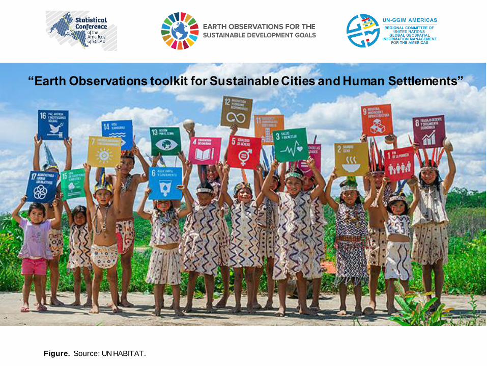
Figure. Source: UN HABITAT.
“Earth Observations toolkit for Sustainable Cities and Human Settlements”
“Earth Observations toolkit for Sustainable Cities and Human Settlements”
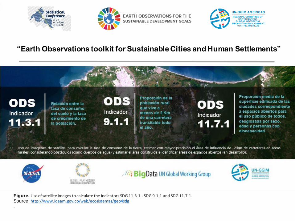
Figure. Use of satellite images to calculate the indicators SDG 11.3.1 - SDG 9.1.1 and SDG 11.7.1.Source: http://www.ideam.gov.co/web/ecosistemas/geo4sdg.
“Earth Observations toolkit for Sustainable Cities and Human Settlements”
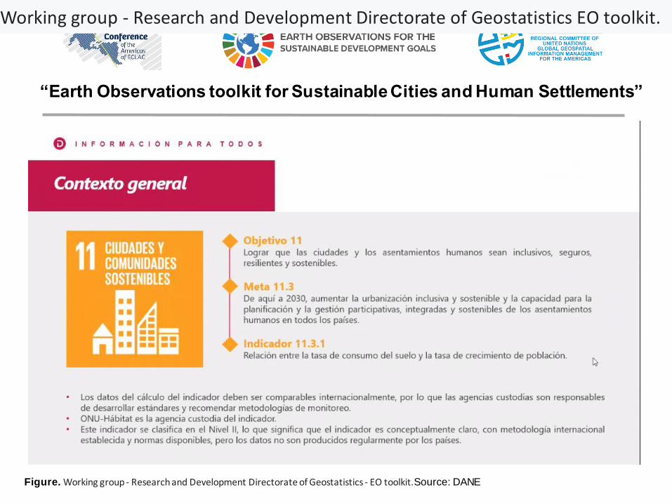
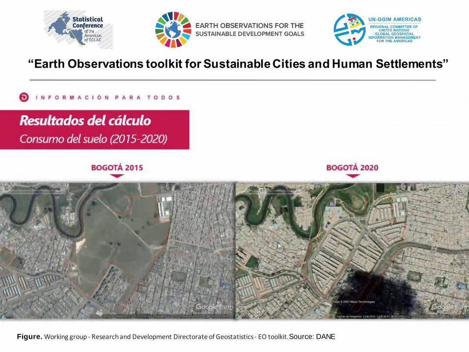
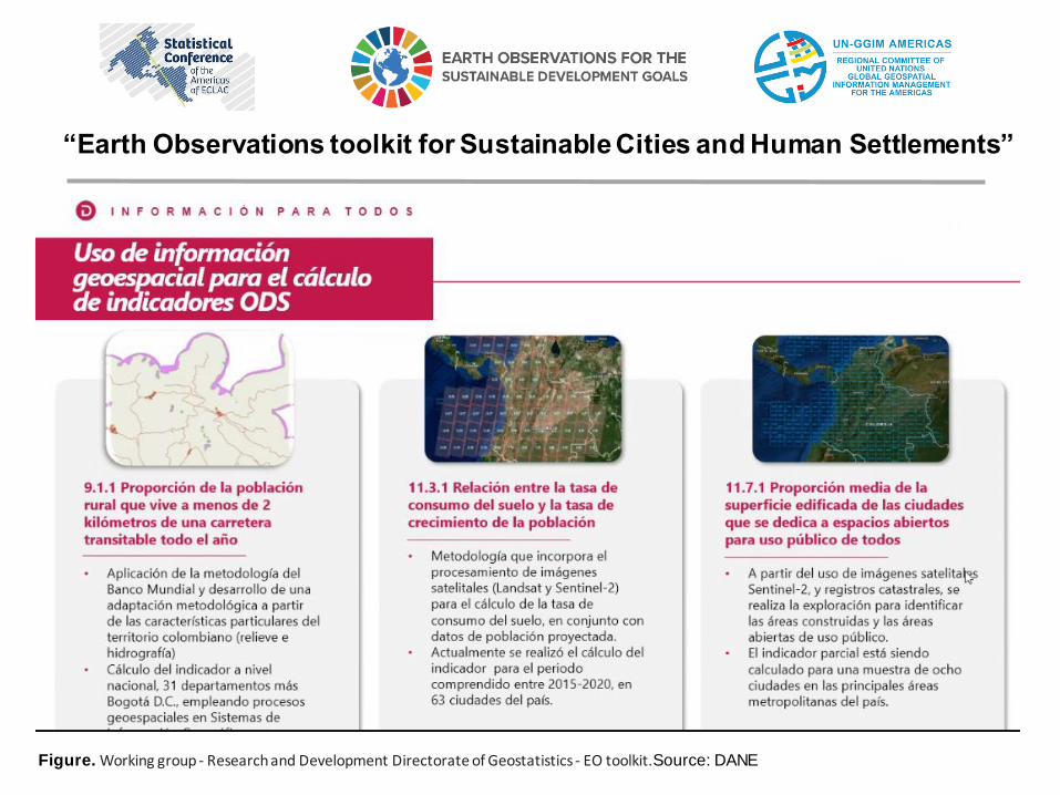
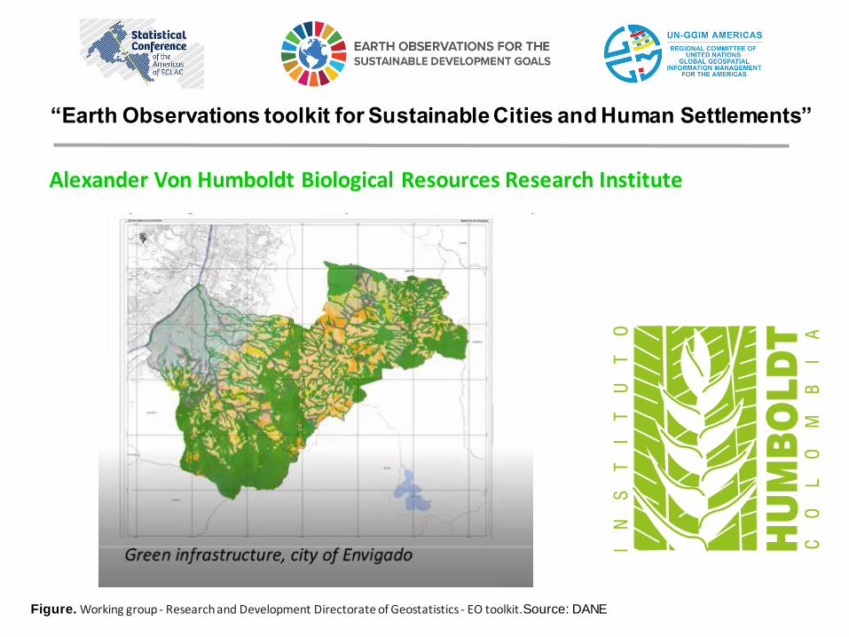
Figure. Working group - Research and Development Directorate of Geostatistics - EO toolkit.Source: DANE
“Earth Observations toolkit for Sustainable Cities and Human Settlements”
Working group - Research and Development Directorate of Geostatistics EO toolkit.
“Earth Observations toolkit for Sustainable Cities and Human Settlements”
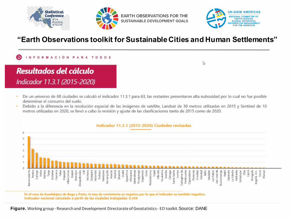
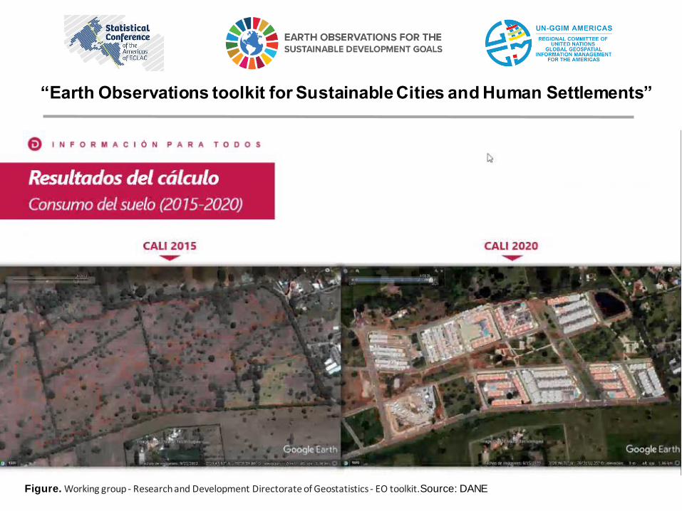
Figure. Working group - Research and Development Directorate of Geostatistics - EO toolkit.Source: DANE
“Earth Observations toolkit for Sustainable Cities and Human Settlements”
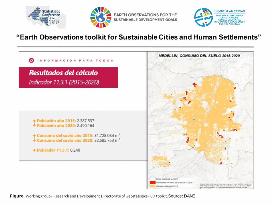
Figure. Working group - Research and Development Directorate of Geostatistics - EO toolkit.Source: DANE
“Earth Observations toolkit for Sustainable Cities and Human Settlements”
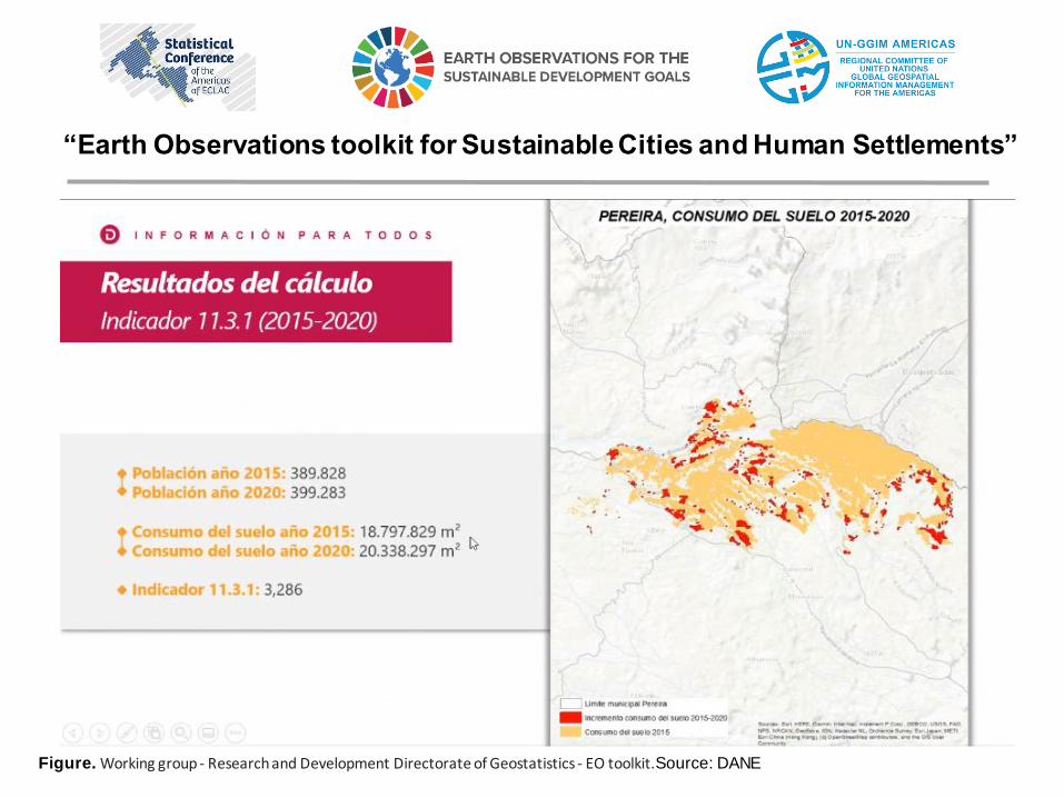
Figure. Working group - Research and Development Directorate of Geostatistics - EO toolkit.Source: DANE
“Earth Observations toolkit for Sustainable Cities and Human Settlements”
Figure. Working group - Research and Development Directorate of Geostatistics - EO toolkit.Source: DANE
“Earth Observations toolkit for Sustainable Cities and Human Settlements”
Figure. Working group - Research and Development Directorate of Geostatistics - EO toolkit.Source: DANE
“Earth Observations toolkit for Sustainable Cities and Human Settlements”
Figure. Working group - Research and Development Directorate of Geostatistics - EO toolkit.Source: DANE
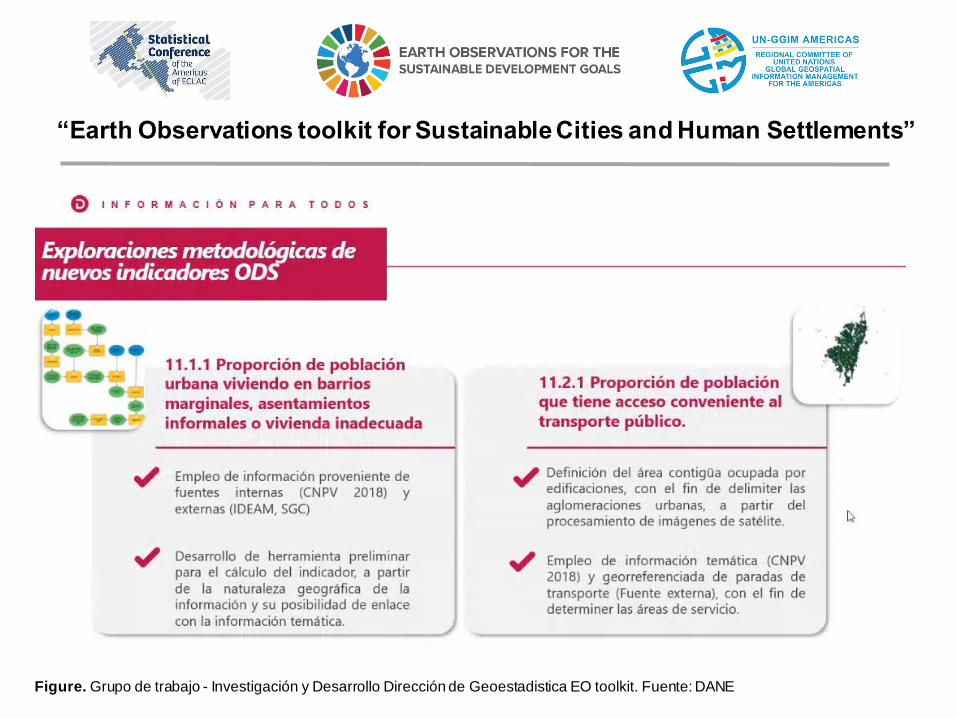
Figure. Grupo de trabajo - Investigación y Desarrollo Dirección de Geoestadistica EO toolkit. Fuente: DANE
“Earth Observations toolkit for Sustainable Cities and Human Settlements”
Figure. Fuente: Gestión Territorial de la Diversidad - Instituto Von Humboldt
“Earth Observations toolkit for Sustainable Cities and Human Settlements”
Alexander Von Humboldt Biological Resources Research Institute
The Alexander Von Humboldt Institute for its part has the objective of promoting,coordinating and conducting research that contributes to the knowledge, conservationand sustainable use of biodiversity as a crucial factor for the well-being of the Colombianpopulation.
Regarding urban issues: - Propose tools to incorporate biodiversity and ecosystem services criteria into urban planning. - Green infrastructure - Biodiversity: composition and functionality and ecosystems of species - Urban ecosystem services - Socio-spatial segregation and equity
“Earth Observations toolkit for Sustainable Cities and Human Settlements”
Figure. Working group - Research and Development Directorate of Geostatistics - EO toolkit.Source: DANE
“Earth Observations toolkit for Sustainable Cities and Human Settlements”
Alexander Von Humboldt Biological Resources Research Institute
Figure. Working group - Research and Development Directorate of Geostatistics - EO toolkit.Source: DANE
“Earth Observations toolkit for Sustainable Cities and Human Settlements”
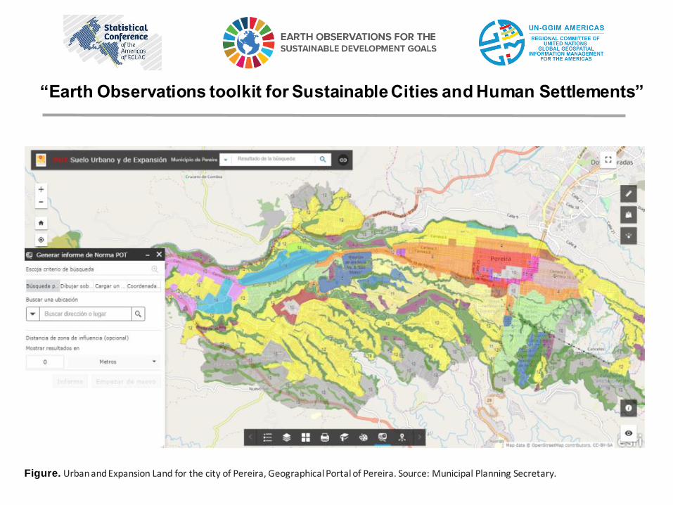
Figure. Urban and Expansion Land for the city of Pereira, Geographical Portal of Pereira. Source: Municipal Planning Secretary.
“Earth Observations toolkit for Sustainable Cities and Human Settlements”
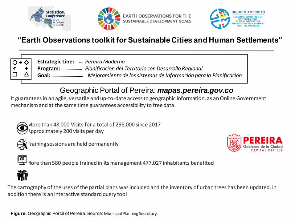
Estrategic Line:Program:Goal:
Pereira Moderna Planificación del Territorio con Desarrollo RegionalMejoramiento de los sistemas de Información para la Planificación
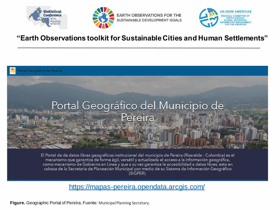
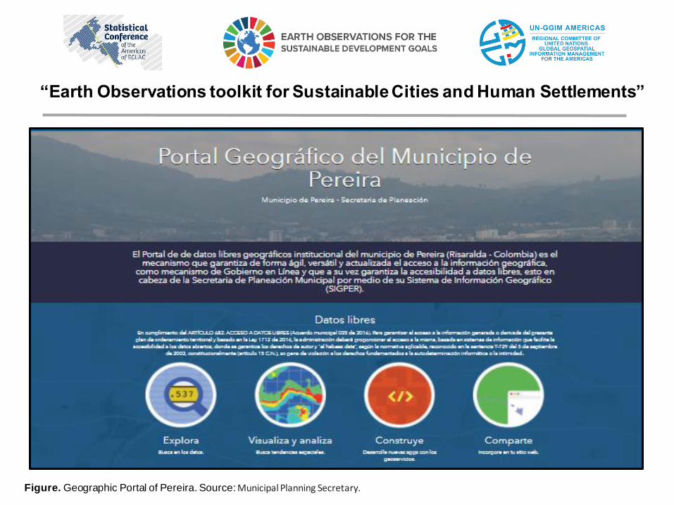
Geographic Portal of Pereira: mapas.pereira.gov.coIt guarantees in an agile, versatile and up-to-date access to geographic information, as an Online Government mechanism and at the same time guarantees accessibility to free data.
More than 48,000 Visits for a total of 298,000 since 2017 Approximately 200 visits per day
Training sessions are held permanently
More than 580 people trained in its management 477,027 inhabitants benefited
The cartography of the uses of the partial plans was included and the inventory of urban trees has been updated, in addition there is an interactive standard query tool
Figure. Geographic Portal of Pereira. Source: Municipal Planning Secretary.
“Earth Observations toolkit for Sustainable Cities and Human Settlements”
https://mapas-pereira.opendata.arcgis.com/
“Earth Observations toolkit for Sustainable Cities and Human Settlements”
Figure. Geographic Portal of Pereira. Fuente: Municipal Planning Secretary.
“Earth Observations toolkit for Sustainable Cities and Human Settlements”
Figure. Geographic Portal of Pereira. Source: Municipal Planning Secretary.
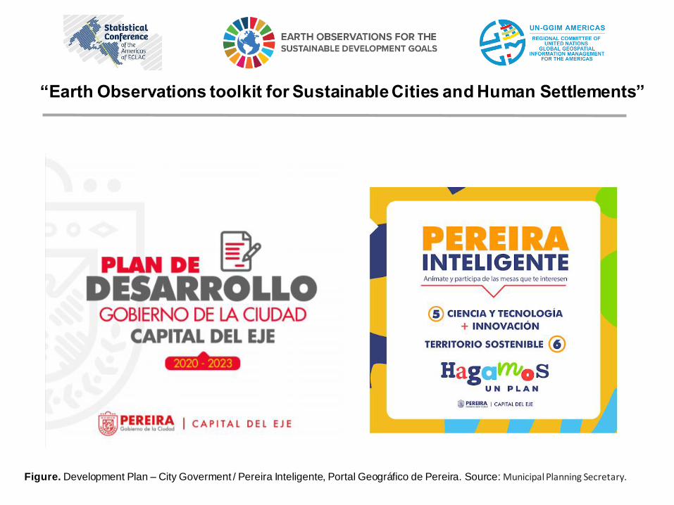
Figure. Development Plan – City Goverment / Pereira Inteligente, Portal Geográfico de Pereira. Source: Municipal Planning Secretary.
“Earth Observations toolkit for Sustainable Cities and Human Settlements”
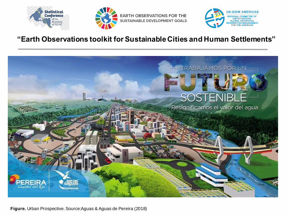
Figure. Urban Prospective. Source:Aguas & Aguas de Pereira (2018)
“Earth Observations toolkit for Sustainable Cities and Human Settlements”
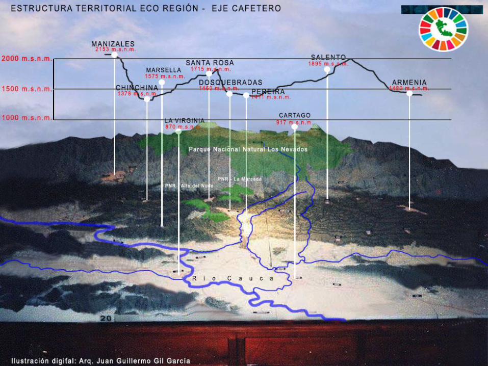
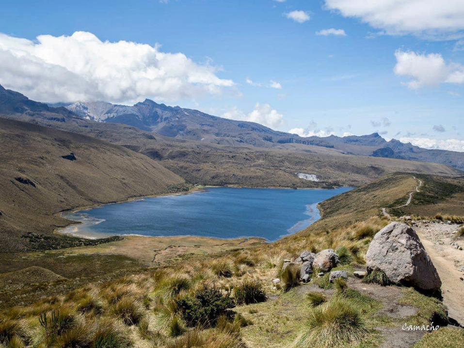
Imagen 1. Fuente: Elaboración Arq. Juan Guillermo Gil García.
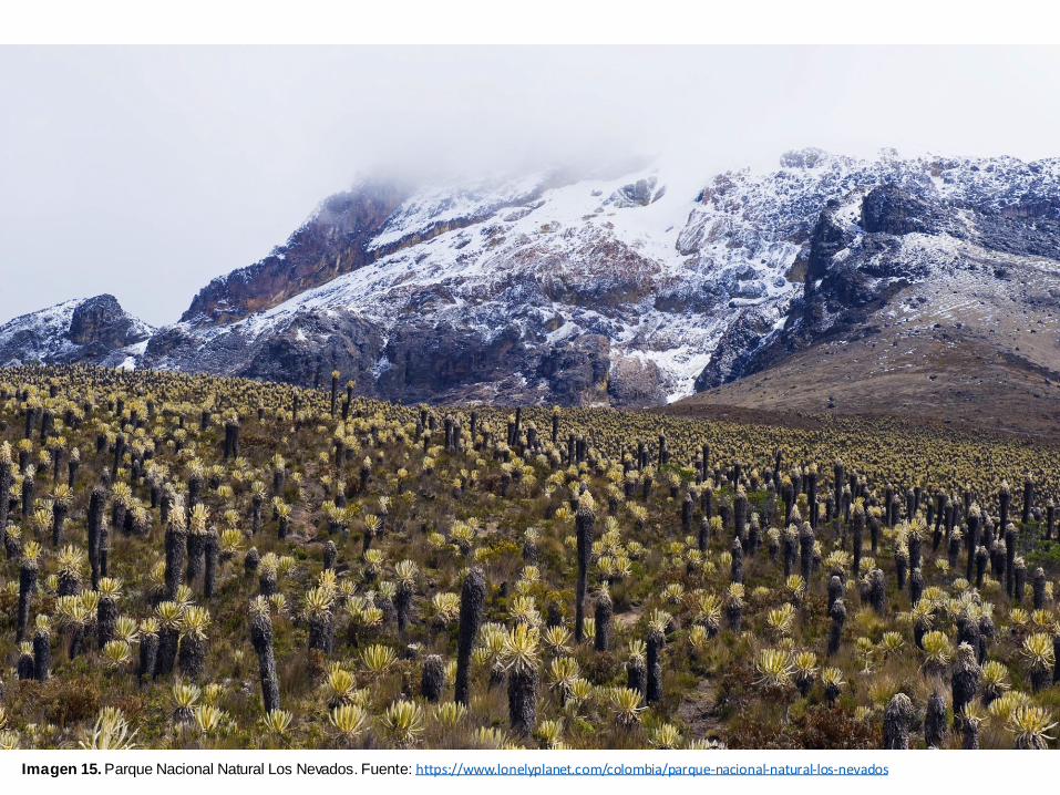
Imagen 15. Parque Nacional Natural Los Nevados. Fuente: https://www.lonelyplanet.com/colombia/parque-nacional-natural-los-nevados
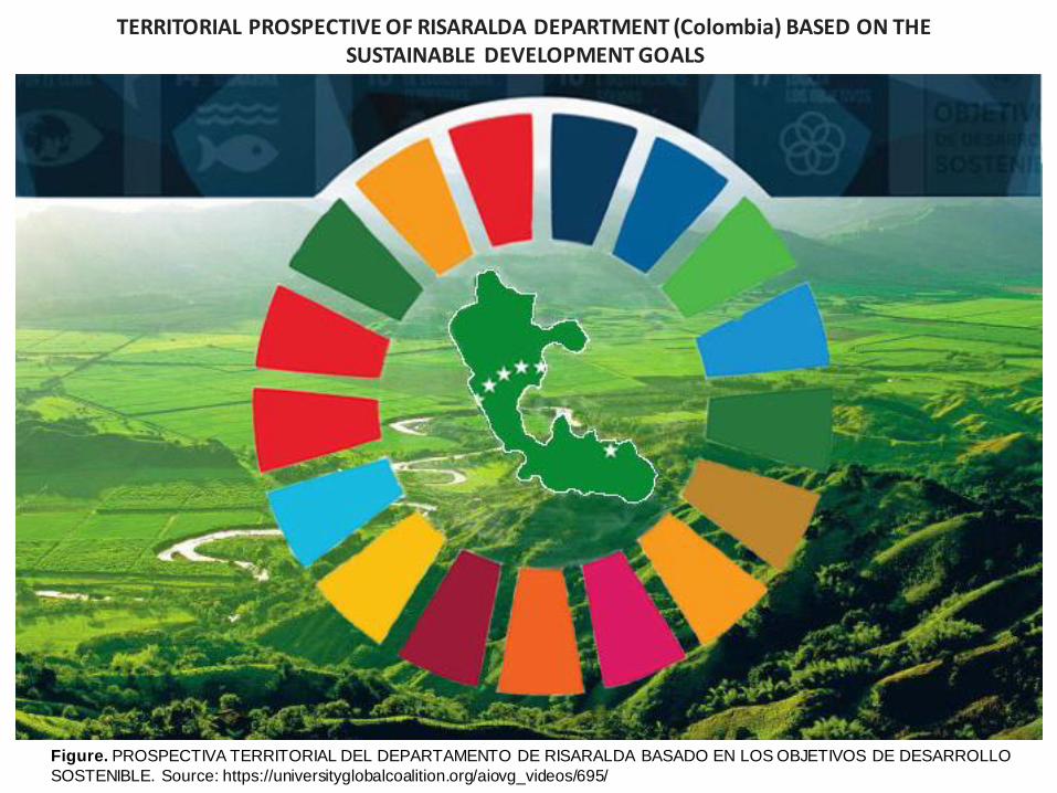
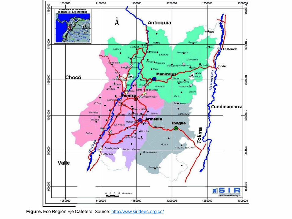
Figure. PROSPECTIVA TERRITORIAL DEL DEPARTAMENTO DE RISARALDA BASADO EN LOS OBJETIVOS DE DESARROLLO
SOSTENIBLE. Source: https://universityglobalcoalition.org/aiovg_videos/695/
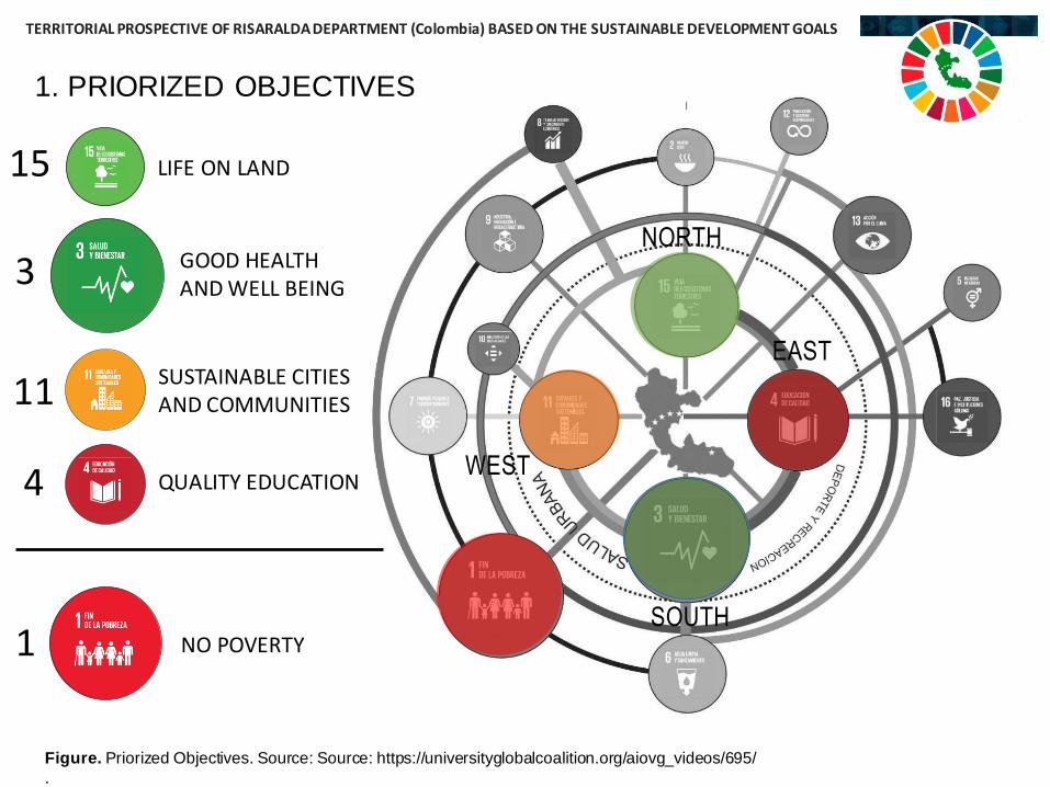
TERRITORIAL PROSPECTIVE OF RISARALDA DEPARTMENT (Colombia) BASED ON THE SUSTAINABLE DEVELOPMENT GOALS
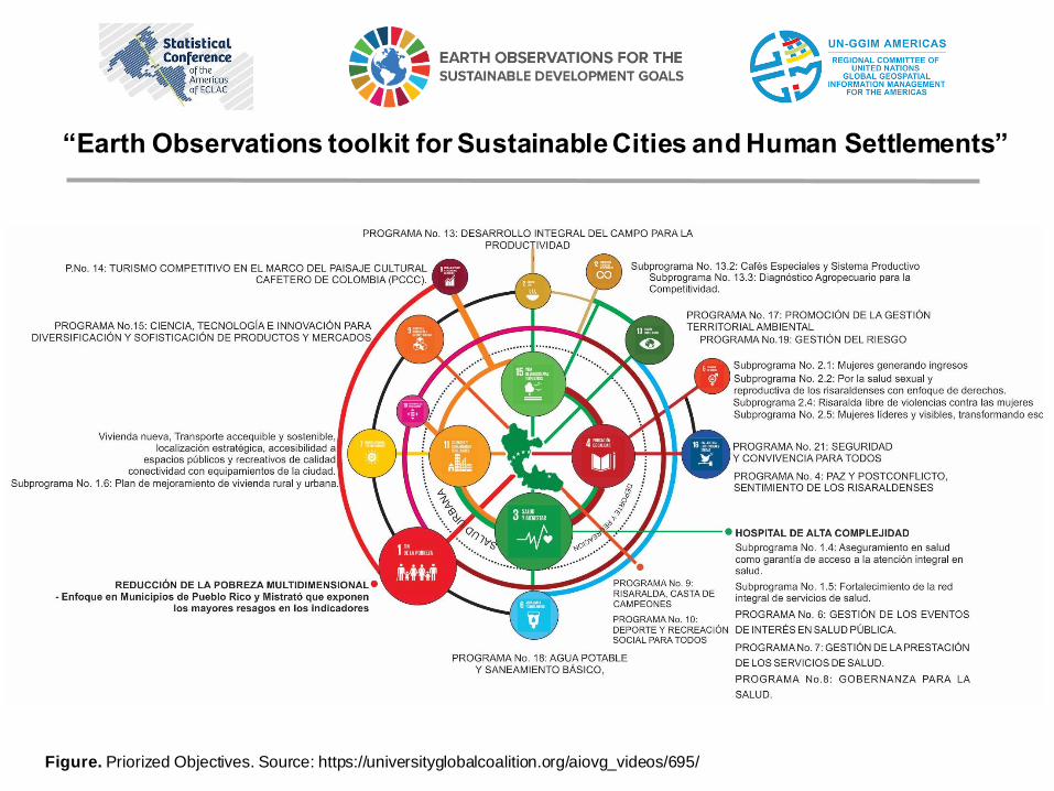
Figure. Priorized Objectives. Source: https://universityglobalcoalition.org/aiovg_videos/695/
“Earth Observations toolkit for Sustainable Cities and Human Settlements”
TERRITORIAL PROSPECTIVE OF RISARALDA DEPARTMENT (Colombia) BASED ON THE SUSTAINABLE DEVELOPMENT GOALS
Figure. Priorized Objectives. Source: Source: https://universityglobalcoalition.org/aiovg_videos/695/
.
1. PRIORIZED OBJECTIVES
NORTH
LIFE ON LAND 15
SOUTH
GOOD HEALTH AND WELL BEING
3
WEST
11 SUSTAINABLE CITIES AND COMMUNITIES
EAST
4 QUALITY EDUCATION
NO POVERTY1
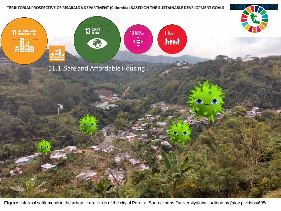
Figure. Informal settlements in the urban– rural limits of the city of Pereira. Source: https://universityglobalcoalition.org/aiovg_videos/695/
.
11.1. Safe and Affordable Housing
TERRITORIAL PROSPECTIVE OF RISARALDA DEPARTMENT (Colombia) BASED ON THE SUSTAINABLE DEVELOPMENT GOALS
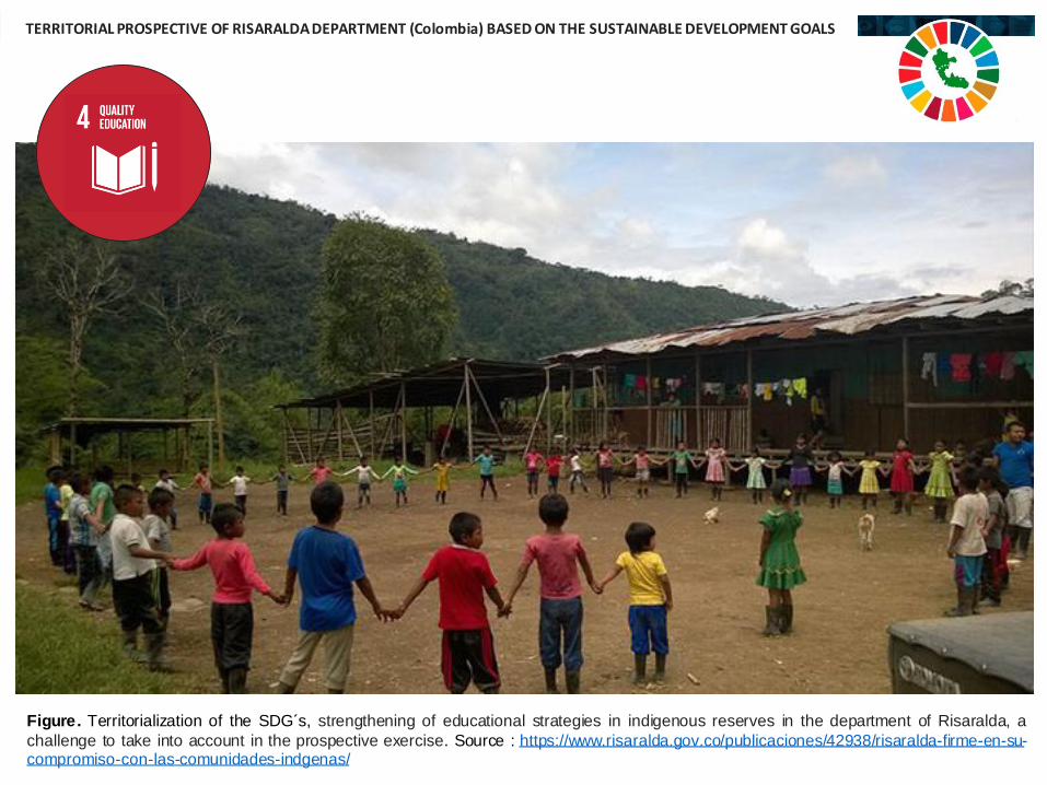
Figure. Territorialization of the SDG´s, strengthening of educational strategies in indigenous reserves in the department of Risaralda, a
challenge to take into account in the prospective exercise. Source : https://www.risaralda.gov.co/publicaciones/42938/risaralda-firme-en-su-compromiso-con-las-comunidades-indgenas/
TERRITORIAL PROSPECTIVE OF RISARALDA DEPARTMENT (Colombia) BASED ON THE SUSTAINABLE DEVELOPMENT GOALS
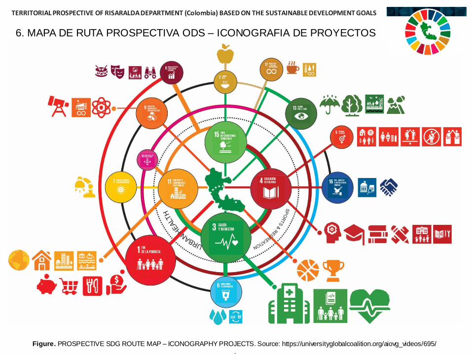
Figure. PROSPECTIVE SDG ROUTE MAP – ICONOGRAPHY PROJECTS. Source: https://universityglobalcoalition.org/aiovg_videos/695/.
6. MAPA DE RUTA PROSPECTIVA ODS – ICONOGRAFIA DE PROYECTOS
TERRITORIAL PROSPECTIVE OF RISARALDA DEPARTMENT (Colombia) BASED ON THE SUSTAINABLE DEVELOPMENT GOALS
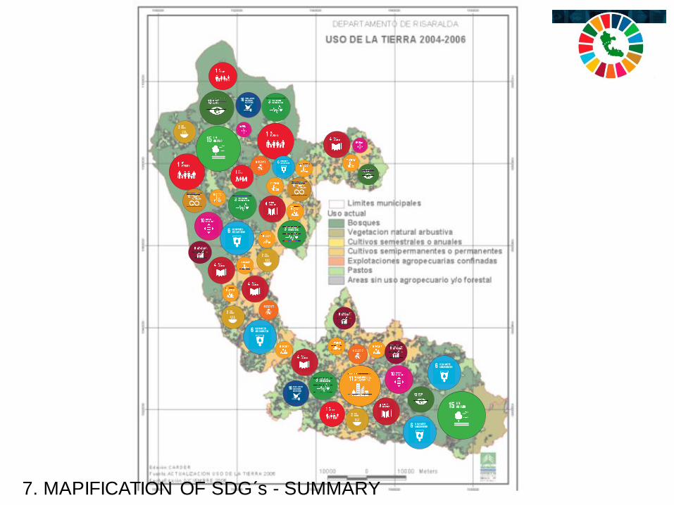
7. MAPIFICATION OF SDG´s - SUMMARY
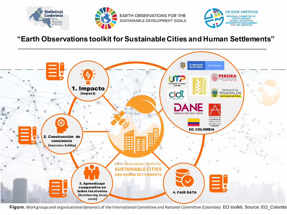
Figure. Work groups and organizational dynamics of the International Committee and National Committee (Colombia) EO toolkit. Source: EO_Colombia
4. FAIR DATA
1. Impacto
2. Construcción de
conciencia
3. Aprendizaje
comparativo en
todos los niveles
EO_COLOMBIA
(Impact)
(Awareness Building)
(Benchlearning Across Levels)
“Earth Observations toolkit for Sustainable Cities and Human Settlements”
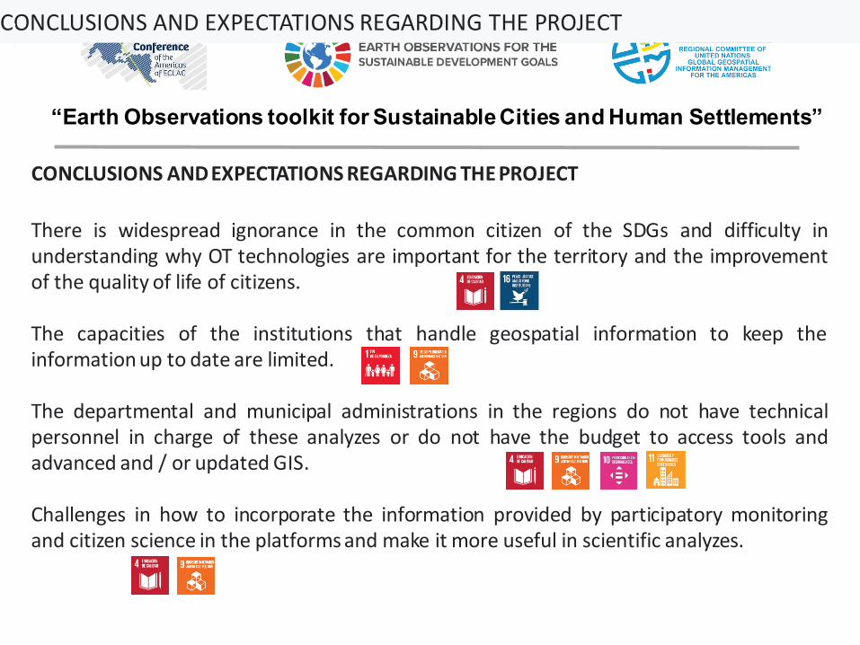
There is widespread ignorance in the common citizen of the SDGs and difficulty inunderstanding why OT technologies are important for the territory and the improvementof the quality of life of citizens.
The capacities of the institutions that handle geospatial information to keep theinformation up to date are limited.
The departmental and municipal administrations in the regions do not have technicalpersonnel in charge of these analyzes or do not have the budget to access tools andadvanced and / or updated GIS.
Challenges in how to incorporate the information provided by participatory monitoringand citizen science in the platforms and make it more useful in scientific analyzes.
CONCLUSIONS AND EXPECTATIONS REGARDING THE PROJECT
“Earth Observations toolkit for Sustainable Cities and Human Settlements”
CONCLUSIONS AND EXPECTATIONS REGARDING THE PROJECT
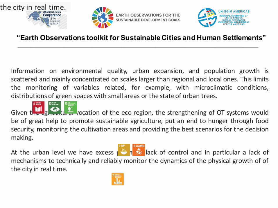
Information on environmental quality, urban expansion, and population growth isscattered and mainly concentrated on scales larger than regional and local ones. This limitsthe monitoring of variables related, for example, with microclimatic conditions,distributions of green spaces with small areas or the stateof urban trees.
Given the agricultural vocation of the eco-region, the strengthening of OT systems wouldbe of great help to promote sustainable agriculture, put an end to hunger through foodsecurity, monitoring the cultivation areas and providing the best scenarios for the decisionmaking.
At the urban level we have excess planning, lack of control and in particular a lack ofmechanisms to technically and reliably monitor the dynamics of the physical growth of ofthe city in real time.
“Earth Observations toolkit for Sustainable Cities and Human Settlements”
the city in real time.

Thank You
“Earth Observations toolkit for Sustainable Cities and Human Settlements”
BIBLIOGRAPHY• Corporación Autónoma Regional de Risaralda, CARDER (2002). AreasNaturales Protegidas de Risaralda. Primera edición, Pereira, Risaralda.• CODS, 2020. Índice ODS 2019 para América Latina y el Caribe. Centro de los Objetivos de Desarrollo Sostenible para América Latina y el
Caribe: Bogotá, Colombia.• Comisión Económica para América Latina y el Caribe (CEPAL), La Agenda 2030 para el Desarrollo Sostenible en el nuevo contexto mundial y
regional: escenarios y proyecciones en la presente crisis (LC/PUB.2020/5), Santiago, 2020.• Departamento Nacional de Planeación. (2018). Plan Nacional de Desarrollo 2018-2022. “Pacto por Colombia, pacto por la equidad”. Bogotá
D.C.• GIL García, Juan Guillermo. Prospectiva Territorial del Departamento de Risaralda a la luz de los ODS. Consejo Departamental de Planeación
– Gobernación de Risaralda - CODS (Centro de los Objetivos de Desarrollo Sostenible para América Latina) Universidad de Los Andes.(2020).Gobernación del Risaralda. (2020) Plan de Desarrollo Departamental 2020-2023 “Risaralda Sentimiento de Todos”. Ordenanza No.002 de 2020.
• Chavarro, Diego, Hernández Aleidys, Olaya, Alejandro, Montenegro, Iván, Vélez, María Isabel y Tovar, Galo, Los Objetivos de DesarrolloSostenible en Colombia y el aporte de la ciencia, la tecnología y la innovación. DOCUMENTO DE TRABAJO N 0.1. Colciencias – SubdirecciónGeneral– Unidad de Diseño y Evaluación de Políticas, Bogotá D.C, Colombia, diciembre 2017.
• INDICE ODS 2019 PARA AMERICA LATINA Y EL CARIBE CODS• Inclusión de los ODSen los PDT 2016 – 2019 Departamento Nacional de Planeación DNP.• LIBRO VERDE 2030. POLÍTICA NACIONAL DE CIENCIA E INNOVACIÓN PARA EL DESARROLLO SOSTENIBLE. Adoptada mediante Resolución
0674 del 9 de julio de 2018• Documento CONPES 3918, «Estrategia para la implementación de los Objetivos de Desarrollo Sostenible (ODS) en Colombia».• Marco de indicadores mundiales para los Objetivos de Desarrollo Sostenible y metas de la Agenda 2030 para el Desarrollo Sostenible.
Anexo. A/RES/71/313. Asamblea General de las Naciones Unidas.• Murga-Menoyo, M. A. (2015). competencias para el desarrollo sostenible: las capacidades, actitudes y valores meta de la educación en el
marco de la Agenda global post-2015.• ONU (2017). Nueva Agenda Urbana. Hábitat III. Quito: Secretaría de Habitat III-ONU.• Plataforma Estratégica del Bosque Modelo Risaralda• Prakash, M., Ramage, S. and S. Goodman (2020). Open Earth observations for sustainable urban development. Williamsburg, VA:
AidData at William & Mary– GEO Group on Earth Observations.• Región Administrativa de Planificación Eje Cafetero RAP. (2018, Mayo). Documento Técnicode Soporte.• Vivienda y ODS en México. ONU-Habitat, Instituto del Fondo Nacional de la Vivienda para los Trabajadores (INFONAVIT) y Acuerdo
Específico de Colaboración con la Secretaría de DesarrolloAgrario, Territorial y Urbano (SEDATU), 2018.• Sarmiento, O.L., García, J., Higuera, D., Useche, A.F., Wilches M.A., Montes, F.,
Bonilla, F., Morales, R., Guzmán, L.A. (Octubre, 2019). Innovacioneslatinoamericanas para ciudades y comunidades cada vez más sostenibles ysaludable aprendizajes de América Latina frente al objetivo de desarrollossostenible número 11 desde la salud urbana. Documentos CODS. No.1. Recuperado de https://cods.uniandes.edu.co/wpcontent/uploads/2019/11/Documento_CODS_salud_1nov_compressed.pdf