Embed Size (px)
Citation preview
FAYETTEVILLE
PEACHTREECITY
WOOLSEY
BROOKS
TYRONE
279
314
54
9285
MILAM RD
NELMS RD
MCBRIDE RD
SEAY RD MOR GAN R D
JENKINSRD
PORTER RD
LOWERYRD
EASTIN RD
BANKSRD
QUARTERS
RD
HILO RD
HARD
Y RD
BROGDON RD
MCDONOUGH RD
DAVIS RD
RIVERS RD
MOR GAN
MILL RD
LEES
L AKE RD
W ESTBR
IDGE RD
KENWO OD RD
OLDG
REENVIL
LERD
MASK RD
LE ES MILL RD
EBENEZE R CH URCH RD
INMAN
RD
BANK
STOW
NRD
HARP RD
RISI NG STAR RD
NEWHOPERD
TYRONE RD
GOZA RD
SANDY CREEK RD
PADGETTRD
FLAT CR
EEK
TRL
BERNHARD RD
ADAMSRD
GINGERCAKE
RDEL
LISON
RD
ANTIOCH RD
GRA N
T
RD
EBENEZERRD
HIGHWAY 85 CONNECTOR
REDW
INE
RD
SPLOST 2017 Stormwater Improvements Draft for Public CommentSPLOST 2017 Stormwater Improvements Draft for Public Comment
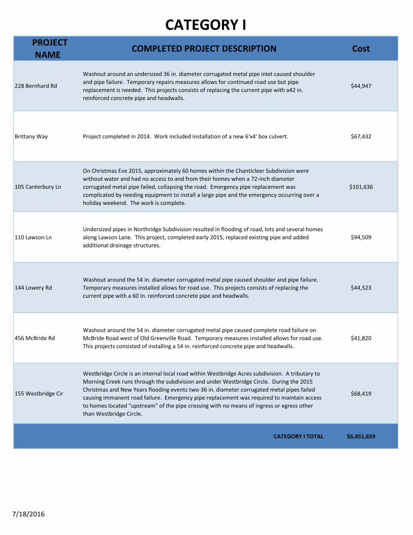
Category I - CompletedCategory I

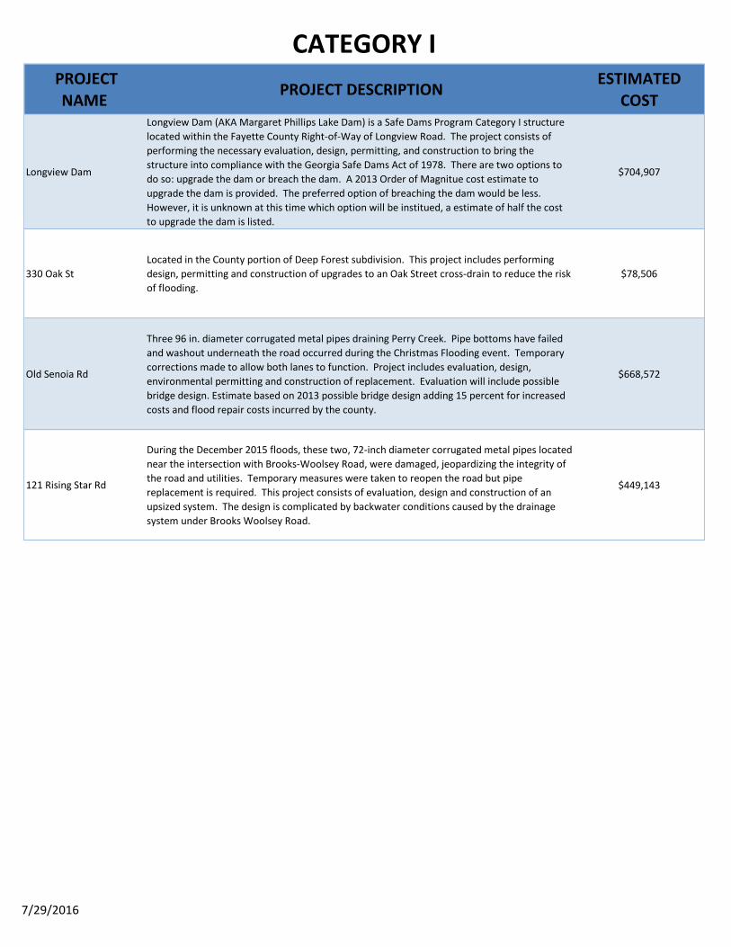
CATEGORY I
7/18/2016
PROJECT NAME
PROJECT DESCRIPTION ESTIMATED COST
210 Antebellum Way
Antebellum Way is a one-way in and out street. Excessive pipe damage, due to Christmas Flood event severely impaired stream flow and caused upstream flooding. Double 84 in.-diameter corrugated metal pipes are bent, restricting flow and are washing out around the inlets. This project includes design and construction to replace with a larger system, possibly box culverts.
$481,581
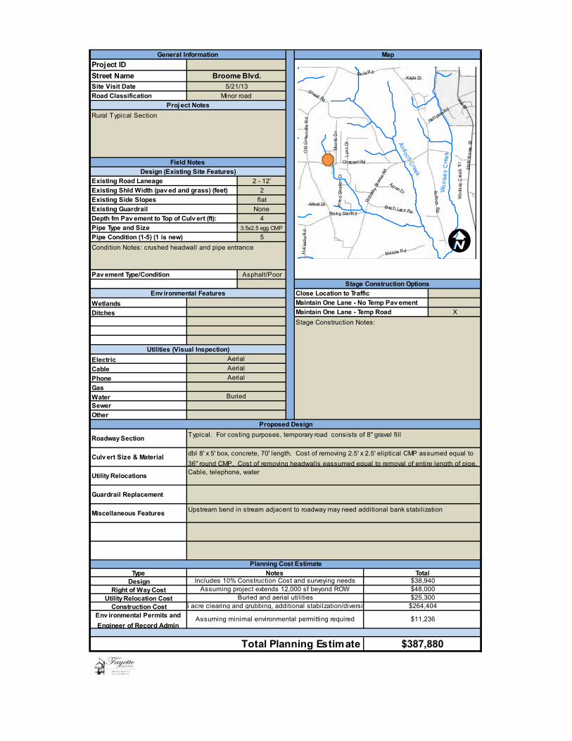
104 Broom Blvd
This project will replace an existing 36-inch corrugated metal pipe with double 8' x 5' concrete box culverts. The system and road were damaged during the December 2015 floods. Temporary repairs were made to keep the road open but pipe replacement is needed for structural and capacity issues. Broom Blvd. is the sole access for 13 homes.
$387,880
Emerald Lake Dam
Emerald Lake Dam is a Georgia Safe Dams Program Category II structure located predominantly within Fayette County Right-of-Way. Work is needed to address flow capacity and structural integrity issues. The project includes design, permitting, and construction of a new labyrinth spillway and associated roadwork. As of January 2016, design work is 80% complete. New cost estimate of $2,064,000 is based on 20% increase of Engineer's Order of Magnitude estimate. Price increase is due to identification of poor subsoils, which require more excavation and a more complicated traffic management plan.
$2,064,000
287 Graves RoadRoad and shoulder washed out around a 60 in. diameter corrugated metal pipe during the 2015 Christmas floods. The proposed design to address capacity problems is to replace the metal pipe with a 10 ft. X 5 ft. reinforced concrete box culvert.
$293,538
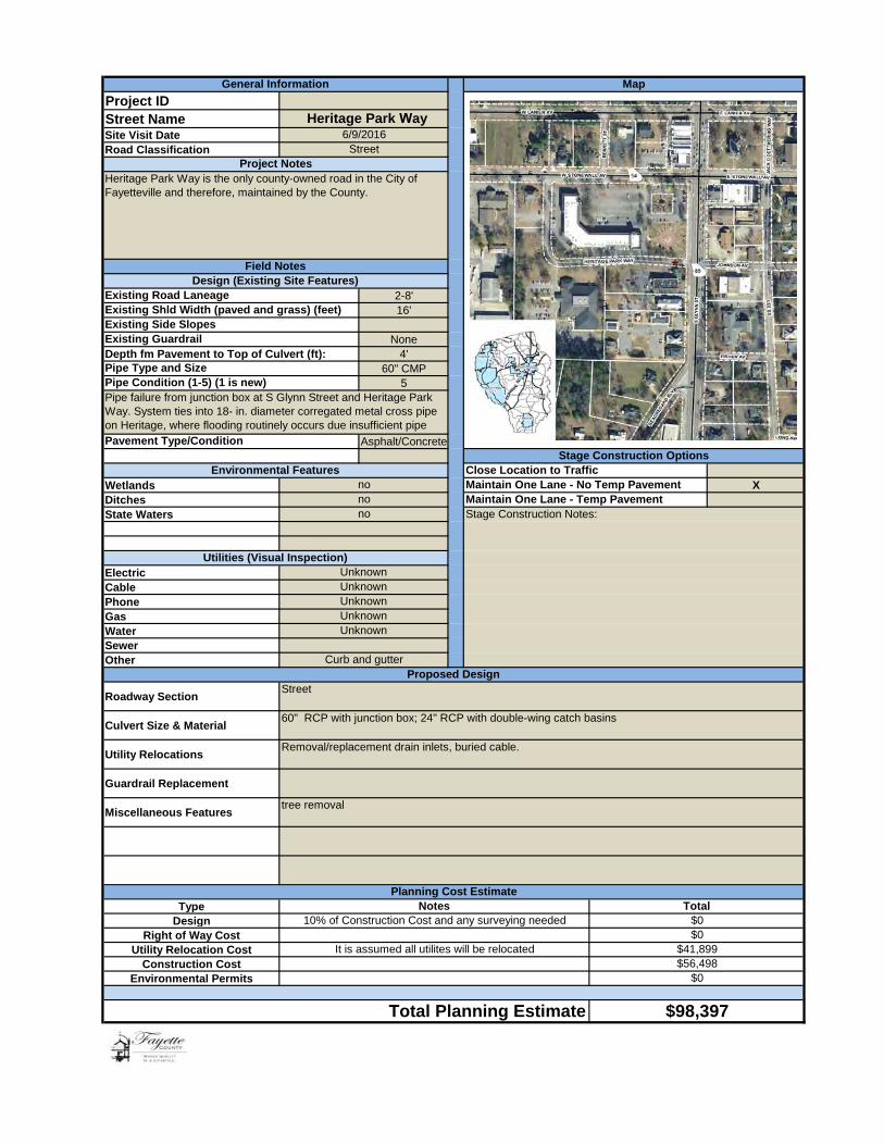
Heritage Park Way
Heritage Park Way is the only road owned by Fayette County that is located in Fayetteville city limits. This project will replace a failing 60-in diameter corregated metal pipe that connects to stormwater pipe under State Route 85 and a failing 18-in diameter cross pipe that is also part of the system. The proposed design will address flooding issues that routinely occur on Heritage Park Way.
$98,397
Kozisek Dam
Kozisek Dam is a Safe Dams Program Category I structure adjacent to and possibly partially within the County Right-of-Way for Neely Road. The project includes evaluation, design, permitting, and construction of necessary improvements and changes to Neely Road to ensure it safely passes design flows and to remove any County liability/ownership that may be associated with Kozisek Dam.
$250,000
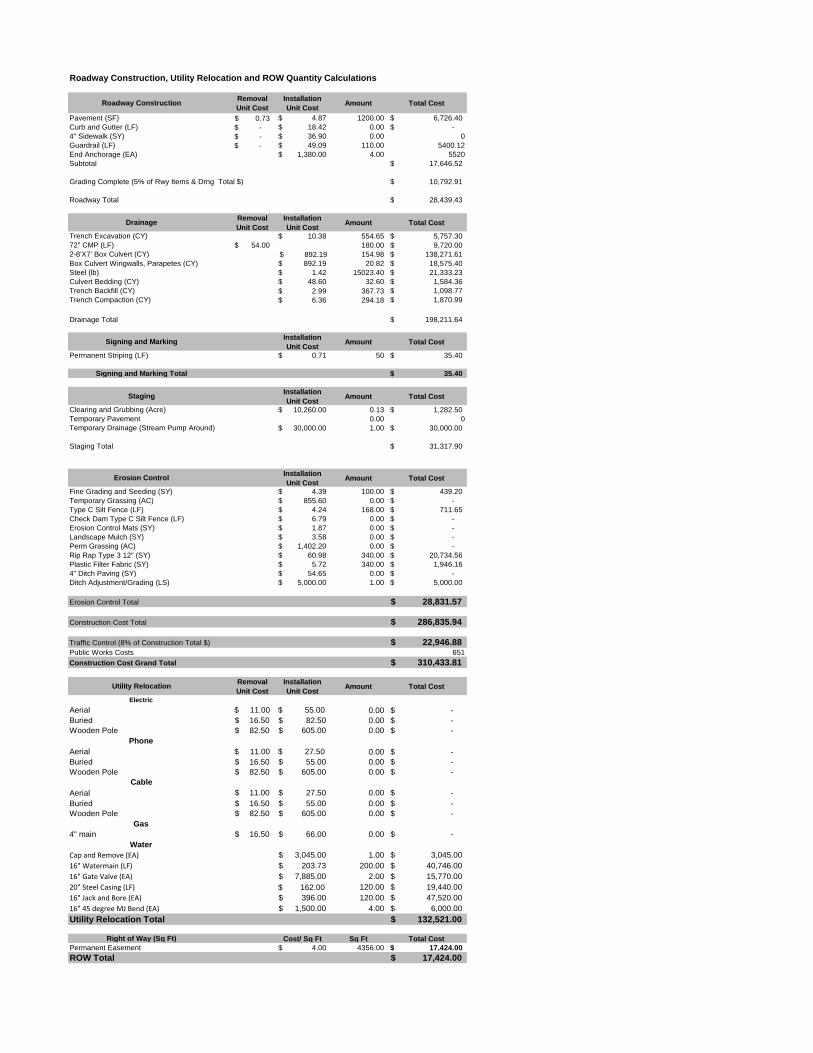
413 Lees Mill Rd
During the 2015 Christmas flood event Tar Creek came above and covered three, 72-inch diameter pipes causing excessive damage. This project will consist of evaluation, design and construction to upsize the drainage capacity to allow passage of the 100 year storm event. This project is located in FEMA Zone AE and a large water main is located near the pipes as well.
$511,849

CATEGORY I
7/29/2016
PROJECT NAME PROJECT DESCRIPTION ESTIMATED
COST
Longview Dam
Longview Dam (AKA Margaret Phillips Lake Dam) is a Safe Dams Program Category I structure located within the Fayette County Right-of-Way of Longview Road. The project consists of performing the necessary evaluation, design, permitting, and construction to bring the structure into compliance with the Georgia Safe Dams Act of 1978. There are two options to do so: upgrade the dam or breach the dam. A 2013 Order of Magnitue cost estimate to upgrade the dam is provided. The preferred option of breaching the dam would be less. However, it is unknown at this time which option will be institued, a estimate of half the cost to upgrade the dam is listed.
$704,907
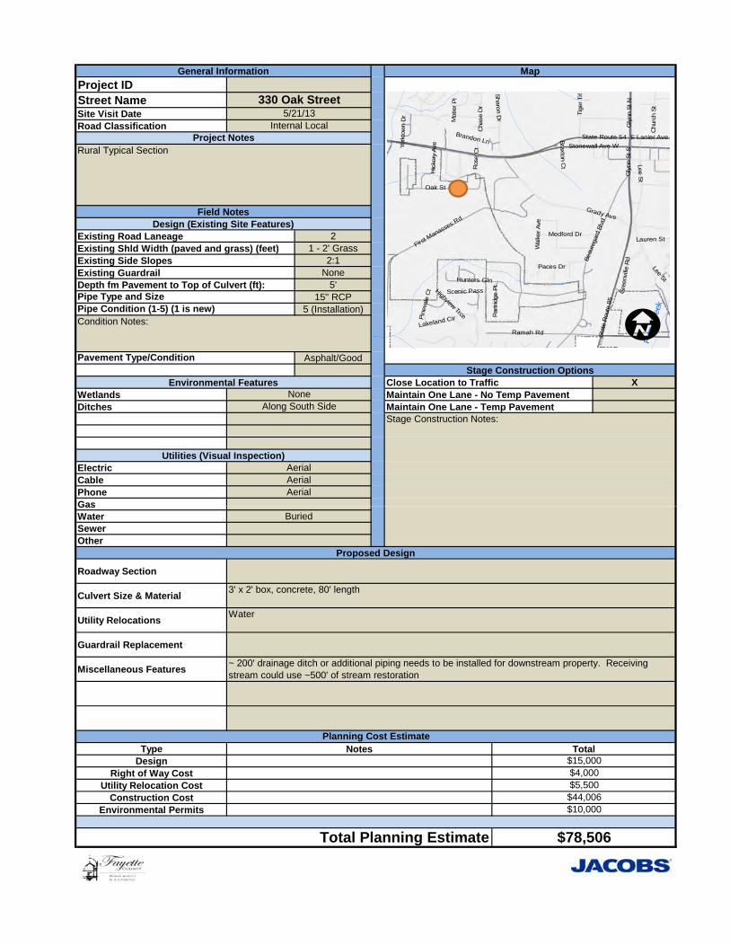
330 Oak StLocated in the County portion of Deep Forest subdivision. This project includes performing design, permitting and construction of upgrades to an Oak Street cross-drain to reduce the risk of flooding.
$78,506
Old Senoia Rd
Three 96 in. diameter corrugated metal pipes draining Perry Creek. Pipe bottoms have failed and washout underneath the road occurred during the Christmas Flooding event. Temporary corrections made to allow both lanes to function. Project includes evaluation, design, environmental permitting and construction of replacement. Evaluation will include possible bridge design. Estimate based on 2013 possible bridge design adding 15 percent for increased costs and flood repair costs incurred by the county.
$668,572
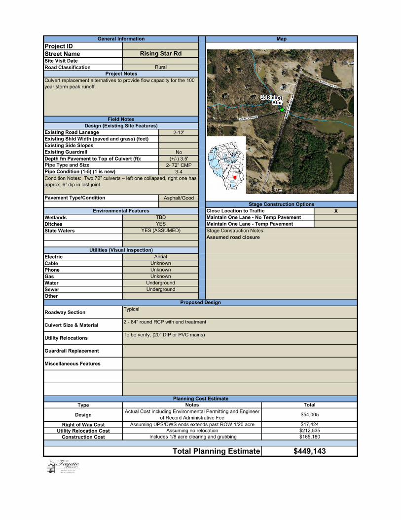
121 Rising Star Rd
During the December 2015 floods, these two, 72-inch diameter corrugated metal pipes located near the intersection with Brooks-Woolsey Road, were damaged, jeopardizing the integrity of the road and utilities. Temporary measures were taken to reopen the road but pipe replacement is required. This project consists of evaluation, design and construction of an upsized system. The design is complicated by backwater conditions caused by the drainage system under Brooks Woolsey Road.
$449,143

CATEGORY I
7/18/2016
PROJECT NAME
COMPLETED PROJECT DESCRIPTION Cost
228 Bernhard Rd
Washout around an undersized 36 in. diameter corrugated metal pipe inlet caused shoulder and pipe failure. Temporary repairs measures allows for continued road use but pipe replacement is needed. This projects consists of replacing the current pipe with a42 in. reinforced concrete pipe and headwalls.
$44,947
Brittany Way Project completed in 2014. Work included installation of a new 6'x4' box culvert. $67,432
105 Canterbury Ln
On Christmas Eve 2015, approximately 60 homes within the Chanticleer Subdivision were without water and had no access to and from their homes when a 72-inch diameter corrugated metal pipe failed, collapsing the road. Emergency pipe replacement was complicated by needing equipment to install a large pipe and the emergency occurring over a holiday weekend. The work is complete.
$101,636
110 Lawson LnUndersized pipes in Northridge Subdivision resulted in flooding of road, lots and several homes along Lawson Lane. This project, completed early 2015, replaced existing pipe and added additional drainage structures.
$94,509
144 Lowery Rd Washout around the 54 in. diameter corrugated metal pipe caused shoulder and pipe failure. Temporary measures installed allows for road use. This projects consists of replacing the current pipe with a 60 in. reinforced concrete pipe and headwalls.
$44,523
456 McBride RdWashout around the 54 in. diameter corrugated metal pipe caused complete road failure on McBride Road west of Old Greenville Road. Temporary measures installed allows for road use. This projects consisted of installing a 54 in. reinforced concrete pipe and headwalls.
$41,820
155 Westbridge Cir
Westbridge Circle is an internal local road within Westbridge Acres subdivision. A tributary to Morning Creek runs through the subdivision and under Westbridge Circle. During the 2015 Christmas and New Years flooding events two-36 in. diameter corrugated metal pipes failed causing immanent road failure. Emergency pipe replacement was required to maintain access to homes located "upstream" of the pipe crossing with no means of ingress or egress other than Westbridge Circle.
$68,419
CATEGORY I TOTAL $6,451,659

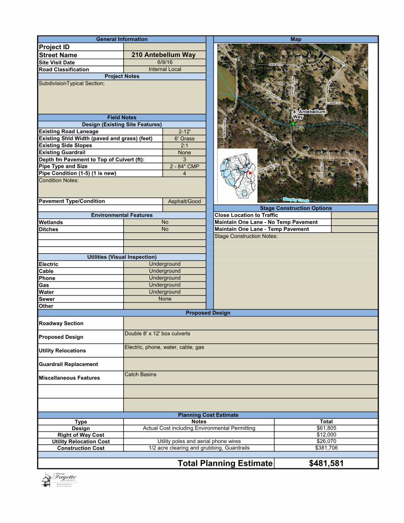
Project IDStreet NameSite Visit DateRoad Classification
2-12'6' Grass
2:1None
Depth fm Pavement to Top of Culvert (ft): 32 - 84" CMP
4
Asphalt/Good
WetlandsDitches
ElectricCablePhoneGasWaterSewerOther
Roadway Section
Proposed Design
Utility Relocations
Guardrail Replacement
Miscellaneous Features
TypeDesign
Right of Way CostUtility Relocation Cost
Construction Cost
Underground
Underground
$381,706
None
Existing Road Laneage
Pipe Type and Size
Stage Construction Options
Catch Basins
Proposed Design
Close Location to Traffic
Existing Guardrail
Design (Existing Site Features)
210 Antebellum Way
MapGeneral Information
SubdivisionTypical Section;
Internal Local6/9/16
Existing Shld Width (paved and grass) (feet)Existing Side Slopes
UndergroundUnderground
Utilities (Visual Inspection)
Project Notes
Field Notes
Double 8' x 12' box culverts
NotesPlanning Cost Estimate
Maintain One Lane - No Temp Pavement
Pipe Condition (1-5) (1 is new)
No
Stage Construction Notes:
Pavement Type/Condition
Condition Notes:
No
Underground
Environmental Features
Maintain One Lane - Temp Pavement
Total Planning Estimate
$12,000Utility poles and aerial phone wires
Actual Cost including Environmental Permitting
$481,581
1/2 acre clearing and grubbing, Guardrails
Electric, phone, water, cable, gas
$61,805
$26,070
Total
Photo 1:
Photo 2:
Ante
bellu
m W
ay
Photo Date:
1/05/2016Taken By:
Tony Hicks
Page:
1
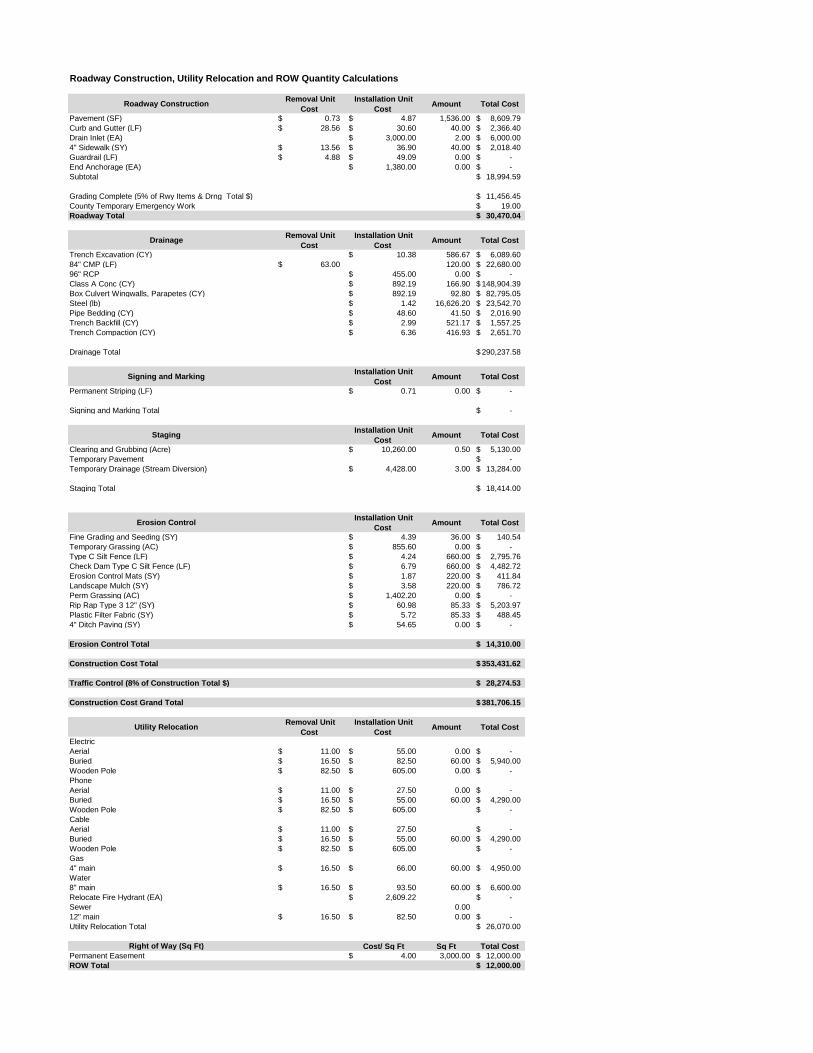
Roadway Construction, Utility Relocation and ROW Quantity Calculations
Roadway Construction Removal Unit
Cost
Installation Unit
Cost Amount Total Cost
Pavement (SF) 0.73$ 4.87$ 1,536.00 8,609.79$
Curb and Gutter (LF) 28.56$ 30.60$ 40.00 2,366.40$
Drain Inlet (EA) 3,000.00$ 2.00 6,000.00$
4" Sidewalk (SY) 13.56$ 36.90$ 40.00 2,018.40$
Guardrail (LF) 4.88$ 49.09$ 0.00 -$
End Anchorage (EA) 1,380.00$ 0.00 -$
Subtotal 18,994.59$
Grading Complete (5% of Rwy Items & Drng Total $) 11,456.45$
County Temporary Emergency Work 19.00$
Roadway Total 30,470.04$
Drainage Removal Unit
Cost
Installation Unit
Cost Amount Total Cost
Trench Excavation (CY) 10.38$ 586.67 6,089.60$
84" CMP (LF) 63.00$ 120.00 22,680.00$
96" RCP 455.00$ 0.00 -$
Class A Conc (CY) 892.19$ 166.90 148,904.39$
Box Culvert Wingwalls, Parapetes (CY) 892.19$ 92.80 82,795.05$
Steel (lb) 1.42$ 16,626.20 23,542.70$
Pipe Bedding (CY) 48.60$ 41.50 2,016.90$
Trench Backfill (CY) 2.99$ 521.17 1,557.25$
Trench Compaction (CY) 6.36$ 416.93 2,651.70$
Drainage Total 290,237.58$
Signing and Marking Installation Unit
Cost Amount Total Cost
Permanent Striping (LF) 0.71$ 0.00 -$
Signing and Marking Total -$
Staging Installation Unit
Cost Amount Total Cost
Clearing and Grubbing (Acre) 10,260.00$ 0.50 5,130.00$
Temporary Pavement -$
Temporary Drainage (Stream Diversion) 4,428.00$ 3.00 13,284.00$
Staging Total 18,414.00$
Erosion Control Installation Unit
Cost Amount Total Cost
Fine Grading and Seeding (SY) 4.39$ 36.00 140.54$
Temporary Grassing (AC) 855.60$ 0.00 -$
Type C Silt Fence (LF) 4.24$ 660.00 2,795.76$
Check Dam Type C Silt Fence (LF) 6.79$ 660.00 4,482.72$
Erosion Control Mats (SY) 1.87$ 220.00 411.84$
Landscape Mulch (SY) 3.58$ 220.00 786.72$
Perm Grassing (AC) 1,402.20$ 0.00 -$
Rip Rap Type 3 12" (SY) 60.98$ 85.33 5,203.97$
Plastic Filter Fabric (SY) 5.72$ 85.33 488.45$
4" Ditch Paving (SY) 54.65$ 0.00 -$
Erosion Control Total 14,310.00$
Construction Cost Total 353,431.62$
Traffic Control (8% of Construction Total $) 28,274.53$
Construction Cost Grand Total 381,706.15$
Utility Relocation Removal Unit
Cost
Installation Unit
Cost Amount Total Cost
Electric
Aerial 11.00$ 55.00$ 0.00 -$
Buried 16.50$ 82.50$ 60.00 5,940.00$
Wooden Pole 82.50$ 605.00$ 0.00 -$
Phone
Aerial 11.00$ 27.50$ 0.00 -$
Buried 16.50$ 55.00$ 60.00 4,290.00$
Wooden Pole 82.50$ 605.00$ -$
Cable
Aerial 11.00$ 27.50$ -$
Buried 16.50$ 55.00$ 60.00 4,290.00$
Wooden Pole 82.50$ 605.00$ -$
Gas
4" main 16.50$ 66.00$ 60.00 4,950.00$
Water
8" main 16.50$ 93.50$ 60.00 6,600.00$
Relocate Fire Hydrant (EA) 2,609.22$ -$
Sewer 0.00
12" main 16.50$ 82.50$ 0.00 -$
Utility Relocation Total 26,070.00$
Right of Way (Sq Ft) Cost/ Sq Ft Sq Ft Total Cost
Permanent Easement 4.00$ 3,000.00 12,000.00$
ROW Total 12,000.00$

Project ID
Street NameSite Visit Date
Road Classification
2 - 12'
2
flat
None
Depth fm Pav ement to Top of Culv ert (ft): 4
3.5x2.5 egg CMP
5
Asphalt/Poor
Wetlands
Ditches X
Electric
Cable
Phone
Gas
WaterSewer
Other
Roadway Section
Culv ert Size & Material
Utility Relocations
Guardrail Replacement
Miscellaneous Features
TypeDesign
Right of Way CostUtility Relocation Cost
Construction CostEnv ironmental Permits and
Engineer of Record Admin
Stage Construction Notes:
Assuming project extends 12,000 sf beyond ROW $48,000
Existing Road Laneage
Planning Cost Estimate
Aerial
Upstream bend in stream adjacent to roadway may need additional bank stabilization
dbl 8' x 5' box, concrete, 70' length. Cost of removing 2.5' x 2.5' eliptical CMP assumed equal to
36" round CMP. Cost of removing headwalls eassumed equal to removal of entire length of pipe.
Stage Construction Options
$264,404
Cable, telephone, water
Broome Blvd.
Existing Side Slopes
Pav ement Type/Condition
Condition Notes: crushed headwall and pipe entrance
Existing Shld Width (pav ed and grass) (feet)
Pipe Condition (1-5) (1 is new)
Field Notes
Pipe Type and Size
MapGeneral Information
Rural Typical Section
Minor road
5/21/13
Aerial
Proj ect Notes
Env ironmental Features
Design (Existing Site Features)
Maintain One Lane - No Temp Pav ement
Maintain One Lane - Temp Road
Existing Guardrail
Close Location to Traffic
5 acre clearing and grubbing, additional stabilzation/diversi$25,300
Aerial
Buried
Total
Utilities (Visual Inspection)
Total Planning Estimate
Proposed Design
Typical. For costing purposes, temporary road consists of 8" gravel fill
$387,880
NotesIncludes 10% Construction Cost and surveying needs
Assuming minimal environmental permitting required $11,236
Buried and aerial utilities
$38,940
!(A
ntioc h Creek
Wo
ols
ey
Cre
ek
An
tioch
Rd
Snead Rd
Sta
te R
ou t
e 9
2
Old
Gre
en
ville
Rd
Chappell Rd
Goza R d
Woo
lse y
Broo
ks R
d
Ris ing Star R d
Mo
rris
Dr
Ma lone R d
Lyn
n D
r
Ham pton Rd
Burc h Lak e Rd
Act on Dr
Huc
kab
y R
d
Kayla Dr
Alford Dr
Hi ll St
Wo
ols
ey C
ree
k Tr
l
Ha n
d S
ha
ker
Ct
2
I
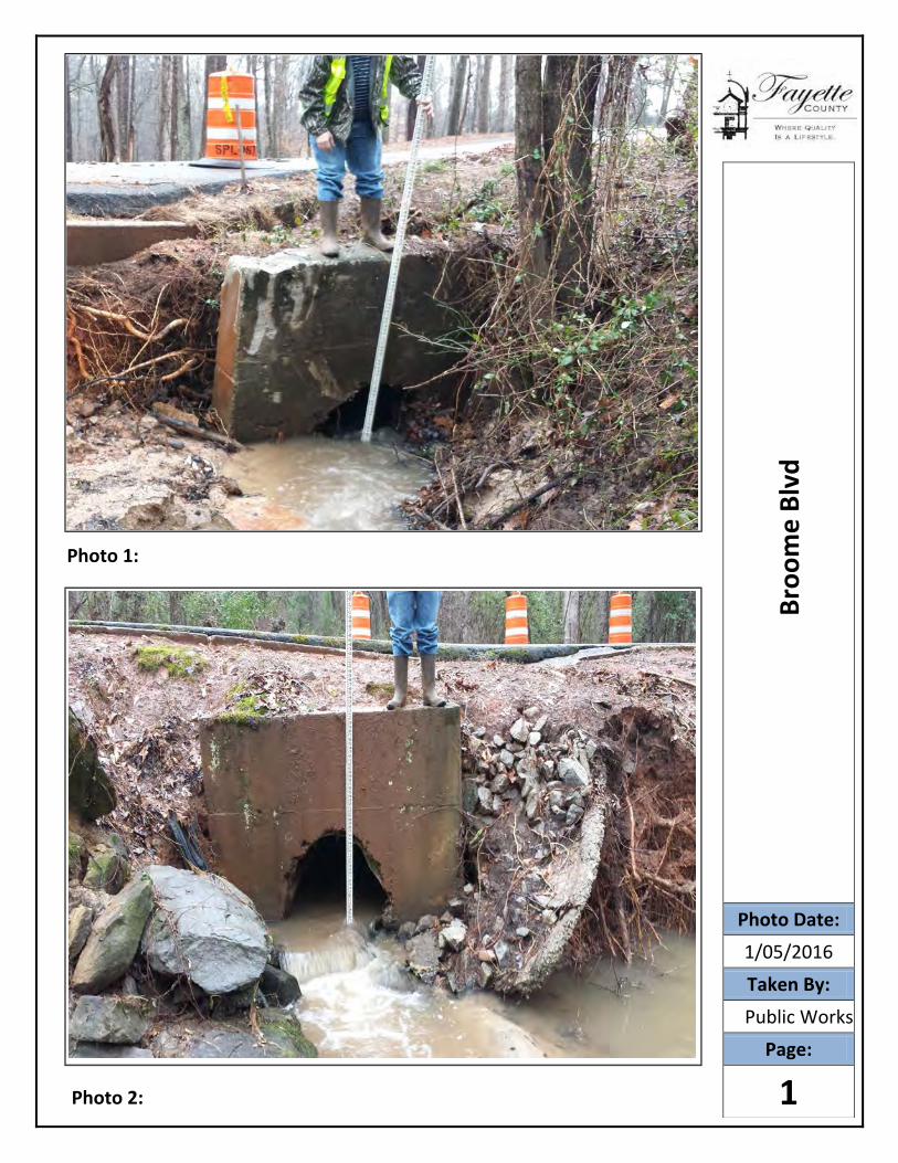
Photo 1:
Photo 2:
Broo
me
Blvd
Photo Date:
1/05/2016Taken By:
Public Works
Page:
1
Roadway Construction, Utility Relocation and ROW Quantity Calculations
Roadway Construction Removal Unit Cost Installation Unit
Cost Amount Total Cost
Pavement (SF) 0.73$ $ 4.87 432.00 2,421.50$
Curb and Gutter (LF) 28.56$ $ 30.60 0.00 -$
Drain Inlet (EA) $ 3,000.00 0.00 -$
4" Sidewalk (SY) 13.56$ $ 36.90 0.00 -$
Guardrail (LF) 4.88$ $ 49.09 625.00 33,735.00$
End Anchorage (EA) $ 1,380.00 2.00 2,760.00$
Subtotal 38,916.50$
Grading Complete (5% of Rwy Items & Drng Total $) 9,676.63$
Roadway Total 49,963.13$
Drainage Removal Unit Cost Installation Unit
Cost Amount Total Cost
Trench Excavation (CY) $ 10.38 373.33 3,875.20$
36" CMP (LF) 19.62$ 140.00 8,240.40$
36" RCP $ 134.40 0.00 -$
Class A Conc (CY) $ 892.19 132.51 118,223.83$
Steel (lb) $ 1.42 13,383.00 18,950.33$
Pipe Bedding (CY) $ 48.60 48.00 2,332.80$
Trench Backfill (CY) $ 2.99 370.67 1,107.55$
Trench Compaction (CY) $ 6.36 296.53 1,885.95$
Drainage Total 154,616.06$
Signing and Marking Installation Unit
Cost Amount Total Cost
Permanent Striping (LF) $ 0.71 72.00 50.98$
Signing and Marking Total 50.98$
Staging Installation Unit
Cost Amount Total Cost
Clearing and Grubbing (Acre) $ 10,260.00 0.20 2,052.00$
Temporary Gravel Road (SY) $ 15.42 977.78 15,077.33$
Temporary Drainage (Stream Diversion) $ 4,428.00 2.00 8,856.00$
Staging Total 26,087.29$
Erosion Control Installation Unit
Cost Amount Total Cost
Fine Grading and Seeding (SY) $ 4.39 92.00 404.06$
Temporary Grassing (AC) $ 855.60 0.00 -$
Type C Silt Fence (LF) $ 4.24 560.00 2,372.16$
Check Dam Type C Silt Fence (LF) $ 6.79 560.00 3,803.52$
Erosion Control Mats (SY) $ 1.87 560.00 1,048.32$
Landscape Mulch (SY) $ 3.58 560.00 2,002.56$
Perm Grassing (AC) $ 1,402.20 0.00 -$
Rip Rap Type 3 12" (SY) $ 60.98 48.00 2,927.23$
Plastic Filter Fabric (SY) $ 5.72 48.00 274.75$
4" Ditch Paving (SY) $ 54.65 0.00 -$
Erosion Control Total 12,832.61$
Construction Cost Total 243,550.07$
Traffic Control (8% of Construction Total $) 19,484.01$
County Emergency Roadway Work 1,370.00$
Construction Cost Grand Total 264,404.07$
Utility Relocation Removal Unit Cost Installation Unit
Cost Amount Total Cost
Electric
Aerial 11.00$ $ 55.00 -$
Buried 16.50$ $ 82.50 0.00 -$
Wooden Pole 82.50$ $ 605.00 -$
Phone
Aerial 11.00$ $ 27.50 -$
Buried 16.50$ $ 55.00 100.00 7,150.00$
Wooden Pole 82.50$ $ 605.00 -$
Cable
Aerial 11.00$ $ 27.50 -$
Buried 16.50$ $ 55.00 100.00 7,150.00$
Wooden Pole 82.50$ $ 605.00 -$
Gas
4" main 16.50$ $ 66.00 -$
Water
8" main 16.50$ $ 93.50 100.00 11,000.00$
Relocate Fire Hydrant (EA) $ 2,609.22 -$
Sewer 0.00
12" main 16.50$ $ 82.50 0.00 -$
Utility Relocation Total 25,300.00$
Right of Way (Sq Ft) Cost/ Sq Ft Sq Ft Total Cost
Permanent Easement $ 4.00 12,000.00 48,000.00$
ROW Total 48,000.00$

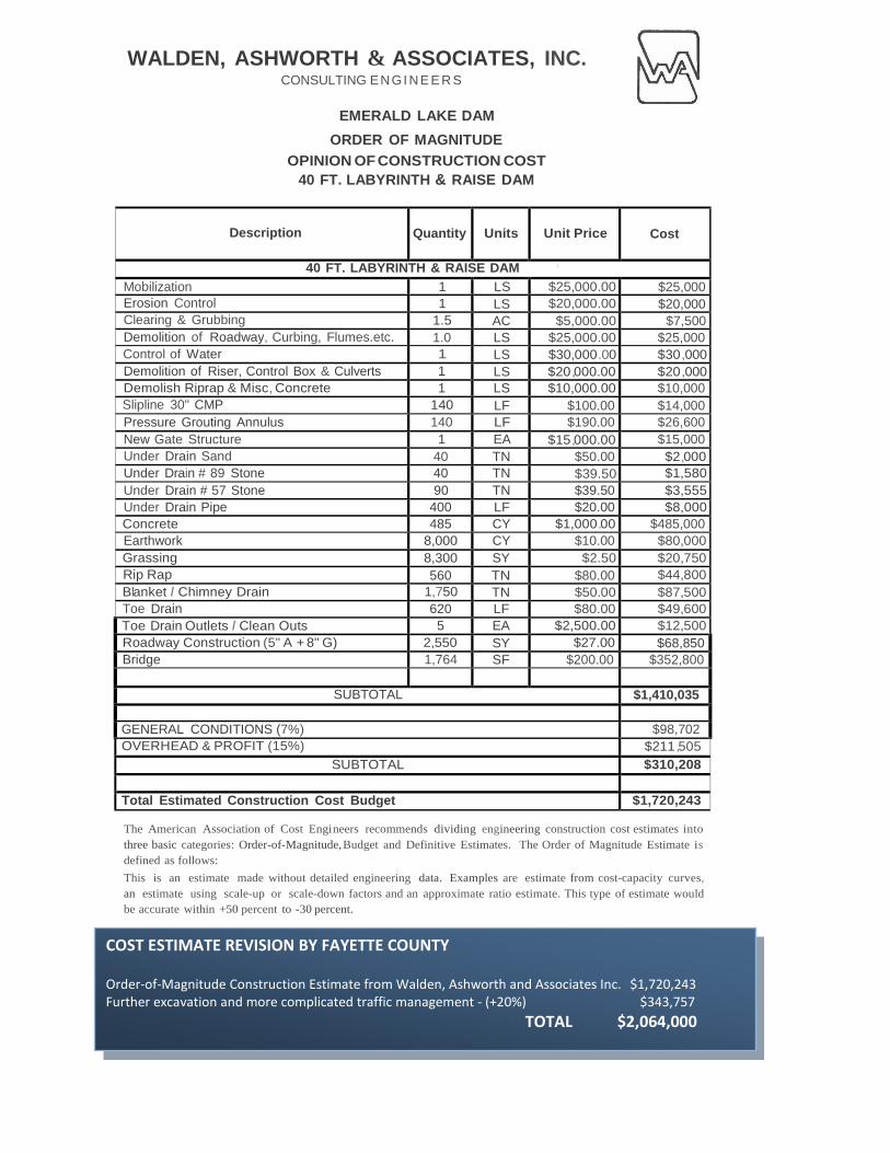
WALDEN, ASHWORTH & ASSOCIATES, INC. CONSULTING ENGI NE E R S
EMERALD LAKE DAM
ORDER OF MAGNITUDE OPINION OF CONSTRUCTION COST
40 FT. LABYRINTH & RAISE DAM
Description
Quantity
Units
Unit Price
Cost
40 FT. LABYRINTH & RAISE DAM I
Mobilization 1 LS $25,000.00 $25,000 Erosion Control 1 LS $20,000.00 $20,000 Clearing & Grubbing 1.5 AC $5,000.00 $7,500 Demolition of Roadway, Curbing, Flumes.etc. 1.0 LS $25,000.00 $25,000 Control of Water 1 LS $30,000 .00 $30 ,000 Demolition of Riser, Control Box & Culverts 1 LS $20,000.00 $20 ,000 Demolish Riprap & Misc, Concrete 1 LS $10,000.00 $10,000 Slipline 30" CMP 140 LF $100.00 $14,000 Pressure Grouting Annulus 140 LF $190.00 $26,600 New Gate Structure 1 EA $15,000.00 $15,000 Under Drain Sand 40 TN $50.00 $2,000 Under Drain # 89 Stone 40 TN $39.50 $1,580 Under Drain # 57 Stone 90 TN $39.50 $3,555 Under Drain Pipe 400 LF $20.00 $8,000 Concrete 485 CY $1,000.00 $485,000 Earthwork 8,000 CY $10.00 $80,000 Grassing 8,300 SY $2.50 $20,750 Rip Rap 560 TN $80.00 $44,800 Blanket I Chimney Drain 1,750 TN $50.00 $87,500 Toe Drain 620 LF $80.00 $49,600 Toe Drain Outlets I Clean Outs 5 EA $2,500.00 $12,500 Roadway Construction (5" A + 8" G) 2,550 SY $27.00 $68,850 Bridge 1,764 SF $200.00 $352,800
SUBTOTAL $1,410,035
GENERAL CONDITIONS (7%) $98,702 OVERHEAD & PROFIT (15%) $211 ,505
SUBTOTAL $310,208 Total Estimated Construction Cost Budget $1,720,243
The American Association of Cost Engi neers recommends dividing engineering construction cost estimates into three basic categories: Order-of-Magnitude, Budget and Definitive Estimates. The Order of Magnitude Estimate is defined as follows: This is an estimate made without detailed engineering data. Examples are estimate from cost-capacity curves, an estimate using scale-up or scale-down factors and an approximate ratio estimate. This type of estimate would be accurate within +50 percent to -30 percent.
COST ESTIMATE REVISION BY FAYETTE COUNTY
Order-of-Magnitude Construction Estimate from Walden, Ashworth and Associates Inc. $1,720,243 Further excavation and more complicated traffic management - (+20%) $343,757 TOTAL $2,064,000
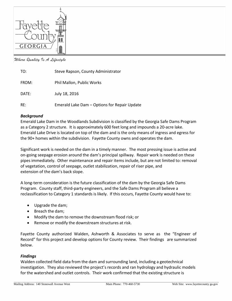
TO: Steve Rapson, County Administrator
FROM: Phil Mallon, Public Works
DATE: July 18, 2016
RE: Emerald Lake Dam – Options for Repair Update
Background Emerald Lake Dam in the Woodlands Subdivision is classified by the Georgia Safe Dams Program as a Category 2 structure. It is approximately 600 feet long and impounds a 20-acre lake. Emerald Lake Drive is located on top of the dam and is the only means of ingress and egress for the 90+ homes within the subdivision. Fayette County owns and operates the dam.
Significant work is needed on the dam in a timely manner. The most pressing issue is active and on-going seepage erosion around the dam’s principal spillway. Repair work is needed on these pipes immediately. Other maintenance and repair items include, but are not limited to: removal of vegetation, control of seepage, outlet stabilization, repair of riser pipe, and extension of the dam’s back slope.
A long-term consideration is the future classification of the dam by the Georgia Safe Dams Program. County staff, third-party engineers, and the Safe Dams Program all believe a reclassification to Category 1 standards is likely. If this occurs, Fayette County would have to:
• Upgrade the dam; • Breach the dam; • Modify the dam to remove the downstream flood risk; or • Remove or modify the downstream structures at risk.
Fayette County authorized Walden, Ashworth & Associates to serve as the “Engineer of Record” for this project and develop options for County review. Their findings are summarized below.
Findings Walden collected field data from the dam and surrounding land, including a geotechnical investigation. They also reviewed the project’s records and ran hydrology and hydraulic models for the watershed and outlet controls. Their work confirmed that the existing structure is
Mailing Address: 140 Stonewall Avenue West Main Phone: 770-460-5730 Web Site: www.fayettecounty ga.gov
designed to pass flows associated with the 24-hour, 10-year storm event. Larger storms will result in the dam being overtopped. That is, during any year, there is less than a 10 percent chance that the road will be overtopped and access limited (or prohibited) into and out of the subdivision.
Ultimately, four options were identified and an Order-of-Magnitude estimate was developed for each. Staff reviewed these options and narrowed the list to two alternatives.
Slip-line Existing Pipes & Install a Seepage Drain – This option addresses the immediate repair and maintenance needs of the dam. It includes clearing and grubbing, draining the lake, water control, slip-lining the five 80-ft long corrugated metal pipes (48” diameter each), pressure grouting around the pipes, installation of a new riser pipe, installation of comprehensive drain system, and stabilization. The estimated construction cost for this work is $694,000.
Advantages of this option include a substantially lower cost, resolution of immediate structural issues, and minimal impacts to traffic during construction. This option, however, does not improve the hydraulic capacity of the dam; so the probability of the road being overtopped remains as it currently is. Furthermore, the work associated with slip-lining the pipes (approximately 25% of the total project cost) plus some of the grading, stabilization and other tasks would have to be modified or replaced if the dam is classified as a Category 1 structure in the future.
40-ft Labyrinth Weir & Raise Dam – This option also addresses the immediate repair and maintenance needs of the dam plus substantially increases the hydraulic capacity of the structure. Work items include: clearing & grubbing; draining the lake; water control; demolition of roadway, pipes, and concrete weir; construction of 40-ft labyrinth weir; placement of bridge over weir; roadway reconstruction; installation of a new riser pipe; installation of comprehensive drain system; and stabilization. This option address immediate structural issues and substantially increases flow capacity of the dam. The new outlet control would be designed to meet Category 1 standards so no re-work of the outlet control and spillway is anticipated. This option also reduces the chance of road overtopping to less than 1 percent per year. The original estimated construction cost for this work was $1,720,000. The weir, bridge and road reconstruction account for over $900,000. Further engineering design work has identified poor subsoils which will result in more excavation and a more complicated traffic management plan. Because of these issues a new estimate based on a 20 percent increase of the Engineer’s Order of Magnitude estimate is advised. This increases the estimated cost from $1,720,243 to an estimated $2,064,000.
Recommendation Staff recommends the 40-ft labyrinth weir option. Although nearly 2.5 times the cost this options provides the triple benefit of 1) repairing immediate needs; 2) reducing the probability of stranding homeowners during flood events; and 3) meeting Category 1 standards should they become applicable.

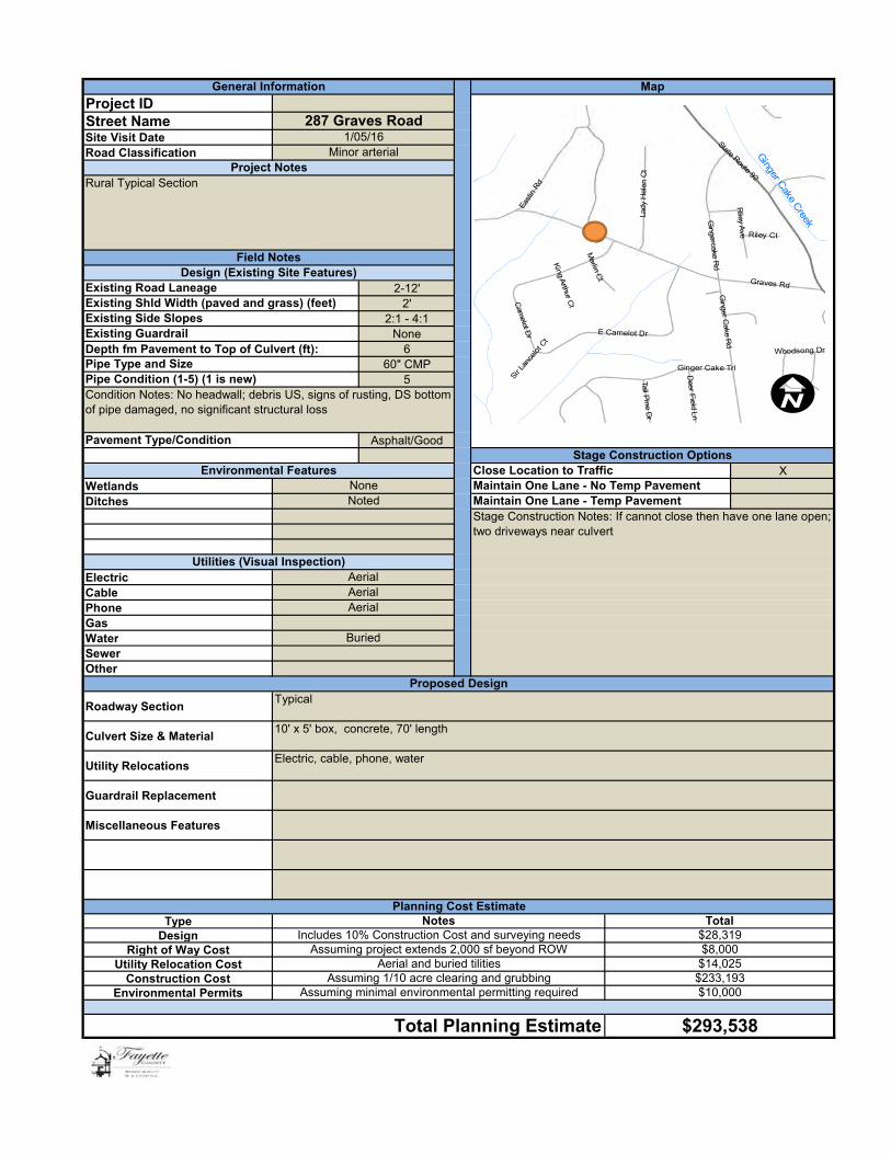
Project IDStreet NameSite Visit DateRoad Classification
2-12'2'
2:1 - 4:1None
Depth fm Pavement to Top of Culvert (ft): 660" CMP
5
Asphalt/Good
XWetlandsDitches
ElectricCablePhoneGasWaterSewerOther
Roadway Section
Culvert Size & Material10' x 5' box, concrete, 70' length
Utility Relocations
Guardrail Replacement
Miscellaneous Features
TypeDesign
Right of Way CostUtility Relocation Cost
Construction CostEnvironmental Permits
Maintain One Lane - No Temp PavementMaintain One Lane - Temp PavementStage Construction Notes: If cannot close then have one lane open; two driveways near culvert
AerialAerial
Utilities (Visual Inspection)
Typical
Electric, cable, phone, water
Existing Side Slopes
Proposed Design
NoneNoted
Existing Guardrail
Aerial
Project Notes
MapGeneral Information
Rural Typical Section
Minor arterial1/05/16
287 Graves Road
Design (Existing Site Features)Field Notes
Existing Road LaneageExisting Shld Width (paved and grass) (feet)
Pipe Type and SizePipe Condition (1-5) (1 is new)
Stage Construction Options
Condition Notes: No headwall; debris US, signs of rusting, DS bottom of pipe damaged, no significant structural loss
Close Location to TrafficEnvironmental Features
Pavement Type/Condition
Buried
Assuming minimal environmental permitting required
Total
Aerial and buried tilities
$28,319
$14,025
$10,000$233,193
Includes 10% Construction Cost and surveying needs
Planning Cost EstimateNotes
Assuming 1/10 acre clearing and grubbing
Assuming project extends 2,000 sf beyond ROW $8,000
$293,538Total Planning Estimate
!(
Ginger C
ake Creek
Graves Rd
State Route 92
East
in R
d
Cam
elot Dr E Camelot Dr
Ginger Cake Trl
Ginger C
ake Rd
Gingercake R
d
L ad y
He l
e n C
t
Riley A
ve Riley Ct
Merlin C
t
Deer F
ield Ln
Tall Pine D
r
Woodsong Dr
King A
rthur Ct
Sir L
ance
lot C
t
26
I
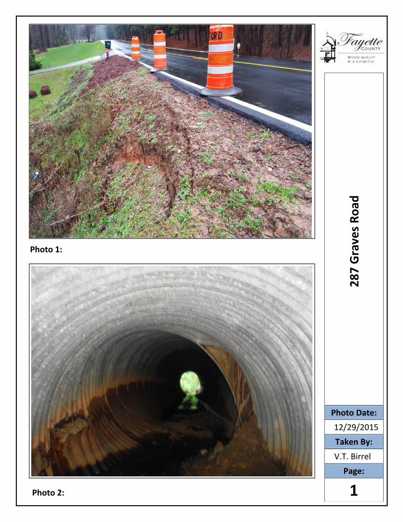
Photo 1:
Photo 2:
287
Gra
ves R
oad
Photo Date:
12/29/2015Taken By:
V.T. Birrell
Page:
1
Roadway Construction, Utility Relocation and ROW Quantity Calculations
Roadway Construction Removal Unit
Cost
Installation Unit
Cost Amount Total Cost
Pavement (SF) $ 0.73 $ 4.87 288.00 $ 1,614.34
Curb and Gutter (LF) $ 28.56 $ 30.60 0.00 $ -
Drain Inlet (EA) $ 3,000.00 0.00 $ -
4" Sidewalk (SY) $ 13.56 $ 36.90 0.00 $ -
Guardrail (LF) $ 4.88 $ 49.09 0.00 $ -
End Anchorage (EA) $ 1,380.00 0.00 $ -
Subtotal $ 1,614.34
Grading Complete (5% of Rwy Items & Drng Total $) $ 9,731.59
Roadway Total $ 11,345.93
Drainage $ 5.00 Installation Unit
Cost Amount Total Cost
Trench Excavation (CY) $ 10.38 373.33 $ 3,875.20
60" CMP (LF) $ 24.60 70.00 $ 5,166.00
60" RCP (LF) $ 259.20 0.00 $ -
Class A Conc (CY) $ 892.19 172.26 $ 153,688.30
Steel (lb) $ 1.42 17,995.00 $ 25,480.92
Pipe Bedding (CY) $ 48.60 32.00 $ 1,555.20
Trench Backfill (CY) $ 2.99 402.67 $ 1,203.17
Trench Compaction (CY) $ 6.36 322.13 $ 2,048.77
Drainage Total $ 193,017.56
Signing and Marking Installation Unit
Cost Amount Total Cost
Permanent Striping (LF) $ 0.71 48.00 $ 33.98
Signing and Marking Total $ 33.98
Staging Installation Unit
Cost Amount Total Cost
Clearing and Grubbing (Acre) $ 10,260.00 0.10 $ 1,026.00
Temporary Pavement $ -
Temporary Drainage (Stream Diversion) $ 4,428.00 1.00 $ 4,428.00
Staging Total $ 5,521.97
Erosion Control Installation Unit
Cost Amount Total Cost
Fine Grading and Seeding (SY) $ 4.39 61.33 $ 269.38
Temporary Grassing (AC) $ 855.60 0.00 $ -
Type C Silt Fence (LF) $ 4.24 280.00 $ 1,186.08
Check Dam Type C Silt Fence (LF) $ 6.79 280.00 $ 1,901.76
Erosion Control Mats (SY) $ 1.87 93.33 $ 174.72
Landscape Mulch (SY) $ 3.58 93.33 $ 333.76
Perm Grassing (AC) $ 1,402.20 0.00 $ -
Rip Rap Type 3 12" (SY) $ 60.98 32.00 $ 1,951.49
Plastic Filter Fabric (SY) $ 5.72 32.00 $ 183.17
4" Ditch Paving (SY) $ 54.65 0.00 $ -
Erosion Control Total $ 6,000.35
Construction Cost Total $ 215,919.80
Traffic Control (8% of Construction Total $) $ 17,273.58
Construction Cost Grand Total $ 233,193.38
Utility Relocation Removal Unit
Cost
Installation Unit
Cost Amount Total Cost
Electric
Aerial $ 11.00 $ 55.00 50.00 $ 3,300.00
Buried $ 16.50 $ 82.50 0.00 $ -
Wooden Pole $ 82.50 $ 605.00 2.00 $ 1,375.00
Phone
Aerial $ 11.00 $ 27.50 50.00 $ 1,925.00
Buried $ 16.50 $ 55.00 0.00 $ -
Wooden Pole $ 82.50 $ 605.00 $ -
Cable
Aerial $ 11.00 $ 27.50 50.00 $ 1,925.00
Buried $ 16.50 $ 55.00 0.00 $ -
Wooden Pole $ 82.50 $ 605.00 $ -
Gas
4" main $ 16.50 $ 66.00 $ -
Water
8" main $ 16.50 $ 93.50 50.00 $ 5,500.00
Relocate Fire Hydrant (EA) $ 2,609.22 $ -
Sewer 0.00
12" main $ 16.50 $ 82.50 0.00 $ -
Utility Relocation Total $ 14,025.00
Right of Way (Sq Ft) Cost/ Sq Ft Sq Ft Total Cost
Permanent Easement $ 4.00 2,000.00 $ 8,000.00
ROW Total $ 8,000.00

Project IDStreet NameSite Visit DateRoad Classification
2-8'16'
NoneDepth fm Pavement to Top of Culvert (ft): 4'
60" CMP5
Asphalt/Concrete
Wetlands XDitchesState Waters
ElectricCablePhoneGasWaterSewerOther
Roadway Section
Culvert Size & Material
Utility Relocations
Guardrail Replacement
Miscellaneous Features
TypeDesign
Right of Way CostUtility Relocation Cost
Construction CostEnvironmental Permits
Unknown
Unknown
tree removal
Proposed DesignStreet
Curb and gutter
$41,899
10% of Construction Cost and any surveying needed
60" RCP with junction box; 24" RCP with double-wing catch basins
Heritage Park Way
Unknown
Removal/replacement drain inlets, buried cable.
$0
Planning Cost Estimate
Total Planning Estimate $98,397
Total
$0
Notes
$56,498It is assumed all utilites will be relocated
$0
6/9/2016
Unknown
Unknown
Existing Road Laneage
Maintain One Lane - No Temp PavementMaintain One Lane - Temp Pavement
Pavement Type/Condition
nono
Existing Guardrail
Close Location to TrafficEnvironmental Features
no
Utilities (Visual Inspection)
MapGeneral Information
Heritage Park Way is the only county-owned road in the City of Fayetteville and therefore, maintained by the County.
StreetProject Notes
Field NotesDesign (Existing Site Features)
Existing Side Slopes
Pipe Type and Size
Pipe failure from junction box at S Glynn Street and Heritage Park Way. System ties into 18- in. diameter corregated metal cross pipe on Heritage, where flooding routinely occurs due insufficient pipe
Pipe Condition (1-5) (1 is new)
Existing Shld Width (paved and grass) (feet)
Stage Construction Notes:
Stage Construction Options
Roadway Construction, Utility Relocation and ROW Quantity Calculations
Roadway ConstructionRemoval
Unit Cost
Installation
Unit CostAmount Total Cost
Pavement (SF) 0.73$ 4.87$ 154.00 863.22$
Curb and Gutter (LF) 28.56$ 30.60$ 65.00 3,845.40$
DWCB 1,520.00$ 2.00 3,040.00$
4" Sidewalk (SY) 13.56$ 36.90$ 0.00 0
Guardrail (LF) 4.88$ 49.09$ 0.00 0
End Anchorage (EA) 1,380.00$ 0.00 0
Subtotal 7,748.62$
Grading Complete (5% of Rwy Items & Drng Total $) 2,491.09$
Roadway Total 10,239.71$
DrainageRemoval
Unit Cost
Installation
Unit CostAmount Total Cost
Trench Excavation (CY) 10.38$ 391.11 4,059.73$
60" CMP (LF) 24.60$ 88.00 2,164.80$
60" RCP (LF) 223.12$ 88.00 19,634.56$
24" RCP (LF) 36.45$ 12.00 437.44$
Class A Conc (CY) $ 892.19 0.00 -$
Steel (lb) 1.42$ 0.00 -$
Pipe Bedding (CY) 48.60$ 0.00 -$
Trench Backfill (CY) 2.99$ 5280.00 15,776.64$
Trench Compaction (CY) 6.36$ 0.00 -$
Drainage Total 42,073.17$
Signing and MarkingInstallation
Unit CostAmount Total Cost
Permanent Striping (LF) 0.71$ 0 -$
Signing and Marking Total -$
StagingInstallation
Unit CostAmount Total Cost
Clearing and Grubbing (Acre) 10,260.00$ -$
Temporary Pavement 0
Temporary Drainage (Stream Diversion) 4,428.00$ -$
Staging Total -$
Erosion ControlInstallation
Unit CostAmount Total Cost
Fine Grading and Seeding (SY) 4.39$ 0.00 -$
Temporary Grassing (AC) 855.60$ 0.00 -$
Type C Silt Fence (LF) 4.24$ 0.00 -$
Check Dam Type C Silt Fence (LF) 6.79$ 0.00 -$
Erosion Control Mats (SY) 1.87$ 0.00 -$
Landscape Mulch (SY) 3.58$ 0.00 -$
Perm Grassing (AC) 1,402.20$ 0.00 -$
Rip Rap Type 3 12" (SY) 60.98$ 0.00 -$
Plastic Filter Fabric (SY) 5.72$ 0.00 -$
4" Ditch Paving (SY) 54.65$ 0.00 -$
Erosion Control Total -$
Construction Cost Total 52,312.88$
Traffic Control (8% of Construction Total
$)4,185.03$
Construction Cost Grand Total 56,497.92$
Utility RelocationRemoval
Unit Cost
Installation
Unit CostAmount Total Cost
Electric
Aerial $ 11.00 $ 55.00 0.00 -$
Buried 16.50$ 82.50$ 88.00 8,712.00$
Wooden Pole 82.50$ 605.00$ 0.00 -$
Phone
Aerial $ 11.00 $ 27.50 0.00 -$
Buried 16.50$ 55.00$ 88.00 6,292.00$
Wooden Pole 82.50$ 605.00$ 0.00 -$
Cable
Aerial 11.00$ 27.50$ 0.00 -$
Buried 16.50$ 55.00$ 50.00 3,575.00$
Wooden Pole 82.50$ 605.00$ 0.00 -$
Gas
4" main 16.50$ 66.00$ 80.00 6,600.00$
Water
8" main 16.50$ 93.50$ 80.00 8,800.00$
Sewer
12" main 16.50$ 82.50$ 80.00 7,920.00$
Utility Relocation Total 41,899.00$
Right of Way (Sq Ft) Cost/ Sq Ft Sq Ft Total Cost
Permanent Easement 4.00$ -$ -$
ROW Total -$
Page 1 of 2
Neely Road / Lake Kozisek Dam - Order of Magnitude Opinion of Cost
Kozisek Dam is a Safe Dams Program Category I structure adjacent to and possibly
partially within Fayette County Right-of-Way for Neely Road. The project includes evaluation, design,
permitting, and construction of necessary improvements and changes to Neely Road to ensure it
safely passes design flows and to remove any County liability/ownership that may be associated
with Kozisek Dam.
This is an Order of Magnitude Opinion of Cost and based solely on a visual inspection of the dam. No
survey measurements, geotechnical evaluations, hydrologic or hydraulic analyses, material testing or
other calculations were made in support of the Opinion of Cost other than the assumptions identified
below.
A third-party Engineer was hired to develop the Opinion of Cost for the other two Dam projects included
in the SPLOST list. The estimate for the Neely Road / Lake Kozisek Dam work was developed
by County staff because of the greater uncertainty associated with the scope of this project. Several
options are available for bringing this structure into compliance and the County's degree of involvement
may change depending upon the final option selected.
The Kozisek Lake Dam is approximately 1,004 feet long, 26 feet in height and has a crest width of 12 feet.
The drainage area to the dam is 430 acres (+/-).
Page 2 of 2
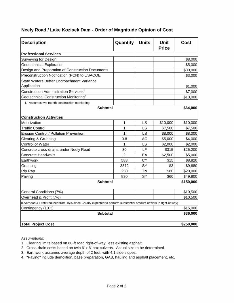
Neely Road / Lake Kozisek Dam - Order of Magnitude Opinion of Cost
Description Quantity Units Unit Cost
Price
Professional Services
Surveying for Design $8,000
Geotechnical Exploration $5,000
Design and Preparation of Construction Documents $30,000
Preconstruction Notification (PCN) to USACOE $3,000
State Waters Buffer Encroachment Variance
Application $1,000
Construction Administration Services1
$7,000
Geotechnical Construction Monitoring1
$10,000
1. Assumes two month construction monitoring
Subtotal $64,000
Construction Activities
Mobilization 1 LS $10,000 $10,000
Traffic Control 1 LS $7,500 $7,500
Erosion Control / Pollution Prevention 1 LS $8,000 $8,000
Clearing & Grubbing 0.8 AC $5,000 $4,000
Control of Water 1 LS $2,000 $2,000
Concrete cross-drains under Neely Road 80 LF $315 $25,200
Concrete Headwalls 2 EA $2,500 $5,000
Earthwork 588 CY $15 $8,820
Grassing 3872 SY $3 $9,680
Rip Rap 250 TN $80 $20,000
Paving 830 SY $60 $49,800
Subtotal $150,000
General Conditions (7%) $10,500
Overhead & Profit (7%) $10,500
(Overhead & Profit reduced from 15% since County expected to perform substantial amount of work in right-of-way)
Contingency (10%) $15,000
Subtotal $36,000
Total Project Cost $250,000
Assumptions:1. Clearing limits based on 60-ft road right-of-way, less existing asphalt.
2. Cross-drain costs based on twin 6' x 6' box culverts. Actual size to be determined.
3. Earthwork assumes average depth of 2 feet, with 4:1 side slopes.
4. "Paving" include demolition, base preparation, GAB, hauling and asphalt placement, etc.
Project IDStreet NameSite Visit DateRoad Classification
2-12'
NoDepth fm Pavement to Top of Culvert (ft): (+/-) 5.2'
3 - 72" CMP5
Asphalt/Good
XWetlandsDitchesState Waters
ElectricCablePhoneGasWaterSewerOther
Roadway Section
Culvert Size & Material
Utility Relocations
Guardrail Replacement
Miscellaneous Features
Type
Design
Right of Way CostUtility Relocation Cost
Construction Cost
MapGeneral Information
Culvert replacement alternatives to provide flow capacity for the 100 year storm peak runoff.
RuralProject Notes
Field NotesDesign (Existing Site Features)
Assumed road closure
Existing Side Slopes
Pipe Type and Size
Condition Notes: Existing culverts do not provide service for the 100 yr storm event.
Pipe Condition (1-5) (1 is new)
Existing Shld Width (paved and grass) (feet)
Stage Construction Notes:
Stage Construction Options
1/20/2016
Underground
Unknown
Existing Road Laneage
Maintain One Lane - No Temp PavementMaintain One Lane - Temp Pavement
Pavement Type/Condition
TBDYES
Existing Guardrail
Close Location to TrafficEnvironmental Features
YES
Utilities (Visual Inspection)
16" Waterline
$17,424
Planning Cost Estimate
Total Planning Estimate $511,849
TotalNotes
$310,434
Assuming UPS/DWS ends extends past ROW 1/20 acre
$51,470
Underground
Aerial
Underground
Includes 1/8 acre clearing and grubbing, guardrail installation
Proposed DesignTypical
$132,521
Actual Cost including Environmental Permitting and Eng of Record Administrative Fee
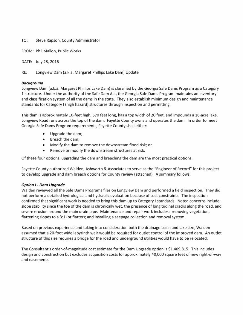
2-8'X7' Concrete Box Culvert with associated wing walls and rip-rap.
Lees Mill Rd
Unknown
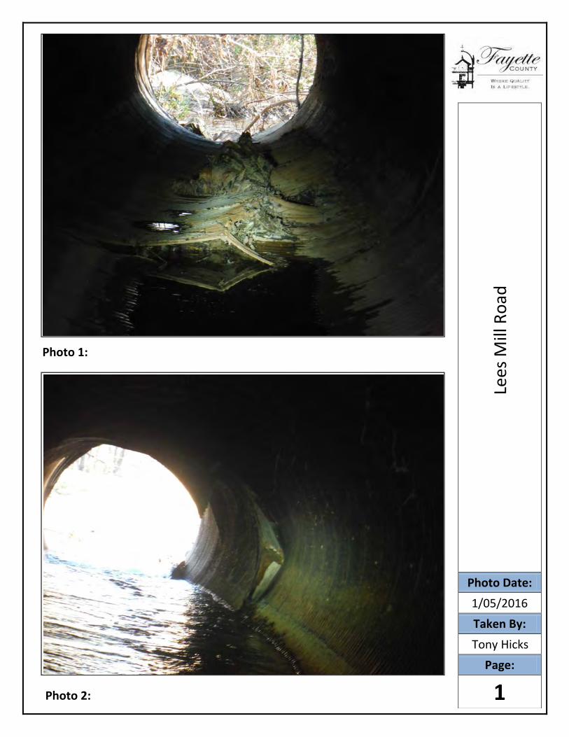
Photo 1:
Photo 2:
Lees
Mill
Ro
ad
Photo Date:
1/05/2016Taken By:
Tony Hicks
Page:
1
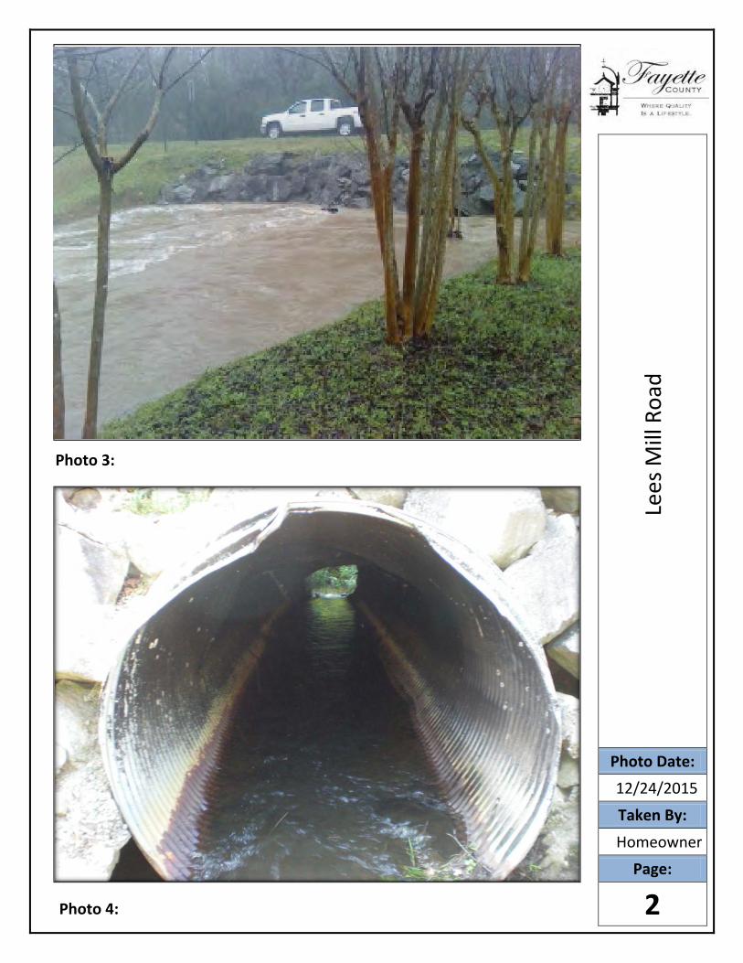
Photo 3:
Photo 4:
Lees
Mill
Roa
d
Photo Date:
12/2 /2015
Taken By:
Homeo ne
Page:
2
Roadway Construction, Utility Relocation and ROW Quantity Calculations
Roadway ConstructionRemoval
Unit Cost
Installation
Unit CostAmount Total Cost
Pavement (SF) 0.73$ 4.87$ 1200.00 6,726.40$
Curb and Gutter (LF) -$ 18.42$ 0.00 -$
4" Sidewalk (SY) -$ 36.90$ 0.00 0
Guardrail (LF) -$ 49.09$ 110.00 5400.12
End Anchorage (EA) 1,380.00$ 4.00 5520
Subtotal 17,646.52$
Grading Complete (5% of Rwy Items & Drng Total $) 10,792.91$
Roadway Total 28,439.43$
DrainageRemoval
Unit Cost
Installation
Unit CostAmount Total Cost
Trench Excavation (CY) 10.38$ 554.65 5,757.30$
72" CMP (LF) 54.00$ 180.00 9,720.00$
2-8'X7' Box Culvert (CY) $ 892.19 154.98 138,271.61$
Box Culvert Wingwalls, Parapetes (CY) 892.19$ 20.82 18,575.40$
Steel (lb) 1.42$ 15023.40 21,333.23$
Culvert Bedding (CY) 48.60$ 32.60 1,584.36$
Trench Backfill (CY) 2.99$ 367.73 1,098.77$
Trench Compaction (CY) 6.36$ 294.18 1,870.99$
Drainage Total 198,211.64$
Signing and MarkingInstallation
Unit CostAmount Total Cost
Permanent Striping (LF) 0.71$ 50 35.40$
Signing and Marking Total 35.40$
StagingInstallation
Unit CostAmount Total Cost
Clearing and Grubbing (Acre) 10,260.00$ 0.13 1,282.50$
Temporary Pavement 0.00 0
Temporary Drainage (Stream Pump Around) 30,000.00$ 1.00 30,000.00$
Staging Total 31,317.90$
Erosion ControlInstallation
Unit CostAmount Total Cost
Fine Grading and Seeding (SY) 4.39$ 100.00 439.20$
Temporary Grassing (AC) 855.60$ 0.00 -$
Type C Silt Fence (LF) 4.24$ 168.00 711.65$
Check Dam Type C Silt Fence (LF) 6.79$ 0.00 -$
Erosion Control Mats (SY) 1.87$ 0.00 -$
Landscape Mulch (SY) 3.58$ 0.00 -$
Perm Grassing (AC) 1,402.20$ 0.00 -$
Rip Rap Type 3 12" (SY) 60.98$ 340.00 20,734.56$
Plastic Filter Fabric (SY) 5.72$ 340.00 1,946.16$
4" Ditch Paving (SY) 54.65$ 0.00 -$
Ditch Adjustment/Grading (LS) 5,000.00$ 1.00 5,000.00$
Erosion Control Total 28,831.57$
Construction Cost Total 286,835.94$
Traffic Control (8% of Construction Total $) 22,946.88$ Public Works Costs 651
Construction Cost Grand Total 310,433.81$
Utility RelocationRemoval
Unit Cost
Installation
Unit CostAmount Total Cost
Electric
Aerial $ 11.00 $ 55.00 0.00 -$
Buried 16.50$ 82.50$ 0.00 -$
Wooden Pole 82.50$ 605.00$ 0.00 -$
Phone
Aerial $ 11.00 $ 27.50 0.00 -$
Buried 16.50$ 55.00$ 0.00 -$
Wooden Pole 82.50$ 605.00$ 0.00 -$
Cable
Aerial 11.00$ 27.50$ 0.00 -$
Buried 16.50$ 55.00$ 0.00 -$
Wooden Pole 82.50$ 605.00$ 0.00 -$
Gas
4" main 16.50$ 66.00$ 0.00 -$
Water
Cap and Remove (EA) 3,045.00$ 1.00 3,045.00$
16" Watermain (LF) 203.73$ 200.00 40,746.00$
16" Gate Valve (EA) 7,885.00$ 2.00 15,770.00$
20" Steel Casing (LF) $ 162.00 120.00 19,440.00$
16" Jack and Bore (EA) 396.00$ 120.00 47,520.00$
16" 45 degree MJ Bend (EA) 1,500.00$ 4.00 6,000.00$
Utility Relocation Total 132,521.00$
Right of Way (Sq Ft) Cost/ Sq Ft Sq Ft Total Cost
Permanent Easement 4.00$ 4356.00 17,424.00$
ROW Total 17,424.00$
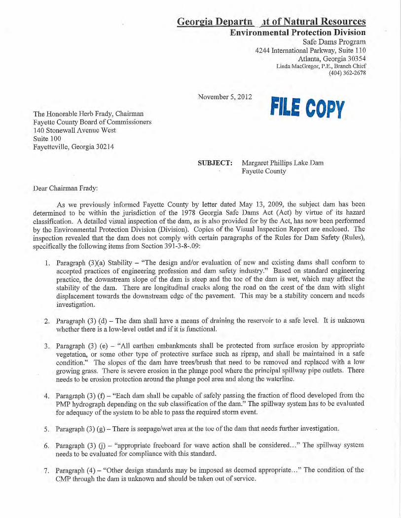
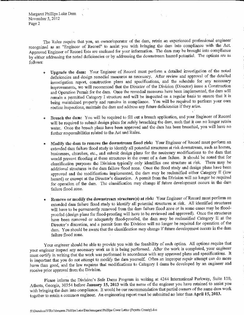
TO: Steve Rapson, County Administrator FROM: Phil Mallon, Public Works DATE: July 28, 2016 RE: Longview Dam (a.k.a. Margaret Phillips Lake Dam) Update Background Longview Dam (a.k.a. Margaret Phillips Lake Dam) is classified by the Georgia Safe Dams Program as a Category 1 structure. Under the authority of the Safe Dam Act, the Georgia Safe Dams Program maintains an inventory and classification system of all the dams in the state. They also establish minimum design and maintenance standards for Category I (high hazard) structures through inspection and permitting. This dam is approximately 16-feet high, 670 feet long, has a top width of 20 feet, and impounds a 16-acre lake. Longview Road runs across the top of the dam. Fayette County owns and operates the dam. In order to meet Georgia Safe Dams Program requirements, Fayette County shall either:
• Upgrade the dam; • Breach the dam; • Modify the dam to remove the downstream flood risk; or • Remove or modify the downstream structures at risk.
Of these four options, upgrading the dam and breaching the dam are the most practical options. Fayette County authorized Walden, Ashworth & Associates to serve as the “Engineer of Record” for this project to develop upgrade and dam breach options for County review (attached). A summary follows. Option I - Dam Upgrade Walden reviewed all the Safe Dams Programs files on Longview Dam and performed a field inspection. They did not perform a detailed hydrological and hydraulic evaluation because of cost constraints. The inspection confirmed that significant work is needed to bring this dam up to Category I standards. Noted concerns include: slope stability since the toe of the dam is chronically wet, the presence of longitudinal cracks along the road, and severe erosion around the main drain pipe. Maintenance and repair work includes: removing vegetation, flattening slopes to a 3:1 (or flatter); and installing a seepage collection and removal system. Based on previous experience and taking into consideration both the drainage basin and lake size, Walden assumed that a 20-foot wide labyrinth weir would be required for outlet control of the improved dam. An outlet structure of this size requires a bridge for the road and underground utilities would have to be relocated. The Consultant’s order-of-magnitude cost estimate for the Dam Upgrade option is $1,409,815. This includes design and construction but excludes acquisition costs for approximately 40,000 square feet of new right-of-way and easements.
Option 2 - Dam Breach The dam breach option returns the watershed to free-flow (i.e., natural) conditions by draining the lake and cutting out a portion of the dam. The Option also calls for Longview Road to be permanently cut/broken, thereby avoiding the cost of a new culvert or bridge. Instead, cul-de-sacs will be provided on either side of the breach location to provide turn-around points for Longview Road. Work to breach Longview Dam includes:
• Environmental permitting; • Acquiring proposed right-of-way and easements for the project. • Draining the lake; • Breaching the dam with a 20-ft cut and 4:1 side slopes; • Breaking of Longview Road and installation of two cul-de-sacs; • Installation of guard rail; and • Installation of a drain pipe and concrete weir wall for control of peak flows.
Breaching the dam removes the dam from any further operations and maintenance requirements by the Georgia Safe Dams Act. For a conceptual cost estimate, County staff assumed the Dam Breach option would be $704, 907, one-half the estimated amount to upgrade the dam. Similar to Option 1, this excludes right-of-way and easement costs. Recommendation Staff recommends Option 2, Dam Breach. This option provides the double benefit of 1) meeting the required Ga Safe Dams Act Category I standards and 2) removing the structure from future State operation and maintenance requirements. Although Longview Road is a Collector, it lends itself to be changed from a thru road to a dead-end road since there are alternate roads (i.e., SR 314) providing the same connectivity. Direction is needed from the Board of Commissioners regarding which option to pursue. Further design and permitting is on hold until guidance is provided.
COST ESTIMATES FOR LONGVIEW DAM TO MEET GEORGIA SAFE DAMS CATEGORY 1 REQUIREMENTS
Option 1 – Dam Upgrade: $1,409,815
Option 2 – Dam Breach (preferred): $704,907
ORDER OF MAGNITUDE OPINION OF COST
FOR THE REHABILITATION
OF MARGARET PHILLIPS LAKE DAM
FOR
WALDEN, ASHWORTH & ASSOCIATES, INC.Consulting Engineers
August 5, 2013
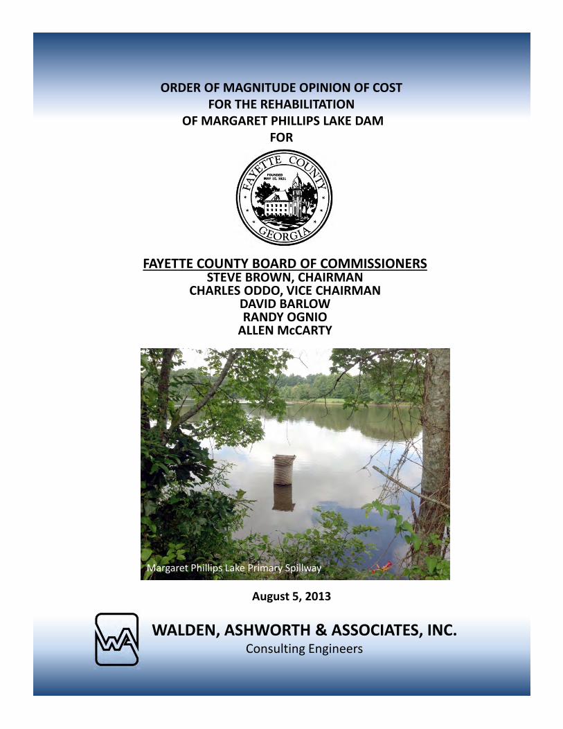
Margaret Phillips Lake Primary Spillway
FAYETTE COUNTY BOARD OF COMMISSIONERSSTEVE BROWN, CHAIRMAN
CHARLES ODDO, VICE CHAIRMANDAVID BARLOWRANDY OGNIO
ALLEN McCARTY
MARGARET PHILLIPS LAKE DAM
FAYETTE COUNTY, GEORGIA
ORDER OF MAGNITUDE
OPINION OF COST
WALDEN, ASHWORTH & ASSOCIATES, INC.
CONSULTING ENGINEERS
August 5, 2013
WA&A J.O. 3301700
WALDEN, ASHWORTH & ASSOCIATES, INC. CONSULTING ENGINEERS
P.O. BOX 6462 $ MARIETTA, GEORGIA 30065 $ 770/956-7879
August 5, 2013
Mr. Phil Mallon, P.E.
Fayette County Engineer
115 McDonough Rd
Fayetteville, Georgia 30215
RE: MARGARET PHILLIPS LAKE DAM
FAYETTE COUNTY, GEORGIA
ORDER OF MAGNITUDE - OPINION OF COST
WA&A J.O. 3301700
Dear Mr. Mallon:
We have completed our Order of Magnitude Opinion of Cost for the Margaret Phillips Lake Dam
and are pleased to present the results in the attached report. We appreciate the opportunity to assist
Fayette County on this project.
If you have any questions, please do not hesitate to call.
Very truly yours,
WALDEN, ASHWORTH & ASSOCIATES, INC.
Martin L. Walden, P.E.
President
MLW/jcw
Attachment
WALDEN, ASHWORTH & ASSOCIATES, INC.
MARGARET PHILLIPS LAKE DAM FAYETTE COUNTY, GEORGIA
ORDER OF MAGNITUDE COST ESTIMATE
INTRODUCTION
This report, which was authorized through an agreement with the Fayette County Board of Commissioners, provides an Order of Magnitude Opinion of Cost for the rehabilitation of the Margaret Phillips Lake Dam and includes a summary of the assumptions and procedures used to develop that Opinion of Cost.
SCOPE
Our Order of Magnitude Opinion of Cost to rehabilitate the Margaret Phillips Lake Dam and bring it into compliance with current requirements for Category I, high hazard dams is based on a brief visual inspection of the dam, a review of available data and our experience with similar dams. The visual inspection was made without the benefit of surveying equipment and no measurements were taken. The scope of the site visit was limited to visible elements only and excluded covered, buried, or hidden conditions. The scope of work did not include any calculations, special investigations, equipment testing, field or laboratory testing, geotechnical investigations or material testing. DATA SEARCH - GEORGIA SAFE DAMS PROGRAM FILES
The purpose of the Georgia Safe Dams Act, 1977, is to protect the health, safety and welfare of all citizens of the state by reducing the risk of dam failure, thus reducing the risk of death and injury. Under the authority of the Safe Dam Act, the Georgia Safe Dams Program maintains an inventory and classification system of all the dams in the state, an inspection and permitting system, and sets certain minimum design standards for those dams that are considered to be Category I (high hazard) structures. The Safe Dams Program maintains a file of all known data, inspection reports, correspondence and permitted improvements to all Category I dams. Because the Margaret Phillips Dam is classified as a Category I structure, the Safe Dams Program maintains such a file for it. As part of the scope of work, we reviewed the file for the dam at the office of the Safe Dams Program.
WALDEN, ASHWORTH & ASSOCIATES, INC.
DESCRIPTION OF DAM
The Margaret Phillips Lake Dam is an estimated 670 feet long and has a top width of 20 feet. The dam is approximately 16 feet high and impounds a lake having a surface of approximately 16 acres at normal pool with a drainage basin of approximately 860 acres (1.3 sq. mi.). The normal pool elevation of the lake is controlled by a Corrugated Metal Pipe (CMP) riser located near the center of the dam. The secondary spillway consists of two 24 inch diameter reinforced concrete culverts under the road on top of the dam. ASSUMPTIONS USED IN OPINION OF COST
Our Opinion of Cost assumes that all of the deficiencies noted by the Georgia Safe Dams Program and our brief inspection will be addressed in the renovation of the dam and will include such items as removal of inappropriate vegetation on both the upstream and downstream slopes; flattening of both slopes to a 3:1 slope; installation of a seepage collection and removal system including a full height chimney/blanket drain and toe drain and additional spillway capacity. It is not possible to determine the adequacy of the capacity of the spillways without a detailed hydrological and hydraulic evaluation. Such an evaluation is beyond the scope of this Order of Magnitude estimate. Therefore, based on the size of the lake and its drainage basin, we have assumed that a 20 foot wide labyrinth weir type structure will be required. It is important to understand that a more detailed engineering evaluation will be required before a more refined opinion of cost can be developed. The construction of the labyrinth weir spillway will require the excavation of a section completely through the dam. The rectangular concrete spillway structure will be constructed along with the appropriate seepage control drains in this excavated notch in the dam and select fill will be backfilled against the structure. In order to maintain the roadway, a bridge spanning across the spillway structure will be required. The water line will be suspended under the bridge. Using criteria established by the Georgia Safe Dams Program, the structure will have a design storm of 25% of the Probable Maxim Precipitation (PMP) based on Antecedent Moisture Condition III (AMC III) which reflects a saturated watershed from antecedent rains. This condition results in the highest runoff potential.
WALDEN, ASHWORTH & ASSOCIATES, INC.
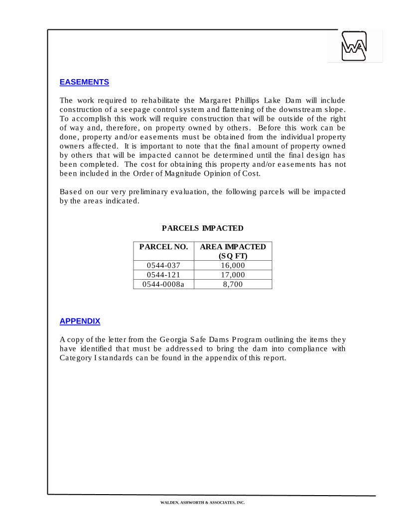
EASEMENTS
The work required to rehabilitate the Margaret Phillips Lake Dam will include construction of a seepage control system and flattening of the downstream slope. To accomplish this work will require construction that will be outside of the right of way and, therefore, on property owned by others. Before this work can be done, property and/or easements must be obtained from the individual property owners affected. It is important to note that the final amount of property owned by others that will be impacted cannot be determined until the final design has been completed. The cost for obtaining this property and/or easements has not been included in the Order of Magnitude Opinion of Cost. Based on our very preliminary evaluation, the following parcels will be impacted by the areas indicated.
PARCELS IMPACTED
PARCEL NO. AREA IMPACTED
(SQ FT) 0544-037 16,000 0544-121 17,000
0544-0008a 8,700 APPENDIX
A copy of the letter from the Georgia Safe Dams Program outlining the items they have identified that must be addressed to bring the dam into compliance with Category I standards can be found in the appendix of this report.
WALDEN, ASHWORTH & ASSOCIATES, INC.
MARGARET PHILLIPS LAKE DAM FAYETTE COUNTY, GEORGIA
ORDER OF MAGNITUDE OPINION OF COST
Our Opinion of Cost is based on limited data and does not have the benefit of detailed design and/or drawings. We have made assumptions based on our observations, available data and our experience with similar dams. A more definitive cost estimate cannot be prepared without detailed design. The American Association of Cost Engineers recommends dividing engineering construction cost estimates into three basic categories as follows: Order of Magnitude Estimate This is an estimate made without detailed engineering data. Some examples would be an estimate from cost-capacity curves, an estimate using scale-up or scale-down factors and an approximate ratio estimate. Budget Estimate Budget in this case applies to the owner=s budget and not to the budget as a project control document. A budget estimate is prepared using flow-sheets, layouts and equipment details. Definitive Estimate As the name implies, this is an estimate prepared from very defined engineering data. As a minimum, the data must include fairly complete plans and elevations, piping and instrumentation diagrams, one-line electrical diagrams, equipment data sheets and quotations, structural sketches, soil data and sketches of major foundations, building sketches and a complete set of specifications. The Amaximum@ definitive estimate would be made from AApproved for Construction@ drawings and specifications. The construction cost estimate for the rehabilitation of this dam is an Order of Magnitude estimate.
WALDEN, ASHWORTH & ASSOCIATES, INC.
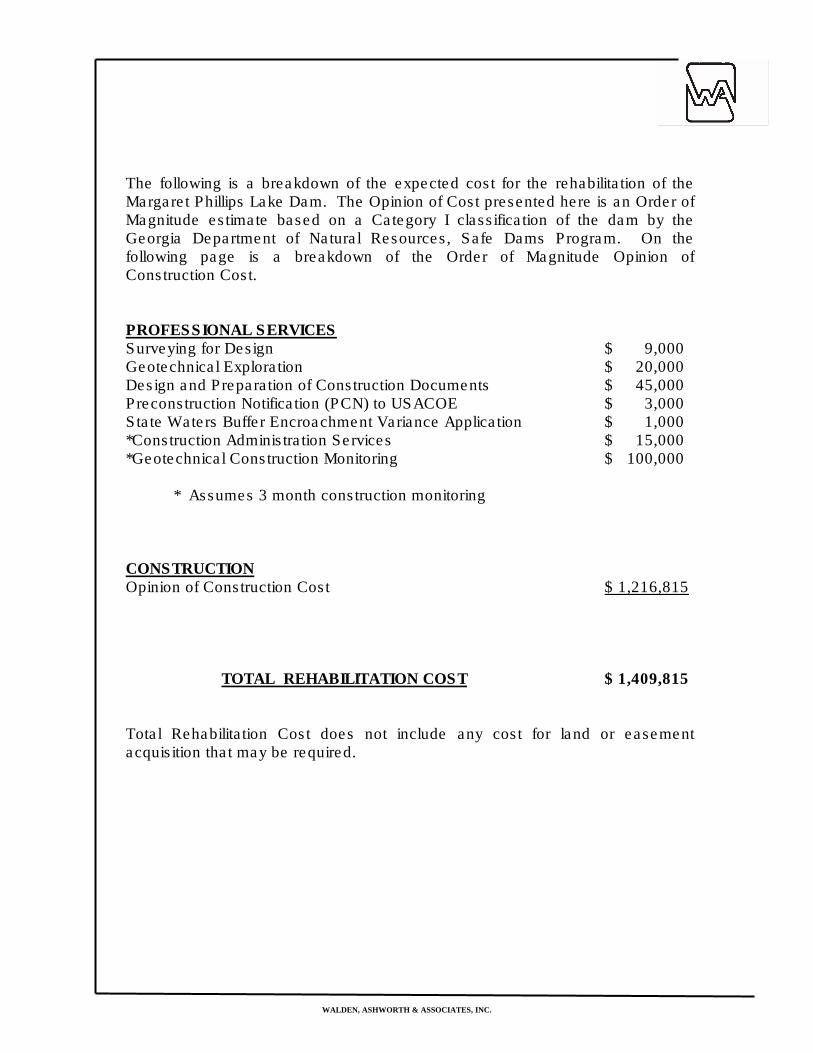
The following is a breakdown of the expected cost for the rehabilitation of the Margaret Phillips Lake Dam. The Opinion of Cost presented here is an Order of Magnitude estimate based on a Category I classification of the dam by the Georgia Department of Natural Resources, Safe Dams Program. On the following page is a breakdown of the Order of Magnitude Opinion of Construction Cost. PROFESSIONAL SERVICES Surveying for Design $ 9,000 Geotechnical Exploration $ 20,000 Design and Preparation of Construction Documents $ 45,000 Preconstruction Notification (PCN) to USACOE $ 3,000 State Waters Buffer Encroachment Variance Application $ 1,000 *Construction Administration Services $ 15,000 *Geotechnical Construction Monitoring $ 100,000 * Assumes 3 month construction monitoring CONSTRUCTION Opinion of Construction Cost $ 1,216,815 TOTAL REHABILITATION COST $ 1,409,815 Total Rehabilitation Cost does not include any cost for land or easement acquisition that may be required.
WALDEN, ASHWORTH & ASSOCIATES, INC.CONSULTING ENGINEERS
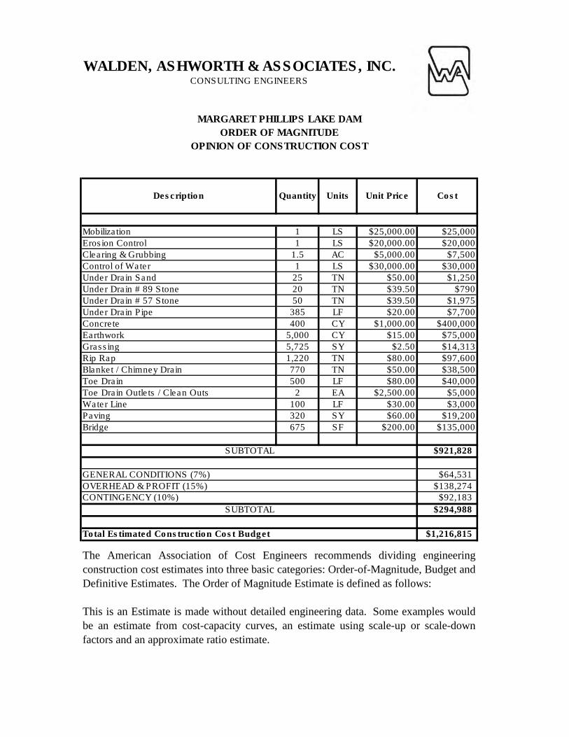
MARGARET PHILLIPS LAKE DAM
ORDER OF MAGNITUDE
OPINION OF CONSTRUCTION COST
Description Quantity Units Unit Price Cost
Mobilization 1 LS $25,000.00 $25,000
Erosion Control 1 LS $20,000.00 $20,000
Clearing & Grubbing 1.5 AC $5,000.00 $7,500
Control of Water 1 LS $30,000.00 $30,000
Under Drain Sand 25 TN $50.00 $1,250
Under Drain # 89 Stone 20 TN $39.50 $790
Under Drain # 57 Stone 50 TN $39.50 $1,975
Under Drain Pipe 385 LF $20.00 $7,700
Concrete 400 CY $1,000.00 $400,000
Earthwork 5,000 CY $15.00 $75,000
Grassing 5,725 SY $2.50 $14,313
Rip Rap 1,220 TN $80.00 $97,600
Blanket / Chimney Drain 770 TN $50.00 $38,500
Toe Drain 500 LF $80.00 $40,000
Toe Drain Outlets / Clean Outs 2 EA $2,500.00 $5,000
Water Line 100 LF $30.00 $3,000
Paving 320 SY $60.00 $19,200
Bridge 675 SF $200.00 $135,000
SUBTOTAL $921,828
GENERAL CONDITIONS (7%) $64,531
OVERHEAD & PROFIT (15%) $138,274CONTINGENCY (10%) $92,183
SUBTOTAL $294,988
Total Estimated Construction Cost Budget $1,216,815
The American Association of Cost Engineers recommends dividing engineering
construction cost estimates into three basic categories: Order-of-Magnitude, Budget and
Definitive Estimates. The Order of Magnitude Estimate is defined as follows:
This is an Estimate is made without detailed engineering data. Some examples would
be an estimate from cost-capacity curves, an estimate using scale-up or scale-down
factors and an approximate ratio estimate.
WALDEN, ASHWORTH & ASSOCIATES, INC.
APPENDIX

Project IDStreet NameSite Visit DateRoad Classification
21 - 2' Grass
2:1None
Depth fm Pavement to Top of Culvert (ft): 5'15" RCP
5 (Installation)Condition Notes:
Asphalt/Good
XWetlandsDitches
ElectricCablePhoneGas
MapGeneral Information
Rural Typical Section
Internal Local5/21/13
Close Location to TrafficMaintain One Lane - No Temp PavementMaintain One Lane - Temp Pavement
Field Notes
None
Existing Guardrail
330 Oak Street
Pipe Type and Size
Design (Existing Site Features)Existing Road Laneage
Existing Side SlopesExisting Shld Width (paved and grass) (feet)
Project Notes
Pipe Condition (1-5) (1 is new)
Environmental Features
Pavement Type/ConditionStage Construction Options
Utilities (Visual Inspection)
AerialAerial
Along South SideStage Construction Notes:
Aerial
!(
Perry
Cre
ek
State Route 54
Gly
nn S
t S
Lee St
Grady Ave
Hunters Gln
Beau
rega
rd B
lvd
Ramah Rd
First Manasses Rd
Oak St
Stonewall Ave W
Cha
se D
r
Sharon Dr
Chu
rch
St
Paces Dr
Medford Dr
Highview Trce
Gl y
nn S
t N
Stat
e R
oute
85
Hic
kor y
Ave
Gre
envi
lle R
d
T ige
r Trl
Lauren St
E Lanier Ave
Partr
idg e
Pt
Lakeland Cir
York
t ow
n D
r
Scenic Pass
Pine
vale
Ct
Wal
ker A
ve
Br axton Ct
Mot
ier P
l
Ros
e C
t
Brandon Ln
Lee St
6
I
GasWaterSewerOther
Roadway Section
Culvert Size & Material
Utility Relocations
Guardrail Replacement
Miscellaneous Features
TypeDesign
Right of Way CostUtility Relocation Cost
Construction CostEnvironmental Permits
Total Planning Estimate
Total$15,000
$5,500
$10,000
Water
~ 200' drainage ditch or additional piping needs to be installed for downstream property. Receiving stream could use ~500' of stream restoration
Buried
3' x 2' box, concrete, 80' length
$78,506
Notes
$44,006
$4,000
Planning Cost Estimate
Proposed Design
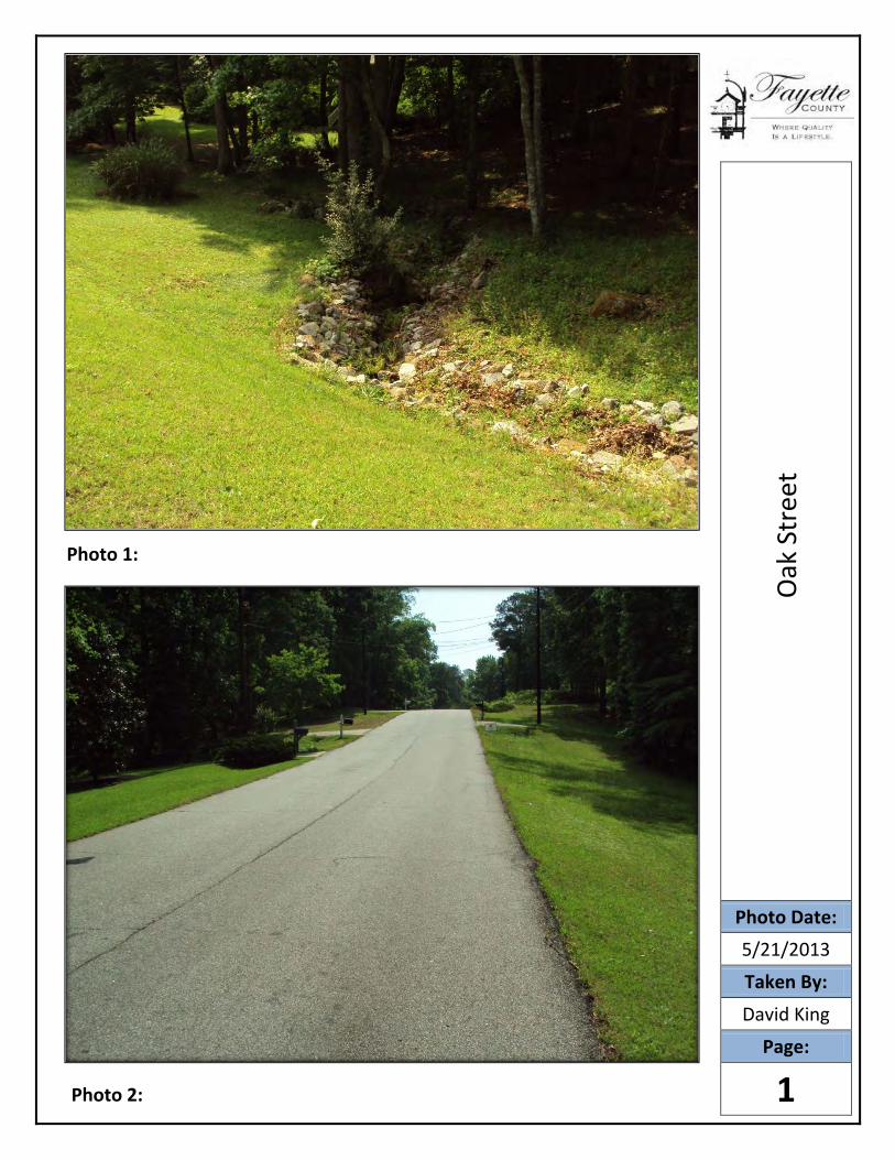
Photo 1:
Photo 2:
Oak
Str
eet
Photo Date:
5/21/2013
Taken By:
David King
Page:
1
Photo 3:
Photo 4:
Oak
Str
eet
Photo Date:
5/21/2013
Taken By:
David King
Page:
2
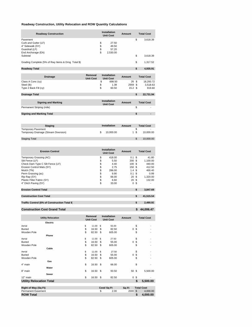
Roadway Construction, Utility Relocation and ROW Quantity Calculations
Roadway Construction Installation Unit Cost Amount Total Cost
Pavement 3,618.39$ Curb and Gutter (LF) 27.50$ 4" Sidewalk (SY) 49.50$ Guardrail (LF) 57.20$ End Anchorage (EA) 2,530.00$ Subtotal 3,618.39$
Grading Complete (5% of Rwy Items & Drng Total $) 1,317.52$
Roadway Total 4,935.91$
Drainage Removal Unit Cost
Installation Unit Cost Amount Total Cost
Class A Conc (cy) $ 698.50 26 $ 18,293.72 Steel (lb) 1.38$ 2559 $ 3,518.63 Type 2 Back Fill (cy) 60.50$ 15.2 $ 919.60
Drainage Total 22,731.94$
Signing and Marking Installation Unit Cost Amount Total Cost
Permanent Striping (mile) -$
Signing and Marking Total -$
Staging Installation Amount Total CostTemporary Pavement -$ Temporary Drainage (Stream Diversion) 10,000.00$ 1 10,000.00$
Staging Total 10,000.00$
Erosion Control Installation Unit Cost Amount Total Cost
Temporary Grassing (AC) 418.00$ 0.1 41.80$ Silt Fence (LF) 5.50$ 200 1,100.00$ Check Dam Type C Silt Fence (LF) 4.40$ 100 440.00$ Erosion Control Mats (SY) 2.75$ 150 412.50$ Mulch (TN) 286.00$ 1.4 400.40$ Perm Grassing (ac) 9.90$ 0.1 0.99$ g ( )Rip Rap (SY) 66.00$ 20 1,320.00$ Plastic Filter Fabric (SY) 6.60$ 20 132.00$ 4" Ditch Paving (SY) 33.00$ 0 -$
Erosion Control Total 3,847.69$
Construction Cost Total 41,515.54$
Traffic Control (6% of Construction Total $) 2,490.93$
Construction Cost Grand Total 44,006.47$
Utility Relocation Removal Unit Cost
Installation Unit Cost Amount Total Cost
ElectricAerial $ 11.00 $ 55.00 -$ Buried 16.50$ 82.50$ 0 -$ Wooden Pole 82.50$ 605.00$ -$
PhoneAerial $ 11.00 $ 27.50 -$ Buried 16.50$ 55.00$ 0 -$ Wooden Pole 82.50$ 605.00$ -$
CableAerial 11.00$ 27.50$ -$ Buried 16.50$ 55.00$ 0 -$ Wooden Pole 82.50$ 605.00$ -$
Gas4" main 16.50$ 66.00$ -$
Water8" main 16.50$ 93.50$ 50 5,500.00$
Sewer12" main 16.50$ 82.50$ 0 -$ Utility Relocation Total 5,500.00$
Right of Way (Sq Ft) Cost/ Sq Ft Sq Ft Total CostPermanent Easement 2.00$ 2000 4,000.00$ ROW Total 4,000.00$

Project IDStreet NameSite Visit DateRoad Classification
2 - 12'8' (G)
2:1 to 10:1None
Depth fm Pavement to Top of Culvert (ft): 3'3 - 96" CMP
3
Asphalt/New
XWetlandsDitches
ElectricCablePhoneGas
Existing Shld Width (paved and grass) (feet)
Condition Notes: Lining deteriorated, but pipes fully functioning; DS drop
Existing Side Slopes
Field Notes
Old Senoia Road
Pavement Type/Condition
MapGeneral Information
Rural Typical Section
Collector5/21/13
Design (Existing Site Features)Existing Road Laneage
Existing Guardrail
Pipe Type and Size
Utilities (Visual Inspection)Aerial
Aerial and Buried
Pipe Condition (1-5) (1 is new)
Environmental FeaturesMaintain One Lane - No Temp PavementMaintain One Lane - Temp PavementStage Construction Notes:
Project Notes
Stage Construction Options
None identifiedNone
Close Location to Traffic
Close Road - access from the South & North
!(
Perry Creek
Shoa
l Cre
ek
Whi
tew
ater
Cre
ek
Ging
er C
ake C
Harp Rd
Red
win
e R
d
Stat
e R
oute
85
McBride Rd
Stat
e R
o ute
92
Seay Rd
Old
Sen
oia
Rd
Ant
i och
Rd
Sherwood Rd
Har
ris R
d
Price R
d
Oxford Ln
Ramah Rd
Mas
k R
d
Dawn Dr
Sur
rey
Park
Dr 1
GasWaterSewerOther
Roadway Section
Proposed Design
Utility Relocations
Guardrail Replacement
Miscellaneous Features
TypeDesign
Right of Way CostUtility Relocation Cost
Construction CostEnvironmental Permits
$668,572.00
environmental(bridge), floodplain analysis
Total$140,949.73
$26,125.00
$30,000.00
$12,000.00
Total Planning Estimate
bridge design and geotech (BFI) included
$459,497.27
100' prestressed concrete beam bridge, three spans, 43' wide
Proposed Design
Description
Buried
Buried Phone, Watermain
Proposed Guardrail Installation due to proposed culvert(s) and side slopes
Planning Cost Estimate
Zone AE with Floodway, Floodplain Analysis Required
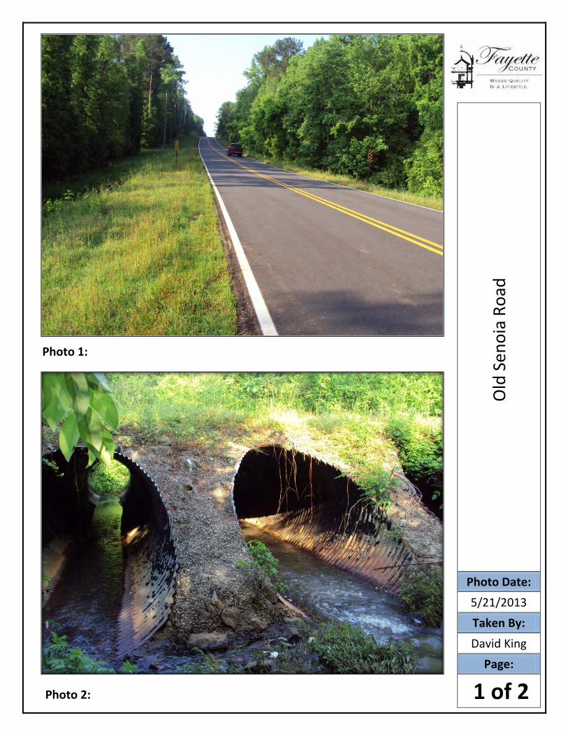
Photo 1:
Photo 2:
Old
Sen
oia
Road
Photo Date:
5/21/2013
Taken By:
David King
Page:
1 of 2
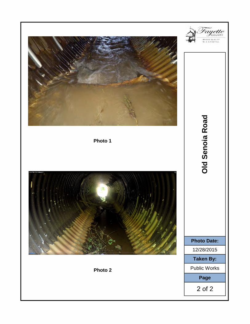
Old
Sen
oia
Roa
d
Photo 1
Photo Date:
12/28/2015
2 of 2
Taken By:
Public WorksPhoto 2Page
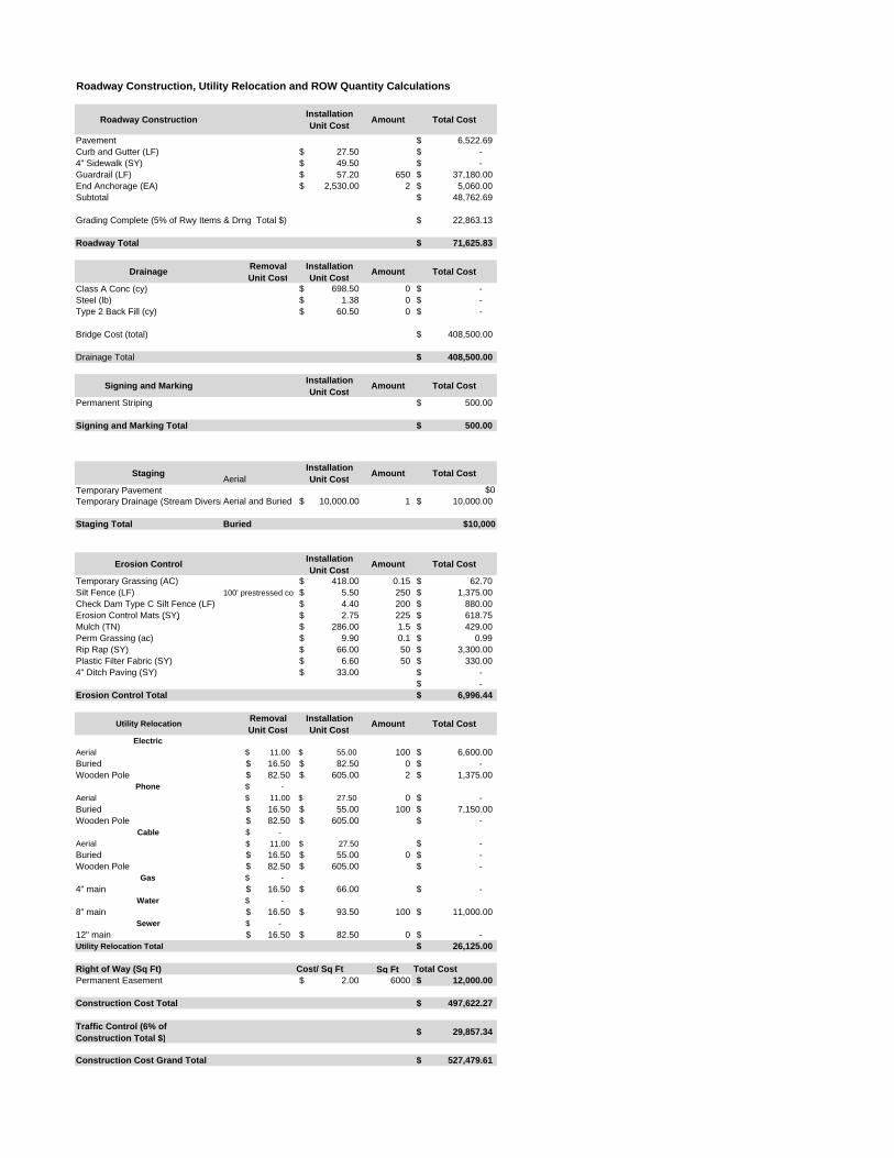
Roadway Construction, Utility Relocation and ROW Quantity Calculations
Roadway Construction Installation Unit Cost Amount Total Cost
Pavement 6,522.69$ Curb and Gutter (LF) 27.50$ -$ 4" Sidewalk (SY) 49.50$ -$ Guardrail (LF) 57.20$ 650 37,180.00$ End Anchorage (EA) 2,530.00$ 2 5,060.00$ Subtotal 48,762.69$
Grading Complete (5% of Rwy Items & Drng Total $) 22,863.13$
Roadway Total 71,625.83$
Drainage Removal Unit Cost
Installation Unit Cost Amount Total Cost
Class A Conc (cy) 698.50$ 0 -$ Steel (lb) 1.38$ 0 -$ Type 2 Back Fill (cy) 60.50$ 0 -$
Bridge Cost (total) 408,500.00$
Drainage Total 408,500.00$
Signing and Marking Installation Unit Cost Amount Total Cost
Permanent Striping 500.00$
Signing and Marking Total 500.00$
Staging AerialInstallation Unit Cost Amount Total Cost
Temporary Pavement $0Temporary Drainage (Stream DiversiAerial and Buried 10,000.00$ 1 10,000.00$
Staging Total Buried $10,000
Erosion Control Installation Unit Cost Amount Total Cost
Temporary Grassing (AC) 418.00$ 0.15 62.70$ Silt Fence (LF) 100' prestressed con 5.50$ 250 1,375.00$ Check Dam Type C Silt Fence (LF) 4.40$ 200 880.00$ Erosion Control Mats (SY) 2.75$ 225 618.75$ ( ) $ $Mulch (TN) 286.00$ 1.5 429.00$ Perm Grassing (ac) 9.90$ 0.1 0.99$ Rip Rap (SY) 66.00$ 50 3,300.00$ Plastic Filter Fabric (SY) 6.60$ 50 330.00$ 4" Ditch Paving (SY) 33.00$ -$
-$ Erosion Control Total 6,996.44$
Utility Relocation Removal Unit Cost
Installation Unit Cost Amount Total Cost
ElectricAerial $ 11.00 $ 55.00 100 6,600.00$ Buried 16.50$ 82.50$ 0 -$ Wooden Pole 82.50$ 605.00$ 2 1,375.00$
Phone $ - Aerial $ 11.00 $ 27.50 0 -$ Buried 16.50$ 55.00$ 100 7,150.00$ Wooden Pole 82.50$ 605.00$ -$
Cable -$ Aerial 11.00$ 27.50$ -$ Buried 16.50$ 55.00$ 0 -$ Wooden Pole 82.50$ 605.00$ -$
Gas $ - 4" main 16.50$ 66.00$ -$
Water $ - 8" main 16.50$ 93.50$ 100 11,000.00$
Sewer -$ 12" main 16.50$ 82.50$ 0 -$ Utility Relocation Total 26,125.00$
Right of Way (Sq Ft) Cost/ Sq Ft Sq Ft Total CostPermanent Easement 2.00$ 6000 12,000.00$
Construction Cost Total 497,622.27$
Traffic Control (6% of Construction Total $) 29,857.34$
Construction Cost Grand Total 527,479.61$
Project IDStreet NameSite Visit DateRoad Classification
2-12'
NoDepth fm Pavement to Top of Culvert (ft): (+/-) 3.5'
2- 72" CMP3-4
Asphalt/Good
XWetlandsDitchesState Waters
ElectricCablePhoneGasWaterSewerOther
Roadway Section
Culvert Size & Material
Utility Relocations
Guardrail Replacement
Miscellaneous Features
Type
Design
Right of Way CostUtility Relocation Cost
Construction Cost
MapGeneral Information
Culvert replacement alternatives to provide flow capacity for the 100 year storm peak runoff.
RuralProject Notes
Field NotesDesign (Existing Site Features)
Assumed road closure
Existing Side Slopes
Pipe Type and Size
Condition Notes: Two 72” culverts – left one collapsed, right one has approx. 6” dip in last joint.
Pipe Condition (1-5) (1 is new)
Existing Shld Width (paved and grass) (feet)
Stage Construction Notes:
Stage Construction Options
Unknown
Unknown
Existing Road Laneage
Maintain One Lane - No Temp PavementMaintain One Lane - Temp Pavement
Pavement Type/Condition
TBDYES
Existing Guardrail
Close Location to TrafficEnvironmental Features
YES (ASSUMED)
Utilities (Visual Inspection)
To be verify, (20" DIP or PVC mains)
$17,424
Planning Cost Estimate
Total Planning Estimate $449,143
TotalNotes
$165,180Assuming no relocation
Assuming UPS/DWS ends extends past ROW 1/20 acre
$54,005
Underground
Aerial
Underground
Includes 1/8 acre clearing and grubbing
Proposed DesignTypical
$212,535
Actual Cost including Environmental Permitting and Engineer of Record Administrative Fee
2 - 84" round RCP with end treatment
Rising Star Rd
Unknown
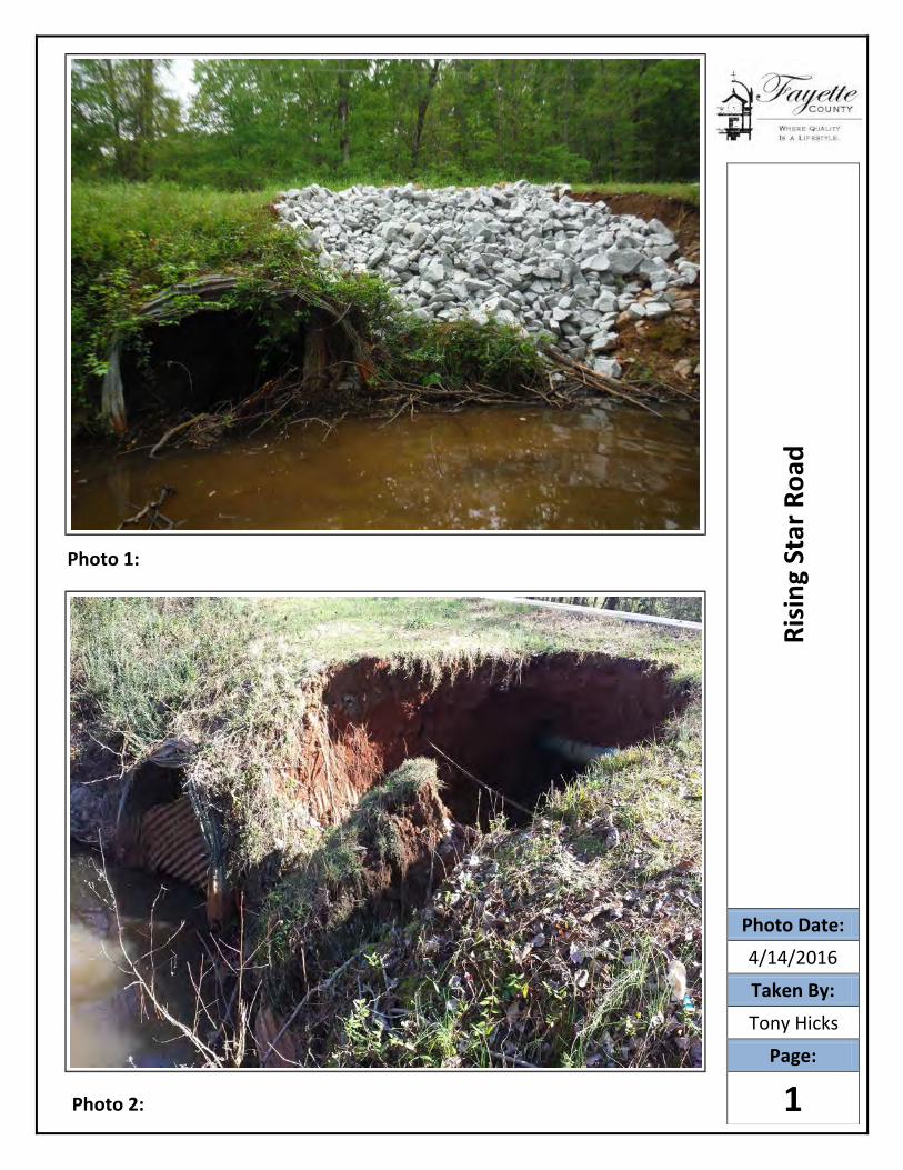
Photo 1:
Photo 2:
Risi
ng S
tar R
oad
Photo Date:
4/14/2016Taken By:
Tony Hicks
Page:
1
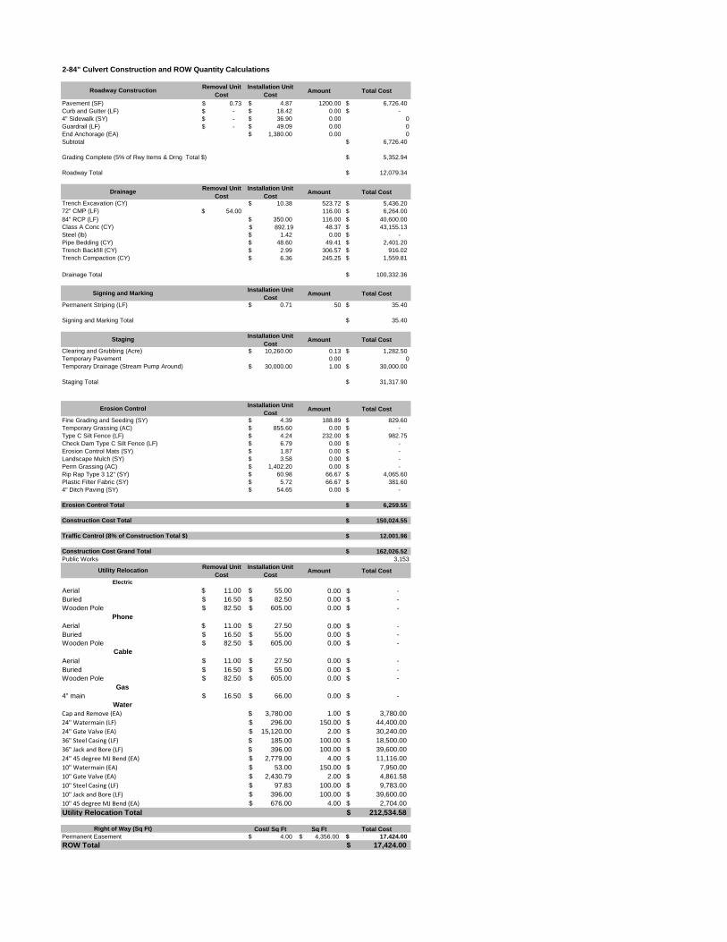
2-84" Culvert Construction and ROW Quantity Calculations
Roadway ConstructionRemoval Unit
Cost
Installation Unit
CostAmount Total Cost
Pavement (SF) 0.73$ 4.87$ 1200.00 6,726.40$
Curb and Gutter (LF) -$ 18.42$ 0.00 -$
4" Sidewalk (SY) -$ 36.90$ 0.00 0
Guardrail (LF) -$ 49.09$ 0.00 0
End Anchorage (EA) 1,380.00$ 0.00 0
Subtotal 6,726.40$
Grading Complete (5% of Rwy Items & Drng Total $) 5,352.94$
Roadway Total 12,079.34$
DrainageRemoval Unit
Cost
Installation Unit
CostAmount Total Cost
Trench Excavation (CY) 10.38$ 523.72 5,436.20$
72" CMP (LF) 54.00$ 116.00 6,264.00$
84" RCP (LF) 350.00$ 116.00 40,600.00$
Class A Conc (CY) $ 892.19 48.37 43,155.13$
Steel (lb) 1.42$ 0.00 -$
Pipe Bedding (CY) 48.60$ 49.41 2,401.20$
Trench Backfill (CY) 2.99$ 306.57 916.02$
Trench Compaction (CY) 6.36$ 245.25 1,559.81$
Drainage Total 100,332.36$
Signing and MarkingInstallation Unit
CostAmount Total Cost
Permanent Striping (LF) 0.71$ 50 35.40$
Signing and Marking Total 35.40$
StagingInstallation Unit
CostAmount Total Cost
Clearing and Grubbing (Acre) 10,260.00$ 0.13 1,282.50$
Temporary Pavement 0.00 0
Temporary Drainage (Stream Pump Around) 30,000.00$ 1.00 30,000.00$
Staging Total 31,317.90$
Erosion ControlInstallation Unit
CostAmount Total Cost
Fine Grading and Seeding (SY) 4.39$ 188.89 829.60$
Temporary Grassing (AC) 855.60$ 0.00 -$
Type C Silt Fence (LF) 4.24$ 232.00 982.75$
Check Dam Type C Silt Fence (LF) 6.79$ 0.00 -$
Erosion Control Mats (SY) 1.87$ 0.00 -$
Landscape Mulch (SY) 3.58$ 0.00 -$
Perm Grassing (AC) 1,402.20$ 0.00 -$
Rip Rap Type 3 12" (SY) 60.98$ 66.67 4,065.60$
Plastic Filter Fabric (SY) 5.72$ 66.67 381.60$
4" Ditch Paving (SY) 54.65$ 0.00 -$
Erosion Control Total 6,259.55$
Construction Cost Total 150,024.55$
Traffic Control (8% of Construction Total $) 12,001.96$
Construction Cost Grand Total 162,026.52$
Public Works 3,153
Utility RelocationRemoval Unit
Cost
Installation Unit
CostAmount Total Cost
Electric
Aerial $ 11.00 $ 55.00 0.00 -$
Buried 16.50$ 82.50$ 0.00 -$
Wooden Pole 82.50$ 605.00$ 0.00 -$
Phone
Aerial $ 11.00 $ 27.50 0.00 -$
Buried 16.50$ 55.00$ 0.00 -$
Wooden Pole 82.50$ 605.00$ 0.00 -$
Cable
Aerial 11.00$ 27.50$ 0.00 -$
Buried 16.50$ 55.00$ 0.00 -$
Wooden Pole 82.50$ 605.00$ 0.00 -$
Gas
4" main 16.50$ 66.00$ 0.00 -$
Water
Cap and Remove (EA) $ 3,780.00 1.00 3,780.00$
24" Watermain (LF) 296.00$ 150.00 44,400.00$
24" Gate Valve (EA) 15,120.00$ 2.00 30,240.00$
36" Steel Casing (LF) $ 185.00 100.00 18,500.00$
36" Jack and Bore (LF) $ 396.00 100.00 39,600.00$
24" 45 degree MJ Bend (EA) 2,779.00$ 4.00 11,116.00$
10" Watermain (EA) 53.00$ 150.00 7,950.00$
10" Gate Valve (EA) 2,430.79$ 2.00 4,861.58$
10" Steel Casing (LF) 97.83$ 100.00 9,783.00$
10" Jack and Bore (LF) 396.00$ 100.00 39,600.00$
10" 45 degree MJ Bend (EA) 676.00$ 4.00 2,704.00$
Utility Relocation Total 212,534.58$
Right of Way (Sq Ft) Cost/ Sq Ft Sq Ft Total Cost
Permanent Easement 4.00$ 4,356.00$ 17,424.00$
ROW Total 17,424.00$

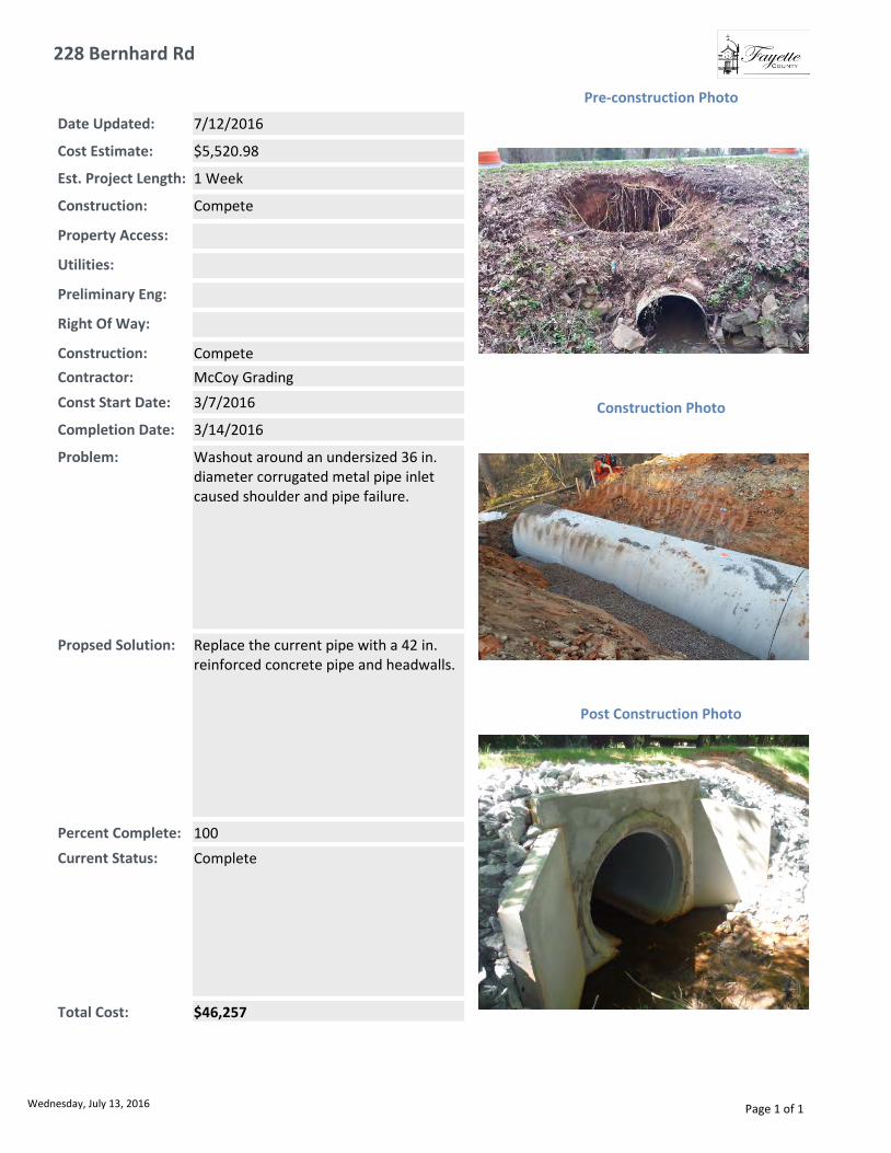
228 Bernhard Rd
Total Cost: $46,257
Const Start Date: 3/7/2016
Completion Date: 3/14/2016
Est. Project Length: 1 Week
Current Status: Complete
Date Updated: 7/12/2016
Construction: Compete
Right Of Way:
Preliminary Eng:
Utilities:
Property Access:
Contractor: McCoy Grading
Cost Estimate: $5,520.98
Post Construction Photo
Problem: Washout around an undersized 36 in. diameter corrugated metal pipe inlet caused shoulder and pipe failure.
Construction Photo
Pre-construction Photo
Percent Complete: 100
Construction: Compete
Propsed Solution: Replace the current pipe with a 42 in.reinforced concrete pipe and headwalls.
Wednesday, July 13, 2016 Page 1 of 1

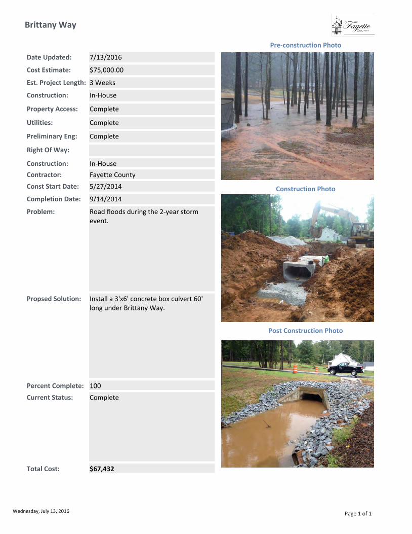
Brittany Way
Total Cost: $67,432
Const Start Date: 5/27/2014
Completion Date: 9/14/2014
Est. Project Length: 3 Weeks
Current Status: Complete
Date Updated: 7/13/2016
Construction: In-House
Right Of Way:
Preliminary Eng: Complete
Utilities: Complete
Property Access: Complete
Contractor: Fayette County
Cost Estimate: $75,000.00
Post Construction Photo
Problem: Road floods during the 2-year storm event.
Construction Photo
Pre-construction Photo
Percent Complete: 100
Construction: In-House
Propsed Solution: Install a 3'x6' concrete box culvert 60' long under Brittany Way.
Wednesday, July 13, 2016 Page 1 of 1

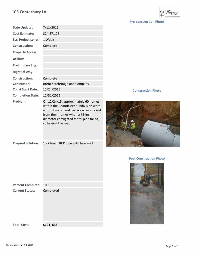
105 Canterbury Ln
Total Cost: $101, 636
Const Start Date: 12/24/2015
Completion Date: 12/31/2015
Est. Project Length: 1 Week
Current Status: Completed
Date Updated: 7/11/2016
Construction: Complete
Right Of Way:
Preliminary Eng:
Utilities:
Property Access:
Contractor: Brent Scarbrough and Company
Cost Estimate: $24,671.06
Post Construction Photo
Problem: On 12/24/15, approximately 60 homes within the Chanticleer Subdivision were without water and had no access to and from their homes when a 72-inch diameter corrugated metal pipe failed, collapsing the road.
Construction Photo
Pre-construction Photo
Percent Complete: 100
Construction: Complete
Propsed Solution: 1 - 72-inch RCP pipe with headwall
Wednesday, July 13, 2016 Page 1 of 1

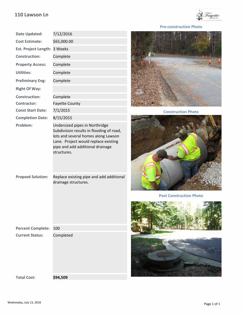
110 Lawson Ln
Total Cost: $94,509
Const Start Date: 7/1/2015
Completion Date: 8/15/2015
Est. Project Length: 3 Weeks
Current Status: Completed
Date Updated: 7/12/2016
Construction: Complete
Right Of Way:
Preliminary Eng: Complete
Utilities: Complete
Property Access: Complete
Contractor: Fayette County
Cost Estimate: $65,000.00
Post Construction Photo
Problem: Undersized pipes in Northridge Subdivision results in flooding of road, lots and several homes along Lawson Lane. Project would replace existing pipe and add additional drainage structures.
Construction Photo
Pre-construction Photo
Percent Complete: 100
Construction: Complete
Propsed Solution: Replace existing pipe and add additional drainage structures.
Wednesday, July 13, 2016 Page 1 of 1

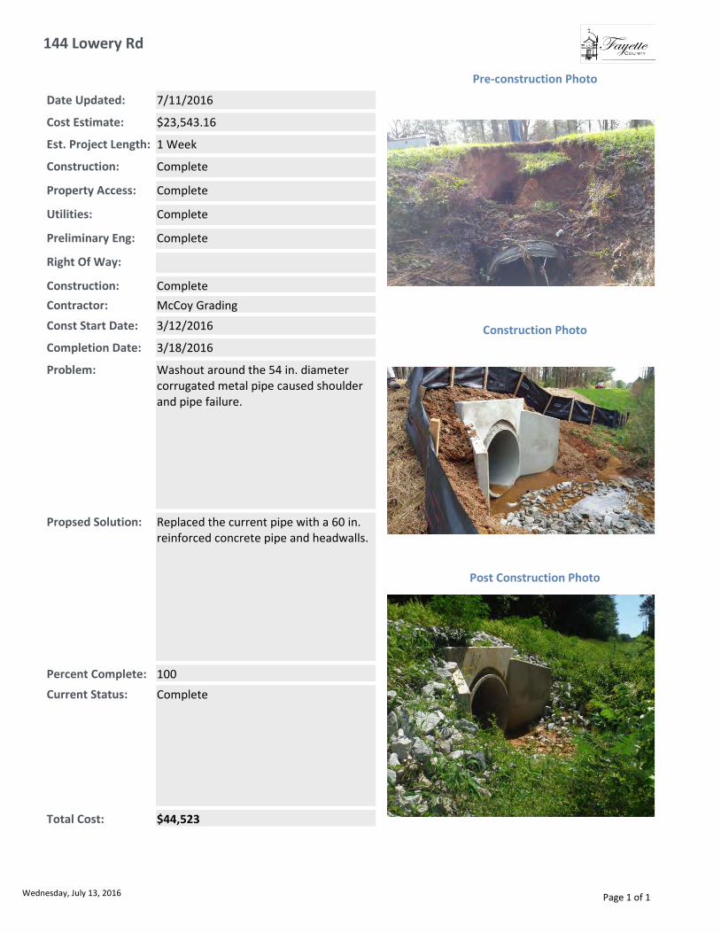
144 Lowery Rd
Total Cost: $44,523
Const Start Date: 3/12/2016
Completion Date: 3/18/2016
Est. Project Length: 1 Week
Current Status: Complete
Date Updated: 7/11/2016
Construction: Complete
Right Of Way:
Preliminary Eng: Complete
Utilities: Complete
Property Access: Complete
Contractor: McCoy Grading
Cost Estimate: $23,543.16
Post Construction Photo
Problem: Washout around the 54 in. diameter corrugated metal pipe caused shoulder and pipe failure.
Construction Photo
Pre-construction Photo
Percent Complete: 100
Construction: Complete
Propsed Solution: Replaced the current pipe with a 60 in. reinforced concrete pipe and headwalls.
Wednesday, July 13, 2016 Page 1 of 1

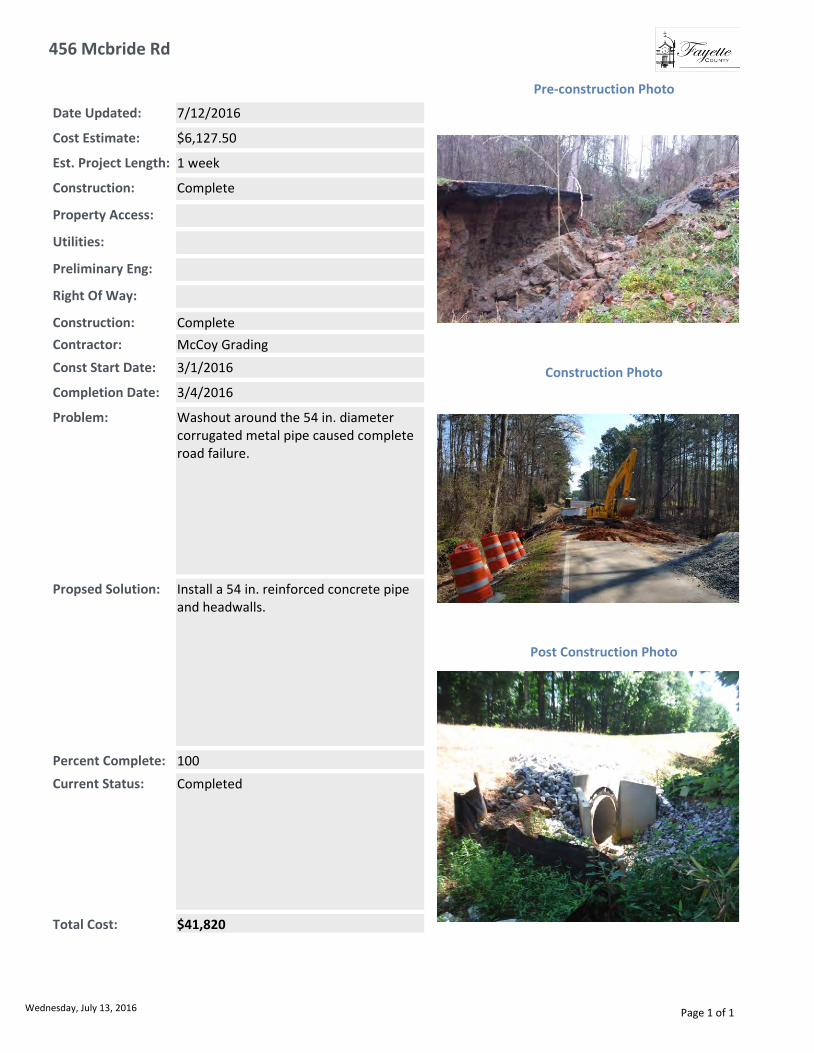
456 Mcbride Rd
Total Cost: $41,820
Const Start Date: 3/1/2016
Completion Date: 3/4/2016
Est. Project Length: 1 week
Current Status: Completed
Date Updated: 7/12/2016
Construction: Complete
Right Of Way:
Preliminary Eng:
Utilities:
Property Access:
Contractor: McCoy Grading
Cost Estimate: $6,127.50
Post Construction Photo
Problem: Washout around the 54 in. diameter corrugated metal pipe caused complete road failure.
Construction Photo
Pre-construction Photo
Percent Complete: 100
Construction: Complete
Propsed Solution: Install a 54 in. reinforced concrete pipe and headwalls.
Wednesday, July 13, 2016 Page 1 of 1

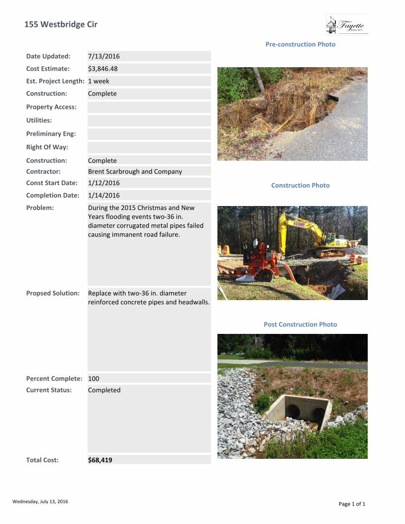
155 Westbridge Cir
Total Cost: $68,419
Const Start Date: 1/12/2016
Completion Date: 1/14/2016
Est. Project Length: 1 week
Current Status: Completed
Date Updated: 7/13/2016
Construction: Complete
Right Of Way:
Preliminary Eng:
Utilities:
Property Access:
Contractor: Brent Scarbrough and Company
Cost Estimate: $3,846.48
Post Construction Photo
Problem: During the 2015 Christmas and New Years flooding events two-36 in. diameter corrugated metal pipes failed causing immanent road failure.
Construction Photo
Pre-construction Photo
Percent Complete: 100
Construction: Complete
Propsed Solution: Replace with two-36 in. diameter reinforced concrete pipes and headwalls.
Wednesday, July 13, 2016 Page 1 of 1