Embed Size (px)
Citation preview
ST. MARY’S COLLEGE
GEOGRAPHY SBA GUIDELINES MANUAL

1 | P a g e
© Geo Coppin 2018
INTRODUCTION
The purpose of this manual is to assist Forms 4 & 5 Geography students to
effectively carry out, prepare and format SBA projects, in accordance to CXC CSEC
specifications. It is strongly advised that every attempt is made to follow ALL the
guidelines provided.
2 | P a g e
© Geo Coppin 2018
OVERVIEW OF THE GEOGRAPHY SBA
The School Based Assessment (SBA) is an INTEGRAL part of the student’s
assessment in the course covered by the Geography syllabus. The Report should be
NO MORE than 1000 words in length. In cases where the word limit is exceeded by
more than 100 words, there will be a 10% penalty deduction in the marks. Students
who duplicate or allow the duplication of work submitted in the same or previous
years, will be PENALIZED.
3 | P a g e
© Geo Coppin 2018
ORDER OF GUIDELINES
Page
Field Trip Guidelines 4
Cover Page 6
Strategy Sheet 9
Table of Contents 11
Introduction 13
Aim 14
Location 16
Methodology 21
Presentation of Data 23
Quality of Data 26
Discussion and Analysis 27
Conclusion 28
Communication of Data 29
Bibliography 30
Appendix 32
SBA Mark Allocation 33
Guidelines for Drafts 34
The Geography SBA Process 39
4 | P a g e
© Geo Coppin 2018
FIELD TRIP GUIDELINES
Pre-Field Trip
Before each field trip, there will be a review session in class providing an overview
of the SBA, including the title, aim and other general information (this information
will be also posted on the website). It is important that ALL students are present
for that session.
Due to the nature of most Geography field trips, students are strongly advised to
wear clothing appropriate for the trip, for example:
Long pants and long sleeve jerseys for trips to the beach, river or open areas
Comfortable and appropriate footwear (sneakers and/or water shoes)
Students must also walk with a change of clothes (packed in a seal plastic bag), sun
screen and/or insect repellent (if needed), notepad and pen, ziplock bag for cell
phone and/or camera, snacks, lunch and water.
Day of Field Trip
All field trips will start at the College and proceed to the selected venue. There will
be a debriefing session before departing the school, where, if necessary, the class
will be divided into groups in order to complete the field trip in a timely manner and
the Methodology for the study will be reviewed.
At the site, note the following:
At ALL times stay within your assigned group
If the study area is a beach or river, NO STUDENTS ARE ALLOWED TO
SWIM! (Ministry of Education Directive)
Listen carefully to the instructions and guidelines issued by the
teachers/instructors/presenters
Each student must draw their own sketch maps/diagrams of the study area
and any features observed
Each student must take their own photos using their cameras or cell phones.
NOTE: When taking pictures of a feature, you must place a ruler or an item
of known height next to the feature and then take the picture. This is to give
an approximate height of the feature in question.
If unsure of anything, ask a question.
5 | P a g e
© Geo Coppin 2018
Each group must have at least ONE student designated to record all the data
obtained during the tests conducted. This designated person must also pass
on the data collected to the rest of the group and teachers.
Post Field Trip
After the field trip, all the data collected will be collated and posted on the class
website. There will also be a session in class to review the data and provide
guidelines for proceeding with the project.
6 | P a g e
© Geo Coppin 2018
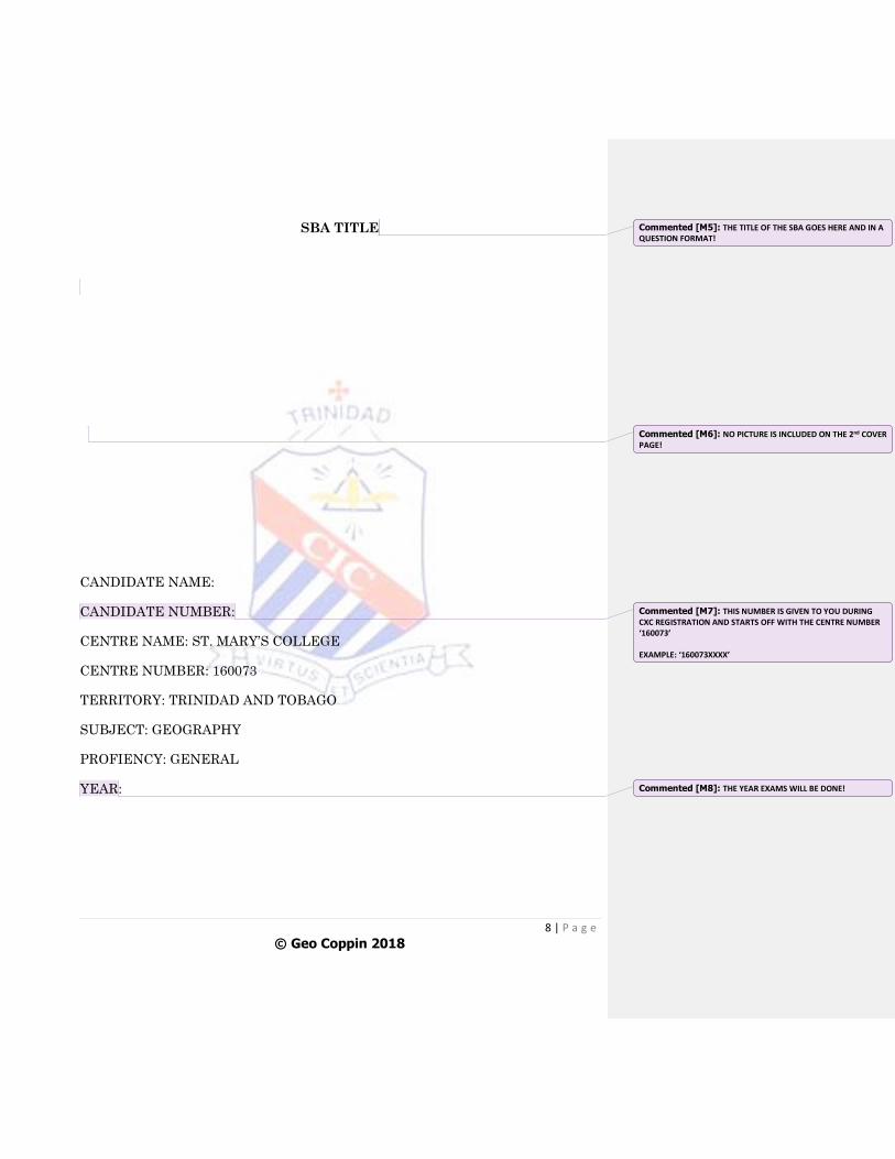
COVER PAGE
Students MUST have TWO Cover Pages.
Both pages will have the SAME information, with the exception that the
second Cover Page MUST NOT INCLUDE A PHOTOGRAPH.
7 | P a g e
© Geo Coppin 2018
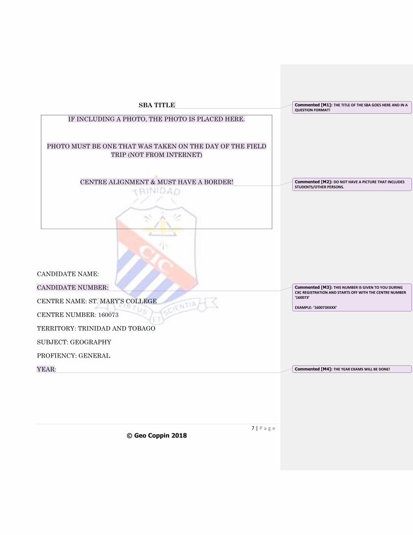
SBA TITLE
IF INCLUDING A PHOTO, THE PHOTO IS PLACED HERE.
PHOTO MUST BE ONE THAT WAS TAKEN ON THE DAY OF THE FIELD
TRIP (NOT FROM INTERNET)
CENTRE ALIGNMENT & MUST HAVE A BORDER!
CANDIDATE NAME:
CANDIDATE NUMBER:
CENTRE NAME: ST. MARY’S COLLEGE
CENTRE NUMBER: 160073
TERRITORY: TRINIDAD AND TOBAGO
SUBJECT: GEOGRAPHY
PROFIENCY: GENERAL
YEAR:
Commented [M1]: THE TITLE OF THE SBA GOES HERE AND IN A QUESTION FORMAT!
Commented [M2]: DO NOT HAVE A PICTURE THAT INCLUDES STUDENTS/OTHER PERSONS.
Commented [M3]: THIS NUMBER IS GIVEN TO YOU DURING CXC REGISTRATION AND STARTS OFF WITH THE CENTRE NUMBER ‘160073’ EXAMPLE: ‘160073XXXX’
Commented [M4]: THE YEAR EXAMS WILL BE DONE!
8 | P a g e
© Geo Coppin 2018
SBA TITLE
CANDIDATE NAME:
CANDIDATE NUMBER:
CENTRE NAME: ST. MARY’S COLLEGE
CENTRE NUMBER: 160073
TERRITORY: TRINIDAD AND TOBAGO
SUBJECT: GEOGRAPHY
PROFIENCY: GENERAL
YEAR:
Commented [M5]: THE TITLE OF THE SBA GOES HERE AND IN A QUESTION FORMAT!
Commented [M6]: NO PICTURE IS INCLUDED ON THE 2nd COVER PAGE!
Commented [M7]: THIS NUMBER IS GIVEN TO YOU DURING CXC REGISTRATION AND STARTS OFF WITH THE CENTRE NUMBER ‘160073’ EXAMPLE: ‘160073XXXX’
Commented [M8]: THE YEAR EXAMS WILL BE DONE!
9 | P a g e
© Geo Coppin 2018
STRATEGY SHEET
This sheet MUST be completed by ALL students in BLACK or BLUE ink.
The sheet is completed after the field trip is conducted and must be inserted
BEFORE the Table of Contents of the SBA. The sheet will be provided by the
Teacher.
However, the Sheet MUST be written in the Future Tense.
10 | P a g e
© Geo Coppin 2018
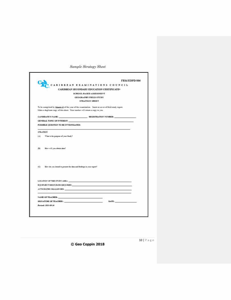
Sample Strategy Sheet
11 | P a g e
© Geo Coppin 2018
TABLE OF CONTENTS
The Table of Contents follows the TWO Cover Pages and Strategy Sheet.
It is NOT a NUMBERED PAGE!
It is important that the numbers in the Table of Contents match the page
numbers in the SBA project.
The Table of Contents is worth 1 mark!
12 | P a g e
© Geo Coppin 2018
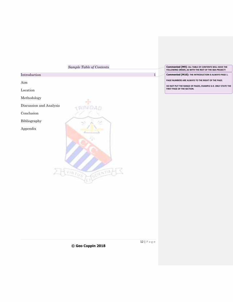
Sample Table of Contents
Introduction 1
Aim
Location
Methodology
Discussion and Analysis
Conclusion
Bibliography
Appendix
Commented [M9]: ALL TABLE OF CONTENTS WILL HAVE THE FOLLOWING ORDER, AS WITH THE REST OF THE SBA PROJECT!
Commented [M10]: THE INTRODUCTION IS ALWAYS PAGE 1. PAGE NUMBERS ARE ALWAYS TO THE RIGHT OF THE PAGE. DO NOT PUT THE RANGE OF PAGES, EXAMPLE 6-9. ONLY STATE THE FIRST PAGE OF THE SECTION.
13 | P a g e
© Geo Coppin 2018
INTRODUCTION
The Introduction gives a clear overview of the topic and narrows the research
to the area of study.
Justification on choice of topic must also be included (why are you doing this
particular topic?).
It is worth 2 marks!
14 | P a g e
© Geo Coppin 2018
AIM
The Aim or Purpose of the SBA must include at least ONE aim clearly stated
as a direct or implicit question.
It is ideal that the aim begins, “The aim of this/the SBA is.........”
All students will have the SAME AIM, as given by the Teachers.
The Aim is worth 2 marks.
15 | P a g e
© Geo Coppin 2018
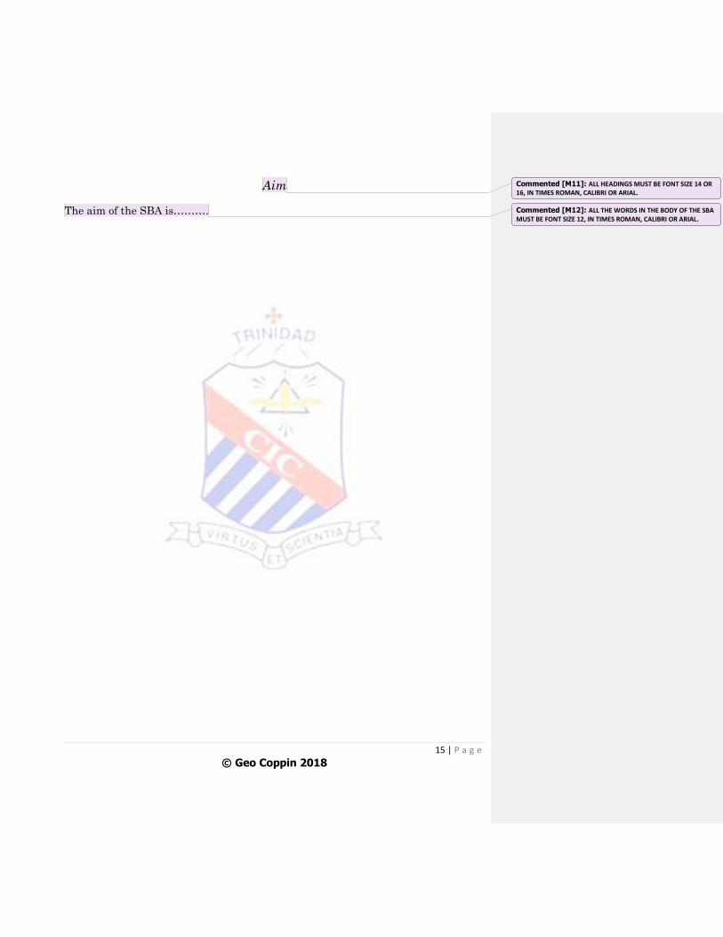
Aim
The aim of the SBA is……….
Commented [M11]: ALL HEADINGS MUST BE FONT SIZE 14 OR 16, IN TIMES ROMAN, CALIBRI OR ARIAL.
Commented [M12]: ALL THE WORDS IN THE BODY OF THE SBA MUST BE FONT SIZE 12, IN TIMES ROMAN, CALIBRI OR ARIAL.
16 | P a g e
© Geo Coppin 2018
LOCATION
The Location starts off with brief descriptions of the Maps and the sketch of
the Study Area.
It is worth 4 marks!
17 | P a g e
© Geo Coppin 2018
Sample Location (Description Page)
Trinidad is located [insert latitude and longitude coordinates] and is bounded by
[insert the bodies of water that surround the island north, south, east and west].
(Map 1)
Brief description of the general area the study area is located on the island (and in
relation to other areas or physical features). (Map 2)
Brief description of the study area and notable features in the area. (Diagram 1)
18 | P a g e
© Geo Coppin 2018
Map Guidelines
THREE maps, ONE showing the site on a map of Trinidad, ONE showing its
location in relation to other features (roads, rivers, etc.) and ONE of the study
site.
All maps must be accurately drawn and properly labelled.
ALL MAPS MUST BE DRAWN, NOT COPIED or DRAWN
ELECTRONICALLY.
All maps are to be drawn on blank white ‘Letter’ paper. NOT ON
FOLDER PAGE OR LEGAL SIZE PAPER.
Try to be as accurate as possible.
All maps must first be drawn in pencil then outlined in pen after. NO
PENCIL WORK!
Try to centre your drawing on the page.
Use colour pencils for all symbols and features. DO NOT USE
COLOURED PENS.
Try to be NEAT and TIDY!
All maps must:
1. Have a BORDER (IN PEN)
2. Have a TITLE (ON TOP THE BORDER & CENTRED)
3. Have a NORTH DIRECTIONAL ARROW (PLACED TO THE RIGHT OF
THE MAP)
4. Have a SCALE (Scale must be placed at the bottom of the map, inside the
border)
Map 1 and Map 2 MUST have a Scale, as indicated from the source material,
like an Atlas. Do NOT DRAW FREE HAND any map that has a scale. You
can trace the ‘scaled’ map from the Atlas. Diagram 1 will be a sketch map of
the study area and, as such, will NOT have a scale. Therefore, the scale for
sketch maps like Diagram 1 is ‘NOT DRAWN TO SCALE’.
19 | P a g e
© Geo Coppin 2018
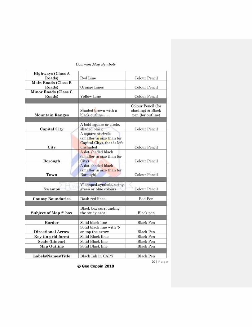
5. Have a KEY, using the conventional symbols. (The Key MUST be done in a
‘grid’ format.)
20 | P a g e
© Geo Coppin 2018
Common Map Symbols
Highways (Class A
Roads) Red Line Colour Pencil
Main Roads (Class B
Roads) Orange Lines Colour Pencil
Minor Roads (Class C
Roads) Yellow Line Colour Pencil
Mountain Ranges
Shaded brown with a
black outline
Colour Pencil (for
shading) & Black
pen (for outline)
Capital City
A bold square or circle,
shaded black Colour Pencil
City
A square or circle
(smaller in size than for
Capital City), that is left
unshaded Colour Pencil
Borough
A dot shaded black
(smaller in size than for
City) Colour Pencil
Town
A dot shaded black
(smaller in size than for
Borough) Colour Pencil
Swamps
V' shaped symbols, using
green or blue colours Colour Pencil
County Boundaries Dash red lines Red Pen
Subject of Map 2' box
Black box surrounding
the study area Black pen
Border Solid black line Black Pen
Directional Arrow
Solid black line with 'N'
on top the arrow Black Pen
Key (in grid form) Solid Black lines Black Pen
Scale (Linear) Solid Black line Black Pen
Map Outline Solid Black line Black Pen
Labels/Names/Title Black Ink in CAPS Black Pen
21 | P a g e
© Geo Coppin 2018
METHODOLOGY
A clear statement on HOW data was collected and an example of the
instrument(s) used or a brief outline of how observations were made and tests
done.
Also, a clear statement on WHEN the data were collected and a clear
statement on WHERE the data were collected.
It is worth 4 marks!
Methodology Tips
The Methodology MUST be written in SEQUENTIAL ORDER from start of
the field trip to the end, preferably in a paragraph format.
You are ONLY to state when, where and how you obtain your information for
the purpose of achieving the aim of the project. YOU ARE NOT TO
INCLUDE ANY OBSERVATIONS MADE DURING THE TRIP, ANY
RESULTS OR MAKE ANY CONCLUSIONS.
You can include pictures or diagrams showing any tests/experiments
conducted. If included, they must be properly labelled and integrated.
Must be written in Past Tense and must “flow’!
22 | P a g e
© Geo Coppin 2018
Example of Methodology
“A field trip was carried out on Monday 00th January 2016 at the [insert full
location]. On arrival,……….”
23 | P a g e
© Geo Coppin 2018
PRESENTATION OF DATA
A variety of illustrations, for example graphs, tables, labelled photographs,
must be used to show the primary data collected.
At least TWO DIFFERENT TYPES should be included.
Each illustration MUST be:
i. Accurate (correctly drawn/constructed)
ii. Relevant (appropriate in illustrating the particular data)
iii. Neat (clear to understand and read)
iv. Clearly labelled (components are properly indicated and stated in
Key)
v. Titled (includes a Reference number and title)
Illustrations MUST also have a Border. They can be hand-drawn or
constructed using Excel or Word.
It is worth 4 marks!
Information may be used from the Internet, pamphlets and textbooks but
should NOT be copied directly.
**The teacher is required to impose a penalty, deduction of 1 mark, in cases where
less than two examples are used and where illustrations are copied from secondary
sources.
ALL ILLUSTRATIONS MUST BE SUITABLY CHOSEN,
STRUCTURED & INTEGRATED INTO YOUR DISCUSSION &
ANALYSIS.
24 | P a g e
© Geo Coppin 2018
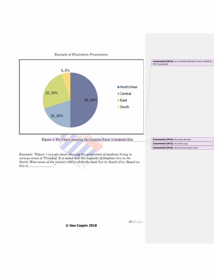
Example of Illustration Presentation
Figure 1: Pie Chart showing the location Form 4 students live.
Example: “Figure 1 is a pie chart showing the proportion of students living in
various areas of Trinidad. It is noted that the majority of students live in the
North/West areas of the country (50%) while the least live in South (5%). Based on
this it…………………….”
Commented [M13]: ALL ILLUSTRATIONS MUST HAVE A BORDER, KEY (if applicable)
Commented [M14]: Illustration Number
Commented [M15]: Illustration type
Commented [M16]: What the illustration shows
25 | P a g e
© Geo Coppin 2018
Illustration Reference Terms
Use ‘Figure’ for any type of table or charts (pie chart, bar graph, line graph,
etc.).
Use ‘Diagram’ for any type of sketch map or diagram that was hand-drawn.
Use ‘Map’ for any maps drawn to scale.
Use ‘Photo’ for any digital pictures used in the project.
Use ‘Plate’ for any hard-copy photos that were developed and stuck in the
project.
26 | P a g e
© Geo Coppin 2018
QUALITY OF DATA
The data must be comprehensive and very accurate.
Data must also be APPROPRIATE & RELEVANT, MOSTLY consisting of
PRIMARY DATA!!
It is worth 4 marks!
27 | P a g e
© Geo Coppin 2018
DISCUSSION AND ANALYSIS
The Discussion and Analysis must be very well organised, with coherent,
well-developed and well-sequenced points, supported by comprehensive data
(must show evidence of field work).
The illustrations must be well integrated with the text and content. For ease
of reading and understanding, the presentation of illustrations must
be part of the Discussion and Analysis and NOT as a separate
section!
You are not to use data obtained from secondary sources. The Discussion and
Analysis is ONLY based on the data collected on the day of the field trip.
Based on the information obtained, what can be said about the
problem/issue? Based on your knowledge on the theory (textbooks, etc.), what
does the data collected imply?
This is worth 10 marks!
28 | P a g e
© Geo Coppin 2018
CONCLUSION
The Conclusion must be related to the purpose of the study and must provide
a succinct summary consistent with the data obtained.
ALL information DISCUSSED & ANALYSED must be summarised and if the
AIM was ACHIEVED, it must be also stated!
Any limitations in carrying out the Methodology can be included.
** NO NEW INFORMATION MUST BE INTRODUCED IN THE CONCLUSION.
It is worth 4 marks!
29 | P a g e
© Geo Coppin 2018
COMMUNICATION OF DATA
The final draft must have no grammatical errors or flaws and there must be
extensive use of appropriate geographical terms.
Your sentences and paragraphs must be structured correctly and must make
sense (grammatically and geographically).
It is worth 4 marks!
30 | P a g e
© Geo Coppin 2018
BIBLIOGRAPHY
The Bibliography is to be written in alphabetical order by AUTHOR with
TITLE, PUBLISHER, PLACE and COPYRIGHT YEAR for at LEAST
THREE, relevant and UP-TO-DATE references.
Any information referred to in the body of the project MUST be included in
the Bibliography.
There must be AT LEAST THREE references to be awarded the total 1 mark.
Note that the class website and teachers are NOT to be included in the
Bibliography.
31 | P a g e
© Geo Coppin 2018
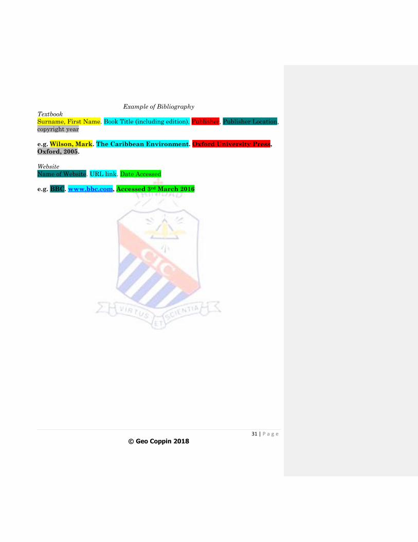
Example of Bibliography
Textbook
Surname, First Name. Book Title (including edition). Publisher, Publisher Location,
copyright year
e.g. Wilson, Mark. The Caribbean Environment. Oxford University Press,
Oxford, 2005.
Website
Name of Website. URL link. Date Accessed
e.g. BBC. www.bbc.com, Accessed 3rd March 2016
32 | P a g e
© Geo Coppin 2018
APPENDIX
Any raw data or questionnaires should be included in the Appendix. This
section comes after the Bibliography.
33 | P a g e
© Geo Coppin 2018
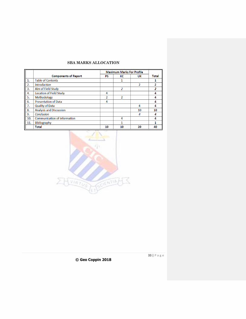
SBA MARKS ALLOCATION
34 | P a g e
© Geo Coppin 2018
GUIDELINES FOR SBA DRAFTS
Following the SBA field trip and all the data has been collated and provided
to all students, SBA draft projects will be required.
Each draft submission will focus on a particular section or sections of the
entire project.
The deadlines for each draft will be stated in class and posted on the class
website.
Drafts #1-5 will be on a MONTHLY BASIS!
DRAFT #1: SBA Outline- Students must submit an outline of how they
intend to proceed to do the SBA project (how will they use the data to achieve
the title and aim of the SBA). Students indicate what they will include in
their Introduction, Methodology, Discussion and Analysis (include the type of
illustrations that will be used) and Conclusion.
DRAFT #2: Submission of Introduction, Aim, Location (including Maps 1 and
2 and Diagram 1) and Methodology.
DRAFT #3: Submission of corrections from Draft #2, as well as Discussion
and Analysis (include illustrations) Conclusion and Bibliography.
DRAFT #4: Corrections to Draft #2 and/or #3
DRAFT #5: Corrections to Draft #4
Drafts #6 onwards will be on a WEEKLY BASIS!
DRAFTS #6 onwards: Any section or sections that need correcting must be
submitted.
Final Draft will be the week before Carnival!
FINAL DRAFT: Submission of the FULL SBA project, inclusive of Cover
pages, Table of Contents, all the sections and Appendix (if applicable).
HARDCOPY & SOFTCOPY!(See below for softcopy requirements)
35 | P a g e
© Geo Coppin 2018
The final SBA draft is to be presented in a soft-backed folder (preferably clear
cover with sliding spine) of ‘Quarto’ or ‘A4’ size (roughly Letter size).
It is preferred that your final draft is typed, using font size 12 for the
Body, 14-16 for the Headings and 10-11 for Captions for illustrations.
Font styles such as Arial, Calibri or Times Roman are preferred.
Students must type their projects on ONE side of the page ONLY.
ALL illustrations and pictures in the FINAL Draft MUST BE IN
COLOUR!
Submission of Softcopy
Due to CXC changes regarding the submission of samples, in addition to submitting
a hardcopy, a softcopy is now mandatory. The hardcopy project will be used for
marking purposes while the softcopy will be sent to CXC (if selected as a sample).
The following requirements must be followed when submitting the softcopy:
Ensure that both the hardcopy and softcopy are the SAME.
Since maps need to be hand-drawn, each map will need to be numbered,
scanned and inserted in the final softcopy. Do NOT take a photo of the maps
and copy and paste in word as the original quality of the maps will be lost.
All pages, except the copy pages and table of contents, must be numbered.
The final softcopy MUST be in PDF format, which can be done in ‘Word’,
‘Save as’ then select ‘PDF’ under ‘Save as type’.
The following can be done to ensure the final project is properly formatted
and uploaded:
- File 1: Complete the Strategy Sheet provided, scan and convert into a PDF
file.
- File 2: Prepare the Cover pages and table of Contents separate from the
rest of the project and covert to a PDF file
- File 3: Prepare the Introduction, Aim and Location pages, each numbered
‘1, 2, 3’ and covert to a PDF file
36 | P a g e
© Geo Coppin 2018
- File 4: Insert the page numbers (by hand) on the maps, numbered ‘4, 5, 6’,
scan and covert into a PDF file
- File 5: Prepare the rest of the SBA, starting from the Methodology on page
7 and convert into a PDF file
- Using an online ‘PDF Merger’, merge Files 1-5 to create one PDF file
- Email the merged file to teacher
Things to Note
Draft #1 and Drafts including any hand-drawn maps and diagrams MUST be
submitted HARDCOPY. Other Drafts can be submitted SOFTCOPY in Word
and uploaded on the class website SBA page.
Any Draft submitted in Word will be edited using the ‘Review’ feature in the
document. All changes made will be tracked and comments will also be
included.
To avoid the constant use of colour ink during the Draft stage, any colour
illustration can be submitted in the softcopy draft.
Students MUST NOT copy drafts from other students as this will result in
the awarding of ‘zero’ marks.
Draft Schedule (Subject to change)
FORM 4- TERM 3
Draft #1 June
FORM 5- TERM 1
Draft #2 September
Draft #3 October
Draft #4 November
FORM 5- TERM 2
Draft #5 January
Draft #6 onwards January & February
FINAL DRAFT February (Week before Carnival)
37 | P a g e
© Geo Coppin 2018
Guidelines for doing Corrections to Maps (after Draft #2)
1. For Maps 1 and 2, place a blank ‘Letter’ sized page on the map of Trinidad in
the Atlas (Map 1) or the page (Map 2).
2. Trace over the outline of the maps in PENCIL.
3. In PENCIL, draw the border, title, directional arrow, scale (linear) and key
(in grid format)
4. As neatly as possible, include ALL the required features and labels in
PENCIL.
5. Submit to teacher for feedback and ONCE the corrections are good, outline
all pencil work in pen and colour pencils. Erase any visible pencil work!
38 | P a g e
© Geo Coppin 2018
Doing the Word Count for the SBA
Word Count- 1000 words (Max -1100 words)
When doing the word count for the project, the following is NOT included:
1. The Cover pages
2. Table of Contents
3. The Bibliography
4. Appendix
5. Section Headings
6. Words included in illustrations
7. Captions for illustrations
8. Words in brackets used to define a term or make a point
Exceeding the word count will result in a deduction of 4 marks!
39 | P a g e
© Geo Coppin 2018
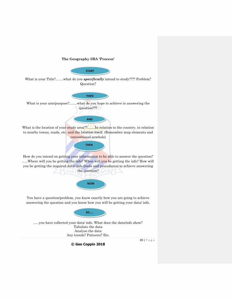
The Geography SBA ‘Process’
What is your Title?........what do you specifically intend to study???? Problem?
Question?
What is your aim/purpose?........what do you hope to achieve in answering the
question???
What is the location of your study area??........In relation to the country, in relation
to nearby towns, roads, etc. and the location itself. (Remember map elements and
conventional symbols)
How do you intend on getting your information to be able to answer the question?
…..Where will you be getting the info? When will you be getting the info? How will
you be getting the required data/ info (tools and procedures) to achieve answering
the question?
You have a question/problem, you know exactly how you are going to achieve
answering the question and you know how you will be getting your data/ info.
…..you have collected your data/ info. What does the data/info show?
Tabulate the data
Analyse the data
Any trends? Patterns? Etc.
START
THEN
AND
THEN
NOW
SO…..
40 | P a g e
© Geo Coppin 2018
What does that mean?
What can you conclude about the title/aim of the SBA???.....have you answered the
question? Solve the problem.
THEREFORE