Embed Size (px)
Citation preview
STANDARDS FOR REGIONAL GEOLOGIC MAPPING:
PROCEDURES AND GUIDELINES FOR WORK PROCESSES
CONTENT AND DIGITAL ATTRIBUTES FOR PRODUCTS (PARTII)
(PART I)
FEDERAL DEMOCRATIC REPUBLIC OF ETHIOPIA
MINISTRY OF MINES AND ENERGY
Organized, developed and prepared by:BEDRU HUSSIEN MOHAMMED (PhD)
February 2007
Addis Ababa
PROFESSIONALS ADVISORY TASK FORCE
REGIONAL GEOLOGY AND GEOCHEMISTRY DEPARTMENTGEOLOGICAL SURVEY OF ETHIOPIA
Ministry of Mines and EnergyProfessional Advisory Task Force
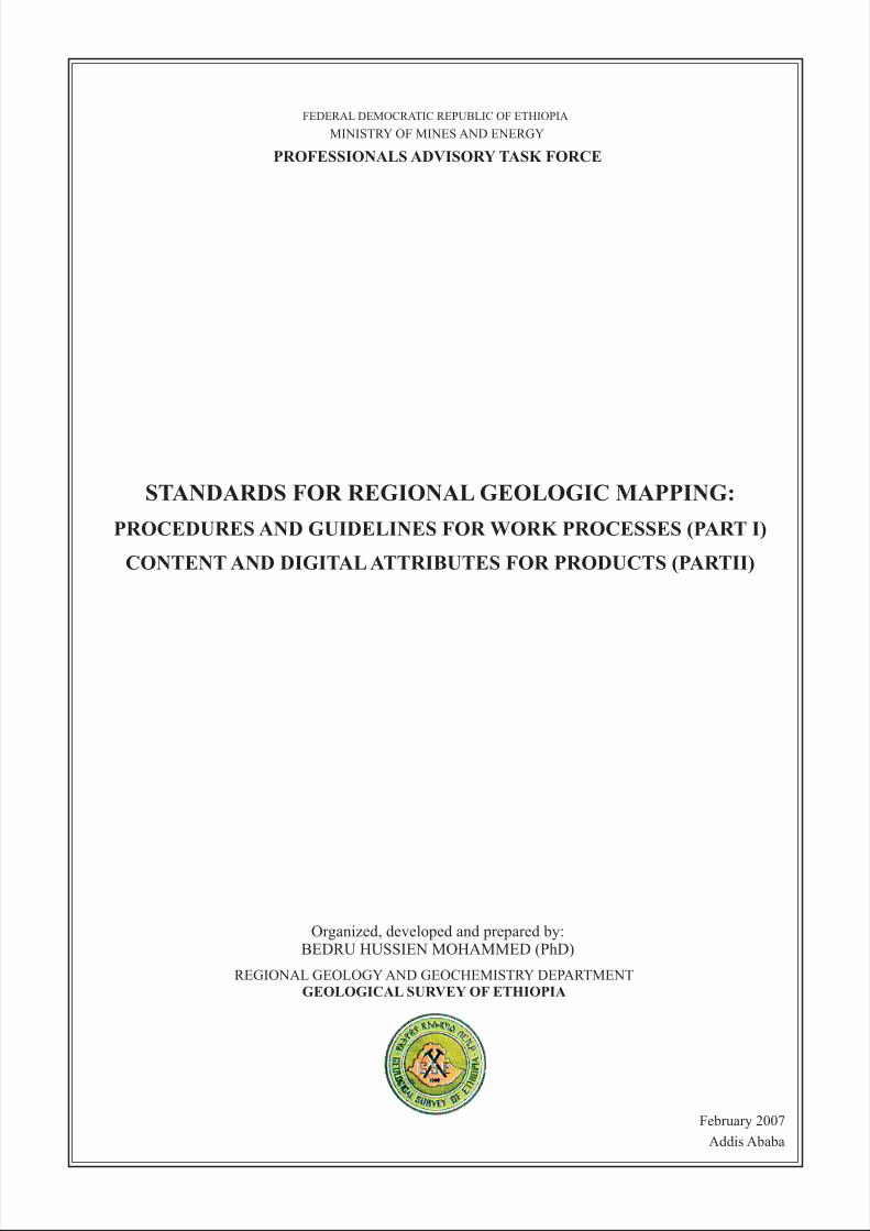
Overview of essential standards for regional geologic mapping
WS-chart.cdr
Regional Geological Mapping SectionGeological Survey of Ethiopia
Main activities, technical processes and associated standards for regional geologic mapping project
Guidelines for project proposal
Guidelines for interpretation, map preparation & reporting
Guidelines for field geological data collection
Format for field notebook
Scheme for field rock classification & naming
Guidelines for lithostratigraphic nomenclature
Forms: rock-section logging & database tables
Digital database schema & table formats
Description form & associated guideline
Rock classification diagrams
Petrographical terminologies & mineral symbols
Geologic map components and digital maplayout format
Regional geologic report components & word processing format
Contents & cartographic attributes of geologic map components
Contents of regional geologic report components
Layout for cover/title page
Page layout for main text body of the report
Layout for list of content, figure, table & enclosure
Guidelines for illustrations (Figures, tables)
Conventions for reference citation and listing
International geologic time scale & associated letter symbol
International stratigraphic color for geologic time divisions
Lithostratigraphic units of Ethiopia: Formations, letter symbols,description, color & foreground pattern scheme
Stratigraphic color scheme for geologic ages recorded in Ethiopia
Patterns overprinting geologic age colors (stratigraphic colors)
Pattern symbols for different kind of mappable lithological units
Digital cartographic symbols & attributes for basemap features
Digital cartographic symbols & attributes for geologic features
Color fill scheme for different type of mappable lithological units
Guidelines for scheduling field traverses & related formats
Check-list of field equipments and materials
Literature survey
Background &significanceconception
Geologic mapping
Remote Sensingstudies: initial
Remote Sensingstudies: final
Field preparation
Building-up ofdatabase archive
Petrographicstudies
Field dataanalysis
Geologic mappreparation
Geologic reportwriting
Forms
WORK PROCESSES STANDARDS
PROJECTINCEPTION
PROJECT IMPLEMENTATION
PRE-FIELDACTIVITIES
FIELDACTIVITIES
POST-FIELDACTIVITIES
FINALACTIVITIES
Ministry of Mines and EnergyProfessional Advisory Task Force
Standard guidelines for regional geologic mapping activities
Regional Geological Mapping SectionGeological Survey of Ethiopia
STANDARD PROCEDURES AND GUIDELINES
FOR
REGIONAL GEOLOGIC MAPPING WORK PROCESSES (ACTIVITIES)
PART I
I-1. PROCEDURES AND GUIDELINES IN REMOTE SENSING STUDIES (RS)
I-2. CHECK-LIST OF FIELD EQUIPMENTS AND CAMPING MATERIALS (FE)
RS-1. Purpose and advantages of digital remote sensing data
RS-3. Preliminary works
RS-2. Main required inputs
RS-4. Elements of image interpretation
RS-5. Interpretation and mapping procedure
RS-6. Attributes of initial remote sensing map
RS-7. Attributes of initial remote sensing report
FE-1. Professional instruments
FE-2. Base maps
FE-3. Mapping guidelines, forms & supporting items
FE-4. Stationary materials/items
FE-5. Sampling tools and related items
FE-6.Logistics & related materials/tools
FE-7.Camping materials/field luggage items
FE-8.Kitchen materials/items
FE-9. First Aid kit
FE-10.Fieldwork information
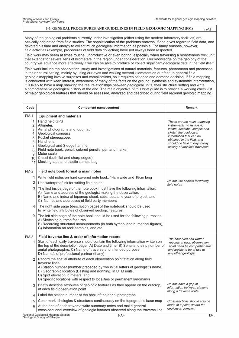
FM-1. Equipment & materials
FM-2. Field note book format & main notes
FM-3. Field traverse line & order of information record
FM-4. Preliminary field work
FM-5. Outcrop analysis and record
FM-6. Sampling
FM-7. Field sketches and photographs
FM-8. Compilation of field data
LU-1. Procedures for establishing lithostratigraphic units
SR-1. Remote sensing studies
VR-1. Remote sensing studies
MR-1. Remote sensing studies
PS-1. General steps of petrographic study
PS-2. Petrographic steps and main features of clastic sedimentary rocks
PS-3. Petrographic steps and main features of calcareous sedimentary rocks
PS-4. Petrographic steps and main features of volcanic lava flows
PS-5. Petrographic steps and main features of pyroclastic volcanic rocks
PS-5. Petrographic steps and main features of intrusive igneous rocks
PS-5. Petrographic steps and main features of metamorphic rocks
SR-2. General field working steps and observation record
VR-2. General field working steps and observation record
MR-2. General field working steps and observation record
SR-3. Steps of outcrop analysis in clastic sedimentary sequence
VR-3. Steps of outcrop analysis in volcanic lava flows
MR-3. Outcrop analysis and record of lithologic data
SR-4. Steps of outcrop analysis in calcareous sedimentary rocks
VR-4. Steps of outcrop analysis in pyroclastic volcanic rocks
MR-4. Outcrop analysis and record of structure data
MR-5. Outcrop analysis and record of high deformation zones
LU-2. Lithostratigraphic rank terms
LU-3. Miscellaneous lithostratigraphic ranking terms
LU-4. Procedures of extending lithostartigraphic units and correlation
I-3. GENERAL PROCEDURES AND GUIDELINES IN FIELD MAPPING ACTIVITIES (FM)
I-4. GUIDELINES FOR FIELD IDENTIFICATION AND NAMING OF LITHOSTRATIGRAPHIC UNITS (LU)
I-5. PROCEDURES AND GUIDELINES IN SEDIMENTARY ROCK TERRAIN MAPPING (SR)
I-6. PROCEDURES AND GUIDELINES IN VOLCANIC ROCK TERRAIN MAPPING (VR)
I-7. PROCEDURES AND GUIDELINES IN METAMORPHIC ROCK TERRAIN MAPPING (MR)
I-8. PROCEDURES AND GUIDELINES IN IN PETROGRAPHIC STUDY OF ROCK THINSECTIONS (PS)
I-A1
I-A1
I-A1
I-A1
I-A2
I-A2
I-A2
I-A3
I-A3
I-A3
I-A3
I-A3
I-A3
I-A3
I-A3
I-A3
I-A3
I-A4
I-A4
I-A4
I-A5
I-A5
I-A5
I-A5
I-A5
I-A6
I-A8
I-A9
I-A10
I-A13
I-A13
I-A13
I-A14
I-A14
I-A14
I-A14
I-A8
I-A9
I-A10
I-A8
I-A9
I-A11
I-A8
I-A9
I-A11
I-A12
I-A6
I-A7
I-A7
Ministry of Mines and EnergyProfessional Advisory Task Force
Standards for regional geologic mapping work processes (Activities)
Regional Geological Mapping SectionGeological Survey of Ethiopia
I-A
TABLE OF CONTENTS
Pagenumber
1
1
1
1
2
2
2
2
3
3
3
3
4
4
4
4
5
5
5
5
6
6
6
6
7
7
7
7
RS-1
RS-2
RS-3
RS-4
Code RemarkComponent name /content
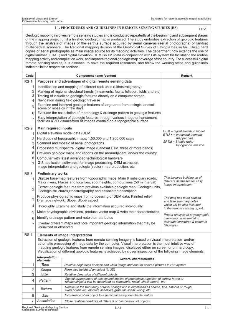
Geologic mapping involves remote sensing studies and is conducted repeatedly at the beginning and subsequent stagesof the mapping project until a finished geologic map is produced. The study embodies extraction of geologic featuresthrough the analysis of images of the earth\s surface acquired by aerial cameras (aerial photographs) or landsatmultispectral scanners. The Regional mapping division of the Geological Survey of Ethiopia has so far utilized hardcopies of aerial photographs as main image source for its mapping activities. The department now extends the use ofdigital landsat (ETM +) and digital elevation (DEM/SRTM) data in conjunction with GIS system for facilitating the routinemapping activity and compilation work, and improve regional geologic map coverage of the country. For successful digitalremote sensing studies, it is essential to have the required resources, and follow the working steps and guidelinesindicated in the respective sections.
Purposes and advantages of digital remote sensing data
Main required inputs
Preliminary works
Elements of image interpretation
Easy interpretation of geologic features through various image enhancementfacilities & 3D visualization of images overlaid on a topographic surface
Identification and mapping of different rock units (Lithostratigraphy)
Marking of regional structural trends (lineaments, faults, foliation, folds and etc)
Tracing of visualized geologic features directly on a computer screen
Navigation during field geologic traverse
Examine and interpret geologic features of large area from a single landsatscene or mosaics in few days
Evaluate the association of morphology & drainage pattern to geologic features
I-1. PROCEDURES AND GUIDELINES IN REMOTE SENSING STUDIES (RS)
Ministry of Mines and EnergyProfessional Advisory Task Force
Standards for regional geologic mapping activities
Regional Geological Mapping SectionGeological Survey of Ethiopia
I-A1 I1-1
1 of 2
GIS application softwares: for image processing, DEM extraction,image interpretation and geologic (vector) map production, etc.
Digitize base map features from topographic maps: Main & subsidiary roads,Major rivers, Places and localities, spot heights, contour lines (50 m interval)
Extract geologic features from previous available geologic map: Geologic units,Geologic structures,lithostratigraphy and associated description
Produce physiographic maps from processing of DEM data: Painted relief,Slope, Slope aspectDrainage network,
Overlay different maps and note important geologic information that may bevisualized or observed
Thoroughly Examine and study the information acquired individually
Make physiographic divisions, produce vector map & write their characteristics
Identify drainage pattern and note their attributes
This involves building up ofdifferent databases for easyimage interpretation.
The data has to be studiedand take summary noteswhich will be also includedin the remote sensing report.
Proper analysis of physiographicinformation is essential todelineate structures & extent oflithologies
Extraction of geologic features from remote sensing imagery is based on visual interpretation and/orautomatic processing of image data by the computer. Visual interpretation is the most intuitive way ofmapping geologic features from remote sensing images, displayed either on screen or on hard copy.Visualization of different geologic features is achieved by closer inspection of the following image elements.
Tone
Interpretationelements General characteristics
Shape
Size
Pattern
Texture
Site
Association
Digital elevation model data (DEM)
Hard copy of topographic maps: 1:50,000 and 1:250,000 scale
Scanned and mosaic of aerial photographs
Processed multispectral digital image (Landsat ETM, three or more bands)
Previous geologic maps and reports on the area/adjacent, and/or the country
Computer with latest advanced technological hardware
DEM = digital elevation modelETM + = enhanced thematic
mapper plusSRTM = Shuttle radar
topographic mission
Relative brightness of black and white image and hue for colored pictures in HIS system
Form also height of an object (in 3D)
Relative dimension of different objects
Spatial arrangement of objects and implies characteristic repetition of certain forms orrelationships. It can be described as concentric, radial, check board, etc
Relates to the frequency of tonal change and is expressed as coarse, fine, smooth or rough,even or uneven, mottled, speckled, granular, linear, wooly, etc
Occurrence of an object to a particular easily identifiable feature
Close relationships/links of different or combination of objects.
Start actual on screen interpretation of lithologic boundaries and structures, i.e,digitizing identified contacts & geologic structures as line features
Visualize geologic features by employing different functions of image analysis
Note the band combination and GIS image analysis functions,which allows best visualization of geologic features
Note the type and spatial location of geologic features that you may havespontaneously identified/recognized
Note image properties of identified features and establish key properties foridentification of other geologic features
Make lithologic polygons from the line features marking lithologic boundary
Complete your map by providing map symbols for the lithologic units &Structural features
Appropriate stratigraphic legend
Lithologic units
Geologic structures
Geologic cross sections
Base map features
Selected traverse routes and possible field camping sites
ABSTRACTa) Location, b) tasks performed, c) Brief list and summary of interpretedgeologic units and structures, d) General statement on pre planned field tasks,
OBJECTIVES AND SCOPEa) Statement on objectives and location, b) Materials, methods, techniquesemployed and time invested, c) General summary of the output andcontent of the report
BACKGROUND INFORMATIONa) Statement on available previous works in the area/adjacent areas,b) Summarized description of lithologic units and structures in the area asidentified by early workers or references from country wide geologic mapsand reports
PHYSIOGRAPHYa) Statement on the general morphology, relief and slope gradient,b) Physiographic divisions and their characteristic features,c) Drainage network and type of drainage pattern
LITHOLOGIC UNITSa) Brief list of interpreted lithologies, b) Preliminary stratigraphic outline &
their position in a geologic time correlated to early works,c) Image and/or other characteristics of remotely sensed lithologic units,d) Distribution and physiographic expressions, e) Relationship among
adjacent units
STRUCTURAL FEATURESa) General overview of interpreted geologic structures, b) Attributes of thestructures, and c) Its influence on the landscape & distribution of lithologic units
PRELIMINARY TRAVERSE ROUTES AND FIELD TASKSa) Summarized overview of the physiography, lithologic units and structures,b) Outline of geologic problem conceptualized/identified in the course ofremote sensing study, c) Statement on proposed field traverses & purpose
I-1. PROCEDURES AND GUIDELINES IN REMOTE SENSING STUDIES (RS)
Ministry of Mines and EnergyProfessional Advisory Task Force
Standards for regional geologic mapping activities
Regional Geological Mapping SectionGeological Survey of Ethiopia
I-A2 I1-2
2 of 2
1
1
1
2
2
2
3
4
3
3
5
4
4
6
5
5
7
6
6
7
RS-5
RS-6
RS-7
Code RemarkComponent name /content
Interpretation and mapping procedure
Initial remote sensing map
Attributes of Initial remote sensing report
Indicate additional basis ofremote sensing interpretation(Add geologic map)
(Add physiographic map)
(Add geologic map, lithologyand structure)
(Add traverse route map, andtable of preplanned traverses,on the appropriate form)
Record image attributes ofinterpreted geologic features,on the appropriate form
Follow standards in part twofor the geologic map
Provide brief idea on importanceof the report
Present clear orientation intodifferent section of the report(Add location map)
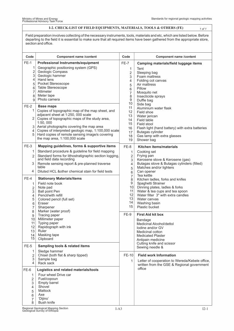
Field preparation involves collecting of the necessary instruments, tools, materials and etc, which are listed below. Beforedeparting to the field it is essential to make sure that all required items have been gathered from the appropriate store,section and office.
I-2. CHECK-LIST OF FIELD EQUIPMENTS, MATERIALS, TOOLS & OTHERS (FE)
Ministry of Mines and EnergyProfessional Advisory Task Force
Standards for regional geologic mapping activities
I-A3 I2-1
1 of 1
Regional Geological Mapping SectionGeological Survey of Ethiopia
1
1
1
1
1
2
2
2
2
2
3
3
3
3
3
4
4
4
4
4
5
5
5
678
9101112131415
6789
FE-1
FE-8
FE-9
FE-10
FE-2
FE-3
FE-4
FE-5
Code CodeComponent name /content Component name /content
Geographic positioning system (GPS)Geologic CompassGeologic hammerHand lensPocket StereoscopeTable StereoscopeAltimeterMeter tapePhoto camera
Copies of topographic map of the map sheet, andadjacent sheet at 1:250, 000 scaleCopies of topographic maps of the study area,1:50, 000Aerial photographs covering the map areaCopies of interpreted geologic map, 1:100,000 scaleHard copies of remote sensing image/s coveringthe map area, 1:100,000 scale
Professional Instruments/equipment
Base maps
Mapping guidelines, forms & supportive items
Stationary Materials/items
Sampling tools & related items
Field note bookNote padBall point PenPencil/with refillColored pencil (full set)EraserSharpenerMarker (water proof)Tracing paperMillimeter paperTyping paperRapidograph with inkRulerMasking tapeClipboard
Sledge hammerChisel (both flat & sharp tipped)Sample bagRack sack
FE-7
FE-6
1
1
1
1
2
2
2
3
3
3
4
4
4
5
5
5
6
6
6
7
7
7
8
89
1011121314
15
89
10
1112131415
16
171819
Logistics and related materials/tools
Four wheel Drive carFuel/copounEmpty barrelShovelMattockAxe‘Dijino’Bush knife
Kitchen items/materials
First Aid kit box
Field work Information
Cooking setFrying panKerosene stove & Kerosene (gas)Butagas stove & Butagas cylinders (filled)Matches and/or lightersCan openerTea kettleKitchen ladles, forks and knifesSpaghetti StrainerDinning plates, ladles & forksWater & tea cups and tea spoonWater filter 3" with extra candlesWater canvasWashing basinPlastic bucket
Standard procedure & guideline for field mapping
Standard forms for lithostratigraphic section logging,and field data recording
Remote sensing report & pre-planned traversetable
Diluted HCL &other chemical stain for field tests
Camping materials/field luggage items
TentSleeping bagFoam mattressFolding cot canvasAir mattressPillowMosquito netInsecticide spraysDuffle bagSide bagAluminium water flaskField shoeWater jericanField tableField stoolFlash light (hand battery) with extra batteriesButagas cylinderGas lamp with extra glassesShower bag
Letter of cooperation to Wereda/Kebele office,written from the GSE & Regional governmentoffice
BandageMedicinal Alcohol/dettolIodine and/or GVMedicinal cottonMedicated PlasterAntipain medicineCutting knife and scissorSewing needle &
Many of the geological problems currently under investigation (either using the modern laboratory facilities) arebasically originated from field studies. The sophistication of the problems narrows, if one gives regard to field data, anddevoted his time and energy to collect much geological information as possible. For many reasons, however,field activities (example, procedures of field data collection) have not always been respected.
Field work may seem at times routine, unproductive or even boring, especially when traversing a monotonous rock unitthat extends for several tens of kilometers in the region under consideration. Our knowledge on the geology of thecountry will advance more effectively if we can be able to produce or collect significant geological data in the field itself.
Hand held GPSAltimeter,Aerial photographs and topomap,Geological compass,Pocket stereoscope,Hand lens,Geological and Sledge hammerField note book, pencil, colored pencils, pen and markerMeter scaleChisel (both flat and sharp edged),Masking tape and plastic sample bag
These are the main mappinginstruments, to navigate,locate, describe, sample andsketch the geologicalinformation that can beobtained in the field. andshould be held in day-to-dayactivity of any field traverses
1234
56789
1011
FM-1 Equipment and materials
Field work include the observation, study and investigations of natural materials, features, phenomena and processesin their natural setting, mainly by using our eyes and walking several kilometers on our feet. In general fieldgeologic mapping involve surprises and complications, so it requires patience and demand decision. If field mappingis conducted with keen interest, awareness of many of the facts on the ground, synthesis and systematic interpretation,it is likely to have a map showing the real relationships between geological units, their structural setting and writea comprehensive geological history at the end. The main objective of this brief guide is to provide a working check-listof major geological features that should be assessed, analyzed and described during field regional geologic mapping.
1
2
3
1
4
5
2
3
4
5
6
FM-2
FM-3
Field note book format & main notes
Field traverse line & order of information recordThe observed and writtenrecords at each observationpoint need be comprehensiveand legible to be of use toany other geologist
Do not use pencils for writingfield notes
Cross-sections should also bemade at a point, where thegeology is complex
Do not leave a gap ofinformation between stationsalong a traverse route.
Write field notes on hard covered note book: 14cm wide and 18cm long
Use waterproof ink for writing field notes
The first inside page of the note book must have the following information:A) Name and address of the geologist making the observation,B) Name and index of topomap sheet, subsheets and year of project, andC) Names and addresses of field party members
The right side page (description page) of the notebook should be usedto write field attributes of observed geologic features.
The left side page of the note book should be used for the following purposes:A) Sketching outcrop features,B) Recording structural measurements (in both symbol and numerical figures),C) Information on rock samples, and etc.
Start of each daily traverse should contain the following information written onthe top of the description page: A) Date and time, B) Serial and strip number ofaerial photograph/s, C) Name of traverse and intended purposeD) Name/s of professional partner (if any)
Record the spatial attribute of each observation point/station along fieldtraverse lines:A) Station number (number preceded by two initial letters of geologist’s name)B) Geographic location (Easting and northing) in UTM units,C) Spot elevation in meters, andD) Specific locations with respect to localities or permanent landmarks
Briefly describe attributes of geologic features as they appear on the outcrop,at each field observation point
Label the station number at the back of the aerial photograph
Color mark lithologies & structures continuously on the topographic base map
At the end of each traverse write summary notes and make generalcross-sectional overview of geologic features observed along the traverse line
I-3. GENERAL PROCEDURES AND GUIDELINES IN FIELD GEOLOGIC MAPPING (FM)
Ministry of Mines and EnergyProfessional Advisory Task Force
Standards for regional geologic mapping activities
Regional Geological Mapping SectionGeological Survey of Ethiopia
I-A4 I3-1
1 of 2
Code RemarkComponent name /content
1
1
2
3
4
5
1
2
3
1
2
3
2
3
4
5
6
7
8
9
10
11
12
13
14
15
FM-5
FM-6
FM-7
FM-8
Note the morphology of the outcrop area: hill, flat, river, creek, road, cliff, etc
Based on the outcrop analysis, decide what to sample (rock, fossil or mineral)and its purpose
Mark the position of sectioning of specimens for simple petrographic study
Samples for specific petrographic/polished section studies(ex. structural study) should have compass orientation marks and attitude ofgeologic feature to be studied
Write the station number on the sample, on the wrapping masking tape, andon the plastic bag
Record specimens collected and reasons for further study on the note book
The weekly field data has tobe evaluated & summarizedat the field camp
Transfer observation points on the topographic base map and color marksample locations
Delineate contacts of lithologies on the base map
Summarize acquired field data and identify problems to be worked out
Outcrops with significant geologic information have to be sketched and/orphotographed
Sketched or photographed features must show appropriate scale and compassorientation
Write down the locality, direction of view, attitude of the topographic surfaceand attributes of sketched/photographed geologic features in the note book
Note the nature of exposure: continuous, partly covered, blocky, fragmental
Note the homogeneity and heterogeneity of exposed rocks
Note the economic significance of exposed lithologies
Note appearance of rocks on weathered surfaces
Describe the type of contact in adjacent rock units: sharp, gradational
Note the nature of structural features on the outcrop: simple, complex, etc
Describe identified structures: type, attitude, geometry, age
Take rock samples for comparisons with other similar outcrops, furthermicroscope characterization of rock units and/or solving particular problemsnoted on the outcrop
Make sketches/photographs of outcrops with significant informationon the geologic history
Conclude the outcrop analysis with interpretation remarks on the genesis,lithostartigraphy, structural history and/or problems of interpretation
Describe each identified rock type: color, texture/grain size, mineralogy, etc
Inspect for color, textural and mineralogical variations occurring in arelatively homogeneous outcrops
Outcrop analysis and record
Sampling
Field sketches and photographs
Compilation of field data
Closely examine the lithostratigraphic relationships among different kind ofrocks in heterogenous outcrops
Identify structures in each of rock units: primary (formational), secondary(deformational)
Keep observations or factson the ground distinct frominterpretations
It is desirable to makeas much observations ongood outcrops
Fresh unaltered samplesare required for petrographicstudy of components oflithologies
This is to familiarize withground attributes of geologicfeatures and find-out accessroutes to reach outcrops ofinterest identified by remotesensing study
12
4
5
3
FM-4 Preliminary (reconnaissance) field work
Make road geological traverse in the first few days of the field work
Collect information on available motorable roads or foot paths
Take short notes of the geologic observations made
Write outlines of the new traverse plan and changes made to previous schedule
Plan main traverses ahead, based on the acquired actual information andpre-planned purposes identified during remote sensing study
In most cases it is essentialto make rough sketch ofall photographed features
Code RemarkComponent name /content
Ministry of Mines and EnergyProfessional Advisory Task Force
Standards for regional geologic mapping activities
Regional Geological Mapping SectionGeological Survey of Ethiopia
I-A5 I3-2
2 of 2I-3. GENERAL PROCEDURES AND GUIDELINES IN FIELD GEOLOGIC MAPPING (FM)
GROUP: Employed to a succession of two or more or associatedformations with significant and diagnostic lithologic properties in common.The component formations need not be the same everywhere.
contiguous
Aggregation offormations simplifys lithostratigraphic divisions in certain localities
FORMATION: Primary formal unit of lithostratigraphic classification. Itsestablishment varies with the complexity of the geology of a region and thedetail needed for geologic mapping and to work out its geologic history.This is the only formal lithostratigraphic unit into which the stratigraphiccolumn everywhere should be divided completely on the basis of lithology.Its thickness may range from less than a meter to several thousands.
Ranking of stratotypes asformation is done tosuccessions that can bemapped at the scale of mapping
MEMBER: Possesses lithologic properties distinguishing it from adjacentparts of the formation. No fixed standard is required for the extent andthickness of a member. Some formations may be completely divided intomembers; others may have only certain parts designated as members.A member may extend from one formation to another. Specially shapedforms of members (or of formations) are lenses and tongues. A lens is alens-shaped body of rock of different lithology than the unit that encloses it.A tongue is a projecting part of a lithostratigraphic unit extending out beyondits main body.
1
LU-2
LU-1
Lithostratigraphic rank terms
Procedures for establishing lithostratigraphic unit
Do not use compound lithologicterms for naming
Avoid the use of non-lithologicterms and adjjectives such asvolcanics, metamorphics, etc
Thickness of a successionis not a criteria for groupingformations
Identify stratigraphic types based on detailed mapping in certain localities
Determine the type locality where the stratigraphic unit is best exposed
Supplement the lithostratigraphic designation by mapping other referencesections with similar lithologic character
Note and designate lower and upper stratotypes, in poorly exposed areas
Decide on where to place the lithostratigraphic boundar: lithologic change, orarbitrarily based on vertical/lateral lithologic gradation, or intertongung
Desiginate separate names for similar stratigraphic types separated byunconformities or major hiatuses
Derive simple lithologic term to namedesignated lithostratigraphic unit
from the predominant lithologic type
Extend the use of lithostratigraphic designation to stratified volcanic rocks andmetamorphic rocks with little deformational history
Define a separate criteria for lithostratigraphic designation of non-layeredintrusive units or metamorphic rocks with complex deformational history
Use supplementary geographic locality to accommodate lateral changes inlithostartigraphic character
This section provides basic international stratigraphic principles and guidelines for definition, characterization andestablishment of lithostartigraphic units in the course of mapping.
GroupFormation
MemberBed
Flow
1
2
3
4
5
6
7
8
9
10
1
2
3
4
5
Boundaries of designatedlithostratigraphic units can cutacross time surfaces, fossilranges, etc
Local or minor hiatuses, within asimilar stratigraphic sequence(lithologic units) should not beused for designation of more thanone lithostratigraphic unit
Avoid terms such as "lower","middle", and "upper for formalsubdivisions of lithostratigraphicunits
Use local geographic termcombined with either a unit-termor a simple field lithologic term,such as gneiss, schist, etc orcomplex, ophiolite, melangeto metamorphic stratotypes
Division of formation intomembers should be madefor a particular purpose
Ranking into distinctive beds(key beds, marker beds) shouldbe made to serve particularstratigraphic purpose.
Formal stratigraphichirearchy
Code RemarkComponent name /property
Ministry of Mines and EnergyProfessional Advisory Task Force
Standards for regional geologic mapping activities
Regional Geological Mapping SectionGeological Survey of Ethiopia
I-A6 I4-1
1 of 2
I-4. GUIDELINES FOR FIELD IDENTIFICATION & NAMING OF LITHOSTRATIGRAPHIC UNITS (LU)
(adapted from international commission on stratigraphy)
Lithostratigraphic units are bodies of rocks, bedded or unbedded, may be sedimentary, or igneous, or metamorphicin origin. They are defined and characterized on the basis of their lithologic properties and their stratigraphic relationsobserved in the field, and/or recognized by a combination of both. The geographic extent of a lithostratigraphic unit iscontrolled entirely by the continuity and extent of its diagnostic lithologic features.
BED: The smallest formal unit in the hierarchy of sedimentary lithostratigraphicunits, e.g. a single stratum lithologically distinguishable from other layersabove and below.
FLOW: A discrete extrusive volcanic body distinguishable by texture,composition, or other objective criteria.
The designation and namingof flows as units is limited tothose that are distinctiveand widespread
LU-3
LU-4
Miscelaneous lithostratigraphic ranking terms
Procedures for extending lithostratigraphic units and Correlation
Do not designatelithostratigraphic namefor succession that are notfully described andcharacterized
1
1
2
2
3
3
lithostratigraphic unit and its boundaries are extended away from the typesection or type locality only as far as the diagnostic lithologic properties onwhich the unit is based may be identified
Where lithologic identity is difficult to determine because of poor or nooutcrops, a lithostratigraphic unit and its boundaries may be identified andcorrelated on the basis of indirect evidence: geomorphic expression,wire-line logs, seismic reflections, distinctive vegetation, etc
Use the top or the base of a marker bed as a boundary for a formallithostratigraphic unit where the marker bed occurs at or near a recognizablevertical change in lithology
Code RemarkComponent name /property
Ministry of Mines and EnergyProfessional Advisory Task Force
Standards for regional geologic mapping activities
Regional Geological Mapping SectionGeological Survey of Ethiopia
I-A7 I4-2
2 of 2
I-4. GUIDELINES FOR FIELD IDENTIFICATION & NAMING OF LITHOSTRATIGRAPHIC UNITS (LU)
(adapted from international commission on stratigraphy)
SUPER GROUP AND SUBGROUP: Commonly used for several associatedgroups or for associated groups and formations with significant lithologicproperties in common. Exceptionally, a group may be divided into subgroups.
COMPLEX: A lithostratigraphic unit composed of diverse types of any classor classes or rocks (sedimentary, igneous, metamorphic) and characterizedby irregularly mixed lithology or by highly complicated structural relations.
LITHOSTRATIGRAPHIC HORIZON (LITHOHORIYON) A surface oflithostratigraphic change, commonly the boundary of a lithostratigraphic unit,or a lithologically distinctive very thin marker bed within a lithostratigraphic unit
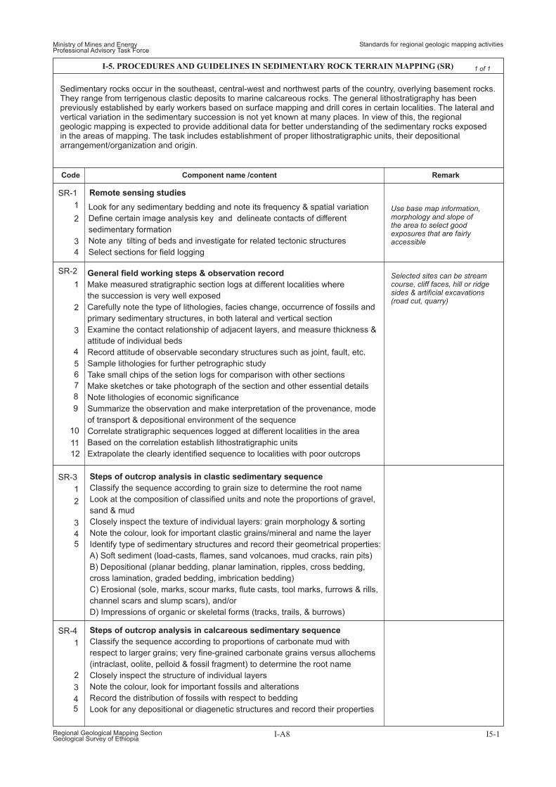
Sedimentary rocks occur in the southeast, central-west and northwest parts of the country, overlying basement rocks.They range from terrigenous clastic deposits to marine calcareous rocks. The general lithostratigraphy has beenpreviously established by early workers based on surface mapping and drill cores in certain localities. The lateral andvertical variation in the sedimentary succession is not yet known at many places. In view of this, the regionalgeologic mapping is expected to provide additional data for better understanding of the sedimentary rocks exposedin the areas of mapping. The task includes establishment of proper lithostratigraphic units, their depositionalarrangement/organization and origin.
General field working steps & observation record
Make measured stratigraphic section logs at different localities where
the succession is very well exposed
Carefully note the type of lithologies, facies change, occurrence of fossils and
primary sedimentary structures, in both lateral and vertical section
Examine the contact relationship of adjacent layers, and measure thickness &
attitude of individual beds
Record attitude of observable secondary structures such as joint, fault, etc.
Sample lithologies for further petrographic study
Take small chips of the setion logs for comparison with other sections
Make sketches or take photograph of the section and other essential details
Note lithologies of economic significance
Summarize the observation and make interpretation of the provenance, mode
of transport & depositional environment of the sequence
Correlate stratigraphic sequences logged at different localities in the area
Based on the correlation establish lithostratigraphic units
Extrapolate the clearly identified sequence to localities with poor outcrops
Steps of outcrop analysis in clastic sedimentary sequence
Classify the sequence according to grain size to determine the root name
Look at the composition of classified units and note the proportions of gravel,
sand & mud
Closely inspect the texture of individual layers: grain morphology & sorting
Note the colour, look for important clastic grains/mineral and name the layer
Identify type of sedimentary structures and record their geometrical properties:
A) Soft sediment (load-casts, flames, sand volcanoes, mud cracks, rain pits)
B) Depositional (planar bedding, planar lamination, ripples, cross bedding,
cross lamination, graded bedding, imbrication bedding)
C) Erosional (sole, marks, scour marks, flute casts, tool marks, furrows & rills,
channel scars and slump scars), and/or
D) Impressions of organic or skeletal forms (tracks, trails, & burrows)
Steps of outcrop analysis in calcareous sedimentary sequence
Classify the sequence according to proportions of carbonate mud with
respect to larger grains; very fine-grained carbonate grains versus allochems
(intraclast, oolite, pelloid & fossil fragment) to determine the root name
Closely inspect the structure of individual layers
Note the colour, look for important fossils and alterations
Record the distribution of fossils with respect to bedding
Look for any depositional or diagenetic structures and record their properties
1
1
1
1
2
2
2
2
3
3
4
3
3
4
5
6
7
8
9
10
11
12
4
45
5
Code RemarkComponent name /content
Ministry of Mines and EnergyProfessional Advisory Task Force
Standards for regional geologic mapping activities
Regional Geological Mapping SectionGeological Survey of Ethiopia
I-A8 I5-1
1 of 1I-5. PROCEDURES AND GUIDELINES IN SEDIMENTARY ROCK TERRAIN MAPPING (SR)
SR-1
SR-2
SR-3
SR-4
Remote sensing studies
Use base map information,morphology and slope ofthe area to select goodexposures that are fairlyaccessible
Selected sites can be streamcourse, cliff faces, hill or ridgesides & artificial excavations(road cut, quarry)
Look for any sedimentary bedding and note its frequency & spatial variation
Define certain image analysis key and delineate contacts of different
sedimentary formation
Note any tilting of beds and investigate for related tectonic structures
Select sections for field logging
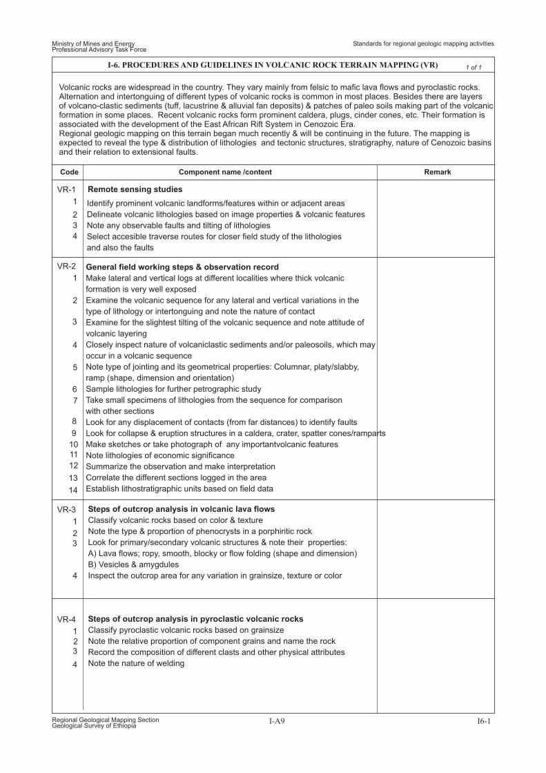
Volcanic rocks are widespread in the country. They vary mainly from felsic to mafic lava flows and pyroclastic rocks.Alternation and intertonguing of different types of volcanic rocks is common in most places. Besides there are layersof volcano-clastic sediments (tuff, lacustrine & alluvial fan deposits) & patches of paleo soils making part of the volcanicformation in some places. Recent volcanic rocks form prominent caldera, plugs, cinder cones, etc. Their formation isassociated with the development of the East African Rift System in Cenozoic Era.Regional geologic mapping on this terrain began much recently & will be continuing in the future. The mapping isexpected to reveal the type & distribution of lithologies and tectonic structures, stratigraphy, nature of Cenozoic basinsand their relation to extensional faults.
General field working steps & observation record
Make lateral and vertical logs at different localities where thick volcanic
formation is very well exposed
Examine the volcanic sequence for any lateral and vertical variations in the
type of lithology or intertonguing and note the nature of contact
Examine for the slightest tilting of the volcanic sequence and note attitude of
volcanic layering
Closely inspect nature of volcaniclastic sediments and/or paleosoils, which may
occur in a volcanic sequence
Note type of jointing and its geometrical properties: Columnar, platy/slabby,
ramp (shape, dimension and orientation)
Sample lithologies for further petrographic study
Take small specimens of lithologies from the sequence for comparison
with other sections
Look for any displacement of contacts (from far distances) to identify faults
Look for collapse & eruption structures in a caldera, crater, spatter cones/ramparts
Make sketches or take photograph of any importantvolcanic features
Note lithologies of economic significance
Summarize the observation and make interpretation
Correlate the different sections logged in the area
Establish lithostratigraphic units based on field data
Steps of outcrop analysis in volcanic lava flows
Classify volcanic rocks based on color & texture
Note the type & proportion of phenocrysts in a porphiritic rock
Look for primary/secondary volcanic structures & note their properties:
A) Lava flows; ropy, smooth, blocky or flow folding (shape and dimension)
B) Vesicles & amygdules
Inspect the outcrop area for any variation in grainsize, texture or color
Steps of outcrop analysis in pyroclastic volcanic rocks
Classify pyroclastic volcanic rocks based on grainsize
Note the relative proportion of component grains and name the rock
Record the composition of different clasts and other physical attributes
Note the nature of welding
1
1
1
1
2
2
2
2
3
3
3
4
3
4
4
4
5
6
7
8
9
10
11
12
13
14
VR-1
VR-2
VR-3
VR-4
Remote sensing studies
Identify prominent volcanic landforms/features within or adjacent areas
Delineate volcanic lithologies based on image properties & volcanic features
Note any observable faults and tilting of lithologies
Select accesible traverse routes for closer field study of the lithologies
and also the faults
Code RemarkComponent name /content
Ministry of Mines and EnergyProfessional Advisory Task Force
Standards for regional geologic mapping activities
Regional Geological Mapping SectionGeological Survey of Ethiopia
I-A9 I6-1
1 of 1I-6. PROCEDURES AND GUIDELINES IN VOLCANIC ROCK TERRAIN MAPPING (VR)
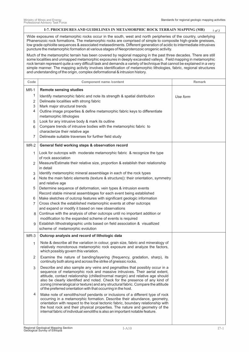
Look for outcrops with moderate metamorphic fabric & recognize the type
of rock association
Measure/Estimate their relative size, proportion & establish their relationship
in detail
Identify metamorphic mineral assemblage in each of the rock types
Note the main fabric elements (texture & structure|): their orientation, symmetry
and relative age
Determine sequence of deformation, vein types & intrusion events
Record stable mineral assemblages for each event being established
Make sketches of outcrop features with significant geologic information
Cross check the established metamorphic events at other outcrops
and expand or modify it based on new observations
Continue with the analysis of other outcrops until no important addition or
modification to the expanded scheme of events is required
Establish lithostratigraphic units based on field association & visuallized
scheme of metamorphic evolution
1
1
1
2
2
2
3
3
3
4
5
7
6
4
4
5
6
7
8
9
MR-1
MR-2
MR-3
Remote sensing studies
Use formIdentify metamorphic fabric and note its strength & spatial distribution
Delineate localities with strong fabric
Mark major structural trends
Outline image properties & define metamorphic fabric keys to differentiate
metamorphic lithologies
Look for any intrusive body & mark its outline
Compare trends of intrusive bodies with the metamorphic fabric to
characterize their relative age
Delineate suitable traverses for further field study
Note & describe all the variation in colour, grain size, fabric and mineralogy ofrelatively monotonous metamorphic rock exposure and analyze the factors,which possibly govern this variation.
Examine the nature of banding/layering (frequency, gradation, sharp), itscontinuity both along and across the strike of gneissic rocks.
Describe and also sample any veins and pegmatites that possibly occur in asequence of metamorphic rock and massive intrusives. Their aerial extent,attitude, contact relationship (chilled/normal margin) and relative age shouldalso be clearly identified and noted. Check for the presence of any kind ofzoning (mineralogical or texture) and any structural fabric. Compare the attitudeof the preferred orientation with that occurring in the host.
Make note of xenoliths/roof pendants or inclusions of a different type of rockoccurring in a metamorphic formation. Describe their abundance, geometry,orientation with respect to the local tectonic fabric, boundary relationship withthe host rock and their physical properties. The nature and geometry of theinternal fabric of individual xenoliths is also an important notable feature.
Code RemarkComponent name /content
Ministry of Mines and EnergyProfessional Advisory Task Force
Standards for regional geologic mapping activities
I-A10 I7-1
1 of 3I-7. PROCEDURES AND GUIDELINES IN METAMORPHIC ROCK TERRAIN MAPPING (MR)
General field working steps & observation record
Outcrop analysis and record of lithologic data
Regional Geological Mapping SectionGeological Survey of Ethiopia
Wide exposures of metamorphic rocks occur in the south, west and north peripheries of the country, underlyingPhanerozoic rock formations. The metamorphic rocks are comprised of simple to composite high-grade gneisses,low grade ophiolite sequences & associated metasediments. Different generation of acidic to intermediate intrusivespuncture the metamorphic formation at various stages of Neoproterozoic orogenic activity.
Much of the metamorphic terrain has been covered by regional mapping in the past three decades. There are stillsome localities and unmapped metamorphic exposures in deeply excavated valleys. Field mapping in metamorphicrock terrain represent quite a very difficult task and demands a variety of technique that cannot be explained in a verysimple manner. The mapping activity involves identification of metamorphic lithologies, fabric, regional structuresand understanding of the origin, complex deformational & intrusion history.
Care must be taken using thevergence of folds for anystructural interpretation.Assigning of asymmetric folds intoS, Z or M folds can be made if theexposure surface allows themeasurement of the axis andaxial plane. This also applies inregions where the foliationappears vertical.
In a layered sequence of schists,certain layers may show two ormore foliations and in others not.
Using stereographic net check ifthe lineation plots on the greatcircle defined by the foliation planein which the attitude of lineationis measured.
FoliationA) Note the morphological characteristic of foliations (when hammered):
Continuous, Spaced/fracture cleavage & CrenulationB) Measure and note the attitude of foliation (dip direction/amount of dip).C) Check and note any slight variation in the intensity/attitude of foliation in
different bands or layers. Also analyze why the intensity of foliation variesbetween different layers.
D) Closely inspect for overprinting relationship of foliations.
LineationA) Note the type of lineation: mineral (preferred orientation of mineral grains),
stretching (stretched mineral grains or aggregates of deformed grains),rods (preferred orientation of elongated bodies of quartz), etc. and theminerals that best define it.
B) Measure and note the attitude of lineation (direction of plunge andamount of plunge) or pitch.
FoldsA) Note the geometrical feature (cylindrical/noncylindrical) of the fold.B) Determine direction of closure (antiform, synform, recumbent, etc.)
and style of folding (tightness, curvature, symmetry, etc.)C) For folds where the hinge zone is clearly exposed, measure the attitude of
the axis (direction of plunge/amount of plunge) and axial plane (directionof dip/amount of dip).
D) Record wavelength and amplitude of cylindrical foldsE) For folds with unclear hinge zone, measure orientation of axial trace.F) Note any development of foliation (axial planar) associated with the folding.
5
1
2
3
4
5
6
7
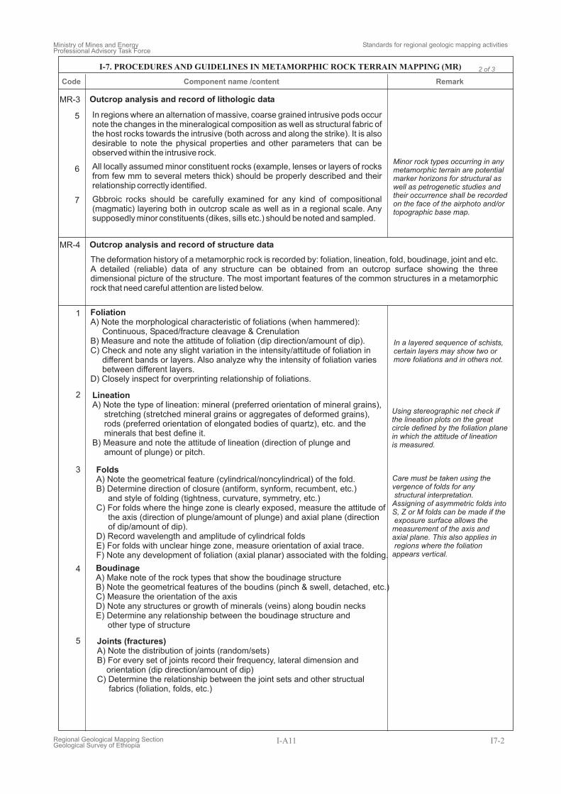
MR-3
MR-4
Outcrop analysis and record of lithologic data
Outcrop analysis and record of structure data
In regions where an alternation of massive, coarse grained intrusive pods occurnote the changes in the mineralogical composition as well as structural fabric ofthe host rocks towards the intrusive (both across and along the strike). It is alsodesirable to note the physical properties and other parameters that can beobserved within the intrusive rock.
All locally assumed minor constituent rocks (example, lenses or layers of rocksfrom few mm to several meters thick) should be properly described and theirrelationship correctly identified.
Gbbroic rocks should be carefully examined for any kind of compositional(magmatic) layering both in outcrop scale as well as in a regional scale. Anysupposedly minor constituents (dikes, sills etc.) should be noted and sampled.
The deformation history of a metamorphic rock is recorded by: foliation, lineation, fold, boudinage, joint and etc.A detailed (reliable) data of any structure can be obtained from an outcrop surface showing the threedimensional picture of the structure. The most important features of the common structures in a metamorphicrock that need careful attention are listed below.
BoudinageA) Make note of the rock types that show the boudinage structureB) Note the geometrical features of the boudins (pinch & swell, detached, etc.)C) Measure the orientation of the axisD) Note any structures or growth of minerals (veins) along boudin necksE) Determine any relationship between the boudinage structure and
other type of structure
Joints (fractures)A) Note the distribution of joints (random/sets)B) For every set of joints record their frequency, lateral dimension and
orientation (dip direction/amount of dip)C) Determine the relationship between the joint sets and other structual
fabrics (foliation, folds, etc.)
Minor rock types occurring in anymetamorphic terrain are potentialmarker horizons for structural aswell as petrogenetic studies andtheir occurrence shall be recordedon the face of the airphoto and/ortopographic base map.
Code RemarkComponent name /content
Ministry of Mines and EnergyProfessional Advisory Task Force
Standards for regional geologic mapping activities
Regional Geological Mapping SectionGeological Survey of Ethiopia
I-A11 I7-2
2 of 3I-7. PROCEDURES AND GUIDELINES IN METAMORPHIC ROCK TERRAIN MAPPING (MR)
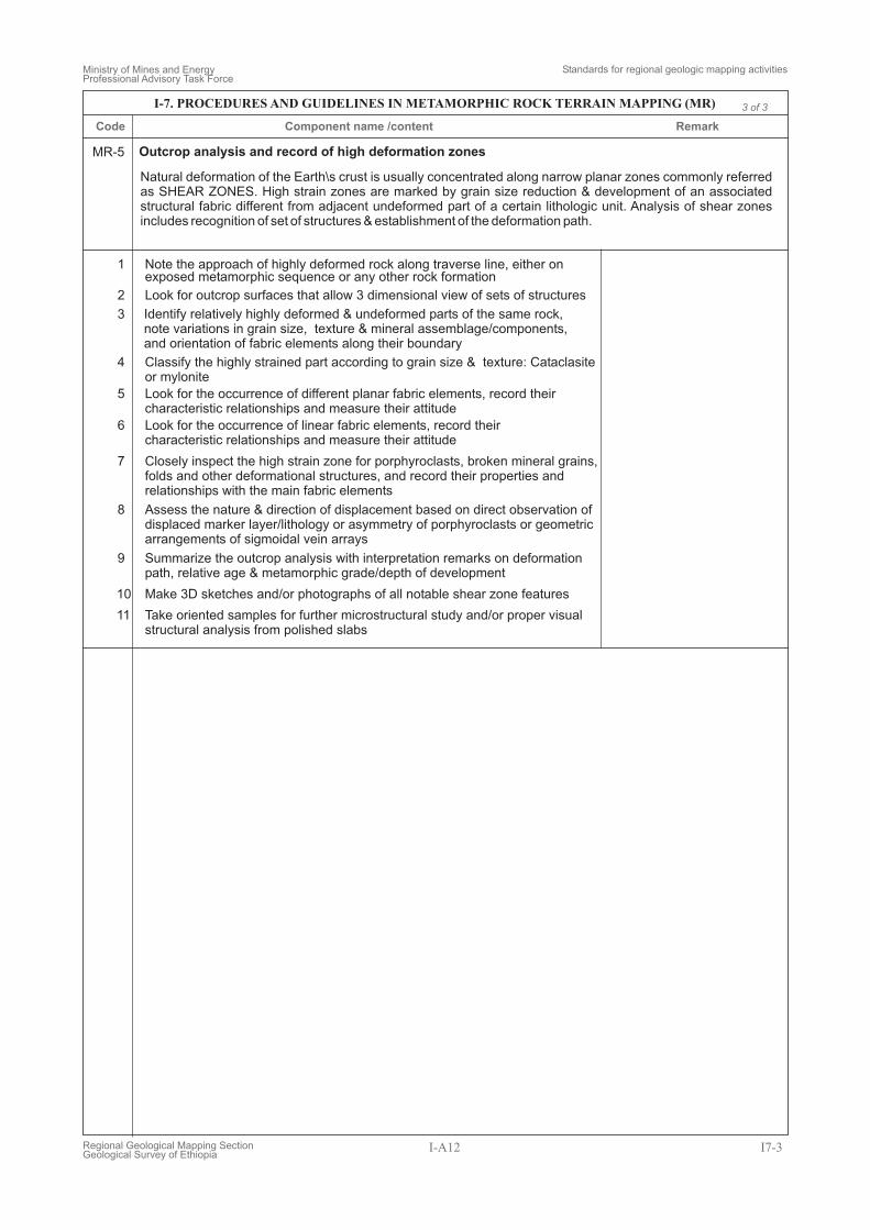
MR-5 Outcrop analysis and record of high deformation zones
Natural deformation of the Earth\s crust is usually concentrated along narrow planar zones commonly referredas SHEAR ZONES. High strain zones are marked by grain size reduction & development of an associatedstructural fabric different from adjacent undeformed part of a certain lithologic unit. Analysis of shear zonesincludes recognition of set of structures & establishment of the deformation path.
1
2
3
4
5
6
7
8
9
10
11
Note the approach of highly deformed rock along traverse line, either onexposed metamorphic sequence or any other rock formation
Look for outcrop surfaces that allow 3 dimensional view of sets of structures
Classify the highly strained part according to grain size & texture: Cataclasiteor mylonite
Look for the occurrence of different planar fabric elements, record theircharacteristic relationships and measure their attitude
Look for the occurrence of linear fabric elements, record theircharacteristic relationships and measure their attitude
Closely inspect the high strain zone for porphyroclasts, broken mineral grains,folds and other deformational structures, and record their properties andrelationships with the main fabric elements
Assess the nature & direction of displacement based on direct observation ofdisplaced marker layer/lithology or asymmetry of porphyroclasts or geometricarrangements of sigmoidal vein arrays
Summarize the outcrop analysis with interpretation remarks on deformationpath, relative age & metamorphic grade/depth of development
Make 3D sketches and/or photographs of all notable shear zone features
Take oriented samples for further microstructural study and/or proper visualstructural analysis from polished slabs
Identify relatively highly deformed & undeformed parts of the same rock,note variations in grain size, texture & mineral assemblage/components,and orientation of fabric elements along their boundary
Code RemarkComponent name /content
Ministry of Mines and EnergyProfessional Advisory Task Force
Standards for regional geologic mapping activities
Regional Geological Mapping SectionGeological Survey of Ethiopia
I-A12 I7-3
3 of 3I-7. PROCEDURES AND GUIDELINES IN METAMORPHIC ROCK TERRAIN MAPPING (MR)
1
1
1
4
4
8
2
2
5
5
9
3
3
7
7
6
6
10
2
3
4
5
7
8
9
6
PS-1
PS-2
PS-3
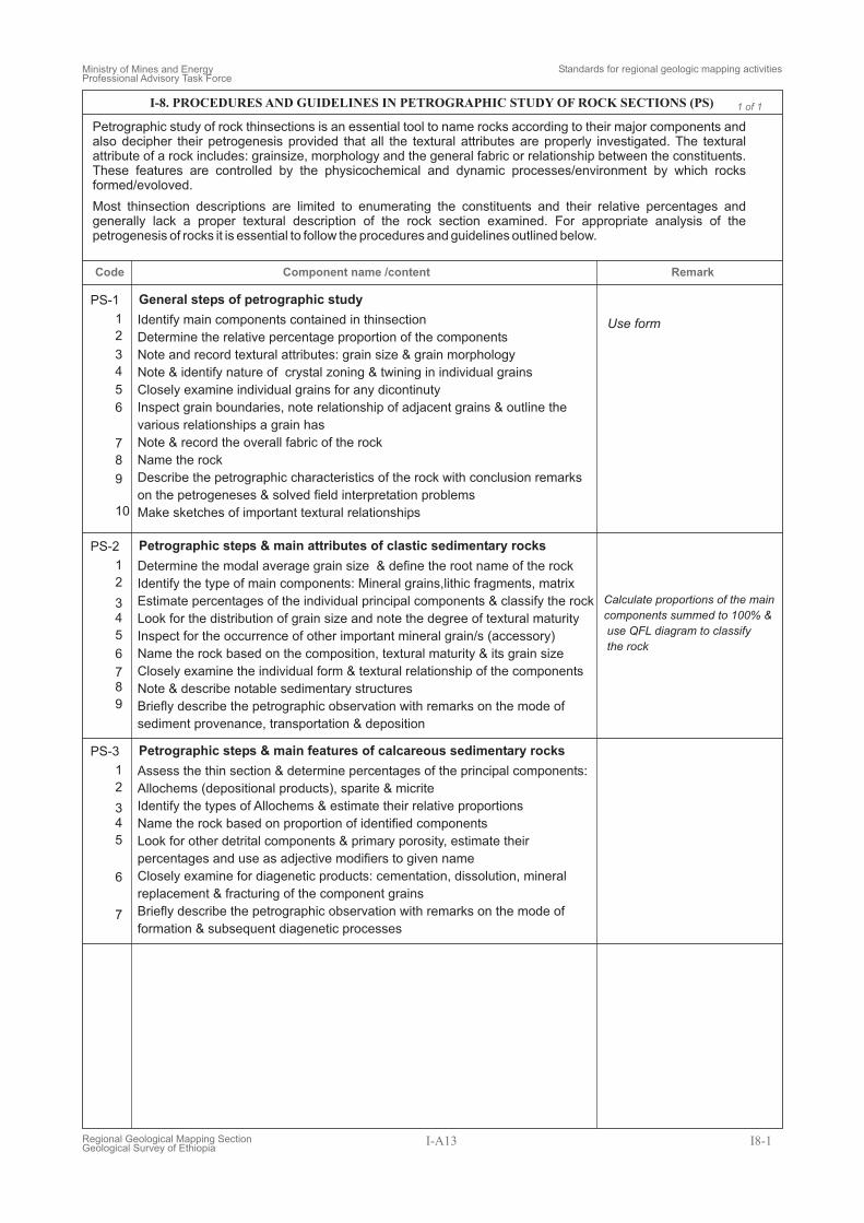
General steps of petrographic study
Petrographic steps & main attributes of clastic sedimentary rocks
Petrographic steps & main features of calcareous sedimentary rocks
Use formIdentify main components contained in thinsection
Determine the relative percentage proportion of the components
Note and record textural attributes: grain size & grain morphology
Note & identify nature of crystal zoning & twining in individual grains
Closely examine individual grains for any dicontinuty
Inspect grain boundaries, note relationship of adjacent grains & outline the
various relationships a grain has
Note & record the overall fabric of the rock
Name the rock
Describe the petrographic characteristics of the rock with conclusion remarks
on the petrogeneses & solved field interpretation problems
Make sketches of important textural relationships
Determine the modal average grain size & define the root name of the rock
Identify the type of main components: Mineral grains,lithic fragments, matrix
Estimate percentages of the individual principal components & classify the rock
Look for the distribution of grain size and note the degree of textural maturity
Inspect for the occurrence of other important mineral grain/s (accessory)
Name the rock based on the composition, textural maturity & its grain size
Closely examine the individual form & textural relationship of the components
Note & describe notable sedimentary structures
Briefly describe the petrographic observation with remarks on the mode of
sediment provenance, transportation & deposition
Assess the thin section & determine percentages of the principal components:
Allochems (depositional products), sparite & micrite
Identify the types of Allochems & estimate their relative proportions
Name the rock based on proportion of identified components
Look for other detrital components & primary porosity, estimate their
percentages and use as adjective modifiers to given name
Closely examine for diagenetic products: cementation, dissolution, mineral
replacement & fracturing of the component grains
Briefly describe the petrographic observation with remarks on the mode of
formation & subsequent diagenetic processes
Petrographic study of rock thinsections is an essential tool to name rocks according to their major components andalso decipher their petrogenesis provided that all the textural attributes are properly investigated. The texturalattribute of a rock includes: grainsize, morphology and the general fabric or relationship between the constituents.These features are controlled by the physicochemical and dynamic processes/environment by which rocksformed/evoloved.
Most thinsection descriptions are limited to enumerating the constituents and their relative percentages andgenerally lack a proper textural description of the rock section examined. For appropriate analysis of thepetrogenesis of rocks it is essential to follow the procedures and guidelines outlined below.
Calculate proportions of the main
components summed to 100% &
use QFL diagram to classify
the rock
Code RemarkComponent name /content
Ministry of Mines and EnergyProfessional Advisory Task Force
Standards for regional geologic mapping activities
Regional Geological Mapping SectionGeological Survey of Ethiopia
I-A13 I8-1
1 of 1I-8. PROCEDURES AND GUIDELINES IN PETROGRAPHIC STUDY OF ROCK SECTIONS (PS)
1
1
1
1
4
4
4
4
2
2
2
2
5
56
5
5
3
3
3
3
7
7
8
8
6
6
6
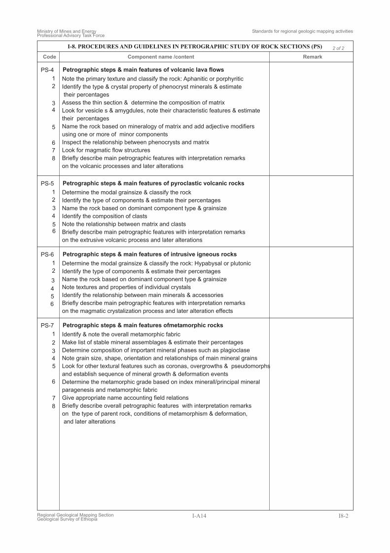
PS-4
PS-5
PS-6
PS-7
Petrographic steps & main features of volcanic lava flows
Petrographic steps & main features of pyroclastic volcanic rocks
Petrographic steps & main features of intrusive igneous rocks
Petrographic steps & main features ofmetamorphic rocks
Note the primary texture and classify the rock: Aphanitic or porphyritic
Identify the type & crystal property of phenocryst minerals & estimate
their percentages
Assess the thin section & determine the composition of matrix
Look for vesicle s & amygdules, note their characteristic features & estimate
their percentages
Name the rock based on mineralogy of matrix and add adjective modifiers
using one or more of minor components
Inspect the relationship between phenocrysts and matrix
Look for magmatic flow structures
Briefly describe main petrographic features with interpretation remarks
on the volcanic processes and later alterations
Determine the modal grainsize & classify the rock
Identify the type of components & estimate their percentages
Name the rock based on dominant component type & grainsize
Identify the composition of clasts
Note the relationship between matrix and clasts
Briefly describe main petrographic features with interpretation remarks
on the extrusive volcanic process and later alterations
Determine the modal grainsize & classify the rock: Hypabysal or plutonic
Identify the type of components & estimate their percentages
Name the rock based on dominant component type & grainsize
Note textures and properties of individual crystals
Identify the relationship between main minerals & accessories
Briefly describe main petrographic features with interpretation remarks
on the magmatic crystalization process and later alteration effects
Identify & note the overall metamorphic fabric
Make list of stable mineral assemblages & estimate their percentages
Determine composition of important mineral phases such as plagioclase
Note grain size, shape, orientation and relationships of main mineral grains
Look for other textural features such as coronas, overgrowths & pseudomorphs
and establish sequence of mineral growth & deformation events
Determine the metamorphic grade based on index minerall/principal mineral
paragenesis and metamorphic fabric
Give appropriate name accounting field relations
Briefly describe overall petrographic features with interpretation remarks
on the type of parent rock, conditions of metamorphism & deformation,
and later alterations
Code RemarkComponent name /content
Ministry of Mines and EnergyProfessional Advisory Task Force
Standards for regional geologic mapping activities
Regional Geological Mapping SectionGeological Survey of Ethiopia
I-A14 I8-2
2 of 2I-8. PROCEDURES AND GUIDELINES IN PETROGRAPHIC STUDY OF ROCK SECTIONS (PS)
Ministry of Mines and EnergyProfessional Advisory Task Force
Standard guidelines for regional geologic mapping activities
Regional Geological Mapping SectionGeological Survey of Ethiopia
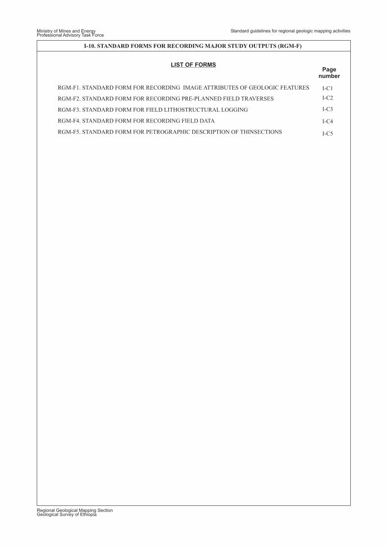
I-10. STANDARD FORMS FOR RECORDING MAJOR STUDY OUTPUTS (RGM-F)
LIST OF FORMS
RGM-F1. STANDARD FORM FOR RECORDING IMAGE ATTRIBUTES OF GEOLOGIC FEATURES
RGM-F2. STANDARD FORM FOR RECORDING PRE-PLANNED FIELD TRAVERSES
RGM-F3. STANDARD FORM FOR FIELD LITHOSTRUCTURAL LOGGING
RGM-F4. STANDARD FORM FOR RECORDING FIELD DATA
RGM-F5. STANDARD FORM FOR PETROGRAPHIC DESCRIPTION OF THINSECTIONS
I-C1
I-C2
I-C3
I-C4
I-C5
Pagenumber
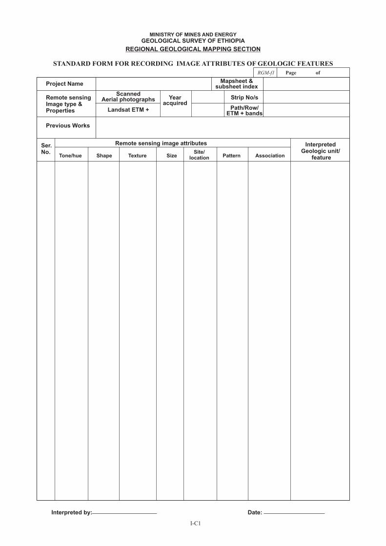
STANDARD FORM FOR RECORDING IMAGE ATTRIBUTES OF GEOLOGIC FEATURES
Project Name
Remote sensingImage type &Properties
Previous Works
Mapsheet &subsheet index
Yearacquired
ScannedAerial photographs
Landsat ETM + Path/Row/ETM + bands
Strip No/s
Tone/hue Shape Texture SizeSite/
location Pattern Association
Remote sensing image attributes InterpretedGeologic unit/
feature
Ser.No.
Interpreted by: Date:
MINISTRY OF MINES AND ENERGY
GEOLOGICAL SURVEY OF ETHIOPIA
REGIONAL GEOLOGICAL MAPPING SECTION
I-C1
RGM-f1 Page of
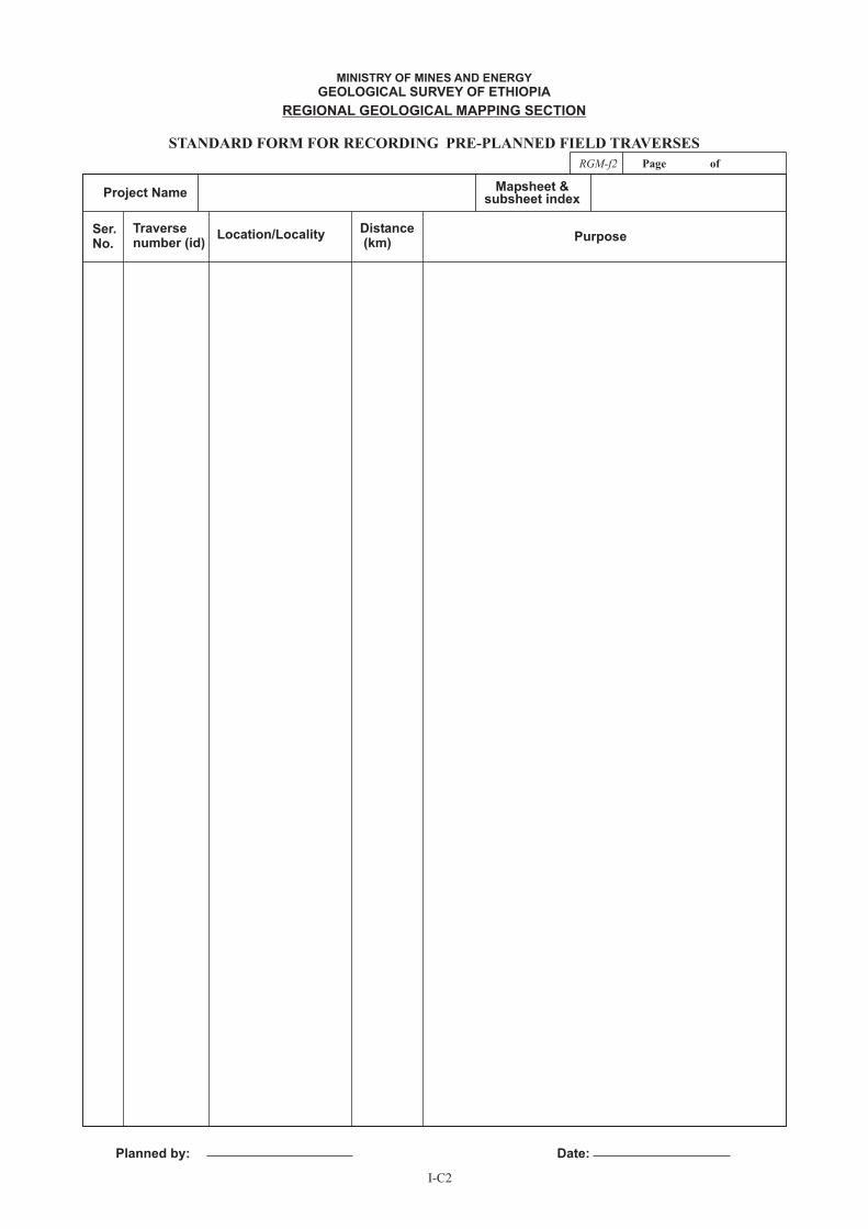
Traversenumber (id)
Location/LocalityDistance(km)
PurposeSer.No.
Planned by: Date:
STANDARD FORM FOR RECORDING PRE-PLANNED FIELD TRAVERSES
Project NameMapsheet &
subsheet index
MINISTRY OF MINES AND ENERGY
GEOLOGICAL SURVEY OF ETHIOPIA
REGIONAL GEOLOGICAL MAPPING SECTION
I-C2
RGM-f2 Page of
Place/Locality
Elevation(meters)
Geographic coordinate (UTM zone: )
East North
Textu
reGra
vel
Sand
v.c
oarse
coarse
med
ium
fin
ev.fi
ne
Silt
Cla
y
MINISTRY OF MINES AND ENERGY
GEOLOGICAL SURVEY OF ETHIOPIA
STANDARD FORM FOR LITHOSTRATIGRAPHIC SECTION LOGGING
Project NameMapsheet &
subsheet index
Grain size
LithologyC
olo
ur
Th
ickn
ess
Fo
ssils/
min
era
l/cla
st
Sed
imen
tary
str
uctu
res
Oth
er
data
Description/Remarks/ InterpretationCode
Logged by: Date:
REGIONAL GEOLOGICAL MAPPING SECTION
I-C3
RGM-f3 Page of
Date:
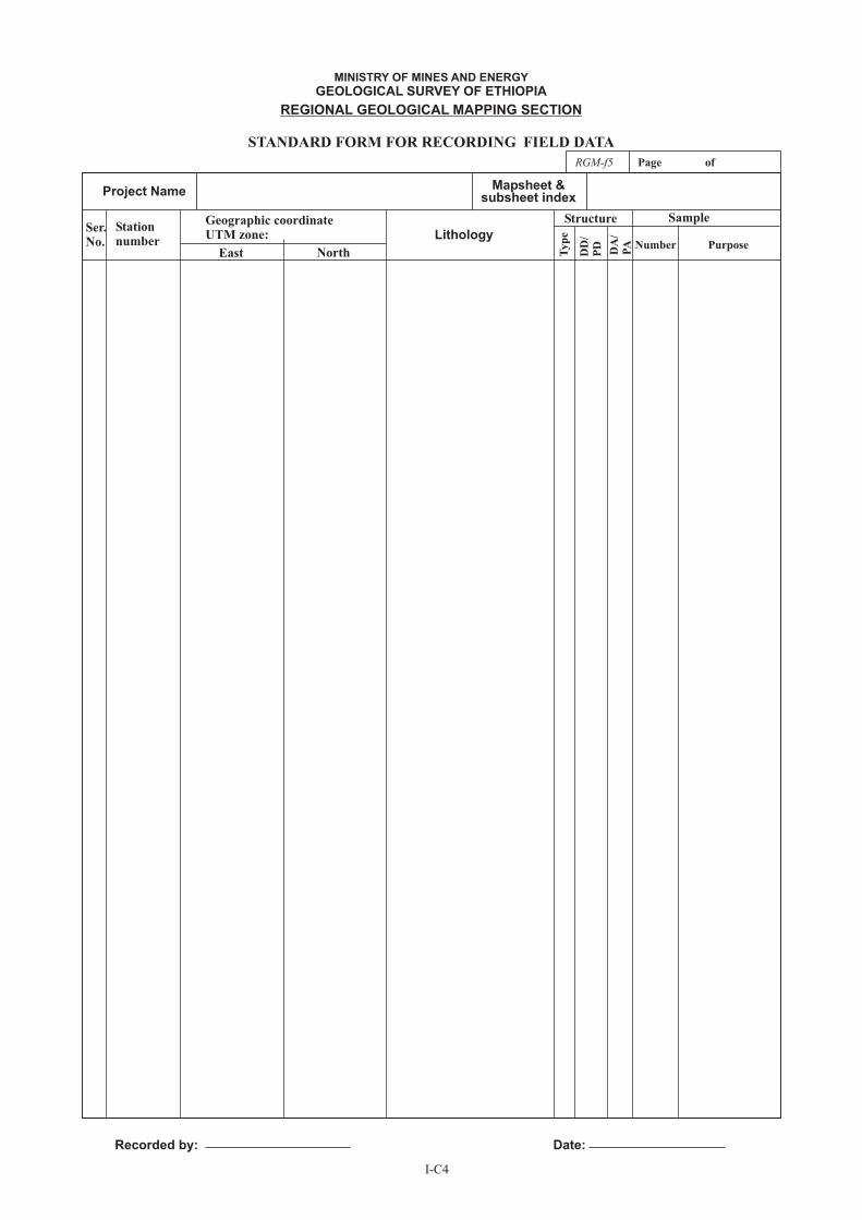
Station
number
Geographic coordinate
UTM zone: Lithology
Structure
Typ
e
DD
/
PD
DA
/
PA
Sample
Number Purpose
Ser.
No.
Recorded by: Date:
STANDARD FORM FOR RECORDING FIELD DATA
Project NameMapsheet &
subsheet index
MINISTRY OF MINES AND ENERGY
GEOLOGICAL SURVEY OF ETHIOPIA
REGIONAL GEOLOGICAL MAPPING SECTION
RGM-f5 Page of
East North
I-C4
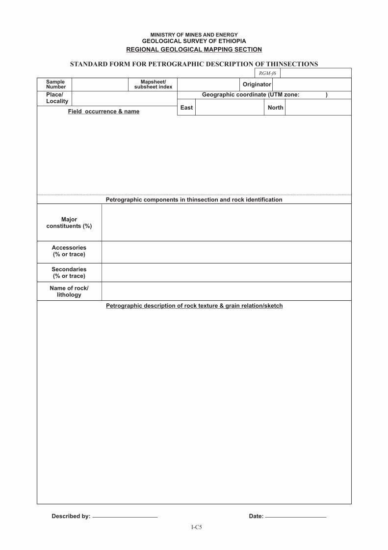
SampleNumber
Place/Locality
Majorconstituents (%)
Accessories(% or trace)
Secondaries(% or trace)
Name of rock/lithology
Petrographic description of rock texture & grain relation/sketch
Field occurrence & name
Petrographic components in thinsection and rock identification
Mapsheet/subsheet index
Geographic coordinate (UTM zone: )
Originator
East
Described by:
North
Date:
STANDARD FORM FOR PETROGRAPHIC DESCRIPTION OF THINSECTIONS
MINISTRY OF MINES AND ENERGY
GEOLOGICAL SURVEY OF ETHIOPIA
REGIONAL GEOLOGICAL MAPPING SECTION
RGM-f6
I-C5
STANDARDS FOR REGIONAL GEOLOGIC MAPPING PRODUCTS:
DIGITAL DATABASE MODEL,
DIGITAL CARTOGRAPHIC ATTRIBUTES FOR GEOLOGIC MAPS AND
CONTENT AND LAYOUT FOR REGIONAL GEOLOGIC REPORTS
Ministry of Mines and EnergyProfessional Advisory Task Force
Standards for regional geologic mapping products
WS-chart.cdr
Regional Geological Mapping SectionGeological Survey of Ethiopia
PART II
Ministry of Mines and EnergyProfessional Advisory Task Force
Standards for regional geologic mapping products
TOC-1.cdr
Regional Geological Mapping SectionGeological Survey of Ethiopia
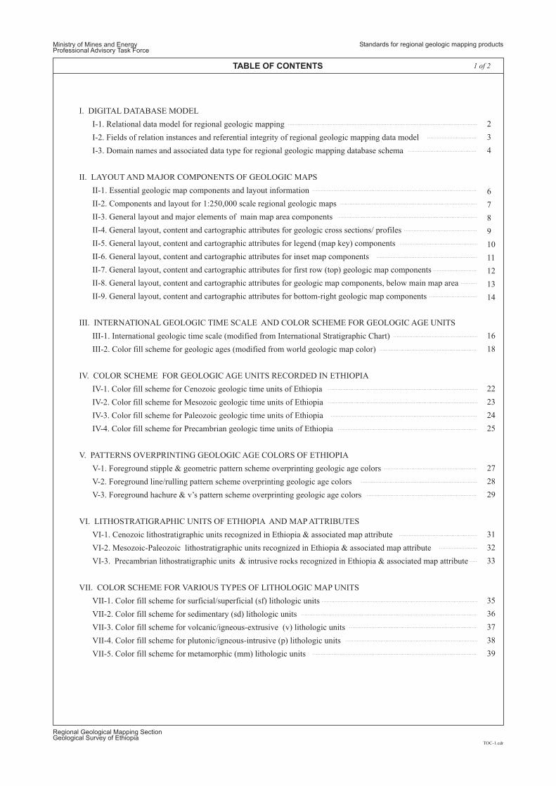
TABLE OF CONTENTS
I. DIGITAL DATABASE MODEL
II. LAYOUT AND MAJOR COMPONENTS OF GEOLOGIC MAPS
I-1. Relational data model for regional geologic mapping
II-1. Essential geologic map components and layout information
I-2. Fields of relation instances and referential integrity of regional geologic mapping data model
I-3. Domain names and associated data type for regional geologic mapping database schema
II-2. Components and layout for 1:250,000 scale regional geologic maps
II-3. General layout and major elements of main map area components
II-4. General layout, content and cartographic attributes for geologic cross sections/ profiles
II-8. General layout, content and cartographic attributes for geologic map components, below main map area
II-9. General layout, content and cartographic attributes for bottom-right geologic map components
II-5. General layout, content and cartographic attributes for legend (map key) components
II-7. General layout, content and cartographic attributes for first row (top) geologic map components
II-6. General layout, content and cartographic attributes for inset map components
III. INTERNATIONAL GEOLOGIC TIME SCALE AND COLOR SCHEME FOR GEOLOGIC AGE UNITS
IV. COLOR SCHEME FOR GEOLOGIC AGE UNITS RECORDED IN ETHIOPIA
VII. COLOR SCHEME FOR VARIOUS TYPES OF LITHOLOGIC MAP UNITS
V. PATTERNS OVERPRINTING GEOLOGIC AGE COLORS OF ETHIOPIA
VI. LITHOSTRATIGRAPHIC UNITS OF ETHIOPIA AND MAP ATTRIBUTES
III-1. International geologic time scale (modified from International Stratigraphic Chart)
IV-1. Color fill scheme for Cenozoic geologic time units of Ethiopia
V-1. Foreground stipple & geometric pattern scheme overprinting geologic age colors
VI-1. Cenozoic lithostratigraphic units recognized in Ethiopia & associated map attribute
VII-1. Color fill scheme for surficial/superficial (sf) lithologic units
IV-2. Color fill scheme for Mesozoic geologic time units of Ethiopia
V-2. Foreground line/rulling pattern scheme overprinting geologic age colors
VI-2. Mesozoic-Paleozoic lithostratigraphic units recognized in Ethiopia & associated map attribute
VII-2. Color fill scheme for sedimentary (sd) lithologic units
VII-3. Color fill scheme for volcanic/igneous-extrusive (v) lithologic units
VII-4. Color fill scheme for plutonic/igneous-intrusive (p) lithologic units
VII-5. Color fill scheme for metamorphic (mm) lithologic units
V-3. Foreground hachure & v’s pattern scheme overprinting geologic age colors
VI-3. Precambrian lithostratigraphic units & intrusive rocks recognized in Ethiopia & associated map attribute
IV-3. Color fill scheme for Paleozoic geologic time units of Ethiopia
IV-4. Color fill scheme for Precambrian geologic time units of Ethiopia
III-2. Color fill scheme for geologic ages (modified from world geologic map color)
1 of 2
2
3
4
6
7
8
9
10
11
12
13
14
16
18
22
23
24
25
27
28
29
31
32
33
35
36
37
38
39
Ministry of Mines and EnergyProfessional Advisory Task Force
Standards for regional geologic mapping products
TOC-2.cdr
Regional Geological Mapping SectionGeological Survey of Ethiopia
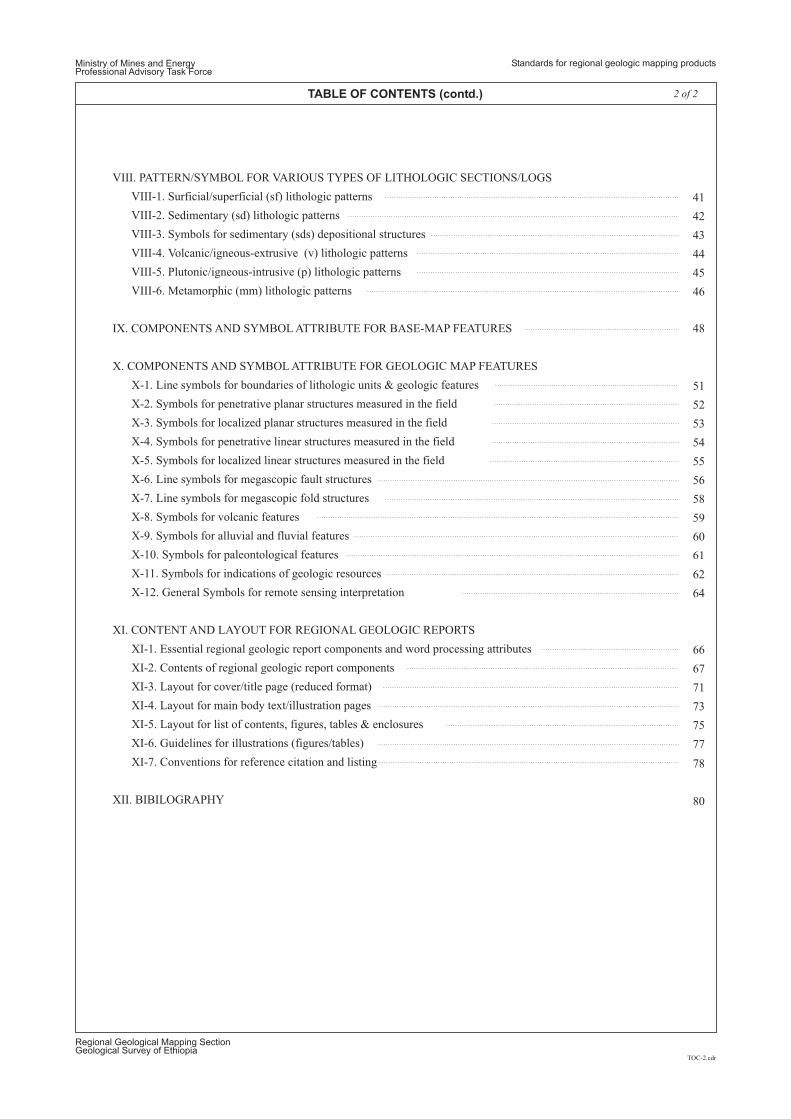
2 of 2TABLE OF CONTENTS (contd.)
VIII. PATTERN/SYMBOL FOR VARIOUS TYPES OF LITHOLOGIC SECTIONS/LOGS
IX. COMPONENTS AND SYMBOL ATTRIBUTE FOR BASE-MAP FEATURES
X. COMPONENTS AND SYMBOL ATTRIBUTE FOR GEOLOGIC MAP FEATURES
XI. CONTENT AND LAYOUT FOR REGIONAL GEOLOGIC REPORTS
XII. BIBILOGRAPHY
VIII-1. Surficial/superficial (sf) lithologic patterns
X-1. Line symbols for boundaries of lithologic units & geologic features
X-7. Line symbols for megascopic fold structures
VIII-2. Sedimentary (sd) lithologic patterns
VIII-3. Symbols for sedimentary (sds) depositional structures
X-2. Symbols for penetrative planar structures measured in the field
X-8. Symbols for volcanic features
VIII-4. Volcanic/igneous-extrusive (v) lithologic patterns
X-3. Symbols for localized planar structures measured in the field
X-9. Symbols for alluvial and fluvial features
VIII-5. Plutonic/igneous-intrusive (p) lithologic patterns
X-4. Symbols for penetrative linear structures measured in the field
X-10. Symbols for paleontological features
VIII-6. Metamorphic (mm) lithologic patterns
X-5. Symbols for localized linear structures measured in the field
X-6. Line symbols for megascopic fault structures
X-11. Symbols for indications of geologic resources
X-12. General Symbols for remote sensing interpretation
XI-1. Essential regional geologic report components and word processing attributes
XI-2. Contents of regional geologic report components
XI-3. Layout for cover/title page (reduced format)
XI-4. Layout for main body text/illustration pages
XI-5. Layout for list of contents, figures, tables & enclosures
XI-6. Guidelines for illustrations (figures/tables)
XI-7. Conventions for reference citation and listing
41
42
43
44
45
46
51
52
53
54
55
56
58
59
60
61
62
64
66
67
71
73
75
77
78
80
48
Ministry of Mines and EnergyProfessional Advisory Task Force
Standard guidelines for regional geologic mapping activities
I.cdr
Regional Geological Mapping SectionGeological Survey of Ethiopia
1
DIGITAL DATABASE MODEL
Ministry of Mines and EnergyProfessional Advisory Task Force
I-1.cdr
Regional Geological Mapping SectionGeological Survey of Ethiopia
2
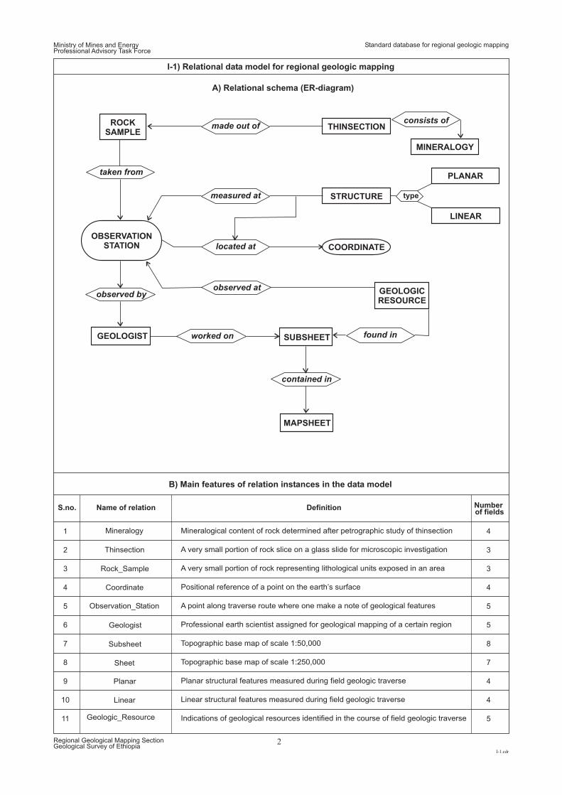
I-1) Relational data model for regional geologic mapping
A) Relational schema (ER-diagram)
B) Main features of relation instances in the data model
made out ofconsists of
measured at
located at
found in
ROCKSAMPLE
GEOLOGICRESOURCE
THINSECTION
MINERALOGY
STRUCTURE
PLANAR
type
LINEAR
COORDINATE
taken from
observed byobserved at
worked on
S.no. Name of relation Definition Numberof fields
contained in
OBSERVATIONSTATION
GEOLOGIST SUBSHEET
MAPSHEET
Subsheet
Sheet
Geologist
Observation_Station
Rock_Sample
Planar
Linear
Thinsection
Mineralogy Mineralogical content of rock determined after petrographic study of thinsection
A very small portion of rock slice on a glass slide for microscopic investigation
A very small portion of rock representing lithological units exposed in an area
Positional reference of a point on the earth’s surface
A point along traverse route where one make a note of geological features
Professional earth scientist assigned for geological mapping of a certain region
Topographic base map of scale 1:50,000
Topographic base map of scale 1:250,000
Planar structural features measured during field geologic traverse
Linear structural features measured during field geologic traverse
Indications of geological resources identified in the course of field geologic traverse
Coordinate
Geologic_Resource
1 4
2 3
3 3
4 4
5 5
6 5
7 8
8 7
9 4
10 4
11 5
Standard database for regional geologic mapping
Ministry of Mines and EnergyProfessional Advisory Task Force
I-2.cdr
Regional Geological Mapping SectionGeological Survey of Ethiopia
3
I-2) Fields of relation instances and referential integrity of regional geologic mapping data model
Subsheet
Sheet
Geologist
Observation_Station
Rock_Sample
Planar
Linear
Thinsection
Mineralogy
Coordinate
Geologic_Resource
Mineralogy & thinsection
Thinsection & rock sample
Rock sample & observation station (obst)
Observation station & coordinate
Geologist & observation station
Geologist & subsheet
Geologic resource & subsheet/ observation station
Subsheet & sheet
Planar, linear & coordinate via observation station
ss_index
ms_index
ss_name
ms_name
ssb_xll
msb_xll
ssb_xur
msb_xur
ssb_yll
msb_yll
ssb_yur
msb_yur
t_id ms_id
cr_z
p_id name title int t_no
os_no locality date g_id scn
rs_sno flithology_name f_texture
p_cn p_type dd da
l_cn l_type pd Pa
ts_sno
ts_sno
rs_sno
ts_sno
ps_sno
ps_sno
os_no
os_no
os_no
ms_id
l_ssid
p_cn l_cn
os_no scn
p_id
t_no
ms_index
ss_index
scn scn
c_id
g_id
t_id
rs_sno
p_texture
major_components minor_componets
plithology_name
secondary_components
c_id x_coord y_coord elevation
gr_sno
gr_sno
r_class r_type r_association l_ssid
A) Diagram showing fields (domains) of individual relations & their relationship
B) List of linked relationships
made out of
consists of
located at/measured at
located at
found in/observed at
taken from
observed by
worked on
contained in
S.no. Linking reference Connected (linked) relation instances Related domains
1
2
3
4
5
6
7
8
9
Standard database for regional geologic mapping
Ministry of Mines and EnergyProfessional Advisory Task Force
I-3.cdr
Regional Geological Mapping SectionGeological Survey of Ethiopia
4
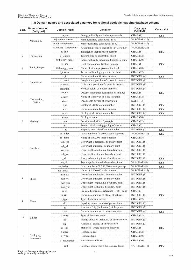
I-3) Domain names and associated data type for regional geologic mapping database schema
Standard database for regional geologic mapping
S.no.Name of relation
(Entity set)Domain (Field) Definition
Data type(Attribute)
Constraint
Mineralogy
ps_sno Petrographically studied sample number
Thinsection identification number
Texture of rock under thinsection
Petrographically determined lithology name
Rock sample identification number
Coordinate identification number
Longitudinal position of a point in meters
Latitudinal position of a point in meters
Vertical height of a point in meters
Observation station identification number
Name of locality at or close to station
Day, month & year of observation
Geologist identification number
Coordinate identification number
Geologist identification number
Geologist name
Position/work title of geologist
Station initial bearing geologist’s name
Mapping team identification number
Assigned mapping team identification no
Topomap sheet in which subsheet found
Index number of 1:50,000 scale topomap
Index number of 1:250,000 scale topomap
Name of 1:50,000 scale topomap
Name of 1:250,000 scale topomap
Lower left longitudinal boundary point
Lower left longitudinal boundary point
Upper right longitudinal boundary point
Upper right longitudinal boundary point
Lower left latitudinal boundary point
Lower left latitudinal boundary point
Upper right latitudinal boundary point
Upper right latitudinal boundary point
Projected coordinate reference (UTM) zone
Coordinate number of planar structures
Coordinate number of linear structures
Type of planar structure
Type of linear structure
Dip direction (azimuth) of planar feature
Plunge direction (azimuth) of linear feature
Amount of dip (inclination) of the plane
Amount of plunge of linear feature
Station no. where resource observed
Resource class
Resource type
Resource association
Subsheet index where the resource found
Name of lithology given in the field
Texture of lithology given in the field
CHAR (8)
CHAR (8)
CHAR (8)
CHAR (8)
CHAR (12)
CHAR (12)
CHAR (12)
CHAR (12)
CHAR (15)
VARCHAR (10)
VARCHAR (8)
VARCHAR (8)
VARCHAR (15)
CHAR (3)
DATE (10)
INTEGER (4)
INTEGER (4)
INTEGER (4)
INTEGER (4)
INTEGER (4)
INTEGER (8)
INTEGER (8)
INTEGER (8)
INTEGER (8)
INTEGER (8)
INTEGER (8)
INTEGER (8)
INTEGER (8)
INTEGER (4)
INTEGER (4)
INTEGER (3)
INTEGER (3)
INTEGER (2)
INTEGER (2)
CHAR (3)
CHAR (12)
CHAR (12)
CHAR (8)
CHAR (12)
CHAR (10)
CHAR (20)
VARCHAR (10)
INTEGER (2)
INTEGER (2)
INTEGER (8)
INTEGER (8)
CHAR (20)
CHAR (20)
CHAR (20)
VARCHAR (20)
VARCHAR (20)
VARCHAR (20)
ts_sno
p_texture
plithology_name
major_components Main identified constituents in %
Minor identified constituents in %
Alteration products identified in % or other
minor_components
secondary_components
1
2
3
4
5
6
7
8
9
10
11
Subsheet
Sheet
Geologist
Observation_Station
Rock_Sample
Planar
Linear
Thinsection
Coordinate
Geologic_Resources
ss_index
ms_index
ss_name
ms_name
ssb_xll
msb_xll
ssb_xur
msb_xur
ssb_yll
msb_yll
ssb_yur
msb_yur
t_id
ms_id
cr_z
p_id
name
title
int
t_no
os_no
locality
date
g_id
scn
rs_sno
flithology_name
f_texture
p_cn
p_type
dd
da
l_cn
l_type
pd
pa
c_id
x_coord
y_coord
elevation
gr_sno
r_class
r_type
r_association
l_ssid
KEY
KEY
KEY
KEY
KEY
KEY
KEY
KEY
KEY
KEY
KEY
KEY
KEY
KEY
KEY
KEY
KEY
Ministry of Mines and EnergyProfessional Advisory Task Force
XI.cdr
Regional Geological Mapping SectionGeological Survey of Ethiopia
Standard layout & components for regional geologic maps
LAYOUT AND MAJOR COMPONENTS OF GEOLOGIC MAPS
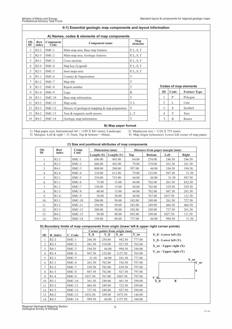
Ministry of Mines and EnergyProfessional Advisory Task Force
II-1.cdr
Regional Geological Mapping SectionGeological Survey of Ethiopia
6
II-1) Essential geologic map components and layout information
Ob.ID
Ob.ID
Rowindex
Rowindex
ComponentCode
Comp.Code
Component nameMap
elements
1 R2-2 SMC-1 Main map area, Base map features P, L, S, T
2 R2-3 SMC-2 Main map area, Geologic features P, L, S, T
3 R4-1 SMC-3 Cross sections P, L, S, T
4 R2-4 SMC-4 Map key (Legend) P, L, S, T
5 R2-1 SMC-5 Inset maps area P, L, S, T
6 R1-1 SMC-6 Country & Organization T
7 R1-2 SMC-7 Map title T
8 R1-3 SMC-8 Report number T
9 R1-4 SMC-9 Logo R
10 R3-1 SMC-10 Base map information T
11 R3-2 SMC-11 Map scale T, L
12 R3-3 SMC-12 History of geological mapping & map preparation T
13 R4-2 SMC-13 True & magnetic north arrows L, T
14 R4-3 SMC-14 Geologic map information T
Length (X)
Dimension (mm)
Corner points from origin (mm)
Distance from paper margin (mm)
Length (Y) Top Bottom Left Right
1 R2-2 SMC-1 696.00 443.00 64.00 254.00 246.50 246.50
2 R2-3 SMC-2 666.00 443.00 79.00 319.00 261.50 261.50
3 R4-1 SMC-3 800.00 200.00 597.00 44.00 194.50 194.50
4 R2-4 SMC-4 210.00 613.00 79.00 152.00 947.50 31.50
5 R2-1 SMC-5 210.00 733.00 64.00 44.00 31.50 947.50
6 R1-1 SMC-6 75.00 15.00 44.00 782.00 261.50 852.50
7 R1-2 SMC-7 130.00 15.00 44.00 782.00 529.50 529.50
8 R1-3 SMC-8 40.00 15.00 44.00 782.00 887.50 261.50
9 R1-4 SMC-9 30.00 30.00 44.00 767.00 1037.50 121.50
10 R3-1 SMC-10 200.00 50.00 542.00 249.00 261.50 727.50
11 R3-2 SMC-11 256.00 50.00 542.00 249.00 466.50 466.50
12 R3-3 SMC-12 200.00 50.00 542.00 249.00 727.50 261.50
13 R4-2 SMC-13 50.00 40.00 692.00 109.00 1027.50 111.50
14 R4-3 SMC-14 158.00 60.00 737.00 44.00 999.50 31.50
C) Size and positional attributes of map components
ID R_index C_Code X_ll
X_ll X
X_ll - Lower left (X)
X_ur - Upper right (X)
Y_ll - Lower left (Y)
Y_ur - Upper right (Y)
Y_ll
Y_ll
X_ur
X_ur
Y_ur
Y_ur
Y
1 R2-2 SMC-1 246.50 254.00 942.50 777.00
2 R2-3 SMC-2 261.50 319.00 927.50 762.00
3 R4-1 SMC-3 194.50 44.00 994.50 244.00
4 R2-4 SMC-4 947.50 152.00 1157.50 765.00
5 R2-1 SMC-5 31.50 44.00 241.50 777.00
6 R1-1 SMC-6 261.50 782.00 336.50 797.00
7 R1-2 SMC-7 529.50 782.00 659.50 797.00
8 R1-3 SMC-8 887.50 782.00 927.50 797.00
9 R1-4 SMC-9 1037.50 767.00 1067.50 797.00
10 R3-1 SMC-10 261.50 249.00 461.50 299.00
11 R3-2 SMC-11 466.50 249.00 722.50 299.00
12 R3-3 SMC-12 727.50 249.00 927.50 299.00
13 R4-2 SMC-13 1032.50 109.00 1072.50 144.00
14 R4-3 SMC-14 999.50 44.00 1157.50 104.00
D) Boundary limits of map components from origin (lower left & upper right corner points)
ID Code Feature Type
1 P Polygon
2 L Line
3 S Symbol
1) Map paper size; International A0 = 1189 X 841 (mm), Landscape. 2) Maplayout size = 1126 X 753 (mm).3) Margins: Left & right = 31.5mm, Top & bottom = 44mm. 4) Map origin (reference): Lower left corner of map paper.
4 T Text
5 R Raster
Codes of map elements
B) Map paper format
A Names, codes & elements of map components)
Standard layout & components for regional geologic maps
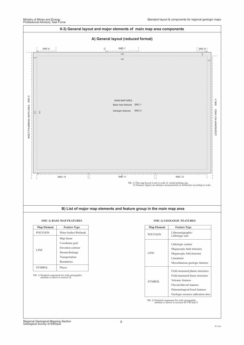
Ministry of Mines and EnergyProfessional Advisory Task Force
II-3.cdr
Regional Geological Mapping SectionGeological Survey of Ethiopia
8
II-3) General layout and major elements of main map area components
15
15
5
666
696
15
5443
473
15
5
55 5
MAIN MAP AREA
SMC-6
SMC-10 SMC-11
SMC-7
SMC-1
SMC-2
SMC-8
SMC-12
Base map features
Geologic features
INS
ET
/TH
UM
BN
AIL
MA
PS
AR
EA
LE
GE
ND
/MA
PK
EY
AR
EA
SM
C-5
SM
C-4
NB. 1) This map layout is not to scale of actual printing size.2) Numeric figures are distance measurements in millimeter according to scale.
NB. 1) Detailed component list with cartographicattribute is shown in section IX
NB. 2) Detailed component list with cartographicattribute is shown in sections III-VIII and X
A) General layout (reduced format)
B) List of major map elements and feature group in the main map area
Map Element Map ElementFeature Type Feature Type
Water bodies/Wetlands Lithostratigraphic/Lithologic unit
Places
Map frame
Lithologic contactCoordinate grid
Megascopic fault structureElevation contour
Megascopic fold structureStream/drainage
LineamentTransportation
Miscellaneous geologic features
Field measured planar structures
Field measured linear structures
Volcanic features
Fluvial/alluvial features
Paleontological/fossil features
Geologic resource indication sites
Boundaries
POLYGONPOLYGON
SYMBOL
SYMBOL
LINELINE
SMC-1) BASE MAP FEATURES SMC-2) GEOLOGIC FEATURES
Standard layout & components for regional geologic maps
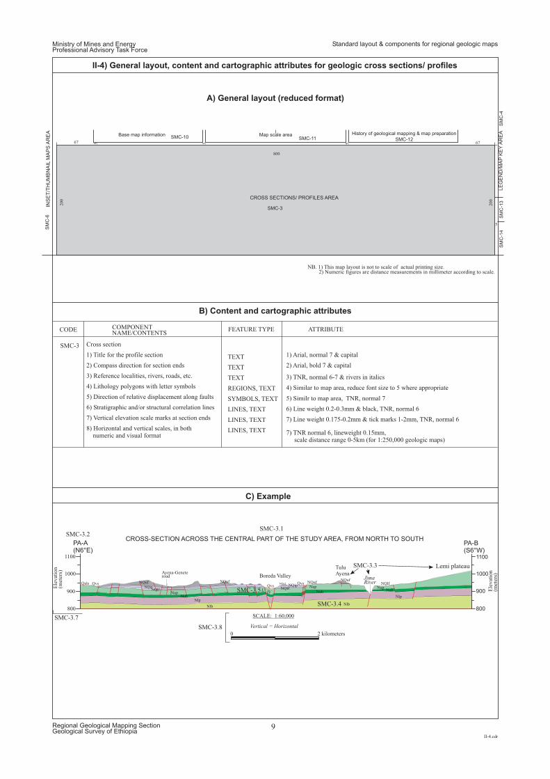
CROSS-SECTION ACROSS THE CENTRAL PART OF THE STUDY AREA, FROM NORTH TO SOUTHPA-A(N6°E)
PA-B(S6°W)
900
800
1000
1100
900
800
1000
1100
Ele
vat
ion
(met
ers)
Ele
vat
ion
(met
ers)Boreda Valley
Ayena-Geneteroad
TuluAyena
Lemi plateau
Qals QvsQvs
QvsNQuf
NQlfNQip
NQuf NQufNQuf
NQuf
NubNub Nub
NQip
NlpNlp
Nup
NupNQlf
NQlf
NlbNlb
Nup
Vertical = Horizontal
JimaRiver
U D
SCALE: 1:60,000
2 kilometers0
SMC-3
SMC-3.1SMC-3.2
SMC-3.7
SMC-3.8
SMC-3.3
SMC-3.4
SMC-3.5
Cross section
1) Title for the profile section 1) Arial, normal 7 & capital
2) Arial, bold 7 & capital
3) TNR, normal 6-7 & rivers in italics
4) Similar to map area, reduce font size to 5 where appropriate
5) Similr to map area, TNR, normal 7
6) Line weight 0.2-0.3mm & black, TNR, normal 6
7) Line weight 0.175-0.2mm & tick marks 1-2mm, TNR, normal 6
7) TNR normal 6, lineweight 0.15mm,scale distance range 0-5km (for 1:250,000 geologic maps)
2) Compass direction for section ends
3) Reference localities, rivers, roads, etc.
4) Lithology polygons with letter symbols
5) Direction of relative displacement along faults
6) Stratigraphic and/or structural correlation lines
7) Vertical elevation scale marks at section ends
8) Humeric and visual formatorizontal and vertical scales, in both
n
CODE COMPONENTNAME/CONTENTS
TEXT
TEXT
TEXT
REGIONS, TEXT
SYMBOLS, TEXT
LINES, TEXT
LINES, TEXT
LINES, TEXT
FEATURE TYPE ATTRIBUTE
200
5 67
5
800
5 567
200 CROSS SECTIONS/ PROFILES AREA
Base map information Map scale areaSMC-10
SM
C-6
SMC-11
SMC-3
SM
C-1
3S
MC
-4S
MC
-14
History of geological mapping & map preparation
SMC-12
INS
ET
/TH
UM
BN
AIL
MA
PS
AR
EA
LE
GE
ND
/MA
PK
EY
AR
EA
NB. 1) This map layout is not to scale of actual printing size.2) Numeric figures are distance measurements in millimeter according to scale.
A) General layout (reduced format)
B) Content and cartographic attributes
C) Example
Ministry of Mines and EnergyProfessional Advisory Task Force
II-4.cdr
Regional Geological Mapping SectionGeological Survey of Ethiopia
9
II-4) General layout, content and cartographic attributes for geologic cross sections/ profiles
Standard layout & components for regional geologic maps
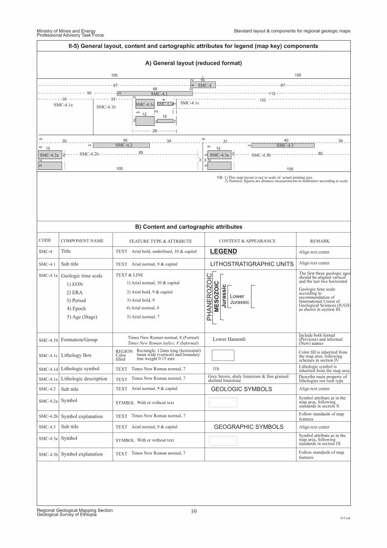
Align text center
Align text center
Symbol attribute as in themap area, followingstandards in section X
Symbol attribute as in themap area, followingstandards in section IX
Align text center
Align text center
Include both formal(Previous) and informal(New) names
Color fill is inherited fromthe map area, followingschemes in section IV
Follow standards of mapfeatures
Follow standards of mapfeatures
Lithologic symbol isinherited from the map area
Describe main property oflithologies not rock type
Geologic time scaleaccording torecommendation ofInternational Union ofGeological Sciences (IUGS)as shown in section III.
The first three geologic agesshould be aligned verticaland the last two horizontal
REMARK
LEGEND
LITHOSTRATIGRAPHIC UNITS
GEOLOGIC SYMBOLS
GEOGRAPHIC SYMBOLS
Geologic time scale
Formation/Group
Lithology Box
Lithologic symbol
Lithologic description
105
97 97
105
105
105
122
112
22
4
5 5
5 1585
36 3435 40 3431
85
15
55
2
2
2
2
3 3
5 5
25
4
2
2
2 2
16
4850
2
103
3 3
35 33
28
12
SMC-4
SMC-4
SMC-4.2 SMC-4.3
SMC-4.1
SMC-4.1
SMC-4.2a SMC-4.3aSMC-4.2b SMC-4.3b
SMC-4.1cSMC-4.1b
SMC-4.1a
SMC-4.1a
SMC-4.1d SMC-4.1e
CODE COMPONENT NAME CONTENT & APPEARANCEFEATURE TYPE & ATTRIBUTE
SMC-4.1b
SMC-4.1c
SMC-4.1d
SMC-4.1e
SMC-4.2
SMC-4.2a
SMC-4.2b
SMC-4.3
SMC-4.3a
SMC-4.3b
1) EON
PH
AN
ER
OZ
OIC
2) ERA
ME
SO
ZO
IC
3) Period
Ju
rassic
4) Epoch
LowerJurassic
5) Age (Stage)
Title
Sub title
Sub title
Symbol
Symbol
Symbol explanation
Symbol explanation
Sub title
TEXT & LINE
REGION
TEXT
TEXT
TEXT
SYMBOL
SYMBOL
TEXT
TEXT
TEXT
TEXT
TEXT
1) Arial normal, 10 & capital
2) Arial bold, 9 & capital
3) Arial bold, 9
4) Arial normal, 8
5) Arial normal, 7
Colorfilled
Rectangle, 12mm long (horizontal)6mm wide (vertical) and boundaryline weight 0.15 mm
Times New Roman normal, 8 (Formal)
Times New Roman italics, 8 (Informal)
Times New Roman normal, 7
Times New Roman normal, 7
Times New Roman normal, 7
Times New Roman normal, 7
Arial normal, 9 & capital
Arial normal, 9 & capital
Arial normal, 9 & capital
With or without text
With or without text
Arial bold, underlined, 10 & capital
Lower Hamenli
J1h
Grey brown, shaly limestone & fine grainedskeletal limestone
A) General layout (reduced format)
B) Content and cartographic attributes
NB. 1) This map layout is not to scale of actual printing size.2) Numeric figures are distance measurements in millimeter according to scale.
Ministry of Mines and EnergyProfessional Advisory Task Force
II-5.cdr
Regional Geological Mapping SectionGeological Survey of Ethiopia
10
II-5) General layout, content and cartographic attributes for legend (map key) components
Standard layout & components for regional geologic maps
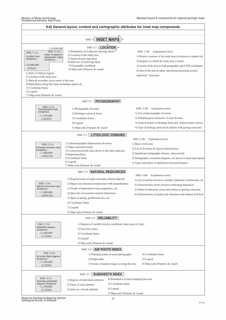
Location map(Graphics)
Physiographic map(Graphics)
Lithologic domains map(Graphics)
Natural resources map(Graphics)
Air photo flight diagram(Graphics)
Reliability diagram(Graphics)
Topomap subsheetsdiagram (Graphics)
Index of adjacenttopographic maps(Graphics)
SMC-5.1A SMC-5.1B Explanation (Text)
1) Horn of African regions
1) Relative location of the study area in refernce to capital city
2) Location of the study area
2) Region/s in which the study area is found
3) Main & secondary acess routes to the area
3) Limits of the area in both geographic and UTM coordinates
4) Main places along the routes including capital city
4) Size of the area in sqkm, specifying measuring system
5) Coordinate frame
(spherical / cartesian)
6) Legend
(95X85)
(140X95)
(180X120)
(180X120)
(115X80)
(115X80)
(115X80)
1:20,000,000
1:10,000,000
1:1,250,000
1:1,000,000
1:1,000,000
1:1,500,000
1:1,500,000
1:1,500,000
7) Map scale (Numeric & visual)
SMC-5.1A1 1) Boundaries of 8 adjacent topomap sheets
2) Location of the study area
3) Name of each map sheet
4) Index no. of each map sheet
5) Geographic coordinate
6) Map scale (Numeric & visual)
SMC-5.2ASMC-5.2B Explanation (text)1) Phsiographic divisions
1) List of physiographic divisions2) Drainage system & basin
2) Morphological characters of each division3) Coordinate frame
3) General feature of drainage basin and related stream courses4) Legend
4) Type of drainage network & relation with geology-structure5) Map scale (Numeric & visual)
SMC-5.3A
SMC-5.3B Explanation (text)
1) Lithostratigraphic/lithotectonic divisions 1) Basis of division
2) Major structural trends2) List of divisions & typical characteristics
3) Crossection/profile lines shown in the main map area3) Significant stratigraphic features (discovered)4) Important places
4) Stratigraphic correlation diagram, not shown in main map legend5) Coordinate frame
5) Types and nature of significant structural features6) Legend
7) Map scale (Numeric & visual)
SMC-5.4A
SMC-5.4B Explanation (text)
1) Regions/zones of major economic mineral deposits 1) List of natural resources, metallic, industrial, construction, etc
2) Major rock alteration trends/zones with mineralization 2) Characteristics of the resources indicating dimension
3) Trends of mineralized veins, pegmatites, etc 3) Nature of alteration zones and relation to geology-structure
4) Spot sites of economic mineral indications 4) Characteristics of small scale intrusions and relation with host
5) Spots of spring, geothermal sites, etc
6) Coordinate frame
7) Legend
8) Map scale (Numeric & visual)
SMC-5.6A 1) Principal points of aerial photographs
2) Flight paths
3) Scenes of landsat image covering the area
4) Coordinate frame
5) Legend
6) Map scale (Numeric & visual)
SMC-5.5A 1) Regions of variable traverse conditions/ data source (if any)
2) Traverses routes
3) Coordinate frame
4) Legend
5) Map scale (Numeric & visual)
SMC-5.7A1) Regions of individual subsheets
2) Name of each subsheet
3) Index no. of each subsheet
4) Boundaries of each maaping team area
5) Coordinate frame
6) Legend
7) Map scale (Numeric & visual)
2
4
2
2
3
2
INSET MAPS
LOCATION
PHYSIOGRAPHY
LITHOLOGIC DOMAINS
NATURAL RESOURCES
RELIABILITY
AIR PHOTO INDEX
SUBSHEETS INDEX
SMC-5
SMC-5.1
SMC-5.2
SMC-5.3
SMC-5.4
SMC-5.5
SMC-5.6
SMC-5.7
Ministry of Mines and EnergyProfessional Advisory Task Force
II-6.cdr
Regional Geological Mapping SectionGeological Survey of Ethiopia
11
II-6) General layout, content and cartographic attributes for inset map components
Standard layout & components for regional geologic maps
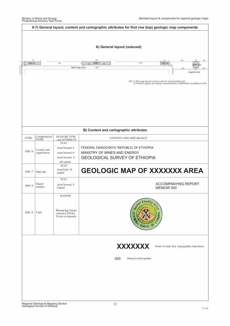
GEOLOGIC MAP OF XXXXXXX AREA
XXXXXXX
ACCOMPANYING REPORTMEMOIR 000
000
FEDERAL DEMOCRATIC REPUBLIC OF ETHIOPIA
MINISTRY OF MINES AND ENERGY
GEOLOGICAL SURVEY OF ETHIOPIA
SMC-6Country andorganization
Map title
Reportnumber
Logo
Name of ( )study area topographic map sheet
Memoir serial number
CODE COMPONENTNAME CONTENT AND APPEARANCE
TEXT
TEXT
TEXT
RASTER
FEATURE TYPEand ATTRIBUTE
SMC-7
Arial Normal, 8
Arial Normal, 9
Arial Normal, 9Capital
Bitmap/Jpg format,colored (CMYK),30 mm in diameter
Arial Normal, 11
All capital
Arial bold, 18capital
SMC-8
SMC-9
Main map area
Legend area
SMC-6 SMC-7 SMC-8SMC-9
110
15
105
15
30
40 30
5
105
90130
65 65
696
22815
75
15
5
193 15
5NB. 1) This map layout is not to scale of actual printing size.
2) Numeric figures are distance measurements in millimeter according to scale.
A) General layout (reduced)
B) Content and cartographic attributes
Ministry of Mines and EnergyProfessional Advisory Task Force
II-7.cdr
Regional Geological Mapping SectionGeological Survey of Ethiopia
12
II-7) General layout, content and cartographic attributes for first row (top) geologic map components
Standard layout & components for regional geologic maps
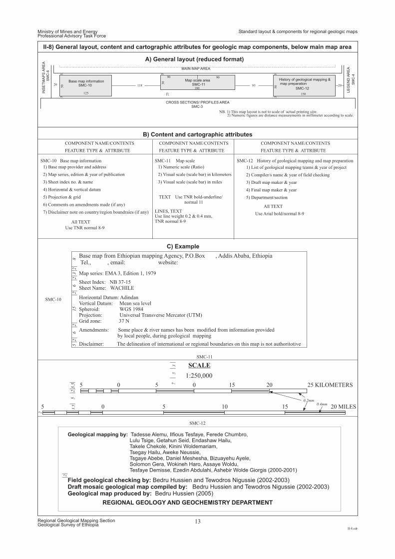
Geological mapping by: Tadesse Alemu, Ilfious Tesfaye, Ferede Chumbro,Lulu Tsige, Getahun Seid, Endashaw Hailu,Takele Chekole, Kinini Woldemariam,Tsegay Hailu, Aweke Neussie,Tsgaye Abebe, Daniel Meshesha, Bizuayehu Ayele,Solomon Gera, Wokineh Haro, Assaye Woldu,Tesfaye Demisse, Ezedin Abdulahi, Ashebir Wolde Giorgis (2000-2001)
Field geological checking by:Draft mosaic geological map compiled by:Geological map produced by:
Bedru Hussien and Tewodros Nigussie (2002-2003)Bedru Hussien and Tewodros Nigussie (2002-2003)
Bedru Hussien (2005)
150
50
5
2093118
5
125
180
9090
50
30
5
25
20
5 5
CROSS SECTIONS/ PROFILES AREA
Base map information Map scale area
SMC-10 SMC-11
SMC-3
History of geological mapping &map preparation
SMC-12
SMC-12
MAIN MAP AREA
SM
C-6
SM
C-4
INS
ET
MA
PS
AR
EA
LE
GE
ND
AR
EA
5
5
0.2mm0.4mm
3
2
7
25
52
62
15
26
23
28
3.5
2
3.5 0 5 0 15 20 25 KILOMETERS
5 0 5 10 15 20 MILES
SCALE
1:250,000
SMC-10
SMC-10
SMC-11
SMC-11
REGIONAL GEOLOGY AND GEOCHEMISTRY DEPARTMENT
SMC-12Base map information
Base map from Ethiopian mapping Agency, P.O.Box , Addis Ababa, EthiopiaTel., , email: website:
Map scale History of geological mapping and map preparation
1) Base map provider and address 1) Numeric scale (Ratio) 1) List of geological mapping teams & year of project
2) Map series, edition & year of publication 2) Visual scale (scale bar) in kilometers 2) Compiler/s name & year of field checking
3) Sheet index no. & name 3) Visual scale (scale bar) in miles 3) Draft map maker & year
4) Final map maker & year
5) Department/section
4) Horizontal & vertical datum
5) Projection & grid
6) Comments on amendments made (if any)
7) Disclaimer note on country/region boundraies (if any)
COMPONENT NAME/CONTENTSCOMPONENT NAME/CONTENTSCOMPONENT NAME/CONTENTS
All TEXT
Use TNR normal 8-9
Map series: EMA 3, Edition 1, 1979
Amendments: Some place & river names has been modified from information providedby local people, during geological mapping
Use line weight 0.2 & 0.4 mm,TNR normal 8-9
Use Arial bold/normal 8-9
Use TNR bold-underline/normal 11
TEXT
All TEXTLINES, TEXT
FEATURE TYPE & ATTRIBUTEFEATURE TYPE & ATTRIBUTEFEATURE TYPE & ATTRIBUTE
NB. 1) This map layout is not to scale of actual printing size.2) Numeric figures are distance measurements in millimeter according to scale.
A) General layout (reduced format)
B) Content and cartographic attributes
C) Example
Sheet Index: NB 37-15Sheet Name: WACHILE
Horizontal Datum: AdindanVertical Datum: Mean sea levelSpheroid: WGS 1984Projection: Universal Transverse Mercator (UTM)Grid zone: 37 N
Disclaimer: The delineation of international or regional boundaries on this map is not authoritotive
Ministry of Mines and EnergyProfessional Advisory Task Force
II-8.cdr
Regional Geological Mapping SectionGeological Survey of Ethiopia
13
II-8) General layout, content and cartographic attributes for geologic map components, below main map area
Standard layout & components for regional geologic maps
GR
IDN
OR
TH
TRUE NORTH
MAGNETIC NORTH
APPROXIMATE MEAN DECLINATION,OVER THE ENTIRE AREA, JANUARY 2000
Annual changes 4’ easterly
10’
5
2
Lineweight o.15mm
45°
2
2
20m
m
4
GEOLOGICAL SURVEY OF ETHIOPIA, P.O.BOX 2302, ADDIS ABABA, ETHIOPIATEL. , EMAIL: WEBSITE:
Ethiopia, 1:250,000 regional geologic map series
Copies of this map can be obtained from Geoscience Information Department, Geological survey of EthiopiaPrice5
52
22
22
158
50
80
40
55
45
60
50
5 47
5
33
90
5
CR
OS
SS
EC
TIO
NS
/P
RO
FIL
ES
AR
EA
True &magneticnortharrows
Geologic map information
SM
C-1
1
SM
C-3
SMC-13
SMC-14
History of geological mapping & map preparation
SMC-12
MAIN MAP AREA
LE
GE
ND
/M
AP
KE
YA
RE
A
SMC-13
SMC-13
SMC-14
Published by Ethiopian Mapping Agency, 1999, P.O.Box Addis Ababa, Ethiopia
SMC-14
True & magnetic north arrows
Geologic map information
1) Direction of grid north
1) Copy right symbol, organization & address
2) True north arrow
Line weight 0.2mm, length 20mm, TNR normal 6, capital
Line weight 0.15mm, TNR normal 7
TNR normal 7 & capital
TNR normal 7
Line weight .15mm, 2mm in diameter, Arial normal 7 & capital
Arial normal 6
Line weight 0.2mm, length 20mm, arrow head star sign(2mm diameter, line aeight 0.15mm), TNR normal 6, capital
Line weight 0.2mm, length 20mm, half arrow (4x1mm, line weight 0.15mm)head facing future decliniation direction, TNR normal 6, capital
2) Publisher, address & year
3) Magnetic north arrow
3) Geologic map series
4) Declination mark and angle
4) Price
5) Reference & year
5) Geologic map provider (sales) & address
6) Comments on further declination variation
CODE COMPONENTNAME/CONTENTS
ARROW, TEXT
ARROW, TEXT
LINE, TEXT
SYMBOL, TEXT
LINE, TEXT
TEXT
All TEXT
TEXT
FEATURE TYPEand ATTRIBUTE
NB. 1) This map layout is not to scale of actual printing size.2) Numeric figures are distance measurements in millimeter according to scale.
A) General layout (reduced format)
B) Content and cartographic attributes
C) Example
Ministry of Mines and EnergyProfessional Advisory Task Force
II-9.cdr
Regional Geological Mapping SectionGeological Survey of Ethiopia
14
II-9) General layout, content and cartographic attributes for bottom-right geologic map components
Standard layout & components for regional geologic maps
Ministry of Mines and EnergyProfessional Advisory Task Force
International standards for regional geologic maps
III.cdr
Regional Geological Mapping SectionGeological Survey of Ethiopia
15
INTERNATIONAL GEOLOGIC TIME SCALE AND COLOR SCHEME FOR GEOLOGIC AGE UNITS
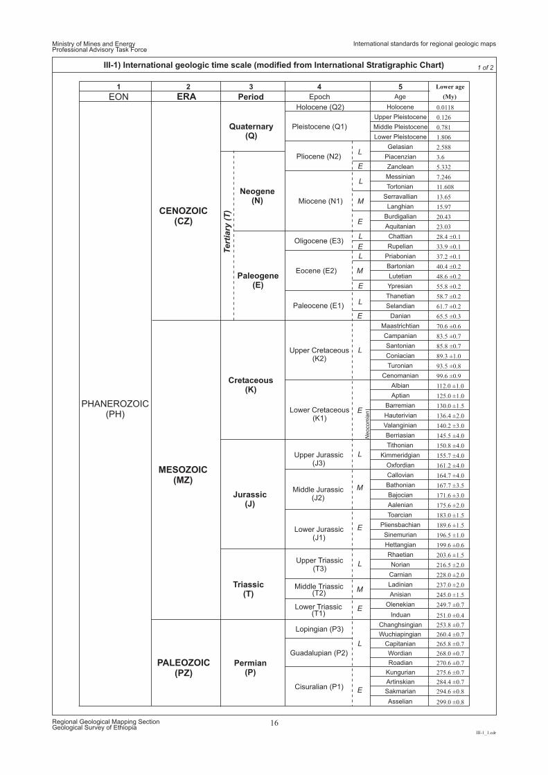
1 2 3 4 5 Lower age
EON ERA Period Epoch Age (My)
Holocene (Q2) Holocene 0.0118
Upper Pleistocene 0.126
Middle Pleistocene 0.781
Lower Pleistocene 1.806
Gelasian 2.588
Piacenzian 3.6
Zanclean 5.332
Messinian 7.246
Tortonian 11.608
Serravallian 13.65
Langhian 15.97
Burdigalian 20.43
Aquitanian 23.03
Chattian 28.4 ±0.1
Rupelian 33.9 ±0.1
Priabonian 37.2 ±0.1
Bartonian 40.4 ±0.2
Lutetian 48.6 ±0.2
Ypresian 55.8 ±0.2
Thanetian 58.7 ±0.2
Selandian 61.7 ±0.2
Danian 65.5 ±0.3
Maastrichtian 70.6 ±0.6
Campanian 83.5 ±0.7
Santonian 85.8 ±0.7
Coniacian 89.3 ±1.0
Turonian 93.5 ±0.8
Cenomanian 99.6 ±0.9
Albian 112.0 ±1.0
Aptian 125.0 ±1.0
Barremian 130.0 ±1.5
Hauterivian 136.4 ±2.0
Valanginian 140.2 ±3.0
Berriasian 145.5 ±4.0
Tithonian 150.8 ±4.0
Kimmeridgian 155.7 ±4.0
Oxfordian 161.2 ±4.0
Callovian 164.7 ±4.0
Bathonian 167.7 ±3.5
Bajocian 171.6 ±3.0
Aalenian 175.6 ±2.0
Toarcian 183.0 ±1.5
Pliensbachian 189.6 ±1.5
Sinemurian 196.5 ±1.0
Hettangian 199.6 ±0.6
Rhaetian 203.6 ±1.5
Norian 216.5 ±2.0
Carnian 228.0 ±2.0
Ladinian 237.0 ±2.0
Anisian 245.0 ±1.5
Olenekian 249.7 ±0.7
Induan 251.0 ±0.4
Changhsingian 253.8 ±0.7
Wuchiapingian 260.4 ±0.7
Capitanian 265.8 ±0.7
Wordian 268.0 ±0.7
Roadian 270.6 ±0.7
Kungurian 275.6 ±0.7
Artinskian 284.4 ±0.7
Sakmarian 294.6 ±0.8
Asselian 299.0 ±0.8
Pliocene (N2)
Pleistocene (Q1)
Paleocene (E1)
Eocene (E2)
Oligocene (E3)
Miocene (N1)
Middle Jurassic(J2)
Upper Jurassic(J3)
Lower Cretaceous(K1)
Upper Cretaceous(K2)
Jurassic(J)
Triassic(T)
Permian(P)
Cisuralian (P1)
Guadalupian (P2)
Lopingian (P3)
Lower Triassic(T1)
Middle Triassic(T2)
Upper Triassic(T3)
Lower Jurassic(J1)
Quaternary(Q)
Neogene(N)
Paleogene(E)
Tert
iary
(T)
Cretaceous(K)
PHANEROZOIC(PH)
CENOZOIC(CZ)
PALEOZOIC(PZ)
MESOZOIC(MZ)
L
L
L
E
L
L
M
M
E
E
L
E
Neocom
ian
L
L
L
M
M
E
E
E
E
E
Ministry of Mines and EnergyProfessional Advisory Task Force
III-1_1.cdr
Regional Geological Mapping SectionGeological Survey of Ethiopia
16
III-1) International geologic time scale (modified from International Stratigraphic Chart) 1 of 2
International standards for regional geologic maps
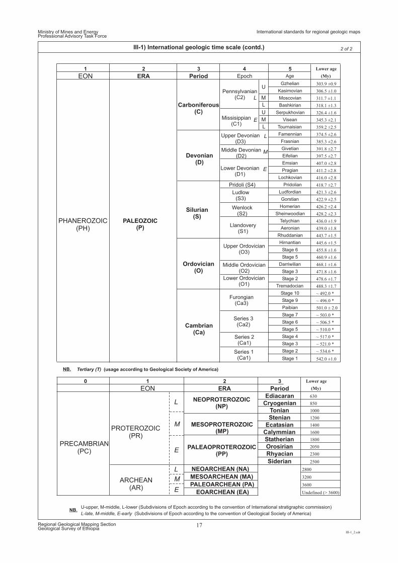
1 2 3 4 5 Lower age
EON ERA Period Epoch Age (My)
Gzhelian 303.9 ±0.9
Kasimovian 306.5 ±1.0Pennsylvanian(C2) Moscovian 311.7 ±1.1
Bashkirian 318.1 ±1.3
Serpukhovian 326.4 ±1.6
Missisippian(C1)
Visean 345.3 ±2.1
Tournaisian 359.2 ±2.5
Famennian 374.5 ±2.6
Frasnian 385.3 ±2.6
Givetian 391.8 ±2.7
Eifelian 397.5 ±2.7
Emsian 407.0 ±2.8
Pragian 411.2 ±2.8
Lochkovian 416.0 ±2.8
Pridoli (S4) Pridolian 418.7 ±2.7
Ludfordian 421.3 ±2.6
Gorstian 422.9 ±2.5
Homerian 426.2 ±2.4
Sheinwoodian 428.2 ±2.3
Telychian 436.0 ±1.9
Aeronian 439.0 ±1.8
Rhuddanian 443.7 ±1.5
Hirnantian 445.6 ±1.5
Stage 6 455.8 ±1.6
Stage 5 460.9 ±1.6
Darriwilian 468.1 ±1.6
Stage 3 471.8 ±1.6
Stage 2 478.6 ±1.7
Tremadocian 488.3 ±1.7
Stage 10 ~ 492.0 *
Stage 9 ~ 496.0 *
Paibian 501.0 ± 2.0
Stage 7 ~ 503.0 *
Stage 6 ~ 506.5 *
Stage 5 ~ 510.0 *
Stage 4 ~ 517.0 *
Stage 3 ~ 521.0 *
Stage 2 ~ 534.6 *
Stage 1 542.0 ±1.0
0 1 2 3 Lower age
EON
L
M
E
L
M
E
ERA Period (My)
Ediacaran 630
Cryogenian 850
Tonian 1000
Stenian 1200
Ecatasian 1400
Calymmian 1600
Statherian 1800
Orosirian 2050
Rhyacian 2300
Siderian 2500
NEOARCHEAN (NA) 2800
MESOARCHEAN (MA) 3200
PALEOARCHEAN (PA) 3600
EOARCHEAN (EA) Undefined (> 3600)
Series 1(Ca1)
PRECAMBRIAN(PC)
PROTEROZOIC(PR)
ARCHEAN(AR)
PALEAOPROTEROZOIC(PP)
MESOPROTEROZOIC(MP)
NEOPROTEROZOIC(NP)
Lower Ordovician(O1)
Furongian(Ca3)
Series 3(Ca2)
Series 2(Ca1)
Wenlock(S2)
Llandovery(S1)
Upper Ordovician(O3)
Middle Ordovician(O2)
Upper Devonian(D3)
Middle Devonian(D2)
Lower Devonian(D1)
Ludlow(S3)
PHANEROZOIC(PH)
PALEOZOIC(P)
Carboniferous(C)
Devonian(D)
Silurian(S)
Ordovician(O)
Cambrian(Ca)
U
U-upper, M-middle, L-lower (Subdivisions of Epoch according to the convention of International stratigraphic commission)
U
ML
L
L-late, M-middle, E-early (Subdivisions of Epoch according to the convention of Geological Society of America)
E
M
E
M
L
L
Tertiary (T) (usage according to Geological Society of America)
Ministry of Mines and EnergyProfessional Advisory Task Force
III-1_2.cdr
Regional Geological Mapping SectionGeological Survey of Ethiopia
17
III-1) International geologic time scale (contd.) 2 of 2
NB.
NB.
International standards for regional geologic maps
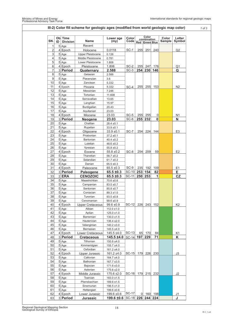
SN.ObID
TimeDivision Name
Lower age(my)
ColorCode
ColorSample
LetterSymbol
1 5 Age
2 4 Epoch Holocene
Recent
0.0118 255 251 240 Q2
3 5 Age Upper Pleistocene 0.126
4 5 Age Middle Pleistocene 0.781
5 5 Age Lower Pleistocene 1.806
6 4 Epoch Pleistocene 1.806 255 247 176 Q1
8 5 Age Gelasian 2.588
9 5 Age Piacenzian 3.6
10 5 Age Zanclean 5.332
11 4 Epoch Pliocene 5.332 255 255 153 N2
12 5 Age Messinian 7.246
13 5 Age Tortonian 11.608
14 5 Age Serravallian 13.65
15 5 Age Langhian 15.97
16 5 Age Burdigalian 20.43
17 5 Age Aquitanian 23.03
18 4 Epoch Miocene 23.03 255 255 0 N1
19 3 Period Neogene 23.03 255 232 0 N20 5 Age Chattian 28.4 ±0.1
21 5 Age Rupelian 33.9 ±0.1
22 4 Epoch Oligocene 33.9 ±0.1 254 224 144 E3
23 5 Age Priabonian 37.2 ±0.1
24 5 Age Bartonian 40.4 ±0.2
25 5 Age Lutetian 48.6 ±0.2
26 5 Age Ypresian 55.8 ±0.2
27 4 Epoch Eocene 55.8 ±0.2 254 209 59 E2
28 5 Age Thanetian 58.7 ±0.2
29 5 Age Selandian 61.7 ±0.2
30 5 Age Danian 65.5 ±0.3
31 4 Epoch Paleocene 65.5 ±0.3 235 192 109 E1
32 3 Period Paleogene 65.5 ±0.3 253 154 82 E33 2 ERA CENOZOIC 65.5 ±0.3 250 253 1 CZ34 5 Age Maastrichtian 70.6 ±0.6
35 5 Age Campanian 83.5 ±0.7
36 5 Age Santonian 85.8 ±0.7
37 5 Age Coniacian 89.3 ±1.0
38 5 Age Turonian 93.5 ±0.8
39 5 Age Cenomanian 99.6 ±0.9
40 4 Epoch Upper Cretaceous 99.6 ±0.9 226 243 152 K2
41 5 Age Albian 112.0 ±1.0
42 5 Age Aptian 125.0 ±1.0
43 5 Age Barremian 130.0 ±1.5
44 5 Age Hauterivian 136.4 ±2.0
45 5 Age Valanginian 140.2 ±3.0
46 5 Age Berriasian 145.5 ±4.0
47 4 Epoch Lower Cretaceous 145.5 ±4.0 65 170 84 K1
48 3 Period Cretaceous 145.5 ±4.0 197 229 71 K49 5 Age Tithonian 150.8 ±4.0
50 5 Age Kimmeridgian 155.7 ±4.0
51 5 Age Oxfordian 161.2 ±4.0
52 4 Epoch Upper Jurassic 161.2 ±4.0 179 226 230 J3
53 5 Age Callovian 164.7 ±4.0
54 5 Age Bathonian 167.7 ±3.5
55 5 Age Bajocian 171.6 ±3.0
56 5 Age Aalenian 175.6 ±2.0
57 4 Epoch Middle Jurassic 175.6 ±2.0 179 215 232 J2
58 5 Age Toarcian 183.0 ±1.5
59 5 Age Pliensbachian 189.6 ±1.5
60 5 Age Sinemurian 196.5 ±1.0
61 5 Age Hettangian 199.6 ±0.6
62 4 Epoch Lower Jurassic 199.6 ±0.6 0 160 198 J1
63 3 Period Jurassic 199.6 ±0.6 226 244 224 J
7 3 Period Quaternary 2.588 254 230 146 Q
Ministry of Mines and EnergyProfessional Advisory Task Force
III-2_1.cdr
Regional Geological Mapping SectionGeological Survey of Ethiopia
18
III-2) Color fill scheme for geologic ages (modified from world geologic map color) 1 of 3
SC-1
SC-2
SC-3
SC-4
SC-5
SC-6
SC-7
SC-8
SC-9
SC-10
SC-11
SC-12
SC-13
SC-14
SC-15
SC-16
SC-17
SC-18
Colorcombination
Red Green Blue
International standards for regional geologic maps
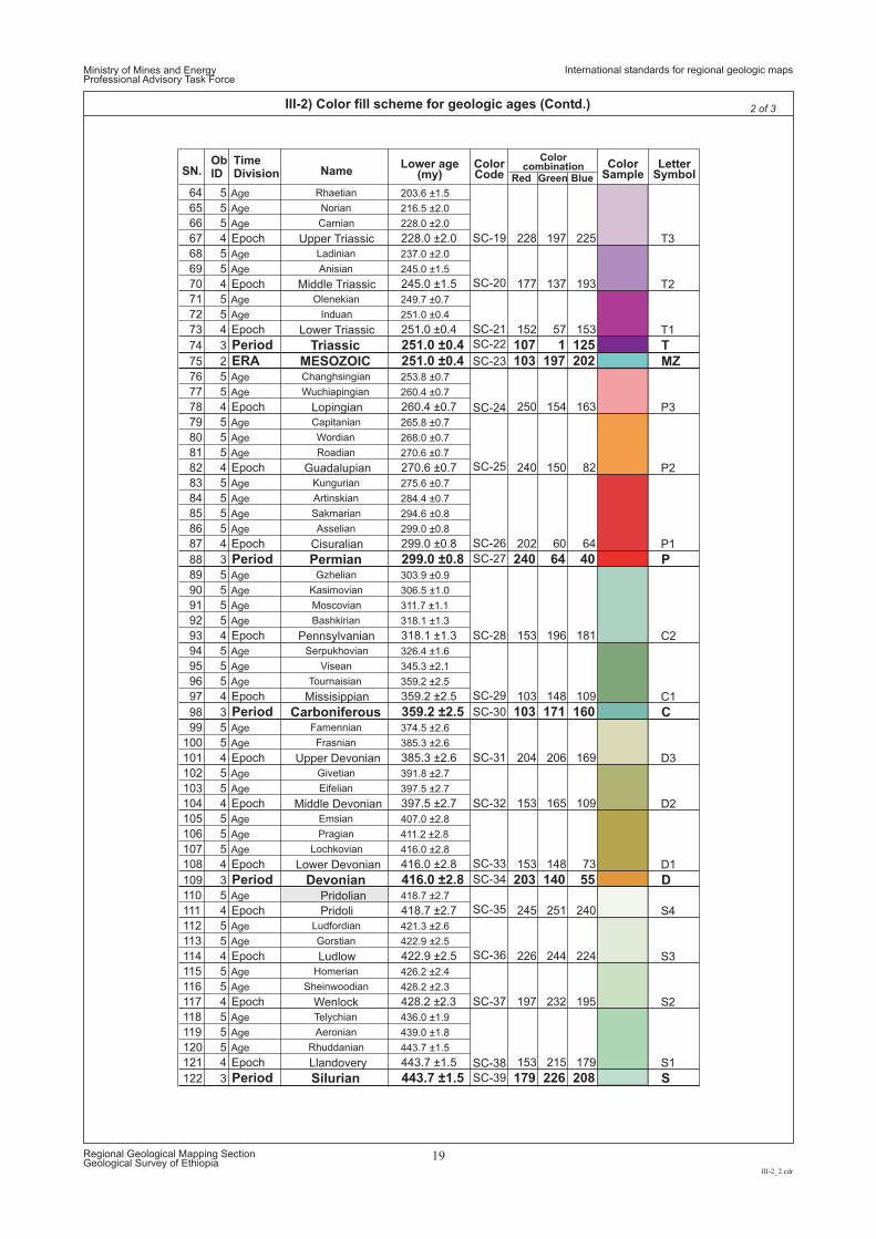
64 5 Age Rhaetian 203.6 ±1.5
65 5 Age Norian 216.5 ±2.0
66 5 Age Carnian 228.0 ±2.0
67 4 Epoch Upper Triassic 228.0 ±2.0 228 197 225 T3
68 5 Age Ladinian 237.0 ±2.0
69 5 Age Anisian 245.0 ±1.5
70 4 Epoch Middle Triassic 245.0 ±1.5 177 137 193 T2
71 5 Age Olenekian 249.7 ±0.7
72 5 Age Induan 251.0 ±0.4
73 4 Epoch Lower Triassic 251.0 ±0.4 152 57 153 T1
74 3 Period Triassic 251.0 ±0.4 107 1 125 T75 2 ERA MESOZOIC 251.0 ±0.4 103 197 202 MZ76 5 Age Changhsingian 253.8 ±0.7
77 5 Age Wuchiapingian 260.4 ±0.7
78 4 Epoch Lopingian 260.4 ±0.7 250 154 163 P3
79 5 Age Capitanian 265.8 ±0.7
80 5 Age Wordian 268.0 ±0.7
81 5 Age Roadian 270.6 ±0.7
82 4 Epoch Guadalupian 270.6 ±0.7 240 150 82 P2
83 5 Age Kungurian 275.6 ±0.7
84 5 Age Artinskian 284.4 ±0.7
85 5 Age Sakmarian 294.6 ±0.8
86 5 Age Asselian 299.0 ±0.8
87 4 Epoch Cisuralian 299.0 ±0.8 202 60 64 P1
88 3 Period Permian 299.0 ±0.8 240 64 40 P89 5 Age Gzhelian 303.9 ±0.9
90 5 Age Kasimovian 306.5 ±1.0
91 5 Age Moscovian 311.7 ±1.1
92 5 Age Bashkirian 318.1 ±1.3
93 4 Epoch Pennsylvanian 318.1 ±1.3 153 196 181 C2
94 5 Age Serpukhovian 326.4 ±1.6
95 5 Age Visean 345.3 ±2.1
96 5 Age Tournaisian 359.2 ±2.5
97 4 Epoch Missisippian 359.2 ±2.5 103 148 109 C1
98 3 Period Carboniferous 359.2 ±2.5 103 171 160 C99 5 Age Famennian 374.5 ±2.6
100 5 Age Frasnian 385.3 ±2.6
101 4 Epoch Upper Devonian 385.3 ±2.6 204 206 169 D3
102 5 Age Givetian 391.8 ±2.7
103 5 Age Eifelian 397.5 ±2.7
104 4 Epoch Middle Devonian 397.5 ±2.7 153 165 109 D2
105 5 Age Emsian 407.0 ±2.8
106 5 Age Pragian 411.2 ±2.8
107 5 Age Lochkovian 416.0 ±2.8
108 4 Epoch Lower Devonian 416.0 ±2.8 153 148 73 D1
109 3 Period Devonian 416.0 ±2.8 203 140 55 D110 5 Age 418.7 ±2.7
111 4 Epoch Pridoli
Pridolian
418.7 ±2.7 245 251 240 S4
112 5 Age Ludfordian 421.3 ±2.6
113 5 Age Gorstian 422.9 ±2.5
114 4 Epoch Ludlow 422.9 ±2.5 226 244 224 S3
115 5 Age Homerian 426.2 ±2.4
116 5 Age Sheinwoodian 428.2 ±2.3
117 4 Epoch Wenlock 428.2 ±2.3 197 232 195 S2
118 5 Age Telychian 436.0 ±1.9
119 5 Age Aeronian 439.0 ±1.8
120 5 Age Rhuddanian 443.7 ±1.5
121 4 Epoch Llandovery 443.7 ±1.5 153 215 179 S1
122 3 Period Silurian 443.7 ±1.5 179 226 208 S
SN.ObID
TimeDivision Name
2 of 3
SC-19
SC-20
SC-21
SC-22
SC-23
SC-24
SC-25
SC-26
SC-27
SC-28
SC-29
SC-30
SC-31
SC-32
SC-33
SC-34
SC-35
SC-36
SC-37
SC-38
SC-39
Lower age(my)
ColorCode
ColorSample
LetterSymbol
Colorcombination
Red Green Blue
Ministry of Mines and EnergyProfessional Advisory Task Force
III-2_2.cdr
Regional Geological Mapping SectionGeological Survey of Ethiopia
19
III-2) Color fill scheme for geologic ages (Contd.)
International standards for regional geologic maps
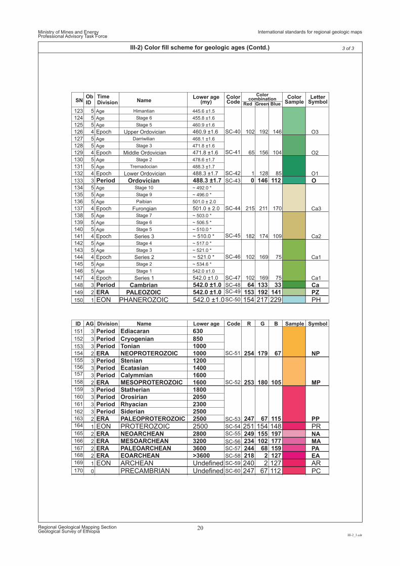
SNObID
TimeDivision Name
123 5 Age Himantian 445.6 ±1.5
124 5 Age Stage 6 455.8 ±1.6
125 5 Age Stage 5 460.9 ±1.6
126 4 Epoch Upper Ordovician 460.9 ±1.6 102 192 146 O3
127 5 Age Darriwilian 468.1 ±1.6
128 5 Age Stage 3 471.8 ±1.6
129 4 Epoch Middle Ordovician 471.8 ±1.6 65 156 104 O2
130 5 Age Stage 2 478.6 ±1.7
131 5 Age Tremadocian 488.3 ±1.7
132 4 Epoch Lower Ordovician 488.3 ±1.7 1 128 85 O1
133 3 Period Ordovician 488.3 ±1.7 0 146 112 O134 5 Age Stage 10 ~ 492.0 *
135 5 Age Stage 9 ~ 496.0 *
136 5 Age Paibian 501.0 ± 2.0
137 4 Epoch Furongian 501.0 ± 2.0 215 211 170 Ca3
138 5 Age Stage 7 ~ 503.0 *
139 5 Age Stage 6 ~ 506.5 *
140 5 Age Stage 5 ~ 510.0 *
141 4 Epoch Series 3 ~ 510.0 * 182 174 109 Ca2
142 5 Age Stage 4 ~ 517.0 *
143 5 Age Stage 3 ~ 521.0 *
144 4 Epoch Series 2 ~ 521.0 * 102 169 75 Ca1
145 5 Age Stage 2 ~ 534.6 *
146 5 Age Stage 1 542.0 ±1.0
147 4 Epoch Series 1 542.0 ±1.0 102 169 75 Ca1
148 3 Period Cambrian 542.0 ±1.0 64 133 33 Ca149 2 ERA PALEOZOIC 542.0 ±1.0 153 192 141 PZ
150
151
152
153
154
155
156
157
158
159
160
161
162
163
164
165
166
167
168
169
170
1 EON PHANEROZOIC 542.0 ±1.0 154 217 229 PH
ID AG Division Name Lower age Code R G B Sample Symbol
3 Period Ediacaran 630
3 Period Cryogenian 850
3 Period Tonian 1000
2 ERA NEOPROTEROZOIC 1000 254 179 67 NP3 Period Stenian 1200
3 Period Ecatasian 1400
3 Period Calymmian 1600
2 ERA MESOPROTEROZOIC 1600 253 180 105 MP3 Period Statherian 1800
3 Period Orosirian 2050
3 Period Rhyacian 2300
3 Period Siderian 2500
2 ERA PALEOPROTEROZOIC 2500 247 67 115 PP
1 EON PROTEROZOIC 2500 251 154 148 PR2 ERA NEOARCHEAN 2800 249 155 197 NA2 ERA MESOARCHEAN 3200 234 102 177 MA2 ERA PALEOARCHEAN 3600 244 68 159 PA2 ERA EOARCHEAN >3600 218 2 127 EA
1 EON ARCHEAN Undefined 240 2 127 AR0 PRECAMBRIAN Undefined 247 67 112 PC
Ministry of Mines and EnergyProfessional Advisory Task Force
III-2_3.cdr
Regional Geological Mapping SectionGeological Survey of Ethiopia
20
III-2) Color fill scheme for geologic ages (Contd.) 3 of 3
SC-40
SC-41
SC-42
SC-43
SC-44
SC-45
SC-46
SC-47
SC-48
SC-49
SC-50
SC-51
SC-52
SC-53
SC-54
SC-55
SC-56
SC-57
SC-58
SC-59
SC-60
Lower age(my)
ColorCode
Colorcombination
Red Green Blue
ColorSample
LetterSymbol
International standards for regional geologic maps
Ministry of Mines and EnergyProfessional Advisory Task Force
IV.cdr
Regional Geological Mapping SectionGeological Survey of Ethiopia
21
COLOR SCHEME FOR GEOLOGIC AGE UNITS RECORDED IN ETHIOPIA
Standard colors for regional geologic maps
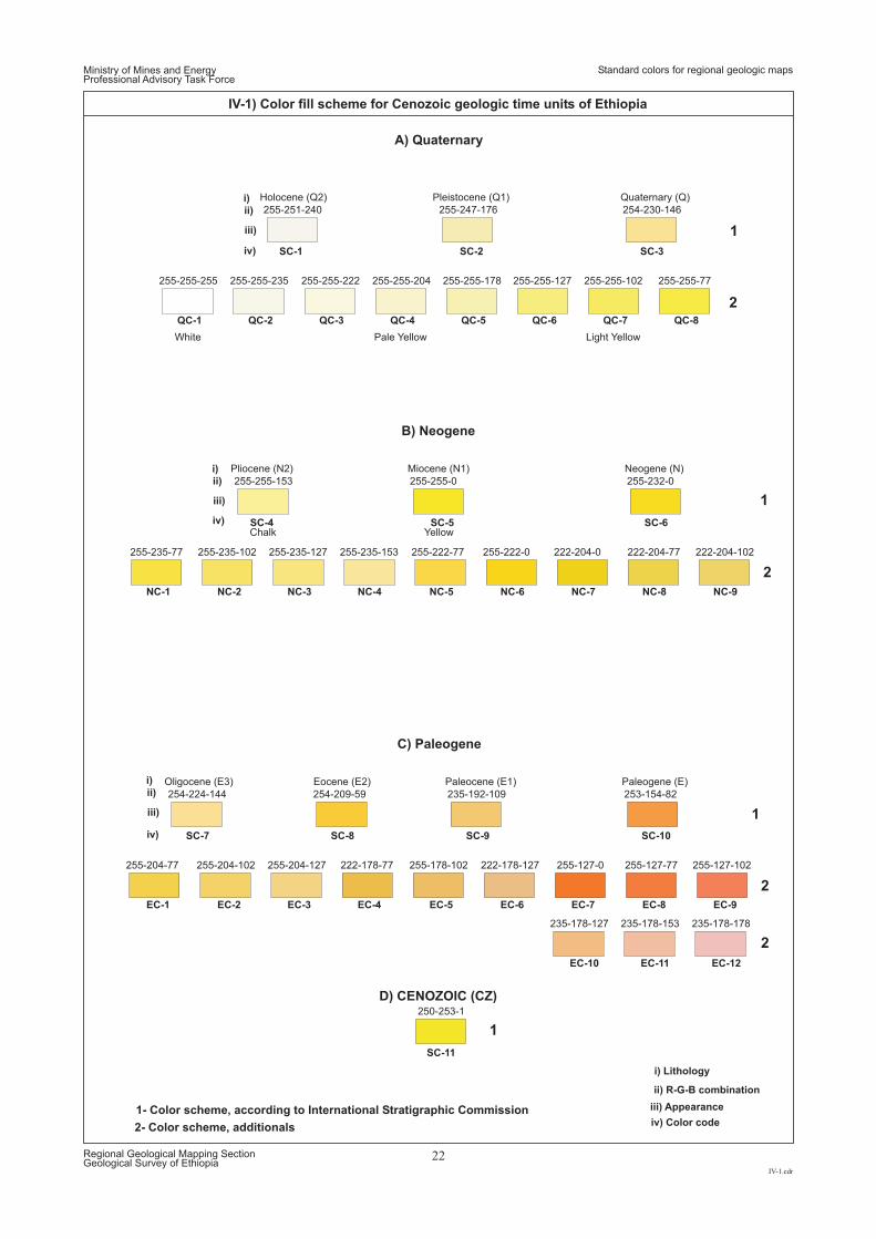
1
2
1
2
1
2
1
2
1- Color scheme, according to International Stratigraphic Commission
SC-1 SC-2 SC-3
255-255-77
255-235-77
255-127-77255-127-0
255-247-176
255-255-0
254-209-59
255-255-204
255-222-0
222-178-127
254-230-146
255-232-0
235-192-109 253-154-82
255-255-222
222-204-0
255-204-77
235-178-127
255-255-178
255-222-77
255-178-102
255-251-240
255-255-153
254-224-144
255-255-235
222-204-77
255-204-102
235-178-153
255-255-255
222-204-102
255-204-127
235-178-178
250-253-1
255-255-102
255-235-102
255-127-102
255-255-127
255-235-127 255-235-153
222-178-77
Yellow
Pleistocene (Q1)
Pale Yellow
Quaternary (Q)
Chalk
Light Yellow
Holocene (Q2)
QC-1 QC-2 QC-3 QC-4 QC-5 QC-6 QC-7 QC-8
White
D) CENOZOIC (CZ)
Miocene (N1)
Paleocene (E1)
Neogene (N)
Paleogene (E)
Pliocene (N2)
Eocene (E2)Oligocene (E3)
SC-4
SC-8SC-7
SC-5
SC-9
SC-6
SC-10
SC-11
NC-1
EC-1
NC-2
EC-2
NC-3
EC-3
NC-4
EC-4
NC-5
EC-5
NC-6
EC-6
NC-7
EC-7
EC-10
NC-8
EC-8
EC-11
NC-9
EC-9
EC-12
B) Neogene
C) Paleogene
ii) R-G-B combination
i) Lithology
iii) Appearance
iv) Color code
i)
i)
i)
ii)
ii)
ii)
iii)
iii)
iii)
iv)
iv)
iv)
Ministry of Mines and EnergyProfessional Advisory Task Force
Standard colors for regional geologic maps
IV-1.cdr
Regional Geological Mapping SectionGeological Survey of Ethiopia
22
IV-1) Color fill scheme for Cenozoic geologic time units of Ethiopia
2- Color scheme, additionals
A) Quaternary
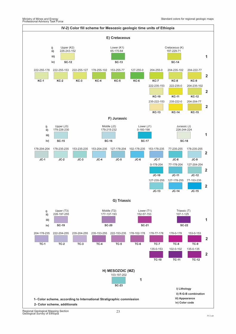
204-235-102
77-235-255
178-0-178
204-222-77
178-235-255
153-0-153
65-170-84
179-215-232
177-137-193
178-255-102
153-204-235
235-153-255
197-229-71
0-160-198
152-57-153
226-244-224
107-1-125
222-255-127
153-235-235
235-204-255
204-235-102
127-204-204
135-0-135
204-204-77
77-153-235
153-255-77
127-178-204
222-153-235
226-243-152
179-226-230
228-197-255
222-255-153
178-235-235
222-204-255
222-235-0
77-178-204
102-0-102
235-222-0
127-178-255
222-255-178
178-204-204
204-178-235
222-235-153
0-178-204
135-0-153
235-222-153
127-235-255
103-197-202
204-255-0
153-178-235
178-77-178
127-255-0
102-178-235
178-102-178
H) MESOZOIC (MZ)
SC-12 SC-13 SC-14
Lower ( )K1 Cretaceous ( )KUpper ( )K2
KC-1
KC-10
KC-2
KC-11
KC-3
KC-12
KC-4
KC-13
KC-5
KC-14
KC-6
KC-15
KC-7 KC-8 KC-9
Lower (T1)
Lower ( )J1
Triassic (T)
Jurassic ( )J
Middle (T2)
Middle ( )J2
Upper (T3)
Upper ( )J3
SC-20
SC-16
SC-19
SC-15
SC-21
SC-17
SC-22
SC-18
TC-1
JC-1
TC-2
JC-2
TC-3
JC-3
TC-4
JC-4
TC-5
JC-5
TC-6
JC-6
TC-7
JC-7
TC-10
JC-10
TC-8
JC-8
TC-11
SC-23
JC-11
TC-9
JC-9
TC-12
JC-12
JC-13 JC-14 JC-15
G) Triassic
F) Jurassic
E) Cretaceous
2- Color scheme, additionals
1
2
1
2
1
2
2
2
1
2
2
2
1- Color scheme, according to International Stratigraphic commission
Ministry of Mines and EnergyProfessional Advisory Task Force
IV-2.cdr
Regional Geological Mapping SectionGeological Survey of Ethiopia
23
IV-2) Color fill scheme for Mesozoic geologic time units of Ethiopia
ii) R-G-B combination
i) Lithology
iii) Appearance
iv) Color code
i)
i)
i)
ii)
ii)
ii)
iii)
iii)
iii)
iv)
iv)
iv)
Standard colors for regional geologic maps
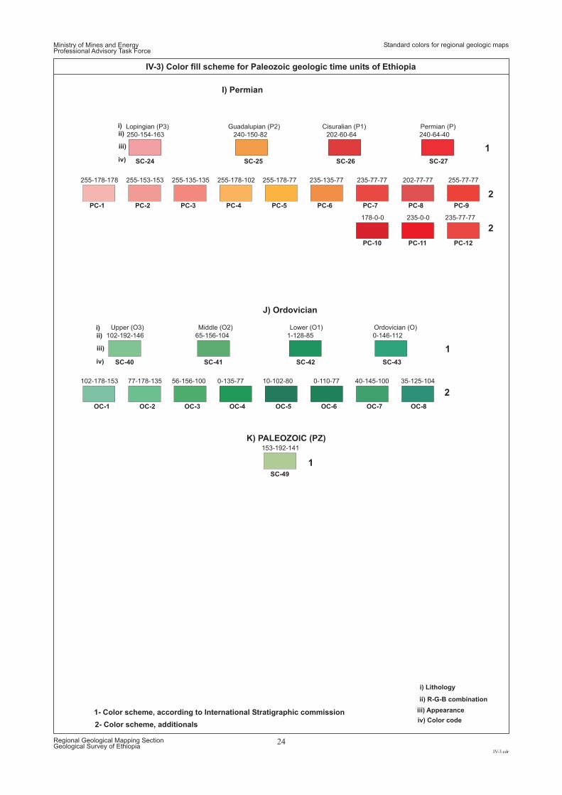
202-77-77 255-77-77
240-150-82
255-178-102
202-60-64 240-64-40
255-135-135
235-77-77
255-178-77
250-154-163
255-153-153
235-0-0
255-178-178
178-0-0
153-192-141
235-77-77235-135-77
Permian (P)
K) PALEOZOIC (PZ)
SC-24 SC-25 SC-26 SC-27
Guadalupian ( )P2 Cisuralian ( )P1Lopingian ( )P3
PC-1
PC-10
PC-2
PC-11
PC-3
PC-12
PC-4 PC-5 PC-6 PC-7 PC-8 PC-9
35-125-104
65-156-104
0-135-77
1-128-85 0-146-112
56-156-100 10-102-80
102-192-146
77-178-135102-178-153 40-145-1000-110-77
Lower (O )1 Ordovician (O)Middle (O )2Upper (O )3
SC-41SC-40
SC-49
SC-42 SC-43
OC-1 OC-2 OC-3 OC-4 OC-5 OC-6 OC-7 OC-8
J) Ordovician
I) Permian
2- Color scheme, additionals
1
1
2
1
2
2
1- Color scheme, according to International Stratigraphic commission
Ministry of Mines and EnergyProfessional Advisory Task Force
IV-3.cdr
Regional Geological Mapping SectionGeological Survey of Ethiopia
24
IV-3) Color fill scheme for Paleozoic geologic time units of Ethiopia
ii) R-G-B combination
i) Lithology
iii) Appearance
iv) Color code
i)
i)
ii)
ii)
iii)
iii)
iv)
iv)
Standard colors for regional geologic maps
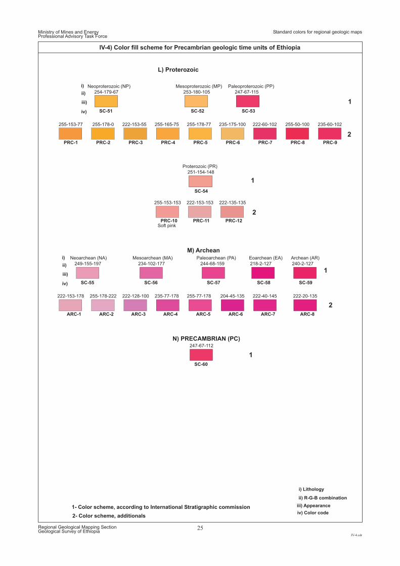
L) Proterozoic
1
2
1
2
1
1
2
1- Color scheme, according to International Stratigraphic commission
255-50-100 235-60-102
253-180-105
255-165-75
247-67-115
251-154-148
222-153-55
222-135-135
255-178-77
254-179-67
255-178-0
222-153-153
255-153-77
255-153-153
247-67-112
222-60-102235-175-100
Proterozoic (PR)
N) PRECAMBRIAN (PC)
SC-51 SC-52 SC-53
SC-54
Mesoproterozoic (M )P Paleoproterozoic ( )PPNeoproterozoic (NP)
Soft pink
222-20-135
234-102-177
235-77-178
244-68-159 218-2-127 240-2-127
222-128-100 255-77-178
249-155-197
255-178-222222-153-178 222-40-145204-45-135
Paleoarchean (PA) Eoarchean (EA) Archean (AR)Mesoarchean (MA)Neoarchean (NA)
SC-56SC-55
SC-60
SC-57 SC-58 SC-59
M) Archean
ARC-1 ARC-2 ARC-3 ARC-4 ARC-5 ARC-6 ARC-7 ARC-8
PRC-1
PRC-10
PRC-2
PRC-11
PRC-3
PRC-12
PRC-4 PRC-5 PRC-6 PRC-7 PRC-8 PRC-9
Ministry of Mines and EnergyProfessional Advisory Task Force
IV-4.cdr
Regional Geological Mapping SectionGeological Survey of Ethiopia
25
IV-4) Color fill scheme for Precambrian geologic time units of Ethiopia
2- Color scheme, additionals
ii) R-G-B combination
i) Lithology
iii) Appearance
iv) Color code
i)
i)
ii)
ii)
iii)
iii)
iv)
iv)
Standard colors for regional geologic maps
Standard foreground patterns for regional geologic mapsMinistry of Mines and EnergyProfessional Advisory Task Force
V.cdr
Regional Geological Mapping SectionGeological Survey of Ethiopia
26
PATTERNS OVERPRINTING GEOLOGIC AGE COLORS OF ETHIOPIA
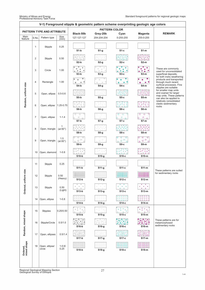
127-127-127 204-204-204 0-255-255 255-0-255
Ran
do
m,u
nif
orm
siz
eO
rdere
d,u
nif
orm
siz
eR
an
do
m,m
ixed
sh
ap
eO
rdere
d,
mix
ed
sh
ap
e
0.25
0.50
1.00
1.00
0.5-0.6
1.25-0.75
1-1.4
1(at 60°)
1.5(at 60°)
1-0.8
0.25
0.50(Heavy)
0.50(Light)
1-0.8
0.25/0.50
0.5/1.0
0.5/1.4
1-0.6/0.25
Black-50b Grey-20b Cyan Magenta
PATTERN COLORPATTERN TYPE AND ATTRIBUTE
REMARK
These are commonlyused for unconsolidatedsuperficial deposits,for both insitu weatheringproducts and transportedthrough much recentsurficial processes. Finestipples are suitablefor smaller map unitsand coarser for largermap units. These patternscan also be applied torelatively consolidatedclastic sedimentaryrocks
These patterns are suitedfor sedimentary rocks
These patterns are formetamorphosedsedimentary rocks
Mainfeature S.No.
Size(mm)
Pattern type
1
2
3
4
5
6
7
8
9
10
11
12
13
14
15
16
17
18
Stipple
Stipple
Circle
Rectangle
Open, ellipse
Open, ellipse
Open, ellipse
Open, triangle
Open, triangle
Open, diamond
Stipple
Stipple
Stipple
Open, ellipse
Stipples
Stipple/Circle
Open, ellipses
Open, ellipse/circle
Ministry of Mines and EnergyProfessional Advisory Task Force
I.cdr
Regional Geological Mapping SectionGeological Survey of Ethiopia
27
V-1) Foreground stipple & geometric pattern scheme overprinting geologic age colors
Standard foreground patterns for regional geologic maps
S3-b
S4-b
S5-b
S6-b
S7-b
S8-b
S9-b
S10-b
S11-b
S12-b
S13-b
S14-b
S15-b
S16-b
S17-b
S18-b
S3-g
S4-g
S5-g
S6-g
S7-g
S8-g
S9-g
S10-g
S11-g
S12-g
S13-g
S14-g
S15-g
S16-g
S17-g
S18-g
S3-c
S4-c
S5-c
S6-c
S7-c
S8-c
S9-c
S10-c
S11-c
S12-c
S13-c
S14-c
S15-c
S16-c
S17-c
S18-c
S3-m
S4-m
S5-m
S6-m
S7-m
S8-m
S9-m
S10-m
S11-m
S12-m
S13-m
S14-m
S15-m
S16-m
S17-m
S18-m
S2-b S2-g S2-c S2-m
S1-b S1-g S1-c S1-m
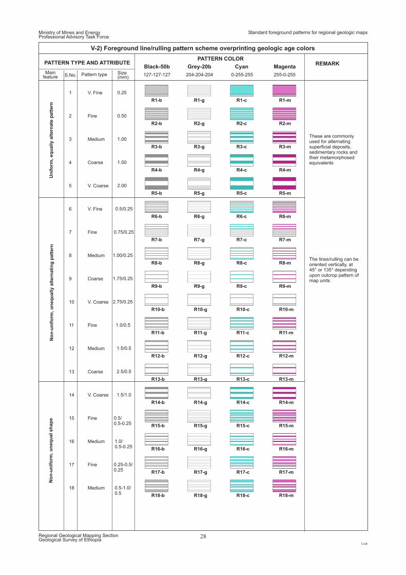
Un
ifo
rm,eq
ually
alt
ern
ate
patt
ern
No
n-u
nif
orm
,u
neq
ually
alt
ern
ati
ng
patt
ern
No
n-u
nif
orm
,u
neq
ualsh
ap
e
0.25
0.5/0.25
0.50
0.75/0.25
1.0/0.5
0.5/0.5-0.25
0.25-0.5/0.25
1.00
1.00/0.25
1.5/0.5
1.0/0.5-0.25
0.5-1.0/0.5
1.50
1.75/0.25
2.5/0.5
2.00
2.75/0.25
1.5/1.0
PATTERN TYPE AND ATTRIBUTE
Mainfeature S.No.
Size(mm)
Pattern type
1
6
2
7
11
15
17
3
8
12
16
18
4
9
13
5
10
14
V. Fine
V. Fine
Fine
Fine
Fine
Fine
Fine
Medium
Medium
Medium
Medium
Medium
Coarse
Coarse
Coarse
V. Coarse
V. Coarse
V. Coarse
Ministry of Mines and EnergyProfessional Advisory Task Force
I.cdr
Regional Geological Mapping SectionGeological Survey of Ethiopia
28
V-2) Foreground line/rulling pattern scheme overprinting geologic age colors
Standard foreground patterns for regional geologic maps
R3-b
R4-b
R5-b
R6-b
R7-b
R8-b
R9-b
R10-b
R11-b
R12-b
R13-b
R14-b
R15-b
R16-b
R17-b
R18-b
R3-g
R4-g
R5-g
R6-g
R7-g
R8-g
R9-g
R10-g
R11-g
R12-g
R13-g
R14-g
R15-g
R16-g
R17-g
R18-g
R3-c
R4-c
R5-c
R6-c
R7-c
R8-c
R9-c
R10-c
R11-c
R12-c
R13-c
R14-c
R15-c
R16-c
R17-c
R18-c
R3-m
R4-m
R5-m
R6-m
R7-m
R8-m
R9-m
R10-m
R11-m
R12-m
R13-m
R14-m
R15-m
R16-m
R17-m
R18-m
R2-b R2-g R2-c R2-m
R1-b R1-g R1-c R1-m
127-127-127 204-204-204 0-255-255 255-0-255
Black-50b Grey-20b Cyan Magenta
PATTERN COLORREMARK
These are commonlyused for alternatingsuperficial deposits,sedimentary rocks andtheir metamorphosedequivalents
The lines/rulling can beoriented vertically, at45° or 135° dependingupon outcrop pattern ofmap units
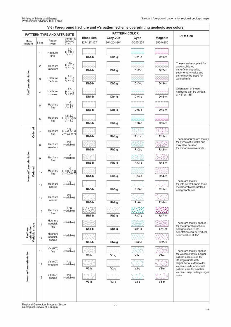
127-127-127 204-204-204 0-255-255 255-0-255
Un
ifo
rmo
rien
tati
on
No
n-u
nif
orm
ori
en
tati
on
Ord
ere
dO
rdere
d
No
n-u
nif
orm
ori
en
tati
on
Un
ifo
rmo
rien
tati
on
Vari
ab
lesh
ap
e
2.0H = 0.5V = 1
1.50H = 1.0V = 1.0
1.0H = 1.0V = 1.0
1.0H = 1.0V = 2.0
1.0H = 1.0V = 1.0
1.5-2.0H = 1.0-0.5
V = 1.0
1.0H = 0.8-1.0V = 0.6-0.75
2.0(variable)
1.0(variable)
1.0H = 0.5-1.0V = 0.5-0.75
1.0(variable)
2.0(variable)
1.50(variable)
(variable)
1.0(variable)
1.5(variable)
2.0(variable)
(variable)
Black-50b Grey-20b Cyan Magenta
PATTERN COLORPATTERN TYPE AND ATTRIBUTEREMARK
Mainfeature S.No.
Length &spacing(mm)
Patterntype
1
2
3
4
5
6
7
8
9
10
11
12
13
14
15
16
17
18
Hachurefine
Hachuremedium
Hachuremedium
Hachurecoarse
Hachurefine
Hachurefine
Hachurefine
Hachuremedium
Hachurefine
Hachurefine
Hachurecoarse
Hachurecoarse
Hachurefine
Hachurespecial,
fine
V’s (60°)fine
V’s (60°)medium
V’s (60°)coarse
Hachurespecial,coarse
Ministry of Mines and EnergyProfessional Advisory Task Force
I.cdr
Regional Geological Mapping SectionGeological Survey of Ethiopia
29
V-3) Foreground hachure and v’s pattern scheme overprinting geologic age colors
Standard foreground patterns for regional geologic maps
Dh3-b
Dh4-b
Dh5-b
Dh6-b
Rh1-b
Rh2-b
Rh3-b
Rh4-b
Rh5-b
Rh6-b
Rh7-b
Sh1-b
Sh2-b
V1-b
V2-b
V3-b
Dh3-g
Dh4-g
Dh5-g
Dh6-g
Rh1-g
Rh2-g
Rh3-g
Rh4-g
Rh5-g
Rh6-g
Rh7-g
Sh1-g
S -gh2
V1-g
V2-g
V3-g
Dh3-c
Dh4-c
Dh5-c
Dh6-c
Rh1-c
Rh2-c
Rh3-c
Rh4-c
Rh5-c
Rh6-c
Rh7-c
Sh1-c
S -ch2
V1-c
V2-c
V3-c
Dh3-m
Dh4-m
Dh5-m
Dh6-m
Rh1-m
Rh2-m
Rh3-m
Rh4-m
Rh5-m
Rh6-m
Rh7-m
Sh1-m
S -mh2
V1-m
V2-m
V3-m
Dh2-b Dh2-g Dh2-c Dh2-m
Dh1-b Dh1-g Dh1-c Dh1-m
These can be applied forunconsolidatedsuperficial deposits,sedimentary rocks andsome may be used forwelded tuffs.
Orientation of thesehachures can be vertical,at 45° or 135°
These hachures are mainlyfor pyroclastic rocks andmay also be usedfor minor intrusive units
These are mainlyfor intrusive/plutonic rocks,metamorphic hornfelsesand granofelses
These are mainly appliedfor metamorphic schistsand gneisses. Noteorientation can be vertical,horizontal or at 45°
These are mainly appliedfor volcanic flows. Largerpatterns are suited forlithologic units withlarger aerial extent/oldervolcanic units and smallpatterns are for smallervolcanic map units/youngerunits
Ministry of Mines and EnergyProfessional Advisory Task Force
VI.cdr
Regional Geological Mapping SectionGeological Survey of Ethiopia
30
LITHOSTRATIGRAPHIC UNITS OF ETHIOPIA AND MAP ATTRIBUTES
Standard local stratigraphic units of Ethiopia
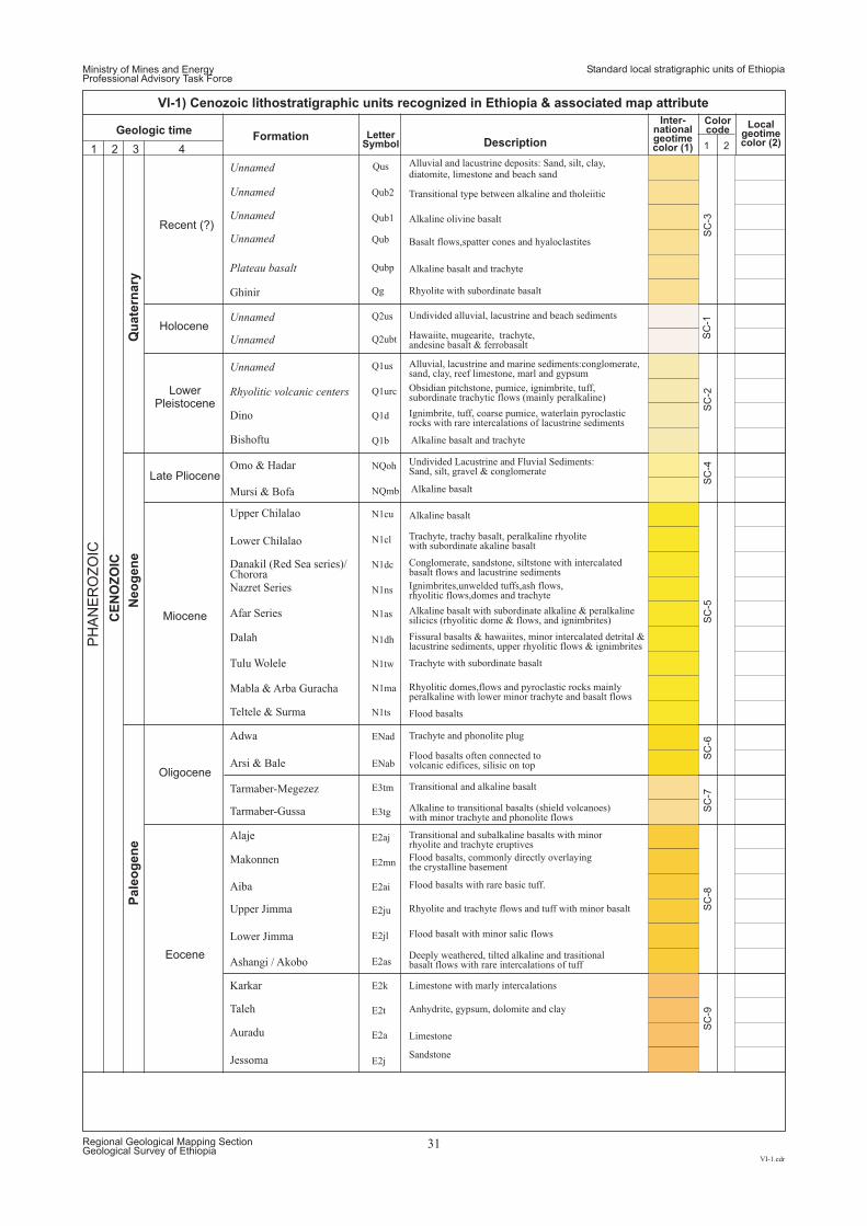
Ministry of Mines and EnergyProfessional Advisory Task Force
Standard local stratigraphic units of Ethiopia
VI-1.cdr
Regional Geological Mapping SectionGeological Survey of Ethiopia
31
VI-1) Cenozoic lithostratigraphic units recognized in Ethiopia & associated map attribute
LetterSymbol
FormationDescription
Geologic time
Unnamed
Q1urc
Tarmaber-Megezez E3tm
Unnamed Qus
Unnamed Qub
Unnamed Qub2
Unnamed Qub1
Plateau basalt Qubp
Ghinir Qg
Rhyolitic volcanic centers
Q2us
Unnamed Q2ubt
Unnamed Q1us
Dino Q1d
Bishoftu Q1b
Omo & Hadar NQoh
Mursi & Bofa NQmb
Upper Chilalao N1cu
Lower Chilalao N1cl
Danakil (Red Sea series)/Chorora
N1dc
Nazret Series N1ns
Afar Series N1as
Dalah N1dh
Tulu Wolele N1tw
Mabla & Arba Guracha N1ma
Teltele & Surma N1ts
Adwa ENad
Tarmaber-Gussa E3tg
Alaje E2aj
Makonnen E2mn
Arsi & Bale ENab
Aiba E2ai
Upper Jimma E2ju
Lower Jimma E2jl
Ashangi / Akobo E2as
Karkar E2k
Taleh E2t
Auradu E2a
Jessoma E2j
Alluvial and lacustrine deposits: Sand, silt, clay,diatomite, limestone and beach sand
Basalt flows,spatter cones and hyaloclastites
Transitional type between alkaline and tholeiitic
Alkaline olivine basalt
Alkaline basalt and trachyte
Obsidian pitchstone, pumice, ignimbrite, tuff,subordinate trachytic flows (mainly peralkaline)
Rhyolite with subordinate basalt
Undivided alluvial, lacustrine and beach sediments
Hawaiite, mugearite, trachyte,andesine basalt & ferrobasalt
Alluvial, lacustrine and marine sediments:conglomerate,sand, clay, reef limestone, marl and gypsum
Ignimbrite, tuff, coarse pumice, waterlain pyroclasticrocks with rare intercalations of lacustrine sediments
Alkaline basalt and trachyte
Alkaline basalt
Undivided Lacustrine and Fluvial Sediments:Sand, silt, gravel & conglomerate
Alkaline basalt
Trachyte, trachy basalt, peralkaline rhyolitewith subordinate akaline basalt
Conglomerate, sandstone, siltstone with intercalatedbasalt flows and lacustrine sediments
Ignimbrites,unwelded tuffs,ash flows,rhyolitic flows,domes and trachyte
Alkaline basalt with subordinate alkaline & peralkalinesilicics (rhyolitic dome & flows, and ignimbrites)
Fissural basalts & hawaiites, minorflows & ignimbrites
intercalated detrital &lacustrine sediments, upper rhyolitic
Trachyte with subordinate basalt
Transitional and alkaline basalt
Rhyolitic domes,flows and pyroclastic rocks mainlyperalkaline with lower minor trachyte and basalt flows
Flood basalts
Trachyte and phonolite plug
Alkaline to transitional basalts (shield volcanoes)with minor trachyte and phonolite flows
Transitional and subalkaline basalts with minorrhyolite and trachyte eruptives
Flood basalts often connected tovolcanic edifices, silisic on top
Flood basalts, commonly directly overlayingthe crystalline basement
Flood basalts with rare basic tuff.
Rhyolite and trachyte flows and tuff with minor basalt
Flood basalt with minor salic flows
Deeply weathered, tilted alkaline and trasitionalbasalt flows with rare intercalations of tuff
Limestone with marly intercalations
Anhydrite, gypsum, dolomite and clay
Limestone
Sandstone
Inter-nationalgeotimecolor (1)
Localgeotimecolor (2)
Colorcode
SC
-1S
C-2
SC
-4S
C-5
SC
-6S
C-7
SC
-8S
C-9
SC
-3
1 2
Qu
ate
rnary
Neo
gen
e
CE
NO
ZO
IC
PH
AN
ER
OZ
OIC
Pale
og
en
e
Holocene
Recent (?)
1 2 3 4
LowerPleistocene
Late Pliocene
Miocene
Oligocene
Eocene
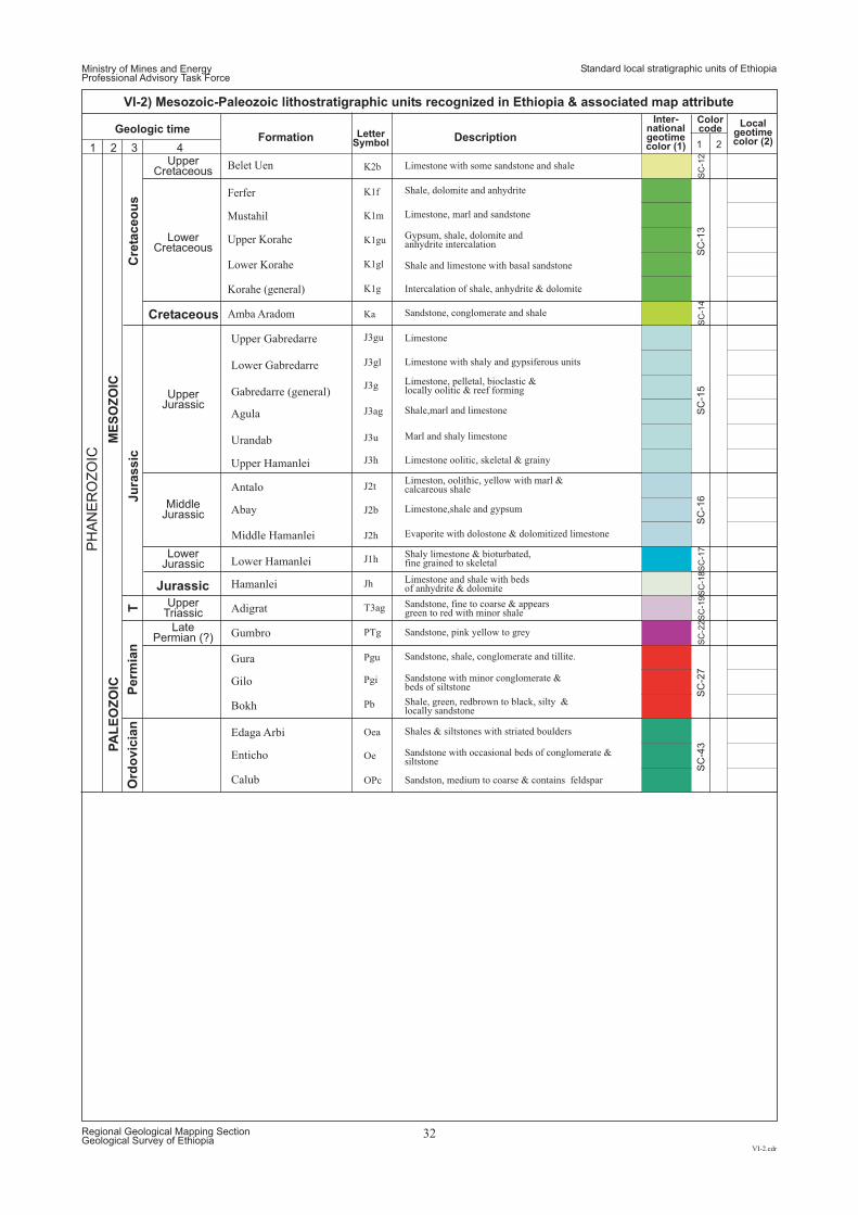
Ministry of Mines and EnergyProfessional Advisory Task Force
Standard local stratigraphic units of Ethiopia
VI-2.cdr
Regional Geological Mapping SectionGeological Survey of Ethiopia
32
VI-2) Mesozoic-Paleozoic lithostratigraphic units recognized in Ethiopia & associated map attribute
LetterSymbol
Formation Description
Inter-nationalgeotimecolor (1)
Localgeotimecolor (2)
Colorcode
1 2
Hamanlei
Upper Gabredarre
Lower Gabredarre
Gabredarre (general)
Agula
Urandab
Antalo
Abay
Upper Hamanlei
Middle Hamanlei
Lower Hamanlei
Adigrat
Gumbro
Enticho
Calub
Edaga Arbi
Gura
Gilo
Bokh
Amba Aradom
Belet Uen
Ferfer
Mustahil
Upper Korahe
Lower Korahe
Korahe (general)
Jh
J3gu
J3gl
J3g
J3ag
J3u
J2t
J2b
J3h
J2h
J1h
T3ag
PTg
Oea
Oe
OPc
Pgu
Pgi
Pb
Ka
K2b
K1f
K1m
K1gu
K1gl
K1g
Geologic time
1 2 3 4
SC
-12
SC
-13
SC
-14
SC
-15
SC
-16
SC
-17
SC
-18
SC
-19
SC
-22
SC
-27
SC
-43
Sandstone, conglomerate and shale
Limestone with some sandstone and shale
Sandstone, fine to coarse & appearsgreen to red with minor shale
Sandstone, pink yellow to grey
Sandstone, shale, conglomerate and tillite.
Sandstone with minor conglomerate &beds of siltstone
Shale, green, redbrown to black, silty &locally sandstone
Shales & siltstones with striated boulders
Sandstone with occasional beds of conglomerate &siltstone
Sandston, medium to coarse & contains feldspar
Limestone and shale with bedsof anhydrite & dolomite
Shaly limestone & bioturbated,fine grained to skeletal
Evaporite with dolostone & dolomitized limestone
Limestone oolitic, skeletal & grainy
Limestone,shale and gypsum
Shale,marl and limestone
Shale, dolomite and anhydrite
Limestone, marl and sandstone
Marl and shaly limestone
Limeston, oolithic, yellow with marl &calcareous shale
Limestone
Limestone, pelletal, bioclastic &locally oolitic & reef forming
Limestone with shaly and gypsiferous units
Intercalation of shale, anhydrite & dolomite
Gypsum, shale, dolomite andanhydrite intercalation
Shale and limestone with basal sandstoneCre
taceo
us
Ju
rassic
ME
SO
ZO
IC
PH
AN
ER
OZ
OIC
Ord
ovic
ian
Perm
ian
T
PA
LE
OZ
OIC
UpperCretaceous
LowerCretaceous
Cretaceous
UpperJurassic
MiddleJurassic
LowerJurassic
Jurassic
UpperTriassic
LatePermian (?)
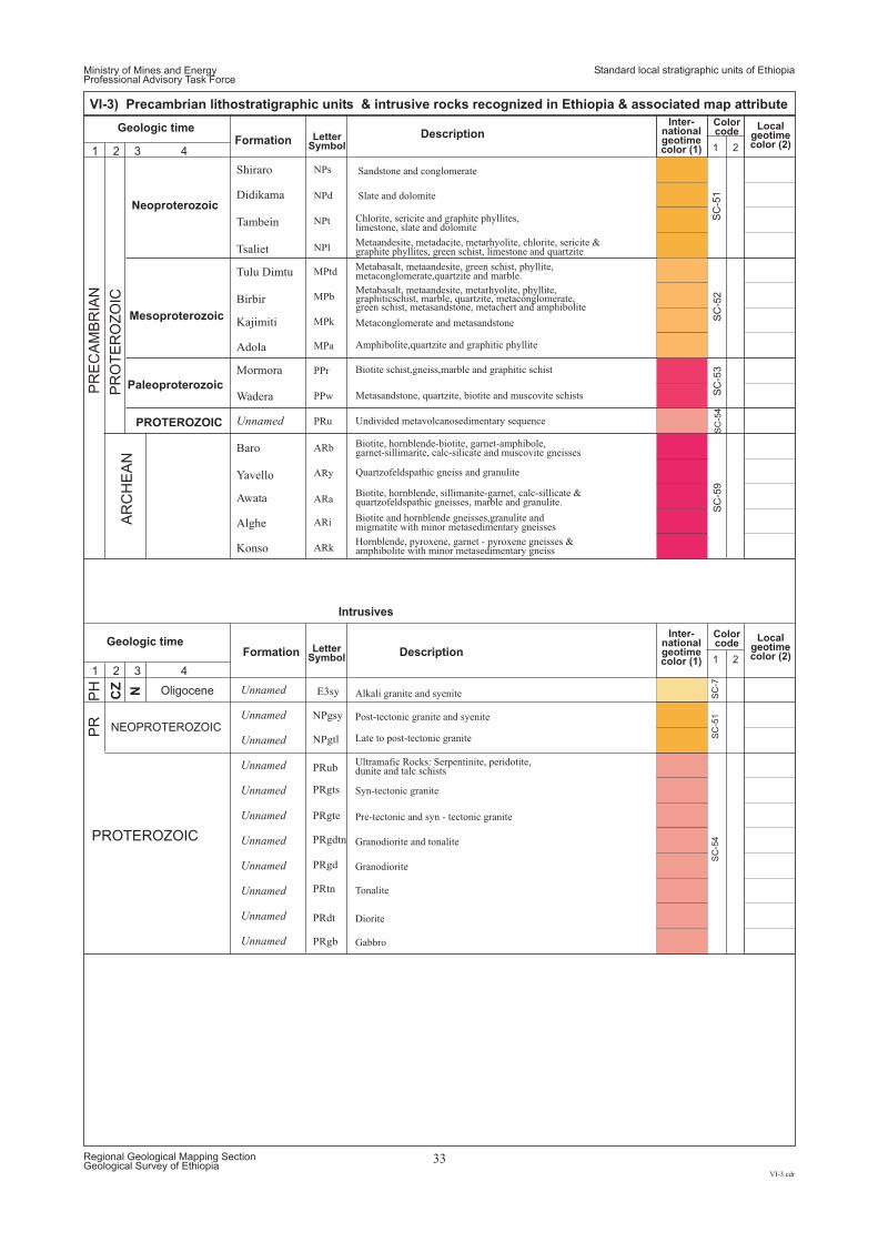
PR
EC
AM
BR
IAN
PH
PR
PR
OT
ER
OZ
OIC
PROTEROZOIC
Ministry of Mines and EnergyProfessional Advisory Task Force
Standard local stratigraphic units of Ethiopia
VI-3.cdr
Regional Geological Mapping SectionGeological Survey of Ethiopia
33
VI-3) Precambrian lithostratigraphic units & intrusive rocks recognized in Ethiopia & associated map attribute
LetterSymbol
FormationDescription
Description
Inter-nationalgeotimecolor (1)
Inter-nationalgeotimecolor (1)
Localgeotimecolor (2)
Localgeotimecolor (2)
Colorcode
Colorcode
1
1
2
2
Unnamed PRu
NPs
NPd
NPt
NPl
MPtd
MPb
MPk
MPa
PPr
PPw
ARb
ARy
ARa
ARi
ARk
Shiraro
Didikama
Tambein
Tsaliet
Tulu Dimtu
Birbir
Kajimiti
Adola
Mormora
Wadera
Baro
Yavello
Awata
Alghe
Konso
Geologic time
1 2 3 4
1 2 3 4
SC
-51
SC
-52
SC
-53
SC
-54
SC
-59
SC
-7S
C-5
1S
C-5
4
Undivided metavolcanosedimentary sequence
Sandstone and conglomerate
Slate and dolomite
Chlorite, sericite and graphite phyllites,limestone, slate and dolomite
Metaandesite, metadacite, metarhyolite, chlorite, sericite &graphite phyllites, green schist, limestone and quartzite
Metabasalt, metaandesite, green schist, phyllite,metaconglomerate,quartzite and marble.
Metabasalt, metaandesite, metarhyolite, phyllite,
schist, metasandstone, metachert and amphibolitegraphiticschist, marble, quartzite, metaconglomerate,green
Metaconglomerate and metasandstone
Amphibolite,quartzite and graphitic phyllite
Biotite schist,gneiss,marble and graphitic schist
Metasandstone, quartzite, biotite and muscovite schists
Biotite, hornblende-biotite, garnet-amphibole,garnet-sillimarite, calc-silicate and muscovite gneisses
Quartzofeldspathic gneiss and granulite
Biotite, hornblende, sillimanite-garnet, calc-sillicate &quartzofeldspathic gneisses, marble and granulite.
Biotite and hornblende gneisses,granulite andmigmatite with minor metasedimentary gneisses
Hornblende, pyroxene, garnet - pyroxene gneisses &hibolite with minor metasedimentary gneiss
Alkali granite and syenite
Post-tectonic granite and syenite
Late to post-tectonic granite
Ultramafic Rocks: Serpentinite, peridotite,dunite and talc schists
Syn-tectonic granite
Pre-tectonic and syn - tectonic granite
Granodiorite and tonalite
Granodiorite
Tonalite
Diorite
Gabbro
Neoproterozoic
Mesoproterozoic
Paleoproterozoic
PROTEROZOIC
AR
CH
EA
N
E3sy
NPgsy
NPgtl
PRub
PRgts
PRgte
PRgd
PRgdtn
PRtn
PRdt
PRgb
LetterSymbol
Formation
Intrusives
Geologic time
Unnamed
Unnamed
Unnamed
Unnamed
Unnamed
Unnamed
Unnamed
Unnamed
Unnamed
Unnamed
Unnamed
NCZ
NEOPROTEROZOIC
Oligocene
Ministry of Mines and EnergyProfessional Advisory Task Force
Standard colors for regional geologic maps
VII.cdr
Regional Geological Mapping SectionGeological Survey of Ethiopia
34
COLOR SCHEME FOR VARIOUS TYPES OF LITHOLOGIC MAP UNITS
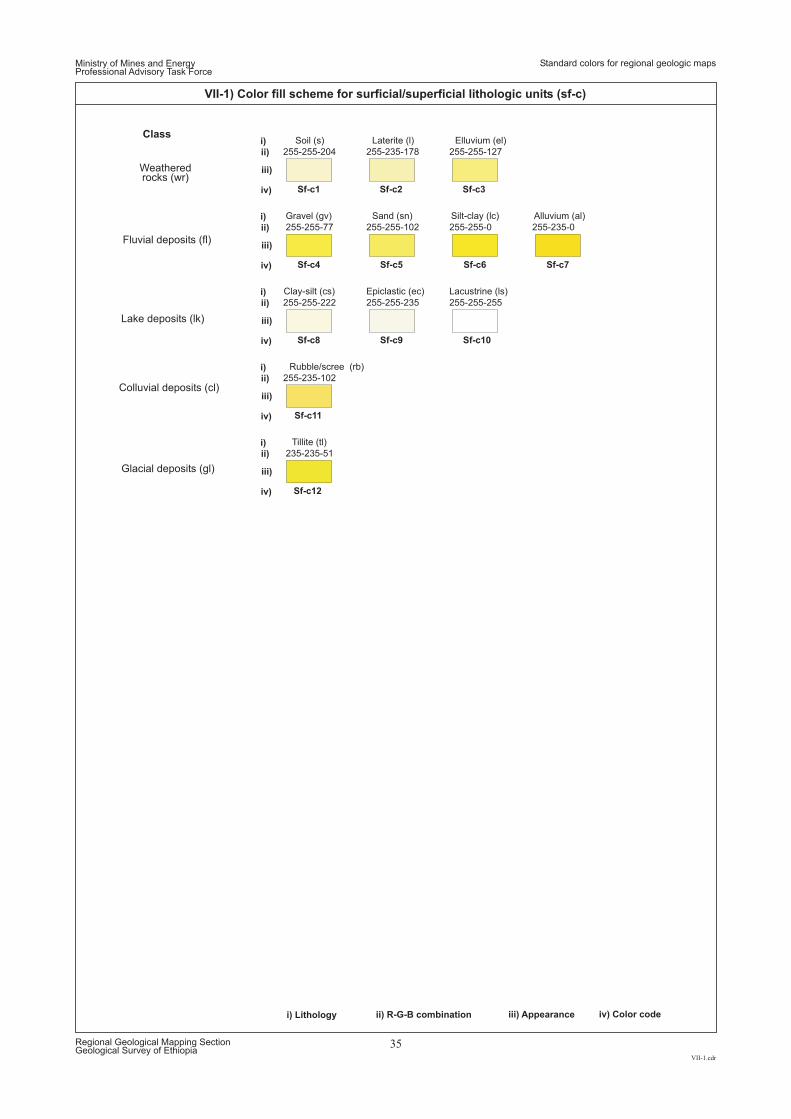
ii) R-G-B combinationi) Lithology iii) Appearance iv) Color code
i)
i)
i)
i)
i)
ii)
ii)
ii)
ii)
ii)
iii)
iii)
iii)
iii)
iii)
iv)
iv)
iv)
iv)
iv)
Sf-c1
Sf-c4
Sf-c8
Sf-c11
Sf-c12
Sf-c2 Sf-c3
Sf-c5
Sf-c9 Sf-c10
Sf-c6 Sf-c7
255-235-178 255-255-127
255-255-102
255-255-235 255-255-255
255-255-0 255-235-0
255-255-204
255-255-77
255-255-222
255-235-102
235-235-51
Laterite (l) Elluvium (el)
Sand (sn)
Epiclastic (ec) Lacustrine (ls)
Silt-clay (lc) Alluvium (al)
Soil (s)
Gravel (gv)
Clay-silt (cs)
Rubble/scree (rb)
Tillite (tl)
Ministry of Mines and EnergyProfessional Advisory Task Force
VII-1.cdr
Regional Geological Mapping SectionGeological Survey of Ethiopia
35
VII-1) Color fill scheme for surficial/superficial lithologic units (sf-c)
Standard colors for regional geologic maps
Class
Fluvial deposits (fl)
Lake deposits (lk)
Colluvial deposits (cl)
Weatheredrocks (wr)
Glacial deposits (gl)
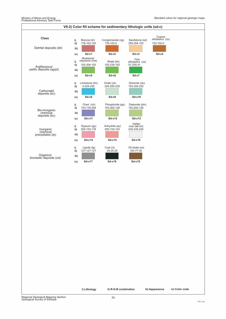
ii) R-G-B combinationi) Lithology iii) Appearance iv) Color code
i)
i)
i)
i)
i)
i)
ii)
ii)
ii)
ii)
ii)
ii)
iii)
iii)
iii)
iii)
iii)
iii)
iv)
iv)
iv)
iv)
iv)
iv)
Sd-c1
Sd-c5
Sd-c8
Sd-c14
Sd-c17 Sd-c18 Sd-c19
Sd-c2
Sd-c6
Sd-c9
Sd-c15 Sd-c16
Sd-c3 Sd-c4
Sd-c7
Sd-c10
Sd-c12 Sd-c13Sd-c11
178-102-0
102-235-102
204-255-235
255-153-153 235-235-235
255-204-153 153-102-0
51-255-51
153-255-235
153-202-128 153-202-128153-135-204
178-102-102
102-204-102
0-204-255
255-153-178
127-127-127 25-25-25 102-77-35
Conglomerate (cg)
Shale (sh)
Chalk (ck)
Anhydrite (ay)Halite/
rock salt (hl)
Sandstone (sd)
Coarsesiliclastics (cs)
Finesiliclastics (cs)
Dolomite (do)
Phosphorite (pp) Diatomite (dm)Chert (ch)
Breccia (br)
Mudstone/claystone (md)
Limestone (lm)
Gypsum (gy)
Lignite (lg) Coal (cl) Oil shale (os)
Ministry of Mines and EnergyProfessional Advisory Task Force
VII-2.cdr
Regional Geological Mapping SectionGeological Survey of Ethiopia
36
VII-2) Color fill scheme for sedimentary lithologic units (sd-c)
Standard colors for regional geologic maps
Class
Argillaceous/pelitic deposits (ag/pl)
Carbonateldeposits (bc)
Bio-Inorganicchemical
deposits (bc)
Inorganicchemical
precipitates (Ip)
Detrital deposits (dd)
Organics/bioclastic deposits (od)
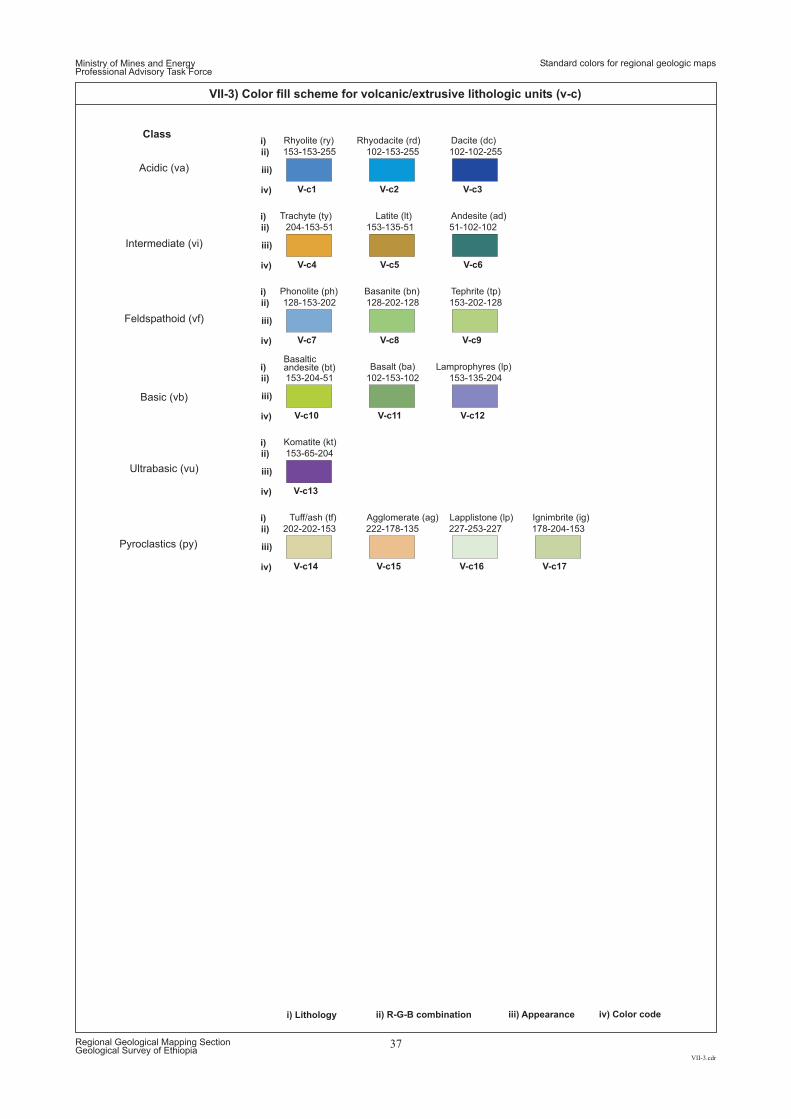
ii) R-G-B combinationi) Lithology iii) Appearance iv) Color code
i)
i)
i)
i)
i)
i)
ii)
ii)
ii)
ii)
ii)
ii)
iii)
iii)
iii)
iii)
iii)
iii)
iv)
iv)
iv)
iv)
iv)
iv)
Pyroclastics (py)
V-c14 V-c15 V-c16 V-c17
202-202-153 222-178-135 227-253-227 178-204-153
Tuff/ash (tf) Agglomerate (ag) Lapplistone (lp) Ignimbrite (ig)
V-c1
V-c4
V-c7
V-c10
V-c13
V-c2
V-c5
V-c8
V-c11
V-c3
V-c6
V-c9
V-c12
102-153-255
153-135-51
128-202-128
102-153-102
102-102-255
51-102-102
153-202-128
153-135-204
153-153-255
204-153-51
128-153-202
153-204-51
153-65-204
Rhyodacite (rd)
Latite (lt)
Basanite (bn)
Basalt (ba)
Dacite (dc)
Andesite (ad)
Tephrite (tp)
Lamprophyres (lp)
Rhyolite (ry)
Trachyte (ty)
Phonolite (ph)
Basalticandesite (bt)
Komatite (kt)
Ministry of Mines and EnergyProfessional Advisory Task Force
VII-3.cdr
Regional Geological Mapping SectionGeological Survey of Ethiopia
37
VII-3) Color fill scheme for volcanic/extrusive lithologic units (v-c)
Standard colors for regional geologic maps
Class
Intermediate (vi)
Feldspathoid (vf)
Basic (vb)
Acidic (va)
Ultrabasic (vu)
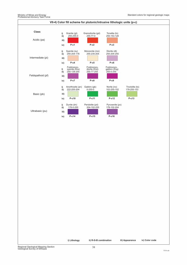
ii) R-G-B combinationi) Lithology iii) Appearance iv) Color code
i)
i)
i)
i)
i)
ii)
ii)
ii)
ii)
ii)
iii)
iii)
iii)
iii)
iii)
iv)
iv)
iv)
iv)
iv)
P-c1
P-c4
P-c7
P-c10
P-c14
P-c2
P-c5
P-c8
P-c11
P-c15
P-c3
P-c6
P-c9
P-c12
P-c16
P-c13
255-77-0
255-235-204
255-77-255
0-255-0
204-102-255
255-153-128
255-204-255
255-0-255
102-255-102
178-102-204
178-255-153
255-255-0
255-204-178
255-128-255
222-255-204
178-0-255
Granodiorite (gd)
Monzonite (mz)
Foidmonzo-diorite (fmd)
Gabbro (gb)
Peridotite (pd)
Tonalite (tn)
Diorite (dt)
Foidmonzo-gabbro (fmg)
Norite (no)
Pyroxenite (px)
Troctolite (to)
Granite (gt)
Syenite (sy)
Foidmonzo-syenite (fms)
Anorthosite (an)
Dunite (dn)
Ministry of Mines and EnergyProfessional Advisory Task Force
VII-4.cdr
Regional Geological Mapping SectionGeological Survey of Ethiopia
38
VII-4) Color fill scheme for plutonic/intrusive lithologic units (p-c)
Standard colors for regional geologic maps
Class
Intermediate (pi)
Feldspathoid (pf)
Basic (pb)
Acidic (pa)
Ultrabasic (pu)
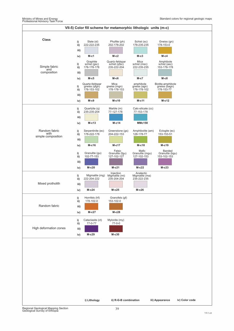
M-c29 M-c30
77-0-77 77-0-0
Cataclasite (ct) Mylonite (my)
High deformation zones
M-c27 M-c28
153-102-0178-102-0
Granofels (gf)Hornfels (hf)
Random fabric
M-c1
M-c5
M-c9
MMc158
M-c19
M-c20 M-c21 M-c22 M-c23
M-c24 M-c25 M-c26
M-c2
M-c6
M-c10
M-c3
M-c7
M-c11
M-c4
M-c8
M-c12
M-c16 M-c17 M-c18
M-c13 M-c14
202-178-202
235-222-204
178-178-153
178-235-235
222-235-235
178-178-102
178-153-0
153-178-178
178-153-77
178-222-178 204-222-153 128-178-77
235-235-204 77-127-178
222-222-235
178-178-178
178-153-102
77-153-178
153-153-51
102-77-153 127-102-127 127-102-153 153-102-153
222-204-222 235-204-204 235-222-235
Phyllite (ph) Schist (sc) Gneiss (gn)
Serpentinite (ec) Greenstone (gs) Amphibolite (am)
Quartzite (q) Marble (m)
Slate (sl)
Graphiteschist (gsc)
Micagneiss (mgn)
Quartz-feldsparschist (qfsc)
Quartz-feldspargneiss (qfgn)
Micaschist (msc)
amphibolegneiss (agn)
Amphiboleschist (asc)
Biotite-amphibolegneiss (bagn)
Calc-silicate (cc)
Eclogite (ec)
Granulite (gu)Felsic
Granulite (fgu)Mafic
Granulite (mgu)Banded
Granulite (bgu)
Migmatite (mg)Injection
Migmatite (mi)Anatectic
Migmatite (ma)
Class
Simple fabricand
composition
Random fabricwith
simple composition
Mixed protholith
Ministry of Mines and EnergyProfessional Advisory Task Force
VII-5.cdr
Regional Geological Mapping SectionGeological Survey of Ethiopia
39
VII-5) Color fill scheme for metamorphic lithologic units (m-c)
Standard colors for regional geologic maps
ii) R-G-B combinationi) Lithology iii) Appearance iv) Color code
i)
i)
i)
i)
i)
i)
i)
i)
i)
ii)
ii)
ii)
ii)
ii)
ii)
ii)
ii)
ii)
iii)
iii)
iii)
iii)
iii)
iii)
iii)
iii)
iii)
iv)
iv)
iv)
iv)
iv)
iv)
iv)
iv)
iv)
Ministry of Mines and EnergyProfessional Advisory Task Force
Standard patterns for lithologic logs/profiles
VIII.cdr
Regional Geological Mapping SectionGeological Survey of Ethiopia
40
PATTERN/SYMBOL FOR VARIOUS TYPES OF LITHOLOGIC SECTIONS/LOGS
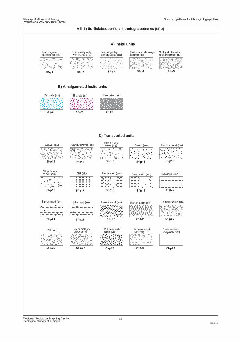
Sf-p5Sf-p4Sf-p1 Sf-p2 Sf-p3
Sf-p8Sf-p7Sf-p6
Sf-p13Sf-p12 Sf-p14 Sf-p15Sf-p11
Sf-p18Sf-p17 Sf-p19 Sf-p20Sf-p16
Sf-p25Sf-p22 Sf-p23 Sf-p24Sf-p21
Sf-p28Sf-p27 Sf-p29Sf-p26 Sf-p27
A) Insitu units
B) Amalgameted Insitu units
C) Transported units
Ferricrite (ec)
Silty-clayeygravel (cg)
Pebbly silt (psl)
Rubble/scree (rb)
Silicrete (sl)
Sandy gravel (sg)
Silt (slt)
Sitly mud (sm)
Calcrete (cs)
Gravel (gv)
Silty-clayeysand (scs)
Sandy mud (sm)
Till (sm) Volcaniclasticbreccia (vb)
Volcaniclasticsand (vs)
Volcaniclasticsilt (vsl)
Volcaniclasticclay/ash (vsl)
Sand (sn)
Sandy silt (ssl)
Pebbly sand (ps)
Clay/mud (md)
Eolian sand (es) Beach sand (bs)
Soil, organicdominated (os)
Soil, sandy-siltywith humus (ss)
Soil, silty-claylow organics (cs)
Soil, concretionary-laterite (ls)
Soil, caliche withrock fragment (rs)
Ministry of Mines and EnergyProfessional Advisory Task Force
VIII-1.cdr
Regional Geological Mapping SectionGeological Survey of Ethiopia
41
VIII-1) Surficial/superficial lithologic patterns (sf-p)
Standard patterns for lithologic logs/profiles
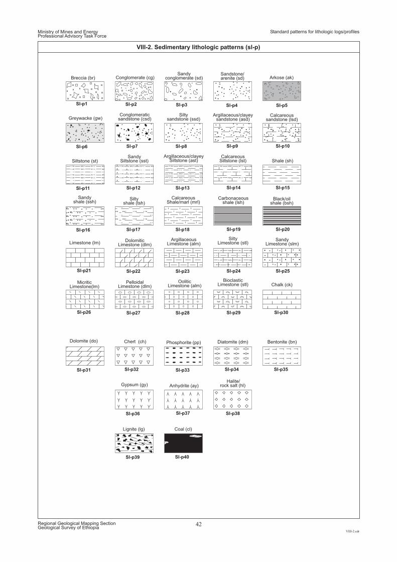
Sl-p1 Sl-p2 Sl-p3 Sl-p4 Sl-p5
Sl-p6 Sl-p7 Sl-p8 Sl-p9 Sl-p10
Sl-p11 Sl-p12 Sl-p13 Sl-p14 Sl-p15
Sl-p16 Sl-p17 Sl-p18 Sl-p19 Sl-p20
Sl-p21 Sl-p22 Sl-p23 Sl-p24 Sl-p25
Sl-p26 Sl-p27 Sl-p30Sl-p28 Sl-p29
Sl-p31 Sl-p33 Sl-p34 Sl-p35Sl-p32
Sl-p36 Sl-p37 Sl-p38
Sl-p39 Sl-p40
Conglomerate (cg)
Shale (sh)
Chalk (ck)
Anhydrite (ay)Halite/
rock salt (hl)
Sandstone/arenite (sd)
Sandyconglomerate (sd) Arkose (ak)
Greywacke (gw)
Dolomite (do) Phosphorite (pp) Diatomite (dm) Bentonite (bn)Chert (ch)
Breccia (br)
Argillaceous/clayeysandstone (asd)
Calcareoussandstone (lsd)
Black/oilshale (bsh)
Siltysandstone (ssd)
Conglomeraticsandstone (csd)
Siltstone (st)
Siltyshale (tsh)
DolomiticLimestone (dlm)
PelloidalLimestone (dlm)
SandySiltstone (sst)
Sandyshale (ssh)
Argillaceous/clayeySiltstone (ast)
CalcareousShale/marl (mrl)
ArgillaceousLimestone (alm)
OoliticLimestone (alm)
CalcareousSiltstone (lst)
Carbonaceousshale (lsh)
Limestone (lm)
MicriticLimestone(lm)
SandyLimestone (slm)
SiltyLimestone (stl)
BioclasticLimestone (stl)
Gypsum (gy)
Lignite (lg) Coal (cl)
Ministry of Mines and EnergyProfessional Advisory Task Force
VIII-2.cdr
Regional Geological Mapping SectionGeological Survey of Ethiopia
42
VIII-2. Sedimentary lithologic patterns (sl-p)
Standard patterns for lithologic logs/profiles
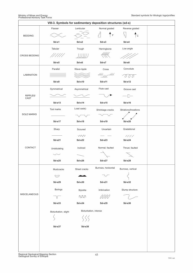
Sd-s1
Sd-s5
Sd-s9
Sd-s13
Sd-s17
Sd-s21
Sd-s25
Sd-s29
Sd-s33
Sd-s37
Sd-s2
Sd-s6
Sd-s10
Sd-s14
Sd-s18
Sd-s22
Sd-s26
Sd-s30
Sd-s34
Sd-s38
Sd-s3
Sd-s7
Sd-s11
Sd-s15
Sd-s19
Sd-s23
Sd-s27
Sd-s31
Sd-s35
Sd-s4
Sd-s8
Sd-s12
Sd-s16
Sd-s20
Sd-s24
Sd-s28
Sd-s32
Sd-s36
Flasser
Convolute
Lenticular Normal graded Reverse graded
BEDDING
CROSS BEDDING
LAMINATION
RIPPLES/CAST
SOLE MARKS
Tabular Trough Herringbone Low angle
Parallel Wave-ripple Cross
Symmetrical Asymmetrical Flute cast Groove cast
Tool marks Load casts)Shrinkage cracks
Sharp Scoured Uncertain Gradational
Unddulating Normal, faulted Thrust, faultedInclinedCONTACT
MISCELANEOUS
Imbrication Slump structure
Bioturbation, slight Bioturbation, intense
Stylolite
Mudcracks
Borings
Sheet cracks Burrows, verticalBurrows, horizontal
Striations/lineations
CF
Ministry of Mines and EnergyProfessional Advisory Task Force
VIII-3.cdr
Regional Geological Mapping SectionGeological Survey of Ethiopia
43
VIII-3. Symbols for sedimentary deposition structures (sd-s)
Standard symbols for lithologic logs/profiles
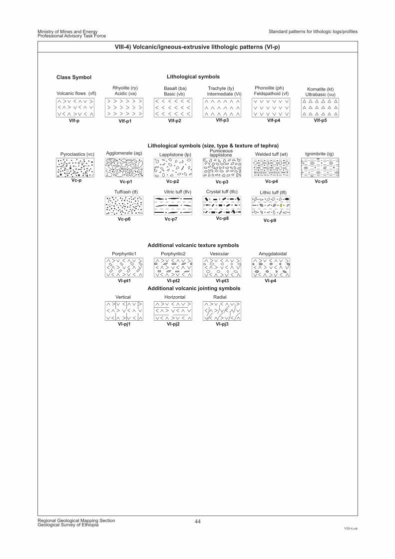
Vl-pj1 Vl-pj2 Vl-pj3
Vl-pt1 Vl-pt2 Vl-pt3 Vl-p4
Vc-p6 Vc-p7 Vc-p8 Vc-p9
Vc-p1 Vc-p2 Vc-p4 Vc-p5Vc-p3Vc-p
Vlf-p1 Vlf-p5Vlf-p2 Vlf-p3 Vlf-p4Vlf-p
Tuff/ash (tf) Vitric tuff (tfv)
Agglomerate (ag)
Crystal tuff (tfc)
Lapplistone (lp)
Lithic tuff (tfl)
Welded tuff (wt) Ignimbrite (ig)PumiceouslapplistonePyroclastics (vc)
Basic (vb) Intermediate (Vi) Feldspathoid (vf)Acidic (va)Basalt (ba) Trachyte (ty) Phonolite (ph)
Volcanic flows (vfl)
Porphyritic1 Porphyritic2 Vesicular Amygdaloidal
Vertical Horizontal Radial
Rhyolite (ry) Komatite (kt)
Lithological symbols
Lithological symbols (size, type & texture of tephra)
Additional volcanic texture symbols
Additional volcanic jointing symbols
Class Symbol
Ultrabasic (vu)
Ministry of Mines and EnergyProfessional Advisory Task Force
VIII-4.cdr
Regional Geological Mapping SectionGeological Survey of Ethiopia
44
VIII-4) Volcanic/igneous-extrusive lithologic patterns (Vl-p)
Standard patterns for lithologic logs/profiles
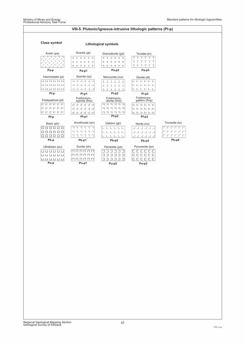
Pa-p1 Pa-p2 Pa-p3Pa-p
Pi-p1 Pi-p2 Pi-p3Pi-p
Pf-p1 Pf-p2 Pf-p3Pf-p
Pb-p1 Pb-p2 Pb-p3 Pb-p4Pb-p
Pu-p1 Pu-p2 Pu-p3Pu-p
Granodiorite (gd)
Monzonite (mz)
Foidmonzo-diorite (fmd)
Gabbro (gb)
Peridotite (pd)
Tonalite (tn)Acidic (pa)
Diorite (dt)Intermediate (pi)
Foidmonzo-gabbro (fmg)Feldspathoid (pf)
Norite (no)
Pyroxenite (px)Ultrabasic (pu)
Troctolite (to)Basic (pb)
Granite (gt)
Syenite (sy)
Foidmonzo-syenite (fms)
Anorthosite (an)
Dunite (dn)
Class symbol Lithological symbols
Ministry of Mines and EnergyProfessional Advisory Task Force
VIII-5.cdr
Regional Geological Mapping SectionGeological Survey of Ethiopia
45
VIII-5. Plutonic/igneous-intrusive lithologic patterns (Pl-p)
Standard patterns for lithologic logs/profiles
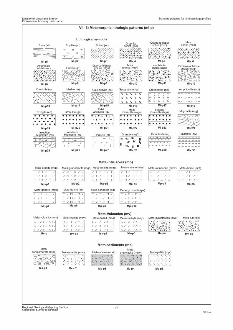
Mv-p5Mv-p4
Meta-tuff (mtf)Meta-pyroclastics (mvc)
Mp-p1
Ml-p1
Ml-p7
Ml-p13
Ml-p19
Ml-p25
Mv-p1
Mp-p4
Ml-p4
Ml-p10
Ml-p16
Ml-p22
Ml-p28
Mp-p8
Mp-p2
Ml-p2
Ml-p8
Ml-p14
Ml-p20
Ml-p26
Mv-p2
Mp-p5
Ml-p5
Ml-p11
Ml-p17
Ml-p23
Ml-p29
Mp-p7 Mp-p9
Mp-p3
Ml-p3
Ml-p9
Ml-p15
Ml-p21
Ml-p27
Mv-p3Mv-p
Mp-p6
Ml-p6
Ml-p12
Ml-p18
Ml-p24
Ml-p30
Mp-p10
Meta-granodiorite (mgd)
Meta-basalt (mba)
Meta-monzonite (mmz)
Meta-gabbro (mgb) Meta-peridotite (pd)
Meta-tonalite (mtn)
Meta-trachyte (mty)Meta-volcanics (mv)
Meta-diorite (mdt)
Meta-pyroxenite (px)
Meta-granite (mgt)
Meta-rhyolite (mry)
Meta-syenite (msy)
Meta-dunite (dn)
Meta-intrusives (mp)
Meta-Volcanics (mv)
Meta-sediments (ms)
Ms-p1 Ms-p2 Ms-p3 Ms-p4 Ms-p5
Meta-conglomerate (mcg) Meta-arenite (mar) Meta-arkose (mak)
Meta-greywacke (mgw) Meta-pellite (mpl)
Cataclasite (ct) Mylonite (my)Granofels (gf)Hornfels (hf)
Phyllite (ph) Schist (sc)
Gneiss (gn)
Serpentinite (ec) Greenstone (gs) Amphibolite (am)Quartzite (q) Marble (m)
Slate (sl)Graphite
schist (gsc)
Micagneiss (mgn)
Quartz-feldsparschist (qfsc)
Quartz-feldspargneiss (qfgn)
Micaschist (msc)
amphibolegneiss (agn)
Amphiboleschist (asc)
Biotite-amphibolegneiss (bagn)
Calc-silicate (cc)
Eclogite (ec) Granulite (gu)Felsic
Granulite (fgu)Mafic
Granulite (mgu)Banded
Granulite (bgu) Migmatite (mg)
InjectionMigmatite (mi)
AnatecticMigmatite (ma)
Lithological symbols
Ministry of Mines and EnergyProfessional Advisory Task Force
VIII-6.cdr
Regional Geological Mapping SectionGeological Survey of Ethiopia
46
VIII-6) Metamorphic lithologic patterns (ml-p)
Standard patterns for lithologic logs/profiles
Ministry of Mines and EnergyProfessional Advisory Task Force
Standard symbols for basemap elements
IX.cdr
Regional Geological Mapping SectionGeological Survey of Ethiopia
47
COMPONENTS AND SYMBOL ATTRIBUTE FOR BASE-MAP FEATURES
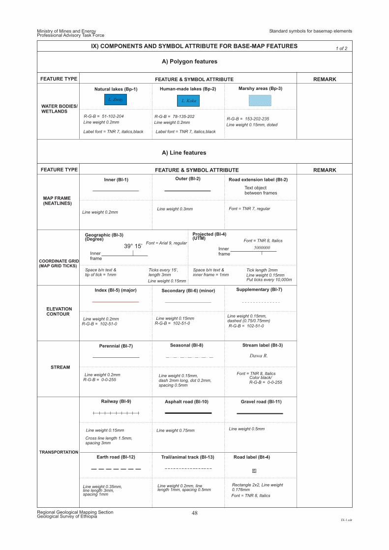
FEATURE TYPE
FEATURE TYPE
REMARK
REMARK
FEATURE & SYMBOL ATTRIBUTE
FEATURE & SYMBOL ATTRIBUTE
Text objectbetween frames
Innerframe
Innerframe
39° 15’ 5000000
Natural lakes (Bp-1)
Inner (Bl-1)
Index ( (major)Bl-5)
Perennial (Bl-7)
Railway (Bl-9) Asphalt road (Bl-10)
Earth road (Bl-12)
Gravel road (Bl-11)
Trail/animal track (Bl-13) Road label (Bt-4)
Seasonal (Bl-8) Stream label (Bt-3)
Secondary ( (minor)Bl-6) Supplementary (Bl-7)
Geographic (Bl-3)(Degree)
Projected (Bl-4)(UTM)
Human-made lakes (Bp-2)
Outer (Bl-2)
Marshy areas (Bp-3)
Road extension label (Bt-2)
WATER BODIES/WETLANDS
MAP FRAME(NEATLINES)
COORDINATE GRID(MAP GRID TICKS)
ELEVATIONCONTOUR
STREAM
TRANSPORTATION
A) Polygon features
A) Line features
R-G-B = 102-51-0
R-G-B = 0-0-255Color black/R-G-B = 0-0-255
R-G-B = 102-51-0R-G-B = 102-51-0
Line weight 0.2mm
Label font = TNR 7, italics,black Label font = TNR 7, italics,black
Line weight 0.2mm
Line weight 0.2mm
Line weight 0.2mm
Line weight 0.35mm,line length 3mm,spacing 1mm
Line weight 0.2mm, linelength 1mm, spacing 0.5mm
Line weight 0.15mm,dash 2mm long, dot 0.2mm,spacing 0.5mm
Line weight 0.15mmLine weight 0.15mm,dashed (0.75/0.75mm)
Space b/n text &tip of tick = 1mm
Space b/n text &inner frame = 1mm
Put ticks every 10,000m
Ticks every 15’,length 3mm
Tick length 2mm
Line weight 0.15mm
Line weight 0.15mm
Line weight 0.3mm
Line weight 0.2mmLine weight 0.15mm, doted
Font = TNR 7, regular
R-G-B = 51-102-204
Cross line length 1.5mm,spacing 3mm
R-G-B = 78-135-202R-G-B = 153-202-235
Line weight 0.15mm
Rectangle 2x2, Line weight0.176mm
6
Line weight 0.75mm Line weight 0.5mm
Font = Arial 9, regularFont = TNR 8, Italics
Font = TNR 8, Italics
Font = TNR 8, Italics
L. KokaL. Zway
Ministry of Mines and EnergyProfessional Advisory Task Force
Standard symbols for basemap elements
IX-1.cdr
Regional Geological Mapping SectionGeological Survey of Ethiopia
48
IX) COMPONENTS AND SYMBOL ATTRIBUTE FOR BASE-MAP FEATURES
Dawa R.
1 of 2
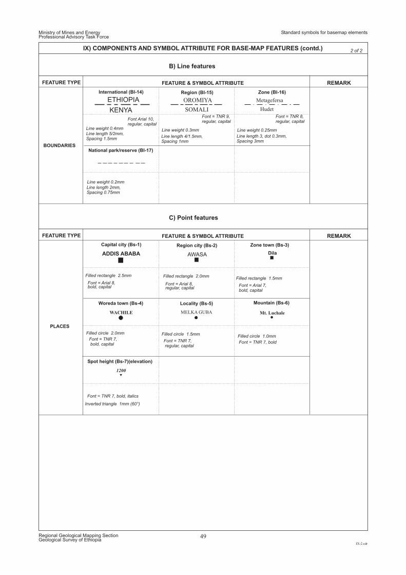
Ministry of Mines and EnergyProfessional Advisory Task Force
Standard symbols for basemap elements
IX-2.cdr
Regional Geological Mapping SectionGeological Survey of Ethiopia
49
IX) COMPONENTS AND SYMBOL ATTRIBUTE FOR BASE-MAP FEATURES (contd.)
B) Line features
2 of 2
C) Point features
FEATURE TYPE
FEATURE TYPE
REMARK
REMARK
FEATURE & SYMBOL ATTRIBUTE
FEATURE & SYMBOL ATTRIBUTE
International (Bl-14)
National park/reserve (Bl-17)
Capital city (Bs-1)
Woreda town (Bs-4)
Spot height (Bs-7)(elevation)
Region city (Bs-2)
Locality (Bs-5)
Zone town (Bs-3)
Mountain (Bs-6)
Region (Bl-15) Zone (Bl-16)
BOUNDARIES
PLACES
1200
ADDIS ABABA AWASA Dila
WACHILE MELKA GUBA Mt. Luchale
ETHIOPIA OROMIYA Metagefersa
KENYA SOMALI Hudet
Line length 2mm,Spacing 0.75mm
Line weight 0.4mm
Line weight 0.2mm
Filled rectangle 2.5mm
Filled circle 2.0mm
Inverted triangle 1mm (60°)
Filled rectangle 2.0mmFilled rectangle 1.5mm
Filled circle 1.0mm
Line weight 0.3mm
Font Arial 10,regular, capital
Font = TNR 9,regular, capital
Font = TNR 8,regular, capital
Line weight 0.25mm
Font = Arial 8,bold, capital
Font = TNR 7,bold, capital
Font = TNR 7, bold, italics
Font = Arial 8,regular, capital
Font = TNR 7,regular, capital
Font = Arial 7,bold, capital
Font = TNR 7, bold
Line length 5/2mm,Spacing 1.5mm
Line length 4/1.5mm,Spacing 1mm
Line length 3, dot 0.3mm,Spacing 3mm
Filled circle 1.5mm
Ministry of Mines and EnergyProfessional Advisory Task Force
Standard symbols for geologic features
X.cdr
Regional Geological Mapping SectionGeological Survey of Ethiopia
50
COMPONENTS AND SYMBOL ATTRIBUTE FOR GEOLOGIC MAP FEATURES
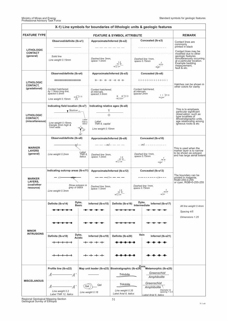
3
3
3
3.5
1
21.5 1.5
2
30°
1.5
1
1
1.5
1.5
1.5
0.5
1
1
1
Y
O
Label
TNR 8,italics
Greenschist
Trilobite
Trilobite
Greenschist
Amphibolite
AmphiboliteDiameter &spacing = 0.5
Label Arial 8, italics
Line weight 0.35Line weight 0.2 Line weight 0.18Label Arial 8, italicsLabel TNR 12, Italics
A
A
A’
A’ Qal Qel
Definite (lb-s14)
Definite (lb-s18)
Profile line (lb-s22)
Dyke,Basic
Dyke,Acidic
Dyke,Intermediate
Vein
Zone
Inferred )(lb-s15
Inferred )(lb-s19
Map unit leader (lb-s23)
Definite (lb-s16)
Definite (lb-s20)
Biostratigraphic (lb-s24)
Inferred (lb-s17)
Inferred (lb-s21)
Metamorphic (lb-s25)
FEATURE TYPE REMARKFEATURE & SYMBOL ATTRIBUTE
Indicating outcrop areas (lb-s11)
Observed/definite (lb-s8)
Indicating field location (lb-s7) Indicating relative ages (lb-s8)
Observed/definite (lb-s4)
Approximate/Inferred (lb-s12)
Approximate/Inferred (lb-s9)
Approximate/Inferred (lb-s5)
Concealed (lb-s13)
Concealed (lb-s10)
Concealed (lb-s6)
LITHOLOGICCONTACT(general)
MARKERLAYERS(general)
MARKERLAYERS,(coal/otherresource)
MINORINTRUSIONS
MISCELANOUS
LITHOLOGICCONTACT,(gradational)
LITHOLOGICCONTACT,(miscellaneous)
Observed/definite (lb-s1) Approximate/Inferred (lb-s2) Concealed (lb-s3)
LabelTNR 8,italics
Station
ml ml ml
cs cs cs
Show polygon ingrey or black
LabelTNR 8, capital
Contact h ,at intervals,spaced 3.5mm
atchered
Line weight 0.15mm
Line weight 0.15mm
Line weight 0.2mm
Line weight 0.15mm,triangle 2mm high &1mm wide
Line weight 0.15mm
Line weight 0.3mm
All line weight 0.4mm
Spacing 4/5
Dimensions 1.25
Contact h ,by 1.5mm long line,spaced 0.5mm
atchered Contact h ,at intervals,spaced 2mm
atchered
Dashed line 3mm,space 1.0mm
Solid line
Dashed line 3mm,space 1.0mm
Dashed line 3mm,space 1.0mm
Dashed line 1mm,space 0.75mm
Dashed line 1mm,space 0.75mm
Dashed line 1mm,space 0.75mm
This is to emphasisparticular significantobservation, such astype localities oflithostratigraphic units,age relationship amongigneous rocks & etc
Contact lines arecommonlyprinted in black
Contact lines may bemodified due to othergeologic featuressimultaneously occurringat a particular location.Example beddingmeasurement,fault & etc.
Hatches can be shown inother colors for clarity
This is used when themarker layer is to narrowto be shown as polygonand has large aerial extent
The boundary can beprinted in magenta,RGB=255-0-255or cyan, RGB=0-255-255
Ministry of Mines and EnergyProfessional Advisory Task Force
Standard symbols for geologic features
X-1.cdr
Regional Geological Mapping SectionGeological Survey of Ethiopia
51
X-1) Line symbols for boundaries of lithologic units & geologic features
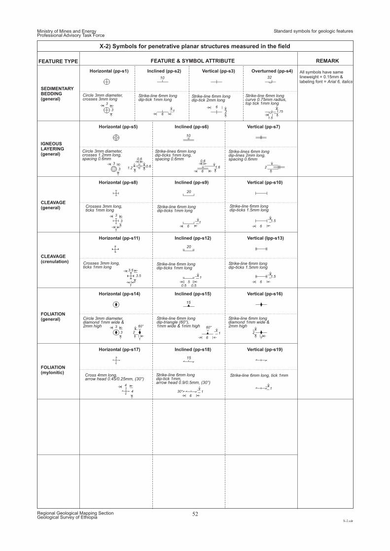
3
3
3
3
4
2
3.5
1.2
0.6
1
1
1
0.6
6
6
5
6
6
0.50.5
6
6
0.6 1.6
1
1
1
11
2
1
1.5
1.5
2
1 2 1.75
3
3
3
3
4
3.5
6
6
1.5
60° 60°
30°
20
20
10
10
32
15
15
Horizontal (pp-s1)
Horizontal (pp-s5)
Horizontal (pp-s8)
Horizontal (pp-s11)
Horizontal (pp-s14)
Horizontal (pp-s17)
Inclined (pp-s2)
Inclined (pp-s6)
Inclined (pp-s9)
Inclined (pp-s12)
Inclined (pp-s15)
Inclined (pp-s18)
Vertical (pp-s3)
Vertical (pp-s7)
Vertical (pp-s10)
Vertical (Ipp-s13)
Vertical (pp-s16)
Vertical (pp-s19)
Overturned (pp-s4)
FEATURE TYPE REMARKFEATURE & SYMBOL ATTRIBUTE
SEDIMENTARYBEDDING(general)
All symbols have samelineweight = 0.15mm &labeling font = Arial 6, italics
IGNEOUSLAYERING(general)
CLEAVAGE(general)
CLEAVAGE(crenulation)
FOLIATION(mylonitic)
FOLIATION(general)
Cross 4mm long,arrow head 0.45/0.25mm, (30°)
Strike-line 6mm longdip-tick 1mm,arrow head 0.9/0.5mm, (30°)
Strike-line 6mm long, tick 1mm
Circle 3mm diameter,diamond 1mm wide &2mm high
Strike-line 6mm longdip-triangle (60°),1mm wide & 1mm high
Strike-line 6mm longdiamond 1mm wide &2mm high
Crosses 3mm long,ticks 1mm long
Strike-line 6mm longdip-ticks 1mm long
Strike-line 6mm longdip-ticks 1.5mm long
Crosses 3mm long,ticks 1mm long
Strike-line 6mm longdip-ticks 1mm long
Strike-line 6mm longdip-ticks 1.5mm long
Circle 3mm diameter,crosses 1.2mm long,spacing 0.6mm
Strike-lines 6mm longdip-ticks 1mm long,spacing 0.6mm
Strike-lines 6mm longdip-lines 2mm long,spacing 0.6mm
Circle 3mm diameter,crosses 3mm long
Strike-line 6mm longdip-tick 1mm long
Strike-line 6mm longdip-tick 2mm long
Strike-line 6mm longcurve 0.75mm radius,top tick 1mm long
Ministry of Mines and EnergyProfessional Advisory Task Force
Standard symbols for geologic features
X-2.cdr
Regional Geological Mapping SectionGeological Survey of Ethiopia
52
X-2) Symbols for penetrative planar structures measured in the field
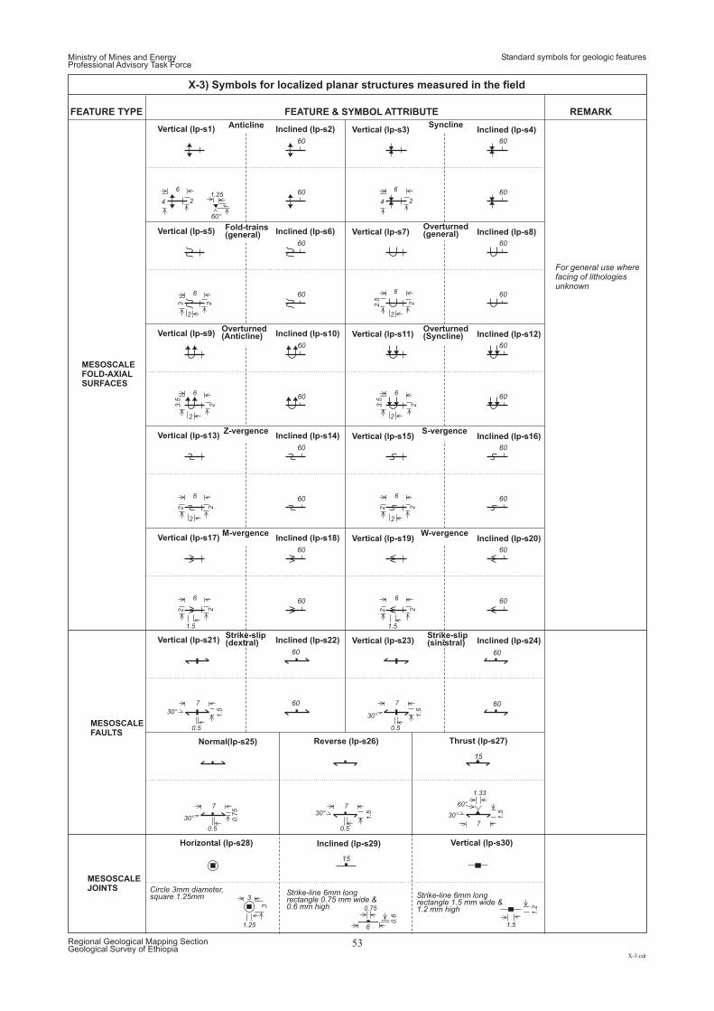
FEATURE TYPE REMARKFEATURE & SYMBOL ATTRIBUTE
Vertical (lp-s1)
Vertical (lp-s9)
Vertical (lp-s13)
Vertical (lp-s17)
Vertical (lp-s21)
Vertical (lp-s5)
Anticline
Fold-trains(general)
Syncline
Overturned(general)
Overturned( )Syncline
Overturned( )Anticline
Z-vergence
M-vergence
Strike-slip(dextral)
Strike-slip(sinistral)
S-vergence
W-vergence
Inclined (lp-s2)
Inclined (lp-s10)
Inclined (lp-s14)
Inclined (lp-s18)
Inclined (lp-s22)
Inclined (lp-s6)
Vertical (lp-s3)
Vertical (lp-s11)
Vertical (lp-s15)
Vertical (lp-s19)
Vertical (lp-s23)
Vertical (lp-s7)
Inclined (lp-s4)
For general use wherefacing of lithologiesunknown
Inclined (lp-s12)
Inclined (lp-s16)
Inclined (lp-s20)
Inclined (lp-s24)
Inclined (lp-s8)
60
60
60
4
33
.5
3.5
222 2
4
2.5
21.25
1
2
2
2
22
1.5
0.5
0.5
1.25
0.75
1.5
0.6
1.2
0.5
1.33
0.5
1.5
2
2
2 222
2
1.5
0.7
5
3
1.5 1.5
1.5
2
2
2
6
6
6 6
66
6
7
7
3
6
7
7
7
6
6
6
60 60
60
60
60
60
60 60
6060
60 60
60°
30°
30°30° 30°
60°
30°
60
60
60
60 60
6060
60 60
MESOSCALEFOLD-AXIALSURFACES
MESOSCALEFAULTS
Circle 3mm diameter,square 1.25mm
Strike-line 6mm longrectangle 0.75 mm wide &0.6 mm high
Strike-line 6mm longrectangle 1.5 mm wide &1.2 mm high
15
15
Thrust (lp-s27)Normal(lp-s25)
Horizontal (lp-s28)
Reverse (lp-s26)
Inclined (lp-s29) Vertical (lp-s30)
MESOSCALEJOINTS
Ministry of Mines and EnergyProfessional Advisory Task Force
Standard symbols for geologic features
X-3.cdr
Regional Geological Mapping SectionGeological Survey of Ethiopia
53
X-3) Symbols for localized planar structures measured in the field
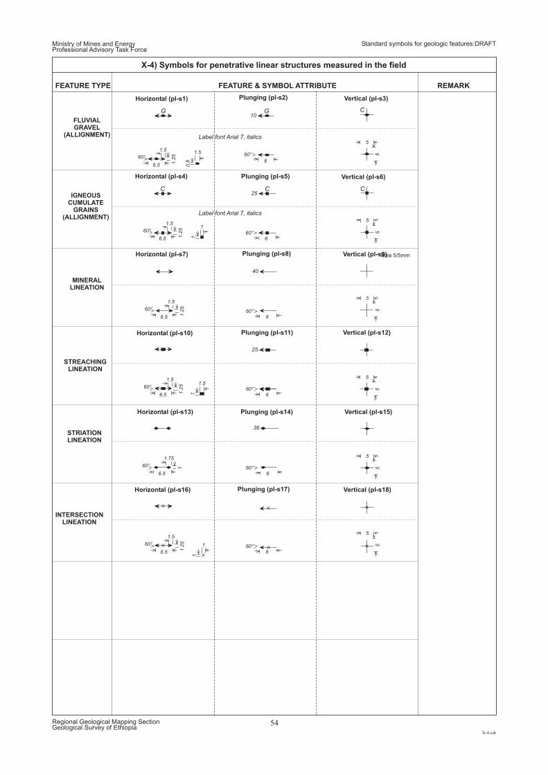
Size 5/5mm
1.5
1
1.5
1
0.8
11
1
1.2
5
1.2
51
.25
11.2
51
.25
6.5
6.5
6.5
6.5
6.5
6.5
6
6
6
6
6
6
5
5
5
5
5
55
55
55
5
1.5
1.5
1.5
1.75
1.5
1.5
60°
60°
60°
60°
60°
60°
60°
60°
60°
60°
60°
60°
C C C
G
Label font Arial 7, italics
Label font Arial 7, italics
G C
FEATURE TYPE REMARKFEATURE & SYMBOL ATTRIBUTE
25
25
36
40
10
Horizontal (pl-s1)
Horizontal (pl-s4)
Horizontal (pl-s7)
Horizontal (pl-s16)
Horizontal (pl-s10)
Horizontal (pl-s13)
Plunging (pl-s2)
Plunging (pl-s5)
Plunging (pl-s8)
Plunging (pl-s17)
Plunging (pl-s11)
Plunging (pl-s14)
Vertical (pl-s3)
Vertical (pl-s6)
Vertical (pl-s9)
Vertical (pl-s18)
Vertical (pl-s12)
Vertical (pl-s15)
FLUVIALGRAVEL
(ALLIGNMENT)
IGNEOUSCUMULATE
GRAINS(ALLIGNMENT)
MINERALLINEATION
STREACHINGLINEATION
STRIATIONLINEATION
INTERSECTIONLINEATION
Ministry of Mines and EnergyProfessional Advisory Task Force
Standard symbols for geologic features:DRAFT
X-4.cdr
Regional Geological Mapping SectionGeological Survey of Ethiopia
54
X-4) Symbols for penetrative linear structures measured in the field
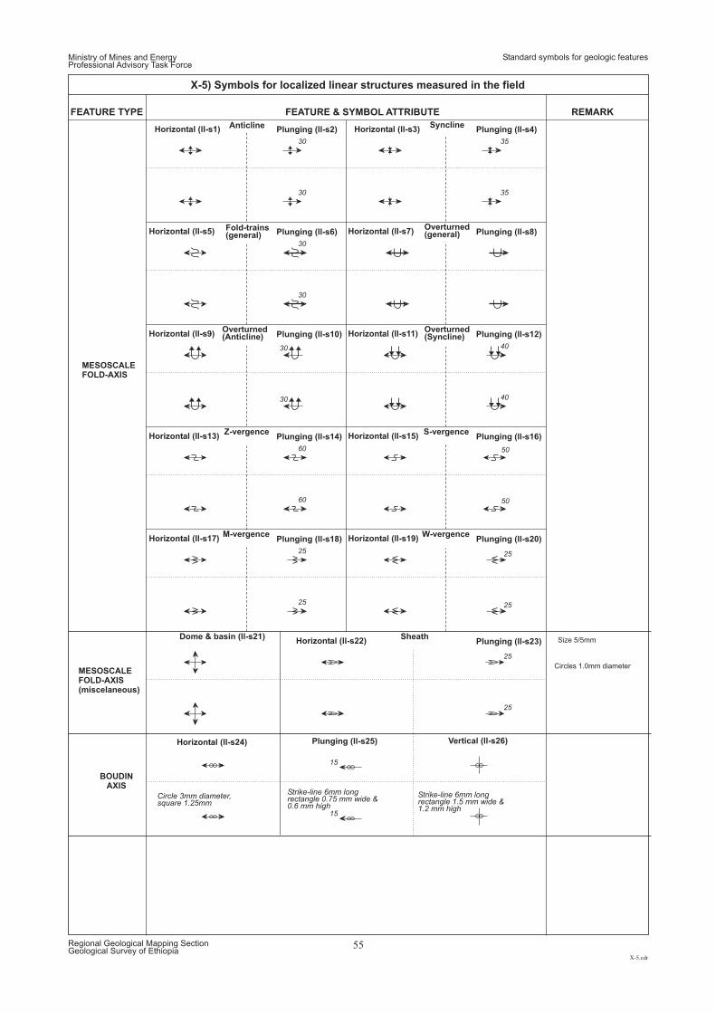
Circles 1.0mm diameter
Size 5/5mm
Circle 3mm diameter,square 1.25mm
Strike-line 6mm longrectangle 0.75 mm wide &0.6 mm high
Strike-line 6mm longrectangle 1.5 mm wide &1.2 mm high
40
25 25
25
60 50
15
30
30
30
35
40
25 25
25
60 50
MESOSCALEFOLD-AXIS
15
FEATURE TYPE REMARKFEATURE & SYMBOL ATTRIBUTE
Horizontal (ll-s1) Horizontal (ll-s3)
Horizontal (ll-s7)
Horizontal (ll-s11)
Horizontal (ll-s15)
Horizontal (ll-s19)
Horizontal (ll-s22)
Horizontal (ll-s5)
Horizontal (ll-s9)
Horizontal (ll-s13)
Horizontal (ll-s17)
Anticline
Fold-trains(general)
Syncline
Overturned(general)
Overturned( )Syncline
Overturned( )Anticline
Z-vergence S-vergence
M-vergence
Dome & basin (ll-s21) Sheath
W-vergence
Plunging (ll-s2) Plunging (ll-s4)
Plunging (ll-s8)
Plunging (ll-s12)
Plunging (ll-s16)
Plunging (ll-s20)
Plunging (ll-s23)
Plunging (ll-s6)
Plunging (ll-s10)
Plunging (ll-s14)
Plunging (ll-s18)
30
30
30
35
Horizontal (ll-s24) Plunging (ll-s25) Vertical (ll-s26)
BOUDINAXIS
MESOSCALEFOLD-AXIS(miscelaneous)
Ministry of Mines and EnergyProfessional Advisory Task Force
Standard symbols for geologic features
X-5.cdr
Regional Geological Mapping SectionGeological Survey of Ethiopia
55
X-5) Symbols for localized linear structures measured in the field
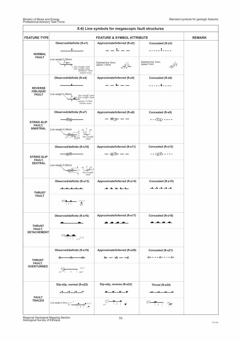
62
1
0.5 6 21
1.5 20°
6
2x1.51
9 60°
2x1.51.5
0.5
5 2.51.25
1.5
460°
1.5x1.31.5
3.2 1.85
3.2
1.8
5
25° 0.85
2
square 1x1mm,outline none
2
diameter 1mm,outline none
3 1
1.5 1
Line weight 0.38mm
line weight 2mmline length 1mm
Dashed line 3mm,space 1.5mm
Dashed line 1mm,space 1mm
Line weight 0.38mm
line weight 2mmline length 1mm
Line weight 0.38mm
line weight2mm
Line weight 0.38mm
line weight2mm
Line weight 0.3mm
FEATURE TYPE REMARKFEATURE & SYMBOL ATTRIBUTE
Observed/definite (ft-s1)
Observed/definite (ft-s4)
Observed/definite (ft-s7)
Observed/definite (ft-s10)
Observed/definite (ft-s16)
Observed/definite (ft-s13)
Observed/definite (ft-s19)
Approximate/Inferred (ft-s2)
Approximate/Inferred (ft-s5)
Approximate/Inferred (ft-s8)
Approximate/Inferred (ft-s11)
Approximate/Inferred (ft-s17)
Approximate/Inferred (ft-s14)
Approximate/Inferred (ft-s20)
Concealed (ft-s3)
Concealed (ft-s6)
Concealed (ft-s9)
Concealed (ft-s12)
Concealed (ft-s18)
Concealed (ft-s15)
Concealed (ft-s21)
NORMALFAULT
Dip-slip, normal (ft-s22) Thrust (ft-s24)Dip-slip, reverse (ft-s23)
STRIKE-SLIPFAULT,
SINISTRAL
STRIKE-SLIPFAULT,
DEXTRAL
THRUSTFAULT
THRUSTFAULT,
DETACHEMENT
FAULTTRACES
THRUSTFAULT,
OVERTURNED
REVERSE/OBLIQUE/
FAULT
Ministry of Mines and EnergyProfessional Advisory Task Force
Standard symbols for geologic features
X-6.cdr
Regional Geological Mapping SectionGeological Survey of Ethiopia
56
X-6) Line symbols for megascopic fault structures
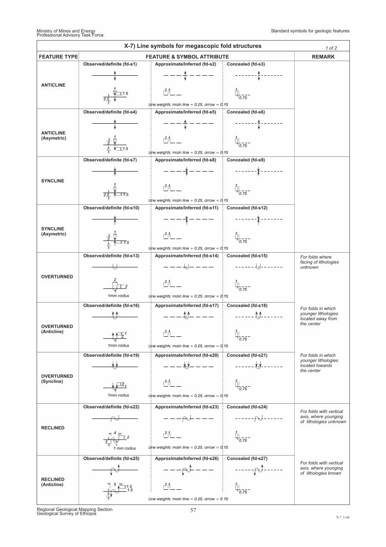
For folds wherefacing of lithologiesunknown
For folds in whichyounger lithologieslocated away fromthe center
For folds in whichyounger lithologieslocated towardsthe center
For folds with verticalaxis, where youngingof lithologies unknown
For folds with verticalaxis, where youngingof lithologies known
Ministry of Mines and EnergyProfessional Advisory Task Force
Standard symbols for geologic features
X-7_1.cdr
Regional Geological Mapping SectionGeological Survey of Ethiopia
57
X-7) Line symbols for megascopic fold structures 1 of 2
Observed/definite (fd-s1)
Observed/definite (fd-s4)
Observed/definite (fd-s7)
Observed/definite (fd-s10)
Observed/definite (fd-s13)
Observed/definite (fd-s16)
Observed/definite (fd-s19)
Observed/definite (fd-s22)
Observed/definite (fd-s25)
Approximate/Inferred (fd-s2)
Approximate/Inferred (fd-s5)
Approximate/Inferred (fd-s8)
Approximate/Inferred (fd-s11)
Approximate/Inferred (fd-s14)
Approximate/Inferred (fd-s17)
Approximate/Inferred (fd-s20)
Approximate/Inferred (fd-s23)
Approximate/Inferred (fd-s26)
Concealed (fd-s3)
Concealed (fd-s6)
Concealed (fd-s9)
Concealed (fd-s12)
Concealed (fd-s15)
Concealed (fd-s18)
Concealed (fd-s21)
Concealed (fd-s24)
Concealed (fd-s27)
FEATURE TYPE REMARKFEATURE & SYMBOL ATTRIBUTE
ANTICLINE
ANTICLINE(Asymetric)
SYNCLINE
SYNCLINE(Asymetric)
OVERTURNED
OVERTURNED(Anticline)
OVERTURNED(Syncline)
RECLINED
RECLINED(Anticline)
1.5
1.5
1.5
1.5
2
1
1
2
2
2
1.51.5
Line weights: main line = 0.25, arrow = 0.15
Line weights: main line = 0.25, arrow = 0.15
Line weights: main line = 0.25, arrow = 0.15
Line weights: main line = 0.25, arrow = 0.15
Line weights: main line = 0.25, arrow = 0.15
Line weights: main line = 0.25, arrow = 0.15
Line weights: main line = 0.25, arrow = 0.15
Line weights: main line = 0.25, arrow = 0.15
Line weights: main line = 0.25, arrow = 0.15
2.5
3
3
2
2
2.5
1mm radius
1mm radius
1mm radius
1 mm radius
2
3
3
3
3
3
3
3
3
3
3
0.75
0.75
0.75
0.75
0.75
0.75
0.75
0.75
0.75
1
1
1
1
1
1
1
1
1
1
1
1
1
2
4
5
1
1
1
1
1
1
1
1
1
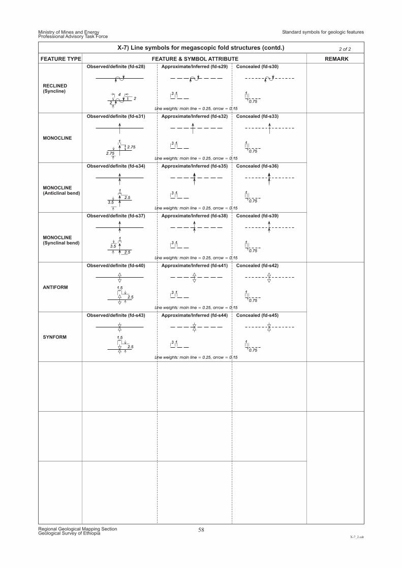
Ministry of Mines and EnergyProfessional Advisory Task Force
Standard symbols for geologic features
X-7_2.cdr
Regional Geological Mapping SectionGeological Survey of Ethiopia
58
X-7) Line symbols for megascopic fold structures (contd.) 2 of 2
Observed/definite (fd-s28)
Observed/definite (fd-s31)
Observed/definite (fd-s34)
Observed/definite (fd-s37)
Observed/definite (fd-s40)
Observed/definite (fd-s43)
Approximate/Inferred (fd-s29)
Approximate/Inferred (fd-s32)
Approximate/Inferred (fd-s35)
Approximate/Inferred (fd-s38)
Approximate/Inferred (fd-s41)
Approximate/Inferred (fd-s44)
Concealed (fd-s30)
Concealed (fd-s33)
Concealed (fd-s36)
Concealed (fd-s39)
Concealed (fd-s42)
Concealed (fd-s45)
FEATURE TYPE REMARKFEATURE & SYMBOL ATTRIBUTE
MONOCLINE
MONOCLINE(Anticlinal bend)
MONOCLINE(Synclinal bend)
ANTIFORM
SYNFORM
RECLINED(Syncline)
2
2.5
2.5
2.5
2.5
Line weights: main line = 0.25, arrow = 0.15
Line weights: main line = 0.25, arrow = 0.15
Line weights: main line = 0.25, arrow = 0.15
Line weights: main line = 0.25, arrow = 0.15
Line weights: main line = 0.25, arrow = 0.15
Line weights: main line = 0.25, arrow = 0.15
2
2.75
2.75
3.5
3.5
3
3
3
3
3
3
0.75
0.75
0.75
0.75
0.75
0.75
1
1
1
1
1
1
4
1
1
1
1.5
1.5
1
1
1
1
1
1
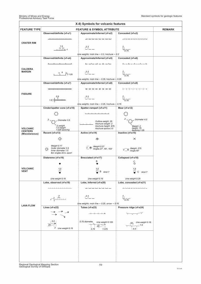
Ministry of Mines and EnergyProfessional Advisory Task Force
Standard symbols for geologic features
X-8.cdr
Regional Geological Mapping SectionGeological Survey of Ethiopia
59
X-8) Symbols for volcanic features
Observed/definite (vf-s1)
Observed/definite (vf-s4)
Observed/definite (vf-s7)
Lobe, observed (vf-s19)
Lines (vf-s22)
Cinder/spatter cone (vf-s10)
Active (vf-s14)
Diatereme (vf-s16)
Approximate/Inferred (vf-s2)
Approximate/Inferred (vf-s5)
Approximate/Inferred (vf-s8)
Lobe, Inferred (vf-s20)
Tubes (vf-s23)
Spatter-rampart (vf-s11) Maar (vf-s12)
Inactive (vf-s15)
Brecciated (vf-s17)
Concealed (vf-s3)
Concealed (vf-s6)
Concealed (vf-s9)
Lobe, concealed (vf-s21)
Pressure ridge (vf-s24)
Recent (vf-s13)
Collapsed (vf-s18)
FEATURE TYPE REMARKFEATURE & SYMBOL ATTRIBUTE
CALDERAMARGIN
FISSURE
VOLCANICCENTERS(Miscelaneous)
VOLCANICVENT
LAVA FLOW
CRATER RIM
25°
2
5.5
1.375
0.75 diameter
25°
3.75
1.0
5.5
60o
1
Line weights: main line = 0.3, hachure = 0.2
Line weights: main line = 0.35, hachure = 0.25
Line weights: main line = 0.25, hachure = 0.15
Line weight 0.15 Line weight 0.15
Arial 7 Arial 7
Line weight 0.25
Line weights: main line = 0.25, arrow = 0.15
Line weight 0.15
Line weight 0.15Line weight 0.125
1.25
1.5
1
3
3
3
3
0.75
0.75
0.75
0.75
1
1
1
1
1.5
6
0.5
2
1.5 1.5 1.5
1
1
1
1
B
B
C
C
Weight 0.17Outer diameter 3.5Inner diameter 1.5Bar angles 22.5 aparto
Outline weight .25Hachure weight .2Hachure height .875Hachure space 3.5
32
Weight 0.27Angles 27°, 90°, 153° Weight .275
Angle 90°
.2 .2Diameter 3.5 Diameter 4.0
.2 weight1.0 height1.625 spacing
Weight .2Height .75Spacing 1.25
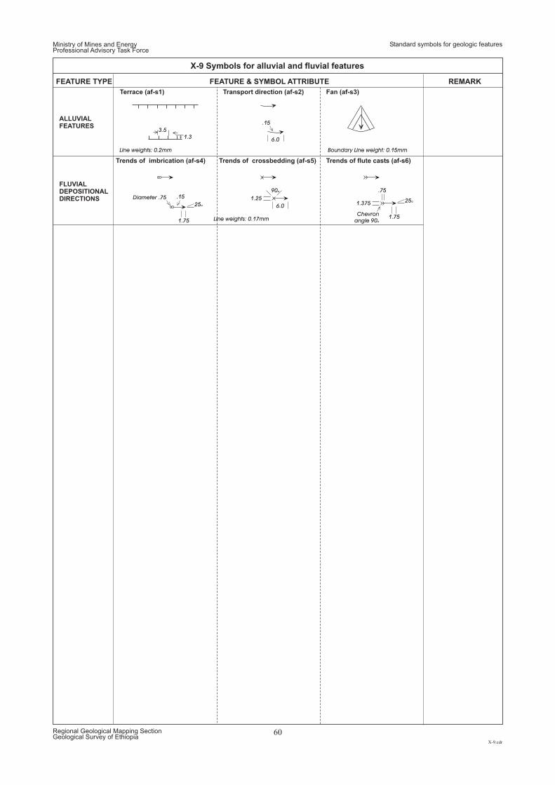
Terrace (af-s1)
Trends of imbrication (af-s4)
Transport direction (af-s2)
Trends of crossbedding (af-s5)
Fan (af-s3)
Trends of flute casts (af-s6)
FEATURE TYPE REMARKFEATURE & SYMBOL ATTRIBUTE
FLUVIALDEPOSITIONALDIRECTIONS
ALLUVIALFEATURES
Ministry of Mines and EnergyProfessional Advisory Task Force
Standard symbols for geologic features
X-9.cdr
Regional Geological Mapping SectionGeological Survey of Ethiopia
60
X-9 Symbols for alluvial and fluvial features
1.3
Line weights: 0.2mm Boundary Line weight: 0.15mm
Line weights: 0.17mm
3.5
25o
1.75
25o
1.75
1.375
.75
1.25
6.0
6.0
Diameter .75
.15
.1590o
Chevronangle 90o
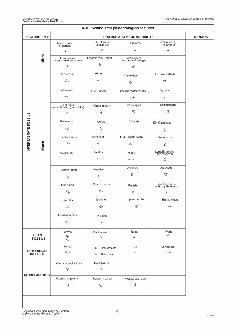
AcritarchsAmmonites
Belemnites Brachiopods Bryozoa
Cephalopods
Algae Archaeocyathids
Bones
Brackish-water fossils
Calcareous(coccoliths)nannoplankton
Chitinozoans
Corals
Diatoms
Charophytes
Conodonts Crinoids
Echinoderms
Dinoflagellates
Echinoids
FEATURE TYPE
INV
ER
TA
BR
AT
EF
OS
SIL
S
IMacro
Mic
ro
PLANTFOSSILS
VERTEBRATEFOSSILS
MISCELANEOUS
REMARKFEATURE & SYMBOL ATTRIBUTE
Fish remains
Fish scales
Foraminifers,in general
Foraminifers, larger Foraminifers,smaller and pelagic
Foraminifers,smaller and benthonic
Fossils, abundantFossils, in general Fossils, sparse
GastropodsFresh-water fossils
Graptolites Hyoliths Lamellibranchs(pelecypods)
Marine fossils
Microfossils,in general
Insects
Leaves
Microfossils,calcareous
M
NeedlesOncolites Ostracods
Plant remains
Radiolaria Rostroconchs Silicoflagellatesand (or) ebridians
Sponges Stromatolites
Teeth
Trilobites
Wood
Pollen and (or) spores
Roots
Rudists
Spicules Sporomorphs
Stromatoporoids
Trace fossils
Vertebrates
Ministry of Mines and EnergyProfessional Advisory Task Force
Standard symbols for geologic features
X-10.cdr
Regional Geological Mapping SectionGeological Survey of Ethiopia
61
X-10) Symbols for paleontological features
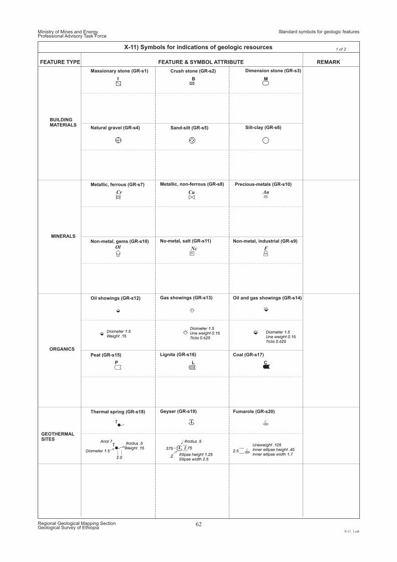
T
T2.75
.2
.375
Radius .5Arial 7
2.0
Diameter 1.5
Radius .5Weight .15
Ellipse height 1.25Ellipse width 2.5
2.5
Lineweight .125Inner ellipse height .45Inner ellipse width 1.7
Diameter 1.5Weight .15
Diameter 1.5Diameter 1.5Line weight 0.15Line weight 0.15Ticks 0.625Ticks 0.625
M
1 of 2
CLP
FNcOl
Cr Cu Au
BI
FEATURE TYPE REMARKFEATURE & SYMBOL ATTRIBUTE
Massionary stone (GR-s1)
Natural gravel (GR-s4)
Metallic, ferrous (GR-s7)
Non-metal, gems (GR-s10)
Oil showings (GR-s12)
Peat (GR-s15)
Thermal spring (GR-s18)
Crush stone (GR-s2)
Sand-silt (GR-s5)
Metallic, non-ferrous (GR-s8)
No-metal, salt (GR-s11)
Gas showings (GR-s13)
Lignite (GR-s16)
Geyser (GR-s19)
Dimension stone (GR-s3)
Silt-clay (GR-s6)
Precious-metals (GR-s10)
Non-metal, industrial (GR-s9)
Oil and gas showings (GR-s14)
Coal (GR-s17)
Fumarole (GR-s20)
BUILDINGMATERIALS
MINERALS
ORGANICS
GEOTHERMALSITES
Ministry of Mines and EnergyProfessional Advisory Task Force
Standard symbols for geologic features
X-11_1.cdr
Regional Geological Mapping SectionGeological Survey of Ethiopia
62
X-11) Symbols for indications of geologic resources
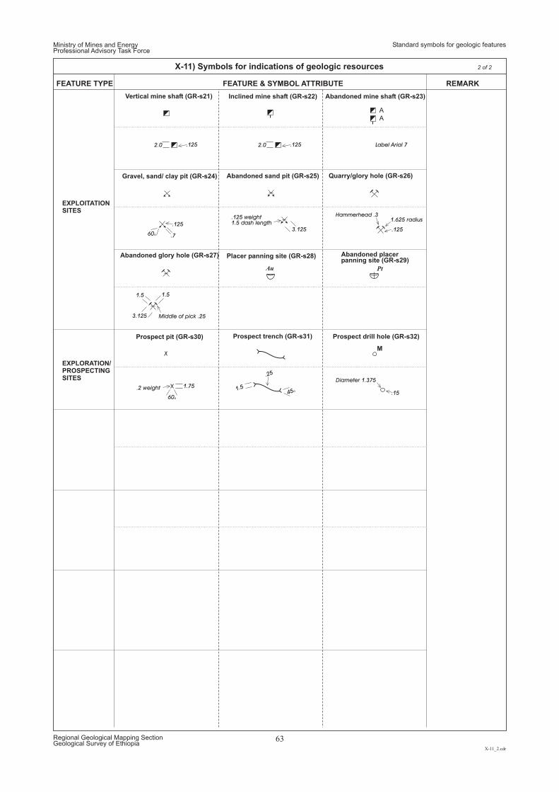
EXPLOITATIONSITES
EXPLORATION/PROSPECTINGSITES
60o .7
.125
Gravel, sand/ clay pit (GR-s24)
.125 .1252.0 2.0 Label Arial 7
A
A
.125 weight1.5 dash length
1.51.5
.125
3.125
3.125
1.625 radiusHammerhead .3
Middle of pick .25
Au Pt
M
.2 weight
60o
1.751.5
.25
45o
Diameter 1.375
.15
Prospect pit (GR-s30) Prospect trench (GR-s31) Prospect drill hole (GR-s32)
Quarry/glory hole (GR-s26)
Abandoned placerpanning site GR-s29)(
Abandoned glory hole (GR-s27)
Abandoned sand pit (GR-s25)
Placer panning site (GR-s28)
Vertical mine shaft (GR-s21) Inclined mine shaft (GR-s22) Abandoned mine shaft (GR-s23)
FEATURE TYPE REMARKFEATURE & SYMBOL ATTRIBUTE
Ministry of Mines and EnergyProfessional Advisory Task Force
Standard symbols for geologic features
X-11_2.cdr
Regional Geological Mapping SectionGeological Survey of Ethiopia
63
X-11) Symbols for indications of geologic resources 2 of 2
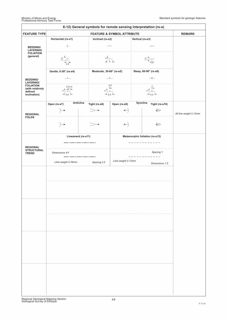
2.5 1
1 1 11.5
2.5
5
5.5 5.5 5.5
1
1.50.50.5 1
BEDDING/LAYERING/FOLIATION(general)
BEDDING/LAYERING/FOLIATION(with relativelydefinedinclination)
REGIONALFOLDS
REGIONALSTRUCTURALTREND
Gentle, 0-30° (rs-s4) Steep, 6 (rs0-90° -s6)Moderate (rs-s, 30-60° 5)
Horizontal (rs-s1) Inclined (rs-s2) Vertical (rs-s3)
FEATURE TYPE REMARKFEATURE & SYMBOL ATTRIBUTE
Open (rs-s7)Anticline
Lineament (rs-s11)
Syncline
Metamorphic foliation (rs-s12)
Tight (rs-s8) Open (rs-s9) Tight (rs-s10)
Lline weight 0.13mmLline weight 0.35mm
All line weight 0.13mm
Spacing 1
Spacing 0.5 Dimensions 1.5
Dimensions 4/1
Ministry of Mines and EnergyProfessional Advisory Task Force
Standard symbols for geologic features
X-12.cdr
Regional Geological Mapping SectionGeological Survey of Ethiopia
64
X-12) General symbols for remote sensing interpretation (rs-s)

Ministry of Mines and EnergyProfessional Advisory Task Force
Standards for regional geologic reports
XI.cdr
Regional Geological Mapping SectionGeological Survey of Ethiopia
65
CONTENT AND LAYOUT FOR REGIONAL GEOLOGIC REPORTS
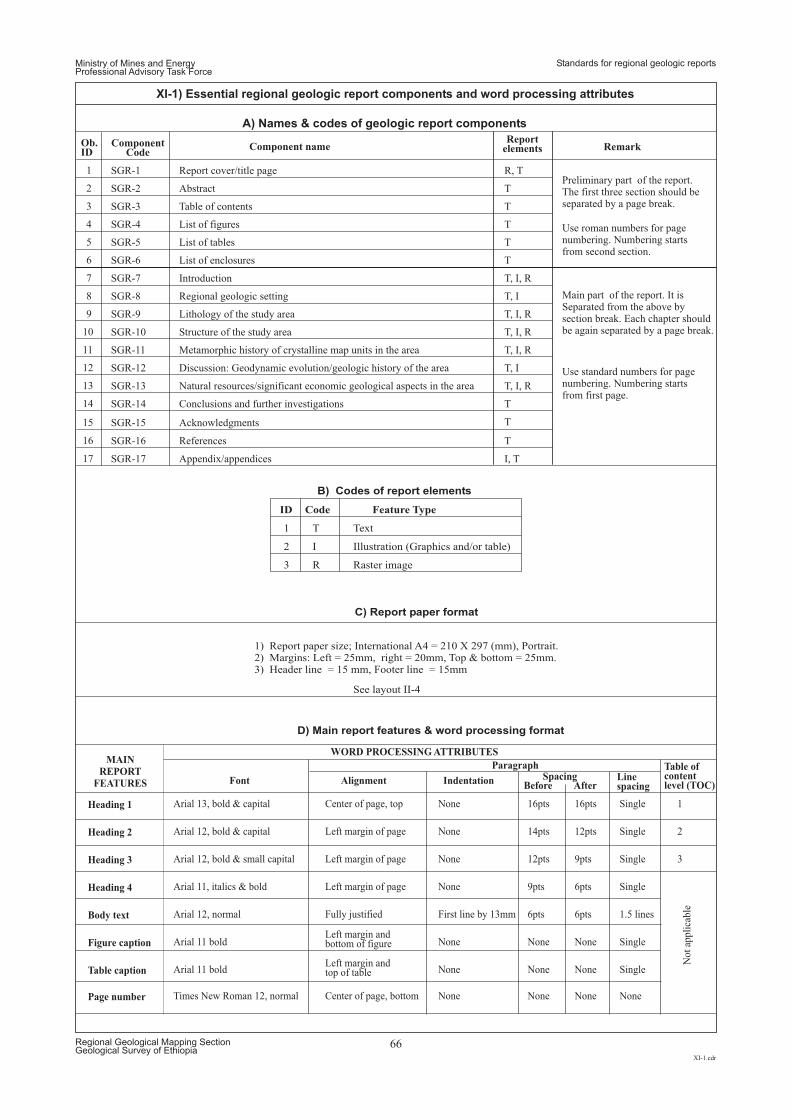
Ob.ID
ComponentCode
Component nameReport
elements Remark
1 SGR-1 Report cover/title pagePreliminary part of the report.The first three section should beseparated by a page break.
Use roman numbers for pagenumbering. Numbering startsfrom second section.
Use standard numbers for pagenumbering. Numbering startsfrom first page.
Main part of the report. It isSeparated from the above bysection break. Each chapter shouldbe again separated by a page break.
R, T
2 SGR-2 Abstract T
3 SGR-3 Table of contents T
4 SGR-4 List of figures T
5 SGR-5 List of tables T
6 SGR-6 List of enclosures T
7 SGR-7 Introduction T, I, R
8 SGR-8 Regional geologic setting T, I
9 SGR-9 Lithology of the study area T, I, R
10 SGR-10 Structure of the study area T, I, R
11 SGR-11 Metamorphic history of crystalline map units in the area T, I, R
12 SGR-12 Discussion: Geodynamic evolution/geologic history of the area T, I
13 SGR-13 Natural resources/significant economic geological aspects in the area T, I, R
14
15
16
17
SGR-14
SGR-15
SGR-16
SGR-17
Conclusions and further investigations
Acknowledgments
References
Appendix/appendices
T
T
T
I, T
ID Code Feature Type
1 T Text
2 I Illustration (Graphics and/or table)
3 R Raster image
See layout II-4
1) Report paper size; International A4 = 210 X 297 (mm), Portrait.2) Margins: Left = 25mm, right = 20mm, Top & bottom = 25mm.3) Header line = 15 mm, Footer line = 15mm
B) Codes of report elements
C) Report paper format
D) Main report features & word processing format
Before After
Heading 1 Arial 13, bold & capital Center of page, top None 16pts 16pts Single 1
Heading 2 Arial 12, bold & capital Left margin of page None 14pts 12pts Single 2
Heading 3 Arial 12, bold & small capital Left margin of page None 12pts 9pts Single 3
Heading 4 Arial 11, italics & bold Left margin of page None 9pts 6pts Single
No
tap
pli
cab
le
Body text Arial 12, normal Fully justified First line by 13mm 6pts 6pts 1.5 lines
Figure caption Arial 11 boldLeft margin andbottom of figure
Left margin andtop of table
None None None Single
Table caption
Page number
Arial 11 bold
Times New Roman 12, normal Center of page, bottom
None
None
None
None
None
None
Single
None
Font
WORD PROCESSING ATTRIBUTESMAIN
REPORT
FEATURES
Table ofcontentlevel (TOC)
ParagraphSpacingAlignment Indentation Line
spacing
Ministry of Mines and EnergyProfessional Advisory Task Force
Standards for regional geologic reports
XI-1.cdr
Regional Geological Mapping SectionGeological Survey of Ethiopia
66
XI-1) Essential regional geologic report components and word processing attributes
A Names & codes of geologic report components)
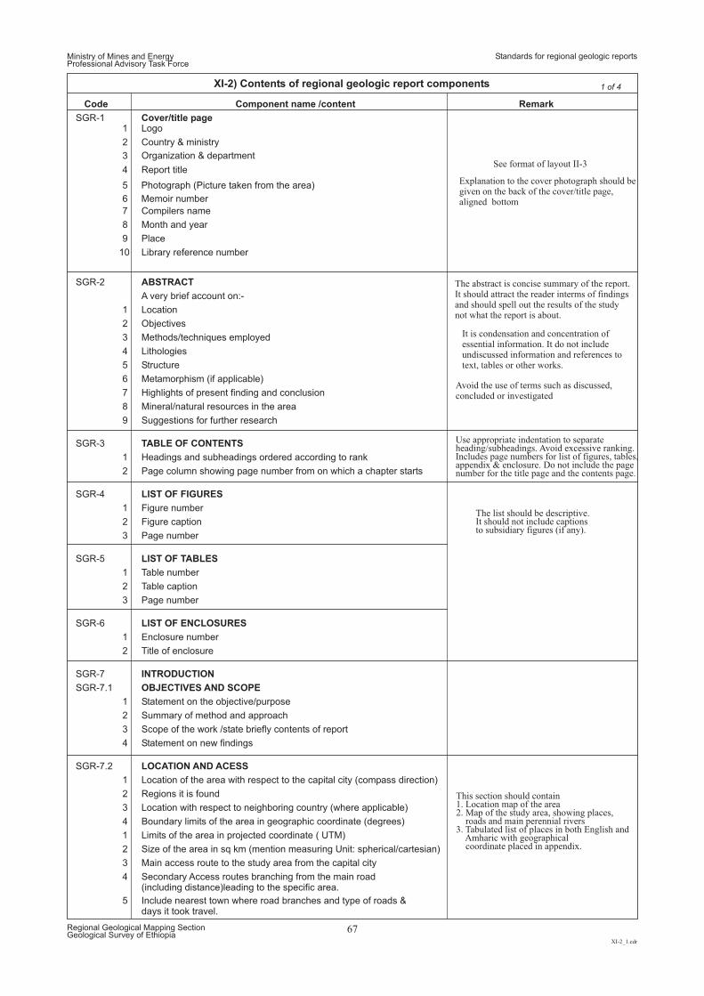
Code Remark
See format of layout II-3
Explanation to the cover photograph should begiven on the back of the cover/title page,aligned bottom
Component name /content
SGR-1 Cover/title page1 Logo
2 Country & ministry
Organization & department3
4 Report title
5
6
Photograph (Picture taken from the area)
Memoir number
7 Compilers name
8 Month and year
9 Place
10 Library reference number
SGR-2 ABSTRACT
A very brief account on:-
1 Location
2 Objectives
3 Methods/techniques employed
4 Lithologies
5 Structure
6 Metamorphism (if applicable)
7 Highlights of present finding and conclusion
8 Mineral/natural resources in the area
9 Suggestions for further research
SGR-3 TABLE OF CONTENTS
1 Headings and subheadings ordered according to rank
2 Page column showing page number from on which a chapter starts
SGR-4 LIST OF FIGURES
1 Figure number
2 Figure caption
3 Page number
SGR-5 LIST OF TABLES
1 Table number
2 Table caption
3 Page number
SGR-6 LIST OF ENCLOSURES
1 Enclosure number
2 Title of enclosure
SGR-7 INTRODUCTION
SGR-7.1 OBJECTIVES AND SCOPE
1 Statement on the objective/purpose
2 Summary of method and approach
3 Scope of the work /state briefly contents of report
4 Statement on new findings
SGR-7.2 LOCATION AND ACESS
1 Location of the area with respect to the capital city (compass direction)
2 Regions it is found
3 Location with respect to neighboring country (where applicable)
4 Boundary limits of the area in geographic coordinate (degrees)
1 Limits of the area in projected coordinate ( UTM)
2 Size of the area in sq km (mention measuring Unit: spherical/cartesian)
3 Main access route to the study area from the capital city
4 Secondary Access routes branching from the main road(including distance)leading to the specific area.
5 Include nearest town where road branches and type of roads &days it took travel.
The abstract is concise summary of the report.It should attract the reader interms of findingsand should spell out the results of the studynot what the report is about.
It is condensation and concentration ofessential information. It do not includeundiscussed information and references totext, tables or other works.
Avoid the use of terms such as discussed,concluded or investigated
Use appropriate indentation to separateheading/subheadings. Avoid excessive ranking.Includes page numbers for list of figures, tables,appendix & enclosure. Do not include the pagenumber for the title page and the contents page.
The list should be descriptive.It should not include captionsto subsidiary figures (if any).
This section should contain1. Location map of the area2. Map of the study area, showing places,
roads and main perennial rivers3. Tabulated list of places in both English and
Amharic with geographicalcoordinate placed in appendix.
Ministry of Mines and EnergyProfessional Advisory Task Force
Standards for regional geologic reports
XI-2_1.cdr
Regional Geological Mapping SectionGeological Survey of Ethiopia
67
XI-2) Contents of regional geologic report components 1 of 4
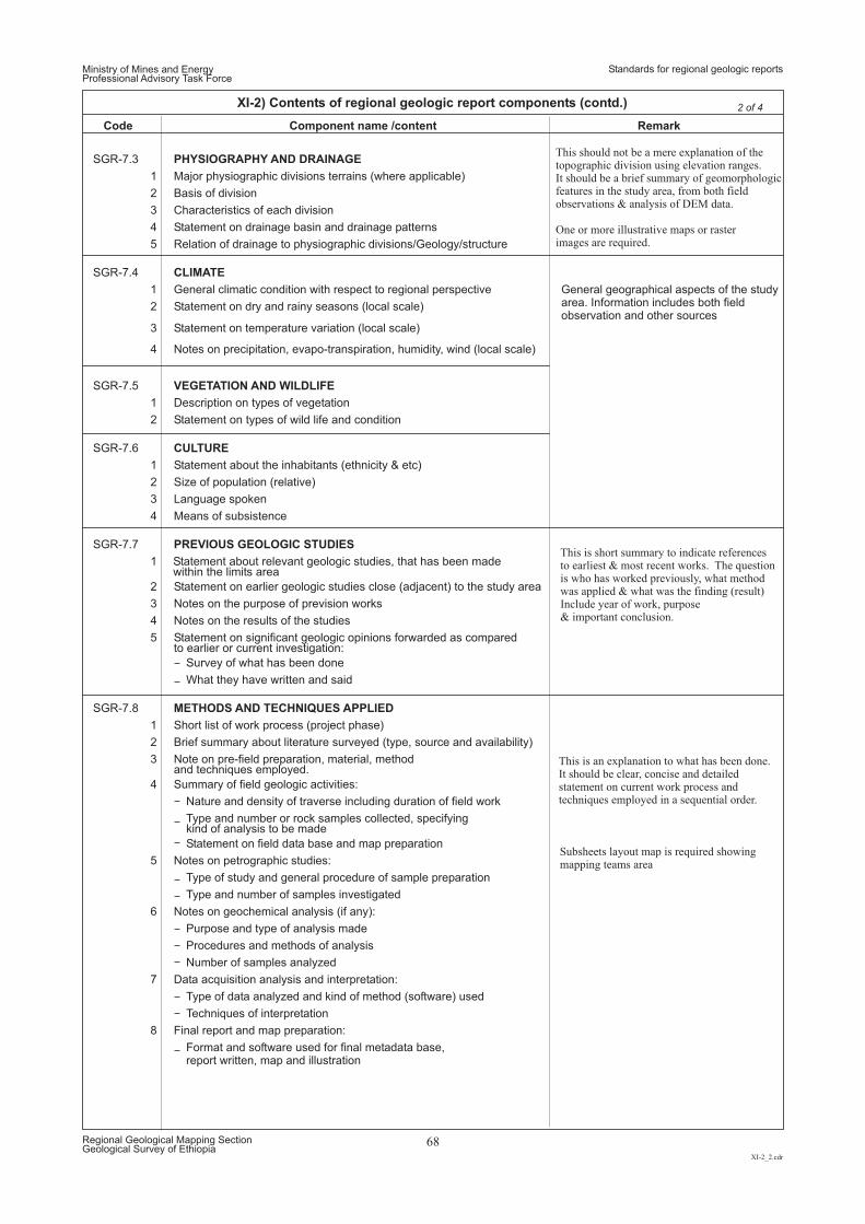
Code RemarkComponent name /content
Ministry of Mines and EnergyProfessional Advisory Task Force
Standards for regional geologic reports
XI-2_2.cdr
Regional Geological Mapping SectionGeological Survey of Ethiopia
68
XI-2) Contents of regional geologic report components (contd.) 2 of 4
SGR-7.3 PHYSIOGRAPHY AND DRAINAGE
1 Major physiographic divisions terrains (where applicable)
2 Basis of division
3 Characteristics of each division
4 Statement on drainage basin and drainage patterns
5 Relation of drainage to physiographic divisions/Geology/structure
SGR-7.4 CLIMATE
1 General climatic condition with respect to regional perspective General geographical aspects of the studyarea. Information includes both fieldobservation and other sources
2 Statement on dry and rainy seasons (local scale)
3 Statement on temperature variation (local scale)
4 Notes on precipitation, evapo-transpiration, humidity, wind (local scale)
SGR-7.5 VEGETATION AND WILDLIFE
1 Description on types of vegetation
2 Statement on types of wild life and condition
SGR-7.6 CULTURE
1 Statement about the inhabitants (ethnicity & etc)
2 Size of population (relative)
3 Language spoken
4 Means of subsistence
SGR-7.7 PREVIOUS GEOLOGIC STUDIES
1 Statement about relevant geologic studies, that has been madewithin the limits area
2 Statement on earlier geologic studies close (adjacent) to the study area
3 Notes on the purpose of prevision works
4 Notes on the results of the studies
5 Statement on significant geologic opinions forwarded as comparedto earlier or current investigation:
Survey of what has been done
What they have written and said
SGR-7.8 METHODS AND TECHNIQUES APPLIED
1 Short list of work process (project phase)
2 Brief summary about literature surveyed (type, source and availability)
3 Note on pre-field preparation, material, methodand techniques employed.
4 Summary of field geologic activities:
Nature and density of traverse including duration of field work
Type and number or rock samples collected, specifyingkind of analysis to be made
Statement on field data base and map preparation
5 Notes on petrographic studies:
Type of study and general procedure of sample preparation
Type and number of samples investigated
6 Notes on geochemical analysis (if any):
Purpose and type of analysis made
Procedures and methods of analysis
Number of samples analyzed
7 Data acquisition analysis and interpretation:
Type of data analyzed and kind of method (software) used
Techniques of interpretation
8 Final report and map preparation:
Format and software used for final metadata base,report written, map and illustration
This should not be a mere explanation of thetopographic division using elevation ranges.It should be a brief summary of geomorphologicfeatures in the study area, from both fieldobservations & analysis of DEM data.
One or more illustrative maps or rasterimages are required.
This is short summary to indicate referencesto earliest & most recent works. The questionis who has worked previously, what methodwas applied & what was the finding (result)Include year of work, purpose& important conclusion.
This is an explanation to what has been done.It should be clear, concise and detailedstatement on current work process andtechniques employed in a sequential order.
Subsheets layout map is required showingmapping teams area
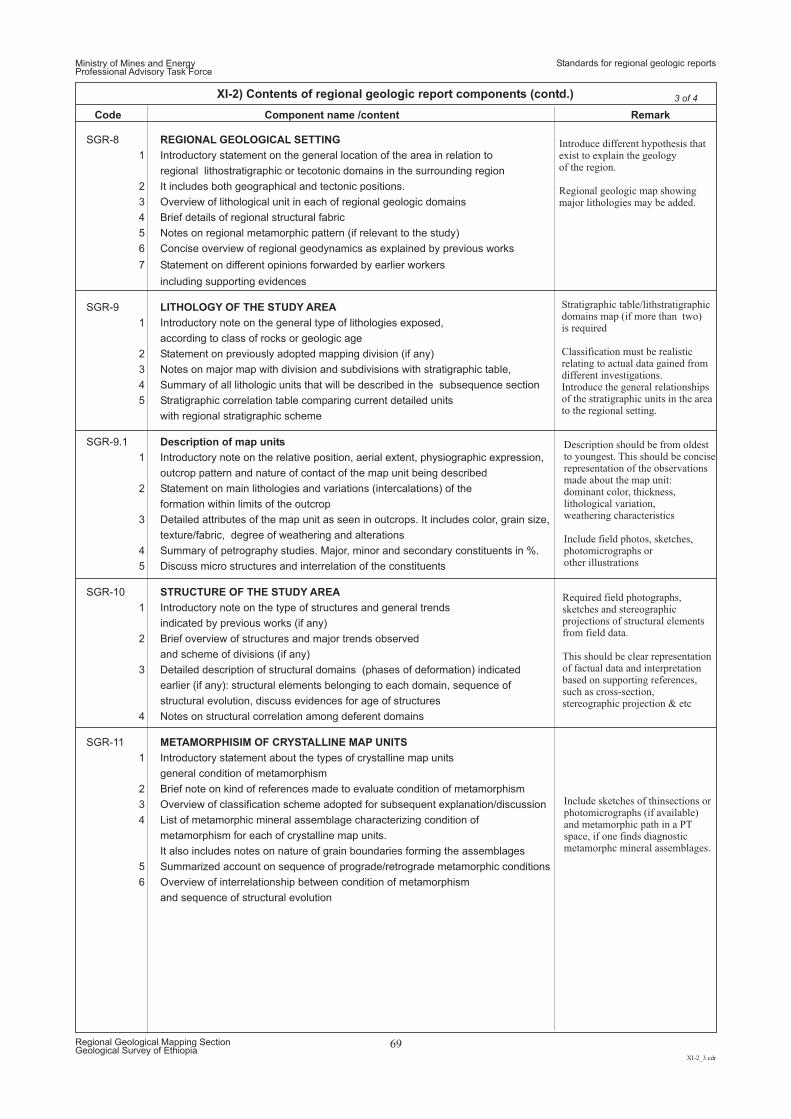
Code RemarkComponent name /content
SGR-8 REGIONAL GEOLOGICAL SETTING
1 Introductory statement on the general location of the area in relation to
regional lithostratigraphic or tecotonic domains in the surrounding region
2 It includes both geographical and tectonic positions.
3 Overview of lithological unit in each of regional geologic domains
4 Brief details of regional structural fabric
5 Notes on regional metamorphic pattern (if relevant to the study)
6 Concise overview of regional geodynamics as explained by previous works
7 Statement on different opinions forwarded by earlier workers
including supporting evidences
SGR-9 LITHOLOGY OF THE STUDY AREA
1 Introductory note on the general type of lithologies exposed,
according to class of rocks or geologic age
2 Statement on previously adopted mapping division (if any)
3 Notes on major map with division and subdivisions with stratigraphic table,
4 Summary of all lithologic units that will be described in the subsequence section
5 Stratigraphic correlation table comparing current detailed units
with regional stratigraphic scheme
SGR-9.1 Description of map units
1 Introductory note on the relative position, aerial extent, physiographic expression,
outcrop pattern and nature of contact of the map unit being described
2 Statement on main lithologies and variations (intercalations) of the
formation within limits of the outcrop
3 Detailed attributes of the map unit as seen in outcrops. It includes color, grain size,
texture/fabric, degree of weathering and alterations
4 Summary of petrography studies. Major, minor and secondary constituents in %.
5 Discuss micro structures and interrelation of the constituents
SGR-10 STRUCTURE OF THE STUDY AREA
1 Introductory note on the type of structures and general trends
indicated by previous works (if any)
2 Brief overview of structures and major trends observed
and scheme of divisions (if any)
3 Detailed description of structural domains (phases of deformation) indicated
earlier (if any): structural elements belonging to each domain, sequence of
structural evolution, discuss evidences for age of structures
4 Notes on structural correlation among deferent domains
SGR-11 METAMORPHISIM OF CRYSTALLINE MAP UNITS
1 Introductory statement about the types of crystalline map units
general condition of metamorphism
2 Brief note on kind of references made to evaluate condition of metamorphism
3 Overview of classification scheme adopted for subsequent explanation/discussion
4 List of metamorphic mineral assemblage characterizing condition of
metamorphism for each of crystalline map units.
It also includes notes on nature of grain boundaries forming the assemblages
5 Summarized account on sequence of prograde/retrograde metamorphic conditions
6 Overview of interrelationship between condition of metamorphism
and sequence of structural evolution
Introduce different hypothesis thatexist to explain the geologyof the region.
Regional geologic map showingmajor lithologies may be added.
Stratigraphic table/lithstratigraphicdomains map (if more than two)is required
Classification must be realisticrelating to actual data gained fromdifferent investigations.Introduce the general relationshipsof the stratigraphic units in the areato the regional setting.
Description should be from oldestto youngest. This should be conciserepresentation of the observationsmade about the map unit:dominant color, thickness,lithological variation,weathering characteristics
Include field photos, sketches,photomicrographs orother illustrations
Required field photographs,sketches and stereographicprojections of structural elementsfrom field data.
This should be clear representationof factual data and interpretationbased on supporting references,such as cross-section,stereographic projection & etc
Include sketches of thinsections orphotomicrographs (if available)and metamorphic path in a PTspace, if one finds diagnosticmetamorphc mineral assemblages.
Ministry of Mines and EnergyProfessional Advisory Task Force
Standards for regional geologic reports
XI-2_3.cdr
Regional Geological Mapping SectionGeological Survey of Ethiopia
69
XI-2) Contents of regional geologic report components (contd.) 3 of 4
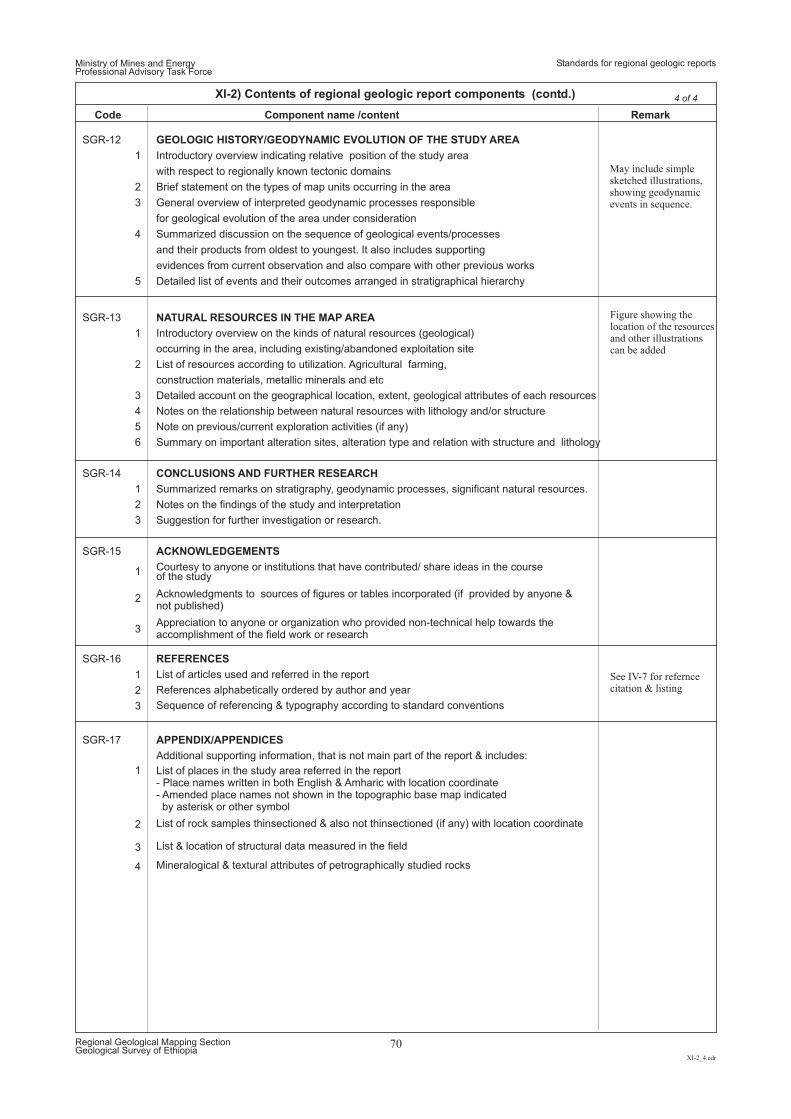
Code RemarkComponent name /content
SGR-13 NATURAL RESOURCES IN THE MAP AREA
1 Introductory overview on the kinds of natural resources (geological)
occurring in the area, including existing/abandoned exploitation site
2 List of resources according to utilization. Agricultural farming,
construction materials, metallic minerals and etc
3 Detailed account on the geographical location, extent, geological attributes of each resources
4 Notes on the relationship between natural resources with lithology and/or structure
5 Note on previous/current exploration activities (if any)
6 Summary on important alteration sites, alteration type and relation with structure and lithology
SGR-14 CONCLUSIONS AND FURTHER RESEARCH
1
1
1
1
Summarized remarks on stratigraphy, geodynamic processes, significant natural resources.
2
2
2
2
Notes on the findings of the study and interpretation
3
3
3
3
4
Suggestion for further investigation or research.
SGR-15 ACKNOWLEDGEMENTS
Courtesy to anyone or institutions that have contributed/ share ideas in the courseof the study
Acknowledgments to sources of figures or tables incorporated (if provided by anyone ¬ published)
Appreciation to anyone or organization who provided non-technical help towards theaccomplishment of the field work or research
SGR-16 REFERENCES
List of articles used and referred in the report
References alphabetically ordered by author and year
Sequence of referencing & typography according to standard conventions
SGR-17 APPENDIX/APPENDICES
Additional supporting information, that is not main part of the report & includes:
List of places in the study area referred in the report- Place names written in both English & Amharic with location coordinate- Amended place names not shown in the topographic base map indicatedby asterisk or other symbol
List of rock samples thinsectioned & also not thinsectioned (if any) with location coordinate
List & location of structural data measured in the field
Mineralogical & textural attributes of petrographically studied rocks
Figure showing thelocation of the resourcesand other illustrationscan be added
See IV-7 for referncecitation & listing
SGR-12 GEOLOGIC HISTORY/GEODYNAMIC EVOLUTION OF THE STUDY AREA
1 Introductory overview indicating relative position of the study area
with respect to regionally known tectonic domains
2 Brief statement on the types of map units occurring in the area
3 General overview of interpreted geodynamic processes responsible
for geological evolution of the area under consideration
4 Summarized discussion on the sequence of geological events/processes
and their products from oldest to youngest. It also includes supporting
evidences from current observation and also compare with other previous works
5 Detailed list of events and their outcomes arranged in stratigraphical hierarchy
May include simplesketched illustrations,showing geodynamicevents in sequence.
Ministry of Mines and EnergyProfessional Advisory Task Force
Standards for regional geologic reports
XI-2_4.cdr
Regional Geological Mapping SectionGeological Survey of Ethiopia
70
XI-2) Contents of regional geologic report components (contd.) 4 of 4
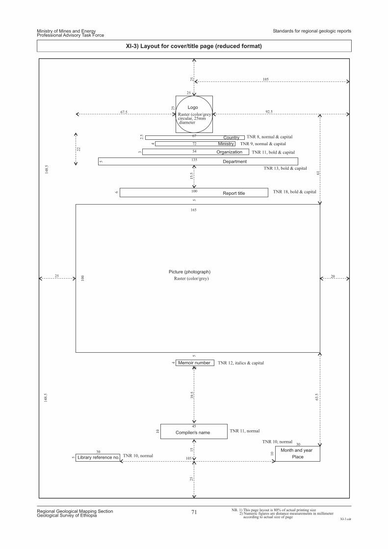
165
100
25
2025
67.5 92.5
25
25
148.5
22
148.5
30
45
105
30
30
10
10
39.5
63.5
25
15
55
4
5
100
105
Raster (color/grey)circular, 25mmdiameter
TNR 8, normal & capital
TNR 9, normal & capital
TNR 11, bold & capital
TNR 13, bold & capital
TNR 18, bold & capital
TNR 12, italics & capital
TNR 11, normal
TNR 10, normal
TNR 10, normal
Raster (color/grey)
135
6
61
15.5
5
72
544
367
2.5
Logo
Country
Ministry
Organization
Department
Report title
Picture (photograph)
Memoir number
Compiler/s name
Month and year
PlaceLibrary reference no.
NB. 1) This page layout is 80% of actual printing size2) Numeric figures are distance measurements in millimeter
according to actual size of page
Ministry of Mines and EnergyProfessional Advisory Task Force
Standards for regional geologic reports
XI-3.cdr
Regional Geological Mapping SectionGeological Survey of Ethiopia
71
XI-3) Layout for cover/title page (reduced format)
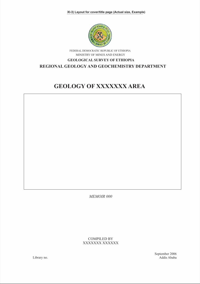
GEOLOGY OF XXXXXXX AREA
FEDERAL DEMOCRATIC REPUBLIC OF ETHIOPIA
MINISTRY OF MINES AND ENERGY
COMPILED BYXXXXXXX XXXXXX
MEMOIR 000
Library no.September 2006
Addis Ababa
GEOLOGICAL SURVEY OF ETHIOPIA
REGIONAL GEOLOGY AND GEOCHEMISTRY DEPARTMENT
XI-3) Layout for cover/title page (Actual size, Example)
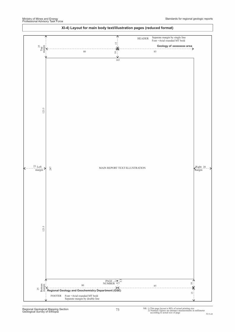
HEADER
MAIN REPORT TEXT/ILLUSTRATION
FOOTER Font =Arial rounded MT boldSeparate margin by double line
Separate margin by single line
Font =Arial rounded MT bold
Leftmargin
Bott
om
mar
gin
Rightmargin
Top
mar
gin
PAGENUMBER
Geology of xxxxxxxxx area
Regional Geology and Geochemistry Department (GSE)
165
25
123.5
123.5
25
15
3.5
4.5
15
10
10
25
80
80
85
85
20
247
NB. 1) This page layout is 80% of actual printing size2) Numeric figures are distance measurements in millimeter
according to actual size of page
Ministry of Mines and EnergyProfessional Advisory Task Force
Standards for regional geologic reports
XI-4.cdr
Regional Geological Mapping SectionGeological Survey of Ethiopia
73
XI-4) Layout for main body text/illustration pages (reduced format)

Geology of xxxxxxxxx area
Regional Geology and Geochemistry Department (GSE)
MAIN REPORT TEXT/ILLUSTRATION
12
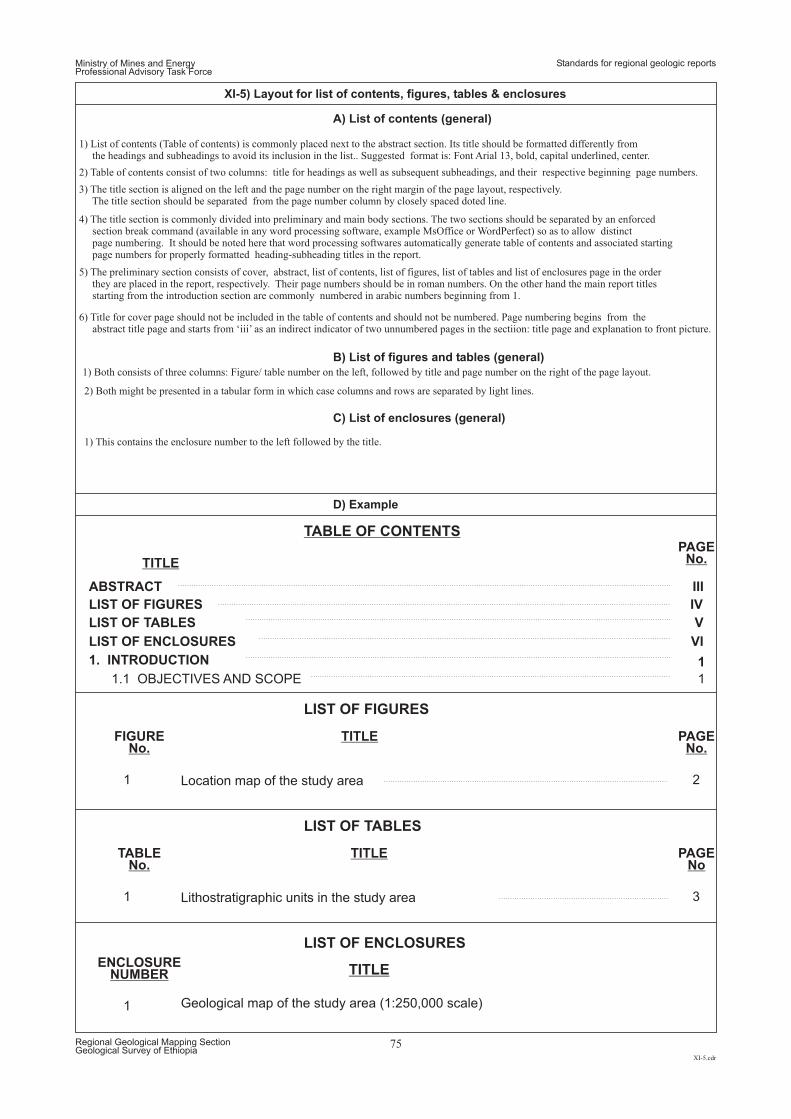
Ministry of Mines and EnergyProfessional Advisory Task Force
XI-5.cdr
Regional Geological Mapping SectionGeological Survey of Ethiopia
75
XI-5) Layout for list of contents, figures, tables & enclosures
Standards for regional geologic reports
2) Table of contents consist of two columns: title for headings as well as subsequent subheadings, and their respective beginning page numbers.
1) List of contents (Table of contents) is commonly placed next to the abstract section. Its title should be formatted differently fromthe headings and subheadings to avoid its inclusion in the list.. Suggested format is: Font Arial 13, bold, capital underlined, center.
1) Both consists of three columns: Figure/ table number on the left, followed by title and page number on the right of the page layout.
1) This contains the enclosure number to the left followed by the title.
2) Both might be presented in a tabular form in which case columns and rows are separated by light lines.
3) The title section is aligned on the left and the page number on the right margin of the page layout, respectively.The title section should be separated from the page number column by closely spaced doted line.
4) The title section is commonly divided into preliminary and main body sections. The two sections should be separated by an enforcedsection break command (available in any word processing software, example MsOffice or WordPerfect) so as to allow distinctpage numbering. It should be noted here that word processing softwares automatically generate table of contents and associated startingpage numbers for properly formatted heading-subheading titles in the report.
5) The preliminary section consists of cover, abstract, list of contents, list of figures, list of tables and list of enclosures page in the orderthey are placed in the report, respectively. Their page numbers should be in roman numbers. On the other hand the main report titlesstarting from the introduction section are commonly numbered in arabic numbers beginning from 1.
6) Title for cover page should not be included in the table of contents and should not be numbered. Page numbering begins from theabstract title page and starts from ‘iii’ as an indirect indicator of two unnumbered pages in the sectiion: title page and explanation to front picture.
A) List of contents (general)
B) List of figures and tables (general)
C) List of enclosures (general)
D) Example
TABLE OF CONTENTS
LIST OF FIGURES
LIST OF TABLES
LIST OF ENCLOSURES
TITLE
PAGENo.
PAGENo.
PAGENo
FIGURENo.
TABLENo.
ENCLOSURENUMBER
TITLE
TITLE
TITLE
ABSTRACT
1
1
1
III
2
3
LIST OF FIGURES IV
LIST OF TABLES
LIST OF ENCLOSURES
V
VI
1. INTRODUCTION
Location map of the study area
Lithostratigraphic units in the study area
Geological map of the study area (1:250,000 scale)
1.1 OBJECTIVES AND SCOPE
1
1
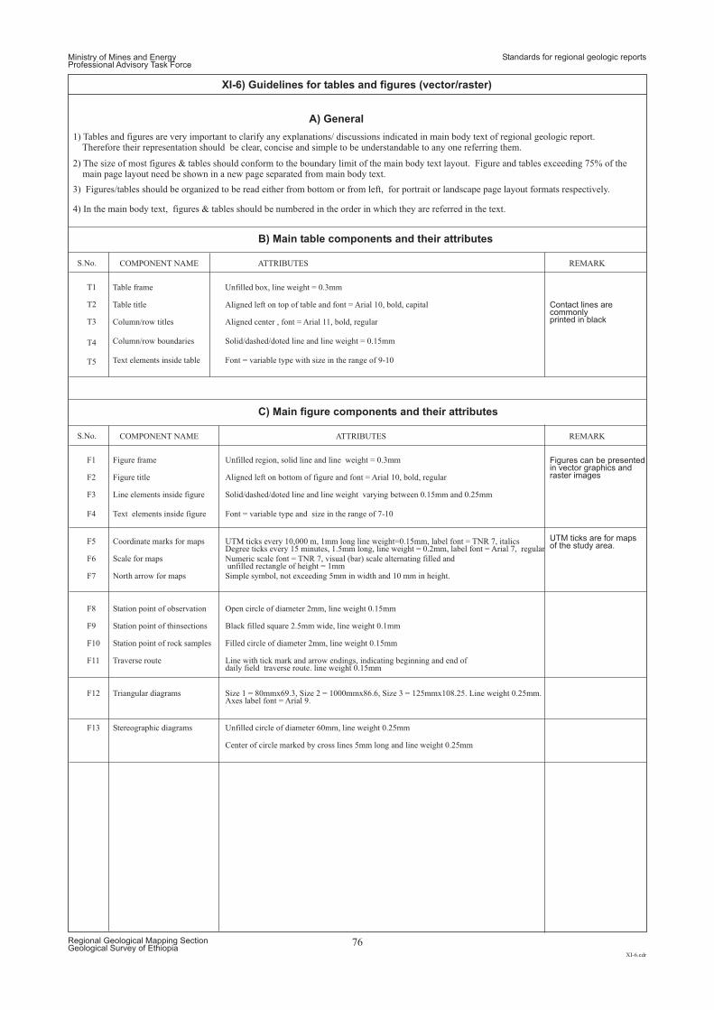
Ministry of Mines and EnergyProfessional Advisory Task Force
Standards for regional geologic reports
XI-6.cdr
Regional Geological Mapping SectionGeological Survey of Ethiopia
76
XI-6) Guidelines for tables and figures (vector/raster)
A) General
T1
F1 Unfilled region, solid line and line weight = 0.3mmFigure frame
T2
F2 Aligned left on bottom of figure and font = Arial 10, bold, regularFigure title
T3
F3 Solid/dashed/doted line and line weight varying between 0.15mm and 0.25mmLine elements inside figure
T4
F4 Font = variable type and size in the range of 7-10Text elements inside figure
F5
F8
F12
F6
F9
F7
F10
F13
F11
Simple symbol, not exceeding 5mm in width and 10 mm in height.
Filled circle of diameter 2mm, line weight 0.15mm
Unfilled circle of diameter 60mm, line weight 0.25mm
Center of circle marked by cross lines 5mm long and line weight 0.25mm
Line with tick mark and arrow endings, indicating beginning and end ofdaily field traverse route. line weight 0.15mm
UTM ticks every 10,000 m, 1mm long line weight=0.15mm, label font = TNR 7, italicsDegree ticks every 15 minutes, 1.5mm long, line weight = 0.2mm, label font = Arial 7, regular
Open circle of diameter 2mm, line weight 0.15mm
Size 1 = 80mmx69.3, Size 2 = 1000mmx86.6, Size 3 = 125mmx108.25. Line weight 0.25mm.Axes label font = Arial 9.
Numeric scale font = TNR 7, visual (bar) scale alternating filled andunfilled rectangle of height = 1mm
Black filled square 2.5mm wide, line weight 0.1mm
Coordinate marks for maps
Station point of observation
Triangular diagrams
Scale for maps
Station point of thinsections
North arrow for maps
Station point of rock samples
Stereographic diagrams
Traverse route
T5
Table frame Unfilled box, line weight = 0.3mm
Aligned left on top of table and font = Arial 10, bold, capital
Aligned center , font = Arial 11, bold, regular
Solid/dashed/doted line and line weight = 0.15mm
Font = variable type with size in the range of 9-10
Table title
Column/row titles
Column/row boundaries
Text elements inside table
S.No.
S.No.
COMPONENT NAME
COMPONENT NAME
ATTRIBUTES
ATTRIBUTES REMARK
REMARK
1) Tables and figures are very important to clarify any explanations/ discussions indicated in main body text of regional geologic report.Therefore their representation should be clear, concise and simple to be understandable to any one referring them.
4) In the main body text, figures & tables should be numbered in the order in which they are referred in the text.
2) The size of most figures & tables should conform to the boundary limit of the main body text layout. Figure and tables exceeding 75% of themain page layout need be shown in a new page separated from main body text.
3) Figures/tables should be organized to be read either from bottom or from left, for portrait or landscape page layout formats respectively.
B) Main table components and their attributes
C) Main figure components and their attributes
Contact lines arecommonlyprinted in black
Figures can be presentedin vector graphics andraster images
UTM ticks are for mapsof the study area.
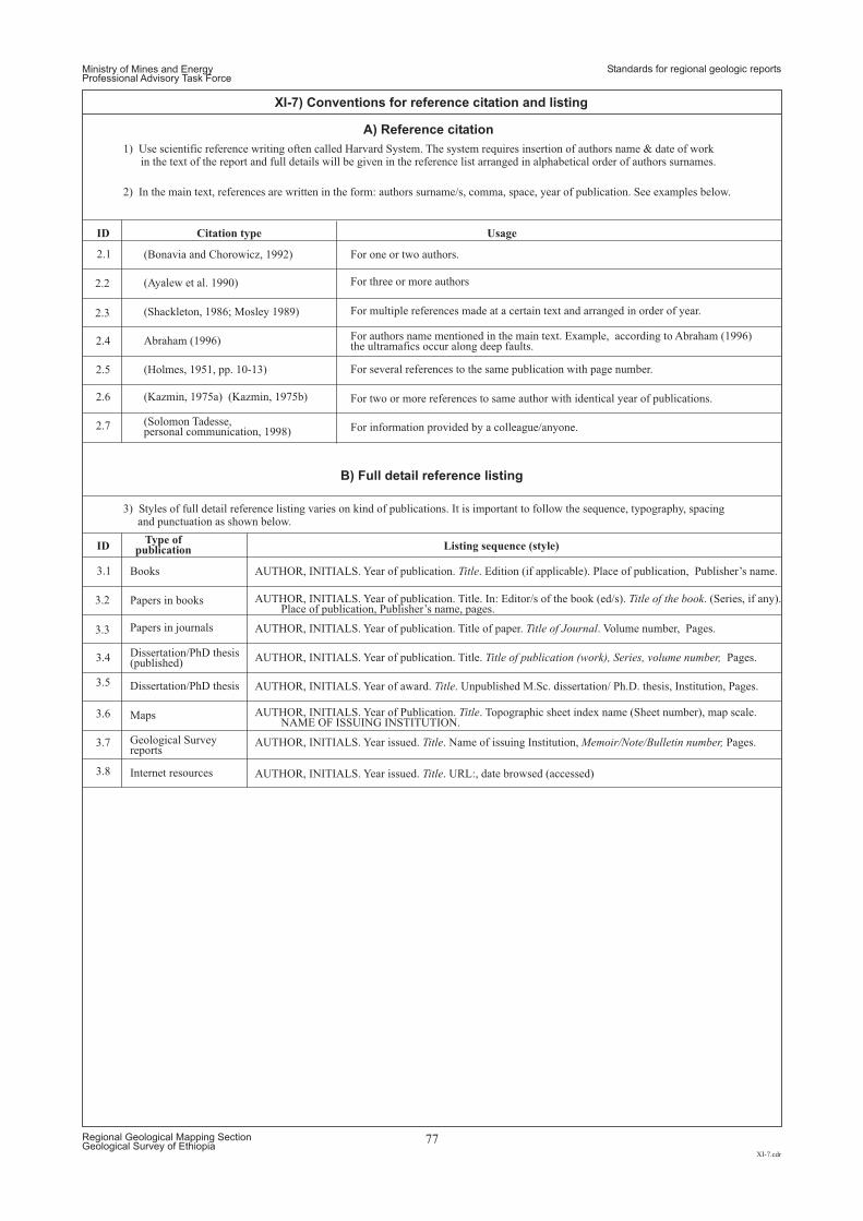
Ministry of Mines and EnergyProfessional Advisory Task Force
Standards for regional geologic reports
XI-7.cdr
Regional Geological Mapping SectionGeological Survey of Ethiopia
77
XI-7) Conventions for reference citation and listing
A) Reference citation
B) Full detail reference listing
1) Use scientific reference writing often called Harvard System. The system requires insertion of authors name & date of workin the text of the report and full details will be given in the reference list arranged in alphabetical order of authors surnames.
2) In the main text, references are written in the form: authors surname/s, comma, space, year of publication. See examples below.
3) Styles of full detail reference listing varies on kind of publications. It is important to follow the sequence, typography, spacingand punctuation as shown below.
(Bonavia and Chorowicz, 1992)
AUTHOR, INITIALS. Year of publication. . Edition (if applicable). Place of publication, Publisher’s name.Title
For one or two authors.
Books
For three or more authors
Papers in books
For two or more references to same author with identical year of publications.
For information provided by a colleague/anyone.
Maps
Geological Surveyreports
Internet resources
For several references to the same publication with page number.
For authors name mentioned in the main text. Example, according to Abraham (1996)the ultramafics occur along deep faults.
Dissertation/PhD thesis(published)
Dissertation/PhD thesis
For multiple references made at a certain text and arranged in order of year.
Papers in journals
(Ayalew et al. 1990)
AUTHOR, INITIALS. Year of publication. Title. In: Editor/s of the book (ed/s). . (Series, if any).Place of publication, Publisher’s name, pages.
Title of the book
Abraham (1996)
AUTHOR, INITIALS. Year of publication. Title. Pages.Title of publication (work), Series, volume number,
(Holmes, 1951, pp. 10-13)
AUTHOR, INITIALS. Year of award. . Unpublished M.Sc. dissertation/ Ph.D. thesis, Institution, Pages.Title
(Kazmin, 1975a) (Kazmin, 1975b)
(Solomon Tadesse,personal communication, 1998)
AUTHOR, INITIALS. Year of Publication. . Topographic sheet index name (Sheet number), map scale.NAME OF ISSUING INSTITUTION.
Title
AUTHOR, INITIALS. Year issued. . Name of issuing Institution, Pages.Title Memoir/Note/Bulletin number,
AUTHOR, INITIALS. Year issued. . URL:, date browsed (accessed)Title
(Shackleton, 1986; Mosley 1989)
AUTHOR, INITIALS. Year of publication. Title of paper. . Volume number, Pages.Title of Journal
2.1
3.1
ID
ID
Citation type
Listing sequence (style)
Usage
Type ofpublication
2.2
3.2
2.3
3.3
2.4
3.4
2.5
3.5
2.6
2.7
3.6
3.7
3.8
.
.
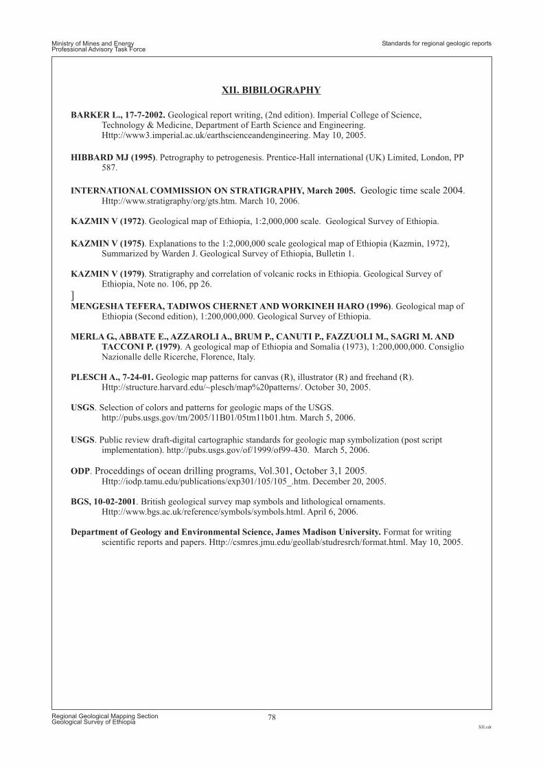
Ministry of Mines and EnergyProfessional Advisory Task Force
Standards for regional geologic reports
XII.cdr
Regional Geological Mapping SectionGeological Survey of Ethiopia
78
XII. BIBILOGRAPHY
BARKER L., 17-7-2002.
HIBBARD MJ (1995)
INTERNATIONAL COMMISSION ON STRATIGRAPHY, March 2005.
KAZMIN V (1972)
MENGESHA TEFERA, TADIWOS CHERNET AND WORKINEH HARO (1996)
PLESCH A., 7-24-01.
USGS
USGS
ODP
BGS, 10-02-2001
Department of Geology and Environmental Science, James Madison University.
Geological report writing, (2nd edition). Imperial College of Science,Technology & Medicine, Department of Earth Science and Engineering.Http://www3.imperial.ac.uk/earthscienceandengineering. May 10, 2005.
. Petrography to petrogenesis. Prentice-Hall international (UK) Limited, London, PP587.
.Http://www.stratigraphy/org/gts.htm. March 10, 2006.
. Geological map of Ethiopia, 1:2,000,000 scale. Geological Survey of Ethiopia.
. Geological map ofEthiopia (Second edition), 1:200,000,000. Geological Survey of Ethiopia.
Geologic map patterns for canvas (R), illustrator (R) and freehand (R).Http://structure.harvard.edu/~plesch/map%20patterns/. October 30, 2005.
. Selection of colors and patterns for geologic maps of the USGS.http://pubs.usgs.gov/tm/2005/11B01/05tm11b01.htm. March 5, 2006.
. Public review draft-digital cartographic standards for geologic map symbolization (post scriptimplementation). http://pubs.usgs.gov/of/1999/of99-430. March 5, 2006.
. .Http://iodp.tamu.edu/publications/exp301/105/105_.htm. December 20, 2005.
. British geological survey map symbols and lithological ornaments.
Geologic time scale 2004
Proceddings of ocean drilling programs, Vol.301, October 3,1 2005
KAZMIN V (1975)
KAZMIN V (1979)
MERLA G., ABBATE E., AZZAROLI A., BRUM P., CANUTI P., FAZZUOLI M., SAGRI M. AND
TACCONI P. (1979)
. Explanations to the 1:2,000,000 scale geological map of Ethiopia (Kazmin, 1972),Summarized by Warden J. Geological Survey of Ethiopia, Bulletin 1.
. Stratigraphy and correlation of volcanic rocks in Ethiopia. Geological Survey ofEthiopia, Note no. 106, pp 26.
. A geological map of Ethiopia and Somalia (1973), 1:200,000,000. ConsiglioNazionalle delle Ricerche, Florence, Italy.
]
Http://www.bgs.ac.uk/reference/symbols/symbols.html. April 6, 2006.
Format for writingscientific reports and papers. Http://csmres.jmu.edu/geollab/studresrch/format.html. May 10, 2005.