Embed Size (px)
Citation preview
SURVEY AND MONITORING OF
PENSTEMON GIBBENSII (GIBBENS’ BEARDTONGUE)
IN SOUTH-CENTRAL WYOMING
Prepared for the Bureau of Land Management
Wyoming State Office and Rawlins Field Office
By Bonnie Heidel
Wyoming Natural Diversity Database
Dept. 3381, University of Wyoming
1000 E. University Ave.
Laramie, WY 82071
May 2009
Cooperative Agreement No. KAA041037, Modifications 3 and 5
ii
ABSTRACT
Survey and monitoring of Gibbens’ beardtongue (Penstemon gibbensii) was conducted in
2007-2008 to update the status of the species in Wyoming as treated in two prior status reports.
Data on new occurrences from intervening years were incorporated, a potential distribution
model and photointerpretation were used as the basis for expanding systematic surveys, and one
new occurrence was documented. The area of occupied habitat has been greatly expanded to 270
acres, but at least three of the six known occurrences have experienced significant declines in
population numbers. The total population numbers in Wyoming are estimated at 6000-9000
plants. Prolonged drought appears to be responsible for the population declines in the state, as
documented at two monitored sites and estimated at a third. Population declines exceed an order
of magnitude at Cherokee Basin, where they appear to be associated with extreme erosion.
Information on impacts and potential threats are also updated.
Report citation:
Heidel, B. 2009. Survey and monitoring of Gibbens’ penstemon (Penstemon gibbensii) in
south-central Wyoming. Prepared for the Bureau of Land Management. Wyoming Natural
Diversity Database, Laramie, WY.
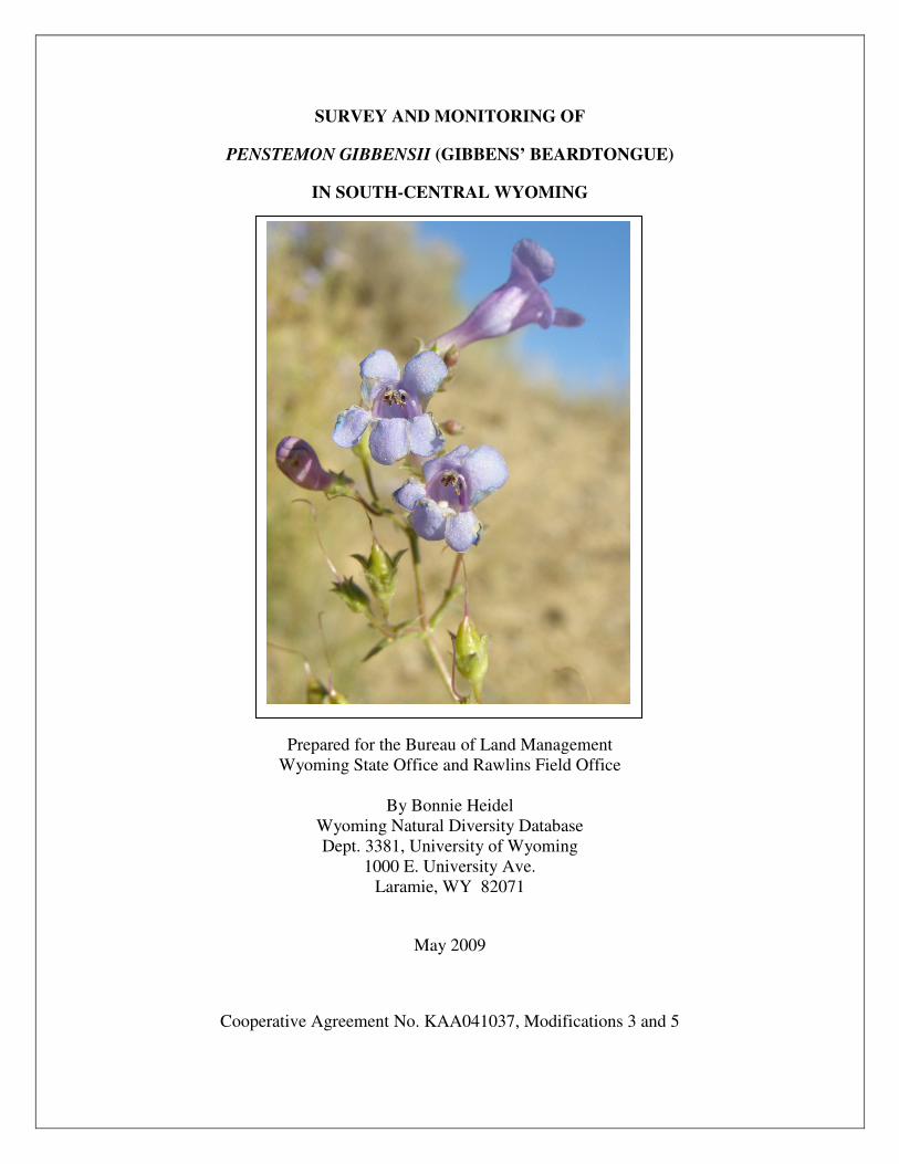
Cover photo: Penstemon gibbensii close-up, by B. Heidel
iii
Table of Contents
I. INTRODUCTION ............................................................................................................................... 1
II. METHODS ...................................................................................................................................... 3
III. SPECIES INFORMATION ........................................................................................................... 4
A. Classification ..................................................................................................................................... 4
B. Present legal or other formal status ................................................................................................... 6
C. Description ........................................................................................................................................ 6
D. Geographical distribution .................................................................................................................. 8
E. Habitat: Gibbens' beardtongue is found primarily on barren shale or sandstone slopes of the ...... 13
F. Population biology and demography .............................................................................................. 20
G. Population ecology .......................................................................................................................... 26
IV. ASSESSMENT AND MANAGEMENT RECOMMENDATIONS .......................................... 27
A. Potential threats to currently known populations: ......................................................................... 27
B. Management practices and response: ............................................................................................ 29
C. Conservation recommendations ....................................................................................................... 30
C. Status recommendations: .............................................................................................................. 31
D. Summary: ...................................................................................................................................... 31
V. LITERATURE CITED .................................................................................................................... 32
APPENDICES
Appendix A. Global ranking analysis for Penstemon gibbensii
Appendix B. Element occurrence records and maps for Penstemon gibbensii
Appendix C. 2008 survey routes
Appendix D. Potential distribution model for Penstemon gibbensii
Appendix E. Additional new Wyoming plant species of concern documented in 2008
Appendix F. Penstemon gibbensii area of occupancy
Appendix G. Monitoring of Penstemon gibbensii at Cherokee Basin
Appendix H. Monitoring of Penstemon gibbensii at Flat Top Mountain
Appendix I. Updated state species abstract for Penstemon gibbensii
iv
FIGURES AND TABLES
Figure 1. Penstemon gibbensii illustration
Figure 2. Penstemon gibbensii close-up
Figure 3. Penstemon gibbensii whole plant
Figure 4. Global distribution and Wyoming distribution of Penstemon gibbensii
Figure 5. Potential distribution of Penstemon gibbensii in Wyoming
Figure 6. Sections where Penstemon gibbensii has been surveyed in Wyoming
Figure 7. Typical topographic setting for Penstemon gibbensii
Figure 8. Willow Creek topographic settings for Penstemon gibbensii
Figures 9-14. Penstemon gibbensii habitat
Figure 15. Annual precipitation in Baggs, WY (1982-2006)
Figure 16. Annual temperature in Baggs,WY (1982-2006)
Figure 17. Alpha Hull Range Extent for Penstemon gibbensii
Figure 18. Trend in Penstemon gibbensii established plants in Cherokee Basin monitoring
Figure 19. Trend in Penstemon gibbensii seedlings in Cherokee Basin monitoring
Figure 20. Trend in Penstemon gibbensii established plants in Flat Top monitoring
Figure 21. Trend in Penstemon gibbensii stems in Flat Top monitoring
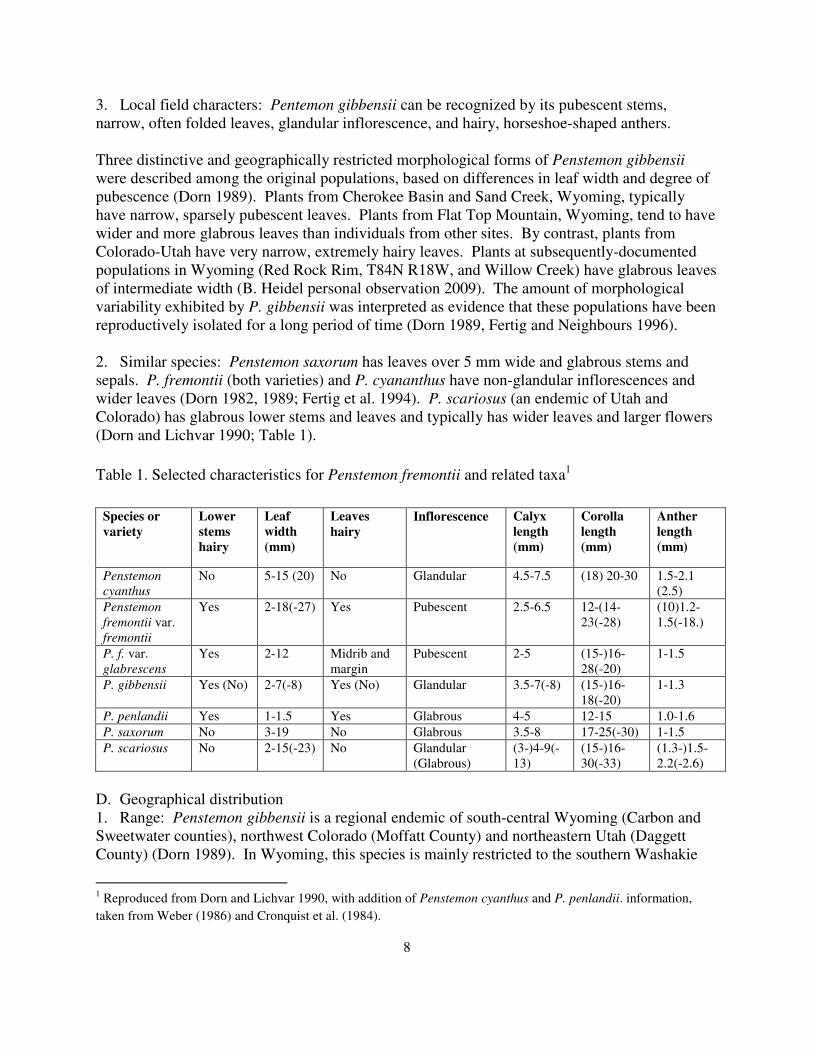
Table 1. Selected characteristics for Penstemon fremontii and related taxa
Table 2. Location information for known occurrences of Penstemon gibbensii
Table 3. Species frequently associated with Penstemon gibbensii
Table 4. Soil characteristics at Penstemon gibbensii sites in Wyoming
Table 5. Mineralogy of Penstemon gibbensii soil samples
Table 6. Size and extent of Penstemon gibbensii occurrences
Table 7. Non-native species in Penstemon gibbensii habitat
v
ACKNOWLEDGEMENTS
This report is an update that reflects on past work of many people. Robert Dorn
conducted more taxonomic research on Penstemon gibbensii than any other botanist, and
prepared the first state status report on the species in Colorado and Wyoming. Walter Fertig
coordinated new surveys, prepared a subsequent Wyoming status report, added a monitoring site,
developed a potential distribution model used in 2008 surveys, and synthesized species’
information for the Wyoming Rare Plant Field Guide and state species abstract. Amy Roderick
Taylor (UW graduate student), Sara Davis (WEST, Inc. biologist) and Jill Larson (Wyoming
Natural Diversity Database; WYNDD employee participating in the 2008 study) discovered new
populations. Beth Rintz, Kurt and Jeanette Flaig made revisits and provided documentation of
the population discovered by WEST, Inc. Susan Spackman-Punjabi (Colorado Natural Heritage
Program), Jill Handwerk (Colorado Natural Heritage Program), and Ben Franklin (Utah Natural
Heritage Program) kindly provided occurrence data, shapefiles and comments on current
Penstemon gibbensii status in their state.
Joy Handley (WYNDD) entered occurrence data prior to the start of this study,
assembled digital orthophotograph sets for fieldwork, prepared the rangewide distribution maps,
the map of survey extent, and the Wyoming occurrence exports. Mark Andersen (WYNDD)
provided area- of-occupancy calculations. Jill Larson assisted in 2008 surveys and monitoring
for WYNDD. Ramona Belden (University of Wyoming Soils Testing Lab) oversaw soils
analysis. The facilities and resources of the Rocky Mountain Herbarium were fundamental to
this study and are gratefully acknowledged.
Mark Andrew Warren initiated monitoring and previously provided an interim report on
the monitoring of Penstemon gibbensii in the Cherokee Basin for the Rock Springs Field Office
of the Bureau of Land Management (BLM). Frank Blomquist coordinated the current P.
gibbensii project for the Rock Springs Office of the BLM, provided information updates for two
populations, provided copies of Cherokee Basin monitoring data, and helped monitor at
Cherokee Basin and Flat Top Mountain. Mark Newman facilitated x-ray spectroscopy analysis
of the soil samples for the Rock Springs Field Office with help of the Worland Field Office.
Tyler Abbott and Adrienne Pilmanis provided Wyoming BLM state office coordination. This
project would not have been possible without the contributions of many people.

vi
1
I. INTRODUCTION
This status report provides updates and additions to the two prior Penstemon gibbensii status
reports for the species in Wyoming (Dorn 1989, Fertig and Neighbours 1996), also cross-
referencing the most current out-of-state information (Spackman and Anderson 1999, Colorado
Natural Heritage Inventory 2009, Utah Natural Heritage Inventory 2009). A need for updating
the information on P. gibbensii in the state was identified based upon five considerations.
1. The most current Penstemon gibbensii status report for Wyoming (Fertig and Neighbours
1996) was prepared when there were three known occurrences in the state. Two new
occurrences were subsequently discovered (Roderick et al. 1999, Flaig 2006) that had not
been addressed as they modify status information.
2. A potential distribution model was developed for Penstemon gibbensii (Fertig and Thurston
2003) based on the first four known occurrences, which identified additional areas of
potential habitat that had never been surveyed in prior status surveys.
3. Collection label data for two historical specimens of Penstemon gibbensii collected by
Robert Gibbens were found in the Rocky Mountain Herbarium historical collections database
in 2007, though the specimens themselves were sent off and regarded as lost. The two
putative P. gibbensii collection stations had never been surveyed in prior state status surveys.
4. Long-term monitoring studies at the only monitored occurrence of Penstemon gibbensii
showed major declines in species’ numbers (USDI BLM unpublished monitoring data 2004).
Previously, the species’ trends were characterized as stable or increasing (Fertig and
Neighbours 1996).
5. Long-term monitoring set up at a second Penstemon gibbensii occurrence (Fertig and
Neighbours 1996) intended for annual monitoring had never been revisited to assess trend
and to collect demographic information.
The following introductory information represents a brief history of species’ documentation,
incorporating the background information and results of prior status surveys (Dorn 1989, Fertig
and Neighbours 1996, Spackman and Anderson 1999), but with additions, updates, and review of
current supporting data (Colorado Natural Heritage Program 2008, Utah Natural Heritage
Program 2008, and Wyoming Natural Diversity Database 2008).
Robert Gibbens, a doctoral student in range management at the University of Wyoming,
made the first collection of Penstemon gibbensii in 1967 or 1968. The collection was
provisionally identified as P. mensarum and noted as one of four new additions to the state flora
collected in his study plots in northern desert shrub scrub (Appendix A in Gibbens 1972). Dr.
Robert Dorn studied the material while preparing his “Manual of the Vascular Plants of
Wyoming” (Dorn 1977) and tentatively assigned it to P. saxosorum. The original specimens
were later sent out for examination by a Penstemon specialist, lost, and never returned (Dorn
1989, Fertig and Neighbours1996).
Dorn resurveyed the locale west of Baggs for Gibbens’ unusual Penstemon in 1981, using the
prior collection label information (Dorn pers. commun. to B. Heidel 2008), and relocated it on
BLM-administered land at the northeast end of Cherokee Basin. Comparative studies with
related species revealed that the material belonged to a new, undescribed species which Dorn
(1982) named P. gibbensii in honor of its discoverer.
2
Meanwhile, the species was discovered in Colorado at Brown’s Park (Spitzie Draw) in
Moffat County in 1978 by J. Scott Peterson, Sandy Emrich, Elizabeth Painter and Carolyn Pease,
but was not determined as P. gibbensii until after 1982 (Dorn 1989). An additional occurrence
was discovered farther east in Moffat County (Sterling Place) by Karen Wiley-Eberle in 1984
and an extension to it by Betsy Neely in 1986. In 1989, the species was found in Brown’s Park
in Daggett County, Utah by J. Anderson and F. Smith little more than three miles away from the
original Colorado occurrence. The extent of these two Colorado occurrences and one Utah
occurrence have since been systematically surveyed and new surveys were conducted on
Brown’s Park Formation outcrops, but no new occurrences have been found (Spackman and
Anderson 1999, Handwerk pers. commun. to B. Heidel 2009).
Penstemon gibbensii was designated as a Category 2 candidate for listing under the
Endangered Species Act by the U.S. Fish and Wildlife Service (USFWS) in 1983. Under Bureau
of Land Management (BLM) Manual 6840, the BLM is directed to manage USFWS candidate
species in such a manner that ensures these species and their habitats are conserved and that
agency actions do not contribute to the need to list these species as Threatened or Endangered
(Willoughby et al. 1992). To protect the plant and prevent the need for listing it, plans were
developed for constructing an exclosure, discussed in both the Divide Grazing EIS (1983) and a
separate environmental assessment (Warren 1992). The BLM exclosure around the P. gibbensii
occurrence was completed in 1985. This also lead the BLM to collect P. gibbensii monitoring
data from the Cherokee Basin exclosure (1987-2007), with one interim summary (Warren
1992),collected by BLM at 3-6 year intervals with results stored in manual agency files. The
Category 2 status also lead USFWS to contract the first status survey for the species in 1987-
1989, as a result of which two additional P. gibbensii occurrences were documented at Flat Top
Mountain and Sand Creek in 1987 (Dorn 1989).
Sometime after 1991, when electronic databases were initiated at the Rocky Mountain
Herbarium (RM), data from two collection labels for Penstemon gibbensii specimens were
entered in a database for storing information on historical specimens. The corresponding
specimens were not in the cabinet accessions at the RM, and the particular collection locales
were not mentioned or surveyed by Dorn (1989) or by Fertig and Neighbours (1996). These
electronic records were retrieved in 2007 and it was not clear whether the long-lost P. gibbensii
specimens had been returned and misfiled, the collection label data had been entered apart from
the specimens, or else the collection label entries represented some sort of error.
In 1995, the BLM Wyoming State Office and Rawlins Field Office contracted on a cost-
share basis with the Wyoming Natural Diversity Database (WYNDD) to conduct field surveys
for Penstemon gibbensii on public lands in south-central Wyoming. The objectives of this
project were to collect additional information on the biology, distribution, habitat use, population
size, and potential threats to this species to be used in guiding management decisions. In
addition, the existing monitoring at Cherokee Basin was resurveyed and new monitoring at Flat
Top Mountain was established to study demographic trends by Walter Fertig, Mary Neighbours
and Jane Struttman (Fertig and Neighbours 1996). Later, on 19 July 1995, USFWS reviewed its
policy on candidate species and replaced the C2 designation with a new category “Species at
Risk” (Davis 1995). Species in this new category were no longer considered formal candidates
for listing, so P. gibbensii had no official status.
3
In 1997, Amy Roderick Taylor documented a new location of Penstemon gibbensii in the
Upper North Platte River valley north of Saratoga as part of floristic inventory representing
master thesis research (Roderick et al. 1999, Taylor 2000), a site that was later surveyed in detail
by Walter Fertig in 1999. An adjoining private landowner requested a survey, extending the
population boundaries as surveyed by Bonnie Heidel in 2005. In 2004, Sara Davis of WEST,
Inc. found a new location of P. gibbensii in Willow Creek (a Sand Creek tributary northwest of
the Sand Creek occurrence) in late summer as part of a pipeline survey. The latter was mapped
in detail on the corridor by Kurt Flaig, Jeanette Flag and Beth Rintz in 2005 (Flaig 2006).
In 2001, the BLM Wyoming State Office released the first sensitive species list for the state,
and Penstemon gibbensii was included among 40 vascular plant species recognized as sensitive
in the state (USDI BLM 2001). In 2003, potential distribution maps were completed for all BLM
sensitive species, including P. gibbensii, were produced from known distribution (four records)
by Walter Fertig and Rob Thurston (Fertig and Thurston 2003). The potential distribution map,
as well as reported declines in P. gibbensii population numbers (USDI BLM 2004) spurred
discussion of prospective monitoring and survey needs. In 2006, the Sand Creek occurrence of
P. gibbensii was mapped in greater detail by BLM (Frank Blomquist 2007).
The current Penstemon gibbensii project was originally proposed as a monitoring study in
2004 and contracted by BLM on a challenge cost-share basis with WYNDD in 2007. Most of
the fieldwork was conducted in 2008. The objectives of the current project were to compile the
most complete distribution and habitat information at all known occurrences, test the potential
distribution model in new surveys, conduct surveys at the historic P. gibbensii collection sites,
collect and help interpret monitoring data from the ongoing Cherokee Basin monitoring project,
gather and interpret monitoring data from the Flat Top Mountain occurrence, and update habitat
information as appropriate.
In 2008, a petition was filed to list 206 species in the Mountains and Plains Region of the
U.S. Fish and Wildlife Service under the Endangered Species Act, including Penstemon
gibbensii. Subsequently, a 90-day finding for 165 of the species among the original 206
determined that the petition did not present substantial information indicating that listing may be
warranted for those particular species (USDI Fish and Wildlife Service 2009). P. gibbensii was
not included among the 165 species that were addressed, and thus remains among those for
which a finding is pending.
II. METHODS Information on the habitat and distribution of Penstemon gibbensii was obtained from
previous status reports (Dorn 1989, Fertig and Neighbours 1996), Rocky Mountain Herbarium
(RM) collections and databases, the literature, WYNND files and computer databases, and
knowledgeable individuals. A map of the potential distribution of P. gibbensii, generated with
use of a range/intersection model (Fertig and Thurston 2003), was compared with known
distribution.
In preparation for fieldwork, the potential distribution map was printed out with topographic
map boundaries superimposed. The most recent status report (Fertig and Neighbours 1996)
provided a compiled record of places where Penstemon gibbensii had been surveyed but not
4
found (Appendix B in Fertig and Neighbours 1996), and they were transcribed onto a printed
potential distribution map to eliminate those areas already surveyed. Digital aerial
orthphotograph quarter-quads were printed out with the polygons of potential habitat
superimposed.
Field surveys were initiated in late June of 2007, monitoring at the Cherokee Basin site was
conducted in mid-July 2007, monitoring at the Flat Top Mountain site was conducted in early
July 2008, and all other surveys were conducted in July 2008. Data on biology, habitat,
population size, and management matters were collected using WYNDD plant survey forms.
Copies of status reports and all previously-collected data entered as part of records was printed
out to use as reference in the field, along with boundaries of previously-surveyed populations,
digitized from hand-drawn boundaries recorded onto U.S. Geological Survey topographic maps
(7.5’ quads).
The three permanent monitoring transects established at the Cherokee Basin, Wyoming site
by the BLM in 1985 were re-read by Mark Warren and Frank Blomquist (BLM), Chicago
Botanical Garden interns, and the author in 2007. The three permanent monitoring transects
established at Flat Top Mountain, Wyoming by Walter Fertig and Walter Fertig and Jane
Struttmann (WYNDD) in 1995 were re-read by the author, Jill Larson (WYNDD), and Frank
Blomquist (BLM) in 2008.
In addition, Geographic Positioning Satellite (GPS) points were taken at known and new
Penstemon gibbensii occurrences to check and map new boundaries (Blomquist 2007, and this
study). Prior to this, population boundaries were digitized from hand-drawn boundaries marked
onto topographic maps in the field (Fertig and Neighbours 1996).
Soil samples were collected at every site to a depth of 15 cm in order to document soil
Munsell color (wet and dry), texture, calcium carbonate equivalent (%), check for high selenium
levels, and to determine the mineralogy as indication of volcanic ash through mass spectrometry.
In addition, x-ray diffraction analysis was also conducted. For the spectroscopy, soil samples
collected from each site were reduced to a very fine powder via hand grinding in a sapphire-
diamond mortar and pestle, and then compacted into the opening of an x-ray slide. The samples
were analyzed in x-ray diffractometer using a Rigaku Miniflex, Model 2005 unit and CuK’v’
radiation, driven by DataScan software and interpreted by Jade v.7 software, as conducted at the
Worland Field Office of the Bureau of Land Management. The output included a plot of the x-
ray response and tabular identification of peaks by Jade software. A quantitative analysis of each
sample was also produced using the Jade Easy-Quant feature, provided that there were at least
two or three mineral phases present in the sample.
III. SPECIES INFORMATION A. Classification
1. Scientific name: Penstemmon gibbensii (Dorn), described in Dorn (1982)
2. Synonyms: None
5
3. Common name: Gibbens’ beardtongue, Gibbens’ penstemon
4. Family: Scrophulariaceae (Dorn 2001), but treated by some authors as subsumed in the
Plantaginaceae based on molecular genetics (Wolfe et al. 2006)
5. Size of genus: The Penstemon genus is comprised of about 271 species (Lodgewick and
Lodgewick 1999, cited in Wolfe et al. 2006), representing the largest genus of vascular plants
that is entirely endemic to North America.
6. Phylogenetic relationships: Dorn (1982) placed Penstemon gibbensii in Section Glabri and
noted its strong resemblance to P. cyanthus, P. fremontii, and P. saxorum. He later hypothesized
that P. gibbensii may be at least partly derived from P. fremontii, which grows in adjacent
sagebrush habitats (Dorn 1989). Subsequently, Dorn and Lichvar (1990) described a new variety
of Penstemon fremontii, P. f. var. glabrescens, that resembles P. gibbensii but lacks glands in the
inflorescence and tends to have broader leaves. The new variety is endemic to Colorado and
differs from the type variety in growing on barren habitats of Green River Shale. In addition,
O’Kane (1988) also suggested a possible affinity between P. gibbensii and P. penlandii, another
Colorado endemic. Some genetics researchers (Wolfe et al. 2006), following taxonomic
treatments of the American Penstemon Society (Lodewick and Lodewick 1999), have rejected
the subgenera treatments of taxonomists like Cronquist et al. (1984) and treat the Section Glabri
as part of the Habroanthus Section.
Genetics analysis of Penstemon gibbensii and P. penlandii was initiated by a University of
Colorado graduate student through Denver Botanical Gardens using alloenzyme techniques, and
three diagnostic loci were found (Gibson No Date. a). However, only two of the loci could
effectively be used, and 1991 attempts to increase the sample size with material from the field
had poor results (Gibson No Date. b). Methodology recommendations were made and the
conclusion was drawn that more thorough genetic analysis was warranted, including P. fremontii
among the species compared.
Penstemon gibbensii is currently one of several species being studied in comparative
population genetic analysis, in which initial results from two Wyoming populations document
high variation at the loci examined to date (Buerkle pers. commun. to B. Heidel 2009). The
between-population differentiation analysis has yet to be conducted.
Genetics research is needed for more than understanding relationships between species and
origin. Botanists have noted in the field that populations of Penstemon gibbensii exhibit
morphological differences in leaf characteristics (Dorn 1989, Dorn and Lichvar 1990, Fertig and
Neighbours 1986) as represented in Table 1. This may or may not be significant because
vegetative characteristics are generally more strongly influenced by environment than
reproductive traits of flowers and fruits. The environmental distinctions between populations are
presented in the habitat section of this report as contribution towards evaluating this idea. There
have not been seed collections made from P. gibbensii populations for growing under common
environmental conditions (common garden experiment) to confirm that population differences
are truly genetic differences. It is possible that between-population genetics are divergent in the
three isolated areas of distribution, as characteristic of a paleoendemic.
6
B. Present legal or other formal status
1. National
a. Legal status: Penstemon gibbensii was listed as a USFWS Category 2 (C2) candidate in
1983 (US Fish and Wildlife Service 1983). In 1995, USFWs revised its policy on candidate
species and replaced the C2 designation with a new category “Species at Risk” (Davis 1995).
Species in this category were no longer considered formal candidates for listing. In 2008, it was
included among 206 species petitioned for listing in the Mountain-Plains region of the U.S. Fish
and Wildlife Service under the Endangered Species Act, and was not addressed in the set of
species subsequently dropped from consideration (USDI Fish and Wildlife Service 2009).
The Wyoming Bureau of Land Management included Penstemon gibbensii on the first
Sensitive species list (USDI BLM 2001), a list that has undergone one revision in 2002. The
Colorado Bureau of Land Management recognized P. gibbensii as sensitive, and the Utah Bureau
of Land Management also recognized P. gibbensii as sensitive, though it is present on state lands
and it not known to extend onto federal lands.
b. Heritage rank. Penstemon gibbensii was ranked G1 at the time of the previous status surveys
(Fertig and Neighbours 1996, Spackman and Anderson 1999) when it was known from four
occurrences rangewide (treating the out-of-state records as a single occurrence). The
information compiled in this report provided information for updating the rank in an expanded
framework and automated process as supporting a global rank of “G1G2” (Appendix A).
2. State
a. Legal status: This species is not protected by state government statutes in any of the states
within its range.
b. Heritage rank: Penstemon gibbensii was ranked S1 when it was known from four
occurrences statewide, considered critically imperiled because of extreme rarity or other factors
of its life history making it especially vulnerable to extinction statewide. It is also ranked S1 in
Colorado (Spackman et al. 1997, Spackman and Anderson 1999, Colorado Natural Heritage
Program 2008) and Utah (Utah Natural Heritage Program 2008). The information compiled in
this report provides a basis reviewing the state rank, but no state rank changes have been made.
C. Description
1. General non-technical description: Penstemon gibbensii is a perennial herb with one to
many erect, pubescent (rarely glabrous) stems 4-14 in (10-35 cm) tall. The leaves are linear to
linear-lanceolate and often folded down the length of the midrivb, opposite, smooth-margined,
pubescent to glabrate, and mostly less than 3.16 in (5 mm) wide. The inflorescence and flowers
(including the sepals) are glandular-hairy. The corolla is tube-shaped, bright blue, and ½-3/4 in
(15-20 mm) long. Anther sacs are short pubescent on the back, dark purple-brown, horseshoe-
shaped and 1/16 in (1.2-1.5 mm) long. Fruits are oval, tawny-brownish capsules (Dorn 1982,
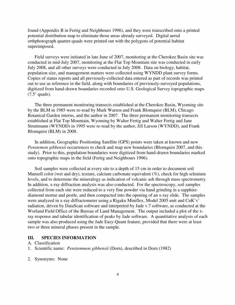
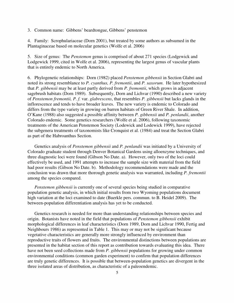
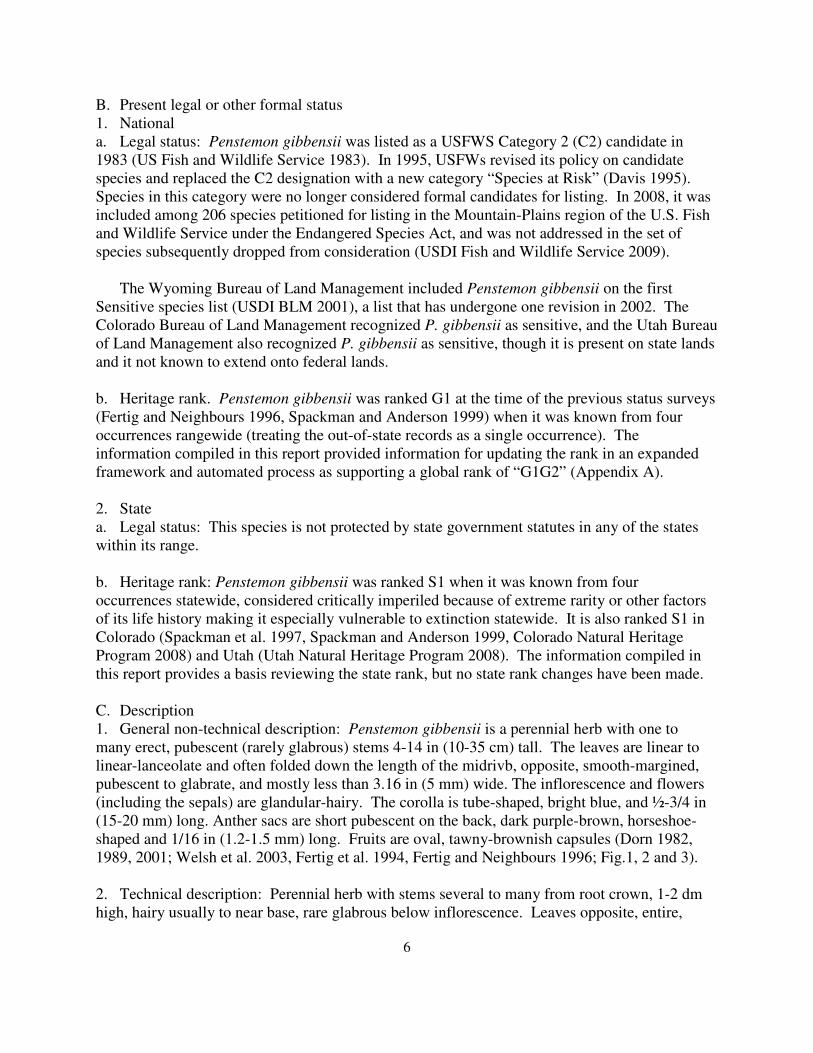
1989, 2001; Welsh et al. 2003, Fertig et al. 1994, Fertig and Neighbours 1996; Fig.1, 2 and 3).
2. Technical description: Perennial herb with stems several to many from root crown, 1-2 dm
high, hairy usually to near base, rare glabrous below inflorescence. Leaves opposite, entire,
7
linear to linear-lanceolate or lance-linear, to 9 cm long, mostly 5 (8) mm or less wide, at least the
lower mostly glabrous. Inflorescence glandular-hairy, sepals lanceolate, 4-8 mm long, corolla
blue, 15-20 mm long, hairy inside and out, the inner hairs long and broad, the outer smaller and
mostly glandular. Anthers hairy, dehiscing not quite to the base, staminode sparsely bearded at
the tip. Seeds 2-3 mm long (Fertig and Neighbours 1996, adapted from Dorn 1982, 1989).
Figure 1. Penstemon gibbensii illustration, Figure 2. Penstemon gibbensii close-up,
by K. Thorne by B. Heidel
Figure 3. Penstemon gibbensii
whole plant, whole plant, by W. Fertig
8
3. Local field characters: Pentemon gibbensii can be recognized by its pubescent stems,
narrow, often folded leaves, glandular inflorescence, and hairy, horseshoe-shaped anthers.
Three distinctive and geographically restricted morphological forms of Penstemon gibbensii
were described among the original populations, based on differences in leaf width and degree of
pubescence (Dorn 1989). Plants from Cherokee Basin and Sand Creek, Wyoming, typically
have narrow, sparsely pubescent leaves. Plants from Flat Top Mountain, Wyoming, tend to have
wider and more glabrous leaves than individuals from other sites. By contrast, plants from
Colorado-Utah have very narrow, extremely hairy leaves. Plants at subsequently-documented
populations in Wyoming (Red Rock Rim, T84N R18W, and Willow Creek) have glabrous leaves
of intermediate width (B. Heidel personal observation 2009). The amount of morphological
variability exhibited by P. gibbensii was interpreted as evidence that these populations have been
reproductively isolated for a long period of time (Dorn 1989, Fertig and Neighbours 1996).
2. Similar species: Penstemon saxorum has leaves over 5 mm wide and glabrous stems and
sepals. P. fremontii (both varieties) and P. cyananthus have non-glandular inflorescences and
wider leaves (Dorn 1982, 1989; Fertig et al. 1994). P. scariosus (an endemic of Utah and
Colorado) has glabrous lower stems and leaves and typically has wider leaves and larger flowers
(Dorn and Lichvar 1990; Table 1).
Table 1. Selected characteristics for Penstemon fremontii and related taxa1
Species or
variety
Lower
stems
hairy
Leaf
width
(mm)
Leaves
hairy
Inflorescence Calyx
length
(mm)
Corolla
length
(mm)
Anther
length
(mm)
Penstemon
cyanthus
No 5-15 (20) No Glandular 4.5-7.5 (18) 20-30 1.5-2.1
(2.5)
Penstemon
fremontii var.
fremontii
Yes 2-18(-27) Yes Pubescent 2.5-6.5 12-(14-
23(-28)
(10)1.2-
1.5(-18.)
P. f. var.
glabrescens
Yes 2-12 Midrib and
margin
Pubescent 2-5 (15-)16-
28(-20)
1-1.5
P. gibbensii Yes (No) 2-7(-8) Yes (No) Glandular 3.5-7(-8) (15-)16-
18(-20)
1-1.3
P. penlandii Yes 1-1.5 Yes Glabrous 4-5 12-15 1.0-1.6
P. saxorum No 3-19 No Glabrous 3.5-8 17-25(-30) 1-1.5
P. scariosus No 2-15(-23) No Glandular
(Glabrous)
(3-)4-9(-
13)
(15-)16-
30(-33)
(1.3-)1.5-
2.2(-2.6)
D. Geographical distribution
1. Range: Penstemon gibbensii is a regional endemic of south-central Wyoming (Carbon and
Sweetwater counties), northwest Colorado (Moffatt County) and northeastern Utah (Daggett
County) (Dorn 1989). In Wyoming, this species is mainly restricted to the southern Washakie
1 Reproduced from Dorn and Lichvar 1990, with addition of Penstemon cyanthus and P. penlandii. information,
taken from Weber (1986) and Cronquist et al. (1984).
9
Basin, north and west of Baggs. It is also in the Upper North Platte River valley, north of
Saratoga. In Colorado and Utah, it is found in the Green River watershed. The three areas of
distribution span a distance of about 120 miles (100 km) and are all part of intermontane basins
within the Wyoming Basins Ecoregion.
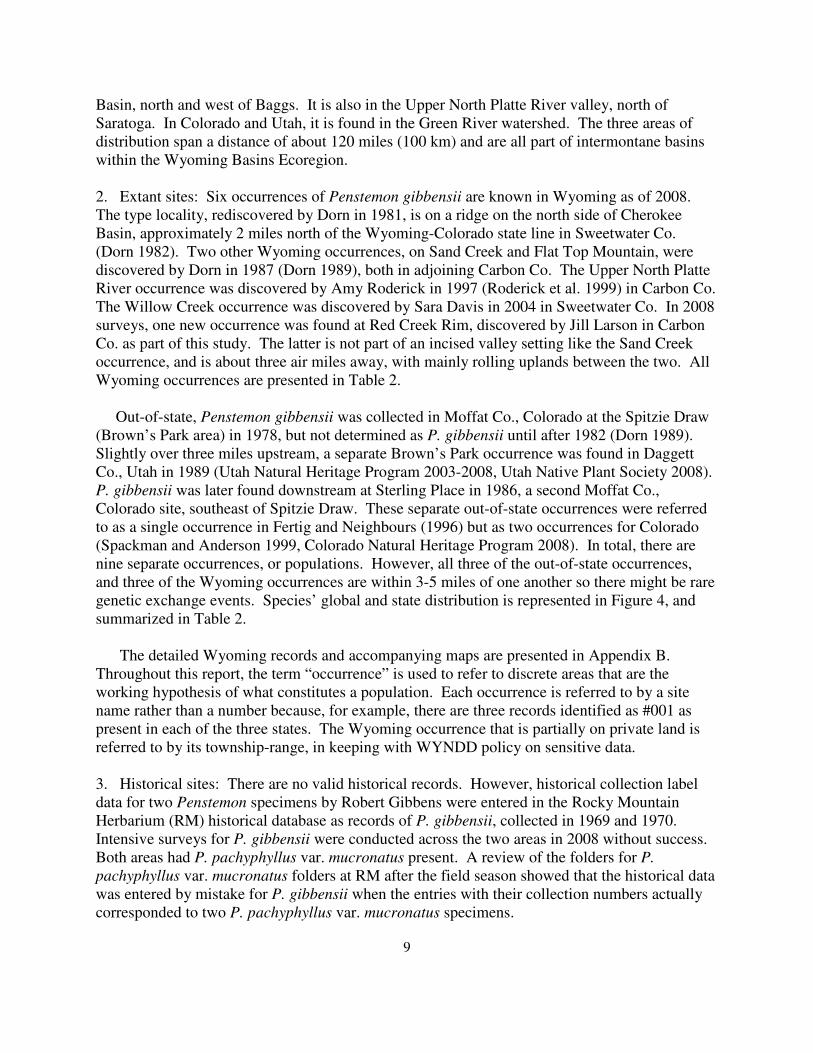
2. Extant sites: Six occurrences of Penstemon gibbensii are known in Wyoming as of 2008.
The type locality, rediscovered by Dorn in 1981, is on a ridge on the north side of Cherokee
Basin, approximately 2 miles north of the Wyoming-Colorado state line in Sweetwater Co.
(Dorn 1982). Two other Wyoming occurrences, on Sand Creek and Flat Top Mountain, were
discovered by Dorn in 1987 (Dorn 1989), both in adjoining Carbon Co. The Upper North Platte
River occurrence was discovered by Amy Roderick in 1997 (Roderick et al. 1999) in Carbon Co.
The Willow Creek occurrence was discovered by Sara Davis in 2004 in Sweetwater Co. In 2008
surveys, one new occurrence was found at Red Creek Rim, discovered by Jill Larson in Carbon
Co. as part of this study. The latter is not part of an incised valley setting like the Sand Creek
occurrence, and is about three air miles away, with mainly rolling uplands between the two. All
Wyoming occurrences are presented in Table 2.
Out-of-state, Penstemon gibbensii was collected in Moffat Co., Colorado at the Spitzie Draw
(Brown’s Park area) in 1978, but not determined as P. gibbensii until after 1982 (Dorn 1989).
Slightly over three miles upstream, a separate Brown’s Park occurrence was found in Daggett
Co., Utah in 1989 (Utah Natural Heritage Program 2003-2008, Utah Native Plant Society 2008).
P. gibbensii was later found downstream at Sterling Place in 1986, a second Moffat Co.,
Colorado site, southeast of Spitzie Draw. These separate out-of-state occurrences were referred
to as a single occurrence in Fertig and Neighbours (1996) but as two occurrences for Colorado
(Spackman and Anderson 1999, Colorado Natural Heritage Program 2008). In total, there are
nine separate occurrences, or populations. However, all three of the out-of-state occurrences,
and three of the Wyoming occurrences are within 3-5 miles of one another so there might be rare
genetic exchange events. Species’ global and state distribution is represented in Figure 4, and
summarized in Table 2.
The detailed Wyoming records and accompanying maps are presented in Appendix B.
Throughout this report, the term “occurrence” is used to refer to discrete areas that are the
working hypothesis of what constitutes a population. Each occurrence is referred to by a site
name rather than a number because, for example, there are three records identified as #001 as
present in each of the three states. The Wyoming occurrence that is partially on private land is
referred to by its township-range, in keeping with WYNDD policy on sensitive data.
3. Historical sites: There are no valid historical records. However, historical collection label
data for two Penstemon specimens by Robert Gibbens were entered in the Rocky Mountain
Herbarium (RM) historical database as records of P. gibbensii, collected in 1969 and 1970.
Intensive surveys for P. gibbensii were conducted across the two areas in 2008 without success.
Both areas had P. pachyphyllus var. mucronatus present. A review of the folders for P.
pachyphyllus var. mucronatus folders at RM after the field season showed that the historical data
was entered by mistake for P. gibbensii when the entries with their collection numbers actually
corresponded to two P. pachyphyllus var. mucronatus specimens.
10
4. Unverified/Undocumented reports: None known.
Table 2. Location information for known occurrences of Penstemon gibbensii
EO# Site
Name
County,
State
Legal
Description
Elevation
(ft)
USGS 7.5’
Quad
Location
001 Cherokee
Basin
Sweetwater
Co., WY
T12N R94W
S10
6500-6600 McPherson
Springs
Northeast end of Cherokee Basin,
ca 17 air miles west of Baggs
002 Sand
Creek
Carbon
Co., WY
T12N R93W S3,
4, 8, and 9
6200-6260 McPherson
Springs,
Poison
Basin
Both sides of Sand Creek above
mouth on Little Snake River, ca
10 air miles west of Baggs
003 Flat Top
Mountain
Carbon
Co., WY
T14N R93W S3
and 10
7500-7700 Flat Top
Mountain
Flat Top Mountain, ca 15 air
miles north-northwest of Baggs
004 T84N
R18W
Carbon
Co., WY
T18N R84W
[sensitive data]
7000-7240 Overland North of Saratoga
005 Willow
Creek
Sweetwater
Co., WY
T14N R94W
S18 and 19;
T14N R95W
S12 and 13
6440-6540 Powder
Mountain
NE
West side of Willow Creek, ca 20
air miles northwest of Baggs
0082 Red
Creek
Rim
Carbon
Co., WY
T13N R93W
S23 and 26
6400-6420 Poison
Basin
Red Creek Rim, ca 10 air miles
northwest of Baggs
001 Spitzie
Draw
Moffat
Co., CO
T10N R103W
S3, 8, 9, and 10
5500-5600 Lodore
School,
Swallow
Canyon
Brown’s Park north of Hwy 318
along Spitzie Draw
002 Sterling
Place
Moffat
Co., CO
T10N R102W
S20, 21 and 29
5420-5760 Lodore
School
Brown’s Park north of Hwy 318
and south of Sterling Spring
001 Brown’s
Park
Daggett
Co., UT
T1N R25E S2 5570 Swallow
Canyon
Brown’s Park, 0.25 miles west of
the state line
5. Sites where present status not known: In 2008, concerted efforts were made to survey
Penstemon gibbensii on public land identified as potential habitat using the potential distribution
model of Fertig and Thurston (2003). The potential distribution model is represented in Figure 5
and was interpreted as having merit because the two newest P. gibbensii occurrences
documented after the model was produced fall within areas identified as suitable. The areas
mapped in the potential distribution map that are not yet surveyed are appropriate to consider as
potentially suitable areas and sites where present status is not known.
6. Areas surveyed but species not located: Systematic surveys for Penstemon gibbensii were
conducted by Dorn (1989) and Fertig and Neighbours (1996) in the Washakie Basin and
immediate vicinity. The 1996 report included a mapped compilation of all places searched in the
two studies.
2 There is a gap in assigning occurrence numbers in Wyoming, starting with the Red Creek Rim occurrence, because
the next available number is always used. Two historic collections of Gibbens of Penstemon pachyphyllus had been
entered based on an error in an herbarium database reporting them as P. gibbensii accessions, and later deleted.
11
Figure 4. Global distribution and Wyoming distribution of Penstemon gibbensii
Distribution records are from Colorado Natural Heritage Program, Utah
Natural Heritage Program, and Wyoming Natural Diversity Database, 2008
12
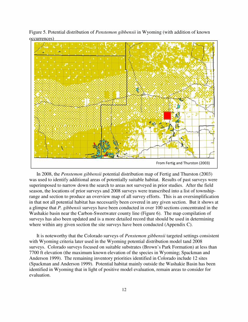
Figure 5. Potential distribution of Penstemon gibbensii in Wyoming (with addition of known
occurrences)
In 2008, the Penstemon gibbensii potential distribution map of Fertig and Thurston (2003)
was used to identify additional areas of potentially suitable habitat. Results of past surveys were
superimposed to narrow down the search to areas not surveyed in prior studies. After the field
season, the locations of prior surveys and 2008 surveys were transcribed into a list of township-
range and section to produce an overview map of all survey efforts. This is an oversimplification
in that not all potential habitat has necessarily been covered in any given section. But it shows at
a glimpse that P. gibbensii surveys have been conducted in over 100 sections concentrated in the
Washakie basin near the Carbon-Sweetwater county line (Figure 6). The map compilation of
surveys has also been updated and is a more detailed record that should be used in determining
where within any given section the site surveys have been conducted (Appendix C).
It is noteworthy that the Colorado surveys of Penstemon gibbensii targeted settings consistent
with Wyoming criteria later used in the Wyoming potential distribution model tand 2008
surveys. Colorado surveys focused on suitable substrates (Brown’s Park Formation) at less than
7700 ft elevation (the maximum known elevation of the species in Wyoming; Spackman and
Anderson 1999). The remaining inventory priorities identified in Colorado include 12 sites
(Spackman and Anderson 1999). Potential habitat mainly outside the Washakie Basin has been
identified in Wyoming that in light of positive model evaluation, remain areas to consider for
evaluation.
From Fertig and Thurston (2003)
13
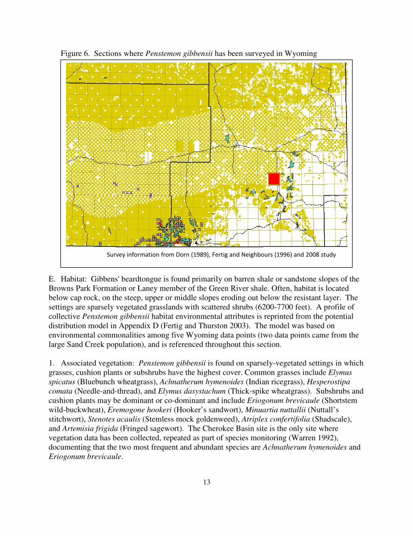
Figure 6. Sections where Penstemon gibbensii has been surveyed in Wyoming
E. Habitat: Gibbens' beardtongue is found primarily on barren shale or sandstone slopes of the
Browns Park Formation or Laney member of the Green River shale. Often, habitat is located
below cap rock, on the steep, upper or middle slopes eroding out below the resistant layer. The
settings are sparsely vegetated grasslands with scattered shrubs (6200-7700 feet). A profile of
collective Penstemon gibbensii habitat environmental attributes is reprinted from the potential
distribution model in Appendix D (Fertig and Thurston 2003). The model was based on
environmental commonalities among five Wyoming data points (two data points came from the
large Sand Creek population), and is referenced throughout this section.
1. Associated vegetation: Penstemon gibbensii is found on sparsely-vegetated settings in which
grasses, cushion plants or subshrubs have the highest cover. Common grasses include Elymus
spicatus (Bluebunch wheatgrass), Achnatherum hymenoides (Indian ricegrass), Hesperostipa
comata (Needle-and-thread), and Elymus dasystachum (Thick-spike wheatgrass). Subshrubs and
cushion plants may be dominant or co-dominant and include Eriogonum brevicaule (Shortstem
wild-buckwheat), Eremogone hookeri (Hooker’s sandwort), Minuartia nuttallii (Nuttall’s
stitchwort), Stenotes acaulis (Stemless mock goldenweed), Atriplex confertifolia (Shadscale),
and Artemisia frigida (Fringed sagewort). The Cherokee Basin site is the only site where
vegetation data has been collected, repeated as part of species monitoring (Warren 1992),
documenting that the two most frequent and abundant species are Achnatherum hymenoides and
Eriogonum brevicaule.
Survey information from Dorn (1989), Fertig and Neighbours (1996) and 2008 study
14
Woody vegetation often prevails in landscapes adjoining Penstemon gibbensii habitats,
variously including Artemisia tridentata ssp. wyomingensis (Wyoming big sagebrush), Atriplex
gardneri (Gardner’s saltbush), Juniperus osteosperma (Utah juniper), and Cercocarpus
montanus (Mountain mahogany). The Cherokee Basin vegetation plot studied by Robert
Gibbens that was nearest to P. gibbensii was documented as dominated by Machaeranthera
glabriuscula (syn. Xylorhiza glabriuscula; Woody aster), a species that is favored under heavy
grazing and is still present in the immediately-adjoining area but not as a dominant (B. Heidel
personal observation).
Colorado sites were noted as supported well-developed cryptobiotic crusts that lent stability
to the relatively steep, unconsolidated substrate (Spackman and Anderson 1999). Cryptobiotic
crusts were not noted in any Wyoming sites, even though there was frequent soil inspection in
taking soil samples as part of 2008 surveys. It is possible there were cryptic forms of the crusts
present but not discernible under drought conditions, that they had previously been present but
were impacted and eliminated by past land use (e.g., the history of heavy sheep-grazing reported
by Gibbens 1972); or that the habitats at the higher-elevations in Wyoming are not suited for
cryptobiotic crust.
2. Frequently associated species: Thirty species were reported as frequently associated with
Penstemon gibbensii by Fertig and Neighbours (1996). Almost 20 more species are reported as
common, as reported in Cherokee Basin plots (Warren 1992) and at the subsequent Wyoming
sites, or else noted as being common at the Colorado and Utah sites (Spackman and Anderson
1999, Colorado Natural Heritage Program 2008). Associated species are presented in Table 3.
Table 3. Species frequently associated with Penstemon gibbensii
Scientific name Common name WY (F&N
1996)3
WY
Addition
CO
(S&A)4
Achnatherum hymenoides Indian ricegrass X
Artemisia frigid Fringed sagewort X
Artemisia longifolia Long-leaf wormwood X
Artemisia tridentata var.
wyomingensis
Wyoming big sagebrush X
Asclepias cryptoceras Humboldt Mountain milkweed X X
Astragalus convallarius Lesser rushy milkvetch X
Astragalus jejunus var. jejunus Starveling milkvetch X
Astragalus nelsonianus Nelson’s milkvetch X
Astragalus spatulatus Spoonleaf milkvetch X
Astragalus tenellus Loose-flowered milkvetch X
Astragalus vexilliflexus Bent-flowered milkvetch X
Atriplex confertifolia Shadscale X
3 Reported in Fertig and Neighbours 1996
4 Reported in Spackman and Anderson 1999
15
Chaenactis douglasii Hoary chaenactis X
Comandra umbellate Bastard toadflax X
Cryptantha caespitosa Caespitose cat's-eye X
Cryptantha flava Yellow miner's candle X
Cymopterus terebinthinus Terpentine cymopterus X
Elymus elymoides Squirreltail X
Elymus lanceolatus Thickspike wheatgrass X
Elymus spicatus Bluebunch wheatgrass X
Eremogone eastwoodiae Eastwood's sandwort X
Eremogone hookeri Hooker's sandwort X
Ericameria nauseosus Rubber rabbitbrush X
Erigeron pulcherrimus Basin daisy X
Eriogonum brevicaule Shortstem wild-buckwheat X
Glossopetalon spinescens Spiny greasebush X
Gutierrezia sarothrae Broom snakeweed X
Hedysarum boreale Northern sweet-vetch X
Hesperostipa comate Needle-and-thread X
Hymenopappus filifolius Fine-leaf woolywhite X X
Lepidium montanum Mountain pepperwort X
Leptodactylon pungens Prickly phlox X
Leptocactylon spp. Phlox X
Lesquerella alpine Alpine bladderpod X
Lupinus argenteus Silvery lupine X
Machaeranthera grindelioides Nuttall's goldenweed X
Minuartia nuttallii Brittle stitchwort X
Packera cana Silver-woolly groundsel X
Penstemon fremontii Fewmont's beardtongue X
Penstemon pachyphyllus var.
mucronatus
Thick-leaf beardtongue X
Phacelia glandulosa Glandular phacelia X
Phlox hoodii Hood’s phlox X
Purshia tridentate Bitterbrush X
Sphaeromeria capitata Cluster-head chicken-sage X
Stanley pinnata Bushy prince's-plume X
Stanley spp. Prince’s-plume X
Stenotus acaulis Stemless mock goldenweed X
Stephanomeria runcinata Runcinate-leaved skeletonweed X
Thermopsis rhombifolia Round-leaved golden-pea X
Wyethia scabra Badland mule's-ears X X
Zuckia brandegei Western hop-sage X
16
Species that are common at the Utah and Colorado sites but localized or absent from the
Wyoming sites include Wyethia scabra (Badland’s mule’s-ears), Hedysarum boreale (Northern
sweet-vetch), Glossopetalon spinescens (Spiny greasebush), and Pinus edulis (Two-needle
pinyon).
Six other Wyoming plant species of concern (Heidel 2007) were newly-documented at
Penstemon gibbensii sites or in accessing potential habitat (Appendix E).
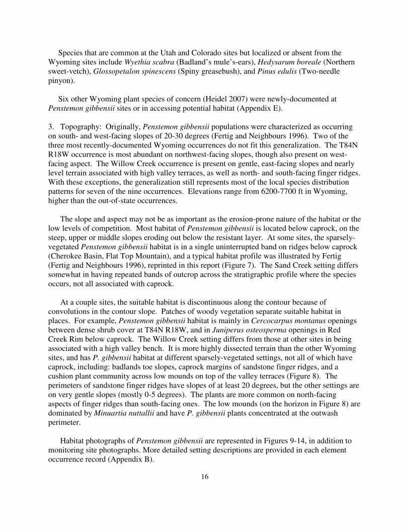
3. Topography: Originally, Penstemon gibbensii populations were characterized as occurring
on south- and west-facing slopes of 20-30 degrees (Fertig and Neighbours 1996). Two of the
three most recently-documented Wyoming occurrences do not fit this generalization. The T84N
R18W occurrence is most abundant on northwest-facing slopes, though also present on west-
facing aspect. The Willow Creek occurrence is present on gentle, east-facing slopes and nearly
level terrain associated with high valley terraces, as well as north- and south-facing finger ridges.
With these exceptions, the generalization still represents most of the local species distribution
patterns for seven of the nine occurrences. Elevations range from 6200-7700 ft in Wyoming,
higher than the out-of-state occurrences.
The slope and aspect may not be as important as the erosion-prone nature of the habitat or the
low levels of competition. Most habitat of Penstemon gibbensii is located below caprock, on the
steep, upper or middle slopes eroding out below the resistant layer. At some sites, the sparsely-
vegetated Penstemon gibbensii habitat is in a single uninterrupted band on ridges below caprock
(Cherokee Basin, Flat Top Mountain), and a typical habitat profile was illustrated by Fertig
(Fertig and Neighbours 1996), reprinted in this report (Figure 7). The Sand Creek setting differs
somewhat in having repeated bands of outcrop across the stratigraphic profile where the species
occurs, not all associated with caprock.
At a couple sites, the suitable habitat is discontinuous along the contour because of
convolutions in the contour slope. Patches of woody vegetation separate suitable habitat in
places. For example, Penstemon gibbensii habitat is mainly in Cercocarpus montanus openings
between dense shrub cover at T84N R18W, and in Juniperus osteosperma openings in Red
Creek Rim below caprock. The Willow Creek setting differs from those at other sites in being
associated with a high valley bench. It is more highly dissected terrain than the other Wyoming
sites, and has P. gibbensii habitat at different sparsely-vegetated settings, not all of which have
caprock, including: badlands toe slopes, caprock margins of sandstone finger ridges, and a
cushion plant community across low mounds on top of the valley terraces (Figure 8). The
perimeters of sandstone finger ridges have slopes of at least 20 degrees, but the other settings are
on very gentle slopes (mostly 0-5 degrees). The plants are more common on north-facing
aspects of finger ridges than south-facing ones. The low mounds (on the horizon in Figure 8) are
dominated by Minuartia nuttallii and have P. gibbensii plants concentrated at the outwash
perimeter.
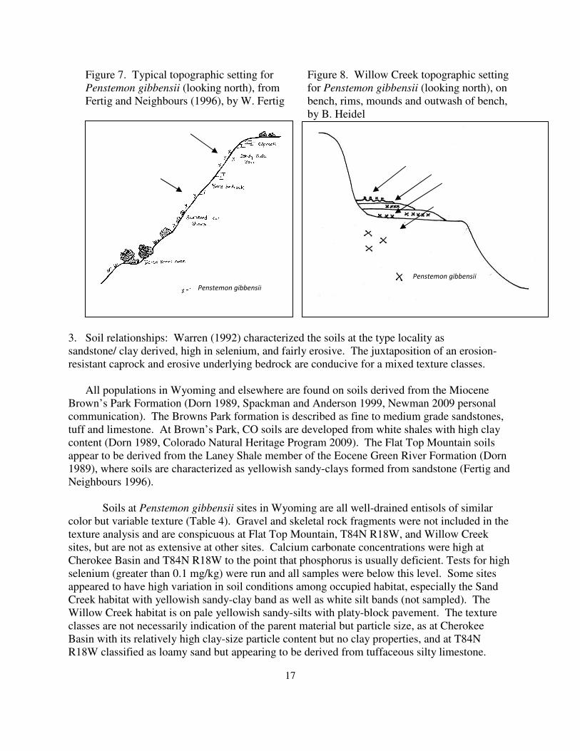
Habitat photographs of Penstemon gibbensii are represented in Figures 9-14, in addition to
monitoring site photographs. More detailed setting descriptions are provided in each element
occurrence record (Appendix B).
17
Figure 7. Typical topographic setting for Figure 8. Willow Creek topographic setting
Penstemon gibbensii (looking north), from for Penstemon gibbensii (looking north), on
Fertig and Neighbours (1996), by W. Fertig bench, rims, mounds and outwash of bench,
by B. Heidel
3. Soil relationships: Warren (1992) characterized the soils at the type locality as
sandstone/ clay derived, high in selenium, and fairly erosive. The juxtaposition of an erosion-
resistant caprock and erosive underlying bedrock are conducive for a mixed texture classes.
All populations in Wyoming and elsewhere are found on soils derived from the Miocene
Brown’s Park Formation (Dorn 1989, Spackman and Anderson 1999, Newman 2009 personal
communication). The Browns Park formation is described as fine to medium grade sandstones,
tuff and limestone. At Brown’s Park, CO soils are developed from white shales with high clay
content (Dorn 1989, Colorado Natural Heritage Program 2009). The Flat Top Mountain soils
appear to be derived from the Laney Shale member of the Eocene Green River Formation (Dorn
1989), where soils are characterized as yellowish sandy-clays formed from sandstone (Fertig and
Neighbours 1996).
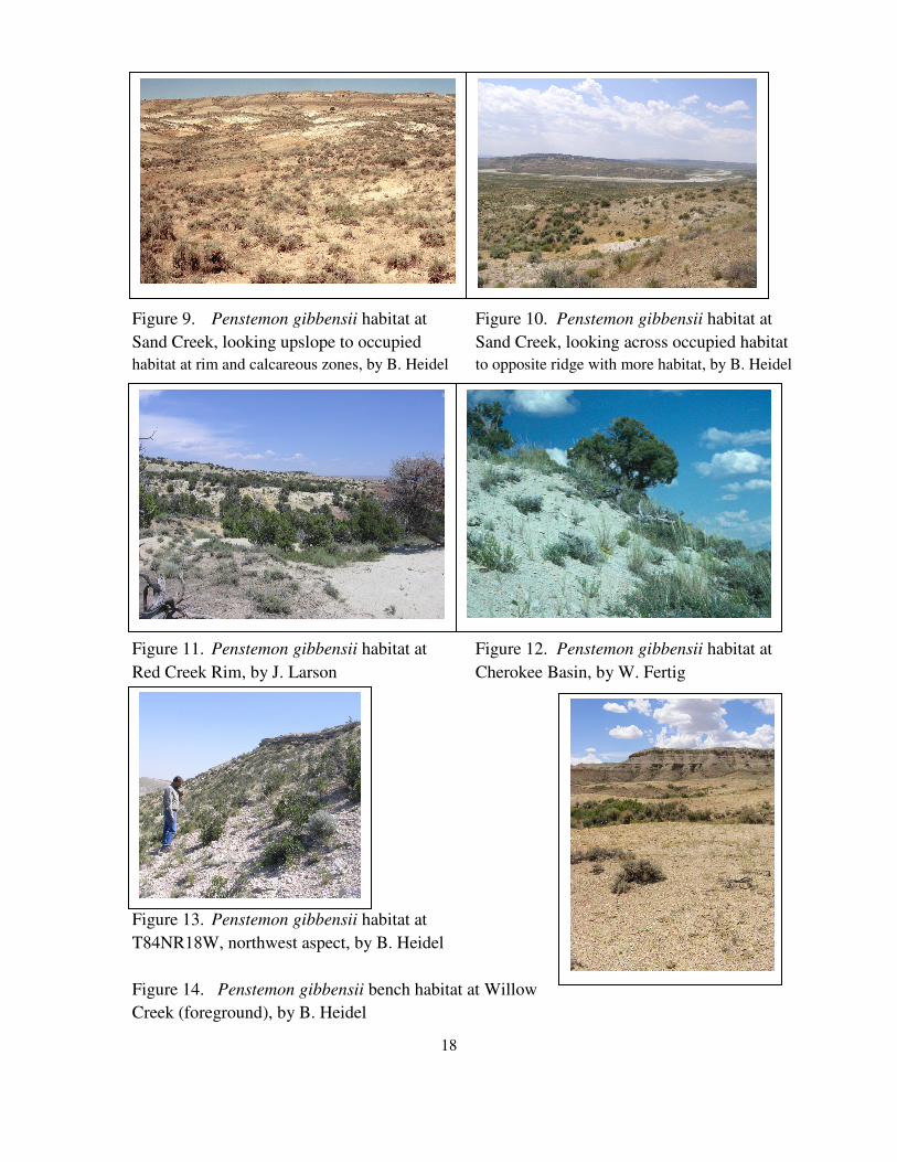
Soils at Penstemon gibbensii sites in Wyoming are all well-drained entisols of similar
color but variable texture (Table 4). Gravel and skeletal rock fragments were not included in the
texture analysis and are conspicuous at Flat Top Mountain, T84N R18W, and Willow Creek
sites, but are not as extensive at other sites. Calcium carbonate concentrations were high at
Cherokee Basin and T84N R18W to the point that phosphorus is usually deficient. Tests for high
selenium (greater than 0.1 mg/kg) were run and all samples were below this level. Some sites
appeared to have high variation in soil conditions among occupied habitat, especially the Sand
Creek habitat with yellowish sandy-clay band as well as white silt bands (not sampled). The
Willow Creek habitat is on pale yellowish sandy-silts with platy-block pavement. The texture
classes are not necessarily indication of the parent material but particle size, as at Cherokee
Basin with its relatively high clay-size particle content but no clay properties, and at T84N
R18W classified as loamy sand but appearing to be derived from tuffaceous silty limestone.
Penstemon gibbensii
Penstemon gibbensii
18
Figure 9. Penstemon gibbensii habitat at Figure 10. Penstemon gibbensii habitat at
Sand Creek, looking upslope to occupied Sand Creek, looking across occupied habitat
habitat at rim and calcareous zones, by B. Heidel to opposite ridge with more habitat, by B. Heidel
Figure 11. Penstemon gibbensii habitat at Figure 12. Penstemon gibbensii habitat at
Red Creek Rim, by J. Larson Cherokee Basin, by W. Fertig
Figure 13. Penstemon gibbensii habitat at
T84NR18W, northwest aspect, by B. Heidel
Figure 14. Penstemon gibbensii bench habitat at Willow
Creek (foreground), by B. Heidel
19
Table 4. Soil characteristics at Penstemon gibbensii sites in Wyoming
SAND SILT CLAY TEXTURE CACO3 EQ COLOR COLOR
% % % % DRY WET
Cherokee Basin 27 40 33 Clay Loam 5.45 2.5 Y 7/3 2.5 Y 5/2
Sand Creek 77 13 10 Loamy Sand 0.71 2.5 Y 6/4 2.5 Y 6/4
Flat Top Mountain 45 43 12 Loam 0.14 2.5 Y 7/3 2.5 Y 4/3
T84N R18W 82 10 8 Loamy Sand 4.82 2.5 Y 7/3 2.5 Y 4/3
Willow Creek 35 43 22 Loam 0.46 2.5 Y 6/6 2.5 Y 4/4
Red Creek 85 3 12 Loamy Sand 0.18 2.5 Y 7/3 2.5 Y 6/3
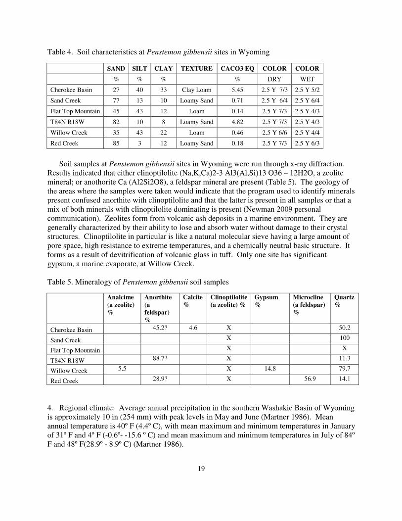
Soil samples at Penstemon gibbensii sites in Wyoming were run through x-ray diffraction.
Results indicated that either clinoptilolite (Na,K,Ca)2-3 Al3(Al,Si)13 O36 – 12H2O, a zeolite
mineral; or anothorite Ca (Al2Si2O8), a feldspar mineral are present (Table 5). The geology of
the areas where the samples were taken would indicate that the program used to identify minerals
present confused anorthite with clinoptilolite and that the latter is present in all samples or that a
mix of both minerals with clinoptilolite dominating is present (Newman 2009 personal
communication). Zeolites form from volcanic ash deposits in a marine environment. They are
generally characterized by their ability to lose and absorb water without damage to their crystal
structures. Clinoptilolite in particular is like a natural molecular sieve having a large amount of
pore space, high resistance to extreme temperatures, and a chemically neutral basic structure. It
forms as a result of devitrification of volcanic glass in tuff. Only one site has significant
gypsum, a marine evaporate, at Willow Creek.
Table 5. Mineralogy of Penstemon gibbensii soil samples
Analcime
(a zeolite)
%
Anorthite
(a
feldspar)
%
Calcite
%
Clinoptilolite
(a zeolite) %
Gypsum
%
Microcline
(a feldspar)
%
Quartz
%
Cherokee Basin 45.2? 4.6 X 50.2
Sand Creek X 100
Flat Top Mountain X X
T84N R18W 88.7? X 11.3
Willow Creek 5.5 X 14.8 79.7
Red Creek 28.9? X 56.9 14.1
4. Regional climate: Average annual precipitation in the southern Washakie Basin of Wyoming
is approximately 10 in (254 mm) with peak levels in May and June (Martner 1986). Mean
annual temperature is 40º F (4.4º C), with mean maximum and minimum temperatures in January
of 31º F and 4º F (-0.6º- -15.6 º C) and mean maximum and minimum temperatures in July of 84º
F and 48º F(28.9º - 8.9º C) (Martner 1986).
20
In the Brown’s Park area of Colorado and Utah, average annual precipitation is about 16 in
(406 mm). Annual, January, and July temperatures are slightly higher than in Wyoming (Dorn
1989).
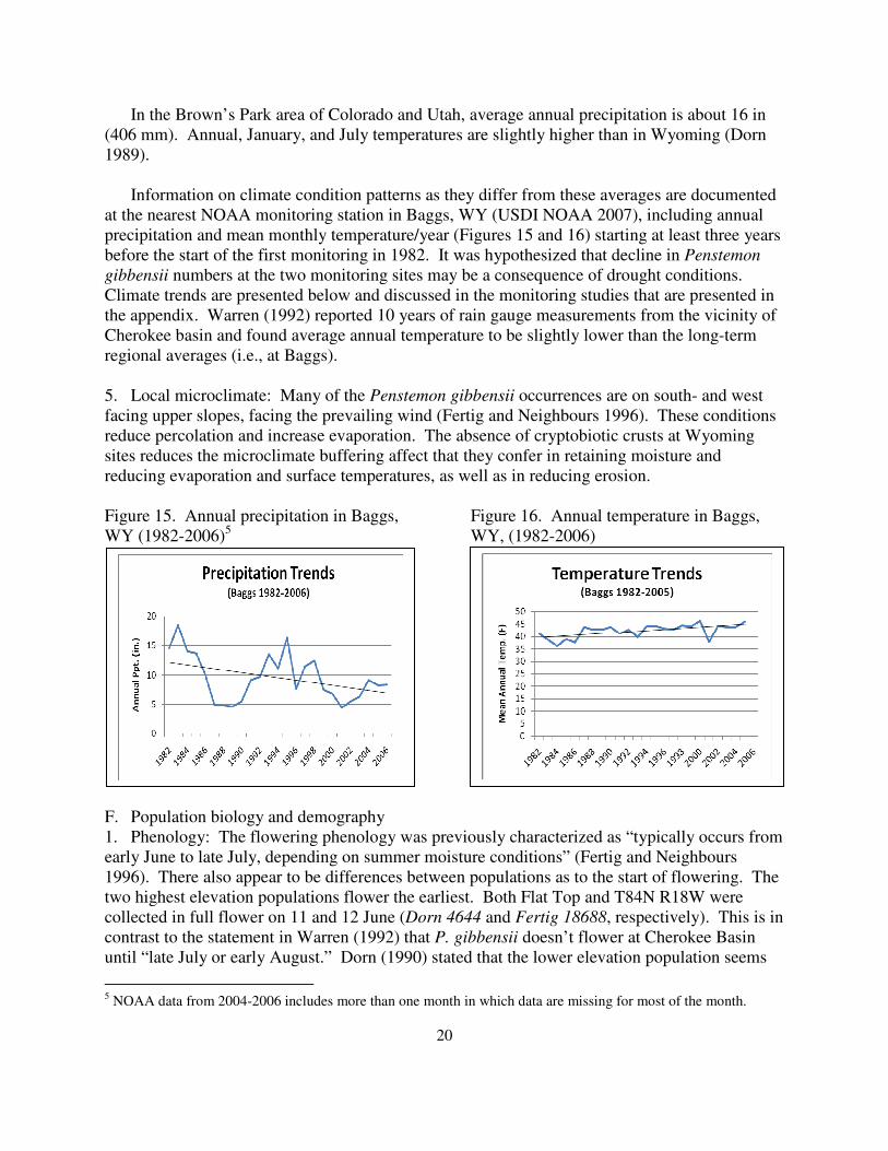
Information on climate condition patterns as they differ from these averages are documented
at the nearest NOAA monitoring station in Baggs, WY (USDI NOAA 2007), including annual
precipitation and mean monthly temperature/year (Figures 15 and 16) starting at least three years
before the start of the first monitoring in 1982. It was hypothesized that decline in Penstemon
gibbensii numbers at the two monitoring sites may be a consequence of drought conditions.
Climate trends are presented below and discussed in the monitoring studies that are presented in
the appendix. Warren (1992) reported 10 years of rain gauge measurements from the vicinity of
Cherokee basin and found average annual temperature to be slightly lower than the long-term
regional averages (i.e., at Baggs).
5. Local microclimate: Many of the Penstemon gibbensii occurrences are on south- and west
facing upper slopes, facing the prevailing wind (Fertig and Neighbours 1996). These conditions
reduce percolation and increase evaporation. The absence of cryptobiotic crusts at Wyoming
sites reduces the microclimate buffering affect that they confer in retaining moisture and
reducing evaporation and surface temperatures, as well as in reducing erosion.
Figure 15. Annual precipitation in Baggs, Figure 16. Annual temperature in Baggs,
WY (1982-2006)5 WY, (1982-2006)
F. Population biology and demography
1. Phenology: The flowering phenology was previously characterized as “typically occurs from
early June to late July, depending on summer moisture conditions” (Fertig and Neighbours
1996). There also appear to be differences between populations as to the start of flowering. The
two highest elevation populations flower the earliest. Both Flat Top and T84N R18W were
collected in full flower on 11 and 12 June (Dorn 4644 and Fertig 18688, respectively). This is in
contrast to the statement in Warren (1992) that P. gibbensii doesn’t flower at Cherokee Basin
until “late July or early August.” Dorn (1990) stated that the lower elevation population seems
5 NOAA data from 2004-2006 includes more than one month in which data are missing for most of the month.
21
to flower last. Out-of state populations are at the lowest elevation, and were in bud at the time of
the most recent survey (2 July 1999). Prolonged flowering of P. gibbensii into September has
been reported by Dorn (1989) and in 2008 (Figure 3) as moisture conditions and growing season
temperatures allow. It appears that flowering activity at most occurrences may run for a couple
months. This is consistent with P. gibbensii having indeterminate inflorescences and axillary
branches with buds at different stages of development at any given time. A more accurate
phenology statement for P. gibbensii in Wyoming does not use the word “typical” and is as
follows: “Flowers from mid June to early August (September), depending on spring and summer
moisture conditions and site differences.”
2. Population size and condition: Based on 1995 survey results of three Wyoming occurrences
the total Wyoming population numbers were estimated to be 3900-4200 individuals (Fertig and
Neighbours 1996). This did not include the T84N R18W population, a later discovery estimated
by Fertig as having 4500-5000 plants in 1999 (a hypothetical total of 8400-9200 plants). Based
on 2008 survey results, there are now six Wyoming occurrences, and the new Willow Creek
occurrence is as extensive if not as large numerically as the Sand Creek population. However,
the current total number of plants in Wyoming is estimated at the 6000-9000 plants because of
declining numbers at previously known sites. In Colorado, there were no more than 5000 plants
in Colorado (Spackman and Anderson 1999), so the total numbers are about 11,000 – 14,000.
Surveys in 1995 found that 30-40% of all mature plants were in reproductive states. Earlier
studies showed that seedling individuals can account for 21-50% of all plants (Warren 1992). As
a rule, seedlings are not used in population tallies because they are not established and often the
most vulnerable life history stage to stress factors. Seedlings were not observed to be abundant
in 1995, possibly as a result of drought conditions in 1994 and dry summer conditions in 1995.
Seedlings were noted as rare at Flat Top Mountain and none were found at Cherokee Basin in
2008 despite the return of relatively normal precipitation patterns that began in the preceding
winter.
In general, Penstemon gibbensii seems to have minimal reproductive success in most years
because of dry conditions (Dorn 1990). It responds favorably to late summer moisture when
many other plants have senesced, and late summer rains in 1988 were suggested as influencing
the increase in species’ numbers in 1989 (Warren 1992). Extended below-normal precipitation
has also been hypothesized to account for below-normal seedling numbers, as noted in 1995 on
the heels of summer drought conditions (Fertig and Neighbours 1996).
Tallies have also been made of Penstemon gibbensii extent taken from digitized population
boundaries. Based on 1995 survey results, the total occupied area was reported to come to about
62 acres. However, the boundaries drawn for the Sand Creek population in 1995 corresponded
closely to the area digitized in 2005 yet were only estimated as totaling 35 acres even though
digitized boundaries span 118.7 acres. The most recent three occurrences have approximately
doubled the total extent and the outer limits of all six digitized boundaries now total 270 acres. It
is important to note that the species’ local distribution patterns are not continuous where they are
present, and the species may occupy anywhere from 5-50% of the area as mapped so any map of
population boundaries over-represents occupied habitat. In Colorado, a tally of occupied habitat
22
in the two occurrences amounts to about 25 acres, and the Utah occurrence is less than 10 acres,
for a ballpark total of 300 acres.
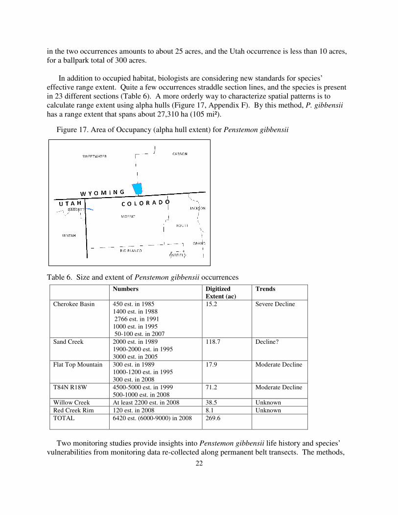
In addition to occupied habitat, biologists are considering new standards for species’
effective range extent. Quite a few occurrences straddle section lines, and the species is present
in 23 different sections (Table 6). A more orderly way to characterize spatial patterns is to
calculate range extent using alpha hulls (Figure 17, Appendix F). By this method, P. gibbensii
has a range extent that spans about 27,310 ha (105 mi²).
Figure 17. Area of Occupancy (alpha hull extent) for Penstemon gibbensii
Table 6. Size and extent of Penstemon gibbensii occurrences
Numbers Digitized
Extent (ac)
Trends
Cherokee Basin 450 est. in 1985
1400 est. in 1988
2766 est. in 1991
1000 est. in 1995
50-100 est. in 2007
15.2 Severe Decline
Sand Creek 2000 est. in 1989
1900-2000 est. in 1995
3000 est. in 2005
118.7
Decline?
Flat Top Mountain 300 est. in 1989
1000-1200 est. in 1995
300 est. in 2008
17.9 Moderate Decline
T84N R18W 4500-5000 est. in 1999
500-1000 est. in 2008
71.2 Moderate Decline
Willow Creek At least 2200 est. in 2008 38.5 Unknown
Red Creek Rim 120 est. in 2008 8.1 Unknown
TOTAL 6420 est. (6000-9000) in 2008
269.6
Two monitoring studies provide insights into Penstemon gibbensii life history and species’
vulnerabilities from monitoring data re-collected along permanent belt transects. The methods,
23
results and discussion for them are presented in Appendix G and H; and highlighted in this
section. They provide a basis for hypothesizing that the seedling establishment stage has been
the most restrictive life history stage in recent years, that the sites without gravel and skeletal
material on the soil surface may be far more vulnerable to erosion as exacerbated by drought,
and that available seed biology information suggests that this species is likely to have a seed
bank and that the phenology of germination is set in large part by spring precipitation. The
dynamics in species’ numbers has not previously been addressed, the nature and degree of such
dynamics are important to consider, the 1995 survey results may represent peak estimates rather
than mean estimates or low estimates.
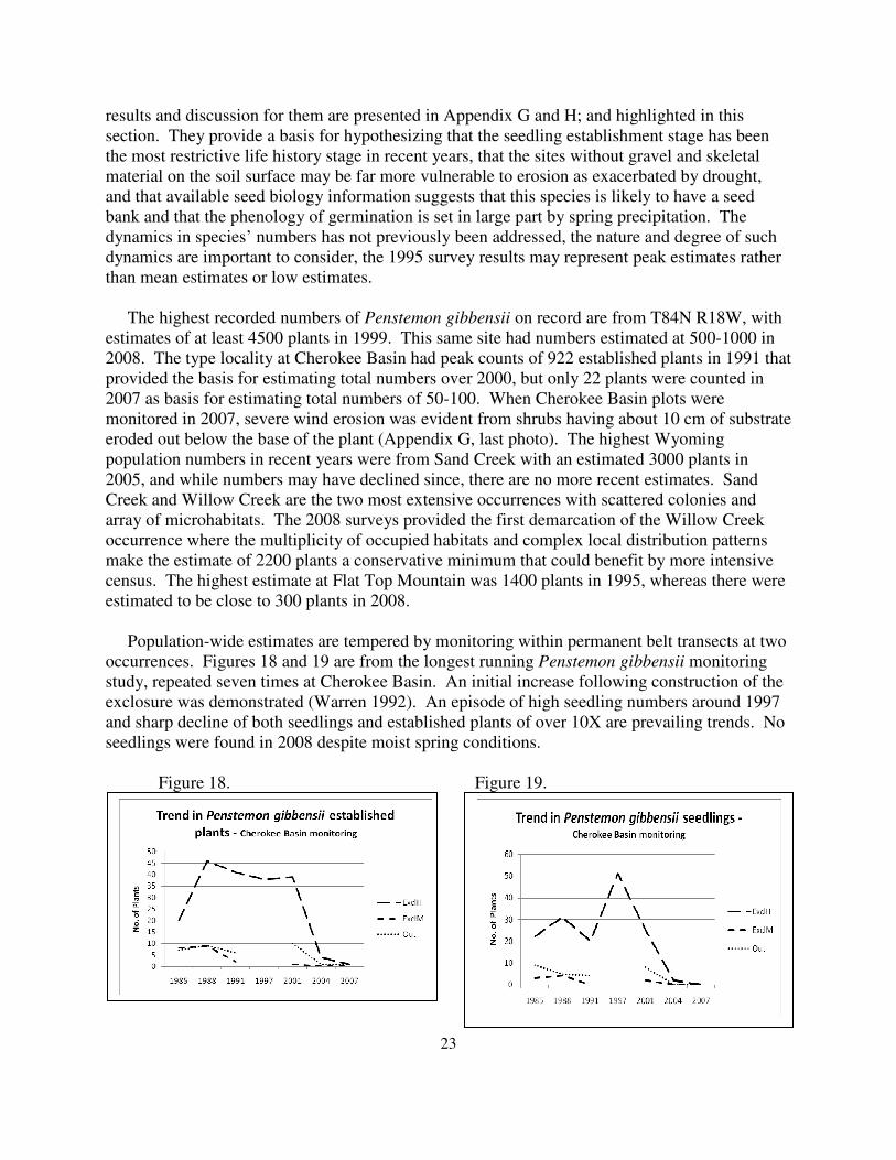
The highest recorded numbers of Penstemon gibbensii on record are from T84N R18W, with
estimates of at least 4500 plants in 1999. This same site had numbers estimated at 500-1000 in
2008. The type locality at Cherokee Basin had peak counts of 922 established plants in 1991 that
provided the basis for estimating total numbers over 2000, but only 22 plants were counted in
2007 as basis for estimating total numbers of 50-100. When Cherokee Basin plots were
monitored in 2007, severe wind erosion was evident from shrubs having about 10 cm of substrate
eroded out below the base of the plant (Appendix G, last photo). The highest Wyoming
population numbers in recent years were from Sand Creek with an estimated 3000 plants in
2005, and while numbers may have declined since, there are no more recent estimates. Sand
Creek and Willow Creek are the two most extensive occurrences with scattered colonies and
array of microhabitats. The 2008 surveys provided the first demarcation of the Willow Creek
occurrence where the multiplicity of occupied habitats and complex local distribution patterns
make the estimate of 2200 plants a conservative minimum that could benefit by more intensive
census. The highest estimate at Flat Top Mountain was 1400 plants in 1995, whereas there were
estimated to be close to 300 plants in 2008.
Population-wide estimates are tempered by monitoring within permanent belt transects at two
occurrences. Figures 18 and 19 are from the longest running Penstemon gibbensii monitoring
study, repeated seven times at Cherokee Basin. An initial increase following construction of the
exclosure was demonstrated (Warren 1992). An episode of high seedling numbers around 1997
and sharp decline of both seedlings and established plants of over 10X are prevailing trends. No
seedlings were found in 2008 despite moist spring conditions.
Figure 18. Figure 19.
24
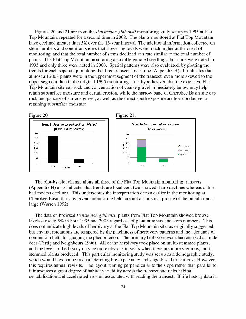
Figures 20 and 21 are from the Penstemon gibbensii monitoring study set up in 1995 at Flat
Top Mountain, repeated for a second time in 2008. The plants monitored at Flat Top Mountain
have declined greater than 5X over the 13-year interval. The additional information collected on
stem numbers and condition shows that flowering levels were much higher at the onset of
monitoring, and that the total number of stems declined at a rate similar to the total number of
plants. The Flat Top Mountain monitoring also differentiated seedlings, but none were noted in
1995 and only three were noted in 2008. Spatial patterns were also evaluated, by plotting the
trends for each separate plot along the three transects over time (Appendix H). It indicates that
almost all 2008 plants were in the uppermost segment of the transect, even more skewed to the
upper segment than in the original 1995 monitoring. It is hypothesized that the extensive Flat
Top Mountain site cap rock and concentration of coarse gravel immediately below may help
retain subsurface moisture and curtail erosion, while the narrow band of Cherokee Basin site cap
rock and paucity of surface gravel, as well as the direct south exposure are less conducive to
retaining subsurface moisture.
Figure 20. Figure 21.
The plot-by-plot change along all three of the Flat Top Mountain monitoring transects
(Appendix H) also indicates that trends are localized; two showed sharp declines whereas a third
had modest declines. This underscores the interpretation drawn earlier in the monitoring at
Cherokee Basin that any given “monitoring belt” are not a statistical profile of the population at
large (Warren 1992).
The data on browsed Penstemon gibbensii plants from Flat Top Mountain showed browse
levels close to 5% in both 1995 and 2008 regardless of plant numbers and stem numbers. This
does not indicate high levels of herbivory at the Flat Top Mountain site, as originally suggested,
but any interpretations are tempered by the patchiness of herbivory patterns and the adequacy of
nonrandom belts for gauging the phenomenon. The primary herbivore was characterized as mule
deer (Fertig and Neighbours 1996). All of the herbivory took place on multi-stemmed plants,
and the levels of herbivory may be more obvious in years when there are more vigorous, multi-
stemmed plants produced. This particular monitoring study was set up as a demographic study,
which would have value in characterizing life expectancy and stage-based transitions. However,
this requires annual revisits. The layout running perpendicular to the slope rather than parallel to
it introduces a great degree of habitat variability across the transect and risks habitat
destabilization and accelerated erosion associated with reading the transect. If life history data is
25
a priority to collect, then demographic monitoring needs to be re-designed and commitments
made to annual monitoring.
2. Reproductive biology
a. Type of reproduction: Penstemon gibbensii is a perennial that reproduces by seed (Dorn
1989). Flowering appears to be influenced strongly by summer moisture availability and plant
size (Fertig and Neighbours 1996). At the Flat Top Mountain site, flowering individuals
possessed as many as 10 or more stems per plant as noted in 1995, compared with 2-3 stems for
vegetative plants. There were just a couple many-stemmed plants found at the Flat Top
Mountain site in 2008 and the plants having highest stem numbers were found at Willow Creek.
There is no evidence of vegetative reproduction in this species, but separate shoots within a short
distance of one another may be connected underground, a source for overestimating population
size that is more likely when plants are growing among gravel or have low vigor and shoots are
more apt to appear isolated.
A limited Penstemon gibbensii set of seeds were collected by Denver Botanical Garden in
1992 (Jennifer Ramp Neale pers. commun. to B. Heidel 2009), and accessioned at the National
Center for Genetic Resources Preservation (NCGRP) in Fort Collins. It may be appropriate to
update the collections. Depending on the results from current genetics research (A. Buerkle pers.
commun. to B. Heidel 2009), it may also be appropriate to expand the collection from all three
geographic areas. The type collection at Cherokee Basin corresponds with a population that has
at least a slight chance of extirpation, and is a priority for representing in seed accessions.
b. Pollination biology: The Penstemon genus is insect-pollinated, but the specific pollinator is
not known. Dorn (1989) reports minimal reproductive success most years because of dry
conditions, which could affect pollinator visitation or plant energy allocations.
c. Seed dispersal and biology: Seeds of Penstemon gibbensii are probably dispersed by gravity
and wind near the parent plant. Depending on the setting, this may favor downslope and
downwind dispersal patterns. Germination requirements are poorly understood, but scarification
of the seed coat may be necessary for germination (Carol Dawson, Center Botanical Garden,
pers. commun. to W. Fertig). Seedling establishment is probably episodic and dependent on
climate conditions. The fact that seedlings have been reported in Cherokee Basin monitoring as
conducted in mid-summer suggests that germination is in spring. The absence of seedlings in
2008 despite moist spring conditions may mean that there is not a seed bank, whether because
the seed bank was depleted by the length of drought, or else the seeds were eroded out of suitable
habitat under the severe erosion that has occurred at the Cherokee Basin site.
There have not been studies to date on the seed biology of Penstemon gibbensii, but the work
of Meyers and Kitchen (1992, 1994) and Meyers et al. (1995) provide a frame of reference for
evaluating it against other intermontane species of Penstemon, other species of similar habitat,
and other species in Section Glabri. They have shown that adaptive radiation in the Penstemon
genus has included evolution of habitat-specific germination timing strategies in multiple
lineages within the genus. It is possible for such species to maintain a seed bank from year to
year even without burial of seeds if they have a cyclic dormancy pattern that effectively confines
26
germination to autumn or early spring, as documented for P. palmeri (Meyer and Kitchen 1992).
They studied P. fremontii, a closely-related mid-elevation species within the broad Section
Glabri that similarly experiences cold winters but scanty snowpack. Seeds of P. fremontii failed
to respond significantly to chilling periods of less than 12 weeks, reaching maximum
germination after chilling 16 weeks, as overwintering conditions. The set of over 20% that did
not respond to chill treatment was a “carryover” fraction that may represent a strategy for
adaptation to unpredictable climates (Meyer and Kitchen 1994, Meyer et al. 1995). These results
indicated that the majority of P. fremontii seeds germinate in early spring but that there is a
fraction that forms a seed bank, and which may respond to other environmental cues over time.
G. Population ecology
1. General summary: Penstemon gibbensii is restricted to bare, sparsely vegetated sandy-shale
slopes with poor soil development. Its capacity for high reproductive output, as represented by
the potential to flower for over three months, is dependent on climate, and consistent with the life
history of a short-lived perennial. Population expansion may be restricted by the availability of
specific soil types, episodic climatic conditions favoring seedling establishment, and the degree
of herbivory. At several sites on both the east and west sides of Sand Creek, it appears to be
capable of colonizing disturbed, bare ground though only in areas where a suitable substrate has
been exposed.
2. Competition: Penstemon gibbensii is restricted to sparsely vegetated sites with large areas of
bare soil where competition with other plant species is minimal (Fertig and Neighbours 1996).
Warren (1992) characterized its Cherokee Basin habitat as having less than 5% cover. It is
almost always absent from adjacent areas with high graminoid or shrub cover. As mentioned
under seed biology, the other species of sparsely-vegetated slopes may facilitate seed
germination or possibly entrap seeds on the unstable slopes. There have been similar cases of
short-lived perennials having dual competition/facilitation relationships with surrounding long-
lived vegetation depending on climate conditions of any given year and on the local setting
(Greenlee and Calloway 1996).
2. Herbivory: Penstemon gibbensii is relatively succulent and was reported to be grazed by
mule deer, pronghorn, cattle, and other herbivores during late summer when other green
vegetation is sparse (Whiskey Basin Consultants 1982, Dorn 1989, Warren 1992). This
herbivory appears to be restricted almost entirely to inflorescences (Fertig and Neighbours
1996). Limited herbivory was noted in 2008, and may vary within and between years.
In addition, there may be secondary effects of herbivores on Penstemon gibbensii. The most
unconsolidated substrates and the more steeply-sloping settings are very prone to erosion that
may uproot mature plants and alter seed dispersal patterns.
3. Hybridization: No direct evidence of hybridization has been observed in the field. The
closely related Penstemon fremontii occurs in the immediate vicinity of P. gibbensii at the
Cherokee Basin, Sand Creek and Willow Creek sites, but appear to be reproductively isolated by
ecological and temporal barriers. An albino P. gibbensii plant was noted in the Willow Creek
population, but this is a variant within the species.
27
4. Land ownership: Almost all known Wyoming occurrences of Penstemon gibbensii are found
on lands managed by the BLM Rawlins Field Office. The exception is the T84N R18W
population that is on State Land and private land. Also, a small portion of the Sand Creek
population is on State Land. In Colorado, the Spitzie Draw occurrence is on the Browns Park
National Wildlife Refuge (U.S. Fish and Wildlife Service) and lands managed by the BLM Little
Snake Field Office. The Sterling Place occurrence is entirely on BLM lands. The Utah
occurrence lies on State Land. In total, seven of the nine occurrences are entirely or in large part
on BLM-administered lands.
IV. ASSESSMENT AND MANAGEMENT RECOMMENDATIONS A. Potential threats to currently known populations: The restricted and specialized habitat of
Penstemon gibbensii makes this species vulnerable to habitat degradation and loss. Grazing,
mineral development, recreation, roads and weeds are potential threats. Drought, climate
conditions and big game herbivory may directly or indirectly impact the species and erode its
habitat.
…
1. Grazing: Summer grazing by livestock and large native ungulates (mostly mule deer) has
been cited as the primary threat to Penstemon gibbensii (Whiskey Basin Consultants 1982,
Spackman and Anderson 1999). Surveys in 1995 found that most herbivory was restricted to
flowering stems. This reduction in reproductive output could have a significant negative impact
on seed production, seed bank replenishment, and long-term viability of this species (Fertig and
Neighbours 1996). The influence of livestock grazing was questioned by Warren (1992) with
reference to the Cherokee Basin habitat, citing steep slope, unstableness of footing, and low
forage production, exacerbated by water unavailability in the area. A windmill is located 1 ½
miles to the west of Cherokee Basin and its operation could potentially influence wildlife use
patterns. Winter use by sheep does not appear to be a concern at the Cherokee Basin site
(Warren 1992). Wild horses and signs of their presence were noted in the Willow Creek
population but direct signs of grazing were wanting.
Three lines of evidence indicate that past grazing may have had an influence. First, the
exclosure study has documented an increase in Penstemon gibbensii numbers in the years of
near-normal precipitation up until 2001 (Warren 1992 and unpublished data). Second, the
original Gibbens’ vegetation plot near P. gibbensii, presumably sampled in the late 1960’s,
documented dominance of a poisonous unpalatable species, Xylorhiza glabriuscula, that is still
present but no longer dominant in the immediate vicinity. This dominance of a putative
“increaser” species suggests a level of grazing intensity in adjoining gentle terrain that may have
had incidental livestock use on steeper adjoining slopes no matter how unproductive the P.
gibbensii habitat. The absence of cryptogamic crusts in P. gibbensii habitat of Wyoming
contrasts with that in Colorado, and might possibly reflect the effects of trampling from past
grazing practices. In Colorado, summer grazing was thought to have the greatest impact,
resulting from direct removal of biomass, trampling, and increased erosion (Spackman and
Anderson 1999).
28
2. Mineral and energy development: Dorn (1989) listed oil and gas exploration as a potential
threat to Penstemon gibbensii populations, though activity was low at that time. Since 1989,
exploration activity has increased greatly throughout the Washakie Basin of Wyoming. Most
sites occupied by P. gibbensii are on unstable slopes that are unlikely to be developed for access,
roads, pipeline routes, or well pad sites (Fertig and Neighbours 1996). The authors also
identified seismic exploration utilizing explosives or trampling by vehicles transporting testing
equipment as potential threats.
One pipeline has been laid across a western colony of Penstemon gibbensii at the Sand Creek
occurrence, one pipeline has been laid through or adjoining a southern colony of the Willow
Creek occurrence, and another pipeline was put in across Willow Creek between colonies. In
addition, a wellpad has been constructed above a southeast colony of the Sand Creek occurrence
(immediately upslope of Figure 10), and the road that crosses the colony has been upgraded for
heavy machinery. The aforementioned developments dissect limited areas of habitat and suggest
that the degree of energy development threats are not severe. However, they have not
necessarily been instituted to their full potential in P. gibbensii habitat, and other forms of
development may be possible. Any developments also introduce the possibility of additional
indirect impacts like ORV use and spread of exotic species, that may be more difficult to gauge
and that may change in the future later than the ground-disturbing development.
Uranium is mined in Poison Basin near the Red Rim Creek population. The Washakie Basin
area is underlain by sub-bituminous coal that is not regarded as suited for strip mining. It is also
underlain by oil shale-bearing rock (Roberts 1989). The Upper North Platte River valley area
has quarries in the same township as Penstemon gibbensii used for road surfacing material, and
mineral and energy developments often promote road construction and other infrastructure.
Wind energy has not been developed to date in the vicinity of Penstemon gibbensii habitat,
though there is ridgetop cap rock above most of its habitat that might be considered in wind farm
developments. Any wind energy developments at ridgetops might affect downslope habitats.
There are no high-value commercial uses of the substrates constituting Penstemon gibbensii
habitat (Table 5), or overlying caprock. However, the gravelly occurrence sites, particularly
those with easy access, might be at risk of quarry developments. Roads in the vicinity of the site
at T18N R84W are built up with gravel material that bears similarity to the nearby Penstemon
gibbensii habitat.
3. Recreation: Trampling by off-road vehicles may result in direct mortality of plants and lead
to soil erosion. ORV use was identified as a potential threat to Colorado populations (Spackman
and Anderson 1999). Although plants may colonize disturbed areas at the margins, they do not
become established within roadbeds that receive active vehicle use.
Trampling by botanists and any other visitors to Penstemoni gibbensii habitat is also a
potential threat, especially in those sites with steep, loose soils under repeated visits. Visitation
of occupied habitat should be kept to a minimum to prevent excessive erosion, discussed further
in the monitoring studies (Appendix G).

29
4. Roads: A new access road has been built around the north side of Hog Lake in the Browns
Park National Wildlife Refuge within 200 m of the cliffs that support Penstemon gibbensii
(Spackman and Anderson 1999). The relatively new road that crosses Willow Creek at the edge
of P. gibbensii habitat provides ready access to the very edge of the population. As mentioned
above, a road that was upgraded for oil and well use cuts across a limited part of the Sand Creek
population. It was previously suggested by Fertig and Neighbours (1996) that some existing
roads on Flat Top Mountain would be appropriate to close or re-route to minimize trampling
impacts.
5. Weeds: In addition to the above-mentioned threats, exotic species competition and noxious
weed encroachment have been identified as potential impacts to Penstemon gibbensii in
Colorado (Spackman and Anderson 1999). They might be fostered by any of the above-
mentioned activities. In general, weedy annual numbers are low in and adjoining P. gibbensii
habitats of Wyoming, and are most common locally near roads. They are not new on the
landscape but were noted, e.g., in 1987 surveys of the Cherokee Basin occurrence. In general,
noxious species and weedy annuals were generally scarce in Penstemon gibbensii habitat
surveyed in 2008. Their presence to date has been noted (Table 7).
Table 7. Non-native species in Penstemon gibbensii habitat
Species Site
Alyssum desertorum Cherokee Basin, Red Rim Creek
Bromus tectorum Cherokee Basin, Red Creek Rim, Sand Creek, Sterling Place (where
abundant in parts of adjoining habitat)
Halogeton glomeratus Cherokee Basin, Sand Creek, Spitzie Draw, Sterling Place
Salsola australis Spitzie Draw. Sterling Place
6. Finally, the affects of drought on Penstemon gibbensii warrant careful consideration as
“natural threats,” whether as possible harbinger of climate change or chance events. The
estimated P. gibbensii population numbers are significantly down in the Cherokee Basin, Flat
Top Mountain and T84N R18W occurrences. There is no trend data available for Willow Creek
but it appears that its habitat with gentle slopes and east aspect is less harsh than all other
settings. It would be valuable to know if Colorado populations have undergone sharp decline
since the time of pre-drought surveys. The results of monitoring within and between the
Cherokee Basin and Flat Top Mountain suggest that species’ habitat is highly vulnerable to
erosion under prolonged drought, particularly in the steeper slope segments and where gravel and
skeletal rock fragments are wanting. The two monitoring sites are appropriate to revisit to
evaluate trends in the wake of drought. If erosion has removed most of the seed bank with
surface substrates at Cherokee Basin, then recovery will take multiple life cycles rather than just
a moist year or two.
B. Management practices and response: An 8 foot high wire mesh exclosure was established by
the BLM in 1985 to enclosed 80% of the occupied habitat of Penstemon gibbensii at the
Cherokee Basin site, preventing entry by big game and livestock. A smaller, 3-strand barbed
wire exclosure covered 15% of the habitat, preventing entry by livestock. The remaining 5% of
30
the occupied habitat was unfenced, outside of the exclosures. As noted previously, results from
the Cherokee Basin originally documented upward trends in P gibbensii numbers of established
plants, particularly in the tall exclosure (1985-2001). However, numbers showed sharp declines
in 2004 and 2007, apparently under drought conditions. This exclosure has been critical in
ruling out grazing as the cause of decline. The exclosure appeared to be intact, despite past
reports of the fence being cut (Dorn 1989). The uniformly steep, south-facing slope and soil
properties of this site might account for the severity of trend instead.
C. Conservation recommendations
1. Recommendations regarding present or anticipated activities: Whiskey Basin Consultants
(1982) recommended fencing the Cherokee Basin population to protect Penstemon gibbensii
from the impacts of grazing. Based on the upward trend of this species during most of the initial
16 years, this fence should remain in place, consistent with Warren (1992). Additional fencing
was described as desirable for the Flat Top Mountain population if mule deer herbivory became
too great of a threat (Fertig and Neighbours 1996) but was not identified in 2008 as a priority.
Periodic inspection of all sites is probably warranted at 3-5 year intervals for checking
management practices as they affect the species, following a checklist of potential threats and
potential invasive species, and looking for signs of impact. This includes an inspection of all
pipelines that cross the population. This also includes monitoring of the Cherkoee Basin and Flat
Top Mountain occurrences, at least until a recovery is documented. Neither study design are
suited for producing life history data, which is important to pursue if P. gibbensii does not
recover at Cherokee Basin. In the case that it is extirpated is documented at Cherokee Basin,
then propagation and re-introduction is appropriate to consider. The connection between threats
warrants special consideration, as with weed encroachment or escalated ORV use commonly
associated as facilitated by energy developments.
2. Notification of BLM personnel of locations on BLM lands: To prevent inadvertent impacts to
known populations, all appropriate BLM personnel involved in planning and on-the-ground land
management activities should be provided with location data for Penstemon gibbensii. It is
especially important that BLM minerals, engineering, and range staff know precise locations so
that disturbances can be avoided. Towards this end, P. gibbensii is featured on the cover of the
1994 Wyoming Rare Plant Field Guide (Fertig et al. 1994), and the state species abstract is
updated and posted by WYNDD as part of this project (Appendix I).
3. Areas recommended for protection: Ten acres of habitat encompassing the Cherokee Basin
population of Penstemon gibbensii were proposed for designation as an Area of Critical
Environmental Concern (ACEC) in the draft Great Divide Resource Area Resource Management
Plan (RMP)(USDI BLM 1988). This area and Flat Top Mountain were identified as warranting
consideration (Fertig et al. 1998). ACECs were not designated in the final Record of Decision
for the RMP (USDI BLM 1990). ACEC designation at P. gibbensii sites was not included in the
Rawlins Resource Management Plan (USDI BLM 2009). ACEC priorities for P. gibbensii were
discussed by Fertig and Markow (1998).
31
In Colorado, both population sites have been identified as potential conservation sites
warranting strong conservation actions. The Spitzie Draw population and The Sterling Place
have been recommended for designation as ACECs (Spackman and Anderson 1999), a proposal
that was included in the Little Snake River RMP but not listed as the preferred alternative.
The private property on which Penstemon gibbensii occurs has been protected by The Nature
Conservancy as part of a conservation easement, but this does not address the adjoining state
land.
C. Status recommendations: It may be appropriate for the Wyoming BLM to continue
recognizing Penstmon gibbensii as a sensitive species as a way to ensure that agency actions do
not contribute to the further endangerment of the species and the subsequent need for listing
under the Endangered Species Act.
As part of this status report update, the global ranking information for Penstemon gibbensii
was updated. It was analyzed using the NatureServe rank calculator and supports a global rank
change from G1 to G1G2. The analysis was run using a range of values in cases where there are
uncertainties (e.g., in estimating effective population size, trend reversibility, and the severity of
combined threats) (discussed in Appendix A).
The new occurrences and broadened area of occupancy reduce the endangerment of this
taxon on one hand, but the steep declines of population numbers in recent years, unknown
capacity to recover population numbers, and uncertain degree of threats counterbalance the
original information.
D. Summary: Penstemon gibbensii is a regional endemic of the Washakie Basin, Wyoming, the
Upper North Platte River valley, Wyoming, and the Brown’s Park area near the Colorado-Utah
border. It is presently known from nine occurrences spanning a distance of 120 miles but an area
of occupancy of ca 27,310 ha (105 mi²) and only occupying about 270 acres total in Wyoming,
in addition to about 25 acres in Colorado plus roughly 5 acres in Utah. The new occurrences
documented in recent years expanded this range extent, an increase that is tempered by results
from the two monitored populations showing dramatic drop in numbers under prolonged drought
since 2001. It appears that current population sizes may be much lower than previous estimates
made during more favorable climate cycles, so despite the new populations, the current total is
estimated at between 11,000-14,000 individuals. Soils data collected from the six Wyoming
occurrences provides a basis for hypothesizing that the species is restricted to tuffaceous
deposits. The severity of threat from energy developments may have previously been over-
estimated but not all potential developments have been instituted and the vulnerability of P.
gibbensii population numbers to prolonged drought was not previously identified.
The following summary addresses the five original reasons for preparing this update.
1. The two Penstemon gibbensii occurrences documented since the most current Wyoming
status report (Fertig and Neighbours 1996) represent significant geographic expansion of its
range to the North Platte Valley (T18N R84W), and significant expansion of the total
32
species numbers and occupied habitat. The T18N R84W occurrence had the highest reported
population numbers in Wyoming, and the Willow Creek occurrence had an extensive
population on par with the extensive Sand Creek occurrence.
2. The potential distribution model developed for Penstemon gibbensii (Fertig and Thurston
2003) is meaningful for the Washakie Basin, most of which has been surveyed at some level.
One new occurrence was documented at Red Creek Rim. The utility of the model warrants
further testing in the North Platte area and in outlying areas to the extent that they identify
potential habitat on public lands.
3. Collection label data for two historical specimens of Penstemon gibbensii collected by
Robert Gibbens were false reports that were artifacts of the past data entry process at the
Rocky Mountain Herbarium. This was not determined until after extensive searches were
conducted in the two areas. Both fell within potential habitat identified by the model.
4. Monitoring was continued at Cherokee Basin, which had only one Penstemon gibbensii plant
remaining in the five original transects. The entire site was estimated as supporting 2000 P.
gibbensii plants in 1995, but was estimated at 50-100 plants in 2007. Continuation of whole-
site census is the most meaningful approach for the future. Maintenance of the exclosure has
been and will continue to be critical for differentiating drought response from grazing
response.
5. Monitoring was repeated for the first time at Flat Top Mountain, showing major decline as
found at Cherokee Basin. But the declines were less severr than those at Cherokee Basin.
Comparisons between the two sites suggest that the Cherokee Basin site has much more
highly erodible substrate. Continuation of the monitoring at Flat Top complements and helps
interpret Cherokee Basin monitoring.
V. LITERATURE CITED
Blomquist, F. 2007. Penstemon gibbensii survey information and shapefiles from Sand Creek,
conveyed to Wyoming Natural Diversity Database. Bureau of Land Management,
Rawlins.
Buerkle, A. 2009. Message regarding Penstemon genetics research. Personal communication to
B. Heidel. University of Wyoming Department of Botany.
Colorado Natural Heritage Program. 2008. Penstemon gibbensii element occurrence data,
exported and conveyed by J. Handwerk, 5 August 2008.
Cronquist, A., A.H. Holmgren, N.H. Holmgren, J.L. Reveal, and P.K. Holmgren. 1984. Volume
4, Subclass Asteridae (Except Asteraceae). Intermountain Flora: Vascular Plants of the
Intermountain West, USA. Columbia University Press, New York.
Davis, C.P. 1995. Letter discussing changes in USFWS C1, C2 and 3C candidates. Letter from
U.S. Fish and Wildlife Service, Cheyenne, WY dated 21 August 1995.
Dawson, C. No Date. Personal communication to Walter Fertig. Denver Botanical Garden,
Denver, CO.
Dorn, R.D. 1977. Vascular plants of Wyoming. Mountain West Publishing, Cheyenne, WY.
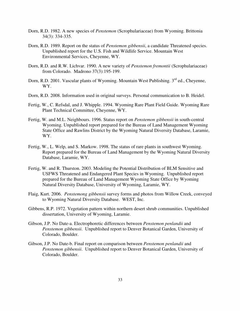
33
Dorn, R.D. 1982. A new species of Penstemon (Scrophulariaceae) from Wyoming. Brittonia
34(3): 334-335.
Dorn, R.D. 1989. Report on the status of Penstemon gibbensii, a candidate Threatened species.
Unpublished report for the U.S. Fish and Wildlife Service. Mountain West
Environmental Services, Cheyenne, WY.
Dorn, R.D. and R.W. Lichvar. 1990. A new variety of Penstemon fremontii (Scrophulariaceae)
from Colorado. Madrono 37(3):195-199.
Dorn, R.D. 2001. Vascular plants of Wyoming. Mountain West Publishing. 3rd
ed., Cheyenne,
WY.
Dorn, R.D. 2008. Information used in original surveys. Personal communication to B. Heidel.
Fertig, W., C. Refsdal, and J. Whipple. 1994. Wyoming Rare Plant Field Guide. Wyoming Rare
Plant Technical Committee, Cheyenne, WY.
Fertig, W. and M.L. Neighbours. 1996. Status report on Penstemon gibbensii in south-central
Wyoming. Unpublished report prepared for the Bureau of Land Management Wyoming
State Office and Rawlins District by the Wyoming Natural Diversity Database, Laramie,
WY.
Fertig, W., L. Welp, and S. Markow. 1998. The status of rare plants in southwest Wyoming.
Report prepared for the Bureau of Land Management by the Wyoming Natural Diversity
Database, Laramie, WY.
Fertig, W. and R. Thurston. 2003. Modeling the Potential Distribution of BLM Sensitive and
USFWS Threatened and Endangered Plant Species in Wyoming. Unpublished report
prepared for the Bureau of Land Management Wyoming State Office by Wyoming
Natural Diversity Database, University of Wyoming, Laramie, WY.
Flaig, Kurt. 2006. Penstemong gibbensii survey forms and photos from Willow Creek, conveyed
to Wyoming Natural Diversity Database. WEST, Inc.
Gibbens, R.P. 1972. Vegetation pattern within northern desert shrub communities. Unpublished
dissertation, University of Wyoming, Laramie.
Gibson, J.P. No Date-a. Electrophoretic differences between Penstemon penlandii and
Penstemon gibbensii. Unpublished report to Denver Botanical Garden, University of
Colorado, Boulder.
Gibson, J.P. No Date-b. Final report on comparison between Penstemon penlandii and
Penstemon gibbensii. Unpublished report to Denver Botanical Garden, University of
Colorado, Boulder.
34
Greenlee, J.T. and R.M. Calloway. 1996. Abiotic stress and the relative importance of
interference and facilitation in montane bunchgrass communities in western Montana.
Am. Nat. 148(2):386-396.
Handwerk, J. 2009. Personal communication to B. Heidel. Colorado Natural Heritage Program,
Fort Collins, CO.
Heidel, B. 2007. 2007 Wyoming plant species of concern list. Wyoming Natural Diversity
Database, Laramie, WY.
Lodewick, K., and R. Lodewick. 1999. Key to the genus Penstemon and its related genera in the
tribe Cheloneae (Scrophulariaceae). Eugene, OR.
Love, J.D. and A.C. Christiansen. 1985. Geologic map of Wyoming. U.S. Geological Survey.
Martner, B. 1986. Wyoming climate atlas. University of Nebraska Press, Lincoln, NE.
Meyer, S.E. and S.G. Kitchen. 1992. Cyclic seed dormancy in the short-lived perennial
Penstemon palmeri. J. Ecol. 80:115-122.
Meyer, S.E. and S.G. Kitchen. 1994. Habitat-correlated variation in seed germination response to
chilling in Penstemon Section Glabri (Scrophulariaceae). Am. Midl. Nat. 132:349-365.
Meyer, S.E., S.G. Kitchen ands.L. Carlson. 1995. Seed germination timing patterns in
Intermountain Penstemon (Scrophulariaceae). Am. J. Bot. 82(3):377-389.
Neal, J.R. 2009. Confirmation of seed accessions. Personal communication to B. Heidel. Denver
Botanical Garden, Denver, CO.
Newman, M. 2009. Comments accompanying spectroscopy results for soil samples collected at
each Penstemon gibbensii site in Wyoming. Bureau of Land Management, Rawlins.
O'Kane, S.L. 1988. Colorado's rare flora. Great Basin Naturalist 48 (4):434-484.
Roberts, S. 1989. Wyoming Geomaps. Geological Survey of Wyoming, Educ. Series 1.
Laramie, WY.
Roderick, A.J., B.E. Nelson, and R.L. Hartman. 1999. Final report on the general floristic
inventory of the Upper North Platte and Laramie River drainages. Report prepared for the
Bureau of Land Management Rawlins and Casper Districts by the Rocky Mountain
Herbarium, University of Wyoming, Laramie, WY.
Spackman, S. and D. Anderson. 1999. Field survey for the globally imperiled Gibbens'
beardtongue, Penstemon gibbensii Dorn in Colorado. Report prepared for the Colorado
Natural Areas Program by the Colorado Natural Heritage Program, Fort Collins, CO.
Spackman, S., B. Jennings, J. Coles, C. Dawson, M. Minton, A. Kratz, and C. Spurrier. 1997.
Colorado Rare Plant Field Guide. Prepared for the Bureau of Land Management, US
35
Forest Service, and US Fish and Wildlife Service by the Colorado Natural Heritage
Program, Ft. Collins, CO.
Taylor, A.R. 2000. The vascular flora of the Upper North Platte River drainage, Wyoming.
Master's thesis, Dept. of Botany, University of Wyoming, Laramie, WY.
USDI Bureau of Land Management. 1988. Proposed resource management plan and final
environmental impact statement for the Great Divide Resource Area, Rawlins District,
Wyoming.
USDI Bureau of Land Management. 1990. Great Divide Resource Area, Record of Decision and
approved Resource Management Plan. BLM Rawlins District Office, Wyoming.
USDI Bureau of Land Management. 2001. Wyoming Bureau of Land Managment sensitive
species policy and list; instruction memorandum no. WY02001-040. BLM Wyoming
State Office, Cheyenne.
USDI Bureau of Land Management. 2009. Proposed resource management plan and final
environmental impact statement for the Rawlins Field Office, Wyoming.
USDI Fish and Wildlife Service. 1983. Endangered and Threatened Wildlife and Plants;
Supplement to Review of Plant Taxa for Listing; Proposed Rule. Federal Register
48(229): 53640-53670.
USDI Fish and Wildlife Service. 2009. Endangered and Threatened Wildlife and Plants; Partial
90-Day Finding on a Petition To List 206 Species in the Midwest and Western United
States as Threatened or Endangered With Critical Habitat. Federal Register / Vol.
74(23):6122-6128. Printed February 5, 2009 under Rules and Regulations.
USDI National Oceanic and Atmospheric Association. 2007. Wyoming climate summaries.
Posted at: http://www.wrcc.dri.edu/summary/climsmwy.html .
Utah Native Plant Society. 2003-2008. Utah Rare Plant Guide. Posted electronically at
http://www.utahrareplants.org/rpg.html.
Utah Natural Heritage Program. 2008. Penstemon gibbensii element occurrence information and
pdf maps, emailed by M. Franklin, 5 August 2008.
Warren, A. 1992. Monitoring/evaluation report on Penstemon gibbensii. Bureau of Land
Management Great Divide Resource Area Memorandum, dated 16 January 1992.
Weber, W.A. 1986. Phytologia 60(6): 459-461.
Welsh, S. L., N. D. Atwood, S. Goodrich, and L. C. Higgins. 2003. A Utah Flora, 3rd
ed.
Brigham Young University, Great Basin Naturalist Memoirs 9: 1-894.
Whiskey Basin Consultants. 1982. Final report, Threatened and Endangered plants inventory.
Unpublished report prepared for the Bureau of Land Management, Rock Springs District.

36
Willoughby, J., E. Hastey, K. Berg, P. Dittberner, R. Fellows, R. Holmes, J. Knight, B. Radtkey,
and R. Rosentreter. 1992. Rare Plants and Natural Plant Communities: a Strategy for the
Future. Bureau of Land Management, Washington, D.C.
Wolfe, A.D., C.P. Randle, S.L. Datwyler, J.J. Morawetz, N. Arguedas and J. Diaz. 2006.
Phylogeny, taxonomic affinities, and biogeography of Penstemon (Plantaginaceae) based on ITS
and CPDNA sequence data. Amer. J. Bot. 93(11):1699-1713.
Wyoming Natural Diversity Database. 2008. Penstemon gibbensii element occurrence records,
exported upon completion of 2008 data entry.