Embed Size (px)
Citation preview
Teacher and Student Services, 2010 1
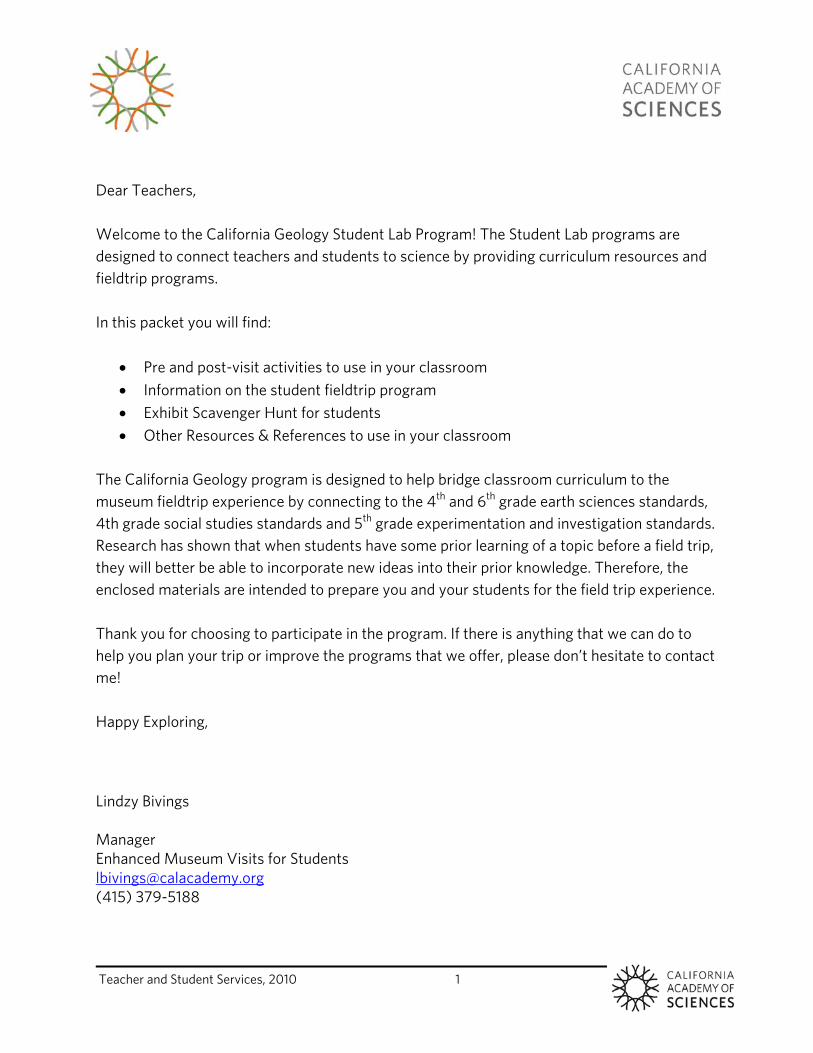
Dear Teachers, Welcome to the California Geology Student Lab Program! The Student Lab programs are designed to connect teachers and students to science by providing curriculum resources and fieldtrip programs. In this packet you will find:
Pre and post-visit activities to use in your classroom Information on the student fieldtrip program Exhibit Scavenger Hunt for students Other Resources & References to use in your classroom
The California Geology program is designed to help bridge classroom curriculum to the museum fieldtrip experience by connecting to the 4th and 6th grade earth sciences standards, 4th grade social studies standards and 5th grade experimentation and investigation standards. Research has shown that when students have some prior learning of a topic before a field trip, they will better be able to incorporate new ideas into their prior knowledge. Therefore, the enclosed materials are intended to prepare you and your students for the field trip experience. Thank you for choosing to participate in the program. If there is anything that we can do to help you plan your trip or improve the programs that we offer, please don’t hesitate to contact me! Happy Exploring, Lindzy Bivings Manager Enhanced Museum Visits for Students [email protected] (415) 379-5188

Teacher and Student Services, 2010 2
Teacher and Student Services, 2010 3
Teacher Resource Guide
California Geology Lab Field Trip Program
Grades 4 – 6

Teacher and Student Services, 2010 4
Table of Contents
Teacher and Student Services, 2010 5
Teacher Resource Guide
California Geology Grades 4 - 6
Contents
Field Trip Program: California Geology Lab ……………………………………………………………………………..7
Rocks and Minerals Scavenger Hunt ……………………………………………………………………………………….9
Pre-visit Activity: Rock Cycle Roundabout ……………………………………………………………………………..13
Post-visit Activity: Plotting Earthquakes ………………………………………………………………………………..27
Post-visit Activity: Google Earth Geology Field Trip ………………………………………………………………35
Post-visit Activity: Fossil Fuels ……………………………………………………………………………………………...41
California Content Standards …………………………………………………………………………………………….51
Vocabulary ……………………………………………………………………………………………………………………….53
Resources …………………………………………………………………………………………………………………………55

Table of Contents
Teacher and Student Services, 2010 6
Teacher and Student Services, 2010 7
California Content Standards
This activity reinforces the following correlated California content standards: 2a, 4a, 4b, 4c, 4d, 4e, 6a, 7a, 7b.
Objectives
The three major goals of the California Geology field trip program are to:
1.) Engage students in the scientific process by role-playing a scientist using specimens, microscopes and pictures from the field to identify rocks and how they formed.
2.) Develop a context for geology found in California by engaging students in map reading skills to identify locations of different rocks and minerals.
3.) Connect with how geology is used in our everyday lives by exploring the geologic resources found in the state.
Summary Students take on the role of researcher though participating in an exploration of rock specimens. Students begin this program with an introduction to the geologic properties that scientists look for in rocks and minerals. They then study a mystery rock specimen using two types of microscopes and record their observations through drawing and written descriptions of the geologic properties of their rock. They use this information on their own quest to identify the origin of a mystery rock. After an introduction to the rock cycle, students make predictions of what type of rocks they have been studying. Lastly, students learn to read a geologic map of California and play a matching game to connect natural resources to local geology. Teachers may pair this program with a Geology classroom kit teacher workshop and rental. For more information on the Geology Kit and Teacher Workshop, please visit: http://www.calacademy.org/teachers/erk.php
Field Trip Program: California Geology Lab INSTRUCTORS This program will be led by professional museum educators.
DURATION Activity: 70 minutes SETTING Academy Student Lab (Level 3, near the Naturalist Center)
Field Trip: California Geology Lab
Teacher and Student Services, 2010 8
Field Trip Program Outline What are rocks and minerals?
Students begin reviewing the differences between rocks and minerals
Learn how to describe rocks and minerals using geologic principles: size, color, patterns, grain size, shape, etc.
Mystery Rock Study
Students learn how to use two different types of microscopes to make observations
Students are broken up into 3 different teams to describe :”mystery rocks” using geologic principles
Rock Cycle Introduction & Predictions
Students review the Rock Cycle, learning about igneous, metamorphic and sedimentary rocks.
Using information from the observed specimens and pictures from the collecting sites, students make predictions on the type of rock they think they have.
California Geological Survey and Map
A brief history of how Josiah Whitney, one of the treasurers of the Academy, implemented the first geologic survey of California in the year 1864, shortly after the gold rush.
Students learn how to read a geologic map and begin to determine what type of rock they have been studying and whether or not their predictions were accurate.
Collection & Materials Matching Game
Small groups of students will receive trays of geologic collections to examine.
As a class, they will begin a matching game trying to determine how people use the different rocks and minerals in everyday life. Then they will figure out where the rocks and minerals were mined in California using the geologic map.
Conclusions
Instructors will lead a quick review of the complexity of California Geology and the important role that geology plays in our lives.
Field Trip: California Geology Lab
Teacher and Student Services, 2010 9
Objectives
Through this scavenger hunt, students will: 1. learn about the different compositions of rocks and minerals. 2. understand that rocks and minerals have different uses based on their materials. 3. observe differences in rock and mineral characteristics.
Materials
Rocks and Minerals Scavenger Hunt (one copy per student) pencils (one per student) optional: clipboards (one per student)
Vocabulary
sedimentary: formed from the accumulation of small particles deposited by wind or water.
breccia: angular pieces of rock stuck together by sedimentary rock. volcanic: formed by or originating from a volcano. igneous: produced under conditions of intense heat, as with volcanic rocks or rocks
from molten magma. metamorphic: rock changed by the action of extreme heat or pressure.
Teacher Background
The California Academy of Science doesn’t currently have an exhibit dedicated to geology; however, rocks and minerals are all around if you know where to look! This scavenger hunt will guide students through exhibits and have them carefully observe rocks and minerals in unexpected places. It will also get them thinking about how rocks and minerals are used by people. Students will spend the most time in the Naturalist Center, which is a great resource for information on rocks and minerals. Correlated California Content Standards
Grade Four Earth Sciences : 4a., 5a. Grade Five Physical Sciences: 1f. , Investigation and Experimentation: 6a.
Rocks and Minerals Exhibit Scavenger Hunt GRADE LEVELS 4th-6th; California Content Standards for 4th and 5th
SUBJECTS Physical Sciences DURATION Preparation: 10 minutes Activity: 45 minutes
SETTING Islands of Evolution Exhibit and Naturalist Center at the California Academy of Sciences
Field Trip: California Geology Lab
Teacher and Student Services, 2010 10
Activity Preparation
1. Make copies of the Rocks and Minerals Scavenger Hunt and distribute to each student.
Introduction
Explain and discuss the vocabulary. These are terms the students will see in the exhibit texts or will be helpful in their explanations.
Explain that you will be visiting different exhibits and that you will be gathering bits and pieces of geology related information from these exhibits. Tell them they may need to keep a sharp eye out to find them all.
Go over the questions on the scavenger hunt with your students and chaperones and make sure they understand what they will be doing. Most of the questions focus on making observations.
Procedure
1. The Rocks and Minerals Scavenger Hunt sequence has been designed for ease of travel between exhibits. You don’t have to complete the hunt in this order, but the following procedure explains the most straightforward route.
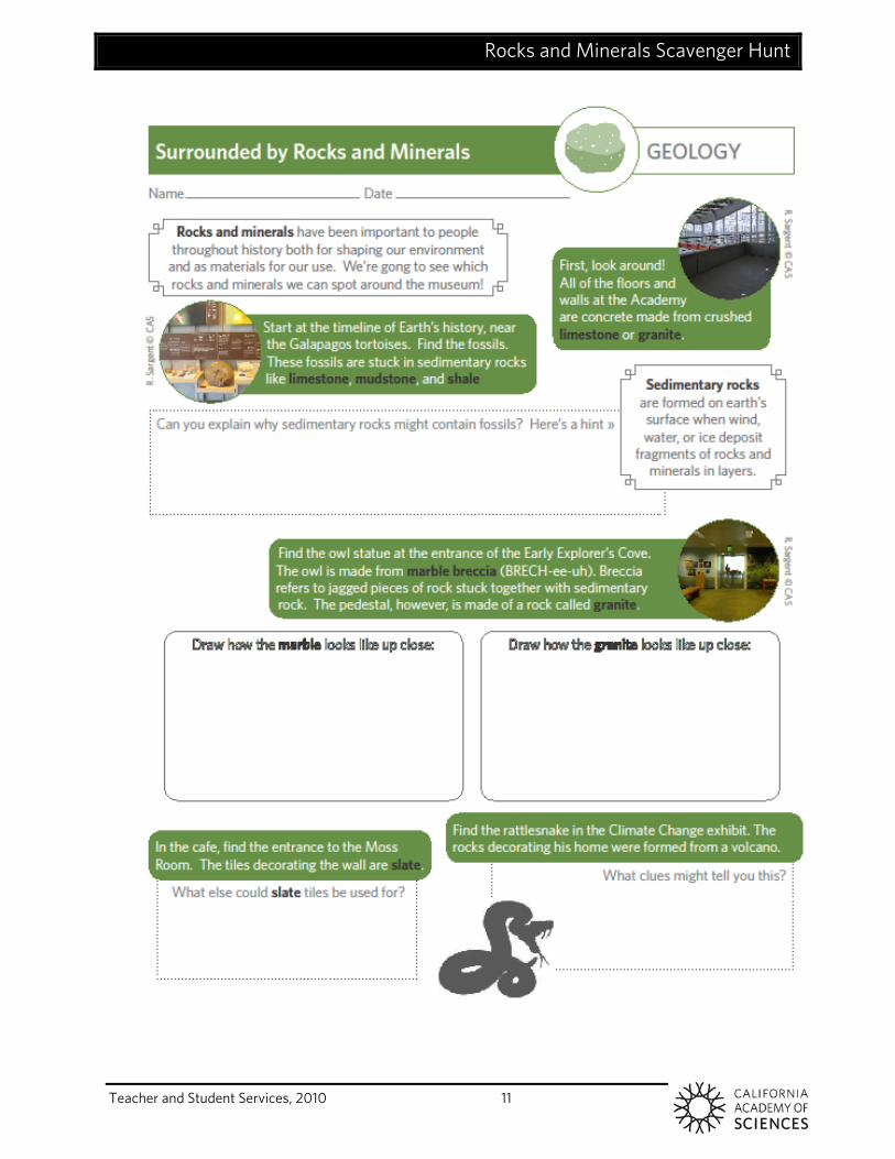
2. Start in the Islands of Evolution Exhibit, located on the main floor behind the Planetarium. On the back wall is a timeline of Earth’s history, where the fossils can be found.
3. Help them find the entrance to the Early Childhood Center and the location of the owl.
4. The next stop is the entrance to the Moss Room within the cafeteria; you don’t need to enter the Moss Room, just observe the decorated wall above the stairs leading down into the restaurant.
5. Find the rattle snake terrarium in the center of the Climate Change Exhibit. 6. The Naturalist Center is on the third floor. You can find the stairs located near
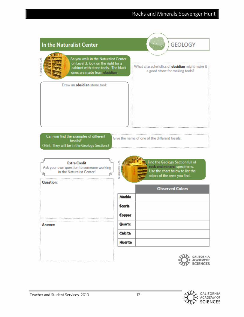
the café. Once at the third floor, cross the bridge towards the Planetarium to reach the entrance to the Naturalist Center.
7. Once in the Naturalist Center you may need to help students locate specific cases or specimens. If you have any trouble, just ask the staff for help!
Wrap-Up
Discuss the different kinds of rocks and how their formation and characteristics differ.
What were some of the observations they made about specific rock specimens? What kinds of things do people use rocks and minerals for? Was there anywhere they found rocks that surprised them?
Rocks and Minerals Scavenger Hunt
Teacher and Student Services, 2010 11
Rocks and Minerals Scavenger Hunt
Teacher and Student Services, 2010 12
Teacher and Student Services, 2010 13
California Content Standards This activity reinforces the following correlated California content standards: 4a, 4b, 4c, 4d, 7a, 7b (see page 53).
Objectives In this activity, students will:
4. Learn how the three types of rock are formed as part of the rock cycle 5. Learn that rocks change over very long periods of time. 6. Learn that the same forces that produce/change rocks also produce/change landforms
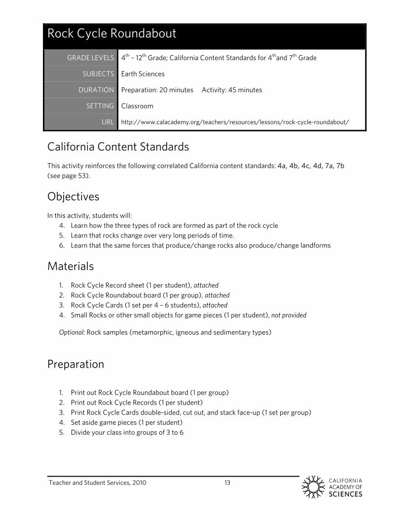
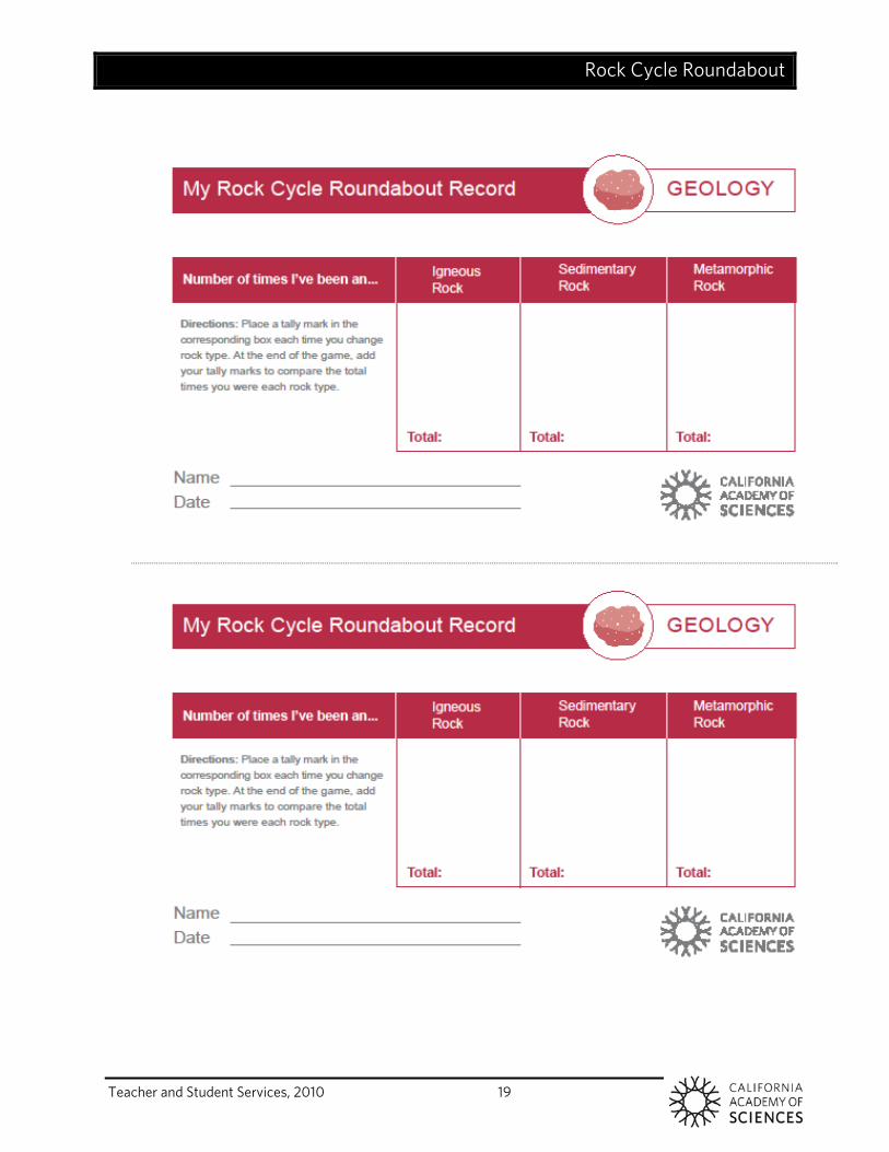
Materials 1. Rock Cycle Record sheet (1 per student), attached 2. Rock Cycle Roundabout board (1 per group), attached 3. Rock Cycle Cards (1 set per 4 – 6 students), attached 4. Small Rocks or other small objects for game pieces (1 per student), not provided
Optional: Rock samples (metamorphic, igneous and sedimentary types)
Preparation
1. Print out Rock Cycle Roundabout board (1 per group) 2. Print out Rock Cycle Records (1 per student) 3. Print Rock Cycle Cards double-sided, cut out, and stack face-up (1 set per group) 4. Set aside game pieces (1 per student) 5. Divide your class into groups of 3 to 6
Rock Cycle Roundabout
GRADE LEVELS 4th – 12th Grade; California Content Standards for 4thand 7th Grade
SUBJECTS Earth Sciences
DURATION Preparation: 20 minutes Activity: 45 minutes
SETTING Classroom
URL http://www.calacademy.org/teachers/resources/lessons/rock-cycle-roundabout/
Rock Cycle Roundabout
Teacher and Student Services, 2010 14
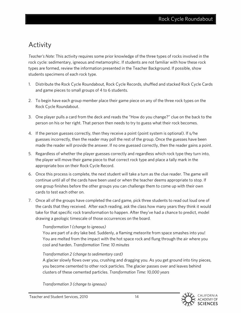
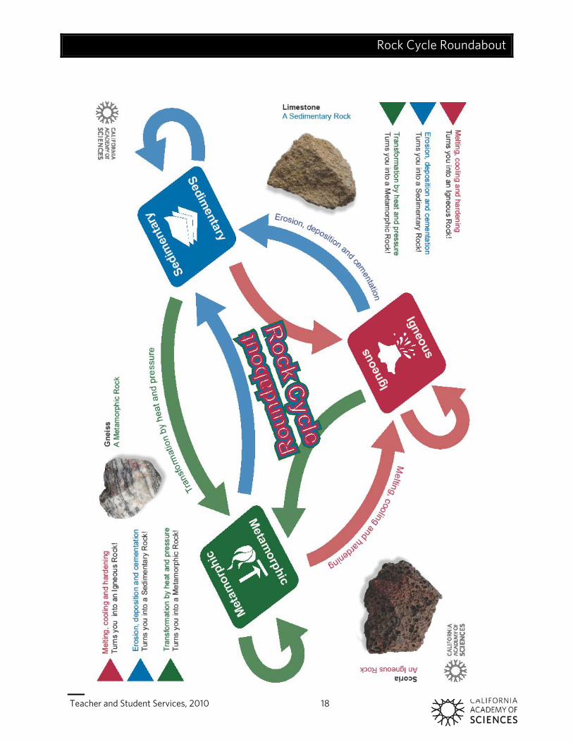
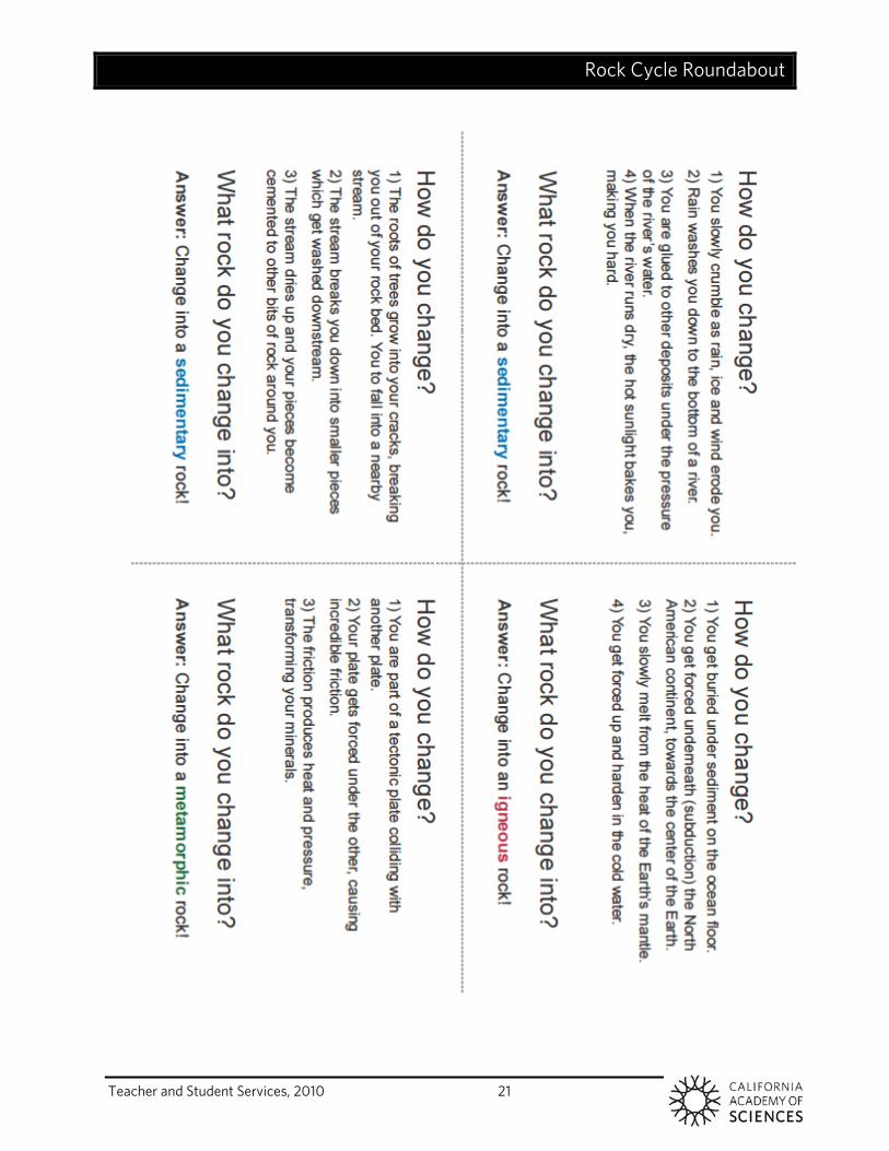
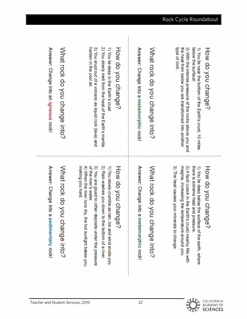
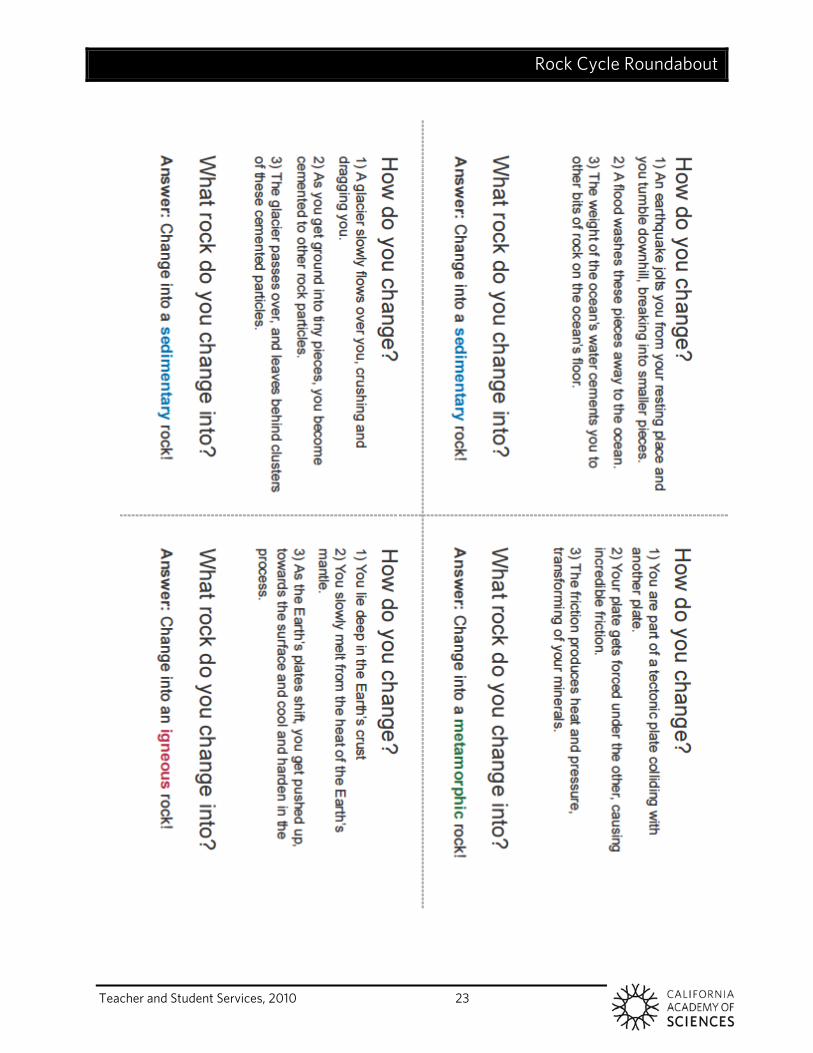
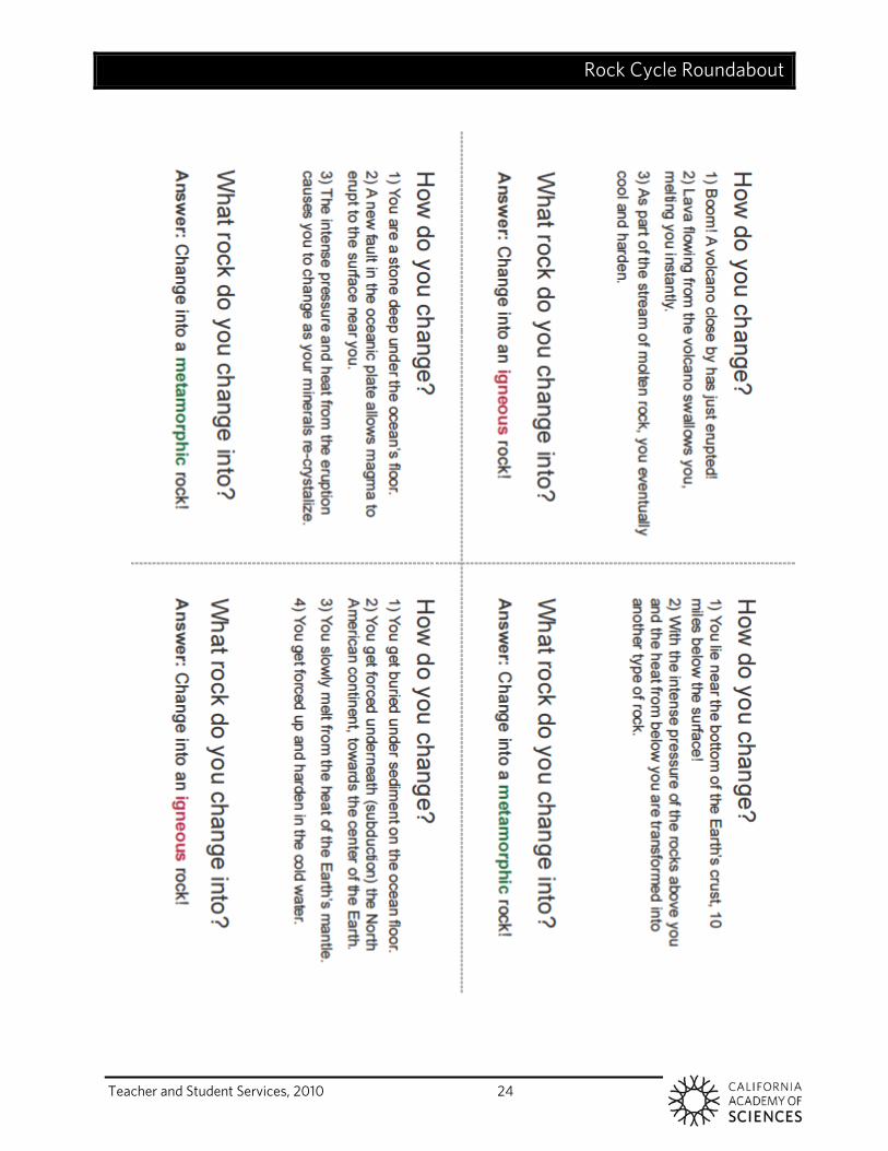
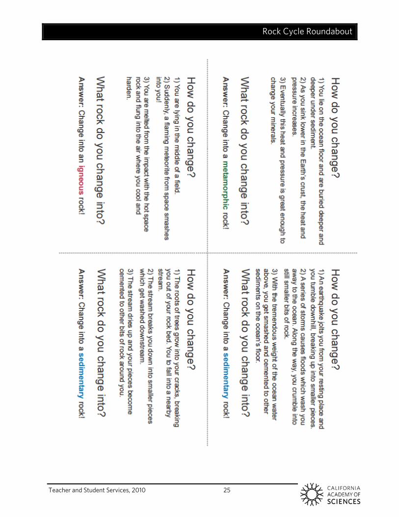
Activity Teacher’s Note: This activity requires some prior knowledge of the three types of rocks involved in the rock cycle: sedimentary, igneous and metamorphic. If students are not familiar with how these rock types are formed, review the information presented in the Teacher Background. If possible, show students specimens of each rock type.
1. Distribute the Rock Cycle Roundabout, Rock Cycle Records, shuffled and stacked Rock Cycle Cards and game pieces to small groups of 4 to 6 students.
2. To begin have each group member place their game piece on any of the three rock types on the Rock Cycle Roundabout.
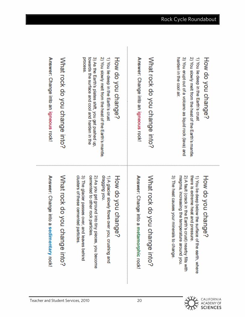
3. One player pulls a card from the deck and reads the “How do you change?” clue on the back to the person on his or her right. That person then needs to try to guess what their rock becomes.
4. If the person guesses correctly, then they receive a point (point system is optional). If s/he guesses incorrectly, then the reader may poll the rest of the group. Once the guesses have been made the reader will provide the answer. If no one guessed correctly, then the reader gains a point.
5. Regardless of whether the player guesses correctly and regardless which rock type they turn into, the player will move their game piece to that correct rock type and place a tally mark in the appropriate box on their Rock Cycle Record.
6. Once this process is complete, the next student will take a turn as the clue reader. The game will continue until all of the cards have been used or when the teacher deems appropriate to stop. If one group finishes before the other groups you can challenge them to come up with their own cards to test each other on.
7. Once all of the groups have completed the card game, pick three students to read out loud one of the cards that they received. After each reading, ask the class how many years they think it would take for that specific rock transformation to happen. After they’ve had a chance to predict, model drawing a geologic timescale of those occurrences on the board.
Transformation 1 (change to igneous) You are part of a dry lake bed. Suddenly, a flaming meteorite from space smashes into you! You are melted from the impact with the hot space rock and flung through the air where you cool and harden. Transformation Time: 10 minutes
Transformation 2 (change to sedimentary card) A glacier slowly flows over you, crushing and dragging you. As you get ground into tiny pieces, you become cemented to other rock particles. The glacier passes over and leaves behind clusters of these cemented particles. Transformation Time: 10,000 years Transformation 3 (change to igneous)
Rock Cycle Roundabout
Teacher and Student Services, 2010 15
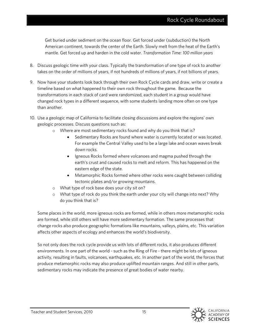
Get buried under sediment on the ocean floor. Get forced under (subduction) the North American continent, towards the center of the Earth. Slowly melt from the heat of the Earth’s mantle. Get forced up and harden in the cold water. Transformation Time: 100 million years
8. Discuss geologic time with your class. Typically the transformation of one type of rock to another
takes on the order of millions of years, if not hundreds of millions of years, if not billions of years.
9. Now have your students look back through their own Rock Cycle cards and draw, write or create a timeline based on what happened to their own rock throughout the game. Because the transformations in each stack of card were randomized, each student in a group would have changed rock types in a different sequence, with some students landing more often on one type than another.
10. Use a geologic map of California to facilitate closing discussions and explore the regions’ own geologic processes. Discuss questions such as:
o Where are most sedimentary rocks found and why do you think that is? Sedimentary Rocks are found where water is currently located or was located.
For example the Central Valley used to be a large lake and ocean waves break down rocks.
Igneous Rocks formed where volcanoes and magma pushed through the earth’s crust and caused rocks to melt and reform. This has happened on the eastern edge of the state.
Metamorphic Rocks formed where other rocks were caught between colliding tectonic plates and/or growing mountains.
o What type of rock base does your city sit on? o What type of rock do you think the earth under your city will change into next? Why
do you think that is?
Some places in the world, more igneous rocks are formed, while in others more metamorphic rocks are formed, while still others will have more sedimentary formation. The same processes that change rocks also produce geographic formations like mountains, valleys, plains, etc. This variation affects other aspects of ecology and enhances the world’s biodiversity. So not only does the rock cycle provide us with lots of different rocks, it also produces different environments. In one part of the world - such as the Ring of Fire - there might be lots of igneous activity, resulting in faults, volcanoes, earthquakes, etc. In another part of the world, the forces that produce metamorphic rocks may also produce uplifted mountain ranges. And still in other parts, sedimentary rocks may indicate the presence of great bodies of water nearby.
Rock Cycle Roundabout
Teacher and Student Services, 2010 16
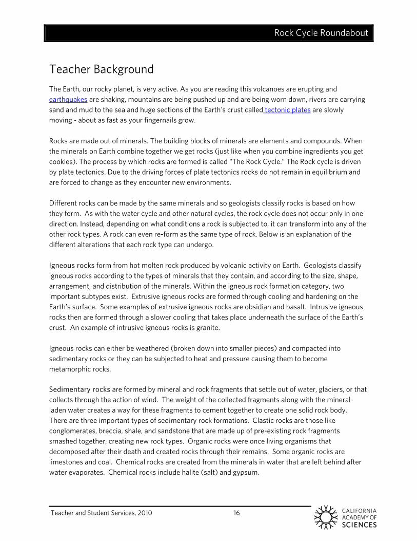
Teacher Background The Earth, our rocky planet, is very active. As you are reading this volcanoes are erupting and earthquakes are shaking, mountains are being pushed up and are being worn down, rivers are carrying sand and mud to the sea and huge sections of the Earth's crust called tectonic plates are slowly moving - about as fast as your fingernails grow. Rocks are made out of minerals. The building blocks of minerals are elements and compounds. When the minerals on Earth combine together we get rocks (just like when you combine ingredients you get cookies). The process by which rocks are formed is called “The Rock Cycle.” The Rock cycle is driven by plate tectonics. Due to the driving forces of plate tectonics rocks do not remain in equilibrium and are forced to change as they encounter new environments. Different rocks can be made by the same minerals and so geologists classify rocks is based on how they form. As with the water cycle and other natural cycles, the rock cycle does not occur only in one direction. Instead, depending on what conditions a rock is subjected to, it can transform into any of the other rock types. A rock can even re-form as the same type of rock. Below is an explanation of the different alterations that each rock type can undergo. Igneous rocks form from hot molten rock produced by volcanic activity on Earth. Geologists classify igneous rocks according to the types of minerals that they contain, and according to the size, shape, arrangement, and distribution of the minerals. Within the igneous rock formation category, two important subtypes exist. Extrusive igneous rocks are formed through cooling and hardening on the Earth’s surface. Some examples of extrusive igneous rocks are obsidian and basalt. Intrusive igneous rocks then are formed through a slower cooling that takes place underneath the surface of the Earth’s crust. An example of intrusive igneous rocks is granite. Igneous rocks can either be weathered (broken down into smaller pieces) and compacted into sedimentary rocks or they can be subjected to heat and pressure causing them to become metamorphic rocks. Sedimentary rocks are formed by mineral and rock fragments that settle out of water, glaciers, or that collects through the action of wind. The weight of the collected fragments along with the mineral-laden water creates a way for these fragments to cement together to create one solid rock body. There are three important types of sedimentary rock formations. Clastic rocks are those like conglomerates, breccia, shale, and sandstone that are made up of pre-existing rock fragments smashed together, creating new rock types. Organic rocks were once living organisms that decomposed after their death and created rocks through their remains. Some organic rocks are limestones and coal. Chemical rocks are created from the minerals in water that are left behind after water evaporates. Chemical rocks include halite (salt) and gypsum.
Rock Cycle Roundabout
Teacher and Student Services, 2010 17
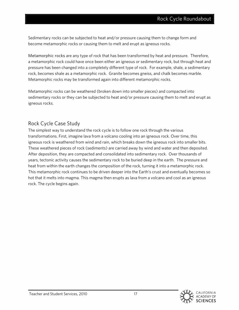
Sedimentary rocks can be subjected to heat and/or pressure causing them to change form and become metamorphic rocks or causing them to melt and erupt as igneous rocks. Metamorphic rocks are any type of rock that has been transformed by heat and pressure. Therefore, a metamorphic rock could have once been either an igneous or sedimentary rock, but through heat and pressure has been changed into a completely different type of rock. For example, shale, a sedimentary rock, becomes shale as a metamorphic rock. Granite becomes gneiss, and chalk becomes marble. Metamorphic rocks may be transformed again into different metamorphic rocks. Metamorphic rocks can be weathered (broken down into smaller pieces) and compacted into sedimentary rocks or they can be subjected to heat and/or pressure causing them to melt and erupt as igneous rocks.
Rock Cycle Case Study The simplest way to understand the rock cycle is to follow one rock through the various transformations. First, imagine lava from a volcano cooling into an igneous rock. Over time, this igneous rock is weathered from wind and rain, which breaks down the igneous rock into smaller bits. These weathered pieces of rock (sediments) are carried away by wind and water and then deposited. After deposition, they are compacted and consolidated into sedimentary rock. Over thousands of years, tectonic activity causes the sedimentary rock to be buried deep in the earth. The pressure and heat from within the earth changes the composition of the rock, turning it into a metamorphic rock. This metamorphic rock continues to be driven deeper into the Earth’s crust and eventually becomes so hot that it melts into magma. This magma then erupts as lava from a volcano and cool as an igneous rock. The cycle begins again.
Rock Cycle Roundabout
Teacher and Student Services, 2010 18
Rock Cycle Roundabout
Teacher and Student Services, 2010 19
Rock Cycle Roundabout
Teacher and Student Services, 2010 20
Rock Cycle Roundabout
Teacher and Student Services, 2010 21
Rock Cycle Roundabout
Teacher and Student Services, 2010 22
Rock Cycle Roundabout
Teacher and Student Services, 2010 23
Rock Cycle Roundabout
Teacher and Student Services, 2010 24
Rock Cycle Roundabout
Teacher and Student Services, 2010 25
Rock Cycle Roundabout
California Academy of Sciences, Teacher and Student Services, 2010 26
California Academy of Sciences, Teacher and Student Services, 2010 27
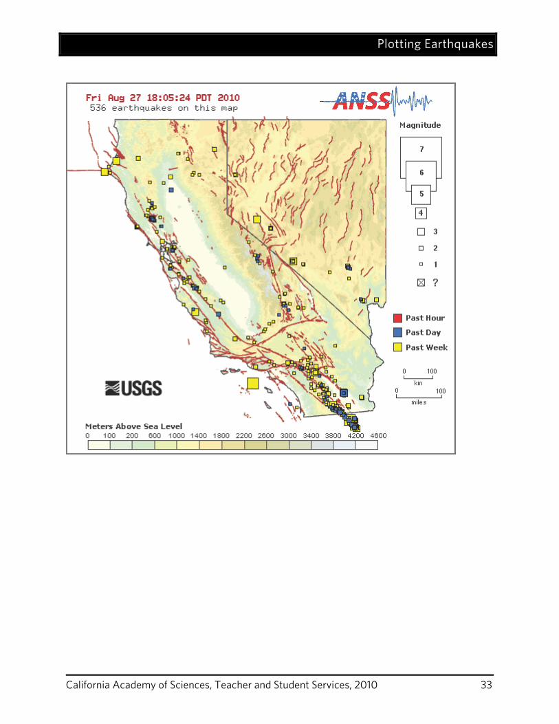
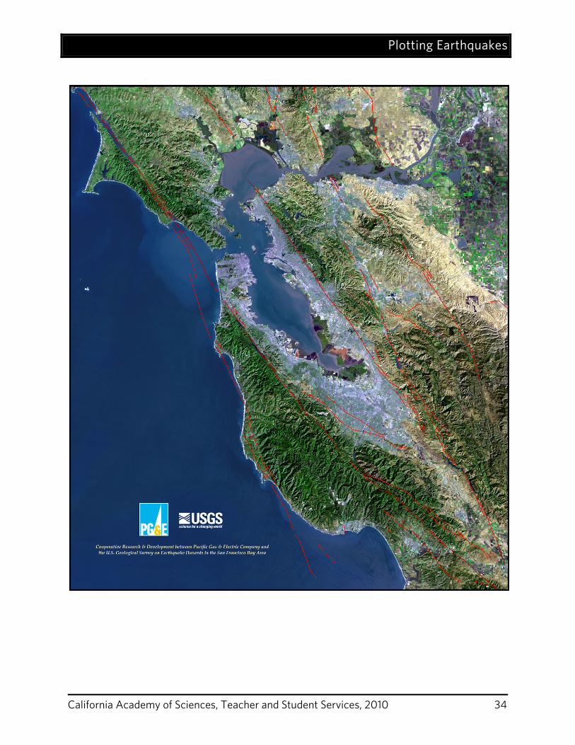
Plotting Earthquakes GRADE LEVELS 4th – 12th Grade; California Content Standards for 4th,6th and 7th Grade
SUBJECTS Earth Sciences DURATION Preparation: 10 minutes Activity: 45 minutes
SETTING URL:
Classroom http://www.calacademy.org/teachers/resources/lessons/plotting-earthquakes/
California Content Standards This activity reinforces the following correlated California content standards: 4a, 4b, 4c, 4d, 7a, 7b (see page 53).
Objectives In this activity, students will:
1. Learn how to plot earthquakes on a map 2. Explore recent earthquake activity in California and Nevada
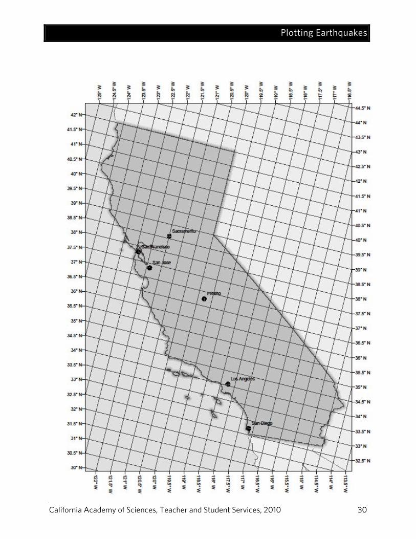
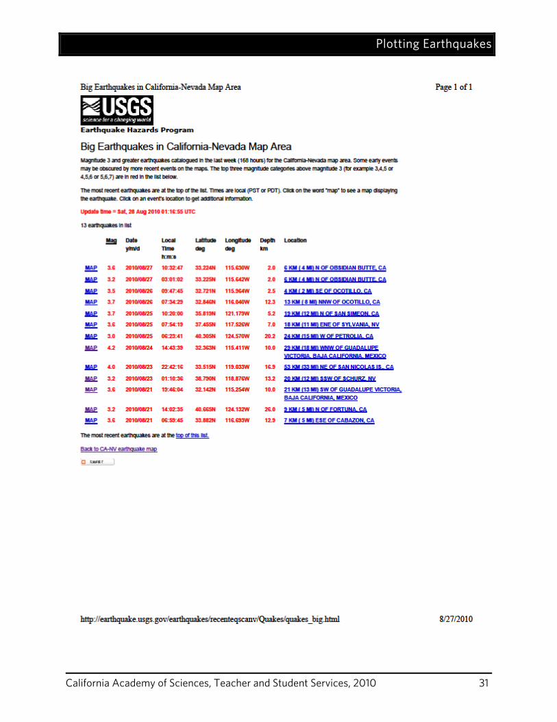
Materials 1. California Map (1 per 4 – 6 students) 2. Pencils 3. Rulers 4. Map of Fault Lines 5. Printout of recent earthquakes in California 6. Slinky (optional)
Preparation 1. Print out California Maps (1 per group) 2. Obtain list of recent earthquakes
Plotting Earthquakes
California Academy of Sciences, Teacher and Student Services, 2010 28
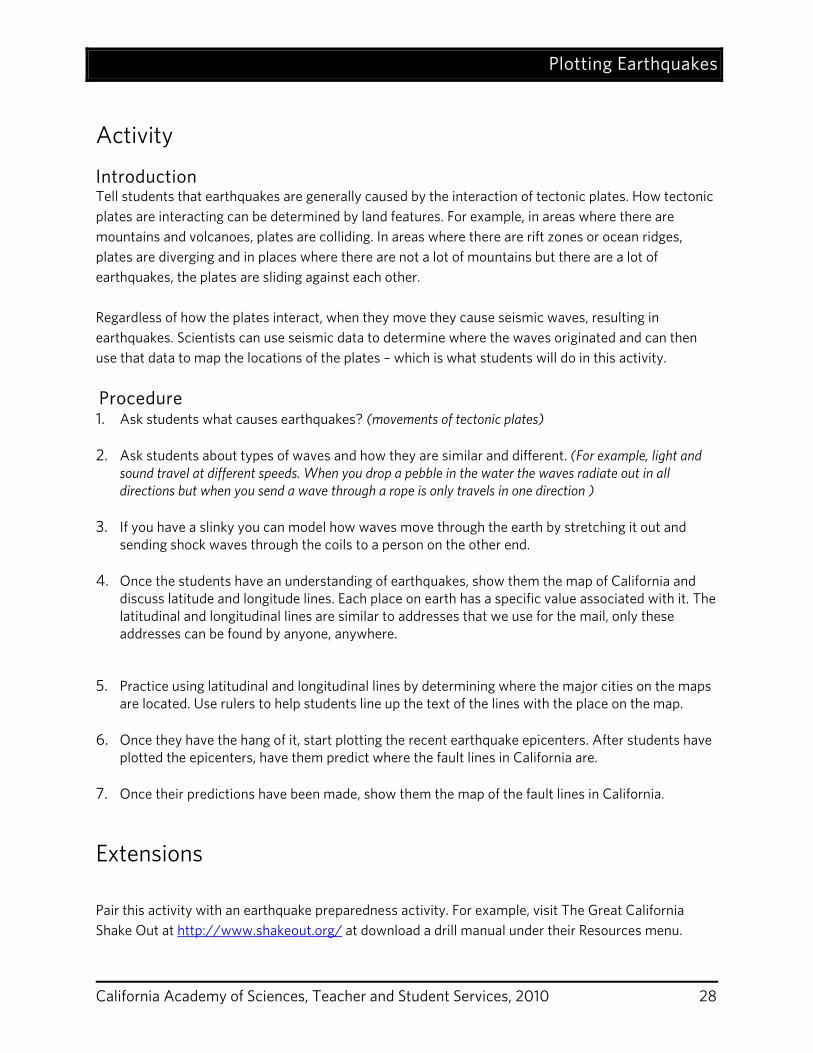
Activity
Introduction Tell students that earthquakes are generally caused by the interaction of tectonic plates. How tectonic plates are interacting can be determined by land features. For example, in areas where there are mountains and volcanoes, plates are colliding. In areas where there are rift zones or ocean ridges, plates are diverging and in places where there are not a lot of mountains but there are a lot of earthquakes, the plates are sliding against each other. Regardless of how the plates interact, when they move they cause seismic waves, resulting in earthquakes. Scientists can use seismic data to determine where the waves originated and can then use that data to map the locations of the plates – which is what students will do in this activity. Procedure 1. Ask students what causes earthquakes? (movements of tectonic plates) 2. Ask students about types of waves and how they are similar and different. (For example, light and
sound travel at different speeds. When you drop a pebble in the water the waves radiate out in all directions but when you send a wave through a rope is only travels in one direction )
3. If you have a slinky you can model how waves move through the earth by stretching it out and
sending shock waves through the coils to a person on the other end. 4. Once the students have an understanding of earthquakes, show them the map of California and
discuss latitude and longitude lines. Each place on earth has a specific value associated with it. The latitudinal and longitudinal lines are similar to addresses that we use for the mail, only these addresses can be found by anyone, anywhere.
5. Practice using latitudinal and longitudinal lines by determining where the major cities on the maps are located. Use rulers to help students line up the text of the lines with the place on the map.
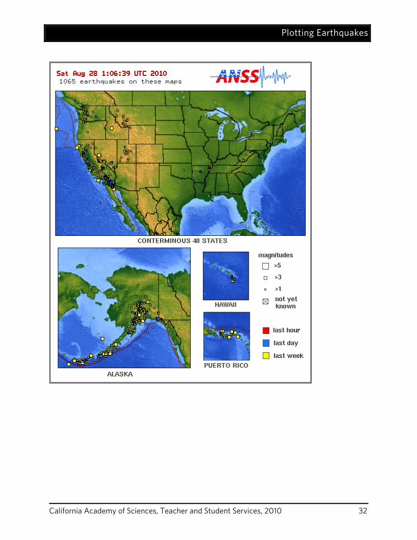
6. Once they have the hang of it, start plotting the recent earthquake epicenters. After students have
plotted the epicenters, have them predict where the fault lines in California are. 7. Once their predictions have been made, show them the map of the fault lines in California.
Extensions Pair this activity with an earthquake preparedness activity. For example, visit The Great California Shake Out at http://www.shakeout.org/ at download a drill manual under their Resources menu.
Plotting Earthquakes
California Academy of Sciences, Teacher and Student Services, 2010 29
Teacher Background The Earth, our rocky planet, is very active. Earthquakes happen every day. As you are reading this volcanoes are erupting and earthquakes are shaking, mountains are being pushed up and are being worn down, rivers are carrying sand and mud to the sea and huge sections of the Earth's crust called tectonic plates are slowly moving - about as fast as your fingernails grow. The earth’s crust is composed of 7 major tectonic plates and several minor plates that move around the earth due to convection currents in the mantle (the malleable layer beneath the crust). These plates interact with each other in three separate ways; they can collide, diverge, or slide past each other. When these plate movements happen, we get earthquakes. In California the North American Plate is colliding and sliding past the Pacific Ocean Plate and this causes earthquakes. Sometimes there are catastrophic earthquakes, but more often they are smaller movements. In this activity students will plot recent earthquakes on a map.
Plotting Earthquakes
California Academy of Sciences, Teacher and Student Services, 2010 30
Plotting Earthquakes
California Academy of Sciences, Teacher and Student Services, 2010 31
Plotting Earthquakes
California Academy of Sciences, Teacher and Student Services, 2010 32
Plotting Earthquakes
California Academy of Sciences, Teacher and Student Services, 2010 33
Plotting Earthquakes
California Academy of Sciences, Teacher and Student Services, 2010 34
California Academy of Sciences, Teacher and Student Services, 2010 35
Google Earth Geology Field Trip GRADE LEVELS 2nd - 12th Grade; California Content Standards for 2nd, 4th,6th and 7th Grade
SUBJECTS Earth Sciences DURATION Preparation: 20 minutes Activity: 45 minutes – 1 hour
SETTING URL:
Classroom http://www.calacademy.org/teachers/resources/lessons/plotting-earthquakes/
California Content Standards This activity reinforces the following correlated California content standards: 4b, 4e, 7a (see page 53).
Objectives In this activity, students will: 1) learn about California geology. 2) learn about common rocks, including how they are formed and some of their uses in everyday life.
Materials Computer and projector California Geology Flight kmz file:
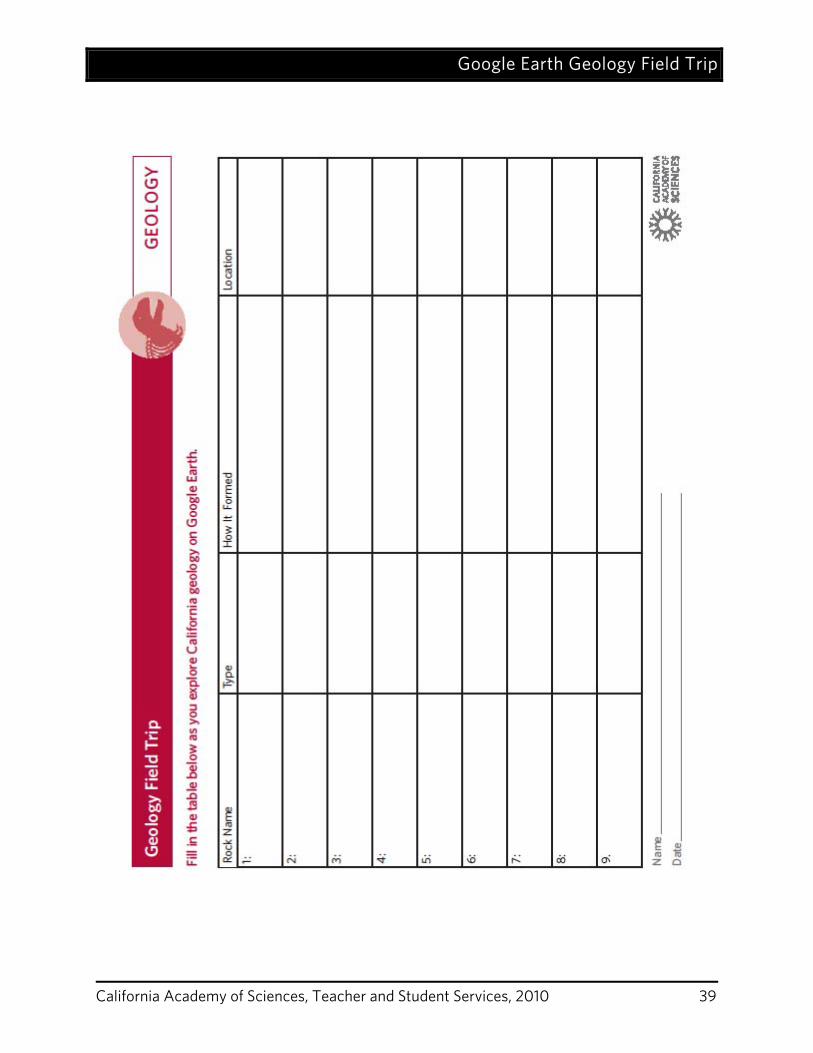
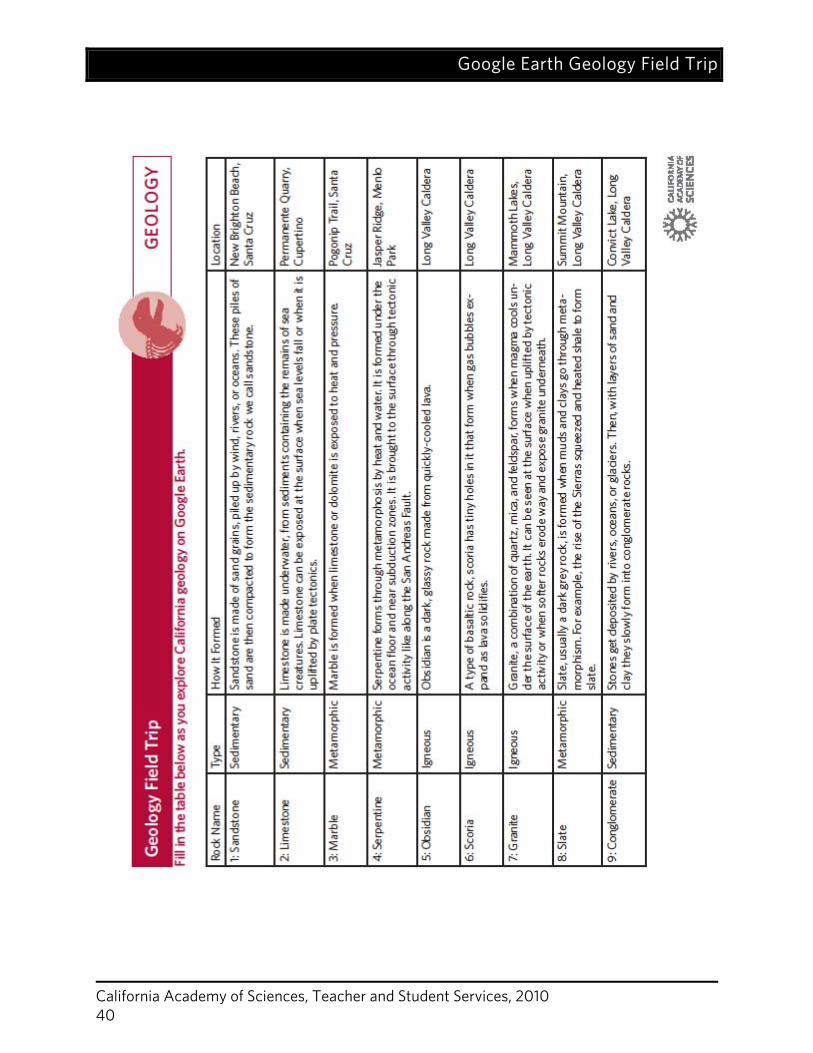
https://www.calacademy.org/teachers/resources/lessons/google-earth-geology-field-trip/ California Geology Map Geology Field Trip Worksheet (1 per student) Geology Field Trip Worksheet Teacher Version
Preparation 1. Print enough copies of the worksheet for each student to have one.
2. Print one copy of the worksheet (teacher version) and review it.
3. Download Google Earth for free: http://earth.google.com/
4. Put the CD in your computer and download the kmz file entitled “California Geology Flight.”
5. Open the kmz file. Google Earth should automatically launch.
6. On the left-hand side of the window, under the “Temporary Places”, you will see California
Geology Flight.
7. Practice using Google Earth so that you can run the tour with your students and help them with
questions they might have.
Google Earth Geology Field Trip
California Academy of Sciences, Teacher and Student Services, 2010 36
Activity Introduction 1. Review the rock cycle with your students. There are three different types of rocks:
sedimentary, metamorphic, and igneous. Remind students how these different rock types are formed.
2. Show students the map of California and explain that there are certain locations that tend to have one rock type or another. (Keep the map up in the classroom as a reference for this activity.)
3. Pass around the rock samples and ask for student observations. 4. Ask students the following questions.
Which of these rock types would you expect to find on a field trip to the beach? (Mostly sedimentary rocks because sand builds up on the beach and over time can form sedimentary rocks.)
Which of these rock types would you expect to find near the volcanoes in the Sierra Nevada? (Mostly igneous rocks because they are formed when molten material from volcanoes cools and hardens.)
Where in California would you expect to see metamorphic rocks? (You can find metamorphic rocks anywhere where rock has been changed by heat and pressure. This could be near the coastline, where two plates once collided and now move in opposite directions along a series of faults including the San Andreas Fault. You could also find them in the mountains where mountain building could have caused serious heat and pressure.)
Procedure 1. Tell students that they are going to go on a virtual geology field trip to see some places where
they can find sedimentary, metamorphic, and igneous rocks in California.
2. Open the kmz file entitled “California Geology Flight.” This will open the Google Earth application.
3. Start by double clicking on “California.” This view will show a cluster of points in the Bay Area and a cluster in the Sierras. Explain to the students that your virtual field trip will involve looking at geology close to home and then further away in the Sierras.
4. Then, double click “Bay Area.” This will zoom into a view of only the Bay Area. Tell students that you will look at four different rocks in the Bay Area.
5. Explain that the Bay Area is located on a fault line and near the ocean. Both of these geographic features greatly affect the types of rocks that are distributed around the Bay Area.
6. Start with the first rock, sandstone, and proceed to give your students a tour of the four Bay Area rocks.
7. To fly to each rock, double click on the Academy logo next to each rock type on the left panel.
8. Once you reach the location, you can click on the logo once more to bring up the balloon of photos and information. (Note that you can also click on the name of the rock type on the left –in
Google Earth Geology Field Trip
California Academy of Sciences, Teacher and Student Services, 2010 37
blue. This will bring up the balloon of photos and information. A double click will fly you to the appropriate location.)
9. Read the balloon text out loud to your students and have a discussion about how each rock type was formed. (Use the information from the teacher worksheet to flesh out what is written in the balloons.)
10. For each rock location, you can pause to discuss relevant issues such as how the visible topography was formed, what rocks are used for in everyday life, how and why rocks are mined, and the environmental issues associated with mining.
11. At each location have students fill in the appropriate section on their worksheet.
12. After visiting the four Bay Area rocks, double click on “Sierra Nevada.” This will zoom into a view of the Mono Lake area of the Sierra Nevada. Tell students that you will now fly to the mountains and look at 5 rocks from this region.
13. Double click on “Mono Craters.” This will fly you in closer to a view of the volcanic landscape.
14. Discuss how the Sierras were formed: Today, California’s faults are mostly transform faults (where plates grind past one another), but there used to be a subduction zone off the coast of California. At subduction zones, oceanic crust is subducted beneath the continental crust. When oceanic crust subducts, it melts, causing large plumes of magma to rise. In California, these large plumes of magma resulted in mountain building and volcanoes. When the magma cooled, it formed the igneous granite that comprises the base of the Sierras. As volcanoes erupted, mountains formed, rivers were born, and other geologic processes occurred in this area. Many metamorphic, igneous, and sedimentary rocks formed.
15. Explore the five Sierra rocks as you did with the Bay Area rocks. Have the students continue to document what they are learning on their worksheets.
Wrap-Up Discuss with the students:
What surprised you about your virtual field trip? Why are there so many different types of rocks in California? (California is tectonically active
and showcases a variety of different geologic processes including sedimentation, metamorphism, and volcanic eruptions.)
What questions do you have about California geology? Relate your virtual field trip to the specific standards for your grade. The Google Earth tour can serve as a visual cue to remind students of many important geologic concepts.
Extensions With older students, spend time flying over California’s major geologic features. Have students take turns explaining some of the features that you can see.
Google Earth Geology Field Trip
California Academy of Sciences, Teacher and Student Services, 2010 38
Teacher Background
California is situated on the boundary between the North American Plate and the Pacific Plate, a location that gives rise to significant tectonic activity and complex geology. California is an amazingly diverse state in terms of geology. It is full of current dynamic geologic processes (earthquakes, landslides, and volcanoes), and it is full of rocks that tell us about geologic processes of the past. Without traveling all around the state, it can be difficult to imagine all these different types of rocks and geologic formations. Google Earth is a unique tool that allows users to see the unthinkable. It lets us fly around the planet, viewing the world, its rocks, its oceans, and its cities, from a perspective impossible without technology. In this lesson, we use the tool of Google Earth to take students on a virtual field trip around California. We start close to home in the Bay Area, looking at two types of sedimentary rocks (sandstone and limestone) and two types of metamorphic rocks (marble and serpentine). Then, we move to the Sierra Nevada where we see one sedimentary rock (conglomerate), one metamorphic rocks (slate), and three igneous rocks (obsidian, scoria, and granite). By flying around the Bay Area and then to the Sierra Nevada, students can compare the environments in which these different types of rocks are formed. For background information on these rocks please see the teacher version of the worksheet.
Reference United Stated Geological Survey, Menlo Park Campus, kindly supplied the rocks and many of
the rock and location photos for this lesson. Farndon, J. (2008). The illustrated encyclopedia of rocks of the world. London: Southwater. Sloan, D. (2006). California natural history guides: Geology of the San Francisco Bay region.
Berkeley: University of California Press. Hill, M. (2006). California natural history guides: Geology of the Sierra Nevada. Berkeley:
University of California Press.
Google Earth Geology Field Trip
California Academy of Sciences, Teacher and Student Services, 2010 39
Google Earth Geology Field Trip
California Academy of Sciences, Teacher and Student Services, 2010 40
California Academy of Sciences, Teacher and Student Services, 2010 41
Fossil Fuels: Facing the Issues
GRADE LEVELS 3rd-8th; California Content Standards for 3rd, 6th, and 8th SUBJECTS Earth Sciences, Physical Sciences, Social Sciences
DURATION Preparation: 10 minutes Activity: 90 minutes
SETTING URL:
Classroom http://www.calacademy.org/teachers/resources/lessons/fossil-fuels-facing-the-issues/
California Content Standards This activity reinforces the following correlated California content standards: 3a, 6b, 6c, 8a (see page 53).
Objectives In these activities, students will:
1. learn about some of the environmental consequences associated with fossil fuel usage. 2. learn that fossil fuels are nonrenewable resources. 3. relate combustion reactions to fossil fuel burning.
Materials Coal Mining chocolate chip cookies – relatively hard cookies work best (1 per student) toothpicks (1 per student plus a few extras) plates (1 per student) Coal Mining worksheets (1 per student) Oil Spill plastic tubs (1 per team of 4 or 5 students) Dixie cups (1 per team of 4 or 5 students) water cooking oil habitat items: rocks, sticks, feathers cleaning items: sponges, cotton balls, spoons Oil Spill worksheets (1 per student) Air Pollution candle (1 if doing a demonstration. 1 per group if older students are participating.) glass jars or beakers (2-3 if doing a demonstration. 1 per group if older students are participating.)
Fossil Fuels: Facing the Issues
California Academy of Sciences, Teacher and Student Services, 2010 42
Preparation 1. Collect and organize all materials. 2. Print out all worksheets
Activity
Introduction Set the stage by discussing energy usage with your students. Ask them where we get the majority of the energy that we use. The answer is that we get the majority of our energy from fossil fuels. Discuss and describe the processes involved in taking fossil fuels from the ground to be used for fuel – extraction, conversion, distribution, and end use (see Teacher Background section).
Procedure Cookie Mining
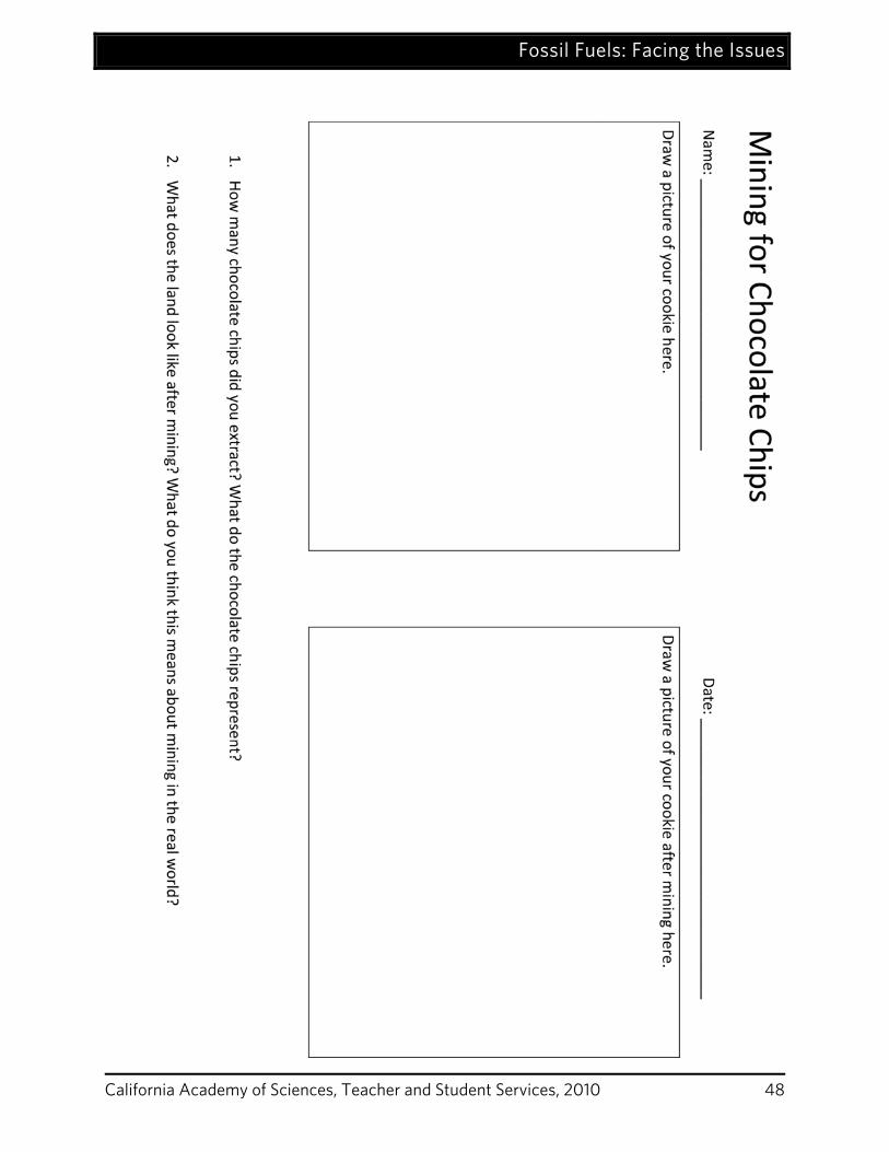
1. Tell students that they are going to become coal miners. Their job is to use the tool you give them to mine the land and find as much coal as possible while doing the least damage to the land.
2. Hand out the coal mining worksheets. 3. Tell students that they will each be getting a chocolate chip cookie. The cookie represents a
parcel of land that is going to be mined for coal. The chocolate chips represent coal. 4. Tell students to draw their cookie first. Then give students time to mine for chocolate chips,
draw their cookie again, and answer the questions at the bottom of the worksheet. 5. Ask students what happened to the land around the coal. Discuss what implications strip
mining might have on local ecosystems. In general, surface mining takes away topsoil and vegetation and therefore destroys habitat for wildlife.
6. Ask students whether coal is a renewable or nonrenewable resource. Explain that fossil fuels are nonrenewable resources because they take millions of years to form and do not reform on the scale of a human lifetime. Explain that cookie mining illustrated this fact because once they took the coal/chocolate out, there wasn’t any more to replace it.
Oil Spills
1. Ask students if they have heard about oil spills in the ocean. 2. Remind students of some oil spills in history. See the Teacher Background section for
information. 3. Tell students that sometimes ships transporting oil accidentally spill oil into the oceans and
that the results can be really harmful for marine ecosystems. 4. Tell students they are going to become part of an oil spill clean up crew. 5. Divide students into groups of four or five.
Fossil Fuels: Facing the Issues
California Academy of Sciences, Teacher and Student Services, 2010 43
6. Give each group a plastic tub filled a few inches with water, a small cup with a few tablespoons of cooking oil, and a set of habitat and cleaning items.
7. Tell students to put their habitat items in the tub. 8. Have student pour the oil into the tub. 9. Have students experiment with the various cleaning items. 10. Hand out the worksheets and tell students to record their observations on the Oil Spill
worksheet as they experiment with cleaning up the oil spill. 11. After students have finished filling out their worksheets, lead a discussion about how each of
the objects interacted with the oil. Then ask students what they think this demonstration can tell us about real world oil spills.
There are a few key lessons to point out. It is hard to separate oil and water, so clean up processes can take a long time and a lot of effort. Oil sticks to feathers and is hard to remove, which implies that birds are affected during oil spills. In fact, oil can hamper a bird’s ability to stay warm. When oil coats feathers, the feathers are no longer waterproof. The birds thus get wet and cold, which can lead to death. Candle Pollution
1. Tell students that they will get to see one component of air pollution. 2. Light a candle. 3. Let it burn for a few seconds. 4. Then, put the bottom of a glass jar or beaker above the flame so that the glass touches the top
of the flame. 5. Soot will immediately develop on the glass. 6. You can do this with a few glass jars and then pass it around so that students can touch the
soot if they want. 7. Ask students what soot is. It is fine black particles, chiefly composed of carbon, produced by
incomplete combustion. 8. Ask students what the candle burning represents. It represents the burning of fossil fuels. Most
candles are made with paraffin wax, which is derived from oil. It is a hydrocarbon and so burns like other hydrocarbons such as fossil fuels.
9. Spend a few minutes explaining to students why soot was created. Depending on the level of your students, you can go into more or less detail about combustion reactions.
Complete Combustion of Paraffin Wax: C25 H52 + 38O2 ↔ 25CO2 + 26 H2O Paraffin Wax + Oxygen ↔ Carbon Dioxide + Water If complete combustion were to occur as in the equation above, the only products formed would be carbon dioxide and water. Most combustion is incomplete however. This means that only a portion of the paraffin is converted into carbon dioxide and water. Some of the carbon from the paraffin is
Fossil Fuels: Facing the Issues
California Academy of Sciences, Teacher and Student Services, 2010 44
released as soot. This is what you saw on the glass that was held in the flame. Soot and other air pollutants are released when humans burn fossil fuels. Incomplete Combustion of Paraffin Wax Paraffin Wax + Oxygen ↔ Carbon Dioxide + Water + Carbon Particles
Wrap-Up Discuss with the students:
What are some of the problems associated with using fossil fuels for energy? (mining damages ecosystems, air pollution can harm ecosystems and human health, oil spills, climate change)
What are some things that we can do to lessen these problems in our world? (conserve energy, use more efficient technology that consumes less energy, encourage the use of renewable energy sources)
Teacher Background For many decades now, fossil fuels such as oil and coal have fueled the bulk of global energy production. These products were plentiful and inexpensive at the beginning of the industrial revolution and were widely adopted in industry, commerce, and transportation. However, energy is now becoming a critical topic of discussion as global supplies of cheap fossil fuels steadily decline and fossil fuel related greenhouse gases accumulate in the atmosphere. Due to increased concern about global climate change, as well as the uncertainties surrounding the import of foreign oil, many developed countries are now faced with the choice of continuing their fossil-fuel based energy, or developing new technologies that can reduce or eliminate the need for these products. Although there is currently a surge in the use of alternative sources of energy, the vast majority of the world’s energy continues to be produced by burning fossil fuels. In 2006, approximately 88% of the world’s energy and 86% of the United States’ energy was supplied by fossil fuels. Using fossil fuels has caused a number of environmental and human health effects. For example, burning fossil fuels is the number one contributor to human-induced climate change. Climate change is an important reason for people to reduce their fossil fuel consumption via conservation, efficiency measures, and switching to renewable energy sources. Although climate change is topmost in the list of concerns about fossil fuel usage, there are many other associated issues with our use of fossil fuels. The activities covered in this lesson will highlight three of the other problems associated with fossil fuel usage: extraction consequences, distribution problems, and air pollution. Specifically, these activities will illustrate the consequences of surface mining for coal, the challenges of cleaning oil spills, and the air pollution produced by burning fossil
Fossil Fuels: Facing the Issues
California Academy of Sciences, Teacher and Student Services, 2010 45
fuels. Although there are many other environmental consequences involved with burning fossil fuels, these three examples serve to illustrate the types of problems caused by our use of fossil fuels for energy. Although fossil fuels (coal, oil, and natural gas) are all different in their properties and uses, they have some similarities. They all come from fossilized plant and/or animal material. They are all nonrenewable resources; they take millions of years to form and do not regenerate on the timescale of a human life. They also all go through similar processes on their path from being extracted from the ground to serving as fuels for human beings. In order to extract coal, oil, and natural gas from underground, people have to mine or drill. This often has significant impacts on the surrounding land, plants, and animals. After these resources are extracted from the ground, they must be converted into useful energy currencies such as gasoline and electricity. This is done through refining, like when oil is refined to produce gasoline, or through burning the product to produce electricity, like when coal is burned at power plants to produce electricity. These energy currencies are then distributed to people who use them for services such as transportation, heating, and lighting. The distribution of energy can be via pipes, trains, ships, or power lines. All of these steps (extraction, conversion, distribution, and end use) have impacts on the environment. The extraction process is different for different fossil fuels, but drilling or mining for fossil fuels always impacts the land. Whether it is creating exploratory roads and drill sites or taking off the tops of mountains to look for coal, the land is altered by the extraction process. In this lesson, we will focus on one of the more destructive practices for fossil fuel extraction, surface mining for coal. Coal occurs in bands of various thicknesses, some of which are close to the earth’s surface. Some coal is mined underground, but the majority is mined in surface mines, also known as strip mines. Strip mining involves removing the earth above a coal band in order to expose the coal. In an ideal situation, the excavated land would be refilled, but a lot of mines have been left without topsoil and with great risk of serious erosion. In these cases, the land can no longer support vegetation or wildlife. Today, United States federal law requires that people replace soil and replant vegetation. However even with these measures strip mined areas are heavily impacted and may not fully recover. After extraction, fossil fuels need to be converted into useful forms. This includes burning coal and natural gas for electricity and converting crude oil into its byproducts such as gasoline. The conversion process is responsible for a large proportion of air pollution. But, air pollution is certainly not restricted to this step in the pathway. Air pollution also occurs in the end use step like when people burn gasoline in vehicles. Air pollutants are those substances added to the air by humans that have negative environmental and/or health consequences. Air pollutants include particulates (particles of solids in the air), sulfur oxides, nitrogen oxides, hydrocarbons, carbon monoxide, and more. In the United States, each year about 180 million tons of pollutants are released into the air from transportation,
Fossil Fuels: Facing the Issues
California Academy of Sciences, Teacher and Student Services, 2010 46
power plants, industrial processes and other sources. Air pollutants result in both environmental problems like acid rain and human health concerns like emphysema, bronchitis, and asthma. In this lesson, we will show students how soot, fine black particulate matter, can be released when substances are burned. Combustion or burning involves a series of chemical reactions that produce heat and/or light. In complete combustion, a compound reacts with oxygen completely to produce a limited number of products. For example, when a substance composed entirely of hydrogen and carbon (a hydrocarbon) burns completely in pure oxygen, it will release only carbon dioxide and water. Incomplete combustion occurs more often than complete combustion. It occurs when there isn’t enough oxygen for a complete burn or when combustion is interrupted. Incomplete combustion of hydrocarbons produces more products including carbon dioxide, water, carbon monoxide, soot, and various other compounds. This is the kind of combustion that occurs when we burn fossil fuels. The distribution of energy resources can have negative environmental consequences. Distribution occurs both before and after energy conversion. For example, oil is transported to refineries, where it is converted to gasoline and other substances, which are in then distributed as well. This lesson will focus on one example of a distribution problem, an oil spill. Small oil spills occur all the time, as ships move around the oceans. Large oil spills, occur much less frequently, but can be absolutely detrimental to the ecosystems in which they occur. The Exxon Valdez oil spill is one of the most infamous oil spills because it dumped a huge amount of oil, 10.9 million gallons, into Prince William Sound, a pristine area full of wildlife. The incident killed hundreds of thousands of birds, and damaged the local fisheries. It triggered the largest oil spill clean up in history, an effort that latest for many years. Some wildlife populations have recovered well, while others have not recovered. Closer to home, in November 2007, a container ship hit the San Francisco-Oakland Bay Bridge and spilled 58,000 gallons of oil, resulting in beach closures and dead and injured wildlife including seabirds and fish. In exploring coal mining, oil spills, and air pollution, students will get a sense of a few of the problems associated with fossil fuels. Although fossil fuels have helped bring prosperity to many parts of the world by providing electricity, heating, cooling, and transportation, a decrease in fossil fuel usage is becoming more and more necessary for a host of reasons.
Fossil Fuels: Facing the Issues
California Academy of Sciences, Teacher and Student Services, 2010 47
References Chea, T. (2007, November 9). San Francisco Oil Spill Threatens Wildlife. National Geographic
News. Retrieved June 18, 2008 from http://news.nationalgeographic.com/news/2007/11/071109-AP-bay-spill.html
Cleveland, C.J. (2008, April 22). Exxon Valdez oil spill. The encyclopedia of earth. Retrieved
June 18, 2008 from www.eoearth.org/article/Exxon_Valdez_oil_spill.
Hinrichs, R.A. and Kleinbach, M. (2006). Energy: Its use and the environment (4th ed.). Belmont, California: Thomson Brooks/Cole.
Roa, M. (1993). Environmental Science Activities Kit. San Francisco: Jossey-Bass.
Rohrig, B. (2007). The captivating chemistry of candles. Chemmatters. Retrieved June 24, 2008
Woodward, J. (2007). Stanford University Course: Energy Resources. Source data from BP,
Statistical Review of World Energy 2007 and Energy Information Association, Annual Energy Review 2006.
Fossil Fuels: Facing the Issues
California Academy of Sciences, Teacher and Student Services, 2010 48
Fossil Fuels: Facing the Issues
California Academy of Sciences, Teacher and Student Services, 2010 49
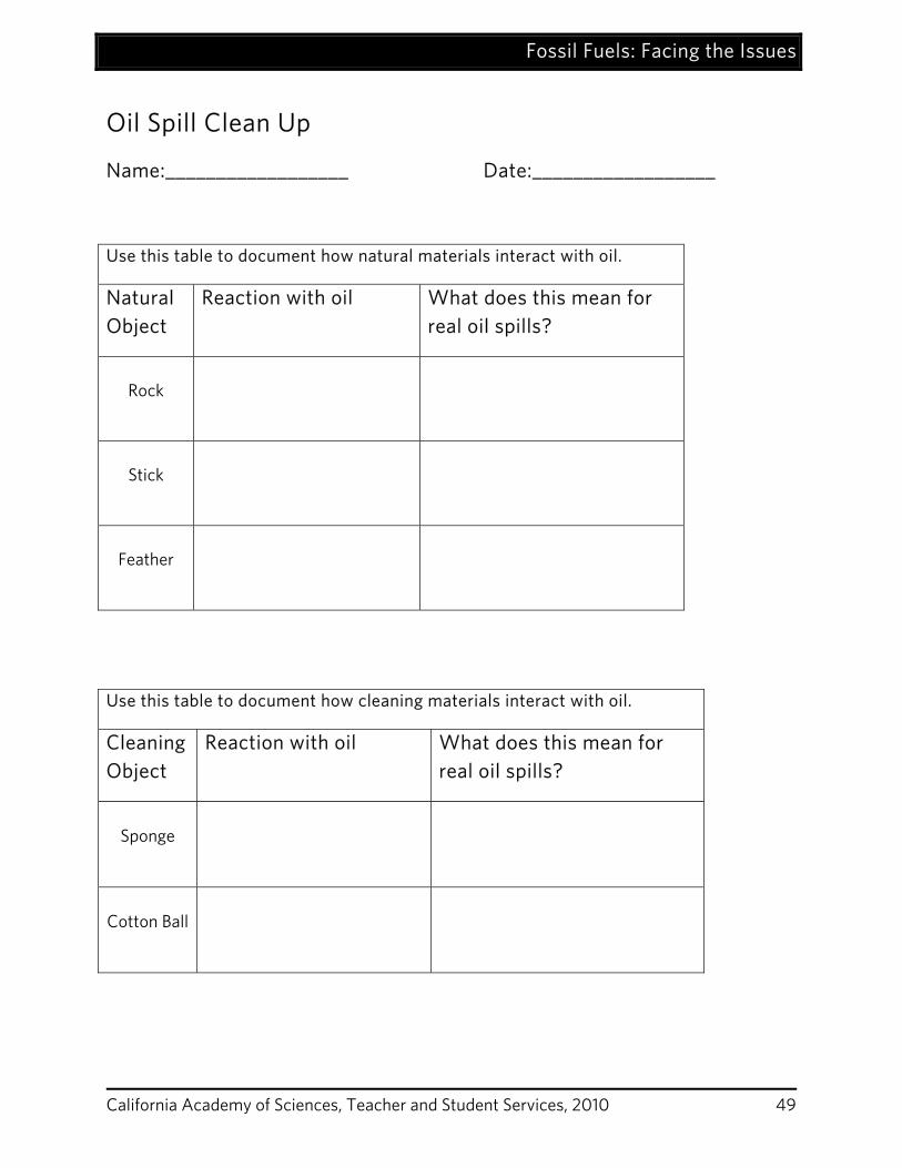
Oil Spill Clean Up
Name:__________________ Date:__________________
Use this table to document how natural materials interact with oil.
Natural Object
Reaction with oil What does this mean for real oil spills?
Rock
Stick
Feather
Use this table to document how cleaning materials interact with oil.
Cleaning Object
Reaction with oil What does this mean for real oil spills?
Sponge
Cotton Ball
Fossil Fuels: Facing the Issues
California Academy of Sciences, Teacher and Student Services, 2010 50
California Content Standards
California Academy of Sciences, Teacher and Student Services, 2010 51
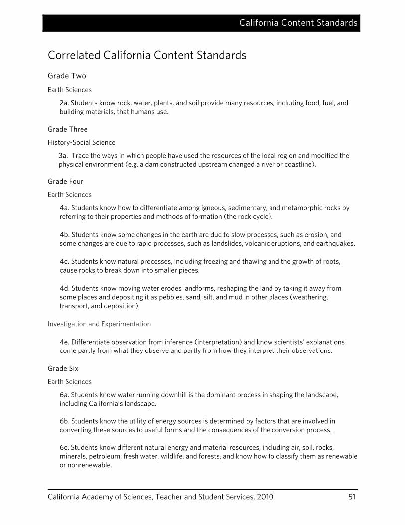
Correlated California Content Standards
Grade Two
Earth Sciences
2a. Students know rock, water, plants, and soil provide many resources, including food, fuel, and building materials, that humans use.
Grade Three
History-Social Science
3a. Trace the ways in which people have used the resources of the local region and modified the physical environment (e.g. a dam constructed upstream changed a river or coastline).
Grade Four
Earth Sciences
4a. Students know how to differentiate among igneous, sedimentary, and metamorphic rocks by referring to their properties and methods of formation (the rock cycle).
4b. Students know some changes in the earth are due to slow processes, such as erosion, and some changes are due to rapid processes, such as landslides, volcanic eruptions, and earthquakes.
4c. Students know natural processes, including freezing and thawing and the growth of roots, cause rocks to break down into smaller pieces.
4d. Students know moving water erodes landforms, reshaping the land by taking it away from some places and depositing it as pebbles, sand, silt, and mud in other places (weathering, transport, and deposition).
Investigation and Experimentation
4e. Differentiate observation from inference (interpretation) and know scientists' explanations come partly from what they observe and partly from how they interpret their observations.
Grade Six
Earth Sciences
6a. Students know water running downhill is the dominant process in shaping the landscape, including California’s landscape. 6b. Students know the utility of energy sources is determined by factors that are involved in converting these sources to useful forms and the consequences of the conversion process. 6c. Students know different natural energy and material resources, including air, soil, rocks, minerals, petroleum, fresh water, wildlife, and forests, and know how to classify them as renewable or nonrenewable.
California Content Standards
California Academy of Sciences, Teacher and Student Services, 2010 52
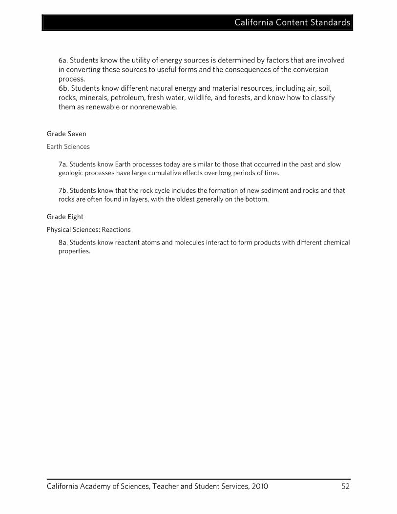
6a. Students know the utility of energy sources is determined by factors that are involved in converting these sources to useful forms and the consequences of the conversion process. 6b. Students know different natural energy and material resources, including air, soil, rocks, minerals, petroleum, fresh water, wildlife, and forests, and know how to classify them as renewable or nonrenewable.
Grade Seven
Earth Sciences
7a. Students know Earth processes today are similar to those that occurred in the past and slow geologic processes have large cumulative effects over long periods of time.
7b. Students know that the rock cycle includes the formation of new sediment and rocks and that rocks are often found in layers, with the oldest generally on the bottom.
Grade Eight
Physical Sciences: Reactions
8a. Students know reactant atoms and molecules interact to form products with different chemical properties.
Vocabulary
California Academy of Sciences, Teacher and Student Services, 2010 53
Vocabulary biodiversity: great variety of life forms in a given area. cement (verb): to glue or fuse together. coal: a dark-brown to black solid substance formed naturally from the compaction and hardening of fossilized plants and used as a fuel primarily for electricity generation. core: the center of the Earth. crust: the outer layer of the Earth, upon which we all live. The crust is mainly composed of igneous and metamorphic rocks and is divided into plates that move very, very slowly. deposition: the process through which material is added to – or deposited on – a landform. earthquake: a sudden movement of the earth's crust caused by the release of stress accumulated along geologic faults or by volcanic activity. epicenter: the point on earth’s surface that is vertically above the focus of an earthquake. erosion: the process of moving weathered pieces of rocks and organic material. extrusive: igneous rocks that form from lava above the surface of the crust. fault: a crack in the Earth’s crust. foliation: the formation of lines, swirls or streaked patterns in metamorphic rocks due to the realignment of their minerals. fossil fuel: a hydrocarbon deposit, such as petroleum, coal, or natural gas, derived from living matter of a previous geologic time and used for fuel. geology: the scientific study of the Earth along with its rocks, minerals and land forms, including the processes that have affected them throughout Earth's history. grains: individual mineral crystals or particles within a rock or sediment deposit. hydrocarbon: compound containing only hydrogen and carbon and often occurring in fossil fuels . igneous rock: rock that forms from the cooling and hardening of magma and lava. intrusive: igneous rocks that form from magma below the surface of the crust. latitude: part of a grid used for describing positions on earth’s surface, consisting of parallel circles. A measurement, in degrees, of a place's distance north or south of the equator. lava: liquid rock on the surface of the earth.
Vocabulary
California Academy of Sciences, Teacher and Student Services, 2010 54
longitude: part of a grid used for describing positions on earth’s surface, consisting of half circles joining at the poles. A measurement, in degrees, of a place's distance east or west of the prime meridian, which runs through Greenwich, England. magma: liquid rock underneath the surface of the earth. mantle: the middle layer of the Earth, between the core and the crust. mantle: the middle layer of the Earth, between the core and the crust. metamorphic rock: rock that has had its mineral composition and/or texture changed while in a solid state due to changes in temperature and pressure . mineral: the components of rocks, minerals are naturally occurring solids with a uniform chemical composition and crystal shape. natural gas: a mixture of hydrocarbon gases that occurs naturally beneath the earth's surface and is used as a fuel primarily for cooking and heating homes. nonrenewable resource: a resource that is not replaceable after its use such as oil or coal. petroleum: naturally occurring mixture of gaseous, liquid, and solid hydrocarbons derived from remains of fossil plants and animals, especially in shallow marine environments, and separated into products such as gasoline, paraffin wax, asphalt, and many others. pressure: the application of continuous force on an object. renewable resource: a resource such as solar energy that is never used up or a resource that can be replaced. rock: a mixture of minerals that are consolidated. sedimentary rock: rock that has formed through the deposition and solidification of sediment, transported either by water (rivers, lakes, and oceans), ice (glaciers), or wind. soot: the fine black particles, chiefly composed of carbon, produced by incomplete combustion of coal, oil, wood, or other materials. subduction: the process of one plate in the Earth’s crust getting forced under another any time two plates in the Earth’s crust collide, one. This being drawn down or overridden by another, localized along the juncture (subduction zone) of two plates. weathering: the chemical alteration and mechanical breakdown of rocks during exposure to air, moisture, and organic matter.
Resources
California Academy of Sciences, Teacher and Student Services, 2010 55
Resources Books
Blobaum, C. 1999. Geology Rocks!: 50 Hands-On Activities to Explore the Earth. Charlotte, VT, Williamson Publishing Co. Parker, S. (1997) Rocks and Minerals (Eyewitness Books). New York, NY: DK Publishing, Inc. Skinner, B. 2004. Dynamic Earth. Hoboken: John Wiley & Sons, Inc: UK. Von Noordon, D. (ed.) 1997. Rocks and Minerals (Eye Wonder ). New York, NY: DK Publishing, Inc. Books in Spanish Symes, R. (1997) Rocas y Minerales (Eyewitness Series in Spanish). New York, NY: DK Publishing, Inc. Rosinsky, N.M. (2003) Las Rocas, Duras, Blandas, Lisas, y Ásperas. Mankato, MN, Picture Window Books
Web Resources:
Rock Cycle Animation:
http://www.uky.edu/AS/Geology/howell/goodies/elearning/module05swf.swf
http://www.phschool.com/atschool/phsciexp/active_art/rock_cycle/index.html
Earth Science Diagrams including geologic time scale:
http://www.yorku.ca/esse/veo/earth/sub1-2.htm
http://en.wikipedia.org/wiki/Geologic_time_scale