Embed Size (px)
Citation preview
Temperature Monitoring and Management Plan FERC Project Nos. 2085, 2175, 67 and 120
Copyright 2007 by Southern California Edison Company February 2007
TEMPERATURE MONITORING AND MANAGEMENT PLAN
BIG CREEK HYDROELECTRIC SYSTEM
MAMMOTH POOL (FERC Project No. 2085) BIG CREEK NOS. 1 AND 2 (FERC Project No. 2175)
BIG CREEK 2A, 8, AND EASTWOOD (FERC Project No. 67) BIG CREEK NO. 3 (FERC Project No. 120)
FEBRUARY 2007
SUBMITTED BY SOUTHERN CALIFORNIA EDISON COMPANY

Temperature Monitoring and Management Plan FERC Project Nos. 2085, 2175, 67 and 120
Copyright 2007 by Southern California Edison Company i February 2007
TABLE OF CONTENTS Page
1.0 INTRODUCTION........................................................................................1
2.0 OBJECTIVES .............................................................................................1
3.0 APPROACH ...............................................................................................2
3.1 General Approach............................................................................2
3.2 Water Temperature Monitoring ........................................................3
3.2.1 Detailed Stream Water Temperature Data Collection Methods ................................................................................3
3.2.2 Reservoir Temperature Profiles ............................................5
3.2.3 Meteorology ..........................................................................5
3.2.4 Flow ......................................................................................6
3.2.5 Data Analysis ........................................................................6
4.0 SJR STEVENSON REACH (DAM 6 TO UPSTREAM OF POWERHOUSE 3) STUDY ...................................................................................................7
5.0 INTERIM WATER TEMPERATURE CONTROL PROGRAM.....................8
6.0 LONG-TERM WATER TEMPERATURE CONTROL PROGRAM ..............9
7.0 REPORTING ............................................................................................10
7.1 Annual Progress Report.................................................................10
7.2 Annual Meeting..............................................................................11
7.3 Summary Report............................................................................11
8.0 LITERATURE CITED ...............................................................................12

Temperature Monitoring and Management Plan FERC Project Nos. 2085, 2175, 67 and 120
Copyright 2007 by Southern California Edison Company ii February 2007
List of Tables
Table 1. Proposed Stream Temperature Monitoring Sites Including River Miles (RM) in the Vicinity of the Four Big Creek ALP Projects
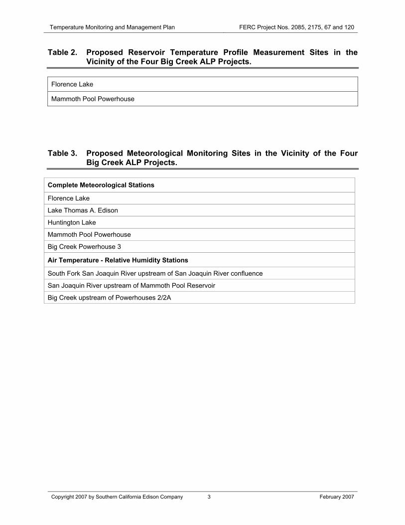
Table 2. Proposed Reservoir Temperature Profile Measurement Sites in the Vicinity of the Four Big Creek ALP Projects
Table 3. Proposed Meteorological Monitoring Sites in the Vicinity of the Four Big Creek ALP Projects
List of Figures
Figure 1. Temperature Monitoring Sites

Temperature Monitoring and Management Plan FERC Project Nos. 2085, 2175, 67 and 120
Copyright 2007 by Southern California Edison Company 1 February 2007
1.0 INTRODUCTION
The Temperature Monitoring and Management Plan (Plan) covers four Southern California Edison Company (SCE) Big Creek Hydroelectric Projects: Mammoth Pool (FERC No. 2085), Big Creek Nos. 1 and 2 (FERC No. 2175), Big Creek Nos. 2A, 8, and Eastwood (FERC No. 67), and Big Creek No. 3 (FERC No. 120) (jointly referred to as the “Project”). The new licenses for the Project include the release of prescribed minimum instream flows (MIF) for Project bypass reaches. One of the principal factors considered in the selection of MIFs was maintaining existing beneficial uses related to water temperature (as described in the Central Valley Regional Water Quality Control Board 1998 Basin Plan [Basin Plan]), when water temperature is a Project controllable factor.
The Plan monitors water temperatures during at least the first three to five years that new MIFs are released under the new Project licenses, including during at least one Dry or Critically Dry Water Year type. Data will be collected by SCE to assist in: 1) documenting compliance with water temperature targets for daily mean and maximum water temperatures under the new MIFs, and 2) obtaining information about potential Project controllable factors. Flows may be adjusted by SCE in situations where temperature criteria may not be achieved. The monitoring results will be used by SCE to prepare a Long-Term Water Temperature Control Program that will be added to this Plan. The Long-Term Water Temperature Control Program must be approved by the State Water Resources Control Board (State Water Board) Chief of the Division of Water Rights and the Federal Energy Regulatory Commission (Commission or FERC). Once the Long-Term Water Temperature Control Program has been approved, water temperature targets must be met by SCE, when water temperatures are a Project controllable factor.
2.0 OBJECTIVES
The principal objective of this Plan is to verify whether the Basin Plan designated cold fresh water beneficial use is being maintained in Project bypass reaches. The cold fresh water beneficial use would be maintained when daily mean water temperatures do not exceed 20°C and daily maximum water temperatures do not exceed 22°C. A second objective of this Plan is to design and implement the Long-Term Water Temperature Control Program, if necessary to meet the water temperature targets, subject to Project controllable factors. SCE will institute operational measures to comply with the Long-Term Water Temperature Control Program. To meet the objectives of this Plan, sufficient water temperature data will need to be collected by SCE in the Project bypass reaches in conjunction with data on other factors, including flow and meteorology.

Temperature Monitoring and Management Plan FERC Project Nos. 2085, 2175, 67 and 120
Copyright 2007 by Southern California Edison Company 2 February 2007
3.0 APPROACH
3.1 GENERAL APPROACH
This Plan’s general approach is to address each of the elements listed below:
1. Monitor summer water temperatures under the new license MIFs in reaches in which temperatures reached or exceeded the temperature targets during temperature monitoring in 2000 or 2001, and in other locations which may provide useful information on factors that may influence water temperatures and potential Project controllable factors.
2. Evaluate whether the new MIFs result in meeting the water temperature targets in those reaches.
3. Prior to monitoring water temperature in the San Joaquin River (SJR) Mammoth Pool Dam to upstream of Mammoth Pool Powerhouse and the Dam 6 to upstream of Powerhouse 3 bypass reaches, develop an Interim Water Temperature Control Program to adjust flow releases to maintain temperature targets in those reaches, if necessary, until the Long-Term Water Temperature Control Program is completed and approved.
4. Use telemetry to monitor real-time water temperatures in the SJR Mammoth Pool Dam to upstream of Mammoth Pool Powerhouse and the Dam 6 to upstream of Powerhouse 3 bypass reaches and adjust releases to maintain water temperature targets using the Interim Water Temperature Control Program.
5. Conduct studies in SJR Dam 6 to upstream of Powerhouse 3 bypass reach to determine if a change in beneficial use designation is warranted based on the reach containing a native transition zone fish assembly and water temperature conditions appropriate to that fish community.
6. Evaluate whether Project controllable factors are feasible and if they can be used to meet temperature targets in reaches or locations where the targets are not met, based on monitoring conducted under this Plan.
7. Consult annually with the resource agencies including US Fish and Wildlife Service (USFWS) during each April of implementation of this Plan regarding temperature monitoring results and potential actions to meet water temperature targets, when water temperatures are Project controllable factors.
8. If necessary to achieve water temperature targets, develop a Long-Term Water Temperature Control Program to meet water temperature targets, when meeting water temperatures is feasibly under Project control.
As some infrastructure changes are necessary prior to SCE making MIF and Channel and Riparian Maintenance Flow (CRMF) releases in many Project bypass reaches, this Plan will be implemented for each bypass reach identified for monitoring during the first

Temperature Monitoring and Management Plan FERC Project Nos. 2085, 2175, 67 and 120
Copyright 2007 by Southern California Edison Company 3 February 2007
full summer after a new MIF is implemented in that bypass reach. This will likely result in different bypass reaches being monitored during different years and for different periods of time. This monitoring schedule may be adjusted and coordinated, upon approval by the Chief of the Division of Water Rights and approval by the FERC.
3.2 WATER TEMPERATURE MONITORING
Water temperature monitoring to be conducted by SCE will focus on the summer months (June 1 through September 30) in designated bypass reaches downstream of diversions for the Project (Table 1). These locations are listed in Table 1 and shown in Figure 1. Real-time telemetry stations and data loggers are shown in Figure 1 using different symbols.
For higher elevation bypass reaches and other bypass reaches where water temperatures are expected to be cool (all bypass reaches except those in the mainstem SJR), temperature monitoring will have a nominal duration of three years or until at least one Dry or Critically Dry Year is monitored. These bypass reaches are indicated in Table 1 and are distinguished by gray shading. If water temperatures targets are maintained in these locations, monitoring will be discontinued after three years. If target water temperatures are not maintained during extreme conditions in a reach, SCE and the resource agencies will consult to determine if monitoring should be extended for that reach. The Chief of the Division of Water Rights and FERC shall decide when the water temperature monitoring has shown compliance with maintaining target water temperatures and that the monitoring of that stream reach can be terminated.
At lower elevations, in the SJR between Mammoth Pool Dam and Mammoth Pool Powerhouse and between Dam 6 and upstream of Powerhouse 3, water temperatures will be monitored for no less than five years, including at least one Dry or Critically Dry Water Year. In the SJR, telemetry will be used to monitor summer water temperatures as indicated in Table 1. Telemetry will be used to identify in real-time when water temperatures exceed target temperatures, or under unique or extreme conditions are expected to do so. Temperature profiles measured in Mammoth Pool Reservoir and telemetry of water temperatures in the bypass reach near the point of release will identify if the water available for release into that bypass reach is sufficiently cool to attain target temperatures or to prevent warming of daily mean water temperatures over 20°C by more than 2.7°C. When these conditions occur, SCE shall release additional flow, based on the interim Water Temperature Control Program (see Section 5.0) that will be developed no later than one year after the new license is final and no longer subject to appeal.
3.2.1 DETAILED STREAM WATER TEMPERATURE DATA COLLECTION METHODS
All stream temperature monitoring sites are listed in Table 1, including tributaries that have MIF flows that may influence water temperatures in the bypass reach. Table 1 indicates whether SCE will use a temperature recorder (logger) or telemetry device at each site. At least two water temperature recorders will be placed at each site to reduce the potential for data loss. Telemetered locations will report real-time water
Temperature Monitoring and Management Plan FERC Project Nos. 2085, 2175, 67 and 120
Copyright 2007 by Southern California Edison Company 4 February 2007
temperature data to SCE at its Big Creek Operations Center and to SCE's Big Creek publicly available website. Monitoring will take place from June 1 (in the lower reaches) through September 30, when water temperatures are warmest. Monitoring would begin at non-permanent sites after spill is over. Starting dates for monitoring in the South Fork San Joaquin River (SFSJR) bypass reach, which is generally colder for a longer portion of the year, would be from July 1 (depending upon access conditions and safety) through September 30. However, this later monitoring date does not present a water temperature concern as periods of high flow and snow generally correlate with lower water temperatures. Upon approval by the Chief of the Division of Water Rights and notice to FERC, and based on the developing water temperature record, these dates may be shifted as necessary to incorporate a more appropriate temporal period for which water temperature control is necessary.
Temperatures will be recorded at no less than 15-minute intervals throughout the day. Data will be downloaded monthly from the data loggers. Standard field procedures will be followed to minimize data losses (for example, during trips to download data, each instrument will be examined for tampering and a calibration hack is made). Standard electronic file handling procedures will be used to minimize data translation errors and to maintain data quality (for example, file naming conventions have been established that specify the location and timing of data collection; templates have also been established for storing data yet to be transcribed).
Onset Optic Stowaway temperature recorders, or their equivalent, will be used for recording water temperatures. The units are sealed and transmit data via infrared signal to downloading media. The units will be mounted in armored housings. The parts of the armored housing screw together with a chain passing through mounting rings to lock the unit and prevent it from being opened. When installed, each temperature recorder will be secured and well hidden, where they should not be influenced by groundwater or exposed to air by dropping water levels. Each recorder will be checked for proper function prior to being placed in operation or upon having been reset. Each unit will be checked monthly. A calibration hack will be made during this operations check. A calibration hack consists of measuring the water temperature at the location of the instrument transducer with a calibrated thermometer whose calibration is traceable to a recognized national standard; the date, time, and temperature is recorded and compared to the corresponding temperature measured by the electronic recorder.
The data collected from these units will be downloaded and stored in a database. The data stored in the database will include water temperatures and meteorological data (air temperature, wind speed, relative humidity, and solar radiation). The collected data will be plotted versus time to help indicate any data losses from stranding of units, equipment malfunction, or environmental conditions. Suspect data will be treated as missing values. The location of each recorder will be verified using a Global Positioning System (GPS) unit at the time of installation.
Some existing gaging stations have telemetry capability and these will have temperature sensors added, as indicated in Table 1. These telemetered systems will be

Temperature Monitoring and Management Plan FERC Project Nos. 2085, 2175, 67 and 120
Copyright 2007 by Southern California Edison Company 5 February 2007
maintained by SCE as part of their maintenance of the flow recorders and telemetry at those gages. Temporary water temperature telemetry gages will be operated in the SJR upstream of Mammoth Pool Powerhouse and in the SJR upstream of Powerhouse 31. These temperature gages will be installed after the cessation of spill in these reaches or by June 1 in non-spill years. These will be operated until September 30 and then removed to avoid damage due to potential spill in the subsequent spring. These telemetered temperature gages will report results to the Big Creek Operations Center and the SCE Big Creek publicly available website.
3.2.2 RESERVOIR TEMPERATURE PROFILES
Temperature profiles will be measured by SCE on a monthly basis in Florence Reservoir and Mammoth Pool Reservoir to characterize water temperatures and reservoir temperature stratification (Table 2). These data provide an indication of the status of reservoir stratification and the controllability of downstream water temperatures. In cases such as Mammoth Pool Reservoir in Dry Water Years, when the reservoir's warm upper water layer (epilimnion) and cool bottom water layer (hypolimnion) mix in late summer/fall, there may no longer be a pool of cool water for release to the bypass reach. Increased water releases from Mammoth Pool may not reduce instream water temperatures below the criteria in this case. Water temperature maintenance therefore, may not be a controllable factor at such times. If telemetered temperature monitoring is continued in the Mammoth Pool bypass reach beyond the initial five year study, the Long-Term Water Temperature Control Program may require measuring temperature profiles or other means of monitoring the presence of thermal stratification in Mammoth Pool Reservoir in Dry or Critically Dry Water Years.
One temperature profile will be taken near the dam or the downstream end of each reservoir, usually the deepest area of the reservoir, another will be taken near mid-reservoir, and one will be taken at the upstream end. Measurements will be taken with a temperature measuring instrument such as a Hydrolab Quanta or YSI DO-Temperature meter or equivalent with a cable length sufficient to measure temperatures in the deepest portion of each reservoir. The location of each site profiled will be documented using a GPS unit.
3.2.3 METEOROLOGY
Meteorology has a very large influence on stream temperatures and warming. As extreme meteorological conditions (and hydrological conditions) may occur, it is important to evaluate the effect of these extreme events, if they occur, on stream temperatures. It is also important to identify these events as extreme cases outside of the normal range. In order to understand the influence of extreme meteorological conditions on water temperatures, meteorological data will be collected by SCE in selected locations within the Upper San Joaquin River Basin.
1If feasible, these units will be installed within the Project boundary. If infeasible, USDA-Forest Service special use permits will be obtained.
Temperature Monitoring and Management Plan FERC Project Nos. 2085, 2175, 67 and 120
Copyright 2007 by Southern California Edison Company 6 February 2007
Concurrent meteorological data will be collected at the same five locations within the Upper San Joaquin River Basin that were used in the Project Alternative Licensing Process (ALP) temperature monitoring study (SCE 2003 Final Technical Study Report (FTSR), CAWG 5, Water Temperature Monitoring (SCE 2004) (Table 3)). Table 3 lists the reaches that are associated with the meteorological stations. The meteorological stations at these locations will collect wind speed, solar radiation, air temperature, and relative humidity data. Additional meteorological data sources will be considered for use (e.g., USDA-Forest Service RAWS sites). Relating local air temperatures to those of stations with long periods of record helps to define the historical exceedances that allow ranking the observed water temperatures as resulting from cold, normal, or hot climatic conditions. This ranking will help in interpreting the temperature data collected. Air temperature and relative humidity also will be recorded at supplementary locations in between the full meteorological stations. These are sited in locations (Table 3) that were used to supplement data collecting during the relicensing studies.
3.2.4 FLOW
Flow data will be obtained by SCE from information reported at the nearest appropriately located stream gage to represent flow conditions during monitoring. Several of the flow gages are telemetered and reported on SCE's Big Creek website.
3.2.5 DATA ANALYSIS
For each bypass reach, during Plan water temperature monitoring over the first three to five years, summer daily mean and maximum water temperatures, flows, and meteorology data will be compiled and presented in a format similar to that of the SCE 2003 FTSR, CAWG 5, Water Temperature Monitoring (SCE 2004). Measured water temperatures will be compared to temperature targets. Days during which water temperature targets are exceeded will be tabulated by month and location. For each day in which target temperatures are exceeded, the conditions affecting water temperatures including meteorology, especially air temperature, and flow will be described.
The Water Year Type, as identified based on the April 1 forecast for the California Department of Water Resources (DWR), Bulletin No. 120, San Joaquin Valley Water Year Index, or its successor index that is most representative of the Big Creek watershed, will be used to characterize hydrological conditions. Air temperatures will be compared to the historical record to identify extreme conditions. The monthly air temperatures will be compared with the historical percent exceedance air temperatures.
For the SJR, water temperatures and thermal stratification in Mammoth Pool Reservoir will be compared with water temperatures in the SJR bypass reaches downstream of Mammoth Pool Dam to upstream of Mammoth Pool Powerhouse and from downstream of Dam 6 to upstream of Powerhouse 3. For the SFSJR, water temperatures and thermal stratification in Florence Lake will be compared with water temperatures in the SFSJR.

Temperature Monitoring and Management Plan FERC Project Nos. 2085, 2175, 67 and 120
Copyright 2007 by Southern California Edison Company 7 February 2007
If SCE adjusts flow releases to respond to water temperatures warmer than the target temperatures under the Interim Water Temperature Control Program, the adjustments and their efficacies will be described. Potential changes to bypass reach releases that are recommended for the following year and the conditions under which they would apply will be included.
A progress report, as described in Section 5.0, will be prepared by SCE after each year of the three to five year monitoring program. The progress report will tabulate and discuss the results of the previous summer's monitoring and make recommendations for temperature monitoring and changes to the Interim Water Temperature Control Program. The results also will be discussed at an annual meeting of SCE and the resource agencies. SCE shall propose actions it will take in the forth coming summer to avoid target water temperature exceedances.
4.0 SJR STEVENSON REACH (DAM 6 TO UPSTREAM OF POWERHOUSE 3) STUDY
The lower portion of the SJR Stevenson Reach is used by native fish as a transition zone, as identified in the SCE 2002 FTSR, CAWG 7, Characterize Fish Populations Report (SCE 2003). New MIFs should provide increased habitat for the native species, specifically hardhead, Sacramento pikeminnow, and Sacramento sucker. These species, especially hardhead, are in decline in many portions of California. In addition, their temperature requirements are believed to be warmer than those for trout. A supplementary study will evaluate the use and importance of this reach for these species. If this reach is found to be important for native transition zone species, it may be more appropriate to manage this reach as a warm or cool/warm reach rather than as a cold fresh water habitat reach. This would require reclassification of the water temperature beneficial use for this reach under the Basin Plan (CVRWQCB 1998).
In order to evaluate the appropriate temperature regime for this reach, fish data will be collected by SCE in conjunction with water temperatures and dissolved oxygen measurements. Fish sampling in this reach will take place in the first, third, and fifth years after implementation of the new MIF for the reach. Sampling will take place in the same locations and use the same techniques as used in the 2002 FTSR, CAWG 7, Characterize Fish Populations Report (SCE 2003). Results of each year of sampling will be included in the yearly progress report (see below). At the conclusion of the third year of sampling (year five after MIF implementation for this reach), a report will be prepared. The report will summarize the information collected and recommend whether this reach should be reclassified with regard to the temperature beneficial use. The report will be provided to interested resource agencies for review and comment. If the consensus recommendation of SCE and the resource agencies is to change the designation of this reach or the lower portion of the reach (below the Stevenson Creek confluence), this will be discussed with appropriate staff of the State Water Board and Regional Water Quality Control Board and SCE will propose an amendment of the cold fresh water habitat designation in the Basin Plan for this specific sub-reach.
Temperature Monitoring and Management Plan FERC Project Nos. 2085, 2175, 67 and 120
Copyright 2007 by Southern California Edison Company 8 February 2007
5.0 INTERIM WATER TEMPERATURE CONTROL PROGRAM
The Interim Water Temperature Control Program (Interim Program) will be prepared by SCE within one year of license acceptance. The Interim Program will contain measures (e.g., increased flow releases) that may be feasibly implemented by SCE to maintain water temperatures below target temperatures, when water temperature is a Project controllable factor. The Interim Program will also include feasible measures to reduce water temperature increases, when water temperatures are above target levels and cannot be reduced below target levels, when water temperature increases are a Project controllable factor. The primary concern of the Interim Program is two bypass reaches on the mainstem SJR. The Mammoth Pool Dam to Mammoth Pool Powerhouse bypass reach (Mammoth Reach) and the “Stevenson Reach” from Dam 6 to upstream of Powerhouse 3 are the lowest elevations of the bypass reaches under consideration in this Plan. These reaches are more prone to warming than reaches at higher elevations. During summer months, telemetry will be used to monitor water temperatures at the upper and lower ends of each reach. This provides SCE real-time information on water temperatures and the ability to potentially take actions to modify water temperatures.
If water temperatures in the Mammoth Reach exceed target temperatures when Mammoth Pool Reservoir is thermally stratified, cool water will be released at Mammoth Pool Dam to reduce water temperatures. If water temperatures in the Stevenson Reach of the SJR exceed target temperatures, when cool water is present in the Dam 6 impoundment, cool water will be released at Dam 6 to reduce water temperatures. These water temperature conditions would be considered Project controllable within the capacity of the flow release structures, when cool water is available. As daily mean water temperatures are calculated on a 24-hour basis, water temperatures that exceed the daily mean temperature target would not be known until the following day. Daily maximum water temperatures are based on the warmest hourly temperature measured during the course of the day and so hourly water temperatures that approach or exceed the daily maximum water temperature target may be responded to more promptly.
The Interim Program will make use of water temperature modeling results from the water temperature model developed for the SCE 2004 Technical Study Report, CAWG 5, Water Temperature Model Calibration/Simulation (SCE 2005) to develop interim guidance with respect to the incremental amount of flow that would need to be released to reduce water temperatures below target levels during the summer months at a range of warm air temperatures. The interim guidance would be prepared for the Mammoth and Stevenson reaches of the SJR and provided to SCE operators with instructions on how to implement the guidance to meet target water temperatures.
Increased MIFs below Mammoth Pool Reservoir may slightly accelerate the mixing of the reservoir in late summer, especially in drier Water Year types. After Mammoth Pool Reservoir loses thermal stratification, cool water may no longer be available to meet water temperature targets or to reduce water temperatures. Under these conditions (with water temperatures exceeding the target temperatures), the water temperature target would be to prevent warming from exceeding an increase of 2.7°C (5°F) from the diversion to the end of the bypass reach. The water temperature model and modeling

Temperature Monitoring and Management Plan FERC Project Nos. 2085, 2175, 67 and 120
Copyright 2007 by Southern California Edison Company 9 February 2007
results will be used to provide interim guidance with respect to the incremental amount of flow beyond the required MIFs that would need to be released to prevent warming in excess of 2.7°C. Under these conditions, predicted air temperatures from available weather forecasts would be used with the interim guidance from modeling to avoid warming of more than 2.7°C on succeeding days during which maximum temperatures are likely to be exceeded. Similar to the guidance provided to the SCE operators for meeting the water temperature targets, this guidance would provide the incremental amount of flow needed to be released to prevent warming in excess of 2.7°C for a range of air temperatures. As Mammoth Pool Reservoir would be expected to lose thermal stratification in August (in Dry Years) or September, the guidance would be provided for a range of air and water temperatures for those two months. The SCE operators would be provided with instructions on how to implement this guidance until it is superseded by the development of the Long-Term Water Temperature Control Program described below. During this interim program, short exceedances of the water temperature targets will not be considered compliance violations.
Water temperatures in the SFSJR just above the confluence with the SJR will be monitored during July of the first Dry or Critically Dry Water Year2. SCE will perform additional modeling regarding the relationship between atmospheric and water conditions. If atmospheric and water conditions indicate daily mean temperatures will likely exceed the 20°C target at the SFSJR/SJR confluence, SCE will monitor the actual daily mean water temperature at the confluence to confirm the model’s predictions. If the water temperatures exceed 20°C, SCE will increase water releases from Mono Creek by an additional 3 cfs. If the increased water releases do not reduce water temperature to 20°C or less, SCE will continue increasing water releases and monitoring water temperatures at the confluence at least every other day that daily mean water temperatures are predicted to exceed 20°C until water temperatures are 20°C or less. Once water temperatures are 20°C or less, SCE will use this information to develop a revised protocol to maintain water temperatures at 20°C or less at the confluence of the SFSJR and SJR.
The Interim Program will include an annual progress report and recommendations to the State Water Board for potential modifications. The performance of the Interim Program and modifications will be discussed at the annual meeting. Modifications to the Interim Program will be implemented after approval by the Chief of the Division of Water Rights and notification to FERC.
6.0 LONG-TERM WATER TEMPERATURE CONTROL PROGRAM
The development of a Long-Term Water Temperature Control Program (Long-Term Program) is a key objective of this Plan. The Long-Term Program will focus on those feasible actions that will need to be implemented to meet water temperature targets, when water temperature is a Project controllable factor. The Long-Term Program will 2If daily mean air temperatures monitored during July are cooler than the 30 percent long-term daily exceedance, the evaluation will be repeated during the next dry or critically dry water year.

Temperature Monitoring and Management Plan FERC Project Nos. 2085, 2175, 67 and 120
Copyright 2007 by Southern California Edison Company 10 February 2007
provide guidance to SCE operators for complying with temperature targets in the bypass reaches. In developing the Long-Term Program, extreme or unusual conditions will be considered and taken into account in determining appropriate actions. If needed to achieve temperature targets, the Long-Term Program is expected to be developed after the completion of five years of monitoring under this Plan. The Long-Term Program recommendations will be included as part of the summary report discussed below. The Long-Term Program will be implemented after approval by the Chief of the Division of Water Rights and FERC.
Results of water temperature monitoring will be used to identify bypass reaches where temperature targets are being met and no further monitoring or actions are necessary. Those results will also be used to identify the bypass reaches where additional actions may need to be implemented to meet water temperature targets.
Temperature monitoring results and the results of the implementation of the Interim Program will be used to identify feasible Project controllable factors related to water temperatures. The Long-Term Program will recommend whether there is a need for continuation of water temperature telemetry or other monitoring. As necessary, the Long-Term Program will contain guidance for incremental flow releases to meet target water temperatures or to reduce warming, when water temperatures are a Project controllable effect.
7.0 REPORTING
7.1 ANNUAL PROGRESS REPORT
A draft Annual Progress Report shall be prepared and submitted to the USDA-FS, the California Department of Fish and Game (CDFG), the State Water Board and the U.S. Fish and Wildlife Service (USFWS) (together, the “resource agencies”) 90 days following the completion of each year of temperature monitoring (October 15 will be considered the end of each year's monitoring). A 60 day review period shall be provided for resource agencies. Thirty days following the receipt of comments, SCE will finalize the Annual Progress Report to address any comments. The annual meeting described in Section 7.2, would be held following the finalization of the annual report.
The analysis and report of the results of the past year’s water temperature monitoring will include the results of the analyses identified in Section 3.2.5, above. The Annual Progress Report shall follow the general presentation layout of basic temperature data used in the SCE 2003 FTSR, CAWG 5, Water Temperature Monitoring (SCE 2004). All hourly records collected will be provided on CD-ROM as part of the report. In cases where temperature targets were exceeded in bypass reaches, SCE shall identify, as part of that analysis, whether these exceedances occurred due to conditions that were included within the range used in the temperature model predictions or were due to conditions that were more extreme. The report shall discuss the known reasons for not meeting the water temperature goal, such as seasonal mixing of Project reservoirs that result in the unavailability of cool stored water for release and temperature

Temperature Monitoring and Management Plan FERC Project Nos. 2085, 2175, 67 and 120
Copyright 2007 by Southern California Edison Company 11 February 2007
maintenance. For any exceedance of the temperature objectives for a reach, an evaluation shall be made of the conditions related to that exceedance. If based upon Project controllable factors, SCE shall propose feasible short-term responses (not including infrastructure changes) to be included in the Interim Program to meet water temperature targets in a forthcoming season with similar conditions (e.g., a water year of the same type or drier, with similar meteorological conditions). The actions shall be reviewed with the resource agencies and SCE and included in the Interim Program upon concurrence of the resource agencies. The Annual Progress Reports shall be filed with the resource agencies and the FERC.
If after (up to) five successive years of monitoring, including at least one Dry or Critically Dry Water Year, monitoring of the water temperatures demonstrates that the temperature goals are being met by Project operations, SCE may discontinue the monitoring required by this Plan and file a Summary Report as detailed below. SCE shall include a recommendation to discontinue monitoring in appropriate reaches in the last Annual Progress Report if SCE believes that the Plan is eligible to be discontinued. Notwithstanding SCE’s recommendations, water temperature monitoring may be discontinued only upon the approval of the Chief of the Division of Water Rights and FERC.
7.2 ANNUAL MEETING
An annual meeting between SCE and the resource agencies will be held during April, after the April 1 runoff prediction and water year type for the upper San Joaquin basin is announced by DWR. During that meeting, the results of the previous year's monitoring and recommendations for modifying monitoring or bypass reach releases will be discussed. Changes agreed to by SCE and the resource agencies will be added to the draft final Annual Progress Report prepared for that year. Upon completion of any changes to the draft final Annual Progress Report, the report will be sent to the resource agencies and filed with the FERC.
7.3 SUMMARY REPORT
A draft Summary Report shall be submitted to the resource agencies six months following the conclusion of the temperature monitoring required by this Plan. The report will summarize the results of all the years of monitoring for each reach. Observed temperatures and conditions shall be compared to the temperature goals. Extreme conditions occurring within the monitoring period and their effects on exceeding water temperature goals will be evaluated. It is recognized that temperature monitoring for one or more of the short-term monitoring bypass reaches (three-year studies) may conclude prior to the remainder of the reaches being studied.
The Summary Report will include recommendations for any potential modification of the temperature Beneficial Use of the Stevenson Reach of the SJR. The Summary Report also will include the Long-Term Program for those reaches in which target temperatures were exceeded, or in which additional monitoring is needed (see Section 6.0, above for a description of the contents of that plan).

Temperature Monitoring and Management Plan FERC Project Nos. 2085, 2175, 67 and 120
Copyright 2007 by Southern California Edison Company 12 February 2007
A 60 day comment period will be provided for resource agency review. If needed, a meeting will be scheduled between SCE and the resource agencies. Within 30 days after receipt of comments, or meeting with the resource agencies, whichever comes later, a final Summary Report shall be filed with the FERC and the resource agencies, including copies of comments received, and SCE’s replies to comments. The Long-Term Program would be implemented after approval by the Chief of the Division of Water Rights and FERC.
8.0 LITERATURE CITED
California RWQCB, Central Valley Region (CVRWQCB). 1998. Basin Plan. The Water Quality Control Plan (Basin Plan) for the California Regional Water Quality Control Board, Central Valley Region, Fourth Edition, 1998, The Sacramento River Basin and the San Joaquin River Basin. Sacramento, California.
Southern California Edison Company (SCE). 2003. CAWG 7, Characterize Fish Populations, 2002 Final Technical Study Report (FTSR). In SCE’s Amended Preliminary Draft Environmental Assessment (APDEA) for the Big Creek Alternative Licensing Process (ALP) Projects (Mammoth Pool (FERC Project No. 2085), Big Creek Nos. 1 and 2 (FERC Project No. 2175), Big Creek Nos. 2A, 8, and Eastwood (FERC Project No. 67), and Big Creek No. 3 (FERC Project No. 120)). (Volume 4, SD-C, Books 8 and 21). February 2007.
SCE. 2004. CAWG 5, Water Temperature Monitoring, 2003 FTSR. In SCE’s APDEA for the Big Creek ALP Projects (Mammoth Pool (FERC Project No. 2085), Big Creek Nos. 1 and 2 (FERC Project No. 2175), Big Creek Nos. 2A, 8, and Eastwood (FERC Project No. 67), and Big Creek No. 3 (FERC Project No. 120)). (Volume 4, SD-D, Books 12 and 23). February 2007.
SCE. 2005. CAWG 5, Water Temperature Model Calibration/Simulation. In SCE’s APDEA for the Big Creek ALP Projects (Mammoth Pool (FERC Project No. 2085), Big Creek Nos. 1 and 2 (FERC Project No. 2175), Big Creek Nos. 2A, 8, and Eastwood (FERC Project No. 67), and Big Creek No. 3 (FERC Project No. 120)). (Volume 4, SD-E, Books 18 and 24). February 2007.

Temperature Monitoring and Management Plan FERC Project Nos. 2085, 2175, 67 and 120
Copyright 2007 by Southern California Edison Company February 2007
TABLES

Temperature Monitoring and Management Plan FERC Project Nos. 2085, 2175, 67 and 120
Copyright 2007 by Southern California Edison Company 1 February 2007
Table 1. Proposed Stream Temperature Monitoring Sites Including River Miles (RM) in the Vicinity of the Four Big Creek ALP Projects1.
Temp. Gage Type
License, Reach and Location Temp. Gage Type
Locations Not in Mainstem Bypass Reach
Mammoth Pool (FERC Project No. 2085)2 San Joaquin River (SJR) Mammoth
Reach Sites
Logger Upstream of Mammoth Pool Reservoir (Short Term -3 yr) (SJR RM 34.6)
Telemetry SJR Downstream of Mammoth Pool (SJR RM 25.55)
Profile Mammoth Pool Reservoir (Profile in Summer Monthly)
Logger SJR Upstream of Rock Creek (SJR RM 22.6)
Telemetry After Spill
SJR Upstream of Mammoth Pool PH (SJR RM 18.2)
Big Creek Nos. 1 and 2 (FERC Project No. 2175) Big Creek Dam 4 to PH 2/2A Reach
Sites
Logger Big Creek Release at Dam 4 (Short Term 3-yr) (BC RM 5.9)
Logger Big Creek Upstream of Powerhouse 2/2A (Short Term 3-yr) (BC RM 2.1)
Big Creek 2A, 8, and Eastwood (FERC Project No. 67) South Fork San Joaquin River
(SFSJR) Sites SFSJR Tributary and Reservoir Sites
Telemetry SFSJR Downstream of Florence Lake (SFSJR RM 27.85)
Profile Florence Lake (Profile in Summer Monthly)
Logger SFSJR Upstream of Camp 61 Creek (Short Term 3-yr) (SFSJR RM 17.9)
Logger Camp 61 Creek Upstream of SFSJR (Short Term 3-yr) (C61 RM 0.1)
Logger SFSJR Downstream of Camp 61 Creek (Short Term 3-yr) (SFSJR RM 17.8)
Logger SFSJR Upstream of Mono Creek (Short Term 3-yr) (SFSJR RM 16.65)
Logger Mono Creek Upstream of SFSJR (Short Term 3-yr) (MC RM 0.1)
Logger SFSJR Downstream of Mono Creek (Short Term 3-yr) (SFSJR RM 16.55)
Logger SFSJR Rattlesnake Crossing (Short Term 3-yr) (SFSJR RM 14.35)
Logger SFSJR Upstream of San Joaquin River3 (Short Term 3-yr) (SFSJR RM 0.1)
Logger San Joaquin River Upstream of SFSJR3 (Short Term 3-yr) (SJR RM 38.4)

Temperature Monitoring and Management Plan FERC Project Nos. 2085, 2175, 67 and 120
Copyright 2007 by Southern California Edison Company 2 February 2007
Table 1. Proposed Stream Temperature Monitoring Sites Including River Miles (RM) in the Vicinity of the Four Big Creek ALP Projects1 (continued).
Temp. Gage Type
License, Reach and Location Temp. Gage Type
Locations Not in Mainstem Bypass Reach
Big Creek Dam 5 to PH 8 Reach Sites
Logger Big Creek Downstream of Dam 5 (Short Term 3-yr) (BC RM 1.65)
Logger Big Creek Upstream of Powerhouse 8 (Short Term 3-yr) (BC RM 0.1)
North Fork Stevenson Creek Sites
Telemetry/Logger4
Tunnel 7 Outlet (Short Term 3-yr) (NFSC RM 3.5)
Telemetry/Logger4
SCE Gage 99 (USGS Gage 11239300 ) (Short Term 3-yr) (NFSC RM 1.6 )
Big Creek No. 3 (FERC Project No. 120) San Joaquin River – Dam 6 to
Redinger Lake
Telemetry SJR at Dam 6 (SJR RM 17.0)
Logger SJR upstream of Stevenson Creek (Staircase) (SJR RM 15.5)
Telemetry After Spill
SJR upstream of Powerhouse 3 (SJR RM 11.0)
1Primarily based on monitoring sites used in 2003 (SCE 2004). 2Light gray shading indicates short term monitoring of at least 3 years, including at least one Dry Water Year (see Section 3.2). 3To be emplaced as accessible (snow and high flows). 4SCE's choice as to type of instrumentation to be installed.
Temperature Monitoring and Management Plan FERC Project Nos. 2085, 2175, 67 and 120
Copyright 2007 by Southern California Edison Company 3 February 2007
Table 2. Proposed Reservoir Temperature Profile Measurement Sites in the Vicinity of the Four Big Creek ALP Projects.
Florence Lake
Mammoth Pool Powerhouse
Table 3. Proposed Meteorological Monitoring Sites in the Vicinity of the Four Big Creek ALP Projects.
Complete Meteorological Stations
Florence Lake
Lake Thomas A. Edison
Huntington Lake
Mammoth Pool Powerhouse
Big Creek Powerhouse 3
Air Temperature - Relative Humidity Stations
South Fork San Joaquin River upstream of San Joaquin River confluence
San Joaquin River upstream of Mammoth Pool Reservoir
Big Creek upstream of Powerhouses 2/2A

Temperature Monitoring and Management Plan FERC Project Nos. 2085, 2175, 67 and 120
Copyright 2007 by Southern California Edison Company February 2007
FIGURE

Temperature Monitoring and Management Plan FERC Project Nos. 2085, 2175, 67 and 120
Copyright 2007 by Southern California Edison Company February 2007
Placeholder for Figure 1. Temperature Monitoring Sites
Non-Internet Public Information
This Figure has been removed in accordance with the Commission regulations at 18 CFR Section 388.112.
This Figure is considered Non-Internet Public information and should not be posted on the Internet. This information is provided in Book 24 of the Application for New License and is identified as “Non-Internet Public” information. This information may be accessed from the FERC’s Public Reference Room, but is not expected to be posted on the Commission’s electronic library, except as an indexed item.