Embed Size (px)
Citation preview

The Earth as a Planet of Change: Introduction to Physical Geography
By Mr. Friedel
TEKS: WG.3(A-C), WG.4(A-C). 2013
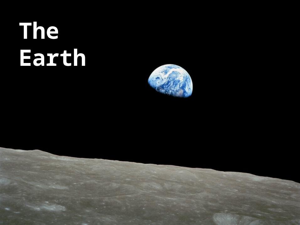
The Earth
Part 1: Earth-Sun Relationship• Objective (WG.3A): Explain weather conditions and climate in
relation to annual changes in Earth-Sun relationships.
• We will explain how the earth sun-sun relationship affects climate and seasons
• I will complete the earth-sun relationship graphic organizer for notes

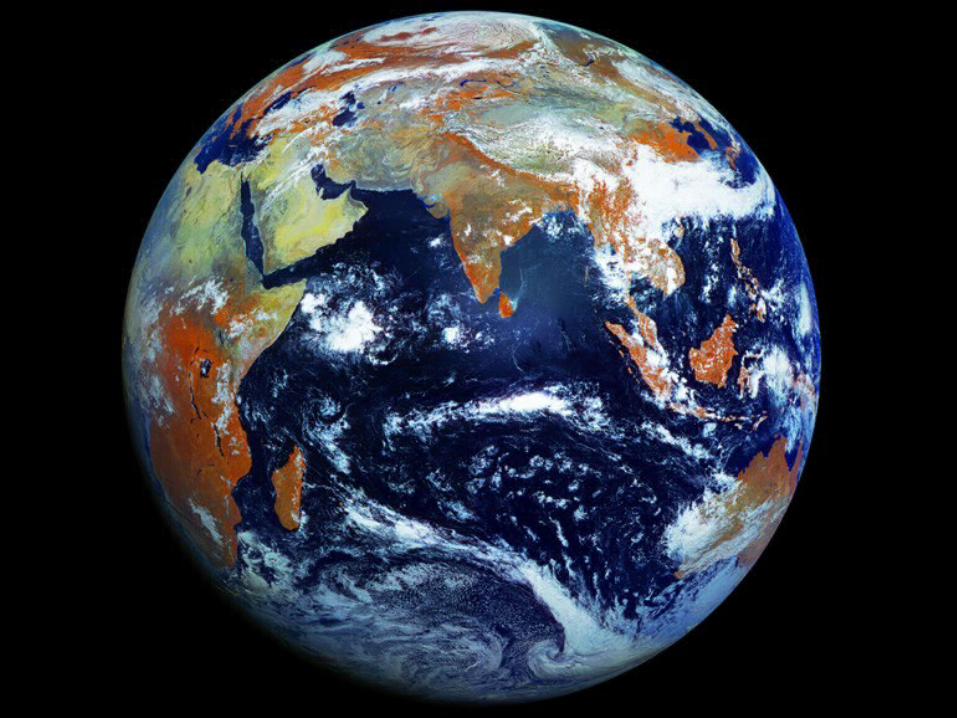
Earth is the third planet from the Sun, and the densest and fifth-largest of the eight planets in the Solar System. It is also the largest of the Solar System's four terrestrial planets.
Radius: 3,959 miles (6,371 km)Age: 4.54 billion yearsDistance from Sun: 92,960,000 miles (149,600,000 km)Mass: 5.972E24 kgPopulation: 6.974 billion (2011) World BankMoon: Moon

The Earth’s TiltKEY VOCABULARY WORDS• Tilt: the angle of incline of
the Earth’s axis affects the temperature of a place.
• Revolution: the Earth’s trip around the sun (one year)
• Rotation: the Earth completely rotates on its axis every 24 hours. (alternating between night and day)


5 Major Circles of Latitude
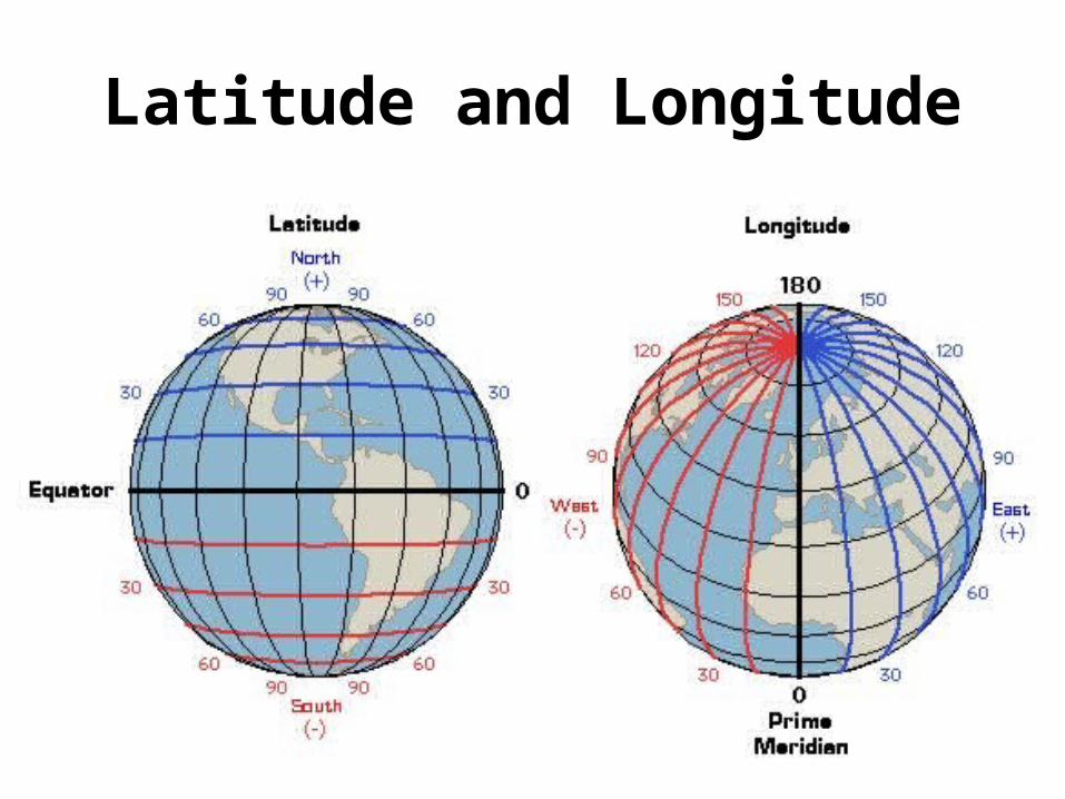
Latitude and Longitude


Greenhouse Effect
• Natural way for Earth to retain its warmth and for plants and animals to survive.
• The planet Venus is the hottest planet in the Solar System and is covered in a dense atmosphere that retains the heat

Key Vocabulary/Concepts
• Rotation• Revolution• Position in Solar System• Solstice• Equinox• Seasons• Latitudinal Location

Part 2: The Four Spheres of the Earth System

Part 2: The Four Spheres of the Earth System
• Objective (WG.4C) Examine the physical processes that affect the lithosphere, atmosphere, hydrosphere, and biosphere.
• We will examine the physical processes that affect the Earth’s four spheres.
• I will complete a graphic organizer of the Earth system.


The Earth’s Layers

The Earth’s Four Spheres
• The area near the surface of the earth can be divided up into four inter-connected "geo-spheres:"
• Lithosphere• Hydrosphere• Biosphere• Atmosphere
• The names of the four spheres are derived from the Greek words for stone (litho), air (atmo), water (hydro), and life (bio).

The Lithosphere• Lithosphere: The lithosphere is the solid, rocky crust
covering entire planet. This crust is inorganic and is composed of minerals
• It covers the entire surface of the earth from the top of Mount Everest to the bottom of the ocean.


• About 70% of the earth’s surface is covered with water
• 97% percent of the water on the earth is salt water. Salt water is filled with salt and other minerals, and humans cannot drink this – Although the salt can be removed through desalinization, it is a difficult and
expensive process
• 2% of the water on earth is glacier ice at the North and South Poles.– This ice is fresh water and could be melted; however, it is too far away from where
people live to be usable.
• Less than 1% of all the water on earth is fresh water that we can actually use. – We use this small amount of water for drinking, transportation, heating and cooling,
industry, and many other purposes.
The Hydrosphere


The Atmosphere
• The atmosphere is the body of air which surrounds our planet
• Most of our atmosphere is located close to the earth's surface where it is most dense
• The air of our planet is 79% nitrogen and just under 21% oxygen; the small amount remaining is composed of carbon dioxide and other gasses.

Layers of the Atmosphere


The Bisophere
• The biosphere is composed of all living organisms
• Plants, animals, and one-celled organisms are all part of the biosphere
• Most of the planet's life is found from three meters below the ground to thirty meters above it and in the top 200 meters of the oceans and seas

The distribution of life on earth


How many of the Earth’s spheres can you see in this picture?

Key Vocabulary/Concepts
• Atmosphere• Bisophere• Hydrosphere• Lithosphere• Desalinization• How much of the Earth’s surface is covered in
water?• How much of the Earth’s water can we drink?

Part 3: Weather and Climate
Part 3: Weather and Climate
• Objective (WG.4A): Explain how elevation, latitude, wind systems, ocean currents, position on a continent, and mountain barriers influence temperature, precipitation, and distribution of climate regions.
• We will explain how physical geographic factors influence climate
• I will complete a climagraph

Climate Vs. Weather
• Climate: The average temperature and precipitation in an area over a long period of time.
• Weather: Current temperature & precipitation in an area (Short period of time).

Factors that Influence Climate Regions
• Factors that affect climate regions– Latitude– Landforms– Ocean (Currents: warm and cold, proximity)– Wind (Prevailing)– Continental Position– Elevation
Remember LLOWCE

Important Lines of Latitude
66° N
23 1/2 ° N
0 °
23 1/2 ° S
66° S
Arctic Circle
Tropic of Cancer
Equator
Tropic of Capricorn
Antarctic Circle

Latitude, latitude, latitude
• Latitude: The most influential factor that affects climate type
• There are three latitude zones:– Low Latitude- between 23 ½° N and 23 ½ ° S – Mid Latitude- between 23 ½ °N and 66 ° N AND 23 ½ ° S and 66 ° S– High Latitude- Poles; above 66 ° N AND below 66 ° S

Low Latitude ClimatesLatitudeRange
World Location Vegetation Seasons
TropicalRainforest
10° S to 25 ° N Amazon basin, equatorial Africa, East Indies, from Sumatra to New Guinea
A canopy of tall trees with layers of shorter trees and plants underneath
Heavy rainfall in all months, no difference in seasons
Tropical Grasslands
15° to 25° N and S India, Southeast Asia, West Africa, southern Africa, South America, north coast of Australia
Grasses, short trees(Ex. Savanna in
Africa)
Warm year round, wet and dry seasons
Desert18° to 28° N and S,
centered on Tropics of Cancer and Capricorn
Western North America (southwest U.S.) southwest South America (Chili) north central Mexico, north Africa, southwest Africa, central Australia, north Asia (China, Mongolia)
Scattered vegetation; short grasses and shrubs, cacti
Warm or cold, little to noprecipitation yearround
©2012, TESCCC


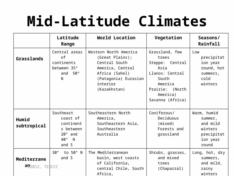
Mid-Latitude ClimatesLatitudeRange
World Location Vegetation Seasons/Rainfall
GrasslandsCentral areas ofcontinentsbetween 35° and
50° N
Western North America (Great Plains); Central South America, Central Africa (Sahel) (Patagonia) Eurasian interior (Kazakhstan)
Grassland, few treesSteppe: Central AsiaLlanos: Central South
AmericaPrairie: (North
America)Savanna (Africa)
Low precipitation year round, hot summers, cold winters
Humidsubtropical
Southeast coast of continents between 20° and 40° N and S
Southeastern North America, Southeastern Asia, Southeastern Australia
Coniferous/Deciduous (mixed) Forests and grassland
Warm, humid summer, and mild winters precipitation year round
Mediterranean30° to 50° N and
SThe Mediterranean basin, west
coasts of California, central Chile, South Africa, western/southern Australia
Shrubs, grasses, and mixed trees (Chaparral)
Long, hot, dry summers, and mild, rainy winters
©2012, TESCCC

Mid-Latitude ClimatesLatitudeRange
World Location Vegetation Seasons/Rainfall
HumidContinental
30 to 55 N andS, to 60 N inEurope
North central North America; north central Asia (China); Korea; Japan; central and eastern Europe
Mixed coniferous and deciduous forest
Warm summer cold winters, moderate rainfall throughout the year
Marine-WestCoast
30 to 60 N and S West coast of N. America, west coast of southern Chile, and northwestern Europe
Mixed coniferous and deciduous forests
Cool summers, mild winters, high rainfall year round
©2012, TESCCC


High Latitude ClimatesLatitude Range World Location Vegetation Seasons/
Rainfall
Subarctic50° to 60° N Northern North America
and EurasiaConiferous forests - taiga Extremely cold
winter, short, cool summer
Arctic60° to 70° N Northern North America
and Eurasia Short grasses, mosses,
lichens, tundraExtremely cold and
dry all year
©2012, TESCCC

• Taiga is a biome characterized by coniferous forests consisting mostly of pines, spruces and larches.
• It is the world’s largest biome


Other ClimatesLatitudeRange
World Location Vegetation Seasons/Rainfall
Highland
Found all over the world
Mountain Ranges: Himalayas, Andes, Rockies, Alps, etc.
Varies with elevation and location on mountain. Leeward side is drier with less vegetation.
Windward side receives the most rainfall while leeward side remains dry.
©2012, TESCCC

Distribution of Earth’s Major Climates

Landforms
• Landforms affect the status of climates by interceding to the natural flow of weather systems in a particular area.
• Some of the major effects of landforms to climate are orographic lifting, the rainshadow effect, creation of landform breezes that affects temperatures and wind funnels.
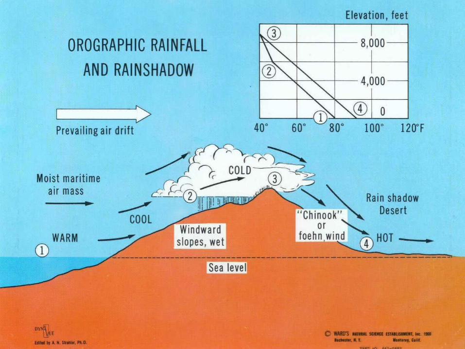


Orographic Effect

• What is going on here?

Microclimate

Ocean’s Impact on Climate• Water heats and cools slower than does land• Milder climates near large bodies of water• More extreme climates away from large
bodies of water (continental climate)

Ocean Currents
Humboldt Current


Shifts in Climate: El Niño and La Niña
• El Niño: is a band of anomalously warm ocean water temperatures that occasionally develops off the western coast of South America and can cause climatic changes across the Pacific Ocean.
• El Nino's typical winter impacts: Above-average precipitation from Southern California to Texas and Florida. Drier-than-average in the Ohio and Tennessee Valleys.
• La Niña: the sea surface temperature across the equatorial Eastern Central Pacific Ocean will be lower than normal by 3–5 °C.
• La Nina's typical winter impacts: Drier-than-average from Arizona to Texas the Gulf Coast and Florida. Above-average precipitation in the Pacific Northwest and Ohio Valley.

Wind Currents
Doldrums

Wind Currents
• Wind: Air moving across a pressure gradient


Impact of Global Wind Currents on Biosphere

Coriolis Effect
http://www.youtube.com/watch?v=aeY9tY9vKgs

The Coriolis Effect
• The Coriolis effect is the apparent deflection of objects (such as airplanes, wind, missiles, and ocean currents) moving in a straight path relative to the earth's surface
• Its strength is proportional to the speed of the earth's rotation at different latitudes but it has an impact on moving objects across the globe.

The Coriolis Effect:Hurricanes and Cycles


Hurricane Katrina

Continental Location Impacts Climate

Elevation Impacts Climate


Climagraph

Key Vocabulary/Concepts• Weather• Climate• Factors that Impact Climate
– Latitude (most important)– Landforms– Ocean (Currents: warm and cold, proximity)– Wind (Prevailing)– Continental Position– Elevation
• Orographic Effect• El Niño and La Niña• Climagraph• Coriolis Effect

Part 4: Earth’s Landforms

Part 4: Earth’s Landforms
• Objective (WG.4B): Explain landforms and the physical processes that cause their development.
• We will explain landforms and the physical processes that cause their development.
• I will complete the earth-sun relationship graphic organizer for notes

Earth’s Landforms

The Earth’s Layers

Plate Tectonics• Geologists have an explanation—a scientific theory—of
how the Earth's surface behaves called plate tectonics
• Tectonics means large-scale structure. So "plate tectonics" says that the large-scale structure of the Earth's outer shell is a set of plates
• Plates move with respect to each other in three ways: – they move together (converge)– they move apart (diverge)– they move past each other (transform).

The Plates Fit Together

The Earth’s Plates

Forces that Cause Tectonic Movement
• Slab pull• Ridge Push• Convection
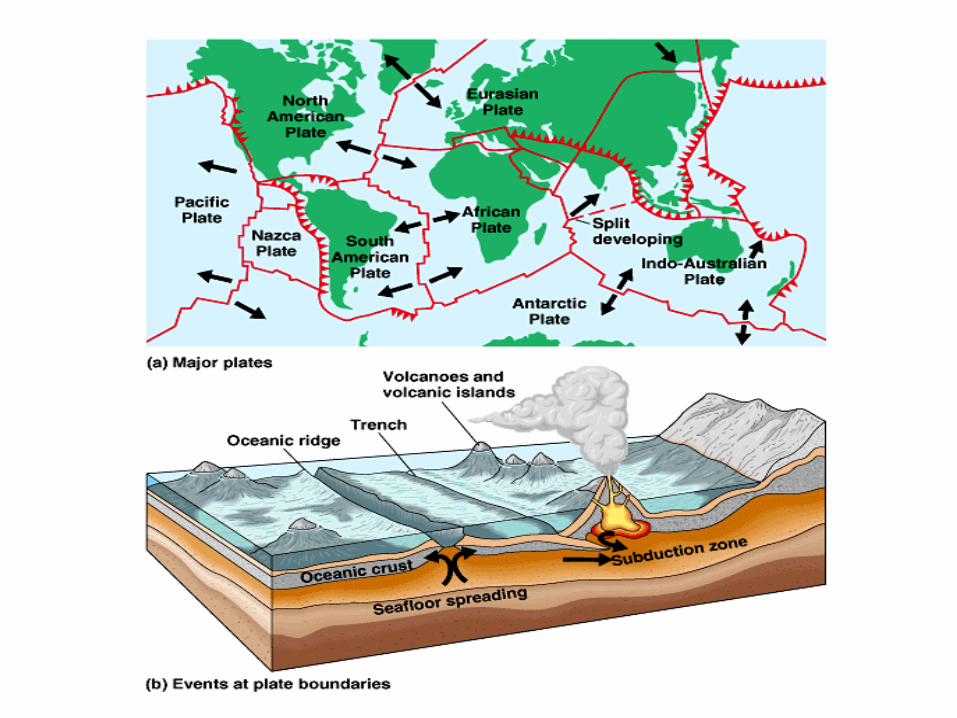

Plate Tectonics
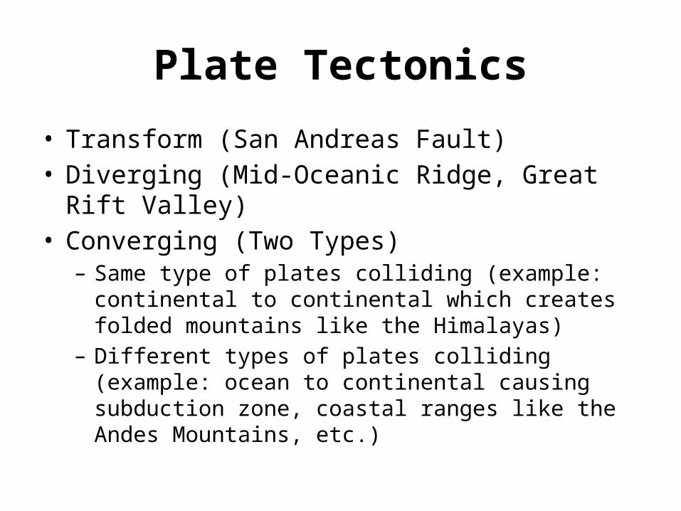
Plate Tectonics
• Transform (San Andreas Fault)• Diverging (Mid-Oceanic Ridge, Great Rift Valley)• Converging (Two Types)
– Same type of plates colliding (example: continental to continental which creates folded mountains like the Himalayas)
– Different types of plates colliding (example: ocean to continental causing subduction zone, coastal ranges like the Andes Mountains, etc.)

Plate Tectonics
• An earthquake is the result of a sudden release of energy in the Earth's crust that creates seismic waves
• A tsunami is a series of water waves caused by the displacement of a large volume of a body of water (usually from an earthquake or volcano)
• A Volcano is an opening, or rupture, in a planet's surface or crust, which allows hot magma, volcanic ash and gases to escape from the magma chamber below


Tsunami in Japan, 2011


Processes that Formed Different Landforms

Weathering
• Weathering: Weathering is the breaking down of rocks, soils and minerals as well as artificial materials through contact with the Earth's atmosphere, biota and waters
• Erosion is the process by which soil and rock are removed from the Earth's surface by processes such as wind or water flow, and then transported and deposited in other locations.


How did this u-shaped valley happen?


River Deltas

Plateau: an area of relatively level high ground


Key Vocabulary/Concepts
• Plate Tectonics– Diverging– Converging (two types)– Transform
• Earthquakes• Weathering• Erosion• River Delta• Ring of Fire