Embed Size (px)
Citation preview

WP 1.3 Port ECDIS - WP leader Hamburg Port Authority – Neuer Wandrahm 4, 20457 Hamburg, Germany
Contact person: Dieter Seefeldt - email: [email protected]
Project no: FP6-031486 Project acronym: EFFORTS
Project title: Effective Operation in Ports
WP 1.3 PortECDIS Port ECDIS information paper
The EU Project - Port ECDIS - Development of a new enhanced ENC standard for use in ports and harbours. Why a Port ECDIS?! Masters and pilots approaching a seaport usually use an Electronic Chart Display and In-formation System (ECDIS) to obtain the required navigational information they need. The common ECDIS standard supports navigation in the open sea and coastal areas; the Inland ECDIS standard was developed for navigation on inland waterways. The chart require-ments for manoeuvring big ships in narrow fairways (harbour access channels) and har-bours and for the port maintenance go far beyond the current ECDIS standard in scale, accuracy, chart objects and attributes (“object catalogue”, in future "feature catalogue") and call for a specific “Port ECDIS”. Managing bigger vessels, increasing traffic, less harbour space, berth organisation, dredging purposes etc. requires accurate and up‐to‐date
high‐resolution topographic and bathymetric data to provide all necessary information, in
some cases also in real‐time. As GIS (Geo Information System) the Port ECDIS is able to
interact with other port related geo data sources for a more beneficial use and to improve the interoperability of harbour related tasks to support the maintenance work of the port authorities. ECDIS (Electronic Chart Display and Information System) and its related standards were introduced about a decade ago. Meanwhile the technology has matured and chart coverage has improved. Today on many ships SOLAS V chart carriage requirements are fulfilled by type approved ECDIS. In order not to violate type approval regulations ECDIS systems must use electronic navigational charts (ENCs) from official sources (e.g. Hydrographic Offices). ECDIS is not only used onboard but also in Vessel Traffic Management Systems and Ma-rine Simulators. Besides ECDIS more and more applications have been developed, that make use of ENCs (Electronic Navigational Chart). To avoid confusion latter must not be considered as type approved ECDIS. Among these there are ECS (i.e. Electronic Chart Systems that were designed to be used as additional navigation device but not as main navigation system), hydrographic survey and dredging software packages that use ENC
WP 1.3 Port ECDIS - WP leader Hamburg Port Authority – Neuer Wandrahm 4, 20457 Hamburg, Germany
Contact person: Dieter Seefeldt - email: [email protected]
data as backdrop during their operations, purpose bound navigation software that has been developed for dedicated navigational manoeuvres, e.g. for portable pilot units. The Inland ECDIS Standard is based on IHO and IMO ECDIS related standards. Basically it defines extensions necessary to meet the requirements of river navigation where they differ from marine navigation. For example additional chart features (not relevant in the marine domain) have been introduced. In 2001, the Economic Commission for Europe of the United Nations (UN ECE) adopted the Inland ECDIS Standard as a recommendation for the European inland waterway system (Central Commission for Navigation on the Rhine ‐
CCNR 2002). For operations in ports special requirements with respect to vertical and horizontal accuracy exist. This is achieved by using modern sensor technology. The same accuracy is required in the underlying electronic charts (scale, accuracy). The respective source data (topogra-phy and hydrographic data) is made available and maintained by the port authorities. The official ENCs as created by the Hydrographic Offices are designed to meet the re-quirements of marine navigation in general. However with respect to content, actuality, de-tail, compilation scale, and accuracy they often do not meet the requirements when it comes to navigating in narrow channels, shallow waters, tidal waters, docking operations, berthing, and turning manoeuvres with minimum under keel clearance. One example is the official ENC of the Port of Hamburg (Germany). It surely meets all the relevant ECDIS related standards and fulfils the requirements of marine navigation. How-ever the chart is too small in scale, has not enough bathymetric detail and poorly defines horizontal accuracy of topographic features (i.e. quay‐walls, piers, pontoons). It cannot be
used for the above mentioned operations within the port area. ECDIS and Inland ECDIS related standards and regulations allow for encoding of quality and accuracy information. However, they do not define rules that can be applied to produce electronic charts that meet the requirements for operations in ports. It is necessary to spec-ify criteria and margins that can be applied to the source data to decide if they qualify for integration in a Port ECDIS dataset or not. Port‐ECDIS is not only about producing better electronic charts to be shown in the naviga-
tion displays of various applications. Port‐ECDIS addresses user groups of other domains
as well (maintenance, dredging, planning, river engineering). Often they have the need to look at the data not only as a chart but also in 3D. This means that additional data repre-sentations are required. The source data that is used can also be used for the generation of Digital Terrain Models (DTM) representing the bathymetry and Triangulated Irregular Net-works (TIN) e.g. describing the channel model. The channel model represents the theoreti-cal, designed and maintained surface of the harbour bottom. These additional data repre-sentations are not defined in the existing ECDIS and Inland ECDIS standards. At least the new Hydrographic Geospatial Standard for Marine Data and Information S‐100 integrates a
gridded bathymetry component. The implementation timetable of S100 points to the year 2009/2010. An improved ENC Product Specification (S‐101) will not come into force until at least 2012! The special navi-
gational and manoeuvring requirements in ports we have to fulfil now, so we have to start as soon as possible. ECDIS and Inland ECDIS standards precisely define the rules and requirements that are essential for safe marine and river navigation respectively. The development of a Port ECDIS standard is focused on high precision operations in ports. It must be seen as an independent but complementary standard to ECDIS and Inland ECDIS. There is no use of a Port ECDIS without its counterparts from marine and inland navigation. Thus for a better
WP 1.3 Port ECDIS - WP leader Hamburg Port Authority – Neuer Wandrahm 4, 20457 Hamburg, Germany
Contact person: Dieter Seefeldt - email: [email protected]
understanding and general acceptance of the Port ECDIS concept it is essential to coordi-nate and harmonize the work between all stakeholders. Port ECDIS can only be successful if it smoothly integrates with the ongoing developments in the domains of ECDIS and Inland ECDIS. Having said this it becomes obvious that (be-sides the technical aspects) promoting the idea of Port ECDIS among the ECDIS and Inland ECDIS community should be one of the main activities of the work package. Central Commission for the Navigation on the Rhine (CCNR) describes in the RIS Guide-lines 2004 that an Inland ECDIS is compatible with maritime ECDIS, that means: a) Inland vessels sailing in maritime waters with Inland ECDIS equipment get all maritime ENC information. b) Sea going vessels sailing in inland waters with maritime ECDIS equipment get all infor-mation being equal to marine information (e.g. river banks), but they do not get the addi-tional inland information (e.g. inland notice marks). So that sea-river vessels are recommended to use the additional Inland ECDIS software libraries in order to get full Inland ENC information. As we know is this statement incomplete or wrong, because the maritime ECDIS system must be able to identify the product Inland ENC! The Port ECDIS / Port ENC fulfils also the requirements that are requested by the EU RIS-Directive (DIRECTIVE 2005/44/EC OF THE EUROPEAN PARLIAMENT AND OF THE COUNCIL) on harmonised river information services (RIS) on inland waterways in the Community
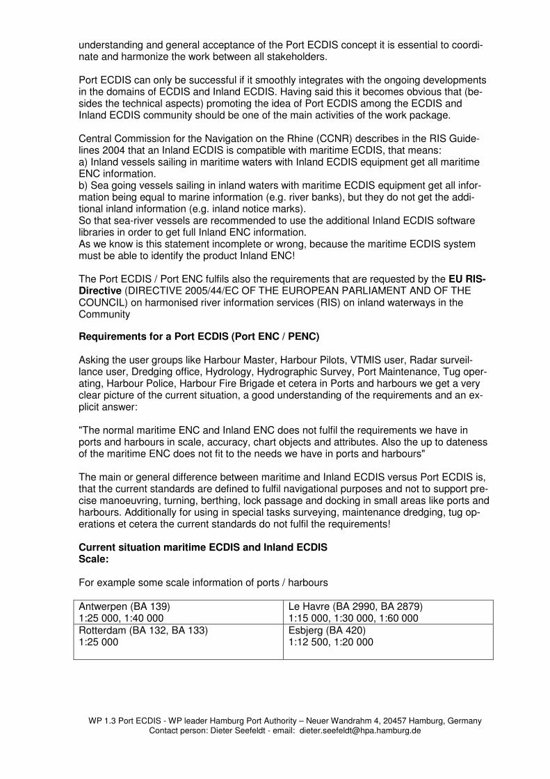
Requirements for a Port ECDIS (Port ENC / PENC) Asking the user groups like Harbour Master, Harbour Pilots, VTMIS user, Radar surveil-lance user, Dredging office, Hydrology, Hydrographic Survey, Port Maintenance, Tug oper-ating, Harbour Police, Harbour Fire Brigade et cetera in Ports and harbours we get a very clear picture of the current situation, a good understanding of the requirements and an ex-plicit answer: "The normal maritime ENC and Inland ENC does not fulfil the requirements we have in ports and harbours in scale, accuracy, chart objects and attributes. Also the up to dateness of the maritime ENC does not fit to the needs we have in ports and harbours" The main or general difference between maritime and Inland ECDIS versus Port ECDIS is, that the current standards are defined to fulfil navigational purposes and not to support pre-cise manoeuvring, turning, berthing, lock passage and docking in small areas like ports and harbours. Additionally for using in special tasks surveying, maintenance dredging, tug op-erations et cetera the current standards do not fulfil the requirements! Current situation maritime ECDIS and Inland ECDIS Scale: For example some scale information of ports / harbours Antwerpen (BA 139) 1:25 000, 1:40 000
Le Havre (BA 2990, BA 2879) 1:15 000, 1:30 000, 1:60 000
Rotterdam (BA 132, BA 133) 1:25 000
Esbjerg (BA 420) 1:12 500, 1:20 000
WP 1.3 Port ECDIS - WP leader Hamburg Port Authority – Neuer Wandrahm 4, 20457 Hamburg, Germany
Contact person: Dieter Seefeldt - email: [email protected]
Oslo (BA 3712) 1:12 500
Hamburg (BA 3267, BA 3268) 1:15 000, 1:30 000 Official BSH ENC Port of Hamburg based on chart scale 1: 15 000
Bremen (BA 3406, BA 3407) 1:12 500, 1:25 000
Southampton (BA 2401) 1:10 000
Singapore (BA 4033, BA 4034) 1:10 000
Ports in the Philippine Islands (BA 962) 1:10 000, 1:20 000, 1:30 000, 1:35 000
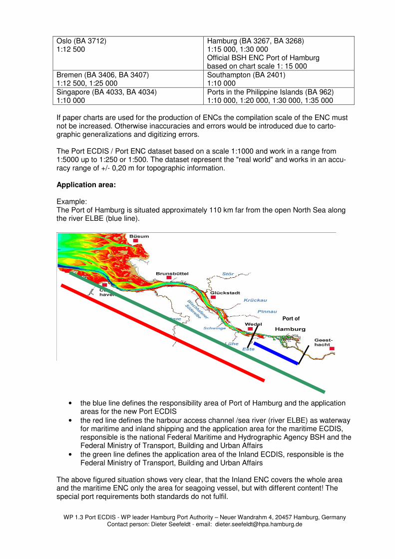
If paper charts are used for the production of ENCs the compilation scale of the ENC must not be increased. Otherwise inaccuracies and errors would be introduced due to carto-graphic generalizations and digitizing errors. The Port ECDIS / Port ENC dataset based on a scale 1:1000 and work in a range from 1:5000 up to 1:250 or 1:500. The dataset represent the "real world" and works in an accu-racy range of +/- 0,20 m for topographic information. Application area: Example: The Port of Hamburg is situated approximately 110 km far from the open North Sea along the river ELBE (blue line).
• the blue line defines the responsibility area of Port of Hamburg and the application areas for the new Port ECDIS
• the red line defines the harbour access channel /sea river (river ELBE) as waterway for maritime and inland shipping and the application area for the maritime ECDIS, responsible is the national Federal Maritime and Hydrographic Agency BSH and the Federal Ministry of Transport, Building and Urban Affairs
• the green line defines the application area of the Inland ECDIS, responsible is the Federal Ministry of Transport, Building and Urban Affairs
The above figured situation shows very clear, that the Inland ENC covers the whole area and the maritime ENC only the area for seagoing vessel, but with different content! The special port requirements both standards do not fulfil.
Port of
WP 1.3 Port ECDIS - WP leader Hamburg Port Authority – Neuer Wandrahm 4, 20457 Hamburg, Germany
Contact person: Dieter Seefeldt - email: [email protected]
So the other approach to research and develop a Port ECDIS based on this above men-tioned confused situation, because both user groups needs the full information, but get only one in the moment. So the Port ECDIS should be able to represent both standards on base of very precise to-pographic and bathymetric information. This topographic situation we will find all over the world, so that's not a special "Port of Hamburg" problem. Responsibility: Normally the ports and harbours are responsible for there own business including all tasks they are necessary to operate and control the port activities. So the ports are normally also responsible for the survey task and representing the results for example as fair sheets or hydrographic maps in a large scale environment as base information for the harbour mas-ter, the pilots and other maintenance, safety et cetera requirements. So the idea is obvious to use standards (IHO S57 + Inland ECDIS) and extend them with new / other features and objects to fulfil port requirements. That's why we executing the research and development task within the EU project EFFORTS, WP 1.2 and WP 1.3, to find out, define and produce a new special Port ENC dataset and standard using the exam-ple of the Port of Hamburg. For such a Port ENC we think the port authority has to be responsible and it is main impor-tant, that port authorities can produce these Port ENC's and approve them. Normally type approval regulations for ECDIS systems dictate, SOLAS vessels must use electronic navi-gational charts (ENCs) from official sources (e.g. Hydrographic Offices). Port ENCs that have been certified by Port Authorities should have the same status as an official ENC with respect to ECDIS type approval. Standards: The current ECDIS and Inland ECDIS standards are well-established. Developments in this field are on the way, so that a new “IHO Geospatial Standard for Hydrographic Data” named S100 will come in place in the near future (2012 / 2013). The cuurent work for the Port ECDIS project is based on the existing standards. Proposals for enhancements will be made to fulfil port requirements. The new Port ECDIS standard or the Port ENC dataset we need now will consider the international standardization developments and should / must be integrated in the S100 standard. Accuracy: For the production of the Port ECDIS or better the Port ENC dataset we need precise to-pographic information in a digital form, so that the charts could be derived and converted direct from topographic survey source data or from precise digital aerial photos (orthophoto) with a resolution better than +/- 0,20 m. On the one hand modern survey equipment is able to survey within that accuracy level and the state of the art GIS (Geo Information System) can handle this kind of "real world" situa-tion. On the other hand the state of the art sensor technology and the equipment on board of modern container vessels, bulkers, tanker and cruise liners et cetera makes it possible to navigate and manoeuvre very precise! Also modern piloting systems like the PPU (WP 1.2)
WP 1.3 Port ECDIS - WP leader Hamburg Port Authority – Neuer Wandrahm 4, 20457 Hamburg, Germany
Contact person: Dieter Seefeldt - email: [email protected]
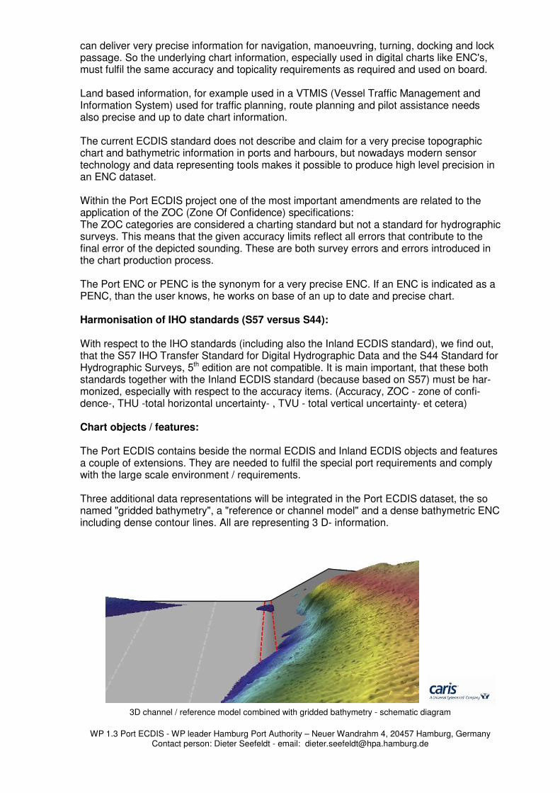
can deliver very precise information for navigation, manoeuvring, turning, docking and lock passage. So the underlying chart information, especially used in digital charts like ENC's, must fulfil the same accuracy and topicality requirements as required and used on board. Land based information, for example used in a VTMIS (Vessel Traffic Management and Information System) used for traffic planning, route planning and pilot assistance needs also precise and up to date chart information. The current ECDIS standard does not describe and claim for a very precise topographic chart and bathymetric information in ports and harbours, but nowadays modern sensor technology and data representing tools makes it possible to produce high level precision in an ENC dataset. Within the Port ECDIS project one of the most important amendments are related to the application of the ZOC (Zone Of Confidence) specifications: The ZOC categories are considered a charting standard but not a standard for hydrographic surveys. This means that the given accuracy limits reflect all errors that contribute to the final error of the depicted sounding. These are both survey errors and errors introduced in the chart production process. The Port ENC or PENC is the synonym for a very precise ENC. If an ENC is indicated as a PENC, than the user knows, he works on base of an up to date and precise chart. Harmonisation of IHO standards (S57 versus S44): With respect to the IHO standards (including also the Inland ECDIS standard), we find out, that the S57 IHO Transfer Standard for Digital Hydrographic Data and the S44 Standard for Hydrographic Surveys, 5th edition are not compatible. It is main important, that these both standards together with the Inland ECDIS standard (because based on S57) must be har-monized, especially with respect to the accuracy items. (Accuracy, ZOC - zone of confi-dence-, THU -total horizontal uncertainty- , TVU - total vertical uncertainty- et cetera) Chart objects / features: The Port ECDIS contains beside the normal ECDIS and Inland ECDIS objects and features a couple of extensions. They are needed to fulfil the special port requirements and comply with the large scale environment / requirements. Three additional data representations will be integrated in the Port ECDIS dataset, the so named "gridded bathymetry", a "reference or channel model" and a dense bathymetric ENC including dense contour lines. All are representing 3 D- information.
3D channel / reference model combined with gridded bathymetry - schematic diagram
WP 1.3 Port ECDIS - WP leader Hamburg Port Authority – Neuer Wandrahm 4, 20457 Hamburg, Germany
Contact person: Dieter Seefeldt - email: [email protected]
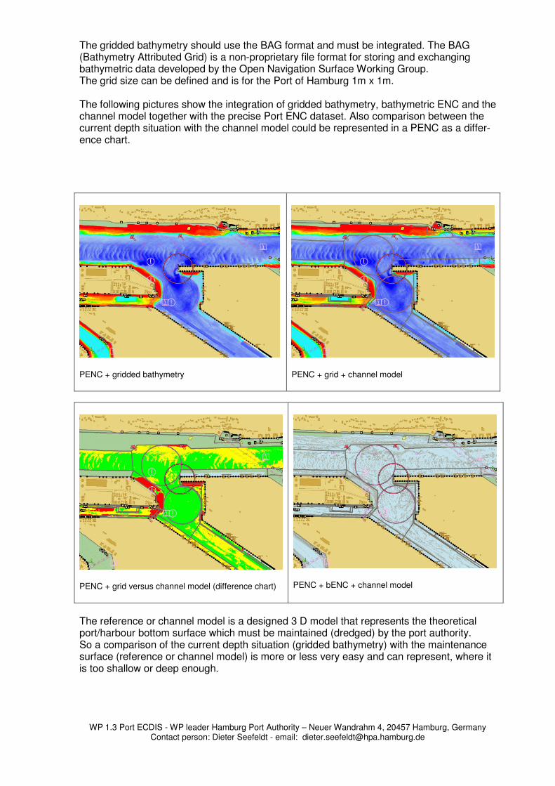
The gridded bathymetry should use the BAG format and must be integrated. The BAG (Bathymetry Attributed Grid) is a non-proprietary file format for storing and exchanging bathymetric data developed by the Open Navigation Surface Working Group. The grid size can be defined and is for the Port of Hamburg 1m x 1m. The following pictures show the integration of gridded bathymetry, bathymetric ENC and the channel model together with the precise Port ENC dataset. Also comparison between the current depth situation with the channel model could be represented in a PENC as a differ-ence chart.
PENC + gridded bathymetry
PENC + grid + channel model
PENC + grid versus channel model (difference chart)
PENC + bENC + channel model
The reference or channel model is a designed 3 D model that represents the theoretical port/harbour bottom surface which must be maintained (dredged) by the port authority. So a comparison of the current depth situation (gridded bathymetry) with the maintenance surface (reference or channel model) is more or less very easy and can represent, where it is too shallow or deep enough.

WP 1.3 Port ECDIS - WP leader Hamburg Port Authority – Neuer Wandrahm 4, 20457 Hamburg, Germany
Contact person: Dieter Seefeldt - email: [email protected]
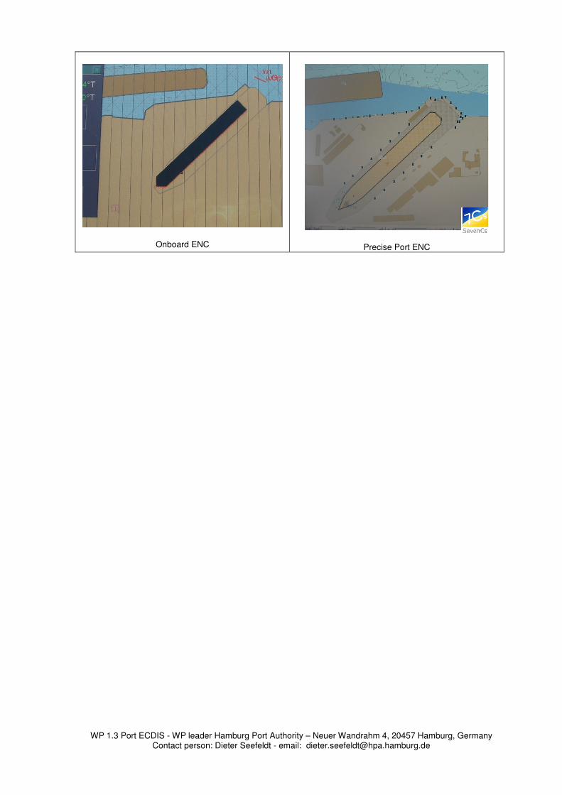
File size limitations: The file size limitations within the current ECDIS standard are also a limitation for further developments! Currently the ENC cell size is limited to 5MB! Nowadays modern computer technology and data transfer methods can handle a lot of more data, so that this limitation is obsolete and must be defined new. Skin of the earth difficulty: The current standard defines the "skin of the earth" for ENC data (so named group 1 object class). For these objects it is not allowed to overlap. This issue is not only related to presen-tation but also to encoding of ENC's. Official description: Each area covered by a meta object Coverage (M_COVR) with Cate-gory of coverage = coverage available (CATCOV = 1) must be totally covered by a set of geo objects of type area that do not overlap each other (the skin of the earth). These ob-jects make up Group 1. The list below contains the objects that must always be in Group 1, if they appear in the dataset and if they are of type area like: Depth Area (DEPARE), Dredged Area (DRGARE), Floating Dock (FLODOC), Hulk (HUL-KES), Land Area (LNDARE), Pontoon (PONTON), Unsurveyed Area (UNSARE). But we think objects like the above mentioned should also belong to Group2 as defined in the Inland ECDIS Standard. This postulation must be unlocked to get more freedom during the data production and representing process. Conclusion: A modern ENC as developed in the Port ECDIS work package has to be produced from the related source data to ensure the maximum accuracy for the specified level of detail and up to dateness! The very special port related requirements must be fulfilled if an ENC can be called PortENC! The PortENC (PENC) stands for up to date and precise information so that the abbreviation PENC stands also for Precise ENC!! The EU research and development project PortECDIS and the proposal for new enhanced ENC standard should fulfil the current requirements we have in ports, harbours with less space for safe navigation, manoeuvring, turning and docking. The result is directed to the future and wants to initiate an ECDIS or Inland ECDIS upgrade process to establish the above mentioned Port ECDIS and Port ENC as a new additional / complementary standard. This usability of this standard must be given on Inland ECDIS and maritime ECDIS.. From our point of view this is very important with respect to the IMO information, because during the 85th session of IMO's Maritime Safety Committee (MSC), the proposal was ap-proved to make mandatory the carriage of ECDIS on SOLAS vessels from 2012. The pro-posal contained amendments to SOLAS regulation V/19 to make the carriage of ECDIS under SOLAS chapter V Safety of Navigation mandatory as proposed by NAV 54. A Port ENC can avoid the misinterpretation that’s possible under the current situation. If a PENC (Port ENC or Precise ENC) is used and a vessel sails on land, not the chart is im-precise, only the navigational information onboard must be checked. Please have a look at the below presented pictures. The navigational information was re-ceived from the same source (Pilot plug); the left picture shows the onboard normal ENC situation and the right picture represents the same navigational data together with a precise Port ENC dataset. The difference is highly visible.
WP 1.3 Port ECDIS - WP leader Hamburg Port Authority – Neuer Wandrahm 4, 20457 Hamburg, Germany
Contact person: Dieter Seefeldt - email: [email protected]
Onboard ENC
Precise Port ENC