Embed Size (px)
Citation preview
Nat. Hazards Earth Syst. Sci., 10, 2623–2629, 2010www.nat-hazards-earth-syst-sci.net/10/2623/2010/doi:10.5194/nhess-10-2623-2010© Author(s) 2010. CC Attribution 3.0 License.
Natural Hazardsand Earth
System Sciences
The UNESCO-IOC framework – establishing an international earlywarning infrastructure in the Indian Ocean region
J. Lauterjung 1, P. Koltermann2, U. Wolf2, and J. Sopaheluwakan3
1Deutsches GeoForschungsZentrum GFZ, Telegrafenberg, 14473 Potsdam, Germany2UNESCO IOC – Tsunami Unit, 1 Rue Mollis, 75732 Paris Cedex, France3Lembaga Ilmu Pengetahuan Indonesia – LIPI (The Indonesian Institute of Sciences), Jl. Gatot Subroto 10,Jakarta 12710, Indonesia
Received: 23 August 2010 – Revised: 21 November 2010 – Accepted: 22 November 2010 – Published: 20 December 2010
Abstract. The Sumatra-Andaman earthquake with a mag-nitude of 9.3, and the subsequent destructive tsunami whichcaused more than 225 000 fatalities in the region of the In-dian Ocean, happened on 26 December 2004. Less than onemonth later, the United Nations (UN) World Conference onDisaster Reduction took place in Kobe, Japan to commemo-rate the 1995 Kobe earthquake. The importance of prepared-ness and awareness on regional, national and communitylevels with respect to natural disasters was discussed dur-ing this meeting, and resulted in the approval of the HyogoDeclaration on Disaster Reduction. Based on this declara-tion the UN mandated the Intergovernmental OceanographicCommission (IOC) of UNESCO (United Nations Education,Science and Cultural Organization), taking note of its over40 years of successful coordination of the Pacific TsunamiWarning System (PTWC), to take on the international coordi-nation of national early-warning efforts for the Indian Oceanand to guide the process of setting up a Regional TsunamiEarly Warning System for the Indian Ocean.
1 Introduction
More than 225 000 people lost their lives on 26 Decem-ber 2004, due to the Sumatra-Andaman Earthquake with amagnitude of 9.3 and the ensuing destructive ocean-widetsunami. In January 2005 the UN World Conference on Dis-aster Reduction took place in Kobe, Japan. The Hyogo Dec-laration on Disaster Reduction is since then the basis for the
Correspondence to:J. Lauterjung([email protected])
establishment of Tsunami Early Warning Systems all aroundthe world (UN1, 2005). During this conference a dedicatedresolution was also passed to mandate the IntergovernmentalOceanographic Commission of UNESCO (IOC) to take re-sponsibility for the international coordination of the nationalefforts in the Indian Ocean regions in order to guide the pro-cess of setting up a Regional Tsunami Early Warning Systemfor the Indian Ocean (UN2, 2005; UN3, 2005).
2 The UNESCO framework
UNESCO IOC started its activities with a series of regionalconferences in Paris in March 2005 and a few weeks later inMauritius which resulted in the formation of the Intergovern-mental Coordination Group (ICG) for the establishment of anIndian Ocean Tsunami Early Warning and Mitigation System(ICG-IOTWS). This ICG-IOTWS started regular work (seeTable 1) with its first meeting in Perth in August 2005.
Members of the ICG-IOTWS are all Indian OceanRim counties. Ex-officio members are UN orga-nizations, i.e. WMO (World Meteorological Organiza-tion), UNDP (United Nations Development Programme),OCHA ((UN) Office for the Coordination of Humanitar-ian Affairs), donor countries and other invited organizations.The ICG has an organizational structure and is managed bya secretariat based in Perth, Australia.
Already during the preparatory phase several WorkingGroups had been formed to tackle the major challenges andrequirements for a Regional Tsunami Early Warning System.Finally six Working Groups were established which are leadby IOTWS member countries and meet 1–2 times a year todiscuss the respective development and to formulate decisionproposals for ICG-IOTWS assembly resolutions.
Published by Copernicus Publications on behalf of the European Geosciences Union.
2624 J. Lauterjung et al.: The UNESCO-IOC framework – establishing an international early warning structure
Table 1. List of IOC IOTWS ICG meetings, places and dates.
Meeting Place Date
IOC Kick-Off Paris, France 3–8 March 2005IOC (preparatory) Mauritius 14–16 April 2005
ICG I Perth, Australia 3–5 August 2005ICG II Hyderabad, India 14–16 December 2005ICG III Bali, Indonesia 31 July–2 August 2006ICG IV Mombasa, Kenya 28 February–2 March 2007ICG V Kuala Lumpur, Malaysia 8–10 April 2008ICG VI Hyderabad, India 7–9 April 2009ICG VII Banda Aceh, Indonesia 14–16 April 2010
The following Working Groups were established in 2005and 2006:
– Working Group 1: seismic measurements, data collec-tion and exchange.
– Working Group 2: sea level data collection and ex-change, including deep-ocean tsunami detection instru-ments.
– Working Group 3: risk assessment.
– Working Group 4: modelling, forecasting and scenariodevelopment.
– Working Group 5: establishment of a system of interop-erable advisory and warning.
– Working Group 6: mitigation, preparedness andresponse.
2.1 Major results of working group activities
The main activities have been in the field of monitoring in-strumentation (seismic, tide gauges), tsunami modelling, riskassessment and interoperability.
2.1.1 Monitoring instrumentation
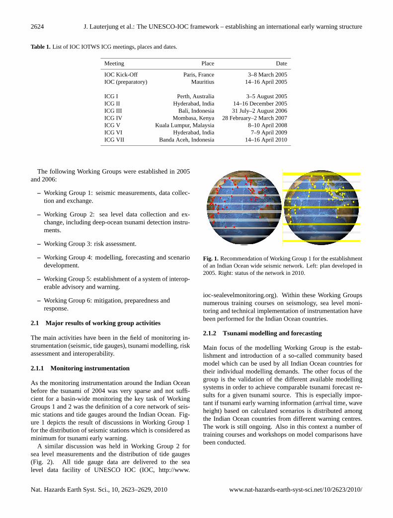
As the monitoring instrumentation around the Indian Oceanbefore the tsunami of 2004 was very sparse and not suffi-cient for a basin-wide monitoring the key task of WorkingGroups 1 and 2 was the definition of a core network of seis-mic stations and tide gauges around the Indian Ocean. Fig-ure 1 depicts the result of discussions in Working Group 1for the distribution of seismic stations which is considered asminimum for tsunami early warning.
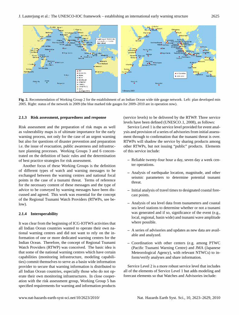
A similar discussion was held in Working Group 2 forsea level measurements and the distribution of tide gauges(Fig. 2). All tide gauge data are delivered to the sealevel data facility of UNESCO IOC (IOC,http://www.
Figures and Figure captions
Figure 1: Recommendation of Working Group 1 for the establishment of an Indian
Ocean wide seismic network. Left: Plan developed in 2005. Right: Status of the network in 2010.
Figure 2: Recommendation of Working Group 2 for the establishment of an Indian
Ocean wide tide gauge network. Left: Plan developed min 2005. Right: Status of the network in 2009 (the blue marked tide gauges for 2009-2010 are in operation now).
Fig. 1. Recommendation of Working Group 1 for the establishmentof an Indian Ocean wide seismic network. Left: plan developed in2005. Right: status of the network in 2010.
ioc-sealevelmonitoring.org). Within these Working Groupsnumerous training courses on seismology, sea level moni-toring and technical implementation of instrumentation havebeen performed for the Indian Ocean countries.
2.1.2 Tsunami modelling and forecasting
Main focus of the modelling Working Group is the estab-lishment and introduction of a so-called community basedmodel which can be used by all Indian Ocean countries fortheir individual modelling demands. The other focus of thegroup is the validation of the different available modellingsystems in order to achieve comparable tsunami forecast re-sults for a given tsunami source. This is especially impor-tant if tsunami early warning information (arrival time, waveheight) based on calculated scenarios is distributed amongthe Indian Ocean countries from different warning centres.The work is still ongoing. Also in this context a number oftraining courses and workshops on model comparisons havebeen conducted.
Nat. Hazards Earth Syst. Sci., 10, 2623–2629, 2010 www.nat-hazards-earth-syst-sci.net/10/2623/2010/
J. Lauterjung et al.: The UNESCO-IOC framework – establishing an international early warning structure 2625
Figures and Figure captions
Figure 1: Recommendation of Working Group 1 for the establishment of an Indian
Ocean wide seismic network. Left: Plan developed in 2005. Right: Status of the network in 2010.
Figure 2: Recommendation of Working Group 2 for the establishment of an Indian
Ocean wide tide gauge network. Left: Plan developed min 2005. Right: Status of the network in 2009 (the blue marked tide gauges for 2009-2010 are in operation now).
Fig. 2. Recommendation of Working Group 2 for the establishment of an Indian Ocean wide tide gauge network. Left: plan developed min2005. Right: status of the network in 2009 (the blue marked tide gauges for 2009–2010 are in operation now).
2.1.3 Risk assessment, preparedness and response
Risk assessment and the preparation of risk maps as wellas vulnerability maps is of ultimate importance for the earlywarning process, not only for the case of an urgent warningbut also for questions of disaster prevention and preparationi.e. the issue of evacuation, public awareness and infrastruc-ture planning processes. Working Groups 3 and 6 concen-trated on the definition of basic rules and the determinationof best practice strategies for risk assessment.
Another focus of these Working Groups is the definitionof different types of watch and warning messages to beexchanged between the warning centres and national focalpoints in the case of a tsunami threat. Terms of referencefor the necessary content of these messages and the type ofadvice to be conveyed by warning messages have been dis-cussed and agreed. This work was essential for the conceptof the Regional Tsunami Watch Providers (RTWPs, see be-low).
2.1.4 Interoperability
It was clear from the beginning of ICG-IOTWS activities thatall Indian Ocean countries wanted to operate their own na-tional warning centres and did not want to rely on the in-formation of one or more dedicated warning centres for theIndian Ocean. Therefore, the concept of Regional TsunamiWatch Providers (RTWP) was conceived. The basic idea isthat some of the national warning centres which have certaincapabilities (monitoring infrastructure, modeling capabili-ties) commit themselves to serve as a basin wide informationprovider to secure that warning information is distributed toall Indian Ocean countries, especially those who do not op-erate their own monitoring infrastructures. In close cooper-ation with the risk assessment group, Working Group 5 hasspecified requirements for warning and information products
(service levels) to be delivered by the RTWP. Three servicelevels have been defined (UNESCO1, 2008), as follows:
Service Level 1 is the service level provided for event anal-ysis and provision of a series of advisories from initial assess-ment through to confirmation that the tsunami threat is over.RTWPs will shadow the service by sharing products amongother RTWPs, but not issuing “public” products. Elementsof this service include:
– Reliable twenty-four hour a day, seven day a week cen-ter operations.
– Analysis of earthquake location, magnitude, and otherseismic parameters to determine potential tsunamithreat.
– Initial analysis of travel times to designated coastal fore-cast points.
– Analysis of sea level data from tsunameters and coastalsea level stations to determine whether or not a tsunamiwas generated and if so, significance of the event (e.g.,local, regional, basin wide) and tsunami wave amplitudewhere possible.
– A series of advisories and updates as new data are avail-able and analyzed.
– Coordination with other centers (e.g. among PTWC(Pacific Tsunami Warning Centre) and JMA (JapaneseMeteorological Agency), with relevant NTWCs) to in-form/verify analyses and share information.
Service Level 2 is a more robust service level that includesall of the elements of Service Level 1 but adds modeling andforecast elements so that Watches and Advisories include:
www.nat-hazards-earth-syst-sci.net/10/2623/2010/ Nat. Hazards Earth Syst. Sci., 10, 2623–2629, 2010
2626 J. Lauterjung et al.: The UNESCO-IOC framework – establishing an international early warning structure
– Estimated wave height(s) (EWH) for offshore forecastpoints.
– Estimated time(s) of arrival (ETA) for offshore forecastpoints.
– Other tsunami characteristics (eg duration, wave period,time of max amplitude) where available.
– Potential threat zones.
– Confidence levels as applicable and appropriate.
– Advanced warning and notification products such asgraphical forecasts.
National tsunami warning centres will need to utilizewatch information to formulate tsunami threat informationfor their communities (under bilateral arrangements withRTWPs if required).
Service Level 3 links the Service Level 2 services andproducts with local risk and hazard assessment and inunda-tion models through NTWCs to provide coastal inundationforecasts for communities at risk.
Until now Australia, India and Indonesia have officiallyindicated their willingness to take over the role of a RTWPfor the Indian Ocean as all three countries have invested inthe set-up and operation of a comprehensive early warninginfrastructure and have largely contributed to the RTWP im-plementation process.
Major papers outlining the results of the Working Groupactivities in detail include the IOTWS Implementation Plan(UNESCO3, 2010), the IOTWS Implementation Plan forRegional Tsunami Watch Providers (UNESCO1, 2008) anda document describing the results of the first Indian Oceanwide communication and alerting experiment IOWave09(UNESCO2, 2009).
Reflecting the progress made in the establishment of theIOTWS and in preparation for the future sustained gover-nance of the system the 7th Session of the ICG-IOTWS inBanda Aceh, Indonesia, 14–16 April 2010, dissolved the6 already existing Working Groups and established 3 newWorking Groups:
– Working Group 1: tsunami risk assessment andreduction.
– Working Group 2: tsunami detection, warning anddissemination.
– Working Group 3: tsunami awareness and response.
This modification corresponds with the structure of theWorking Groups in all other tsunami warning systems fa-cilitating the co-operation and exchange of experiences andknowledge to provide a global cover at equal standards.
Yemen
Maldives
Sri Lanka
Indonesia
Madagascar
Kenya
Tanzania
Israel
South Africa
3014
Seismic online Seismic to be movedSeismic planned 2011 Seismic GEOFONTide Gauge + GPS
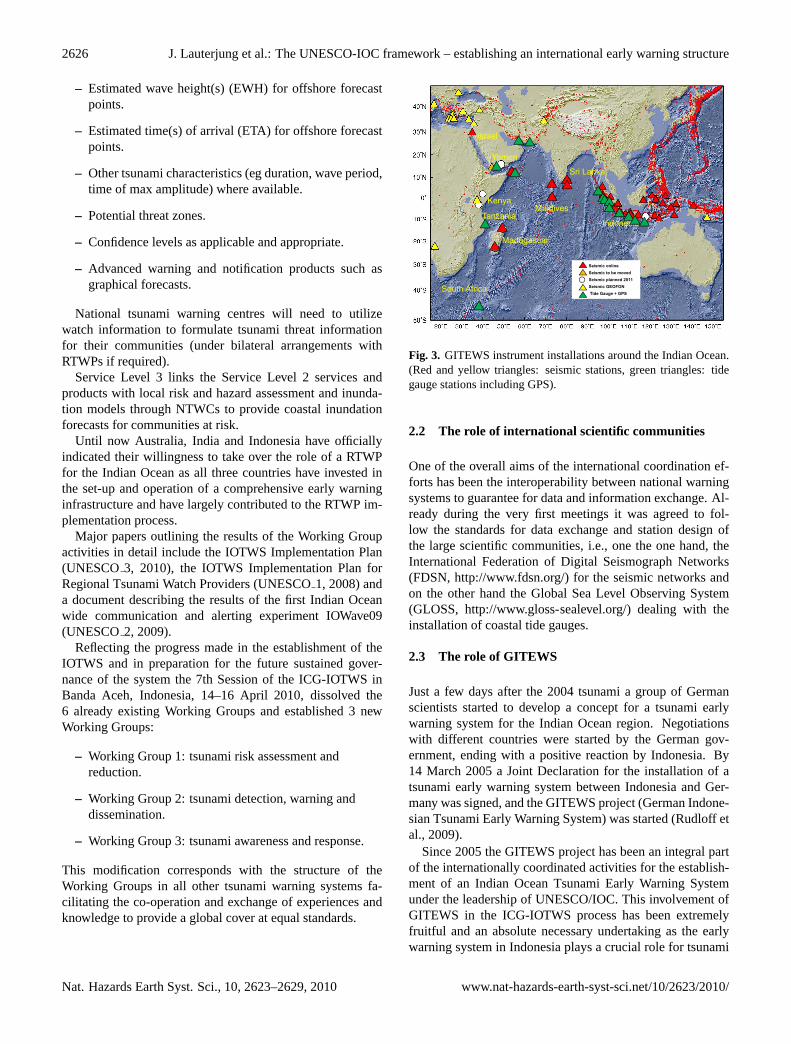
Figure 3: GITEWS instrument installations around the Indian Ocean. (Red and yellow triangles: seismic stations, green triangles: tide gauge stations including GPS)
Fig. 3. GITEWS instrument installations around the Indian Ocean.(Red and yellow triangles: seismic stations, green triangles: tidegauge stations including GPS).
2.2 The role of international scientific communities
One of the overall aims of the international coordination ef-forts has been the interoperability between national warningsystems to guarantee for data and information exchange. Al-ready during the very first meetings it was agreed to fol-low the standards for data exchange and station design ofthe large scientific communities, i.e., one the one hand, theInternational Federation of Digital Seismograph Networks(FDSN,http://www.fdsn.org/) for the seismic networks andon the other hand the Global Sea Level Observing System(GLOSS, http://www.gloss-sealevel.org/) dealing with theinstallation of coastal tide gauges.
2.3 The role of GITEWS
Just a few days after the 2004 tsunami a group of Germanscientists started to develop a concept for a tsunami earlywarning system for the Indian Ocean region. Negotiationswith different countries were started by the German gov-ernment, ending with a positive reaction by Indonesia. By14 March 2005 a Joint Declaration for the installation of atsunami early warning system between Indonesia and Ger-many was signed, and the GITEWS project (German Indone-sian Tsunami Early Warning System) was started (Rudloff etal., 2009).
Since 2005 the GITEWS project has been an integral partof the internationally coordinated activities for the establish-ment of an Indian Ocean Tsunami Early Warning Systemunder the leadership of UNESCO/IOC. This involvement ofGITEWS in the ICG-IOTWS process has been extremelyfruitful and an absolute necessary undertaking as the earlywarning system in Indonesia plays a crucial role for tsunami
Nat. Hazards Earth Syst. Sci., 10, 2623–2629, 2010 www.nat-hazards-earth-syst-sci.net/10/2623/2010/
J. Lauterjung et al.: The UNESCO-IOC framework – establishing an international early warning structure 2627
early warning in the Indian Ocean. Due to the geotectonicsituation most of the tsunamigenic earthquakes threateningthe Indian Ocean are generated along the Sunda Arc, an ac-tive continental margin running along the coastline of In-donesia (Lauterjung et al., 2010). The early warning systemin Indonesia is able to deliver very first and fast indicationsand data with respect to a tsunami and, therefore, contributesto an ocean wide communication and information networkfor regional tsunami warning.
Although GITEWS participates in the ICG-IOTWS pro-cesses as an observer only, scientists have been actively in-volved in the Working Group activities. In this contextGITEWS took over the task of the installation of seismicstations outside Indonesia (Sri Lanka, Maldives, Madagas-car, Yemen, Kenia) including a satellite communication net-work. The result of this work is shown in Fig. 3. In addi-tion most of the countries around the Indian Ocean are usingSeisComp 3 (http://www.seiscomp3.org/), the seismic com-munication and processing software developed during thecourse of the GITEWS project (Hanka et al., 2010). Alongwith the installation of this software package an introduc-tion and training for the users of SeisComp3 was alreadyprovided. This software is now a quasi-standard for seis-mic processing. Furthermore all data of seismic stationsaround the Indian Ocean are stored and are available on-line in the GEOFON archive at GFZ in Potsdam (GEOFON,http://www.gfz-potsdam.de/geofon).
GITEWS also set up a number of tide gauges, partly withthe support of UNESCO IOC (Fig. 3) and training of the re-spective operators in data evaluation and station maintenancewas also provided.
GITEWS was also strongly involved in general trainingand education activities. For more than 25 years the GFZin Potsdam has been offering annual international trainingcourses for Seismology, Seismic Data Analysis, Hazard As-sessment and Risk Mitigation under the auspices of UN-ESCO (Letz and Bormann, 2002). These training courseswere extended after the 2004 tsunami by a module TsunamiEarly Warning. The last training course took place in early2010 in Citeko/Indonesia using the new training facility ofBMKG (Badan Meteorologi, Klimatologi dan Geofisika –Indonesias Agengy for Meteorology, Cliamatology and Geo-physics)/Indonesia. This training course was attended by 30participants from 19 Indian Ocean Countries.
2.4 Major achievements of ICG-IOTWS
The work of the ICG resulted in several achievements:
1. Interim Tsunami Watch Provider
Already during the first stage of the international effortto set up an Indian Ocean wide Tsunami Early Warn-ing System it was agreed between the member countriesin early 2005 that the Pacific Tsunami Warning Cen-tre (PTWC) and the Japanese Meteorological Agency
(JMA) should serve as Interim Tsunami Watch Providerand deliver tsunami information based on results ofglobal seismic networks to the Tsunami Warning Fo-cal Points (TWFP). The responsibility to disseminateTsunami information on a national scale is under theaegis of the respective member country (see next bullet:Tsunami Warning Focal Points).
2. Nomination and identification of Tsunami WarningFocal Points.
As a first reaction to the deficient distribution of infor-mation during and after the 2004 tsunami each IndianOcean country nominated an organization whose duty itthen became to operate a 24/7 office for the reception oftsunami alerts produced by the PTWC and/or JMA andto disseminate warning products within the countries.
3. Working Groups
The ICG-IOTWS established specific Working Groupsto identify the needs of the different components ofearly-warning systems, to identify the needs of the com-munity for joint activities, to organize the definitionof requirements for a basin wide early warning systemand to define the specifications and terms of referenceof an Indian Ocean Regional Tsunami Watch Provider(RTWP).
4. Risk Assessment
During the years 2005 and 2006 a number of TsunamiHazard and Risk assessment studies in the Indian Oceanrim countries were conducted by international scientificgroups under the auspices of UNESCO IOC. In manycountries these studies resulted in national strategies fordisaster reduction and preparedness forming the basisfor further steps and activities in the field of early warn-ing.
2.5 First ideas for a Global Tsunami Warning System
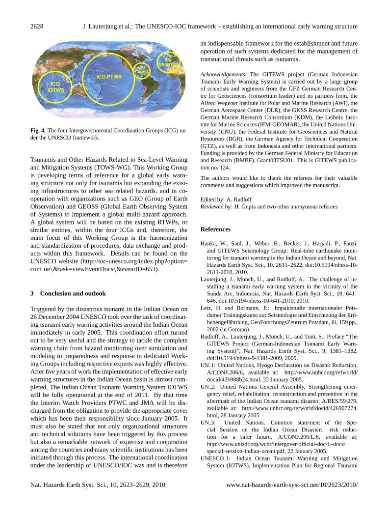
Within the framework of UNESCO IOC four Intergovern-mental Coordination Groups have been organized (Fig. 4):
– the ICG/PTWS covering the Pacific and incorporatingthe existing PTWC and JMA;
– the ICG/CARIBE concentrating on the Caribbean Seaand;
– the ICG/NEAMTWS (North-east Atlantic, Mediter-ranean and Connecting Seas);
– the ICG/IOTWS covering the Indian Ocean.
The implementation strategy of tsunami early warningprocesses in these ICGs is almost comparable to the ICG-IOTWS as described above. Based on the successful workin the existing ICGs, IOC implemented a Working Group
www.nat-hazards-earth-syst-sci.net/10/2623/2010/ Nat. Hazards Earth Syst. Sci., 10, 2623–2629, 2010
2628 J. Lauterjung et al.: The UNESCO-IOC framework – establishing an international early warning structure
ICG PTWSICG
IOTWS
ICG NEAMTWSICG
CARIBE
Figure 4: The four Intergovernmental Coordination Groups (ICG) under the
UNESCO Framework. Fig. 4. The four Intergovernmental Coordination Groups (ICG) un-der the UNESCO framework.
Tsunamis and Other Hazards Related to Sea-Level Warningand Mitigation Systems (TOWS-WG). This Working Groupis developing terms of reference for a global early warn-ing structure not only for tsunamis but expanding the exist-ing infrastructures to other sea related hazards, and in co-operation with organizations such as GEO (Group of EarthObservation) and GEOSS (Global Earth Observing Systemof Systems) to implement a global multi-hazard approach.A global system will be based on the existing RTWPs, orsimilar entities, within the four ICGs and, therefore, themain focus of this Working Group is the harmonizationand standardization of procedures, data exchange and prod-ucts within this framework. Details can be found on theUNESCO website (http://ioc-unesco.org/index.php?option=com oe\&task=viewEventDocs\&eventID=653).
3 Conclusion and outlook
Triggered by the disastrous tsunami in the Indian Ocean on26 December 2004 UNESCO took over the task of coordinat-ing tsunami early warning activities around the Indian Oceanimmediately in early 2005. This coordination effort turnedout to be very useful and the strategy to tackle the completewarning chain from hazard monitoring over simulation andmodeling to preparedness and response in dedicated Work-ing Groups including respective experts was highly effective.After five years of work the implementation of effective earlywarning structures in the Indian Ocean basin is almost com-pleted. The Indian Ocean Tsunami Warning System IOTWSwill be fully operational at the end of 2011. By that timethe Interim Watch Providers PTWC and JMA will be dis-charged from the obligation to provide the appropriate coverwhich has been their responsibility since January 2005. Itmust also be stated that not only organizational structuresand technical solutions have been triggered by this processbut also a remarkable network of expertise and cooperationamong the countries and many scientific institutions has beeninitiated through this process. The international coordinationunder the leadership of UNESCO/IOC was and is therefore
an indispensable framework for the establishment and futureoperation of such systems dedicated for the management oftransnational threats such as tsunamis.
Acknowledgements.The GITEWS project (German IndonesianTsunami Early Warning System) is carried out by a large groupof scientists and engineers from the GFZ German Research Cen-tre for Geosciences (consortium leader) and its partners from, theAlfred Wegener Institute for Polar and Marine Research (AWI), theGerman Aerospace Center (DLR), the GKSS Research Centre, theGerman Marine Research Consortium (KDM), the Leibniz Insti-tute for Marine Sciences (IFM-GEOMAR), the United Nations Uni-versity (UNU), the Federal Institute for Geosciences and NaturalResources (BGR), the German Agency for Technical Cooperation(GTZ), as well as from Indonesia and other international partners.Funding is provided by the German Federal Ministry for Educationand Research (BMBF), Grant03TSU01. This is GITEWS publica-tion no. 124.
The authors would like to thank the referees for their valuablecomments and suggestions which improved the manuscript.
Edited by: A. RudloffReviewed by: H. Gupta and two other anonymous referees
References
Hanka, W., Saul, J., Weber, B., Becker, J., Harjadi, P., Fauzi,and GITEWS Seismology Group: Real-time earthquake moni-toring for tsunami warning in the Indian Ocean and beyond, Nat.Hazards Earth Syst. Sci., 10, 2611–2622, doi:10.5194/nhess-10-2611-2010, 2010.
Lauterjung, J., M̈unch, U., and Rudloff, A.: The challenge of in-stalling a tsunami early warning system in the vicinity of theSunda Arc, Indonesia, Nat. Hazards Earth Syst. Sci., 10, 641–646, doi:10.5194/nhess-10-641-2010, 2010.
Letz, H. and Bormann, P.: Impaktstudie internationaler Pots-damer Trainingskurse zur Seismologie und Einschtzung der Erd-bebengef̈ahrdung, GeoForschungsZentrum Potsdam, iii, 159 pp.,2002 (in German).
Rudloff, A., Lauterjung, J., M̈unch, U., and Tinti, S.: Preface “TheGITEWS Project (German-Indonesian Tsunami Early Warn-ing System)”, Nat. Hazards Earth Syst. Sci., 9, 1381–1382,doi:10.5194/nhess-9-1381-2009, 2009.
UN 1: United Nations, Hyogo Declaration on Disaster Reduction,A/CONF.206/6, available at: http://www.unhcr.org/refworld/docid/42b988b24.html, 22 January 2005.
UN 2: United Nations General Assembly, Strengthening emer-gency relief, rehabilitation, reconstruction and prevention in theaftermath of the Indian Ocean tsunami disaster, A/RES/59/279,available at: http://www.unhcr.org/refworld/docid/426907274.html, 28 January 2005.
UN 3: United Nations, Common statement of the Spe-cial Session on the Indian Ocean Disaster: risk reduc-tion for a safer future, A/CONF.206/L.6, available at:http://www.unisdr.org/wcdr/intergover/official-doc/L-docs/special-session-indian-ocean.pdf, 22 January 2005.
UNESCO1: Indian Ocean Tsunami Warning and MitigationSystem (IOTWS), Implementation Plan for Regional Tsunami
Nat. Hazards Earth Syst. Sci., 10, 2623–2629, 2010 www.nat-hazards-earth-syst-sci.net/10/2623/2010/
J. Lauterjung et al.: The UNESCO-IOC framework – establishing an international early warning structure 2629
Watch ProvidersIOC Information Series, No. 81, UNESCO 2008(in English).
UNESCO2: Indian Ocean Tsunami Warning and Mitigation Sys-tem (IOTWS). Exercise Indian Ocean Wave 2009 (IOWave09)An Indian Ocean-wide Tsunami Warning and CommunicationExercise, IOC Technical Series, No. 88, UNESCO 2009 (in En-glish).
UNESCO3: Indian Ocean Tsunami Warning and Mitigation Sys-tem IOTWS. Implementation Plan. Seventh Session of theIntergovernmental Coordination Group for the Indian OceanTsunami Warning and Mitigation System (ICG/IOTWS-VII),Banda Aceh, Indonesia, 14–16 April 2010, IOC Technical Se-ries No. 71., (Revision 3), UNESCO 2010.
www.nat-hazards-earth-syst-sci.net/10/2623/2010/ Nat. Hazards Earth Syst. Sci., 10, 2623–2629, 2010