Embed Size (px)
Citation preview
Tourism wayfinding & signage strategy
Submitted to:Eurobodalla Shire Council
Adopted – December 2018
Eurobodalla Shire Council – Wayfinding & tourism signage strategywayfound © 2018 - All Rights Reserved 2
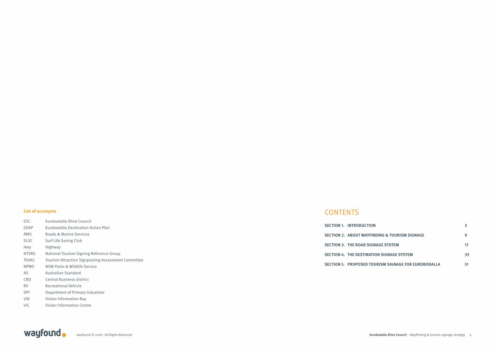
List of acronyms
ESC Eurobodalla Shire CouncilEDAP Eurobodalla Destination Action PlanRMS Roads & Marine ServicesSLSC Surf Life Saving ClubHwy HighwayNTSRG National Tourism Signing Reference GroupTASAC Tourism Attraction Signposting Assessment CommitteeNPWS NSW Parks & Wildlife ServiceAS Australian StandardCBD Central Business districtRV Recreational VehicleDPI Department of Primary IndustriesVIB Visitor Information BayVIC Visitor Information Centre
CONTENTSSECTION 1. INTRODUCTION 3
SECTION 2. ABOUT WAYFINDING & TOURISM SIGNAGE 9
SECTION 3. THE ROAD SIGNAGE SYSTEM 17
SECTION 4. THE DESTINATION SIGNAGE SYSTEM 33
SECTION 5. PROPOSED TOURISM SIGNAGE FOR EUROBODALLA 51

Eurobodalla Shire Council – Wayfinding & tourism signage strategy 3
SECTION 1. INTRODUCTION

Eurobodalla Shire Council – Wayfinding & tourism signage strategywayfound © 2018 - All Rights Reserved 4
Eurobodalla Shire Council (Council) commissioned tourism signage consultancy Wayfound to develop a whole of destination integrated tourism wayfinding and signage strategy (the Strategy). The purpose of the Strategy is to ensure that current and future signage facilitates safe and positive journeys and enhances the dispersal of visitors and their connection with the people, the place and the stories of Eurobodalla.
WHY DO THIS STRATEGY?Tourism signage is an extremely important element of any destination’s branding, marketing and visitor information strategies. Signage is critically important to presenting a consistent tourism experience and to retaining and dispersing visitors throughout the Shire. Signage also provides opportunities to raise awareness of the area’s attractions and features and encourage people to stop and visit.
Wayfinding is about finding one’s way and relates to how a person orientates him/herself and navigates through an area or place.
The existing tourism related signage in Eurobodalla does not enhance the visitor experience or adequately direct visitors to the area’s many attractions. Business and tourism organisations along with business operators have requested that Council develop a Strategy to address this, with some of their concerns being:
• Lack of wayfinding and tourism signage to let visitors know the attractions, services and facilities available off the Princes Highway and to encourage them to turn-off the highway.
• Lack of unique and distinctive signage and imagery that showcases Eurobodalla’s tourism experiences and entices visitors to stop, explore and stay longer.
The Strategy forms part of a suite of initiatives by Council to encourage visitors to stop, extend their length of stay and increase expenditure in the Eurobodalla. The Eurobodalla Destination Action Plan 2018-2021 (EDAP), sets a bold aim of increasing visitor expenditure and overnight visitor stays by 25% by 2021, and contains several priority actions relevant to the development of this Strategy.
Signage is critically important to presenting a consistent tourism experience and to retaining and dispersing visitors throughout the Shire.
Destination Investment and Development - Work with relevant Council departments to improve the visual appeal of towns and villages through ongoing beautification works (e.g.streetscapes, gateway entrances, wayfinding signage).
Destination Marketing - Action 7.5 Develop a Destination Eurobodalla Brand Style Guide for local operators and businesses to ensure the consistent delivery of the brand marketing materials, (electronic, print-based, signage) that aligns with findings of the Brand Review process (S9.3).
Visitor Information Services Action 8.4 Prepare a Destination Eurobodalla Visitor Signage Strategy that aligns with findings of the Brand Review (Action 7.3) to create distinctive and innovative signage and visitor information displays at key tourism attractions; key transport hubs & gateway locations; and promotes diversity of experiences within the destination (S10.8).
PRIORITY
04
PRIORITY
07
PRIORITY
08
SECTION 1. INTRODUCTION
PROJECT BACKGROUNDWHAT’S INCLUDED IN THE STRATEGY? The Strategy is limited to addressing the wayfinding and tourism-related signage needed for visitors who are travelling in vehicles to find their way safely and efficiently to the tourism destinations and attractions within Eurobodalla.
It does not pertain to pedestrian wayfinding, signage once at the destination/attraction, private/commercial signs, business identification signs, town/village signs (other than entry signs), public facilities signs, cycling or walking trails or advertising.
Eurobodalla Shire Council – Wayfinding & tourism signage strategywayfound © 2018 - All Rights Reserved 5
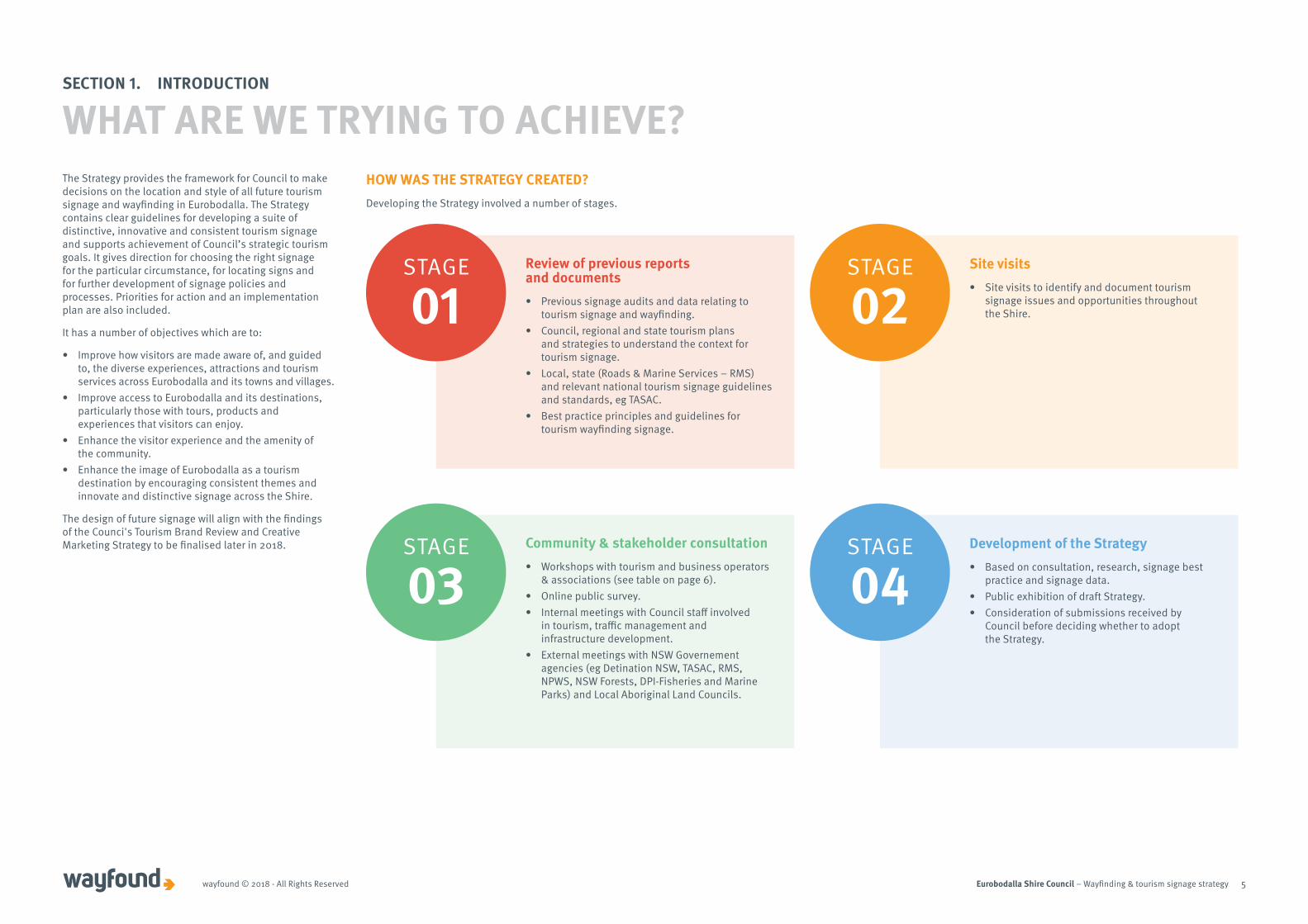
The Strategy provides the framework for Council to make decisions on the location and style of all future tourism signage and wayfinding in Eurobodalla. The Strategy contains clear guidelines for developing a suite of distinctive, innovative and consistent tourism signage and supports achievement of Council’s strategic tourism goals. It gives direction for choosing the right signage for the particular circumstance, for locating signs and for further development of signage policies and processes. Priorities for action and an implementation plan are also included.
It has a number of objectives which are to:
• Improve how visitors are made aware of, and guided to, the diverse experiences, attractions and tourism services across Eurobodalla and its towns and villages.
• Improve access to Eurobodalla and its destinations, particularly those with tours, products and experiences that visitors can enjoy.
• Enhance the visitor experience and the amenity of the community.
• Enhance the image of Eurobodalla as a tourism destination by encouraging consistent themes and innovate and distinctive signage across the Shire.
The design of future signage will align with the findings of the Counci's Tourism Brand Review and Creative Marketing Strategy to be finalised later in 2018.
STAGE
01Review of previous reports and documents• Previous signage audits and data relating to
tourism signage and wayfinding.• Council, regional and state tourism plans
and strategies to understand the context for tourism signage.
• Local, state (Roads & Marine Services – RMS) and relevant national tourism signage guidelines and standards, eg TASAC.
• Best practice principles and guidelines for tourism wayfinding signage.
STAGE
02Site visits • Site visits to identify and document tourism
signage issues and opportunities throughout the Shire.
STAGE
04Development of the Strategy• Based on consultation, research, signage best
practice and signage data.• Public exhibition of draft Strategy. • Consideration of submissions received by
Council before deciding whether to adopt the Strategy.
HOW WAS THE STRATEGY CREATED?Developing the Strategy involved a number of stages.
SECTION 1. INTRODUCTION
WHAT ARE WE TRYING TO ACHIEVE?
STAGE
03Community & stakeholder consultation• Workshops with tourism and business operators
& associations (see table on page 6).• Online public survey. • Internal meetings with Council staff involved
in tourism, traffic management and infrastructure development.
• External meetings with NSW Governement agencies (eg Detination NSW, TASAC, RMS, NPWS, NSW Forests, DPI-Fisheries and Marine Parks) and Local Aboriginal Land Councils.
Eurobodalla Shire Council – Wayfinding & tourism signage strategywayfound © 2018 - All Rights Reserved 6
Engaging and informing the community was a key component of developing the Strategy.
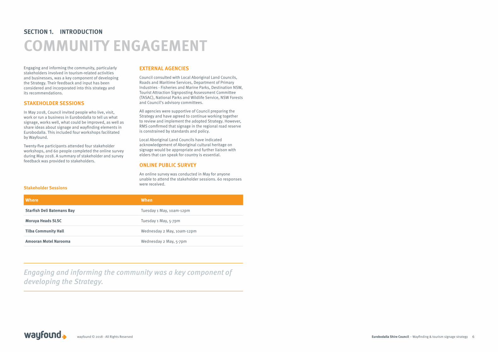
Engaging and informing the community, particularly stakeholders involved in tourism-related activities and businesses, was a key component of developing the Strategy. Their feedback and input has been considered and incorporated into this strategy and its recommendations.
STAKEHOLDER SESSIONSIn May 2018, Council invited people who live, visit, work or run a business in Eurobodalla to tell us what signage, works well, what could be improved, as well as share ideas about signage and wayfinding elements in Eurobodalla. This included four workshops facilitated by Wayfound.
Twenty-five participants attended four stakeholder workshops, and 60 people completed the online survey during May 2018. A summary of stakeholder and survey feedback was provided to stakeholders.
Stakeholder Sessions
Where When
Starfish Deli Batemans Bay Tuesday 1 May, 10am-12pm
Moruya Heads SLSC Tuesday 1 May, 5-7pm
Tilba Community Hall Wednesday 2 May, 10am-12pm
Amooran Motel Narooma Wednesday 2 May, 5-7pm
EXTERNAL AGENCIESCouncil consulted with Local Aboriginal Land Councils, Roads and Maritime Services, Department of Primary Industries - Fisheries and Marine Parks, Destination NSW, Tourist Attraction Signposting Assessment Committee (TASAC), National Parks and Wildlife Service, NSW Forests and Council’s advisory committees.
All agencies were supportive of Council preparing the Strategy and have agreed to continue working together to review and implement the adopted Strategy. However, RMS comfirmed that signage in the regional road reserve is constrained by standards and policy.
Local Aboriginal Land Councils have indicated acknowledgement of Aboriginal cultural heritage on signage would be appropriate and further liaison with elders that can speak for country is essential.
ONLINE PUBLIC SURVEYAn online survey was conducted in May for anyone unable to attend the stakeholder sessions. 60 responses were received.
SECTION 1. INTRODUCTION
COMMUNITY ENGAGEMENT
Eurobodalla Shire Council – Wayfinding & tourism signage strategywayfound © 2018 - All Rights Reserved 7
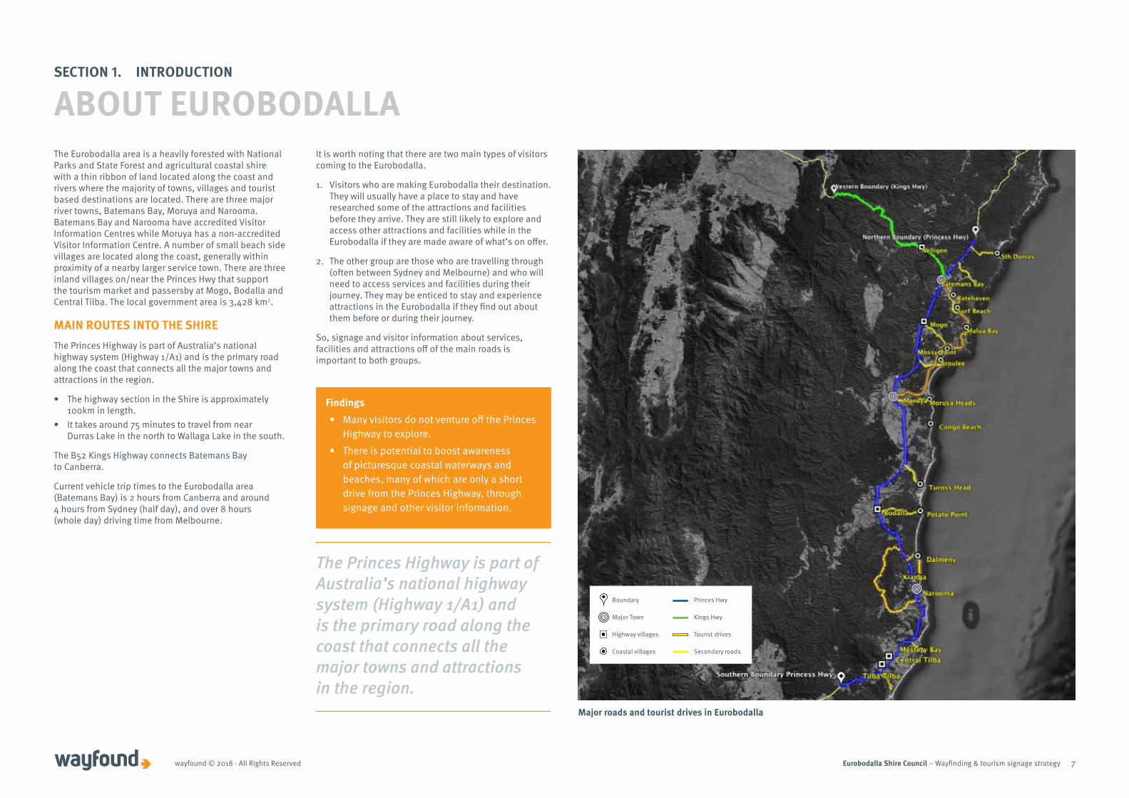
The Princes Highway is part of Australia’s national highway system (Highway 1/A1) and is the primary road along the coast that connects all the major towns and attractions in the region.
SECTION 1. INTRODUCTION
ABOUT EUROBODALLA
Princes HwyBoundary
Kings HwyMajor Town
Tourist drivesHighway villages
Secondary roadsCoastal villages
Major roads and tourist drives in Eurobodalla
The Eurobodalla area is a heavily forested with National Parks and State Forest and agricultural coastal shire with a thin ribbon of land located along the coast and rivers where the majority of towns, villages and tourist based destinations are located. There are three major river towns, Batemans Bay, Moruya and Narooma. Batemans Bay and Narooma have accredited Visitor Information Centres while Moruya has a non-accredited Visitor Information Centre. A number of small beach side villages are located along the coast, generally within proximity of a nearby larger service town. There are three inland villages on/near the Princes Hwy that support the tourism market and passersby at Mogo, Bodalla and Central Tilba. The local government area is 3,428 km2.
MAIN ROUTES INTO THE SHIRE The Princes Highway is part of Australia’s national highway system (Highway 1/A1) and is the primary road along the coast that connects all the major towns and attractions in the region.
• The highway section in the Shire is approximately 100km in length.
• It takes around 75 minutes to travel from near Durras Lake in the north to Wallaga Lake in the south.
The B52 Kings Highway connects Batemans Bay to Canberra.
Current vehicle trip times to the Eurobodalla area (Batemans Bay) is 2 hours from Canberra and around 4 hours from Sydney (half day), and over 8 hours (whole day) driving time from Melbourne.
It is worth noting that there are two main types of visitors coming to the Eurobodalla.
1. Visitors who are making Eurobodalla their destination. They will usually have a place to stay and have researched some of the attractions and facilities before they arrive. They are still likely to explore and access other attractions and facilities while in the Eurobodalla if they are made aware of what’s on offer.
2. The other group are those who are travelling through (often between Sydney and Melbourne) and who will need to access services and facilities during their journey. They may be enticed to stay and experience attractions in the Eurobodalla if they find out about them before or during their journey.
So, signage and visitor information about services, facilities and attractions off of the main roads is important to both groups.
Findings• Many visitors do not venture off the Princes
Highway to explore. • There is potential to boost awareness
of picturesque coastal waterways and beaches, many of which are only a short drive from the Princes Highway, through signage and other visitor information.

Eurobodalla Shire Council – Wayfinding & tourism signage strategywayfound © 2018 - All Rights Reserved 8
ABOUT TOURISM IN EUROBODALLACouncil's tourism research indicates that about 1.3 million people visited the Eurobodalla in the year ending June 2017 and contributed $385 million to the tourism economy.
Tourism Research Australia visitation data for Eurobodalla shows the most popular transport option is for self-drive accounting for 97% of domestic overnight visitors, 99% of daytrip visitors and 91% of international visitors. Social activities and outdoor/nature activities are the main activities undertaken in Eurobodalla. Both for those on a dedicated trip to the area and for those on a stop-over (Eurobodalla Tourism Monitor 2017).
Council commissioned Micromex to undertake a visitor survey and to better understand the profile of visitors (eg. who is visiting and why?) and their experience in Eurobodalla. The research was conducted over the months of January and February 2018 and 275 people participated.
While the majority of people surveyed are satisfied with signage, the strong tourism drive market and expected growth in the tourism economy in the Eurobodalla demonstrates a strong basis for improving wayfinding and tourism-related signage. This will ensure that new and returning visitors to the area are aware of the attractions, experiences and services on offer.
Achieving the EDAP goal of increasing visitor expenditure and overnight visitor stays by 25% by 2021 is dependent not only leadership and management by the Council but also cooperation with the local tourism industry. They will play a key role in developing, enhancing and promoting tourism product and experience development opportunities to create distinctive and quality visitor experiences.
want more information/promotion of what the area offers from tourism operators12%
went for a drive64%
What could improve their experience?
Some things they do
travel to Eurobodalla by car94%stay in caravan parks or campgrounds21%
want more/longer parking6% want improved roads4% improved signage/directions2%
went to beaches91%
SECTION 1. INTRODUCTION
WHAT DOES THIS TELL US? 37% from Canberra
31% from regional NSW
17% from Sydney
6% from Melbourne
9% from other places in Australia
Where visitors are from
81% were satisfied to very satisfied
6% were not satisfied
13% were somewhat satisfied
Satisfaction with signage*
* Satisfaction with signage directing them to shopping areas and places of interest.
74% holiday
13% visiting friends & relatives
10% day trip3% stop over
Purpose of visit to Eurobodalla
VISITATION TO EUROBODALLA*
* Eurobodalla Shire Council Visitor Research 2018 (Micromex)

Eurobodalla Shire Council – Wayfinding & tourism signage strategy 9
SECTION 2. ABOUT WAYFINDING & TOURISM SIGNAGE
Eurobodalla Shire Council – Wayfinding & tourism signage strategywayfound © 2018 - All Rights Reserved 10
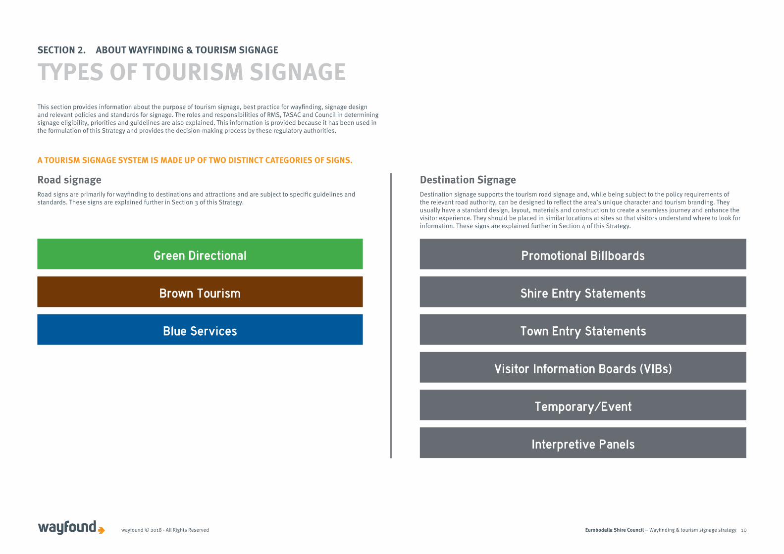
This section provides information about the purpose of tourism signage, best practice for wayfinding, signage design and relevant policies and standards for signage. The roles and responsibilities of RMS, TASAC and Council in determining signage eligibility, priorities and guidelines are also explained. This information is provided because it has been used in the formulation of this Strategy and provides the decision-making process by these regulatory authorities.
A TOURISM SIGNAGE SYSTEM IS MADE UP OF TWO DISTINCT CATEGORIES OF SIGNS.
Green Directional
Road signage Destination Signage
Promotional Billboards
Shire Entry Statements
Town Entry Statements
Visitor Information Boards (VIBs)
Temporary/Event
Interpretive Panels
Brown Tourism
Blue Services
Road signs are primarily for wayfinding to destinations and attractions and are subject to specific guidelines and standards. These signs are explained further in Section 3 of this Strategy.
SECTION 2. ABOUT WAYFINDING & TOURISM SIGNAGE
TYPES OF TOURISM SIGNAGE
Destination signage supports the tourism road signage and, while being subject to the policy requirements of the relevant road authority, can be designed to reflect the area’s unique character and tourism branding. They usually have a standard design, layout, materials and construction to create a seamless journey and enhance the visitor experience. They should be placed in similar locations at sites so that visitors understand where to look for information. These signs are explained further in Section 4 of this Strategy.
Eurobodalla Shire Council – Wayfinding & tourism signage strategywayfound © 2018 - All Rights Reserved 11
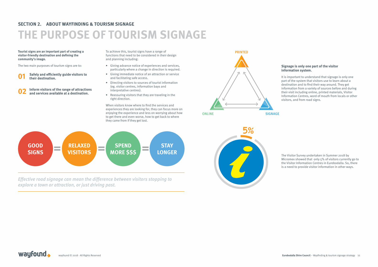
Signage is only one part of the visitor information system.
It is important to understand that signage is only one part of the system that visitors use to learn about a destination and to find their way around. They get information from a variety of sources before and during their visit including online, printed materials, Visitor Information Centres, word of mouth from locals or other visitors, and from road signs.
SECTION 2. ABOUT WAYFINDING & TOURISM SIGNAGE
SIGNAGE
PRINTED
ONLINE
THE PURPOSE OF TOURISM SIGNAGE
The Visitor Survey undertaken in Summer 2018 by Micromex showed that only 5% of visitors currently go to the Visitor Information Centres in Eurobodalla. So, there is a need to provide visitor information in other ways.
Tourist signs are an important part of creating a visitor-friendly destination and defining the community’s image.
The two main purposes of tourism signs are to:
01 Safely and efficiently guide visitors to their destination.
02 Inform visitors of the range of attractions and services available at a destination.
To achieve this, tourist signs have a range of functions that need to be considered in their design and planning including:
• Giving advance notice of experiences and services, particularly where a change in direction is required.
• Giving immediate notice of an attraction or service and facilitating safe access.
• Directing visitors to sources of tourist information (eg. visitor centres, information bays and interpretative centres).
• Reassuring visitors that they are traveling in the right direction.
When visitors know where to find the services and experiences they are looking for, they can focus more on enjoying the experience and less on worrying about how to get there and even worse, how to get back to where they came from if they get lost.
GOODSIGNS
RELAXEDVISITORS
SPENDMORE $$$
STAYLONGER
Effective road signage can mean the difference between visitors stopping to explore a town or attraction, or just driving past.

Eurobodalla Shire Council – Wayfinding & tourism signage strategywayfound © 2018 - All Rights Reserved 12
As in many other places in Australia, there is a belief amongst tourism operators in the Eurobodalla that road signage is a tool for marketing and promoting their business. This is at odds with the position of road authorities which is that signage is primarily for traffic management and motorist safety.
The community consultations indicated that signage needs to be reviewed to ensure it is appropriate, consistent and compliant. There were concerns about some locations that seem to have a proliferation of signs. Some think these end up looking cluttered and chaotic and do not fit with the image and vision Eurobodalla is trying to convey.
SECTION 2. ABOUT WAYFINDING & TOURISM SIGNAGE
THE PURPOSE OF TOURISM SIGNAGE
WHAT WE FOUND/WHAT WE HEARD
The underlying approach emphasised in the state and national signage guidelines is always to limit the number of signs approved and installed on the road network. This is to ensure road safety and to minimise clutter.
The RMS's view is that visitors plan their journey in advance and only key services that benefit the wider community should be signed from the Highway. Australian Standard (AS 1742.5:2017) states there are more effective ways for operators to assist people to reach their destination, including providing a clear address and a map on their printed and online materials. Most people now have access to online maps or GPS and this can frequently be used in place of signage if the address is clearly defined.
The National Tourism Signing Reference Group (NTSRG) document, Tourist Signing Rationalisation: A practical guide for road signing practitioners explains that the purpose of tourism signage is NOT to replace marketing and information provided by tourism businesses and destination.
The NTSRG guidelines specify that:
• A directional sign should be the last link in the communication chain between the business (or destination) and their customer.
• Almost all visitors to a destination arrive armed with some level of awareness and information. So, the primary signing need is directional, and not motivational.
• Visitors are initially motivated to visit a town, city or region because of preconceived knowledge about the destination. This may be acquired through a variety of means, but rarely because of road signage.
• Directional and reassurance signs simply confirm that they’re heading in the right direction.
Road signing to tourism attractions and services can be a contentious issue for road authorities. The cause of the tension is often the absence of clear, fair and equitable guidelines for the tourism industry. There is also a misperception by many operators that signs are promotional tools.
(source: NTSRG)
Blue services signs at Durras Beach
Eurobodalla Shire Council – Wayfinding & tourism signage strategywayfound © 2018 - All Rights Reserved 13
Wayfinding is about finding one’s way and relates to how a person orientates him/herself and navigates through an area or place. A wayfinding system is a unified series of related informational, advisory and directional aids to help visitors travel around successfully, safely and with confidence.
A good wayfinding system aims to answer the following basic questions.
• Where am I?• How do I get where I want to go?• What is the quickest route? The safest?
The most attractive?• How long will it take or how far is it?• Where can I find amenities I may need or want, such
as toilets, places to rest, places to eat, shopping or places of interest?
• Where can I get help or additional information?
The visitor needs a logical progression of orderly information, which becomes more detailed as they approach their destination.
Best practice for signage design is guided by the need to be coherent, conspicuous, legible and functional.
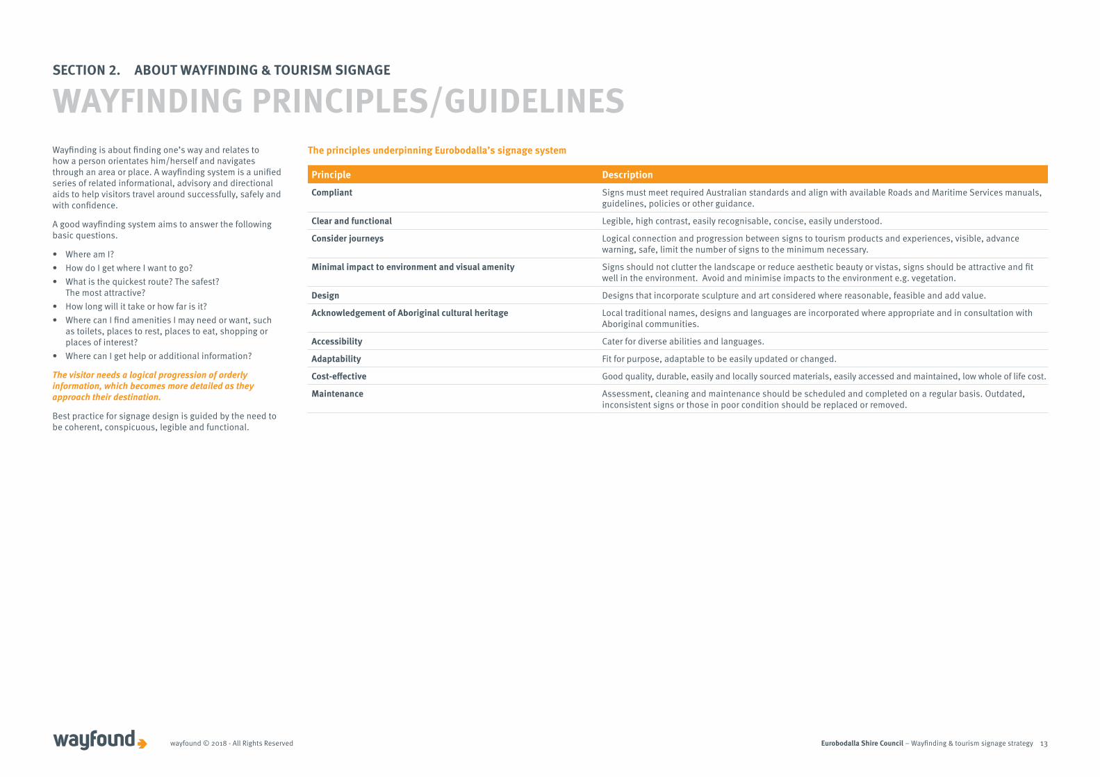
The principles underpinning Eurobodalla’s signage system
Principle Description
Compliant Signs must meet required Australian standards and align with available Roads and Maritime Services manuals, guidelines, policies or other guidance.
Clear and functional Legible, high contrast, easily recognisable, concise, easily understood.
Consider journeys Logical connection and progression between signs to tourism products and experiences, visible, advance warning, safe, limit the number of signs to the minimum necessary.
Minimal impact to environment and visual amenity Signs should not clutter the landscape or reduce aesthetic beauty or vistas, signs should be attractive and fit well in the environment. Avoid and minimise impacts to the environment e.g. vegetation.
Design Designs that incorporate sculpture and art considered where reasonable, feasible and add value.
Acknowledgement of Aboriginal cultural heritage Local traditional names, designs and languages are incorporated where appropriate and in consultation with Aboriginal communities.
Accessibility Cater for diverse abilities and languages.
Adaptability Fit for purpose, adaptable to be easily updated or changed.
Cost-effective Good quality, durable, easily and locally sourced materials, easily accessed and maintained, low whole of life cost.
Maintenance Assessment, cleaning and maintenance should be scheduled and completed on a regular basis. Outdated, inconsistent signs or those in poor condition should be replaced or removed.
SECTION 2. ABOUT WAYFINDING & TOURISM SIGNAGE
WAYFINDING PRINCIPLES/GUIDELINES
Eurobodalla Shire Council – Wayfinding & tourism signage strategywayfound © 2018 - All Rights Reserved 14
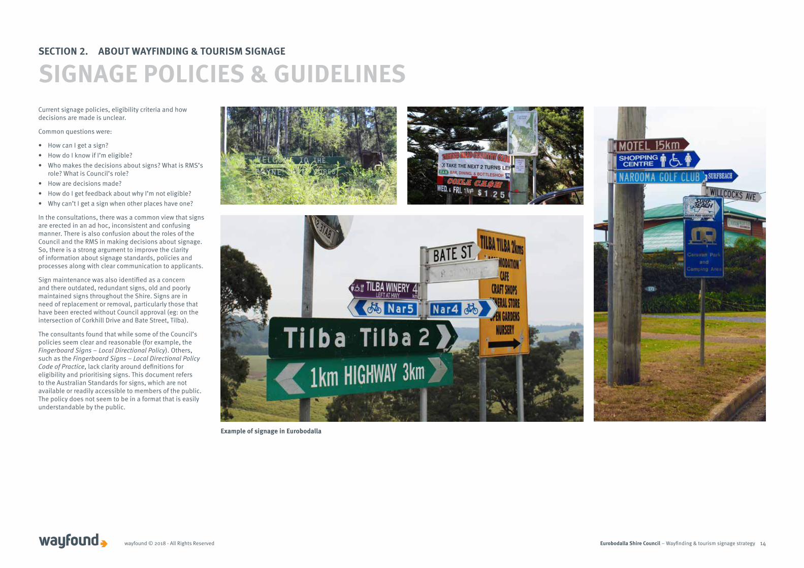
Current signage policies, eligibility criteria and how decisions are made is unclear.
Common questions were:
• How can I get a sign?• How do I know if I’m eligible?• Who makes the decisions about signs? What is RMS’s
role? What is Council’s role? • How are decisions made? • How do I get feedback about why I’m not eligible? • Why can’t I get a sign when other places have one?
In the consultations, there was a common view that signs are erected in an ad hoc, inconsistent and confusing manner. There is also confusion about the roles of the Council and the RMS in making decisions about signage. So, there is a strong argument to improve the clarity of information about signage standards, policies and processes along with clear communication to applicants.
Sign maintenance was also identified as a concern and there outdated, redundant signs, old and poorly maintained signs throughout the Shire. Signs are in need of replacement or removal, particularly those that have been erected without Council approval (eg: on the intersection of Corkhill Drive and Bate Street, Tilba).
The consultants found that while some of the Council’s policies seem clear and reasonable (for example, the Fingerboard Signs – Local Directional Policy). Others, such as the Fingerboard Signs – Local Directional Policy Code of Practice, lack clarity around definitions for eligibility and prioritising signs. This document refers to the Australian Standards for signs, which are not available or readily accessible to members of the public. The policy does not seem to be in a format that is easily understandable by the public.
SECTION 2. ABOUT WAYFINDING & TOURISM SIGNAGE
SIGNAGE POLICIES & GUIDELINES
Example of signage in Eurobodalla
Eurobodalla Shire Council – Wayfinding & tourism signage strategywayfound © 2018 - All Rights Reserved 15
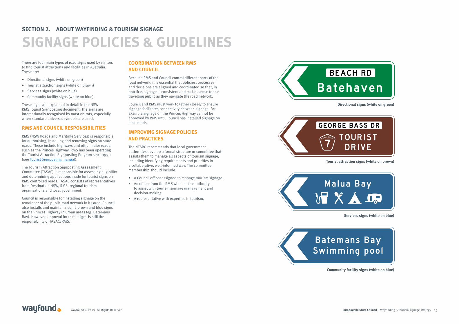
There are four main types of road signs used by visitors to find tourist attractions and facilities in Australia. These are:
• Directional signs (white on green)• Tourist attraction signs (white on brown)• Services signs (white on blue)• Community facility signs (white on blue)
These signs are explained in detail in the NSW RMS Tourist Signposting document. The signs are internationally recognised by most visitors, especially when standard universal symbols are used.
RMS AND COUNCIL RESPONSIBILITIESRMS (NSW Roads and Maritime Services) is responsible for authorising, installing and removing signs on state roads. These include highways and other major roads, such as the Princes Highway. RMS has been operating the Tourist Attraction Signposting Program since 1990 (see Tourist Signposting manual).
The Tourism Attraction Signposting Assessment Committee (TASAC) is responsible for assessing eligibility and determining applications made for tourist signs on RMS controlled roads. TASAC consists of representatives from Destination NSW, RMS, regional tourism organisations and local government.
Council is responsible for installing signage on the remainder of the public road network in its area. Council also installs and maintains some brown and blue signs on the Princes Highway in urban areas (eg: Batemans Bay). However, approval for these signs is still the responsibility of TASAC/RMS.
COORDINATION BETWEEN RMS AND COUNCIL Because RMS and Council control different parts of the road network, it is essential that policies, processes and decisions are aligned and coordinated so that, in practice, signage is consistent and makes sense to the travelling public as they navigate the road network.
Council and RMS must work together closely to ensure signage facilitates connectivity between signage. For example signage on the Princes Highway cannot be approved by RMS until Council has installed signage on local roads.
IMPROVING SIGNAGE POLICIES AND PRACTICES The NTSRG recommends that local government authorities develop a formal structure or committee that assists them to manage all aspects of tourism signage, including identifying requirements and priorities in a collaborative, well-informed way. The committee membership should include:
• A Council officer assigned to manage tourism signage.• An officer from the RMS who has the authority
to assist with tourism signage management and decision-making.
• A representative with expertise in tourism.
SECTION 2. ABOUT WAYFINDING & TOURISM SIGNAGE
SIGNAGE POLICIES & GUIDELINES
Directional signs (white on green)
Tourist attraction signs (white on brown)
Services signs (white on blue)
Community facility signs (white on blue)
Eurobodalla Shire Council – Wayfinding & tourism signage strategywayfound © 2018 - All Rights Reserved 16
Recommendation 1
Review Council’s signage policies and practices to:
• Align with the purpose and principles of tourism signage outlined in the Strategy.
• Ensure the policies are easily understood.• Include a program of regular inspection and
maintenance.
Recommendation 2
Conduct annual audits of fingerboards signs against Council’s Fingerboards Signs Policy and progressively remove signage that is not compliant.
Recommendation 3
Communicate with tourism businesses and operators to clarify the purpose of signage and alternative methods that are effective in helping visitors become aware of and how to find their business.
SECTION 2. ABOUT WAYFINDING & TOURISM SIGNAGE
RECOMMENDATIONS/ACTIONS
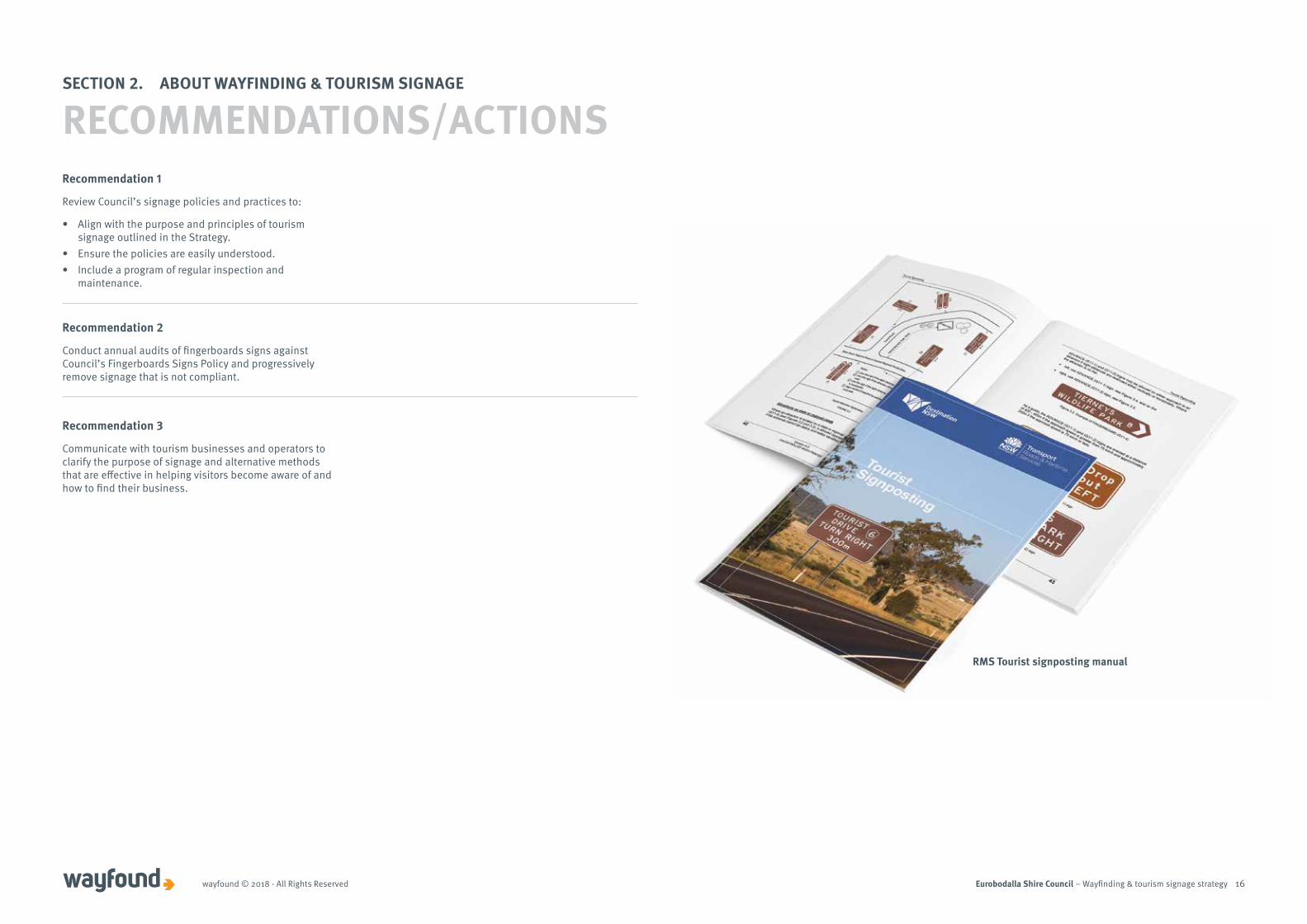
RMS Tourist signposting manual

Eurobodalla Shire Council – Wayfinding & tourism signage strategy 17
SECTION 3. THE ROAD SIGNAGE SYSTEM

Eurobodalla Shire Council – Wayfinding & tourism signage strategywayfound © 2018 - All Rights Reserved 18
This section provides background information on the road sign types along with policies and guidelines as they relate to tourism.
Promotional Billboards
Shire Entry Statements
Town Entry Statements
Visitor Information Boards (VIBs)
Temporary/Event
Interpretive Panels
Green Directional
Road signage Destination Signage
Brown Tourism
Blue Services
SECTION 3. THE ROAD SIGNAGE SYSTEM
TOURISM SIGNAGE SYSTEM
Example of tourism signage in Eurobodalla

Eurobodalla Shire Council – Wayfinding & tourism signage strategywayfound © 2018 - All Rights Reserved 19
Directional signs use white lettering on a green background. They provide directions to towns and cities and particular locations. Most include reference to a route numbering system or road name. They reassure motorists that they are travelling in the right direction, and facilitate traffic movement in the safest and most direct way.
SECTION 3. THE ROAD SIGNAGE SYSTEMSECTION 3.1 Green - Directional Road Signs
BACKGROUND
In general, green signs were found to be functional and clear throughout the Shire.
Green directional signs are subject to the Austroads Guides (Guide to Traffic Management) and Australian Standards (AS 1742, 1743 & 2890), which the RMS adopted in 2011 as its primary technical reference for directional signs.
None
WHAT WE FOUND/WHAT WE HEARD
PRINCIPLES/GUIDELINES
RECOMMENDATIONS/ACTIONS
Positional
Reassurance Advance Warning
Directional
Intersection
Eurobodalla Shire Council – Wayfinding & tourism signage strategywayfound © 2018 - All Rights Reserved 20
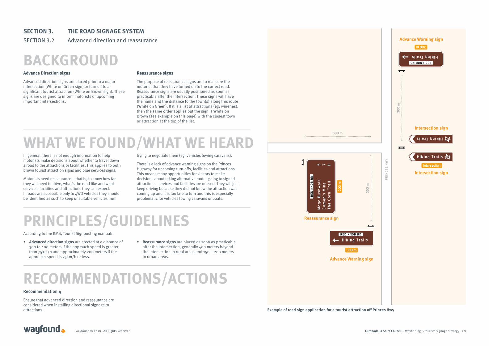
Advance Direction signs
Advanced direction signs are placed prior to a major intersection (White on Green sign) or turn off to a significant tourist attraction (White on Brown sign). These signs are designed to inform motorists of upcoming important intersections.
Reassurance signs
The purpose of reassurance signs are to reassure the motorist that they have turned on to the correct road.Reassurance signs are usually positioned as soon as practicable after the intersection. These signs will have the name and the distance to the town(s) along this route (White on Green). If it is a list of attractions (eg: wineries), then the same order applies but the sign is White on Brown (see example on this page) with the closest town or attraction at the top of the list.
Mo
go
Bu
shw
alk
Co
ma
n’s
Min
eT
he
Co
rn T
rail
5 7 11
RE
D K
NO
B R
D
H iking Trai ls
RED KNOB RD
300 m
Hiking Trails
Hiking Trai ls
Intersection
30
0 m
Hiking Trails
RED KNOB RD
300 m
30
0 m
300 m
30
0 m
PR
INC
ES
HW
Y
Advance Warning sign
Reassurance sign
Intersection sign
Intersection sign
Advance Warning sign
Example of road sign application for a tourist attraction off Princes Hwy
In general, there is not enough information to help motorists make decisions about whether to travel down a road to the attractions or facilities. This applies to both brown tourist attraction signs and blue services signs.
Motorists need reassurance – that is, to know how far they will need to drive, what’s the road like and what services, facilities and attractions they can expect. If roads are accessible only to 4WD vehicles they should be identified as such to keep unsuitable vehicles from
trying to negotiate them (eg: vehicles towing caravans).
There is a lack of advance warning signs on the Princes Highway for upcoming turn-offs, facilities and attractions. This means many opportunities for visitors to make decisions about taking alternative routes going to signed attractions, services and facilities are missed. They will just keep driving because they did not know the attraction was coming up and it is too late to turn and this is especially problematic for vehicles towing caravans or boats.
WHAT WE FOUND/WHAT WE HEARD
Recommendation 4
Ensure that advanced direction and reassurance are considered when installing directional signage to attractions.
RECOMMENDATIONS/ACTIONS
According to the RMS, Tourist Signposting manual:
• Advanced direction signs are erected at a distance of 300 to 400 meters if the approach speed is greater than 75km/h and approximately 200 meters if the approach speed is 75km/h or less.
• Reassurance signs are placed as soon as practicable after the intersection, generally 400 meters beyond the intersection in rural areas and 150 – 200 meters in urban areas.
PRINCIPLES/GUIDELINES
SECTION 3. THE ROAD SIGNAGE SYSTEMSECTION 3.2 Advanced direction and reassurance
BACKGROUND
Eurobodalla Shire Council – Wayfinding & tourism signage strategywayfound © 2018 - All Rights Reserved 21
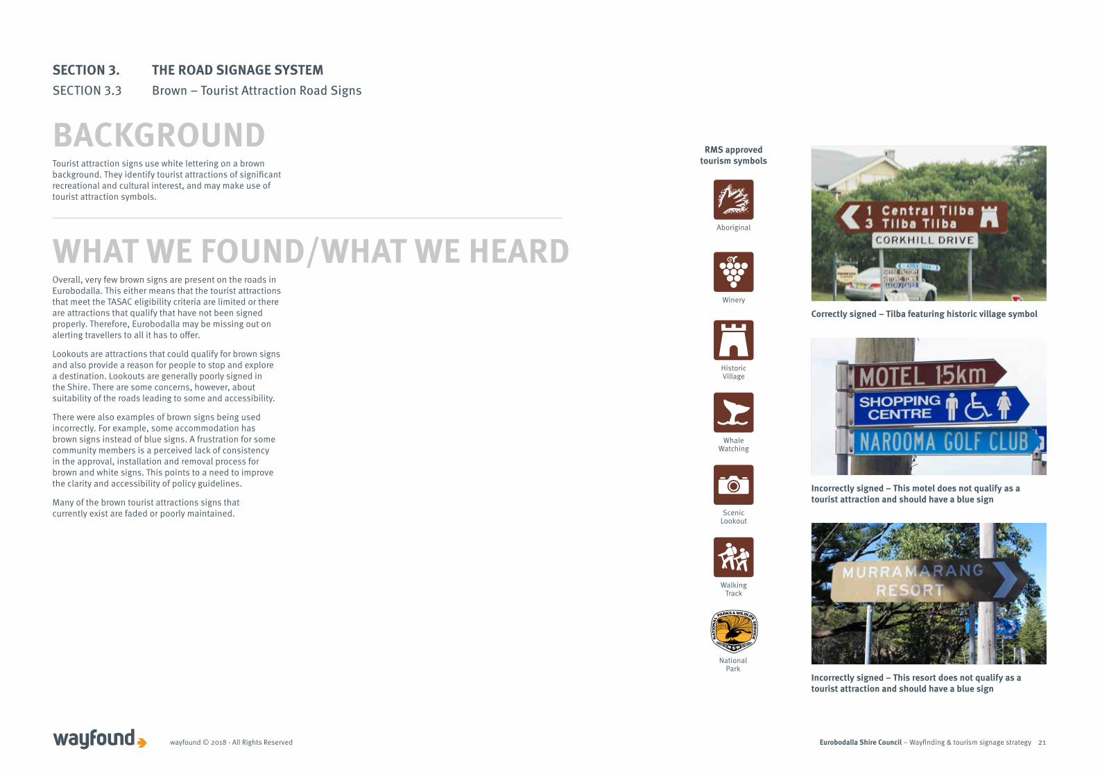
Tourist attraction signs use white lettering on a brown background. They identify tourist attractions of significant recreational and cultural interest, and may make use of tourist attraction symbols.
Overall, very few brown signs are present on the roads in Eurobodalla. This either means that the tourist attractions that meet the TASAC eligibility criteria are limited or there are attractions that qualify that have not been signed properly. Therefore, Eurobodalla may be missing out on alerting travellers to all it has to offer.
Lookouts are attractions that could qualify for brown signs and also provide a reason for people to stop and explore a destination. Lookouts are generally poorly signed in the Shire. There are some concerns, however, about suitability of the roads leading to some and accessibility.
There were also examples of brown signs being used incorrectly. For example, some accommodation has brown signs instead of blue signs. A frustration for some community members is a perceived lack of consistency in the approval, installation and removal process for brown and white signs. This points to a need to improve the clarity and accessibility of policy guidelines.
Many of the brown tourist attractions signs that currently exist are faded or poorly maintained.
WHAT WE FOUND/WHAT WE HEARDAboriginal
Winery
Historic Village
Whale Watching
Scenic Lookout
Walking Track
Aboriginal
Historic Village
Whale Watching
Walking Track
Scenic Lookout
Winery
National Park National Park
Incorrectly signed – This resort does not qualify as a tourist attraction and should have a blue sign
Incorrectly signed – This motel does not qualify as a tourist attraction and should have a blue sign
Correctly signed – Tilba featuring historic village symbol
RMS approved tourism symbols
SECTION 3. THE ROAD SIGNAGE SYSTEMSECTION 3.3 Brown – Tourist Attraction Road Signs
BACKGROUND
Eurobodalla Shire Council – Wayfinding & tourism signage strategywayfound © 2018 - All Rights Reserved 22
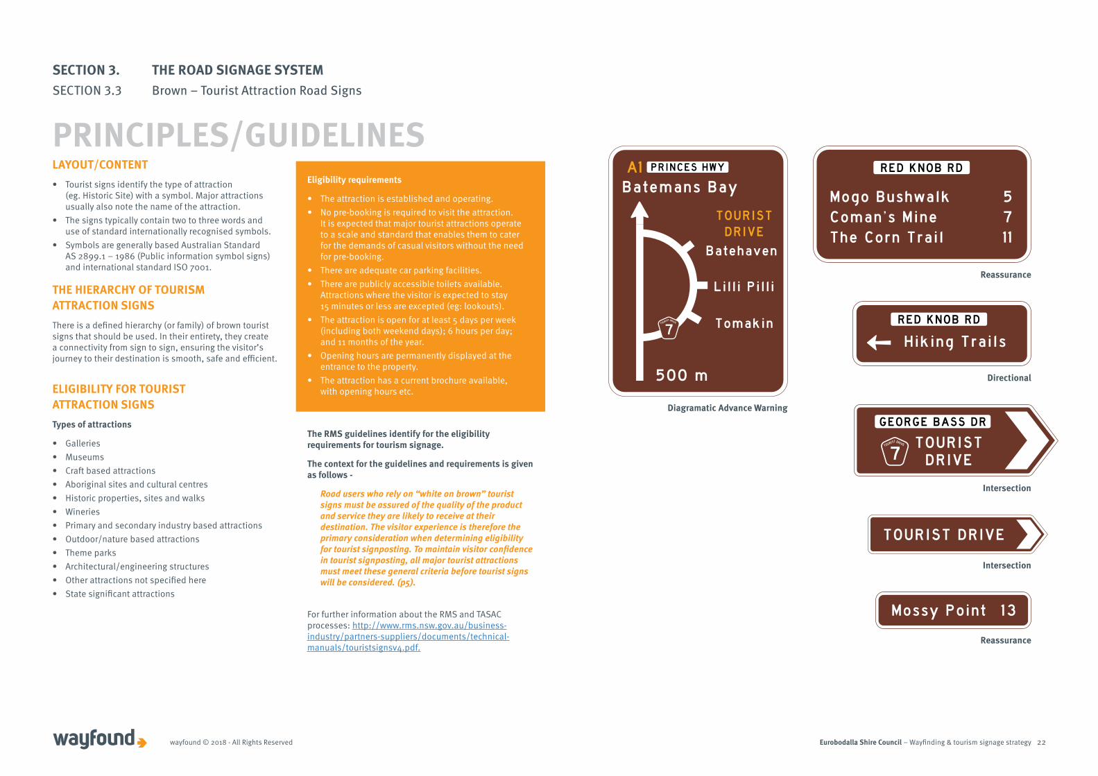
LAYOUT/CONTENT• Tourist signs identify the type of attraction
(eg. Historic Site) with a symbol. Major attractions usually also note the name of the attraction.
• The signs typically contain two to three words and use of standard internationally recognised symbols.
• Symbols are generally based Australian Standard AS 2899.1 – 1986 (Public information symbol signs) and international standard ISO 7001.
THE HIERARCHY OF TOURISM ATTRACTION SIGNS There is a defined hierarchy (or family) of brown tourist signs that should be used. In their entirety, they create a connectivity from sign to sign, ensuring the visitor’s journey to their destination is smooth, safe and efficient.
ELIGIBILITY FOR TOURIST ATTRACTION SIGNS Types of attractions
• Galleries• Museums• Craft based attractions• Aboriginal sites and cultural centres• Historic properties, sites and walks• Wineries• Primary and secondary industry based attractions• Outdoor/nature based attractions• Theme parks• Architectural/engineering structures• Other attractions not specified here• State significant attractions
Eligibility requirements
• The attraction is established and operating.• No pre-booking is required to visit the attraction.
It is expected that major tourist attractions operate to a scale and standard that enables them to cater for the demands of casual visitors without the need for pre-booking.
• There are adequate car parking facilities. • There are publicly accessible toilets available.
Attractions where the visitor is expected to stay 15 minutes or less are excepted (eg: lookouts).
• The attraction is open for at least 5 days per week (including both weekend days); 6 hours per day; and 11 months of the year.
• Opening hours are permanently displayed at the entrance to the property.
• The attraction has a current brochure available, with opening hours etc.
The RMS guidelines identify for the eligibility requirements for tourism signage.
The context for the guidelines and requirements is given as follows -
Road users who rely on “white on brown” tourist signs must be assured of the quality of the product and service they are likely to receive at their destination. The visitor experience is therefore the primary consideration when determining eligibility for tourist signposting. To maintain visitor confidence in tourist signposting, all major tourist attractions must meet these general criteria before tourist signs will be considered. (p5).
For further information about the RMS and TASAC processes: http://www.rms.nsw.gov.au/business-industry/partners-suppliers/documents/technical-manuals/touristsignsv4.pdf.
Reassurance
Directional
Intersection
Intersection
Reassurance
Diagramatic Advance Warning
SECTION 3. THE ROAD SIGNAGE SYSTEMSECTION 3.3 Brown – Tourist Attraction Road Signs
PRINCIPLES/GUIDELINES
Eurobodalla Shire Council – Wayfinding & tourism signage strategywayfound © 2018 - All Rights Reserved 23
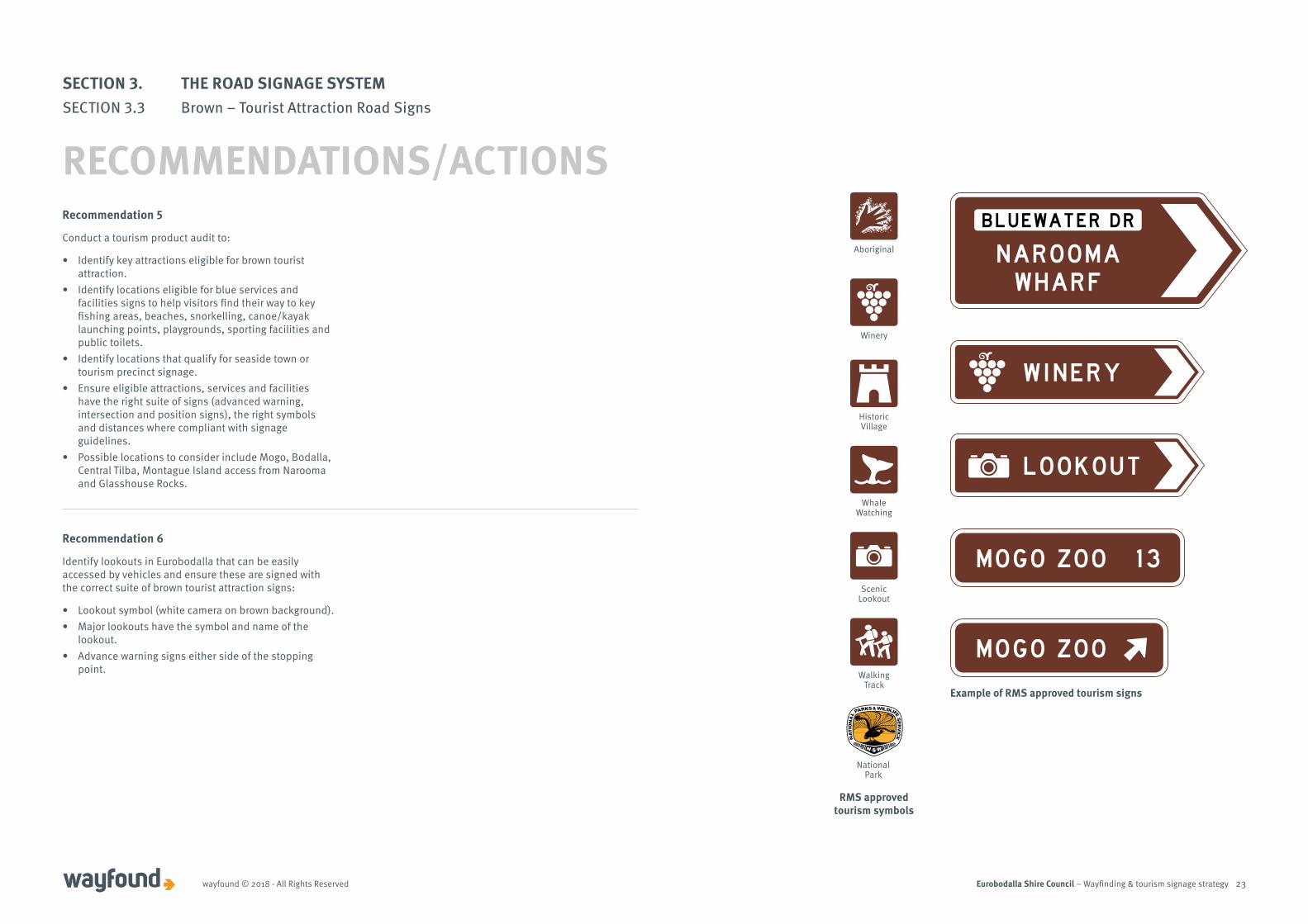
Recommendation 5
Conduct a tourism product audit to:
• Identify key attractions eligible for brown tourist attraction.
• Identify locations eligible for blue services and facilities signs to help visitors find their way to key fishing areas, beaches, snorkelling, canoe/kayak launching points, playgrounds, sporting facilities and public toilets.
• Identify locations that qualify for seaside town or tourism precinct signage.
• Ensure eligible attractions, services and facilities have the right suite of signs (advanced warning, intersection and position signs), the right symbols and distances where compliant with signage guidelines.
• Possible locations to consider include Mogo, Bodalla, Central Tilba, Montague Island access from Narooma and Glasshouse Rocks.
Recommendation 6
Identify lookouts in Eurobodalla that can be easily accessed by vehicles and ensure these are signed with the correct suite of brown tourist attraction signs:
• Lookout symbol (white camera on brown background).• Major lookouts have the symbol and name of the
lookout. • Advance warning signs either side of the stopping
point.
Aboriginal
Winery
Historic Village
Whale Watching
Scenic Lookout
Walking Track
Aboriginal
Historic Village
Whale Watching
Walking Track
Scenic Lookout
Winery
National Park National Park
RMS approved tourism symbols
Example of RMS approved tourism signs
SECTION 3. THE ROAD SIGNAGE SYSTEMSECTION 3.3 Brown – Tourist Attraction Road Signs
RECOMMENDATIONS/ACTIONS
Eurobodalla Shire Council – Wayfinding & tourism signage strategywayfound © 2018 - All Rights Reserved 24
Importantly, the purpose of signs in this category is to inform road users about the services that are available at a destination rather than to promote particular towns or businesses.
SPECIFIC CRITERIA To be eligible for tourist signposting the “seaside” town / village must meet the following criteria:
Note: RMS is currently reviewing its signage guidelines. The guidelines in this Strategy will be updated to reflect any changes to the RMS guidelines.
• Located off the major traffic corridor. Signs in this category are intended to inform road users about the services available on a terminating route some distance away from the main traffic route. Only those destinations that are at the end of terminating roads, and not towns/villages located on through-routes, are eligible for tourist signposting under this category.
• Located on the coast. Generally, terminating roads are a feature of coastal destinations, where towns/villages are commonly served by only one road in and out.
• Provides a range of services for visitors. As a minimum, eligible towns/villages are expected to provide a range of facilities and services that visitors can access, including accommodation, food and fuel.
Source: http://www.rms.nsw.gov.au/business-industry/partners-suppliers/documents/technical-manuals/touristsignsv4.pdf. Page 25-27.
PRINCIPLES/GUIDELINES
WHAT WE FOUND/WHAT WE HEARD
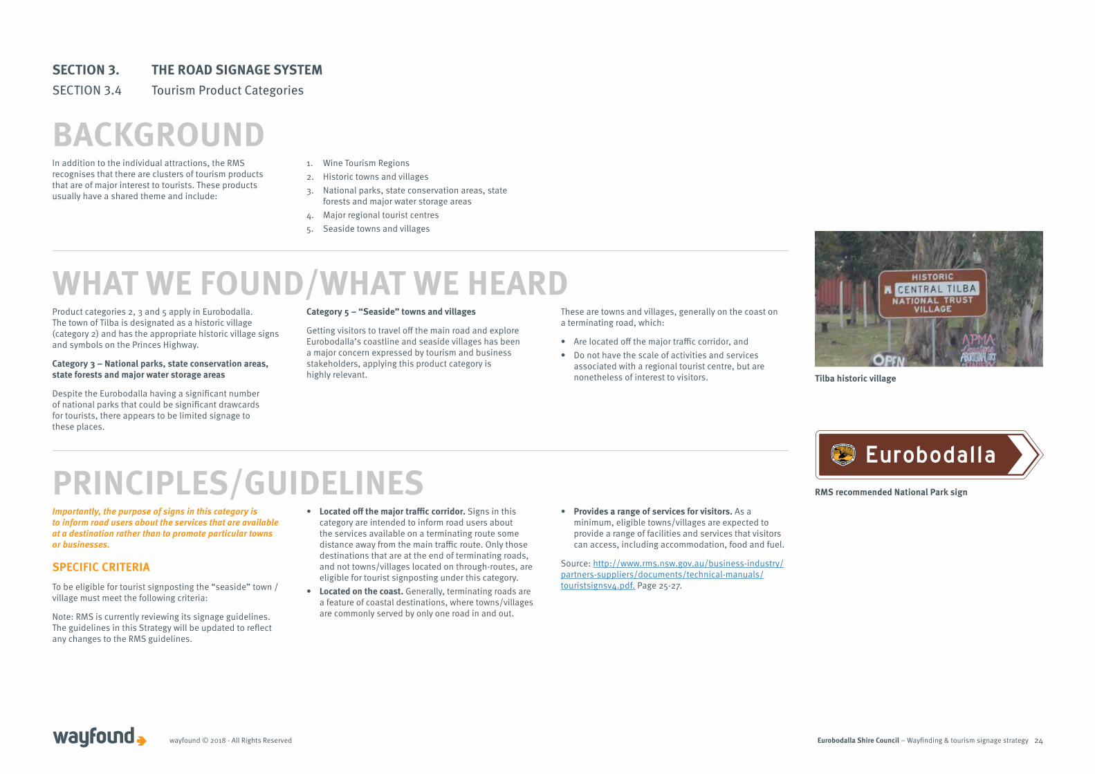
Tilba historic village
RMS recommended National Park sign
In addition to the individual attractions, the RMS recognises that there are clusters of tourism products that are of major interest to tourists. These products usually have a shared theme and include:
1. Wine Tourism Regions 2. Historic towns and villages 3. National parks, state conservation areas, state
forests and major water storage areas4. Major regional tourist centres5. Seaside towns and villages
Product categories 2, 3 and 5 apply in Eurobodalla. The town of Tilba is designated as a historic village (category 2) and has the appropriate historic village signs and symbols on the Princes Highway.
Category 3 – National parks, state conservation areas, state forests and major water storage areas
Despite the Eurobodalla having a significant number of national parks that could be significant drawcards for tourists, there appears to be limited signage to these places.
Category 5 – “Seaside” towns and villages
Getting visitors to travel off the main road and explore Eurobodalla’s coastline and seaside villages has been a major concern expressed by tourism and business stakeholders, applying this product category is highly relevant.
These are towns and villages, generally on the coast on a terminating road, which:
• Are located off the major traffic corridor, and • Do not have the scale of activities and services
associated with a regional tourist centre, but are nonetheless of interest to visitors.
Eurobodalla
SECTION 3. THE ROAD SIGNAGE SYSTEMSECTION 3.4 Tourism Product Categories
BACKGROUND

Eurobodalla Shire Council – Wayfinding & tourism signage strategywayfound © 2018 - All Rights Reserved 25
Recommendation 7
Council work with relevant agencies (eg NSW forest and National Parks and Wildlife Services) to improve directional signage to:
• National parks and conservation areas• State forests• Mountain bike trails• Major water storage areas• Walking tracks
Seaside town advance warning sign
SECTION 3. THE ROAD SIGNAGE SYSTEMSECTION 3.4 Tourism Product Categories
RECOMMENDATIONS/ACTIONS
Eurobodalla Shire Council – Wayfinding & tourism signage strategywayfound © 2018 - All Rights Reserved 26
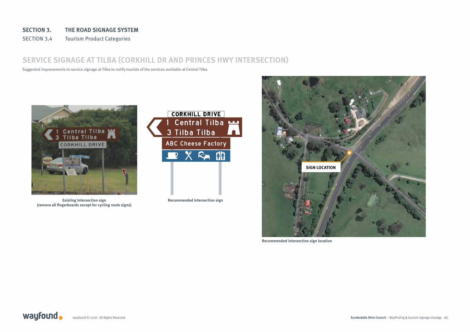
CORKHILL DRIVE
1 Central Tilba3 Tilba TilbaABC Cheese Factory
Suggested improvements to service signage at Tilba to notify tourists of the services available at Central Tilba
Existing intersection sign (remove all fingerboards except for cycling route signs)
Recommended intersection sign
Recommended intersection sign location
SERVICE SIGNAGE AT TILBA (CORKHILL DR AND PRINCES HWY INTERSECTION)
SIGN LOCATION
SECTION 3. THE ROAD SIGNAGE SYSTEMSECTION 3.4 Tourism Product Categories
Eurobodalla Shire Council – Wayfinding & tourism signage strategywayfound © 2018 - All Rights Reserved 27
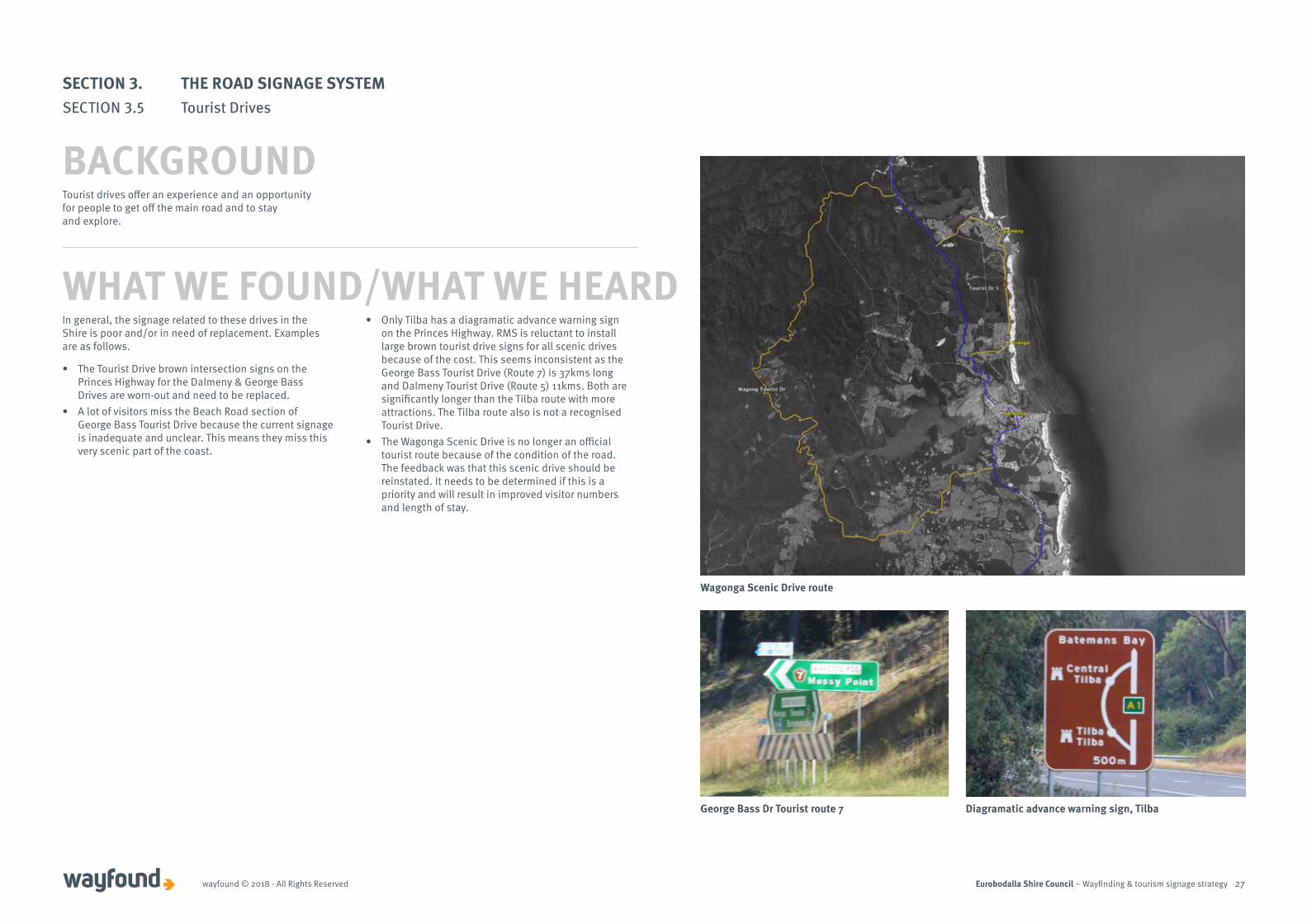
Tourist drives offer an experience and an opportunity for people to get off the main road and to stay and explore.
In general, the signage related to these drives in the Shire is poor and/or in need of replacement. Examples are as follows.
• The Tourist Drive brown intersection signs on the Princes Highway for the Dalmeny & George Bass Drives are worn-out and need to be replaced.
• A lot of visitors miss the Beach Road section of George Bass Tourist Drive because the current signage is inadequate and unclear. This means they miss this very scenic part of the coast.
• Only Tilba has a diagramatic advance warning sign on the Princes Highway. RMS is reluctant to install large brown tourist drive signs for all scenic drives because of the cost. This seems inconsistent as the George Bass Tourist Drive (Route 7) is 37kms long and Dalmeny Tourist Drive (Route 5) 11kms. Both are significantly longer than the Tilba route with more attractions. The Tilba route also is not a recognised Tourist Drive.
• The Wagonga Scenic Drive is no longer an official tourist route because of the condition of the road. The feedback was that this scenic drive should be reinstated. It needs to be determined if this is a priority and will result in improved visitor numbers and length of stay.
WHAT WE FOUND/WHAT WE HEARD
Wagonga Scenic Drive route
George Bass Dr Tourist route 7 Diagramatic advance warning sign, Tilba
SECTION 3. THE ROAD SIGNAGE SYSTEMSECTION 3.5 Tourist Drives
BACKGROUND
Eurobodalla Shire Council – Wayfinding & tourism signage strategywayfound © 2018 - All Rights Reserved 28
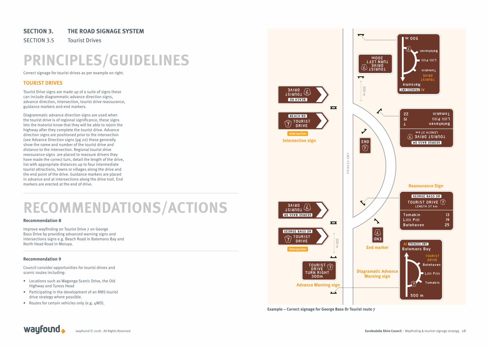
Correct signage for tourist drives as per example on right.
TOURIST DRIVESTourist Drive signs are made up of a suite of signs these can include diagrammatic advance direction signs, advance direction, intersection, tourist drive reassurance, guidance markers and end markers.
Diagrammatic advance direction signs are used when the tourist drive is of regional significance, these signs lets the motorist know that they will be able to rejoin the highway after they complete the tourist drive. Advance direction signs are positioned prior to the intersection (see Advance Direction signs (pg 20) these generally show the name and number of the tourist drive and distance to the intersection. Regional tourist drive reassurance signs are placed to reassure drivers they have made the correct turn, detail the length of the drive, list with appropriate distances up to four intermediate tourist attractions, towns or villages along the drive and the end point of the drive. Guidance markers are placed in advance and at intersections along the drive trail. End markers are erected at the end of drive.
30
0 m
30
0 m
BatehavenLilli PilliTomakin
LENGTH 37 km
715
22
GEORGE BASS DR
TOURIST DRIVE7
TOURISTDRIVE
TURN LEFT300m
7
TOURISTDRIVE
TURN RIGHT300m
7
TomakinLil l i Pi l lBatehaven
LENGTH 37 km
1319
25
GEORGE BASS DR
TOURIST DRIVE 7
END
7
END
7
PRINCES HWY A1Narooma
TOURISTDRIVE
500 m
Batehaven
Lilli Pilli
Tomakin
7
PRINCES HWYA1Batemans Bay
TOURISTDRIVE
500 m
Batehaven
Lil l i Pi l l i
Tomakin7
TOURISTDRIVE
BEACH RD
7
TOURISTDRIVE
BEACH RD
7
Intersection
IntersectionTOURIST
DRIVE
GEORGE BASS DR
7
TOURISTDRIVE
GEORGE BASS DR
7
PR
INC
ES
HW
Y
Example – Correct signage for George Bass Dr Tourist route 7
Recommendation 8
Improve wayfinding on Tourist Drive 7 on George Bass Drive by providing advanced warning signs and intersections signs e.g. Beach Road in Batemans Bay and North Head Road in Moruya.
RECOMMENDATIONS/ACTIONS
Reassurance Sign
Intersection sign
End marker
Diagramatic Advance Warning sign
Advance Warning sign
SECTION 3. THE ROAD SIGNAGE SYSTEMSECTION 3.5 Tourist Drives
PRINCIPLES/GUIDELINES
Recommendation 9
Council consider opportunities for tourist drives and scenic routes including:
• Locations such as Wagonga Scenic Drive, the Old Highway and Tuross Head
• Participating in the development of an RMS tourist drive strategy where possible.
• Routes for certain vehicles only (e.g. 4WD).
Eurobodalla Shire Council – Wayfinding & tourism signage strategywayfound © 2018 - All Rights Reserved 29
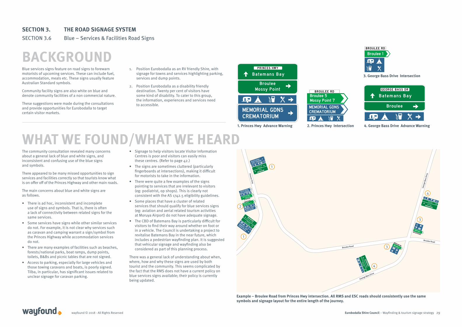
The community consultation revealed many concerns about a general lack of blue and white signs, and inconsistent and confusing use of the blue signs and symbols.
There appeared to be many missed opportunities to sign services and facilities correctly so that tourists know what is on offer off of the Princes Highway and other main roads.
The main concerns about blue and white signs are as follows.
• There is ad hoc, inconsistent and incomplete use of signs and symbols. That is, there is often a lack of connectivity between related signs for the same services.
• Some services have signs while other similar services do not. For example, it is not clear why services such as caravan and camping warrant a sign/symbol from the Princes Highway while accommodation services do not.
• There are many examples of facilities such as beaches, forests/national parks, boat ramps, dump points, toilets, B&Bs and picnic tables that are not signed.
• Access to parking, especially for large vehicles and those towing caravans and boats, is poorly signed. Tilba, in particular, has significant issues related to unclear signage for caravan parking.
• Signage to help visitors locate Visitor Information Centres is poor and visitors can easily miss these centres. (Refer to page 42.)
• The signs are sometimes cluttered (particularly fingerboards at intersections), making it difficult for motorists to take in the information.
• There were quite a few examples of the signs pointing to services that are irrelevant to visitors (eg: podiatrist, op shops). This is clearly not consistent with the AS 1742.5 eligibility guidelines.
• Some places that have a cluster of related services that should qualify for blue services signs (eg: aviation and aerial related tourism activities at Moruya Airport) do not have adequate signage.
• The CBD of Batemans Bay is particularly difficult for visitors to find their way around whether on foot or in a vehicle. The Council is undertaking a project to revitalise Batemans Bay in the near future, which includes a pedestrian wayfinding plan. It is suggested that vehicular signage and wayfinding also be considered as part of this planning process.
There was a general lack of understanding about when, where, how and why these signs are used by both tourist and the community. This seems complicated by the fact that the RMS does not have a current policy on blue services signs available; their policy is currently being updated.
WHAT WE FOUND/WHAT WE HEARD
Broulee
Batemans Bay
GEORGE BASS DR
Broulee
Moruya
GEORGE BASS DRBROULEE RD BROULEE RD
5 Broulee7 Mossy Point
MEMORIAL GDNSCREMATORIUM
MEMORIAL GDNSCREMATORIUM
Broulee 5 Mossy Point 7
BROULEE RD
Broulee 1
BrouleeMossy Point
Bega
MEMORIAL GDNSCREMATORIUM
PRINCES HWY
BrouleeMossy Point
Batemans Bay
MEMORIAL GDNSCREMATORIUM
PRINCES HWY
1. Princes Hwy Advance Warning 2. Princes Hwy Intersection 4. George Bass Drive Advance Warning
3. George Bass Drive Intersection
BROULEE RD
5 Broulee
7 Mossy Point
MEMORIAL GDNS
CREMATORIUM
BROULEE RD
MEMORIAL GDNS
CREMATORIUM
Broulee 5
Mossy Point 7
Broulee
Mossy Point
Bega
MEMORIAL GDNS
CREMATORIUM
PRINCES HWY
BrouleeMossy Point
Batemans BayMEMORIAL GDNS
CREMATORIUM
PRINCES HWY
Broulee
Batem
ans Bay
GE
OR
GE
BA
SS
DR
Broulee
Moruya
GEORGE BASS DR
BROULEE RDBroulee 1
BROULEE RD 1 Broulee
Broulee Road
Princes Hw
y
George Bass Drive
Geo
rge
Bass
Driv
e
Broulee Road
Example – Broulee Road from Princes Hwy intersection. All RMS and ESC roads should consistently use the same symbols and signage layout for the entire length of the journey.
1
1
2
4
4
3
3
Blue services signs feature on road signs to forewarn motorists of upcoming services. These can include fuel, accommodation, meals etc. These signs usually feature Australian Standard symbols.
Community facility signs are also white on blue and denote community facilities of a non commercial nature.
These suggestions were made during the consultations and provide opportunities for Eurobodalla to target certain visitor markets.
1. Position Eurobodalla as an RV friendly Shire, with signage for towns and services highlighting parking, services and dump points.
2. Position Eurobodalla as a disability friendly destination. Twenty per cent of visitors have some kind of disability. To cater to this group, the information, experiences and services need to accessible.
SECTION 3. THE ROAD SIGNAGE SYSTEMSECTION 3.6 Blue – Services & Facilities Road Signs
BACKGROUND
Eurobodalla Shire Council – Wayfinding & tourism signage strategywayfound © 2018 - All Rights Reserved 30
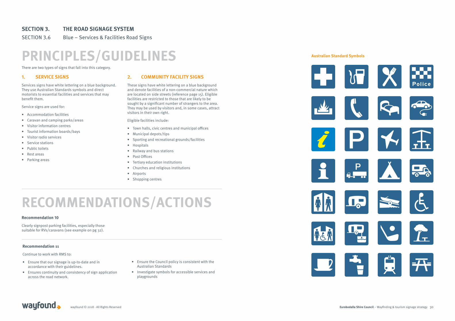
There are two types of signs that fall into this category.
1. SERVICE SIGNSServices signs have white lettering on a blue background. They use Australian Standards symbols and direct motorists to essential facilities and services that may benefit them.
Service signs are used for:
• Accommodation facilities• Caravan and camping parks/areas• Visitor information centres• Tourist information boards/bays• Visitor radio services• Service stations• Public toilets• Rest areas• Parking areas
2. COMMUNITY FACILITY SIGNS These signs have white lettering on a blue background and denote facilities of a non-commercial nature which are located on side streets (reference page 15). Eligible facilities are restricted to those that are likely to be sought by a significant number of strangers to the area. They may be used by visitors and, in some cases, attract visitors in their own right.
Eligible facilities include:
• Town halls, civic centres and municipal offices• Municipal depots/tips• Sporting and recreational grounds/facilities• Hospitals• Railway and bus stations• Post Offices• Tertiary education institutions• Churches and religious institutions• Airports• Shopping centres
RECOMMENDATIONS/ACTIONS
Australian Standard Symbols
SECTION 3. THE ROAD SIGNAGE SYSTEMSECTION 3.6 Blue – Services & Facilities Road Signs
PRINCIPLES/GUIDELINES
Recommendation 10
Clearly signpost parking facilities, especially those suitable for RVs/caravans (see example on pg 32).
Recommendation 11
Continue to work with RMS to:
• Ensure that our signage is up-to-date and in accordance with their guidelines.
• Ensures continuity and consistency of sign application across the road network.
• Ensure the Council policy is consistent with the Australian Standards
• Investigate symbols for accessible services and playgrounds
Eurobodalla Shire Council – Wayfinding & tourism signage strategywayfound © 2018 - All Rights Reserved 31
To DENHAM AVE
GRAYDON AVEDenhams Beach
MYSTERY BAY RD2 Mystery Bay
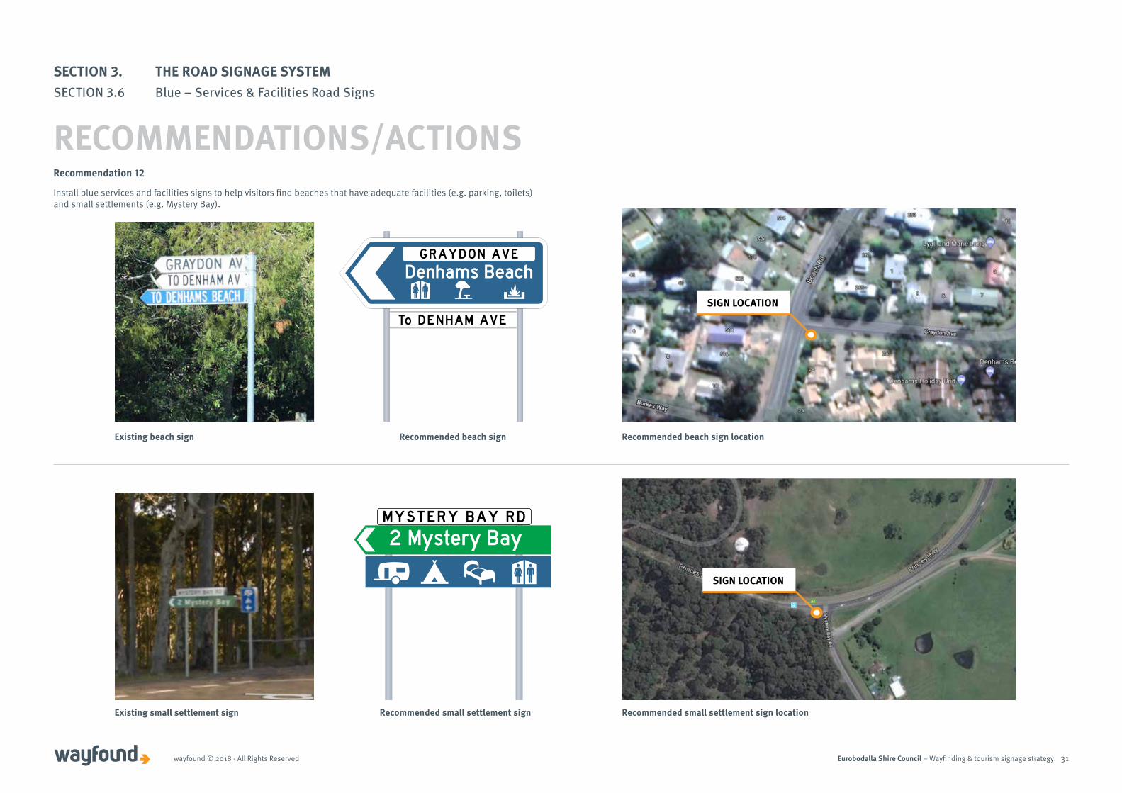
Recommendation 12
Install blue services and facilities signs to help visitors find beaches that have adequate facilities (e.g. parking, toilets) and small settlements (e.g. Mystery Bay).
Existing beach sign
Existing small settlement sign
Recommended beach sign
Recommended small settlement sign
SIGN LOCATION
SIGN LOCATION
SECTION 3. THE ROAD SIGNAGE SYSTEMSECTION 3.6 Blue – Services & Facilities Road Signs
RECOMMENDATIONS/ACTIONS
Recommended beach sign location
Recommended small settlement sign location
Eurobodalla Shire Council – Wayfinding & tourism signage strategywayfound © 2018 - All Rights Reserved 32
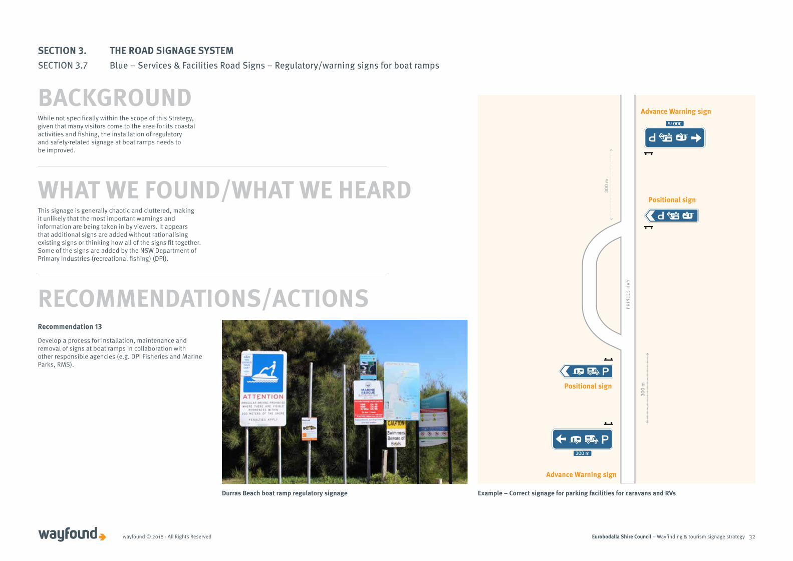
While not specifically within the scope of this Strategy, given that many visitors come to the area for its coastal activities and fishing, the installation of regulatory and safety-related signage at boat ramps needs to be improved.
This signage is generally chaotic and cluttered, making it unlikely that the most important warnings and information are being taken in by viewers. It appears that additional signs are added without rationalising existing signs or thinking how all of the signs fit together. Some of the signs are added by the NSW Department of Primary Industries (recreational fishing) (DPI).
Recommendation 13
Develop a process for installation, maintenance and removal of signs at boat ramps in collaboration with other responsible agencies (e.g. DPI Fisheries and Marine Parks, RMS).
300 m
30
0 m
30
0 m
300 m
PR
INC
ES
HW
Y
Advance Warning sign
Advance Warning sign
Positional sign
Positional sign
Example – Correct signage for parking facilities for caravans and RVsDurras Beach boat ramp regulatory signage
SECTION 3. THE ROAD SIGNAGE SYSTEMSECTION 3.7 Blue – Services & Facilities Road Signs – Regulatory/warning signs for boat ramps
BACKGROUND
WHAT WE FOUND/WHAT WE HEARD
RECOMMENDATIONS/ACTIONS

Eurobodalla Shire Council – Wayfinding & tourism signage strategy 33
SECTION 4. THE DESTINATION SIGNAGE SYSTEM

Eurobodalla Shire Council – Wayfinding & tourism signage strategywayfound © 2018 - All Rights Reserved 34
Promotional Billboards
Shire Entry Statements
Town Entry Statements
Visitor Information Boards (VIBs)
Temporary/Event
Interpretive Panels
Green Directional
Road signage Destination Signage
Brown Tourism
Blue Services
This section provides background information on the destination signs and how they can be used to promote the Shire’s attractions and experiences. It also provides suggestions, based on best practice and the design guidelines provided in Section 2 of this Strategy, on the suite of signage that could be used in the Eurobodalla.
Examples of existing tourism signage in Eurobodalla
SECTION 4. THE DESTINATION SIGNAGE SYSTEMSECTION 4.1 About destination signage
BACKGROUND

Eurobodalla Shire Council – Wayfinding & tourism signage strategywayfound © 2018 - All Rights Reserved 35
While there is little opportunity to influence the design of green, brown and blue road signs, there is scope to create a suite of unique and well-designed destination and marketing tourism-related signs for Eurobodalla.
A suite of destinations signs can include the following types of signage.
1. Promotional Billboards – these can be used for promoting and providing directional information for the area and specific attractions. They are aimed at encouraging visitors to stop and stay longer.
2. Shire Entry Statements – these are also referred to as gateway signs. They create a sense of arrival to a region, Shire or town/village and identify an area as a destination (i.e. a place worth stopping). They should reflect the character of the place.
3. Town Entry Statements – these are at the entrance to a town or village. They usually reflect the destination’s branding but with a regional approach they might include the regional and Shire council brand.
4. Visitor Information Boards (VIBs) – provide information that helps with wayfinding and orientation (eg: contain maps of the area), attractions and features, visitor information services, and services, facilities and amenities available in the area.
5. Temporary/Event – these signs are used to highlight events and activities but are not permanent signs.
6. Interpretive Panels – these signs provide information about attractions, historic sites, lookouts, etc. and can be arranged single signs or groups of signs.
FUNDING FOR SIGNAGESome tourism operators and business organisations expressed a willingness to contribute funding towards tourism signs identified as a priority for their area. This means it is possible to install more signs than would be possible with Council funds alone and should be pursued during the implementation of this Strategy.
ACKNOWLEDGING THE TRADITIONAL OWNERS AND INDIGENOUS CULTURECouncil is committed to working with the traditional owners of the area. One way to do this in a highly visible way is to include Aboriginal language on the signs for places and attractions. For example, towns and villages.
Examples of promotional billboards, town entry statements and visitor information boards in other areasEurobodalla's destination signage would be designed to align with the Tourism Brand Review results and Marketing Strategy
SECTION 4. THE DESTINATION SIGNAGE SYSTEMSECTION 4.1 About destination signage
PRINCIPLES/GUIDELINES
Eurobodalla Shire Council – Wayfinding & tourism signage strategywayfound © 2018 - All Rights Reserved 36
The community supports creating good quality signage that reflects the tourism offer and signals a sense of pride and care about the area.
At present, there is no consistent approach to destination signage and messaging in Eurobodalla.
While many people indicated they do not want a proliferation of signs that might take away from the pristine beauty of the Shire and/or block beautiful vistas, most people were in favour of using signs to help highlight the area’s offers and experiences. For example, the pristine coastline.
Specific design suggestions include the following:
• That signs should fit within the environment and character of the place.
• Local materials (eg: stone and timber) and suppliers should be used whenever possible and practicable.
• Beautiful and professional images of the places and experiences should be used.
• Using a consistent theme or style for tourism signs throughout the Shire is preferred as long as the individual identities for towns and villages are not lost.
• Sculptural signs that use design and art and are part of the experience could be used in some places and also as wayfinding (as long as there is a cost-effective way to do this).
• Signs should be practical and functional – for example, ensure that the text and images are easy to read and appropriate for the speed at which cars will be travelling.
• Consider how multi-language signage can be used. Dual naming with local Indigenous names for places should be included wherever possible.
These suggestions have been included in the wayfinding principles/guidelines (pg 13).
Recommendation 14
Prepare a design and style guide for destination signage that aligns with the findings of Council’s Tourism Brand Review, Creative Marketing Strategy and the principles in this Strategy.
Recommendation 15
Explore opportunities for funding to install destination signage including grants and possible business and community contributions.
Recommendation 16
Council work with Aboriginal communities and Council's Aboriginal Advisory Committee to identify how destination signage can best acknowledge traditional cultures and languages.
RECOMMENDATIONS/ACTIONS
SECTION 4. THE DESTINATION SIGNAGE SYSTEMSECTION 4.1 About destination signage
WHAT WE FOUND/WHAT WE HEARD
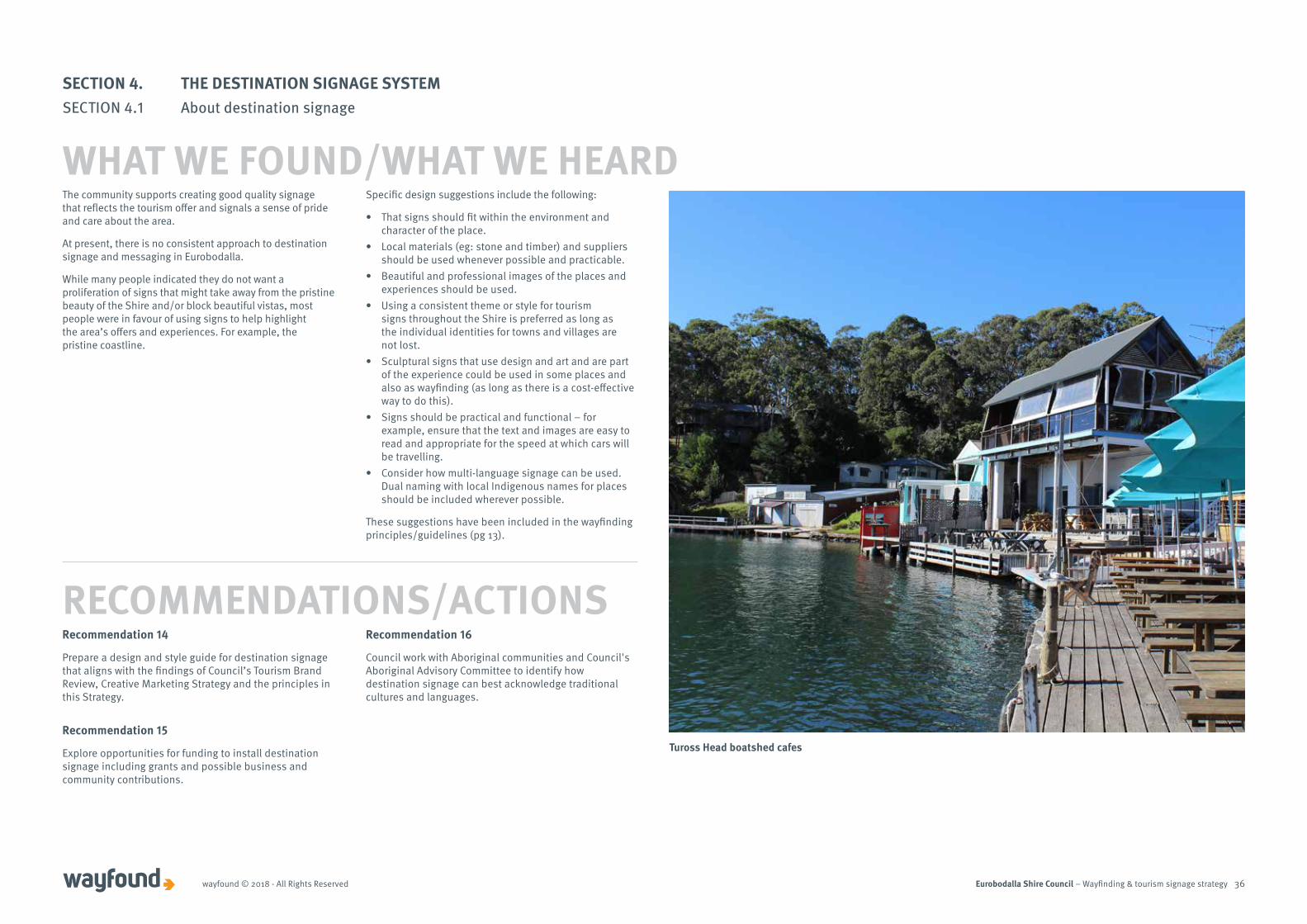
Tuross Head boatshed cafes
Eurobodalla Shire Council – Wayfinding & tourism signage strategywayfound © 2018 - All Rights Reserved 37
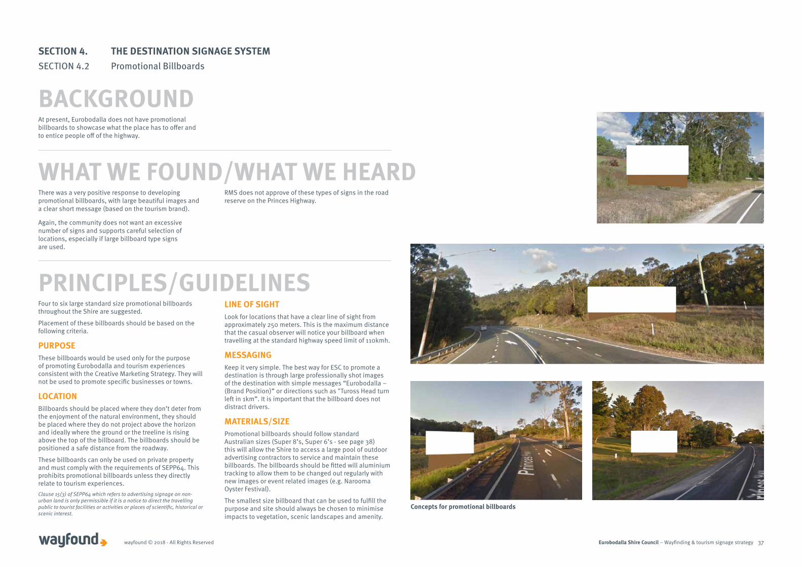
There was a very positive response to developing promotional billboards, with large beautiful images and a clear short message (based on the tourism brand).
Again, the community does not want an excessive number of signs and supports careful selection of locations, especially if large billboard type signs are used.
RMS does not approve of these types of signs in the road reserve on the Princes Highway.
Four to six large standard size promotional billboards throughout the Shire are suggested.
Placement of these billboards should be based on the following criteria.
PURPOSEThese billboards would be used only for the purpose of promoting Eurobodalla and tourism experiences consistent with the Creative Marketing Strategy. They will not be used to promote specific businesses or towns.
LOCATIONBillboards should be placed where they don’t deter from the enjoyment of the natural environment, they should be placed where they do not project above the horizon and ideally where the ground or the treeline is rising above the top of the billboard. The billboards should be positioned a safe distance from the roadway.
These billboards can only be used on private property and must comply with the requirements of SEPP64. This prohibits promotional billboards unless they directly relate to tourism experiences. Clause 15(3) of SEPP64 which refers to advertising signage on non-urban land is only permissible if it is a notice to direct the travelling public to tourist facilities or activities or places of scientific, historical or scenic interest.
LINE OF SIGHTLook for locations that have a clear line of sight from approximately 250 meters. This is the maximum distance that the casual observer will notice your billboard when travelling at the standard highway speed limit of 110kmh.
MESSAGINGKeep it very simple. The best way for ESC to promote a destination is through large professionally shot images of the destination with simple messages “Eurobodalla – (Brand Position)” or directions such as "Tuross Head turn left in 1km”. It is important that the billboard does not distract drivers.
MATERIALS/SIZEPromotional billboards should follow standard Australian sizes (Super 8’s, Super 6’s - see page 38) this will allow the Shire to access a large pool of outdoor advertising contractors to service and maintain these billboards. The billboards should be fitted will aluminium tracking to allow them to be changed out regularly with new images or event related images (e.g. Narooma Oyster Festival).
The smallest size billboard that can be used to fulfill the purpose and site should always be chosen to minimise impacts to vegetation, scenic landscapes and amenity.
WHAT WE FOUND/WHAT WE HEARD
PRINCIPLES/GUIDELINES
Concepts for promotional billboards
SECTION 4. THE DESTINATION SIGNAGE SYSTEMSECTION 4.2 Promotional Billboards
BACKGROUNDAt present, Eurobodalla does not have promotional billboards to showcase what the place has to offer and to entice people off of the highway.

Eurobodalla Shire Council – Wayfinding & tourism signage strategywayfound © 2018 - All Rights Reserved 38
Recommendation 17
Council investigate potential locations to install up to six promotional billboards along the Princes Highway to promote Eurobodalla. This would:
• Align with the findings of Council’s Tourism Brand Review and Creative Marketing Strategy.
• Align with the principles in this Strategy. • Include consideration of locations north and south
of Hector McWilliam Drive intersection, between Cullendulla and Batemans Bay, south of Narooma, north and south of Moruya.
Super 8’s8.3m x 2.2m
18.26m2
Super 6’s6m x 3m
18m2
Australian Standard Billboard sizes.
Portrait 13m x 4.5m
Portrait 24m x 6m
13.5m224m2
SECTION 4. THE DESTINATION SIGNAGE SYSTEMSECTION 4.2 Promotional Billboards
RECOMMENDATIONS/ACTIONS
Eurobodalla Shire Council – Wayfinding & tourism signage strategywayfound © 2018 - All Rights Reserved 39
While there are entry statements for the main towns, the current entry signs and statements for the Shire do not promote the Eurobodalla tourism offer well. There is no real sense of arrival nor a message that conveys Eurobodalla is a destination worth exploring.
Additionally, some towns and villages do not have entry statements or their quality varies widely. Some are in need of replacement. There is support for developing a consistent style and approach to entry statements, as long as towns and villages are able to retain some of their individual character.
The entry statements that were installed in Batemans Bay, Moruya and Narooma in 2016 may not fit with this new design and style but, unless there is a cost-effective way to retrofit them to bring them in line with the new style, they should be retained as is until the end of their useful lives. Consideration may be given to landscaping, lighting and adding any features that may help them appear as part of the same family as the newer signs.
WHAT WE FOUND/WHAT WE HEARD
COMMUNITYCommunity buy-in must be sought at the start of the process. It cannot be underestimated the importance of getting the community engaged and involved in the project. This will help achieve a successful outcome.
DESIGNCreate a memorable design that visitors will recognise and establish the connection between the entry statements and the broader Eurobodalla experience. Local materials should be sourced whenever possible.
SIZE AND SCALEA suite of entry statements of complementary designs and sizes that suit different locations and a hierarchy for the Shire, towns and villages would be ideal. They should be of an appropriate scale for the size of the location and be able to be seen from a reasonable distance (about 200 meters) by people traveling in vehicles.
VISIBILITYLighting and power supply e.g. mains power or solar should be carefully considered for night time viewing.
SITE LOCATIONLocations should be chosen so the entry statement can be clearly viewed but is not a distraction or safety hazard for motorists. Entry signs should not interfere with other road safety and regulatory signs and be placed in locations to convey a positive image of the location.
CONSTRUCTIONHigh quality construction and use of materials that are durable, high quality and replaceable.
PRINCIPLES/GUIDELINES
Entry statements provide an opportunity for the Shire to welcome visitors and encourage them to stay and explore the area. It is important that these entry signs reflect the Eurobodalla tourism brand so there is a clear, consistent and interesting style.
SECTION 4. THE DESTINATION SIGNAGE SYSTEMSECTION 4.3 Gateway/Entry Statements
BACKGROUND
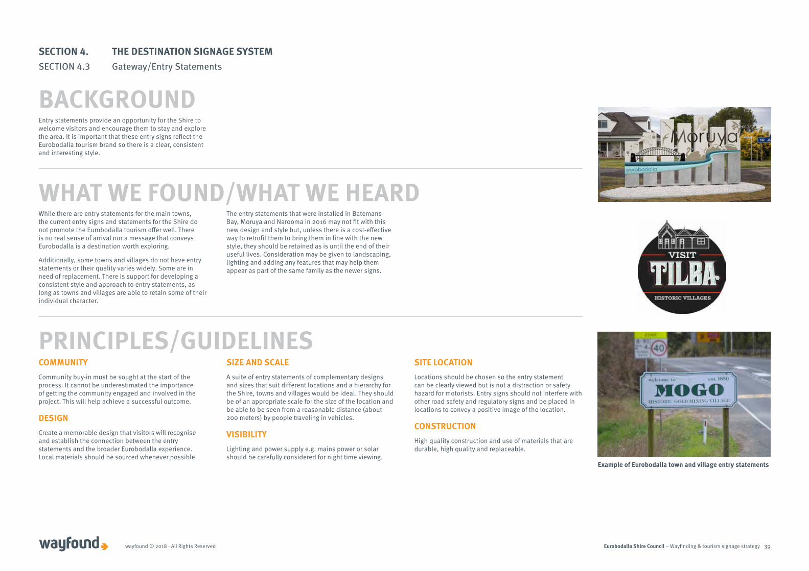
Example of Eurobodalla town and village entry statements
Eurobodalla Shire Council – Wayfinding & tourism signage strategywayfound © 2018 - All Rights Reserved 40
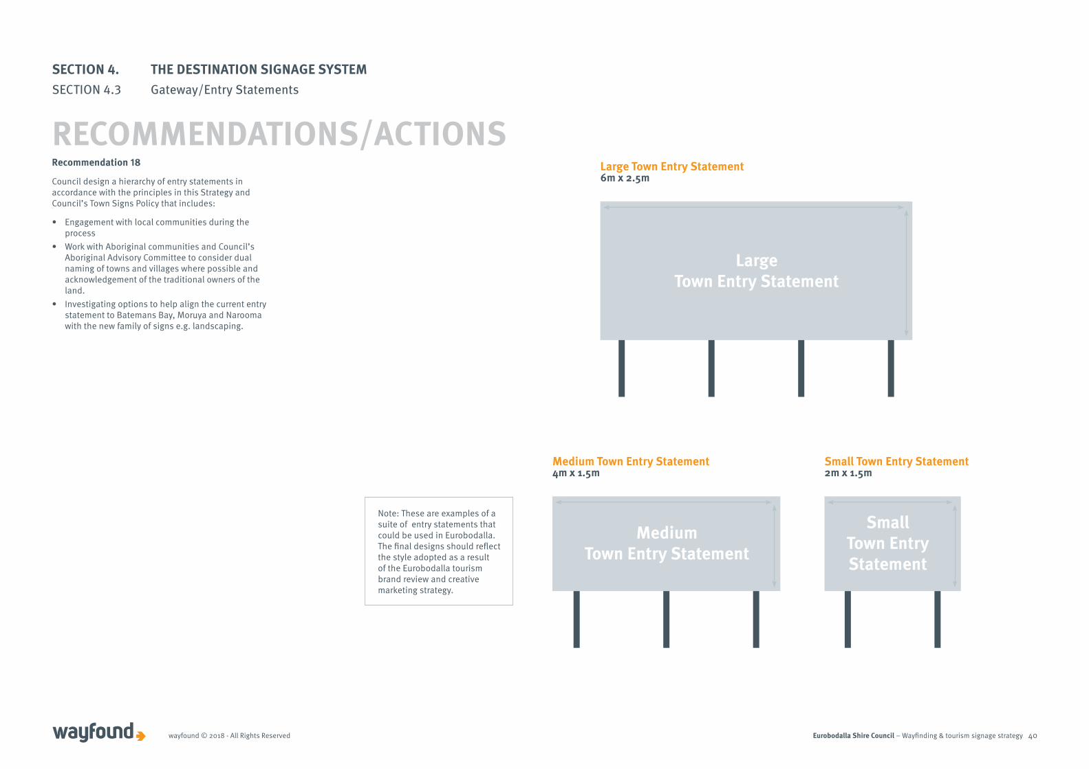
Large Town Entry Statement6m x 2.5m
Large Town Entry Statement
Medium Town Entry Statement4m x 1.5m
Medium Town Entry Statement
Small Town Entry Statement2m x 1.5m
Small Town Entry Statement
Recommendation 18
Council design a hierarchy of entry statements in accordance with the principles in this Strategy and Council’s Town Signs Policy that includes:
• Engagement with local communities during the process
• Work with Aboriginal communities and Council’s Aboriginal Advisory Committee to consider dual naming of towns and villages where possible and acknowledgement of the traditional owners of the land.
• Investigating options to help align the current entry statement to Batemans Bay, Moruya and Narooma with the new family of signs e.g. landscaping.
SECTION 4. THE DESTINATION SIGNAGE SYSTEMSECTION 4.3 Gateway/Entry Statements
RECOMMENDATIONS/ACTIONS
Note: These are examples of a suite of entry statements that could be used in Eurobodalla. The final designs should reflect the style adopted as a result of the Eurobodalla tourism brand review and creative marketing strategy.
Eurobodalla Shire Council – Wayfinding & tourism signage strategywayfound © 2018 - All Rights Reserved 41
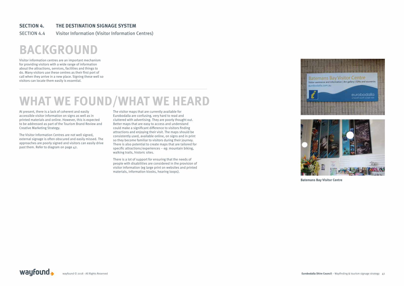
At present, there is a lack of coherent and easily accessible visitor information on signs as well as in printed materials and online. However, this is expected to be addressed as part of the Tourism Brand Review and Creative Marketing Strategy.
The Visitor Information Centres are not well signed, external signage is often obscured and easily missed. The approaches are poorly signed and visitors can easily drive past them. Refer to diagram on page 42.
The visitor maps that are currently available for Eurobodalla are confusing, very hard to read and cluttered with advertising. They are poorly thought out. Better maps that are easy to access and understand could make a significant difference to visitors finding attractions and enjoying their visit. The maps should be consistently used, available online, on signs and in print so they become familiar to visitors during their journey. There is also potential to create maps that are tailored for specific attractions/experiences – eg: mountain biking, walking trails, historic sites.
There is a lot of support for ensuring that the needs of people with disabilities are considered in the provision of visitor information (eg large print on websites and printed materials, information kiosks, hearing loops).
Visitor information centres are an important mechanism for providing visitors with a wide range of information about the attractions, services, facilities and things to do. Many visitors use these centres as their first port of call when they arrive in a new place. Signing these well so visitors can locate them easily is essential.
WHAT WE FOUND/WHAT WE HEARD
SECTION 4. THE DESTINATION SIGNAGE SYSTEMSECTION 4.4 Visitor Information (Visitor Information Centres)
BACKGROUND
Batemans Bay Visitor Centre

Eurobodalla Shire Council – Wayfinding & tourism signage strategywayfound © 2018 - All Rights Reserved 42
TURNRIGHT300m
TURNLEFT300m
Batemans BayNarooma
2km70km
30
0 m
30
0 m
PR
INC
ES
HW
Y
BEACH RD
Advance Warning sign
Position signs
VC Reassurance sign
Example – Correct signage for directions to Batemans Bay Visitor Information Centre
A comprehensive accredited visitor information centre program operates in NSW and signposting plays a significant role in communicating information to assist road users, see Section 2.4.
There are other sources of visitor information that do not fit under the accredited visitor information centre network. Information bays or lay-bys that meet the criteria below can be signposted on the state road network.
Source: http://www.rms.nsw.gov.au/business-industry/partners-suppliers/documents/technical-manuals/touristsignsv4.pdf.
The prime purpose of signing to a VIC is so that visitors can find it easily. To assist with navigation, these direction signs need to be consistent, accurate and reliable.
The safest and most suitable routes should be considered for visitors to find their way to the VIC. VIC wayfinding signs should be placed at decision-making (turning) points, starting at the town boundary and continue to where the VIC is located.
Aside from decision-making points, wayfinding signs should be located at any major intersections where the driver may have doubt about the correct road to take.
Arriving at the visitor information centre – Signs should direct the visitor into a car parking area associated with the centre.
At the Centre – Clear signage is important, particularly if the centre is set back from the road or in a built up area.
All signage should conform with the National Visitor Centre Accreditation program.
Recommendation 19
Consistent with the findings of Council’s Visitor Information Services Review to be undertaken later in 2018:
• Ensure directional signage to Visitor Information Centres and signage at Visitor Information Centres is improved and consistent with the State guidelines for identifying these centres.
• Consider providing visitor information outside of centres for people who arrive after-hours e.g. visitor information boards (see section 4.5)
RECOMMENDATIONS/ACTIONS
SECTION 4. THE DESTINATION SIGNAGE SYSTEMSECTION 4.4 Visitor Information (Visitor Information Centres)
PRINCIPLES/GUIDELINES
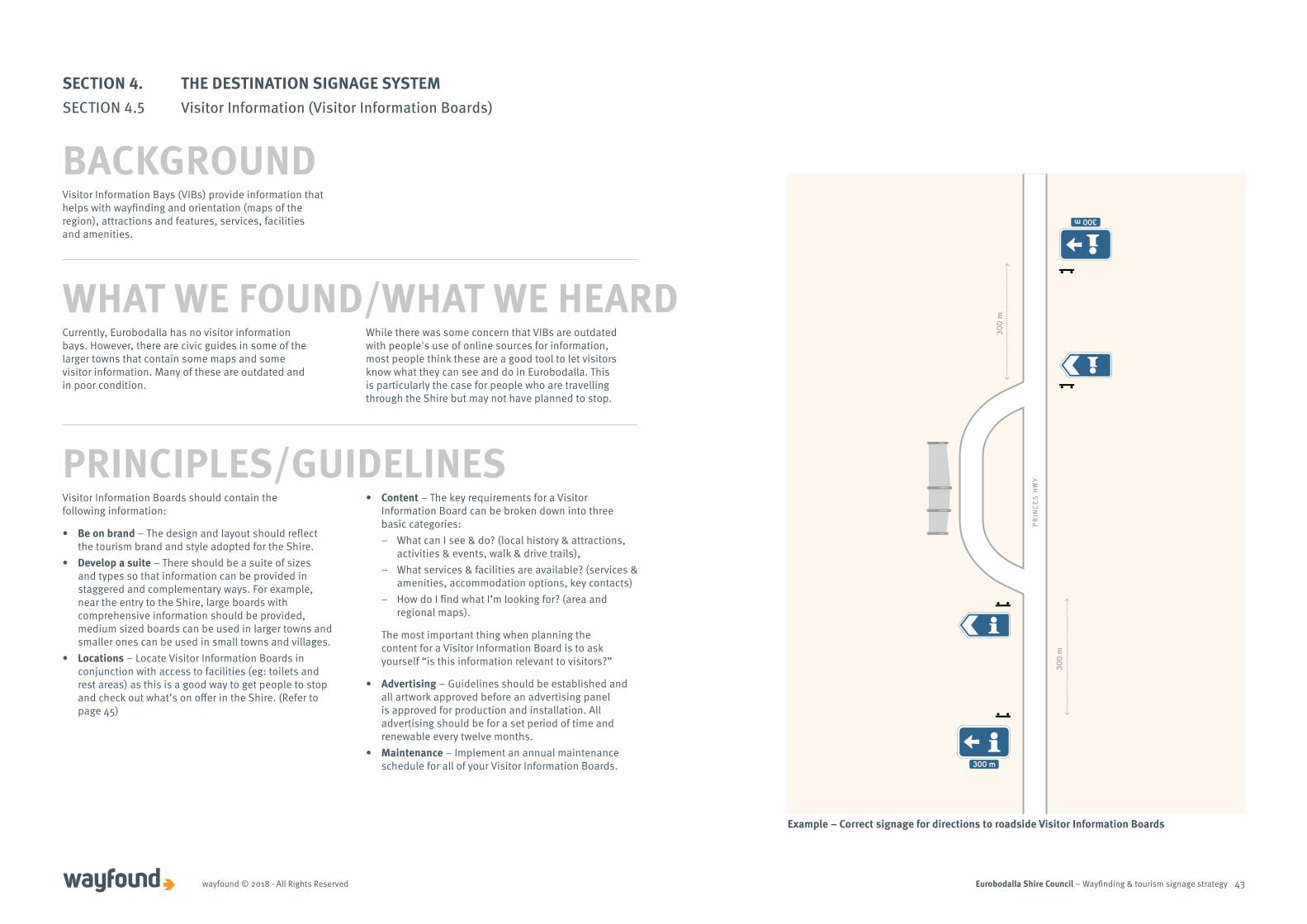
Eurobodalla Shire Council – Wayfinding & tourism signage strategywayfound © 2018 - All Rights Reserved 43
30
0 m
30
0 m
PR
INC
ES
HW
Y
300 m
300 m
Visitor Information Boards should contain the following information:
• Be on brand – The design and layout should reflect the tourism brand and style adopted for the Shire.
• Develop a suite – There should be a suite of sizes and types so that information can be provided in staggered and complementary ways. For example, near the entry to the Shire, large boards with comprehensive information should be provided, medium sized boards can be used in larger towns and smaller ones can be used in small towns and villages.
• Locations – Locate Visitor Information Boards in conjunction with access to facilities (eg: toilets and rest areas) as this is a good way to get people to stop and check out what’s on offer in the Shire. (Refer to page 45)
• Content – The key requirements for a Visitor Information Board can be broken down into three basic categories:
– What can I see & do? (local history & attractions, activities & events, walk & drive trails),
– What services & facilities are available? (services & amenities, accommodation options, key contacts)
– How do I find what I’m looking for? (area and regional maps).
The most important thing when planning the content for a Visitor Information Board is to ask yourself “is this information relevant to visitors?”
• Advertising – Guidelines should be established and all artwork approved before an advertising panel is approved for production and installation. All advertising should be for a set period of time and renewable every twelve months.
• Maintenance – Implement an annual maintenance schedule for all of your Visitor Information Boards.
PRINCIPLES/GUIDELINES
Example – Correct signage for directions to roadside Visitor Information Boards
WHAT WE FOUND/WHAT WE HEARD
Visitor Information Bays (VIBs) provide information that helps with wayfinding and orientation (maps of the region), attractions and features, services, facilities and amenities.
Currently, Eurobodalla has no visitor information bays. However, there are civic guides in some of the larger towns that contain some maps and some visitor information. Many of these are outdated and in poor condition.
While there was some concern that VIBs are outdated with people's use of online sources for information, most people think these are a good tool to let visitors know what they can see and do in Eurobodalla. This is particularly the case for people who are travelling through the Shire but may not have planned to stop.
SECTION 4. THE DESTINATION SIGNAGE SYSTEMSECTION 4.5 Visitor Information (Visitor Information Boards)
BACKGROUND
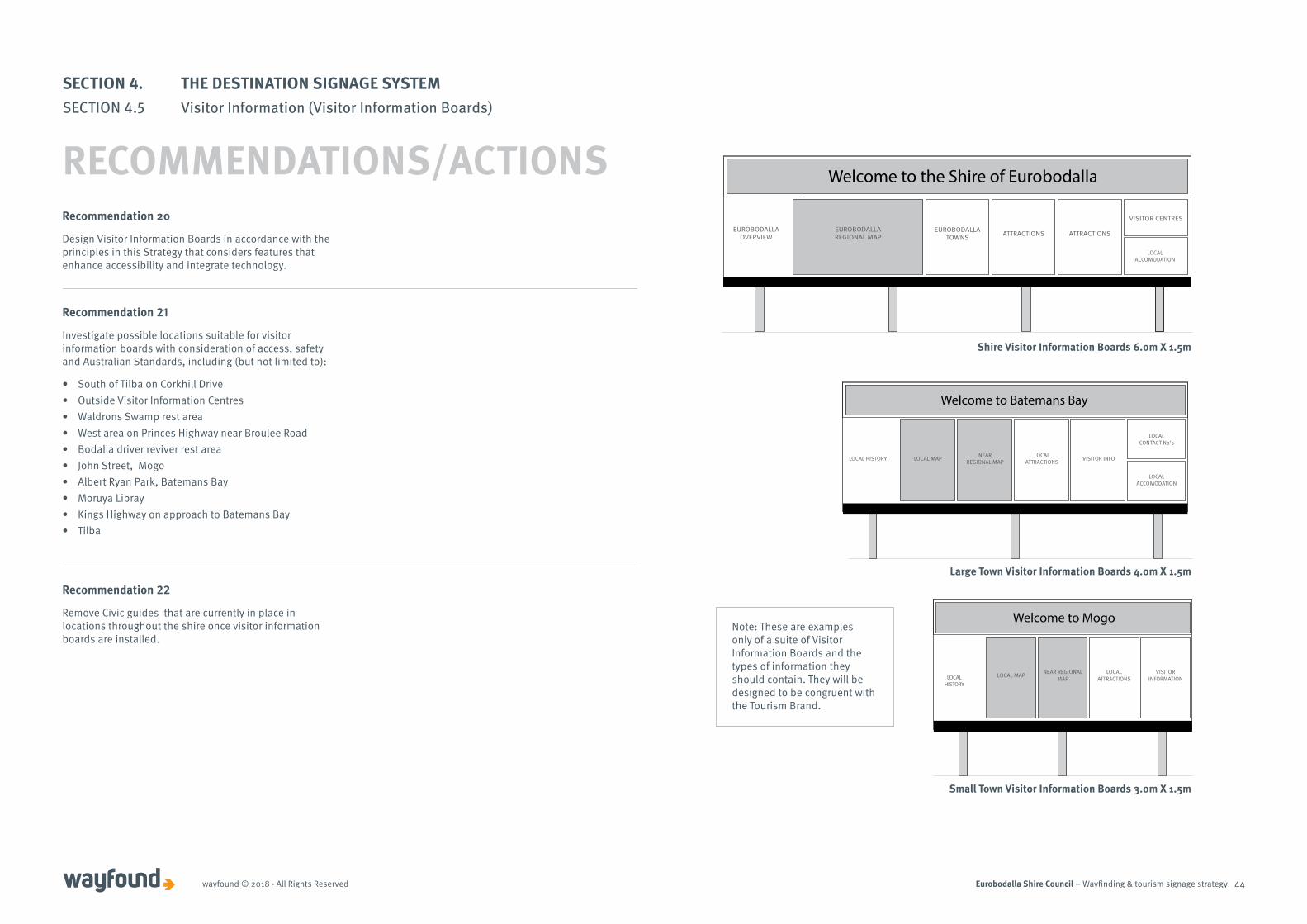
Eurobodalla Shire Council – Wayfinding & tourism signage strategywayfound © 2018 - All Rights Reserved 44
Recommendation 20
Design Visitor Information Boards in accordance with the principles in this Strategy that considers features that enhance accessibility and integrate technology.
LOCAL ATTRACTIONS VISITOR INFO
LOCAL CONTACT No’s
LOCAL ACCOMODATION
Large Town Visitor Information Boards 4.0m X 1.5m
Welcome to Batemans Bay
NEARREGIONAL MAPLOCAL MAPLOCAL HISTORY
NEAR REGIONAL MAPLOCAL MAP LOCAL
ATTRACTIONSVISITOR
INFORMATION
Small Town Visitor Information Boards 3.0m X 1.5m
Welcome to Mogo
LOCAL HISTORY
Shire Visitor Information Boards 6.0m X 1.5m
EUROBODALLATOWNS ATTRACTIONS ATTRACTIONS
VISITOR CENTRES
Welcome to the Shire of Eurobodalla
EUROBODALLAOVERVIEW
EUROBODALLAREGIONAL MAP
LOCAL ACCOMODATION
Note: These are examples only of a suite of Visitor Information Boards and the types of information they should contain. They will be designed to be congruent with the Tourism Brand.
SECTION 4. THE DESTINATION SIGNAGE SYSTEMSECTION 4.5 Visitor Information (Visitor Information Boards)
RECOMMENDATIONS/ACTIONS
Recommendation 21
Investigate possible locations suitable for visitor information boards with consideration of access, safety and Australian Standards, including (but not limited to):
• South of Tilba on Corkhill Drive• Outside Visitor Information Centres• Waldrons Swamp rest area• West area on Princes Highway near Broulee Road• Bodalla driver reviver rest area• John Street, Mogo• Albert Ryan Park, Batemans Bay• Moruya Libray• Kings Highway on approach to Batemans Bay• Tilba
Recommendation 22
Remove Civic guides that are currently in place in locations throughout the shire once visitor information boards are installed.
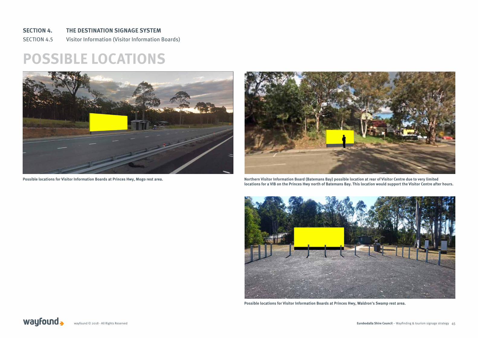
Eurobodalla Shire Council – Wayfinding & tourism signage strategywayfound © 2018 - All Rights Reserved 45
Possible locations for Visitor Information Boards at Princes Hwy, Mogo rest area. Northern Visitor Information Board (Batemans Bay) possible location at rear of Visitor Centre due to very limited locations for a VIB on the Princes Hwy north of Batemans Bay. This location would support the Visitor Centre after hours.
Possible locations for Visitor Information Boards at Princes Hwy, Waldron's Swamp rest area.
SECTION 4. THE DESTINATION SIGNAGE SYSTEMSECTION 4.5 Visitor Information (Visitor Information Boards)
POSSIBLE LOCATIONS
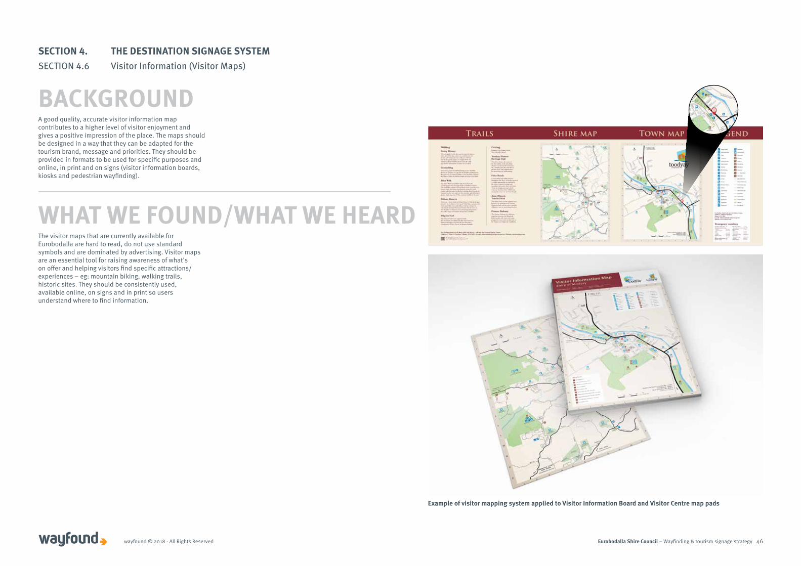
Eurobodalla Shire Council – Wayfinding & tourism signage strategywayfound © 2018 - All Rights Reserved 46
Example of visitor mapping system applied to Visitor Information Board and Visitor Centre map pads
WHAT WE FOUND/WHAT WE HEARD
A good quality, accurate visitor information map contributes to a higher level of visitor enjoyment and gives a positive impression of the place. The maps should be designed in a way that they can be adapted for the tourism brand, message and priorities. They should be provided in formats to be used for specific purposes and online, in print and on signs (visitor information boards, kiosks and pedestrian wayfinding).
The visitor maps that are currently available for Eurobodalla are hard to read, do not use standard symbols and are dominated by advertising. Visitor maps are an essential tool for raising awareness of what's on offer and helping visitors find specific attractions/experiences – eg: mountain biking, walking trails, historic sites. They should be consistently used, available online, on signs and in print so users understand where to find information.
SECTION 4. THE DESTINATION SIGNAGE SYSTEMSECTION 4.6 Visitor Information (Visitor Maps)
BACKGROUND

Eurobodalla Shire Council – Wayfinding & tourism signage strategywayfound © 2018 - All Rights Reserved 47
Recommendation 23
Develop improved visitor maps for use online, in print and on visitor information boards, that align with the findings of the Tourism Brand Review and Creative Marketing Strategy. Consider how maps can be more accessible to people with disabilities e.g. large print, accessible web content.
RECOMMENDATIONS/ACTIONS
KEY REQUIREMENTS FOR VISITOR INFORMATION MAPS Ensure the map has the right content for its purpose – Is it to show people how to get around your region and the services and attractions on offer? Is it for a tourist drive trail, a walk trail or for an activity like mountain bike riding or bushwalking? Each of these will have different requirements.
Design the map so it is easy to use – If you are designing a map to be used by bush walkers it must fit easily into a pocket and not be difficult to fold. If your map is primarily for elderly users, legibility factors such as type size, colours used must be considered.
Use the right format – Consider how the maps will be distributed? Will users pick up one from a visitor centre? If so, do they need to fit in a standard size brochure rack? Or how much space will it take up on the counter? Or will users download it from your website and print it out?
Maps on Visitor Information Boards
• Always include a ‘you are here’ indicator.• Show the larger area (eg; the Shire) for orientation
along with local areas or specific sections but be certain the scale is the right size to be legible.
• Give indications of distances to destinations – driving time, walking distance etc.
• Include arrows, clear text and Australian standard symbols for services, facilities and attractions.
• Visitor Information Board maps should be at eye level.
SECTION 4. THE DESTINATION SIGNAGE SYSTEMSECTION 4.6 Visitor Information (Visitor Maps)
PRINCIPLES/GUIDELINES
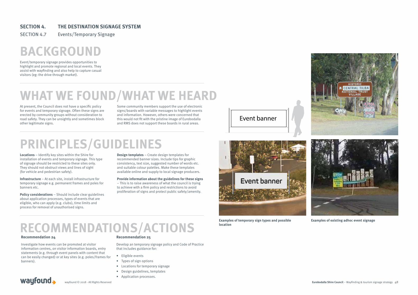
Eurobodalla Shire Council – Wayfinding & tourism signage strategywayfound © 2018 - All Rights Reserved 48
Event banner
At present, the Council does not have a specific policy for events and temporary signage. Often these signs are erected by community groups without consideration to road safety. They can be unsightly and sometimes block other legitimate signs.
Some community members support the use of electronic signs/boards with variable messages to highlight events and information. However, others were concerned that this would not fit with the pristine image of Eurobodalla and RMS does not support these boards in rural areas.
Event/temporary signage provides opportunities to highlight and promote regional and local events. They assist with wayfinding and also help to capture casual visitors (eg: the drive through market).
WHAT WE FOUND/WHAT WE HEARD
Locations – Identify key sites within the Shire for installation of events and temporary signage. This type of signage should be restricted to these sites only. They should not obstruct views and lines of sight (for vehicle and pedestrian safety).
Infrastructure – At each site, install infrastructure for temporary signage e.g. permanent frames and poles for banners etc.
Policy considerations – Should include clear guidelines about application processes, types of events that are eligible, who can apply (e.g. clubs), time limits and process for removal of unauthorised signs.
Design templates – Create design templates for recommended banner sizes. Include tips for graphic consistency, text size, suggested number of words etc. and suitable colour palettes. Make these templates available online and supply to local signage producers.
Provide information about the guidelines for these signs – This is to raise awareness of what the council is trying to achieve with a firm policy and restrictions to avoid proliferation of signs and protect public safety/amenity.
PRINCIPLES/GUIDELINES
RECOMMENDATIONS/ACTIONS
SECTION 4. THE DESTINATION SIGNAGE SYSTEMSECTION 4.7 Events/Temporary Signage
BACKGROUND
Examples of existing adhoc event signageExamples of temporary sign types and possible location
Recommendation 24
Investigate how events can be promoted at visitor information centres, on visitor information boards, entry statements (e.g. through event panels with content that can be easily changed) or at key sites (e.g. poles/frames for banners).
Recommendation 25
Develop an temporary signage policy and Code of Practice that includes guidance for:
• Eligible events• Types of sign options• Locations for temporary signage• Design guidelines, templates • Application processes.
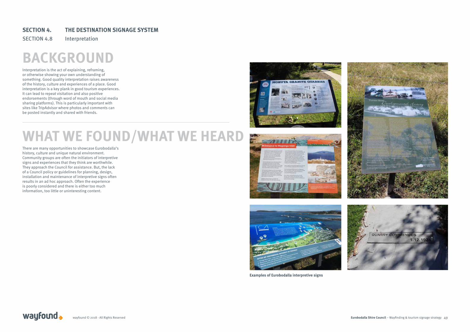
Eurobodalla Shire Council – Wayfinding & tourism signage strategywayfound © 2018 - All Rights Reserved 49
There are many opportunities to showcase Eurobodalla’s history, culture and unique natural environment. Community groups are often the initiators of interpretive signs and experiences that they think are worthwhile. They approach the Council for assistance. But, the lack of a Council policy or guidelines for planning, design, installation and maintenance of interpretive signs often results in an ad hoc approach. Often the experience is poorly considered and there is either too much information, too little or uninteresting content.
Interpretation is the act of explaining, reframing, or otherwise showing your own understanding of something. Good quality interpretation raises awareness of the history, culture and experiences of a place. Good interpretation is a key plank in good tourism experiences. It can lead to repeat visitation and also positive endorsements (through word of mouth and social media sharing platforms). This is particularly important with sites like TripAdvisor where photos and comments can be posted instantly and shared with friends.
WHAT WE FOUND/WHAT WE HEARD
SECTION 4. THE DESTINATION SIGNAGE SYSTEMSECTION 4.8 Interpretation
BACKGROUND
Examples of Eurobodalla interpretive signs
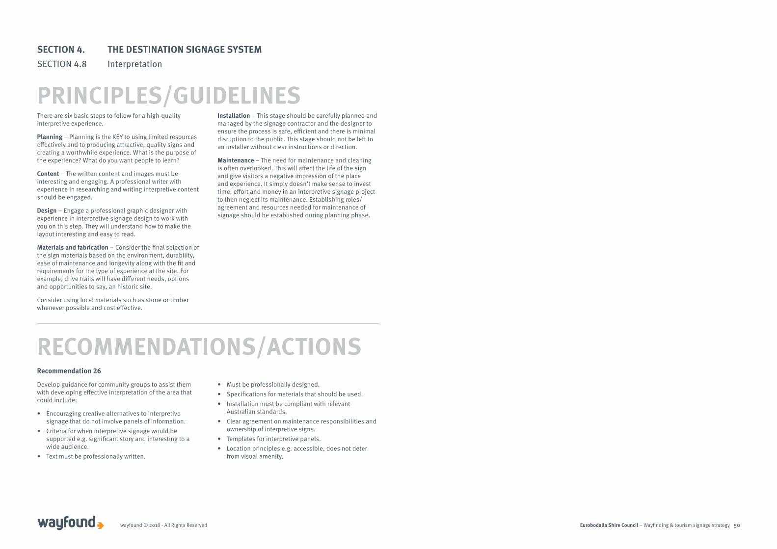
Eurobodalla Shire Council – Wayfinding & tourism signage strategywayfound © 2018 - All Rights Reserved 50
There are six basic steps to follow for a high-quality interpretive experience.
Planning – Planning is the KEY to using limited resources effectively and to producing attractive, quality signs and creating a worthwhile experience. What is the purpose of the experience? What do you want people to learn?
Content – The written content and images must be interesting and engaging. A professional writer with experience in researching and writing interpretive content should be engaged.
Design – Engage a professional graphic designer with experience in interpretive signage design to work with you on this step. They will understand how to make the layout interesting and easy to read.
Materials and fabrication – Consider the final selection of the sign materials based on the environment, durability, ease of maintenance and longevity along with the fit and requirements for the type of experience at the site. For example, drive trails will have different needs, options and opportunities to say, an historic site.
Consider using local materials such as stone or timber whenever possible and cost effective.
Installation – This stage should be carefully planned and managed by the signage contractor and the designer to ensure the process is safe, efficient and there is minimal disruption to the public. This stage should not be left to an installer without clear instructions or direction.
Maintenance – The need for maintenance and cleaning is often overlooked. This will affect the life of the sign and give visitors a negative impression of the place and experience. It simply doesn’t make sense to invest time, effort and money in an interpretive signage project to then neglect its maintenance. Establishing roles/agreement and resources needed for maintenance of signage should be established during planning phase.
Recommendation 26
Develop guidance for community groups to assist them with developing effective interpretation of the area that could include:
• Encouraging creative alternatives to interpretive signage that do not involve panels of information.
• Criteria for when interpretive signage would be supported e.g. significant story and interesting to a wide audience.
• Text must be professionally written.
• Must be professionally designed.• Specifications for materials that should be used.• Installation must be compliant with relevant
Australian standards.• Clear agreement on maintenance responsibilities and
ownership of interpretive signs.• Templates for interpretive panels.• Location principles e.g. accessible, does not deter
from visual amenity.
RECOMMENDATIONS/ACTIONS
SECTION 4. THE DESTINATION SIGNAGE SYSTEMSECTION 4.8 Interpretation
PRINCIPLES/GUIDELINES

Eurobodalla Shire Council – Wayfinding & tourism signage strategy 51
SECTION 5. PROPOSED TOURISM SIGNAGE FOR EUROBODALLA
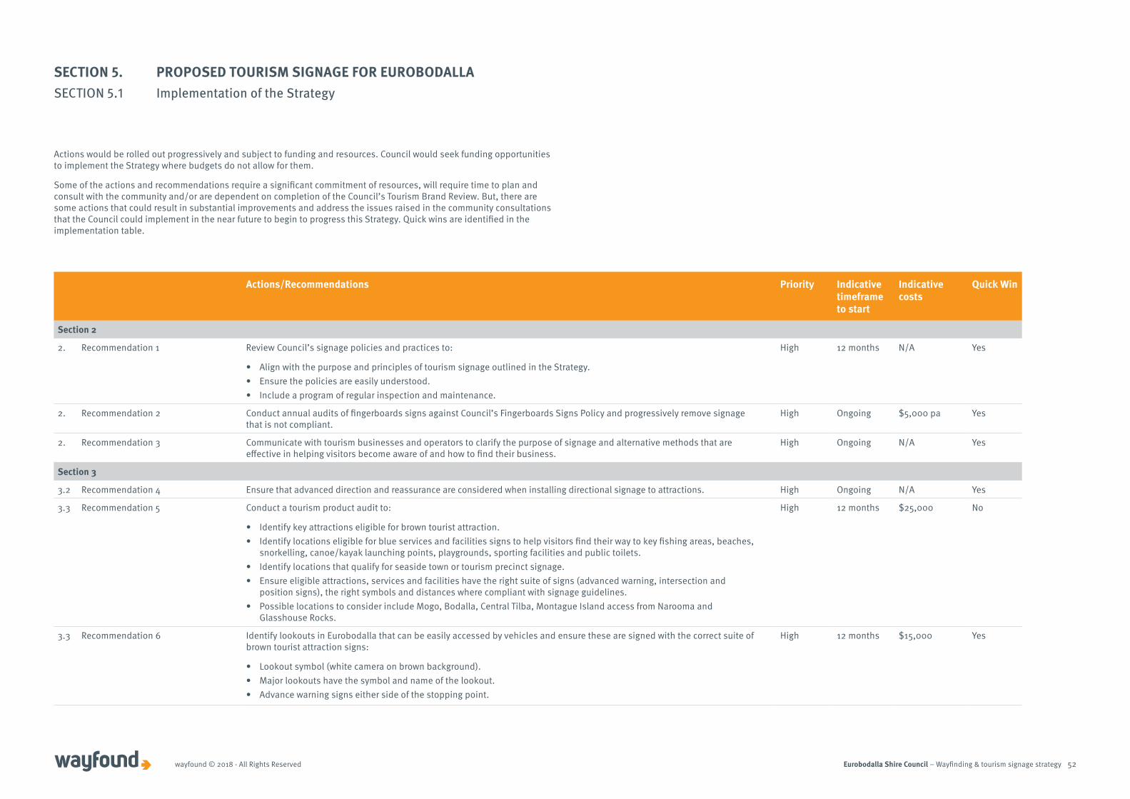
Eurobodalla Shire Council – Wayfinding & tourism signage strategywayfound © 2018 - All Rights Reserved 52
Actions would be rolled out progressively and subject to funding and resources. Council would seek funding opportunities to implement the Strategy where budgets do not allow for them.
Some of the actions and recommendations require a significant commitment of resources, will require time to plan and consult with the community and/or are dependent on completion of the Council’s Tourism Brand Review. But, there are some actions that could result in substantial improvements and address the issues raised in the community consultations that the Council could implement in the near future to begin to progress this Strategy. Quick wins are identified in the implementation table.
Actions/Recommendations Priority Indicative timeframe to start
Indicative costs
Quick Win
Section 2
2. Recommendation 1 Review Council’s signage policies and practices to:
• Align with the purpose and principles of tourism signage outlined in the Strategy.• Ensure the policies are easily understood.• Include a program of regular inspection and maintenance.
High 12 months N/A Yes
2. Recommendation 2 Conduct annual audits of fingerboards signs against Council’s Fingerboards Signs Policy and progressively remove signage that is not compliant.
High Ongoing $5,000 pa Yes
2. Recommendation 3 Communicate with tourism businesses and operators to clarify the purpose of signage and alternative methods that are effective in helping visitors become aware of and how to find their business.
High Ongoing N/A Yes
Section 3
3.2 Recommendation 4 Ensure that advanced direction and reassurance are considered when installing directional signage to attractions. High Ongoing N/A Yes
3.3 Recommendation 5 Conduct a tourism product audit to:
• Identify key attractions eligible for brown tourist attraction.• Identify locations eligible for blue services and facilities signs to help visitors find their way to key fishing areas, beaches,
snorkelling, canoe/kayak launching points, playgrounds, sporting facilities and public toilets.• Identify locations that qualify for seaside town or tourism precinct signage.• Ensure eligible attractions, services and facilities have the right suite of signs (advanced warning, intersection and
position signs), the right symbols and distances where compliant with signage guidelines.• Possible locations to consider include Mogo, Bodalla, Central Tilba, Montague Island access from Narooma and
Glasshouse Rocks.
High 12 months $25,000 No
3.3 Recommendation 6 Identify lookouts in Eurobodalla that can be easily accessed by vehicles and ensure these are signed with the correct suite of brown tourist attraction signs:
• Lookout symbol (white camera on brown background).• Major lookouts have the symbol and name of the lookout. • Advance warning signs either side of the stopping point.
High 12 months $15,000 Yes
SECTION 5. PROPOSED TOURISM SIGNAGE FOR EUROBODALLASECTION 5.1 Implementation of the Strategy
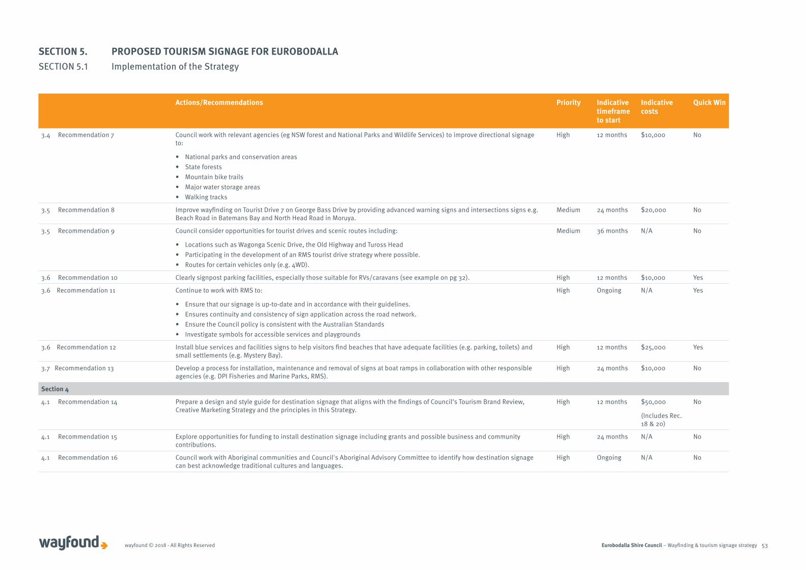
Eurobodalla Shire Council – Wayfinding & tourism signage strategywayfound © 2018 - All Rights Reserved 53
Actions/Recommendations Priority Indicative timeframe to start
Indicative costs
Quick Win
3.4 Recommendation 7 Council work with relevant agencies (eg NSW forest and National Parks and Wildlife Services) to improve directional signage to:
• National parks and conservation areas• State forests• Mountain bike trails• Major water storage areas• Walking tracks
High 12 months $10,000 No
3.5 Recommendation 8 Improve wayfinding on Tourist Drive 7 on George Bass Drive by providing advanced warning signs and intersections signs e.g. Beach Road in Batemans Bay and North Head Road in Moruya.
Medium 24 months $20,000 No
3.5 Recommendation 9 Council consider opportunities for tourist drives and scenic routes including:
• Locations such as Wagonga Scenic Drive, the Old Highway and Tuross Head• Participating in the development of an RMS tourist drive strategy where possible. • Routes for certain vehicles only (e.g. 4WD).
Medium 36 months N/A No
3.6 Recommendation 10 Clearly signpost parking facilities, especially those suitable for RVs/caravans (see example on pg 32). High 12 months $10,000 Yes
3.6 Recommendation 11 Continue to work with RMS to:
• Ensure that our signage is up-to-date and in accordance with their guidelines.• Ensures continuity and consistency of sign application across the road network.• Ensure the Council policy is consistent with the Australian Standards• Investigate symbols for accessible services and playgrounds
High Ongoing N/A Yes
3.6 Recommendation 12 Install blue services and facilities signs to help visitors find beaches that have adequate facilities (e.g. parking, toilets) and small settlements (e.g. Mystery Bay).
High 12 months $25,000 Yes
3.7 Recommendation 13 Develop a process for installation, maintenance and removal of signs at boat ramps in collaboration with other responsible agencies (e.g. DPI Fisheries and Marine Parks, RMS).
High 24 months $10,000 No
Section 4
4.1 Recommendation 14 Prepare a design and style guide for destination signage that aligns with the findings of Council’s Tourism Brand Review, Creative Marketing Strategy and the principles in this Strategy.
High 12 months $50,000
(Includes Rec. 18 & 20)
No
4.1 Recommendation 15 Explore opportunities for funding to install destination signage including grants and possible business and community contributions.
High 24 months N/A No
4.1 Recommendation 16 Council work with Aboriginal communities and Council's Aboriginal Advisory Committee to identify how destination signage can best acknowledge traditional cultures and languages.
High Ongoing N/A No
SECTION 5. PROPOSED TOURISM SIGNAGE FOR EUROBODALLASECTION 5.1 Implementation of the Strategy
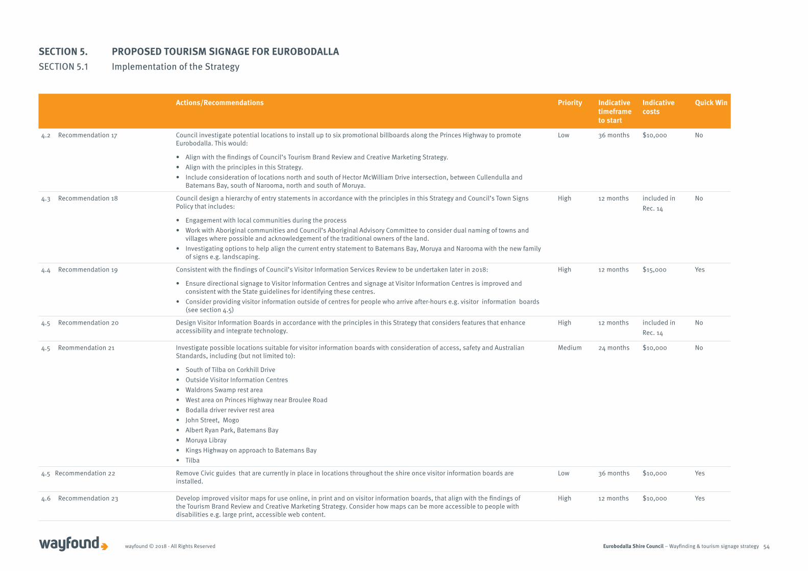
Eurobodalla Shire Council – Wayfinding & tourism signage strategywayfound © 2018 - All Rights Reserved 54
Actions/Recommendations Priority Indicative timeframe to start
Indicative costs
Quick Win
4.2 Recommendation 17 Council investigate potential locations to install up to six promotional billboards along the Princes Highway to promote Eurobodalla. This would:
• Align with the findings of Council’s Tourism Brand Review and Creative Marketing Strategy. • Align with the principles in this Strategy. • Include consideration of locations north and south of Hector McWilliam Drive intersection, between Cullendulla and
Batemans Bay, south of Narooma, north and south of Moruya.
Low 36 months $10,000 No
4.3 Recommendation 18 Council design a hierarchy of entry statements in accordance with the principles in this Strategy and Council’s Town Signs Policy that includes:
• Engagement with local communities during the process• Work with Aboriginal communities and Council’s Aboriginal Advisory Committee to consider dual naming of towns and
villages where possible and acknowledgement of the traditional owners of the land.• Investigating options to help align the current entry statement to Batemans Bay, Moruya and Narooma with the new family
of signs e.g. landscaping.
High 12 months included inRec. 14
No
4.4 Recommendation 19 Consistent with the findings of Council’s Visitor Information Services Review to be undertaken later in 2018:
• Ensure directional signage to Visitor Information Centres and signage at Visitor Information Centres is improved and consistent with the State guidelines for identifying these centres.
• Consider providing visitor information outside of centres for people who arrive after-hours e.g. visitor information boards (see section 4.5)
High 12 months $15,000 Yes
4.5 Recommendation 20 Design Visitor Information Boards in accordance with the principles in this Strategy that considers features that enhance accessibility and integrate technology.
High 12 months included inRec. 14
No
4.5 Reommendation 21 Investigate possible locations suitable for visitor information boards with consideration of access, safety and Australian Standards, including (but not limited to):
• South of Tilba on Corkhill Drive• Outside Visitor Information Centres• Waldrons Swamp rest area• West area on Princes Highway near Broulee Road• Bodalla driver reviver rest area• John Street, Mogo• Albert Ryan Park, Batemans Bay• Moruya Libray• Kings Highway on approach to Batemans Bay• Tilba
Medium 24 months $10,000 No
4.5 Recommendation 22 Remove Civic guides that are currently in place in locations throughout the shire once visitor information boards are installed.
Low 36 months $10,000 Yes
4.6 Recommendation 23 Develop improved visitor maps for use online, in print and on visitor information boards, that align with the findings of the Tourism Brand Review and Creative Marketing Strategy. Consider how maps can be more accessible to people with disabilities e.g. large print, accessible web content.
High 12 months $10,000 Yes
SECTION 5. PROPOSED TOURISM SIGNAGE FOR EUROBODALLASECTION 5.1 Implementation of the Strategy

Eurobodalla Shire Council – Wayfinding & tourism signage strategywayfound © 2018 - All Rights Reserved 55
Actions/Recommendations Priority Indicative timeframe to start
Indicative costs
Quick Win
4.7 Recommendation 24 Investigate how events can be promoted at visitor information centres, on visitor information boards, entry statements (e.g. through event panels with content that can be easily changed) or at key sites (e.g. poles/frames for banners).
High 12 months $5,000 Yes
4.7 Recommendation 25 Develop an temporary signage policy and Code of Practice that includes guidance for:
• Eligible events• Types of sign options• Locations for temporary signage• Design guidelines, templates • Application processes.
Medium 24 months $5,000 Yes
4.8 Recommendation 26 Develop guidance for community groups to assist them with developing effective interpretation of the area that could include:
• Encouraging creative alternatives to interpretive signage that do not involve panels of information.• Criteria for when interpretive signage would be supported e.g. significant story and interesting to a wide audience.• Text must be professionally written.• Must be professionally designed.• Specifications for materials that should be used.• Installation must be compliant with relevant Australian standards.• Clear agreement on maintenance responsibilities and ownership of interpretive signs.• Templates for interpretive panels.• Location principles e.g. accessible, does not deter from visual amenity.
Medium 12 months N/A Yes
SECTION 5. PROPOSED TOURISM SIGNAGE FOR EUROBODALLASECTION 5.1 Implementation of the Strategy

Wayfound15 phillimore streetfremantle wa [email protected]: (08) 9430 4166ABN: 98 120 289 223
Way
foun
d ES
C655
7 –
30.0
8.18