Embed Size (px)
Citation preview
9Comprehensive Plan: 2035 February 22, 2008
InTRoDUCTIon
TOWN BACKGROUND
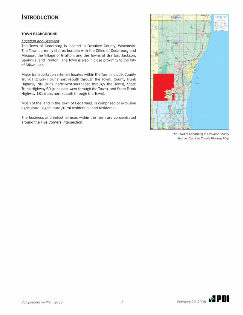
Location and OverviewThe Town of Cedarburg is located in Ozaukee County, Wisconsin. The Town currently shares borders with the Cities of Cedarburg and Mequon, the Village of Grafton, and the Towns of Grafton, Jackson, Saukville, and Trenton. The Town is also in close proximity to the City of Milwaukee.
Major transportation arterials located within the Town include: County Trunk Highway I (runs north-south through the Town), County Trunk Highway NN (runs northwest-southeast through the Town), State Trunk Highway 60 (runs east-west through the Town), and State Trunk Highway 181 (runs north-south through the Town).
Much of the land in the Town of Cedarburg is comprised of exclusive agricultural, agricultural/rural residential, and residential.
The business and industrial uses within the Town are concentrated around the Five Corners intersection.
The Town of Cedarburg in Ozaukee CountySource: Ozaukee County Highway Map
�0 Town of CedarburgFebruary 22, 2008
HISTORY OF THE TOWN
Early HistoryThe Town of Cedarburg’s earliest beginnings trace their roots, initially, to the Town of Grafton which was incorporated by the State legislature on January 26, 1846. This encompassed all of Township 10, Ranges 21 and 22 East. Sometime in early 1849, the Town of Cedarburg was separated and officially incorporated with the first meeting of Town supervisors on April 3, 1849.
The origin of the name “Cedarburg” has been lost to the ages. When the area known today as Ozaukee county was surveyed in March 1837, the surveyor of record, in his notes, referred to “Cedar Creek” (the stream) in his land description of the section within Township 10 Range 21 East. The spelling of ‘burg’ is definitely of German extraction. A ‘burg’, in German, refers to a “fortress”, which the area could have resembled in the 1840’s. Considering the area became populated by ethnic Germans, it appears the name was derived from the combination of the name of the dominant feature “Cedar Creek” and the German ‘burg.’ (The German word ‘berg’, on the other hand, refers to a mountain or hill, which the area definitely was not. Thode, Ernest, German-English Genealogical Dictionary, Baltimore, MD: Genealogical Publishing Co. Inc. 1992).
The first men to hold office for the new town were: William Vogenitz, Henry Krohn and Edward Nolan, supervisors; Charles E. Chamberlin, Town Clerk; Valentine Hahn, Jr., Town superintendent of schools; Charles E. Chamberlin and William Halpin, Justices of the Peace; James Wheelock, Christopher Burns, Hugh McElroy, W. Hartsman, Edward Lynch, John Smith, Peter Krause, Patrick Dougherty, John Fitzgerald, Fredrick Hilgen, Fredrich Schleiffer, Michael Hickey and James Nolan, overseers of highways of the road districts in which they resided. (Town of Cedarburg Minute Book, Volume 1, Page 1.)
Squatters were the earliest initial ‘white settlers’, however, most did not stay once the financial panic of 1837 swept through the country. Among those listed in June 1836 was E. P. Shaw in Hamilton (NE 1/4, Sec. 35), and in June 1837 A. S. Putney in Horns Corners (SW 1/4, Sec. 9), Moses Chandler in Kaehlers Mill (NE 1/4, Sec. 9), and Reuben Wells at Five Corners (NW 1/4, Sec. 22).
The earliest land sales noted (after the official opening at Green Bay in late 1835) were those of Ann Gurnsey Noyes, Eliphalet Cramer, George B. Warren and Jonathan Spencer in March 1839. They purchased land patents to acreage which was primarily located along the banks of Cedar Creek, in particular where the prospects for establishing water-powered mills appeared the most advantageous.
Historic Features: Past and PresentThe most recognizable, and perhaps most famous, feature of the Town is that of the Covered Bridge. This structure is the last remaining original covered wooden bridge in the state of Wisconsin. In 1850, Michael Hickey was paid $38.00 to build a bridge near his residence. This simple structure eventually was severely damaged in the spring flooding of 1876. Residents then petitioned the Town for a new bridge, citing “the said bridge is a comfort for all the Citizens in the north part of the Town, not only for local communication.” (Copy of Original “Petition of Citizens and Taxpayers of Town of Cedarburg”, dated 18 May 1876.)
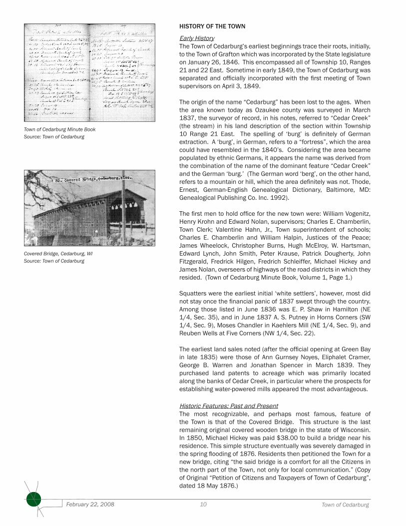
Town of Cedarburg Minute BookSource: Town of Cedarburg
Covered Bridge, Cedarburg, WISource: Town of Cedarburg

��Comprehensive Plan: 2035 February 22, 2008
The style of the structure is known as Town lattice. The planking and timber was obtained from a mill located near Baraboo, Wisconsin, which cut and squared all lumber. White pine was the specie of choice for the 120 foot single span. (The lumber was transported over 75 miles.) The original builder added board and batten siding which seems to have helped the bridge withstand the harsh winters of the northern climate. Being ‘covered’, it provided protection from inclement weather while traveling and helped to stave off deterioration of the decking.
A center support was added in 1927 with the advent of increased vehicular traffic and heavier loads. The bridge came under the jurisdiction of the county highway department in the 1940’s, and was officially retired from service in 1962. The Port Washington chapter of the D.A.R. officially recognized the historic nature of the bridge with a plaque in 1955, which is located over the south entrance.
Deckers CornersThis Town of Cedarburg community is said to have been named after a German by the name of Carl Ludwig Deecke (1814-1864) and is located at the present day intersections of Pleasant Valley, Granville Roads and Highway NN. These roads form a type of six-way intersection with the old fieldstone tavern building (restored in the 1990’s) forming the centerpiece of the settlement.
In addition to the tavern, the area originally contained a blacksmith shop, wagon shop, cheese factory, sawmill, district school number 6, and a lime kiln (Plat Book of Washington & Ozaukee Counties Minneapolis, MN: C.M. Foote & Company, 1892). The school, wagon shop, stone tavern, and cheese factory buildings remain.
Five CornersThis area is located at the present day intersections of Highways 60, NN and Covered Bridge Road. Travelers heading north from the City of Cedarburg to this community would have had to traverse a large, swampy, low lying area from which they would have viewed in the distance Rinn’s Tavern, the creamery, and the Patrick Halpin homestead all seated on a small hill. The crossroad also was home to a blacksmith shop and a cider press.
Today, the only commercial structure which remains virtually unchanged is Rinn’s Tavern. The dance hall, originally built as a separate structure, was incorporated into the present structure (the roof line is still visible). The creamery building still remains (7676 Highway 60); however, it has been altered beyond recognition. The Halpin home, which was on Covered Bridge Road just north of the tavern, was moved to the Ozaukee County Pioneer Village in the Town of Saukville in the early 1970’s. The accompanying barn was demolished. Another home located on the northeast corner of Highway 60 and Covered Bridge Road was demolished to accommodate the present Kohl’s Flooring building and parking lot. The Diedrich Wittenberg (1267 Highway NN), Michael Sullivan (1167 Highway NN), and Fred Beckmann (1214 Highway NN) homes remain.
It has been said that this area has also been called ‘Kennedy’s Corners’, though documentation of this is has not been found.
Five Corners, Cedarburg, WISource: Town of Cedarburg
Deckers Corner, Cedarburg, WISource: Town of Cedarburg
�2 Town of CedarburgFebruary 22, 2008
HamiltonThe name of this small community was originally known as New Dublin by the mostly Irish population which settled near this area. According to the United States Post Office, New Dublin was the fifth stop north of Milwaukee on the Green Bay trail mail run (“Parental Stories of Pioneer Times”, Dr. Bernard J. Cigrand; Port Washington Star (Port Washington, WI), 30 December 1916).
In the spring of 1848, this settlement became known as Hamilton. It has been said the name is in honor of William Stevens Hamilton (1797-1850), son of Alexander Hamilton (1757-1804), who was known to have come to Wisconsin in 1827 to engage in mining and smelting in the southeast area of the state. He attended the U. S. Military Academy in West Point; however, he left before graduating to become a surveyor. He was known to have driven cattle to Fort Howard through the Hamilton area in the late 1820’s following the Green Bay Trail.
Joseph Gardiner (also known in early sources as “Miserly Joe”), an early surveyor for the Green Bay Trail, is said to have lived in a shack just off the trail. As to how long Gardiner resided in Hamilton, not much is known.
One of the earliest permanent residents to settle in Hamilton was Edward H. [Eduard] Janssen (1815-1877). He emigrated from Germany and arrived in Ozaukee County in 1840. He initially settled on 40 acres in section 23 in Mequon. He sold the property to Adolph Zimmermann in about 1855.
He purchased acreage in Hamilton and set about to establish a grist mill on the banks of Cedar Creek located on the Green Bay Trail in 1854 with his brother, Theodore, and William Gaitzsch. The trio named the new structure the Hamilton Grist Mill. It was located on the sight of a former saw mill which was operating as early 1847.
After Edward’s brother and his partner, Gaitzsch, both died, he was left with sole ownership of the mill. In about 1861, Janssen sold the mill to Andreas Bodendoerfer (1828-1908) and it became known as the Concordia Mill. Bodendoerfer built a large home in which to house his 19 children and the workers who were employed in his mill. The “Big House”, as it was known, although built of stone, was unfortunately destroyed by fire in the late 1800’s.
Janssen built a lovely stone home for himself in about 1854 and also Turn Halle in about 1867 for use by members of the Cedarburg Turn Verein. Both structures still stand.
Another charming reminder of bygone days is the Apothecary Shop located on the Trail just north of Pioneer Road (Highway C). It is said to have been built some time between 1860 and 1864, and functioned as a general store for its residents. When its owner, Herman Lindner (1843-1911), passed away, it slowly deteriorated from neglect. The structure is currently being restored.
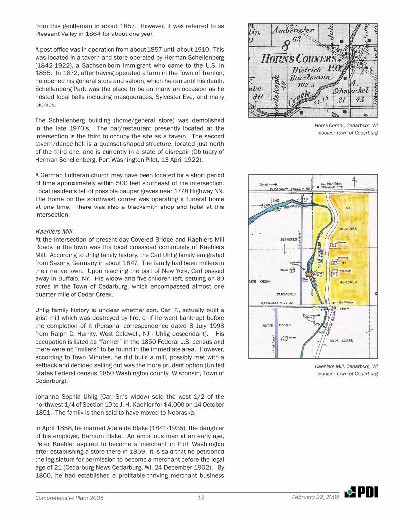
Horns CornersFrederick W. Horn (1815-1893), known as the ‘Sage of Cedarburg,’ is said to have settled at the present day intersection of Highway NN and Horns Corners Road for a short time. The corner took its name
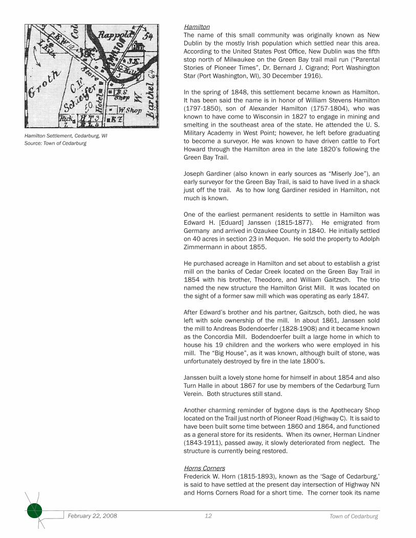
Hamilton Settlement, Cedarburg, WISource: Town of Cedarburg
�3Comprehensive Plan: 2035 February 22, 2008
from this gentleman in about 1857. However, it was referred to as Pleasant Valley in 1864 for about one year.
A post office was in operation from about 1857 until about 1910. This was located in a tavern and store operated by Herman Schellenberg (1842-1922), a Sachsen-born immigrant who came to the U.S. in 1855. In 1872, after having operated a farm in the Town of Trenton, he opened his general store and saloon, which he ran until his death. Schellenberg Park was the place to be on many an occasion as he hosted local balls including masquerades, Sylvester Eve, and many picnics.
The Schellenberg building (home/general store) was demolished in the late 1970’s. The bar/restaurant presently located at the intersection is the third to occupy the site as a tavern. The second tavern/dance hall is a quonset-shaped structure, located just north of the third one, and is currently in a state of disrepair (Obituary of Herman Schellenberg, Port Washington Pilot, 13 April 1922).
A German Lutheran church may have been located for a short period of time approximately within 500 feet southeast of the intersection. Local residents tell of possible pauper graves near 1778 Highway NN. The home on the southwest corner was operating a funeral home at one time. There was also a blacksmith shop and hotel at this intersection.
Kaehlers MillAt the intersection of present day Covered Bridge and Kaehlers Mill Roads in the town was the local crossroad community of Kaehlers Mill. According to Uhlig family history, the Carl Uhlig family emigrated from Saxony, Germany in about 1847. The family had been millers in their native town. Upon reaching the port of New York, Carl passed away in Buffalo, NY. His widow and five children left, settling on 80 acres in the Town of Cedarburg, which encompassed almost one quarter mile of Cedar Creek.
Uhlig family history is unclear whether son, Carl F., actually built a grist mill which was destroyed by fire, or if he went bankrupt before the completion of it (Personal correspondence dated 8 July 1998 from Ralph D. Harrity, West Caldwell, NJ - Uhlig descendant). His occupation is listed as “farmer” in the 1850 Federal U.S. census and there were no “millers” to be found in the immediate area. However, according to Town Minutes, he did build a mill, possibly met with a setback and decided selling out was the more prudent option (United States Federal census 1850 Washington county, Wisconsin, Town of Cedarburg).
Johanna Sophia Uhlig (Carl Sr.’s widow) sold the west 1/2 of the northwest 1/4 of Section 10 to J. H. Kaehler for $4,000 on 14 October 1851. The family is then said to have moved to Nebraska.
In April 1858, he married Adelaide Blake (1841-1935), the daughter of his employer, Barnum Blake. An ambitious man at an early age, Peter Kaehler aspired to become a merchant in Port Washington after establishing a store there in 1859. It is said that he petitioned the legislature for permission to become a merchant before the legal age of 21 (Cedarburg News Cedarburg, WI, 24 December 1902). By 1860, he had established a profitable thriving merchant business
Horns Corner, Cedarburg, WISource: Town of Cedarburg
Kaehlers Mill, Cedarburg, WISource: Town of Cedarburg
�4 Town of CedarburgFebruary 22, 2008
in downtown Port Washington, employing two clerks. One was his brother, William, and the other was a young Luxembourger.
During the late 1850’s and into the 1860’s, at least one grist miller and one saw miller tried to establish business in the settlement area. By 1860, Charles Müller was working in the grist mill, while Anton Boehm, a Bohemian immigrant, was running a sawmill. It is not currently known when Kaehler took over ownership of both mills.
Probably upon the death of his mother, Sophia, Peter moved his young family to his father’s Town of Cedarburg property. At some point, Peter acquired one-third of an acre from the Krohn family on Cedar Creek. This is the land which is believed to have been the site of the grist mill.
After the move, Kaehler became active in local politics and civic enterprises. He was on the executive committee for the Ozaukee County Agricultural Society which was responsible for operating the annual county fair. He provided services for the Town and lumber for many local building projects.
At some point it is said that he established a general store on the corner of present day intersection of Kaehlers Mill and Covered Bridge Roads since he had previously operated such a business in Port Washington. The store may also have functioned as a post office for local residents to send and receive mail. Several mill cottages are said to have been located near the intersection as well.
The mills fell into disrepair after the Kaehler family moved to Chicago in the late 1880’s following a very lengthy and nasty court battle over property taxes. He established a grain, feed and flour business and left his wife a sizable estate when he passed away in 1902.
The last traces of the mills disappeared in 1903 when the lumber and metal were salvaged and sold off (Cedarburg News, Cedarburg, WI, 2 December 1903). The only buildings remaining from this settlement are the blacksmith shop (located on the former Krohn homestead) and the store, which has since been converted to a single family residence. The mill race is still visible in winter months.
Native American InfluencesThere were several Native American activity areas in the Town of Cedarburg. The one which was probably the largest and oldest in the area was located in the former “Hilgen Spring Park” which is now a housing project in the City of Cedarburg.
At one time it contained at least three burial mounds which were dated to the Early Woodland Time Period (460 B.C.) (Van Langen, Howard & Thomas F. Kehoe, Hilgen Spring Park Mound Group, The Wisconsin Archeologist, March 1971, Vol. 52, No. 1, (Milwaukee, WI: The Wisconsin Archeology Society, 1971), p. 18). Unfortunately, these have since been destroyed by new development.
One other area within the present township limits is located near Granville and Cedar Creek Roads and has been identified as a campsite. Several artifacts were found and catalogued in the early 1960’s (Daalmann, Elmer C., A Campsite in Cedarburg Township, Ozaukee County, The Wisconsin Archeologist, December 1964, Vol.
�5Comprehensive Plan: 2035 February 22, 2008
45, No. 4, Milwaukee, WI: The Wisconsin Archeology Society, 1964), p. 175-178). This area has seen recent housing development activity.
PAST PLANNING IN THE TOWN
The Town has completed the following plans since 1995:
Comprehensive Land Use Plan, 1995Master Bicycle and Pedestrian Route Plan, 1999Park and Green Space Plan, 2004Five Corners Master Plan, 2006
••••
�6 Town of CedarburgFebruary 22, 2008
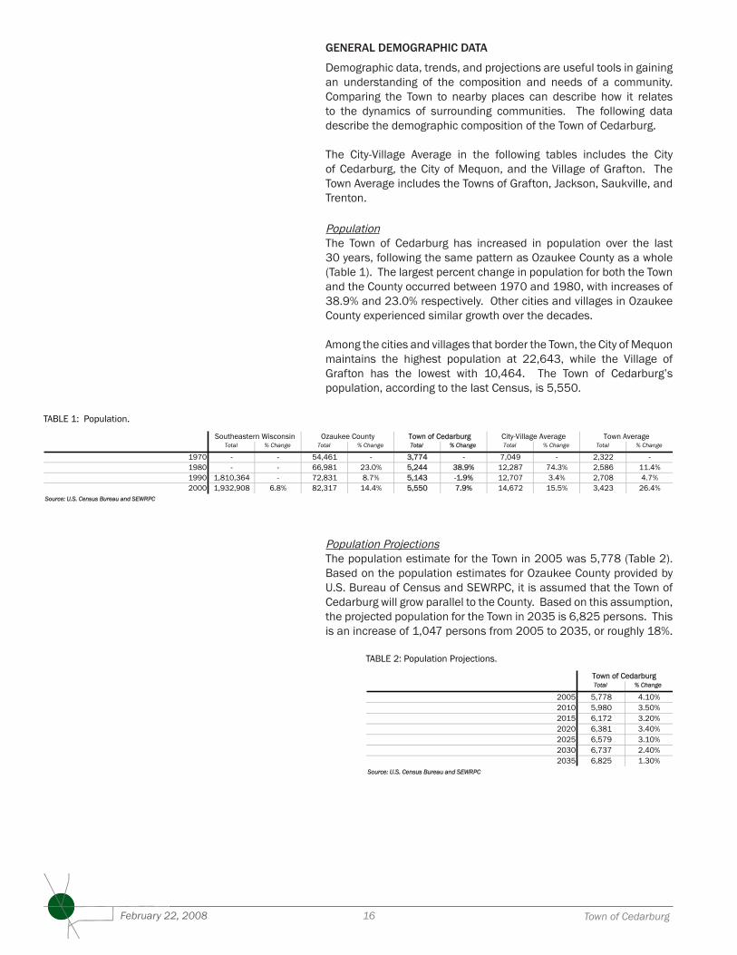
GENERAL DEMOGRAPHIC DATA
Demographic data, trends, and projections are useful tools in gaining an understanding of the composition and needs of a community. Comparing the Town to nearby places can describe how it relates to the dynamics of surrounding communities. The following data describe the demographic composition of the Town of Cedarburg.
The City-Village Average in the following tables includes the City of Cedarburg, the City of Mequon, and the Village of Grafton. The Town Average includes the Towns of Grafton, Jackson, Saukville, and Trenton.
PopulationThe Town of Cedarburg has increased in population over the last 30 years, following the same pattern as Ozaukee County as a whole (Table 1). The largest percent change in population for both the Town and the County occurred between 1970 and 1980, with increases of 38.9% and 23.0% respectively. Other cities and villages in Ozaukee County experienced similar growth over the decades.
Among the cities and villages that border the Town, the City of Mequon maintains the highest population at 22,643, while the Village of Grafton has the lowest with 10,464. The Town of Cedarburg’s population, according to the last Census, is 5,550.
Population ProjectionsThe population estimate for the Town in 2005 was 5,778 (Table 2). Based on the population estimates for Ozaukee County provided by U.S. Bureau of Census and SEWRPC, it is assumed that the Town of Cedarburg will grow parallel to the County. Based on this assumption, the projected population for the Town in 2035 is 6,825 persons. This is an increase of 1,047 persons from 2005 to 2035, or roughly 18%.
POPULATION
Total % Change Total % Change Total % Change Total % Change Total % Change
1970 - - 54,461 - 3,774 - 7,049 - 2,322 -1980 - - 66,981 23.0% 5,244 38.9% 12,287 74.3% 2,586 11.4%1990 1,810,364 - 72,831 8.7% 5,143 -1.9% 12,707 3.4% 2,708 4.7%2000 1,932,908 6.8% 82,317 14.4% 5,550 7.9% 14,672 15.5% 3,423 26.4%
Source: U.S. Census Bureau and SEWRPC
Southeastern Wisconsin Ozaukee County Town of Cedarburg Town AverageCity-Village Average
TABLE 1: Population.
Total % Change
2005 5,778 4.10%2010 5,980 3.50%2015 6,172 3.20%2020 6,381 3.40%2025 6,579 3.10%2030 6,737 2.40%2035 6,825 1.30%
Source: U.S. Census Bureau and SEWRPC
Town of Cedarburg
TABLE 2: Population Projections.
�7Comprehensive Plan: 2035 February 22, 2008
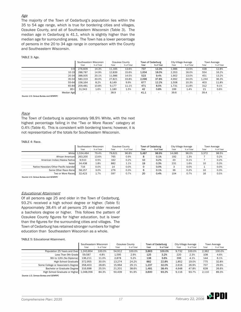
AgeThe majority of the Town of Cedarburg’s population lies within the 35 to 54 age range, which is true for bordering cities and villages, Ozaukee County, and all of Southeastern Wisconsin (Table 3). The median age in Cedarburg is 41.1, which is slightly higher than the median age for surrounding areas. The Town has a lower percentage of persons in the 20 to 34 age range in comparison with the County and Southeastern Wisconsin.
RaceThe Town of Cedarburg is approximately 98.9% White, with the next highest percentage falling in the “Two or More Races” category at 0.4% (Table 4). This is consistent with bordering towns; however, it is not representative of the totals for Southeastern Wisconsin.
Educational AttainmentOf all persons age 25 and older in the Town of Cedarburg, 93.2% received a high school degree or higher. (Table 5) Approximately 38.4% of all persons 25 and older received a bachelors degree or higher. This follows the pattern of Ozaukee County figures for higher education, but is lower than the figures for the surrounding cities and villages. The Town of Cedarburg has retained stronger numbers for higher education than Southeastern Wisconsin as a whole.
AGE
Total % of Total Total % of Total Total % of Total Total % of Total Total % of Total
0-9 276,609 14.3% 11,165 13.6% 737 13.3% 1,986 13.5% 438 12.8%10-19 288,787 14.9% 12,839 15.6% 1,004 18.0% 2,353 16.0% 554 16.2%20-34 388,005 20.1% 11,986 14.5% 523 9.4% 1,902 13.0% 451 13.2%35-54 580,319 30.0% 27,821 33.8% 2,096 37.8% 4,992 34.0% 1,244 36.3%55-64 158,164 8.2% 8,149 9.9% 677 12.2% 1,508 10.3% 403 11.8%65-84 209,481 10.8% 9,177 11.1% 471 8.5% 1,731 11.8% 312 9.1%
85+ 31,543 1.6% 1,180 1.5% 42 0.8% 199 1.4% 21 0.6%Median Age - - 38.9 - 41.1 - 39.6 - 39.4 -
Source: U.S. Census Bureau and SEWRPC
Southeastern Wisconsin Ozaukee County City-Village Average Town AverageTown of Cedarburg
TABLE 3: Age.
RACE
Total % of Total Total % of Total Total % of Total Total % of Total Total % of Total
White 1,534,464 79.4% 79,621 96.8% 5,487 98.9% 14,085 96.0% 3,372 98.5%African American 263,200 13.6% 765 0.9% 8 0.1% 192 1.3% 7 0.2%
American Indian/Alaska Native 9,510 0.5% 162 0.2% 10 0.2% 20 0.1% 7 0.2%Asian 34,438 1.8% 882 1.1% 19 0.3% 231 1.6% 10 0.3%
Native Hawaiian/Other Pacific Islander 716 0.0% 14 0.0% 0 0.0% 3 0.0% 1 0.0%Some Other Race Alone 58,157 3.0% 276 0.3% 6 0.1% 36 0.2% 10 0.3%
Two or More Races 32,423 1.7% 597 0.7% 20 0.4% 104 0.7% 16 0.5%Source: U.S. Census Bureau and SEWRPC
City-Village AverageSoutheastern Wisconsin Ozaukee County Town AverageTown of Cedarburg
TABLE 4: Race.
EDUCATIONAL ATTAINMENT
Total % of Total Total % of Total Total % of Total Total % of Total Total % of Total
Population 25 Years and Over 1,243,854 100.0% 54,912 100.0% 3,863 100.0% 9,732 100.0% 2,362 100.0%Less Than 9th Grade 59,587 4.8% 1,595 2.9% 125 3.2% 220 2.3% 108 4.6%
9th to 12th (No Diploma) 136,211 11.0% 2,878 5.2% 138 3.6% 396 4.1% 144 6.1%High School Graduate 372,955 30.0% 13,274 24.2% 882 22.8% 1,852 19.0% 775 32.8%
Some College or Associate's Degree 358,403 28.8% 15,964 29.1% 1,237 32.0% 2,616 26.9% 707 29.9%Bachelor or Graduate Degree 316,698 25.5% 21,201 38.6% 1,481 38.4% 4,648 47.8% 628 26.6%
High School Graduate or Higher 1,048,056 84.3% 50,439 91.9% 3,600 93.2% 9,116 93.7% 2,110 89.3%Source: U.S. Census Bureau and SEWRPC
City-Village AverageSoutheastern Wisconsin Ozaukee County Town AverageTown of Cedarburg
TABLE 5: Educational Attainment.
�8 Town of CedarburgFebruary 22, 2008
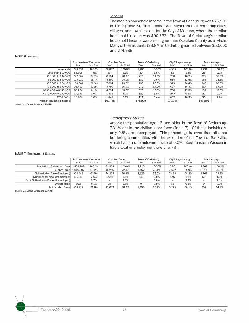
Employment StatusAmong the population age 16 and older in the Town of Cedarburg, 73.1% are in the civilian labor force (Table 7). Of those individuals, only 0.8% are unemployed. This percentage is lower than all other bordering communities with the exception of the Town of Saukville, which has an unemployment rate of 0.0%. Southeastern Wisconsin has a total unemployment rate of 5.7%.
IncomeThe median household income in the Town of Cedarburg was $75,909 in 1999 (Table 6). This number was higher than all bordering cities, villages, and towns except for the City of Mequon, where the median household income was $90,733. The Town of Cedarburg’s median household income was also higher than Ozaukee County as a whole. Many of the residents (23.8%) in Cedarburg earned between $50,000 and $74,999.
INCOME
Total % of Total Total % of Total Total % of Total Total % of Total Total % of Total
Households 749,634 100.0% 30,887 100.0% 1,903 100.0% 4,503 100.0% 1,234 100.0%Less Than $10,000 56,195 7.5% 837 2.7% 30 1.6% 82 1.8% 26 2.1%
$10,000 to $34,999 222,507 29.7% 6,184 20.0% 275 14.5% 730 16.2% 229 18.6%$35,000 to $49,999 125,222 16.7% 4,360 14.1% 182 9.6% 564 12.5% 167 13.5%$50,000 to $74,999 164,084 21.9% 7,324 23.7% 453 23.8% 919 20.4% 345 28.0%$75,000 to $99,999 91,480 12.2% 4,789 15.5% 340 17.9% 687 15.3% 214 17.3%
$100,000 to $149,999 60,794 8.1% 4,234 13.7% 379 19.9% 786 17.5% 192 15.6%$150,000 to $199,999 14,148 1.9% 1,311 4.2% 123 6.5% 273 6.1% 27 2.2%
$200,000+ 15,204 2.0% 1,848 6.1% 121 6.4% 462 10.3% 36 2.9%Median Household Income - - $62,745 - $75,909 - $70,288 - $63,856 -
Source: U.S. Census Bureau and SEWRPC
City-Village AverageSoutheastern Wisconsin Ozaukee County Town AverageTown of Cedarburg
TABLE 6: Income.
EMPLOYMENT STATUS
Total % of Total Total % of Total Total % of Total Total % of Total Total % of Total
Population 16 Years and Over 1,479,309 100.0% 62,858 100.0% 4,310 100.0% 10,901 100.0% 2,669 100.0%In Labor Force 1,009,387 68.2% 45,255 72.0% 3,152 73.1% 7,622 69.9% 2,017 75.6%
Civilian Labor Force (Employed) 954,443 64.5% 44,203 70.3% 3,126 72.5% 7,435 68.2% 1,968 73.7%Civilian Labor Force (Unemployed) 53,951 3.6% 1,016 1.6% 26 0.6% 176 1.6% 50 1.9%
% of Civilian Labor Force (Unemployed) - 5.7% - 2.3% - 0.8% - 2.3% - 2.1%Armed Forces 993 0.1% 36 0.1% 0 0.0% 11 0.1% 0 0.0%
Not in Labor Force 469,922 31.8% 17,603 28.0% 1,158 26.9% 3,279 30.1% 652 24.4%Source: U.S. Census Bureau and SEWRPC
Southeastern Wisconsin Ozaukee County Town AverageTown of Cedarburg City-Village Average
TABLE 7: Employment Status.
�9Comprehensive Plan: 2035 February 22, 2008
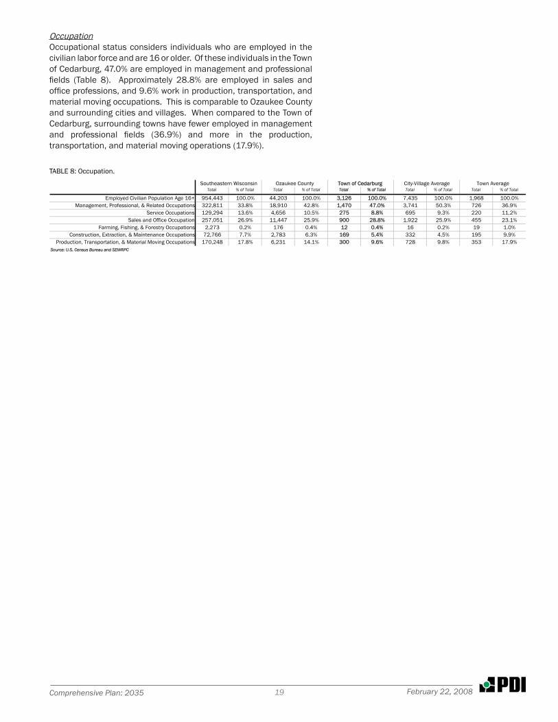
OccupationOccupational status considers individuals who are employed in the civilian labor force and are 16 or older. Of these individuals in the Town of Cedarburg, 47.0% are employed in management and professional fields (Table 8). Approximately 28.8% are employed in sales and office professions, and 9.6% work in production, transportation, and material moving occupations. This is comparable to Ozaukee County and surrounding cities and villages. When compared to the Town of Cedarburg, surrounding towns have fewer employed in management and professional fields (36.9%) and more in the production, transportation, and material moving operations (17.9%).
Total % of Total Total % of Total Total % of Total Total % of Total Total % of Total
Employed Civilian Population Age 16+ 954,443 100.0% 44,203 100.0% 3,126 100.0% 7,435 100.0% 1,968 100.0%Management, Professional, & Related Occupations 322,811 33.8% 18,910 42.8% 1,470 47.0% 3,741 50.3% 726 36.9%
Service Occupations 129,294 13.6% 4,656 10.5% 275 8.8% 695 9.3% 220 11.2%Sales and Office Occupation 257,051 26.9% 11,447 25.9% 900 28.8% 1,922 25.9% 455 23.1%
Farming, Fishing, & Forestry Occupations 2,273 0.2% 176 0.4% 12 0.4% 16 0.2% 19 1.0%Construction, Extraction, & Maintenance Occupations 72,766 7.7% 2,783 6.3% 169 5.4% 332 4.5% 195 9.9%
Production, Transportation, & Material Moving Occupations 170,248 17.8% 6,231 14.1% 300 9.6% 728 9.8% 353 17.9%Source: U.S. Census Bureau and SEWRPC
Southeastern Wisconsin Ozaukee County Town AverageTown of Cedarburg City-Village Average
TABLE 8: Occupation.