Embed Size (px)
Citation preview
Uig Harbour Redevelopment Environmental Impact Assessment (EIA) ReportVolume 1: Non-Technical Summary
The Highland Council
Project number: 60536743UHRD-ACM-ZZ-GE-RP-EN-00002
06 February 2019
Uig Harbour RedevelopmentEnvironmental Impact Assessment (EIA)
NON-TECHNICAL SUMMARY 60536743
Prepared for: The Highland Council
UHRD-ACM-ZZ-GE-RP-EN-00002AECOM
Quality information
Prepared by Checked by Approved by
– Consultant – Associate Director – Associate Director
Revision HistoryRevision Revision date Details Authorized Name Position
P01.1 05/10/2018 Working Draft
P01.2 07 Dec 2018 Working Draft forinternal review
P01.3 14 Jan 2019 Draft for ClientReview
Associate Director
P01 06 February 2019 Final for Issue Associate Director
Distribution List# Hard Copies PDF Required Association / Company Name
Electronic only
FINAL Electronic, printready.
Redacted
Redacted
Redacted
Redacted
RedactedRedacted Redacted

Uig Harbour RedevelopmentEnvironmental Impact Assessment (EIA)
NON-TECHNICAL SUMMARY 60536743
Prepared for: The Highland Council
UHRD-ACM-ZZ-GE-RP-EN-00002AECOM
Prepared for:The Highland CouncilDiriebught Depot94 Diriebught RoadInvernessIV2 3QNThe Highland Council
Prepared by:
AECOM Limited7th Floor, Aurora120 Bothwell StreetGlasgow G2 7JSUnited Kingdom
T: +44 141 248 0300aecom.comAECOM Infrastructure & Environment UK Limited1 TanfieldEdinburgh EH3 5DAUnited Kingdom
T: +44 131 301 8600aecom.com
© 2019 AECOM Limited. All Rights Reserved.This document has been prepared by AECOM Limited (“AECOM”) for sole use of our client (the “Client”) inaccordance with generally accepted consultancy principles, the budget for fees and the terms of referenceagreed between AECOM and the Client. Any information provided by third parties and referred to herein has notbeen checked or verified by AECOM, unless otherwise expressly stated in the document. No third party may relyupon this document without the prior and express written agreement of AECOM.
Uig Harbour RedevelopmentEnvironmental Impact Assessment (EIA)
NON-TECHNICAL SUMMARY 60536743
Prepared for: The Highland Council
UHRD-ACM-ZZ-GE-RP-EN-00002AECOM
Table of Contents
Volume 1: Non Technical Summary
Volume 2a: Main Report, Front End and Physical Environment
Volume 2b: Main Report, Biological Environment
Volume 2c: Main Report, Human Environment
Volume 3: Technical Appendices and Figures
Volume 1: Non Technical Summary. Table of Contents
1. Introduction .................................................................................................................. 51.1 The Purpose of the Document ............................................................................ 51.2 The Applications ................................................................................................. 51.3 Uig Harbour, Skye ............................................................................................... 61.4 National and Local Policy .................................................................................... 6
3. 2. Project Description ............................................................................................ 73.1 Site Description ................................................................................................... 73.2 Project Overview ................................................................................................. 73.3 Project Programme ............................................................................................. 9
5. 3. EIA & Scoping and Consultation Process .............................................................. 105.1 EIA Process ...................................................................................................... 105.2 EIA Scoping and Consultation ............................................................................ 11
6. Summary of Environmental Effects ............................................................................ 136.1 Introduction ....................................................................................................... 136.2 Marine Physical Environment ............................................................................ 136.3 Marine Water and Sediment Quality .................................................................. 136.4 Flood Risk & Climate Change ........................................................................... 146.5 Ground Conditions and Contamination ............................................................. 166.6 Marine Nature Conservation Areas ................................................................... 166.7 Benthic Ecology ................................................................................................ 176.8 Fish and Shellfish Ecology ................................................................................ 186.9 Marine Mammals .............................................................................................. 196.10 Ornithology ....................................................................................................... 206.11 Socio-Economics, Tourism & Public Access ...................................................... 216.12 Terrestrial Noise & Vibration .............................................................................. 216.13 Commercial and Recreational Navigation ......................................................... 226.14 Commercial Fisheries ....................................................................................... 226.15 Marine Archaeology & Cultural Heritage ........................................................... 23
7. Summary ................................................................................................................... 247.1 Uig Harbour on the Isle of Skye ........................................................................ 24

Uig Harbour RedevelopmentEnvironmental Impact Assessment (EIA)
NON-TECHNICAL SUMMARY 60536743
Prepared for: The Highland Council
UHRD-ACM-ZZ-GE-RP-EN-00002AECOM
TablesTable 3-1: List of Stakeholders Consulted ……………………………………………………………………………….12No table of figures entries found.
FiguresFigure 2-1: Proposed Development Site ............................................................................................................ 7Figure 2-2: The Proposed Development ............................................................................................................ 8Figure 3-1: EIA Process Flowchart................................................................................................................... 10Table 3-1: List of Stakeholders Consulted ........................................................................................................ 12
Uig Harbour RedevelopmentEnvironmental Impact Assessment (EIA)
NON-TECHNICAL SUMMARY 60536743
Prepared for: The Highland Council
UHRD-ACM-ZZ-GE-RP-EN-00002 AECOM5
1. Introduction
1.1 The Purpose of the Document
This document is the Non-Technical Summary (NTS) of the Environmental Impact 1.1.1Assessment (EIA) for the proposed Uig Harbour Redevelopment (The Proposed Development). The purposes of this document is to provide a summary, in non-technical language, of the EIA undertaken by AECOM on behalf of The Highland Council Development and Infrastructure Department (The Applicant), in support of the consent applications.
An EIA provides an assessment of likely significant effects as a result of the Uig 1.1.2Harbour Redevelopment proposals. The main volumes comprising the EIA Report are available separately, as follows:
· Volume 1 Non-Technical Summary;
· Volume 2 Main Report; and
· Volume 3 Figures and Appendices.
The NTS focusses on a discussion of residual effects. These are defined as a 1.1.3summary of the environmental impacts likely to occur to a receptor due to the Proposed Development, once mitigation measures have been applied. Environmental impacts during both construction and operation of the Proposed Development have been considered as appropriate. Where likely significant effects have not been identified, it can be concluded that residual effects have not been identified and therefore no additional mitigation is required.
1.2 The Applications
The EIA Report and this NTS document have been written to support a series of 1.2.1consent applications which are required to allow the Proposed Development to proceed. These comprise:
· A Harbour Revision Order: As the Proposed Development boundary extends beyond the current Port limits and existing powers operated by the Harbour Authority, an HRO is required. The consenting authority for this is Transport Scotland;
· A Marine Construction Licence: This is required for all elements of the Proposed Development which are proposed to be constructed below the extent of Mean High Water (MHWS). The consenting authority for this is Marine Scotland;
· A Dredging and Dredge Disposal Marine Licence: This covers the dredging activities that are required to facilitate the Proposed Development. It also includes the proposals to deposit sediment dredged from the construction site at a sea disposal location just outside Uig Bay, which has not previously been identified or used for this purpose. As a result the EIA Report also includes an evaluation of the suitability of the proposed deposition location to accommodate dredged sediment without causing significant residual effect. The consenting authority for the dredging licence application is Marine Scotland.
Uig Harbour RedevelopmentEnvironmental Impact Assessment (EIA)
NON-TECHNICAL SUMMARY 60536743
Prepared for: The Highland Council
UHRD-ACM-ZZ-GE-RP-EN-00002 AECOM6
· Planning Permission: This is specifically required for the proposal to construct a new ticket office to support the ferry operations.
1.3 Uig Harbour, Skye
Situated on the west coast of the Trotternish Peninsula on Skye’s north east coast, 1.3.1Uig Harbour is located within Uig Bay and forms part of the ‘Skye Triangle’ ferry service, which also includes harbours at Tarbert and Lochmaddy, and which together provide essential ferry services for the communities of the Western Isles; a vital role which is highlighted in national and local policy.
The King Edward Pier (the Pier) at Uig is under the control of Highland Harbours 1.3.2which is run by The Highland Council (THC); whilst the ferry service operations are controlled by CalMac Ferries Ltd. (CFL).
The present structure and layout of the harbour, including the Pier, has developed 1.3.3through a series of adjustments and alterations since the Pier’s initial creation and particularly as a result of two previous programmes of modernisation. The first was in 1984-1986 when, amongst other adjustments, Roll On / Roll Off facilities were provided for Caledonian MacBrayne’s MV Hebridean Isles. The second was in 2000 when additional free standing structures, known as ‘dolphins’, were installed in the inner and outer areas of the vessel berth to improve the mooring points available for the vessel.
In recent years there has been an increase in demand for the ferry services 1.3.4provided by the Skye Triangle. At the same time the vessel currently operating the route has been identified for replacement with a larger and more efficient vessel. In order to allow this new vessel to operate efficiently and reliably in the widest range of operating conditions, including poor weather conditions, a number of upgrades are required to Uig Harbour.
The Pier is currently used by a range of harbour users including the existing ferry 1.3.5service, commercial fishermen, aquaculture site operators and boat day trips. In addition, there are a number of residential properties in the vicinity of Uig Harbour, the closest of which is located approximately 40 m north east of the area within which the upgrades are proposed (the Proposed Development Area).
1.4 National and Local Policy
These proposed upgrades are supported in both the national and local policy 1.4.1context which acknowledges the crucial role that ports and harbours, including Uig, play in providing lifeline services to rural island and mainland communities. In addition the National Planning Framework 3 (NPF3) which was implemented in 2014 identifies significant opportunities in growth for Scotland’s coastal and island communities reliant on the crucial role of ferry services in connecting rural communities with the mainland.
Uig Harbour RedevelopmentEnvironmental Impact Assessment (EIA)
NON-TECHNICAL SUMMARY 60536743
Prepared for: The Highland Council
UHRD-ACM-ZZ-GE-RP-EN-00002 AECOM7
3. 2. Project Description
3.1 Site Description
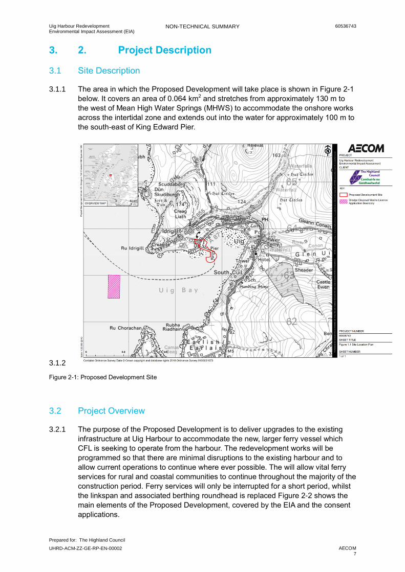
The area in which the Proposed Development will take place is shown in Figure 2-1 3.1.1below. It covers an area of 0.064 km2 and stretches from approximately 130 m to the west of Mean High Water Springs (MHWS) to accommodate the onshore works across the intertidal zone and extends out into the water for approximately 100 m to the south-east of King Edward Pier.
3.1.2
Figure 2-1: Proposed Development Site
3.2 Project Overview
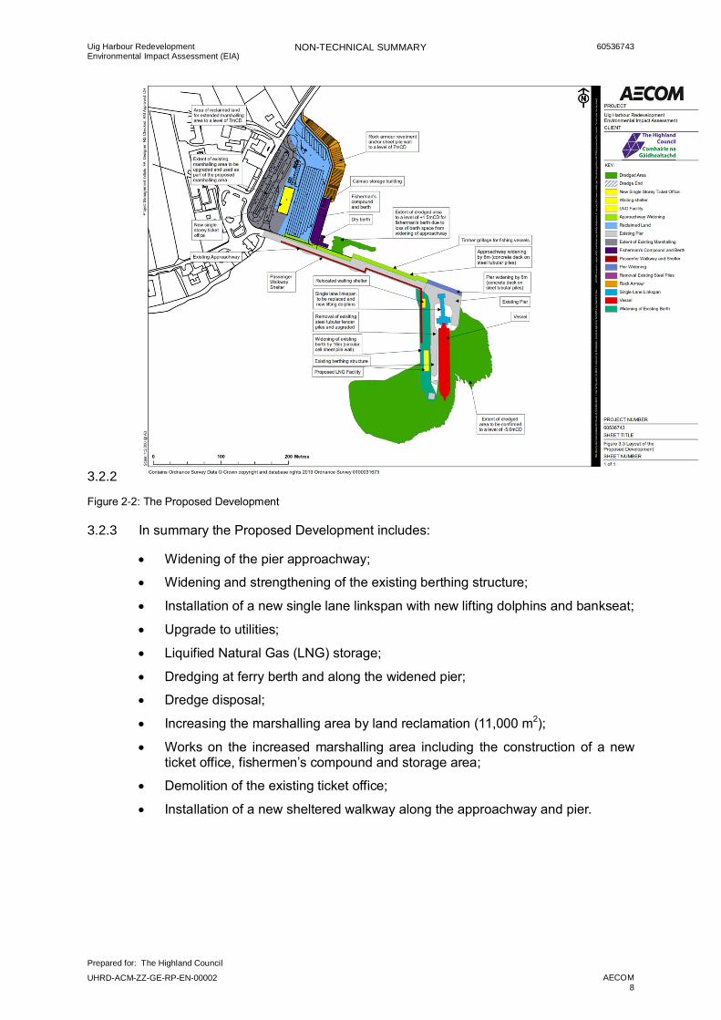
The purpose of the Proposed Development is to deliver upgrades to the existing 3.2.1infrastructure at Uig Harbour to accommodate the new, larger ferry vessel which CFL is seeking to operate from the harbour. The redevelopment works will be programmed so that there are minimal disruptions to the existing harbour and to allow current operations to continue where ever possible. The will allow vital ferry services for rural and coastal communities to continue throughout the majority of the construction period. Ferry services will only be interrupted for a short period, whilst the linkspan and associated berthing roundhead is replaced Figure 2-2 shows the main elements of the Proposed Development, covered by the EIA and the consent applications.
Uig Harbour RedevelopmentEnvironmental Impact Assessment (EIA)
NON-TECHNICAL SUMMARY 60536743
Prepared for: The Highland Council
UHRD-ACM-ZZ-GE-RP-EN-00002 AECOM8
3.2.2
Figure 2-2: The Proposed Development
In summary the Proposed Development includes: 3.2.3
· Widening of the pier approachway;
· Widening and strengthening of the existing berthing structure;
· Installation of a new single lane linkspan with new lifting dolphins and bankseat;
· Upgrade to utilities;
· Liquified Natural Gas (LNG) storage;
· Dredging at ferry berth and along the widened pier;
· Dredge disposal;
· Increasing the marshalling area by land reclamation (11,000 m2);
· Works on the increased marshalling area including the construction of a new ticket office, fishermen’s compound and storage area;
· Demolition of the existing ticket office;
· Installation of a new sheltered walkway along the approachway and pier.

Uig Harbour RedevelopmentEnvironmental Impact Assessment (EIA)
NON-TECHNICAL SUMMARY 60536743
Prepared for: The Highland Council
UHRD-ACM-ZZ-GE-RP-EN-00002 AECOM9
3.3 Project Programme
Whilst the construction programme is still being developed, the preferred option is 3.3.1to construct the Proposed Development as a single, integrated and continuous construction project over approximately 24 months.
It is possible however that the project may be delivered in up to three construction 3.3.2phases, in order to take account of a staged availability of project funding. Under a staged funding scenario, the following construction phases are anticipated to be undertaken over approximately 40 active working months, divided across the three phases:
· Phase 1: Essential upgrades. This will include the work that is required to allow safe operation of the service and to maximise service reliability, particularly in poor weather conditions. This phase would include: works to the approachway; the widening of the berthing structure; the installation of a new wave wall and scour protection for the widened pier, replacement of the linkspan; installation of new lighting, telecom, water and drainage services; and the dredging required around the pier.
· Phase 2: Marshalling area and ticket office. This will include the proposed land reclamation to accommodate a larger vehicle marshalling area; works to the fishermen’s compound; and construction of a new ticket office and storage building.
· Phase 3: Additional Activities. This will include demolition of old ticket office and installation of covered walkway for foot passengers
The ferry service from Uig is expected to continue as usual throughout the majority 3.3.3of the construction programme with the exception of the period of time required to complete the linkspan and berthing roundhead. The closure is expected to last up to approximately 12 weeks. The timing of this closure is yet to be confirmed, however it is most likely to occur either in the spring or autumn period, therefore avoiding the peak summer season when vehicle and passenger throughput is at its highest
Uig Harbour RedevelopmentEnvironmental Impact Assessment (EIA)
NON-TECHNICAL SUMMARY 60536743
Prepared for: The Highland Council
UHRD-ACM-ZZ-GE-RP-EN-00002 AECOM10
5. 3. EIA & Scoping and Consultation Process
5.1 EIA Process
EIA is a formal process used to evaluate the potential environmental consequences 5.1.1of a development project. EIA therefore ensures that potential problems are foreseen and addressed at an early stage in a project’s planning and design, where ever possible. Assessments are made of the significance of an effect on a wide range of receptors and mitigation measures are proposed to reduce any significant effects.
Consideration given to each topic in the EIA includes whether identified potential 5.1.2effects will be significant; this depends on the sensitivity of the existing environmental baseline and the scale of the change which will occur as a result of the development. It is this determination of significance which is crucial to informing the decision-making process.
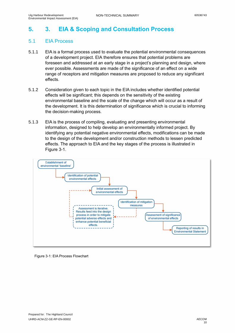
EIA is the process of compiling, evaluating and presenting environmental 5.1.3information, designed to help develop an environmentally informed project. By identifying any potential negative environmental effects, modifications can be made to the design of the development and/or construction methods to lessen predicted effects. The approach to EIA and the key stages of the process is illustrated in Figure 3-1.
Figure 3-1: EIA Process Flowchart

Uig Harbour RedevelopmentEnvironmental Impact Assessment (EIA)
NON-TECHNICAL SUMMARY 60536743
Prepared for: The Highland Council
UHRD-ACM-ZZ-GE-RP-EN-00002 AECOM11
5.2 EIA Scoping and Consultation
The Project has adopted a proactive approach to consultation with a wide range of 5.2.1consultees throughout the process of completing the EIA, commencing with the scoping exercise and the pre-application process.
A Scoping exercise documented in a Scoping Report, was carried out at an early 5.2.2stage in the EIA process to identify the potential for environmental effects and to explain which interactions between the project and the environment were considered to be potentially significant and therefore identified for further assessment within the EIA Report. The proposed scope of the EIA was submitted to Transport Scotland (TS), Marine Scotland, Licencing Operations Team (MS-LOT) and The Highland Council (THC) (Planning) on 28th September 2017. Consultation was carried out as part of this process with a range of statutory and non-statutory organisations and individuals with interests in the project.
The Applicant organised consultation meetings with Uig Harbour Users, Community 5.2.3Council and Community Trust on three separate occasions. These events offered the opportunity to discuss the Proposed Development works, to provide feedback to the Applicant through the Uig Community Trust, and to raise any concerns with the Proposed Development. Events were held on:
· 2nd October 2017 at the Uig Community Centre, Uig, Skye;
· 26th October 2017 at the Uig Community Centre, Uig, Skye; and
· 17th January 2018 at the Uig Community Centre, Uig, Skye.
In addition further Pre-application consultation events were completed in September 5.2.42017, with events held at the Uig Community Centre, Harris Hotel in Tarbert, and at Lochmaddy Village Hall. A further set of Pre-application consultation events were completed in February 2018 at the same venues.
Consultation and liaison will continue throughout the entire project. 5.2.5
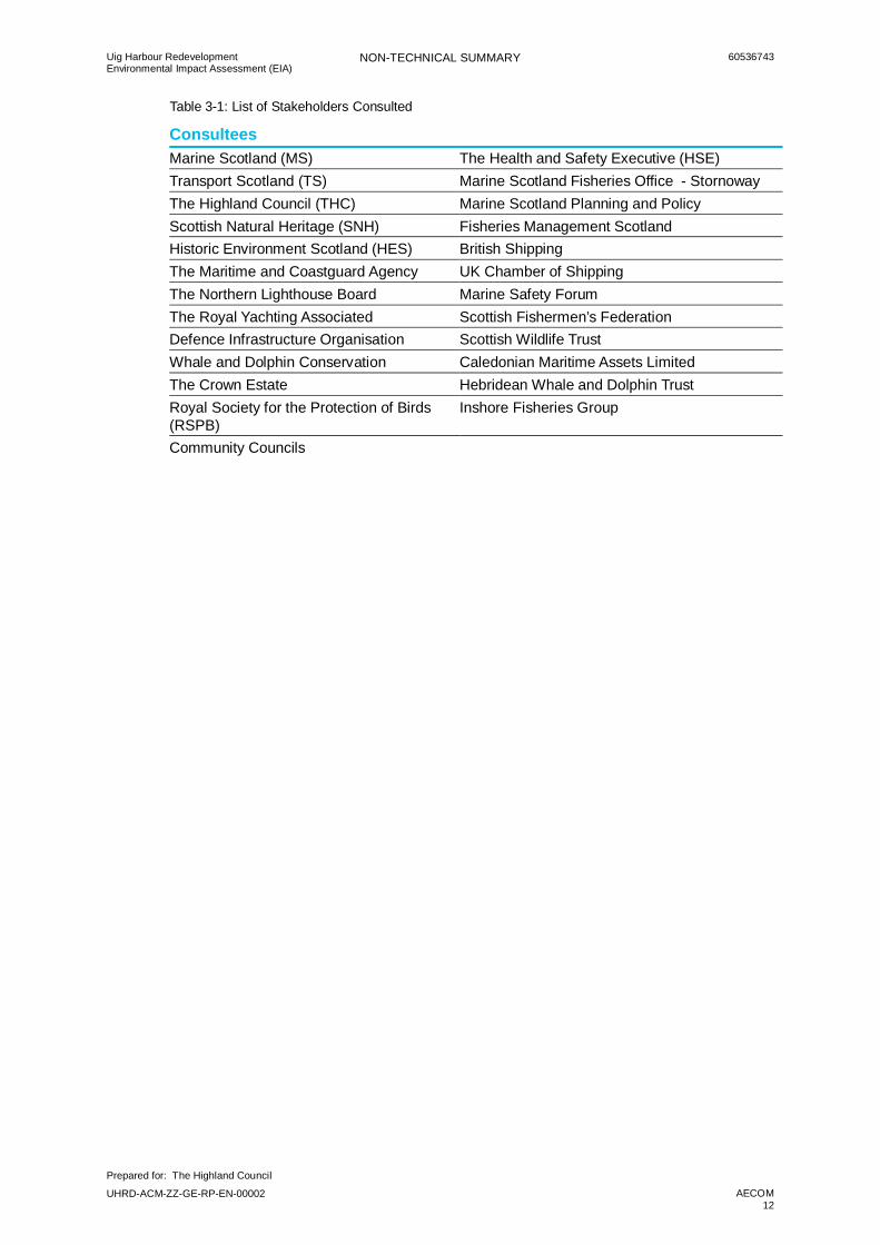
Consultation with the consenting authorities with jurisdiction over the various parts 5.2.6of the Proposed Development, as well as with statutory and non-statutory stakeholders has also been carried out throughout design development and as an ongoing part of the EIA. Consultation has been undertaken with the organisations and groups listed in Table 3-1 below, during the EIA process.
Uig Harbour RedevelopmentEnvironmental Impact Assessment (EIA)
NON-TECHNICAL SUMMARY 60536743
Prepared for: The Highland Council
UHRD-ACM-ZZ-GE-RP-EN-00002 AECOM12
Table 3-1: List of Stakeholders Consulted
ConsulteesMarine Scotland (MS) The Health and Safety Executive (HSE)Transport Scotland (TS) Marine Scotland Fisheries Office - StornowayThe Highland Council (THC) Marine Scotland Planning and PolicyScottish Natural Heritage (SNH) Fisheries Management ScotlandHistoric Environment Scotland (HES) British ShippingThe Maritime and Coastguard Agency UK Chamber of ShippingThe Northern Lighthouse Board Marine Safety ForumThe Royal Yachting Associated Scottish Fishermen’s FederationDefence Infrastructure Organisation Scottish Wildlife TrustWhale and Dolphin Conservation Caledonian Maritime Assets LimitedThe Crown Estate Hebridean Whale and Dolphin TrustRoyal Society for the Protection of Birds(RSPB)
Inshore Fisheries Group
Community Councils
Uig Harbour RedevelopmentEnvironmental Impact Assessment (EIA)
NON-TECHNICAL SUMMARY 60536743
Prepared for: The Highland Council
UHRD-ACM-ZZ-GE-RP-EN-00002 AECOM13
6. Summary of Environmental Effects
6.1 Introduction
The EIA Report identifies the environmental topics that have been assessed. For 6.1.1each assessment topic, the EIA Report describes the methodological approach to assessment, provides existing information on the local environment and describes the potential effects which could be expected during construction and operation of the Proposed Development.
6.2 Marine Physical Environment
The marine physical environment section of the EIA includes consideration of 6.2.1coastal and marine processes including waves, tides and tidal currents, sediment transport, suspended sediments and geomorphological processes. Assessments followed an evidence based approach drawing on a range of data sources including: survey data relating to bathymetry, sediment grab sampling and borehole logs; Numerical modelling studies and associated data sources including Acoustic Wave and Current Profiler (AWAC) field data; and regional mapping of seabed geology.
The EIA considered the potential for the Proposed Development to affect water and 6.2.2wave movement within Uig Bay, as well as the potential to affect water quality as a result of disturbance of seabed sediments resulting in increased concentrations of sediment suspended in the water column.
A series of modelling studies were completed looking at how sediment suspended 6.2.3into the water column, particularly during dredging and dredge disposals activities, could be expected to behave under a range of different tidal and wind/weather conditions. Modelling results indicate that any increases in suspended sediment during dredging and disposal activities will be short-term, rapidly returning to background levels following completion of the works. The greatest increases are predicted to occur at the dredge pockets themselves and at the point of sediment release at the proposed new disposal site, reducing rapidly with distance from source.
Effects on the marine physical environment associated with the Proposed 6.2.4Development were assessed as negligible to minor adverse. . The effects of changes to the marine physical environment on sensitive receptors including marine ecology etc. have also been considered and are discussed in later chapters.
6.3 Marine Water and Sediment Quality
Uig Bay and Loch Snizort form part of the Loch Snizort coastal water body as 6.3.1defined by SEPA. This water body is currently classified as being of overall good status.
Uig Harbour RedevelopmentEnvironmental Impact Assessment (EIA)
NON-TECHNICAL SUMMARY 60536743
Prepared for: The Highland Council
UHRD-ACM-ZZ-GE-RP-EN-00002 AECOM14
Results from the grab sampling and borehole logs collected to inform the EIA show 6.3.2that whilst the measured levels of most contaminants (oils and metals etc.) are largely well below action levels (as set by Marine Scotland), some sediments around Uig Bay contain elevated concentrations of certain metals including chromium, copper and nickel. These levels are not uniform across the bay but have been recorded at several locations, including the two proposed dredge pockets and the proposed new disposal site. These may be as a result of historic deposition within the sediments from the harbour activities, which have subsequently migrated along the northern shore of Uig Bay as a result of wave and/or tidal action. They may also be as a result of natural leaching of these metals from the local geology.
Identified effects on marine water and sediment quality associated with the 6.3.3Proposed Development include the potential to disturb, re-distribute and release contaminated sediments into the water column as a result of dredging activity and the disposal of dredge arisings to the proposed new disposal site. The potential for increased suspended sediment concentrations within the water column to reduce dissolved oxygen concentrations in the water was also considered. There will always be an element of risk from accidents and spillages/leaks in a construction operation (e.g. oil, fuel and lubricants from machinery) which could result in the contamination of the adjacent sediments and water.
Mitigation measures that will be implemented include the appropriate disposal of 6.3.4dredging materials, the installation of suitable bunding and storage facilities to prevent the release of fuel oils, lubricating fluids associated with the plant and equipment into controlled waters, best practices, safety precautions will be followed during refuelling activities to minimise the risk of an oil spill. Once these mitigation measures identified above are implemented, the potential for impact on marine water and sediment quality during the construction phase will be reduced to negligible.
Although some contaminants have been identified within the dredge sediment, 6.3.5similar concentrations also currently exist at the proposed disposal site. Sediment disturbance and redistribution as a result of dredging is therefore not expected to result in any significant change to contaminant concentrations within the bay. As discussed above, increases in sediment in the water column are not expected to be significant; consequently nor is any resultant effect on dissolved oxygen concentrations.
6.4 Flood Risk & Climate Change
Uig Bay is located on the eastern side of Loch Snizort and is fed by the River Rha 6.4.1and the River Conon which flow from surrounding land into the top of the bay. In addition, a small burn drains land to the north-west of Uig and is culverted beneath the A 87 and the existing marshalling area to outflow at the sea adjacent to the current reclaimed area.
Uig Harbour RedevelopmentEnvironmental Impact Assessment (EIA)
NON-TECHNICAL SUMMARY 60536743
Prepared for: The Highland Council
UHRD-ACM-ZZ-GE-RP-EN-00002 AECOM15
As discussed above, modelling studies were completed to identify how water levels, 6.4.2currents and wave climate may be affected by the Proposed Development. Modelling indicated that effects on water levels and wave climate will be limited in extent to the immediate vicinity of the pier structure, where the coastline is already influenced by existing water levels and is considered to be sensitive to any further change.
Construction activities will required the removal of sections of the existing wave wall 6.4.3for rebuilding. The resulting temporary risk to pier users can however be mitigated through the use of temporary barriers, warning signs and monitoring of flood and weather warnings. There will also be drainage arrangements agreed with SEPA, THC and Scottish Water as outlined in the CEMP to ensure surface water drainage is appropriately managed during construction.
The construction laydown, site offices and site compound will be located away from 6.4.4the harbour area and on higher ground in order to minimise the risk of flooding of construction equipment and the site compound. The contractor will produce a Flood Risk Management Plan/ method statement will be in place throughout construction which will explain how the contractor intends to identify and respond to any impending flood event.
Modelling completed as part of the assessment indicates that during adverse 6.4.5weather conditions incoming waves could result in ‘wave overtopping’ of existing coastal structures at the end of the pier near the shore area. This does not represent a new situation as wave overtopping already occurs at this location even without the Proposed Development. Any additional impact is expected to be minor, although the existing potential will not be improved by the Proposed Development.
Modelling also suggests that the pier approachway will continue to be affected by 6.4.6wave overtopping during adverse weather. Warning signs will be put in place to deter people from using the pier in dangerous weather conditions, however it will be unlikely that the pier will be used in poor weather conditions.
Uig Harbour RedevelopmentEnvironmental Impact Assessment (EIA)
NON-TECHNICAL SUMMARY 60536743
Prepared for: The Highland Council
UHRD-ACM-ZZ-GE-RP-EN-00002 AECOM16
6.5 Ground Conditions and Contamination
Ground conditions and the potential for existing land contamination to be present at 6.5.1the Proposed Development have been investigated through a combination of desk study, including review of historic data and past activities, and primary site investigation.
The ground conditions at the Proposed Development are made of superficial sand 6.5.2and gravel/raised beach deposits overlying basalt dominated bedrock. The marshalling area is currently ‘made-ground’ as a result of previous land reclamation. In addition current and former uses of the area including: activities associated with the ferry terminal; a petrol/fuel station; and former industrial uses (e.g. as part of previous diatomite mining activity) have introduced potential sources of existing ground contamination. These will be further investigated as part of pre-construction site investigations, and any pollution control and/or remediation measures which may be required, will be implemented.
No significant impacts to soil and groundwater are expected throughout the 6.5.3construction and operational phases of the Development provided that appropriate pollution control mitigation measures are applied. As a result the residual impact is predicted to be negligible.
Pollution control measures will be set out within a Construction Environmental 6.5.4Management Document (CEMD) containing a suite of Environmental Management Plans (EMPs) which will be developed prior to commencement of construction works. The CEMD will ensure that construction activities take place in accordance with all relevant legislation for the protection of surface and groundwater, codes of good practice as well as best practice guidance for works on or near water, such as PPGs prepared by SEPA.
6.6 Marine Nature Conservation Areas
There are three marine nature conservation sites surrounding the Proposed 6.6.1Development that are designated under national and international legislation. These are: Inner Hebrides and the Minches Special Area of Conservation (SAC) Ascrib, Isay and Dunvegan SAC, and Sea of Hebrides proposal Marine Protected Area (pMPA). A number of Priority Marine Features (PMFs) have also been previously recorded or identified as present during site specific survey within Loch Snizort and Uig Bay.
Potential effects on marine nature conservation sites have been assessed within 6.6.2the relevant technical chapters of the EIA, including possible cumulative effects. No significant residual impacts to designated sites, as a result of the construction or operation of Proposed Development, after control and mitigation measures have been identified.
Uig Harbour RedevelopmentEnvironmental Impact Assessment (EIA)
NON-TECHNICAL SUMMARY 60536743
Prepared for: The Highland Council
UHRD-ACM-ZZ-GE-RP-EN-00002 AECOM17
6.7 Benthic Ecology
A range of surveys were carried out in order to understand the benthic (seabed) 6.7.1ecology which may be affected by the Proposed Development. Intertidal habitats around Uig Bay were surveyed, along with boat-based grab sample and video surveys of the subtidal seabed habitats, particularly in the outer area of Uig Bay proposed as the sediment disposal site. This survey information was supplemented with a desk study of available published data including previous survey data from Marine Scotland, the Highland Council and other relevant surveys carried out in Skye.
Intertidal and subtidal habitats within Uig Bay and the wider environment of Loch 6.7.2Snizort are dominated by mud and sand habitats, with the eastern coast and northern edge of the bay entrance dominated by coarser sands and gravels and finer muddy sediments within outer and northern parts of the Bay. In addition, there are some localised areas of rocky reef, particularly around the Ascrib islands in Loch Snizort, but there are also bedrock habitats close to the north and south entrances of Uig Bay and close to the ferry terminal itself.
Subtidal sediments at the proposed dredge disposal site are dominated by 6.7.3polychaete worms and molluscs with recordings of two different species of seapens along with burrows in the seabed indicating the potential for the Scottish PMF habitat ‘Seapens and burrowing megafauna in circalittoral fine mud’. ‘Kelp and red seaweed on sublittoral sediments’ is also likely to be present in the Bay. (Previous records have identified a further PMF habitat ‘Inshore Deep Mud with Burrowing Heart Urchins’ near to the Rubha Raidhain fish farm on the far side of Uig Bay, but no heart urchins were identified during the subtidal surveys). These PMF habitats are of regional importance, being widespread across Uig Bay and around the coast of Scotland. Sublittoral PMF habitats are therefore considered to have low to medium sensitivity/importance.
The intertidal habitats and species in Uig Bay are considered to be typical of 6.7.4intertidal habitats widely distributed in Scottish coastal waters. No habitats or species of conservation concern, such as PMFs, have been identified in the intertidal region of Uig Bay.
Dredge disposal will cause a localised change in sediment particle size which is 6.7.5likely to result in a localised change in subtidal habitat composition in the affected area. However the proposed sea disposal site has been specifically chosen for, amongst other characteristics, its water depth and the retentive properties of seabed bathymetry. In addition, burrowing megafauna can tolerate being covered (smothered) with some sediment and the natural burrowing process (bioturbation) as a result of these species is also expected to help medium to long term recovery of the seabed and supported habitats. In addition, although dredging activities may result in some redistribution of identified contaminants within sediments the activity will not introduce any new contamination and will not result in any significant change in contamination levels within the sediments in the Bay.
Uig Harbour RedevelopmentEnvironmental Impact Assessment (EIA)
NON-TECHNICAL SUMMARY 60536743
Prepared for: The Highland Council
UHRD-ACM-ZZ-GE-RP-EN-00002 AECOM18
6.8 Fish and Shellfish Ecology
A desk study was carried out in consultation with local representatives from the 6.8.1fishing community in order to understand the characteristics of fish and shellfish ecology in Uig Bay and Loch Snizort which may be affected by the Proposed Development. Consultation indicates that the local area supports some commercial fisheries activity, although at low intensity when compared to other fishing grounds in the area.
Fish species in Uig Bay and Loch Snizort are known to include Atlantic Salmon, 6.8.2basking shark, cod, ling and herring with spawning areas of whiting, sand eel, sprat and the Dublin Bay prawn, Nephrops norvegicus known to include the northern waters of the Isle of Skye (Coull et al, 1998; and 2014). Local aquaculture activities include farming of Atlantic salmon and wrasse at Loch Snizort East finfish farm, approximately 4 km south of Uig Harbour and just outside the Bay and Uig Bay finfish farm in the south east of Uig Bay for production of Atlantic salmon. In addition, a number of species are the subject of sea angling that takes place in many areas around the Isle of Skye. This includes typical coastal species such as pollock, wrasse, flat fish, rays and dogfish, that are likely to be present in the vicinity of the Proposed Development, albeit in relatively low numbers.
Loch Snizort has been designated as an area of Shellfish Growing Waters (SGW) 6.8.3since 2000 for the production of the common periwinkle Littorina littorea and the common cockle Cerastoderma edule. There are also mussels present in Uig Bay. Nephrops (langoustine), crabs and scallops, may also be present, however, consultation with fishing representatives confirmed that whilst scallops and prawns are landed by boats in Uig these are generally caught in the Uists.
Sound plays a major role in the lives of fish and may be used to communicate, 6.8.4locate prey and avoid predators. As a result, fish are sensitive to underwater noise such as noise from construction piling. The sensitivity and potential for effects depends on fish physiology; those species with swim bladders are considered most sensitive. The noise expected to be generated in the water as a result of construction activities, particularly piling, has been modelled. This modelling has helped to understand how far construction noise could reasonably be expected to travel through the water, and at what sound levels (decibels). The modelled noise levels have been compared with published information relating to noise levels known to cause either disturbance or injury to fish. Injury as a result of construction noise would only occur to an individual at very close proximity to the noise source, but this is considered unlikely as any individual will move away from the noise as it starts up. Caged salmon in the fish farms in proximity to Uig Bay may exhibit temporary behaviour responses to construction noise, but at over 1 km distance from the sound source this are not expected to be significant.
Changes in suspended sediment concentrations within the water as a result of 6.8.5dredging activities have been modelling, including sediment concentrations expected close to nearby fish farms. These are not expected to significantly affect fish, including caged fish at fish farms.
Uig Harbour RedevelopmentEnvironmental Impact Assessment (EIA)
NON-TECHNICAL SUMMARY 60536743
Prepared for: The Highland Council
UHRD-ACM-ZZ-GE-RP-EN-00002 AECOM19
6.9 Marine Mammals
A desk top study was undertaken in order to understand the numbers, types 6.9.1(species) and frequency of marine mammals likely to be present within Uig Bay and Loch Snizort. This took specific account of available information relating to the adjacent SAC designations (Inner Hebrides and the Minches SAC; and Ascrib, Isay and Dunvegan SAC), designated as areas of protected habitat specifically for Harbour Porpoise and for seals.
The Inner Hebrides, including the Isle of Skye, are known to support a number of 6.9.2marine mammal species designated under Annex II of the EC Habitats Directive. These include: Harbour porpoise Phocoena phocoena ; Bottlenose dolphin Tursiops truncatus; White beaked dolphin Lagenorhynchus albirostris; Common dolphin Delphinus delphis; Minke whale Balaenoptera acutorostrata as well as the Common (harbour) seal Phoca vitulina. The most sensitive of these species is the harbour porpoise.
Anthropogenic underwater sound can affect a marine mammal’s ability to echolocate and to 6.9.2.1communicate; it can affect an individual’s behaviour (for example by interrupting feeding patterns and social interactions); and in extreme cases it can cause physical harm (through disorientation leading to beaching, and trauma to the auditory apparatus).
The noise expected to be generated in the water as a result of construction 6.9.3activities, particularly piling, has been modelled. This modelling has help to understand how far construction noise could reasonably be expected to travel through the water, and at what sound levels (decibels). The modelled noise levels have been compared with published information relating to noise levels known to cause injury (permanent or temporary), disturbance or other behavioural responses for the harbour porpoise, which is the most sensitive species identified to be present within and around Uig Bay.
Project construction is expected to require both vibratory and impact piling with up 6.9.4to two piling rigs operating at any one time. As impact piling is the noisier of the two piling methods, the Project will seek to avoid the simultaneous use of more than one impact piling rig.
Only noise very close (<10m) to source (i.e. the piling rig) may reach a level 6.9.5sufficient to cause permanent injury to marine mammals. Construction noise is however expected to result in a behavioural response from an individual marine mammal within close proximity, where an individual is expected to move away from the noise source.
Marine Mammal Observers (MMOs) will observe and monitor Uig Bay during noisy 6.9.6construction activities. Passive Acoustic Monitoring (PAM) will also be installed to ensure marine mammals continue to be monitored even during construction periods where visibility is poor. In addition, piling activities will use a ‘soft-start’ procedure which will generate a small noise first to give any individual an opportunity to move away before any louder noise begins. If an individual is observed in close proximity, then piling activities will not begin until it has moved away.
Uig Harbour RedevelopmentEnvironmental Impact Assessment (EIA)
NON-TECHNICAL SUMMARY 60536743
Prepared for: The Highland Council
UHRD-ACM-ZZ-GE-RP-EN-00002 AECOM20
Changes in suspended sediment concentrations within the water as a result of 6.9.7dredging activities have been modelling, these are considered in section 4.3 above and are not expected to significantly affect marine mammals.
6.10 Ornithology
Desk and field surveys (for both breeding and wintering birds) were carried out to 6.10.1understand the types of birds present, along with the usage and value of the habitats in Uig Bay and surrounding areas by birds.
Habitats within and immediately around Uig Bay are generally of low value to breeding bird species, 6.10.1.1other than those which are common and widespread. Whilst the cliffs on the south side of Uig Bay may support breeding seabirds, disturbance is not expected as a result of their distance from the Proposed Development.
There are however two notable species of bird known to breed in the area, which are: corncrake Crex 6.10.1.2crex and the white-tailed eagle Haliaeetus albicilla. Corncrake has been reported to be irregularly present (i.e. not every year) in the Uig area by the RSPB Corncrake Officer for Skye. White-tailed eagle has been observed to use a single breeding site in the local area for at least the last three years, and it is assumed that they will continue to do so. As specially-protected bird species of high conservation concern listed on Schedule 1 of the Wildlife and Countryside Act 1981 (WCA), the Project will take measures during construction to minimise any risk of disturbance to these birds.
Uig Bay is also used by an assemblage of wintering/passage birds which are 6.10.2relatively common and widespread in the local area.
Construction will require a small amount of vegetation to be cleared for a 6.10.3construction compound with some additional loss of intertidal habitat to accommodate the expanded marshalling area. Whilst a small number of seabirds currently using these areas as roosts will be displaced, other roost areas are available and any disturbance is not expected to be significant. Disturbance as a result of the physical presence of construction activities and as a result of increased operational activity once construction is complete will not be significant as birds are already accustomed to existing harbour activity.
Necessary measures to ensure compliance of the construction works with 6.10.4environmental legislation will be embedded within a Construction Environment Management Plan (CEMP).
Uig Harbour RedevelopmentEnvironmental Impact Assessment (EIA)
NON-TECHNICAL SUMMARY 60536743
Prepared for: The Highland Council
UHRD-ACM-ZZ-GE-RP-EN-00002 AECOM21
6.11 Socio-Economics, Tourism & Public Access
The Isle of Skye, the largest island in the Inner Hebrides, welcomes large numbers 6.11.1of tourists every year and is known for its dramatic landscapes, wilderness and local history and is popular for walking and outdoor pursuits. The ferry services and the associated tourism trade makes a significant contribution to the economy of Uig, which includes service providers catering for tourists including hotels, bed and breakfast accommodation, caravan parks, restaurants and cafes. A number of marine businesses also operate from Uig harbour including commercial fisheries activities, fish farm operators and an outdoor adventure centre.
It is inevitable that construction activities will generate some noise which will be 6.11.2heard within the local community with some temporary loss of amenity. Noise will be minimised where ever possible and noise generating activities will only be carried out during the day, therefore avoiding evening, overnight and early morning disturbance where ever possible. In addition, the ferry service will continue to operate throughout the majority of the construction works. Where it is necessary to suspend the ferry service temporarily to allow for the replacement of the linkspan, the necessary closure will be publicised well in advance, alternative services will be provided from other west coast ports and the length of time that the ferry service is suspended for will be kept to a necessary minimum.
Once completed, the new ferry will offer increased capacity as well as an 6.11.3improvement in the ability to operate a ferry service during poor weather conditions. As a result the Proposed Development is expected to result in an increase in both vehicle and footfall numbers through Uig, bringing potential long term benefit to the local community.
6.12 Terrestrial Noise & Vibration
Existing noise levels in and around Uig are dominated by road traffic on the A87 6.12.1and by boat movements in the harbour. The site is in a rural location and the baseline noise levels are general low.
It is inevitable that construction activities will generate some noise which will be 6.12.2heard within the local community. Construction activities requiring pile driving are likely to generate the most noise. These will occur at various stages throughout the construction and will be particularly associated with works to widen the vessel berth and the approachway, as well as associated with dredging, land reclamation and the replacement of the ticket office.
Residential properties close to the Proposed Development site are likely to be the 6.12.3most sensitive to noise generated by construction activities which may be heard over and above the existing noise levels which residents are already used to. Impacts at the closest properties were considered to be representative of worst-case impacts.
Uig Harbour RedevelopmentEnvironmental Impact Assessment (EIA)
NON-TECHNICAL SUMMARY 60536743
Prepared for: The Highland Council
UHRD-ACM-ZZ-GE-RP-EN-00002 AECOM22
Where practicable, mitigation measures in the form of mobile or semi-permanent 6.12.4noise barriers located as close to the construction activities as possible will be installed, however where this is not feasible (such as along the approachway and on the pier structure) other noise reducing mitigation measures will be used which may include the installation of shrouds around the piling hammers. In addition a construction noise management plan will be produced to ensure appropriate and available noise controls are employed throughout the construction process.
Residents will be informed of noisy works in advance of activities commencing. 6.12.5Noisy works will be programmed to take place during the least sensitive times of the day and will be interspersed with quieter activities where possible to provide periods of respite.
6.13 Commercial and Recreational Navigation
The ferry service operated by CFL is the main user of Uig harbour, which is also 6.13.1used by both local and visiting fishing vessels, as well as vessels involved in the aquaculture industry. In addition, a small number of recreational vessels are regularly or occasionally moored in the harbour, with the closest Royal Yachting Association (RYA) affiliated clubs based at Portree on the eastern coast of the Isle of Skye and at Lochmaddy in the Western Isles.
A range of potential scenarios in which the Proposed Development may affect the 6.13.2navigation of vessels using Uig harbour has been considered including the potential for accidents or incidents involving construction craft as well as the potential for access restrictions to other harbour users as a result of construction. Construction activities will be timed to avoid interaction with the ferry service including within the turning space the ferry requires in order to approach the quay. All activities will be carried out in accordance with the harbour’s Marine Safety Management System; appropriate Notices to Mariners will be issued and all construction vessels will carry appropriate vessel identification system (AIS) to ensure their location is always available to other vessels.
Works affecting existing berths for fishing vessels etc. will be phased to ensure 6.13.3berths will remain available for use throughout construction. Access to these berths is not expected to be significantly affected as sufficient navigable water is available within the Bay to avoid construction activities.
6.14 Commercial Fisheries
Scottish Government fisheries statistics, published data sources and consultation 6.14.1with representatives from the local fishing community were analysed in order to understand the commercial fisheries activities in Uig Bay and Loch Snizort which may be affected by the Proposed Development. Consultation indicates that the local area supports some commercial fisheries activity, although at low intensity when compared to other fishing grounds in the area. Nephrops, scallop and crabs were the top three species landed (by weight and value) into Uig by Scottish and English fishing vessels in 2016, as shown by UK annual fisheries statistics. However, these species of fish are generally caught around the Outer Hebrides (e.g. Rodel, the Uists) and the Shiant Islands.
Uig Harbour RedevelopmentEnvironmental Impact Assessment (EIA)
NON-TECHNICAL SUMMARY 60536743
Prepared for: The Highland Council
UHRD-ACM-ZZ-GE-RP-EN-00002 AECOM23
A small number of fishing vessels operate out of Uig Harbour on a permanent basis 6.14.2whilst a larger number of fishing vessels use the harbour on a less regular basis. Both trawlers and creelers utilise the harbour facilities, making Uig Harbour of local importance to the fishermen. Access to the harbour for fishing boats will be maintained throughout construction including additional temporary moorings if necessary. Separate assessments of potential for effects on fish ecology from construction noise etc., have also confirmed that construction will not significantly effect fish biology therefore fish stocks.
6.15 Marine Archaeology & Cultural Heritage
Maritime archaeology and cultural heritage includes the history and material 6.15.1remains of people and their activities on, under, near or associated with the sea. This includes shipwrecks, submerged settlements and buildings in and around coastal areas. It is important to characterise any artefacts which are known to be in the area and also to understand the potential for new artefacts to be discovered.
The wreck of the fishing vessel Sarah Lena which was lost on 25th June 2010 is 6.15.2located approximately 2.6 km south-west of the pier and close to the proposed sea disposal site. Sediment dispersion modelling has been used to understand how deposited dredge materials may affect this site, and has confirmed that dredge deposition is not expected to result in significant effect on this wreck.
The steamship Irlanda which was stranded and sunk at Idrigill Point in 1943, lies 6.15.3approximately 1.7 km west of the pier. This wreck site lies outside any expected influence of the Proposed Development.
A staged programme of archaeological investigation will be undertaken to determine 6.15.4the palaeoenvironmental potential of the peaty deposits and organic sediments found during ground investigations, and the possibility that they may contain archaeological remains.
Uig Harbour RedevelopmentEnvironmental Impact Assessment (EIA)
NON-TECHNICAL SUMMARY 60536743
Prepared for: The Highland Council
UHRD-ACM-ZZ-GE-RP-EN-00002 AECOM24
7. Summary
7.1 Uig Harbour on the Isle of Skye
The Applicant is proposing to redevelop Uig Harbour on the Isle of Skye to improve 7.1.1lifeline ferry services to rural communities and to accommodate the introduction to service of a new, larger vessel on the route, to provide increased capacity for both local community and tourists. The new vessel which will operate from Uig will be one of a new generation dual-fuel vessels currently under construction for CMAL, with the capacity to use either Marine Gas Oil (MGS) or Liquefied Natural Gas (LNG). This new vessel will be cleaner and more efficient than the existing vessel and will make an important contribution towards air quality improvements and the Scottish Government’s Climate Change objectives.
Uig Harbour has been identified as a ‘national development’ by the Scottish 7.1.2Government in the National Planning Framework 3 which acknowledges the important opportunity for growth in Scotland’s coastal and island communities and highlights the crucial role that lifeline ferry services play in reducing the disadvantage of distance for these communities by supporting economic activity and delivering public services.
An EIA has been undertaken by AECOM on behalf of The Applicant to identify 7.1.3potentially significant effects that the Proposed Development may have on a range of physical, biological and human receptors, the findings of which are set out within the EIA Report and this Non-Technical Summary (NTS) which accompanies the consent applications.
Mitigation measures have been proposed to reduce the significance of impacts that 7.1.4have been identifies from the EIA. A Construction Environmental Management Plan will be produced which will summarise the mitigation measures proposed during construction and operation of the development. All details for mitigation measures will be agreed with regulatory authorities prior to construction being commenced.

Uig Harbour RedevelopmentEnvironmental Impact Assessment (EIA)
NON-TECHNICAL SUMMARY 60536743
Prepared for: The Highland Council
UHRD-ACM-ZZ-GE-RP-EN-00002 AECOM25
aecom.com