Embed Size (px)
Citation preview
U.S. Army Research, Development and
Engineering Command
US ARMY CERDEC Dismounted Solder Navigation – Update
2012 Precision Indoor Personnel Location and Tracking Annual International Technology Workshop
DISTRIBUTION STATEMENT A. Approved for public release; distribution is unlimited.
CP&I - Delivering Innovation
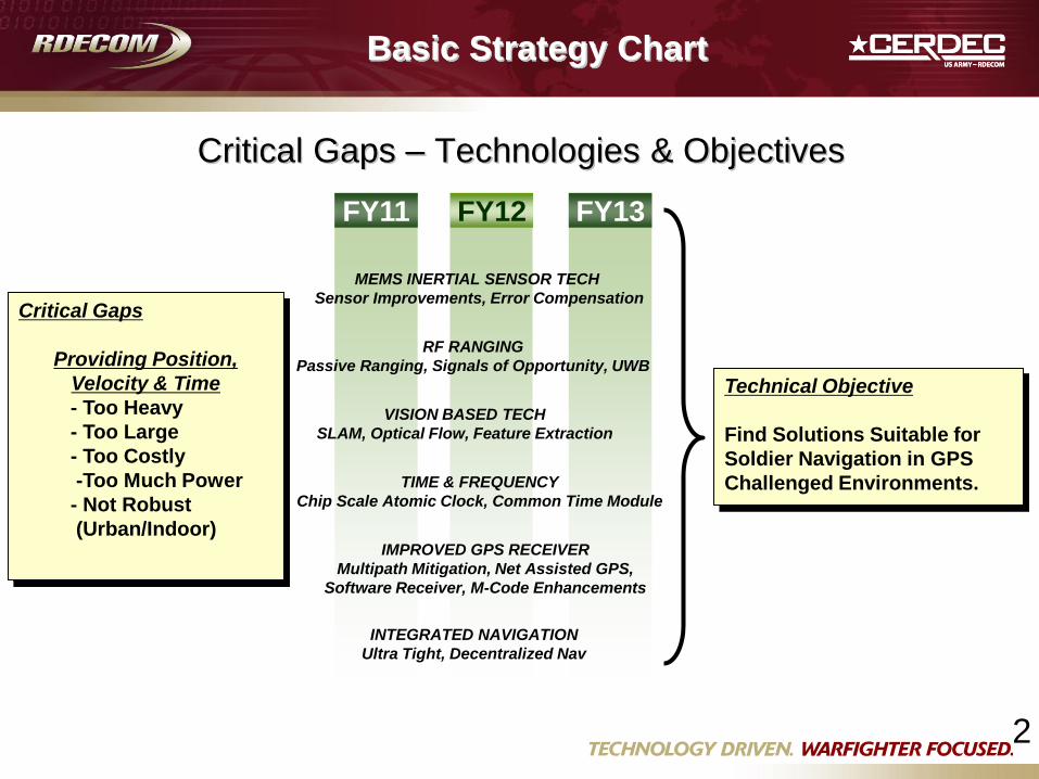
Critical Gaps – Technologies & Objectives
FY11 FY12 FY13
MEMS INERTIAL SENSOR TECH
Sensor Improvements, Error Compensation
RF RANGING
Passive Ranging, Signals of Opportunity, UWB
TIME & FREQUENCY
Chip Scale Atomic Clock, Common Time Module
INTEGRATED NAVIGATION
Ultra Tight, Decentralized Nav
IMPROVED GPS RECEIVER
Multipath Mitigation, Net Assisted GPS,
Software Receiver, M-Code Enhancements
Technical Objective
Find Solutions Suitable for
Soldier Navigation in GPS
Challenged Environments.
Critical Gaps
Providing Position,
Velocity & Time
- Too Heavy
- Too Large
- Too Costly
-Too Much Power
- Not Robust
(Urban/Indoor)
Basic Strategy Chart
VISION BASED TECH
SLAM, Optical Flow, Feature Extraction
2
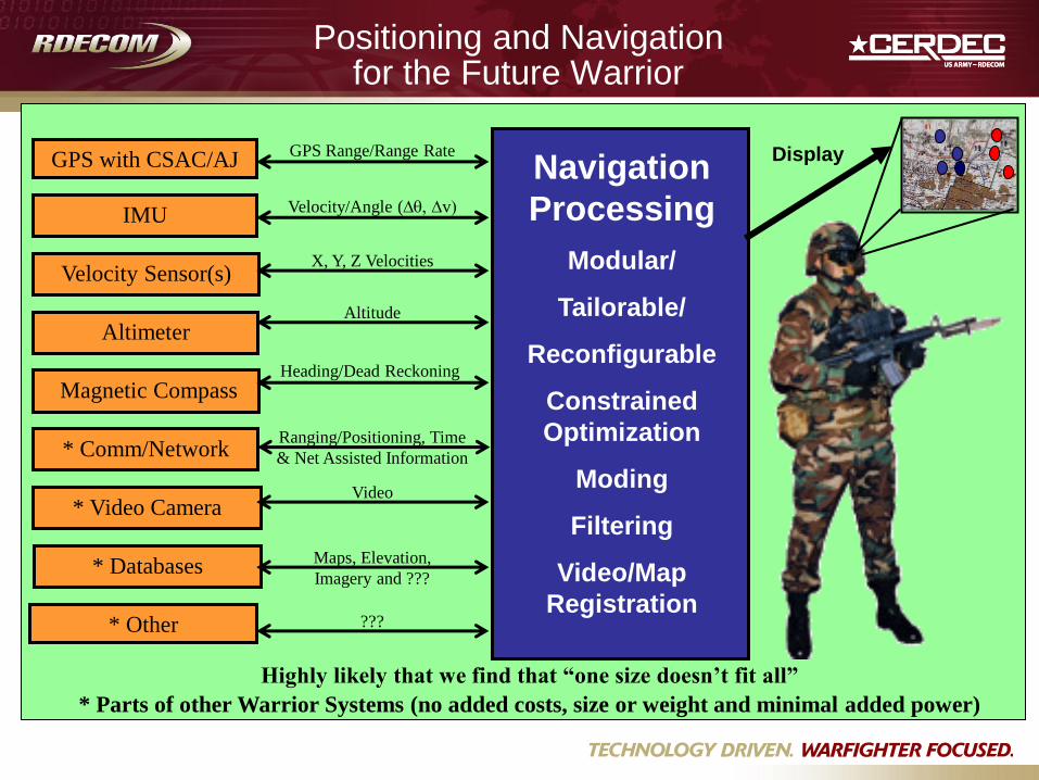
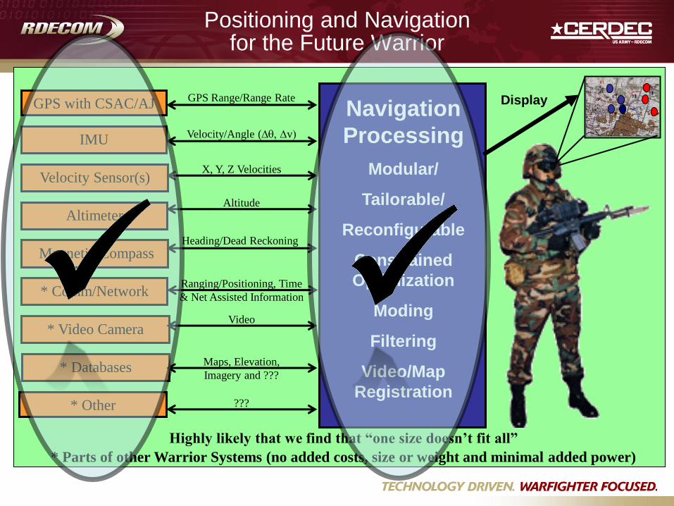
Positioning and Navigation for the Future Warrior
GPS with CSAC/AJ
* Comm/Network
Altitude
Magnetic Compass
IMU
Video
Velocity/Angle (Dq, Dv)
* Video Camera
Velocity Sensor(s)
Altimeter
Heading/Dead Reckoning
Ranging/Positioning, Time
& Net Assisted Information
Navigation
Processing
Modular/
Tailorable/
Reconfigurable
Constrained
Optimization
Moding
Filtering
Video/Map
Registration
X, Y, Z Velocities
GPS Range/Range Rate Display
???
Maps, Elevation,
Imagery and ??? * Databases
Highly likely that we find that “one size doesn’t fit all”
* Parts of other Warrior Systems (no added costs, size or weight and minimal added power)
* Other
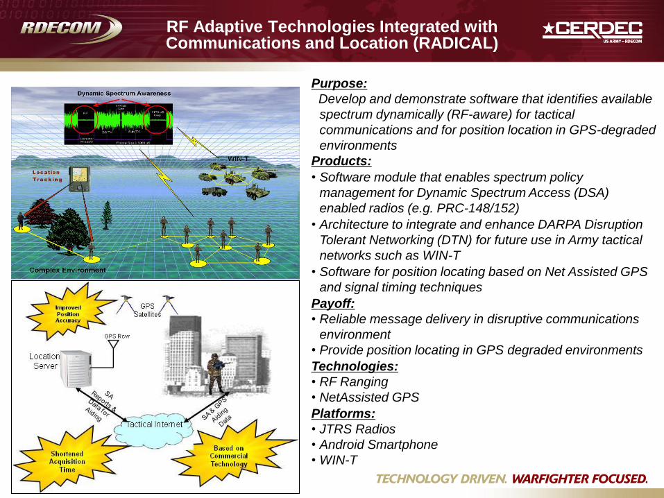
RF Adaptive Technologies Integrated with Communications and Location (RADICAL)
Purpose:
Develop and demonstrate software that identifies available
spectrum dynamically (RF-aware) for tactical
communications and for position location in GPS-degraded
environments
Products:
• Software module that enables spectrum policy
management for Dynamic Spectrum Access (DSA)
enabled radios (e.g. PRC-148/152)
• Architecture to integrate and enhance DARPA Disruption
Tolerant Networking (DTN) for future use in Army tactical
networks such as WIN-T
• Software for position locating based on Net Assisted GPS
and signal timing techniques
Payoff:
• Reliable message delivery in disruptive communications
environment
• Provide position locating in GPS degraded environments
Technologies:
• RF Ranging
• NetAssisted GPS
Platforms:
• JTRS Radios
• Android Smartphone
• WIN-T
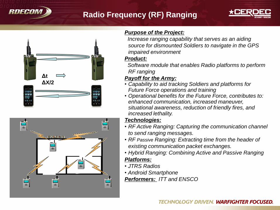
Radio Frequency (RF) Ranging
Purpose of the Project:
Increase ranging capability that serves as an aiding
source for dismounted Soldiers to navigate in the GPS
impaired environment
Product:
Software module that enables Radio platforms to perform
RF ranging
Payoff for the Army: • Capability to aid tracking Soldiers and platforms for
Future Force operations and training • Operational benefits for the Future Force, contributes to:
enhanced communication, increased maneuver, situational awareness, reduction of friendly fires, and increased lethality.
Technologies:
• RF Active Ranging: Capturing the communication channel
to send ranging messages.
• RF Passive Ranging: Extracting time from the header of
existing communication packet exchanges.
• Hybrid Ranging: Combining Active and Passive Ranging
Platforms:
• JTRS Radios
• Android Smartphone
Performers: ITT and ENSCO
Δt
ΔX/2
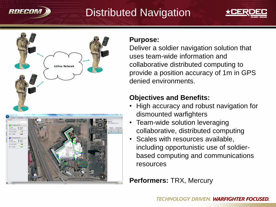
Purpose:
Deliver a soldier navigation solution that
uses team-wide information and
collaborative distributed computing to
provide a position accuracy of 1m in GPS
denied environments.
Objectives and Benefits:
• High accuracy and robust navigation for
dismounted warfighters
• Team-wide solution leveraging
collaborative, distributed computing
• Scales with resources available,
including opportunistic use of soldier-
based computing and communications
resources
Performers: TRX, Mercury
Distributed Navigation
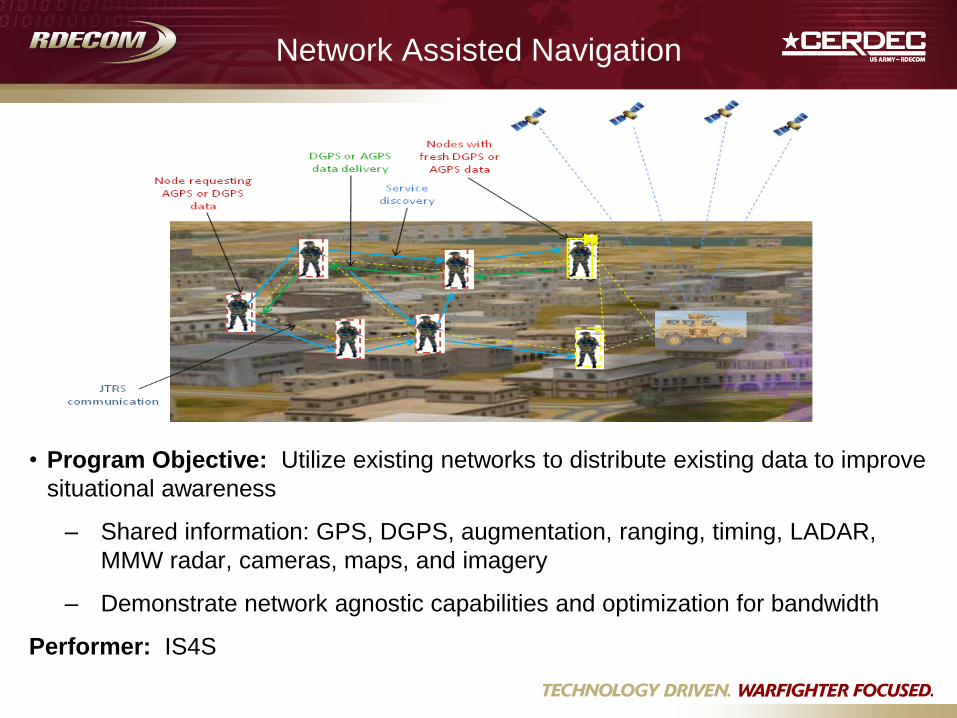
Network Assisted Navigation
• Program Objective: Utilize existing networks to distribute existing data to improve
situational awareness
– Shared information: GPS, DGPS, augmentation, ranging, timing, LADAR,
MMW radar, cameras, maps, and imagery
– Demonstrate network agnostic capabilities and optimization for bandwidth
Performer: IS4S
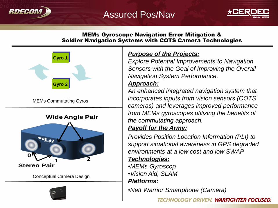
Assured Pos/Nav
Purpose of the Projects:
Explore Potential Improvements to Navigation
Sensors with the Goal of Improving the Overall
Navigation System Performance.
Approach:
An enhanced integrated navigation system that
incorporates inputs from vision sensors (COTS
cameras) and leverages improved performance
from MEMs gyroscopes utilizing the benefits of
the commutating approach.
Payoff for the Army:
Provides Position Location Information (PLI) to
support situational awareness in GPS degraded
environments at a low cost and low SWAP
Technologies:
•MEMs Gyroscop
•Vision Aid, SLAM
Platforms:
•Nett Warrior Smartphone (Camera)
Gyro 2
Gyro 1
MEMs Commutating Gyros
Stereo Pair
Wide Angle Pair
01 2
Conceptual Camera Design
MEMs Gyroscope Navigation Error Mitigation &
Soldier Navigation Systems with COTS Camera Technologies
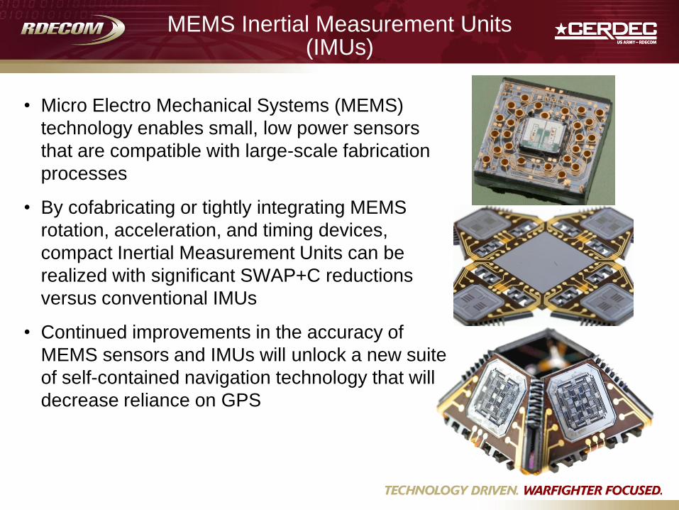
MEMS Inertial Measurement Units (IMUs)
• Micro Electro Mechanical Systems (MEMS)
technology enables small, low power sensors
that are compatible with large-scale fabrication
processes
• By cofabricating or tightly integrating MEMS
rotation, acceleration, and timing devices,
compact Inertial Measurement Units can be
realized with significant SWAP+C reductions
versus conventional IMUs
• Continued improvements in the accuracy of
MEMS sensors and IMUs will unlock a new suite
of self-contained navigation technology that will
decrease reliance on GPS
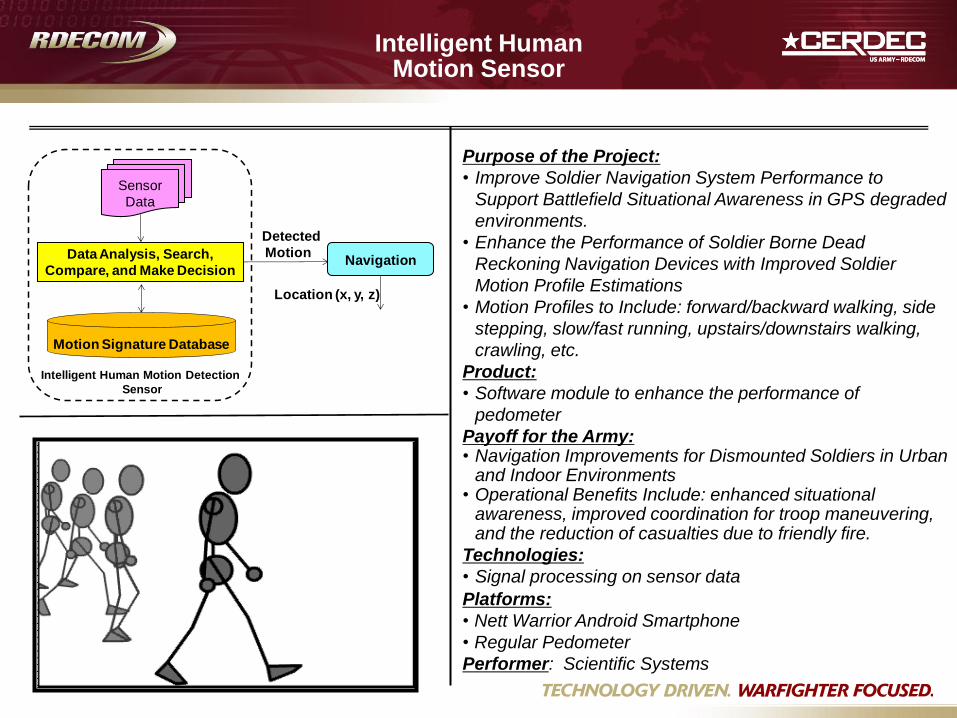
Intelligent Human
Motion Sensor
Purpose of the Project:
• Improve Soldier Navigation System Performance to
Support Battlefield Situational Awareness in GPS degraded
environments.
• Enhance the Performance of Soldier Borne Dead
Reckoning Navigation Devices with Improved Soldier
Motion Profile Estimations
• Motion Profiles to Include: forward/backward walking, side
stepping, slow/fast running, upstairs/downstairs walking,
crawling, etc.
Product:
• Software module to enhance the performance of
pedometer
Payoff for the Army: • Navigation Improvements for Dismounted Soldiers in Urban
and Indoor Environments • Operational Benefits Include: enhanced situational
awareness, improved coordination for troop maneuvering, and the reduction of casualties due to friendly fire.
Technologies:
• Signal processing on sensor data
Platforms:
• Nett Warrior Android Smartphone
• Regular Pedometer
Performer: Scientific Systems
Motion Signature Database
Data Analysis, Search,
Compare, and Make Decision
Sensor
Data
Navigation
Detected
Motion
Location (x, y, z)
Intelligent Human Motion Detection
Sensor
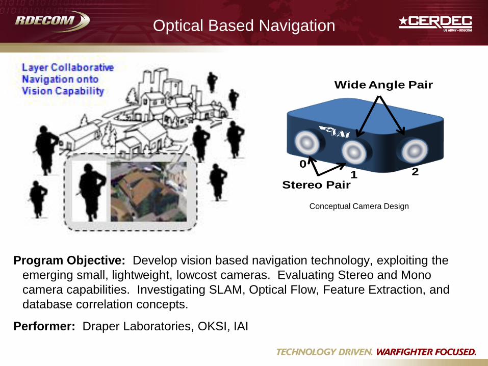
Optical Based Navigation
Stereo Pair
Wide Angle Pair
01 2
Conceptual Camera Design
Program Objective: Develop vision based navigation technology, exploiting the
emerging small, lightweight, lowcost cameras. Evaluating Stereo and Mono
camera capabilities. Investigating SLAM, Optical Flow, Feature Extraction, and
database correlation concepts.
Performer: Draper Laboratories, OKSI, IAI
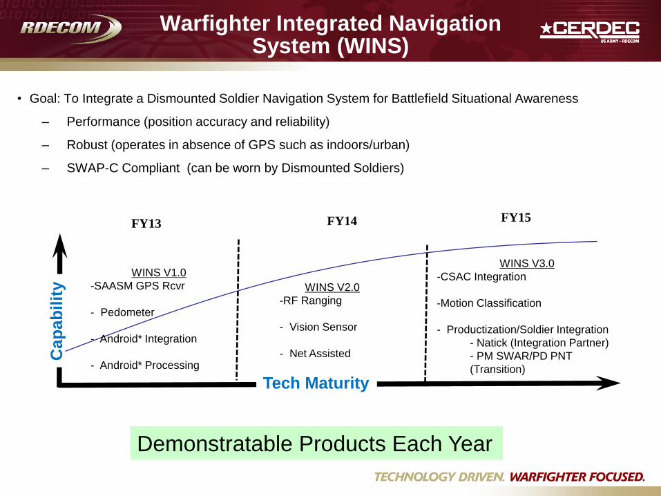
Warfighter Integrated Navigation System (WINS)
Tech Maturity
• Goal: To Integrate a Dismounted Soldier Navigation System for Battlefield Situational Awareness
– Performance (position accuracy and reliability)
– Robust (operates in absence of GPS such as indoors/urban)
– SWAP-C Compliant (can be worn by Dismounted Soldiers)
Cap
ab
ilit
y WINS V1.0
-SAASM GPS Rcvr
- Pedometer
- Android* Integration
- Android* Processing
FY13 FY14 FY15
WINS V2.0
-RF Ranging
- Vision Sensor
- Net Assisted
WINS V3.0
-CSAC Integration
-Motion Classification
- Productization/Soldier Integration
- Natick (Integration Partner)
- PM SWAR/PD PNT
(Transition)
Demonstratable Products Each Year

Multi-Global Navigation Satellite System (GNSS) Receivers
Purpose: • To investigate a more robust satellite based navigation
solution for use by the US Army.
• Relies on many different RF signals making it
more difficult to deny or spoof.
• Investigate feasibility of developing SWAP-C compliant
multi-GNSS receivers and antennas.
Results: • Receiver capable of operating with several different
GNSS signals from space. Configurable and dynamic
to take advantage of good signals and optimize a
navigation solution.
• Tools to analyze performance and model and simulate
the effects of GNSS receivers in place of GPS
receivers in navigation equipment/systems. Utilize
CIGNM and new Spirent GNSS Simulator.
Payoff for the Army: • Better understanding of value (strengths and
weaknesses) of a multi-GNSS solution.
• Simulation tool to investigate impacts on various
navigation systems.
• Potentially more robust space based navigation
solution than a pure GPS based navigation solution.
Positioning and Navigation for the Future Warrior
GPS with CSAC/AJ
* Comm/Network
Altitude
Magnetic Compass
IMU
Video
Velocity/Angle (Dq, Dv)
* Video Camera
Velocity Sensor(s)
Altimeter
Heading/Dead Reckoning
Ranging/Positioning, Time
& Net Assisted Information
Navigation
Processing
Modular/
Tailorable/
Reconfigurable
Constrained
Optimization
Moding
Filtering
Video/Map
Registration
X, Y, Z Velocities
GPS Range/Range Rate Display
???
Maps, Elevation,
Imagery and ??? * Databases
Highly likely that we find that “one size doesn’t fit all”
* Parts of other Warrior Systems (no added costs, size or weight and minimal added power)
* Other
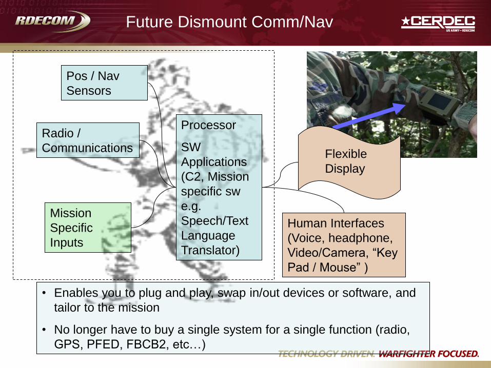
Pos / Nav
Sensors
Radio /
Communications
Human Interfaces
(Voice, headphone,
Video/Camera, “Key
Pad / Mouse” )
Processor
SW
Applications
(C2, Mission
specific sw
e.g.
Speech/Text
Language
Translator)
Mission
Specific
Inputs
• Enables you to plug and play, swap in/out devices or software, and
tailor to the mission
• No longer have to buy a single system for a single function (radio,
GPS, PFED, FBCB2, etc…)
Future Dismount Comm/Nav
Flexible
Display
BACK UPS
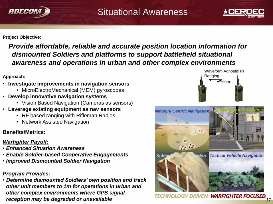
Warfighter Payoff:
• Enhanced Situation Awareness
• Enable Soldier-based Cooperative Engagements
• Improved Dismounted Soldier Navigation
Program Provides:
• Determine dismounted Soldiers’ own position and track
other unit members to 1m for operations in urban and
other complex environments where GPS signal
reception may be degraded or unavailable
Project Objective:
17
Approach:
Provide affordable, reliable and accurate position location information for
dismounted Soldiers and platforms to support battlefield situational
awareness and operations in urban and other complex environments
• Investigate improvements in navigation sensors
• MicroElectroMechanical (MEM) gyroscopes
• Develop innovative navigation systems
• Vision Based Navigation (Cameras as sensors)
• Leverage existing equipment as nav sensors
• RF based ranging with Rifleman Radios
• Network Assisted Navigation
Situational Awareness
Benefits/Metrics:
Network Centric Navigation Urban/Indoor Navigation
Subterranean Navigation Tactical Vehicle Navigation
Waveform Agnostic RF
Ranging
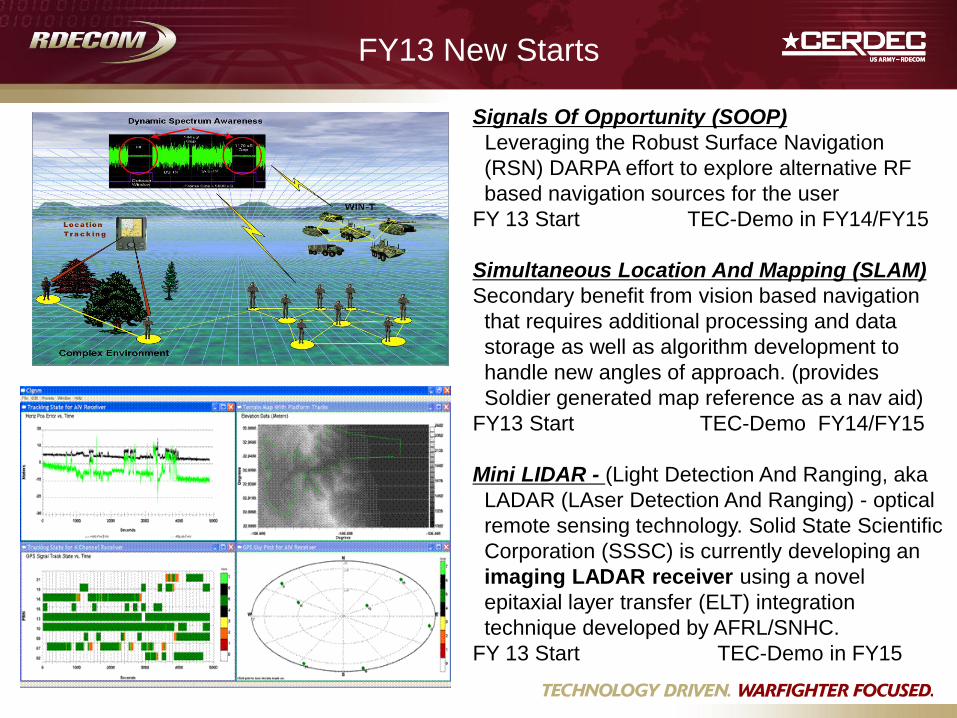
FY13 New Starts
Signals Of Opportunity (SOOP)
Leveraging the Robust Surface Navigation
(RSN) DARPA effort to explore alternative RF
based navigation sources for the user
FY 13 Start TEC-Demo in FY14/FY15
Simultaneous Location And Mapping (SLAM)
Secondary benefit from vision based navigation
that requires additional processing and data
storage as well as algorithm development to
handle new angles of approach. (provides
Soldier generated map reference as a nav aid)
FY13 Start TEC-Demo FY14/FY15
Mini LIDAR - (Light Detection And Ranging, aka
LADAR (LAser Detection And Ranging) - optical
remote sensing technology. Solid State Scientific
Corporation (SSSC) is currently developing an
imaging LADAR receiver using a novel
epitaxial layer transfer (ELT) integration
technique developed by AFRL/SNHC.
FY 13 Start TEC-Demo in FY15
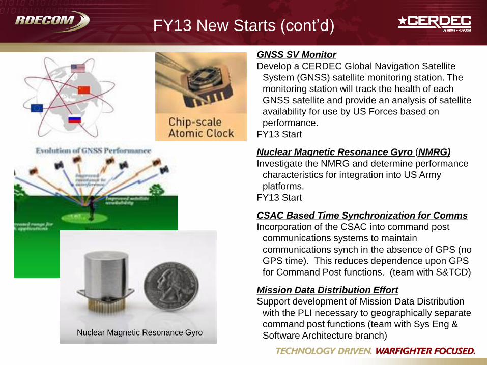
FY13 New Starts (cont’d)
GNSS SV Monitor
Develop a CERDEC Global Navigation Satellite
System (GNSS) satellite monitoring station. The
monitoring station will track the health of each
GNSS satellite and provide an analysis of satellite
availability for use by US Forces based on
performance.
FY13 Start
Nuclear Magnetic Resonance Gyro (NMRG)
Investigate the NMRG and determine performance
characteristics for integration into US Army
platforms.
FY13 Start
CSAC Based Time Synchronization for Comms
Incorporation of the CSAC into command post
communications systems to maintain
communications synch in the absence of GPS (no
GPS time). This reduces dependence upon GPS
for Command Post functions. (team with S&TCD)
Mission Data Distribution Effort
Support development of Mission Data Distribution
with the PLI necessary to geographically separate
command post functions (team with Sys Eng &
Software Architecture branch) Nuclear Magnetic Resonance Gyro