Embed Size (px)
DESCRIPTION
Using ArcView GIS: Part 3. Learning more of the basics for ArcMap 3.3. Areas to be covered today. ESRI USA or other Databases Adding a Locator or Insert Map Adjusting legends Viewing Data table (attributes) – Tables window Where is an entity What is at an entity (Identity icon) - PowerPoint PPT Presentation
Citation preview

Using ArcView GIS: Using ArcView GIS: Part 3Part 3
Learning more of the Learning more of the basics for ArcMap 3.3basics for ArcMap 3.3
11Using ArcMap Part 3Using ArcMap Part 3

Areas to be covered todayAreas to be covered today
ESRI USA or other DatabasesESRI USA or other Databases Adding a Locator or Insert MapAdding a Locator or Insert Map Adjusting legendsAdjusting legends Viewing Data table (attributes) – Tables Viewing Data table (attributes) – Tables
windowwindow Where is an entityWhere is an entity What is at an entity (Identity icon)What is at an entity (Identity icon) Adding Default LabelsAdding Default Labels Writing a ProcLibWriting a ProcLib Using Help in ArcMapUsing Help in ArcMap
22Using ArcMap Part 3Using ArcMap Part 3

GIS Data SetsGIS Data Sets On the C: driveOn the C: drive
– go to c:/esri/esridata/go to c:/esri/esridata/A variety of basic databases on USA, World A variety of basic databases on USA, World
and Elsewhereand Elsewhere
On the J: driveOn the J: drive– go to j:/Geo/Geodata/go to j:/Geo/Geodata/
There are multiple folders of data here, There are multiple folders of data here, although some of it is redundantalthough some of it is redundant
In this class we will concentrate only on In this class we will concentrate only on Shape Files and some Image FilesShape Files and some Image Files
Using ArcMap Part 3Using ArcMap Part 3 33

GIS Data SetsGIS Data Sets On the WebOn the Web
– There are an immense number of shape There are an immense number of shape files and imagesfiles and images
– For your project you may wish to start For your project you may wish to start exploringexploring
Using ArcMap Part 3Using ArcMap Part 3 44

Going to a folder with dataGoing to a folder with data
Using ArcMap Part 3Using ArcMap Part 3 55
Click on black Cross
Then on black cross with folder
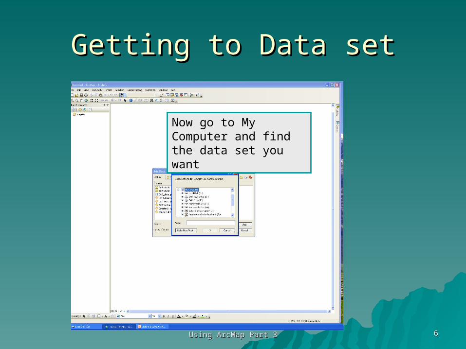
Getting to Data setGetting to Data set
Using ArcMap Part 3Using ArcMap Part 3 66
Now go to My Computer and find the data set you want

This will now be available on This will now be available on clicking the Black Crossclicking the Black Cross
Using ArcMap Part 3Using ArcMap Part 3 77

Now Add StatesNow Add States
Using ArcMap Part 3Using ArcMap Part 3 88

Zoom into the 48 then open the Zoom into the 48 then open the Properties to SymbologyProperties to Symbology
Using ArcMap Part 3Using ArcMap Part 3 99

Select Quantities – Graduated Select Quantities – Graduated ColorsColors
Using ArcMap Part 3Using ArcMap Part 3 1010

Under Fields (attribute) Value Under Fields (attribute) Value Choose 18-29Choose 18-29
Using ArcMap Part 3Using ArcMap Part 3 1111

Now Normalize (divide) this by Now Normalize (divide) this by POP 1999 then hit OKPOP 1999 then hit OK
Using ArcMap Part 3Using ArcMap Part 3 1212

ResultResult
Using ArcMap Part 3Using ArcMap Part 3 1313

ADDING A ADDING A LOCATOR LOCATOR
MAP AS AN MAP AS AN INSETINSET
Using ArcMap Part 3Using ArcMap Part 3 1414

Adding Inset Maps for LocationAdding Inset Maps for LocationMost Americans know where Wyoming is but what if your audience is a group in Kazakhstan
1515Using ArcMap Part 3Using ArcMap Part 3
First make a nice map of Wyoming.
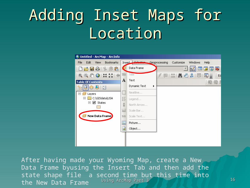
Adding Inset Maps for LocationAdding Inset Maps for Location
1616Using ArcMap Part 3Using ArcMap Part 3
After having made your Wyoming Map, create a New Data Frame byusing the Insert Tab and then add the state shape file a second time but this time into the New Data Frame

Activate the new Data FrameActivate the new Data Frame
Using ArcMap Part 3Using ArcMap Part 3 1717
To make sure that you are working in the new data frame right click it and choose Activate (this enables you to move between data frames)

Using ArcMap Part 3Using ArcMap Part 3 1818
Now go to the Layout View and size and move the new Data Frame to the location where you would like the Locator Map

Using ArcMap Part 3Using ArcMap Part 3 1919
We’ll try this location.
Once you are done return to the Data View

Using ArcMap Part 3Using ArcMap Part 3 2020
Next:1.Add Data for the states.shp2.Then adjust it to show the contiguous 48 states to the center of you Data View, 3.Click on the select feature by Rectangle icon and drag and draw a small rectangle inside of Wyoming.

Using ArcMap Part 3Using ArcMap Part 3 2121
Be sure not to extend the rectangle outside of Wyoming

Using ArcMap Part 3Using ArcMap Part 3 2222
This selection will now highlight Wyoming.

Using ArcMap Part 3Using ArcMap Part 3 2323
If you would prefer a solid color for selection instead of outline go to Properties and clidk the Selection tab and change the radio button to “with this color” (choose a color you like).

Using ArcMap Part 3Using ArcMap Part 3 2424
Now Red

Using ArcMap Part 3Using ArcMap Part 3 2525
This will now create an inset map on the Layout View, which can be labeled “Locater Map”

Using ArcMap Part 3Using ArcMap Part 3 2626
Layout with locator map.

Insert MapsInsert Maps
Inserted maps can be locator maps Inserted maps can be locator maps or any other type of mapor any other type of map
You can have as many maps as You can have as many maps as appropriate in your final Layoutappropriate in your final Layout
2727Using ArcMap Part 3Using ArcMap Part 3

Under Construction from here Under Construction from here onon
Using ArcMap Part 3Using ArcMap Part 3 2828

Where is the entity Iowa?Where is the entity Iowa?Make active in Attribute Window Make active in Attribute Window
then look on View Windowthen look on View Window
2929Using ArcMap Part 3Using ArcMap Part 3

What was done?What was done?
1. In the Attribute table window for States click on Iowa
2. In the View window Iowa turns Yellow. This is most easily seen if all states are given a single symbol in the Legend editor
3030Using ArcMap Part 3Using ArcMap Part 3

Now reverse the question and ask Now reverse the question and ask “What is at the entity – Iowa”“What is at the entity – Iowa”
By clicking the Identity Icon over the state of Iowa the list of attributes appears
3131Using ArcMap Part 3Using ArcMap Part 3

Now causing an entity to be Now causing an entity to be “selected” from the View “selected” from the View
WindowWindowLet’s Select a river in Alaska
Start by making the View Window active
3232Using ArcMap Part 3Using ArcMap Part 3

Making an Entity ActiveMaking an Entity Active
Use the “Select Feature” Icon
Then go to the entity you wish to select and click
3333Using ArcMap Part 3Using ArcMap Part 3

The ResultThe Result
3434Using ArcMap Part 3Using ArcMap Part 3

Housekeeping, when you are done Housekeeping, when you are done with an entity Un-Select by clicking with an entity Un-Select by clicking
this iconthis icon
3535Using ArcMap Part 3Using ArcMap Part 3

Adding Labels to EntitiesAdding Labels to Entities
Using ArcMap Part 3Using ArcMap Part 3 3636
In the VIEW window just:1.Make a theme active2.Click the Label Icon3.Click on the map on the entity4.Then move things around with the black arrow until you are happy

Adjusting you legendAdjusting you legend
Using ArcMap Part 3Using ArcMap Part 3 3737

Note how cumbersome listing all Note how cumbersome listing all the states isthe states is
Turning-off the legends
3838Using ArcMap Part 3Using ArcMap Part 3

ResultResult
3939Using ArcMap Part 3Using ArcMap Part 3

How does this effect the final How does this effect the final Layout Window?Layout Window?
I’ll leave this for you to re-call.I’ll leave this for you to re-call.
4040Using ArcMap Part 3Using ArcMap Part 3

Accessing Attribute DataAccessing Attribute Data
Use Open
4141Using ArcMap Part 3Using ArcMap Part 3

Results when States is Active Results when States is Active ThemeTheme
4242Using ArcMap Part 3Using ArcMap Part 3

What was the active Theme here?What was the active Theme here?
4343Using ArcMap Part 3Using ArcMap Part 3

Requirements for a ProcLibRequirements for a ProcLib Title: -- Title: -- should inform the reader immediately as to the nature of the proclibshould inform the reader immediately as to the nature of the proclibPurpose:Purpose: more detailed description of the proclibs use more detailed description of the proclibs use
Procedure: Procedure: (in step by step outline format quickly indicate all steps necessary to perform (in step by step outline format quickly indicate all steps necessary to perform
the procedure)the procedure)1. ................. 1. ................. 2. .................2. .................3. (major step)3. (major step)(substep or choices) (substep or choices) .......... .......... . . OriginatorOriginator: your name: (if questions your name and e-mail): your name: (if questions your name and e-mail)Procedure Creation Date:Procedure Creation Date: (when was this made or updated) (when was this made or updated)Contact:Contact: (email or other details (email or other details
4444Using ArcMap Part 3Using ArcMap Part 3

ProcLib ExampleProcLib ExampleTitle: Overcoming ArcView Printing ProblemsTitle: Overcoming ArcView Printing Problems
Purpose:Purpose: Occasionally ArcView Occasionally ArcView LayoutsLayouts or or ViewsViews refuse to print, here are two methods to overcome refuse to print, here are two methods to overcome the problem.the problem.
Procedure: Procedure: 1. Check your diagnoses. Make sure the printer is on and has paper. Then in 1. Check your diagnoses. Make sure the printer is on and has paper. Then in Layout Layout or or View View window window
make sure that under make sure that under File/Print SetupFile/Print Setup, the correct printer has been addressed. No go? Continue. , the correct printer has been addressed. No go? Continue.
2. 2. Simple Fix Simple Fix (this sometimes works) use the print command (this sometimes works) use the print command File/Print File/Print and in the window that pops-and in the window that pops-up change the up change the radio button radio button from from ArcView Enhanced ArcView Enhanced to to ArcView BasicArcView Basic..
3. 3. Longer Fix: Longer Fix: If it still doesn’t work then we need the two step procedure.If it still doesn’t work then we need the two step procedure.• In the In the Layout Layout window go to window go to File/Export File/Export set the location where you want to save an image of set the location where you want to save an image of
your map and give it a file name (in that order). Hit your map and give it a file name (in that order). Hit OK.OK. • Open either MSWord or Powerpoint. Bring-up a blank sheet and Open either MSWord or Powerpoint. Bring-up a blank sheet and Insert/Picture/From FileInsert/Picture/From File• Adjust the map in on your page and print it.Adjust the map in on your page and print it.
4. 4. AlternateAlternate for Powerpoint. for Powerpoint. • With Layout showing on your computer screen use the With Layout showing on your computer screen use the ShiftShift and and Print ScreenPrint Screen keys to keys to
capture your image. capture your image. • Open Powerpoint and Open Powerpoint and PastePaste this image from your computer buffer and this image from your computer buffer and • using tools in Powerpoint crop the result till it is neat. using tools in Powerpoint crop the result till it is neat.
Originator: P. Buckley [email protected]: P. Buckley [email protected] Date: 10-03-02, updated 04-20-06Procedure Date: 10-03-02, updated 04-20-06
4545Using ArcMap Part 3Using ArcMap Part 3

Using Help in ArcViewUsing Help in ArcView
I don’t highly recommend this the I don’t highly recommend this the Help available with the software, but Help available with the software, but sometimes this is all you havesometimes this is all you have
It can be accessed from any window It can be accessed from any window once the program is openedonce the program is opened
Using ArcMap Part 3Using ArcMap Part 3 4646

Help MenuHelp Menu
Using ArcMap Part 3Using ArcMap Part 3 4747

Entering the Help ManualEntering the Help Manual
Using ArcMap Part 3Using ArcMap Part 3 4848
Click on the Help entry then the Help Topics
Click on the Help entry then the Help Topics
This will then open a Help Topics Window
I usually use the Index tab, but each has some merit

Results for Layout (Class) Results for Layout (Class) inquiryinquiry
Using ArcMap Part 3Using ArcMap Part 3 4949
Not perhaps the most easily understood definition, but …