Embed Size (px)
Citation preview
Earth Surface Processes and LandformsEarth Surf. Process. Landforms 23, 493–508 (1998)
USING SEDIMENT ‘FINGERPRINTS’ TO ASSESS SEDIMENT-BUDGETERRORS, NORTH HALAWA VALLEY, OAHU, HAWAII, 1991–92
BARRY R. HILL1*, ERIC H. DECARLO2, CHRISTOPHER C. FULLER3 AND MICHAEL F. WONG1
1US Geological Survey, 677 Ala Moana Blvd, Suite 415, Honolulu, HI 96813, USA2School of Ocean and Earth Science and Technology, University of Hawaii at Manoa, 1000 Pope Road, Honolulu, HI 96822, USA
3US Geological Survey, 345 Middlefield Road, MS 465, Menlo Park, CA 94025, USA
Received 30 September 1995; Revised 30 June 1997; Accepted 6 October 1997
ABSTRACT
Reliable estimates of sediment-budget errors are important for interpreting sediment-budget results. Sediment-budgeterrors are commonly considered equal to sediment-budget imbalances, which may underestimate actual sediment-budgeterrors if they include compensating positive and negative errors.
We modified the sediment ‘fingerprinting’ approach to qualitatively evaluate compensating errors in an annual (1991)fine (<63µm) sediment budget for the North Halawa Valley, a mountainous, forested drainage basin on the island of Oahu,Hawaii, during construction of a major highway. We measured concentrations of aeolian quartz and 137Cs in sedimentsources and fluvial sediments, and combined concentrations of these aerosols with the sediment budget to construct aerosolbudgets. Aerosol concentrations were independent of the sediment budget, hence aerosol budgets were less likely thansediment budgets to include compensating errors. Differences between sediment-budget and aerosol-budget imbalancestherefore provide a measure of compensating errors in the sediment budget.
The sediment-budget imbalance equalled 25 per cent of the fluvial fine-sediment load. Aerosol-budget imbalances wereequal to 19 per cent of the fluvial 137Cs load and 34 per cent of the fluvial quartz load. The reasonably close agreementbetween sediment- and aerosol-budget imbalances indicates that compensating errors in the sediment budget were notlarge and that the sediment-budget imbalance is a reliable measure of sediment-budget error.
We attribute at least one-third of the 1991 fluvial fine-sediment load to highway construction. Continued monitoringindicated that highway construction produced 90 per cent of the fluvial fine-sediment load during 1992. Erosion of channelmargins and attrition of coarse particles provided most of the fine sediment produced by natural processes. Hillslopeprocesses contributed relatively minor amounts of sediment. 1998 John Wiley & Sons, Ltd.
KEY WORDS: sediment budget; coarse-particle attrition; sediment ‘fingerprinting’; tropical geomorphology; highway construction effects; aeolianquartz; 137Cs
INTRODUCTION
Sediment budgets provide a useful framework for quantifying sediment sources and understanding the effectsof human activities on sediment transport (e.g. Reid et al., 1981; Sutherland and Bryan, 1991). Because erosionalprocesses are spatially variable and difficult to measure, however, sediment budgets inherently contain errors.Accurate assessments of errors greatly enhance the usefulness of sediment-budget studies, particularly whensediment budgets are used to determine effects of land-use practices (Kondolf and Matthews, 1991).
Sediment-budget errors are often considered equal to sediment-budget imbalances, that is, discrepanciesbetween estimates of sediment inputs, outputs and storage changes (Kondolf and Matthews, 1991). Sediment-budget imbalances, however, may underestimate actual sediment-budget errors if they include compensatingpositive and negative errors (Kondolf and Matthews, 1991).
As an example, a sediment budget might overestimate sediment production by naturally occurring landslidesand underestimate sediment production by gullies related to land use by a similar, or compensating, amount.Although the imbalance in the sediment budget would be small, the true importance of the two sediment sourceswould be seriously misrepresented. Resource management actions based on the sediment budget would quitelikely be costly failures in terms of erosion control.
* Correspondence to: B. R. Hill, US Geological Survey, 677 Ala Moana Blvd, Suite 415, Honolulu, HI 96813, USA.
CCC 0197-9337/98/060493–16 $17.50 1998 John Wiley & Sons, Ltd.
494 B. R. HILL ET AL.
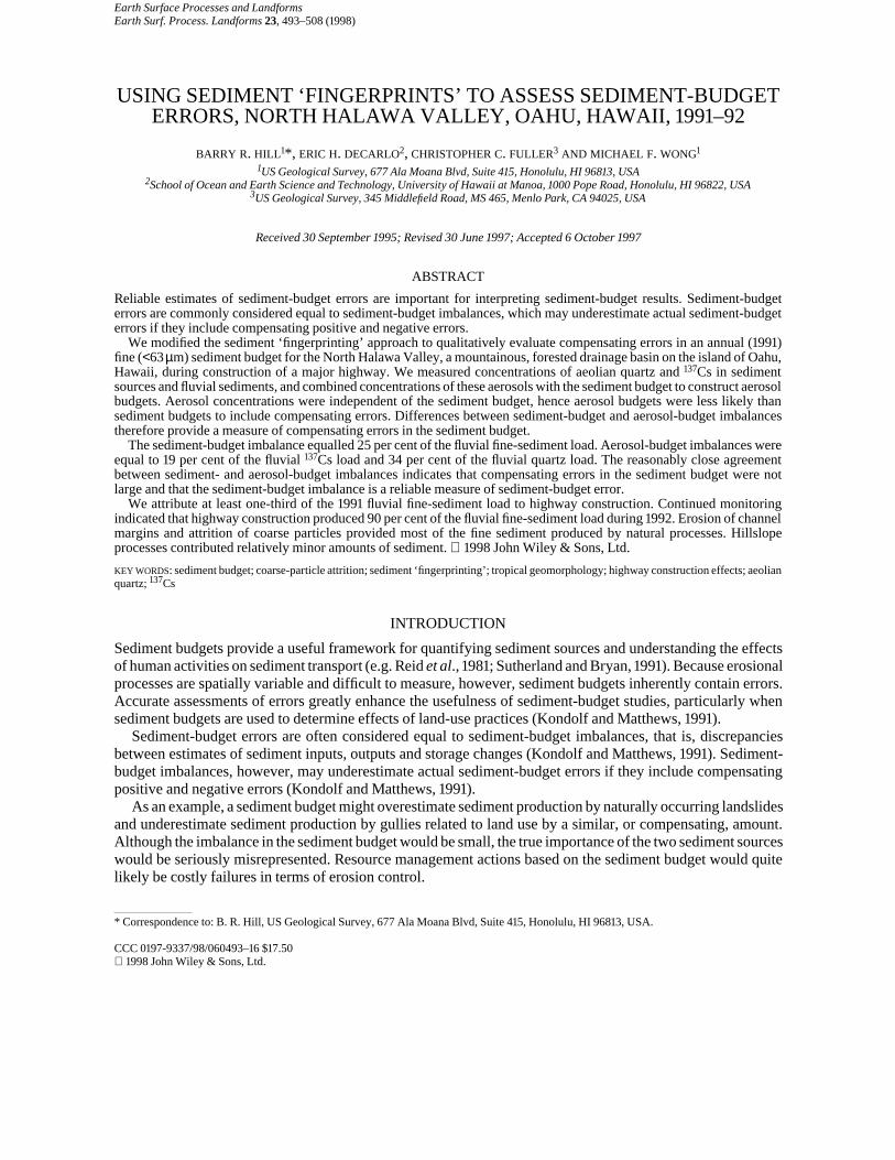
Figure 1. North Halawa Valley study area
Sediment ‘fingerprinting’ (e.g. Peart and Walling, 1986) is an alternative approach to sediment-sourcequantification. Sediment ‘fingerprints’ consist of sediment characteristics such as chemistry, mineralogy,colour, magnetic properties or radionuclide content that distinguish sources of fluvial sediment (e.g. Peart andWalling, 1988). Concentrations of ‘fingerprints’ in sediment sources can be compared to ‘fingerprint’concentrations in fluvial sediments to infer the major sources of fluvial sediments (e.g. Sutherland, 1991).
We modified the sediment ‘fingerprinting’ approach to qualitatively evaluate compensating errors in anannual (1991) fine (<63µm) sediment budget for the North Halawa Valley, a mountainous, forested drainagebasin on the island of Oahu, Hawaii (Figure 1). The study objective was to determine the sources of fluvialsediment transported from the valley during construction of a major highway. We measured concentrations oftwo aerosols, aeolian quartz and 137Cs, in sediment sources and fluvial sediments and combined thesemeasurements with the sediment budget to construct annual aerosol budgets. Aerosol concentrations were
1998 John Wiley & Sons, Ltd. Earth Surf. Process. Landforms 23, 493–508 (1998)
495SEDIMENT BUDGET ERRORS
independent of the sediment budget, hence aerosol budgets were less likely than the sediment budget tofortuitously balance as a result of compensating positive and negative errors. Differences between sediment-budget and aerosol-budget imbalances therefore provide a measure of compensating errors in the sedimentbudget.
Sediment and aerosol budgets were developed using data collected in 1991 (designations of years refer towater years, which begin on 1 October, end on 30 September, and are numbered for the calendar year in whichthey end). We restricted the study to fine-grained sediment because bedload data were not available and becausesilt and clay particles are, under most conditions, transported in suspension (Richards, 1982). We continued thesediment-budget monitoring in 1992 , but lacked sufficient data to construct aerosol budgets for 1992.
STUDY AREA CHARACTERISTICS
North Halawa Stream drains the North Halawa Valley on the leeward (southwestern) slope of the KoolauRange (Figure 1). The study area consists of the 10·4km2 drainage basin upstream of US Geological Survey(USGS) stream-gauging station 2262, at an altitude of 49m (stream-gauging station numbers are abbreviated inthis paper; complete numbers are preceded by 16 and end in 00). The overall stream gradient, measured from theheadwaters to station 2262, is 0·074m m−1, and basin relief is 814m. Mean velocities computed for bankfullconditions ranged from 1·10 to 2·29m s−1, and bankfull Reynold’s numbers ranged from 0·21×106 to 1·78×106.Bed material consists of boulders, cobbles and gravel, with small amounts of finer sediment.
Average annual rainfall in North Halawa Valley ranges from about 1000 to 3800mm a−1 (US Department ofCommerce, 1961). Rainfall is related to altitude, and is highest near the crest of the Koolaus as a result oforographic lifting and cooling of marine air masses moving over the Koolau Range with the prevailingnortheasterly trade winds (Wentworth, 1942; Mink, 1959). Rainfall varies seasonally, with most precipitationfalling between November and April.
The Koolau Range is the eroded remnant of the larger and younger of two major shield volcanoes thatformed the island of Oahu (Stearns and Vaksvik, 1935). Lithology of the study area consists of basalt that wasextruded in numerous gently dipping, thin (<3m) flows of aa and pahoehoe lava (Visher and Mink, 1964).
The lower valley, below an altitude of about 300m, is deeply eroded and roughly U-shaped in cross-section.Unweathered bedrock is exposed in small scarps along valley walls (Izuka, 1992). The active channel is incised1–2m into alluvium, and a few small ephemeral tributaries enter from steep adjacent hillslopes that are mantledwith colluvial deposits (Izuka, 1992).
The upper valley, at altitudes greater than 300m, includes several tributary canyons that are V-shaped incross-section. Chemical weathering of bedrock extends tens of metres below the land surface (Wentworth,1942; Izuka, 1992). Alluvial deposits are absent along tributary channels (Izuka, 1992). The ridges and crest ofthe Koolau Range that bound the North Halawa Valley display the classic ‘knife-edge’ morphology describedby Wentworth (1943).
North Halawa Valley was inhabited and used for farming by native Hawaiians (Spear, 1990). Parts of thelower valley were used for agriculture between 1850 and 1947 (Spear, 1990, 1991). A major reforestation projectwas undertaken in 1910–11 to control erosion (Spear, 1991). The valley is presently uninhabited.
Construction of the H-3 freeway in the North Halawa Valley began in November 1987 and continues atpresent (1997). Construction activities have increased suspended-sediment loads at station 2262 (Hill andDeCarlo, 1991; Hill, 1996). As of September 1991, highway construction affected about 4 per cent of thedrainage basin area upstream of station 2262 and involved about 404000m3 of cut and 72900m3 of fill(Q. D. Truong, Parsons Brinkerhoff Quade & Douglas, Inc., written communication, 1993).
Quartz in soils of the leeward Koolau Range originates solely from aeolian transport of dust from Asia(Jackson et al., 1971). Quartz content of soils from ridge crests in the Koolaus ranges from 0·8 to 3·4 per cent(Jackson et al., 1971). Quartz particles are mostly in the 2–10µm size range (Rex et al., 1969; Jackson et al.,1971) and are distributed to depths of about 7cm in ridgetop soils of the Koolau Range (Jackson et al., 1971).
137Cs, a radioactive product of nuclear fission, has a half-life of 30·2 years and was distributed worldwidewith atmospheric fallout following atmospheric testing of nuclear weapons during the 1950s and early 1960s(e.g. Sutherland, 1991). Maximum fallout rates were measured on Oahu in 1963–64 (Health and Safety
1998 John Wiley & Sons, Ltd. Earth Surf. Process. Landforms 23, 493–508 (1998)
496 B. R. HILL ET AL.
Laboratory, 1977). Deposition of 137Cs was negligible during the 1991–92 study period (e.g. Ritchie andMcHenry, 1990). 137Cs, an alkali cation, is strongly bound to cation-exchange sites of clays and is largelyirreversibly bound in fresh-water systems. 137Cs generally exhibits an exponential decrease with depth inundisturbed soils (Ritchie and McHenry, 1990).
METHODS
We constructed annual fine-grained sediment budgets (henceforth ‘sediment budgets’) from field andlaboratory measurements of sediment transport in North Halawa Valley. Previous investigations in the KoolauRange (Stearns and Vaksvik, 1935; Wentworth, 1928, 1943; White, 1949; Scott and Street, 1976; Peterson et al.,1993) indicated that debris flows, soil creep and channel erosion were probably the most important naturalerosional processes, and these were the processes that we monitored in the field. We included estimates of fine-grained sediment produced by in situ weathering and subsequent erosion and by attrition of coarse particlesduring fluvial transport. Because of difficulties in directly measuring sediment transport from construction sites(e.g. Riley, 1990), we estimated sediment loads originating from highway construction with a regionalregression.
Drainage-basin budgets for quartz and 137Cs were based on the 1991 sediment budget and averageconcentrations of quartz and 137Cs in sediment sources and fluvial sediments. The quartz budget included anestimate of atmospheric deposition.
Fluvial sediment transport at station 2262
Streamflow and suspended-sediment discharge were monitored at station 2262 (Figure 1) using standardpractices of the USGS (Porterfield, 1972; Rantz et al., 1982a,b; Edwards and Glysson, 1988). Recurrenceintervals of annual peak flows at nearby station 2260 were determined using methods of the US InteragencyAdvisory Committee on Water Data (1981) with 42 years of data. Suspended-sediment samples were collectedwith automatic point samplers (442 samples in 1991, 138 in 1992) and with manual depth-integrating cross-section samplers (24 samples in 1991, 20 in 1992). Point samples were collected daily when stream stage wasabove a threshold level, and at intervals of 45 or 90 min when stage exceeded a higher threshold level. Fewersamples were collected in 1992 than in 1991 as a result of long periods of low and zero streamflow. Cross-sectionsamples were collected for a wide range of flow conditions, and particularly during high flows. Laboratoryanalyses for suspended-sediment concentration and particle-size distribution were made at the USGSlaboratory in Honolulu, using methods described by Guy (1969).
Estimation of highway construction effects
Fine-sediment loads resulting from highway construction were estimated using a regional regression. Theregression used measured annual suspended-sediment yields and corresponding annual runoff depths forleeward Koolau basins in natural forest cover, with only small areas affected by residential or agriculturaldevelopment. Data used for the analysis included pre-construction data for North Halawa Stream (Hill, 1996)and data reported for nearby basins in previous studies (Jones et al., 1971; Doty et al., 1981; Shade, 1984).
Suspended-sediment yields were first converted to fine-sediment yields by multiplying by the averageproportion of fine material in suspended-sediment samples, collected at the stations used in the regressionanalysis (87·5 per cent, using data from USGS data files). Data were then transformed to common logarithmsbefore computing the regression, which took the form:
log Sy=−3·52+2·02× log R (1)
where Sy is annual fine-sediment yield (in Mg km−2) and R is annual runoff depth (inmm). The standard error ofthe regression was 0·22 in log units, and the coefficient of determination was 86·1 per cent.
Annual fine-sediment yields attributable to natural erosion were estimated with Equation 1 using measuredannual runoff depths at station 2262 during 1991 and 1992. These regression estimates were corrected for back-transformation with a bias-correction factor of 1·15 computed using the method of Duan (1983). The estimatedfine-sediment yields were converted to loads by multiplying by drainage area. The fine-sediment loads
1998 John Wiley & Sons, Ltd. Earth Surf. Process. Landforms 23, 493–508 (1998)
497SEDIMENT BUDGET ERRORS
estimated with Equation 1 were then substracted from the measured annual fine-sediment loads at station 2262to obtain estimates of fine-sediment loads resulting from highway construction activities.
Measurements of sediment mobilization and storage changes
Estimates of sediment mobilization and changes in sediment storage were based on field measurements ofvolumetric changes in landforms. Volume changes were converted to mass units of total sediment by measuringbulk densities of sediment sources using the method of Blake (1965). Proportions of fine sediment in sedimentsources were determined with pebble counts (Wolman, 1954) and sieve analyses (Day, 1965).
Debris flows. Debris-flow scars were inventoried in 1990, 1991 and 1992, and locations were recorded. Thenumber of debris flows each year was determined by subtracting the scars identified in previous years from thetotal number of scars. Length and width of debris-flow scars were measured remotely using an optical deviceemploying the principle of similar triangles (S. D. Ellen, USGS, Menlo Park, CA, written communication,1992). Average depth of debris-flow scars was estimated from tape measurements at four accessible scars.Annual debris-flow volumes were estimated by multiplying the lengths and widths of individual scars by theaverage scar depth and summing for all scars attributed to each year of the study. Samples of debris-flowdeposits used for sieve analyses were wet-sieved through a 63µm sieve after treatment with hydrogen peroxideto remove organic material.
Although field observations indicated that delivery of debris flows to channels was frequently incomplete,we assumed a delivery ratio of 100 per cent for sediment-budget calculations. Consequences of this assumptionare discussed below.
Soil creep. Soil movement resulting from soil creep was monitored at eight hillslope sites (Figure 1) withmodified Young pits (e.g. Lewis, 1976). These pits consisted of holes augured to bedrock or saprolite in whichnumbered sections of 2·5cm PVC pipe were placed. Monuments consisting of steel rods were driven at least0·5m into the hillside on both sides of the pits along the contour. Downslope displacement of the pipe sectionswas measured with a ruler from a cloth tape stretched between the monuments.
Samples of hillslope soils were collected for bulk density and sieve analyses. Hydrogen peroxide was notused to remove organic material because the samples were also used for 137Cs analyses. Samples weremechanically disaggregated instead.
Of the original eight hillslope sites, three were destroyed by construction before any rates could be measured(sites 1, 2 and 3). The remaining sites were considered inadequate to quantify spatial variations in soil creeprates, so a representative rate of 0·004m a−1 over a depth of 0·50m, based on previous studies in tropicalclimates (Lewis, 1976; Saunders and Young, 1983), was used in place of field measurements. The volume of soilmobilized by soil creep was estimated by multiplying the representative rate by the representative depth and thetotal length of channel affected by soil creep. This channel length was determined as the sum of the lengths of allchannels, as determined from contour crenulations on the USGS Kaneohe and Pearl Harbour quadrangle maps(1:24000, 1983), in an area extending from station 2262 upstream to a point halfway between hillslope sites 8and 7. Hillslope site 8 is the farthest upstream site where soil creep was detected, and hillslope site 7 is thefarthest downstream site where no soil creep was detected. Channel lengths were doubled to account for soilcreep along both banks.
A delivery ratio of 100 per cent was assumed for soil creep. This assumption seems reasonable because soiltransported by the creep process has little opportunity for deposition en route to a channel.
Channel sediment storage Erosion and deposition along the main stream channels in the study area weremonitored with 25 monumented cross-sections. These cross-sections were located at miscellaneous measuringsites along the channel, in groups of two to four (Figure 1). Cross-sections were surveyed in 1990, 1991 and 1992using level and rod. Annual cross-sectional areas were computed separately for each bank and the streambed bynumerical integration of trapezoidal subareas above an arbitrary datum. Annual area changes for 1991–92 werecalculated by subtracting the 1991 area from 1990 areas and 1992 areas from 1991 areas. Area changes aretherefore positive for erosion and negative for deposition. Area changes for left and right banks were summed,and average annual changes in bank and bed areas were computed for each group of cross-sections.
Samples of bed and bank materials finer than 2mm were collected for bulk-density and sieve analyses. Bulk-density analyses may underestimate the actual bulk densities of coarse channel-bank and streambed materials
1998 John Wiley & Sons, Ltd. Earth Surf. Process. Landforms 23, 493–508 (1998)
498 B. R. HILL ET AL.
because samples were not representative of the larger particles. Pebble counts (Wolman, 1954) were used toestimate the percentage of bank and bed material finer than 2mm at each cross-section group. The percentagesof fine sediment in bed and bank materials at each cross-section site were computed as the percentage finer than2mm, as determined from the pebble counts, multiplied by the proportion of the <2mm fraction that was finerthan 63µm, as determined by sieve analyses.
To compute volume changes in channel storage of sediment, annual changes in bank and bed areas at cross-section groups were multiplied by the length of channel extending halfway to the adjacent cross-section groupsboth upstream and downstream. For the cross-section group at station 2262, the downstream end of the studyarea, area changes were multiplied by the distance halfway to station 2260. Area changes for sites 2255, 2252and 2251 were applied to the lengths of channel marked as blue lines upstream of these sites on the USGSKaneohe quadrangle map. Area changes for site 2251 were also applied to a major tributary that enters the mainchannel downstream of site 2252.
Volumes of channel erosion and deposition were therefore computed only for major perennial andintermittent channels, and not for the more numerous ephemeral tributaries. Soil creep was assumed to supplythe sediment eroded from ephemeral tributary streambanks, hence a separate estimate of erosion alongephemeral tributaries was deemed unnecessary for the sediment budget. Although this assumption isreasonable for long-term sediment budgets, annual variations in bank erosion rates may have resulted in over-or underestimation of sediment delivery from ephemeral tributaries for our annual sediment budgets. Fieldobservations indicate that little sediment was stored along the steep, narrow tributary channels.
All sediment eroded from the channel bed and banks was considered to be available for fluvial transport.This assumption is reasonable, because we did not observe mass failure of large intact blocks of bank materialthat remained in the channel following peak flows.
Miscellaneous sites 2252, 2255 and 2256 were destroyed during construction of the highway in 1992, andabout 1·5km of channel were lined with metal culverts and buried. The right bank and stream bed at site 2251were buried by a debris flow in 1992. Computations of channel erosion for 1992 are therefore based only onmeasurements at stations 2262 and 2260 and at sites 2258.5, 2257 and 2251 (left bank only). Channel reacheslined with culverts were marked on topographic maps, and the lengths of these reaches were not included in thecomputations. Changes in streambed sediment storage during 1992 were assumed to be negligible in thosereaches computed using data from site 2251.
Attrition experiments
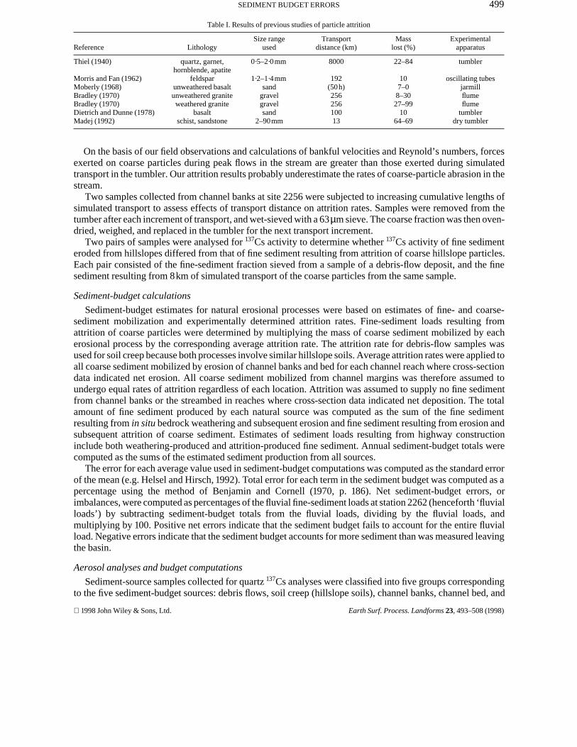
Because this study concerned the transport of fine-grained rather than total sediment, attrition of coarseparticles must be considered as a fine-sediment source. Coarse-particle attrition as a source of suspendedsediment has been investigated previously by Dietrich and Dunne (1978) and Madej (1992). Both of thesestudies found attrition to be a major source of suspended sediment. Numerous other studies have documentedsubstantial losses of coarse sediments as a result of abrasion during fluvial transport (Table I).
In the North Halawa Valley, the combination of basalt bedrock, warm climate and high rainfall has resultedin extensive chemical weathering of bedrock (e.g. Stearns and Vaksvik, 1935). Chemical alteration of bedrockto secondary minerals extends to tens of metres below land surface (e.g. Izuka, 1992). Coarse particles in near-surface sediment sources, therefore, are likely to be composed entirely of secondary minerals and so are likelyto be much less resistant to mechanical abrasion than unweathered bedrock.
We used simple abrasion-mill experiments to estimate the amount of fine sediment resulting from attrition ofcoarse particles mobilized by natural erosional processes. The coarse (>63µm) fractions of samples of debris-flow deposits, channel banks, and streambed material were individually tested in a rock-polishing tumbler madeof soft rubber. The tumbler drum had a diameter of 11cm and a length of 10cm. Samples ranged from about 8 to50g dry mass and consisted mostly of sand and fine gravel, although a few samples contained coarse gravel.The samples were completely covered with deionized water and subjected to 8km of simulated fluvialtransport. This distance was selected to represent an average travel distance from mid-basin to station 2262. Thedrum rotated at a velocity of 0·4m s−1. After tumbling, samples were wet-sieved, oven-dried for 1–2h at 80°C,and weighed. Attrition was calculated as the loss of mass of the coarse-material sample, expressed as apercentage of the original mass.
1998 John Wiley & Sons, Ltd. Earth Surf. Process. Landforms 23, 493–508 (1998)
499SEDIMENT BUDGET ERRORS
Table I. Results of previous studies of particle attrition
Reference LithologySize range
usedTransport
distance (km)Mass
lost (%)Experimental
apparatus
Thiel (1940) quartz, garnet,hornblende, apatite
0·5–2·0mm 8000 22–84 tumbler
Morris and Fan (1962) feldspar 1·2–1·4mm 192 10 oscillating tubesMoberly (1968) unweathered basalt sand (50h) 7–0 jarmillBradley (1970) unweathered granite gravel 256 8–30 flumeBradley (1970) weathered granite gravel 256 27–99 flumeDietrich and Dunne (1978) basalt sand 100 10 tumblerMadej (1992) schist, sandstone 2–90mm 13 64–69 dry tumbler
On the basis of our field observations and calculations of bankful velocities and Reynold’s numbers, forcesexerted on coarse particles during peak flows in the stream are greater than those exerted during simulatedtransport in the tumbler. Our attrition results probably underestimate the rates of coarse-particle abrasion in thestream.
Two samples collected from channel banks at site 2256 were subjected to increasing cumulative lengths ofsimulated transport to assess effects of transport distance on attrition rates. Samples were removed from thetumber after each increment of transport, and wet-sieved with a 63µm sieve. The coarse fraction was then oven-dried, weighed, and replaced in the tumbler for the next transport increment.
Two pairs of samples were analysed for 137Cs activity to determine whether 137Cs activity of fine sedimenteroded from hillslopes differed from that of fine sediment resulting from attrition of coarse hillslope particles.Each pair consisted of the fine-sediment fraction sieved from a sample of a debris-flow deposit, and the finesediment resulting from 8km of simulated transport of the coarse particles from the same sample.
Sediment-budget calculations
Sediment-budget estimates for natural erosional processes were based on estimates of fine- and coarse-sediment mobilization and experimentally determined attrition rates. Fine-sediment loads resulting fromattrition of coarse particles were determined by multiplying the mass of coarse sediment mobilized by eacherosional process by the corresponding average attrition rate. The attrition rate for debris-flow samples wasused for soil creep because both processes involve similar hillslope soils. Average attrition rates were applied toall coarse sediment mobilized by erosion of channel banks and bed for each channel reach where cross-sectiondata indicated net erosion. All coarse sediment mobilized from channel margins was therefore assumed toundergo equal rates of attrition regardless of each location. Attrition was assumed to supply no fine sedimentfrom channel banks or the streambed in reaches where cross-section data indicated net deposition. The totalamount of fine sediment produced by each natural source was computed as the sum of the fine sedimentresulting from in situ bedrock weathering and subsequent erosion and fine sediment resulting from erosion andsubsequent attrition of coarse sediment. Estimates of sediment loads resulting from highway constructioninclude both weathering-produced and attrition-produced fine sediment. Annual sediment-budget totals werecomputed as the sums of the estimated sediment production from all sources.
The error for each average value used in sediment-budget computations was computed as the standard errorof the mean (e.g. Helsel and Hirsch, 1992). Total error for each term in the sediment budget was computed as apercentage using the method of Benjamin and Cornell (1970, p. 186). Net sediment-budget errors, orimbalances, were computed as percentages of the fluvial fine-sediment loads at station 2262 (henceforth ‘fluvialloads’) by subtracting sediment-budget totals from the fluvial loads, dividing by the fluvial loads, andmultiplying by 100. Positive net errors indicate that the sediment budget fails to account for the entire fluvialload. Negative errors indicate that the sediment budget accounts for more sediment than was measured leavingthe basin.
Aerosol analyses and budget computations
Sediment-source samples collected for quartz 137Cs analyses were classified into five groups correspondingto the five sediment-budget sources: debris flows, soil creep (hillslope soils), channel banks, channel bed, and
1998 John Wiley & Sons, Ltd. Earth Surf. Process. Landforms 23, 493–508 (1998)
500 B. R. HILL ET AL.
construction (tunnel tailing, saprolite, and fill). Suspended-sediment samples from station 2262 were alsoanalysed for quartz and 137Cs contents. Because of the small mass of individual suspended-sediment samples,these samples were composited for 137Cs analyses. All samples were wet-sieved, and only the fine (<63µm)fractions were analysed.
The quartz contents of the fine fractions of suspended sediments and sediment source materials weredetermined by X-ray diffractometry (XRD). The methodology is described in Hill et al. (1997). Briefly, themethod involves the development of calibration curves using standard mixtures of pure quartz obtainedcommercially and sediment-source materials collected in North Halawa Valley. Peak heights of samplediffractograms were compared to calibration curves to determine quartz content in percentage by mass. Thelower detection limit was determined to 0·1 per cent quartz.
137Cs activities were measured with a high-resolution, intrinsic germanium-detector gamma spectrometer.The methodology is described in Hill et al. (1997). Samples were typically counted for two-day periods.Uncertainties in the measured activities were calculated from the random counting error of each peak andbackground region for the sample and blank at the one standard deviation level, as described by Friedlander etal. (1981). The relative uncertainty in sample activities ranged from ±3 to ±58 per cent, and averaged ±15 percent. Replicate counts of samples agreed, on average, to ±15 per cent. Detection limits for 137Cs are dependenton sample mass and geometry (Keith et al., 1983), and ranged from 0·33pCi g−1 for the smallest samples(suspended sediments) to 0·02pCi g−1 for soil samples of sufficient mass to fill the largest counting jar.
The Kruskall–Wallis test (Iman and Conover, 1983) was used to test differences in the quartz contents and137Cs activities of the five sediment sources. This test is a non-parametric rank-based procedure that isinsensitive to distribution of the data and can be used with data below detection limits. Average quartz contentsand 137Cs activities for sediment sources that include data below detection limits were computed using themethod of Helsel and Cohn (1988).
Aerosol budgets are conceptually similar to sediment budgets in that they compare inputs, changes instorage, and outputs for drainage basins. Aerosol input results from atmospheric deposition, changes in storageresult from erosion and deposition of aerosol-bearing sediment, and output is equal to fluvial transport in NorthHalawa Stream.
A crude estimate of atmospheric deposition for quartz was determined by multiplying the minimum annualquartz deposition rate estimated by Jackson et al. (1971) for ridges in the Koolau Mountains by the proportion ofthe basin area consisting of stream channels, highway construction sites and debris-flow scars. Quartzdeposited on these areas was considered likely to be fluvially transported during a one-year period.Atmospheric deposition of 137Cs was considered negligible on the basis of results of previous studies in thenorthern hemisphere (Ritchie and McHenry, 1990).
Changes in basin storage of quartz and 137Cs were estimated by multiplying fine-sediment production fromeach source by the corresponding average sediment-source concentrations of quartz and 137Cs. Attrition-generated fine sediment was included in the aerosol-budget calculations.
Concentrations of quartz and 137Cs were not significantly correlated with streamflow or suspended-sedimentconcentration. Fluvial loads of quartz and 137Cs were therefore determined by multiplying annual fine-sedimentloads at station 2262 by the average quartz content and 137Cs activity of suspended sediments collected at thestation.
Aerosol-budget errors were computed in the same manner as sediment-budget errors. Because the errorterms for the aerosol-budget estimates include errors associated with both sediment sources and aerosolconcentrations, they are necessarily larger than corresponding sediment-budget errors.
RESULTS
Peak streamflows during the study period were moderate, with return periods of about two years in 1991 and oneyear in 1992. Our results are therefore representative of moderate streamflow conditions, and not high-magnitude events that might be more important for landform evolution and fluvial sediment transport.
1998 John Wiley & Sons, Ltd. Earth Surf. Process. Landforms 23, 493–508 (1998)
501SEDIMENT BUDGET ERRORS
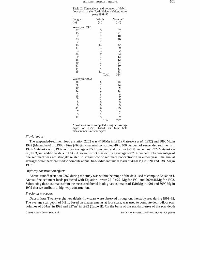
Table II. Dimensions and volumes of debris-flow scars in the North Halawa Valley, water
years 1991–92
Length(m)
Width(m)
Volume*(m3)
Water year 199137157
337
15113
359
1540371415
57771
1443974344
11
372110461
4292
63131224301133
Total 354
Water year 1992487810324
15755
4173
12
6432334556323
58626
1329655
49417
Total 227
* Volumes were computed using an averagedepth of 0·2m, based on four fieldmeasurements of scar depths
Fluvial loads
The suspended-sediment load at station 2262 was 4730Mg in 1991 (Matsuoka et al., 1992) and 3890Mg in1992 (Matsuoka et al., 1993). Fine (<63µm) material constituted 40 to 100 per cent of suspended sediments in1991 (Matsuoka et al., 1992) with an average of 85±3 per cent, and from 47 to 100 per cent in 1992 (Matsuoka etal., 1993, and additional data in USGS Hawaii district files) with an average of 87±6 per cent. The percentage offine sediment was not strongly related to streamflow or sediment concentration in either year. The annualaverages were therefore used to compute annual fine-sediment fluvial loads of 4020Mg in 1991 and 3380Mg in1992.
Highway construction effects
Annual runoff at station 2262 during the study was within the range of the data used to compute Equation 1.Annual fine-sediment loads predicted with Equation 1 were 2710±271Mg for 1991 and 290±46Mg for 1992.Subtracting these estimates from the measured fluvial loads gives estimates of 1310Mg in 1991 and 3090Mg in1992 that we attribute to highway construction.
Erosional processes
Debris flows Twenty-eight new debris-flow scars were observed throughout the study area during 1991–92.The average scar depth of 0·2m, based on measurements at four scars, was used to compute debris-flow scarvolumes of 354m3 in 1991 and 227m3 in 1992 (Table II). On the basis of the standard error of the scar depth
1998 John Wiley & Sons, Ltd. Earth Surf. Process. Landforms 23, 493–508 (1998)
502 B. R. HILL ET AL.
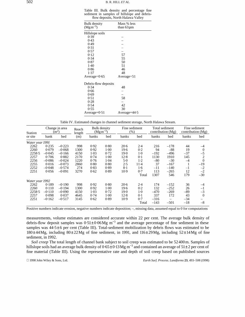
Table III. Bulk density and percentage finesediment in samples of hillslope and debris-
flow deposits, North Halawa Valley
Bulk density(Mgm−3)
Mass % lessthan 63µm
Hillslope soils0·390·430·490·310·570·120·340·871·400·861·37
Average=0·65
–––––575550514648
Average=51
Debris-flow deposits0·340·660·690·510·280·540·55
Average=0·51
48––58–4230
Average=44·5
Table IV. Estimated changes in channel sediment storage, North Halawa Stream.
Stationor site
Change in area(m2)
bank bed
Reachlength
(m)
Bulk density(Mgm−3)
banks bed
Fine sediment(%)
banks bed
Total sedimentcontribution (Mg)banks bed
Fine sedimentcontribution (Mg)banks bed
Water year 1991226222602258·522572256225522522251
0·2350·079
–0·0450·706
–0·0860·016
–0·0480·056
–0·223–0·068–0·1660·882
–0·024–0·073–0·574–0·091
99813004150217012202860274
3270
0·920·921·030·740·760·800·830·62
0·801·000·721·001·040·800·890·89
20·619·619·012·85·02·58·1
10·9
2·40·21·00·11·2
11·41·60·7Total
21694
–1921130–8037
–11113
1307
–178–88
–4961910–30
–167–140–265546
4419
–37145–41
–112
179
–40
–520
–19–2–2
–30
Water year 1992226222602258·522572251
0·1890·110
–0·1100·098
–0·162
–0·190–0·194–0·0900·037
–0·517
9981300415046453145
0·920·921·030·740·62
0·801·000·721·000·89
20·619·619·012·810·9
2·40·21·00·10·7Total
174132
–470337
–316–143
–152–252–269172–
–501
3626
–8943
–34–18
–4–1–30
––8
Positive numbers indicate erosion, negative numbers indicate deposition; –, missing data, assumed equal to 0 for computations
measurements, volume estimates are considered accurate within 22 per cent. The average bulk density ofdebris-flow deposit samples was 0·51±0·06Mg m−3 and the average percentage of fine sediment in thesesamples was 44·5±6 per cent (Table III). Total-sediment mobilization by debris flows was estimated to be180±44Mg, including 80±22Mg of fine sediment, in 1991, and 116±29Mg, including 52±14Mg of finesediment, in 1992.
Soil creep The total length of channel bank subject to soil creep was estimated to be 52400m. Samples ofhillslope soils had an average bulk density of 0·65±0·13Mg m−3 and contained an average of 51±2 per cent offine material (Table III). Using the representative rate and depth of soil creep based on published sources
1998 John Wiley & Sons, Ltd. Earth Surf. Process. Landforms 23, 493–508 (1998)
503SEDIMENT BUDGET ERRORS
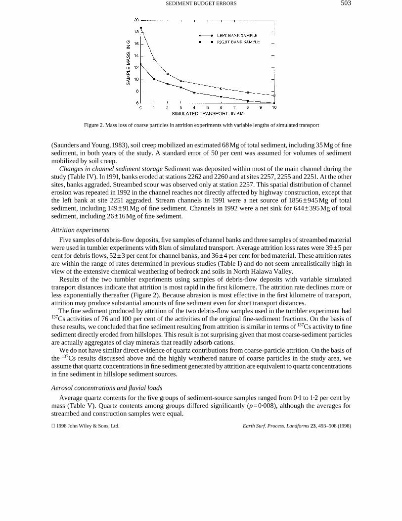
Figure 2. Mass loss of coarse particles in attrition experiments with variable lengths of simulated transport
(Saunders and Young, 1983), soil creep mobilized an estimated 68Mg of total sediment, including 35Mg of finesediment, in both years of the study. A standard error of 50 per cent was assumed for volumes of sedimentmobilized by soil creep.
Changes in channel sediment storage Sediment was deposited within most of the main channel during thestudy (Table IV). In 1991, banks eroded at stations 2262 and 2260 and at sites 2257, 2255 and 2251. At the othersites, banks aggraded. Streambed scour was observed only at station 2257. This spatial distribution of channelerosion was repeated in 1992 in the channel reaches not directly affected by highway construction, except thatthe left bank at site 2251 aggraded. Stream channels in 1991 were a net source of 1856±945Mg of totalsediment, including 149±91Mg of fine sediment. Channels in 1992 were a net sink for 644±395Mg of totalsediment, including 26±16Mg of fine sediment.
Attrition experiments
Five samples of debris-flow deposits, five samples of channel banks and three samples of streambed materialwere used in tumbler experiments with 8km of simulated transport. Average attrition loss rates were 39±5 percent for debris flows, 52±3 per cent for channel banks, and 36±4 per cent for bed material. These attrition ratesare within the range of rates determined in previous studies (Table I) and do not seem unrealistically high inview of the extensive chemical weathering of bedrock and soils in North Halawa Valley.
Results of the two tumbler experiments using samples of debris-flow deposits with variable simulatedtransport distances indicate that attrition is most rapid in the first kilometre. The attrition rate declines more orless exponentially thereafter (Figure 2). Because abrasion is most effective in the first kilometre of transport,attrition may produce substantial amounts of fine sediment even for short transport distances.
The fine sediment produced by attrition of the two debris-flow samples used in the tumbler experiment had137Cs activities of 76 and 100 per cent of the activities of the original fine-sediment fractions. On the basis ofthese results, we concluded that fine sediment resulting from attrition is similar in terms of 137Cs activity to finesediment directly eroded from hillslopes. This result is not surprising given that most coarse-sediment particlesare actually aggregates of clay minerals that readily adsorb cations.
We do not have similar direct evidence of quartz contributions from coarse-particle attrition. On the basis ofthe 137Cs results discussed above and the highly weathered nature of coarse particles in the study area, weassume that quartz concentrations in fine sediment generated by attrition are equivalent to quartz concentrationsin fine sediment in hillslope sediment sources.
Aerosol concentrations and fluvial loads
Average quartz contents for the five groups of sediment-source samples ranged from 0·1 to 1·2 per cent bymass (Table V). Quartz contents among groups differed significantly (p=0·008), although the averages forstreambed and construction samples were equal.
1998 John Wiley & Sons, Ltd. Earth Surf. Process. Landforms 23, 493–508 (1998)
504 B. R. HILL ET AL.
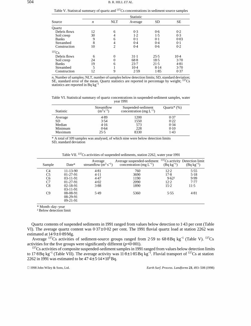
Table V. Statistcal summary of quartz and 137Cs concentrations in sediment source samples
SourceStatistic
n NLT Average SD SE
QuartzDebris flowsSoil creepBanksStreambedConstruction
123098
10
64642
0·31·20·10·40·4
0·61·50·10·40·6
0·20·30·030·10·2
137CsDebris flowsSoil creepBanksStreambedConstruction
624195
12
00619
31·168·823·710·42·59
25·518·521·58·141·85
10·43·704·813·700·37
n, Number of samples; NLT, number of samples below detection limits; SD, standard deviation;SE, standard error of the mean. Quartz statistics are reported in percentage by weight; 137Csstatistics are reported in Bq kg−1
Table VI. Statistical summary of quartz concentrations in suspended-sediment samples, wateryear 1991
StatisticStreamflow
(m3s−1)Suspended-sediment
concentration (mg L−1)Quartz* (%)
AverageSDMedianMinimumMaximum
4·893·544·160·64
25·5
12001550573228
8330
0·370·220·340·101·43
* A total of 109 samples was analysed, of which nine were below detection limitsSD, standard deviation
Table VII. 137Cs activities of suspended sediments, station 2262, water year 1991
Sample Date*Average
streamflow (m3 s−1)Average suspended-sediment
concentration (mg L−1)137Cs activity
(Bq kg−1)Detection limit
(Bq kg−1)
C4C5C6C7C8
C9
11-13-9001-27-9103-11-9101-27-9102-18-9103-11-9108-08-9108-29-9109-21-91
4·814·114·474·023·88
5·49
7603690119020901890
5360
12·217·89·62†
12·215·2
5·55
5·555·189·997·77
11·5
4·81
* Month–day–year† Below detection limit
Quartz contents of suspended sediments in 1991 ranged from values below detection to 1·43 per cent (TableVI). The average quartz content was 0·37±0·02 per cent. The 1991 fluvial quartz load at station 2262 wasestimated at 14·9±0·89Mg.
Average 137Cs activities of sediment-source groups ranged from 2·59 to 68·8Bq kg−1 (Table V). 137Csactivities for the five groups were significantly different (p<0·001).
137Cs activities of composite suspended-sediment samples in 1991 ranged from values below detection limitsto 17·8Bq kg−1 (Table VII). The average activity was 11·8±1·85Bq kg−1. Fluvial transport of 137Cs at station2262 in 1991 was estimated to be 47·4±5·14×106 Bq.
1998 John Wiley & Sons, Ltd. Earth Surf. Process. Landforms 23, 493–508 (1998)
505SEDIMENT BUDGET ERRORS
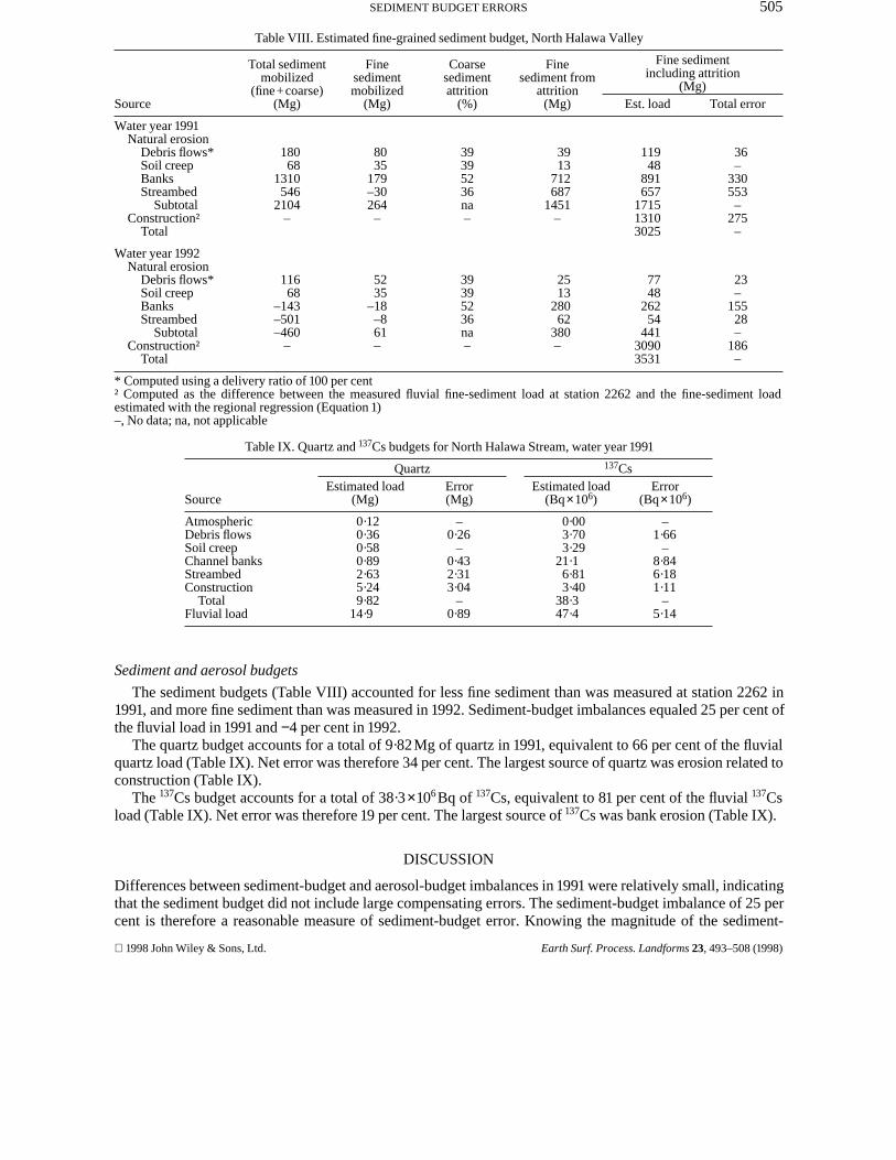
Table VIII. Estimated fine-grained sediment budget, North Halawa Valley
Source
Total sedimentmobilized
(fine+coarse)(Mg)
Finesedimentmobilized
(Mg)
Coarsesedimentattrition
(%)
Finesediment from
attrition(Mg)
Fine sedimentincluding attrition
(Mg)Est. load Total error
Water year 1991Natural erosion
Debris flows*Soil creepBanksStreambed
SubtotalConstruction†
Total
18068
1310546
2104–
8035
179–30264–
39395236na–
3913
712687
1451–
11948
891657
171513103025
36–
330553–
275–
Water year 1992Natural erosion
Debris flows*Soil creepBanksStreambed
SubtotalConstruction†
Total
11668
–143–501–460
–
5235
–18–861–
39395236na–
2513
28062
380–
7748
26254
44130903531
23–
15528–
186–
* Computed using a delivery ratio of 100 per cent† Computed as the difference between the measured fluvial fine-sediment load at station 2262 and the fine-sediment loadestimated with the regional regression (Equation 1)–, No data; na, not applicable
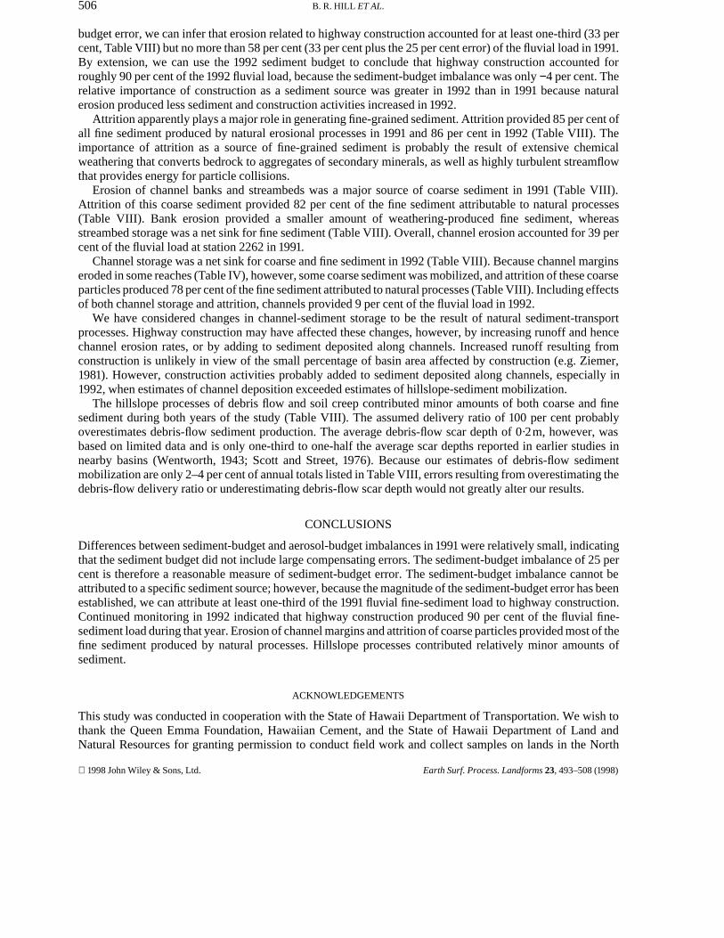
Table IX. Quartz and 137Cs budgets for North Halawa Stream, water year 1991
Source
QuartzEstimated load
(Mg)Error(Mg)
137CsEstimated load
(Bq×106)Error
(Bq×106)
AtmosphericDebris flowsSoil creepChannel banksStreambedConstruction
TotalFluvial load
0·120·360·580·892·635·249·82
14·9
–0·26
–0·432·313·04
–0·89
0·003·703·29
21·16·813·40
38·347·4
–1·66
–8·846·181·11
–5·14
Sediment and aerosol budgets
The sediment budgets (Table VIII) accounted for less fine sediment than was measured at station 2262 in1991, and more fine sediment than was measured in 1992. Sediment-budget imbalances equaled 25 per cent ofthe fluvial load in 1991 and −4 per cent in 1992.
The quartz budget accounts for a total of 9·82Mg of quartz in 1991, equivalent to 66 per cent of the fluvialquartz load (Table IX). Net error was therefore 34 per cent. The largest source of quartz was erosion related toconstruction (Table IX).
The 137Cs budget accounts for a total of 38·3×106 Bq of 137Cs, equivalent to 81 per cent of the fluvial 137Csload (Table IX). Net error was therefore 19 per cent. The largest source of 137Cs was bank erosion (Table IX).
DISCUSSION
Differences between sediment-budget and aerosol-budget imbalances in 1991 were relatively small, indicatingthat the sediment budget did not include large compensating errors. The sediment-budget imbalance of 25 percent is therefore a reasonable measure of sediment-budget error. Knowing the magnitude of the sediment-
1998 John Wiley & Sons, Ltd. Earth Surf. Process. Landforms 23, 493–508 (1998)
506 B. R. HILL ET AL.
budget error, we can infer that erosion related to highway construction accounted for at least one-third (33 percent, Table VIII) but no more than 58 per cent (33 per cent plus the 25 per cent error) of the fluvial load in 1991.By extension, we can use the 1992 sediment budget to conclude that highway construction accounted forroughly 90 per cent of the 1992 fluvial load, because the sediment-budget imbalance was only −4 per cent. Therelative importance of construction as a sediment source was greater in 1992 than in 1991 because naturalerosion produced less sediment and construction activities increased in 1992.
Attrition apparently plays a major role in generating fine-grained sediment. Attrition provided 85 per cent ofall fine sediment produced by natural erosional processes in 1991 and 86 per cent in 1992 (Table VIII). Theimportance of attrition as a source of fine-grained sediment is probably the result of extensive chemicalweathering that converts bedrock to aggregates of secondary minerals, as well as highly turbulent streamflowthat provides energy for particle collisions.
Erosion of channel banks and streambeds was a major source of coarse sediment in 1991 (Table VIII).Attrition of this coarse sediment provided 82 per cent of the fine sediment attributable to natural processes(Table VIII). Bank erosion provided a smaller amount of weathering-produced fine sediment, whereasstreambed storage was a net sink for fine sediment (Table VIII). Overall, channel erosion accounted for 39 percent of the fluvial load at station 2262 in 1991.
Channel storage was a net sink for coarse and fine sediment in 1992 (Table VIII). Because channel marginseroded in some reaches (Table IV), however, some coarse sediment was mobilized, and attrition of these coarseparticles produced 78 per cent of the fine sediment attributed to natural processes (Table VIII). Including effectsof both channel storage and attrition, channels provided 9 per cent of the fluvial load in 1992.
We have considered changes in channel-sediment storage to be the result of natural sediment-transportprocesses. Highway construction may have affected these changes, however, by increasing runoff and hencechannel erosion rates, or by adding to sediment deposited along channels. Increased runoff resulting fromconstruction is unlikely in view of the small percentage of basin area affected by construction (e.g. Ziemer,1981). However, construction activities probably added to sediment deposited along channels, especially in1992, when estimates of channel deposition exceeded estimates of hillslope-sediment mobilization.
The hillslope processes of debris flow and soil creep contributed minor amounts of both coarse and finesediment during both years of the study (Table VIII). The assumed delivery ratio of 100 per cent probablyoverestimates debris-flow sediment production. The average debris-flow scar depth of 0·2m, however, wasbased on limited data and is only one-third to one-half the average scar depths reported in earlier studies innearby basins (Wentworth, 1943; Scott and Street, 1976). Because our estimates of debris-flow sedimentmobilization are only 2–4 per cent of annual totals listed in Table VIII, errors resulting from overestimating thedebris-flow delivery ratio or underestimating debris-flow scar depth would not greatly alter our results.
CONCLUSIONS
Differences between sediment-budget and aerosol-budget imbalances in 1991 were relatively small, indicatingthat the sediment budget did not include large compensating errors. The sediment-budget imbalance of 25 percent is therefore a reasonable measure of sediment-budget error. The sediment-budget imbalance cannot beattributed to a specific sediment source; however, because the magnitude of the sediment-budget error has beenestablished, we can attribute at least one-third of the 1991 fluvial fine-sediment load to highway construction.Continued monitoring in 1992 indicated that highway construction produced 90 per cent of the fluvial fine-sediment load during that year. Erosion of channel margins and attrition of coarse particles provided most of thefine sediment produced by natural processes. Hillslope processes contributed relatively minor amounts ofsediment.
ACKNOWLEDGEMENTS
This study was conducted in cooperation with the State of Hawaii Department of Transportation. We wish tothank the Queen Emma Foundation, Hawaiian Cement, and the State of Hawaii Department of Land andNatural Resources for granting permission to conduct field work and collect samples on lands in the North
1998 John Wiley & Sons, Ltd. Earth Surf. Process. Landforms 23, 493–508 (1998)
507SEDIMENT BUDGET ERRORS
Halawa basin. Wayne Shibata and Xi Yuan Wen performed the XRD analyses used in this study. Reviews ofearlier manuscripts by Ross Sutherland and two anonymous reviewers were very helpful.
REFERENCES
Benjamin, J. R. and Cornell, C. A. 1970. Probability, Statistics, and Decision for Civil Engineers, McGraw-Hill Book Company, NewYork, 684 pp.
Blake, G. R. 1965. ‘Bulk density’, in Black C. A. (Ed.), Methods of Soil Analysis, Part 1, Physical and mineralogical properties, includingstatistics of measurement sampling, American Society of Agronomy, Madison, Wisconsin, 374–390.
Bradley, W. C. 1970. ‘Effect of weathering on abrasion of granitic gravel, Colorado River (Texas)’, Geological Society of AmericaBulletin, 81, 61–80.
Day, P. R. 1965. ‘Particle fractionation and particle-size analysis’, in Black, C. A. (Ed.), Methods of Soil Analysis, Part 1, Physical andmineralogical properties, including statistics of measurement and sampling, American Society of Agronomy, Madison, Wisconsin,545–567.
Dietrich, W. E. and Dune, T. 1978. ‘Sediment budget for a small catchment in mountainous terrain’, Zeitschrift fur Geomorphologie N.F.Suppl. Bd., 29, 191–206.
Doty, R. D., Wood, H. B. and Merriam, R. A. 1981. ‘Suspended sediment production from forested watersheds on Oahu, Hawaii’, WaterResources Bulletin, 17, 399–405.
Duan, N. 1983. ‘Smearing estimate: a nonparametric retransformation method’, Journal of the American Statistical Association, 78, 605–610.
Edwards, T. K. and Glysson, G. D. 1988. Field methods for measurement of fluvial sediment, US Geological Survey Open-File Report 86–531, 118 pp.
Friedlander, G., Kennedy, J. W., Macias, E. S. and Miller, J. M. 1981. Nuclear and Radiochemistry, 3rd edn, Wiley, London, 684 pp.Guy, H. P. 1969. Laboratory theory and methods for sediment analysis, Techniques of Water-Resources Investigations of the United
States Geological Survey, Book 5, Ch. C1.Health and Safety Laboratory, 1977. Final tabulation of monthly Sr-90 fallout data, 1954–1976, Health and Safety Laboratory
Environmental Quarterly no. 329, US Energy Research and Development Administration, New York, 884 pp.Helsel, D. R. and Cohn, T. A. 1988. ‘Estimation of descriptive statistics for multiply-censored water-quality data’, Water Resources
Research, 24, 1997–2004.Helsel, D. R. and Hirsch, R. M. 1992. Statistical Methods in Water Resources, Studies in Environmental Science 49, Elsevier, Amsterdam,
522 pp.Hill, B. R. 1996. Streamflow and suspended-sediment loads before and during highway construction, North Halawa, Haiku, and
Kamooalii drainage basins, Oahu, Hawaii, 1983–91, US Geological Survey Water-Resources Investigations Report 96–4259, 34 pp.Hill, B. R. and DeCarlo, E. H. 1991. ‘Effects of highway construction on suspended-sediment concentrations in two small drainage basins
on Oahu, Hawaii’, in State of Washington Water Research Center Report 78, Proceedings from the technical sessions of the regionalconference on Nonpoint Source Pollution, March 20–21, Tacoma, Washington, 303–313.
Hill, B. R., Fuller, C. C. and DeCarlo, E. H. (1997). ‘Hillslope soil erosion estimated from aerosol concentrations, North Halawa Valley,Oahu, Hawaii’, Geomorphology, 20, 67–79.
Iman, R. L. and Conover, W. J. 1983. A Modern Approach to Statistics, Wiley, New York, 497 pp.Izuka, S. K. 1992. Geology and stream infiltration of North Halawa Valley, Oahu, Hawaii, US Geological Survey Water-Resources
Investigations Report 91–4197, 21 pp.Jackson, M. L., Levelt, T. W. M., Syers, J. K., Rex, R. W., Clayton, R. N., Sherman, G. D. and Uehara, G. 1971. ‘Geomorphological
relationships of tropospherically derived quartz in the soils of the Hawaiian islands’, Soil Science Society of America Proceedings, 35,515–525.
Jones, B. L., Nakahara, R. H. and Chinn, S. S. W. 1971. Reconnaissance study of sediment transported by streams, island of Oahu, USGeological Survey Circular C33, 45 pp.
Keith, L. H., Libby, R. A., Crummett, W., Taylor, J. K., Deegan, J. Jr and Wentler, G. 1983. ‘Principles of environmental analysis’,Analytical Chemistry, 55, 2210–2218.
Kondolf, G. M. and Matthews, W. V. G. 1991. ‘Unmeasured residuals in sediment budgets: a cautionary note’, Water Resources Research,27, 2483–2486.
Lewis, L. A. 1976. ‘Soil movement in the tropics – a general model’ Zeitschrift fur Geomorphologie Suppl. Bd, 25, 132–144.Madej, M. A. 1992. Changes in channel-stored sediment, Redwood Creek, Northwestern California, Geological Survey Open-File Report
92–34, 1010 pp.Matsuoka, I., Kunishige, V. E. and Lum, M. G. 1992. Water resources data, Hawaii and other Pacific area, water year 1991, Volume 1,
Hawaii, US Geological Survey Water-Data Report HI–91–1, 282 pp.Matsuoka, I., Kunishige, V. E. and Lum, M. G. 1993. Water resources data, Hawaii and other Pacific area, water year 1992, Volume 1,
Hawaii, US Geological Survey Water-Data Report HI–92–1, 350 pp.Mink, J. F. 1959. ‘Distribution pattern of rainfall in the leeward Koolau Mountains, Oahu, Hawaii’, Journal of Geophysical Research, 65,
2869–2876.Moberly, R. Jr 1968. ‘Loss of Hawaiian littoral sand’, Journal of Sedimentary Petrology, 38, 17–34.Morris, W. J. and Fan, P- F. 1962. ‘Abrasion effects on arkose mixtures’, Journal of Sedimentary Petrology, 32, 225–230.Peart, M. R. and Walling, D. E. 1986. ‘Fingerprinting sediment source: the example of a drainage basin in Devon, UK, in Hadley, R. F.
(Ed.), Drainage Basin Sediment Delivery, International Association of Hydrological Sciences Publication 159, 41–55.Peart, M. R. and Walling, D. E. 1988. ‘Techniques for establishing suspended sediment sources in two drainage basins in Devon, UK: a
comparative assessment’, in Bordas, M. P. and Walling, D. E. (Eds), Sediment Budgets, International Association of HydrologicalSciences Publication 174, 269–279.
1998 John Wiley & Sons, Ltd. Earth Surf. Process. Landforms 23, 493–508 (1998)
508 B. R. HILL ET AL.
Peterson, D. M., Ellen, S. D. and Knifong, D. L. 1993. Distribution of past debris flows and other rapid slope movements from naturalhillslopes in the Honolulu District of Oahu, Hawaii, US Geological Survey Open-file Report 93–514, 32 pp.
Porterfield, G. 1972. Computation of fluvial sediment discharge, US Geological Survey Techniques of Water-Resources Investigations,Book 3, Ch. C3.
Rantz, S. E. et al. 1982a. Measurement and computation of streamflow: Volume 1. Measurement of stage and discharge, US GeologicalSurvey Water-Supply Paper 2175, 284 pp.
Rantz, S. E. et al. 1982b. Measurement and computation of streamflow: Volume 2. Computation of discharge, US Geological SurveyWater-Supply Paper 2175, 346 pp.
Reid, L. M., Dunne, T. and Cederholm, C. J. 1981. ‘Application of sediment budget studies to the evaluation of logging road impact’,Journal of Hydrology [New Zealand], 20, 49–62.
Rex, R. W., Syers, J. K., Jackson, M. L. and Clayton, R. N. 1969. ‘Eolian origin of quartz in soils in Hawaiian islands and in Pacific pelagicsediments’, Science, 163, 277–279.
Richards, K. S. 1982. Rivers–Form and Process in Alluvial Channels, Methuen, London, 358 pp.Riley, S. J. 1990. ‘Monitoring the erosion of an expressway during its construction: problems and lessons’, Hydrological Sciences
Journal, 35, 365–381.Ritchie, J. C. and McHenry, J. R. 1990. ‘Application of radioactive fallout cesium-137 for measuring soil erosion and sediment
accumulation rates and patterns: a review’, Journal of Environmental Quality, 19, 215–233.Saunders, I. and Young, A. 1983. ‘Rates of surface processes on slopes, slope retreat, and denudation’, Earth Surface Processes and
Landforms, 8, 473–501.Scott, G. A. J. and Street, J. M. 1976. ‘The role of chemical weathering in the formation of Hawaiian amphitheatre-headed valleys’,
Zietschrift fur Geomorphologie, 20, 171–189.Shade, P. J. 1984. Hydrology and sediment transport, Moanalua Valley, Oahu, Hawaii, US Geological Survey Water-Resources
Investigations Report 84–4156, 54 pp.Spear, R. L. 1990. North Halawa Valley: a progress report on the archaeological fieldwork conducted within the H-3 highway corridor,
Oahu Island, Hawaii, Applied Research Group, Bishop Museum, Honolulu, Hawaii, 18 pp.Spear, R. L. 1991. Preliminary report on the archaeology of the access road corridor in North Halawa Valley, Oahu Island, Hawaii,
Public Archaeology Section, Applied Research Group, Bishop Museum, Honolulu, Hawaii.Stearns, H. T. and Vaksvik, K. N. 1935. ‘Geology and ground-water resources of the island of Oahu’, Territory of Hawaii Division of
Hydrography Bulletin, 1, 479 pp.Sutherland, R. A. 1991. ‘Caesium-137 and sediment budgeting within a partially closed drainage basin’, Zietschrift fur Geomorphologie
N.F, 33, 47–63.Sutherland, R. A. and Bryan, R. B. 1991. ‘Sediment budgeting: a case study in the Katiorin Drainage Basin, Kenya’, Earth Surface
Processes and Landforms, 16, 383–398.Thiel, G. A. 1940. ‘The relative resistance to abrasion of mineral grains of sand size’, Journal of Sedimentary Petrology, 10, 103–124.US Department of Commerce, Environmental Science Services Administration, 1961. Climates of the states – Hawaii, Climatography of
the United States, no. 60–51, 27 pp.US Interagency Advisory Committee on Water Data, 1981. Guidelines for determining flood flow frequency, Bulletin 17B of the
Hydrology Committee, Washington, DC (available from Office of Water Data Coordination, USGS, Reston, VA 22092, USA).Visher, F. N. and Mink, J. F. 1964. Ground-water resources in Southern Oahu, Hawaii, US Geological Survey Water-Supply Paper 1778,
133 pp.Wentworth, C. K. 1928. ‘Principles of stream erosion in Hawaii’, Journal of Geology, 36, 385–410.Wentworth, C. K. 1942. Geology and ground-water resources of the Moanalua-Halawa District, Board of Water Supply, Honolulu,
156 pp. (unpublished).Wentworth, C. K. 1943. ‘Soil avalanches on Oahu, Hawaii’, Geological Society of America Bulletin, 54, 53–64.White, S. E. 1949. ‘Processes of erosion on steep slopes of Oahu, Hawaii’, American Journal of Science, 247, 168–186.Wolman, M. G. 1954. ‘A method of sampling coarse river-bed material’, Transactions of the American Geophysical Union, 35, 951–956.Ziemer, R. R. 1981. ‘Storm flow response to road building and partial cutting in small streams of Northern California’, Water Resources
Research, 17, 907–917.
1998 John Wiley & Sons, Ltd. Earth Surf. Process. Landforms 23, 493–508 (1998)