Embed Size (px)
Citation preview
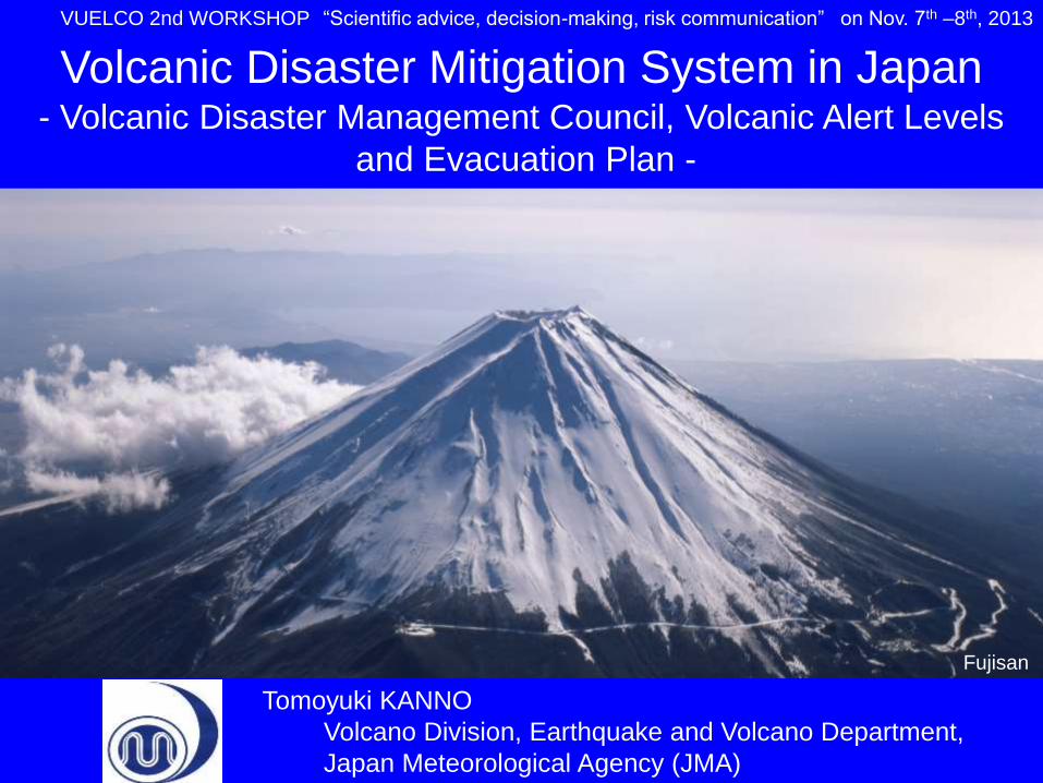
Tomoyuki KANNO
Volcano Division, Earthquake and Volcano Department,
Japan Meteorological Agency (JMA)
Volcanic Disaster Mitigation System in Japan - Volcanic Disaster Management Council, Volcanic Alert Levels
and Evacuation Plan -
VUELCO 2nd WORKSHOP “Scientific advice, decision-making, risk communication” on Nov. 7th –8th, 2013
Fujisan
• Introduction
– Volcano Monitoring by JMA
– Outline of disaster measures
• Volcanic Disaster Mitigation System in Japan
– Promotion of Volcanic Disaster Mitigation System
– Guidelines for evacuation in case of volcanic eruption
• Volcanic Disaster Management Council
• Volcanic Alert Levels
• Specific and practical Evacuation Plan
• Asamayama eruption in 2009 and Shinmoedake
Eruption in 2011 as case studies
• Conclusion
– Large eruptions will occur in 21st century in Japan 1
Contents
• Introduction
– Volcano Monitoring by JMA
– Outline of disaster measures
• Volcanic Disaster Mitigation System in Japan
– Promotion of Volcanic Disaster Mitigation System
– Guidelines for evacuation in case of volcanic eruption
• Volcanic Disaster Management Council
• Volcanic Alert Levels
• Specific and practical Evacuation Plan
• Asamayama eruption in 2009 and Shinmoedake
Eruption in 2011 as case studies
• Conclusion
– Large eruptions will occur in 21st century in Japan 2
Contents
N32°
N28°
N24°
E140° E144°
Ogasawara Islands Pacific Plate
Philippine Sea Plate
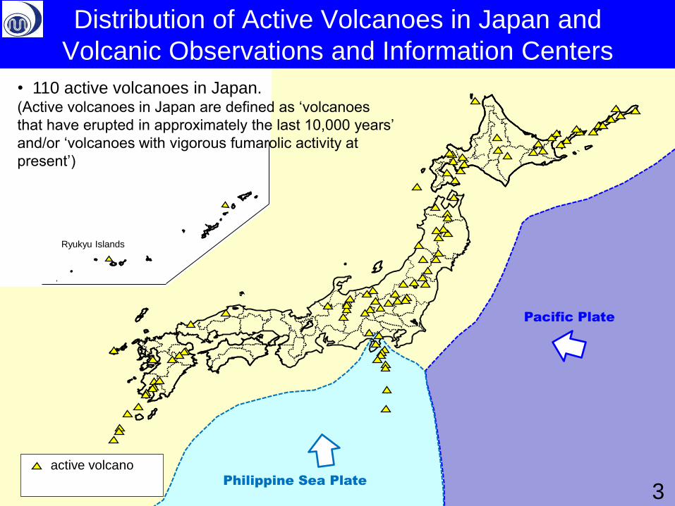
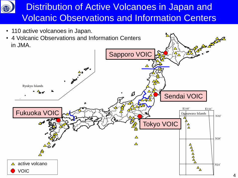
Distribution of Active Volcanoes in Japan and
Volcanic Observations and Information Centers
Ryukyu Islands
active volcano
• 110 active volcanoes in Japan. (Active volcanoes in Japan are defined as ‘volcanoes
that have erupted in approximately the last 10,000 years’
and/or ‘volcanoes with vigorous fumarolic activity at
present’)
3
Ryukyu Islands
N32°
N28°
N24°
E140° E144°
Ogasawara Islands
active volcano
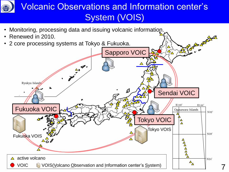
VOIC
• 110 active volcanoes in Japan.
• 4 Volcanic Observations and Information Centers
in JMA.
4
Sapporo VOIC
Sendai VOIC
Tokyo VOIC
Fukuoka VOIC
Distribution of Active Volcanoes in Japan and
Volcanic Observations and Information Centers
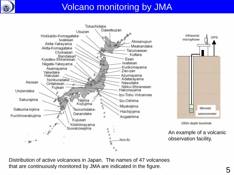
Distribution of active volcanoes in Japan. The names of 47 volcanoes
that are continuously monitored by JMA are indicated in the figure.
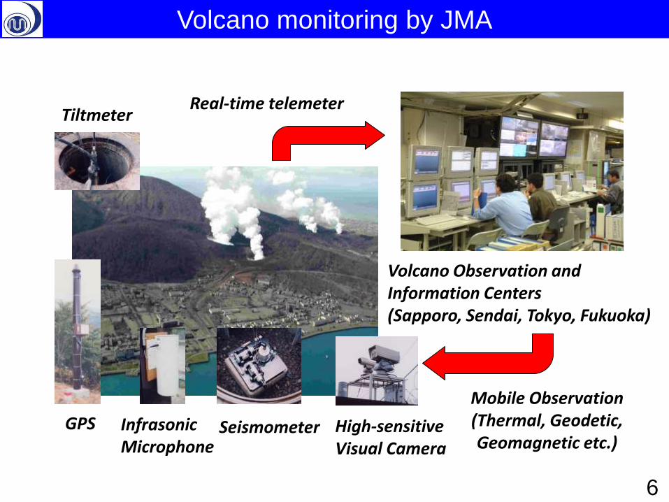
GPS
100m depth borehole
tiltmeter
seismometer
Infrasonic
microphone
An example of a volcanic
observation facility.
Volcano monitoring by JMA
5
傾斜計
High-sensitive Visual Camera
Seismometer Infrasonic Microphone
GPS
Tiltmeter
Volcano Observation and Information Centers (Sapporo, Sendai, Tokyo, Fukuoka)
Real-time telemeter
Mobile Observation (Thermal, Geodetic, Geomagnetic etc.)
Volcano monitoring by JMA
6
Ryukyu Islands
N32°
N28°
N24°
E140° E144°
Ogasawara Islands
• Monitoring, processing data and issuing volcanic information.
• Renewed in 2010.
• 2 core processing systems at Tokyo & Fukuoka.
active volcano
VOIC VOIS(Volcano Observation and Information center’s System)
Sapporo VOIC
Sendai VOIC
Tokyo VOIC
Fukuoka VOIC
Tokyo VOIS
Fukuoka VOIS
Volcanic Observations and Information center’s
System (VOIS)
7
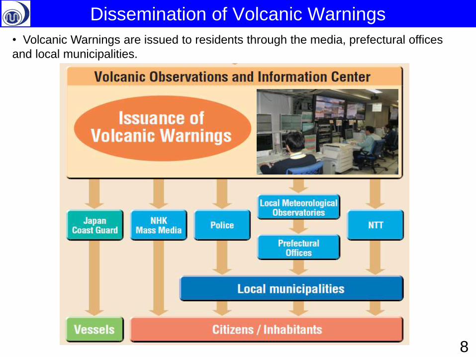
Dissemination of Volcanic Warnings
• Volcanic Warnings are issued to residents through the media, prefectural offices
and local municipalities.
8
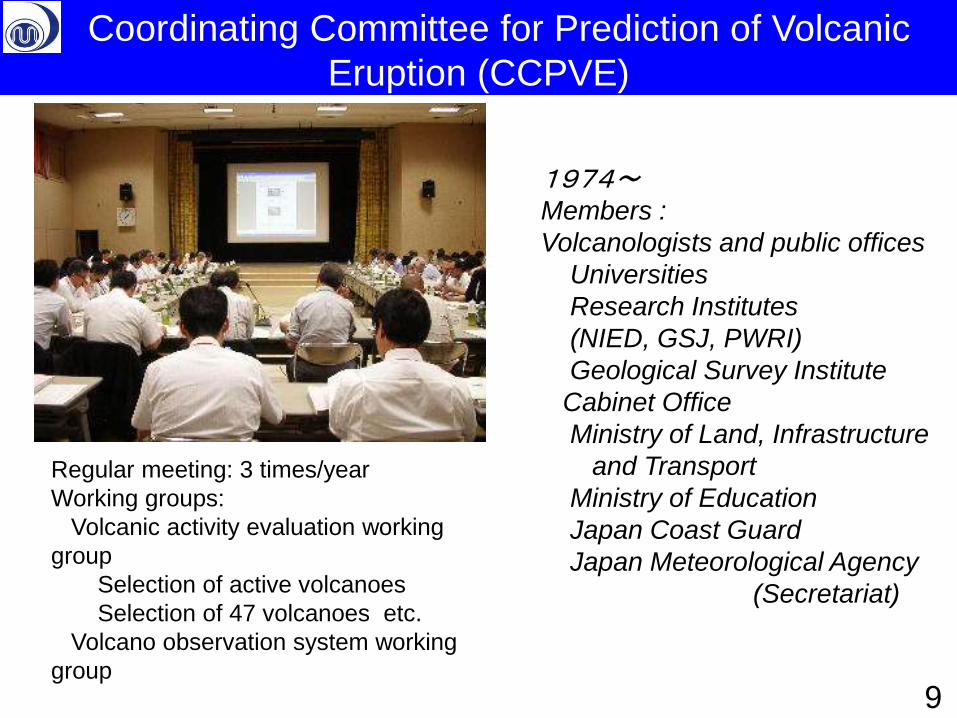
1974~
Members :
Volcanologists and public offices
Universities
Research Institutes
(NIED, GSJ, PWRI)
Geological Survey Institute
Cabinet Office
Ministry of Land, Infrastructure
and Transport
Ministry of Education
Japan Coast Guard
Japan Meteorological Agency
(Secretariat)
Regular meeting: 3 times/year
Working groups:
Volcanic activity evaluation working
group
Selection of active volcanoes
Selection of 47 volcanoes etc.
Volcano observation system working
group
Coordinating Committee for Prediction of Volcanic
Eruption (CCPVE)
9
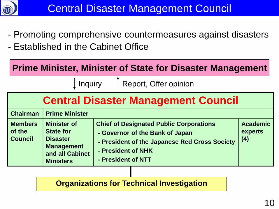
- Promoting comprehensive countermeasures against disasters
- Established in the Cabinet Office
Prime Minister, Minister of State for Disaster Management
Inquiry Report, Offer opinion
Organizations for Technical Investigation
10
Central Disaster Management Council
Central Disaster Management Council Chairman Prime Minister
Members
of the
Council
Minister of
State for
Disaster
Management
and all Cabinet
Ministers
Chief of Designated Public Corporations
- Governor of the Bank of Japan
- President of the Japanese Red Cross Society
- President of NHK
- President of NTT
Academic
experts
(4)
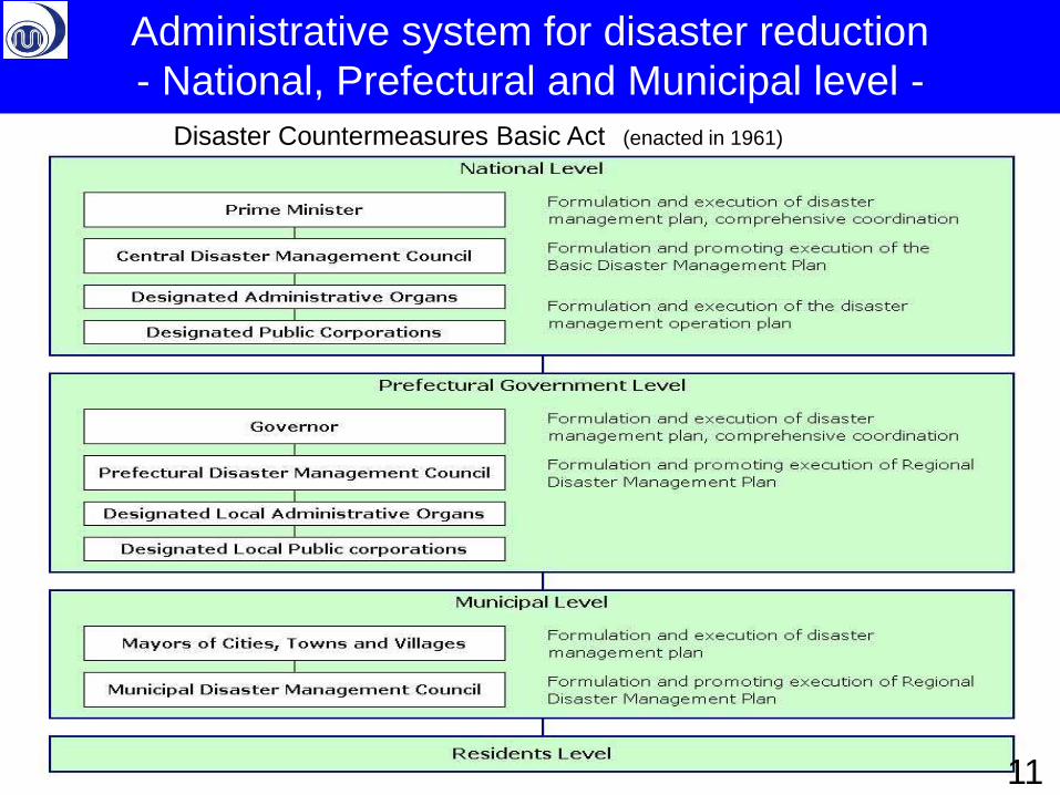
Administrative system for disaster reduction
- National, Prefectural and Municipal level -
Disaster Countermeasures Basic Act (enacted in 1961)
11
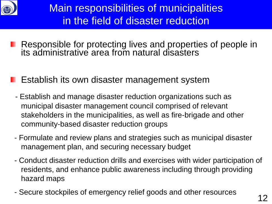
Responsible for protecting lives and properties of people in its administrative area from natural disasters
Establish its own disaster management system
- Establish and manage disaster reduction organizations such as
municipal disaster management council comprised of relevant
stakeholders in the municipalities, as well as fire-brigade and other
community-based disaster reduction groups
- Formulate and review plans and strategies such as municipal disaster
management plan, and securing necessary budget
- Conduct disaster reduction drills and exercises with wider participation of
residents, and enhance public awareness including through providing
hazard maps
- Secure stockpiles of emergency relief goods and other resources
Main responsibilities of municipalities
in the field of disaster reduction
12
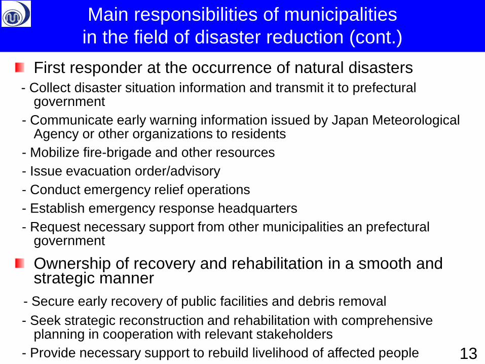
First responder at the occurrence of natural disasters
- Collect disaster situation information and transmit it to prefectural government
- Communicate early warning information issued by Japan Meteorological Agency or other organizations to residents
- Mobilize fire-brigade and other resources
- Issue evacuation order/advisory
- Conduct emergency relief operations
- Establish emergency response headquarters
- Request necessary support from other municipalities an prefectural government
Ownership of recovery and rehabilitation in a smooth and strategic manner
- Secure early recovery of public facilities and debris removal
- Seek strategic reconstruction and rehabilitation with comprehensive planning in cooperation with relevant stakeholders
- Provide necessary support to rebuild livelihood of affected people
Main responsibilities of municipalities
in the field of disaster reduction (cont.)
13
• Introduction
– Volcano Monitoring by JMA
– Outline of disaster measures
• Volcanic Disaster Mitigation System in Japan
– Promotion of Volcanic Disaster Mitigation System
– Guidelines for evacuation in case of volcanic eruption
• Volcanic Disaster Management Council
• Volcanic Alert Levels
• Specific and practical Evacuation Plan
• Asamayama eruption in 2009 and Shinmoedake
Eruption in 2011 as case studies
• Conclusion
– Large eruptions will occur in 21st century in Japan 14
Contents
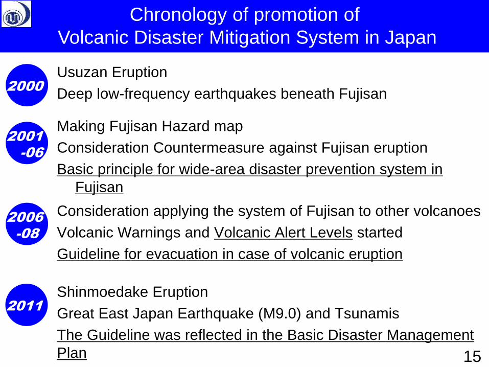
Usuzan Eruption
Deep low-frequency earthquakes beneath Fujisan
Chronology of promotion of
Volcanic Disaster Mitigation System in Japan
15
2011
2006
-08
2000
2001
-06
Making Fujisan Hazard map
Consideration Countermeasure against Fujisan eruption
Basic principle for wide-area disaster prevention system in
Fujisan
Consideration applying the system of Fujisan to other volcanoes
Volcanic Warnings and Volcanic Alert Levels started
Guideline for evacuation in case of volcanic eruption
Shinmoedake Eruption
Great East Japan Earthquake (M9.0) and Tsunamis
The Guideline was reflected in the Basic Disaster Management
Plan
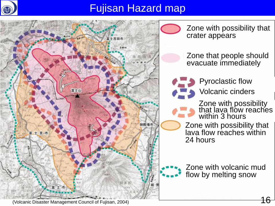
Zone with possibility that crater appears Zone that people should evacuate immediately
Pyroclastic flow Volcanic cinders
Zone with possibility that lava flow reaches within 24 hours
Zone with volcanic mud flow by melting snow
Zone with possibility that lava flow reaches within 3 hours
Fujisan Hazard map
16 (Volcanic Disaster Management Council of Fujisan, 2004)
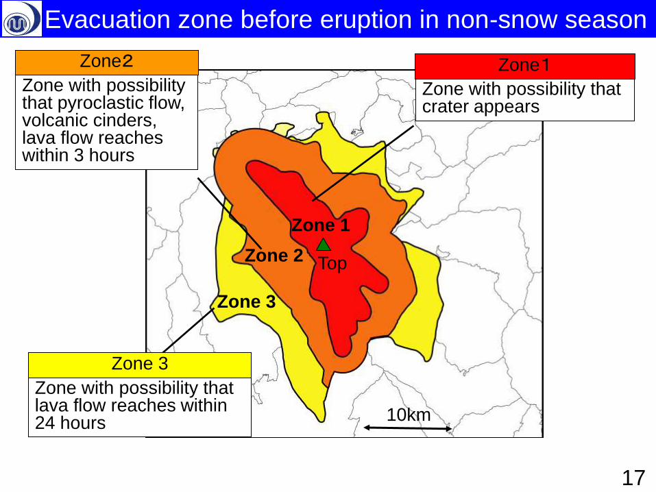
10km
Top
10km
Zone 1
Zone 2
Zone 3
Zone with possibility that crater appears
Zone with possibility that pyroclastic flow, volcanic cinders, lava flow reaches within 3 hours
Zone with possibility that lava flow reaches within 24 hours
Zone2
Zone 3
Zone1
17
Evacuation zone before eruption in non-snow season
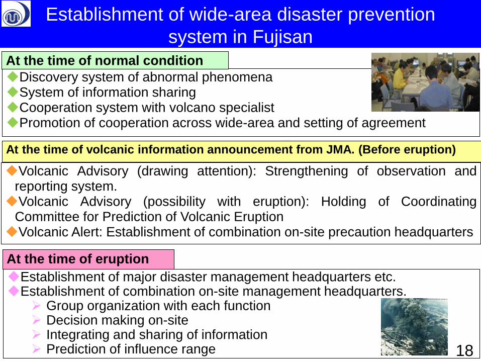
Discovery system of abnormal phenomena System of information sharing Cooperation system with volcano specialist Promotion of cooperation across wide-area and setting of agreement
Volcanic Advisory (drawing attention): Strengthening of observation and reporting system. Volcanic Advisory (possibility with eruption): Holding of Coordinating
Committee for Prediction of Volcanic Eruption Volcanic Alert: Establishment of combination on-site precaution headquarters
Establishment of major disaster management headquarters etc. Establishment of combination on-site management headquarters.
Group organization with each function Decision making on-site Integrating and sharing of information Prediction of influence range
At the time of eruption
At the time of normal condition
At the time of volcanic information announcement from JMA. (Before eruption)
18
Establishment of wide-area disaster prevention
system in Fujisan
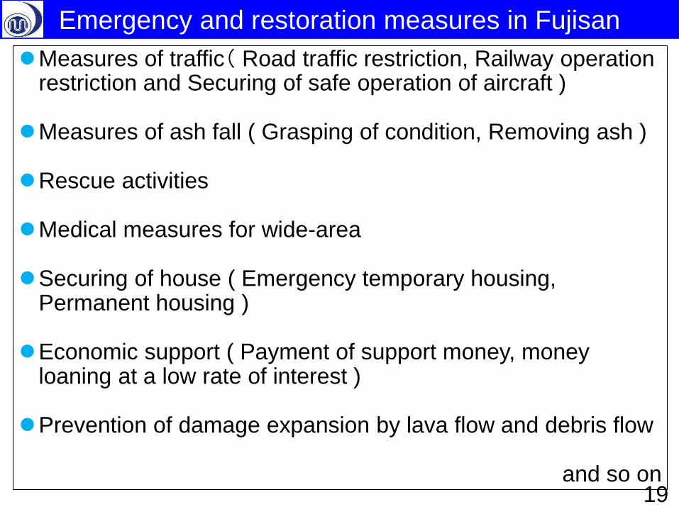
Measures of traffic( Road traffic restriction, Railway operation restriction and Securing of safe operation of aircraft )
Measures of ash fall ( Grasping of condition, Removing ash )
Rescue activities
Medical measures for wide-area
Securing of house ( Emergency temporary housing, Permanent housing )
Economic support ( Payment of support money, money loaning at a low rate of interest )
Prevention of damage expansion by lava flow and debris flow
and so on 19
Emergency and restoration measures in Fujisan
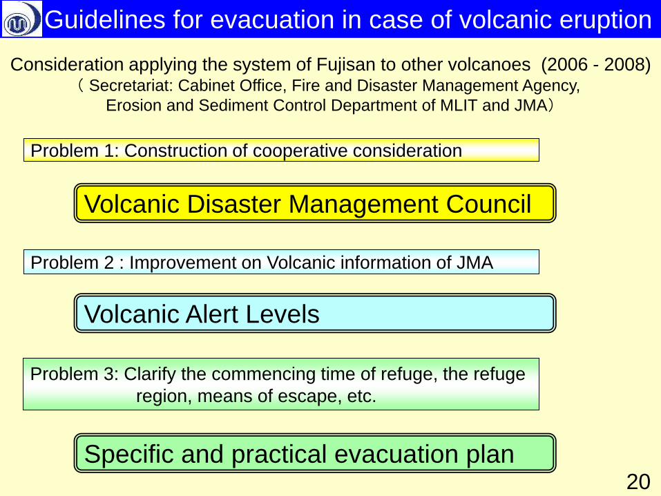
Problem 2 : Improvement on Volcanic information of JMA
Problem 3: Clarify the commencing time of refuge, the refuge
region, means of escape, etc.
Problem 1: Construction of cooperative consideration
Consideration applying the system of Fujisan to other volcanoes (2006 - 2008) ( Secretariat: Cabinet Office, Fire and Disaster Management Agency,
Erosion and Sediment Control Department of MLIT and JMA)
Volcanic Alert Levels
Specific and practical evacuation plan
Volcanic Disaster Management Council
20
Guidelines for evacuation in case of volcanic eruption
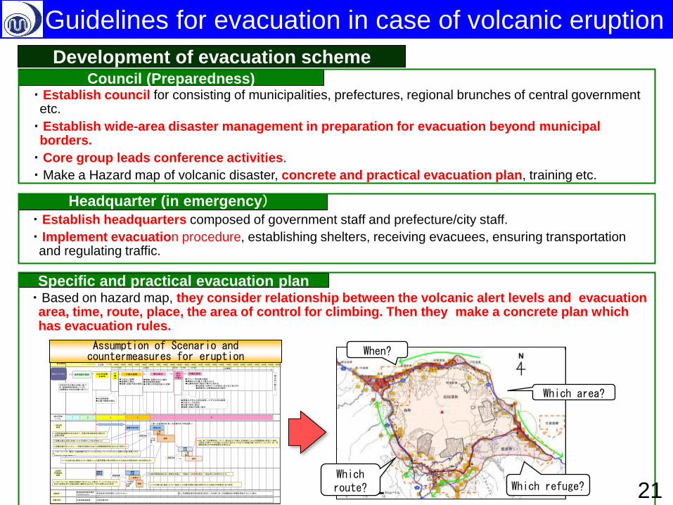
Which route?
When?
Which area?
Which refuge?
Council (Preparedness) ・Establish council for consisting of municipalities, prefectures, regional brunches of central government
etc.
・Establish wide-area disaster management in preparation for evacuation beyond municipal borders.
・Core group leads conference activities.
・Make a Hazard map of volcanic disaster, concrete and practical evacuation plan, training etc.
Headquarter (in emergency)
・Establish headquarters composed of government staff and prefecture/city staff.
・Implement evacuation procedure, establishing shelters, receiving evacuees, ensuring transportation and regulating traffic.
Specific and practical evacuation plan ・Based on hazard map, they consider relationship between the volcanic alert levels and evacuation
area, time, route, place, the area of control for climbing. Then they make a concrete plan which has evacuation rules.
駒ケ岳火山 噴火シナリオと防災対応の想定(バスによる集団避難)経過時間
(1/17 0:30) (09:53) (11:00) (12:30)
噴火警戒レベル
22時間 23時間18時間 19時間 20時間 21時間10時間 11時間 16時間 17時間12時間 13時間 14時間 15時間 24時間1時間 2時間 3時間 4時間 5時間 6時間 7時間 8時間 9時間
バス
◆10分以上継続◆断続的に噴火◆微動・空振が増大傾向
◆微動・空振がさらに増大◆地殻変動を観測◆大噴火の可能性ありと判断
◆プリニー式の噴火開始 ◆噴煙は火口直上で数千m以上 ◆山麓市街地で軽石が降下し始める ◆火砕流・火砕サージが発生(全方位に拡がる) ◆積雪期には融雪型泥流の発生
異常現象を観測 火山性微動を観測
小噴火
小噴火継続 噴火拡大 噴火拡大
(中噴火)
大噴火発生噴火シナリオ1 ・噴火急に衰える
2
2 3 541
2日間
避難準備広報
避難
一時集合
避難広報
バス出動と集結
一時集合
避難広報
警戒区域の設定検討(火口から2km)
第二次避難区域内警戒区域の設定(この時期に第二次避難区域の避難を開始するとした場合)警戒区域の設定検討(火口から4km)規制等
2災害情報連絡室 災害対策本部本部体制
避難広報
一時集合
避難バス要請と出動・集結
避難準備広報
*バスについては、事前の準備ができていないと想定して、レベルが4になった 時点で要請を受け出動を開始し集結するものとして約1時間30分と想定
一般住民避難
災害時要援護者避難
*避難広報は巡回と周知にかかる時間として約2時間とした
*災害時要援護者の歩行速度を考慮し、一時集合への時間を想定(一般住民より時間がかかる)
*バスの繰り返し輸送(ピストン輸送)による集団避難で最も時間のかかる地区の時間を設定(約2時間20分)
*仮に第二次避難区域について、噴火拡大(中噴火)を見極めてからの避難開始と想定した場合、 火砕流・火砕サージが発生(全方位に拡がる)するまでの避難が間に合わないことになり、第一次 避難区域との同時期避難が必要となる
※昭和4年の噴火史実に基づき、経過時間を設定している(時間軸の日時は史実に基づく)
9時間 14時間
◆規模の大きな水蒸気爆発~マグマ水蒸気爆発◆火砕サージの発生◆山麓で降灰(数㎝)◆微動・空振が急激に増大
*災害時要援護者対応も含めて、災害対策本部体制の確立が 必要な時期
◆水蒸気爆発◆山麓で微量の降灰
避難
<第一次避難区域・第二次避難区域(同時避難)>
*バスについては、事前に出動準備が完了しているものとしてレベル5になった段階で出動・集結にかかる 時間を約1時間と想定した
*バスの繰り返し輸送(ピストン輸送)による集団避難で最も時間のかかる地区の時間設定(約1時間)
避難準備
避難準備
*避難広報を受けてから、一時集合を開始するまでの避難準備時間を約30分と想定した
避難準備
Development of evacuation scheme
Assumption of Scenario and countermeasures for eruption
21
Guidelines for evacuation in case of volcanic eruption
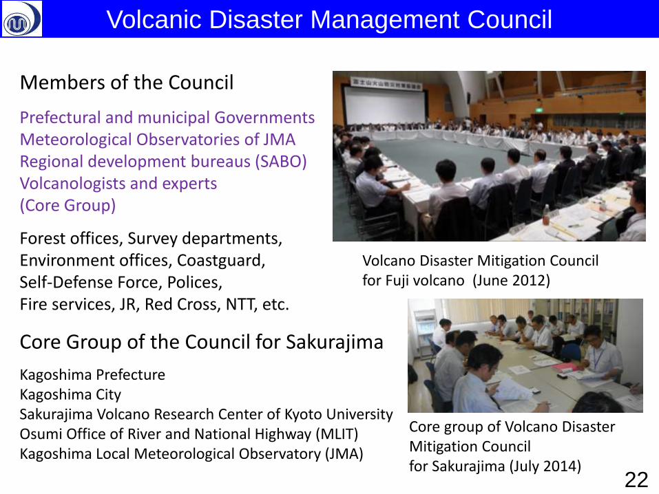
Volcano Disaster Mitigation Council for Fuji volcano (June 2012)
Members of the Council
Prefectural and municipal Governments Meteorological Observatories of JMA Regional development bureaus (SABO) Volcanologists and experts (Core Group)
Forest offices, Survey departments, Environment offices, Coastguard, Self-Defense Force, Polices, Fire services, JR, Red Cross, NTT, etc.
Core Group of the Council for Sakurajima
Kagoshima Prefecture Kagoshima City Sakurajima Volcano Research Center of Kyoto University Osumi Office of River and National Highway (MLIT) Kagoshima Local Meteorological Observatory (JMA)
Core group of Volcano Disaster Mitigation Council for Sakurajima (July 2014)
Volcanic Disaster Management Council
22
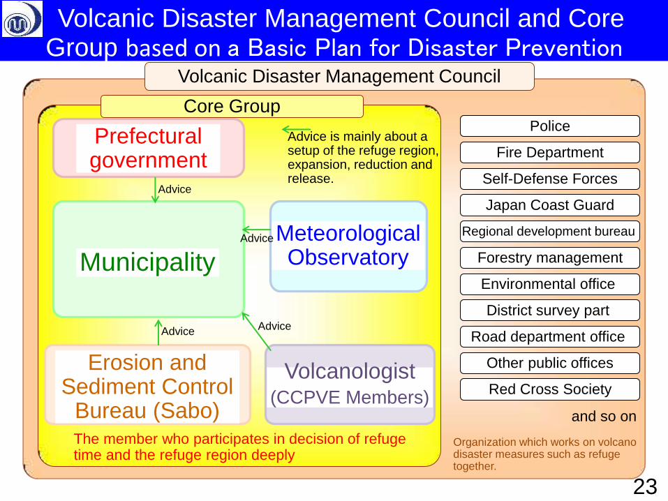
Volcanic Disaster Management Council
Organization which works on volcano disaster measures such as refuge together.
Police
Fire Department
Self-Defense Forces
Japan Coast Guard
Forestry management
Environmental office
District survey part
Road department office
Other public offices
Red Cross Society
Regional development bureau
and so on
Core Group
Prefectural government
Meteorological Observatory Municipality
Erosion and Sediment Control
Bureau (Sabo) The member who participates in decision of refuge time and the refuge region deeply
Advice
Volcanologist (CCPVE Members)
Advice
Advice Advice
Advice is mainly about a setup of the refuge region, expansion, reduction and release.
23
Volcanic Disaster Management Council and Core Group based on a Basic Plan for Disaster Prevention
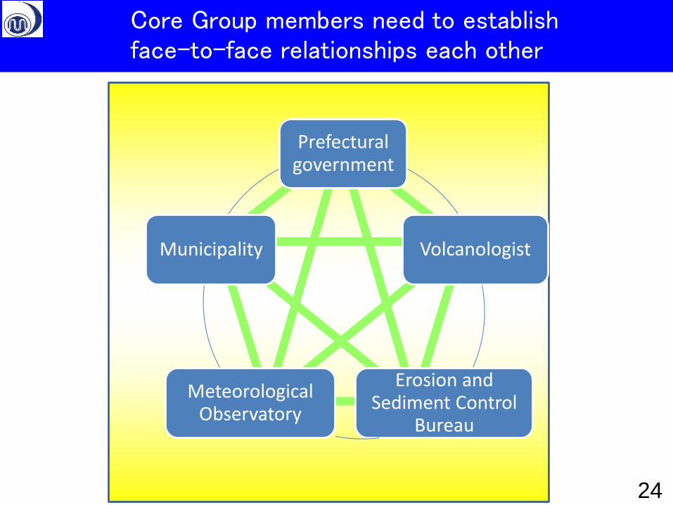
Prefectural government
Volcanologist
Erosion and Sediment Control
Bureau
Meteorological Observatory
Municipality
Core Group members need to establish face-to-face relationships each other
24
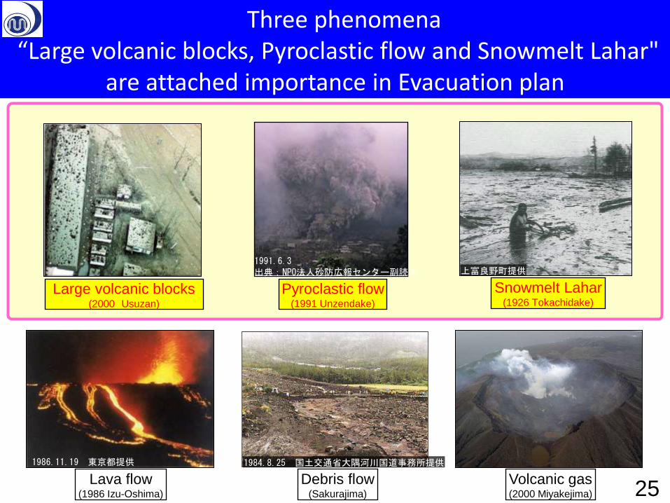
Large volcanic blocks (2000 Usuzan)
Pyroclastic flow (1991 Unzendake)
Lava flow (1986 Izu-Oshima)
Snowmelt Lahar (1926 Tokachidake)
Debris flow (Sakurajima)
Volcanic gas (2000 Miyakejima)
1986.11.19 東京都提供
1991.6.3 出典:NPO法人砂防広報センター副読本
1984.8.25 国土交通省大隅河川国道事務所提供
上富良野町提供
25
Three phenomena “Large volcanic blocks, Pyroclastic flow and Snowmelt Lahar"
are attached importance in Evacuation plan
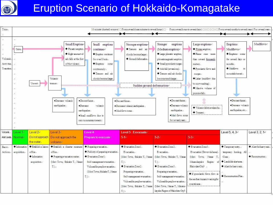
Eruption Scenario of Hokkaido-Komagatake
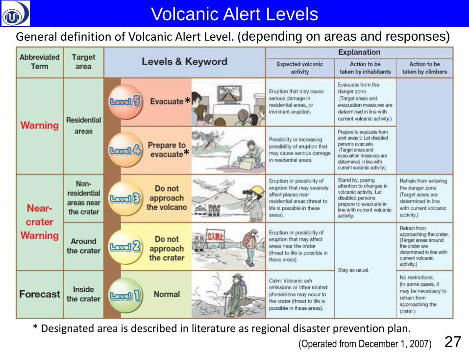
Volcanic Alert Levels General definition of Volcanic Alert Level. (depending on areas and responses)
(Operated from December 1, 2007)
* Designated area is described in literature as regional disaster prevention plan.
*
*
27
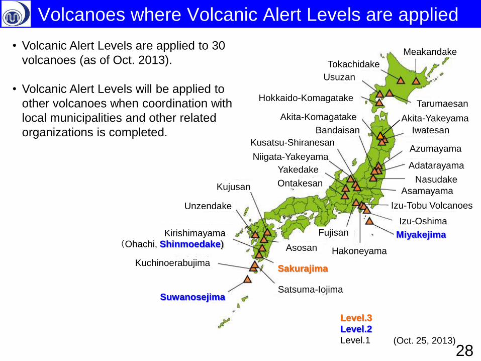
Volcanoes where Volcanic Alert Levels are applied
Meakandake
Usuzan
Hokkaido-Komagatake Tarumaesan
Iwatesan
Azumayama
Nasudake
Bandaisan
Kusatsu-Shiranesan
Asamayama Ontakesan
Miyakejima
Adatarayama
Fujisan
Hakoneyama
Tokachidake
Kirishimayama
Sakurajima
Satsuma-Iojima
Unzendake
Kujusan
Suwanosejima
Kuchinoerabujima
Asosan
Akita-Komagatake
(Ohachi, Shinmoedake)
(Oct. 25, 2013)
Izu-Tobu Volcanoes
Izu-Oshima
Niigata-Yakeyama
Yakedake
• Volcanic Alert Levels are applied to 30
volcanoes (as of Oct. 2013).
• Volcanic Alert Levels will be applied to
other volcanoes when coordination with
local municipalities and other related
organizations is completed.
Level.3
Level.2
Level.1
Akita-Yakeyama
28
• Introduction
– Volcano Monitoring by JMA
– Outline of disaster measures
• Volcanic Disaster Mitigation System in Japan
– Promotion of Volcanic Disaster Mitigation System
– Guidelines for evacuation in case of volcanic eruption
• Volcanic Disaster Management Council
• Volcanic Alert Levels
• Specific and practical Evacuation Plan
• Asamayama eruption in 2009 and Shinmoedake
Eruption in 2011 as case studies
• Conclusion
– Large eruptions will occur in 21st century in Japan 29
Contents
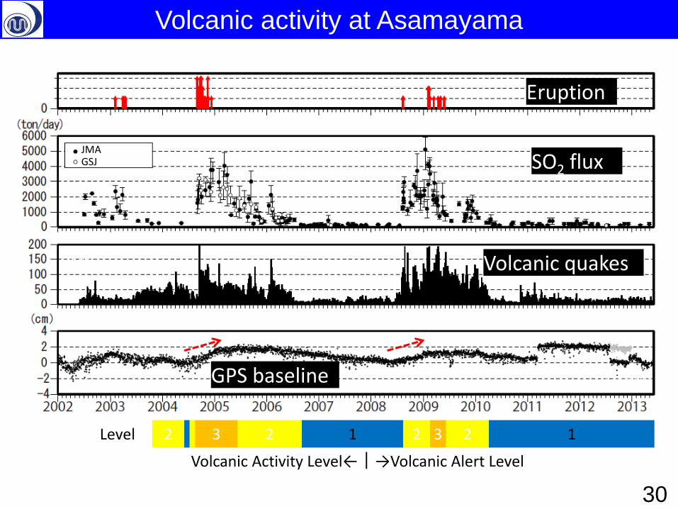
Eruption
SO2 flux
Volcanic quakes
GPS baseline
JMA GSJ
N/day
↑ 3.11 ↑ Replace sensor
1 1 2 2 3 2 3 2 Level
Volcanic Activity Level←|→Volcanic Alert Level
Volcanic activity at Asamayama
30
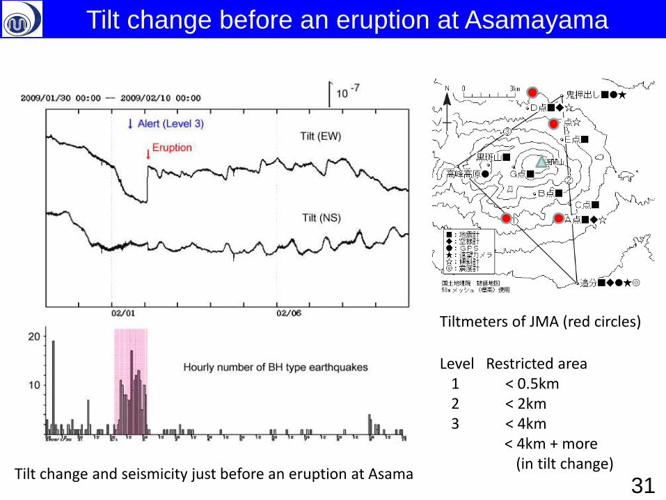
Tilt change and seismicity just before an eruption at Asama
Tiltmeters of JMA (red circles)
Level Restricted area 1 < 0.5km 2 < 2km 3 < 4km < 4km + more (in tilt change)
Tilt change before an eruption at Asamayama
31
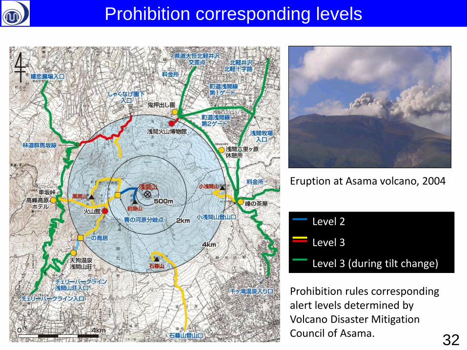
Level 2
Level 3
Level 3 (during tilt change)
Eruption at Asama volcano, 2004
Prohibition rules corresponding alert levels determined by Volcano Disaster Mitigation Council of Asama.
Prohibition corresponding levels
32
Criteria for evacuations etc.
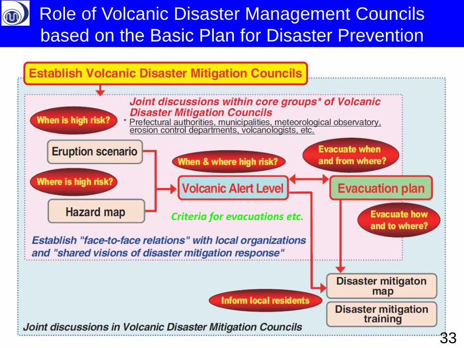
Role of Volcanic Disaster Management Councils
based on the Basic Plan for Disaster Prevention
33
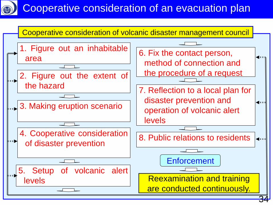
Cooperative consideration of volcanic disaster management council
2. Figure out the extent of
the hazard
3. Making eruption scenario
4. Cooperative consideration
of disaster prevention
5. Setup of volcanic alert
levels
1. Figure out an inhabitable
area
8. Public relations to residents
7. Reflection to a local plan for
disaster prevention and
operation of volcanic alert
levels
Reexamination and training
are conducted continuously.
Enforcement
6. Fix the contact person,
method of connection and
the procedure of a request
Cooperative consideration of an evacuation plan
34
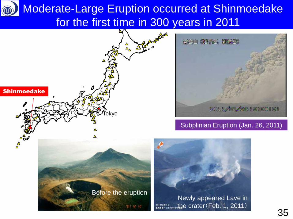
Subplinian Eruption (Jan. 26, 2011)
Before the eruption Newly appeared Lave in
the crater(Feb. 1, 2011)
Shinmoedake
Tokyo
Moderate-Large Eruption occurred at Shinmoedake
for the first time in 300 years in 2011
35
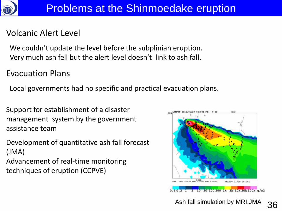
Volcanic Alert Level
We couldn’t update the level before the subplinian eruption. Very much ash fell but the alert level doesn’t link to ash fall.
Evacuation Plans
Local governments had no specific and practical evacuation plans.
Support for establishment of a disaster management system by the government assistance team
Development of quantitative ash fall forecast (JMA) Advancement of real-time monitoring techniques of eruption (CCPVE)
Ash fall simulation by MRI,JMA
Problems at the Shinmoedake eruption
36
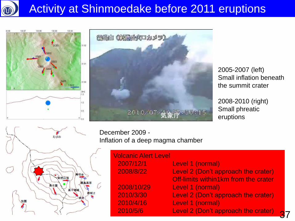
2005-2007 (left)
Small inflation beneath
the summit crater
2008-2010 (right)
Small phreatic
eruptions 気象庁
December 2009 -
Inflation of a deep magma chamber
Volcanic Alert Level
2007/12/1 Level 1 (normal)
2008/8/22 Level 2 (Don’t approach the crater)
Off-limits within1km from the crater
2008/10/29 Level 1 (normal)
2010/3/30 Level 2 (Don’t approach the crater)
2010/4/16 Level 1 (normal)
2010/5/6 Level 2 (Don’t approach the crater)
Activity at Shinmoedake before 2011 eruptions
37
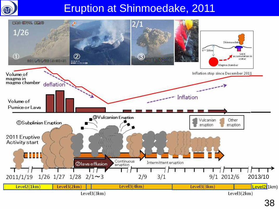
Level2(1km)
2013/10
Eruption at Shinmoedake, 2011
38
Ebino
Kirishima Miyakonojo
Kobayashi
Tkaharu
湧水町
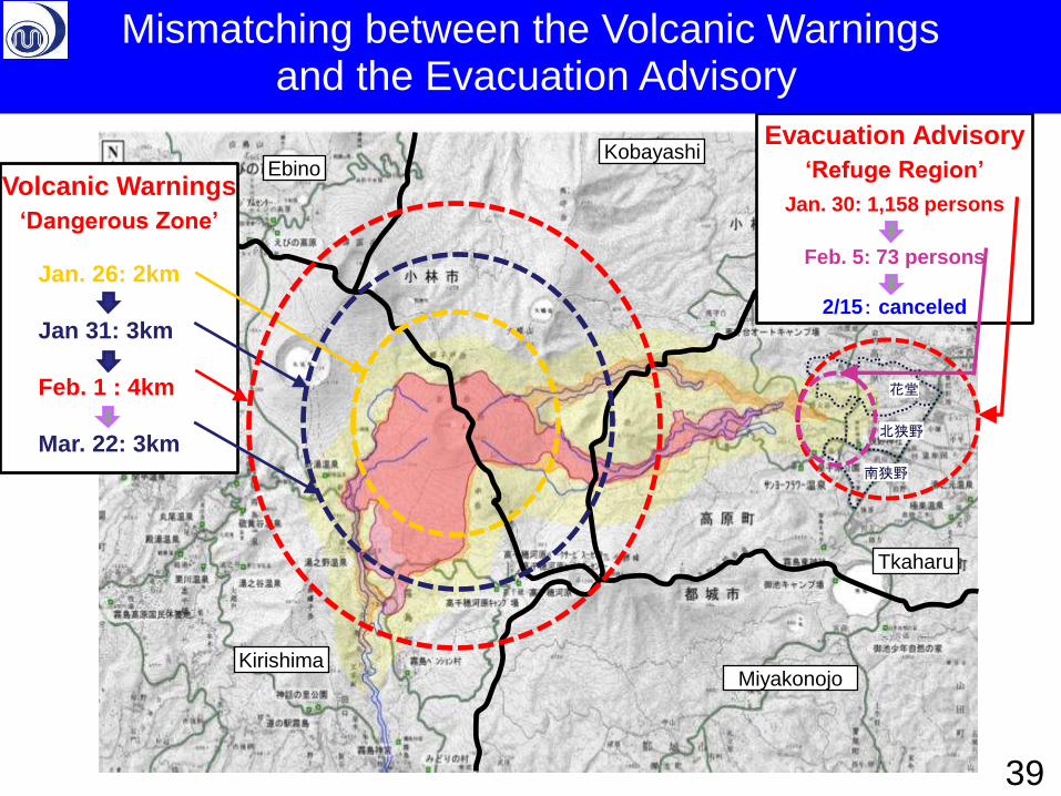
Volcanic Warnings
‘Dangerous Zone’
Jan. 26: 2km
Jan 31: 3km
Feb. 1 : 4km
Mar. 22: 3km
花堂
北狭野
南狭野
Evacuation Advisory
‘Refuge Region’
Jan. 30: 1,158 persons
Feb. 5: 73 persons
2/15: canceled
39
Mismatching between the Volcanic Warnings and the Evacuation Advisory
40
Kirishima City
Evacuation Plan
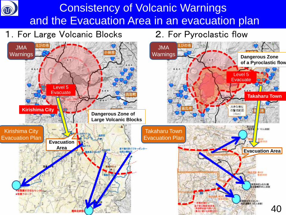
2.For Pyroclastic flow 1.For Large Volcanic Blocks
Takaharu Town
Evacuation Plan
JMA
Warnings
JMA
Warnings
Evacuation
Area Evacuation Area
Level 5 Evacuate
避難・ 避難準備
40
Dangerous Zone of
Large Volcanic Blocks
Dangerous Zone
of a Pyroclastic flow
Kirishima City
Takaharu Town
Level 5 Evacuate
Consistency of Volcanic Warnings and the Evacuation Area in an evacuation plan
Volcanic Disaster Management Council for Shinmoedake
Organization which works on volcano disaster measures such as refuge together.
Police
Fire Department
Self-Defense Forces
Japan Coast Guard
Forestry management
Environmental office
District survey part
Road department office
Other public offices
Red Cross Society
Regional development bureau
and so on
Core Group
Prefectural government
Meteorological Observatory Municipality
Erosion and Sediment Control
Bureau (Sabo) The member who participates in decision of refuge time and the refuge region deeply
Advice
Volcanologist (CCPVE Members)
Advice
Advice Advice
41
Volcanic Disaster Management Council and Core Group based on a Basic Plan for Disaster Prevention
Government Assistance Team
Advice
2. Volcanic Alert Levels
3. Specific and practical Evacuation Plan
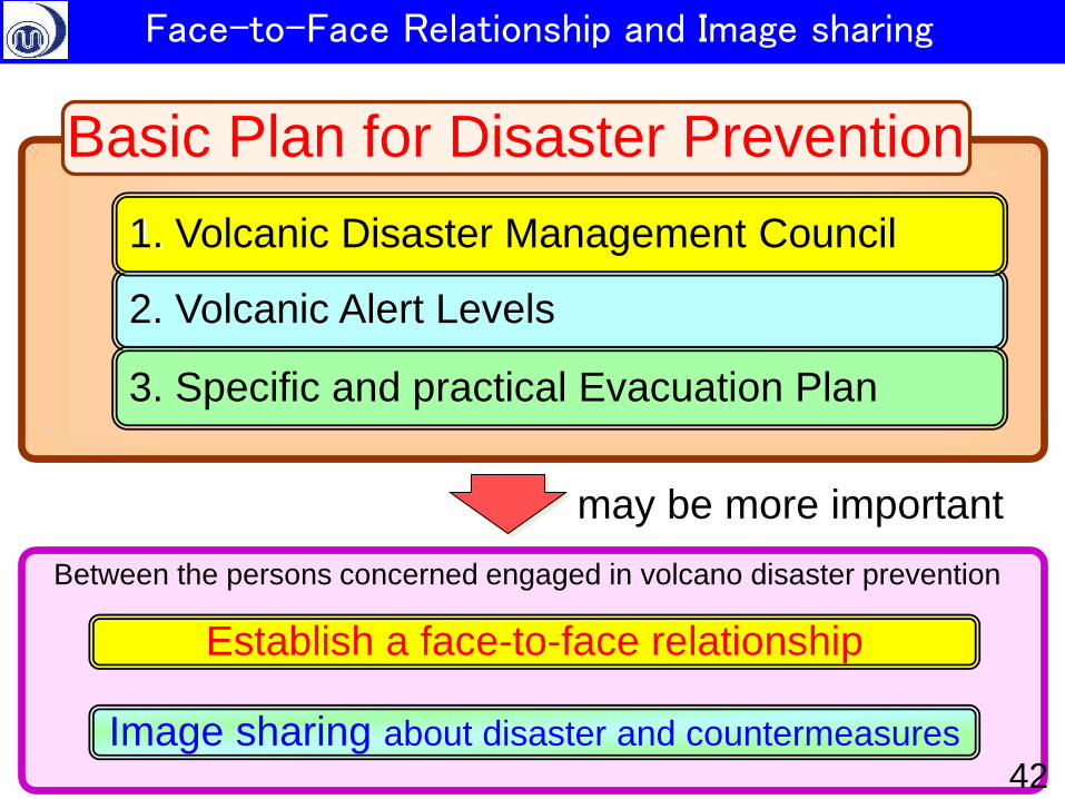
1. Volcanic Disaster Management Council
Establish a face-to-face relationship
Image sharing about disaster and countermeasures
Basic Plan for Disaster Prevention
Between the persons concerned engaged in volcano disaster prevention
may be more important
42
Face-to-Face Relationship and Image sharing
• Introduction
– Volcano Monitoring by JMA
– Outline of disaster measures
• Volcanic Disaster Mitigation System in Japan
– Promotion of Volcanic Disaster Mitigation System
– Guidelines for evacuation in case of volcanic eruption • Volcanic Disaster Management Council
• Volcanic Alert Levels
• Specific and practical Evacuation Plan
• Asamayama eruption in 2009 and Shinmoedake Eruption in 2011 as case studies
• Conclusion
– Large eruptions will occur in 21st century in Japan 43
Contents
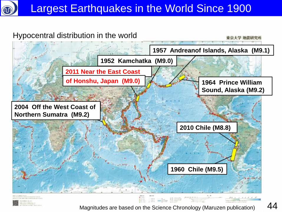
1952 Kamchatka (M9.0)
1957 Andreanof Islands, Alaska (M9.1)
1964 Prince William
Sound, Alaska (M9.2)
1960 Chile (M9.5)
2004 Off the West Coast of
Northern Sumatra (M9.2)
2010 Chile (M8.8)
Hypocentral distribution in the world
Largest Earthquakes in the World Since 1900
Magnitudes are based on the Science Chronology (Maruzen publication)
2011 Near the East Coast
of Honshu, Japan (M9.0)
44
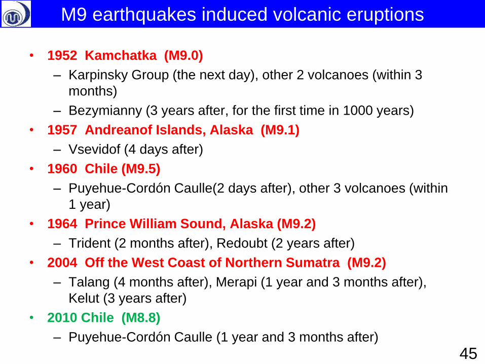
• 1952 Kamchatka (M9.0)
– Karpinsky Group (the next day), other 2 volcanoes (within 3
months)
– Bezymianny (3 years after, for the first time in 1000 years)
• 1957 Andreanof Islands, Alaska (M9.1)
– Vsevidof (4 days after)
• 1960 Chile (M9.5)
– Puyehue-Cordón Caulle(2 days after), other 3 volcanoes (within
1 year)
• 1964 Prince William Sound, Alaska (M9.2)
– Trident (2 months after), Redoubt (2 years after)
• 2004 Off the West Coast of Northern Sumatra (M9.2)
– Talang (4 months after), Merapi (1 year and 3 months after),
Kelut (3 years after)
• 2010 Chile (M8.8)
– Puyehue-Cordón Caulle (1 year and 3 months after)
M9 earthquakes induced volcanic eruptions
45
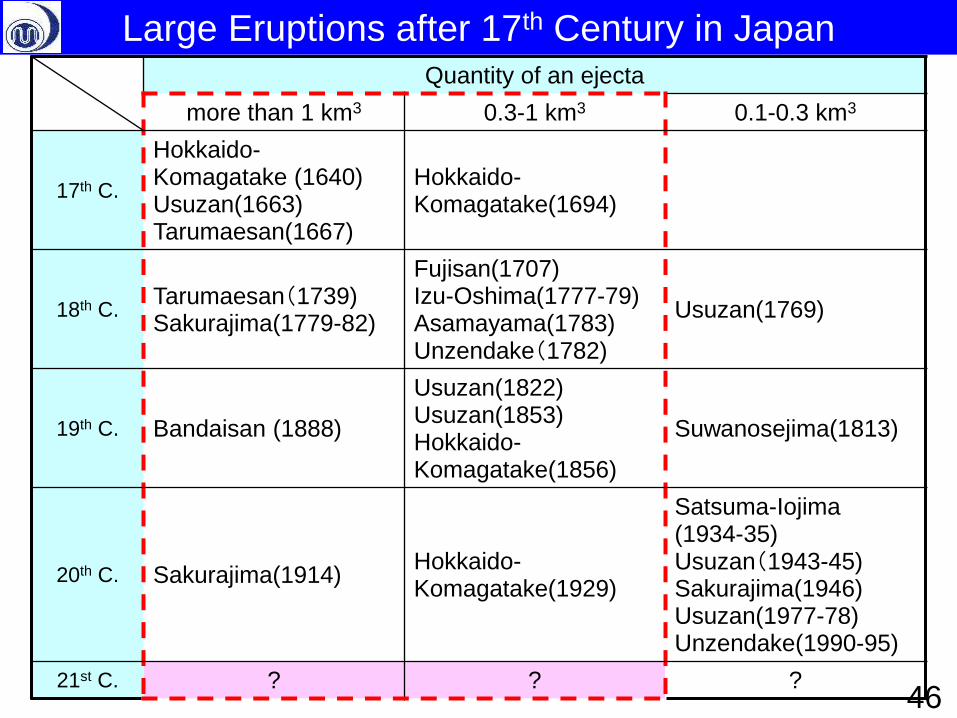
Quantity of an ejecta
more than 1 km3 0.3-1 km3 0.1-0.3 km3
17th C.
Hokkaido-Komagatake (1640) Usuzan(1663) Tarumaesan(1667)
Hokkaido-Komagatake(1694)
18th C. Tarumaesan(1739) Sakurajima(1779-82)
Fujisan(1707) Izu-Oshima(1777-79) Asamayama(1783) Unzendake(1782)
Usuzan(1769)
19th C. Bandaisan (1888)
Usuzan(1822) Usuzan(1853) Hokkaido-Komagatake(1856)
Suwanosejima(1813)
20th C. Sakurajima(1914) Hokkaido-Komagatake(1929)
Satsuma-Iojima (1934-35) Usuzan(1943-45) Sakurajima(1946) Usuzan(1977-78) Unzendake(1990-95)
21st C. ? ? ?
Large Eruptions after 17th Century in Japan
46
Proposals for mitigation of large-scale volcanic disasters
Compared with local countermeasures for volcanic disasters, Japan has
not yet well prepared for large-scale volcanic disasters (LSVD) that may
affect wide area of the country.
The government held ‘Study meetings for volcanic disaster mitigation for
wide area’ (Co-secretariat : the Cabinet Office, the Fire and Disaster
Management Agency, the Ministry of Land, Infrastructure, Transport and
Tourism and the Japan Meteorological Agency) and publicized ‘Proposals
for mitigation of large-scale volcanic disasters’ (16 May, 2013).
Main topics of the proposals 1. Need for countermeasures against large-scale lava flows, pyroclastic
flows and mudflows
2. Need for countermeasures against large-scale tephra fall
3. Role of the nation and municipalities when LSVD
4. Need for experts advice and enhancement of monitoring when LSVD
5. Enhancement of observation, research and human resources for LSVD
47
Thank you for your attention !
Japan Meteorological Agency
‘Ukiyoe’ picture by KATSUSHIKA Hokusai