Embed Size (px)
Citation preview
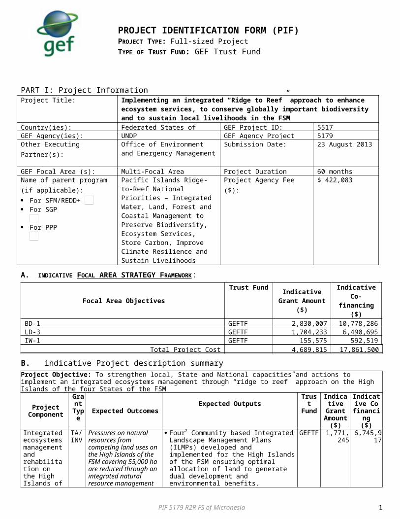
PART I: Project InformationProject Title: Implementing an integrated “Ridge to Reef” approach to enhance ecosystem services, to
conserve globally important biodiversity and to sustain local livelihoods in the FSMCountry(ies): Federated States of Micronesia GEF Project ID: 5517GEF Agency(ies): UNDP GEF Agency Project ID: 5179Other Executing Partner(s): Office of Environment and
Emergency ManagementSubmission Date: 23 August 2013
GEF Focal Area (s): Multi-Focal Area Project Duration (Months) 60 monthsName of parent program (if applicable): For SFM/REDD+ For SGP For PPP
Pacific Islands Ridge-to-Reef National Priorities – Integrated Water, Land, Forest and Coastal Management to Preserve Biodiversity, Ecosystem Services, Store Carbon, Improve Climate Resilience and Sustain Livelihoods
Project Agency Fee ($): $ 422,083
A. INDICATIVE FOCAL AREA STRATEGY FRAMEWORK :
Focal Area ObjectivesTrust Fund Indicative
Grant Amount($)
Indicative Co-financing
($) BD-1 GEFTF 2,830,007 10,778,286LD-3 GEFTF 1,704,233 6,490,695IW-1 GEFTF 155,575 592,519
Total Project Cost 4,689,815 17,861,500
B. indicative Project description summary
PIF 5179 R2R FS of Micronesia
PROJECT IDENTIFICATION FORM (PIF)
PROJECT TYPE: Full-sized Project TYPE OF TRUST FUND: GEF Trust Fund
1
Project Objective: To strengthen local, State and National capacities and actions to implement an integrated ecosystems management through “ridge to reef” approach on the High Islands of the four States of the FSM
Project Component
Grant
Type Expected OutcomesExpected Outputs
Trust Fund
Indicative
Grant Amount
($)
Indicative Co
financing($)
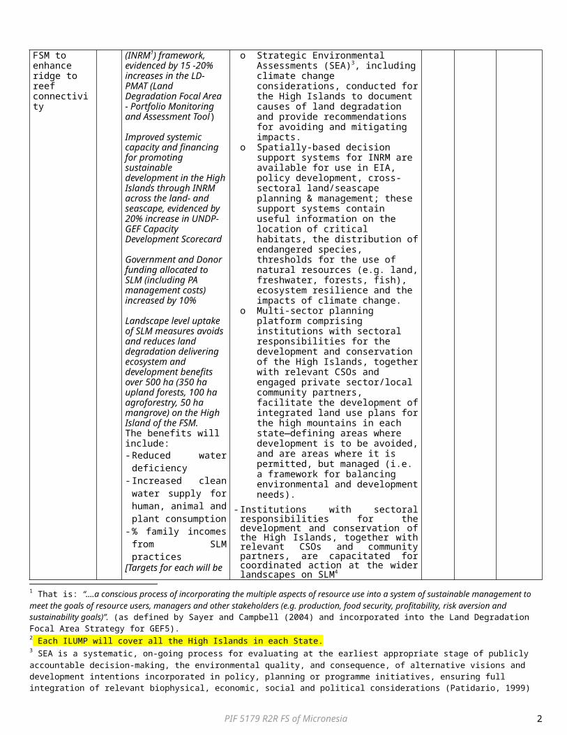
Integrated ecosystems management and rehabilitation on the High Islands of FSM to enhance ridge to reef connectivity
TA/ INV
Pressures on natural resources from competing land uses on the High Islands of the FSM covering 55,000 ha are reduced through an integrated natural resource management (INRM1) framework, evidenced by 15 -20% increases in the LD-PMAT (Land Degradation Focal Area - Portfolio Monitoring and Assessment Tool)
Improved systemic capacity and financing for promoting sustainable development in the High Islands through INRM across the land- and seascape, evidenced by 20% increase in UNDP-GEF Capacity Development Scorecard
Government and Donor funding allocated to SLM (including PA management costs) increased by 10%
Landscape level uptake of SLM measures avoids and reduces land degradation delivering ecosystem and development benefits over 500 ha (350 ha upland forests, 100 ha agroforestry, 50 ha mangrove) on the High Island of the FSM.The benefits will include:
Four2 Community based Integrated Landscape Management Plans (ILMPs) developed and implemented for the High Islands of the FSM ensuring optimal allocation of land to generate dual development and environmental benefits. o Strategic Environmental Assessments
(SEA)3, including climate change considerations, conducted for the High Islands to document causes of land degradation and provide recommendations for avoiding and mitigating impacts.
o Spatially-based decision support systems for INRM are available for use in EIA, policy development, cross-sectoral land/seascape planning & management; these support systems contain useful information on the location of critical habitats, the distribution of endangered species, thresholds for the use of natural resources (e.g. land, freshwater, forests, fish), ecosystem resilience and the impacts of climate change.
o Multi-sector planning platform comprising institutions with sectoral responsibilities for the development and conservation of the High Islands, together with relevant CSOs and engaged private sector/local community partners, facilitate the development of integrated land use plans for the high mountains in each state—defining areas where development is to be avoided, and are areas where it is permitted, but managed (i.e. a framework for balancing environmental and development needs).
- Institutions with sectoral responsibilities for the development and conservation of the High Islands, together with relevant CSOs and community partners, are capacitated for coordinated action at the wider landscapes on SLM4
- Secure additional (10% increase over baseline) finances for SLM investments (including PA
GEFTF 1,771,245 6,745,917
1 That is: “….a conscious process of incorporating the multiple aspects of resource use into a system of sustainable management to meet the goals of resource users, managers and other stakeholders (e.g. production, food security, profitability, risk aversion and sustainability goals)”. (as defined by Sayer and Campbell (2004) and incorporated into the Land Degradation Focal Area Strategy for GEF5).2 Each ILUMP will cover all the High Islands in each State.3 SEA is a systematic, on-going process for evaluating at the earliest appropriate stage of publicly accountable decision-making, the environmental quality, and consequence, of alternative visions and development intentions incorporated in policy, planning or programme initiatives, ensuring full integration of relevant biophysical, economic, social and political considerations (Patidario, 1999)4 Proposed target beneficiaries for capacity building activities: Department of Resource s and Development, Local community Groups in all 4 States; Chuuk State: Department of Agriculture, Department of Marine Resources, EPA; Chuuk Conservation Society; Pohnpei State: Department of Land and Natural Resources, Department of Public Safety, EPA, Conservation Society of Pohnpei,; Kosrae State: Kosrae Island Resource Management Authority, Kosrae Conservation and Safety Organisation, Yela Environment Landowners Association; Yap State: Department of Resources and Development, Yap Community Action Program.
PIF 5179 R2R FS of Micronesia 2

- Reduced water deficiency
- Increased clean water supply for human, animal and plant consumption
- % family incomes from SLM practices
[Targets for each will be established during the PPG phase]
management costs5) and align existing contributions to the environmental sector to support SLM practiceso Valuation of goods and services of natural
systems as well as different SLM practices – as a basis for brokering new public and donor finance for BD conservation and SLM
- Management and rehabilitation of critical ecosystems to enhance functional connectivity, reduce erosion, improve water quantity and quality and reduce coastal flooding. Physical measures include (i) At least 350 hectares of degraded upland forests area important for biodiversity conservation as identified in the ILMPs undergo ecosystem rehabilitation to counteract on-going and past land degradation (e.g. fire, unsustainable forest/wood harvesting, sakau cultivation, IAS); (ii) Increased water quality due to the reduction of nutrient pollution through improved management of piggeries; and (iii) At least 50 hectares of mangroves and wetlands rehabilitated.
Management Effectiveness enhanced within new and existing PAs on the High Islands of FSM as part of R2R approach (both marine and terrestrial)
TA/INV
Expansion of protected areas totaling at least 5,000 hectares6 in all four States
Increased management effectiveness for at least 20 existing and new protected areas covering 16,000 ha Increased METT scores
over baseline by at least 10% over average of the targeted PAs, with no drop in scores in any of the individual PAs
Stable or increased populations of critical endangered species such as Green Turtle (Chelonia mydas) and Humphead Wrasse (Cheilinus undulatus); as well as Globally vulnerable endemic bird species such as Truk Monarch (Metabolus regensis), Dusky White Eye (Horsfeldia nunu) and Micronesian Pigeon (Ducala oceanica endemic regionally) [Baseline and final indicator species to be established during PPG]
- National and State-level Legal and Institutional Framework established and capacities enhanced for guidance/support to effective management of PAs: (i) Department of Resources and Development and State Agencies actively involved and capacitated to perform in centralised functions such as planning, finance and legal affairs cost effectively; (ii) Standardised PA reporting and performance monitoring system; (iii) A PA management information system established at State and National level populated with up-to-date biodiversity, finance and other management (including climate risk management) information.
Expansion of PAs of the High Islands through upgrading of protection and gazetting: (i) Zoning and boundary demarcation based on land use planning and key data on the land/seascape; (ii) Gazetting at least 5,000 ha of terrestrial and marine PAs [exact areas to be determined during PPG phase];
Newly established PAs equipped and capacitated, including the development of local communities’ capacities in managing PAs.
Effective site and cross-site level PA management practices promoted in new and existing PAs (i) improved PA management planning and boundary demarcation; (ii) setting up biodiversity/ecological monitoring systems; (iii) enforcement strengthening (surveillance, interception of malfeasance), (iv) community level training tailored to improving management of specific threats at each site.
GEFTF 2,695,245 10,265,035
Subtotal 4,466,490 17,010,952Project Management Cost (PMC) GEFTF 223,325 850,548
5 Financing gaps for existing PAs and management costs for proposed new PAs will be determined during the PPG.6 The exact list of new protected areas will be determined during the PPG phase. A list of potential protected areas is provided in the main text, but sites might be added/removed based on community consultations.
PIF 5179 R2R FS of Micronesia 3
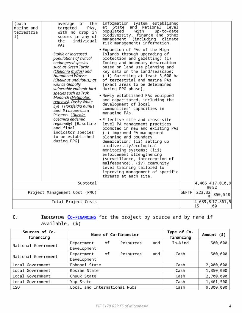
Total Project Costs 4,689,815 17,861,500
C. INDICATIVE CO-FINANCING for the project by source and by name if available, ($)
Sources of Co-financing Name of Co-financier Type of Co-financing Amount ($)
National Government Department of Resources and Development In-kind 500,000National Government Department of Resources and Development Cash 500,000Local Government Pohnpei State Cash 2,000,000Local Government Kosrae State Cash 1,350,000Local Government Chuuk State Cash 2,700,000Local Government Yap State Cash 1,461,500CSO Local and International NGOs Cash 9,300,000Multilateral Agency (ies) UNDP Cash 50,000Total Cofinancing 17,861,500
D. INDICATIVE TRUST FUND RESOURCES ($) REQUESTED BY AGENCY, FOCAL AREA AND COUNTRY1
GEF Agency
Type of Trust Fund Focal Area Country
Name/Global
Grant Amount ($)
(a)
Agency Fee ($) (b)2
Total ($) c=a+b
UNDP GEFTF Biodiversity FS Micronesia 2,649,560 238,460 2,888,020UNDP GEFTF Land Degradation FS Micronesia 1,315,720 118,415 1,434,135UNDP GEFTF Climate Change FS Micronesia 568,960 51,206 620,166UNDP GEFTF International Waters Global 155,575 14,002 169,577Total Grant Resources 4,689,815 422,083 5,111,8981 Government of the Federated States of Micronesia wishes to avail of the STAR flexibility mechanism in order to maximize in GEF V the use of resources for this priority project.
E. PROJECT PREPARATION GRANT (PPG)
Please check on the appropriate box for PPG as needed for the project according to the GEF Project Grant: Amount Agency Fee
Requested ($) for PPG ($) (upto)$150k for projects up to & including $6 million ___150,000______ ___13,500______
PPG AMOUNT REQUESTED BY AGENCY, FOCAL AREA(S) AND COUNTRY(IES) FOR MFA AND/OR MTF Project only
TRUST FUND
GEF AGENCY
FOCAL AREACountry
Name/Global
(in $)
PPG (a)Agency Fee
(b)Total
c = a + bGEF TF UNDP Biodiversity FSM 84,751 7,627 92,378GEF TF UNDP Land Degradation FSM 42,078 3,787 45,865GEF TF UNDP Climate Change FSM 18,196 1,638 19,834GEF TF UNDP International Waters Global 4,975 448 5,423Total PPG Amount 150,000 13,500 163,500MFA: Multi-focal area projects; MTF: Multi-Trust Fund projects.
PART II: PROJECT JUSTIFICATION
A PROJECT OVERVIEW
A.1. Project Description.
Short Introduction:
Marine and terrestrial biodiversity and ecosystem services underpin the economy of the Federated States of Micronesia and are vital to food security. However, these resources and services are currently being undermined by unsustainable resource use practices and overharvesting of resources, spread of invasive alien species and the impacts of climate change. This project has been designed to engineer a paradigm shift in the management of natural resources from an ad hoc site/problem centric approach to a
PIF 5179 R2R FS of Micronesia 4
holistic “ridge to reef” management approach, where whole island systems are managed to enhance ecosystem services, to conserve globally important biodiversity and to sustain local livelihoods. The project will promote an integrated approach towards fostering sustainable land management and biodiversity conservation – seeking to balance environmental management with development needs. Amongst other things, it will set-up a multi-sector planning platform to balance competing environmental, social and economic objectives. In doing so, it will reduce conflicting land-uses and improve the sustainability of upland and mangrove forest and wetlands management so as to maintain the flow of vital ecosystem services and sustain the livelihoods of local communities. Further, the project will demonstrate sustainable land management practices – testing new management measures, as needed, to reduce existing environmental stressors. The project will also enhance the FSM’s capacities to effectively manage its protected areas estate as well as increase the terrestrial and marine coverage of the PA system on the High Islands.
Global environmental problems
The Federal States of Micronesia (FSM) is an independent sovereign island nation consisting of four States – from west to east, Yap, Chuuk, Pohnpei and Kosrae (see map in Annex 1) – that are spread across the Western Pacific Ocean. Together, the States comprise 607 islands (with a combined land area of approximately 701 km2 and 2,600,000 km2 of the Pacific Ocean) that stretch over a longitudinal distance of almost 2,700 km just north of the equator. The governance structure in the FSM is such that each State has a high level of autonomy. The legislation and institutional framework of the Federated States of Micronesia is underscribed by National and individual State constitutions. The most recently available population estimates suggest that the population is 103,000. Of this population, 50% live on Chuuk, 33% on Pohnpei, 10% in Yap and the rest in Kosrae7. FSM’s HDI value for 2012 was 0.645 – placing it in the medium human development category –117 out of 187 countries and territories. Micronesia receives guaranteed funds (approximately $130 million annually until 2023) under a compact with the USA, which are invested in education, health, infrastructure, public sector capacity building, private sector development, and environmental management. A Trust Fund has also been established, into which the US and the FSM make annual contributions, and the returns on which are expected to provide for the long-term financial sustainability of the country after 2023. FSM also receives income from the sale of fishing licenses to foreign fleets operating in its EEZ and there is an emerging tourism industry in some of the States. Agriculture forms a major part of the economy, but much of this is subsistence agriculture and is not recorded in the GDP (60% of FSM’s population is dependent on subsistence farming and fishing). Breadfruit, banana, taro, yam, sweet potato, cassava, coconut and tropical fruits are the staple foodstuffs, in addition to seafood. Swine production constitutes the primary livestock industry- pigs playing an important part in local culture. The main export commodities are fish, pepper, sakua (kava) and betel nuts.
In line with the “ridge to reef” approach, the focus of the project will only be on the main islands (“high islands”) of each State that have some elevation, rather than on the atoll islands.
Yap State spans some 25,899,881 hectares of ocean. Its land area of about 12,950 ha consists of some 134 islands and atolls, 22 of which are populated. Lying at the western end of FSM, Yap differs from Eastern Micronesia in a number of ways. Climatically, it lies in an area that generally experiences a monsoon climatic pattern with some frequent periods of drought. The 3 High Islands of Yap (Yap proper, Map and Rumung) are small (land area of approximately 8,000 ha) and closely clustered resulting in condensed natural communities from ridge top (174 m) to reef. The majority of land on Yap, including mangrove forests, is privately owned under a complex traditional tenure system. The general forest types of mainland Yap includes Upland Forest, Swamp Forest, Mangrove Forest and Agroforests. Agriculture is undertaken mainly for subsistence, the main crops being yam, banana, taro, coconut, citrus and cassava, Colcasia and Xanthosoma. The present vegetation is mainly coconut trees (Cocus nucifera), Pandanus trees (Calophyllum spp.), breadfruit (Artoparpus atilis) and small shrubs. Agroforestry constitutes the dominant farming system.
Chuuk State: The State of Chuuk consists of a group of partially sunken volcanic islands (14 in total) surrounded by a barrier reef spanning 63 km in diameter (known as Chuuk Lagoon - the area of focus of the project in Chuuk), and a number of outlying coral atolls and islands. The volcanic islands are characterised by steep uplands, which comprise 73% of the total land area. The maximum elevation on Weno Island is 370 m, Dublon 344 m, Fefan 300 m and Tol 443 m. Chuuk is the most populated state in the FSM. Chuuk Lagoon has a land area of 12,691 ha and a very high population density of 3.72 persons/ha. The lagoon islands of Chuuk State have the highest percent of land under agroforestry of the high islands of Micronesia. The main subsistence crops are banana, breadfruit, coconuts and taro. The small areas of intact forest atop the peaks of some lagoon islands are rich in endemic species and are a repository of some of the most endangered remnant forest patches and species in Micronesia.
Pohnpei State includes the high island of Pohnpei and a number of small islets situated within a large lagoon (focus of project), and Outer Atolls. Pohnpei Island is roughly circular, with a land area of about 35,500 ha. It is a steep and mountainous volcanic island. Eleven peaks rise more than 600 m above sea level. The interior vegetation is dominated by sakau (kava) fields and upland forests
7 MDG Status Report 2010, Government of FSM
PIF 5179 R2R FS of Micronesia 5
(2002 figures show only 13% remaining8). Areas of intact native upland forests are of special interest because of the high rate of endemism. The dwarf cloud forests cloaking Pohnpei’s peaks are especially unique. The coastal areas and lower slopes are characterised by agroforestry (33%) and secondary vegetation (5%). Agroforestry has been expanding rapidly in recent decades.
Kosrae State: Kosrae is located at the eastern end of the Caroline Island group. The island is roughly triangular, with an area of about 11,180 ha. The island of Kosrae is characterised by steep mountains covered with dense forest. Several mountain peaks rise to 600 m above sea level, and Mt. Finkol is 629 m high. Deep wet valleys link the basaltic uplands to a wide alluvial plain along the island’s perimeter. Most of the island’s 7,686 inhabitants live along this perimeter. Mountainous areas make up about 70% of the island, with foot slopes, alluvial fans, and bottomlands comprising another 15% of the area. Approximately 14% the island is vegetated by mangrove swamps. Other vegetation types include upland forest, Swamp Forest, Mangroves, Cloud Forest, Secondary Forest, Agroforest, Marsh and Savanna Grassland. The island is fertile, though much of it is steep and inaccessible..
Ecosystem Services: Upland Forests provide habitat for biodiversity including many endemic species. They also provide critical hydrological services, both in terms of water provisioning and quality regulation. The extensive root systems of the forest trees and underlying plants and shrubs (aided by a ground layer of composting vegetation) serve to capture rainfall by slowing down runoff. This provides time for the water to sink into the ground where it is filtered and slowly released into streams and rivers. Through this process of slowing down rainwater surface runoff, the upland forests act to significantly reduce soil erosion, and thus help protect freshwater wetlands, mangrove areas and coral reefs from sedimentation and excessive nutient loading. Furthermore, by slowing down surface runoff and allowing rainwater to seep into the ground, the upland forests facilitate the slow release of ground water which helps ensure stream flow during relatively dry periods. It also acts to reduce the severity of flooding when it occurs. Mangrove forests have multiple values – as fisheries habitat, and for wood production, trapping sediment, and shoreline protection. Mangrove forests buffer the force of waves, including storm surges, and thus protect the coastline from erosion. The “fringe” (seaward) mangrove is especially valuable for this coastal protection function. Agroforests provide food, fiber, medicines and materials needed to support subsistence while at the same time supplying many of the ecosystem services of forests. Agroforests, wetlands and mangrove forests also provide an important role in reducing soil erosion and trapping sediment, releasing water of good quality into the marine environment. Sediment has a negative effect on coral reefs, which is important to near-shore fishing .
Global Biodiversity Significance The oceanic islands of the Federated States of Micronesia are critical storehouses of biodiversity. The country forms part of two Global 200 WWF ecoregions9, namely the Yap Tropical Dry Forest and the Carolines Tropical Moist Forest Ecoregion, and forms part of the Polynesia/Micronesia Hotspot, one of most endangered terrestrial ecosystems globally 10. The Yap Tropical Dry Forest contains the westernmost islands of Yap State. Yap’s Forests and savannas support a number of endemic plant species, including Drypetes yapensis, Drypetes carolenesis, Trichospermum kutai, Hedyotis yapensis, Timonius albus, Myrtella bennigseniana, Casearia cauliflora, and Dentaphalangium volkensii. The large tree Serianthes kanehirae and the distinctive tree Garcinia rumiyo are endemic to Yap and Palau. Yap hosts at least three endemic bird species; a monarch (Monarcha godeffroyi) and two white-eyes (Rukia oleaginea sp., Zosterops hypolais), as well as the distinctive Yap Cicadobird (Coracina nesiotis). Two endemic or subspecies of flying fox inhabit Yap State (Pteropus mariannus yapensis and P. m. ulithiensis). The Carolines Tropical Moist Forest Ecoregion contains the islands in Kosrae, Pohnpei, Chuuk and the easternmost islets of Yap State. The dominant vegetation is Mixed broadleaf forest. Lowland vegetation is dominated by mangrove and swamp forests. Located above 450 meters above mean sea level, montane cloud forests thrive on the unique combination of relatively high rainfall and elevation. These cloud forests are a global rarity as they are some of the lowest elevation cloud forests in the world; they are home to over 30 species of tree snails, 24 species of birds, and three species of endemic flying foxes. The Ecoregion has in general very high endemism, with over 200 endemic species. The list of endemic species includes one endemic genus and over 24 species of reptiles and four flying foxes (Pteropus molosinnus, P. insularis, P. phaeocephalus, P. marianus ualnus). Thirteen birds are endemic to the ecoregion, including the Truk monarch (Metabolus rugensis), the Pohnpei mountain starling (Aplonis pelzeni) and the Pohnpei lorry (Trichoglossus rubiginosus). The FSM’s High Islands also exhibit a great diversity of marine ecosystems in the form of fringing and barrier reefs around the high volcanic islands. According to the 2002 National Coral Reef Action Strategy (NOAA) “Reefs support more species per unit area than any other marine ecosystem including about 4,000 documented species of fish, 800 species of hard corals and hundreds of other species.” Four of the world’s seven sea turtles are recorded in the FSM.
Threats to Biodiversity and Ecosystem Services in the FSM can be categorized as five bundles: Conversion and Degradation of Natural Habitat and Ecosystems: Deforestation and fragmentation of forests in the form of forest clearance to allow for urbanization, infrastructure development, home building, in-filling, commercial agricultural expansion, and small-scale logging for timber and firewood use has been identified as one of the main forces behind land degradation. The
8 Federated States of Micronesia State-wide Assessment and Resource Strategy 2010 – 2015+.9 Olson, D.M. & Dinerstein, E. 2002. The Global 200: Priority Ecoregions for Global Conservation. Ann. Missouri Bot. Gard. 89:199 – 224.10 Mittermeier, R.A., Myers, N. & Mittermeier, C.G. 2000. Hotspots: Earth’s Biologically Richest and Most Endangered Terrestrial Ecoregions. Conservation International.
PIF 5179 R2R FS of Micronesia 6
Lowland forests of Pohnpei have been very disturbed and the area of native upland forests has declined from 42% of the total vegetation cover (14,910 ha of upland forest) in 1975 to 15% (5,325 ha of upland forests) in 1995, a total loss of 9,585 ha over the 20-year period. This is largely attributed to forest clearing to plant sakau (kava or Piper methysticum). On Chuuk, the only semi-original forest remaining is scattered in tiny remnants. In Yap, swidden farming of nutrient-demanding crops such as yams by early settlers led to large scale land clearing and nutrient depletion and the consequent spread of savannah. This is exacerbated by the slash and burn cultivation currently practiced in the Yap High Islands. The Yap High Islands also experience chronic wildfires during dry periods and acute wildfires that burn valuable forest lands on years with ENSO-related droughts. On two occasions in the last 30 years, at least 22% of Yap has been burnt during dry periods. Mangrove forests have been depleted from conversion to coastal infrastructure development11, through increased settlements and through the harvest of trees for timber and firewood. Over the past 20 years the availability of large amounts of funding for infrastructure improvements under the Compact of Free Association with the U.S. has led to increased dredging, road construction and land clearing. For example, in fiscal year 2007, $6.1 million was allocated to the Infrastructure Sector12. Sedimentation from these land-based activities, as well as agriculture, has contributed to the degradation of nearshore coral reef ecosystems in all four states. The overall harvest rate (for firewood) of mangroves on Kosrae for the past 10 years was 10%, but rates varied widely among the different parts of the island 13. The harvesting rates of mangroves are thought to be higher of the main islands of Pohnpei and Chuuk, due to their higher human population. The degradation of freshwater wetlands has been severe throughout the federation, due mainly to deforestation and to siltation from unsustainable land use, salinity intrusion, and filling in of wetland areas for home and agricultural development. The traditional practice of converting wetland vegetation in swamp forests for taro cultivation has also affected wetlands in the moist rainforests.
Overexploitation and Unsustainable Harvesting of Biological Resources: Overfishing and overhunting has been identified as the most urgent and critical threat across marine and terrestrial areas of interest for conservation in all the states 14. This is exacerbated by destructive and unsustainable fishing methods e.g. dynamite, chlorine, fish poisoning with the plant (Derris elliptica), the use of small mesh gillnets; and the over exploitation of fish aggregation spawning sites. Intense population growth on the main island of Chuuk since the 1960s, destructive fishing practices and a vast export market have placed increasing pressure on Chuuk’s natural resources, with roughly 2,000 – 4,000 mt/year of coastal resource harvested. Most of the fish gets exported, mostly to Guam. Rhodes et. al., 2001 states that the fish populations in Kosrae is experiencing overexploitation and in Yap localized overfishing of certain species and areas occur, especially around the main island. On Pohnpei, due to a substantial local commercial market for coastal marine products and subsistence use, at least 600 mt of fish is caught annually. Based on per capita consumption estimates, Pohnpei is now fishing nearly 1.5 times (150%) of its sustainable productive capacity 15. Particularly affected by unsustainable fishing and marine/coastal harvesting practices are Green Bumphead Parrotfish (Bolbometopon muricatum), Humphead Wrasse (Cheilinus undulatus), Giant Clam (Tridacna gigas), which has been almost eliminated in some parts of the FSM, Mangrove Crab (Scylla serrata), Black-lipped mother-of-pearl oyster (Pinctada margaritifera), Lobster (Panulinus sp.), Green Turtle (Chelonia mydas), Coconut Crab (Birgus latro) and Sea Cucumbers. A recent survey undertaken in Kosrae resulted in not one commercial valuable grouper of any species seen in 75 dives undertaken. The survey also recorded only three bumphead parrotfish and seven humphead wrasse in 75 dives16. This is impacting on local food security. Excessive hunting, especially of the Micronesian pigeon (Ducula oceanica) and the Caroline Islands ground dove (Gallicolumba kubaryi) has reduced the populations of these species.
Pollution: Farm waste is a major cause of land and water pollution, in particular waste from pigs. Most municipalities have instituted regulations requiring pig farmers to confine their animals. It is estimated that on the island of Pohnpei alone there are more than 3,000 piggeries. Raising pigs in pens requires farmers to clean the pens daily. The most common method of cleaning is with water. As the piggeries do not have an associated waste management system, the contaminated water enters fresh water creeks and lagoons. This has made many aquatic habitats unsuitable for freshwater species, including several endemic species that need clean, clear water. Pollution of lagoons and estuaries has in turn severely affected the fishing industry in several lagoons. Corals are very sensitive and usually grow in waters that are low in nutrients.
11 Figures are not available for loss of mangroves in FSM due to coastal infrastructure but based on global figures this are significant. Rates of deforestation/conversion of mangroves are among the highest of all tropical forests, far exceeding upland forests. Land conversion related to aquaculture, urban, and agricultural development has resulted in the loss of 35% of mangroves between 1980 and 2007 (Kaufman, J. B., Heider, C., Cole, T.G., Dwire, K.A. and Donato, D.C. 2011. Ecosystem Carbon Stocks of Micronesian Mangrove Forests. Wetlands 31: 343 – 352. 12 http://www.doi.gov/oia/Firstpginfo/compactgrants/index.html 13 Hauff, R.D., Enel, K.C., and Jack, J. 2006. Tracking Human Disturbance in Mangroves: Estimating Harvest Rates on a Micronesian Island. Wetlands Ecology and Management.14 The Nature Conservancy, 2003. A Blueprint for Conserving the Biodiversity of the Federal State of Micronesia. Pohnpei, FSM.15 Rhodes, K.L., Warren-Rhodes, K., Houk, P., Cuetos-Bueno, J., Fong, Q and Hoot, W. 2011. An Interdisciplinary Study of Market Forces and Nearshore Fisheries Management in Micronesia. A Report of the Marine Program of the Asia Pacific Region, The Nature Conservancy. Report No 6/11. 120 pp. 16 Hasurmai, M., Joseph, E., Palik, S., Rikim, K.. The State of Coral Reef Ecosystems of the Federated States of Micronesia.
PIF 5179 R2R FS of Micronesia 7
Spread of alien invasive species: Alien animal and plant species that have either been deliberately or accidentally introduced in the country threaten native species by preying on, smothering or out competing them. Past accidental and intentional introduction of alien species have led to the e extinction of some endemic species in the FSM. The isolation of the Micronesian islands makes them highly susceptible to invasive plants and animals. In the last 150 years, over 457 new plants and animals have been introduced to the islands of the FSM17. The percentage of introduced plants varies between the states with introduced species comprising 22% in Kosrae, 40% in Pohnpei, 37% in Chuuk and 39% in Yap of plant species18. Many openings in the forests (from sakau, fires, etc.) provide opportunities for aggressive vines such as Merremia peltata to establish themselves, smothering trees and preventing seedlings and saplings from growing.
Impacts from Climate Change: Conservative anticipated impacts of Climate Change are as follow: tendency towards more frequent typhoons during the summer and fall seasons; Gradual increase in the dry season in the western two-thirds of the FSM (Yap and Chuuk), with concomitant fire hazard; Projected accelerated sea level rise of 0.15 (minimum) to 0.95 meters (maximum) by 2100. Sea level rise is likely to have significant impact on turtle nesting beaches, low-lying seabird nesting areas, and mangrove forests19.
Institutions and policies:Ownership of land and aquatic areas varies between the States. In Kosrae and Pohnpei, land is both privately and State owned, while aquatic areas are managed by the State as public trusts. In Chuuk, most land and aquatic areas are privately owned and acquired through inheritance, gift, or more recently, by purchase. In Yap almost all land and aquatic areas are owned or managed by individual estates and usage is subject to traditional control. These land and aquatic tenure systems have critical bearing on the strategies and actions required to sustainably manage the biodiversity and ecosystems of the islands. The responsibility for environmental issues is shared between the FSM National government and the individual State government departments. The sharing of responsibility has at times resulted in the duplication of legislation at the State and national levels. It also resulted in gaps in legislation and areas in which the location of responsibility between National and State governments has been less than clear. Each State has made efforts to control development and manage natural resources through the creation of land use plans, coastal zone plans, legislation and regulations. The National Government provides guidance and technical assistance to the States when needed and requested on matters related to planning, development, natural resources, fisheries and the environment.
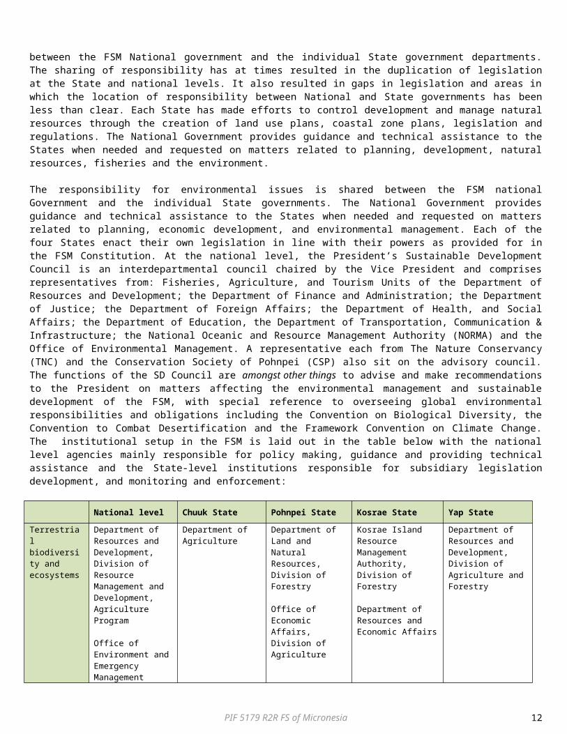
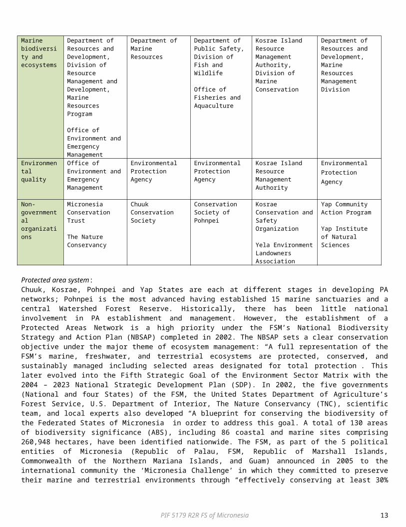
The responsibility for environmental issues is shared between the FSM national Government and the individual State governments. The National Government provides guidance and technical assistance to the States when needed and requested on matters related to planning, economic development, and environmental management. Each of the four States enact their own legislation in line with their powers as provided for in the FSM Constitution. At the national level, the President’s Sustainable Development Council is an interdepartmental council chaired by the Vice President and comprises representatives from: Fisheries, Agriculture, and Tourism Units of the Department of Resources and Development; the Department of Finance and Administration; the Department of Justice; the Department of Foreign Affairs; the Department of Health, and Social Affairs; the Department of Education, the Department of Transportation, Communication & Infrastructure; the National Oceanic and Resource Management Authority (NORMA) and the Office of Environmental Management. A representative each from The Nature Conservancy (TNC) and the Conservation Society of Pohnpei (CSP) also sit on the advisory council. The functions of the SD Council are amongst other things to advise and make recommendations to the President on matters affecting the environmental management and sustainable development of the FSM, with special reference to overseeing global environmental responsibilities and obligations including the Convention on Biological Diversity, the Convention to Combat Desertification and the Framework Convention on Climate Change. The institutional setup in the FSM is laid out in the table below with the national level agencies mainly responsible for policy making, guidance and providing technical assistance and the State-level institutions responsible for subsidiary legislation development, and monitoring and enforcement:
National level Chuuk State Pohnpei State Kosrae State Yap State
17 Falanruw, M.C., 2002. Terrestrial Biodiversity of the Federated States of Micronesia. FSM National Biodiversity Strategy and Action Plan Project. FSM Department of Economic Affairs and Global Environment Facility.18 FSM, 2010. Federated States of Micronesia Fourth National Report. Implementation of Article 6 of the Convention on Biological Diversity.19 FSM, 2010. Federated States of Micronesia Fourth National Report. Implementation of Article 6 of the Convention on Biological Diversity.
PIF 5179 R2R FS of Micronesia 8
Terrestrial biodiversity and ecosystems
Department of Resources and Development, Division of Resource Management and Development, Agriculture Program
Office of Environment and Emergency Management
Department of Agriculture
Department of Land and Natural Resources, Division of Forestry
Office of Economic Affairs, Division of Agriculture
Kosrae Island Resource Management Authority, Division of Forestry
Department of Resources and Economic Affairs
Department of Resources and Development, Division of Agriculture and Forestry
Marine biodiversity and ecosystems
Department of Resources and Development, Division of Resource Management and Development, Marine Resources Program
Office of Environment and Emergency Management
Department of Marine Resources
Department of Public Safety, Division of Fish and Wildlife
Office of Fisheries and Aquaculture
Kosrae Island Resource Management Authority, Division of Marine Conservation
Department of Resources and Development, Marine Resources Management Division
Environmental quality
Office of Environment and Emergency Management
Environmental Protection Agency
Environmental Protection Agency
Kosrae Island Resource Management Authority
Environmental Protection Agency
Non-governmental organizations
Micronesia Conservation Trust
The Nature Conservancy
Chuuk Conservation Society
Conservation Society of Pohnpei
Kosrae Conservation and Safety Organization
Yela Environment Landowners Association
Yap Community Action Program
Yap Institute of Natural Sciences
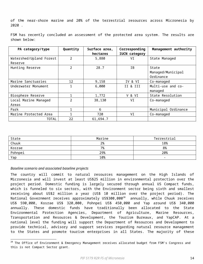
Protected area system:Chuuk, Kosrae, Pohnpei and Yap States are each at different stages in developing PA networks; Pohnpei is the most advanced having established 15 marine sanctuaries and a central Watershed Forest Reserve. Historically, there has been little national involvement in PA establishment and management. However, the establishment of a Protected Areas Network is a high priority under the FSM’s National Biodiversity Strategy and Action Plan (NBSAP) completed in 2002. The NBSAP sets a clear conservation objective under the major theme of ecosystem management: “A full representation of the FSM’s marine, freshwater, and terrestrial ecosystems are protected, conserved, and sustainably managed including selected areas designated for total protection”. This later evolved into the Fifth Strategic Goal of the Environment Sector Matrix with the 2004 – 2023 National Strategic Development Plan (SDP). In 2002, the five governments (National and four States) of the FSM, the United States Department of Agriculture’s Forest Service, U.S. Department of Interior, The Nature Conservancy (TNC), scientific team, and local experts also developed “A blueprint for conserving the biodiversity of the Federated States of Micronesia” in order to address this goal. A total of 130 areas of biodiversity significance (ABS), including 86 coastal and marine sites comprising 260,948 hectares, have been identified nationwide. The FSM, as part of the 5 political entities of Micronesia (Republic of Palau, FSM, Republic of Marshall Islands, Commonwealth of the Northern Mariana Islands, and Guam) announced in 2005 to the international community the ‘Micronesia Challenge’ in which they committed to preserve their marine and terrestrial environments through “effectively conserving at least 30% of the near-shore marine and 20% of the terrestrial resources across Micronesia by 2020”.
FSM has recently concluded an assessment of the protected area system. The results are shown below:
PA category/type Quantity Surface area, hectares
Corresponding IUCN category
Management authority
Watershed/Upland Forest Reserve 2 5,880 VI State ManagedHunting Reserve 2 28.7 IB State Managed/Municipal
OrdinanceMarine Sanctuaries 12 9,158 IV & VI Co-managedUnderwater Monument 1 6,000 II & III Multi-use and co-managedBiosphere Reserve 1 1,772 V & VI State ResolutionLocal Marine Managed Areas 2 38,130 VI Co-managed
PIF 5179 R2R FS of Micronesia 9

Park 1 6 Municipal OrdinanceMarine Protected Area 1 720 VI Co-managed
TOTAL 22 61,694.7
To date, the FSM States – Chuuk, Kosrae, Pohnpei and Yap – current status (%) of areas protected is as follows:State Marine TerrestrialChuuk 2% 18%Kosrae 7% 8%Pohnpei 29% 20%Yap 10% -
Baseline scenario and associated baseline projectsThe country will commit to natural resources management on the High Islands of Micronesia and will invest at least US$25 million in environmental protection over the project period. Domestic funding is largely secured through annual US Compact funds, which is funneled to six sectors, with the Environment sector being sixth and smallest receiving about US$2 million a year (US$ 10 million over the project period). The National Government receives approximately US$300,00020 annually, while Chuuk receives US$ 590,000, Kosrae US$ 320,000, Pohnpei US$ 450,000 and Yap around US$ 340,000 annually. These domestic funds have traditionally been allocated to the State Environmental Protection Agencies, Department of Agriculture, Marine Resources, Transportation and Resources & Development, the Tourism Bureaux, and YapCAP. At a national level the funding will support the Department of Resources and Development to provide technical, advisory and support services regarding natural resource management to the States and promote tourism enterprises in all States. The majority of these funds will be used to finance the management of the existing state protected areas or to assist in the management of the existing Community-based protected areas (see Annex 2) through the various State Departments (Chuuk State: Department of Agriculture, Department of Marine Resources; Pohnpei State: Department of Land and Natural Resources, Department of Public Safety; Kosrae State: Kosrae Island Resource Management Authority; and Yap State: Department of Resources and Development). These departments will also provide an extension service to farmers and together with the NGOs undertake regular monitoring activities of marine resources, including enforcing the law. State agencies (Environmental Protection Agencies of Chuuk, Yap and Pohnpei and the Kosrae Island Resource Management Authority) will undertake Environment Impact Assessments as required and monitor water quality. Other domestic funds available come from fisheries licensing fees and are sometimes allocated as appropriations from the respective state congressional delegations to NGOs and community groups for environmental projects. International funding is channelled mostly through NGOs21. The primary sources of funding are US federal grants (considered as a different category of funding than Compact funds) such as USAID, USDA, USFS, NOAA and the USDOI amongst others. The NGOs finance the establishment and management of protected areas, community partnership building and consultations, environmental awareness campaigns, training and workshops through the Micronesia Conservation Trust, from foreign Governments such as Japan, the European Union, Germany, Italy, Australia, New Zealand, and other private foundations and donors. The said injection of funding into the environment sector (through financing from the above-mentioned sources) equals US$ 3 million a year (US$15 million over the project period). This funding stream from the donors is not guaranteed; donors do not specifically allocate funds towards the environment every year. Conservation Society of Pohnpei will continue its management and support role to Pohnpei State protected areas and Community-based PAs. This includes the surveying, demarcating, management and law enforcement of the Water Forest Reserve, as well as implementing its “grow low” programme to encourage farmers to grow sakau on the lowlands of Pohnpei. It will continue its support to the marine protected areas of Pohnpei, as well as its marine monitoring programme which includes monitoring of Grouper Spawning and Aggregation, fish – focusing on the preferred market fish families – Scaridae (Parrotfish), Lethrinidae (Emperors) and Siganidae (Rabbitfish). The Chuuk Conservation Society will support and collaborate with the communities that manage the Parem Marine PA and the Epinup Mangrove Reserve. With the mentioned funding Kosrae Conservation and Safety Organisation will support the community in the management of the Awane Marine PA, Tafunsak Marine PA and Olu Watershed PA. The funding received by Yela Environment Landowners Association will assist in the management of the Yela Watershed and specifically for the conservation of remaining “Ka” forest in the Yela Ka Forest PA. The Micronesia Conservation Trust will improve the predictability of funding flows by creating a planned US$ 20 million endowment. MCT currently provides US$ 1 million (US$ 5 million over the project period) to environmental work in the FSM.Despite existing investments and activities, under the business-as-usual scenario 1) areas of biological significance (ABS) will continue to be degraded and ecosystem services will continue to be degraded due to anthropogenic pressures and poor land management practices; and 2) existing PAs will remain poorly managed and under-funded, without a strong central coordination
20 The Office of Environment & Emergency Management receives allocated budget from FSM’s Congress and this is not Compact Sector grant.21 FSM, 2010. Federated States of Micronesia Fourth National Report. Implementation of Article 6 of the Convention on Biological Diversity.
PIF 5179 R2R FS of Micronesia 10
hub. The long-term solution is, therefore, to implement a ridge-to-reef approach that combines a sustainable land management regime with a functional, representative and sustainable national system of terrestrial and coastal protected areas on the High Islands of the FSM. However, several barriers exist to the attainment of the long term solution. These are briefly described below:
Barrier 1: Lack of an overarching framework for promoting sustainable development in the FSM’s High Islands, including systemic capacities and availability of critical information / knowledge and funding: The financial and human resources earmarked in the baseline programmes for environmental improvement are deployed and managed by sectoral departments under a highly decentralized governance framework. Further, the prevalence of private and/or traditional control of lands and waters has resulted in a ‘silo’ mentality as concerns the improvement of environmental parameters in the agriculture, forestry and fisheries sectors. There is a need to harmonise and coordinate efforts across sectors and land and water managers and owners, and spearhead innovative ways and means of enhancing ecosystem functioning and resilience in an integrated and coordinated way that balances socio-economic and environmental objectives. Without a proper assessment, monitoring and planning regime for the maintenance of ecosystem services, managers and users will continue to have a difficult time effectively evaluating and integrating biodiversity conservation and land degradation risks within decision-making. The States lack the capacity to generate, implement and enforce integrated land and water management plans. Financial constraints present a further barrier to upscaling SLM levels at a level required to successfully arrest land degradation. Further, there is a disconnect between public expenditures and environmental priorities i.e. land degradation. This is linked to limited awareness both among decision-makers but also among the public and local communities of the importance and value of goods and services provided by intact ecosystems. The FSM does not have operational, “on-the-ground” examples of integrated sustainable land management at a landscape level (opposed to more piece-meal management of specific problems). Without access to know-how, proven through demonstration, government decision-makers and resource users do not have the tools and knowledge necessary to decrease land degradation. There is a critical unmet need to infuse new management approaches into the management system – focusing on sectors that are driving land degradation.Barrier 2: Inadequate PA representation and capacities to effectively conserve biodiversity of the High Islands of the FSM : The decentralised political situation in the FSM and the prevalence of private and/or traditional control of lands and waters throughout the nation necessitates broad public consultations to build public understanding of the importance of conservation and the role of protected areas. In addition, many of the nation’s areas of biodiversity significance are remote and isolated, necessisating that local communities and land/reef owners play a significant management role, irrespective of tenure. PAs need to be initiated at the community-level, where they will be well-supported locally and address local resource over-exploitation concerns. Communities have strong cultural and social ties to the environment but with rapid changes in population, consumption and changes in people’s lifestyles, the capacity for local communities to manage the areas of biodiversity significance has been diluted. Further, until recently, there has been little national involvement in PA management and establishment. However, without involvement by the State in PA establishment and management, restrictions imposed might overly-harsh or liberal, and in most cases not enforceable against violators outside the community. PA Management will also be more effective and efficient if common functions are standardised and centralised e.g. planning, finance and legal affairs. A clear barrier in the effective management of PAs is therefore the current unclear roles and responsibilities and capacities among the National, State and local-level agencies (NGOs) and local communities. There is clear need to expand the protected area system in order to effectively conserve a representative sample of the FSM’s biodiversity. However, the current PA related capacity building activities have been opportunistic and not systematic or necessarily strategic. Meanwhile, the support from State and national government for strengthening local conservation measures has not kept pace with needs. Many States do not have sufficient biodiversity legislation.
Proposed alternative scenario, with a brief description of expected outcomes and components of the project, incremental cost reasoning and expected contributions from the baseline, the GEFTF, LDCF/SCCF and co-financingThe project has two components – designed to overcome the afore-mentioned barriers.
Component 1: Integrated Ecosystems Management and Rehabilitation on the High Islands of the FSM to enhance Ridge to Reef Connectivity: Community-led Integrated Land Management Plans (ILMPs) will be developed for the High Islands of the four States ensuring the optimal allocation of land resources to generate development benefits and critical environmental benefits in tandem. In order to ensure these ILMPs are based on solid and up-to-date information, Strategic Environmental Analyses for the 4 States will be undertaken. The SEA will incorporate previous work undertaken to identify Areas of Biodiversity Significance and will provide solid recommendations for avoiding and mitigating the land degradation impacts of the main economic sectors. The support to INRM will be strengthened by making key spatial data and information available to decision-makers through open access systems. Through these ‘decision support systems’, any planner or developer will be able to determine where critical habitats are, which threats these habitats are suffering, whether a given site has a PA status and what the predominant land and seascape use are. This framework will create an enabling environment, within which legislation pertaining to the sustainable development of the islands can be enacted, and EIA procedures and due diligence can be enforced. A coordination mechanism
PIF 5179 R2R FS of Micronesia 11
(multi-stakeholder planning platform) that brings together the different institutions with sectoral responsibilities, for the development and conservation of the High Islands, as well as the CSOs and private sector/local community partners will put in place for each State. Work of multi-stakeholder committee will ensure a unified approach in the development and implementation of IFMPs resulting in the optimum use of land in terms of biodiversity conservation, ecosystem services and socio-economic development, but also ensure approval of the plans by the local stakeholders thereby increasing the chances of successful implementation of the plans. From the point of view of capacity building for SLM, the project will incise on institutional mandates, cohesive policies, principles for strengthening the management capabilities of the different management authorities and guidelines for links with sector planning. All of these actions will ensure that the terrestrial and surrounding marine areas are planned as an integral part of the wider land/seascape of the High Islands. To build the business case for increasing financial resources flows, valuation will be undertaken of the costs/benefits of different production sectors and SLM practices within selected landscapes and their benefits to ecosystem functioning and to livelihoods. This information will be used by State governments and municipalities to broker public and donor funding for ecosystem conservation and SLM practices. On the ground, the project will support the management of critical ecosystems to enhance functional connectivity, reduce erosion, improve water quantity and quality and reduce coastal flooding. This will include (design details to be finalized in the PPG stage) (1) ecosystem rehabilitation of at least 350 hectares of degraded upland forest identified during the ILMP process as important for biodiversity conservation to counteract on-going and past land degradation; (2) Support will also be provided to pig farmers in order to improve their management practices through application of dry litter piggery systems or the installation of artificial wetlands to capture the nutrients; and (3) rehabilitate of least 50 hectares of mangroves and wetlands to effectively capture sediment before water enters lagoons. Results and lessons learnt regarding integrated IW practices will be shared with the regional project "Testing the integration of Water, Land Forest and Coastal Management to Preserve Ecosystem Services, Store Carbon, Improve Climate Resilience and Sustain Livelihood's in Pacific Island Countries”.
Component 2: Management Effectiveness enhanced within new and existing PAs on the High Islands of FSM as part of R2R approach: This component focuses on strengthening the management effectiveness of new and existing PAs. The project will support the strengthening of State legislation concerning biodiversity in order to ensure that a standardized approach to PA management and assistance to State agencies and communities managing PAs is followed. The project will assist each of the 4 States governments to strengthen their institutional arrangements to promote effective PA management, knowledge codification, sharing and enforcement. As part of this process of capacity development and standardization, the Department of Resources and Development at the National level as well as the Department of Agriculture and the Department of Marine Resources from Chuuk State; Department of Land and Natural Resources and Department of Public Safety from Pohnpei State; Kosrae Island Resource Management Authority from Kosrae State; and Department of Resources and Development from Yap State will be capacitated in centralized cost-effective PA management functions such as planning (especially participatory planning processes and community engagement), finance and legal affairs. A standardised PA reporting and performance monitoring system will be introduced across the 4 States and a PA management information system will be established which will host biodiversity, finance and other information. New protected areas will be established covering an area of at least 5,000 ha across the four States of the FSM. Potential areas are: Pohnpei State: Lenger –Parem ABS, Dausokole Estuary ABS, Dien Mangrove ABS, Nan Pailong ABS, Dau Mwoakote Mangrove ABS, and Pilikir Pass ABS; Chuuk State: Southeast Reef ABS, Wichukuno (Faichuuk) Marine ABS, Koup Atoll ABS, Northeast Pass ABS, and Weno Ridge (Tonoken) Forest ABS, Kosrae State: Yela-Okat Terminalia/Mangrove BAS, Finkol Terminalia Forest ABS, Kosrae Forest ABS, and Malem Utera Mangrove ABS; Yap State: Nimpal Channel ABS and Peelaek Channel ABS. New PAs will be equipped and adequately staffed. Existing (see list in Annex 2) and new PA’s management (State or Community-based) will be capacitated in effective PA management especially in PA management planning, boundary demarcation, monitoring (to feed into the centralized information systems) and enforcement.
Global environmental benefits Baseline practices Alternative to be put in place by the project Selected environmental benefit
Land use planning does not account for ecosystem values, biodiversity, and impacts on coastal resources, leading to continued forest and coastal degradation and loss of ecosystem functionsNarrow sectoral approach prevails in terms of land use decision making; agricultural planning and infrastructure development planning does not incorporate
Mainstreaming SLM/BD principles into island planning, compliance monitoring and enforcement:- All land in target islands is classified in line
with the principle of using the land as optimally as possible and integrating the value of ecosystems in such decisions.
- The approach of integrating protected areas and their values into the wider land/seascape is operationalized in the FSM
- Provision made in the Integrated Land
LD, IW and BD benefitsPressures on forest and coastal landscapes on areas of 55,000 ha reduced:- Well-functioning ecosystem services (such as
upland forest water supply and erosion prevention; natural wetlands functioning as sediment capture, mangroves function as sediment capture, buffer against storms, and provide breeding habitat for fish)
- Water quality released into marine system improved resulting in more resilient coral
PIF 5179 R2R FS of Micronesia 12
biodiversity and ecosystem services aspects.National policies do not support land use optimization to sustain resource resilience.
Management Plans for the conservation of biodiversity.
- Community engagement in forest and coastal planning and use
reefs, larger near-shore fish stocks..- Reduced fragmentation and loss of forest
habitat due to sakua cultivation, infrastructure development.
- Wider public aware of the values of biodiversity and ecosystem services.
Degradation of upland forests and agroforests through:- Clear cutting for sakua
cultivation- Swidden agriculture and
increase of fires- Invasion by alien invasive
species
Sustainable forest management practices implemented:- Forest exclusion zones and set aside of High
Conservation Value Forests,- Rehabilitation of degraded natural forests
covering 350 ha,
LD Benefits- increased water availability, better streamflow and quality- increased in Biodiversity Intactness in Forests- increase annual household income from forest and tree products.
IW Benefits- 350 ha of Rehabilitated Forest habitat- Catchment protection measures – ha under
improved [Target to be established during PPG]
Degradation of Mangrove forest due to fire wood collection and infrastructure. Up-filling of wetlands
At least 50 hectares of mangroves and wetlands rehabilitated to effectively capture sediment
IW benefits- 50 ha of rehabilitated habitat
Nutrient pollution from pig farming activities
Alternative piggery management practices applied
LD benefits- Improved water availability through the
improvement of streamflow and qualityIW benefits
- Agriculture pollution reduction practices – estimate N kg/year [to be determined during PPG]
Management of 10,000 ha of protected areas ineffective and protected areas not representative of the ecosystems of the High Islands
Increase protected area coverage in the High Islands of the FSM by 5,000 haIncrease in management effectiveness of 16,000 ha of protected areas (20% increase in average in METT scores)
BD Benefits:- Stable or increased populations of Green
Turtle (Chelonia mydas), Humphead Wrasse (Cheilinus undalatus), Truk Monarch (Metabolus regensis), Dusky White Eye (Horsfelia nunu) and Micronesian Pigeon (Ducala oceanica).
Innovativeness, sustainability and potential for scaling upThe integrated approach being implemented through the project (i.e. combining SLM, forest management, biodiversity conservation) as a coordinated partnership between government administrations and local stakeholders will provide an innovative example that is expected will (a) generate important lessons for small island developing states, and (b) build new national expertise in new fields (e.g. land use planning and ecosystem services evaluation). Further, the project will illustrate a new approach to land use planning and the allocation of land between different land uses in the FSM as it will bring together the various stakeholders within a landscape and develop Integrated Land Management Plans. Through the participation of the FSM in in the regional Ridge to Reef programme for the Pacific, there will be opportunities to scale up this approach to other Pacific small island countries. This project is building on a strong baseline. First, a policy and institutional framework for protected area management and integrating natural resource management into land use planning already exists. Secondly, there is a strong commitment from Government to address the forest and land degradation issues in the High Islands. Thirdly, the project has financial sustainability written into it, through the valuation of goods and services of natural systems as well as different SLM practices, which will be used as a basis for brokering new public finance for biodiversity conservation and sustainable land management.A.2. Stakeholders.
Stakeholders Project Implementation RoleOffice of Environment and Emergency Management
This Office will facilitate functioning of the project implementation unit (PIU), especially in regard to liaison with government authorities from different sectors.
Department of Resources and Development Division of Resource and Development, Agriculture
This department will take the lead coordinating role in the development of the Integrated Land Management Plans in the 4 States ensuring standardization and quality. It will also take the lead in the coordination of the development of a standardized reporting and monitoring system, as well as in the development of a national
PIF 5179 R2R FS of Micronesia 13
Program and Marine Program PA management information system. State Government Departments including Chuuk State: Department of Agriculture, Department of Marine Resources; Pohnpei State: Department of Land and Natural Resources, Department of Public Safety; Kosrae State: Kosrae Island Resource Management Authority; and Yap State: Department of Resources and Development
These State Government Departments will take the lead developing the Integrated Land Management Plans for the individual States. They will also be responsible for the establishment of new protected areas and undertake, with the assistance of the NGOs, the consultations with the communities required in the process of PA establishment. Ecosystem restoration and rehabilitation projects will be overseen by these departments and some pending availability of manpower even undertaken by the departments, especially if such activities are undertaken in the PAs managed by the State. These departments will participate in capacity development exercises, both in terms of developing the capacity in consultative processes (ILMP development and PA establishment and participatory management) and effective conservation of PAs and ecosystems. They will also play an important coordinating and implementing role in the monitoring and information gathering regarding Sustainable Land Use practices as well as the performance management of the PAs that will receive funding under the project.
State Agencies responsible for Environmental Quality: Environmental Protection Agencies of Chuuk, Yap and Pohnpei and the Kosrae Island Resource Management Authority
These agencies have 4 main areas of responsibility: Pollution Control, Pesticides and hazardous chemicals, Public education and awareness; and Water Quality. Their involvement with the project includes interaction with the pig farmers, mainly through awareness raising and education of the pollution caused by current practices and they will also be involved in the water quality monitoring of lagoon water around the High Islands. Such information will form part of the Spatially based decision support system for INRM.
Chuuk Conservation Society The mission of CCS is to ‘preserve and protect Chuuk’s natural resources to sustain community livelihoods by working with community partners’. The organization aims to achieve this through the following objectives: 1. Protect the cultural and natural resources of our communities by establishing an initial framework for a state-wide protected/managed area network. 2. Build the effectiveness and accountability of CCS by providing the necessary tools and resources to carry out its mission. The CCS will form part of the Multi-sector planning committee that will collaborate in developing the integrated land use plan for the High Islands of Chuuk State. It will participate in the capacity development for coordinated SLM action. The CCS will be involved in the community consultation in PA establishment, partnering with communities and the Chuuk State in PA management, and undertaking ecosystem restoration activities on the main islands of Chuuk. CCS will also participate in the PA management capacity development programme. Based on the valuation studies conducted by the project, CCS will increase its fundraising efforts with donors in order to secure additional finances for SLM investments.
Conservation Society of Pohnpei (CSP)
The CSP was founded in 1998 by a group of concerned citizens and is the premier conservation organization in the FSM. CSP aims to increase community involvement in the conservation and management of Pohnpei’s natural resources; to build local capacity through public and private partnerships; to develop alternatives to unsustainable practices; and to promote law and policies that support these objectives. CSP will form part of the Multi-sector planning committee that will collaborate in developing the integrated land use plan for the main islands of Pohnpei. It will participate in the capacity development for coordinated SLM action. CSP will be involved in the community consultation in PA establishment, partnering with communities and the Pohnpei State in PA management, and undertaking ecosystem restoration activities on the main islands of Pohnpei.. CSP will also participate in the PA management capacity development programme. Based on the valuation studies conducted by the project, CSP will increase its fundraising efforts with donors in order to secure additional finances for SLM investments.
The Micronesia Conservation Trust (MCT)
The MCT is a regional organization chartered under FSM law to support biodiversity conservation and related sustainable development for the people of Micronesia. The trust has a vision for a Micronesia wide system of PAs which enhances the lives and livelihoods of people by ensuring a healthy living environment and providing sustenance and economic benefits, while contributing to the region’s ongoing commitment to global conservation. MCT accomplishes this by providing long-term, sustained funding through a grants program that encourages people to adopt sustainable and appropriate solutions to local environmental challenges. The MCT is set up as a private cooperation with a governing board of 9 members, including members from national, State, and municipal governments, NGOs, business, and academic institutions. The Board members represent the two major eco-regions of the Micronesia – the low islands (coral atolls) and the high islands (volcanic islands). The MCT is working to mobilise funding from a variety of public and private sources to build an endowment of US$ 20 million to provide long-term support for sustainable biodiversity resource management in Micronesia. The MCT will be involved in providing long-term grants and ensuring sustainability of funding for PA management and ecosystems restoration. Based on the valuation studies conducted by the project, MCT will increase its fundraising efforts with donors in order to secure additional finances for SLM investments in the FSM.
The Nature Conservancy (TNC) TNC is a leading conservation organization working around the world to protect ecologically important lands and waters for nature and people. The TNC will be involved in supporting a number of protected areas in the High Islands of the FSM and will provide technical expertise for the development of Integrated Land Management Plans for the main islands of the 4 States.
Yap Community Action Program (YapCAP)
The YapCAP helps ensure that development and infrastructure projects at the community level are consistent with the State’s overall development goals and policies. Their power includes (i) promoting, encouraging and implementing development projects at the community level; (ii) adopting and enforcing rules and regulations; and (iii) receiving, coordinating and administrating grants and funds on behalf of the Yap State. YapCAP will form part of the Multi-sector planning committee that will collaborate in developing the integrated land use plan for the main islands of Yap. It will participate in the capacity
PIF 5179 R2R FS of Micronesia 14
development for coordinated SLM action. The YapCAP will be involved in the community consultation in PA establishment, partnering with communities and the Yap State in PA management, and undertaking ecosystem restoration activities on the main islands of Yap. YapCAP will also participate in the PA management capacity development programme. Based on the valuation studies conducted by the project, YapCAP will increase its fundraising efforts with donors in order to secure additional finances for SLM investments.
Kosrae Conservation and Safety Organisation (KCSO)
KCSO’s mission is to sustainably manage and protect Kosrae’s biodiversity and natural heritage through community engagement. KCSO will form part of the Multi-sector planning committee that will collaborate in developing the integrated land use plan for the Korsae Island. It will participate in the capacity development for coordinated SLM action. The KCSO will be involved in the community consultation in PA establishment, partnering with communities and the Kosrae State in PA management, and undertaking ecosystem restoration activities on the Kosrae Island. KCSO will also participate in the PA management capacity development programme. Based on the valuation studies conducted by the project, KCSO will increase its fundraising efforts with donors in order to secure additional finances for SLM investments.
Yela Environment Landowners Association (YELA)
Yela Valley on Kosrae Island is one of the least disturbed wetland-dominated watersheds left in the Pacific. The freshwater swamp in the valley bottom is the world’s largest forest of towering, buttressed “ka” (Terminalia carolensis) trees. Yela’s owners have formed a non-profit organization YELA to protect the world’s only remaining Ka forest, its surrounding ecosystems, and its great ecological wealth from all harmful activities. YELA will undertake any activities to be undertaken in its jurisdiction and will be used for awareness raising and promotion of their approach in other areas in the High Islands of the FSM. YELA will form part of the Multi-sector planning committee that will collaborate in developing the integrated land use plan for the Korsae Island. It will participate in the capacity development for coordinated SLM action. YELA will also participate in the PA management capacity development programme. Based on the valuation studies conducted by the project, YELA will increase its fundraising efforts with donors in order to secure additional finances for SLM investments.
Local Community Groups Local communities will be the primary agents to manage community protected areas and also in local agro-ecosystems management. Local leaders (both formal and traditionally) will play key roles in ensuring local protected area declaration, whilst local farmers groups/fishers groups, women’s groups, youth groups etc. will also play key roles in different aspects of conservation planning, implementation and also in landscape management. Community Groups will form part of the Multi-sector planning committees that will collaborate in developing the integrated land use plans for the High Islands of the FSM. Local communities will be directly involved in the management and rehabilitation of critical habitats. The community groups will participate in the capacity development for coordinated SLM action. Community Groups responsible for PA management will also participate in the PA management capacity development programme.
A.3 Risk. Risk Rating Management StrategyMarine and terrestrial ecosystems are not sufficiently resilient and their biological and physical integrity is incrementally compromised by the effects of global and regional climate change
Moderate The design of a more representative, comprehensive and adequate system of PAs in the High Islands, as well as the sustainable development over a wider land/seascape, will seek to integrate the PA subsystem into the country’s evolving climate change adaptation strategy. The removal of threats, pressures and stresses that impact on the biodiversity of this region, will ensure that ecosystems are more resilient to the impacts of climate change and therefore less vulnerable to its effects. The whole work of designing PAs and conserving ecosystem services will take ecosystem resilience and emerging threats to biodiversity into consideration, climate change being a major one. The project will establish sea/landscape scale buffer areas and where possible, corridors connecting PAs, which can act as a safeguard for PAs against the undesired effects of climate change by allowing biodiversity to alter distribution patterns in response to increased climate variability effects. PA expansion is in and on itself a climate change adaptation strategy.
Land/Reef owners/users flout planning regulations and new protected area designations leading to extension of agricultural areas, including increase in roads leading to farms, and intensification of fishing (and bad fishing practices)
Moderate The project supports strengthening of monitoring and enforcement of regulations in the newly formed and existing protected areas. A spatially-based decision-based system will also be designed that will be used for decisions on land allocation and when inappropriate, these farm extensions will not be permitted. Establishment of island-level management fora and island-level management planning through participatory processes, as well as robust implementation of monitoring mechanisms for biodiversity and ecosystem resilience will work towards minimizing the risk. A dialogue with local communities, industry and farmers will be undertaken as part of the process of developing community-led integrated land management plans – to obtain community ownership.
Weak coordination within and between State and national government and other stakeholder institutions responsible for land/coastal management; limited capacity (especially at lower levels) to interact with land users
Moderate The project will support and facilitate activities to ensure improved institutional coordination, capacity building and awareness-raising at the national, State and municipal levels. Where possible, formal agreements will be used to define roles and responsibilities. Training will be provided to stakeholders on conflict resolution. Activities will be designed and implemented in a win-win manner, beneficial to all, as far as possible. The sustainable development of the landscape will be emphasized with arguments that are supported with long-term economic forecasts.
PIF 5179 R2R FS of Micronesia 15

A.4. Coordination.
The proposed project adds value to a number of related initiatives as set out below: Implementation of Global and Regional Oceanic Fisheries Conventions and Related Instruments in the Pacific Small Island
Developing States (GEF #4746): The aim of this recently approved project is to support Pacific SIDS in meeting their obligations to implement and effectively enforce global, regional and sub-regional arrangements for the conservation and management of transboundary oceanic fisheries thereby increasing sustainable benefits derived from these fisheries.
Pacific Islands Oceanic Fisheries Management Project (GEF #2131): The aim of this recently completed project was to support Pacific SIDs’ efforts to reform, realign, restructure and strengthen their national fisheries laws, policies, institutions and programmes.
Pacific Adaptation to Climate Change Project (GEF #3101): The aim of this project, which is under implementation, is to implement long-term adaptation measures to increase the resilience of a number of key development sectors in the Pacific islands to the impacts of climate change.
The Micronesia Challenge: Sustainable Finance Systems for Island Protected Area Management - under the GEF Pacific Alliance for Sustainability (GEF # 3626): The objective of this project is to develop and apply sustainable finance systems and policies that will provide sustainable long-term core resources for effective and adaptive conservation strategies across the three proponents of the Micronesia Challenge.
Implementing Sustainable Integrated Water Resource and Wastewater Management in the Pacific Island Countries - under the GEF Pacific Alliance for Sustainability (GEF # 2586): The aim of this project is to implement sustainable integrated water resource and wastewater management in the Pacific Island Countries - under the GEF Pacific Alliance for Sustainability.
The UNDP/GEF Project “National Biodiversity Planning to Support the Implementation of the CBD 2011 – 2020 Strategic Plan in the Federated States of Micronesia” (GEF # 5426) – the overall goal of the project is to integrate FSM’s obligations under the Convention on Biological Diversity (CBD) into its national development and sectoral planning frameworks through a renewed and participative ‘biodiversity planning’ and strategizing process, in a manner that is in line with the global guidance contained in the CBD’s Strategic Plan for 2011 – 2020. While the project will focus on updating all aspects of the National Biodiversity Strategy and Action Plan, special emphasis will be placed on (i) the valuing of ecosystem goods and services; and (ii) the incorporation of challenges and opportunities linked to ecosystem-based adaptation and resilience.
-A Technical Working Group will be established that ensembles technical experts on biodiversity and ecosystem conservation and all the related projects in FSM will be represented on this group. Regular meetings will be held between the different projects to leverage synergies and ensure efficiency in implementing the projects. The studies conducted and information gathered under the other projects will be integrated into project development and implementation.
B DESCRIPTION OF THE CONSISTENCY OF THE PROJECT WITH:
B.1 National strategies and plans or reports and assessments under relevant conventions.
The project is fully aligned with FSM Strategic Development Plan, specifically to “protect, conserve, and sustainably manage a full and functional representation of marine, freshwater and terrestrial ecosystems”. The following strategies will benefit from this project: (1) A Blueprint for Conserving the Biodiversity of the FSM, specifically the identification of areas of biological significance; (2) The NBSAP, specifically the following Strategic Themes: 1 – Ecosystem Management. Strategic Goal: a full representation of FSM’s marine, freshwater, and terrestrial ecosystems are protected, conserved, and sustainably managed, including selected areas designated for total protection; 2 – Species Management. Strategy Goal: FSM’s native, endemic, threatened, and traditionally important species are protected and used sustainably for the benefit of future generations of the people of the FSM and the global community. 4 – Agrobiodiversity. Strategic Goal: The conservation and sustainable use of Agrobiodiversity contributes to the nation’s development and the future food security of the FSM. 8 – Human Resources and Instutional Development. Strategy Goal: All citizens, residents, and institutions of the nation are aware of the importance of biodiversity and have the technical knowledge, skills, and capability to conserve….. all biodiversity within the nation. 9 – Resource Owners. Strategy Goal: traditional resource owners and communities are fully involved in the protection, conservation, preservation, and sustainable use of the nation’s biodiversity. 10 – Mainstreaming Biodiversity. Strategy Goal: All economic and social activities of the FSM take full account of impacts on and fully consider sustainability of biodiversity.
The project will directly support the FSM to achieve the following Aichi Targets: (5) By 2020, the rate of loss of all natural habitats, including forests, is at least halved and where feasible brought close to zero, and degradation and fragmentation is significantly reduced; (6) By 2020 all fish and invertebrate stocks and aquatic plants are managed and harvested sustainably, legally and applying the ecosystem based approaches, so that oversfishing is avoided, recovery plans and measures are in place for all depleted species, fisheries have no significant adverse impacts on threatened species and vulnerable ecossytems and the impacts of fisheries on stocks, species and ecosystems are within safe ecological limits; (11) By 2020, at least 17 per cent of
PIF 5179 R2R FS of Micronesia 16

terrestrial and inland water, and 10 per cent of coastal and marine areas, especially areas of particular importance for biodiversity and ecosystem services, are conserved through effectively and equitably managed, ecologically representattive and well-connected systems of protected areas and other effective area-based conservation measures, and integrated into the wider landscapes and seascapes; (12) By 2020 the extinction of known threatened species has been prevented and their conservation status, particularly those in decline, has been improved and sustained. The project also advances the strategic goals of the UNCCD 10-year strategic plan namely: 1) To improve the living conditions of affected populations; 2) To improve the condition of affected ecosystems; 3) To generate global benefits through effective implementation of the UNCCD. It addresses the following operational objectives of the UNCCD Strategic Plan: 1) Advocacy; 2) Science, technology and knowledge; 3) Capacity-building; and 4) Financing and technology transfer.
The project is well aligned with the GEF’s Programme Framework Document for the regional programme “Pacific Islands Ridge-to-Reef National Priorities – Integrated Water, Land, Forest and Coastal Management to Preserve Ecosystem Services, Store Carbon, Improve Climate Resilience and Sustain Livelihoods”. The project’s two components are primarily aligned with the Regional PFD Component 1: National Multi-focal Area Ridge-to-Reef Demonstrations in all Pacific Island Countries, patricularly with the following three Outcomes; (1) Ridge-to-Reef approach achieved in demonstration sites through the scaling up of IWRM and introduction of ICM towards integrated management of natural resources and to reduce watershed and coastal pollution in priority catchments; (2) Improved terrestrial and marine biodiversity conservation in priority catchments and linked to coastal areas; and (3)improved resilience to climate change of island ecosystems and communities in priority catchments.
B.2. GEF focal area and/or fund(s) strategies, eligibility criteria and priorities:
Component 1 is aligned to the Land Degradation (Desertification and Deforestation) Strategy – LD Objective 3: “Reduce Pressures on Natural Resources from Competing Land Uses in the wider Landscape” – through capacity development to improve decision-making in management of production landscapes to ensure maintenance of ecosystem services important for the global environment and for people’s livelihoods, and avoiding deforestation and forest degradation. Component 2 addresses the GEF’s Biodiversity Focal Area Objective 1 “Improve sustainability of PA Systems” and Outcome 1.1: “Improved management effectiveness of (existing and) new protected areas”. The project will also directly contribute to IW Focal Area’s Objective 1: “Catalyze multi-state cooperation to balance conflicting water users in trans-boundary surface and groundwater basins while considering climate variability and change” under Output 1.3 “Innovative solutions implemented for reduced pollution, improved water use efficiency, sustainable fisheries with right-based management, IWRM, water supply protection in SIDS, and aquifer and catchment protection” through the project’s activities under Component 2 on pollution reduction in the streams of selected sites.
B.3 The GEF Agency’s comparative advantage for implementing this project:
The Government of the Federated States of Micronesia has requested UNDP assistance in designing and implementing this project, due to UNDP’s track record in Asia and the Pacific. UNDP has an established national representation in the FSM UN Joint Presence Office, Kolonia, Pohnpei with well-developed working relationships with the key stakeholders. It counts on a country development manager exclusively dedicated to FSM’s affairs. This officer is supported by other programme, operations and Senior Management staff at UNDP Fiji Multi-country Coordinating Office’s. Moreover, the project will benefit from the presence of a UNDP/GEF Regional Technical Advisor dedicated to Biodiversity in the Regional Service Centre. UNDP also has extensive experience in integrated policy development, human resources development, institutional strengthening, and non-governmental and community participation. The United Nations Development Assistance Framework (UNDAF) for the Pacific Region for the period 2013 – 2017 has identified, under Focus Area 1: “Environmental Management, Climate Change and Disaster Risk management” as a priority. Under Outcome 1.1, the Framework identifies “By 2017, the most vulnerable communities across the PICT are more resilient with particular focus on communities, through integrated implementation of sustainable environmental management, climate change adaptation/mitigation, and disaster risk management. Improved resilience of PICTs, with particular focus on communities, through integrated implementation of sustainable environmental management, climate change adaptation/mitigation, and disaster risk management”. This project is aligned with this priority of the Framework, which is also applicable to the FSM.
PART III: APPROVAL/ENDORSEMENT BY GEF OPERATIONAL FOCAL POINT(S) AND GEF AGENCY(IES )
A. RECORD OF ENDORSEMENT OF GEF OPERATIONAL FOCAL POINT (S) ON BEHALF OF THE GOVERNMENT(S):
NAME POSITION MINISTRY DATE (MM/dd/yyyy)Andrew R. Yatilman
Director, GEF Operational Focal Point
Office of Environment and Emergency Management, Federal States of Micronesia
5 August 2013
B. GEF Agency(ies) Certification
PIF 5179 R2R FS of Micronesia 17

This request has been prepared in accordance with GEF/LDCF/SCCF/NPIF policies and procedures and meets the GEF/LDCF/SCCF/NPIF criteria for project identification and preparation.
Agency Coordinator, Agency name Signature DATE
(MM/dd/yyyy)Project Contact
Person Telephone Email Address
Adriana DinuUNDP-GEF Officer-in-Charge and Deputy Executive Coordinator
23 August 2013 Johan Robinson, Regional Technical Advisor for Biodiversity, UNDP
+662-3049100 Ext.5100
PIF 5179 R2R FS of Micronesia 18
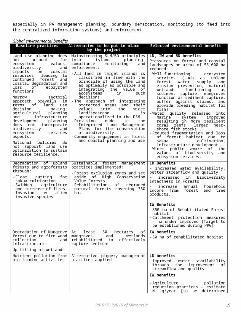
Annex 1: Map of the Four States of the FSM
PIF 5179 R2R FS of Micronesia 19
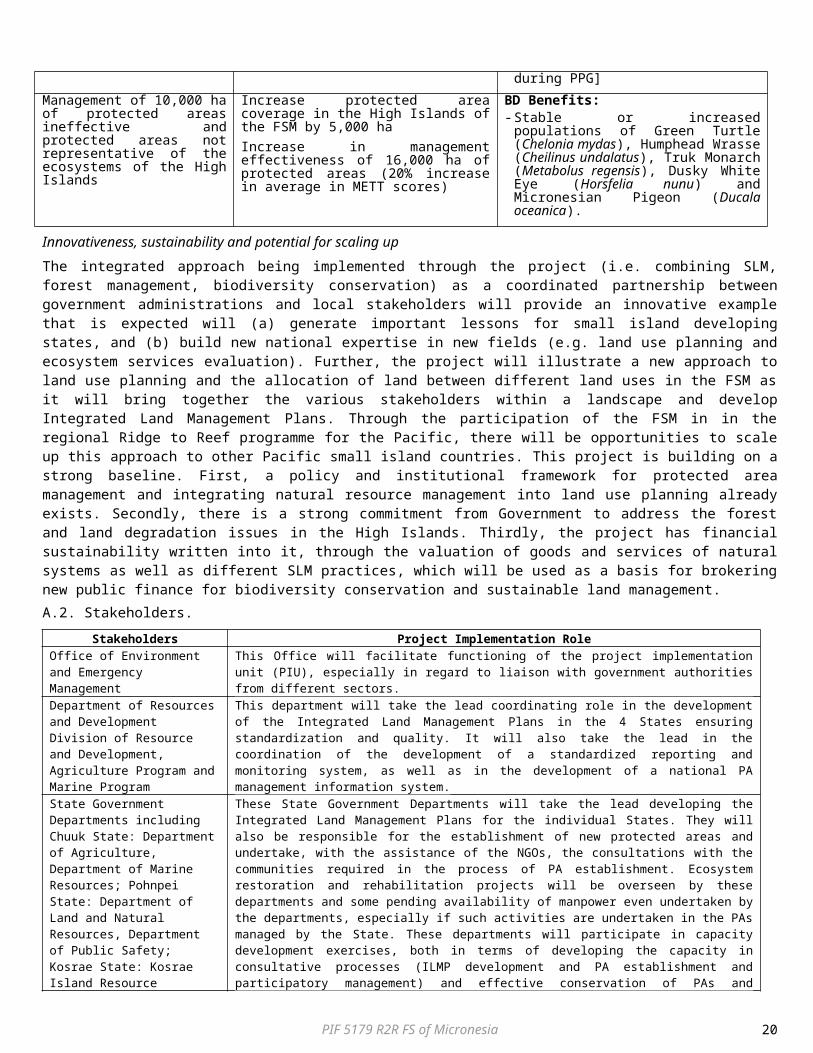
Annex 2: Existing PAs considered part of the High Islands of FSM:Protected Area Management Area (ha)Pohnpei StatePohnpei Watershed Forest Reserve State 5,000
Enipein Mangrove Reserve State 955Senpehn Mangrove Reserve State 130
Kehpara Marine PA State 189Namwen Na Marine PA State 71
Namwen Naningih Marine PA State 34Pwudoi Marine PA State 139
Sapwitik Marine PA Community-based 82.7Mwand (Dekehos) Marine PA Community-based 460
Nanwap Marine PA Community-based 305Total Pohnpei State 7,365.7
Chuuk State
Parem Marine PA Community-based/Private-owned
72
Epinup Mangrove Reserve Community-based 147.3Pianu Pass Marine PA Community-based 880
Total Chuuk State 1,099.3
Kosrae StateUtwe Biosphere Reserve (includes the Utwe-Walung Marine PA) State 1,772
Awane Marine PA Community-based 131.2Tukasungai (Trochus niloticus) Sanctuary State 277.8
Tafunsak Marine PA Community-based 58.8Olum Watershed Protected Area Community-based 310.3
Yella Ka Forest Community based 520.3Total Kosrae 3,070.4
Yap State
Nimpal Channel Marine Conservation Area Community-based 77.5
Total Area of PAs in all 4 States 11,612.9
PIF 5179 R2R FS of Micronesia 20