Embed Size (px)
Citation preview

An innovative AEC/GIS integration platform that can service millions of
3D objects on a web browser!
Sanghee Shin([email protected])

<Image Source: http://www.inhapress.com/news/photo/201706/7226_2328_957.png>

Geospatial Paradigm Shift
Current Future
Concept Object Information Context Awareness
Data Consumer Prosumer/DIY
User Person Things
Visualization Real World Digital Twins
Application Base Map Key Factor for Fusion
Driving Entity Public Sector Private Sector
Space Outdoor Indoor + Outdoor +
Update Cycle Static Dynamic
<Source: Hosang Sagong(2016), ‘Policy Directions of Spatial Information for Hyper-connected Society’ modified>

3D GIS
A system designed for acquisition, storing, processing, analysis, management, or publishing of geo-spatial data in 3D environment

<Image Source: http://geospatial.net >
BIM/AEC
A digitalized design data of construction, infrastructure, or large-sized facilities/machineries under CAD(Computer Aided Design) environment

Facility Management
GeoBIM Platform
Integratio
nM
od
el

GIS
CityGML
Geospatial Information
GIS Standards
IFC
BIM
Outdoor Model
Indoor Model
BIM Standards
ConstructionDrawings Info.
In/Out door GI Model
(Geospatial Information Model)
From Standard,

From Industry,

And From Open Source…


mago3D is a platform for …
Visualizing massive and complex 3D objects including BIM
on a web browser1
Seamless integration of BIM/AEC and 3D GIS in a single space 2
Web based collaborative issue/process management 4
‘Digital Twin’ that can create parallel worlds in a virtual reality
with numerous IoT, sensor data 3

Overall System Architecture
Client
internet
Web Server WAS
F4DStorag
e
mago3D.JS
mago
Content
Management
DataBase
Cesium /
World Wind
F4D Converter
2 main cores of mago3D

2 Main Cores of mago3D… F4D Converter mago3D.js
mago3D.js
3D GIS Engines
Cesium.js
WebWorldWind.js
API
API
service html
F4D Converter
F4D
.ifc
.3ds
.obj
.dae
F4D Converter converts 3D formats(IFC, 3DS, OBJ, DAE, JT)
to 3D internet service format F4D. It carries out data size
reducing and pre-processing for fast rendering.
JavaScript that expands existing WebGL Globe’s features to
support BIM and indoor space.

BIM Integration
Seamless integration of BIM and 3D GIS
on the same platform
Scene from indoor to outdoor through windows Scene from outdoor to indoor through windows

MEP Integration
Integration of large size MEP and 3D GIS
on a web browser
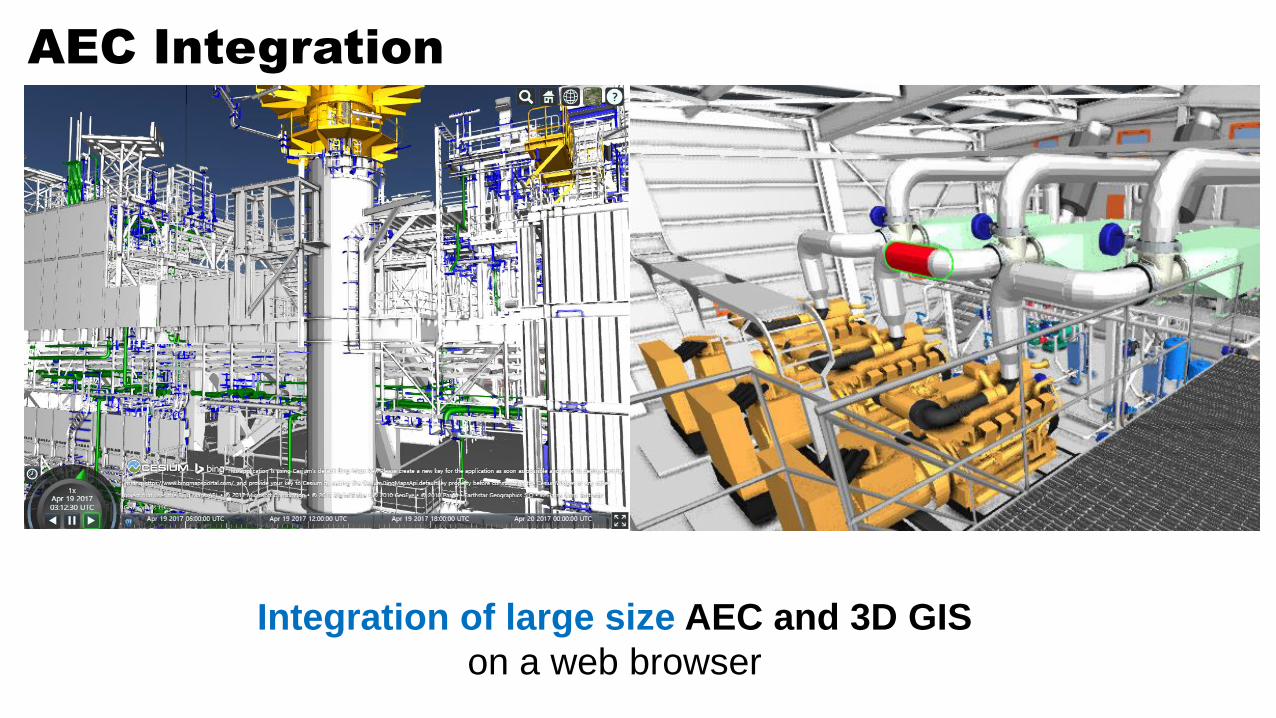
AEC Integration
Integration of large size AEC and 3D GIS
on a web browser

Cultural Heritage in Korea
Cultural Heritage in Korea

6 currently – Visualization of large-sized and highly detailed AEC data
Tunnel, Department store, Bridge,
Overpass offered by CUG(Civil
User Group) in Japan
Tunnel, Bridge in Japan

6 currently – Various API supported
APIs are supported for
developing application
systems(currently 29 APIs) moving/rotating
a full building
moving objects &
viewing attributesregistration/monitoring/search of issues
OpenAPIs
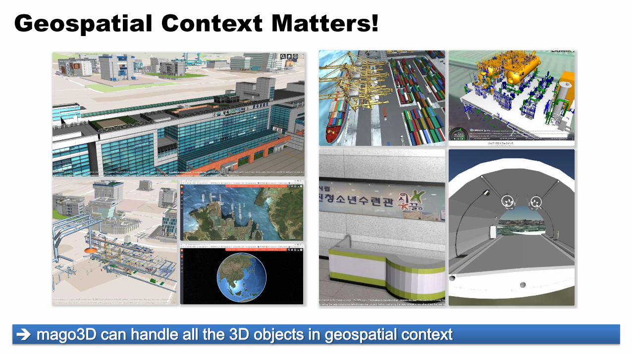
Geospatial Context Matters!
mago3D can handle all the 3D objects in geospatial context

Future Plan
A
mago3D
Cloud
B
mago3DB
mago3D
JTObj
IFC
Collada3DS
Revitweather
data
To the Digital Twin
Platform

http://www.mago3d.com
Web Page

https://github.com/gaia3d
Source Code

In Summary
• mago3D is a web based 3D objects visualization and management platform that can integrate BIM/AEC and GIS.
• It can visualize massive and complex 3D objects including BIM on a web browser without installing additional program or plugins.
• It utilizes open source WebGL Globe - Cesium, World Wind or others to expand those features and functions to indoor level.
• mago3D itself is a open source project with Apache and AGPL licenses.
• It supports many industry standard formats such as ifc, 3ds, obj, dae, kml, gltf...

For more information, please visit http://mago3d.com
All the source codes are available at https://github.com/gaia3d
Thank you!
Acknowledgement : This project is funded by Ministry of Land, Infrastructure and Transportation, Korea, through R&D number:18NSIP-B080778-04
![JUKI £j]shveiprom.com/cats/SCHMETZ/JUKI-KANSAI.pdf · juki £j] aec - 143 \ aec - 155 aec - 275-ss30n-sa42 aec-1500 aec - 2500 aec - 2700 afu - 333 ahc - 142 alh - 252 als 185-a](https://img.pdfslide.net/doc/110x75/5e8a1bf31f655643d2300f31/juki-j-juki-j-aec-143-aec-155-aec-275-ss30n-sa42-aec-1500-aec-2500.jpg)


![AEC Tunnel Lighting AEC TUNNEL LIGHTING - …old.annell.se/AnnellFiles/Brochure_Tunnel_ENG_low_Del1[2].pdf · AEC Tunnel Lighting AEC TUNNEL LIGHTING | 3 NERO e GRIGIO per marchi](https://img.pdfslide.net/doc/110x75/5b733ee97f8b9a95348de2ee/aec-tunnel-lighting-aec-tunnel-lighting-old-2pdf-aec-tunnel-lighting-aec.jpg)