Embed Size (px)
Citation preview
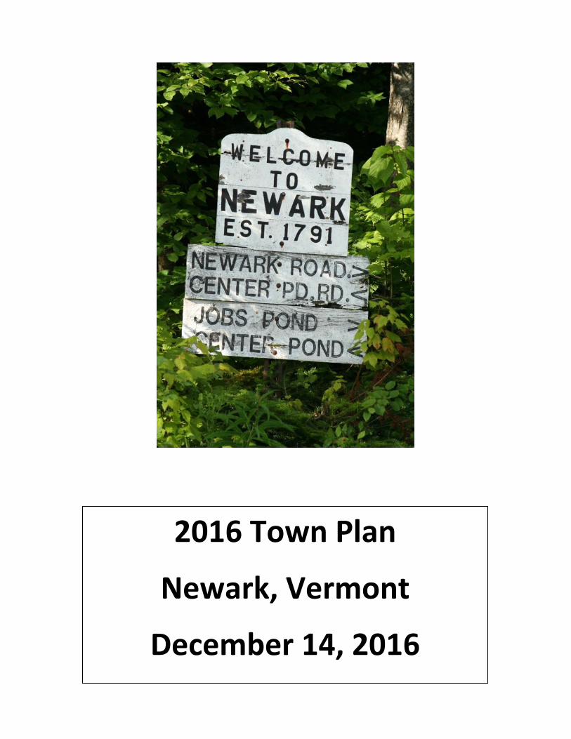
2016 Town Plan
Newark, Vermont
December 14, 2016

Newark Town Plan December 14, 2016
1
1 Introduction ............................................................................................................................. 7
Newark Background and History...................................................................................... 7 1.1
Government ..................................................................................................................... 8 1.2
The Newark Town Plan..................................................................................................... 9 1.3
The Purpose of Town Plans ....................................................................................... 9 1.3.1
Statutory Requirements .......................................................................................... 10 1.3.2
Development of Newark’s Town Plan .................................................................... 11 1.3.3
1.3.3.1 Newark Town Plan—2011 ............................................................................... 12
1.3.3.2 Newark Town Plan Amendments—2012 ........................................................ 12
1.3.3.3 Newark Town Plan—2016 ............................................................................... 13
2 Statement of Objectives, Policies, and Programs ................................................................. 15
Vision Statement ............................................................................................................ 15 2.1
Growth and Development .............................................................................................. 15 2.2
Zoning, Subdivisions, and Nonregulatory Policies ......................................................... 15 2.3
3 Land Use ................................................................................................................................ 16
Climate ........................................................................................................................... 16 3.1
Topography .................................................................................................................... 16 3.2
Geology, Bedrock, Soils, and Slopes ............................................................................... 16 3.3
Forests and Wildlife Habitat ........................................................................................... 17 3.4
Water Resources ............................................................................................................ 18 3.5
Headwater Areas .................................................................................................... 18 3.5.1
Rivers, Streams, and Surface Waters ...................................................................... 19 3.5.2
Wetlands and Vernal Pools ..................................................................................... 20 3.5.3
Present and Prospective Land Use ................................................................................. 21 3.6
Public Lands ............................................................................................................ 22 3.6.1
3.6.1.1 Town Parcels .................................................................................................... 22
3.6.1.2 State of Vermont Parcels ................................................................................. 23
3.6.1.3 The Nature Conservancy Parcel....................................................................... 23
3.6.1.4 Cemeteries ....................................................................................................... 24
Newark Town Plan December 14, 2016
2
Forests and the SCI Linkage .................................................................................... 24 3.6.2
Agriculture .............................................................................................................. 25 3.6.3
Residential ............................................................................................................... 26 3.6.4
Recreation ............................................................................................................... 29 3.6.5
Commerce and Industry ......................................................................................... 31 3.6.6
Historic and Cultural Features ................................................................................ 32 3.6.7
Open Spaces ............................................................................................................ 33 3.6.8
Posted Land, Parcelization, Fragmentation, and Current Use ............................... 33 3.6.9
Land-Use Goals ............................................................................................................... 34 3.7
4 Transportation ....................................................................................................................... 36
Class 1—State Highways ................................................................................................ 36 4.1
Class 2—Newark Street .................................................................................................. 36 4.2
Class 3—Town Highways ................................................................................................ 37 4.3
Class 4—Town Highways ................................................................................................ 37 4.4
Legal Trails ...................................................................................................................... 38 4.5
Unidentified Corridors or “Ancient Roads” .................................................................... 38 4.6
Scenic Roads ................................................................................................................... 38 4.7
New Roads, Driveways, and Curb Cuts .......................................................................... 39 4.8
Bicycle and Pedestrian Traffic ........................................................................................ 39 4.9
Public Transportation and Ride Sharing ......................................................................... 39 4.10
Transportation Goals ...................................................................................................... 40 4.11
5 Utility and Facility Plan .......................................................................................................... 42
Town Buildings ............................................................................................................... 42 5.1
Historic Features ............................................................................................................ 42 5.2
Town and Regional Services ........................................................................................... 43 5.3
Road Maintenance .................................................................................................. 43 5.3.1
Hospitals and Medical Services ............................................................................... 43 5.3.2
Emergency Services ................................................................................................ 44 5.3.3
5.3.3.1 Rescue .............................................................................................................. 44
5.3.3.2 Fire Protection ................................................................................................. 44
Newark Town Plan December 14, 2016
3
5.3.3.3 Police Protection.............................................................................................. 46
Libraries ................................................................................................................... 46 5.3.4
Refuse Disposal ....................................................................................................... 46 5.3.5
Post Office ............................................................................................................... 47 5.3.6
Utilities ........................................................................................................................... 47 5.4
Water and Sewage .................................................................................................. 47 5.4.1
Electric Power ......................................................................................................... 47 5.4.2
Communication Services ......................................................................................... 47 5.4.3
Utility and Facility Goals ................................................................................................. 48 5.5
6 Preservation Plan ................................................................................................................... 50
Aesthetics ....................................................................................................................... 51 6.1
Scenery .................................................................................................................... 51 6.1.1
Noise ....................................................................................................................... 52 6.1.2
Night Sky ................................................................................................................. 53 6.1.3
Historic Features ............................................................................................................ 53 6.2
Rare and Irreplaceable Natural Areas ............................................................................ 53 6.3
Gravel and Other Nonrenewable Resources ................................................................. 54 6.4
Preservation Plan Goals ................................................................................................. 55 6.5
7 Education ............................................................................................................................... 56
Child Care ....................................................................................................................... 56 7.1
Preschool ........................................................................................................................ 57 7.2
Newark Street School ..................................................................................................... 57 7.3
Newark Street School Curriculum, Programs, and Services ................................... 58 7.3.1
Newark Street School Community Amenities ........................................................ 60 7.3.2
Secondary Education ...................................................................................................... 60 7.4
Postsecondary and Continuing Education ..................................................................... 61 7.5
Educational Attainment in Newark ................................................................................ 61 7.6
Education Goals .............................................................................................................. 61 7.7
8 Energy Plan ............................................................................................................................ 62
Home Heating................................................................................................................. 63 8.1
Newark Town Plan December 14, 2016
4
Efficiency and Conservation ........................................................................................... 63 8.2
Electricity ........................................................................................................................ 64 8.3
Newark’s Energy Future: The Comprehensive Energy Plan and Renewables ............... 64 8.4
Land Use and Energy Conservation ................................................................................ 67 8.5
Energy Goals ................................................................................................................... 67 8.6
9 Housing .................................................................................................................................. 69
Overview of Housing in Newark ..................................................................................... 69 9.1
Affordable Housing ........................................................................................................ 70 9.2
Housing Projections........................................................................................................ 70 9.3
Housing Goals ................................................................................................................. 71 9.4
10 Economic Development ..................................................................................................... 73
Newark’s Workforce....................................................................................................... 73 10.1
Tourism in Newark ......................................................................................................... 74 10.2
Regional Perspective ...................................................................................................... 75 10.3
The Future of Newark’s Economy .................................................................................. 76 10.4
Economic Development Goals ....................................................................................... 76 10.5
11 Flood-Resilience Plan ......................................................................................................... 78
Existing Conditions and Flood Risks ............................................................................... 78 11.1
Floodplains .............................................................................................................. 79 11.1.1
River Corridors ........................................................................................................ 80 11.1.2
Uplands and Wetlands ............................................................................................ 80 11.1.3
Riparian Restoration Zones ..................................................................................... 81 11.1.4
Transportation Infrastructure ................................................................................. 82 11.1.5
Vermont’s Emergency Relief and Assistance Fund ........................................................ 82 11.2
Town Road and Bridge Standards ........................................................................... 83 11.2.1
Flood-Hazard Regulations and the National Flood Insurance Program ................. 84 11.2.2
Local Emergency Operations Plan .......................................................................... 85 11.2.3
All-Hazard Mitigation Plan ...................................................................................... 85 11.2.4
Instream Emergency Protective Measures .................................................................... 85 11.3
Flood-Resilience Goals ................................................................................................... 86 11.4
Newark Town Plan December 14, 2016
5
12 Regional Context, Adjacent Towns, and State Goals ......................................................... 88
NVDA .............................................................................................................................. 88 12.1
Burke .............................................................................................................................. 88 12.2
Brighton .......................................................................................................................... 89 12.3
Ferdinand ....................................................................................................................... 89 12.4
Sutton ............................................................................................................................. 90 12.5
Westmore ....................................................................................................................... 90 12.6
East Haven ...................................................................................................................... 90 12.7
State Planning Goals ....................................................................................................... 90 12.8
13 Implementation Plan ......................................................................................................... 95
Figures
Figure 1 Newark's population over time ....................................................................................... 8
Figure 2 Minimizing the impact of residential development ...................................................... 27
Figure 3 Clustered development .................................................................................................. 28
Figure 4 Newark Street School enrollments ................................................................................ 58
Figure 5 Comparison of student test results................................................................................ 59
Figure 6 Energy consumption in Newark ..................................................................................... 62
Figure 7 Home heating fuels in Vermont and Newark ................................................................ 63
Figure 8 Newark housing stock .................................................................................................... 69
Tables
Table 1 Watersheds in Newark ..................................................................................................... 19
Table 2 Newark parcelization ....................................................................................................... 34
Table 3 Miles of highway in Newark ............................................................................................. 36
Table 4 Sales of Newark single-family residences in 2014 ........................................................... 70
Table 5 Federal Disaster Declarations in Newark ......................................................................... 78

Newark Town Plan December 14, 2016
6
Newark Town Plan December 14, 2016
7
1 Introduction
Newark Background and History 1.1
Newark is the northernmost town in Caledonia County (Map 1). It is bordered on the south by
the Caledonia County towns of Burke and Sutton. Newark is bordered on the east and north by
the Essex County towns of East Haven, Ferdinand, and Brighton. It is bordered on the west by
the Orleans County town of Westmore (Map 2).
Newark was chartered on August 15, 1781, to William Wall along with 69 other shareholders by
the then-Republic of Vermont. In 1791, Vermont was admitted into the Union as the 14th state.
James Ball is said to have been Newark’s first European settler. He cleared land near the town’s
southern boundary with Burke in 1795 and settled there with his family in 1797. Soon
thereafter, Eleazer Packer settled “some two miles deeper still in the forest.” Packer Mountain
and Packer Cemetery are familiar landmarks to Newark residents.
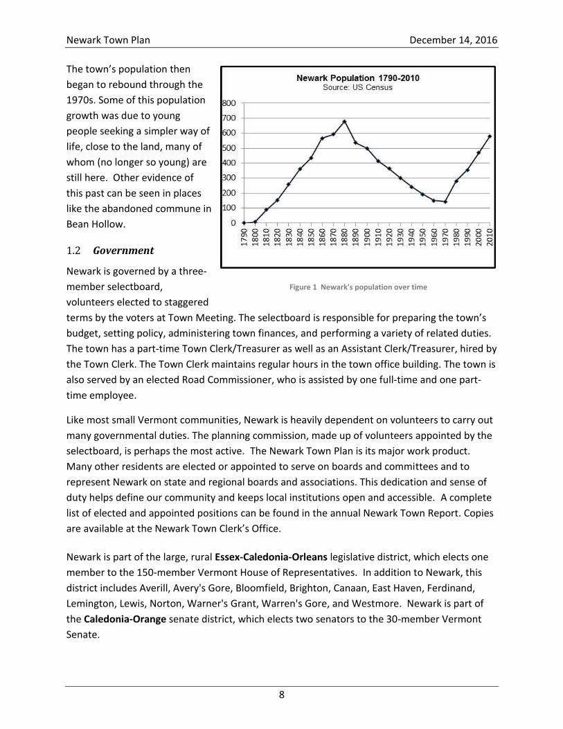
The town, with a population approaching 100, organized in 1809. Newark reached its peak
population of 679 in 1880, as can be seen in Figure 1.
An 1875 map of Newark (Map 3) shows 13 schools in the town and a more extensive road
network than exists today. It also shows maple syrup operations, a few “hops yards,” and a
number of starch factories, which provided a market for Newark potato farmers. Farmers also
grew wheat for the town’s grist mill and raised pigs, sheep, and cattle. Newark forests supplied
wood for no fewer than six water-powered sawmills and a shingle mill. The town supported a
store and a hotel.
The roads that would become VT Routes 114 and 5A were built in 1842 and 1853. These roads
enabled travelers to bypass the little hill town of Newark and may have inhibited the town’s
growth.
The village area at the crossing of Newark Street and Schoolhouse Road has, at times, been
referred to as “Newark Street,” leading to occasional confusion about whether the name
“Newark Street” referred to the street, the village area, or the entire town.
In The Nature of Vermont, Charles Johnson describes the Vermont of this era as being
deforested and ill-farmed. Wildlife had become scarce, and fish had pretty much disappeared.
People began abandoning Vermont for more fertile lands.1 The population of Newark began to
drop, hitting a low of 144 in 1970.
1 Charles W. Johnson, The Nature of Vermont (State of Vermont, 1980), p. 44.
Newark Town Plan December 14, 2016
8
The town’s population then
began to rebound through the
1970s. Some of this population
growth was due to young
people seeking a simpler way of
life, close to the land, many of
whom (no longer so young) are
still here. Other evidence of
this past can be seen in places
like the abandoned commune in
Bean Hollow.
Government 1.2
Newark is governed by a three-
member selectboard,
volunteers elected to staggered
terms by the voters at Town Meeting. The selectboard is responsible for preparing the town’s
budget, setting policy, administering town finances, and performing a variety of related duties.
The town has a part-time Town Clerk/Treasurer as well as an Assistant Clerk/Treasurer, hired by
the Town Clerk. The Town Clerk maintains regular hours in the town office building. The town is
also served by an elected Road Commissioner, who is assisted by one full-time and one part-
time employee.
Like most small Vermont communities, Newark is heavily dependent on volunteers to carry out
many governmental duties. The planning commission, made up of volunteers appointed by the
selectboard, is perhaps the most active. The Newark Town Plan is its major work product.
Many other residents are elected or appointed to serve on boards and committees and to
represent Newark on state and regional boards and associations. This dedication and sense of
duty helps define our community and keeps local institutions open and accessible. A complete
list of elected and appointed positions can be found in the annual Newark Town Report. Copies
are available at the Newark Town Clerk’s Office.
Newark is part of the large, rural Essex-Caledonia-Orleans legislative district, which elects one
member to the 150-member Vermont House of Representatives. In addition to Newark, this
district includes Averill, Avery's Gore, Bloomfield, Brighton, Canaan, East Haven, Ferdinand,
Lemington, Lewis, Norton, Warner's Grant, Warren's Gore, and Westmore. Newark is part of
the Caledonia-Orange senate district, which elects two senators to the 30-member Vermont
Senate.
Figure 1 Newark's population over time
Newark Town Plan December 14, 2016
9
Newark is a member of the Northeastern Vermont Development Association (NVDA), which
serves as both the planning commission and the development association for Vermont’s
Northeast Kingdom.2 Newark has two seats on the NVDA’s board of directors. The town also
participates in the Vermont League of Cities and Towns (VLCT), a nonprofit, nonpartisan
organization that serves Vermont's municipal officials. Newark has representation on VLCT
committees, sends a representative to the league’s annual meeting, attends VLCT seminars and
training sessions, and frequently makes use of the VLCT’s Municipal Assistance Center.
The Newark Town Plan 1.3
The Newark Town Plan is an advisory document, not a regulatory document. It does not pertain
to zoning. The Newark Town Plan presents a clear, written community standard. A reader who
has never visited Newark should, on reading the plan, understand what Newark is like, what its
residents want, and what future they are working toward. The Newark Town Plan represents
the public good at the most local of levels.
The Purpose of Town Plans 1.3.1
Towns are not required to adopt town plans, so the question is sometimes asked, “Why spend
the time and effort to write a town plan?” Town plans can be useful in a number of ways, from
serving as a simple source of information to providing a foundation for future planning
activities. Ultimately, the residents themselves will determine the uses of the Newark Town
Plan.
Potential uses include:
A source of information: Town plans are a valuable source of information for local
boards, commissions, citizens, and businesses. The information in a plan can serve to
familiarize residents, potential residents, and development interests about a town and its
resources.
A basis for community programs and decision making: Town plans can be used as a guide
for recommendations contained in capital budgets and programs, for proposed
community development programs, and for the direction and content of local initiatives
such as farmland protection, recreation planning, and housing.
A source for planning studies: Few town plans can address every issue in complete detail.
Thus, town plans record and discuss not only what is known about the resources and
residents of the town, but also what is not known. Therefore, many plans will
recommend further studies to develop courses of action on specific needs.
A standard for review at the state and regional levels: Act 250, Section 246, Section 248,
and other state regulatory processes identify town plans as a standard for review of
2 Governor George Aiken is credited with giving the name Northeast Kingdom to Caledonia, Essex, and Orleans
Counties on a 1949 visit to Lyndonville. “Northeast Kingdom” is commonly abbreviated “NEK.”
Newark Town Plan December 14, 2016
10
development applications. Town plans are important to the development of regional
plans as well as to regional and inter-municipal programs. In addition, state proposals
(including the purchase of state land for parks and recreation) must comply with town
plans.
A long-term guide: A town plan is a long-term guide by which to measure and evaluate
public and private proposals that affect the physical, social, and economic environment of
the community.
Fulfillment of an eligibility requirement for state and federal grants: While town plans in
and of themselves are not required, the state began requiring towns to adopt town plans
in 2000 in order to be eligible for most grants and low-interest loans. Planning grants,
water and wastewater grants, community development grants, historic preservation
grants, and other key sources of funding all now require town plans to have been
adopted. While many private funding sources do not require town plans for eligibility,
having a town plan that documents the need for funding will generally strengthen the
application.
A basis for regulatory action: A town plan can help serve as a foundation and guide for
the creation of needed ordinances and policies that may be considered important by the
town, including health, junk, speed limits, signing, road standards, and other issues.
It is important for the citizens of Newark to understand that the Newark Town Plan does not
represent or include zoning bylaws or development regulations. Likewise, it is important to
know that all energy-generation and transmission-development plans linked to the electrical
grid are approved and regulated by the State of Vermont's Public Service Board under Title 30
V.S.A. Section 248. The preparation of a detailed town plan and town participation in the
state's review process are the best ways to ensure that the Town of Newark's goals and
objectives are considered and weighed by the Public Service Board during the decision process.
After the town plan is approved (locally by the selectboard and regionally by the NVDA), the
Newark Town Plan will become an important tool in protecting the town's interests in
development hearings (under Act 250) and utility hearings (under Sections 246 and 248) to
which the town is a party.
Statutory Requirements 1.3.2
Vermont towns are authorized to create town plans under Title 24 V.S.A. Section 4381. The
state statute requires that certain topics be discussed, although it does not mandate any
specific goals and policies. All local plans in Vermont, regardless of whether they are for rural
or urban towns, must include the following 12 components, as outlined in Title 24 V.S.A.
Section 4382. These represent the minimum requirements of the Vermont Municipal and
Regional Planning and Development Act:
Newark Town Plan December 14, 2016
11
A statement of objectives, policies, and programs of the town, both to guide the future
growth and development of land, public services, and facilities and to protect the
environment (Section 2).
A land-use plan (Section 3) and map (Map 4).
A transportation plan (Section 4) and map (Map 15).
A utility and public facility plan (Section 5) and map (Map 13).
A statement of town policies for the preservation of rare and irreplaceable natural areas,
scenic and historic features, and resources (Section 6).
An educational facilities plan (Section 7) and map (Map 13).
A statement of how the plan relates to adjacent town plans and the regional plan
(Section 12).
An energy plan, including policies and programs to implement those policies (Section 8).
A housing element, including a recommended program for addressing low- and
moderate-income persons' needs as identified in the regional plan (Section 9).
An economic development element that describes present economic conditions and the
location, type, and scale of desired economic development and that identifies policies
and programs necessary to foster economic growth (Section 10).
A flood-resilience plan (Section 11).
A recommended program for the implementation of the objectives of the development plan (Section 13).
Title 24 V.S.A. Section 4302 describes additional goals that a municipal plan
Development of Newark’s Town Plan 1.3.3
Newark has maintained its town plan for several decades. The process for developing each
revision of the Newark Town Plan has involved:
Solicitation of public input.
Review of the plans of neighboring towns.
Review of the Northeast Kingdom’s regional plan.
Consultations with relevant experts.
Dozens of warned planning commission meetings.
Public hearings.
Review and approval by the Newark Selectboard.
Review and approval by the NVDA.
Newark adopted a new town plan on December 7, 2011. On September 17, 2012, the Newark
Selectboard approved the 2012 plan, addressing seven amendments to the 2011 plan. The
purpose of the amendments was to clarify the town's position on industrialization. This 2016
Newark Town Plan retains much of the content of the 2012 plan and expands on that content.
Newark Town Plan December 14, 2016
12
This plan also addresses new statutory requirements and contains updated statistics.
1.3.3.1 Newark Town Plan—2011
Newark began the development of its 2011 plan in 2008 when it carried out a land-use
investigation project. The project, funded by a municipal planning grant from the Vermont
Department of Housing and Community Development, was conducted by the Newark Planning
Commission with the assistance of the NVDA.
The land-use investigation project involved a number of public meetings and the production of
a final report (available for download at NVDA.net ). The meetings included presentations from
NVDA planners, reviews of detailed resource maps of Newark, a primer on Act 250 from the
District Environmental Commission Coordinator, a primer on state and federal land-use
regulations, and discussions among Newark residents.
The project, which provided significant input for use in the town plan, made it clear that, above
all, Newark residents value the rural character of the community, wish to preserve that
character, do not support large-scale development in the town, and support the preservation of
the town's natural resources, open space, and scenery.
The Newark Town Plan, which the Newark Planning Commission completed in the fall of 2011,
is a reflection of these values. The 2011 version of the Newark Town Plan was discussed at two
public hearings, was approved by the Newark Selectboard on December 7, 2011, and was
reviewed and approved by the NVDA as described under 24 V.S.A. Section 4350.
1.3.3.2 Newark Town Plan Amendments—2012
In March of 2012, Newark received notification that a wind-energy developer planned to erect
a wind-measurement tower in Newark to determine the area’s wind-energy potential. The
developer stated that such a project would be consistent with the goals and objectives
expressed in the 2011 Newark Town Plan.
Both the Newark Selectboard and the Newark Planning Commission felt that the developer had
misinterpreted the town plan. And thus, on May 30, 2012, at a joint meeting, the selectboard
and the planning commission agreed that the planning commission should amend the Newark
Town Plan.
By the end of June 2012, the planning commission had prepared seven amendments to the
Newark Town Plan. Some of the amendments clarified the town's position on industrial and
commercial development in the town. Other amendments reflected the planning commission's
understanding of the interpretation of town plans by state regulators.
Newark Town Plan December 14, 2016
13
The planning commission held a public hearing on the amendments on August 9, 2012, and the
selectboard held a public meeting on September 11. On September 17, 2012, Newark held a
special Town Meeting at which voters recommended, by a vote of 169 to 59, that the
selectboard approve the amended town plan. The selectboard voted unanimously to approve
the plan. In October, the NVDA's Town Plan Approval Committee conducted a public hearing
on the amended Newark Town Plan. The committee determined that the amended plan met
statutory requirements and that it had been adopted according to Vermont law. The amended
town plan was approved first by the committee and later by the NVDA's Board of Directors.
On October 16, 2012, Hawk Rock Holdings, an owner of property in Newark, filed suit against
the Town of Newark, asking the Caledonia Superior Court to find the Newark Town Plan
deficient and to declare it invalid. Nearly 3 years later, on August 5, 2015, Judge Robert Bent of
the Caledonia Superior Court declared the amended Newark Town Plan to be invalid, citing
deficiencies in the town plan report that state statute requires municipal planning commissions
to prepare. In October 2015, the Newark Planning Commission corrected the deficiencies in the
town plan report and on November 21, 2015, the Newark Selectboard readopted the
amendments to the town plan that it originally had adopted on September 17, 2012.
1.3.3.3 Newark Town Plan—2016
The Newark Planning Commission has now revised the 2012 town plan in order to create this,
the 2016 Newark Town Plan. The 2016 revisions are the result of several important
developments:
Revisions were made by the Vermont Legislature to Title 24 V.S.A. Chapter 117, which
added new requirements for town plans (for example, plans must now address flood
resilience).
Newark was awarded a Department of Housing and Community Development grant in
2014 to create a natural resources inventory, update maps, and develop a new flood-
resilience element for the Newark Town Plan.
New maps became available through the Agency of Natural Resources, the Agency of
Transportation, and other sources.
Newark completed a natural resource inventory as part of the 2014 grant.3
There was a need for more specificity and data to make the town plan more meaningful.
There was a need to study and include additional detail in the economic development
section, based on recent major development projects in the area.
In preparing the 2016 town plan, the Newark Planning Commission has considered the
following factors:
Existing land use.
3 Fritz Gerhardt, Natural Resource Inventory of the Town of Newark, Vermont, 2014.
Newark Town Plan December 14, 2016
14
Community facilities, services, and resources.
Natural resources.
Population.
Past Newark town plans.
Input from Newark residents and taxpayers.
Information developed under the 2008 and 2014 municipal planning grants awarded by
the Department of Housing and Community Development.
The development of the 2016 Newark Town Plan began in August 2013, has required roughly
five dozen public meetings and thousands of hours of work by the planning commission and
selectboard, and has been informed by:
Review of the plans of neighboring towns.
Review of the regional plan.
Two large public informational and discussion meetings.
The preparation of the Newark Natural Resource Inventory.
Consultations with:
o Northeastern Vermont Development Association (NVDA)
o Caledonia County Natural Resources Conservation District
o Beck Pond, LLC (author of the Newark Natural Resource Inventory)
o Vermont Natural Resources Council
o Vermont League of Cities and Towns
o Vermont Agency of Commerce and Community Development
o Vermont Fish and Wildlife Department
o Watershed Management Division of the Vermont Department of Environmental
Conservation.
Three public hearings (one each conducted by the planning commission, the
selectboard, and NVDA).
Newark Town Plan December 14, 2016
15
2 Statement of Objectives, Policies, and Programs
Vision Statement 2.1
In preparing for each of its four most recent town plans (including this one), the Newark
Planning Commission conducted public meetings where the town’s Vision Statement was
reviewed and discussed, a statement that has remained virtually unchanged since it was first
composed nearly two decades ago. The most recent public discussion, in 2014, confirmed that
the statement remains relevant and important:
Newark is a quiet rural town with a beautiful setting. Woodlands, open fields, hills,
scenic vistas, the sounds of nature, clean water and air, and clean streams and pristine
ponds make Newark a unique and pleasant community to visit and live in. The
environment is clean and healthy.
It is these characteristics that the Town of Newark intends to protect and preserve.
As a result of our public discussions, the Newark Planning Commission has added this paragraph
to the town’s Vision Statement:
Our townspeople, while of independent spirit, share a strong sense of community and
view their stewardship of Newark’s lands as a serious responsibility. It is important to
the citizens of Newark that the character of the town, its history, its sense of
community, and its natural setting be preserved for the benefit and enjoyment of
future generations of residents and visitors.
The primary purpose of this town plan is to describe the character of the town and to suggest
ways that Newark can preserve its character and the natural resources heritage on which its
character rests.
Growth and Development 2.2
Newark residents are pleased with the town’s rural character and see little need for dramatic
change, growth, or development. Newark has maintained its rural character and close-knit
community feeling in spite of 45 years of population growth. Preserving the character of the
town may become more challenging as economic activity in the region increases.
Zoning, Subdivisions, and Nonregulatory Policies 2.3
The Newark Town Plan does not represent or include zoning bylaws or development
regulations.
Newark Town Plan December 14, 2016
16
3 Land Use
Newark’s historic land use has been influenced by climate, topography, and soils. Future land
use should be guided by the importance of preserving its cultural and natural heritage. Central
to these considerations is the preservation of Newark’s large forest habitat blocks, which provide
essential connecting habitat linking important wildlife habitats across northeastern Vermont,
northern New England, and adjacent Canada.4
Climate 3.1
Newark is located in Vermont’s northeast highlands, the coldest and snowiest region in the
state. The USDA’s latest Plant Hardiness Map shows that Newark lies on the boundary of Zone
3b and Zone 4a. These zones indicate low winter temperatures of -35 and -30 degrees
Fahrenheit, respectively. (Previous maps have shown Newark to lie entirely within Zone 3.)
Newark’s growing season is short: between 90 and 120 days, beginning in late May or early
June and ending in late September or early October. Low-elevation pockets can experience
shorter seasons.
Topography 3.2
Elevations in Newark range from slightly less than 1,100 feet (335 m) along the East Branch of
the Passumpsic River to 2,362 feet (720 m) atop Abbott Hill in the northwestern side of town,
just south of Job Mountain. The main topographical features in Newark are several north-south
ridges, numerous rivers and streams, and several ponds (see Map 5). The most prominent
north-south ridge rises between the East Branch of the Passumpsic River and Bean and Sleeper
Brooks and includes Packer and Walker Mountains and Hawk Rock. Both Hawk Rock and Walker
Mountain have large cliff formations that are visible from VT Route 114, and Packer Mountain
has large cliff formations visible from Newark Street and other town roads. A second ridge
extends from the Abbott Hill area southeast toward Newark Hollow, and a third ridge extends
from the southeast corner of Newark Pond through the center of town toward Maple Ridge
Road. Between these three ridges flow the town’s rivers and streams: the East and West
Branches of the Passumpsic River; Bean, Sleeper, and Roundy Brooks; and numerous smaller
tributaries. Finally, Newark is home to several ponds, including Newark, Center, Beck, Walker,
and Sawdust Ponds, as well as a small part of Brown Pond.5
Geology, Bedrock, Soils, and Slopes 3.3
Newark is underlain by five formations of bedrock (see Map 6 ). About half the town is
underlain by Waits River Formation—primarily limestone, which may have formed along the
4 Ibid., vi.
5 Ibid., 4.
Newark Town Plan December 14, 2016
17
shore of an ocean that existed 500 million years ago. Much of the rest of the town rests on
various granite formations.6 Limestone bedrock is easily soluble and contains minerals
important to plant growth. Granite is less soluble and contains few minerals that promote plant
growth. Much of the town’s best agricultural soils are found atop the Waits River Formation
bedrock.
The town’s surface geology ranges from exposed granite bedrock on Packer Mountain and
Hawk Rock to unsorted glacial till to peats and mucks in the town’s wetlands.7 The Soil
Conservation Service8 categorizes over half of Newark's land into one or more of the following
four groups:
Unfavorable depth to bedrock, less than 20 to 40 inches.
Excess soil wetness.
Unfavorable topography, mainly excessively steep slopes.
Unfavorable rate of movement of water through soil.
These factors leave relatively little acreage suitable for development (see Map 18).
Soils are considered to be prime agricultural soils if they meet national standards as having “the
best combination of physical and chemical characteristics for producing food, feed fiber, forage,
and oilseed crops and are also available for these uses. The present land use may be cropland,
pasture, forestland, or other land uses, but not urban and built-up or water. Location, tract size,
and accessibility to markets and support industries are not considered when making a Prime
Farmland determination.” Prime agricultural soils meet conditions that relate to temperature
and growing season, flooding, moisture, water table depth, drainage, rock content, acidity,
slope, and depth.9 Though small in area, Newark has significant tracts of prime agricultural soils
as well as agricultural soils of statewide importance (see Map 11).
Forests and Wildlife Habitat 3.4
Newark is heavily forested, with 15 large areas of contiguous forest habitat. As described in
Gerhardt,10 deciduous, coniferous, and mixed forests cover approximately 20,927 acres, or
about 88% of the town. The largest forest block is located between Center Pond Road and VT
Route 114 and consists of 7,900 acres, encompassing Packer and Walker Mountains and Hawk
Rock. Another large forest block in Newark, of 3,366 acres, includes much of the upper Bean
Brook watershed between Center Pond Road and Newark Street. These blocks extend into the
6 Ibid., 5.
7 Ibid., 7.
8 It is now called the Natural Resources Conservation Service. It is part of the USDA and works with private
landowners to help them conserve, maintain, and improve their natural resources. 9 Vermont Soil Fact Sheet, Detailed Definitions and Explanations, USDA Natural Resources Conservation Service.
10 Gerhardt, Inventory, p. 13.
Newark Town Plan December 14, 2016
18
towns of Brighton and Westmore, respectively. Other Newark forests are connected to even
larger forest blocks in Essex County (the second largest forest block in the state) and Westmore.
Map 8 shows these and other habitat blocks in Newark, representing areas of contiguous forest
and other natural habitats unfragmented by roads, development, or agriculture. While
primarily forests, these essential blocks also include wetlands, rivers and streams, lakes and
ponds, cliffs, and rock outcrops.11
Newark’s forests are part of a critical habitat corridor that links Vermont’s northern Green
Mountains with the forests of Essex County, northern New Hampshire, and beyond (see Map 9
and Map 10). This corridor has been identified by the Staying Connected Initiative (SCI) as one
of six priority linkages in the northern Appalachian Mountain region. SCI is an international
partnership of 21 governmental and nongovernmental organizations working to restore and
enhance landscape connectivity across the Northern Appalachians.
Water Resources 3.5
Newark is rich in water resources. Newark’s rivers, streams, and waterbodies are vital to the
community and comprise unique, sensitive, and irreplaceable natural features.
Headwater Areas 3.5.1
Headwaters are the seeps, wetlands, small pools, and tiny streams at heights of land that
eventually make their way to larger valley-bottom rivers. If protected from development and
intensive uses (such as logging, resource extraction, and some forms of recreation), these
headwaters can contain the purest water in an entire river system. At the same time,
degradation of these waters can degrade the entire downstream system. In Vermont,
headwaters are afforded special protection, and development near headwaters is regulated.
The federal Environmental Protection Agency recognizes three orders of headwaters. A zero-
order headwater may be a wetland or a seep. A first-order headwater is the smallest stream
that forms from one or more zero-order headwaters. A second-order headwater forms where
two first-order headwaters converge.12 Newark has headwaters of all three orders, which feed
each of the larger brooks and rivers that flow through the town. The health of these
headwaters is critical to the health of the region’s rivers.
Newark’s headwaters are generally characterized by steep slopes and shallow soils. Headwater
streams and ephemeral surface waters are highly vulnerable to erosion and man-made
11
Vermont Agency of Natural Resources, BioFinder Component Extract—Landscapes/Habitat Blocks, http://biofinder.vermont.gov/ 12
http://www.epa.gov/eerd/methods/headwater/HISSmanual-ch1.pdf, p. 1.
Newark Town Plan December 14, 2016
19
disturbance. Headwater seeps, located at higher elevations on the landscape, serve as the
source for downslope streams and are protected in Vermont as Class II wetlands.
Protection of headwaters is an important priority for the Town of Newark. Development (and
other activities) that could damage headwaters must be avoided.
Rivers, Streams, and Surface Waters 3.5.2
Newark’s rivers and streams are important assets to our community, providing recreational and
aesthetic functions as well as supporting plentiful and diverse fisheries and aquatic species. The
surface waters host unique aquatic natural communities and support diverse species, ranging
from fresh water mussels to brook trout to common loon to river otter. Newark’s watersheds
are shown in Map 7 and the acreage for each is shown in Table 1.
Table 1 Watersheds in Newark (source: Vermont ANR)
Newark's Watersheds
Watershed Acres Pct of Newark Acreage
Bean Brook 10,905 46%
East Branch Passumpsic River 7,531 32%
West Branch Passumpsic River 4,860 20%
Clyde River 537 2%
Total 23,833 100%
In addition to many smaller streams and waterbodies, Newark counts among its water
resources portions of the East and West Branch Passumpsic River and Bean and Sleepers Brooks
as well as Newark Pond and Center Pond. The East Branch Passumpsic River has its headwaters
in neighboring Brighton, but it flows approximately 5 miles through the eastern portion of
Newark before continuing on through East Haven and Burke to join with the West Branch in
Lyndon. The West Branch rises on the slopes of Mt. Pisgah in Westmore but is also fed from the
outlet of Newark Pond. It flows approximately 0.8 mile through the very western corner of
Newark before passing into Sutton and Burke and joining with the East Branch in Lyndon to
form the main-stem Passumpsic River. The Passumpsic joins the Connecticut River in Barnet
and flows southward to Long Island Sound.
Sleepers Brook and Bean Brook drain a large area of Newark. Bean Brook drains Bald Hill Pond
in Westmore and flows over 6 miles eastward across Newark, joining the East Branch
Passumpsic River just beyond the Newark/East Haven town boundary. Sleepers Brook drains
the northern portion of town and passes through Center Pond before joining Bean Brook near
Newark Hollow.
Newark Town Plan December 14, 2016
20
A small portion of Newark’s northernmost area drains toward Job’s Pond, Cold Brook, and the
Clyde River, where it continues to Lake Memphremagog and the St. Lawrence Seaway. Newark
also contains much of the headwaters of Roundy Brook, which flows through Burke Hollow and
joins the West Branch Passumpsic.
Newark’s ponds are highly valued for their scenic and recreational qualities, and parcels with
frontage on Center Pond and Newark Pond have the highest per-acre values in town. Center
Pond, so named because it sits near the geographic center of town, is roughly 80 acres in size
and has a maximum depth of 72 feet. It is a cold-water fishery with lake trout and brook trout.
The pond has recently become a nesting site for loons.
Newark Pond is located on the western edge of town and is roughly 163 acres. It has a
maximum depth of 31 feet. Its diverse fishery includes bullhead, rainbow trout, smallmouth
bass, and yellow perch. Newark Pond has nesting loons during most summers.
Other small ponds in Newark, both in the northern part of town, include Walker Pond and
Sawdust Pond, which (according to Vermont Place Names, 1977) is said to have gotten its name
because a sawmill located there nearly filled the pond with sawdust at one time.
The ponds and streams within Newark's borders are irreplaceable assets. Preservation of their
purity and aesthetic beauty is important to Newark residents. Development along the
waterways may result in pollution, sedimentation caused by a lack of riparian forest buffers,
reduced public and wildlife access to lakeshores, and the introduction of invasive exotic flora or
fauna. Protecting water quality is a high priority in the Town of Newark. Impacts from logging
on steep slopes or near the water’s edge, development close to the water, runoff from gravel
roads, and cutting of vegetation along shorelines all negatively affect the quality of water.
The Vermont Shoreland Protection Act (2014) regulates activities within 250 feet of the mean
water level of lakes larger than 10 acres. The intent of the act is to allow reasonable
development of shorelands on lakes and ponds while protecting aquatic habitat and water
quality and maintaining the natural stability of shorelines. Standards for the creation of
impervious surfaces (such as buildings and driveways) and cleared areas within the shoreland
area are intended to preserve functioning lake and pond ecosystems, protect water quality and
bank stability, conserve aquatic and wildlife habitat, and further the economic benefits of lakes
and their shorelands. New, stricter shoreland protection legislation was enacted in 2015. A
handbook for shoreland development, including new legal requirements, is available at the
Newark Town Clerk’s Office.
Wetlands and Vernal Pools 3.5.3
Wetlands are important natural resource areas that provide erosion protection and shoreline
stabilization, recharge underground aquifers, enable natural purification of water, and provide
Newark Town Plan December 14, 2016
21
necessary habitats for many species of fish, wildlife, migratory birds, and plants. Wetlands
provide scenic areas for hunting, fishing, canoeing, kayaking, and other forms of recreation.
They are also important locations for environmental education and research.
Beavers, once nearly extinct in Vermont, have created valuable wetlands along both the East
Branch Passumpsic River and Bean Brook. Beaver dams have created a series of upland ponds
and wetlands that cascade down the western face of Packer Mountain. These areas provide
essential habitat to a wide variety of species and must be protected from the effects of
development. Vermont’s Agency of Natural Resources (ANR) recommends encouraging beaver
activity and protecting beaver ponds with a buffer of at least 400 feet. Residents and road
crews should seek alternatives to beaver-dam removal.13
Vernal pools are small wetland areas—generally located within upland forests—that are critical
seasonal habitats for amphibians such as spotted salamander and wood frog. These unique and
sensitive areas were added to the state’s Class II wetland designation in 2010, and a statewide
inventory of vernal pools using color infrared aerial photography and field surveys was
completed about the same time. A small number of vernal pools have been mapped in Newark.
However, the recent Natural Resource Inventory of Newark suggests that “the relative paucity
of vernal pools in Newark may reflect limited search effort, and additional efforts should be
undertaken to identify and map any vernal pools in the Town of Newark.”14
The Vermont Wetland Rules provide wetland classifications and outline protective measures for
Class I and Class II wetlands. Class I wetlands are considered irreplaceable. Class II wetlands are
important and require protection.15 (There are no Class I wetlands in Newark.)
Present and Prospective Land Use 3.6
The 1875 map of Newark referred to in Section 1 shows Newark’s settlement and development
patterns when the town’s population was at its greatest. At that time, there were more roads,
more industry, more agriculture, more settled areas, and more schools than exist in present-
day Newark. Newark’s current land use is shown in Map 4.
A small number of Newark residents still work in the woods, produce maple sugar, or grow hay.
Other residents operate home-based businesses based on arts and crafts or leveraged by the
internet. Today, Newark is primarily a bedroom community whose residents work in schools,
commerce, or industry in larger neighboring towns and cities. Newark is also a vacation
destination, having a large number of camps and second homes, some of which are available
for vacation rental.
13
Vermont Agency of Natural Resources, Conserving Vermont’s Natural Heritage, 2013, p. 65. 14
Gerhardt, Inventory, p. 20. 15
http://www.vtwaterquality.org/wetlands/docs/wl_st_reg.pdf
Newark Town Plan December 14, 2016
22
Planning for land use in Newark has consistently involved the public, as illustrated in the
following summary:
1998 The Newark Planning Commission conducted a survey of residents regarding land-use preferences.
2008 The planning commission held a number of land-use planning sessions under a state planning grant. The Northeastern Vermont Development Association (NVDA) facilitated the sessions, with contributions from ANR.
2011 The planning commission and selectboard both conducted public hearings on a new town plan.
2012 A number of organizations in the town (including the planning commission and selectboard) conducted a variety of informational and discussion sessions focused on land use and energy generation.
2012 Both the planning commission and the selectboard conducted public hearings on amendments to the town plan.
2014 The Newark Planning Commission, under a state planning grant, conducted educational and information-gathering sessions that explored land use from the perspective of natural resources and flood resiliency. This grant also enabled the development of Dr. Gerhardt’s comprehensive Natural Resource Inventory.
2015 The planning commission and the selectboard both conducted additional public hearings on the amendments to the town plan originally proposed in 2012.
The consistent message that residents have delivered in all these public efforts is that they like
Newark just as it is. Thus, Newark’s land-use plan, as described in the following sections, is
based on a few fundamental goals:
Protect the town’s natural resources.
Enhance the town’s natural flood-resilience assets.
Preserve the town’s rural character.
Maintain the viability of Newark’s working lands by protecting them from fragmentation
and by discouraging the introduction of incompatible uses.
Public Lands 3.6.1
3.6.1.1 Town Parcels
Newark owns three contiguous municipal properties located on Newark Street near the center
of town. The Town Garage and Fire Station occupy a 7.13-acre parcel at the north end. The
Newark Street School includes a 5.55-acre campus with parking, play areas, ball fields, and
community gardens. The Town Hall and Town Clerk’s Office occupy a third parcel (0.38 acre),
located at the southern end of the complex. The town buildings are described in Section 5.1.
Newark Town Plan December 14, 2016
23
The town also owns 117 acres, with 950 feet of shoreline, on the north end of Center Pond. In
conjunction with the Vermont Land Trust and the Vermont Housing and Conservation Board,
these lands and development rights on the entire east side of Center Pond were acquired in
1995 as part of the Center Pond Project in order to provide open spaces, a beach, camping
areas, and hunting areas for present and future generations of Newark residents. The
protected area includes 700 acres, with 4,800 feet of shoreline. The town also holds an
easement on the eastern shoreline that permits the construction of a foot trail. This area has
been overseen in the past by the Center Pond Natural Resources Committee, composed of
residents and camp owners. A member of the selectboard and a member of the planning
commission serve as ex officio members of the committee, although the committee is currently
inactive.
3.6.1.2 State of Vermont Parcels
The Bald Hill Wildlife Management Area (WMA) is a 700-acre tract of land surrounding the Bald
Hill Fish Culture Station in Newark. It is owned by the State of Vermont and managed by the
Vermont Fish and Wildlife Department. It includes all of 14-acre Sawdust Pond and much of the
headwaters of Bean Brook. An additional 232 acres is located in the adjacent area of Westmore.
The Bald Hill Fish Culture Station was previously used to raise trout and salmon for the state
fish-stocking program. Today, it is still used for salmon but is also the state’s only producer of
walleye.
Willoughby State Forest surrounds much of Lake Willoughby (a National Natural Landmark) and
is managed for many uses, particularly recreation. It is located predominantly in the
neighboring towns of Sutton and Westmore and is approximately 7,682 acres in size. A 52-acre
parcel of the forest is located in Newark, on Newark Street in the northern portion of town near
Job’s Pond. The “Newark Block” includes a 45-acre Norway Spruce Plantation. The parcel is
governed by the Willoughby State Forest Long Range Management Plan (last updated in April
2004).
The State of Vermont also owns three public fishing-access areas in Newark, managed by the
Vermont Fish and Wildlife Department. These are a 0.6-acre gravel access on the west side of
Center Pond, a 0.3-acre gravel access on the north end of Newark Pond, and a 0.8-acre
primitive cartop access at the south end of Beck Pond.
3.6.1.3 The Nature Conservancy Parcel
The Nature Conservancy owns a 44-acre Newark Pond Natural Area, located on the southwest
corner of Newark Pond. The natural area, open to the public, protects loon nesting habitat on
Newark Pond and includes a small island with nesting loons and 2,410 feet of protected
shoreline. In addition to the island, the preserve includes a hiking trail.
Newark Town Plan December 14, 2016
24
3.6.1.4 Cemeteries
The town has three cemeteries. Packer Cemetery (0.40 acre) is located at the eastern end of
Schoolhouse Road at the intersection with Maple Ridge Road. It is the oldest cemetery in
Newark and has no land for future burials. The town recently purchased land for the future
expansion of the Pleasant View Cemetery (2.5 acres total), located on Schoolhouse Road just
east of Newark Street. There is also an old private family cemetery located on VT Route 114
(Island Pond Road) across from Moose Lane, dating from a diphtheria epidemic in 1879.
Forests and the SCI Linkage 3.6.2
According to SCI maps, Newark’s forests are located at a chokepoint in the critical habitat
corridor that links the northern Green Mountains with forests in Essex Country and beyond (see
Map 9 and Map 10). If these forests were to be compromised, the viability of the corridor
would be threatened. Preservation of this corridor is an outstanding conservation opportunity
of international significance and is a top priority of the Town of Newark.
Forests offer an almost unlimited range of benefits to the Newark community, including clean
water, recreation and educational activities, and scenery. Much of Newark’s forestlands are in
private ownership, where they are used to generate fuelwood, lumber, and forest products
such as maple syrup and Christmas trees. Sound forest management results in a stable
economic return for landowners, local resources to support local industry, and perhaps most
importantly, an incentive for keeping large tracts of land free of development and available to
wildlife and to the public for recreation and scenic enjoyment. Conversely, poor forest
management can result in the degradation of biological diversity, reduced recreational
potential, and damage to scenic landscapes.
In addition to commercial value for landowners, Newark’s forest habitat is also vital to the local
community’s interests in its natural heritage, identity, and working landscape. These lands
represent much of what makes life in this area unique and enjoyable. They provide a myriad of
ecological functions for fish, wildlife, plants, and all the natural processes that sustain them.
Further, they provide extremely valuable connections for people to enjoy and appreciate the
land and its abundant resources.
Sound forest-management plans should be encouraged and should include objectives for
sustainable timber production, protection of water quality, maintenance of a diversity of
wildlife habitat, and aesthetic enhancement. Whatever the objectives of a forest property
owner, developing and implementing a forest-management plan is the best means of managing
a forest parcel for long-term sustainable forest production. Landowners enrolled in Vermont’s
Use Value Appraisal program (known as “Current Use”) also receive substantial tax benefits
Newark Town Plan December 14, 2016
25
based on the property’s value as a working forest or farm rather than on its development
potential.
The primary threats to Newark’s forests are development, fragmentation, parcelization, and
poor logging and forest-management practices. It is Newark’s goal to maintain its intact forests
and to discourage parcelization and fragmentation, which compromise forest value.
A variety of federal, state, and local mechanisms offer financial help to forest owners who wish
to keep their forests intact, such as:
The Forest Legacy Program is a federal program (administered by Vermont’s Department
of Forest, Parks and Recreation) that helps landowners resist financial pressures that
might otherwise force them to convert forestlands to nonforest uses.
Vermont’s Current Use program provides property-tax relief to forest owners who agree
to adhere to a forest-management plan and to refrain from developing their forestland.
Vermont law enables municipalities to enter into contracts with landowners to stabilize
their property taxes in exchange for cooperation in meeting municipal goals (such as
maintaining intact forests).
Many federal programs are available to help forest owners with grants and other
assistance. These include the Land and Water Conservation Fund, Environmental Quality
Incentive Program, Conservation Technical Assistance program, Wildlife Habitat Incentive
Program, and Partners for Fish and Wildlife Program.
Available state programs include the Forest Stewardship Program and Forest Watershed
Program.
Agriculture 3.6.3
In the past, Newark was known for its production of hops, grains, and potatoes. After a century
and a half of vigorous activity, these agricultural endeavors began to decline. Newark’s last
commercial dairy operation ceased operation in 2003. Much of the town’s pastureland and
marginal cropland is reverting to woodland. Today, less than 6% of Newark’s land remains
cleared for agricultural use.
Despite the loss of traditional dairy farms, some of the higher quality cropland in Newark is still
being used for agriculture. Large farms in the neighboring Town of Sutton are keeping many of
Newark’s lands open by growing some of their cattle feed here. Also, a number of small,
diversified farms and gardens in Newark are growing hay, grain, flowers, fruits, and vegetables.
Others are raising horses, livestock, and poultry or producing products such as maple syrup,
wool, and Christmas trees.
A great deal of property in town remains in large parcels. With fewer residents continuing to
be engaged in farming, land subdivision, primarily for residential purposes, is reshaping
Newark Town Plan December 14, 2016
26
portions of Newark’s working landscape. Subdivision and development continue to threaten
productive farm land. Farms sustain and enhance local capacity for food production, and
support of existing and future farming operations should be encouraged. Support of organic
farming is especially encouraged because of its positive effects on agricultural resources.
Though small in area, Newark has significant tracts of prime agricultural soils as well as
agricultural soils of statewide importance (see Map 11). Land development should be carried
out in a manner that minimizes fragmentation of these tracts.
Newark’s agricultural resources are growing in importance as more Vermonters become
interested in reestablishing a local food economy. Farmers’ markets, Community Supported
Agriculture, and a variety of efforts being carried out by the NVDA are improving the economic
outlook for Newark farmers. In addition to their economic importance, Newark’s agricultural
lands are an important cultural and scenic feature of the town.
Prime agricultural soils are a finite resource. Maintaining a land base for farming not only helps
preserve Newark’s rural character, it contributes to the local economic base in a sustainable
manner. In the face of global climate change and an increasing world population, maintaining a
local food supply may prove in the long run to be critical to the community’s survival.
Residential 3.6.4
Newark is a bedroom community whose residents work, for the most part, in neighboring
towns. The sparseness of development in Newark has also made it an attractive location for
vacation homes, seasonal homes, and camps.
According to Vermont’s Enhanced 911 database, there are 597 structures in Newark. Of these,
354 are residences and 214 are camps or seasonal homes. The remaining structures include
state and town buildings as well as buildings that the state has not categorized. (See Map 12.)
Residential development in town is occurring at a slow, but steady pace. The parcelization and
fragmentation that can result from this type of development pose a threat to Newark’s natural
and agricultural resources. Newark has neither zoning nor subdivision regulations that might
help avoid these dangers. The town thus relies on its landowners to be good stewards and to
exercise care in the use of their land.
The town discourages development that requires the construction of new roads (especially
dead-end roads). Besides creating a fragmentation problem, such development increases the
town’s infrastructure and maintenance burdens.
The state estimates that Newark’s population may grow as much as 30% by 2030. Our existing
housing stock can accommodate much of that growth through conversion of vacation homes,
upgrades of seasonal homes, and the use of accessory residences.
Newark Town Plan December 14, 2016
27
Historic settlement areas along Newark Street may be the most suitable for new small-scale
residential development. Many of the other settlement areas shown on the map of 1875
Newark (Map 3) have been reforested, have become part of a vital wildlife linkage (see Map
10), and are no longer suitable for development. Newark has no areas that are suitable for
large-scale development.
Newark discourages “strip development” along roads and encourages developers to preserve
open space and to be mindful of their impact on the forest and the town’s rural character. The
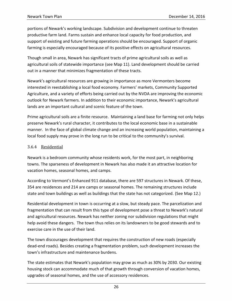
Vermont Natural Resources Council has described “good” and “bad” building practices,
depicted in Figures 2 and 3.16 The town encourages good building practices that meet the goals
described in Section 9.4.
Figure 2 Minimizing the impact of residential development (Vermont Natural Resources Council)
16
Community Strategies for Vermont’s Forest and Wildlife, Vermont Natural Resources Council, September 2013.
Newark Town Plan December 14, 2016
28
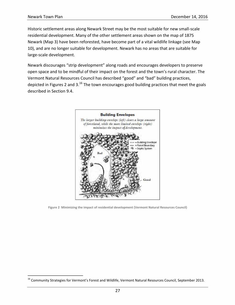
Figure 3 Clustered development (Vermont Natural Resources Council)
The Town of Newark has neither a central public municipal water supply nor a municipal
sewage disposal or treatment system. The town maintains a single-source water system that
provides drinking water to the Newark Town School, the Town Garage, and the Town Clerk’s
Office. Most residences make use of on-site water and septic systems dedicated to a single
dwelling.
The use of on-site systems has worked well, and there are no plans to consider municipal
systems in the near future. However, as Newark grows and changes, the town should be aware
of potential problems in order to protect the health and well-being of its residents. The quality
of ground and surface water is an issue of ever-increasing importance to the town’s residents.
The Department of Environmental Conservation currently regulates all waste and potable water
systems in the state. A Wastewater System and Potable Water Supply Permit must be applied
for and granted by the Department of Environmental Conservation for any new development.
Information covering sewage systems and requirements is available through the ANR and the
Newark Town Clerk’s Office.
Vermont’s stormwater regulations require that the majority of stormwater be treated on site
for any development that involves more than 1 acre of disturbed land. Smaller developments,
such as single-family homes, are exempt from state and federal stormwater regulations.
Smaller developments, however, can have a cumulative impact on water quality.
Low-impact development (LID) techniques provide an alternative to conventional stormwater
management. LID mimics natural hydrologic processes and can be employed at individual
homes to minimize runoff and maximize infiltration. Techniques can be relatively simple – like
creating rain gardens in low-lying areas to absorb runoff or by disconnecting impervious
Newark Town Plan December 14, 2016
29
surfaces, such as having downspouts drain into a yard, not a driveway. The net result is fewer
contaminants entering our lakes, rivers, and streams. There has been some educational
outreach on LID in the Northeast Kingdom. Although Newark has no zoning, landowners might
benefit from outreach and education before they develop (or redevelop) their lots.
The town’s goal is to maintain or improve the quality of surface and ground water to ensure a
safe, drinkable water supply and to maintain a high level of appreciation for the protection of
the ponds and streams of Newark.
Recreation 3.6.5
Newark abounds with outdoor recreational opportunities, among them being hiking, biking,
boating, canoeing, camping, cross-country and back-country skiing, snowmobiling, horseback
riding, golfing, hunting, and fishing. Newark has miles of recreational trails that provide
opportunities to visit and explore the community’s natural areas.
Several areas in town provide public access for outdoor activities:
The area adjacent to the Town Hall is used as a town park. It has a paved area for a
basketball court and an open-air ice rink in the winter. It also has a covered picnic area.
The park is used annually for the fire department’s chicken BBQ and flea market on Old
Home Day.
The Bald Hill WMA, managed by the state Fish and Wildlife Department, is open to
hiking, skiing, hunting, fishing, and trapping (subject to state regulations).
Willoughby State Forest provides hiking, skiing, and other dispersed recreational
opportunities. A section of a woods road is used in the winter as a snowmobile trail.
Both Newark Pond and Center Pond provide opportunities for fishing and boating. Each
pond has a state-maintained fishing and boating access area for launching boats, canoes,
and kayaks. Personal watercraft are not permitted on either pond. Both ponds support
populations of stocked and wild fish, including native brook trout.
Beck Pond is a shallow 20-acre pond located due north of Center Pond. It has a small
access trail for cartop/carry-in boats and has a population of brook trout.
In 2005, NorthWoods Stewardship Center constructed a 0.5-mile trail from a trailhead on
Center Pond Road to a small beach on the north end of the pond. Students from the
Newark Street School have installed a number of bog bridges and help maintain the
walking trails.
The Newark Pond Natural Area preserve includes 2,410 feet of shoreline and a 0.5-mile
nature trail, accessed by a small parking area on Newark Pond Road that loops through
the forest around to the shoreline.
Newark Town Plan December 14, 2016
30
Publicly accessible recreational trails include the Center Pond Trail, the Newark Pond Natural
Area loop trail (owned by The Nature Conservancy), and the woods roads located at Bald Hill
WMA and Willoughby State Forest.
The NVDA and the Northeast Kingdom Travel and Tourism Association provide guides for
bicycling in the Northeast Kingdom (nvda.net/Transp/documents). Cycling in the Kingdom
includes a route from East Burke to Island Pond, traveling along VT Route 114 through Newark.
Cycling the Kingdom’s Back Roads includes a route that enters Newark from the north on
Abbott Hill Road and continues south down Newark Street, Schoolhouse Road, and Maple Ridge
Road.
Kingdom Trails Association, located in East Burke, manages a world-renowned mountain-biking
network featuring more than 100 miles of varied terrain in the area. Many Newark residents
use the Kingdom Trails network for mountain biking, hiking, snowshoeing, and Nordic skiing.
The Vermont Association of Snow Travelers (VAST) is an association of local snowmobile clubs
that includes the Newark E-Z Riders, who maintain Newark’s snowmobile trails. Since most
snowmobile trails are located on private land, VAST relies on the generosity of landowners for
the privilege of riding on their land. Several woods roads, public Class 4 roads, and legal trails
are included in the VAST trail network in Newark. Snowmobile trails may intersect town roads
at designated crossings, but town ordinance prohibits operating a snowmobile on a town road.
Use of all-terrain vehicles (ATVs) is increasing in popularity. The Vermont All-Terrain Vehicle
Sportsman’s Association is an association of local ATV clubs. There are currently no specific ATV
trails in Newark, and ATVs are not permitted on roads or public lands in the town. ATV
operators must obtain landowner permission before using ATVs on private land.
Many landowners permit nonmotorized traffic on their lands. Some landowners permit hunting
and trapping. Abuse of landowner generosity can result in an increase in posted land. The Town
of Newark encourages people to seek permission to access posted land and to respect the
rights of landowners.
In addition, Newark embraces the Vermont tradition of permitting low-impact recreational
access, such as cross-country skiing, hunting, and hiking, on private roads and trails. Newark
landowners are encouraged to support recreation by NOT posting their land, and visitors should
respect private property and obey all signs. Landowners should be made aware that under
Vermont’s Landowner Liability Law, they are not liable for injuries to recreationalists who use
their land.
Recreation is an important aspect of life in Newark. It is also an important driver of the
economy of the town and region. Newark wishes to preserve its natural assets, which provide
so many recreational opportunities, and to continue its landowners’ tradition of providing
Newark Town Plan December 14, 2016
31
recreational access to private lands. The town also wishes to maintain its recreational assets
such as hiking trails and beaches and to work with local groups to expand the range of
recreational opportunities.
Commerce and Industry 3.6.6
Newark has little in the way of commercial or industrial development. The village centers and
downtown areas of neighboring towns offer more promise for commercial ventures than
Newark, with its small population and lightly traveled roads.
Similarly, Newark has few amenities to offer industrial developers. It lacks sewage and water
systems, three-phase power, paved roads, and easy access to interstate highways. The Town of
Newark supports the NVDA’s efforts to develop and promote industrial parks that provide the
infrastructure and services required for industrial development in the region.
Concentrating commercial and industrial development in existing commercial areas and
industrial parks is a fundamental principle in the “smart growth” strategy that the State of
Vermont is promoting. Many Newark residents commute to commercial and industrial areas in
nearby towns to work and shop.
Newark’s commercial activities at the present time are forestry, arts, artisanal work, individual
home construction, and home-based occupations. These small businesses are important to the
town and should be encouraged. A home occupation or business is defined as one conducted
by the resident(s) of a residential building, which is carried out within the principal building or
an accessory structure incidental to the dwelling, employs no more than four nonresidents, and
does not substantially alter the character of the area.
Newark’s goal is to maintain its unique rural atmosphere, natural scenic beauty, and wildlife
habitat, while encouraging the orderly and environmentally sound development of economic
opportunities.
Residents of the Northeast Kingdom view the rural character of the region, its natural
resources, and its large tracts of undeveloped land as its most valuable resource and vital to an
economic future that is most compatible with their lifestyles, sensibilities, and preferences. The
Town of Newark encourages only those developments that preserve and make use of these
economic drivers, respect the natural environment, and improve the well-being of residents.
The town regards development that would compromise the rural character of the town, its
natural resources, and its large tracts of undeveloped land as inappropriate and inconsistent
with the town’s vision and goals.
The Town of Newark regards large-scale industrial development as inappropriate within the
town, preferring instead to support the NVDA’s efforts to develop industrial centers within the
Newark Town Plan December 14, 2016
32
Northeast Kingdom. Newark values its ridgelines and other high-elevation areas and recognizes
the great importance of these areas to both residents and migratory wildlife. Therefore, large-
scale commercial and industrial development at elevations greater than 1,700 feet should be
strictly avoided.
Approximately 10,000 acres (out of the town’s total of nearly 24,000 acres) lie at elevations
above 1,700 feet. These lands, which are depicted in Map 4, are largely made up of
conservation lands and parcels that are enrolled in the Current Use program; they are, thus,
unavailable for development. A majority of these lands lie in the critical wildlife linkage
identified by the Staying Connected Initiative. Thus, they are inappropriate for development.
Significant portions of the lands have steep slopes and poor soils and are not served by
electricity distribution lines; thus, they may be unsuitable for development.
In addition, Newark regards commercial or industrial structures that exceed 125 feet in height
as inappropriate and inconsistent with the town’s vision and goals.
Any industrial or commercial development in Newark should be small-scale, should not
fragment forests, should not encroach on neighboring properties, and should have an
appearance that blends in with Newark’s rural character. “Strip development” along roads in
Newark must be avoided. Developments that cannot blend should be entirely screened from
view from neighboring properties, state highways, and town roads. Screening can be achieved
by proper siting, consideration of topographical features, and use of native vegetation.
Historic and Cultural Features 3.6.7
The Town of Newark has some known historic sites and structures as well as other historic
features that have yet to be identified or catalogued. Newark’s historic homes and buildings are
part of the town’s cultural landscape and rural character, which include traditional settlement
patterns and features and the historic built environment. A 2014 public forum confirmed that
there is local support for preserving Newark’s rural character, including its small-town feeling,
agrarian setting, and historic, scenic, and recreational resources.
Many privately owned historic homes and barns help define the town’s agrarian heritage. Also
of historical significance, though not well-documented, are other cultural landscape features,
including native American sites, stone walls, shade trees, fences, corner posts, and “witness
trees,” which once marked field and property boundaries; foundations and cellar holes, as well
as other visible remnants of past land use and occupation. Several historic mill sites in Newark
are evidenced by stone work and remnant foundations and point to the early industry of the
town’s past.
Newark Town Plan December 14, 2016
33
Open Spaces 3.6.8
Newark recognizes the importance of open spaces for wildlife habitat, recreation, flood
resilience, and preservation of our cultural heritage. These issues are important themes that
recur throughout this town plan. They are discussed elsewhere in this section as well as
Sections 6 and 11. See the Newark Natural Resource Inventory for more detailed discussions.
Posted Land, Parcelization, Fragmentation, and Current Use 3.6.9
There is a tradition of “open lands” in the Northeast Kingdom. Landowners generously allow
access to their lands for various recreational purposes. Guests who make use of this access are
generally courteous, appreciative, and respectful.
Newark’s lands remain largely open for recreation. To post land against trespassing, a
landowner must file with the town clerk each year, pay a fee, and meet strict state signage
requirements. As of this writing (August 2016), only six parcels, totaling 409.9 acres, are legally
posted.
Parcelization and fragmentation are distinct but related threats to Newark’s wildlife habitat.
The Vermont Natural Resources Council describes these threats as follows: When land is
divided into smaller parcels (parcelized), the result is usually an increase in the number of
owners of that piece of land. This often leads to new housing and infrastructure development,
fragmenting the landscape. Depending on the location and scale, such fragmentation may
negatively affect plant and animal species, wildlife habitat, and water quality. Fragmentation
may also affect “the contiguous ownership and management of forest parcels, and thus the
viability of large tracts of forestland to contribute to Vermont’s rural economy.”17
Newark’s grand lists for the years 2004, 2009, and 2013 show that Newark’s land is being
broken up into smaller parcels. The process may appear to be slow, but it is a difficult process
to reverse, and the cumulative effect over time can be significant.
Table 2 shows that from 2004 to 2013, the number of parcels in Newark grew from 675 to 702.
The median parcel size has shrunk from 11 acres to 10.6 acres, meaning that half the parcels
are now smaller than 10.6 acres and half are larger. If this trend were to continue at its current
pace, by 2036 there would be 771 parcels and the median size would be 9.6 acres.
17
VNRC, Community Strategies for Vermont’s Forests and Wildlife: A Guide for Local Action, September 2013, p. 4.
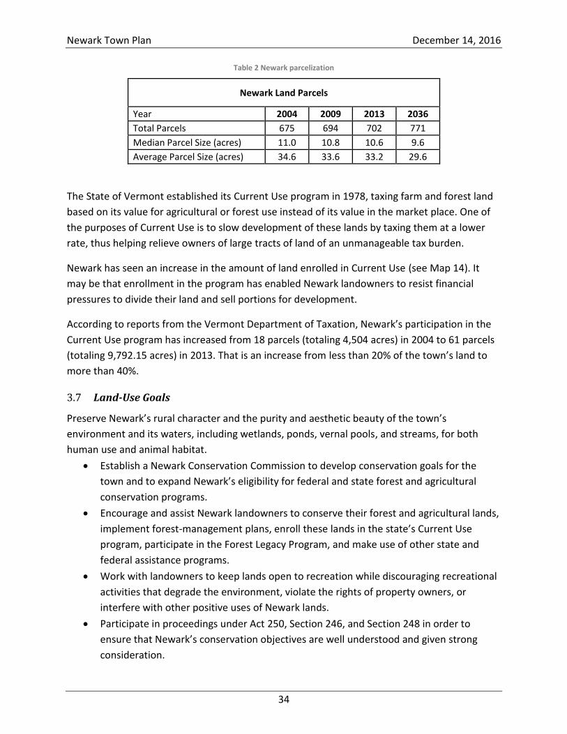
Newark Town Plan December 14, 2016
34
Table 2 Newark parcelization
Newark Land Parcels
Year 2004 2009 2013 2036
Total Parcels 675 694 702 771
Median Parcel Size (acres) 11.0 10.8 10.6 9.6
Average Parcel Size (acres) 34.6 33.6 33.2 29.6
The State of Vermont established its Current Use program in 1978, taxing farm and forest land
based on its value for agricultural or forest use instead of its value in the market place. One of
the purposes of Current Use is to slow development of these lands by taxing them at a lower
rate, thus helping relieve owners of large tracts of land of an unmanageable tax burden.
Newark has seen an increase in the amount of land enrolled in Current Use (see Map 14). It
may be that enrollment in the program has enabled Newark landowners to resist financial
pressures to divide their land and sell portions for development.
According to reports from the Vermont Department of Taxation, Newark’s participation in the
Current Use program has increased from 18 parcels (totaling 4,504 acres) in 2004 to 61 parcels
(totaling 9,792.15 acres) in 2013. That is an increase from less than 20% of the town’s land to
more than 40%.
Land-Use Goals 3.7
Preserve Newark’s rural character and the purity and aesthetic beauty of the town’s
environment and its waters, including wetlands, ponds, vernal pools, and streams, for both
human use and animal habitat.
Establish a Newark Conservation Commission to develop conservation goals for the
town and to expand Newark’s eligibility for federal and state forest and agricultural
conservation programs.
Encourage and assist Newark landowners to conserve their forest and agricultural lands,
implement forest-management plans, enroll these lands in the state’s Current Use
program, participate in the Forest Legacy Program, and make use of other state and
federal assistance programs.
Work with landowners to keep lands open to recreation while discouraging recreational
activities that degrade the environment, violate the rights of property owners, or
interfere with other positive uses of Newark lands.
Participate in proceedings under Act 250, Section 246, and Section 248 in order to
ensure that Newark’s conservation objectives are well understood and given strong
consideration.
Newark Town Plan December 14, 2016
35
Make landowners aware that, under Vermont’s Landowner Liability Law, they are not
liable for injuries to recreationalists who use their land.
Encourage the orderly and environmentally sound development of economic opportunities.
Discourage development and incompatible activities, such as the construction of new
roads or road expansions that damage headwaters or compromise the integrity of
forests and prime agricultural lands.
Develop mechanisms that promote Newark’s forest and agricultural products and that
support farming operations, especially organic farming.
Participate in the development of management plans for state recreational facilities in
Newark.
Explore land-acquisition opportunities to facilitate the establishment of other
recreational assets, from hiking trails to beaches.
Help preserve the critical habitat corridors, forests, and agricultural lands from fragmentation
and incompatible uses.
Explore tax-stabilization options to enable owners of forest and agricultural lands to
avoid breaking up intact tracts because of financial hardship.
Encourage home-based occupations and small businesses such as forestry, arts,
agriculture, artisanal work, and individual home construction.
Establish and maintain effective working relationships with local ANR and Agency of
Agriculture personnel to stay abreast of state and federal programs that provide aid to
farmers and owners of agricultural lands.
Support the NVDA’s efforts to develop and promote industrial parks in the county that
provide the infrastructure and services to support industrial development in the region.
Identify and preserve historically significant sites and buildings.
Seek grant money to carry out field work to identify and preserve sites, buildings, and
features that have environmental or historical significance.
Work with the Newark Conservation Commission to identify historic sites and features
in Newark.
Enhance the town’s natural flood-resilience assets.
See Section 12, Flood-Resilience Plan.
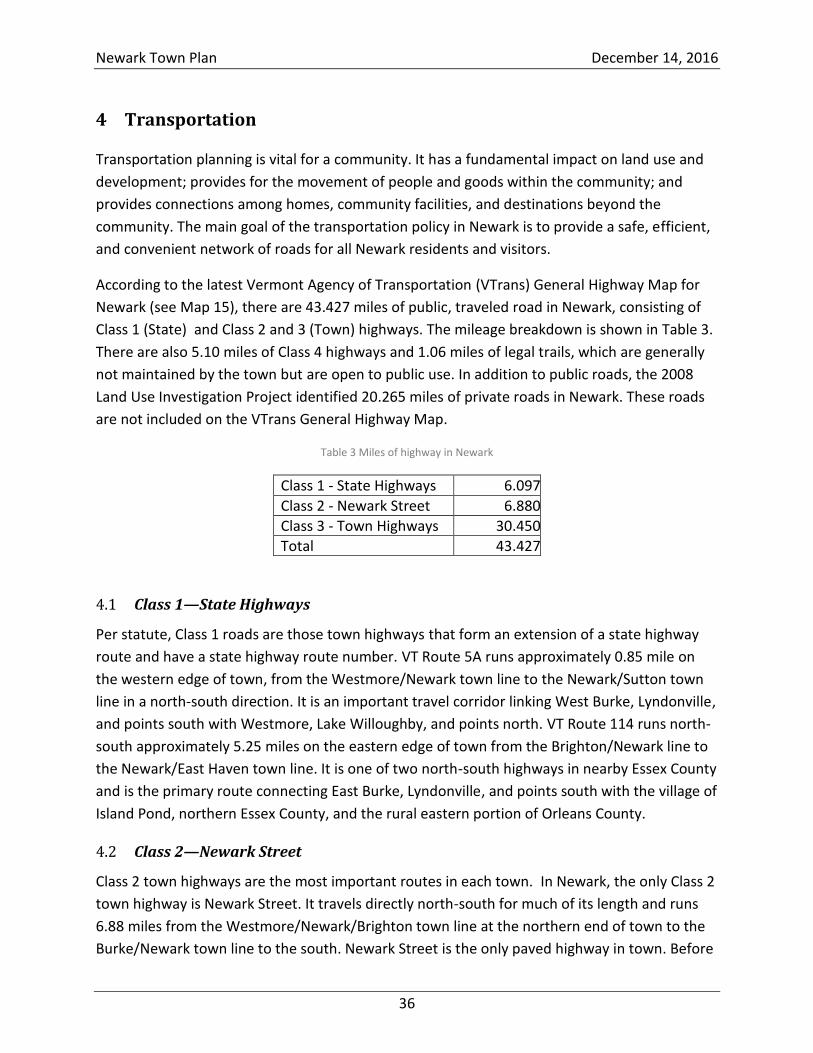
Newark Town Plan December 14, 2016
36
4 Transportation
Transportation planning is vital for a community. It has a fundamental impact on land use and
development; provides for the movement of people and goods within the community; and
provides connections among homes, community facilities, and destinations beyond the
community. The main goal of the transportation policy in Newark is to provide a safe, efficient,
and convenient network of roads for all Newark residents and visitors.
According to the latest Vermont Agency of Transportation (VTrans) General Highway Map for
Newark (see Map 15), there are 43.427 miles of public, traveled road in Newark, consisting of
Class 1 (State) and Class 2 and 3 (Town) highways. The mileage breakdown is shown in Table 3.
There are also 5.10 miles of Class 4 highways and 1.06 miles of legal trails, which are generally
not maintained by the town but are open to public use. In addition to public roads, the 2008
Land Use Investigation Project identified 20.265 miles of private roads in Newark. These roads
are not included on the VTrans General Highway Map.
Table 3 Miles of highway in Newark
Class 1 - State Highways 6.097
Class 2 - Newark Street 6.880
Class 3 - Town Highways 30.450
Total 43.427
Class 1—State Highways 4.1
Per statute, Class 1 roads are those town highways that form an extension of a state highway
route and have a state highway route number. VT Route 5A runs approximately 0.85 mile on
the western edge of town, from the Westmore/Newark town line to the Newark/Sutton town
line in a north-south direction. It is an important travel corridor linking West Burke, Lyndonville,
and points south with Westmore, Lake Willoughby, and points north. VT Route 114 runs north-
south approximately 5.25 miles on the eastern edge of town from the Brighton/Newark line to
the Newark/East Haven town line. It is one of two north-south highways in nearby Essex County
and is the primary route connecting East Burke, Lyndonville, and points south with the village of
Island Pond, northern Essex County, and the rural eastern portion of Orleans County.
Class 2—Newark Street 4.2
Class 2 town highways are the most important routes in each town. In Newark, the only Class 2
town highway is Newark Street. It travels directly north-south for much of its length and runs
6.88 miles from the Westmore/Newark/Brighton town line at the northern end of town to the
Burke/Newark town line to the south. Newark Street is the only paved highway in town. Before
Newark Town Plan December 14, 2016
37
the construction of VT Route 114, Newark Street served as a main stage route between West
Burke and Island Pond. The State of Vermont paved Newark Street from Route 5A in West
Burke to the state-owned Bald Hill Fish Culture Station (approximately 3.36-miles of this paved
street lies in Newark). The northerly portion of Newark Street near Abbott Hill was resurfaced
with sta-mat gravel in 2013.
Class 3—Town Highways 4.3
Class 3 roads include all traveled town highways other than Class 1 or 2 highways and, by law,
must be kept in good and sufficient repair during all seasons of the year. Newark has 30.45
miles of gravel Class 3 town highways. Appropriated funds and grant money from the Federal
Emergency Management Agency have been used to upgrade and improve Newark’s gravel
roads. The improvements include extensive ditching, new culverts, and new surface gravel, as
well as new street signs (particularly near the municipal garage and school) and better road
alignments at intersections. It is felt that the existing road network and maintenance programs
serve the town’s citizens adequately at the present time.
The town follows the state’s recommendations for gravel-road construction and maintenance
and continues to apply for grant monies to aid with the cost of road work. A 2015 road-erosion
inventory identified potential erosion hazards in Newark; this inventory will enable the town to
prioritize projects that mitigate stormwater runoff, reduce erosion and property damage, and
address water-quality impairments. Future road-maintenance efforts should consider practices
such as ditch treatments and culvert upgrades to increase the resiliency of the infrastructure
and reduce long-term costs.
New roads (for a subdivision, for example) will be considered for acceptance by the town only if
they meet minimum Class 3 standards as defined by Vermont statute. The town will be
reluctant to accept new dead-end roads and cul-de-sacs—they are especially time-consuming
for road crews to maintain and they provide little public benefit. Also, building and maintaining
additional roads require the use of gravel, an expensive, finite resource. The town purchases
most of its gravel from a gravel operation within the town (see Section 6.4).
Class 4—Town Highways 4.4
Class 4 roads include all other town highways, which are typically maintained to the extent
required by the necessity of the town. By law, towns are not required to maintain Class 4 roads
regularly, but they may be required to maintain bridges and culverts. There are 5.10 miles of
public Class 4 roads in Newark, many of which access private dwellings or are currently
impassible to most vehicles.
Because Vermont’s Class 4 roads are public rights of way that provide important opportunities
for recreation (such as snowmobiling, skiing, bike riding, and hunting), the Vermont Trails and
Newark Town Plan December 14, 2016
38
Greenways Council and the Vermont Department of Forests, Parks and Recreation advise
communities to preserve these corridors for current and future generations. In the event that
Newark decides to discontinue or “throw up” a Class 4 road, the town should seek to reclassify
the road as a legal trail, thus preserving the public right of way while eliminating the burden of
maintenance.
Legal Trails 4.5
By statute, a legal trail is a public right of way that is “not a highway.” The town is not liable for
the construction, maintenance, repair, or safety of legal trails. Newark has two legal trails,
totaling 1.06 miles.
Unidentified Corridors or “Ancient Roads” 4.6
Unidentified corridors are highways that were laid out with proper authority but do not appear
on town highway maps, are not clearly observable by evidence of use, and are not legal trails.
These roads are often unnoticed in property-deed research—which typically include the last 30
years—and have complicated title and insurance claims. Newark conducted research on ancient
roads within the town. Recent state legislation, which gave towns a limited amount of time to
identify and reclaim these roads, expired in 2015.
Scenic Roads 4.7
VT Routes 114 and 5A, both of which pass through Newark, have been designated “Northeast
Kingdom Byways” by the Northeast Kingdom Travel and Tourism Association. The byway
designation is an element of the association’s campaign to promote the Northeast Kingdom as
a geotourism destination. VT Route 5A provides views of Willoughby Gap. VT Route 114 follows
the East Branch of the Passumpsic and provides views of the Seneca range to the east and
Hogback Mountain (the ridge made up of Walker Mountain, Hawk Rock, Packer Mountain, and
Sugar Hill) to the west.
Newark’s town highways are scenic as well. Many town roads, including Newark Street, East Hill
Road, Duford Road, Abbott Hill Road, Center Pond Road, Schoolhouse Road, Maple Ridge Road,
and Rivers Farm Road feature canopied stretches that open up onto views of Hogback
Mountain, the Senecas, East Haven Ridge, Willoughby Gap, Haystack Mountain, Job’s
Mountain, the Pinnacle, and Bald Hill. Abbott Hill Road is especially dramatic in winter when the
frequent snows cover the trees that overhang the road.
These views are an essential characteristic of Newark, and it is the goal of the town to preserve
them. The town discourages the disruption of tree canopies, stone walls, and other scenic
features along roadways. The town encourages shared access for driveways—this reduces the
number of curb cuts and will encourage the type of smart growth that the town promotes (see
Newark Town Plan December 14, 2016
39
Figure 3 on page 28). The town discourages developments and activities that would detract
from the open views along highways.
New Roads, Driveways, and Curb Cuts 4.8
So as to ensure that no damage is done to town highways, a developer or property owner must
receive the town’s permission before connecting a new road or driveway to an existing town
road. Access permits for curb cuts are available at the Town Clerk’s Office for a small fee.
Approval from VTrans is required to access state highways.
Bicycle and Pedestrian Traffic 4.9
Newark encourages bicycle riding on the shoulders of town roads, but the town advises riders
to use caution, especially on narrow bridges. Being a hill town, every approach to Newark
involves a steep climb, so bicycles may never be popular for general transportation.
The town has no sidewalks, so care and caution should be at the utmost when walking along
our roads. As development in Newark continues, there may be a need to consider
improvements to the town’s pedestrian infrastructure—particularly in the village area near the
Newark Street School. Here, it may be practical to enhance pedestrian and bicycle travel
through appropriate speed limits and safety signage. The planning commission will work with
the selectboard and School Committee to assess the benefit of the addition of a sidewalk or
recreation path on or near town property.
Public Transportation and Ride Sharing 4.10
Currently, there are few alternatives that would allow residents to become less dependent on
motor vehicles. Rural Community Transit (RCT) is a nonprofit transportation group that serves a
wide range of passengers through a variety of programs. RCT coordinates medical trips for
Medicaid-eligible persons and also provides services for area social-service agencies. RCT relies
on a volunteer driver network and, as demand increases, so does the need for volunteers.
VTrans has developed a free resource called Go Vermont (govermont.org) to help people
reduce their transportation costs through carpooling, vanpooling, and ride sharing. While none
exists in Newark, a number of Park and Ride sites are located in neighboring towns, offering
Newark residents the opportunity to carpool to work or retail businesses. Many of these are
located along state highways—VT Routes 114, 5, and 5A—or at private businesses and
municipal properties. Carpooling is an important, cost-effective means of reducing vehicle
mileage, maintenance costs, fuel consumption, and carbon emissions. Where possible, Newark
should work with neighboring communities and VTrans to promote the use of Park and Ride
facilities by Newark residents.
Newark Town Plan December 14, 2016
40
Transportation Goals 4.11
Provide a sustainably built and funded transportation infrastructure that is resilient, minimizes
runoff and sedimentation impacts to wetlands and surface waters, and has minimal impacts to
Newark’s wildlife, scenic beauty, and historic settlement patterns.
Carry out improvements to town roads in a manner that protects, conserves, and
enhances natural resources, scenic features, and wildlife.
Cooperate with VTrans and neighboring towns to provide an effective transportation
system that enables residents to access services and facilities within town and in
neighboring communities.
Adopt construction and maintenance practices that help minimize the cost of
maintaining local roads.
Seek grants for road-improvement expenses such as equipment, ditch stabilization, road
surfacing, erosion control, and bridge and culvert replacement.
Prioritize spending such that maintenance and rehabilitation of existing traveled roads
take precedence over road upgrades to Class 4 or private roads.
Create a long-term road-improvement program—including a prioritized bridge and
culvert inventory—and review periodically.
Design new culverts to accommodate high-flow stormwater events and provide passage
for aquatic organisms.
Work with VTrans to identify locations of conflict between wildlife and transportation
and identify solutions to minimize these conflicts.
Ensure that new town roads and new lot layouts minimize the degradation and
fragmentation of wildlife habitat, forests, and farmland.
Ensure that adequate standards are followed in upgrading Class 4 and private roads to
Class 3 town-maintained roads, noting that landowners are required to pay for such
upgrades and that the planning commission and selectboard must ensure consistency
with the town plan.
Provide Newark residents with transportation facilities that are safe, efficient, and adequate to
meet the needs of all users, including pedestrians and cyclists.
Cooperate with the Northeastern Vermont Development Association, neighboring
communities, and service providers to encourage the development and use of public
transportation, ride sharing, and Park and Ride facilities.
Conduct a town-wide survey of bicycle-pedestrian trails, routes, and resources to assess
opportunities for development and improvement.
Encourage development of community pathways and trails for bicycle and pedestrian
(bike-ped) use—particularly in the Newark Street village area.
Increase safety for bike-ped and other uses on Newark Street through the development
of facilities, such as a bike lane, and management of motorized traffic behavior.

Newark Town Plan December 14, 2016
41
Encourage access to broadband services so as to support telecommuting, home
occupations, and small-scale home businesses, thus reducing the need for commuting.
Newark Town Plan December 14, 2016
42
5 Utility and Facility Plan
Newark’s buildings and facilities are shown in Map 13.
Town Buildings 5.1
The Town of Newark owns four buildings: Town Clerk's Office, Newark Street School, Town
Garage, and Town Hall. These buildings are situated on a 13-acre parcel located just north of
the crossroads of Newark Street and Schoolhouse Road.
The Town Clerk's Office was built in 1973-1974, has 560 square feet of floor area, is handicap
accessible, and has electric heat. The building has been maintained well and is in fair condition.
It consists of three rooms: the clerk's office, the document vault, and the conference room. The
conference room is used for meetings of the selectboard, listers, planning commission, and
other town groups. The conference room is also used for Election Day polling.
The Newark Street School was constructed in 1980. The town owns the building; the Caledonia
North Supervisory Union owns the contents. Educational resources in town are described in
Section 7.
The Town Garage, constructed in 1986, is a heated 40' x 100', five-bay metal structure located
just north of the Newark Street School. The garage houses both the town’s road equipment
and the Newark Volunteer Fire Department’s equipment. The condition of the town garage is
poor, and the jointly used space is inadequate. A Town Building Committee was formed in
spring 2016 to investigate replacement or repair options for the Town Garage, fire station, and
Town Clerk’s Office.
The former Town Hall, which is in poor condition, is the oldest building owned by the town. The
upper level, unused now and mostly empty, was once used for Town Meetings and includes an
open floor plan with a small stage and a primitive bathroom facility (no longer functioning). The
rear portion of the lower level is used for storage, while the front section has been converted
into a recycling center (see Section 5.3.5). Improvements to the recycling center were made
possible by private donations and by bottle-return monies provided by the recycling center. In
2014, the building was rewired and the antiquated “fuse box” was replaced with a circuit-
breaker panel.
Historic Features 5.2
The Town of Newark has some known historic sites and structures. These buildings are part of
the town’s cultural landscape and rural character.
Newark Town Plan December 14, 2016
43
The Newark Union Church, located in the heart of Newark’s village, was built in 1862 and is
owned by the pew holders. The building is in good condition, thanks to grants and donations. A
new roof was installed in 1997 with the help of a grant from the Vermont Preservation Trust. In
the last few years, the building was rewired and painted and had new windows installed. The
Bicentennial Committee landscaped the grounds in 1991. The church is used for Newark’s
annual Old Home Day celebration in July and for a nondenominational Easter service. The
acoustics are excellent, making it a favorite venue for the Newark Balkan Chorus.18 The Newark
Street School has used the church for programs and graduation. The church is also available for
weddings and funerals.
Town and Regional Services 5.3
Road Maintenance 5.3.1
Newark’s highways are maintained by a three-person crew (two full-timers and one part-timer).
The Road Commissioner is elected annually at Town Meeting. This person supervises road
maintenance and works closely with the selectboard and the Vermont Agency of
Transportation.
It is town policy to leave a road unplowed if all the homes on that road are unoccupied in the
winter. Newark has an ordinance forbidding the moving of snow from a driveway onto a town
road (a practice that can create hazardous conditions for drivers).
Hospitals and Medical Services 5.3.2
The closest hospital to Newark is the Northeastern Vermont Regional Hospital (NVRH) in St.
Johnsbury. It is affiliated with Dartmouth-Hitchcock Medical Center in Lebanon, NH, has a staff
of 340, is licensed for 75 beds, and has a walk-in emergency room. NVRH has a helipad,
enabling the Dartmouth-Hitchcock Advance Response Team to transport patients to Lebanon or
to any other facility in New England.
Other nearby hospitals are the North Country Hospital in Newport, Copley Hospital in
Morrisville, Littleton Hospital in Littleton, NH, and Fletcher Allen Health Care in Burlington.
The Norris Cotton Cancer Center North, a Dartmouth-Hitchcock facility located in St. Johnsbury,
provides cancer care in coordination with local health-care facilities as well as with the Norris
Cotton Cancer Center in Lebanon.
18 The Newark Balkan Chorus, created by beloved teacher Evanne Weirich, has shared its rich harmonies and
rhythms in such venues as Garrison Keillor’s Prairie Home Companion and the movie In the Bedroom.
Newark Town Plan December 14, 2016
44
Numerous medical and dental facilities are located in towns close to Newark, including Lyndon,
St. Johnsbury, Barton, and Island Pond. Some Newark residents use Corner Medical in
Lyndonville, Island Pond Health Care, or medical offices in St. Johnsbury for their health care.
Eye care is available in St. Johnsbury. Pharmacies are located in Island Pond, Lyndonville, and St.
Johnsbury.
Emergency Services 5.3.3
5.3.3.1 Rescue
The Town of Newark is served by Lyndon Rescue, Inc., an ambulance service located at Lyndon
State College. Lyndon Rescue’s board consists of one person from each of the towns it serves.
Besides providing emergency ambulance service, Lyndon Rescue will also transport patients
from one medical facility to another (e.g., from NVRH to the Dartmouth-Hitchcock Medical
Center in Lebanon).
The town has implemented the Enhanced 911 program. All roads have been named, and signs
indicating their names have been erected. All homes have been numbered. This facilitates
quicker response by emergency vehicles. New house numbers are assigned by the Newark
Volunteer Fire Department, which will provide reflective house number signs for a small fee.
On the other hand, some of the maps used by rescue and fire personnel have inaccuracies and
inconsistences among them, making some homes and camps difficult to find.
Newark, along with 23 other area communities, belongs to Local Emergency Planning
Committee 9 (www.lepc9.org). This committee develops response and mitigation plans for a
number of natural and man-made disasters, including floods, hazardous material spills,
wildfires, snowstorms, and terrorism. Currently, Newark does not participate in the National
Flood Insurance Plan and has no flood-hazard regulations. Flood resiliency is discussed more
fully in Section 11.
A propane-powered electric generator has been installed at the school, improving the school’s
resource as an emergency site for the town.
5.3.3.2 Fire Protection
Fire protection for the town is provided by the dedicated volunteers of the Newark Volunteer
Fire Department. The department answers calls that include structure fires, medical calls,
motor-vehicle accidents, chimney fires, and alarm investigations. The department also provides
emergency medical services and is the only Certified ALS First Responder squad in the region.
The department can provide the first response to 911 calls, with any necessary follow-up
provided by Lyndon Rescue. The fire department has a portable defibrillator and a basket to
transport patients when vehicle access is not available.
Newark Town Plan December 14, 2016
45
The department currently has three volunteer EMTs on its roster. They are qualified to work
alongside Lyndon Rescue’s workers. The volunteers use paging devices that are dispatched
from St. Johnsbury, enabling them to be on-call 24 hours a day. The fire station and fire trucks
are equipped with two-way radios.
The department has a fire engine, and a tanker truck that are kept in the east end of the Town
Garage, which is heated, keeping the equipment available for year-round use. The fire trucks
and the garage are equipped with two-way radios. The department also has a Chevrolet Tahoe
and an equipment trailer. The department is constructing a new building (Fall 2016) to provide
additional storage capacity.
The fire department has received grants to install dry hydrants at various water sources within
the town to supply water for the town’s pumper truck during fire emergencies and for refilling
afterward. Currently, there are four dry hydrants, located on Center Pond Road at Sleepers
Brook, at Newark Pond, on Hollow Road, and on Howard Brook Road (VT Route 114). At the
2015 Town Meeting, $30,000 was appropriated to obtain and install a 30,000-gallon
underground poly-retention system for fire suppression to cover the center of town. The fire
chief is currently working with the selectboard investigating options.
Dispatching is managed 24/7 by the St. Johnsbury dispatch system. The Newark Volunteer Fire
Department has mutual-aid agreements with two organizations: the Northeast Mutual Aid,
which includes the six towns on Newark’s southerly borders, and the Northeast International
Mutual Aid System, which includes towns on the northerly borders. Newark is part of mutual-
aid systems involving 25 other fire departments.
In other public service, the fire department periodically hosts a CPR/Basic First Aid course at the
Newark Street School. This hands-on workshop is free to the public (donations are gratefully
accepted). During Fire Prevention Week, volunteer members meet with and educate the
children at school on fire safety.
The town appropriates funds annually for department operations. Additional funds are raised
through an annual chicken BBQ, an annual chicken pie supper, and generous donations from
residents and property owners.
The fire department is faced with several challenges:
The continued development of year-round and seasonal homes and camps has increased
the number of structures covered by the department.
Some of the development is occurring in remote areas and along Class 4 or private roads,
making access more difficult.
Gated or barred private roads encumber access to potential emergencies.
Newark Town Plan December 14, 2016
46
It has become increasingly difficult to enroll and retain community members in the fire
department.
The availability of private or public water supplies to support emergency fire services is
limited.
The conditions at the town garage and fire department are crowded.
5.3.3.3 Police Protection
Newark is served by two part-time constables, who are elected each year at Town Meeting. The
constables are paid only for services performed for the town, which typically involve local
complaints about violations of town ordinances or state statutes. (Copies of town ordinances
are available at the Town Clerk’s Office.)
Newark is served by the Caledonia County Sheriff’s Department. The department provides
routine patrolling and emergency services. If desired, the town can enter into a contract with
the Sheriff’s Department to provide dedicated coverage on a per-hour basis. Newark is also in
the territory served by the St. Johnsbury barracks of the Vermont State Police.
Libraries 5.3.4
Newark has no public library, but the town donates funds annually to the Cobleigh Public
Library in Lyndonville. Among other services, the library provides a bookmobile that stops at
the Newark Street School on a regular basis. Residents can use the Cobleigh Public Library as
well as the Island Pond Public Library in Brighton, both of which offer internet service.
Additional library services are offered at the former East Haven School and the Burke Mountain
Club in East Burke.
Refuse Disposal 5.3.5
The solid-waste transfer facility is housed in a semienclosed structure adjacent to the Town Hall
building, where part of the first floor has been converted to a recycling center. The recycling
center is operated by the Town of Newark in partnership with the Northeast Kingdom Waste
Management District (NEKWMD). Since July 2013, the transfer station has been manned by a
contracted waste hauler. It offers free recycling and pay-per-throw trash collection. The
facility's regular hours are Saturday, 8 am to noon, and Sunday, 11 am to 4 pm. From January 1
through April 30, Saturday hours are suspended and Sunday hours are extended, running from
9 am to 4 pm.
Items that can be recycled include glass, steel cans, plastics, corrugated cardboard, boxboard,
newspapers, junk mail, aluminum cans, and other materials. Compost containers for food
scraps are located outside the building. Bulky items, such as appliances and furniture, may be
disposed of, for a fee, whenever the facility is open. Residents can also make arrangements
Newark Town Plan December 14, 2016
47
with the contractor to pick up bulky items at their home. The solid waste is removed weekly by
the contractor and disposed of at the Waste USA landfill in Coventry, VT.
With the widespread community support of this program, the town recycles about 67% of its
solid waste, one of the highest rates in the district.
Newark residents can dispose of metal, batteries, oil, and other materials at NEKWMD’s facility
in Lyndonville.
Post Office 5.3.6
Many years ago, Newark had two post offices, but today it has none. Mail delivery is largely
handled by the West Burke Post Office, with the East Haven Post Office covering a small portion
of town.
Utilities 5.4
Water and Sewage 5.4.1
The town has no municipal water or sewer systems. Systems are the sole responsibility of
property owners and are required to meet state and federal regulatory standards (see Section
3.6.4).
Electric Power 5.4.2
Electric power in Newark is served by Lyndonville Electric Department in the southern part of
town and by Vermont Electric Cooperative in the north. No large-scale electricity generation is
located within the town. Newark has no three-phase power lines. Some areas of town have no
grid-based electricity access. Some residents may opt to supply their own electricity through
the use of gasoline, diesel, or propane generators or renewable-energy systems such as solar
panels (see Section 8, Energy).
Communication Services 5.4.3
Telephone service throughout the town is provided via landlines by FairPoint Communications.
Old lines and equipment, however, often cause static interference in landline telephone
service.
Cellular phone service is available through several carriers (e.g., AT&T or T-Mobile), although
the town has many “dead areas” in cellular service.
High-speed internet services are provided in various parts of town by FairPoint Communications
via landlines, by major satellite companies (such as DISH and Direct TV), and by other internet
Newark Town Plan December 14, 2016
48
services that use line-of-site technology. Some areas in town are unable to access any of these
alternatives.
Television programing is available by cable in some parts of the town and by major satellite
companies, but again, cable service is not available everywhere.
Utility and Facility Goals 5.5
Preserve the rural character of the community and ensure the adequacy of town resources for
present and future generations through the preservation and maintenance of town buildings,
lands, and historic resources.
Assist the Town Building Committee in assessing the present condition and future needs
of the Town Clerk's Office, the Town Garage/Fire Department buildings, and the Town
Hall and look into funding options, including grants, for renovations or replacements.
Work with the selectboard, town clerk, fire department, and road commissioner to
address ongoing priorities for town properties.
Establish a conservation commission, similar to the former Center Pond Committee, to
guide management of the Newark Town Forest, to support land and resource-
conservation projects, and to provide stewardship resources for landowners.
Actively support the pew holders who care for the historic Newark Union Church.
Encourage the formation of a Newark Historical Society or Committee to preserve the
town’s history and highlight the community’s historic sites, buildings, and artifacts.
Work with the selectboard and cemetery sexton to ensure that the town cemeteries are
maintained in good order.
Ensure the safety of Newark residents and properties by supporting the services of Newark's
road, fire, and rescue personnel.
Actively participate in and support the efforts of the Town Building Committee to ensure
adequate fire, road, office, and school facilities in Newark.
Improve public safety by ensuring that all roads have their names posted clearly and by
encouraging property owners to display E911 numbers on their houses and camps.
Encourage community support for and membership in the Newark Volunteer Fire
Department.
Maintain Newark’s position as a leader in the reduction of household solid waste in the
Northeast Kingdom by continuing to operate an efficient and user-friendly recycling and waste
transfer facility.
Encourage efforts to reduce solid waste by maintaining cost-effective access to collection
services for household recyclables, e-waste, compost, scrap metal, hazardous waste, bulk
items, and trash.
Newark Town Plan December 14, 2016
49
Educate residents about mandated universal recycling and the appropriate disposal of
hazardous materials, yard waste, bulk items, etc., by making information available at the
town office and recycling center.
Work with the selectboard and the town’s representative to the NEKWMD to support
and assist the state in enforcing waste-disposal laws, including junk cars, illegal dump-
sites, open burning of trash, and improper disposal of hazardous materials.
Encourage owners of junk vehicles to dispose of them or to store them in
environmentally safe, fenced enclosures.
Encourage residents to decrease the volume of solid waste by reducing their use of
disposable items and by recycling all possible items after their last use.
Support universal access to communication services—internet, cellular, and cable—throughout
town.
Work with Northeastern Vermont Development Association, the state, and other
consumers to urge providers to continue line and equipment upgrades throughout the
town for better telephone and high-speed internet service.
Newark Town Plan December 14, 2016
50
6 Preservation Plan
Newark is rich in natural resources, scenic beauty, and recreational opportunities. The
preservation of these riches has been the result of frugality, a commitment to stewardship, the
willingness to forego many of the luxuries that are readily available in other parts of Vermont,
and plain good luck.
For many years, the primary threats to the preservation of Newark’s natural and cultural
heritage arose from unsustainable timber-harvesting practices and the scattered development
of homes and camps. Now, Vermont’s energy policies have introduced the threat of unchecked
energy sprawl.
Newark’s irreplaceable assets include its rural character, its wildlife habitat, its scenery, and its
recreational opportunities. It is the goal of the Town of Newark to preserve these assets and
protect them against threats.
The town is concerned about plans for major development within Newark and in neighboring
towns. Since most area towns regulate development more strictly than Newark does, Newark
may find itself vulnerable to types of development that surrounding towns find undesirable.
These developments could threaten the environment and quality of life that Newark residents
value.
The town’s goal is to ensure that future generations may enjoy a high quality of life, economic
and recreational opportunities, abundant clean water, clean air, healthy habitat for fish and
wildlife, picturesque landscapes, and peace and quiet.
While it is the intention of the citizens of Newark to preserve the scenic beauty and quality of
sparsely developed wildlife habitat throughout the town, lands that the town places special
value on for scenic, wildlife, and recreational importance include:
The ridgeline historically known as Hogback Mountain, which consists of Walker
Mountain, Hawk Rock, Packer Mountain, and Sugar Hill.
The Job Mountain Ridge, which enters Newark from the northwest and runs toward
Newark Hollow.
The Pinnacle Ridge, which extends southeastward from Newark Pond toward Maple
Ridge Road.
The high-elevation areas along Newark Street, Abbott Hill Road, Pinnacle Road, Spruce
Ridge Road, Maple Ridge Road, and Kinney Hill Road.
The town’s ponds, including Newark Pond, Center Pond, Beck Pond, Walker Pond,
Sawdust Pond, and Brown Pond.
Newark Town Plan December 14, 2016
51
The town’s rivers and streams, including the East and West Branches of the Passumpsic,
Bean Brook, and Sleeper Brook, as well as smaller tributaries, wetlands, and vernal pools.
The scenic roads described in Section 4.7.
These natural resources provide important ecological services as well as economic,
recreational, and aesthetic benefits to residents and visitors. Development that would
compromise these benefits is inappropriate and inconsistent with the town’s vision and goals.
Newark is a community heavily influenced by past land uses and traditions. Our working
landscape—forests, farmlands, and historic features—continues to define our community.
Development in Newark has followed historical patterns and, for the most part, is harmonious
with the scenic qualities of a New England hill town. Newark’s scenic and aesthetic qualities
enhance our citizens’ quality of life and are highly valued. Newark residents list such qualities
as “small town feeling,” “pastoral and rural quality,” and “stewards of the land” as valued
characteristics.
Aesthetics 6.1
Scenery 6.1.1
Newark’s aesthetics and scenic beauty reflect the unspoiled character of the Northeast
Kingdom. Mountain ridgelines and high-elevation areas contribute substantially to the scenic
beauty. The town strongly discourages development on Newark’s mountain ridgelines and
other high-elevation areas, as these are included within Newark’s natural areas that are to be
preserved in their natural condition.
Northeast Kingdom ridgelines and high-elevation areas are particularly vulnerable to
development for wind-generation energy projects. No commercial or industrial facility for the
generation, transmission, or distribution of electrical energy, including meteorological towers
that collect wind data, should be constructed on ridgelines and mountain areas within the
Town of Newark. Modern commercial wind turbines are massive industrial machines that are
totally out of character with Newark’s unspoiled natural environment. Such development
would result in an undue adverse impact on the aesthetics and scenic beauty of the town. It
would be so out of character with our surroundings as to offend the sensibilities of the average
person.
Newark’s economic future is tied inextricably to our ability to preserve our natural
environment. Industrial-scale facilities for the generation, transmission, or distribution of
energy located on Newark’s ridgelines or mountain areas would unduly interfere with the
orderly development of Newark and the surrounding region. The societal benefits that accrue
by preserving the aesthetics and scenic beauty of our area, protecting our natural resources,
and maintaining our rural character outweigh any potential economic gain or amount of energy
Newark Town Plan December 14, 2016
52
that might be produced by commercial or industrial development of Newark’s high-elevation
areas.
Newark’s opposition to the construction of commercial or industrial electric-generation
facilities on the town’s ridgelines or mountain areas is a clearly written community standard
intended to preserve the aesthetics and scenic beauty of Newark and is a land-conservation
measure intended to ensure the orderly development of Newark and the region. This
declaration shall be construed by local and state regulatory bodies to achieve its full intended
purpose.
Noise 6.1.2
Newark is a quiet place, and residents consider “peace and quiet” to be an essential element of
the town’s rural character. Newark residents enjoy being able to hear the sounds of the rich
natural environment and benefit from Newark’s quiet nights.
Some daytime noise is acceptable (such as from traffic, chainsaws, farm equipment, and the
like) because it is occasional and is tied to our way of life. Such noise is usually being made by
neighbors or family members, who are generally courteous and sensible about the times of day,
duration, and volume of noise.
Most residents would find the noise of a pile driver or a race track objectionable even if the
noise is occasional. Most residents would agree that the constant noise of industrial equipment,
loud music, or barking dogs is unacceptable.
Medical professionals acknowledge that many types of noise, as well as the volume of noise,
can cause adverse health effects that range from damage to hearing, to annoyance and stress
reactions, to sleep disturbance.
Noise is measured in decibels (“dBA”). The World Health Organization recommends that indoor
levels of noise remain below 30 dBA at night and suggests that nighttime levels of continuous,
low-frequency noise should be even lower than 30 dBA.19
Newark’s ambient (background) noise is typically below 20 dBA. In order to preserve Newark’s
essential rural character, the Town of Newark urges residents, property owners, and visitors to
be courteous and attentive to the amount of noise to which they subject their neighbors.
Furthermore, the Town of Newark considers industrial or commercial sources of noise
inappropriate for the town if they produce noise readings greater than 30 dBA as measured at
property boundaries. To protect against the effects of infrasound, no industrial or commercial
19
WHO Guidelines for Community Noise. World Health Organization, Geneva, 1999.
Newark Town Plan December 14, 2016
53
activity should produce indoor noise readings that would exceed 50 dBC in any existing or
prospective residence anywhere on a neighboring property.
These guidelines include prospective residences to ensure that no Newark property owners lose
the ability to develop any portion of their property owing to noise generated by a commercial
or industrial neighbor.
Night Sky 6.1.3
People are often overwhelmed by the clear view of the night skies that Newark residents enjoy.
Poorly designed outdoor lighting can obscure the night sky. The town encourages residents to
meet their outdoor lighting requirements in ways that do not interfere with viewing the night
sky. An internet search can provide information on how to improve the effectiveness of
outdoor lighting systems while reducing their costs.
Developments that obscure the view of the night sky are inappropriate in Newark, as are
developments that create light pollution that diminishes the view of the night sky.
Historic Features 6.2
The primary historic landmarks in Newark are the Newark Union Church and the old Town Hall.
The church has been well maintained through grants and generous contributions of pew-
holders, residents, and visitors. Although the old Town Hall has not been as well maintained,
the town has made periodic investments and should continue to do so. The town should look
for additional grant money to fund maintenance tasks for both historic landmarks.
Rare and Irreplaceable Natural Areas 6.3
Newark occupies a critical location at a chokepoint in a wildlife habitat linkage. This linkage has
been noted by the Staying Connected Initiative (SCI) for its importance as a rare and
irreplaceable natural area (Map 9 and Map 10). Roughly 75% of land in the town lies in this
linkage, including:
Virtually all of the town’s higher elevation land.
All of Hogback Mountain.
Nearly all of the town’s lands that drain into Bean Brook and the East Branch of the
Passumpsic.
The Hogback Mountain area is particularly important, as it is the largest block of wildlife habitat
in town. It adjoins Vermont’s second-largest block of habitat (which, in turn, adjoins the largest
block), magnifying its importance.
The Newark lands that lie within the SCI linkage represent the town’s best conservation
opportunity. Approximately 50% of Newark’s linkage is, in fact, conservation land or land
Newark Town Plan December 14, 2016
54
enrolled in Current Use, so development is not possible. The town discourages development
that would fragment or compromise any of the remaining portion of the linkage. Such lands
should be preserved by obtaining easements, by considering acquisition by the town, and by
encouraging acquisition by conservation groups.
Gravel and Other Nonrenewable Resources 6.4
Gravel is vital for road construction, road maintenance, and many types of development. It is an
essential ingredient of manufactured building materials. Gravel is a finite, nonrenewable
resource—once depleted, it cannot be replaced, so it is important to plan for its prudent use.
Gravel deposits can serve an important role in filtering ground water and recharging aquifers.
They often occur near rivers and lakes. For these reasons, some deposits are too ecologically
valuable to disturb. State regulations may prohibit gravel extraction from a site in order to
protect water supplies, critical wildlife habitat, or conserved lands.
Development that occurs over or near gravel deposits can make extraction difficult or
impossible. Land owners and developers should take the presence of gravel into account when
planning construction.
Extraction and processing of gravel and other earth resources can become a nuisance for
neighboring residents and landowners. Problems resulting from extraction include noise, dust,
and air pollution; surface and groundwater pollution; siltation; storage and disposal of waste
materials (both solid and liquid); increased stormwater runoff, erosion, and sedimentation;
spoiling of the landscape and limiting utility for subsequent uses of the site; and decreased
highway safety and increased municipal costs due to increased traffic and accelerated
deterioration of highways and bridges attributed to the transportation activities generated by
the earth-resource operations. These impacts may substantially depreciate land values in the
immediate vicinity. For these reasons, extraction operations should be isolated from
neighboring properties and screened from view from roads and neighboring properties.
Before earth-resource-extraction operations begin at a site, the landowner and operator should
work with the town, state, and Caledonia County Natural Resource Conservation District to
develop operational plans that will:
Minimize impacts to the environment and to neighbors
Create a stable site
Enable easy reclamation of the site
Identify uses for the site when operations are completed
There is currently one active commercial gravel extraction site in Newark. It is located off Route
5A. The Town of Newark has a 10-year contract with the operator of that site to purchase
gravel. Newark’s road-maintenance activities require 5,000 yards of gravel in an average year.
Newark Town Plan December 14, 2016
55
Preservation Plan Goals 6.5
Preserve Newark’s irreplaceable assets for future generations. These include its rural character, wildlife habitat, scenery, recreational opportunities, and peace and quiet.
Establish a conservation commission to:
o Develop detailed plans to preserve Newark’s rare and irreplaceable areas
o Develop detailed plans to preserve features that contribute to Newark’s
working landscape
o Identify historic sites and buildings, inform landowners of the value of these
features, and suggest ways to preserve them
o Raise funds to finance protection of important forest and agricultural lands
through easements or acquisition
Support efforts to protect important natural and recreational areas through
sustainable management, easements, and acquisition.
Encourage sustainable forest-management practices.
Support our community standard opposing large-scale industrial and commercial
facilities on the town’s ridgelines and high-elevation areas. Such development would
result in an undue adverse impact on the aesthetics and scenic beauty of the town.
It would be so out of character with our surroundings as to offend the sensibilities of
the average person.
Urge all residents, property owners, and visitors to be respectful, courteous, and
attentive to the amount and timing of noise their activities produce. This is especially
important near the town's ponds, where sound travels more easily.
Encourage residents and property owners to meet exterior lighting requirements in
ways that do not interfere with the view of the night sky; make best practices
information available through the town office.
Encourage the choice of roofing and exterior colors for buildings that are congruent
with natural surroundings, especially near Newark's ponds and scenic areas.
Discourage development and land uses that would fragment or compromise the SCI
habitat linkage area through intervention in state proceedings as well as through
education, easements, and land acquisition.
Preserve historic resources by identifying and protecting sites, buildings, and
features that contribute to Newark’s rural, working landscape.
Make the Newark Town Plan available online and at the Town Clerk’s Office;
encourage individuals seeking development permits to reference and adhere to the
Town's preservation goals during construction or renovation.
Newark Town Plan December 14, 2016
56
7 Education
Newark’s educational needs are met by a variety of childcare alternatives, its elementary school
(the Newark Street School), and excellent secondary-education choices. The Vermont State
Colleges and the Community College of Vermont provide local postsecondary and adult-
education opportunities.
Vermont is at a crossroads with regard to educating its children. Politics are threatening the
operation of small school districts. Legislation passed during the 2014-15 biennium calls for the
consolidation of schools into districts with a minimum of 900 students. This, in response to
decreasing statewide student enrollment and the ever-increasing cost of school budgets and
associated property-tax burdens, presents a significant challenge for many of Vermont’s
schools, 30% of which have fewer than 100 pupils.
The Newark Street School falls within Vermont’s small-school category and, despite
overwhelming community support, faces extraordinary challenges. Are students getting the
best education? Will the Newark Street School remain open? What will be the fate of
neighboring schools within the supervisory union, which collectively falls below the 900-student
threshold? How will legislated incentives and penalties impact local districts? What, if any,
impact will the law have on rising property taxes? These and many other questions are being
asked by members of communities across the state.
Newark residents showed unanimous support for the Newark Street School at the 2015 Town
Meeting, passing the following resolution:
We, the voters of Newark, would like the legislature to know we are in strong
support of our extraordinary school with its beautiful building and grounds,
shared resources, exemplary staff, technology, afterschool program, and
community support and believe that bigger is not always better.
In addition, Newark is served by two of the best secondary schools in Vermont, Lyndon
Institute and St. Johnsbury Academy. The legislative impact on these private schools
also remains unknown.
It is clear that the Newark community supports its children, teachers, and education
professionals. Residents must be ever vigilant and actively work to meet the highest education
standards for Newark’s children so that they receive the first-rate education they deserve.
Child Care 7.1
Child care for preschool-aged children is a critical need for many families. Local child-care
facilities are privately operated. According to the state’s “Bright Futures” child-care database
Newark Town Plan December 14, 2016
57
(http://www.brightfutures.dcf.state.vt.us), in 2015, there were five registered child-care homes
and two licensed child-care facilities in Newark and its adjoining towns.
Newark supports the addition of affordable, registered, residence-based family child-care
facilities within the town. Newark encourages prospective operators of child care to make use
of the business planning assistance available from the Vermont Small Business Development
Center in St. Johnsbury (http://www.vtsbdc.org/).
Preschool 7.2
The Newark Street School provides tuition for 3- and 4-year-old children to attend local
certified prekindergarten programs. The Bright Futures website describes the availability and
eligibility requirements for child-care benefits offered by the state.
Each spring, the Newark Street School offers a 6-week, ½-day-per-week “Transition to
Kindergarten” program to incoming kindergarten students.
Newark Street School 7.3
The Newark Street School is a vital community resource that offers excellent K-8 education. In
addition to serving the community’s educational needs, the school serves as the center for civic
programs and activities. It is a source of pride for residents and is essential to Newark’s identity.
In 1875, Newark had 13 one-room schoolhouses. The Newark Street School was built in 1980 to
replace the town’s last remaining one-room schoolhouse. The two-story wood-frame school
included three classrooms on the ground floor and a multipurpose room with a kitchen
upstairs. Construction of an addition was completed in 1997, and the current Newark Street
School contains six classrooms, a library, office space, small-group workspaces, a kitchen, and a
large multipurpose community-use space, featuring a basketball court. The school can
accommodate more than 100 students.
The school building has been meticulously maintained and is in excellent condition. It was
painted in 2009. Energy-efficient lighting was installed in 2010. Extensive maintenance to the
heating system and duct work was performed in 2012. A new standing-seam roof was put on
the building in 2013.
The Newark Street School is located on town-owned property at 1448 Newark Street. This 13-
acre parcel also includes town offices, town road-maintenance department, volunteer fire
department, and the transfer station/recycling center. The acreage, with its open and
southwesterly exposure, allows for future campus expansion and the addition of alternative
energy options.
In addition to, and in support of the excellent academic opportunities offered by the school, the
Newark Street School holds itself as a true community school and asset. Parents, grandparents,
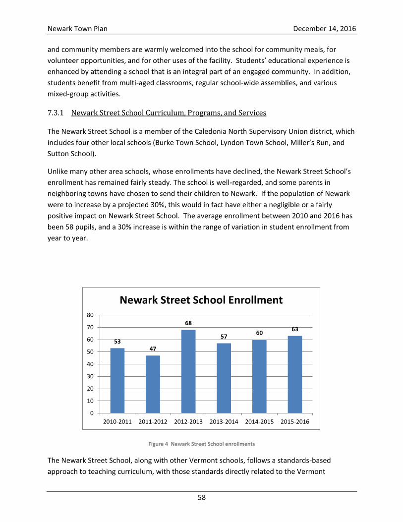
Newark Town Plan December 14, 2016
58
and community members are warmly welcomed into the school for community meals, for
volunteer opportunities, and for other uses of the facility. Students’ educational experience is
enhanced by attending a school that is an integral part of an engaged community. In addition,
students benefit from multi-aged classrooms, regular school-wide assemblies, and various
mixed-group activities.
Newark Street School Curriculum, Programs, and Services 7.3.1
The Newark Street School is a member of the Caledonia North Supervisory Union district, which
includes four other local schools (Burke Town School, Lyndon Town School, Miller’s Run, and
Sutton School).
Unlike many other area schools, whose enrollments have declined, the Newark Street School’s
enrollment has remained fairly steady. The school is well-regarded, and some parents in
neighboring towns have chosen to send their children to Newark. If the population of Newark
were to increase by a projected 30%, this would in fact have either a negligible or a fairly
positive impact on Newark Street School. The average enrollment between 2010 and 2016 has
been 58 pupils, and a 30% increase is within the range of variation in student enrollment from
year to year.
Figure 4 Newark Street School enrollments
The Newark Street School, along with other Vermont schools, follows a standards-based
approach to teaching curriculum, with those standards directly related to the Vermont
53 47
68
57 60
63
0
10
20
30
40
50
60
70
80
2010-2011 2011-2012 2012-2013 2013-2014 2014-2015 2015-2016
Newark Street School Enrollment
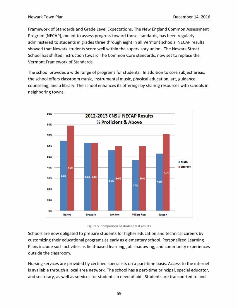
Newark Town Plan December 14, 2016
59
Framework of Standards and Grade Level Expectations. The New England Common Assessment
Program (NECAP), meant to assess progress toward those standards, has been regularly
administered to students in grades three through eight in all Vermont schools. NECAP results
showed that Newark students score well within the supervisory union. The Newark Street
School has shifted instruction toward The Common Core standards, now set to replace the
Vermont Framework of Standards.
The school provides a wide range of programs for students. In addition to core subject areas,
the school offers classroom music, instrumental music, physical education, art, guidance
counseling, and a library. The school enhances its offerings by sharing resources with schools in
neighboring towns.
Figure 5 Comparison of student test results
Schools are now obligated to prepare students for higher education and technical careers by
customizing their educational programs as early as elementary school. Personalized Learning
Plans include such activities as field-based learning, job shadowing, and community experiences
outside the classroom.
Nursing services are provided by certified specialists on a part-time basis. Access to the internet
is available through a local area network. The school has a part-time principal, special educator,
and secretary, as well as services for students in need of aid. Students are transported to and
Newark Town Plan December 14, 2016
60
from school by bus. The school continues to provide an essential nutritional breakfast and lunch
program.
The after-school program is a critical element of Newark Street School culture. It is a successful
and well-attended component of Newark’s educational program, providing an engaging blend
of tutoring, academic enrichment, participation in the arts, and regular exposure to healthy
lifestyles. The after-school program includes a community garden and is the home of the
Newark Balkan Chorus, a world-renowned chorus singing traditional Balkan songs.
Graduates of the Newark Street School report that the school had prepared them well for
secondary education and postsecondary opportunities.
Newark Street School Community Amenities 7.3.2
Newark Street School is a member of the Vermont Rural Partnership (VRP), a nonprofit
organization dedicated to sustaining rural schools and rural communities. Funded by private
grant funds, VRP supports community involvement in schools and school involvement in the
community. A VRP grant helped the Newark Volunteer Fire Department construct a community
ice rink on the campus (if weather permits, the rink will begin its inaugural season in December
2016). Previous grants from VRP provided assistance with the installation of a Frisbee golf
course, planting boxes, and a bread oven.
The Newark Street School has an outdoor basketball court, and in 2011, a grant from the Land
& Water Conservation Fund (through the Vermont Agency of Natural Resources) enabled
construction of a community playground and baseball/softball diamond for school and
community use.
A North Country Credit Union grant provided school picnic tables for outdoor meals and
community events.
The school is the site of Newark’s annual town meeting and other community meetings,
dinners, discussions, lectures, training sessions, and activities. The school also serves as the
town’s emergency shelter and is equipped with a propane-fired generator.
Secondary Education 7.4
Lyndon Institute and St. Johnsbury Academy are customarily the secondary schools that
graduates of Newark Street School attend. Recent legislation has expanded the opportunity for
all students in grades 9 through 12 to enroll in any secondary school of their choice.
Transportation for secondary education is the responsibility of the students and their families.
Both Lyndon Institute and St. Johnsbury Academy offer career and technical education to all
incoming juniors and seniors, as well as to adult learners, in the surrounding school district
Newark Town Plan December 14, 2016
61
area. Programs are available that prepare students for careers in automotive technology,
welding, construction trades, computer and internet technology, culinary arts, electrician
trades, manufacturing, and health and human services, among others. Cooperative education
allows qualified students an opportunity to participate in real-world work experiences.
Postsecondary and Continuing Education 7.5
Lyndon State College and Johnson State College are 4-year colleges that are part of the state
college system. They are located within 15 and 50 miles, respectively, of Newark. The nearest
private college is Sterling College, in Craftsbury (about 35 miles from Newark).
Adult educational services and facilities with college-level classes are located nearby. The
Community College of Vermont (CCV) has satellite offices and classrooms in St. Johnsbury and
Newport. CCV offers programs in business, liberal arts, and nursing.
St. Johnsbury Academy and the Lyndon Institute Career and Technical Center offer adult
education for anyone who is no longer enrolled in a traditional high school. Another resource
for adult education is Northeast Kingdom Adult Basic Education, a nonprofit organization that
provides free instruction to individuals no longer enrolled in public school.
Educational Attainment in Newark 7.6
According to recent American Community Survey five-year estimates (2009-2013), 89.4% of
Newark’s residents over the age of 25 have a high school diploma or equivalent (up from 78% in
2000). This is slightly below the statewide average of 91.3% and may indicate a need for
continuing educational services in this area.
A look at college-attainment figures reveals that 30.4% of residents have completed a
bachelor’s degree or higher. While below the statewide average of 34.2%, this figure has
increased significantly since 2000, when only 13.5% had a 4-year degree.
Education Goals 7.7
Preserve and encourage the high-quality education provided by Newark Street School.
Find creative ways to pay for unfunded state and federal mandates.
Support the school board’s efforts to design and implement cost-effective educational
plans.
Encourage the continued participation in school activities and events by the town's
residents.
Encourage continued collaboration with neighboring towns to ensure a rich offering of
school programs and opportunities.
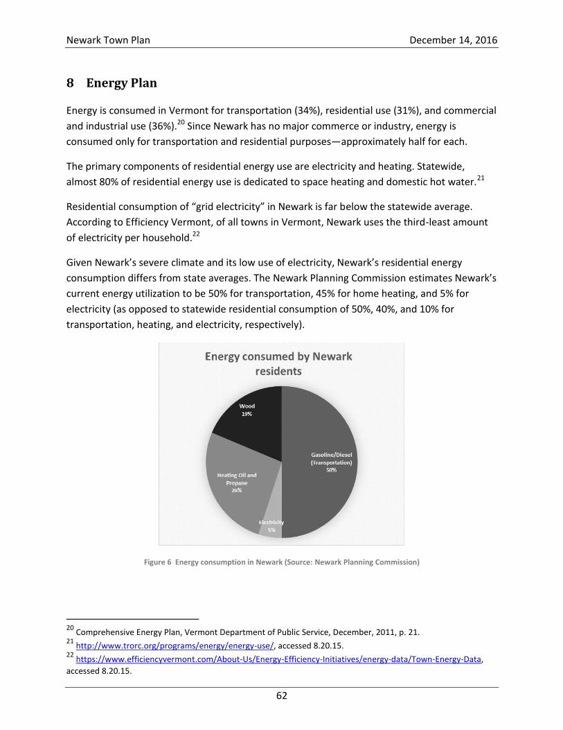
Newark Town Plan December 14, 2016
62
8 Energy Plan
Energy is consumed in Vermont for transportation (34%), residential use (31%), and commercial
and industrial use (36%).20 Since Newark has no major commerce or industry, energy is
consumed only for transportation and residential purposes—approximately half for each.
The primary components of residential energy use are electricity and heating. Statewide,
almost 80% of residential energy use is dedicated to space heating and domestic hot water.21
Residential consumption of “grid electricity” in Newark is far below the statewide average.
According to Efficiency Vermont, of all towns in Vermont, Newark uses the third-least amount
of electricity per household.22
Given Newark’s severe climate and its low use of electricity, Newark’s residential energy
consumption differs from state averages. The Newark Planning Commission estimates Newark’s
current energy utilization to be 50% for transportation, 45% for home heating, and 5% for
electricity (as opposed to statewide residential consumption of 50%, 40%, and 10% for
transportation, heating, and electricity, respectively).
Figure 6 Energy consumption in Newark (Source: Newark Planning Commission)
20
Comprehensive Energy Plan, Vermont Department of Public Service, December, 2011, p. 21. 21
http://www.trorc.org/programs/energy/energy-use/, accessed 8.20.15. 22
https://www.efficiencyvermont.com/About-Us/Energy-Efficiency-Initiatives/energy-data/Town-Energy-Data,
accessed 8.20.15.
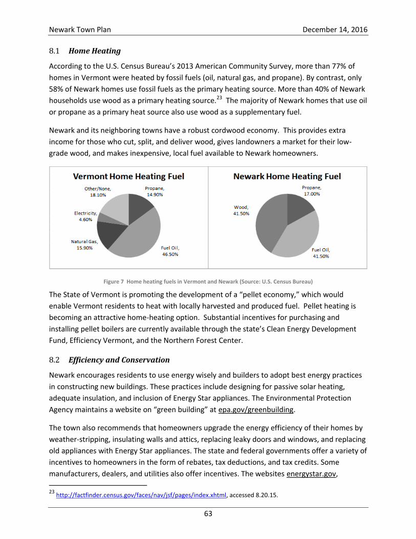
Newark Town Plan December 14, 2016
63
Home Heating 8.1
According to the U.S. Census Bureau’s 2013 American Community Survey, more than 77% of
homes in Vermont were heated by fossil fuels (oil, natural gas, and propane). By contrast, only
58% of Newark homes use fossil fuels as the primary heating source. More than 40% of Newark
households use wood as a primary heating source.23 The majority of Newark homes that use oil
or propane as a primary heat source also use wood as a supplementary fuel.
Newark and its neighboring towns have a robust cordwood economy. This provides extra
income for those who cut, split, and deliver wood, gives landowners a market for their low-
grade wood, and makes inexpensive, local fuel available to Newark homeowners.
Figure 7 Home heating fuels in Vermont and Newark (Source: U.S. Census Bureau)
The State of Vermont is promoting the development of a “pellet economy,” which would
enable Vermont residents to heat with locally harvested and produced fuel. Pellet heating is
becoming an attractive home-heating option. Substantial incentives for purchasing and
installing pellet boilers are currently available through the state’s Clean Energy Development
Fund, Efficiency Vermont, and the Northern Forest Center.
Efficiency and Conservation 8.2
Newark encourages residents to use energy wisely and builders to adopt best energy practices
in constructing new buildings. These practices include designing for passive solar heating,
adequate insulation, and inclusion of Energy Star appliances. The Environmental Protection
Agency maintains a website on “green building” at epa.gov/greenbuilding.
The town also recommends that homeowners upgrade the energy efficiency of their homes by
weather-stripping, insulating walls and attics, replacing leaky doors and windows, and replacing
old appliances with Energy Star appliances. The state and federal governments offer a variety of
incentives to homeowners in the form of rebates, tax deductions, and tax credits. Some
manufacturers, dealers, and utilities also offer incentives. The websites energystar.gov,
23
http://factfinder.census.gov/faces/nav/jsf/pages/index.xhtml, accessed 8.20.15.
Newark Town Plan December 14, 2016
64
energy.gov/taxbreaks.htm, and efficiencyvermont.com describe some of the incentive
programs.
Electricity 8.3
Most of the town receives its electricity from the Lyndonville Electric Department (LED), which,
in addition to purchasing power from major generators, operates two small hydro facilities (Vail
and Great Falls) on the Passumpsic River. The northern quarter of Newark receives its electricity
from the Vermont Electric Cooperative (VEC).
Newark has no three-phase electricity service. Many types of industrial equipment require
three-phase power to run properly.
Many areas of town are unserved even by single-phase distribution lines. These areas include
lengthy stretches of East Hill, Maple Ridge, Duford, Kinney Hill, and Abbott Hill Roads. There are
no electric substations in Newark.
Newark’s Energy Future: The Comprehensive Energy Plan and Renewables 8.4
There is a great deal of concern in Vermont about climate change. This has led to the
development of the state’s Comprehensive Energy Plan and the establishment of aspirational
goals to reduce emissions of greenhouse gases and produce 90% of our energy by renewable
means. The state has also adopted statutory requirements (under Act 56) that Vermont
electricity utilities increase the proportion of “renewable electricity” that they sell.
Newark may be closer to achieving the state’s aspirational goals than other Vermont towns by
virtue of its low usage of grid electricity, its large number of solar-powered “off-the-grid”
homes, the considerable number of net-metered solar installations, and the large number of
homes that use wood heat. However, Newark will not be able to meet the 90% renewable
energy goal until significant advances are made in transportation technology. The current
generation of electric vehicles is unsuitable for widespread use in Newark; electric vehicles are
expensive, have limited range, take too long to charge, and perform poorly in cold weather.
Additionally, many Newark residents require pickup trucks, which, currently, are available only
as gasoline- or diesel-fueled vehicles.
Many Newark residents have already reduced their consumption of transportation fuels by
eliminating unnecessary trips and by sharing rides with neighbors. Public transportation and
formal ride-share options in Newark are limited because they are expensive to establish in
sparsely populated rural areas. Park and Ride facilities are generally sited at intersections of
major road corridors. Since Newark has no such locations, the town should work with
neighboring towns to create Park and Ride facilities that could be used by all area residents.
Newark Town Plan December 14, 2016
65
Newark encourages homeowners to consider solar hot water and to participate in Vermont’s
net-metering program. Net metering enables individuals or groups to generate their own
electricity (from solar panels or other renewable technology) and get credit from utilities,
thereby offsetting their utility electricity costs. Newark encourages the development of
residential and community-scale electricity generation subject to the following standards:
No electricity generation facility should occupy more than 2 acres of land.
Electricity generation facilities should not fragment wildlife habitat, block wildlife
corridors, or compromise wetlands.
Electricity generation facilities should not be sited on agricultural soils of national or state
importance.
Electricity generation facilities should connect to existing distribution lines without
requiring upgrades.
Facilities should produce no noise louder than 30 dBA or 50 dBC as measured at
boundaries with neighboring properties.
Facilities should not extend above the background horizon line.
Facilities should not encroach on neighbors.
The renewable energy credits generated by facilities in Newark should be retired.
In order to preserve Newark’s rural character, any energy facility that occupies more than a
quarter-acre of land should be screened from view from all state roads, town roads, and
neighboring properties. Screening can be achieved by proper siting, consideration of
topographical features, and use of native vegetation.
The Northeastern Vermont Development Association’s 2020 Energy Plan identifies no sites in
Newark that are suitable for solar orchards.24 This may be due to the fact that Newark is the
terminus for power lines coming from LED from the south and VEC from the north. The
capacity of the electricity distribution lines in Newark is limited. Since three-phase power is not
available in Newark, the town is a poor site for large-scale solar power. Therefore, solar
developments should be kept small. This will reduce the likelihood that distribution lines will
become saturated and ensure that any Newark homeowner can participate in Vermont’s net-
metering program without fear of destabilizing the local electricity distribution system.
Considering these limitations, the Newark Street School campus might provide a good site for a
small, net-metered community solar facility. Newark also has a number of residences with
south-facing roofs or yards with southern exposure that would be suitable for small solar
developments.
24
NVDA 2020 Energy Plan, p. 29, http://www.nvda.net/files/2015%20Chapter%202%20Energy.pdf
Newark Town Plan December 14, 2016
66
The NVDA has identified a handful of Newark locations for small-scale commercial wind.25
However, the potential is extremely low and the sites lie in ecologically sensitive areas (inside
the SCI wildlife linkage depicted in Map 10). Development would be inconsistent with Newark’s
rural character, noise guidelines, and conservation plan.
The NVDA has identified two locations in Newark that might be suitable for small-scale
hydroelectric installations.26 The difficulty of the permit process for new hydroelectric plants
makes it unlikely that either of these sites would be developed. The town would approach such
developments with extreme caution and would seek assurances that they could be undertaken
without compromising the town’s conservation goals.
Industrial-scale energy installations are incompatible with Newark’s vision and goals:
Industrial-scale installations would negatively affect the town’s fundamental goal of
habitat preservation.
Industrial-scale energy installations would be out of place in the Newark landscape.
Newark lacks the infrastructure to support large installations. Building the required
infrastructure would be costly, would detract from the beauty of the town, and would
contribute to the degradation of our natural environment.
Industrial-scale energy installations, by virtue of their impacts on the landscape and
wildlife habitat, would negatively affect Newark’s economy (which benefits from second
homes, tourism, and vacation rentals) and would interfere with the orderly development
of our region, which is investing in an economic future based on ecotourism.27
Industrial-scale energy installations can also impact property values. (Vermont towns are
beginning to reduce the assessed values of properties that are impacted by noise or
adverse visual impacts created by energy installations.)
Therefore, industrial-scale power generation and transmission facilities are inappropriate in the
town. This includes, but is not limited to, industrial-scale wind turbines and their associated
transmission facilities.
While Newark is a poor location for utility-scale projects, the town is committed to collaborate
with the utilities that serve it to:
Determine what volume of electricity generation would be suitable for the town.
Identify locations for developments that could improve reliability and not destabilize the
grid.
Identify locations suitable to both the utilities and the town.
Cooperate with development in mutually agreeable locations.
25
Ibid., 30. 26
Ibid., 31. 27
travelthekingdom.com.
Newark Town Plan December 14, 2016
67
Define projects that can help utilities meet the state’s energy transformation goals that
were established in 2015.
Newark asks the utilities that serve it to:
Oppose projects proposed for Newark (and other towns) that are not the result of a
collaborative process involving the town.
Refuse to purchase power, whenever possible, from projects that have not been the
result of a collaborative process involving any host town.
Land Use and Energy Conservation 8.5
In more densely populated towns and cities, smart-growth principles provide better
opportunities for energy conservation than they do in Newark. While the application of smart-
growth principles may not result in appreciable energy conservation, it can support the
preservation of wildlife habitat in Newark and beyond.
The Town of Newark discourages development sprawl, whether it be residential sprawl or
energy sprawl. Newark discourages development that requires expanding infrastructure,
including roads and utility poles and wires.
Energy Goals 8.6
Stay abreast of federal, regional, and state energy programs and incentives and develop
effective ways of informing townspeople, such as by maintaining a notebook and other relevant
materials in the Town Clerk’s Office.
Evaluate the role of the Newark Energy Coordinator and consider establishing a Newark
Energy Committee.
Work with Efficiency Vermont and state agencies to increase awareness of incentive
programs.
Help residents reduce greenhouse gas emissions resulting from home heating by holding
workshops and maintaining appropriate information in the Town Clerk’s Office.
Encourage conversion of oil- and gas-heated homes to modern wood heating (efficient
wood and pellet stoves, furnaces, and boilers).
Encourage builders to adopt best energy practices in new construction.
Encourage residents to upgrade thermal efficiency of existing buildings.
Encourage residents to consider solar hot water.
Encourage alternative transportation options.
Explore ride-sharing programs.
Explore the creation of Park and Ride facilities with neighboring communities.
Encourage cooperative transportation arrangements for Newark’s high school students.
Newark Town Plan December 14, 2016
68
Encourage residential-scale net metering.
Encourage small net-metering projects.
Discourage large-scale net metering that might saturate local distribution lines.
Collaborate with VEC and LED to develop a strategy that will enable any Newark
homeowner who chooses to net meter to do so without destabilizing the grid.
Discourage energy sprawl and energy development that would adversely affect wildlife habitat,
agricultural soils, the character of the town, geotourism, or property values.
Collaborate with VEC and LED to identify appropriate locations for electricity generation,
consistent with Newark’s goals and vision.
Promote awareness of local sources of energy and opportunities to employ renewable
energy in applications that are compatible with Newark’s vision and goals.
Explore opportunities to establish an appropriately sited community solar facility to
power municipal properties.
Conduct energy audits of town buildings to identify areas of energy waste and areas of potential
savings.
Recommend cost-effective energy conservation and efficiency measures as well as
modifications that will make use of renewable energy.
Implement energy efficiency measures for existing and future community facilities as
opportunities arise.
Prioritize modifications and efficiency improvements (e.g., facility retrofits, renovations,
and equipment upgrades) and incorporate them into the town's capital budget.
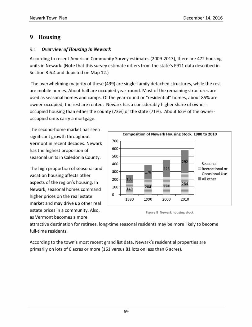
Newark Town Plan December 14, 2016
69
9 Housing
Overview of Housing in Newark 9.1
According to recent American Community Survey estimates (2009-2013), there are 472 housing
units in Newark. (Note that this survey estimate differs from the state’s E911 data described in
Section 3.6.4 and depicted on Map 12.)
The overwhelming majority of these (439) are single-family detached structures, while the rest
are mobile homes. About half are occupied year-round. Most of the remaining structures are
used as seasonal homes and camps. Of the year-round or “residential” homes, about 85% are
owner-occupied; the rest are rented. Newark has a considerably higher share of owner-
occupied housing than either the county (73%) or the state (71%). About 62% of the owner-
occupied units carry a mortgage.
The second-home market has seen
significant growth throughout
Vermont in recent decades. Newark
has the highest proportion of
seasonal units in Caledonia County.
The high proportion of seasonal and
vacation housing affects other
aspects of the region’s housing. In
Newark, seasonal homes command
higher prices on the real estate
market and may drive up other real
estate prices in a community. Also,
as Vermont becomes a more
attractive destination for retirees, long-time seasonal residents may be more likely to become
full-time residents.
According to the town’s most recent grand list data, Newark’s residential properties are
primarily on lots of 6 acres or more (161 versus 81 lots on less than 6 acres).
Figure 8 Newark housing stock
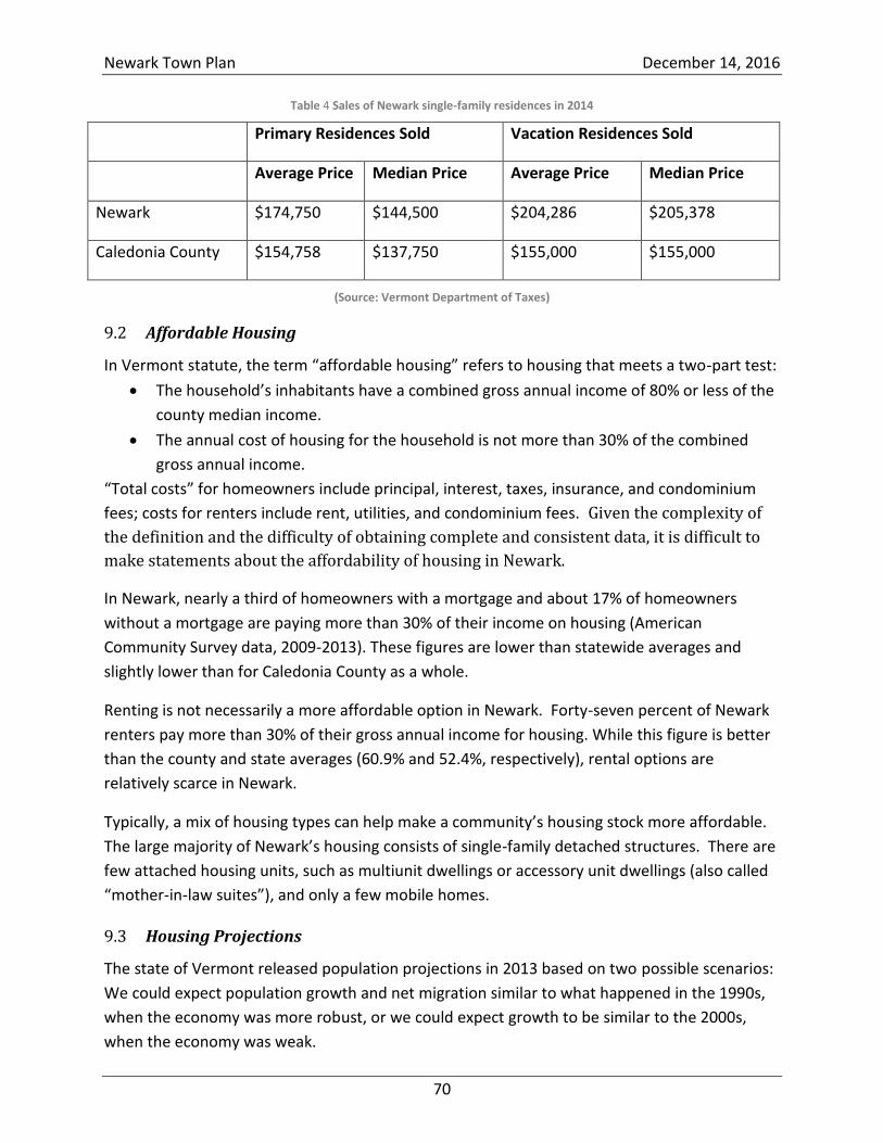
Newark Town Plan December 14, 2016
70
Table 4 Sales of Newark single-family residences in 2014
Primary Residences Sold Vacation Residences Sold
Average Price Median Price Average Price Median Price
Newark $174,750 $144,500 $204,286 $205,378
Caledonia County $154,758 $137,750 $155,000 $155,000
(Source: Vermont Department of Taxes)
Affordable Housing 9.2
In Vermont statute, the term “affordable housing” refers to housing that meets a two-part test:
The household’s inhabitants have a combined gross annual income of 80% or less of the
county median income.
The annual cost of housing for the household is not more than 30% of the combined
gross annual income.
“Total costs” for homeowners include principal, interest, taxes, insurance, and condominium
fees; costs for renters include rent, utilities, and condominium fees. Given the complexity of
the definition and the difficulty of obtaining complete and consistent data, it is difficult to
make statements about the affordability of housing in Newark.
In Newark, nearly a third of homeowners with a mortgage and about 17% of homeowners
without a mortgage are paying more than 30% of their income on housing (American
Community Survey data, 2009-2013). These figures are lower than statewide averages and
slightly lower than for Caledonia County as a whole.
Renting is not necessarily a more affordable option in Newark. Forty-seven percent of Newark
renters pay more than 30% of their gross annual income for housing. While this figure is better
than the county and state averages (60.9% and 52.4%, respectively), rental options are
relatively scarce in Newark.
Typically, a mix of housing types can help make a community’s housing stock more affordable.
The large majority of Newark’s housing consists of single-family detached structures. There are
few attached housing units, such as multiunit dwellings or accessory unit dwellings (also called
“mother-in-law suites”), and only a few mobile homes.
Housing Projections 9.3
The state of Vermont released population projections in 2013 based on two possible scenarios:
We could expect population growth and net migration similar to what happened in the 1990s,
when the economy was more robust, or we could expect growth to be similar to the 2000s,
when the economy was weak.
Newark Town Plan December 14, 2016
71
Either way, projections for Newark suggest a 30% increase in population by 2030. We don’t
expect to see a large influx of school-aged children, as the region’s population is expected to
age considerably. Projections for Caledonia County show a substantial increase in populations
aged 70 and up. While these are projections, not predictions, it appears that rural living is a
draw, and Newark may be an attractive destination for retirement.
Housing Goals 9.4
Maintain Newark’s rural character, consistent with the historic built environment and avoiding
habitat fragmentation and negative impacts to water quality and natural and community
resources such as scenic, agricultural, open, and forested lands.
Support housing that reinforces historic settlement patterns and preserves and improves
existing structures.
Preserve historic buildings—including homes, barns, and community buildings—as an
important part of the town’s heritage.
Continue to explore the use of regulatory and nonregulatory methods of managing
growth, discouraging types of development that would alter the character of the town or
strain the capabilities of local transportation, safety, and health systems.
Explore the creation of a village designation in the Newark Street area.
Locate future expansion or development of publicly owned community facilities and
buildings in the Newark Street village area.
Avoid fragmentation in outlying areas by designing development so that the extension of
roads, driveways, and other infrastructure is minimized or, preferably, shared.
Promote smart-growth principles for subdivisions so as to avoid unnecessary
fragmentation of wildlife habitats and distinct timber stands and to allow for access for
long-term forest management.
Maintain and improve the availability of safe and affordable housing and property ownership
for all income levels by encouraging a balance of housing for a mixture of incomes.
Ensure a variety of housing units for all income levels within the town, emphasizing,
when possible, the rehabilitation of existing structures.
Task the Building Committee to evaluate the town’s future needs for affordable housing
and housing for seniors.
Keep housing affordable by encouraging appropriately sized lots, accessory apartments
or dwellings, and clustered developments, including multifamily housing and housing for
seniors, consistent with the desire to maintain Newark’s rural quality. Any such housing
development should be approached using smart-growth principles.
Promote and support federal and state programs for weatherization, rehabilitation, and
home financing; construction and improvement of affordable housing; and housing for
seniors by making information available through the Newark Town Clerk’s Office.
Newark Town Plan December 14, 2016
72
Encourage residential housing in Newark that is sufficiently valued to help defray the cost
of public services in town.
Create a built environment that is consistent with Newark’s rural residential character, reduces
energy consumption, and reduces the long-term economic impact of rising energy costs.
Support town residents in their efforts to weatherize their homes, increase energy
efficiency, and reduce energy consumption.
Plan future housing for locations that complement existing or planned employment
locations, reduce travel times and the need for road upgrades and extensions, and
minimize the amount of energy spent on transportation.
Incorporate sound principles of site design for reducing energy use, such as solar and
slope orientation and protective wind barriers, where land development, including
subdivision, is proposed.
Compile examples of energy-efficient site design, landscaping, and structure design to
guide and encourage homeowners and builders to construct high-quality, energy-
efficient, and environmentally sound housing through the use of measures such as site
and building design, materials selection, and energy-efficient lighting, heating, venting,
and air-conditioning systems to reduce energy consumption and costs.
Newark Town Plan December 14, 2016
73
10 Economic Development
Newark’s Workforce 10.1
According to recent American Community Survey (ACS) five-year estimates (2009-2013), about
270 Newark residents are in the labor force, 229 of whom are employed. This figure roughly
correlates to U.S. Census Bureau data, which identifies 262 primary jobs held by Newark
residents.
Newark is a bedroom community that relies heavily on commercial and industrial centers in
larger, neighboring towns for employment. The Census Bureau uses quarterly employment
earnings to show where workers are employed in relation to where they live.
Newark residents—like most people who live and work in the Northeast Kingdom—do not live
close to work. A recent dataset (2011) shows that Newark residents primarily work in
Caledonia and Orleans counties, with the remainder employed in widely scattered locations as
far away as Burlington, Bennington, and Rutland.
About 40% of Newark residents live 50 miles or more from their employer (i.e., the employer
who issues their W-2 form). Some of these residents may be field representatives for distant
employers or may telecommute. Some may actually drive to a distant place of employment.
The Census Bureau statistics may also be skewed by employers who issue all W-2 forms from a
central, distant location.
About 40 Newark residents have employers located in Lyndon and St. Johnsbury. Although
Newport is a major labor market and service center for the Northeast Kingdom, only about
seven Newark residents have primary jobs in Newport or Derby.
According to ACS estimates, the median household income in Newark is $45,809, which is just
slightly higher than county-wide ($45,395). The mean (average) household income in Newark,
however, is $54,494, considerably lower than mean county-wide income ($57,426). This is
because household incomes in Newark are weighted more heavily in the middle ranges—
between $35,000 and $75,000.
Being largely a bedroom community, there is limited employment activity in Newark. Private-
sector employment is mostly small goods-producing endeavors (home construction, arts and
crafts, forestry) and various home-based businesses. A home occupation or business is defined
as one conducted by the resident(s) of a residential building, which is carried out within the
principal building or an accessory structure incidental to the dwelling, employs no more than
four nonresidents, and does not substantially alter the character of the area. Newark
encourages small, home-based businesses.
Newark Town Plan December 14, 2016
74
The Vermont Department of Labor Economic and Labor Market Information report for 2013
shows that Newark had 7 covered establishments employing 72 individuals, representing total
wages of nearly $2.3 million. This figure represents only employment activity that is covered by
unemployment insurance and is likely to exclude small-scale employment activity, such as sole
proprietorships.
The largest employers in Newark are the school and the town government. Collectively, they
account for about 20 employees, some of whom live in Newark. Other Newark residents are
employed in construction, professional and business services, and education and health
services. Many Newark residents are self-employed in endeavors such as agriculture, forestry,
and other home-based businesses.
Tourism in Newark 10.2
Economically, Newark is highly dependent on—and benefits from—tourism, an essential driver
of the economy in the Northeast Kingdom. The characteristics that bring visitors to the region
are the same ones that Newark residents treasure: rural character, wildlife, scenery, and
recreational opportunities. Newark benefits greatly from its proximity to regional tourism
facilities and activities, including skiing, snowmobiling, hiking, and bicycling.
Kingdom Trails Association (KTA), located in East Burke, provides a network of nonmotorized
trails for all levels of ability. Known nationally for its mountain-biking opportunities, KTA
reports approximately 80,000 user visits annually, with an economic impact greater than $8
million. Twelve new businesses related to the recreation industry were created in the area since
2013.
The Northeast Kingdom Tourism and Travel Association (NEKTTA) has promoted the region as a
geotourism destination.28 The National Geographic Society defines geotourism as Tourism that
sustains or enhances the geographical character of a place—its environment, culture,
aesthetics, heritage, and the well-being of its residents. As a result of NEKTTA’s campaign, the
Northeast Kingdom has become a highly regarded geotourism destination. “Indeed the area is
so special that in 2006 the National Geographic Center for Sustainable Destinations gave the
region a Geotourism designation. Recently the Northeast Kingdom was ranked as the #1
Geotourism destination in the United States, and among the top 10 in the world.”29
There are no restaurants, inns, hotels, or stores in Newark, but B&Bs have operated in the town
and numerous cabins, cottages, and homes are available for vacationers to rent. Nearly half of
Newark’s housing units are seasonal homes or camps (see Section 9). This helps the tax base in
town and also brings outside money into the region.
28
http://www.travelthekingdom.com/about-geotourism.php, accessed June 5, 2016. 29
https://www.vermontvacation.com/landing-pages/byways/northeast-kingdom-byway, accessed June 5, 2016.
Newark Town Plan December 14, 2016
75
Regional Perspective 10.3
Since Newark is regarded as a bedroom community, economic development strategies are best
viewed within a regional context. Life in the Northeast Kingdom region has long been marked
by chronic underemployment and lagging personal incomes.
Historically, Caledonia County has had one of the highest unemployment rates in the state, and
the unemployment rate in all three counties of the Northeast Kingdom has lagged the
statewide rate.
Caledonia’s annual average unemployment rate for 2013 was 5.3%, the third highest in the
state after Orleans and Essex counties (6.2% and 5.8%, respectively.) The November 2014 non-
seasonally adjusted figures put the county’s unemployment rate at about 4.5%, compared to
4.0% statewide.
In 1990, the U.S. Congress created the EB-5 Program to stimulate the U.S. economy through job
creation and capital investment by foreign investors. In the fall of 2012, an infusion of funds
from the EB-5 program promised to bring a reversal of fortune to the Kingdom, with a number
of large projects planned in the Jay, Newport, and Burke area. It appears, however, that local
EB-5 funds may have been misappropriated, and the program is currently under federal
receivership (spring 2016). On the other hand, significant development had already taken place
at the Jay Peak and Burke ski areas. A 116-unit hotel and conference center at Burke Mountain
opened in September 2016. Similarly in Jay, new ski amenities, as well as 100 new housing
units and an 84-unit hotel, are completed or under way.
Other developments in the Kingdom include expansion to the Newport State Airport in
Coventry and the designation of Foreign Trade Zone #286, which allows U.S.-based companies
to defer, reduce, or eliminate customs duties on products admitted to the zone.
These developments will bring more people to the region. New hospitality and tourism jobs
related to the resort development at both Jay and Burke are anticipated. Many of the
hospitality jobs would require minimal postsecondary education. Indirect and induced job
creation is also expected. Where newcomers might choose to live remains unclear, but the
region is likely to see an increased demand for housing at various income levels, more visitors,
and increased spending power.
In an economic analysis of job creation by counties between December 2009 and June 2014,
economists in the Vermont Department of Labor found that Orleans County showed the
greatest increase in job growth, with nonfarm jobs growing by 8.4%. Research also seems to
suggest that traditional commuting patterns are shrinking. Although Census Bureau data do
not show that Newark has a strong tie with the Burke or Newport labor markets, that
relationship may change as employment opportunities expand. The Northeastern Vermont
Newark Town Plan December 14, 2016
76
Development Association (NVDA) continues to work with the state to monitor economic
impacts.
The Future of Newark’s Economy 10.4
Newark’s economic future is inextricably linked to its access to the outdoors. Its rural beauty,
large open tracts, and abundant wildlife are quality-of-life assets as well as economic engines.
While it is important to measure the impacts of our region’s outdoor economy in terms of the
spending and jobs attributed to tourism and recreation, it is also important to recognize the
broader benefits in terms of economic recruitment and workforce development. Research has
shown that access to public lands, open spaces, and recreation correlates to higher levels of
income and attracts skilled, higher wage jobs more rapidly than communities without such
amenities.30
Newark’s goal is to maintain its unique rural atmosphere and natural scenic beauty, while
encouraging the orderly and environmentally minded development of economic opportunities.
Residents of the Northeast Kingdom view the rural character of the region, its natural
resources, and its large tracts of undeveloped land as its most valuable resource and vital to an
economic future that is most compatible with their lifestyles, sensibilities, and preferences. The
Town of Newark encourages development that preserves and makes use of these economic
drivers, respects the natural environment, and improves the well-being of residents. The town
regards development that would compromise the rural character of the town, its natural
resources, and its large tracts of undeveloped land as inconsistent with the town’s vision and
goals.
Economic Development Goals 10.5
Encourage economic development that is compatible with existing land use and the Newark
Town Plan, thus preserving Newark's rural character.
Support orderly development that encourages, promotes, and preserves the town's
natural scenic beauty, unique character, historic built environment, quality of life, and the
economic well-being of Newark's citizens.
Promote economic development that honors the rural, historic, scenic, natural resources,
and character of Newark.
Encourage local tourism by supporting efforts to protect Newark's historic and natural
resources and by expanding recreational and cultural opportunities for local residents
and visitors.
Encourage new small-business development that is compatible with existing or traditional land
30
Center for American Progress: “The Government Should Begin to Measure America’s Powerful Outdoor
Economy,” January 2015.
Newark Town Plan December 14, 2016
77
use and consistent with local and regional plans.
Support economic development—particularly in the agribusiness, wood products, and
tourism/recreation “clusters”—that encourages environmentally sustainable small and
home-based enterprises.
Encourage other goods-producing endeavors, such as home construction, the arts,
artisanal work, forestry, and agriculture.
Create an inventory of existing and potential recreational opportunities in town.
Encourage sustainable, low-impact commercial and recreational enterprise in Newark.
Promote access for local businesses and entrepreneurs to local, regional, state, and federal supports that provide opportunities for business development and growth through education, training, financing, technical assistance, and other services.
Work with NVDA and service providers to expand access to high-speed internet so as to
increase opportunities for home-based businesses or for telecommuting.
Maintain open positive communication and partnerships with neighboring towns and
NVDA in efforts to attract businesses to the area.
Work with the NVDA to promote economic growth through the use of regional, state, and
federal programs, such as tax-increment financing, tax-credit programs, revolving loans,
and business-development grants.
Promote local economic development and a skilled workforce by supporting access for
Newark residents—young and old—to educational and training opportunities that
provide technical, business, and environmental skills and inspire innovation and
sustainable economic enterprises.
Encourage the selectboard and planning commission to review and actively participate in
Act 250 proceedings as well as in other state, regional, and local hearings that involve
commercial development in order to represent the goals of the Newark Town Plan.
Inform local entrepreneurs about the availability of small-business services and funds by
making the information available through the town office.
Encourage a diversity of local commercial and service enterprises that use as much local
labor as possible.
Encourage Newark residents to buy local and support the economic well-being of their
fellow community members.
Leverage our proximity to the NVDA’s industrial parks and support NVDA efforts to add
amenities and encourage businesses to locate there.
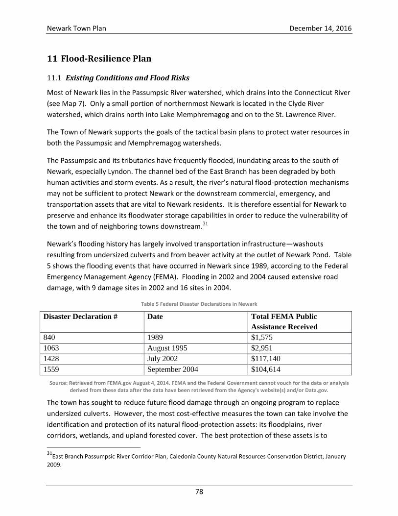
Newark Town Plan December 14, 2016
78
11 Flood-Resilience Plan
Existing Conditions and Flood Risks 11.1
Most of Newark lies in the Passumpsic River watershed, which drains into the Connecticut River
(see Map 7). Only a small portion of northernmost Newark is located in the Clyde River
watershed, which drains north into Lake Memphremagog and on to the St. Lawrence River.
The Town of Newark supports the goals of the tactical basin plans to protect water resources in
both the Passumpsic and Memphremagog watersheds.
The Passumpsic and its tributaries have frequently flooded, inundating areas to the south of
Newark, especially Lyndon. The channel bed of the East Branch has been degraded by both
human activities and storm events. As a result, the river’s natural flood-protection mechanisms
may not be sufficient to protect Newark or the downstream commercial, emergency, and
transportation assets that are vital to Newark residents. It is therefore essential for Newark to
preserve and enhance its floodwater storage capabilities in order to reduce the vulnerability of
the town and of neighboring towns downstream.31
Newark’s flooding history has largely involved transportation infrastructure—washouts
resulting from undersized culverts and from beaver activity at the outlet of Newark Pond. Table
5 shows the flooding events that have occurred in Newark since 1989, according to the Federal
Emergency Management Agency (FEMA). Flooding in 2002 and 2004 caused extensive road
damage, with 9 damage sites in 2002 and 16 sites in 2004.
Table 5 Federal Disaster Declarations in Newark
Disaster Declaration # Date Total FEMA Public
Assistance Received
840 1989 $1,575
1063 August 1995 $2,951
1428 July 2002 $117,140
1559 September 2004 $104,614
Source: Retrieved from FEMA.gov August 4, 2014. FEMA and the Federal Government cannot vouch for the data or analysis derived from these data after the data have been retrieved from the Agency's website(s) and/or Data.gov.
The town has sought to reduce future flood damage through an ongoing program to replace
undersized culverts. However, the most cost-effective measures the town can take involve the
identification and protection of its natural flood-protection assets: its floodplains, river
corridors, wetlands, and upland forested cover. The best protection of these assets is to
31
East Branch Passumpsic River Corridor Plan, Caledonia County Natural Resources Conservation District, January
2009.
Newark Town Plan December 14, 2016
79
discourage development that would compromise their effectiveness. Restoration of some of
Newark’s riparian areas would also improve Newark’s flood resilience.
Floodplains 11.1.1
Floodplains are low-lying areas adjacent to a water source that become inundated as
floodwaters rise up and spill out over a riverbank. Floodplains provide an important ecological
function by storing floodwaters, reducing downstream flood velocities, and minimizing
riverbank erosion. They also help protect water quality and habitat by filtering nutrients and
impurities from runoff, processing organic wastes, and moderating temperature fluctuations.32
FEMA prepares Flood Insurance Rate Maps (FIRMs) identifying Special Flood Hazard Areas,
which are floodplains that are likely to become inundated during a significant flood known as a
“base flood” or “100-year flood.” The term “100-year flood” is misleading, though, because it
creates the false impression that a flood of that magnitude will occur only once a century.
What the term really means is that the base flood has a 1% chance of flooding in any given
year. With a 1% annual chance, a structure in a Special Flood Hazard Area has more than a one-
in-four chance of being affected by a flood during a 30-year mortgage. By comparison, the
same structure has less than a one-in-ten chance of being damaged by fire over the same
mortgage.33
Interpretation of the FIRMs can be difficult, since they lack the type of detail usually associated
with maps, such as streets. The maps are important, though, because they are used to
determine the cost and availability of flood insurance.
The FEMA FIRM maps for Newark are available on-line34 and in the Town Clerk’s Office. The
flood-hazard areas tend to be located in three types of locations:
Low-lying lands around ponds, including Newark Pond, Center Pond, and Sawdust Pond.
Wetland areas, including those situated west of Beck Pond Road, near Bean Brook (below Newark Hollow), and on either side of VT Route 114 near Hawk Rock and Moose Lane.
Riparian areas, including a small section along the West Branch Passumpsic River near VT Route 5A and a much larger section along the East Branch Passumpsic River east of VT Route 114 below bridge B20 (see Map 15). This latter hazard area extends south all the way to the East Haven town line.
Developed areas around Newark Pond and, to a lesser extent, Center Pond may be at risk of
inundation flooding and property damage during extreme high-water events. Of greater
concern is the potential risk of inundation and fluvial erosion along VT Route 114, where the
32
Floodplain Management Requirements: A Study Guide and Desk Reference for Local Officials, FEMA 2005. 33
www.floodready.Vermont.gov. 34
FIRMs are available at http://map1.msc.fema.gov/idms/IntraView.cgi?KEY=97795922&IFIT=1; for the Newark map, use https://msc.fema.gov/portal/advanceSearch#searchresultsanchor.
Newark Town Plan December 14, 2016
80
risk of moving water poses a danger to homes, property, and infrastructure. Several structures
are situated within or very close to the mapped river corridor and flood-hazard area and may
be susceptible to erosion, flash flooding, and channel movement.
River Corridors 11.1.2
River channels are constantly undergoing physical adjustments. They might be slow, resulting
from gradual stream-bank erosion or sediment deposit, or they might be sudden and dramatic,
in the case of a stream-bank collapse. In fact, flood-related damage occurs frequently in
Vermont, owing in part to the state’s mountainous terrain.
The Vermont Department of Environmental Conservation describes a river corridor as the
river’s channel and enough adjacent land to provide “wiggle room” as the channel changes over
time. Lands near stream banks are particularly vulnerable to erosion damage by flash flooding,
bank collapse, and stream-channel dynamics.
A statewide base map of river corridors was released in November 2014. The map is essentially
a computer model, completed on all streams with a watershed area of more than 2 square
miles. Each river corridor includes a meander belt—the lateral extent that the river can move
to maintain channel equilibrium—and an area extending from the edge of the meander belt to
provide a natural vegetation buffer that can inhibit stream-bank erosion and dissipate stream
energy. Over time, the base map can be updated to reflect field-based data as they become
available. In Newark, the streams included in the base map are the East Branch Passumpsic,
Sleeper Brook, Bean Brook, and the West Branch Passumpsic.
If buildings are sited in river corridors, not only are they at risk, but they pose a threat to
downstream infrastructure, such as culverts, roads, and bridges. Downstream harm (a blocked
culvert, for example) can, in turn, increase risks to upstream properties. Accordingly, Newark
discourages development in its river corridors.
Uplands and Wetlands 11.1.3
Often missing from FEMA’s FIRMs are natural assets that help reduce the impacts of downhill
flows and help retain and filtrate drainage.
Proper management of upland areas plays an important role in minimizing flood hazards.
Newark’s topography consists of several north-south ridges. The town’s rivers and streams,
including Bean, Sleeper, and Roundy Brooks, the West and East Branches of the Passumpsic
River, and many smaller tributaries, flow between these ridges. The most prominent north-
south ridge is known as Hogback Mountain and includes Walker Mountain, Hawk Rock, Packer
Mountain, and Sugar Hill. The forested cover on the higher elevations along this ridge is part of
the largest block of contiguous forest in Newark (7,900 acres). While these areas are very
Newark Town Plan December 14, 2016
81
important for supporting wide-ranging species of wildlife, their flood-resilience function is also
critical. Limiting the clearing of upland slopes will help attenuate flood flows and reduce
stormwater runoff. Newark’s forest cover, particularly in areas with steep slopes and high
elevations (where headwaters are located), should be protected.
Wetlands also have the capacity to retain significant amounts of water. According to the
Vermont Significant Wetlands Inventory maps, Newark’s wetlands cover 1,292 acres and are
divided among 98 discrete wetlands. They are mostly concentrated along the East and West
Branches of the Passumpsic River and the Bean, Sleeper, and Roundy Brooks. The largest
wetlands are found along the East Branch Passumpsic, Bean Brook, and a small tributary of the
East Branch that drains Packer Mountain and Hawk Rock.
The State of Vermont regulates activities in and adjacent to wetlands. These rules apply to the
wetlands and associated buffer zones within 100 feet of Class I wetlands and 50 feet of Class II
wetlands. Any activity in a Class I or II wetland requires a state permit. The Town of Newark
supports and assists the state in regulating and protecting wetlands.
Riparian Restoration Zones 11.1.4
Riparian areas consist of both the aquatic and the terrestrial ecosystems of streams, rivers,
lakes, ponds, and wetlands.35 Restoring compromised riparian areas can promote biodiversity,
prevent erosion, protect water quality, and provide habitat and wildlife corridors.36
The Natural Resource Inventory of the Town of Newark identified the highest value riparian
restoration opportunities by means of a screening process that involved:
Delineating 100-foot-wide buffers along streams and rivers.
Identifying areas within buffer zones that are not currently covered by forest, shrubland,
or wetland vegetation.
Excluding sites with an existing building, road, or pond.
Evaluating the remaining sites for restoration potential.
Of the sites evaluated, those given the highest priority for restoration lie along the East Branch
of the Passumpsic River (see Map 17). According to the inventory, many of these sites could
best be restored by planting appropriate native floodplain or wetland vegetation. Some
unstable stream banks might require more aggressive treatment.37
35
Creating and Maintaining Resilient Forests in Vermont: Adapting Forests to Climate Change, Vermont Department of Forests, Parks and Recreation, May 2015, p. 40. 36
ibid., p. 53. 37
Gerhardt, Inventory, pp. 51-53.
Newark Town Plan December 14, 2016
82
The inventory report emphasizes that restoring the appropriate vegetation and habitats would
serve to store floodwaters, reduce stream-bank erosion, filter nutrients and sediments, and
create high-quality fish and wildlife habitat.38
Transportation Infrastructure 11.1.5
Newark has an ongoing program to upgrade and maintain its transportation infrastructure. The
town has received assistance from the Caledonia County Natural Resources Conservation
District (NRCD), the NorthWoods Stewardship Center, and the Northeastern Vermont
Development Association (NVDA).
Newark received a Better Backroads grant (from the Vermont Agency of Transportation)
to identify the conditions of smaller road erosion (ditching, driveway culverts, some
crossover culverts). The NRCD conducted an inventory, identifying and prioritizing
projects. The inventory provides a budget framework for a 5-year plan to implement the
projects. A Road Erosion Inventory and Capital Budget Plan is recommended every 5
years, to create a budget cycle for road-improvement projects as well as a tool for town
officials to track road-improvement progress. Projects identified in the inventory may be
eligible for additional Better Backroads grants.
The NorthWoods Stewardship Center has helped the town address some of the
deficiencies identified by the NRCD project.
In 2015, the NVDA worked with Lyndon State College to train individuals to assess the
conditions of the town’s short structures (bridges with spans between 6 and 20 feet),
classifying them as “good,” “fair,” or “poor.” This assessment will be important for
identifying medium- to long-range costs for maintaining, upgrading, and repairing these
bridges. Towns are responsible for inspecting their own short structures; the state does
not do so.
Newark uses the data that these projects provide to update the state’s inventory of bridges and
culverts (www.vtculverts.org). The inventory currently includes 299 culverts, the majority of
which are shown to be in fair or good condition (88%).
The state inventory shows five bridges on Newark’s town highways, three of which are depicted
on maps as short structures: B7 on Hollow Road located near the base of Center Pond, B9 on
Maple Ridge Road, and B10 on Bald Hill Pond Road near Sawdust Pond.
Vermont’s Emergency Relief and Assistance Fund 11.2
The flooding events in 2002 and 2004 each resulted in more than $100,000 in damage to roads
and bridges in Newark. Federal and state government assisted in covering the cost to repair the
38
Gerhardt, Inventory, p. 53.
Newark Town Plan December 14, 2016
83
damages, but Vermont’s formula for providing assistance has changed. As a result, future
flooding events could cost Newark taxpayers more.
FEMA provides public assistance covering 75% (or more) of infrastructure damage resulting
from a presidentially declared disaster. Vermont’s Emergency Relief Assistance Fund (ERAF)
used to cover 50% of the remaining damage, leaving the town responsible for 12.5% or less.
To encourage towns to undertake flood-resilience initiatives, Vermont has changed ERAF’s
rules. In order to qualify for full ERAF assistance, a town must now take all of the following
steps, described more fully in the following subsections:
Adopt the most current Town Road and Bridge Standards (which are listed in the VTrans
Orange Book: Handbook for Local Officials).
Adopt flood regulations that meet the minimum standards for enrollment in the National
Flood Insurance Program (NFIP); note that actual enrollment is not required.
Maintain a Local Emergency Operations Plan (LEOP).
Adopt a FEMA-approved All-Hazard Mitigation Plan. Towns that fail to meet these requirements will receive 30% assistance rather than 50% from
ERAF, thus raising the town’s share of the cost of a disaster from 12.5% to 17.5%.
Currently, Newark does not meet the new ERAF requirements. Thus, if Newark were to suffer
$100,000 in damages from a federally declared disaster, its share of the burden would be
$17,500. If the ERAF requirements were met, the burden would be $12,500.
Town Road and Bridge Standards 11.2.1
The intent of Vermont’s Town Road and Bridge Standards is to improve safety, reduce life-cycle
costs, and reduce environmental impacts. Adoption of these standards may also increase the
amount of state funding for repairs and replacement of bridges and culverts on town highways
(Classes 1 through 3).
The state share for the replacement and repair of bridges and culverts is limited to $175,000
per project. The local share is 20% of the project cost, but that share can drop to 10% if the
town has adopted the standards and completed a highway infrastructure inventory within the
past 3 years.
Thus, if Newark were to adopt the standards, the town’s share of a $100,000 project would
drop from $20,000 to $10,000.
Newark has chosen not to adopt the state standards because they would be costly and
impractical to implement on Newark’s rural roads. Even with financial assistance from the state,
adopting the standards would drive the town’s highway budget to unsustainable levels.
Newark Town Plan December 14, 2016
84
Newark’s road system is safe and flood resilient despite the town’s decision not to adopt the
state standards.
Flood-Hazard Regulations and the National Flood Insurance Program 11.2.2
Newark is not currently enrolled in NFIP. Enrolling in the program would enable Newark
property owners to obtain affordable flood insurance. It would also help some property
owners qualify for federally backed mortgages.
Enrolling in the NFIP would require Newark to adopt flood-hazard regulations for the Special
Flood Hazard Areas designated on the FEMA Flood Insurance Rate Map. These are Sawdust
Pond, a swamp to the west of Center Pond Road and Beck Pond, the East Branch of the
Passumpsic River, Bean Brook, Newark Pond, Center Pond, tributaries of Howard Brook, and
the brief portion of the West Branch Passumpsic near VT Route 5A. The most significant
concentration of development in a Special Flood Hazard Area appears to be the East Branch,
where six properties may be located in or near inundation hazard areas.
The (minimally compliant) regulations would not prohibit development in a Special Flood
Hazard Area, but new development would have to meet certain standards, such as elevation or
flood-proofing. If an existing residential structure in a hazard area were to suffer extensive
flood damage, it would have to be brought into compliance. This might require, for example,
elevating it and modifying its basement to allow flood waters to flow through.
While minimally compliant flood-hazard regulations will allow property owners to purchase
flood insurance at more affordable rates, the regulations may not reduce flood risks. The
minimally compliant standards still allow development in a Special Flood Hazard Area, so it is
possible that new development could reduce the effectiveness of flood-protection assets and
increase the vulnerability of other properties, roads, and bridges to flood risks.
The development and adoption of flood regulations might be both difficult and controversial,
but it would be required in order to make affordable flood insurance available to Newark
property owners and to make Newark eligible for the maximum amount of state aid through
ERAF.
Even though Newark is not enrolled in the NFIP, the town encourages builders and property
owners to meet NFIP’s minimum requirements for new structures or substantially improved
structures being built in a flood zone. Newark encourages inclusion of an additional 2 feet of
freeboard above the base flood elevation for any new structure being built in the flood zone.
Newark Town Plan December 14, 2016
85
Local Emergency Operations Plan 11.2.3
The LEOP establishes lines of responsibility during a disaster and identifies high-risk
populations, hazard sites, procedures, and resources. This information is particularly important
in coordinating responses through mutual-aid towns and with regional and state entities.
The LEOP must be reviewed annually (after Town Meeting) in order to ensure that it is up-to-
date with respect to community needs and contains correct contact information for critical
responders. Copies are available at the Town Clerk’s Office.
All-Hazard Mitigation Plan 11.2.4
The All-Hazard Mitigation Plan prioritizes hazard issues and details steps for addressing them. It
is required by FEMA in order to receive grant funding for reducing or eliminating hazards. In
2005, a local All-Hazard Mitigation Plan was developed for Newark as an annex to the regional
plan for the Northeast Kingdom. Since that time, the FEMA approval process has become more
rigorous. It is likely that Newark will have to develop a single-jurisdictional plan if the town
wishes to seek FEMA funds for mitigation projects, such as replacing bridges, elevating
structures, acquiring repetitive-loss structures, or purchasing a generator for an emergency
shelter.
Instream Emergency Protective Measures 11.3
Some flood and erosion hazards pose an immediate threat to safety and property. These
hazards may require swift action that cannot be encumbered by standard permitting
procedures. Vermont statute gives selectboards some authority to undertake stream-alteration
measures when they are needed to prevent loss of life or severe property damage. However,
such action needs to be taken in a manner that provides adequate notice to landowners,
minimizes impacts to stream stability and habitat, and remains eligible for reimbursement by
state and federal funds. Act 138, which was passed in 2012, establishes a protocol for taking
emergency action.
Under Vermont law, a selectboard is authorized to approve an emergency protective measure if
it meets the following conditions:
It is necessary to preserve life or to prevent severe imminent damage to public or private
property, when such property has experienced damage or is under threat of imminent
failure within the next 72 hours.
It is limited to the minimum amount necessary to remove imminent threats to life or
property. To meet this criterion, the emergency measures must be proportional to the
threat and shall cease when the threat to life or of severe damage to a property has
ended.
Newark Town Plan December 14, 2016
86
The emergency measure must meet the Agency of Natural Resources’ (ANR) implementation
standards for stream alterations. As soon as a municipality approves an emergency protection
measure, the municipality must notify the ANR within 24 hours. It is very important that local
officials are aware of required procedures so that they can act swiftly and decisively when an
emergency arises.
Flood-Resilience Goals 11.4
Protect water resources and areas essential to floodplain function, including floodplains, river
corridors, land adjacent to streams, wetlands, and upland forests to reduce the risk of flood
damage to infrastructure and property.
Work with landowners to preserve and restore riparian areas in order to improve
coverage of native plants in floodplains and wetlands.
Work to increase forest cover in riparian areas and upland forests adjacent to riparian
areas and wetlands so as to moderate stream temperatures, maintain wildlife corridors,
and mitigate flooding impacts.
Work with the ANR and Agency of Agriculture to ensure that forest-management plans
improve, rather than reduce, flood resilience; that property owners adhere to forest-
management plans; and that agricultural practices do not detract from flood resilience.
Support the conservation of lands located within the FEMA-mapped flood-hazard areas,
especially important upland areas that protect watershed functions, and undeveloped
river corridor areas along the East and West Branches of the Passumpsic River, where
flood and fluvial erosion pose a significant risk to nearby properties, homes, and
infrastructure.
Support orderly development that encourages, promotes, and preserves the town's
water and forest resources and oppose development or land-use changes that are
counter to the health and function of Newark's watersheds.
Review and actively participate in Act 250 and Section 248 proceedings and in other
state, regional, and local hearings that involve development that may impact water
resources so as to represent the goals of the Newark Town Plan.
Work with landowners in priority areas with important floodplain protection or
restoration opportunities to encourage participation in conservation and restoration
programs.
Establish and sustain flood-hazard education and outreach efforts to support flood-damage
mitigation and to help protect community residents and property against future flood damage.
Support established guidelines for forestry (Best Management Practices) and agriculture
(Required Agricultural Practices) that reduce runoff and impacts to riparian areas by
making information available through the town office.
Consider standards for stream-bank setbacks and buffers based on geomorphic
Newark Town Plan December 14, 2016
87
standards and river-corridor information identified by the Vermont Department of
Environmental Conservation.
Work with the Newark Selectboard to review and update the town's LEOP and All-
Hazards Mitigation Plan.
Work with the Newark Selectboard to evaluate the costs and benefits of meeting the
state’s ERAF requirements.
Coordinate with the NVDA, Vermont League of Cities and Towns, state agencies, and
others to conduct a workshop to inform Newark's citizens and taxpayers about flood
resilience.
Ensure that the town and its facilities are prepared to meet the demands of the next flood by
mitigating flood hazards and minimizing risk exposure in a sustainable, cost-effective manner.
Work with the selectboard to determine the next steps on how best to proceed with
Newark's flood-resilience plan.
Work with the selectboard and road commissioner to keep the town's road-erosion
inventory and capital-budget plan current and updated in the state database of bridges
and culverts.
Work with NVDA, the state, and others to identify funding for necessary capital
improvements.
Work with the selectboard and road commissioner to ensure that all maintenance and
new infrastructure projects meet best practices for flood resilience.
Newark Town Plan December 14, 2016
88
12 Regional Context, Adjacent Towns, and State Goals
The towns of Westmore, Ferdinand, Sutton, Burke, East Haven, and Brighton border Newark.
These towns are also rural in nature. Westmore, Sutton, Burke, Brighton, and the Unified
Towns and Gores (UTG, of which Ferdinand is a part) have town plans that are very similar in
content to Newark’s. Unlike Newark, however, these neighboring towns have adopted zoning
bylaws. Among Newark’s neighbors, only East Haven has neither a town plan nor zoning
bylaws.
While Newark's town plan shares visions and goals with the Northeastern Vermont
Development Association’s (NVDA) regional plan and the plans of the surrounding towns, all
but one of the six abutting towns regulate development more strictly than does Newark. Thus,
Newark may be attractive for development activities that cannot pass muster under the zoning
bylaws of neighboring towns. Residents should be particularly aware of zoning districts that
abut Newark. These are described below in the sections relating to each of the towns.
The Newark Selectboard and Newark Planning Commission keep current with the area's
development plans and issues by participating in monthly planning meetings and by attending
various planning-related workshops offered by Vermont state agencies, the NVDA, and the
Vermont League of Cities and Towns.
While the NVDA provides a framework for Newark to work cooperatively with neighboring
towns, members of Newark’s town government have attended planning commission and
development review board meetings in adjoining towns. The Newark, Brighton, and Unified
Towns and Gores (of Essex County) have conferred and held joint meetings.
NVDA 12.1
Newark supports the NVDA and stays abreast of regional development plans and issues.
Newark's town plan is both compatible with and supportive of the visions and goals of the
NVDA's regional plan.
Burke 12.2
The area of Burke that abuts Newark is a low-density district called “Agricultural – Residential
II.” The stated purpose of this district is to “maintain and preserve the agricultural character
and scenic qualities of outlying areas while providing the opportunity for low-density residential
housing, limited non-residential development and the continued operation and expansion of
agricultural operations, forest management, and other resource based activities.”39 This district
has a 5-acre minimum lot size. It should also be noted that this district allows for commercial
39
Town of Burke Zoning and Subdivision Regulations, July 11, 2011, P. 13.
Newark Town Plan December 14, 2016
89
and industrial uses, such as earth extraction, heavy equipment yards, log and lumber yards, and
truck terminals, although many of these uses are limited to VT Route 5. Much of the area in
question is in a “Scenic Conservation Overlay” (i.e., areas with an elevation of 1,500 feet or
more), which gives the Burke Development Review Board a degree of discretion regarding
clearing of forested cover and landscaping when approving building sites.40 The town is
currently contemplating the use of performance standards that might accommodate a broader
array of industrial uses in this area.
The ski resort on nearby Burke Mountain is undergoing substantial development under a plan
that includes more than 1,000 living units, hotels, and other commercial buildings and
businesses. The first large hotel is expected to open in September 2016; the remaining plans
are unclear at the present time. The Burke Mountain development will impact Newark and its
citizens. Development plans in Burke, as well as in other neighboring towns, are reviewed on an
ongoing basis by the Newark Selectboard and the Newark Planning Commission.
Brighton 12.3
The area of Brighton that abuts Newark is characterized by forestry and agriculture, as well as
by camps and scattered homes. There are few roads and limited electrical infrastructure in this
district. While the camps and homes rely on on-site water and wastewater disposal, area soils
tend to have difficulty supporting on-site wastewater disposal. The town of Brighton considers
many areas of this district to have “great scenic values that would be lost, if the land were
overdeveloped.” To protect its scenic assets, the 2013 Brighton Town Plan says that any
development on its mountains “should not extend above the tree line.” Brighton’s “Rural
Lands” district (minimum 5 acres) largely consists of single-family dwellings and camps,
although earth extraction is permitted. The Brighton Town Plan has provisions for planned
residential development.41
Ferdinand 12.4
Where Ferdinand abuts Newark is wooded with no public-road access. Commercial, industrial,
and residential development is restricted to 500 feet of the centerline of publicly owned and
maintained roads. The UTG has a Conservation Overlay for areas with hydric soils and
wetlands, slopes greater than 20%, critical natural wildlife habitat, and elevations greater than
2,500 feet.
An industrial wind-energy project was proposed for a ridgeline in Ferdinand in 2012. UTG voters
and property owners soundly rejected the proposal. In 2014, the UTG adopted a town plan that
states, “The UTG absolutely prohibits any commercial energy generation facility upon the
40
Burke Zoning, p. 15. 41
Brighton Town Plan, April 15, 2013, p. 32.
Newark Town Plan December 14, 2016
90
ridgelines or mountain areas.”42 This explicit discouragement of industrial wind turbines is
similar to the language contained in this Newark Town Plan.
Sutton 12.5
The area of Sutton that abuts Newark is considered “rural,” which, according to its land-use
objectives, provides for “limited residential development” and for activities that are deemed
compatible with agriculture and forestry. Manufacturing and commercial uses may be
approved conditionally. The maximum allowable density abutting Newark is 2 acres.
Industrial wind turbines in neighboring Sheffield encroach on Sutton, adversely impacting the
town. The 2013 Sutton Town Plan states that “such developments because of their visual
impact, their accompanying noise, their potential impact on wildlife and the environment, and
their impact on property values are not appropriate for these areas (high elevation ridgelines)
or in adjacent areas in other towns where Sutton’s viewshed is affected.”43
Westmore 12.6
Westmore’s zoning has two minimum lot sizes: 20,000 square feet for shoreland development
and 40,000 square feet for all others. The town is zoned for very limited commercial
development. The commercial development that is allowed (conditionally) is largely related to
retail and hospitality industries. Westmore’s town plan states, “Large scale commercial wind
development, including test towers is incompatible with our community’s rural character and land
use values.”44
East Haven 12.7
East Haven borders Newark to the east. East Haven has neither a town plan nor zoning
regulations.
State Planning Goals 12.8
The Newark Town Plan meets all relevant state planning goals as required by statute.
Goals/Objective Addressed in Plan?
Comment
(1) To plan development so as to maintain the historic settlement pattern of compact village and urban centers separated by rural countryside.
Yes Historic settlement patterns are referenced in sections on land use, transportation, and housing. Protection of rural countryside is a primary goal of the town and a theme of the Newark Town Plan.
42 Unified Towns & Gores of Essex County, Vermont LOCAL DEVELOPMENT PLAN, October 13, 2014, p. 22. 43
Sutton Town Plan, October 24, 2013, p. 20. 44
Westmore Town Plan, April 8, 2013, p. 31.
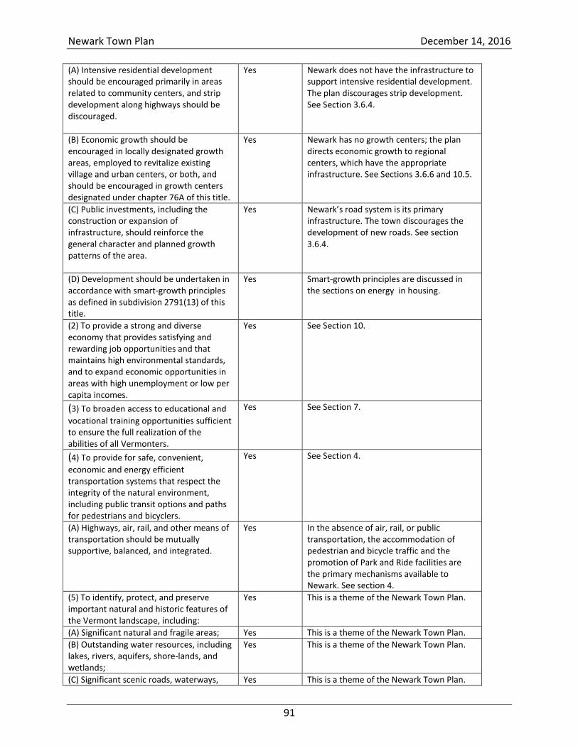
Newark Town Plan December 14, 2016
91
(A) Intensive residential development should be encouraged primarily in areas related to community centers, and strip development along highways should be discouraged.
Yes Newark does not have the infrastructure to support intensive residential development. The plan discourages strip development. See Section 3.6.4.
(B) Economic growth should be encouraged in locally designated growth areas, employed to revitalize existing village and urban centers, or both, and should be encouraged in growth centers designated under chapter 76A of this title.
Yes Newark has no growth centers; the plan directs economic growth to regional centers, which have the appropriate infrastructure. See Sections 3.6.6 and 10.5.
(C) Public investments, including the construction or expansion of infrastructure, should reinforce the general character and planned growth patterns of the area.
Yes Newark’s road system is its primary infrastructure. The town discourages the development of new roads. See section 3.6.4.
(D) Development should be undertaken in accordance with smart-growth principles as defined in subdivision 2791(13) of this title.
Yes Smart-growth principles are discussed in the sections on energy in housing.
(2) To provide a strong and diverse economy that provides satisfying and rewarding job opportunities and that maintains high environmental standards, and to expand economic opportunities in areas with high unemployment or low per capita incomes.
Yes See Section 10.
(3) To broaden access to educational and
vocational training opportunities sufficient to ensure the full realization of the abilities of all Vermonters.
Yes See Section 7.
(4) To provide for safe, convenient,
economic and energy efficient transportation systems that respect the integrity of the natural environment, including public transit options and paths for pedestrians and bicyclers.
Yes See Section 4.
(A) Highways, air, rail, and other means of transportation should be mutually supportive, balanced, and integrated.
Yes In the absence of air, rail, or public transportation, the accommodation of pedestrian and bicycle traffic and the promotion of Park and Ride facilities are the primary mechanisms available to Newark. See section 4.
(5) To identify, protect, and preserve important natural and historic features of the Vermont landscape, including:
Yes This is a theme of the Newark Town Plan.
(A) Significant natural and fragile areas; Yes This is a theme of the Newark Town Plan.
(B) Outstanding water resources, including lakes, rivers, aquifers, shore-lands, and wetlands;
Yes This is a theme of the Newark Town Plan.
(C) Significant scenic roads, waterways, Yes This is a theme of the Newark Town Plan.
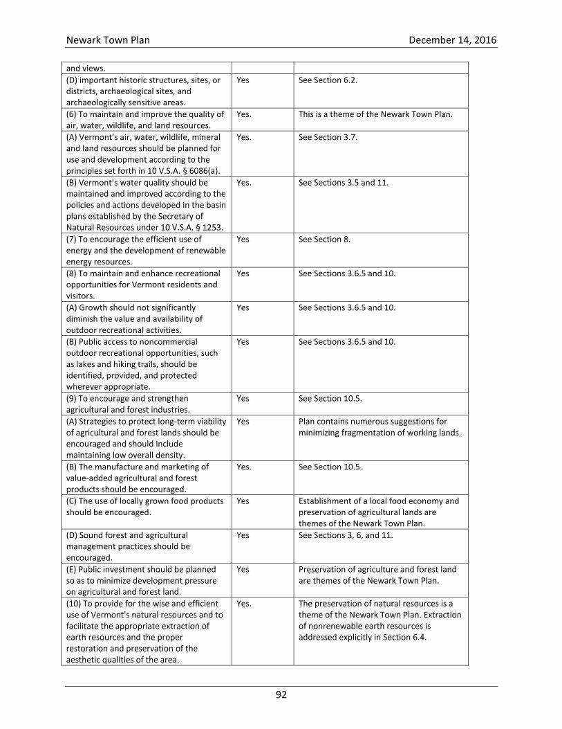
Newark Town Plan December 14, 2016
92
and views.
(D) important historic structures, sites, or districts, archaeological sites, and archaeologically sensitive areas.
Yes See Section 6.2.
(6) To maintain and improve the quality of air, water, wildlife, and land resources.
Yes. This is a theme of the Newark Town Plan.
(A) Vermont's air, water, wildlife, mineral and land resources should be planned for use and development according to the principles set forth in 10 V.S.A. § 6086(a).
Yes. See Section 3.7.
(B) Vermont’s water quality should be maintained and improved according to the policies and actions developed in the basin plans established by the Secretary of Natural Resources under 10 V.S.A. § 1253.
Yes. See Sections 3.5 and 11.
(7) To encourage the efficient use of energy and the development of renewable energy resources.
Yes See Section 8.
(8) To maintain and enhance recreational opportunities for Vermont residents and visitors.
Yes See Sections 3.6.5 and 10.
(A) Growth should not significantly diminish the value and availability of outdoor recreational activities.
Yes See Sections 3.6.5 and 10.
(B) Public access to noncommercial outdoor recreational opportunities, such as lakes and hiking trails, should be identified, provided, and protected wherever appropriate.
Yes See Sections 3.6.5 and 10.
(9) To encourage and strengthen agricultural and forest industries.
Yes See Section 10.5.
(A) Strategies to protect long-term viability of agricultural and forest lands should be encouraged and should include maintaining low overall density.
Yes Plan contains numerous suggestions for minimizing fragmentation of working lands.
(B) The manufacture and marketing of value-added agricultural and forest products should be encouraged.
Yes. See Section 10.5.
(C) The use of locally grown food products should be encouraged.
Yes Establishment of a local food economy and preservation of agricultural lands are themes of the Newark Town Plan.
(D) Sound forest and agricultural management practices should be encouraged.
Yes See Sections 3, 6, and 11.
(E) Public investment should be planned so as to minimize development pressure on agricultural and forest land.
Yes Preservation of agriculture and forest land are themes of the Newark Town Plan.
(10) To provide for the wise and efficient use of Vermont's natural resources and to facilitate the appropriate extraction of earth resources and the proper restoration and preservation of the aesthetic qualities of the area.
Yes. The preservation of natural resources is a theme of the Newark Town Plan. Extraction of nonrenewable earth resources is addressed explicitly in Section 6.4.
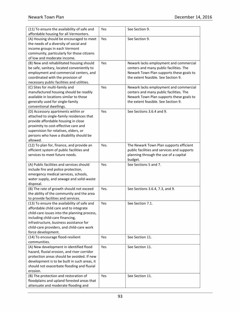
Newark Town Plan December 14, 2016
93
(11) To ensure the availability of safe and affordable housing for all Vermonters.
Yes See Section 9.
(A) Housing should be encouraged to meet the needs of a diversity of social and income groups in each Vermont community, particularly for those citizens of low and moderate income.
Yes See Section 9.
(B) New and rehabilitated housing should be safe, sanitary, located conveniently to employment and commercial centers, and coordinated with the provision of necessary public facilities and utilities.
Yes Newark lacks employment and commercial centers and many public facilities. The Newark Town Plan supports these goals to the extent feasible. See Section 9.
(C) Sites for multi-family and manufactured housing should be readily available in locations similar to those generally used for single-family conventional dwellings.
Yes Newark lacks employment and commercial centers and many public facilities. The Newark Town Plan supports these goals to the extent feasible. See Section 9.
(D) Accessory apartments within or attached to single-family residences that provide affordable housing in close proximity to cost-effective care and supervision for relatives, elders, or persons who have a disability should be allowed.
Yes See Sections 3.6.4 and 9.
(12) To plan for, finance, and provide an efficient system of public facilities and services to meet future needs.
Yes. The Newark Town Plan supports efficient public facilities and services and supports planning through the use of a capital budget.
(A) Public facilities and services should include fire and police protection, emergency medical services, schools, water supply, and sewage and solid-waste disposal.
Yes See Sections 5 and 7.
(B) The rate of growth should not exceed the ability of the community and the area to provide facilities and services.
Yes. See Sections 3.6.4, 7.3, and 9.
(13) To ensure the availability of safe and affordable child care and to integrate child-care issues into the planning process, including child-care financing, infrastructure, business assistance for child-care providers, and child-care work force development.
Yes See Section 7.1.
(14) To encourage flood-resilient communities.
Yes See Section 11.
(A) New development in identified flood hazard, fluvial erosion, and river corridor protection areas should be avoided. If new development is to be built in such areas, it should not exacerbate flooding and fluvial erosion.
Yes See Section 11.
(B) The protection and restoration of floodplains and upland forested areas that attenuate and moderate flooding and
Yes See Section 11.
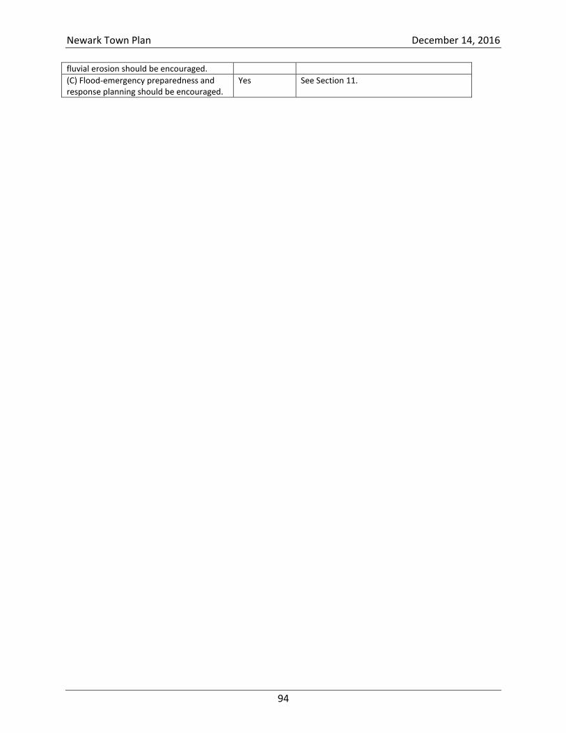
Newark Town Plan December 14, 2016
94
fluvial erosion should be encouraged.
(C) Flood-emergency preparedness and response planning should be encouraged.
Yes See Section 11.
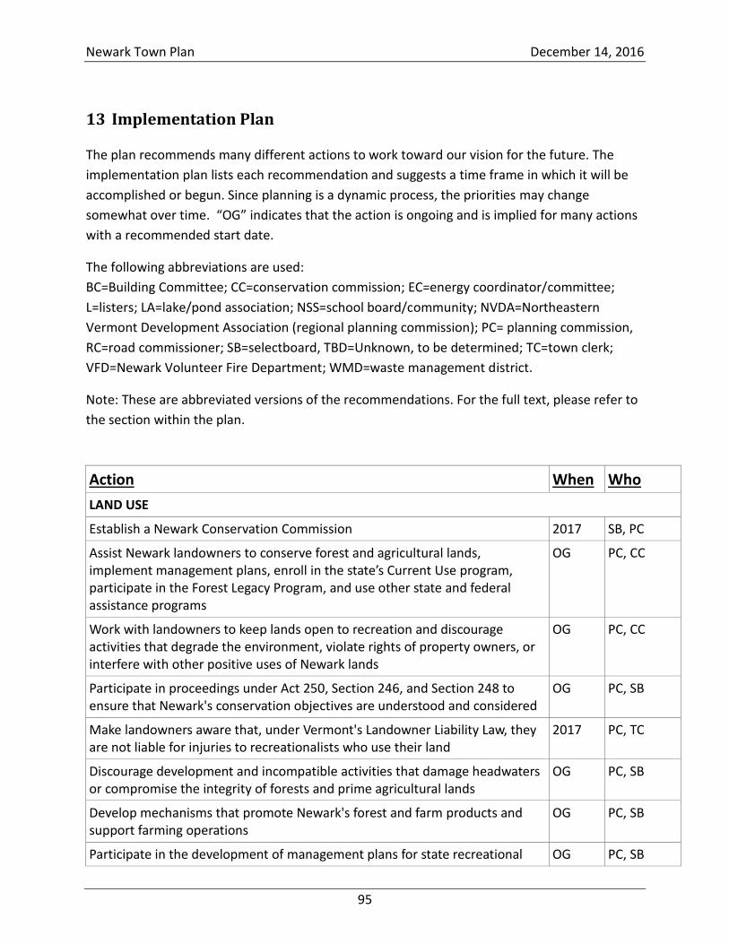
Newark Town Plan December 14, 2016
95
13 Implementation Plan
The plan recommends many different actions to work toward our vision for the future. The
implementation plan lists each recommendation and suggests a time frame in which it will be
accomplished or begun. Since planning is a dynamic process, the priorities may change
somewhat over time. “OG” indicates that the action is ongoing and is implied for many actions
with a recommended start date.
The following abbreviations are used:
BC=Building Committee; CC=conservation commission; EC=energy coordinator/committee;
L=listers; LA=lake/pond association; NSS=school board/community; NVDA=Northeastern
Vermont Development Association (regional planning commission); PC= planning commission,
RC=road commissioner; SB=selectboard, TBD=Unknown, to be determined; TC=town clerk;
VFD=Newark Volunteer Fire Department; WMD=waste management district.
Note: These are abbreviated versions of the recommendations. For the full text, please refer to
the section within the plan.
Action When Who
LAND USE
Establish a Newark Conservation Commission 2017 SB, PC
Assist Newark landowners to conserve forest and agricultural lands, implement management plans, enroll in the state’s Current Use program, participate in the Forest Legacy Program, and use other state and federal assistance programs
OG PC, CC
Work with landowners to keep lands open to recreation and discourage activities that degrade the environment, violate rights of property owners, or interfere with other positive uses of Newark lands
OG PC, CC
Participate in proceedings under Act 250, Section 246, and Section 248 to ensure that Newark's conservation objectives are understood and considered
OG PC, SB
Make landowners aware that, under Vermont's Landowner Liability Law, they are not liable for injuries to recreationalists who use their land
2017 PC, TC
Discourage development and incompatible activities that damage headwaters or compromise the integrity of forests and prime agricultural lands
OG PC, SB
Develop mechanisms that promote Newark's forest and farm products and support farming operations
OG PC, SB
Participate in the development of management plans for state recreational OG PC, SB
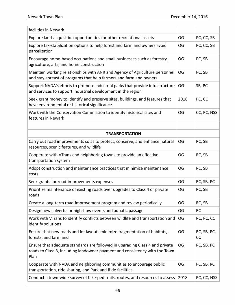
Newark Town Plan December 14, 2016
96
facilities in Newark
Explore land-acquisition opportunities for other recreational assets OG PC, CC, SB
Explore tax-stabilization options to help forest and farmland owners avoid parcelization
OG PC, CC, SB
Encourage home-based occupations and small businesses such as forestry, agriculture, arts, and home construction
OG PC, SB
Maintain working relationships with ANR and Agency of Agriculture personnel and stay abreast of programs that help farmers and farmland owners
OG PC, SB
Support NVDA's efforts to promote industrial parks that provide infrastructure and services to support industrial development in the region
OG SB, PC
Seek grant money to identify and preserve sites, buildings, and features that have environmental or historical significance
2018 PC, CC
Work with the Conservation Commission to identify historical sites and features in Newark
OG CC, PC, NSS
TRANSPORTATION
Carry out road improvements so as to protect, conserve, and enhance natural resources, scenic features, and wildlife
OG RC, SB
Cooperate with VTrans and neighboring towns to provide an effective transportation system
OG RC, SB
Adopt construction and maintenance practices that minimize maintenance costs
OG RC, SB
Seek grants for road-improvements expenses OG RC, SB, PC
Prioritize maintenance of existing roads over upgrades to Class 4 or private roads
OG RC, SB
Create a long-term road-improvement program and review periodically OG RC, SB
Design new culverts for high-flow events and aquatic passage OG RC
Work with VTrans to identify conflicts between wildlife and transportation and identify solutions
OG RC, PC, CC
Ensure that new roads and lot layouts minimize fragmentation of habitats, forests, and farmland
OG RC, SB, PC, CC
Ensure that adequate standards are followed in upgrading Class 4 and private roads to Class 3, including landowner payment and consistency with the Town Plan
OG RC, SB, PC
Cooperate with NVDA and neighboring communities to encourage public transportation, ride sharing, and Park and Ride facilities
OG PC, SB, RC
Conduct a town-wide survey of bike-ped trails, routes, and resources to assess 2018 PC, CC, NSS
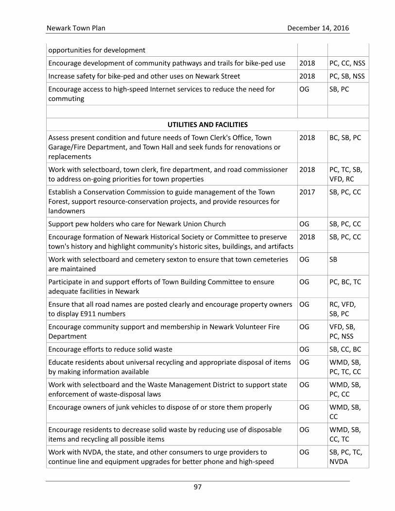
Newark Town Plan December 14, 2016
97
opportunities for development
Encourage development of community pathways and trails for bike-ped use 2018 PC, CC, NSS
Increase safety for bike-ped and other uses on Newark Street 2018 PC, SB, NSS
Encourage access to high-speed Internet services to reduce the need for commuting
OG SB, PC
UTILITIES AND FACILITIES
Assess present condition and future needs of Town Clerk's Office, Town Garage/Fire Department, and Town Hall and seek funds for renovations or replacements
2018 BC, SB, PC
Work with selectboard, town clerk, fire department, and road commissioner to address on-going priorities for town properties
2018 PC, TC, SB, VFD, RC
Establish a Conservation Commission to guide management of the Town Forest, support resource-conservation projects, and provide resources for landowners
2017 SB, PC, CC
Support pew holders who care for Newark Union Church OG SB, PC, CC
Encourage formation of Newark Historical Society or Committee to preserve town's history and highlight community's historic sites, buildings, and artifacts
2018 SB, PC, CC
Work with selectboard and cemetery sexton to ensure that town cemeteries are maintained
OG SB
Participate in and support efforts of Town Building Committee to ensure adequate facilities in Newark
OG PC, BC, TC
Ensure that all road names are posted clearly and encourage property owners to display E911 numbers
OG RC, VFD, SB, PC
Encourage community support and membership in Newark Volunteer Fire Department
OG VFD, SB, PC, NSS
Encourage efforts to reduce solid waste OG SB, CC, BC
Educate residents about universal recycling and appropriate disposal of items by making information available
OG WMD, SB, PC, TC, CC
Work with selectboard and the Waste Management District to support state enforcement of waste-disposal laws
OG WMD, SB, PC, CC
Encourage owners of junk vehicles to dispose of or store them properly OG WMD, SB, CC
Encourage residents to decrease solid waste by reducing use of disposable items and recycling all possible items
OG WMD, SB, CC, TC
Work with NVDA, the state, and other consumers to urge providers to continue line and equipment upgrades for better phone and high-speed
OG SB, PC, TC, NVDA
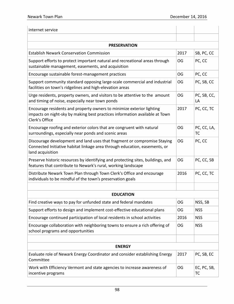
Newark Town Plan December 14, 2016
98
internet service
PRESERVATION
Establish Newark Conservation Commission 2017 SB, PC, CC
Support efforts to protect important natural and recreational areas through sustainable management, easements, and acquisition
OG PC, CC
Encourage sustainable forest-management practices OG PC, CC
Support community standard opposing large-scale commercial and industrial facilities on town's ridgelines and high-elevation areas
OG PC, SB, CC
Urge residents, property owners, and visitors to be attentive to the amount and timing of noise, especially near town ponds
OG PC, SB, CC, LA
Encourage residents and property owners to minimize exterior lighting impacts on night-sky by making best practices information available at Town Clerk's Office
2017 PC, CC, TC
Encourage roofing and exterior colors that are congruent with natural surroundings, especially near ponds and scenic areas
OG PC, CC, LA, TC
Discourage development and land uses that fragment or compromise Staying Connected Initiative habitat linkage area through education, easements, or land acquisition
OG PC, CC
Preserve historic resources by identifying and protecting sites, buildings, and features that contribute to Newark's rural, working landscape
OG PC, CC, SB
Distribute Newark Town Plan through Town Clerk's Office and encourage individuals to be mindful of the town’s preservation goals
2016
PC, CC, TC
EDUCATION
Find creative ways to pay for unfunded state and federal mandates OG NSS, SB
Support efforts to design and implement cost-effective educational plans OG NSS
Encourage continued participation of local residents in school activities 2016 NSS
Encourage collaboration with neighboring towns to ensure a rich offering of school programs and opportunities
OG NSS
ENERGY
Evaluate role of Newark Energy Coordinator and consider establishing Energy Committee
2017 PC, SB, EC
Work with Efficiency Vermont and state agencies to increase awareness of incentive programs
OG EC, PC, SB, TC
Newark Town Plan December 14, 2016
99
Encourage conversion to modern wood heating OG EC
Encourage builders to adopt best energy practices in new construction OG EC
Encourage residents to upgrade thermal efficiency of existing buildings OG EC
Encourage residents to consider solar hot water OG EC
Explore ride-sharing programs OG PC, RC, EC
Explore the creation of Park and Ride facilities with neighboring communities 2018 PC, RC
Encourage cooperative transportation arrangements for Newark's high school students
OG NSS
Encourage small net-metering projects OG EC, PC
Discourage large-scale net metering that might saturate local distribution lines OG EC, PC
Collaborate with VEC and LED to help Newark homeowners net meter OG EC, PC
Collaborate with VEC and LED to identify appropriate locations for electrical generation, consistent with Newark's goals and vision
2017 EC, PC
Promote awareness of local sources of energy and opportunities to employ renewable energy in applications that are compatible with Newark's vision and goals
OG EC, PC
Explore opportunities to establish an appropriately sited community solar facility to power municipal properties
2017 EC, PC, SB, BC
Recommend cost-effective energy conservation and efficiency measures as well as modifications that will make use of renewable energy
2017 EC, PC
Implement energy efficiency measures for existing and future community facilities as opportunities arise
OG EC, PC, SB, BC
Prioritize modifications and efficiency improvements and incorporate them into town's capital budget
OG SB, BC, EC
HOUSING
Support housing that reinforces historic settlement patterns and preserves and improves existing structures
OG PC, BC
Preserve historic buildings as an important part of the town's heritage OG PC, BC
Explore the use of regulatory and nonregulatory methods of managing growth, discouraging types of development that would alter the character of the town or strain local transportation, safety, and health systems
OG PC, SB
Explore the creation of village designation in the Newark Street area 2019 PC, SB
Locate future public community facilities in the Newark Street village area 2017 SB, BC, PC
Avoid fragmentation in outlying areas by designing development so that the extension of roads, driveways, and infrastructure is minimized or shared
2017 SB, BC
Newark Town Plan December 14, 2016
100
Promote smart-growth principles for subdivisions so as to avoid unnecessary fragmentation of wildlife habitats and distinct timber stands and to allow for access for long-term forest-management
2017 SB, PC
Ensure a variety of housing units for all income levels and rehabilitate existing structures when possible
OG SB, PC
Task the Building Committee to evaluate the town's future needs for affordable and senior housing
2019 SB, PC, BC
Keep housing affordable by encouraging appropriately sized lots, accessory dwellings, and clustered developments, consistent with desire to maintain Newark's rural quality
OG SB, PC, BC
Promote and support federal and state programs for weatherization, rehabilitation, and home financing; construction and improvement of affordable housing; and housing for seniors by making information available through Town Clerk’s Office
2018 SB, PC, TC, BC, EC
Encourage housing in Newark that is sufficiently valued to help defray the cost of public services
OG SB, PC
Support efforts to weatherize homes, increase energy efficiency, and reduce energy consumption
OG SB, PC, EC
Plan future housing for locations that complement existing or planned employment locations, reduce travel times and the need for road upgrades and extensions, and minimize the energy spent on transportation
OG SB, PC, EC
Incorporate sound principles of site design for reducing energy use OG SB, PC, EC
Compile examples of energy-efficient site design, landscaping, and structure design to guide builders, and homeowners in order to promote high-quality, energy-efficient, and environmentally sound housing
OG SB, PC, EC, BC
ECONOMIC DEVELOPMENT
Support orderly development that encourages, promotes, and preserves the town's scenic beauty, character, historic built environment, quality of life, and economic well-being of Newark's citizens
OG SB, PC
Promote economic development that honors the rural, historic, scenic, natural resources, and character of Newark
OG SB, PC
Encourage local tourism by protecting historic and natural resources and expanding recreational and cultural opportunities for residents and visitors
OG SB, PC, CC
Support economic development that encourages environmentally sustainable small and home-based enterprises
OG SB, PC
Encourage goods-producing endeavors, such as home construction, the arts, forestry, and agriculture
OG SB, PC

Newark Town Plan December 14, 2016
101
Create an inventory of existing and potential recreational opportunities in town
2018 PC, CC, NSS
Encourage sustainable, low-impact, commercial and recreational enterprise OG PC, SB, CC
Work with NVDA and service providers to expand access to high-speed Internet
OG SB, PC
Maintain open communication and partnerships with neighboring towns and NVDA to attract businesses to the area
OG SB, PC
Work with the NVDA to maximize benefit from regional, state, and federal programs to support local economic growth
OG SB, PC
Promote local economic development and a skilled workforce by supporting access to educational and training opportunities
OG SB, PC
Encourage selectboard and planning commission to review and participate in Act 250 proceedings and other state, regional, and local hearings that involve commercial development
OG SB, PC
Inform local entrepreneurs about small-business services and funds by making information available through the town office
2019 PC, SB, TC
Encourage a diversity of local enterprises that use local labor OG SB, PC
Encourage residents to buy local and support fellow community members OG SB, PC
Leverage our proximity to the NVDA’s industrial parks and support NVDA efforts to add amenities and encourage businesses to locate there.
OG SB, PC
FLOOD RESILIENCE
Work with landowners to preserve and restore riparian areas OG PC, CC, SB
Work to increase forest cover in riparian areas and upland forests adjacent to riparian areas and wetlands
OG PC, CC, SB
Work with ANR and Agency of Agriculture to ensure that property owners adhere to forest-management plans that improve flood resilience and agricultural practices that do not detract from flood resilience
OG PC, CC
Support the conservation of lands located in the FEMA-mapped flood-hazard areas
OG PC, CC, SB
Support orderly development that preserves the town's water and forest resources and oppose development that negatively impacts watershed health and function
OG PC, CC, SB
Review and participate in Act 250, Section 248, and other proceedings that involve development that may impact Newark's water resources
OG PC, CC, SB
Work with landowners in priority areas with important floodplain protection or restoration opportunities to participate in conservation and restoration
OG PC, SB
Newark Town Plan December 14, 2016
102
programs
Support best practices guidelines in forestry and agriculture and make information available in the town office
OG PC, SB, TC
Consider standards for stream-bank setbacks and buffers based on geomorphic standards and river-corridor information identified by the Vermont Department of Environmental Conservation
2019 PC, SB
Work with Newark Selectboard to review and update the town's LEOP and All-Hazards Mitigation Plan
2017 PC, SB
Work with Newark Selectboard to evaluate costs and benefits of meeting the state’s ERAF requirements
2017 PC, SB
Coordinate with NVDA, Vermont League of Cities and Towns, and others to conduct a workshop on flood resilience
2017 PC, SB
Work with selectboard to determine next steps in Newark's flood-resilience plan
2017 PC, SB
Work with selectboard and road commissioner to update town road-erosion inventory and capital-budget plan
OG PC, SB, RC
Work with NVDA and others to identify funding for necessary capital improvements
OG PC, SB, RC
Work with selectboard and road commissioner to ensure that all maintenance and new infrastructure projects meet best practices for flood resilience
OG PC, SB, RC
2016 Town Plan
Newark, Vermont
December 14, 2016
Appendix A—Maps

Newark Town Plan Appendix A December 14, 2016
A-1
Table of Maps
Map 1 Newark's location in Vermont ............................................................................................ 2
Map 2 Newark and neighboring towns ......................................................................................... 3
Map 3 Newark in 1875 ................................................................................................................... 4
Map 4 Newark land-use map ......................................................................................................... 5
Map 5 Topographical features ....................................................................................................... 6
Map 6 Newark's bedrock formations ............................................................................................ 7
Map 7 Newark's watersheds .......................................................................................................... 8
Map 8 Newark's forest blocks ........................................................................................................ 9
Map 9 Six priority wildlife linkages identified by the Staying Connected Initiative .................... 10
Map 10 Newark's critical location in the SCI wildlife corridor ..................................................... 11
Map 11 Prime agricultural soils in Newark .................................................................................. 12
Map 12 Homes, camps, and other buildings ............................................................................... 13
Map 13 State and municipal recreational, service, and educational facilities ............................ 14
Map 14 Bald Hill WMA, conserved lands, parcels enrolled in Current Use ................................ 15
Map 15 Newark Highway Map (Vermont Agency of Transportation) ......................................... 16
Map 16 Newark elevation map .................................................................................................... 17
Map 17 Potential riparian restoration sites along the East Branch of the Passumpsic River ..... 18
Map 18 Erodible and shallow soils and steep slopes .................................................................. 19
These maps were gathered from a variety of sources, including archives, the Newark Natural
Resource Inventory, the Staying Connected Initiative, and various state agencies. Some of the
maps were constructed for the Newark Town Plan with data obtained from state and federal
sources.
There is simply too much land-use information to place on a single map. Information from other
maps should be used to supplement Map 4 Newark land-use map in order to inform decisions
about appropriate uses of land in Newark.
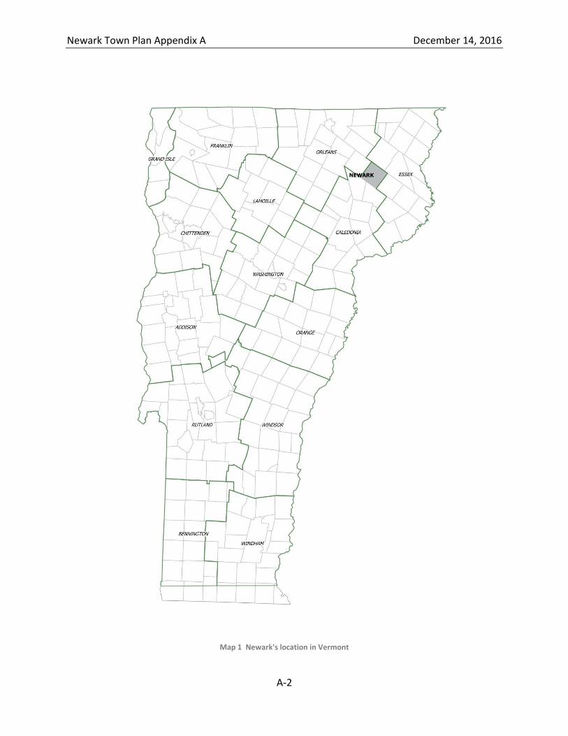
Newark Town Plan Appendix A December 14, 2016
A-2
Map 1 Newark's location in Vermont
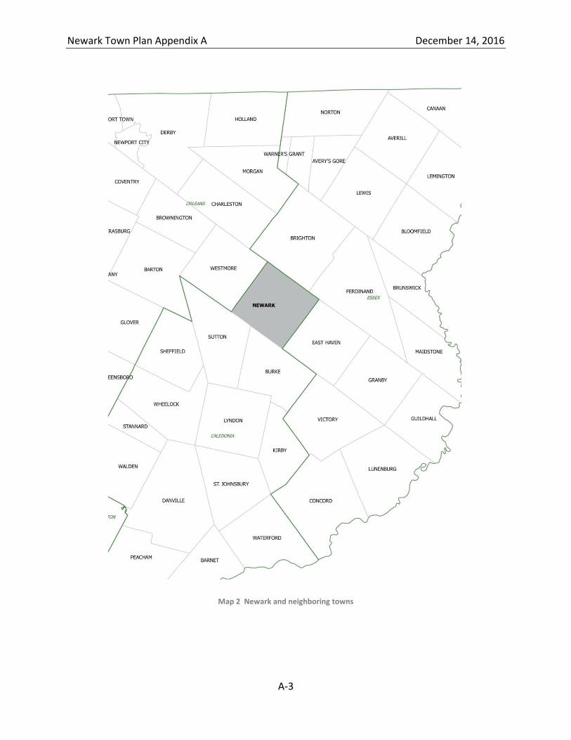
Newark Town Plan Appendix A December 14, 2016
A-3
Map 2 Newark and neighboring towns
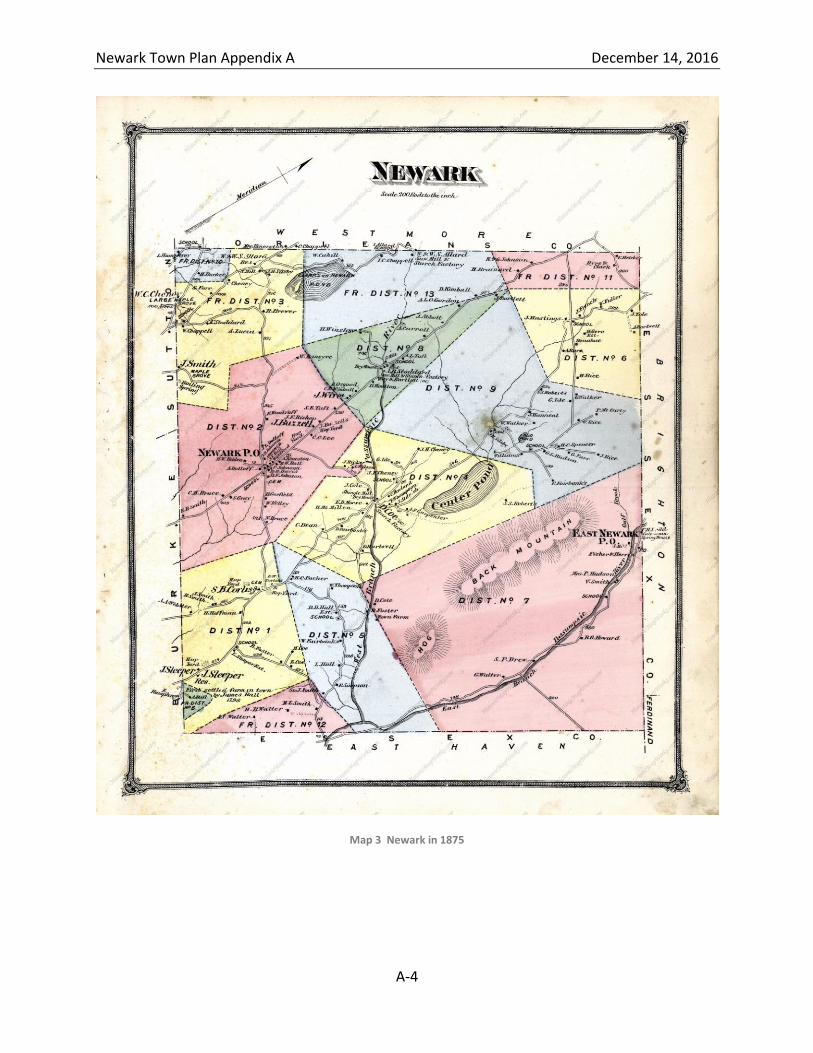
Newark Town Plan Appendix A December 14, 2016
A-4
Map 3 Newark in 1875
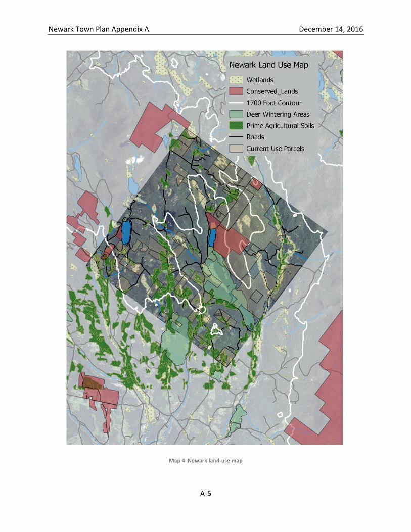
Newark Town Plan Appendix A December 14, 2016
A-5
Map 4 Newark land-use map
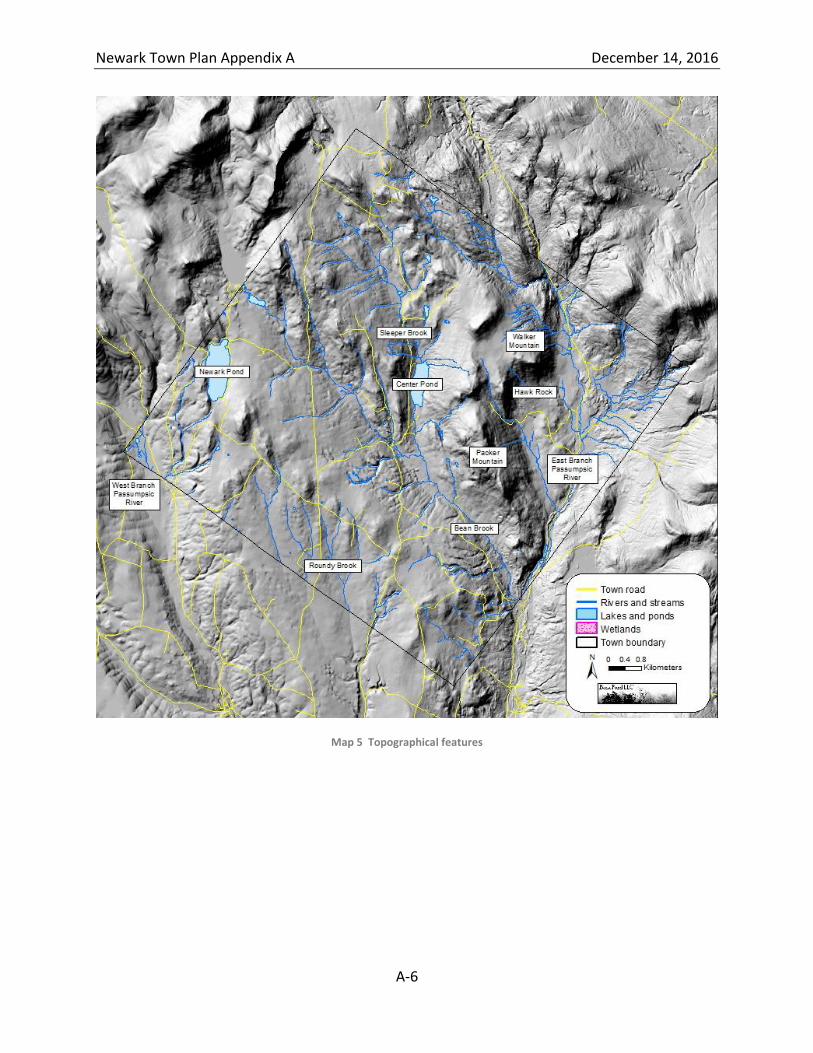
Newark Town Plan Appendix A December 14, 2016
A-6
Map 5 Topographical features
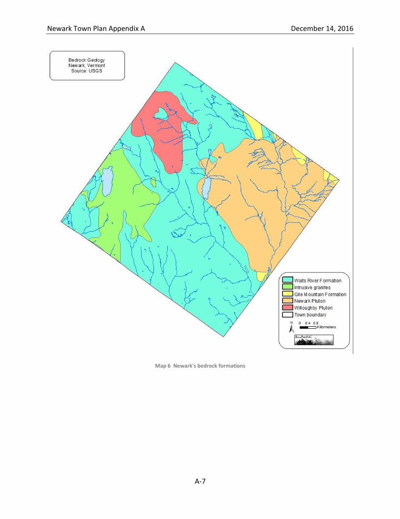
Newark Town Plan Appendix A December 14, 2016
A-7
Map 6 Newark's bedrock formations
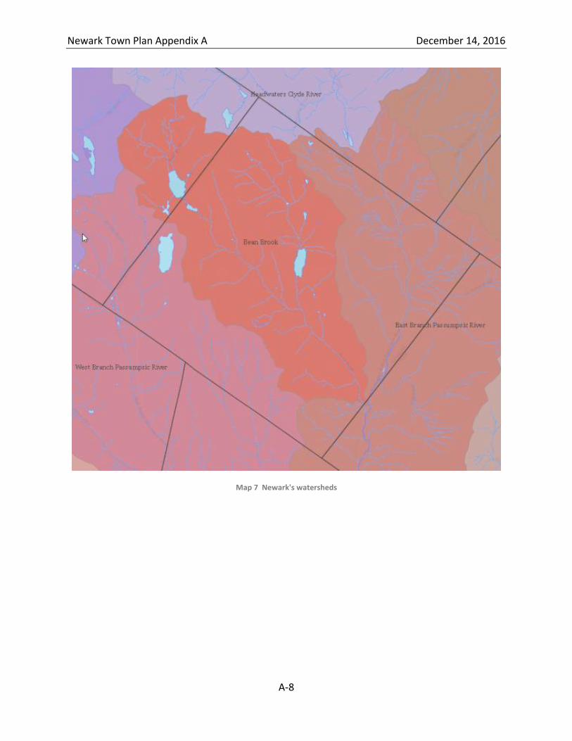
Newark Town Plan Appendix A December 14, 2016
A-8
Map 7 Newark's watersheds
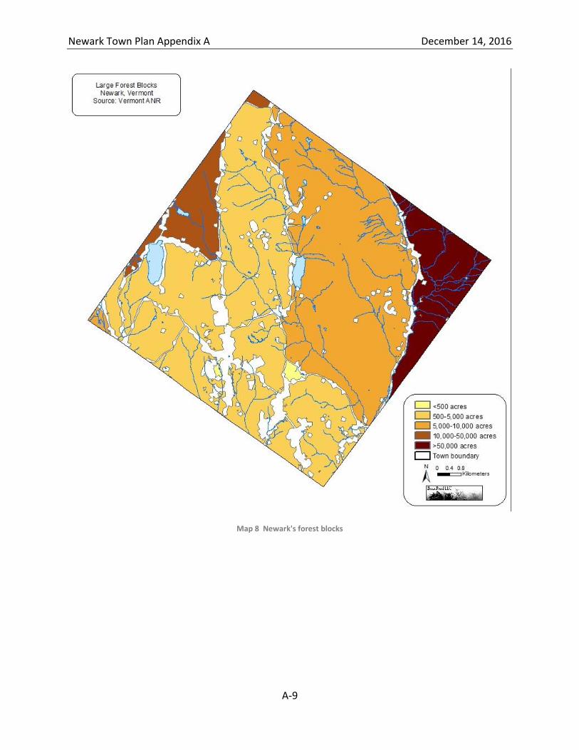
Newark Town Plan Appendix A December 14, 2016
A-9
Map 8 Newark's forest blocks
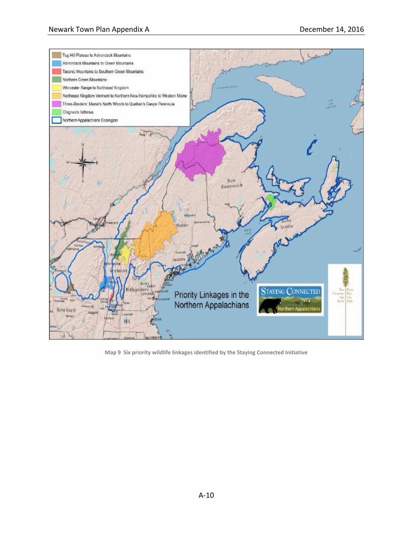
Newark Town Plan Appendix A December 14, 2016
A-10
Map 9 Six priority wildlife linkages identified by the Staying Connected Initiative
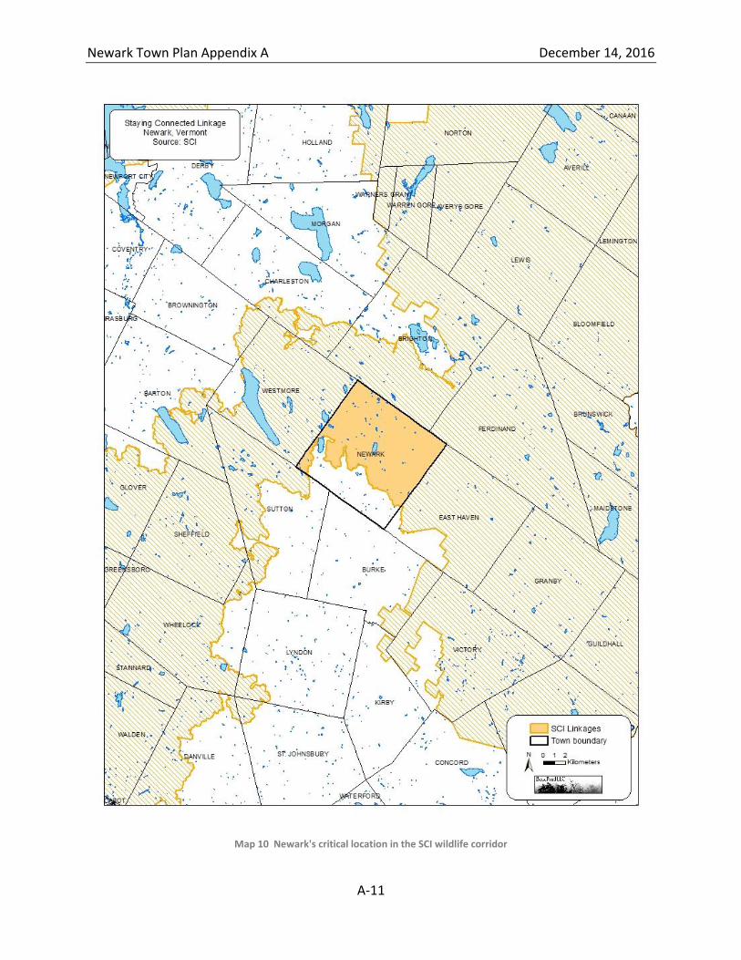
Newark Town Plan Appendix A December 14, 2016
A-11
Map 10 Newark's critical location in the SCI wildlife corridor
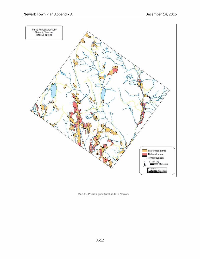
Newark Town Plan Appendix A December 14, 2016
A-12
Map 11 Prime agricultural soils in Newark
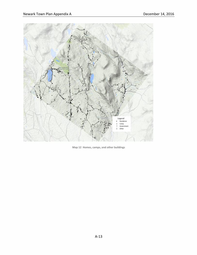
Newark Town Plan Appendix A December 14, 2016
A-13
Map 12 Homes, camps, and other buildings
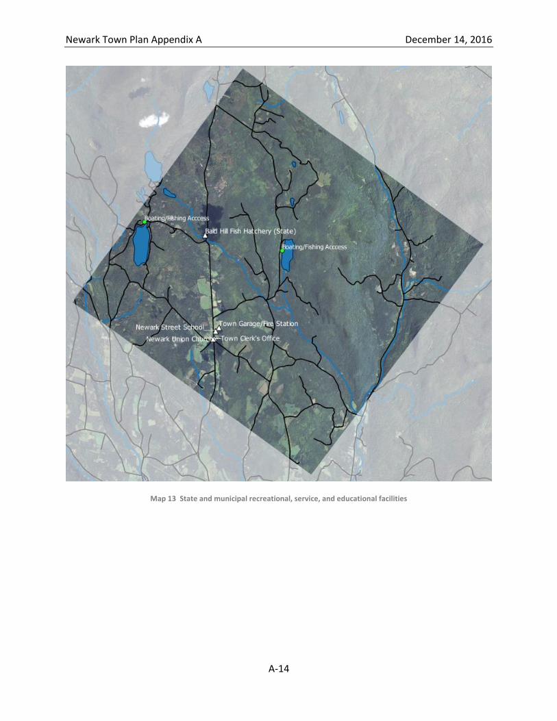
Newark Town Plan Appendix A December 14, 2016
A-14
Map 13 State and municipal recreational, service, and educational facilities
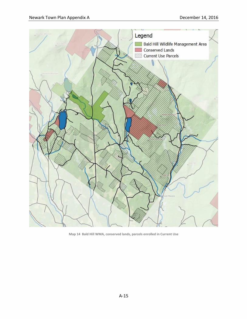
Newark Town Plan Appendix A December 14, 2016
A-15
Map 14 Bald Hill WMA, conserved lands, parcels enrolled in Current Use
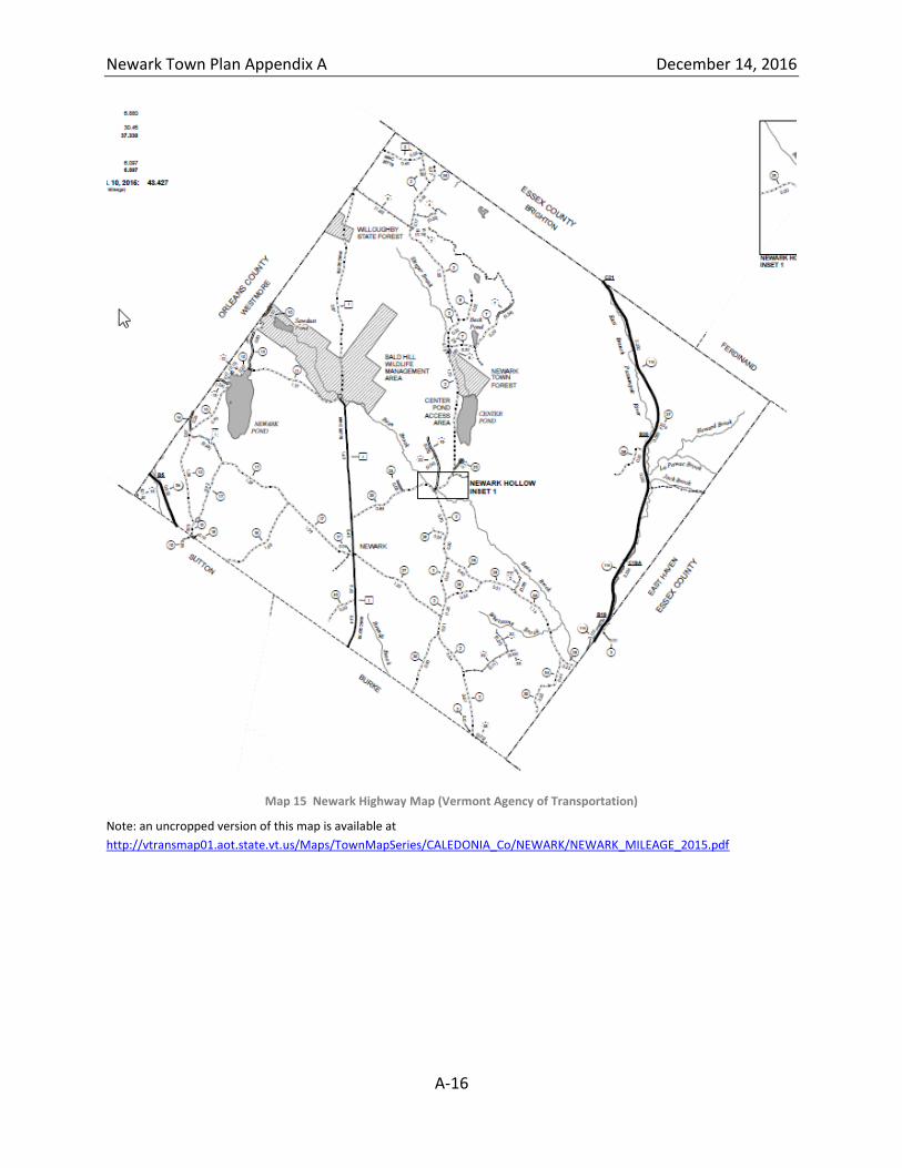
Newark Town Plan Appendix A December 14, 2016
A-16
Map 15 Newark Highway Map (Vermont Agency of Transportation)
Note: an uncropped version of this map is available at
http://vtransmap01.aot.state.vt.us/Maps/TownMapSeries/CALEDONIA_Co/NEWARK/NEWARK_MILEAGE_2015.pdf
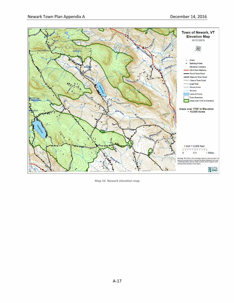
Newark Town Plan Appendix A December 14, 2016
A-17
Map 16 Newark elevation map
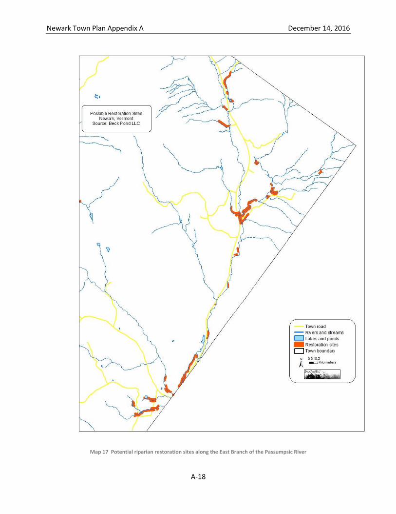
Newark Town Plan Appendix A December 14, 2016
A-18
Map 17 Potential riparian restoration sites along the East Branch of the Passumpsic River
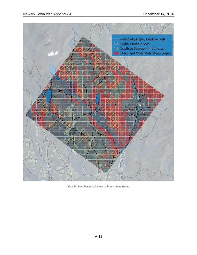
Newark Town Plan Appendix A December 14, 2016
A-19
Map 18 Erodible and shallow soils and steep slopes