Embed Size (px)
Citation preview
I
e
-.
SECOND
ANNUAL REPORT ON 7Ifl
GEOLOGY OF VERMONT. i:HiI
• V V• V .V
V V V VVV; •, ..................• V - V•S -.:'-• V V V V V V *er.'VVVV V
SECOND
ANNUAL REPORT
ON THE
GEOLOGY
OF THE
STATE OF VERMONT.
BY C. B. ADAMS, State Goologlst,Teof. Chem. and Nat. Hist. In Middlebury College, Corroep. member of the
fleet. Soc. Nat. Iliet., of the Entom. Soc. of Pa., member of the Assoc. Amer. Goologiets, &c. &c.
BURLINGTON; CHAUNCEY GOODRICH.
-I S46.
I
:1
0
0
I I
S p :.
To His Excellencij WILLIA1I SLADE, Governor of Vermont:
Siit,
I herewith submit the second report on the Geology of Vermont,
and have the honor to remain, your Excellency's obedient servant,
C. B. ADAms, State Geologist.
Middlebury, Oct. 1, 1846.
I
CONTENTS.
List of engravings, Index of towns and counties, Errata,
INTRODUCTION.
history of the Survey from Oct. 1845, to Oct. 1846,
PART I. ELEMENTARY GEOLOGY.
Design of this part,
Crr. I. GEOLOGICAL AGENCIES.
Intensity of geological agencies,
Classification of " "
Igneous agencies, . .
Subaerial agency, .
Volcanoes, . Eruptions, . Static pressure in volcanoes, Character of lava,
Earthquakes, . Thermal springs,
Submarine igneous agency, Volcanic islands,
Subterranean igneous agency, Theory of geysers and of volcanoes, Theory of internal heat,
Aqueous agencies, . Aqueous agencies not marine,
Rain ; frost, .
Rivers, . . Landslides; glaciers,
Springs, .
Jo
20 21 21 22 22 22 29 29 30 31 32 32 32 33 37 38 39 39 40
44
2 3
Oceanic agencies, . . 45 Primary strata, . . . . . . . 104
Waves, . . . . Duration of genera, . . . . . . 105
Oceanic currents, 47 Connection of geology with the bible, . . . . 106
Icebergs, . . 49
General results of igneous and aqueous agencies, . . 52 PART H. MINERALOGY.
Organic agencies, . . . . . . Localities of minerals, . . . . . . ioo Classfication of the animal kingdom, 53
PART III. CONCRETIONS.
Organic deposits, . . . . . 59 Power of concretion, . . . . . . ill Corals. . . . . . . . 59 Law " " . . . . . 112 Animalcules, . , . . . . 61 Constitution of concretions, . . . . 115 Vegetable deposits, . . . . 62 Comparison of concretion with crystalization, . . . 117
Origin of fossil bodies, . . . . . 63 Classification of forms, . . . . . . 117 Human agency, . . . . . 63 Concretions in Vermont, . . . . . 118 Petrifaction, . . . . . . 65 Burial of organic bodies, . . . - 65 PART IV. SCIENTIFIC GEOLOGY.
Durability of " is . . . 66 GEOLOGY OF VERMONT, . 120 Principles of zoology applied to the study of fossils, . . 70 Quaternary system, . . . . . . 121
Geographical distribution of species, . . . 70 Drift, . . . . . . . 122 Extinction of species, . . . . . 73 General distribution of drift, . . . . 121 Introduction " " . . . . 75 Drift moraines, . . . . . . 122 Duration is
" . . . . 77 Dispersion of drift, . . . . . 123 Determination of organic remains, . . . . 79 Furrows, scratches, and rounded and polished rocks, . 125 Comparative number of living and fossil species, . . 90 Streams of stones, . . . . . 128
Fracture of slate hills, . . . . . 131 Cuip. II. HIsToRY OF THE EARTH. Age of the drift, . . . . . . 138
Theories of drift, and submergence of Vermont during the Tabular view of the geological formations, . . . 83 drift period, . . . . . 139 Quaternary period, . . . . . 87 Older pleistocene, . . . . . . 140
Newer pleistocene, . . . . . . 87 Deposits, . . . . . . . 140 Drift period, . . . . . . . 90 Blue clay, . . . . . - 141
Older pleistocene, . . . . . . 90 Marine, with fossils, - . . . 141 Characters of drift, . . . . . . 91 Not marine, without fossils, . . . 141 Theories " " . . . . . . Brown clay, . . . . . 141
Iceberg theory of drift, . . . . Marine, with fossils, . . . . 141 Glacio-aqueous " " . . . . . Not marine, without fossils, . . . 142 Theory of elevations, . . . . Sand, . . . . . . 142
Tertiary system, . . . . . . . 96 Marine, with fossils, . ., . . 142 Cretaceous " . - . . . . . Not marine, without fossils, . . . 142 Wealden group, - . . . . . . Origin, . . . . . . . 143 Oölitic system, . . . . . 98 Oceanic currents, . - - . 144 Lias " . . . . . . . 99 Icebergs, . . . . - . 144 Triassic " . . . . . . 101 Climate, . - - . . . 144 Permiari " . . . . . . . 102 Newer p]eistocene, . . . . 145 Carboniferous " . . - . . . . 102 Terraced valleys, - . . 145 Old red, or Devonian system, - - . . . 103 Age of terraces, - - . . 147 New York, or Silurian " . . . . . 103 Marl beds, . . 147 Taconic system, . . . . . 104
Infusorial deposit, 149
Historical period, . 132
Calcareous deposits, . . . 152
Ferruginous " . . . . . 153 Manganesian " . . . 154
Vegetable " . . . . 154
Fluviatile " and agency, . . 155
Poultney River, . . . . 156
Waves, . . . . . . . 15 Rains, . . . . . . 158
Frost, . . . . . 159
Trappean period . . . . . . . 15 Greenstone dykes, . . . 160
Porphyry " - . . . 162
Palaeozoic rocks, . . - . . . . 162
Champlain rocks, . . . . . . 162
Azoic rocks, . . . - . . . 167
PART V. ECONOMICAL GEOLOGY, AND MINERALOGY.
AGRICULTURAL GEOLOGY. 170
Instructions to Mr. Hall, . . . . . 171 Report of It
" . . . . . . 174 Plan of operations, . . . . . 174
Origin of soils, . . . . . 176
Relation of the soils to the rocks of Vermont, . . 177
Natural resources for the improvement of soils, . 181
Varieties of soil in Vermont, . . 183
Improvement of soils, . . . 184 Notices of towns, estimates of agricultural productions, &c.
in alphabetical order, . . . . 186 Remarks on the agriculture of Vermont. . . . 209
MINING.
Ores of iron, . . . . . 215
Brown iron ore, . . . . . 215
Magnetic, " . . . 217
Specular, " . . . 218
Chromic iron, . 220
Ochres, . . 225
Manganese, . . 225
Copper, . . - - 226
Lead and silver, . . . . 226
Anthracite, . . 228
Graphite, . . . - . 229
Materials for pottery and porcelain. . 229
ARCIIITECTCIiE.
Building sites, . . . 231
stones, . 232
Lil
Marble s . . . . . . . 233
Serpentine, . . . . . . . 236
Soapstone, . . . . . . . . 239
Roofing and writing slate, . . . . . 240 Stone posts, . . . . . .
. 241
Limestone, . . . . . . . 241
Hydraulic lime, . . . . 244
ENGINEERING.
Location of roads, . . . . . . .
Materials for roads, . . . . . 245
APPENDIX.
Letter from President Hitchcock, . . . . . 247
Obituary notice of Denison Olmsted, Jr. . . . 252 Report of Mr. Olmsted, . . . . . . 253
Report of Mr. Thompson, . . . . . . 259
Letter from Dr. C. L. Allen, . . . . . 261 Expenses of the survey, . . . . .
. 262 Note on the variation of compass, . . .
. 264 Glossary. . . . . . . . . 266
INDEX OF TOWNS AND COUNTIES. ENGRAVINGS.
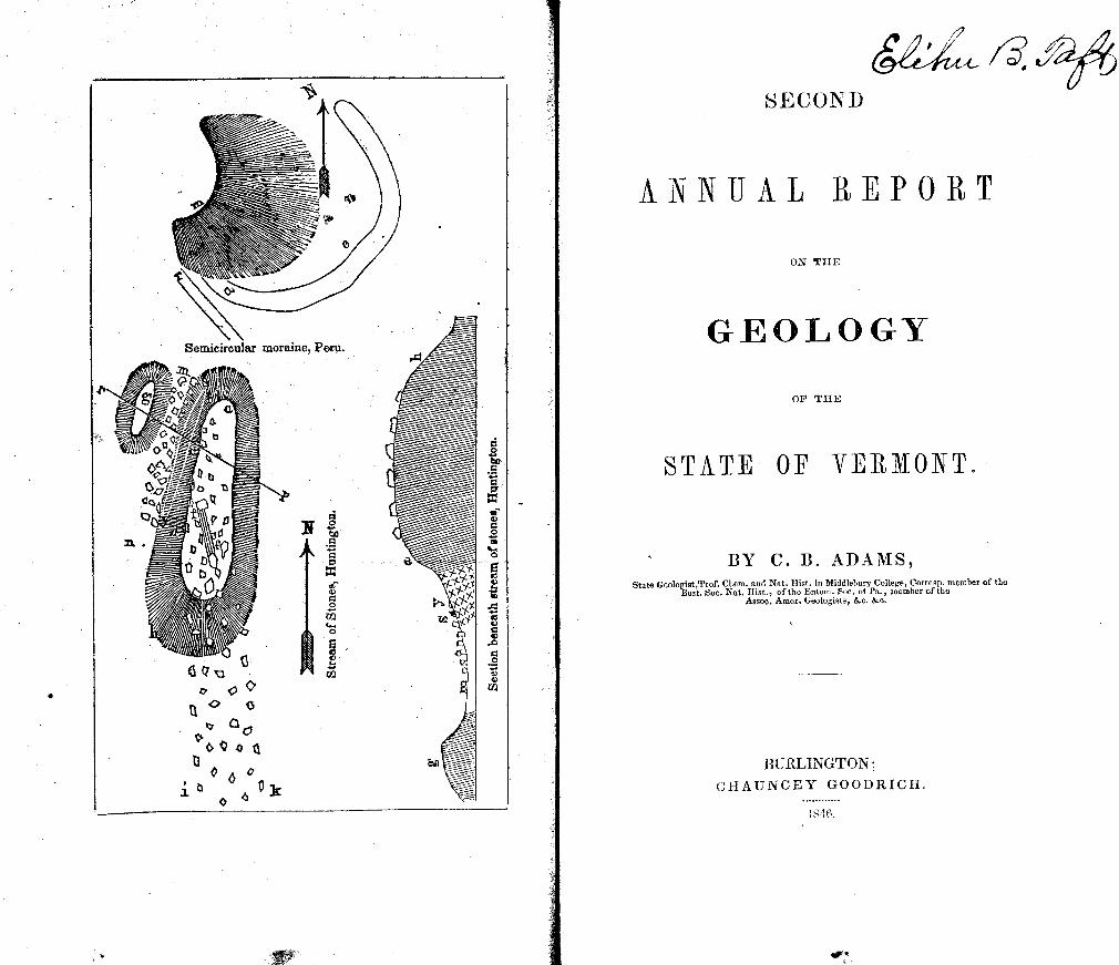
Fig. 1. Volcano of Kilauea, - - - - - page 25 2. Theory of geysers and volcanoes, - - - 33 3. The world with its volcanoes, - - - - 34 4. Crust of the earth, . - - . 37 5. American mastodon, . . • - - - 86 6. Mylodon robustus, - - - - - 89 7. lchthyosaurus communis, - - - • 100 8. Plesiosaurus dolichodeirus, - - - 100 9. Moraine in Peru, - - - - - - 123
* 10. Stream of stones in Huntington, - - - - 130 11. Section beneath do. - - - - 130
* 12. Fractured slate at the north end of Bruce's quarry, - 132 13. do. do. at the summit of do. - - - 132
* 14. do. do. at Willard's quarry, - - 133 *15.
16. ) Localiti es of fractured slate, - - -
- - 13o
' 17. Section of pleistocene deposits, Monkton pond, . 148 18. Plan of Hosmers pond, Peacharn, - - - - 150 19-30. Shells of animalcules, - - - - 150-1 31, 32. Spicules of spongillae, - - - - - 151 33. Eunotia monodon, - - - - - 152
*34• Section of clay, marl, and muck, in Alburgh, - - 154 35. OTd and new channels of Poultney river, - - 156
* 36. Section of Snake Mounlain, Addison Co., - - - 163 *37 Section across Larrabee's Point, - - - - 164 *38. Section of arch of a plicaton of red sandrock, Monkton, - 165 * 39. Chambered shell, Fisk's quarry, Isle Ia Motte, - - 166
41. } Flexure of argilllaceous slate, Guilford, - - - 169
*42. Jointed slate, Dummerston, - - - 169 43, Section of clay, marl, and muck, Derby, - - - 194
*44 Section of bui'ding sites, - - - - 232
All the above engravings were executed on wood, by Mr. JOHN G. GAY, of Whiting.
" Original.
Addison, page 116, 119, 158,164, 254 Dorset, 122,243 Addison Co. 10, 11, 41, 125, 140, 141 Dover, 177
159, 162, 244, 245 Dummerston, 116, 134, 135, 137,169 Albany, 179, 182, 186,241 194, 232, 251, 254 Alburgli, 116, 119,154, 184, 254Duxbury, 125,178 Andover, 188Eden, 178, 181, 194,239, 251 Bakersfield, 11, 243Elmore, 178, 194 Barnard, 178, 181, 188 Enosburgh, 11, 123,219, 225, 239,240 Barnet, 188, 229, 242, 254 Essex, 119 Barre, 179, 188, 251 Essex Co. 179,245 Barton, 189 Fairfield, 219,254 Belvidere, 178, 239, 240 Fairhaven, 156, 241 Bennington, 122, 215, 230, 231,247, 240Fairlee, 242
250, 254 Fayston, 178 Bennington Co. 155, 249 Franklin Co. 11, 125, 219 Benson, 154 Clover, 151, 182, 195 Berkshire, 123, 219, 254 Grafton, 239, 251 Berlin, 178, 179, 189 1 Grand Isle Co. 159 Bethel, 109,119, 178, 179, 189, 239,254 Granville, 178 Bolton, 125 Greenborough, 195 Bradford, 184, 189 Guilford, 131, 169, 233, 251 Braintree, 110, 178, 239 Halifax, 179 Brandon, Brattleborough,
119, 154, 225, 234, 254 122, 133, 135, 143, 182F1ardwick,
Hancock, 122, 168, 184, 195, 243 179, 182,195,242, 254
190,247 Hartford, 196 Bridgewater, 178, 184, 190, 239 Highgate, 153 Bridport, 153, 164lHinesburgh, 122 Bristol, 110, 217, 243, 254 Holland, 179, 196 Brookfaeld, 110,190 Huntington, 129, 254, 259 Brownington, 191 Hydepark, 178, 181,196 Burlington, 11, 153 7 161, 247, 259, 261 Isle Ia Motte, 112, 126, 127, 164, 166 Cabot, 110, 179, 191, 230 235, 254 Calais, 191 Jamaica, 177, 181, 196 Caledo,iia Co. 10,167, 174 Jay, 12, 14,125, 127,167, 178,220, 238 Cavendish, 191, 236, 239, 242, 251Jericho, 143 Charleston, 182Johnson, 178,239 Charlotte, 162, 165, 261 Lamoille Co. 11,174 Chelsea, 191 Landgrove, 177 Chester, 192, 233,Lincoln, 246 Chittenden, 153, 215, 218, 226, 227, 254iLondonderry, 122, 177, 197 Chittenden Co. 11, 14, 125 7 142, 244 Lowell, Ii, 14, 122, 123,154, 178, 197
259 237, 239, 251 Clarendon, 250Ludlow, 197 Coichester, 119,153, 216, 217, 254, 260 Lunenburgh, 183 Corinth, 18t), 192, 251, 254 Lyndon, Cornwall, 141, 244 Maidstone, 152 Coventry, 192, 226 Manchester, 122 Craftsbury, 110, 182, 192, 214, 241, 242Mausfield, 261
254 Marshfield, 197 Danby, 122Mendon, 168,225,243 Danville, 193, 5?42, 254 Middlebury, 9, 122, 124, 152, 158, 171 Derby, 116, 119,153, 179, 182, 184, 193 218, 234, 261.
254 Middlesex, 110, 143, 178, 19
E;l
JVlilton, 219, 243, 254, 261 Springfield, 203 Monkton, 148, 153, 163, 165, 229, 230 Sterling, 178, 239
231, 249, 250. Stockbridge, 243 Montpelier, 179, 184, 198, 241, 247 Stow, 119, 154, 178, 203, 239, 251 Moretown, 154, 168, 178, 198, 239 StratFord, 251, 254 Morgan, 198 Stratton, 177 Morristown, 178, 181, 19$ Sudbury, 119, 233 Mount Holly, 177 Sunderland, 24.9 Newbury, 183, 184, 199 Swanton, 235, 254 Newfane, 181, 199 Thetford, 109, 203, 226, 233 7 240, 242 New Haven, 155 254. Newport, 179 Townshend, 110, 204, 233 Northfleld, 178, 179, 239, 251 Troy, 11, 14, 178, 204 7 217, 238, 239 North Hero, 119 240, 251. Norwich, Orange Co.,
116, 119, 199 228 10, 167, 174, 241, 245
Tunbridge, Underhill,
204,242 261
Orleans Co., 10, 11, 174 Vergennes, 239 Orwell, 119 Vershire, 242 Panton, 165,261 Waitsfleld, 110, 178, 204 Peacham, 150, 151, 182, 184, 200 Walden, 182, 204 Peru, 122 7 123 Wallingford, 122, 215, 254 Pittsfield, 178 Waltham, 244 Pittsford, 116, 119 Wardaborough, 177, 181. 205 Plainfleld, 179 Warren, 119, 153, 154 7 178, 205, 246 Plymouth, 168, 178, 184, 200, 216, 218 Washington, 205
225, 233, 242, 243, 251, 254 Washington Co., 10, 174 Foultney, 229 Waterbury, 178, 205, 239 Pownal, 153,231 Waterford, 110,175, 205, 217 Putney, 127, 183, 200 Waterville, 939, 240, 251 Randolph, 146, 179, 201, 241 Weathersfield, 183, 206 Readsborough, 177 Westfield, 14, 178, 220, 238, 239, 240 Richford, 239 251. Richmond, 125 Westford, Rochester, 110, 178, 201, 239, 251 West Haven, Rockingham, 183, 201 Westminster, Roxbury, 178, 237, 239, 251 Westmore, Royalton, 179, 181, 182, 201 Weston, Rutland, Rutland Co.,
119, 122, 234 10, 11, 142
Weybridge, Whitingham,
Ryegate, 110, 119 1 202 Williamstown, St. Johnsbury, 202 Wilmington, Salisbury, 216 Windham, Searsburgh, 177, 248 Windhum Co., Sharon, 119, 181 Windsor, Shelburne, 116, 119, 126, 162, 176, 244 Windsor Co.,
254, 260. Winhall, Sherburne, 122, 178, 184, 243 Wo1colt, Shoreham, 141, 164, 244 Woodbury, Shrewsbury, 177 Woodstock, Somerset, 177, 181, 184, 203 Worcester,
ERRATA. On page 64, line 12th from the bottom, for cattle in some copies read battle.
" " 84, the fourth word from the top, in the column of formations should be pie iocene.
On page 150, line 2d from.the top, for this town read Freeborn. 152, line 19th from the top, for Stawronies baileyi, in some copies, read Stauroneis Baileiji.
On page 156, for Fig. 17, in some copies, read Fig. 35.
INTRODUCTION.
History of the S'itrvey from October, 1845, to October, 1846.
The operations of the last winter were carried on at the depot of specimens in Middlebury, with the exception of the chemical analyses, which were performed in New Haven, Connecticut. The observations made during the previous season were arranged and written out for future use in the preparation of the Final Report. The data for several general sections across the south-ern half of the State were employed in the construction of these sections, which are so arranged as to shew the geographical re-lations of the several sections, and of their parts. The first es-say towards a colored geological map of the State occupied some time: the State having been for the most part traversed by myself during the preceding summer, I was able, with important aid from the published sections and descriptions of parts of western Vermont by Professor Emmons, to construct a map, which requires only some few alterations and additions to be as correct as cart be expected in the absence of such a basis as would re-quire a topographical survey of the State.
A few days were devoted to the preparation of an outline of Elementary Geology, without which the description of the Geol-ogy of Vermont would be unintelligible to many who are not in possession of more extended elementary treatises. Most of this manuscript is published in this Report, and its preparation du-ring the winter, without theiefore encroaching on the season of field labor, accounts for what would otherwise be the dispropor-tionate space allotted to it.
Much of the winter was occupied with the geological speci-mens collected during the previous season by myself and assist-ants. These were separated from the mineralogical specimens, arranged, trimmed, and, with the exception of the fossils of the Champlain rocks, assorted for distribution, ticketed, catalogued, examined and made the subject of copious notes, which will be used in the Final Report. These specimens were arranged in the proper order of the subjects which they illustrate. The labor of trimming specimens devolved upon myself, and as unfortu-nately those which were collected by my assistants had been
153 156
183,206 207 177 232
168, 177 153, 155, 182, 207
176 207
10,174, 177 207
10,174, 177 177
178, 208 208
180, 1182, 208 178,208
10
taken without sufficient regard to their size, form, freshness, &c. much time was consumed in the attempt to reduce them to a proper condition, and about one thousand which were too small were rejected ; a loss which falls very disproportionately on the du-plicate suites designed for the literary and medical institutions, and which it is necessary thus to explain, to account in part for the greater number of specimens which will be found in the collec-tion designed for the State.
On each specimen has been put, with poisoned tragacanth paste, a margined ticket with figures printed with pica Egyptian type. The corresponding specimens in the several suites, of course, received the same number. The manuscript catalogue of the specimens, amounting in the State collection to 935, was nearly completed when an uncommonly early season cahled. to field labor. The specimens of the State collection are arranged on shelves in an apartment of the Geological depot, for consulta-tion by the Principal during the progress and completion of the survey. Since it is in some cases not practicable to obtain the requisite number of specimens of a given kind for all the suites, the State collection will therefore be the only perfect suite. The remaining specimens have been put each in a wrapper, on the outside of which the number of the specimen is written in dupli-cate.
About one hundred figures, in part for the present, but mostly for the Final Report, were drawn. For most of these, being a suite of figures of the more important varieties of clay stones from a locality in Pittsford, the survey is indebted to Miss Adehine P. Thompson, the daughter of my assistant.
Having arranged a plan of the field operations for the present summer, this labor was commenced by me early in the season. During the unsettled weather of spring, short excursions were made into various parts of Addison and of the adjacent counties, chiefly with reference to the Champlain and Pleistocene forma-tions and the Taconic rocks.
A visit was next made to Orange County, where the operations of the survey were greatly facilitated by the gratuitous coOpera-tion of Dr. S. W. Thayer, Jr. The geology of the southern half of this county was examined in company with Dr. Thayer, and collections of minerals were made at several localities.
In the nex 0 t tour through portions of Rutland, Windsor, and
Windham counties, I was honored with the presence and coop-eration of Your Excellency. The results both of economical and of scientific interest were too various to be mentioned here.
The next excursion was made throu,,h Washington, Caledonia and the north part of Orleans counties, and some important results obtained for the Geological map, and in the first named
Ii
county the most remarkable examples of striated and polished rocks were discovered. A visit was also made to the White Mountains in New Hampshire for the purpose of finding the evidences of Drift agency at an elevation greater than exists in Vermont, and in which we succeeded. During this excursion I was accompanied by Mr. Thompson ; and by Rev. Ebenezer Burgess of Ahmednugger, India, who assisted in our labors gra- tuitously.
A tour was then made through the north part of Chittenden, and through Franklin, Lamoille, and Orleans counties, with nu-merous and highly interesting results. In the two former coun-ties were found abundantly extraordinary exhibitions of Drift furrows and polished rocks. In the vicinity of Burlington were found interesting Pleistocene deposits with abundance of marine
shells of existing species, among which was one, Lucina flexuosa, which had not hitherto been known to exist in a fossil state. In this vicinity I was accompanied by Mr. Thompson. In Franklin county His Honor Lieutenant Governor Eaton accompanied me in various parts of Enoshurgh and in part of Bakersfield. In Lamoille county the valley of the Lamoihle River was found to exhibit the same extraordinary deflection eastward of the Drift current, which was first noticed by Dr. Jackson in the valley of the Winooski. Mr. Hall accompanied me through various parts of Orleans county and rendered efficient aid in the exploration of the rocks and in the collection of minerals.
Subsequently to -this tour, some short excursions have been made in Rutland and Addison counties with various but interest-ing results. These have been continued more or less frequently, up to the time of the printing of this report, and, with the other numerous miscellaneous duties of the Survey, will, it is hoped, be a sufficient apology for the obvious marks of haste on these pages.
It is obviously unnecessary to describe the details of the oper- ations of each successive iay in the order of their occurrence, and the description of them in a systematic arrangement must be reserved for the Final Report. Yet as some curiosity exists in reference to the manner of proceeding, I will narrate in detail here, as a specimen of a day's work, the history of one day which was of rather more than common interest, during which I was assisted by Mr. Hall.
Aug. 11. Finding the air remarkably clear, and the weather promising favorably, we resolved to take advantage of it for our proposed ascent of Jay Peak, and accordingly started from Low-ell at half past four o'clock A. M. We passed by the serpentine ranges of this town, and rode eight miles to South Troy to breakfast. Most of the way was along an immense Pleistocene
12
fluviatile deposit, resembling those of Black and Barton Rivers, that is, with the remains left by subsequent denuding agency seldom existing- in the form of regular terraces, as in most of our valleys, but cut into irregular elevations and depressions. The great extent of this deposit was subsequently found to have been due in part to the number of streams, which converge into this valley from the head waters of the Missisco, acting in the older Pleistocene period on the then recent and fresh materials of the Drift.
Here we found that the thermometer attached to the barometer had been broken, but fortunately the barometer itself was sound. At this valley, in the lower story of Mr. Johnson's Hotel, at 7 A. M., the barometer stood at 29.26 inches; and the detached thermometer hanging near it for half an hour indicated a temper-ature of 70 ° Fahr. which was probably not far from the tem-perature of the instrument; the height above Lake Champlain is therefore about 650 feet.
Having made our arrangements, we started for the ascent, ac-companied by Mr. Johnson, Major Bates, Elder Downs, and Mr. Nathaniel B. Norris. A ride of a few miles brought us into Jay about 21 miles from the east and two miles from the south line of the town, where we left our horses and proceeded on foot, through an unbroken forest, to the Peak, in a south west direction. About four miles of the route was a moderate ascent, and was followed by two miles of a steeper but not very rough surface, when we arrived at the naked peak. The route thus far was indicated by "spotted trees," which had been marked from time to time, and many of them during the previous summer, when the mountain was fre-quently ascended by a party engaged in making night signals from the summit for the surveyors of the United States and Canada boundary line, and who had a camp on the mountain. Except for the obstruction of fallen trees and the straggling moose bush-es, the ascent is quite easy as compared with many of the moun-tains of Vermont, and if a good bridle path were constructed, which would require scarcely any thing more than the removal of the fallen trees, the ascent would be as easy as to the same height on the White Mountains. Occasional fragments of coarse talcose slate were seen, but the rocks in place were mostly concealed.
We ascended the steep rocky apex for about one-sixth of a mile on the west side, which is covered with debris of the coarse talcose slate in angular blocks mostly from one to four feet in diameter. The north side is a sheer precipice of 500 or 600 feet. The summit we found to be of the same rock, the talc in rather large proportion, with numerous small irregular masses of pure chlorite, and an irregular vein of white quartz. The rock is highly charged with very minute crystals of magnetic iron ore, so
13
as powerfully to affect the magnet, especially the small agate poised needle of my pocket compass, which in different positions pointed in exactly opposite directions, indicating strong polarity in given portions of the rock. The abundantly disseminated crystals however seem to be a sufficient cause, and the presence of any workable mass of ore is not by any means certainly to be inferred. By repeated observations with two compasses ele-vated a few feet above the rocks, we probably approached near to accuracy. The direction of the strata is about north 10 1 east, and the dip from 80 ° west to perpendicular. Mr. Hall collected a variety of specimens, which, although less than our standard size, proved in the course of the six miles descent to be sufficient- ly large.
With the exeptions of an area of a few yards at the west end of the summit, beginning at an elevation only eight feet lower than the highest point, the rocks were mostly covered with drift furrows, many of which were very distinct, with a direction of north 40 ° west. The drift current here was deflected to the east of its usual course by the deep valley of the Missisco east of the Green Mountains, which are prolonged to the south at an ele-vation but slightly less than that of the peak, and were therefore an obstacle to the usual course of the drift. The furrowed sur-faces are somewhat rounded, but owing to the disintegration of the rock, the finer scratches and smoothness of the surface, which probably existed at the close of the drift period, have disappear -ed. The masses of angular debris, over which we had ascended, sufficiently indicated the powerful effects of the destructive agen-cies of frost and rain since the time of the drift current, which, being powerful enough to furrow the rocks, must have then re-nioved the preexisting loose fragments.
The barometer was taken up and down the mountain with great care by Mr. Norris, who was also of great service in readily detecting the "spotted trees," where they were infrequent. When first set up, at 1 P. M. it stood at 26.113 inches and the detach-ed thermometer at 62 ° Fahr. The instruments were hung togeth-er in the shade for 11 hours, when at 2 P. M. the barometer stood at 26.1 inch, and the thermometer at 60 ° Fahrenheit, both being probably at very nearly the same temperature. Sub-sequently calculating the results, with the observations on Mr. Thompson's wheel barometer at 1 P. M. of the same day, we find the elevation to be 39181 feet above Lake Champlain; while with an observation with Mr. Thompson's Bunten's barom-eter at 11 P. M. of the same day at the level of the Lake in Shelburne, the result is 39381 feet, giving as a mean 3928.1 feet above the Lake or 4020 to 4025 above the ocean.
The scenery we shall not attempt to describe. The scattered
t
Ii
mountains of Canada on the north with the intervening broad lands, Lake Champlain mapped out on the west with its islands and bays, and the White Mountains of New Hampshire in the extreme east, were the principal objects.
A little bed of sphagnous moss, a few feet below the summit, with its matted roots decayed to the depth of a foot, was an ob-ject of some interest at this elevation, and in a region where sphagnous swamps are scarcely known.
Both on our ascent and descent we stopped at a small brook, two miles below the summit, which we called 'Cold Brook,' the water having a temperature of 43° Fahr., not far from the mean annual temperature of this region.
We reached the foot of the mountain about sunset and pro-ceeded towards North Troy. When about three-fourths of a mile west of the middle of the east line of Jay, we came to a ledge of serpentine, a continuation of the Westfield range and west range of Lowell. A vein of supposed magnetic iron ore was pointed out to us, which however had but little influence on the magnet. Making the necessary observations, we collected speci-mens for examination by daylight the next morning, when we found it to be chrornic iron, of great value, which will be des-cribed under its appropriate head.
The chemical analyses were made by Mr. Denison Olmsted, Jr. in the laboratory of Yale College. A melancholy interest is attached to his report, from the fact that it was his last, although almost his first, public labor of science. A rapid consumption marked him for a victim, while completing this task, and when arrangements had already been made, by which his high attain-ments in mineralogy were to be made available in the field labor of this survey. His promptness and fidelity, his skill and rapid acquisitions in science had raised the highest hopes of the value of his services to the survey. These hopes have been disappointed by the decease of Mr. Olrnsted on the 15th of August last.
The tabular results of the analyses are dispersed through the report under the several subjects to which they belong, and the brief description of the general methods of analysis will he found in the appendix, C.'
The Rev. Zadock Thompson has been employed in field labor, mostly in Chittenden County, with very interesting results, espe-cially in the discovery of numerous trap dykes, without however a single example of an overlying mass of trap. Mr. T. has also rendered very valuable aid in the preparation of town maps and in the collection of the various scattered observations on the height
See Appendix, Article B.
13
of different points throughout the State, a work of the utmost im-portance for the Geology of the Pleistocene period.
The Rev. S. R. Hall has been chiefly engaged in the Agricul-tural department of the survey, and the plan as well as the re-suits of his labors will be found in their place in the part of this report, which treats of Economical Geology. The great value of these results cannot but interest deeply all who are concerned in the prosperity of this State.
Both of these gentlemen have not only labored with great in-dustry and efficiency during the time for which they have re-ceived compensation, but have also, throughout the year, gratui-tously devoted much time to the furtherance of its objects.
Various assistance has been rendered in the depot of speci-mens by Dr. S. P. Lathrop, by several members of the senior class in Middlebury College, and by Mr. A. R. Holmes, of New Bedford, Mass. Much credit is due especially to Mr. H. for the neatness and precision with which the numerous details of labor on the specimens were performed.
It is with much satisfaction that I repeat our acknowledgments to the citizens of the State, whom we have met in the field ope-rations, both for their hospitalities and for their zealous coöpera-tion. It would he agreeable to us to enumerate the many favors of this kind, but they are far too numerous to be introduced here. We have also much satisfaction in recording our experience of the quiet and orderly public houses, with a single exception, which we have every where found.
The very general desire of personally attending and aiding in the field operations, on the part of the citizens of the several towns, has been often coupled with an apparently confident ex-pectation that one or two weeks at least would be devoted to the examination of each town. As it would be extremely unreason-able for us to expect to find in the community generally, a prac-tical knowledge of the manner of conducting geological explora-tions, we n-inst be allowed frankly to say that we have usually found any thing but correct views on this subject. Few are aware of the numerous and important inferences which may be made by a single and even rapid ride across a town, which often gives a practical geologist a knowledge of the structure of the whole region and of its general features, and thus furnishes the data for inferences of great economical importance. We have not found it generally considered that there is a structure more or less regular to particular regions, and that consequently it is no more necessary to examine every acre or even every square mile for the principal results, than it is for a mechanic to exam-ine every square inch of a piece of timber in order to ascertain what it is.
113
Nor will any deny the propriety of our having a plan with somewhat fixed and definite objects in view, which however is inconsistent with the common expectation that we are, to trans-pose the language of my esteemed and revered instructor, to follow the leadings of the inhabitants rather than of the rocks. Perhaps it is not improper to say that we often know more of the rocks in a town that we have never seen, than do any of its inhab-itants, which may at first seem to be a singular or even uncour-teous assertion, than which nothing is farther from our intention; for it is not more remarkable, than that a mechanic should know more of the mode of constructing a house which he has not en-tered, than does even its owner and occupant. We are encour-aged to offer these explanations by the general facility with which we have found them apprehended and appreciated.
On the other hand the limit of the survey, which is fixed in the Bill making provision for it, renders it necessary to make the ex-amination with much less minuteness of detail than would be de-sirable, and although it would not be useful to devote a week or more to ev'3ry town, there are many whose mineralogy and geo-ology merit this amount of attention.
Not far from 7000 specimens have been obtained during the present summer, of which I have collected in person about 5000. A large majority of these, like those of last year, are either geo-logical specimens or specimens of the useful minerals. It had been my design to employ Mr. Olmsted in the collection of the various minerals of scientific interest for which Vermont has been somewhat celebrated. The melancholy disappointment in this plan has rendered it expedient to give some time in person to this object, and some localities of much interest have been vis-ited, and full suites of specimens from them have been selected. But the almost exclusive devotion, by one individual, of at least one season to this object, is indispensable to do justice to it.
The importance of collecting and depositing in suitable places numerous specimens illustrative of the geology and mineralogy of the State, which shall be described in the Final Report, is probably appreciated by most of the community. As vouchers for the statements to be made, or as materials for correcting them, as means of comparison with minerals which may be found by persons not very familiar with their character, and especially as a help to any who may be commencing the study of our Geology,___for these and other purposes they are indispensable. I have, therefore, zealously endeavored to carry out the views of
See letter of Pres Hitchcock in the First Report, page 67. We may add, too, that since our work is chiefly with the rocks and minerals, and not in in-dulging ourselves in social intercourse, those persons, whom we have not had the pleasure of seeing, are not therefere to infer that their town has been neglected.
17
your Excellency on this subject, notwithstanding the great amount of manual labor which necessary results.
The plan for the ensuing year may he stated in part and in gen eral terms, although the difficulty ot j)ravidtng for all the chemi-cal analyses, and the securing an assistant qualified to collect fine specimens of the simple minerals, with the amount of funds at my command, renders it impracticable now to form a plan with confidence as to all its parts. The fossils and the simple iriiner als collected last year, and all the specimens collected this year, are, so far as my time and the amount of assistance will permit, to receive the same attention which was given to the geological specimens last winter.
Should it be thought desirable, a large portion of the speci- mens with catalogues may be made ready for distribution to the several institutions before the commencement of another season of field labor. Whenever the distribution shall take place, the principles on which itshall have been made will be publicly an- nounced.
The preparation of sections and of other figures, and the writ- ing out of many of the results of the field labor will again re- quire much attention. The analysis of minerals will also be car- ried on.
During the next summer, the collection of minerals through- out the Stale, the geology of much of the north east and of the south west extremes of the State, the additional examination of
the geology of ninny districts, which have been partly examined, and the continuation of the m.rricultural department will occupy all the lumen that ran be brouht into tlìe field.
For the analsis of mt nerais I have a1jnniuted as chemist to the survey, Mr. T. S. I Int of New IL;v en, Connecticut, who is am-
pi' quiahfind to flU the plane of hi; lamented predecessor, and who 1: 0 ime a ;e;rt of the analyses herewith renorted under drecun rf Mr. Oe'1, dnhg the illness of the latter. The
a lysesn fl n n :rrasn as hfomc, ta the laboratory of Pro-
fesor B. Sdliman, Jr. Tue anolvees of soda s an ;mportant object contemplated in
the Bill provid i ig for tilO survcy ; but in order that such analy-ses should he of any service, they will require, even if the time and skill of a professed chemist could he obtained gratuitously, an expose witch cannot be met with the present funds of the survey. We shall, therefore, offer further ren]arks on this sub-ject under the head of I Expenses of the Survey,' in the Ap-
pendix. It seems necessary to remark on the expectation, which has
been entertained of these annual reports, that, although finished on the first day of October, as required by law, they will contain
1f1
all the results, and thus afford a means of judging what progress has been made, up to that time. That those, who are not prac-tically acquainted with the operations of a geological survey, should look for its returns simultaneously with the autumnal har-vest, may not be surprising. Yet we think such expectations will be waived, when it is considered that nearly all the scientific results are reserved for the Final Report, and that no small part of the results in economical geology are made out long subse-quently to the publication of the Report, after receiving the de-tails reported by the assistants, and obtaining the results of the chemical analyses. A full report of the operations of one season could not be in readiness before the following spring. Nor would it be expedient, on the score of economy, to publish a full report every year, when the Final Report must necessarily in-clude all the details of the survey. It should be remembered also that the preparation of a full and elaborate Report, if possible to be prepared before October first, would seriously cut short the labors in the field. Yet, as the servant of the people, we have endeavored, as far as practicable, to meet this expectation, and have prepared a report somewhat more full than otherwise might have been thought necessary.
PART 1.
ELEMENTARY GEOLOGY. Design of this Part.
Since the application of geology to the economical objects of the survey would not have been intelligible without an introductory sketch of some of the general features of the science, a few pre-lirninary considerations were presented in the first Report, for the benefit of those whose occupations do not permit them to study extended treatises of general geology. As this report is not re-stricted to objects of economical importance, it becomes necessa-ry to present here a more particular view of some of the facts and theories on geology, in which the attention will be chiefly directed to the present and later periods in the geological history of the earth, reserving the particular consideration of the more re-mote periods for some future occasion.
An important object of this survey is to raise up geological observers, who shall take up the work where the government may leave it, and prolong it indefinitely. With this object also in view, we submit the following hastily prepared introduction to the principles of the science. For an observer to neglect these would be empiricism, and po one is prepared to make valuable ob-servations without some elementary knowledge. Yet while the most extensive and profound acquisition in any department of physics may find ample scope in this noble and comprehensive science, any intelligent mind, with some rudiments of knowledge and a due measure of perseverance, may enter these broad fields and aid in their cultivation. One of the most valuable works, on the geology of Scotland has been recently written by a self-taught stone-cutter, whose volunie has received the highest en-comiums from the veterans in British geology.
The scientific reader, if perchance there should be such, will allow me to remind him, that while it is hoped that the results of
14 New Walks in an old Field," by Mr. Hugh Miller.
20
the survey may not be without interest to him, these reports are Written primarily for the information of those, at whose expense the survey is conducted. Although the geological reader will find many familiar facts, which he will pass over, the writer considers himself justified, by the extraorduiary interest manifested by the people of Vermont in the Geological Survey, in presenting a re-port, whose object is not only to add to the pecuniary resources of the State, but to that intelligence for which it is distinguished.
ChAPTER I.
GEOLOGICAL AGENCIES.
Presuming that the first report is in the hands of my readers, I proceed from those preliminary remarks (pp. 9-15), to the con-sideration of existing agencies, which are producing geological changes on the surface of the earth. With a constitutional be-lief in the constancy of the laws of nature, we look to the opera tions itow in progress, not only on account of their intrinsic inter-est, but because they alone Cart enable us to understand the history of the past. If we shall find strata now in the process of accu-mulation beneath the waters, burying within them the present races of animals and plants, marine, fluviiitile, or terrestrial, the species of hot or those of cold climates, according to the si nation in which these deposites are forming, and if we see unstratified rocks resulting from eruptions of lava, we shall be better able to comprehend the origin of ancient deposits with their imbedded relics of species which have long been extinct, and of those enor-mous masses ofunstratifiet] crystalline rocks, which exist where the volcanic fires have long since gone out.
Intensity of Geological Agencies.
Some very able geologists are of the opinion that the course of nature has been, through all the geolo!ical epochs, the saute as at present, not only in the nature of the agencies of change, but also in the degree of in te i t' wit hi which they have acted ; that volcanic forces have never been more violent than they are now ; and that there have been no other changes of climate than those which are consequent on changes in the relative dis-tribution of land and water. Many others suppose that volcanic convulsions of the earth's crust have been more violent arid on a larger scale than at present ; and that the earth's surface was once intensely heated by the internal fires, so as to support the
21
dense tropical vegetation and the tropical races of animals, whose remains are now found abundantly in cold climates. With-out discussing this question at present, the only elementary ques-tion on which geologists differ, we merely hold it up, that it may be seen in the light of the facts which we are briefly to notice.
Classification of Geological Agencies.
Existing agencies may be classed under three heads; the ig-
neous, comprehending all the effects of heat; the aqueous, com-prehending the effects of water in all its forms ; and the or-ganic, or agency of the animal and vegetable kingdoms.
IGNEOUS AGENCIES.
The crust of the earth has been more or less subjected to the action of heat both from internal and from external sources. The former are the origin of volcanic action, using the term in its wider signification, as comprising the kindred phenomena of vol-canoes, earthquakes and thermal springs.
A volcano is an opening in the earth, from which matter has been ejected by heat, in the form of lava, scoria, or ashes. Usually the opening called the Crater is an inverted cone ; and ariSund there arises a mountain in the form of a cone, with its apex truncated, produced by the elevation of the earth's crust and the eection of the lava."--Jlitchcock.
Extinct volcanoes are those which have not erupted since the comrriencernent of the historical period, and since they therefore belong to the history of antecedent epochs, the consideration of them is reserved for another place.
Active volcanoes are those which have been known to erupt since the existence of man. A very few of these are in constant action, as Stromboli and Kilauea, but the greater part are inter-mittent, with intervals of action varying from a few months to many centuries.
Earthquakes are intimately connected with volcanoes proceed- ing from the same general cause, and frequently followed by an erul)non, by which these convulsive throes of the earth are re-
lic ved. Thermal springs belong to the same class of phenomena, de-
riving their temperature from past or present volcanic fires, with which they are always associated.
The facts relating to earthquakes, to thermal springs, and to volcanoes may be classified, as they are subarial, submarine, or s ubterranean.*
* SubariaI from sub and oCr, under the atmosphere; Submarine, from sub and mare, under the sea; Subterranean from sub and terra, under the earth,
22
SUBAERIAL IGNEOUS AGENCY.
VOLCANOES.
There are about 300 volcanoes, of which one-third belong to America, one-third to Oceanica, and the remaining third to Eu-rope, Asia and Africa.
Eruptions.
Usually the first symptoms of an eruption are heard in rumb-ling sounds, which seem to travel along for a greater or less dis-tance in the depths of the earth ; they are seen in the increased volumes of smoke which arise from the crater ; and are felt in tremulous motions of the earth, which assume the violence of earthquakes, and bring in their train the horrors that usually ac-company these convulsions. Sulphurous and muriatic vapors fill the air, while electric agencies display their vivid coruscations, accompanied with heavy peals of thunder. Unusual signs of fright are manifested by the brute creation. Showers of stones and cinders fall, sometimes in immense profusion, and the con-vulsions of the earth become more violent. Masses of rock are ejected from the crater with tremendous explosions, until at length the earthquakes cease, and the imprisoned gases and lava find vent through the crater and sometimes through the sides of the volcanic mountain. A river of molten rock streams down and spreads out into a sea of fire. Sometimes its course is siow, sometimes rapid. Glaciers may be encountered and melted, and torrents of boiling water and mud poured down. Showers of cinders again fall and announce the termination of the eruption to be at hand. The flames, explosions, and ejections of rocks and stones become less violent, and finally nothing but vapors and smoke escape from the crater.
Etna and I7esuvins have been observed from remote antiquity, and the earthquakes and eruptions of the former were described by the earliest historians and poets. Before the Christian era, V
'uvius was in a state of inactivity. history had no records of
itseruptions, and a naturalist only, as he observed the volcanic nature of the rocks, would have suspected its real character. Its energies found vent in the neighboring isles of Iscliin and Procida, which were shaken by terriflc convulsions and desolated by erup-tions. But Vesuvius itself was silent, and although Straho per-ceived its volcanic character, Pliny omitted it in his list of active volcanoes. In the cone were the remains of an ancient crater nearly filled up, and covered on its interior with wild vines. At the bottom was a sterile plain, on which Spartacus once encamp-ed with his army of 10,000 gladiators, whose descent was a more
23
disastrous eruption than the fiery floods of later years. The mountain was flanked with fruitful fields highly cultivated, and at its base were the luxurious and populous cities of Herculaneuin and Pompeii.
In 63 A. D., Vesuvius gave signs of awakening from its repose of unknown ages. From that year to 79 \. D. shocks were fre-quent, and at length became more violent, when a terrific erup-tion took place, and buried the cities above mentioned. Since that time its eruptions have been numerous, but those of 1631 and 1822 were most remarkable. In 1631 a stream of lava con-sumned Resina, which was built over the site of Herculaneuni, and floods of mud were poured down with terrible devastation. These floods originated in heavy rains which are often produced by volcanic action, and which wash down the cinders and dust until they assume the consistency of mud.
For some time previous to 1822 the crater had been gradually filling up, when it was blown out with awful explosion, to the depth of 2000 feet, and more than 800 feet of the top were blown om
Etna was meanwhile subject to occasional eruptions. In the year 1669 an immense quantity of the lava overwhelmed 14 towns and villages before reaching Catania. Although the walls of this city were sixty feet high, the lava accumulated until it gained the top, and then poured over in a fiery cascade, destroying a portion of the city. The current continued 15 miles further, when it entered the sea with a depth of 40 feet. The progress of this current had been so slow that the surface had time to cool, so that it advanced by breaking through its walls of crust. Since the commencement of the present century, there have been sev-eral eruptions through the sides of the mountain. In 1811, seven openings were formed each at a lower level successively. in 1819, three out of five such openings united in one, and poured an enormous torrent into the valley 'Del Bove.' Arriving at a precipice, it poured over in a cataract of liquid rock, which cool-ed in its descent and hardened into solid rocks, dashing against the bottom with an inconceivable crash. This current continued to flow for nine months, when it was found to move at the rate of less than five rods per day.
A late traveller gives the following description of an eruption of Etna seen by night:
"It was about half past ten when we reached the foot of the craters, which were both tremendously agitated; the great vent threw up immense columns of fire, mingled with the blackest smoke and sand. Each explosion of fir,, was preceded by a bellowing of thunder in the mountain. The smaller mouth was much more active : and the explosions followed each other so rapidly that we could not count three seconds between them. The stones which were emitted were fourteen seconds in falling back to the crater; con-
24
equently there were always five or six explosioris—sonietime more thab twenty—in the air at once. These stones were thrown up perpendicularly, in the shape of a wide-spreading sheaf, producing the most ma gnificent effect imaginable. The smallest stones appeared to be of the size of cannon balls the greater were like bomb-shells; but others were pes of rock, five or six cubic foot in size, and some of the most enormous dimensions ; the latter gen-erally fell on the ridge of the crater, and rolled down its sides, splitting into fragments as they struck against the hard and cutting masses of cold lava. The smoke emitted by the smaller cone was white, and its appearance incon-ceivably grand and beautifu] ; but the other crater, though less active, was much more terrible ; and the thick blackness of its gigantic volumes of smoke partly concealed the fire which it vomitedi Occasionally both burst forth at the same instaut and with the most tremendous fury ; sometimes mingling their ejected stones.
If any person could accurately fancy the effect of 500,000 sky_rockets darting up at once to a height of three or four thousand feet, and then falling back in the shape of red-hot balls, shells, and large rocks of fire, he might have an idea of a single explosion of this burning mountain ; but it is doubt-ful whether any imagInation can conceive the effect of one hundred of such explosions in the space of five minutes, or of twelve hundred or more in the course of an hour, as we saw them t"—Mantell.
in Iceland have occurred some of the most extensive erup-tions on record. Most of this island, which is 300 miles long and 150 broad, is covered with volcanoes and vast regions of lava, rug-ged and torn into broken and pointed rocks, or cleft into yawning chasms of many miles in length, and unseen depth. Other parts of the island are filled with innumerable springs spouting forth tor-rents of boiling water, or with immense mountains of ice. The con-vulsions of 1783 appear to have been most violent and on a scale of extraordinary magnitude. Multitudes of the wretched inhabi-tants perished in the almost general wreck of organic nature. In an eruption of Skaptar Jok-ul, two streams of lava flowed oW in opposite directions, of which one was 40 miles lon and seven broad. and the nth€-t amis 50 tag mmmiii 12 Ejrammii both eon-initmimtr 7010i)tfthl t;i) new
Ott 11mm tam (l:m wi I mm ever active vu 1 can, irisse, ci tinnmmmmJ a -- - : 1. 't'iia m - am 1 er is mint mm C(it0 iii il(iti H a a ii ml cmii y 11mm r t Ito hose
j \immuo, R a .mht it I 0 (ifJ) r I i*OiiO eel above lie jetH tl tiii s, . 1, € re r ehil mit ime;me' eiimiemmm in the Illiddle of a H, m tim-li is i-tim m-i-imatid iiV a tm oi - mm e item 200 tim 400 fec: is 15 n.ies iii tioumh rt:tce. (Jr ra-tlier this plait is itself a chasm 1 atd the crater is a chasm wjlhn a chasm.
Mr. Stewart, formerly missionary at these islands, gives an interesting account of its appearance.
Standtmmo at an eievaiori of 151ff) feet, tee looked into a horrid gulf, not 1' Ii ri 1 ri c in c m d It Ii i ii i11- he hideous immensity tm-el, ililapeliloot of the any frightful woes, emitraced in it, almost caused an involuntary closlig of the eyes aCOinst it. But when to the sight is added the effect of the various unnatural and frightful noses, the muttormeg and sighing, the groaning and bellowing, the every agonized strug-
25
gling of the mighty action within, as a whole it is too horrible. This gulf contains 50 or 60 conical craters, many of which are in constant action. About half way down the perpendicular side of the chasm is a ledge or piaz-za of lava from a few feet to several yards in width, which extends all around. Below this, all was of a dismal black color, except two or three of the coni-cal craters at the bottom, which were covered with sulphur of various shades of yellow and green. The cliffs above the piazza were red on the north and and west bides; on the east the bank was less precipitous, and consisted of entire banks of sulphur of a delicate and bright yellow.
As the darkness of the night gathered around us, fire after fire began to glimmer on the eye, appearing in rapid succession. Two or three small cra-ters were in full action, every moment casting out stones, ashes, and lava, with heavy detonations, while the irritated flames glared over the surrounding obscurity, richly illuminating the more distant volumes of smoke. The great seat of action, however, seemed to be in the southern and western end, where an exhibition of ever-varying fire-works was presented. Rivers of fire were seen rolling in splendid coruscations among time laboring craters. During the second night, the noises were redoubled, rollin g from one end of the vast chasm to the other with inconceivable velocity, and the flames burst from a large cone, which in the morning appeared to have been long inactive. Red hot stones, cinders, and ashes were propelled to an immense height, and soon the lava boiled over in two curved streams glittering with indescribable bril- haney.
A whole lake of fire opened in a more distant part, two miles in circumfer-ence. Its surface had all the agitation of an an ocean; billow after billow tossed its monstrous bosom in the air and occasionally met with such violent concussion as to dash the fiery spray 40 or 50 feet high."*
'
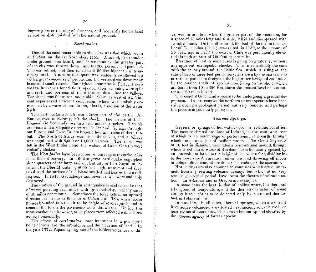
- , '. •i_,.i ,-,t ..._J .
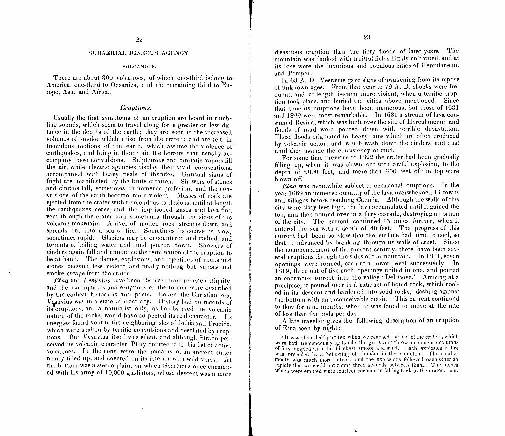
Fig. 1.—Volcano of Kilaue a.
An eruption, which had its source in this volcano, in June, 1840, was one of the most extraordinary of modern times. It has been described by Mr. Coan, American missionary in the Sandwich Islands, who, soon after the eruption, discovered the place where the current broke forth, and traced it to the sea.
5 This spray is blown out by the winds into delicate threads, as melted glass may be drawn out, and accuruulates on the sides in masses winch resemble bunches of tow.
4
We give his narrative, although rather long, as furnishing one of the most instructive examples of this class of geological agen-cies.
"For several years past the great crater of Kilanea has been rapidly filling up, by the rising of the superincumbent crust, and by the frequent gushing forth of the molten sea below. In this manner the great basin below the black ledge, which has been computed from three hundred to five hundred feet deep, was long since filled by the ejection and cooling of successive masses of the fiery fluid. These silent eruptions continued to occur at inter-vals, until the black ledge was repeatedly overflowed, each cooling, and form ing a new layer from two feet thick and upwards, until the whole area of the crater was filled up, at least fifty feet above the original black ledge, and thus reducing the whole depth of the crater to less than nine hundred feet. This process of filling up continued till the latter part of May, 1840, when, as many natives testify, the whole area of the crater became one entire sea of ignifluous matter, raging like old ocean when lashed into fury by a tempest. For several days the fires raged with fearful intensity, exhibiting a scene aw-fully terrific. The infuriated waves sent up infernal sounds, and dashed with such maddening energy against the sides of the awful caldron, as to shake the solid earth above, and to detach huge masses of overhanging rocks, which, leaving their ancient beds, plunged into the fiery gulf below. So terrific was the scene that no one dared to approach near it, and travellers on the main road, which lay along the verge of the crater, feeling the ground tremble be-neatli their feet, fled and passed by at a distance. I should be inc]ined to dis-credit the statements of the natives had I not since been to Kilanua and ex-amined it minutely with these reports in view. Every appearance, however, of the crater confirms them. Every thing within the caldron is new. Not a particle of the lava remains as it was when I last visited. All has been melt-ed down and recast. The whole appears like a raging sea, whose waves have been suddenly solidified while in the most violent agitation.
Having stated something of the appearance of the great crater for several days before the disgorgement of its fiery contents, I will now give a short history of the eruption itself. I say short, because it would require a volume to give a full and minute detail of all the facts in the case. On the 30th of May, the people of Puna observed the appearance of smoke and fire in the interior, a mountainous and desolate region of that district. 'l'hinking that the fire might be the burning of sonic jungle, they took little notice of it until the next day, sabbath, when the meetings in the different villages were thrown into confusion by sudden and grand exhibitions of fire, on a scale so large and fearful as to leave them no room to doubt the cause of the phenomenon. The fire augmented during the day and night; but it did not seem to flow off rapidly in any direction. All were in consternation, as it was expected that the molten flood would pour itself down from its height of tour thousand feet to the coast, and no one knew to what point it would flow, or what devasta tion would attend its fiery course. On Monday, June 1st., the stream began to flow off in a northeasterly direction, and on the following Wednesday, June 3d., at evening, the river reached the sea, having averaged about half a mile an hour in its progress. The rapidity of the flow was very unequal, be-ing modified by the inequalities of the surface, over which the stream passed. Sometimes it is supposed to have moved five miles an hour, and at other times, owing to obstructions, making no apparent progress, except in filling up deep valleys, and in swelling over or breaking away hills and precipices.
But I will return to the source of the eruption. This is in a forest, and in the bottom of an ancient wooded crater, about four hundred feet deep, and probably eight miles east from Ktlauea. The region being uninhabited and covered with a thicket, it was some time before the place was discovered, and up to this tune, though several foreigners have attempted it, no one, except myself, has reached the spot. From Kilanea to this place the lava flows in a
21
subterranean gallery, probably at the depth of a thousand feet, but its course can be distinctly traced all the way, by the rending of the crust of the earth into innumerable fissures, and by the emission of smoke, steam and gases. The eruption in this old crater is small, and from this place the stream disap-pears again for the distance of a mile or two, when the lava again gushed up and spread over an area of about fifty acres. Again it passes under ground - for two or three miles, when it reappears in another old wooded crater, con-suming the forests, and partly filling up the basin. Once more it disappears, and flowing in a subterranean channel, cracks and breaks the earth, opening fissures from six inches to ten or twelve feet in width, and sometimes split-ting the trunk of a tree so exactly that its legs stand astride at the fissure. At some places it is impossible to trace the subterranean stream, on account of the impenetrable thicket under which it passes. After flowing under ground several miles, perhaps six or eight, it again broke out like an over-whelniing flood, and sweeping forest, hamlet, plantation, and every thing before it, rolled down with resistless energy to the sea, where, leaping a precipice of forty or fifty feet, it poured itself in one vast cataract of fire into the deep below, with loud detonations, fearful hissings, and a thousand unearthly and indiscribable sounds. Imagine to yourself a river of fused minerals, of the breadth and depth of Niagara, and of a gory red, falling, in one emblasoned sheet, one raging torrent, into the ocean The scene, as described by eye witnesses, was terribly sublime. Two mighty agencies in collision I Two antagonist and gigantic forces in contact, and producing eflbcts on a scale inconceivably grand T he atmosphere in all directions was filled with ashes, spray, gases, etc., while the burning lava, as it fell into the water, was shivered into millions of minute particles, and, being thrown back into the air, fell in showers of sand on all the surrounding country. 'F lie coast was extended into the sea for a quarter of a mile, and a pretty sand beach and a new cape were formed. Three hills of scoria and sand were also formed in the sea, the lowest about two hundred, and the highest about three hundred feet.
For three weeks this terrific river continued to disgorge itself into the sea with little abatement. Multitudes of fishes were killed, and the waters of the ocean were heated for twenty miles along the coast. The breadth of the stream, where it fell into the sea, is about half a mile, but inland it varies from one to four or five miles in width, conforming itself, like a river, to the face of the country over which it flowed.
The depth of the stream will probably vary from ten to two hundred feet, according to the inequalities of the surface over which it passed. During the flow, night was converted into day on all eastern Hawaii. The light rose and spread like the morning upon the mountains, and its glare was seen on the opposite side of the island. it was also distinctly visible for more than one hundred miles at sea, and at the distance of forty miles fine print could be read at midnight. The brihliany of the light was like a blazing firmament, and the scene is said to have been one of unrivalled sublimity.
The whole course of the streana from Kilauea to the sea is about 40 miles. Its mouth is about 25 miles from Hilo station. The ground over which it flowed descends at the rate of one hundred feet to the mile. The crust is now cooled, and may be traversed with ease, though scalding steam, pungent gases, and smoke are still emitted in many places.
In pursuing my way for nearly two days over this mighty smouldering mass, I was more and more impressed, at every step, with the wonderful scene. Hills had been melted down like wax; various and deep valleys had been filled ; and majestic forests had disappeared like a feather in the flames. In some places the niolten stream parted and flowed in separate channels for a great distance, and then reuniting formed islands of various sizes, from one to fifty acres, with trees still standing, but seared and blighted by the intense heat. Ou the outer edges of the lava, where the stream was more shallow, and the
28
heat less vehement, and where of course the liquid mass cooled soonest, the trees were mowed down like grass before the scythe, and left charred, crisped, smouldering, and only half consumed. As the lava flowed around the trunks of large trees on the outskirts of the stream, the melted mass stiffened and eonsolidated before the trunk was consumed, and when this was eflbcted, the top of the tree fell, and lay unconsumed on the Crust, while the hole which marked the place of the trunk remains almost as smooth and perfect as the calibre of a cannon. These holes are innumerable, and I found them to meas-ure from ten to forty feet deep, but, as I remarked before, they are in the more shallow parts of the lava, the trees being entirely consumed where it was deeper. During the flow of this eruption, the great crater of Kilauea sunk about threehuidred feet, and her fires became nearly extinct, one lake only out of many being left active in this mighty cauldron. This, with other facts which have been named, demonstrates that the eruption was the dis-gorgement of the fires of Kilauea. 'F lie open lake in the old crater is at present intensely active, and the fires are increasing, as is evident from the glare visible at our station and from the testimony of visitors.
While the stream was flowing, it might be approached within a few yards on the windward side, while at the leeward no one could live within the dis tance of many miles, on account of the smoke, the impregnation of the atmos-phere with pungent and deadly gases, and the fiery showers which were con-stantly descending and destroying vegetable life. During the progress of the descending stream, it would often fall into some fissure, and forcing itself into apertures and under rnaasive rocks, and even hillocks and extended plats of ground, and lifting them from their ancient beds, bear them with all their superincumbent niass of soil, trees, etc. on its viscous and livid bosom, like a raft on tl1e water. When the fused mass was sluggish, it had a gory appear-ance like clotted blood mingled and thrown into violent agitation.
Sometimes the flowing lava would find a subterranean gallery, diverging at right angles from the main channel, and pressing into it would flow off unob-served, till meeting with some obstruction in its dark passage, when, by its expansive force, it would raise the crust of the earth into a dome-like hill of fifteen or twenty feet in heght, and then bursting this shell, pour itself out in a fiery torrent around. A man who was standing at a considerable distance from the main stream, and intently gazing on the absorbing scene before him, found himoelf suddenly raised to the height of ten or fifteen feet above the common level around him, and he had but just time to escape from his dangerous position, when the earth opened where he had stood, and a stream of fire gushed out ."—Coan.
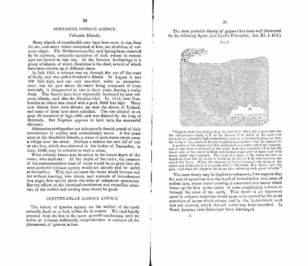
Another illustration we quote from Mr. LyelI's Principles of Geology.
"In April, 1815, one of the most frightful eruptions recorded in history oc-curred in the mountain Thniboro, in the island of Sumatra. It began on the 5th of April, and was most violent on the 11th and 12th, and did not entirely cease till iuly. The sound of the explosions was heard in Sumatra, at the diatance of 970 geographical miles in a direct line, and at Ternato, in an op. posite direction, at the distance of 720 miles. Out of a population of twelve thousand, only twenty-six individuals survived on the island. Violent whirl-winds carried up men, horses, cattle, and whatever else came within their influence, into the air; tore up the largest trees by their roots, and covered the whole sea with floating timber. Great tracts of land were covered with lava, several streams of which, issuing from the crater of the Tomboro moun-tains, reached the sea. So heavy was the fall of ashes, that they broke into the Presideit'5 house at Birna, forty miles east of the volcano, and rendered it, as well as many other dwellings in town, uninhabitable. On the side of Java the ashes were carried to the distance of 300 miles, and 217 towards Celebes, in sufficient quantity to darken the air.
29
The floating cinders to the windward of Sumitra formed, on the 12th of April, a mass two feet thick, and several miles in extent, through which slops with difficulty forced their way.
The darkness occasioned in the day time by the ashes in Java was so pro found, that nothing equal to it was ever witnessed in the darkest night.
The area over which the tremulous noises and other volcanic effects ex-tended, was one thousand English miles in circumference, including the whole of the Molucca islands, Java, and a considerable portion of Celebes." —Lyell.
Static pressure in Volcanoes.
The enormous pressure of the liquid lava against the interior of volcanoes, when it is raised to a great height, is the cause of the frequent eruption through their sides. The force requisite to raise lava to the edge of the crater of £tna, from the level of the base of the mountain, exceeds five tons per square inch. In Co-topaxi, one of the highest of all volcanoes, being 19,000 feet in height, the force required is ten tons per square inch: yet this volcano has projected matter 6000 feet above its summit, and once threw a stone weighing 200 tons to the distance of nine miles. Aconcagua in Chile has a height of 23,000 feet, and would therefore require at its base, for an eruption from the sum-mit, a force of nearly 14 tons per square inch.
Characters of Lava.
The melted matter ejected from volcanoes is composed chiefly of feldspar and augite. When the former prevails the lava is said ot be feldspathic or trachytic, and when the latter predominates the lava is said to be augitic. When lava is cooled near the surface of the mass, it is usually light and porous, having been inflated with bubbles of gas. In some cases these bubbles of gas are of great size, and the cavities constitute large caverns. Sometimes the elasticity of the gas explodes the bubbles and throws frag-. ments of lava into the air. When melted feldspathic lava comes into contact with water, the water is converted into steam, which occasions the lava to froth up, and converts it into pumice. At the time of the eruption of Skaptar Jokul in 1783, there was an island thrown up seventy miles from land, when the ocean was covered with vast quantities of floating pumice, for a distance of 150 miles. My friend Dr. C. T. Jackson has informed me that he has made pumice from the slags of furnaces by throwing wa-ter in the path of the running slag. It is indeed a common form of the slag of furnaces.
When lava cools under the pressure of a superincumbent mass, it is generally as compact and solid as the older rocks. Some of the products of volcanoes consist mostly of silex, and resemble
30
impure glass or the slag of furnaces, and frequently the artificial cannot be distinguished from the natural product.
Earthquakes.
One of the most remarkable earthquakes was that which began at Lisbon on the 1st November, 1755. A sound, like thunder under ground, was heard, and in six minutes the greater part of the city was thrown down, and 60,000 persons had perished. The sea retired, and then rolled back 50 feet higher than its or-dinary level. A new marble quay was suddenly swallowed up with a great concourse of people, and the vortex drew down many boats and small vessels. The highest mountains in Portugal were shaken from their foundations, opened their summits, were split and rent, and portions of them thrown down into the valleys. The shock was felt at sea, and a ship 120 miles west of St. Vin-cent experienced a violent concussion, which was probably oc-casioned by a wave of translation, that is, a motion of the water itself.
This earthquake was felt over a large part of the earth. All Europe, even to Norway, felt the shock. The waters of Loch Lomond (in Scotland) rose two feet and four inches. Terrible eruptions and earthquakes occurred in Iceland. Springs through-out Europe and Great Britain became hot, and some of them tur-bid. The North of Africa was violently shaken, and a village was engulphed with 8,000 or 10,000 persons. The shock was felt in the West Indies ; and the waters of Lake Ontario were violently shaken.
The West Indies have been more or less subject to earthquakes since their discovery. In 1692 a great earthquake engulphed three quarters of the large and opulent city of Port Royal in Ja-macia; the Blue Mountains, 8000 feet high, were rent and shat-tered, and the surface of the island swelled and heaved like a roll-ing sea. In 1843, Gaudaloupe and several towns were suddenly destroyed.
The motion of the ground in earthquakes is said to be like that of waves pursuing each other with great velocity, in many cases of 20 miles per minute. Sometimes the force acts in an upward direction, as in the earthquake of Calabria in 1783, when loose masses bounded into the air to the height of several yards, and in some of the towns the pavements were thrown up. During the same earthquake however, other places were affected with a force acting horizontally.
The effects of earthquakes, most important in a geological point of view, are the subsidence and the elevation of land. I the year 1772, Papandayang, one of the loftiest volcanoes of Ja-
31
va, was in eruption, when the greater part of the mountain, for a space of 15 miles long and 6 wide, fell in and disappeared with its inhabitants. On the other hand, the bed of the sea, in the har-bor of Conception (Chile), was raised, in 1750, to the amount of 25 feet, and in 1822 the coast of Chile was permanently eleva-ted through an area of 100,000 square miles.
Elevation of land in some cases is going on gradually, without any apparent earthquake shocks. This is remarkably the case with the country around the Baltic Sea, which is rising at the rate of two or three feet per century, as shown by the marks made at various periods to designate the high water level,and confirmed by the marine shells of species now living on the shore, which are found from 10 to 200 feet above the present level of the wa-ter and 50 miles inland.
The coast of Greenland appears to be undergoing a gradual de-pression. In this country the northern states appear to have been rising during a geological period not very remote, and perhaps the process is yet slowly going on.
Thermal Springs.
Geysers, or springs of hot water, occur in volcanic countries. The most celebrated are those of Iceland, in the southwest part of which is an assemblage of perforations in the earth, through which are emitted jets of boiling water. The Great Geyser, S or 10 feet in diameter, perforates a basin-shaped mound, through which a column of water of this diameter is frequently ejected, by an intermittent force, to the height of 150 or 200 feet, dividing in-to the most superb curvate ramifications, and throwing off shoots in oblique directions, whose falling jets endanger the spectator.
Hot springs are also common in countries which are quite re-mote from any existing volcanic agency, but which at no very remote geological period have been the theatre of volcanic ac-tion. In Arkansas and in Oregon are examples.
In some cases the heat is that of boiling water, but there are all degrees of temperature, and the thermal character of some springs is so slight as to be detected only by continued thermo-metrical observations.
In most if not in all cases, thermal springs, which are distant from active volcanoes, are situated near ancient volcanic rocks or near chains of mountains, which were broken up and elevated by the igneous agency of former epochs.
32
StJ]3MARINE IGNBOTJS AGENCY.
Volcanic Islands.
Many islands of considerable size have been seen to rise from the sea, and many others composed of lava are doubtless of vol-canic origin. The Mediterranean Sea only having been observed by the ancients, authentic narratives of such events in remote ages are limited to that sea. In the Grecian Archipelago is a group of islands, of which &tntorini is the chief, several of which have been thrown up at different times.
In July 1831, a volcano rose up through the sea ot the coast of Sicily, and was called Graham's Island. In August it was 180 feet high, and one and one-third miles in circumfer-ence: but the part above the water being composed of loose materials, it disappeared in two or three years, leaving a rocky shoal. The Azores have been repeatedly increased by new vol-canic islands, and also the Aleutian isles. In 1814, near Una-laschka an island was raised with a peak 3000 feet high. Many new islands have been thrown up near the shores of Iceland, and some of them have since subsided. The one alluded to on page 29 consisted of high cliffs, and was claimed by the king of Denmark. But Neptune appears to have been the successful claimant.
Submarine earthquakes not infrequently furnish proofs of their occcurrence in sudden and extraordinary waves. A few years since at the Sandwich Islands, a series of such waves swept away a village near the shore. Perhaps a sudden rise and fall of one or two feet, which was observed in the harbor of Nantucket, in June, 1836, may be referred to such a cause.
What volcanic forces may be active in the lowest depth of the ocean, who shall say? At the depth of five miles, the pressure of the superincumbent mass of water would be so great that the most powerful volcanic agency would act silently and be unfelt at the surface. With that pressure the water would become red hot without bursting into steam, and currents of incandescent lava might flow quietly down the sides of submarine mountains. But the effects on the chemical constitution and crystalline struc-ture of the melted and cooling mass would be great.
SUBTERRANEAN IGNEOUS AGENCY
The history of igneous agency on the surface of the earth naturally leads us to look within for its source. We shall briefly proceed from the less to the more general conclusions, until we arrive at a theory sufficiently comprehensive to embrace all the phenomena of igneous action.
33
The most probable theory of geysers has been well illustrated by the following figure, (see Lyell's Principles; Am. Ed. I. 42.)
Fig. 2.
Suppose water percolating from the surface of the earth to penetrate into the subterranean cavity A D by the fissures F F, while at the same time steam at an extremely hirh temperature, such as is commonly given out from the vents of lava currents during congelation, emanates from the fissures C.
A portion of the steam is at first condensed into water, while the tempera ture of the water is elevated by the latent heat thus envolved, till at last the lower part of the cavity is filled with boiling water and the upper part with steam under high pressure. The expansive force of the steam becomes at length so great that the water is forced up the fissure E B, and runs over the rim of the basin. When the pressure is thus diriiinished, the steam in the upper part of the cavity A expands, until all the water D is driven into the pipe and when this happens the steam also rushes up with great velocity."
The same theory may be rpplied to volcanoes, if we suppose that the seat of operations is at the depth of several miles, on a mass of molten lava, where water entering is converted into steam which forces up the lava in the crater of some neighboring volcano or through the crust of the earth. That water is an important agent in volcanic eruptions would seem to be proved by the great quantities of steam which escape, and by the hydrochloric acid and salt emitted, which the suit waler may have furnished. In South America even fishes have been discharged.
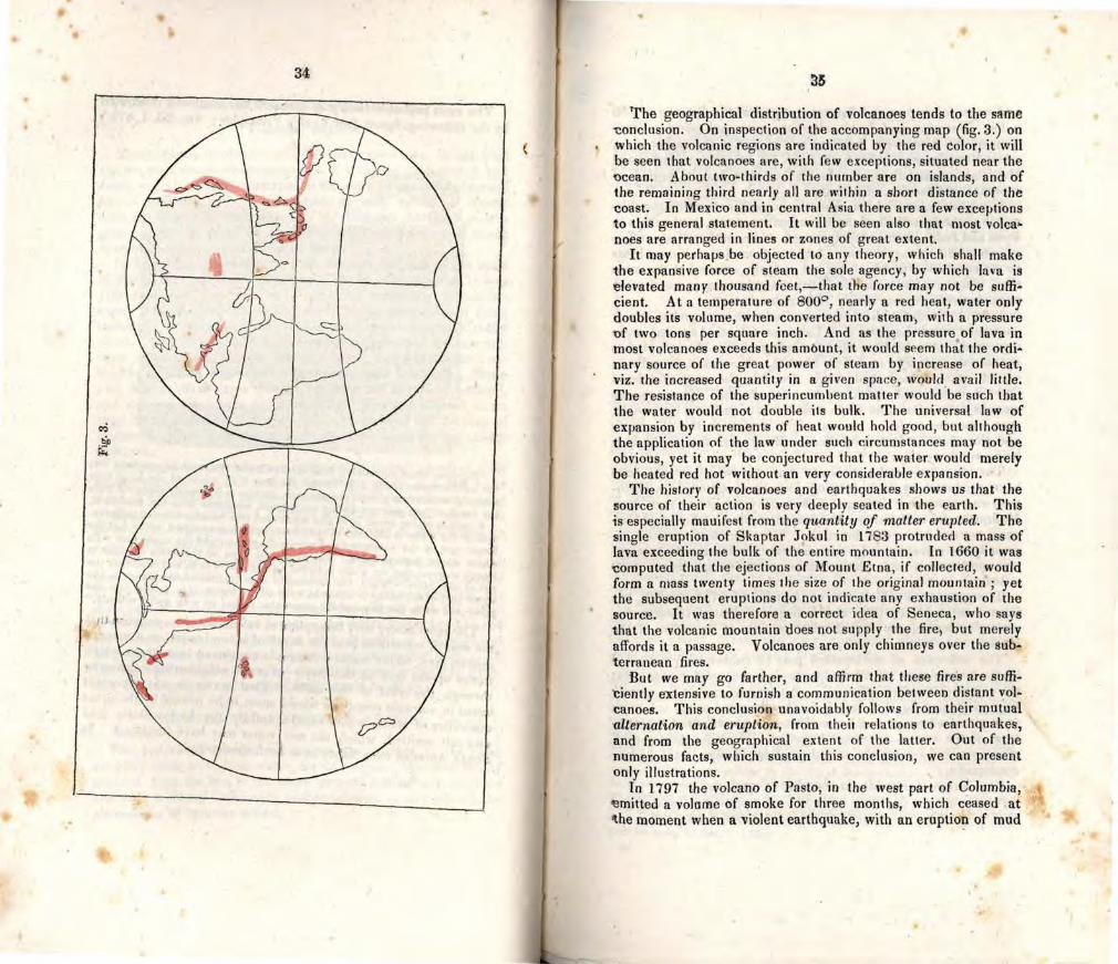
34
The geographical distribution of volcanoes tends to the strn 'conclusion. On inspection of the accompanying map (fig. 3.) on which the volcanic regions are indicated by the red color, it will be seen that volcanoes are, with few exceptions, situated near the ocean. About two-thirds of the number are on islands, and of the remaining third nearly all are within a short distance of the coast. In Mexico and in central Asia there are a few exceptions to this general statement. It will be seen also that most volca noes are arranged in lines or zones of great extent.
It may perhaps be objected to any theory, which shall make the expansive force of steam the sole agency, by which lava is elevated many thousand feet,—that the force may not be suffi-cient. At a temperature of SOO, nearly a red heat, water only doubles its volume, when converted into steam, with a pressure of two tons per square inch. And as the pressure of lava in most volcanoes exceeds this amOunt, it would seem that the ordi-nary source of the great power of steam by increase of heat, viz, the increased quantity in a given space, would avail little. The resistance of the superincumbent matter would he such that the water would not double its bulk. The universal law of expansion by increments of heat would hold good, but although the application of the law under such circumstances may not be obvious, yet it may be conjectured that the water would merely be heated red hot without an very considerable expansion.
The history of volcanoes and earthquakes shows us that the source of their action is very deeply seated in the earth. This is especially mauifest from the quantity of matter erupted. The single eruption of Skaptar Jokul in 1783 protruded a mass of lava exceeding the bulk of the entire mountain. In 1660 it was computed that the ejections of Mount Etna, if collecied, would form a mass twenty times the size of the original mountain ; yet the subsequent eruptions do not indicate any exhaustion of the source. It was therefore a correct idea of Seneca, who says that the volcanic mountain does not supply the fire, but merely affords it a passage. Volcanoes are only chimneys over the sub-terranean fires.
But we may go farther, and affirm that these fires are suffi-iently extensive to furnish a communication between distant vol-
canoes. This conclusion unavoidably follows from their mutual alternation and eruption, from theit relations to earthquakes, and from the geographical extent of the latter. Out of the numerous facts, which sustain this conclusion, we can present only illustrations.
In 1797 the volcano of Pasto, in the west part of Columbia, ennitted a volume of smoke for three months, which ceased at The moment when a violent earthquake, with an eruption of mud
0
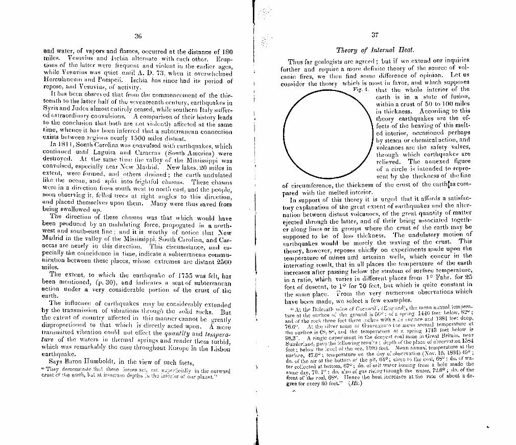
36
1. 37
and water, of vapors and flames, occurred at the distance of 180 miles. Vesuvius and Ischia alternate with each other. Erup-tions of the latter were frequent and violent in the earlier ages, while Vesuvius was quiet until A. D. 73, when it overwhelmed Herculaneum and Pompeii. Ischia has since had its period of repose, and Vesuvius, of activity.
It has been observed that from the commencement of the thir-teenth to the latter half of the seventeenth century, earthquakes in Syria and Judea almost entirely ceased, while southern Italy suffer-ed extraordinary convulsions. A comparison of their history leads to the conclusion that both are not violently affected at the same time, whence it has been inferred that a subterranean connection exists between regions nearly 1500 miles distant.
In 1811, South Carolina was convulsed with earthquakes, which continued until Laguira and Caraccas (South America) were destroyed. At the same time the valley of the Mississippi was convulsed, especially near New Madrid. New lakes, 20 miles in extent, were formed, and others drained ; the earth undulated like the ocean, and split into frightful chasms. rfheSe chasms were in a direction from sou tli vest to north east, and the people, soon observing it, felled trees at right angles to this direction, and placed themselves upon them. Many were thus saved from being swallowed up.
The direction of these chasms was that which would have been produced by an undulating force, propogated in a north-west and south-east line ; and it is worthy of notice that New Madrid in the valley of the Mississippi, South Carolina, and Car-accas are nearly in this direction. This circumstance, and es-pecially the coincidence in time, indicate a subterranean commu-nication between these places, whose extremes are distant 2500 miles.
The extent, to which the earthquake of 1755 was felt, has been mentioned, (p. 30), and indicates a seat of subterranean action under a very considerable portion of the crust of the earth.
The influence of earthquakes may be considerabl y extended by the transmission of vibrations through the solid rocks. But the extent of country aliectcd in this manner cannot be greatly disproportioned to that which is directly acted upon. A mere transmitted vibration could not effect the quantity and tempera-ture of the waters in thermal springs and render them turbid, which was remarkably the case throughout Europe in the Lisbon cart h quake.
Says Baron Humboldt, in the view of such facts, They demonstrate that these forces act, not superficiall y in the outward
crust of the earth, but at immense depths in the interior of our planet."
Theory of internal Beat.
Thus far geologists are agreed ; but if we extend our inquiries further and require a more definite theory of the source of vol- canic fires, we then find some difference of opinion. Let us consider the theory which is most in favor, and which supposes
Fi 4. that the whole interior of the earth is in a state of fusion, within a crust of 50 to 100 miles in thickness. According to this theory earthquakes are the ef-fects of the heaving of this melt-ed interior, occasioned perhaps by steam or chemical action, and volcanoes are the safety valves, through which earthquakes are relieved. The annexed figure of a circle is intended to repre-
g.
sent by the thicknesss of the line
of circumference, the thickness of the crust of the earthas com-pared with the melted interior.
In support of this theory it is urged that it affords a satisfac-tory explanation of the great extent of earthquakes and the alter-nation between distant volcanoes, of the great quantity of matter ejected through the latter, and of their being associated togeth-er along lines or in groups where the crust of the earth may be supposed to be of less thickness. The undulatory motion of earthquakes would be merely the waving of the crust. This theory, however, reposes chiefly on experiments made upon the temperature of mines arrd artesian wells, which concur in the interesting result, that in all places the temperature of the earth increases after passing below the stratum of surface temperature, in a ratio, which varies in different places from 1 0 Fahr. for 25
feet of descent, to 10 for 70 feet, but which is quite constant in the same place. From the very numerous observations which have been made, we select a few examples.
At the Dolcoath mine of Cornwall, (Eneland), the mean annual tempera-ture at the surface of the ground is 50° of a spring 1440 feet l,eow, 82° and of the rock three feet three inches wthn its surface and 1381 feet deep,
766°. At the silver mine of Guanaxuato the mean anneal temperature at the surface is 68, 8°, and the temperature of a spring 1713 feet helow is
98,3. A single experiment in the deepest coal mine i n Great Britain, near Sunerland, gave the following results ; depth of the place of observation 1584
feet; below the level ol the sea, 1500 feet. Mean annual temperature at the surface, 47.6° ; temperature on the day of observation (Nov. 15, 1834) 49°
do. of the air at the bottom of the pit, 64°; close to the coal, 680 ; do. of wa-ter collected at bottom, 67°; do. of salt water issuing from a hole made the same day, 70. 1 1 do. also of gas rising through the water, 72.6° ; do. of the front of the coal, 68°. Hence the heat increases at the rate of about a de-gree for every 60 feet." 1,11k.)
38
At Berlin (Prussia) the mean temperature is 47.1 0 ; the tem perature of the water of an artesian well at the depth of 675 feet is 67.6°. At Paris the main temperature is 51.1° ; the tem perature of an artesian well 1800 feet deep (the deepest in the world,) is 83°. In Wurtemhurg the water obtained in artesian wells is used with success to prevent the stopping of machinery by the freezing of the water which carries it, and also for warm ing a paper manufactory.
As similar results have been obtained in all cases, it is infer-red that the heat would be found to continue to increase, if we were able to penetrate much deeper, until at the depth of one or two miles, we should reach the temperature of boiling water.f At the same ratio of increase, the heat at a depth of fifty miles would be sufficient for the fusion of all known rocks.
It has been objected to this theory, that the diffusion of heat through the liquid interior should melt also the crust of the earth. If it were supposed that the heat continued to increase through all the melted nucleus to the centre in the sonic ratio in which it increases through the solid crust, the objection would be fatal to any such theory. But we cannot see any wore difficulty in con-ceivig that the earth has had a crust 50 miles in thickness con-gealed in the laise of ages, than that a body of water should be iticrusted with ice by a similar process. It might as well be ur-ged that it is impossible for a pond of water to he frozen over, because the diffusion of heat through the water would melt the ice.
A nother theoi'y supposes that there are, beneath the crust of the earth, iiiinicnse reservoirs and subterranean channels of lava, whose action is the source of eruptions and earthquakes. 'l'he ground of preference for this theory on the part of its advocates, is, that it is sufficient to account for all the phenomena of earth-quakes and volcanoes, and of the temperature of mines and ar-tesian wells, if, however, these reservoirs, and channels are thus numerous, the theory is obviously exposed to the objection which has been urged atainst the former, and the existence of partitions protected from the colder temperature of the surface by miles of non-conducting materials, but exposed to the action of these adjacent lakes of fire, is inconsistent with the laws of the equilibrium of heat in liquids.
AQTJEOPTS AGENCIES
The aqueous agencies, which are modifying the surface of the earth may be classified as they are, or are not, marine. Those
'Warm spriligs which rise from deep sources, have been used for warming conservatories, and irrigiting garedns. It is said that a piece of ground at Erfurt h Germany) whic is thus kept at an equable and high temperature yietd to its proprietor a annual profit of $60,000 derived from raising salad.
tOn account of the great pressure, it is not to be inferred that water would boil at this or any other depth. v. p. 35.
39
which are not marine are the atmospheric agencies of rain and frost ; rivers with their occasional inundations, aided by ice, and forming deltas ; lakes bursting through their barriers; springs depositing mineral inatter on the surface of the ground ; and glaciers. The marine agencies are waves, tides, oceanic cur-rents, and icebergs.
AQJE0US AGENCIES, NOT MARINE.
ATMOSPHERIC AGENCIES.
Rain acts chemically on all calcareous rocks. It is well known that water, although when pure it will not dissolve limestone, yet when charged with carbonic acid gas, will dissolve calcareous matter with a facility proportioned to the quantity of gas in the water. Falling rain obsorbs this gas from the air, and thus ac-quires the power of slowly dissolving the solid rocks in limestone countries. Calciferous rocks exhibit the effect of this action in the irregular furrows which are worn down their inclined sides, and in the generally rounded surfaces of such rocks.
Rains also act mechanically by carrying the loose fragments and particles of the surface of the ground into rivers, thus fur-nishing them, not only with their liquid but also with their solid contents.
This agency is very strilting in some countries, where the rock formations are more or less porous like sandstone, or where they have not been first worn and then protected by Drift. In Jamai-ca and Antigua there is often an imperceptible gradation of cohe-rence from the loose soil of the surface to the solid rock beneath, and the upper portions of the latter may easily be removed with a spade. Heavy rains falling on the steep sides of mountains of such rocks will therefore carry off immense quantities of matter, and expose fresh portions of rock.
The removal of mineral matter from higher to lower stations is the greater from the fact that a greater quantity of rain usually falls on high than on low lands. Eievated districts being cooler condense a greater portion of the vapor, which is every where present in the atmosphere. This is especially manifest in hot countries, where the intense heat enables the air to contain an immense amount of watery vapor, which is condensed in deluging showers on the cooi sides of the mountains.
In cold climates the agency of frost more or less compensates for the deficiency of rain in the work of destruction. Water pen-etrating into porous rocks or entering fissures, and expanding by frost with an irresistible force, crumbles the surface, and throws out large blocks of stone. The fragments lie in enormous heaps
r 40
at the base of precipices or fall into the beds of mountain torrents and are removed by freshets.
Rivers co-operate in the work by carrying down limestone in solution, I hus furnishing the materials for the solid structures of some of the most extensive and interesting organic agencies which we are to notice. Their most obvious action, however, is in the transport of matter merely by mechanical agency. This is much greater than some would suppose, from the fact that mineral sub-stances lose about three-sevenths of their weight in water as com-pared with their weight in air. A current moving with a velocity of only 300 yards per hour, will tear tip fine clay ; of 600 yards per hour, will remove fine sand ; of two-thirds of a mile per hour, will remove coarse sand ; and with a velocity of two miles per hour, will transport stones two inches in diameter, The agency of running water is also multiplied by the friction of the trans-ported fragments upon each other and on the bed of the stream.
One of the most magnificent and instructive examples of the denuding agency of rivers is to be seen in the retrocession of the IViagara Falls, which have cut an enormous ravine from Queens-town seven miles back to their present situation. In consequence of the structure of that (histrict, soft shales at the base of the falls underlying the harder limestone, the latter is gradually under-mined and these fragments of the overlying rock are detached from above. In this way the falls are now retrograding at a rate not easily reckoned with precision for the want of historical data, but variously estimated to average from one yard to one foot per year. As the rocks have a small dip backwards in the direction of Lake Erie, the falls will at length cease to act on the soft shales, and the process will then be greatly retarded.
The Ganges and Burrarnpooter, descending from the Himalaya mountains, the loftiest on the globe, unite in a vast delta which they have formed. This delta is an extensive alluvial plain, reti-culated by an immense number of channels, and is more than twice as large as the state of Vermont. Nothing as coarse as gravel can he found near the Ganges within 400 miles of its mouth. The river has been known to carry away 40 square miles from one district within a few years. Islands of many miles in extent are formed in a short period. Various estimates have been made of the quantity of the solid matter which is carrieddown by this river; according to the most accurate of which, 35,000 cubic feet of mud pass down every minute during the flood season, or about 3,500,000 tons daily, and the quantity (liSCharged during the 120 days of the flood must therefore amount to 6,000,000,000 of cubic feet. High tides (ii to 16 feet) rapidly disperse this sediment in the Bay of Bengal, whose waters, 100 fathoms deep at 100 miles out, are gradually shoaled from this distance towards
41
the shore to four fathoms, and for 60 miles are discolored by this turbid stream. The annual discharge of the Ganges would be sufficient to cover a township six miles square with soil to the depth of nearly seven feet.
The delta of the Nile is nearly as large as the state of Ver-mont. Its progress has been arrrested in comparatively modern times by an easterly current in the Mediterranean, which carries off much of the sediment that is discharged into the sea, and preys occasionally upon the delta itself. It is very probable that a bay once occupied the site of the delta, and that it must have been of great depth, for while the sea near the shore gradually deepens to 50 fathoms, it then suddenly falls off to 380 fathoms.
The Amazon is probably unequalled among all the powerful agents of degradation. The vast amount carried out by its cur-rent, which is not entirely lost in the ocean at the distance of 300 miles from land, is furnishing materials, which, instead of forming a delta, become the subjects of oceanic agents.
The Mississippi, the father of waters, has formed most of the lower part of Louisiana, and is forming a tongue of land which extends on each side of it far into the Gulf of Mexico, and which has advanced several leagus since New Orleans was built.
In Massachusetts the matter carried down by the Merrimac has been estimated, from careful experiments by Dr. S. L. Dana, of Lowell, to be 840,000 tons per annum.
The destructive force of occasional floods and storms is worthy of notice. Oceanic deltas are liable to be flooded not only by freshets but by storms from the sea, driving up the tide and cur-rent, and when at rare intervals these causes all combine,extensive tracts are entirely remodeled, and vegetable and animal life per-ish on a scale commensurate with the changes in inorganic nature.
An instructive example of the extraordinary effects of freshets occurred a few years since in Addison County, in this State, of which we shall give an acount on some future occasion. It is here mentioned, in passing, because many of our citizens will recollect the disasters of that flood, especially in New Haven. Tropical mountainous regions, like some of the West India Isl-ands, are especially liable, from the heavy rains which fall on the mountains, to very destructive floods, which pour down in con-tinuous cataracts, sweeping along rocks of many tons weight, where ordinarily an insignificant brook only is to be seen. Tem-porary rivers are then formed where in dry seasons water is en-tirely wanting.
Masses of ice cooperate powerfully with freshets, choking up the course of the stream, and forming basins of the accumulated waters, which at length burst their barriers, and rush down )
6
I 42
tearing up the loose earth in narrow gorges, like Deerfield River in Massachusetts, and grinding over the solid rocks with the noise of thunder. These effects are sometimes seen on a scale which would not have been anticipated.
The tendency of a river flowing through a plain of unconsoli-dated materials is to form curves, or bends as they are usually called. Wherever the current deviates from a straight line, it strikes the opposite bank, wearing it away, while the comparative quietness of the water on the other side promotes the accumula-tion of sediment, and the degree of curvature is thus continually increasing. At length in some unusual freshet, the river cuts across the narrowed neck of the bend and forms a new channel. Such bends are numerous on the Mississippi, and are frequently cut off. A few years since a remarkable bend in the Connecti-cut, in the beautiful alluvial meadows of Northampton, had a cir-cuit of about three miles with a neck of eighty rods, when in a freshet the river cut a deep channel across the neck, leaving its former circuit dry except so far as it still receives a small tributary.
Numerous rivers, in the lower part of their channels, have probably ceased the work of excavation, and when confined by embankment have a tendency to fill up their beds and run at a higher level. The Po and the Adige drain the northern part of Italy, and have caused one hundred miles of coast to encroach twenty miles upon the Adriatic sea within 2000 years. On these rivers the practice of embankment, which commenced in the thir-teenth century, has been carried to a great extent. In consequence, the Po has been filled up so much that the surface of the water is higher than the roofs of the houses in the city of Ferrara. The magnitude of these barriers is a subject of increasing expense and anxiety, it having sometimes been found necessary to give them an additional height of one foot in a single season. The Missis-sippi is confined by levees for a considerable distance above and below New Orleans, and as the Po is comparatively a pigmy, the future inhabitants of Louisiana may expect to find the river rather unmanageable, should it begin to fill its bed and to raise its waters.
Notwithstanding the powerful degradating agency of rivers, they have not in most cases formed the valleys through which they flow. These are usually due to agencies which gave the configuration to the surface of the earth long anterior to the his-torical epoch. Some rivers, as the Deerfield in Massachusetts, near its mouth, and the Connecticut between Mt. Holyoke and Mt. Tom, and again at Middletown in Connecticut, turn aside from valleys, through which a moderate elevation would send them, to pass through mountain gorges, which must have been made by other agencies. The consideration of the terraces so
43
frequently seen on the banks of rivers belongs to another geologi-cal period.
The bursting of lakes is an agency, which, although occasional and rare, produces powerful effects. This is not the place to de-scribe the well known example of the Runaway pond in Glover in this State, and we introduce for an illustration the case of the frightful deluge which occured in 1818 in the valley of Bagnes in Switzerland. r he waters of the Drance were dammed up by the falling of glaciers and avalanches, which formed a barrier 400 feet high and 600 feet wide, above which a lake nearly a mile and a half long accumulated. A bold and persevering engineer tunnelled the dyke so as to meet the surface of the water of the lake, which flowed through, gradually melting down its channel as the water fell in the lake. In this way 330,000,000 cubic feet of water were carried off in three days without damage, when the dyke gave way, and in half an hour 530,000,000 cubic feet of water swept down, running the first 13 miles in thirty-five min-utes, and bearing down 400 houses, with trees, rocks and earth. Had it not been for the enterprise of the engineer three times the amount of water might have accumulated before bursting through the dyke.
Landslideg frequently occur on mountains, especially in times of freshets, and sometimes fill up the course of streams and oc-casion floods. Hills of clay are peculiarly liable to slides, which produce contortions in the flexible strata. Avalanches of snow and ice concur in violently removing rocks and earth from the steep sides of mountains into valleys beneath.
The history of glaciers has within a few years excited much interest, not only on account of their remarkable effects and mode of action, but because of their supposed applicability on a grand and nearly universal scale to the explanation of the phenomena of Drift
"Glaciers are masses of ice wiieh are enclosed in Alpine valleys, or are suspended upon the flanks of the mountains which rise into the regions of eternal frost. Being of white color, they appear at •a distance like vast streams of snow issuing from lofty summits, and extending into the lower val-leys. In the Alps * * * they terminate sometimes as high as 7000 or 8000 feet ; but some descend to 300 feet. 'l'hey are sometimes three miles wide and fifteen long, and their thickness at the lower end varies from 80 to 100 feet, and at the upper end, from 12 to 180 feet. * * * Glaciers are composed of snow that has been more or less melted and again frozen. The lower part becomes pure solid ice ; the upper part is composed of a sort of granular
* * A new layer is added at least each year, so that the mass is strati-fied. The upper surface is rough and sometimes covered by pointed masses of ice, called aiguilles or needles. Fissures across the glaciers, 20 or 30 and sometimes even 100 feet wide, are very common, produced by the unequal temperature of different parts of the mass. The slope of glaciers is frequently quite moderate. The lower end of the glacier of Aar, which is 15 miles long, is 3000 feet below the upper cud."
44
"The crests and higher parts of the Alps, which are frequently vast pie. teaux, or tab]e lands, containing 100, 200, or even 300 square miles, are cov-ered with thick continuous masses of ice, though the lofty peaks sometimes rise as volcanic mountains from the ocean. These plateaux are denominated mers de glace or seas of ice, and from which the glaciers originate. The mars de glace, by expansion, send down the streams of ice, which continue to de-scend until they are incited. The common opinion, that the glaciers slide down the monntain by their weight is found to be incorrect; as they are not detached from the mar de glace; and it is only the lower part, where the ground is thawed beneath, that slides over the surface, and that by the expan-sion of the "water freezing in the fissures." In the winter they do not slide at all on their bottom."
"As glaciers advance by expansion, they break off masses of rock from the sides and bottoms of the valleys, and crowd along whatever is moveable, so as to fbrni large accumulations of detritus in front and along their sides. When the glacier melts away, these ridges remain, and are called moraines."
Although the inferior surface of the glacier is pure smooth ice, yet it is usually thickly set with fragments of rock, pebbles and course sand, firmly frozen into it, which make it a huge rasp ; and when it moves forward, these projecting masses, pressed down by the enormous weight of the glacier, wear down and scratch the solid rocks ; or when the materials in the ice are very fine, they smooth and even polish the surface beneath. The moveable mate-ria]s beneath the ice are crushed and rounded, and often work into sand and mud. The rocks in place, against which the glacier presses, are also smoothed and striated upon their sides. These strite wherever found, are perfectly parallel to one another, because the materials producing them are fixed in the bottom of the ice. But as the glacier advances and retreats, new sets of scratches will be produced, which sometimes cross those previously made at a small angle." (1-1k.)
The causes of springs and the circumstances which modify their action, are strictly geological, but as this portion of the subject is one of great economical importance, we shall reserve it for future consideration under the head of Economical Geology. We are here to consider springs only as agents of geological changes.
Springs act chiefly by taking up mineral matter at various depths and afterwards depositing it on the surface of the ground. The deposits of greatest magnitude which are thus formed are calcareous or siliceous. We have already remarked that water containing carbonic acid has the property of dissolving limestone. Now the quantity of this gas which water is capable of containing depends upon pressure. Under the pressure of the atmosphere it may contain its own volume; if the pressure be doubled, it will take up double its volume and so on, and to any additional amount in exact proportion to the pressure. Conse-quently, at some distance within the surface of the earth, springs may, and especially in limestone countries do, contain a great amount of this gas. Hence the subterranean passages of such water through fissures in limestone enlarges those fissures, so that in many cases rivers of considerable size flow under ground, as in Jamaica, which after flowing on the surface for miles have been lost in limestone chasms. Caverns of greater or less size are formed by
the same agency, for caves of any considerable extent are almost invariably in limestone districts.
The water, if overcharged with gas and limestone, that is, containing more than the mere pressure of the air will permit, must deposit the excess of limestone when it issues either into an open cavern or upon the surface of the ground. When it drops from the roof of a cavern, stalactites are formed, like icicles pendent from the roof, and masses of stalagmite on its floor, and some-times these meet, forming a column, which is continuous from the floor to the roof of the cavern. Sometimes these masses, espe-cially the stalactites, are of a beautiful crystalline structure; the stalagmite is more frequently in thin concentric but irregular lay-ers, a result of the mode of its deposition. Masses of the latter have been seen, in many countries, rising up like altars 10 or 12 feet high, and 15 feet in diameter. Slabs of beautiful calcareous alabaster are obtained from such stalagmite.
The most extensive deposits of this kind are formed where the springs issue on the surface of the ground. At San Filippo in Italy the springs have deposited a mass of limestone 250 feet thick, and extending a mile and a quarter, when the calciferous waters are diluted by another stream, and the portion of limestone not before deposited is carried into the sea. These springs have been known to deposit a solid mass 30 feet thick in 20 years. The geologist is familiar with numerous cases like this. Fre-quently the calcareous deposits of springs are more or less filled with irregular pores, and the mass is then called tufa. Nurner-ous examples occur in this State which will be described in their place. Plants and any other bodies, lying in the water of such springs, are liable to be coated with the deposit, and such cases of mere incrustation are sometimes confounded with petrifaction, which is an entirely different process.
Deposits of siliceous matter, often called siliceous sinter, are the product of hot springs. If water contain an alkali, as soda, it is capable, especially at a high temperature, of dissolving silex, which is deposited when the spring comes to the surface. The basin of the Great Geyser in Iceland has been form-ed in this manner. Siliceous incrustations are formed on plants in the same manner as the calcareous incrustations above men-tioned. Such deposits are less numerous and extensive than those which are calcareous, but of much interest, as shewing us how water may dissolve rocks of flint.
OCEANIC AGENCIES.
The materials which are borne along by rivers, if not deposited along their course, are consequently carried into lakes, seas, and
'IG
oceans and distributed in sedimentary strata over their beds. We are now to glance at the agencies which regulate and modify this distribution. In lakes, especially those of small extent, the modify-ing agencies are slight and the strata will ordinarily constitute basin-shaped deposits. But in oceans and seas there are several pow-erful causes, which are of great interest not only on account of the effects which they are actually producing, but because the effects are examples of agencies, which have in former epochs act-ed in a similar manner to form a large portion of the present sur-face of continents. They are waves, tides, currents and ice-bergs.
Waves.
In consequence of the indefinite and imaginative descriptions which are common of waves running " mountain high," those who are not familiar with the open ocean, seldom have correct conceptions of them. These I mountains' rarely exceed thirty feet in height, although they have been observed in the Pacific of the height of forty feet. We were once favored with an exhi-bition of waves on a scale of unusual magnitude, when the height of their summits was, for the most part, not over thirty feet above the bottom of the depressions, and the highest did not exceed thirty-five feet. Although these waves were suddenly raised by a storm, which had been immediately preceded by another at right angles, in the Gulf Stream, and were of course very short and narrow, the height was less than one-tenth of the width. Enormous as are these masses, which may be a half mile or more in length, the sublimity of such a scene depends more on their motion than on their magnitude. The motion, which, as is well known, is a motion of the form and not of the sub-stance, is often twenty miles per hour, rapidly rolling past the fleetest ships.
But since the motion is not in the substance of the water, this agency acts only at a moderate depth, and geological effects are produced only when these masses are driven on shoals and coasts. Here, on account of the resistance of the bottom, they rollup a front more and more steep until it becomes perpendicular, and being still urged on, they fall over and break with enormous force on the coast, dashing up the sides of rocky cliffs or rushing in a sheet of foam far up a sloping shore. Zn
One of .the most common effects is the wearing of loose stones, originally rough and angular, into smooth oval peb-bles. On a sloping shore the loose stones are exposed to the continual friction of rolling up and (loWn, and those of the hard-est flints are usually the most perfectly rounded. On shores
47
where the rocks are limestone occasionally containing flint, the pebbles of flint are found to exceed in number those of the lime-stone, most of the latter having been entirely destroyed by the continual friction. The form .s'ill depend somewhat upon the structure of the rock, slates furnishing small much-flattened oval forms, constituting a mass of gravel or shingle. Sometimes steep shores of granite or other hard rock are covered deeply with large loose pebbles, such as furnish the paving stones for our cit-ies, the rattling down of thousands of which after the retiring waves produces a crashing sound, of painful intensity. Storms sometimes pile up at the head of sandy beaches, out of the reach of ordinary tides, enormous ridges of pebbles. An example may be seen at Chelsea beach near Boston, where is a ridge most-ly of pebbles of porphyry, two miles long, ten to fifteen feet high, and four rods wide, like a vahl, between the sea and low marshes within. Blocks of stones of several tons weight are also moved in storms by the force of the waves, and a coast is modified so as to be recognized only in its outline, the minute details of the shore beimig entirely changed.
On coasts which are fringed with cliffs of loose materials, the waves undermine the cliffs until fragments fall down an easy prey to the next storm. If the cliffs are composed of the drift deposits, the finer materials are washed away, while the shore at its base is covered with large boulders, monuments of ruin. But if the cliffs are of solid rock, they will oppose a more effectual resistance. Yet solid rock is not impregnable, for the waves, taking up loose fragments, use them like battering rains to undermine the base of the cliff, while the agency of frost above aids in the work. If the cliffs be of limestone of unequal hardness from the intermixture of silex, peculiar and remarkable effects are produced; the siliceous fragments furnish nearly indestructible pebbles, which wear out cavities and sometimes long irregular caverns, whose sides, consisting of smooth cavities, attest the agency by which they were formed.
Oceanic Currents.
The naked rocks on the outside of Boston harbor, and the crumbling cliffs of I)rift on the inner islands, shew the agency of easterly storms in the excavation of the harbor. Much of the eastern coast of England is rapidly crumbling away, and many towns are known only in history, their site now forming a part of the German ocean. In the harbor of Sherringliam there was ten years since, depthsuIIicient to float a frigate, where forty-eight years before there was a cliii filly feet Iigh with houses on it.
More or less modified and aided by oceanic currents, the sea
48
is making extensive depredations on some shores and building up others.
The materials which are brought down by rivers and removed from the shore by waves are not then left to subside at once to the bottom of the sea. Oceanic currents, some perpetual and fixed in their course, and others intermittent and variable, bear the finer sediment into the deeper part of the ocean. The most re-inarkable and well known is the Gulf Stream, which flows past the eastern coast of South America, bearing the sediment of the Amazon to the north, and forming vast districts of low land be-tween that river and the Oronoco; then spreading through the Caribbean Sea it enters the Gulf of Mexico, where, being pent up, it rushes through the straits of Florida with a velocity of four miles per hour, diminishing to three miles off Cape Hatteras, whence it takes a north-easterly course to the Banks of New-foundland, where it is met by another current from Baffin's Bay and deflected towards Iceland, Spitsbergen, and the Northern parts of Scotland. In this great river of the ocean flow about 90,000,000,000 of cubic feet of water per minute, or 3000 times the amount discharged by the Mississippi. The polar current from Baffin's Bay is divided on meeting with the Gulf Stream, one portion being supposed to run under the latter to the south, and the other flowing on the surface between the Gulf Stream and the coast of North America. Another current of great size flows from the Antarctic ocean along the Western coast of south America. That Arctic or Antarctic currents flow beneath the surface into theequatoriaI regions of the Atlantic is proved by the temperature of the Caribbean Sea, which on the surface is 800, but at the depth of 240 fathoms is 48 0, only 1 0 warmer than at a corresponding depth within some parts of the Arctic circle. One of the under currents has been found at the equa-tor 200 miles broad and 23° colder than the surface water.
These great currents are influenced to some extent by long storms and prevailing winds, and other less and local currents are entirely remodeled by storms.
The ocean is thus not a great lake, but a mass of broad rivers, whose size and complexity of divided, deflected, upper and un-der currents, present to the geologist a vast and intricate prob-lem, whose details are yet to be solved. If the fine sediment which comes within the influence of these currents subsides at the rate of one foot per hour, it will be carried hundreds or thou-sands of miles, and in many cases by upper and under currents in different directions, before it will repose on the bed of the ocean in strata which are destined to be the slate rocks of some fu-ture geological epoch. Extensive shoals and long low islands occur off the coast of the Southern States which are separated from
49
the main land by large bodies of water, and which are probably the products of oceanic currents. Long Island once constituted several islands, which have been united into one by the action of tides and currents and waves. Oft Massachusetts Bay, far out in the deep sea but west of the Gulf Stream, are dangerous shoals which have probably been formed by currents.
Oceanic currents not only distribute the sediment which is me-chanically suspended, but they also aid the waves and tides in mingling throughout the ocean with great uniformity its saline ingredients, whether they are dissolved primarily by its own wa-ters or by rivers.
Icebergs.
Icebergs are masses of fresh-water ice which are seen floating on the ocean or stranded on shoals both in the northern and southern hemispheres, and with few exceptions in latitudes above 40°.
In their originS, icebergs are glaciers formed in the higher lati-tudes all along the coasts and in the bays, in the same manner in which glaciers are formed i-n the Alps ; (see page 43). The new Antarctic continent, which was discovered in 66° south latitude by the exploring expedition sent out by our Government, was found to be bounded continuously by icy cliffs from one hun-dred and fifty to two hundred feet in height, without any appear-ance of rocks. "No break in this icy hurrier where a foot could be set on the rocks, was observable from aloft." A long range of icebergs were seen stranded in the sea, where bottom could not be reached with a line of nine hundred feet. The line of the icy harrier was only here and there pierced by deep bays, but otherwise was quite uniform. A few floating icebergs were seen with rocks and earth on them, on one of which a landing was effected and some geological specimens were obtained. One rock was five or six feet in diameter. On the iceberg was a pond of fresh water of an acre in extent. Captain Wilkes describes the icebergs which were seen near their source as distinctly strati-fied, resulting from successive deposits of snow, which was sup-posed to fall to the amount of thirty feet per year. By occa-sional thaws they became more compact, aided not a little by the fogs, which on one occasion formed one fourth of an inch of ice on the rigging in a few hours. The Astrolabe (of a French expedi-tion) "skirted for sixty miles a perfectly vertical wall of ice, elevated one hundred and twenty to one hundred and thirty feet above the waves whose surface was perfectly level. Here we have the source of the enormous level ice-bergs_lie yes.
In other cases, especially in latitudes where the sun has suii- 7
iO
cient power in summer to melt most of the snow, icebergs are formed chiefly in narrow valleys at the head of inlets of the sea, where the snow is sheltered from the low summer's sun, and the water flows down on it from the neighboring hills. Thus in South Georgia are fornted perpendicular or overhanging cliffs of ice several hundred feet high. In Sandwich Land an intelligent navigator observed that "the ice made from the tops of the highest hills down into the sea. In one place in particular, the sea had washed in under the ice as far as we could see, and this huge body of ice, four or five hundred feet in height on its face, and a mile or two in length, hung, not touching the beach by thur or five feet, except at the sides of the mountains where it formed. The face next the sea was nearly perpendicular. * * * In Greenland the long narrow bays or fords, like broad rivers, run far up amid the lofty mountains or table lands of the interior. The vast plains of the interior abut upon these fords ; hence the greater number are closed by a glacier, close to which the water has a depth of several hundred fathoms. Several of the inlets are now completely filled up, and at others the ice projects far out into the waves, forming a con-siderable prornontory."—Hayes.
In the eastern part of Iceland is a region of 3000 square miles almost entirely covered with vast mountains of ice.
Undermined by the waves and ruptured by the frost, immense masses are occasionally detached into the sea, producing by their fall enormous waves, which loosen other masses, urging on ice-bergs which have stranded, and wash off rocks and the project-ing portions of others. The noise made by the fall of the enor-mous masses of ice is compared to thunder, and by the first set-tlers on the Shetland Isles was mistaken for earthquakes. Most of the falling masses, however, are comparatively small fragments, and no one has seen the detachment of the larger ice islands. These are several miles in extent ; navigators frequently mention them as being from five to ten miles in length. The French ex-ploring expedition, above-mentioned, measured several which were a mile in breadth ; and one was 13 miles long, with vertical walls 100 feet high. It must, therefore, have been 600 or 800 feet thick.* Another seen by the same expedition was 225 feet high, which would give a depth below the surface of 1400 to 1800 feet. Capt. Ross saw several aground in Baffin's Bay, in water which was 1500 feet deep.
The motions of icebergs are of great importance not merely for the effects produced at the present time, but for their bearing on the theories of the Drift deposits. The most ordinary motion is a uniform slow progress from higher to warmer latitudes irrespec-tive of wind arid waves. This motion is the effect of those un-der currents with which their enormous depth in the water brings
Ice floats wth one.ninth of its bulk above the surfhce. Making allowance for any want of compactness, and especially for a greater breadth of the base, the depth of an iceberg may be reckoned at between 6 and 8 times the height.
51
them in contact. Immense numbers of them are from this cause often seen to the east of Newfoundland, where floating from the north they at length, in latitude 430, come into the warin Gulf Stream, which there has an eastern course, and urged on by the current beneath the Gulf Stream they float in a direction across the latter, usually disappearing, however, before they reach its southern side in latitude 36 0 . Many of them get aground on the Grand Banks before they reach the Gulf Stream.
One of the most extraordinary examples of size and motion was an iceberg seen by the British steamer, the Acadia, on the 16th May, 1842, latitude 46°, longitude 47°, among 100 others, and which was 400 to 500 feet high, and consequently about 3000 feet deep in the water. It must therefore, have nearly equalled from the base to the summit, the hi2hest peaks of the Green mountains. Having a remarkable resemblance to St Paul's Cathedral in London, it was named St. Paul's. But the most extraordinary part of the narrative is that on the 6th June the same object was seen, and the immediate exclamation on board was, there is our old friend St. Paul's. In the interim between the two views, the iceberg had drifted about 70 miles." This slow motion, 70 miles in twenty-one days, is worthy of notice. The maximum force of the polar current off Newfoundland is two miles per hour, and although liable to be retarded it can hard-ly be supposed to be reduced to one-seventh of a mile per hour for 21 days. It is not improbable that this enormous iceberg was retarded by ploughing the bottom of the sea in some parts of its course.
In the southern hemisphere currents from the polar regions in the same manner float the icebergs into warmer latitudes, occa-sionally as far as the latitude of the Cape of Good Hope.
In their progress into regions of less intense cold, the struc-ture of icebergs changes; the stratification disappears and the whole becomes a compact mass of translucent blue ice, and the surface presents all conceiVable forms, which the imagination ea-sily converts into a city with its spires, domes and battlements.
Another motion is that of a violent heaving and rolling of the mass when aground. Capt. Couthuoy in August, 1827, saw one stranded on the Grand Bank in about 500 feet of water, around which to the distance of one-fourth of a mile, the water was full of mud stirred up by the violent rolling of the mass.
Icebergs floating into warmer water and melting more rapidly on some portion than others sometimes change their centre of gravity, and the enormous mass is seen to topple over, producing great commotion in the water.
The dissolution of icebergs is sometimes effected by a violent explosion, rending the whole into fragments, which soon (hsap-
pear. Several cases of this kind are recorded and are bsupposed to be owing to the expansion of bodies of air confined within the ice at a temperature much below the freezing point, and when the temperature of the ice rises up to this point, the air must ex-pand and the ice explode. Bit the ordinary process is that of melting in warmer waters, and here we have the most important feature in the modern history of icebergs as illustrative of the past. It is obvious that whatever foreign materials, rocks and earth, may be borne along with them, will be dropped in their path on the bed of the ocean. It is, however, rarely that ice-bergs at a great distance from their orignal source are seen thus loaded. The one above mentioned as seen by Capt. Couthuoy was thus loaded, and a few other -cases are recorded. But they are rare, and many navigators have seen thousands of icebergs no one of which bore along any foreign materials. On the other hand such materials have been seen on them before and soon af-ter they were detached. It is not improbable, although in many cases a mass of rocks and earth may be a nucleus as af-firmed by some, around which the ice accumulated, that, since these materials must rest on some base, they cannot occupy the interior of the ice, and therefore are lost soon after the ice bergs are detached. WThatever materials adhere from any cause to their sides will be dropped near their source.
the great earthquake of Chile raised an extent of 100000 square miles three feet in height, here was the amount of two and three-fourths millions of millions of cubic feet raised at once above the sea level. Similar elevations may occur in places which are at a distance from the sea, and therefore shew no obvi-ous proof of elevation.
The great problem therefore of the general tendency of exist-ing forces is as complicated as it is grand in its numerous and conflicting elements.
There are some other physical agencies, of more of less impor-tance, which we have not introduced in out classification, because they are of limited extent. Rocks are sometinies split by light-ning, and terrestrial magnetism or rather galvanism has been sup-posed to exert an important influence, especially in metallic veins. In districts of fine sand, wi ids exert an important agency in their distribution. It is well known that many of the remains of the ancient Egyptian architecture are more or less buried in imnal-pable dust. We are familiar with the accounts of caravans on the great deserts of northern A frica overtaken and buried beneath blown sand, and in Europe some villages have been destroyed by drifting sands. A few examples of such sands in this country are known, but have not attracted much attention.
ORGANIC AGENCIES.
The two great powers which we have thus considered, fire and water, are to some extent in their geological effects, as they are in their nature, antagonist forces. Running water is constantly removing the land by slow degrees from higher to lower levels, and into the sea, while volcanoes are raising, from within the crust of the earth, to a greater or less height their floods of incIted rocks. Earthquakes are also engaged in lifting whole countries by violent shocks, while some unknown power, perhaps the pli cation of the crust of the ecrth, is gradually effecting the same result. As, however, water in some cases reverses its usual mode of operation, and in springs raises its soluble contents from deep places and deposits them on the surface of the ground, so on the other hand, the igneous agencies not tinfrequently reverse the more common process of elevation, and we see earthquakes swal-lowing down large portions of land. It is obvious, that rivers carry into the sea an amount of sediment greatly exceeding the eruptions of volcanoes, and if the elevatory effects of earthqual.es did not exceed those of depression, the general tendency would be to reduce the earth to a uniform level. But if, as is stated
* Not that we adopt the iceberg theory of Drift exclusively; see the subject of Drift.
The nature of organic agencies is of great interest to the geol-ogist because they show how extensive rock formations are and have been formed, as well as for the indispensable aid which a knowledge of this subject furnishes in tracing out the history of the extinct species of animals and plants, which arc found in a fossil state.
A minute practical knowledge of the natural history and anat-omy of the numerous tribes of animals and phi its is necessary to this end, but since it requires the devotion of a life time to attain this knowledge in any one of the numerous sciences which treat of these subjects, the geologist, afier becoming familiar with their outlines, contents himself with depending on the aid of zoologists and botanists, in determining the character and habits of extinct species. It is indeed fortunate for him if he has been lamihiar with some one branch of these sciences.
As indispensable even to the mere reader of geology, we sub-join a brief outline of the classftcation of the animal kingdom. About 150,000 species of animals (of which two-thirds are insects,) and 100,000 species of platts are known to naturalists. The object of classification is not merely to aid the memory in the knowledge of such a muhittide of objects, but also to exhibit
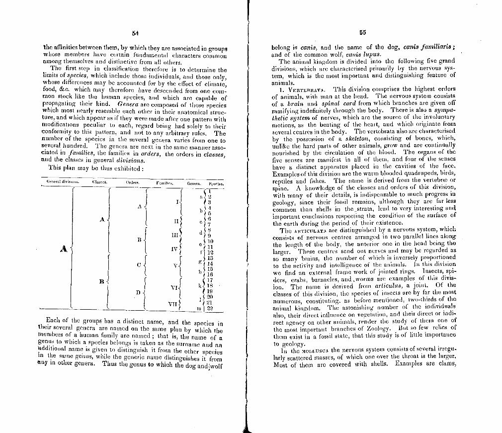
54
the affinities between them, by which they are associated in groups whose members have certain fundamental characters common among themselves and distinctive from all others.
The first step in classification therefore is to determine the limits of species, which include those individuals, and those only, whose differences may be accounted for by the effect of climate, food, &c. which may therefore have descended from one com-mon stock like the human species, and which are capahie of propagating their kind5 Genera are composed of those species which most nearly resemble each other in their anatomical struc-ture, and which appear as if they were made after one pattern with modifications peculiar to each, regard being had solely to their conformity to this pattern, and not to any arbitrary rules. The number of the species in the several genera varies from one to several hundred. The genera are next in the same manner asso-ciated in families, the families in orders, the orders in classes, and the classes in general divisions.
This plan may be thus exhibited:
General divisions. (lasseC. Oedets. Families. Genera. Species.
I
a22
b
I1 "5
I
510
[
Bf IV
e
12 A1 I I I S13
v
g4 515
B 1 1 (17
vI
k18 19
520 VII I 21
in 22
Each of the groups has a distinct name, and the species in their several genera are iianied on the same plan by which the members of a human family are named ; that is, the name of a genus to which a species belongs is taken as the surname and an additioiial name is given to distinguish it from the other species in the same gehus, while the generic name distinguishes it from any in other genera. Thus the genus to which the dog andwoIf
55
belong is canis, and the name of the dog, canis familiaris; and of the common wolf, canis lupus.
The animal kingdom is divided into the following five grand divisions, which are characterised priiantly by the nervous sys-tem, which is the most important and distinguishing feature of animals.
1. VERTEBRATA. This division comprises the highest orders of animals, with man at the head. The nervous system consistS of a brain and spinal cord from which bianches are given off ramifying indefinitely through the body. There is also a sympa-thetic system of nerves, which are the source of the involuntary motions, as the beating of the heart, and which originate from several centres in the body. The vertebrata also are characterised by the possession of a skeleton, consisting of bones, which, unlike the hard parts of other animals, grow and are continually nourished by the circulation of the blood. The organs of the five senses are manifest in all of them, and four of the senses have a distinct apparatus placed in the cavities of the face. Examples of this division are the warm blooded quadrupeds, birds, reptiles and fishes. The name is derived from the veriebrw or spine. A knowledge of the classes and orders of this division, with many of their details, is indispensable to much progress in geology, since their fossil remains, although they are far less common than shells in the strata, lead to very interesting and important conclusions respecting the condition of the surface of the earth during the period of their existence.
The AWFICULATA are distinguished by a nervous system, which consists of nervous centres arranged in two parallel lines along the length of the body, the anterior one in the head being the larger. These centres send out nerves and may be regarded as so many brains, the nnmber of which is inversely proportioned to the activity and intelligence of the animals. In this division we find an external frame work of jointed rings. Insects, spi ders, crabs, barnacles, and worms are examples of this divis-ion. The name is derived from articulus, a joint. Of the classes of this division, the species of insects are by far the most numerous, constituting, as before mentioned, two-thirds of the animal kingdom. The astonishing number of the individuals also, their direct influence on vegetation, and their direct or indi-rect agency on other animals, render the study of them one of the most important branches of Zoology. But so few relics of them exist in a fossil state, that this study is of little importance to geology.
In the MOLLU5CA the nervous system consists of several 1rregu larly scattered masses, of which one over the throat is the larger. Most of them are covered with shells. Examples are clams,
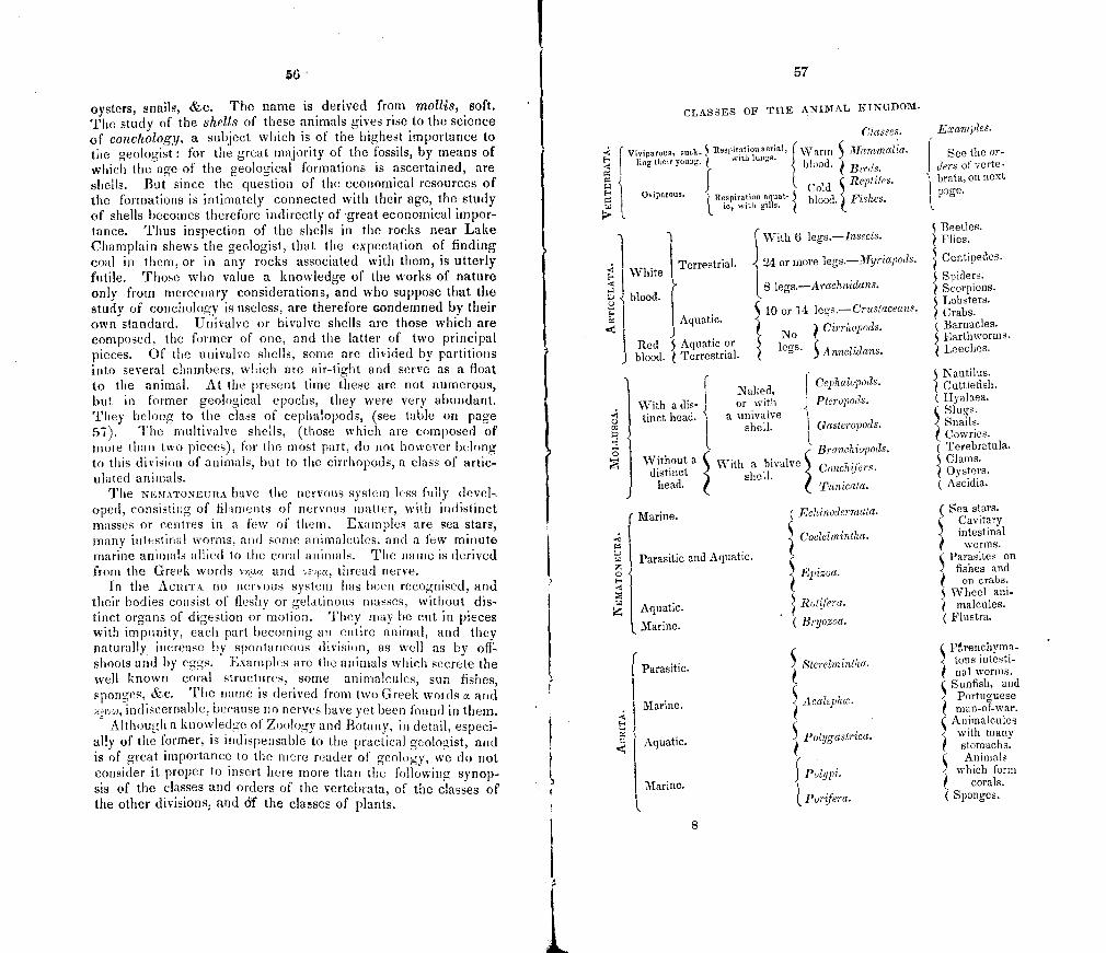
57
CLASSES OF THE ANIMAL KINGDOM.
Classes. Examples.
I Viviparous, suck- 3 Respiration aerial, 1\Varm S Mammalia. with lungs. See the or-
ders of verte- ting their young, blood. Birds. brata, on next
Oviparous. ' ResPiration cola
aqu 3 blood. Fishes. ie, with ,,115at
page. a 1,
I With 6 legs.—Insects. c Beetles.
Flies.
Terrestrial. 24 or more legs.—Myriapods. 3 Centipedes. White Spiders.
8 legs—A rachnidans. 3 Scorpions a. b lood. Lobsters.
10 or 14 legs.— Crustaceans. Crabs. a Aquatic 3, ?
Cirrhopods. ( Barnacles.
No Red 3 Aquatic or 3 legs. Arinelidans. S Earthworms. < Leeches.
J blood. Terrestrial
Cephalopods. , Nautilus.
Cuttlefish. Naked, With a dis- or with Pteropods. Hyalaea.
Slugs. 0 tinct head. r' a ,
a univalve shell. Gasteropods.
5 Snails. Cowries.
- Branchiopods. ( Terebratula.
01 Without a distinct
th a bivalve S Conchif'ers. Clams. Oysters.
head. )
shell. Tunicata. (
Ascidia.
( Marine. ( Echinodermata. ( Sea stars.
Cavitary
Coelelmintha. 3, 5 intestinal a worms. aa Parasitic an d Aquatic. Parasites on Z Epizoa. 3 fishes and
on crabs. Wheel ani-
I i Aquatic. 3 Rot fera. malcuies.
Marine. ( Bryozoa. ( Flustra.
P.renchyma- I
Parasitic. Sterelmintha. 3, tous intesti-nal worms.
Sunfish, and
Marine. Acalephc. 3 Portuguese man-of-war.
( Animalcules
Aquatic. 3 PolygastriCa. with many stomachs. Animals
Polypi. which form 3, Marine. orals. c
I Pornfera. S ( ponges.
8
L
56
oysters, snails, &c. The name is derived from mollis, soft. The study of the shells of these animals gives rise to the science of conchology, a subject which is of the highest importance to the geologist : for the great majority of the fossils, by means of which the age of the geological formations is ascertained, are shells. But since the question of the economical resources of the formations is intimately connected with their age, the study of shells becomes therefore indirectly of great economical impor-tance. Thus inspection of the shells in the rocks near Lake Champlain shews the geologist, that the expectation of finding coal in them, or in any rocks associated with them, is utterly futile. Those who value a knowledge of the works of nature only from mercenary considerations, and who suppose that the study of conchology is useless, are therefore Gondemned by their own standard. Univalve or bivalve shells are those which are composed, the former of one, and the latter of two principal pieces. Of the univalve shells, some are divided by partitions into several chambers, which are air-tight and serve as a float to the animal. At the present time these are not numerous, but in former geological epochs, they were very abundant. They belong to the class of cephalopods, (see table on page 57). The rnultivalve shells, (those which are composed of more than two pieces), for the most part, do not however belong to this division of animals, but to the cirrhopods, a class of artic-ulated animals.
The NEMATONEIJRA have the nervous system less fully devel oped, consisting of filaments of nervous matter, with indistinct masses or centres in a few of them. Examples are sea stars, many intestinal worms, and some animalenles. and a few minute marine animals allied to the coral animals. The name is derived from the Greek words agi.e and vsupe, thread nerve.
In the ACIUTA no nervous system has been recognised, and their bodies consist of fleshy or gelatinous masses, without dis-tinct organs of digestion or motion. They may be cut in pieces with impunity, each part becoming an entire animal, and they naturally increase by spontaneous division, as well as by off-shoots and by eggs. Examples are the animals which secrete the well known coral structures, some animalcules, sun fishes, sponges, &c. The name is derived from two Greek voids a and camvo, indiscernable, because no nerves have yet been found in them.
Although a knowledge of Zoology and Botany, in detail, especi-ally of the former, is indispensable to the practical geolocist, and is of great importance to the mere reader of' geology, we do not consider it proper to insert here more than the following synop-sis of the classes and orders of the vertebrata, of the classes of the other divisions, and 61 the cla5ses of plants.
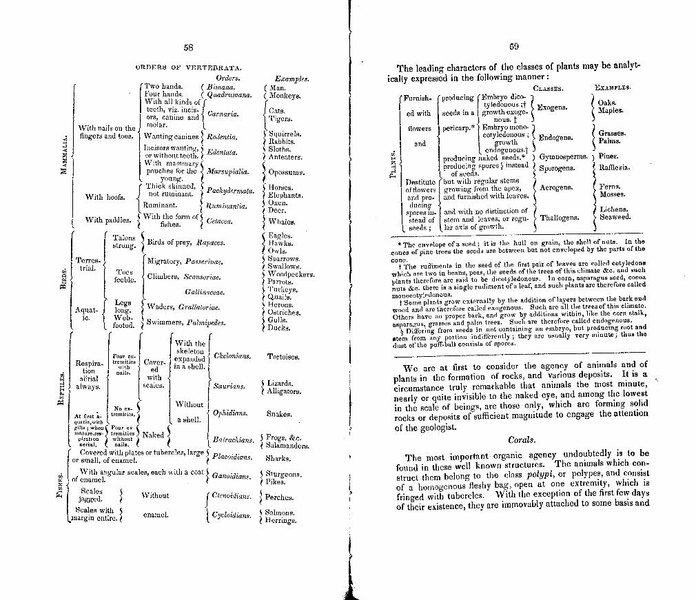
ORDERS OF VERTEBRATA.
Orders. Examples. (Two hands. ( Bimana. (Man. I Four hands. ( Quadrumana. (Monkeys.
I With all kinds of f teeth, viz. incis- Carnaria. I Cats.
) Tigers. o I rs, c.anine and
With nails on the molar
fingers and toes. Wanting canines 3 Rodentia. Squirrels. Rabbits.
I Incisors wanting, Edentata. Sloths. I or without teeth. Anteaters.
With mammary ç i1
pouches for the /Iarsupialia. I Opossums.
young. I Thick skinned, I Pachydermata. Horses. 3 With hoofs. not ruminant. Elephants.
1 Ruminant. 3 Ruminantia. 5 Oxen. Deer.
With paddles. With the form of fishes. Cetacea. 3 Whales.
Talons ( Eagles. strong.
[Terres-
Birds of prey, Rap aces Hawks. Owls.
IMigratory, Passerinae. Sparrows.
I trial. Swallows. Toes
feeble. Climbers, Scansoriae. c Woodpeckers. Parrots.
Gallinaceac. S Turkeys, uaiis.
Aquat f Legs
- long. I 3 Waders, Grallatoriag. Herons. Ostriches.
ic. L Web- 3 Swimmers, Palmipedes. S Gulls. footed. Ducks. f
IWiththel I F our ex-
skeleton expanded j Chelonians. Tortoises.
tremities - Respira
with I Cover- in a shell. ed tioli nails.
aerial with always. scales. f Saurians. Lizards.
a, 5' 1.
Alligators.
No ex-
At first 'a. tremities.
With
a
out Ophidians.
[ shell. I Snakes.
I quatie,with gills; when Four ex. mature,res- tremities
piratioa without Naked
Batrachjans. 5 Frogs, &c. aerial, nails. Salamanders.
or small, of enamel. Covered with plates or tubercies, large 3 Placoidians. Sharks.
With angular scales, each with a coat 3 Ganoidjans. rA of enamel. Pikes. Scales
jagged. 3 Without Ctenojdjans 3 Perches.
Scales with 5 niargin entire, enamel.
{ Cycloidians. 5 Salmons.
Herrings.
59
The leading characters of the classes of plants may be analyt- ically expressed in the following manner:
CLASSES. EXAMPLES.
(Furnish- (Embryo dico- Oaks.
ed with
{producing tyledonous ;j-
seeds in a growth exoge- E xogens . Maples.
nous. flowers pericarp.* Embryo mono-
cotyledo nous Grasses. and growth
End ogens Palms.
i endogenous4 E. producing naked seeds.* ) Gymnosperms. Pines. Z I producing spores l instead Sporogens. Rafflesia.
1. of seeds. I Destitute flowers
(but with regular stems I growing from the apex, Acrogens. Ferns
I of and pro- and furnished with leaves. Mosses.
I ducing spores In- sporesin-I stead of
and with no distinction of an stem and leaves, or regu- Thallogens.
Lichens. Seaweed.
seeds; 1ar axis of growth.
* The envelope of a seed; it is the hull on grain, the shell of nuts. In the cones of pine trees the seeds are between but not enveloped by the parts of the cone. The rudiments in the seed of the first pair of leaves are called cotyledons which are two in beans, peas, the seeds of the trees of this climate &c. and such plants therefore are said to be dicotyledonous. In corn, asparagus seed, cocoa nuts &c. there is a single rudiment of a leaf, and such plants are therefore called monocotyledonous.
Some plants grow externally by the addition of layers between the bark and wood and are therefore called exogenous. Such are all the trees of this climate. Others have no proper bark, and grow by additions within, like the corn stalk, asparagus, grasses and palm trees. Such are therefore called endogenous.
5 Differing from seeds in not containing an embryo, but producing root and stem from any portion indifferently; they are usually very minute; thus the dust of the puff.ball consists of spores.
We are at first to consider the agency of animals and of plants in the formation of rocks, and various deposits. It is a circumstance truly remarkable that animals the most minute,
nearly or quite invisible to the naked eye, and among the lowest in the scale of beings, are those only, which are forming solid rocks or deposits of sufficient magnitude to engage the attention
of the geologist. Corals.
The most important organic agency undoubtedly is to be
found in these well known structures. The animals which con-
struct them belong to the class polypi, or polypes, and consist
of a hoinogenous fleshy bag, open at one extremity, which is fringed with tubercles. With the exception of the first few days of their existence, they are immovably attached to some basis and
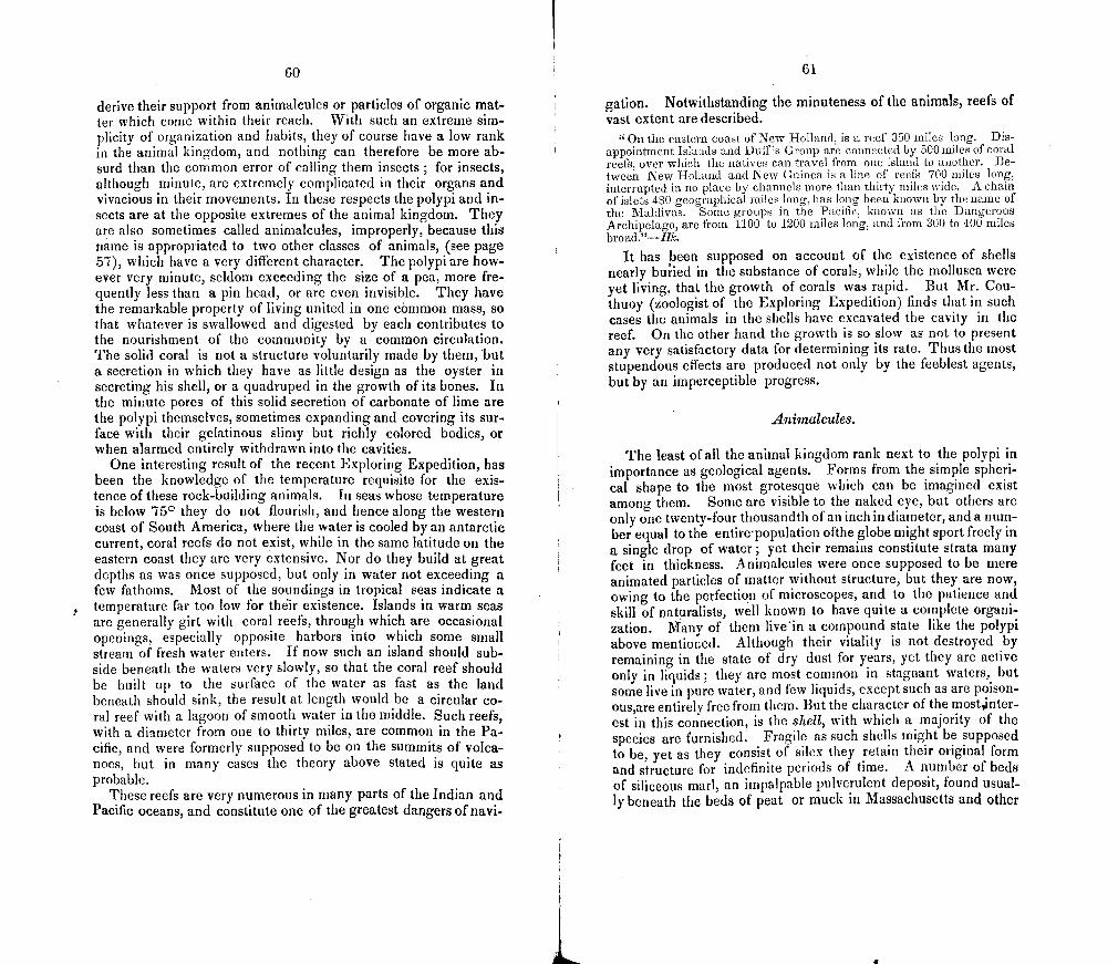
GO
derive their support from animalcules or particles of organic mat-ter which come within their reach. With such an extreme sim-plicity of organization and habits, they of course have a low rank in the animal kingdom, and nothing can therefore be more ab-surd than the common error of calling them insects ; for insects, although minute, are extremely complicated in their organs and vivacious in their movements. In these respects the polypi and in-sects are at the opposite extremes of the animal kingdom. They are also sometimes called animalcules, improperly, because this name is appropriated to two other classes of animals, (see page 57), which have a very different character. The polypi are how-ever very minute, seldom exceeding the size of a pea, more fre-quently less than a pin head, or are even invisible. They have the remarkable property of living united in one common mass, so that whatever is swallowed and digested by each contributes to the nourishment of the community by a common circulation. The solid coral is not a structure voluntarily made by them, but a secretion in which they have as little design as the oyster in secreting his shell, or a quadruped in the growth of its bones. In the minute pores of this solid secretion of carbonate of lime are the polypi themselves, sometimes expanding and covering its sur-face with their gelatinous slimy but richly colored bodies, or when alarmed entirely withdrawn into the cavities.
One interesting result of the recent Exploring Expedition, has been the knowledge of the temperature requisite for the exis-tence of these rock-building animals. in seas whose temperature is below 750 they do not flourish, and hence along the western coast of South America, where the water is cooled by an antarctic current, coral reefs do not exist, while in the same latitude on the eastern coast they are very extensive. Nor do they build at great depths as was once supposed, but only in water riot exceeding a few fathoms. Most of the soundings in tropical seas indicate a temperatare far too low for thir existence. Islands in warm seas are generally girt with coral reefs, through which are occasional openings, especially opposite harbors into which some small stream of fresh water enters. If now such an island should sub-side beneath the waters very slowly, so that the coral reef should be built up to the surface of the water as fast as the land beneath should sink, the result at length would be a circular co-ral reef with a lagoon of smooth water in the middle. Such reefs, with a diameter from one to thirty miles, are common in the Pa-cific, and were formerly supposed to be on the summits of volca-noes, but in many cases the theory above stated is quite as probable.
These reefs are very numerous in many parts of the Indian and Pacific oceans, and constitute one of the greatest dangers of navi-
61
gation. Notwithstanding the minuteness of the animals, reefs of vast extent are described.
"On the eastern coast of New Holland is a reef 350 miles long. Dis-appointment Islands and Duff's Group are connected by 500 miles of coral reefs, over which the natives can travel from one island to another. Be-tweeri New Holland and New Guinea is a line of reefs 700 miles long, interrupted in no place by channels more than thirty miles wide. A chain of islets 480 geographical miles long, has long been known by the name of the Maldivas. Some groups in the Pacific, known as the Dangerous Archipelago, are from 1100 to 1200 miles long, and from 300 to 400 miles broad."—Hk.
It has been supposed on account of the existence of shells nearly buried in the substance of corals, while the mollusca were yet living, that the growth of corals was rapid. But Mr. Cou-thuoy (zoologist of the Exploring Expedition) finds that in such cases the animals in the shells have excavated the cavity in the reef. On the other hand the growth is so slow as not to present any very satisfactory data for determining its rate. Thus the most stupendous effects are produced not only by the feeblest agents, but by an imperceptible progress.
Animalcules.
The least of all the animal kingdom rank next to the polypi in importance as geological agents. Forms from the simple spheri-cal shape to the most grotesque which can be imagined exist among them. Some are visible to the naked eye, but others are only one twenty-four thousandth of an inch in diameter, and a num-ber equal to the entire - population ofthe globe might sport freely in a single drop of water; yet their remains constitute strata many feet in thickness. Animalcules were once supposed to be mere animated particles of matter without structure, but they are now, owing to the perfection of microscopes, and to the patience and skill of naturalists, well known to have quite a complete organi-zation. Many of them live'in a compound state like the polypi above mentioned. Although their vitality is not destroyed by remaining in the state of dry dust for years, yet they are active only in liquids; they are most common in stagnant waters, but some live in pure water, and few liquids, except such as are poison-ous,are entirely free from them. But the character of the most,inter-est in this connection, is the shell, with which a majority of the species are furnished. Fragile as such shells might be supposed to be, yet as they consist of silex they retain their original form and structure for indefinite periods of time. A number of beds of siliceous marl, an impalpable pulverulent deposit, found usual-ly beneath the beds of peat or muck in Massachusetts and other
62
places, have been found to be chiefly composed of these shells to the depth of several feet.
The vast quantiy of these deposits is less astonishing when we consider the fecundity of animalenles, some of which will have millions of descendants in a few days. Thus one individual of of the large species, Hydatina senta, in twelve days may produce 16,000,000, and another in four days 170,000,000,000; and Ehrenberg, to whom science is indebted more than to all others on this subject, affirms that if the price of tripoli (rotten stone or polishing powder, which is composed of their shells) should rise materially, he could raise animalcules, and collect the shells, and sell them at a profit for polishing powder. He has actually obtained several pounds by rearing the animalcules. We may have occasion to notice again deposits of these shells in Ger-many of the thickness of fourteen and twenty-eight feet, and to describe some as existing in this State.
On account of the great extent of siliceous deposits known to have originated from this source, some geologists have been inclined to believe that most of the siliceous strata in the crust of the earth once constituted the shells of animalcules.
Other species of animalcules have shells composed of iron rust, and much of the iron scum, which may be seen floating on water, consists of animalcules.
Nor are animalcules limited to fresh water deposits, but many exist in the sea, and fossil species abound in some marine depos-its, as in the chalk of England.
Another source in the animal kingdom of rocky strata is to be found in the vast quantities of the shells of mollusca and of the crustaceous coverings of other marine animals, which abound in some parts of the tropical seas. In such regions the sand of beaches is often seen to be composed of the comminuted calca-reous fragments. So in the ancient Palaeozoic rocks of Lake Champlain, we shall find entire ledges composed of the commin-uted fragments of corals and shells. It is probable that many beds of crystalline marble were originally composed of such frag-ments, and have been subsequently altered by igneous agency.
Plants are well known to form deposits of vegetable matter. From their complete decay results vegetable mould, the particu-lar consideration of which will belong to agricultural geology. While many quickly perish, others are more enduring, and form accumulations of muck, peat and drift wood. Peat results chiefly from the partial decay of mosses, especially Sphagnum, which constantly grows as the older portions decay. Since however in hot climates the decay of plants is rapid and complete, when exposed to atmospheric agency, beds of peat are found only in cold countries.
63
Immense rafts of drift wood are well known to accumulate in the lower part of the rivers of this continent.
"In consequence of some obstruction in the Atchafalaya, supposed to have been formerly the bed of Red River but now an arm of the Mississip-pi, a raft accumulated in 3S years, which in 1816 was 10 miles long, 220 yards wide, and eight feet thick. Although floating it is covered with soil and living plants.
"Similar rafts occur on the Red E4iver, and one on the Washita con-cealed the surface for 50 miles, and supported a growth of trees. At the mouth of the Mississippi alternations of drift wood and mud extend over hundreds of square leagues."—Hk.
In a few cases, as in Maine and Louisiana, the process by which drift wood may be converted into coal has been seen in its incipi-ent stages. Facts of this kind are of great interest as illustrating the origin of the immense beds of coal in the carboriiferous for-mations.
We are now to consider organic agency as illustrating the ori-gin of those fossil bodies, to which geology is mainly indebted both for its great principles and for its most interesting details.
Human agency has exerted a powerful effect, especially in tem-perate climates, both in modifying other agencies and in deposi-ting in the earth the relics of man himself.
The human race produce geological changes in several modes: 1. By the destruction of vast numbers of animals and plants to make room for themselves. 2. By aiding in the wide distribution of many animals an plants, that accompany man in his migrations. 3. By destroying the equili-brium between conflicting species of animals and plants, and thus enabling some species to predominate at the expense of others. 4. By altering the climate of large countries by means of cultivation. 5. By resisting the encroachments of rivers and the ocean. 6. By helping to degrade the higher parts of the earth's surface. 7. By contributing peculiar fossil relics to the alluvial depositions now going on, on the land and in the sea: such as the skeletons of his own frame, the various productions of his art, nu-merous gold and silver coins, jewelry, cannon balls, &c. that sink to the bottom of the ocean in shipwrecks, or become otherwise entombed." (Hk.)
"When we reflect on the number of curious monuments consigned to the bed of the ocean, in the course of every naval war from the earliest times, our conceptions are greatly raised respting the multiplicity of las-ting memorials which man is leaving of his labors. During our last strug.. gle with France, thirty-two of our ships of the line went to the bottom in the space of twenty-two years, besides seven 50-gun ships, eighty-six fri-gates and a multitude of smaller vessels. The navies of the other Euro-pean powers, France, Holland, Spain and Denmark, were almost annihila-ted during the same period so that the aggregate of their losses must have many times exceeded that of Great Britain. In every one of these ships were batteries of cannon constructed of iron or brass, whereof a great num-ber had the dates and places of their manufacture inscribed upon them in letters cast in metal. In each there were coins of copper, silver, and often many of gold, capable of serving as valuable historical monuments; in each were an infinite variety of instruments of the arts of war and peace; many formed of materials such as glass and earthern ware, capable of lasting for indefinite ages when once removed from the mechanical action of the waves, and buried under a mass of matter which may exclude the corroding action of the water.
64
"But let it not be imagined that the fury of war is more conducive than the peaceful spirit of commercial enterprise to the accumulation of wrecked vessels in the bed of the sea. From an examination of Lloyd's lists, from the year 1793 to the commenCement of 1829 Captain W. H. Smyth as-certained that the number of British ressris alone lost during that period amounted on an average to no less than one and a half dai9i; an extent of loss which would hardly have been anticipated, although Moreau's Ta-bles chew that the number of merchant vessels employed at one time, in the navigation of England and Scotland, amounted to about twenty thou-sand, having one with another a mean burthen of 120 tons. Mr. J. L. Prevost, also informs me that, on inspecting Lloyd's lists for the years of 18291 1830, and 1S31, he finds that no less than nineteen hundred and fifty-three were lost in those three years, their average tonnage being above 150 tons, or in all nearly 300,000 tons, being at the enormous rate of 100,000 tons annually of the merchant vessels of our nation only. This increased loss arises, I presume, from increasing activity in commerce.
"Out of five hundred and fifty ships of tile royal navy lost to the country during the period above mentioned, only one hundred and sixty were taken or destroyed by the enemy, the rest having either stranded or foundered or having been burnt by accident; a striking proof that the dangers of na-val warfare, however great, may be far exceeded by the storm, the shoal, the lee-shore, and all the other perils of the deep.
e5,Jil1ion5 of silver dollars and other coins have been sometimes submerg-ed in a single silip and on these, when they happen to be enveloped in a matrix capable of protecting them from chemical changes, much informa-tion of historical interest will remain inscribed, and endure for periods as indefinite as have the delicate markings of zoophytes or lapidified plants, in some of tile ancient secondary rocks. In almost every large ship, more-over, there arii some precious stones set in seals and other articles of use and ornament composed of the hardest substances in nature, on which let-ters and various images are carved—engravings which they may retain when included in subaqueous strata, as long as a crystal preserves its natural fbrm.
"It was therefore a splendid boast, that the deeds of the English chiv-alry at Agincourt made Henry's chronicle—as rich with praise
As is the oose and bottom of the deep With sunken wreck and sunless treasures;
for it is probable that a great number of monuments of the skill and indus-try of man will, in the course of ages. be collected in the bed of the ocean, than will exist at any time on the surface of the continents." (LyelL)
Human hones also are as durable as those of other animals. Cuvier says that
"In ancient fields of cattle the bones of men have suffered as little de-composition as those of horses which were buried in the same grave."
Human bones have been found in a fossil state, and even in solid rocks. The most remarkable instance is that of the skele- ton found in a fragmentary rock in Gaudaloupe. But as this rock is daily increasing by the uniting of minute fragments of shells and corals with a calcareous cement, no remote antiquity can be ascribed to these remains. in short all the remains of man are limited to deposits which are subsequent to the drift, the latest of all the geological formations, in accordance with the sacred scriptures, which assume a period of about six thousand years for the past existence of man and of the animals associated
65
with him, but do not limit the period of the antiquity of the earth
itself. The proportion of the various tribes of animals and plants
which are found in a fossil state roust depend not only on their number, but on the facility with which they may be preserved. it becomes therefore of great importance to consider this subject, in order to avoid erroneous conclusions respecting the Fauna and Flora of former epochs. Thus two-thirds of all the known spe-cies of organic remains are shells, but it is riot to be inferred that molluscs constituted two-thirds of all the organic beings in exis-tence. The nature and process of petrifaction, the circunistan-ces requisite for preservation, and the durability of the parts, are the principal elements of this question.
Petrij'action consists in the substitution of particles of miner-al matter in the place of the particles of vegetable or animal matter, and consequently preserves the structure of the original body. In some cases this process is known to take place at the present time, as when bones arc enveloped in clay containing sulphuret of iron. Sticks, nuts, &c. in a place where beg iron ore is accumulating, are found to have been converted into ore, probably within a few years. Leaves have been artificially baked in clay and found to resemble ancient peirilactions. But little, however, is known of' the pi'oeess, for the chemical conditions favorable to it are more likely to exist under a pressure of super-incumbent materials and excluded mroni the air.
A larize portion of fossils, however, have been preserved with-out petnifaction, and it is therefore of more consequence to COfl -
sider what circumstances are favorable to the preservation either of the substance or of the form of organic bodies. In general it is essential that the body should he buried eitiier by aqueous or oth-er agencies. In a few instances bodies have been preserved without t he aizencv of, water. Thus bodies of men, and remains of birds and erzs have been fniind buried in guano ; and the moving sands of deserts bury \anious nidecis, which nn'v be pre-served iniilbuteiy. Aninais ire Oetn buried in caves and fis-sures u inud itmaus. of tvii:li ni:meruus exanlplCs have been found iii iuropc. 'ret hogs do preserve the hadies of animals which arc omired ju theju. Peat also arcU'TmUl1teS over and pie- serves 1'° rate ferests. The eni v VCEtiII1S of tilO forests de- scribed by Julius Ca'sar aiou the great Renmnn Road in Britain are time unned tunics of trees in peat. In frigid climates ani-mals are sornctiius el!,ncnlced fo r eyes in ice.
The ejections of volcanoes as we have seen, may bury even entire cities, nail various orgmiil bodies may be preserved in the same manner.
Floods and storms often bury immense numbers of organic be-ings. In 1787 on the coast of Corornandel, there was a flood occasioned by a hurricane which drove the waters of the sea in-land 20 miles. This flood covered the country with mud, in which were the carcasses of 10,000 inhabitants and 100,000 cattle. When, however, the bodies are buried permanently beneath the water, the probability of their preservation is much greater, as when in 1780 an earthquake wave rushed over the city Savanna Ia Mar in Jamaica, and in an instant swept away the whole town, leaving not a vestige of roan, beast or habitation on the surface.
But the most efficient agents are the floods of rivers, by which plants and animals are borne into deep water and often into the sea and permanently submerged. In these cases the carcases may be buried at once beneath a heavy mass of sand and stones, or being merely drowned and subsequently decaying, only their harder parts will be preserved. Even marine animals are often destroyed by the mass of materials swept down in floods.
"We are informed by Humboldt, that during the periodical swell-ings of the large rivers in South America great numbers of quadrupeds are annually drowned. Of the wild horses, for example, which graze in immense troops in the savannah, thousands are said to perish when the river Apure is swollen, betbre they ha-ye time to reach the rising ground of the Lianos. The mares, during the season of hugh water, may be seen, vith their colts, swimming about and feeding on giass, ofwhicli the top alone
waves above the waters." * I * " In Scotland, in August, lS29, a fertile
district on the east coast became a scene of dreadful desolation, and a vast number of animals and plants were washed from the land, and found scat-tered around the mouths of the principal rivers. An eye-witness thus de-scribes the scene which presented itself at the mouth of the Spey in Mo-rayshire :-' For several miles along the beach crowds were employed in endeavoring to save the wood and other wreck with which the heavy roll-ing tide was loaded; whilst the margin of the sea was strewed with the carcasses of domes tic animals, and with millions of dead hares and rab bits.' "—LyelI.
The solitl parts of marine animals, as bones of fishes, and the shells of molluscs, of crustacea, and of echinodermata are of course often at the death of the animal in places favorable for preservation, or are swept into such places. 'l'hus to the east of the Fame Islands a bed of sand and mud full of broken and en-tire shells has been traced for 20 miles ; and for the space of three and a half miles in length the mud is so full of fish bones, that the sounding lead is seldom drawn up without some verte-brm attached. Between Gibraltar and Ceuta fragments of shells have been found on a gravelly hnitoni at the depth of 4800 feet, carried thither by a current. Fishes are also buried by sub-ma-rine eruptions of lava or mud.
The durability of parts of the bodies of the various tribes of animals and plants cliflèrs extremely, and is found to correspond
67
to a considerable extent with the relative quantity of their re mains which have been found in a fossil state. It is therefore important to consider this subject a little in detail.
If vei-tebratecl animals are buried so deep beneath a mass of sand or mud, that their putrefying bodies cannot rise to the sur-face, their skeletons will be preserved entire. If, however, they are not thus buried, they will soon after the commencement of putrefaction, from the formation of gases, become lighter than the water and float on the surface ; decomposition will be more rapid, and the bones will fall scattered to the bottom, and be gradually covered by the deposits of mud or sand which my be going on. Birds, however, are always buoyed up by their feath-ers and hence only scattered bones are likely to be preserved. Their bones also being tubular are more likely to be crushed than those of other vertebrata. The skeletons of some fishes, as the sharks, being cartilaginous are more subject to decay, but their teeth being very hard will be preserved. Accordingly the bones of birds are extremely rare, and while the skeletons of many kinds of fish are common, it is seldom that any thing more than the teeth of sharks are found. Birds, however, frequently leave their tracks in fine sand and mud to be buried by additional layers of sediment, and although little search has been made by laying open strata on the banks of rivers and on the shores of the sea, a number of examples have been found. It will be seen in the sequel that the tracks of birds are far more frequently found in the rocks than are any other relics of them.
Of the articulate, insects, although far more numerous than any or all other classes except the animalcules, are very rarely preserved. The naturalist in searching for objects of Natural History, rarely finds dead insects. Multitudes of them with a ferocious activity prey upon each other. On the water or on the land they are the favorite food of numerous tribes of vertebrata hats, lizards, frogs, fishes and birds devour moyriads. Permeated by the innumerable air tubes of respiration, they after death speedily decay by atmospheric agency. Being from the same cause lighter than the water they are rarely buried, but like birds float on the surface, without however eventually dropping any solid parts, but either decaying or becoming the prey of fishes. Rarely therefore either in the recent or older rocks are their re-mains found. Yet as it would obviously he incorrect to infer from the paucity of their remains in alluvial deposits, that few exist at the present day, so it would he equally erroneous to in-fer positively that they were not more numerous in former peri-ods than the number of their remains would indicate. The re-mains which have been formed are either those of insects that frequent water, and are therefore, more likely to be buried in the
mud, or the elytra of beetles, which are the most indestructible parts.
Of the myriapods the same remark may be made covered with crustaceous rings of about the consistence of the harder parts of beetles, they are about equally durable and are found about as frequently in their haunts. Unaccustomed to frequent wet places, they are not likely to be entombed.
Of the arachnida a majority are extremely frail, but a few, especially the scorpions, are as durable as any of the beetles, being covered with a hard crust, and a few have been found in a fossil state. The most durable species of this class are however not aquatic.
Most of the crustaceans are covered with a crust much harder than any of the preceding articulata, and parts of some of them have the solidity of bones. They are mostly marine some, especially of the minute species, inhabit fresh water, and a few are capable of living on dry land. They are, therefore, much more frequently preserved.
Of the cirrhopods many are covered with true shells of solid carbonate of lime, and as they are marine there can be no reason why they should not be preserved in as large proportion as any tribes of organic beings. From their deficiency in the geologi-cal formations, it may quite safely be inferred that the class is of comparatively recent introduction.
Annelidans are less durable than the myriapods which they re-semble in their general form. But many of them are aquatic, and, having the habit of burying themselves in the mud or sand, are not very unlikely to be preserved, notwithstanding the exceeding frailty of their structure. It is quite remarkable that the oldest animals, yet described as existing in any geological formation, are marine worms with very slender and perishable bodies. Their remains, although distinct, usually resemble faint impressions. The tracks of earth-worms, which are so abundantly seen imme-diately after a heavy lain has driven them out of their holes, are often in a situation to be soon covered with a layer of mud, and are quite likely to be preserved. Impressions on some of the solid rocks probably have a similar origin.
All the classes of molluscct, except the Tunicata, consist either wholly or to a great extent of species, which are furnished with solid or calcareous shells, and have mostly aquatic habits. They exist in great numbers in places favorable for their preservation, and not a few live buried in find or sand, where after death only the soft parts perish. The proportion, therefore, of those which are preserved should by far exceed that of any other division of the animal kingdom. Accordingly, as we have before remarked, two-thirds of the known species of fossils are shells, and we are
69
not surprised that fossil shells should constitute the greater por-tion of numerous strata of the fossiliferous rocks of all ages. Remains of naked molluscs, the riunicatil and others, however, are rare, and most of these consist of some solid internal part. Extremely rare, nor perhaps free from doubt respecting their nature, are the instances of petrifaction of the soft parts of mol-luscs.
Of the several classes, the shells of the gasteropods and con-chifers are most solid and durable, and the latter most abound in species whose habit is to live buried in sand or mud. Yet in the older formations they are either very rare, or entirely wanting, and the shells of the cephalopods and brachiopods are far more abundant, although at the present lime they are extremely rare. Whence it may be safely inferred that the proportions of these great classes have been totally reversed.
On account of the great number of fossil shells, it would be interesting and instructive to pursue these inquiries into the detail of orders, families and genera, but such an amount of detail would not consist with the plan of this introductory sketch.
Of the ne,natonewra, the echinodermata are covered with shells, which are densely crowded with calcareous portions only less solid than the shells of molluscs and cirrhopods, and from their marine habits and great numbers are likely to be preserved. rih ie i r remains are by no means rare in many of the formations.
The rotilera and hryozoa are not uncommon in a fossil state, as they have hard parts which are siliceous or calcareous, and are aquatic. Of the parasitic classes of nematoneura, it would per-haps be premature to say much of the probability of their exis-tence in a fossil state ; less solid, however, than most of the other classes of this divison, they are less likely to have been preserved, if they existed.
Of the Acute-, from the soft bodies of the sterelmintha and their situation, parasitic in parts of animals destined to petrifac-lion, we should not expect their preservation. The acalephm, although marine, being were gelatinous masses, with but a few grains of solid matter, are vely unlikely to be preserved. The absence of the remains of these ClaSseS from geological forma-tions affords, therefore. little proof that they did not exist. Of the polytzastrie anirnalcuies the many wliieh had shells of flint leave their shells in extensive deposits, as before remarked.
Of the polypi a few species are naked, and although marine, their soft gelatinous bodies could scarcely be preserved. But the great number of coraliferous species are engaged in the involun-tary labors which we have before described, and whose durabili-ty is proved by the remains of corals in nearly all the fossilifer-
70
ous rocks, and beautifully described in the following lines of James Montgomery:
"I saw the living pile ascend, The mausoleum of its architects, Still d y ing upwards as their labors closed Slime the materials, but the slime was turned To adamant by their petrific touch.
" Frail were their frames, ephemeral their ]ives, Their masonry imperishable. All Lile'sneedful functions, food, exertion, rest, Bynice econot-ny of Providence, Vere overruled, to carry on the process
Which out of water brought forth solid rock. Atom by atom, thus the mountain grew A coral island, stretching east and west Steep were the flanks, with precipices sharp, Descending to their base in ocean gloom. * * * * * * * Compared with this amazing edifice, Raised by the weakest creatures in existence, What are the works of intellectual man, His temples, palaces and sepulchres Dust in the balance, atoms in the gale,
men Compared with these achievets in the deep, Were all the monuments of olden time. Egypt's grey piles of hieroglyphic grandeur, That have survived the lan guage which they speak, Preserving its dead emblems to the eye, Yet hiding from the mind what these reveal Her pyramids would be mere pinnacles, Her giant statues, wrought from rocks of granite, But puny ornaments forsuch a pile At this stupendous mound of catacombs."
The porifera or sponges consist of the fibrous portion knowry by this name in commerce, and a slimy mass which envelopes the fibres. Dried sponges are frequently lijund on the sea shore, and some of these with many of the species inhabiting deep water may be buried and fossilised. So fine is the texture and permeable to mnineralisi ng agents, that the microscope investigation s of late years have shown that many flint nodules in the chalk consist of siliceous petrifactions of sponges. They are not numerous in the formations and had they existed abundantly in the most ancient periods, it is probable that their remains would have been abun-dantly preserved.
It rernans now to consider some general laws of the organic nature of the present epoch as illustrating a few great principles of very important application in the study of fossils.
The geographical distribution of species of animals and plants is a subject of great importance in its application to geology. Although the subject is so copious in its details that it can never,
71
be exhausted, a few outlines may be sketched as sufficient to give some general view. The common observer,who is unaccustomed to careful discrimination between the specific, especially of small an-imals and plants, which nearly resemble each other, is not aware of the great difference between the Fauna and Flora of different countries. Thus of the species of shells in the West Indies, pro-bably less than one in fifty exists in the New England States. The native quadrupeds of America are specifically distinct from those of Europe. Of the countless hosts of insects, few are com-mon to both sides of the ocean, except those which have been transported by human agency. With a few exceptions, which may perhaps be resolved into the general rule, species are distributed as if they had originated in certain centres, and had subsequently spread until they have met with a hostile climate, or with some obstacle which they cannot pass, or with regions which do not af-ford them the nourishment they require, or possibly in some ca-ses there may not have been sufficient time since their creation for them to have reached their utmost limits.
Climate has a most marked influence. Let any one travel from home a thousand miles of latitude, and he will find that he has left behind him a great majority of the familiar species. Let him go two thousand miles, and the appearance of a single species which he has been accustomed to see, will be an era in his wan. derings. Not only so, but there will be a striking difference in the more comprehensive groups: whole genera, families, or even orders have disappeared and new ones surround him. On the other hand an equal change of longitude will present no such change in the more comprehensive groups, nor in the species except to a limited extent, or as there may be intervening bar-riers of mountains, water, dcc.
In some cases whole tribes of animals and plants, and in others the individuals of particular species only in a genus, are equally affected by climate. Thus the whole tribe of palm trees and many families of shells, either exclusively or with the exception of a few of the smaller and less characterie species, such as the
onvol u ta * with their richly colored and highly polished spe-cies, are found in great profusion only in hot climates. The oaks, if found within the tropics, are on elevated regions where they have the climate proper to a higher latitude. Again, there are some genera which exist in all climates, as the Helix (snails,) but are represented in each climate by peculiar species. In most cases there exist peculinrities by which the experienced naturalist can distinguish the species of one climate from those of another. Rarely the same species exists in very different cli-
"A family embracing the cones, olives, and cowrics.
nates; as among the molluscs, Lucina divaricata is found throughout the West Indies, in the Mediterranean, and as far north in this country as Long Island ; and Pholas costata occurs in Massachusetts and in Florida. A peculiar class of examples of this kind are the migrating animals, which find a greater uni-formity of climate by changing their abode as the season changes. From these facts we should expect, if the climate had ever been uniform over the surface of the earth, that species would have had a much wider geographical range than at present, and this appears to have been the fact in the earliest periods.
But not climate only, other circumstances restrain species with-in certain limits, and even more comprehensive groups have a more or less restricted s ta tion .* Bodies of water interpose an ob-stacle to the distribution of terrestrial species ; fresh water to the marine, and salt water to the fresh water species. Deserts and mountains separate zoological as well as political provinces. islands have their peculiar Fauna and Flora. Some species can exist only on certain geological formations ; thus the larger and heavy land shells of some tropical con ntrics exist only in liniestccne regions, and the land shells of this country are far more abundant in such districts, although not exclusively conlined to them. Some require dry and others vet lcid ; some pure and others impure water ; some live on sand, others in mud ; sonic on high land, oth-ers on low land ; some in deep water, others on the shore. A few species a2ain can accommodate themselves to a variety of stations. All these details it is the business of (lie zocaloist to investigate, and on him consequently the geologist is dependent for the means of drawing conclusions.
Sometimes there is a peculiar grouping of species ; as when a river flowing into an estuary mixes terrestrial, fresh water, and marine species in the same deposit ; or when beasts of prey drag into caves the carcasses of various animals or when the hermit crabs,t so abundant in hot climates, and with amphibious habits, occasionally mingle terrestrial and marine shells on the open coast without fluviatile agency.
In the application of these general facts to the ease of fossils of extinct species in older formatins it will follow that no unih'ersal rule can be given by which to determine whether a ivr sneHes inhabited a hot climate or otherwise, but that the decision must depend on the zoolocical affinities of th sHec If flo- belongs to a group which is found exclusively iii on lroincs. the proba-
The /dn,i of place in which a species I ie is clIed its station.
f Crabs,—whose instinct leads them in Cailaicly to enter ttce empty shells of dead molluscs thr the protection (ii eF iods5, ulciccil cu nt iiiteccutie prcu tected by the J 1' ) j jj cruet celtIc 'hccc cy Sec eSecud-___ar, cinch termiS crccbs.'
1)
bility that it was tropical will be very strong, and if a large num-ber of such species are found in the same formation without any other which are proper to colder climates, the conclusion may be considered certain. If, however, the extinct species belong to a group whose species are found in all climates, and it has none of the distinctive marks of climate on it, it will fail of establishing any conclusion respecting the climate.
From the peculiarities of station which characterise riot only species but more comprehensive groups, the geologist is usually able to make very interesting and important inferences respecting the geography of a region, as it was at the time when the species now extinct was in existence.
Fossil shells shew whether the deposit was made in fresh or salt water ; or if species of both the fresh and salt water are min-gled, it will be generally inferred that the deposit, especially if the layers form a basin-shaped depression, was wade in an estuary into which a river emptied. The depth of the water may often be inferred from the genus to which the fossil belongs. The char-acter of the shells will also shew whether it was a sandy or a muddy shore ; in this particular, however, merely confirming the inferences made front the mineral characters of the strata. Fossil plants will shew not only the temperature of the climate, but its humidity, and the general features of the surface. The geologi-cal student will find in the copious details of the science, with which we are not here concerned, that the inferences are as full of interest, as are the zoological premises from wInch they are made.
Extinction of Species.
Since the vast majority of tile species and many entire genera and families, whose remains are found in a fossil state, have long since become extinct, any facts of a similar character within the historical period become invested with extraordinary interest. Of so recent a date, however, is zoological science, to which alone
we can look for any, information respecting the countless host of small species which people the air and the waters, that the facts are few and relate only to the larger species. We shall hereafter see that the extinction of the fossil species was owing chiefly to grad-ual changes of climate, aided by volcanic convulsions and by mutations in the distribution of land and water. Since the exis-tence of man, his agency has had a marked efhct in the more or less complete extermination of some species, and in the increased development of others, to subserve his purposes. Many quadru-peds, as the heaver, wolf, bear, : c. are now extinct in ('ccut
10
74
Britain. The perseverence with which the fur trade is carried on is rapidly tending to the extermination of many species.
"Immediately after South Georgia was explored by Capt. Cook, in 1771, the Americans commenced carrying seal-skins to China, where they obtained most exorbitant prices. One mitlion two hundred thousand skins have been taken from that island alone, since that period; and nearly an equal number from the island of Desolation! The numbers of the fur-seals killed in the South Shetland Isles in 1821 and 1822, amounted to three hundred and twenty thousand. This valuable animal is now almost extinct in all these islands."
"An extraordinary bird, a native of New Zealand, of which but few living individuals are known to naturalists, appears to be on the point of extinction it is the Apteryx austrahis." "This bird is of a greyish brown color, and has xieither wings nor tail." "The feathers are long and loose, like those of the Emu, but each plume has only a single shaft." "The Dodo was a bird of the gal-Jinaceous tribe, larger than a turkey, which abounded in the Mauritius and adjacent islands, when those countries were first colonized by the Dutch, about two centuries ago. This bird formed the principal food of the inhabi-tants, but it was found to be incapable of domestication, and its numbers there. fore soon become sensibly diminished. Stuffed specimens were preserved in the museums of Europe, and paintings of the living animal are still extant in the Ashmolean Museum at Oxford, and in the British Museum. But the Dodo is now extinct—it is no longer to be found in the isles where it once flourished; and all the stuffed specimens are destroyed. The only relics that remain, are the head and foot of an individval in the Ashmolean, and the leg of another in the British Museum. To render this illustration complete the bones of the Dodo have been found in a tufaceous deposit beneath a bed of lava, in the Isle of France ; so that if the remains of the recent bird alluded to, had not been preserved, these fossil relics would have constituted the only proof that such a creature had ever existed on our planet."—Mantehl.
In Iceland a large species of elk became extinct, probably not long after the island was inhabited by man.
"its remains commonly occur in the beds of marl beneath the peatbogs." In Curragh, immense quantities of the bones of the elk lie within a small
space, as if the animals had assembled in a herd ; the skeletons appear to be entire, and the nose is elevated, the antlers being thrown back on the shoul-ders, as if the creatures had sunk in a morass, and been suffocated." "The skeleton is upwards of ten feet high from the ground to the highest point of the antlers, which are palmated, and from ten to fourteen from one extremity to the other." "In the county of Cork, a human body was exhumed from a wet and marshy soil, beneath a bed of peat eleven feet thick; the body was in good preservation, and enveloped in a skin covei'ed with hair, which there is every reason to conclude was that of the elk. A rib of the elk has also been found, in which there is a perforation that evidently had been formed by a pointed instrument while the animal was alive, for there is an effusion of callus or new bony matter, which could not have resulted from something remaining in the wound for a considerable period; such an eflbct, indeed, as would be produced by the head of an arrow or Spear. There is, therefore, presumptive evidence that the race was extirpated by the hunter-tribes who first took possession of the British Jsiands."—ihIanieli.
But the most remarkable of all the species which have become extinct within the historical period is the Dinornis, a genus of birds of enormous size, far exceeding the ostrich. Their bones are found in recent deposits in New Zealand, and the natives have a tradition of the former existence of this bird, which they called Moa. It was allied to the Apteryx in its characters, being With-
7 J
out wings. The thigh bone of the larger species was upwards of two feet in length. Being the only land animal in that country of sufficient size to furnish food to the people, it was probably exterminated by the early inhabitants.
These are the only animals which are known to have become extinct since the commencement of man's existence. Many which flourished during the periods immediately preceding have since become extinct, but so slow are the changes in nature and so long is an entire period, the unit in geological computation, that it is not easy to determine whether any such were in exis-tence in-the earliest days of our race.
Introduction of Species.
Connected with this question of the existence of species is that of their introduction. how and when does Creative Power introduce the new species? Geology shows us that they have been introduced from time to time during long periods. Have any such instances occurred in modern time? Some suppose that the introduction of species forms a part of the present order of things. If it is difficult to learn the precise time when species die out, much more is it to determine the year or the century of their introduction. If they are now introduced from time to time, it is not probable that such an event is more frequent than the extinction of others, and as it would from the numerical pre-ponderence of the smaller and inferior tribes he more common among them, it might occur frequently, without being demon-strable. When species before unknown are discovered, the infer-ence is, not that they have been created within a few years, but that they have been overlooked. It is only when the view is extended through periods in which centuries dwindle, like terres-trial distances seen from the planetary spaces, into an invisible insignificance, that we may speak with confidence of the gradual introduction and extinction'of species.
The question how species are introduced has been much dis-cussed, and some of the theories have been supposed to conflict with the great truth of religion, that the species are created by a Being of infinite intelligence and goodness. Some writers, there-fore, with a zeal not according to knowledge, have made upon these theories attacks which are too quixotic to engage the at-tention of sober science. Whether species are introduced by a special act of creation, or whether the actions of the Supreme Be-
ing in this as in other events of nature have such a uniformity and such fixed principles, that we may call them laws of nature, is a question which should disturb no man's religious belief. Our limits, however, will not permit us to discuss either the theories
Or the objections to them, and we can merely give a synopsis of the former without adducing any of the facts with which they are connected.
One theory supposes that species are introduced by a direct creative agency, wluch is of the nature of a miracle, that is, can-jiot be referred to any uniform course of nature. Such would perhaps seem to be the origin of man as related in the sacred writings, which, however, give us no details of the creation of other species. Nor can any argument from analogy be drawn from his creation to that of other species, since, zoologically con-sidered, man is an anomaly in the animal kingdom, and the case is rather one of contrast than analogy.
Another theory is that of transmutation, which supposes that beings of the most simple organization having somehow come into existence, the more complex and the higher orders of ani-mals have originated in them by a gradual increase in the corn-plexity of their structure. Of this theory there have been various modifications. It was supposed by Buffon originally, that there were elementary particles of living matter, viz. animalcules, whose fortuitous aggregation formed larger animals, which are, therefore, only heaps of animalcules. Lamark supposed that ani-rnalcules are elementary particles of living matter, but that the larger animals were formed from them by the process of appe-tency which we shall presently notice. The basis of this theory, and the basis and superstructure of Buffon's theory, were over-thrown by those naturalists who discovered that animalcules have a very complicated organization. The doctrine ofappetency supposed that new organs are formed in animals before destitute of them, by the existence of desires in the animal constantly tend-ing in a given direction. Thus the desie of masticating food produced teeth, the decire of handling made hands and fingers grow, &c. This seems sufficiently absurd, and those who have adopted the theory of transmutation have generally detached it from this absurdity, and not attempted to explain how the pro-cess of transmutation goes on.
It was never supposed that the process of transmutation was so rapid that any perceptible process could be made within the limits of human observation. But the long periods of geology are supposed to affoid amale scope, and the idea formerly prevailing, that the species which first existed were of the simplest forms, and that the more complex were gradually introduced, gave it coun-tenance. The geologist, however, finds that some of the higher orders, were among the early inhabitants of the globe, and that
BufThn, althou ii a Volunhinous Writer on Natural I--Iistory, was not apracti-cal natursi ht, and his writius hive had west influence amen u' the unlearned, who are always theorizing without regard to facts.
II
while in some portions of the animal kingdom there has been a gradual introduction of the more complex forms, in others the pro-cess has been retrograde.
Another theory is that of equivocal generation, which is not ex-clusively applied to the introduction of species, but which supposes that individuals of species, which may or may not have pre-existed, may be generated by circumstances supposed to be favorable to such a process. It once had a wide application, and bees, flies, snakes, weeds, mushrooms, &c. were supposed to be formed in this manner. The substitution of the rigid and exact observa-tion, which characterise modern science, in place of the idle spec-ulation of former days, and especially the aid of the microscope, have shown the relation of parent and offspring to exist in most of these cases, and the unexplored portions of nature to which this theory is applied, are greatly reduced. The inquiries on this subject, without confirming this theory, do, however, extend our views of the vitality of seeds, and of the inferior forms of animal life. Seeds which have been dormant for centuries have been made to grow, and every one knows that the clearing of wood-land is often followed by a different growth of timber, whose seeds have been for centuries dormant in the shade of the forest, which doubtless once choked and exterminated the growth from which those seeds were derived. Animalcules are known to exist for years without manifestations of life, in a state of dry powder, the sport of the winds, and on application of moisture have revived.
Duration of Species.
We must notice briefly a question of great interest to the geo-logist and to any philosophical observer of nature, the duration of species. Nature has not left the individuals of species without many safe-guards against the dangers to which they are exposed. Yet multitudes of seeds peish without germination, and the great-er portion of the animal kingdom perish by violence, long before reaching the limit of which their life is susceptible, so that a 'natural death' is rather the exception than the rule in nature. But the life of a species, if we may so speak, is far more carefully guarded. To every species is given a degree of fecundity far beyond that which would be required for its perpetuity, if not ex-posed to occasional accidents and disastrous seasons ; while, for the excessive multiplication consequent on a favorable season, checks are provided in the limited supply of nourishment, and in the enemies which increase by this increase of their prey. Thus individuals may perish in countless myriads, but the species en-dure from age to age, and not a few of the feeblest and most mi-nute species have existed many timeti longer than man himself.
78
Without the aid of geology, zoology can give us no informa-tion on the duration of species, for in the rare cases where a spe-cies has become extinct within the historical period, it teaches nothing respecting the origin of those species. Happily, howev-er, the case of some species now in existence, and whose remains are found in some of the Tertiary strata is full of instruction. Of the twelve hundred and thirty eight species of shells, which existed in the earliest of the Tertiary periods, forty-two are yet living. If now we can satisfactorily account for the longevity of these species or even discover any condition connected with it, we shall obtain a view of principles which are highly instructive on this subject.
Some of the species, which have thus survived the changes on the earth's surface that have proved fatal to most of their former cotemporaries, have a wide geographical distribution, which
"Indicates a capacity of enduring a variety of externa] circumstances, and which may enable a species to survive considerable changes of climate, and other revolutions of the earth's surface." (Lyel].) Lucina divaricata is an example before mentioned; Saxicava rugosa, now living on the shores of Europe and America, is found in the Pleistocene deposits of both countries, and as far back as the Eocene in Europe.
If thus a species is capable of enduring extremes of climate in a wide geographical range, the probability that it is a long lived species may be inferred. Among fossil species, therefore, those which occur in several successive formations are the more likely to be found in the strata of distant countries, or conversely, those which are known to have this wide geographical range, are less likely to be restricted to a single formation.
Others which have also survived the three great Tertiary peri-ods, or in the language of Mr. Lyell, 'have like Nestor survived three generations, are species, which, living in deep water, find a uniformity of temperature and of other conditions, which do not exist at the surface. Such frequently have, from this cause rather than any innate capacity of endurance, a wide geographi-cal range.
Others again are species which have gradually migrated into warmer latitudes as the climate has gradually become colder. Several species of shells which are now found only in a fossil state in middle Europe are living within the tropics. Hence we should derive a caution in inferring the cotemporaneousness of distant formations from the identity of a few species, for it is os-sible that some of these formations may have had the same cli-mate at periods, which, although not far distant on the geologi-cal scale, may yet have been by no means contemporaneous.
Of the several divisions of the animal kingdom, the species of
79
some are much more enduring than of others. Of the mammals no living species can be traced farther back than the most recent of the Tertiary periods. The fossil remains of birds are perhaps too few to warrant any positive generahisations, but those which have been found belonging to former periods are distinct from any now living. Of fishes which have been found in greater or less numbers in nearly all the fossiliferous rocks, it is said that the same species is never found in two successive formations. They are therefore the most serviceable in determining the cotempora-neousness of distant formations.
The duration of genera and of the more comprehensive groups, may be more appropriately considered in another place.
Determination of Organic Remains.
Were we permitted to go into detail, it might easily be shown in what manner important inferences may be drawn from very imperfect remains of animals and plants. Often only a tooth, or a few scattered fragments of bones, or even the tracks may be all the relics which remain to testify to the character of the extinct species. The determination of the character of organic remains, therefore becomes a problem of the highest importance, and often taxes to the utmost the resources of science. Nor is it a ques-tion of scientific interest only, for since the real character and the age of the rock is to be determined usually by the nature of the organic remains, it becomes a question of great practical interest.
We have before shewn the nature of the aid which is derived from a minute acquaintance with the species which are now liv-ing. But hot only zoology and botany contribute from their boundless resources to the aid of the geologist, comparative and vegetable anatomy render no less efficient aid. These sciences examine the parts of animals and plants and
"Reveal to us the astonishing fact, that so mathematically exact is the pro-portion between the parts of an animal, that from the character of a single limb, or even from a single tooth or bone, the form and proportion of the other bones, and the entire ammal may be inferred ! Hence not only the frame work of the foosil skletou of an extinct animal, but also the character of the muscles, by which each bone was moved, the external form and figure of the body, the food, and habits, and haunts, and mode of life of creatures that ceased to exist before the creation of the human race, can with a high degree of probability be ascertained." (ilk.)
This, although extraordinary, is not so mysterious as might at first appear. Every tribe of animals has some peculiarities, of which some are necessarily connected, and others are invariably associated without any obvious connection. An example of the necessary relation between parts may be seen in the relation of the claws of the tiger, or of any kindred species, to the other parts of the animal. The sharp curved retractile claws are fitted for
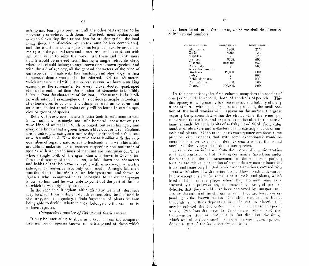
t
80
seizing and tearing its prey, and all the other parts appear to be necessarily associated with them. The teeth must be sharp, and adapted for cutting flesh rather than for bruising grain the food being flesh, the digestive apparatus must be less complicated, and the intestines not a quarter as long as in herbivorous ani-mals ; and the general form and structure must be consistent with agility in order to seize the prey. All these and many more details would be inferred from finding a single retractile claw, whether it should belong to any known or unknown species, and with the aid of zoology, all the general characters of the tribe of carnivorous mammals with their anatomy and physiology in their numerous details would also be inferred. Of the characters which are associated without apparent reason, we have a striking example in the ruminants, for every cloven-footed quadruped chews the cud, and thus the number of stomachs is infallibly inferred from the characters of the foot. The naturalist is famil-iar with numberless examples of this curious principle in zoology. It extends even to color and clothing as well as to form and structure, so that certain colors only will be found in certain spe-cies or groups of species.
Both of these principles are familiar facts in reference to well known animals. A single tooth of a horse will shew not only to what kind of animal the tooth belonged, but even his age; and every one knows that a green horse, a blue dog, or a red elephant are as unlikely to exist, as a ruminating quadruped with four toes or with a solid hoof. Now those who are as familiar with the vari-ous tribes of organic nature, as the husbandman is with his cattle, are able to make similar inferences respecting the multitude of species with which the mass of mankind are unacquainted. Thus when a single tooth of the iguanodon was shewn to Cuvier be-fore the discovery of the skeleton, he laid down the characters and habits of that herbivorous reptile with an accuracy, which the subsequent discoveries have only confirmed. A single fish scale was found in the intestines of an ichthyosaurus, and shewn to Agassiz, who recognized it as belonging to an extinct species known to him, and he was able to point out the part of the fish to which it was originally attached.
In the vegetable kingdom, although many general inferences may be made from parts, yet details cannot often be deduced in this way, and the geologist finds fragments of plants without being able to decide whether they belonged to the same or to different species.
Comparative number of living and fossil species.
It may be interesting to shew in a tabular form the compara-tive number of species known to be living and of those which
St
have been found in a fossil state, which we shall do of course only in round numbers.
Ciaaaes or diviion. Living spevion. Entinct spenien.
Mammalia. 1300. 275. Birds. 8000. 20. Bept1es. 120. Fishes. 8000. 900. Insects. 100,000. 250. Articulata, 500. (0th or than inseCts) Molluscs. 12,000. 6000. Polypi. 7 900. Echnodorniata. 1 200! Animalcules. 800. 100. Plants. 100,000. 800.
In this comparison, the first column comprises the species of one period, and the second, those of hundreds of periods. This discrepancy is owing mainly to three causes : the liability of many tribes to perish without being fossilized ; second, the small por-tion of the fossil remains which appear on the surface, the great majority being concealed within the strata, while the living spe-cies are on the surface, and exposed to notice also, in the case of many animals, by their habits of activity ; and third, the greater number of observers and collectors of the existing species of ani-mnals and plants. Of so much much con sequence are these three principal circumstances, that with sonic exceptions it would he mere speculation to rnale a definite comparison in the actual number of the living and of the extinct species.
A very obvious inference from the history of organic remains is, that the greater part of existing continents have been under the ocean since the conimeitcement of the palaeozoic period for they are, with the exception of sonic primary mountainous dis-tricts, and some very limited fresh water torniations, covered with strata which abound with rniNine fossils. rFIe fossils with scarce-ly any exceptions are the rcuau;s of animals md plants, which lived and (lied in the places where they are now found, as is attested by the preservation, in numerous instances, of parts so delicate, that they wouid have been destroyed by transport, and also by the nature of the stratum in which they are found corres-ponding to the hnowa station of lmndred species now living. Since also some ilimex (lepo itS ihmu cut certain directions, it m'jv he inferred at tic mitnterik f hich i cv are were derived 1mm the cte 01 oher outs hit
was an :Iumil or tr,tineltt iii at threction, the size oh which amid oftsr ivers muitct ha' e P' H Ohm ntcmtsume propor- ti(fl0(C to that of the
82
From the alternation, in some cases, of fresh water with ma-rine formations, it is also obvious that some portions of the earth have been subject to both elevation and subsidence repeatedly.
It appears to have been the general fact, that the palaeozoic formations with their fossils were uniformly spread over much more extensive areas, than are the secondary and tertiary forma-tions,—not that there is an abrupt change from the former to the latter, but that in general and gradually the deposits are more limited as they are more recent. This would seem to prove that the ocean was shallow over very extensive areas, which would be the consequence of the limited extent of dry land, and is inferred from the general character of the organic remains.
It is also a very interesting fact, that in the secondary and pa-laeozoic formations the proofs of a warm and even a torrid cli-mate abound. It would seem that there has been a gradual diminution in the heat of the surface from the earliest periods. The organic remains, in countries which are now subject to the rigors of a cold climate, are of a highly tropical character. It would appear also that the climate was more nearly uniform through the different zones, and accordingly species were more widely distributed. The uniformity in the species of widely dis-tant regions is most remarkable in the vegetation of the coal period, even more so than in the animals of more ancient pe-riods.
"It appears that, out of 48 species from Nova Scotia, without enumerating the different species of &igmariae, which agree perfectly with the varieties found in England, there are no less than 37 which have been identified. The part of the remaining eleven might perhaps have been found to agree with known European fossils, had not most of the specimens been in too imperfect a state to admit of close comparison.
Out of 53 species obtained by me from the coal-fields of the United States, almost all of them from Pennsylvania, Maryland and Ohio, I have been able to identify 35 with European fossils, chiefly species found in Great Brit-ain. Of the remaining 18, only four can be said to be peculiar forms, the other 14 being all closely allied species, or geographical representations of European plants. When it is considered that all the genera of these fossils are likewise common to North America and Europe, we seem entitled to declare that so great a d?gree of uniformity in regions equally remote is without parallel.'—Leel/.
83
ChAPTER II.
HISTORY OF THE EARTH.
We proceed now with a hasty sketch of the geological history of the earth. It would seem more natural in a historical science, to commence with the most remote period of antiquity and to follow down the course of time. On the other hand the condi-tion of the earth in its earliest ages was so unlike the present, in its geography, its climate, and all its features, that there is little in common between the most ancient and the present period, except that the same material atoms and the same laws of nature remain. He who for the first time becomes acquainted with this extraordinary history, is lost in the strange scenes of those earli-est days, unless proceeding step by step from the present to the past, he shall have become gradually accustomed to the change. Without deeming myself pledged to the same course on any future ocóasion, I shall, therefore, offer myself as a guide in has-tily tracing up the stream of time into the remote regions of the past.
Tabular view of the geological forntations.
It will be recollected that on a previous occasion we enu-merated six classes of stratified rocks. Of these the oldest are called primary strata, and are characterized by their position, beneath the palaeozoic rocks. They are crystalline in their struc-ture, and contain no fossils; but this is also true of some rocks, which are less ancient but have been altered by heat. The sec-ond class includes those strata which contain the remains of the earliest organic beings, and a long series of subsequent forma-tions. These were followed by the secondary and these by the tertiary strata. The fifth and sixth classes, drift and alluvium, are by some comprised in one with the name of quaternary. The accompanying table is intended to exhibit most of the formations in these classes, in the order of their superposition. The first col-umn gives the names of the classes; the second, of the orders into which the classes are divided ; the third, of the systems, or groups ; the fourth, of the divisions, and the fifth, of the forma-tions ; in the sixth column we have the thickness in feet, and in the last, the names of some countries where the formations are well developed. The table is of course incomplete, not only because the haste with which it has been prepared does not per-mit research, but because the progress of geology is continually intercalating formations newly discovered, among those which are
well known.
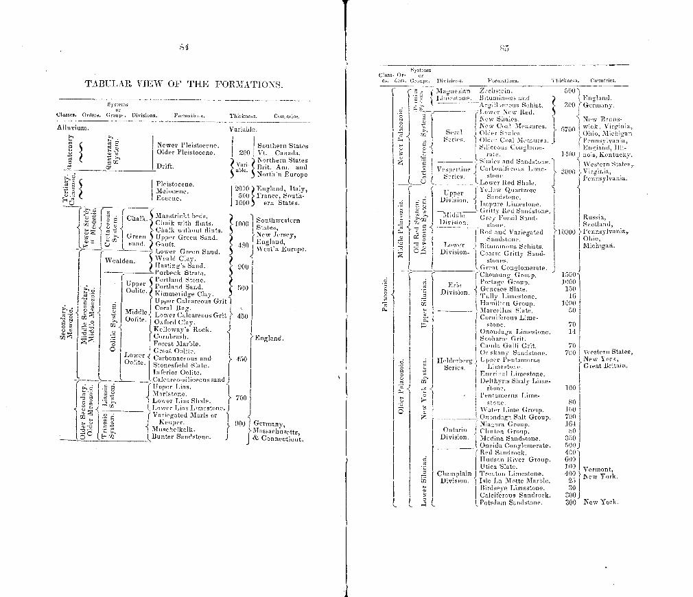
a 0 N 0 0 C,
0
z
U
N 0 0 a a
On a
-u
U
0 N 0 a a me
On
C)
0
0
a a
I C
S ye to inn Class- Or- or
es days. C coups. Divisions. Formations. Tti icknesa. Cenetries. TABULAR VIEW OF FHE FORMATIONS.
ye tO
Classes. Orders. Groups. Divisions. Formations. Thickness. Countries.
Alluvium. Variable,
cd Newer Pleistocene. Southern States Older Pleistocene, 200 Vt. Canada.
92 • ) Northern States Drift. Vary Brit. Am. and
) Nortlsn Europe
.5 Pleistocene. i e e. 2000) England, Italy,
0 000flC
500 France, South- 1000) ern States.
Chalk. Maestriclit Southwestern
a- J Green ( Chalk without flints. ' Upper Greets Sand. New Jersey,
I sand. GiuIt. 480 al ud
I Losrer Green Sand. Europe. J
Wealden. \Veald Clay. Hastinp's Sand. 900 Purbeck Strata. )
I I Upper
C Portlnd Stone. Portla
and Sand.
Oolite. Kimmeridge Clay. 500
lllpper Calcareous Grit
Midd1e Lower Cacareous Grit 450 - Oohte. 0 If tO Oxfhrd Clay.
Kelloway s Rock. J ICornbrash. England.
Forest Marble. I C
Lower Great Oolite.
Oolyt. Carbonaceous and 450 Stonesfield Slate. Inferior Oolite. Caicarco.siticeous sand J
I I a I Upper Lion. 1 a i Marlstone. Losver Lias Shale. 700
a Lower Lbs Limestone. J
I 02 I Variegated Mario or I Kcmiper. i 900 1 Germany,
.5 Muschelkalk. S Bunter Sandstone. J
Maesachusettg, & Connecfi,5
• . Slaoneoian Zeclistcin. 3 Limestone. Bituminous and 3. rgillitceuus Scitsist. L_
ç a Losver New Red. New Slyales.
i New Cant Measures. Seral Older Shales.
i Series. i Older Coal Measures. s;lij Conglosiie-
S i rate. Shales and Sanclstone.
\esnertme f Carb,nifbrous Lime- Series. stone.
Losver Red Shale.
( p r Upe I Vellum Quartzose
O Divis ion. ..J Sandstone. a
o _..cnitty
Impure Li iiestose. Red Sandstone.
J\Iiditle Grey Fossil Sand- ] )ivision. stone
3 I Red and Variegated S Sandstone.
Lower j Btumin one Sctiists. C Divisio xe. Coarse Gritty Sand-
I I stones. r Geat Conglomerate.
ç I Ctieuiung Group.
a Erie I'ortane Group.
Division. .çGenesee Slate. I silly Limestone. Hamilton Group.
- llareellus Slate. I Cornifbrous Lime-
stone. Onondaga Limestone. Scoharie Grit. Cammta Galli Grit. Or.ekany Sandstone.
Helderbere Upper Pentamerus S Series. ) Limestone.
Enerinal Limestone. a5 Va Delihyrms Slialy Lime- - I s'tone.
I Pesstamerus Lime. etone.
Water Lime Group. z __J Onondaga Salt Group.
Niasara Group. Ontario j Clinton Group.
Division. 11 Medina Sandstone. Oneida Conglomerate. Red Sandrock.
zi Hudson River Group. .5 Utica Slate.
Cinamplain i Trenton Limestone. Division. Isle La Motto i\Iarble.
Birdeeye Limestone. Calciferous Sandrock.
l Potsdam Sandstone.
50u . )i EntiSand.
300 0Gersuany.
J •• New Brnne- - 5700 wick. Virttinia 5
I Otiio, Michigan i I t'ennsylvania,
England, .1111-1400 J nOiS, Kentucky.
Western States,-3000 .Virginia,
Pennsylvania.
Russia, Scotland,
10000 Pennmsylvania, Oh in, Michigan.
1500 1000
150 16
1000 50
70
700 I Western States, New York, Great Britain.
100 1.
80 1150 700 164 ho I
350 500J
600
100 Vermont, 400 New York.
25 30 I
300J 300 New York.
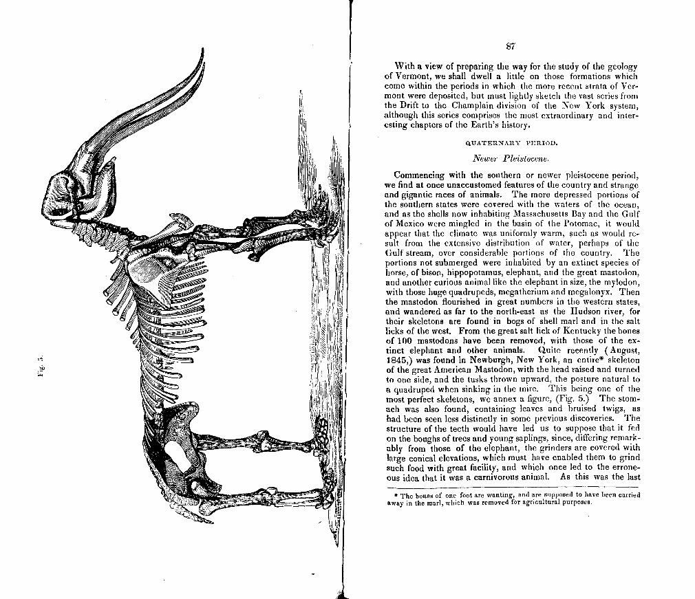
87
With a view of preparing the way for the study of the geology of Vermont, we shall dwell a little on those formations which come within the periods in which the more recent strata of Ver-mont were deposited, but must lightly sketch the vast series from the Drift to the Champlain division of the New York system, although this series comprises the most extraordinary and inter -esting chapters of the Earth's history.
UATERNARY PERIOD.
Newer Pleistocene.
Commencing with the southern or newer pleistocene period, we find at once unaccustomed features of the country and strange and gigantic races of animals. The more depressed portions of the southern states were covered with the waters of the ocean, and as the shells now inhabiting Massachusetts Bay and the Gulf of Mexico were mingled in the basin of the Potomac, it would appear that the climate was uniformly warm, such as would re-ult from the extensive distribution of water, perhaps of the
Gulf stream, over considerable portions of the country. The portions not submerged were inhabited by an extinct species of horse, of bison, hippopotamus, elephant, and the great mastodon, and another curious animal like the elephant in size, the niylodon, with those huge quadrupeds, megatherium and megalonyx. Then the mastodon flourished in great numbers in the western states, and wandered as far to the north-east as the Hudson river, for their skeletons are found in bogs of shell marl and in the salt licks of the west. From the great salt lick of Kentucky the bones of 100 mastodons have been removed, with those of the ex-tinct elephant and other animals. Quite recently (August, 1845,) was found in Newburgh, New York, an entire* skeleton of the great American Mastodon, with the head raised and turned to one side, and the tusks thrown upward, the posture natural to a quadruped when sinking in the mire. This being one of the most perfect skeletons, we annex a figure, (Fig. 5.) The stom-ach was also found, containing leaves and bruised twigs, as had been seen less distinctly in some previous discoveries. The structure of the teeth would have led us to suppose that it fed on the boughs of trees and young saplings, since, differing remark-ably from those of the elephant, the grinders are covered with large conical elevations, which must have enabled them to grind such food with great facility, and which once led to the errone-ous idea that it was a carnivorous animal. As this was the last
* The bonee of one foot are wanting, and are supposed to have been carried away in the marl, which was removed for agricultural purposes.
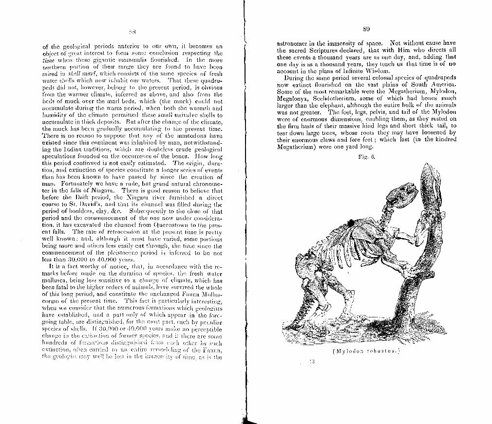
of the geological periods anterior to our own, it becomes an object of great interest to form some conclusion respecting the tie when these giantic mammalia flourished. In the more northern portion of their range they are found to have been mired in sJrrll marl, which consists ot I he same species of fresh water shells which now inhabit our waters. That these quadru-peds did not, however, belong to the present period, is obvious from the warmer climate, inferred as above, and also from the beds of muck over the marl beds, which (the muck) could not accumulate d un rig the warm period, when both the warmth and humidity of the climate permitted these small univalve shells to accumulate in thick deposits. But after the change of the climate, the muck has been gradually accumulating to the present time. There is no reason to suppose that any of the mastodons have existed since this continent was inhabited by man, notwithstand-ing the Indian traditions, which are doubtless crude geological speculations founded on the occurrence of the bones. ilow long this period continued is not easily estimated. The origin, dura-tion, and extinction of species constitute a longer series of events than has been known to have passed by since the creation of man. Fortunately we have a rude, but grand natural chronome-ter in the falls of Niagara. There is good reason to believe that before the Drift period, the Niagara river furnished a direct course to St. David's, and that its channel was filled during the period of boulders, clay, &c. Subsequently to the close of that period and the conirneuccinent of the one now under considera-tion, it has excavated the channel from Queenstown to the pres-ent falls. The rate of retrocession at the present time is pretty well known; and, although it must have varied, some portions being more and others less easily cut through, the time since the commencement of the pleistocene period is inferred to he not less than 30,000 to 40,000 years.
It is a fact worthy of notice, that, in accordance with the re-marks before tirade ou the duration of species, the fresh water mollusca, being less sensitive to a change of climate, which has been fatal to the higher orders of animals, have survived the whole of this long period, and constitute the unchanged Fauna Mollus-corum of the present time. This fact is particularly interesting, when we consider that the numerous loralations which geologists have established, and a part only of which appear in the fore-going table, are distinguished, for the most part, each by peculiar species of shells. If 30,000 or dO,000 years make 00 perceptible change ia the extinction of former Species, and if there are sonic hundreds Of feruetines dstngwsheo ham each other 1sy such extinction, often carried to an entire iemodeirng of the Fauna, the geoloist rca well he lost in the inm200sitv of time, as is the
89
astronomer in the immensity of space. Not without cause have the sacred Scriptures declared, that with Him who directs all these events a thousand years are as one day, and, adding that one day is as a thousand years, they teach us that time is of no account in the plans of Infinite Wisdom.
During the same period several colossal species of quadrupeds now extinct flourished on the vast plains of South America. Some of the most remarkable were the Megatherium, Mylodon, Megalonyx, Scelidotherium, some of which had bones much larger than the elephant, although the entire bulk of the animals was not greater. The feet, legs, pelvis, and tail of the Mylodon were of enormous dimensions, enabling them, as they , rested on the firm basis of their massive hind legs and slort thick tail, to tear down large trees, whose roots they may have loosened by their enormous claws and fore feet ; which last (in the kindred Megatherium) were one yard long.
Fig. 6.
ov rz-
:
, (
: xn -
[rilylodoa robustus.]
oo
During the same period, also, there lived in Great Britain many quadrupeds, most of which, including all the larger species, are extinct, as an extinct species of elephant, of hear and of hyena larger than any now living, of horse, lion, tiger, &e. These occur with some, as the great Irish elk, before mentioned, which became extinct since the existence of inan, and others, which are yet in existence, as the fox and wolf, thus showing that the ex-tinction of species of that epoch was a gradual, and not a sudden and violent process.
Probably, also, the gigantic birds of New Zealand existed dur-ing the same period, although continued into the historical epoch.
DRIFT PERIOD.
As the members of the drift division have a full development in Vermont, the general geology of this period claims some con-sideration. The features of the surface and the physical changes of that period will be found still more unlike the present order of things. We must, therefore, before coming to the conclusions which constitute its history, carefully examine those mementos of it, which we find abundantly scattered over a large portion of the country.
The deposits of this period cover this continent north of 40 north latitude, and in the valleys of the Delaware, Susquehannah, and Mississippi, they extend a few degrees farther to the south. A large part of Europe, Great Britain, Norway, Sweden, Russia, and the countries south of the Baltj are covered with similar deposits. Drift also occurs in similar latitudes in the southern hemisphere, as in Patagonia, and the Falkland Islands. It ap-pears to be wanting within the tropics, for the few accounts, which have been given of its existence in the West Indies, are based no doubt on the deposits of rivers flowing at higher levels and sub-ject to violent freshets.
The deposits of this period are the older pleistocene and the drift. The latter comprises by far the greater part of these de-posits, and consists of sand, gravel, hard-pan, pebbles and boul-ders variously mingled, and frequently shewing a very irregular and confused stratification, as if the result of very turbulent currents.
The deposits of the older pleistocene were formed in the irreg-ular basins of drift, and consist of clays more or less finely lami-nated and of fine sand. They contain fossils, (some of which are delicate shells evidently entombed in the place where they lived,) and indicate a period of quiet. The subdivisions of this period, as they appear in Vermont, will be considered in another place.
'11
The most important facts relating to this period may be referred to the following heads:
1. The fossiliferous horizontal and regular deposits of the older pleistocene, which are for the most part extremely limited in extent.
2. The absence of fossils from the drift. 3. Its confused stratification. 4. The transport of drift abundantly over the highest part of
the country, not only pebbles but enormous boulders weighing many tons having been carried up steep acclivities.
6. The direction of the transport being towards the south, to south east, rarely a little to the west of south, and never in a con-trary direction. To the practical geologist, this fact is as familiar as the alphabet, and the direction of the source to which frag-ments may be traced was noticed in the first report. This fact is strikingly obvious in the larger boulders. In some cases the materials were transported for hundreds of miles, and frequently for ten or twenty miles. It is truly remarkable how little influ-ence ranges of mountains, oblique to the current of drift, had upon its course.
6. The diminution in the size of the boul4ers as they are more distant from the parent ledge.
7. The existence of furrows and scratches on the surface of the solid rocks, whose direction corresponds so universally and ex-actly with the course of the transported materials, that the one may always be taken as the index of the other. Here also the influence of oblique ranges of mountains is usually slight and very local. But some mountain valleys have had an influence more or less marked, two striking examples of which we shall find in the geology of this state.
In some cases on the tops of mountains of the tougher rocks, as on Mt. Holyoke in Massachusetts, furrows are found which are a foot wide and two inches deep. We have seen also, in Dorchester, Massachusetts, the sides of an angle between two portions of a ledge of hard quarizose conglomerate, which was nearly in the direction of the drift, rendered concave and sjiooth, as if the moving bodies were forced through with great friction.
More frequently the furrows are but an inch to three inches in width and about a third as deep. Still more frequently scratches occur which do not exceed one eighth or one fourth of an inch in width, and others are as fine as the stroke of a pen.
Sometimes the entire surface of the rock is smoothed down, rounded and polished, as in the case of the Dorchester rocks above
Although the whole peiO( is termed the drift period from its most charac-teristic deposits, yet to avo!d confusion, we shall term the regular deposits pleis. tocene, and restrict the word drift to the coarser or more confused deposits.
92
mentioned where the surface of the hard quartz pebbles is in relief, like the siliceous specks in a piece of marble artificially polished.
S. That the scoring is referable to the agency which transpor-ted the drift is proved by the coincidence of direction in cases without number: it is also inferred from the following considera-tions; the superposition of the drift over the furrowed rocks proves that the furrows are at least as ancient as the drift, and there is no reason for supposing that they are more ancient; in-deed in the geology of this State, we shall find very satisfactory proof that they could not have been made at any preceding period.
9. In many narrow valleys, or elsewhere, at the foot of moun-tains, especially on the north side, there are collections of small steep well rounded hills, separated in some cases by equally well rounded concavities, and composed of very loose gravel and peb-bles ; and the same kind of materials is occasionally found in very long narrow steep ridges, some curved and some more or less straight. These accumulations have been called inoraines, and iceberg moraines, from their close resemblance to the masses of earth and stones so called, which result from glacial action.
10. The tops of some slate hills have been crushed over by enormous masses from above striking them with a prodigious force. As most of the known examples have been discovered in this State, we reserve for another place the description of these facts.
11. The southern limit of the drift before mentioned is a fact of great importance.
Such is a general description of the drift of North America. With slight modification it is equally true of the drift of wes-tern and central Europe. But in the recent and magnificent work of Sir R. I. Murchison on the geology of Russia, we have a very material addition to the history of the drift of northern Europe. Commencing at the western boundaries of Russia, and proceeding to the north east part of European Russia, the trans-port of drift is found to be more and more to the east, until at length in approaching the Arctic Ocean, the course is from west to east. In other words, the lines of direction, traced backward, converge towards the crystalline and metamorphic rocks of Scan-dinavia; and since M. Boghtlink had previously shown that the transport in the extreme north of Lapland was from the south to the north, it follows that the depression of the drift of northern Europe consisted in a series of excentric movements from the Scandinavian centre. We may add that the completion of most of the periphery of the scene of this great drift movement, within the limits of Europe, disconnects it in space from the similar move-
93
ments in North America, with which it had been commonly asso-ciated ; while the superposition of the European drift in the vicinity of the Baltic, over strata which contain the recent species of shells, and the position of the North American drift, beneath strata which contain several extinct with many existing species of shells, demonstrate that our drift is much older than that of north-ern and central Europe. Nevertheless the remarkable corres-pondence in general features points to a similar, though not identical origin, and leads us to look for similar results, in the future possible discovery of excentric lines of transport over the immense area of this continent lying north of 40 0 north latitude.
Another example of the excentric dispersion of drift also oc-curs in Europe in the Alps, whence masses of drift have followed the course of the valleys outwards.
Theories of drift.
The great problem—what was the agency which dispersed the drift, and wore down, smoothed and furrowed the rocky floor over which the materials moved—has elicited many theories. We shall here notice the outlines of these theories, without attempting to describe all their modifications, which have been almost as numerous as the individual writers.
The iceberg theory supposes that the drift country was sub-merged below the tops of the mountains not long before the drift agency, and that a polar current floated down icebergs which were loaded with the materials of the drift, and which, melting in their progress into a warmer latitude, strewed the drift along the bottom of the sea, and scored the surfaces of the rocks be-neath, with the fragments of rock which were frozen into the bot-tom of the icebergs.
This theory has the great advantage of introducing no more violent agencies than are now in operation ; such a polar current now exists, as we have seen, bearing icebergs, which are occa-sionally loaded with gravel, into warmer regions; and probably it would not be denied that if this country were submerged, this current, which now has a strong westerly tendency, would flow over an extensive region; the iceberg moraines are such as would be produced by the stranding of icebergs, either dropping their freight of earth and stones, or crowding up the materials on the bed of the sea by their weight and as they were rocked and ur-ged on by the waves; this agency, it is said, must have acted with greater intensity than at present, because the climate was colder, and the glaciers must have descended from the mountains of New England: instances are now occurring in which masses of ice, having thus frozen stones into the bottom, scratch the rocks
over which they are driven. It will be seen that this is a double theory, and although submergence is necessary to the action of icebergs, the theory of submergence may be retained consistently with the rejection of the iceberg theory.
it is, however, objected to the theory of submergence, that the drift appears to be entirely destitute of fossils, although submer-gence between the older and later drift to the extent of 300 to 500 feet below the present level is admitted, being attested by marine shells as before mentioned. It may also be ob1ected that -whether or not icebergs were drifted along, they could not have picked up masses of rock from the valleys and then carried them over the mountains ; that on the tops of the mountains rather than in the valleys the scratches should more frequently occur, whereas they are at least as common in the latter situation ; that the source of the materials should be found only in higher north-ern latitudes, rather than within a few miles of the present situation of the fragments ; that icebergs would not drop the heaviest stones first ; and that the rocky bed of the ocean especially in its valleys, would have been more or less pro-tected by a covering of mud from the furrowing agency of stones frozen into the icebergs. It is also denied, as we shall see in the geology of Vermont, that there is any evidence of a colder cli-mate, at least in the middle period, and it will be shown that the tops of the mountains were not the centres of dispersion but were overflowed in the same manner as the low lands.
The second theory is that of the glaci 0-aqueous agency, which supposes the climate to have become cold at the commencement of this period,
Whereby all organic lifo was destroyed ; and in high latitudes at least, glaciers were formed on mountains of moderate altitude indeed, that vast sheets of ice were spread over almost the entire surface extending south as far as the phenomena of drift have been observed. The northern regions, especially around the poles, are supposed to have formed one vast mer de glace, which sent out its enormous glaciers, in a southerly direction, by the force of expansion, and the advance and retreat of these glacIers, accumulated the moraines and produced the striae and embossed appearance (roches mou-tonnees) upon the rocks. When the temperature was raised, the inciting of the immense sheets of ice produced vast currents of water, which would lift up and bear along huge icebergs loaded with detritus,and thus scatter boulders over wide surfaces."—(Hh.)
In support of this theory, it is urged that a few years since an elephant and rhinoceros, of the species which inhabited Siberia immediately before the drift period, were found with the flesh and skin entire, frozen in ice on the northern shores of Siberia, and that, therefore, there must have been a change from a climate warm enough to produce the food of the elephant whose remains are so abundant in that country, and so sudden that putrefaction would not take place. It is also argued that this refrigeration of
95
the climate accounts for the absence of fossils from the drift; that the iceberg moraines, the striae, and furrows and smoothing down of the surface of the rocks, and the transport of the detri-tus, are effects precisely similar to what we see on a smaller scale in the glaciers of the Alps..
To this theory it is objected that such a refrigeration of climate is without any known parallel in the history of the earth, and that it cannot be accounted for without supposing a great derange-ment, for the time, of the solar system, and that the accumulation of a glacier large enough to cover the northern regions of Europe, Asia and America, is not possible without a chaotic derange-ment of the whole planetary system ; that glacial action is pecu-liar to the highly inclined valleys of very lofty mountains; that the southerly transport of the drift through a long period is not sufficiently accounted for, even by the sudden melting of the ice, and that the mere expansion of the great glacial sheet could not transport the (Irift for several hundreds of miles ; that the north-ern part of Siberia is not a proper drift region., and consequently the case of the frozen animals has no connection with the subject; and that the wearing down and striation of the rocks may be otherwise accounted for.
The theory of eThvations supposes that in the great centres from which the drift emanated, there were violent earthquakes and elevations, oft repeated through a succession of ages, whose shocks threw down over the northern portions of the globe enormous earthquake waves, bearing along the immense icebergs of the po-lar regions with great violence, and strewing the preexisting loose materials of the surface far to the south of their former position, and that immense masses of such materials were moved along by receiving a portion of the impulse,which acted on the rocks beneath in the same manner as glaciers, producing similar results. Some of the advocates of this theory suppose that this took place with-out any actual depression of the continents, although this is not essential to the theory. Some also suppose that instead of sim-ple elevations, there were undulations of the crust of the earth, as in some modern earthquakes, without admitting ice to have had much influence.
In support of this theory, it is argued that earthquake waves are known, by many modern examples, to consist in the actual locomotion,(if I may use a word characteristic of these times also,) of the water, and consequently to have a momentum inconceiva.. bly greater than ordinary waves, and that such waves of transla-
1f however such a region as the eastern part of Iceland, with 3000 square miles of ice mountains, were exposed to such earthquake action, immense num-bers of icebergs would be borne along by the waves.
96
tion might therefore have swept over many degrees of latitude; and it has been proved that a current of twenty miles per hour would transport stones weighing 300 tons.
To this theory it is objecte(l, that repeated elevations could not go on long enough to produce the drift phenomena, before the great central earthquake region would have been elevated above the water. But it is not necessary to suppose that all the earth-quake action was elevatory, and it may have comprised, as in modern earthquake regions, a series of both elevations and sub-sidences : it is obvious that time commotions in the water in the latter case would be far more limited than in the former.
We shall now, as we proposed, offer merely a synopsis of the many and long periods, which intervened between the drift and the Champlain division of the New York system.
TERTIARY SYSTESI.
The formations of this period are Composed of layers of clay, sand, gravel, and mud, with occasional quartz-
Use and calcareous beds more or less consolidated; all of which were depos-ited in waters comparatively quiet and in separate basins"(—IIk.) or in more extended areas.
They consist of three or four groups of marine strata, which are separated by other strata that contain freshwater and terrestrial remains.
The Pie jocenc strata are found in many parts of southern Eu-rope to attain to great thickness; in some places to two thousand feet. They contain abundantly shells of marine species, of which a large portion still exist oil the Mediterranean. A deposit on the Rhine contains brown coal in greater quantity than any other above the carboniferous system ; but it is of little economi-cal value. A majority of the species of fossile insects are found in the pleiocene of Germany.
The Meiocene strata occupy a considerable portion of France, Austria, Poland, and Russia, and, in this country, of Delaware, Maryland, Virginia, and North Carolina. Marine shells are abundant. About seventeen per cent. of the species are yet in existence. Mammals also were very abundant during this and the pleiocene epochs.
The Eocene also contains numerous species of shells, of which about three per cent. ame yet living. This formation occurs in the south east of England, in the vicinity of Paris, and also in Alabama and South Carolina. The remains of some birds, and of many mammals are found, of which the species, and many of the genera are extinct. The eocene of Germany contains beds of polishing slate, fourteen and twenty eight feet thick, which
97
consist of the shells of animalcules, at the rate of 41,000 mil lions to a cubic inch.
CRETACEOUS SYSTEM.
This formation consists chiefly of chalk in the upper parts, and of sands in the lower; the chalk being replaced in this country by the Ferruginous Sand. It is well developed in the south east portion of England, in New Jersey, Alabama, Mississippi, and Arkansas. The fossils are numerous, and are mostly the remains of animals, the plants of this period having been rarely preserved. The flints which are so abundant, are delicate spon-ges, in which are microscopic shells, petrified and filled with sili-ceous matter, and which exhihit the spongy structure and the shells under a powerful magnifier. Echinodermata, shells, and crabs are abundant. The hermit crabs make their appearance for the first time in this period. Fishes are common, and several extinct genera of saurian reptiles, one of which, the niososaurus, a kind of lizard, had a head four feet long, and was probably twenty four feet in its entire length.
WEALDEN GROUP.
This group consists of clay, sand, and limestone strata, which contain the remains of terrestrial and fresh water animals and plants. The remains of coniferous trees, and large but unde-termined endogenous plants are found. Minute fresh-water crustaceans, and some insects, a few wading birds, and some tortoises, fresh water mollusca, and enormous saurians in great numbers, were the animal kingdom of that period. The fresh water shells were very numerous, and constitute the greater part of some strata of beautiful marble. They belonged to extinct species of the existing genera of paludina, melania, and cyclas. But the reptiles were the most remarkable of the animal kingdom for size, number, and variety. Some resemble the long snouted gavial of the Ganges, and others were furnished with shorter and more powerful jaws. One of the most extraoN dmnary was time iguanodon, a herbivorous saurian, with some resemblance, especially in the form of its teeth, to the iguana or tree lizard, but of massive proportions. In one respect, it was more like the pachydermata, (thick skinned mammals), than reptiles, for its body was elevated to a considerable height above the ground, the thigh bone,being three feet eight inches io length, and thirty-five inches in circumference at the condyles. It is estimated to have been not far from thirty feet in length, although when first discovered, it was supposed, on account of the great
13
98
size of some of the bones, to have been much larger. That they were very numerous is evident from the discovery of more than seventy in the quarries of one locality in the south of Eng-land.
OOLITIC SYSTEM,
The name oölitic, signifying egg-stones, is derived from the appearance of many of the limestones of this system, which are composed of a multitude of little spheroidal concretions. The strata comprise an extensive group of limestones and clays, and are more remarkable for their economical and scientific impor-tance, than for their thickness and extent. For the subdivisions, the table may be consulted. in England, they are very fully developed.
The system is remarkable for the number and variety of its fossils. Of the plants, extinct species of fossil Cycadeae chiefly abound. This is an order of tropical plants which, although ex-ogenous, resemble short palms, with a magnificient crown of graceful foliage, and a large terminal bud. In the animal king-dom, polypi were abundant, of the tribes which construct exten-sive coral reefs. The echinoderruata were represented by many very singular animals, some of which grew firmly to the rocks by a long stem, (the crinoideans). Crabs and insects have been well preserved, and all the classes of shells are common, but the higher orders are more abundant. Of the cephalopods, one spe-cies is found with its ink bag, which it probably used as the cut-tie-fish uses its bag, to discoltr the waters by a discharge of the inky fluid when pursued by enemies. The well known India ink is obtained from the cuttle-fish, and the ink of a fossil speci-men, preserved through the long intervening periods, was there-fore tried by an artist and found to be of the best quality.
The fishes and reptiles, however, of this period are objects of more than fifty species of fishes have been found, most of which the greatest interest. In the oölite of England the remains of were of the sauroid family, a family comprising those genera which approach most nearly in their structure, especially in their mouth, to the sauriaii reptiles, which they also resemble in their ferocious habits. The bill-fish of Lake Champlain, Lepisosteus oxyurus, is one of the few living species of this family. During this period huge marine reptiles appear to have been the lords of creation. One of them, the pieiosaurus, was as long as a whale, with conical teeth seven inches long, and as the portion of the jaw into which the teeth were st was three feet long, the head must have been of great size. The neck was of massive proportions, some of its vertebrue being eighteen inches in cir-aumference, although only one inch long, thus uniting flexibility
99
with great strength. In place of legs and feet, the animal was provided with paddles for swimming, like the whale. Of several other genera, which more nearly resembled the crocodiles of the present epoch, the genus cetiosaurus was also remarkable for its great size, the larger species having attained the length of sixty feet. This was also an aquatic genus, a broad vertical tail hav-ing been the main organ of motion. It was also provided with large webbed feet.
There were other saurians of terrestrial habits, allied to the iguanodon. The megalosaurus had strong two-edged teeth curved backwards and tapering to a sharp point, and with both edges ser-rated (notched like a saw). They were therefore admirably adapted for holding, tearing and cutting up their prey. It was probably about thirty feet long, and, like the iguanodon, was ele-vated several feet from the ground by massive legs, and had a body much broader and deeper than the modern saurians. These with the numerous marine reptiles
"Formed a group of predatory animals never surpassed in fierceness, strength, and veracity." (Ansted).
But the most extraordinary of the reptiles of that period was the pterodactyle, an animal with the form and general appear-ance of a bat, except in the head, which was very long and re-sembled that of a crocodile, to which also the internal anatomy of the body corresponded. Although the neck contained only seven vertebrm, it had great flexibility, and the head could be thrown over so as to rest on the lower part of the back. The apparatus for flying in bats consists of an enormous extension of four of the toes with the skin stretched across. But in this ani-mal the fifth toes only were greatly elongated, and the skin was extended from these along the sides of the legs and body. The other toes being free, the animal could walk or swim with the Wings folded.
This interesting group of strata is also remarkable for contain-ing the remains (in the Stotiesfield slate) of the first mammals known to have existed. They belonged to two extinct genera of marsupials.
LIAS SYSTEM.
The strata of this system consist chiefly of calcareous and ar gillaceous matter more or less mixed. It is probably richer in organic remains than any other formation.
In the absence of corals, the sea abounded in echinodermata, among which were most conspicuous the crinoideans. One of the genera of this order, pentacrinites, had a five-sided stem s from the summit of which the arms were given off in innumera-
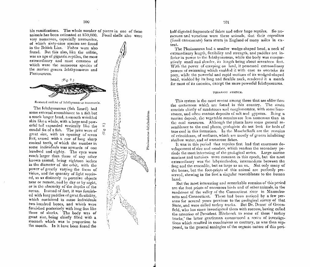
\ ç.
0
c)
0 0 52
'5 (0 0
100
ble ramifications. The whole number of pieces in one of these animals has been estimated at 150,000. Fossil shells also were very numerous, especially ammonites, of which sixty-nine species are found ft in the British Lias. Fishes were also found. But this also, like the oölitic, was an age of gigantic reptiles, the most extraordinary and most common of which were the numerous species of the marine genera Ichthyosaurus and Plesiosaurus.
(Fig. 7.)
Restored outline of Ichthyosauru s commun is.
The Ichthyosaurus (fish lizard) had some external resemblance to a fish but a much longer head, a smooth wrinkled skin like a whale, with a large and pow-erful tail expanded vertically like the caudal fin of a fish. The jaws were of great size, with an opening of seven feet, armed with a row of long sharp conical teeth of which the number in some individuals was upwards of one hundred and eighty. The eyes were much larger than those of any other known animal, being eighteen inches in the diameter of the orbit, with the power of greatly varying the focus of vision, and the quantity of light receiv-ed, so as distinctly to perceive objects near or remote, and by day or by night, or in the obscurity of the depths of the ocean. Instead of feet, it was furnish-ed with long paddles of great flexibility, which contained in some individuals two hundred bones, and which were furnished posteriorly with long fins like those of sharks. The body was of great size, being chiefly filled with a stomach which was in proportion to the mouth. In it have been found the
101
half digested fragments of fishes and other huge reptiles. So nu-merous and voracious were these animals, that their coprolites (fossil excrements) form strata in England of many miles in ex-tent.
The Plesiosaurus had a smaller wedge-shaped head, a neck of extraordinary length, flexibility and strength, and paddles not in-ferior in power to the Ichthyosaurus, while the body was compar-atively small and slender, its length being about seventeen feet. With the power of creeping on land, it possessed extraordinary powers of swimming which enabled it with ease to overtake its prey, while the powerful and rapid motions of its wedged-shaped head, wielded by its long and flexible neck, rendered it a match for most of its enemies, except the more powerful Ichthyosaurus.
TRIASSIC SYSTEM.
This system is the most recent among those that are older than the cretaceous which are found in this country. The strata consists chiefly of sandstones and conglomerates, with some lime-stones, and often contain deposits of salt and gypsum. Being a marine deposit, the vegetable remains are less numerous than in the coal measures. Although thd plants have some general re-semblance to the coal plants, geologists do not look for beds of true coal in this formation. In the Musehelkalk are the remains of crinoideans, of molluscs, which are mostly of genera inhabiting shallow water, and of numerous fishes.
It was in this period that reptiles first had that enormous de-velopement of size and number, which renders the secondary pe-riods the most interesting of the geological series. Large marine saurians and tortoises were common in this epoch, but the most extraordinary was the labyrinthodon, intermediate between the frog and the crocodile, but as large as an ox. Not only many of the bones, but the foot-prints of this animal are perfectly pre-served, shewing in the foota singular resemblance to the human hand.
But the most interesting and remarkable remains of this period are the foot prints of enormous birds and of other animals, in the sandstone of the valley of the Connecticut river in Massachu-setts and Connecticut. These had been noticed by a few per-sons for several years previous to the geological survey of that State, and were called turkey tracks. But Dr. Deane of Green-field, who has since investigated them with success, having called the attention of President Hitchcock to some of these 'turkey tracks,' the latter gentleman commenced a series of investiga-tions which resulted in conclusions so contrary, as was then sup-posed, to the general analogies of the organic nature of this pen-
102
od, that it was a longtime before they obtained general credence, Reptiles were the highest order of animals before supposed to have existed at this early period, but from the discoveries of Pres-ident Hitchcock, it appears that birds, which perhaps had some affinities to the class of reptiles, were common, and that there were many species, and some of gigantic size, surpassing the famous Dinornis of New Zealand. The feet of some were six-teen to eighteen inches in length, with the toes as large round as a man's wrist, and the stride of the animal was four to six feet. Other tracks are less than the foot of the humming bird, although these are probably the young of a species which may have been as large as a sparrow. Dr. Deane has recently found the tracks of unknown and strange quadrupeds associated with the bird tracks. Even the impressions of rain drops are preserved, whose slant-ing direction records with infallible accuracy the direction of the wind in a passing shower.
PERMIAN SYSTEM.
"The Permian rocks consist of distinct strata of very varied lithological character. They are composed, for the most part, of white limestome with gypsum and rock salt, of red and green gritstones, with shells and occasional-ly with copper ore, and of magnesian limestones, conglomerates, &c. The whole series is highly fossiliferous, and contains the remains of extinct species of animals and vegetables, greatly resembling those of the carboniferous pen-od."—Ansted.
In the magnesian limestone, reptiles appear, which are not unlike the lizards of the l)resent day. With the exception per -haps of the footmarks in the carboniferous system, they are the oldest remains of warm-blooded animals that have been found.
CAKBONITEROUS SYSTEM.
This system is one of the most interesting in an economical and scientific point of view. It is the great repository of coal. Probably all the valuable beds of fossil fuel belong to this system, and the expectations which may be entertained of discovering it in profitable quantities in other rocks, are likely to prove ground-less, as they certainly have hitherto. The strata consist of sand-stone, shales, and limestone, with beds of coal, which latter are in some cases thirty feet thick. The valuable beds repose upon a bed of underclay which abounds withthe singular fossil roots called stigrnaria, whose trunks called sigillaria are also found in the coal fields.
"So thoroughly is the Welsh miner persuaded that the two things (the coal scam and underclay) are essentially conjoined, that he wou]d as soon expect to live in a house without a foundation, as to work in a coal seam
103
which did not rest upon underclay." "This fossil (stigmaria ficoides) so completely fills every bed of underclay, that it is not possible to cut a cubic foot which does not contain some portion of the plant."—Logan.
The coal itself is fully ascertained by microscopic examination of its structure to have been of vegetable origin. Usually the roofs of the coal mines abound with ferns and many other plants, which are preserved in the beauty and delicacy of their forms with great perfection. Dr. Buckland remarks ofa mine in Bohe-nila,
"The roof is covered with a canopy of gorgeous tapestry, enriched with festoons of most graceful foliage, flung in wild and irregular profusion over every portion of its surface. The effbct is heightened by the contrast of the coal-black color of these vegetables, with the light ground-work of the rock to which they are attached. The spectator feels himself transported, as if by enchantment, into the forest of another world ; he beholds trees of forms and characters now unknown upon the surface of the earth, presented to his senses almost in the beauty and vigor of their primal life their scaly stems, and bending branches, with their delicate apparatus, of foliage, are all spread before him, little impaired by the countless ages, and bearing faithful record of extinct systems of vegetation."—Buekland.
Nor was animal life less prolific in the period of the carbonif-erous limestone. The great mass of the mountain limestone of Europe was formed in the ocean, by the coraliferous tribes. The crinoideans and shells of curious structure were abundant. The relics of one hundred andtwenty species of fishes have been found.
OLD RED OR DEVONJAN SYSTEM.
The formations of this system consist of conglomerate, sand-stones and slates of great thickness, with limestones. Some thick deposits of limestone are the remains of ancient coral reefs. Cri-noideans and shells were abundant. The remains of about fifty species of fishes have been described, and, like all the others of the palaeozoic periods, belong to the order of ganoideans.
NEW YORK 'OR STLUREAN SYSTEM.
This system, comprising about thirty formations, is most fully developed in New York. By the geologists of that State it has been subdivided into four divisions, which, as well as the forma-tions, have received names from the places in which they are most exhibited. These divisions are founded partly on geograph-ical considerations, and are subject probably to some modifica-tion.
The Erie division consists of slates and sandstones, with a few thin beds of limestone. They contain some plants not unlike the coal plants, with numerous shells and trilobites. The latter were a tribe of crustaceans, whose remains were found in great num-
104
bers in the older and middle palaeozoic periods, but which then became extinct.
Te Helderberg series abounds in valuable limestones, with some shales and sandstones. It is rich in gypsum 4 and salt. Shells and coral were abundant in this period. A few remains of fishes also occur.
The Ontario division consists of conglomerates, sandstones and limestones. The limestone of Niagara Falls belongs to this division, and abounds with corals, shells, and other interesting fossils.
The Champlain division consists of lirnestones, slates and sand-stones, and with the exception of the lowest formation, the Pots-dam sandstone, is fully developed in Western Vermont. Shells, corals and trilobites were abundant in this period.
TACONIC SYSTEM.
The formations of this system consist of limestones, slates and conglomerates. They are supposed by some geologists to be only a part of the New York system altered by the action of heat. Others again regard them as a distinct and older system. As these rocks are so fully developed in this State, and the ori-gin of them is yet in doubt, we shall reserve a statement of the facts for the Final Report.
If they are identical with the New York rocks, we have in the Potsdam sandstone, the palaeozoic base, or the remains of the first organic beings known to have existed on the earth. It is remarkable that these are shells, although we should have expect-ed to find the remains of plants, since the animal is dependent on the vegetable kingc!oni for nourishment. If the taconic rocks are more ancient, the palaeozoic base is carried further down, but the most ancient organic remains are here also marine animals.
PRIMARY STRATA..
Beneath the oldest fossiliferous rocks lie certain highly crystal-line strata, which have been subjected to intense, and for the most part, long continued heat. rFllev are much disturbed from their original position, and have been thrown into a confused arrangement. They are guiess, mica slate, and some limestones. From the absence of fossils, it has been supposed that they were deposited before the existence of organic beings, and thus that they indicated a commencement of at least one great series of creations of organic - life. Yet since they have been intensely heated, it is obvious that organic forms may have once been embedded within them, and consequently no inference respecting
105
the condition of the crust of the earth during this period can be made with confidence. The non-existence of organic life can only be inferred from strata of very mechanical structure, desti-tute of fossils, and generally distributed beneath the fossiliferous rocks. It is unnecessary to say that such rocks do not exist, and as astronomy shows that we are within an assemblage of celestial orbs, whose limits, in regions too distant for imagination to con-ceive, we cannot find, so geology shews us to be on a stream of time, whose course it traces through inconceivable myriads of ages past, but whose source and termination are far removed from our knowledge, to where time merges into eternity.
But not only is the history of the primary rocks obscure ; it is often impossible to determine which of the crystalline strata are primary, and which of them are of palaeozoic age, but have since been altered by igneous agency. Many of this latter origin are known in Europe, which were once supposed to be primary, but are now known to have originated in some much later geo-logical periods. Thus the history of all those rocks, which cannot be distinctly traced beneath the oldest palaeozoic strata, is envel-oped in obscurity. Here all the sources of knowledge,—relative position, fossils, and original mineral constitution,—fail the geolo-gist whose lot is cast in such a region. Such is most of Vermont.
Duration of Genera, 'c.
We had occasion to remark on the duration of species, and we might, in noticing the organic remains of the several systems, have considered the duration of genera, and of the more com-prehensive groups, had our limits permitted. We select now a few striking examples. Of the chambered shells, there are known to have existed in the palaeozoic and secondary periods, upwards of six hundred species of a dozen genera, of which there remained after the secondary periods, only one genus, the Nautilus, which has existd through all the systems, and which contained, in the tertiary epochs, four species, and in the present it contains only two. * To this only one genus of chambered shells with one speciest has been added. On the other hand, of the convoluta, a family of shells containing about seven hun-dred species of six genera, many of which species are among the most abundant as well as beautiful of any now living, none existed anterior to the tertiary epochs. But some tropical genera, as the Lingula, have existed from the earliest age to the present.
The genus cerithium is not known to have existed before the tertiary period, yet two hundred and twenty species have been found in the tertiary strata, and more than one hundred belong
Nautilus pompilius and N. umbilicatus. t Spirula Peronii.
14
1
106
to the existing fauna. No general rule, it would seem, can be laid down for the duration of the groups more comprehensive than species. Some are represented by a few species in all the systems, or in a few of them, and others by many species in a few formations. It may however be said of most of those genera, which have survived through all the periods, that they either belong exclusively to tropical climates, or inhabit deep waters.
Connection of Geology with the Bible.
As many well-meaning persofls are disturbed by a supposed incongruity between the principles of geology and the Mosaic narrative, a due respect to such requires a few words on this subject. It should be remembered, that the design of the bible is not to teach science, and that the object of the narrative of the creation, in the bible, was simply to teach the religious truth, that there is One God, the Creator of all things, and not to anti-cipate the developments of geology. As a necessary consequence, the common language of that day, was used on subjects belong-ing to science, for, " What other language would have been consistent with Divine wisdom The inspired writers must have borrowed their terminology either from the mistaken philosophy [of other untie Os] of their own times, and so have sane. tified and perpetrated falsehood, uiiinteiiiifible meantime to all but one in ten thousand ; or they roust have anticipated the terminology of the true system without any revelation of the system itself; and so have become unin-telligible to all men ; or lastly they must have revealed the system itself, and thus have left nothing for the exercise, development, or reward of the human inderstaiiding, instead of teaching that moral knowledge, and enforcing those social and civic virtues, out of which the arts and sciences will spring up in due time, and of their own accord." (Coleridge, Lit. Remains.)
All therefore that can reasonably be expected on this subject in a Divine Revelation, is. that it should not expressly teach a system inconsistent with true science.
But it is supposed by some, that the bible teaches that the materials of the earth are no older than the human race, and such a doctrine if really existing in any portion of the bible, would be fatal to its authenticity. Not only geologists, however, but many theologians, who wrote before the discoveries of geol-ogy, have been of the opinion that the time of ''the beginning" is not fixed. Let any one, who is perplexed on this subject, re-examine the first verses of Genesis, and see whether any thing is said of the length of time, during which "the earth was with-out form and void," and whether there is any expression of time before the first day's work. Surely, it would have been as much out of place for Moses to have given a description of the extinct races, which existed before "the first day," as it is unreasonable
, to draw any conclusion, from his silence, unfavorable to the credi-
I (17
bility of the sacred narrative. I-Tow the account of the six (lays is to be interpreted, is a question for biblical critics, with which geology has no concern, and the supposed analogy, between those days and the geological periods, will be found to vanish on strict examination. For the satisfaction of some, however, we add the interpretation of a venerable English divine, of great learn-ing and piety, Dr. John Pye Smith.
11 1. The first verse of Genesis describes the creation of the matter of the whole universe, probably in the state of mere elements, at sonic indefinite epoch in past eternity. 2. The term earth, as used in the subsequent verses of Genesis, describing the work of six days, was designed to express the part of our world which God was adapting for the dwelling of man and the animals connected with him. 3. The narrative of the six days' work is a description in expressions adapted to the ideas and capacities of mankind in the earliest ages, of a series of operations, by which the Being of omnipotent wisdom and goodness, adjusted and finished, not the earth generally, but as the particular subject under consideration here, a PORTION of its surface for most glorious purposes. This portion of the earth I conceive to have been a large part of Asia lying between the Caucasian ridge, the Caspian sea, and Tartary, on the north, the Persian and Indian seas on the south, and the high mountain ridges which run at considerable distances, on the eastern and western flank. 4. This region was first, by atmospheric and geologicat causes of previous operation under the will of the Almighty, brought into a condition of superficial ruin, or some kind of general disorder. Probably by volcanic agency it was submerged, covered with fogs and clouds, and subse-quently elevated, and the atmosphere by the fourth day rendered pellucid. 5. The sun, moon, and stars were not created on the fourth day but then made, constituted, appointed to be luminaries."
Again, geology gives us no evidence of a universal deluge since the commencement of the historical period, nor of any other deluge which was universal, and throws great doubt on any such theory. Yet many persons, not considering what meaning was attached by the Jew's to the general expressions of the bible respecting the earth and mankind, and how absurd it is to suppose that they were told that America, and New Holland, and central Africa were covered with a deluge, and their inhab-itants exterminated, are much disturbed on finding their favorite theories untenable. Yet sech theories make no part of the bible. We again quote Dr. Smith:
"The Noachian deluge was limited to that part of the world occupied by the human race, and therefore we ought not to expect that any traces of it on the globe can now be distinguished from those of previous and analogous deluges."
Many also suppose that death was not introduced into the course of nature, until after the guilt of human sin. Yet count-less multitudes perished during the long periods anterior to this event, not only by the decay of old age, but as a prey to the rnyriads of ferocious animals with which the land and water were infested. Perhaps if it be considered that the Supreme Being, having infinite intelligence and wisdom, must have foreknown
108
the existence of moral evil, and have therefore, from the begin-ning, arranged his plans with reference to it, it may be admitted still, that even the physical death of the brute creation was the consequence of human sins, without any discrepancy with the facts of geology.
On the other hand, it must be regarded as an interesting fact, that when geology and the bible both treat of the same subject, they do really agree; viz, in reference to the length of time during which man and the animals, in which he has an interest, have existed. Although the geologist cannot measure time by years, yet as near as computation can be made, the geological period coincides with that which is assigned in the sacred scrip-tures.
PART II.
MINERALOGY.
We have introduced this head here, rather because it forms a part of our general plan, than because we are now prepared to offer any connected statement of results. We have before remarked upon our progress and disappointment in this depart-ment of the survey. A catalogue, made some time since, of all the published articles accessible here, and of some in manuscript, relating to the minerals of Vermont, shews that much time has in former years been given to the minerals of Vermont by nume-rous observers, and expectations probably higher than the facts, and certainly than the results of the survey will warrant, have been entertained by some respecting the interesting minerals of Vermont.
Although metamorphic rocks are by no means destitute of interesting mineral localities, those which are of igneous origin are far more likely to reward the collector with their rich and various contents. Not more than one-twentieth of the State consists of igneous rocks, but seven-eighths of these are meta-morphic, and we have accordingly a due proportion of minerals. Many of the localities are well known, and we add only a few as they occur to us, which 'we have lately noticed, in addition to those which, being also of economical interest, are mentioned in another place.
In the north west corner of BETHEL is a bed of fine whitish tak, most of which is more or less densely filled with elegant crystals of actinolite, many of which are large, and the speci-mens exhibit them of all sizes, with all degrees of aggregation. At the same locality, chlorite occurs in large quantity with octahe-dral iron ore sparsely disseminated. These minerals constitute a bed about four feet thick, not far west from the east boundary of the talcose and chlorite slates. A portion of this bed of talc is free from other minerals.
In the south cast corner of THET'ORD, kyanite is rather corn-
110
mon, in the conformable white quartz veins of segregation in the mica slate. We did not find any specimens of great beauty.
In BROOKFIELD, within a few rods of the north east corner of Braintree, mispickel occurs abundantly.
Black mica, wrinkled and nearly pure, occurs in the naked mountain, south east of the village in TOWNSJ-IEND.
In CABOT, one and a half miles from the south line, on the main road to the village, staurotide is abundant in mica slate, and many of the crystals contain small garnets imbedded. Some of the rocks here contain large imperfect crystals of hornblende very thickly disseminated in a base of compact hornblende strata, and the more rapid decay of the base leaves the crystals in bold relief, giving to the rock a remarkable appearance.
Magnificent specimens of spherical concretions of black mica, mostly one to one and a half inches in diameter constitute large portions of a few blocks of granite found in WATERFORD and RYEGATE. These specimens even much exceed in beauty those of the well known locality in CRAFTSBURY. At the latter locality however they fill enormous blocks of granite, which are thickly scattered over several acres near the lower village, south east from the centre of the town.
We have frequently been solicited to furnish specimens of the Middlebury zircon, and we take this opportunity to say, that it was found only in one boulder of syenite, and that, with the ex-ception of two specimens in the cabinet at Middlebury college, it was all taken away many years since.
Elegant crystals of titanium, from one five-hundreth to one one-hundreth of an inch in diameter and mostly an inch long, are very abundantly disseminated in a fragment of a transparent smoky quartz crystal from BRISTOL, and we have a similar speci-men from WATTSFIELD. The cyrstals in these specimens are nearly of a silver white with a faint tinge of yellow. Larger crystals occur in limpid quartz, and of the usual copper-red color, in ROcHEsTER, at a locality which is kept secret by two individu-als acquainted with it.
PART III.
C 0 NCRET JON S.
Although the phenomena of concretion have attracted more or less attention from many naturalists, they do not, so far as we are aware, appear to have been collected rogether and examined as a distinct subject. r1h e i r grand and extraordinary features, in the prismatic columns of basalt and of greenstone, have indeed been observed both by popular and scientific writers, and the cause of the prismatic form has been shewn by actual experi-ment. The calcareous concretions of the magnesian limestone in Durham, (England,) and the oölitic structure of this rock in the southern part of Yorkshire have been described by geologists, while other immense accumulations of small concretions are well known to constitute a considerable part of the oölitic rocks of England. The remarkable forms assumed by the argillo-calcare-ous concretions of clay beds have not been unnoticed. In Great Britain they have been supposed, even by some geologists, to be artificial products. They have been noticed in Sweden, and have been supposed to be the fossil remains of mollusca. Others are of the opinion that they are concretions. In this country, espe-cially in New England, they are very common. But little atten-tion, however, has been given to them, except by President Hitch-cock, who, in his Final Report on the Geology of rvlassachusetts, has given an interesting chapter on their constitution, proper-ties, and forms, with some suggestions on the power of concre-tion, but without arrivig at any conclusions respecting its nature.
Limited not only in time but by other incidental considerations, we can offer merely a brief and very imperfect synopsis of this subject.
The Power of Concretion.
Two things are necessary to define the power of concretion,-the law of its attraction, and the kinds of particles which are subject to it. Thus the law of crystalization is defined by its
112
building up in certain geometrical forms particles which are homogeneous. Cohesion is commonly understood as the power which unites homogeneous or heterogeneous particles without any definite forms and without change of properties; and chemi-cal affinity unites heterogeneous particics with a change of prop-erties into more complex homogeneous particles, which then obey cohesion.
Law of ConcreUon.
This is molecular attraction in the direction of the radii of a sphere towards the centre.
The proof of this proposition rests on the subordinate propo-sition, that concretionary forms are either perfect spheres, or spheres modified by circumstances. For the force must obvious-ly be exerted along or towards the radii, otherwise the resulting form would not be spherical ; it cannot be outwards, for this would be repulsion not attraction; it cannot normally be towards successive points along a few radii, from the intervening spaces, for then we should have a divergent columnar as well as con-centric structure, such in fact as we find in globular aggregations of imperfect crystals, which result from the combined action of crystaliation and concretion, and consequently are neither per-fect cyrstals nor perfect concretions; the concretionary attraction therefore must be towards the centre. Accordingly when there is a deflciency, in argillo-calcareous concretions, of the carbonate of lime, which appears to be most subject to this power, the exte-rior parts of the concretion are less firmly concreted and contain less carbonate of lime.
Our subordinate proposition, being merely a generalization, requires the consideration of the particulars generalized, which we must briefly notice, reserving the more detailed examination of the facts for some future occasion.
Spheres with little or no modif.ication do actually exist in im-mense numbers, and are probably far more numerous than per -fect crystals. Every geologist will at once call to mind the vast deposits in England with an oölitic structure. This structure also exists in some rrertiary and carboniferous strata, and even in the Isle Ia Motte limestone of New York and of the Isle Ia Motte. Such are also many of the concretions in the niagnesian lime-stone of Durham before referred to. Occasionally also perfect sheres are found in concretionary greenstoue, as at Mt. Holyoke, in Massachusetts, and in some dykes in Vermont.
The modified, or if we may so speak, the secondary forms no less confirm the general proposition, since these forms may be shewn to be spheres, modified by circumstances which are known to exist.
113
The prismatic forms of trap rock result from the lateral inter-ference of distinct spheres. It is well known that Mr. Gregory Watt fused 700 pounds of basalt; portions which cooled rapidly were amorphous and vitreous, but a slower process resulted in the formation of spherical masses, which increasing appeared to press upon each other, and being free above in the air and below in the liquid mass, were lengthened perpendicularly into prisms. If a lateral pressure actually exists between the spheres, it may easily be demonstrated, (since six equal continuous circles may be drawn in contact, touching an interior equal circle,) that in the case of equal spheres with equal lateral pressure, regular hexa-gonal prisms will result, and that with unequal spheres or unequal pressure other prisms will be formed, the number and dimensions of the sides of which would vary accordingly.
But the lateral pressure, if it exist at all, is far from being the only circumstance to be considered. When the spheres are in contact, there are no more particles at the point of contact in the line of attraction, and this point is therefore a part of the result-ing surface of the prism ; but the particles around would still continue to arrange themselves in obedience to the same law, and opposite concentric circles of particles around the first point of contact would successively come in contact face to face, until those on the adjacent sides of a given prism also should touch each other in the same horizontal plane, and these points of con-tact will then be extended up and down, forming the lateral edges of the resulting prisms, in the same manner as the first contact resulted in the lateral faces.
But it must still be considered, how it is that the prisms are continued to so great a length as at the Giant's Causeway; for if spheres are produced in various strata of the fused mass, it could not be expected that the perpendicular axes of the several spheres should coincide in straight lines, nor that the horizontal joints should be spherical, and the lateral ones, plane surfaces. But if we suppose the surface of the cooling mass to produce a stratum of spheres first, and that concretion takes place deeper and deep-er with a gradual and uninterrupted process of cooling, it is easy to see how prisms may commence at the surface, and be gradu-ally prolonged downwards. It is not however of course necessa-ry that the surface should be horizontal, as imperfect fluidity and containing walls of crust, and other circumstances, may give an inclined cooling surface. Not a few of the examples of columnar basalt are known to be inclined, and some are even horizontal.
That the various irregular forms of the trap rocks are more common than regular prisms, is an obvious result of variations in the circumstances which have been considered.
Let us now consider the case of the argillo-calcareous coricre-15
I:
'I
114
tions (claystones,) which are formed in clay deposits. Leaving out of view other circumstances, we find them formed in various laminae of clay at a greater or less depth beneath the surface, but each single concretion usually in a given lamina, although. those of different laminae sometimes coalesce. The most obvious and common modification in such circumstances is that of spher-oidal forms, flattened and extended equally or unequally in dif-ferent directions in a horizontal plane, and of course orbicular, ellipsoidal, oval, &c. Two causes exist which may occasion these depressed forms ; the division of the general medium of clay in-to laminae, may interpose an obstacle to a corpuscular attraction, and prevent the free and ordinary passage of particles from one lamina to another; or, as gravitation modifies the action of low degrees of chemical affinity, so the perpendicular downward pressure in clay beds, which must greatly exceed the pressure in other directions, may cause an attraction, which has no great intensity, to act with more efficiency in horizontal directions.
The magnesian limestone of Durham, (England), above men-tioned, contains discoid forms made up of circular laininae run-fling into each other, which
"Indicate a tendency to aggregation about different centres, even when, owing to some cause, the operation could not develop itself in a vertical di-rection." '—Ansted.
The influence of nuclei is well known. Thus when the root-lets of plants penetrate the clay beds, cylindrical concretions are made about them. In this case the filament appears to be an axis of attraction; but an axis may be regarded as composed of an indefinite number of points which are centres, and the cylindrical concretions consequently as composed of an indefinite number of spheres, which have coalesced by their upper and under surfaces.
The attachment of the nucleus to some point of support mod-ifies the form. Thus forms which otherwise would be spherical become hemispherical, and mammillary if confluent. An interest-ing example, of calcareous concretions thus modified, is described by Mr. Lyell, as existing in the tufaceous deposits of Tivoli.
We have of course considered in these remarks chiefly those forms, which are really or apparently simple. The complex forms result from the coalescence of those which are simple,and the study of them, although interesting, is, like that of the aggregation of imperfect crystals, comparatively unfruitful in general results.
In coming to the conclusion that the normal form is a sphere, we do not put forth for this theory the claim of novelty, which might be a doubtful recommendation. In enumerating six predomi-nant forms in the claystones of Massachusetts, commencing with the sphere, President Hitchcock remarks, that "nearly all of them might be regarded as modifications of the first."
115
If the law above proposed be regarded as established, a theory of it may be required. This however would render it necessary to have previously determined, whether the power of concretion be distinct from that of cohesion, a question on which we have at present only suggestions to offer.
The other fundamental question, respecting the power of con-cretion, relates to the substances which are subject to it. This question is yet involved in much obscurity, for the observations and analyses of concretions are not sufficiently numerous to fur-nish the required data. The substances seem to belong for the most part to two classes; any rocks of igneous origin, for it has been exerted in granite and in syenite as well as in trap rocks; and calcareous substances of aqueous origin. There are also ferruginous and manganesian concretions. In the case of the igneous rocks, time power is not restricted to a simple mineral, but the mixed ingredients of the mass of rock are, apparently at least, alike subject to the law. In a large portion of the other cases which now occur to us, more or less of carbonate of lime is pres-en t.
An interesting fact is mentioned by Ansted, that the concre-tions in the magnesian limestone of Durham are themselves free from magnesia. President Hitchcock analysed a number of spec-imens of claystones in Massachusetts, and two specimens from Nykoping, Sweden, from which it appears that from forty to sixty per cent. were carbonate of lime, and the rest was niostly silica, alumina, and iron, but these were not separated. On the next page we give the more minute analyses of Mr. Olmsted, which in general correspond with those of President Hitchcock, but also shew the presence of protoxide of manganese; in both series of analyses, several specimens were found to contain a small por-tion of magnesia.
President Hitchcock infers that the claystones are not a definite compound of carbonate of lime and clay, which conclusion is further fortified by the analyses of Mr. Olmsted. Since the vast majority of perfect spherical concretions consist of nearly pure carbonate of lime, it may be inferred that the other ingredients of claystones should be regarded as foreign substances.
The wide difference, between the constitution of those concre-tions which are of igneous origin and those which are of aqueous origin, is truly remarkable, and seems to present an insurmounta-ble obstacle to definite conclusions.
The following are the analyses made by Mr. Olmsted for this survey.
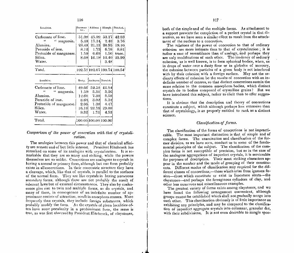
116
Localities. IDummere I Addison. Alburgh. Pittuford. ton.
Carbonate of lime. 51.081 45.091 53.17 42.88 magnesia. 5.401 17.341 2.48 3.76
Alumina. 28 .40 1 21.131 20.951 19.10 Peroxide of iron. 8.12 1.731 6.76 8.81 Protoxide of manganese. 1.50 0.60i 1.50 trace. Silica. 8.08 16.181 12.40 25.99 Water. 3.48
Total. 1 02 . 58 l l02 . 07100 . 74 100.54
Localities. Derby. fShe1burne. Norwich.
Carbonate of lime. 49.661 52.58 44,84 magnesia. 1.59 5.31 3.26
Alumina. 12.60 7.30 8.50 Peroxide of iron. 8.68 3.02 5.32 Protoxide of manganese. 2.00 1.38 4.47 Silica. 16.18 28.70 29.08 Water. 9.32 1.71 4.53
Total. 100.001100.00,100.00
Comparison of the power of concretion with that of crystali- zation.
The analogies between this power and that of chemical affini-ty are remote and of but little interest. President Hitchcock has remarked on some of its analogies with crystalization. It is re-markable that they are so many and striking, while the powers themselves are so unlike. Concretions are analogous to crystals in having a normal or primary form, although but one form probably exists in all concretions. In their concentric structure they have a cleavage, which, like that of crystals, is parallel to the surfaces of the normal form. They are like crystals in having numerous secondary forms, although these are not probably the result of inherent laws but of external circumstances. They also by coales-cence give rise to twin and multiple forms, as do crystals, and many of them, in consequence of an indefinite number of ap-proximate centres of attraction, result in amorphous masses. More frequently than crystals, they include foreign substances, which probably modify the form. As the crystals of given localities of-ten have some peculiarity in a predominant form, the same is true, as was first observed by President Hitchcock, of claystones,
117
both of the simple and of the multiple forms. As attachment to a support prevents the completion of a perfect crystal in that di-rection, so we have seen a similar effect to result from the attach-ment of the nucleus to a concretion.
The relations of the power of concretion to that of ordinary cohesion are more intimate than to that of crystalization ; it is rather a case of resemblance than of analogy, and perhaps they are only modifications of each oIlier. The tendency of ordinary cohesion, as is well known, is to form spherical bodies, when, as in drops of water over a dusty floor or in globules of mercury, the cohesion between particles of a given body is not interfered with by their cohesion with a foreign surface. May not the or-dinary effects of cohesion be the results of concretion with an in-definite number of centres, so that distinct concretions sustain the same relation to the common amorphous bodies, which distinct crystals do to bodies composed of crystalline grains? But we have introduced this subject, rather to elicit than to offer sugges tions.
It is obvious that the description and theory of concretions constitute a subject, which although perhaps less extensive than that of crystalology, is as properly entitled to rank as a distinct science.
Classification of forms.
The classification of the forms of concretions is not impracti-cable. The most important distinction is that of simple and of complex forms. The examination and classification of the for-mer division, as we have seen, conduct us to some of the funda-mental principles of the subject. The classification of the com-plex forms is not susceptible of precision, but as in the case of the analogous aggregations of imperfect crystals, it is serviceable for purposes of description. Their most striking characters ap-pear in the number and the mode of grouping of their constitu-ents. Different modes of classification may required for the (hf-ferent classes of coricretions,-those which arise from igneous fu-sion-those which constitute or exist in limestone strata-the claystones-and perhaps the ferruginous cylinders of clay, and other less numerous and miscellaneous examples.
The greatest variety of forms exists among claystones, and we have found the following arrangement convenient, although groups cannot be established which shall not gradually merge into each other. This classification obviously is of little importance as exhibiting any principles, and may be compared to the classifica-tion of iniperfect aggregate crystals into columnar, granular &c, with their subdivisions. It is not even desirable to mingle spec-
118
imens from different localities, since, as before remarked, the pe-culiarities are a matter of much interest. But the various forms from a given locality may be conveniently arranged by this system, with modifications in some cases. The term nuclear we have in-troduced to designate a mode of formation, in which a concretion, probably after an interval in the process, becomes the nucleus of an external concretion, which is separated by a depression from the nucleus. The concentric structure differs in not having a depression between the parts, which appear to have resulted from slight and regular intervals in the process. A. Simple forms;
1. without apparent concentric arrangement. . Encyclica;
a. with concentric structure; b. nuclear.
B. Primary compounds; simple or encyclic forms, united in the direction of the horizontal axis, i. e. edgewise.
3. Dimera; composed of two simple or encyclic forms; a. with concentric structure; b. nuclear.
5. Decamera; with four to ten parts; a. elongated, parts less confluent; b. '' '' quite cc
C. not " " less " d. cc cc cc quite cc
6. Polyrnera, with more than ten parts. Subdivided like the decamerous concretioris.
C. Binary compounds, united in the direction of the shorter axis, face to face, in two layers.
This and the following may be subdivided as their parts are dirnerous, trimerous, &c.
D. Ternary, united in three layers. E. The less common examples of four or more layers may consti-
tute the last division. The amorphous bodies, resulting from confused concretion with
an indefinite number of centres, must be rejected from such an arrangement.
Concretions in Vermont.
These are the trappean, which will be described in connection with the trap rocks on a future occasion ; the micaceous, occur-ring in a peculiar variety of granite, before mentioned ; those of manganesian wad ; the silico-calcareous, which are also argilla-ceous, and occur near the junction of clay beds with overlying beds of fine sand; the argillo-calcareous, occurring in blue and
119
in brown clay; and the argillo-ferruginous, which are cylindrical, and occur in clay beds, with their longer axis perpendicular to the lamina, through several of which they are prolonged. They are also occasionally found in other rocks, but in general such are of more irregular forms.
Localities of the cylindrical ferruginous concretions exist at Appletree Point, in Coichester, where they are, for this class of concretions, unusually hard; at Chimney Point, in Addison, &c.
Clay-stones occur in Rutland and Pittsford at several localities, in Brandon, Sudbury, Orwell, Addison, North Hero, and Al-burgh in brown clay; and in Dummerston, two localities in Norwich, two in Ryegate, in Sharon, Bethel, Warren, Shelburne, Essex, Stow, and Derby, in blue clay.
At most of these localities the varieties of form are very remark-able and numerous, and the details which have been and will be noticed are too voluminous for an annual report. Even in a col-lection of several hundred from asing1e locality, it is difficult to find duplicates of a given variety.
121
PART IV.
SCIENTIFIC GEOLOGY.
"What struck me most in England was the perception that only those works that have a practical tendency awake attention, and command respect, while the purely scientific, which possess far greater merit, are almost un-known. And yet the latter are the proper and true source from which the others flow. Practice alone can never lead to the discovery of a truth or a principle. In Germany, it is quite the contrary. Here, in the eyes of scien-tific men, no value, or at least but a trifling one, is placed on the practical re-sults. The enrichment of science is alone considered worthy of attention. I do not mean to say that this is better; for both nations the golden medium would be a real good fortune." (Liebig.)
"For one mind willing or capable of patiently working out and discovering a new truth or principle, there are hundreds who can apply to practice these principles, when once ascertained. Nothing can be more short sighted, there-fore, even on pure utilitarian grounds, than the usual polic y of the herd of cui bono philosophers, who award higher honors and emoluments to the appli cation than to the discovery of scientific principles." (LyelI)
GEOLOGY OF VERMONT. Although the sciences which describe the animal, the vegeta-
ble, and the mineral kingdoms of nature are therefore called Nat-ural History, from the original signification of the word, yet in the proper English sense of history, geology is the only depart-ment of natural science which can be said to be historical. Be-ginning in the process of investigation, with the careful observa-lions of the existing facts in the structure of the earth, it ascends by cautious inferences, from these effects of causes which have been in action in all periods of time, to a description, in chrono-logical order, of the events which have occurred in the physical history of the earth.
The geological history of Vermont is conveniently divided into three great periods, of which the last is the quaternory, which includes the history of all the unconsolidated materials, the gravel, clay, sand, alluvium, &c. which cover the solid rocks.
The next preceding period embraces by far the greater and
most interesting portion of the geological history of the earth, and is represented in other countries by a long list of formations from the tertiary down to the older pa!aeozoic. The entire ab-sence of any deposits in Vermont, which can be referred to this period, renders it impossible to give its history. Certain erup-tions of trap and porphyry are the only events of which any rel-ics are left. The third is the palaeozoic period, the most ancient portion of which is commemorated in the six fossiliferous forma-tions of the Champlain rocks.
Unfortunately for the geological history of this State, a greater part of it consists of rocks which are destitute of fossils, which have been so disturbed from their original position and worn down, that their original order of position is rather a matter of conjecture, or at least of inference, than of observation, and whose highly crystalline structure, and in many parts, mountain masses and ramifying veins of granite, indicate the intense heat by which they have been metamorphosed. When these rocks were deposited—whether any or all of them were ever replete with fos-sils—when the granite eruptions burst through them with their in-tense igneous crystalizing agency—and when they were plicated into long mountain ridges—are, and are likely long to remain, matters of conjecture. To describe these as they now exist is therefore all that can reasonably be required.
Q.UATERNARY SYSTEM.
The absence of tertiary and secondary deposits is, in a meas-ure, compensated by a very full development of most of the for-niations of this system. Commencing with the more ancient of them, they are the drift, the older pleistocene, the newer pleisto-cene, and those of the historical period.
DRIFT.
General distribution of drift. The description of the litho-logical characters of diift on pp. 91,92, is strictly applicable to the drift of this state. In the lower parts of the valley of Lake Champlain it is mostly covered by the beds of clay and sand of the subsequent pleistocene periods: but on penetrating them, drift is usually found beneath. Examples, however, are not infrequent of clay reposing directly on the solid rock. With these few circumscribed exceptions, most common in the lowest parts, and the usual scattered spots of naked rocks, the State is entirely covered with drift.
The greatest accumulations are in narrow mountain valleys, and over the lower parts of the Green Mountain range. In no situations are the solid rocks so uniformly concealed for many
16
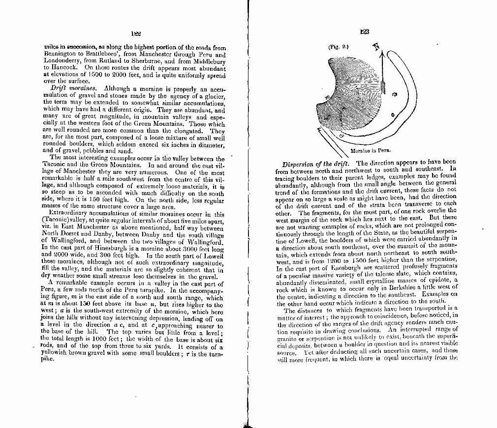
12
miles in succession, as along the highest portion of the roads from Bennington to Brattleboro', from Manchester through Peru and Londonderry, from Rutland to Sherburne, and from Middlebury to Hancock. On these routes the drift appears most abundant at elevations of 1500 to 2000 feet, and is quite uniformly spread over the surface.
Drift moraines. Although a moraine is properly an accu-mulation of gravel and stones made by the agency of a glacier, the term may be extended to somewhat similar accumulations, which may have had a different origin. They are abundant, and many are of great magnitude, in mountain valleys and espe-cially at the western foot of the Green Mountains. Those which are well rounded are more common than the elongated. They are, for the most part, composed of a loose mixture of small well rounded boulders, which seldom exceed six inches in diameter, and of gravel, pebbles and sand.
The most interesting examples occur in the valley between the Taconic and the Green Mountains. In and around the east vil-lage of Manchester they are very numerous. One of the most remarkable is half a mile southwest from the centre of this vii-lage, and although composed of extremely loose materials, it is so steep as to be ascended with much difficulty on the south side, where it is 150 feet high. On the north side, less regular masses of the same structure cover a large area.
Extraordinary accumulations of similar moraines occur in this (Taconic)valley, at quite regular intervals of about five miles apart, viz, in East Manchester as above mentioned, half way between North Dorset and Danby, between Danby and the south village of Wallingford, and between the two villages of Wallingford. In the east part of Hinesburgh is a moraine about 3000 feet long and 2000 wide, and 300 feet high. In thesouth part of Lowell these moraines, although not of such extraordinary magnitude, fill the valley, and the materials are so slightly coherent that in dry weather some small streams lose themselves in the gravel.
A remarkable example occurs in a valley in the east part of Peru, a few rods north of the Peru turnpike. In the accompany -ing figure, m is the east side of a north and south range, which at In is about 150 feet above its base n, but rises higher to the west; a is the south-west extremity of the moraine, which here joins the hills without any intervening depression, leading off on a level in the direction a c, and at c 1 approaching nearer to the base of the hill. The top varies but little from a level; the total length is 1000 feet; the width of the base is about six rods, and of the top from three to six yards. It consists of a yellowish brown gravel with some small boulders; r is the turn-pike.
IM
(Vg. t.)
DispersIom of the drift. The direction appears to have been from between north and northwest to south and southeast. in tracing boulders to their parent ledges, examples may be found abundantly, although from the small angle between the general trend of the formations and the drift current, these facts do not appear on so large a scale as might have been, had the direction of the drift current and of the strata been transverse to each other. The fragments, for the most part, of one rock overlie the west margin of the rock which lies next to the east. But there are not wanting examples of rocks, which are not prolonged con-tinuously through the length of the State, as the beautiful serpen-tine of Lowell, the boulders of which were carried abundantly in a direction about south southeast, over the summit of the moun-tain, which extends from about north northeast to south south-west, andis from 1200 to 1500 feet higher than the serpentine, In the east part of Enosburgh are scattered profusely fragments of a peculiar massive variety of the talcose slate, which contains, abundantly disseminated, small crystalline masses of epidote, a rock which is known to occur only in Berkshire a little west of the centre, indicating a direction to the southeast. Examples on the other hand occur which indicate a direction to the south.
The distances to which fragments have been transported is a matter of interest; the approach to coincidence, before noticed, in the direction of the ranges of the drift agcncy renders much cau-tion requisite in drawing conclusions. An interrupted range of granite or serpentine is not unlikely to exist, beneath the uperfi-cial deposits, between a boulder in question and its nearest visible source. Yet after deducting all such uncertain cases, and those still more frequent, in which there is equal uncertainty from the
124
north dnd south trend of the original ledge, very many remain of transportation of thirty and of forty miles, even of heavy iron ore. In general also it is true in this, as in the other neighboring States, that the larger fragments have been carried to a less dis-tance.
This last remark, however, does not apply, in any considerable extent, to the great bulk of the drift, which consists of gravel and small pebbles mostly derived from rocks within a very few miles. The same is true also of a great majority of the superficial boul-ders, and the only exceptions which now occur to me are of dis-tricts in which the rock in place is far more perishable than the one lying next to the north.
In general there is a pretty close agreement between the dura-bility of a rock, and the abundance of pebbles and boulders in dis-tinction from the finer materials. I use the term durability, as including resistance both to chemical and to mechanical agencies. Some of our softest slates, impressible with the finger nail, still retain delicate drift scratches, and the smooth surface remains as it was, polished by the drift agency, although ever since exposed to atmospheric influences; but their fragments are not numerous. Limestone, being not only rather soft, but decaying also by solu-tion, does not furnish its proportionate share of boulders. On the other hand the strip of quartz rock, on the west side of the southern half of the Green Mountains, equally annoys the travel-ler and the cultivator of the soil, if that may be called soil which consists mostly of pebbles and boulders, whose ellipsoidal form and more common size has procured the provincial appellation of "hardheads."
It is scarcely necessary to remark that the detachment of the fragments and rounding of their angles is not to be exclusively ascribed to the drift agency. The ordinary agencies of rivers and waves, and of the atmosphere are ever producing these results. If, as there is good reason tb believe, Vermont was above the ocean during all or most of those periods, to which we have alluded as the dark ages in our geological history, some of these boulders and pebbles may have been worn by the waters of mesozoic and even of palaeozoic times. The accumulation of the materials may have been in progress during all the intervening periods, arid since the lapse of time would alike accumulate the durable and consume the more perishable boulders, we find in this the cause of this disproportion in comparison with the extent of the parent rocks, as well as in the long continued violence of the drift agency itself.
In some places a part of the boulders are traceable to two sour-ces, as in Middebury, where are many from a variety of the red sandrock, which occurs ten miles to the north north-west, and
125
others are from another variety a few miles farther north in a due north direction.
FURROWS, SCRATChES, AND ROUNDED AND POLISHED ROCKS.
On the general coincidence, usual elsewhere in drift regions, between the direction of the furrows and that of the transport of drift, we find no exception. From the facility and precision with which they may be measured, these scratches afFord the best means of ascertaining the direction of the drift current.
Nearly two hundred examples, (reckoning as distinct cases those only which are at least one-quarter of a mile distant), have been found, and are particularly described in my journal. Among the districts most remarkable for their abundance, is the valley of the Winooski, especially the south side of the river from Rich-mond through Bolton and Duxhury. There the perfectly round-ed surfaces of the talcose slate, the broad furrows, and delicate scratches, were protected by a fluviatile deposit of fine sand, dur-ing the long subsequent period of the older pleistocene, and therefore have a freshness which adds much to the beauty and interest of these results of the drift agency. Another region, surpassed by the former only in the interesting character of indi-vidual cases but not in their number, embraces the middle towns in Franklin county, and of the north part of Chittenden county, from Canada to the Winooski, where few ledges can be found which are not rounded and furrowed.
The limestone of Addison county abounds with well smoothed surfaces covered with scratches, which have been protected from decay by a covering of brown clay, and have within afew years been exposed by the removal of the clay in the gullies at the roadsides. On the other hand surfaces of limestone, which have been long exposed to atmospheric agencies,— the surfaces of rocks which are more or less feldspathic, as the granite and gneiss regions, and which decay by yielding up their potassa,—or sur-faces which crumble by the admission of water into a porous or loosely laminated structure, seldom afford examples. Since, however, the deficiency occurs only in cases where the rock is undergoing disintegration, it would not perhaps be an unreasona-ble inference, that the entire surface of the rocky floor of the State was smoothed into cavities and convexities, and covered with furrows and scratches by the drift agency.
The greatest elevation at which drift furrows exist, is an inter-esting question, which has received some attention. They exist abundantly on Jay Peak, at the northern extremity of the Green Mountain range. This elevation was determined barometrically With a fine instrument of J. H. Temple, Boston, under very fa-
126
vorable circumtanoes, of a calm pleasant day between one and two o'clock, P. M., with simultaneous observations on a Buntens instrument at the shore of Lake Champlain in Shelburne, and on a wheel barometer in Burlington. Taking the mean of the results, which differ only twenty feet, the height of the summit is 4025 feet above the ocean. The furrows were found a few yards east of the highest westerly point, and six or eight feet below it, and were continued over the east part of the Peak with a direction of north 400 west, as nearly as could be determined over a talcose slate which abounded with crystals of magnetic ore. Although from one to two inches wide and half an inch deep, their rough sur-faces and the absence of small scratches indicate considerable decay of the surface. An immense number of fragments around the naked summit, with sharp angles and rough sides, shew also that there has been a powerful agency acting on this porous wrinkled slate, of frost and perhaps of lightning, since the fur-rows were made. Making, therefore, due allowance for the ob-literation of the marks of drift agency, we can hardly avoid the conclusion, that such agency was nearly or quite as energetic as ati ower levels.
With the same object in view, an excursion was made to the White Hills of New Hampshire, in the hope, notwithstanding the feldspathic character of the rocks, that some furrows or at least boulders might be detected at a great elevation. President Hitchcock had before observed rounded rocks here, at an eleva-tion of 5000 feet. (Elementary Geology, page 206, 3d edition.) The same example, probably, we saw, and found that, as is usually the case in Vermont, the northwest sides were rounded and the 'southeast uneven: at a little higher elevation to the north were distinct furrows with a north and south direction, which had been partly preserved by a vegetable deposit, and lad been recently uncovered in making a bridle path. An example similar in all respects was found on the north side of Mount Pleasant, about 300 feet below the summit, an elevation rather less than the other.
The general direction of the drift agency, as indicated by the scratches, was from the north 0° to 20° west. In very numer-ous examples, not far from one third of the whole number, two or more distinct sets of striae may he recognised, with different directions, but those of each set are parallel. At Hill's quarry, in the isle La Motic, there are eight sets, viz, north 80 east, north 3 0 east, north 10° west, north 230 west, north 43° west, north 430 west, north 4 vest, and north 63° west. In general the striac of north about 100 lvest are most common, and then those which are north 200 to 300 west. It is not usual to find more than two or tlirc sets, and it is probable, not to say certain, that
127
the earlier striae were entirely obliterated by the long continued drift agency.
It is often possible to determine the relative age of the striae, although much caution is requisite. One which is shallow may appear to have been cut off by another which is narrow and deep, although the latter may be the oldest, and hence if the lat-ter was in fact the more recent, the fact cannot be certainly inferred from such a case. If the striae are of nearly equal depth, it may not be possible to arrive at any conclusion. But when a small one is continued across the bottom of a somewhat deeper one, which often occurs when the latter is broader as compared with its depth, and if several such examples occur on a given surface, all tending to the same conclusion, there can be no rea-son for distrust. We have succeeded in this way, in about thir-ty examples, in determining the relative age of two sets of strim, and find no exception to the general conclusion, that those which had the more westerly origin are the more recent. In one case, that of Hill's quarry above mentioned, the age of three sets was de-termined as follows, beginning with the oldest, north 10° west, north 8 0 east, north 47 west.
The parallelism of the str1w is one of the first characters to at-tract attention, and hence many persons, whose attention I have directed to them, have called them a raking of the surface. In surfaces which present the convexity of one-third or even of one-half of a sphere, there is scarcely any perceptible deviation from parallelism in the ascent of the scratches.
But although the minor inequalities of surface have not mate-rially influenced the direction of the stri, the general direction of the current was essentially modified by the prominent features of the surface of the State. In the valley of the Winooski, where it crosses the Green Mountain range, the directioi of the striw is generally from north 70 0 west to north 85° west. In the valley of the Lamoille where it crosses the same range, the direction is from north 75° west to north 85 0 west. The deflection on the summit of Jay Peak we have before noticed. A remarkable case of a deflection westward occurs in Putney, about three miles north of the village, where a valley opening to the west and south de-flected the current, so that most of the strim have a direction from north 45 0 east and others are from north 25 0 east. But the usual course of the strite varies from north and south, to north 15° west by south 15° east.
That these strito and furrows belong to the same period with the drift, being indeed the effect of the transport.of the latter, has been regarded as sufficiently proved by the coincidence of di-rection, and by the want of any deposits intervening between the striated rooks and overlying drift. It necessarily follows that they
128
are as ancient as the drift accumulations. But our limestone dis-tricts afford abundant direct proof, that no considerable period elapsed between the termination of the striating agency, and the clay deposits of the older pleistocene, (themselves more recent than the drift,) which intervenes between them and the rocks where they occur in connection. For owing to atmospheric agencies, exposed surfaces of limestone have not retained the drift furrows, but wherever a surface has been recently uncover-ed, as by the gullies of roads, the most delicate strife are found to have been preserved by a covering of a few inches in clay. It follows then, that the furrows and strim could not have been ex-posed to atmospheric agencies, for a period which even human history would consider long, and as they could not have been submerged without the superposition of deposits, it follows, that the st ria, which are covered by clay were made, at least in part, immediately before the deposition of the clay. It would not of course follow that the striating agency was limited to this point of time, which indicates its close only. But it is worthy of re-mark, that a period of violence appears to have been immeaiately succeeded by one as quiet, as could occur with existing agencies.
There is another class of examples of striated rocks, in which the rocks were covered with the fine sands of the older pleisto-cene, as is proved by the existence, on the hill sides above them, of river terraces which are composed of these sands, and by the sands around them. These terraces are, as we shall have occa-sion to notice more particularly in future, the relies of deposits made subsequently to the drift, and were afterwards, in conse-quence of the deepening of the channel of the river, cut away and borne down to a lower level. In the valley of the Winoo-ski, the splendid examples of striated and polished rocks appear to owe their freshness to the fact, as before suggested, that they were thus covered during a great part of the time subsequent to the drift period.
Streams of stones.
The type of this class of phenomena was discovered in Rich-mond, Massachusetts, by President Hitchcock, and has since elicited umch attention. Their characteristics seem to be, the arran gement in a line, of great length as compared with the bread th,—one, two or more miles long, to twenty to sixty rods wide,—of an enormous quantity of angular fragments of rock, overlying the common drift, and extending from a ledge of the same kind of rock in the direction of the drift current.
In the absence of any evidence of their overlying pleistocene deposits, the superposition on drift proves only that they were
129
placed in their present position, at, or near the close of the drift period. It is not, however, to be inferred, that this kind of effect was peculiar to the close of the drift period, for whatever similar streams may have been strewed along previously in the period of drift agency, would subsequently have been either re-arranged or buried beneath other drift, so as not now to be rec-ognisable. For it is obvious that a stream of stones beneath the surface is not very likely to be discovered, and even those, which are on the surface, have been only very recently observed. A considerable portion of erratic blocks may have been removed from their previous situations in tIJe same manner, not excepting even many, which, although well rounded. may have been worn by other agencies before the drift period. Proper streams, con-forming to the type above referred to, must be difficult to recog-nise, not only because they must have been the last effects of the drift agency in order to their being undisturbed and visible, but many other conditions must conspire to furnish a satisfactory case. The ledge, from which they originated, must be recogni-sable without doubt from other rocks in the vicinity, and the rock must be one which does not rapidly decay by atmospheric agen-cies. They are also with much difficulty discovered and traced out, exc€jIt in cleared land. We have nevertheless succeeded in tracing out one such phenomenon, and had it not been for dense and tangled forests, which required more time than could be allotted to them, probably other supposed examples might have been traced out satisfactorily.
A very interesting example occurs in HUNTINGTON, about two miles east of the village, and not far from the south-east corner of the town, on land of Mr. Bunyan Bradley, who mentioned the ease as a curiosity, and suspecting its true character I have since examined it.
The accompanying figure (Fig. 10.) represents the prominent local features.
a h is a hill rising 150 fet above the valley m ii, consisting of fine talcose slate, the direction of the laminae being north 15 1 east, with a dip 75 0 east. This hill is about one fourth of a mile long, with an average width of sixty rods in the northern half, and widening to the south.
g is a small hill of talcose slate with the same characters and position.
b c d h is a precipice, low at b and accessible, highest from C to d with a broken slope, which at c averages 40°, and 30° at d.
S y is a long narrow mass of very coarse binary syenite, inclu-ded between the tiIcose slate on elUier side, nearly half way tip
the bill. 17
4
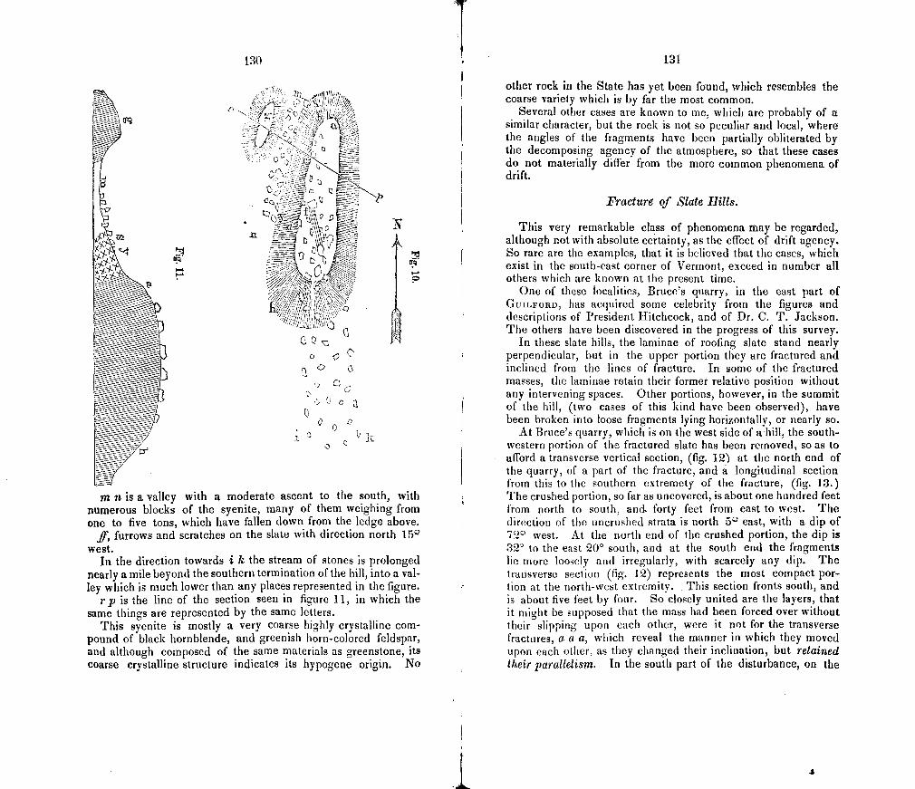
130
P1"
/
I!
. opi
Ce !
21
1021 TP
'V 0
a
m n is a valley with a moderate ascent to the south, with numerous blocks of the syenite, many of them weighing from one to five tons, which have fallen down from the ledge above.
if, furrows and scratches on the slate with direction north 15" west.
In the direction towards i k the stream of stones is prolonged nearly a mile beyond the southern termination of the hill, into a val-ley which is much lower than any places represented in the figure.
rp is the line of the section seen in figure 11, in which the same things are represented by the same letters.
This syenite is mostly a very coarse highly crystalline com-pound of black hornblende, and greenish horn-colored feldspar, and although composed of the same materials as greenstone, its coarse crystalline structure indicates its hypogene origin. No
131
other rock in the State has yet been found, which resembles the coarse variety which is by far the most common.
Several other cases are known to me, which are probably of a similar character, but the rock is not so peculiar and local, where the angles of the fragments have been partially obliterated by the decomposing agency of the atmosphere, so that these cases do not materially differ from the more common phenomena of drift.
Fracture of Slate Hills.
This very remarkable class of phenomena may be regarded, although not with absolute certainty, as the effect of drift agency. So rare are the examples, that it is believed that the cases, which exist in the south-east corner of Vermont, exceed in number all others which are known at the present time.
One of these localities, Bruce's quarry, in the east part of GIJILFORD, has acquired some celebrity from the figures and descriptions of President Hitchcock, and of Dr. C. T. Jackson. The others have been discovered in the progress of this survey.
in these slate hills, the laminae of roofing slate stand nearly perpendicular, but in the upper portion they are fractured and inclined from the lines of fracture. In some of the fractured masses, the latninae retain their former relative position without any intervening spaces. Other portions, however, in the summit of the hill, (two cases of this kind have been observed), have been broken into loose fragments lying horizontally, or nearly so.
At Bruce's quarry, which is on the west side of ahihl, the south-western portion of the fractured slate has been removed, so as to afford a transverse vertical section, (fig. 12) at the north end of the quarry, of a part of the fracture, and a longitudinal section from this to the southern extremety of the fracture, (fig. 13.) The crushed portion, so far as uncovered, is about one hundred feet from north to south, and forty feet from east to west The direction of the uncrushed strata is north 50 east, with a dip of
west. At the north end of the crushed portion, the dip is 32° to the east 20° south, and at the south end the fragments lie more loosely and irregularly, with scarcely any dip. The transverse section (fig. 12) represents the most compact por-tion at the north-west extremity. This section fronts south, and is about five feet by four. So closely united are the layers, that it might be supposed that the mass had been forced over without their slipping upon each other, were it not for the transverse fractures, a a a, which reveal the manner in which they moved upon each other, as they changed their inclination, but retained their parallelism. In the south part of the disturbance, on the
4
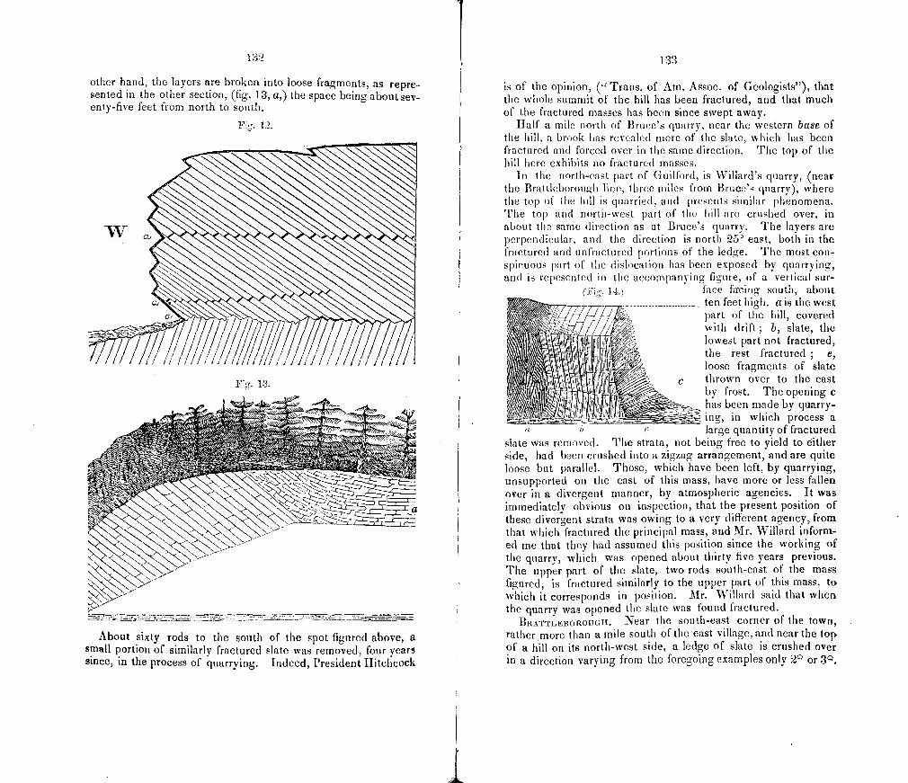
other hand, the layers are broken into loose fragments, as repre-sented in the other section, (fig. 13, a,) the space being about sev-enty-five feet from north to south.
Fig. 12.
Fig. 13.
About sixty rods to the south of the spot figured above, a small portion of similarl y fractured slate was removed, four years since, in the process of quarrying. Indeed, President Hitchcock
O) 1 I .).)
is of the opinion, (" Trans. of Am. Assoc. of Geologists"), that the whole summit of the bill has been fractured, and that much of the fractured masses has been since swept away.
half a mile north of Bruce's quarry, near the western base of the hill, a brook has revealed more of the slate, which has been fractured and forced over in the same direction. The top of the hill here exhibits no fractured masses.
In the north-cast part of Guilford, is WTillard's quarry, (near the Brattleboronh line, three miles from Bruce's quarry), where the top of the hill is quarried, and presents similar phenomena. The top and north-west part of the hill are crushed over, in about time same (iirection as at Bruce's quarry. The layers are perpendicular, and the direction is north 25 east, both in the fractured and unfiactured portions of the ledge. The most con- Spiruous part of the dislocation has been exposed by quarrying, and is rcpesnted in the accompanying figure, of a vertical sur-
face fircing south, about -
-
...........ten feet hih. a is the west • . part of the hill, covered
's with drift ; b, slate, the fØl L lowest part not fractured,
I the rest fractured ; e, loose fragments of slate
c thrown over to the east - by frost. The opening c
/ i J Jj his been rn-ide by quarry- mug, in which process a
- " large quantity of fractured slate was removed. The strata, not being free to yield to either side, had been crushed into a zigzag arrangement, and are quite loose but parallel. Those, which have been left, by quarrying, unsupported on the east of this mass, have more or less fallen over in a divergent manner, by atmospheric agencies. It was immediately obvious on inspection, that the present position of these divergent strata was owing to a very different agency, from that which fractured the principal mass, and Mr. Willard inform.-ed me that they had assumed this position since the working of the quarry, which was opened about thirty five years previous. The upper part of the slate, two rods south-east of the mass figured, is fractured similarly to the upper part of this mass, to which it corresponds in position. Mr. Willard said that when the quarry was opened the slate was found fractured.
BRATTLEBOrI.OUGII. Near the south-east corner of the town, rather more than a mile south of the east village, and near the top of a hill on its north-west side, a ledge of slate is crushed over in a direction varying from the foregoing examples only 2 or 30.
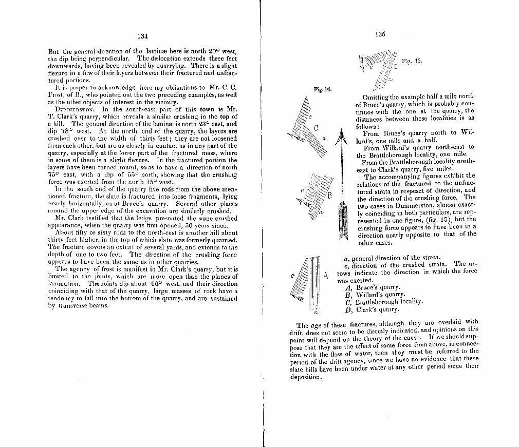
134
But the general direction of the lamina3 here is north 20 0 west, the dip being perpendicular. The dislocation extends three feet downwards, having been revealed by quarrying. There is a slight flexure in a few of their layers between their fractured and unfrac-tured portions.
It is proper to acknowledge here my obligations to Mr. C. C. Frost, of B., who pointed out the two preceding examples, as well as the other objects of interest in the vicinity.
IJUMMERSTON. In the south-east part of this town is Mr. T. Clark's quarry, which reveals a similar crushing in the top of a hill. The general direction of the laminm is north 23 11 east, and dip 78 1 west. At the north end of the quarry, the layers are crushed over to the width of thirty feet; they are not loosened from each other, but are as closely in contact as in any part of the quarry, especially at the lower part of the fractured mass, where in some of them is a slight fiexure. In the fractured portion the layers have been turned round, so as to have a direction of north 75 11 east, with a dip of 55° north, shewing that the crushing force was exerted from the north 15 0 west.
in the south end of the quarry five rods from the above men-tioned fracture, the slate is fractured into loose fragments, lying nearly horizontally, as at Bruce's quarry. Several other places around the upper edge of the excavation are similarly crushed.
Mr. Clark testified that the ledge presented the same crushed appearance, when the quarry was first opened, 50 years since.
About fifty or sixty rods to the north-east is another hill about thirty feet higher, in the top of which slate was formerly quarried. The fracture covers an extent of several yards, and extends to the depth of one to two feet. The direction of the crushing force appears to have been the same as in other quarries.
The agency of frost is manifest in Mr. Clark's quarry, but itis limited to the jdints, which are more open than the planes of lamination. Thejoints dip about 60° west, and their direction coinciding with that of the quarry, large masses of rock have a tendency to fall into the bottom of the quarry, and are sustained by transverse beams.
135
'Fig. 15. IL'
/ CL //.
Omitting the example half a mile north of Bruce's quarry, which is probably con-tinuos with the one at the quarry, the distances between these localities is as follows:
From Bruce's quarry north to Wil-lard's, one mile and a half.
From Willard's quarry north-east to the Brattleborough locality, one mile.
From the Brattleborough locality north-east to Clark's quarry, five miles.
The accompanying figures exhibit the relations of the fractured to the unfrac-tured strata in respesct of direction, and the direction of the crushing force. The two cases in Dummerston, almost exact-ly coinciding in both particulars, are rep-resented in one figure, (fig. 15), but the crushing force appears to have been in a direction nearly opposite to that of the other cases.
g, general direction of the strata.
/ / I c, direction of the crushed strata. The ar-
o A rows indicate the direction in which the force was exerted.
/ I A, Bruce's quarry. B, Willard's quarry.
I C, Brattleborough locality. D, Clark's quarry.
The age of these fractures, although they are overlaid with drift, does not seem to be directly indicated, and opinions on this point will depend on the theory of the cause. If we should sup-pose that they are the effect of some force from above, in connec-tion with the flow of water, then they must he referred to the period of the drift agency, since we have no evidence that these slate hills have been under water at any other period since their
deposition.
Fig. 16.
41,
Several theories have been advanced to account for the (rae-ture at Bruce's quarry, the only one of the above examples which has been described heretofore.
In the first report of the geology of New Hampshire, Dr. Jack-son describes and figures this example, and accounts for it by supposing an overlapping of a portion of the strata succeeded by a lateral thrust; and his figure represents on the top of the hill such an overlapping mass, whose lateral thrust would ne-cessarially crush over the strata. If the figure be correct, the the-ory would seem to be well sustained. President Hitchcock, how-ever remarks:
"Soon after noticing this opinion, I revisited the locality, and made a care-ful examination of it with reference to those views ; and I must say that .1 could not discover the least evidence of any disturbance of the strata beneath the fractured lanainw ; nor of any crossing and overlapping of the strata; nor of a lateral thrust; nor of unstratified rocks within several miles of the spot. If the figure accompanying Dr. Jackson's account was intended to rep-resent the quarry (of which I ani not quite certain, from his language,) I must observe, that I could not discover, at the quarry, the tiock mass 01 slate rep-resented in his figure as lying in a north-east and south-west direction, and pressing against the fractured 1amin."
Perhaps the nearly horizontal fragments, occupying this part of the hill, (Fig. 13, a,) may have been the ground, on which it was supposed that there was such a mass of slate, as is represented to have caused the fracture. This theory perhaps would have had the preference, had it not pioved on reexamination to have been totally at variance with the facts in the case, and accordingly Dr. Jackson has subsequently abandoned both the theory and the figure, and in his final Report has proposed another theo-ry, with an excellent figure which very accurately represents the appearance of this part of the quarry, except that the curved and loose condition of the strata represented at the left of the figure do not exist, but that which is represented in our figure, (fig.1'2), Dr. Jackson now proposes tile agency of water freezing between the laminm of slate, as the cause of the fracture. The manner in which frost acts in these quarries we have already shewn, and the effects cannot by any means be confounded with these frac-tures ; frost entering deeper in successive years causes the per-pendicular layers to diverge, opening upwards. But a large por-tion of these layers are perfectly parallel, and as contiguous throughout as any unfractured laminte ; nor could the expansion of frost break off the strata, and then throw them down loosely in a horizontal position in the middle of the top of the hill, before the quarries were opened, as in Bruce's and Clark's quarries, but its principal effects would be in the outer portion of the mass. But the case of Willard's quarry is, if possible, more in point ; here nature has shewn us, side by side (Fig. 14,) the difference he-
137
tween the agency of frost, and that which caused these fractures and even without this contrast, the zigzag condition of tile frac-tured yet parallel layers, which were not free to move on either side, incontestibly points to some force acting in this instance almost directly downwards. Notwithstanding, therefore, a strong predilection for the simplicity of this theory, we cannot regard it as consistent with the facts. The third theory is that of President Hitchcock
"The expansion of a vast mass of ice, resting on this spot, or its move-ment by any other agency, mi ght have produced th 'I e fracture. he direction
m in which the force ust have acted here, however, is nearly at right angles to that taken by the drift in that part of the country ; so that if the ice were the agent, it must there have made a lateral rnoveueut; perhaps in consequence of an enormous mass striking against time hill east of the quarry."
The most obvious objection to this theory is that which Presi-dent Hitchcock suggests, of the direction in which the force act-ed in the case of Bruce's quarry. But it now appears that there are three examples, whose extremes are two miles and a quartet' distant, in which the force coincided almost exactly in direc-lion, so that it is not easy to avoid the conclusion of a common or at least a similar cause; and as the examples of drift agency eve-rywhere shew that to have been exerted in a direction nearly opposite to this, the difficulty of referring these facts to the force of the drift current is greatly magnified.
But it is difficult to conceive how masses of water could have frozen Ofl the tops of hills so as to crush over the strata in one direction only in one region and in the opposite direction only in another. Moreover the direction, in one case mit least, appears to have been, not that of a force nioving on the surface, but com-ing down upon the top of tIme hill.
We had intended to propose as a theory the toppling over of floating icebergs, which are well known by unequal melting to change their centre of gravity, and roll over. The effects are indeed precisely what we should expect, if enormous icebergs should, while thus roiling pver, strike upon the summits of the hills ; time zigzag appearance of the fractured slates in Wi1lard' quarty, and the masses nearest the centre of the hill lying in loose fragments in a nearly horizontal direction would be accounted for. This, however, would not account for the coincidence, for although the two hills in Dummerston, being only sixty rods dms-taut, may have been crushed by the same blow notwithstanding their difference of height, thirty or forty feet, yet it cannot be supposed, that the same stroke of an iceberg fractured hills two miles and a half distant, for a mass of ice of this horizontal ex-tent would not turn over, unless at least as high as wide, a supposition too improbable to be entertained. It has been sug~ gested by Mr. Darwin that some similar cases in Wales may have
Is
135
been the effect of "icebergs lifted up and down by the tides ;" or, rather as President Hitchcock has recently sugested to us, huge icebergs rising and falling by the undulations of a heavy sea may have thus struck the hills with a downard force. To this theory there seems to be an apparent objection in the exis-tence of crushed laminm near the base of the hill ; but if we suppose all the overlying parts to have been crushed at the same time and subsequently swept away, the difficulty vanishes.
Age of the Drift.
The entire absence of any deposits of the periods immediately anterior to the drift agency, deprives us of the means of compar-ison with such deposits, and we cannot here adduce extra-limital illustrations. But the subsequent deposits of the older pleisto-cene, which we are yet to describe, enable us to piace it at the commencement of the grand series of events which they com-memorate, and its relations to them are fully and variously exhib-ited in the facts which belong their history.
In offering a few suggestions respecting the so-called older and later drift, and on the supposed cotemporaneousness of the North American and European Drift, we are compelled, although with much hesitation, to differ somewhat from the opinions here-tofore advanced by some eminent geologists.
With a strong preposession in favor of the theory of a double period of drift agency, the latter part of which followed the older pleistocene, we have sought dilligently for the evidences of such later drift overlying the pleistocene sands and clays.
It was indeed sufficiently obvious that the most essential feature of the drift proper,—its universal distribution over all the older deposits in the vast region where it occurs—was wanting to any later masses of gravel and boulders. An examination of the particular cases, which we at first endeavored to refer to a later drift agency, shews that they are not only extrenily limited, but referable to different and obvious agencies, unlike those to which the drift is ascribed. In the valleys they are merely the effects of the freshets of existing streams flowing at higher levels, before the obstructions of the drift in their channels had been cut through. They are therefore variously interstratifled with the pleistocene deposits. In some cases the waves of the great St. Lawrence and Champlain Bay or Sound of that period spread the drift, from the shores of the then islands, down over the de-posits of those waters. In other cases the masses are really drift of the older period surrounded at a little lower level, or nearly covered, with an extremely thin subsequent deposit, and their superpositi o n over the latter is only in appearance. On the oth-er hand precisely similar effects are now resulting from the ac-
139
tion of waves and freshets on the ancient drift, in local reiixrange-ments of its materials.
The streams of stones have also been brought forward to prove the existence of a later drift period, but as we have before re-marked, until they can be traced over admitted pleistocene de-posits, they can be regarded only as the last of the great and long continued agency of the drift proper. Nor can these local coarse deposits be referred to ordinary iceberg agency, since we have abundant evidence, that Vermont was, during the period of their origin, only about four hundred feet below its present elevation.
Finding therefore the grand characteristics of universality, and of a general movement in a given direction, wanting to the so-call-ed 'later drift,' and being able to refer the various supposed ex-amples to well known local agencies or to the older drift, we are constrained to give up the theory of a later drift period. We can here only in this general way mention these facts, having re-served the rather numerous details for future use.
We have before remarked on the satisfactory and lucid gener-alizations of Sir R. I. Mnrchison on the drift of Europe, in refer-ring it to a great Scandinavian centre, and we observed that, con-sequently, it must be independent of the North American drift in respect to the source of the agency, and that the subjacent strata, with existing species of shells, prove the European drift to be more recent than the North American drift, which is overlaid with deposits, which contain not only existing but extinct species. Thus we shall enumerate, among the pleistocene fossils of Ver-mont, the Nucula Pottlandica, the most abundant of the genus in its period, but which the numerous conchologists, who are fa-miliar with the labors of Mighels, Gould, and Couthuoy, on our deep water species, will not hesitate to regard as extinct. Dr. Mighels has described some extinct species of Bulla, which he discovered in the Portland deposit of blue clay. Dr. Jackson also discovered in Maine the Nucula Jacksonii of the same pe-riod now extinct. It is obvious, therefore, that we must claim, for the drift of this country, a much greater antiquity, than belongs to that of Europe.
Theories of drift, and submergence of Vermont during the drjft period.
Whether this region was entirely submerged during the drift period is a question intimately connected with the theories of drift, one of which, the iceberg theory, necessarily supposes it, and others may be modified to admit or deny it. The facts which we have described relating to the crushed slate hills evidently point to iceberg agency, and consequently to submergence. Yet
140
we cannot claim for this evidence a demonstrative force. The pirticular discussion of the almost interminable subject of the drift theories, in their relations to the phenomena in this State,
e canio>t here enter upon. It would be easy, in the language of the SUI)joiflcd letter of President Hitchcock, ''to clip the wings of some hypotheses," which have winged their flight too far into the regions of imagination. Yet the leading features of the more prominent theories, the agency of more powerful waves of trans-lation, tno%ing along the great masses of loose materials over the subjacent solid rocks in oft repeated and long continued pulses, and the icebergs crowding UI) moraines and shattering slate hills-seem both requisite to acount for the facts.
Older pleistocene.
The deposits refered to this period are, in the order of position, 2. brown clay, fine sand, arid loose gravel; I. blue clay. The first three cannot be arranged in a universal order of su-
perposition ; the brown clay and tine sand appear to be for the most part local equivalents, and the gravel is variously interstrat-ified with or overlying either. The blue clay appears, in the in-numerable examples of junction with the other deposits, to occupy the lower place, although it is by no means certain that all the blue clays of this period are coteniporaneous, and anterior to all the brown clay and sand. Yet such would seem generally to be the fact. It is scarcely necessary to remark, that there are some clays as well as many sand deposits, which owe their present sit. nation to agencies of a date much more recent, or even of the historical period.
In each of the above named deposits, we have those which are of marine and those which are of freshwater origin, and although a great part of the former is destitute of organic remains, its con-nection with the fossiliferous parts, or its elevation, usually en-ables us to determine whether it is marine. So far as we have ascertained, the marine deposits are limited to the valley of Lake Champlain, and to an elevation not exceeding 300 feet above this Lake. Observations with the barometer in various parts of this valley, mostly in Addison county, with the various elevations determined in rail road and canal surveys sofar as we have had access to them, assign this limit of elevation to the pleis-tocene deposits of the Champlain valley. The greatest height, at which marine shells have been found, does not exceed 200 feet above Lake C., and their greatest known distance from its present shores is but four miles. Yet the continuousness of all
141
the clays and sands beneath the elevation of 300 feet leads us to refer them to a common origin.
The fossils of the blue clay are Nucula Portlandica (Hk.,) and Lucina flexuosa (Mont.)
Since the. industrious and persevering efforts of several able naturalists in New England have resulted in the discovery in the stomachs of fishes of myriads of shells of several species of Nucula without the occurrence of a single recent Nucula Portlandica, we may safely infer that this species is extinct. Lucina flexuosa, however, has been frequently found in such researches in a fresh condition.
Both the L. flexuosa and the congeners of N. Portlandica in-habit deep water in fine dark blue silt, which needs only some pressure to resemble the Champlain blue clays.
The blue clays, which contain no evidence of rilarine origin, are insulated beds, scattered through the State, usually in valleys of various elevations. Very frequently they are overlaid with deposits of muck or of marl, oi7 of both in the order of clay be-neath, next above marl, and then muck. One case, however, is peculiar, a large deposit in Cornwall and Shoreham on the Lem-onfare river, where blue clay is overlaid with muck, which is suc-ceeded by blue clay and then by another deposit of muck. Probably, however, the upper bed belongs to the newer pleisto-cene period, and the lower bed being in the valley of the Lake, may possibly have been of marine origin.
Some of these blue clays contain a consiberable per centage of carbonate of lime, and are admirably adapted for a heavy dres-sing of light soils.
Some -beds contain a large proportion of sand, and in them we have often a gradual transition from the blue clay beneath to the fine sand above. No fossils have yet been found in these insu-lated beds, but claystones of the most beautiful forms and deli-cate texture are common in the finer varieties of blue clay.
The marine brown clay is most extensively distributed through Addison county, most of which, below the level of 300 feet above Lake Champlain, is covered with it. It lies directly on the drift, or on blue clay, or on the Champlain and Taconic rocks. We have not yet found it above or beneath the pleistocene sands, but it appears to pass into them laterally. Its fossils are Sanguinolaria fusca, Saxicava rugosa, and Mya arenaria.
The first is found abundantly in various localities on, or within a few miles of the lake shore. As this is now found in the bays of the New England coast, more abundantly than any other spe-cies of bivalve shells, so it is the most common of the fossils of this brown clay. It is very frequently found with the valves together, indicating that such individuals lived at or near the spot where
142
they are found. The Mya arenaria occurs at several places, al-though it was by no means so generally diffused as tho Sanguin-olaria fusca, but thus far we have found it only in a mixture of gravel and blue clay, more or less broken, and of less size than is common with the recent shells. The Saxicava rugosa is more common than the Mya arenaria.
The marine brown clay contains more or less of carbonate of lime, and is well adapted for most agricultural purposes, although rather difficult of tiiliige. Concretions are common, but are usu-ally small and irregular, either resembling septaria, or of the cylin drical type of form.
Of the brown clays, in which we have yet found no evidence of a marine origin, there is an extensive tract, probably below a determinate level, in the vicinity of Lake Memphremagog, and there are scattered beds, at various levels in Rutland county and other parts. Probably, however, some of the blue clays have been often mistaken for the brown, since they weather to the same color.
The marine sands of this period occur in the vicinity of Lake Champlain, and are most abundant in Chittenden county. They extend eastward up the valleys until they reach a level above the submergence of this epoch, where they are probably of fluviatile origin. They seem to he, in the northern part of the valley of Lake Champlain, the equivalents of the brown clay in the south-ern part, a current having perhaps drifted the finer particles of clay to the south. Fossil shells, of the species Sanguinolaria fusca and Saxicava rugosa, are common, but more frequeutly in the lower beds near their junction with the blue clay, where they are exposed by the encroachment of Lake Champlain. A few cases, however, are known where, in strata of very coarse sand, the first named species is found abundantly at an elevation of 150 to 200 feet or more above the waters of the lake. Both spe-cies are frequently found with the valves together, and are thus proved to have lived and died in the places where they are now found.
The sands of this period, which are not marine, are very abun-dantly distributed through the State, mostly in valleys of existing streams, which at a later period have cut away and removed the greater part of these deposits, leaving only their lateral portions in the form of terraces. These deposits lie immediately on the drift, and we have made several sections shewing their position.
We have not yet succeeded in the discovery of fossils in these sands. The lower strata frequently contain aggregated masses of silico-calcareous concretions, which are more or less stained with hydrateof iron.
The local details of these sands are very numerous, and of great
143
interest, often showing where existing streams have flowed, at ele-vations of 150 and 200 feet above their present levels since the drift period ; as at Brattleborough, where the Connecticut river flowed on a level higher than the spires of the meeting houses, and at Middlesex, where the same was true of the Winooski ; or in Jericho, where they furnish evidence of a lateral coirimunica-tion between the Winooski and the Lamoille.
With these sands occur the overlying or interstratified layers of coarser materials, which have been mistaken for later drift depos-its, and on which we have before remarked.
The origin of the older pleistocene deposits may here be very briefly stated.
The general configuration of the surface of the State having been the same for a long time before the drift period as at pres-ent, the streams must for the most part have run through the same valleys, and had probably reduced their channels to a level not very different from the present. The drift agency then drift-ed the enormous amount of loose materials, which had been ac-cumulating since the palaeozoic times, spread them over the sur-face, and more or less filled the valleys and blocked up their out-lets. At the close of the drift period, the surface of the drift must have contained a much larger proportion, than at present, of fine materials, which the rains of the many centuries of the older pleistocene washed down into the valleys, whence the streams carried off more or less of them. The particles of clay being much fitier than the sands, the first deposits were mostly of the blue clay in many districts, The long continuance of at-mospheric agency converted the blue into brown clay in the drift, and the later deposits are accordingly of brown clay and brown sand: the finer particles of clay were more generally carried to a greater distance in the valley of the Champlain, from their principal sources in the Lamoille and Wiiiooski, than were the heavier particles of sand.
The fineness of the mateials, the regular horizontal thin lami-nation of the clay and stratification of the sands indicate a quiet condition in the depositing waters, for the streams were probably even more quiet than at present in the vicinity of Lake Cham-plain and Lake Memphremagog, the fall being less by about 300 feet. Occasional freshets interposed between the layers some strata of coarser niatelials. The hills of drift of the Champlain valley, which now rise more than 300 feet above the lake, were is-lands, as now appears from the absence on them of pleistocene de-posits. The more westerly of these islands were exposed to the waves of the Champlain and Canadian sound, which rolled down the materials of the drift on the sides of these islands in and upon the clay deposits, and these examples of ordinary denudating agen-
144
cy have been mistaken for a later drift, or sometimes occasion the appearance of uncovored drift proper, at a level below that at which the actual section of such cases reveals the clay.
The agency of oceanic currents during this period has excited some attention, and it has even been supposed that the Gulf Stream must have flowed to the north throngh the Champlain valley. On the other hand it would seem difficult to avoid the conclusion that the polar current must have flowed to the south through this valley, for its tendency, even now, in the absence of such an opening, is to the west of south as it enters the Gulf of St. Lawrence, while the Gulf Stream pursues a course to the north-east and east north-east; and since the configuration of the coast of the northern and of the middle states for some dis-tance to the south of the Hudson river was not essentially differ-ent from that of the present day, the relative course of these great oceanic currents could not have been materially different. Had the Gulf Stream flowed through this valley, the shells should have been of other species indicating a higher tempera-ture of the water.
The agency of icebergs during this period is also worthy of consideration. Since the depth of the waters over the summit level of the Champlain and Hudson Tiver canal was but about 150 feet, it is obvious that icebergs exceeding a height of 20 feet above the water must have been stranded before reaching those straits, and as the average depth of the waters through the val-ley of Lake Champlain did not exceed 200 feet, few icebergs could have entered from the valley of the St. Lawrence.
The climate of this period has been supposed to have been much cojder than at present, in consequence of an error, which very naturally arose respecting the fossil shells, which were said to be of a highly arctic character. We cannot here relate the circumstances which occasioned this error, which is no dispar-agement to the learned geologists who adopted it. That it is an error we have seeii, these shells being the most common bi-valves on the coast of New England at the present time. There is indeed no occasion for supposing the climate to have been colder, but if, as we suspect, the peat beds are all referable to a more recent period, there is much reason to believe that it was somewhat warmer. Consequently the theories of the formation of icebergs and glaciers on the mountains of New England dur-ing this period fall to the ground. If glaciers could have accu-mulated any where, it would have been in the valleys of the La-moille and Winooski, where, however, the perfect preservation of the drift strke and scratches, in a direction up these valleys, prove that in them no glacier agency has been exerted.
1/15
]\Tcwer Pleistocene.
In the middle and western states, this period is readily distin-guished from the historical period by the remains of the masto-don and of other mammalia. But in Vermont, in the absence of these remains, we have no criterion, by which to mark the termination of the last and the commencement of the present pe-riod. The greater longevity, which is enjoyed by the species of mollusca, has perpetuated all those which are found in the de-posits of the newer pleistocene to the present time. In the ab-sence of any definite character, it may safely be conjectured that the older marl beds and older infusorial deposits belong to this epoch, while it is probable that muck beds were not in a process of accumulation, but characterise the historical period. To the newer pleistocene period also may be referred most of the denu-dation of the older pleistocene fluviatile deposits, resulting in the terraces which remain on the margins of the valleys.
Terraced Valleys.
Evidences of the fluviatile tendency of this period appear in the terraces, which are more or less common on every river in the state, with perhaps the exception of small sluggish streams, which do not descend from any considerable elevation. They are char-acterized by a regularly horizontal surface, jutting out from the side of a hill, with an irregular line of margin but uniform slope. In some cases a second terrace makes out in like manner from the first, with a level surface but a variable width, before we descend to the lowest interval in which is the preseflt channel of the river. These ancient river banks are composed of the sand and gravel which characterise the older pleistocene, and for their origin car-ry us back to that period. They are generally from ten or twen-ty feet to forty feet high.
The first stage of the prqcess in which the terraces originated, the deposition of the materials, we have before referred to the older pleistocene. The process of denudation must have next followed, when the rivers, cutting down their channels through the drift barriers, lowered them gradually above the barriers. Flowing through the level deposits of sand, they must have form-ed serpentine channels, as rivers do now in alluvial plains; con-sequently by increasing the convexity of the bends, and then cut-ting them off or wearing away their headlands, and shifting their beds, they would be meanwhile removing the greater part of ma-terials thus disturbed. By this process the greater portion of the original plain must have been carried off, and it is not necessary to suppose that the distance between opposite terraces is any in-
10
146
dication of greater magnitude of the river, but only of its shifting its channel.
The process having advanced thus far, we have an interval through which the river flows, and if the channel has entirely cut through the drift, the process is either completed or so much protracted by the difficulty of wearing down the solid rocks, that the progress during even a geological period would be scarcely perceptible, and only one terrace would be formed. But if a terrace has been formed before the complete removal of the ob-structions in the channel, the same process must have been re-peated within the new and narrower level of interval. We should thus have a second terrace. Repetitions of the process in cases where the obstructions were not entirely removed would occa-sion a greater number of terraces. In some instances these rep-etitions have occurred in a valley in which several streams unite and the changes of their channels have left not only many terra-ces with irregular margins, but detached portions like islands in a horizontal surface in the middle of the valleys. A remarkable case, worthy of protracted and minute investigation, occurs at the village of West Randolph, which is built in the depressions left by this kind of denudation.
This general theory we believe to be applicable, with modifi-cations as local peculiarities may require, to the most if not all of the terraces in this state. In the valley of Lake Champlain, we have a modifying cause in the elevation of the valley subsequent to the older pleistocene period.
These river terraces are obviously different in their origin from some other terraces without the limits of the State, to which we would not apply the sante theory ; as the prairie terraces of Mis-souri territory, especially the Coteau des Prairies, which have no communication with rivers, and which are probably the lines of ancient sea or lake coasts, and which like the present sea and lake coasts have the ground at their bases strewn with blocks of stone (Mather.) Nor should they be confounded with terraces and bluffs near and often parallel to the present sea coast, which were once the lines of coast since elevated by earthquakes, which are found in Chili, which have been described by Dr. Skey in Barbadoes, and which we have seen in Jamaica. Quite different also in their origin, although somewhat similar in form are the parallel roads of Scotland, (see Lyell's Elementary Geology.) We mention these cases for the purpose of contrast, and to re-strict the above theory to the terraced valleys of a region of drift.
It has been supposed by some that the sudden bursting of the barriers of ponds, as in the case of the Runaway pond in Glover, has been the cause of these terraces. Not improbably the pro-cess may have been more rapid in some cases than in others,
147
Age of the Terraces.
We have already spoken of the period of the commencement of their formation, and have also remarked that this process, if going on at all at the present time, must be far more protracted, in consequence of most of the rivers having come to the solid rock in various parts of their course. If, as is prol)able, the pe-riod of the pleistocene was several times longer than the historical period, it would seem very probable that in most cases the drift obstructions were removed, and that the rivers had come into a condition not essentially different from the present, before the close of that period.
Marl beds.
The distribution of the marl beds is of both scientific and eco-nomical interest. The detailed investigations of Mr. Flail shew that the talcose slate region, extending through the middle of the State, is entirely destitute of them but that they are very com-mon in the region lying east, over the argillaceous and micaceous slates, which are abundantly interstratifled with beds of siliceous limestone. In the west part of the State they occur chiefly or wholly in districts where pure or impure limstone occurs. Some idea of the great number of them in the eastern part of the State may be formed, by consulting the Agricultural Report of Mr. Hall further on, although many of the detuds have been omitted for want of time and room.
These beds occupy basin-shaped depressions, which were once occupied by ponds, or they occur in existing ponds. Many are covered with beds of muck, and some with a hea growth of timber. They consist of fresh water shells in every stage of decay, of pulverulent carbonate of lime, which has probably resulted from a complete decay of the shells, and of a variable
portion of clay.
but a combination of circumstances, such as a barrier of loose sand protected by a harder cover, is requisite for the sudden bursting of a pond, which would render this the exception rather than the general rule. It would also be only a modification of the theory which we have proposed, which in the introduction of the drift agency accounts for the existence of such barriers. Besides in the only case of the bursting of a pond to which we can refer in this region, we have ascertained that the pond itself was only an excavation in a pleistocene fluviatile deposit, and consequently unlike those which are supposed to have been made by barriers of drift.
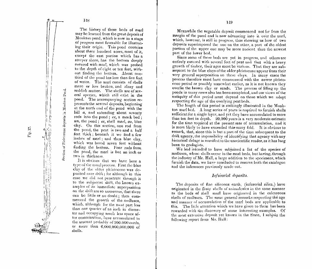
-4
/
.J]
- 148 I 149
The history of these beds of marl Meanwhile the vegetable deposit commenced not far from the may be learned from the great deposit of Monktoii pond, which is now in a stage
margin of the pond and is now advancing into it over the marl,
of progress most favorable for illustrat- which, however, is still in progress, thus showing us how of two deposits superimposed the one on the other, a part of the oldest ing their origin. This pond contains
about three hundred acres, most of it, portion of the upper one may be more ancient than the newest part of the lower bed.
except the east portion which has a Since some of these beds are yet in progress, and others are steeper shore, has the bottom deeply entirely covered with several feet of peat and that with a heavy covered with marl. which was probed to the depth of eight or ten feet, with- I growth of timber, their ages must be various. That they are sub-
out finding the bottom. About one- sequent to the blue clays of the older pleistocene appear from their
third of the pond has less than five feet very general superposition on these clays. In many cases the
of water. The marl consists of shells process theiefore must have commenced with the newer pleisto.
more or less broken, and slimy and cene period or possibly somewhat earlier, as it is not known they
reddish matter. The shells are of sev- overlie the brown clay or sands. The process of filling up the
eral species, which still exist in the ponds in many cases also has been completed, and our views of the
pond. The accompanying section re- antiquity of this period must depend on those which we adopt
presents the several deposits, beginning respecting the age of the overlying peat beds.
The length of this period is strikingly illustrated in the Monk- at the north end of the pond with the ton marl bed. A long series of years is required to furnish shells
.zz bill a, and extending about seventy sufficient for a single layer, and yet they have accumulated to more rods into the pond ; cc, a muck bed ; than ten feet in depth. 20,000 years is a very moderate estimate nn, the pond ; ee, shell marl, oo, blue for the time required at the present rate of accumulation, and it clay. On this section, one rod from
J is more likely to have exceeded thist many fold. It is obvious to the pond, the peat is two and a half feet thick; beneath it we find few a
remark, that, since this is but a part of the time subsequent to the
.22 inches of marl ; and then blue clay, drift agency, the impossibility of identifying that agency with any
P. C)
which was bored seven feet without I historical deluge is manifest to the unscientific reader, as it has long
finding the bottom. Four rods from been to geologists.
We had intended to have subjoined a list of the species of the pond, the marl is but an inch or I mollusca, whose shells occur in the marl beds, but having, through two in thickness.
It is obvious that we have here the industry of Mr. Hall, a large addition to the specimens, which
a I furnish the data, we have concluded to reserve both the catalogue type of the usual process. First the blue and the inferences previously made out. clay of the older pleistocene was de- posited over drift for although in this InJ'u'sorial deposits. case we did not penetrate through it to the subjacent drift, the known cx- The deposits of fine siliceous earth, (infusorial silica,) have amples of its immediate superposition on the drift are so numerous, that there
originated in the flinty shells of animalcules in the same manner
can be little or no doubt; then corn- as the beds of shell marl have originated in the calcareous
rnenced the growth of the niollusca, shells of mollusca. The same general remarks respecting th6 age
which, although for the most J)art less I and manner of accumulation of the marl beds are applicable to
than one quarter of an inch in diame- this. The little attention which we have given to them has been
ter and occupying much less space af- rewarded with the discovery of some interesting examples. Of the most extensive deposit vet known in the State, I subjoin the
ter commirlution, have accumulated to following report from Mr. hall the amount probably of 300,000 cords, or more than 6,000,000,000,000 of shells.
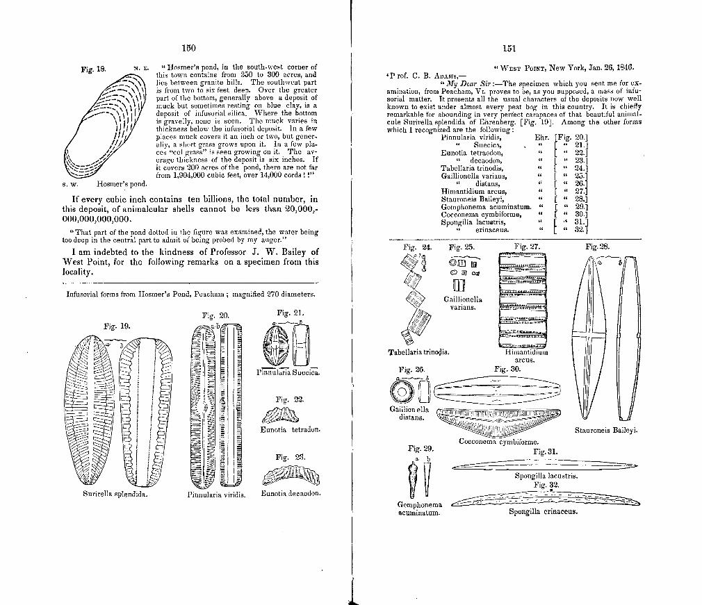
Fig. 19.
Surirella splendida.
150
Fig. 18. N. E.
S. W. Hosmer's pond.
"liosmer's pond, in the eouth-wet corner of this town contains from 250 to 300 acres, and lies between granite hills. The southwest part is from two to six feet deep. Over the greater part of the bottom, generally above a deposit of muck but sometimes resting on blue clay, is a deposit of infusorial silica. Where the bottom is gravelly, none is seen. The muck varies in thickness below the infusorial deposit. In a few places muck covers it an inch or two, but gener-ally, a short grass grows upon it. In a few pla-ces "eel grass" is seen growing on it. The av -erage thickness of the deposit is six inches. If it covers 200 acres of the pond, there are not far from 1,904,000 cubic feet, over 14,000 cords I"
If every cubic inch contains ten billions, the total number, in this deposit, of anirnalcular shells cannot be less than 20,000,-000,000,000,000.
"That part of the pond dotted in the figure was examined, the water being too deep in the central part to admit of being probed by my auger."
I am indebted to the kindness of Professor J. W. Bailey of West Point, for the following remarks on a specimen from this locality.
Infusorial forms from Hosmer's Pond, Peacham; magnified 270 diameters.
Fig. 20. Fig, 21,
P!iilia Succi.
Fig. 22.
Eunotia tetradon.
U:tFig. 23.
Pinnularia viridis. Eunotia decaodon.
151
"WEST POINT, New York, Jan. 26, 1840. 'P rof. C. B. AnAaTs,-
"My Dear Sir :—The specimen which you sent me for ex-amination, from Peacham, Vt. proves to be, as you supposed, a mass of infu-sorial matter. It presents all the usual characters of the deposits now well known to exist under almost every peat bog in this country. It is chiefly remarkable for abounding in very perfect carapaces of that beautiful animal-cule Surirella splendida of Ehrenberg. [Fig. 19]. Among the other forms which I recognized are the following:
Pinnularia viridis, Ehr. [Fig. 20.] Suecica, . " [ " 21.]
Eunotia tetraodon, " [ " 22.] decaodon, " [ " 23.]
Tabellaria trinodis, " " 24.] Gaillionella varians, " [ " 25.]
distans, " [ " 26.] Himantidium arcus, " [ " 27.1 Stauroneis Baileyi, " [ " 28,1 Gomphonema acuminatum. " [ " 29.] Cocconema cymbiforme, " [ " 30.] Spongilla lacustris, " [ • 31.
erinaceus. " [ " 32.
Fig. 24. Fig. 25. Fig, 27. Fig. 28.
/'ifl
> Gaillionella varians.
Tabellaria trinois. Himantidium arcus.
Fig. 26. Fig. 30. On Ga :5ua
Stauroneis Baileyi
Cocconema cymbiforme. Fig. 29. Fig. 31.
I Spongilla lacustris. Fig. 32.
Gomphonema acuminatum. Spongilla erinaceus.
15
There are many other epecies present for winch the names cannot be do-terrniiied until we receive Ehrenburg's forthcoming work, in which all the known species are to be figured and described."
In Maidstone is a less extensive deposit of infusorial silica, on which Professor Bailey has sent me the following remarks.
WEST POINT, February 16th, 1840, My Dear Sir:-
Your interestIng letter with its enclosed specimens came safely to hand, and I have given them a somewhat hasty examination which has afforded the following results.
The most interesting specimen in the infusorial marl from Maidstone, (No. 45), although, not so white as many infusorial deposits, it is almost wholly composed of shields of animaicules, and is quite free from sand or other inor. ganic matter. The principal species present are these, many of which are almost ubiquitous, viz.
Pinnularia viridis, Ehr. abundant. [Fig. 20.1 Pinnularia viridula, "
Pinnularia pachyptera " rare. Stawroiies baileyl, " abundant. [ " 28.] Synedra nina. Hiuiantidiuni arcus, " { " 27.] Gomphoneina acuninatum. rare in this specimen. [ " 29.] Eunotia monodon, Fig. 33.
These are the largest forms, and most of them are quite abundant, but the great mass is made up of frustules of the minute Gaillmouella varians of Ehren-berg, whose size rarely exceeds one twenty-five hundredths of an inch. Now, although 'figures will not lie,' they yet lead to almost incredible results, when we calculate how many of these minute but pertect organisms occur in a single cubic inch of this deposit. You may go over the calculation and correct the result if wrong.
Five millions, twohundred and fifty thou-uu X CJuU—i,tU,iJU sand in a square inch.
2500 x 2500 >< 0=15,125,000,000 5 Fifteen billions, one hundred and twenty- five millions in a cubic inch.
Yet I suppose your locality contains many thousands, not merely of cubic inches, but of cubic feet of matter equaily rich in anmmalcularremains.
This specimen also contains the fossil pollen of IJUIC and other trees."
ItJSTORJCAL PERIOD.
Since our plan does not permit minute descriptions of the de-tails of the deposits and agencies of this period, we shall merely call attention to a few illustrations. The deposits referable to this period are the calcareous, the ferruginous, the manganesian, the organic, and the fluviatile. The agencies are those of rains, springs, rivers, and waves.
Calcareous deposits.
Of those which are rmed by springs, examples are not rare, In the north east part of Middlebury are several associated springs which deposit a small amount of a very porous tufa. The rain-
153
eral springs of Wihliamstown deposit a more solid tufa, as does also a spring in the north part of Monkton, in which abundant bubbles of carbonic acid gas are constantly rising with much vi-vacity. 'I'hese tufas consist chiefly of slender anastomosing tems, which are more or less covered with minute delicate spines and tubercl es.
Examples are more common, in which, without any constant spring, tufa accumulates at the base and sides of hills and cliffs of calcareous and calciferous rocks. On the sides of the bluff, at Lone-Rock Point, Burlington, it collects in the crevices of the precipice, and occasionally incrusts and fills pieces of delicate moss. On the west side of a cliff of red sandrock, in the south part of Snake Mt., Bridport, near the house of Mr. Frost, is a de-posit, which had been called ' cinders,' and had been erroneously supposed to be of some economical importance. Numerous irregular cavities in it have a mammillary surface, and a num-ber of small angular stones are imbcdded in it, forming a kind of breccia. A similar case occurs at Mallet's Bay, Coichiester. At the base of a ledge of siliceous limestone east of Mr. Church's house in Highgate, is a very solid tufa, with the surfaces maui-roillary or densely covered with very minute tubercular and ho-tryoldal stalactites. This locality has been supposed to indicate volcanic agency, but it is unnecessary to say that its opposite, aqueous agency, is manifest. In some cases, as in Derby and at Mallet's hay, the tufa contains so niuch gravel as to approximate to a conglomerate.
Stalactites of small size and irregular form are found in some caverns, as in ilighgate cave ; arid in Chittenden, where have been found the short tooth-like or wedge-shaped stalactites, which form on a sloping roof. But the best specimens have long since been carried off by visitors.
In PowNAt., half ii mile norlh of the State line, and near the northeast bank of the Iloosic R., is an interesting example of a calciferous coutInmerate and sandstone, in which the process of consolidation is now going on in the mass of drift. A sim-ilar but harder calcareous conglomerate of consolidated drift oc-curs in WTestlord on land of Dr. 1-lames.
Ferruginou.9 (Jeposits.
Most of these have been or will be described under the head of bog ore, as a part of economical geology. .A single exam-ple has occurred of a ferruginous congiomerrite in Warren, where it was found by Mr. Wm. B. Tyler about two miles \vest of his house, having been revealed by a brook. It is drilt cemen-ted by the peroxide and hydrate of iron.
20
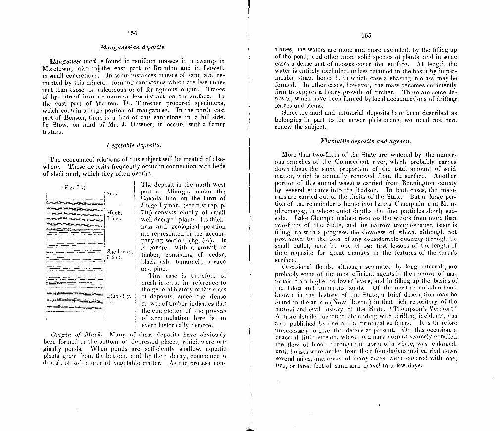
(Fig. 31.)
154
Mwzganes'ian deposits.
Manganese wad is found in reniform masses in a swamp in Moretown; also itil the east part of Brandon and in Lowell, in small concretions. In some instances masses of sand are ce-mented by this mineral, forming sandstones which are less cohe-rent than those of calcareous or of ferruginous origin. Traces of hydrate of iron are more or less distinct on the surface. In the east part of Warren, Dr. Thresher procured specimens, which contain a large portion of manganese. In the north east part of Benson, there is a bed of this sandstone in a hill side. In Stow, on land of Mr. J. Downer, it occurs with a firmer texture.
Vegetable deposits.
The economical relations of this subject will be treated of e1se where. These deposits frequently occur in connection with beds of shell marl, which they often overlie.
The deposit in the north west
Soil, part of Alburgh, under the Canada line on the farm of Judge Lyman, (see first rep. p.
Muck, TO,) consists chiefly of small 5 feet. well-decayed plants. Its thick-
ness and geological position are represented in the accom- panying section, (fig. 34). It is covered with a growth of
Shell mar] 9 feet timber, consisting of cedar,
black ash, tamarack, spruce and pine.
This case is therefore of much interest in reference to the general history of this class
iThie city, of deposits, since the dense growth of timber indicates that the completion of the process of accumulation here is an event historically remote.
Origin of Muck. Many of thcse deposits have obviously been formed in the bottom of depressed places, which were ori-ginally ponds. When ponds are sufficiently shallow, aquatic plants grow from the bottom, and by their decay, commence a deposit of suit mud and vegetable matter. As'the process con-
155
tinues, the waters are more and more excluded, by the filling up of the pond, and other more solid species of plants, and in some cases a dense mat of mosses cover the surface. At length the water is entirely excluded, unless retained in the basin by imper-meable strata beneath, in which case a shaking morass may be formed. In other cases, however, the mass becomes sufficiently firm to support a heavy growth of timber. There are some de-posits, which have been formed by local accumulations of drifting leaves and stems.
Since the marl and infusorial deposits have been described as belonging in part to the newer pleistocene, we need not here renew the subject.
Fliwiatile deposits and agency.
More than two-fifths of the State are watered by the numer-ous branches of the Connecticut river, which probably carries down about the same proportion of the total amount of solid matter, which is annually removed from the surface. Another portion of this annual waste is carried from Bennington county by several streams into the hudson. In both cases, the mate-rials are carried out of the limits of the State. But a large por-tion of the remainder is borne into Lakes' Champlain and Mem-phremagog, in whose quiet depths the fine particles slowly sub-side. Lake Champlain alone receives the waters from more than two-fifths of the State, and its narrow trough-shaped basin is filling up with a progress, the slowness of which, although not protracted by the loss of any considerable quantity through its small outlet, may be one of our first lessons of the length of time requisite for great cliangs in the features of the earth's surface.
Occasional floods, although separated by long intervals, are probably some of the most efficient agents in the removal of ma-terials from higher to lowef levels, and in filling up the basins of he lakes and numerous ponds. Of the most remarkable flood
known in the history of the State, a brief description may be found in the article (New haven) in that rich repository of the natural and civil history of the State, I Thompson's Vermont.' A more detailed account, abounding with thrilling incidents, was also published by one of the principal sufferers. It is therefore unnecessary to cive the details at lrcsent. On this occasion, a peaceful little streatn, whose ordinary current scarcely equalled the flow of blood through the aorta of a whale, was enlarged, until houses were hurled from their foundations and earned down Severil miles, and areas of niafly acres were covered with one, two, or three feet of sand and gravel in a few days.
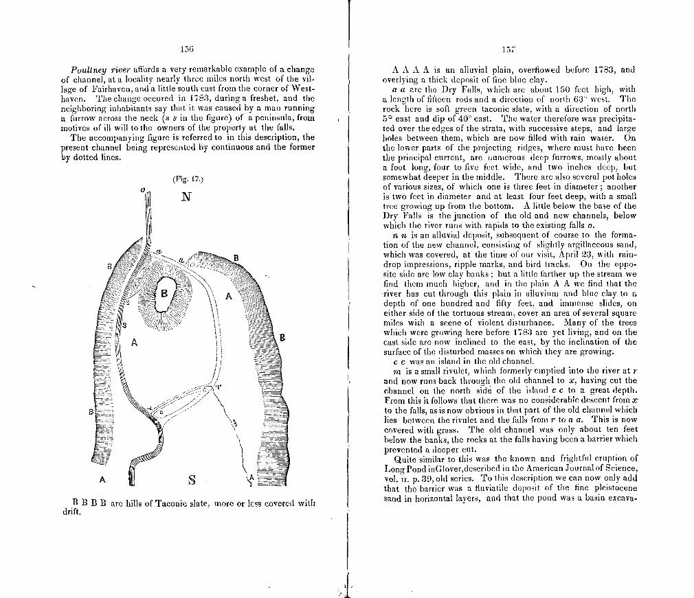
1513
Poultney river affords a very remarkable example of a change of channel, at a locality nearly three miles north west of the vil-lage of Fairhaven, and a little south east from the corner of West-haven. The change occured in 1783, during a freshet, and the neighboring inhabitants say that it was caused by a man running a furrow across the neck (.9 s in the figure) of a peninsula, from motives of ill will to the owners of the property at the falls.
The accompanying figure is referred to in this description, the present channel being represented by continuous and the former by dotted lines.
(Fig. 17.)
N
B / /
/
Bf Li
A
B B B are hills of Taconic slate, more or less covered with drift.
A A A A is an alluvial plain, overflowed before 1783, and overlying a thick deposit of fine blue clay.
a a are the Dry Falls, which are about 150 feet high, with a length of fifteen rods and a direction of north 63° west. rfhe rock here is soft green laconic slate, with a direction of north 5 east and dip of 40° east. The water therefore was precipita-ted over the edges of the strata, with successive steps, and large holes between them, which are now filled with rain water. On the lower parts of the projecting ridges, where must have been the principal current, are numerous deep furrows, mostly about a foot long, four to five feet wide, and two inches deep, but somewhat deeper in the middle. There are also several pot holes of various sizes, of which one is three feet in diameter; another is two feet in diameter and at least four feet deep, with a small tree growing up from the bottom. A little below the base of the Dry Falls is the junction of the old and new channels, below which the river runs with rapids to the existing falls o.
n n is an alluvial deposit, subsequent of course to the forma-tion of the new channel, consisting of slightly argillaceous sand, which was covered, at the time of our visit, April 23, with rain-drop impressions, ripple marks, and bird tracks. On the oppo-site side are low clay banks ; but a little farther up the stream we find them much higher, and in the plain A A we find that the river has cut through this plain in alluvium and blue clay to a depth of one hundred and fifty feet, and immense slides, on either side of the tortuous stream, cover an area of several square miles with a scene of violent disturbance. Many of the trees which were growing here before 1783 are yet living, and on the east side are now inclined to the east, by the inclination of the surface of the disturbed masses on which they are growing.
c c was an island in the old channel. rn is a small rivulet, which formerly emptied into the river at r
and now runs back through the old channel to x, having cut the channel on the north side of the island c c to a great depth. From this it follows that there was no considerable descent from a to the falls, as is now obvious in that part of the old channel which lies between the rivulet and the falls from r to a a. This is now covered with grass. The 01(1 channel was only about ten feet below the banks, the rocks at the falls having been a barrier which prevented a deeper cut.
Quite similar to this was the known and frightful eruption of Long Pond inGlover,described in the American Journal of Science, vol. ii. p.39, old series. To this description we can now only add that the barrier was a fluviatile deposit of the fine pleistocene sand in horizontal layers, and that the pond was a basin excava-
1 S
ted in this sand, and as it was upon the height of land in the valley (!), this fact is not easily accounted for.
Action of 11"aves.
The numerous headlands on the Champlain shore are much exposed to the prevailing north-west and south-west winds, and the cliffs composed of the pleistocene clays are wearing away.
The southern and narrow part of the Lake has its waters deeply discolored by the fine clays derived from these banks. Within five years the road leading south-east from Chimney Point has been washed away in one spot. The numerous mo-rasses along the shore also shew some of the results of this agency.
Rains.
The direct agency of rains, before they form running streams, is chiefly chemical, and in a limestone region the effects are very striking. Rain water, absorbing in its fall a portion of the car-bonic acid of the atmosphere, thus acquires the power of dissolv-ing limestone. Accordingly the surfaces of calcareous rocks are much iriodifled by this agency. The effects depend partly upon the position of the surface, and partly upon the structure and composition of the rocks. Sloping surfaces are very commonly furrowed in the direction of the slope, and these furrows are easily distinguished from the drift furrows by their direction being invariably a consequence of the inclination of the surface, and by their irregularity in width and depth, the chemical action being the greatest upon the softer portions of the rock, while the resist-less mechanical force of the furrowing agency of the drift was un-impeded by such obstacles. One of the most beautiful examples is at the marble quarry of Slason & Ormsbee in Middlebury ; but they may be seen in almost any town on the Stockbrid-ge lime-stone. By the same agency cracks in the rocks are enlarged into rounded channels, and cavities with some resemblance to pot-holes very closely resemble the effects of the fluviatile agency of some remote period. They are, however, later than the drift, and consequently have been formed since the riv -ers occupied their present courses. That they are later than the drift is proved by the interesting fact before noticed, that a cover-ing of a few inches, or at least a foot only of clay is necessary to protect the surface from pluvial agency.
Limestone rocks with a jointed structure present the singular appearance of having been cracked by desiccation. The appear-ance is obviously deceptive, and differs from that of shrinkage cracks, by the regularity of the forms which are thus developed. This results from the chemical action of rain water beiog mere
150
efficient upon the edges of the seams, which usually cross each other at oblique angles.
The composition of the rock also modifies the result. Through the extensive district of the calciferous sand rock in the north-west, and the still more extensive region of the calcareo-mica slate, in the eastern two-fifths of the State, the surfaces of rock are often seen covered with a more or less crumbling sand, which has been left by the decay of the calcareous portion.
Frost.
The agency of rivers, rains, and waves, is much increased by the effects of frost. Many of the rocks upon the shore of Lake Champlain, especially the Utica slates and Hudson River slates, are very fissile, and are split by the freezing of the water, which penetrates their seams, into innumerable fragments. Examples may be seen on the shores of Grand Isle and in some parts of Addison county. Frost also has a powerful agency in reducing to sand or mud substances which are in any degree porous. By this agency also the decay of land shells is hastened. Within the tropics, the shelter of an overhanging cliff will preserve the shells of many successive generations of terrestrial species, as if in the well guarded drawers of the conchologist, as we once saw much to our satisfaction. But it is in vain to look here for any
n such accumulatios of former generations. Wherever shells are found under the shelter of stones, they are obviously in the pro-cess of rapid decay.
TRAPPEAN PERIOD
The entire absence of any tertiary, secondary, newer or mid-dle palaeozoic formations, leaves a wide blank in the physical history of the State. During these numerous and long periods of time, no deposits were here made and consolidated, which, with their organic contents, should be so many chapters in the book of nature. For the want of such documents, we must recur to the neighboring regions for most of the few acneral conclusions respecting the history of Vermont during these periods. From the absence of deposits, it may he inferred that the land was above the waters of the ocean, and must, therefore, have been clothed with terrestrial vegetation, and have been the abode of terrestrial animals. Whatever living things, and whatever accu-mulation of fluviatile deposits there may have been, containing, perhaps, organic remains, during the tertiary periods, were all mingled with the other loose materials that covered the solid rocks, and their distinctive characters were obliterated by the drift agency. The meiocene of Martha's Vineyard is the nearest
160
tertiary deposit, and, with many remains of marine animals, it contains relics of terrestrial vegetation, such as probably flour-ished over most of New England.
The next oldest formation in the vicinity, is the new red sand-stone of Massachusetts and Connecticut. This rock, like most sandstones, contains but few organic remains, the porous charac-ter of the original sands having doubtless been, as such are now, unfavorable to the preservation of organic bodies. It abounds, however, with the foot-prints of birds, and of other animals, and since the most interesting locality of these tracks is within ten miles of this State, and this formation approaches within four miles, many of those enormous birds were no doubt familiar with the hills and valleys of Vermont: and if such animals as frequent the margins of tidal estuaries were common, there must have been others more exclusively terrestrial, of which no remains have been preserved. If, too, as is generally supposed, the climate of this period was of tropical warmth in the temperate zone, the vegetation here must have been of tropical luxuriance; and since the climate most favorable to such a growth is also most fatal to its subsequent preservation, we should not for this, as well as for reasons before suggested, expect to find abundant remains of it in the sandstone af Massachusetts.
It is probable that during the red sandstone period, the Con-necticut River emptied into a long narrow bay, which reached up from Long Island Sound, nearly to, or quite over the southern line of Vermont, and in which the sandstone deposits accumula-ted. Consequently no small part of them had their origin in this State, having been carried down by the river. Some of the coarse conglomerates, a few miles south of our southern line, have been found by President Hitchcock, to contain pebbles derived from Vermont rocks, which pebbles would be vari-ously regarded,—by some geologists as indicating violent fresh-ets,—and by others, as the memorials of an ancient period of drift agency. But the most conclusive proof, of the immense amount of materials which have been removed from what was the palaeozoic surface of Vermont, will be kund in the history of the trap dykes. President Hitchcock has shevn that the eruptions of trap, whose bold features mark the valley of the Connecticut south of Vermont, took place (brine' the red sand-stone period. It is, therelore, not improbable that the dykes of similar greenstone in this State were erupted during the same period.
GREENSTONE DYKES.
Ii is very remarkable, that, although trap dykes are very Common in some districts, not a single example of an overlying
161
mass has been been discovered. The geologist is well aware that such dykes for the most part fill fissures or channels through which eruptions took place. These eruptions, if we may judge from the great number and the distribution of the dykes, must have been extensive, yet the whole body of the erupted mate-rials has disappeared, leaving only so much as was included within the walls of the channels. Had a few masses only been left, we might have been astonished at the vast amount of mate-rials which have been carried off by the various atmospheric, fluviatile and drift agencies of denudation. But a denudation which has not left, in so many cases, a single relic of the erupted trap, must have removed a vastly greater amount. The other rocks, being on the average as perishable as the trap, and hav-ing in fact been worn down to the satne levels, must have lost an amount proportioned to their superficial extent. In Scotland large districts have been denuded to the depth of three thousand feet, as is shown by remains of the old red sandstone, capping lofty hills. But it is of course impossible, without similar data, to estimate the amount of denudation in Vermont. Since, how -ever, during a great part, if not all the time, which has elapsed since the oldest division of the palaeozoic rocks, a period imn-mensely greater than that portion of it which has succeeded the trappean eruption, the work of denudation has been going on, we may conjecture with much probability that the surface has been removed to the depth of many hundreds, perhaps some thousands of feet. Hence it is not surprising, that there is so much diffi-culty in determining the manner in which the palaeozoic or pri-mary strata were disturbed from their original horizontal position. Hence, too, we cannot infer with certainty, that there were no comparatively short intervals of submergence and deposition of marine strata, which have been since entirely worn away, but only that the time of emergence and denudation must have been at least much longer. The new red sandstone may have once also extended farther up the valley of the Connticut into Vermont.
The dykes of greenstone have cut through all the divisions of our stratified rocks, and are therefore proved to be more recent than any of them. In the Champlain rocks, they are most nu-merous in the vicinity of Burlington, where Mr. Thompson has investigated tImem with great success. Until recently no dykes were known in the Taconic rocks, but we have discovered several examples. In the middle of the east side of the State, they are also not uncommon in the calcarco-mica slate. Many of them are of much interest, although the rock in immediate proximity does not exhibit any peculiar marks of igneous agency, but the effects of such agency appear to have been extended through large areas.
21
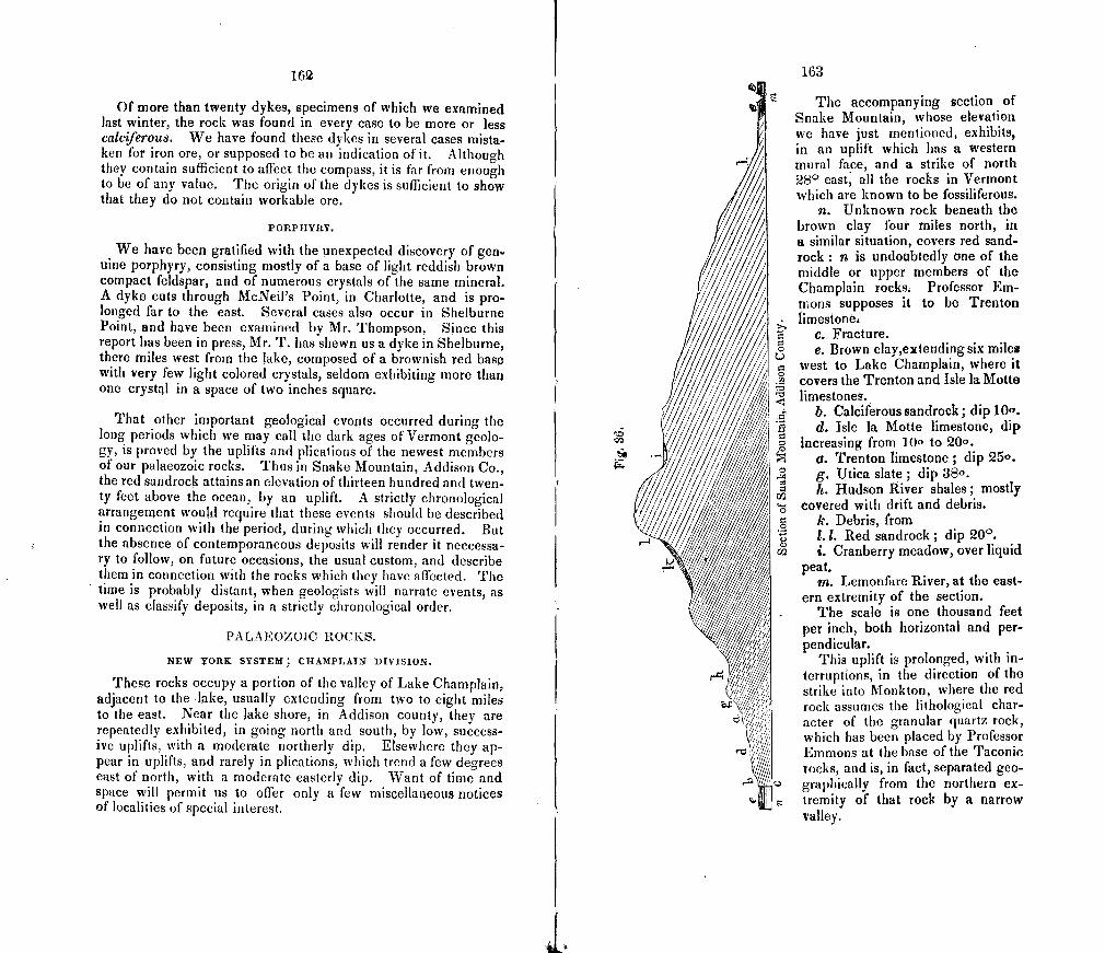
Its
Cz
162
Of more than twenty dykes, specimens of which we examined last winter, the rock was found in every case to be more or less calciferou8. We have found these dykes in several cases mista-ken for iron ore, or supposed to be an indication of it. Although they contain sufficient to affect the compass, it is far from enough to be of any value. The origin of the dykes is sufficient to show that they do not contain workable ore.
PORPHYRY.
We have been gratified with the unexpected discovery of gen uine porphyry, consisting mostly of a base of light reddish brown compact feldspar, and of numerous crystals of the same mineral. A dyke cuts through McNeil's Point, in Charlotte, and is pro-longed far to the east. Several cases also occur in Shelburne Point, and have been examined by Mr. Thompson, Since this report has been in press, Mr. T. has shewn us a dyke in Shelburne, there miles west from the lake, composed of a brownish red base with very few light colored crystals, seldom exhibiting more than one crystal in a space of two inches square.
That other important geological events occurred during the long periods which we may call the dark ages of Vermont geolo-gy, is proved by the uplifts and plications of the newest members of our palaeozoic rocks. Thus in Snake Mountain, Addison Co., the red sandrock attains an elevation of thirteen hundred and twen-ty feet above the ocean, by an uplift. A strictly chronological arrangenjent would require that these events should be described in connection with the period, during which they occurred. But the absence of contemporaneous deposits will render it neccessa-ry to follow, on future occasions, the usual custom, and describe them in connection with the rocks which they have affected. The time is probably distant, when geologists will narrate events, as well as classify deposits, in a strictly chronological order.
PALAEOZOIC ROCKS.
NEW YORK SYSTEM; C}I4MPLAJN DIVISION.
These rocks occupy a portion of the valley of Lake Champlain, adjacent to the lake, usually extending from two to eight miles to the east. Near the lake shore, in Addison county, they are repeatedly exhibited, in going north and south, by low, success ive uplifts, with a moderate northerly dip. Elsewhere they ap-pear in uplifts, and rarely in plications, which trend a few degrees east of north, with a moderate easterly dip. Want of time and space will permit us to offer only a few miscellaneous notices of localities of special interest.
163
The accompanying section of Snake Mountain, whose elevation we have just mentioned, exhibits, in an uplift which has a western mural face, and a strike of north 280 east, all the rocks in Vermont which are known to be fossiliferous.
n. Unknown rock beneath the brown clay Ibur miles north, in a similar situation, covers red sand-rock: n is undoubtedly one of the middle or upper members of the Champlain rocks. Professor Em-mons supposes it to be Trenton limestones
c. Fracture. e. Brown clay,extending six miles
west to Lake Champlain, where it .5 covers the Trenton and Isle Ia Motto
limestones. E b. Caldferous sandrock; dip 10". I d. Isle Ia Motte limestone, dip
increasing from 10° to 20o. o. Trenton limestone; dip 25°. g. Utica slate; dip 38°. h. Hudson River shales; mostly
' covered with drift and debris. k. Debris, from 1. 1. Red sandrock; dip 200.
r2 i. Cranberry meadow, over liquid peat.
m. Lemonfare River, at the east-ern extremity of the section.
The scale is one thousand feet per inch, both horizontal and per-pendicular.
This uplift is prolonged, with in-terruptions, in the direction of the strike into Monkton, where the red rock assumes the lithological char-acter of the granular quartz rock, which has been placed by Professor Emmons at the base of the Taconic rocks, and is, in fact, separated geo-graphically from the northern cx-tremity of that rock by a narrow valley.
II
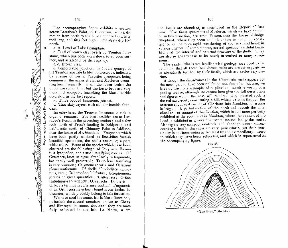
r,4
164
The accompanying figure exhibits a section across Larrabee's Point, in Shoreham, with a di-rection from north to south, one hundred and fifty rods long, and fifty feet high. The strata dip 10 0 north.
a. a. Level of Lake Champlain. c. Bluff of brown clay, overlying Trenton lime-
stone, which has been worn down to an even sur-face, and scratched by drift agency.
e. e. Brown clay. i. Conformable junction, in Judd's quarry, of
the Trenton and Isle Ia Motte limestones, indicated by change of fossils. Favosites lycopodon being common in the upper strata, and Maclurea occur-ring less frequently in rn, the lower beds : the upper are rather thin, but the lower beds are very thick and compact, furnishing the black marble described in the first report.
rj n. Thick bedded limestone, jointed. o. Thin slaty layers, with slender fucoids abun-
dant. . As eslewhere, the Trenton limestone is rich in
organic remains. The best localities are at Lar-rabee's Point, in the preceding section; and a few rods north of Frost's landing in Bridport; and half a mile north of Chimney Point in Addison,
o near the house of Mr. Goodale. Fragments which • have been partly calcined at lime-kilns furnish
beautiful specimens, the shells assuming a pure white color. Some of the species which have been observed are the following: of Polyparia, Favos-ites lycopodon, and a small ramifying species. Of Crustacea, Isotelus gigas, abundantly in fragments, but rarely well preserved ; Trinucleus tesselatus is very common; Calymene senaria and Ceraurus pleurexanthemus. Of shells, Trocholites ammo-nius, rare ; Bellerophon bilobatus ; Strophomena sereica in great quantities ; S. alternata ; Orthis testudinaria abundantly; 0. callactis; Delthyris—; Orbicula terminalis; Pterinea undata? 1ragments of an Orthocera have been found seven inches in diameter, which probably belong to this formation.
We have used the name, Isle Ia Motte limestone, to include the several members known as Chazy and Birdseye limestone, &c. since they are most fully exhibited in the Isle La Motte, where
165
the fossils are abundant, as mentioned in the Report of last year. The finest specimens of Maclurea, which we have obtain-ed in this forniation, are from Panton, near the house of Judge Shephard, where they occur an inch or two in relief in conse-quence of the more rapid weathering of the rock, and being in various degrees of completeness, several specimens exhibit beau-tifully all the internal and external structure of the shells. They are also so abundant as to be nearly in contact in many speci- men S.
The reader who is not familiar with geology may need to be-reminded that all these fossiliferous rocks are marine deposits, as is abundantly testified by their fossils, which are exclusively ma- rine.
Although the disturbances in the Champlain rocks appear for the most part to have been uplifts on one side of a fracture, we have at least one example of a plication, which is worthy of a passing notice, although we cannot here give the full description and figures which the case will require. The plicated rock is the red sand-rock, constituting a hill, which extends through the extreme south east corner of Charlotte into Monkton, for a mile in length. A partial section of the north end reveals the anti-clinal axis or summit of the plication, which is still more perfectly exhibited at the south end in Monkton, where the summit of the bend is exhibited in a very fine natural section facing the south. Although a very compact sandrock, and although some strataex-ceeding a foot in thickness are very pure quartz, yet their con-tinuity is not interrupted in the least by the extraordinary fiexure to which they have been subjected, and which is represented in
the accompanying figure. Fig. 38.
The Oven," Monkton.
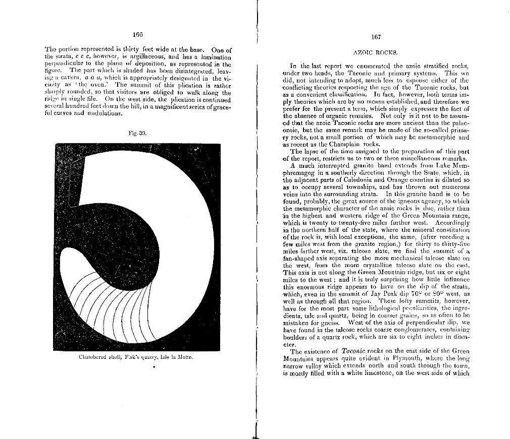
166
The portion represented is thirty feet wide at the base. One of the strata, C C C, however, is argillaceous, and has a lamination perpendicular to the plane of deposition, as represented in the figure. The part which is shaded has been disintegrated, leav-ing a cavern, a a a, which is appropriately designated in the vi-ciwty as 'the oven.' The summit of this plication is rather sharply rounded, so that visitors are obliged to walk along the ridge in single file. On the west side, the plication is continued several hundred feet down the hill, in a magnificent series of grace-ful curves and undulations.
Fig. 39.
Chambered sheti, Fisk's quarry, Isle la Motte.
167
AZOIC 1OCKS.
In the last report we enumerated the azoic stratified rocks, tinder two heads, the Taconic and primary systems. This we did, not intending to adopt, much less to espouse either of the conflicting theories respecting the age of the Taconic rocks, but -as a convenient classification. In fact, however, both terms im-ply theories which are by no means established, and therefore we -prefer for the present a term, which simply expresses the fact of the absence of organic remains. Not only is it not to be assum-ed that the azoic Taconic rocks are more ancient than the palae--ozoic, but the same remark may be made of the so-called prima--ry rocks, not a small portion of which may be metamorphic and as recent as the Champlain rocks.
The lapse of the time assigned to the preparation of this part of the report, restricts us to two or three miscellaneous remarks.
A much interrupted granite band extends from Lake Mem-phremagog in a southerly direction through the State, which, in the adjacent parts of Caledonia and Orange counties is dilated so as to occupy several townships, and has thrown out numerous veins into the surrounding strata. In this granite band is to be -found, probably, the great source of the igneous agency, to which the metamorphic character of the azoic rocks is due, rather than in the highest and western ridge of the Green Mountain range, which is twenty to twenty-five miles further west. Accordingly in the northern half of the state, where the mineral constitution of the rock is, with local exceptions, the same, (after receding a few miles west from the granite region,) for thirty to thirty-five miles farther west, viz. talcose slate, we find the summit of a fan-shaped axis separating the more mechanical talcose slate on the west, from the more crystalline talcose slate on the east. This axis is not along the Green Mountain ridge, but six or eight -miles to the west ; and it is truly surprising how little influence this enormous ridge appears to have on the dip of the strata, which, even in the summit of Jay Peak dip 70° or 80° west, as well as through all that region. These lofty summits, however, have for the most part sonic lithological pecuhatities, the ingre-dients, talc and quartz, being in coarser grains, so as often to be mistaken for gneiss. West of the axis of perpendicular dip, we
-have found in the talcose rocks coarse conglomerates, containing ouIders of a quartz rock, which are six to eight inches in diam-
-eter. The existence of Taconic rocks on the east side of the Green
Mountains appears quite evident in Plymouth, where the long -narrow valley which extends north and south through the town, s mostly filled with a white limestone, on the west side of which
I
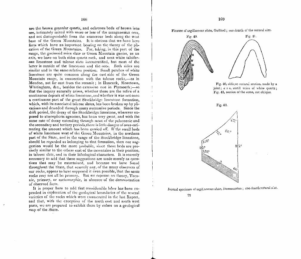
Fig. 40.
168
are the brown granular quartz, and ochreous beds of brown iron Gre, intimately mixed with more or less of the manganesian ores, and not distinguishable from the numerous beds along the west base of the Green i\iountains. It is obvious that we have here facts which have an important bearing on the theory of the ph-cation of the Green Mountains. For, taking, in this part of the range, the gneissoid mica slate or Green Mountain gneiss, as an axis, we have on both sides quartz rock, and next white talcifer-ens limestone and talcose slate interstratified, but most of the latter is outside of the limestone and the ores. Both sides are similar and in the same relative position. Small patches ofwhite limestone are quite common along the east side of the Green Mountain range, in connection with the talcose rocks,—as in Mendon, not far east from the summit ; in Hancock, Moretown, Whitingham, &c., besides the extensive one in Plymouth ;—so that the inquiry naturally arises, whether these are the relics of a continuous deposit of white limestone, and whether it was not once a continuous part of the great Stockbridge limestone formation, which, with its associated talcose slates, has been broken up by ph-cations and denuded through many successive periods. Since the drift period, the decay of the Stockbridge limestone, wherever ex-posed to atmospheric agencies, has been very great, and with the same rate of decay extending through most of the palaeozoic and the secondary and tertiary periods,there is little danger of over-esti-mating the amount which has been carried off, lithe small beds of white limestone west of the Green Mountains, in the northern part of the State, and in the range of the Stockbridge limestone, should be regarded as belonging to that formation, then our sug-gestion would be the more probable, since those beds are pre-cisely similar to the others east of the mountains in their position, in talcose slate, and in their lithological characters. It is scarcely necessary to add that these suggestions are made merely as ques-tions that may be entertained, and because we have found throughout the State, that scarcely any, of the many observers of our rocks, appear to have supposed it even possible, that the azoic rocks may not all be primary. But we espouse no theory, Taco-rile, primary, or metamorphic, in absence of the demonstration of observed facts.
It is proper here to add that considerable labor has been ex-pended in exploration of the geological boundaries of the several varieties of the rocks which were enumerated in the last Report, and that, with the exception of the north east and south west parts, we are prepared to exhibit them by colors on a geological map of the State.
169
Flexure of argillaceous slate, Guilford ; one-fourth of the natural size.
Fig. 41.
Fig. 40, oblique natural section, made by a joint; a a a, small veins of white quartz; Fig. 41, section of the same, not oblique.
Fig. 42.
Jointed specimen of argillaceous slate, Dummerston ; one-fourth natural size.
22
171
PART V.
ECONOMICAL GEOLOGY AND NINERALOGY,
Most of the economical relations of geology and mineralogy, may be comprehended under the general divisions of Agriculture, Mining, Architecture, and Engineering.
AGRICULTURAL GEOLOGY.
Not only is the fundamental importance of this great art, on which civilized man is mainly dependent for food, more fully appreciated of late years, but the high intellectual rank which should belong to an employment, that is so intimately connected with chemistry, botany, zoology, mineralogy, and geology is also better appreciated. But in Vermont, although many of its citi-zens are negligent of the true grounds on which agriculture claims a high consideration, this pursuit has never been subject to disrespect; for not only a considerable portion of the men of the learned professions, but the highest officers in the State have been, or are farmers. Happily, therefore, for our State, this art needs not to be elevated in the esteem of the community. These circumstances, the eagerness with which agricultural knowledge is sought, and the enterprise with which it is reduced to practice by many men of superior talents, afford no small encouragement to any attempt to render geology subservient to agriculture.
Having, in the general and preliminary survey of last year, prepared the way for direct effort in this department of the sur-vey, I accordingly directed Mr. Hall, to make a survey of the agricultural geology of the eastern part of the State, in a list of instructions herewith appended to these remarks introductory to his report. It will be seen that this labor has been performed with great diligence and success, and that the almost untouched agricultural resources in the deposits of muck and marl, are truly surprising. Some new countries have a rich virgin soil, but it is of
far greater importance, that there should exist materials, with which knowledge and industry may easily keep up the highest degree of fertility through successive generations. We cannot therefore but regret, that so large a portion of the active young men of the State should abandon their homes for distant and unset-tled regions, while, with probably less toil and expense, they may here make for themselves as good farms, as they can find in the far west, with the advantages of a nearer market, a salubrious climate, and the associations and privileges of home.
The value of any, even a small improvement in agriculture, has been forcibly described by a late writer, by reference to the sta-tistics of the business of a conimnunity, shewing that an improve-ment amounting to but one per cent, of increased production, may be absolutely equal to a gain of fifty or one hundred per cent, in other branches of business. A glance at the statistics of Vermont will shew how pertinent is this consideration here. The addition of one per cent, to our agricultural products, would equal the addition of twenty per cent. to all the mineral products of the State.
We had intended to offer some general remarks on the origin of soils, and on the other relations of geology to agriculture, but the report of Mr. Hall renders this unnecessary. It will be seen that Mr. H. has collected numerous statistics, which are not geological, but as they have not interfered with the duties assign-ed to him, and are, moreover, of much value, no apology can be needed for their insertion.
instructions to S. R. Hall, assistant geologist, communicated May 1st, 1846.
1. The territory, within which your labors are to be restricted, comprises so much of Vermont as lies cast of the principal ridge of the Green Mountains.
2. Sixty specimens of soils are to be collected. 3. Each specimen is to consist of one quart of soil. 4. Each specimen is to be preserved in a stout bag, with its
number written indellibly. 5. The specimens should be free from perceptible moisture
before they are packed in boxes. 6. The boxes containing the specimens, should be forwarded
to this place, [Middlebury], as soon as convenient after they shall have been closed.
7. The materials of a specimen should be a fair sample of the soil of the field selected, rejecting, however, all stones larger than peas. But the proportion of the soil, which consists of stones exceeding this size, as near as can be estimated, should be noted in your journal.
172
S. The sixty localities of the specimens should be apportioned throughout the above mentioned territory, according to such plan as mature reflection, and your good judgment will mark out; and the principles which govern you should be committed to writing, that they may be published in connection with these inst ru cti Otis.
9. Among the sixty specimens should be some from soils which have not been altered by cultivation,—others from those which have been highly improved,—and a few from those which have been irnpoverished,—iri such number of each character as you may find expedient.
10. Statistics and information will be required respecting the particular soils of which specimens are collected ; viz.
of the crops produced of the kind of improvement made, if any, and the manner
of cultivation so far as it may affect the character of the soil; of the depth of the soil of the character of the subsoil;
subjacent rocks cc rocks lying to the north a few miles;
of their drainage, and general character of humidity, tex-ture, and other apparent physical properties.
11. If possible, endeavor to arrive at some generalizations on the relation of the soils to the geological character of their vicin ity. But if any general propositions are advanced as the result of your investigations, they must be well sustained by well described facts.
12 In immediate connection with the preceding, is the sub-ject of the geographical distribution of the soils, to which the same remarks will apply.
13. You will search for, and examine the natural sources for the improvement of the soil, especially the beds of muck and of marl, and report their exteat, depth, and quantity in cubic meas-ure, so far as practicable also, how much, and in what manner they are used.
14. As a subject of scientific interest, you will, where practi-cable, make sections of some of the more interesting muck and marl beds, especially when in connection with an existing pond. The remarks made to you in person on the manner of making sections, need not be repeated.
15. Of the marls, which are entirely covered with muck, you will collect as large a quantity, as may be convenient, of the shells, which may be easily done by rinsing the marl in a bucket of water. Great care should be taken to collect them in the same proportion of the several species in which they exist in the marl.
16. About one quart of each marl bed may be collected for specimens; and the same from a few of the muck beds.
173
1'7 At least once during each month, between the 20th and 25th, yon will write to me for the purpose of keeping me advised of your progress.
IS. In devoting a reasonable portion of your time to inter-course with the most intelligent agriculturists, you will endeavor to collect as well as to disseminate inforination, that you may em-body in your report such facts in the various branches of our practical agriculture, as you may deem expedient. In such cases, the name of the agriculturist should be stated ; as well as of the owners and cultivators of the soil from which specimens are taken.
19. A report on the agricultural department of the survey must be furnished as early as September 10, ready for the press. This report may include the entire subject of Agricultural Geolo-gy, except so far as may he superseded by some general introduc-tory remarks, which I may offer on the importance of the agricul-tural interest, the relations of the physical sciences to agriculture, and on the origin of soils. (See remarks on page VU).
20. The other objects of the geological survey may, when facts of interest occur, receive a portion of your attention, but not to occasion the neglect of the duties above mentioned.
21. Whatever specimens of rocks and of common minerals may be collected, must be three inches square, not to vary more than half an inch from this typical size, (except for some specific and important reasons, as the exhibition of joints &c.), and from one-half to one inch thick, with one face perfectly free from ham-mer marks and scratches, and from the effects of weathering. Should you have occasion to pass over any of the spots on which specimens were collected by you last samnier, a few more of the same, with the same number attached, are desired.
22. The directions of last year may be referred to for the nurn-ber of specimens, manner of packing, &c., your initial H. being added to the number, commencing with ilumber 61.
23. If any trap dykes, riot before examined, occur, you will col-lect specimens, and note the width, direction, and dip of the dyke, and observe whether the rock has polarity.
24. The direction of any drift scratches not before recorded, and kind of rock may be noted. If there be two or more sets, you will look for the evidence of their relative age in the manner of their intersection ; but extreme minuteness of observation and particularity of description will be necessary to render your ob-servations available.
25. Whenever claystones are collected, a large numberis de-sirable on account of the great number of forms. The situation of clay beds may be noted somewhat particularly.
26. Infusorial deposits should be carefully sought for, and specimens collected.
17.1
27. Should you have anything to report on the other economical objects of the survey, it is important that such report should be rendered as early as October 15, and that the facts should be de-scribed under the same heads and in the same order as in my first report. The facts belonging to the scientific geology, which you may collect, may be communicated subsequently. Your route and the localities whence specimens are taken, should be indicated on a map, of a scale at least twice as large as Mr. Thompson's.
28. Localities of scientific interest are best described by refer-ence to town lines, rivers and objects on the map, as most intelli-gible to strangers ; but those of merely economical interest, by references most intelligible in the vicinity.
29. A geological map of the State has been forwarded to you, and you will note any corrections which you may find neccesary.
30. Should your time of field labor not permit you to go over the whole territory assigned and to finish the plan, you will nev -ertheless carry out these instructions as fully as practicable, so far as you may go.
Report of 11b. hail.
To C. B. ADAMS, STATE GEOLOGIST:
Sir— In accordance with your instructions, I commenced field labor, as assistant geologist, the present season, on the 13th of May ; and with only slight interruptions have continued my examinations to the present time. So much of the State, "lying east of the principal range of the Green Mountains" has been visited as the time, allowed me, would permit.
It has been a constant source of regret, that it was necessary for you to assign so large a field, and to limit the time for its ex-amination to three months. The small amount of funds appro-priated by the State, for a geological survey, making both una-voidable, I have endeavored to observe the most rigid economy in using the time. But still a part of the field has been unavoid-ably omitted. Fourteen towns in Windham county, twenty in Windsor, twelve in Orange, fifteen in Washington, eight in La-moille,ltwelve in Caledonia, and eighteen in Orleans counties, have, with more or less care, been examined.
I have made it a prominent object to examine the characters of the soil, as well as to collect specimens for analysis ; and so far as could be done, have endeavored to visit the best conducted farms, and obtain information with regard to improved methods, and the present history of agriculture, in different sections ; also to obtain from intelligent practical farmers, answers to such inqui-ries as the following
175
What modes are adopted for increasing the quantity or improv-ing the quality of manures?
Are there extensive deposits of muck, marl, &c., in the town I To what extent, and how employed?
How many barn cellars in your vicinity, for preserving the urine of cattle as a manure, or preserving the ordinary manure from leaching, bleaching and wasting? What method is adopt-ed for making compost, and to what extent?
About what amount of hay, per acre, do you regard as a fair average for the town?
What is a fair average crop of wheat per acre ? of corn ? of rye ? (if grown,) of oats? of barley ? of buckwheat, and of potatoes? Average yield of wool per head from sheep? butter or cheese from cow? &c. When practicable, the estimate of several individuals has been sought, obtained and noted. A copy of these notes is subjoined to this report, with other facts, gathered from individ-uals, furnishing interesting items in the history of our agriculture.
I regret to say that I have not been able, before rendering this report, to make any examination in the interesting valley of the Connecticut, above 'Waterford, nor of all the towns bordering on the Passumpsic River.
Two leading considerations have governed me, in making a selection of specimens of soil for analysis; first, to select from each county, a due proportion according to its extent and agri-cultural importance, and secondly to have each specimen repre-sent as much extent of territory as possible. That I have been able to make selections in every instance as judiciously, as could have been done after more extended are careful examination, is not probable. A catalogue of these specimens will be hereafter submitted. As I was limited to sixty specimens from this field, it was utterly impossible that samples from every variety of soil could be taken, there being very great diversity in the char-acter of the soils examined. This has been found true, often within a territory of limited extent. The intervale on the same meadow, and even on the same farm, not unfrequently, furnishes several varieties differing so mdterially from each other, as to require considerable diversity in cultivation.
Soil taken from three terraces of the intervale in Charleston, N. H., and analyzed by Dr. Jackson, showed the following diversity of character:
1st terrace. 2d terrace. 3d terrace. Water, 2.4 3.4 3.2 Vegetable matter, 4.2 8.1 5.0 Insoluble silicates, 81.0 78.0 79.2 Peroxide of iron, 4•5 4.6 73 Alumina, 4.0 4.3 5.1
1.0 0.3 Salts of lime, 4.0
176
Intervale soil, bordering on a given stream, is not only modified by its degree of elevation, but by the character of the rocks in place and of the drift, over which the water of the river and its tributaries have passed, from which it was deposited. Upland soil often presents still greater diversities, owing to the character and depth of the drift, the qualities of the rock or subsoil over which it lies, the relation of its surface to the. dip of strata, and the presence of different proportions of vegetable matter, metallic oxides and earthy salts.
All soils doubtless have been originally formed by the disinte-gration and decomposition of rocks, through mechanical and chemical agencies. This process is continually carried on, and is well explained in Gray's Elements of Scientific and Practical Agriculture.* The prominent kinds of rocks, which occur east
" 1. The oxygen of the atmosphere combines chemically with the metals and decomposable minerals, and by forming new compounds, causes them to crumIe down. Water, also, imparts its oxygen, and produces a similar effect. The surface of rocks, in this way becomes pulverized to a greater or less depth. The principal mineral substances with which the oxygen of the air and of water unite, are iron, manganese and pyrites. When a rock contains iron or manganese, in a lower state of oxidation, these oxides attract more oxygen from the air and water, increase in bulk, and split or cleave into thin layers; thus affording an opportunity for the mechanical agency of water, either by friction 01 freezing.
2. Pyrites, or the bi-sulphuret of iron, exerts the most powerful agency in the decomposition of rocks, and perhaps the most extensive; as this mineral is widely disseminated through nearly all classes of rocks. It is composed of sul-phur and iron. The sulphur attracts oxygen from the air and from water, and forms the well known substance sulphuric acid, [oil of vitriol]. The iron also combines with oxygen from the Caine source, and forms an oxide of iron. The acid and the oxide now unite, and produce a new compound, the sulphate of iron, or copperas, a substance capable of being dissolved in water. Thus, the rock through which the pyrites is disseminated, is crumbled, thrown, or changed in its properties. But the action does not stop here. The sulphate of iron being dissolved in water, which is constantly penetrating the mass, is brought into contact with feldspar, and both are decomposed; the sulphuric acid in the copperas abandons the iron, and unites with the potash and lime in the feldspar, forming sulphate of potash and of lime, while the oxide of iron is deposited in the form of iron rust. When the pyrites exists in slate rocks, containing much alumina, magnesia and lime, the sulphuric acid combines with these bases, by which nearly the whole rock is gradually converted into soil. Were this the only agent acting upon the rocks, the character of the soil would be accurately known, by examining the rock which underlays it; but this is rarely the case.
S. The mechanical agency of water, aided by cold and heat, and by its cur-rents and waves, not only aids in breaking down the solid masses, but trans-ports the pulverized materials in the form of detritus, and deposits them in lower lands. .Thus the substances of different rocks are mingled together. Freezing water exerts an immense power in this respect. The water penetrates every seam and crevice of the rocks, and by its expansive power in the act of freezing, forces the parts asunder, and creates new fissures, which are each year increased in number and width. Nor does this influence cease after the rocks are fully converted into soils ; each year the expansive force of water tends to pulverize, and render the earth light and porous. The friction of run-ning water wears off the rocks, and removes that which has become hroken down by chemical action. The particles being suspended, and carried down by
177
of the principal range of the Green Mountains in this State are, talcose, slate, mica slate or Green Mountain gneiss, catcareo-mica slate, gneiss proper, granite, clay slate and horn blonde slate.
In Readsborougb, Whitingham, Searsborough, Wilmington, Somerset, Dover, Stratton, Wardsborough, Jamaica, Winhall, Londonderry, Landgrove, Weston, Mount Holly and Shrewsbu-ry, towns lying principally in the west part of Windsor and Wind-ham counties, the rock is chiefly Green Mountain gneiss. This kind of rock is composed of quartz, mica and feldspar, chiefly. Pure quartz consist wholly of silica. Mica usually contains of sili-ca about 40 per cent., alumina 12, magnesia 13, potash 7, perox-ide of iron 5 to 20, manganese 1 to 2. Feldspar usually con-
the force of the stream and deposited along the banks, and at the mouths of revere.
4 Decaying plants tend to convert the rock into soils. The vegetable acids are capable of combining with the lime, soda, animonia, potash, magnesia, oxide of iron and manganese. These bases are thus withdrawn from the rocks, and the latter crumble to pieces, and salts are formed, which are useful in the nourishment of future generations of plants. Daring decay, large quanti-ties of carbonic acid are formed. This acid is not only direct food for plants, but is capable of combining with the potash in the feldspar of granite rocks, and of facilitating their decomposition. This acid is the most powerful agent in its action upon the alkalies, even decomposing the silicates, and forming solu-ble salts.
5. Growing plants exert the most powerful agency in decomposing the rocks. Not only do the lichens, mosses and other plants insert their roots into the cre-vices of the rocks, and by keeping them moist, favor the chemical action of air and water, but the living plant forms with the rock or soil a galvanic battery of immense power; by this means the plant is enabled to obtain from time soil those ingredients which its wants may require. This is proved by the fact, that plants, growing in glass vessels, will decompose the glass, to obtain the potash, of which the glass is in part composed. It is highly probable that a greater amount of decomposition is produced in this way, than by all other causes to-gether. Similar to this influence if not identical with it, is what has been called "catalysis of life." The living plant aids by its presence to decompose the rocks, and to effect rapid changes, which not only convert them into the state of soil, but form the elements into different substances.
The above processes will serve to illustrate the chemical and mechanical agen-cies, which are constantly at work to crumble down the solid rocks, and bring them into a state fit for the suppqrt of the vegetable kingdom. These agents are constantly active. The great effect of stirring the soil, is to facilitate the decomposition of the rocks, and of the vegetable bodies which are always present in the soil. But for this agency, the soils in a few years would become exhausted of all their alkalies, the vegetable matter would not decay, and hence no food in the soil would he provided for the plants. Absolute barrenness must therefore succeed. For without alkalies, or alkaline earths and geine, no plants can grow.
Depth of soil. The influences of the agents above described, has not exten-ded to an average depth of more than 15 feet; although in some places the soil is actually more than a hundred feet in depth. This is but a small portion of the whole mass of the earth, whose mean diameter is 7,911 miles ; hence the soil would be less in proportion to the whole earth, than the slightest tarnish of rust on an iron globe 100 feet in diameter compared with its mass. But a small part of this constitutes what is properly denominated the soil.
That part only of the surface, varying from 3 to 20 inches in depth, which has become mingled with vegetable and animal matters, constitutes the true soil, and itis mostly this part which concerns the farmer, and which is present. ed for our investigation, classification, description, and improvement.
23
178
tains silica about 43 per cent., alumina 33, soda 13, potash 7, lime, iron and manganese from 1 to 3 each. As the quartz, feld-spar and mica, abound more or less in different parts, the soil that is composed principally of this rock will vary essentially. In most instances that came under my observation, the proportion of feldspar, is very limited, and of course the soil will be essen-tialty composed of of silica, alumina, potash, and vegetable mat-ter,—and be deficient in soda and lime. Lime is however measurably supplied by the drift from the limestone region lying north-west. Both ashes and caustic lime would doubtless essen-tially improve the fertility of the soil in this region. Talcose slate is found lying cast of the Green Mountain gneiss, in the southern part of the State, only to or three miles in width, but north of Plymouth, it is generally from ten to twelve miles wide.
Plymouth, Bridgewater, the easterly part of Barnard and Beth-el, and westerly part of Sherburne and Pittsfield, Rochester, Braintree, Granville, Warren, Roxbury, western part of Northfield, Berlin and Waitsfield, easterly part of Fayston and Diixbury, Moretown, Middlesex, Waterbury, Worcester, Stow, Elmore, Morristown, Wolcott, Hydepark, eastern part of Johnson, Ster-ling and Belvidere, Eden, Lowell, Westfield, Troy and Jay, are embraced in this division, and sinaIl parts of a few other towns, bordering on some of these. This rock varies very much in character in different places. It is often filled with veins of quartz on the highlands, by which it is rendered hard. In other places is soft, and furnishes, in some instances, a fine building-stone.
Talcose slate is composed of silica about 57 per cent., magne-sia 27 to 30, oxide of iron 4 to 6, alumina 1 to 2, lime 7 to 10. The quartzose varieties above mentioned contain a much larger portion of silica. Within the limits of this range, are found ex-tensive beds of serpentine and steatite. Serpentine usually con-sists, according to various analyses given by Dana, of silica 40 to 43 per cent magnesia 40 to 42, water 11 to 12, protoxide iron 1 to 2, lime and alumina a trace. Steatite or soapstone usually contains silica 40 to 43 per cent., magnesia 24 to 26. alumina 0 to 5, oxide of iron 9 to 10, lime 16 to '22. Iron ore in many pla-ces, carbonate of lime in one or two, and galena, sulphuret of copper in small veins, in one or two other towns,—one fouud within the limits of this range. Drift covers a very considerable portion of talcose slate rock, and very essentially varies the soil particularly in the Missisco valley, and that part of the values of the Lamoille, Winooski, and White rivers, embraced within this division. The soil is deficient in potash, and lime, and is im-proved in fertility by caustic lime, ashes, and sulphate of lime.
Bordering on, and lying east of the talcose slate range, is the
179
calcareo-nmica slate region, enibracinghowever, strata of clay slate, gneiss, hornblende slate, and masses of granite.
That part of the State which lies east of a range from Mcm. phremagog lake, to the State Flouse at Monipelier, and thence to Halifax, is wholly embraced in this division, excepting part of the county of Essex, lying north of the head of the fifteen-mile falls. The latter is almost wholly a region of granite and gneiss, and except in the Connecticut valley, mostly an unbroken forest. There is considerable difference perceptible, in a portion of this division, extending from Derby and Holland on the north, to Bethel and Royalton in White River valley, from the other por-tions, though similar in litholo.gical character. Near the line of the talcose slate, at least north of the valley of White River, is a considerable range of clay slate, and for some distance eastward, this and hornblende slate are interstratified with the calcareo-mica slate, or blue siliceous limestone. These rocks are rapidly de-composing, especially the argillaceous and lime slate, and furnish-ing new supplies of matter to the soil. There is less drift than in most other parts. The soil is very deep, and more retentive of manure, than that farther east. Randolph, Barre, Hardwick and Derby, furnish examples of this division. The great depth of the soil, the presence of more alumina with the silica doubt-less adds to its value. Lime, in the waters of the streams and ponds, has occasioned large deposits of shell marl, furnishing an inexhaustible supply of this substance, for making lime and en-riching the soil.
Probably nine-tenths of the marl east of the Green Mountains is found in the towns lying in the division just specified—being from 12 to 15 miles in width, and about 80 in length. The same region is also remarkable for numerous and very deep deposits of muck. Several narrow ranges of granite and gneiss extend from time north line of the State, to a considerable extent, following the direction of the general strata. Such a range first seen at Newport, extends to the north-west part of Albany. An-other may be traced from the north-west part of Derby, to the central part of Montpehier, and from to Berlin, and Northfield. Another extends from the east part of Derby to Barre. rfhese ranges are bounded on each side by slate, and vary in width from a few feet to half a mile,—fragrnents of which in the form of boulders, are extensively scattered over the whole region. The hornblende range, from the high lands in Holland, may be traced in the general direction of the strata to Cabot and Plainfield in the valley of the Winooski.
Granite is composed of quartz, mica, and feldspar or albite. Mica and feldspar usually contain 7 to 15 per cent of potash each, and albite an equal amount of soda It will be obvious,
180
therefore, that the decomposition of this rock in a limestone region must materially improve the soil, by furnishing these important alkalies.
Hornblende slate, when decomposed, forms a very retentive soil. It is composed of silica 40 to 45 per cent., magnesia 14 to 18, lime 10 to 18, alumina 7 to 12, protoxide of iron, 7 to 18, protoxide of manganese 1 to 2, hydrofluoric acid 1 to 1.5. The hornbleude slate is associated with calcareo-mica slate or blue siliceous limestone, and by this union, the soil formed is more porous than it otherwise would be, and is sufficiently dry to pro. duce the best varieties of grass and grain.
The argillaceous and calcareo-mica slates of this region con tain generally iron pyrites in greater or less quantities which is rapidly decomposed by the action of the atmosphere, thus facili. tating the decomposition of the rock, and furnishing sulphuric acid to the soil. This acid combines with lime, forming gypsum or plaster, and enters into the composition of the most important grains and grasses.
Sulphuric acid "combines with potash, soda, lime, magnesia, &c., and forms suiphates, which exist abundantly in nature, and have often been bene-ficially and profitably employed as manure. Where the soil contains lime or magnesia, the acid may often be applied directly to the land, in a very dilute state, with advantage to clover and other similar crops. It has in France, near Lyons, been observed to act favorably when applied in this way, while in Germany it has been found better to apply it to the ploughed land, previous to sowing. A few experiments have also been made in this country with par-tial success."
"Sulphuretted hydrogen is exceedingly noxious to animal and vegetable life, when diffused in any considerable quantity through the air, by which they are surrounded. The luxuriance of vegetation in the neighborhood of sulph-urous springs, however, has given reason to believe that water impregnated with this gas, may act in a beneficial manner when it is placed within reach of the roots of plants. It seems also to be ascertained that natural or artifi-cial waters which have a sulphurous taste, give birth to a peculiarly lux-uriant vegetation, when they are employed in the irrigation of meadows." (Johnston's Lectures on Agricultural Chemistry.)
Where the rock in place is almost entirely calcareo-mica slate, as in Lyndon, Corinth, Woodstock, &c. and most other parts of the state lying east, and south of the portion just described, there is more danger from drought, and a greater inconvenience is experienced from the leaching of the soil.
The drift soil, excepting where it is clayey, or interval, would be greatly improved, by a heavy dressing of clay, wherever it is practicable. Lime, plaster and ashes will be found highly advari tageous, and indeed indispensible, where the liquid manure of the barn is not carefully preserved and applied.
A statement of the preceding facts seemed necessary, in order to a consideration of the natural resources for agricultural Improvement. These resources are principally four;
181
1. Deposits of muck. 2. Deposits of marl. 3. Deposits of clay. 4. Beds of limestone, suitable for burning. In the division first mentioned, where the rock is mostly Green
Mountain gneiss, or a coarse mica slate, small deposits of black muck are found in most towns, and on the streams, deposits of clay. This quality of muck, when united with caustic lime, or wood ashes, or when combined with the urine of cattle, is exceedingly valuable as a fertilizer of the soil. Though the deposits are not usually large, they are considerably numerous, especially in the more elevated portions, and will be adequate to the wants of agriculture there for a long period. On the bor-ders of streams, and for the more sandy or gravelly soil, the deposits of clay will be found of great value. The deposits of muck were much more frequently employed than the latter, but neither of them in a degree commensurate with the claims of the soil, or the true interests of agriculture. A few deposits of brown muck, of limited extent, were noticed at Newfane, Wards-boro', Somerset and Jamaica. Probably others exist on the bor-ders of ponds, or the sites of ancient ponds, of which no infor-mation was received.
The talcose slate region abounds in deposits of clay. The soil being much less porous generally, however, than in the for-mer division, clay will be less necessary, except where there is a considerable depth of sandy or gravelly drift. In the higher part of the Missisco valley,—Ederi, Hydepark, Morristown, and in most of the towns lying in the Winooski, Dog, Mad and White River values, considerable sections were observed where the soil would be greatly improved by a heavy dressing of clay. Deposits of muck, not usually very extensive, but considerably frequent were observed in this region. It seems, however, to have been used as yet, in but very few instances, agriculturists, preferring to employ plaster, lime or ashes. An adequate knowl-edge of the real worth of the deposits of muck, would lead to a great increase in the use of it, and would proportionably increase the fertility of the soil. Muck of medium quality, would amply repay the expense of transporting several miles. After being thrown up and dried, it is light and easily transported, and in this state, well adapted to absorb and retain ammonia and other salts, existing in urine, &c. Farther examination will doubtless disclose other deposits. No deposits of marl exist in the whole talcose slate region, as far as is known. In the calcareo-mica slate region, especially in that portion of it first described, embra-cing Memphremagog basin, Clyde, Barton and Black River val-lies, and from thence to Royalton, Barnard, and Sharon, in
1s
White River valley, the deposits of muck are both numerous and large. The towns of Derby, Charleston, Albany, Glover, Craftsbury, and Peacham, and probably others, have from two to six millions of cords each ; much of which lying above deposits of marl, will be found as valuable when taken from the beds, as equal quantities of cow dung. Probably few towns, if any, in this section, contain less than from three to five hundred thousand cords of brown muck, of excellent quality. The quantity of marl is also very large. A number of towns, might each furnish enough that is of excellent quality for the manufacture of lime, to supply eastern Vermont for centuries. The deposite at Wil-liamstown, covering an area of some fifteen acres, from six to eighteen feet deep, would furnish probably more than sixty mil-lions of bushels. The enterprising owners of this deposit of marl manufactured some five thousand bushels of lime the last year, which readily sold at the kiln, at twenty five cents per bushel. They are making considerably more the present year. It is found equal to the best lime manufactured in the State. It is the intention of Messrs. Kinsman to construct a perpetual kiln, and thus to diminish greatly, the expense of manufacturing marl into lime.
In Albany, Craftsbury, Flardwick, Peacham, Walden, Royal-ton, Woodstock, and probably several other towns, the quantity is not much less.
Marl has often been employed as a top-dressing, in the vicini-ty where it occurs, but without any perceptible benefit. This has induced some to regard it as of no value in agriculture. It should therefore be stated, that, in order to make it possible that marl should be deposited in any place, the soil must contain suffi-cient carbonate of lime, to have the water of ponds, &c. impreg-nated with it ; marl being composed of the shells of those ani-mals, that secrete carbonate of lime from water, to form a cover-ing. There is, doubtless, in such cases already as much carbon-ate of lime necessary, already in the soil.
The marl must be burnt to lime, in order to be of essential ser-vice as a direct fertilizer of soils, in the vicinitywhcre found. Marl in the proportion of three or four bushels to a cord, will be very beneficial in compost manures, especially as it contains some other salts, beside carbonate of lime. A specimen analysed by Dr. Jackson, from Brattleborough, was found to contain crenate, apocrenate, and humate of lime.
Most of the marls in Vermont will probably he found upon analysis, to contain phosphate of lime. But as the analysis of them has not becri made, farther suggestions, on their nature in forming compost manures, must be deferred until the Final Report.
is:
Of the whole field assigned me for examination, the present year, probably from a twentieth to a twenty fifth part, capable of being brought under the plough or scythe, is meadow or interval 1 a soil deposited through the agency of streams of water, since the drift-period. That portion, found in the valley of the Con-necticut, has generally been regarded as furnishing the best spec-imens of New England soil. It is doubtful whether better soil can be found, than some portions which might be selected near this stream. The "ox bow" in Guildhall, " cat bow" in Lunen-burg, upper interval, "great ox -how," and lower interval, in Newbury, the " bow" in Weathersfield, great meadow in Rock-ingham, and meadows in Westminster and Putney, furnish such samples.
The meadow or interval lands on the smaller streams fur-nish very considerable varieties. On Black, Missisco and Bar-ton rivers, the blue clay is aliriost always found within a few feet, and often within a few inches of the surface, where the meadows are annually flowed. The higher parts have more frequently brown clay, or a mixture of sand and clay. These meadows, when too low to plough, produce a good burden of wild grasses, the quality of which is yearly improving. English grasses thrive well on the higher portions, also oats and corn.
The rivers which flow into the Connecticut, furnish specimens of interval or meadow soil, of almost every variety,—hrown clay, fine interval loam, sandy and gravelly loam, and in some cases meadow muck. Brown and blue clay, are of frequent occurrence in the vallies of the Winooski, White and Black riv-ers, in hills or terraces of moderate elevations ;—the former greatly preponderates. The low lands bordering on the Nuihe-gan, Wait's, Ompompanoos-uck, Quechee, and West rivers, and some of the smaller streams, are more gravelly or sandy, though occasionally brown clay, and alluvial soil of excellent quality occur.
The upland soil varies, asthe rock in place varies, and as the character of the drift changes.
Spread over extensive plains, especially in the north easterly portions of Vermont, is a variety of soil, the formation and cir-curnstances of which are difficult of explanation. On the surfiice is usually from one to three inches in depth of dark soil,—which seems to be a fine loam, mixed with vegetable matter. Lying under this is a stratum of white sandy loam ; from one to twelve inches in depth, as white as the whitest sand of the river depos-its. This seems to have been a deposit from water, and is con-formable to, and rests upon what appears to have been a previ-OUs deposit from water, varying from yellowish to a reddish brown color. It is from six inches to four feet in depth, and
184
usually lies on sand or gravel. I have in a few cases found it resting on rock in place, and in a few others, resting on a sandy brown clay.
When this variety of soil has been ploughed, and manure added, it becomes dark colored, especially where ashes have been added, as well as manure. It is usually productive, and seems peculiarly favorable to the growth of hemlock timber. It is often denominated hemlock soil.
This variety of soil should be carefully analyzed, each part sep-arately, before a full explanation of it can be given.
Little attention has hitherto been given to the subject of re-claiming the natural swamps, and bogs, and converting them into grass lands. Something has been attempted in a few instances, the results of which may be more fully stated in the final report. Col. Prichard, of Bradford, has reformed a bog or swamp, lying in his meadow, and which formerly bore only a wild sour grass, and could not be passed over with a team, by simply ditching, and the application of leached ashes. A heavy crop of foul meadow grass, herd's grass, &c., has been cut on it for several years, and no difficulty experienced in passing over it with cattle. Mr. Stearns, and'Mr. Ginne, of Derby, have commenced experi-ments, the results of which will be stated next year.
It is to be hoped that some enterprising person will purchase and reclaim the great bog in Peacham, consisting of some two or three hundred acres, which would make one of the most produc-tive grass farms in the country, at an expense not much greater than that of clearing an equal quantity of wood-land. Much of it might be ploughed. This bog lies in the valley of Wells River and Winooski River ponds, about equally distant between them. A road will doubtless soon pass through this valley, leading from Newbury to Montpelier by a shorter and more level route than any other.
Many thousand acres of muck meadow, of similar character, in the State, may be easily drained and brought under cultiva-tion, which will then be found among the most productive of our lands. The muck meadow of Judge Lyman, Alburgh, furnishes an example of what hundreds may be made.
Several beds of limestone occur in the southern part of the State, that may be regarded of considerable agricultural impor-tance. That at Plymouth, extending also into Bridgewater, that at Sherburne, one at Weathersfield, one at Somerset, and one at Hancock, may be regarded probably as among the most impor-tant. Lime may be manufactured at these places to a much greater extent than at present, and by an improvement in the construction of kilns, at much less expense. There is nothing to prevent lime being afforded at such a price, at any of these places,
185
as to encourage a much more extensive use of it, as a fertilizer The limestone of the calcareo-inica slate is burned to a greater or less extent in many towns, and although it contains so large a portion of silex, that it does not swell more than half or three fourths of of its bulk in slaking, it makes a strong plaster, and is highly valuable for agriculture. Mixed with muck in the propor-tion of three or four bushels to the cord, it will add greatly to the value of it as a dressing for wheat, clover, and potatoes, and in-deed for most of the crops grown.
Facilities for irrigation are very numerous, but not very much improved. These will be more valued, as the science of agricul-ture is better understood. The best specimens of improvements from irrigation will be found described in the notice of Dum-merston. Wherever similar facilities occur, similar benefit may be secured.
Much land in Vermont would be greatly improved by ditching. In some situations, both the quantity of iron, and of sulphuric acid, resulting from the decomposition of pyrites, is so great, that nothing of value is now produced. Such places, by being thoroughly ditched, might be reclaimed, and made productive. Many meadows, kept moist by cold springs, produce only a small wild grass, which, if thoroughly ditched, would produce the best varieties of hay. Cedar swamps, regarded in many instances, after the timber is removed, as a nuisance, rather than as benefi-cial to a farm, may, by adequate ditching, and then supplying ashes as a top-dressing, be converted into the most productive and valuable of grass lands.
Though soils differ very much "as regards their immediate origin, their physical properties, their chemical constitution, and their agricultural capabilities," yet, there are very few acres, in the field I have examined, that may not be brought under profit-able cultivation. Any soil, containing a sufficient portion of organic matter, may be improved.
This organic matter consists in part of decayed animal, but chiefly of de cayed vegetable substances, sometimes in black or brown fibrous portions, ex-hibiting still, on a careful examination, something of the original structure of organized substances from which they have been derived,—sometinies form-ing only a fine brown powder intimately intermixed with the mineral matters of the soil—sometimes scarcely perceptible in either or these forms, and exis-ting only in the state of organic compounds, more or less void of color, and at times entirely soluble in water. In soils which appear to eonsist only of pure sand, or clay, organic matter, in this latter form, may often be detected in considerable quantity.
"The proportion of organic matter in soils which are naturally productive of any useful crops, varies from one-half per cent, to seventy per cent, of their whole weight. With less than the former proportion they will scarce-ly support vegetation ;—with more than the latter, they require much admix-ture, before they can be brought into profitable cultivation.
It is only in mucky and peaty soils that the latter large proportion is ever 24
186
found. In many of the best soils, the organic matter does not average five per cent., and rarely exceeds ten or twelve. Oats and rye will grow upon land containing only one or one and a half per cent, of vegetable matter barley, where two or three per cent, are present ; but good wheat soils con-tain in general from four to eight per cent., and if very stiff and clayey, from ten to twelve per cent. may occasionally be detected.
however, a certain proportion of organic matter is always found in a soil distinguished for its fertility, yet the presence of such substances is not alone sufficient to impart fertility to the land. The earthy part of soil consists principally of these ingredients
1. Of silica, siliceous sand, or siliceous gravel_of various degrees of fine-ness, from that of an inpilpable powder as it occurs in clay soils, to the large and more or less rounded sandstones of the gravel beds.
2. Alumina—generally in the form of clay, but occasionally occuring in shaly or siaty masses more or less hard, intermingled with the soil.
3. Lime, or carbonate of lime—fragments more or less large of the various limestones that are met with near the surface in different places. Where cul-tivation prevails, it often happens, that all the lime the soil contains has been added to it for agricultural purposes—in the form of quick-lime, or of one or another of the numerous varieties of marl, which different districts are known to produce.
"It is rare, that a superficial covering is any where met with on the sur-face of the earth, which consists solely of anyone or these three substances-a soil however is called sandy in which the siliceous sand greatly predomi-nates, and calcareous, where, as in some of our limestone districts, carbonate of lime is present in considerable quantities. When alumina forms a large proportion of the soil it constitutes a clay of greater or less tenacity. The term clay, however, or pure clay, is never used by writers on agriculture, to denote a soil consisting of alumina only, for none such ever occurs in nature.
"Soils in general consist in great part of the three substances just named, in a state of mechanical mixture. This is always the case with the sileceous sand, and with the carbonate of lime—but in the clays the silica and alumina are, for the most part, in a state of chemical combination. Thus, if a portion of stiff clay be kneaded or boiled with repeated portions of water, till its co-herence is entirely destroyed, and if the water, with the finer parts which float in it, be then poured into a second vessel, the whole of the soil will be separated into two portions—a fine impalpable powder consisting chiefly of clay, poured off with the water, and a quantity of siliceous or other sand in particles of various sizes, which will remain in the first vessel. This sand was also mechanically mixed with the soil. The fine clay contains still some mechanical admixtures, but consists chiefly of silica and alumina mechanical-ly combined." (Johnston's Lectures.)
Notices of towns, and estimates of agricultural productions, 8fc.
[In the daily journal, such facts were occasionally recorded, as were supposed to be adapted to convey information of gen-eral interest, although not always specially relating to geolo-gy. J
ALBANY. On the farm of Mr. Zuar Rowell, east of great Hosmer's pond, is a very valuable deposit of mar], lying under a deposit of muck—about four feet deep. The marl varies from four to eight feet thick, where examined, and covers from six to ten acres. Both the muck and marl are of excellent quali-ty. The deposits are in what was anciently a natural pond, en-
187
larged by a beaver dam, now entirely filled up. The meadow has been partially drained, and could be effectually at a little ex-pense. Quantity of muck on an acre, twelve to fifteen hundred cords. Marl probably three hundred cords.
A small stream passing through this meadow is macic to turn a water-wheel, which works a forcing pump, placed in the bottom of a small cistern supplied with water from a valuable spring. By this pump, water is forced through logs, to the barn of Mr. Row-elI, more than twenty-five feet higher than the spring. The ex-pense of this ingenious contrivance is only a few clollats. Besides the water-wheel and aqueduct, the expense is not more than a dollar. On land of Mr. G. W. Powers, in south east part of the town, is a 'beaver meadow,' containing five or six acres of muck four or five feet deep, beneath which is a deposit of marl, resting on gravel and blue clay. This marl is mixed with clay in some places. Half a mile north of this is another deposit of marl fifteen to twenty acres, on land of Mr. Omne. Muck three to five feet deep—and marl eight to ten. This marl is of excellent quality. it is on the borders of a pond, which may easily be drained, so as to procure the marl without difficulty. This pond now covers but a few acres, and will eventually be entirely filled up, by the agents which have already diminished it to a tenth part of its for-mer size. In the north east part of the town, there is a very large beaver meadow,' containing, as I was informed, from one to two
hundred acres, where the muck is very deep, under which it is supposed there is marl. A large deposit of muck is found on the borders of the creek, passing through the whole easterly part of the town, and also on the borders of several small ponds. Seve-ral valuable deposits are found in the river valley, on land of Mr. Church, also on the farm of widow Hovey, and on farm of Mr.
near the new meeting house. This latter deposit, is prob-ably a beaver meadow ; the muck is from four to six feet deep, where examined. It gives the odor of suiphuretted hydrogen, when penetrated, so as to be exceedingly disagreeable. There are in this bed ten or twelve acres. Several other smaller depos-its would probably swell the amount of valuable muck in this town to three or four millions of cords, and it is so well distributed as to be available to almost every farm. Strange as it may seem, only a few hundred loads have yet been removed and applied as manure.
The rock is calcareo-mica slate. A narrow range of granite occurs in the extreme east part of the town, and ariot icr in the north west part. Soil, alluvial on the river, drift on the plains, and principally formed from the rock in place, on the hills.
Estimates of produce, ic., by Rev. E. R. Kiiby, and Mr. Warren. Hay on best farms, two tons per acre; average for the
1
188
town, one ton and a half; wheat 20 to 25 bushels per acre; corn 30; oats 35; barley 30 to 40; India wheat 40; rye 20; potatoes 200; average of wool per sheep, 3 lbs.; butter made from a cow, average, 100 to 13 lbs. a year.
ANDOVER. This town lies mostly in the talcose slate region. Green Mountain gneiss occurs on the west, and calcareo-mica slate on the east part. Small deposits of muck in several places. Soil, mostly drift.
Estimate of crops, c., by Mr. S. L. Marsh, Mr. Andress and Mr. Burton. Ilay less than one ton per acre, on an average for the town ; wheat 115 bushels per acre; corn 25 to 30 ; oats 40; rye seldom grown; barley occasionally grown, yields 20 to 40; India wheat, little grown ; potatoes 250; wool 3 lbs. per sheep a cow yields about 100 lbs. butter a year. Considerable attention paid to raising both sheep and cattle.
BARNARD. This town is about equally divided by the line that separates the talcose slate and calcareo-mica slate. Much of the soil is drift ; town generally hilly. There is a valuable deposit of marl in East Barnard. Considerable lime has been made here formerly. The pond in which the marl is deposited is now small, and will eventually disappear.
Estimate of crops, by Messrs. L. Chancy and H. Topliff. Hay rather less than one ton per acre; wheat 15 to 18 bushels per acre; corn 0; oats 30; potatoes 200; barley, buckwheat and rye, grown only occasionally; considerable attention given to growing wool; sheep, Merino and Saxony, yield 2 to 3 lbs. per head.
BARNET. This town, lying on the Connecticut River, is in the caleareo-mica slate region. A considerable range of clay slate is found near the river. A range of granite passes through the west part of the town. The soil, in the Passumpsic and Connecticut River valleys, is alluvial and river deposit, of good quality. In the westerly part, the limestone is rapidly decomposing and uni-ting with the drift, and makes an excellent soil. The town, although considerably broken, has an excellent soil for grazing. Many valuable cattle, and some horses are sent to market annually, and large quantities of excellent butter. Deposits of muck are numer-ous, and considerable quantities of marl are found in several places, from which a good quality of lime has been manufactured.
Estimate of crops, &c. by Jacob Ide, Esq. Hay 1 to 1- tons per acre, (best farms two tons ;) wheat 18 to 20 bushels per acre; corn 40; rye, barley and buckwheat, not estimated ; oats 40 to 50; potatoes 200; wool 3 lbs. per sheep; butter 150 lbs. per cow a year.
BARRE. This town is wholly in the calcareo-mica slate region. Ranges of granite in easterly part. Considerable part of the
19
town is drift soil and the lower parts brown clay and loam ; some intervale on the river. Marl. I was told, is found in the south west part of the town. Small deposits of muck, frequent. Soil generally good, though very different in different parts of the town.
Estimates by J. Hale, of the Lower Flat, and Dea. J. Barbour, north part of the town. Hay, about one ton per acre; wheat 15 to 18 bushels; corn 30 to 40; oats 30 to 40; rye 15 ; barley and buckwheat, little grown; potatoes 200; wool 2 to 3 lbs. per sheep ; butter per cow 100 lbs. ; cattle and horses raised for market.
BARTON. This town is in the calcareo-mica slate region; rock in central part is hornblende slate, in eastern part granite. Much of the soil is drift of good quality, and a small tract of brown clay and alluvium near the river. Several beds of muck exist, but none very extensive. Little used at present.
Estimate of produce by J. H. Kimball Esq., and Mr. Mansfield. Hay, one ton and a half per acre; wheat 15 bushels; corn 35 to 40 ; oats 30 to 40 ; buckwheat 40 ; barley 30; rye, not much grown; potatoes 200; wool 3 lbs. per sheep; butter, per cow, 125 lbs.
BERLIN. This town lies partly in the talcose slate and partly in the calcareo-mica slate region. Soil, interval and drift principal-ly. Muck, in considerable deposits in the vicinity of the pond.
Estimate of crops, by S. F. Nye, Esq., and Dr. Smith. Hay one ton to ton and a quarter per acre wheat 15 bushels; corn 35 ; oats 30; rye, buckwheat and barley, little grown ; potatoes 175 to 200; wool per sheep, 2 to 3 lbs.; butter per cow, 100 lbs. a year.
BETHEL. Rock talcose slate, and calcareo-mica slate. Most of the soil, river deposit, alluvial and drift. Several deposits of brown clay in considerably extensive tracts, which would greatly benefit the gravelly soil, of other parts, if applied. Deposits of muck are found in several places, and considerably used.
Estimate of crops, by Dr. Alfred Paige. Hay one ton per acre ; wheat 15 bushels per acre; corn 40 to 50; oats 25 rye 20; buckwheat and barley are but little grown; potatoes 150;
wool per sheep, three lbs.; butter per cow, 100 to 200 lbs. a year. BRADFORD. The rock in this town is clay, talcose slate and
calcareo-mica slate in the east and central, and gneiss in the west part. The interval on the river, though not extensive, is very good. The plain is river deposit and drift. The hills are drift, combined with a soil formed by decom position of the rocks in place. The soil is of medium quality. The gravelly soil would be greatly improved by a heavy dressing of clay. A valuable deposit of muck on the farm of Col. Piichard, of several acres,
4
190
was examined. By ditching and applying leached ashes, it is made exceedingly valuable grass land,—but is worth ranch more for manure. Sinail deposits of muck in several places, but not much used.
Estinwte of crops, 8jc., by J. W. D. Parker, Esq., and Col. Prichard. Hay, one ton to ton and a half per acre; wheat 12 to 20 bushels; corn 30 to 50; oats 35 to 60; rye, buckwheat and barley, seldom grown ; potatoes 200 or less ; wool per sheep, three lbs.; butter per cow less than 100 lbs. a year.
BRATTLEBOROUGH. This town, in the Connecticut river val-ley, has the same rocks, and the same soil with those in the vicini-ty. The soil is various,—alluviai, river deposit and drift. The clay slate range is here of considerable width. The interval is more siliceous than that of Putney and Westminister, though perhaps equally valuable for some crops. The proportion of sandy loam is greater than in the towns lying farther north. This variety, though not naturally strong, is made highly productive by a judicious application of manure. It was gratifying to find much interest awakened in this town on the subject of agricultur-al improvements. The eflbrts of F. Holbrook, Esq. have great-ly increased the attention paid to the subject of manures, and to better modes of tiliage. A few men equally intelligent and en-terprising, in each county, would in a short time, essentially ad-vance the agricultural interests of the whole State. Having re-ceived the promise of a written communication from him, detail-ing some of the modes adopted by him, I need not particularize in this place.
Estimate of average crops, -c., on the interval of Brattiebor-ough, by F. P. Sawyer, Esq. Hay, one ton and a half per acre wheat not cultivated ; corn 50 bushels; oats 50 ; rye 10 ; bar-ley 15; buckwheat 15 to 20 ; potatoes 200.
BRIDGEWATER. The soil in this town is mostly drift. Inter-vals on the river; saiidy, rock in place. mostly calcareo-mica slate; subsoil loose gravel. Several small deposits of muck, but not much used. Beds of clay, along the river, occasionally.
Estimate of CropS, c., by Lywand Raymond, Esq. Hay three-fourths of a ton per acre ; wheat 15 bushels ; corn 25 oats 30 ; rye, barley and buckwheat, but little grown ; potatoes not estimated. Many sheep are kept ; wool per head, 3 lbs.; but-ter per cow, probably less than 100 lbs. a year.
BROOKFIELD. Rock, calcareo-mica slate. Soil, drift and de-composition of rock in place,—deep on the hills, and retentive of manure. A deposit of marl occurs in several ponds, of good quality. Many deposits o muck are found, but not much used.
Estimate of crops, c., by Cot. Edson. Hay less than one per acre; wheat 12 bushels per acre ; corn 30 ; oats 30; rye
191
none; buckwheat 25 to 30; potatoes 175 ; wool per sheep 3 lbs.; butter per cow, 75 to 100 lbs. a year.
BROWNINGTON lies in the calcareo-niica slate region. A range of granite passes through the west part, and hornblende slate through the east part. Soil mostly drift of good quality, subsoil, gravel, river deposits and alluvial near the river. Many deposits of muck occur, some of which are very large and of excellent quality, though not much used.
Estimate of crops, Sjc., by William Joslyn, Esq. Hay, more than a ton per acre; wheat 20 bushels per acre; corn, but little grown; rye, little grown; harley 25; oats 35 to 40; potatoes 200 or more; wool per sheep, 3 lbs.; butter per cow, not estima-ted.
CABOT. This town is hilly. Rock, calcareo-mica slate, horn-blende slate and granite. Soil, decomposed rock and drift, generally deep, and productive. Subsoil on the river, gravel and occa-sionally brown clay.
Estimate of crops, 8c., by J. McLean, Esq. Hay one ton per acre; wheat 15 bushels; corn 40; oats 40; rye, barley and buckwheat, not much grown; potatoes 200 to 250; wool per sheep, 2 2 to 3 lbs. ; butter per cow, 75 to 100 lbs. a year.
CALAI5. This town lies wholly in the calcareo-mica slate re-gion: a narrow stratum of granite passes through it. The soil of the hills is mostly from the decomposition of the rock in place, and drift on the borders of streams. A deposit of marl, of limi-ted extent, is found near the centre, from which lime to some ex-tent is manufactured. Numerous and valuable deposits of muck in all parts of the town. The soil is generally very fertile.
Estimate of crops, by G. W. Foster and Jonas Hall, Esqrs. Hay best farms 2 tons per acre, average 1 tons; wheat 12 to 15 bushels per acre; corn 40; oats 35 to 40; rye 15; potatoes 150 to 200; wool per sheep 2 and 3.4 to 3 lbs.; butter per cow 100 to 125 a year.
CAVENDISH. Rock, caliareo-mica slate, and granite. Soil, river deposit and drift, occasional beds of brown clay; sub-soil near the river is gravel; small deposits of muck are nurner-ou S.
Estimate of crops, by Mr. Adams. Hay, less than one ton per acre ; wheat, not much grown, except on the hills, 12 to 15 bushels; corn 35; oats 35; rye 18; buckwheat and barley not grown; potatoes 200; wool per sheep, (Merino and Saxony) 21 to three ibs; butter per cow not estimated.
CHELSHA. Rock, calcareo-mica slate, very siliceous. Small deposits only of muck and those little used. Soil, river depos-it and drift near the Branch ; on the hills, decomposed rock in place and drift.
192
Estimate of crops,, by Captain Harry Hale. Hay less than a ton wheat 15 bushels; corn 25; oats 30; buckwheat 30; rye and barley not much grown ; potatoes 100 to 250; wool per sheep (Merino) 3 lbs.; butter per cow 100 lbs. a year.
CHESTER. Rock, calcareo-mica slate and granite. Soil, mostly drift—corisiderable interval near the river; subsoil on low lands gravel ; only a small deposit of muck. Much of the soil in this town would be greatly improved by a heavy dressing of clay, deposits of which occasionally occur;—plaster, ashes and lime would be highly useful.
Estimate of crops, c. by Horace Onion, Esq. Hay one ton per acre ; wheat but little grown ; corn 30 bushels ; rye 10 to 15; oats 40; potatoes 150; many sheep kept; wool per sheep (Merino and Saxony) 3 lbs ; butter per cow not estimated.
CORINTH. Rock, calcareo-inica slate and gneiss. The rock is rapidly decomposing, and unites with drift to form the soil. Deposits of muck numerous and some large;—valuable deposit of marl on land of N. Lovewell, Esq..—it is four to six feet deep, and lies upon blue clay and clayey sand. Lime would be greatly beneficial to the soil, and it is hoped will be manufactured from this bed of marl, for the benefit of agriculture.
Estimate of crops, by A. C. Tenney, and T. Cook, Esqrs. 1-lay hardly a ton per acre; wheat 8 to 10 bushels; corn 30 to 35; oats 25 to 30; buckwheat rye and barley but little grown; potatoes 200; wool per sheep 3 lbs.; butter per cow 75 to 100 lbs. a year.
COVENTRY. Rock, clay slate, calcareo-mica slate and gneiss. Much of the soil in this town is clayey drift ; on the borders of the lake and on the rivers, river deposit and gravelly drift. Many thousand acres of low interval near South Bay, &c. and bordering on the lake in this town, Newport, Salem and Derby, have become useless, in consequence of a rise in the waters of the lake, occasioned by a dam near the outlet in Canada. The removal of that nuisance is an object of considerable importance, and some time was devoted by me to those preliminary steps which would secure it;—it is hoped it will be accomplished. The soil of this town is very productive ; some large deposits of muck are found and numerous smaller beds.
Estimate of crops, -c. by Deacon Frost. Hay one ton and a half, best farms two tons per acre; wheat 15 to 20 bushels ; corn 40; oats 40 to 45; barley 40; buckwheat 30 to 40; rye seldom grown; potatoes 250 to 300; wool per sheep 3 lbs.; butter per cow 125 to 180 lbs. a year.
CRAFTSBURY. The rock in the eastern and central parts of this town is calcareo-mica slate, clay slate and granite;—in the
193
west part talcose slate. Soil near the river low interval and drift in other parts, mostly formed by decomposition of the rocks. Deposits of excellent marl in great Hosmer, little Hosmer and Duck ponds, and on the borders of these, will furnish an ample supply of lime for the county, for centuries. In the c natural garden' is an immense deposit of muck: sits depth is probably twenty feet or more, and the area probably a square mile ; this has doubtless resulted from the partial filling up of great Elligo pond, which obviously once extended nearly to the site of the south village. If the depth is as great as above stated, there are over 4,000,000 cords in this single deposit ; large deposits of muck in the vicinity of little Hosmer pond, and in other places in this town, will doubtless furnish as much more.
Estimate of crops, 8jc. by Hon. S. C. Crafts, J. A. Paddock, Esq. Col. Wm. Paddock, S. Root, Esq. and others. Hay one ton and a fourth, to a ton and a half per acre; wheat 12 to 15 bushels; corn 40; oats 40 to 50; rye not generally grown, 15 to 20; barley 30 to 40; buckwheat 50; potatoes 250 to 300; wool per sheep 3 to 3j lbs. ; butter per cow 125 to 175 lbs. a year.
DANVJLLE. Rocks in place, calcarco-mica slate, hornblende slate and granite. This is among the best grazing towns in the State, and though considerably elevated, has, generally, a warm quick soil. Tracts of river deposit are found from five to seven hundred feet above the waters of the Passumpsic. The soil is usually a very deep loam, with occasional pebbles ; in some places coarse gravel is seen. The soil in North Danville is of the finest quality: it seems to be a loam composed of the horn-blende and granite rocks from the towns north of it, combined with the decomposed blue siliceous limestone in place. Many excellent horses and cattle are raised in this town for market. Marl is found in several ponds ; in Keyzer's pond the quantity is large: lime has been manufactured from a deposit in the east part of the town. Muck is found in quantities abundantly ade-quate to the wants of agriculture, and is used to a considerable e xte i-it.
Estimate of crops, c. by Hon. S. Sias and T. Howard, Esq. Hay 11 toils per acre, best farms 2 to 2-; wheat 20 bushels; corn 30; barley 25; oats 30; buckwheat 30; potatoes 200; wool 3 lb. per sheep; butter per cow 100 to 120 lbs. a year best dairies 150 lbs.
DERBY. Rock in place, calcareo-mica slate, and granite. Soil, mostly fine drift ; on the borders of the lake, gravelly drift, alluvium, and brown clay. This town has been regarded as infe-rior to no one for agriculture ; deposits of muck are immense and well distributed, and this is beginning to be used with great
25
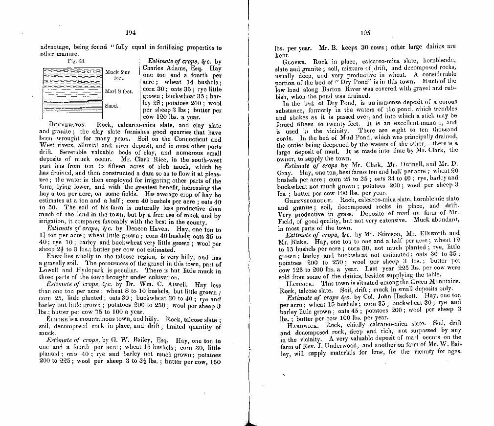
194
advantage, being found "fully equal in fertilizing properties to other manure.
Fig. 43. Estimate of crops, 8f c. by Charles Adams, Esq. Hay
Muk four one ton and a fourth per eet acre, wheat 14 bushels,
Marl 3 feet corn 30; oats 35; rye little grown; buckwheat 35; bar-
_____ Sand ley 28; potatoes 200; wool per sheep 3 lbs; butter per cow 120 lbs. a year.
DtTMMERSTON. Rock, calcareo-mica slate, and clay slate and granite; the clay slate furnishes good quarries that have been wrought for many years. Soil on the Connecticut and West rivers, alluvial and river deposit, and in most other parts drift. Severable valuable beds of clay, and numerous small deposits of muck occur. Mr. Clark Rice, in the south-west part has from ten to fifteen acres of rich muck, which he has drained, and then constructed a dam so as to flow it at pleas-ure; the water is then employed for irrigating other parts of the farm, lying lower, and with the greatest benefit, increasing the hay a ton per acre, on some fields. His average crop of hay he estimates at a ton and a half; corn 40 bushels per acre ; oats 40 to 50. The soil of his farm is naturally less productive than much of the land in the town, but by a free use of muck and by irrigation, it compares favorably with the best in the county.
Eslimate of crops, c. by Deacon Haven. Hay, one ton to 1 I ton per acre; wheat little grown; corn 40 bushels; oats 35 to 40; rye 10; barley and buckwheat very little grown; wool per sheep 21 to 3 lbs.; butter per cow not estimated.
EDEN lies wholly in the talcose region, is very hilly, and has a gravelly soil. The porousness of the gravel in this town, part of Lowell and Hydepark is peculiar. There is but little muck in those parts of the town brought under cultivation.
Estimate of crops, tjc. by Dr. Wui. C. Atwell. Hay less than one ton per acre ; wheat 8 to 10 bushels, but little grown; corn 25, little planted; oats 30 ; buckwheat 30 to 40 ; rye and barley but little grown ; potatoes 200 to 250; wool per sheep 3 lbs.; butter per cow 75 to 100 a year.
ELIoRE is a mountainous town, and hilly. Rock, talcose slate soil, decomposed rock in place, and drift; limited quantity of muck.
Estimate of crops, by G. W. Bailey, Esq. Hay, one ton to one and a fourth per acre; wheat 15 bushels; corn 30, little planted ; oats 40 ; rye and barley not much grown; potatoes 200 to 225; wool per sheep 3 to 3j lbs.; butter per cow, 150
195
lbs. per year. Mr. B. keeps 30 cows; other large dairies are kept.
GLOVER. Rock in place, calcareo-mica slate, hornblende, slate and granite ; soil, mixture of drift, and decomposed rocks, usually deep, and very productive in wheat. A considerable portion of the bed of " Dry Pond" is in this town. Much of the low land along Barton River was covered with gravel and rub-bish, when the pond was drained.
In the bed of Dry Pond, is an immense deposit of a porous substance, formerly in the waters of the pond, which trembles and shakes as it is passed over, and into which a stick may be forced fifteen to twenty feet. It is an excellent manure, and is used in the vicinity. There are eight to ten thousand cords. In the bed of Mud Pond, which was principally drained, the outlet being deepened by the waters of the other,—there is a large deposit of marl. It is made into lime by Mr. Clark, the owner, to supply the town.
Estimate of crops by Mr. Clark, Mr. Dvinell, and Mr. D. Gray. Hay, one ton, best farms ton and half per acre; wheat 20 bushels per acre; corn 25 to 35; oats 34 to 40; rye, barley and buckwheat not much grown ; potatoes 200; wool per sheep 3 lbs. ; butter per cow 100 lbs. per year.
GREENSBOR0UGFI. Rock, calcareo-mica slate, hornblende slate and granite ; soil, decomposed rocks in place, and drift. Very productive in grass. Deposite of marl on farm of Mr. Field, of good quality, but not very extensive. Muck abundant, in most parts of the town.
Estimate of crops, c. by Mr. Stirnson, Mr. Ellsworth and Mr. Blake. Hay, one ton to one and a half per acre; wheat 12 to 15 bushels per acre ; corn 30, not much planted ; rye, little grown ; barley and buckwheat not estimated; oats 30 to 35 potatoes 200 to 250; wool per sheep 3 lbs.; butter per cow 125 to 200 lbs. a year. Last year 225 lbs. per cow were sold from some of the driries, besides supplying the table.
HANCOCK. This town is situated among the Green Mountains. Rock, talcose slate. Soil, drift; muck in small deposits only.
Estimate of crops jc. by Cot. John Hackett. Hay, one ton per acre; wheat 15 bushels; corn 35 ; buckwheat 30; rye and barley little grown ; oats 45 ; potatoes 200; wool per sheep 3 lbs. ; butter per cow 100 lbs. per year.
HARDWICK. Rock, chiefly calcareo-mica slate. Soil, drift and decomposed rock, deep and rich, not surpassed by any in the vicinity. A very valuable deposit of mart occurs on the farm of Rev. J. Underwood, and another on farm of Mr. W. Bai-ley, will supply materials for lime, for the vicinity for ages.
196
Deposits of very rich nwck lie over the marl, and in many other places in the town. Many cattle of fine quality are reared for market.
Estimate of crops &j'c. by Col. Warner. Half the farms, 2 tons of hay per acre, average one ton and a halt'; wheat 20 bush-els per acre, or more; corn 50; oats 50; rye but little grown; bar. icy 25 to 30; buckwheat 25 to 40; potatoes 300 to 325 bushels per acre; wool per sheep 3 lbs.; butter per cow 175 to 200 lbs. per year.
HARTFORD. The rock is calcareo-mica slate, and clay slate. Soil, river deposit, alluvium and drift, generally of good quality. Considerable tracts of brown clay, which may he very advanta-. geously used to improve the sandy soil in the vicinity of the riv-ers. Small deposits of muck, but not numerous. Agriculture is here rapidly improving.
Estimate of crops by L. Hazen, Esq. Hay, best farms ton and a half per acre, average, one ton ; wheat 15 bushels per acre; corn 40 ; oats 40 ; rye 15 ; barley and buckwheat seldom grown ; potatoes 200; wool per sheep 2 34 lbs. (Merino and Saxony) ; butter per cow 100 lbs. per year.
HOLLAND. There is a beaver meadow in the west part of Holland, on the road from Morgan to Stanstead. It contains about 5 to 7 acres, and has been partially drained. The muck is from 2 to 3 feet deep, below which is a deposit of marl of equal depth, as stated by the owner, (i. e. when the muck is two feet, the marl below it is two feet, and when the muck is three feet, the marl is three feet). Considerable lime has been made here. It is burnt with wood in a kiln, (a layer of wood, then a layer of marl, &c.) The lime is of medium quality and sells at twenty five cents per bushel. The marl rests on blue clay and a clayey gravel.
HYDEPARK. This town is entirely in the talcose slate region. Soil, ancient river deposit, in many places covered with loose gravel. Some tracts of alluvium and brown clay. Several depos-its of muck, which are used to some extent.
Estimate of ciops by Mr. Matthews, Hon. N. P. Sawyer, and Joshua Sawyer, Esq. Hay, best farms ton and a half to 2 tons per acre, average ton per acre ; wheat 16 to 20 bushels corn 30 to 40; barley not much grown; buckwheat 25 to 30; rye 15; potatoes 200; wool per sheep 3 lbs.; butter per cow 75 to 100 lbs. per year.
JAMAIcA. Rock, mostly Green. Mountain gneiss and granite. Soil, on the river, drift and alluvium. Numerous small deposits of muck.
Estimate of crops 8.c. by N. Wyman, Esq. Hay, less than a ton per acre; wheat on the hills 15 bushels per acre; corn on
197
the river 50; rye 10 or 12; oats 40 to 50; barley and buck-wheat not grown; potatoes 150 to 200; wool per sheep 3 lbs.; butter per cow, not estimated.
KIRBY. See St. Johnsbury. LONDONDERRY. Rock, Green Mountain gneiss. Soil, of me-
dium quality, mostly drift, some alluvial tracts near streams. Small deposits of muck are considerably frequent.
Estimate of crops by J. Stewart, Esq. hay, rather less than a ton per acre; wheat 12 to 15 bushels; corn 30; oats 30 to 40 ; barley and buckwheat not grown ; potatoes 200 bushels per acre ; wool per sheep 3 lbs.; butter per cow not estimated.
LOWELL. This town lies wholly in the talcose slate region, and is, except the valley of the Missisco, mountainous. Soil, in this valley river deposit, drift and alluvium. It is of good quali-ty, and when well cultivated is very productive. Small deposits of muck in several places.
Estimate of crops 8f c. by T. Wolsey, Esq. hay, one ton per acre; wheat 20 bushels; corn 35 to 40; oats 40; rye 15; buckwheat 25; barley not grown frequently; potatoes 200; wool per sheep 31 lbs. ; butter per cow 100 lbs. per year. The farm of Mr. W. S. Flint, in this town is a specimen of what others might become by judicious husbandry. Mr. F. gives considerable attention to growing wheat. His average crop is 30 bushels per acre, on gravelly loam. He applies 20 loads of leached ashes, when the grass land is ploughed, and sows with wheat. The following year he uses 20 loads of barn manure per acre, and plants potatoes. The third year sows wheat and grass seed, and applies 100 lbs. plaster per acre. His crop of potatoes averages 350 bushels per acre, and hay 2 to 3 tons He has thirty acres of potatoes the present year.
LUDLOW. Rock, in this town, talcose slate and Green Moun-tain gneiss. Soil on the river, drift and river deposit, and nar-row tracts of alluvium. On land of J. Wellington, and Jesse and Ira Bailey, is a large deposit of muck, said to be of good quality.
Estimate of crops, 8,-c., by M. Spoffard, Esq., and Dea. Da-vison. Hay, less than one ton per acre ; wheat 12 to 15 bush-els; corn 25 ; oats 40 ; rye, buckwheat and barley, seldom grown ; potatoes 200 ; wool per sheep, 3 lbs.; butter per cow, 100 to 125 lbs. a year.
MARSHFIELD. Rock, calcareo-mica slate, and granite. This town is hilly ; soil, drift and decomposed rock in place, gener-ally strong and productive. One large deposit of muck near Mr. Dwinells', in the south-west part ; another containing 60 acres in the east part ; and numerous smaller deposits, are found in other places in the town. It has been but little used.
198
Estimate of crops, c., by J. L. Carpenter. Hay one ton per acre ; wheat 15 bushels; corn 25 ; oats 30 ; rye and barley but little grown ; potatoes 250 ; wool per sheep, 3 lbs.; butter per cow 100 lbs. a year.
MIDDLESEX. This town lies wholly in the talcose slate region. Soil, drift, liver (leposit and alluvium ; generally of medium qual-ity. Very little muck exists.
Estimate of crops, 8f c., by Holden Putnam, Esq. Hay, one ton and a quarter per acre; best farms, I I toils; wheat 13 or 14 bushels; corn 45; oats 50; rye, barley and buckwheat, little grown ; potatoes 200; wool 3 lbs. per sheep.
MONTPELIER. The rock in the easterly part of this town is calcareo-mica slate,and granite, and the west part talcose slate. Soil river deposit,alluvium, and loam from decomposition of the rocks in place ; usually very productive. Several small deposits of muck in different parts of the town, but not much employed as manure.
Estimate of crops, c., by D. Baldwin, Esq. Hay, best farms, 2 tons per acre—average for whole town, one ton and a half; wheat 7 bushels; corn 30 to 40; oats 40; rye 25; barley and buck-wheat, not estimated potatoes 200 ; wool per sheep, 3 lbs.; but-ter per cow, 150 to 180 lbs. a year. Deeper ploughing would greatly improve the productiveness of the soil, especially where the soil is clayey.
MORETOWN. The rock in place is talcose slate, principally. A range of steatite occurs in the central part, accompanied with serpentine. The soil is mostly drift, except in the valley of the Winooski and Mad rivers. The alluvial and river deposits in these portions of the town are very productive. Small deposits of muck are found in several places, but have been little used.
Estimate of crops, c., by Alpheus Bass, Esq. Hay one ton and a quarter per acre; wheat 10 to 12 bushels; corn 30; rye, barley and buckwheat, not grown; potatoes 200; wool 3 lbs. per sheep ; butter 112 to 125 per cow, or cheese 250 lbs. a year.
MORGAN. This town lies in the calcareo-mica slate region. Rock in the eastern part, grleiss ; soil, drift and alluvial, general-ly very productive when properly cultivated.
Estimate of crops, c., by Rev. J. L. Clark. Hay, one ton and a fourth per acre; wheat 15 to 20 bushels ; corn 40 ; oats 40 to 50; rye, none; barley 20; buckwheat 30 to 50; wool per sheep, 2 to 3 lbs.; butter per cow, 100 to 150 lbs. a year.
MoRRIsTowN. Rock in place, talcose slate ; soil, drift, river deposit and alluvial. Each of these varieties is of good quality, and the produce is large, generally. An extensive deposit of muck occurs near Joe's Pond, on the farms of Messrs. W. and L. Small and others. This pond, once doubtless covering a hundred acres
199
or more, is now reduced to two or three, and will eventually dis-appear entirely. The muck is very deep, and of excellent quali-ty. Its value to the surrounding region cannot be easily estitna-ted. Some smaller deposits are found in other parts of the town.
Estimate of crops, c., by lion. V. P. Noyes, J. Mills, Esq., L. Small, Esq., and Go]. Herrick. Hay, one ton and a quarter to one and a half per acre ; wheat 10 to 15 bushels; corn 40 to 50; oats 40 to 50; rye 20 to 30; buckwheat 30; potatoes 200; wool 3 lbs. per sheep; butter per cow, 100 to 140 lbs. a year.
NEWBURY. The rock is similar to other river towns. Soil, alluvial, river deposit and drift. The large amount of intervale has long rendered this one of the best agricultnral towns in the State. The proportion of valuable intervale is probably greater than in any other town ; but its productiveness without manure has probably considerably diminished. The hills and banks near the river are gravel with subsoil of clay. Upland soil is good, and generally productive.
Estimate of crops, 81'c., by W. U. Shedd, Esq., aad Col. Ten-nev. Hay, one ton and a half per acre; wheat 15 to 20 bushels; corn 40; buckwheat 25 to 30; rye and barley, little grown ; oats 40 to 50; potatoes 200; wool per sheep, 3 lbs.; butter per cow, 100 to 150 a year.
Estimate by H. Bailey, Esq., Great Oxbow. Hay 1 to 2 tons per acre ; wheat 20 bushels ; corn 40 to 50 ; oats 40, when not manured,-50 or more when land is manured. General course of cultivatiou —1st, oats without manure, on green-sward. 2d, potatoes or corn, and twenty to thirty loads of manure. 3d, wheat or oats, and grass seed. Land usually remains in grass S or 9 years.
NEWFANE. The rock in this town is, in the east part, calca-reo-rnica slate, and taicose slate in the west part. Soil, gravelly loam. Deposits of muck in several places of good quality. Con-siderable interest has been excited in agricultural improvements. Compost manure used considerably. Ashes very valuable. Dress-ing of clay would be very valuable.
Lstimate of crops, c., by C. K. Field, Esq. Hay, rather less than a ton per acre ; wheat 12 bushels ; corn 30 to 40 ; bar-ley 25 to 30; rye 10 to 15 ; wool per sheep, 3 lbs.; butter per cow, not estimated.
Noawica. Rock clay slate and calcareo-mica slate. Soil, alluvium, river deposit and drift. Deeper ploughing is much need-ed, to improve the productiveness of the soil in this town. Muck exists in a few places in the north part of the town.
Estimate of crops, by Col. A. Stimson. hay, one ton to tot] and a quarter per acre; wheat 15 bushels, corn 25 to 30; rye
200
16 to 20; oats 30; potatoes 250; wool per sheep, 3 lbs.; butter per cow, 125, lbs., or cheese 250 a year.
PELCJJAM. Rock calcareo-mica slate and granite. Soil deep loam, subsoil, generally rock. Several valuable and extensive deposits of marl are found. That on the farm of Mr. Johnson, is found below a bed of deep muck, and is eight or nine feet in thickness, and of good quality for making lime. Another large deposit is in Ladd's pond; smaller deposits occur elsewhere. In Hosmer pond, is a deposit of infusorial silica, estimated at more than 14,000 cords, though it would require millions of the animal-cules, of whose shells it is composed, to form a mass of the size of a pea!
Peacham abounds in large deposits of muck. The 'great bog,' in the south west part of the town covers an area of more than 200 acres, and is probably twenty feet in thiclness, and contains one and a half millions of cords. Other large deposits are found, like the meadow of Mr. Johnson, which will furnish an inexhaus-tible supply of the best of manure, for improving the fertility of the soil.
Estimate of crops, by Co!. Wm. Wheeler, and Dea. E. C. hamherlain. Flay, 1 ton per acre, best farms 2 tons; wheat 20
bushels per acre; corn 40; oats 30 to 40; barley, rye and buck-wheat, but little grown ; potatoes 300 ; wool per sheep 3 lbs.; butter per cow 100 to 150 lbs. a year.
It is very gratifying to learn, that there is an obvious improve-rnentin the agriculture of this town, and that the interest is in-creasing.
PLYMOUTH. Rock in this town, talcose slate and carbonate of lime. Soil, drift and decomposed rocks in place. Small tracts of alluvial soil near the pond and stream. A deposit of muck of good quality was examined on the farm of Rev. Mr. Baldwin, of six or eight acres, and several smaller deposits in other parts of the town, are said to b4 equally valuable.
Estimate of crops, ic. by Rev. Mr. Baldwin and others. Hay, I ton per acre; wheat 10 to 12 bushels per acre ; corn 35 to 40; rye 15 to 20; buckwheat 35 to 40; oats 35; potatoes 250; wool, per sheep 3 lbs.; butter per cow, not estimated.
PUTNEY. Bock clay slate, calcareo-tnica slate and gneiss. Alluvial and drift soil. The intervals are very productive, and the town generally has a good soil. A very valuable muck bed on the farm of Mr. A. Keyes, contains ten or twelve acres; this has been "found as valuable as the best barn manure." Some smaller deposits occur in other parts of the town, but not much used. Considerable interest exists with regard to agricultural improvements.
Estimate of crops by Dea. Crawford and others. Hay, 1 ton
201
and a quarter per acre; wheat, not much grown; corn 40 bush els; oats 40 to 50; rye 15; barley, none grown; potatoes 150 to 200 ; wool per sheep, 3 lbs. ; butter per cow, no estimate.
RANDOLPII. This town lies chiefly in the calcareo-mica slate region, and has many varieties of soil. On both the branches of White River, which passes through it, are considerable alluvial and river deposits. The central part has a deep and rich soil, formed of the decomposed rock in place and drift. Few towns are better adapted to agricultural purposes. Deeper ploughing and the application of clay to the gravelly tracts, occuring on the streams, would be greatly beneficial. Muck in small deposits is found in several places.
Estimate of crops, 8cc. by Win. Nutting, Esq. Hay, 1 tons per acre ; wheat 15 bushels; corn 40 to 50 ; oats 40; buckwheat 40 to 50; potatoes 250 to 300; wool per sheep, 3 lbs. ; butter per cow, 100 to 150 lbs. a year.
RocuEsTElt. Rock in place, talcose slate, in which beds of serpentine and steatite occur. Soil mostly drift. Considerable tracts of alluvial land occur on the streams. Soil generally good, though the town is very uneven. Deposits of muck in a few places only.
Estimate of crops, 4-c. by Hon. E. D. Briggs. hay, i tons per acre ; wheat not estimated; corn 40; oats 40; buckwheat riot estimated ; potatoes 200; wool per sheep, 3 lbs. ; butter per cow, not estimated.
ROCKINGHAM. Rock in place, calcareo-mica slate, and clay slate. Soil, alluvial, river deposits and drift. Intervals on the streams are valuable, and much of the land is adapted to agricul-ture. Beds of blue clay of considerable extent are found along the Connecticut River. Muck is found in a few places.
Estimate qf crops on the interval. Hay 1 I ton per acre; wheat not often grown ; corn 50 bushels ; rye 15 ; oats 50 ; po-tatoes 225 to 250; wool per sheep, 31, lbs.; land kept in grass three years, and then tilIed three years.
ROYALTON. Rock in place, clacareo-mica slate. Considera-ble interval on White River and its branches, and portions of the upland are well adapted to agriculture. Other portions of the soil are liable to leach, and are not very productive without conside-rable manure. There is a large and very valuable deposit of mail on the farm of Mr. 1)ewey. It was deposited in an ancient bea-ver pond, and is now very accessible. It will supply lime for the whole White River valley. Several valuable deposits of muck are found in the vicinity.
Estimate of crops, by II. Bingham, Esq. and others. Hay, less than one ton per acre, best farms one ton and a half; wheat 12 to 15 bushels; corn 30; oats 25 to 30; buckwheat 20; rye
23
202
10; potatoes 150; wool per sheep, 3 lbs.; butter per cow, '75 to 100 lbs. a year.
RYECiATE. Rock calcareo-mica slate and granite. There is very little interval in this town ; considerable deposits of brown and blue clay near the river. A very valuable deposit of muck occurs on the farm of J. Cameron and others, and many smaller deposits elsewhere. rFhle land is generally uneven, but well adapted to grazing. Cows are the principal stock. Deep plough-ing has been proved exceedingly beneficial.
Estimate of crops, c. by John Cameron, Esq. Hay, 11, tons per acre ; wheat 15 to 20 bushels, (considerable grown ;) corn 25 to 30; barley, rye and buckwheat seldom grown ; oats 40 potatoes 250 ; wool per sheep, 3 lbs. ; butter per cow, 150 to 175 lbs. a year.
ST. JOHNSrnJRY, (East), and Kinay. The range of clay slate found usually bordering on the Connecticut river, below the mouth of the Passumpsic, continues a northerly course through the west part of Waterford, east part of St. Johnsbury, and cen-tral part of Kirby, rising in high bluffs in these places. The other rocks are those common to the region. The soil, excepting small tracts of alluvial and river deposit, is drift of good quality. Muck is common in small beds, and is used much more than formerly.
Estimate of crops, by Seth Borroughs, Esq., Hon. C. Morrill, and Isaac Harrington, Esq. Hay, one ton per acre, - best farms, one and a half; wheat 15 bushels; corn 30; oats 30 ; buck-wheat 30 to 40; potatoes 200; wool 2- to 3 lbs. per sheep; but-ter per cow, 100 lbs. a year.
ST. JOHNSBURy, (Plain.) This town is in the calcareo-mica slate region. Being watered by the Passumpsic and Moose riv-ers, it has a considerable amount of alluvial and river deposits. The soil in the more elevated portions, is drift united with the decomposed rock in place, and is generally productive. It resembles very nearly the soil of other towns where blue lime-stone is the principal rock. A deposit of marl has recently been found on the farm of Hon. E. Paddock, from which a good qual-ity of lime may be manufactured, for the supply of this portion of the State. Muck of good quality, occurs in many places, and is beginning to be employed to considerable extent. Interest in agricultural improvements is rapidly increasing.
Estimate of crops, by Joseph Fairbanks, Esq. Hay, one toti per acre—best farms, one and a half; wheat 161.018 bushels;
fOr. William Gibson emigrated to this town from Scotland in 1501, with seven Sons, and was able to purchase only one lot of land, on which lie settled. He deceased in 1845, at which time it was supposed that he and his descendants owned property to the value of half the town. This property has been acquired by agricultural industry, and chiefly from the profits of the dairy.
20:3
corn 30 to 35,—river farms, 50,to 60 ; rye 10 to 12 ; oats 35 potatoes 150 to 200.
SoIcRsET. Rock, Green Mountain gneiss. This is a hilly town, but has a good soil for grass, &c.
Estimate of crops, by H. I-Tall. Hay, one ton and a half per acre ; vlieat 20 bushels ; corn 25 to :30 ; rye 20 ; oats 40 ; wool per sheep, 2 to 3 lbs.; butter per cow, 100 to 125 lbs. a year.
ST0cKBIcTDGF.. Rock, talcose slate. Soil, drift and some allu-am on t lie river, subsoil gravel. Estimate of crops, by Dr. F. P. Fay, and - Morgan, Esq.
Flay one toil per acre ; wheat 15 bushels ; corn 30 ; rye 15 ; oats 35 to 40; potatoes 200 ; wool per sheep, 3 lbs.; butter per cow, 15 to 100 lbs. a year.
SI'RTNOFIELD. Rock in place, calcareo-mica slate principal-
ly. Soil, alluvial, river deposit and drift ; generally well adapt- ed to agriculture. Several beds of muck, very valuable. One on the farm of Dr. Chase, of several acres. A heavy (Iressing of clay on the sandy tracts near the Connecticut river, would be greatly beneficial. Beds of both brown and hitie clay are fre-quent. The interest in improvements in agriculture is rapidly increasing in this town.
Estimate of crops, by E. Whitney, Esq., Dr. Chase and oth-ers. hay one ton or less per acre; wheat 20 bushels, on the hills ; corn 30 to 40; oats 40 to 50; potatoes 150, perhaps more; Many sheep kept, wool per head, (Saxony and Merino), 3 lbs.; butter per cow, 6 lbs. per week, or 120 lbs. a year.
STOW. This tow!) is wholly in the talcose slate region ; but a considerable portion was probably covered by the waters of an ancient lake, once existing between Mansfield, Sterling, and Worcester mountains. Much of time soil is alluvial or clayey. It is highly productive. Drift soil occurs in the more elevated portions, similar to that generally in time talcose slate region.
Estimate of crops, c.,'hy Noah Robinson, Esq., Nathan Rob-inson, Esq., and Dea. L. S. Binghiam. Hay ton and a quarter to ton and a half per acre ; wheat 15 to 20 bushels ; corn 45 ; oats 35 to 40 ; rye 10 ; buckwheat 30 or over ; potatoes 200 to 300 wool per sheep, 3 lbs.; butter per cow, 150 lbs. a year.
Tilerroit). Rock, calcarec-mica slate. Considerable alluvial soil and river deposit on the Coutmeeieut river, and do ft on the Ompommipammoos'k. lull lands, deep ioiui generally. Small de-posits of muck in several places, beginning to be used consider-ably by some.
Estimate of crops, by Mr. -- hail, Union Village. Hay, one ton per acre ; wheat 12 to l bushels corn 35 ; oats 40; rye 1510 20 ; potatoes 200 ; wool 2: lbs. per sheep ; butter per cow 100 to 12C lbs a year.
i
204
TOWNSHEND. The rock in this town is the calcareo-mica slate, and gneiss. Soil mostly drift, and loam from the decomposition of the rock, and usually of very good quality. On the river are narrow tracts of interval, and some deposits of clay, which will be of great value if applied to the sandy lands, as a dressing, Considerable muck occurs in small deposits.
Average of crops, c., by Messrs. C. Gaffleld, P. How, J. Jamieson, and Dr. Hyde. Hay one ton per acre; wheat, grown only on the hills, 15 to 25 bushels ; corn 30 to 40; oats 40 ; rye 15 to 20; barley 0; potatoes 150 to 200; wool per sheep 3j lbs. (native and Irish).
TRoT. This town is long and narrow, lying in the Missisco valley. Rock, talcose slate, serpentine, and steatite. Soil, allu vium and drift, and of excellent quality. When under good cul-tivation it is very productive. Many deposits of muck occur, but none large, and not as yet much used.
Estimate of crops, c., by E. Elkins, Esq., North Troy. Hay, best farms, q tons, average ton and a half; wheat 10 to 12 bushels; corn 40; oats 30 to 40; rye 25 to 30; buckwheat 50; potatoes 250; wool per sheep, 3 lbs.; butter per cow, 150 lbs. a year. -
TUNBUIDGE. This town is wholly in the calcareo-mica slate region. Considerable interval on the Branch, and some deposits of clay. Soil, generally drift and not very retentive; would be greatly improved by deeper plowing. A small deposit of marl, and several deposits of muck, occur.
Estimate of crops, by Orison Foster, Esq. Hay less than one ton per acre, best farms, ton and a half; wheat 12 to 15 bushy els; corn 30; oats 35; barley 12 ; wool per sheep, 2 lbs; but-ter per cow, 75 lbs. a year.
WAITSFIELD. Rock in place, talcose slate. That part of the town lying in the valley of Warren river, has an excellent soil. It was doubtless, formerly covered by the waters ofa lake that has entirely disappeared. Considerable quantities ofmuck exist near the river ; also tracts of brown clay.
Estimate of crops, by Julian Dumas, Esq. Hay, one ton and a half per acre; wheat 12 to 15 bushels ; corn 30 to 40; oats 35 ; rye, barley and buckwheat, little grown ; potatoes 200 wool per sheep, 2j to 3 lbs.; butter per cow 130 lbs. a year.
WALDEN. Rock in place, calcareo-rnica slate. Soil, drift and loam from decomposed rock. A very valuable deposit of marl, on the borders of Lyfoid's pond, furnishes an excellent material for making lime, in any quantity required. There are many depos-its of muck, and some of excellent quality, but little used as yet, except by a few farmers.
205
Estimate of crops, by L. Farrington, Esq. Hay, ton and a quarter to ton and a half per acre; wheat 15 to 20 bushels; corn 20; rye, none; oats 30 to 40; barley 25; wool per sheep 3 lbs.; butter per cow 120 to 130 lbs. a year.
WARDSBOROUGI-1. Rock, Green Mountain gneiss. Soil,drift prin-cipally. The town is very uneven, but the soil retentive and pro-duces good wheat and hay. Small deposits of black muck are frequent, which is used much more than formerly.
Estimate of crops, by John Tafts, Esq. Hay, one ton, per-haps less, per acre ; wheat 15 to 20 bushels ; corn 35 ; rye 15; oats 35 to 40; wool 31 lbs. per sheep; butter per cow, 100 lbs. or over, a year.
WARREN. Rock in place, talcose slate and Green Mountain -gneiss. The soil is mostly drift, and of medium quality. Small deposits of muck occur, but have not been much improved as ma-nure.
Estimate of crops, by W. Cardell, Esq., and others. Hay, one ton per acre; wheat 12 bushels; corn 25 ; oats 25 to 30; rye, buckwheat and barley, little grown : potatoes 130 to 150; -wool 3 lbs. per sheep; butter per cow, 100 lbs. or more, a year.
WAsHINGToN. Rock, calcareo-mica slate, and granite, very rapidly decomposing. Soil deep and rich in many places ; in others, gravelly drift. The town is elevated and uneven. De-posits of muck not very large, nor frequent.
Estimate of crops, by G. R. Gale, Esq. Hay, one ton or less per acre; wheat 18 bushels; corn 25; oats 30; buckwheat 30; barley 25; potatoes 250; wool per sheep 3 lbs.; butter per cow 150 to 175 lbs. a year.
WATERBURY. This town is principally in the talcose slate re-gion; green mountain gneiss occurs in the west part. Soil, drift, river deposit and alluvium ; the latter is considerable and of good quality ; brown clay occurs near the streams in tracts of some extent. The town is well adapted to agriculture, being less bro-ken than others in the vicinity. Several deposites of muck ex-ist which are becoming more highly prized than formerly. Crops generally heavy.
Estimate of crops, c. by J. Simpson, Esq. and others. Hay I j tons per acre ; wheat, 20 bushels; corn 40 ; rye 25 ; oats 40 barley 30; buckwheat, 35; potatoes 200.
WATERF0RD. Rock in place, calcareo-mica slate, clay and talcose slate. The soil near the stream is river deposit and drift small tracts of interval are found in several places. The town is -hilly, and the soil generally drift, of good quality. Several de-posits of muck occur: some farmers are beginning to estimate as important sources of manure.
Estimate of crops, jc. by J. Works, Esq. Hay one ton per
acre ; wheat 15 to 20 bushels per acre; corn 30, (river farms probably 40); rye, buckwheat and barely not estimated ; oats 30 to 40 ; potatoes 200 to 250 ; wool to 3 lbs. per sheep; butter per cow 100 lbs. a year.
WEATHERSFIELI. Rock, calcarco-mica slate, and gneiss. Soil, alluvium, river deposit and drift. The intervales are sonic-what large and very productive. The upland generally has a good soil. The first uplifts from the intervales are sandy, and without admixtures of clay will not be very productive, but by the free use of clay may be made very valuable. I visited the farm of Hon. W. T. Jarvis, to whom, with many others who have kindly assisted me in my investibmtions, I am placed under many obliga-tions. The farm of Mr. Jarvis, consists of 180 acres of inter-vale, 124 of plain, and the remanirler, about 800 acres, of upland, lying farther back from the river. Tie has 350 acres of tillage land, under the plough and scythe. His annual crop is,— coin 1-200 bushels ; wheat 150 bushels ; oats 1000 ; rye 100 ; potatoes 1000 to 1500 ; hay 250 tons. Average yield of wheat, 18 bushels per acre ; corn 50 ; oats 70 ; hay one ton and a half per acre. I -Ic usually plants on green-sward, and sows grain and grass seed the next year, then mows three years. It is not so much the object of Mr. Jarvis to produce very large crops, as to obtain medi-um crops, with the least expense for labor &c. He applies thir-ty to forty loads of barn manure per acre, to land when planted, and three or four bushels of ashes to the grain crop. Mr. J. has done very much to improve the breed of sheep in this coun-try. He first introduced the Merino, from Spain. While resi-dent there, he purchased and sent five or six thousand to the United States. his present flock is one thousand, which yields, of the finest wool, 3 lbs. per sheep. Mr. J. has used consider-able effort to introduce the Arabian breed of horses, as a cross with the native breed. lie has some fine specimens in his sta-bles, both for the saddle and harness.
WESTMINSTER. Rocks in place, clay slate, calcareo-mica slate; gneiss also occurs in the %vest part. Soil, alluvium, river deposit and drift. Below the loam on the upland, as I was informed by Hon. %Vm. C. Bradley, is a stratum of gravel lying on blue clay and this resting on quicksand. Westminster will compare favor-ably with any town in this section of the country. it lies most-ly on a plain, surrounded by semi-circular ranges of hills of moderate elevation ; of these they are three ranges, ptuallel to each other, with considerahla vilhes between them—the western range is much the inott elevated.—these ranges extend into Put-ney on the south and Rockingliam on the north. Muck is Con-siderably abundant and much used ; a bed of marl, it is said, is found in the west part of the town, on the ftrm of Mr. Wilcox,
207
but was not examined. Interest in agricultural improvement is rapidly advancing.
Estimate of crops, by John May, Esq. hay i tons per acre: wheat but little erowncorn 40 to 50 bushels ; oats 40 ; rye 10 to 15 ; potatoes 200; wool per sheep 3 lbs., (Merino and Saxony) ; butter per cow not estimated.
W'ESTMORE. Rock , granite principally. Soil, drift. The town but sparsely settled. There is a deposit of irifusorial silica south of the lake ; muck of limited extent is found in several places.
Estimate of crops, 'c. by S. Bishop. Hay If tons per acre ; wheat 15 to •20 bushels ; corn 30 ; oats 30 ; potatoes 150 ; wool per sheep 2 to 3 lbs.; butter per cow 100 lbs. a year.
WILLIAMSTOWN. The rock in this town is calcareo-mica slate, very rapidly decomposing. Soil is deep, very productive and well adapted to wheat, grass. &c. The immense deposit of marl on the farm of Messrs. Kinsman, (probably the largest in the state not covered by water), will furnish an adequate supply of lime for the surrounding region, for many centuries. Many valuable deposits of muck are found in different parts of the town.
Estimate of crops, by Mr. Kinsman and E. Gale, Esq. Hay 11 tons per acre ; wheat 16 to 20 bushels ; corn 35 to 40 ; oats 30 ; barley not much grown ; buckwheat 40 ; potatoqs 200-many are grown for making starch ; wool per sheep 3 lbs.; butter per cow 100 to 125 lbs. a year.
MTINDHAI. Rock, generally talcose slate. Soil mostly drift. The town is hilly, and the soil generally retentive. Muck de-posits not frequent.
Estimate of crops, c. by Rev. Mr. Arms. Hay one ton per acre ; wheat 12 to 15 bushels ; rye not grown ; corn 30 ; oats 36 ; potatoes 250 ; wool per sheep 3 to 3 lbs. (native and Me-rino) ; butter per cownot estimated.
WINDSoR. Rock in place, calcarco-rnica slate and clay slate. Soil alluvial, river deposit and drift. The amount of inverval is flot large ; many beds of clay occur which might be very advan-tageously applied to the gravely soil, on the fimst uplifts from the intervals. In the west part of the town a good deposit of marr was examined on land of Mr. Samuel Myrick ; it contains some two acres ; another deposit, it is said, is found in the same neigh-borhood. Muck is found in the west part of the town, in many places. -
No estimate of crops was received. Agricultural productions will compare favorably with other
208
towns in the vicinity ;—'corn and oats, probably 50 bushels each hay one ton and a half per acre.
WooDBuaY. This town is in the calcareo-mica slate region. A range of granite passes through it. Soil, drift and decom-posed rocks in place ;—the surface is uneven. It contains nu-merous ponds, on the borders of which are large supplies of muck.
Estimate of crops, by Mr. Cilley. Hay 1 I tons per acre; wheat 12 bushels ; corp 30; rye 10 to 12 ; oats 30 to 35 ; bar-ley 20 ; potatoes 200; wool per sheep 3 lbs ; butter per cow 100 lbs. a year.
WOODSTOCK. Rock, calcareo-mica slate. Soil, gravelly loam or drift generally; some tracts of alluvium on the rivet' are of good quality. There is a very valuable deposit of marl on the farm of Hon. C. Marsh, covering twelve to fifteen acres ; the marl is probably six to ten feet deep, lying beneath muck. Here was a small natural pond, very much enlarged doubtless by a beaver darn ; the muck is three or four feet in depth above the marl, and of excellent quality. A supply of the best of lime may here be made for the county, and manure for the town, for ages ; oth-er deposits of muck of smaller extent occur. Visited the farm of Mr. Gushing, one mile east of the village, consisting of twenty-five acres of interval, and two hundred and seventy-five of up-land. Mr. C. purchased of this farm one hundred acres twenty-one years ago, and was able to pay only a fourth part of the value ; it was in a very impoverished state. He has since added-two hundred acres adjoining, and purchased a back farm and pas-ture, and has brought the whole into a high state of cultivation and now keeps a flock of five hundred and fifty sheep, beside other stock ;—he has erected barns and other buildings adequate to the exigencies of the farm—thus developing a specimen of thrift and agricultural enterprise, very instructive to the young men of the State. Mr. C. makes it an object to raise wool of the best quality. Average of hay, one and a half tons per acre He succeeds well with winter wheat and obtains twenty bushels per acre ; corn thirty to fifty.
WOLCOTT. Rock, talcose slate. Soil, drift, river deposit and-narrow tracts of alluvium on the streams. Small deposits of muck were noticed.
Estimate of crops, 'c. by R. Hutchins and J. Hutchins, Esq. 1-lay one ton per acre ; wheat 12 to 15 bushels ; corn 30 to 40 oats 30 to 40 ; barley, buckwheat and rye seldom grown ; pota toes 150 ; wool per sheep 3 lbs.; butter per cow 100 to 150 lbs a year.
WoRcEsTER Rock in place, talcose slate. The town is very hilly and broken. Soil on the streams generally drift and allu
209
viom of good quality. One very large deposit of muck, and others smaller occur, not however much used as manure.
Estimate of crops by Mr. Rice, and Milton Brown, Esq. Hay one and a fourth to one and a half tons per acre; wheat 12 to 15 bushels; corn 30 to 35; barley 30; buckwheat 30; Rye not cultivated; potatoes 200 to 300 per acre; wool per sheep 2J to 3 lbs.; butter per cow 120 a year.
Remarks. in giving the estimate of crops, &c., when differ-ent individuals in any town disagreed with each other in amounts, the lowest and highest are usually stated.
inquiries have been extended to the methods adopted for pre-serving manure, especially the urine of cattle, by the construction of cellars under stables. Such means have been provided in only a few instances in that part of the State which I have vis-ited. This is inexplicable, as but few intelligent farmers are ignorant of the fact that urine has greater fertilizing properties than solid manure. The expense of the construction of such cellars is so little, and as common soil, when dried and placed in such cellars, during the winter, (when muck cannot be obtained for that purpose,) is worth quite as much as manure from stable windows, it is surprising that so few have been constructed. This neglect has doubtless been attended with a loss of many hundred thousand dollars to the people of the State, in the value of agricultural products that might have been secured. The ex-posure of manure, thrown from stables, to the influence of the sun and rains, without covering, occasions a great waste of the ferC tilizing salts contained in it, especially ammonia. The value of manure, protected from the weather, is nearly twice as great, as when exposed in the usual manner. Ample means are available, to most of those making agriculture their business, for augment-ing the produce of land, now under cultivation, 50 or 100 per cent. The great difference observable in the crops of farms sim-ilar in soil, &c., justifies this conclusion. Attention to this sub-ject is increasing, but far less So than true economy demands of a people proverbial for economizing in most other respects.
By the analyses of different kinds of grain,&c., the importance of certain elements in the soil is made apparent. The following analyses of the more important grains, also of the various kinds of manure, that may be most readily applied as fertilizers, will be conducive to the Ol)jects contemplated by the department of the geological survey assigned to me. These analyses of grains and straw are taken from Sprengel. The figures in the several columns indicate the number of pounds contained in one thou-sand pounds of the 'articles named in the first column.
27
I
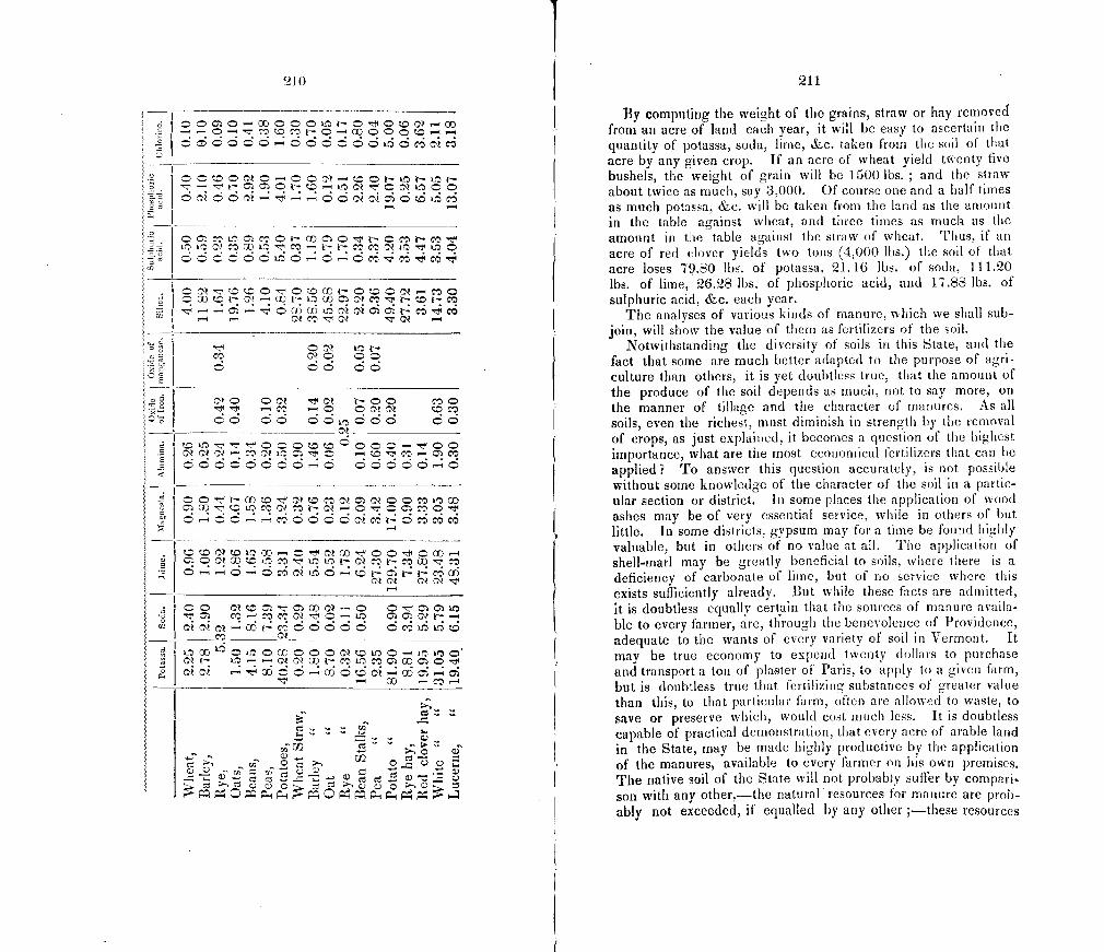
210
C.)
a - — —
C W N C'l ° L CD C C N N
—VMVV —
C V LN CC
CCL©C 6 CC
ci C C c—c .5 CC. -4 C -C
.5
•' i
'-4
• CC C C -C CCCf LC C C Ci t- -
f2 -G)N O CC
------
C'lt- Lr,,-
c'l — co —-
cc
CS....'. C-)
rJ'
Cd Cd 5) CS C)C)C.C) C5))C
211
By computing the weight of the grains, straw or hay removed from an acre of land each year, it will be easy to ascertain the quantity of potassa, soda, lime, &c. taken from the soil of that acre by any given crop. If an acre of wheat yield ti.enty five bushels, the weight of grain will be 1500 lbs. ; and the straw about twice as much, say 3,000. Of course one and a half times as much potassa. &c. will be taken from the land as the amount in the table against wheat, and three times as unick as the amount in the table against the straw of wheat. Thus, if an acre of red (lover yields two tons (4,000 lbs.) the soil of that acre loses 79.80 lbs. of potassa, 21.16 lbs. of soda, 111.20 lbs. of lime, 26.28 lbs. of phosphoric acid, and 17.88 lbs. of sulphuric acid, &ç. each year.
The analyses of various kinds of manure, which we shall sub-join, will show the value of them as fertilizers of the soil.
Notwithstanding the diversity of soils in this State, and the fact that some are much better adapted to the purpose of agri-culture than others, it is yet doubtless true, that the amount of the produce of the soil depends as much, not to say more, on the manner of tillage and the character of manures. As all soils, even the richest, must diminish in strength by the removal of crops, as just explained, it becomes a question of the highest importance, what are the most economical fertilizers that can he applied? To answer this question accurately, is not possible without some knowledge of the character of tile soil in a partic-ular section or district. In some places the application of wood ashes may be of very essential service, while in others of but little. In some districts, gypsum may for a time be fouad highly valuable, but in others of no value at all. Time application of shell-marl may be greatly beneficial to soils, where there is a deficiency of carbonate of lime, but of no service vliere this exists sufficiently already. But while these facts are admitted, it is doubtless equally cert,ain that the sources of manure availa-ble to every farmer, are, through the benevolence of Providence, adequate to the wants of every variety of soil in Vermont. It may be true economy to expend twenty dollars to purchase and transport a ton of plaster of Paris, to apply to a given farm, but is doubtless true that fertilizing substances of greater value than this, to that particular farm, often are allowed to waste, to save or preserve which, would cost much less. It is doubtless capable of practical demonstration, that every acre of arabic laud in the State, may be made highly productive by the application of the manures 1 available to every farmer on his own premises. The native soil of the State will not probably suffer by compari son with any other,—the natural resources for manure are prob-ably not exceeded, if equalled by any other ;—these resources
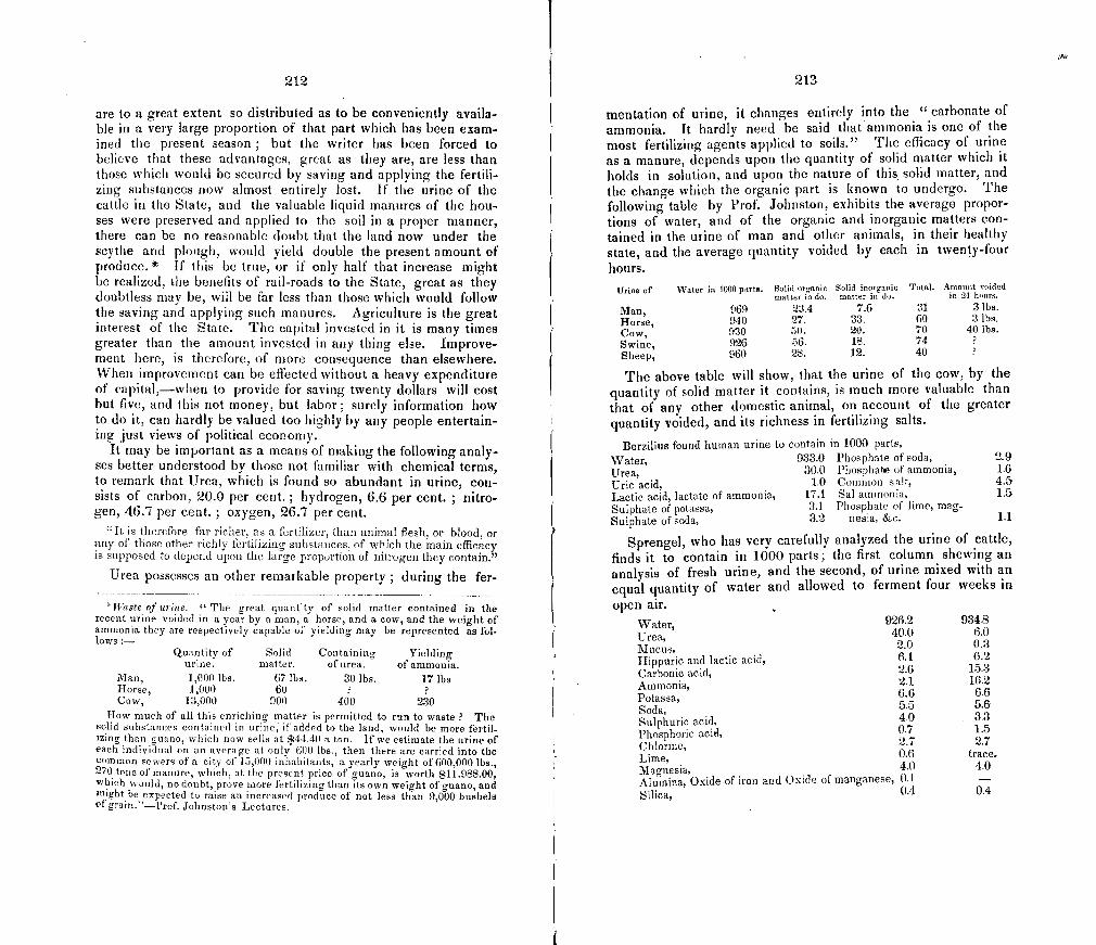
212
are to a great extent so distributed as to be conveniently availa-ble in a very large proportion of that part which has been exam-ined the present season ; but the writer has been forced to believe that these advantages, great as they are, are less than those which would be secured by saving and applying the fertili-zing substances now almost entirely lost. If the urine of the cattle in the State, and the valuable liquid manures of the hou-ses were preserved and applied to the soil in a proper manner, there can be no reasonable doubt that the land now under the scythe and plough, would yield double the present amount of produce. * If this be true, or if only half that increase might be realized, the benefits of rail-roads to the State, great as they doubtless may be, will be far less than those which would follow the saving and applying such manures. Agriculture is the great interest of the State. The capital invested in it is many times greater than the amount invested in any thing else. Improve-rnent here, is therefore, of more consequence than elsewhere. When improvement can be effected without a heavy expenditure of capital,-when to provide for saving twenty dollars will cost but five, and this not money, but labor; surely information how to do it, can hardly be valued too highly by any people entertain-ing just views of political economy.
It may be important as a means of making the following analy-ses better understood by those not familiar with chemical terms, to remark that Urea, which is found so abundant in urine, con-sists of carbon, 20.0 per cent. ; hydrogen, 6.6 per cent. ; nitro-gen, 46.7 per cent.; oxygen, 26.7 per cent.
"It is therefore far richer, as a fertilizer, than animal flesh, or blood, or any of those other richly fertilizing substan ces, of which the main efficacy is supposed to depend upon the large proportion of nitrogen they contain."
Urea possesses an other remarkable property ; during the fer-
Waste of urine. " The great quantity of solid matter contained in the recent urine voided in a year by a juan, a horse, and a cow, and the weight of ammonia they are respectively capable of yielding may be represented as fol-lows :-
Quantity of Solid Containing Yielding urine, matter, of urea. of ammonia.
Man, 1,000 lbs. 67 lbs. 30 lbs. 17 lbs Horse, 1,000 60 Cow, 13,000 900 400 230
How much of all this enriciong matter is permitted to run to waste ? The solid substances contained in urine, if added to the land, would be more fertil-izing than guano, which now sells at $4440 a ton. If we estimate the urine of each individual on an average at only 600 lbs., then there are carried into the common sewers of a city of 15,000 inhabitants, a yearly weight of 600,000 lbs., 270 tons of manure, which, at the present price of guano, is worth $11.988.00, which would, no doubt, prove more fertilizing than its own weight of guano, and might be expected to raise an increased produce of not less than 9,000 bushels of grain:'.... prof. Johnston's Lectures,
213
mentation of urine, it changes entirely into the CC carbonate of ammonia. It hardly need be said that ammonia is one of the most fertilizing agents applied to soils." The efficacy of urine as a manure, depends upon the quantity of solid matter which it holds in solution, and upon the nature of this solid matter, and the change which the organic part is known to undergo. The following table by Prof. Johnston, exhibits the average propor-tions of water, and of the organic and inorganic matters con-tained in the urine of man and other animals, in their healthy state, and the average quantity voided by each in twenty-four hours.
Urine of \Voter in 1000 parts. Solid organic Solid inorganic Total. Amount voided mattel' is do. matter in do. in 04 hr,nro.
Man, 969 23.4 7.6 31 3 lbs.
Horse, 940 27. 33. 60 3 lbs.
Cow, 930 50. 20. 70 40 lbs.
Swine, 926 56. 18. 74 Sheep, 960 28. 12. 40
The above table will show, that the urine of the cow, by the quantity of solid matter it contains, is much more valuable than that of any other domestic animal, on account of the greater quantity voided, and its richness in fertilizing salts.
Berzilius found human urine to contain in 1000 parts,
Water, 933.0 Phosphate of soda, 2.9
Urea, 30.0 Phospha of ammonia, 1.6
Uric acid, 1.0 Common salt, 4.5 Lactic acid, lactate of ammonia, 17.1 Sal ammonia, 1.5
Sulphate of potassa, 3.1 Phosphate of lime, mag-
Sulphate of soda, 3.2 nesia, &c. 1.1
Sprengel, who has very carefully analyzed the urine of cattle, finds it to contain in 1000 parts; the first column shewing an analysis of fresh urine, and the second, of urine mixed with an equal quantity of water and allowed to ferment four weeks in open air.
Water, 926.2 934.8
Urea, 40.0 6.0
Mucus, 2.0 0.3
1-lippuric and lactic acid, 6.1 6.2
Carbonic acid, 2.6 15.3
Ammonia, 2.1 16.2
Potassa, 6.6 6.6
Soda, 5.5 5.6
Sulphuric acid, 4.0 3.3
Phosphoric acid, 0.7 1.5
Chlorine, 2.7 2.7
Lime, 0.6 trace.
Magnesia, 4.0 4.0 Alumina, Oxide of iron and Oxide of manganese, 0.1 Silica, 0.4 0.4
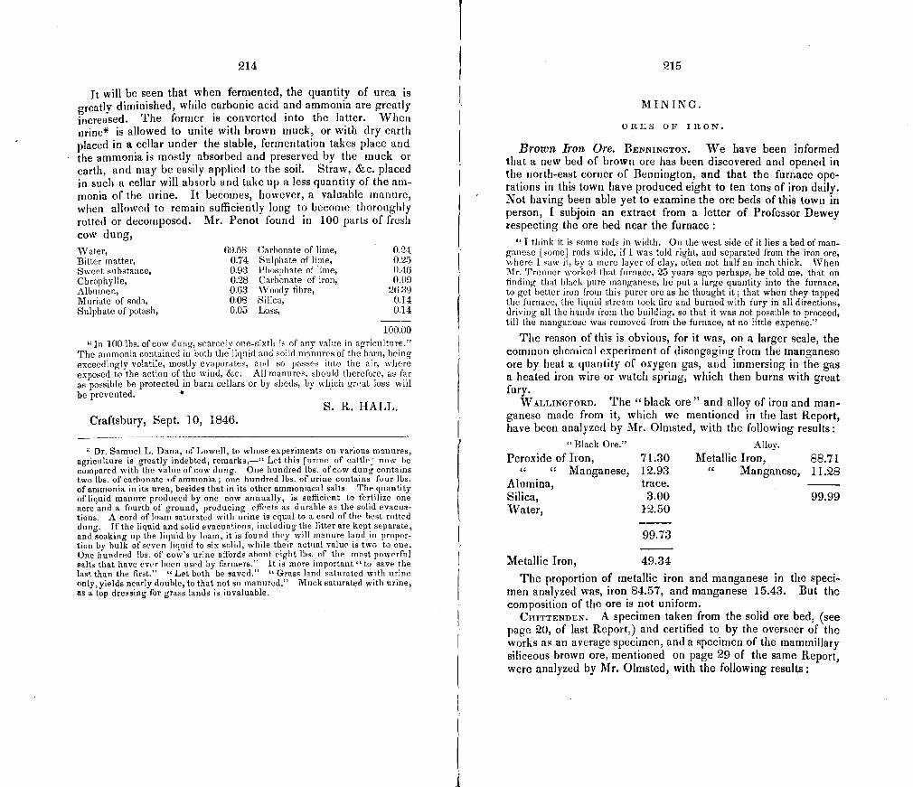
214
It will be seen that when fermented, the quantity of urea is greatly diminished, while carbonic acid and ammonia are greatly increased. The former is converted into the latter. Milieu ur i ne* is allowed to unite with brown muck, or with dry earth placed in a cellar under the stable, fermentation takes place and the ammonia is mostly absorbed and preserved by the muck or earth, and may be easily applied to the soil. Straw, &c. placed in such a cellar will absorb and take up a less quantity of the am-monia of the urine. It becomes, however, a valuable manure, when allowed to remain sufficiently long to become thoroughly rotted or decomposed. Mr. Penot found in 100 parts of fresh cow dung, Water, 69.58 Carbonate of lime, 0.24 Bitter matter, 0.74 Sulphate of lime, 0.25 Sweet substance, 0.03 Phosphate of lime, 0.46 Chrophylle, 0.28 Carbonate of iron, 0.09 Albumen, 0.63 Woody fibre, 2639 Muriate of soda, 0.08 Silica, 0.14 Sulphate of potash, 0.05 Loss, 0.14
100.00
"In 100 lbs. of cow dung, scarcely one-sixth is of any value in agriculture." The ammonia contained in both the liquid and solid manures of the barn, being exceedingly volatile, mostly evaporates, and so passes into the air, where exposed to the action of the wind, &c. All manures, should therefore, as far as possible be protected in barn cellars or by sheds, by which great loss will be prevented.
S. R. HALL. Craftsbury, Sept. 10, 1846.
Dr. Samuel L. Dana, of Lowell, to whose experiments on various manures, agriculture is greatly indebted, remarks,—" Let this [urine of cattle] now be compared with the value of cow dung. One hundred lbs. of cow dung containS two lbs. of carbonate of ammonia; one hundred lbs. of urine contains four lbs. of ammonia in its urea, besides that in its other ammoniacal salts. The quantity of liquid manure produced by one cow annually, is sufficient to fertilize one acre and a fourth of ground, producing effects as durable as the solid evacua-tions. A cord of loam saturated with urine is equal to a cord of the best rotted dung. If the liquid and solid evacuations, including the litter are kept separate, and soaking up the liquid by loam, it is found they will manure land in propor-tion by hulk of seven liquid to six solid, while their actual value is two to one. One hundred lbs. of cow's urine affords about eight lbs. of the most powerful salts that have ever been used by farmers." It is more important "to save the last than the first." "Let both be saved." "Grass land saturated with urine only, yields nearly double, to that not so manured." Muck saturated with urine, as a top dressing for grass lands is invaluable.
215
MINING.
ORES OF IRON.
Brown Iron Ore. BENNINGTON. We have been informed that a new bed of brown ore has been discovered and opened in the north-east corner of Bennington, and that the furnace ope-rations in this town have produced eight to ten tons of iron daily. Not having been able yet to examine the ore beds of this town in person, I subjoin an extract from a letter of Professor Dewey respecting the ore bed near the furnace:
"I think it is some rods in width. On the west side of it lies a bed of man-ganese [some] rods wide, if I was told right, and separated from the iron ore, where I saw it, by a mere layer of clay, often not half an inch thick. When Mr. Trenner worked that furnace, 25 years ago perhaps, he told me, that on finding that black pure manganese, he put a large quantity into the furnace, to get better iron from this purer ore as he thought it; that when they tapped the furnace, the liquid stream took fire and burned with fury in all directions, driving all the hands from the building, so that it was not possible to proceed, till the manganese was removed from the furnace, at no little expense."
The reason of this is obvious, for it was, on a larger scale, the common chemical experiment of disengaging from the manganese ore by heat a quantity of oxygen gas, and immersing in the gas a heated iron wire or watch spring, which then burns with great fury.
WALLINGFORD. The 11 black ore" and alloy of iron and man-ganese made from it, which we mentioned in the last Report, have been analyzed by Mr. Olrnsted, with the following results:
"Black Ore." Alloy.
Peroxide of Iron, 71.30 Metallic Iron, 88.71
Manganese, 12.93 " Manganese, 11.28 Alumina, trace. . -- Silica, 3.00 99.99 Water, 12.50
99.73
Metallic Iron, 49.34
The proportion of metallic iron and manganese in the speci-men analyzed was, iron 84.57, and manganese 15.43. But the composition of the ore is not uniform.
CIIITTENDEN. A specimen taken from the solid ore bed, (see page 20, of last Report,) and certified to by the overseer of the works as an average specimen, and a specimen of the maminillary siliceous brown ore, mentioned on page 29 of the same Report, were analyzed by Mr. Olmsted, with the following results:
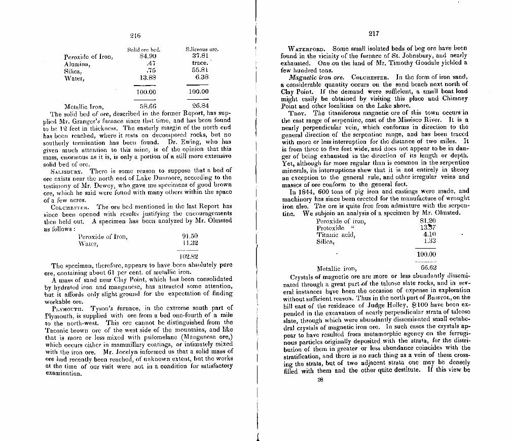
216
Solid ore bed. Siliceous ore.
Peroxide of Iron, 84.90 37.81 Alumina, .47 trace. Silica, .75 55.81 Water, 13.88 6.38
100.00 100.00
Metallic Iron, 58.66 26.84 The solid bed of ore, described in the former Report, has sup-
plied Mr. Granger's furnace since that time, and has been found to be 12 feet in thickness. The easterly margin of the north end has been reached, where it rests on decomposed rocks, but no southerly termination has been found. Dr. Ewing, who has given much attention to this mine, is of the opinion that this mass, enormous as it is, is only a portion of a still more extensive solid bed of ore.
SALISBUnY. There is some reason to suppose that a bed of ore exists imear the north end of Lake Dunmore, according to the testimony of Mr. Dewey, who.gave me specimens of good brown ore, which he said were found with many others within the space of a few acres.
COLCHESTER. The ore bed mentioned in the last Report has since been opened with results justifying the encouragements then held out. A specimen has been analyzed by Mr. Olmsted as follows
Peroxide of Iron, 91.50 Water, 11.32
102.82 The specimen, therefore, appears to have been absolutely pure
ore, containing about 61 per cent. of metallic iron. A mass of sand near Clay Point, which has been consolidated
by hydrated iron and manganese, has attracted some attention, but it affords only slight ground for the expectation of finding workable ore.
PLYMOUTH. rfy500s furnace, in the extreme south part of Plymouth, is supplied with ore from a bed one-fourth of a mile to the north-west. This ore cannot be distinguished from the Taconic brown ore of the west side of the mountains, and like that is more or less mixed with psilomelane (Manganese ore,) which occurs either in mammillary coatings, or intimately mixed with the iron ore. Mr. Jocelyn informed us that a solid mass of ore had recently been reached, of unknown extent, but the works at the time of our visit were not in a condition for satisfactory examination.
217
WATERFORD. Some small isolated beds of bog ore have been found in the vicinity of the furnace of St. Johnsbury, and nearly exhausted. One on the land of Mr. Timothy Goodale yielded a few hundred tons.
Magnetic iron ore. COLCUESTER. In the form of iron sand, a considerable quantity occurs on the sand beach next north of Clay Point. lithe demand were sufficient, a small boat load might easily be obtained by visiting this place and Chimney Point and other localities on the Lake shored
TROY. The titaniferous magnetic ore of this town occurs in the east range of serpentine, east of the Missisco River. It is a nearly perpendicular vein, which conforms in direction to the general direction of the serpentine range, and has been traced with more or less interruption for the distance of two miles. It is from three to five feet wide, and does not appear to be in dan-ger of being exhausted in the direction of its length or depth. Yet, although far more regular than is common in the serpentine minerals, its interruptions shew that it is not entirely in theory an exception to the general rule, and other irregular veins and masses of ore conform to the general fact.
In 1844, 600 tons of pig iron and castings were made, and machinery has since been erected for the manufacture of wrought iron also. The ore is quite free from admixture with the serpen-tine. We subjoin an analysis of a specimen by Mr. Olmsted.
Peroxide of iron, 81.20 Protoxide " 137 Titanic acid, 4.10 Silica, 1.33
100.00
Metallic iron, 66.62 Crystals of magnetic ore are more or less abundantly dissemi-
nated through a great part of the talcose slate rocks, and in sev-eral instances hve been the occasion of expense in exploration without sufficient reason. Thus in the north part of BRISTOL, on the hill east of the residence of Judge Holley, $100 have been ex-pended in the excavation of nearly perpendicular strata of talcose slate, through which were abundantly disseminated small octahe-dral crystals of magnetic iron ore. In such cases the crystals ap-pear to have resulted from metamorphic agency on the ferrugi-nous particles originally deposited with the strata, for the distri-bution of them in greater or less abundance coincides with the stratification, and there is no such thing as a vein of them cross-ing the strata, but of two adjacent strata one may be densely filled with them and the other quite destitute. If this view be
28
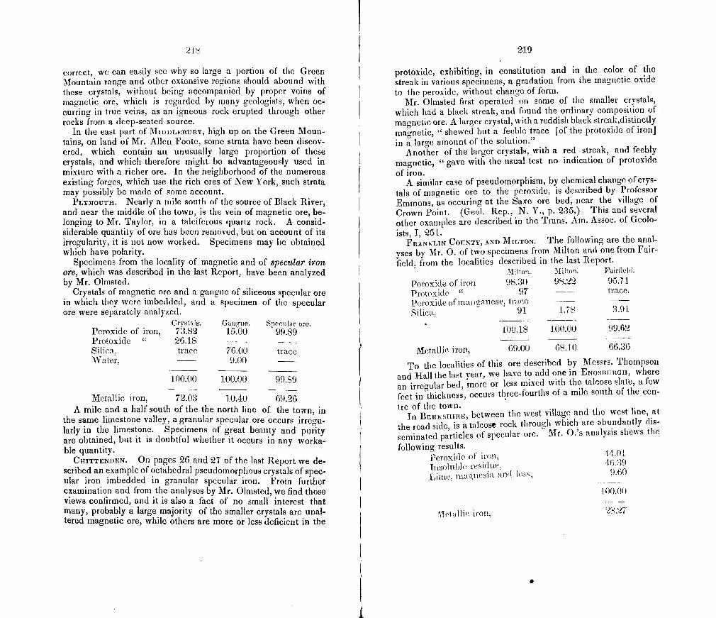
21$
correct, we can easily see why so large a portion of the Green Mountain range and other extensive regions should abound with these crystals, without being accompanied by proper veins of magnetic ore, which is regarded by many geologists, when oc-curring in true veins, as an igneous rock erupted through other rocks from a deep-seated source.
In the east part of MIDDLEBURY, high up on the Green Moun-tains, on land of Mr. Allen Foote, some strata have been discov-ered, which contain an unusually large proportion of these crystals, and which therefore might be advantageously used in mixture with a richer ore. In the neighborhood of the numerous existing forges, which use the rich ores of New York, such strata may possibly be made of some account.
PLYMOUTH. Nearly a mile south of the scsurce of Black River, and near the middle of the town, is the vein of magnetic ore, be-longing to Mr. Taylor, in a talciferous quartz rock. A consid-siderable quantity of ore has been removed, but on account of its irregularity, it is not now worked. Specimens may he obtained which have polarity.
Specimens from the locality of magnetic and of specular iroii ore, which was described in the last Report, have been analyzed by Mr. Olmsted.
Crystals of magnetic ore and a gangue of siliceous specular ore in which they were imbedded, and a specimen of the specular ore were separately analyzed.
Crystals. Gangue. Specular ore. Peroxide of iron, 73.82 15.00 99.89 Protoxidc " 26.18 - Silica, trace 76.00 trace Water, 9.00 -
100.00 100.00 99.89
Metallic iron, 72.03 10.40 69.26 A mile and a half south of the the north line of the town, in
the same limestone valley, a granular specular ore occurs irregu-larly in the limestone. Specimens of great beauty and purity are obtained, but it is doubtful whether it occurs in any worka-ble quantity.
CHITTENDEN. On pages 26 and 27 of the last Report we de-scribed an example of octahedral pseudomorphous crystals of spec-ular iron imbedded in granular specular iron. From further examination and from the analyses by Mr. Olmsted, we find those views confirmed, and it is also a fact of no small interest that many, probably a large majority of the smaller crystals are unal-tered magnetic ore, while others are more or less deficient in the
219
protoxide, exhibiting, in constitution and in the color of the streak in various specimens, a gradation from the magnetic oxide to the peroxide, without change of form.
Mr. Olmsted first operated on some of the smaller crystals, which had a black streak, and found the ordinary composition of magnetic ore. A larger crystal, with a reddish black strcak,distinctly magnetic, "shewed but a feeble trace [of the protoxide of iron] in a large amount of the solution."
Another of the larger crystals, with a red streak, and feebly magnetic, "gave with the usual test no indication of protoxide of iron.
A similar case of pseudomorphism, by chemical change of crys-tals of magnetic ore to the peroxide, is described by Professor Emmons, as ocduring at the Saxe ore bed, near the village of Crown Point. (Geol. Rep., N. Y., p. 235.) This and several other examples are described in the Trans. Am. Assoc. of Geolo- ists, I, 251.
FRANKLIN COUNTY, AND MILToN. The following are the anal- yses by Mr. 0. of two specimens from Milton and one from Fair-field, from the localities described in the last Report.
Milton. Milton. Fairfield.
Peroxide of iron 98.30 98.22 95.71 Protoxide " 97 trace.
Peroxide of man ganese, trace Silica, 91 1.78 3.91
100.18 100.00 99.62
Metallic iron, 69.00 68.10 66.36
To the localities of this ore described by Messrs. Thompson and Hall the last year, we have to add one in ENOSBURGH, where an irregular bed, more or less mixed with the talcose slate, a few feet in thickness, occurs three-fourths of a mile south of the cen-
tre of the town. In BERKSHIRE, between the west village and the west line, at
the road side, is a talcose rock through which are abundantly dis- seminated particles of specular ore. Mr. O.'s analysis shews the
following results. Peroxide of iron, 44.0I
Insolu hie residue,
Lime, muagfleSiii and loss, 9.60
100.00
1etallic iron, 28.27
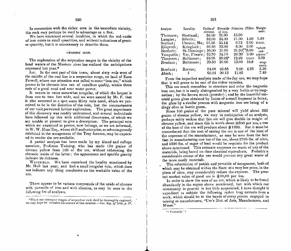
220
In connection with the richer ores in the immediate vicinity, this rock may perhaps be used to advantage as a flux.
We have examined several localities, in which the red oxide of iron exists in small quantities, and without indications of great-er quantity, but it is unnecessary to describe them,
CHROI'VIIC IRON.
The exploration of the serpentine ranges in the vicinity of the head waters of the Missisco river has realized the anticipations expressed last year.*
JAY. In the east part of this town, about sixty rods west of the middle of the east line is a serpentine range, on land of Enos Farwell, where our attention was called to some "iron ore," which proves to be chromic iron ore of excellent quality, within three rods of a good road and near water power.
It occurs in VCinS somewhat irregular, of which the largest is from one to two feet wide, and we were assued by Mr. F. that it also occurred at a spot some thirty rods north, which we per. ceived to be in the direction of the vein, but the circumstances of our visit prevented farther exploration. The great importance of this discovery was readily understood, and several individuals have followed up this with additional discoveries, of which we are unable at present to give a description. The principal vein which we examined in person, now belongs, as we are informed, to W. W. Hus&Esq., whose skill and enterprise, so advantageously exhibited in the mangement of the Troy furnace, may be expect. ed to render the ore available.
A partial analysis has been made by my friend and college associate, Professor Twining, who has made 180 grains of chrome yellow from 100 of the ore, without exhausting the chromic oxide of the latter: the appearance and specific gravity indicate its richness.
WESTFIELD. We have examined the locality mentioned by Mr. Hall last year, and find a small irregular vein, which does not indicate any thing conclusive on the workable value of the ore.
There appear to be various compounds of the oxide of chrome with peroxide of iron and with alumina, as may be seen in the follo%viug list of analyses.
'Wlien our extensive ranges of serpentine rock shall be thoroughly explored. we may hope for valuable discoveries of this mineral.- Geo. Rep. of 1e45, p. 27.
Analyst. Locality. Oxide of Peroxide Alumina. ISilex. Manga chrome, of iron. nese.
Thomson; Shetland; 56.00 31.00 13.00 Laugier; Siberia; 53.00 34.00 11.00 1.00 1.00 Seybert; Chester, Ms.; 51.56 35.14 9.72 2.00 trace. Klaproth; Krieglock; 55.50 33.00 6.00 2.00 "white Bertheir; St. Domingo; 56.00 37.00 21.50775.00 sub- Vauquelin; Var, France; 53.70 34.70 20.30 2.00 stance."
Thomson; Baltimore; 52.95 29.24* 12.22 trace 309 Beudant; Baltimore; 39.50 36.00 13.00 10.6 mag-
nesia.
Beudant; Roeras; 54.08 25.66 9.00 4.83 5.36 Abich; 7 60.04 20.13 11.85 7.45
From the imperfect analysis made oftheiay ore, we may hope that it will prove to be one of the richer varieties.
This ore much resembles in structure and color the magnetic iron ore, but it is easily distinguished by a very feeble or no mag-netism; by the brown streak (powder) ; and by the beautiful em-erald green glass obtained by fusion of a small fragment in borax, the glass by a similar process with magnetic iron ore being of a dingy olive or bottle green.
Since 100 grains of the pure mineral will yield about 225 grains of chrome yellow, we may in anticipation of an analysis, perhaps safely reckon that this ore will give double its weight of chrome yellow, and since this is worth about $600 per ton, a ton of the best of the ore will produce about $1200. But it must be remembered that the cost of raising the ore is one of the least of the expenses of the manufacturer, as may be seen from the fact that in manufacturing one ton of the ore, about 2786 lbs. of nitre, and 5230 lbs. of sugar of lead would be requisite for the product above mentioned. This estimate supposes no waste of any of the materials, being based on their chemical equivalents. Probably a considerable excess of the ore would present any great waste of the more costly materials.
The substitution of potash and peroxide of manganese, both of which may be obtained within the State at a very low price, in the place of nitre, may considerably reduce the expense. The pres-ent market value of good ore is $40,00 per ton.
In order to shew the uses of an ore, which is likely to be found abundantly in the region above mentioned, but with which our community in general is but little acquainted, I have thought it expedient to subjoin the following rather long extracts from a work, which should be in the hands of every person engaged in mining or manufactures, "Ure's Diet. of Arts, Manufactures, and Mines."
" Protoxide "?
Ii
222
'The chief application of this ore is to the production of chromate of pot-ash, from which salt the various other preparations of this metal used in the arts are obtained. The ore, freed, as well as possible, from its gangue, is re-duced to a fine powder, by being ground in a mill under ponderous edge_ wheels, and sifted. It is then mixed with one third or one half its weight of coarsely bruised nitre, and exposed to a powerful heat, for several hours, on a reverberatory hearth, where it is stirred about occasionally. In the large man-ufactories of this country, the ignition of the above mixture in pots is laid aside, as too operose and expensive. The calcined matter is raked out, and lixivia-ted with water. The bright yellow solution is then evaporated briskly, and the chromate of potash falls down in the form of granular salt, which is lifted out from time to time from the bottom with a large ladle, perforated with small holes, and thrown into a draining-box. This saline powder may be formed into regular crystals of neutral chromete of potash, by solution in water and slow evaporation; or it may be converted into a more beautiful crystalline iody, the bichromate of potash, by treating its concentrated solution with nitric, muriatic, sulphuric, or acetic acid, or, indeed, any acid exercising a stronger affinity for the second atom of the potash than the chroniic acid does.
Btchromate of potash, by evaporation of the above solution, and slow cool-ing, may be obtained in the form of square tables, with bevelled edges, or fiat four-sided prisms. They are permanent in the air, have a metallic and bitter laste, and dissolve in about one tenth of their weight of water, at 60 F.; but in one half of their weight of boiling water. They consist ofchromic acid 13, potash 6 ; or, in 100 parts, 684 4-316. This salt is much employed in cali-co_printing and in dyeing.
Chromuate of lead, the chrome-yellow of the painter, is a rich pigment of varicus shades, from deep orange to the palest canary yellow. it is made by add tog a liquid solution of the neutral chromnate (the above granular salt) to a solution, equally liquid, of acetate or nitrate of lead. A precipitate falls, which must be well washed, and carefully dried out of the reach of any sul. phuretted vapors. A lighter shade of yellow is obtained by mixing some solu-tion of alum, or sulphuric acid, with the chromate, before pouring it into the solution of lead and an orange tint is to be procured by the addition of subac-etate of lead, in any desired proportion.
For the productwn of chromnate of potash from chrome ore, various other processes have been recommended. The followiug formulm, which have been verified in practice, will prove useful to the manufacturers of this important article
J Two parts of chrome ore, containing about 50 per cent, of protoxide of chromium
One part ofsaltpetre. IL Four parts of chrome ore, containing 34 per cent. ofprotoxide of chromium.
Two parts of potashes. One part of saltpetre.
M. Four parts chrome ore, - 34 Two of potashes. Four tenths of a part of peroxide of manganese.
IV. Three parts of chronic ore. Four parts of saltpetre. Two parts of argaL
Some manufacturers have contrived to effect the conversion of the oxide into an acid, and of course to form the chromate of potash, by the agency of potash alone, in a calcining furnace, or in earthen pots fired in a pottery kiln.
After lixiviating the calcined mixtures with water, if the solution be a tol-erably pure chromate of potash, its value may be inferred, from its specific gravity, by the following table :-
223
At specific gravity 128 it contains about 50 per cent. of the salt. 1-21 33 118 25 1-15 20 112 16 111 14 1-10 12
In making the red bichromate of potash from these solutions of the yellow salt, nitric acid was at first chiefly used ; but in consequence of its relatively high price, sulphuric, muriatic, or acetic acid has been frequently substituted upon the great scale.
There is another application of chrome which merits some notice here that of its green oxide to dyeing and painting on porcelain. This oxide may be prepared by decomposing, with heat, the chrornate of mercury, a salt made by adding to nitrate of protoxide of mercury, chromate of potash, in equivalent proportions. This chromate has a fine cinnabar red, when pure ; and, at a dull red heat, parts with a portion of its oxygen and is mercurial oxide. Fron M. Dulong's experiments it would appear, that the purest chromate of mner-cury is not the best adapted for preparing the oxide of chrome to be used in porcelain paniting. He thinks it ought to contain a little oxide of nianganese and chromate of potash, to afford a green color of a fine tint, especially for pieces that are to receive a powerful heat. Pure oxide of chrome preserves its color well enough in a muffle furnace ; but, under a stronger fire, it takes a dead-leaf color.
The green oxyde of chrome has come so extensively into use as an enam-el color for porcelain, that a fuller account of the best modes of manufactur-ing it must prove acceptable to many of my readers.
That oxide, in combination with water, called the hydrate, may be econom-ically prepared by boiling chromate of potash, dissolved in water, with half its weight of flowers of sulphur, till the resulting green precipitate ceases to increase, which may be easily ascertained by filtering a little of the mixture. The addition of some potash accelerates the operation. This consists in com-bining the sulphur with the oxygen of the chrome acid, so as to form sulphuric acid, which unites with the potash of chromate into sulphate of potash, while the chrome oxide becomes a hydrate. An extra quantity of potash facilitates the deoxidizement of the chromicfacid by the formation of hyposulphite and sulphuret of potash, both of which have a strong attraction for oxygen. For this purpose the clear lixivium of the chromnate of potash is sufficiently pure, though it should hold some alumina and silica in solution, as it generally does. The hydrate may be freed from particles of sulphuric acid upon it; which dis-solves; after which it may be precipitated, in the state of a carbonate, by car-bonate of potash, not added in excess.
By calcining a mixture of bichromate of potash and sulphur in a crucible,-chromic acid is also decomposed, and a hydrated oxide may be obtained ; the sulphur being partly converted into sulphuret of potassium, and partly into sulphuric acid (at the expense of the chromic), which combines with the rest of the potash into a sulphate. By careful hixiviation, these two new corn-pounds may be washed away, and time chrome green may be freed from the remaining sulphur, by a siightheat.
Liebig and \Vohler have lately contrived a process for producing a subchro.. mate of lead of a beautiful vermilion hue. Into saltpetre, brought to fusion in a crucible at a gentle heat, pure chrome yellow is to be thrown by small por-tions at a time. A strong ebulhition takes place at each addition, and the mass becomes black, and continues so while it is hot. The chrome yellow is to be added till little of the saltpetre remains undecomposed, care being taken not to overheat the crucible, lest the color of the mixture should become brown. Having allowed it to settle for a few minutes, during which the dense basic salt falls to the bottom, the fluid part, consisting of chromate of potash and saltpetre, is to be poured ofl and it can be employed again in preparing
224
chrome yellows The mass remaining in the crucible is to be washed with Water, and the chrome red being separated from the other matters, is to be dried after proper edulcoration. It is essential for tne beauty of the color that the saline solution should not stand long over the red powder, because the color is thus apt to become a dull orange hue. The fine crystalline powder subsides so quickly to the bottom after every ablution, that the above precau-tion may be easily observed.
As Chromic Acid will probably ete long become an object of interest to the calico printer, I shall describe here the best method of preparing it. To 100 parts of yellow chromate of potash, add 136 of nitrate of barytes, each in solu-tion. A precipitate of the yellow chromate of barytes falls, Which being washed and dried would amount to 130 parts. But while still moist, it is to be dis-solved in water by the intervention of nitric acid, and then decomposed by the addition of the requisite quantity of sulphuric acid, whereby the barytes is separated, and the chromic acid remains associated with the nitric acid, from Which it can be freed by evaporation to dryness. On re-dissolving the chro-mic acid residuum in water, filtering and evaporating to a proper degree, 50 parts of chromic acid may be obtained in crystals.
This acid may also be obtained from chrornate of lime 1 formed by mixing chromate of potash and Inuriate of lime; washing the insoluble chromate of lime which precipitates, and decomposing it by the equivalent quantity of ox-alic acid, or for ordinary purposes even sulphuric acid may be employed.
Chromic acid is obtained in quadrangular crystals, of a deep red color; it has a very acrid and styptic taste. It reddens powerfully litmus paper. It is deliquescent in the air. When heated to redness it emits oxygen, and pas-ses into deutoxide. When a little of it is fused along with vitreous borax the compound assumes an emerald green color.
As chromic acid parts with its last dose of oxygen very easily, it is capable in certain styles of calico printing of becoming a valuable substitute for chlo-iine where this more powerful substance would not from peculiar circumstan ces be admissible. For this ingenious application, the arts are indebted to that truly scientific manufacturer, M. Daniel Kmchlin, of Miuihouse. He dis covered that whenever chromate of potash has its acid set free by its being mixed with tartaric or oxalic acid, or a neutral vegetable substance, (starch or sugar for example,) and a mineral acid, and a very lively action is produced 1 with disengagement of heat, and of several gases. The result of this decom.. position is the active reagent, chromic acid, possessing valuable properties to the printer. Watery solutions of chromate of potash and tartaric acid being mixed, an effervescence is produced which has the power of destroying vege. table colors. But this power lasts no longer than the efferescence. The loin.. oral acids react upon the chrornate of potash only when vegetable coloring niatter, gum, starch, or a vegetable acid are present, to determine the disen.. gageinent of gas. During this curious change carbonic acid is evolved ; and when it takes place in a retort, there is condensed in the receiver a colorless liquid, slightly acid, exhaling somewhat the smell of vinegar, and containing ti little empyreumatic oil. This liquid heated With the nitrates of mercury or silver reduces these metals. On these principles M. Kmchlin discharged in digo blue by passing the cloth through a solution of chromate of potash, and printing nitric acid thickened with gum upon certain spots. It is probable that the employment of chromic acid would supercede the necessity of having recourse in many cases to the more corrosive chlorine.
The following directions have been given for the preparation of a blue oxyde of chrome. The concentrated alkaline solution of chromnate of potash is to be saturated with weak sulphuric acid, and then to every 8 lbs. is to be added 1 lb. of common salt, and half a lb. of concentrated sulphuric acid; the liquid will now acquire a green color. To be certain that the yellow color is total-ly destroyed, a small quantity of the liquor is to have potash added to it, and filtered; if the fluid is still yellow, a fresh portion of salt and sulphuric acid
225
is to be added; the fluid is then to be evaporated to dryness, redissol red, and filtered ; j the oxide of chronie is finally to be precipit. i by caustic potash. It will be of greenish-blue color, and being washed, must be collected upon a filter."
0 Cli RES.
Since the numerous beds of brown iron ore in western Ver-mont are more or less abundantly enveloped in ochre, deposits of this substance frequently raise expectations of the discovery of ore. The probability of such discovery, since ochres accumu-late from other causes, must be judged of in each case. In some cases ochre accumulates in depressions by the wash of adjacent lands which contain more or less of disseminated particles of iron. We have also found one or two cases of greenstone, in dykes, containing so much iron as by decomposition to afford a hard ochreous clay, in which the feldspathic grains are visible in a fresh fracture. An interesting example of this kind was pointed out to me by His Honor Lieutenant Gov. Eaton in ENOSBURGH, about one and a half miles south-south-east from the centre of the town. A singular rock in the west part of MENDON, not suffi-ciently exposed for examination in place, may be such a green-stone undecomposed, as it contains a large per centage of brown iron ore.
MANGANESE.
BItANDON. A specimen of psiloinelaie, with implanted crys-tals of an ore of manganese, from Mr. Conant's ore bed, has been analysed by Mr. Olrnsted with the following results:
Red oxide of manganese, 81.38 Oxygen, 2.74 Magnesia, 2.22 Silica, 3.60 Water, 9.75
99.69
It contained therefore, if there be no error,
Metallic manganese, 58.755 Oxygen, 25.365
which scarcely differs from the constitution of sesqui-oxide of manganese.
PLYMOUTR. We have before mentioned that the ores of man-ganese occur with the brown iron ore near the furnace. It is
29
226
not improbable that workable manganese may be found in this vicinity.
COVENTY. A locality of manganese spar occurs in this town, two miles snuth-a'est from the viHage and two large boulders, perhaps derived from this locality, have been found by Mr. Hall in Albany. This mineral is of no use except as an ornamental stone. It receives a good polish, and is used for inlaid work.
COPPER.
CORINTH. A rich vein of copper pyrites, occurs in this town, two and a half miles west of the village. Not improbably it is a part of the great vein of pyrites which is worked in Strafford. The vein is here twenty feet wide, and the copper pyrites is mostly in a portion eighteen inches wide. A specimen has been an-alized by Mr. Olinsted, with the following results:
Copper, 27.28 Iron, 37.91 Sulphur, 33.70 Silica and mica, 1.11
100.00
The ore appears to be rich, and is worthy of attention.
LEAD AND SILVER.
CHITTENDEN. "The lead mine" was examined in company with Your Excellency and with Dr. Ewing of Pittsford, and much admiration was elicited at the perseverence of those who had been cnncernec in the works. A vein of white quartz, near the summit of a high mountain, had been quarried to the open air, and at some distance below a drift had been run ten rods into the solid rnck to meet it. Some small portions of galena were found, and specks of the ore may now be seen in the white quartz.
A specimen of this ore was analyzed by Mr. Olmsted, without detecting any silver, which, from the analogy of the New Hamp-shire ores in metamorphic rocks, we had expected analysis would discover. For particulars of the process, the report of Mr. 0. may be consulted.
TIIETFORD. One hundred rods north-east of Thetford Hill is "the mute " of galena and blende, where an excavation has been made to the open air sufficiently to reveal the character of the vein, which dips about 200 to the south-east, the slate in which it occurs having a dip of 400 to the east 30 0 south. The vein
227
is mostly from one to four inches wide, but irregular and more or less mixed with other minerals. It is not likely to be of any further use than to afford cabinet specimens of gelena and hlende, and the owner of the land, we are informed, asks 0.00 for the privilege of mining ad libitum, although the vein is worth many fold more than that of Chittenden.
Mr. Olmsted's analysis of this ore in the moist way afforded traces of silver, and Dr. Thayer informed me that cupellation of a considerable quantity by another person had yielded a button of that metal.
The geological position of lead ore appears to be in the palae-ozoic rocks. The ore of New York, and the vast quantities which exist in the weste.tn States are in these rocks: and in his able report of exploration in the great lead region of Iowa, &c. made by order of the Secretary of the r1 reasLiry of the United States, Mr. D. D. Owen has shown that the formations contain-ing the lead ore are the equivalents of those which, in the north of England and in Scotland, have been considered the richest lead country in the world. But if, as is not impossihie, many of the so-called primary rocks of Vermont are metamorphic palae-ozoic rocks, may we not then hope to find workable veins of lead in these rocks? Mr. Owen has given us an answer to this in-quiry:
"It behooves us to remember that the metalliforous capacity of rocks de-pends rather upon their lithologicat character than upon their precise age. Phillips, in a recent geological treatise justly remnarbs : "It is not because of any peculiar chemical quality that limestone yields most lead ore on Aldotono Moor, but because it is a rockbhal has retainsd openness ofjissore. Gritstoues, in many mining fields near A]dstone Moor, are equally productive but shales * * have closed up their fissures, and their crumbling faces appear to have rejected the crystallizations, which have attached to the harder lime-stone, grindstone, and chert."
In this connection we cannot forbear mentioning the remark made to us by a practical miner, who was expressing his belief that there was no workalile ore in the Chittenden mine,—' that the rock there was so hard that the lead could not grow in it.' As is often the case with practical men, the fact was correct, al-though the theory of growth was such as we cannot subscribe to. The English geologist quoted by Mr. Owen has exactly cx-prssed the idea of the miner so far as relates to the fact. But Mr. Owen further remarks:
"All other things being equal, the older the rock, or, in other words, the nearer it approaches the inferior igneous rocks, (the presumed sources of me-tallic ores), the greater is the probability of its being rich in metals."
And if so, should not metamorphic rocks, being so much nearer the sources of igneous agency than the palaeozoic rocks, contain greater quanties of lead? The usual fact that they do not is
228
not inconsistent with the general theory stated by Mr. Owen, for as the ores of zinc and lead are quite easily volatilised, they may have been St]l)lirflated out of those rocks which have been sub-jected to powerful metamorphic ageicy, while others less in-tensely heated have received and retained them. If extensive veins and deposits of lead once existed in Vermont, we should therefore expect now to find only some sinail vestiges remaining. In this view of the subject, we see the ground of the remark be-fore quoted, that
"The meta]liferous capacity of rocks depends rather upon their lithologi cal character than upon their precise age."
Nevertheless it must be admitted that some valuable lead mines exist in metamorphic and even in igneous rocks, where perhaps the igneous agency was not continued so long as in other cases, or where other circumstances may have prevented the escape of this ore. It is therefore not probable but possible that galena exists in the State in workable quantity.
ANTHRACITE COAL.
229
respectable man, altogether above any suspicion of intrigue or speculation, and at the time, had no anxiety to sell his farm, but actually leased this loca-tion to an agent of the copper company, for a term of years to be wrought up-on shares, and afterwards sold the place to another parson at a moderate price previous to the expiration of the lease."
Whether we have cleared up the subject by introducing these communications may admit of some question.
POULTNEY. We have been informed that exploration for coal has been going on during a part of the present year in a black slate, and that the desire has been expressed that we should visit and examine the locality, which we will certainly do, as soon as the coal shall have been discovered.
GRAPHITE.
BARNET. Mr. Maclaren shewed me specimens obtained by himself in this town, mixed with some argillaceous foreign mate-rials, which may not prevent its being of considerable value for many purposes.
MATERIALS FOR POTTERY AND PORCELAIN.
NoliwicH. We mentioned last year, giving the authority of Dr. Davis, that a small quantity had been obtained in thin layers. Since then we have received the following statement from a gen-tlemen, whose name, if we considered ourselves at liberty to give it, would be regarded as ample guarantee for what he actually states.
"About eight or nine years since, I heard the rumor of anthracite having been found in Norwich, Vt., and in company withProf. --, visited the farm and 'locality,' where it was said to have been discovered. The rock is bright mica slate ; on the general declivity of the hill, a few miles back from the Connecticut river ; the locality right at the surface—with enough of digging to chew some fresh fractures of the rock—but we found there nothing that bore any resemblance to anthracite. On our return to the farm house, we were shown specimens of genuine Pennsylvania anthracite in a box. There can he no doubt whatever, that the whole matter is a gross deception, and we learned then, there was a close connection between the discovery of the coal and a desire to sell the farm, preparatory to a removal west."
On the other hand, however, we have received the following account from Dr. Davis.
"The statement I gave you, was from my own personal examination, at two or three different visits to the location, and I can say decidedly, that the speci-mens which I dug from the rock could not have been placed there by human agency, unless there is some more subtle and mysterious slight of hand than has hitherto been exhibited to the public. Every appearance indicated to me, that the fragments of coal were forced into crevices by subterranean combus. tion, and they had evidently occupied the position in which they were found for a series of years.
"Mr. Smith, who was uwner of the place at the time, and who made the discovery, was a member of the congregational church, and a very candid and
In the last report we designated the white clays, which exisf abundantly as associated with the taconic rocks, as kaolin, using this term simply in reference to its mineral character without re-gard to the origin. Since, however, the theory of the origin of
all kaolin in granites which consist mostly of feldspar generally prevails, this term is liable to convey an idea, which is erroneous in reference to the white clays referred to. We shall, therefore 5 adopt the suggestion of President Hitchcock, in his letter which will be appended, and use the terra pipe clay or white clay.
MONKTON. Further inquiries have confirmed my doubts of the correctness of the writer referred to last year, who ascrihed the origin of the pipe clay in this town to the decomposition of graph-. ic granite. The associatiqns of this clay are similar to those of the other stratified deposits of the taconic range. The excava-tions which will be made by the present owners, the Messrs. Farrar's, will, however, decide the question. The following letter from the Messrs. F.'s show that this bed is likely to be made avaliable, and we may hope that their experience in common pottery will ensure them success in the enterprise, which is one of much importance to their vicinity.
VERGENNES, Sept. 28, 1846. "Dear Sir
In accordance with your request, I send you a statement of our fire brick works at this place.
We use principally the Monkton kaolin. With this we mix a portion of New Jersey clay, known as the alum clay; which is extensively used and
1.
230
sustains a high reputation for the manufacture of fire brick. We also corn. bins with these a portion of burnt brick suitably crushed, and to exclude every thing but the best materials for sustaining heat, we procure the well known sandstone from Wilinborough, N. V., which we reduce by water-power to the proper fineness, to give the right texture to our brick. This has been proved by experiment not inferior to fire clay for resisting the effects of heat.
These articles are well ground in a mill, and the brick made of them are allowed to harden slightly, and are then pressed to render them solid and their surface and edges regular, and to complete the process they are burned in a kiln constructed for the purpose.
We have got our works but recently into operation and burned the first kiln of brick, and intend to continue the manufacture of them constantly. As to the extent of our business, I will only add, we have incurred expense, and bestowed labor and time thus far, in the belief that the advantage of pos. sessing the right materials, and our location in the centre of an extensive region, abounding in the manufacture of iron and other articles for which these bricks are essential, will at a future time enable us to speak of no incon-siderable amount. Very respectfully yours,
E. L. & E. H. FARRAR. Prof. C. B. ADAms, Middlebury College.
BENNINGTON. A specimen of the pipe clay used by Messrs. Norton and Fenton, has been analysed by Mr. Olmsted, and found to contain
Silica, 18.20
Alumina, 65.60 Magnesia, 3.24
Water, 13.20
100.24
The great amount of alumina may excite some surprise, and as the ultimate analysis alone is likely to convey an incorrect idea of the constitution of this clay, I introduce here extracts from
letters of Mr. Olinsted, referring to a trial which had been made in Boston of the Monkton pipe clay, as a material for the prepar-
ation of the mordant, acetate of alumina, for dyeing. With regard to the kaolin, it is probable to me that Mr. simply
treated the specimen from Monkton with acid and precipitated the alumina from the solution. By this means we should obtain simply any free alumina present while the silicate of alumina would gelatinize without decomposing. The specimen I analysed was fused with carbonate of potassa in a platinum crucible, and the fused mass treated with water :—the residue undissolved by water treated with hydrochloric acid, complete and easy solution effected, and the alumina precipitated from the acid solution, the silica being thrown down from the aqueous solution. The residue left on treating the fused mass with water very evidently contained besides the alumina separated from the silica another portion, which had the appearance of alumina that had simply under. gone intense heat in an uncombined condition. I am not sufficiently acquaint. ed with the art of pottery to know, but suppose the silicate of alumina to have no virtue of its own, the uncoinibined alumina and silica being alone service. able."
"I made some examination of the kaolin with regard to the amount o free alumina present, but I think the experiments of the manufacturer are the only safe guide. The amount of free alumina that I could separate by acid, was only about thirteen per cent."
231
It appears therefore that the failure of the attempt to introduce this article into use for the purpose above named is due, if, as is probable, the constitution of the Monkton clay is similar to that of Bennington, not to the want of alumina but to the condition in which it exists in the clay. Mr. Olrnsted's illness prevented him from pursuing this subject, and determining how much alumina exists in each of the three states indicated, viz, free, allotropic by heat, and combined with silica. If we allow the thirteen per cent, for the free alumina, there will remain 52.60 in the other forms. Of this, all the silica present in the clay is capable of combining, even as a protosilicate, with only about 20.12 of the alumina, leaving 32.48, nearly one-half, in an allotropic state. But as it is by no means to be supposed that all the silica is combined with alumina, it would seem that a larger portion of the latter has been altered by heat; and the fact of this condition of a consid-erable portion of the alumina may be considered as confirmatory of the theory that this clay is a member of a metamorphic strati-fied rock. The economical results are of no small importance, and we hope to be able hereafter to present something more defi-nite on the proportion of the alumina in these several states.
POWNAL. Prof. Dewey informs me that there is a bed of the white clay in this town.
CABOT. At the southwest corner of Joe's pond, by the sides of a road running west from the pond, are numerous large ligniform masses of albite, with a bladed structure, and the ledge from which it was derived may probably be discovered without much difficulty. It may be of use in the composition of a paste for porcelain, and if nearer to Bennington might be of value in some of the various kinds of pottery manufactured there. On account of the structure of these masses, they may be split by a blow with the edge of the hammer in the manner in which wood is split with an axe, but with greater facility, into very long and slender pieces.
ARcHITEcTuRE.
"Geology sustains important relations to architecture, first in the selection of builing siten, and, second, in the choice of stones or of materials for the manufacture of bricks."—AnsLed.
In the selection of a building site, reference must be had not only to the facilities of drainage of the surface, but also to the structure of the earth beneath the surface. The almost univer-sal covering of drift in this State, together with the inequalities of surface, render artificial drainage either unnecessary or very easy ; the pleistocene sands are still more porous, and a great portion of the pleistocene clays are rather thinly spread over drift, and are therefore easily penetrated and drained. In the latter
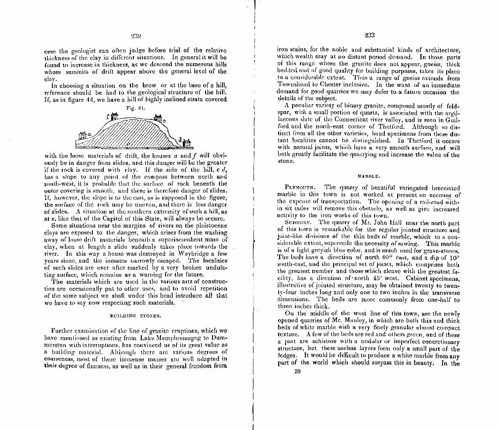
232
case the geologist can often judge before trial of the relative thickness of the clay in different situations. In general it will be found to increase in thickness, as we descend the numerous hills whose summits of drift appear above the general level of the clay.
In choosing a situation on the brow or at the base of a hill, reference should be had to the geological structure of the hill. If, as in figure 44, we have a hill of highly inclined strata covered
Fig. 44.
PA with the loose materials of drift, the houses a andf will obvi-ously be in danger from slides, and this danger will be the greater if the rock is covered with clay. Tithe side of the hill, c d, has a slope to any point of the compass between north and south-west, it is probable that the surface of rock beneath the outer covering is smooth, and there is therefore danger of slides. If, however, the slope is to the east, as is supposed in the figure, the surface of the rock may be uneven, and there is less danger of slides. A situation at the southern extremity of such a hill, as at e, like that of the Capitol of this State, will always be secure.
Some situations near the margins of rivers on the pleistocene clays are exposed to the danger, which arises from the washing away of loose drift materials beneath a superincumbent mass of clay, when at length a slide suddenly takes place towards the river. In this way a house was destroyed in Weybridge a few years since, and the inmates narrowly escaped. The localities of such slides are ever after marked by a very broken undula-ting surface, which remains as a warning for the future.
The materials which are used in the various arts of construc-tion are occasionally put to other uses, and to avoid repetition of the same subject we shall under this head introduce all that we have to say now respecting such materials.
BUILDING STONES.
Further examination of the line of granite eruptions, which we have mentioned as existing from Lake Memphremagog to Dum-merston with interruptions, has convinced us of its great value as a building material. Although there are various degrees of coarseness, most of these immense masses are well adapted in their degree of fineness, as well as in their general freedom from
233
iron stains, for the noble and substantial kinds of architecture, which wealth may at no distant period demand. In those parts of this range where the granite does not appear, gneiss, thick bedded and of good quality for building purposes, takes its place to a considerable extent. Thus a range of gneiss extends from Townshend to Chester inclusive. In the want of an immediate demand for good quarries we may defer to a future occasion the details of the subject.
A peculiar variety of binary granite, composed mostly of feld , spar, with a small portion of quartz, is associated with the argil-laceous slate of the Connecticut river valley, and is seen in Gnu-ford and the north-east corner of Thetfôrd. Although so dis-tinct from all the other varieties, hand specimens from these dis-tant localities cannot be distinguished. In Thetford it occurs with natural joints, which have a very smooth surface, and will both greatly facilitate the quarrying and increase the value of the stone.
MARBLE.
PLYMOUTH. The quarry of beautiful variegated brecciated marble in this town is not worked at present on account of the expense of transportation. The opening of a rail-road with-in six miles will remove this obstacle, as well as give increased activity to the iron works of this town.
SUDDURY. The quarry of Mr. John Hall near the north part of this town is remarkable for the regular jointed structure and joint-like divisions of the thin beds of marble, which to a con-siderable extent, supercede the necessity of sawing. This marble is of a light greyish blue color, and is much used for grave-stones. The beds have a direction of north 40 1 east, and a dip of 10 0 south-east, and the principal set of joints, which comprises both the greatest number and those which cleave with the greatest fa-cility, has a direction of'north 450 west. Cabinet specimens, illustrative of jointed strUcture, may be obtained twenty to twen-ty-four inches long and only one to two inches in the transverse dimensions. The beds are more commonly from one-half to three inches thick.
On the middle of the west line of this town, are the newly opened quarries of Mr. Manley, in which are both thin and thick beds of white marble with a very finely granular almost compact texture. A few of the beds are red and others green, and of these a part are schistose with a nodular or imperfect Concretionary structure, but these useless layers form only a small part of the ledges. It would be difficult to produce a white marble from any part of the world which should surpass this in beauty. In the
30
234
more southerly of these quarries the beds have a direction of north 5° east, and a dip of 24° east. A short distance north of this quarry, is a small insulated hill in which is the other quarry with the beds dipping 10° to the south-west, of a pure white, greyish blue, and a delicate flesh color.
RUTLAND. Hyde's quarry. Two specimens from this quarry have been analysed by Mr. Olmsted, one of a pure white gran-ular variety and the other with a greenish tinge and rather less friable.
Greenish variety. White variety. Carbonate of lime, 85.45 97.73 Alumina and iron, .59 Silica and mica, 14.55 1.68
100.00 100.00
We had confidently supposed this to be a magnesian limestone, and the result has not a little surprised us as it did the analyst, who suggests that the friableness of this marble may be due to the intermixture of grains of the silica, which in the greenish variety appears to be abundant. The fineness of these grains and the uniformity of their diffusion probably prevents any difficulty arising from it to the manufacturer of the marble. The purer variety, however, is more abundant in the quarry.
In the greenish variety was the additional reason for anticipa-ting the presence of magnesia, that it was probably colored with the same green non-elastic laniellar mineral, whose external char-acters were obviously those of talc. Whether this is a green mica requires further examination.
BRANDON. A specimen of the fine white statuary marble has been analysed by Mr. Olmsted, as follows:
Carbonate of lime, 99.51 magnesia, trace.
Silica and other insoluble matter. .29 Water and loss, .20
100.00
The constitution corresponds well in purity with the spotless ness of the appearance of this elegant marble. The external characters of this marble also led to the supposition that it was dolomitic.
MIDDLEBURY. Gibbs' quarry in the north part of the town furnishes white marble of a fine texture, which is for the most part thick bedded; but the beds are uneven and traversed with irregular seams, which injure the quarry for marble. It is cele-
235
brated for furnishing excellent lime. The mineralogist will find here a thin stratum of the brilliant semi-crystalline brown spar variety of dolomite.
The quarry of Slason and Ormsbee, not far from the geograph-ical centre of the town, resembles that last mentioned. The marble is of very fine texture, and mostly white, but the beds are more or less unequal and irregular, and some talciferous strata, with the adjacent beds, are much contorted. The general direc-tion is north 10° west, and the dip in the average 75° cast; some planes of division in a part of the quarry which closely resemble planes of deposit have a dip of 20 3 east.
Phelps' quarry, near the northwest corner of the town, is very similar to 1Ianley's quarry in Sudbury, not only in the quality of the marble, but in containing the same jaspery red and green talciferous schistose subconcrctionary strata; and since also the direction of the strata and of a line uniting the two quarries coin-cide, it would seem to be a necessary inference that the two quarries are in strata which were originally continuous ; yet the continuity of this line is now interrupted by the northern and narrow extremity of the Taconic slate. On the west side of this slate the limestone, including the Sudbury quarries, has been called sparry limestone, and this Stockbridge limestone on the east side has been regarded by some as another formation. It would seem to be an unavoidable inference from this and some other facts that these limestones were once continuous, but that their continuity was broken by the upheaval of the originally sub-jacent and now intervening Taconic mOuntains, and accordingly where these mountains in Brandori and Sudbury suddenly termi-nate in low hills, we find the intervening slate contracted in a corresponding degree, and terminating like a wedge a few miles farther north in Cornwall ; to the north of which, in the absence of a geographical division, we have not been able to continue the boundary line. In making this suggestion, for it is merely a sug-gestion, we do not intend' to deny that these limestones before they become metamorphic may not have comprised more than one formation, but to suggest a doubt whether the geographical division is a geological division.
To recur to the point from which we have digressed ; the ridge in Middlehury, at the nortil extrenuity of which is Phelps' quarry, extends for nearly a mile to the south, and in most of the dis-tance is capable of furnishing excellent marble from this inex -haustible source.
IsLE LA MOTTF. ; Hill's quarry: and SWANTON. A speci-men of black marble from the former, and one of the dove color-ed marble from the latter place have been analysed by Mr. Olm-stead, with the following results
236
Black. Dove colored. Carbonate of lime, 87.94 94.66
magnesia, 4.56 .23 Alumina and iron, 2.60 1.09 Insoluble matter, mostly silica, 4.80 2.39 Water and loss, .10 1.63 Protoxide of manganese, trace -
100.00 100.00
SRPENT1NE
In Dr. Feuchtwanger's Treatise on Gems, we find the follow, ing important suggestions on the uses of this rock.
"It is easily wrought on lathes into various articles; such as snuff-boxes, vases, ink-stands, &c. In a small place at Zoblitz, in Saxony, several hun-dred persons are constantly employed in the manufacture of boxes, trinkets, and chimney-pieces. The locality in Grenada, in Spain, has supplied many churches and palaces of Madrid with large columns, and other ornaments. It is reall'y surprising that the inhabitants of those districts where the precious serpentine is found, have not yet employed it as an article of trade, as the quality of the American serpentine is, if not superior to the English and Span ish, certainly not inferior to any hitherto found ; and I trust that the day is not far distant when our parlors will be embellished with mantle-pieces, ta-bles, and mantle ornaments, made of it, Candlesticks, mugs, pitchers, knife-handles, firearm-stands, jamb-hooks, and many other domestic articles, instead of silver-plated, steel, and cast-iron ware, might be formed of it and used."
- The objection which exists against the introduction of this article as a substitute for marble, being founded chiefly on the extreme difficulty of obtaining, especially of the more beautiful varieties, sufficiently large pieces free from seams, does not apply to the numerous small ornamental articles, which may be manu-factured from it.
CAVENDISH. On visiting the shop where the beautiful serpen-tine, formerly belonging to Mr. Proctor, had been worked, we were much impressed with the number and beauty of the varie-ties of color, which were revealed on the smooth surface of the sawed slabs. With the variety of color in a given piece, howev -er, appears to be a corresponding inequality of structure, which renders the slab more liable to fracture. This may account for what, so far as we have seen this rock, appears to be generally true, that the most elegant varieties are most invariably prone to fracture under the hammer into the most irregular fragments, so as to bid defiance to the rules we had adopted respecting the size and form of our specimens. The difficulty may be partly met by giving a greater thickness to the slabs, and avoided by using the stone for purposes which will not expose it to fracture, and for small articles.
231
Roxnuitv. We had anticipated an advantageous exhibition of the ledge described last year by the rail-road excavation, but find that this had been made chiefly on the east side, where the serpen-tine is more abundantly traversed by seams. A beautiful polished slab in a table in the congregational meeting house in West Ran dolph was obtained from this locality.
LOWELL. Two ranges of serpentine commence in this town near the head waters of the Missisco, and extend nearly into Canada. For the richness and number of the varieties it would not seem possible that they can be surpassed, while their extent, amounting to twenty or thirty square miles, is beyonththe possi-ble demand of all future ages. They are exhibited in several precipitous ledges, which are easy of access and of being worked.
In this town we examined three of the principal of these ledges, one a mile and one-half east,—and another one-third of a mile west—of the village, and a third in the north part of the town, which may be called respectively the east, west, and north ledges.
The east ledge constitutes the west side of a hilt east from the village, whence it appears as a mass of pale ash-colored rocks, for such is the color of weathered surfaces. The number of varieties of great beauty, which may be found here, is remarka-ble: more than a dozen may be found within a few rods, con-sisting of the intermixture in veins, irregular masses, and grains of various shades of light and blackish green with each other, or with brown spar, and the surfaces of the joints are very frequent-ly covered with a thin coat of delicate amianthus, soas to resem-ble velvet, and are spangled with the brilliant surfaces of the brown spar. Of the uniform varieties, there will be no difficulty probably in obtaining blocks of sufficient size for the ordinary demands of internal architecture. This ledge has recently been made more conspicuous by being burnt over, and probably has not before been visited.
The west ledge has been well known to mineralogists, although the change of the name of the town, from Kellyvale to the less poetic name of Lowell, may occasion some confusion in the
localities' of mineralogical treatises, a consideration which pos sibly may not have had due weight in the legislative decision on this change of name. This ledge has a western mural face, of one hundred and fifty to two hundred feet high, the lower two-thirds being covered with a debris, consisting of large fragments, which themselves might furnish many blocks for the saw. The varieties are rather less numerous and elegant than those of the Last ledge, but blocks of good size and much beauty may be
23S
obtained with great facility. This locality has been much visited for specimens of asbestus.
The north ledge is not far from the Troy line, and has a wes-tern mural face within five rods of one of the best roads in the State. It furnishes varieties similar to those of the west ledge.
The general distribution of water power in this town may be readily conceived by a glance on the map at the head waters of the Missisco, which converge from a variety of directions into the basin, in which the village is situated, and which opens to the north for the channel of this river. Accordingly the ser-pentine will require but very little transportation to water power sufficient for sawing, and in fact, most of it is within a few rods of the main channel of the Missisco.
WESTFrELD. One-half mile west of the Troy line, and two and one-half miles north from the south line of the town, a road crosses a ledge of serpentine and soapstone. The weathering of the serpentine here has revealed a jointed structure, which much resembles stratification in some parts, but for the most part they variously intersect as usual. This serpentine appears to be less beautiful than that of Lowell, although further examination would doubtless detect elegant varieties.
TROY. The ledges of serpentine in this town are numerous and extensive. A little north of the north village, we found soapstone and serpentine in junction, and at the junction we found a rock composed of rounded fragments of serpentine, mixed with soapstone, which, although not of economical value, may be of scientific interest. Within the north village, towards the west side, is a ledge of dark green serpentine, variegated with light green, and with pilose amianthus on the jointed sur-faces.
Between the furnace and the great vein of magnetic iron ore, the serpentine again appears, constituting the west side of a lofty hill. Here, enormous ledges are easily approached from a good road, which runs along their base, while the Missisco is but a few rods to the west. But the ledge in which is the vein of iron ore, is, not only on account of the ore, but on account of the varieties of serpentine, an object of much interest. Elegant varieties are numerous, among which are most conspicuous the very bright green noble serpentine, which covers most of the numerous jointed faces with a coat of one-eighth to one-half inch thick, and the spotted varieties. Numerous seams may render it difficult to obtain large slabs, but smaller pieces suitable for a great variety of ornamental purposes may be obtained, of great beauty in any quantity.
JAY. We have before, under the head of chromic iron,
229
described a locality of serpentine in this town, where there is an extensive ledge within a few rods of good water power.
SOAPSTONE.
Beds of soapstone occur in Grafton, Cavendish, Bridgewater, Bethel, Rochester, Braintree, Moretown, Waterbur y , Stow, Ster ling, Johnson, Eden, Lowell, Westfield, Troy, Richford, Enos-burg, Belvidere, and Waterville. Some of these localities were described last year.
The very common association of serpentine and soapstone, is worthy of notice, as of both economical and scientific interest. Thus, in Cavendish, the soapstone lies on the west side of the serpentine, with a few rods of mica slate intervening; in Roch-ester, it is closely associated with serpentine ; in Lowell, it is on the east side of the east ledge, and on the west side of the west ledge ; in Westfield, on the west side, and in North Troy, on the west side of the serpentine. Steatite appears generally to occur in beds rather than in prolonged strata, and these beds are usually of great thickness as compared with their length.
CAVENDISIL The mica slate, which intervenes between the serpentine on the east, and the soapstone on the west, occupies a space of about ten rods wide on the main road from Ludlow to Proctorsyille. The soapstone is several rods wide, and the quantity is inexhaustible. Much of it is undoubtedly of exeel lent quality, and being on the route of the Rutland rail-road, ic worthy of careful exploration.
BETHEL. In West Bethel, on the Rochester road, is a bed which has been examined by my assistants, who report it to be forty feet wide. Also, in the north part of Bethel, near the acti nolite locality before mentioned, is a bed of laminated talc, most of which is sufficiently compact to be quarried as steatite.
ROCHESTER. Messrs. Hall and Thompson, report the bed in this town to be at least forty feet wide.
BRAINTREE. Dr. S. W. Thayer, Jr., informs me that there is a bed in this town, in a line with that of Bethel, and with the serpentine of Roxbury and Northfleld.
MORETOWN. Associated with serpentine in the north-west corner of the town, is a bed of laminated talc, which can be wrought as soapstone. It occurs not far south of the Winooski, near the road, where a common stone wall has been built mostly of fragments of talc.
The beds in WATERBURY, JOHNSON, and EDEN, have been examined but not yet described by my assistants.
LOWELL. About a mile east of the village, on land of Mr. Pearl C. Brigham, is a bed of soapstone which has not yet been
240
quarried. The portions near the surface which we saw, are so closely filled with crystals of brown spar as to be of no value, but this is not likely to be true of the entire bed. Mr. Hall reports a bed west of the west ledge of serpentine, as being
dark colored and hard." We were also shewn a piece of excellent quality in the possession of an individual, who wished us to pay him for the privilege of examining the bed.
WESTFIELD. At the locality of the serpentine before mention-ed, stcatite, of many varieties and of excellent quality, occurs in junction with the west side of the serpentine at the road side. Some of this soap-stone is of a very beautiful dark green; some portions are cream colored mottled with darker colors, and some of a light grevish blue, very soft and free.
TROT. Messrs. Hall and Thompson report that the bed in Sonth Troy, "one-half mile east of the meeting house, is too hard to be wrought, and is filled with crystals of octahedral and suiphuret of iron." We have before mentioned the junction of serpentine and soapstone in North rrroy. The latter is abund-ant, with light horn colored and greyish blue varieties, and of good quality.
ENOSBURGH. In the east part of this town a bed has been re-cently discovered.
Messrs. Hall and Thompson report a bed in BELVIDERE, and in their report of last year describe the bed of WATERVILLE.
THETFORD. Near the middle of the east side of this town, in micaceous hornblende slate, is an irregular bed of soapstone about eight feet thick, which has been quarried. In the lower part of the bed, it passes into a dark green laminated tak, and in the upper part contains bitter spar and litht blue actinolite.
In the regions which we have examined, the valley of the Mis-sisco east of the Green Mountains contains the greatest abund-ance of this valuable stone, as well as of its associate serpentine, although neither have yet been quarried to any considerable ex-tent. The day is probably not very far distant, when the con-structiori of the Passumpsic rail-road through the valley of Lake Meinphremagog, and perhaps of a branch to some part of this upper valley of the Missisco, will render these resources more available.
ROOFING AND WRITING SLATES.
THETFORD. In the northeast corner of this town is a range of argillaceous slate, which is extremely fissile and soft,.and, without any tools, is easily peeled off from the side of the ledge in large sheets. The lamination has a direction of north 10° east. It is of easy access on the east side from the main road
241
near the Connecticut river. The softness of this slate has been objected to, but this would only require a little more care in handliug it, for the durability must depend more on the chemi-cal constitution. We have before remarked that the fine drift scratches have been preserved on the soft slates in Fairhaven through untold ages. Probably if this ledge were opened, it would be found less fissile. Mr. Bartholemew, the owner of the ledge, has used this roofing slate for many years with success.
ALBANY. A narrow range of argillaceous slate extends from the southern extremity of Lake Memphremagog to Montpelier between the calcareo-mica slate on the east, and the Talcose slate on the west, with an average width not exceeding one mile. In the sontheast corner of Albany, four miles from Craftsbury Common, it occurs in very regular laminae, with a dip nearly perpendicular, and appears to be well adapted in structure for a roofing slate; but at the locality which we examined it is some-what calciferous, and will not probably be found durable on exposure to rains.
FAIRHAVEN. Nearly two miles north-north.east from the vil-lage of Fairhaven is Allen's slate quarry, on the west side of a hill at the base of which appears the sparry limestone. The laminae of the slate have a-direction of north 40 1" east, and dip of 101 south-east; but the dip is variable in consequence of gen-tie undulations of the laminae. These undulations, however, are not abrupt enough to diminish materially the value of the quarry, while natural joints, some with a direction of north 30 0 west, and others that of an east and west direction, facilitate the removal of the slate. The slates of this quarry are soft and free from grit, and answer for writing as well as for roofing slates. Indeed they are quarried chiefly for the former purpose, for which they are well adapted.
STONE POSTS.
These are made not only of granite in the granitic region of Orange county, but of mica slate in the west part of this county. They are obtained with great facility, of a fine dark blue variety, in consequence of the intersection of strata from three to five inches thick by natural joints, which are a few inches distant and at right angles to the plane of stratification. In RANDOLPH, be-tween the west and centre villages, such posts are quarried, and sold at 5 to 20 cents each.
LIMESTONE.
.lIica slate limestone. The limits of the calcareo-mica slate formation have now been pretty accurately determined, and we have before mentioned the interesting and important fact that
31
242
the marl beds east of the Green Mountains are found only on this formation and the argillaceous slates. The boundary be-tween these formations, as laid down on a geological map, extending from Canada to Massachusetts, is therefore of much economical importance.
Although all the beds, which are abundantly interstratified with the mica slate, are siliceous, some of them contain much more lime than others. In general, they are the richest and most abundant in the middle of the eastern half of the State. The following are the results of some analyses by Mr. Olmsted.
craftshury. Ilardwick. flanville. Barnet. Vershire.
Carbonate of lime, 30.82 52.47 53.50 47.07 36.78
magnesia, 2.51 3.72 2.20 4.00 3.27 Alumina and Iron, 2.05 3.00 1.90 1.70 8.80 Insoluble matter, 6000 39.90 38.90 44.70 50.15
Water and loss, 4.62 .91 3.50 2.53 1.00 Protoxide of manganese, trace -
100,00 100.00 100.00 100.00 100.00
In TUNBJUDGE, Mr. Osmer P. Farnham has burned this lime-stone, and has used it with good results, both on land and for mortar.
In CAYENDISH, one-half mile east of Duttonsville, is the lime-stone quarry of Christopher Webber, Esq. This limestone differs from the common siliceous limestone of the mica slate in several important respects. It is of a dingy white, with thickly dissemi-nated grains of translucent quartz, in consequence of which it is quite friable, and is very even bedded, It is included conforma-bly between strata of mica slate, with a direction of north and south, and dip of 30° vest. Its thickness is about 25 feet, and it is traceable for three or four miles in the direction of the strike. Large quantities have been burned by Mr. Webber for many years past.
DANVILLE and VERSHIRE are remarkable for the facility with which this limestone disintegrates by atmospheric agency, and although it is therefore unsuitable for a building stone, the benefit to the soil is ample compensation.
A few towns on the Connecticut River are destitute of this siliceous limestone. Such are Thetford and Fairlee.
Talcose Slate Limestone. The white and reddish white gran-ular limestone of Plymouth extends from within a few rods of the north line of the town along a narrow valley to within a short distance of the south line of the town. Great quantities are burned for the supply of the neighboring towns, and there are probably more lime-kilus in this town than in any other five towns
243
in the State. It is much to be regretted that there are so many rude kilns of rough stone, making a great waste of labor and fuel, instead of one or two large perpetual kilns. Probably there is not now another situation in the State so favorable for an enterpris-ing person, who will erect such a kiln. The reputation of the Plymouth lime is well established, and nothing is wanting but the reduction of price by a more economical process.
MENDON. The bed of white limestone, which was mentioned in the last Report on the authority of another person as occurr-ing in Stockbridge, is mostly in the north-east part of Mendon, and extends, as I was informed, over the Sherburne line. Large quantities of it are burned in the north-east part of Sherburne.
HANCOCK. We have before mentioned the recent discovery in this town of limestone similar to that of Plymouth, half a mile south of the village, We have not yet visited the locality, but confidently hope that it will be of great value to the vicinity. The limestone appears to be of very good quality.
BAKERSFIELD, In the north-east corner of this town, are beds of white limestone, on land of Mr. Hardy, associated vithtalcose slate, in interrupted beds. These beds are from six to ten feet thick, with a direction of north 5 0 east, and a clip of 75 west. Veins of white quartz, which are undoubtedly of igneous origin, cut through the beds of limestone transversely.
Taconic Limestone. Several varieties have been analyzed by Mr. Olmsted ; most of which analyses were introduced in con-nection with the Taconic marble. The following are the results of the analysis of specimens associated with the brown iron ores in North Dorset and in Bristol. It is remarkable that these spe-cimens, and one from the limestone which contains the specular iron in the north-west corner of Milton, and which Professor Em-mons regards as the calciferous sandrock of the Champlain rocks, are the only lirnestories which may properly be called magnesian, among all that were analyzed. They are all without clistitict crystalline structure, and are very compact, with a brownish tinge, and argillaceous odur, and are perhaps the last ones in the series of limestones, which would have been suspected of being magnesian. In each ease the specimens were taken from imme-diate proximity to the iron ores.
N. Dorset. Brsto1. Milton.
Carbonate of lime, 85.18 51.35 84.45 " " magnesia, 13.11 44.76 12.14
Alumina and iron, 1.79 2.00 1.01 Insoluble matter, 1.49 1.40 1.50
n\ostly silica, Water and loss, - .49 .90
101.57 100.00 100.00
'I
1
244
HYDRAULIC LIME.
On account of the abundance of siliceous and argillaceous limestones over a great part of the State, it may be expected that numerous quarries of stone suitable for the preparation of water cement will eventually be opened, but we have not yet been able to give the sublect the attention which it merits. The impure gritty and argillaceous limestones should be sought for this pur-pose, and subjected to actual experiment. There are quarries in Shoreham, Corn wall, Waltham and Shelburne.
ENGINEERING.
With regard to this subject there are two points in which the application of geology is both immediate and evident. These are, (1,) The selection of the line along which the road or canal is to be carried, and the management of the cuttings and embankrnents that may be determined on ; and (2,) The selection of the materials for their construction."—_4nsled.
Many of the principles which determine the selection of a route for a road are of course independent of geological consid-erations. The latter, however, are always of more or less impor-tance, although in a country over most of which is spread a deep drift, deposit, there is little to be said which is not obvious. Many of the principles which apply to the choice of building sites are also applicable in laying out roads. It is also, other things being equal, desirable to locate roads with reference to the materials for their construction, especially since a sparse pop-ulation can seldom do more than make the roads of the mate-rials on the spot. In Addison county, where the numerous hills of drift above the general level of the clay are much elongated in a north and south direction, the sides of these hills immediately above the clay obviously present the best sites for roads which run north and south; for this elevation is moderate and attended by easy grades, and the materials removed would be such as are needed for a covering for those portions of the road, which necessarily pass over clay. Neither these, however, nor indeed any principles of public convenience have generally determined the location of most of the roads in this part of the State, but they have here, as well as in some other districts, been laid out so as to pass near the houses of individuals, wherever they hap-pened to be. It is not, therefore, surprising that roads thus loca-ted, in a region which presents the greatest natural obstacles, so far as materials are concerned, to good roads, should be fairly entitled to the epithet of execrable during the greater portion of the year. Fortunate indeed is it for such roads, that during our long winters nature kindly spreads a mantle over their defects.
In Chittenden county many of the roads, on the other extreme, run over the loose pleistocene sands, and when long dry weather
245
has at length rendered the clay roads of their neighbors tolerable, travellers and teamsters on these roads are not a little annoyed by the deep sands, which again become tolerable when wet weather has rendered the clay roads nearly impassable. A sandy road, however, is more easily improved than one of clay, requir-ing a moderate addition of hardpan or clay.
Having had some experience of good and bad roads in Ver-mont, while travelling in a private conveyance more than 4000 miles during.the last two summers in all parts of the State, (ex-cept Essex county,) I may be permitted to say that, with the exception perhaps of Addison county, the roads are as good as can be expected from the number of the population. This re-mark, however, does not apply to the numerous traps, which were originally designed for bridges over small rivulets and sluice-ways. Many of the roads in Orange county, especially, not only testify to the natural advantages enjoyed in the materials, but also to the industry with which they have been used. Never-theless it would be too much to expect, from a resident in Addi-son county, an assent to the rule which makes the character of the public roads the criterion of the grade of civilization.
In the choice of materials for the improvement of roads, those stones will be found most durable which have great toughness, like most varieties of greenstone, rather than those which are very hard but more brittle. But the absence of greenstone in sufficient quantity will render it necessary to use otlier materials, such as granite and sandrock, siliceous limestone, mica slate, and argillaceous and argillo-calcareous slates. From the flicility with which the latter are broken to a proper degree of fineness, they are more frequently used, and for roads which are not much trav -elled, better materials do not exist. rIliey are not, however, sufficiently durable for roads that are subject to a great amount of travel.
The comminution of solid rocks for the improvement of roads is, however, in most ca'ses, too expensive a process for a sparse population, and the loose materials of the surface are usually em-ployed. The selection of these must have some reference to the ground on which they are to he used, but ordinarily they will be the following, commencing with the best: 1, rather fine gravel with a tenacity intermediate between loose gravel and hardpan , hardpan; 3, coarse loose gravel; 4, fine do.; 5, sand; 6,
loam and sods; 7, clay. With the exception of sand on clay roads, and clay on sandy roads, the last three should never be used when the others are accessible, and perhaps never. Per-sons from abroad, who have been accustomed to an efficient sys-tem of road making, are not a little surprised at the very common use of sods and loam in mending the highway, where gravel of

246
excellent quality for the purpose exists along the road-side, and is exposed in this process of mis-improving roads.
It may not be improper here to make one or two other sugges-tions on this subject, although they are not geological. It is a matter of complaint in some towns that the expense of bridges comes so heavily upon them, while adjacent towns have little or no expense of the kind, it would seem to be a just principle that those who use the bridge most should pay the most, but in fact, although the town in which a bridge is situated will use it more than any other one town, yet the use of it in the aggregate by those who pay nothing much exceeds that of the one which pays the whole. We apply the remark of course only to the more im-portant routes of travel. The same principle is involved in roads over mountain ridges, which are of greater importance to other towns in the aggregate than to those through which they pass. Thus the road over the mountain between Lincoln and Warren saves five to ten miles in the distance between ten to twenty towns on either side of the Green Mountains, but is rarely used because its bad condition, in addition to the high grades, renders it nearly impassable. Similar cases are very numerous, where the public advantage would far more than equal the expense of bridg-es and well constructed roads, and hence some of the most im-portant roads in the State are private property. In many of the routes which might be improved or opened to the great accom-modation of extensive districts, a county tax would approximate nearly to the principle of assessing the expense where the benefit is derived.
We will take the liberty to make another suggestion: a small expense for guide-boards will save the traveller much perplexity, especially where there are no inhabitants in the vicinity, and the roughness of the country and dense forests render it impossible to foresee the windings of the road, which perhaps hifurcates like the letter Y.
Still more intimate relations exist between railroads or canals and the geological structure of a country, both in respect of their construction and of the natural sources of business. It is unnec-essary to offer any suggestions here, since the location and con-struction of such works are confided in a great measure to per -sons with whom this knowledge is a part of their profession.
On several miscellaneous subjects, as firestones, whetstones, common and mineral springs, we should have introduced a few facts and suggestions, but the length which this report has reach-ed constrains us to withhold them.
A PP E N DIX.
KM Letter from President Hitchcock.
AMHERST, Sept. 1st, 1846, DEAR SIR—As I have just returned from an excursion of about
400 miles in Vermont, you may expect to receive an account of any geological phenomena, which arrested my attention, especial-ly as I was not accompanied by you. As I travelled rapidly, how-ever, you will not expect that I should go into much detail as to particular localities. I shall merely record a few things which ex-cited interest in my mind, but which may, nevertheless, be of lit-tle consequence.
I passed along the eastern part of the State till nearly opposite Môntpelier, when I turned northeasterly and crossed the State to Burlington; thence I went southerly on the west side of the Green Mountains to Bennington, whence I crossed the State again to Brattleborough; and truly, although I had crossed the Green and Hoosac Mountaintains in a great many places, I nev-er met with so fine a section as that laid open along the Winoos-ki (Onion) river. The strata west of Montpelier stand nearly perpendicular, and are more continuous and regular in that dip than on any other section across them that I have seen. And what an enormous thickness of talcose slate, especially is there exhibited. For that formation extends most of the distance from Montpelier to Burlington ; except that perhaps there may be a central band of mica slate, or gneiss, in the highest part of the Green Mountain range. This formation can hardly be less than twenty miles thick! Now admitting that the strata are folded once, - and it seems to me, that there is no evidence of any more plications,—indeed scarcely any evidence of one,—we shall have a thickness to this rock often miles; equal to that of all the stratified rocks of Great Britain, as estimated by Dr. Buckland. You know that all attempts to measure the thickness of the crys-talline slate rocks of Europe have been deemed very unsatisfac-tory. Have you not here an opportunily to do it with a good degree of accuracy? If you can, you will convey no small favor upon geology.
218
The section across the southeru part of the State I found far less satisfactory. The enormous quantity of drift that is strewed over the western slope and the top of the Green Mountains, al-most entirely hides the subjacent rock ; so that between Benning-ton and Searsburgh,—that is over the main part of the range, I saw the rock in place only two or three times. The boulders are indeed gneissoid most of the way. But in the only place on the west side of the mountain where the ledges appear, they are formed of distinct mica slate ; yet I must believe that gneiss 00-
curs in the vicinity, and in great quantity. Indeed, it shows itself in Searsburgh ; and it is not till you cross the Deerfield river, that you find distiuct mica slate ; which, however, is suc-ceeded again by gneiss; or rather, the two rocks appear to me to be interstratified through the whole range. I hope you will examine this region with great care; for a few miles to the south in Massachusetts, you will see, by my map, published in my Re-port, that I found nothing but mica slate in the main part of the Hoosac range. In examining it, I crossed on the road from Chariemont to North Adams; and also farther north, through Monroe and Clarksburgh; and I hope you will go over the same ground: because should you represent gneiss on your map to the Massachusetts' line, there would be an apparent discrepancy between us. I incline to the belief that the rocks change in the Hoosac and Green Mountain range in the direction of their strike, as you will see by referring to my Report, (vol. 2, p. 597) and besides, much of the rock there, being half way between the two sorts, would by one man be referred to gneiss, and by anoth-er to mica slate. I believe it will be found that there is no real discrepancy between us, and that the rocks do change near the line between the two States to a considerable extent. I hope you will be able to trace out their true connection, before you publish your final Report, although I think it will require several days examination on foot in one of the most uncultivated regions of New England. I hope, also, you will do the same in respect to a deposit of singular granite in the west part of Clarksburgh, which is imperfectly described in my Report (vol. 2, p. 683.) It is possible you may find it to be thick bedded gneiss, though its boulders, strewed in immense quantity to the south-west, and sometimes fifteen or twenty feet in diameter, show no signs of la-mination or stratification. As this is the only granite I have met with, connected with the Taconic rocks, its examination becomes very important.
Vermont is certainly a fine field for the study of the phenome-na of drift; a subject which excites as much interest at this day as any in geology, and to which, therefore, the intelligent inhab-ttants of the State will wish you to pay particular attention. I
249
fancy the facts which you will be able to bring out, will clip the wings of some of the hypotheses that are making much noise on this subject at the present day. What fine examples of striae and embossed rocks you have along the Wirooski river; where the drift agency was directly opposed to existing agencies,—the former acting with tremendous power towards the southeast and the latter moderately towards the northeast. I cannot doubt, also, that you will be able to find along the northern and western slopes of your mountains still more striking examples, in which the drift agency forced the grinding materials up bill, and that a great distance. The facts on this subject have not yet been brought out as they ought to be, for they have a most im-portant bearing upon theory. Mere waves of translation cannot explain, it seems to me, such cases; nor can can icebergs alone, much less glaciers.
I expect, also, that Vermont will furnish interesting examples of those peculiar accumulations of drift, which I call rnoraines though I would not hence infer that they were produced by corn-mon glaciers, but by any solid body urged forward by a vis a lergo. It seems to me, from what I have seen, that those mo-raines which are seen along your narrow valleys at intervals, stretching across them nearly, and often in the shape of a half moon, with the horns towards the north,—I say that I am pre-pared to have you show from these, that icebergs or glaciers have acted an important part in producing the peculiar phenomena of drift. I was struck the other day with the great nnmber of those moraines in Bennington county, particularly in Sunderland; and I hope that you will spend several days in examining that region.
I glanced at the economical geology of Bennington county, also, enough to be satisfied that it will require your particular at-tention. The region in and around Bennington appears to be rich in valuable materials for the arts. The iron beds are doubt-less very numerous and rich, and with so thick a coat of drift, the wonder is that so many have been discovered. More will doubt-less be brought to light. Connected with the iron is an abun-dance of manganese. Then there is the prolific bed of white clay, wrought by Norton and Felton; the latter of whom was kind enough to conduct me to that bed, as well as to show me his very interesting and important pottery establishment. I ought not to omit, also, the inexhaustible quantities of yellow ochre, from which a large amount of paint is annually prepared. Allow me here to make one or two Suggestions concerning the white clays found in almost every town between Bennington and 1Ionk-ton. I entirely agree with you in the opinion expressed in your Report of 1845, p. 53, that this clay is the result of the decom-position of calciferous slate and limestone. I have before me a
22
specimen from the Bennington bed, where light and dark colored clays are interlarninated and plicated, so as to present a fine ex-ample of the tortuosities of the slate rocks of the Taconic range. This shows that the rock underwent decomposition in the most quiet manner. Where dark colored matter existed in the rock, it gives the same color to the clay ; and when iron was present in the rock, it imparts a red color to the clay. Where only silica and alumina are present, we have the pure pipe clay, or as it has been called, kaolin.
But according to strict scientific principles, is this latter name correct ? For the books describe kaolin as always resulting from the decomposition of feldspar. Now in no bed that I have seen, was this the case; and you say that you could not verify the statement of a previous writer, that the Monkton bed resulted from the decomposition of graphic granite. All the clays, which I have seen Ion the west side of the Green Mountains in Ver-mont, appear to me to be pipe clay. It is precisely the same material as that to which I have applied this name at Gay Head on Martha's Vineyard ; save that at the Head the clay seems to have been rearranged by water. That the clay of Vermont will form porcelain, I doubt not ; and Mr. Fenton has demonstrated it experimentally but if we adhere to strict mineralogical prin-ciples, it should not be called kaolin.
Mr. Fenton conducted mc to a remarkable spring rising in the midst of a beautiful grove in Bennington out of dilapidated drift, in such quantity as to move the machinery of a po'der mill and I was deeply interested to find that it was a thermal spring, like the one at New Lebanon and Willianistown that is, great quantities of gas, (nitrogen and oxigen), were rising through the water over a space of several square rods. My belief is, that the quantity of gas is as great as, or greater than, at New Lebanon but the rater at Bennington, like that in Williamstown, and also at Clarendon, does not seem to have a higher temperature than ordinary springs, although I did not apply the thermometer. The water of this spring is undoubtedly much purer than com-mon springs ; and the hydropathist might be tempted to seize upon this beautiful spot, as he has upon Lebanon Springs, for ef-fecting water cures. But yankee eacrprise has anticipated him for a powder mill would not be a very agreeable accompaniment to such an establishment,
As I have traversed Vermont this year, I have been deeply im-pressed with the new era that is opening upon her by the con-struction of rail-roads. In a short time, if I em not greatly mis-informed, all her territory east of the Green Mountains will be connected with i-Iartford and New York by a road through the entire valley of the Connecticut ; while the State will be crossed
211
obliquely by two routes at least, leading to Boston, and soon, al-so, without doubt, will the rich mineral and agricultural dis4rict west of the mountains open an iron track southerly into the great thoroughfares of the land. In 1830, when, as I began to survey Massachusetts geologically, I turned out of my course to see a rail-road three miles long, the only one then existing in New England, used to convey granite from the Quincy quarry to the Neponset river, how hardly should I have believed that I need wait only sixteen years to see the state cut by rail-roads in all directions! Yet such an improbability has become a demonstra-tive reality ; and now 1 can easily believe that the vision of Ver-mont intersected by rail-roads in a similar manner will soon be accomplished—especially when I hear the spade and the drill al-ready ringing at so many points along her valleys. And to speak of nothing else, what now outlets will such a consummation give to the mineral resources of the State. As I pass up the valley of the Connecticut, for example, I meet first with the vast depos-its of roofing slates in Guilford and Dummerston, close to a rail-road. Then, in similar proximity, I find the beautiful granite of Dummerston. How numerous too, are the quarries of soapstone in Grafton, Plymouth, Waterville, Stow, Westfield, Eden, Roch-ester, and a multitude of other places ! And then, what a vast supply of serpentine, yet almost untouched, in Cavendish, Rox-bury, Nortlificld, Troy, Lowell, Waterville, &c. Nor should the elegant brecciated marble of Plymouth he forgotten; nor the un-rivalled copperas ore of Strafford and Corinth ; nor the conimori limestone in various places, forming excellent lime ; nor the _-- granite of Barre—nor the granite and gneiss of the more —part the State ; or finally, the marls so common in the cen-
tral parts of the State, almost through its whole extent. Of the rich mineral deposits vcst of the mountains I need say nothing, since they are already so well known.
Now who can doubt, that these rail-roads when constructed, will create a large demahd for all these mineral treasures, and give new impulse to enterprises for their exhumation ? And what an argument does this fact present for tile vigorous prosccuton of the geological survey to its conipleuon
I am happy to see from an inspection of your depot of speci-mens, what fine collections von will make out for the different in-stitutions of the State. I hope the State will give you a reasona-ble time to perfect and bring out your Final Report ; sinoe not merely your own scientific reputation, but in a. measure, that of the State is concerned. No one, but he who has zone throuah such a work, knows what an immense number of details must be attended to, nor how many doubtful points settled, sometimes iot without rexamiation,—bcfore such a work can he properly eorn
252
pleted. That you may live to see it finished in such a manner, is the sincere prayer of
Your friend and servant, EDWARD HITCHCOCK.
Death of Denison Olinsted, Jr.
"The funeral of this lamented young man, took place in the College Chapel' 5 yesterday, at the close of the afternoon service. What rendered the scene peculiarly touching was, that this is the third son of Professor Olrnsted, who, in the short space of two years, has been cut off in the dawn of manhood ,
and with the fairest prospects of usefulness. Well may the afflicted father say,
Insatiate archer could not one suffice? Thy shaft flew thrice, and thrice my peace was slain.
The funeral services were conducted by Rev. Dr. Goodrich, from whose eloquent and appropriate address we gather the following particulars
"It was a fact generally known to the College community, that he whose untimely fate the assembly was called to mourn, was a youth of no ordinary promise. Many present would recollect that in early childhood he developed superior mathematical powers, having become a distinguished proficient in arithmetic, and mastered the first four books of Euclid's geometry before he was nine years old. At this period, an incident apparently trifling excited in him an enthusiastic fondness for the natural sciences, particularly mineralogy and chemistry. Although, while in college, his general scholarship placed him among the most distinguished class of students, yet he never lost sight of those favorite studies, but pursued them with an affection and unity of purpose, which is a sure prognostic of eminence. He graduated at this col- lege in 1844, and has since, until arrested by sickness, devoted himself to the study of chemistry and its kindred pursuits, with untiring zeal and energy. Although not yet twenty-two years of age, he had already acquired such repu- tation as to be commissioned by the State of Vermont to analyze such mine- rals as were selected for this purpore in the geological survey of the State,j- and at almost at the very moment when the fatal malady assailed him, he was in nomination by the Geologist of the North American British Provinces, for the place of chemist in the geological survey of the Canadas: a post which he had the fairest prospect of obtaining ; and which opened to him, along with the
Yale College.
tWe learn that Mr. Olmsted had also received more recently from our State Geologist, a commission as Assistant Geologist, and would have been engaged in the field labor of the survey during this summer, had not the fatal disease prevented.—[Vermont Chronicle, Sept. 2 1 1846.1
253
rewards of honor and emolument, the fairest opportunity for professional im-provement.
" To these bright prospects, and to the high hopes cherished by hfs friends, of distinguished success and honorable fame, a rimalady fatal in its character, and rapid in its advances, has put a final period. This change is the more unexpected and surprising, as he was distinguished among his fellows for mus cular strength, and for athletic achievments which few could equal.
"Sad, indeed, would be such a blighting of the earthly hopes of our deceased young friend, had they not been supplanted by hopes of heaven still more exalted. At the early age of thirteen years, as many present will reccllect, accompanied by a sister and three elder brothers, he came before this altar and made a solemn consecration of himself to the service of God. Although noted from infancy for his quiet, amiable disposition, and love of truth, yet so great was the change produced in his feelings when lie first experienced the grace of God in his heart, that he expressed himself as happy beyond all he had ever known. Affections thus sanctified in childhood, produced their ap-propriate fruits in his subsequent life, marked as it was by unsullied purity, by a strict regard to truth and duty, and by exemplary devotion.
Although his sickness was unusually distressing, yet he endured it with unexampled calmness and patience; not a murmur escaped his lips ; but he blessed God for the means which he had thus enjoyed of growth in grace, and preparation for Heaven. The closing scene was peaceful and triumphant. In the hour of dissolution, the severity of his sufferings was abated, and his mind shone out with perfect clearness. "I am (said he) passing through the river—the heavenly Canaan full in view. Miracle of mercy I Infinite grace I" Many similar expressions denoted that his mind was in perfect peace. Near the close he enquired how long it was probable life would continue I and be-iasg told that be seemed very near Fleaven, he said, with an expression that indicated a longing to depart, "I must not be impatient."—[New Haven Pa-ladium, Aug. 17.
C l
I. Report of Mr. Denison Olmsted, Jr.
NEW HAVEN, May 4, 1846, Prof. C. B. ADAMS,
Dear S'ir :—I had the honor to receive from you last October, and at various times since, specimens for analysis, amounting in all to forty-four, upon the examination of which I beg leave to offer the following report.
254
The minerals were as follows: marble, Hyde's Rutland.
:
1:cro quarry,
if 3. Claystones, Duinmerston. cc 4. " Addison.
5. " Alburgh. it 6. Kaolin, Bennington. " 7. Talcose slate with specular iron, W. Berkshire.
8. Magnetic iron in ochrcy iron ore, Plymouth. 9. Specular iron, micaceous,
10. Magnetic iron in do., CC
11. Compact specular iron, Milton. " 12. " " Fairfield.
13. Galena, Chittenden. 14. " Thetford. 15. Claystones, Pittsford. 16. " Derby. 17. " Shelburne.
Norwich. 19. Stockbridge limestone; statuary marble, Brandon.
" 20. " Bristol ore bed. " 21. " North Dorset.
22. Calciferous sandstone, Milton. ' 23. Dove-colored marble, Swanton.
" 24. Black marble, Hill's quarry, Isle La Motte. " 25. Mica slate limestone, Danville.
26. " Hardwick. 27. " Barnet. 28. " Craftsbury.
(C 2. " Vershire. " 30. Iron ore, Milton.
31. Octahedral crystal, feebly magnetic, streak red, Chit.. " 32. " " magnetic, streak reddish, tenden. " 33. Metallic iron and manganese, forged in Wallingford.
34. Magnetic iron ore, Troy. " 35. Iron and copper pyrites, Strafford.
36. Copper pyrites, Corinth. CC 37 An incrustation, Huntington.
38. Galena, same with No. 14, Thetford. " 39. Brown iron ore, siliceous, Chittenden. " 40. Do. solid bed, average specimen, cc
C 41. "Black ore" from which No. 33 was forged, Wallingford. " 42. Psilomelane with implanted crystals, of -, Brandon. " 43. -- BetheL " 44. Brown iron ore, Colehester.
' About fifteen grain5.
255
Limestones and calciferous sandstones. 1. A weighed portion of the powder, carefully dried over sul-
phuric acid, was boiled with hydrochloric acid until all the soluble matter was taken up.
2. The insoluble matter, consisting of silica and mica, was sep-arated on a prepared filter and weighed.
3. The clear solution was rendered ammonical, and any alumi-na and oxide of iron that might be separated collected.
4. Oxalate of ammonia was added to the filtrate from the am-moniacal precipitate ; the precipitated oxalate of lime collected on a filter, and after careful washing, converted into sulphate of lime, in which form it was weighed, the amount of carbonate of lime being calculated from the veiht.
5. To the filtrate from the oxalate of lime, phosphate of soda was added, the mixture violently agitated, and suffered to stand for more than twelve hours, alter which the phosphate of ammo-ida and magnesia, if present, was collected and from its weight after ignition the carbonate of magnesia computed.
The results of these and of the following processes have been distributed through the body of the foregoing report-C. B. A.
In the analysis of claystones. 1. A gramtne* of the dried powder, having been imtimately
mixed with three or four times its bulk of a mixture of carbonate of potassa and carbonate of soda, was subjected in a covered pla-tinum crucible to the full heat of an anthracite fire, until complete fusion had taken place.
2. The fused mass was treated with hydrochloric acid, and the contents of the crucible transferred to a porcelain capsule. The solution was then evaporated to dryness, the excess of acid vola-tilized, water added and the separated silica collected on a filter.
3. The fluid separated from the silica, was rendered ammo-nical, the precipitate collected on a filter, and after careful wash-ing, removed and boiled with caustic potash. The oxides of iron and manganese left undissolved, were collected and weighed together. The quantity of manganese present in the precipitate was subsequently ascertained by a process, which will be described in speaking of the ores of iron and manganese.
4. From the potash solution separated from the oxides of iron and manganese, alumina was thrown down by chloride of ammo ni urn.
5. From the fluid separated from the amnmoniacal precipitate, lime and magnesia were obtained precisely as in the case of limestofles.
256
6. Water was estimated throughout these analyses, by intro-ducing into a covered platinum crucible, a weighed portion of the powder, carefully freed from moisture, and exposing it to the heat of an anthracite furnace, until it no longer lost weight by successive ignitions. in the case of brown iron ore, the loss gave the amount of water at once. Where carbonates were present in the original specimen, the amount of carbonic acid contained in these was computed, and being deducted from the whole loss, the remainder indicated the true amount of water present. In many cases, however, it was thought safe to estimate the water by loss on the analysis.
iron Ores. 1. A weighed portion of the dried powder was boiled with
hydrochloric acid, until all the soluble matter was taken up. In case protoxide of iron had been detected, the J)OWder was intro-rluced into a flask previously filled with carbonic acid, and the flask carefully covered during solution at a gentle heat, to pre-vent the oxidising action of the atmosphere. In case of a sul-phuret, the solution was effected in nitric acid or aqua regia. Where titanium had been detected, the solution was effected in hydrochloric acid at a gentle heat.
2. After the separation of any silica that appeared, if nei-ther protoxide of iron, peroxide of manganese, or titanic acid had been detected, peroxide of iron was thrown down at once by ammonia, collected, and after ignition, weighed.
3. The peroxide and protoxide of iron were separated by the carbonate of barvta by the process of Fuchs. Pure carbon-ate of baryta was added to the solution, which was made as slightly acid as possible, until all the peroxide of iron was thrown (town. This, with the excess of carbonate of baryta added, was collected on a filter, and after very careful washing redissolved in hydrochloric acid : the baryta having then been separated by sulphuric acid, peroxide of iron was thrown down by ammonia, which, collected and weighed, gave the amount present in the specimen.
4. The fluid, separated from the carl)Onate of baryta precip-itate, containing the prothxide of iron, was boiled with nitric acid until completely peroxidised, when ammonia threw down perox-ide of iron, from the weight of which the amount of protoxide was calculated.
5. Manganese was separated from iron, sometimes by the above process, and sometimes by an alkaline benzoare, the iron being thrown down as henzoate of iron from an exactly neutral solution, while the manganese remained dissolved. The nianga-ncse was thrown down from the liquor containing it, after the
237
solution of baryta, if present, by carbonate of soda. From the weight of the carbonate of manganese after ignition, the amount of protoxide of manganese was calculated.
6. One specimen contained peroxide and protoxide of iron with titanic acid. In this case a process recommended by Ko-hell was followed. To the solution after the separation of a little silica, carbonate of baryta was added in excess, by which perox-ide of iron and titanic acid were thrown down with the excess of baryta, while protoxide of iron remained in solution. The precipitate being separated on a filter and washed, the fluid fil-tered off was boiled with nitric acid, until the iron was com-pletely peroxidised, when ammonia was added in excess, and from the weight of the precipitate the protoxide of iron computed.
The precipitate of peroxide of iron and titanic acid was redis-solved in hydrochloric acid at a gentle heat, and the iron reduced to the state of protoxide by a current of suiphuretted hydrogen. After the separation of sulphur, carbonate baryta was again add-ed, and titanic acid thrown down, while the iron was left in solu-tion. This solution having been separated from the precipitate and peroxidized as above, ammonia threw down peroxide of iron, the weight of which indicated the amount in the original specimen.
The titanic acid was separated from the carbonate of baryta added in exess by repeated doses of sulphuric acid. From the solution it was precipitated by ammonia.
Three specimens, Nos. 10, 13, 32, were examined for a par-ticular purpose. They consist of crystals having the form of magnetic iron ore, imbedded in specular iron. No. 10 gives a black powder and is readily attracted by the magnet. No. 31 is very feebly affected by the magnet and gives a red powder. No. 32 is somewhat more affected by the magnet than No. 31, and its powder is a shade less red. No. 10 presents on analysis the following constitution
Peroxide of iron, 73.82 Protoxide " 26.18 Silica, trace.
The protoxide of iron in this specimen is five per cent. less than in ordinary magnetic iron ore. This may be due in part to the penetration of the crystals by the micaceous iron of the gangue. No. 31 gave with the usual test no indication of protox-ide of iron.
No. 32 showed but a feeble trace in a large amount of the so-lution.
Iron and Copper Pyrites. 1. A solution in nitric acid having been effected, with the ex-
ception of the pure sulphur separated during solution, and a little 33
258
silica, the fluid was filtered, and after the excess of nitric acid had been chiefly expelled, was submitted to the action of a cur-rent of suiphuretted hydrogen until completely saturated. The sulphuret of copper was separated on a filter, and after careful washing redissolved in hydrochloric acid, and precipitated by pot-ash as oxide of copper, from the weight of which the suiphuret of copper in the specimen was calculated,—or in this instance the metallic copper.
2. The iron was thrown down as usual by ammonia, and from the weight of peroxide of iron, the suiphuret of iron, or metallic iron was found.
3. The sulphur of the original specimen having been in part converted into sulphuric acid by boiling with nitric acid, this was thrown down in the form of sulphate of baryta by the addition of chloride of barium. From the weight of the sulphate of baryta the amount of sulphur equivalent was calculated and added to the pure sulphur reserved above. (1.)
Three specimens of galena, Nos. 13, 14, 38, were examined for the presence of silver. Nos. 13 and 14 were treated in the moist way by a process recommended by Liebig.
1. The solution having been effected in nitric acid, with the exception of sulphate of lead formed during the operation, this was filtered off.
2. To the clear solution cyanide of potassium was added in excess. By this means all the lead was throwu down as cyanide, while the cyanide of silver at first precipated was redissolved without hesitation. The cyanide of lead having been removed by filtration, nitric acid was added in excess to the clear solution, when any silver present should have appeared as a white curdy precipitate. In the case of No. 13 not the slightest trace of sil-ver was observed. No 12 gave very feeble indications of its presence. Another specimen, the same as No. 14, No. 38, was afterwards subjected to cupellation, but without presenting a vis-ible trace by this process, which must be regarded as far less del-icate than the other of Professor Liebig.
Kaolin. 1. A weighed portion was fused as in the case of claystones,
the fused mass treated with water, and filtered from the insoluble residue, which was alumina, with a little magnesia.
2. The filtrate was aciduleted with hydrochloric acid, and evaporated to dryness ; on treating the dried mass with water, insoluble silica appeared, which was collected and weighed.
3. The insoluble residue of (1) was dissolved in hydrochlo-ric acid, and alumina and magnesia thrown down by the ordina-ry reagents.
25)
No. 37. An incrustation from huntington. This was found to consist of a soluble and an insoluble portion.
The soluble portion consisted chiefly of sulphate of lime, with a mere trace of sulphate of iron. No alumina was detected in the soluble portion.
No. 42. Psilomelanite with implanted crystals of an ore of manganese.
1. After solution the liquor was treated with hydrosulphuret of ammonia, by which all the manganese was thrown down as sul-phuret. It was then redissolved in hydrochloric acid, and thrown down by carbonate of soda. From the carbonate of manganese after ignition, the amount of peroxide of manganese was compu-ted, and the red oxide of manganese equivalent to this being as-certained, the excess of oxygen was set down as such. To other constituents were ascertained by the process already described.
D. OLMSTED 1 JR.
D.
Report of Mr. TlIonpson. BURLINGTON, SEPT. 15, 1846.
Dear Sir, The time at which I was expected to report to you the result
of my geological examinations during the past summer, has now arrived ; but the accident on the 26th of August, (of which you have already been informed, and, from the etfects of which, I am now happy to inform you that I am, by the blessing of God, in a great measure recovered,) has rendered it impossible for me to place it in your hands, in season to be used in the preparation of your second annual report,. I shall, however, endeavor to have it in readiness as soon as possible, that, if it shall contain any materials suitable toyour purposes, they may be available to you for future use. Not having reduced the notes which I have talcn, to any order, I am not able now to give you even an ab-stract of my doings. My labors, when not in company with yourself, as you are aware, have been confined mostly to the county of Chittendcn,.—a county not hitherto regarded as prom-ising very important discoveries, especially in the way of valuable metallic ores, or of the more choice minerals. Nor has any thing come to light during the past summer, which is calculated to produce any material change in this opinion. Still I have little doubt that iron ore, at least, of good quality, will vet be found here in considerable abundance. But, whether this expectation be realized or not, this county, I am well persuaded, contains its
260
due proportions of mineralwealth. Quarries of excellent building stone are found in numerous places. Limestones, which make the best of quick-lime, are abundant in all the towns bordering on the lake, and there are some quarries suitable for marble, and others which make good hydraulic cement. Clays and sand suitable for bricks and pottery are common, and the sandstone formation in Colchestcr, I have no doubt, would furnish an abun-dance of excellent material for glass. The deposits of muck and peat are numerous. and some of them extensive, and there is at least one considerable deposit of shell marl. These afford the very materials necdlul to fertilize and give consistency to the soil of the extensive sandy plains ; and. although but little used at present, their worth begins to be appreciated, and the time is probably not remote, when they will be found to be mines of more importance to the true intererts of the country, than mines of gold or silver.
The scientific geology of that portion of the State to which my attention has been mostly confined, I have found to be ex-ceedingly interesting, but not on account bf any peculiarity of the rock formations. These are, to a great extent, the same as in the adjacent counties of Addison and Franklin, the ranges being, in many cases, continuous from south to north through the whole extent. But it is interesting on account of the numerous deposits of marine shells of the pleistocene period, some of which are more than two miles inland from the lake, and at least 200 feet above it ; and especially so on account of the many proofs of igneous action from beneath at a period certainly more recent than the formation or our newest solid rocks. These proofs con-sist of greenstone and feldspathic dikes, the latter being usually porphyritic, which have been formed in the slates, sandstones, and other rocks, and which are exceedingly numerous, particularly in the south-western part of the county, as you will see by the spe-cimens forwarded to you and the localities denoted on the map, which will accompany my report. On the peninsula between Shelburne bay and the lake, known by the name of Pottier's Point, I have examined more than 20 distinct dikes ; but they are here more numerous, in proportion to the extent of territory, than at any other place, and the numerical ratio of the green-stone to the fcldspathic dikes is about as 8 to 12. As we recede from this point, the dikes become less frequent, the greenstone dikes being the most common towards the east and north-east, as are the feldspathic towards the south. These dikes, in general, have an eastern and westerly direction, and Pottier's Point affords an excellent place to study their relative ages, and furnishes, if I mistake not, conclusive proof that the feldspathic, or porphyry dikes, are the most recent.
261
During the latter part of the summer I have made numerous barometrical observations; for the purpose of determining the elevation of the different parts of the county above Lake Cham-plain, the results of which, together with the heights of numerous points in other parts of the State, which have been ascertained by the several surveys for canals and rail-roads, will be forwarded to you with my report. I will, however, here state a few of the results obtained from my recent observations.
Mansfield Mountain, Chin, 4258 ft. above Lake Champlain.
Nose, 3954 " S. Peak, 3792 "CC
'.U1tIS riLiLup,
Sugar Loaf, Charlotte, 913 "
Snake Hill, Milton, 822 "
Cobble Hill, do. 737 "
Underhill Flat, 575 "
These measurements make the Chin and Nose each about 70 feet higher, and Camel's Hump 100 feet lower than the results of Capt. A. Partridge's barometrical measurements made several years ago. E. F. Johnson, Esq., by trigonometrical observations made at Burlington, calculated the height of the Chin to be 4269 feet above the lake, and I am informed that some of the engi-iieers employed on the Central Rail-Road have found the height of Camel's Hump, by levelling up it, to be 3984 feet above the lake. Very respectfully and truly yours,
ZADOCK THOMPSON.
E .
Letter from Dr. C. L. Allen. MIDDLEBtIRY, VT., Sept. 21, 1846.
Prof. ADAMS,
Sir :—Haviag recently visited and analysed qualitatively the water of a
spring, situated on the farm of Solomon Allen, in Panton, I forward to you the
results of the analysis. The substances contained in the water are,
Sulphate of magnesia, Sulphate of soda, Sulphate of iron, Carbonate of limo, Carbonate of soda, Carbonic acid gas.
Of these, the sulphate of magnesia [Epsom salts] exists in the largest quan-tity; probably, to the amount of half a drachm in a pint. The iron and car-bonaces are in small quantities, rfh ere are about five cubic inches of carbonic acid in a pint of the water. Your obedient servant,
C. LINNAEEJS ALLEN.
262
F.
Expenses of the Survey,
The expenses of the geological survey, from March 1, 1S46, to October 1, 1846, have been the following Travelling expenses of principal and assistants, $358.27 Salary of the Principal, 350.00 Salaries of commissioned assistants, 324.00 Services of occasional assistants, 90.42 Services of President Hitchcock, 54.00 Apparatus, engravings, and expenses of the geo-
logical depot, including rent, fuel, mineral trays, &c. 222.12
Transportation and postage, 64.42
$1463.23
The estimates for the remainder of the year, up to March 1, 1847, are the following Travelling expenses, $20.00 Salary of the Principal, 250.00 Services of occasional assistants, :32.77 Expenses of the geological depot, 20.00 Transportation and postage, 14.00 Chemical analyses, 200.00
536.77
$2000.00
If the funds of the survey for the ensuing year should not be increased, the expenses of the current year may be taken as the estimates, which are required by law.
The analyses of soils is an important object of the survey, to which we have alluded in the introduction to this report. In order to show the nature of this work, I insert here extracts from a correspondence with Mr. Benjamin Silliman, Jr. Professor, in Yale College, of Chemistry applied to the arts.
"I hardly know what answer to make to your enquiry about the terms for analyzing one hundred specimens of soils, &c. Our customary charge in analysis has been $5 per every determinailon. This makes a round bifl, but not more than a fair quid pro quo for the labor and skill reijured. It is the rate affixed by the joint agreement of several chemists. 1-lowever we always make an abatement from it in case of many analyses of the same sort. No doubt, a sort of analysis of a soil may be made for $5 all told, but what sort I will not say. In my opinion the present crate of science demands that
263
an analysis of a soil to be of any use whatever, must be minute, and ought to comprise at least ten separate determinations, besides the ultimate analysis of
the whole mass, by alkaline fusion, which is useful as showing the extreme resource of the soil. We now think that we must have, first, an analysis of the matter saluble from the soil by water alone. &cond, the amount of the matters soluble in dilute hydrochloric acid. Third, the amount of organic mat-ters, and the hygromtric capacity of the soil, and, Fourth, the ultimate analy-sis by fusion, as just suggested. Lastly we ought to know the mechanical
condition of the sni], technically called its mechanical analysis, which requires
a series of siftings, washings and weighings, distinct from all the proceeding. Going through all these numerous but essential steps on sixteen soils for * *
we made him a bill of $500. The difference between fertility and barren-ness is comprised within such narrow limits that only a minute analysis of the
sort I have sketched, can be of inuch use. Agriculture gains nothing from
any further nmultipiicaion of suoh analyses, as the bulk of those which in past years have filled geological and agricultural reports. We have enough such already. Unless an analysis of a soil can do something more than people have hitherto been content with, the result will soon be, that agriculturists
will with reason, question the utility of chemical analyses as of any practical benefit."
The expenses of the analyses of one hundred soils, not inclu-ding the services of the chemist, are estimated by Professor Silli-man at $400, which is certainly a low estimate for a work of such magnitude. Having received some assurance that most of the ordinary compensation for the skill and time of the chemist would be dispensed with, I should have taken measures, had the
funds of the survey permitted, to secure the invaluable services of this distinguished chemist.
The accumulation in the geological depot of about 12.000 specimens—of which only one fourth have been prepared for distribution, by the laborious process described in the introduc-tion to this report,—Will be the occasion of an increased expen-diture, which will, however, be small in comparison with the value
of the results. The last year of the 'field labor of the survey must necessarily
be attended with increased expenditure, for several important objects, which will form the subject of a future communication to
the Executive.
GLOSSARY.
EXPLANATION OF TERMS.
Actinolite, a variety of hornblende i long slender green crystals.
Ac/it, an entrance to a mine nearly quite horizontal—usually a little a cending, for drainage.
Alkali, a chemical agent which caustic and neutralizes acids, potash.
Amethystine, of the color of amethys a violet variety of quartz, used as gem.
Anthracite, mineral coal which is m bituminous, & burns without smok
Aniiclinal axis, an imaginary line i the rocks, from either side of whic they dip in opposite directions.
Apocrenic acid, an acid found in th mould of soils.
Aqueous, relating to water. Rocks aqueous origin are those which wer deposited by water as sediment.
Arenaceous, crumbling into sand. Argentiferous, containing silver. Argillaceous, containing or compose
of clay. Augite, a variety of hornblende. Azoic, destitute of organic remains. Bed, a layer of mineral matteiinc1ude
between the layers of rock. Binary, containing two ingredients. Botryoidal, resembling a bunch
grapes; consisting of aggregate globules.
Boulder, a fragment of rock which ha had its angles worn off.
Breccia, a mass composed of angula fragments.
Brown coal, a variety of mineral coi resembling charred vegetable ma ter, of little use.
Brown Hematite, a fibrous variety brown iron ore.
Cainozoic, containing remains of corn 34
of the existing or the less ancient species of animals.
Caicarecms, composed more or less of carbonate of lime.
Calciferous, containing carbonate of lime.
Carapace, a shelly covering on the back of some animals.
Carbon, an elementary substance of which coal is chiefly, and the dia-rnond entirely composed.
Carboniferous, containing coal. Chlorine, a yellowish green gas, very
corrosive and destructive when breathed, with remarkable bleaching properties.
Chlorite, a dark green soft earthly min-eral.
Chlorite slate, a kind of slate composed of grains of chlorite and quartz.
Compact, composed of grains which are nearly or quite invisible to the naked eye, and more or less firmly coherent.
Conchoidal, with concavities in the surface.
Concretion, see p. 11. Congeners, those which belong to the
same genus. Conformable; strata are said to be
conformable when they lie parallel with each other.
Conglomerate, a rock composed of pebbles and gravel consolidated.
Coniferous, bearing cones, like pine trees.
Coral, a rocky mass formed bysecre- tions from minute animals in the warm ocean of tropical climates.
Coraliferous, producing coral. Corpuscular, relating to particles of
matter. Crenic acid, anacid found invegeta-
NOTE.
In this Report the bearings of compass are corrected for vari-ation, 10° W. being allowed. The variation at the N. E. corner of the State is 12 0 W., at the N. W. part 11° W., as determined
by the U. S. Engineers on the boundary line. At Burlington
about 100, according to Mr. Thompson. We are informed, in
the south part of the State, that the variation was 9 0 W.
266
267
ble mould. Crystal, a mineral body with a regular
symmetrical form. Crystalline, composed of crystals. Crystallization, the act of forming into
crystals. Debris, an accumulation of angular
fragments of rock. Denudation, the wearing away of the
surface. Desiccation, a drying up. Detritus, that which is worn off. Dip, inclination of the strata below
the plane of the horizon. Disintegration., a crumbling into fine
imperceptible particles. Dolomitic; Dolomite, or a dolomitic
limestone, is one which contains magnesia.
Drift, see p. 91; also a passage in a mine.
Dyke, see p. 160. Elytra, the hard wingcases of beetles
and of other insects. Encrinite, an animal composed in great
part of a calcareous skeleton, affixed to the bottom of the sea by a joint-ed stem, with a flower-shaped sum-mit.
Endogenous, see p. 59. Excentric, proceeding from a centre. Fauna, the animals of any country or
period. Feldspathic, consisting, more or less,
of feldspar. Flora, the plants of any country or
period. Formation, layers of rock which were
deposited during the same period of the earth's history.
Fossil, found in the rocks of earth the term is usually applied only to the remains of plants and animals.
Fossiliferous, containing fossils. Fucoid, a fossil resembling sea-weeds. Gangue, the mass in which a mineral
is embedded. Geine, a name applied by some to veg-
etable mould. Gneiss, a stratified rock which is com-
posed of quartz, feldspar and mica. Granite, an unstratified rock composed
of the same ingredients as gneiss. Granular, composed of grains. Graphic, resembling written charac-
ters, as graphic granite. Graphite; black lead is the common
but improper name.
Greenstone, an ancient volcanic rock. Hematite, fibrous iron ore. Hornblende slate, a slate composed of
grains of hornblende and quartz. llumic acid, an acid found in vegeta
ble mould. Humus, vegetable mould. Hypogene, formed deep in the crust of
the earth. Ichthyosaurus, see p. 100. Igneous; an igneous rock is one which
was erupted in a melted state, like lavh.
Irmterstratified, lying between the strata.
Joints, planes of division cutting across strata, with smooth faces.
Lacustrine, pertaining to a pond or lake.
Lamina, a thin plate of any thing, as of mica.
Lara, the melted matter of volcanoes. Lithological; the lithological charac-
ters of rock are their mineral char-acters, in distinction from position and fossil contents.
Littoral, inhabiting the shore. Maclurea, a genus of marine shells,
long since extinct, somewhat resem- bling, in form, snail-shells.
Mammillary, having a surface cover- ed with small convexities.
Mesozoic, containing the remains of animals which lived in the middle periods of the geological history.
Metamorphic, changed by heat to a crystalline structure.
Mica slate, a slate composed of grains of mica and quartz.
Nodule, a lump more or less globular. Octahedral, having eight three-sided
faces. Oolitic, see p. 98. Organic; all animal and vegetables
bodies are said to be organic, be-cause composed of organs or vital apparatus.
Orthocera, a genus of shells long since extinct, straight and conical, and.di-vided into numerous chambers by tranverse partitions.
Oxide, a substance combined with oxy gen gas, and not acid, is anox-ide; thus oxide of iron is the metal iron combined with oxygen.
Pala3ozoic, containing ancient an-imals.
pertaining to rain.
Pollen, the dust in flowers, which is essential to reproduction.
Pelagic, inhabiting deep water. Plumbago, see graphite. Polyparia, corals. Primary; primary rocks are the oldest
rocks. Psendomorphism, the substitution for
the crystalline form proper to any mineral of a form proper to some other mineral.
Reverberatory; a reverberatory furnace is one in which a dome reflects the flame down on the ore.
Saccharine, sugary. Saccharoid, resembling white sugar. Sandstone, a rock composed of grains
of sand more or less firmly coherent. Saurians, animals allied to alligatars,
&c. Seconrlary, see table, p. 84. Shale, soft slate. Siliceous, more or less composed of
silex or quartz. Sphagnous,abounding with sphagnum,
a kind of moss. Stalactites, mineral substances.in the
shape of icicles. Steatite, soapstone, sometimes called
freestone improperly. Strike, direction of the upturned edges
of the strata.
ireak, the color obtained by filing mineral. ynclinal axis, an imaginary line to-wards which the strata dip from either side,
Talc, the softest mineral. Talciferous, containing talc. Taconic, an Indian name of a range
of mountains next west of the Green Mountains in south-western Vt. and Mass., now applied to the rocks next west of the Green Mountains.
Talcose slate, a slate composed of grains of talc and quartz.
Tertiary, see table, p. 84. Translucent, admitting of the passage
of light, less than transparent. Tufa; calcareous tufa is a deposit of
carbonate of lime, (limestone) from water which held it insolation.
Tympstone, in an iron furnace, the stone beneath which the melted iron is drawo off.
Unconformable, not eonformable,which see.
Treins, long masres of mineral matter, which have been injected into rocks by igneous agency; or which have been separated otherwise from the contiguous rock.
Vitreous, resembling glass.
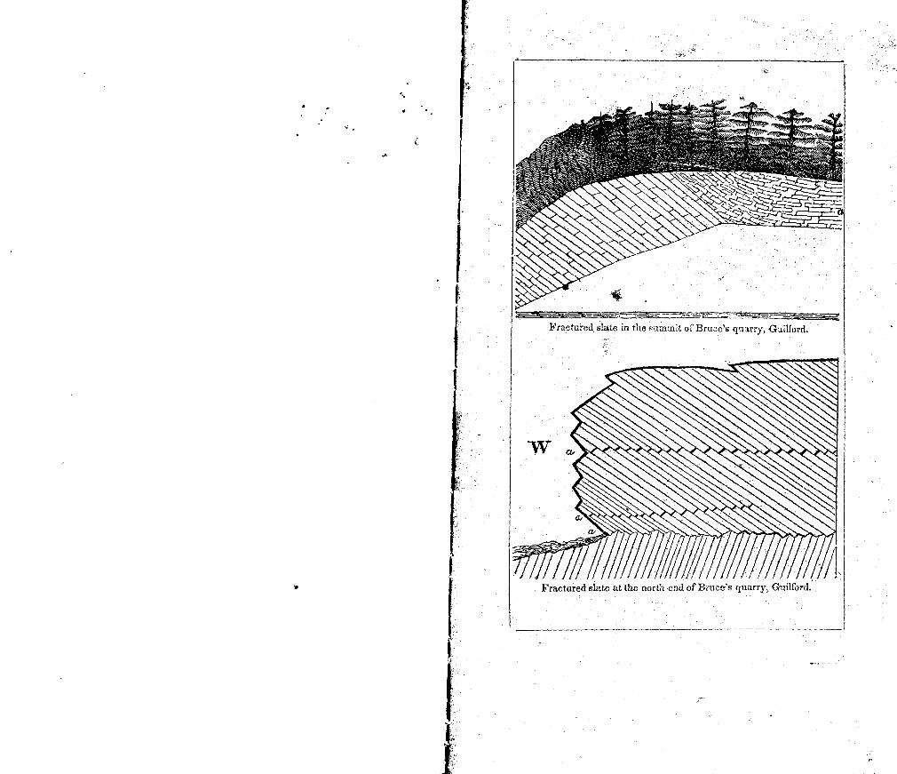
C
Fractured sltc in thcurnnit of Bra--c's q'larry, Gijilord.
Fractured slate at the north end of Brues quarry, Guilford.
I
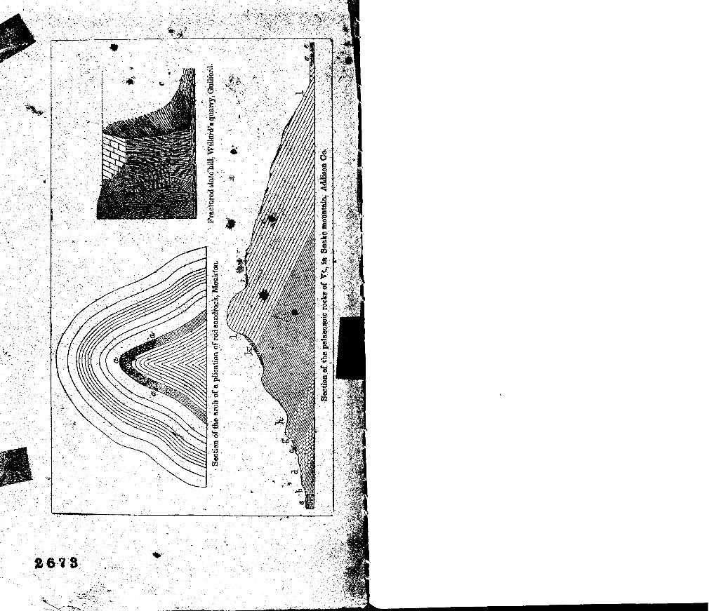
a
A f/I I / I /7/
- / z/ - /17/
(
////
T 1 4