Embed Size (px)
Citation preview
M.L. Gavrilova and C.J.K. Tan (Eds.): Trans. on Comput. Sci. VI, LNCS 5730, pp. 200–218, 2009. © Springer-Verlag Berlin Heidelberg 2009
A General-Purpose Geosimulation Infrastructure for Spatial Decision Support
Ivan Blecic, Arnaldo Cecchini, and Giuseppe A. Trunfio
Laboratory of Analysis and Models for Planning (LAMP) Department of Architecture and Planning - University of Sassari,
Palazzo Pou Salit, Piazza Duomo 6, 07041 Alghero, Italy {ivan,cecchini,trunfio}@uniss.it
Abstract. In this paper we present the general-purpose simulation infrastructure MAGI, with features and computational strategies particularly relevant for strongly geo-spatially oriented simulations. Its main characteristics are (1) a com-prehensive approach to geosimulation modelling, with a flexible underlying meta-model formally generalising a variety of types of models, both from the cellular automata and from the agent-based family of models, (2) tight interoperability between GIS and the modelling environment, (3) computationally efficiency and (4) user-friendliness. Both raster and vector representation of simulated entities are allowed and managed with efficiency, which is obtained through the integra-tion of a geometry engine implementing a core set of operations on spatial data through robust geometric algorithms, and an efficient spatial indexing strategy for moving agents. We furthermore present three test-case applications to discuss its efficiency, to present a standard operational modelling workflow within the simu-lation environment and to briefly illustrate its look-and-feel.
Keywords: Geosimulation, software, multi-agent systems, cellular automata, GIS, urban modelling, open source.
1 Introduction
Geosimulation is a simulation technique for modelling phenomena taking place in geographical environments through the so called bottom-up approaches [1-9], such as cellular automata (CA) or multi-agent systems (MAS). Typically, a geosimulation model uses geo-spatial datasets (i.e. entities in space such as buildings, infrastruc-tures, terrain, and so on) to represent the environment and the “active” entities (cells, agents) interacting locally. The use of advanced characteristics of artificial entities (like autonomy, pro-activity, ability to perceive the space, mobility, etc.) combined with explicit and faithful representations of the geographical space make this family of models an effective technique for simulating complex geographical systems.
Indeed, it has been recognised that such approaches may be of great potential for verifying and evaluating hypotheses about how real geographical complex systems operate, and are therefore often considered as key computer-based tools for territorial analysis and decision support, especially in the field of spatial planning [5].
A General-Purpose Geosimulation Infrastructure for Spatial Decision Support 201
The entering of the geosimulation modelling in its age of maturity [1-8], the growing computational capabilities of nowadays computers, the consolidation of general-purpose as well as specialised GIS-based geo-analysis tools together with their availability as open-source libraries and applications, in our view offer the necessary critical mass to foster the development of robust and scalable general-purpose modelling tools. Tools going beyond the toy-like, demonstrative, proof-of-concept status, thus allowing opera-tional modelling and simulation of real-world geographical systems.
As such, these tools should encompass a series of requirements. In particular, they should (1) be grounded on a sufficiently generalised and flexible meta-model, allow-ing the implementation of a variety of types of geosimulation models; (2) allow a tight interoperability with GIS where the spatial datasets are stored and are pre- or post-processed and analysed; (3) be computationally efficient; and (4) user-friendly.
MAGI (Multi-agent Geosimulation Infrastructure) was developed as a general-purpose integrated infrastructure for geosimulation complying with these require-ments. The objective of this paper is to present the main characteristics and features of MAGI relevant for strongly geo-spatially oriented simulations.
2 The Meta-model
The underlying meta-model of MAGI is an attempt to formally generalise a variety of types of models, both from the cellular automata as well as from the agent-based family of models. Therefore, MAGI should foremost be seen as a software application wrapping around this meta-model, without making compromises to the simplicity and elegance of the modelling practice, while offering rich modelling, simulation and experimentation environment.
The meta-model in MAGI is basically a set of objects and agents organised in lay-ers, where each layer can host one specific type of entity. Formally, the environment
is defined as:
(1)
where is the set of global parameters; the set groups together a series of global functions ; and is the set of layers. In particular, each layer is defined as:
(2)
where is the set of layer parameter; the set collects a series of layer functions ; and is the set of model entities (i.e. either agents or simpler objects like static
entities or CA cells). Global and layer parameters can be used in models to affect the behaviour of enti-
ties populating the environment. This permits forms of global steering of the model evolution, which has been recognised as important for simulation of phenomena not completely reducible to local interactions (i.e. factors outside the local spatial context can be accounted for in the entities’ behaviour).
Moreover, in the MAGI meta-model, parameters may also be a way to store aggre-gate information from a layer, to be used as such in other layers. For example, thanks to the global and layer-level functions, which are scheduled for execution during the
202 I. Blecic, A. Cecchini, and G.A. Trunfio
simulation, the local evolution of a phenomenon evolving on a layer may depend on some global indicators of the phenomena evolving on .
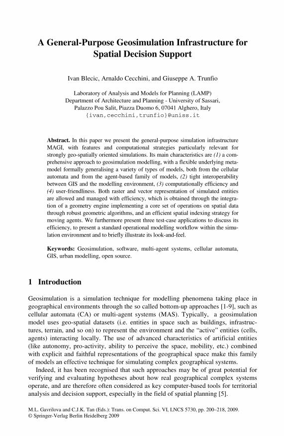
Fig. 1. Example of a model organised in layers
The multi-layer approach presents many advantages in spatial modelling, such as:
• simpler coupling of many spatial models of dynamic phenomena evolving in the same geographical space (e.g. regional and urban models requiring different spatial and temporal resolution);
• easier integration among several different models (evolving on different layers) especially if developed by distinct field experts;
• more direct correspondence of GIS data to the layer-based structure of the model, which simplifies the acquisition of model inputs and the exportation of results.
It is important to point out that the meta-model in discussion includes the possibility of having auxiliary layers containing only static and “inactive” entities. This may prove very useful for urban modelling, for example to account for the effects on other layers of urban entities such as roads, services, facilities and infrastructures (see Fig. 1). In the hereby presented meta-model, the modelling of such interactions is possible because (as we shall see below) every single entity belonging to one layer can interact with entities belonging to other layers, including therefore also auxiliary layers with only static entities.
2.1 The Entity (MAGI Agent)
Layers are populated by agents of different types . In particular, an agent of type is defined as:
(3)
Where is the internal data structure describing agent’s state and history. During the simulation, can change as a result of interactions with other agents, between the agent and its environment, and due to its behavioural specification. The data structure
defines the agent’s geo-spatial attributes. It includes both a vector geometrical shape (like point, line, polygon, circle), representative of the agent, as well as its positioning (i.e. location and rotation). Clearly, during the simulation can be updated (for example the agent can change its position). Finally, is the current spatial context of
A General-Purpose Geosimulation Infrastructure for Spatial Decision Support 203
the agent , represented by a set of references to objects and agents being relevant to , and therefore potentially subject to its actions or requests for action. Clearly, dur-
ing the simulation, every object in can be dynamically updated by the agent as a result of its perception activity.
An agent type is defined as:
(4)
where:
• is the set of possible agent’s internal data structures ; • is the set of admissible geometrical shapes for agents of type ; • is the set of possible actions defining behavioural specification (actions can
modify internal states and geo-spatial attributes of agents); • is the set of perception functions which can be used by agents to perceive their
environment. A function maps the environment to the agent’s context . The perception activity is of particular importance for agents in a geo-spatial environment, since it is one of the main components of their spatial cognitive capabilities.
• is the decision function. Based on its current state and context, this function is used by agents at every turn in order to decide which operation to execute. An operation may be one of agent’s own actions and/or requests to other agents to exe-cute their actions.
• is the agreement function. This function is used by agents to decide, based on their state and context, whether to agree on the execution of an action from , when requested to do so by other agents.
The above definition of agents allow for special case of agents with purely reactive behaviour. As a consequence of this, the agreement on actions asked to reactive agents is decided through a specific agreement function directly belonging to the environment.
2.2 Cellular Automata as a Special Case
The simplest type of “agents” available through this meta-model are cells which can be used for modelling the environment as a CA. Such cells are endowed with a shape and dynamic multiple neighbourhoods (i.e. the agent’s spatial context). Moreover, MAGI makes available a rich set of functions for building regular lattices consisting of rectangular or hexagonal cells with standard or custom neighbourhoods.
Given the possibility of multi-layer structure of models, we thus have a so called multi-layered model in which the automata are organised in different layers [10].
Even if many CA models adopt a strictly local neighbourhood, spatial interactions in geographical phenomena can often take place over greater distances. For this rea-son, accordingly with the notion of the proximal space deriving from the research in “cellular geography” [11], in CAs developed in MAGI every cell can have a different neighbourhood defined by relations of proximity of spatial geographical entities, where proximity can be both a topological relation or a generic functional influence.
204 I. Blecic, A. Cecchini, and G.A. Trunfio
In other words, similarly to the spatial context of an agent defined above, the neighbourhood of a CA cell can be defined as a generic set of agents-cells whose states can influence the variation of the cell’s state. It is important to note that neighbourhoods can be non-stationary, since they can vary in size and shape during the system’s evolution, thanks to the reiteration of the spatial queries attached to the cell. In general, depending on the model requirements, various queries can be associ-ated to each cell, so that different possible neighbourhoods, even belonging to differ-ent layers, correspond respectively to different rules of the transition function.
3 Overview of MAGI Architecture
From architectural point of view, MAGI is composed of three components: (i) a mod-elling and simulation environment, (ii) a GIS interoperability bridge, and (iii) a class library developed in C++ language. The latter can be used for developing model plug-ins for MAGI simulation environment as well as independent stand-alone models.
3.1 Modelling and Simulation Environment
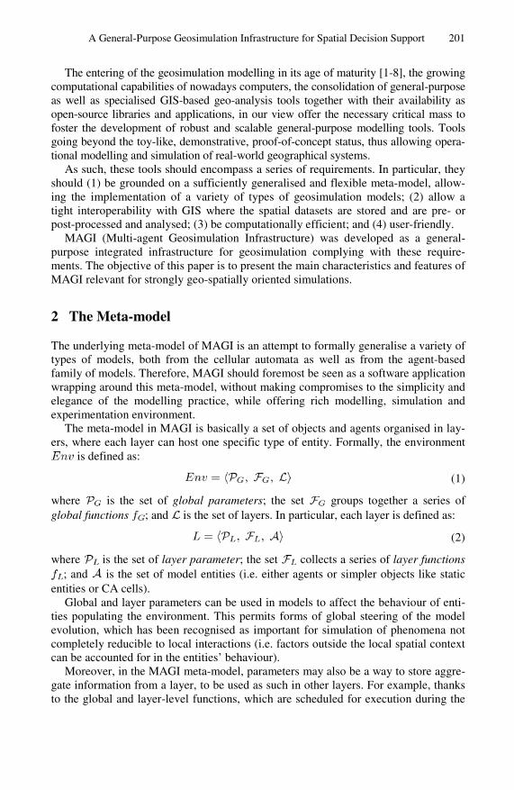
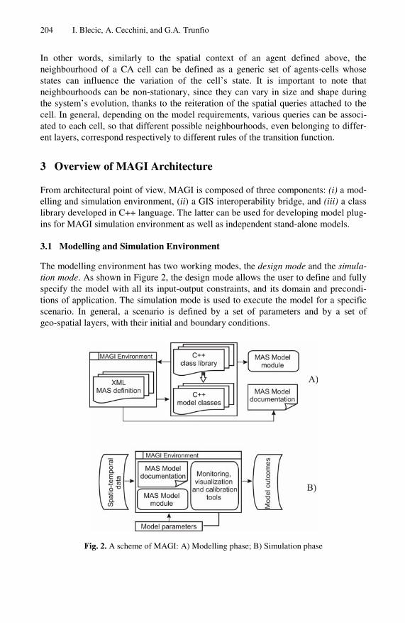
The modelling environment has two working modes, the design mode and the simula-tion mode. As shown in Figure 2, the design mode allows the user to define and fully specify the model with all its input-output constraints, and its domain and precondi-tions of application. The simulation mode is used to execute the model for a specific scenario. In general, a scenario is defined by a set of parameters and by a set of geo-spatial layers, with their initial and boundary conditions.
Fig. 2. A scheme of MAGI: A) Modelling phase; B) Simulation phase
A General-Purpose Geosimulation Infrastructure for Spatial Decision Support 205
Internally, a model structure in MAGI is an XML document describing the organi-sation of the model in layers, model parameters, properties of elementary entities, and so on. Such XML model description is used by the framework to generate a skeleton of the C++ source code of the model, according to the MAGI C++ class library (see Figure 2). Subsequently, the generated source code can be imported into a standard C++ development environment for further coding and debugging.
In addition, the simulation module contains specific user interfaces for invoking the simulation plug-in and for configuring the preferences and initial conditions rele-vant for the simulation, among which the values of global and layer parameters, the number of time steps, and the output options.
The execution of the simulation engine produces output scenarios in XML format, together with several synthetic statistics of the results of simulation (like the evolution of global and layer parameters over simulation steps).
3.2 GIS Interoperability Bridge
Recent research in the field of geosimulation focused mainly on techniques to im-prove models of spatial processes, to propose new conceptualisations of spatial enti-ties and their mutual relationships, to apply simulation models to real-world problems and to develop new software tools for supporting the process of modelling. This latter research direction has produced modelling and simulation frameworks – like Swarm, Repast, OBEUS [5,6], among others (see [5] for a review) – supporting various forms of integration of geo-spatial data. However, the interoperability with GIS offered by existing tools is still limited.
The integration of simulation engines into existing GIS systems has been proposed elsewhere (e.g. loose coupling based on the Remote Procedure Call paradigm or other proprietary protocols) [4,12,13]. However, the coupling of simulation engines with proprietary GIS can hardly provide the necessary modelling flexibility and a satisfac-tory computational efficiency. For this reason, MAGI has been specifically designed to allow an easy and effective importation and exportation of geo-spatial datasets from and to standard GIS formats. In particular, the user interface of MAGI offers functionalities for: (i) creating entities (i.e. agents) from features of vector data files; (ii) mapping the feature attributes directly into agents’ states and objects’ properties; (iii) importing raster files as cellular spaces where cells’ attributes can correspond to pixels samples, (iv) powerful importing capabilities from common GIS formats, and (v) the integration of specific computational strategies for efficiency and robustness.
3.3 Class Library
As mentioned above, MAGI is endowed with a C++ class library for supporting the development of geosimulation models according to the meta-model described in sec-tion 2. Clearly, the MAGI class library can also be used by software developers as a stand-alone library for deriving and implementing models, independently from the MAGI environment.
The main advantage of providing a class library lies in the greater simplicity of model-designing phase in comparison to a development from scratch. Indeed, at the beginning, the modeller needs only to specify the model components, and is relieved from a number of implementation details and complications. In addition, the use of
206 I. Blecic, A. Cecchini, and G.A. Trunfio
the XML standard for outlining the model structure permits an easy merging of dif-ferent sub-models, simplifying and promoting the collaboration among different experts. Another important implication of the use of XML consists in high readability of the model structure, which is reputed important for avoiding black-box effects.
The MAGI class library implements and adopts several computational strategies and offers specific algorithms which are utterly relevant for the computational effi-ciency of geosimulations. Given their relevance, we present few of them in the remaining of the present section, namely the algorithms for indexing of agents and the embedded geometry engine.
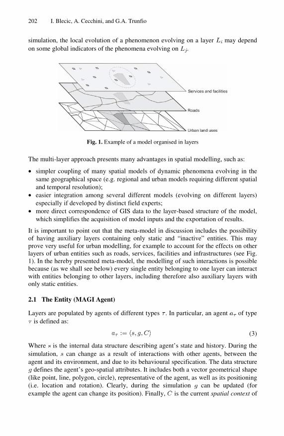
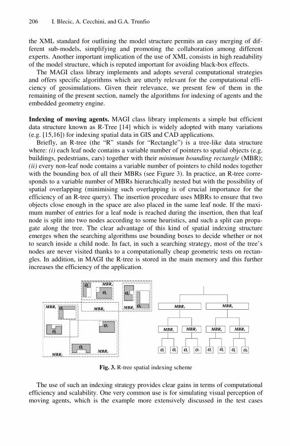
Indexing of moving agents. MAGI class library implements a simple but efficient data structure known as R-Tree [14] which is widely adopted with many variations (e.g. [15,16]) for indexing spatial data in GIS and CAD applications.
Briefly, an R-tree (the “R” stands for “Rectangle”) is a tree-like data structure where: (i) each leaf node contains a variable number of pointers to spatial objects (e.g. buildings, pedestrians, cars) together with their minimum bounding rectangle (MBR); (ii) every non-leaf node contains a variable number of pointers to child nodes together with the bounding box of all their MBRs (see Figure 3). In practice, an R-tree corre-sponds to a variable number of MBRs hierarchically nested but with the possibility of spatial overlapping (minimising such overlapping is of crucial importance for the efficiency of an R-tree query). The insertion procedure uses MBRs to ensure that two objects close enough in the space are also placed in the same leaf node. If the maxi-mum number of entries for a leaf node is reached during the insertion, then that leaf node is split into two nodes according to some heuristics, and such a split can propa-gate along the tree. The clear advantage of this kind of spatial indexing structure emerges when the searching algorithms use bounding boxes to decide whether or not to search inside a child node. In fact, in such a searching strategy, most of the tree’s nodes are never visited thanks to a computationally cheap geometric tests on rectan-gles. In addition, in MAGI the R-tree is stored in the main memory and this further increases the efficiency of the application.
Fig. 3. R-tree spatial indexing scheme
The use of such an indexing strategy provides clear gains in terms of computational efficiency and scalability. One very common use is for simulating visual perception of moving agents, which is the example more extensively discussed in the test cases
A General-Purpose Geosimulation Infrastructure for Spatial Decision Support 207
section of this paper (see below section 4.1). There are also other types of spatial perception that can take advantage of the spatial indexing structure available in MAGI. For example, in assessing the physical admissibility of agent’s movement, the agent itself (or a specific environment function) must check if the desired trajectory intersects objects or other agents.
It is worth mentioning that the algorithms of spatial perception in MAGI consider all agents with their actual bi-dimensional shapes (e.g. circles, segments, polygons), so agents may reduce or block the view to each other. Therefore, agents’ shapes must be indexed in the R-tree as any other entity in the environment. However, since agents can move, the update operations are necessary for maintaining the coherence and efficiency of the spatial indexing structure. Unfortunately, since the change of object position in a standard R-tree corresponds to one remove and one insert operation (potentially with the need to split or merge nodes), that would become significantly expensive for simulating models with many thousands of moving agents. Indeed, one of the reasons of reduced efficiency of geosimulation models developed within a GIS environment is related to the use of therein available indexing structures which were conceived mainly for static spatial data and therefore exhibit poor update performances.
Since the problem of efficiently indexing the actual position of moving objects arises in many applications (e.g. real-time traffic simulation and monitoring, transpor-tation managements, mobile computing) [17], it has been object of great attention in recent years. To reduce the number of update operations, many existing approaches (e.g. [18,19]) use a function to describe movements of objects and then update the data structure only when the parameters of that function change (e.g. when the speed or the direction of a car or a pedestrian change). However, frequently there is no sufficiently good function available to describe some specific movements. For this reason, other alternatives to the standard indexing techniques have been proposed for accelerate updating operations. One of such indexing scheme, which fits well to the characteris-tics of moving agents, has been implemented in MAGI. It is based on processing updates in the R-tree using a bottom-up approach instead of the standard top-down procedure [20,21,22]. Specifically, this approach processes an update from the leaf node of the old entry to be updated, and tries to insert the new entry into the same leaf node or into its sibling node. For accessing the leaf node, a secondary index (i.e. a direct link) is maintained for all objects. The particular scheme implemented in MAGI is the so called LUR-tree (Leaf-prior-Update R-tree) [21]. For further details on the visual perception problem and LUR-tree implementation in MAGI see [23].
Geometry engine. Given the vector representation of objects associated to entities in the environment, both spatial perception and spatial reasoning require the use of a geometry engine. Such engine must provide: (i) the capability of creating and using geometrical objects; and (ii) suitable computational geometry algorithms for handling these objects, such as computation of spatial relationships and properties, shape combinations, overlay, buffer operations, among others.
For this purpose, the GEOS (Geometry Engine - Open Source) class library [24] has been integrated into MAGI, together with a simple wrapper interface. GEOS provides a complete model for specifying 2-D linear geometry and implements a set of operations on spatial data using robust geometry algorithms. The main reasons for integrating GEOS in a geosimulation class library are:
208 I. Blecic, A. Cecchini, and G.A. Trunfio
• Robusteness. Geometry algorithms are susceptible to problems of robustness, i.e. an inexact behaviour due to the round-off errors and the numerical errors propaga-tion. In GEOS, the fundamental geometric operations (e.g. line intersections), on which most of other operations are based, are implemented using robust algo-rithms. Also, the binary predicate algorithm, which is particularly important for the process of agents’ spatial perception, is fully robust. Many other algorithms in GEOS minimise the problems of robustness and those known not to be fully robust (i.e. spatial overlay and buffer algorithms) are rarely used in agent modelling and work correctly in the majority of cases.
• Computational requirements. As geosimulation models may deal with thousands of agents, the computational complexity of every geometric operation used by agents can greatly affect the overall requirements of computational resources. Unfortu-nately, robust geometric algorithms often present poor computational perform-ances. GEOS uses specific techniques to produce good performance when operat-ing on common types of input data.
• Rich set of available features and spatial operations. In terms of the spatial model, geometric objects and method definitions, GEOS complies well with the OpenGIS Simple Features Specification [30]. In particular, it provides a set of Boolean predicates for computing common spatial relationships (e.g. disjoint, intersects, crosses, within, contains, overlaps, touches, equals, etc.) as well as common algo-rithms for computing intersections, distances, areas and many others.
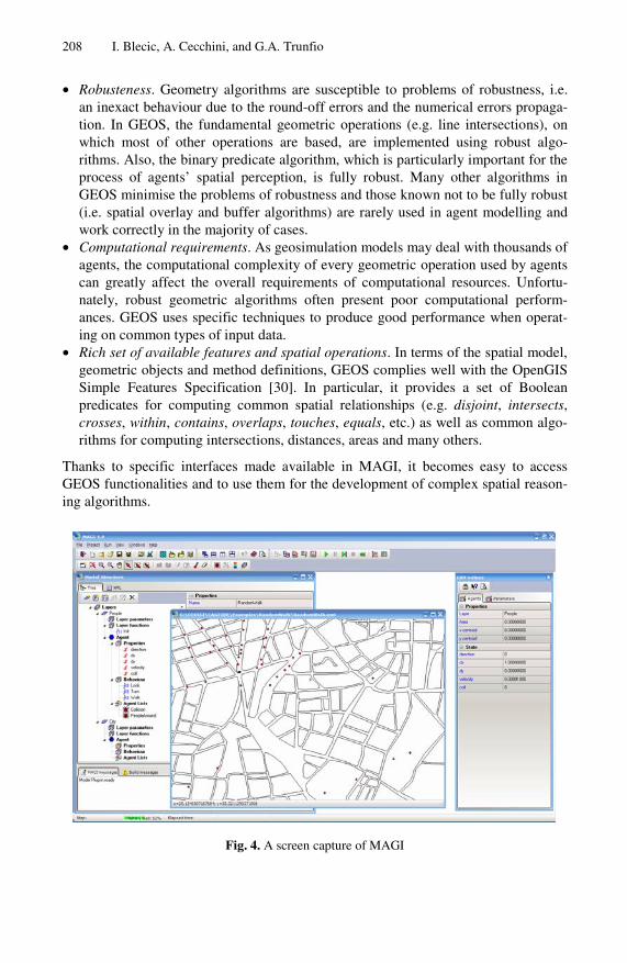
Thanks to specific interfaces made available in MAGI, it becomes easy to access GEOS functionalities and to use them for the development of complex spatial reason-ing algorithms.
Fig. 4. A screen capture of MAGI
A General-Purpose Geosimulation Infrastructure for Spatial Decision Support 209
4 Test Cases
MAGI has been extensively used for implementing different MAS and CA models. In this section, we discuss three test cases to better show the functioning and to point out the advantages of MAGI. The first one is a multi-agent model of visual perception of moving agents; the second is a CA simulation of urban growth [3,4], and the third is a CA land-use model [25,26,27].
4.1 Visual Perception of Moving Agents
As mentioned before, the spatial perception of agents represents one of the main components of their spatial cognitive capabilities in geosimulation models. An agent must be able to perceive objects and other surrounding agents to build an internal representation of its spatial context, and to use it in her decision-making process. In some cases, spatial perception implies not only detecting presence/absence of entities (i.e. agents in the language of our meta-model), but also estimating their geometric characteristics (e.g. the distance from them, the relative distances among different objects, objects’ areas or shape types).
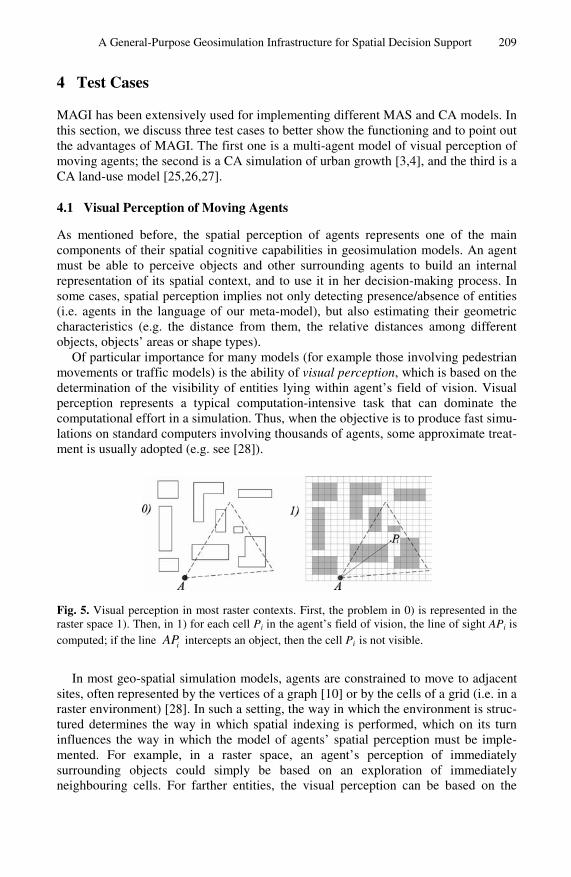
Of particular importance for many models (for example those involving pedestrian movements or traffic models) is the ability of visual perception, which is based on the determination of the visibility of entities lying within agent’s field of vision. Visual perception represents a typical computation-intensive task that can dominate the computational effort in a simulation. Thus, when the objective is to produce fast simu-lations on standard computers involving thousands of agents, some approximate treat-ment is usually adopted (e.g. see [28]).
Fig. 5. Visual perception in most raster contexts. First, the problem in 0) is represented in the raster space 1). Then, in 1) for each cell Pi in the agent’s field of vision, the line of sight APi is computed; if the line iAP intercepts an object, then the cell Pi is not visible.
In most geo-spatial simulation models, agents are constrained to move to adjacent sites, often represented by the vertices of a graph [10] or by the cells of a grid (i.e. in a raster environment) [28]. In such a setting, the way in which the environment is struc-tured determines the way in which spatial indexing is performed, which on its turn influences the way in which the model of agents’ spatial perception must be imple-mented. For example, in a raster space, an agent’s perception of immediately surrounding objects could simply be based on an exploration of immediately neighbouring cells. For farther entities, the visual perception can be based on the
210 I. Blecic, A. Cecchini, and G.A. Trunfio
computation of the line of sight between the agent’s position and the target cell, for every cell in agent’s field of vision (see Fig. 5) [28].
As mentioned before (see subsection 2.1), in MAGI all agents are associated to a geometrical shape with a vector representation. This however does not eliminate the possibility to use raster layers as cellular spaces. Also, agents may in the line of prin-ciple move to any position (although using some specific types of agents in MAGI, the action move must be evaluated by the environment, and its successful completion is not guaranteed in general).
The possibility to use vector shapes allows more realistic simulations, offers greater flexibility, and a better interoperability with GIS applications. In models based entirely on cellular spaces, the dimension of cells determines both the accuracy of the representation of complex shapes (e.g. buildings) and the spatial resolution of agents’ movements. However, such a rigidity is not present in models using vector shapes for entities, be they static or moving agents. Furthermore, the accuracy of spatial percep-tion based on vector representation can take significant advantages from the existing algorithms of computational geometry. Another manifest benefit offered by the possi-bility to treat with vector entities lies in a greater simplicity of use of –, and interop-erability with most spatial data (e.g. demographic data, land-uses, buildings shapes, etc.) managed by GIS software, without the need of their previous rasterisation. In fact, the geo-spatial features can directly be mapped to agents of the model, and vice versa.
However, to these advantages could correspond greater computational costs of algorithms managing agents’ movements and spatial perception. In many situations this may not be of crucial importance (for example when the model involves only few agents or when its purpose is to analyse a complex system without the need for real-time simulation). Nevertheless, the containment of computational requirements is still a relevant factor, as that allows the use of more detailed models (e.g. more evolved agents) with given computational resources. In order to obtain such objectives of efficiency, the process of agents’ spatial perception in MAGI is grounded on the two features mentioned above: a specific purpose-oriented spatial indexing technique for moving objects, and a fast and robust geometry engine.
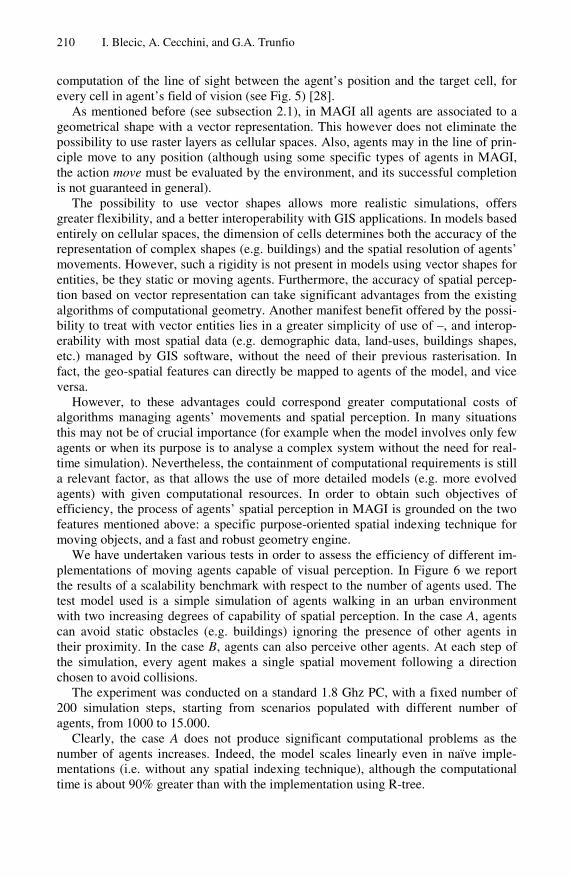
We have undertaken various tests in order to assess the efficiency of different im-plementations of moving agents capable of visual perception. In Figure 6 we report the results of a scalability benchmark with respect to the number of agents used. The test model used is a simple simulation of agents walking in an urban environment with two increasing degrees of capability of spatial perception. In the case A, agents can avoid static obstacles (e.g. buildings) ignoring the presence of other agents in their proximity. In the case B, agents can also perceive other agents. At each step of the simulation, every agent makes a single spatial movement following a direction chosen to avoid collisions.
The experiment was conducted on a standard 1.8 Ghz PC, with a fixed number of 200 simulation steps, starting from scenarios populated with different number of agents, from 1000 to 15.000.
Clearly, the case A does not produce significant computational problems as the number of agents increases. Indeed, the model scales linearly even in naïve imple-mentations (i.e. without any spatial indexing technique), although the computational time is about 90% greater than with the implementation using R-tree.
A General-Purpose Geosimulation Infrastructure for Spatial Decision Support 211
Fig. 6. Results of the test on walking agents. In A) agents walk avoiding collisions but ignoring other agents; in B) agents walk avoiding collisions and perceiving the presence of other agents in their field of vision.
As expected, in the case B where agents need to perceive the presence and the posi-tion of other agents, the naïve approach leads to the impossibility to simulate systems with thousands of agents within reasonable time, since the computational complexity of perception is , where is the number of the agents. On the contrary, the computational time, obtained through the use of standard algorithms available in MAGI, exhibits a linear dependence on the number of agents.
In both cases the use of the LUR-tree approach leads to a computational time of about 16% lower than that of the standard R-tree.
On the whole, these tests show that the advantages deriving from vector-based geosimulation models using thousands of agents can effectively be put in action with MAGI, at affordable computational costs.
4.2 Urban Growth CA Model
An operational assessment of the effectiveness of MAGI, as simulation environment tightly interoperable with GIS, has been undertaken through the development a SLEUTH-like urban growth model.
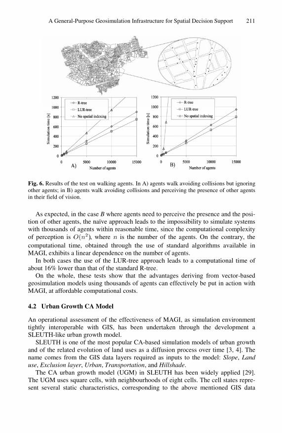
SLEUTH is one of the most popular CA-based simulation models of urban growth and of the related evolution of land uses as a diffusion process over time [3, 4]. The name comes from the GIS data layers required as inputs to the model: Slope, Land use, Exclusion layer, Urban, Transportation, and Hillshade.
The CA urban growth model (UGM) in SLEUTH has been widely applied [29]. The UGM uses square cells, with neighbourhoods of eight cells. The cell states repre-sent several static characteristics, corresponding to the above mentioned GIS data
212 I. Blecic, A. Cecchini, and G.A. Trunfio
layers (the layer Hillshade is used only for representation purposes and the Land use layer is not used by the UGM), as well as dynamic characteristics of the urbanisation. The transition function depends on five integer parameters defined on the interval from 1 to 100. These parameters are:
• Dispersion, which determines the overall dispersal of urbanisation; • Breed, which expresses the likelihood of a new isolated urban cell to initiate an
independent growth cycle; • Spread, controlling the diffusion by contagion from existing urbanised cells; • Slope Resistance, influencing the likelihood of urbanisation on steep slopes; • Road Gravity, which regulates the generation of new urbanisation towards and
along roads.
The UGM transition function is composed of four probabilistic rules: (i) Spontaneous Growth, which consists of random spontaneous urbanisation of a fixed number of cells at each time step; (ii) New Spreading Centres, determining whether any of the new, spontaneously urbanised cells become a new urban spreading centre; (iii) Edge Growth, defining the component of growth which stems from existing spreading centres; (iv) Road-Influenced Growth, accounting for the urbanisation related to the presence of transportation infrastructure and therefore of the resulting better accessi-bility (for details see [29]).
Since the main purpose of our implementation of SLEUTH UGM in MAGI is the assessment of effectiveness of the software infrastructure, the model described here does not include details such as the so called parameter self-modification [3].
The SLEUTH UGM represents an interesting test case for the evaluation of the characteristics of MAGI, mainly because:
1. it is a parameter-dependent CA model, thus fitting well with the characteristics of the MAGI library that allows the definition of a set of layer parameters;
2. it is a “constrained” CA, since in the Spontaneous Growth rule the number of cells changing their state from non urban to urban is fixed, and this can be handled in a natural way using a specific layer-level function in the set ;
3. the transition function determines the interaction among each cell and its near-est neighbouring cells (for the New Spreading Centres and Edge Growth rules), as in a standard CA, but also the interaction with cells representing roads within a radius considerably larger than the size of single cells; this can be easily implemented defining two distinct neighbourhoods of cell, as con-templated by the meta-model described above.
In particular, the simulation model under discussion is composed in MAGI of one layer including the five layer-level parameters mentioned above. Each cell is charac-terised by a state composed of the following five scalar properties::
• Slope, representing the terrain slope in percent; • Exclusion, defining the level of resistance to urbanisation (e.g. open water bod-
ies take the value 100, while areas available for urban development take the value 0);
• Urban, which is the only dynamic property and represents the urbanisation state (can take the two values: urban and non urban);
A General-Purpose Geosimulation Infrastructure for Spatial Decision Support 213
• Road, derived from a road network GIS layer, and is also of binary type (road or non-road) indicating whether the cell contains a road or not.
In order to implement the UGM transition function in MAGI (i.e. the four above men-tioned rules of the transition function), two distinct neighbourhoods are associated to each cell. This is obtained by defining the set of selection queries as:
(5)
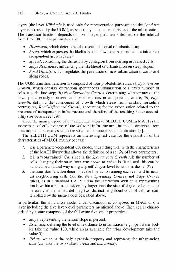
where gives the standard Moore neighbourhood while returns the nearest cell, located within a predefined radius, having . Both selection queries are exe-cuted only at the first time step of the simulation. While the query is provided by the library, in order to implement the query in MAGI, the modeller have to develop an easy override of the two virtual functions executeQuery and in-cludeEntity, as shown in Fig. 7. In particular, in executeQuery a filter shape representing a circle centered in the cell’s centroid is used for invoking the library function nearestNeighbourhoodSearch, which on its turn performs an effi-cient preliminary search in the R-tree based on the MBRs of the involved shapes. The latter function also invokes the includeEntity function for refining the result through the check of the property Road of the candidate cells as well as its spatial relationship with the filter shape (i.e. using the function contains provided by GEOS). This approach in construction CA neighbourhoods, being not dependent on the regularity of the space tessellation, presents the advantage of a more flexible mod-elling approach without sacrificing the computational efficiency. For example, the extension towards a model based on irregular cells would not require the rewriting of the functions in Fig. 7.
The raster layers used for the production of the input scenario file have been elabo-rated from several raster files available on the SLEUTH web site [29]. Even if not strictly necessary, the visualisation capabilities of MAGI are useful in the pre-processing phase for a preliminary assessment of qualitative characteristics of spatial data which can influence some modelling-related decisions (such as the extension of the area under study or the size of cells).
The SLEUTH UGM has been used in MAGI with many different input scenarios and, on the whole, the test case has definitely highlighted the effectiveness of the framework in making this family of well-established CA models more accessible to standard GIS users.
4.3 Constrained Land-Use Model
Another test case model developed and experimented in MAGI is a constrained CA for the simulation of the local land-use dynamics [25,26,27].
This model is “constrained” in the sense that at each time step the aggregate level of demand for every land use is fixed by an exogenous constraint. This constraint is defined on a macro-level by external a-spatial demographic, economic and environ-mental models.
214 I. Blecic, A. Cecchini, and G.A. Trunfio
void NearestRoadCells::executeQuery() {
auto_ptr<Geometry> filter(world.shapeFactory->createCircle( ownerEntity->getXCentroid(), ownerEntity->getYCentroid(), world.road_gravity_radius)); nearestNeighbourhoodSearch(1, filter); }
bool NearestRoadCells::includeEntity(Entity &candidate, Geometry* filter) { try { Cell &c = dynamic_cast<Cell&>(candidate); if ( c.Road!=0 && filter->contains(ownerEntity->getShape()) ) return true; } catch (const bad_cast& e) { cerr << e.what() << endl; } return false; }
Fig. 7. The C++ functions required by the MAGI library for implementing the query in the SLEUTH-like urban growth model
Our model is a simplified version of the one discussed in [25,26,27] since it has been devised for MAGI testing purposes. However, its extension to a more detailed version is plainly straightforward.
In particular, the only dynamic property of the elementary automaton (i.e. cell) state represents the land use, and has been limited to the set
. Other properties of cells represent static land-use characteristics. These are: cell accessibility , suitability for different land uses (taking into account features like slope, terrain aspect and the presence of specific infrastruc-tures), a Boolean value Zj for each land use, defining the exclusion of the j-th land use (for example due to zoning regulations or physical constraints). The state of the cell also includes a transition potential Pj for each land use j, expressing the level of pro-pensity of the land to acquire the j-th type of use.
The cell neighbourhood is defined as the circular region of a given radius around the cell.
The first phase of the transition function consists of the computation of the transi-tion potentials for every cell, according to the equation:
(6)
where is a random perturbation factor and Nj is the so called neighbourhood effect. The latter represents the sum of all the attractive and repulsive effects of land uses and land covers within the neighbourhood, on the j-th land use which the current cell may assume. Since, in general, more distant cells in the neighbourhood have smaller influ-ence, in our MAGI version of the model, the factor Nj is computed as:
A General-Purpose Geosimulation Infrastructure for Spatial Decision Support 215
(7)
where the summation is extended to all cells of the neighbourhood V (which does not include the owner cell itself). In Eq. 7 the current land use of the cell is denoted by i; s is the cell size; d is the distance between the cell c and the current cell; the parameter aij represents the maximum influence (positive or negative) of the land use i on the use j; dij is the distance in correspondence of which the contribution to the neighbouring effect is a fraction of the maximum value (currently ) and
. The positive term Ik, where k denotes the current land use of the cell, accounts for the effect of the cell on itself (zero-distance effect) and represents an inertia effect due to the costs of transformation from one land use to another.
The second phase of the transition function takes place on a non-local basis and consists of transforming each cell into the state with the highest potential, given the constraint of the overall number of cells in each state imposed by the exogenous trend for that iteration.
As for the SLEUTH UGM model discussed in section 4.2, this land-use model represents another significant test case for the purpose of evaluating MAGI. In fact, the presence of a non-standard neighbourhoods and of a parameterised transition function including also non-local transformations, are both characteristics which can naturally be treated by the MAGI library.
In the model developed for MAGI, a single layer of square cells has been used for the automaton. However, MAGI library could also allow irregular cells be used for this model without the need of changing the model source code.
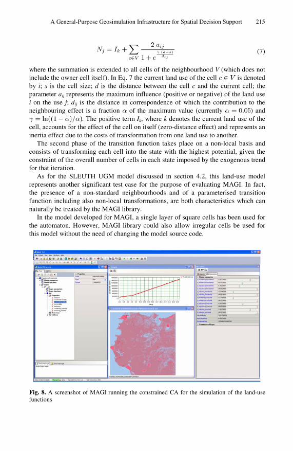
Fig. 8. A screenshot of MAGI running the constrained CA for the simulation of the land-use functions
216 I. Blecic, A. Cecchini, and G.A. Trunfio
The neighbourhood has been defined through a selection query executed only at the first simulation time step, which returns the cells located within a predefined ra-dius of 1000 m, excluding the owner cell. To this purpose, as for the model discussed in section 4.2, specific overrides for the library functions executeQuery and
includeEntity, have been developed. A set of layer parameters hold the values of Ik, aij and dij of Eq. 7 and, once the
XML model definition has been loaded in MAGI, their value can be easily set by the user and stored in a scenario file.
At the first time step of the simulation, a layer function loading trends of land-use demand for all the subsequent time steps is executed.
The local component of the transition function (i.e. the standard transition function executed on the cell level) computes the transition potential Pj according to Eqs. 6 and 7, while a layer function implements the transition algorithm. In the latter, all cells are ranked by their highest potential, and cell transitions begin with the highest ranked cell and proceed downwards until a sufficient number of cells have been attributed to every land use.
The model has been applied on a region in the western part of Sicily (Italy) using a grid of square cells of size 400x400 meters. The initial scenario, corre-sponding to the situation in 1970, has been produced efficiently in MAGI where some input raster layers have been associated to cells’ properties and incorporated into the XML scenario file, together with the values of layer parameters.
Since the model under discussion is probabilistic, a series of 30-step simulations (each simulating 30 years of system’s evolution) has been performed and the output scenarios have been used for the production of a probability map through a specific function in MAGI. In Fig. 8, the final outcome of the simulation is depicted.
This test case also showed that the architecture and the features of MAGI can make CA-based modelling and simulation as accessible to users as other advanced but more standard spatial analysis procedures.
5 Conclusions
Geosimulations may be computationally quite a demanding set of simulation ap-proaches, and therefore require the use of an articulated “ecology” of techniques, tools and computational strategies which have to be integrated into a well organised software infrastructure. In this paper we have shown how MAGI implements and purposely integrates a series of approaches, tools and strategies in order not only to be user friendly and sufficiently general to host a large variety of model types, but also to provide high computational efficiency and robustness. We have presented few situa-tions and cases, where such techniques and strategies offered by MAGI can effec-tively be put in action.
In particular, we have discussed one of the crucial cognitive capability of agents in geosimulation models, namely the problem of agents’ spatial perception. The algo-rithms for spatial perception may be characterised by very high computational costs, especially in models with vector representation for entities. That notwithstanding, in MAGI agents can operate in a vector space, but can still sense the environment rather efficiently thanks to the use of a robust and efficient geometric engine together with a specifically implemented spatial indexing technique.
A General-Purpose Geosimulation Infrastructure for Spatial Decision Support 217
We have also briefly presented two test drives of MAGI on two widely know CA models, which we hope have shown its effectiveness and user-friendliness not only for the modelling and simulation tasks, but also the usefulness of its GIS interopera-bility bridge for all the ancillary, often time-consuming activities of pre-processing of spatial data, scenario initialisation, and analysis of results of simulation.
Taking into consideration the current use experiences of MAGI – notwithstanding they have still been quite limited in number – there exist preliminary clues that different aspects of MAGI are fairly competitive with other similar simulation frameworks (like Swarm, Repast and OBEUS) with respect to characteristics such as user-friedliness, interoperability with GIS, and computational efficiency due to the adoption of opti-mized libraries, specifically implemented computational approaches and the use of a programming language (i.e. C++) generally exhibiting better performance.
From the point of view of system’s extension, in the future we plan to focus on the development of a support tool for calibrating and validating geosimulation models, as well as on few other implementational aspects of MAGI, such as the development of a version using thread-pooling techniques, capable of taking greater advantage of multi-core processors.
The architectural characteristics of the integrated environment of MAGI delivers satisfactory computational power without sacrificing the generality of the base meta-model. This is a particularly relevant point given the fact that MAGI was designed as a general-purpose modelling and simulation tool for geosimulations.
References
1. Cecchini, A.: Urban modelling by means of cellular automata: generalised urban automata with the help on-line (AUGH) model. Environment and Planning B, 721–732 (1996)
2. Batty, M.: Urban systems as cellular automata. Environment and Planning B 24, 159–164 (1997)
3. Clarke, K., Hoppen, S., Gaydos, L.: A self-modifying cellular automaton model of histori-cal urbanization in the San Francisco Bay Area. Environ. Plan B 24, 247–261 (1997)
4. Clarke, K., Gaydos, L.: Loose-coupling a cellular automaton model and gis: long-term urban growth predictions for San Francisco and Baltimore. Int. J. Geog. Inf. Sci. 12, 699–714 (1998)
5. Benenson, I., Torrens, P.M.: Geosimulation: object-based modeling of urban phenomena. Comput. Environ. Urban Syst. 28, 1–8 (2004)
6. Torrens, P., Benenson, I.: Geographic automata systems. Int. J. of Geogr. Inf. Sci. 19, 385–412 (2005)
7. Castle, C., Crooks, A.: Principles and concepts of agent-based modelling for developing geospatial simulations. Working Paper 110, Centre for Advanced Spatial Analysis, University College London, London (2006)
8. Cecchini, A., Trunfio, G.A.: Supporting urban planning with CAGE: a software environ-ment to simulate complex systems. Adv. Complex Syst. 10-2, 309–325 (2007)
9. Ferber, J.: Multi-agent systems: an introduction to distributed artificial intelligence. Addison-Wesley, Reading (1999)
10. Bandini, S., Manzoni, S., Vizzari, G.: Toward a platform for multi-layered multi-agent situated system (MMASS)-based simulations: focusing on field diffusion. Appl. Artif. In-tell. 20, 327–351 (2006)
218 I. Blecic, A. Cecchini, and G.A. Trunfio
11. Tobler, W.: Cellular geography. In: Gale, S., Olsson, G. (eds.) Philosophy in Geography, pp. 379–386. Reidel, Dordrecht (1979)
12. Wu, F.: GIS-based simulation as an exploratory analysis for space-time processes. J. Geogr. Syst. 1, 199–218 (1999)
13. Wagner, D.: Cellular automata and geographic information systems. Environ. Plan. B 24, 219–234 (1997)
14. Guttman, A.: R-trees: A dynamic index structure for spatial searching. In: SIGMOD Conf., pp. 47–57 (1984)
15. Beckmann, N., Kriegel, H.P., Schneider, R., Seeger, B.: The R*-tree: An efficient and ro-bust access method for points and rectangles. In: SIGMOD Conf., pp. 322–331 (1990)
16. Roussopoulos, N., Leifker, D.: Direct spatial search on pictorial databases using packed R-trees. In: SIGMOD Conf., pp. 17–31 (1985)
17. Wolfson, O., Xu, B., Chamberlain, S., Jiang, L.: Moving objects databases: Issues and so-lutions. In: 10th Int. Conf. Sci. Stat. Database Manag., pp. 111–122. IEEE Computer Soci-ety, Los Alamitos (1998)
18. Kollios, G., Gunopulos, D., Tsotras, V.J.: On indexing mobile objects. In: Proceedings of the Eighteenth ACM SIGACT-SIGMOD-SIGART Symp. Princip. Database Syst., pp. 261–272 (1999)
19. Tayeb, J., Ulusoy, Ä.O., Wolfson, O.A.: Quadtree-based dynamic attribute indexing method. Comput. J. 41, 185–200 (1998)
20. Kwon, D., Lee, S., Lee, S.: Indexing the current positions of moving objects using the lazy update R-tree. In: Proceedings of the Third Int. Conf. Mob. Data Manag., pp. 113–120 (2002)
21. Lee, M.L., Hsu, W., Jensen, C.S., et al.: Supporting frequent updates in r-trees: A bottom-up approach. In: VLDB, pp. 608–619 (2003)
22. Kwon, D., Lee, S., Lee, S.: Efficient update method for indexing locations of moving ob-jects. J. Inf. Sci. Eng. 21, 643–658 (2005)
23. Blecic, I., Cecchini, A., Trunfio, G.A.: A Software Infrastructure for Multi-agent Geosimu-lation Applications. In: Gervasi, O., Murgante, B., Laganà, A., Taniar, D., Mun, Y., Gavrilova, M.L. (eds.) ICCSA 2008, Part I. LNCS, vol. 5072, pp. 375–388. Springer, Hei-delberg (2008)
24. GEOS: Geometry Engine - Open Source (2008), http://geos.refractions.net/ 25. White, R., Engelen, G.: Cellular automata and fractal urban form: A cellular modeling ap-
proach to the evolution of urban land-use patterns. Environment and Planning, 1175–1199 (1993)
26. White, R., Engelen, G., Uljee, I.: The use of constrained cellular automata for high-resolution modelling of urban land use dynamics. Environment and Planning B: Planning and Design 24, 323–343 (1997)
27. White, R., Engelen, G.: High-resolution integrated modelling of the spatial dynamics of urban and regional systems. Computers, Environment and Urban Systems 24, 383–400 (2000)
28. Moulin, B., Chaker, W., Perron, J., et al.: MAGS project: Multi-agent geosimulation and crowd simulation. In: Kuhn, W., Worboys, M.F., Timpf, S. (eds.) COSIT 2003. LNCS, vol. 2825, pp. 151–168. Springer, Heidelberg (2003)
29. Project Gigalopolis, NCGIA (2003), http://www.ncgia.ucsb.edu/projects/gig/
30. Open GIS Consortium, OpenGIS simple features specification for SQL revision 1.1(2007), http://www.opengis.org/techno/specs/99-049.pdf


