Embed Size (px)
Citation preview
A Historical Inquiry into the Urban and Architectural Development of the Techwood / Clark Howell Homes locale, Atlanta, Georgia
Thomas M. Shelby Travis Hampton Dominique Baker
Paper for ARCH 6154 / CP 6832 Introduction to Urban Design Spring 2011 Georgia Institute of Technology
Order of Contents
Section 1 - Introduction Section 2 - Location and Setting of the Techwood Neighborhood Section 3 – Results of the Historical Inquiry
Subsection 3A – Period 1 Subsection 3B – Period 2 Subsection 3C – Period 3 Section 3 – Concluding Remarks and Future Research Section 4 - References Cited and Sources Consulted Appendix A-Tax Maps Appendix B-NRHP Description Note: All figures, maps, plans, and photographs were culled from a range of various sources—both archival and secondary—as well as from online; credit is given wherever possible or original sources cited.
Introduction
The Techwood area of Atlanta is a neighborhood that nearly always elicits a
response from anyone who has lived in the city for any length of time or is familiar with
its history. Built between 1934 and 1936, Techwood Homes represented the first
national effort at slum clearance and replacing it with high quality, publicly subsidized
units, embodying the most up-to-date theories of planning and design, making it one of
the most innovative and unique public housing projects. A series of some twenty
buildings consisting of three story apartments and one story row-houses, many with
garages, the project also included public spaxces such as a library, kindergarten, an
auditorium, retail stores and offices, and other facilities to make it a “city within a city.”
Techwood Homes offered a maximum amount of usable public and semi-public open
space, modern conveniences and amenities, and standards that ensured ample light and
sufficient exterior open space.1 The story of Techwood Homes, along with its neighbor
Clark Howell Homes, is one of inexorable decline that ultimately, in cyclical fashion,
resulted in its demolition and replacement by new housing concepts. Techwood Clark
Howell formed/forms a distinct part of Atlanta, and like every other part of the city, has
an interesting story.
Report Objectives-
The aims and objectives of this report are relatively straightforward—to
undertake a historical study of a particular area within the City of Atlanta—in this case,
the Techwood Clark Howell area, an approximately 56 acre enclave of traditionally low
income housing—tracing its development from its first settlement, incorporation, or plat
through to the present day through the lens of urban design. This lens includes how
territory is organized—lots and blocks—as well as the organization and design of streets;
also included is the location and architectural design of buildings, residences, and
businesses that occupied them in the past. Beyond the basic physical description of the
terrain and infrastructure (which provides a relatively easy delineation of the area), a
narrative history of the Techwood neighborhood is presented that draws upon a variety
of archival, secondary, and internet sources; in addition an extensive visual history,
1 Atlanta Urban Design Commission, Atlanta’s Lasting Landmarks (Atlanta: Atlanta Urban Design Commission, 1987), 130.
using old photographs and maps, is given to document the development of the area
over the decades. Commentary on social, economic, and racial conditions is also
presented—albeit in a limited sense here due to time—and its concomitant conditions of
perception, crime, and the vibrancy of the neighborhood. Traditionally the two adjacent
public housing projects that stood in the area for so long—Techwood Homes and Clark
Howell—had been white only, until desegregation, which dramatically changed the racial
composition of the neighborhood. Today, this composition has changed dramatically
once again, though not nearly as dramatic as the changes to the built environment
brought about by the 1996 Olympic Games; nevertheless the changes from safety to
danger within is subtle, yet palpable. In conclusion, a variety of research questions that
presented themselves during this project are offered as a guide for future historical
research on the Techwood neighborhood.
Methods of Inquiry-
The initial step was to examine the 1928 USGS 15’ Fulton, Georgia topographic
quadrangle and bracket the territory in question; from this a documentation search that
included photographs, additional maps such as Sanborn Fire Insurance Maps, and city
directories was undertaken. Instructions for the this particular project suggests that the
second step will be to go backwards in time. The next critical time frame is before about 1918, at the end of WWI and before the boom of the 1920’s. This may be the time of the original subdivision and, if so, that will be the starting point. The next critical time frame will be the 1890’s, which is the era before the automobile, ant[sic] that may be the time of the original plat. The earliest will be the 1840’s at the time of the original subdivision of Atlanta.
A document search was undertaken for most of these temporal cases, including
photographs and city directory information. Instructions go on to further state
The third step will be to go forward in time from 1928. The next critical time will be the 1930’s, which is the date of a comprehensive set of Sanborn maps. The next critical time after that is the post-war period – 1955 seems to be a good one and Sanborn maps are usually available for that period. And, then it depends on available information – some will be available during the 1960’s or 1970’s or 1980’s. Business direction information is available for this. And then jump to the present with GIS data, with current parcels, building footprints, topography, and edge of pavement.
Documentation of the Techwood neighborhood—in order to achieve the goals
stated above—consisted of both library and secondary research to understand the
historical context of the area and its surrounding locales; archival research at the Atlanta
History Center, which included tax maps, plat maps, photographs, and relevant files; the
Georgia Institute of Technology Department of Archives and Records Management; a
review of the “gray” literature of Cultural Resource Management firms and other like
sources; and internet sources that ranged from those academic in nature such as the
New Georgia Encyclopedia, online historic maps made available by both the University of
Georgia and the University of Alabama, and the Library of Congress’ HABS HAER online
database, to those aimed at professionals such as the Fulton County Tax Assessors
website, aerial photographic services, and Google Earth, to those geared simply for an
interested, popular audience such as ebay postcards (surprisingly a rich source of
images), AtlantaTimeMachine.com as well as other sites that cover local history. In
addition to cited bibliographic information, the locations of archival materials are
referenced, as are—wherever possible—maps and photographs.
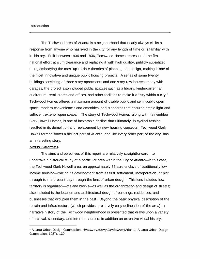
Aerial view to the northwest of the Techwood neighborhood (Library of Congress, HABS website).
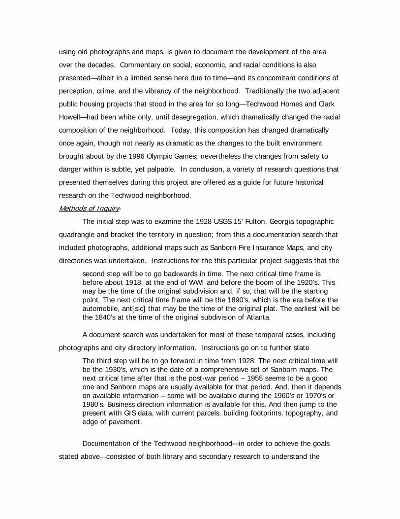
Aerial view to the west of the Techwood neighborhood (undated photograph, Kenneth Rogers Photographs Collection, Atlanta History Center, catalog no. VIS 82.210.09).
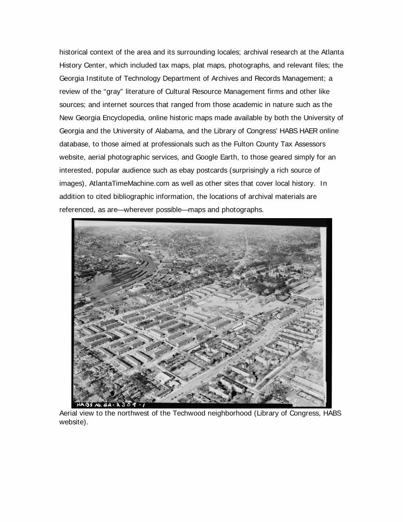
Aerial view to the northeast of the Techwood neighborhood (undated photograph, Kenneth Rogers Photographs Collection, Atlanta History Center, catalog no. VIS 82.210.07).
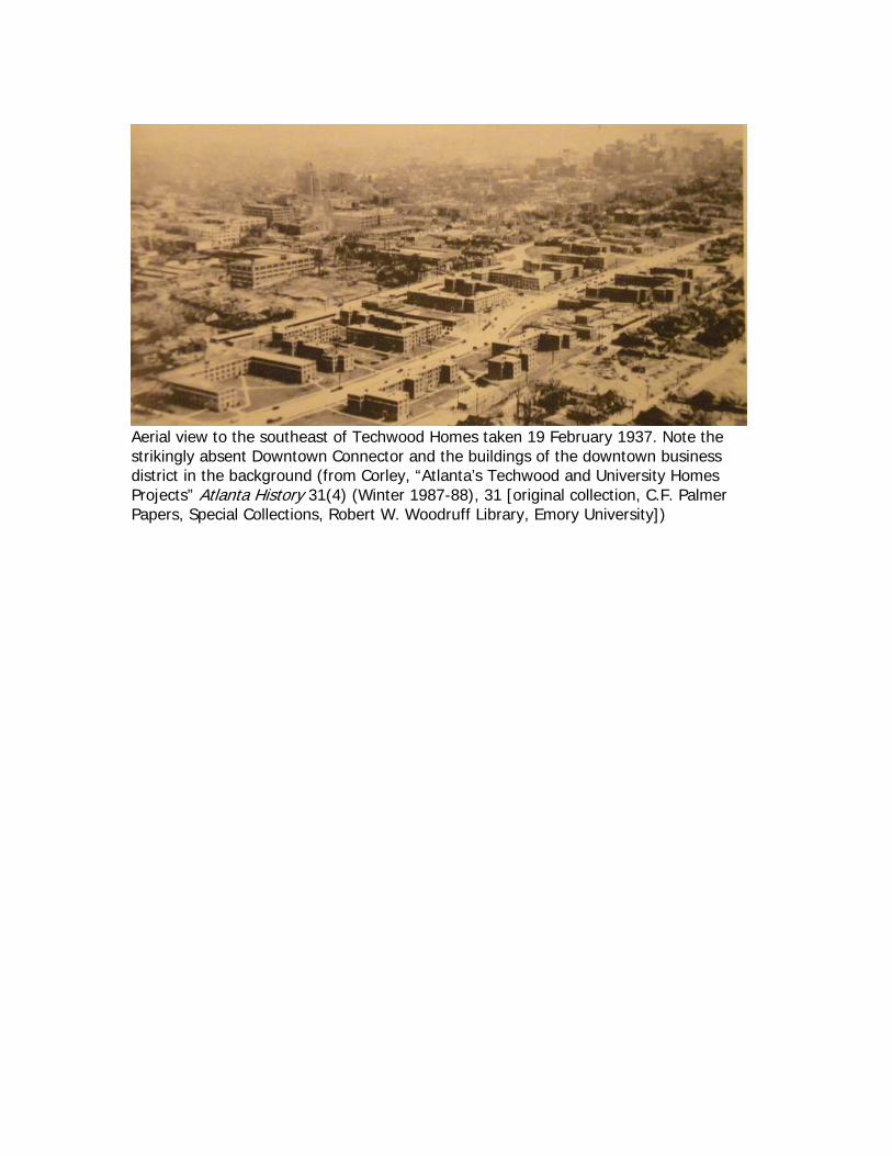
Aerial view to the southeast of Techwood Homes taken 19 February 1937. Note the strikingly absent Downtown Connector and the buildings of the downtown business district in the background (from Corley, “Atlanta’s Techwood and University Homes Projects” Atlanta History 31(4) (Winter 1987-88), 31 [original collection, C.F. Palmer Papers, Special Collections, Robert W. Woodruff Library, Emory University])
Location and Setting of the Techwood Neighborhood
The Techwood Neighborhood is both easily perceived as a distinct part of the
city, bounded by both perceptual borders, in a general sense, as well as infrastructural
borders—namely, an educational and corporate complex and major streets and a
highway, respectively. The topography is relatively level, hence the early name Tech
Flats, with two knolls or rises to the north upon which the Georgia Institute of
Technology sits. A small stream called Tanyard Creek once flowed from the south to the
north in the Techwood Neighborhood in the vicinity of Techwood Drive, crossing North
Avenue, Grant Field, and what is now Peters Park, continuing on and ultimately
emptying into Peachtree Creek. This stream has long since been piped, channelized,
and absorbed into the subterranean infrastructure of Atlanta. North Avenue, and
beyond it the campus of the Georgia Institute of Technology, founded in 1888 and then
called the Georgia School of Technology, delineates the project area to the north. To
the west it is bounded by Luckie Street, and beyond it the campus of Coca-Cola World
Headquarters, which itself is bounded to the west by the former Southern Railway
tracks, now Norfolk Southern. To the east of the project area, and forming an effective
barrier to midtown and Peachtree Street, is the so called Downtown Connector—the
limited access multi-lane highway of I-75 and I-85. Finally, to the south, a logical
boundary to the project area is delineated by what is now called Ivan Allen, Jr.
Boulevard, and beyond are some of the major tourist draws to the city and the central
business district.
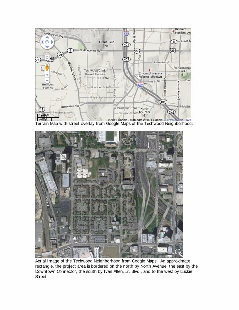
Terrain Map with street overlay from Google Maps of the Techwood Neighborhood.
Aerial Image of the Techwood Neighborhood from Google Maps. An approximate rectangle, the project area is bordered on the north by North Avenue, the east by the Downtown Connector, the south by Ivan Allen, Jr. Blvd., and to the west by Luckie Street.
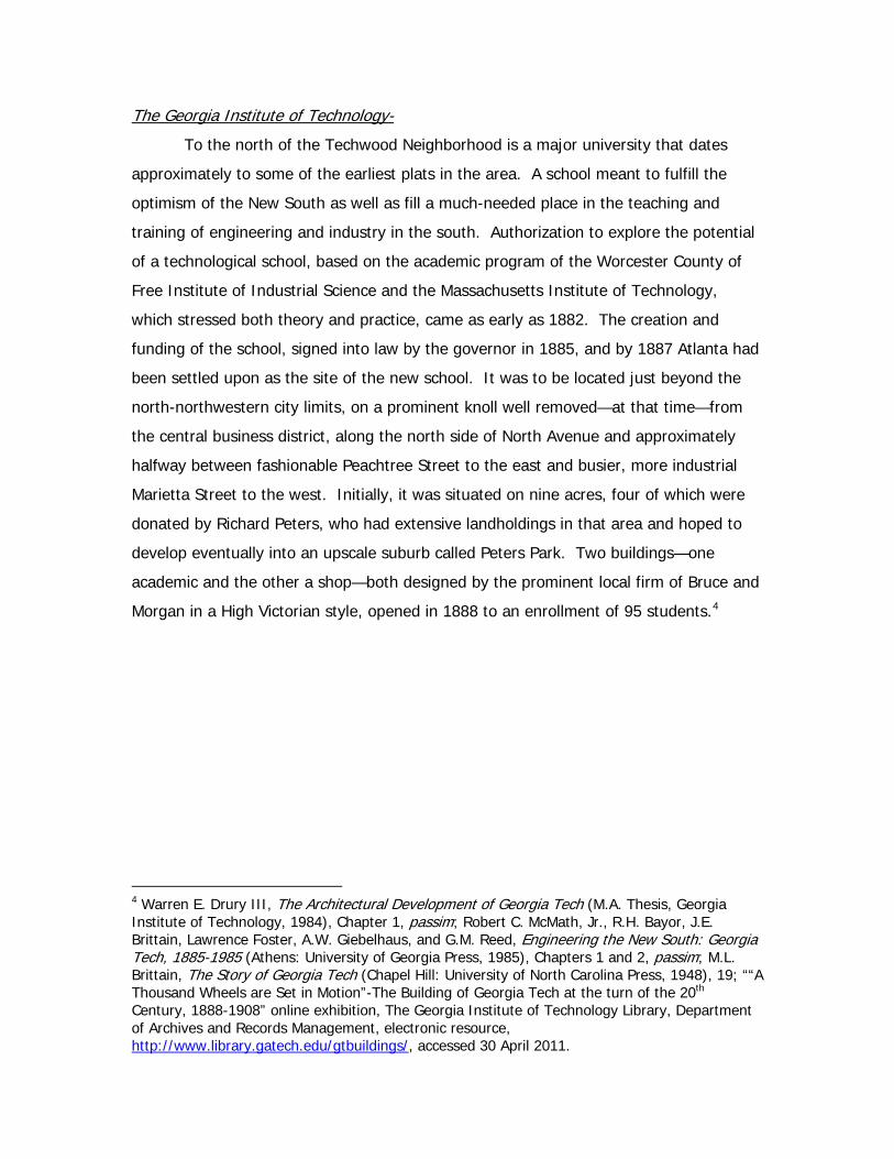
The Coca-Cola Company-
To the west of the Techwood Neighborhood is the Coca-Cola World
Headquarters 35 acre campus, or compound, which includes major buildings such as the
26 story granite clad Coca-Cola North Avenue Tower (1980), the 20 story Coca-Cola USA
building (1987), the nine story Coca-Cola Technical Center (1981) with its technical and
engineering laboratories, the elegant, white marble and granite clad Central Reception
Building and Forecourt (1986), and, set diagonally from the other buildings, the ten
story Coca-Cola Enterprises Building (or One Coca-Cola Plaza) (1970), the first corporate
structure built at this location in the late 1960s. Other service buildings, the corporate
archives, and a learning center are here as well.2 The story of Coca-Cola is beyond the
scope of this report, and should be rather well-known, especially among Atlantans and
given its proximity to Georgia Tech. An approximate date, much less a precise one or a
chain of title, that Coca-Cola purchased the property located on North Avenue and
bounded by Marietta Street and Plum Street, to the west and east, respectively, and
Corput and residential lots to the south; this property also contained a spur of the
Southern Railway Line, based on the 1946 tax plats.3 During the course of research at
the Atlanta History Center, a date of 1926 was noted with the company owning the lot,
so regardless it is apparent that the Coca-Cola Company has owned land parcels here
for the better part of the 20th century, along with its other major Atlanta area operations
on Edgewood Avenue and Spring Street.
2 Isabelle Gournay, AIA Guide to the Architecture of Atlanta (Athens: University of Georgia Press, 1993), 150-153; as can be noted from the dates, the Coca-Cola Company undertook a dramatic 2 million square foot expansion of its corporate campus; principal designer was George Heery of Heery International. see “Coca-Cola Corporate Headquarters, Atlanta” at the Brookwood Group, electronic document, http://phantom.brookwoodgroup.com/index.php?sec=4&sub=2&sct=0&state=1, accessed 26 April 2011. 3 Fulton County Board of Assessors Real Estate Plat Book 11-District 14 L.L.79-83 (1946-1956), Sheet 82-4, Atlanta History Center.
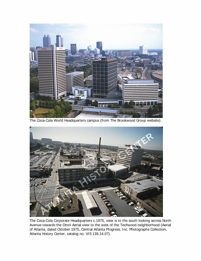
The Coca-Cola World Headquarters campus (from The Brookwood Group website).
The Coca-Cola Corporate Headquarters c.1975, view is to the south looking across North Avenue towards the Omni Aerial view to the west of the Techwood neighborhood (Aerial of Atlanta, dated October 1975, Central Atlanta Progress, Inc. Photographs Collection, Atlanta History Center, catalog no. VIS 139.14.07).
The Georgia Institute of Technology-
To the north of the Techwood Neighborhood is a major university that dates
approximately to some of the earliest plats in the area. A school meant to fulfill the
optimism of the New South as well as fill a much-needed place in the teaching and
training of engineering and industry in the south. Authorization to explore the potential
of a technological school, based on the academic program of the Worcester County of
Free Institute of Industrial Science and the Massachusetts Institute of Technology,
which stressed both theory and practice, came as early as 1882. The creation and
funding of the school, signed into law by the governor in 1885, and by 1887 Atlanta had
been settled upon as the site of the new school. It was to be located just beyond the
north-northwestern city limits, on a prominent knoll well removed—at that time—from
the central business district, along the north side of North Avenue and approximately
halfway between fashionable Peachtree Street to the east and busier, more industrial
Marietta Street to the west. Initially, it was situated on nine acres, four of which were
donated by Richard Peters, who had extensive landholdings in that area and hoped to
develop eventually into an upscale suburb called Peters Park. Two buildings—one
academic and the other a shop—both designed by the prominent local firm of Bruce and
Morgan in a High Victorian style, opened in 1888 to an enrollment of 95 students.4
4 Warren E. Drury III, The Architectural Development of Georgia Tech (M.A. Thesis, Georgia Institute of Technology, 1984), Chapter 1, passim; Robert C. McMath, Jr., R.H. Bayor, J.E. Brittain, Lawrence Foster, A.W. Giebelhaus, and G.M. Reed, Engineering the New South: Georgia Tech, 1885-1985 (Athens: University of Georgia Press, 1985), Chapters 1 and 2, passim; M.L. Brittain, The Story of Georgia Tech (Chapel Hill: University of North Carolina Press, 1948), 19; ““A Thousand Wheels are Set in Motion”-The Building of Georgia Tech at the turn of the 20th Century, 1888-1908” online exhibition, The Georgia Institute of Technology Library, Department of Archives and Records Management, electronic resource, http://www.library.gatech.edu/gtbuildings/, accessed 30 April 2011.
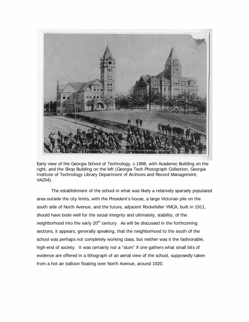
Early view of the Georgia School of Technology, c.1888, with Academic Building on the right, and the Shop Building on the left (Georgia Tech Photograph Collection, Georgia Institute of Technology Library Department of Archives and Record Management, VA204). The establishment of the school in what was likely a relatively sparsely populated
area outside the city limits, with the President’s house, a large Victorian pile on the
south side of North Avenue, and the future, adjacent Rockefeller YMCA, built in 1911,
should have bode well for the social integrity and ultimately, stability, of the
neighborhood into the early 20th century. As will be discussed in the forthcoming
sections, it appears, generally speaking, that the neighborhood to the south of the
school was perhaps not completely working class, but neither was it the fashionable,
high-end of society. It was certainly not a “slum” if one gathers what small bits of
evidence are offered in a lithograph of an aerial view of the school, supposedly taken
from a hot-air balloon floating over North Avenue, around 1920.
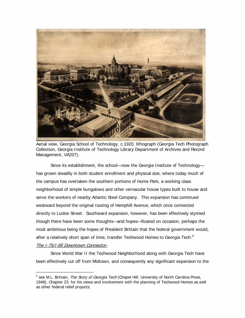
Aerial view, Georgia School of Technology, c.1920, lithograph (Georgia Tech Photograph Collection, Georgia Institute of Technology Library Department of Archives and Record Management, VA207). Since its establishment, the school—now the Georgia Institute of Technology—
has grown steadily in both student enrollment and physical size, where today much of
the campus has overtaken the southern portions of Home Park, a working class
neighborhood of simple bungalows and other vernacular house types built to house and
serve the workers of nearby Atlantic Steel Company. This expansion has continued
westward beyond the original routing of Hemphill Avenue, which once connected
directly to Luckie Street. Southward expansion, however, has been effectively stymied
though there have been some thoughts—and hopes—floated on occasion, perhaps the
most ambitious being the hopes of President Brittain that the federal government would,
after a relatively short span of time, transfer Techwood Homes to Georgia Tech.5
The I-75/I-85 Downtown Connector-
Since World War II the Techwood Neighborhood along with Georgia Tech have
been effectively cut off from Midtown, and consequently any significant expansion to the
5 see M.L. Brittain, The Story of Georgia Tech (Chapel Hill: University of North Carolina Press, 1948), Chapter 23, for his views and involvement with the planning of Techwood Homes as well as other federal relief projects.
east, by the Downtown Connector.6 In Atlanta, as with much of the rest of America, the
automobile was to become wildly popular after its introduction in the first decade of the
20th century, with production increasing exponentially so that by the 1920s the
automobile was a highly successful manufactured good perfected by Henry Ford and his
assembly lines. The commercial success of the automobile during the 1920s, considered
by many to be perhaps the pivotal decade of the 20th century, was to have a profound
affect on virtually all aspects of society—from a reshuffling of both racial and
socioeconomic conditions, personal mobility, the rise of the suburb, the appearance of
the garage7 and parking garage for residential and commercial needs, respectively—with
far-ranging implications for city planning and architecture—that is to say, the built
environment. It would not be long before the automobile’s popularity would literally
begin to choke the central city, with congestion increasingly yearly as one moved out of
the downtown district; developments such as traffic signals, one-way streets, and
ultimately, the expressway were called upon to remedy these problems.8
The nationwide depression and the arrival of World War II put the brakes on
automobile production, at least for civilians, which had the consequence off delaying or
“putting on hold”, in a sense, the realization of the urgency in solving a myriad of traffic
issues. The post-war boom would only exacerbate the problem. Atlanta was no
different from other American cities in trying to cope with their traffic problems. A
proactive first step was taken in 1944 by the Atlanta City Council by commissioning the
H.W. Lochner Co. of Chicago, a nationally known traffic consultant, to make detailed
traffic studies and circulation patterns, the result being a report outlining recommended
street layouts and highway configurations. This report, completed in 1946, became
known as the Lochner Plan, and formed the basis of post-war traffic planning for
6 With the construction of Tech Square and the plaza on the Fifth Street Bridge within the last decade, Georgia Tech has expanded eastward into midtown; though it is an effective, and daunting, physical barrier, it is not a complete barrier. 7 For but just one aspect of these changes, see J.B. Jackson, “The Domestication of the Garage” in J.B. Jackson and Helen L. Horowitz, editor, Landscape in Sight: Looking at America (New Haven: Yale University Press, 1997), 118-125. 8 The literature on the phenomenon of the automobile and its myriad effects is vast, and the resulting changes have in turn further altered the world we live in, such as, for example, the coming of the interstate highway system, not only a military benefit but a response to the increasingly mobile American public; the interstates, in turn, have altered countless small towns they pass by as well as the traditional neighborhoods destroyed for their construction as they pass through a city. However, for all their negative impacts the interstates certainly make everyday life much easier.
decades. The basics off the plans called for an inter-state highway system linking
Atlanta with other regional cities such as Birmingham, Montgomery, Macon,
Chattanooga, Spartanburg, and Augusta, as well as a circular highway that would
encircle, or ring, the city; these highways would consist of two lanes each direction,
wide enough to be expanded to three, and separated by a broad center “mall”. These
primary highways would be tied in with each other just outside the downtown business
district via “downtown connectors” which, in the case of Atlanta, was to be a north-
south, limited access expressway cutting though downtown and midtown. For in-town
traffic certain streets would be widened, a “smoothly flowing artery system” created by
grade separations and the elimination of jogs, and the elimination of curbside parking in
the downtown area. As it was so eloquently described, the “fast traffic” would take the
“expressways” through or around the city, only needing to get onto main streets near
their destination. Additional Lochner recommendations called for a centralized bus
station, to be located in the heart of downtown, and major passenger station for rail
travel.9
Thus the Downtown Connector, a six-lane thoroughfare designated as a state
route, soon went into the planning stages, a sixty million dollar bond referendum was
approved, and with state and federal assistance rights-of-ways began to be purchased
and, in 1948—a decade before the Eisenhower Interstate Highway System—construction
began on the Connector. Once the Connector passes through downtown and the so-
called Grady curve, the highway takes a northerly route through midtown, largely
between Techwood Drive and Williams Street, until it reaches the Brookwood
neighborhood, at what is known as the Brookwood Split. The construction of the
Connector and the interstates in the 1960s, including most of the perimeter interstate,
engaged in a dialectical relationship with the motoring public of Atlanta in which the
highways would be expanded, the population and consequently traffic volume would
increase, and expansion plans were in development in short order. The problem of
traffic congestion, a problem that still plagues the city today, was made imminently clear
in 1964 in an article written by Bruce Galphin—radical changes in traffic habits were
9 Harold H. Martin, Atlanta and Environs: A Chronicle of its People and Events Volume III (Athens: University of Georgia Press, 1987), 106; John E. Ivey, Jr., Nicholas J. Demerath, and Woodrow W. Breland, Building Atlanta’s Future (Chapel Hill: University of North Carolina Press, 1948), 196-198.
needed, as were reconfiguring many of the junctions and interchanges that by then
were outmoded and actually quite dangerous. The expressway, once a dreamed-of
marvel of modern technology that would allow one to speed through the city, was
actually strangling the city. Beginning in 1978 a radical patch or remedy, costing over a
billion dollars, got underway. Called the Freeing the Freeways program, the interstate
system of Atlanta was under perpetual construction for some seventeen years; the long-
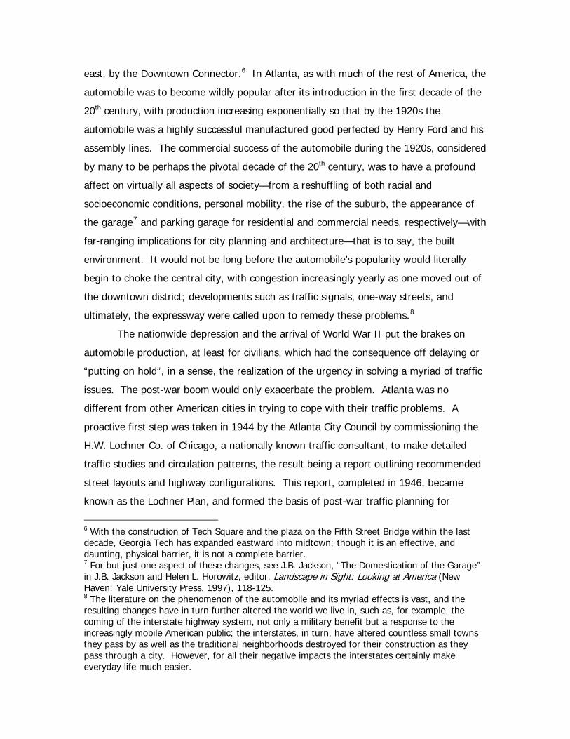
term alleviations are yet to be determined.10
Aerial view of the Downtown Connector under construction in 1948. Note Grant Field, Techwood and the Georgia Tech residence halls, and the Biltmore Hotel. The red V is placed at the location of the Varsity (from atlantatimemachine.com).
10 Martin, Atlanta and Environs, 390-391.
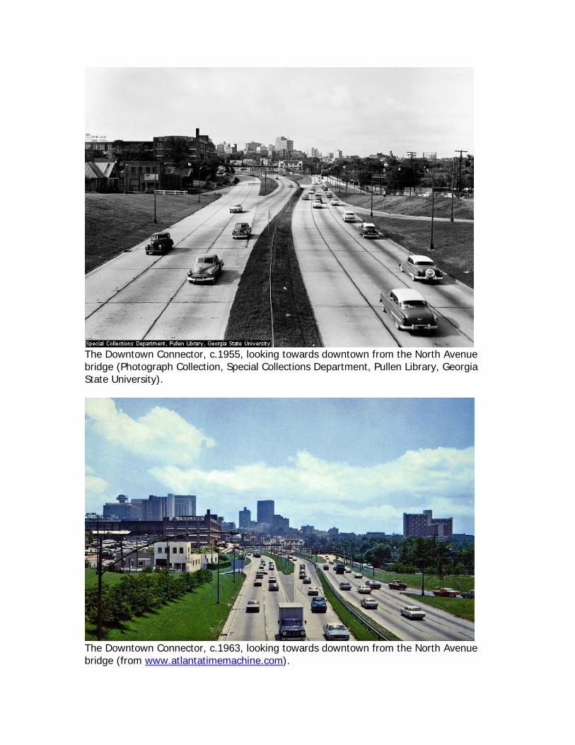
The Downtown Connector, c.1955, looking towards downtown from the North Avenue bridge (Photograph Collection, Special Collections Department, Pullen Library, Georgia State University).
The Downtown Connector, c.1963, looking towards downtown from the North Avenue bridge (from www.atlantatimemachine.com).
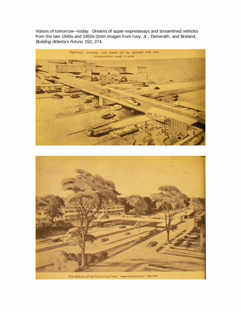
Visions of tomorrow—today. Dreams of super-expressways and streamlined vehicles from the late 1940s and 1950s (both images from Ivey, Jr., Demerath, and Breland, Building Atlanta’s Future, 152, 274.
Results of the Historical Inquiry
The research findings were, not surprisingly, fruitful in some areas but lacking in
others. For ease of discussion the discussion of the findings are divided into three
different periods, and it should be noted that these three are logical divisions marked by
settlement or initial—and official—indications of inhabitation, a gradual deterioration, a
dramatic renewal program followed by a phase of gradual deterioration, and marked
again by dramatic renewal. Only time will bear out the cyclical nature of deterioration.
These three chronological periods are as follows:
• Period 1-Tech Flats: Urban plats and land auctions are first noted soon after the end of the Civil War, most likely in the 1870s with deterioration of the neighborhood into “slums” ending with the construction of Techwood Homes in 1935 followed by Clark Howell Homes in 1941.
• Period 2-Techwood Clark Howell Homes: Federal low-cost public housing
arrives on the American scene, and at the bureaucratic level, with the PWA and the New Deal. The deterioration of these housing projects into a violent crime and drug ridden urban zone ends with their demolition, to be replaced by the Hope VI Centennial Place development, due in large part by the 1996 Olympics.
• Period 3-Centennial Place Homes: The neighborhood as it stands today
and just over a decade old. For all three periods, a historical context and sketch will be outlined, followed by
discussions and observations on the social, urban, and architectural character. A
subsequent section will consist entirely of visual material (i.e. maps, photographs,
drawings, and prints) in order to give an idea of how the area actually looked, rather
than how it is described. After all, a picture—and a map for that matter—are truly worth
a thousand words. Areas that are lacking in documentary materials, or topics that could
be further explored, will be offered in the final section of concluding remarks.
Historical Outline through the Civil War-
The historic occupation11 of the Techwood area, as does much of Atlanta, begins
in 1821 at which time most of the land had been ceded to white, Euro American settlers.
Officially founded in 1837, the city was to become a vital transportation center in the
region during the Civil War and after, and it was on this foundation that the city became
a commerce and finance center for both the State of Georgia and the southeast. The
Western and Atlantic Railroad was the first to arrive in 1837, and as the town was the
“end of the line”—zero milepost—the town was called Terminus. By 1846 the town was
no longer a terminus, as two additional railroads were laid through the town, connecting
it with other parts of the southeast. In 1845 the name was changed to Atlanta,
purportedly a feminine version of Atlantic. By 1860 Atlanta was the fourth largest city in
the southeast and was a prime target for General Sherman’s March to the Sea; in July of
1864 Sherman laid siege to the city, capturing it in September. The destruction of the
city’s transportation facilities and much of the city itself signaled the, for all intents and
purposes, end of the Confederacy.
11 As opposed to prehistoric, that is to say occupation by Native Americans and during the historic period by the Cherokee.
Period One-Tech Flats (c. 1870-1935)-
Historical Context- During Reconstruction, the railroads were quickly repaired, with
additional rail lines coming through the city so that by the turn of the 20th century some
fifteen rail lines served the city. Although railroads were at the heart of the economy of
Atlanta, the economy grew and diversified with industrial and commercial development
that included manufacturing, such as textiles and cotton processing, and trade with
national markets. The increasing importance of the city led to its designation as the
state capital in 1868, and booming Atlanta came to epitomize the “New South” creed—
essentially a point of view that recognized prosperity could only come with Northern
reconciliation, with more industry—and Northern capital—and more education with less
dependence on agriculture and cotton. The tangible results of this creed were
showcased in the 1881 International Cotton Exposition, the 1887 Piedmont Exposition,
and the Cotton States and International Exposition of 1895, held in Piedmont Park. By
the turn of the 20th century the “Atlanta Spirit” was not only expanding the economic
growth of the city but also its cultural, artistic, and sporting aspects, hoping to establish
the city as a regional center. In the 1920s the “Forward Atlanta” campaign of Ivan
Allen, Sr. was highly successful in luring corporations to Atlanta for their regional
headquarters—among them Sears, Roebuck, and Co. and General Motors.
Historical Sketch-The precise origins or the first lots to be platted in the Techwood
Neighborhood are unclear at the present. The first evidence found that suggests some
of the streets within the area existed can be found on the ---unfinished-tms
Social Character- The socioeconomic and racial composition of Tech Flats appears
to be slightly more complex than one is led to believe, especially if one considers the
earliest years of occupation. By turn of the 20th century, however, it appears that Tech
Flats was a somewhat racially mixed neighborhood of working class white and black,
even more so prior to the arrival of Jim Crow. It was a neighborhood of cheap rentals
by and large, an area of working class housing for the lower income brackets employed
either in the service industry downtown or the nearby industrial works clustered along
the railroad; the neighborhood continued to deteriorate into slum conditions as
commercial and industrial encroached as infill, especially at its fringe. The prevailing
view seems to give it as predominately white with approximately one quarter of the
population black.12
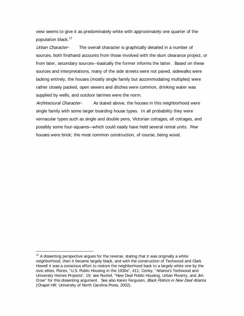
Urban Character- The overall character is graphically detailed in a number of
sources, both firsthand accounts from those involved with the slum clearance project, or
from later, secondary sources—basically the former informs the latter. Based on these
sources and interpretations, many of the side streets were not paved, sidewalks were
lacking entirely, the houses (mostly single family but accommodating multiples) were
rather closely packed, open sewers and ditches were common, drinking water was
supplied by wells, and outdoor latrines were the norm.
Architectural Character- As stated above, the houses in this neighborhood were
single family with some larger boarding house types. In all probability they were
vernacular types such as single and double pens, Victorian cottages, ell cottages, and
possibly some four-squares—which could easily have held several rental units. Few
houses were brick; the most common construction, of course, being wood.
12 A dissenting perspective argues for the reverse, stating that it was originally a white neighborhood, then it became largely black, and with the construction of Techwood and Clark Howell it was a conscious effort to restore the neighborhood back to a largely white one by the civic elites. Flores, “U.S. Public Housing in the 1930s”, 411; Corley, “Atlanta’s Techwood and University Homes Projects”, 19; see Ruchel, “New Deal Public Housing, Urban Poverty, and Jim Crow” for this dissenting argument. See also Karen Ferguson, Black Politics in New Deal Atlanta (Chapel Hill: University of North Carolina Press, 2002).
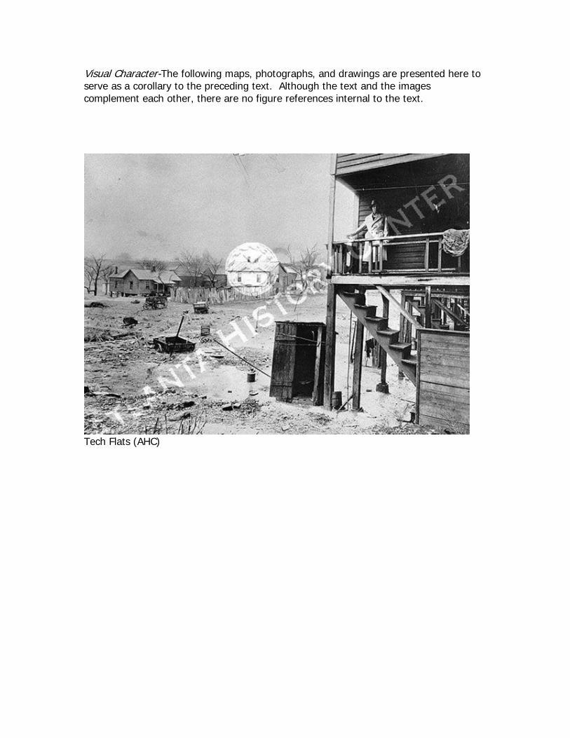
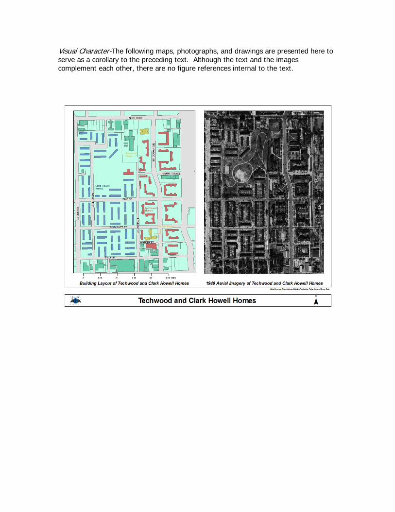
Visual Character-The following maps, photographs, and drawings are presented here to serve as a corollary to the preceding text. Although the text and the images complement each other, there are no figure references internal to the text.
Tech Flats (AHC)
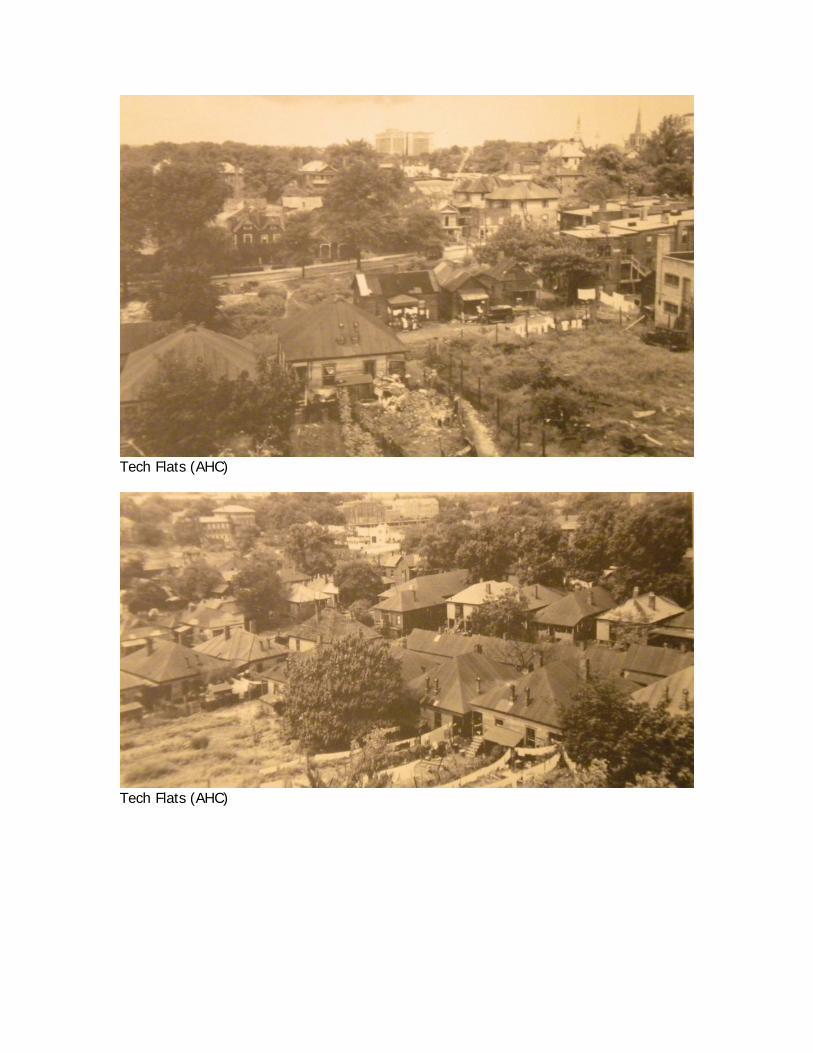
Tech Flats (AHC)
Tech Flats (AHC)
Tech Flats (AHC)
Tech Flats (unknown internet source)

The following are maps, plats, and auction fliers from the files of the Atlanta History Center
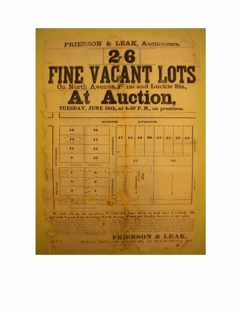
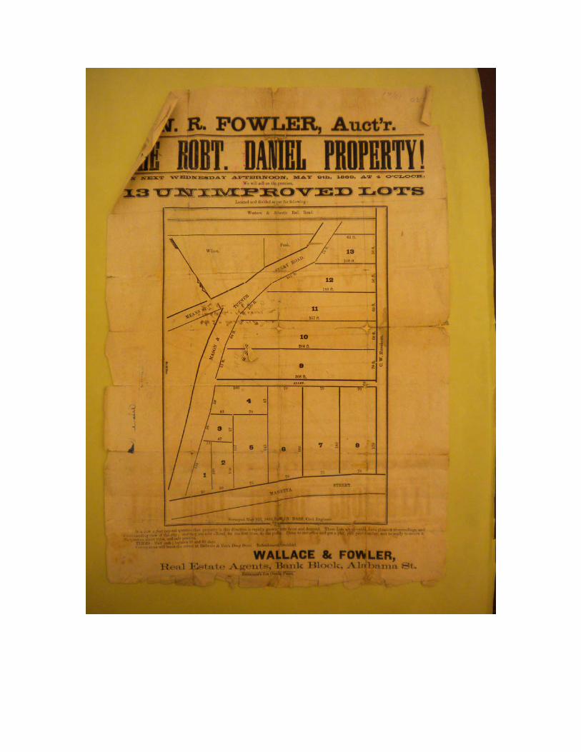
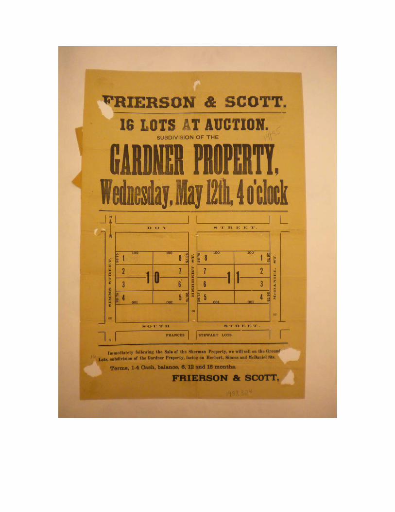
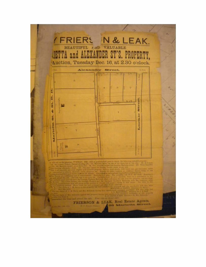
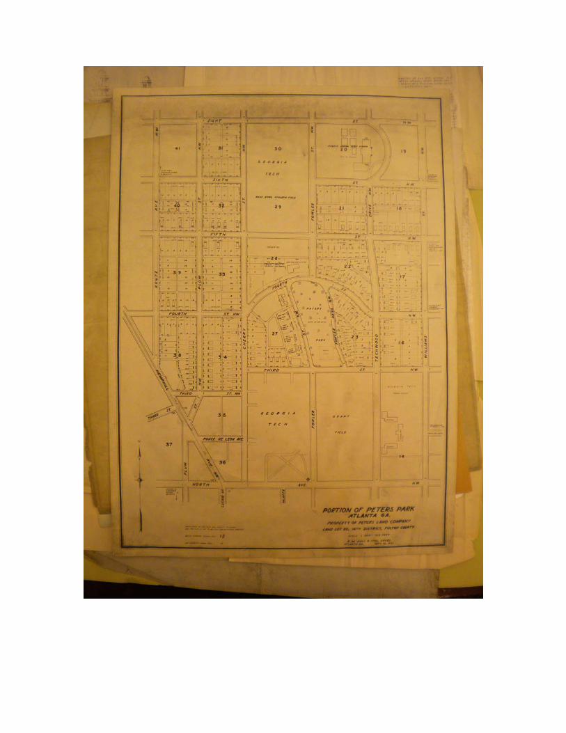
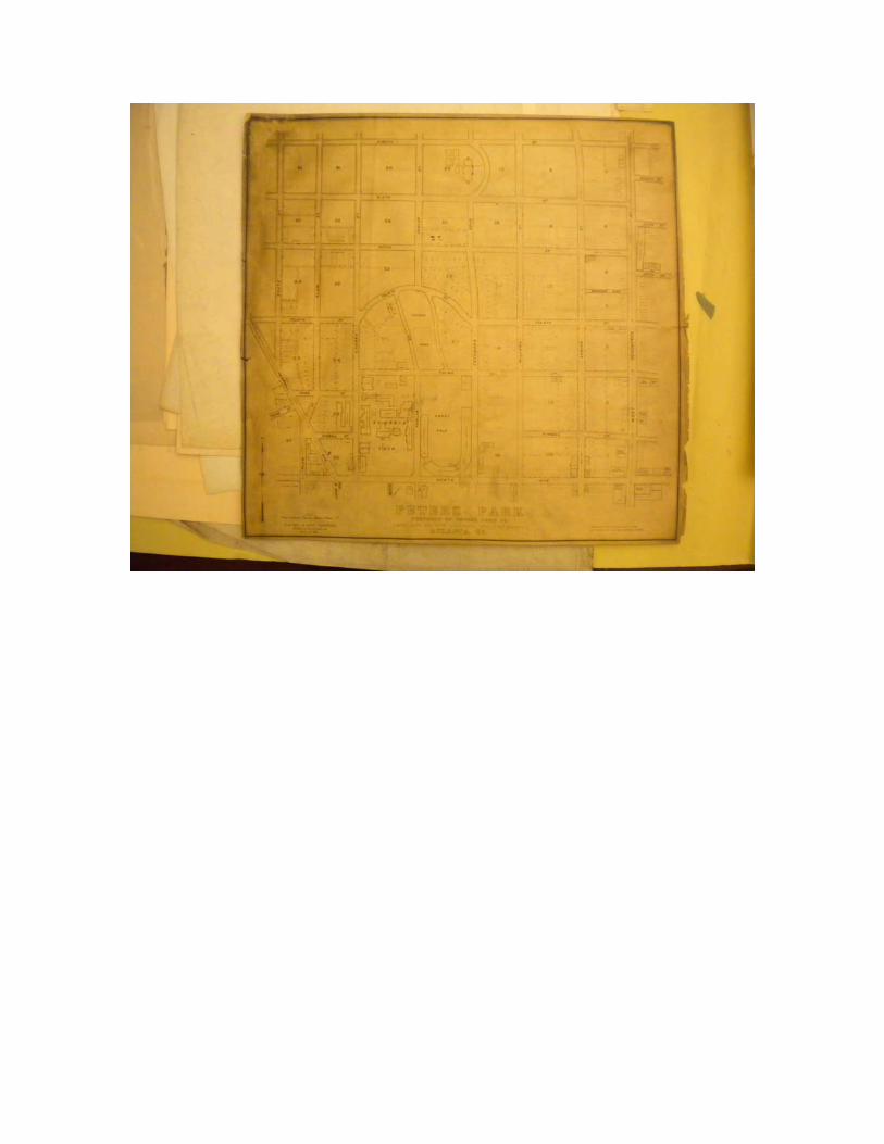
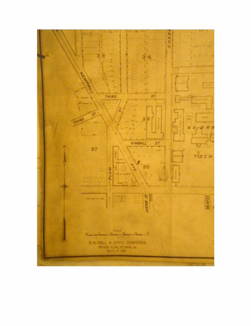
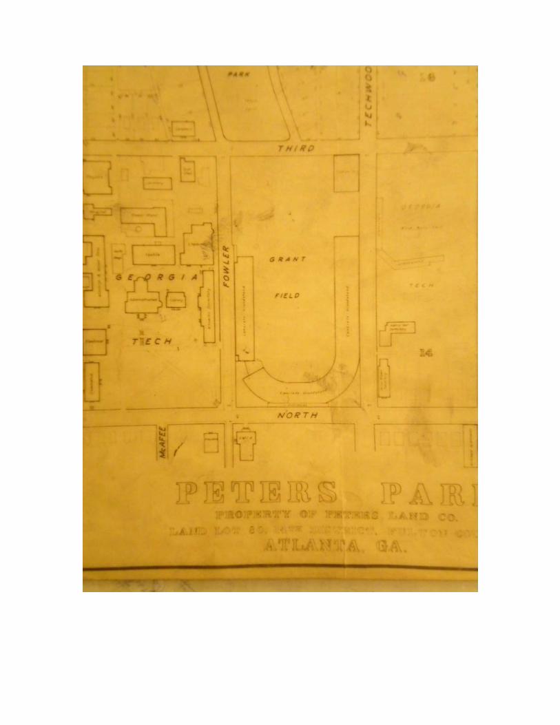
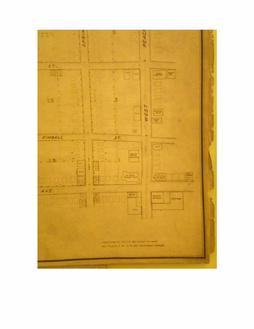
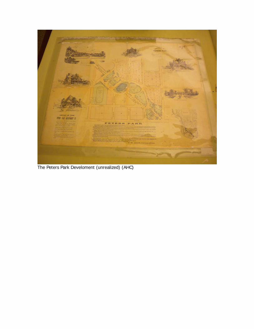
The Peters Park Develoment (unrealized) (AHC)
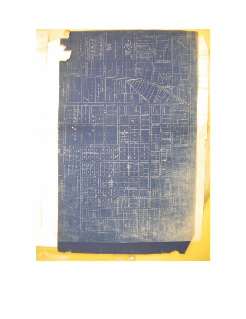
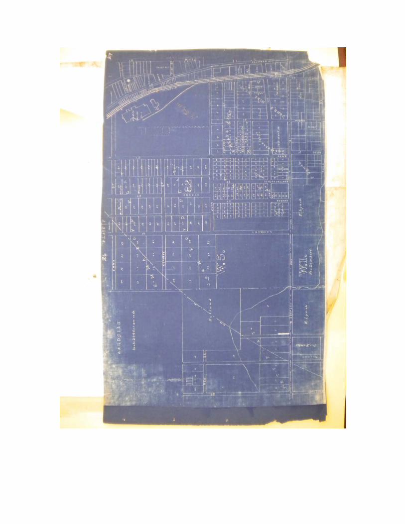

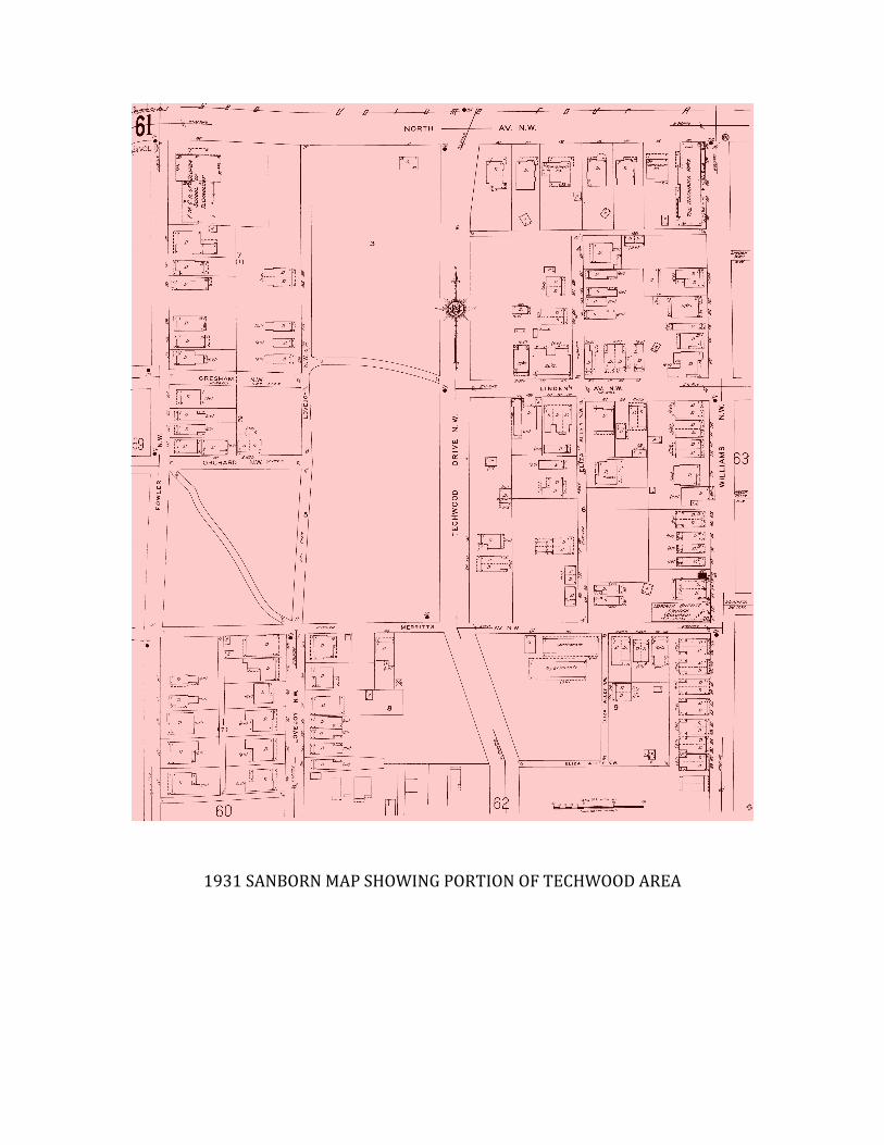
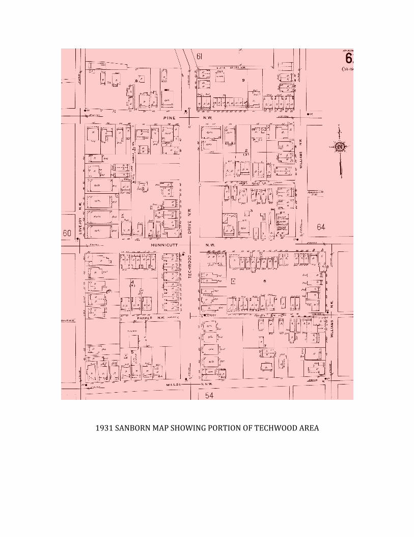
The following is a sequence of Sanborn Fire Insurance Maps
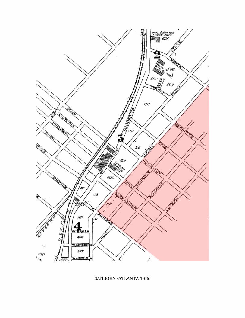
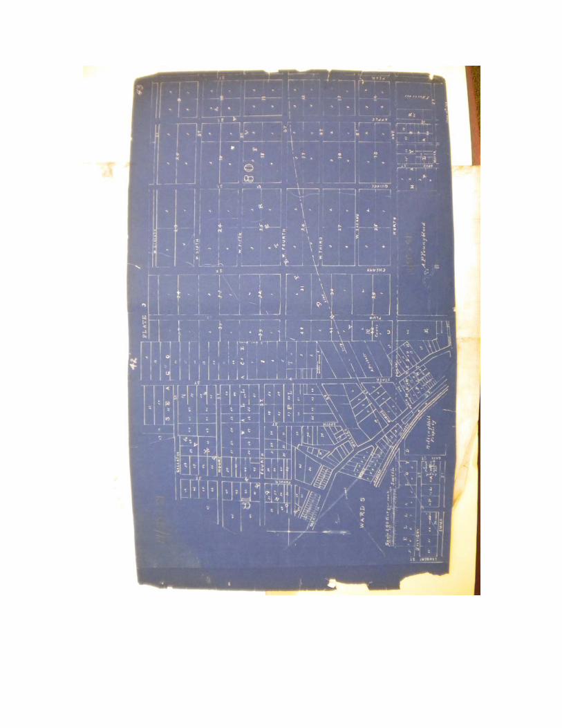
SANBORN -‐ATLANTA 1886
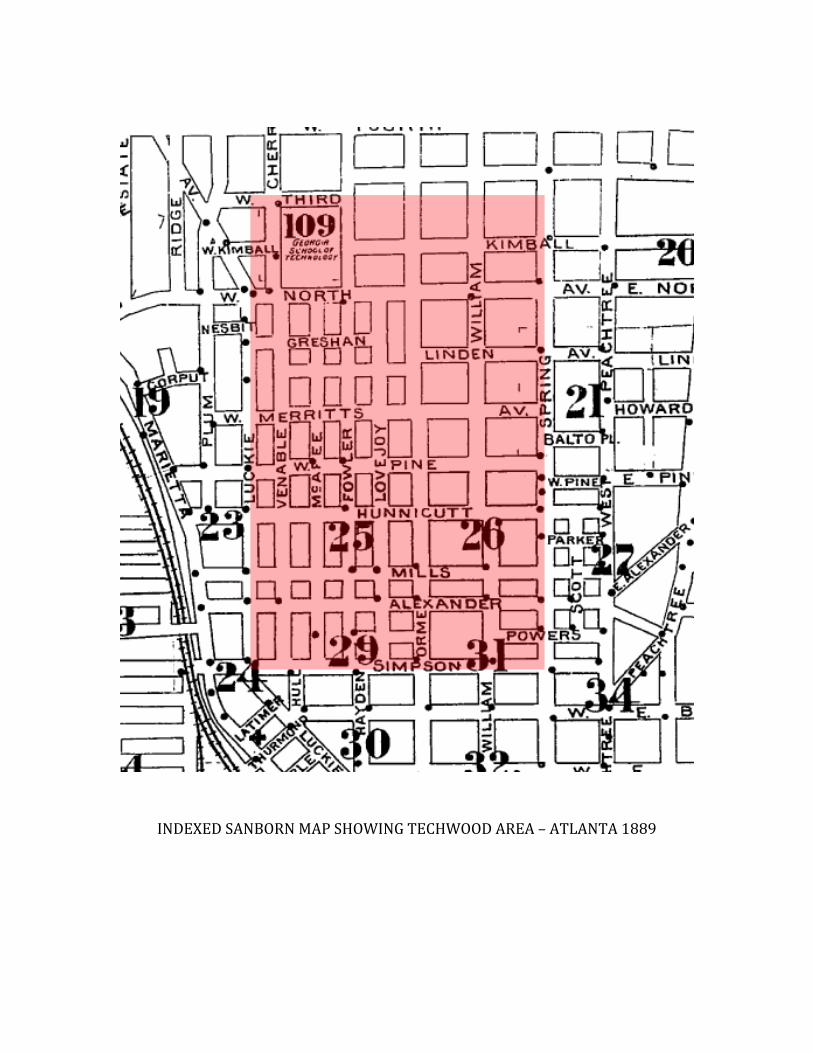
INDEXED SANBORN MAP SHOWING TECHWOOD AREA – ATLANTA 1889
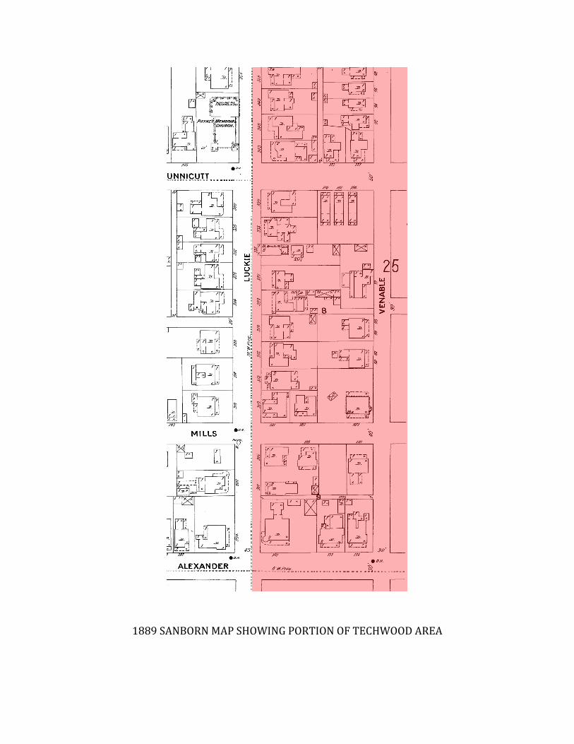
1889 SANBORN MAP SHOWING PORTION OF TECHWOOD AREA
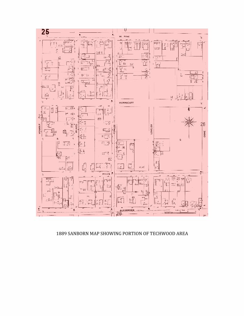
1889 SANBORN MAP SHOWING PORTION OF TECHWOOD AREA

1889 SANBORN MAP SHOWING PORTION OF TECHWOOD AREA
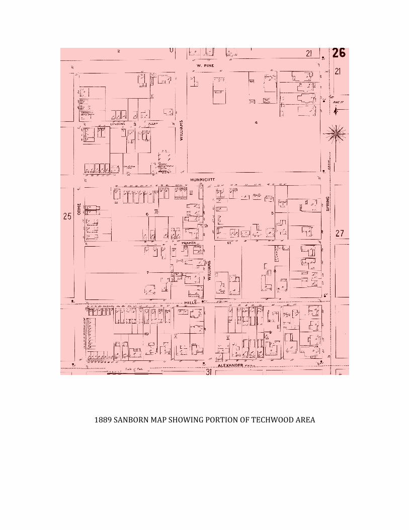
1889 SANBORN MAP SHOWING PORTION OF TECHWOOD AREA
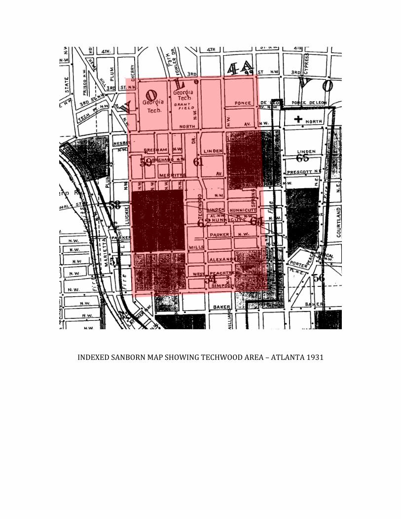
INDEXED SANBORN MAP SHOWING TECHWOOD AREA – ATLANTA 1931
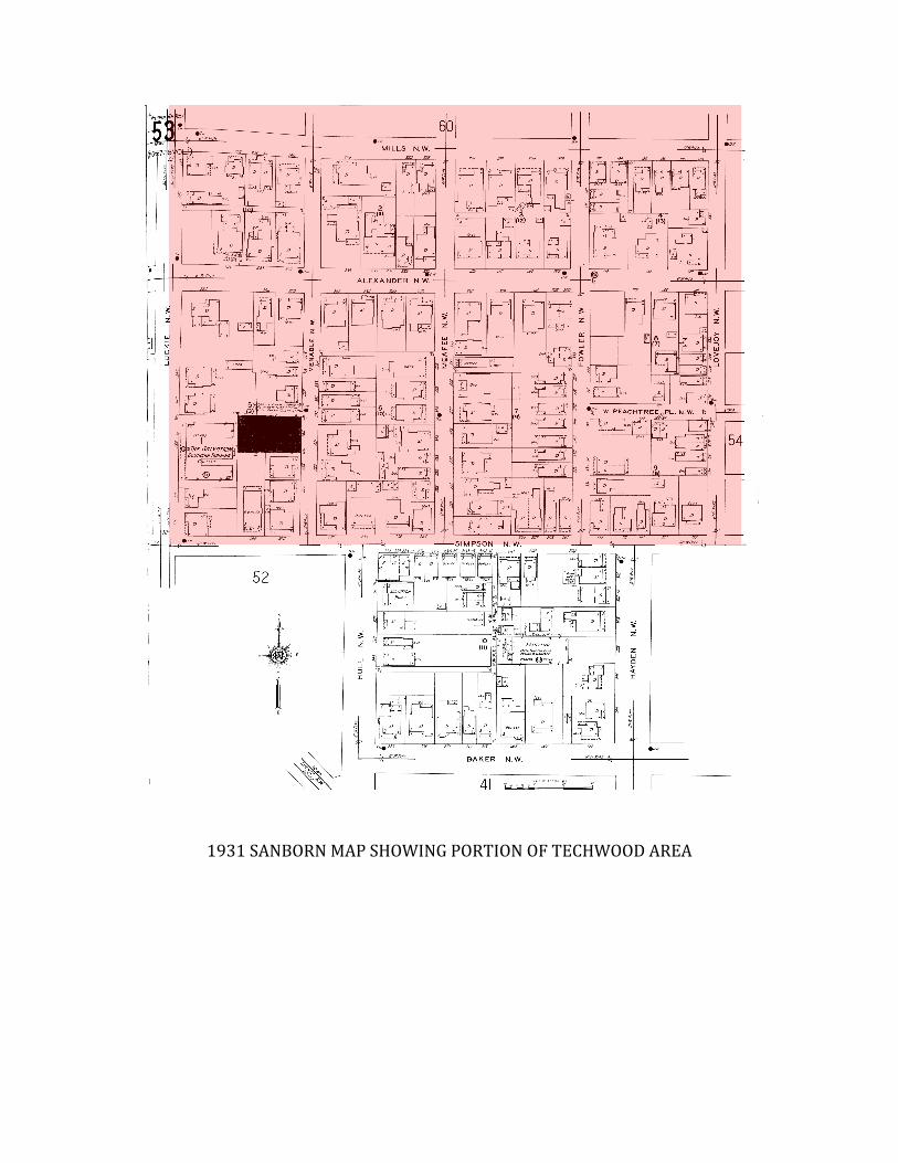
1931 SANBORN MAP SHOWING PORTION OF TECHWOOD AREA
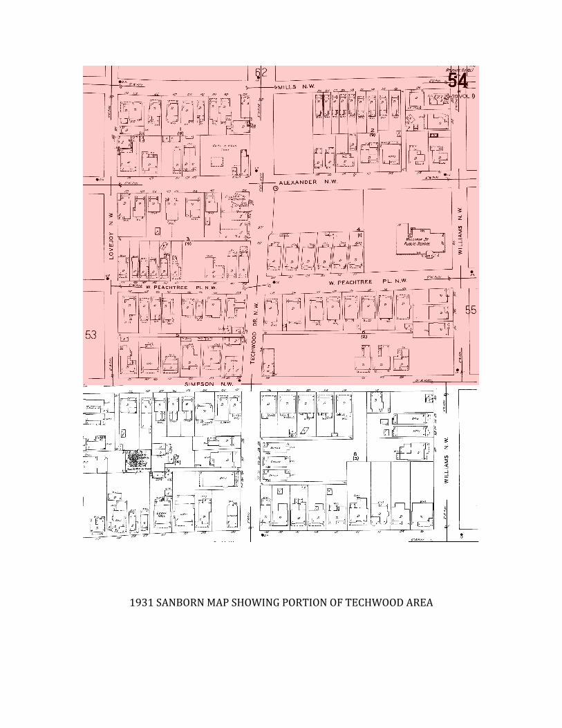
1931 SANBORN MAP SHOWING PORTION OF TECHWOOD AREA
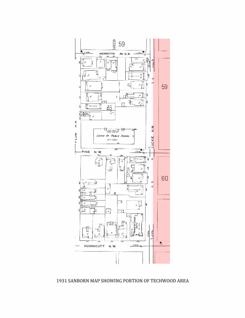
1931 SANBORN MAP SHOWING PORTION OF TECHWOOD AREA
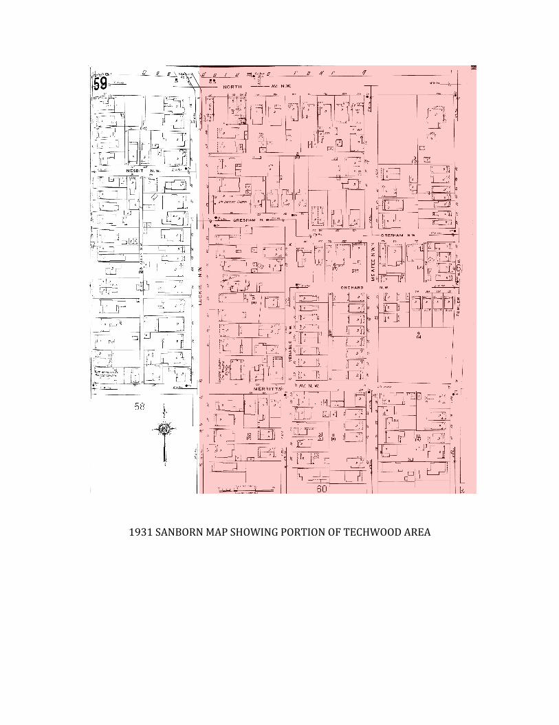
1931 SANBORN MAP SHOWING PORTION OF TECHWOOD AREA
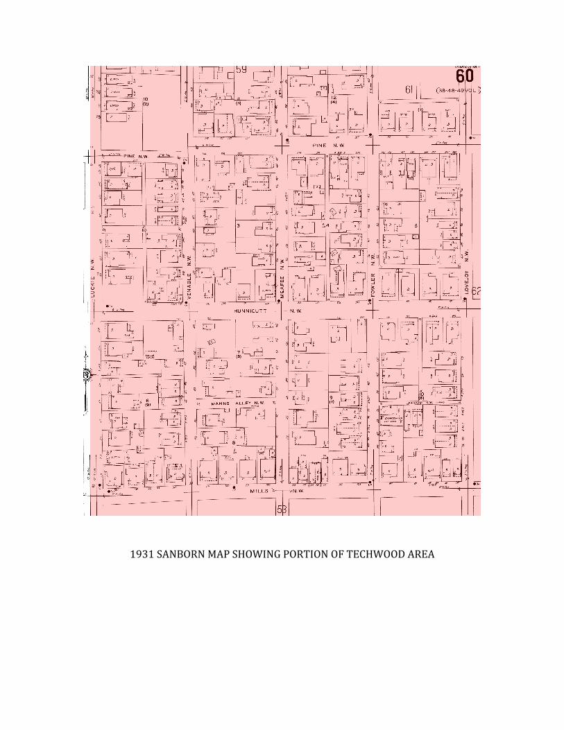
1931 SANBORN MAP SHOWING PORTION OF TECHWOOD AREA
1931 SANBORN MAP SHOWING PORTION OF TECHWOOD AREA
1931 SANBORN MAP SHOWING PORTION OF TECHWOOD AREA
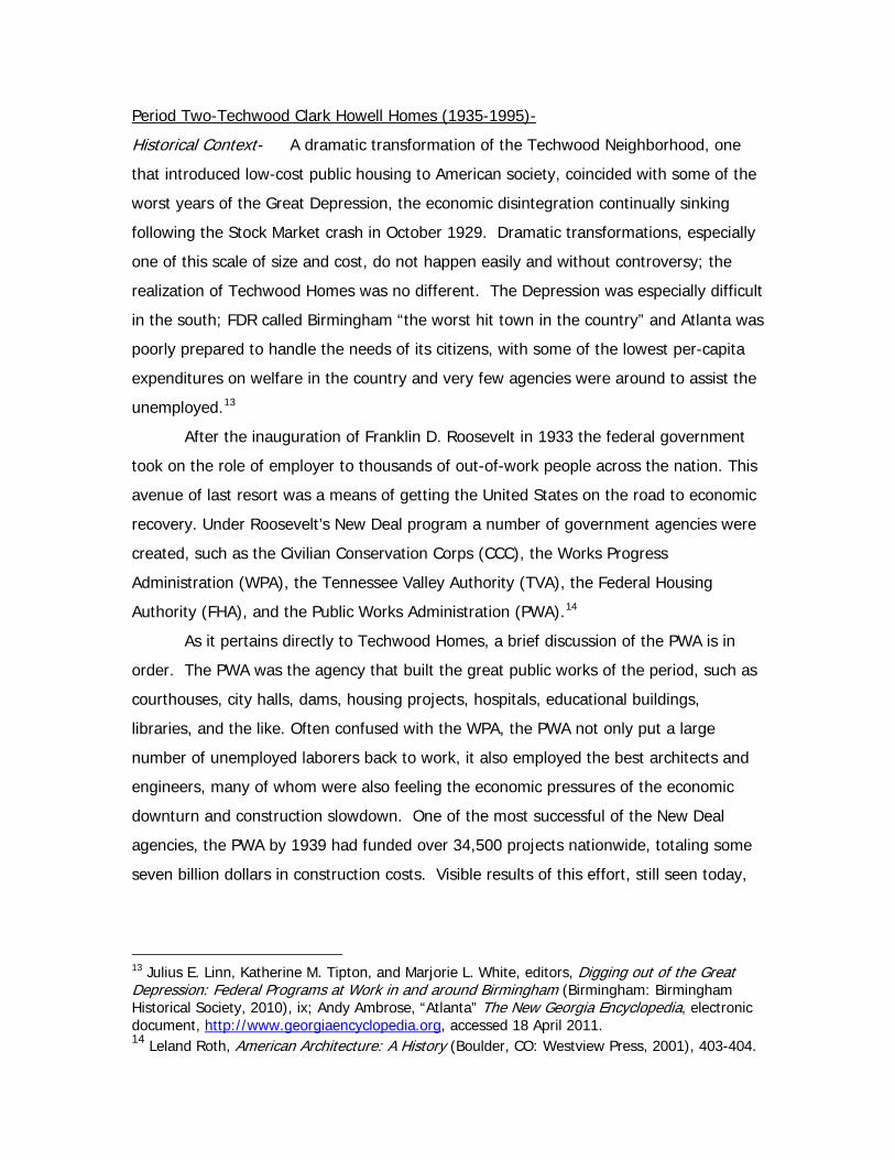
Period Two-Techwood Clark Howell Homes (1935-1995)-
Historical Context- A dramatic transformation of the Techwood Neighborhood, one
that introduced low-cost public housing to American society, coincided with some of the
worst years of the Great Depression, the economic disintegration continually sinking
following the Stock Market crash in October 1929. Dramatic transformations, especially
one of this scale of size and cost, do not happen easily and without controversy; the
realization of Techwood Homes was no different. The Depression was especially difficult
in the south; FDR called Birmingham “the worst hit town in the country” and Atlanta was
poorly prepared to handle the needs of its citizens, with some of the lowest per-capita
expenditures on welfare in the country and very few agencies were around to assist the
unemployed.13
After the inauguration of Franklin D. Roosevelt in 1933 the federal government
took on the role of employer to thousands of out-of-work people across the nation. This
avenue of last resort was a means of getting the United States on the road to economic
recovery. Under Roosevelt’s New Deal program a number of government agencies were
created, such as the Civilian Conservation Corps (CCC), the Works Progress
Administration (WPA), the Tennessee Valley Authority (TVA), the Federal Housing
Authority (FHA), and the Public Works Administration (PWA).14
As it pertains directly to Techwood Homes, a brief discussion of the PWA is in
order. The PWA was the agency that built the great public works of the period, such as
courthouses, city halls, dams, housing projects, hospitals, educational buildings,
libraries, and the like. Often confused with the WPA, the PWA not only put a large
number of unemployed laborers back to work, it also employed the best architects and
engineers, many of whom were also feeling the economic pressures of the economic
downturn and construction slowdown. One of the most successful of the New Deal
agencies, the PWA by 1939 had funded over 34,500 projects nationwide, totaling some
seven billion dollars in construction costs. Visible results of this effort, still seen today,
13 Julius E. Linn, Katherine M. Tipton, and Marjorie L. White, editors, Digging out of the Great Depression: Federal Programs at Work in and around Birmingham (Birmingham: Birmingham Historical Society, 2010), ix; Andy Ambrose, “Atlanta” The New Georgia Encyclopedia, electronic document, http://www.georgiaencyclopedia.org, accessed 18 April 2011. 14 Leland Roth, American Architecture: A History (Boulder, CO: Westview Press, 2001), 403-404.
are the substantial public buildings found in communities, both large and small, across
the nation.15
Soon after the creation of the New Deal, Atlanta became one of the first cities to
have a federally operated relief program—an opportunity the city and many of its
institutions, such as Georgia Tech, took full advantage of. As a result, millions of dollars
were sent to Atlanta projects, thousands of out of work residents were given
employment, and out of much of these efforts civic improvements and other programs
“for the greater good” such as school improvements and additions, the creation of a
symphony orchestra, improvements at the city airport, and repair work to the
Cyclorama, were tangible—both physical and symbolic—proof of these efforts. The most
significant of these efforts was, of course, Techwood Homes and University Homes, built
for whites and blacks, respectively.16
Although the New Deal was noble in its ideals and its accomplishments
incomparable, it was World War II that ended the Depression. In fact, the war-time
industry was a rapid, complete turnaround from what had transpired the preceding
decade, and fueled an industrial and manufacturing boom in this country. Cities such as
Atlanta and Birmingham would enjoy a relatively long period of prosperity, with much of
this economic boom based on war-time industry such as Lockheed, located in Marietta,
alongside such names as General Motors and Ford Motor Company, both of which
established manufacturing plants in the area. Complementing this boom period was
rapid population growth, greatly expanded in the annexation of 82 square miles and
100,000 residents in 1952 [see section on Downtown Connector above].17
15 For more information about the PWA see C. W. Short and R. Stanley Brown, Public Buildings: Architecture under the Public Works Administration, 1933-1939, Volume 1. Unabridged reprint of the first half (through page 343) of Public Buildings: A Survey of Architecture of Projects Constructed by Federal and Other Governmental Bodies between the years 1933 and 1939 with the assistance of the Public Works Administration. Originally published in Washington, D.C. in 1939 (New York: Da Capo Press, 1986), with new introduction by Richard Guy Wilson. For an excellent contemporary discussion of the PWA as well as housing see Richard Guy Wilson, Introduction to the Da Capo edition, ix-x; see Wright, Building the Dream, Chapter 12 for an engaging discussion of the history and development of federal housing from the Depression years through the 1960s; see also Gelernter, A History of American Architecture, 253-254, 265-266, for a discussion of these design problems. 16 Ambrose, “Atlanta” New Georgia Encyclopedia, electronic document; see also Andy Ambrose, Atlanta: An Illustrated History (Athens, GA: Hill Street Press, 2003), 149-151. 17 Ambrose, “Atlanta” New Georgia Encyclopedia, electronic resource.
The 1960s brought about the end of Jim Crow with the crystallization of the Civil
Rights movement and the concern of the white business leaders such as Robert
Woodruff of Coca-Cola about their image and the city’s image. Indeed, it was Mayor
William Hartsfield who coined the phrase “the city too busy to hate” as a means of
setting the city apart from the violence occurring elsewhere in the south. Although
these words seem hollow, especially when considering the legacy of Lester Maddox and
other racial problems and strife that occurred in the city, the process of integration and
the desegregation of Atlanta high schools was relatively peaceful. By the 1970s the
racial makeup of city government changed, with Maynard Jackson elected mayor in
1974 for two terms, followed by Andrew Young; a subtle reflection of the racial changes
that Atlanta underwent—the city was predominately black, the suburbs almost lily white.
The 1960s also continued a trend of urban renewal, more often than not in black
neighborhoods, along with the coming of the Atlanta Braves, construction of Atlanta
Fulton County Stadium, and the Atlanta Falcons, signaling that Atlanta had become “big
time.” Prosperity would continue into the 1980s and 1990s as high rise buildings
dramatically changed the skyline of not only downtown but midtown and Buckhead.18
Historical Sketch-19 Demolition of the Tech Flats area began 29 September 1934 with
Secretary of the Interior Harold Ickes, who oversaw the PWA, setting off a demolition
blast, destroying a shack—a emblematic signal of the start off construction—and the
first of many to be disposed of in a similar fashion. The man behind the chain of events
that led to Techwood Homes was Charles F. Palmer, a prominent real estate developer
in the city, who was continually appalled at the conditions he saw in the neighborhood
as he drove to his downtown office from his home in the northern part of the city. After
he chanced upon Jacob Riis’s book How the Other Half Lives at the library he was
inspired to document the conditions first hand; he met and discussed the situation in the
slum with Atlanta police officers who worked that beat; and determined that slum
clearance would not only be a beneficial humanitarian endeavor but of great benefit to
business interests in the city. He immediately recognized the potential of the
government’s new program of subsidies for slum clearance and new housing,
18 Ibid. 19 Information on the history of Techwood Homes is well known and well documented and can be found in a number of sources, as such only a very brief history will be outlined here, otherwise see the Bibliography for additional information.

subsequently forming a partnership of interested, and influential, individuals such as
Clark Howell, Sr., Dr. M.L. Brittain, president of Georgia Tech, Judge John S. Candler,
and James L. Key, the mayor of Atlanta. Their efforts, initially approved, would suffer
some setbacks with a new presidential administration and agenda, their plans were
modified to fit within the New Deal’s Public Works Administration, who took on a
program of slum clearance and replacement housing; funding was largely provided by
the PWA but Techwood was governed by a local board of trustees.20 It should be noted
that first and foremost these programs were meant to put people back to work, with the
social objectives and contributions were secondary. Techwood Homes would be the first
of its kind, and it was certainly not without opposition and legal hurdles. Nonetheless,
the signal by Ickes began a construction period at two housing projects that provided
employment for over two thousand Atlantans. Roosevelt traveled to Atlanta to
personally dedicate the project on 29 November 1935, which, like Ickes flipping a switch
on the dynamite, he flipped a switch thereby turning on the electricity. Techwood
Homes was completed on August 15, 1936 (though some units were ready for
occupancy in January 1936) after two years of construction activity and expenditures of
some three million dollars. During his dedication, Roosevelt noted to the crowd of
40,000 gathered at Georgia Tech’s Grant Field that “Within sight of us today stands a
tribute to useful work under government supervision—the first slum clearance and low-
rent housing project.”21
Social Character- When looking at the fifty years, give or take, that Techwood
Homes stood, providing low cost, subsidized housing—what it was designed and built
for—it would seem easy to quickly sum up the social aspects of the project. However,
never is this easy when dealing with a highly social creature and human nature.
Techwood Homes was built for whites, replacing a somewhat racially mixed
20 The Housing Division of the PWA initially sought to produce low-cost housing through private and/or local initiatives, the overall emphasis of which was reducing unemployment. However, this approach was unsuccessful and in 1935 the PWA established the Emergency Housing Corporation. This entity became directly involved in condemning land and establishing a set of housing standards, such as size, room plans, materials, etc, all of which led to a predetermined low-cost character. Wilson, Introduction to the Da Capo Edition, p. ix-x. 21 Atlanta Housing Authority, “Research—Quick Facts”, Atlanta Housing Authority website, electronic resource, http://www.atlantahousing.org/pressroom/index.cfm?Fuseaction=quickfacts, accessed 4 April 2011; Corley, “Atlanta’s Techwood and University Homes Projects”, 26; Flores, “U.S. Public Housing in the 1930s”, 410-416.
neighborhood of working class white and black, with rigidly enforced laws of
segregation. Interpretations of the racial composition of Tech Flats, a neighborhood of
cheap rentals and working class housing which degenerated over time with commercial
and industrial infill, can vary widely. The prevailing view seems to give it as
predominately white with approximately one quarter of the population black. A
dissenting perspective argues for the reverse, stating that it was originally a white
neighborhood, then became largely black, and it was these black families that were
displaced in a conscious effort to restore the neighborhood back to a largely white one
(hence Techwood and Clark Howell being whites-only).22
Interestingly, research into the socio-economic conditions of early Techwood
residents is revealing, and contradictory when viewed within the aims of the project, and
for that matter public housing as a whole. It is true that the early occupants of
Techwood fell within low income brackets and had by and large moved out of
substandard housing, they were nonetheless employed—generally in service industries—
with blue collar jobs; a few college students were also counted as early residents. Work
by Florence Corley has revealed that the most common job group among early
Techwood residents was office and clerical workers, and that in 1936 during its first year
of occupancy, there “were fourteen telephone operators and elevator operators [and] . .
. Workers in the building trades, personal services, and the professions were also
represented. Some reported themselves as pensioners, but most tenants held jobs and
had an income.”23
Indeed, the volume of applicants for the new Techwood Homes was high, and
government social workers interviewed and screened applicants; income was important,
and candidates with steady, not transitory, employment as well as “exemplary personal
habits” were selected. Rental rates, as set by the PWA, was not to exceed 20% of a
worker’s income, and income of five times the rental rate were excluded; however, if
you calculate this, Techwood residents, for a number of years, actually fell within the
22 Flores, “U.S. Public Housing in the 1930s”, 411; Corley, “Atlanta’s Techwood and University Homes Projects”, 19; see Ruchel, “New Deal Public Housing, Urban Poverty, and Jim Crow” for this dissenting argument, though note that this article was written with a clear ideological stance. See also Karen Ferguson, Black Politics in New Deal Atlanta (Chapel Hill: University of North Carolina Press, 2002). 23 Florence Fleming Corley, “Atlanta’s Techwood and University Homes Projects: The Nation’s Laboratory for Public Housing” Atlanta History 31-4(Winter 1987-88), 31.
upper end of the range of rental populations. This meant that the white residents of the
slum that Techwood replaced, supposedly for whom it was meant for, were excluded as
the Techwood rental rates were two times what they were paying when it was Tech
Flats, and for the black residents who had to move out of the neighborhood, they were
also excluded for this same reason from nearby University Homes, which was being built
during this same period of time. A paradoxical realization of the gulf between the goals
of the new project—housing for “families who are in the lowest income group”—and the
realities of income exclusion—income exclusion—is that not only were the poor residents
of Tech Flats excluded, but also excluded the vast majority of renters in the city of
Atlanta.24 In 1937 the Atlanta Housing Authority took control of Techwood Homes,
along with its other recently completed project, University Homes; essentially the federal
government divested itself of direct involvement in local housing decisions, instead
providing funding and other services to local housing authorities.25
Techwood Homes, along with its adjacent project, Clark Howell Homes, that was
built soon after, provided pleasant living environments with a number of amenities such
as private garage buildings, a health clinic, tennis courts, a wading pool, a library, an
auditorium, a kindergarten, several playgrounds and a playground shelter, and an open
park-like grounds with many trees and some landscaping—though some open space was
taken with the construction of two high-rise homes for the elderly in the late 1960s and
early 1970s; amenities at Clark Howell consisted of a community center in a large park
and a pre-existing Carnegie branch library. In 1968 the process of integration began at
the last three segregated projects in Atlanta—two of which were Techwood Homes and
Clark Howell Homes—and by 1974 Techwood Homes was approximately 50 percent
black, a racial shift that seemed to alarm the CEO of Coca-Cola at the time, who feared
that if Techwood and Clark Howell became “all black” then the felony rate “will triple.”
The War on Poverty, as well as the Civil Rights Act of 1964, would result in the opening
of public housing to the lowest strata of poor black Americans, and integration by and
24 Larry Keating and Carol A. Flores, “Sixty and Out: Techwood Homes Transformed by Enemies and Friends” Journal of Urban History 26-3(March 2000), 281-284. 25 Carol A. Flores, “U.S. Public Housing in the 1930s: the first projects in Atlanta, Georgia” Planning Perspectives 9-4(October 1994), 424. In 1935 the federal courts determined that federal agencies, such as the PWA, did not have the right to condemn land for public housing. However, state and local agencies could. Thus, local housing offices were created and much of the decision-making powers were transferred to them. Gwendolyn Wright, Building the Dream: A Social History of Housing in America (New York: Pantheon Books, 1981), 225.
large led to white flight from the center to the periphery, that is to say, from the central
city to suburbia. There were other causal factors for the decline of Techwood, among
them mismanagement and neglect by the housing authority, and the isolation of the
area by Coca-Cola buildings to the west, Georgia Tech to the north, rows of businesses
to the south, and a massive wall and embankments, built in the 1960s, to the east for
the Downtown Connector. By 1981 the cycle of deterioration was nearly complete;
stigmatized as one of the worst neighborhood in Atlanta, a breakdown in social
conditions, and the projects became havens for crime and vice, the indigent, the elderly,
gangs, vandalism, and a variety of illicit activities. As with the various personalities
behind the creation of Techwood Homes (formed as a response to the urban conditions
of the time), a coalition of Atlanta business leaders endeavored to have the projects
demolished and replaced with a John Portman development, though this endeavor was
stopped with the election of Maynard Jackson; as can clearly seen today, they would
eventually prevail in the Techwood demolition.26
Urban Character- While the transformation of the built environment that occurred in
the 1930s at Techwood was dramatic, the overall composition of the urban structure like
blocks and streets were little changed; no superblocks were formed through whole-sale
street closings (though the individual lots were merged into larger property parcels), no
thru-streets were closed, and the urban armature functioned just as it should—as an
armature for other elements of the urban make-up. The overall “feel” of the
neighborhood, and no doubt the dynamics of the street, did change with the arrival of
Techwood and later Clark Howell Homes. At Techwood Homes, the buildings only cover
25% of the land area with the remainder given over to landscaping and parks of
playgrounds, benches, and trees and shade, as well as some open activity areas. In
terms of infrastructure the streets were paved, sidewalks were provided for, the open
ditch of Tanyard Creek was piped and covered, a sewerage system was put in place as
well as part of a wider effort by the city as part of its new sewer system project.
Running water and electricity were provided for, of course, as well; indeed one of the
26 Keating and Flores, “Sixty and Out”, 284-287; Flores, “Atlanta’s Techwood and University Homes”, 27; Flores, “U.S. Public Housing in the 1930s”, 424; Frank Reuchel, “New Deal Public Housing, Urban Poverty, and Jim Crow: Techwood and University Homes in Atlanta” The Georgia Historical Quarterly 81-4(Winter 1997), 936-37.
recurring comments about Techwood from both contemporary accounts and historical
interpretations is how “modern” the project was.
Architectural Character- Just as with the history of Techwood and Clark Howell
Homes, there is an extensive amount of information available regarding the architecture
of the different components of the projects, their layout, design, materials, and on the
architects, Burge and Stevens.27 Thus, only some basic information will be offered here.
The first federally funded public housing project in the country can also be
considered one of the most innovative and unique of the many that would be
subsequently built. Set on 25 acres, Techwood Homes was a low-density project with
large expanse of public open space. Buildings consisted of three story apartments and
two story row-houses, all with relatively narrow transverse dimensions, for a total of 604
families, and a dormitory (McDaniels) for Georgia Tech that accommodated 307 tech
students. They were modern constructions, with modern amenities such as bathtubs,
electric stoves, and laundry facilities in the basement of each building; there were also
garages for 189 units, a library, and a kindergarten. The exterior featured an eclectic
mix of stylistic elements such as Modern, with casement windows for ample light and
flat, concrete roofs along with a stripped down Georgian, with red brick cladding and
stone accents. The style was described as “modified Georgian” which turns out to have
been a common designation during the 1920s and 1930s.28
In contrast, the adjacent, westward extension of Clark Howell Homes, completed
in 1941 exhibited a more traditional appearance. Designed by Phillip Shutze, the
architectural details such as fenced front and back yards and varied door surrounds and
various door colors for individuality, and the gabled roofs, embellish a rather strict
geometric arrangement of the buildings. According to Betty Dowling, Shutze
approached the design of Clark Howell by “building upon tradition, rather than relying
on new appearances in vogue at the moment…[he] created a village of housing around 27 For further sources of information see the Bibliography, especially Flores 1990. A particularly extensive volume of data regarding Techwood and Clark Howell resulted from the mitigation undertaken prior to demolition under the Historic American Buildings Survey (HABS). This documentation includes written historical data, fairly extensive, with high-quality black and white photographs taken prior to demolition as well as other historical photographs, namely from the Atlanta Housing Authority files, and architectural drawings, including site plans, building plans, elevations, and sections. Many of these drawings are copies of the originals, and others were executed at the time of the mitigation field work. This information can be accessed at the Library of Congress-HABS HAER website. 28 Gournay, AIA Guide to Architecture of Atlanta, 153-54.
a playing field, and a civic activity center of library and recreation buildings.”29 The
initial designs for both Techwood Homes and Clark Howell were far more traditional than
what was built. In the case of Techwood Homes the architects originally envisioned a
sort of medieval vernacular style with peaked roofs, bay windows and dormers,
setbacks, and Dutch end gables; this was later changed to a more classical design, and
then to the modern, government approved scheme that was realized. Shutze’s scheme
for Clark Howell entailed some classical details, mainly around the doors and in the
gables, with arched windows and bay windows.30
By the 1970s the architectural character of both Techwood and Clark Howell
Homes had changed in a number of ways, namely with deterioration of the physical
plant from lack of maintenance and neglect. In addition, some of the open park space
was given over for two mid-rise housing towers—Palmer House on the south end off
Techwood Homes in 1966 and Roosevelt House, on the opposite end and across from
Grant Field, in 1973.31
29 Elizabeth M. Dowling, American Classicist: The Architecture of Philip Trammell Shutze (New York: Rizzoli, 1989), 177-179. 30 Carol A. Flores, The Early Works of Burge and Stevens, Stevens and Wilkinson, 1919-1949 (Atlanta: Georgia Institute of Technology, Master’s Thesis, 1990), 40-41; Dowling, Figures 216, 218. 31 Keating and Flores, “Sixty and Out”, 284.
Visual Character-The following maps, photographs, and drawings are presented here to serve as a corollary to the preceding text. Although the text and the images complement each other, there are no figure references internal to the text.
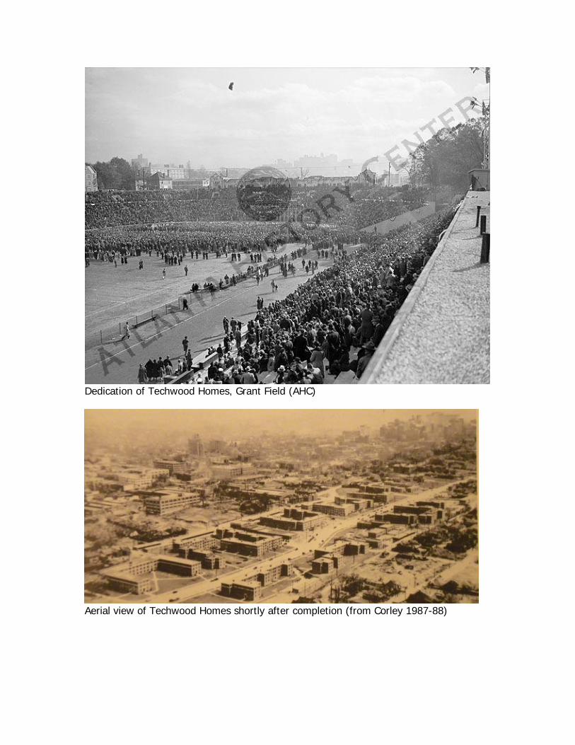
Dedication of Techwood Homes, Grant Field (AHC)
Aerial view of Techwood Homes shortly after completion (from Corley 1987-88)
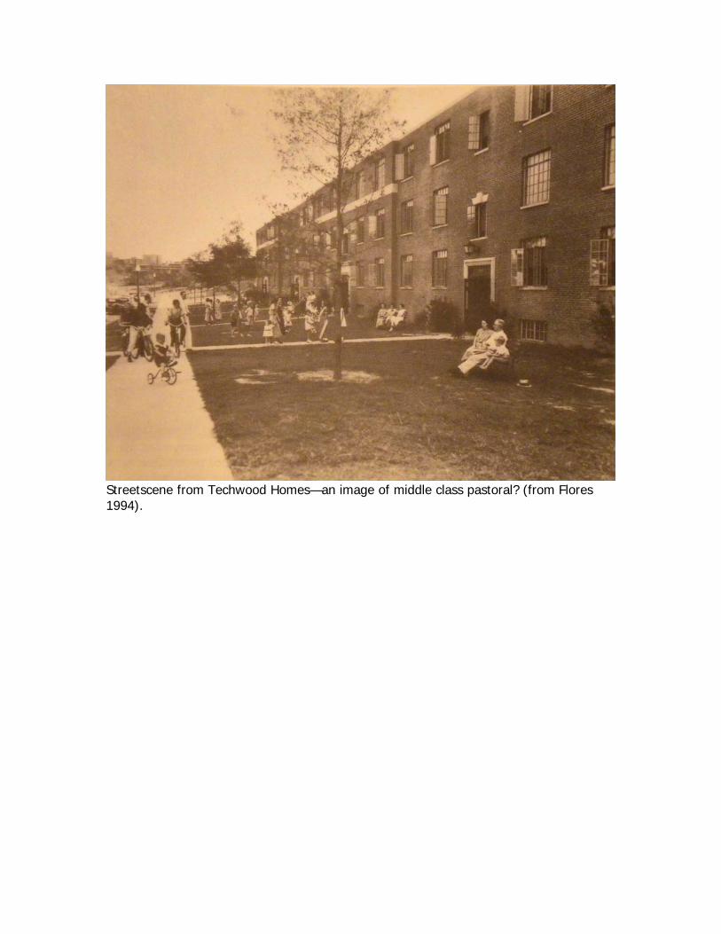
Streetscene from Techwood Homes—an image of middle class pastoral? (from Flores 1994).
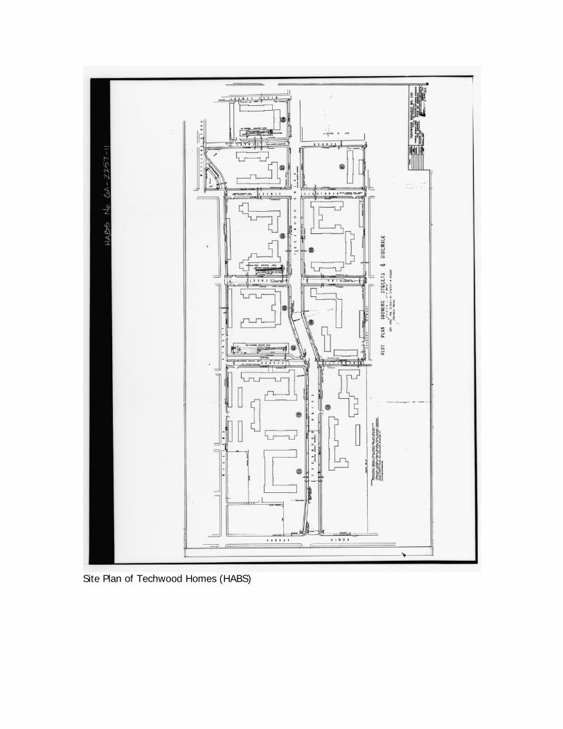
Site Plan of Techwood Homes (HABS)
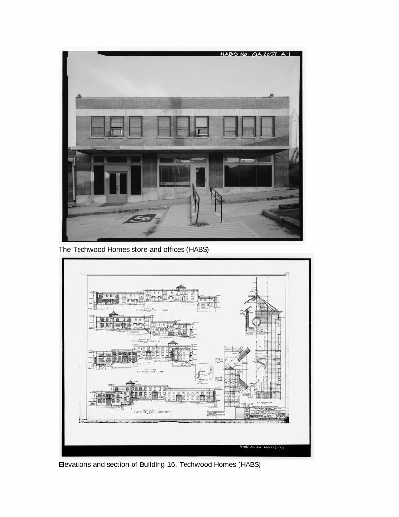
The Techwood Homes store and offices (HABS)
Elevations and section of Building 16, Techwood Homes (HABS)
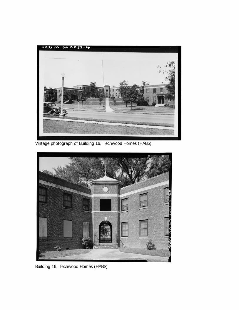
Vintage photograph of Building 16, Techwood Homes (HABS)
Building 16, Techwood Homes (HABS)
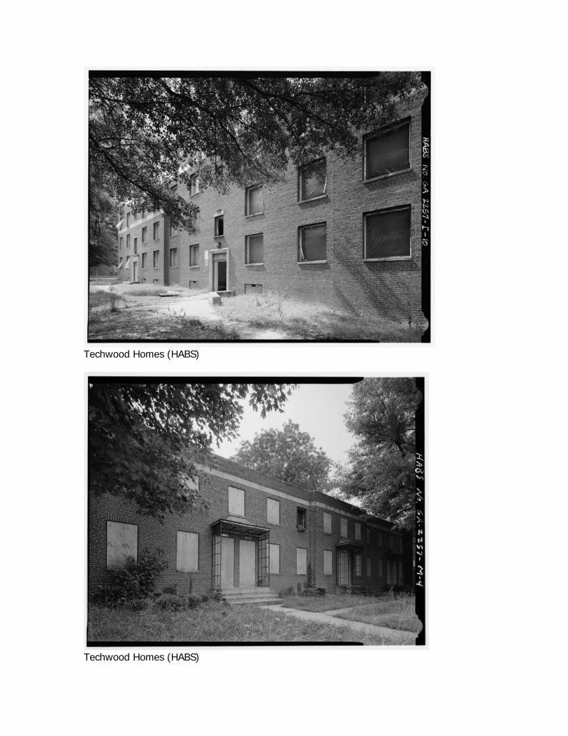
Techwood Homes (HABS)
Techwood Homes (HABS)
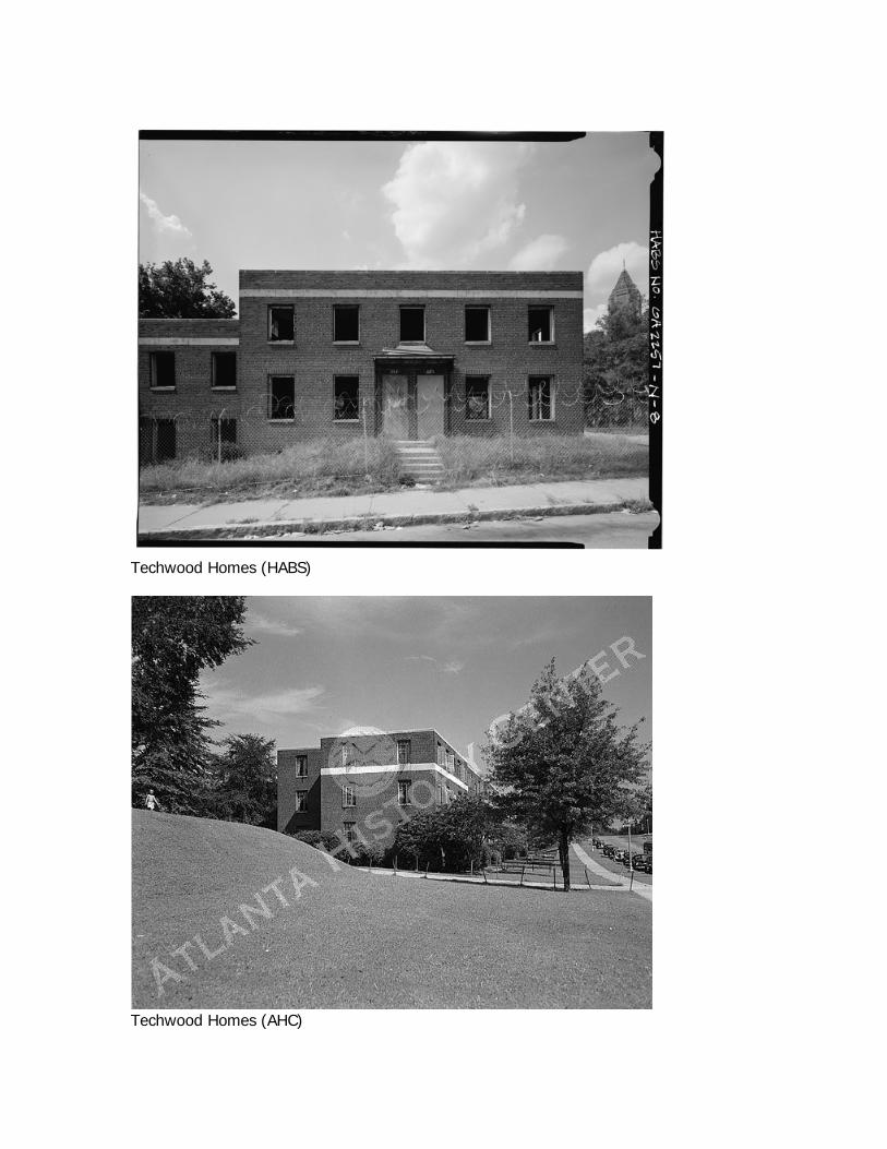
Techwood Homes (HABS)
Techwood Homes (AHC)
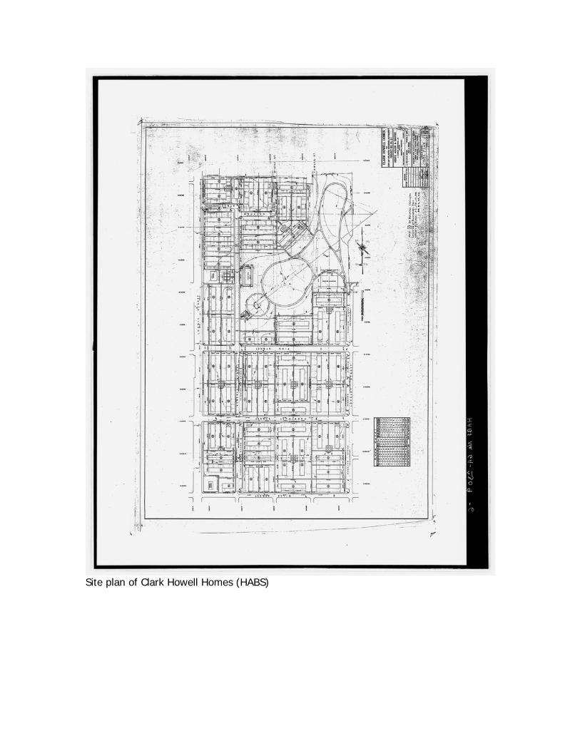
Site plan of Clark Howell Homes (HABS)
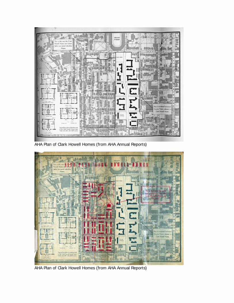
AHA Plan of Clark Howell Homes (from AHA Annual Reports)
AHA Plan of Clark Howell Homes (from AHA Annual Reports)
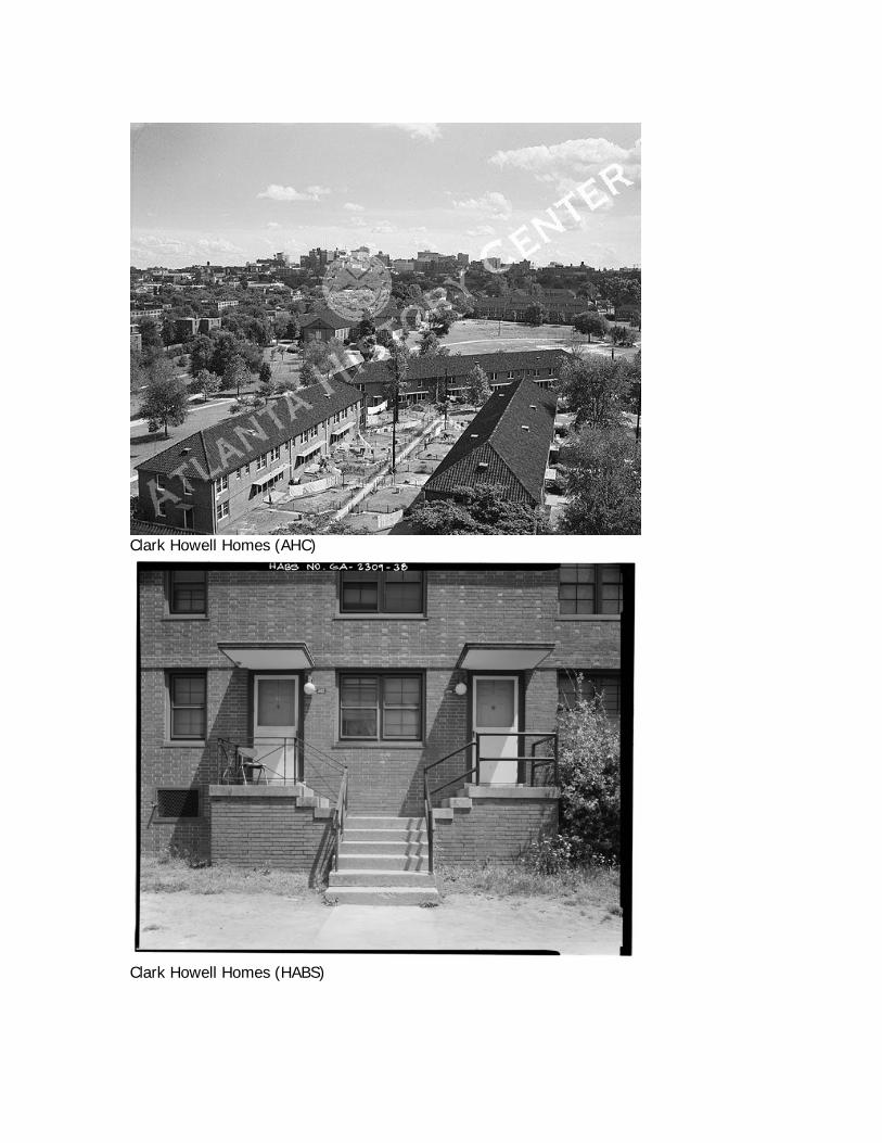
Clark Howell Homes (AHC)
Clark Howell Homes (HABS)
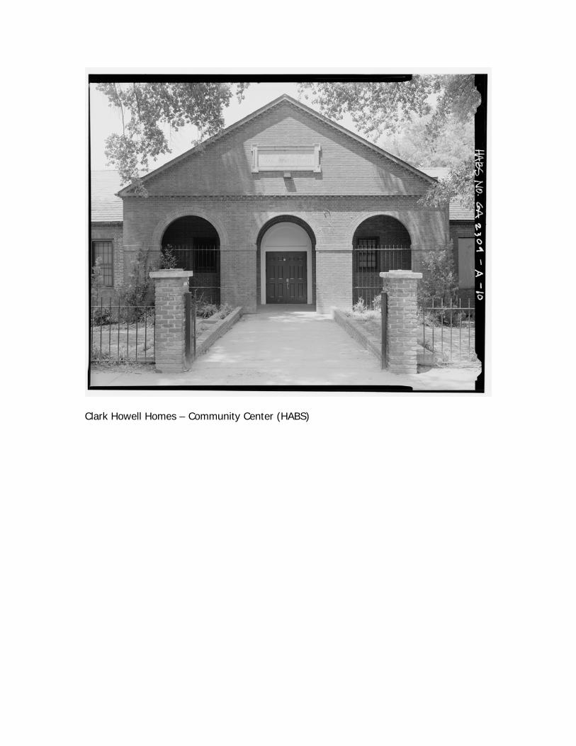
Clark Howell Homes – Community Center (HABS)
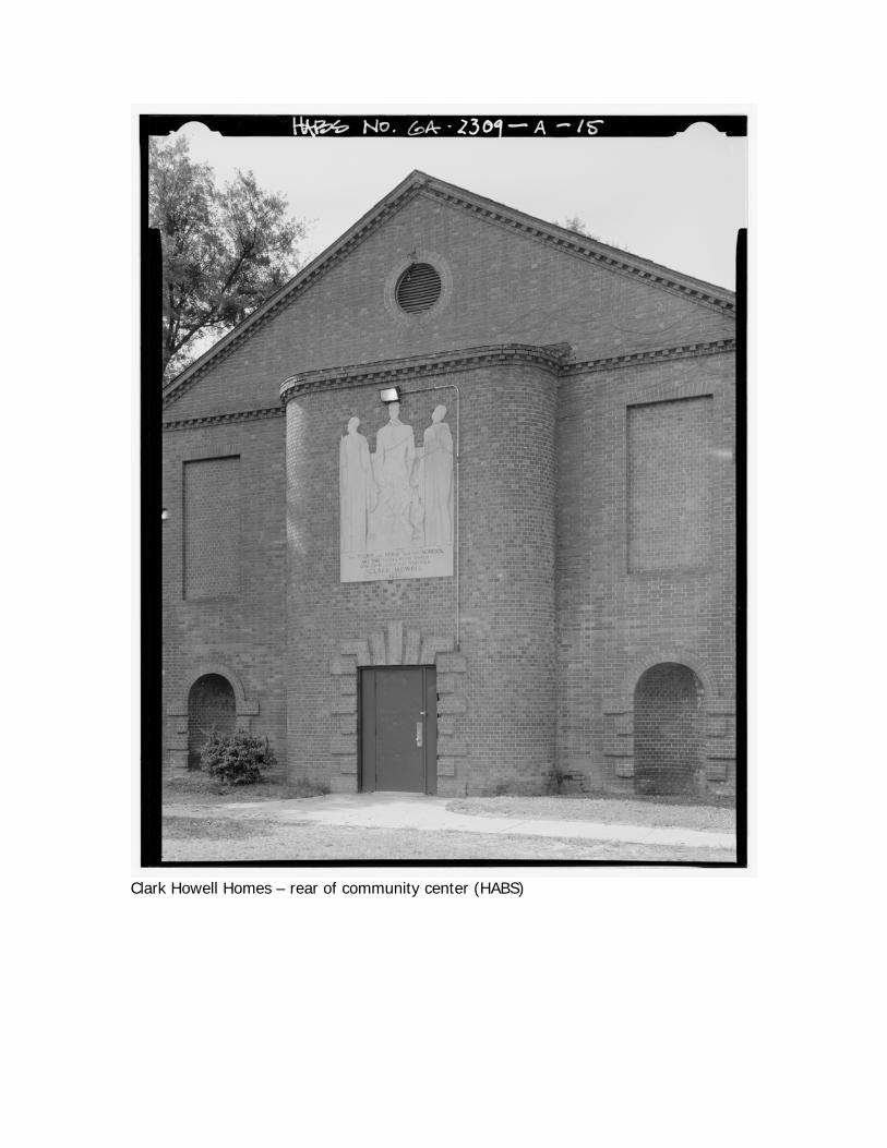
Clark Howell Homes – rear of community center (HABS)
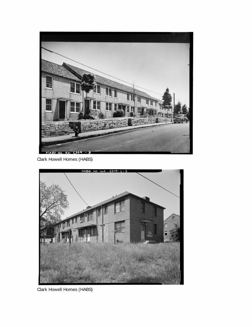
Clark Howell Homes (HABS)
Clark Howell Homes (HABS)
Clark Howell Homes (HABS)
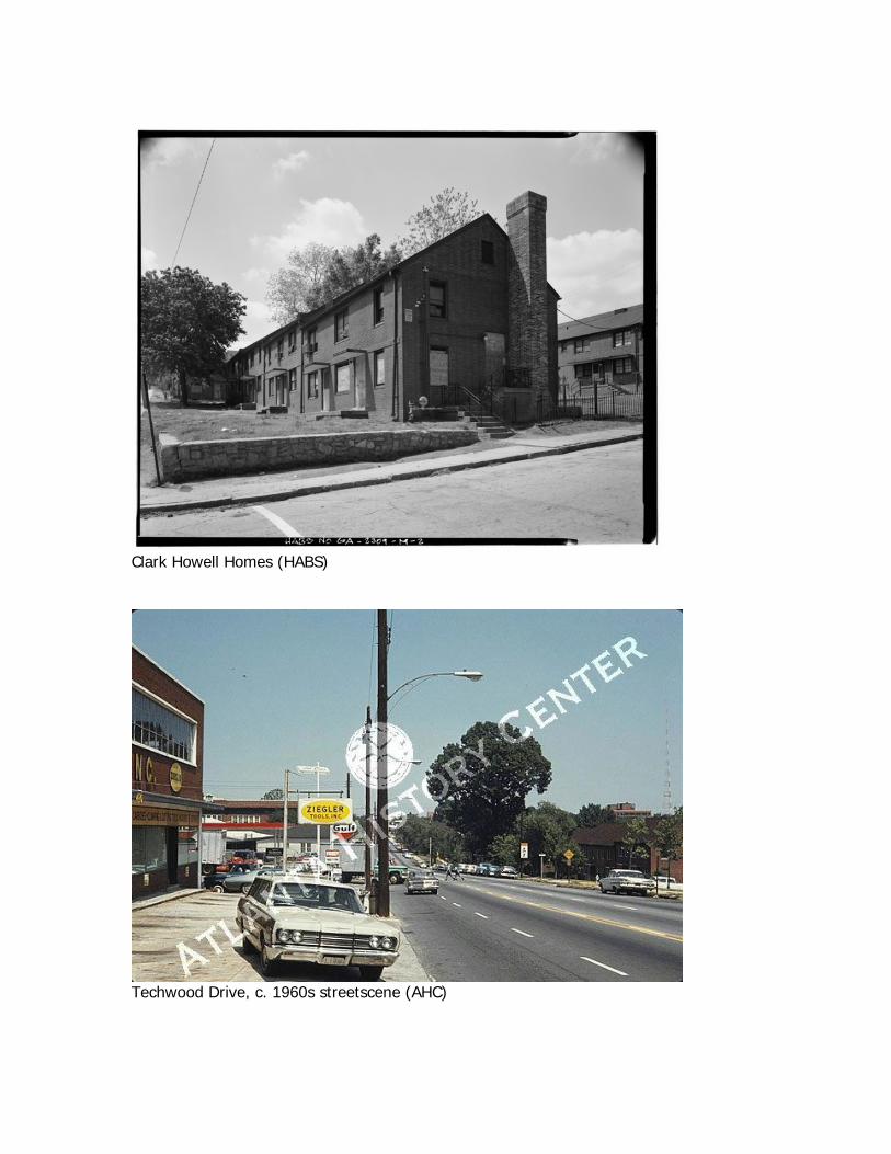
Techwood Drive, c. 1960s streetscene (AHC)
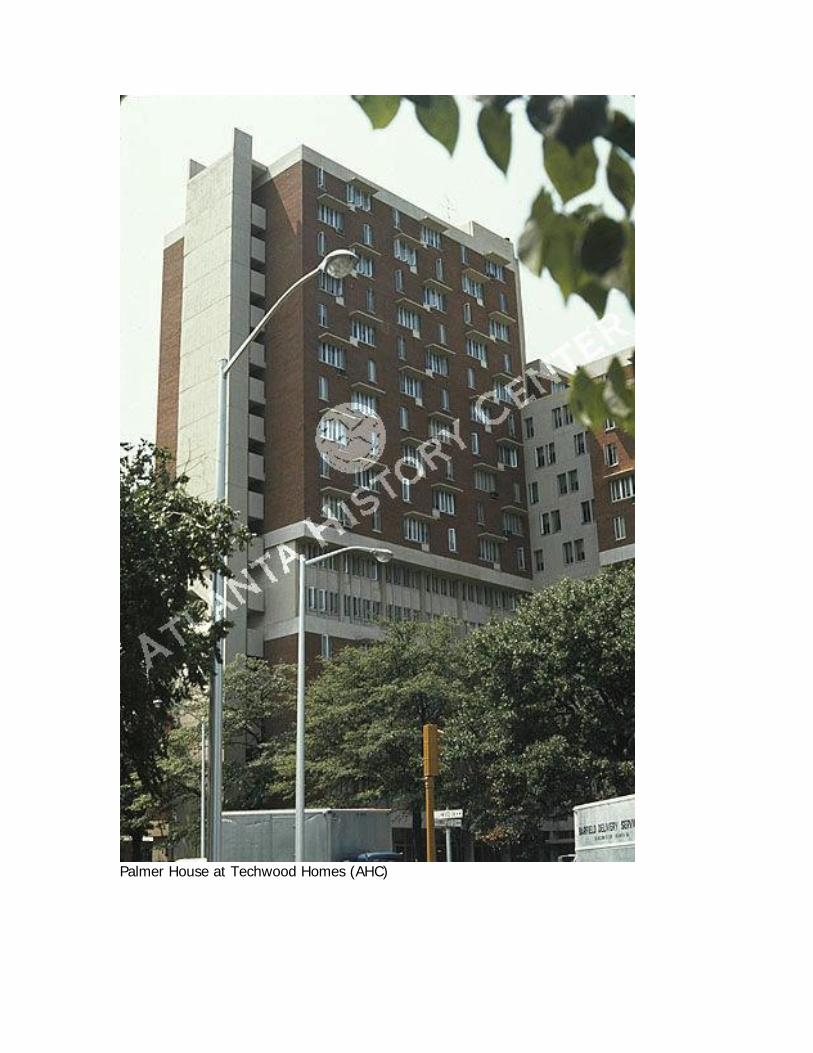
Palmer House at Techwood Homes (AHC)
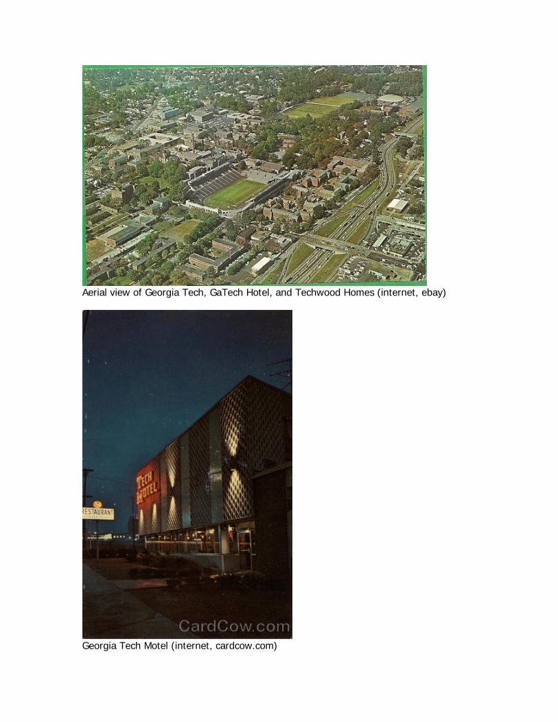
Aerial view of Georgia Tech, GaTech Hotel, and Techwood Homes (internet, ebay)
Georgia Tech Motel (internet, cardcow.com)
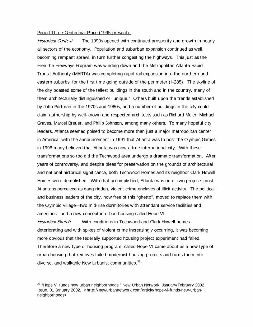
Period Three-Centennial Place (1995-present)-
Historical Context- The 1990s opened with continued prosperity and growth in nearly
all sectors of the economy. Population and suburban expansion continued as well,
becoming rampant sprawl, in turn further congesting the highways. This just as the
Free the Freeways Program was winding down and the Metropolitan Atlanta Rapid
Transit Authority (MARTA) was completing rapid rail expansion into the northern and
eastern suburbs, for the first time going outside of the perimeter (I-285). The skyline of
the city boasted some of the tallest buildings in the south and in the country, many of
them architecturally distinguished or “unique.” Others built upon the trends established
by John Portman in the 1970s and 1980s, and a number of buildings in the city could
claim authorship by well-known and respected architects such as Richard Meier, Michael
Graves, Marcel Breuer, and Philip Johnson, among many others. To many hopeful city
leaders, Atlanta seemed poised to become more than just a major metropolitan center
in America; with the announcement in 1991 that Atlanta was to host the Olympic Games
in 1996 many believed that Atlanta was now a true international city. With these
transformations so too did the Techwood area undergo a dramatic transformation. After
years of controversy, and despite pleas for preservation on the grounds of architectural
and national historical significance, both Techwood Homes and its neighbor Clark Howell
Homes were demolished. With that accomplished, Atlanta was rid of two projects most
Atlantans perceived as gang ridden, violent crime enclaves of illicit activity. The political
and business leaders of the city, now free of this “ghetto”, moved to replace them with
the Olympic Village—two mid-rise dormitories with attendant service facilities and
amenities—and a new concept in urban housing called Hope VI.
Historical Sketch- With conditions in Techwood and Clark Howell homes
deteriorating and with spikes of violent crime increasingly occurring, it was becoming
more obvious that the federally supported housing project experiment had failed.
Therefore a new type of housing program, called Hope VI came about as a new type of
urban housing that removes failed modernist housing projects and turns them into
diverse, and walkable New Urbanist communities.32
32 “Hope VI funds new urban neighborhoods.” New Urban Network. January/February 2002 Issue. 01 January 2002. <http://newurbannetwork.com/article/hope-vi-funds-new-urban-neighborhoods>
Social Character- In 2008, an article from “The Economist” reported that since it’s
construction in 1993 up through 2004, crime rates in Centennial Place have fallen
93%.33 The area also has seen a growth in median income and workforce participation,
which rose 174% and 94% respectively.34 The area is promoted as a mixed-income
community and has become popular among students from both Georgia Tech and
Georgia State who choose to live off campus.
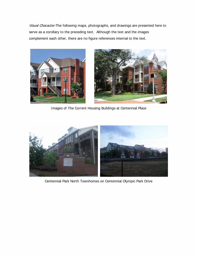
Urban Character- The urban character of this area has changed drastically from the
garden apartment, bar styles of Techwood Homes to a street-side, “New Urbanist”
scheme, where the buildings are aligned with the edges of the blocks with surface
parking located in the center of the blocks. Street-side parallel parking and tree-lined
sidewalks complete each of these types of new blocks, which in effect promotes a
diverse, livable, and walkable community dynamic. For tangible links with the past,
several buildings deemed to have significant historical or architectural features were
preserved and incorporated into the present scheme, including the Clark Howell
community building, Building 16 of Techwood Homes, and the former Carnegie Library
branch has been renovated into a SunTrust Bank.
The blocks themselves have also changed from 200’ x 400’ and 200’ x 600’
average block dimensions to a consistent 400’ x 400’ average block dimension between
Luckie Street and Centennial Olympic Park Drive. McAfee Street was realigned
approximately 200’ east from it’s original path while the old right-of-way was converted
to mid-block, surface parking access drives for the apartment buildings. Merritts Avenue
was also extended across the site to re-establish a connection back to Luckie Street that
was lost when Techwood Homes was constructed. However, the old Techwood
Community Center was spared for Centennial Place, forcing the street to curve around
the existing structure.
At the northeastern section of our focus site, the high-rise building on the corner
of North Avenue and Centennial Park Drive (formally Techwood Drive) is no longer
standing as of 2011 and currently is a vacant lot. The site adjacent to this parcel to the
south is Centennial Park North, which is an upscale urban townhome complex. This
33 “For Richer, For Poorer: America’s Mixed Income Experiment.” The Economist. 3 April 2008. <http://www.economist.com/node/10966143?story_id=10966143> 34 “Keep Hope (VI) Alive.” Brookings Institute. 17 May 2004. <http://www.brookings.edu/opinions/2004/0517metropolitanpolicy_cisneros.aspx>
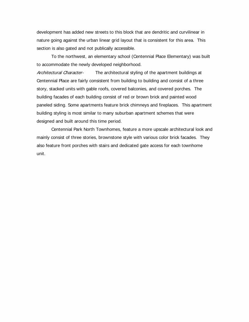
development has added new streets to this block that are dendritic and curvilinear in
nature going against the urban linear grid layout that is consistent for this area. This
section is also gated and not publically accessible.
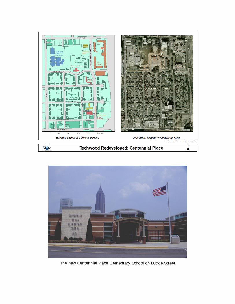
To the northwest, an elementary school (Centennial Place Elementary) was built
to accommodate the newly developed neighborhood.
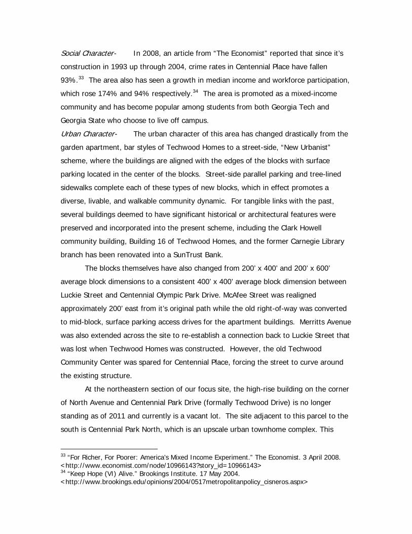
Architectural Character- The architectural styling of the apartment buildings at
Centennial Place are fairly consistent from building to building and consist of a three
story, stacked units with gable roofs, covered balconies, and covered porches. The
building facades of each building consist of red or brown brick and painted wood
paneled siding. Some apartments feature brick chimneys and fireplaces. This apartment
building styling is most similar to many suburban apartment schemes that were
designed and built around this time period.
Centennial Park North Townhomes, feature a more upscale architectural look and
mainly consist of three stories, brownstone style with various color brick facades. They
also feature front porches with stairs and dedicated gate access for each townhome
unit.
Visual Character-The following maps, photographs, and drawings are presented here to
serve as a corollary to the preceding text. Although the text and the images
complement each other, there are no figure references internal to the text.
Images of The Current Housing Buildings at Centennial Place
Centennial Park North Townhomes on Centennial Olympic Park Drive
The new Centennial Place Elementary School on Luckie Street
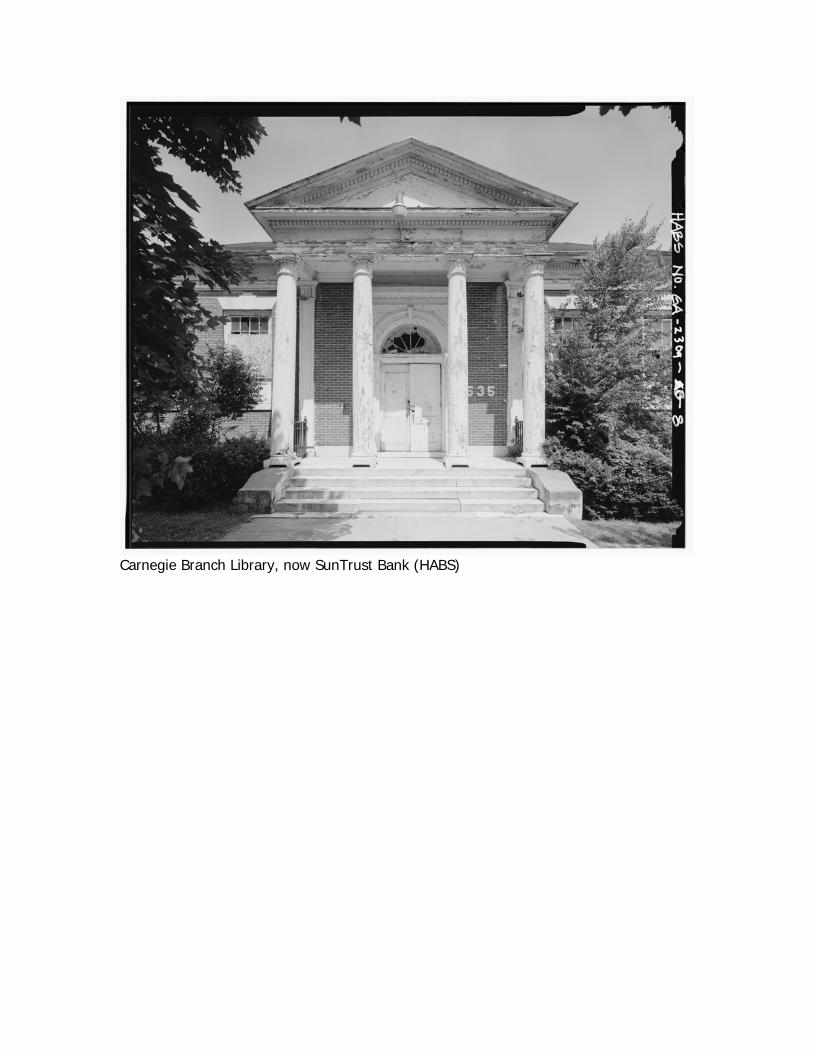
Carnegie Branch Library, now SunTrust Bank (HABS)
Concluding Remarks and Future Avenues of Research
The Techwood Neighborhood today is in its third major historical phase; it too
will likely experience the same internal cycle of the preceding two—population increase
and settlement, growth, unsympathetic infill, deterioration, and finally, demolition and
rebuilding. This third phase is relatively new, and is a marked contrast to what the area
was some twenty years ago. That said, the history of the neighborhood is a bit more
clear than what the future may hold, and although well documented in many respects
the historical record has its share of questions. During the course of research for this
project, a large amount of material was amassed from archival and secondary sources;
far too much to be assimilated here. However, several preliminary avenues of inquiry
have been identified; the potential for any or all of these research questions to be
answered, though, is reasonable, especially given the collections available at the Atlanta
History Center and regional university archives. Indeed, in-depth archival work has only
been touched upon for this project, but judging from the finding aids and discussions
with the archivists, such work—along with research at the courthouse and city hall—
could be especially fruitful. The questions identified tend to deal more with Period 1,
when Tech Flats grew along with the City of Atlanta and then deteriorated into a slum,
namely:
1) What was the nature of the early developments, developers, and owners
during the first few decades following the Civil War?
2) Who were the inhabitants of Tech Flats prior to the turn of the 20th
century as well as after, and what were their occupations?
3) Further correlation between the archaeological remains, namely the
mitigation by Brockington and Associates, with city directory information
would be especially interesting.
4) Investigation into the Palmer Papers at Emory University could also be
especially fruitful, provided a more in-depth study of the phase that
bridged what was Tech Flats to Techwood Homes.
5) What was the racial composition of the area through time?
and finally….
6) Further analysis and appraisal of what defines a “slum” and the successes
and failures of public housing. For failures, the demolition of Pruitt-Igoe
is the iconic moment in American history, but what constitutes the
successes? As far as defining a slum, we all know—or think we know—
what a slum is, but do we really know? This was brought clearly home in
Jane Jacobs’ Death and Life of Great American Cities by her conversation
with the city planner about Boston’s North End.
References Cited and Sources Consulted
*Electronic documents are cited within the footnotes. Garvin, Alexander. The American City: What Works, What Doesn’t. New York: McGraw-Hill, 2002. Fox, Catherine. “In 1935 President Franklin Roosevelt traveled to Atlanta” Architectural Record 187(11) (November 1999), 79. O'Connell, Kim. "Caught Between Housing & History." Journal of Housing & Community Development, 61(5)(2004): 32-36. Branum, Cassie. Public Housing and the City: Shifting Approaches in Urbanism. Atlanta: Georgia Institute of Technology, unpublished manuscript accepted for CP Thesis, 2010. Keating, Larry. “Redeveloping Public Housing: Relearning Urban Renewal’s Immutable Lessons” Journal of the American Planning Association 66-4(Fall 2000), 384-397. Lapping, Mark B. “The Emergence of Federal Public Housing: Atlanta’s Techwood Project” American Journal of Economics and Sociology 32-4(October 1973), 379-385. Dobbins, Michael. Urban Design and People. Hoboken, NJ: John Wiley and Sons, Inc., 2009. Peter E. Arnold. “Public Housing in Atlanta: A National First” Atlanta Historical Bulletin 13 (September 1968), ______. Corley, Florence Fleming. “Atlanta’s Techwood and University Homes Projects” Atlanta History 31-4 (Winter 1987-88), 17-36. Gournay, Isabelle. AIA Guide to the Architecture of Atlanta. Athens: University of Georgia Press, 1993. Atlanta Urban Design Commission. Atlanta’s Lasting Landmarks. Atlanta: Atlanta Urban Design Commission, 1987.
Appendix One
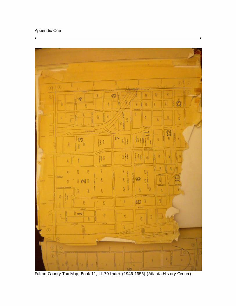
Fulton County Tax Map, Book 11, LL 79 Index (1946-1956) (Atlanta History Center)
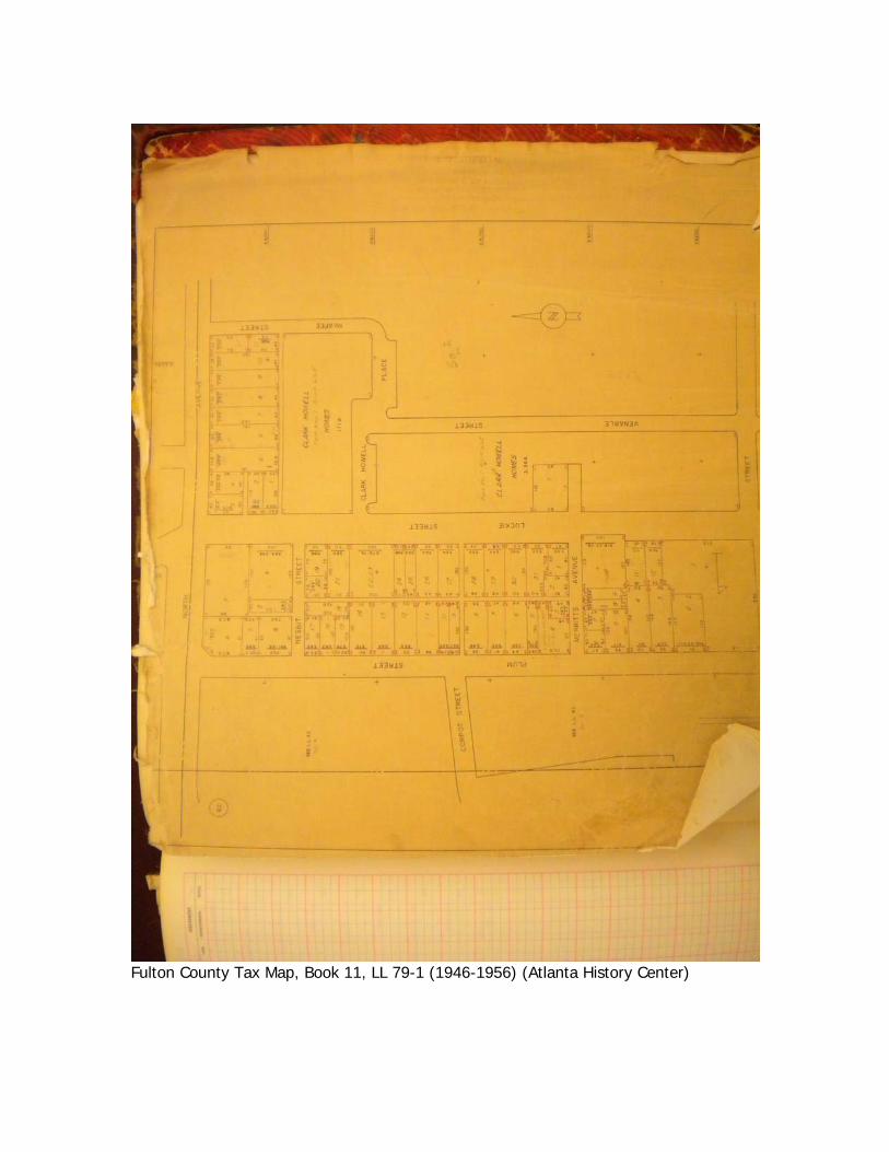
Fulton County Tax Map, Book 11, LL 79-1 (1946-1956) (Atlanta History Center)
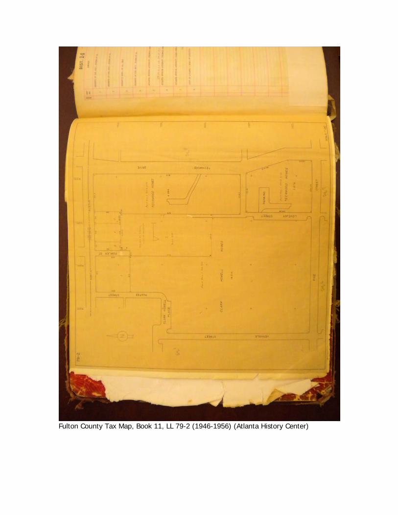
Fulton County Tax Map, Book 11, LL 79-2 (1946-1956) (Atlanta History Center)
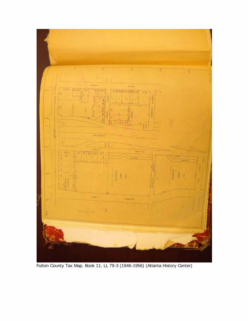
Fulton County Tax Map, Book 11, LL 79-3 (1946-1956) (Atlanta History Center)
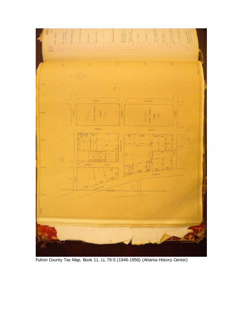
Fulton County Tax Map, Book 11, LL 79-5 (1946-1956) (Atlanta History Center)
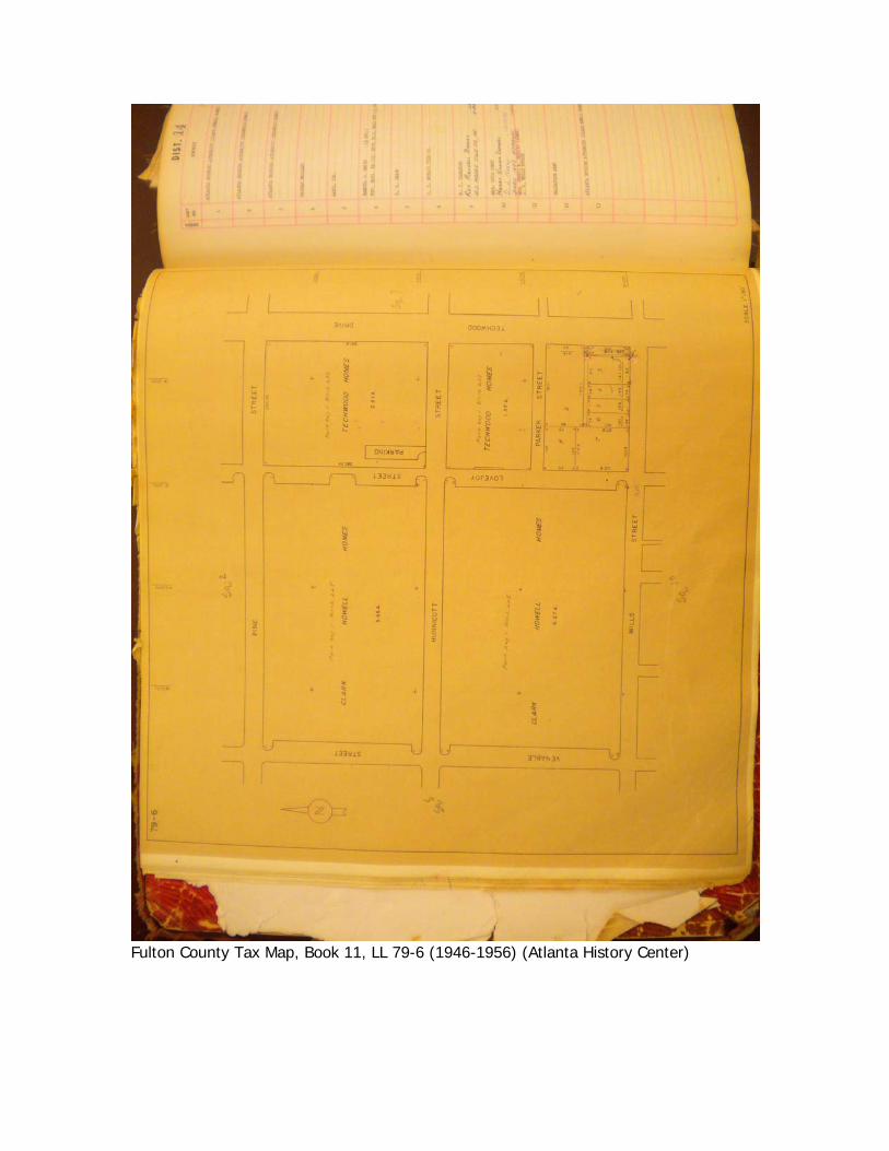
Fulton County Tax Map, Book 11, LL 79-6 (1946-1956) (Atlanta History Center)
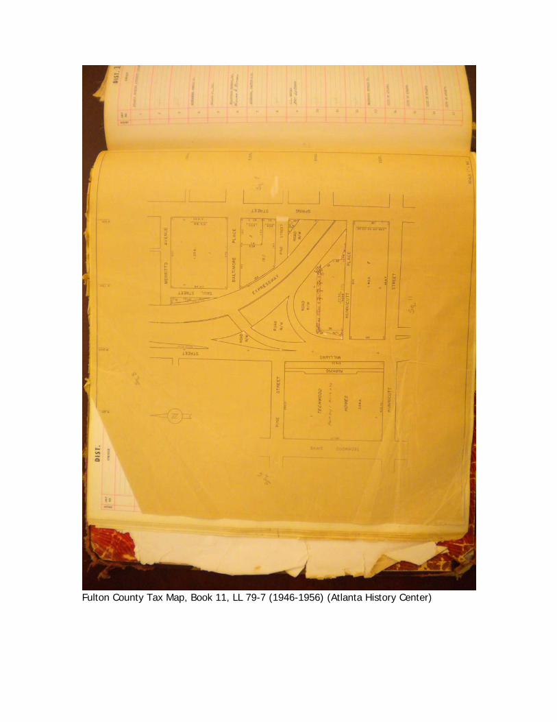
Fulton County Tax Map, Book 11, LL 79-7 (1946-1956) (Atlanta History Center)
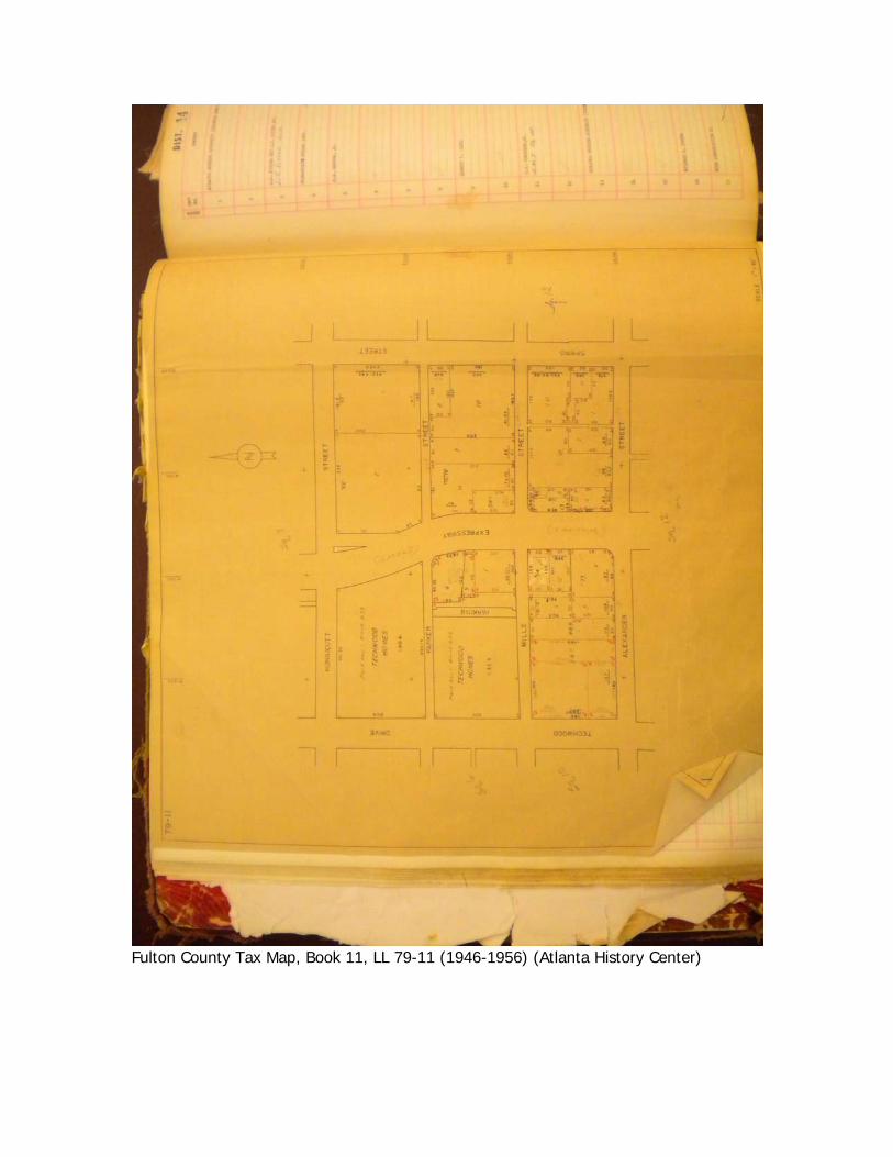
Fulton County Tax Map, Book 11, LL 79-11 (1946-1956) (Atlanta History Center)
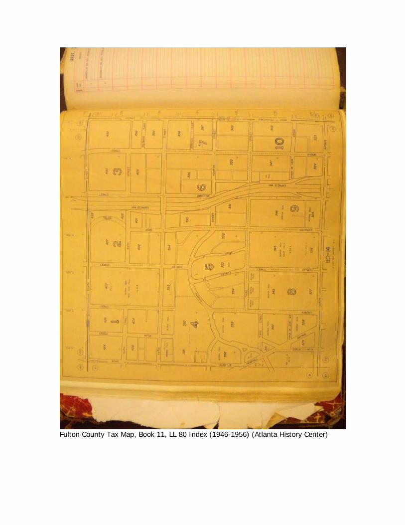
Fulton County Tax Map, Book 11, LL 80 Index (1946-1956) (Atlanta History Center)
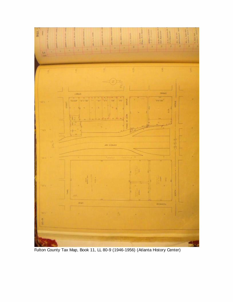
Fulton County Tax Map, Book 11, LL 80-9 (1946-1956) (Atlanta History Center)
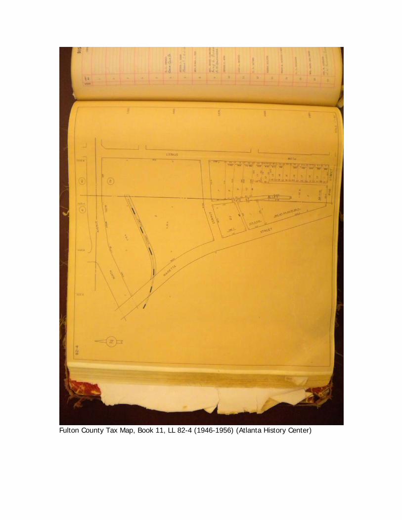
Fulton County Tax Map, Book 11, LL 82-4 (1946-1956) (Atlanta History Center)
Appendix Two
Historical Information from 1976 National Register Nomination
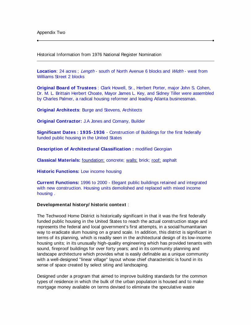
Location: 24 acres ; Length - south of North Avenue 6 blocks and Width - west from Williams Street 2 blocks
Original Board of Trustees : Clark Howell, Sr., Herbert Porter, major John S. Cohen, Dr. M. L. Brittain Herbert Choate, Mayor James L. Key, and Sidney Tiller were assembled by Charles Palmer, a radical housing reformer and leading Atlanta businessman.
Original Architects: Burge and Stevens, Architects
Original Contractor: J.A Jones and Comany, Builder
Significant Dates : 1935-1936 - Construction of Buildings for the first federally funded public housing in the United States
Description of Architectural Classification : modified Georgian
Classical Materials: foundation: concrete; walls: brick; roof: asphalt
Historic Functions: Low income housing
Current Functions: 1996 to 2000 - Elegant public buildings retained and integrated with new construction. Housing units demolished and replaced with mixed income housing .
Developmental history/historic context :
The Techwood Home District is historically significant in that it was the first federally funded public housing in the United States to reach the actual construction stage and represents the federal and local government's first attempts, in a social/humanitarian way to eradicate slum housing on a grand scale. In addition, this district is significant in terms of its planning, which is readily seen in the architectural design of its low-income housing units; in its unusually high-quality engineering which has provided tenants with sound, fireproof buildings for over forty years; and in its community planning and landscape architecture which provides what is easily definable as a unique community with a well-designed "linear village" layout whose chief characteristic is found in its sense of space created by select siting and landscaping.
Designed under a program that aimed to improve building standards for the common types of residence in which the bulk of the urban population is housed and to make mortgage money available on terms devised to eliminate the speculative waste
heretofore customary in slum-clearance and public housing program of the federal government.
Replacing about thirteen blocks of ore of the worst slum areas of Atlanta, this twenty-five acre federal housing project was built between the years 1934 and 1935. Erected by the J. A. Jones Construction Company of Charlotte, North Carolina at a cost of $2,108,337, of which the land alone cost .49 cents a square foot, the project was designed by the architectural firm of Burge and Stevens to accommodate some 604 families.
Burge and Stevens were not the only local group to be involved in the conception and planning of Techwood Homes, however. Others like Clark Howell, Sr., Herbert Porter, major John S. Cohen, Dr. M. L. Brittain Herbert Choate, Mayor James L. Key, and Sidney Tiller were assembled by Charles Palmer, a radical housing reformer and leading Atlanta businessman, to serve as the board of trustees for Techwood Incorporated. The purpose of this body, besides raising additional funds for the project's construction, was largely motivated by the then head of the Public Works Administration who felt that if "local people had some economic stake and the major legal responsibility for the project, they might act more judiciously. Moreover Ickes was philosophically opposed to people making fortunes from the poverty of others.
Complying with the stipulations embodied in the George-Healy Act, the Housing Divisions tenant selection was restricted to families of limited income who at the time were occupying substandard housing. No applicant was accepted who's income exceeded 5 times the rent charged per living unit. As reported in 1935, the average incomes of the tenants ranged from 1,080.00 to 1,920.00 a year and of 80 occupations represented by tenants the most numerous were clerks, followed by service men, office workers, salesmen, small business operators, and others; as was the custom until 1968, blacks did not reside in Techwood, but instead were furnished with housing in University Homes (Edwards and Sayward, Architects: William C. Pauley, Landscape Architect) a few blocks southeast of Techwood in what is now the Atlanta University Center Historic District. This second housing complex, at the urgings of Charles Palmer and John Hope, then President of Atlanta University, was planned as a part of the first federally-funded public housing project. University Homes, as original conceived, was to replace another notorious Atlanta slum known as Beaver's Slide.
In constructing the housing development, some 30 percent of the initial expenditure for labor and materials was a subsidy and the rents obtained from leasing the various dwelling units within the complex were used to liquidate the total cost of the project. The rents for the various units ranged from $16.40 for a well-planned three-room apartment to $27.8 for a six-room row-house. The land on which the project was developed was originally acquired by a limited dividend corporation, which later transferred the title to the property to the federal government.
As the first project to go into construction under the direction of the Housing Division of the Public Works Administration (PWA), Techwood served as an experiment and proving ground in both planning and in the writing of specifications. Living standards for tenants as set up by the Housing Division required that ample light and air be supplied to each
living unit and this was achieved in Techwood by providing adequate cross-ventilation in each apartment and by the actual arrangement of the structure on the site which provided ample lawn space between buildings This is one of the developments key qualities and the landscape design of Techwood has often been cited as one of the reasons that this project probably still remains the "best" public housing project in the United States.
Description of 1976 and historic physical appearance:
Covering eleven blocks in area, Techwood Homes is located along Techwood Drive, a main thoroughfare leading from Atlanta's business district to the campus of the Georgia Institute of Technology. Designed as a self-contained neighborhood, with buildings grouped around grassy courtyards and play areas, the structures of this first all-Federal housing project cover only about one-quarter of the total twenty-five acre site leaving plenty of remaining space for stores, social units and central laundries and generous open expanses.
Situated just south of the campus of Georgia Tech, the site of Techwood Homes has a length of six blocks running south from North Avenue and a width, west from Williams Street, of two blocks. The total area is 24.8 acres. The north end of the plot, that area adjacent to the Tech campus was originally devoted to playgrounds and tennis courts. Today, this area is occupied by a campus parking lot, to the east of Techwood Drive at North Avenue, and a high-rise for the elderly (Roosevelt House, 1972, H.A. Millkey & Associates, architects) to the west. The first building to the south along Techwood and within the historic district is a three-story dormitory containing 159 rooms for students at Georgia Tech. Techwood Dormitory was planned as such from the start of the project. In each of the remaining blocks of the housing development two or three buildings are placed within each block. These are either three-story apartment buildings or two-story row-houses, as indicated on the sketch map. Many of these buildings front on Techwood Drive which is a street developed in 1935 along the approximate longitudinal centerline of the housing project. Garage buildings, providing shelter for 186 cars and now in a state of near ruin were originally placed at the rear of the housing blocks along perimeter streets; since that time, however the housing project has been expanded with the result being that these garages are now practically in the center of the housing area. There are, in addition, four enclosed play-yards located in the apartment courts and many acres of open, tree-shaded spaces.
Incorporated into the original eleven blocks of buildings that comprise Techwood are several groups of two-story row-houses, the three-story Techwood Dormitory, one one-story Store and administration building , eleven one-story garage groups and thirteen three-story apartment buildings. All total there are 604 family living units divided into 397 three-room apartments, 128 four-room, 53 five-room and 26 six room units.
The architecture of the Techwood Homes development is characterized as modified Georgian. The type of construction selected for this project was based on careful analysis and estimates of comparative designs of floor systems. The structural layout for the three apartments and the two-story row houses is similar and all of the building have a narrow transverse dimension: 27 feet for the three-story apartments and 28 feet
2 inches, for the row-houses. This width is divided into two bays by a row of concrete columns and longitudinal concrete beams. The 12 inch exterior walls consist of 8 inch load-bearing ring tile blocks, faced with 4 inches of selected common brick, bonded every fifth course and trimmed with terra cotta and limestone. The floors and roofs are of solid concrete slab construction, supported by the exterior bearing walls and the interior row of columns and longitudinal beams. The exposed concrete ceiling slabs, soffits of stairs, beams in habitable areas, and all exposed interior and exterior surfaces are unplastered; exposed concrete surfaces are covered with cement paint. In general, all footings for these buildings are of the spread type and the basement walls are of poured concrete 12 inches thick to the ground level and 8 inches thick, faced with four inches of common brick, to the first floor line.
Whereas the dormitory in the Techwood Homes development is similar in style to the remainder of the complex, it differs in some respects from the other buildings. It is a concrete skeleton-frame structure with wall columns spaced from 18 to 22 feet and with two lines of interior columns spaced 10 feet apart on either wall of a longitudinal corridor. The outside bays are 12 feet 4 inches wide and, as in the other buildings, there are no transverse beams; the ceilings are smooth in all living quarters. The one-story garage groups are relatively narrow in the transverse dimension of 18 feet 4 inches and have 8 feet 4 inch wide stalls. The roofs are solid-slab construction, 2 1/2 inches thick reinforced with welded wire mesh and are supported on 10-inch steel channel. The side and rear walls of the garages are of 8-inch red brick and in the front, between the garage doors, are 4-inch H-columns supporting the roof channels.
The store building is mainly a one-story structure, except that one end of the building contains an additional floor that houses the complex's administrative offices. The type of construction used here is similar to that used in the three-story apartments except that there are two lines of interior columns instead of one, spaced 18 feet 2 inches connected by longitudinal concrete beams with a roof slab 5 1/2 inches thick.