Embed Size (px)
Citation preview
Conjola and MortonNational Parks
Vegetation Survey andMapping 2004
prepared by
June 2004

Conjola - Morton Vegetation Survey and Mapping
Final nghenvironmental
1 INTRODUCTION ...................................................................................................... 1
1.1 Background......................................................................................................................................1
1.2 Objectives ........................................................................................................................................1
1.3 Project Requirements .....................................................................................................................2
1.4 The Study Area ................................................................................................................................3
1.5 Previous Studies .............................................................................................................................4
1.6 Forest Ecosystems in the Study Area...........................................................................................5
1.7 Correspondence between Mills� Vegetation Communities and Forest Ecosystem Types......9
2 METHODOLOGY ................................................................................................... 11
2.1 Overview.........................................................................................................................................11
2.2 Vegetation Sampling Methodology .............................................................................................122.2.1 Floristic Site selection ..............................................................................................................122.2.2 Quadrat survey method............................................................................................................122.2.3 Photography .............................................................................................................................132.2.4 Forest Ecosystem Type Validation...........................................................................................13
2.3 API Methodology ...........................................................................................................................142.3.1 Translation of CRA API Mapping to Forest Ecosystem Types ...............................................142.3.2 Re-mapping of Coastal and Estuarine Vegetation Types........................................................162.3.3 Re-mapping of cleared areas and corridors.............................................................................17
2.4 GIS Methodology ...........................................................................................................................172.4.1 Field Map Preparation..............................................................................................................172.4.2 Study Area Definition ...............................................................................................................182.4.3 Preparation of GIS Layers for Re-mapping..............................................................................192.4.4 Data Capture and Processing ..................................................................................................192.4.5 Accuracy Level .........................................................................................................................202.4.6 Polygon Attribute Coding .........................................................................................................212.4.7 Survey Site Mapping ................................................................................................................222.4.8 Checking of Information ...........................................................................................................22
3 RESULTS............................................................................................................... 24
3.1 General Findings ...........................................................................................................................243.1.1 Conjola National Park ..............................................................................................................243.1.2 Morton National Park (eastern extensions)..............................................................................25
3.2 Findings Related to Specific Vegetation Types ........................................................................273.2.1 Non-eucalypt communities.......................................................................................................273.2.2 Eucalypt communities ..............................................................................................................29
3.3 Overall Findings and Conclusions ..............................................................................................33
4 MANAGEMENT IMPLICATIONS........................................................................... 35

Conjola - Morton Vegetation Survey and Mapping
Final nghenvironmental
4.1 Conservation Significance and Fire Management .....................................................................354.1.1 Non-eucalypt Vegetation Types ...............................................................................................354.1.2 Eucalypt Vegetation Types ......................................................................................................37
4.2 Rare and Threatened Plant Species ............................................................................................40
4.3 Weeds .............................................................................................................................................41
5 PROJECT TEAM ................................................................................................... 43
6 REFERENCES ....................................................................................................... 44
APPENDICES
Appendix 1 Forest Ecosystem Summary TablesAppendix 2 Field data sheets � example of blank formsAppendix 3 Description of Quadrat SitesAppendix 4 Forest Ecosystem ProfilesAppendix 5 Fire Response MechanismsAppendix 6 GIS DataAppendix 7 Maps

Conjola - Morton Vegetation Survey and Mapping
Final nghenvironmental
1
1 INTRODUCTION
This report describes the methodology, results and conclusions of the vegetation survey and mapping offorest ecosystems of Conjola National Park and the adjoining extension of Morton National Park, in theUlladulla Area of the South Coast Region. The report has been prepared by nghenvironmental undercontract for the NSW NPWS South Coast Region (Ulladulla Office). The project has also coveredNarrawallee Creek Nature Reserve to the south of Conjola National Park, which is documented in aseparate report. A report on the establishment of fire response monitoring plots has also been prepared,based on work undertaken during this project.
1.1 BackgroundDuring the Southern Comprehensive Regional Assessment (Southern CRA) in the late 1990s, a majorproject was undertaken to map vegetation types using full floristic site data, aerial photographicinterpretation and modelling using climatic and physical environmental data. The project covered a largearea within the Southern Directorate, part of which is the South Coast Region, covering all land tenuretypes. Methodology was previously developed for the Eden CRA and documented in a systematic reviewof forest ecosystem types, extent and conservation significance by Keith and Bedward (1999). A newclassification and modelling methodology was developed for the Southern CRA and documented byThomas, Gellie and Harrison (2000), which was heavily based on mapping by air photo interpretation.Validating and where necessary re-mapping modelled forest ecosystems is necessary for conservationmanagement of land within the National Parks Estate. This achieves a greater degree of detail andreliability that is necessary to support aspects such as pest and fire management, threatened speciesmanagement and ecologically sustainable forest management. Methodology for this validation processwas developed in 1999 by Nicholas Graham Higgs Pty Ltd (now nghenvironmental) and has beenapplied in stages for the whole of the NPWS Estate in the Merimbula and Bombala areas together withKooraban and Gulaga National Parks of the Far South Coast Region. Within the South Coast Region, asimilar project was undertaken in 2001-2002 for the Ulladulla Office of NPWS covering MurramarangNational Park and related offshore islands, Meroo National Park and Barnunj State Recreation Area.
This report is the result of the adaptation and application of previously used methodologies for thesampling and re-mapping of forest ecosystems in the Ulladulla Area. The project has involved fieldmapping, database entry of field data, air photo interpretation and GIS mapping as means of validatingthe modelled map by Thomas, Gellie and Harrison (2000) and preparing a revised map based on thesefindings.
1.2 Objectives
The aims as specified in the project brief are to:
• Carry out plot-based, full-floristic field surveys in Narrawallee Creek Nature Reserve,Cudmirrah and Conjola National Parks and the Morton National Park eastern addition;
• Prepare a field validated vegetation map for the study area identifying the dominant canopyand understorey vegetation associations and;
• Establish fire response monitoring plots to compliment and enhance existing operational sitesfor incorporation into the Vegetation Response to Fire Monitoring Project and state-widedatabase at sites selected as being appropriate.
The overall objective of the work is to provide a vegetation data set which includes floristic site data andupdated vegetation maps of Conjola National Park, the eastern extension of Morton National Park andNarrawallee Creek Nature Reserve, with special reference to forest ecosystems of conservationmanagement significance, supported by documentation of the methodology used and results obtained.
Specific objectives in the work were:
• to identify sites for floristic surveys to complement existing CRA data and to provide a basisfor ongoing fire response monitoring;

Conjola - Morton Vegetation Survey and Mapping
Final nghenvironmental
2
• to sample important ecosystems that are vulnerable, rare, under-represented in the reservesystem or fire sensitive;
• to undertake full-floristic plot sampling and provide an inventory of vascular flora from each ofthe plots and other environmental data as specified, including additional data for those sitesestablished for fire monitoring purposes;
• to provide revised vegetation maps of the study area according to project specifications;
• to provide two reports on the vegetation mapping work, one for Conjola and Morton NationalParks and one for Narrawallee Creek Nature Reserve with recommendations for managingrare or fire-sensitive vegetation associations and
• to provide a report on the fire response monitoring sites.
1.3 Project Requirements
The following specific requirements were identified in the project brief.
Standard floristic survey sites:
• In conjunction with NPWS staff and using a gap analysis method, identify 15 sites toundertake plot-based, full-floristic surveys to complement existing CRA site data.
• Undertake full-floristic plot-based sampling using the standardised botanical plot samplingmethodology such as that used during the CRA including permanent plot and photo-pointestablishment at each site.
• Provide an inventory of vascular flora and relevant environmental data from each of the plots,ensuring that the full range of important ecosystems or vegetation associations that arevulnerable, rare, under-represented in the reserve system or fire sensitive are sampled.Detailed notes made of fuel loadings and unusual, unique or interesting features found on ornear plots are also required.
Fire response monitoring sites:
• In conjunction with NPWS staff, select at least 12 fire response monitoring sites (in both burntand unburnt areas) in a range of vegetation types, where possible selecting sites with rare orthreatened plant (ROTAP) species and/ or areas of highest fire risk potential. These sites mayoverlap with the full-floristic sites established to validate the CRA forest ecosystem mappingor be sites where full-floristic plots were measured during the CRA;
• Undertake full-floristic plot based sampling as per methodology described in Section 5:Methodology � Systematic Survey.
• Establish photo points at each monitoring site; and,
• Provide a stand-alone report of the work outlining the basis for selection of monitoring sites,description of location and fire history of each site including map, photographs of each siteand full floristic or plant species fire response and fire fuel sampling sheet(s) for each site.The report is to be a stand-alone document containing a full set of maps, tables, appendicesand photographs.
Mapping:
• Using the Southern CRA forest ecosystems classification and existing forest ecosystemmapping as a basis and guide, and other Southern CRA ecosystem-related datasets providedby NPWS, prepare a validated hard copy and digital vegetation map at a scale of 1:25,000 foreach reserve. This is to include floristic data collected from the 20 (approx) existing sitescreated from the CRA and data collected from the 40 canopy plots set up by the CSIRO andassociated Kevin Mills and Associates Pty Ltd survey (The Vegetation of Cudmirrah NationalPark, Conjola National Park, Cudmirrah Nature Reserve). This information will also beprovided by NPWS.

Conjola - Morton Vegetation Survey and Mapping
Final nghenvironmental
3
• A revised and reliable extant forest ecosystems map is to be prepared for the study areautilising pre-existing information as specified above and information collected in the fieldsurveys component of this project.
• The contractor is expected to have available and utilise a sophisticated level of GIS capabilityand that is ESRI-ArcView compatible.
Reports:
• Prepare two project reports, one for Narrawallee Creek Nature Reserve and another for theConjola/Cudmirrah and Morton National Park (eastern addition) including recommendationsfor managing rare, vulnerable or fire-sensitive vegetation associations. The reports are to bestand-alone documents containing a full set of maps, tables, appendices and photographs.
1.4 The Study Area
The study area lies north of the towns of Ulladulla and Milton and south of Jervis Bay on the NSW SouthCoast. It extends from the coastline to the cliff-lined escarpment west of the Princes Highway, which liesalong the eastern edge of the large Morton National Park. The coastal parks, Conjola National Park andNarrawallee Creek Nature Reserve, include much of the large Conjola Lake and Swan Lake foreshores,several smaller lakes and lagoons, extensive coastal forests and portions of the coastline. The smallvillages of Conjola Lake, Cunjarong, Manyana, Bendalong, Berrara, Cudmirrah and Swan Haven, andassociated coastlines are excluded from but surrounded by the parks and the larger village of Sussexinlet lies to the north of the study area. West of the Princes Highway, the study area extends into MortonNational Park to include land along and below the coastal escarpment which was recently added to thatpark.
Conjola National Park has existed since 1994 as a relatively small park along the northern shores ofLake Conjola. The separate Cudmirrah National Park, also gazetted in 1994, covered the coastline andshores of Swan Lake between the village of Bendalong in the south and Sussex Inlet in the north. Itabsorbed and greatly expanded the former Cudmirrah Nature Reserve which occupied the coastal dunesand wetlands between Bendalong and Barrara. As an outcome of the Southern Regional ForestAgreement, the two national parks were greatly expanded in 2001 with the transfer of 7,600 hectares ofland formerly within Conjola State Forest. The new park is now Conjola National Park. At the same time,6,570 hectares of land west of the Princes Highway in portions of Yerriyong, Jerrawangala andMcDonald State Forests was added to Morton National Park. This eastern extension of Morton includesland adjoining Conjola National Park, effectively connecting land under National Parks Estate, from theBudawang Range through the Clyde River gorge and Little Forest Plateau to the coastline.
Narrawallee Creek Nature Reserve lies to the south of Lake Conjola and is documented in a separatereport. The study area referred to in the remainder of this report, therefore, refers to the Conjola-Mortonportion only.
The majority of the study area is underlain by sedimentary rocks of the Sydney Basin, with smaller areasof Quaternary or Tertiary sediments along parts of the coastline. Granites occur only in the north west ofthe study area within Morton National Park.
The coastline is predominantly fringed by beaches and dunes, broken by occasional rocky headlandsand minor cliff lines. Swamps are numerous but mostly small and confined to drainage lines. ConjolaLake in the south and Swan Lake in the north (the waters of which are excluded from the parks) areprominent features within the study area and estuaries exist on the lower reaches of Berrara andNerrindillah Creeks. Conjola Lake and the connected Berringer Lake are tidal while Swan Lake appearsto be only occasionally open to the sea. It was open in 1993 when the air photos were flown but wasclosed in more recent years (as evidenced by the orthophotos and recent field work. It is therefore likelyto be brackish but not normally tidal.
As a result, Conjola National Park protects a diversity of coastal and estuarine landforms, plantcommunities and animal habitats including extensive dunal systems, estuaries, swamps and importantbird breeding and feeding areas. The vegetation ranges from dry forests on the ridges and flatterelevated areas, moist forests and rainforests in the many gullies, to the non-forest communities of the

Conjola - Morton Vegetation Survey and Mapping
Final nghenvironmental
4
estuarine wetlands, lake foreshores, dunes and rocky headlands. Twenty one threatened species offauna and eighteen regionally significant fauna species have been recorded, plus the rare Pultenaeavillifera var villifera, Grevillea maclayana and Cryptostylis hunteriana and nineteen regionally significantplants, many of which have their southern limit of distribution in the area. There is a high diversity andoccurrence of Aboriginal sites and some features of local historical significance are protected within thePark.
By contrast, the portion of Morton National Park within the study area, is more rugged, including the cliff-lined escarpment of Little Forest Plateau (at around 500 metres above sea level) and dissected landbelow the plateau. The northern part of the extension of this park falls away from the escarpment andconnects with Conjola National Park while the southern part contains some cliff-rimmed outliers of theplateau and falls away to state forests and cleared rural land which separate it from Conjola NationalPark. The Morton National Park extension protects areas of moist heath and cycad/shrub dry forestswhich differ floristically from those of the coastal areas.
Being originally mostly state forests, the study area has a history of disturbance from logging and isdissected by many roads and powerlines. Wildfires have been a major environmental factor influencingthe vegetation and consequently a key factor in conservation and fire management of the parks. NPWSrecords indicate extensive wildfires in 1968-69 and 1991-92 as well as more frequent smaller fires. Muchof the study area was burned more recently during the Hylands fire in December 2001, prompting theneed for ongoing fire response monitoring of the vegetation.
1.5 Previous Studies
The review of previous vegetation studies documented by Thomas, Gellie and Harrison (2000) lists onlyone study relating specifically to the vegetation of the study area, by Kevin Mills and Associates (1995).The report on the vegetation of the former Cudmirrah National Park and Nature Reserve and ConjolaNational Park, all now included in the current enlarged Conjola National Park (K. Mills & Associates,1995), was used as a source of information on vegetation communities present, their conservationsignificance and the conservation significance of particular plant species in the region. Mills describedand mapped the location of 18 communities including 12 eucalypt forests or woodlands, with the latterincluding 5 heathy communities (characterised by an open tree cover and understorey dominated bysclerophyll shrubs), and 6 wetland or littoral non-eucalypt communities. The correspondence betweenMills� communities and the Southern CRA forest ecosystem types is detailed in section 1.7. The reportand GIS vegetation map layers of the work by Mills were consulted during this project.
Other vegetation studies which were consulted cover much broader areas, such as the CSIRO canopysurvey in the 1990s and the surveys which formed part of the Southern CRA. Floristics data arising fromthese have been incorporated in the NPWS floristic survey sites database which was used during thepresent study. The database contains around 30 canopy only sites by CSIRO. A further 25 sites withinthe study area have been surveyed by Kevin Mills (consultant). The remaining 14 sites are all part of theSouthern CRA floristic surveys and were full floristic surveys.
Mapping of floristic types for forestry purposes in the state forests now included in the study area mayhave been carried out for internal purposes by State Forests, but this type of mapping is generallyspecific to target species for logging and generally not useful for other purposes. The most useful forestrymapping is the RN17 (Research Note 17), which is generally high quality API mapping, and was used inthe Southern CRA API project.
Comprehensive mapping of the South Coast portion of the Southern CRA study area is documented inthe Southern Region CRAFTI report (RACD, DUAP, 2000). This study, which was based on APIassessment of forested lands, resulted in structural-based mapping related to growth stage, which wasassigned broad floristic type classes This mapping provided a basis for assessing regional conservationstatus of vegetation communities, identification of old growth, fauna modelling, wilderness assessmentand forest ecosystems modelling.
Using the CRAFTI API vegetation mapping as a basis, and drawing on methodology developed duringthe Eden CRA (Keith and Bedward, 1995, 1998,1999) for forest ecosystem modelling, new methodologywas developed and applied to the Southern CRA area to produce a modelled layer of forest ecosystems.The methodology and a summary of vegetation profiles for each forest ecosystem are documented in thereport by Thomas, Gellie and Harrison (2000). This modelling has been used as the basis for validation
Conjola - Morton Vegetation Survey and Mapping
Final nghenvironmental
5
and re-mapping of vegetation in the Ulladulla Area, the Conjola-Morton section of which is the subject ofthis report.
The results of these CRA projects were used in the process of assessing the representativeness ofvegetation types in the reserve system and the adequacy of existing reserves in conserving a range ofvegetation types. The CRA provided the scientific basis on which the State and CommonwealthGovernments could develop a Regional Forest Agreement (RFA) for the Southern Region of New SouthWales. This agreement determined the future of these forests, providing a balance between conservationand ecologically sustainable use of forest resources. The process ultimately led to additions to the NPWSEstate including extensions to Conjola and Morton National Parks in 2001.
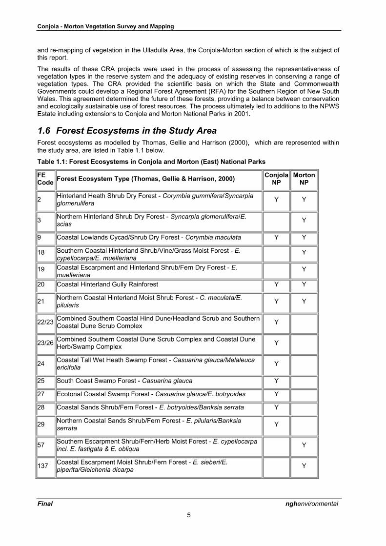
1.6 Forest Ecosystems in the Study AreaForest ecosystems as modelled by Thomas, Gellie and Harrison (2000), which are represented withinthe study area, are listed in Table 1.1 below.
Table 1.1: Forest Ecosystems in Conjola and Morton (East) National Parks
FECode Forest Ecosystem Type (Thomas, Gellie & Harrison, 2000) Conjola
NPMorton
NP
2 Hinterland Heath Shrub Dry Forest - Corymbia gummifera/Syncarpiaglomerulifera Y Y
3 Northern Hinterland Shrub Dry Forest - Syncarpia glomerulifera/E.scias Y
9 Coastal Lowlands Cycad/Shrub Dry Forest - Corymbia maculata Y Y
18 Southern Coastal Hinterland Shrub/Vine/Grass Moist Forest - E.cypellocarpa/E. muelleriana
Y
19 Coastal Escarpment and Hinterland Shrub/Fern Dry Forest - E.muelleriana
Y
20 Coastal Hinterland Gully Rainforest Y Y
21 Northern Coastal Hinterland Moist Shrub Forest - C. maculata/E.pilularis Y Y
22/23 Combined Southern Coastal Hind Dune/Headland Scrub and SouthernCoastal Dune Scrub Complex Y
23/26 Combined Southern Coastal Dune Scrub Complex and Coastal DuneHerb/Swamp Complex Y
24 Coastal Tall Wet Heath Swamp Forest - Casuarina glauca/Melaleucaericifolia Y
25 South Coast Swamp Forest - Casuarina glauca Y
27 Ecotonal Coastal Swamp Forest - Casuarina glauca/E. botryoides Y
28 Coastal Sands Shrub/Fern Forest - E. botryoides/Banksia serrata Y
29 Northern Coastal Sands Shrub/Fern Forest - E. pilularis/Banksiaserrata Y
57 Southern Escarpment Shrub/Fern/Herb Moist Forest - E. cypellocarpaincl. E. fastigata & E. obliqua Y
137 Coastal Escarpment Moist Shrub/Fern Forest - E. sieberi/E.piperita/Gleichenia dicarpa Y

Conjola - Morton Vegetation Survey and Mapping
Final nghenvironmental
6
FECode Forest Ecosystem Type (Thomas, Gellie & Harrison, 2000) Conjola
NPMorton
NP
139 Northern Coastal Hinterland Heath Shrub Dry Forest - C. gummifera/E.sclerophylla Y Y
140 Northern Coastal Tall Wet Heath Y
144 Northern Coast and Hinterland Moist Heath Y
166 Central Coastal Hinterland and Lowland Warm Temperate Rainforest Y
167 Coastal Lowland Sub Tropical/Littoral Rainforest Y
176 Morton Plateau Mallee Swamp Low Forest Y
187 Coastal Headland Heathlands Y
190 Rock Y
These forest ecosystem (FE) types, based on descriptions by Thomas, Gellie & Harrison (2000), areoutlined below.
Eucalypt dry forest types
• Hinterland Heath Shrub Dry Forest � Corymbia gummifera-Syncarpia glomerulifera (FE2),which consists of red bloodwood (C. gummifera) and possibly other eucalypts (E. globoidea,E. piperita, E. consideniana or E. sieberi) with an sub-canopy layer of Syncarpia glomeruliferaand a sclerophyll shrub understorey commonly including Persoonia linearis, Acaciaobtusifolia, Leucopogon lanceolatus, Bossiaea obcordata and Gompholobium latifolium.Modelled as being one of the most common types in the study area.
• Northern Hinterland Shrub Dry Forest - Syncarpia glomerulifera/E. scias (FE 3) is similar toFE2 differing in the presence of large-fruited red mahogany (E. scias ssp callimastha) anddominance of turpentine (Syncarpia glomerulifera) in the canopy. It was modelled as occurringonly in the western parts of the study area in Morton NP.
• Coastal Lowlands Cycad/Shrub Dry Forest � Corymbia maculata (FE9), which is dominatedby spotted gum (Corymbia maculata) with E. globoidea and E. paniculata possibly co-dominant in places. It is said to generally occur on Ordovician metasediments. Understoreyelements include a small tree layer of Allocasuarina littoralis, and a shrub layer withburrawang, (Macrozamia communis), Persoonia linearis, Leucopogon lanceolatus, Hibbertiaaspera and Platysace lanceolata.
• Coastal Escarpment and Hinterland Shrub/Fern Dry Forest - E. muelleriana (FE19) Forest isa medium to tall forest up to 25 metres tall, dominated by Eucalyptus muelleriana withAngophora floribunda. The tall shrub layer comprises mainly Acacia falciformis and A.obtusifolia. It was modelled as occurring only in the Morton NP part of the study area
• Coastal Sands Shrub/Fern Forest � E. botryoides/Banksia serrata (FE28), which is largelyconfined to sand deposits adjoining beaches and coastal lakes. Bangalay (E. botryoides) isoften the sole canopy species. Banksia serrata forms a subcanopy layer, or shares thecanopy with bangalay in low wind-pruned stands. Typical shrubs are Acacia longifolia,Breynia oblongifolia, Monotoca elliptica and Hibbertia obtusifolia. Burrawangs may bepresent, and in long unburnt stands a mesophyll element of shrubs and small trees oftendevelops, including Pittosporum undulatum, Notelaea longifolia, Synoum glandulosum andvines such as Hibbertia scandens and Cissus hypoglauca.
• Northern Coastal Sands Shrub/Fern Forest � E. pilularis/Banksia serrata (FE29), generallyoccurs on low foothills below 100m elevation, on Permian mudstones or on deep sand

Conjola - Morton Vegetation Survey and Mapping
Final nghenvironmental
7
deposits slightly further from the coast than FE28. Blackbutt (E. pilularis) is the dominant tree,but it may be joined by many other species (C. gummifera, Syncarpia glomerulifera, E.botryoides, E. piperita, E. sclerophylla). Banksia serrata, Acacia longifolia and Allocasuarinalittoralis commonly occur in the understorey, along with tussock plants such as Lomandralongifolia and Lepidosperma laterale.
• Northern Coastal Hinterland Heath Shrub Dry Forest � Corymbia gummifera/E. sclerophylla(FE139), is generally a low forest occurring on shallow infertile soils derived from Permiansandstone. Scribbly gum (E. sclerophylla) and red bloodwood usually form the canopy,though they may be joined by E. consideniana or E. sieberi. A small tree layer may includeAllocasuarina littoralis, Leptospermum trinervium or occasionally banksias if close to the sea.The shrubby understorey contains typical �Sydney sandstone� elements such as Lambertiaformosa, Hakea dactyloides, Persoonia mollis ssp caleyi, Petrophile pedunculata, Isopogonanemonifolius and Kunzea capitata. Sedges are common, including Lepyrodia scariosa andXyris spp. The small flannel-flower, Actinotus minor scrambles through the groundcover. Thisis a common type modelled as occurring throughout the study area.
• Morton Plateau Mallee Swamp Low Forest (FE176) is briefly described as a low forestdominated by a variety of mallees and eucalypts adapted to low fertility skeletal soils. Theunderstorey comprises a mixture of heaths, sedges, and grasses. Thomas, Gellie andHarrison (2000) do not provide diagnostic species for this type, which is modelled within thestudy area as occurring only on the Morton plateau.
Eucalypt wet forest types
• Southern Coastal Hinterland Shrub/Vine/Grass Moist Forest - E. cypellocarpa/E. muelleriana(FE18) is a tall forest over 30 metres tall, dominated by Eucalyptus muelleriana with E.cypellocarpa The understorey comprises Hibbertia dentata, Elaeocarpus reticulatus,Notelaea venosa, and Acacia falciformis. Its modelled distribution in the study area is similarto that of dry forest type FE19, which is restricted within the study area to Morton NationalPark.
• Northern Coastal Hinterland Moist Shrub Forest � C. maculata/E. pilularis (FE21), which isfound on sheltered slopes and along drainage lines in coastal foothills on Permian mudstoneor Ordovician metasediments. Blackbutt and spotted gum dominate the canopy, with a smalltree layer including Syncarpia glomerulifera and Acacia mabellae. Mesic elements such asElaeocarpus reticulatus, Synoum glandulosum and Notelaea longifolia occur alongsidesclerophyll shrubs like Persoonia linearis and Acacia longifolia. Vines and ferns are common.
• Southern Escarpment Shrub/Fern/Herb Moist Forest - E. cypellocarpa incl. E. fastigata & E.obliqua (FE57) is an intermediate dry/moist shrub forest up to 35 metres tall, co-dominated byEucalyptus cypellocarpa and E. fastigata, with occasional E. obliqua and E. radiata. Thesespecies are not typical of the study area and cast doubt on the presence of this type. Itsmodelled distribution was in one location in the far western part of the study area.
• Coastal Escarpment Moist Shrub/Fern Forest - E. sieberi/E. piperita/Gleichenia dicarpa(FE137) is a medium to tall forest up to 25 metres tall, co-dominated by Eucalyptus sieberiand Eucalyptus piperita. The understorey is an open cover of Acacia obtusifolia,Leptospermum trinervium, Banksia paludosa, and Leptomeria acida. The ground cover is adense mat of Gleichenia dicarpa, with scattered Gahnia sieberiana, and a sparse lowherbaceous/graminoid layer comprising Playsace lanceolata, Amperea xiphoclada, andGonocarpus teucrioides. One of its few occurrences is on the edge of the eastern Mortonplateau at between 500 and 800 metres.
Rainforest
• Coastal Hinterland Ecotonal Gully Rainforest (FE20). Although widespread in the region, thisvegetation type is naturally fragmented, occurring only in situations which are topographicallyprotected from fire, such as sheltered gullies. It is also sensitive to frequent burning. Itconsists of a mixture of rainforest and wet sclerophyll elements including trees such as lillypilly(Acmena smithii), cabbage palm (Livistona australis), Acacia mabellae, Callicoma serratifolia,Elaeocarpus reticulatus and Tristaniopsis collina, and shrubs including Notelaea venosa,

Conjola - Morton Vegetation Survey and Mapping
Final nghenvironmental
8
Eupomatia laurina and Psychotria loniceroides. Ferns and vines are a similar mixture ofrainforest species, and those more usually found in moist eucalypt forests.
• Central Coastal Hinterland and Lowland Warm Temperate Rainforest (FE166) is a denseforest canopy up to 20 metres height, with a diverse tree canopy of Acmena smithii,Hedycarya angustifolia, Ficus coronata, Cryptocarya glaucescens, and other rainforestspecies. A secondary tree layer up to 5 metres tall, comprises rainforest shrubs or small treesEupomatia laurina, Synoum glandulosum, and Notelaea venosa, along with Bangalow PalmLivistona australis, and tree ferns Cyathea australis and Dicksonia antartica. It was modelledonly immediately below the plateau escarpment in far west of the study area.
• Coastal Lowland Sub Tropical/Littoral Rainforest (FE167) is a dense forest up to 15 metreshigh, co-dominated by Claoxylon australe, Acmena smithii, Dendrocnide excelsa, and Ficuscoronata. An open secondary tree layer of Pittosporum undulatum, and Notelaea venosa isoften present. Its only modelled location on a dry ridge inland from the coast casts doubt onthe presence of this type in the study area.
Non-eucalypt forest types
• Coastal Wet Heath Swamp Forest � Casuarina glauca/Melaleuca ericifolia (FE24). Thisvegetation type generally occurs in a narrow band around the margins of saline coastal lakes,Diagnostic species are the canopy species Casuarina glauca, with an understorey of thesmaller tree Melaleuca ericifolia and occasional Myoporum acuminatum. Groundcover canvery from dense stands of sword-sedge (Gahnia clarkei or G. sieberiana) or other sedges andrushes such as Baumea juncea or Juncus kraussii, to bare ground. The rampant vineParsonsia straminea may be present.
• South Coast Swamp Forest Complex � Casuarina glauca (FE25). This vegetation typegenerally occurs in situations which are less saline, and more frequently inundated with freshwater than FE24. It is often a taller forest, with less groundcover of sedges than the precedingtype. The vine Parsonsia straminea is often abundant.
• Ecotonal Coastal Swamp Forest - Casuarina glauca/E. botryoides (FE27) is a medium forestup to 20 metres tall, dominated by Casuarina glauca, with E. botryoides. The tall shrub layeris a variable mixture of Banksia integrifolia and Acacia longifolia. It was modelled in the studyarea only around Swan Lake.
Non-forest types
• Southern Coastal Hind Dune/Headland Scrub and Southern Coastal Dune Scrub Complex(FE22 and FE23). These two types have been mapped as a complex (coded 2223 in the GISdataset), since they tend to occur in very small or narrow patches, and are almost alwaysfound together. FE23 occurs on the beach dunes and consists of Spinifex sericeus and coastwattle (Acacia sophorae), while FE22 occurs on the hind dune and consists of coast banksia(Banksia integrifolia) with the shrubs Monotoca elliptica and Leucopogon parviflorus over agroundcover of bracken and spiny matrush (Lomandra longifolia).
• Coastal Dune Herb/Swamp Complex (FE26). This type is described as a composite group ofdisturbed swampy areas within coastal dunes. It was poorly sampled. It has been mapped asoccurring as a composite with FE23 (coded 2326 in the GIS dataset) at Berrara Beach.
• Northern Coastal Tall Wet Heath (FE140) is a wet sedge shrubland up to 3 metres highcomprising an open cover of tall shrubs Hakea teretifolia, Allocasuarina distyla,Leptospermum trinervium, L. squarrosum and Xanthorrhea resinifera and a diverseintermediate shrub layer of smaller shrubs. It was modelled as occurring in localised areasthroughout most of Conjola NP.
• Northern Coast and Hinterland Moist Heath (FE144) is a heterogeneous tall shrublanddominated by Melaleuca linearifolia, together with Leptospermum polygalifolium, andLeptomeria acida. It was modelled within some of the lower parts of Morton NP west of thePrinces Highway.
• Coastal Headland Heathlands (FE187). These are described as tall shrublands dominated byAllocasuarina distyla and a number of other shrubs which generally do not occur south of

Conjola - Morton Vegetation Survey and Mapping
Final nghenvironmental
9
Jervis Bay. Despite this, the vegetation type is described as occurring on rocky headlands asfar south as Narooma. The only modelled occurrence of this type in the study area is on theheadland east of Swanhaven.
• Rock (FE190) was included in the modelling in parts of Morton NP and is identified in theforest ecosystems classification as bare rocky outcrops mapped from aerial photo-interpretation where there is obvious bare rock in patch sizes greater than 2 hectares.
Not all of the above forest ecosystem types were found to be present in the study area and a number ofadditional types were identified, including some which are sub-types of those described by Thomas,Gellie and Harrison (2000). Details are contained in the tables in Appendix 1.
1.7 Correspondence between Mills� Vegetation Communities andForest Ecosystem Types
Most of the non-eucalypt communities described by Kevin Mills (K. Mills & Associates, 1995), have adirect one-to-one correspondence with communities described during the Southern CRA (Thomas, Gellieand Harrison, 2000). The same is true of some of the eucalypt communities such as Cu5 (BangalayOpen Forest) which is equivalent to FE28 (Coastal Sands Bangalay-Banksia Forest) and Cu4 (BlackbuttOpen Forest) which equates to FE29 (Coastal Sands Blackbutt-Banksia Forest). However, because ofthe smaller area of Mills� study, he has divided the remaining eucalypt communities much more finelythan the CRA survey did. He also discusses where they occur in the landscape in response to soil anddrainage characteristics.
The following table (1.2) gives the correspondence between Mills� and the CRA vegetation types. Mills�classification is largely based on canopy species whereas the CRA classification is derived from fullfloristics and gives as much or more weight to the understorey composition as it does to the dominanttree species. Hence the same suite of tree species may occur in more than one FE type, and more thanone suite of canopy species may equate to the same FE type if the understorey is similar in all cases.
Table 1.2: Mills� Vegetation Communities and Forest Ecosystems in Conjola National Park
Vegetation communities (Mills, 1995) Vegetation communities (Thomas, Gellie andHarrison, 2000)
Cu1 Blue Gum Tall Open Forest FE21 Spotted Gum-Blackbutt Moist Forest
Cu2 Blackbutt-Turpentine OpenForest/Tall Open Forest
FE2 &FE21
Lowland Red Bloodwood-Turpentine DryShrub Forest or Spotted Gum-BlackbuttMoist Forest depending on site quality
Cu3 Spotted Gum Tall Open Forest FE21or 5
Spotted Gum-Blackbutt Moist Forest orJervis Bay Lowlands Dry Forest
Cu4 Blackbutt Open Forest FE29 Coastal Sands Blackbutt-Banksia Forest
Cu5 Bangalay Open Forest FE28 Coastal Sands Bangalay-Banksia Forest
Cu6 Bloodwood-Peppermint OpenForest/Woodland
FE2 Lowland Red Bloodwood-Turpentine DryShrub Forest
Cu7 Scribbly Gum-Casuarina OpenForest
FE139 Scribbly Gum-Red Bloodwood HeathyWoodland
Cu8 Woollybutt-Paperbark Woodland FE144 �North Coast and Hinterland Moist Heath�,but Mills� name is obviously more apt as itis not a heathland in structure
Cu9 Scribbly Gum-BloodwoodWoodland/Heathland
FE139 Scribbly Gum-Red Bloodwood HeathyWoodland
Cu10 Scribbly Gum-Hakea OpenWoodland/Open Mallee Shrubland
FE139 Scribbly Gum-Red Bloodwood HeathyWoodland

Conjola - Morton Vegetation Survey and Mapping
Final nghenvironmental
10
Vegetation communities (Mills, 1995) Vegetation communities (Thomas, Gellie andHarrison, 2000)
Cu11 Scribbly Gum-Teatree OpenWoodland/Open Shrubland
FE139 Scribbly Gum-Red Bloodwood HeathyWoodland
Cu12 Blackbutt OpenWoodland/Heathland
FE139orFE2
Scribbly Gum-Red Bloodwood HeathyWoodland or Lowland Red Bloodwood-Turpentine Dry Shrub Forest
Cu13 Paperbark Shrubland(Swampland)
FE24 Swamp Oak-Swamp Paperbark Forest
Cu14 Sedgeland (Swampland) FE141 Northern Coast & Escarpment WetHeath/Sedge
Cu15 Swamp Oak Forest/Woodland +Rushland/Forbland (saltmarsh)
FE25andFE186
Swamp Oak Forest and Saltmarsh
Cu16 Banksia-Teatree ClosedShrubland
FE22 Dune/Headland Scrub
Cu17 Coast Wattle OpenShrubland/Spinifex Grassland
FE23 Beach Strand Grassland
Cu18 Ruppia Forbland (seagrass) omitted
omitted FE185 Mangrove Estuarine Low Forest
These corresponding types in the Mills� classification are noted in the discussion of results in Section 3.

Conjola - Morton Vegetation Survey and Mapping
Final nghenvironmental
11
2 METHODOLOGY
2.1 OverviewThe purpose of vegetation sampling for the Conjola-Morton study area was twofold:
• to determine the accuracy of the vegetation maps produced during the Southern CRA,particularly as they relate to vegetation types which are of regional conservation significanceor of particular management concern and to make appropriate corrections to the maps basedon field validation and air photo interpretation, and
• to collect baseline data from permanently marked quadrats which could be used in the futureto assess the impacts of management activities such as deliberate use of fire for assetprotection around the coastal villages.
Prior to commencement of the botanical work, the GIS data set for the study areas, supplied by NPWS,was reviewed and assembled to facilitate the selection of sampling sites and for field validation andmapping purposes. A set of field maps was prepared at 1:25,000 scale covering the project area (seesection 2.4.1 below). These maps of the modelled forest ecosystems were overlayed with previous andproposed new survey sites, contours, drainage roads and an AMG grid. A number of new floristic siteswere identified by Mr Phil Craven (Project Officer (ESFM), NPWS, Nowra) and provided a basis forrefinement by the project team. A second set of field maps was also prepared using the Southern CRAAPI (CRAFTI) mapping on the same base as the FE maps. This mapping was also used in the validationprocess as explained below in sections 2.2 and 2.3.
A meeting of the project steering committee and consultant team was held in October 2003 to plan theapproach to the project and to finalise the selection of floristic sampling sites. This process involvedtaking into account practicalities of access and time to make the field sampling as effective as possibleand aimed to establish a permanent set of plots for future reference and monitoring. Approximately 30 fullfloristic survey sites were initially identified in the combined Conjola-Morton and Narrawallee studyareas by reference to the existing vegetation mapping and locations of earlier floristic field survey sites.Of these, about one third were to be fire response monitoring sites. The sites were marked on the fieldmaps which also showed previous (CRA and earlier) floristic survey sites.
Members of the project team, which included botanist (Ms Jackie Miles) together with NPWS ProjectManager/Ranger (Ms Libby Shields) and Sustainable Management Officer (Ms Genevieve Wright)visited the project area over a number of days during two weeks in late October 2003. The work involvedlocating suitable sampling sites, establishing permanent markers, recording quadrat floristics andvalidating previously-mapped vegetation types. Vegetation sampling took the form of 20 x 20 metrequadrats, nested at one end of a 20 x 50m quadrat. The larger area was used for recording canopyspecies, although understorey was only recorded from the 20 x 20 quadrat. Quadrat data were recordedon data sheets and later transferred to digital format.
The field maps were used (in addition to the published topographic maps, aerial photos and GPS) fornavigation and field orientation, recording of new sampling sites and noting of results of forest typevalidation. Opportunities were made to check the existing vegetation maps and make corrections whentravelling to and from the sample sites. A further visit was made in December 2003 by Mr Phil Kendall tofacilitate the re-mapping work, focussing on the coastal and estuarine areas.
For the purposes of classification and re-mapping, it was decided to use the CRA Forest Ecosystems asdefined by Thomas, Gellie and Harrison (2000) with minor modifications, rather than adopt a substantiallydifferent classification. The existing FE classification appeared to work reasonably well for the vegetationin Conjola and Morton (East) National Parks. However, some of the diagnostic species lists provided byThomas, Gellie and Harrison, 2000 had to be broadened somewhat to embrace different suites of canopyspecies. For example, blackbutt (E. pilularis) is not listed as occurring at all in FE2 (Lowland RedBloodwood-Turpentine Dry Shrub Forest), yet in the Ulladulla area it seems to be one of the mostcommon trees in this vegetation type. Apart from this single difference the species assemblage of thisforest type in the Ulladulla area is very similar to that listed for FE2 by Thomas, Gellie and Harrison. Therevised profiles for each forest ecosystem encountered in the study area are included in Appendix 4.
On the basis of the findings of the field work, re-mapping of the forest ecosystems of the study area wasundertaken using GIS methodology by Mr Phil Kendall, involving adaptation of the existing mapping, re-

Conjola - Morton Vegetation Survey and Mapping
Final nghenvironmental
12
mapping some of the area by air photo interpretation, digital capture and processing of linework andvegetation coding and preparation of new maps for checking and refinement by the project team. Thiswork was done in parallel with preparation of the draft report and in consultation with Ms Jackie Miles.
2.2 Vegetation Sampling Methodology
2.2.1 Floristic Site selection
Twelve full floristics quadrats were located in Conjola NP, of which six double as fire monitoring quadrats.Six were placed in Morton (East) NP, of which three double as fire monitoring quadrats. The distinctionbetween the two types of quadrat is trivial in quadrats which have not burnt, as the fire monitoringquadrats are full floristics quadrats for which additional information on fire recovery mechanisms iscollected. For unburnt quadrats, obviously this cannot be done but information about presence ofseedlings, flowering and seed production is also collected, which is omitted from full floristics quadrats.However, the one can readily be converted into the other if the need arises, that is, if the area is burnt.The only difference on the ground is that fire quadrats (distinguished by an F at the end of the site name)are marked by a centrally located permanent steel marker post, while for full floristics quadrats the postwas positioned, as requested, in the north-east corner of the plot. This difference could be remedied tomake the plots consistent if it is subsequently decided to turn the full floristics plots into fire monitoringplots.
The placement of quadrats was broadly determined by negotiation with NPWS staff prior to commencingwork, but some modifications were made during field work when access difficulties arose or when targetvegetation types could not be located in the area in which they were previously mapped. A description ofall the quadrats is provided in Appendix 3.
2.2.2 Quadrat survey method
A steel post was driven either centrally (for fire monitoring quadrats) or in the north-east corner of the plotand a metal tag with the name of the plot attached. The posts have a yellow plastic top to assist withrelocating them, and minimise risk of injury to bushwalkers from a sharp metal end. A GPS reading wastaken at the marker post to enable relocation of the plot, using the Australian Geodetic Datum (1966) andUTM projection (Australian Map Grid) in Zone 56.
20m tapes were run out from the post either to the south and west (on full floristics plots) or for 10meither side of the post on fire quadrats. In the latter case tapes were either parallel and perpendicular tothe adjacent access track, or where the track was out of sight tapes were laid N-S and E-W. Site datarelating to physical features and disturbance history were recorded, all plants on the quadrat wererecorded and assigned a cover abundance score (modified Braun-blanquet score from 1 to 6). Anadditional 20 x 30m area was checked for the presence of any extra canopy species not recorded in the20 x 20m quadrat. This methodology is consistent with that employed for Southern CRA surveys.
For fire quadrats additional information was collected on recovery mechanisms of each plant speciesrecorded after fire. The fire response mechanisms were based on those developed by Gill andBradstock (1992) and were the same as those used in 28 fire monitoring quadrats established in theNowra area in 2002 (EcoGIS, 2002). They are outlined in Appendix 5. Where the site had been onlypartially burnt such information was recorded only for those species affected by fire. Information onwhich species had seedlings present, which were flowering and seeding, were collected on both burntand unburnt fire monitoring quadrats. Proportion of plants flowering or seeding and numbers ofseedlings present were recorded in broad abundance categories
Similar field data sheets to those used for the Southern CRA were used in this survey. The Braun-Blanquet cover abundance scoring system was used to assess the representation of each species in thequadrat. In addition to floristics, data about vegetation structure and age classes present were recorded,as well as physical data of topography, aspect, elevation and geology. A modified and extended versionwas used for fire response monitoring sites. Blank data sheets are reproduced in Appendix 2.

Conjola - Morton Vegetation Survey and Mapping
Final nghenvironmental
13
2.2.3 Photography
Digital photographs were taken of all quadrats. The sign proposed to be used in each photograph toidentify the sites was too small to be legible in the photos and was not used. Instead each photo file hasbeen named with the quadrat name and the bearing to the quadrat centre at which it was taken.
For full floristics quadrats three photos were taken, from 1-2m back from the corner peg. One was takendiagonally across the quadrat and one along each tape. The tapes are visible in the photo and generallythe tape running south is white and the one running west is yellow. However this may not have beendone invariably and if this information conflicts with the photo name then it is the name which is correct.
For fire monitoring quadrats one or two photos were taken. The location from which they were taken wasdocumented on the field recording sheet. It varied depending on the sun angle at the time of day the plotwas done and the degree to which vegetation obscured the rest of the plot from each corner. The cornerchosen was that which gave the most open view of the plot. In some cases a photo was taken from theend of one of the tapes, not from a corner.
Photos have been provided as .jpg files on the data CD accompanying this report.
2.2.4 Forest Ecosystem Type Validation
Using the plot records, vegetation was assessed as either conforming to the expected speciescomposition for the type mapped in the vicinity, or not doing so. If the vegetation did not appear to be asmapped, then an attempt was made to determine to which type (as defined by Thomas, Gellie andHarrison, 2000) it belonged. However, in some instances vegetation did not fall neatly into any of thedefined types, sometimes being transitional between two or more types and occasionally not conformingto any of the types described previously.
Where additional data were considered necessary to correct the vegetation map, this was collected in theform of a species list from an area of roughly 20 x 20m, with the same Braun-Blanquet cover abundancescoring system. However, less attention was paid to recording every species present. Only enough datawas gathered from these sites to determine the vegetation type. These sites were used during thevegetation analysis and re-mapping work and were not recorded on the standard survey forms and havenot been entered into the database.
Species lists with cover abundance scores were available from earlier sampling used in the CRA, andthese were also consulted to help confirm or refute the vegetation types mapped as occurring at thelocations where these samples were taken. Some additional canopy only sites were recorded by CSIRO.The locations and site numbers of these earlier floristic survey sites were printed on the field map andfloristic information was retrieved using the CRA access database - GM-Naomi.
Separate field maps of Forest Ecosystems and Southern CRAFTI API mapping derived during theSouthern CRA were printed for use during field work. At the same time as the vegetation was validatedin the field against the modelled forest ecosystems maps, the corresponding API maps were alsoconsulted to determine if they provided a better fit to the observed vegetation types and boundaries.Equivalent FE types for many of the API types had previously been determined and printed on the APImaps and these were checked and changed where necessary. This process is explained in more detailin section 2.3.
Any additional information about vegetation types observed during travelling through the parks andbetween survey sites was recorded in the form of annotations on either of the field maps, field datasheets or additional notes on the sampling plot sites.
Data obtained for the full floristics quadrats, the incidental partial floristics lists, earlier site records andannotations made during field work, were later used as the basis of a comparison between the two mapversions and were used to assist with validation of the FE map. Within the budget and time constraints ofthis project, and given the lack of roads in some areas, it was not possible to visit all parts of the parks tocheck the accuracy of every mapped ecosystem. Where the FE map was found to be wrong in aparticular location and the API map could not clarify the true nature of the vegetation type over the wholeof the area where it was mapped, then air photos were re-examined and the existing API mapping wasconfirmed or changed. The API methodology is documented in Section 2.3 below.

Conjola - Morton Vegetation Survey and Mapping
Final nghenvironmental
14
2.3 API Methodology
Two API methodologies were employed during this study:
• Adaptation of CRA API mapping with translation of API to FE types.
• Preparation of new API linework and coding for areas that required re-mapping, mostly alongthe coastline, around the estuaries and coastal lakes and in cleared areas, road corridors andpowerline easements.
2.3.1 Translation of CRA API Mapping to Forest Ecosystem Types
It was found during previous studies in the Far South Coast and South Coast Regions, that many of theforest ecosystem photo patterns were very similar to the boundaries mapped during the CRA APIprojects, despite fundamentally different classifications being used. Often, the patterns recognised on theair photos were a much more realistic representation of forest ecosystem types, than those in the forestecosystems modelled layer. Consequently, methodology has been developed to utilise and adaptselected components of the API maps rather than re-map forest ecosystem types by undertaking entirelynew API work.
It was not always easy to find equivalent API categories for all forest types. Because the FE types arebased on full floristics, they are divided more finely than the API categories. There can be several FEtypes which consist of various combinations of the species for an API type. On a regional basis, it istherefore impossible to devise a list of direct equivalents between FE and API types. However, on areserve by reserve basis, given a knowledge of the main vegetation types present in the area, it ispossible to produce a rough correlation between the two classifications. The corresponding types alsohad to be established separately for different parts within each reserved area in some instances,because of local variations in geology or terrain.
During the Southern CRA, Forest Ecosystem types were assigned to API polygons by Nic Gellie andbotanists Phil Gilmour and Michael Doherty. However, this process did not include all API types and asignificant proportion of API polygons were not assigned to FE types. To assist in the interpretation of theAPI mapping for this present project, a table of the FE to CRAFTI API code correspondence wasassembled by cross tabulation of the API codes and assigned FE types. In general there was agreementwith our field observations, although the omission of the E. pilularis dominated FE29, which shouldcorrespond in some circumstances with the API code E0601, was puzzling.
Differences in classifications between the forest ecosystems modelling and API mapping projectsrequired a close comparison based on predominant indicator species types and to a lesser extent onunderstorey structure and floristics. This process was validated where possible during the field work andfrom data from previous surveys. In this way it was possible to develop conversion code tables. While itwas possible to apply API to FE conversion codes consistently for some types, there were manyexceptions where the conversion codes for a particular API type converted differently depending onlocation. This was notably the case for separating Hinterland Heath Shrub Dry Forest (FE2) and NorthernCoastal Hinterland Moist Shrub Forest (FE21) which are difficult to separate by API. These types had tobe split based on field checking and general trends thought to be determined primarily by terrain andaspect such that FE21 is confined to the lower valley slopes of the larger drainage lines while FE2 occurson the mid to upper slopes above. A number of mixed or more obscure API types did not corresponddirectly to forest ecosystem types and these were left unconverted for the time being. They weremanually converted at a later stage.
The translation from CRAFTI API codes to FE codes used in producing the new maps of Conjola andMorton (East) is provided in the tables below. It corresponds closely to that used by Gellie, et al. butdeparts from it in a few instances where field observation suggested that an alternative interpretationwould be more accurate. Non-eucalypt API codes did not translate into FE codes consistently, oftenbeing one vegetation type in a dry situation and another in drainage lines. Estuarine areas and the lowerend of drainage lines where they entered Swan Lake had also been inconsistently labelled, and much ofthe re-mapping of these areas was based on re-interpretation of aerial photos and additional field work.

Conjola - Morton Vegetation Survey and Mapping
Final nghenvironmental
15
Table 2.1 Equivalent API and FE Codes for Conjola National Park
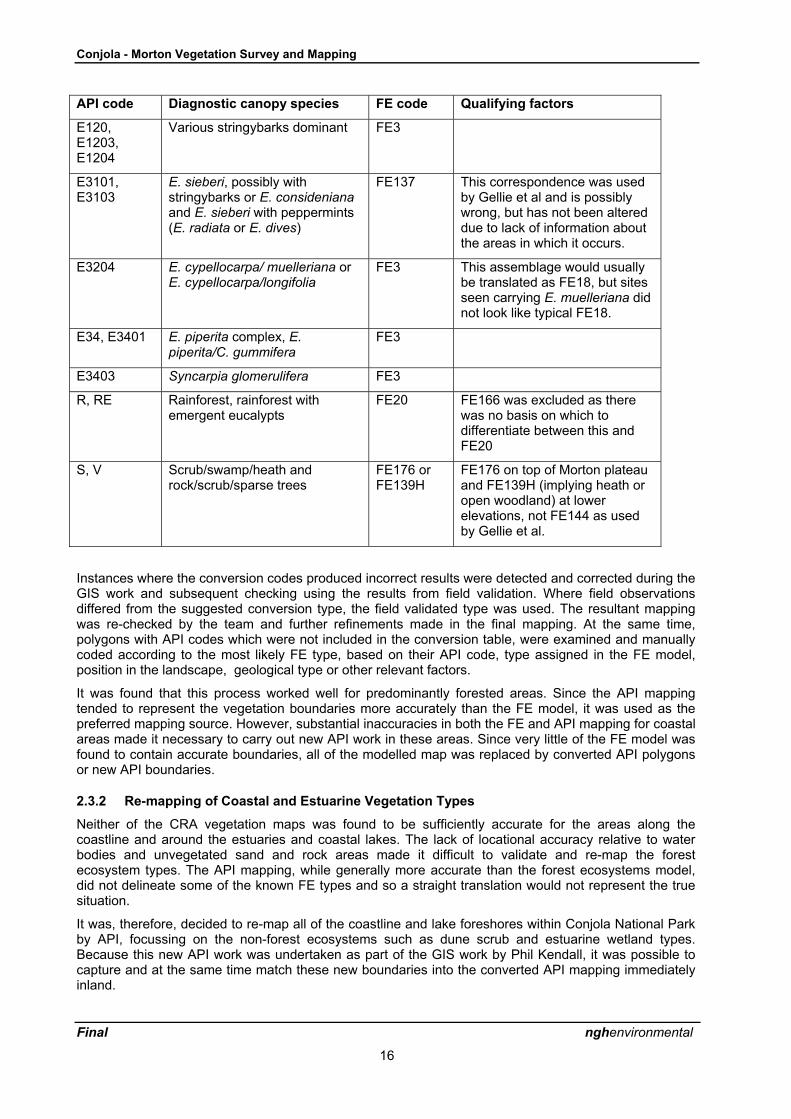
API code Diagnostic canopy species FE code Qualifying factors
E06, E0601and mostother E06combinations
E. pilularis FE2,FE21 orFE29
FE2 unless located on sandsheets close to the sea or rivermouths (FE29) or close tosizeable creeks (FE21)
E0901,E0902
Corymbia maculata andeucalypts (E. pilularis/paniculata/longifolia) althoughnone of these were present inFE5 in Conjola
FE5
E07 E. saligna/botryoides FE21 orFE28
FE21 in drainage lines, FE28 onsand sheets close to the sea orriver mouths
E0805 orE0601E0805,E2606
E. sclerophylla/C. gummifera/E.pilularis,
E. agglomerata/ sclerophylla
FE139
R or RE Rainforest and rainforest withemergent eucalypts
FE20
S Scrub/swamp/heath FE140 orFE139
FE140 if on a drainage line,FE139 or FE139H (heath withscattered trees) if not
V Rock/scrub/sparse trees FE175 orFE139
FE139 in dry sites and FE175 indrainage lines
Y, A Estuarine, sand or mud FE24 Assumed Swan Lake is not tidaland thereforemangrove/saltmarsh is unlikely
FP Estuarine FE144
Table 2.2 Equivalent API and FE Codes for Morton (East) National Park
API code Diagnostic canopy species FE code Qualifying factors
E0601 E. pilularis pure stands FE2 orFE21
FE2 on drier sites, FE21 ingullies
E0601E080
E0601E0805
E0601E1401
E. pilularis with other eucalypts:dry coastal complex (includesnumerous eucalypts), E.sclerophylla/
C. gummifera or others
FE2 orFE21
FE2 on drier sites, FE21 ingullies (not FE139 as interpretedby Gellie et al in producing theoriginal FE map)
E07
E0701
E0704
E. saligna/botryoides, Ebotryoides plus rainforestelements, E. botryoides/globoidea/pilularis
FE21
E0901 Corymbia maculata soledominant
FE9 orFE21
FE9 on dry ridges, FE21 ingullies or on steep slopes with asheltered aspect.
Conjola - Morton Vegetation Survey and Mapping
Final nghenvironmental
16
API code Diagnostic canopy species FE code Qualifying factors
E120,E1203,E1204
Various stringybarks dominant FE3
E3101,E3103
E. sieberi, possibly withstringybarks or E. considenianaand E. sieberi with peppermints(E. radiata or E. dives)
FE137 This correspondence was usedby Gellie et al and is possiblywrong, but has not been altereddue to lack of information aboutthe areas in which it occurs.
E3204 E. cypellocarpa/ muelleriana orE. cypellocarpa/longifolia
FE3 This assemblage would usuallybe translated as FE18, but sitesseen carrying E. muelleriana didnot look like typical FE18.
E34, E3401 E. piperita complex, E.piperita/C. gummifera
FE3
E3403 Syncarpia glomerulifera FE3
R, RE Rainforest, rainforest withemergent eucalypts
FE20 FE166 was excluded as therewas no basis on which todifferentiate between this andFE20
S, V Scrub/swamp/heath androck/scrub/sparse trees
FE176 orFE139H
FE176 on top of Morton plateauand FE139H (implying heath oropen woodland) at lowerelevations, not FE144 as usedby Gellie et al.
Instances where the conversion codes produced incorrect results were detected and corrected during theGIS work and subsequent checking using the results from field validation. Where field observationsdiffered from the suggested conversion type, the field validated type was used. The resultant mappingwas re-checked by the team and further refinements made in the final mapping. At the same time,polygons with API codes which were not included in the conversion table, were examined and manuallycoded according to the most likely FE type, based on their API code, type assigned in the FE model,position in the landscape, geological type or other relevant factors.
It was found that this process worked well for predominantly forested areas. Since the API mappingtended to represent the vegetation boundaries more accurately than the FE model, it was used as thepreferred mapping source. However, substantial inaccuracies in both the FE and API mapping for coastalareas made it necessary to carry out new API work in these areas. Since very little of the FE model wasfound to contain accurate boundaries, all of the modelled map was replaced by converted API polygonsor new API boundaries.
2.3.2 Re-mapping of Coastal and Estuarine Vegetation Types
Neither of the CRA vegetation maps was found to be sufficiently accurate for the areas along thecoastline and around the estuaries and coastal lakes. The lack of locational accuracy relative to waterbodies and unvegetated sand and rock areas made it difficult to validate and re-map the forestecosystem types. The API mapping, while generally more accurate than the forest ecosystems model,did not delineate some of the known FE types and so a straight translation would not represent the truesituation.
It was, therefore, decided to re-map all of the coastline and lake foreshores within Conjola National Parkby API, focussing on the non-forest ecosystems such as dune scrub and estuarine wetland types.Because this new API work was undertaken as part of the GIS work by Phil Kendall, it was possible tocapture and at the same time match these new boundaries into the converted API mapping immediatelyinland.

Conjola - Morton Vegetation Survey and Mapping
Final nghenvironmental
17
The re-mapping included delineating new boundaries for vegetation types which were not adequatelyrepresented in either of the existing maps as well as replacing the boundaries of API polygons on theirseaward edges and along lake shorelines. In the latter case, the edge of vegetated areas was mappedrather than the actual high tide line, thereby excluding unvegetated rock and beach areas. It was foundthat most vegetation boundaries could be relatively easily recognised in digital orthophotos and mappeddirectly rather than having to use a standard API process of marking up acetate overlays, scanning,rectifying and digitising. However, stereo pairs of air photos were used in many instances to interpretvegetation types and to guide the digitising of boundaries from the orthophotos. The 1991 Ulladulla and1993 Jervis Bay aerial photography (at an approximate scale of 1:25,000) provided by the NPWS, wasused for this work.
The coding of new polygons was guided by the results of the field work, interpretation of previous surveysites, reference to the API maps and interpretation using stereo pairs. Field checking was carried out forsome of the coastline to confirm the coding and to investigate instances of uncertainty in areas whichwere not readily apparent in the orthophotos, such as regenerating scrub or ecotonal situations.
To enable a more consistent coverage of the new mapping so that whole polygons could be includedrather than being clipped at park boundaries, the mapping was extended beyond the study area in someinstances. In particular, the whole of Conjola Lake and Swan Lake were included in the re-mapping. Thisalso had the benefit of providing a seamless coverage of new mapping with that in the Narrawallee studyarea. The API mapping was in fact carried out initially for the combined study areas and separated at alater stage into the individual parks and the nature reserve.
2.3.3 Re-mapping of cleared areas and corridors
Within the inland parts of Conjola and in Morton, the linework on the CRA API map was often found to beinaccurate in delineating cleared land (usually former agricultural areas or quarries) and representingcleared powerline easements and road corridors. Re-mapping of boundaries was carried out using thedigital orthophotos, with new polygons added and boundaries of existing ones changed. These polygonswere allocated to a �cleared� category in the legend for the new maps and polygons which wereincorrectly included in the API maps as excluded (i.e. cleared) but in fact contain vegetation, were re-coded to their most probable type, usually that of the surrounding vegetation. This re-mapping of clearedareas was carried out as part of the GIS work and relates particularly to the definition of the study areaboundary which is discussed in more detail in Section 2.4.2.
2.4 GIS Methodology2.4.1 Field Map Preparation
Seven field maps were prepared on A3 size sheets at 1:25,000 scale, for field and API work, covering thecombined areas of Conjola and Morton National Parks within the study area. By developing a new seriesof maps, rather than using a single large format map, it was possible to split the study area up intomanageable size field maps, improve the clarity of the vegetation colour coding and show all relevantbackground details.
The study area falls within UTM Zone 56 and all data sets supplied by NPWS used this projection. TheGIS information was compiled in Zone 56 coordinates, using the Australian Geodetic Datum (1966) andthe appropriate Australian Map Grid for this zone was shown on the field maps.
The source forest ecosystems layer used was the extant forest ecosystems grid model prepared duringthe Southern CRA. This was converted from a grid to a polygon layer and from a version in which theboundaries had been smoothed, the relevant study area portion was clipped and attributes added for FEtype and descriptive labels. Details of the map preparation using ArcView GIS software are as follows.
• For each map sheet, those FE polygons appearing on the map sheet were selected and asummary procedure used to produce a table of the unique codes appearing on that mapsheet. This was used to manually trim the FE legend so that only those FE types seen onthe map sheet were included in the legend.

Conjola - Morton Vegetation Survey and Mapping
Final nghenvironmental
18
• The colour coding for Forest Ecosystem (FE) types was developed for the range of typeencountered in the study areas to provide a sufficiently wide range of colours to minimiseconfusion.
• Access roads and trails were classified according to classes based on surface type andfunction. A legend was developed to reflect this classification.
• Other background layers included were 100 metre and 10 metre contours generated fromthe digital terrain model (DTM), drainage from the 1:25,000 map sheets, air photo centroidpoints, previous and proposed vegetation survey sites and NPWS estate boundaries.
• The AMG 1 km grid (zone 56) was overlayed on the maps for easy reference in the field andAPI work.
A parallel series of seven maps showing Southern CRA API (CRAFTI) floristics polygons was preparedto allow checking in the field and comparison of the two maps in order to derive classification conversioncodes. These were prepared on the same base maps. Because of the sheer number of API codes, it wasnot possible to assign colours to the polygons and they were labelled with the relevant code. Additionalcodes for the FE types assigned by Gellie, et al. (see section 2.3 above) were also printed on the maps.
The maps were prepared using the NPWS supplied vegetation layers derived from the CRA mapping. Itwas apparent from mismatches between the roads, drainage and vegetation layers that there weresubstantial inaccuracies in the previous mapping which required attention during the re-mapping process.
2.4.2 Study Area Definition
In preparing and using a study area boundary based on NPWS Estate boundaries, a number of problemswere encountered which made substantial editing of the boundary necessary and subsequent editing ofthe CRA API layer which was used as the basis for re-mapping.
The main problems apparent were as follows.
• Generally, park boundaries are defined using cadastral or other previously mappedboundaries which are rarely accurate and do not match well with real boundaries as seen inair photos and orthophotos, such as the coastline, edges of tidal lakes or roads. When usedas a clipping boundary they often miss slivers of land between these boundaries and the trueboundary and include other slivers which should be excluded.
• Some park boundaries follow exclusion corridors such as along roads and powerlines and theomission of these corridors from the vegetation map results in gaps in the mapping whichcreate problems where the corridors are inaccurate in the NPWS Estate mapping.
• The clipping of the vegetation maps with the external park boundary results in fragmentationof many polygons which extend beyond park boundaries, effectively splitting vegetation ornatural features such as the coastline or lake margins, causing confusion and detracting fromthe cartographic quality of mapping using the new the vegetation map.
• Inaccuracies in the Southern CRA forest ecosystems modelling has resulted in manyinstances of polygons extending over or falling short of lake/estuary waters, beaches, cliffs,rock platforms, etc.
NPWS Estate boundaries are often complex polygons which exclude land parcels (private in-holdings)and corridors along non-park roads and stock routes. As such the park areas can be somewhatfragmented. The boundaries are usually mapped by interpretation of gazettal details using availabletopographic and cadastral maps which have inaccuracies Consequently, the boundaries do not matchwell with the true positions of natural features such as water bodies and coastal features or built featuressuch as roads, infrastructure and fenced property boundaries. Corridors are usually created as fixeddistance buffers either side of roads or powerlines, and do not follow actual cleared boundaries alongthese easements. This problem is compounded when the roads and powerlines used for buffer creationwere mapped incorrectly.
Both the external and internal boundaries of Conjola and Morton (eastern extension) National Parks werefound to be inaccurate when overlayed on the digital orthophotos. Inaccuracies of over 50 metres werenot uncommon, consequently many roads and powerlines did not actually fit within the exclusioncorridors through the parks. On examination of the supplied layer of the CRA API map, which had been

Conjola - Morton Vegetation Survey and Mapping
Final nghenvironmental
19
clipped to the park boundaries, many gaps were apparent where exclusion corridors had resulted ininformation loss from the vegetation map. Areas which carry forest had been clipped out while slivers ofcleared land in the easements had been left adjacent to the corridors. This problem was furthercompounded where the CRA API mapping had attempted to capture these easements (ofteninaccurately). The resulting map was confusing and very difficult to re-code and use.
The correction of park boundary mapping was clearly beyond the scope of this project. However,boundary definition problems needed to be resolved for the purposes of vegetation re-mapping.Consequently a new study area boundary was created by editing the NPWS Estate boundaries toremove internal boundaries for road and powerline corridors and around small in-holdings and tominimise polygon splitting around the periphery of the study area. Rather than clipping out parts ofpolygons along the coastline, estuaries and around lakes in the vegetation maps and leaving sliversbehind or including unwanted slivers, the study area has been enlarged to include all such polygonswherever possible. These boundaries could then be split or re-shaped to map an accurate edge betweenvegetated areas and non-vegetated areas such as rock, beach or water. New polygon topology wascreated in pc Arc/Info and the boundary was then used for clipping the vegetation layers. Further editingof the API layer was carried out during the re-mapping work to correct previous inaccuracies such asboundaries between cleared and forested land, as explained in section 2.4.3 below.
The resultant study area is slightly larger than the actual reserved areas but the inclusion of smallportions of non-park areas within the study area has considerable benefits for vegetation re-mappingpurposes. Perhaps most importantly it avoided the loss of information along park boundaries and alongthe coastline resulting from inaccuracies in previous mapping. The cleaning up of the boundary alsoenhances the final mapping product. Should the new FE layer of the study area need to be analysed toextract statistical data for areas specifically within the park (e.g. percentage areas of each FE type in thepark), it is a simple process to clip it with the mapped (but inaccurate) park boundaries.
2.4.3 Preparation of GIS Layers for Re-mapping
The study area portion of the Southern CRAFTI map was extracted using the boundary extent derivedfrom the new study area boundary as outlined above. The map used was a modified version of theoriginal CRAFTI map which contained updates by Nic Gellie (EcoGIS) to 2001, re-named fields and anadditional descriptive field for the corresponding forest ecosystem type. A clipped version of this mapusing NPWS Estate boundaries supplied as part of the source data by NPWS was used, however, partof Morton National Park extension was missing from this layer. The missing portion was extracted andadded from the full CRAFTI South Coast layer and attribute information was adapted to match. Aconsiderable amount of manual editing was carried out to rectify problems along road and powerlinecorridors to match them to the vegetation boundaries along these easements as they appeared in thedigital orthophotos, to remove numerous slivers and re-code the easements as �cleared� rather thanexcluded. At the same time additional powerline corridors were added where missing, and some non-existent road corridors were removed.
The CRAFTI map was created by merging of existing State Forests RN17 API mapping and API mappingderived from air photo overlays. This resulted in many sliver polygons, particularly around rainforestgullies. Most of these were retained but re-coded to the appropriate type of their neighbours based on thepatterns evident in the orthophotos.
2.4.4 Data Capture and Processing
In summary, new API line work along the coast and around lakes and estuaries in Conjola NP, wasinterpreted and captured by digitising boundaries directly off the digital orthophotos during the GIS datacapture and coding processes. This included digitising the boundaries of water bodies, cleared and urbanareas. The new linework was incorporated directly into the CRA API linework and coded with the forestecosystem types. The old and new API polygons were merged to create a new composite API map forthe study area, coded according to FE types. This involved both digitising new polygons, splitting and re-shaping the boundaries of existing ones and making appropriate changes to the attribute tables. Editingwas carried out primarily using ARCGIS 8.3 in ARCVIEW shapefile format. Additional polygon processingand re-building was carried out using pc ARC/INFO. For practical purposes, the Conjola and Mortonportions of the study area were separated. The final layers are compatible with ARCVIEW 3.x and havebeen developed using AMG Zone 56 coordinates.
More specifically, there were three aspects to the re-mapping of vegetation in coastal areas.

Conjola - Morton Vegetation Survey and Mapping
Final nghenvironmental
20
• Vegetation types which were not accurately delineated in either of the two CRA vegetation mapswere re-captured by identifying the patterns and digitising directly from the digital orthophotos. Thisprocess was assisted in some cases by first identifying boundaries and types from air photographsusing stereo pairs. It was found that most vegetation boundaries in coastal areas could be relativelyeasily recognised in digital orthophotos and mapped directly rather than having to use a standardAPI process of marking up acetate overlays, scanning, rectifying and digitising.
• Boundaries of polygons which had a frontage to coastal lakes and estuaries or a seaward edgealong beaches or rocky headlands were re-mapped by API so that the incorrect edges of thesepolygons could be replaced, while the landward edges could be retained. The edge of vegetatedareas was mapped rather than the actual high tide line, thereby excluding unvegetated rock andbeach areas. Boundaries of cleared areas were also captured.
• Further polygons in the existing maps were checked as necessary by overlaying the boundaries inoutline on the orthophotos and adjusting or splitting without requiring full replacement of boundaries.
The procedure for polygon processing was as follows.
• Relevant portions of the study area boundary (which is discussed above) or portions of the CRAFTImap which were immediately outside the study area, were used in the API vegetation layer toenable polygon closure along the boundary. In some instances, polygons were allowed to extendbeyond this boundary rather than being split.
• Where further processing of polygons was required in the ARCEDIT module of pc ARC/INFO, theclean command was used to build polygons with nodes automatically snapped within a set toleranceof less than 1 metre and dangling arcs removed using a 2 metre tolerance. Relatively few pointshad to be manually edited to close polygons and remove overshoots. This reflects the greateraccuracy and automated error correction capability of on-screen digitising techniques relative totraditional digitising direct from hard copy maps.
• The polygon layer was coded in ARCGIS according to the map codes marked on the field maps orfor codes to be assigned from the coastal re-mapping work. Codes were added to two new fields inthe attribute table. These fields contained the new FE code and status fields for recording detailsupdate status of each polygon linework and coding. Details of the attribute table are included inAppendix 6. The polygon layer was checked against the aerial photographs, field maps or othernotes, for completeness.
The resultant polygon layer represents all new polygons derived from the API work, within and adjacentto the study area and provides the basis for the new forest ecosystems map. The final map was preparedby dissolving the boundaries between polygons of the same type so as to create a neater map forpresentation purposes. However, since this process results in loss of most of the attribute fields, theoriginal re-coded API maps were retained with full attribute details for the purposes of analysis and anyfurther re-mapping.
2.4.5 Accuracy Level
The API mapping carried out during the CRA and earlier State Forests RN17 mapping was generallyregarded as being reasonably accurate although some vegetation types are difficult to distinguish by APIand some significant ecotonal boundaries between forest types have been missed because ofindistinguishable photo patterns. Although generally accurate to around 25 metres or better, there areinstances, however, of errors of greater than 50 metres. These may relate to inaccuracies in the1:25,000 base mapping to which the CRA API linework was rectified, or to errors in raster to vectorconversion from scanned overlays.
Although this API linework was theoretically utilised in the CRA forest ecosystems modelling project,during the present project, many instances of wrongly placed boundaries in the FE model were detectedwhich do not reflect the accuracy of the underlying API linework. Either the API linework was not fullyutilised or inaccuracies were introduced during the modelling. The FE modelling does not conform wellto the topographic patterns in many instances. This is compounded by the inherent inaccuracy and gridpatterns along polygon edges, caused by grid data modelling. Because of the inaccuracies apparent inthe FE modelled boundaries, these boundaries were not used in the new mapping. This does not implyhowever, that the FE model was ignored, since it was field validated and the modelled polygons wereconsidered in the re-coding of polygons derived from API mapping.

Conjola - Morton Vegetation Survey and Mapping
Final nghenvironmental
21
It has already been noted that significant mis-matches between the NPWS Estate boundaries and otherGIS data layers were frequently apparent. While the park boundaries are clearly defined in words bygazettal notices, the interpretation of these boundaries using available mapping has resulted in manyinaccuracies. Consequently, for the purposes of this project, it was often meaningless to adopt mappedpark boundaries for defining the study area.
The digitising of linework for polygons mapped from orthophotos was carried out in a manner whichminimised inaccuracies. The resulting linework is generally accurate to well within 25 metres of truepositions on the ground and probably in most cases to within 10 metres. This is closely dependent on theaccuracy of the digital orthophotos which is likely to vary slightly as a result of the rectification process inconverting the air photos to orthophotos. This accuracy level does not necessarily relate to topographicand cadastral mapping inaccuracies.
Despite some minor discrepancies between the mapping and GPS records for field survey sites, it isconsidered that the GIS methodology for capturing the new API work, combined with field checking usingGPS readings, achieves accuracy levels which exceed those of the Southern CRA mapping.
Clipping of the new vegetation layer with the park boundary polygons may be necessary in someinstances (for example, to calculate percentages of each vegetation type within the park), however, itshould be realised that this will split many vegetation polygons around the periphery of the mapping andcreate numerous slivers.
2.4.6 Polygon Attribute Coding
Coding of the new mapping, which was based on the Southern CRAFTI layer with additions andmodifications resulting from the API work, was guided by the findings of the field surveys andinterpretation of the existing vegetation maps, air photos and some field checking of the API work, thelatter being confined to Conjola. Coding was an iterative process of validating the coding of polygonsagainst the many sources of information and involving several levels of subsequent checking as outlinedin section 2.4.8. Comments in the attribute tables were constantly updated to reflect the information onwhich code allocations were based. Re-coding of the new API layer was carried out using ArcGIS 8.3.However, for compatibility with the NPWS database, legends for forest ecosystem types were developedusing ArcView 3.x.
Attributes were retained from the original CRA API layer, including all original ID fields. This made itpossible to link the new layer back to the original ones if required for cross-checking purposes andimporting additional attributes. Attributes added or re-named by EcoGIS were also retained. The codingprocess was as follows.
• The API map attribute table was extended with new fields as indicated in Appendix 6 included someadditional fields relating to conversion codes and notes on this process, field survey site numbers (ifpresent), polygon and code update status (i.e changed or unchanged) and final allocated new FEtype and descriptive labels.
• The new FE type was firstly coded according to the findings of the field work, using annotations onthe field maps and the FE types assigned to each floristics survey site and any comments relating tothis were added to the notes field. During this process several additional FE types were added to thelist occurring in the study area.
• The new API work was carried out and coded based on interpretation of the orthophotos, air photosand any other available information. During this process, many polygons were split to betterrepresent the patterns evident from the field or API work and given appropriate revised codes.
• Conversion codes, which translated API codes to FE types, were assigned according to Tables 2.1and 2.2 and as outlined in section 2.3.1 of the report. Rather than applying the conversion codesglobally, each polygon which was not already coded with a new FE type, was manually assigned anew FE code based on the conversion code and other factors. During this stage, many sliverpolygons from the original API mapping were rationalised and re-coded. In most cases slivers wereretained and re-coded. Very small slivers were deleted in some cases around the external study areaboundary and along internal corridors and the boundary was corrected to match the air photos asnecessary.
• Further confirmation or amendment of the mapping was carried out by selective checking usingstereo pairs of air photos.

Conjola - Morton Vegetation Survey and Mapping
Final nghenvironmental
22
• The mapping was checked by the project team and the coding was further refined.
The final forest ecosystems map was prepared as a dissolved version of the modified CRAFTI maps andcontains only the new FE codes and labels, together with polygon perimeter and area calculations.
A full list of attribute codes is contained in Appendix 6. Along with a description of all of the GIS layerssupplied on the data CD.
2.4.7 Survey Site Mapping
The brief required field data sheets to be presented in electronic format as well as the original hardcopies. The field sheets for standard floritic survey sites were initially transferred to the MS AccessDatabase developed by NPWS staff Michael Bedward and Murray Ellis. This allowed maximumautomation of data entry and provided a suitable means of analysing and re-formatting the data. The fireresponse monitoring site data were entered into an Excel spreadsheet database, designed by Nic Gellie(EcoGIS) for fire response monitoring in the Nowra area.
To enable the floristics data to be used in the GIS in conjunction with the forest ecosystems and otherGIS layers, they were translated to a number of DBase files which could be loaded into ArcView GIS.The tables which were converted included the site details (including AMG eastings and northings), thefloristics records for each site and the master table of species names and reference numbers.
The sites table was converted to a GIS point feature layer so it could be displayed and labelled formapping purposes. Additional fields were added to the feature attribute table for old and new FE types,drawn from the field data sheets and botanical notes.
After initial removal of unnecessary fields, the floristics and species tables were permanently joined sothat species reference numbers were followed by several columns of relevant species informationincluding family, scientific and common names. The resulting floristics table can be dynamically linked tothe point feature layer using the common site number field so that a listing of species recorded for eachsite can be readily obtained.
The sites and floristics tables were used in checking the new forest ecosystems map coding and inhelping to identify and resolve anomalies. This process was greatly assisted by having easy access tothe records of FE types found at each new survey site. The GIS version of the database was also used incompiling the forest ecosystem profiles.
2.4.8 Checking of Information
As noted above, several levels of checking were made during the process of conversion coding of theAPI polygons and during the new API work along the coast, to rationalise the coding of FE types and toensure consistency between the new mapping, the site survey database and the information in thisreport. This process was assisted through the recording of notes in the various GIS layer attribute tablesand in the conversion code tables. The compilation of the results section in the draft report wasundertaken concurrently with the API and GIS work to ensure consistency of the information presented,with anomalies and queries resolved as a team effort. The GIS layers were checked at several points toensure that coding had been correctly maintained during editing and polygon processing.
Some inconsistencies were detected between the mapped types and the types recorded for thecorresponding field data records. In some cases this was a result of difficulties in delineating the fieldassessed types by API. In the majority of instances, the problems related to the placement of field surveypoints close to vegetation boundaries, so that they appeared either on the boundary or just outside it in aneighbouring polygon. Although the GIS mapping was accurate to around 10 metres, this level ofinaccuracy may have been sufficient in some cases to cause misplacement of the boundary relative tosurvey site points. In a few instances, survey site map references were found to be incorrect and pointlocations had to be manually adjusted. GPS errors or transcription of coordinates to the field sheets mayhave been responsible for some mismatches of information.
As a result of the potential for mapping and field data inconsistencies, a technique for preparing theforest ecosystem profiles (contained in Appendix 4) was adopted where the field sites were only includedin the species lists where they clearly fell within the mapped polygon of the same type. All other sites,including mismatching types and sites close to boundaries, where possible errors could occur, werelisted as marginal sites and excluded from the consolidated species lists for that FE type.

Conjola - Morton Vegetation Survey and Mapping
Final nghenvironmental
23
All draft material was checked by the botanist (Jackie Miles) and further amended to removeinconsistencies between the field and API work and to check the validity of the GIS mapping.

Conjola - Morton Vegetation Survey and Mapping
Final nghenvironmental
24
3 RESULTS
3.1 General Findings
The following trends were apparent from the field botanical survey work and the API work, relating toinconsistencies identified in the forest ecosystems modelling by Thomas, Gellie and Harrison (2000). Theforest ecosystem (FE) type names have been shortened in most cases by excluding the species nameswhich are typical of each type.
3.1.1 Conjola National Park
Based on the findings of the work, the vegetation of Conjola National Park can be most simply describedas follows.
Conjola National Park protects extensive areas of low scribbly gum (Eucalyptus sclerophylla) and redbloodwood (Corymbia gummifera) forest or woodland, which grow on shallow infertile soils. The crests ofthe many low ridges tend to have a dense understorey of heathy shrubs and small trees such as thepaper-barked tea tree (Leptospermum trinervium). In places the eucalypts and bloodwoods disappearaltogether, leaving dry coastal heath. Characteristic plants of this heath are the Mountain Devil(Lambertia formosa), waratah (Telopea speciosissima), grass trees (Xanthorrhoea species) andnumerous sedges, orchids and lilies. Poorly drained areas within the drier scribbly gum woodlands maycarry the paper-barked snow-in-summer (Melaleuca linariifolia), bottlebrushes (Callistemon linearis), thesmall blue grass tree (Xanthorrhoea resinifera) and native broom (Viminaria juncea). Areas of morefertile clay soils may carry grassy spotted gum (Corymbia maculata) forest and wet flats around SwanLake have swamp mahogany (E. robusta) forest, or belts of swamp paperbark (Melaleuca ericifolia).Deeper gullies carry wet blackbutt (E. pilularis) or Sydney blue gum (E. saligna) forests with a dense tallshrub or small tree layer tangled with vines, and occasional small patches of developing rainforest.Cabbage tree palms (Livistona australis) are a conspicuous feature of these gullies.
The forest ecosystems modelling by Thomas, Gellie and Harrison (2000) was found not to be particularlyaccurate for Conjola National Park. As in earlier Southern CRA vegetation map validation in Meroo andMurramarang National Parks and Barnunj SRA, substantial mapping errors were found. Theseparticularly related to mis-interpretation and over-mapping of non-eucalypt vegetation types, such asCasuarina glauca swamp forest types; Coastal Tall Wet Heath Swamp Forest (FE24) and South CoastSwamp Forest (FE25). These were again mapped as being very much more extensive than they reallyare, being confused with drier non-eucalypt communities such as heath and even with eucalypt forest.
Northern Coastal Tall Wet Heath (FE140), had been considerably over-mapped within the drier woodlandtype Northern Coastal Hinterland Heath Shrub Dry Forest (FE139). Most of the patches of FE140 whichwere not on drainage lines were re-interpreted as FE139 with a low tree density and heathy understorey.Within wetter eucalypt forest types, scrub within drainage lines was re-interpreted as either the paperbarkwoodland type, Northern Coast and Hinterland Moist Heath (FE144) or the swamp mahogany forest type,Northern Coastal Lowlands Swamp Forest (FE175).
The latter is a highly significant community with a restricted distribution which had been overlooked inboth the FE and CRAFTI API maps. FE175 (in this report re-named as Coastal Swamp MahoganyForest) is listed as an Endangered Ecological Community (as Sydney Coastal Estuary Swamp ForestComplex) in the region. A few occurrences of this community were observed around the north-westernend of Swan Lake and extensive patches were mapped from new aerial photo interpretation as a result.However only some of these polygons have been ground-truthed and further work in this area would beuseful to validate the new mapping. The areas visited have been subject to burning during the 2001-2002fires and contain dense young Melaleuca regrowth which, together with the swampy ground and waterchannels, make access difficult. Parts of the area checked during the field work for the API mapping wasfound to contain fringing E. robusta but it is not clear how extensive this species is. According the PhilCraven (NPWS) E. botryoides occurs in this area. It possibly occurs instead of E. robusta in slightly drierareas fringing the swamp. Since there is no described FE type which includes this species in a swampfringe environment, it has been assumed to be a component of FE175.

Conjola - Morton Vegetation Survey and Mapping
Final nghenvironmental
25
Broader eucalypt associations were also not very accurately mapped in detail during the Southern CRA.Although the main vegetation types in Conjola are correctly identified as being Hinterland Heath ShrubDry Forest (FE2), Northern Coastal Hinterland Heath Shrub Dry Forest (FE139) and Northern CoastalHinterland Moist Shrub Forest (FE21), their distributions were not very accurate . In the API mapping,many polygons were mapped as a combination of FE2 and FE21 while in the FE model, much of thishas been interpreted as the wetter FE21, which resulted in it being considerably over-mapped. Thedistribution of these types has been re-mapped as explained in section 3.2.
The Southern Coastal Dune Scrub Complex/Coastal Dune Herb Swamp Complex (FE23/26) waspredicted to occur behind Berrara Beach. The genuine existence of this vegetation type is quite doubtful.The dune scrub complex, FE23, is the same as Eden CRA type Beach Strand Grassland (FE62)described by Keith and Bedward (1999) and consists of Spinifex sericeus and other coastal grasses andherbs which typically only grow on beaches. The dune herb swamp type, FE26, as a discrete vegetationtype, does not stand up to close scrutiny when the list of characteristic species (Thomas, Gellie &Harrison, 2000) is examined. The area appears to support typical dune vegetation behind which is a areaof Northern Coastal Tall Wet Heath (FE140) extending along creek flats. The areas mapped as thiscombined vegetation complex were re-mapped as Dune Scrub-Beach Strand Grassland (FE22/23), andthe mapping of this community was extended somewhat on and behind Berrara and Monument Beaches.
Some of these findings are discussed in relation to rare and under-reserved vegetation types in moredetail in section 3.2.
3.1.2 Morton National Park (eastern extensions)
Based on the findings of the work, the vegetation of the eastern extensions of Morton National Park canbe most simply described as follows.
Morton National Park is largely made up of flat sandstone plateaux, cliff-edged, with deep valleysbetween. The plateaux carry a mosaic of low woodland and heath, or in areas of deeper soils tallerforests, though generally with a heathy understorey. Rainforests can be found in sheltered gullies andalong the cliff bases, where the cliffs afford protection from fires and provide extra moisture and shadingfrom sun and drying winds. The eastern extension of Morton National Park is located to the east of themain plateau and consists of numerous ridges which carry dry heathy forests dominated by redbloodwood (Corymbia gummifera), yertchuk (Eucalyptus consideniana) and various stringybarks, oftenwith turpentine (Syncarpia glomulifera) in the understorey. On sheltered slopes turpentine trees becomelarger and may be prominent in the forest canopy. On occasional exposed ridge tops there are smalltreeless heath patches.
Broadly the forest ecosystem modelling by Thomas, Gellie and Harrison (2000) appears reasonablycorrect in its broad distribution and typing for the new extension of Morton NP. This is no doubt partly dueto the near-absence of non-eucalypt forest types, which are often found to have been poorly interpreted,and which are relatively easy to prove incorrect. Eucalypt forest types are generally less clearly definedand hence less easy to prove wrong. In general it seems that the communities which are mapped ascovering the bulk of this reserve are correctly predicted as being present, these being Hinterland HeathShrub Dry Forest (FE2), Northern Hinterland Shrub Dry Forest (FE3), Northern Coastal Hinterland HeathShrub Dry Forest (FE139) and Northern Coastal Hinterland Moist Shrub Forest (FE21). However, theirdistribution and the proportions of the wetter (FE3 and FE21) and drier (FE2 and FE139) types were notalways correct in detail.
No additional communities were found which had not been mapped, but then the field work in Mortonwas considerably less detailed than in the other parts of the study area. Fewer quadrats were requested,and the road network provides fewer opportunities for ground-truthing of any vegetation types other thanthose found on ridges, as the topography is more rugged than that of Conjola NP or Narrawallee CreekNR.
Indeed, one whole section of the Park, that located between Martins Ridge Road and Coolabah Road,was not visited apart from some brief checking along Martins Ridge Road. Fallen trees blocked anyfurther access from this direction and it was not considered that driving along Coolabah Road would addany useful information. Resource constraints did not permit us to spend the time required to walk intothis area and check it any more thoroughly. Past surveyors have obviously suffered from the sameproblem, as there are no previous quadrat data from this area. There are also some rather unlikely

Conjola - Morton Vegetation Survey and Mapping
Final nghenvironmental
26
Southern CRAFTI API codes on the API map for this area (such as E1801 for E. fastigata and E1702 forE. viminalis/dalrympleana) which suggest that air photo interpreters were similarly handicapped inattempting to decipher the vegetation of this area.
One community which was predicted to occur, was not found to be present in at least one of the areas inwhich it was modelled. This was Northern Coast and Hinterland Moist Heath (FE144) which is defined(Thomas, Gellie and Harrison, 2000) as being dominated by the small tree Melaleuca linariifolia andvarious shrubs typical of either wet (Callistemon linearis, Epacris microphylla) or dry heath (Banksiaericifolia, Darwinia leptantha) with a groundcover including typical wet, low fertility soils species such asSelaginella uliginosus, Gleichenia dicarpa and Leptocarpus tenax. This was checked with two quadratsin widely-separated locations, MORJM01F on Whalebone Road and MORJM06 on Messmate Road, andin both cases the vegetation was found to be open FE139 with relatively sparse, low trees. There was noindication of poor drainage or wet heath in either area. It has therefore been assumed that all suchmapped patches of FE144 are incorrect and have been re-coded as FE139H which contains a sparsetree cover and heath-like understorey, being a woodland/heath variation of the more widespreadNorthern Coastal Hinterland Heath Shrub Dry Forest (FE139) which occurs at lower elevations.
Other patches mapped as �scrub� on the API map had been interpreted as Morton Plateau MalleeSwamp Low Forest (FE176). No diagnostic species list has been provided for this community byThomas, Gellie and Harrison, so it is difficult to know in what respects it differs from the heathycommunity of the lower elevation coastal areas, FE139. Personal experience in Morton NP suggeststhat floristically there is very little difference but polygons coded �S� on the API map have been re-mapped as FE139H (implying that they are heath rather than woodland) at lower elevations in Mortonand as FE176 around the rim of the Morton plateau where they occur as a few slivers along the boundarybetween Morton (East) and Morton NP.
Rainforests occur both in gullies and at the foot of cliffs where they are protected from fire. There aresubstantially more rainforest polygons on the FE map than on the API map. As a decision had beenmade to follow the API mapping because of its greater accuracy, many modelled rainforest polygonswere therefore discarded. API polygons labelled R or RE (rainforest with emergent eucalypts) had beeninterpreted in the FE model as FE20 (Ecotonal Gully Rainforest) in some locations and as FE166 (WarmTemperate Rainforest) in others. It is not clear what the basis for this distinction was, and again in theinterests of simplicity all rainforest polygons have been re-labelled as FE20. It is quite likely that somerainforest in particularly sheltered locations is better developed Warm Temperate Rainforest but withoutfurther ground-based or aerial survey it is not possible to say which is which. The cliff-base rainforestcommunity was checked in the adjacent McDonald State Forest, since this was more accessible thanstands within the National Park. It was found to be similar in structure and species composition to theFE20 seen in gully sites. Many of the API polygons coded as rainforest in the Morton extensions werechecked on air photos and confirmed as rainforest closely resembling FE20. In a few instances, the APImapping appeared incorrect and an appropriate wet eucalypt type was substituted.
Several other vegetation communities were eliminated on the grounds of improbability, although since nomodelled locations were readily accessible for checking the validity of doing this is uncertain.Assessment of one area on Twelve Mile Road which carried yellow stringybark (E. muelleriana) and anunidentified smooth-barked eucalypt suggested that this community should not be characterised as eitherSouthern Coastal Hinterland Shrub/Vine/Grass Moist Forest (FE18) or Coastal Escarpment andHinterland Shrub/Fern Dry Forest (FE19). Neither was mapped as occurring on that particular site, butboth are mapped as occurring in Morton (East). The diagnostic species lists for these two communities(Thomas, Gellie and Harrison, 2000) suggest that they are derived largely from samples taken fromfurther south, and not on Permian sandstone. Similar moist forest on sandstone in this area perhaps fitsbetter into Northern Hinterland Shrub Dry Forest (FE3).
Similarly it was considered unlikely that Southern Escarpment Shrub/Herb/Fern Forest - E. cypellocarpaincl. E. fastigata & E. obliqua (FE57) would occur in the area. E. fastigata is easily confused with E.piperita, even on the ground, and this may have been a source of error in the API map which has flowedthrough into the FE map. FE 57 was assigned to API code E1801 which was discussed above as beingan improbable code for this area.
Coastal Escarpment Moist Shrub/Fern Forest � E. sieberi, E. piperita, Gleichenia dicarpa (FE137) hasbeen left as a possible interpretation of the API codes E3101 and E3103 (E. sieberi and peppermints,generally E. radiata or E. dives). Whether this is the correct interpretation is unknown, but few of thepolygons of this community are in locations which could be checked. One is located towards the end of

Conjola - Morton Vegetation Survey and Mapping
Final nghenvironmental
27
Coolabah Road and could have been checked, but this was not seen as a high priority. It is alsoplausible to interpret this API code as FE2 in which E. sieberi is dominant or co-dominant with the moretypical Corymbia gummifera. Some polygons in the Southern CRAFTI layer were interpreted as FE3 andothers as FE137.
Some of these findings are discussed in relation to rare and under-reserved vegetation types in moredetail below.
3.2 Findings Related to Specific Vegetation Types
Discussion of the findings of the field and API work for those vegetation communities observed in Conjolaand Morton (East) National Parks is provided below. Full descriptions of these types as they relate to thestudy area, have been adapted from descriptions by Thomas, Gellie and Harrison (2000). They aretabulated in the form of Forest Ecosystem Profiles in Appendix 4. The list of communities present may beincomplete as only a small proportion of each of these parks could be checked.
In the descriptions below, the numbering system of the CRA classification (Thomas, Gellie and Harrison,2000) has been retained but the community names have been simplified to make them more descriptive.While most of these types are directly equivalent to the Thomas, Gellie and Harrison types, some of theoriginal names do not accurately reflect the types as represented in the study area. In some cases thedominant species may differ and therefore the original long names, which frequently contain a list of keyspecies, may not be appropriate. One additional sub-type of a more comon forest type has also beenadded. The corresponding original names are included along with the new names in the forestecosystem profiles contained in Appendix 4.
3.2.1 Non-eucalypt communities
Swamp Oak-Swamp Paperbark Forest (FE24)
This community generally occurs in a narrow band around the upper parts of saline or brackish coastallakes and estuaries. Swamp paperbark (Melaleuca ericifolia) forms a dense low canopy 2-5 metres inheight with swamp oak (Casuarina glauca) emergent above it at variable densities. The small treeMyoporum acuminatum may also occur. Other commonly associated species are salt-tolerant rushesand sedges Juncus kraussii and Baumea juncea, and herbs Lobelia alata, Apium prostratum, Leptinellalongipes, Samolus repens and Selliera radicans. The tall sedge Gahnia clarkei may form an almostimpenetrable groundcover layer to 2m high, but this is usually more typical of more freshwater wetlandcommunities further upstream. This community was found as a narrow band around parts of the marginsof Swan Lake in Conjola NP.
Swamp Oak Forest (FE25)
This community was seen only on the northern shore of Lake Conjola, and nowhere else in the Park,although it occurs in Narrawallee Creek Nature Reserve. Typically, swamp oak forms the canopy, withoccasional Myoporum acuminatum and Melaleuca ericifolia forming a very open small tree layer. A shrublayer is generally absent or may consist of a patchy cover of the sprawling semi-woody herb Rhagodiacandolleana, and the groundcover will vary depending on the frequency of inundation, but usuallyincludes salt tolerant species ranging from couch grass (Cynodon dactylon) at the drier end of thespectrum, to samphire (Sarcocornia quinqueflora) and Baumea juncea at the wetter end. The herbslisted above for FE24 are likely to occur. The large vine common silkpod (Parsonsia straminea) is verytypical of FE25, and epiphytic orchids Dendrobium teretifolium and elkhorn ferns (Platyceriumbifurcatum) may grow on the casuarina trees.
Dune/Headland Scrub and Beach Strand Grassland (FE22/23)
These communities are generally mapped as a single unit because they almost invariably occur side byside as variable width bands on beach dunes. FE23 occurs on the beach, and is usually dominated bythe grasses Spinifex sericeus and Austrofestuca littoralis and salt and dessication tolerant herbsincluding Actites megalocarpa, Calystegia soldanella, Carpobrotus glaucescens and the exotics*Hydrocotyle bonariensis and *Cakile spp. This grades via low wind-pruned coast wattle (Acacialongifolia ssp sophorae) into FE22, which occurs on the hind dunes. It generally consists of a canopy of

Conjola - Morton Vegetation Survey and Mapping
Final nghenvironmental
28
coast banksia (Banksia integrifolia) and a shrub layer of Leucopogon parviflorus, Acacia longifolia sspsophorae, Rhagodia candolleana and occasionally Correa alba or the exotic bitou bush(*Chrysanthemoides monilifera). The groundcover may include bracken (Pteridium esculentum),Lomandra longifolia, grasses Poa poiformis, couch (Cynodon dactylon) or the very similar Zoysiamacrantha and herbs including Carpobrotus glaucescens, Oxalis rubens, Pratia purpurascens andDianella caerulea. The vine Kennedia rubicunda is typical, and occasionally Muehlenbeckia adpressaalso occurs.
The headland suite of species which has been lumped into FE22 is really quite a distinct community,although it does include a few of the same salt tolerant species. Typical small trees are Allocasuarinaverticillata and Melaleuca armillaris, with shrubs Alyxia buxifolia, Myoporum boninense, Rhagodiacandolleana and occasionally the exotics bitou bush and mirror bush (*Coprosma repens). In longunburnt situations Pittosporum undulatum may become a major component of this community. Typicalgroundcover plants include Lomandra longifolia, Poa poiformis, Austrostipa stipoides and the herbPelargonium australe.
FE22/23 has been re-mapped along almost all of the coastal fringe within Conjola NP. The Beach StrandGrassland component is difficult to detect in air photos and its seaward edge will vary according to beachdynamics. Consequently it has not been possible to accurately delineate this edge, however it has beenassumed to extend about 20 to 30 metres beyond the visible edge of the dune scrub.
Ecotonal Gully Rainforest (FE20)
This community occurs in small patches in gullies throughout the study area, at the base of cliffs (inMorton) and on adjacent sheltered slopes in relatively fire-protected sites. There is generally an opencanopy of whichever eucalypt species are dominant in the vicinity with the tall wattle Acacia mabellae,and a dense subcanopy of rainforest trees including Acmena smithii, Doryphora sassafras, Cryptocaryaglaucescens and Ceratopetalum apetalum. Below them are smaller trees such as Callicoma serratifolia,Tristaniopsis collina, Synoum glandulosum and Eupomatia laurina and shrubs Notelaea venosa or N.longifolia and Psychotria loniceroides. The groundcover is generally sparse and dominated by variousferns, and vines are numerous and diverse. This community would tend to replace eucalypt forest in theabsence of fire in moister locations. The above description is based on information in Thomas, Gellieand Harrison (2000) and observations in Conjola, Morton, Meroo and Murramurang National Parks.
In Morton the quadrat MORJM05F samples this community. The cliff-base rainforest community waschecked in the adjacent McDonald State Forest, since this was more accessible than stands within theNational Park. It was found to be similar in structure and species composition to the FE20 seen in gullysites. In Conjola the quadrat CONJM10 samples FE20 in a gully north of Red Head Road.
No true rainforest (such as Central Coastal Hinterland and Lowland Warm Temperate Rainforest (FE166)was seen during the field work or included in the re-mapping. Coastal Lowland Sub-Tropical/LittoralRainforest (FE167) which was modelled in Conjola, appears to be an error since only dry forest wasfound at the modelled location. FE166 was modelled in Morton as occurring at the base of cliffs and fieldwork tends to support this in some locations. Because the majority of rainforest polygons in the areawere not field checked, and most of those that were were assessed as FE20, all rainforest polygonshave been re-coded as FE 20 for present purposes. Further field validation in Morton would be needed todetermine the true status of rainforests.
Wet Heath (FE140)
This community occurs in Conjola NP in a number of broad flat drainage lines and wet flats. Thediagnostic species list for FE140 provided by Thomas Gellie and Harrison (2000) does not fit very wellthe observed vegetation in Conjola NP, but has been selected as the closest fit, since both are wet heathtypes. The nature of this vegetation varied quite a lot depending probably on the degree and duration ofinundation. The community Cu11 (Scribbly Gum � Teatree Open Woodland/Open Shrubland describedby Mills (1995) is equivalent to FE140.
The API and FE maps over-mapped this type, tending to place many areas with a sparse eucalypt coveras FE140 whereas they are more characteristic of the surrounding dry forest Scribbly Gum-RedBloodwood Heathy Woodland (FE139). As a result many polygons of FE140, were re-coded or splitbetween FE139 and FE140 on the basis of interpretation of the air photos and orthophotos. As a resultFE140 is now confined mostly to treeless drainage lines and FE139 has been assigned to drier areaswhere a sparse tree cover is evident.
Conjola - Morton Vegetation Survey and Mapping
Final nghenvironmental
29
The quadrat CONJM11 was sited on one of the wetter areas and was dominated by sedges and thesmall grass tree Xanthorrhoea resinifera, with scattered shrubs including Acacia elongata, Acacialongifolia, Comesperma retusum, Bauera rubioides and Sphaerolobium vimineum. However, withincreasing time since fire this community is likely to become more shrub-dominated. Most shrubs on thissite appeared to be seeders. In other areas in the same vicinity re-sprouters such as Callistemon lineariswere seen.
Woollybutt - Paperbark Woodland (FE144)
This community occurs in small patches in drainage lines on sandy soils, generally within a taller forestsuch as Lowland Red Bloodwood-Turpentine Dry Shrub Forest (FE2) or Spotted Gum-Blackbutt MoistForest (FE21), whereas the preceding type, FE140 tends to occur within heathy woodland (FE139).There may be an open canopy of eucalypts, which may include E. longifolia or E. botryoides. If theeucalypt present was E. robusta, then the community would be defined as Coastal Lowlands SwampMahogany Forest (FE175), which is otherwise similar. Paperbarks form a sub-canopy layer 3-10 metreshigh, generally Melaleuca linariifolia but occasionally in the Jervis Bay hinterland north of Conjola NP M.styphelioides, M. biconvexa or M. decora. There may be a patchy shrub layer with Leptospermumpolygalifolium or Callistemon linearis. The groundcover is generally sparse due to frequent inundationand includes a range of semi-aquatic herbs such as Villarsia exaltata and Gonocarpus micranthus, coralfern (Gleichenia dicarpa) and sedges such as Baumea juncea, Schoenus brevifolius and Leptocarpustenax. However it may also consist of a dense thicket of the tall sedge Gahnia clarkei. The abovedescription is based on information in Thomas, Gellie and Harrison (2000) and observations in ConjolaNational Park and reserves around Jervis Bay. Mills (1995) refers to the equivalent community as Cu8(Woollybutt � Paperbark Woodland).
The FE model indicates a few polygons of FE144 in Conjola although this code was not assigned in theCRAFTI mapping where the equivalent API code �FP� was generally assigned incorrectly as FE25. A fewpolygons have been re-mapped as FE144 as the most likely type based on API but this has not beenconfirmed in the field. Quadrat CONJM02 was located in this community at Nerrindillah Creek. It was notseen in Morton (East).
Coastal Headland Heathland (FE187)
This are described by Thomas, Gellie and Harrison (2000) as tall shrublands dominated by Allocasuarinadistyla and a number of other shrubs which generally do not occur south of Jervis Bay. Despite this, thevegetation type is described as occurring on rocky headlands as far south as Narooma.
Headland heath is mapped at one location on the headland at the northern end of Cudmirrah Beach,mostly outside the park boundary. It was not visited so it is not known how closely it fits the descriptionabove.
Rock (FE190)
Some areas on the Morton escarpment were included in the API map with an API code �K� which relatesto rock outcrop with less than 10% vegetation cover. Rock (FE190) is identified in the forest ecosystemsclassification as bare rocky outcrops mapped from aerial photo-interpretation where there is obvious barerock in patch sizes greater than 2 hectares. Examination of aerial photos for this area confirmed that therock areas were generally associated with cliff lines on the escarpment and were generally narrow andlocalised. In some instances, the extent of unvegetated outcrop had been exaggerated and somepolygons were split and part assigned to a rainforest or eucalpyt forest type.
3.2.2 Eucalypt communities
Coastal Sands Bangalay-Banksia Forest (FE28)
This community occurs in a restricted range of locations on deep Quaternary sand deposits behindbeaches, on bars at the mouths of coastal lagoons and alongside small creeks where they flow throughsuch sand deposits. Bangalay (E. botryoides) is generally the only eucalypt species. Saw banksia(Banksia serrata) forms a sub-canopy layer, or in wind-pruned stands mingles with the bangalay in a lowtangled canopy. Typical shrubs are Acacia longifolia ssp sophorae or A. longifolia ssp longifolia andMonotoca elliptica. Burrawangs (Macrozamia communis) may be present or even dominant. Bracken is

Conjola - Morton Vegetation Survey and Mapping
Final nghenvironmental
30
the dominant groundcover species, with Lomandra longifolia, grasses, blady grass (Imperata cylindrica)and kangaroo grass (Themeda triandra) and herbs Schelhammera undulata, Desmodium gunnii, Dianellacaerulea, Gonocarpus teucrioides and Viola hederacea. In long unburnt stands rainforest elements suchas the trees Glochidion ferdinandi, Elaeocarpus reticulatus, Pittosporum undulatum and Acmena smithiiand various vines may appear. Mills (1995) lists this community as Cu5, Bangalay Open Forest. The re-mapping has retained this community near the mouths of Nerrindillah and Berrara Creeks and on thesand sheet east of Swanhaven near the mouth of Swan Lake.
Ecotonal Coastal Swamp Forest (FE27)
This community is intermediate between FE28 and Swamp Oak Forest (FE25) and occurs where sandsheets abut coastal lakes or estuaries. A small area of this vegetation type was mapped on the northernshore of Swan Lake and it was sampled in the quadrat CONJM03F. FE27 is not really a discretevegetation community but is merely an amalgam of two or more communities which occupy adjacenthabitat.
Coastal Sands Blackbutt�Banksia Forest (FE29)
This community is very similar to FE28 but tends to occur a little further inland. This may just be afunction of the relative salt tolerance of the dominant tree species, with E. pilularis not capable ofsurviving as close to the sea as E. botryoides. Red bloodwood (Corymbia gummifera) may be co-dominant and Banksia serrata is often present as a small tree layer. In understorey composition thiscommunity is transitional between FE28 and FE2, described below. It occurs primarily on flat sandsheets, unlike FE2 which is found on low ridges on sandstone-derived soils rather than wind-depositedsand. In Conjola it was re-mapped in only one small area on sand above the tidal reach of NerrindillahCreek. This type is more common in Narrawallee Creek Nature Reserve. It is possible that this type alsooccurs east of Swan Lake and north of Cudmirrah Beach since a reference to Blackbutt tall open forestwas made by Benson, Andrew and Campbell (1986). This reference has not been checked and it seemslikely that the area refererred to is outside the park in an area mapped in the CRAFTI layer ascorresponding to FE28. This area, if it contains Blackbutt is more likely to be FE29.
Lowland Red Bloodwood-Turpentine Dry Shrub Forest (FE2)
This community is widespread in both Morton (East) and in Conjola, occurring on ridges and slopes witha variety of aspects. It is typically dominated by either or both of red bloodwood (Corymbia gummifera)and blackbutt (E. pilularis), with turpentine (Syncarpia glomerulifera) present as either a component ofthe canopy or the understorey depending on the site quality and fire history. Under drier conditions ormore frequent fire, turpentine is more frequently a small tree or mallee form, owing to its habit ofcoppicing after fire. The understorey is shrubby and includes some �heathy� species such as Lambertiaformosa, Gompholobium latifolium and Banksia spinulosa, but also a number of shrubs more typical ofdry forest than heath such as Podolobium ilicifolium, Acacia obtusifolia and Tetratheca thymifolia.Typical groundcover species are the grasses Entolasia stricta and Panicum simile, the ferns Lindsaealinearis and L. microphylla and herbs Dianella caerulea, Phyllanthus hirtellus, Marsdenia suaveolens andPomax umbellata. At the wetter end of the spectrum, such as in gully heads or long unburnt sitesspecies such as Christmas bush (Ceratopetalum gummiferum) and blueberry ash (Elaeocarpusreticulatus) may be present, with ferns Calochlaena dubia and Gleichenia dicarpa.
Many of the polygons in the CRAFTI mapping which were coded as combined FE2/FE21 have been re-coded as FE2 unless they appear to be wetter forest associated with major drainage, in which case theyhave been re-coded as Spotted Gum-Blackbutt Moist Forest (FE21).
Mills (1995) refers to this community as Cu2, Blackbutt-Turpentine Open Forest, and FE2 may alsoinclude his Cu6, Bloodwood-Peppermint Open Forest/Woodland, dominated by C. gummifera and E.piperita, with a heathy understorey. He places Cu2 in less harsh locations in the landscape such asgullies and areas with deeper soils, but not on dunes.
In Morton the quadrat MORJM04 samples this community and in Conjola CONJM06F and CONJM09Fare in various forms of this community.
Hinterland Red Mahogany-Turpentine Moist Forest (FE3)
This community appears to be widespread in the higher western areas of Morton (East), occurring onlower slopes with a variety of aspects. It differs from FE2 in the presence of large-fruited red mahogany(E. scias ssp callimastha) and dominance of turpentine (Syncarpia glomerulifera) in the canopy.

Conjola - Morton Vegetation Survey and Mapping
Final nghenvironmental
31
However, typical FE2 canopy species such as red bloodwood (Corymbia gummifera) and blackbutt (E.pilularis), may also be present, as may E. piperita, E. paniculata and stringybarks including E. globoideaand E. muelleriana. The understorey is shrubby and includes some typical dry forest species such asAcacia obtusifolia, Persoonia linearis and Pultenaea daphnoides, but also a number of species typical ofinfrequently burnt sites such as Zieria arborescens, Astrotricha latifolia, Astrotricha sp. B and the smalltrees Tristaniopsis collina and Elaeocarpus reticulatus.
This community was not seen in Conjola NP and Mills (1995) does not discuss it. In Morton the quadratMORJM03F samples this community.
Jervis Bay Lowlands Dry Forest (FE5)
This community may occur in Conjola NP. It is described by Thomas, Gellie and Harrison (2000) asmainly being dominated by grey gum (E. punctata), which is apparently present in Conjola, although notrecorded on this survey. However, other common eucalypts include C. gummifera and E. eugenioides,and less commonly C. maculata, E. paniculata, E. longifolia and E. globoidea. A sub-canopy layer of thesmall tree Allocasuarina littoralis is frequently present. From the description it appears that shrubs aretypically smaller species such as Pimelea linifolia ssp linifolia, Pultenaea villosa, Pultenaea retusa andDaviesia ulicifolia, and the understorey is predominantly grassy.
This description appears to fit some of the vegetation seen in Conjola NP. Mills (1995) describes thecommunity Cu3 (Spotted Gum Tall Open Forest) which sounds similar, although from his description ithas a prominent small tree layer of wattles and a dense shrub layer. When it was seen 22 months post-fire on this survey, the spotted gum forest in Conjola appeared much more open and grassy, becausemany of the component shrubs and small trees had been reduced to seedlings and were thus lessprominent at the time. The quadrats CONJM07 and CONJM12 may be within this community, althoughthe spotted gum dominated areas which CONJM07 samples were originally mapped as CoastalLowlands Cycad/Shrub Dry Forest - Corymbia maculata (FE9), a dry spotted gum forest type which iscommon on Ordovician sediments south from about Batemans Bay. Given the absence of burrawangs(Macrozamia communis) and the generally grassier appearance of the spotted gum forest in Conjola, itseems to fit the description for FE5 better.
FE5 was re-mapped at seven locations in the northern parts of Conjola, which were previously mappedas FE9. It was not found in Morton (East) but was included in the re-mapping of Narrawallee CreekNature Reserve.
Coastal Lowlands Spotted Gum-Burrawang Dry Shrub Forest (FE9)
Mapping of this community in Conjola was replaced with FE5 (see above), but in Morton (East) therewere a few patches of pure spotted gum (C. maculata) mapped from API which were left as FE9. Thiswas done because the areas where it was mapped were located on steeper sites than the flat areasinterpreted as FE5 in Conjola, and because there were areas of non-sandstone geology within Morton(East) which may have been Ordovician metasediments. This increases the likelihood that thecommunity present would in fact be FE9. However the mapped areas were not visited and the accuracyof the mapping has not been checked. Steep sites with a sheltered aspect were re-mapped as FE21.FE9 as it occurs on Ordovician metasediments south from Batemans Bay typically includes spotted gum,stringybarks and ironbark (E. paniculata or E. tricarpa) with burrawangs (Macrozamia communis) oftenprominent in a dry shrubby understorey. How closely the spotted gum patches in Morton (East) conformto this description is not known.
Scribbly Gum-Red Bloodwood Heathy Woodland (FE139)
This community occurs on the poorest soils, usually shallow and derived from sandstone. They may alsobe poorly drained. Bloodwood (C. gummifera) tends to dominate in drier sites, with yertchuk (E.consideniana) co-dominant or sometimes dominant. Silvertop ash (E. sieberi) is occasionally present inmore elevated ridgetop sites. Scribbly gum (E. sclerophylla) is more likely to occur in poorly drainedsites. The understorey includes a wide variety of heathy shrubs and small trees with some of the morecommon being Leptospermum trinervium, Hakea sericea, Lambertia formosa, Isopogon anemonifolius,Persoonia levis, Petrophile sessilis, Kunzea capitata, Bossiaea heterophylla and Bossiaea ensata.Numerous sedges, various Lomandra species, the grasses Anisopogon avenaceus and Entolasia strictaand numerous herbs such as Actinotus minor and various orchids form the groundcover.
Depending on the exposure of the site to sea winds, the shallowness of the soil and possibly firefrequency, this community may become almost treeless. Many patches in Conjola National Park were

Conjola - Morton Vegetation Survey and Mapping
Final nghenvironmental
32
mapped as �scrub� on the API maps and translated into heath (FE140) on the FE map. However, allthose investigated proved to be FE139 with a sparse, low tree cover. Similarly in Morton (East) patchesmapped as a wet heath (FE144) were found to be FE139 with few trees, or only low trees, possibly dueto frequent fire or other past disturbance. In these areas the type was given a �H� suffix (FE139H) toindicate a heath community derived from FE139 with a very sparse tree layer. It is possible that some ofthese areas were logged in the past for a variety of products, despite the fact that they appear to havelittle potential as commercial forests.
Mills (1995) divides this community into a number of variants, mostly influenced by drainage and soildepth. His Cu7 (Scribbly Gum-Casuarina Open Forest), Cu9 (Scribbly Gum-BloodwoodWoodland/Heathland), Cu10 (Scribbly Gum-Hakea Open Woodland/Open Shrubland), Cu11 (ScribblyGum-Teatree Open Woodland/Open Shrubland) and Cu12 (Blackbutt Open Woodland/Heathland) wouldall be part of the FE139 complex.
Not a great deal of this type of vegetation was seen in Morton (East), although it is very common inConjola, where it occurs on low-lying, near-flat sites and on dry ridges. As Mills points out, it tends to bedominated by E. sclerophylla in areas with impeded drainage and clay soils, and by C. gummifera or E.consideniana on sites with shallow sandy soils and better drainage. In Morton it occurs on a fewelevated ridges on shallow dry soils where E. consideniana is common and one relatively low-lying andflat area on the north-east corner near Wandandian Creek, where E. sclerophylla is present. Two �heath�quadrats MORJM01F and MORJM0are located in FE139 in Morton and four, CONJM01F, CONJM04F,CONJM05 and CONJM08F, in Conjola.
Spotted Gum-Blackbutt Moist Forest (FE21)
This community occurs on better quality sites such as those on sheltered aspects and in gullies on eithersandy soils, where blackbutt dominates, or soils with a higher clay content where spotted gum (Corymbiamaculata) is more likely to occur. Stringybarks (E. globoidea and E. eugenioides) and Sydneypeppermint (E. piperita) may be present. Turpentine may also be present as a canopy co-dominant andrainforest species and cabbage tree palms (Livistona australis) are likely to occur in the gullies. Treewattles such as Acacia mabellae, A. binervata, A. longifolia ssp longifolia and A. irrorata are generallypresent. Mesic shrubs such as Notelaea longifolia are likely to occur. The groundcover is variable andmay include a wide range of grasses, herbs and trailing vines.
FE21 appears to overlap with Mills� Cu2 and Cu1 (Blue Gum Tall Open Forest) although the latterappears from his description to be a wetter forest type restricted to creek flats and co-dominated bySydney blue gum (E. saligna), rough-barked apple (Angophora floribunda) and blackbutt. Hisdescriptions fit the observed vegetation better than the FE21 description in Thomas, Gellie and Harrison(2000). The latter appears to have been derived more from wet spotted gum forests on clay soils aroundBatemans Bay. One CRA quadrat close to the Princes Highway in Morton (East) clearly belongs to thiscommunity, but those further west appeared intermediate between this and FE3, which is also acommunity of sheltered sites. In Conjola, FE21 was seen to occur only close to watercourses, where itwas apparently largely confined to a narrow band on creek flats and on adjacent lower slopes with asheltered aspect. No quadrats were sampled this community in Conjola. FE21 was over-estimated bythe FE model while in the CRAFTI mapping, relatively few polygons were mapped as this type althoughmany were mapped as the combined type FE2/FE21. All of the latter have been re-coded as either FE2or FE21 with some split on the basis of the topography to allocate FE21 to some of the larger gullies andFE2 to the surrounding slopes and minor gullies.
In Morton the CRA quadrat SZ22394M clearly samples this vegetation type in a gully head, whileMORJM02, on a sheltered slope on a non-Permian sandstone geology could be FE21 or possibly FE3.
Coastal Lowlands Swamp Mahogany Forest (FE175)
This community occurs in flat drainage lines on sandy soils close to the sea or on swampy lake margins.It is listed as an Endangered Ecological Community (as Sydney Coastal Estuary Swamp ForestComplex) within the Sydney Basin Bioregion, which includes the Ulladulla area. Typically swampmahogany (E. robusta) forms an open canopy above smaller trees with a tolerance for waterlogged soilssuch as Melaleuca linariifolia, M. ericifolia, M. squarrosa and Acacia longifolia. There may be a densetall groundcover of the large sedge Gahnia clarkei, or of other sedges including Baloskion tetraphyllumssp meiostachyum, Schoenus brevifolius, Leptocarpus tenax and Baumea juncea.

Conjola - Morton Vegetation Survey and Mapping
Final nghenvironmental
33
Mills does not describe this community from Conjola NP, but E. robusta was seen next to Old BerraraRoad and on the western shore of Swan Lake north of the picnic area. Many of these areas had beenburned during the 2001-2002 fires and now contain dense Melaleuca regrowth. On the basis of thesesightings FE175 was mapped in several drainage lines around Swan Lake, but further field work wouldbe useful to confirm its full extent. Further west in Conjola it appears to be replaced by Mills� Cu8,Woollybutt (E. longifolia) Paperbark Woodland, which occurs in drainage lines within FE139 west of thenorthern end of Old Berrara Road. FE175 does not occur in Morton (East) although it is present inNarrawallee Creek Nature Reserve.
Morton Plateau Mallee Swamp Low Forest (FE176)
Thomas, Gellie and Harrison (2000) include only the following brief description of this forest type:
Morton Plateau Mallee Swamp Low Forest is a low forest dominated by a variety of mallees andeucalypts adapted to low fertility skeletal soils. The understorey comprises a mixture of heaths,sedges, and grasses.
FE176 was included in the re-mapping in Morton (East) on top of the Morton Plateau. It is based on theAPI codes S and V, which the FE map shows as FE176. However, where polygons with the same codeshave been mapped in areas below the escarpment, they have been re-mapped as FE139H, which is aheath/woodland sub-type of the dry forest type FE139.
Coastal Escarpment Moist Shrub/Fern Forest (FE137)
This community had been mapped as occurring in the steeper western part of Morton (East). Thomas,Gellie and Harrison (2000) state that it occurs on the eastern Morton plateau, which presumably meansthat it has been sampled in this area, not merely interpreted as being there from API maps. Silvertop ash(E. sieberi) and Sydney peppermint (E. piperita) are said to be the most common canopy dominants.Shrubs or small trees Acacia obtusifolia, Banksia spinulosa and Leptospermum trinervium are commonlypresent, with a range of smaller shrubs. Dense stands of coral fern (Gleichenia dicarpa) are diagnosticof this community, implying impeded drainage or seepage areas on poor shallow soils. The fact thatmuch of the mapping of this community is on moderately steep to very steep sites implies that thismapping is unlikely to be correct, since dense coral fern stands most typically occur on flat sites.However, due to lack of access to the sites where it is mapped its presence could not be confirmed ordisproved. In the absence of strong evidence to the contrary, the polygons of this forest type have beenretained, but it is possible that they are actually the more common FE3.
3.3 Overall Findings and Conclusions
The forest ecosystem types which are present in the final map, and those eliminated as not expected tobe present, are summarised in Appendix 1 � Table A1.1 and A1.2. Table A1.3 sets out where changeshave occurred in each of the two parks in the study area. Of the 24 FE types originally modelled asoccurring, six were found not to exist in the study area, being Southern Coastal HinterlandShrub/Vine/Grass Moist Forest (FE18), Coastal Escarpment and Hinterland Shrub/Fern Dry Forest(FE19), the combined Southern Coastal Dune Scrub Complex and Coastal Dune Herb/Swamp Complex(FE23/26), Southern Escarpment Shrub/Fern/Herb Moist Forest (FE57), Central Coastal Hinterland andLowland Warm Temperate Rainforest (FE166) and Coastal Lowland Sub Tropical/Littoral Rainforest(FE167). One additional type, Coastal Lowlands Swamp Mahogany Forest (FE175) was included in there-mapping which was not in the original FE model for this area but has been mapped and described inother parts of the area covered by the CRA mapping. One additional vegetation type, which wasrecognised in the field, does not fall neatly into any of the existing forest ecosystem types as defined byThomas, Gellie and Harrison (2000). This is a variation of Scribbly Gum - Red Bloodwood HeathyWoodland (FE139) which has only a sparse woodland like tree cover and heathy understorey. It hasbeen defined as the sub-type, Scribbly Gum - Red Bloodwood Heath/Woodland (FE139H) and occurs inareas of Morton National Park below the plateau.
The forest ecosystems recognised during the project were all accommodated within the scope ofpreviously defined types without the need for defining of entirely new types. However, some of thedescriptions by Thomas, Gellie and Harrison (2000) relate more specifically to locations outside the study

Conjola - Morton Vegetation Survey and Mapping
Final nghenvironmental
34
area, requiring expanded or revised descriptions and lists of diagnostic species. The revised details areincorporated in the forest ecosystem profiles contained in Appendix 4.
Of the vegetation types eliminated, only three were regarded as being of particular conservationsignificance. The combined Southern Coastal Dune Scrub Complex and Coastal Dune Herb/SwampComplex (FE23/26) was not recognised as a distinct type within the study area, and areas modelled asthis type were found to be composed of other non-forest coastal vegetation types. The Central CoastalHinterland and Lowland Warm Temperate Rainforest (FE166) modelled in Morton may exist but has notbeen confirmed as distinct from the more common Ecotonal Gully Rainforest (FE20) found throughoutthe study area. Coastal Lowland Sub Tropical/Littoral Rainforest (FE167) was almost certainly amodelling error and was not found in the predicted location or elsewhere in the study area. These threetypes were modelled over very limited extents within the study area and since they exist elsewhere inthe region, there is no significant change to their conservation status in terms of number of hectaresprotected in parks and reserves in the region.
Based on the findings that have been discussed in detail in relation to each vegetation type and relatingto the re-mapping work as discussed above, the following general conclusions are apparent.
The forest ecosystem modelling carried out for the Southern CRA has provided a general representationof the vegetation patterns occurring in the Conjola-East Morton area and has been correct in predictingthe occurrence of the more common forest ecosystem types. The actual distribution of these types issomewhat different in reality and has required most of the area to be re-mapped in order to achieve moreaccurate boundaries and/or typing.
The modelling process has been less successful in predicting the occurrence and distribution of the lesscommon (generally higher conservation and management priority) vegetation types, particularly the non-forest communities of the coastline, estuaries and swamps. Some types have been predicted which donot exist and others have been found which were not modelled. Substantial boundary discrepancies arealso apparent. This trend was also found to exist in many areas covered by the Eden CRA forestecosystems modelling and appears to be an inherent weakness in the modelling process to date. Thefailure of past modelling to reliably predict the occurrence of vegetation types of conservation importanceis the main reason for validation and re-mapping at a more detailed level for park management purposesand for new modelling approaches.
The new vegetation map has been made less fragmented by re-interpretation of the CRAFTI API map,using slightly modified linework and assigning forest ecosystem types to API codes on the basis of fieldexperience in the study area. How much of an improvement the new map is, is uncertain. It is unlikelythat the correspondence between API and FE codes has been invariably correct, and the final map couldbe refined with additional field and API work in the future. Additional air photo interpretation was used toclarify matters in some locations and this resulted in some significant improvements over the previousCRAFTI API work
Along the coastline and around the coastal lakes and estuaries, the modelled distribution of many of thenon-forest types was found to be quite inaccurate. Most of the modelled types were found to be presentsomewhere, if not exactly in the modelled locations. Re-mapping of these areas was necessary using airphoto interpretation which had the added benefit of improving the spatial accuracy of the margins ofvegetation communities with lake shorelines, estuarine waters, beaches, rock platforms and sea cliffs.Cleared areas or agricultural land and cleared easements along roads and powerlines were also re-mapped. Overall, the re-mapping of the coastline has confirmed the diversity of vegetation types presentand helped to identify those areas containing vegetation of particular conservation significance.
The upgraded forest ecosystems map is a significant improvement on the former forest ecosystemsmodelling, in that it has the benefits of more intensive field assessments and more intensive APImapping, which hopefully improves the accuracy of boundaries and typing. There is scope for furtherrefinement of the mapping, in inland forested areas generally and particularly in the western parts ofMorton (Eastern extensions) where there were limited opportunities for field work during this project.

Conjola - Morton Vegetation Survey and Mapping
Final nghenvironmental
35
4 MANAGEMENT IMPLICATIONS
4.1 Conservation Significance and Fire Management4.1.1 Non-eucalypt Vegetation Types
Swamp Oak and Swamp Paperbark Forests (FE24 and 25)
Swamp forests dominated by Casuarina glauca (FE24 and FE25) are regarded as being of highconservation significance in the region because they naturally occur in small fragmented stands aroundcoastal lakes and in small coastal creeks, and because the aggregate remaining area of them in theSouth Coast sub-region was calculated to be low (about 10,000 ha in total for the two types). They arethought to have been relatively heavily affected by clearing, with an estimated 53% of FE24 and 78.5% ofFE25 cleared. An earlier map validation project in Meroo and Murramurang National Parks has alreadydemonstrated that these two vegetation types are considerably less common in the Ulladulla area thanthe CRA mapping suggests. The findings of this project are consistent with this trend, with only a fractionof the predicted distribution of these communities found to be correct. This makes the existing areas ofhigher conservation significance.
This vegetation can be highly flammable if it carries a dense groundcover of sedges, and if lake levelsare low so that the ground is dry at the time of the fire. Melaleuca ericifolia would also be highlyflammable, as least in young stands where there is uniform distribution of fine fuels from close to groundlevel to the crown. Casuarina glauca is not very flammable, but is readily killed by high-intensity fires.Previous observations at Meroo Lake indicated that some individuals had survived the fire there, andsome had succumbed. Subsequent death or recovery may also depend to some extent on water levelsafter the fire, since additional stress may be placed on the plant by prolonged flooding, such as mightoccur in drought periods when closing of the lake mouth raises water levels. Understorey species,Melaleuca ericifolia and various sedges are well adapted to recovering from fire, re-sprouting rapidly fromthe roots. Under frequent fire regimes the understorey may be converted to very dense stands of smallmelaleuca stems. Fire frequency may in fact drive the distinction between FE24 and FE25, the latterdeveloping only in less frequently burnt sites.
Fire should be kept out of these communities as far as possible. If fuel reduction burns are beingundertaken in eucalypt forest in the vicinity of this vegetation type, care needs to be taken not to allowthe fires to escape into it. The only location in which FE25 was observed was on the northern shore ofLake Conjola immediately south from Conjola Mount. FE24 was seen only in small scattered patchesaround Swan Lake, parts of which had been burnt by the 2001 fires.
Dune/Headland Scrub and Beach Strand Grassland (FE22 and 23)
These two communities are of significance because they protect the shoreline from wave erosion andbecause they are naturally fragmented communities which typically occur in quite small patches. Theyare often subjected to substantial recreational pressure when they occur close to towns, and tend to bethe focal point of visitor activity in coastal conservation reserves. As such they are vulnerable to erosionand weed invasion. Significant weeds which threaten these communities are bitou bush(*Chrysanthemoides monilifera ssp rotundata), bridal creeper (*Asparagus asparagoides) and a suite ofbeach weeds including marram grass (*Ammophila arenaria, formerly planted on some beaches tocontrol erosion), beach daisy (*Arctotheca populifolia) and sea spurge (*Euphorbia paralius). No surveywas undertaken in Conjola NP beaches or dunes so the presence or absence of these weeds has notbeen checked. Many of these weeds arrive independently of human disturbance, either deposited bybirds or borne in ocean currents. They can therefore become established on quite remote sites. A singlebitou bush seedling was seen (and removed) in one location on the shore of Swan Lake.
Beach Strand Grassland is unlikely to burn due to the high salt levels in many of the plants and itsgenerally sparse cover. Dune and Headland Scrubs may burn in extreme conditions but this is likely tobe a rare event.
Fire could be considered as a weed management method in stands which are infested with either bitoubush or bridal creeper, as long as follow-up weeding is undertaken to remove surviving plants or new

Conjola - Morton Vegetation Survey and Mapping
Final nghenvironmental
36
seedlings. Fire will remove the larger plants of bitou bush and improve access for controlling seedlings,which are likely to emerge abundantly after a fire. There is some evidence that regular fire would help tocontrol bridal creeper (Willis et al 2003) as germination occurs more readily in the dark conditions whichoccur under dense vegetation or leaf litter and appears to be inhibited by light, and possibly to someextent by smoke. Since many natives display the reverse pattern of germination, regular burning couldhelp tip the balance in favour of native plants and away from bridal creeper. However, it could also helpto destabilise the dunes by removing vegetation cover.
Wet Heath (FE140)
Wet heath occurs in drainage lines within areas of Scribbly Gum-Red Bloodwood Heathy Woodland(FE139) in Conjola NP, but was not seen in Morton (East). It occurs in naturally small and fragmentedstands on the coast because of its restriction to a restricted ecological niche, poorly drained sites onshallow soils of low fertility. On the Morton plateau to the west it is likely to be more common. Thiscommunity is probably well reserved because it occurs primarily on poor soils in areas which have nothistorically been of much value for agriculture or residential development.
This is a highly flammable community because of the continuous distribution of fine fuels from ground tocanopy, the density of the vegetation and the frequent occurrence of myrtaceous shrubs such asLeptospermum, Callistemon and Melaleuca species which have flammable oils in the foliage. Many ofthe component species are well adapted to frequent fires, being re-sprouters, such as the sedges andmany of the shrubs. However some species such as the peas Viminaria juncea and Sphaerolobiumvimineum are obligate seeders which have their main recruitment after fires when a suitable seed bed istemporarily bared by the fire. At other times the dense groundcover of sedges that commonly occurs inthis community would prevent most seedling recruitment. Loss of species is therefore likely to occur witheither too frequent or too infrequent fire in wet heath communities. Fires at intervals of less than tenyears should be avoided, and a variety of different fire intervals throughout the park would be preferable.Heaths are also significant as habitat for threatened species such as the Ground Parrot and EasternBristlebird, both of which require a proportion of this habitat to remain unburned for long periods.
Woollybutt-Swamp Paperbark Woodland (FE144)
This community is very limited in Conjola NP, and was not seen in Morton (East). It occurs in wet siteswithin taller forest such as Lowland Red Bloodwood-Turpentine Dry Shrub Forest (FE2) or Blackbutt-Banksia Forest (FE29). It usually consists of a very open eucalypt canopy with a dense sub-canopy ofpaperbark species (Melaleuca linariifolia and others) and occasional rainforest elements such ascabbage tree palms (Livistona australis). The understorey includes numerous sedges including the largethicket-forming Gahnia clarkei. FE144 is more common further north in the Jervis Bay hinterland, but isnot well reserved in this area. Many of its occurrences are on private property, where it has been clearedor had the understorey removed for grazing or residential subdivision. Some substantial areas areprotected in Jervis Bay National Park and Woollamia Nature Reserve, but few occurrences weredetected in Conjola. The listed threatened species Melaleuca biconvexa occurs in this community,around the Jervis Bay and St Georges Basin hinterland north of Conjola.
Paperbark Woodland is also a highly flammable community, but is well adapted to recovery from fire.The various Melaleuca species recover from epicormic shoots and root suckers and sedges re-sproutreadily. However, observations in Woollamia Nature Reserve suggest that frequent fire can cause thedegradation of this community into dense thickets of small stems. In the absence of fire the rainforestcomponent is likely to become more prominent and this community may grade into FE20 on creek banks.Fire-free intervals should be kept as long as possible. This may require some fuel reduction burns insurrounding eucalypt forests to reduce the likelihood of fire entering the paperbark woodland. However,given the often heathy understorey of surrounding forests it may not be practicable to prevent fuelreduction burns moving into the paperbark woodland. Burning during periods when the soil is wet andthe woodlands at least partially inundated would help.
Ecotonal Gully Rainforest (FE20)
Rainforest is very limited in Conjola NP, but appears to be common in Morton (East), particularly in thewestern part where the terrain is steeper and topographic protection from fire therefore more secure.The base of sandstone cliffs provides an additional fire-free niche in which rainforest can develop inMorton.

Conjola - Morton Vegetation Survey and Mapping
Final nghenvironmental
37
Rainforests provide a specialised habitat to a range of plant and animal species which cannot survive inthe drier eucalypt forests. They occur in naturally small and fragmented stands on the South Coastbecause of their interaction with fire. Most rainforest species are sensitive to frequent fire, so stands areunlikely to persist in locations where fire occurs more than once every few decades.
Ecotonal Gully Rainforest is transitional between moist eucalypt forest and fully developed WarmTemperate or Sub-tropical Rainforest, generally having a sparse canopy of tall eucalypts over adeveloping rainforest understorey. It is likely to occur in narrow belts along gully floors and to include ahigh proportion of more fire-tolerant species and edge species such as coachwood (Ceratopetalumapetalum), lillypilly (Acmena smithii) and Callicoma serratifolia.
Fire should be kept out of this community as far as is practicable.
4.1.2 Eucalypt Vegetation Types
Coastal Sands Bangalay-Banksia and Blackbutt-Banksia Forests (FE28 and 29)
FE28 was identified in the CRA report (Thomas, Gellie and Harrison, 2000) as an ecosystem with anaturally restricted distribution on the South Coast. It has generally been found to be over-mapped inboth the South Coast and Eden Region, making it even more restricted than CRA mapping hassuggested.
FE28 should be considered to be of at least moderate conservation significance because it is a naturallyfragmented ecosystem of limited distribution in the region which is coming under increasing pressureoutside reserves for residential development because of its occurrence on flat land close to the sea. Thesame is true of FE29, which also appears to have been over-mapped. As well as coming underdevelopment pressure outside reserves, stands in reserves often bear the brunt of recreational usage inthe reserve, which tends to be concentrated on the beaches and their access points. They may also betargeted for frequent hazard-reduction burning to protect coastal villages such as Conjola or Swanhaven.
The understorey of FE28 and FE29 is very similar and generally well adapted to regular fire. Brackentends to dominate the groundcover and to become more dominant under regular burning. Some shrubswhich are relatively slow growing and not capable of re-sprouting, such as Monotoca elliptica, are likelyto be lost from frequently burnt stands, as may some other obligate seeders such as wattles, dependingon the fire frequency. Even relatively fire-tolerant re-sprouters such as Banksia serrata may be lost fromfrequently burnt stands over a longer time-frame, since juvenile plants may take up to ten years tobecome fire-tolerant.
Scribbly Gum-Red Bloodwood Heathy Woodland (FE139)
FE139 was not identified as an ecosystem of high conservation significance in the region, but it probablyshould be. Although this type of vegetation is very extensive in the Sydney basin, and is well reserved inthe region in Morton National Park, it is at its southern limit of distribution around Ulladulla. Many of thecomponent species, such as Eucalyptus sclerophylla, Lambertia formosa, Persoonia mollis ssp caleyi,Petrophile pedunculata, Kunzea capitata, Epacris pulchella and Actinotus minor are also at or very closeto their southern limit at Ulladulla.
FE139 also represents habitat for the orchid Cryptostylis hunteriana, listed as Vulnerable under theThreatened Species Conservation Act. This species has been recorded in Conjola NP. Another orchidwhich may be significant through being at its southern limit in the region, Diuris aurea, was found incoastal FE139 in Conjola.
FE139 also requires careful fire management. Having a predominantly heathy shrub understorey with ahigh proportion of sclerophyllous shrubs, and often a dense sedge layer as well, it is highly flammable.Fine fuels are more or less uniformly distributed from ground level to the low eucalypt crowns, via tallshrubs such as Leptospermum trinervium. This makes this vegetation type flammable is almost allweather conditions, and difficult to extinguish because the continuous shrubby understorey makesfirebreak creation impossible except at tracks.
Such heathy vegetation is adapted to relatively frequent fire, but too short an interval between fires mayeliminate obligate seeders, which are killed by fire rather than re-sprouting, from the species mix. Re-sprouting shrubs can also be eliminated over a longer period if frequent fires do not allow sufficient timeto replenish seed banks, and if more fire-sensitive juvenile plants are killed. Fire intervals in the range of

Conjola - Morton Vegetation Survey and Mapping
Final nghenvironmental
38
7-30 years are recommended for shrubby dry sclerophyll forests (NPWS, 2003). However, frequenciesclose to the lower limit would tend to eliminate trees or reduce them to mallee form, convertingwoodlands to open heathland. This appears to have happened already in some parts of Conjola andMorton (East), although it is not known to what extent past logging may have also contributed.
Lowland Red Bloodwood-Turpentine Dry Shrub Forest (FE2)
FE2 is a common and widespread community identified in the CRA report (Thomas, Gellie and Harrison,2000) as of low vulnerability to threatening processes such as clearing and weed invasion. It typicallyoccurs on soils of low fertility and in drier parts of the landscape and so has been little cleared to date. Itwas found to be common in both Conjola and Morton (East).
One rare plant species is associated with this community in Conjola NP. This is the shrub Pultenaeavillifera var. villifera. This is a ROTAP species, with the Blue Mountains population listed as anendangered population under the Threatened Species Conservation Act.
The predominantly shrubby understorey of this community appears well adapted to regular fires, withmany re-sprouters, including some members of the Fabaceae family (peas and wattles) which are morecommonly seeders. However there would be some species which could be eliminated by too frequentfire. Pultenaea villifera is likely to be such a species as it is recorded as re-sprouting after a cool fire, butbeing killed and regenerating from seed after a hot fire (NPWS Fire Response database). Some youngplants were observed to be flowering 22 months post-fire, so it is likely that soil seed-banks of thisspecies would be replenished within a few years.
Hinterland Red Mahogany-Turpentine Moist Forest (FE3)
FE3 was identified in the CRA report (Thomas, Gellie and Harrison, 2000) as being restricted to thesouth-east corner of Morton NP and adjacent State Forests, with an estimated area of about 16000hectares, of which very little has been cleared. It was regarded as having low vulnerability to threateningprocesses such as clearing and weed invasion. It appears that it may be more common than previousmapping suggested in Morton (East), with much of the vegetation in more sheltered parts of thelandscape being referrable to this vegetation type.
The more mesic understorey of this community may be more fire sensitive than the similar FE2, withsome re-sprouters which might be expected to have a limited capacity to resprout if fires became toofrequent. Examples of such species might be the small trees Tristaniopsis collina and Elaeocarpusreticulatus. Many obligate seeders appear to occur in this community, such as Astrotricha latifolia,Astrotricha sp. B, Zieria spp, Boronia spp and various peas such as Pultenaea daphnoides, P. linophylla,Gompholobium glabratum and Kennedia rubicunda.
This forest is intermediate between shrubby dry sclerophyll (recommended fire interval 7-30 years) andwet sclerophyll (25-60 years), so fire intervals averaging around 25-40 years might be approporiate.
Jervis Bay Lowlands Dry Forest (FE5)
FE5 was identified in the CRA report (Thomas, Gellie and Harrison, 2000) as being restricted to an areaimmediately west of Jervis Bay, where it occurs on flat sites below about 100m elevation. The originalarea is estimated to have been about 16000 hectares, with about half having been cleared and relativelylittle reserved prior to the RFA (1000ha). It was regarded as having moderate vulnerability to threateningprocesses such as clearing. The Jervis Bay hinterland is a growth area for residential subdivision.However, the vegetation type may be more widespread than mapping suggested since the CRA mappingdid not have it extending as far south as Conjola.
The understorey of this community is likely to vary between shrubby and grassy depending on firefrequency. As described by Thomas, Gellie and Harrison (2000) it includes a number of obligate seederssuch as Allocasuarina littoralis, Pimelea linifolia, Pultenaea retusa, Pultenaea villosa, Hakea sericea andwattles Acacia irrorata and A. terminalis. These are likely to disappear under a regime of frequent fire,leaving an open grassy understorey. Grasses are also quite prominent and diverse in this communityand this may reflect the varying fire histories of the areas in which it was sampled.

Conjola - Morton Vegetation Survey and Mapping
Final nghenvironmental
39
Spotted Gum-Burrawang Dry Shrub Forest (FE9)
FE9 is a common and widespread community identified in the CRA report (Thomas, Gellie and Harrison,2000) as of moderate vulnerability to threatening processes such as clearing and logging. It typicallyoccurs on soils of lower fertility and in steeper parts of the landscape and so has been little cleared todate. It was re-mapped, however, in only a few locations in Morton (East) within the study area.
This community occurs in relatively fire-prone situations such as ridges and exposed slopes and includesa mixture of re-sprouters such as the burrawangs and various grasses and herbs, and seeders (variouspeas and wattles). In the continued absence of fire it can develop into FE21, Spotted Gum-BlackbuttMoist Forest, with the gradual encroachment of mesophyll shrub and tree species from adjacent drainagelines. It is relatively resilient to high frequency fires, but understorey composition is likely to change, withthe loss of obligate seeders such as some peas and wattles and other shrubs such as Pimelea linifolia,and increased dominance of burrawangs and grasses.
Spotted Gum-Blackbutt Moist Forest (FE21)
FE21 is a common and widespread community identified in the CRA report (Thomas, Gellie andHarrison, 2000) as of moderate vulnerability to threatening processes such as clearing and weedinvasion. It typically occurs on soils of lower fertility and in steeper parts of the landscape and so hasbeen little cleared to date.
This community occurs in less fire-prone situations such as creek flats and gullies and consequently candevelop an understorey of mesophyll shrubs and rainforest tree saplings. In the continued absence offire it is likely to develop into FE20, Ecotonal Gully Rainforest, while under more frequent fire it is likely tolose the shrub component and become more open with a groundcover of grasses, sedges such asGahnia spp, ferns and herbs. The community FE5 (Jervis Bay Lowlands Dry Forest) is likely to be whatFE21 would develop into under frequent burning, at least in the lowland areas of Conjola NP. FE21tends to give way to the similar moist forest FE3 with increasing distance from the coast. In Morton (East)this occurs at around Twelve Mile Road.
Coastal Escarpment Moist Silvertop Ash-fern Forest (FE137)
The presence of FE137 in the western part of Morton (East) could not be confirmed. The API classesE3103 (silvertop-peppermint) and E3101 (silvertop-stringybarks) have been interpreted as thiscommunity, but this may or may not be correct. FE137 is stated by Thomas, Gellie and Harrison (2000)to be reasonably widely distributed over three discrete patches in Monga and the Budawangs, theeastern Morton plateau and the Fitzroy Falls to Budderoo National Park area. It is well reserved.
The list of diagnostic species suggests that this community would be well adapted to reasonably frequentfires, with many re-sprouters. The range of 7-30 years suggested for shrubby dry sclerophyll forests(NPWS 2003) would be appropriate.
Coastal Lowlands Swamp Mahogany Forest (FE175)
This community is very limited in Conjola NP, and does not occur in Morton (East). It occurs in wet siteswithin taller forest such as FE2 or FE29. It usually consists of a very open eucalypt canopy (E. robusta)with a dense sub-canopy of paperbark species (Melaleuca linariifolia and others) and an understorey withshrubs tolerant of wet soils such as Melaleuca squarrosa and Acacia longifolia and numerous sedgesincluding the large thicket-forming Gahnia clarkei. FE175 is listed as an Endangered EcologicalCommunity within the Sydney Basin Bioregion, which includes the Ulladulla area. Its occurrences haveprobably not been very accurately mapped as it did not appear on the API mapping at all, implying that itis difficult to discriminate form other eucalypt communities on drainage lines. A few occurrences havebeen newly mapped as a result of this project.
FE175 is a highly flammable community because of the density of the understorey, although it may onlyburn in drought conditions as occurred in 2001-02 It is well adapted to recovery from fire. Swampmahogany and the various Melaleuca species recover from epicormic shoots and root suckers andsedges resprout readily. However, to avoid development of dense thickets of small diameter melaleucastems, fires should be kept as infrequent as possible. Fuel reduction burns in surrounding forests duringwet periods when fire would be less likely to spread into the swamps may help to achieve this.

Conjola - Morton Vegetation Survey and Mapping
Final nghenvironmental
40
Morton Plateau Mallee Swamp Low Forest (FE176)
This community is limited to a few small slivers around cliff edges in Morton (East), although it is verycommon within the greater Morton National Park. It is well reserved, occurring on land which is uselessfor agriculture or forestry.
Like the very similar FE139 it is a highly flammable vegetation type, but one which is well-adapted tofrequent fire. All the trees and many of the shrubs are re-sprouters, and the groundcover layer containsmany sedges and grasses which re-sprout from the roots. Some of the component species seldomflower except after fire, such as the sedge Cyathochaeta diandra. Fire intervals of 7-30 years arerecommended for heaths, as they are for shrubby dry sclerophyll forests (NPWS 2003). However, at thehigher frequency end of this range some species are likely to be lost, such as the obligate seederBanksia ericifolia. At the lower end species may also be lost, such as some orchids which may rely onthe access to light and nutrients immediately post-fire to produce seed and replace old tubers. A mosaicof fire frequencies within this range is therefore desirable.
4.2 Rare and Threatened Plant Species
The study area is known to provide a habitat for several rare or threatened plant species. There aremany records in the NPWS Atlas of NSW Wildlife of the ROTAP listed species Pultenaea villifera varvillifera, in Conjola NP. An additional location was recently reported by NPWS between Conjola Lake andLake Conjola Entrance Road. Another ROTAP species, Jervis Bay grevillea, Grevillea maclayana hasbeen recorded at two locations in Conjola and at several locations outside the park to the south. Theleafless tongue orchid, Cryptostylis hunteriana, recorded at several locations in the southern parts ofConjola NP, is a threatened species which is listed as vulnerable under the Threatened SpeciesConservation Act.
No other threatened or ROTAP species were evident from a search of atlas records, however, a numberof additional rare or threatened species were recorded during the field work for this project as outlinedbelow. The recorded locations of all known rare and threatened species are shown on the vegetationmaps accompanying this report.
Galium australe
This small herb is listed in Schedule 2 of the Threatened Species Conservation Act as Presumed Extinctin NSW. However in recent years a number of confirmed records (and a few which have yet to beconfirmed) have been made from the South Coast and nearby tablelands. Keith McDougall (NPWSThreatened Species Unit) has recently prepared a nomination to the Scientific Committee to change thelisting to Endangered, as although the species has been found in a number of locations, all have beenvery small populations of one to a few plants. One of these locations was close to Conjola National Park,being on the edge of Swan Lake 1km south-south-west of Swanhaven. Other recent confirmed recordson the South Coast are from Lake Windemere at Jervis Bay and Cullendulla Creek Nature Reserve northof Batemans Bay. There is an unconfirmed record from Beehive Point in Morton NP (McDougall, 2003).
During the present survey, Galium australe was found in two locations. It occurred in quadrat CONJM07on Slaty Box Road in Conjola and was collected below Twelve Mile Road west from the WhaleboneRoad junction in Morton (East). Voucher specimens forwarded to the Herbarium of the Royal BotanicGardens, Sydney have been confirmed as this species. In both cases only one or two plants were seen,but the plant is very inconspicuous and more could have been present. In each case only a small areawas searched.
Pultenaea villifera var villifera
This species is reportedly common in Conjola National Park (Mills 1995) where it occurs mostly inblackbutt-bloodwood forest (probably mainly FE2). Mills implies that the species may be fire-sensitive,pointing out that the species is most common in rocky sites, which have good fire protection because oflow ground fuel levels, and that some sites where it occurs had not been burnt for many years at the timeof his survey. However the Bangalay Road-Cedar Road population appeared to be recovering well fromfire with seedlings being quite numerous (>100 in the 20 x 20m quadrat CONJM09F). No examples ofre-sprouting were seen, and it may be that Pultenaea villifera would be eliminated by too frequent fire. As

Conjola - Morton Vegetation Survey and Mapping
Final nghenvironmental
41
a small proportion of plants were flowering at the time of our survey, some 22 months after the Hylandsfire, it could be assumed that the soil seed bank might be replenished within a few years.
Rulingia hermaniifolia
This ROTAP species is listed as 3RCa, with a wide distribution within NSW and many of the knownpopulations being reserved in national parks, from the Sydney area to Morton and Jervis Bay in thesouth. It tends to occur in small disjunct populations but is apparently locally common in parts of MortonNP (K McDougall, pers. comm.). It grows in crevices on rock platforms and cliffs. A small population wasseen in the vicinity of George Boyd Lookout at the top of the sandstone escarpment on Twelve Mile Roadin Morton (East). It could be under some threat from weed invasion resulting from visitor traffic to thelookout (see below under weeds.)
Grevillea buxifolia species complex
A specimen of this grevillea from Morton (East) has been identified by Peter Olde, who is currentlyundertaking a revision of the Grevillea buxifolia complex. He states that it is referrable to G. scabrifolia, apublished name (Gandoger 1919) which has fallen out of use and is currently in synonymy with G.buxifolia/sphacelata/phylicoides. He intends to recognise it as a distinct taxon at species or sub-specieslevel. It is a rare taxon, confined to the area between Conjola and Nowra. This taxon is recognisable byits oval leaves with recurved margins and small greyish flowers in erect terminal clusters. It keys to G.buxifolia but lacks an obvious appendage on the pollen presenter, though it does have a slight bump inthis location. It was present as numerous seedlings in quadrat MORJM01F. One more advancedindividual growing in wetter conditions in a roadside drain was flowering.
Eucalyptus punctata
Grey gum has its southern limit �south of Nowra� (Harden 2002), and Mills (1995) states that its southernlimit is in the former Cudmirrah National Park, now part of Conjola. During this survey it was not seen inConjola or Morton but was recorded further south in Narrawallee Creek Nature Reserve.
Diuris aurea
This species of donkey orchid was tentatively identified growing in coastal heath west from the headlandbetween Berrara Beach and Monument Beach. It occurs in the quadrat CONJM01F. Bishop (1996)describes its distribution as �coast and tablelands north from Marulan� but Harden (1993) does not haveit listed as occurring in the South Coast botanical division (that is, south of the Shoalhaven River). Avoucher specimen was confirmed by the Royal Botanic Gardens herbarium.
Mirbelia rubiifolia
This small shrub is common in heath and occasional in forest in all three of the surveyed reserves. Mills(1995) states that it is at its southern limit in Cudmirrah (now part of Conjola) but this is incorrect as italso occurs well south of here in the extensive heathlands of Nadgee Nature Reserve close to theVictorian border. However, given the scarcity of heathland between Ulladulla and Nadgee, the Ulladullaarea may well be a local southern limit.
4.3 Weeds
The project brief did not include searching for or recording weeds, but notes were made on the occasionswhen significant weeds were encountered. The following information therefore represents opportunisticsightings, not a systematic survey.
The only weeds recorded in Conjola NP were a small number of species in quadrat CONJM03F on themargin of Swan Lake. This site was close to the villages of Swanhaven and Sussex Inlet, so thepresence of a few exotic species is not surprising. Access to this site was obtained by driving alongsidethe last house in Medlyn Avenue, and a small number of plants of the shrub *Psoralea pinnata were seengrowing next to the track leading to the lake shore. These probably arrived in dumped garden refuse.Anywhere where coastal villages are adjacent to reserves this problem is likely to occur.
The only location in Morton (East) where weeds were recorded was George Boyd Lookout on TwelveMile Road at the top of the sandstone escarpment. A few exotic species have become established in

Conjola - Morton Vegetation Survey and Mapping
Final nghenvironmental
42
rock crevices at the lookout. Buffalo grass (*Stenotaphrum secundatum) is the most abundant, withpaspalum (*Paspalum dilatatum) and the herb cats ear (*Hypochaeris radicata) also present. This areaalso supports the ROTAP plant Rulingia hermaniifolia, a small prostrate shrub which utilises the samehabitat niche of crevices between large sandstone slabs. The exotic species could ultimately pose athreat to the Rulingia at this site, although at present they do not overlap, as the weeds occupy the mostheavily trafficked area close to the lookout, while the Rulingia is in untrampled areas further away fromthe lookout.
From a weed-management viewpoint, consideration needs to be given to closing as many non-essentialtracks as possible, to reduce the scope for weed introduction on vehicles, and deliberate dumping ofgarden refuse in the bush.

Conjola - Morton Vegetation Survey and Mapping
Final nghenvironmental
43
5 PROJECT TEAM
Member Role Expertise
NicholasGraham-Higgs
ProjectManager
Holds a BSc Uni. Of Canb. He has managed, andbeen involved with a large number of large proposalsrelating to National Parks within South-eastern NSW.
Jackie Miles Botanist Holds a BSc, (Hons) from the Aust. Nat. Uni.. Hascompleted an extensive number of botanical andzoological assignments on contract to a number oforganisations and agencies such as the NationalParks and Wildlife Service.
Phil Kendall API mappingGIS work,field dataentry, reportcompilation
Holds a BSc Uni. Of Canb. Worked for 25 years inenvironmental planning and specialising in GIS forthe last 12 years. Has completed many GIS andenvironmental projects for National Parks and WildlifeService.

Conjola - Morton Vegetation Survey and Mapping
Final nghenvironmental
44
6 REFERENCES
Benson, D and McDougall, L (1995) Ecology of Sydney Plant Species, Part 3: Cabombaceae toEupomatiaceae. Cunninghamia 4(2):217-424.
Conacher Travers Pty Ltd (2003) Flora and Fauna Assessment, Part of Lot 4 DP 771597 & Portion 4off Leo Drive, Narrawallee. Consultant report.
Harden, GW (1990-2002) Flora of New South Wales vols 1-4 and Vol 2 revised edition. UNSW Press.
Harty, C & Cheng, D (2003) Changes in distribution of mangroves in Brisbane Water, New SouthWales and strategies for management. Ecological Management & Restoration 4(1):66-67.
Helman, C (1987) Rainforest in southern New South Wales. Pp 47-70 in The rainforest legacy.Australian National Rainforests Study. Volume 1 � the nature, distribution and status of rainforest types.Australian Government Publishing Service.
Keith D.A. & Ashby E. (1992) Vascular Plants of Conservation Significance in South East Forests ofNSW, National Parks and Wildlife Service Occasional Paper Number 11.
Keith, D.A, Bedward, M, and Smith, J (1995) Vegetation of the South East Forests of NSW, DraftInternal Report for NPWS.
Keith, D.A. & Bedward, M (1998) Forest Ecosystem Classification and Mapping for the EdenComprehensive Regional assessment. A report undertaken for the NSW CRA/RFA SteeringCommittee, project number NE 18/EH
Keith, D.A, and Bedward, M (1999) Native vegetation of the South East Forests Region, Eden, NewSouth Wales, in Cunninghamia, Volume 6(1): 1-218.
Kevin Mills & Associates (1995) The Vegetation. Cudmirrah National Park, Conjola National Park,Cudmirrah Nature Reserve, City of Shoalhaven. Volume 1. A report prepared for NSW NationalParks and Wildlife Service, June 1995.
Laegdsgaard, P (2001) Conservation of Coastal Saltmarshes and Management Implications. 11th
NSW Coastal Conference, Newcastle.
McDougall, K (2003) Submission to NSW Scientific Committee for a change of status of the listedthreatened species Galium australe.
Nicholas Graham-Higgs Pty Ltd (2000) Updating Forest Assemblage Mapping on NPWS Estate,Eden Region, a report prepared for the NSW NPWS.
Nicholas Graham-Higgs Pty Ltd (2001) Updating Forest Assemblage Mapping on NPWS Estate,Tantawangalo and Yurammie Sections, South East Forests National Park, a report prepared for theNSW NPWS.
Nicholas Graham-Higgs Pty Ltd (2002a) Meroo National Park and Barnunj State Recreation AreaVegetation Survey and Mapping. Report to NPWS
Nicholas Graham-Higgs Pty Ltd (2002b) Murramarang National Park and Offshore IslandsVegetation Survey and Mapping. Report to NPWS
Nicholas Graham-Higgs Pty Ltd (2002c) Kooraban and Gulaga National Parks Vegetation Surveyand Mapping. Report to NPWS
Nicholas Graham-Higgs Pty Ltd (2002d) Bournda National Park and Nature Reserve, BiamangaNational Park, Mimosa Rocks National Park, Murrabrine and Brogo Sections of WadbilligaNational Park and southern part Gulaga National Park Vegetation Survey and Mapping. Report toNPWS.

Conjola - Morton Vegetation Survey and Mapping
Final nghenvironmental
45
Nicholas Graham-Higgs Pty Ltd (2003) Ben Boyd National Park, Nadgee Nature Reserve, SouthEast Forests National Park (southern sections), Mt Imlay National Park, Coolumbooka NatureReserve and Bondi Gulf Nature Reserve Vegetation Survey and Mapping. Report to NPWS.
NSW NPWS (2003) Fire Management Manual. NSW NPWS, Sydney.
RACD, Department of Urban Affairs and Planning (1999) CRAFTI Southern Region Report - A projectundertaken as part of the NSW Comprehensive Regional Assessments - project number NS 04/API.
Saintilan, N & Williams, RJ (1999) Mangrove Transgression into Saltmarsh Environments in South-east Australia. Global Ecology and Biogeography 8:117-124.
Thomas, V, Gellie, N and Harrison, T (2000) Forest Ecosystem Classification and Mapping for theSouthern CRA Region. A Report undertaken for the NSW CRA/RFA Steering Committee, ProjectNumber NS 08EH.
Willis, AJ et al (2003) Comparative seed ecology of the endangered shrub Pimelea spicata and athreatening weed, Bridal Creeper: Smoke, heat and other fire-related germination cues. EcologicalManagement & Restoration 4(1):55-65.

1
APPENDIX 1: Forest Ecosystem Summary Tables
Table A1.1 Forest Ecosystem Types Following Re-mapping of the Conjola � Morton (East) Study Area
FEType
Forest Ecosystem Description
(as used in this project)
ValidationTask
ConservationStatus
No. ofPolygons
TotalHectares
2 Lowland Red Bloodwood - Turpentine DryShrub Forest
APIconversion &re-mapping
62 7532.99
3 Hinterland Red Mahogany - Turpentine MoistForest
APIconversion 35 2140.67
5 Jervis Bay Lowland Dry Forest APIconversion 8 110.27
9 Coastal Lowlands Spotted Gum - BurrawangDry Shrub Forest
APIconversion 5 23.65
20 Ecotonal Gully RainforestAPI
conversion &re-mapping
Significant59 486.80
21 Spotted Gum - Blackbutt Moist ForestAPI
conversion &re-mapping
66 1358.42
22/23 Dune/Headland Scrub and Beach StrandGrassland Complex
Re-mapping Significant 4 21.01
24 Swamp Oak - Swamp Paperbark Forest Re-mapping Significant 5 5.94
25 Swamp Oak Forest Re-mapping Significant 10 24.34
27 Ecotonal Swamp Forest Re-mapping Significant 1 11.52
28 Coastal Sands Bangalay - Banksia Forest Re-mapping Significant 6 93.2
29 Coastal Sands Blackbut - Banksia Forest Re-mapping Significant 1 4.45
137 Coastal Escarpment Moist Shrub/Fern Forest APIconversion 28 281.69
139 Scribbly Gum - Red Bloodwood HeathyWoodland
APIconversion
Significant 53 4859.32
139/2Mixed Lowland Red Bloodwood - TurpentineDry Shrub Forest and Scribbly Gum - RedBloodwood Heathy Woodland
Re-mapping6 66.39
139H Scribbly Gum - Red Bloodwood Heath APIconversion
Significant 18 217.55
140 Wet HeathAPI
conversion &re-mapping
Significant37 191.5
144 Woolybutt - Paperbark WoodlandAPI
conversion &re-mapping
Significant3 16.3
175 Coastal Lowlands Swamp Mahogany ForestAPI
conversion &re-mapping
Significant4 48.78

Conjola - Morton Vegetation Survey and Mapping
Final nghenvironmental
2
FEType
Forest Ecosystem Description
(as used in this project)
ValidationTask
ConservationStatus
No. ofPolygons
TotalHectares
176 Morton Plateau Mallee Low Forest APIconversion 19 13.72
187 Coastal Headland Heath APIconversion
Significant 1 0.8
190 Rock APIconversion 3 3.26
cleared Cleared Land Re-mapping 36 202.03
urban Urban Development Re-mapping 1 1.64
water Water Body Re-mapping 4 1121.51
Note: Number of polygons and total hectares refer to the expanded study area rather than the actual area of the nationalparks.
Table A1.2 Forest Ecosystem Types No Longer Included in the Study Area Following Re-mapping
FEType
Forest Ecosystem Type (Thomas, Gellie &Harrison, 2000)
ConservationStatus
ConjolaNP
MortonNP
18 Southern Coastal Hinterland Shrub/Vine/Grass MoistForest - E. cypellocarpa/E. muelleriana
Y
19 Coastal Escarpment and Hinterland Shrub/Fern DryForest - E. muelleriana
Y
23/26 Combined Southern Coastal Dune Scrub Complexand Coastal Dune Herb/Swamp Complex
Significant Y
57 Southern Escarpment Shrub/Fern/Herb Moist Forest -E. cypellocarpa incl. E. fastigata & E. obliqua
Y
166 Central Coastal Hinterland and Lowland WarmTemperate Rainforest
Significant Y
167 Coastal Lowland Sub Tropical/Littoral Rainforest Significant Y
Table A1.3 Forest Ecosystem Types Present, No Longer Present and New Types Following Re-mapping
FEType
Forest Ecosystem Type (Thomas, Gellie & Harrison, 2000)
[New Description used in this report in brackets]Conjola
NPMorton
NP
2 Hinterland Heath Shrub Dry Forest - Corymbia gummifera/Syncarpiaglomerulifera [Lowland Red Bloodwood - Turpentine Dry Shrub Forest] Y Y
3 Northern Hinterland Shrub Dry Forest - Syncarpia glomerulifera/E.scias [Hinterland Red Mahogany - Turpentine Moist Forest]
Y
5 [Jervis Bay Lowland Dry Forest] New
9 Coastal Lowlands Cycad/Shrub Dry Forest - Corymbia maculata[Coastal Lowlands Spotted Gum - Burrawang Dry Shrub Forest] N Y
18 Southern Coastal Hinterland Shrub/Vine/Grass Moist Forest - E.cypellocarpa/E. muelleriana
N

Conjola - Morton Vegetation Survey and Mapping
Final nghenvironmental
3
FEType
Forest Ecosystem Type (Thomas, Gellie & Harrison, 2000)
[New Description used in this report in brackets]Conjola
NPMorton
NP
19 Coastal Escarpment and Hinterland Shrub/Fern Dry Forest - E.muelleriana
N
20 Coastal Hinterland Gully Rainforest [Ecotonal Gully Rainforest] Y Y
21 Northern Coastal Hinterland Moist Shrub Forest - C. maculata/E.pilularis [Spotted Gum - Blackbutt Moist Forest] Y Y
22/23Combined Southern Coastal Hind Dune/Headland Scrub and SouthernCoastal Dune Scrub Complex [Dune/Headland Scrub and BeachStrand Grassland Complex]
Y
23/26 Combined Southern Coastal Dune Scrub Complex and Coastal DuneHerb/Swamp Complex N
24 Coastal Tall Wet Heath Swamp Forest - Casuarina glauca/Melaleucaericifolia [Swamp Oak - Swamp Paperbark Forest] Y
25 South Coast Swamp Forest - Casuarina glauca [Swamp Oak Forest] Y
27 Ecotonal Coastal Swamp Forest - Casuarina glauca/E. botryoides[Ecotonal Swamp Forest] Y
28 Coastal Sands Shrub/Fern Forest - E. botryoides/Banksia serrata[Coastal Sands Bangalay - Banksia Forest] Y
29 Northern Coastal Sands Shrub/Fern Forest - E. pilularis/Banksiaserrata [Coastal Sands Blackbut - Banksia Forest] Y
57 Southern Escarpment Shrub/Fern/Herb Moist Forest - E. cypellocarpaincl. E. fastigata & E. obliqua
N
137Coastal Escarpment Moist Shrub/Fern Forest - E. sieberi/E.piperita/Gleichenia dicarpa
[Coastal Escarpment Moist Shrub/Fern Forest]
Y
139 Northern Coastal Hinterland Heath Shrub Dry Forest - C. gummifera/E.sclerophylla [Scribbly Gum - Red Bloodwood Heathy Woodland] Y Y
139H [Scribbly Gum - Red Bloodwood Heath] New
140 Northern Coastal Tall Wet Heath [Wet Heath] Y
144Northern Coast and Hinterland Moist Heath
[Woolybutt - Paperbark Woodland]New
N
166 Central Coastal Hinterland and Lowland Warm Temperate Rainforest N
167 Coastal Lowland Sub Tropical/Littoral Rainforest N
175 [Coastal Lowlands Swamp Mahogany Forest] New
176Morton Plateau Mallee Swamp Low Forest
[Morton Plateau Mallee Low Forest]
Y
187 [Coastal Headland Heath] Y
190 Rock Y
Y = Originally modelled and still present after re-mapping
N = Originally modelled but no longer present after re-mapping
NEW = Not originally modelled � included in re-mapping

Conjola - Morton Vegetation Survey and Mapping
Final nghenvironmental
4
APPENDIX 2: Field Data Sheets � examples of blank forms

Conjola - Morton Vegetation Survey and Mapping
Final nghenvironmental
5
APPENDIX 3: Description of Quadrat SitesAll quadrats recorded in Conjola National Park and the eastern extensions of Morton National Park are described below.Those designated as fire monitoring quadrats are distinguished by the suffix F in the site name. Additional data wascollected on regeneration mechanism in these sites, and the marker post is located centrally rather than in the corner ofthe plot. Other than this there is no difference between fire response and full floristics plots and the latter could beconverted to fire response quadrats if desired later.
CONJOLA NATIONAL PARK
CONJM01FThis site is located in coastal heath/woodland about 100m west of Berrara Beach, in a location that was mapped as FE24(Coastal Swamp Forest � Casuarina glauca/Melaleuca ericifolia), which it clearly is not. There is a narrow belt of a wetterheath type (FE140) running north-south in a drainage depression on the eastern edge of the heath patch, but this is notclose in species composition to any of the wetter heath types described during the Southern CRA, being dominated bythe shrub Viminaria juncea and sedges.
In the drier heath on the quadrat, re-sprouters dominate the shrub layer, mainly Lambertia formosa, Banksia spinulosa,Kunzea capitata and Hibbertia riparia. The main shrub species present as seedlings were Pimelea linifolia, Micrantheumericoides, Acacia suaveolens and Hakea teretifolia, but numbers were low for all but the first of these. The groundcover islargely composed of re-sprouters (grasses and sedges) but devil�s twine (Cassytha glabella) was also extremely common.It was not possible to determine whether this was re-sprouting or had arisen from seedlings, but the latter is more likely,since once this parasitic plant has become attached to its hosts, its connection to the ground usually withers away. Datafrom Sydney fires indicates that this species is killed by fire and also experiences most recruitment after fire (Benson &McDougall 1997).
The site lies within a polygon which is mostly a eucalypt forest of scattered trees with heath understorey and as such hasbeen re-mapped as FE139. The fire history of this site indicates only that it was burnt in December 2001.
CONJM02On a point between two arms of Nerrindillah Creek, this site is shown on the FE map as FE25 (Coastal Swamp Forest �Casuarina glauca). This is not correct, as no Casuarina glauca was seen in the vicinity. The API map suggestsFE2/FE21 with a narrow band of scrub close to the creek. The area is a mixture of eucalypt forest on slightly moreelevated areas and paperbark forest (Melaleuca linariifolia, Leptospermum polygalifolium, Gahnia clarkei and Schoenusbrevifolius) in small depressions. The latter vegetation type has been described by Thomas, Gellie and Harrison (2000)as FE144 (North Coast and Hinterland Moist Heath) but this is something of a misnomer since it is in fact a low forestdominated by Melaleuca species and occasional emergent eucalypts, with no heath elements. �Paperbark wet forest� issuggested as a more appropriate name.
The fire history of this site indicates only that it was burnt in December 2001.
CONJM03FLocated about 30m back from the edge of Swan Lake, this site is mapped as FE27 (Ecotonal Coastal Swamp Forest �Casuarina glauca/Eucalyptus botryoides). This is reasonably accurate, although at this location such vegetation is only anarrow belt. The 20m quadrat occupies the entire width of this vegetation type. Below it is paperbark/teatree scrub(Melaleuca linariifolia, M. ericifolia and Leptospermum polygalifolium) on the lake shore, which is a hybrid of FE144(freshwater paperbark woodland type) and FE24 (estuarine swamp oak/paperbark scrub), and above it on ground whichis about 2m higher is FE139. The quadrat contains species typical of both these associations, while being dominated byE. botryoides and Banksia integrifolia, species which are typical of coastal sand deposits (dunes and lake mouth bars).There is therefore a high species diversity. A high water table had produced rapid growth, with wattle (Acacia longifolia)seedlings up to 2m high (though most were smaller).
Re-sprouters dominate the shrub layer, mainly Leptospermum polygalifolium, but surprisingly including Banksiaintegrifolia. Small trees of this species had been killed to ground level but were resprouting from the base and from theroots. No seedlings were seen. The groundcover is about equally composed of re-sprouters (grasses andlomandra/sedges, bracken) and seeders (forbs such as Opercularia aspera and Hydrocotyle geraniifolia which respondvigorously to the post-fire conditions).
The fire history of this site indicates only that it was burnt in December 2001.
CONJM04FLocated on Slaty Box Road in an area mapped as FE140 (Northern Coastal Tall Wet Heath). In this instance this is notaccurate. This site is dry heath or FE139 with a relatively low cover of trees. The tree cover would have appearedgreater but for the fires, which had temporarily reduced the height and cover abundance of Corymbia gummifera and E.consideniana.
Structurally re-sprouters dominate the shrub layer, including Leptospermum trinervium, Kunzea capitata, Banksiaspinulosa, Isopogon anemonifolius and Petrophile pedunculata. However shrub seedlings were also common, but less

Conjola - Morton Vegetation Survey and Mapping
Final nghenvironmental
6
advanced than the re-sprouters. Common species were Hakea sericea, Mirbelia rubiifolia, Bossiaea heterophylla andAcacia suaveolens. The groundcover is dominated by re-sprouters (the grass Anisopogon avenaceus and the sub-shrubDampiera stricta).
This site has experienced wildfires in 1991, 1992 and December 2001.
CONJM05This site is near the junction of Mondayong and Peppermint Roads in an area correctly mapped as FE139. Dominanttrees are Corymbia gummifera and E. consideniana with occasional E. sieberi. The understorey is heathy. The patch ofFE140 (tall wet heath) mapped nearby is not present, but is just an area of FE139 with fewer trees.
This site has experienced a wildfire in 1968-69, hazard reduction in 81-82 and the December 2001 wildfire.
CONJM06FLocated about 100m east of the main north-south powerline easement through Conjola National Park, this site is mappedas FE21 (Northern Coastal Hinterland Moist Shrub Forest � C. maculata/E. pilularis). It was in fact transitional betweenFE2 (Hinterland Heath Shrub Dry Forest, which is taller than FE139, with substantial cover of Syncarpia glomerulifera anda slightly heathy understorey) and the wetter forest type which occurs in Conjola. However this wetter forest is not a goodmatch to FE21, and was not described in the Southern CRA report.
As might be expected in a transitional forest type, re-sprouters and seeders are about equally abundant in the shrublayer, including Leptospermum polygalifolium, Banksia spinulosa and Lambertia formosa in the former category andAcacia longifolia, Pultenaea daphnoides and Hakea sericea as the most abundant seeders. The groundcover is aboutequally composed of re-sprouters (grasses and sedges, bracken) and seeders (forbs such as Opercularia aspera andGoodenia heterophylla which respond vigorously to the post-fire conditions).
This site experienced wildfires in 68-69, 80-81 and December 2001.
CONJM07Located 100m north of Slaty Box Road in a patch of spotted gum, this site is mapped as FE9 (Coastal LowlandsCycad/Shrub Dry Forest � C. maculata) based on API code E1901. This is accurate, in that spotted gum (Corymbiamaculata) and grey ironbark (E. paniculata) are present. Blackbutt (E. pilularis) is also dominant on this site, and is notmentioned as a potential component of FE9. However, E. pilularis is very widespread on the sandy soils around Ulladullaand seems to occur in almost all forest types, whereas the bulk of the samples used to describe FE9 are likely to havecome from further south, between Batemans Bay and Bermagui, where E. pilularis is less common. Because the speciespresent in polygons with API code E0901 are a closer match to FE5 than to FE9, they have been re-mapped as theformer.
Seeders are dominant in the shrub layer on this site, mainly wattles Acacia binervata, A. terminalis and A. longifolia. Thegroundcover is about equally composed of re-sprouters (grasses and Lomandra spp, bracken) and seeders (forbs suchas Opercularia aspera and Goodenia heterophylla which respond vigorously to the post-fire conditions).
This site experienced wildfires in 68-69, 80-81 and December 2001.
CONJM08FLocated on Stringybark Road in an area mapped as FE140 (Northern Coastal Tall Wet Heath), which again is notaccurate. This site is dry heath or FE139 with a very low cover of trees. The tree cover in this instance is naturally low,not just reduced by fire, possibly because of very shallow soils. The species list for the site is not particularly suggestiveof poor drainage. Grass trees (Xanthorrhoea australis) are a feature of this site, and this particular species ofXanthorrhoea is not generally found on wet soils.
Re-sprouters dominate both the shrub and groundcover layers, with the only abundant seedlings being the shrubHibbertia riparia, which can also resprout, and was doing so on the plot.
This site burnt in 68-69, was hazard reduced in 81-82 and experienced wildfires in 1991, 92 and December 2001, giving ita fire frequency of about every ten years on average.
CONJM09FThis site was chosen for the presence of the rare shrub Pultenaea villifera, which is abundant on the quadrat. It is locatedNE of Bangalay Road near the junction with Cedar Road, and two old and well regenerated tracks run through the plot,parallel to Bangalay Road. The nearer track forms the east-west axis of the plot and the other is on the edge of the plot.Fruits found on the ground indicated that many tree species are present in the vicinity but their proportions on the plotwere difficult to judge because there was little to identify them by except epicormic shoots. Several of the species in thearea have similar discolorous intermediate foliage (E. piperita, E. botryoides and stringybarks). E. piperita and Corymbiagummifera appeared to be the most common, with Syncarpia glomerulifera also abundant. This suggests that the site isin FE2 (Lowland Dry Shrub Forest) which generally contains the latter two tree species with a sclerophyll shrubunderstorey which is slightly �heathy�. It had been mapped as being borderline between FE2 and the wetter FE21, butthe latter does not appear until some distance further downslope.
Notable features were the high species diversity and relatively dense cover in the shrub and ground layers and highnumbers of individual plants. The site is on Permian siltstone with a more clayey soil than most other sites and is on a

Conjola - Morton Vegetation Survey and Mapping
Final nghenvironmental
7
south-facing slope, providing favourable growth conditions. The soil was very well worked by ants and also very muchdug over by either echidnas or bandicoot and/or potoroos. Acacia seedlings were up to 2m high, considerably higherthan on any other plot except the Swan Lake shore site (CONJM03F). Pultenaea villifera had regenerated freely fromseed all over the plot and in the roadside drain and a few plants were flowering.
This site experienced wildfires in 1991, 1992 and 2001.
CONJM10Located on the lower south-facing slope just above a small creek on sandstone, this site was mapped as carrying FE20(Ecotonal Gully Rainforest) and this proved to be correct. The fire had penetrated a short distance into the NW corner ofthe plot, but had burnt almost to the edge of the plot right along its upper edge. On the plot a few smaller coachwood(Ceratopetalum apetalum) had been scorched and were coppicing from the base. Beyond the plot all the coachwoodwere coppicing. Several large coachwood and grey myrtle (Backhousia myrtifolia) dominate the canopy, with emergentE. saligna x botryoides above. Most coachwood trees are smaller and consist of several stems coppiced from a mediumsized base, suggesting an earlier fire had burnt the site more thoroughly, probably about 20 years previously.
This site was hazard reduced in 81-82 and burnt by wildfire in 2001.
CONJM11This site is located south of the east-west powerline easement which crosses Old Berrara Road, in an area mapped asFE24 (Coastal Swamp Forest � Casuarina glauca/Melaleuca ericifolia). This mapping is not accurate. This site is a lowsedge-dominated wet heath, which does not fit into any of the CRA vegetation types well, though it is closest to FE141(Northern Coast and Escarpment Wet Heath/Sedge). It has been re-mapped as FE140, since this is the type assigned tomost of the wet heaths in the area.
Structurally re-sprouters dominate the site, in the form of sedges, all of which were fully recovered from the fire.Leptocarpus tenax, Empodisma minus, Lepidosperma quadrangulata, Ptilothrix deusta and Schoenus brevifolius were thedominant species. Eleocharis sphacelata was also tentatively identified from its dried stems which are distinctivelytransversely septate (hollow and separated into short segments by partitions). If the identification is correct it suggeststhat this site is frequently submerged, since this species is generally found only in standing water. The small grass treeXanthorrhoea resinifera, a species typical of wet soils, is also common and appeared to have flowered profusely in theseason immediately following the fire. Shrubs were sparse, having recovered less fully. The dead remains of wattleswere emergent above the sedge layer, and seedlings of Acacia elongata, A. longifolia and Hakea teretifolia werecommon. The small shrubs Comesperma retusa and Sphaerolobium vimineum were also common but almost concealedwithin the sedge layer. Nearby the groundcover is lower and more open and occasional E. sclerophylla occurs,suggesting that the quadrat has been located in the wettest part of this area.
This site burnt in wildfires in 1995 and 2001.
CONJM12This site was chosen as being representative of an open grassy forest apparently occurring on soils with a higher claycontent which had not been sampled in any other quadrats. It is located near the eastern end of Slaty Box Road, in apolygon which is labelled as FE167 (Subtropical/Littoral Rainforest). This is clearly some sort of clerical error, since thereis no indication of any rainforest in the vicinity. The site has been re-mapped as FE2 being part of a polygon which wascoded in the API map as E0805 which is equivalent to FE139.
Dominant trees are C. gummifera, E. pilularis and E. eugenioides, with a small tree layer including Syncarpiaglomerulifera and Banksia serrata. Seeders are more common in the shrub layer, including several wattles and peas(Acacia longifolia, A. myrtifolia, A. ulicifolia, Bossiaea spp, Aotus ericoides, Pultenaea villosa, Mirbelia rubiifolia andGompholobium spp). However a few re-sprouters are also present. The groundcover is about equally divided betweenre-sprouters and seeders.
This site burnt in wildfires in 1995 and 2001.
MORTON NATIONAL PARK (EASTERN EXTENSIONS)
MORJM01FThis site is located near the junction of Whalebone and Halfway Road in an area mapped as FE144 (Northern Coast andHinterland Moist Heath). While the site is in heath, it would be more accurately described as dry heath or FE139 with arelatively low cover of trees. The tree cover would have appeared greater but for the 2001 fire, which had temporarilyreduced the height and cover abundance of Corymbia gummifera and E. consideniana.
Structurally re-sprouters dominate the shrub layer, including Leptospermum trinervium, Lambertia formosa, Banksiaspinulosa, B. paludosa and Hakea laevipes. Shrub seedlings were present but less common, and structurally far lesssignificant than the re-sprouters. Commonest species were Sphaerolobium minus, Bossiaea heterophylla and Pimelealinifolia. The groundcover is dominated by re-sprouters, sedges Lepyrodia scariosa and Gahnia radula and the grassAnisopogon avenaceus. The rare taxon Grevillea scabrifolia (currently part of the G. buxifolia species complex) wasfound on this site.
The area in which this site is located has been burnt in the 68-69 wildfire, hazard reduced in 1980-81 and 1981-82, andburnt in further wildfires in 1991, 1992 and 2001.
Conjola - Morton Vegetation Survey and Mapping
Final nghenvironmental
8
MORJM02This site is located in a slightly disturbed area between a powerline easement and Deodar Road in an area mapped asFE21. This appears reasonably accurate, in that the site does carry the wetter forest type present in the area, eventhough this is not really a very good match to FE21. The API map suggests FE2 or 3, neither of which is correct.
Seeders dominate the shrub layer, including Acacia longifolia, Acacia sp and Howittia trilocularis, the latter beingextremely common. However re-sprouters are also prominent in the form of Syncarpia glomerulifera, Bursaria spinosa,Notelaea longifolia, Pomaderris aspera and a few rainforest margins species such as Rhodamnia rubescens, Rapaneavariabilis and Clerodendrum tomentosum, all of which were resprouting. The groundcover is a mixture of re-sprouters,sedge Gahnia sieberiana and grasses Entolasia marginata and Oplismenus imbecillis and numerous vines, along withseeders such as Sigesbeckia orientalis, Solanum prinophyllum and Opercularia aspera. The species list for this site wasdistinctly different from most other sites encountered during the survey. It appeared to be on a different geology formmost areas, although what this was could not be determined. It appeared to be either Ordovician or Devonianmetasediments, rather than the Shoalhaven or Sydney sandstone underlying much of the Ulladulla to Nowra area.
The area in which this site is located has been burnt in the 68-69 wildfire, hazard reduced in 1981-82, and burnt in furtherwildfires in 1991, 1992 and 2001.
MORJM03FThis site is located 320m north of Twelve Mile Road near the Jacaranda Road intersection along an old logging track. Itwas mapped as FE3 (Northern Hinterland Shrub Dry Forest � Syncarpia glomerulifera/E. scias) but is also similar toFE2, which is the dry forest type which occupies much of the eastern extension of Morton NP. The dominant tree speciesare C. gummifera and S. glomerulifera.
Acacia obtusifolia and Persoonia linearis are the dominant shrubs, both resprouting, A. obtusifolia being somewhatunusual among the wattles in doing this. It appeared to be resprouting from the roots rather than from a lignotuber.Seeders are also well represented, but small in numbers of individuals, and include Pimelea linifolia, Zieria pilosa,Amperea xiphoclada, Astrotricha sp B, Dodonaea triquetra and peas Pultenaea linophylla, Bossiaea kiamensis,Gompholobium glabratum and Pultenaea daphnoides. The groundcover is a mixture of re-sprouters (Lepidospermaurophorum, Entolasia stricta and ferns), along with seeders such as Gonocarpus teucrioides, Hybanthus vernonii,Goodenia heterophylla and Opercularia aspera.
The area in which this site is located has been burnt in the 68-69 wildfire, hazard reduced in 1980-81 and burnt in 2001.
MORJM04This site is located in 160m north of Twelve Mile Road on a steep north-facing slope which appears to be on Devoniansandstone rather than the more usual Permian sandstone. The usual tree species of C. gummifera, E. pilularis and S.glomerulifera are present but the understorey is markedly different to that seen on most sites. Shrubs are sparse, withPersoonia linearis, Acacia obtusifolia and Podolobium ilicifolium being the only common species. The groundcover isdominated by various Lomandra species and forbs or subshrubs including Pomax umbellata, Phyllanthus hirtellus andHybanthus monopetalus. The site is mapped as being FE2, and given the tree species present this has been left ascorrect, but the understorey is far from typical. The vegetation is about equally distributed between seeders and re-sprouters.
This area has been burnt in wildfires in 1968-69 and 2001.
MORJM05FThis site is located on a lower slope just above a gully mapped as carrying FE20 (Coastal Hinterland Gully Rainforest).The mapping is correct. The quadrat site had been little affected by fire, although it had burnt the south-west corner ofthe plot, and patchily in some other areas. The intensity is likely to have been low. Ferns, tree ferns and rainforest treeswere resprouting from either rhizomes, roots or woody bases, with some such as bolwarra (Eupomatia laurina, a smallrainforest tree) sprouting from both the woody base and the roots. The only seedlings seen were judged likely to havegerminated independently of the fire.
There are emergent tall Syncarpia glomerulifera and E. pilularis, with a lower canopy being formed by Acacia mabellaeand rainforest trees Cryptocarya glaucescens and coachwood, Ceratopetalum apetalum. Old fire scars on the base ofthe Cryptocarya and Syncarpia indicate that a more intense fire has burnt into the edge of this rainforest patch in the past.
This area has been burnt in wildfires in 1968-69 and 2001.
MORJM06This site is located near the junction of Messmate and Cypress Roads in an area mapped as FE139, with a moist heath(FE144) polygon located within it. The quadrat was located on the boundary of the two polygons. In fact the area is allFE139, with some parts more open and with trees of smaller stature. The site gives the impression of having been burnttwice within a short period, with trees having two obvious points at which their growth has been checked. The soil alsoseems unusually poor, as if there had been some loss of topsoil after the first fire, such as might happen if heavy rainfollowed the fire while the ground was still bare.

Conjola - Morton Vegetation Survey and Mapping
Final nghenvironmental
9
Re-sprouters such as Lambertia formosa, Banksia spinulosa and Leptospermum trinervium dominate the shrub layer,although seedlings were also common. The groundcover was very sparse and of relatively low species diversity,perhaps due to the lack of topsoil.
This area has been burnt in wildfires in 1968-69, hazard reduced in 1981-82 and burnt in 2001.

Conjola - Morton Vegetation Survey and Mapping
Final nghenvironmental
10
APPENDIX 4: Forest Ecosystem Profiles
Southern CRA Profile Information
The first page of information on each forest ecosystem is reproduced from Thomas, Gellie and Harrison (2000) and refersto the FE type throughout its distribution in the Southern CRA area. Some corrections to FE descriptions, species namesand spellings on these pages, have been made to improve the accuracy of the information. The diagnositic species listshave not been changed and the non-alphabetic order of the lists has been retained, since it in part reflects the fidelityclasses.
Descriptive vegetation profiles include information about the floristic composition, structure, habitat, and occurrence ofeach ecosystem. The written description is designed to provide a general overview of the structure and floristics of eachof the derived forest ecosystems. Floristic data comprises a table showing vegetation group frequency and cover-abundance of each species within the described unit, together with its frequency and abundance in all the othervegetation groups. Fidelity classes within the floristic table describe the positive or negative association of that specieswithin the vegetation group and provide an indication of the diagnostic species within vegetation group. Please note thatFidel tables have only been generated for ecosystems 1 to 170, as these were direct outputs of the PATN classification
Vulnerability rankings were set for ecosystems in the South Coast and Western subregions to aid in CRA negotiations.These rankings were set and agreed to by the ERG and they indicate how vulnerable each ecosystem is to a range ofthreatening processes including:
G grazing,
C clearing,
L logging,
W weeds,
U urban development,
R recreational pressure,
F fire,
D general development,
P pigs, and
H hobby farms.
In the ranking, 1 was considered very high while 5 was very low
The mapping reliability of each mapped ecosystem was evaluated, using a score between 1 (very high) and 5 (very low).These reliability scores are indicated for each vegetation type under the heading �Reliablity�.
For further information on the Southern CRA profiles, see the report and appendices by Thomas, Gellie and Harrison(2000).
Conjola-Morton Study Area Information
This information is specific to the Conjola-Morton Study Area and has been compiled by reference to the written reports,ArcView map layers, the MS-Access floristics database (GM-Naomi) and the Conjola-Morton site survey databasecreated during this project. Fire sensitive species and fire management prescription information is derived from Section4.1 of the report.
The following headings have been used in this section:
• Mills� Classification equivalent type � the corresponding type used in Kevin Mills (1996) report on vegetationmapping in Conjola and Cudmirrah National Parks
• Previous Survey Sites Represented � as included in NPWS survey sites ArcView layer and GM-Naomidatabase � including Southern CRA sites (full floristics), CSIRO canopy surveys and other earlier survey sites.
• Conjola-Morton 2003 Sites Represented � those sites which fall clearly within the FE type.
• Survey type - full floristics or fire response monitoring � is indicated for each site.
• Marginal Sites � those sites which are on the periphery of an FE polygon or are a hybrid with anotherassociated FE type and therefore are not necessarily representative of a single FE type.

Conjola - Morton Vegetation Survey and Mapping
Final nghenvironmental
11
• Species Recorded at Representative Sites � amalgamated list from the Conjola-Morton 2003 field surveyswhich applies to the sites represented within the FE type excluding marginal sites which may have a mixedspecies composition reflecting an ecotonal situation. Weeds are shown with an asterisk in front of the speciesname.
• Dominant species � according to the FE description in this report
• Threatened Species � known threatened plant species recorded during the field survey or recorded inthreatened species or ROTAP records
• Other Species of Conservation Significance � which have been suggested as being regionally uncommon ornear their known limit of distribution, based on findings of the field survey, literature review, and records ofspecies considered to be rare or uncommon (Southern CRA rare plants database).
• Relationship to other Forest Ecosystems � closely associated FE types
• Conservation Significance � on the basis of the vegetation assessment
• Threats � including urban interface issues, recreational pressures, weed infestation, fire sensitivity, etc
• Impacts of Fire Regimes - based on observations during the field surveys
Conjola - Morton Vegetation Survey and Mapping
Final nghenvironmental
12
FOREST ECOSYSTEM 2: Lowland Red Bloodwood - Turpentine Dry Shrub Forest
Southern CRA Profile Information
Description: Lowland Dry Shrub Forest - Corymbia gummifera / Syncarpia glomulifera
Lowland Dry Shrub Forest is a medium forest over 20 metres height dominated by Corymbia gummifera, sometimes withE. globoidea, E. consideniana, and Syncarpia glomulifera and E .piperita in the Clyde and Shoalhaven catchments. It hasa diverse dry shrub understorey, including Persoonia linearis, Banksia spinulosa, Acacia obtusifolia, Tetratheca thymifolia,Leucopogon lanceolatus, Lomatia ilicifolia, Acacia terminalis, Platysace lanceolata, Bossiaea obcordata, andGompholobium latifolium. The ground cover contains grasses Entolasia stricta, and herbs Patersonia glabrata, Dianellacaerulea var caerulea, and Gonocarpus teucriodes.
Lowland Dry Shrub Forest occurs on shallow sandy soils on low lying ridges and moderately dry slopes in the foothillsand on ridges and benches on the tops of the northern sandstone plateau areas. Austin (1978) refers to a similar type inhis study of the South Coast. This forest ecosystem is equivalent to a similar type, FE46B: Lowland Dry Shrub Forest,which is found in the Eden CRA Region (Keith and Bedward 1999).
Diagnostic Plant SpeciesSpecies Group
coverGroup
freqNon-group
coverNon-group
freqFidelity class
Persoonia linearis 2 0.843 1 0.170 Positive
Entolasia stricta 2 0.814 2 0.137 Positive
Corymbia gummifera 3 0.771 3 0.038 Positive
Acacia obtusifolia 2 0.700 2 0.079 Positive
Banksia spinulosa var spinulosa 2 0.700 2 0.042 Positive
Tetratheca thymifolia 2 0.671 1 0.045 Positive
Pteridium esculentum 2 0.614 2 0.303 Positive
Patersonia glabrata 2 0.500 1 0.034 Positive
Dianella caerulea var caerulea 1 0.743 1 0.154 Uninformative
Lomatia ilicifolia 1 0.586 1 0.034 Uninformative
Leucopogon lanceolatus var lanceolatus 1 0.543 1 0.163 Uninformative
Billardiera scandens var scandens 1 0.500 1 0.129 Uninformative
Lepidosperma urophorum 2 0.486 2 0.068 Uninformative
Gonocarpus teucrioides 2 0.471 2 0.087 Uninformative
Lomandra obliqua 2 0.457 1 0.027 Uninformative
Syncarpia glomulifera 3 0.443 3 0.015 Uninformative
Acacia terminalis 1 0.414 1 0.037 Uninformative
Allocasuarina littoralis 2 0.386 2 0.097 Uninformative
Eucalyptus globoidea 2 0.386 2 0.075 Uninformative
Eucalyptus piperita 3 0.386 3 0.014 Uninformative
Phyllanthus hirtellus 1 0.386 1 0.034 Uninformative
Podolobium ilicifolium 2 0.371 2 0.071 Uninformative
Pomax umbellata 1 0.371 1 0.060 Uninformative
Bossiaea obcordata 2 0.343 2 0.020 Uninformative
Gompholobium latifolium 2 0.343 2 0.007 Uninformative
Pimelea linifolia ssp linifolia 1 0.329 1 0.054 Uninformative
Eucalyptus consideniana 3 0.314 3 0.011 Uninformative
Marsdenia suaveolens 1 0.314 1 0.017 Uninformative
Macrozamia communis 1 0.300 2 0.059 Uninformative
Amperea xiphoclada var xiphoclada 1 0.286 1 0.032 Uninformative
Imperata cylindrica var major 2 0.286 2 0.058 Uninformative
Hibbertia empetrifolia 2 0.271 1 0.020 Uninformative
Patersonia sericea 2 0.271 1 0.027 Uninformative
Eucalyptus sieberi 3 0.257 3 0.107 Uninformative

Conjola - Morton Vegetation Survey and Mapping
Final nghenvironmental
13
Extant area (ha): 86310
Pre-1750 area (ha): 103568
Geographic range: South Coast and small patch within eastern edge of Northern subregion
How much conserved in reserves (ha): 0 in Northern subregion, 24046 in South Coast subregion
Vulnerability: 4(C) in South Coast
Reliability: 3

Conjola - Morton Vegetation Survey and Mapping
Final nghenvironmental
14
FE 2 � Conjola-Morton Study Area
Mills� Classification equivalent type: Cu 2, 6 or 12
Previous Survey Sites Represented: API97, API98, CS_AU103, CS_AU104, CS_AU105, CS_AU106, CS_AU107,CS_AU109, CS_AU110, CS_AU111, CS_AU114, CS_AU116, CS_AU118, CS_AU90, CS_AU91, CS_AU92, CS_AU93,CS_AU94, CS_AU95, CS_AU96, CS_AU97, CS_AU98, CS_JM18, CS_JM19, KMCO10, KMCO11, KMCO13, KMCO2,KMCO4, KMCO5, KMCO7, KMCO8, KMCO9, KMCU11, KMCU16, KMCU4, KMCU9, SZ22395M, SZ23026M,SZ23027G, SZ23028G, SZ23029M, SZ23031, SZ23098M, SZ24279M, SZ24280M
Conjola-Morton 2003 Sites Represented : CONJM6F, CONJM9F and MORJM04
Marginal Sites: CONJM12
Species Recorded at Representative Sites:
Acacia longifolia ssp longifolia
Acacia myrtifolia
Acacia obtusifolia
Acacia suaveolens
Actinotus minor
Amperea xiphoclada var
xiphoclada
Anisopogon avenaceus
Aristida vagans
Austrostipa pubescens
Austrostipa spp.
Banksia spinulosa var spinulosa
Billardiera scandens var scandens
Bossiaea heterophylla
Bossiaea obcordata
Brunoniella pumilio
Caesia parviflora var parviflora
Calochlaena dubia
Caustis flexuosa
Comesperma volubile
Correa reflexa
Corymbia gummifera
Cryptostylis subulata
Dampiera stricta
Dianella caerulea var caerulea
Drosera peltata
Entolasia stricta
Eucalyptus consideniana
Eucalyptus eugenioides
Eucalyptus pilularis
Eucalyptus piperita
Eucalyptus scias ssp callimastha
Gahnia radula
Glycine clandestina
Gompholobium latifolium
Gonocarpus teucrioides
Goodenia heterophylla sspeglandulosa
Haemodorum corymbosum
Haemodorum planifolium
Hakea sericea
Hardenbergia violacea
Hibbertia empetrifolia
Hybanthus monopetalus
Imperata cylindrica var major
Kennedia prostrata
Kennedia rubicunda
Lagenifera stipitata
Lambertia formosa
Lasiopetalum ferrugineum varferrugineum
Lepidosperma laterale
Lepidosperma urophorum
Leptospermum polygalifolium ssppolygalifolium
Leptospermum trinervium
Leucopogon lanceolatus
Lindsaea linearis
Lindsaea microphylla
Lomandra confertifolia ssprubiginosa
Lomandra filiformis ssp filiformis
Lomandra longifolia
Lomandra multiflora
Lomandra multiflora ssp multiflora
Lomandra obliqua
Lomatia ilicifolia
Marsdenia suaveolens
Microlaena stipoides var stipoides
Opercularia aspera
Opercularia varia
Oxalis spp
Panicum simile
Patersonia glabrata
Persoonia levis
Persoonia linearis
Petrophile pedunculata
Phyllanthus hirtellus
Pimelea linifolia ssp linifolia
Platylobium formosum sspformosum
Poa spp.
Podolobium ilicifolium
Pomax umbellata
Poranthera corymbosa
Poranthera microphylla
Pteridium esculentum
Pterostylis spp.
Pultenaea daphnoides
Pultenaea linophylla
Pultenaea rosmarinifolia
Pultenaea villifera var villifera
Scaevola ramosissima
Schelhammera undulata
Smilax glyciphylla
Stackhousia monogyna
Stackhousia viminea
Stylidium laricifolium
Syncarpia glomulifera

Conjola - Morton Vegetation Survey and Mapping
Final nghenvironmental
15
Telopea speciosissima
Tetratheca thymifolia
Themeda australis
Viola hederacea forma A
Xanthosia pilosa
Xanthosia tridentata
Zieria pilosa
Dominant species: Red bloodwood (C. gummifera) and/or blackbutt (E. pilularis) and possibly other eucalypts (E.globoidea, E. piperita, E. consideniana or E. sieberi) with a sub-canopy layer of turpentine (Syncarpia glomulifera) and asclerophyll shrub understorey commonly including Lambertia formosa, Gompholobium latifolium, Banksia spinulosa,Podolobium ilicifolium, Acacia obtusifolia and Tetratheca thymifolia.
Threatened Species: Habitat for the orchid Cryptostylis hunteriana, listed as Vulnerable under the Threatened SpeciesConservation Act. Galium australe (listed as presumed extinct under the Threatened Species Conservation Act) wasrecorded at site CONJM07 just inside the boundary of a polygon re-mapped as FE5 but surrounded by FE2. Pultenaeavillifera var. villifera (ROTAP species) was recorded at site CONJM09F. Also recorded on the ROTAP database wasGrevillea macleayana.
Other Species of Conservation Significance: Persoonia mollis ssp caleyi and Pultenaea rosmarinifolia (SCRA rare plantsdatabase).
Relationship to other Forest Ecosystems: Intergrades with FE21 along gullies and commonly grades into FE139 on drierridges.
Conservation Significance: Widely represented in Conjola and parts of Morton (east) National Parks, not of specialconservation significance.
Threats: Clearing and logging in un-reserved areas.
Impacts of Fire Regimes: Shrubby understorey appears well adapted to regular fires, with many re-sprouters, includingsome members of the Fabaceae family (peas and wattles) which are more commonly seeders. However there would besome species which could be eliminated by too frequent fire. Pultenaea villifera is likely to be such a species as it isrecorded as re-sprouting after a cool fire, but being killed and regenerating from seed after a hot fire (NPWS FireResponse database).

Conjola - Morton Vegetation Survey and Mapping
Final nghenvironmental
16
FOREST ECOSYSTEM 3: Hinterland Red Mahogany - Turpentine Moist Forest
Southern CRA Profile Information
Description: Northern Hinterland Shrub Dry Forest - Syncarpia glomulifera / E. scias ssp callimastha
This forest ecosystem is a medium to tall forest up to 30 metres in height, dominated by Syncarpia glomulifera and E.scias ssp. callismastha, sometimes with E. agglomerata and E. paniculata ssp paniculata . Tree orchids, such asCymbidium suave, are found in tree hollows in the tree layer. A moderately dense shrub understorey comprises Acaciaobtusifolia, Zieria arborescens, Tristaniopsis collina, Astrotricha species B, Correa lawrenciana, Dodonaea triquetra andElaeocarpus reticulatus. The occasionally dense ground cover is dominated by sedges Lepidosperma urophorum,Lepidosperma laterale and Lomandra longifolia, with ferns Pteridium esculentum and Calochlaena dubia and the herbDianella caerulea var caerulea. Vines growing in the ground cover include Smilax glyciphylla, Billardiera scandens,Cassytha pubescens, and Cissus hypoglauca.
This forest ecosystem occurs between 100 and 700 metres elevation to the west of Ulladulla below the sandstoneescarpment. It is found on moderately deep sandy silty loams on Permian mudstones on the talus slopes in the South-East corner of Morton NP and surrounding McDonald and Flat Rock State Forests.
Diagnostic Plant SpeciesSpecies Group
coverGroup
freqNon-group
coverNon-group
freqFidelity class
Syncarpia glomulifera 3 1.000 3 0.020 positive
Entolasia stricta 2 0.917 2 0.147 positive
Acacia obtusifolia 2 0.750 2 0.089 positive
Lepidosperma laterale 2 0.750 1 0.172 positive
Eucalyptus scias ssp callimastha 3 0.667 2 0.006 positive
Lepidosperma urophorum 3 0.667 2 0.074 positive
Zieria arborescens ssp arborescens 2 0.667 2 0.003 positive
Tristaniopsis collina 2 0.500 3 0.019 positive
Dianella caerulea var caerulea 1 0.917 1 0.163 uninformative
Persoonia linearis 1 0.917 1 0.180 uninformative
Smilax glyciphylla 1 0.667 1 0.032 uninformative
Elaeocarpus reticulatus 1 0.583 1 0.103 uninformative
Billardiera scandens var scandens 1 0.500 1 0.135 uninformative
Cymbidium suave 1 0.500 1 0.020 uninformative
Olearia tomentosa 1 0.500 1 0.005 uninformative
Astrotricha species B 2 0.417 2 0.002 uninformative
Cassytha pubescens 1 0.417 1 0.035 uninformative
Correa lawrenciana var lawrenciana 1 0.417 2 0.006 uninformative
Dodonaea triquetra 2 0.417 2 0.017 uninformative
Eucalyptus agglomerata 3 0.417 3 0.053 uninformative
Eucalyptus paniculata ssp paniculata 3 0.417 2 0.032 uninformative
Acacia mabellae 2 0.333 2 0.025 uninformative
Corymbia gummifera 3 0.333 3 0.050 uninformative
Eucalyptus piperita 3 0.333 3 0.020 uninformative
Hibbertia dentata 1 0.333 1 0.057 uninformative
Marsdenia suaveolens 1 0.333 1 0.021 uninformative
Phyllanthus hirtellus 1 0.333 1 0.040 uninformative
Pultenaea daphnoides 2 0.333 1 0.022 uninformative
Acacia longifolia 2 0.250 2 0.042 uninformative
Babingtonia plurifolia 2 0.250 1 0.008 uninformative
Hibbertia aspera 2 0.250 2 0.071 uninformative
Lasiopetalum ferrugineum var ferrugineum 2 0.250 4 0.001 uninformative
Lepidosperma elatius 1 0.250 1 0.004 uninformative

Conjola - Morton Vegetation Survey and Mapping
Final nghenvironmental
17
Species Groupcover
Groupfreq
Non-groupcover
Non-groupfreq
Fidelity class
Lepidosperma filiforme 2 0.250 2 0.009 uninformative
Prostanthera violacea 1 0.250 1 0.001 uninformative
Extant area (ha): 16207
Pre-1750 area (ha): 16228
Geographic range: South Coast
How much conserved in reserves (ha): 12188
Vulnerability: 5
Reliability: 3

Conjola - Morton Vegetation Survey and Mapping
Final nghenvironmental
18
FE 3 � Conjola-Morton Study Area
Mills� Classification equivalent type: Areas do not overlap
Previous Survey Sites Represented: None
Conjola-Morton 2003 Sites Represented : MORJM03F
Marginal Sites : None
Species Recorded at Representative Sites:
Acacia obtusifolia
Amperea xiphoclada var papillata
Anisopogon avenaceus
Astrotricha species B
Banksia spinulosa var spinulosa
Billardiera scandens var scandens
Boronia thujona
Bossiaea kiamensis
Brunoniella pumilio
Caesia parviflora var parviflora
Calochlaena dubia
Corymbia gummifera
Dianella caerulea
Dodonaea triquetra
Elaeocarpus reticulatus
Entolasia stricta
Eucalyptus globoidea
Eucalyptus piperita
Gompholobium glabratum
Gonocarpus teucrioides
Goodenia heterophylla sspeglandulosa
Hardenbergia violacea
Hibbertia empetrifolia
Hibbertia linearis
Hybanthus vernonii ssp vernonii
Kennedia rubicunda
Lagenifera stipitata
Lepidosperma urophorum
Leucopogon lanceolatus
Lindsaea linearis
Lobelia dentata
Lomandra filiformis ssp filiformis
Lomandra longifolia
Marsdenia suaveolens
Opercularia aspera
Persoonia linearis
Phyllanthus hirtellus
Pimelea linifolia ssp linifolia
Platysace lanceolata
Pteridium esculentum
Pultenaea daphnoides
Pultenaea linophylla
Scaevola ramosissima
Schelhammera undulata
Stackhousia viminea
Syncarpia glomulifera
Tetratheca juncea
Tetratheca thymifolia
Viola hederacea forma A
Xanthosia pilosa
Zieria pilosa
Dominant species: Large-fruited red mahogany (E. scias ssp callimastha) and turpentine (Syncarpia glomulifera) in thecanopy, while red bloodwood (Corymbia gummifera), blackbutt (E. pilularis), E. piperita, E. paniculata, E. globoidea andE. muelleriana may also be present. Understorey includes shrubs Acacia obtusifolia, Persoonia linearis, Pultenaeadaphnoides, Zieria arborescens, Astrotricha latifolia and Astrotricha sp. B and the small trees Tristaniopsis collina andElaeocarpus reticulatus.
Threatened Species: Galium australe (listed as presumed extinct in NSW under the Threatened Species ConservationAct) recorded at site MORJM07
Other Species of Conservation Significance: None
Relationship to other Forest Ecosystems: Replaces FE2 in slightly wetter areas.
Conservation Significance: Restricted distribution but more widespread in Morton (East) than previous mappingsuggested.
Threats: Low vulnerability to weed invasion. Mostly protected in conservation reserves and little cleared in state forests.
Impacts of Fire Regimes: The more mesic understorey of this community may be more fire sensitive than the similar FE2,with some re-sprouters such as Elaeocarpus reticulatus and Tristaniopsis collina which might be expected to have alimited capacity to resprout if fires became too frequent. This forest is intermediate between shrubby dry sclerophyll(recommended fire interval 7-30 years) and wet sclerophyll (25-60 years), so fire intervals averaging around 25-40 yearsmight be appropriate.

Conjola - Morton Vegetation Survey and Mapping
Final nghenvironmental
19
FOREST ECOSYSTEM 5: Jervis Bay Lowland Dry Forest
Southern CRA Profile Information
Description: Jervis Bay Lowlands Shrub/Grass Dry Forest - mixed tree species
Jervis Bay Lowlands Shrub/Grass Dry Forest is a medium forest, mainly dominated by Eucalyptus punctata, along withother tree species, such as Corymbia gummifera and Eucalyptus eugenioides. This ecosystem has co-dominant shruband grass layers. The Shrub layer comprises patches of Allocasuarina littoralis, in amongst Daviesia ulicifolia, Melaleucadecora, Persoonia sp, and Pimelea linifolia ssp linifolia. The ground layer contains grasses Entolasia stricta andThemeda australis, small sedges Lomandra multiflora ssp. multiflora, Dianella caerulea var caerulea, and Lepidospermalaterale, with herbs Opercularia diphylla and Brunionella pumilio.
Jervis Bay Lowlands Shrub/Grass Dry Forest is found on silty clay soils between 5 and 100 metres in elevation on thecoastal lowlands south of the Shoalhaven River to Georges Basin up to the base of the sandstone escarpment
Diagnostic Plant SpeciesSpecies Group
coverGroup freq Non-group
coverNon-group
freqFidelity class
Allocasuarina littoralis3 0.818 2 0.101 positive
Brunoniella pumilio 2 0.818 1 0.014 positive
Entolasia stricta 3 0.727 2 0.148 positive
Daviesia ulicifolia 2 0.546 2 0.091 positive
Eucalyptus punctata 3 0.546 3 0.029 positive
Melaleuca decora 3 0.273 0 0.000 positive
Billardiera scandens var scandens 1 0.727 1 0.134 uninformative
Lomandra longifolia 1 0.727 2 0.416 uninformative
Pimelea linifolia ssp linifolia 1 0.636 1 0.058 uninformative
Lomandra multiflora ssp multiflora 1 0.546 1 0.144 uninformative
Opercularia diphylla 1 0.546 2 0.010 uninformative
Pultenaea retusa 1 0.546 1 0.007 uninformative
Corymbia gummifera 3 0.455 3 0.050 uninformative
Dianella caerulea var caerulea 2 0.455 1 0.164 uninformative
Eucalyptus eugenioides 3 0.455 3 0.008 uninformative
Hakea sericea 2 0.455 1 0.007 uninformative
Lepidosperma laterale 1 0.455 1 0.173 uninformative
Themeda australis 2 0.455 2 0.200 uninformative
Imperata cylindrica var major 2 0.364 2 0.061 uninformative
Pteridium esculentum 2 0.364 2 0.308 uninformative
Pultenaea villosa 2 0.364 1 0.004 uninformative
Bursaria spinosa 2 0.273 2 0.075 uninformative
Corymbia maculata 4 0.273 3 0.043 uninformative
Dichondra repens 2 0.273 2 0.207 uninformative
Entolasia marginata 2 0.273 2 0.053 uninformative
Eucalyptus longifolia 4 0.273 2 0.025 uninformative
Eucalyptus paniculata ssp paniculata 3 0.273 2 0.032 uninformative
Lomandra obliqua 1 0.273 1 0.034 uninformative
Persoonia levis 1 0.273 1 0.019 uninformative
Vernonia cinerea var cinerea 2 0.273 1 0.029 uninformative
Acacia irrorata ssp irrorata 2 0.182 2 0.024 uninformative
Acacia terminalis 2 0.182 1 0.044 uninformative
Boronia polygalifolia 2 0.182 2 0.001 uninformative

Conjola - Morton Vegetation Survey and Mapping
Final nghenvironmental
20
Species Groupcover
Group freq Non-groupcover
Non-groupfreq
Fidelity class
Cassytha glabella forma glabella 2 0.182 1 0.025 uninformative
Cassytha pubescens 2 0.182 1 0.035 uninformative
Eucalyptus globoidea 2 0.182 2 0.081 uninformative
Eucalyptus sclerophylla 4 0.182 3 0.009 uninformative
Gahnia sieberiana 3 0.182 2 0.020 uninformative
Extant area (ha): 8916
Pre-1750 area (ha): 16382
Geographic range: South Coast
How much conserved in reserves (ha): 1001
Vulnerability: 3(C)
Reliability: 2

Conjola - Morton Vegetation Survey and Mapping
Final nghenvironmental
21
FE 5 � Conjola-Morton Study Area
Mills� Classification equivalent type: Cu3
Previous Survey Sites Represented: None
Conjola-Morton 2003 Sites Represented: CONJM07
Marginal Sites: None
Species Recorded at Representative Sites:
Acacia longifolia ssp longifolia
Acacia terminalis ssp angustifolia
Austrostipa spp.
Brunoniella pumilio
Bursaria spinosa ssp spinosa
Calochlaena dubia
Clematis aristata
Corymbia maculata
Dianella caerulea var caerulea
Dichelachne micrantha
Digitaria sp.
Entolasia stricta
Eucalyptus paniculata ssppaniculata
Eucalyptus pilularis
Eucalyptus piperita
Eustrephus latifolius
Galium australe
Galium binifolium
Glycine clandestina
Goodenia heterophylla sspeglandulosa
Hardenbergia violacea
Hibbertia scandens
Imperata cylindrica var major
Kennedia rubicunda
Leucopogon lanceolatus
Lomandra filiformis ssp filiformis
Lomandra longifolia
Opercularia aspera
Oplismenus imbecillis
Oxalis sp.
Pandorea pandorana
Panicum simile
Persoonia linearis
Pimelea latifolia ssp latifolia
Poa sp.
Podolobium ilicifolium
Pteridium esculentum
Pultenaea linophylla
Schelhammera undulata
Syncarpia glomulifera
Tylophora barbata
Dominant species: Grey gum (E. punctata) is normally dominant but not recorded in Conjola, other common eucalyptsinclude C. gummifera and E. eugenioides, and less commonly C. maculata, E. paniculata, E. longifolia and E. globoidea.A sub-canopy layer of the small tree Allocasuarina littoralis is frequently present and shrubs are typically smaller speciessuch as Pimelea linifolia ssp linifolia, Pultenaea villosa, Pultenaea retusa and Daviesia ulicifolia, and the understorey ispredominantly grassy.
Threatened Species: Galium australe (listed as presumed extinct under the Threatened Species Conservation Act) wasrecorded at site CONJM07 which falls in an area re-mapped as FE5.
Other Species of Conservation Significance: Eucalyptus punctata has its southern limit in the Conjola area.
Relationship to other Forest Ecosystems: Usually adjoins FE2 or FE21.
Conservation Significance: Not of particular conservation significance but distribution and amount reserved are not fullyknown.
Threats: Moderate vulnerability to threatening processes such as clearing, it has been cleared in some areas for housing.
Impacts of Fire Regimes: Understorey varies between shrubby and grassy depending on fire frequency. Includes obligateseeders such as Allocasuarina littoralis, Pimelea linifolia, Pultenaea retusa, Pultenaea villosa, Hakea sericea and wattlesAcacia irrorata and A. terminalis which are likely to disappear under a frequent fire regime leaving an open grassyunderstorey. Prominent and diverse grasses may reflect the varying fire histories in different sites.

Conjola - Morton Vegetation Survey and Mapping
Final nghenvironmental
22
FOREST ECOSYSTEM 9: Coastal Lowlands Spotted Gum - Burrawang Dry Shrub Forest
Southern CRA Profile Information
Description: Coastal Lowlands Cycad Dry Shrub Dry Forest - Corymbia maculata / Macrozamia communis
Coastal Lowlands Cycad Dry Shrub Dry Forest is a medium to tall forest 25 �30 metres in height, dominated by Corymbiamaculata, with Eucalyptus paniculata ssp paniculata and E. muelleriana as occasional co-dominants. The shrub layercomprises the cycad Macrozamia communis with patches of Allocasuarina littoralis, Breynia oblongifolia, and Persoonialinearis. The smaller shrub layer contains Hibbertia aspera, Oxylobium ilicifolium, Playsace lanceolata and Leucopogonlanceolatus. The ground layer comprises grasses Entolasia stricta, Imperata cyclindrica and Microlaena stipoidesintermixed with herbs and twiners Desmodium varians, Dianella caerulea var caerulea, Hardenbergia violacea, Glycineclandestina,and Schelhammera undulata, along with sedges Lepidosperma laterale, Lomandra longifolia and Lomandramultiflora ssp multiflora
This forest ecosystem occurs at elevations between 25 and 300 metres on undulating ridges and slopes in the coastalfoothills on Ordovician and granitic sediments. It is found in fairly large patches between Termeil and Tilba Tilba on theSouth Coast.
Diagnostic Plant SpeciesSpecies Group
coverGroup
freqNon-group
coverNon-group
freqFidelity class
Macrozamia communis 3 0.937 1 0.048 positive
Corymbia maculata 3 0.873 3 0.030 positive
Entolasia stricta 2 0.841 2 0.138 positive
Hibbertia aspera 2 0.810 2 0.059 positive
Imperata cylindrica var major 2 0.698 2 0.051 positive
Lepidosperma laterale 2 0.698 1 0.165 positive
Microlaena stipoides var stipoides 2 0.651 2 0.266 positive
Desmodium varians 2 0.635 1 0.163 positive
Platysace lanceolata 2 0.587 2 0.114 positive
Hibbertia saligna 1 0.016 0 0.000 positive
Poaceae Unknown 3 0.016 0 0.000 positive
Pterostylis alveata 1 0.016 0 0.000 positive
Senna aciphylla 4 0.016 0 0.000 positive
Dianella caerulea var caerulea 1 0.810 1 0.154 uninformative
Glycine clandestina 1 0.794 1 0.292 uninformative
Hardenbergia violacea 1 0.746 1 0.150 uninformative
Lomandra longifolia 1 0.651 2 0.413 uninformative
Lomandra multiflora ssp multiflora 1 0.619 1 0.137 uninformative
Persoonia linearis 1 0.587 1 0.176 uninformative
Billardiera scandens var scandens 1 0.571 1 0.129 uninformative
Schelhammera undulata 1 0.571 1 0.076 uninformative
Leucopogon lanceolatus var lanceolatus 1 0.556 1 0.163 uninformative
Pratia purpurascens 1 0.556 1 0.096 uninformative
Eustrephus latifolius 1 0.540 1 0.139 uninformative
Lagenifera stipitata 1 0.524 1 0.161 uninformative
Eucalyptus paniculata ssp paniculata 3 0.492 2 0.025 uninformative
Allocasuarina littoralis 2 0.476 2 0.096 uninformative
Dichondra repens 1 0.429 2 0.203 uninformative
Tylophora barbata 1 0.429 2 0.101 uninformative
Breynia oblongifolia 1 0.413 1 0.082 uninformative
Geitonoplesium cymosum 1 0.413 2 0.110 uninformative
Poa meionectes 2 0.413 2 0.137 uninformative

Conjola - Morton Vegetation Survey and Mapping
Final nghenvironmental
23
Species Groupcover
Groupfreq
Non-groupcover
Non-groupfreq
Fidelity class
Notelaea venosa 2 0.397 2 0.123 uninformative
Pandorea pandorana 1 0.349 2 0.145 uninformative
Eucalyptus globoidea 1 0.333 2 0.077 uninformative
Clematis aristata 1 0.318 1 0.268 uninformative
Gonocarpus teucrioides 1 0.318 2 0.091 uninformative
Kennedia rubicunda 1 0.318 1 0.033 uninformative
Oxylobium ilicifolium 1 0.318 2 0.073 uninformative
Phyllanthus hirtellus 1 0.318 1 0.036 uninformative
Pteridium esculentum 2 0.318 2 0.308 uninformative
Themeda australis 2 0.318 2 0.199 uninformative
Vernonia cinerea var cinerea 1 0.318 1 0.024 uninformative
Extant area (ha): 55497 How much conserved in reserves (ha): 1769
Pre-1750 area (ha): 64512 Vulnerability: 3(L/C)
Geographic range: South Coast Reliability: 2
FE 9 � Conjola-Morton Study Area
Mills� Classification equivalent type: None
Previous Survey Sites Represented: None
Conjola-Morton 2003 Sites Represented: None
Marginal Sites: None
Species Recorded at Representative Sites: None
Dominant species: Spotted gum (Corymbia maculata) with E. globoidea and E. paniculata possibly co-dominant in places.Understorey elements include a small tree layer of Allocasuarina littoralis, and a shrub layer with burrawang, (Macrozamiacommunis), Persoonia linearis, Leucopogon lanceolatus, Hibbertia aspera and Platysace lanceolata.
Threatened Species: None.
Other Species of Conservation Significance: None
Relationship to other Forest Ecosystems: Adjoins FE types 2, 5, 21 and 139
Conservation Significance: Widely represented, not of special conservation significance.
Threats: Logging and clearing outside reserved areas
Impacts of Fire Regimes: Occurs in relatively fire-prone situations such as ridges and exposed slopes and includes amixture of re-sprouters such as the burrawangs and various grasses and herbs, and seeders (various peas and wattles).In the continued absence of fire it can develop into FE21, with the gradual encroachment of mesophyll shrub and treespecies from adjacent drainage lines. It is relatively resilient to high frequency fires, but understorey composition is likelyto change, with the loss of obligate seeders such as some peas and wattles and other shrubs such as Pimelea linifolia,and increased dominance of burrawangs and grasses.

Conjola - Morton Vegetation Survey and Mapping
Final nghenvironmental
24
RAINFOREST ECOSYSTEM 20: Ecotonal Gully Rainforest
Southern CRA Profile Information
Description: Coastal Hinterland Ecotonal Gully Rainforest
Coastal Hinterland Ecotonal Gully Rainforest is a rainforest up to 25 metres tall with multiple layers of vegetation. Thetree layer is a mixture of Acmena smithii, Livistona australis and Synoum glandulosum with an intermediate tree layer ofElaeocarpus reticulatus, Tristaniopsis collina, Callicome serratifolia. The lower shrub layer comprises shrubs Notelaeavenosa, Acacia mabellae, with tree fern Cyathea australis. A variable ground cover includes ferns Calochlaena dubia,Doodia aspera, and bracken Pteridium esculentum intermixed with scattered vines Cissus hypoglauca, Eustrephuslatifolius, Morinda jasminoides, Tylophora barbata.
This forest ecosystem is scattered in small patches from south of Jervis Bay to Mimosa Rocks. It has been difficult tomap because of the lack of correlation with environmental variables. The sites indicate that it occurs between 50 and 500metres in elevation in alluvium in sheltered gullies along the breadth of the South Coast.
Diagnostic Plant SpeciesSpecies Group
coverGroup
freqNon-group
coverNon-group
freqFidelity class
Blechnum cartilagineum 3 0.926 2 0.080 positive
Elaeocarpus reticulatus 2 0.852 1 0.093 positive
Calochlaena dubia 2 0.815 2 0.050 positive
Cissus hypoglauca 2 0.815 2 0.095 positive
Smilax australis 2 0.722 2 0.139 positive
Cyathea australis 2 0.704 2 0.085 positive
Synoum glandulosum 2 0.630 2 0.073 positive
Acmena smithii 2 0.593 3 0.082 positive
Doodia aspera 2 0.593 2 0.100 positive
Callicoma serratifolia 3 0.519 2 0.017 positive
Psychotria loniceroides 2 0.519 2 0.052 positive
Marsdenia rostrata 2 0.500 2 0.118 positive
Pseuderanthemum variabile 2 0.500 2 0.059 positive
Tristaniopsis collina 3 0.500 2 0.013 positive
Acacia subporosa 3 0.037 0 0.000 positive
Bertya pomaderroides 2 0.019 0 0.000 positive
Blechnum indicum 3 0.019 0 0.000 positive
Carex brunnea 2 0.019 0 0.000 positive
Panicum pygmaeum 1 0.019 0 0.000 positive
Schizaea rupestris 2 0.019 0 0.000 positive
Eustrephus latifolius 1 0.630 1 0.138 uninformative
Pandorea pandorana 1 0.630 2 0.142 uninformative
Oplismenus imbecillis 1 0.574 2 0.115 uninformative
Lomandra longifolia 1 0.556 2 0.415 uninformative
Notelaea venosa 1 0.556 2 0.121 uninformative
Morinda jasminoides 1 0.537 3 0.090 uninformative
Tylophora barbata 1 0.519 2 0.100 uninformative
Hibbertia dentate 1 0.482 1 0.052 uninformative
Livistona australis 1 0.482 2 0.039 uninformative
Schelhammera undulata 1 0.482 1 0.078 uninformative
Acacia mabellae 2 0.426 2 0.020 uninformative
Gahnia melanocarpa 1 0.426 1 0.044 uninformative

Conjola - Morton Vegetation Survey and Mapping
Final nghenvironmental
25
Species Groupcover
Groupfreq
Non-groupcover
Non-groupfreq
Fidelity class
Smilax glyciphylla 1 0.426 1 0.028 uninformative
Pteridium esculentum 1 0.389 2 0.307 uninformative
Geitonoplesium cymosum 1 0.370 2 0.112 uninformative
Pittosporum revolutum 1 0.370 2 0.068 uninformative
Dianella caerulea var caerulea 1 0.333 1 0.163 uninformative
Eupomatia laurina 2 0.333 3 0.038 uninformative
Viola hederacea 1 0.333 1 0.196 uninformative
Backhousia myrtifolia 3 0.315 4 0.053 uninformative
Clematis aristata 1 0.315 1 0.268 uninformative
Leucopogon lanceolatus var lanceolatus 1 0.315 1 0.168 uninformative
Persoonia linearis 1 0.315 1 0.181 uninformative
Extant area (ha): 2976
Pre-1750 area (ha): 2976
Geographic range: South Coast Vulnerability: 3(F)
How much conserved in reserves (ha): 366 Reliability: 3

Conjola - Morton Vegetation Survey and Mapping
Final nghenvironmental
26
FE 20 � Conjola-Morton Study Area
Mills� Classification equivalent type: None
Previous Survey Sites Represented: SZ23099
Conjola-Morton 2003 Sites Represented: CONJM10, MORJM05F
Marginal Sites: None
Species Recorded at Representative Sites:
Acacia mabellae
Acacia maidenii
Acmena smithii
Backhousia myrtifolia
Blechnum cartilagineum
Breynia oblongifolia
Calochlaena dubia
Ceratopetalum apetalum
Cissus hypoglauca
Clematis glycinoides
Clerodendrum tomentosum
Cryptocarya glaucescens
Cyathea australis
Doodia aspera
Doryphora sassafras
Elaeocarpus reticulatus
Eucalyptus pilularis
Eucalyptus saligna X botryoides
Eupomatia laurina
Eustrephus latifolius
Gahnia melanocarpa
Galium binifolium
Geitonoplesium cymosum
Hibbertia dentata
Hydrocotyle acutiloba
Lomandra longifolia
Marsdenia rostrata
Morinda jasminoides
Notelaea venosa
Opercularia aspera
Oplismenus imbecillis
Palmeria scandens
Parsonsia straminea
Passiflora cinnabarina
Phyllanthus gunnii
Plectorrhiza tridentata
Pseuderanthemum variabile
Psychotria loniceroides
Sarcopetalum harveyanum
Schelhammera undulata
Senecio velleioides
Sigesbeckia orientalis
Smilax australis
Smilax glyciphylla
Solanum pungetium
Stephania japonica var discolor
Sticherus flabellatus
Syncarpia glomulifera
Synoum glandulosum
Tasmannia insipida
Tristaniopsis collina
Tylophora barbata
Viola hederacea
Dominant species: Generally an open canopy of whichever eucalypt species are dominant in the vicinity with the tallwattle Acacia mabellae, and a dense sub-canopy of rainforest trees including Acmena smithii, Doryphora sassafras,Cryptocarya glaucescens and Ceratopetalum apetalum. Smaller trees include Callicoma serratifolia, Tristaniopsis collina,Synoum glandulosum and Eupomatia laurina and shrubs Notelaea venosa or N. longifolia and Psychotria loniceroides.
Threatened Species: None.
Other Species of Conservation Significance: None
Relationship to other Forest Ecosystems: Surrounded by FE2, FE3 or FE21. In other locations outside the study area itcan be marginal to other rainforest types (e.g. FE166/169).
Conservation Significance: Restricted in Conjola which does not contain other rainforest types and therefore of somelocal significance. More common in the steeper valleys and below the escarpment in Morton where it develops from weteucalypt forests in the prolonged absence of fire and may merge with true rainforest types. Also mapped in other arease.g. Meroo National Park.
Threats: Sensitive to frequent burning (see below). Fire should be kept out of this community as far as is practicable.
Impacts of Fire Regimes: Vulnerable to the effects of fire, whether it be wildfire opening up the canopy and destroying thestand structure, or frequent cool burns drying the margins and encouraging the encroachment of grasses and other plantswhich create more fuel load around the edges. Most rainforest species are sensitive to frequent fire, so stands areunlikely to persist in locations where fire occurs more than once every few decades. Rampant vine growth can be aresponse to burning of rainforest stands. If fire were to be excluded from the areas for a sufficiently long period it mightbe expected that FE20 would develop into FE166/169.

Conjola - Morton Vegetation Survey and Mapping
Final nghenvironmental
27
FOREST ECOSYSTEM 21: Spotted Gum - Blackbutt Moist Forest
Southern CRA Profile Information
Description: Northern Foothills Moist Shrub Forest - C. maculata / E. pilularis
Northern Foothills Moist Shrub Forest is a tall forest over 30 metres tall comprising a variable tree canopy. In thesouthern end of its range Corymbia maculata and Eucalyptus pilularis dominate the tree canopy whereas in the northSyncarpia glomulifera and E. saligna (composite) tend to be more dominant. An intermediate tree layer comprisesSynoum glandulosum, Elaeocarpus reticulatus and Acacia mabellae, and Persoonia linearis. An intermediate shrub layercontains Macrozamia communis, Hibbertia aspera, Notelaea longifolia, Persoonia linearis and Breynia oblongifolia. Avariable ground cover of sedges Gahnia melanocarpa, Lomandra longifolia and Lepidosperma urophorum, is intertwinedwith vines Smilax australis, Parsonsia straminea, Clematis aristata, Pandorea pandorana and Morinda jasminoides.Ferns such as Calochlaena dubia and Doodia aspera form small patches in amongst the rest of the ground cover.
This forest ecosystem is found on sheltered slopes on Ordovician sediments in the rolling coastal foothills in the Clyde-Kioloa area. Further to the North, it is found in sheltered gullies and slopes on the Permian mudstone escarpment and inthe lower Shoalhaven and Kangaroo Valley valleys. It is found mainly between 20 and 250 metres in elevation on deepclay soils.
Diagnostic Plant SpeciesSpecies Group
coverGroup
freqNon-group
coverNon-group
freqFidelity class
Cissus hypoglauca 2 0.909 2 0.093 positive
Entolasia stricta 2 0.764 2 0.140 positive
Corymbia maculata 3 0.709 3 0.034 positive
Synoum glandulosum 2 0.673 2 0.072 positive
Pteridium esculentum 2 0.655 2 0.303 positive
Notelaea longifolia forma longifolia 2 0.582 1 0.018 positive
Eucalyptus pilularis 2 0.564 3 0.022 positive
Acacia mabellae 2 0.527 2 0.018 positive
Gahnia melanocarpa 2 0.527 1 0.042 positive
Hibbertia aspera 2 0.527 2 0.065 positive
Notelaea ovata 1 0.073 0 0.000 positive
Maytenus silvestris 1 0.055 0 0.000 positive
Poa affinis 4 0.036 0 0.000 positive
Acacia jonesii 1 0.018 0 0.000 positive
Acacia linifolia 1 0.018 0 0.000 positive
Callistemon salignus 1 0.018 0 0.000 positive
Elaeocarpus reticulatus 1 0.818 1 0.094 uninformative
Dianella caerulea var caerulea 1 0.764 1 0.156 uninformative
Eustrephus latifolius 1 0.746 1 0.137 uninformative
Macrozamia communis 1 0.746 2 0.053 uninformative
Leucopogon lanceolatus var lanceolatus 1 0.709 1 0.162 uninformative
Lomandra longifolia 1 0.691 2 0.413 uninformative
Persoonia linearis 1 0.691 1 0.175 uninformative
Schelhammera undulata 1 0.673 1 0.075 uninformative
Tylophora barbata 1 0.673 2 0.098 uninformative
Breynia oblongifolia 1 0.600 1 0.080 uninformative
Geitonoplesium cymosum 1 0.582 1 0.109 uninformative
Hibbertia dentata 1 0.582 1 0.050 uninformative
Pseuderanthemum variabile 1 0.564 2 0.058 uninformative
Smilax australis 1 0.564 2 0.141 uninformative
Parsonsia straminea 1 0.546 2 0.058 uninformative

Conjola - Morton Vegetation Survey and Mapping
Final nghenvironmental
28
Species Groupcover
Groupfreq
Non-groupcover
Non-groupfreq
Fidelity class
Clematis aristata 1 0.527 1 0.265 uninformative
Desmodium varians 1 0.527 1 0.166 uninformative
Pandorea pandorana 1 0.527 2 0.143 uninformative
Morinda jasminoides 1 0.509 3 0.091 uninformative
Psychotria loniceroides 1 0.509 2 0.052 uninformative
Extant area (ha): 70036
Pre-1750 area (ha): 90370
Geographic range: South Coast
How much conserved in reserves (ha): 10570
Vulnerability: 3(L/C)
Reliability: 2

Conjola - Morton Vegetation Survey and Mapping
Final nghenvironmental
29
FE 21 � Conjola-Morton Study Area
Mills� Classification equivalent type: Cu1, 2 or 3
Previous Survey Sites Represented: CSAU115, CSAU117, KMCU15, KMCU6, SZ22394M
Conjola-Morton 2003 Sites Represented: MORJM02
Marginal Sites: None.
Species Recorded at Representative Sites:
Acacia longifolia ssp longifolia
Acacia parramattensis
Astrotricha latifolia
Breynia oblongifolia
Bursaria spinosa ssp spinosa
Calystegia marginata
Centaurium erythraea*
Cissus hypoglauca
Clerodendrum tomentosum
Dianella caerulea var caerulea
Dichondra repens
Digitaria sp.
Entolasia marginata
Entolasia stricta
Eucalyptus globoidea
Eucalyptus paniculata ssppaniculata
Eucalyptus piperita
Eustrephus latifolius
Gahnia sieberiana
Geitonoplesium cymosum
Geranium solanderi var solanderi
Glycine clandestina
Gonocarpus teucrioides
Howittia trilocularis
Kennedia rubicunda
Livistona australis
Lomandra longifolia
Muehlenbeckia gracillima
Notelaea longifolia
Opercularia aspera
Oplismenus imbecillis
Pandorea pandorana
Panicum simile
Passiflora edulis*
Pelargonium inodorum
Pellaea falcata
Phyllanthus gunnii
Phytolacca octandra*
Pittosporum revolutum
Pomaderris discolor
Pteridium esculentum
Rapanea variabilis
Rhodamnia rubescens
Sarcopetalum harveyanum
Scaevola aemula
Sigesbeckia orientalis
Smilax australis
Solanum prinophyllum
Solanum vescum
Sonchus oleraceus*
Syncarpia glomulifera
Teucrium corymbosum
Tylophora barbata
Wahlenbergia gracilis
Zieria smithii
Dominant species: Spotted gum (C. maculata) dominates the canopy and blackbutt (E. pilularis), stringybarks (E.globoidea and E. eugenioides) and Sydney peppermint (E. piperita) may be present, with a small tree layer includingSyncarpia glomulifera, Acacia mabellae, A. binervata, A. longifolia ssp longifolia and A. irrorata. Mesic elements such asElaeocarpus reticulatus, Synoum glandulosum and Notelaea longifolia occur alongside sclerophyll shrubs like Persoonialinearis and Acacia longifolia. Vines and ferns are common. The groundcover is variable and may include a wide range ofgrasses, herbs and trailing vines.
Threatened Species: None.
Other Species of Conservation Significance: Persoonia mollis ssp caleyi and Pterostylis hians.
Relationship to other Forest Ecosystems: Commonly intergrades with FE2 and adjoins types 3 and 20.
Conservation Significance: Widely represented in Conjola and Morton (East); not of special conservation significance.
Threats: Logging and clearing in non-reserved areas. Little clearing of this forest type has occurred.
Impacts of Fire Regimes: Occurs in less fire-prone situations such as creek flats and gullies and consequently candevelop an understorey of mesophyll shrubs and rainforest tree saplings. In the continued absence of fire it is likely todevelop into FE20, Ecotonal Gully Rainforest, while under more frequent fire it is likely to lose the shrub component andbecome more open with a groundcover of grasses, sedges such as Gahnia spp, ferns and herbs. The community FE5(Jervis Bay Lowlands Dry Forest) is likely to be what FE21 would develop into under frequent burning, at least in thelowland areas of Conjola NP.

Conjola - Morton Vegetation Survey and Mapping
Final nghenvironmental
30
NON-FOREST ECOSYSTEM 22: Dune/Headland Scrub
Southern CRA Profile Information
Description: Southern Coastal Hind Dune/Headland Scrub
Southern Coastal Hind Dune/Headland Scrub is a shrubland dominated by Banksia integrifolia. Common shrubs areAcacia sophorae, Leucopogon parviflorus and Monotoca elliptica and a tall groundcover of bracken, Pteridiumesculentum and Lomandra longifolia is interwoven with a low sparse ground cover of grasses Poa meionectes andEntolasia stricta, together with herbs Oxalis perennans, Pratia purpurascens, and Glycine clandestina.
Southern Coastal Hind Dune/Headland Scrub is found in coastal hind dunes. No sites of this vegetation type weresampled within the Southern CRA Region. It was mapped in the Southern CRA Region in conjunction with ecosystemnumber 23. An equivalent map unit 61 is found in the Eden CRA Region (Keith and Bedward 1999).
Diagnostic Plant SpeciesSpecies Group
coverGroup
freqNon-group
coverNon-group
freqFidelity class
Banksia integrifolia ssp integrifolia 2 1.000 2 0.008 positive
Muehlenbeckia adpressa 1 0.222 0 0.000 positive
Alyxia buxifolia 1 0.111 0 0.000 positive
Austrostipa flavescens 1 0.111 0 0.000 positive
Correa alba 3 0.111 0 0.000 positive
Olearia axillaris 1 0.111 0 0.000 positive
Oxalis perennans 1 0.889 1 0.081 uninformative
Acacia sophorae 1 0.778 2 0.005 uninformative
Pteridium esculentum 1 0.778 2 0.307 uninformative
Leucopogon parviflorus 1 0.667 2 0.001 uninformative
Lomandra longifolia 1 0.667 2 0.416 uninformative
Monotoca elliptica 1 0.667 1 0.013 uninformative
Dichondra repens 1 0.556 2 0.206 uninformative
Carpobrotus glaucescens 1 0.444 3 0.001 uninformative
Correa reflexa var reflexa 1 0.444 1 0.039 uninformative
Hibbertia obtusifolia 1 0.444 1 0.212 uninformative
Isolepis nodosa 1 0.444 2 0.006 uninformative
Kennedia rubicunda 1 0.444 1 0.037 uninformative
Lepidosperma laterale 1 0.444 1 0.173 uninformative
Poa meionectes 1 0.444 2 0.140 uninformative
Pratia purpurascens 1 0.444 1 0.103 uninformative
Dichelachne crinita 1 0.333 1 0.027 uninformative
Entolasia stricta 1 0.333 2 0.149 uninformative
Glycine clandestina 1 0.333 1 0.300 uninformative
Imperata cylindrica var major 3 0.333 2 0.061 uninformative
Melaleuca armillaris 4 0.333 2 0.002 uninformative
Poa poiformis 3 0.333 2 0.011 uninformative
Rhagodia candolleana ssp candolleana 1 0.333 2 0.004 uninformative
Senecio lautus ssp maritimus 1 0.333 2 0.000 uninformative
Zoysia macrantha 1 0.333 2 0.001 uninformative
Actites megalocarpa 1 0.222 2 0.001 uninformative
Arrhenechthites mixta 1 0.222 1 0.020 uninformative
Brachyloma daphnoides 1 0.222 1 0.097 uninformative
Conjola - Morton Vegetation Survey and Mapping
Final nghenvironmental
31
Species Groupcover
Groupfreq
Non-groupcover
Non-groupfreq
Fidelity class
Dianella caerulea var caerulea 1 0.222 1 0.165 uninformative
Eucalyptus botryoides 2 0.222 3 0.027 uninformative
Gahnia radula 1 0.222 2 0.006 uninformative
Juncus continuus 1 0.222 1 0.003 uninformative
Macrozamia communis 2 0.222 2 0.063 uninformative
Opercularia aspera 1 0.222 1 0.037 uninformative
Pelargonium australe 1 0.222 1 0.004 uninformative
Spinifex sericeus 1 0.222 3 0.001 uninformative
Themeda australis 1 0.222 2 0.201 uninformative
Wahlenbergia gracilis 1 0.222 1 0.047 uninformative
Extant area (ha): 1897 (forest ecosystems 22 and 23 combined)
Pre-1750 area (ha): 2676
Geographic range: South Coast
How much conserved in reserves (ha): 583
Vulnerability: 3(C/R)
Reliability: 1
FE 22 � Conjola-Morton Study Area
Mills� Classification equivalent type: Cu16
Previous Survey Sites Represented: CSAU113
Conjola-Morton 2003 Sites Represented: None
Marginal Sites: None
Species Recorded at Representative Sites: None recorded
Dominant species: Canopy of coast banksia (Banksia integrifolia) and a shrub layer of Leucopogon parviflorus, Acacialongifolia ssp sophorae and Rhagodia candolleana The groundcover may include bracken (Pteridium esculentum), spinymatrush (Lomandra longifolia), grasses Poa poiformis, couch (Cynodon dactylon) or the very similar Zoysia macranthaand herbs including Carpobrotus glaucescens, Oxalis rubens, Pratia purpurascens and Dianella caerulea. The vineKennedia rubicunda is typical, and occasionally Muehlenbeckia adpressa also occurs. Includes headland scrub which isdominated by Allocasuarina verticillata and Melaleuca armillaris, with shrubs Alyxia buxifolia, Myoporum boninense andRhagodia candolleana with a groundcover of Lomandra longifolia, Poa poiformis, Austrostipa stipoides and the herbPelargonium australe. Grades into Beach Strand Grassland dominated by coast wattle (Acacia longifolia ssp sophorae)on the foredunes (FE23).
Threatened Species: None.
Other Species of Conservation Significance: None.
Relationship to other Forest Ecosystems: occurs as a complex with FE23.
Conservation Significance: Significant because of their naturally limited extent, the protection they afford to beaches anddunes from wind erosion and on-shore sand creep into other vegetation.
Threats: Recreational pressure on sand dunes especially near towns and recreation areas, vulnerability to weedinvasion, particularly by the noxious weed bitou bush (*Chrysanthemoides monilifera) and bridal creeper (*Asparagusasparagoides) and erosion by wind and waves.
Impacts of Fire Regimes: Dune and Headland Scrubs may burn in extreme conditions but this is likely to be a rare event.
Fire could be considered as a weed management method in stands which are infested with either bitou bush or bridalcreeper, however, it could also help to destabilise the dunes by removing vegetation cover.

Conjola - Morton Vegetation Survey and Mapping
Final nghenvironmental
32
NON-FOREST ECOSYSTEM 23: Beach Strand Grassland
Southern CRA Profile Information
Description: Southern Coastal Dune Scrub complex
Southern Coastal Dune Scrub complex has a variable shrub and grass layer, made up of Acacia sophoraea, Spinifexsericeus, and Banksia integrifolia. The patchy ground cover includes Isolepsis nodosa, Carex longebrachiata,Desmodium varians, and Carpobrotus glaucescens.
It occurs from south of Kiama down to Wallaga Lake in moister dunes than forest ecosystem 22.
In the Eden Region Beach Strand Grassland (FE62) was separated from Coastal Scrub (FE61), the latter equivalent toFE22. Beach Strand Grassland occurs closer to the sea than Coastal Scrub. This seems a closer reflection of realitythan the FE22/23 breakdown used in the Southern CRA.
Diagnostic Plant SpeciesSpecies Group
coverGroup
freqNon-group
coverNon-group
freqFidelity class
Spinifex sericeus 3 1.000 1 0.001 positive
Acacia sophorae 5 0.750 2 0.006 positive
Actites megalocarpa 2 0.500 1 0.001 positive
Austrofestuca littoralis 2 0.500 2 0.003 positive
Calystegia soldanella 2 0.500 1 0.000 positive
Isolepis nodosa 3 0.500 2 0.006 positive
Leucopogon parviflorus 2 0.500 1 0.002 positive
Zoysia macrantha 2 0.500 2 0.001 positive
Banksia integrifolia ssp integrifolia 2 0.250 2 0.010 uninformative
Carex longebrachiata 2 0.250 2 0.025 uninformative
Carpobrotus glaucescens 3 0.250 1 0.001 uninformative
Desmodium varians 1 0.250 1 0.171 uninformative
Dianella longifolia var longifolia 1 0.250 1 0.017 uninformative
Dichelachne crinita 2 0.250 1 0.028 uninformative
Dichondra repens 2 0.250 2 0.207 uninformative
Monotoca elliptica 1 0.250 1 0.015 uninformative
Oxalis exilis 2 0.250 1 0.036 uninformative
Rhagodia candolleana ssp candolleana 1 0.250 2 0.005 uninformative
Viola hederacea 1 0.250 1 0.198 uninformative
Extant area (ha): 2348 (forest ecosystems 23 and 26 combined)
Pre-1750 area (ha): 3166
Geographic range: South Coast
How much conserved in reserves (ha): 711
Vulnerability: 4(R)
Reliability: 1

Conjola - Morton Vegetation Survey and Mapping
Final nghenvironmental
33
FE 23 � Conjola-Morton Study Area
Mills� Classification equivalent type: Cu17
Previous Survey Sites Represented: CSAU113
Conjola-Morton 2003 Sites Represented: None
Marginal Sites: None
Species Recorded at Representative Sites: None recorded.
Dominant species: Occurs on the upper parts of beaches and on foredunes, and is usually dominated by the grassesSpinifex sericeus and Austrofestuca littoralis and salt and dessication tolerant herbs including Actites megalocarpa,Calystegia soldanella, Carpobrotus glaucescens and the exotics *Hydrocotyle bonariensis and *Cakile spp. This gradesvia low wind-pruned coast wattle (Acacia longifolia ssp sophorae) into FE22.
Threatened Species: None.
Other Species of Conservation Significance: None.
Relationship to other Forest Ecosystems: occurs as a complex with FE22.
Conservation Significance: Significant because of their naturally limited extent, the protection they afford to beaches anddunes from wind erosion and on-shore sand creep into other vegetation.
Threats: Recreational pressure on sand dunes especially near towns and recreation areas, vulnerability to weedinvasion, particularly by the noxious weed bitou bush (*Chrysanthemoides monilifera) and erosion by wind and waves.
Impacts of Fire Regimes: Beach Strand Grassland is unlikely to burn due to the high salt levels in many of the plants andits generally sparse cover.
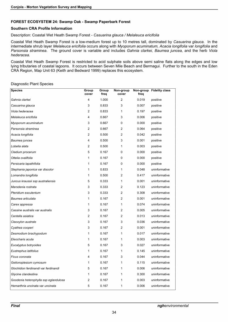
Conjola - Morton Vegetation Survey and Mapping
Final nghenvironmental
34
FOREST ECOSYSTEM 24: Swamp Oak - Swamp Paperbark Forest
Southern CRA Profile Information
Description: Coastal Wet Heath Swamp Forest - Casuarina glauca / Melaleuca ericifolia
Coastal Wet Heath Swamp Forest is a low-medium forest up to 10 metres tall, dominated by Casuarina glauca. In theintermediate shrub layer Melaleuca ericifolia occurs along with Myoporum acuminatum, Acacia longifolia var longifolia andParsonsia straminea. The ground cover is variable and includes Gahnia clarkei, Baumea juncea, and the herb Violahederacea.
Coastal Wet Heath Swamp Forest is restricted to acid sulphate soils above semi saline flats along the edges and lowlying tributaries of coastal lagoons. It occurs between Seven Mile Beach and Bermagui. Further to the south in the EdenCRA Region, Map Unit 63 (Keith and Bedward 1999) replaces this ecosystem.
Diagnostic Plant SpeciesSpecies Group
coverGroup
freqNon-group
coverNon-group
freqFidelity class
Gahnia clarkei 4 1.000 2 0.019 positive
Casuarina glauca 3 0.833 3 0.007 positive
Viola hederacea 2 0.833 1 0.197 positive
Melaleuca ericifolia 4 0.667 3 0.006 positive
Myoporum acuminatum 3 0.667 0 0.000 positive
Parsonsia straminea 2 0.667 2 0.064 positive
Acacia longifolia 2 0.500 2 0.042 positive
Baumea juncea 4 0.500 3 0.001 positive
Lobelia alata 2 0.500 1 0.003 positive
Cladium procerum 5 0.167 0 0.000 positive
Ottelia ovalifolia 1 0.167 0 0.000 positive
Persicaria lapathifolia 1 0.167 0 0.000 positive
Stephania japonica var discolor 1 0.833 1 0.048 uninformative
Lomandra longifolia 1 0.500 2 0.417 uninformative
Juncus kraussii ssp australiensis 5 0.333 1 0.001 uninformative
Marsdenia rostrata 3 0.333 2 0.123 uninformative
Pteridium esculentum 3 0.333 2 0.308 uninformative
Baumea articulata 1 0.167 2 0.001 uninformative
Carex appressa 1 0.167 1 0.074 uninformative
Cassine australis var australis 3 0.167 2 0.005 uninformative
Centella asiatica 2 0.167 2 0.013 uninformative
Claoxylon australe 3 0.167 3 0.036 uninformative
Cyathea cooperi 3 0.167 2 0.001 uninformative
Desmodium brachypodum 1 0.167 1 0.017 uninformative
Eleocharis acuta 1 0.167 1 0.003 uninformative
Eucalyptus botryoides 5 0.167 3 0.027 uninformative
Eustrephus latifolius 1 0.167 1 0.145 uninformative
Ficus coronata 4 0.167 3 0.044 uninformative
Geitonoplesium cymosum 1 0.167 1 0.115 uninformative
Glochidion ferdinandi var ferdinandi 5 0.167 1 0.006 uninformative
Glycine clandestina 1 0.167 1 0.300 uninformative
Goodenia heterophylla ssp eglandulosa 2 0.167 1 0.003 uninformative
Hemarthria uncinata var uncinata 5 0.167 1 0.006 uninformative

Conjola - Morton Vegetation Survey and Mapping
Final nghenvironmental
35
Extant area (ha): 6241Pre-1750 area (ha): 13293Geographic range: South CoastHow much conserved in reserves (ha): 792Vulnerability: 2(C/U)Reliability: 2
FE 24 � Conjola-Morton Study Area
Mills� Classification equivalent type: Cu13
Previous Survey Sites Represented: None
Conjola-Morton 2003 Sites Represented: None
Marginal Sites: None
Species Recorded at Representative Sites: None recorded.
Dominant species: Canopy species include Casuarina glauca, with lower canopy of swamp paperbark (Melaleucaericifolia) and occasional Myoporum acuminatum. Groundcover can vary from dense stands of salt-tolerant sword-sedge(Gahnia clarkei or G. sieberiana) or other sedges and rushes such as Baumea juncea or Juncus kraussii, herbs Lobeliaalata, Apium prostratum, Leptinella longipes, Samolus repens and Selliera radicans to bare ground. The rampant vineParsonsia straminea may be present.
Threatened Species: None.
Other Species of Conservation Significance: None.
Relationship to other Forest Ecosystems: Closely associated with FE 25
Conservation Significance: Swamp forests dominated by Casuarina glauca (FE24 and 25) are regarded as being of highconservation significance in the region because they naturally occur in small fragmented stands around coastal lakes andin small coastal creeks, but do not extend upstream from the lakes or in other areas away from the lakes. The aggregateremaining area of them in the South Coast subregion was calculated to be low (about 10,000 ha in total for the twotypes). It appears from the results of this and earlier surveys that this figure may be considerably exaggerated and thatthey are much less common in the Ulladulla area than the previous CRA modelling suggested.
Threats: Generally vulnerable to clearing and urban development in non-reserved areas. An estimated 53% of FE 24 hasbeen cleared. Possibly vulnerable to the effects of interference with natural lake opening regimes, since Casuarina glaucamay be killed by prolonged flooding (J Miles, pers. obs.).
Impacts of Fire Regimes: Fire may have a severe impact on stands, changing their structure in the medium term. Thisand the related type FE25 can be highly flammable if they carry a dense groundcover of sedges, and if lake levels are lowso that the ground is dry at the time of the fire. Melaleuca ericifolia would also be highly flammable, as least in youngstands where there is uniform distribution of fine fuels from close to ground level to the crown. Casuarina glauca is notvery flammable, but is readily killed by high-intensity fires. Understorey species, Melaleuca ericifolia and various sedgesare well adapted to recovering from fire, re-sprouting rapidly from the roots. Under frequent fire regimes the understoreymay be converted to very dense stands of small melaleuca stems. Fire frequency may in fact drive the distinctionbetween FE24 and FE25, the latter developing only in less frequently burnt sites. Fire should be kept out of thesecommunities as far as possible. If fuel reduction burns are being undertaken in eucalypt forest in the vicinity of thisvegetation type, care needs to be taken not to allow the fires to escape into it.

Conjola - Morton Vegetation Survey and Mapping
Final nghenvironmental
36
FOREST ECOSYSTEM 25: Swamp Oak Forest
Southern CRA Profile Information
Description: South Coast Swamp Forest complex- Casuarina glauca
South Coast Swamp Forest complex is a medium dense forest up to 15 metres tall, dominated by Casuarina glauca, withAcacia sophorae and Avicennia marina. The ground cover is sparse with herbs and graminoids including Commelinacyanea, Pratia purpurescens and Rhagodia candolleana ssp. candolleana.
South Coast Swamp Forest complex occurs in less wet situations than vegetation type 24, in the upper reaches of majorriver estuaries and tributaries between Seven Mile Beach and Wallaga Lake.
Diagnostic Plant SpeciesSpecies Group
coverGroup
freqNon-group
coverNon-group
freqFidelity class
Casuarina glauca 4 1.000 2 0.007 positive
Acacia sophorae 2 0.600 2 0.006 positive
Avicennia marina var australasica 3 0.400 0 0.000 positive
Apium prostratum ssp prostratum var prostratum 2 0.200 0 0.000 positive
Enchylaena tomentosa 2 0.200 0 0.000 positive
Lyperanthus suaveolens 1 0.200 0 0.000 positive
Solanum pungetium 1 0.600 1 0.055 uninformative
Commelina cyanea 2 0.400 1 0.012 uninformative
Dendrobium teretifolium 2 0.400 2 0.000 uninformative
Dichondra repens 2 0.400 2 0.207 uninformative
Pratia purpurascens 2 0.400 1 0.103 uninformative
Rhagodia candolleana ssp candolleana 3 0.400 2 0.004 uninformative
Samolus repens 2 0.400 1 0.001 uninformative
Sarcocornia quinqueflora ssp quinqueflora 2 0.400 2 0.001 uninformative
Suaeda australis 3 0.400 2 0.000 uninformative
Tetragonia tetragonoides 2 0.400 2 0.001 uninformative
Acacia mearnsii 1 0.200 2 0.060 uninformative
Acacia myrtifolia 1 0.200 2 0.004 uninformative
Acrotriche serrulata 1 0.200 1 0.073 uninformative
Allocasuarina verticillata 3 0.200 2 0.004 uninformative
Banksia integrifolia ssp integrifolia 4 0.200 2 0.010 uninformative
Banksia spinulosa var spinulosa 2 0.200 2 0.054 uninformative
Boronia polygalifolia 2 0.200 2 0.001 uninformative
Brachycome spathulata 1 0.200 1 0.066 uninformative
Breynia oblongifolia 2 0.200 1 0.087 uninformative
Cassytha glabella forma glabella 2 0.200 1 0.025 uninformative
Cheilanthes sieberi ssp sieberi 2 0.200 1 0.073 uninformative
Cryptostylis subulata 1 0.200 1 0.004 uninformative
Desmodium varians 2 0.200 1 0.171 uninformative
Einadia trigonos ssp trigonos 4 0.200 1 0.002 uninformative
Entolasia stricta 1 0.200 2 0.149 uninformative
Eucalyptus amplifolia ssp amplifolia 3 0.200 3 0.001 uninformative
Geitonoplesium cymosum 1 0.200 1 0.115 uninformative
Glycine clandestina 1 0.200 1 0.300 uninformative
Gonocarpus teucrioides 1 0.200 2 0.095 uninformative

Conjola - Morton Vegetation Survey and Mapping
Final nghenvironmental
37
Species Groupcover
Groupfreq
Non-groupcover
Non-groupfreq
Fidelity class
Goodenia ovata 1 0.200 2 0.050 uninformative
Hibbertia aspera 3 0.200 2 0.071 uninformative
Hybanthus monopetalus 1 0.200 1 0.006 uninformative
Hypericum gramineum 1 0.200 1 0.172 uninformative
Hypoxis hygrometrica var hygrometrica 1 0.200 1 0.010 uninformative
Isolepis nodosa 2 0.200 2 0.006 uninformative
Juncus kraussii ssp australiensis 1 0.200 3 0.001 uninformative
Leptospermum continentale 1 0.200 2 0.012 uninformative
Lindsaea linearis 2 0.200 1 0.020 uninformative
Lobelia alata 1 0.200 1 0.004 uninformative
Lomandra longifolia 3 0.200 2 0.417 uninformative
Marsdenia rostrata 1 0.200 2 0.123 uninformative
Morinda jasminoides 2 0.200 3 0.097 uninformative
Extant area (ha): 3909
Pre-1750 area (ha): 18194
Geographic range: South Coast
How much conserved in reserves (ha): 648
Vulnerability: 1(C/W)
Reliability: 2

Conjola - Morton Vegetation Survey and Mapping
Final nghenvironmental
38
FE 25 � Conjola-Morton Study Area
Mills� Classification equivalent type: Cu15
Previous Survey Sites Represented: None
Conjola-Morton 2003 Sites Represented: None
Marginal Sites: None
Species Recorded at Representative Sites: None recorded.
Dominant species: Swamp oak Casuarina glauca forms the canopy, with occasional Myoporum acuminatum andMelaleuca ericifolia forming a very open small tree layer. The vine Parsonsia straminea is often abundant. Shrub layer isgenerally absent or may consist of a patchy cover of the sprawling semi-woody herb Rhagodia candolleana, and thegroundcover of salt tolerant species ranges from couch grass (Cynodon dactylon) in drier areas, to samphire (Sarcocorniaquinqueflora) and Baumea juncea in wetter areas. The herbs listed above for FE24 are likely to occur and the large vinecommon silkpod (Parsonsia straminea) is very typical of FE25.
Threatened Species: None.
Other Species of Conservation Significance: None.
Relationship to other Forest Ecosystems: Closely associated with FE24
Conservation Significance: Swamp forests dominated by Casuarina glauca (FE24 and 25) are regarded as being of highconservation significance in the region because they naturally occur in small fragmented stands around coastal lakes andin small coastal creeks, but do not extend upstream from the lakes or in other areas away from the lakes. The aggregateremaining area of them in the South Coast sub-region was calculated to be low (about 10,000 ha in total for the twotypes). It appears from the results of this and earlier surveys that this figure may be considerably exaggerated and thatthey are much less common in the Ulladulla area than the previous CRA mapping suggested.
Threats: Generally vulnerable to clearing and urban development in non-reserved areas. An estimated 78.5% of FE 25has been cleared, but because of errors in the mapping of this vegetation type, this figure is unreliable.. Possiblyvulnerable to the effects of interference with natural lake opening regimes, since Casuarina glauca may be killed byprolonged flooding (J Miles, pers. obs.). Possibly vulnerable to weed infestation, although saline soils would protectagainst most weeds. However, sharp rush, *Juncus acutus appears to represent a considerable threat in the South CoastRegion..
Impacts of Fire Regimes: Fire may have a severe impact on stands, changing their structure in the medium term. Thisand the related type FE24 can be highly flammable if they carry a dense groundcover of sedges, and if lake levels are lowso that the ground is dry at the time of the fire. Casuarina glauca is not very flammable, but is readily killed by high-intensity fires. Understorey species and various sedges are well adapted to recovering from fire, re-sprouting rapidly fromthe roots. Under frequent fire regimes the understorey may be converted to very dense stands of small melaleuca stems.Fire frequency may in fact drive the distinction between FE24 and FE25, the latter developing only in less frequently burntsites. Fire should be kept out of these communities as far as possible. If fuel reduction burns are being undertaken ineucalypt forest in the vicinity of this vegetation type, care needs to be taken not to allow the fires to escape into it.

Conjola - Morton Vegetation Survey and Mapping
Final nghenvironmental
39
FOREST ECOSYSTEM 27: Ecotonal Swamp Forest
Southern CRA Profile Information
Description: Ecotonal Coastal Swamp Forest - Casuarina glauca / E. botryoides
Ecotonal Coastal Swamp Forest is a medium forest up to 20 metres tall, dominated by Casuarina glauca, with E.botryoides. The tall shrub layer is a variable mixture of Banksia integrifolia and Acacia longifolia
Diagnostic Plant SpeciesSpecies Group
coverGroup
freqNon-group
coverNon-group
freqFidelity class
Entolasia marginata 2 0.824 2 0.050 positive
Lomandra longifolia 2 0.824 2 0.415 positive
Oplismenus imbecillis 2 0.824 2 0.119 positive
Casuarina glauca 3 0.706 3 0.006 positive
Dichondra repens 2 0.647 2 0.205 positive
Echinopogon ovatus 2 0.647 1 0.108 positive
Banksia integrifolia ssp integrifolia 2 0.588 2 0.008 positive
Carex longebrachiata 2 0.588 2 0.023 positive
Desmodium varians 2 0.588 1 0.170 positive
Imperata cylindrica var major 2 0.588 2 0.060 positive
Acacia longifolia 2 0.529 2 0.041 positive
Breynia oblongifolia 2 0.529 1 0.085 positive
Commelina cyanea 2 0.529 1 0.010 positive
Glycine clandestina 2 0.529 1 0.299 positive
Isolepis nodosa 2 0.529 2 0.004 positive
Microlaena stipoides var stipoides 2 0.529 2 0.272 positive
Apium prostratum ssp prostratum var filiforme 3 0.059 0 0.000 positive
Dianella crinoides 2 0.059 0 0.000 positive
Myriophyllum simulans 5 0.059 0 0.000 positive
Parsonsia straminea 1 0.588 2 0.063 uninformative
Geranium potentilloides var potentilloides 2 0.471 2 0.068 uninformative
Pteridium esculentum 2 0.471 2 0.308 uninformative
Solanum pungetium 1 0.471 1 0.053 uninformative
Viola hederacea 2 0.471 1 0.197 uninformative
Dianella caerulea var caerulea 1 0.412 1 0.164 uninformative
Eucalyptus botryoides 4 0.412 2 0.025 uninformative
Marsdenia rostrata 1 0.412 2 0.122 uninformative
Pittosporum undulatum 2 0.412 2 0.090 uninformative
Pratia purpurascens 2 0.412 1 0.102 uninformative
Rubus parvifolius 2 0.412 1 0.111 uninformative
Stellaria flaccida 2 0.412 2 0.099 uninformative
Eustrephus latifolius 1 0.353 1 0.145 uninformative
Kennedia rubicunda 2 0.353 1 0.037 uninformative
Pittosporum revolutum 2 0.353 1 0.071 uninformative
Senecio linearifolius 1 0.353 1 0.075 uninformative
Themeda australis 2 0.353 2 0.200 uninformative
Melaleuca ericifolia 4 0.294 3 0.006 uninformative
Monotoca elliptica 1 0.294 1 0.014 uninformative

Conjola - Morton Vegetation Survey and Mapping
Final nghenvironmental
40
Species Groupcover
Groupfreq
Non-groupcover
Non-groupfreq
Fidelity class
Oxalis exilis 2 0.294 1 0.035 uninformative
Solanum stelligerum 2 0.294 1 0.005 uninformative
Stephania japonica var discolor 2 0.294 1 0.048 uninformative
Acacia sophorae 2 0.235 2 0.006 uninformative
Centella asiatica 2 0.235 2 0.012 uninformative
Cynodon dactylon 2 0.235 2 0.009 uninformative
Entolasia stricta 2 0.235 2 0.149 uninformative
Eucalyptus tereticornis 3 0.235 3 0.020 uninformative
Geitonoplesium cymosum 2 0.235 1 0.115 uninformative
Hibbertia aspera 2 0.235 2 0.071 uninformative
Hibbertia scandens 2 0.235 1 0.031 uninformative
Rhagodia candolleana ssp candolleana 2 0.235 2 0.004 uninformative
Extant area (ha): 343
Pre-1750 area (ha): 9841
Geographic range: South Coast
How much conserved in reserves (ha): 20
Vulnerability: 1(C)
Reliability: 3

Conjola - Morton Vegetation Survey and Mapping
Final nghenvironmental
41
FE 27 � Conjola-Morton Study Area
Mills� Classification equivalent type: None
Previous Survey Sites Represented: None
Conjola-Morton 2003 Sites Represented: CONJM03F
Marginal Sites: None
Species Recorded at Representative Sites:
Acacia longifolia ssp longifolia
Acacia ulicifolia
Arthropodium sp.
Austrostipa sp.
Banksia integrifolia
Baumea juncea
Billardiera scandens var scandens
Boronia polygalifolia
Breynia oblongifolia
Cassytha glabella
Casuarina glauca
Centella asiatica
Chrysanthemoides monilifera ssprotundata*
Clematis aristata
Corymbia gummifera
Cymbopogon refractus
Dianella caerulea
Dichondra repens
Digitaria sp.
Dodonaea triquetra
Echinopogon caespitosus
Echinopogon ovatus
Entolasia stricta
Eucalyptus botryoides
Eucalyptus sclerophylla
Euchiton gymnocephalus
Exocarpos strictus
Gahnia clarkei
Glycine clandestina
Gonocarpus teucrioides
Hakea sericea
Hardenbergia violacea
Hibbertia linearis
Hibbertia scandens
Hydrocotyle acutiloba
Hydrocotyle geraniifolia
Hypochaeris radicata*
Imperata cylindrica var major
Kennedia rubicunda
Lagenifera gracilis
Lepidosperma laterale
Leptospermum polygalifolium ssppolygalifolium
Leucopogon lanceolatus
Lomandra longifolia
Microlaena stipoides var stipoides
Notelaea venosa
Opercularia aspera
Opercularia varia
Oplismenus imbecillis
Oxalis sp.
Panicum simile
Patersonia glabrata
Persoonia linearis
Pimelea linifolia ssp linifolia
Poa poiformis
Polymeria calycina
Poranthera microphylla
Pratia purpurascens
Prostanthera incisa
Pteridium esculentum
Pterostylis longifolia
Senecio hispidulus var hispidulus
Solanum pungetium
Themeda australis
Veronica plebeia
Viola hederacea
Wahlenbergia gracilis
Wahlenbergia multicaulis
Xanthorrhoea concava
Xanthosia tridentata
Dominant species: As an ecotonal type this community could be expected to contain elements of either or both of FE25and FE28. This would include a canopy of Swamp oak Casuarina glauca and/or Bangalay (E. botryoides), a sub-canopyof occasional Myoporum acuminatum and Melaleuca ericifolia and/or saw banksia (Banksia serrata. Typical shrubsoccurring in FE28 are Acacia longifolia ssp sophorae or A. longifolia ssp longifolia and Monotoca elliptica. Burrawangs(Macrozamia communis) may be present and groundcover of bracken plus various grasses and herbs found in FE28.
Threatened Species: None.
Other Species of Conservation Significance: None.
Relationship to other Forest Ecosystems: This community is intermediate between Coastal Sands Bangalay - BanksiaForest (FE28) and Swamp Oak Forest (FE25)
Conservation Significance: Swamp forests dominated by Casuarina glauca (FE24 and 25) are regarded as being of highconservation significance as detailed in the profile for FE25. Similarly, FE28 is considered to be at least of moderateconservation significance, therefore the overall significance of this ecotonal type is probably high. It has been mapped atonly one location within the study area.

Conjola - Morton Vegetation Survey and Mapping
Final nghenvironmental
42
Threats: Generally vulnerable to clearing and urban development in non-reserved areas. Stands are also vulnerable torecreational pressure. Possibly vulnerable to the effects of interference with natural lake opening regimes, sinceCasuarina glauca may be killed by prolonged flooding (J Miles, pers. obs.). Possibly vulnerable to weed infestation inareas close to coastal villages, such as Swanhaven and may also be targeted for frequent hazard-reduction burning toprotect these villages.
Impacts of Fire Regimes: Fire may have a severe impact on stands, changing their structure in the medium term. Therelated type FE25 can be highly flammable if it carries a dense groundcover of sedges, and if lake levels are low so thatthe ground is dry at the time of the fire. Casuarina glauca is not very flammable, but is readily killed by high-intensity fires.Therefore, fire should be kept out of communities in which it occurs as far as possible. The understorey is generally welladapted to regular fire but some shrubs which are relatively slow growing and not capable of resprouting are likely to belost from frequently burnt stands, as may some other obligate seeders such as wattles, depending on the fire frequency.Occasional fires may help reduce the impact of weeds around villages, although there would need to be post-firemonitoring for weed seedlings, since the creation of bare ground and temporary nutrient boost from a fire may alsoencourage the germination of rapidly growing weeds which may be able to out-compete natives in some situations.

Conjola - Morton Vegetation Survey and Mapping
Final nghenvironmental
43
FOREST ECOSYSTEM 28: Coastal Sands Bangalay - Banksia Forest
Southern CRA Profile Information
Description: Coastal Sands Shrub/Fern Forest - E. botryoides / Banksia serrata
Coastal Sands Shrub/Fern Forest is a low to tall forest dominated by E. botryoides. It has an understorey of Banksiaserrata, Monotoca elliptica, Allocasuarina littoralis, Breynia oblongifolia, and Acacia longifolia. The ground cover ispredominantly bracken Pteridium esculentum, grasses and graminoids Imperata cylindrica and Lomandra longifolia,intermixed with herbs and twiners, such as Gonocarpus teucrioides, Glycine clandestina, and Viola hederacea.
This forest ecosystem is mainly confined to sandy soils adjoining bays, estuaries, and lagoons in Jervis Bay, Clyde, andMoruya areas.
Diagnostic Plant SpeciesSpecies Group
coverGroup
freqNon-group
coverNon-group
freqFidelity class
Pteridium esculentum 3 0.933 2 0.306 positive
Lomandra longifolia 3 0.867 2 0.415 positive
Eucalyptus botryoides 4 0.800 2 0.024 positive
Banksia serrata 3 0.667 3 0.015 positive
Imperata cylindrica var major 2 0.667 2 0.060 positive
Monotoca elliptica 2 0.600 1 0.013 positive
Allocasuarina littoralis 3 0.533 2 0.101 positive
Banksia integrifolia ssp integrifolia 3 0.533 2 0.008 positive
Marsdenia rostrata 2 0.533 2 0.122 positive
Cyperus laevigatus 2 0.133 0 0.000 positive
Pterostylis curta 1 0.067 0 0.000 positive
Pterostylis grandiflora 1 0.067 0 0.000 positive
Gonocarpus teucrioides 1 0.533 2 0.093 uninformative
Acacia longifolia 2 0.467 2 0.041 uninformative
Glycine clandestina 1 0.467 1 0.299 uninformative
Stephania japonica var discolor 1 0.467 1 0.048 uninformative
Breynia oblongifolia 1 0.400 1 0.086 uninformative
Hibbertia scandens 2 0.400 1 0.030 uninformative
Lagenifera stipitata 1 0.400 1 0.166 uninformative
Lepidosperma concavum 4 0.400 2 0.009 uninformative
Themeda australis 1 0.400 2 0.200 uninformative
Viola hederacea 2 0.400 1 0.198 uninformative
Desmodium var ians 2 0.333 1 0.171 uninformative
Eucalyptus pilularis 3 0.333 3 0.029 uninformative
Hibbertia obtusifolia 1 0.333 1 0.212 uninformative
Macrozamia communis 3 0.333 2 0.062 uninformative
Pratia purpurascens 1 0.333 1 0.103 uninformative
Schelhammera undulata 1 0.333 1 0.083 uninformative
Desmodium brachypodum 1 0.267 1 0.016 uninformative
Dianella caerulea var caerulea 1 0.267 1 0.165 uninformative
Dichondra repens 1 0.267 2 0.207 uninformative
Echinopogon caespitosus var caespitosus 1 0.267 1 0.024 uninformative
Microlaena stipoides var stipoides 2 0.267 2 0.273 uninformative
Oplismenus imbecillis 2 0.267 2 0.121 uninformative
Pittosporum undulatum 2 0.267 2 0.091 uninformative
Synoum glandulosum 4 0.267 2 0.080 uninformative
Acacia maidenii 2 0.200 1 0.010 uninformative
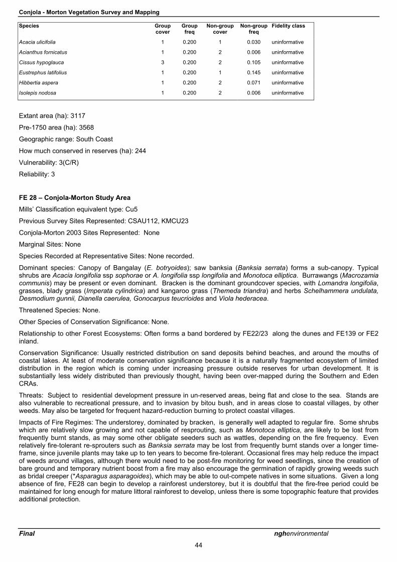
Conjola - Morton Vegetation Survey and Mapping
Final nghenvironmental
44
Species Groupcover
Groupfreq
Non-groupcover
Non-groupfreq
Fidelity class
Acacia ulicifolia 1 0.200 1 0.030 uninformative
Acianthus fornicatus 1 0.200 2 0.006 uninformative
Cissus hypoglauca 3 0.200 2 0.105 uninformative
Eustrephus latifolius 1 0.200 1 0.145 uninformative
Hibbertia aspera 1 0.200 2 0.071 uninformative
Isolepis nodosa 1 0.200 2 0.006 uninformative
Extant area (ha): 3117
Pre-1750 area (ha): 3568
Geographic range: South Coast
How much conserved in reserves (ha): 244
Vulnerability: 3(C/R)
Reliability: 3
FE 28 � Conjola-Morton Study Area
Mills� Classification equivalent type: Cu5
Previous Survey Sites Represented: CSAU112, KMCU23
Conjola-Morton 2003 Sites Represented: None
Marginal Sites: None
Species Recorded at Representative Sites: None recorded.
Dominant species: Canopy of Bangalay (E. botryoides); saw banksia (Banksia serrata) forms a sub-canopy. Typicalshrubs are Acacia longifolia ssp sophorae or A. longifolia ssp longifolia and Monotoca elliptica. Burrawangs (Macrozamiacommunis) may be present or even dominant. Bracken is the dominant groundcover species, with Lomandra longifolia,grasses, blady grass (Imperata cylindrica) and kangaroo grass (Themeda triandra) and herbs Schelhammera undulata,Desmodium gunnii, Dianella caerulea, Gonocarpus teucrioides and Viola hederacea.
Threatened Species: None.
Other Species of Conservation Significance: None.
Relationship to other Forest Ecosystems: Often forms a band bordered by FE22/23 along the dunes and FE139 or FE2inland.
Conservation Significance: Usually restricted distribution on sand deposits behind beaches, and around the mouths ofcoastal lakes. At least of moderate conservation significance because it is a naturally fragmented ecosystem of limiteddistribution in the region which is coming under increasing pressure outside reserves for urban development. It issubstantially less widely distributed than previously thought, having been over-mapped during the Southern and EdenCRAs.
Threats: Subject to residential development pressure in un-reserved areas, being flat and close to the sea. Stands arealso vulnerable to recreational pressure, and to invasion by bitou bush, and in areas close to coastal villages, by otherweeds. May also be targeted for frequent hazard-reduction burning to protect coastal villages.
Impacts of Fire Regimes: The understorey, dominated by bracken, is generally well adapted to regular fire. Some shrubswhich are relatively slow growing and not capable of resprouting, such as Monotoca elliptica, are likely to be lost fromfrequently burnt stands, as may some other obligate seeders such as wattles, depending on the fire frequency. Evenrelatively fire-tolerant re-sprouters such as Banksia serrata may be lost from frequently burnt stands over a longer time-frame, since juvenile plants may take up to ten years to become fire-tolerant. Occasional fires may help reduce the impactof weeds around villages, although there would need to be post-fire monitoring for weed seedlings, since the creation ofbare ground and temporary nutrient boost from a fire may also encourage the germination of rapidly growing weeds suchas bridal creeper (*Asparagus asparagoides), which may be able to out-compete natives in some situations. Given a longabsence of fire, FE28 can begin to develop a rainforest understorey, but it is doubtful that the fire-free period could bemaintained for long enough for mature littoral rainforest to develop, unless there is some topographic feature that providesadditional protection.

Conjola - Morton Vegetation Survey and Mapping
Final nghenvironmental
45
FOREST ECOSYSTEM 29: Coastal Sands Blackbut - Banksia Forest
Southern CRA Profile Information
Description: Northern Coastal Sands Shrub/Fern Forest - E. pilularis / Banksia serrata
Northern Coastal Sands Shrub/Fern Forest is a forest dominated by E. pilularis, with Coyrymbia gummifera, with someoccasional patches of Syncarpia glomulifera. The shrub/small tree layer usually comprises Elaeocarpus reticulatus,Banksia serrata, Monotoca elliptica, and Acacia longifolia. Ground cover is mainly sedges Lomandra longifolia andLepidopserma laterale, with the grass Entolasia stricta, and herbs Dianella caerulea var caerulea and Patersoniaglabrata.
This forest ecosystem is mainly found in the low foothills behind Jervis Bay and Ulladulla. It occurs on moderately deepsilty loam, derived from Permian mudstones at elevations below 100 metres. Some smaller outliers of this map unit arefound further south towards Batemans Bay.
Diagnostic Plant SpeciesSpecies Group
coverGroup
freqNon-group
coverNon-group
freqFidelity class
Lomandra longifolia 3 1.000 2 0.415 positive
Pteridium esculentum 3 0.923 2 0.306 positive
Eucalyptus pilularis 4 0.769 3 0.027 positive
Gonocarpus teucrioides 2 0.769 2 0.092 positive
Elaeocarpus reticulatus 2 0.692 1 0.102 positive
Banksia serrata 3 0.615 3 0.016 positive
Monotoca elliptica 2 0.615 1 0.013 positive
Corymbia gummifera 3 0.539 3 0.050 positive
Lepidosperma laterale 4 0.539 1 0.172 positive
Caladenia alata 1 0.077 0 0.000 positive
Leucopogon lanceolatus var lanceolatus 1 0.615 1 0.168 uninformative
Entolasia stricta 2 0.462 2 0.148 uninformative
Hardenbergia violacea 1 0.462 1 0.159 uninformative
Hibbertia scandens 1 0.462 1 0.030 uninformative
Acacia longifolia 2 0.385 2 0.042 uninformative
Dianella caerulea var caerulea 1 0.385 1 0.165 uninformative
Patersonia glabrata 2 0.385 2 0.041 uninformative
Persoonia linearis 1 0.385 1 0.182 uninformative
Allocasuarina littoralis 4 0.308 2 0.102 uninformative
Gahnia sieberiana 3 0.308 2 0.020 uninformative
Hibbertia linearis 1 0.308 1 0.004 uninformative
Smilax australis 1 0.308 2 0.147 uninformative
Syncarpia glomulifera 4 0.308 3 0.022 uninformative
Acacia suaveolens 1 0.231 1 0.011 uninformative
Anisopogon avenaceus 2 0.231 2 0.011 uninformative
Breynia oblongifolia 1 0.231 1 0.087 uninformative
Cissus hypoglauca 2 0.231 2 0.105 uninformative
Imperata cylindrica var major 2 0.231 2 0.061 uninformative
Pimelea linifolia ssp linifolia 1 0.231 1 0.059 uninformative
Schelhammera undulata 1 0.231 1 0.084 uninformative
Synoum glandulosum 2 0.231 2 0.080 uninformative
Zieria arborescens ssp arborescens 2 0.231 2 0.005 uninformative
Acacia ulicifolia 2 0.154 1 0.031 uninformative
Acianthus fornicatus 1 0.154 1 0.006 uninformative

Conjola - Morton Vegetation Survey and Mapping
Final nghenvironmental
46
Species Groupcover
Groupfreq
Non-groupcover
Non-groupfreq
Fidelity class
Angophora floribunda 3 0.154 1 0.073 uninformative
Aotus ericoides 2 0.154 2 0.015 uninformative
Banksia ericifolia var ericifolia 2 0.154 3 0.015 uninformative
Banksia integrifolia ssp integrifolia 2 0.154 2 0.010 uninformative
Bossiaea heterophylla 1 0.154 1 0.011 uninformative
Caustis flexuosa 2 0.154 2 0.013 uninformative
Dampiera stricta 2 0.154 1 0.012 uninformative
Dianella caerulea var producta 1 0.154 1 0.001 uninformative
Endiandra sieberi 3 0.154 2 0.005 uninformative
Entolasia marginata 2 0.154 2 0.053 uninformative
Eucalyptus botryoides 2 0.154 3 0.027 uninformative
Eucalyptus piperita 4 0.154 3 0.020 uninformative
Eucalyptus sclerophylla 5 0.154 3 0.009 uninformative
Extant area (ha): 13245
Pre-1750 area (ha): 16948
Geographic range: South Coast Vulnerability: 3(C/U)
How much conserved in reserves (ha): 2920 Reliability: 3
FE 29 � Conjola-Morton Study Area
Mills� Classification equivalent type: Cu4
Previous Survey Sites Represented: None
Conjola-Morton 2003 Sites Represented: None but field checked at its mapped location in Conjola NP.
Marginal Sites: None
Species Recorded at Representative Sites: None recorded.
Dominant species: Blackbutt (E. pilularis) is the dominant tree, but it may be joined by many other species such as redbloodwood (Corymbia gummifera); Banksia serrata is often present as a small tree layer. The understorey is transitionalbetween FE28 and FE2 and may include Acacia longifolia ssp sophorae or ssp longifolia and burrawangs (Macrozamiacommunis) along with tussock plants such as Lomandra longifolia and Lepidosperma laterale, bracken and grasses.
Threatened Species: None.
Other Species of Conservation Significance: None.
Relationship to other Forest Ecosystems: Similar to FE 28 with which FE29 is transitional. It also merges with FE2 and inNarrawallee Creek Nature Reserve with FE175.
Conservation Significance: Poorly represented in Conjola, not present in Morton but more extensive in NarrawalleeCreek Nature Reserve. Has a naturally limited and fragmented distribution in the region. There has been a probableoverestimation of its true extent in previous mapping and pressure from coastal development, may raise the conservationsignificance of this vegetation type to at least a moderate level.
Threats: Clearing and urban development in un-reserved areas. Stands are also vulnerable to recreational pressure.
Impacts of Fire Regimes: Like FE28, the understorey, dominated by Bracken is generally well adapted to regular fire.Some shrubs which are relatively slow growing and not capable of resprouting, such as Monotoca elliptica, are likely to belost from frequently burnt stands, as may some other obligate seeders such as wattles, depending on the fire frequency.Even relatively fire-tolerant re-sprouters such as Banksia serrata may be lost from frequently burnt stands over a longertime-frame, since juvenile plants may take up to ten years to become fire-tolerant.

Conjola - Morton Vegetation Survey and Mapping
Final nghenvironmental
47
FOREST ECOSYSTEM 137: Coastal Escarpment Moist Shrub/Fern Forest
Southern CRA Profile Information
Description: Coastal Escarpment Moist Shrub/Fern Forest - E. sieberi / E. piperita / Gleichenia dicarpa
Coastal Escarpment Moist Shrub/Fern Forest is a medium to tall forest up to 25 metres tall, co-dominated by Eucalyptussieberi and Eucalyptus piperita. The understorey is an open cover of shrubs Acacia obtusifolia, Leptospermumtrinervium, Banksia paludosa, Playsace lanceolata, Amperea xiphoclada and Leptomeria acida. The ground cover is adense mat of Gleichenia dicarpa, with scattered Gahnia sieberiana, and a sparse low herbaceous/graminoid layerincluding Gonocarpus teucrioides.
Coastal Escarpment Moist Shrub/Fern Forest occurs in three discrete patches on the edge of the sandstone escarpmentin Monga State Forest and Budawang National Park, the eastern Morton plateau in the Upper Clyde catchment, andalong the northern escarpment from Fitzroy Falls to Budderoo National Park. It usually occurs between 500 and 800metres in elevation on partially impeded clay soils derived from Permian mudstones.
Diagnostic Plant SpeciesSpecies Group
coverGroup
freqNon-group
coverNon-group
freqFidelity class
Acacia obtusifolia 3 1.000 2 0.088 positive
Gleichenia dicarpa 5 0.727 2 0.008 positive
Leptospermum trinervium 2 0.727 2 0.028 positive
Banksia paludosa 2 0.636 2 0.012 positive
Eucalyptus piperita 3 0.636 3 0.019 positive
Eucalyptus sieberi 3 0.636 3 0.108 positive
Gahnia sieberiana 2 0.636 2 0.019 positive
Tetratheca thymifolia 2 0.636 2 0.055 positive
Aotus ericoides 2 0.546 1 0.014 positive
Lepironia articulata 1 0.091 0 0.000 positive
Leucopogon amplexicaulis 1 0.091 0 0.000 positive
Platysace lanceolata 1 0.727 2 0.120 uninformative
Amperea xiphoclada var xiphoclada 1 0.636 1 0.035 uninformative
Lomandra longifolia 1 0.636 2 0.416 uninformative
Banksia spinulosa var spinulosa 1 0.546 2 0.053 uninformative
Pteridium esculentum 1 0.546 2 0.308 uninformative
Dianella caerulea var caerulea 1 0.455 1 0.164 uninformative
Entolasia stricta 2 0.455 2 0.149 uninformative
Gonocarpus tetragynus 1 0.455 1 0.297 uninformative
Gonocarpus teucrioides 2 0.455 2 0.094 uninformative
Leptomeria acida 1 0.455 1 0.015 uninformative
Leptospermum polygalifolium ssp polygalifolium 2 0.455 2 0.025 uninformative
Lindsaea linearis 1 0.455 1 0.019 uninformative
Pultenaea daphnoides 1 0.455 1 0.021 uninformative
Corymbia gummifera 3 0.364 3 0.050 uninformative
Empodisma minus 2 0.364 3 0.019 uninformative
Phyllota phylicoides 2 0.364 2 0.007 uninformative
Acacia elongata var elongata 1 0.273 1 0.005 uninformative
Banksia ericifolia var ericifolia 1 0.273 3 0.015 uninformative
Bauera rubioides 2 0.273 2 0.004 uninformative
Billardiera scandens var scandens 1 0.273 1 0.136 uninformative
Cassytha pubescens 1 0.273 1 0.035 uninformative
Cyathochaeta diandra 2 0.273 2 0.006 uninformative
Epacris impressa 2 0.273 2 0.011 uninformative

Conjola - Morton Vegetation Survey and Mapping
Final nghenvironmental
48
Species Groupcover
Groupfreq
Non-groupcover
Non-groupfreq
Fidelity class
Eucalyptus radiata ssp radiata 1 0.273 3 0.065 uninformative
Lambertia formosa 1 0.273 2 0.011 uninformative
Lepidosperma laterale 1 0.273 1 0.173 uninformative
Persoonia linearis 1 0.273 1 0.182 uninformative
Persoonia mollis ssp budawangensis 1 0.273 2 0.001 uninformative
Persoonia mollis ssp caleyi 3 0.273 1 0.008 uninformative
Schoenus melanostachys 3 0.273 1 0.005 uninformative
Viola hederacea 1 0.273 1 0.198 uninformative
Extant area (ha): 14461
Pre-1750 area (ha): 15345
Geographic range: South Coast
How much conserved in reserves (ha): 8996
Vulnerability: 5 Reliability: 3
FE 137 � Conjola-Morton Study Area
Mills� Classification equivalent type: None
Previous Survey Sites Represented: None
Conjola-Morton 2003 Sites Represented: None
Marginal Sites : None
Species Recorded at Representative Sites: None recorded.
Dominant species: Silvertop ash (E. sieberi) and Sydney peppermint (E. piperita) are canopy dominants with the shrubsor small trees Acacia obtusifolia, Banksia spinulosa and Leptospermum trinervium commonly present. Dense stands ofcoral fern (Gleichenia dicarpa) are diagnostic of this community,
Threatened Species: None.
Other Species of Conservation Significance: None.
Relationship to other Forest Ecosystems: Mapped adjacent to FE3 and may adjoin FE20 along moist gullies.
Conservation Significance: Not present in Conjola and presence in Morton (East) could not be confirmed althoughmapped during the Southern CRA. FE137 is stated by Thomas, Gellie and Harrison (2000) to be reasonably widelydistributed over three discrete patches in Monga and the Budawangs, the eastern Morton plateau and the Fitzroy Falls toBudderoo National Park area. It is well reserved.
Threats: Clearing and logging in un-reserved areas.
Impacts of Fire Regimes: The list of diagnostic species suggests that this community would be well adapted to reasonablyfrequent fires, with many re-sprouters. The range of 7-30 years suggested for shrubby dry sclerophyll forests (NPWS2003) would be appropriate.

Conjola - Morton Vegetation Survey and Mapping
Final nghenvironmental
49
FOREST ECOSYSTEM 139: Scribbly Gum - Red Bloodwood Heathy Woodland
Southern CRA Profile Information
Description: Northern Coastal Hinterland Heath Shrub Dry Forest - C. gummifera / E. sclerophylla
This vegetation type comprises mainly medium to low forest dominated by Scribbly Gum (Eucalyptus sclerophylla) withRed Bloodwood (Corymbia gummifera) usually present as a subdominant. It has a moderately dense heathy shrub layerdominated by sandstone broad-leaved Hakea (Hakea dactyloides), the Banksias (Banksia paludosa and B.spinulosa),Lambertia formosa, and Rough-barked Tea-tree (Leptospermum trinervium). The groundcover comprises Lepyrodiascariosa and Entolasia stricta.
This ecosystem is distributed on shallow podzolic soils on flat plateaux and low lying coastal areas from Jervis Bay downto Ulladulla. Small amounts have been cleared around Jervis Bay, although much of it is reserved within Morton NationalPark.
Diagnostic Plant SpeciesSpecies Group
coverGroup
freqNon-group
coverNon-group
freqFidelity class
Hakea dactyloides 2 0.913 2 0.026 positive
Leptospermum trinervium 3 0.870 2 0.024 positive
Patersonia sericea 2 0.870 1 0.026 positive
Banksia spinulosa var spinulosa 2 0.783 2 0.050 positive
Persoonia mollis ssp leptophylla 2 0.739 1 0.005 positive
Lambertia formosa 2 0.696 2 0.007 positive
Banksia paludosa 2 0.652 2 0.009 positive
Corymbia gummifera 3 0.652 3 0.048 positive
Eucalyptus sclerophylla 2 0.652 3 0.005 positive
Lepyrodia scariosa 2 0.609 2 0.005 positive
Petrophile sessilis 2 0.609 2 0.005 positive
Entolasia stricta 2 0.565 2 0.147 positive
Banksia ericifolia var ericifolia 3 0.522 3 0.013 positive
Hakea teretifolia 2 0.522 2 0.006 positive
Baeckea diosmifolia 1 0.261 0 0.000 positive
Baeckea brevifolia 2 0.130 0 0.000 positive
Billardiera scandens var sericata 1 0.087 0 0.000 positive
Pultenaea paleacea var paleacea 2 0.087 0 0.000 positive
Sphaerolobium minus 2 0.087 0 0.000 positive
Boronia thujona 3 0.043 0 0.000 positive
Dampiera scottiana 2 0.043 0 0.000 positive
Eriostemon buxifolius ssp obovatus 1 0.043 0 0.000 positive
Eriostemon scaber ssp latifolius 2 0.043 0 0.000 positive
Eucalyptus multicaulis 1 0.043 0 0.000 positive
Grevillea baueri ssp asperula 1 0.043 0 0.000 positive
Grevillea linearifolia (Southern Sandstone form) 1 0.043 0 0.000 positive
Hibbertia cistiflora 1 0.043 0 0.000 positive
Leucopogon appressus 1 0.043 0 0.000 positive
Xyris Unknown 3 0.043 0 0.000 positive
Lomatia ilicifolia 1 0.826 1 0.039 uninformative
Persoonia levis 1 0.696 1 0.015 uninformative
Cassytha glabella forma glabella 1 0.609 1 0.022 uninformative
Lomandra obliqua 1 0.609 1 0.031 uninformative

Conjola - Morton Vegetation Survey and Mapping
Final nghenvironmental
50
Species Groupcover
Groupfreq
Non-groupcover
Non-groupfreq
Fidelity class
Lindsaea linearis 1 0.565 1 0.017 uninformative
Pimelea linifolia ssp linifolia 1 0.565 1 0.056 uninformative
Isopogon anemonifolius 1 0.522 1 0.011 uninformative
Dampiera stricta 1 0.478 1 0.010 uninformative
Epacris microphylla var microphylla 2 0.478 2 0.023 uninformative
Leptospermum polygalifolium ssp polygalifolium 2 0.478 2 0.024 uninformative
Mitrasacme polymorpha 1 0.478 1 0.004 uninformative
Xanthorrhoea concava 1 0.478 1 0.023 uninformative
Actinotus minor 2 0.435 1 0.007 uninformative
Aotus ericoides 2 0.435 2 0.013 uninformative
Bossiaea heterophylla 2 0.435 1 0.009 uninformative
Cyathochaeta diandra 3 0.435 2 0.005 uninformative
Eucalyptus consideniana 3 0.391 3 0.015 uninformative
Eucalyptus obstans 2 0.217 2 0.001 uninformative
Eucalyptus mannifera 2 0.174 3 0.058 uninformative
Extant area (ha): 48899 How much conserved in reserves (ha): 15383 Sth Coast and 35 Northern
Pre-1750 area (ha): 51050 Vulnerability: 5 in South Coast
Geographic range: South Coast and Northern Reliability: 2

Conjola - Morton Vegetation Survey and Mapping
Final nghenvironmental
51
FE 139 � Conjola-Morton Study Area
Mills� Classification equivalent type: Cu 7, 9, 10, 11, 12 or 12
Previous Survey Sites Represented: CS_AU100, CS_AU108, CS_AU119, CS_AU99, KMCO14, KMCU12, KMCU17,KMCU2, KMCU3, KMCU5, KMCU8, SZ24224L, SZ24225U
Conjola-Morton 2003 Sites Represented : CONJM1F, CONJM4F, CONJM5 and CONJM8F.
Marginal Sites : None
Species Recorded at Representative Sites:
Acacia obtusifolia
Acacia suaveolens
Acacia ulicifolia
Actinotus minor
Allocasuarina paludosa
Amperea xiphoclada
Amperea xiphoclada varxiphoclada
Anisopogon avenaceus
Aotus ericoides
Austrostipa spp.
Banksia ericifolia
Banksia paludosa
Banksia serrata
Banksia spinulosa var spinulosa
Billardiera scandens var scandens
Blandfordia nobilis
Bossiaea ensata
Bossiaea heterophylla
Bossiaea obcordata
Brunoniella pumilio
Burchardia umbellata
Caesia parviflora var parviflora
Callistemon linearis
Calochilus campestris
Calochilus paludosus
Cassytha glabella
Cassytha glabella forma glabella
Caustis flexuosa
Ceratopetalum gummiferum
Comesperma ericinum
Conospermum taxifolium
Corymbia gummifera
Cryptandra ericoides
Cryptostylis spp.
Cryptostylis subulata
Cyathochaeta diandra
Dampiera stricta
Dillwynia phylicoides
Dillwynia retorta
Diuris aurea
Drosera peltata
Entolasia stricta
Epacris microphylla varmicrophylla
Epacris spp.
Eragrostis spp.
Eucalyptus consideniana
Eucalyptus sclerophylla
Eucalyptus sieberi
Genoplesium spp.
Gompholobium glabratum
Gompholobium pinnatum
Gonocarpus tetragynus
Goodenia bellidifolia ssp bellidifolia
Haemodorum corymbosum
Hakea laevipes ssp laevipes
Hakea sericea
Hakea teretifolia
Hibbertia riparia
Hovea heterophylla
Hovea linearis
Hybanthus vernonii ssp scaber
Hypericum gramineum
Isopogon anemonifolius
Kunzea capitata
Lambertia formosa
Lepidosperma filiforme
Lepidosperma laterale
Leptospermum continentale
Leptospermum trinervium
Lepyrodia muelleri
Lepyrodia scariosa
Leucopogon esquamatus
Lindsaea linearis
Lomandra filiformis ssp filiformis
Lomandra glauca
Lomandra longifolia
Lomandra multiflora
Lomandra obliqua
Lomatia ilicifolia
Melaleuca thymifolia
Micrantheum ericoides
Mirbelia rubiifolia
Mitrasacme polymorpha
Monotoca scoparia
Opercularia varia
Panicum simile
Patersonia sericea
Persoonia laurina
Persoonia levis
Petrophile pedunculata
Petrophile sessilis
Phyllota phylicoides
Pimelea linifolia ssp linifolia
Poranthera ericifolia
Prasophyllum spp.
Ptilothrix deusta
Pultenaea rosmarinifolia
Schoenus lepidosperma ssppachylepis
Sphaerolobium minus
Stylidium spp.
Syncarpia glomulifera
Tetrarrhena juncea

Conjola - Morton Vegetation Survey and Mapping
Final nghenvironmental
52
Tetratheca thymifolia
Thelymitra media var media
Themeda australis
Thysanotus juncifolius
Trachymene incisa
Xanthorrhoea australis
Xanthorrhoea concava
Xanthosia tridentata
Dominant species: Scribbly gum (E. sclerophylla) and red bloodwood usually form the canopy, though they may be joinedby E. consideniana or E. sieberi with E. botryoides closer to the coast. The canopy may be missing altogether in someareas (see FE 139h). A small tree layer may include Allocasuarina littoralis, Leptospermum trinervium or occasionallybanksias if close to the sea. The shrubby understorey contains typical �Sydney sandstone� elements such as Lambertiaformosa, Hakea dactyloides, Persoonia mollis ssp caleyi, Petrophile pedunculata, Isopogon anemonifolius and Kunzeacapitata. The groundcover consists of mixed sedges(including Lepyrodia scariosa and Xyris spp.), grasses (Entolasiastricta, Austrostipa pubescens, Anisopogon avenaceus), the fern Lindsaea linearis and subshrubs such asGompholobium pinnatum, Boronia polygalifolia and Xanthosia tridentata. The small flannel-flower, Actinotus minorscrambles through the groundcover.
Threatened Species: Habitat for the orchid Cryptostylis hunteriana, listed as Vulnerable under the Threatened SpeciesConservation Act. This species has been recorded in Conjola NP. Also recorded is Grevillea macleayana (ROTAP).
Other Species of Conservation Significance: Diuris aurea, was found in coastal FE139 in Conjola (at site COJM01F) andis at its southern limit in the region. Mirbelia rubiifolia was recorded in Conjola, being restricted to heathlands mainly northof Ulladulla and at Nadgee Nature Reserve on the Far South Coast. Other species included Persoonia mollis ssp caleyiand Pultenaea rosmarinifolia.
Relationship to other Forest Ecosystems: A heath with similar species composition but lacking the tree canopy isdescribed as FE 139H.
Conservation Significance: Well represented in Conjola and Morton (East). FE139 was not identified as an ecosystem ofhigh conservation significance in the region, but it probably should be. Although this type of vegetation is very extensivein the Sydney basin, and is well reserved in the region in Morton National Park, it is at its southern limit of distributionaround Ulladulla. Many of the component species, such as Eucalyptus sclerophylla, Lambertia formosa, Persoonia mollisssp caleyi, Petrophile pedunculata, Kunzea capitata, Epacris pulchella and Actinotus minor are also at or very close totheir southern limit which is possibly in or near Barnunj SRA and Meroo National Park, south of Ulladulla.
Threats: Fire (see below)
Impacts of Fire Regimes: Such heathy vegetation is adapted to relatively frequent fire, but too short an interval betweenfires may eliminate obligate seeders, which are killed by fire rather than re-sprouting, from the species mix. Re-sproutingshrubs can also be eliminated over a longer period if frequent fires do not allow sufficient time to replenish seed banks,and if more fire-sensitive juvenile plants are killed. Having a predominantly heathy shrub understorey with a highproportion of sclerophyllous shrubs, and often a dense sedge layer as well, it is highly flammable. Fine fuels are more orless uniformly distributed from ground level to the low eucalypt crowns, via tall shrubs such as Leptospermum trinervium.This makes this vegetation type flammable in almost all weather conditions, and difficult to extinguish because thecontinuous shrubby understorey makes firebreak creation impossible except at tracks. FE139 therefore requires carefulfire management. Fire intervals in the range of 7-30 years are recommended for shrubby dry sclerophyll forests (NPWS,undated). However, frequencies close to the lower limit would tend to eliminate trees or reduce them to mallee form,converting woodlands to open heathland. This appears to have happened already in some parts of Conjola and Morton(East), although it is not known to what extent past logging may have also contributed.
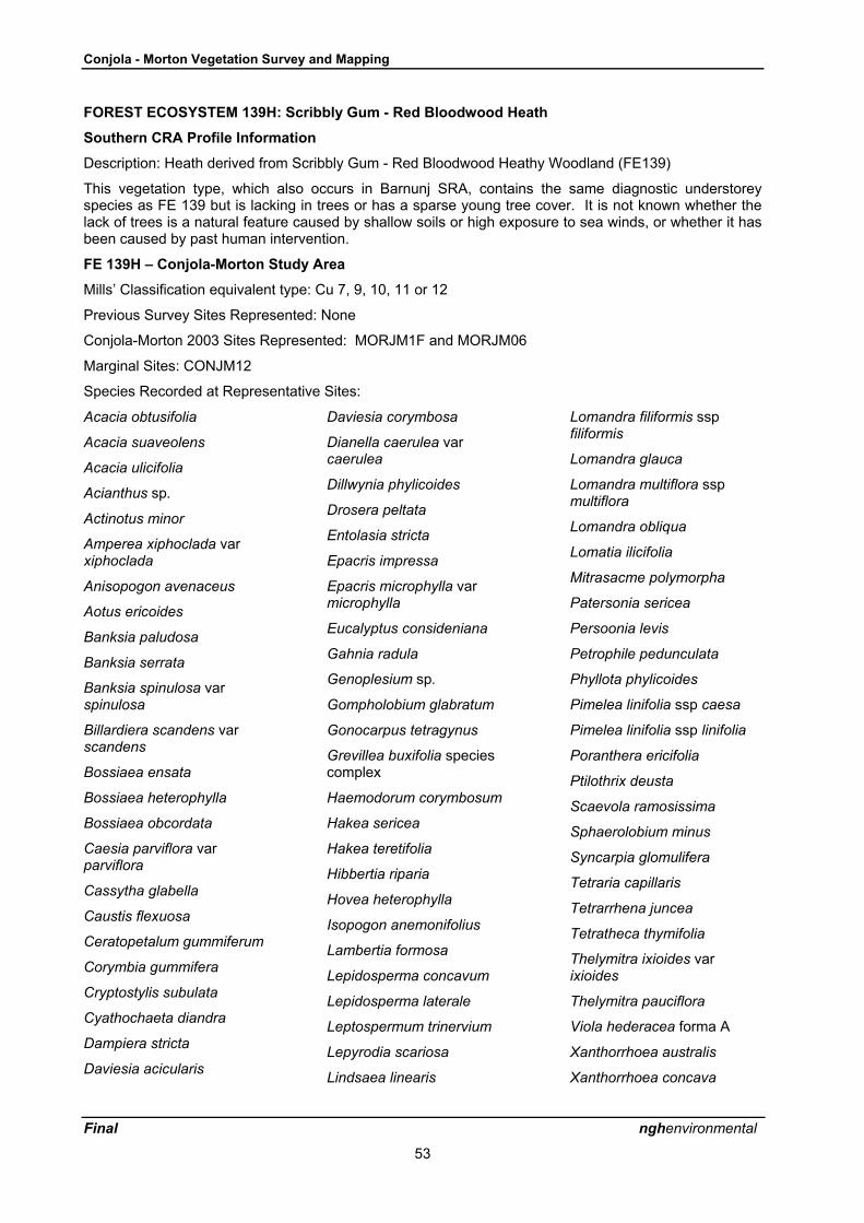
Conjola - Morton Vegetation Survey and Mapping
Final nghenvironmental
53
FOREST ECOSYSTEM 139H: Scribbly Gum - Red Bloodwood Heath
Southern CRA Profile Information
Description: Heath derived from Scribbly Gum - Red Bloodwood Heathy Woodland (FE139)
This vegetation type, which also occurs in Barnunj SRA, contains the same diagnostic understoreyspecies as FE 139 but is lacking in trees or has a sparse young tree cover. It is not known whether thelack of trees is a natural feature caused by shallow soils or high exposure to sea winds, or whether it hasbeen caused by past human intervention.
FE 139H � Conjola-Morton Study Area
Mills� Classification equivalent type: Cu 7, 9, 10, 11 or 12
Previous Survey Sites Represented: None
Conjola-Morton 2003 Sites Represented: MORJM1F and MORJM06
Marginal Sites: CONJM12
Species Recorded at Representative Sites:
Acacia obtusifolia
Acacia suaveolens
Acacia ulicifolia
Acianthus sp.
Actinotus minor
Amperea xiphoclada varxiphoclada
Anisopogon avenaceus
Aotus ericoides
Banksia paludosa
Banksia serrata
Banksia spinulosa varspinulosa
Billardiera scandens varscandens
Bossiaea ensata
Bossiaea heterophylla
Bossiaea obcordata
Caesia parviflora varparviflora
Cassytha glabella
Caustis flexuosa
Ceratopetalum gummiferum
Corymbia gummifera
Cryptostylis subulata
Cyathochaeta diandra
Dampiera stricta
Daviesia acicularis
Daviesia corymbosa
Dianella caerulea varcaerulea
Dillwynia phylicoides
Drosera peltata
Entolasia stricta
Epacris impressa
Epacris microphylla varmicrophylla
Eucalyptus consideniana
Gahnia radula
Genoplesium sp.
Gompholobium glabratum
Gonocarpus tetragynus
Grevillea buxifolia speciescomplex
Haemodorum corymbosum
Hakea sericea
Hakea teretifolia
Hibbertia riparia
Hovea heterophylla
Isopogon anemonifolius
Lambertia formosa
Lepidosperma concavum
Lepidosperma laterale
Leptospermum trinervium
Lepyrodia scariosa
Lindsaea linearis
Lomandra filiformis sspfiliformis
Lomandra glauca
Lomandra multiflora sspmultiflora
Lomandra obliqua
Lomatia ilicifolia
Mitrasacme polymorpha
Patersonia sericea
Persoonia levis
Petrophile pedunculata
Phyllota phylicoides
Pimelea linifolia ssp caesa
Pimelea linifolia ssp linifolia
Poranthera ericifolia
Ptilothrix deusta
Scaevola ramosissima
Sphaerolobium minus
Syncarpia glomulifera
Tetraria capillaris
Tetrarrhena juncea
Tetratheca thymifolia
Thelymitra ixioides varixioides
Thelymitra pauciflora
Viola hederacea forma A
Xanthorrhoea australis
Xanthorrhoea concava

Conjola - Morton Vegetation Survey and Mapping
Final nghenvironmental
54
Xanthosia tridentata
Dominant species: Essentially the same as FE139 from which it is derived, with the canopy dominants,scribbly gum (E. sclerophylla) and red bloodwood either very sparse or absent. The shrub layer containstypical �Sydney sandstone� elements such as Lambertia formosa, Hakea dactyloides, Persoonia mollisssp caleyi, Petrophile pedunculata, Isopogon anemonifolius and Kunzea capitata. The groundcoverconsists of mixed sedges(including Lepyrodia scariosa and Xyris spp.), grasses (Entolasia stricta,Austrostipa pubescens, Anisopogon avenaceus), the fern Lindsaea linearis and subshrubs such asGompholobium pinnatum, Boronia polygalifolia and Xanthosia tridentata. The small flannel-flower,Actinotus minor scrambles through the groundcover.
Threatened Species: Grevillea buxifolia (species complex) was recorded at MORJM01F, a rare speciesawaiting classification.
Other Species of Conservation Significance: None.
Relationship to other Forest Ecosystems: Essentially a treeless variant of FE139 occurring in Morton(East) where it is surrounded by FE2, FE3 or FE139.
Conservation Significance: Mapped only in small patches in Morton (East) but not Conjola althoughFE139 with a sparse tree cover there is similar. Also mapped in Meroo National Park in 2001. Like therelated type FE 139, this community is of higher conservation significance than previously thought. Manyof the component species, such as Eucalyptus sclerophylla, Lambertia formosa, Persoonia mollis sspcaleyi, Petrophile pedunculata, Kunzea capitata, Epacris pulchella and Actinotus minor are also at or veryclose to their southern limit which is possibly in or near Barnunj SRA and Meroo National Park, south ofUlladulla.
Threats: Fire (see below)
Impacts of Fire Regimes: This vegetation type requires careful fire management; having a predominantlyheathy shrub understorey with a high proportion of highly flamable sclerophyllous shrubs, and often adense sedge layer as well, it is highly flammable. Such heathy vegetation is adapted to relativelyfrequent fire, but too short an interval between fires may eliminate obligate seeders from the species mix.

Conjola - Morton Vegetation Survey and Mapping
Final nghenvironmental
55
NON-FOREST ECOSYSTEM 140: Wet Heath
Southern CRA Profile Information
Description: Northern Coastal Tall Wet Heath
Northern Coastal Tall Wet Heath is a wet sedge shrubland up to 3 metres high comprising an open coverof tall shrubs Hakea teretifolia, Allocasuarina distyla, Leptospermum trinervium, L. squarrosum andXanthorrhea resinifera. It has a diverse intermediate shrub layer of smaller shrubs including Sprengeliaincarnata, Banksia paludosa, Dillwynia floribunda ssp floribunda, Bauera rubioides, Sprengelia incarnata,Epacris obtusifolia, E. microphylla ssp microphylla, Darwinia leptantha, as well as sedges Lepidospermafiliformis and Restio fastigiatus, and herbs Actinotis minor.
Diagnostic Plant SpeciesSpecies Group
coverGroup
freqNon-group
coverNon-group
freqFidelity class
Banksia ericifolia var ericifolia 3 1.000 2 0.012 positive
Darwinia leptantha 2 0.938 2 0.002 positive
Epacris microphylla var microphylla 2 0.938 2 0.021 positive
Lepidosperma filiforme 4 0.813 2 0.007 positive
Leptospermum squarrosum 2 0.813 2 0.006 positive
Restio fastigiatus 4 0.813 3 0.001 positive
Dillwynia floribunda var floribunda 2 0.750 2 0.003 positive
Epacris obtusifolia 3 0.750 2 0.004 positive
Sprengelia incarnata 4 0.750 2 0.004 positive
Hakea teretifolia 2 0.688 2 0.006 positive
Allocasuarina distyla 3 0.625 3 0.002 positive
Xanthorrhoea resinifera 3 0.625 2 0.012 positive
Banksia paludosa 2 0.563 2 0.011 positive
Bauera rubioides 2 0.563 2 0.003 positive
Leptocarpus tenax 3 0.563 3 0.006 positive
Petrophile sessilis 2 0.500 2 0.006 positive
Zieria laevigata 1 0.188 0 0.000 positive
Styphelia tubiflora 1 0.063 0 0.000 positive
Actinotus minor 1 0.813 2 0.006 uninformative
Isopogon anemonifolius 1 0.500 1 0.012 uninformative
Boronia barkeriana 2 0.438 2 0.002 uninformative
Leucopogon esquamatus 1 0.438 2 0.003 uninformative
Baeckea imbricata 3 0.375 3 0.004 uninformative
Corymbia gummifera 1 0.375 3 0.050 uninformative
Empodisma minus 3 0.375 3 0.018 uninformative
Drosera spatulata 1 0.313 1 0.003 uninformative
Lepyrodia scariosa 2 0.313 2 0.008 uninformative
Melaleuca capitata 2 0.313 2 0.001 uninformative
Dampiera stricta 1 0.250 1 0.012 uninformative
Dillwynia ramosissima 1 0.250 1 0.002 uninformative
Lambertia formosa 1 0.250 2 0.010 uninformative
Persoonia mollis ssp caleyi 1 0.250 2 0.008 uninformative

Conjola - Morton Vegetation Survey and Mapping
Final nghenvironmental
56
Species Groupcover
Groupfreq
Non-groupcover
Non-groupfreq
Fidelity class
Restio complanatus 3 0.250 2 0.003 uninformative
Banksia serrata 2 0.188 3 0.017 uninformative
Bossiaea ensata 1 0.188 2 0.007 uninformative
Cassytha glabella forma glabella 1 0.188 1 0.024 uninformative
Caustis flexuosa 2 0.188 2 0.013 uninformative
Chorizandra sphaerocephala 2 0.188 3 0.003 uninformative
Hibbertia riparia 1 0.188 1 0.012 uninformative
Lepidosperma concavum 2 0.188 3 0.010 uninformative
Leptospermum juniperinum 2 0.188 2 0.014 uninformative
Leucopogon rodwayi 1 0.188 1 0.001 uninformative
Lomandra glauca 1 0.188 2 0.052 uninformative
Stylidium lineare 1 0.188 1 0.004 uninformative
Eucalyptus obstans 2 0.125 2 0.002 uninformative
Extant area (ha): 6138
Pre-1750 area (ha): 6200
Geographic range: South Coast
How much conserved in reserves (ha): 333
Vulnerability: 3C/D
Reliability: 2

Conjola - Morton Vegetation Survey and Mapping
Final nghenvironmental
57
FE 140 � Conjola-Morton Study Area
Mills� Classification equivalent type: None
Previous Survey Sites Represented: None
Conjola-Morton 2003 Sites Represented : CONJM11
Marginal Sites : None
Species Recorded at Representative Sites:
Acacia elongata
Acacia longifolia ssplongifolia
Allocasuarina sp.
Bauera rubioides
Burchardia umbellata
Cassytha glabella
Comesperma retusum
Cryptandra ericoides
Eleocharis sphacelata
Empodisma minus
Gonocarpus micranthus sspmicranthus
Goodenia paniculata
Hakea teretifolia ssp hirsuta
Hibbertia riparia
Hydrocotyle peduncularis
Lepidospermaquadrangulatum
Leptocarpus tenax
Melaleuca thymifolia
Opercularia varia
Ptilothrix deusta
Schoenus brevifolius
Selaginella uliginosa
Sphaerolobium vimineum
Viola sieberiana
Xanthorrhoea resinifera
Xyris operculata
Dominant species: The Southern CRA diagnostic species list for this type does not fit well with the wetheath observed in the study area at sampling sites where it is dominated by sedges and the small grasstree Xanthorrhoea resinifera, with scattered shrubs including Acacia elongata, Acacia longifolia,Comesperma retusum, Bauera rubioides and Sphaerolobium vimineum. However, with increasing timesince fire this community is likely to become more shrub-dominated.
Threatened Species: None.
Other Species of Conservation Significance: None.
Relationship to other Forest Ecosystems: Often surrounded by FE139 which is restricted to drier areas.
Conservation Significance: Wet heath occurs in drainage lines within areas of Scribbly Gum-RedBloodwood Heathy Woodland (FE139) in Conjola NP, but was not seen in Morton (East). It occurs innaturally small and fragmented stands on the coast because of its restriction to a restricted ecologicalniche, poorly drained sites on shallow soils of low fertility. On the Morton plateau to the west it is likely tobe more common. This community is probably well reserved because it occurs primarily on poor soils inareas which have not historically been of much value for agriculture or residential development.
Threats: Fire (see below).
Impacts of Fire Regimes: In general this community would be highly flammable despite the usually highsoil moisture levels, because of a continuous distribution of fine fuels between the ground and the shrublayer. Wet heaths in the Jervis Bay area often seem to include a high proportion of shrubs in the familyMyrtaceae such as Leptospermum polygalifolium, Callistemon spp and Melaleuca spp. Having volatileoils in the leaves, these would tend to increase the flammability of this community. Too frequent firewould be likely to eliminate shrubs and make the community more sedge-dominated, since sedges arelikely to resprout indefinitely and would be able to produce seed in the first season after fire.
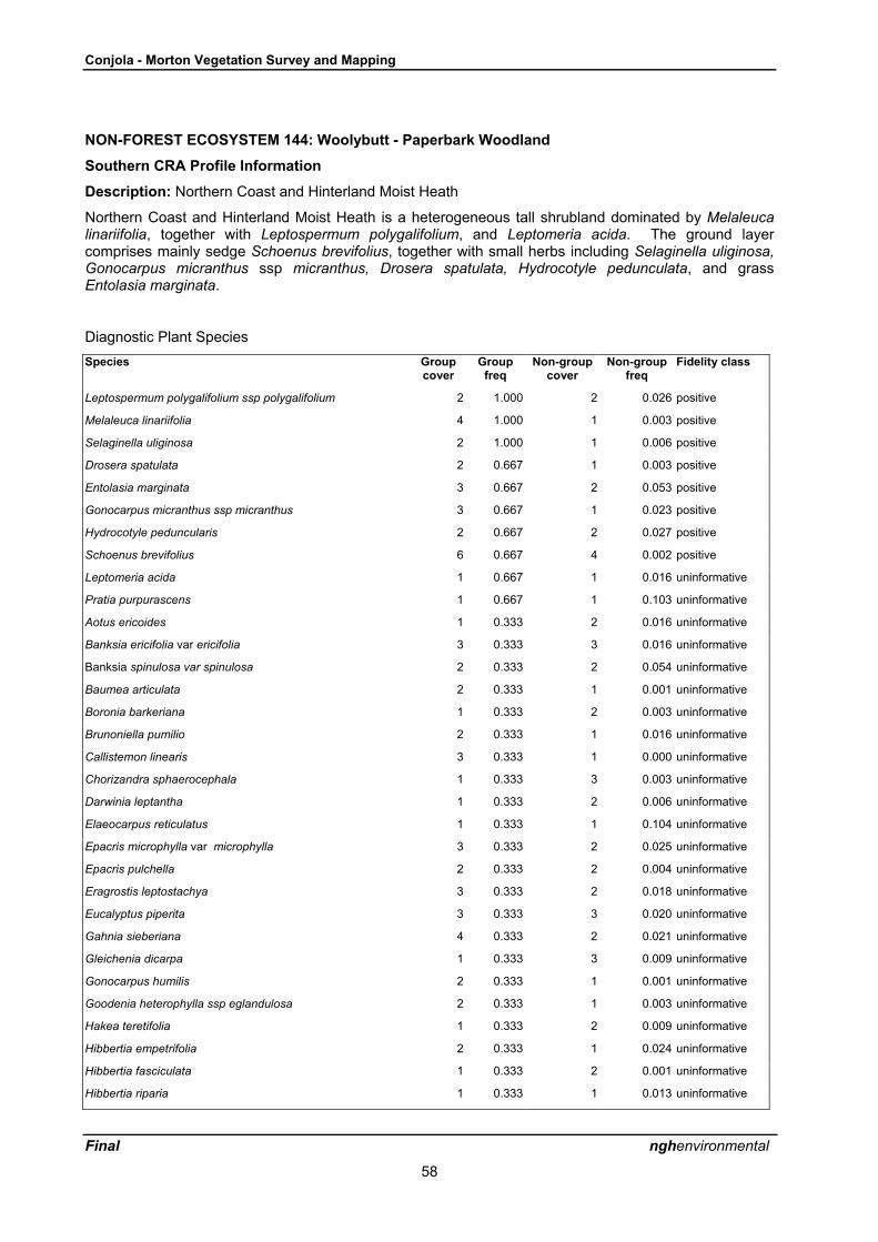
Conjola - Morton Vegetation Survey and Mapping
Final nghenvironmental
58
NON-FOREST ECOSYSTEM 144: Woolybutt - Paperbark Woodland
Southern CRA Profile Information
Description: Northern Coast and Hinterland Moist Heath
Northern Coast and Hinterland Moist Heath is a heterogeneous tall shrubland dominated by Melaleucalinariifolia, together with Leptospermum polygalifolium, and Leptomeria acida. The ground layercomprises mainly sedge Schoenus brevifolius, together with small herbs including Selaginella uliginosa,Gonocarpus micranthus ssp micranthus, Drosera spatulata, Hydrocotyle pedunculata, and grassEntolasia marginata.
Diagnostic Plant SpeciesSpecies Group
coverGroup
freqNon-group
coverNon-group
freqFidelity class
Leptospermum polygalifolium ssp polygalifolium 2 1.000 2 0.026 positive
Melaleuca linariifolia 4 1.000 1 0.003 positive
Selaginella uliginosa 2 1.000 1 0.006 positive
Drosera spatulata 2 0.667 1 0.003 positive
Entolasia marginata 3 0.667 2 0.053 positive
Gonocarpus micranthus ssp micranthus 3 0.667 1 0.023 positive
Hydrocotyle peduncularis 2 0.667 2 0.027 positive
Schoenus brevifolius 6 0.667 4 0.002 positive
Leptomeria acida 1 0.667 1 0.016 uninformative
Pratia purpurascens 1 0.667 1 0.103 uninformative
Aotus ericoides 1 0.333 2 0.016 uninformative
Banksia ericifolia var ericifolia 3 0.333 3 0.016 uninformative
Banksia spinulosa var spinulosa 2 0.333 2 0.054 uninformative
Baumea articulata 2 0.333 1 0.001 uninformative
Boronia barkeriana 1 0.333 2 0.003 uninformative
Brunoniella pumilio 2 0.333 1 0.016 uninformative
Callistemon linearis 3 0.333 1 0.000 uninformative
Chorizandra sphaerocephala 1 0.333 3 0.003 uninformative
Darwinia leptantha 1 0.333 2 0.006 uninformative
Elaeocarpus reticulatus 1 0.333 1 0.104 uninformative
Epacris microphylla var microphylla 3 0.333 2 0.025 uninformative
Epacris pulchella 2 0.333 2 0.004 uninformative
Eragrostis leptostachya 3 0.333 2 0.018 uninformative
Eucalyptus piperita 3 0.333 3 0.020 uninformative
Gahnia sieberiana 4 0.333 2 0.021 uninformative
Gleichenia dicarpa 1 0.333 3 0.009 uninformative
Gonocarpus humilis 2 0.333 1 0.001 uninformative
Goodenia heterophylla ssp eglandulosa 2 0.333 1 0.003 uninformative
Hakea teretifolia 1 0.333 2 0.009 uninformative
Hibbertia empetrifolia 2 0.333 1 0.024 uninformative
Hibbertia fasciculata 1 0.333 2 0.001 uninformative
Hibbertia riparia 1 0.333 1 0.013 uninformative

Conjola - Morton Vegetation Survey and Mapping
Final nghenvironmental
59
Species Groupcover
Groupfreq
Non-groupcover
Non-groupfreq
Fidelity class
Hypericum gramineum 1 0.333 1 0.172 uninformative
Lagenifera stipitata 2 0.333 1 0.167 uninformative
Lepidosperma limicola 2 0.333 2 0.001 uninformative
Leptospermum continentale 1 0.333 2 0.012 uninformative
Leptocarpus tenax 3 0.333 3 0.008 uninformative
Lepyrodia scariosa 3 0.333 2 0.009 uninformative
Leucopogon ericoides 1 0.333 1 0.016 uninformative
Leucopogon lanceolatus var lanceolatus 1 0.333 1 0.170 uninformative
Lindsaea dimorpha 1 0.333 2 0.002 uninformative
Lindsaea microphylla 1 0.333 1 0.021 uninformative
Lomatia ilicifolia 1 0.333 1 0.044 uninformative
Melaleuca hypericifolia 1 0.333 2 0.002 uninformative
Mitrasacme polymorpha 2 0.333 1 0.007 uninformative
Opercularia aspera 1 0.333 1 0.037 uninformative
Patersonia fragilis 1 0.333 2 0.003 uninformative
Extant area (ha): 1041
Pre-1750 area (ha): 1041
Geographic range: South Coast
How much conserved in reserves (ha): 607
Vulnerability: 5
Reliability: 2

Conjola - Morton Vegetation Survey and Mapping
Final nghenvironmental
60
FE 144 � Conjola-Morton Study Area
Mills� Classification equivalent type: Cu8
Previous Survey Sites Represented: None
Conjola-Morton 2003 Sites Represented : CONJM02
Marginal Sites : None
Species Recorded at Representative Sites:
Acacia longifolia sspsophorae
Baumea juncea
Cassytha glabella
Centella cordifolia
Cryptostylis subulata
Dianella caerulea
Entolasia stricta
Eucalyptus botryoides
Gahnia clarkei
Gonocarpus micranthus
Gonocarpus tetragynus
Goodenia heterophylla sspeglandulosa
Goodenia ovata
Hydrocotyle peduncularis
Isolepis cernua
Leptospermum polygalifoliumssp polygalifolium
Lobelia alata
Melaleuca linariifolia
Opercularia varia
Pimelea linifolia ssp linifolia
Schoenus brevifolius
Selaginella uliginosa
Villarsia exaltata
Viminaria juncea
Dominant species: Generally Melaleuca linariifolia but occasionally in the Jervis Bay hinterland north ofConjola NP M. styphelioides, M. biconvexa or M. decora occur. An open canopy of eucalypts mayinclude E. longifolia or E. botryoides. There may be a patchy shrub layer with Leptospermumpolygalifolium or Callistemon linearis. The groundcover is generally sparse and includes herbs such asVillarsia exaltata and Gonocarpus micranthus, coral fern (Gleichenia dicarpa) and sedges such asBaumea juncea, Schoenus brevifolius and Leptocarpus tenax.
Threatened Species: None recorded in Conjola NP, although the Vulnerable species (Schedule 2 of TSCAct) Melaleuca biconvexa occurs in the Jervis Bay and St Georges Basin hinterland.
Other Species of Conservation Significance: None.
Relationship to other Forest Ecosystems: Lowland Red Bloodwood-Turpentine Dry Shrub Forest (FE2) orBlackbutt-Banksia Forest (FE29) often surround the wetter areas in which FE144 occurs.
Conservation Significance: This community is very limited in Conjola NP, and was not seen in Morton(East). FE144 is more common further north in the Jervis Bay hinterland but many of its occurrences areon private property, where it has been cleared or had the understorey removed for grazing or residentialsubdivision. Some substantial areas are protected in Jervis Bay National Park and Woollamia NatureReserve.
Threats: Clearing and grazing in non-reserved areas. Fire (see below).
Impacts of Fire Regimes: Paperbark Woodland is a highly flammable community, but is well adapted torecovery from fire. The various Melaleuca species recover from epicormic shoots and root suckers andsedges re-sprout readily. Fire-free intervals should be kept as long as possible to prevent thedevelopment of dense thickets of small diameter melaleuca root suckers and shrubs.

Conjola - Morton Vegetation Survey and Mapping
Final nghenvironmental
61
FOREST ECOSYSTEM 175: Coastal Lowlands Swamp Mahogany Forest
Southern CRA Profile Information
Description: Northern Coastal Lowlands Swamp Forest - E. robusta
Northern Coastal Lowlands Swamp is a forest up to 25 metres high, dominated by Eucalyptus robusta,as well as a variety of other eucalypts fringing the swamp forest. The understorey comprises amoderate to dense cover of Melaleuca species, including Melaleuca ericifolia, M. linariifolia, M.squarrosa, together a range of Leptospermum spp. The ground cover can be a dense mixed sward ofgrasses and sword grasses, with a fine scattering of herbs and procumbent shrubs.
Extant area (ha): 459
Pre-1750 area (ha): 465
Geographic range: South Coast subregion
How much conserved in reserves (ha): 65
Vulnerability: 1C/W/U
Reliability: 2
FE 175 � Conjola-Morton Study Area
Mills� Classification equivalent type: None
Previous Survey Sites Represented: KMCU19
Conjola-Morton 2003 Sites Represented : None
Marginal Sites : None
Species Recorded at Representative Sites: None recorded.
Dominant species: Swamp mahogany (E. robusta) forms an open canopy above smaller trees with atolerance for waterlogged soils such as Melaleuca linariifolia, M. ericifolia, M. squarrosa and Acacialongifolia. There may be a dense tall groundcover of the large sedge Gahnia clarkei, or of other sedgesincluding Baloskion tetraphyllum ssp meiostachyum, Schoenus brevifolius, Leptocarpus tenax andBaumea juncea.
Threatened Species: None.
Other Species of Conservation Significance: None.
Relationship to other Forest Ecosystems: Occurs in wet sites within taller forest such as FE2 or FE29.Intergrades with FE29 in Narrawallee Creek Nature Reserve.
Conservation Significance: This community is very limited in Conjola NP, and does not occur in Morton(East). FE175 is listed as an Endangered Ecological Community within the Sydney Basin Bioregion,which includes the Ulladulla area. Its occurrences have probably not been very accurately mappedpreviously. It had been overlooked before being newly mapped in Conjola NP and Narrawallee CreekNature Reserve.
Threats: Clearing and logging in un-reserved areas.
Impacts of Fire Regimes: Highly flammable community because of the density of the understorey,although it may only burn in drought conditions as occurred in 2001-02 It is well adapted to recoveryfrom fire. Swamp mahogany and the various Melaleuca species recover from epicormic shoots and rootsuckers and sedges resprout readily. However, to avoid development of dense thickets of smalldiameter melaleuca stems, fires should be kept as infrequent as possible.

Conjola - Morton Vegetation Survey and Mapping
Final nghenvironmental
62
FOREST ECOSYSTEM 176: Morton Plateau Mallee Low Forest
Southern CRA Profile Information
Description: Morton Plateau Mallee Swamp Low Forest
Morton Plateau Mallee Swamp Low Forest is a low forest dominated by a variety of mallees andeucalypts adapted to low fertility skeletal soils. The understorey comprises a mixture of heaths, sedgesand grasses.
Extant area (ha): 40094
Pre-1750 area (ha): 40114
Geographic range: South Coast Subregion
How much conserved in reserves (ha): 35816
Vulnerability: 5
Reliability: 3
FE 176 � Conjola-Morton Study Area
Mills� Classification equivalent type: Areas do not overlap
Previous Survey Sites Represented: None
Conjola-Morton 2003 Sites Represented : MORJM08 (rare plant site only)
Marginal Sites : None
Species Recorded at Representative Sites: Rulingia hermaniifolia(ROTAP species)
Dominant species: Not listed by Thomas, Gellie and Harrison (2000).
Threatened Species: Rulingia hermaniifolia (ROTAP species) recorded at site MORJM08.
Other Species of Conservation Significance: None.
Relationship to other Forest Ecosystems: Adjoins FE3 or FE20, although separated by the presence ofhigh sandstone cliffs.
Conservation Significance: Limited occurrences within the study area in Morton (East), although it is verycommon within the greater Morton National Park. Not present in Conjola NP. It occurs on land which isuseless for agriculture or forestry and is generally well reserved.
Threats: Fire (see below).
Impacts of Fire Regimes: A highly flammable vegetation type, but one which is well-adapted to frequentfire. All the trees and many of the shrubs are re-sprouters, and the groundcover layer contains manysedges and grasses which re-sprout from the roots. Some of the component species seldom flowerexcept after fire, such as the sedge Cyathochaeta diandra. Fire intervals of 7-30 years arerecommended for both heaths and for shrubby dry sclerophyll forests (NPWS 2003), however, a mosaicof fire frequencies within this range is desirable to prevent species loss.

Conjola - Morton Vegetation Survey and Mapping
Final nghenvironmental
63
NON-FOREST ECOSYSTEM 187: Coastal Headland Heath
Southern CRA Profile Information
Description: Coastal Headland Heathlands
Coastal Headland Heathlands are tall shrublands comprising a dominant shrub layer of Allocasuarinadistyla, Calytrix tetragona, Banksia ericifolia var ericifolia, and Leptospermum epacridoideum. Theground cover may comprise a sparse to open cover of sedges Caustis flexuosa and Restio fastigiatus(Skelton and Adam 1994).
Coastal Headland Heathlands occur on rocky headlands between Narooma and Jervis Bay.
Extant area (ha): 446
Pre-1750 area (ha): 940
Geographic range: South Coast subregion
How much conserved in reserves (ha): 109
Vulnerability: 2C/U
Reliability: 1
FE 187 � Conjola-Morton Study Area
Mills� Classification equivalent type: None
Previous Survey Sites Represented: None
Conjola-Morton 2003 Sites Represented : None
Marginal Sites : None
Species Recorded at Representative Sites: None recorded
Dominant species: Not visited within the study area so it is not known how closely it fits the descriptionabove. The dominant species recorded in headland heath in Barnunj SRA were found to differ from thoselisted for this type, suggesting that there is considerable variability within areas which are structurallycoastal heath.
Threatened Species: None.
Other Species of Conservation Significance: None.
Relationship to other Forest Ecosystems: Usually borders cliffs and rock outcrops. Adjoins FE28 oninland side in the one location in Conjola where mapped.
Conservation Significance: Headland heath is mapped at one location on the headland at the northernend of Cudmirrah Beach, mostly outside the park boundary. Common around Jervis Bay, but is veryuncommon south of this point. Large areas of headland heaths do not occur again on the South Coastuntil Green Cape and Nadgee Nature Reserve close to the Victorian border. The species composition ofthese more southerly heaths is rather different. The stand on Cudmirrah Headland may therefore be ofconservation significance as a southern outlier of the Jervis Bay heaths, assuming that they are in factheath and not Headland Scrub. This was not checked.
Threats: Clearing and urban development in non-reserved areas.
Impacts of Fire Regimes: Headland heathlands may suffer a loss of biodiversity in the long term throughinappropriate fire regimes either through prolonged absence of fire or too frequent fire.

Conjola - Morton Vegetation Survey and Mapping
Final nghenvironmental
64
NON-FOREST ECOSYSTEM 190: Rock
Southern CRA Profile Information
Description: Rock
Rock is identified in the vegetation map as bare rocky outcrops mapped from aerial photo-interpretationwhere there is obvious bare rock in patch sizes greater than 2 hectares.
Extant area (ha): 2612
Pre-1750 area (ha): 2631
Geographic range: All subregions
How much conserved in reserves (ha): 21 in Northern subregion and 1185 in South Coast
Vulnerability: 5
Reliability: 2
FE 190 � Conjola-Morton Study Area
Mills� Classification equivalent type: None
Previous Survey Sites Represented: None
Conjola-Morton 2003 Sites Represented : None
Marginal Sites : None
Species Recorded at Representative Sites: None recorded.
Dominant species: Contains little or no vegetation, however, can be a habitat for rare flora (see below).
Threatened Species: None.
Other Species of Conservation Significance: None.
Relationship to other Forest Ecosystems: Fringing vegetation is usually wet eucalypt forests or ecotonalgully rainforest (FE20).
Conservation Significance: Represented only in the study area in Morton (East) but would be moreextensive in the greater Morton NP. May be of special conservation significance for vegetation aspotential habitat for the ROTAP shrub Rulingia hermaniifolia and other ROTAP or TSC listed specieswhich prefer skeletal soils on sandstone such as Eucalyptus sturgessiana, E. langleyi and Pultenaeavillifera, all of which occur in the greater Morton NP. Also an important scenic feature of the coastalescarpment environment and important as fauna habitat.
Threats: None apparent within reserved areas.

Conjola - Morton Vegetation Survey and Mapping
Final nghenvironmental
65
APPENDIX 5: Fire Response MechanismsMature plants subject to 100% leaf scorch from fire die (therefore must return via seedlings)and:
Category 1 seeds are canopy-stored (eg Banksias)
Category 2 seeds are soil-stored (eg Acacia)
Category 3 no seeds remain on site after fire and must be imported
Category 8 seed status unknown
Mature plants subject to 100% canopy scorch survive fire and:
Category 4 resprout from root suckers or rhizomes
Category 5 resprout from basal stem buds (eg lignotubers)
Category 6 resprout from epicormic shoots
Category 7 resprout from terminal aerial buds (eg Xanthorrhoea)
Category 9 resprout from bulbs, corms or tubers
Category 10 resprout mechanism unknown.

Conjola - Morton Vegetation Survey and Mapping
Final nghenvironmental
66
APPENDIX 6: GIS Details
GIS LAYERS
The new GIS layers which are supplied on the data CD accompanying this report are briefly describedbelow. All layers are in ArcView 3.x shapefile format. Additional ArcView legend files are also includedwhere relevant and wherever possible have the same file name as the shapefile to which they apply. Thelegends will therefore load automatically on loading each shapefile into ArcView.
The material in this appendix is also included on the data CD to serve as metadata and a guide to usingthe GIS information.
Study Area
Conjola_morton_narrawallee_study_area.shp � reserve boundaries for the study area extracted fromthe current NPWS_estate layer
CRA_API_clipping_bdry � boundary used to clip the API layer so as to avoid splitting polygons alongthe coastline
Study_area_ext_bdry.shp � boundary of re-mapping which includes internal corridors and inholdingsand includes all areas within the above clipping boundary
Sheet_layout.shp � map sheets used for the hard copy maps in the report
Background Layers
The following are included:
100m_contours.shp � generated from 25m DEM
10m_contours.shp � generated from 25m DEM
fire_history.shp � records of fire history for each floristic site
note: individual shapefiles for wildfires and hazard reduction for relevant years have been extracted foruse in the analysis and are included in the sub-directory �fire_history�
Drainage - several drainage layers are included in the sub-directory �drainage� which were used in themapping. NPWS coastline and drainage layers were edited to avoid overlap with new drainage mappingfrom API which was part of the vegetation layers.
Powerlines.shp � digitised from orthophotos
Recreation_sites.shp � extracted from NPWS recreation sites layer for the South Coast Region (fromearlier work by Phil Kendall/NGH Environmental)
Floristics Site Data
Access database � set of Microsoft Access 97 database files which run under the NPWS site floristicsdatabase developed by Michael Bedward and Murray Ellis. The files are arranged in the appropriatedirectories but need to be linked to the main frontend file (survey.mde) when it is first run. The data iscontained in the backend file survey.be. All of the following data are derived from the access database.Note: Spreadsheet versions of the access tables are contained in the spreadsheets subdirectory. For fulldetails on the attribute information contained in the above database files, see the lookup tables in theNPWS access database.
Con_mor_nar_sites_2003.shp � full floristic survey sites which were recorded on field data sheets andentered in the Access sites database then transferred to ArcView. The attribute table includes locationalinformation as well as the forest ecosystem types from the original modelling and the validation and re-mapping work.

Conjola - Morton Vegetation Survey and Mapping
Final nghenvironmental
67
Floristics_data.dbf � a database file which can be linked to the above survey sites attribute table so asto obtain species listings for each site. The data was converted from the floristics database table in theAccess sites database. (note the site number needs to be used as the common field for linking thetables).
Master_species_list.dbf � database file extracted from NPWS access database � the species namesand other selected attributes have been copied across to the floristics_data.dbf table.
sites_flora_(sthn_cra)z56.shp � extracted from the NPWS floristics sites database for the study area
FireMon_survdat_con_mor_nar.xls � fire response monitoring site data in an excel spreadsheetdeveloped by Nic Gellie for NPWS.
Some additional spreadsheets are included on the CD which were created during the project along withthe blank NPWS proforma data sheets.
Threatened_flora_new_sites.shp � new sites found during the field work or reported by NPWS in 2003-3004.
Vegetation
fe_clipped_z56.shp � derived from the original FE modelled layer by Thomas, Gellie and Harrison(2000) � the grid model was converted to a shapefile and clipped using the study area boundary
The legend fe_clipped_z56.avl applies to the above layer.
api_veg_080999_z56_clipped.shp - study area portion clipped from the Southern CRA API floristicslayer, with modifications by Nic Gellie (EcoGIS)
fe_ext_ecogis56_cncm.shp- layer supplied by NPWS which contains some additional attributeinformation to the above layer
Morton_conjola_API.shp
Updated API data � Southern CRA API mapping adapted with additional coding and new API work, withforest ecosystems coded according to the modified SCRA classification. Legend has the same filename.
Morton_conjola_FE.shp
Versions of above with boundaries between polygons with the same fe_new code dissolved so that theresulting map is essentially a new forest ecosystems map. Legend has the same filename.
The legend file all_fe_new_types.avl contains all forest ecosystem types found in the study area andcan be used with any of the re-mapped API layers.
POLYGON ATTRIBUTE TABLES
Vegetation Maps
The CRA API layers used for this project are those which have been adapted by Nic Gellie(EcoGIS).While there are no specific changes to the polygon boundaries or coding within the Conjola-Morton_Narrawallee study area, the additional fields in the polygon attribute tables have been utilised forthe purposes of recording changes during the validation and re-mapping work.
The attribute codes used in the revised API map Morton_conjola_API.shp which are relevant to the re-mapping, are explained below.
Area_ha recalculated areas in hectares for all polygons.
API_code original code used in CRA API layers
FE1, FE_type, FE2, FE_type2 � fe codes and labels corresponding to FE types assigned to API codesduring the southern CRA. Where a combined FE type is suggested these have been split into FE1 andFE2.
code_status these are all �changed� since FE codes have been interpreted from the API code

Conjola - Morton Vegetation Survey and Mapping
Final nghenvironmental
68
polygon_status reflects updates made during the re-mapping
FE_code Southern CRA forest ecosystem type assigned on the basis of API code to FE codetranslation tables prior to manual adjustment
notes rules and observations relating to the assignment of FE codes to API
field_site full floristics site(s) present in the polygon
FE_new the finally assigned code which is either the FE_code type unchanged, or a new codeassigned on the basis of field or API work
FE_label the description used in this report.
Site Data
In the floristic sites data arcview layer con_mor_nar_sites_2003.shp the following attributes have beenused for forest ecosystem types:
FE_old � the original modelled type
FE_new � the field assigned type
Mapped - the type used for the corresponding polygon in the new mapping
Multiple FE types separated by a �+� indicates these types are present in the vicinity
Multiple FE types separated by a �/� indicates the types intergrade and may show characteristics of bothtypes.
Sites with intergrading types are not considered representative of a single forest ecosystem and areconsidered as marginal sites in the Forest Ecosystem Profiles (Appendix 4).

Conjola - Morton Vegetation Survey and Mapping
Final nghenvironmental
69
APPENDIX 7: Maps
MAPS