Embed Size (px)
Citation preview
Ganga River Basin Planning Assessment Report
Appendices
FinalNovember 2018
Strategic Basin Planning for Ganga River Basin in India

TitleGanga River Basin Planning Assessment (Report: appendices)
ClientWorld Bank andGovernment of India
Project1220123-002
Reference1220123-002-ZWS-0004
Pages
Ganga River Basin Planning Assessment (Report: appendices)
KeywordsIndia, Ganga, Model, Information System, Hydrology, Geohydrology, Water quality, Ecology,Water allocation, Integrated Water Resources Management
SummaryThe World Bank has assigned Deltares and its partners AECOM India and FutureWater to carryout the project “Analytical Work and Technical Assistance to support Strategic Basin Planningfor Ganga River Basin in India” in cooperation with the Government of India. The objectives ofthe project are 1) to strengthen the capacity with respect to strategic basin planning, 2) todevelop a set of scenarios for the development of the Ganga basin, 3) to build a strong andaccessible knowledge base and 4) to establish a multi-stakeholder engagement process tosupport strategic basin planning. This report contains:
• The assessment of scenario and strategy modelling;• The environmental flow assessment;• The surface water – groundwater interaction assessment.
This report contributes to project milestone 5 of the project.This volume contains the appendices to the report.
ReferenceBons, C.A. (Ed.), 2018. Ganga River Basin Planning Assessment Report. Main volume andAppendices. Deltares with AECOM and FutureWater for the World Bank and the Governmentof India, Report 1220123-002-ZWS-0004.
StateFinal

1220123-002-ZWS-0004, November 2018, finalAppendices
Ganga River Basin Planning Assessment Report i
Contents
Abbreviations and Acronyms iii
Preamble 1
A Indicators for E-flow Assessment 3
B Ecozones 5
C Hydrological Alteration Present versus Pristine for all Zones 9
D Ecological Scores Present versus Pristine for all Zones 45D.1 Class Distributions per Species 45D.2 Total Ecological Scores 51
E Socio-economic Scores Present versus Pristine for all Zones 55E.1 Class Distributions per Service 55E.2 Total Socio-economic Scores 58
F Scenario Results for E-flow Indicators 61F.1 Classes per Zone for Hydrological Indicators 61F.2 Classes per Zone for Ecological Indicators 64F.3 Classes per Zone for Socio-economic Indicators 68
G Strategy Results for E-flow Indicators in the Present Situation 73G.1 Classes per Zone for Hydrological Indicators 73G.2 Classes per Zone for Ecological Indicators 76G.3 Classes per Zone for Socio-economic Indicators 80
H Strategy Results for E-flow Indicators under the 2040 RCP4.5 Scenario 85H.1 Classes per Zone for Hydrological Indicators 85H.2 Classes per Zone for Ecological Indicators 88H.3 Classes per Zone for Socio-economic Indicators 92
I Species List of IUCN Protected Species 97
J Waste Water Treatment Settings 101J.1 Treatment Facilities per Modelling Node 101J.2 Treatment Efficiencies 114
K Physical Geographic and Geologic Characteristics of the Ganga Basin 119K.1 Geography of the Basin 119K.2 Drainage System and Water Infrastructure 120K.3 Ganga River Styles 121K.4 Historical Timeline 122K.5 Historical Land Use and Drainage Pattern 123K.6 Physical Geography Conclusions 123K.7 Geology 124K.8 Sub-surface Geology and Tectonic Framework 125K.9 Stratigraphy 126K.10 Geomorphology 129
ii
1220123-002-ZWS-0004, November 2018, finalAppendices
Ganga River Basin Planning Assessment Report
K.11 Hydrogeology 131K.11.1 Pre-tertiary Rocks: 131K.11.2 Hydrogeology of the Quaternary Regions: 131
L Subsidence 135L.1 Introduction 135L.2 Natural Geological Subsidence and Subsidence by Groundwater Pumping 135L.3 Cracking Soils 137L.4 Conclusions 138
M Methods to Improve Groundwater Recharge 139
N Groundwater Management Unit Maps 143
1220123-002-ZWS-0004, November 2018, finalAppendices
Ganga River Basin Planning Assessment Report iii
Abbreviations and Acronyms
AIR Advanced IrrigationArcGIS Geographic Information System developed by ESRIASCII American Standard Code for Information InterchangeBIN BinaryBOD Biological Oxygen DemandCCCR Centre for Climate Change ResearchCDM Common Data ModelCGWB Central Ground Water BoardCI Chloride IonCIFRI Central Inland Fisheries Research InstituteCOD Chemical Oxygen DemandCPCB Central Pollution Control BoardCRS Coordinate Reference SystemCSW Catalogue Service for the WebCWC Central Water CommissionDAP Data Access ProtocolDBF Data Base FileDDFDG Degree Day Factor for Debris-covered GlaciersDDFG Degree Day Factor for non-debris-covered GlaciersDDFS Degree Day Factor for SnowDDV Delta Data Viewer developed by DeltaresDelft-FEWS Flood Early Warning System software developed by DeltaresDEM Digital Elevation ModelDHS Delft Hydraulic SoftwareDLL Dynamic-Link LibraryDSS Decision Support SystemDTM Digital Terrain ModelDWAQ Delft Water Quality Module developed by DeltaresE FLOW Environmental flowEC Electrical ConductivityENVISAT Environmental Satellite operated by ESAEPSG European Petroleum Survey GroupERD Entity Relation DiagramESM Earth System ModelESRI Environmental Systems Research Institute is an international supplier of
geographic information system (GIS) softwareEUWATCH European Union Integrated Project Water and Global ChangeFAO Food and Agricultural OrganizationFEWS Flood Early Warning SystemGangaWIS Ganga Water information systemGDAL Geospatial Data Abstraction LibraryGIS Geographical Information System
iv
1220123-002-ZWS-0004, November 2018, finalAppendices
Ganga River Basin Planning Assessment Report
GLIMS Global Land Ice Measurements from SpaceGLOBCOVER Project of ESA which is now evolving to an international collaborationGMT Greenwich Mean TimeGST Goods and Services TaxGTiff Geo Tagged Image File FormatGUI Graphical User InterfaceGW GroundwaterHDF Hierarchical Data FormatHTML Hypertext Markup LanguageIASME International Association of Mechanical EngineersIBRD International Bank for Reconstruction and DevelopmentICAR Indian Council of Agricultural ResearchIHA Indicators for Hydrological AssessmentIIASA International Institute for Applied Systems AnalysisIIT Indian Institute of TechnologyIITM Indian Institute of Tropical MeteorologyIMD India Meteorological DepartmentiMOD A Graphical User Interface + an accelerated Deltares-version of MODFLOWIndiaWRIS India Water Resource Information SystemIPH Irrigation and Public Health DepartmentISPRS International Society for Photogrammetry and Remote SensingISRIC International Soil Reference and Information CentreISRO Indian Space Resources OrganizationISSCAS Institute of Soil Science, Chinese Academy of SciencesIWRM Integrated Water Resources ManagementJRC Joint Research Center of the EULCC Lambert Conformal ConicLOG LogarithmLOGNSE NSE with logarithmic valuesMERIS MEdium Resolution Imaging SpectrometerMLD Million Liter per DayMODFLOW USGS's modular hydrologic modelMOU Memorandum of UnderstandingMoWR,RD&GR Ministry of Water Resources, River Development and Ganga RejuvenationMS MicroSoftMW Mega WattNB Nota BeneNetCDF Network Common Data FormNIH National Institute of HydrologyNMCG National Mission for Clean GangaNRSC National Remote Sensing CenterNSE Nash-Sutcliffe EfficiencyOGC Open Geospatial ConsortiumONGC Oil and Natural Gas CommissionOOXDEN Optimal oxygen concentration for denitrification
1220123-002-ZWS-0004, November 2018, finalAppendices
Ganga River Basin Planning Assessment Report v
OOXNIT Optimal oxygen concentration for nitrificationOPeNDAP Open-source Project for a Network Data Access ProtocolOXY OxygenPC Personal ComputerPHP Hypertext Preprocessor.PNG Portable Network GraphicsPostGIS An open source software program that adds support for geographic objects to the
PostgreSQL object-relational databasePostgreSQL A powerful, open source object-relational database system developed by the
PostgreSQL Global Development GroupPWS Web Processing ServicePyWPS Web Processing Service written in PythonQGIS. Quantum Geographic Information SystemRAM Random Access MemoryRDBMS Relational Database Management SystemREV Relative Error in VolumeRIBASIM River Basin Simulation Model developed by DeltaresSAGA System for Automated Geoscientific AnalysesSEQ SequenceSLD Styled Layer DescriptorsSPHY Spatial Processes in Hydrology, a distributed hydrological model developed by
FutureWaterSQL Structured Query Language.SRID Spatial Reference IDSRS Spatial Reference SystemSRTM Shuttle Radar Topography MissionSRTM DEM Digital Elevation Model based on SRTMSVN Apache SubversionSW Surface WaterTDS Total Dissolved SolidsTDS THREDDS Data ServerTHREDDS Thematic Real-time Environmental Distributed Data ServicesTSS Time SeriesUI User InterfaceUNESCO-IHE IHE Delft Institute for Water EducationURI Uniform Resource IdentifierUSA United States of AmericaUSB Universal Serial BusWAQ Water QualityWATCH Integrated Project Water and Global ChangeWCS Web Coverage ServiceWFDEI WATCH Forcing ERA-InterimWflow A distributed hydrological model platform developed by DeltaresWFS Web Feature ServiceWGS World Geodetic SystemWIS Water Information SystemWMS Web Map Services
vi
1220123-002-ZWS-0004, November 2018, finalAppendices
Ganga River Basin Planning Assessment Report
WPS Web Processing ServiceWQ Water QualityWRIS Water Resources Information SystemXML Extensible Markup Language
1220123-002-ZWS-0004, November 2018, finalAppendices
Ganga River Basin Planning Assessment Report 1
Preamble
The Ganga River basin is the most populated river basin in the world and is home to half thepopulation of India including two-thirds of the nation’s poor people. The basin provides over one-third of the available surface water in India and contributes to more than half the national wateruse of which 90 percent is diverted to irrigation.
The ecological health of the Ganga river and some if its tributaries has deteriorated significantly asa result of high pollution loads from point and non-point sources; high levels of water abstractionfor consumptive use, mostly for irrigation, but also for municipal and industrial uses; and flowregime and river modifications caused by water resources infrastructure, dams and barrages fordiverting and regulating the river and generating hydropower.
The Government of India has committed itself to an ambitious goal of rejuvenating the Ganga andhas assigned significant funds to address the problem. However, in addition to the technicalcomplexity and scale, the rejuvenation of the Ganga is an inherently “wicked problem” given thewide diversity of stakeholder values and perspectives and the political and institutional dimensionsthat come from distributed responsibilities across multiple jurisdictions and institutions.
The World Bank has assigned Deltares and its partners AECOM India and FutureWater to carryout the present project “Analytical Work and Technical Assistance to support Strategic BasinPlanning for Ganga River Basin in India”.
The key project objectives are:• Significantly strengthen the capability of relevant central and state government agencies to
undertake comprehensive evidence-based strategic basin planning for the Ganga river basin;• Develop, document and disseminate, through detailed analytical work and stakeholder
engagement, a set of plausible scenarios and strageties that balance significantly improvingthe health of the river and maintaining an acceptable level of economic productivity;
• Build a stronger and more accessible information and knowledge base to guide on-goingdialogue and management of the Ganga river basin; and
• Establish on-going multi-stakeholder engagement processes in the basin to support strategicbasin planning.
These objectives will be achieved by:• Developing a detailed and robust water resources planning model for the entire Ganga River
basin in India and training central and state government engineers and planners in its use;• Characterizing and analyzing surface-groundwater interactions across the basin, using this
information to refine the river modelling;• Undertaking a multi-scale environmental flow assessment across the basin and using these
assessments to inform the scenario modelling;• Developing, modelling and disseminating a series of plausible scenarios that explore
alternative options for improving water management including improving river health;• Establishing and facilitating a multi-stakeholder consultation process, inside and outside of
government, to guide and share the work above; and• Ensuring wide access to the models and analyses, with quality documentation.
The main final deliverables of the project consist of:• Report on river basin modelling and documentation of information systems;
2
1220123-002-ZWS-0004, November 2018, finalAppendices
Ganga River Basin Planning Assessment Report
• Software and data files of the river basin model and the water information system for strategicplanning of the Ganga River basin, including the model input and output for the plausiblescenarios;
• Report on surface–groundwater analysis;• Report on environmental flow assessment;• Report on scenario modelling; and• Final project management report including stakeholder engagement processes and
executive summaries of technical reports.
This report contributes to project milestone 5 of the project and combines three of the abovedeliverables in one report:• The assessment of scenario and strategy modelling;• The environmental flow assessment.• The surface water–groundwater interaction assessment;
This volume contains the report appendices.
1220123-002-ZWS-0004, November 2018, finalAppendices
Ganga River Basin Planning Assessment Report 3
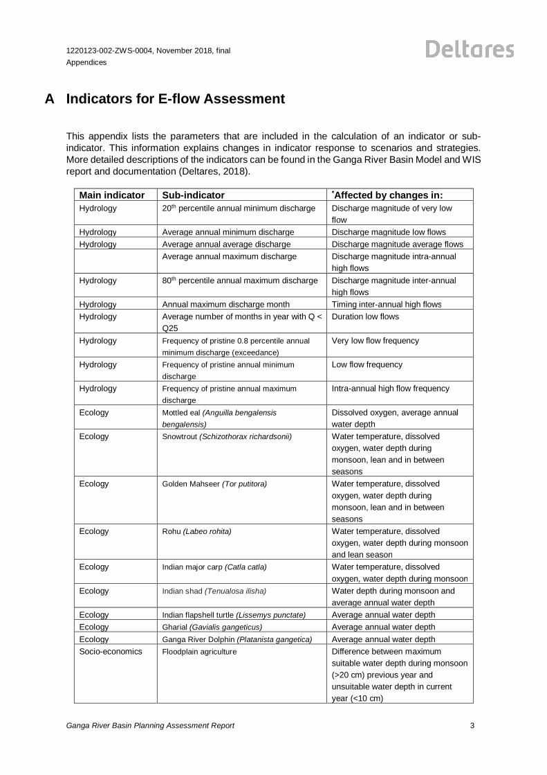
A Indicators for E-flow Assessment
This appendix lists the parameters that are included in the calculation of an indicator or sub-indicator. This information explains changes in indicator response to scenarios and strategies.More detailed descriptions of the indicators can be found in the Ganga River Basin Model and WISreport and documentation (Deltares, 2018).
Main indicator Sub-indicator *Affected by changes in:Hydrology 20th percentile annual minimum discharge Discharge magnitude of very low
flowHydrology Average annual minimum discharge Discharge magnitude low flowsHydrology Average annual average discharge Discharge magnitude average flows
Average annual maximum discharge Discharge magnitude intra-annualhigh flows
Hydrology 80th percentile annual maximum discharge Discharge magnitude inter-annualhigh flows
Hydrology Annual maximum discharge month Timing inter-annual high flowsHydrology Average number of months in year with Q <
Q25Duration low flows
Hydrology Frequency of pristine 0.8 percentile annualminimum discharge (exceedance)
Very low flow frequency
Hydrology Frequency of pristine annual minimumdischarge
Low flow frequency
Hydrology Frequency of pristine annual maximumdischarge
Intra-annual high flow frequency
Ecology Mottled eal (Anguilla bengalensisbengalensis)
Dissolved oxygen, average annualwater depth
Ecology Snowtrout (Schizothorax richardsonii) Water temperature, dissolvedoxygen, water depth duringmonsoon, lean and in betweenseasons
Ecology Golden Mahseer (Tor putitora) Water temperature, dissolvedoxygen, water depth duringmonsoon, lean and in betweenseasons
Ecology Rohu (Labeo rohita) Water temperature, dissolvedoxygen, water depth during monsoonand lean season
Ecology Indian major carp (Catla catla) Water temperature, dissolvedoxygen, water depth during monsoon
Ecology Indian shad (Tenualosa ilisha) Water depth during monsoon andaverage annual water depth
Ecology Indian flapshell turtle (Lissemys punctate) Average annual water depthEcology Gharial (Gavialis gangeticus) Average annual water depthEcology Ganga River Dolphin (Platanista gangetica) Average annual water depthSocio-economics Floodplain agriculture Difference between maximum
suitable water depth during monsoon(>20 cm) previous year andunsuitable water depth in currentyear (<10 cm)
4
1220123-002-ZWS-0004, November 2018, finalAppendices
Ganga River Basin Planning Assessment Report
Socio-economics Religious bathing Average annual water depth andBOD
Socio-economics Fisheries Habitat suitability of the fish species(all ecological sub-indicators exceptthe turtle gharial and dolphin)
* Monsoon season is from July until October, lean season is from March until June, in-between season are all othermonths (January, February, November, December)
1220123-002-ZWS-0004, November 2018, finalAppendices
Ganga River Basin Planning Assessment Report 5
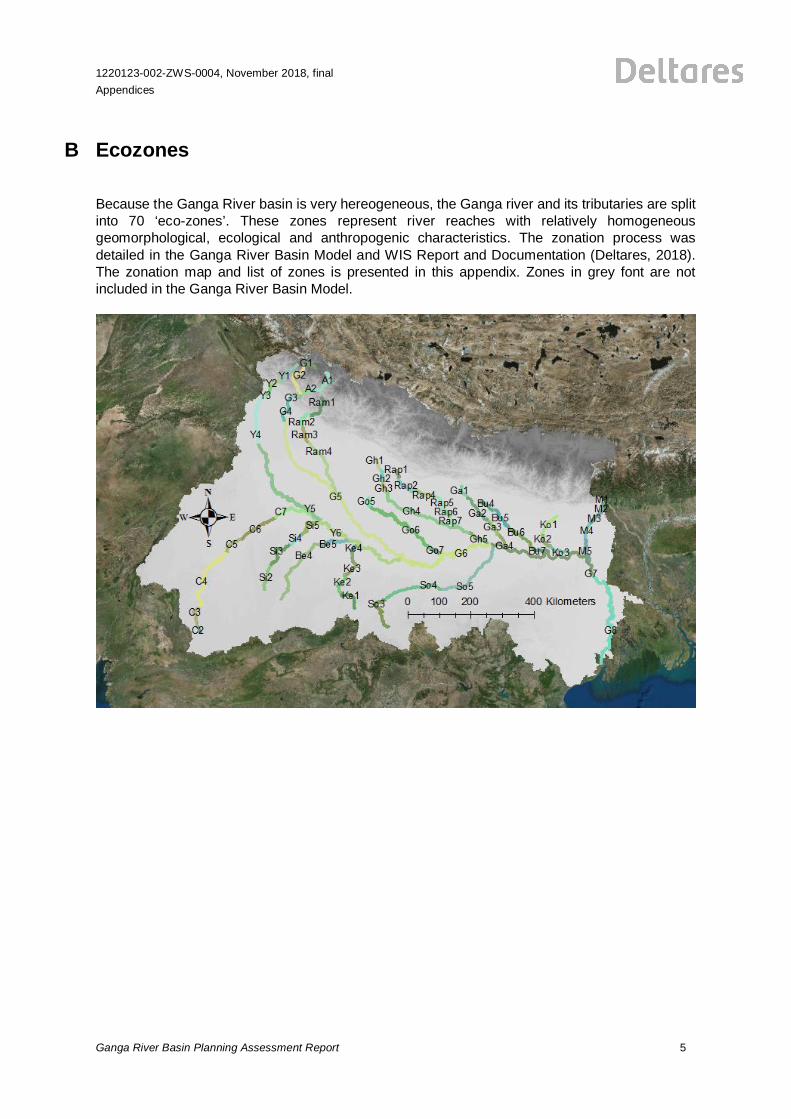
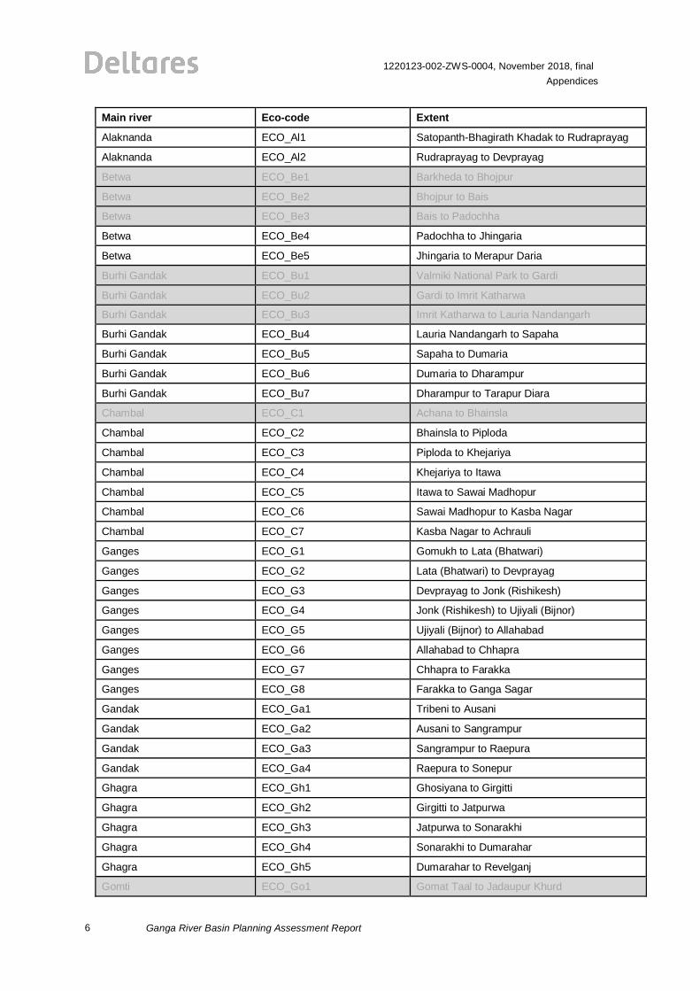
B Ecozones
Because the Ganga River basin is very hereogeneous, the Ganga river and its tributaries are splitinto 70 ‘eco-zones’. These zones represent river reaches with relatively homogeneousgeomorphological, ecological and anthropogenic characteristics. The zonation process wasdetailed in the Ganga River Basin Model and WIS Report and Documentation (Deltares, 2018).The zonation map and list of zones is presented in this appendix. Zones in grey font are notincluded in the Ganga River Basin Model.
6
1220123-002-ZWS-0004, November 2018, finalAppendices
Ganga River Basin Planning Assessment Report
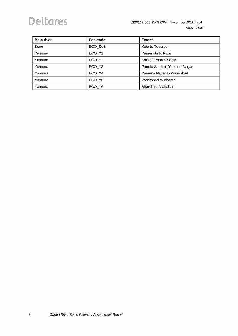
Main river Eco-code Extent
Alaknanda ECO_Al1 Satopanth-Bhagirath Khadak to Rudraprayag
Alaknanda ECO_Al2 Rudraprayag to Devprayag
Betwa ECO_Be1 Barkheda to Bhojpur
Betwa ECO_Be2 Bhojpur to Bais
Betwa ECO_Be3 Bais to Padochha
Betwa ECO_Be4 Padochha to Jhingaria
Betwa ECO_Be5 Jhingaria to Merapur Daria
Burhi Gandak ECO_Bu1 Valmiki National Park to Gardi
Burhi Gandak ECO_Bu2 Gardi to Imrit Katharwa
Burhi Gandak ECO_Bu3 Imrit Katharwa to Lauria Nandangarh
Burhi Gandak ECO_Bu4 Lauria Nandangarh to Sapaha
Burhi Gandak ECO_Bu5 Sapaha to Dumaria
Burhi Gandak ECO_Bu6 Dumaria to Dharampur
Burhi Gandak ECO_Bu7 Dharampur to Tarapur Diara
Chambal ECO_C1 Achana to Bhainsla
Chambal ECO_C2 Bhainsla to Piploda
Chambal ECO_C3 Piploda to Khejariya
Chambal ECO_C4 Khejariya to Itawa
Chambal ECO_C5 Itawa to Sawai Madhopur
Chambal ECO_C6 Sawai Madhopur to Kasba Nagar
Chambal ECO_C7 Kasba Nagar to Achrauli
Ganges ECO_G1 Gomukh to Lata (Bhatwari)
Ganges ECO_G2 Lata (Bhatwari) to Devprayag
Ganges ECO_G3 Devprayag to Jonk (Rishikesh)
Ganges ECO_G4 Jonk (Rishikesh) to Ujiyali (Bijnor)
Ganges ECO_G5 Ujiyali (Bijnor) to Allahabad
Ganges ECO_G6 Allahabad to Chhapra
Ganges ECO_G7 Chhapra to Farakka
Ganges ECO_G8 Farakka to Ganga Sagar
Gandak ECO_Ga1 Tribeni to Ausani
Gandak ECO_Ga2 Ausani to Sangrampur
Gandak ECO_Ga3 Sangrampur to Raepura
Gandak ECO_Ga4 Raepura to Sonepur
Ghagra ECO_Gh1 Ghosiyana to Girgitti
Ghagra ECO_Gh2 Girgitti to Jatpurwa
Ghagra ECO_Gh3 Jatpurwa to Sonarakhi
Ghagra ECO_Gh4 Sonarakhi to Dumarahar
Ghagra ECO_Gh5 Dumarahar to Revelganj
Gomti ECO_Go1 Gomat Taal to Jadaupur Khurd
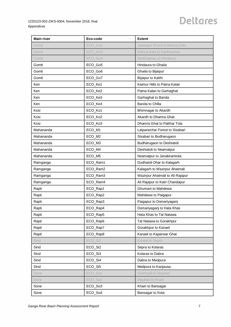
1220123-002-ZWS-0004, November 2018, finalAppendices
Ganga River Basin Planning Assessment Report 7
Main river Eco-code Extent
Gomti ECO_Go2 Jadaupur Khurd to Mahua Kala
Gomti ECO_Go3 Mahua Kala to Dadhnamau
Gomti ECO_Go4 Dadhnamau to Hindaura
Gomti ECO_Go5 Hindaura to Ghaila
Gomti ECO_Go6 Ghaila to Bijaipur
Gomti ECO_Go7 Bijaipur to Kaithi
Ken ECO_Ke1 Kaimur Hills to Patna Kalan
Ken ECO_Ke2 Patna Kalan to Garhaghat
Ken ECO_Ke3 Garhaghat to Banda
Ken ECO_Ke4 Banda to Chilla
Kosi ECO_Ko1 Bhimnagar to Akardh
Kosi ECO_Ko2 Akardh to Dhamra Ghat
Kosi ECO_Ko3 Dhamra Ghat to Patthar Tola
Mahananda ECO_M1 Latpanechar Forest to Sisabari
Mahananda ECO_M2 Sisabari to Budharugaon
Mahananda ECO_M3 Budharugaon to Deshiatoli
Mahananda ECO_M4 Deshiatoli to Neamatpur
Mahananda ECO_M5 Neamatpur to Janakiramtola
Ramganga ECO_Ram1 Dudhatoli Dhar to Kalagarh
Ramganga ECO_Ram2 Kalagarh to Wazirpur Ahatmali
Ramganga ECO_Ram3 Wazirpur Ahatmali to Ali Rajapur
Ramganga ECO_Ram4 Ali Rajapur to Katri Chandapur
Rapti ECO_Rap1 Ghumani to Mahdewa
Rapti ECO_Rap2 Mahdewa to Paigapur
Rapti ECO_Rap3 Paigapur to Domariyaganj
Rapti ECO_Rap4 Domariyaganj to Hata Khas
Rapti ECO_Rap5 Hata Khas to Tal Natawa
Rapti ECO_Rap6 Tal Natawa to Gorakhpur
Rapti ECO_Rap7 Gorakhpur to Kanael
Rapti ECO_Rap8 Kanael to Kaparwar Ghat
Sind ECO_Si1 Korwai to Sepra
Sind ECO_Si2 Sepra to Kolaras
Sind ECO_Si3 Kolaras to Dabra
Sind ECO_Si4 Dabra to Medpura
Sind ECO_Si5 Medpura to Kanjausa
Sone ECO_So1 Sonmuda to Mauhari
Sone ECO_So2 Mauhari to Khairi
Sone ECO_So3 Khairi to Bansagar
Sone ECO_So4 Bansagar to Kota
8
1220123-002-ZWS-0004, November 2018, finalAppendices
Ganga River Basin Planning Assessment Report
Main river Eco-code Extent
Sone ECO_So5 Kota to Todarpur
Yamuna ECO_Y1 Yamunotri to Kalsi
Yamuna ECO_Y2 Kalsi to Paonta Sahib
Yamuna ECO_Y3 Paonta Sahib to Yamuna Nagar
Yamuna ECO_Y4 Yamuna Nagar to Wazirabad
Yamuna ECO_Y5 Wazirabad to Bhareh
Yamuna ECO_Y6 Bhareh to Allahabad
1220123-002-ZWS-0004, November 2018, finalAppendices
Ganga River Basin Planning Assessment Report 9
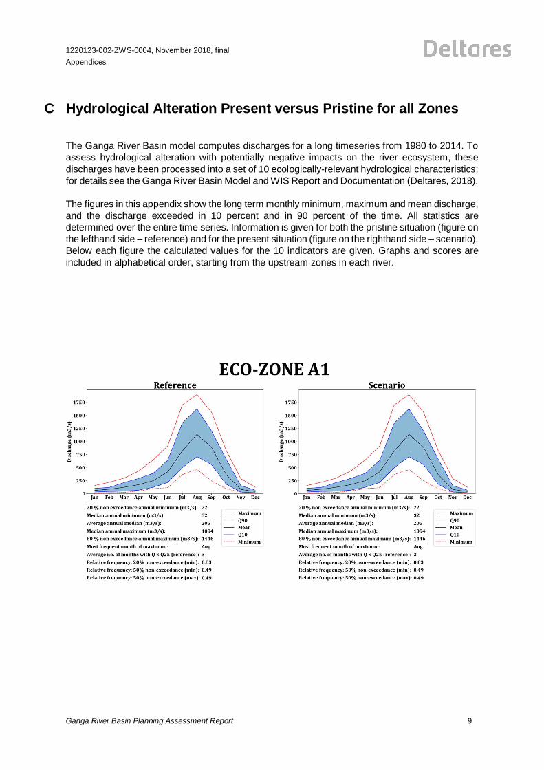
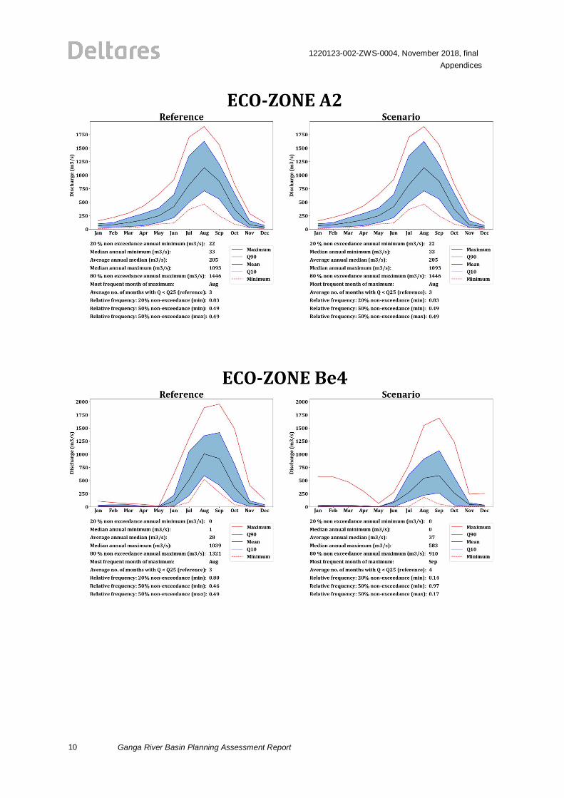
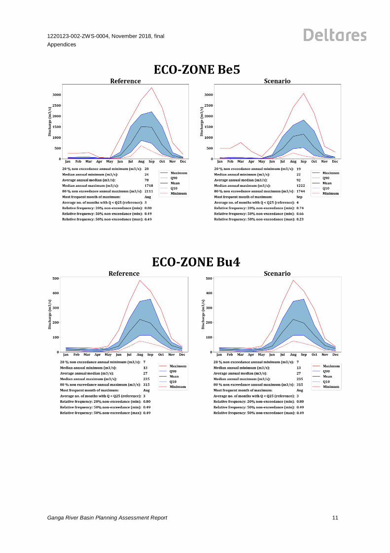
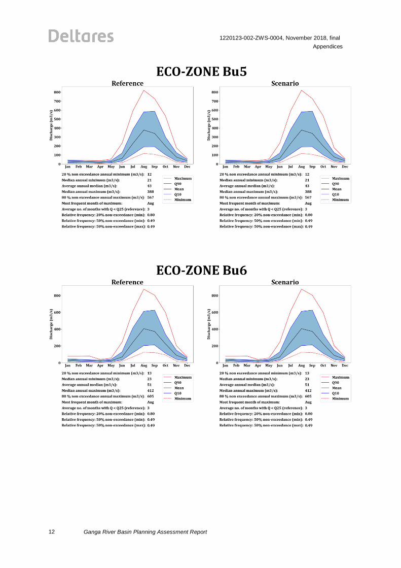
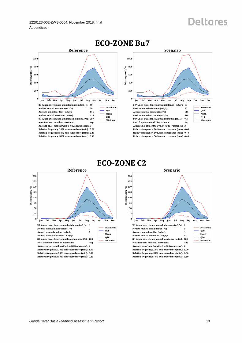
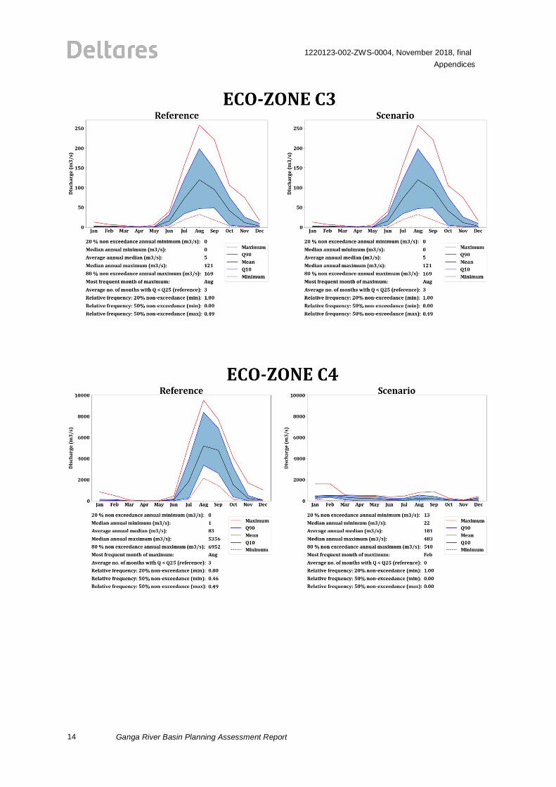
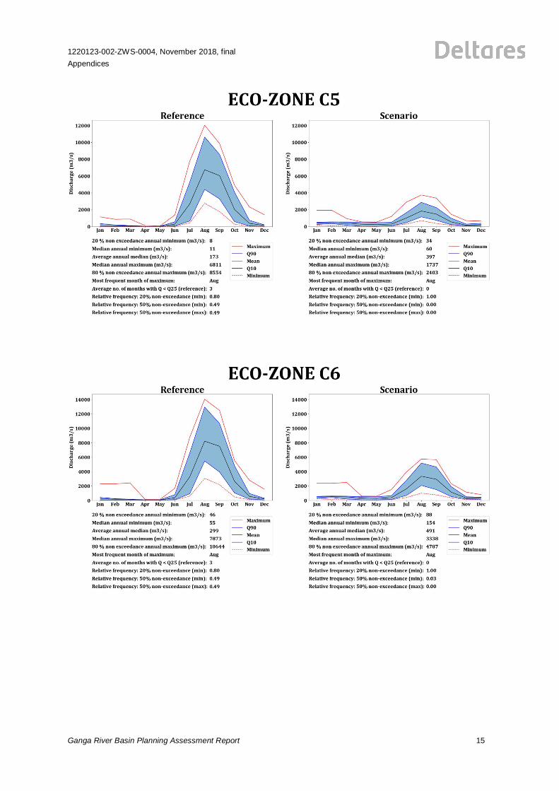
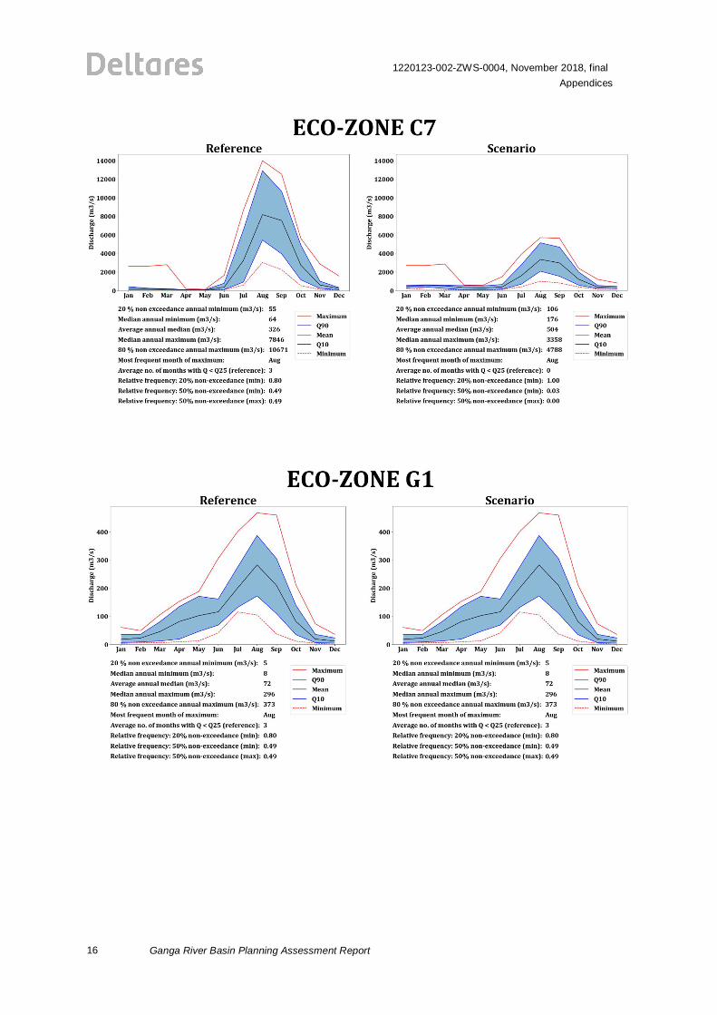
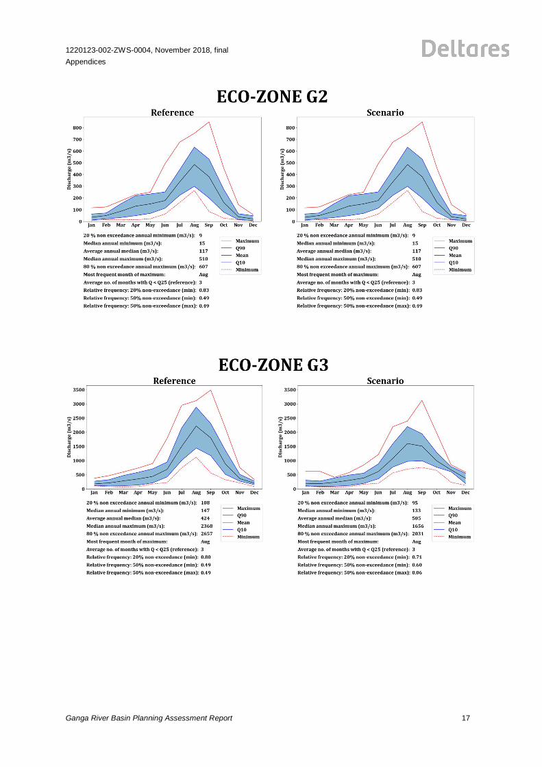
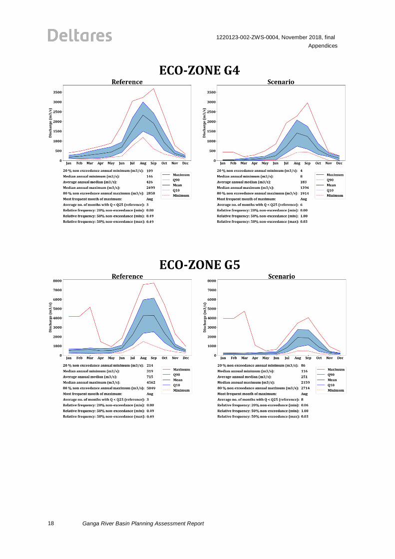
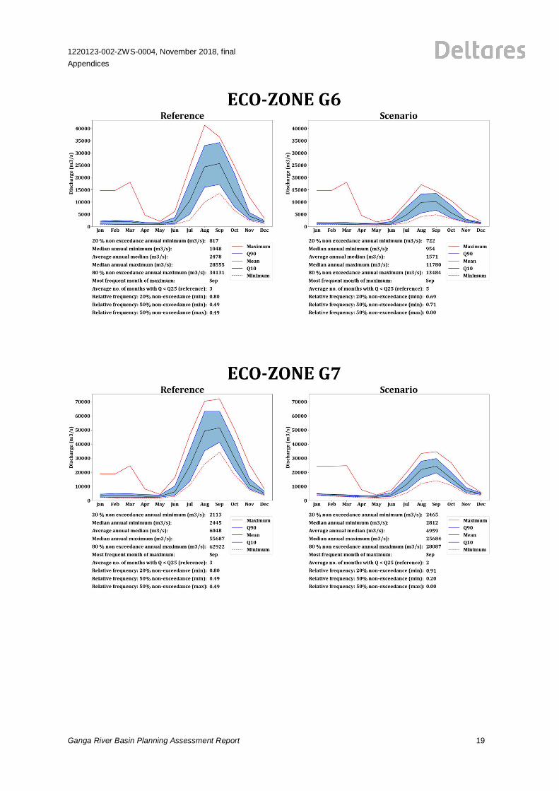
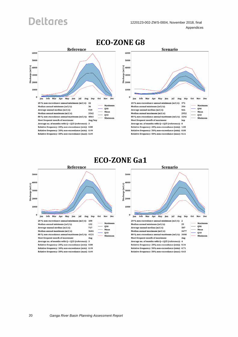
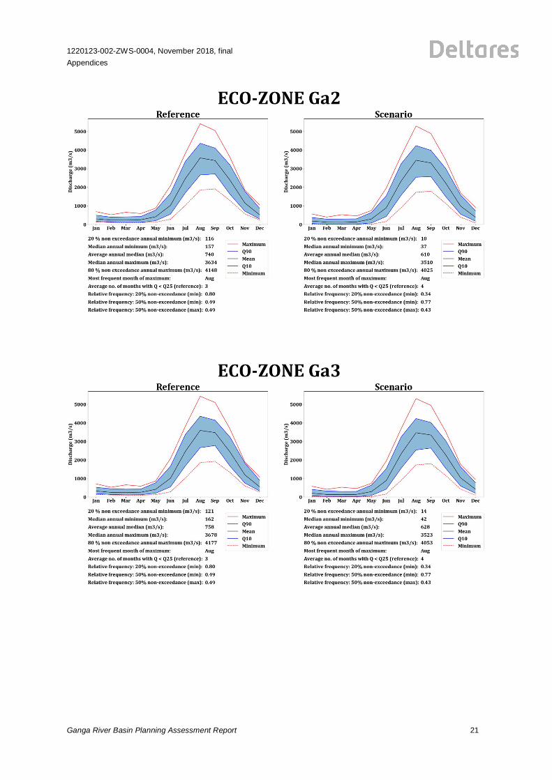
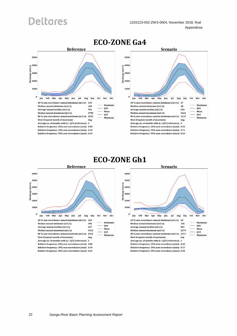
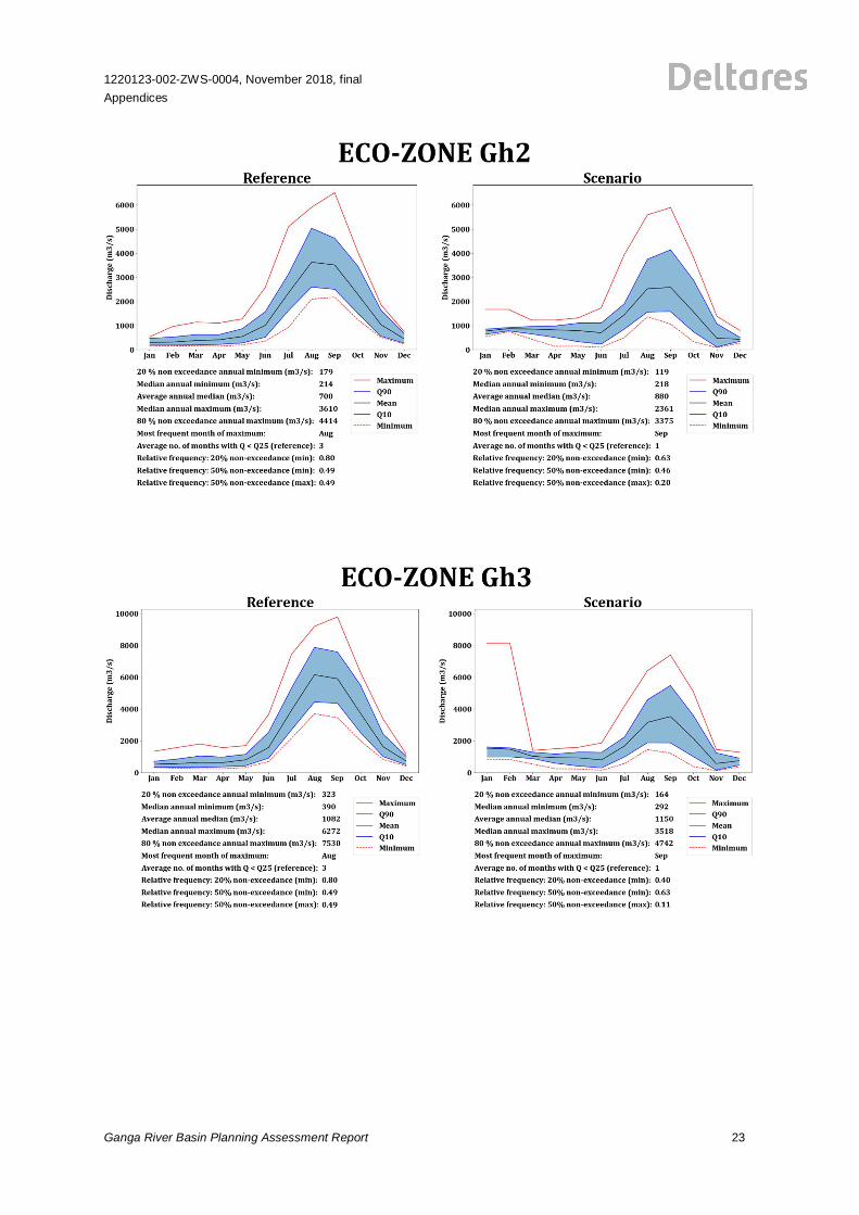
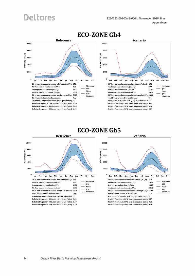
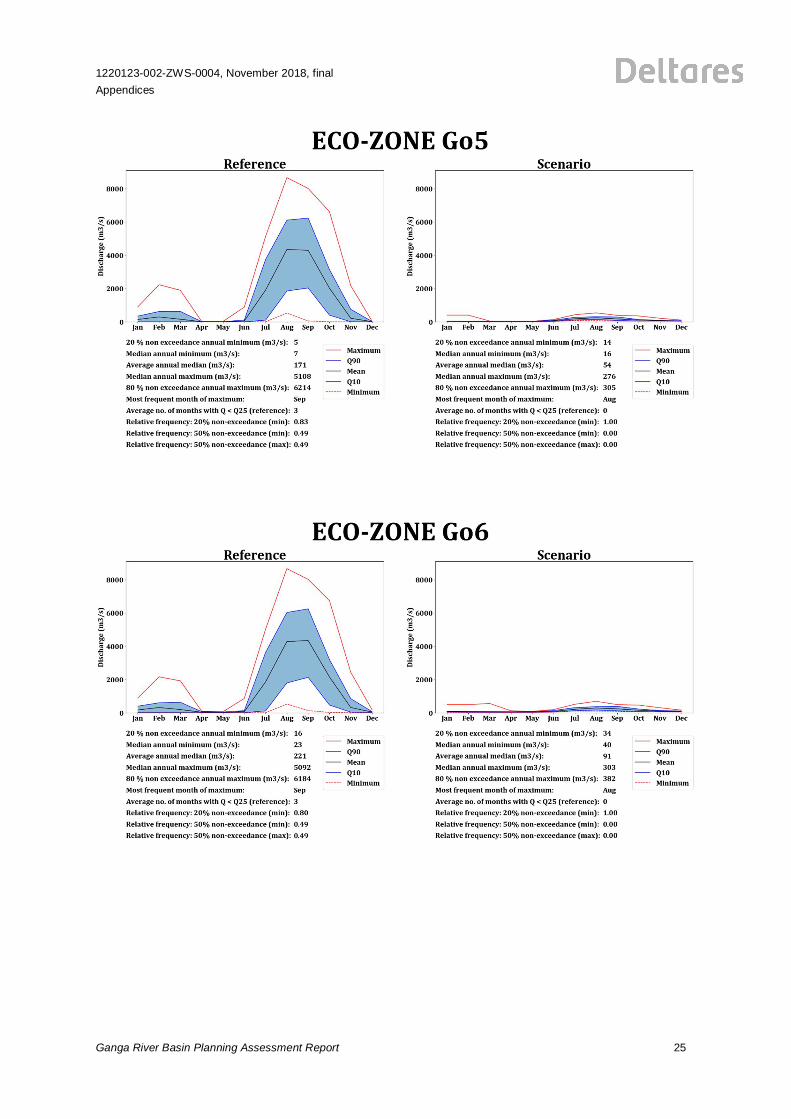
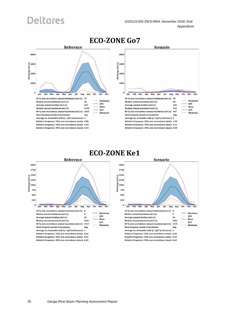
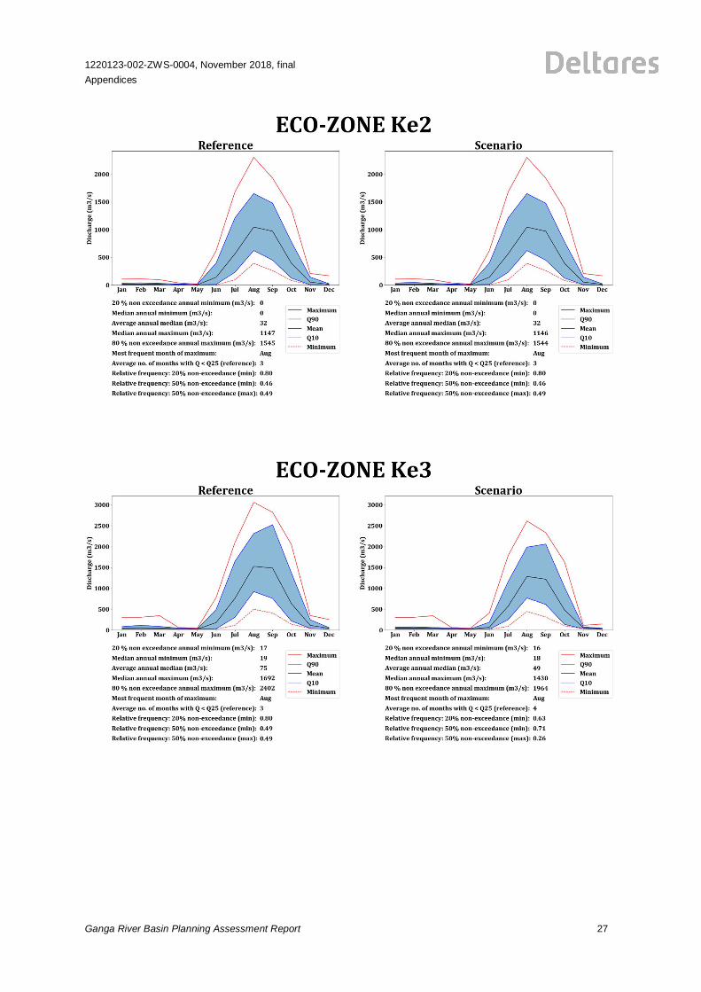
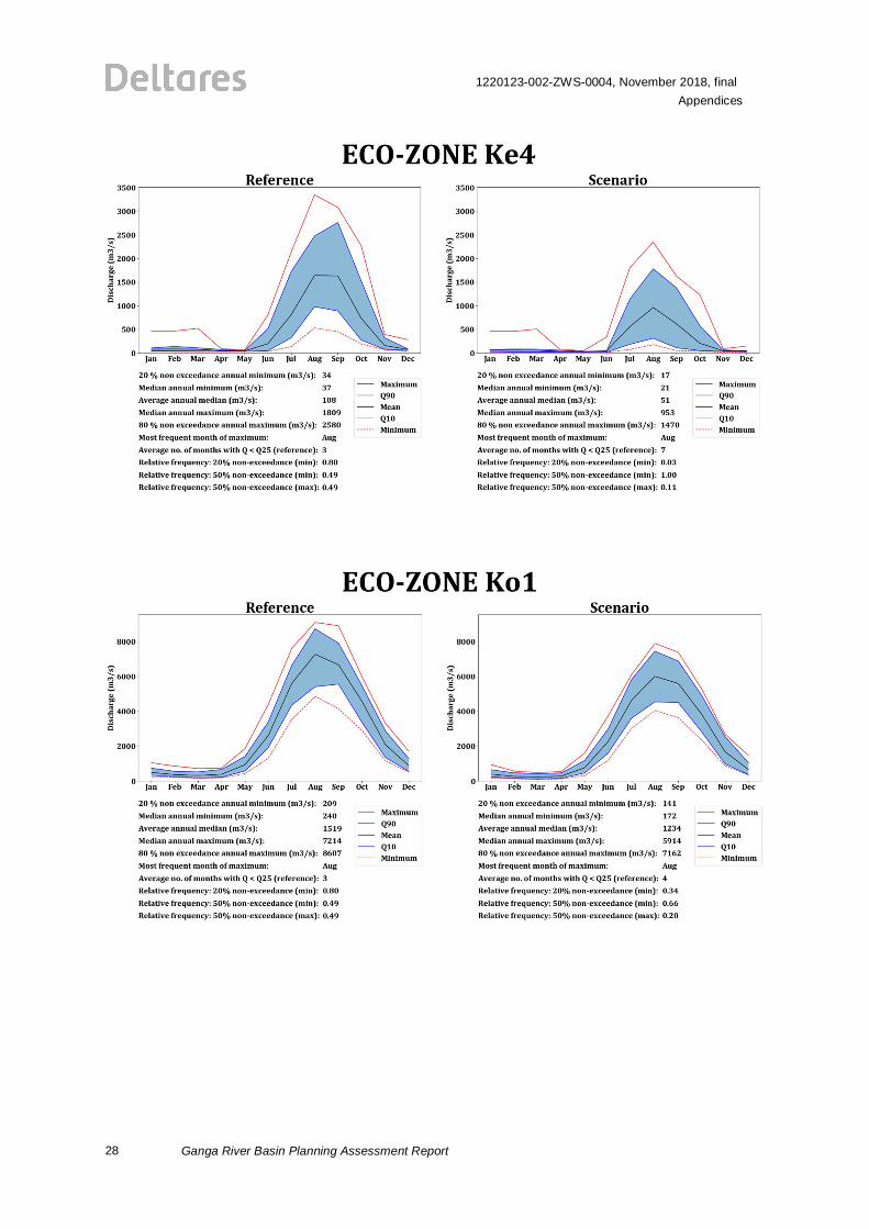
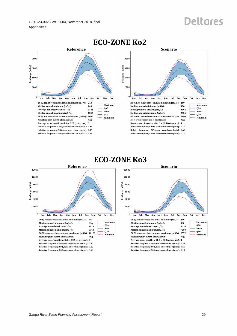
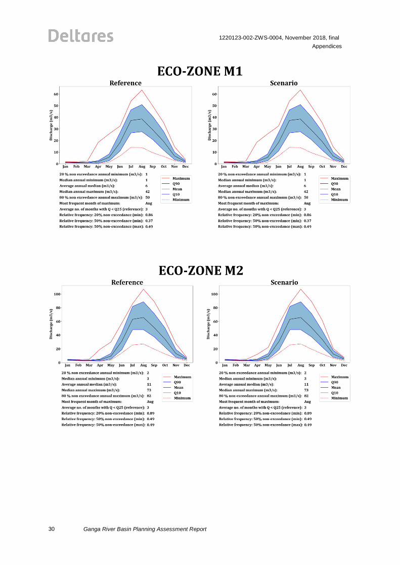
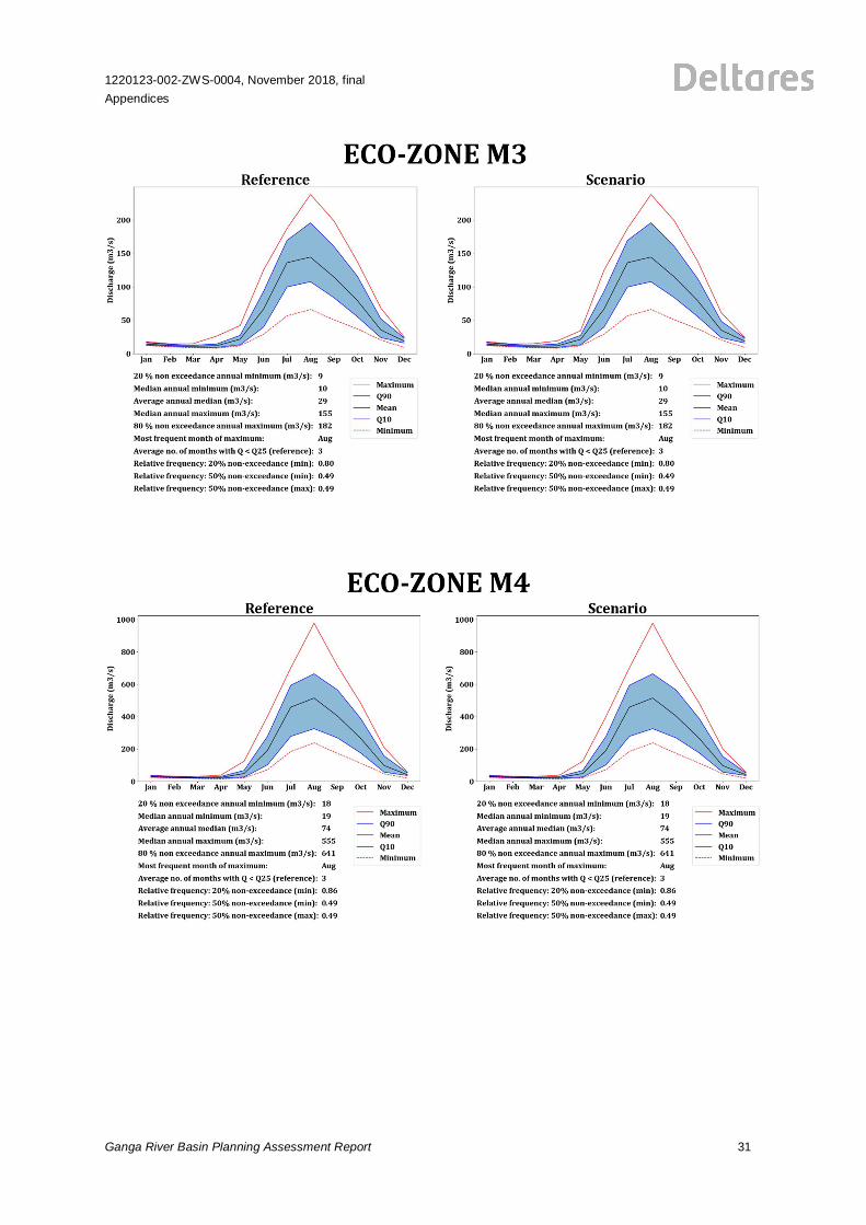
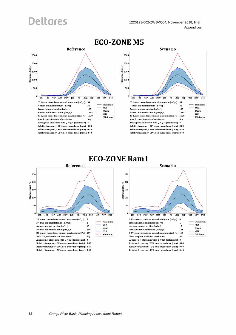
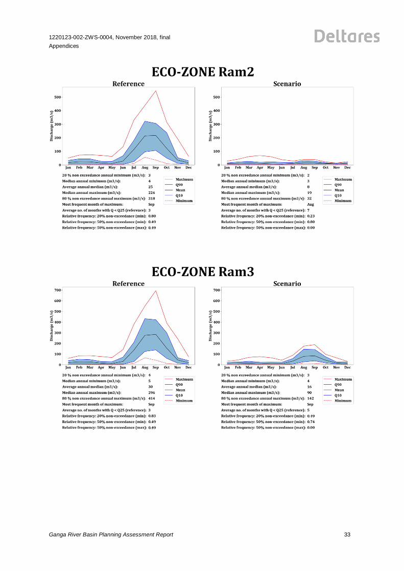
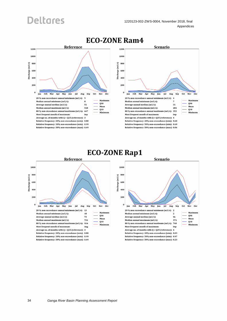
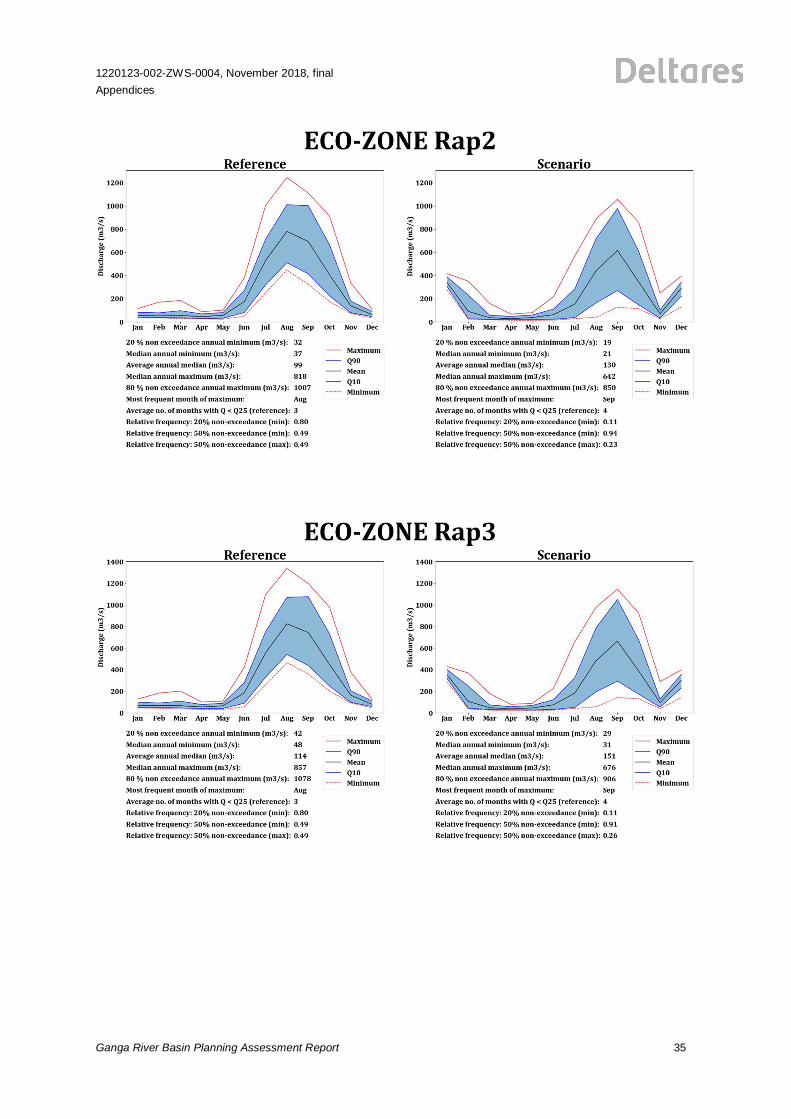
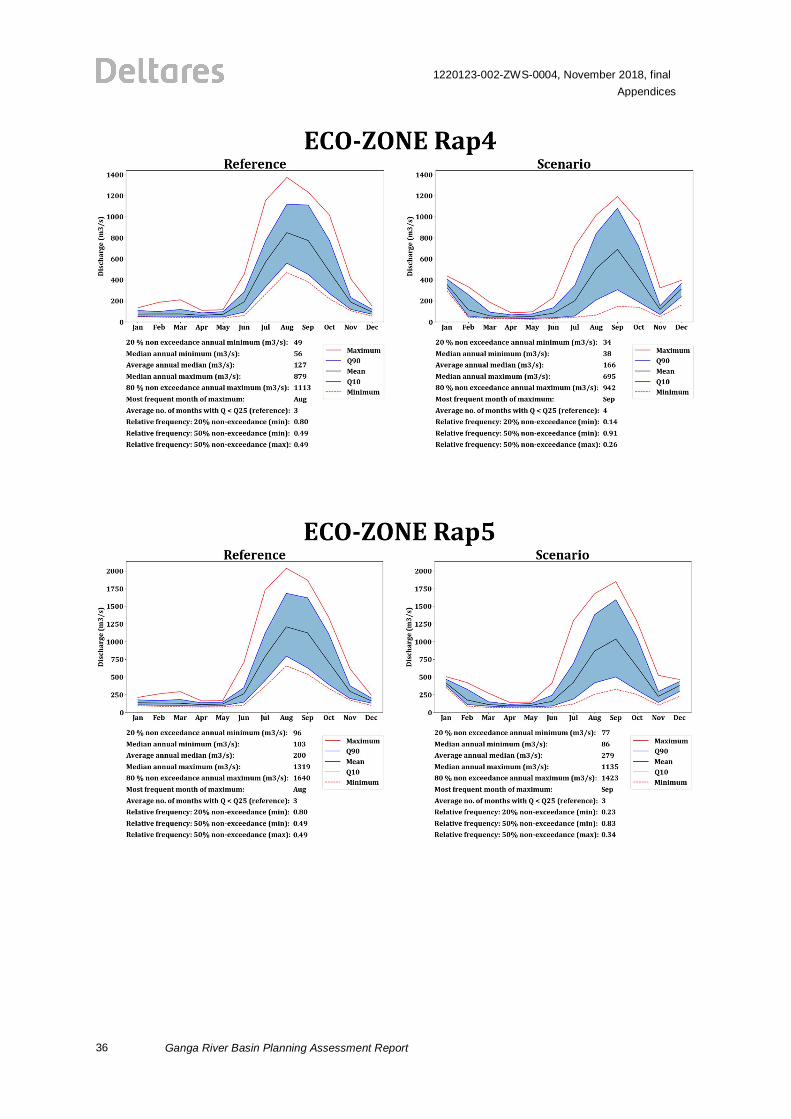
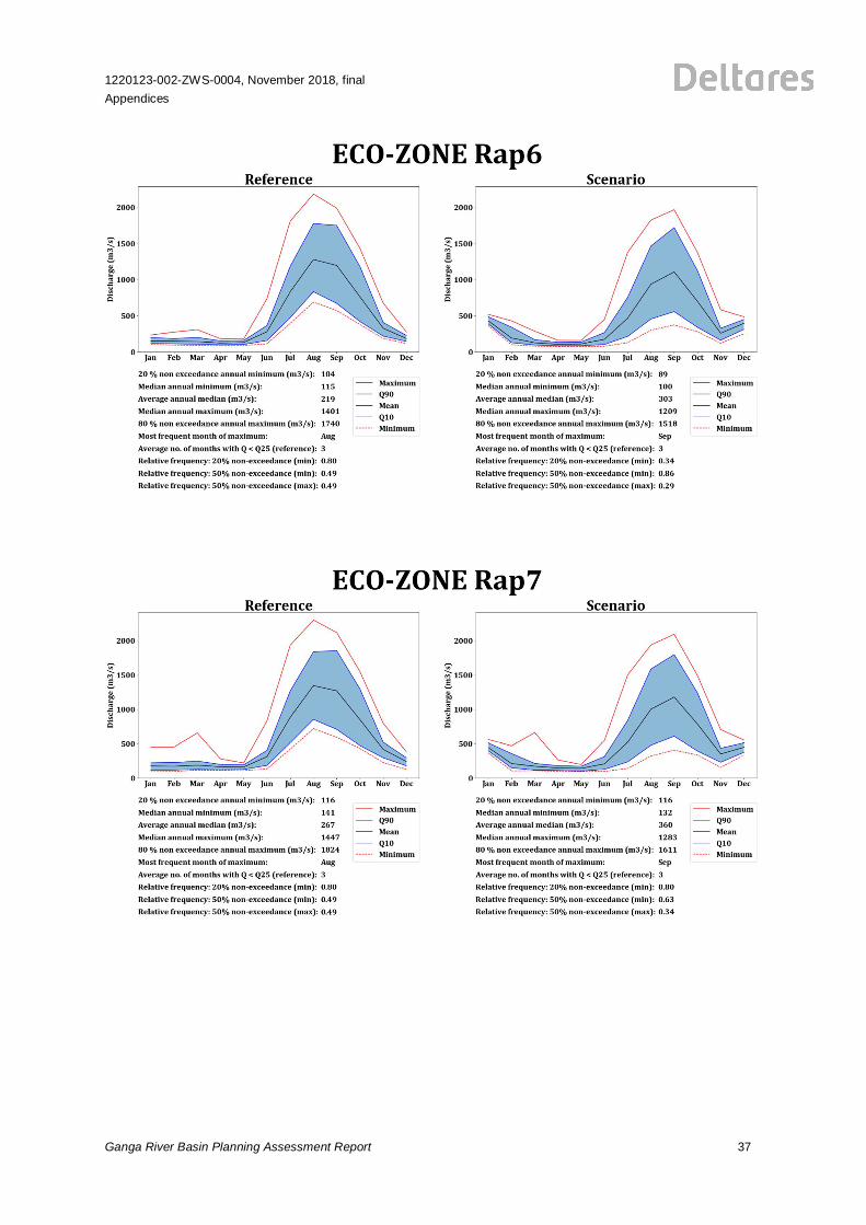
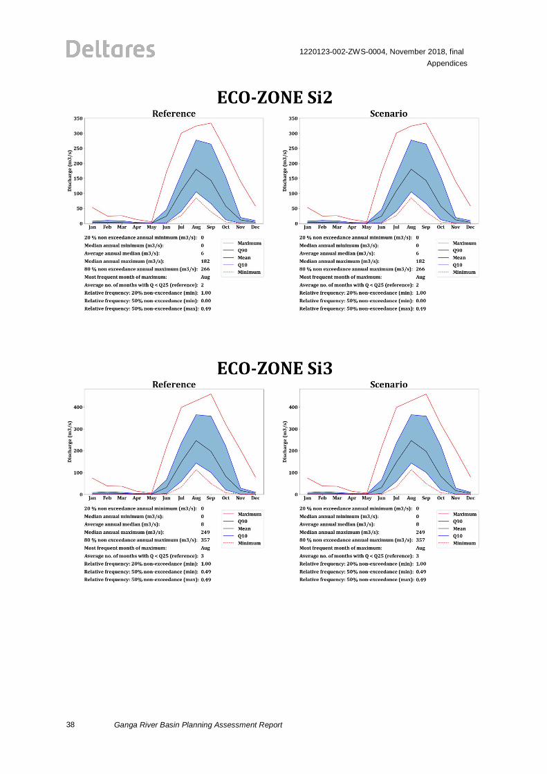
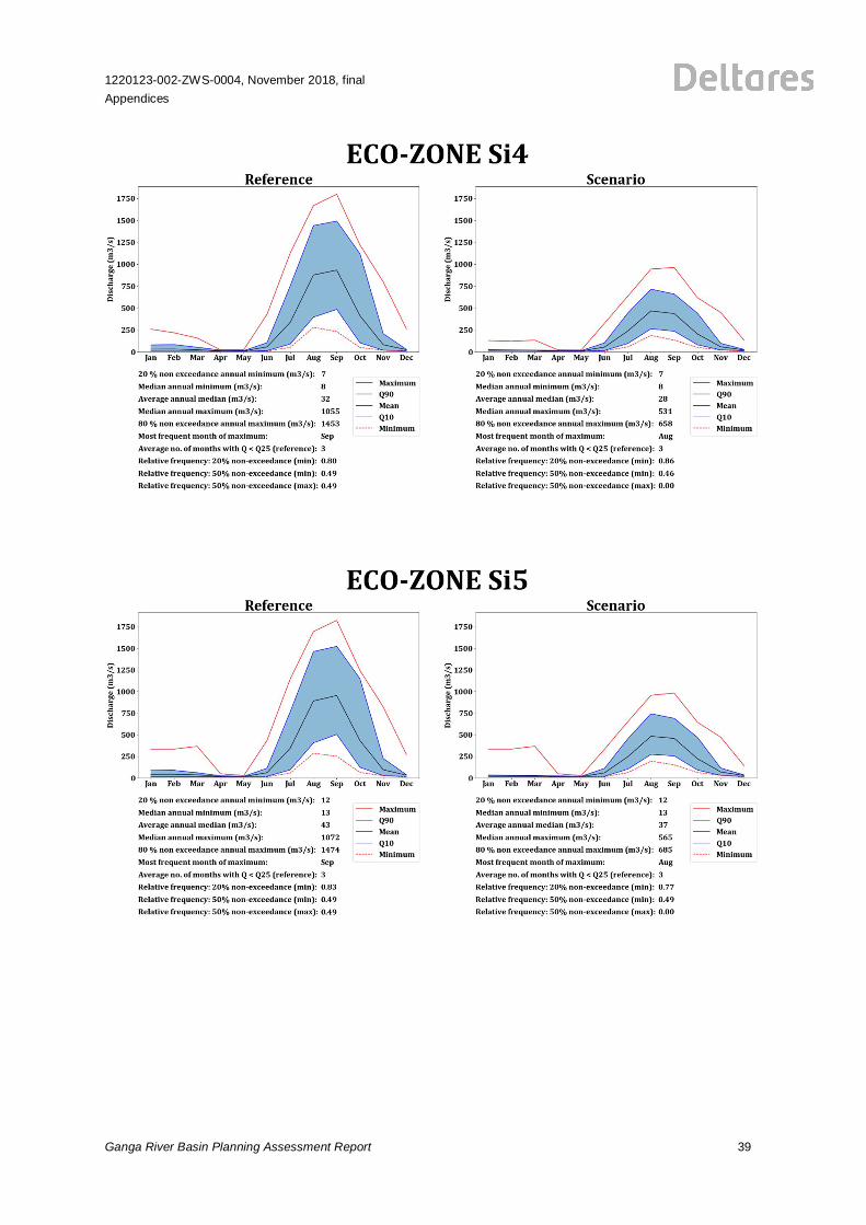
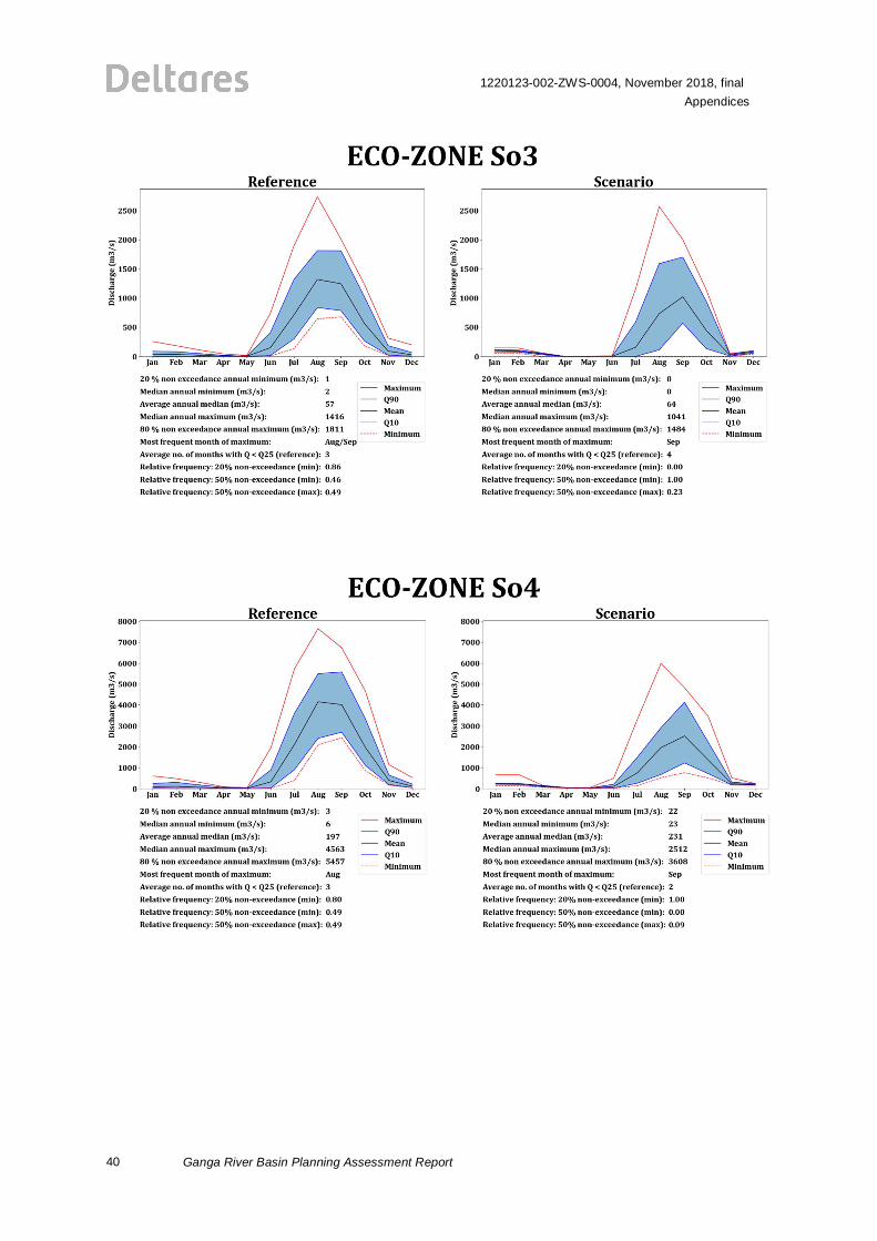
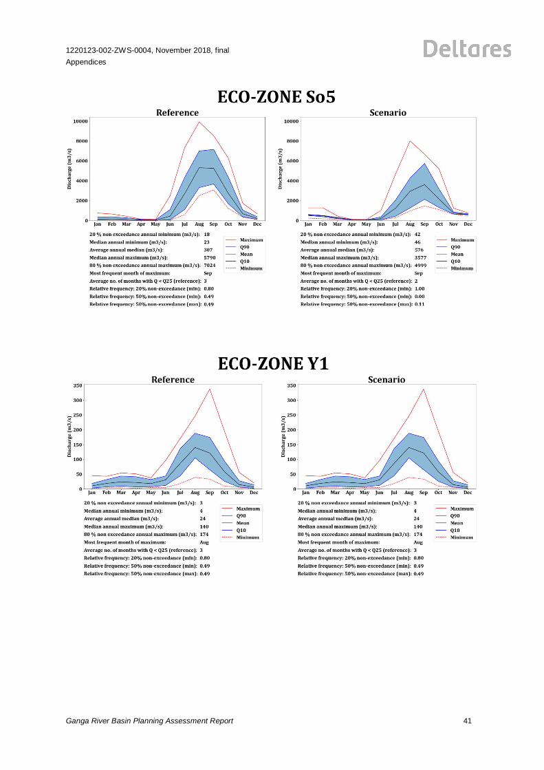
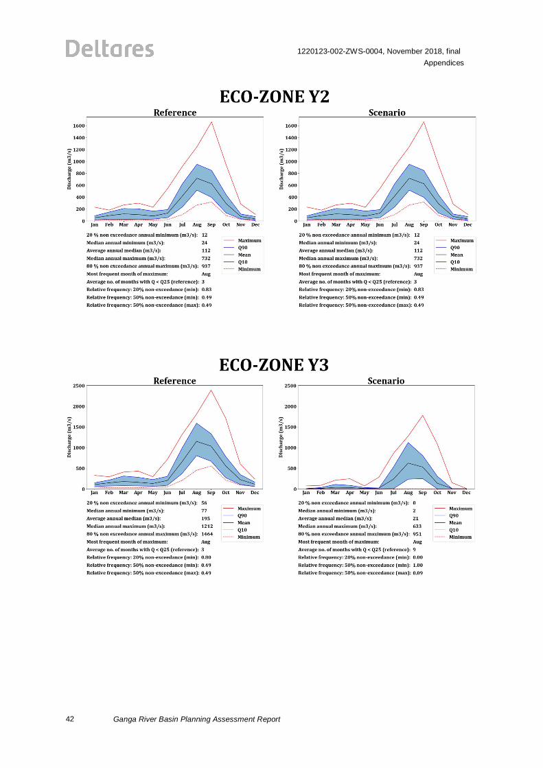
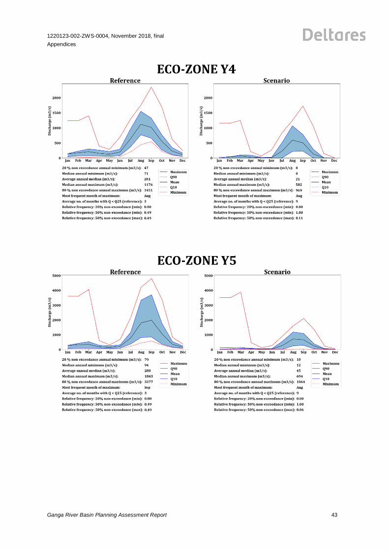
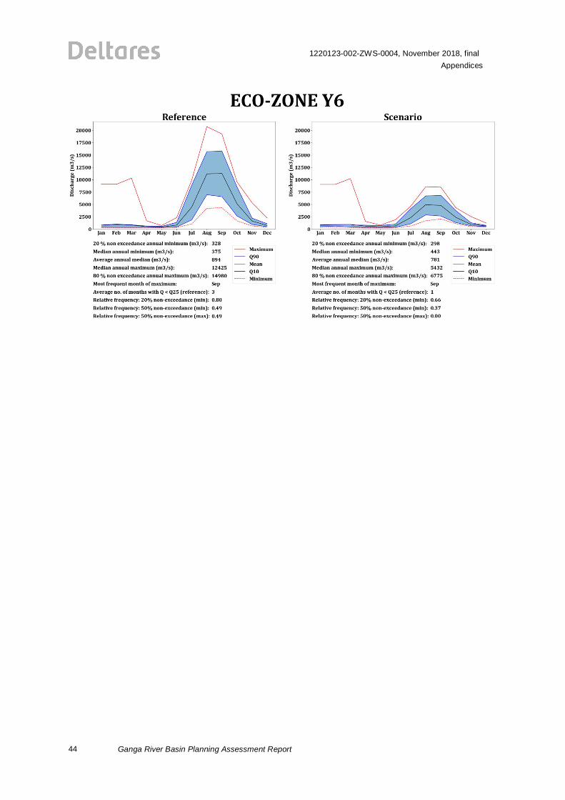
C Hydrological Alteration Present versus Pristine for all Zones
The Ganga River Basin model computes discharges for a long timeseries from 1980 to 2014. Toassess hydrological alteration with potentially negative impacts on the river ecosystem, thesedischarges have been processed into a set of 10 ecologically-relevant hydrological characteristics;for details see the Ganga River Basin Model and WIS Report and Documentation (Deltares, 2018).
The figures in this appendix show the long term monthly minimum, maximum and mean discharge,and the discharge exceeded in 10 percent and in 90 percent of the time. All statistics aredetermined over the entire time series. Information is given for both the pristine situation (figure onthe lefthand side – reference) and for the present situation (figure on the righthand side – scenario).Below each figure the calculated values for the 10 indicators are given. Graphs and scores areincluded in alphabetical order, starting from the upstream zones in each river.
10
1220123-002-ZWS-0004, November 2018, finalAppendices
Ganga River Basin Planning Assessment Report
1220123-002-ZWS-0004, November 2018, finalAppendices
Ganga River Basin Planning Assessment Report 11
12
1220123-002-ZWS-0004, November 2018, finalAppendices
Ganga River Basin Planning Assessment Report
1220123-002-ZWS-0004, November 2018, finalAppendices
Ganga River Basin Planning Assessment Report 13
14
1220123-002-ZWS-0004, November 2018, finalAppendices
Ganga River Basin Planning Assessment Report
1220123-002-ZWS-0004, November 2018, finalAppendices
Ganga River Basin Planning Assessment Report 15
16
1220123-002-ZWS-0004, November 2018, finalAppendices
Ganga River Basin Planning Assessment Report
1220123-002-ZWS-0004, November 2018, finalAppendices
Ganga River Basin Planning Assessment Report 17
18
1220123-002-ZWS-0004, November 2018, finalAppendices
Ganga River Basin Planning Assessment Report
1220123-002-ZWS-0004, November 2018, finalAppendices
Ganga River Basin Planning Assessment Report 19
20
1220123-002-ZWS-0004, November 2018, finalAppendices
Ganga River Basin Planning Assessment Report
1220123-002-ZWS-0004, November 2018, finalAppendices
Ganga River Basin Planning Assessment Report 21
22
1220123-002-ZWS-0004, November 2018, finalAppendices
Ganga River Basin Planning Assessment Report
1220123-002-ZWS-0004, November 2018, finalAppendices
Ganga River Basin Planning Assessment Report 23
24
1220123-002-ZWS-0004, November 2018, finalAppendices
Ganga River Basin Planning Assessment Report
1220123-002-ZWS-0004, November 2018, finalAppendices
Ganga River Basin Planning Assessment Report 25
26
1220123-002-ZWS-0004, November 2018, finalAppendices
Ganga River Basin Planning Assessment Report
1220123-002-ZWS-0004, November 2018, finalAppendices
Ganga River Basin Planning Assessment Report 27
28
1220123-002-ZWS-0004, November 2018, finalAppendices
Ganga River Basin Planning Assessment Report
1220123-002-ZWS-0004, November 2018, finalAppendices
Ganga River Basin Planning Assessment Report 29
30
1220123-002-ZWS-0004, November 2018, finalAppendices
Ganga River Basin Planning Assessment Report
1220123-002-ZWS-0004, November 2018, finalAppendices
Ganga River Basin Planning Assessment Report 31
32
1220123-002-ZWS-0004, November 2018, finalAppendices
Ganga River Basin Planning Assessment Report
1220123-002-ZWS-0004, November 2018, finalAppendices
Ganga River Basin Planning Assessment Report 33
34
1220123-002-ZWS-0004, November 2018, finalAppendices
Ganga River Basin Planning Assessment Report
1220123-002-ZWS-0004, November 2018, finalAppendices
Ganga River Basin Planning Assessment Report 35
36
1220123-002-ZWS-0004, November 2018, finalAppendices
Ganga River Basin Planning Assessment Report
1220123-002-ZWS-0004, November 2018, finalAppendices
Ganga River Basin Planning Assessment Report 37
38
1220123-002-ZWS-0004, November 2018, finalAppendices
Ganga River Basin Planning Assessment Report
1220123-002-ZWS-0004, November 2018, finalAppendices
Ganga River Basin Planning Assessment Report 39
40
1220123-002-ZWS-0004, November 2018, finalAppendices
Ganga River Basin Planning Assessment Report
1220123-002-ZWS-0004, November 2018, finalAppendices
Ganga River Basin Planning Assessment Report 41
42
1220123-002-ZWS-0004, November 2018, finalAppendices
Ganga River Basin Planning Assessment Report
1220123-002-ZWS-0004, November 2018, finalAppendices
Ganga River Basin Planning Assessment Report 43
44
1220123-002-ZWS-0004, November 2018, finalAppendices
Ganga River Basin Planning Assessment Report
1220123-002-ZWS-0004, November 2018, finalAppendices
Ganga River Basin Planning Assessment Report 45
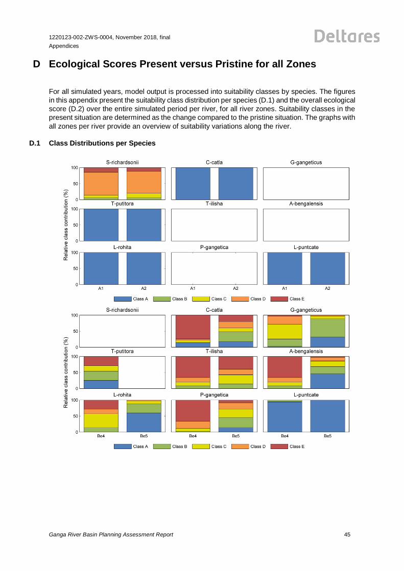
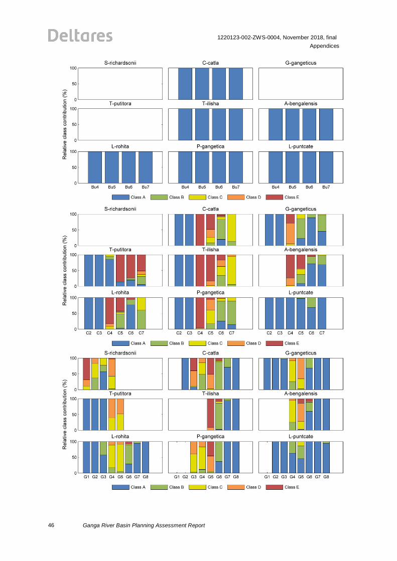
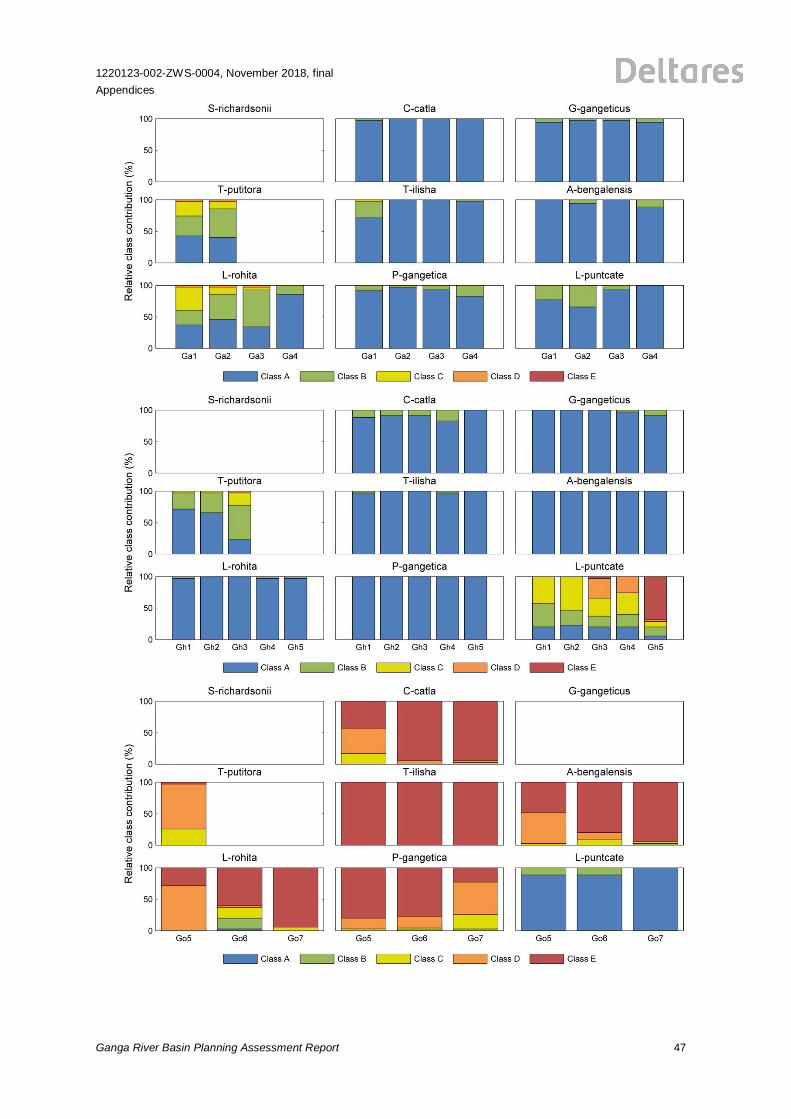
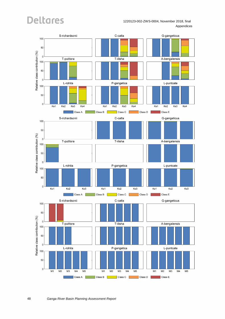
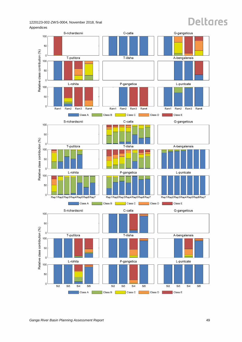
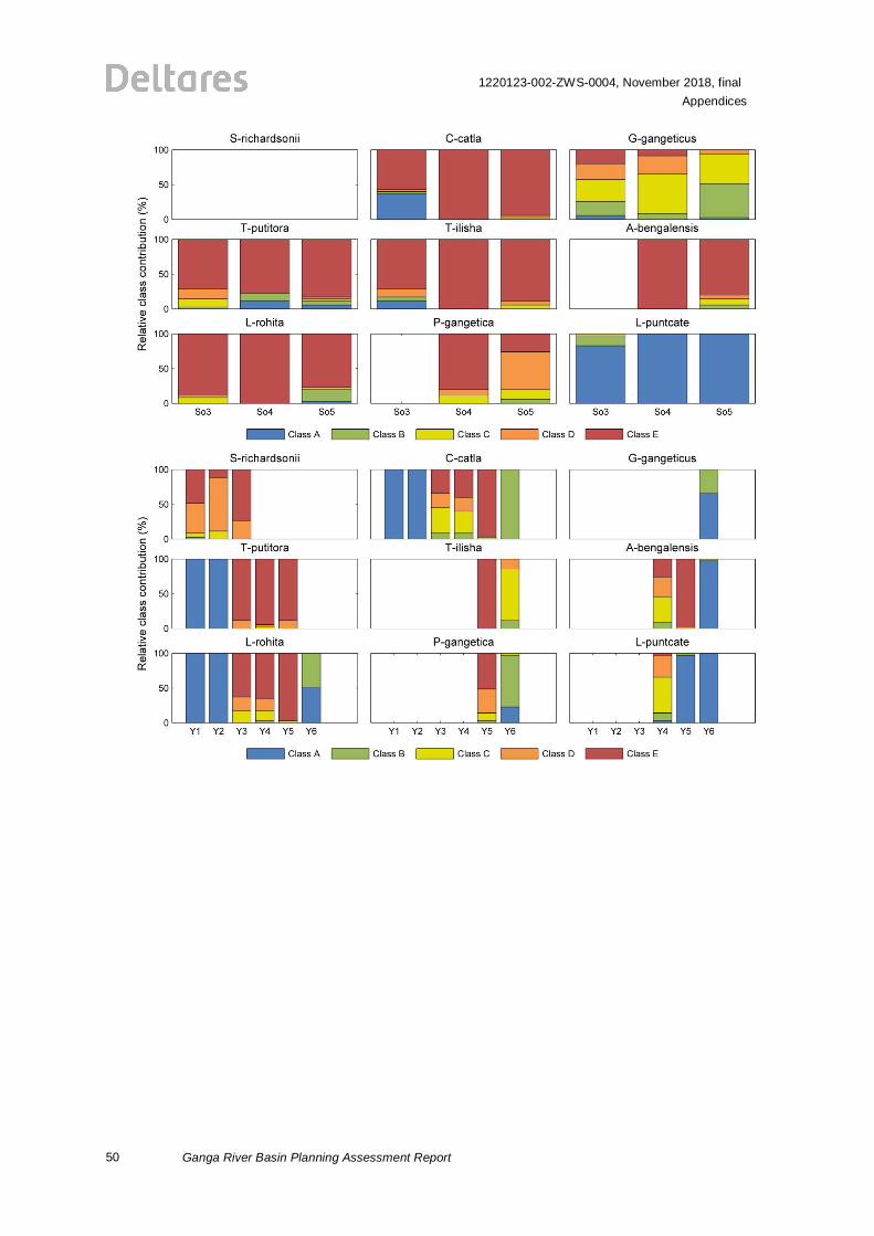
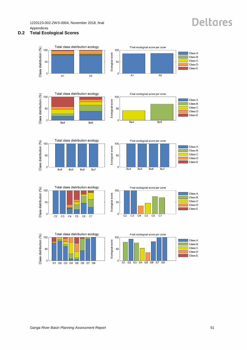
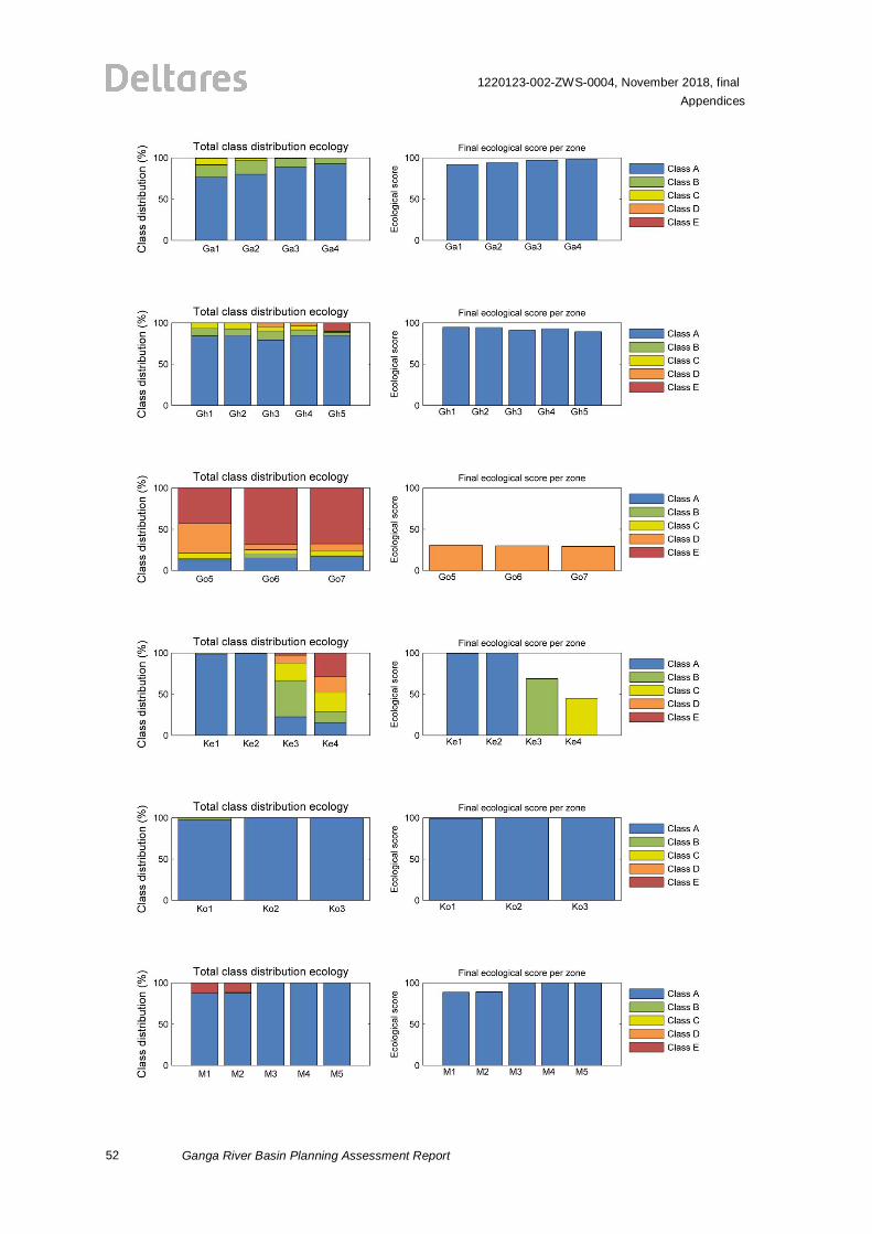
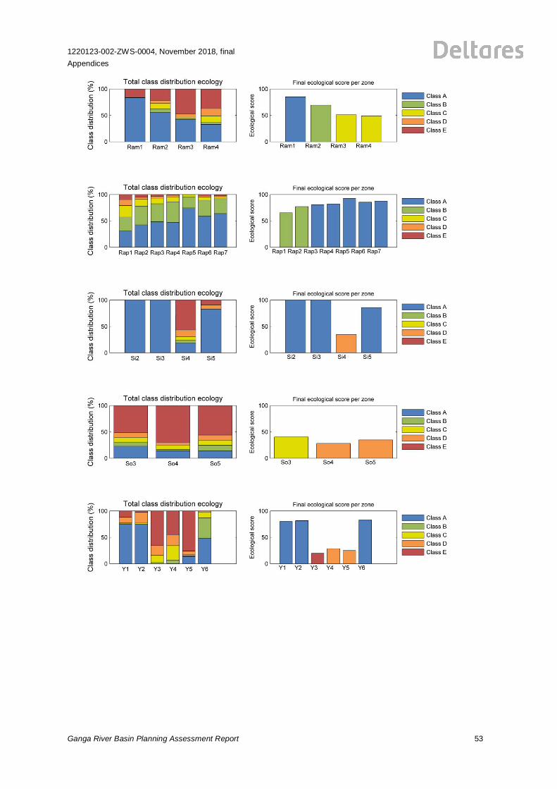
D Ecological Scores Present versus Pristine for all Zones
For all simulated years, model output is processed into suitability classes by species. The figuresin this appendix present the suitability class distribution per species (D.1) and the overall ecologicalscore (D.2) over the entire simulated period per river, for all river zones. Suitability classes in thepresent situation are determined as the change compared to the pristine situation. The graphs withall zones per river provide an overview of suitability variations along the river.
D.1 Class Distributions per Species
46
1220123-002-ZWS-0004, November 2018, finalAppendices
Ganga River Basin Planning Assessment Report
1220123-002-ZWS-0004, November 2018, finalAppendices
Ganga River Basin Planning Assessment Report 47
48
1220123-002-ZWS-0004, November 2018, finalAppendices
Ganga River Basin Planning Assessment Report
1220123-002-ZWS-0004, November 2018, finalAppendices
Ganga River Basin Planning Assessment Report 49
50
1220123-002-ZWS-0004, November 2018, finalAppendices
Ganga River Basin Planning Assessment Report
1220123-002-ZWS-0004, November 2018, finalAppendices
Ganga River Basin Planning Assessment Report 51
D.2 Total Ecological Scores
52
1220123-002-ZWS-0004, November 2018, finalAppendices
Ganga River Basin Planning Assessment Report
1220123-002-ZWS-0004, November 2018, finalAppendices
Ganga River Basin Planning Assessment Report 53

1220123-002-ZWS-0004, November 2018, finalAppendices
Ganga River Basin Planning Assessment Report 55
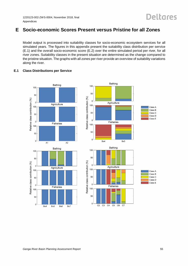
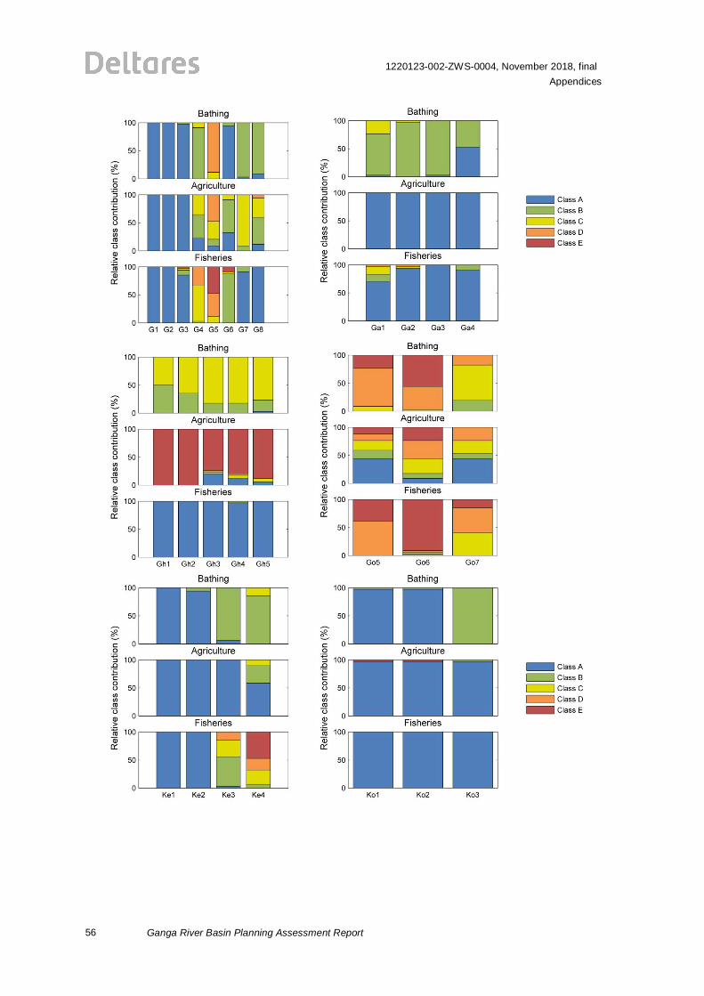
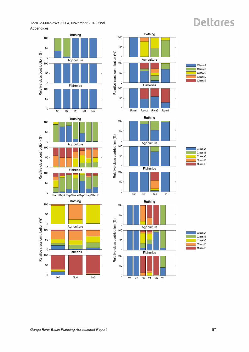
E Socio-economic Scores Present versus Pristine for all Zones
Model output is processed into suitability classes for socio-economic ecosystem services for allsimulated years. The figures in this appendix present the suitability class distribution per service(E.1) and the overall socio-economic score (E.2) over the entire simulated period per river, for allriver zones. Suitability classes in the present situation are determined as the change compared tothe pristine situation. The graphs with all zones per river provide an overview of suitability variationsalong the river.
E.1 Class Distributions per Service
56
1220123-002-ZWS-0004, November 2018, finalAppendices
Ganga River Basin Planning Assessment Report
1220123-002-ZWS-0004, November 2018, finalAppendices
Ganga River Basin Planning Assessment Report 57
58
1220123-002-ZWS-0004, November 2018, finalAppendices
Ganga River Basin Planning Assessment Report
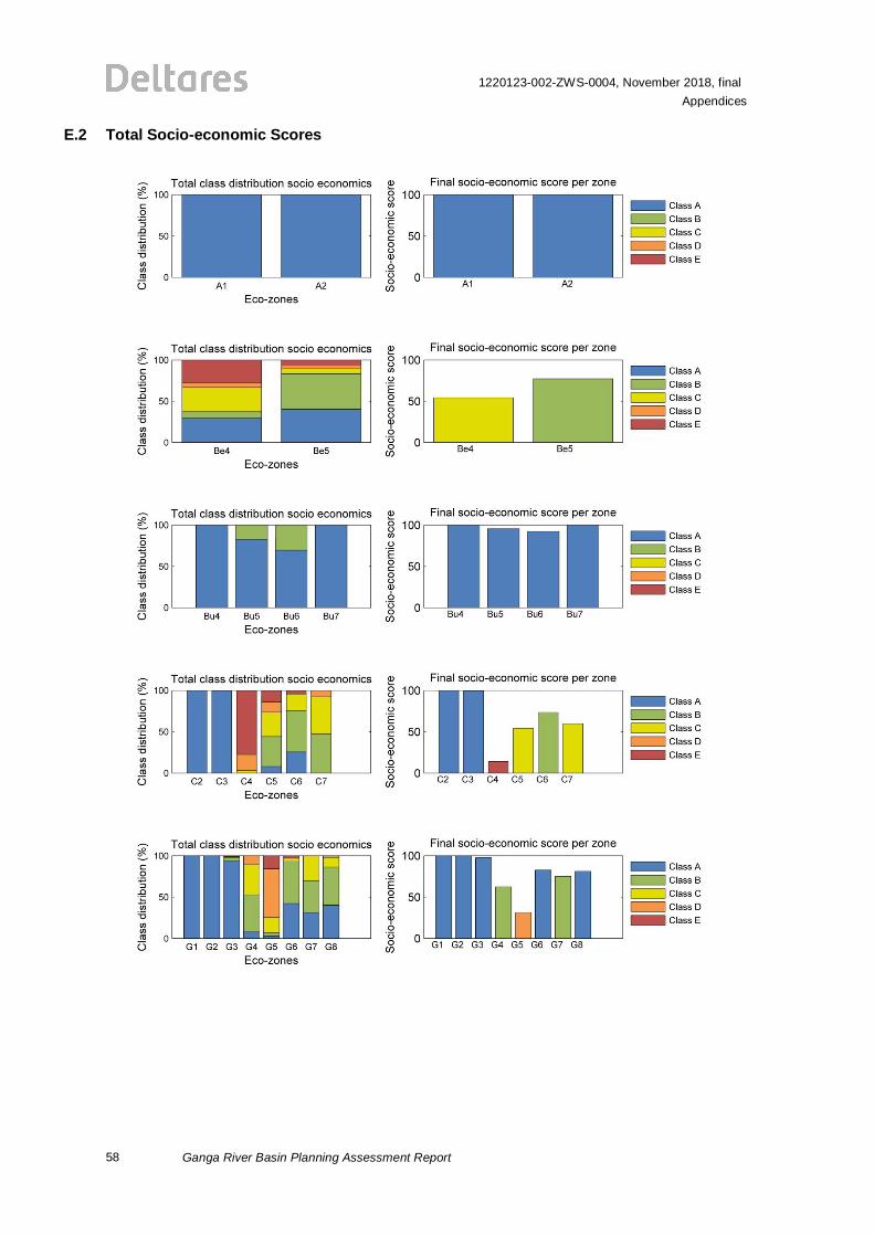
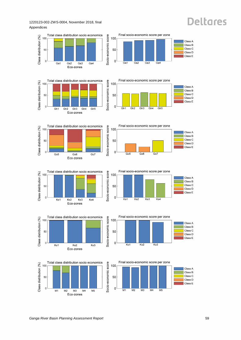
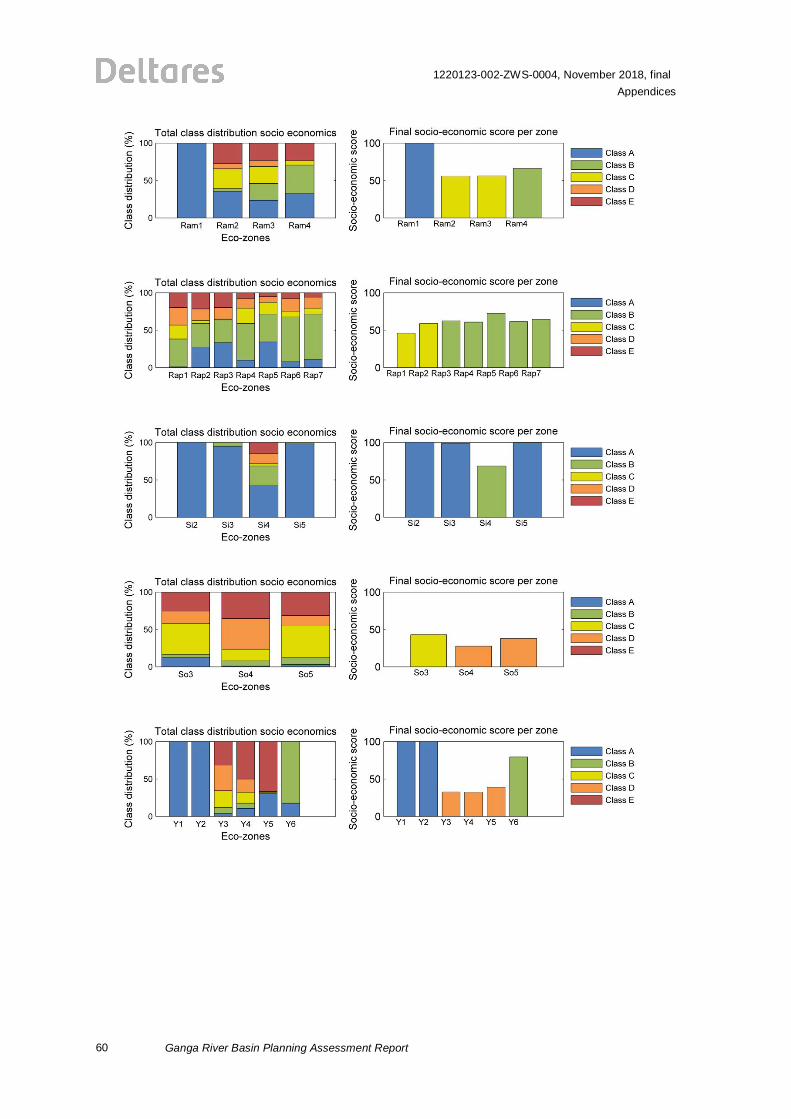
E.2 Total Socio-economic Scores
1220123-002-ZWS-0004, November 2018, finalAppendices
Ganga River Basin Planning Assessment Report 59
60
1220123-002-ZWS-0004, November 2018, finalAppendices
Ganga River Basin Planning Assessment Report
1220123-002-ZWS-0004, November 2018, finalAppendices
Ganga River Basin Planning Assessment Report 61
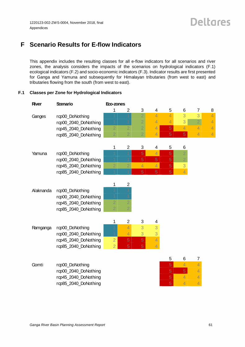
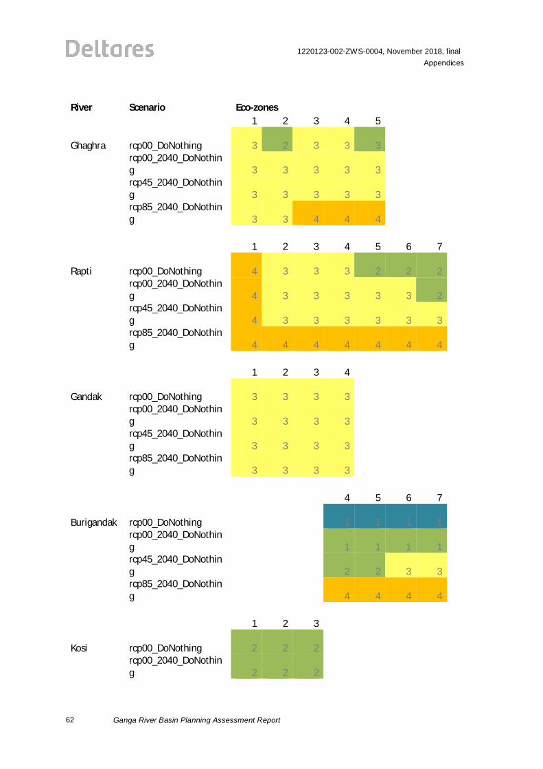
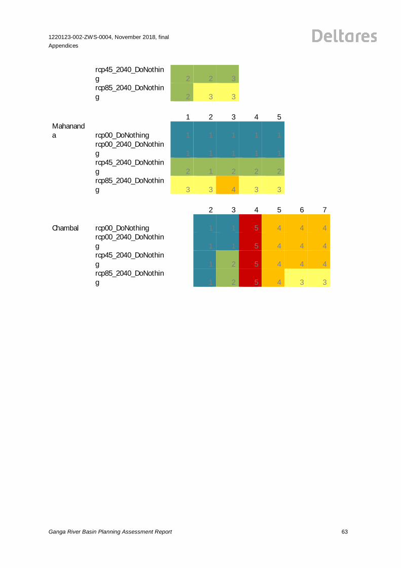
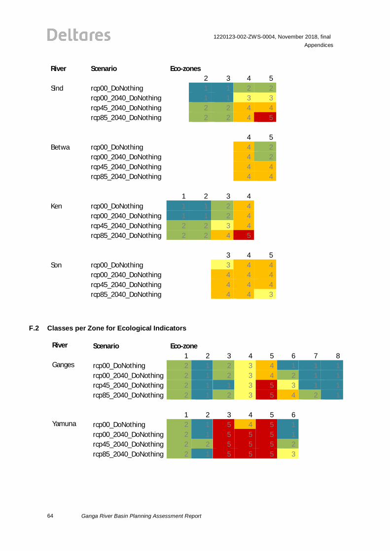
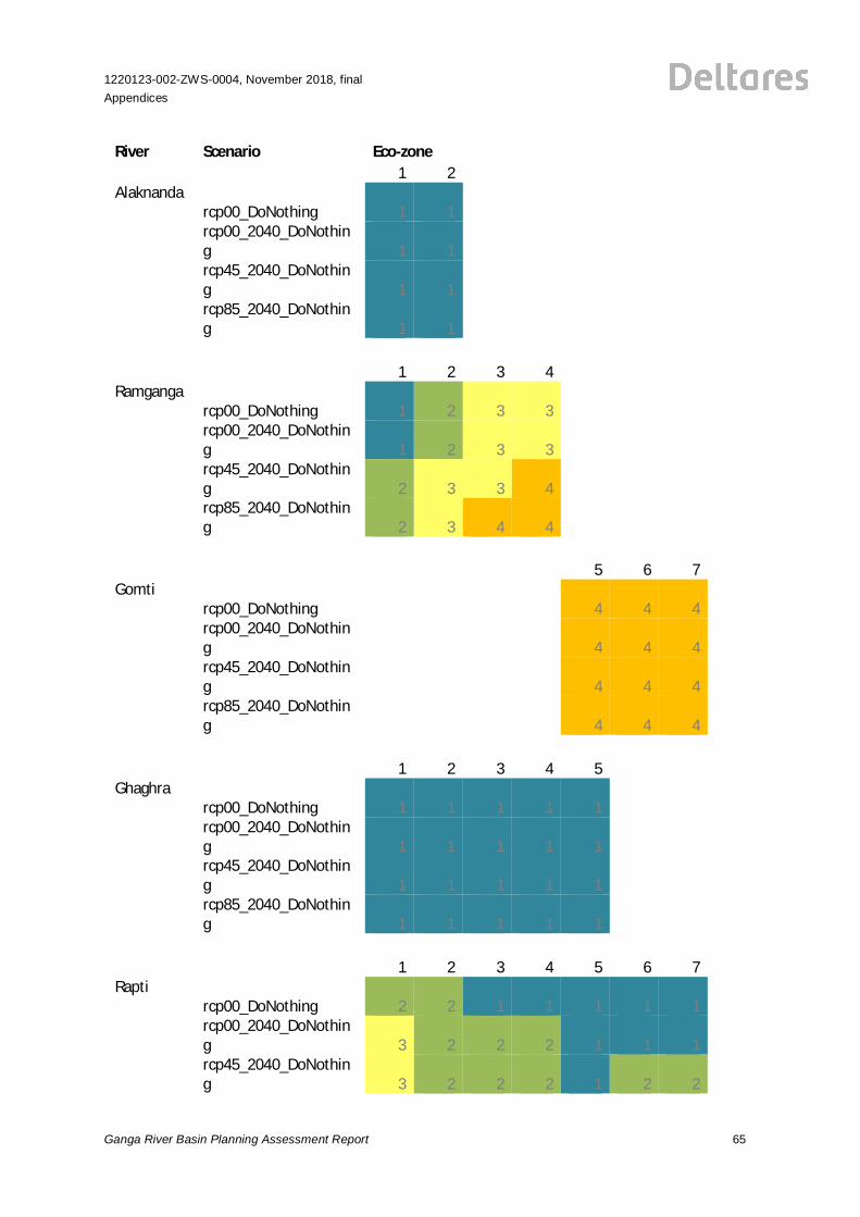
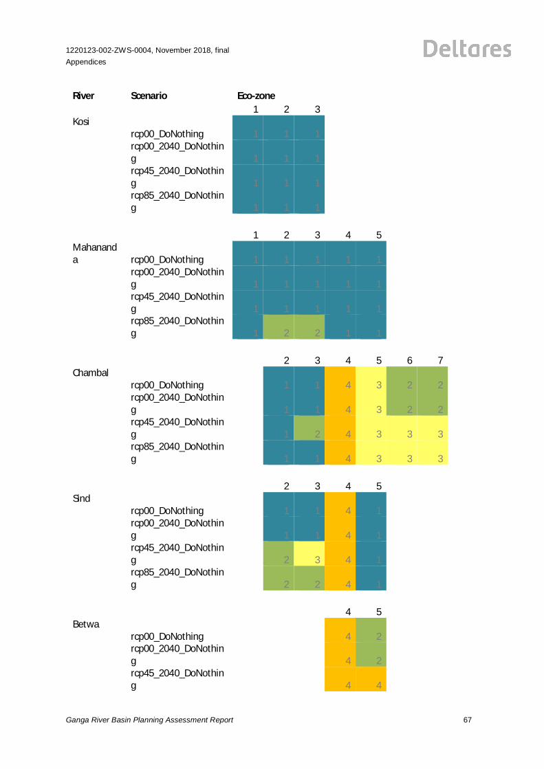
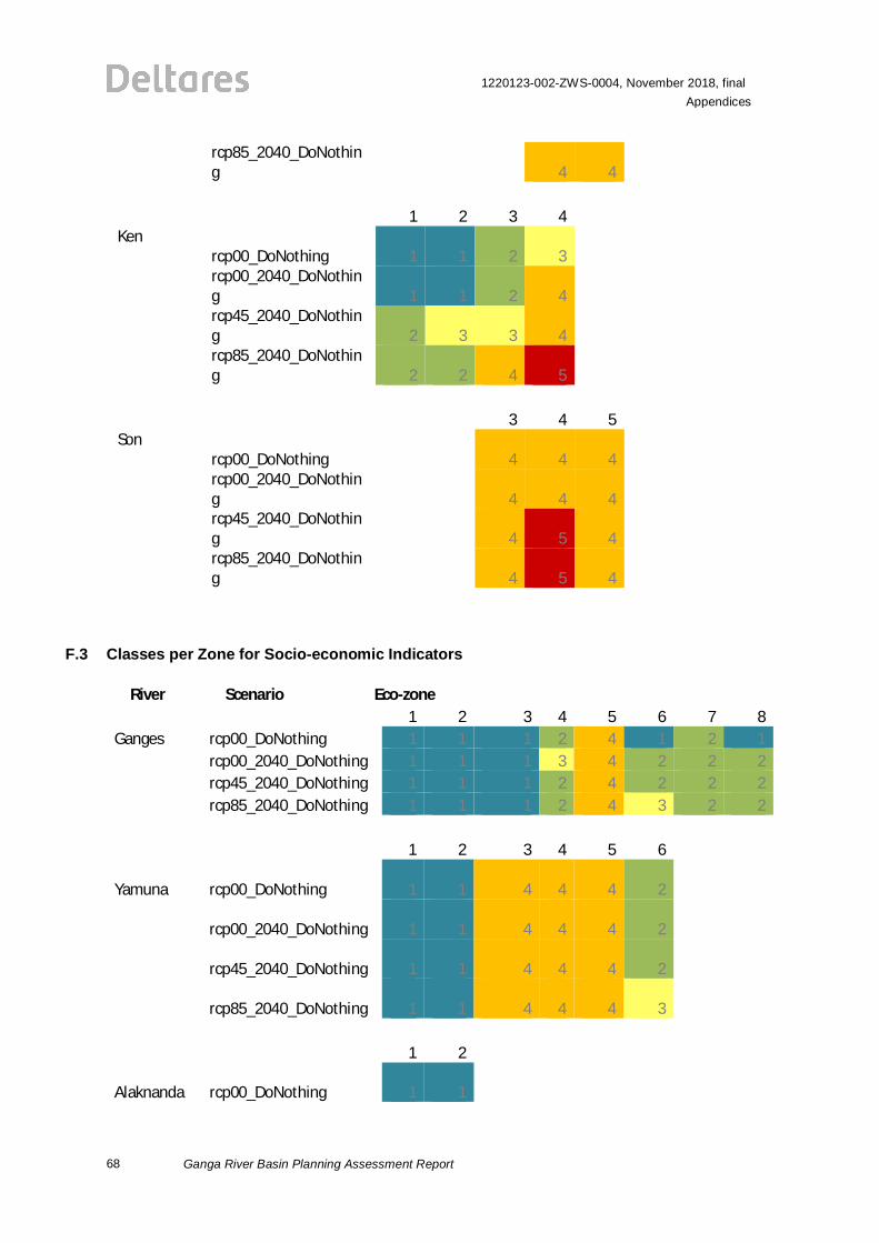
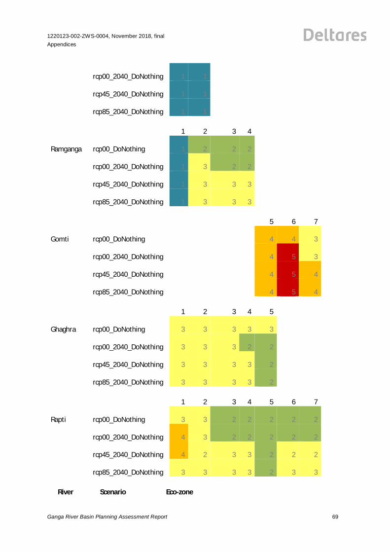
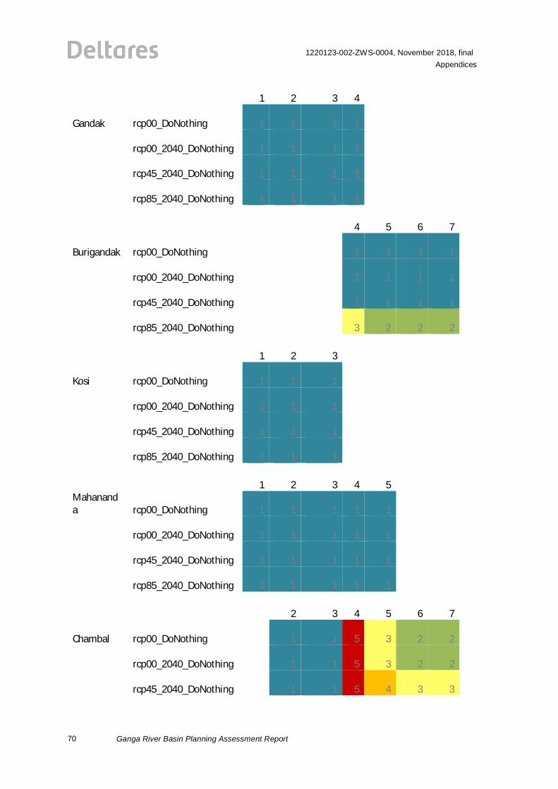
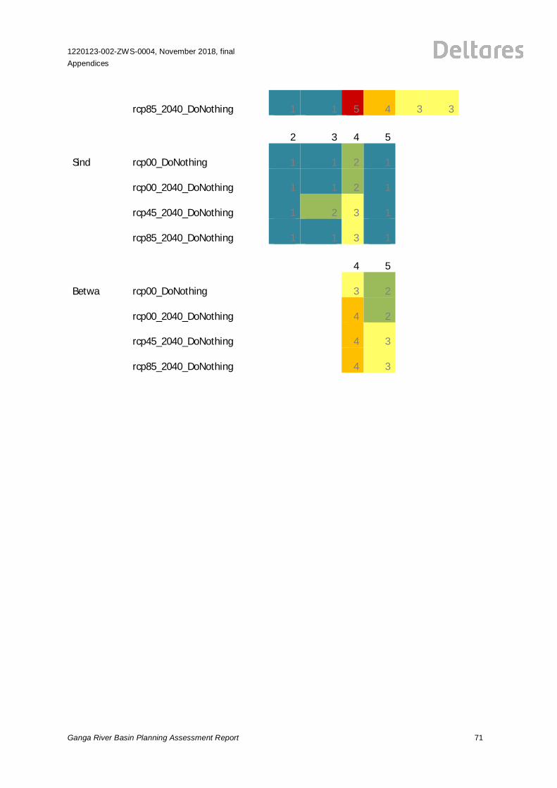
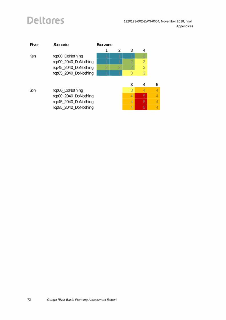
F Scenario Results for E-flow Indicators
This appendix includes the resulting classes for all e-flow indicators for all scenarios and riverzones, the analysis considers the impacts of the scenarios on hydrological indicators (F.1)ecological indicators (F.2) and socio-economic indicators (F.3). Indicator results are first presentedfor Ganga and Yamuna and subsequently for Himalayan tributaries (from west to east) andtributaries flowing from the south (from west to east).
F.1 Classes per Zone for Hydrological Indicators
River Scenario Eco-zones1 2 3 4 5 6 7 8
Ganges rcp00_DoNothing 1 1 2 4 4 3 3 4rcp00_2040_DoNothing 1 1 2 4 4 3 2 4rcp45_2040_DoNothing 2 2 2 4 5 4 4 4rcp85_2040_DoNothing 2 2 2 4 5 5 4 4
1 2 3 4 5 6 7 8Yamuna rcp00_DoNothing 1 1 5 4 5 2 #N/A #N/A
rcp00_2040_DoNothing 1 1 5 5 5 2 #N/A #N/Arcp45_2040_DoNothing 2 2 4 4 5 3 #N/A #N/Arcp85_2040_DoNothing 1 1 5 5 5 4 #N/A #N/A
1 2 3 4 5 6 7 8Alaknanda rcp00_DoNothing 1 1 #N/A #N/A #N/A #N/A #N/A #N/A
rcp00_2040_DoNothing 1 1 #N/A #N/A #N/A #N/A #N/A #N/Arcp45_2040_DoNothing 2 2 #N/A #N/A #N/A #N/A #N/A #N/Arcp85_2040_DoNothing 2 2 #N/A #N/A #N/A #N/A #N/A #N/A
1 2 3 4 5 6 7 8Ramganga rcp00_DoNothing 1 4 3 3 #N/A #N/A #N/A #N/A
rcp00_2040_DoNothing 1 4 3 3 #N/A #N/A #N/A #N/Arcp45_2040_DoNothing 2 5 5 4 #N/A #N/A #N/A #N/Arcp85_2040_DoNothing 2 5 5 4 #N/A #N/A #N/A #N/A
1 2 3 4 5 6 7 8Gomti rcp00_DoNothing #N/A #N/A #N/A #N/A 5 4 4 #N/A
rcp00_2040_DoNothing #N/A #N/A #N/A #N/A 5 5 4 #N/Arcp45_2040_DoNothing #N/A #N/A #N/A #N/A 5 4 4 #N/Arcp85_2040_DoNothing #N/A #N/A #N/A #N/A 5 4 4 #N/A
62
1220123-002-ZWS-0004, November 2018, finalAppendices
Ganga River Basin Planning Assessment Report
River Scenario Eco-zones1 2 3 4 5 6 7 8
Ghaghra rcp00_DoNothing 3 2 3 3 3#N/
A#N/
A#N/
Arcp00_2040_DoNothing 3 3 3 3 3
#N/A
#N/A
#N/A
rcp45_2040_DoNothing 3 3 3 3 3
#N/A
#N/A
#N/A
rcp85_2040_DoNothing 3 3 4 4 4
#N/A
#N/A
#N/A
1 2 3 4 5 6 7 8
Rapti rcp00_DoNothing 4 3 3 3 2 2 2#N/
Arcp00_2040_DoNothing 4 3 3 3 3 3 2
#N/A
rcp45_2040_DoNothing 4 3 3 3 3 3 3
#N/A
rcp85_2040_DoNothing 4 4 4 4 4 4 4
#N/A
1 2 3 4 5 6 7 8
Gandak rcp00_DoNothing 3 3 3 3#N/
A#N/
A#N/
A#N/
Arcp00_2040_DoNothing 3 3 3 3
#N/A
#N/A
#N/A
#N/A
rcp45_2040_DoNothing 3 3 3 3
#N/A
#N/A
#N/A
#N/A
rcp85_2040_DoNothing 3 3 3 3
#N/A
#N/A
#N/A
#N/A
1 2 3 4 5 6 7 8
Burigandak rcp00_DoNothing#N/
A#N/
A#N/
A 1 1 1 1#N/
Arcp00_2040_DoNothing
#N/A
#N/A
#N/A 1 1 1 1
#N/A
rcp45_2040_DoNothing
#N/A
#N/A
#N/A 2 2 3 3
#N/A
rcp85_2040_DoNothing
#N/A
#N/A
#N/A 4 4 4 4
#N/A
1 2 3 4 5 6 7 8
Kosi rcp00_DoNothing 2 2 2#N/
A#N/
A#N/
A#N/
A#N/
Arcp00_2040_DoNothing 2 2 2
#N/A
#N/A
#N/A
#N/A
#N/A
1220123-002-ZWS-0004, November 2018, finalAppendices
Ganga River Basin Planning Assessment Report 63
rcp45_2040_DoNothing 2 2 3
#N/A
#N/A
#N/A
#N/A
#N/A
rcp85_2040_DoNothing 2 3 3
#N/A
#N/A
#N/A
#N/A
#N/A
1 2 3 4 5 6 7 8Mahananda rcp00_DoNothing 1 1 1 1 1
#N/A
#N/A
#N/A
rcp00_2040_DoNothing 1 1 1 1 1
#N/A
#N/A
#N/A
rcp45_2040_DoNothing 2 1 2 2 2
#N/A
#N/A
#N/A
rcp85_2040_DoNothing 3 3 4 3 3
#N/A
#N/A
#N/A
1 2 3 4 5 6 7 8
Chambal rcp00_DoNothing#N/
A 1 1 5 4 4 4#N/
Arcp00_2040_DoNothing
#N/A 1 1 5 4 4 4
#N/A
rcp45_2040_DoNothing
#N/A 1 2 5 4 4 4
#N/A
rcp85_2040_DoNothing
#N/A 1 2 5 4 3 3
#N/A
64
1220123-002-ZWS-0004, November 2018, finalAppendices
Ganga River Basin Planning Assessment Report
River Scenario Eco-zones1 2 3 4 5 6 7 8
Sind rcp00_DoNothing #N/A 1 1 2 2 #N/A #N/A #N/Arcp00_2040_DoNothing #N/A 1 1 3 3 #N/A #N/A #N/Arcp45_2040_DoNothing #N/A 2 2 4 4 #N/A #N/A #N/Arcp85_2040_DoNothing #N/A 2 2 4 5 #N/A #N/A #N/A
1 2 3 4 5 6 7 8Betwa rcp00_DoNothing #N/A #N/A #N/A 4 2 #N/A #N/A #N/A
rcp00_2040_DoNothing #N/A #N/A #N/A 4 2 #N/A #N/A #N/Arcp45_2040_DoNothing #N/A #N/A #N/A 4 4 #N/A #N/A #N/Arcp85_2040_DoNothing #N/A #N/A #N/A 4 4 #N/A #N/A #N/A
1 2 3 4 5 6 7 8Ken rcp00_DoNothing 1 1 2 4 #N/A #N/A #N/A #N/A
rcp00_2040_DoNothing 1 1 2 4 #N/A #N/A #N/A #N/Arcp45_2040_DoNothing 2 2 3 4 #N/A #N/A #N/A #N/Arcp85_2040_DoNothing 2 2 4 5 #N/A #N/A #N/A #N/A
1 2 3 4 5 6 7 8Son rcp00_DoNothing #N/A #N/A 3 4 4 #N/A #N/A #N/A
rcp00_2040_DoNothing #N/A #N/A 4 4 4 #N/A #N/A #N/Arcp45_2040_DoNothing #N/A #N/A 4 4 4 #N/A #N/A #N/Arcp85_2040_DoNothing #N/A #N/A 4 4 3 #N/A #N/A #N/A
F.2 Classes per Zone for Ecological Indicators
River Scenario Eco-zone1 2 3 4 5 6 7 8
Ganges rcp00_DoNothing 2 1 2 3 4 1 1 1rcp00_2040_DoNothing 2 1 2 3 4 2 1 1rcp45_2040_DoNothing 2 1 1 3 5 3 1 1rcp85_2040_DoNothing 2 1 2 3 5 4 2 1
1 2 3 4 5 6 7 8Yamuna rcp00_DoNothing 2 1 5 4 5 1 #N/A #N/A
rcp00_2040_DoNothing 2 1 5 5 5 1 #N/A #N/Arcp45_2040_DoNothing 2 2 5 5 5 2 #N/A #N/Arcp85_2040_DoNothing 2 1 5 5 5 3 #N/A #N/A
1220123-002-ZWS-0004, November 2018, finalAppendices
Ganga River Basin Planning Assessment Report 65
River Scenario Eco-zone1 2 3 4 5 6 7 8
Alaknandarcp00_DoNothing 1 1
#N/A
#N/A
#N/A
#N/A
#N/A
#N/A
rcp00_2040_DoNothing 1 1
#N/A
#N/A
#N/A
#N/A
#N/A
#N/A
rcp45_2040_DoNothing 1 1
#N/A
#N/A
#N/A
#N/A
#N/A
#N/A
rcp85_2040_DoNothing 1 1
#N/A
#N/A
#N/A
#N/A
#N/A
#N/A
1 2 3 4 5 6 7 8Ramganga
rcp00_DoNothing 1 2 3 3#N/
A#N/
A#N/
A#N/
Arcp00_2040_DoNothing 1 2 3 3
#N/A
#N/A
#N/A
#N/A
rcp45_2040_DoNothing 2 3 3 4
#N/A
#N/A
#N/A
#N/A
rcp85_2040_DoNothing 2 3 4 4
#N/A
#N/A
#N/A
#N/A
1 2 3 4 5 6 7 8Gomti
rcp00_DoNothing#N/
A#N/
A#N/
A#N/
A 4 4 4#N/
Arcp00_2040_DoNothing
#N/A
#N/A
#N/A
#N/A 4 4 4
#N/A
rcp45_2040_DoNothing
#N/A
#N/A
#N/A
#N/A 4 4 4
#N/A
rcp85_2040_DoNothing
#N/A
#N/A
#N/A
#N/A 4 4 4
#N/A
1 2 3 4 5 6 7 8Ghaghra
rcp00_DoNothing 1 1 1 1 1#N/
A#N/
A#N/
Arcp00_2040_DoNothing 1 1 1 1 1
#N/A
#N/A
#N/A
rcp45_2040_DoNothing 1 1 1 1 1
#N/A
#N/A
#N/A
rcp85_2040_DoNothing 1 1 1 1 1
#N/A
#N/A
#N/A
1 2 3 4 5 6 7 8Rapti
rcp00_DoNothing 2 2 1 1 1 1 1#N/
Arcp00_2040_DoNothing 3 2 2 2 1 1 1
#N/A
rcp45_2040_DoNothing 3 2 2 2 1 2 2
#N/A
66
1220123-002-ZWS-0004, November 2018, finalAppendices
Ganga River Basin Planning Assessment Report
rcp85_2040_DoNothing 3 3 3 4 3 3 4
#N/A
1 2 3 4 5 6 7 8Gandak
rcp00_DoNothing 1 1 1 1#N/
A#N/
A#N/
A#N/
Arcp00_2040_DoNothing 1 1 1 1
#N/A
#N/A
#N/A
#N/A
rcp45_2040_DoNothing 1 1 1 1
#N/A
#N/A
#N/A
#N/A
rcp85_2040_DoNothing 1 1 1 1
#N/A
#N/A
#N/A
#N/A
1 2 3 4 5 6 7 8Burigandak rcp00_DoNothing
#N/A
#N/A
#N/A 1 1 1 1
#N/A
rcp00_2040_DoNothing
#N/A
#N/A
#N/A 1 1 1 1
#N/A
rcp45_2040_DoNothing
#N/A
#N/A
#N/A 2 1 1 2
#N/A
rcp85_2040_DoNothing
#N/A
#N/A
#N/A 3 2 2 3
#N/A
1220123-002-ZWS-0004, November 2018, finalAppendices
Ganga River Basin Planning Assessment Report 67
River Scenario Eco-zone1 2 3 4 5 6 7 8
Kosircp00_DoNothing 1 1 1
#N/A
#N/A
#N/A
#N/A
#N/A
rcp00_2040_DoNothing 1 1 1
#N/A
#N/A
#N/A
#N/A
#N/A
rcp45_2040_DoNothing 1 1 1
#N/A
#N/A
#N/A
#N/A
#N/A
rcp85_2040_DoNothing 1 1 1
#N/A
#N/A
#N/A
#N/A
#N/A
1 2 3 4 5 6 7 8Mahananda rcp00_DoNothing 1 1 1 1 1
#N/A
#N/A
#N/A
rcp00_2040_DoNothing 1 1 1 1 1
#N/A
#N/A
#N/A
rcp45_2040_DoNothing 1 1 1 1 1
#N/A
#N/A
#N/A
rcp85_2040_DoNothing 1 2 2 1 1
#N/A
#N/A
#N/A
1 2 3 4 5 6 7 8Chambal
rcp00_DoNothing#N/
A 1 1 4 3 2 2#N/
Arcp00_2040_DoNothing
#N/A 1 1 4 3 2 2
#N/A
rcp45_2040_DoNothing
#N/A 1 2 4 3 3 3
#N/A
rcp85_2040_DoNothing
#N/A 1 1 4 3 3 3
#N/A
1 2 3 4 5 6 7 8Sind
rcp00_DoNothing#N/
A 1 1 4 1#N/
A#N/
A#N/
Arcp00_2040_DoNothing
#N/A 1 1 4 1
#N/A
#N/A
#N/A
rcp45_2040_DoNothing
#N/A 2 3 4 1
#N/A
#N/A
#N/A
rcp85_2040_DoNothing
#N/A 2 2 4 1
#N/A
#N/A
#N/A
1 2 3 4 5 6 7 8Betwa
rcp00_DoNothing#N/
A#N/
A#N/
A 4 2#N/
A#N/
A#N/
Arcp00_2040_DoNothing
#N/A
#N/A
#N/A 4 2
#N/A
#N/A
#N/A
rcp45_2040_DoNothing
#N/A
#N/A
#N/A 4 4
#N/A
#N/A
#N/A
68
1220123-002-ZWS-0004, November 2018, finalAppendices
Ganga River Basin Planning Assessment Report
rcp85_2040_DoNothing
#N/A
#N/A
#N/A 4 4
#N/A
#N/A
#N/A
1 2 3 4 5 6 7 8Ken
rcp00_DoNothing 1 1 2 3#N/
A#N/
A#N/
A#N/
Arcp00_2040_DoNothing 1 1 2 4
#N/A
#N/A
#N/A
#N/A
rcp45_2040_DoNothing 2 3 3 4
#N/A
#N/A
#N/A
#N/A
rcp85_2040_DoNothing 2 2 4 5
#N/A
#N/A
#N/A
#N/A
1 2 3 4 5 6 7 8Son
rcp00_DoNothing#N/
A#N/
A 4 4 4#N/
A#N/
A#N/
Arcp00_2040_DoNothing
#N/A
#N/A 4 4 4
#N/A
#N/A
#N/A
rcp45_2040_DoNothing
#N/A
#N/A 4 5 4
#N/A
#N/A
#N/A
rcp85_2040_DoNothing
#N/A
#N/A 4 5 4
#N/A
#N/A
#N/A
F.3 Classes per Zone for Socio-economic Indicators
River Scenario Eco-zone1 2 3 4 5 6 7 8
Ganges rcp00_DoNothing 1 1 1 2 4 1 2 1rcp00_2040_DoNothing 1 1 1 3 4 2 2 2rcp45_2040_DoNothing 1 1 1 2 4 2 2 2rcp85_2040_DoNothing 1 1 1 2 4 3 2 2
1 2 3 4 5 6 7 8
Yamuna rcp00_DoNothing 1 1 4 4 4 2#N/
A#N/
A
rcp00_2040_DoNothing 1 1 4 4 4 2#N/
A#N/
A
rcp45_2040_DoNothing 1 1 4 4 4 2#N/
A#N/
A
rcp85_2040_DoNothing 1 1 4 4 4 3#N/
A#N/
A
1 2 3 4 5 6 7 8
Alaknanda rcp00_DoNothing 1 1 #N/A#N/A
#N/A
#N/A
#N/A
#N/A
1220123-002-ZWS-0004, November 2018, finalAppendices
Ganga River Basin Planning Assessment Report 69
rcp00_2040_DoNothing 1 1 #N/A#N/A
#N/A
#N/A
#N/A
#N/A
rcp45_2040_DoNothing 1 1 #N/A#N/A
#N/A
#N/A
#N/A
#N/A
rcp85_2040_DoNothing 1 1 #N/A#N/A
#N/A
#N/A
#N/A
#N/A
1 2 3 4 5 6 7 8
Ramganga rcp00_DoNothing 1 2 2 2#N/
A#N/
A#N/
A#N/
A
rcp00_2040_DoNothing 1 3 2 2#N/
A#N/
A#N/
A#N/
A
rcp45_2040_DoNothing 1 3 3 3#N/
A#N/
A#N/
A#N/
A
rcp85_2040_DoNothing 1 3 3 3#N/
A#N/
A#N/
A#N/
A
1 2 3 4 5 6 7 8
Gomti rcp00_DoNothing#N/
A#N/
A #N/A#N/A 4 4 3
#N/A
rcp00_2040_DoNothing#N/
A#N/
A #N/A#N/A 4 5 3
#N/A
rcp45_2040_DoNothing#N/
A#N/
A #N/A#N/A 4 5 4
#N/A
rcp85_2040_DoNothing#N/
A#N/
A #N/A#N/A 4 5 4
#N/A
1 2 3 4 5 6 7 8
Ghaghra rcp00_DoNothing 3 3 3 3 3#N/
A#N/
A#N/
A
rcp00_2040_DoNothing 3 3 3 2 2#N/
A#N/
A#N/
A
rcp45_2040_DoNothing 3 3 3 3 2#N/
A#N/
A#N/
A
rcp85_2040_DoNothing 3 3 3 3 2#N/
A#N/
A#N/
A
1 2 3 4 5 6 7 8
Rapti rcp00_DoNothing 3 3 2 2 2 2 2#N/
A
rcp00_2040_DoNothing 4 3 2 2 2 2 2#N/
A
rcp45_2040_DoNothing 4 2 3 3 2 2 2#N/
A
rcp85_2040_DoNothing 3 3 3 3 2 3 3#N/
A
River Scenario Eco-zone
70
1220123-002-ZWS-0004, November 2018, finalAppendices
Ganga River Basin Planning Assessment Report
1 2 3 4 5 6 7 8
Gandak rcp00_DoNothing 1 1 1 1#N/
A#N/
A#N/
A#N/
A
rcp00_2040_DoNothing 1 1 1 1#N/
A#N/
A#N/
A#N/
A
rcp45_2040_DoNothing 1 1 1 1#N/
A#N/
A#N/
A#N/
A
rcp85_2040_DoNothing 1 1 1 1#N/
A#N/
A#N/
A#N/
A
1 2 3 4 5 6 7 8
Burigandak rcp00_DoNothing#N/
A#N/
A #N/A 1 1 1 1#N/
A
rcp00_2040_DoNothing#N/
A#N/
A #N/A 1 1 1 1#N/
A
rcp45_2040_DoNothing#N/
A#N/
A #N/A 1 1 1 1#N/
A
rcp85_2040_DoNothing#N/
A#N/
A #N/A 3 2 2 2#N/
A
1 2 3 4 5 6 7 8
Kosi rcp00_DoNothing 1 1 1#N/A
#N/A
#N/A
#N/A
#N/A
rcp00_2040_DoNothing 1 1 1#N/A
#N/A
#N/A
#N/A
#N/A
rcp45_2040_DoNothing 1 1 1#N/A
#N/A
#N/A
#N/A
#N/A
rcp85_2040_DoNothing 1 1 1#N/A
#N/A
#N/A
#N/A
#N/A
1 2 3 4 5 6 7 8Mahananda rcp00_DoNothing 1 1 1 1 1
#N/A
#N/A
#N/A
rcp00_2040_DoNothing 1 1 1 1 1#N/
A#N/
A#N/
A
rcp45_2040_DoNothing 1 1 1 1 1#N/
A#N/
A#N/
A
rcp85_2040_DoNothing 1 1 1 1 1#N/
A#N/
A#N/
A
1 2 3 4 5 6 7 8
Chambal rcp00_DoNothing#N/
A 1 1 5 3 2 2#N/
A
rcp00_2040_DoNothing#N/
A 1 1 5 3 2 2#N/
A
rcp45_2040_DoNothing#N/
A 1 1 5 4 3 3#N/
A
1220123-002-ZWS-0004, November 2018, finalAppendices
Ganga River Basin Planning Assessment Report 71
rcp85_2040_DoNothing#N/
A 1 1 5 4 3 3#N/
A
1 2 3 4 5 6 7 8
Sind rcp00_DoNothing#N/
A 1 1 2 1#N/
A#N/
A#N/
A
rcp00_2040_DoNothing#N/
A 1 1 2 1#N/
A#N/
A#N/
A
rcp45_2040_DoNothing#N/
A 1 2 3 1#N/
A#N/
A#N/
A
rcp85_2040_DoNothing#N/
A 1 1 3 1#N/
A#N/
A#N/
A
1 2 3 4 5 6 7 8
Betwa rcp00_DoNothing#N/
A#N/
A #N/A 3 2#N/
A#N/
A#N/
A
rcp00_2040_DoNothing#N/
A#N/
A #N/A 4 2#N/
A#N/
A#N/
A
rcp45_2040_DoNothing#N/
A#N/
A #N/A 4 3#N/
A#N/
A#N/
A
rcp85_2040_DoNothing#N/
A#N/
A #N/A 4 3#N/
A#N/
A#N/
A
72
1220123-002-ZWS-0004, November 2018, finalAppendices
Ganga River Basin Planning Assessment Report
River Scenario Eco-zone1 2 3 4 5 6 7 8
Ken rcp00_DoNothing 1 1 1 2 #N/A #N/A #N/A #N/Arcp00_2040_DoNothing 1 1 2 3 #N/A #N/A #N/A #N/Arcp45_2040_DoNothing 2 2 2 3 #N/A #N/A #N/A #N/Arcp85_2040_DoNothing 1 1 3 3 #N/A #N/A #N/A #N/A
1 2 3 4 5 6 7 8Son rcp00_DoNothing #N/A #N/A 3 4 4 #N/A #N/A #N/A
rcp00_2040_DoNothing #N/A #N/A 4 5 4 #N/A #N/A #N/Arcp45_2040_DoNothing #N/A #N/A 4 5 4 #N/A #N/A #N/Arcp85_2040_DoNothing #N/A #N/A 4 5 4 #N/A #N/A #N/A
1220123-002-ZWS-0004, November 2018, finalAppendices
Ganga River Basin Planning Assessment Report 73
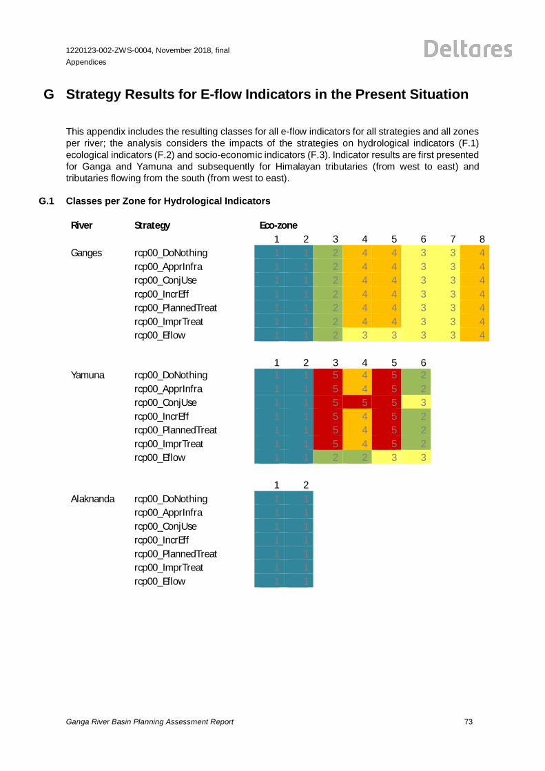
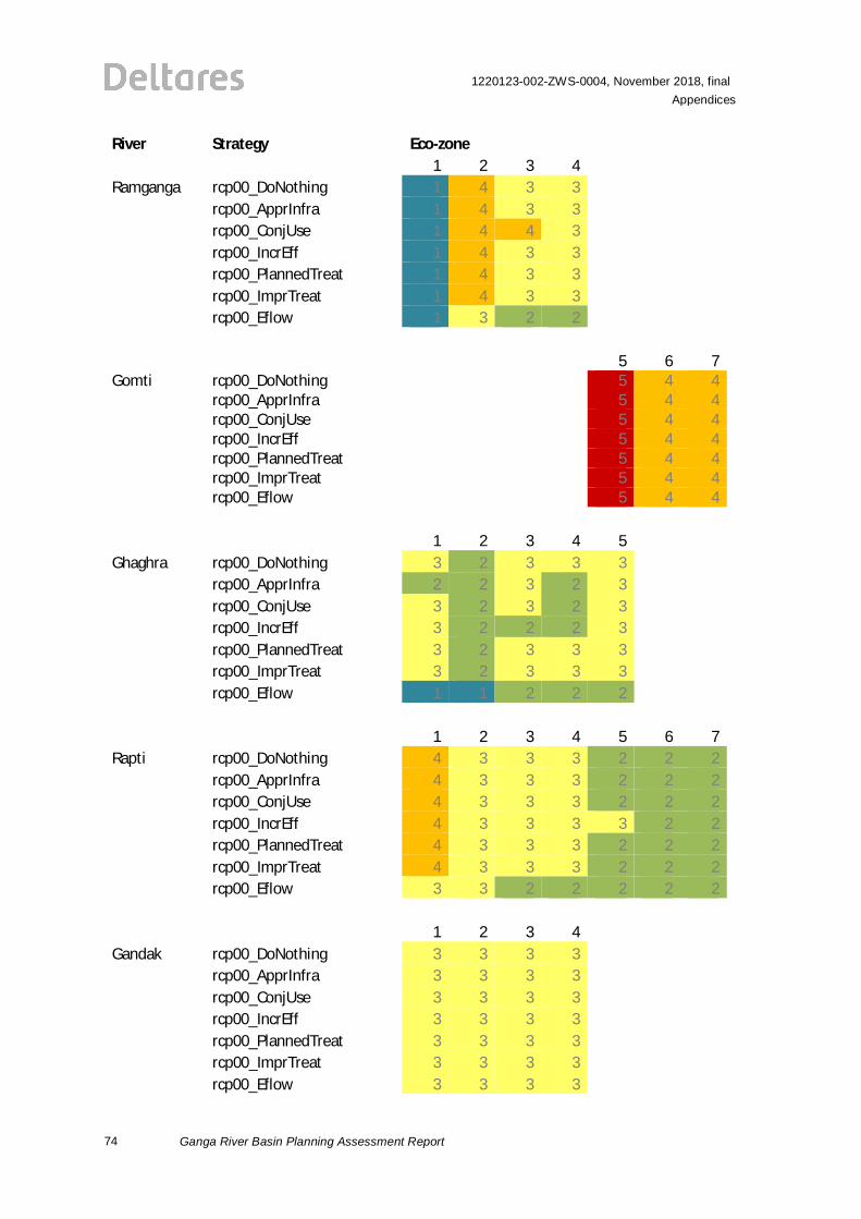
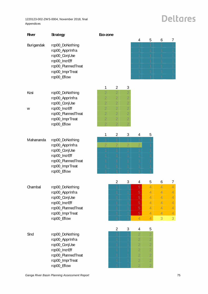
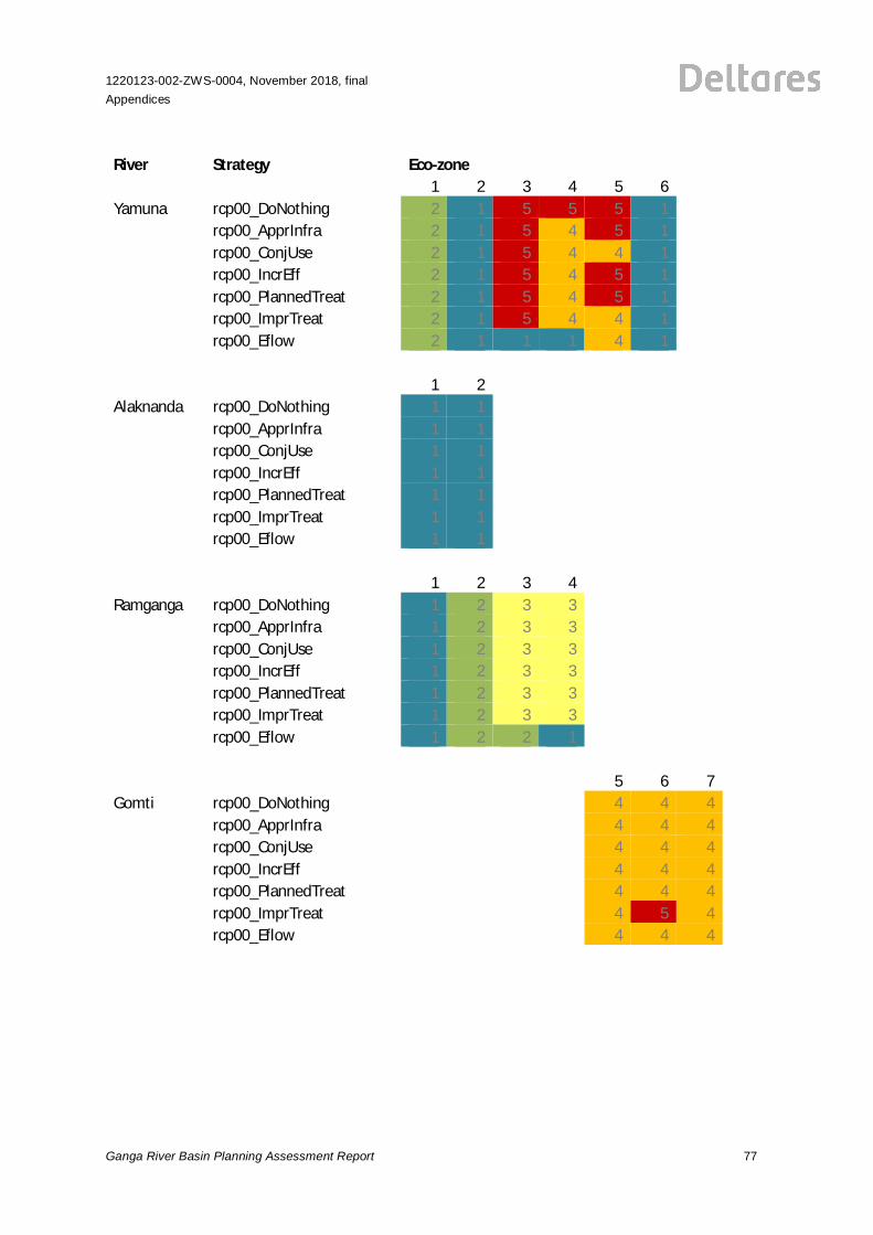
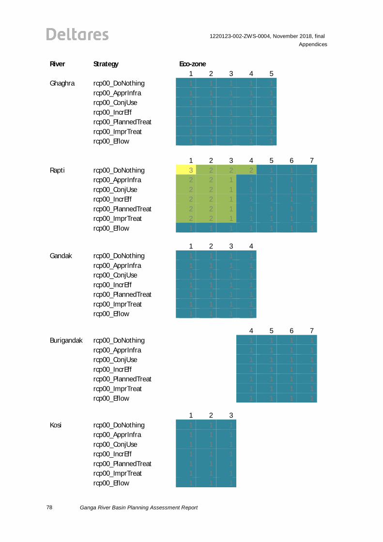
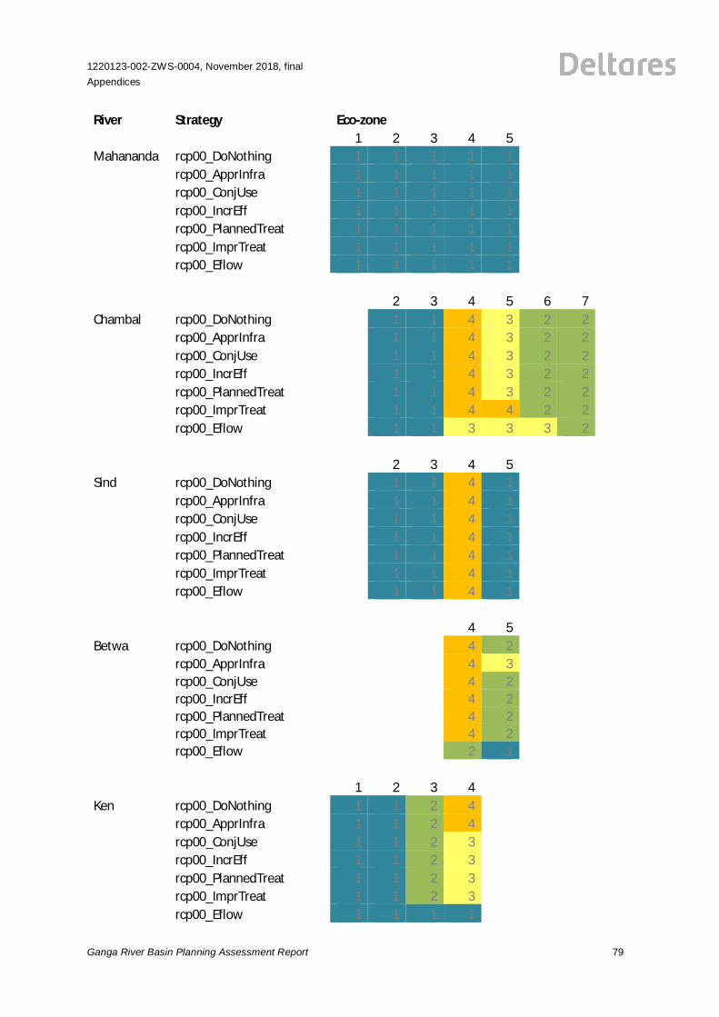
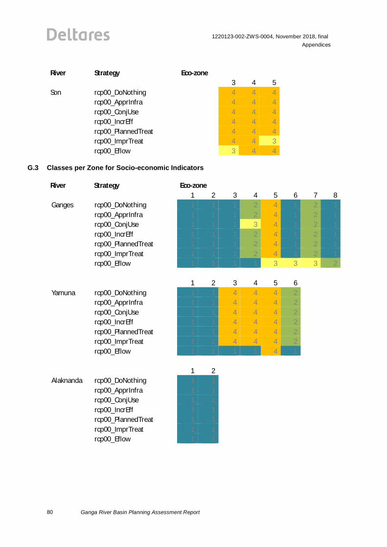
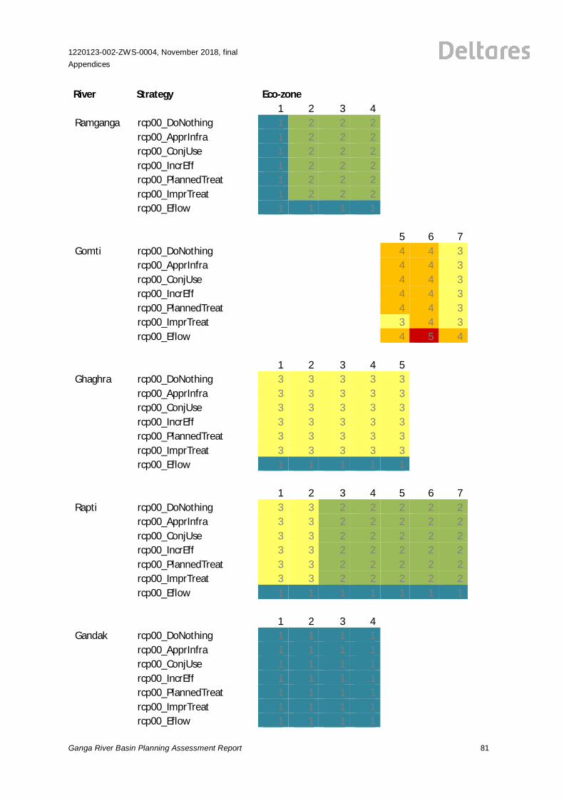
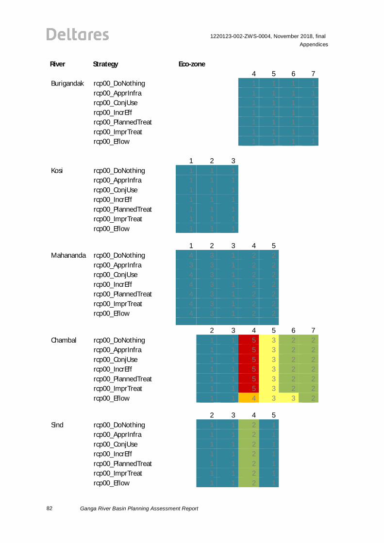
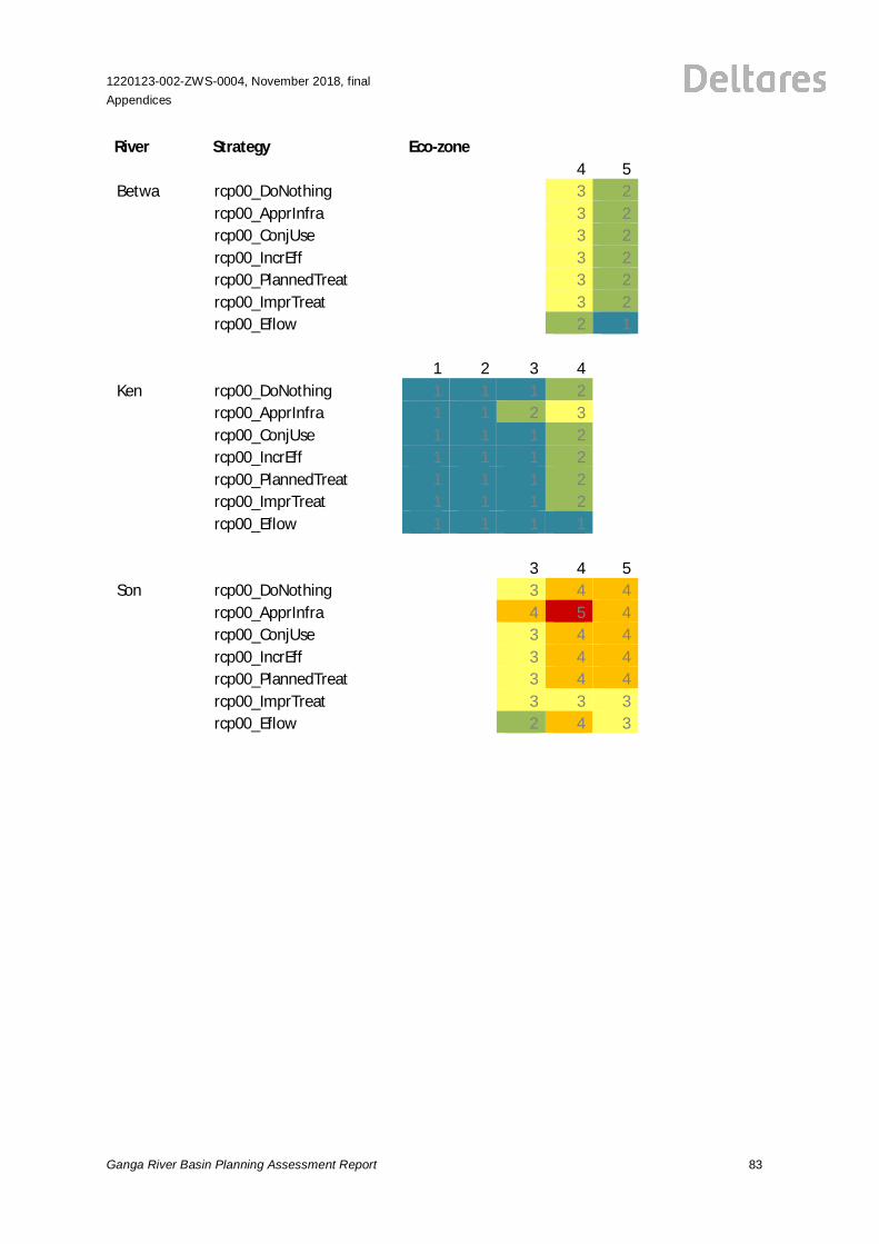
G Strategy Results for E-flow Indicators in the Present Situation
This appendix includes the resulting classes for all e-flow indicators for all strategies and all zonesper river; the analysis considers the impacts of the strategies on hydrological indicators (F.1)ecological indicators (F.2) and socio-economic indicators (F.3). Indicator results are first presentedfor Ganga and Yamuna and subsequently for Himalayan tributaries (from west to east) andtributaries flowing from the south (from west to east).
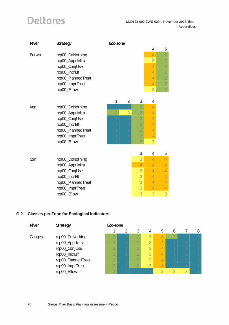
G.1 Classes per Zone for Hydrological Indicators
River Strategy Eco-zone1 2 3 4 5 6 7 8
Ganges rcp00_DoNothing 1 1 2 4 4 3 3 4rcp00_ApprInfra 1 1 2 4 4 3 3 4rcp00_ConjUse 1 1 2 4 4 3 3 4rcp00_IncrEff 1 1 2 4 4 3 3 4rcp00_PlannedTreat 1 1 2 4 4 3 3 4rcp00_ImprTreat 1 1 2 4 4 3 3 4rcp00_Eflow 1 1 2 3 3 3 3 4
1 2 3 4 5 6 7 8Yamuna rcp00_DoNothing 1 1 5 4 5 2
rcp00_ApprInfra 1 1 5 4 5 2rcp00_ConjUse 1 1 5 5 5 3rcp00_IncrEff 1 1 5 4 5 2rcp00_PlannedTreat 1 1 5 4 5 2rcp00_ImprTreat 1 1 5 4 5 2rcp00_Eflow 1 1 2 2 3 3
1 2 3 4 5 6 7 8Alaknanda rcp00_DoNothing 1 1
rcp00_ApprInfra 1 1rcp00_ConjUse 1 1rcp00_IncrEff 1 1rcp00_PlannedTreat 1 1rcp00_ImprTreat 1 1rcp00_Eflow 1 1
74
1220123-002-ZWS-0004, November 2018, finalAppendices
Ganga River Basin Planning Assessment Report
River Strategy Eco-zone1 2 3 4 5 6 7 8
Ramganga rcp00_DoNothing 1 4 3 3rcp00_ApprInfra 1 4 3 3rcp00_ConjUse 1 4 4 3rcp00_IncrEff 1 4 3 3rcp00_PlannedTreat 1 4 3 3rcp00_ImprTreat 1 4 3 3rcp00_Eflow 1 3 2 2
5 6 7Gomti rcp00_DoNothing 5 4 4
rcp00_ApprInfra 5 4 4rcp00_ConjUse 5 4 4rcp00_IncrEff 5 4 4rcp00_PlannedTreat 5 4 4rcp00_ImprTreat 5 4 4rcp00_Eflow 5 4 4
1 2 3 4 5Ghaghra rcp00_DoNothing 3 2 3 3 3
rcp00_ApprInfra 2 2 3 2 3rcp00_ConjUse 3 2 3 2 3rcp00_IncrEff 3 2 2 2 3rcp00_PlannedTreat 3 2 3 3 3rcp00_ImprTreat 3 2 3 3 3rcp00_Eflow 1 1 2 2 2
1 2 3 4 5 6 7Rapti rcp00_DoNothing 4 3 3 3 2 2 2
rcp00_ApprInfra 4 3 3 3 2 2 2rcp00_ConjUse 4 3 3 3 2 2 2rcp00_IncrEff 4 3 3 3 3 2 2rcp00_PlannedTreat 4 3 3 3 2 2 2rcp00_ImprTreat 4 3 3 3 2 2 2rcp00_Eflow 3 3 2 2 2 2 2
1 2 3 4Gandak rcp00_DoNothing 3 3 3 3
rcp00_ApprInfra 3 3 3 3rcp00_ConjUse 3 3 3 3rcp00_IncrEff 3 3 3 3rcp00_PlannedTreat 3 3 3 3rcp00_ImprTreat 3 3 3 3rcp00_Eflow 3 3 3 3
1220123-002-ZWS-0004, November 2018, finalAppendices
Ganga River Basin Planning Assessment Report 75
River Strategy Eco-zone4 5 6 7
Burigandak rcp00_DoNothing 1 1 1 1rcp00_ApprInfra 1 1 1 1rcp00_ConjUse 1 1 1 1rcp00_IncrEff 1 1 1 1rcp00_PlannedTreat 1 1 1 1rcp00_ImprTreat 1 1 1 1rcp00_Eflow 1 1 1 1
1 2 3Kosi rcp00_DoNothing 2 2 2
rcp00_ApprInfra 2 2 2rcp00_ConjUse 2 2 2
w rcp00_IncrEff 2 2 2rcp00_PlannedTreat 2 2 2rcp00_ImprTreat 2 2 2rcp00_Eflow 2 2 2
1 2 3 4 5Mahananda rcp00_DoNothing 1 1 1 1 1
rcp00_ApprInfra 2 2 2 2 1rcp00_ConjUse 1 1 1 1 1rcp00_IncrEff 1 1 1 1 1rcp00_PlannedTreat 1 1 1 1 1rcp00_ImprTreat 1 1 1 1 1rcp00_Eflow 1 1 1 1 1
2 3 4 5 6 7Chambal rcp00_DoNothing 1 1 5 4 4 4
rcp00_ApprInfra 1 1 5 4 4 4rcp00_ConjUse 1 1 5 4 4 4rcp00_IncrEff 1 1 5 4 4 4rcp00_PlannedTreat 1 1 5 4 4 4rcp00_ImprTreat 1 1 5 4 4 4rcp00_Eflow 1 1 4 4 3 3
2 3 4 5Sind rcp00_DoNothing 1 1 2 2
rcp00_ApprInfra 1 1 2 2rcp00_ConjUse 1 1 2 2rcp00_IncrEff 1 1 2 2rcp00_PlannedTreat 1 1 2 2rcp00_ImprTreat 1 1 2 2rcp00_Eflow 1 1 2 2
76
1220123-002-ZWS-0004, November 2018, finalAppendices
Ganga River Basin Planning Assessment Report
River Strategy Eco-zone4 5
Betwa rcp00_DoNothing 4 2rcp00_ApprInfra 3 2rcp00_ConjUse 4 2rcp00_IncrEff 4 2rcp00_PlannedTreat 4 2rcp00_ImprTreat 4 2rcp00_Eflow 3 2
1 2 3 4Ken rcp00_DoNothing 1 1 2 4
rcp00_ApprInfra 2 3 2 4rcp00_ConjUse 1 1 2 4rcp00_IncrEff 1 1 2 4rcp00_PlannedTreat 1 1 2 4rcp00_ImprTreat 1 1 2 4rcp00_Eflow 1 1 2 3
3 4 5Son rcp00_DoNothing 3 4 4
rcp00_ApprInfra 4 4 4rcp00_ConjUse 3 4 4rcp00_IncrEff 3 4 4rcp00_PlannedTreat 3 4 4rcp00_ImprTreat 3 4 4rcp00_Eflow 3 3 3
G.2 Classes per Zone for Ecological Indicators
River Strategy Eco-zone1 2 3 4 5 6 7 8
Ganges rcp00_DoNothing 2 1 2 3 4 2 1 1rcp00_ApprInfra 2 1 2 3 4 1 1 1rcp00_ConjUse 2 1 2 3 4 1 1 1rcp00_IncrEff 2 1 2 3 4 1 1 1rcp00_PlannedTreat 2 1 2 3 4 1 1 1rcp00_ImprTreat 2 1 2 3 4 1 1 1rcp00_Eflow 2 1 1 1 3 3 3 1
1220123-002-ZWS-0004, November 2018, finalAppendices
Ganga River Basin Planning Assessment Report 77
River Strategy Eco-zone1 2 3 4 5 6
Yamuna rcp00_DoNothing 2 1 5 5 5 1rcp00_ApprInfra 2 1 5 4 5 1rcp00_ConjUse 2 1 5 4 4 1rcp00_IncrEff 2 1 5 4 5 1rcp00_PlannedTreat 2 1 5 4 5 1rcp00_ImprTreat 2 1 5 4 4 1rcp00_Eflow 2 1 1 1 4 1
1 2Alaknanda rcp00_DoNothing 1 1
rcp00_ApprInfra 1 1rcp00_ConjUse 1 1rcp00_IncrEff 1 1rcp00_PlannedTreat 1 1rcp00_ImprTreat 1 1rcp00_Eflow 1 1
1 2 3 4Ramganga rcp00_DoNothing 1 2 3 3
rcp00_ApprInfra 1 2 3 3rcp00_ConjUse 1 2 3 3rcp00_IncrEff 1 2 3 3rcp00_PlannedTreat 1 2 3 3rcp00_ImprTreat 1 2 3 3rcp00_Eflow 1 2 2 1
5 6 7Gomti rcp00_DoNothing 4 4 4
rcp00_ApprInfra 4 4 4rcp00_ConjUse 4 4 4rcp00_IncrEff 4 4 4rcp00_PlannedTreat 4 4 4rcp00_ImprTreat 4 5 4rcp00_Eflow 4 4 4
78
1220123-002-ZWS-0004, November 2018, finalAppendices
Ganga River Basin Planning Assessment Report
River Strategy Eco-zone1 2 3 4 5
Ghaghra rcp00_DoNothing 1 1 1 1 1rcp00_ApprInfra 1 1 1 1 1rcp00_ConjUse 1 1 1 1 1rcp00_IncrEff 1 1 1 1 1rcp00_PlannedTreat 1 1 1 1 1rcp00_ImprTreat 1 1 1 1 1rcp00_Eflow 1 1 1 1 1
1 2 3 4 5 6 7Rapti rcp00_DoNothing 3 2 2 2 1 1 1
rcp00_ApprInfra 2 2 1 1 1 1 1rcp00_ConjUse 2 2 1 1 1 1 1rcp00_IncrEff 2 2 1 1 1 1 1rcp00_PlannedTreat 2 2 1 1 1 1 1rcp00_ImprTreat 2 2 1 1 1 1 1rcp00_Eflow 1 1 1 1 1 1 1
1 2 3 4Gandak rcp00_DoNothing 1 1 1 1
rcp00_ApprInfra 1 1 1 1rcp00_ConjUse 1 1 1 1rcp00_IncrEff 1 1 1 1rcp00_PlannedTreat 1 1 1 1rcp00_ImprTreat 1 1 1 1rcp00_Eflow 1 1 1 1
4 5 6 7Burigandak rcp00_DoNothing 1 1 1 1
rcp00_ApprInfra 1 1 1 1rcp00_ConjUse 1 1 1 1rcp00_IncrEff 1 1 1 1rcp00_PlannedTreat 1 1 1 1rcp00_ImprTreat 1 1 1 1rcp00_Eflow 1 1 1 1
1 2 3Kosi rcp00_DoNothing 1 1 1
rcp00_ApprInfra 1 1 1rcp00_ConjUse 1 1 1rcp00_IncrEff 1 1 1rcp00_PlannedTreat 1 1 1rcp00_ImprTreat 1 1 1rcp00_Eflow 1 1 1
1220123-002-ZWS-0004, November 2018, finalAppendices
Ganga River Basin Planning Assessment Report 79
River Strategy Eco-zone1 2 3 4 5
Mahananda rcp00_DoNothing 1 1 1 1 1rcp00_ApprInfra 1 1 1 1 1rcp00_ConjUse 1 1 1 1 1rcp00_IncrEff 1 1 1 1 1rcp00_PlannedTreat 1 1 1 1 1rcp00_ImprTreat 1 1 1 1 1rcp00_Eflow 1 1 1 1 1
2 3 4 5 6 7Chambal rcp00_DoNothing 1 1 4 3 2 2
rcp00_ApprInfra 1 1 4 3 2 2rcp00_ConjUse 1 1 4 3 2 2rcp00_IncrEff 1 1 4 3 2 2rcp00_PlannedTreat 1 1 4 3 2 2rcp00_ImprTreat 1 1 4 4 2 2rcp00_Eflow 1 1 3 3 3 2
2 3 4 5Sind rcp00_DoNothing 1 1 4 1
rcp00_ApprInfra 1 1 4 1rcp00_ConjUse 1 1 4 1rcp00_IncrEff 1 1 4 1rcp00_PlannedTreat 1 1 4 1rcp00_ImprTreat 1 1 4 1rcp00_Eflow 1 1 4 1
4 5Betwa rcp00_DoNothing 4 2
rcp00_ApprInfra 4 3rcp00_ConjUse 4 2rcp00_IncrEff 4 2rcp00_PlannedTreat 4 2rcp00_ImprTreat 4 2rcp00_Eflow 2 1
1 2 3 4Ken rcp00_DoNothing 1 1 2 4
rcp00_ApprInfra 1 1 2 4rcp00_ConjUse 1 1 2 3rcp00_IncrEff 1 1 2 3rcp00_PlannedTreat 1 1 2 3rcp00_ImprTreat 1 1 2 3rcp00_Eflow 1 1 1 1
80
1220123-002-ZWS-0004, November 2018, finalAppendices
Ganga River Basin Planning Assessment Report
River Strategy Eco-zone3 4 5
Son rcp00_DoNothing 4 4 4rcp00_ApprInfra 4 4 4rcp00_ConjUse 4 4 4rcp00_IncrEff 4 4 4rcp00_PlannedTreat 4 4 4rcp00_ImprTreat 4 4 3rcp00_Eflow 3 4 4
G.3 Classes per Zone for Socio-economic Indicators
River Strategy Eco-zone1 2 3 4 5 6 7 8
Ganges rcp00_DoNothing 1 1 1 2 4 1 2 1rcp00_ApprInfra 1 1 1 2 4 1 2 1rcp00_ConjUse 1 1 1 3 4 1 2 1rcp00_IncrEff 1 1 1 2 4 1 2 1rcp00_PlannedTreat 1 1 1 2 4 1 2 1rcp00_ImprTreat 1 1 1 2 4 1 2 1rcp00_Eflow 1 1 1 1 3 3 3 2
1 2 3 4 5 6Yamuna rcp00_DoNothing 1 1 4 4 4 2
rcp00_ApprInfra 1 1 4 4 4 2rcp00_ConjUse 1 1 4 4 4 2rcp00_IncrEff 1 1 4 4 4 2rcp00_PlannedTreat 1 1 4 4 4 2rcp00_ImprTreat 1 1 4 4 4 2rcp00_Eflow 1 1 1 1 4 1
1 2Alaknanda rcp00_DoNothing 1 1
rcp00_ApprInfra 1 1rcp00_ConjUse 1 1rcp00_IncrEff 1 1rcp00_PlannedTreat 1 1rcp00_ImprTreat 1 1rcp00_Eflow 1 1
1220123-002-ZWS-0004, November 2018, finalAppendices
Ganga River Basin Planning Assessment Report 81
River Strategy Eco-zone1 2 3 4
Ramganga rcp00_DoNothing 1 2 2 2rcp00_ApprInfra 1 2 2 2rcp00_ConjUse 1 2 2 2rcp00_IncrEff 1 2 2 2rcp00_PlannedTreat 1 2 2 2rcp00_ImprTreat 1 2 2 2rcp00_Eflow 1 1 1 1
5 6 7Gomti rcp00_DoNothing 4 4 3
rcp00_ApprInfra 4 4 3rcp00_ConjUse 4 4 3rcp00_IncrEff 4 4 3rcp00_PlannedTreat 4 4 3rcp00_ImprTreat 3 4 3rcp00_Eflow 4 5 4
1 2 3 4 5Ghaghra rcp00_DoNothing 3 3 3 3 3
rcp00_ApprInfra 3 3 3 3 3rcp00_ConjUse 3 3 3 3 3rcp00_IncrEff 3 3 3 3 3rcp00_PlannedTreat 3 3 3 3 3rcp00_ImprTreat 3 3 3 3 3rcp00_Eflow 1 1 1 1 1
1 2 3 4 5 6 7Rapti rcp00_DoNothing 3 3 2 2 2 2 2
rcp00_ApprInfra 3 3 2 2 2 2 2rcp00_ConjUse 3 3 2 2 2 2 2rcp00_IncrEff 3 3 2 2 2 2 2rcp00_PlannedTreat 3 3 2 2 2 2 2rcp00_ImprTreat 3 3 2 2 2 2 2rcp00_Eflow 1 1 1 1 1 1 1
1 2 3 4Gandak rcp00_DoNothing 1 1 1 1
rcp00_ApprInfra 1 1 1 1rcp00_ConjUse 1 1 1 1rcp00_IncrEff 1 1 1 1rcp00_PlannedTreat 1 1 1 1rcp00_ImprTreat 1 1 1 1rcp00_Eflow 1 1 1 1
82
1220123-002-ZWS-0004, November 2018, finalAppendices
Ganga River Basin Planning Assessment Report
River Strategy Eco-zone4 5 6 7
Burigandak rcp00_DoNothing 1 1 1 1rcp00_ApprInfra 1 1 1 1rcp00_ConjUse 1 1 1 1rcp00_IncrEff 1 1 1 1rcp00_PlannedTreat 1 1 1 1rcp00_ImprTreat 1 1 1 1rcp00_Eflow 1 1 1 1
1 2 3Kosi rcp00_DoNothing 1 1 1
rcp00_ApprInfra 1 1 1rcp00_ConjUse 1 1 1rcp00_IncrEff 1 1 1rcp00_PlannedTreat 1 1 1rcp00_ImprTreat 1 1 1rcp00_Eflow 1 1 1
1 2 3 4 5Mahananda rcp00_DoNothing 4 3 1 2 2
rcp00_ApprInfra 3 3 1 2 2rcp00_ConjUse 4 3 1 2 2rcp00_IncrEff 4 3 1 2 2rcp00_PlannedTreat 4 3 1 2 2rcp00_ImprTreat 4 3 1 2 2rcp00_Eflow 4 3 1 2 2
2 3 4 5 6 7Chambal rcp00_DoNothing 1 1 5 3 2 2
rcp00_ApprInfra 1 1 5 3 2 2rcp00_ConjUse 1 1 5 3 2 2rcp00_IncrEff 1 1 5 3 2 2rcp00_PlannedTreat 1 1 5 3 2 2rcp00_ImprTreat 1 1 5 3 2 2rcp00_Eflow 1 1 4 3 3 2
2 3 4 5Sind rcp00_DoNothing 1 1 2 1
rcp00_ApprInfra 1 1 2 1rcp00_ConjUse 1 1 2 1rcp00_IncrEff 1 1 2 1rcp00_PlannedTreat 1 1 2 1rcp00_ImprTreat 1 1 2 1rcp00_Eflow 1 1 2 1
1220123-002-ZWS-0004, November 2018, finalAppendices
Ganga River Basin Planning Assessment Report 83
River Strategy Eco-zone4 5
Betwa rcp00_DoNothing 3 2rcp00_ApprInfra 3 2rcp00_ConjUse 3 2rcp00_IncrEff 3 2rcp00_PlannedTreat 3 2rcp00_ImprTreat 3 2rcp00_Eflow 2 1
1 2 3 4Ken rcp00_DoNothing 1 1 1 2
rcp00_ApprInfra 1 1 2 3rcp00_ConjUse 1 1 1 2rcp00_IncrEff 1 1 1 2rcp00_PlannedTreat 1 1 1 2rcp00_ImprTreat 1 1 1 2rcp00_Eflow 1 1 1 1
3 4 5Son rcp00_DoNothing 3 4 4
rcp00_ApprInfra 4 5 4rcp00_ConjUse 3 4 4rcp00_IncrEff 3 4 4rcp00_PlannedTreat 3 4 4rcp00_ImprTreat 3 3 3rcp00_Eflow 2 4 3

1220123-002-ZWS-0004, November 2018, finalAppendices
Ganga River Basin Planning Assessment Report 85
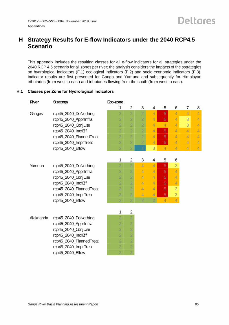
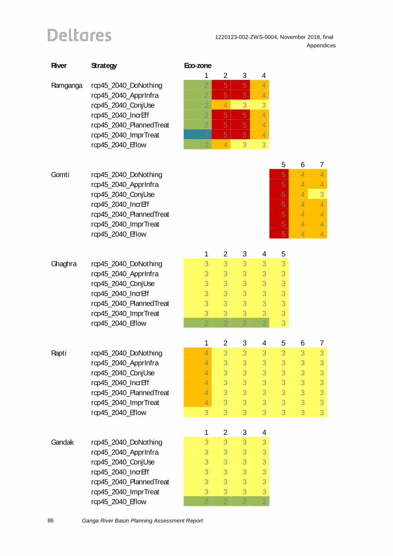
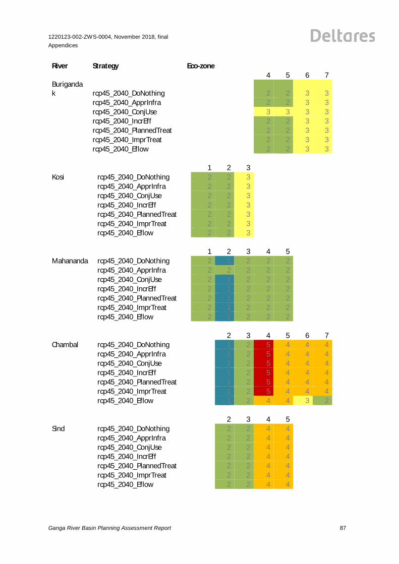
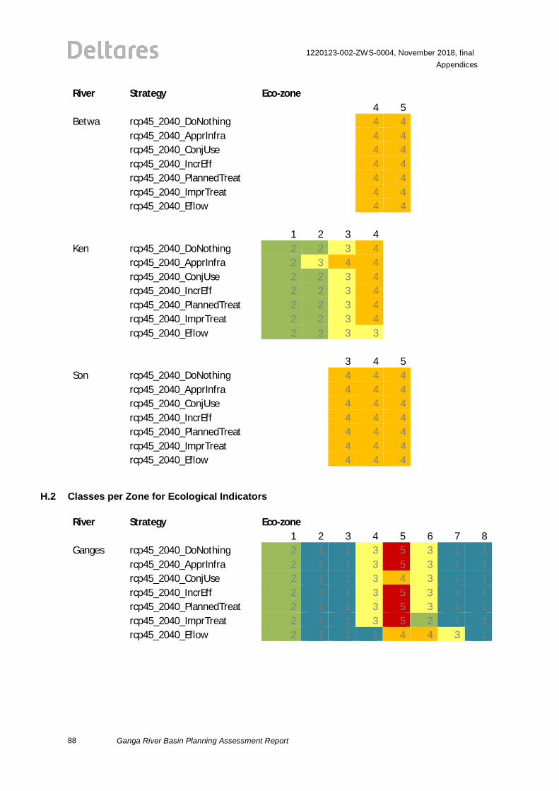
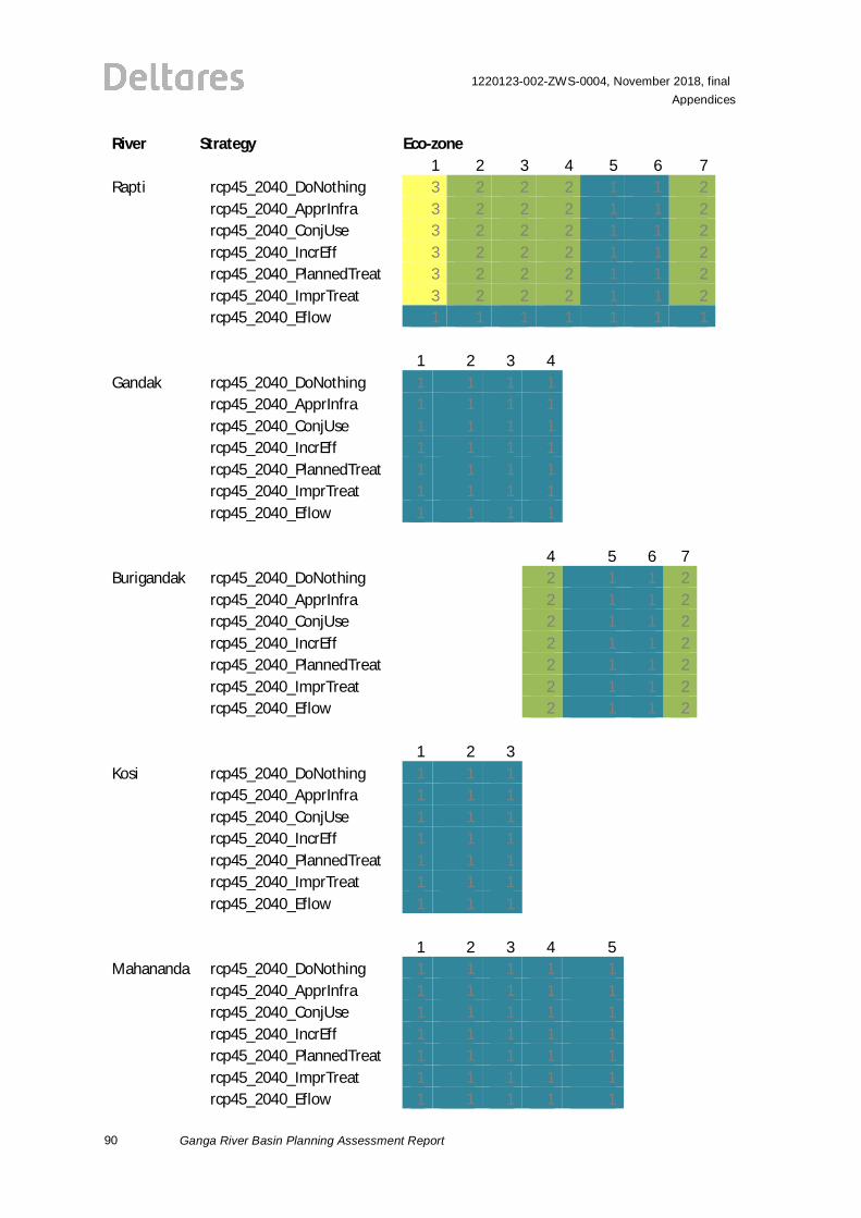
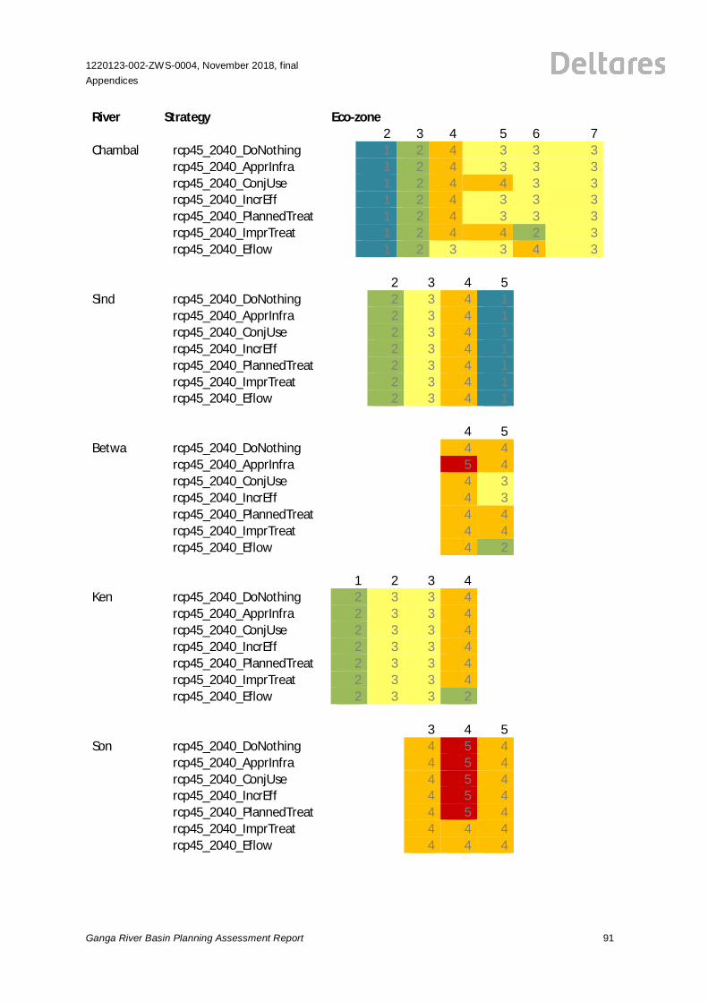
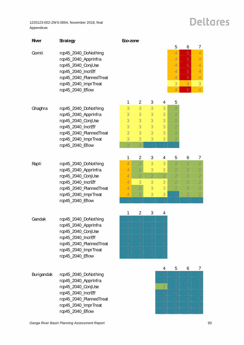
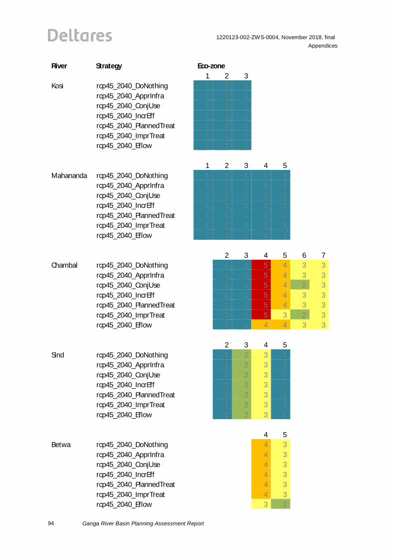
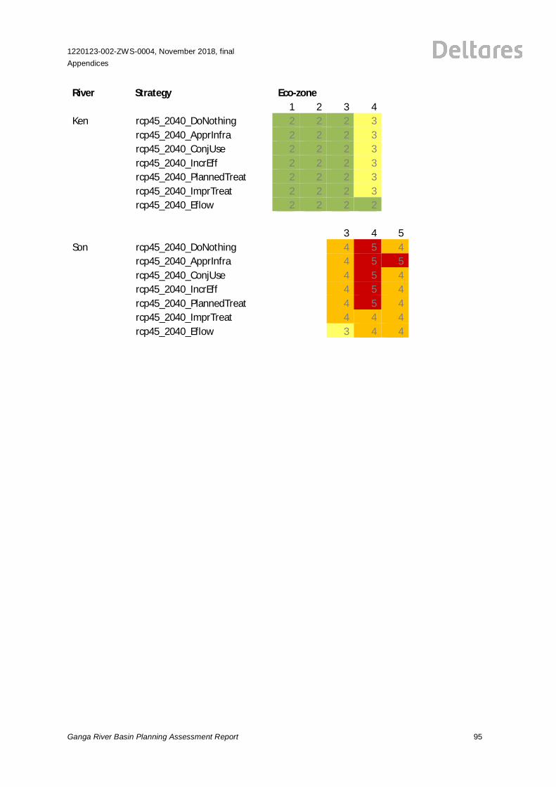
H Strategy Results for E-flow Indicators under the 2040 RCP4.5Scenario
This appendix includes the resulting classes for all e-flow indicators for all strategies under the2040 RCP 4.5 scenario for all zones per river; the analysis considers the impacts of the sstrategieson hydrological indicators (F.1) ecological indicators (F.2) and socio-economic indicators (F.3).Indicator results are first presented for Ganga and Yamuna and subsequently for Himalayantributaries (from west to east) and tributaries flowing from the south (from west to east).
H.1 Classes per Zone for Hydrological Indicators
River Strategy Eco-zone1 2 3 4 5 6 7 8
Ganges rcp45_2040_DoNothing 2 2 2 4 5 4 4 4rcp45_2040_ApprInfra 2 2 2 4 5 4 3 4rcp45_2040_ConjUse 2 2 2 4 4 4 3 4rcp45_2040_IncrEff 2 2 2 4 5 4 4 4rcp45_2040_PlannedTreat 2 2 2 4 5 4 4 4rcp45_2040_ImprTreat 2 2 2 4 5 4 4 4rcp45_2040_Eflow 2 2 1 3 4 4 4 4
1 2 3 4 5 6Yamuna rcp45_2040_DoNothing 2 2 4 4 5 3
rcp45_2040_ApprInfra 2 2 4 4 5 4rcp45_2040_ConjUse 2 2 4 4 5 4rcp45_2040_IncrEff 2 2 4 4 5 4rcp45_2040_PlannedTreat 2 2 4 4 5 3rcp45_2040_ImprTreat 2 2 4 4 5 3rcp45_2040_Eflow 2 2 2 2 4 4
1 2Alaknanda rcp45_2040_DoNothing 2 2
rcp45_2040_ApprInfra 2 2rcp45_2040_ConjUse 2 2rcp45_2040_IncrEff 2 2rcp45_2040_PlannedTreat 2 2rcp45_2040_ImprTreat 2 2rcp45_2040_Eflow 2 2
86
1220123-002-ZWS-0004, November 2018, finalAppendices
Ganga River Basin Planning Assessment Report
River Strategy Eco-zone1 2 3 4
Ramganga rcp45_2040_DoNothing 2 5 5 4rcp45_2040_ApprInfra 2 5 5 4rcp45_2040_ConjUse 2 4 3 3rcp45_2040_IncrEff 2 5 5 4rcp45_2040_PlannedTreat 2 5 5 4rcp45_2040_ImprTreat 2 5 5 4rcp45_2040_Eflow 2 4 3 3
5 6 7Gomti rcp45_2040_DoNothing 5 4 4
rcp45_2040_ApprInfra 5 4 4rcp45_2040_ConjUse 5 4 3rcp45_2040_IncrEff 5 4 4rcp45_2040_PlannedTreat 5 4 4rcp45_2040_ImprTreat 5 4 4rcp45_2040_Eflow 5 4 4
1 2 3 4 5Ghaghra rcp45_2040_DoNothing 3 3 3 3 3
rcp45_2040_ApprInfra 3 3 3 3 3rcp45_2040_ConjUse 3 3 3 3 3rcp45_2040_IncrEff 3 3 3 3 3rcp45_2040_PlannedTreat 3 3 3 3 3rcp45_2040_ImprTreat 3 3 3 3 3rcp45_2040_Eflow 2 2 2 2 3
1 2 3 4 5 6 7Rapti rcp45_2040_DoNothing 4 3 3 3 3 3 3
rcp45_2040_ApprInfra 4 3 3 3 3 3 3rcp45_2040_ConjUse 4 3 3 3 3 3 3rcp45_2040_IncrEff 4 3 3 3 3 3 3rcp45_2040_PlannedTreat 4 3 3 3 3 3 3rcp45_2040_ImprTreat 4 3 3 3 3 3 3rcp45_2040_Eflow 3 3 3 3 3 3 3
1 2 3 4Gandak rcp45_2040_DoNothing 3 3 3 3
rcp45_2040_ApprInfra 3 3 3 3rcp45_2040_ConjUse 3 3 3 3rcp45_2040_IncrEff 3 3 3 3rcp45_2040_PlannedTreat 3 3 3 3rcp45_2040_ImprTreat 3 3 3 3rcp45_2040_Eflow 2 2 2 2
1220123-002-ZWS-0004, November 2018, finalAppendices
Ganga River Basin Planning Assessment Report 87
River Strategy Eco-zone4 5 6 7
Burigandak rcp45_2040_DoNothing 2 2 3 3
rcp45_2040_ApprInfra 2 2 3 3rcp45_2040_ConjUse 3 3 3 3rcp45_2040_IncrEff 2 2 3 3rcp45_2040_PlannedTreat 2 2 3 3rcp45_2040_ImprTreat 2 2 3 3rcp45_2040_Eflow 2 2 3 3
1 2 3Kosi rcp45_2040_DoNothing 2 2 3
rcp45_2040_ApprInfra 2 2 3rcp45_2040_ConjUse 2 2 3rcp45_2040_IncrEff 2 2 3rcp45_2040_PlannedTreat 2 2 3rcp45_2040_ImprTreat 2 2 3rcp45_2040_Eflow 2 2 3
1 2 3 4 5Mahananda rcp45_2040_DoNothing 2 1 2 2 2
rcp45_2040_ApprInfra 2 2 2 2 2rcp45_2040_ConjUse 2 1 2 2 2rcp45_2040_IncrEff 2 1 2 2 2rcp45_2040_PlannedTreat 2 1 2 2 2rcp45_2040_ImprTreat 2 1 2 2 2rcp45_2040_Eflow 2 1 2 2 2
2 3 4 5 6 7Chambal rcp45_2040_DoNothing 1 2 5 4 4 4
rcp45_2040_ApprInfra 1 2 5 4 4 4rcp45_2040_ConjUse 1 2 5 4 4 4rcp45_2040_IncrEff 1 2 5 4 4 4rcp45_2040_PlannedTreat 1 2 5 4 4 4rcp45_2040_ImprTreat 1 2 5 4 4 4rcp45_2040_Eflow 1 2 4 4 3 2
2 3 4 5Sind rcp45_2040_DoNothing 2 2 4 4
rcp45_2040_ApprInfra 2 2 4 4rcp45_2040_ConjUse 2 2 4 4rcp45_2040_IncrEff 2 2 4 4rcp45_2040_PlannedTreat 2 2 4 4rcp45_2040_ImprTreat 2 2 4 4rcp45_2040_Eflow 2 2 4 4
88
1220123-002-ZWS-0004, November 2018, finalAppendices
Ganga River Basin Planning Assessment Report
River Strategy Eco-zone4 5
Betwa rcp45_2040_DoNothing 4 4rcp45_2040_ApprInfra 4 4rcp45_2040_ConjUse 4 4rcp45_2040_IncrEff 4 4rcp45_2040_PlannedTreat 4 4rcp45_2040_ImprTreat 4 4rcp45_2040_Eflow 4 4
1 2 3 4Ken rcp45_2040_DoNothing 2 2 3 4
rcp45_2040_ApprInfra 2 3 4 4rcp45_2040_ConjUse 2 2 3 4rcp45_2040_IncrEff 2 2 3 4rcp45_2040_PlannedTreat 2 2 3 4rcp45_2040_ImprTreat 2 2 3 4rcp45_2040_Eflow 2 2 3 3
3 4 5Son rcp45_2040_DoNothing 4 4 4
rcp45_2040_ApprInfra 4 4 4rcp45_2040_ConjUse 4 4 4rcp45_2040_IncrEff 4 4 4rcp45_2040_PlannedTreat 4 4 4rcp45_2040_ImprTreat 4 4 4rcp45_2040_Eflow 4 4 4
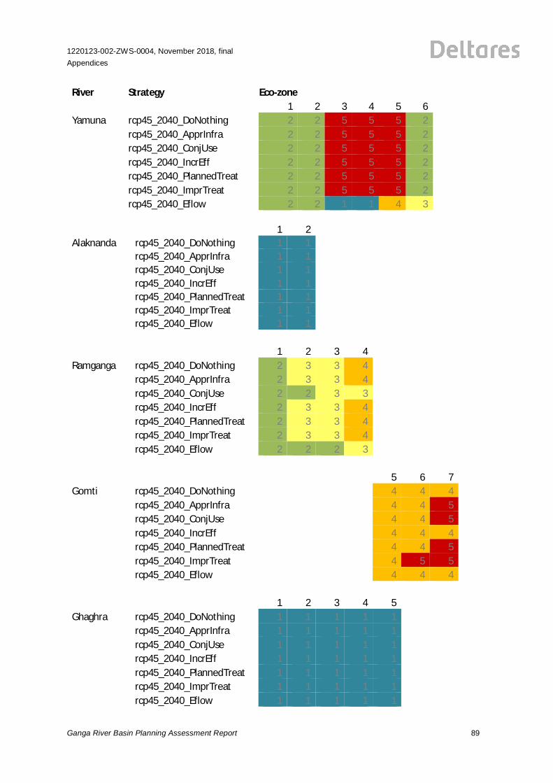
H.2 Classes per Zone for Ecological Indicators
River Strategy Eco-zone1 2 3 4 5 6 7 8
Ganges rcp45_2040_DoNothing 2 1 1 3 5 3 1 1rcp45_2040_ApprInfra 2 1 1 3 5 3 1 1rcp45_2040_ConjUse 2 1 1 3 4 3 1 1rcp45_2040_IncrEff 2 1 1 3 5 3 1 1rcp45_2040_PlannedTreat 2 1 1 3 5 3 1 1rcp45_2040_ImprTreat 2 1 1 3 5 2 1 1rcp45_2040_Eflow 2 1 1 1 4 4 3 1
1220123-002-ZWS-0004, November 2018, finalAppendices
Ganga River Basin Planning Assessment Report 89
River Strategy Eco-zone1 2 3 4 5 6
Yamuna rcp45_2040_DoNothing 2 2 5 5 5 2rcp45_2040_ApprInfra 2 2 5 5 5 2rcp45_2040_ConjUse 2 2 5 5 5 2rcp45_2040_IncrEff 2 2 5 5 5 2rcp45_2040_PlannedTreat 2 2 5 5 5 2rcp45_2040_ImprTreat 2 2 5 5 5 2rcp45_2040_Eflow 2 2 1 1 4 3
1 2Alaknanda rcp45_2040_DoNothing 1 1
rcp45_2040_ApprInfra 1 1rcp45_2040_ConjUse 1 1rcp45_2040_IncrEff 1 1rcp45_2040_PlannedTreat 1 1rcp45_2040_ImprTreat 1 1rcp45_2040_Eflow 1 1
1 2 3 4Ramganga rcp45_2040_DoNothing 2 3 3 4
rcp45_2040_ApprInfra 2 3 3 4rcp45_2040_ConjUse 2 2 3 3rcp45_2040_IncrEff 2 3 3 4rcp45_2040_PlannedTreat 2 3 3 4rcp45_2040_ImprTreat 2 3 3 4rcp45_2040_Eflow 2 2 2 3
5 6 7Gomti rcp45_2040_DoNothing 4 4 4
rcp45_2040_ApprInfra 4 4 5rcp45_2040_ConjUse 4 4 5rcp45_2040_IncrEff 4 4 4rcp45_2040_PlannedTreat 4 4 5rcp45_2040_ImprTreat 4 5 5rcp45_2040_Eflow 4 4 4
1 2 3 4 5Ghaghra rcp45_2040_DoNothing 1 1 1 1 1
rcp45_2040_ApprInfra 1 1 1 1 1rcp45_2040_ConjUse 1 1 1 1 1rcp45_2040_IncrEff 1 1 1 1 1rcp45_2040_PlannedTreat 1 1 1 1 1rcp45_2040_ImprTreat 1 1 1 1 1rcp45_2040_Eflow 1 1 1 1 1
90
1220123-002-ZWS-0004, November 2018, finalAppendices
Ganga River Basin Planning Assessment Report
River Strategy Eco-zone1 2 3 4 5 6 7
Rapti rcp45_2040_DoNothing 3 2 2 2 1 1 2rcp45_2040_ApprInfra 3 2 2 2 1 1 2rcp45_2040_ConjUse 3 2 2 2 1 1 2rcp45_2040_IncrEff 3 2 2 2 1 1 2rcp45_2040_PlannedTreat 3 2 2 2 1 1 2rcp45_2040_ImprTreat 3 2 2 2 1 1 2rcp45_2040_Eflow 1 1 1 1 1 1 1
1 2 3 4Gandak rcp45_2040_DoNothing 1 1 1 1
rcp45_2040_ApprInfra 1 1 1 1rcp45_2040_ConjUse 1 1 1 1rcp45_2040_IncrEff 1 1 1 1rcp45_2040_PlannedTreat 1 1 1 1rcp45_2040_ImprTreat 1 1 1 1rcp45_2040_Eflow 1 1 1 1
4 5 6 7Burigandak rcp45_2040_DoNothing 2 1 1 2
rcp45_2040_ApprInfra 2 1 1 2rcp45_2040_ConjUse 2 1 1 2rcp45_2040_IncrEff 2 1 1 2rcp45_2040_PlannedTreat 2 1 1 2rcp45_2040_ImprTreat 2 1 1 2rcp45_2040_Eflow 2 1 1 2
1 2 3Kosi rcp45_2040_DoNothing 1 1 1
rcp45_2040_ApprInfra 1 1 1rcp45_2040_ConjUse 1 1 1rcp45_2040_IncrEff 1 1 1rcp45_2040_PlannedTreat 1 1 1rcp45_2040_ImprTreat 1 1 1rcp45_2040_Eflow 1 1 1
1 2 3 4 5Mahananda rcp45_2040_DoNothing 1 1 1 1 1
rcp45_2040_ApprInfra 1 1 1 1 1rcp45_2040_ConjUse 1 1 1 1 1rcp45_2040_IncrEff 1 1 1 1 1rcp45_2040_PlannedTreat 1 1 1 1 1rcp45_2040_ImprTreat 1 1 1 1 1rcp45_2040_Eflow 1 1 1 1 1
1220123-002-ZWS-0004, November 2018, finalAppendices
Ganga River Basin Planning Assessment Report 91
River Strategy Eco-zone2 3 4 5 6 7
Chambal rcp45_2040_DoNothing 1 2 4 3 3 3rcp45_2040_ApprInfra 1 2 4 3 3 3rcp45_2040_ConjUse 1 2 4 4 3 3rcp45_2040_IncrEff 1 2 4 3 3 3rcp45_2040_PlannedTreat 1 2 4 3 3 3rcp45_2040_ImprTreat 1 2 4 4 2 3rcp45_2040_Eflow 1 2 3 3 4 3
2 3 4 5Sind rcp45_2040_DoNothing 2 3 4 1
rcp45_2040_ApprInfra 2 3 4 1rcp45_2040_ConjUse 2 3 4 1rcp45_2040_IncrEff 2 3 4 1rcp45_2040_PlannedTreat 2 3 4 1rcp45_2040_ImprTreat 2 3 4 1rcp45_2040_Eflow 2 3 4 1
4 5Betwa rcp45_2040_DoNothing 4 4
rcp45_2040_ApprInfra 5 4rcp45_2040_ConjUse 4 3rcp45_2040_IncrEff 4 3rcp45_2040_PlannedTreat 4 4rcp45_2040_ImprTreat 4 4rcp45_2040_Eflow 4 2
1 2 3 4Ken rcp45_2040_DoNothing 2 3 3 4
rcp45_2040_ApprInfra 2 3 3 4rcp45_2040_ConjUse 2 3 3 4rcp45_2040_IncrEff 2 3 3 4rcp45_2040_PlannedTreat 2 3 3 4rcp45_2040_ImprTreat 2 3 3 4rcp45_2040_Eflow 2 3 3 2
3 4 5Son rcp45_2040_DoNothing 4 5 4
rcp45_2040_ApprInfra 4 5 4rcp45_2040_ConjUse 4 5 4rcp45_2040_IncrEff 4 5 4rcp45_2040_PlannedTreat 4 5 4rcp45_2040_ImprTreat 4 4 4rcp45_2040_Eflow 4 4 4
92
1220123-002-ZWS-0004, November 2018, finalAppendices
Ganga River Basin Planning Assessment Report
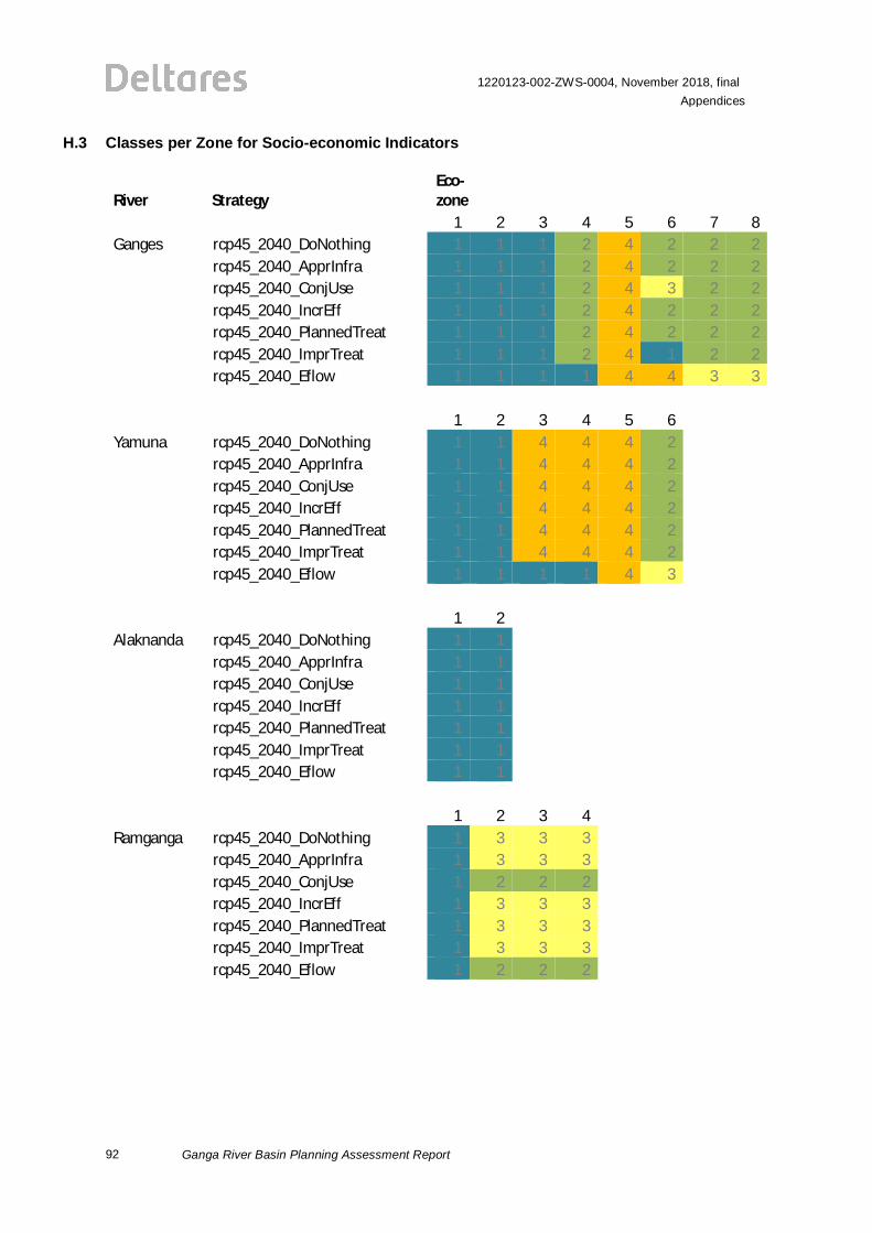
H.3 Classes per Zone for Socio-economic Indicators
River StrategyEco-zone
1 2 3 4 5 6 7 8Ganges rcp45_2040_DoNothing 1 1 1 2 4 2 2 2
rcp45_2040_ApprInfra 1 1 1 2 4 2 2 2rcp45_2040_ConjUse 1 1 1 2 4 3 2 2rcp45_2040_IncrEff 1 1 1 2 4 2 2 2rcp45_2040_PlannedTreat 1 1 1 2 4 2 2 2rcp45_2040_ImprTreat 1 1 1 2 4 1 2 2rcp45_2040_Eflow 1 1 1 1 4 4 3 3
1 2 3 4 5 6Yamuna rcp45_2040_DoNothing 1 1 4 4 4 2
rcp45_2040_ApprInfra 1 1 4 4 4 2rcp45_2040_ConjUse 1 1 4 4 4 2rcp45_2040_IncrEff 1 1 4 4 4 2rcp45_2040_PlannedTreat 1 1 4 4 4 2rcp45_2040_ImprTreat 1 1 4 4 4 2rcp45_2040_Eflow 1 1 1 1 4 3
1 2Alaknanda rcp45_2040_DoNothing 1 1
rcp45_2040_ApprInfra 1 1rcp45_2040_ConjUse 1 1rcp45_2040_IncrEff 1 1rcp45_2040_PlannedTreat 1 1rcp45_2040_ImprTreat 1 1rcp45_2040_Eflow 1 1
1 2 3 4Ramganga rcp45_2040_DoNothing 1 3 3 3
rcp45_2040_ApprInfra 1 3 3 3rcp45_2040_ConjUse 1 2 2 2rcp45_2040_IncrEff 1 3 3 3rcp45_2040_PlannedTreat 1 3 3 3rcp45_2040_ImprTreat 1 3 3 3rcp45_2040_Eflow 1 2 2 2
1220123-002-ZWS-0004, November 2018, finalAppendices
Ganga River Basin Planning Assessment Report 93
River Strategy Eco-zone5 6 7
Gomti rcp45_2040_DoNothing 4 5 4rcp45_2040_ApprInfra 4 5 4rcp45_2040_ConjUse 4 5 4rcp45_2040_IncrEff 4 5 4rcp45_2040_PlannedTreat 4 5 4rcp45_2040_ImprTreat 3 4 3rcp45_2040_Eflow 4 5 4
1 2 3 4 5Ghaghra rcp45_2040_DoNothing 3 3 3 3 2
rcp45_2040_ApprInfra 3 3 3 3 2rcp45_2040_ConjUse 3 3 3 3 2rcp45_2040_IncrEff 3 3 3 3 2rcp45_2040_PlannedTreat 3 3 3 3 2rcp45_2040_ImprTreat 3 3 3 3 2rcp45_2040_Eflow 2 2 1 1 1
1 2 3 4 5 6 7Rapti rcp45_2040_DoNothing 4 2 3 3 2 2 2
rcp45_2040_ApprInfra 4 2 3 3 2 2 2rcp45_2040_ConjUse 4 2 2 2 2 2 2rcp45_2040_IncrEff 4 3 3 3 2 2 2rcp45_2040_PlannedTreat 4 2 3 3 2 2 2rcp45_2040_ImprTreat 4 2 3 3 2 2 2rcp45_2040_Eflow 1 1 1 1 1 1 1
1 2 3 4Gandak rcp45_2040_DoNothing 1 1 1 1
rcp45_2040_ApprInfra 1 1 1 1rcp45_2040_ConjUse 1 1 1 1rcp45_2040_IncrEff 1 1 1 1rcp45_2040_PlannedTreat 1 1 1 1rcp45_2040_ImprTreat 1 1 1 1rcp45_2040_Eflow 1 1 1 1
4 5 6 7Burigandak rcp45_2040_DoNothing 1 1 1 1
rcp45_2040_ApprInfra 1 1 1 1rcp45_2040_ConjUse 2 1 1 1rcp45_2040_IncrEff 1 1 1 1rcp45_2040_PlannedTreat 1 1 1 1rcp45_2040_ImprTreat 1 1 1 1rcp45_2040_Eflow 1 1 1 1
94
1220123-002-ZWS-0004, November 2018, finalAppendices
Ganga River Basin Planning Assessment Report
River Strategy Eco-zone1 2 3
Kosi rcp45_2040_DoNothing 1 1 1rcp45_2040_ApprInfra 1 1 1rcp45_2040_ConjUse 1 1 1rcp45_2040_IncrEff 1 1 1rcp45_2040_PlannedTreat 1 1 1rcp45_2040_ImprTreat 1 1 1rcp45_2040_Eflow 1 1 1
1 2 3 4 5Mahananda rcp45_2040_DoNothing 1 1 1 1 1
rcp45_2040_ApprInfra 1 1 1 1 1rcp45_2040_ConjUse 1 1 1 1 1rcp45_2040_IncrEff 1 1 1 1 1rcp45_2040_PlannedTreat 1 1 1 1 1rcp45_2040_ImprTreat 1 1 1 1 1rcp45_2040_Eflow 1 1 1 1 1
2 3 4 5 6 7Chambal rcp45_2040_DoNothing 1 1 5 4 3 3
rcp45_2040_ApprInfra 1 1 5 4 3 3rcp45_2040_ConjUse 1 1 5 4 2 3rcp45_2040_IncrEff 1 1 5 4 3 3rcp45_2040_PlannedTreat 1 1 5 4 3 3rcp45_2040_ImprTreat 1 1 5 3 2 3rcp45_2040_Eflow 1 1 4 4 3 3
2 3 4 5Sind rcp45_2040_DoNothing 1 2 3 1
rcp45_2040_ApprInfra 1 2 3 1rcp45_2040_ConjUse 1 2 3 1rcp45_2040_IncrEff 1 2 3 1rcp45_2040_PlannedTreat 1 2 3 1rcp45_2040_ImprTreat 1 2 3 1rcp45_2040_Eflow 1 2 3 1
4 5Betwa rcp45_2040_DoNothing 4 3
rcp45_2040_ApprInfra 4 3rcp45_2040_ConjUse 4 3rcp45_2040_IncrEff 4 3rcp45_2040_PlannedTreat 4 3rcp45_2040_ImprTreat 4 3rcp45_2040_Eflow 3 2
1220123-002-ZWS-0004, November 2018, finalAppendices
Ganga River Basin Planning Assessment Report 95
River Strategy Eco-zone1 2 3 4
Ken rcp45_2040_DoNothing 2 2 2 3rcp45_2040_ApprInfra 2 2 2 3rcp45_2040_ConjUse 2 2 2 3rcp45_2040_IncrEff 2 2 2 3rcp45_2040_PlannedTreat 2 2 2 3rcp45_2040_ImprTreat 2 2 2 3rcp45_2040_Eflow 2 2 2 2
3 4 5Son rcp45_2040_DoNothing 4 5 4
rcp45_2040_ApprInfra 4 5 5rcp45_2040_ConjUse 4 5 4rcp45_2040_IncrEff 4 5 4rcp45_2040_PlannedTreat 4 5 4rcp45_2040_ImprTreat 4 4 4rcp45_2040_Eflow 3 4 4

1220123-002-ZWS-0004, November 2018, finalAppendices
Ganga River Basin Planning Assessment Report 97
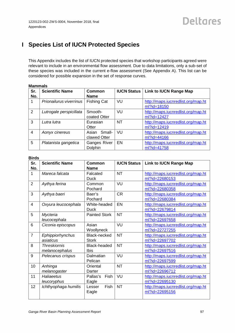
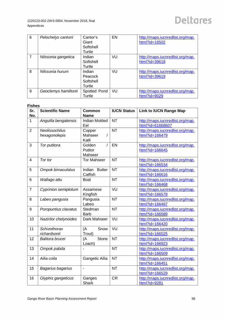
I Species List of IUCN Protected Species
This Appendix includes the list of IUCN protected species that workshop participants agreed wererelevant to include in an environmental flow assessment. Due to data limitations, only a sub-set ofthese species was included in the current e-flow assessment (See Appendix A). This list can beconsidered for possible expansion in the set of response curves.
MammalsSr.No.
Scientific Name CommonName
IUCN Status Link to IUCN Range Map
1 Prionailurus viverrinus Fishing Cat VU http://maps.iucnredlist.org/map.html?id=18150
2 Lutrogale perspicillata Smooth-coated Otter
VU http://maps.iucnredlist.org/map.html?id=12427
3 Lutra lutra EurasianOtter
NT http://maps.iucnredlist.org/map.html?id=12419
4 Aonyx cinereus Asian Small-clawed Otter
VU http://maps.iucnredlist.org/map.html?id=44166
5 Platanista gangetica Ganges RiverDolphin
EN http://maps.iucnredlist.org/map.html?id=41758
BirdsSr.No.
Scientific Name CommonName
IUCN Status Link to IUCN Range Map
1 Mareca falcata FalcatedDuck
NT http://maps.iucnredlist.org/map.html?id=22680153
2 Aythya ferina CommonPochard
VU http://maps.iucnredlist.org/map.html?id=22680358
3 Aythya baeri Baer’sPochard
CR http://maps.iucnredlist.org/map.html?id=22680384
4 Oxyura leucocephala White-headedDuck
EN http://maps.iucnredlist.org/map.html?id=22679814
5 Mycterialeucocephala
Painted Stork NT http://maps.iucnredlist.org/map.html?id=22697658
6 Ciconia episcopus AsianWoollyneck
VU http://maps.iucnredlist.org/map.html?id=22727255
7 Ephippiorhynchusasiaticus
Black-neckedStork
NT http://maps.iucnredlist.org/map.html?id=22697702
8 Threskiornismelanocephalus
Black-headedIbis
NT http://maps.iucnredlist.org/map.html?id=22697516
9 Pelecanus crispus DalmatianPelican
VU http://maps.iucnredlist.org/map.html?id=22697599
10 Anhingamelanogaster
OrientalDarter
NT http://maps.iucnredlist.org/map.html?id=22696712
11 Haliaeetusleucoryphus
Pallas’s FishEagle
VU http://maps.iucnredlist.org/map.html?id=22695130
12 Ichthyophaga humilis Lesser FishEagle
NT http://maps.iucnredlist.org/map.html?id=22695156
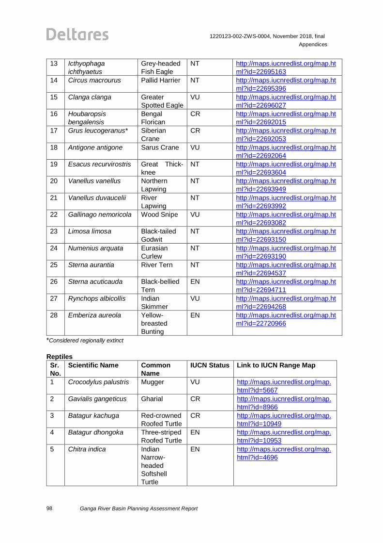
98
1220123-002-ZWS-0004, November 2018, finalAppendices
Ganga River Basin Planning Assessment Report
13 Icthyophagaichthyaetus
Grey-headedFish Eagle
NT http://maps.iucnredlist.org/map.html?id=22695163
14 Circus macrourus Pallid Harrier NT http://maps.iucnredlist.org/map.html?id=22695396
15 Clanga clanga GreaterSpotted Eagle
VU http://maps.iucnredlist.org/map.html?id=22696027
16 Houbaropsisbengalensis
BengalFlorican
CR http://maps.iucnredlist.org/map.html?id=22692015
17 Grus leucogeranus* SiberianCrane
CR http://maps.iucnredlist.org/map.html?id=22692053
18 Antigone antigone Sarus Crane VU http://maps.iucnredlist.org/map.html?id=22692064
19 Esacus recurvirostris Great Thick-knee
NT http://maps.iucnredlist.org/map.html?id=22693604
20 Vanellus vanellus NorthernLapwing
NT http://maps.iucnredlist.org/map.html?id=22693949
21 Vanellus duvaucelii RiverLapwing
NT http://maps.iucnredlist.org/map.html?id=22693992
22 Gallinago nemoricola Wood Snipe VU http://maps.iucnredlist.org/map.html?id=22693082
23 Limosa limosa Black-tailedGodwit
NT http://maps.iucnredlist.org/map.html?id=22693150
24 Numenius arquata EurasianCurlew
NT http://maps.iucnredlist.org/map.html?id=22693190
25 Sterna aurantia River Tern NT http://maps.iucnredlist.org/map.html?id=22694537
26 Sterna acuticauda Black-belliedTern
EN http://maps.iucnredlist.org/map.html?id=22694711
27 Rynchops albicollis IndianSkimmer
VU http://maps.iucnredlist.org/map.html?id=22694268
28 Emberiza aureola Yellow-breastedBunting
EN http://maps.iucnredlist.org/map.html?id=22720966
*Considered regionally extinct
ReptilesSr.No.
Scientific Name CommonName
IUCN Status Link to IUCN Range Map
1 Crocodylus palustris Mugger VU http://maps.iucnredlist.org/map.html?id=5667
2 Gavialis gangeticus Gharial CR http://maps.iucnredlist.org/map.html?id=8966
3 Batagur kachuga Red-crownedRoofed Turtle
CR http://maps.iucnredlist.org/map.html?id=10949
4 Batagur dhongoka Three-stripedRoofed Turtle
EN http://maps.iucnredlist.org/map.html?id=10953
5 Chitra indica IndianNarrow-headedSoftshellTurtle
EN http://maps.iucnredlist.org/map.html?id=4696
1220123-002-ZWS-0004, November 2018, finalAppendices
Ganga River Basin Planning Assessment Report 99
6 Pelochelys cantorii Cantor’sGiantSoftshellTurtle
EN http://maps.iucnredlist.org/map.html?id=16502
7 Nilssonia gangetica IndianSoftshellTurtle
VU http://maps.iucnredlist.org/map.html?id=39618
8 Nilssonia hurum IndianPeacockSoftshellTurtle
VU http://maps.iucnredlist.org/map.html?id=39619
9 Geoclemys hamiltonii Spotted PondTurtle
VU http://maps.iucnredlist.org/map.html?id=9029
FishesSr.No.
Scientific Name CommonName
IUCN Status Link to IUCN Range Map
1 Anguilla bengalensis Indian MottledEel
NT http://maps.iucnredlist.org/map.html?id=61668607
2 Neolissochilushexagonolepis
CopperMahseer /Katli
NT http://maps.iucnredlist.org/map.html?id=166479
3 Tor putitora Golden /PutitorMahseer
EN http://maps.iucnredlist.org/map.html?id=166645
4 Tor tor Tor Mahseer NT http://maps.iucnredlist.org/map.html?id=166534
5 Ompok bimaculatus Indian ButterCatfish
NT http://maps.iucnredlist.org/map.html?id=166616
6 Wallago attu Boal NT http://maps.iucnredlist.org/map.html?id=166468
7 Cyprinion semiplotum AssameseKingfish
VU http://maps.iucnredlist.org/map.html?id=166578
8 Labeo pangusia PangusiaLabeo
NT http://maps.iucnredlist.org/map.html?id=166497
9 Poropuntius clavatus StedmanBarb
NT http://maps.iucnredlist.org/map.html?id=166589
10 Naziritor chelynoides Dark Mahseer VU http://maps.iucnredlist.org/map.html?id=166420
11 Schizothoraxrichardsonii
(A SnowTrout)
VU http://maps.iucnredlist.org/map.html?id=166525
12 Balitora brucei (A StoneLoach)
NT http://maps.iucnredlist.org/map.html?id=166923
13 Ompok pabda - NT http://maps.iucnredlist.org/map.html?id=166509
14 Ailia coila Gangetic Ailia NT http://maps.iucnredlist.org/map.html?id=166451
15 Bagarius bagarius - NT http://maps.iucnredlist.org/map.html?id=166529
16 Glyphis gangeticus GangesShark
CR http://maps.iucnredlist.org/map.html?id=9281

1220123-002-ZWS-0004, November 2018, finalAppendices
Ganga River Basin Planning Assessment Report 101
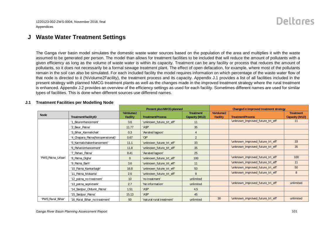
J Waste Water Treatment Settings
The Ganga river basin model simulates the domestic waste water sources based on the population of the area and multiplies it with the wasteassumed to be generated per person. The model than allows for treatment facilities to be included that will reduce the amount of pollutants with agiven efficiency as long as the volume of waste water is within its capacity. Treatment can be any facility or process that reduces the amount ofpollutants, so it does not necessarily be a formal sewage treatment plant. The effect of open defacation, for example, where most of the pollutantsremain in the soil can also be simulated. For each included facility the model requires information on which percentage of the waste water flow ofthat node is directed to it (%Volume2Facility), the treatment process and its capacity. Appendix J.1 provides a list of all facilities included in thepresent strategy with planned NMCG treatment plants as well as the changes made in the improved treatment strategy where the rural treatmentis enhanced. Appendix J.2 provides an overview of the efficiency settings as used for each facility. Sometimes different names are used for similartypes of facilities. This is done when different sources use differend names.
J.1 Treatment Facilities per Modelling NodePresent plus NMCG planned Changed in Improved treatment strategy
Node TreatmentFacilityID%Volume2
Facility TreatmentProcessTreatment
Capacity (MLD)%Volume2
Facility TreatmentProcessTreatment
Capacity (MLD)
'PWS_Patna_Urban'
'1_Beurenhancement' 3.6 'unknown_future_trt_eff' 11 'unknown_improved_future_trt_eff' 11
'2_Beur_Patna' 11.77 'ASP' 35
'3_Bihar_Karmalichak' 0.3 'Aerated lagoon' 4
'4_Chapara_Patna(Notoperational)' 0.67 'OP' 2
'5_Karmalichakenhancement' 11.1 'unknown_future_trt_eff' 33 'unknown_improved_future_trt_eff' 33
'6_Paharienhancement' 11.8 'unknown_future_trt_eff' 35 'unknown_improved_future_trt_eff' 35
'7_Pahari_Patna' 8.41 'Aerated lagoon' 25
'8_Patna_Digha' 0 'unknown_future_trt_eff' 100 'unknown_improved_future_trt_eff' 100
'9_Patna_Barh' 3.6 'unknown_future_trt_eff' 11 'unknown_improved_future_trt_eff' 11
'10_Patna_Kankarbagh' 16.8 'unknown_future_trt_eff' 50 'unknown_improved_future_trt_eff' 50
'11_Patna_Mokama' 2.6 'unknown_future_trt_eff' 8 'unknown_improved_future_trt_eff' 8
'12_patna_no treatment' 10 'no treatment' unlimited
'13_patna_septictank' 2.7 'No information' unlimited 'unknown_improved_future_trt_eff' unlimited
'14_Saidpur_Oldunit_Patna' 1.51 'ASP' 4.5
'15_Saidpur_Patna' 15.13 'ASP' 45'PWS_Rural_Bihar' '16_Rural_Bihar_no treatment' 50 'natural rural treatment' unlimited 30 'unknown_improved_future_trt_eff' unlimited
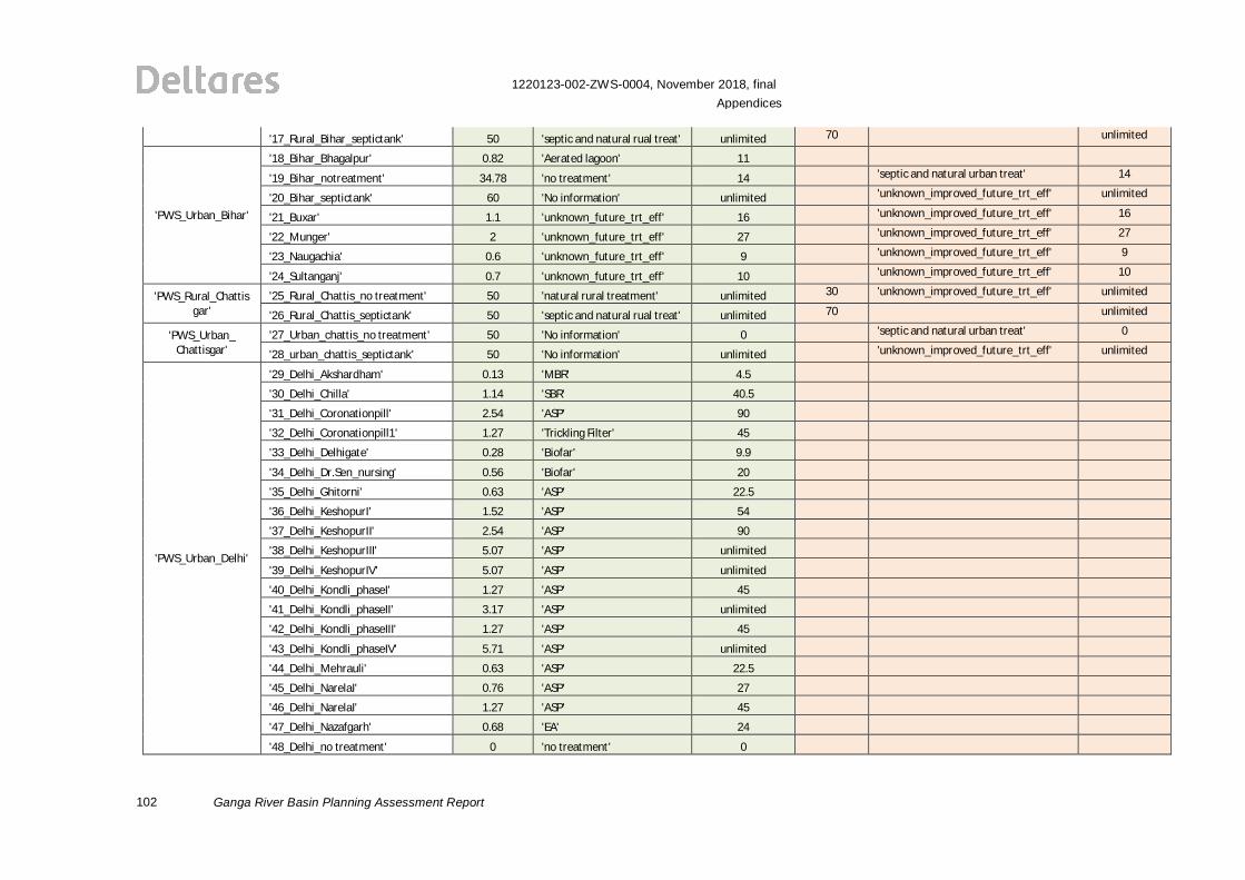
102
1220123-002-ZWS-0004, November 2018, finalAppendices
Ganga River Basin Planning Assessment Report
'17_Rural_Bihar_septictank' 50 'septic and natural rual treat' unlimited 70 unlimited
'PWS_Urban_Bihar'
'18_Bihar_Bhagalpur' 0.82 'Aerated lagoon' 11
'19_Bihar_notreatment' 34.78 'no treatment' 14 'septic and natural urban treat' 14
'20_Bihar_septictank' 60 'No information' unlimited 'unknown_improved_future_trt_eff' unlimited
'21_Buxar' 1.1 'unknown_future_trt_eff' 16 'unknown_improved_future_trt_eff' 16
'22_Munger' 2 'unknown_future_trt_eff' 27 'unknown_improved_future_trt_eff' 27
'23_Naugachia' 0.6 'unknown_future_trt_eff' 9 'unknown_improved_future_trt_eff' 9
'24_Sultanganj' 0.7 'unknown_future_trt_eff' 10 'unknown_improved_future_trt_eff' 10
'PWS_Rural_Chattisgar'
'25_Rural_Chattis_no treatment' 50 'natural rural treatment' unlimited 30 'unknown_improved_future_trt_eff' unlimited
'26_Rural_Chattis_septictank' 50 'septic and natural rual treat' unlimited 70 unlimited
'PWS_Urban_Chattisgar'
'27_Urban_chattis_no treatment' 50 'No information' 0 'septic and natural urban treat' 0
'28_urban_chattis_septictank' 50 'No information' unlimited 'unknown_improved_future_trt_eff' unlimited
'PWS_Urban_Delhi'
'29_Delhi_Akshardham' 0.13 'MBR' 4.5
'30_Delhi_Chilla' 1.14 'SBR' 40.5
'31_Delhi_Coronationpill' 2.54 'ASP' 90
'32_Delhi_Coronationpill1' 1.27 'Trickling Filter' 45
'33_Delhi_Delhigate' 0.28 'Biofar' 9.9
'34_Delhi_Dr.Sen_nursing' 0.56 'Biofar' 20
'35_Delhi_Ghitorni' 0.63 'ASP' 22.5
'36_Delhi_KeshopurI' 1.52 'ASP' 54
'37_Delhi_KeshopurII' 2.54 'ASP' 90
'38_Delhi_KeshopurIII' 5.07 'ASP' unlimited
'39_Delhi_KeshopurIV' 5.07 'ASP' unlimited
'40_Delhi_Kondli_phaseI' 1.27 'ASP' 45
'41_Delhi_Kondli_phaseII' 3.17 'ASP' unlimited
'42_Delhi_Kondli_phaseIII' 1.27 'ASP' 45
'43_Delhi_Kondli_phaseIV' 5.71 'ASP' unlimited
'44_Delhi_Mehrauli' 0.63 'ASP' 22.5
'45_Delhi_NarelaI' 0.76 'ASP' 27
'46_Delhi_NarelaI' 1.27 'ASP' 45
'47_Delhi_Nazafgarh' 0.68 'EA' 24
'48_Delhi_no treatment' 0 'no treatment' 0
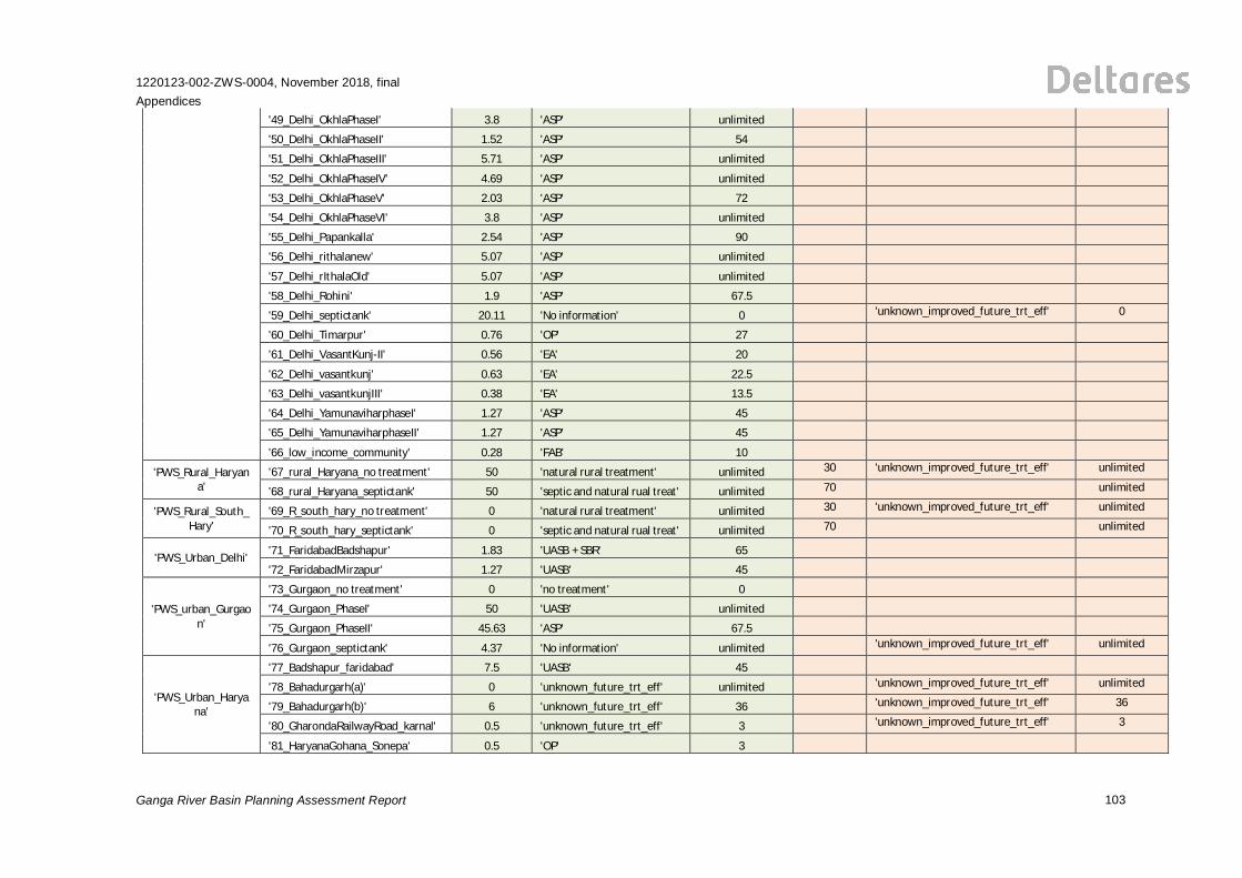
1220123-002-ZWS-0004, November 2018, finalAppendices
Ganga River Basin Planning Assessment Report 103
'49_Delhi_OkhlaPhaseI' 3.8 'ASP' unlimited
'50_Delhi_OkhlaPhaseII' 1.52 'ASP' 54
'51_Delhi_OkhlaPhaseIII' 5.71 'ASP' unlimited
'52_Delhi_OkhlaPhaseIV' 4.69 'ASP' unlimited
'53_Delhi_OkhlaPhaseV' 2.03 'ASP' 72
'54_Delhi_OkhlaPhaseVI' 3.8 'ASP' unlimited
'55_Delhi_Papankalla' 2.54 'ASP' 90
'56_Delhi_rithalanew' 5.07 'ASP' unlimited
'57_Delhi_rIthalaOld' 5.07 'ASP' unlimited
'58_Delhi_Rohini' 1.9 'ASP' 67.5
'59_Delhi_septictank' 20.11 'No information' 0 'unknown_improved_future_trt_eff' 0
'60_Delhi_Timarpur' 0.76 'OP' 27
'61_Delhi_VasantKunj-II' 0.56 'EA' 20
'62_Delhi_vasantkunj' 0.63 'EA' 22.5
'63_Delhi_vasantkunjIII' 0.38 'EA' 13.5
'64_Delhi_YamunaviharphaseI' 1.27 'ASP' 45
'65_Delhi_YamunaviharphaseII' 1.27 'ASP' 45
'66_low_income_community' 0.28 'FAB' 10
'PWS_Rural_Haryana'
'67_rural_Haryana_no treatment' 50 'natural rural treatment' unlimited 30 'unknown_improved_future_trt_eff' unlimited
'68_rural_Haryana_septictank' 50 'septic and natural rual treat' unlimited 70 unlimited
'PWS_Rural_South_Hary'
'69_R_south_hary_no treatment' 0 'natural rural treatment' unlimited 30 'unknown_improved_future_trt_eff' unlimited
'70_R_south_hary_septictank' 0 'septic and natural rual treat' unlimited 70 unlimited
'PWS_Urban_Delhi' '71_FaridabadBadshapur' 1.83 'UASB + SBR' 65
'72_FaridabadMirzapur' 1.27 'UASB' 45
'PWS_urban_Gurgaon'
'73_Gurgaon_no treatment' 0 'no treatment' 0
'74_Gurgaon_PhaseI' 50 'UASB' unlimited
'75_Gurgaon_PhaseII' 45.63 'ASP' 67.5
'76_Gurgaon_septictank' 4.37 'No information' unlimited 'unknown_improved_future_trt_eff' unlimited
'PWS_Urban_Haryana'
'77_Badshapur_faridabad' 7.5 'UASB' 45
'78_Bahadurgarh(a)' 0 'unknown_future_trt_eff' unlimited 'unknown_improved_future_trt_eff' unlimited
'79_Bahadurgarh(b)' 6 'unknown_future_trt_eff' 36 'unknown_improved_future_trt_eff' 36
'80_GharondaRailwayRoad_karnal' 0.5 'unknown_future_trt_eff' 3 'unknown_improved_future_trt_eff' 3
'81_HaryanaGohana_Sonepa' 0.5 'OP' 3
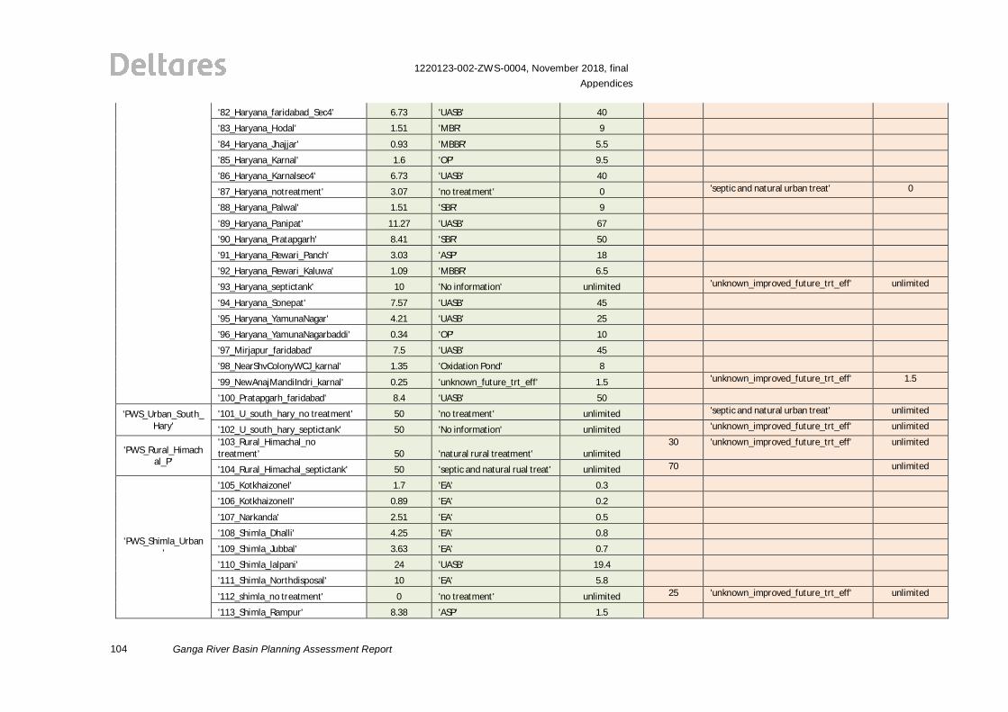
104
1220123-002-ZWS-0004, November 2018, finalAppendices
Ganga River Basin Planning Assessment Report
'82_Haryana_faridabad_Sec4' 6.73 'UASB' 40
'83_Haryana_Hodal' 1.51 'MBR' 9
'84_Haryana_Jhajjar' 0.93 'MBBR' 5.5
'85_Haryana_Karnal' 1.6 'OP' 9.5
'86_Haryana_Karnalsec4' 6.73 'UASB' 40
'87_Haryana_notreatment' 3.07 'no treatment' 0 'septic and natural urban treat' 0
'88_Haryana_Palwal' 1.51 'SBR' 9
'89_Haryana_Panipat' 11.27 'UASB' 67
'90_Haryana_Pratapgarh' 8.41 'SBR' 50
'91_Haryana_Rewari_Panch' 3.03 'ASP' 18
'92_Haryana_Rewari_Kaluwa' 1.09 'MBBR' 6.5
'93_Haryana_septictank' 10 'No information' unlimited 'unknown_improved_future_trt_eff' unlimited
'94_Haryana_Sonepat' 7.57 'UASB' 45
'95_Haryana_YamunaNagar' 4.21 'UASB' 25
'96_Haryana_YamunaNagarbaddi' 0.34 'OP' 10
'97_Mirjapur_faridabad' 7.5 'UASB' 45
'98_NearShvColonyWCJ_karnal' 1.35 'Oxidation Pond' 8
'99_NewAnajMandiIndri_karnal' 0.25 'unknown_future_trt_eff' 1.5 'unknown_improved_future_trt_eff' 1.5
'100_Pratapgarh_faridabad' 8.4 'UASB' 50
'PWS_Urban_South_Hary'
'101_U_south_hary_no treatment' 50 'no treatment' unlimited 'septic and natural urban treat' unlimited
'102_U_south_hary_septictank' 50 'No information' unlimited 'unknown_improved_future_trt_eff' unlimited
'PWS_Rural_Himachal_P'
'103_Rural_Himachal_notreatment' 50 'natural rural treatment' unlimited
30 'unknown_improved_future_trt_eff' unlimited
'104_Rural_Himachal_septictank' 50 'septic and natural rual treat' unlimited 70 unlimited
'PWS_Shimla_Urban'
'105_KotkhaizoneI' 1.7 'EA' 0.3
'106_KotkhaizoneII' 0.89 'EA' 0.2
'107_Narkanda' 2.51 'EA' 0.5
'108_Shimla_Dhalli' 4.25 'EA' 0.8
'109_Shimla_Jubbal' 3.63 'EA' 0.7
'110_Shimla_lalpani' 24 'UASB' 19.4
'111_Shimla_Northdisposal' 10 'EA' 5.8
'112_shimla_no treatment' 0 'no treatment' unlimited 25 'unknown_improved_future_trt_eff' unlimited
'113_Shimla_Rampur' 8.38 'ASP' 1.5
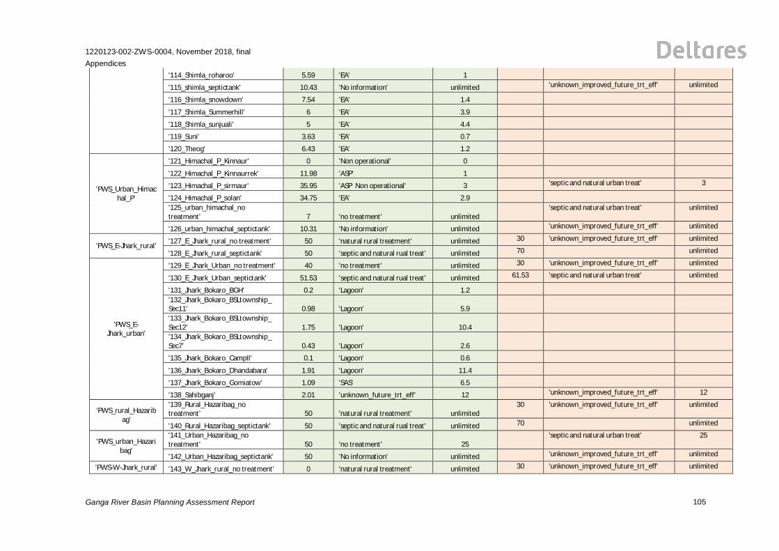
1220123-002-ZWS-0004, November 2018, finalAppendices
Ganga River Basin Planning Assessment Report 105
'114_Shimla_roharoo' 5.59 'EA' 1
'115_shimla_septictank' 10.43 'No information' unlimited 'unknown_improved_future_trt_eff' unlimited
'116_Shimla_snowdown' 7.54 'EA' 1.4
'117_Shimla_Summerhill' 6 'EA' 3.9
'118_Shimla_sunjuali' 5 'EA' 4.4
'119_Suni' 3.63 'EA' 0.7
'120_Theog' 6.43 'EA' 1.2
'PWS_Urban_Himachal_P'
'121_Himachal_P_Kinnaur' 0 'Non operational' 0
'122_Himachal_P_Kinnaurrek' 11.98 'ASP' 1
'123_Himachal_P_sirmaur' 35.95 'ASP Non operational' 3 'septic and natural urban treat' 3
'124_Himachal_P_solan' 34.75 'EA' 2.9'125_urban_himachal_notreatment' 7 'no treatment' unlimited
'septic and natural urban treat' unlimited
'126_urban_himachal_septictank' 10.31 'No information' unlimited 'unknown_improved_future_trt_eff' unlimited
'PWS_E-Jhark_rural' '127_E_Jhark_rural_no treatment' 50 'natural rural treatment' unlimited 30 'unknown_improved_future_trt_eff' unlimited
'128_E_Jhark_rural_septictank' 50 'septic and natural rual treat' unlimited 70 unlimited
'PWS_E-Jhark_urban'
'129_E_Jhark_Urban_no treatment' 40 'no treatment' unlimited 30 'unknown_improved_future_trt_eff' unlimited
'130_E_Jhark_Urban_septictank' 51.53 'septic and natural rual treat' unlimited 61.53 'septic and natural urban treat' unlimited
'131_Jhark_Bokaro_BGH' 0.2 'Lagoon' 1.2'132_Jhark_Bokaro_BSLtownship_Sec11' 0.98 'Lagoon' 5.9'133_Jhark_Bokaro_BSLtownship_Sec12' 1.75 'Lagoon' 10.4'134_Jhark_Bokaro_BSLtownship_Sec7' 0.43 'Lagoon' 2.6
'135_Jhark_Bokaro_CampII' 0.1 'Lagoon' 0.6
'136_Jhark_Bokaro_Dhandabara' 1.91 'Lagoon' 11.4
'137_Jhark_Bokaro_Gomiatow' 1.09 'SAS' 6.5
'138_Sahibganj' 2.01 'unknown_future_trt_eff' 12 'unknown_improved_future_trt_eff' 12
'PWS_rural_Hazaribag'
'139_Rural_Hazaribag_notreatment' 50 'natural rural treatment' unlimited
30 'unknown_improved_future_trt_eff' unlimited
'140_Rural_Hazaribag_septictank' 50 'septic and natural rual treat' unlimited 70 unlimited
'PWS_urban_Hazaribag'
'141_Urban_Hazaribag_notreatment' 50 'no treatment' 25
'septic and natural urban treat' 25
'142_Urban_Hazaribag_septictank' 50 'No information' unlimited 'unknown_improved_future_trt_eff' unlimited
'PWS-W-Jhark_rural' '143_W_Jhark_rural_no treatment' 0 'natural rural treatment' unlimited 30 'unknown_improved_future_trt_eff' unlimited
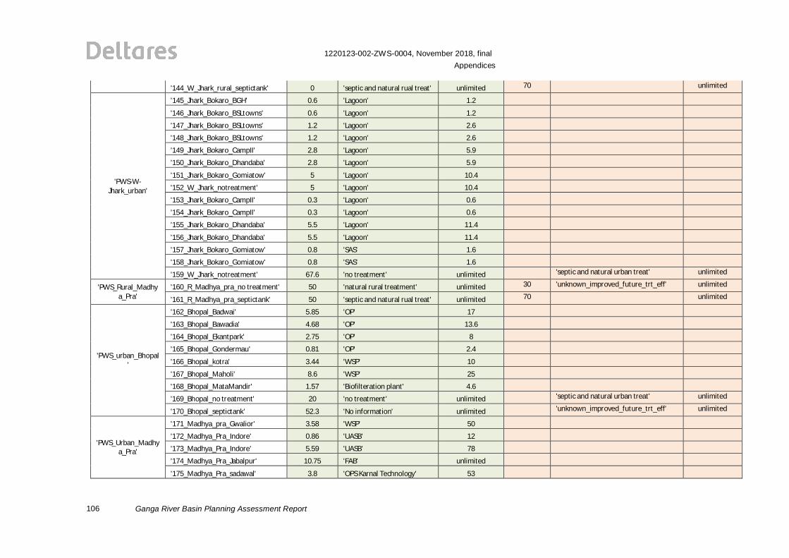
106
1220123-002-ZWS-0004, November 2018, finalAppendices
Ganga River Basin Planning Assessment Report
'144_W_Jhark_rural_septictank' 0 'septic and natural rual treat' unlimited 70 unlimited
'PWS-W-Jhark_urban'
'145_Jhark_Bokaro_BGH' 0.6 'Lagoon' 1.2
'146_Jhark_Bokaro_BSLtowns' 0.6 'Lagoon' 1.2
'147_Jhark_Bokaro_BSLtowns' 1.2 'Lagoon' 2.6
'148_Jhark_Bokaro_BSLtowns' 1.2 'Lagoon' 2.6
'149_Jhark_Bokaro_CampII' 2.8 'Lagoon' 5.9
'150_Jhark_Bokaro_Dhandaba' 2.8 'Lagoon' 5.9
'151_Jhark_Bokaro_Gomiatow' 5 'Lagoon' 10.4
'152_W_Jhark_notreatment' 5 'Lagoon' 10.4
'153_Jhark_Bokaro_CampII' 0.3 'Lagoon' 0.6
'154_Jhark_Bokaro_CampII' 0.3 'Lagoon' 0.6
'155_Jhark_Bokaro_Dhandaba' 5.5 'Lagoon' 11.4
'156_Jhark_Bokaro_Dhandaba' 5.5 'Lagoon' 11.4
'157_Jhark_Bokaro_Gomiatow' 0.8 'SAS' 1.6
'158_Jhark_Bokaro_Gomiatow' 0.8 'SAS' 1.6
'159_W_Jhark_notreatment' 67.6 'no treatment' unlimited 'septic and natural urban treat' unlimited
'PWS_Rural_Madhya_Pra'
'160_R_Madhya_pra_no treatment' 50 'natural rural treatment' unlimited 30 'unknown_improved_future_trt_eff' unlimited
'161_R_Madhya_pra_septictank' 50 'septic and natural rual treat' unlimited 70 unlimited
'PWS_urban_Bhopal'
'162_Bhopal_Badwai' 5.85 'OP' 17
'163_Bhopal_Bawadia' 4.68 'OP' 13.6
'164_Bhopal_Ekantpark' 2.75 'OP' 8
'165_Bhopal_Gondermau' 0.81 'OP' 2.4
'166_Bhopal_kotra' 3.44 'WSP' 10
'167_Bhopal_Maholi' 8.6 'WSP' 25
'168_Bhopal_MataMandir' 1.57 'Biofilteration plant' 4.6
'169_Bhopal_no treatment' 20 'no treatment' unlimited 'septic and natural urban treat' unlimited
'170_Bhopal_septictank' 52.3 'No information' unlimited 'unknown_improved_future_trt_eff' unlimited
'PWS_Urban_Madhya_Pra'
'171_Madhya_pra_Gwalior' 3.58 'WSP' 50
'172_Madhya_Pra_Indore' 0.86 'UASB' 12
'173_Madhya_Pra_Indore' 5.59 'UASB' 78
'174_Madhya_Pra_Jabalpur' 10.75 'FAB' unlimited
'175_Madhya_Pra_sadawal' 3.8 'OPS Karnal Technology' 53
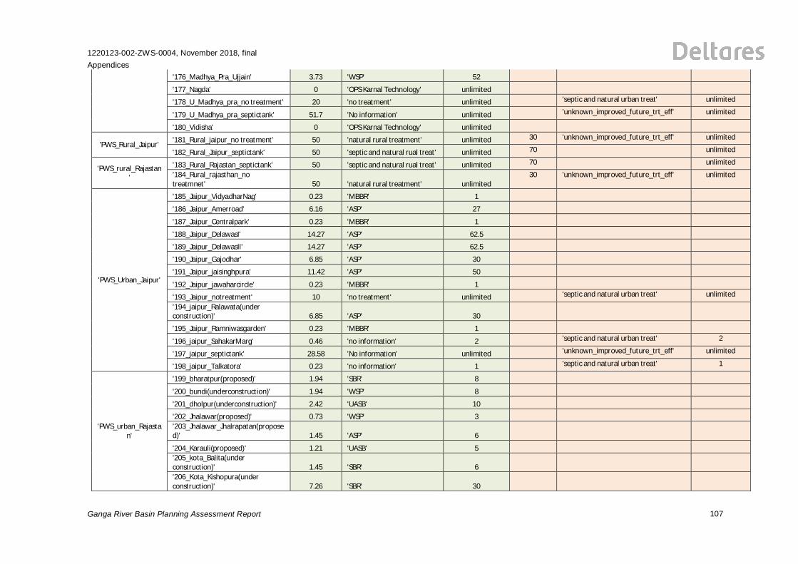
1220123-002-ZWS-0004, November 2018, finalAppendices
Ganga River Basin Planning Assessment Report 107
'176_Madhya_Pra_Ujjain' 3.73 'WSP' 52
'177_Nagda' 0 'OPS Karnal Technology' unlimited
'178_U_Madhya_pra_no treatment' 20 'no treatment' unlimited 'septic and natural urban treat' unlimited
'179_U_Madhya_pra_septictank' 51.7 'No information' unlimited 'unknown_improved_future_trt_eff' unlimited
'180_Vidisha' 0 'OPS Karnal Technology' unlimited
'PWS_Rural_Jaipur' '181_Rural_jaipur_no treatment' 50 'natural rural treatment' unlimited 30 'unknown_improved_future_trt_eff' unlimited
'182_Rural_Jaipur_septictank' 50 'septic and natural rual treat' unlimited 70 unlimited
'PWS_rural_Rajastan'
'183_Rural_Rajastan_septictank' 50 'septic and natural rual treat' unlimited 70 unlimited
'184_Rural_rajasthan_notreatmnet' 50 'natural rural treatment' unlimited
30 'unknown_improved_future_trt_eff' unlimited
'PWS_Urban_Jaipur'
'185_Jaipur_VidyadharNag' 0.23 'MBBR' 1
'186_Jaipur_Amerroad' 6.16 'ASP' 27
'187_Jaipur_Centralpark' 0.23 'MBBR' 1
'188_Jaipur_DelawasI' 14.27 'ASP' 62.5
'189_Jaipur_DelawasII' 14.27 'ASP' 62.5
'190_Jaipur_Gajodhar' 6.85 'ASP' 30
'191_Jaipur_jaisinghpura' 11.42 'ASP' 50
'192_Jaipur_jawaharcircle' 0.23 'MBBR' 1
'193_Jaipur_notreatment' 10 'no treatment' unlimited 'septic and natural urban treat' unlimited
'194_jaipur_Ralawata(underconstruction)' 6.85 'ASP' 30
'195_Jaipur_Ramniwasgarden' 0.23 'MBBR' 1
'196_jaipur_SahakarMarg' 0.46 'no information' 2 'septic and natural urban treat' 2
'197_jaipur_septictank' 28.58 'No information' unlimited 'unknown_improved_future_trt_eff' unlimited
'198_jaipur_Talkatora' 0.23 'no information' 1 'septic and natural urban treat' 1
'PWS_urban_Rajastan'
'199_bharatpur(proposed)' 1.94 'SBR' 8
'200_bundi(underconstruction)' 1.94 'WSP' 8
'201_dholpur(underconstruction)' 2.42 'UASB' 10
'202_Jhalawar(proposed)' 0.73 'WSP' 3'203_Jhalawar_Jhalrapatan(proposed)' 1.45 'ASP' 6
'204_Karauli(proposed)' 1.21 'UASB' 5'205_kota_Balita(underconstruction)' 1.45 'SBR' 6'206_Kota_Kishopura(underconstruction)' 7.26 'SBR' 30
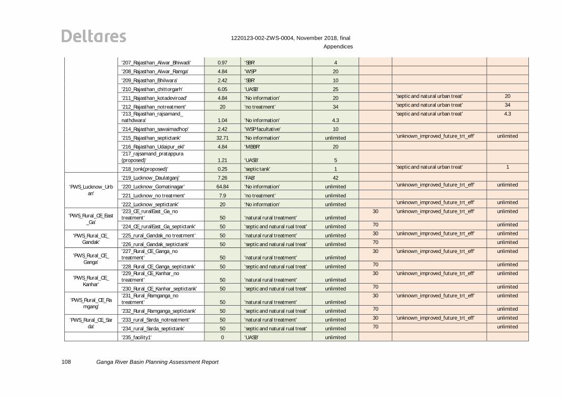
108
1220123-002-ZWS-0004, November 2018, finalAppendices
Ganga River Basin Planning Assessment Report
'207_Rajasthan_Alwar_Bhiwadi' 0.97 'SBR' 4
'208_Rajasthan_Alwar_Ramga' 4.84 'WSP' 20
'209_Rajasthan_Bhilwara' 2.42 'SBR' 10
'210_Rajasthan_chittorgarh' 6.05 'UASB' 25
'211_Rajasthan_kotadeviroad' 4.84 'No information' 20 'septic and natural urban treat' 20
'212_Rajasthan_notreatment' 20 'no treatment' 34 'septic and natural urban treat' 34
'213_Rajasthan_rajsamand_nathdwara' 1.04 'No information' 4.3
'septic and natural urban treat' 4.3
'214_Rajasthan_sawaimadhop' 2.42 'WSP facultative' 10
'215_Rajasthan_septictank' 32.71 'No information' unlimited 'unknown_improved_future_trt_eff' unlimited
'216_Rajasthan_Udaipur_ekl' 4.84 'MBBR' 20'217_rajsamand_pratappura(proposed)' 1.21 'UASB' 5
'218_tonk(proposed)' 0.25 'septic tank' 1 'septic and natural urban treat' 1
'PWS_Lucknow_Urban'
'219_Lucknow_Daulatganj' 7.26 'FAB' 42
'220_Lucknow_Gomatinagar' 64.84 'No information' unlimited 'unknown_improved_future_trt_eff' unlimited
'221_Lucknow_no treatment' 7.9 'no treatment' unlimited
'222_Lucknow_septictank' 20 'No information' unlimited 'unknown_improved_future_trt_eff' unlimited
'PWS_Rural_CE_East_Ga'
'223_CE_ruralEast_Ga_notreatment' 50 'natural rural treatment' unlimited
30 'unknown_improved_future_trt_eff' unlimited
'224_CE_ruralEast_Ga_septictank' 50 'septic and natural rual treat' unlimited 70 unlimited
'PWS_Rural_CE_Gandak'
'225_rural_Gandak_no treatment' 50 'natural rural treatment' unlimited 30 'unknown_improved_future_trt_eff' unlimited
'226_rural_Gandak_septictank' 50 'septic and natural rual treat' unlimited 70 unlimited
'PWS_Rural_CE_Ganga'
'227_Rural_CE_Ganga_notreatment' 50 'natural rural treatment' unlimited
30 'unknown_improved_future_trt_eff' unlimited
'228_Rural_CE_Ganga_septictank' 50 'septic and natural rual treat' unlimited 70 unlimited
'PWS_Rural_CE_Kanhar'
'229_Rural_CE_Kanhar_notreatment' 50 'natural rural treatment' unlimited
30 'unknown_improved_future_trt_eff' unlimited
'230_Rural_CE_Kanhar_septictank' 50 'septic and natural rual treat' unlimited 70 unlimited
'PWS_Rural_CE_Ramgang'
'231_Rural_Ramganga_notreatment' 50 'natural rural treatment' unlimited
30 'unknown_improved_future_trt_eff' unlimited
'232_Rural_Ramganga_septictank' 50 'septic and natural rual treat' unlimited 70 unlimited
'PWS_Rural_CE_Sarda'
'233_rural_Sarda_notreatment' 50 'natural rural treatment' unlimited 30 'unknown_improved_future_trt_eff' unlimited
'234_rural_Sarda_septictank' 50 'septic and natural rual treat' unlimited 70 unlimited
'235_facility1' 0 'UASB' unlimited
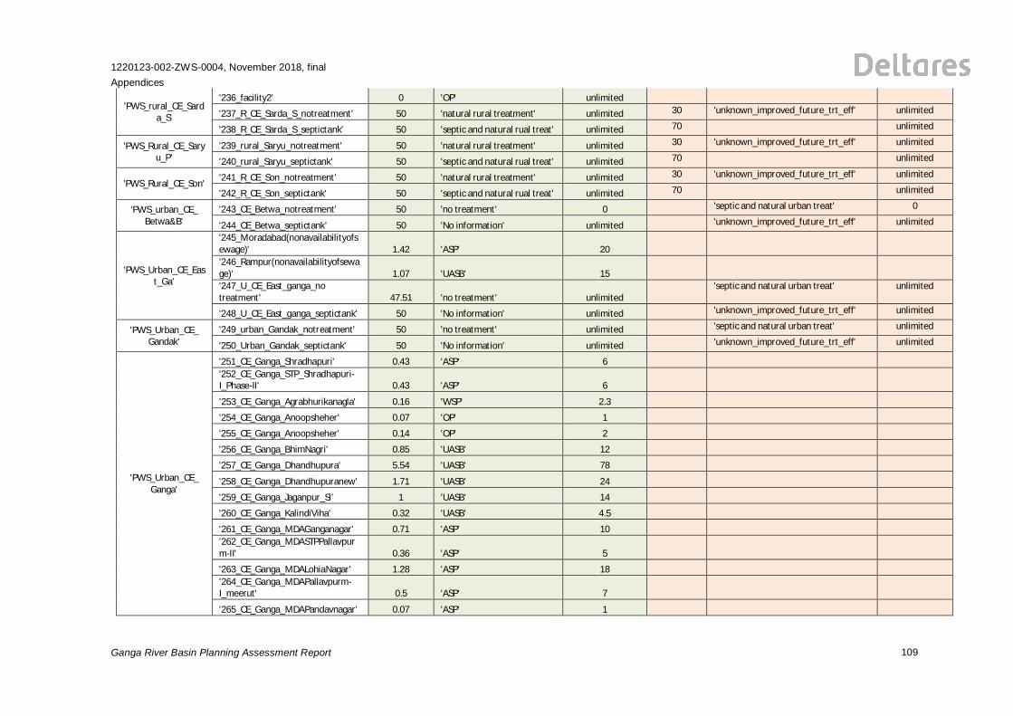
1220123-002-ZWS-0004, November 2018, finalAppendices
Ganga River Basin Planning Assessment Report 109
'PWS_rural_CE_Sarda_S'
'236_facility2' 0 'OP' unlimited
'237_R_CE_Sarda_S_notreatment' 50 'natural rural treatment' unlimited 30 'unknown_improved_future_trt_eff' unlimited
'238_R_CE_Sarda_S_septictank' 50 'septic and natural rual treat' unlimited 70 unlimited
'PWS_Rural_CE_Saryu_P'
'239_rural_Saryu_notreatment' 50 'natural rural treatment' unlimited 30 'unknown_improved_future_trt_eff' unlimited
'240_rural_Saryu_septictank' 50 'septic and natural rual treat' unlimited 70 unlimited
'PWS_Rural_CE_Son' '241_R_CE_Son_notreatment' 50 'natural rural treatment' unlimited 30 'unknown_improved_future_trt_eff' unlimited
'242_R_CE_Son_septictank' 50 'septic and natural rual treat' unlimited 70 unlimited
'PWS_urban_CE_Betwa&B'
'243_CE_Betwa_notreatment' 50 'no treatment' 0 'septic and natural urban treat' 0
'244_CE_Betwa_septictank' 50 'No information' unlimited 'unknown_improved_future_trt_eff' unlimited
'PWS_Urban_CE_East_Ga'
'245_Moradabad(nonavailabilityofsewage)' 1.42 'ASP' 20'246_Rampur(nonavailabilityofsewage)' 1.07 'UASB' 15'247_U_CE_East_ganga_notreatment' 47.51 'no treatment' unlimited
'septic and natural urban treat' unlimited
'248_U_CE_East_ganga_septictank' 50 'No information' unlimited 'unknown_improved_future_trt_eff' unlimited
'PWS_Urban_CE_Gandak'
'249_urban_Gandak_notreatment' 50 'no treatment' unlimited 'septic and natural urban treat' unlimited
'250_Urban_Gandak_septictank' 50 'No information' unlimited 'unknown_improved_future_trt_eff' unlimited
'PWS_Urban_CE_Ganga'
'251_CE_Ganga_Shradhapuri' 0.43 'ASP' 6'252_CE_Ganga_STP_Shradhapuri-I_Phase-II' 0.43 'ASP' 6
'253_CE_Ganga_Agrabhurikanagla' 0.16 'WSP' 2.3
'254_CE_Ganga_Anoopsheher' 0.07 'OP' 1
'255_CE_Ganga_Anoopsheher' 0.14 'OP' 2
'256_CE_Ganga_BhimNagri' 0.85 'UASB' 12
'257_CE_Ganga_Dhandhupura' 5.54 'UASB' 78
'258_CE_Ganga_Dhandhupuranew' 1.71 'UASB' 24
'259_CE_Ganga_Jaganpur_Si' 1 'UASB' 14
'260_CE_Ganga_KalindiViha' 0.32 'UASB' 4.5
'261_CE_Ganga_MDAGanganagar' 0.71 'ASP' 10'262_CE_Ganga_MDASTPPallavpurm-II' 0.36 'ASP' 5
'263_CE_Ganga_MDALohiaNagar' 1.28 'ASP' 18'264_CE_Ganga_MDAPallavpurm-I_meerut' 0.5 'ASP' 7
'265_CE_Ganga_MDAPandavnagar' 0.07 'ASP' 1
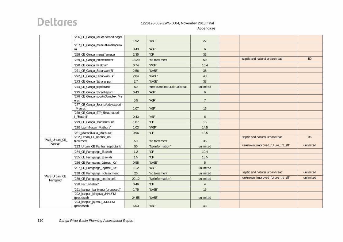
110
1220123-002-ZWS-0004, November 2018, finalAppendices
Ganga River Basin Planning Assessment Report
'266_CE_Ganga_MDAShatabdinagar' 1.92 'ASP' 27'267_CE_Ganga_meerutRakshapuram' 0.43 'ASP' 6
'268_CE_Ganga_muzaffarnaga' 2.35 'OP' 33
'269_CE_Ganga_notreatment' 18.29 'no treatment' 50 'septic and natural urban treat' 50
'270_CE_Ganga_Pilakhar' 0.74 'WSP' 10.4
'271_CE_Ganga_Sadarwan(Bi' 2.56 'UASB' 36
'272_CE_Ganga_Sadarwan(Bi' 2.84 'UASB' 40
'273_CE_Ganga_Saharanpur' 2.7 'UASB' 38
'274_CE_Ganga_septictank' 50 'septic and natural rual treat' unlimited
'275_CE_Ganga_Shradhapuri' 0.43 'ASP' 6'276_CE_Ganga_sportsComplex_Meerut' 0.5 'ASP' 7'277_CE_Ganga_SportsVedvyaspuri_Meerut' 1.07 'ASP' 15'278_CE_Ganga_STP_Shradhapuri-I_Phase-II' 0.43 'ASP' 6
'279_CE_Ganga_TransYamuna' 1.07 'OP' 15
'280_LaxmiNagar_Mathura' 1.03 'WSP' 14.5
'281_MasaniNalla_Mathura' 0.96 'OP' 13.5
'PWS_Urban_CE_Kanhar'
'282_Urban_CE_Kanhar_notreatment' 50 'no treatment' 36
'septic and natural urban treat' 36
'283_Urban_CE_Kanhar_septictank' 50 'No information' unlimited 'unknown_improved_future_trt_eff' unlimited
'PWS_Urban_CE_Ramgang'
'284_CE_Ramganga_Etawah' 1.2 'OP' 10.4
'285_CE_Ramganga_Etawah' 1.5 'OP' 13.5
'286_CE_Ramganga_Jajmau_Ka' 0.58 'UASB' 5
'287_CE_Ramganga_Jajmau_Ka' 15.2 'ASP' unlimited
'288_CE_Ramganga_notreatment' 20 'no treatment' unlimited 'septic and natural urban treat' unlimited
'289_CE_Ramganga_septictank' 22.12 'No information' unlimited 'unknown_improved_future_trt_eff' unlimited
'290_Farrukhabad' 0.46 'OP' 4
'291_kanpur_baniyapur(proposed)' 1.75 'UASB' 15'292_kanpur_bingava_JNNURM(proposed)' 24.55 'UASB' unlimited'293_kanpur_jajmau_JNNURM(proposed)' 5.03 'ASP' 43
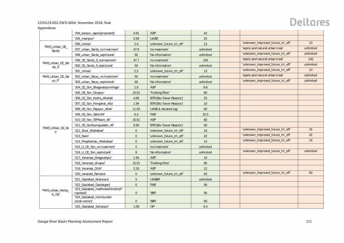
1220123-002-ZWS-0004, November 2018, finalAppendices
Ganga River Basin Planning Assessment Report 111
'294_kanpur_sajari(proposed)' 4.91 'ASP' 42
'295_mainpuri' 2.69 'UASB' 23
'PWS_Urban_CE_Sarda'
'296_Unnao' 2.4 'unknown_future_trt_eff' 13 'unknown_improved_future_trt_eff' 13
'297_urban_Sarda_no treatment' 47.6 'no treatment' unlimited 'septic and natural urban treat' unlimited
'298_urban_Sarda_septictank' 50 'No information' unlimited 'unknown_improved_future_trt_eff' unlimited
'PWS_urban_CE_Sarda_S'
'299_CE_Sarda_S_notreatment' 47.7 'no treatment' 100 'septic and natural urban treat' 100
'300_CE_Sarda_S_septictank' 50 'No information' unlimited 'unknown_improved_future_trt_eff' unlimited
'301_Unnao' 2.3 'unknown_future_trt_eff' 13 'unknown_improved_future_trt_eff' 13
'PWS_Urban_CE_Saryu_P'
'302_urban_Saryu_no treatment' 50 'no treatment' unlimited 'septic and natural urban treat' unlimited
'303_urban_Saryu_septictank' 50 'No information' unlimited 'unknown_improved_future_trt_eff' unlimited
'PWS_Urban_CE_Son'
'304_CE_Son_Bhagwanpurvillage' 1.9 'ASP' 9.8
'305_CE_Son_Dinapur' 15.51 'Trickling Filter' 80
'306_CE_Son_Kodra_Allahab' 4.85 'BTR (Bio Tower Reactor)' 25
'307_CE_Son_Pongahat_Alla' 1.94 'BTR (Bio Tower Reactor)' 10
'308_CE_Son_Rajapur_Allah' 11.63 'UASB & Aerated Lag' 60
'309_CE_Son_SaloriAll' 6.3 'FAB' 32.5
'310_CE_Son_STPNaini_All' 15.51 'ASP' 80
'311_CE_SonNumayadahi_All' 9.69 'BTR (Bio Tower Reactor)' 50
'312_Jhusi_Allahabad' 0 'unknown_future_trt_eff' 16 'unknown_improved_future_trt_eff' 16
'313_Naini' 0 'unknown_future_trt_eff' 42 'unknown_improved_future_trt_eff' 42
'314_Phaphamau_Allahabad' 0 'unknown_future_trt_eff' 14 'unknown_improved_future_trt_eff' 14
'315_U_CE_Son_no treatment' 0 'no treatment' unlimited
'316_U_CE_Son_septictank' 9 'No information' unlimited 'unknown_improved_future_trt_eff' unlimited
'317_Varanasi_bhagwanpur' 1.94 'ASP' 10
'318_Varanasi_dinapur' 15.51 'Trickling Filter' 80
'319_Varanasi_DLW' 2.33 'ASP' 12
'320_varanasi_Ramana' 0 'unknown_future_trt_eff' 50 'unknown_improved_future_trt_eff' 50
'PWS_urban_Noida_&_Ga'
'321_Gaziabad_bharwara' 5 'UASBR' unlimited
'322_Gaziabad_Daulatganj' 6 'FAB' 56'323_Gaziabad_madhubanhindon(Proposed)' 0 'SBR' 56'324_Gaziabad_morti(underconstruction)' 0 'SBR' 56
'325_Gaziabad_Sultanpur' 1.09 'OP' 6.4
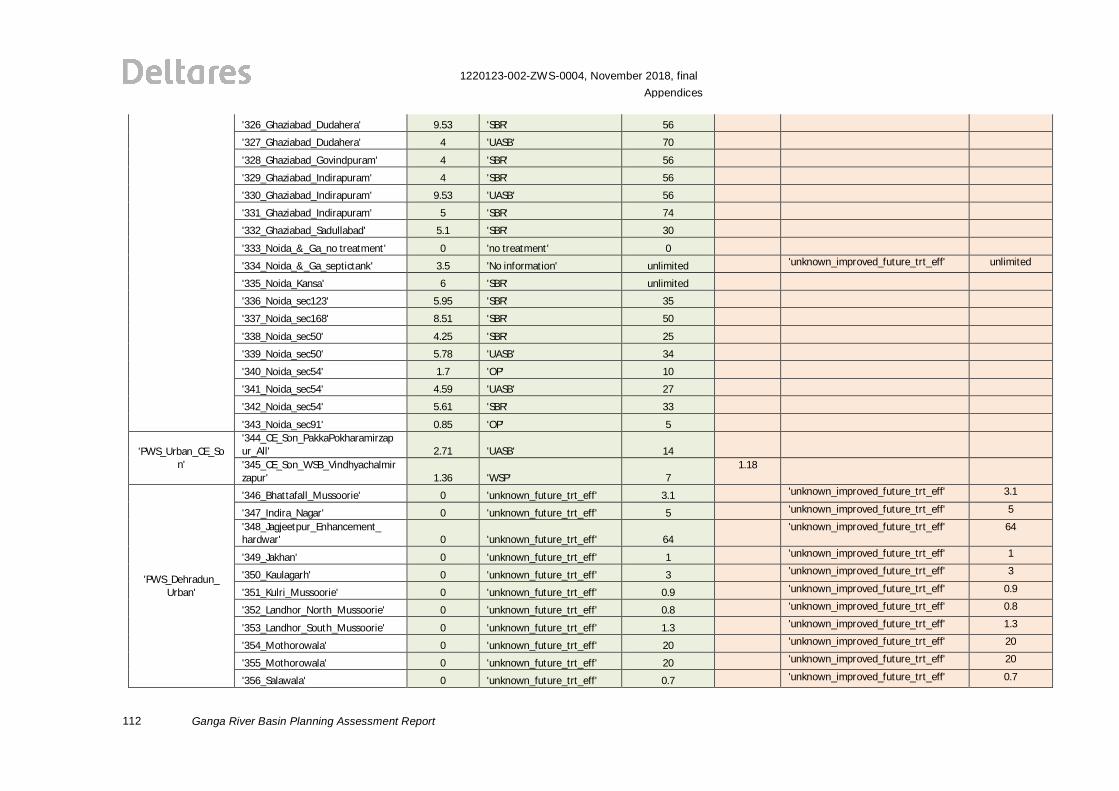
112
1220123-002-ZWS-0004, November 2018, finalAppendices
Ganga River Basin Planning Assessment Report
'326_Ghaziabad_Dudahera' 9.53 'SBR' 56
'327_Ghaziabad_Dudahera' 4 'UASB' 70
'328_Ghaziabad_Govindpuram' 4 'SBR' 56
'329_Ghaziabad_Indirapuram' 4 'SBR' 56
'330_Ghaziabad_Indirapuram' 9.53 'UASB' 56
'331_Ghaziabad_Indirapuram' 5 'SBR' 74
'332_Ghaziabad_Sadullabad' 5.1 'SBR' 30
'333_Noida_&_Ga_no treatment' 0 'no treatment' 0
'334_Noida_&_Ga_septictank' 3.5 'No information' unlimited 'unknown_improved_future_trt_eff' unlimited
'335_Noida_Kansa' 6 'SBR' unlimited
'336_Noida_sec123' 5.95 'SBR' 35
'337_Noida_sec168' 8.51 'SBR' 50
'338_Noida_sec50' 4.25 'SBR' 25
'339_Noida_sec50' 5.78 'UASB' 34
'340_Noida_sec54' 1.7 'OP' 10
'341_Noida_sec54' 4.59 'UASB' 27
'342_Noida_sec54' 5.61 'SBR' 33
'343_Noida_sec91' 0.85 'OP' 5
'PWS_Urban_CE_Son'
'344_CE_Son_PakkaPokharamirzapur_All' 2.71 'UASB' 14'345_CE_Son_WSB_Vindhyachalmirzapur' 1.36 'WSP' 7
1.18
'PWS_Dehradun_Urban'
'346_Bhattafall_Mussoorie' 0 'unknown_future_trt_eff' 3.1 'unknown_improved_future_trt_eff' 3.1
'347_Indira_Nagar' 0 'unknown_future_trt_eff' 5 'unknown_improved_future_trt_eff' 5
'348_Jagjeetpur_Enhancement_hardwar' 0 'unknown_future_trt_eff' 64
'unknown_improved_future_trt_eff' 64
'349_Jakhan' 0 'unknown_future_trt_eff' 1 'unknown_improved_future_trt_eff' 1
'350_Kaulagarh' 0 'unknown_future_trt_eff' 3 'unknown_improved_future_trt_eff' 3
'351_Kulri_Mussoorie' 0 'unknown_future_trt_eff' 0.9 'unknown_improved_future_trt_eff' 0.9
'352_Landhor_North_Mussoorie' 0 'unknown_future_trt_eff' 0.8 'unknown_improved_future_trt_eff' 0.8
'353_Landhor_South_Mussoorie' 0 'unknown_future_trt_eff' 1.3 'unknown_improved_future_trt_eff' 1.3
'354_Mothorowala' 0 'unknown_future_trt_eff' 20 'unknown_improved_future_trt_eff' 20
'355_Mothorowala' 0 'unknown_future_trt_eff' 20 'unknown_improved_future_trt_eff' 20
'356_Salawala' 0 'unknown_future_trt_eff' 0.7 'unknown_improved_future_trt_eff' 0.7
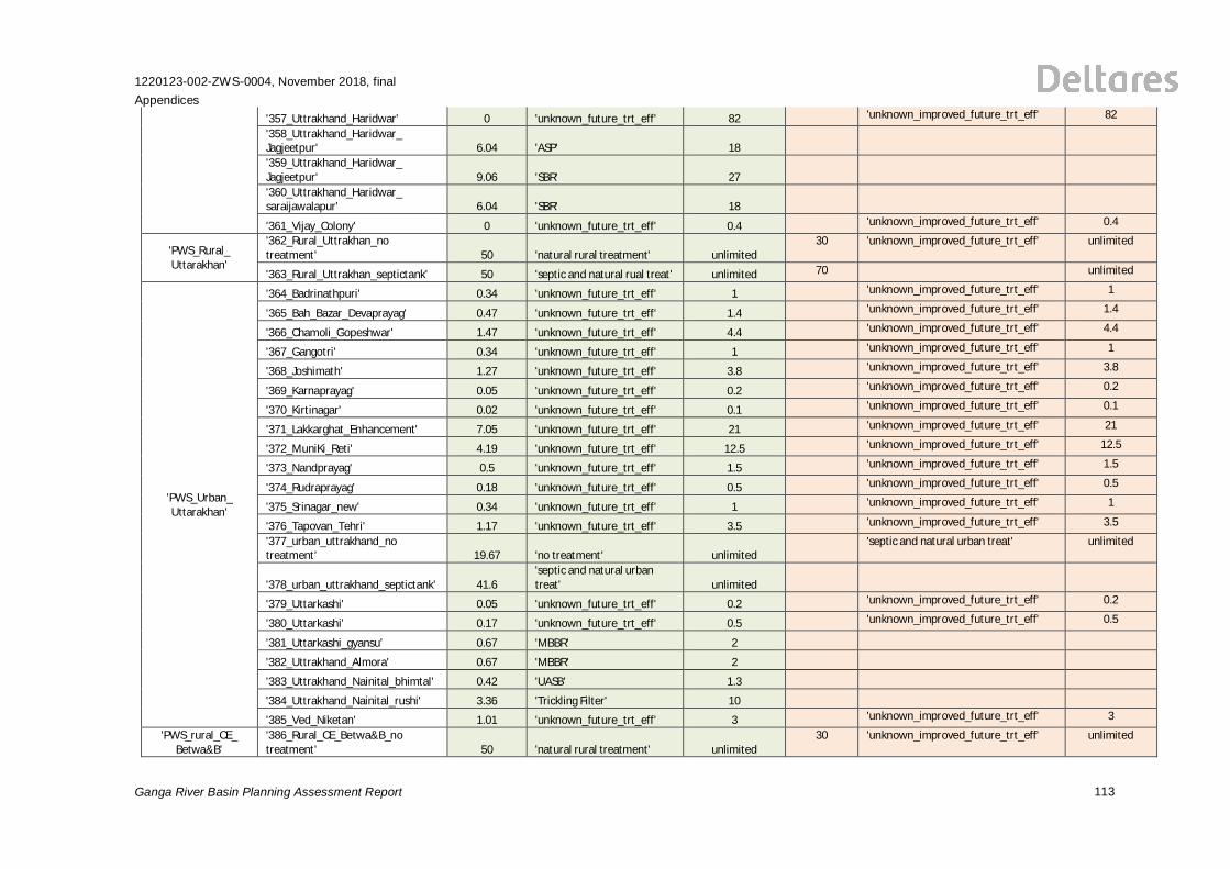
1220123-002-ZWS-0004, November 2018, finalAppendices
Ganga River Basin Planning Assessment Report 113
'357_Uttrakhand_Haridwar' 0 'unknown_future_trt_eff' 82 'unknown_improved_future_trt_eff' 82
'358_Uttrakhand_Haridwar_Jagjeetpur' 6.04 'ASP' 18'359_Uttrakhand_Haridwar_Jagjeetpur' 9.06 'SBR' 27'360_Uttrakhand_Haridwar_saraijawalapur' 6.04 'SBR' 18
'361_Vijay_Colony' 0 'unknown_future_trt_eff' 0.4 'unknown_improved_future_trt_eff' 0.4
'PWS_Rural_Uttarakhan'
'362_Rural_Uttrakhan_notreatment' 50 'natural rural treatment' unlimited
30 'unknown_improved_future_trt_eff' unlimited
'363_Rural_Uttrakhan_septictank' 50 'septic and natural rual treat' unlimited 70 unlimited
'PWS_Urban_Uttarakhan'
'364_Badrinathpuri' 0.34 'unknown_future_trt_eff' 1 'unknown_improved_future_trt_eff' 1
'365_Bah_Bazar_Devaprayag' 0.47 'unknown_future_trt_eff' 1.4 'unknown_improved_future_trt_eff' 1.4
'366_Chamoli_Gopeshwar' 1.47 'unknown_future_trt_eff' 4.4 'unknown_improved_future_trt_eff' 4.4
'367_Gangotri' 0.34 'unknown_future_trt_eff' 1 'unknown_improved_future_trt_eff' 1
'368_Joshimath' 1.27 'unknown_future_trt_eff' 3.8 'unknown_improved_future_trt_eff' 3.8
'369_Karnaprayag' 0.05 'unknown_future_trt_eff' 0.2 'unknown_improved_future_trt_eff' 0.2
'370_Kirtinagar' 0.02 'unknown_future_trt_eff' 0.1 'unknown_improved_future_trt_eff' 0.1
'371_Lakkarghat_Enhancement' 7.05 'unknown_future_trt_eff' 21 'unknown_improved_future_trt_eff' 21
'372_MuniKi_Reti' 4.19 'unknown_future_trt_eff' 12.5 'unknown_improved_future_trt_eff' 12.5
'373_Nandprayag' 0.5 'unknown_future_trt_eff' 1.5 'unknown_improved_future_trt_eff' 1.5
'374_Rudraprayag' 0.18 'unknown_future_trt_eff' 0.5 'unknown_improved_future_trt_eff' 0.5
'375_Srinagar_new' 0.34 'unknown_future_trt_eff' 1 'unknown_improved_future_trt_eff' 1
'376_Tapovan_Tehri' 1.17 'unknown_future_trt_eff' 3.5 'unknown_improved_future_trt_eff' 3.5
'377_urban_uttrakhand_notreatment' 19.67 'no treatment' unlimited
'septic and natural urban treat' unlimited
'378_urban_uttrakhand_septictank' 41.6'septic and natural urbantreat' unlimited
'379_Uttarkashi' 0.05 'unknown_future_trt_eff' 0.2 'unknown_improved_future_trt_eff' 0.2
'380_Uttarkashi' 0.17 'unknown_future_trt_eff' 0.5 'unknown_improved_future_trt_eff' 0.5
'381_Uttarkashi_gyansu' 0.67 'MBBR' 2
'382_Uttrakhand_Almora' 0.67 'MBBR' 2
'383_Uttrakhand_Nainital_bhimtal' 0.42 'UASB' 1.3
'384_Uttrakhand_Nainital_rushi' 3.36 'Trickling Filter' 10
'385_Ved_Niketan' 1.01 'unknown_future_trt_eff' 3 'unknown_improved_future_trt_eff' 3
'PWS_rural_CE_Betwa&B'
'386_Rural_CE_Betwa&B_notreatment' 50 'natural rural treatment' unlimited
30 'unknown_improved_future_trt_eff' unlimited
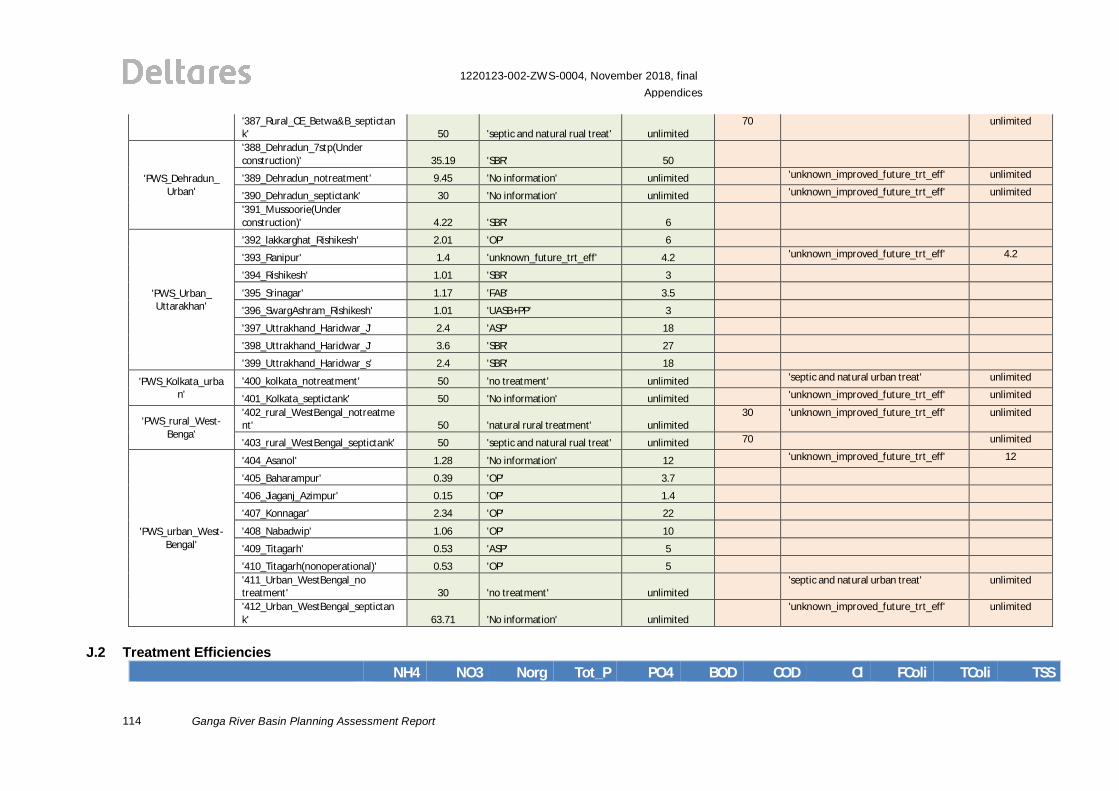
114
1220123-002-ZWS-0004, November 2018, finalAppendices
Ganga River Basin Planning Assessment Report
'387_Rural_CE_Betwa&B_septictank' 50 'septic and natural rual treat' unlimited
70 unlimited
'PWS_Dehradun_Urban'
'388_Dehradun_7stp(Underconstruction)' 35.19 'SBR' 50
'389_Dehradun_notreatment' 9.45 'No information' unlimited 'unknown_improved_future_trt_eff' unlimited
'390_Dehradun_septictank' 30 'No information' unlimited 'unknown_improved_future_trt_eff' unlimited
'391_Mussoorie(Underconstruction)' 4.22 'SBR' 6
'PWS_Urban_Uttarakhan'
'392_lakkarghat_Rishikesh' 2.01 'OP' 6
'393_Ranipur' 1.4 'unknown_future_trt_eff' 4.2 'unknown_improved_future_trt_eff' 4.2
'394_Rishikesh' 1.01 'SBR' 3
'395_Srinagar' 1.17 'FAB' 3.5
'396_SwargAshram_Rishikesh' 1.01 'UASB+PP' 3
'397_Uttrakhand_Haridwar_J' 2.4 'ASP' 18
'398_Uttrakhand_Haridwar_J' 3.6 'SBR' 27
'399_Uttrakhand_Haridwar_s' 2.4 'SBR' 18
'PWS_Kolkata_urban'
'400_kolkata_notreatment' 50 'no treatment' unlimited 'septic and natural urban treat' unlimited
'401_Kolkata_septictank' 50 'No information' unlimited 'unknown_improved_future_trt_eff' unlimited
'PWS_rural_West-Benga'
'402_rural_WestBengal_notreatment' 50 'natural rural treatment' unlimited
30 'unknown_improved_future_trt_eff' unlimited
'403_rural_WestBengal_septictank' 50 'septic and natural rual treat' unlimited 70 unlimited
'PWS_urban_West-Bengal'
'404_Asanol' 1.28 'No information' 12 'unknown_improved_future_trt_eff' 12
'405_Baharampur' 0.39 'OP' 3.7
'406_Jiaganj_Azimpur' 0.15 'OP' 1.4
'407_Konnagar' 2.34 'OP' 22
'408_Nabadwip' 1.06 'OP' 10
'409_Titagarh' 0.53 'ASP' 5
'410_Titagarh(nonoperational)' 0.53 'OP' 5'411_Urban_WestBengal_notreatment' 30 'no treatment' unlimited
'septic and natural urban treat' unlimited
'412_Urban_WestBengal_septictank' 63.71 'No information' unlimited
'unknown_improved_future_trt_eff' unlimited
J.2 Treatment EfficienciesNH4 NO3 Norg Tot_P PO4 BOD COD Cl FColi TColi TSS
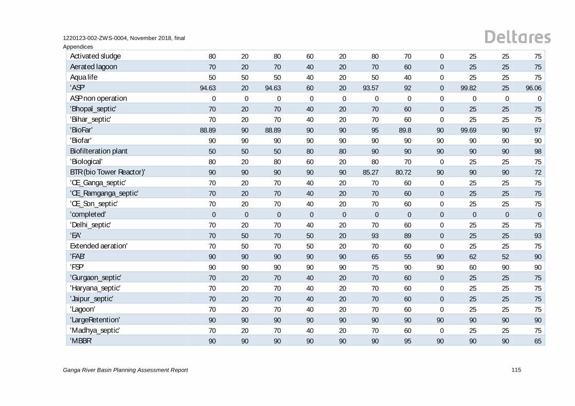
1220123-002-ZWS-0004, November 2018, finalAppendices
Ganga River Basin Planning Assessment Report 115
Activated sludge 80 20 80 60 20 80 70 0 25 25 75Aerated lagoon 70 20 70 40 20 70 60 0 25 25 75Aqua life 50 50 50 40 20 50 40 0 25 25 75'ASP' 94.63 20 94.63 60 20 93.57 92 0 99.82 25 96.06ASP non operation 0 0 0 0 0 0 0 0 0 0 0'Bhopal_septic' 70 20 70 40 20 70 60 0 25 25 75'Bihar_septic' 70 20 70 40 20 70 60 0 25 25 75'BioFar' 88.89 90 88.89 90 90 95 89.8 90 99.69 90 97'Biofar' 90 90 90 90 90 90 90 90 90 90 90Biofilteration plant 50 50 50 80 80 90 90 90 90 90 98'Biological' 80 20 80 60 20 80 70 0 25 25 75BTR (bio Tower Reactor)' 90 90 90 90 90 85.27 80.72 90 90 90 72'CE_Ganga_septic' 70 20 70 40 20 70 60 0 25 25 75'CE_Ramganga_septic' 70 20 70 40 20 70 60 0 25 25 75'CE_Son_septic' 70 20 70 40 20 70 60 0 25 25 75'completed' 0 0 0 0 0 0 0 0 0 0 0'Delhi_septic' 70 20 70 40 20 70 60 0 25 25 75'EA' 70 50 70 50 20 93 89 0 25 25 93Extended aeration' 70 50 70 50 20 70 60 0 25 25 75'FAB' 90 90 90 90 90 65 55 90 62 52 90'FSP' 90 90 90 90 90 75 90 90 60 90 90'Gurgaon_septic' 70 20 70 40 20 70 60 0 25 25 75'Haryana_septic' 70 20 70 40 20 70 60 0 25 25 75'Jaipur_septic' 70 20 70 40 20 70 60 0 25 25 75'Lagoon' 70 20 70 40 20 70 60 0 25 25 75'LargeRetention' 90 90 90 90 90 90 90 90 90 90 90'Madhya_septic' 70 20 70 40 20 70 60 0 25 25 75'MBBR' 90 90 90 90 90 90 95 90 90 90 65
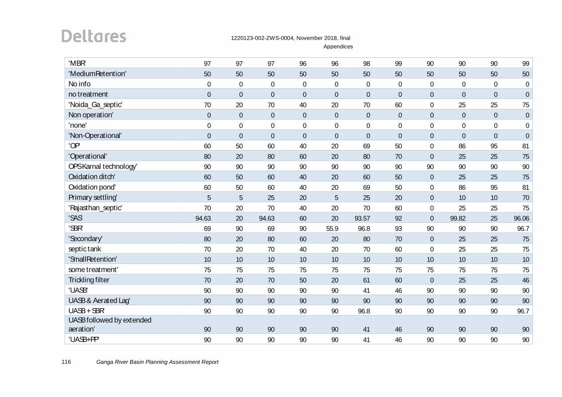
116
1220123-002-ZWS-0004, November 2018, finalAppendices
Ganga River Basin Planning Assessment Report
'MBR' 97 97 97 96 96 98 99 90 90 90 99'MediumRetention' 50 50 50 50 50 50 50 50 50 50 50No info 0 0 0 0 0 0 0 0 0 0 0no treatment 0 0 0 0 0 0 0 0 0 0 0'Noida_Ga_septic' 70 20 70 40 20 70 60 0 25 25 75Non operation' 0 0 0 0 0 0 0 0 0 0 0'none' 0 0 0 0 0 0 0 0 0 0 0'Non-Operational' 0 0 0 0 0 0 0 0 0 0 0'OP' 60 50 60 40 20 69 50 0 86 95 81'Operational' 80 20 80 60 20 80 70 0 25 25 75OPS Karnal technology' 90 90 90 90 90 90 90 90 90 90 90Oxidation ditch' 60 50 60 40 20 60 50 0 25 25 75Oxidation pond' 60 50 60 40 20 69 50 0 86 95 81Primary settling' 5 5 25 20 5 25 20 0 10 10 70'Rajasthan_septic' 70 20 70 40 20 70 60 0 25 25 75'SAS' 94.63 20 94.63 60 20 93.57 92 0 99.82 25 96.06'SBR' 69 90 69 90 55.9 96.8 93 90 90 90 96.7'Secondary' 80 20 80 60 20 80 70 0 25 25 75septic tank 70 20 70 40 20 70 60 0 25 25 75'SmallRetention' 10 10 10 10 10 10 10 10 10 10 10some treatment' 75 75 75 75 75 75 75 75 75 75 75Trickling filter 70 20 70 50 20 61 60 0 25 25 46'UASB' 90 90 90 90 90 41 46 90 90 90 90UASB & Aerated Lag' 90 90 90 90 90 90 90 90 90 90 90UASB + SBR' 90 90 90 90 90 96.8 90 90 90 90 96.7UASB followed by extendedaeration' 90 90 90 90 90 41 46 90 90 90 90'UASB+PP' 90 90 90 90 90 41 46 90 90 90 90
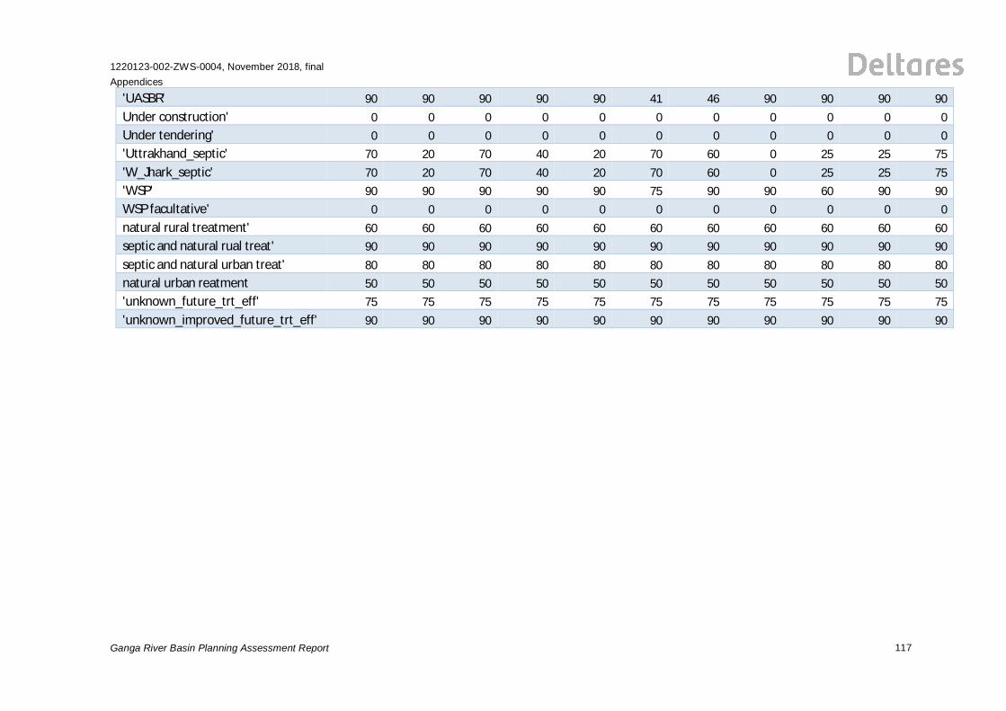
1220123-002-ZWS-0004, November 2018, finalAppendices
Ganga River Basin Planning Assessment Report 117
'UASBR' 90 90 90 90 90 41 46 90 90 90 90Under construction' 0 0 0 0 0 0 0 0 0 0 0Under tendering' 0 0 0 0 0 0 0 0 0 0 0'Uttrakhand_septic' 70 20 70 40 20 70 60 0 25 25 75'W_Jhark_septic' 70 20 70 40 20 70 60 0 25 25 75'WSP' 90 90 90 90 90 75 90 90 60 90 90WSP facultative' 0 0 0 0 0 0 0 0 0 0 0natural rural treatment' 60 60 60 60 60 60 60 60 60 60 60septic and natural rual treat' 90 90 90 90 90 90 90 90 90 90 90septic and natural urban treat' 80 80 80 80 80 80 80 80 80 80 80natural urban reatment 50 50 50 50 50 50 50 50 50 50 50'unknown_future_trt_eff' 75 75 75 75 75 75 75 75 75 75 75'unknown_improved_future_trt_eff' 90 90 90 90 90 90 90 90 90 90 90

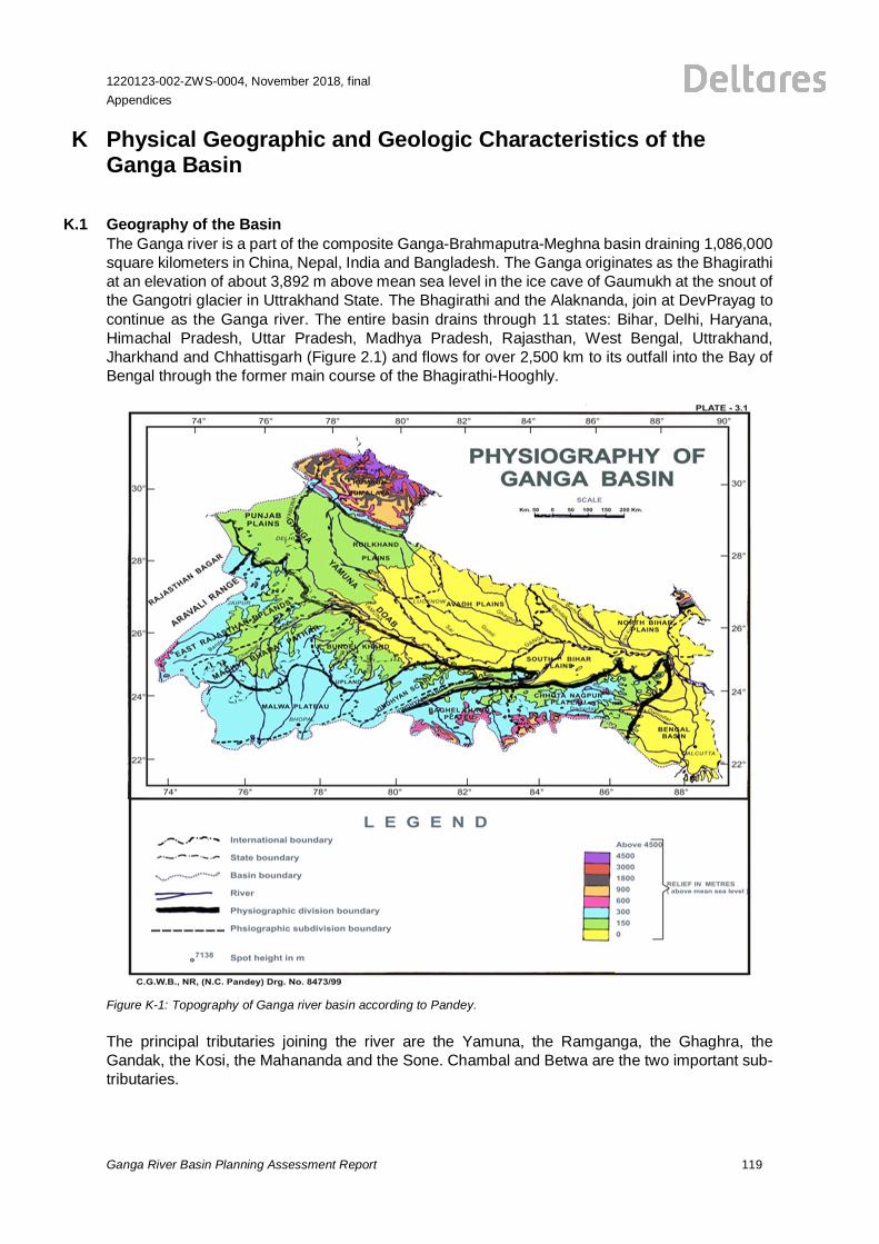
1220123-002-ZWS-0004, November 2018, finalAppendices
Ganga River Basin Planning Assessment Report 119
K Physical Geographic and Geologic Characteristics of theGanga Basin
K.1 Geography of the BasinThe Ganga river is a part of the composite Ganga-Brahmaputra-Meghna basin draining 1,086,000square kilometers in China, Nepal, India and Bangladesh. The Ganga originates as the Bhagirathiat an elevation of about 3,892 m above mean sea level in the ice cave of Gaumukh at the snout ofthe Gangotri glacier in Uttrakhand State. The Bhagirathi and the Alaknanda, join at DevPrayag tocontinue as the Ganga river. The entire basin drains through 11 states: Bihar, Delhi, Haryana,Himachal Pradesh, Uttar Pradesh, Madhya Pradesh, Rajasthan, West Bengal, Uttrakhand,Jharkhand and Chhattisgarh (Figure 2.1) and flows for over 2,500 km to its outfall into the Bay ofBengal through the former main course of the Bhagirathi-Hooghly.
Figure K-1: Topography of Ganga river basin according to Pandey.
The principal tributaries joining the river are the Yamuna, the Ramganga, the Ghaghra, theGandak, the Kosi, the Mahananda and the Sone. Chambal and Betwa are the two important sub-tributaries.
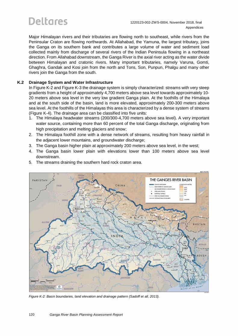
120
1220123-002-ZWS-0004, November 2018, finalAppendices
Ganga River Basin Planning Assessment Report
Major Himalayan rivers and their tributaries are flowing north to southeast, while rivers from thePeninsular Craton are flowing northwards. At Allahabad, the Yamuna, the largest tributary, joinsthe Ganga on its southern bank and contributes a large volume of water and sediment loadcollected mainly from discharge of several rivers of the Indian Peninsula flowing in a northeastdirection. From Allahabad downstream, the Ganga River is the axial river acting as the water dividebetween Himalayan and cratonic rivers. Many important tributaries, namely Varuna, Gomti,Ghaghra, Gandak and Kosi join from the north and Tons, Son, Punpun, Phalgu and many otherrivers join the Ganga from the south.
K.2 Drainage System and Water InfrastructureIn Figure K-2 and Figure K-3 the drainage system is simply characterized: streams with very steepgradients from a height of approximately 4,700 meters above sea level towards approximately 10-20 meters above sea level in the very low gradient Ganga plain. At the foothills of the Himalayaand at the south side of the basin, land is more elevated, approximately 200-300 meters abovesea level. At the foothills of the Himalayas this area is characterized by a dense system of streams(Figure K-4). The drainage area can be classified into five units:1. The Himalaya headwater streams (200/300-4,700 meters above sea level). A very important
water source, containing more than 60 percent of the total Ganga discharge, originating fromhigh precipitation and melting glaciers and snow;
2. The Himalaya foothill zone with a dense network of streams, resulting from heavy rainfall inthe adjacent lower mountains, and groundwater discharge;
3. The Ganga basin higher plain at approximately 200 meters above sea level, in the west;4. The Ganga basin lower plain with elevations lower than 100 meters above sea level
downstream.5. The streams draining the southern hard rock craton area.
Figure K-2: Basin boundaries, land elevation and drainage pattern (Sadoff et all, 2013).
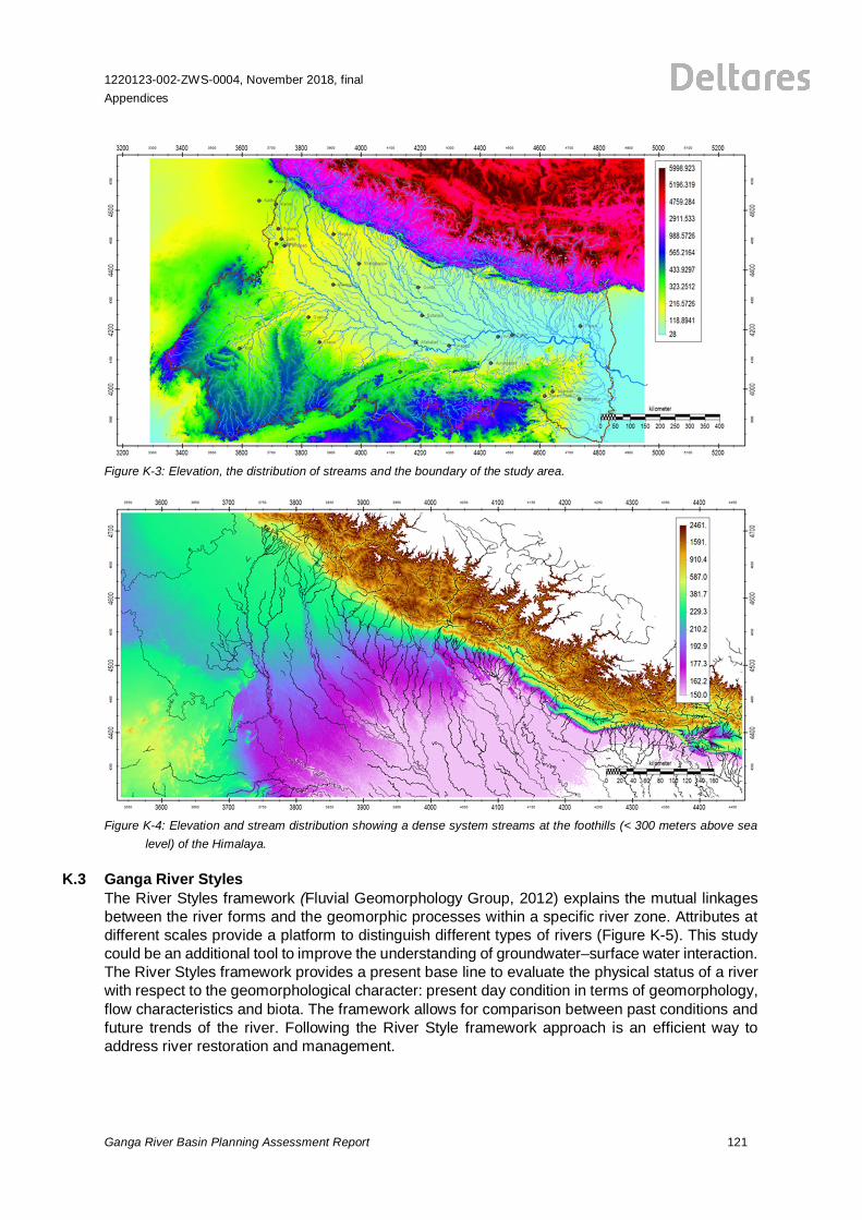
1220123-002-ZWS-0004, November 2018, finalAppendices
Ganga River Basin Planning Assessment Report 121
Figure K-3: Elevation, the distribution of streams and the boundary of the study area.
Figure K-4: Elevation and stream distribution showing a dense system streams at the foothills (< 300 meters above sealevel) of the Himalaya.
K.3 Ganga River StylesThe River Styles framework (Fluvial Geomorphology Group, 2012) explains the mutual linkagesbetween the river forms and the geomorphic processes within a specific river zone. Attributes atdifferent scales provide a platform to distinguish different types of rivers (Figure K-5). This studycould be an additional tool to improve the understanding of groundwater–surface water interaction.The River Styles framework provides a present base line to evaluate the physical status of a riverwith respect to the geomorphological character: present day condition in terms of geomorphology,flow characteristics and biota. The framework allows for comparison between past conditions andfuture trends of the river. Following the River Style framework approach is an efficient way toaddress river restoration and management.
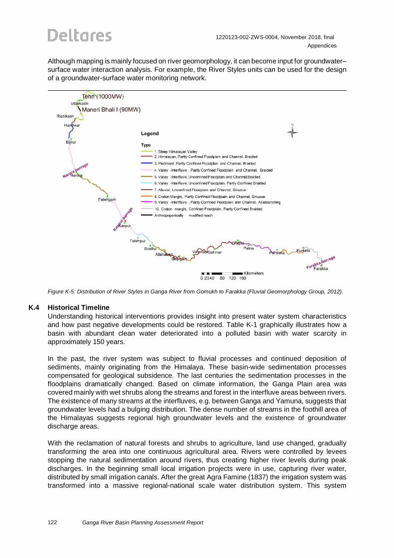
122
1220123-002-ZWS-0004, November 2018, finalAppendices
Ganga River Basin Planning Assessment Report
Although mapping is mainly focused on river geomorphology, it can become input for groundwater–surface water interaction analysis. For example, the River Styles units can be used for the designof a groundwater-surface water monitoring network.
Figure K-5: Distribution of River Styles in Ganga River from Gomukh to Farakka (Fluvial Geomorphology Group, 2012).
K.4 Historical TimelineUnderstanding historical interventions provides insight into present water system characteristicsand how past negative developments could be restored. Table K-1 graphically illustrates how abasin with abundant clean water deteriorated into a polluted basin with water scarcity inapproximately 150 years.
In the past, the river system was subject to fluvial processes and continued deposition ofsediments, mainly originating from the Himalaya. These basin-wide sedimentation processescompensated for geological subsidence. The last centuries the sedimentation processes in thefloodplains dramatically changed. Based on climate information, the Ganga Plain area wascovered mainly with wet shrubs along the streams and forest in the interfluve areas between rivers.The existence of many streams at the interfluves, e.g. between Ganga and Yamuna, suggests thatgroundwater levels had a bulging distribution. The dense number of streams in the foothill area ofthe Himalayas suggests regional high groundwater levels and the existence of groundwaterdischarge areas.
With the reclamation of natural forests and shrubs to agriculture, land use changed, graduallytransforming the area into one continuous agricultural area. Rivers were controlled by leveesstopping the natural sedimentation around rivers, thus creating higher river levels during peakdischarges. In the beginning small local irrigation projects were in use, capturing river water,distributed by small irrigation canals. After the great Agra Famine (1837) the irrigation system wastransformed into a massive regional-national scale water distribution system. This system
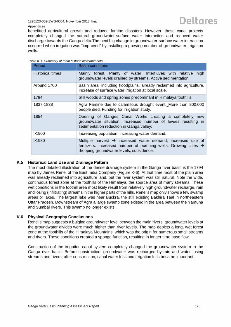
1220123-002-ZWS-0004, November 2018, finalAppendices
Ganga River Basin Planning Assessment Report 123
benefitted agricultural growth and reduced famine disasters. However, these canal projectscompletely changed the natural groundwater-surface water interaction and reduced waterdischarge towards the Ganga delta.The next big change in groundwater-surface water interactionoccurred when irrigation was “improved” by installing a growing number of groundwater irrigationwells.
Table K-1: Summary of main historic developments.Period Basin conditions
Historical times Mainly forest. Plenty of water. Interfluves with relative highgroundwater levels drained by streams. Active sedimentation.
Around 1700 Basin area, including floodplains, already reclaimed into agriculture.Increase of surface water irrigation at local scale.
1794 Still woods and spring zones predominant in Himalaya foothills.
1837-1838 Agra Famine due to calamitous drought event. More than 800,000people died. Funding for irrigation study.
1854 Opening of Ganges Canal Works creating a completely newgroundwater situation. Increased number of levees resulting insedimentation reduction in Ganga valley;
>1900 Increasing population, increasing water demand.
>1980 Multiple harvest à increased water demand, increased use offertilizers. Increased number of pumping wells. Growing cities àdropping groundwater levels, subsidence.
K.5 Historical Land Use and Drainage PatternThe most detailed illustration of the dense drainage system in the Ganga river basin is the 1794map by James Renel of the East India Company (Figure K-6). At that time most of the plain areawas already reclaimed into agriculture land, but the river system was still natural. Note the wide,continuous forest zone at the foothills of the Himalaya, the source area of many streams. Thesewet conditions in the foothill area most likely result from relatively high groundwater recharge, rainand losing (infiltrating) streams in the higher parts of the hills. Renel’s map only shows a few swampareas or lakes. The largest lake was near Buckra, the still existing Bakhira Taal in northeasternUttar Pradesh. Downstream of Agra a large swamp zone existed in the area between the Yamunaand Sumbal rivers. This swamp no longer exists.
K.6 Physical Geography ConclusionsRenel’s map suggests a bulging groundwater level between the main rivers; groundwater levels atthe groundwater divides were much higher than river levels. The map depicts a long, wet forestzone at the foothills of the Himalaya Mountains, which was the origin for numerous small streamsand rivers. These conditions created a sponge function, resulting in longer time base flow.
Construction of the irrigation canal system completely changed the groundwater system in theGanga river basin. Before construction, groundwater was recharged by rain and water losingstreams and rivers; after construction, canal water loss and irrigation loss became important.
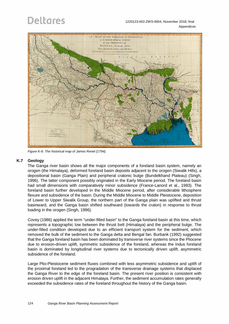
124
1220123-002-ZWS-0004, November 2018, finalAppendices
Ganga River Basin Planning Assessment Report
Figure K-6: The historical map of James Renel (1794).
K.7 GeologyThe Ganga river basin shows all the major components of a foreland basin system, namely anorogen (the Himalaya), deformed foreland basin deposits adjacent to the orogen (Siwalik Hills), adepositional basin (Ganga Plain) and peripheral cratonic bulge (Bundelkhand Plateau) (Singh,1996). The latter component possibly originated in the Early Miocene period. The foreland basinhad small dimensions with comparatively minor subsidence (France-Lanord et al., 1983). Theforeland basin further developed in the Middle Miocene period, after considerable lithosphereflexure and subsidence of the basin. During the Middle Miocene to Middle Pleistocene, depositionof Lower to Upper Siwalik Group, the northern part of the Ganga plain was uplifted and thrustbasinward, and the Ganga basin shifted southward (towards the craton) in response to thrustloading in the orogen (Singh, 1996).
Covey (1986) applied the term “under-filled basin” to the Ganga foreland basin at this time, whichrepresents a topographic low between the thrust belt (Himalaya) and the peripheral bulge. Theunder-filled condition developed due to an efficient transport system for the sediment, whichremoved the bulk of the sediment to the Ganga delta and Bengal fan. Burbank (1992) suggestedthat the Ganga foreland basin has been dominated by transverse river systems since the Pliocenedue to erosion-driven uplift, symmetric subsidence of the foreland, whereas the Indus forelandbasin is dominated by longitudinal river systems due to tectonically driven uplift, asymmetricsubsidence of the foreland.
Large Plio-Pleistocene sediment fluxes combined with less asymmetric subsidence and uplift ofthe proximal foreland led to the progradation of the transverse drainage systems that displacedthe Ganga River to the edge of the foreland basin. The present river position is consistent witherosion driven uplift in the adjacent Himalaya. Further, the sediment accumulation rates generallyexceeded the subsidence rates of the foreland throughout the history of the Ganga basin.
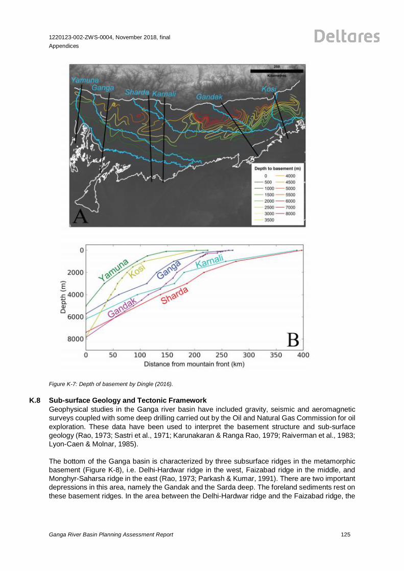
1220123-002-ZWS-0004, November 2018, finalAppendices
Ganga River Basin Planning Assessment Report 125
Figure K-7: Depth of basement by Dingle (2016).
K.8 Sub-surface Geology and Tectonic FrameworkGeophysical studies in the Ganga river basin have included gravity, seismic and aeromagneticsurveys coupled with some deep drilling carried out by the Oil and Natural Gas Commission for oilexploration. These data have been used to interpret the basement structure and sub-surfacegeology (Rao, 1973; Sastri et al., 1971; Karunakaran & Ranga Rao, 1979; Raiverman et al., 1983;Lyon-Caen & Molnar, 1985).
The bottom of the Ganga basin is characterized by three subsurface ridges in the metamorphicbasement (Figure K-8), i.e. Delhi-Hardwar ridge in the west, Faizabad ridge in the middle, andMonghyr-Saharsa ridge in the east (Rao, 1973; Parkash & Kumar, 1991). There are two importantdepressions in this area, namely the Gandak and the Sarda deep. The foreland sediments rest onthese basement ridges. In the area between the Delhi-Hardwar ridge and the Faizabad ridge, the
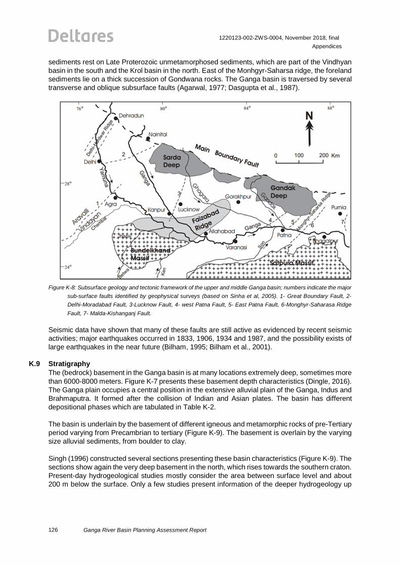
126
1220123-002-ZWS-0004, November 2018, finalAppendices
Ganga River Basin Planning Assessment Report
sediments rest on Late Proterozoic unmetamorphosed sediments, which are part of the Vindhyanbasin in the south and the Krol basin in the north. East of the Monhgyr-Saharsa ridge, the forelandsediments lie on a thick succession of Gondwana rocks. The Ganga basin is traversed by severaltransverse and oblique subsurface faults (Agarwal, 1977; Dasgupta et al., 1987).
Figure K-8: Subsurface geology and tectonic framework of the upper and middle Ganga basin; numbers indicate the majorsub-surface faults identified by geophysical surveys (based on Sinha et al, 2005). 1- Great Boundary Fault, 2-Delhi-Moradabad Fault, 3-Lucknow Fault, 4- west Patna Fault, 5- East Patna Fault, 6-Monghyr-Saharasa RidgeFault, 7- Malda-Kishanganj Fault.
Seismic data have shown that many of these faults are still active as evidenced by recent seismicactivities; major earthquakes occurred in 1833, 1906, 1934 and 1987, and the possibility exists oflarge earthquakes in the near future (Bilham, 1995; Bilham et al., 2001).
K.9 StratigraphyThe (bedrock) basement in the Ganga basin is at many locations extremely deep, sometimes morethan 6000-8000 meters. Figure K-7 presents these basement depth characteristics (Dingle, 2016).The Ganga plain occupies a central position in the extensive alluvial plain of the Ganga, Indus andBrahmaputra. It formed after the collision of Indian and Asian plates. The basin has differentdepositional phases which are tabulated in Table K-2.
The basin is underlain by the basement of different igneous and metamorphic rocks of pre-Tertiaryperiod varying from Precambrian to tertiary (Figure K-9). The basement is overlain by the varyingsize alluvial sediments, from boulder to clay.
Singh (1996) constructed several sections presenting these basin characteristics (Figure K-9). Thesections show again the very deep basement in the north, which rises towards the southern craton.Present-day hydrogeological studies mostly consider the area between surface level and about200 m below the surface. Only a few studies present information of the deeper hydrogeology up
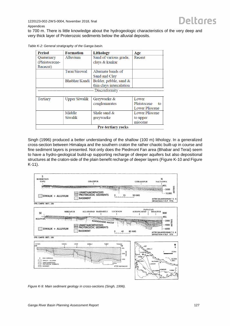
1220123-002-ZWS-0004, November 2018, finalAppendices
Ganga River Basin Planning Assessment Report 127
to 700 m. There is little knowledge about the hydrogeologic characteristics of the very deep andvery thick layer of Proterozoic sediments below the alluvial deposits.
Table K-2: General stratigraphy of the Ganga basin.
Singh (1996) produced a better understanding of the shallow (100 m) lithology. In a generalizedcross-section between Himalaya and the southern craton the rather chaotic built-up in course andfine sediment layers is presented. Not only does the Piedmont Fan area (Bhabar and Terai) seemto have a hydro-geological build-up supporting recharge of deeper aquifers but also depositionalstructures at the craton-side of the plain benefit recharge of deeper layers (Figure K-10 and FigureK-11).
Figure K-9: Main sediment geology in cross-sections (Singh, 1996).
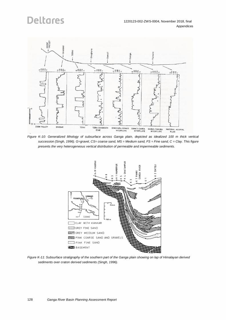
128
1220123-002-ZWS-0004, November 2018, finalAppendices
Ganga River Basin Planning Assessment Report
Figure K-10: Generalized lithology of subsurface across Ganga plain, depicted as idealized 100 m thick verticalsuccession (Singh, 1996). G=gravel, CS= coarse sand, MS = Medium sand, FS = Fine sand, C = Clay. This figurepresents the very heterogeneous vertical distribution of permeable and impermeable sediments.
Figure K-11: Subsurface stratigraphy of the southern part of the Ganga plain showing on lap of Himalayan derivedsediments over craton derived sediments (Singh, 1996).
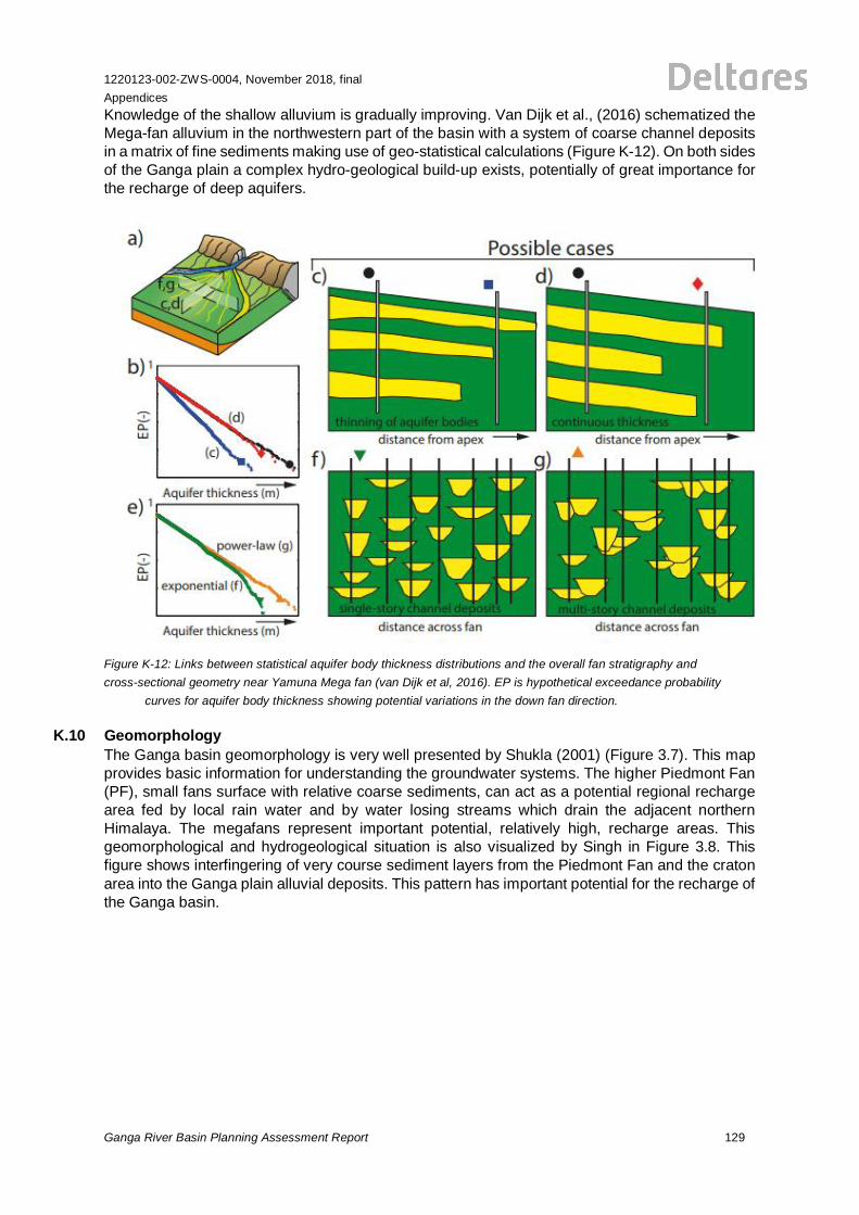
1220123-002-ZWS-0004, November 2018, finalAppendices
Ganga River Basin Planning Assessment Report 129
Knowledge of the shallow alluvium is gradually improving. Van Dijk et al., (2016) schematized theMega-fan alluvium in the northwestern part of the basin with a system of coarse channel depositsin a matrix of fine sediments making use of geo-statistical calculations (Figure K-12). On both sidesof the Ganga plain a complex hydro-geological build-up exists, potentially of great importance forthe recharge of deep aquifers.
Figure K-12: Links between statistical aquifer body thickness distributions and the overall fan stratigraphy andcross-sectional geometry near Yamuna Mega fan (van Dijk et al, 2016). EP is hypothetical exceedance probability
curves for aquifer body thickness showing potential variations in the down fan direction.
K.10 GeomorphologyThe Ganga basin geomorphology is very well presented by Shukla (2001) (Figure 3.7). This mapprovides basic information for understanding the groundwater systems. The higher Piedmont Fan(PF), small fans surface with relative coarse sediments, can act as a potential regional rechargearea fed by local rain water and by water losing streams which drain the adjacent northernHimalaya. The megafans represent important potential, relatively high, recharge areas. Thisgeomorphological and hydrogeological situation is also visualized by Singh in Figure 3.8. Thisfigure shows interfingering of very course sediment layers from the Piedmont Fan and the cratonarea into the Ganga plain alluvial deposits. This pattern has important potential for the recharge ofthe Ganga basin.
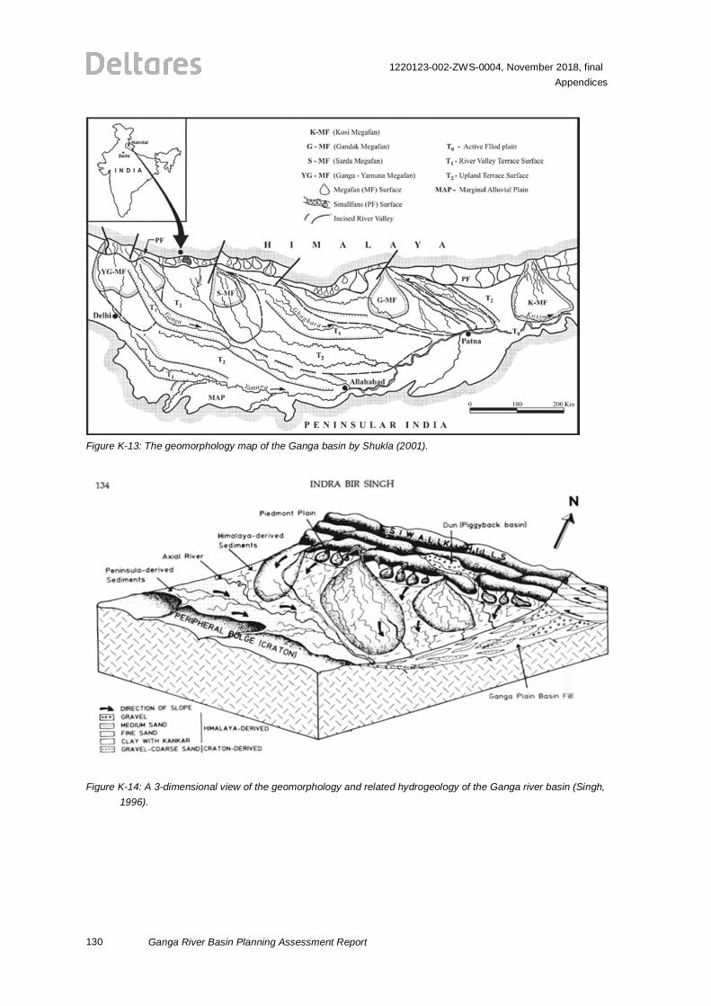
130
1220123-002-ZWS-0004, November 2018, finalAppendices
Ganga River Basin Planning Assessment Report
Figure K-13: The geomorphology map of the Ganga basin by Shukla (2001).
Figure K-14: A 3-dimensional view of the geomorphology and related hydrogeology of the Ganga river basin (Singh,1996).
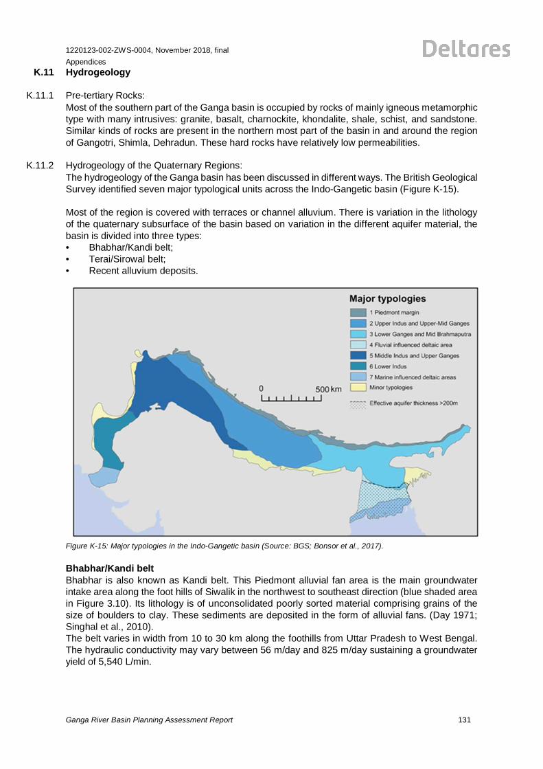
1220123-002-ZWS-0004, November 2018, finalAppendices
Ganga River Basin Planning Assessment Report 131
K.11 Hydrogeology
K.11.1 Pre-tertiary Rocks:Most of the southern part of the Ganga basin is occupied by rocks of mainly igneous metamorphictype with many intrusives: granite, basalt, charnockite, khondalite, shale, schist, and sandstone.Similar kinds of rocks are present in the northern most part of the basin in and around the regionof Gangotri, Shimla, Dehradun. These hard rocks have relatively low permeabilities.
K.11.2 Hydrogeology of the Quaternary Regions:The hydrogeology of the Ganga basin has been discussed in different ways. The British GeologicalSurvey identified seven major typological units across the Indo-Gangetic basin (Figure K-15).
Most of the region is covered with terraces or channel alluvium. There is variation in the lithologyof the quaternary subsurface of the basin based on variation in the different aquifer material, thebasin is divided into three types:• Bhabhar/Kandi belt;• Terai/Sirowal belt;• Recent alluvium deposits.
Figure K-15: Major typologies in the Indo-Gangetic basin (Source: BGS; Bonsor et al., 2017).
Bhabhar/Kandi beltBhabhar is also known as Kandi belt. This Piedmont alluvial fan area is the main groundwaterintake area along the foot hills of Siwalik in the northwest to southeast direction (blue shaded areain Figure 3.10). Its lithology is of unconsolidated poorly sorted material comprising grains of thesize of boulders to clay. These sediments are deposited in the form of alluvial fans. (Day 1971;Singhal et al., 2010).The belt varies in width from 10 to 30 km along the foothills from Uttar Pradesh to West Bengal.The hydraulic conductivity may vary between 56 m/day and 825 m/day sustaining a groundwateryield of 5,540 L/min.
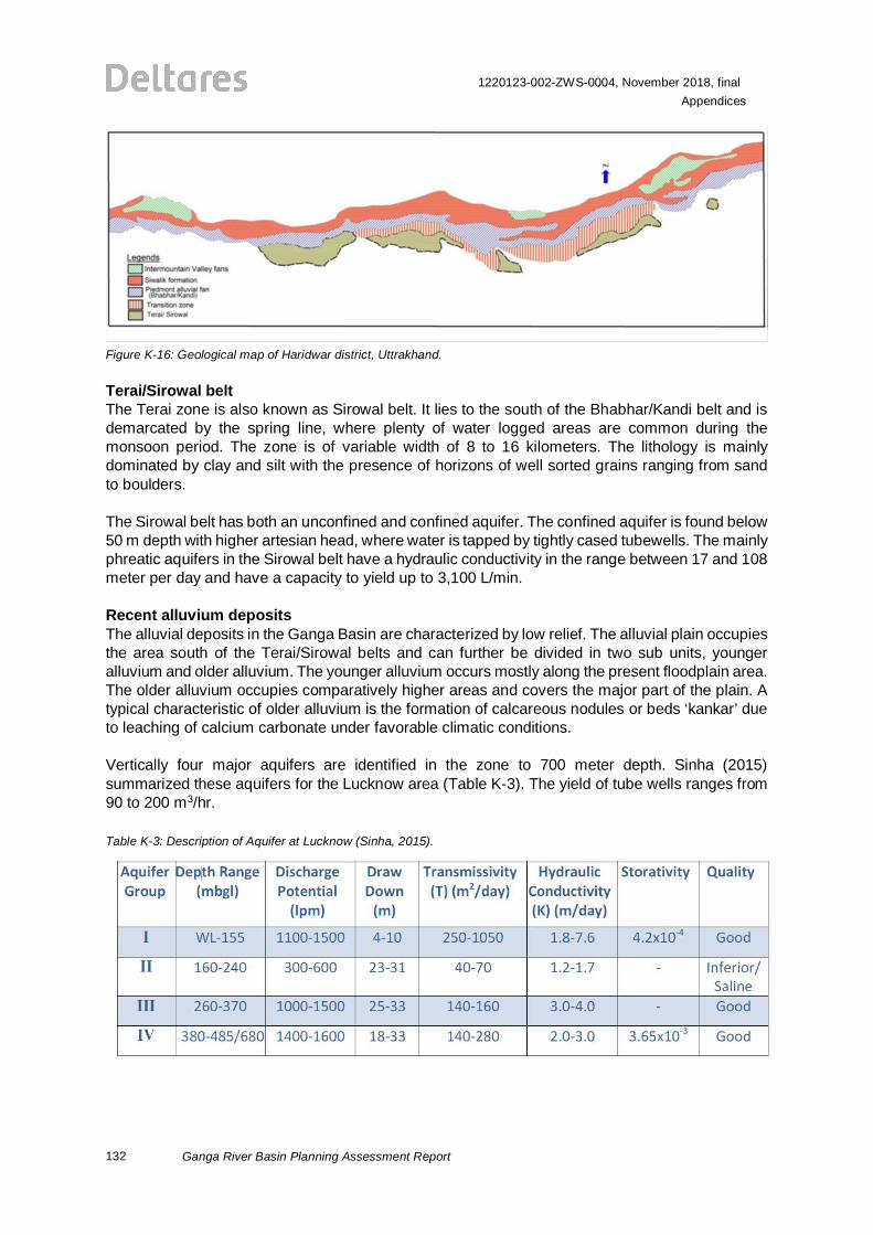
132
1220123-002-ZWS-0004, November 2018, finalAppendices
Ganga River Basin Planning Assessment Report
Figure K-16: Geological map of Haridwar district, Uttrakhand.
Terai/Sirowal beltThe Terai zone is also known as Sirowal belt. It lies to the south of the Bhabhar/Kandi belt and isdemarcated by the spring line, where plenty of water logged areas are common during themonsoon period. The zone is of variable width of 8 to 16 kilometers. The lithology is mainlydominated by clay and silt with the presence of horizons of well sorted grains ranging from sandto boulders.
The Sirowal belt has both an unconfined and confined aquifer. The confined aquifer is found below50 m depth with higher artesian head, where water is tapped by tightly cased tubewells. The mainlyphreatic aquifers in the Sirowal belt have a hydraulic conductivity in the range between 17 and 108meter per day and have a capacity to yield up to 3,100 L/min.
Recent alluvium depositsThe alluvial deposits in the Ganga Basin are characterized by low relief. The alluvial plain occupiesthe area south of the Terai/Sirowal belts and can further be divided in two sub units, youngeralluvium and older alluvium. The younger alluvium occurs mostly along the present floodplain area.The older alluvium occupies comparatively higher areas and covers the major part of the plain. Atypical characteristic of older alluvium is the formation of calcareous nodules or beds ‘kankar’ dueto leaching of calcium carbonate under favorable climatic conditions.
Vertically four major aquifers are identified in the zone to 700 meter depth. Sinha (2015)summarized these aquifers for the Lucknow area (Table K-3). The yield of tube wells ranges from90 to 200 m3/hr.
Table K-3: Description of Aquifer at Lucknow (Sinha, 2015).
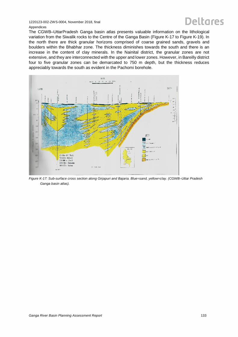
1220123-002-ZWS-0004, November 2018, finalAppendices
Ganga River Basin Planning Assessment Report 133
The CGWB–UttarPradesh Ganga basin atlas presents valuable information on the lithologicalvariation from the Siwalik rocks to the Centre of the Ganga Basin (Figure K-17 to Figure K-19). Inthe north there are thick granular horizons comprised of coarse grained sands, gravels andboulders within the Bhabhar zone. The thickness diminishes towards the south and there is anincrease in the content of clay minerals. In the Nainital district, the granular zones are notextensive, and they are interconnected with the upper and lower zones. However, in Bareilly districtfour to five granular zones can be demarcated to 750 m depth, but the thickness reducesappreciably towards the south as evident in the Pachomi borehole.
Figure K-17: Sub-surface cross section along Girjapuri and Bajaria. Blue=sand, yellow=clay. (CGWB–Uttar PradeshGanga basin atlas).
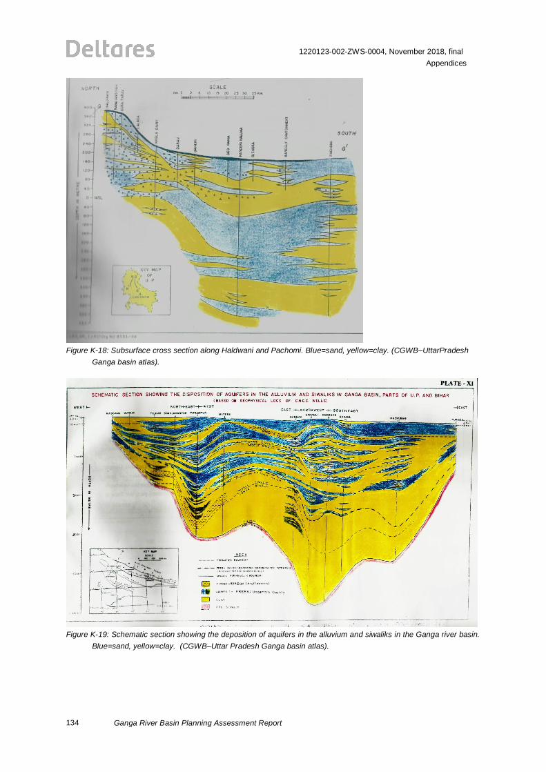
134
1220123-002-ZWS-0004, November 2018, finalAppendices
Ganga River Basin Planning Assessment Report
Figure K-18: Subsurface cross section along Haldwani and Pachomi. Blue=sand, yellow=clay. (CGWB–UttarPradeshGanga basin atlas).
Figure K-19: Schematic section showing the deposition of aquifers in the alluvium and siwaliks in the Ganga river basin.Blue=sand, yellow=clay. (CGWB–Uttar Pradesh Ganga basin atlas).
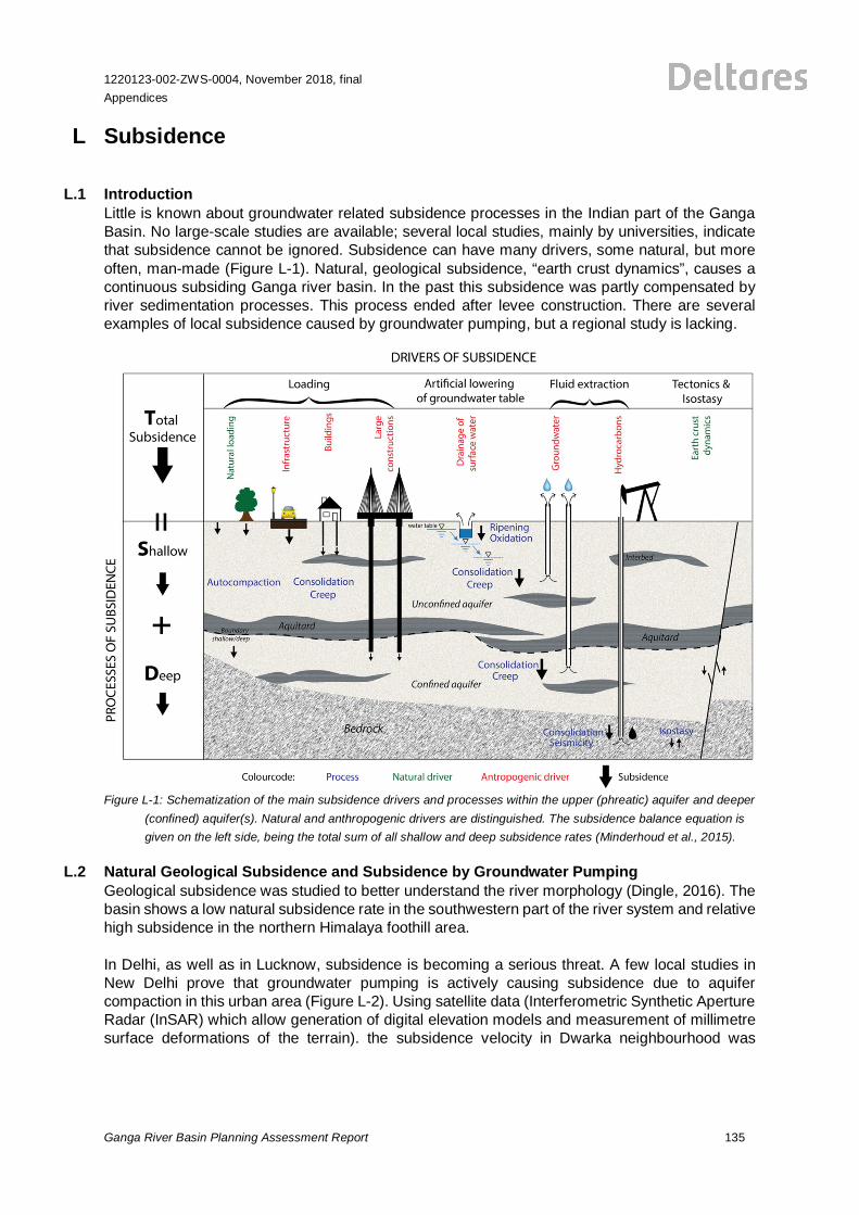
1220123-002-ZWS-0004, November 2018, finalAppendices
Ganga River Basin Planning Assessment Report 135
L Subsidence
L.1 IntroductionLittle is known about groundwater related subsidence processes in the Indian part of the GangaBasin. No large-scale studies are available; several local studies, mainly by universities, indicatethat subsidence cannot be ignored. Subsidence can have many drivers, some natural, but moreoften, man-made (Figure L-1). Natural, geological subsidence, “earth crust dynamics”, causes acontinuous subsiding Ganga river basin. In the past this subsidence was partly compensated byriver sedimentation processes. This process ended after levee construction. There are severalexamples of local subsidence caused by groundwater pumping, but a regional study is lacking.
Figure L-1: Schematization of the main subsidence drivers and processes within the upper (phreatic) aquifer and deeper(confined) aquifer(s). Natural and anthropogenic drivers are distinguished. The subsidence balance equation isgiven on the left side, being the total sum of all shallow and deep subsidence rates (Minderhoud et al., 2015).
L.2 Natural Geological Subsidence and Subsidence by Groundwater PumpingGeological subsidence was studied to better understand the river morphology (Dingle, 2016). Thebasin shows a low natural subsidence rate in the southwestern part of the river system and relativehigh subsidence in the northern Himalaya foothill area.
In Delhi, as well as in Lucknow, subsidence is becoming a serious threat. A few local studies inNew Delhi prove that groundwater pumping is actively causing subsidence due to aquifercompaction in this urban area (Figure L-2). Using satellite data (Interferometric Synthetic ApertureRadar (InSAR) which allow generation of digital elevation models and measurement of millimetresurface deformations of the terrain). the subsidence velocity in Dwarka neighbourhood was
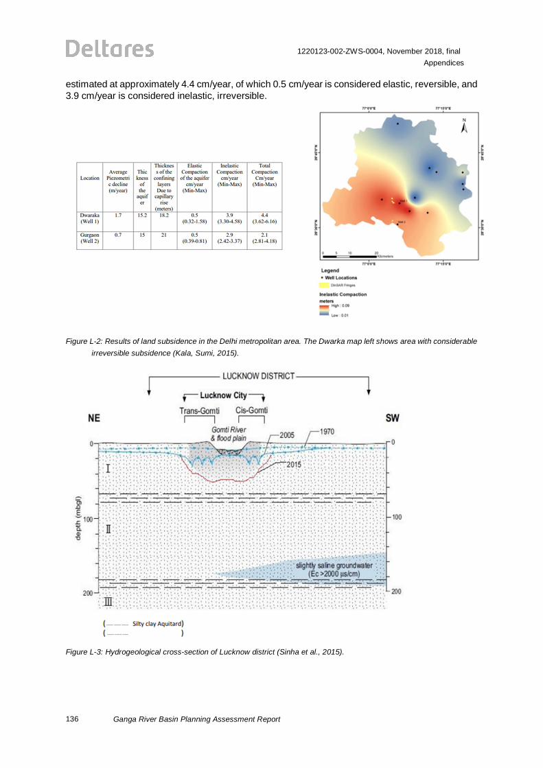
136
1220123-002-ZWS-0004, November 2018, finalAppendices
Ganga River Basin Planning Assessment Report
estimated at approximately 4.4 cm/year, of which 0.5 cm/year is considered elastic, reversible, and3.9 cm/year is considered inelastic, irreversible.
Figure L-2: Results of land subsidence in the Delhi metropolitan area. The Dwarka map left shows area with considerableirreversible subsidence (Kala, Sumi, 2015).
Figure L-3: Hydrogeological cross-section of Lucknow district (Sinha et al., 2015).
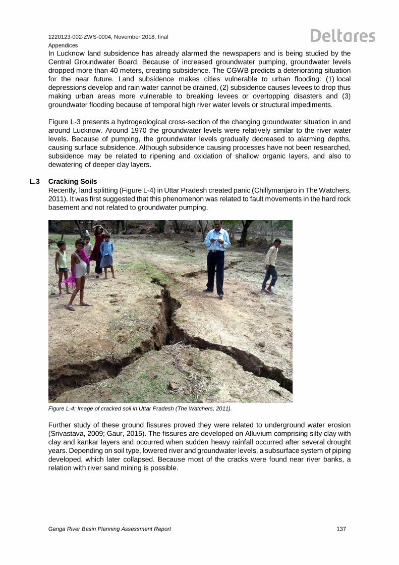
1220123-002-ZWS-0004, November 2018, finalAppendices
Ganga River Basin Planning Assessment Report 137
In Lucknow land subsidence has already alarmed the newspapers and is being studied by theCentral Groundwater Board. Because of increased groundwater pumping, groundwater levelsdropped more than 40 meters, creating subsidence. The CGWB predicts a deteriorating situationfor the near future. Land subsidence makes cities vulnerable to urban flooding: (1) localdepressions develop and rain water cannot be drained, (2) subsidence causes levees to drop thusmaking urban areas more vulnerable to breaking levees or overtopping disasters and (3)groundwater flooding because of temporal high river water levels or structural impediments.
Figure L-3 presents a hydrogeological cross-section of the changing groundwater situation in andaround Lucknow. Around 1970 the groundwater levels were relatively similar to the river waterlevels. Because of pumping, the groundwater levels gradually decreased to alarming depths,causing surface subsidence. Although subsidence causing processes have not been researched,subsidence may be related to ripening and oxidation of shallow organic layers, and also todewatering of deeper clay layers.
L.3 Cracking SoilsRecently, land splitting (Figure L-4) in Uttar Pradesh created panic (Chillymanjaro in The Watchers,2011). It was first suggested that this phenomenon was related to fault movements in the hard rockbasement and not related to groundwater pumping.
Figure L-4: Image of cracked soil in Uttar Pradesh (The Watchers, 2011).
Further study of these ground fissures proved they were related to underground water erosion(Srivastava, 2009; Gaur, 2015). The fissures are developed on Alluvium comprising silty clay withclay and kankar layers and occurred when sudden heavy rainfall occurred after several droughtyears. Depending on soil type, lowered river and groundwater levels, a subsurface system of pipingdeveloped, which later collapsed. Because most of the cracks were found near river banks, arelation with river sand mining is possible.
138
1220123-002-ZWS-0004, November 2018, finalAppendices
Ganga River Basin Planning Assessment Report
L.4 ConclusionsGeological subsidence is studied by geologists and geomorphologists and is fairly well understood.Subsidence from groundwater pumping in Delhi and Lucknow results in serious subsidencevelocities. Minimal information is available on subsidence from pumping in other cities and inagriculture areas.
Little information exists on subsidence caused by (surface water: ditches, canals) drainage ofshallow groundwater. Some incidents of cracking and swelling soils have been reported.
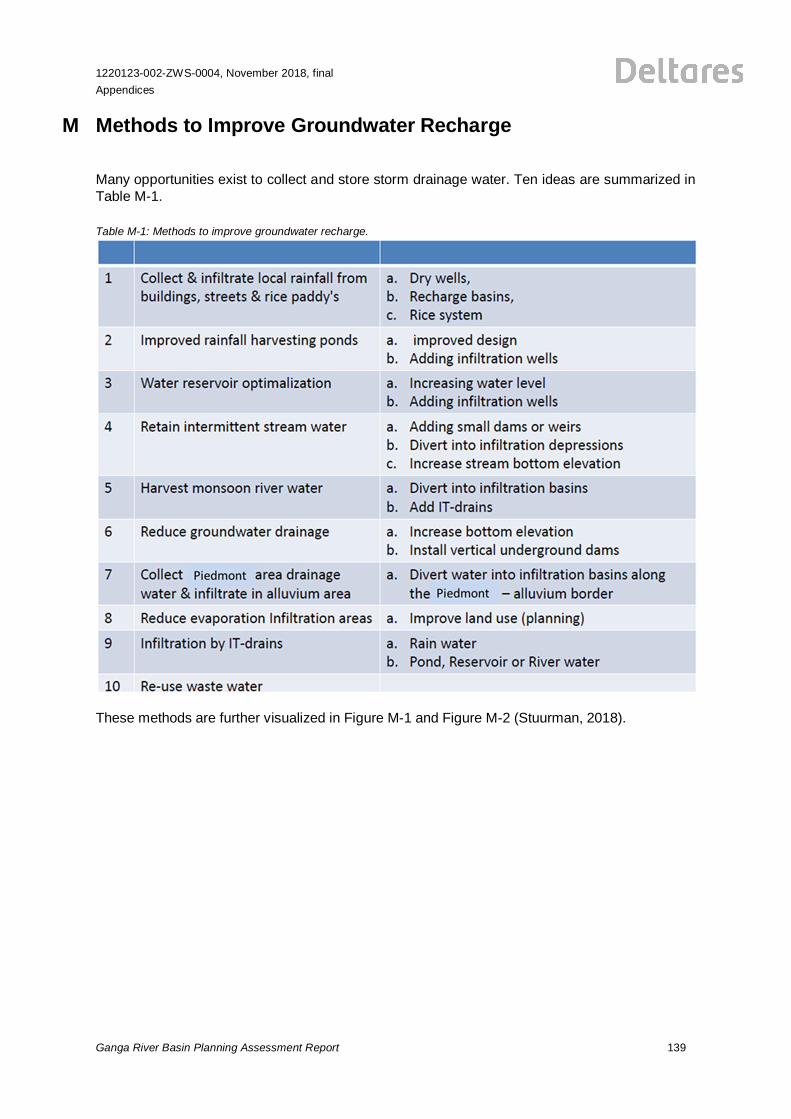
1220123-002-ZWS-0004, November 2018, finalAppendices
Ganga River Basin Planning Assessment Report 139
M Methods to Improve Groundwater Recharge
Many opportunities exist to collect and store storm drainage water. Ten ideas are summarized inTable M-1.
Table M-1: Methods to improve groundwater recharge.
These methods are further visualized in Figure M-1 and Figure M-2 (Stuurman, 2018).
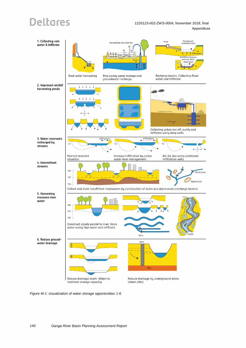
140
1220123-002-ZWS-0004, November 2018, finalAppendices
Ganga River Basin Planning Assessment Report
Figure M-1: visualization of water storage opportunities 1-6.
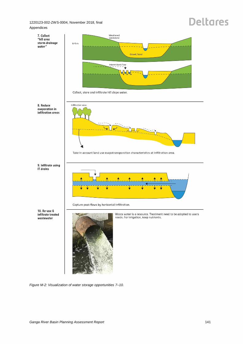
1220123-002-ZWS-0004, November 2018, finalAppendices
Ganga River Basin Planning Assessment Report 141
Figure M-2: Visualization of water storage opportunities 7–10.

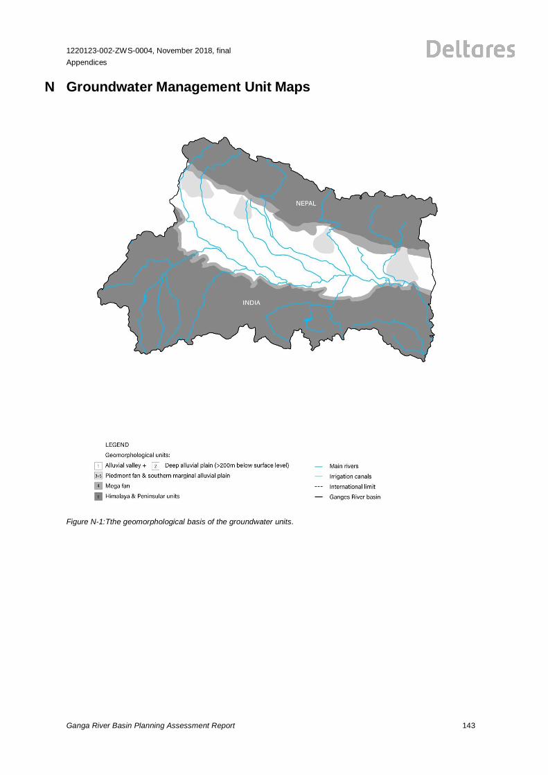
1220123-002-ZWS-0004, November 2018, finalAppendices
Ganga River Basin Planning Assessment Report 143
N Groundwater Management Unit Maps
Figure N-1:Tthe geomorphological basis of the groundwater units.
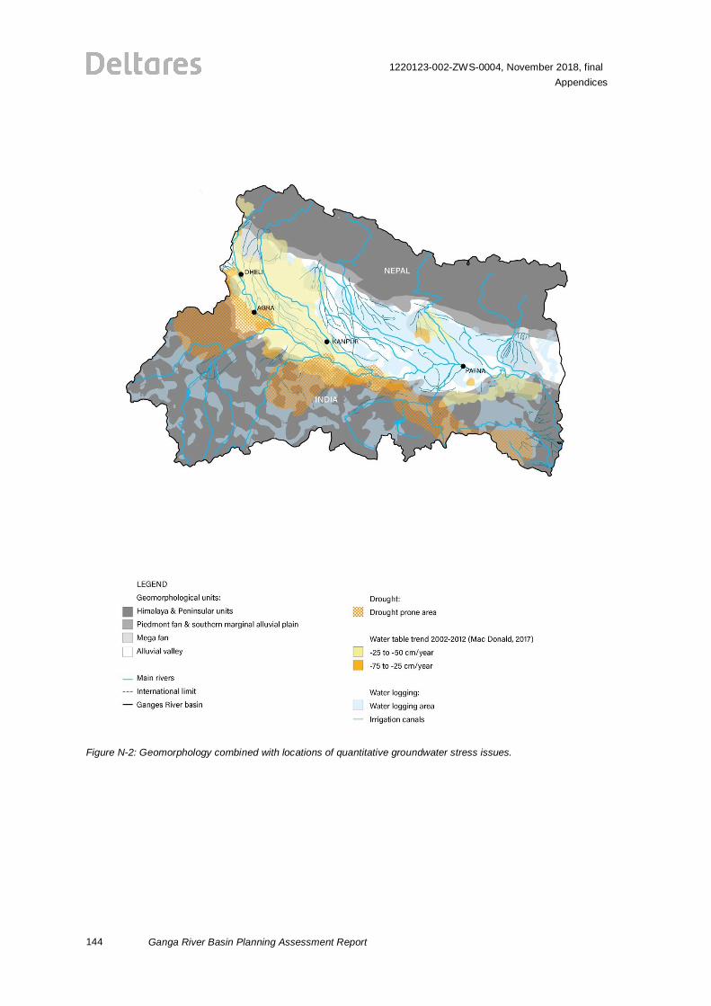
144
1220123-002-ZWS-0004, November 2018, finalAppendices
Ganga River Basin Planning Assessment Report
Figure N-2: Geomorphology combined with locations of quantitative groundwater stress issues.
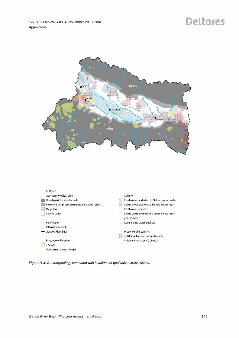
1220123-002-ZWS-0004, November 2018, finalAppendices
Ganga River Basin Planning Assessment Report 145
Figure N-3: Geomorphology combined with locations of qualitative stress issues.
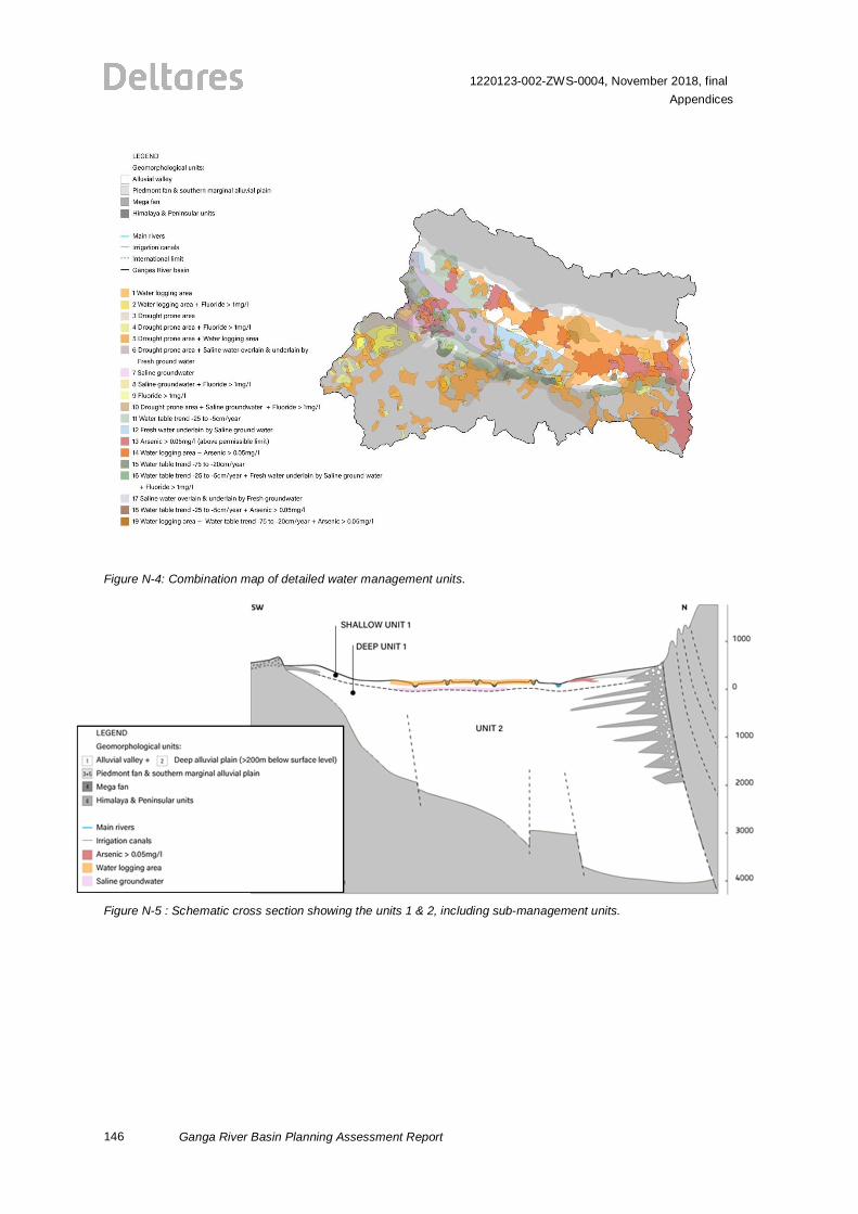
146
1220123-002-ZWS-0004, November 2018, finalAppendices
Ganga River Basin Planning Assessment Report
Figure N-4: Combination map of detailed water management units.
Figure N-5 : Schematic cross section showing the units 1 & 2, including sub-management units.