Embed Size (px)
Citation preview

MISSOURI BUREAU OF GEOLOGY AND MINES. El. R. BUCKLEY, PH. D., Director and State Geologist.
Vol. 1, 2nd Series .
THE
Geology of Miller County
BY
SYD EY H. BALL AND A. F. SMITH.
WITH AN INTRODUCTION BY
E. R. BUCKLEY .
JEFFERSO~ CITY, MO.:
Ttt!BU:<E PRIXTT'.'!G CO)!P.1:<l:, 8TA1'1~ PRD!TERS AND BINDERS.
1903.
BOARD OF MANAGERS.
His Excellency, Alexander :\fonroe Dockery, Governor of Missouri, ex-officio President of the Board ..... .. .. .......... Jefferson City
Edward 1\1. Shepard, Sc D.-Vice President ......... . ..... . . Springfield
E. B. Craighead, L.L.D.-Secretary . . . ... . .... .. ......... Warrensburg
Hon. H . H. Gregg . . . . . . ......... . . . ............... . ... . .. . . Joplin
Hon. W. S. Allee, 1\1.D . . . . ... . . . ... .. ...... . . . ......... . ... . Olean
T ABLE OF CONTENTS.
Letter of Transmittal. ...... . ........................... ... ............. . ... . .. . Introduction ..... ........................ .. .................... .... ..... . ... . ..... ............... . Oh apter I, Physiography ..... ... ........ ...... .... .... ............... .. ... .. . ........... . . .... . . Ohapter IT, Proctor Limestone .. ............... .... .. ... ......... . . .... ........•...........
(Fourtb lllagneslan Limestone of Swallow.) Ohapter III, Gunter Sandstone .............................................................. .
(Third Sandstone of Swallow.) Ohapter IV, Gasconade Limestone.
(Third Magneslan Limestone ot wallow.)
Page VII Xl
1 23
26
30
Chapter V, St. Elizabeth Formation..... ... .. ... ... . .... . ... . ... . . . . . . .. .. .. . . .. . . . . . . .. .. .. .. 50 (Second Sandstone (In part) of Swallow.)
Chapter VI, Jefl'erson Olty Limestone . . . .. . .. . . . . . .. . . . . .. . . . . . .• . . .. . . . . . . . . . .. . .. . .. . .. 69 (Second Magneslan Limestone or Swallow. l
Oh apter VII, Pacific Sandstone..... . . . . . . . . . . . . . . . . . . . . . . . . . . . . . . . . . . . . . . . . . . . . . . . . . . . . . . . . . 79 Uhapter VIII, LowerCarbonlferous......... .. .. .. .. .. . •. .. . . .. . ... .. . . .. .. .... . . . . .. .. . . . . . . .. 82 Ohapter IX, The Ooal Measure Formations............. . ..... .... . . .. . . . . . . . . •. . . . . . . •. . . . . . . 90 Chapter X, Mesozoic, Cenozoic and Quarternary . .. .. . ..... ... .... . . .. .. .. . .... .. .. .. ..... 119 Oh apter XI, Structure. .... .. . . . . . . . . . . . . . . . . . . . . . . . . . . . . . . . . . . . . . . . . . . . . . . . . . . . . . . . . . . . . . . . . . 124 Chapter XII, Dolomite and Chert and their origin............ . . . . . . . . . . . . .. . . . . . .. . . . . .. . . . . 142 Ohapter XIII, Economic Oonslderatlons......... . ..... . ......... . . . . . . . . . . . . . . . . . . . . . . . . . . . 148


ILLUSTRATIONS.
PLATES. Plate.
I. Geological Map of 1111!ler Oounty ............ .. ........ ...... . II. Flood Plain of the Osage River ........................ .. .... . . . . ........ . . ..... .
IJJ. Fig 1.-Mudcracks in Osage River Alluvium .... ..... . . .... . ... . ... ........ ... . Fig 2.-Glacial Boulders along Dog Oreek ............... . . .. . .. ......... ... . .
IV. Gunter Sandstone-Proctor Limestone Unconformity ........... . ...... .. .... .. . V. Differential Weathering of Oherty Dolomite ............ . ........ . ..... . ...... .
V 1. Flat Topped Ridge Underlain by tbe St. Elizabeth formation . ................. . VII. Curling structure in dolomite of the St. Elizabeth formation ................... .
Flg 1.-Vlew along Bedding Plane. l?lg 2.-Slde View.
VIII. Differential Weathering of Ordovlci:-.n Chert . ........... .. . ......... .. .... . IX. Typical Weathered Surface of Pitted Beds of Jefferson City Limestone ..... . . .
X. Peculiar Form of Chert Nodule ..................... .. .. . ......... . .......... . .. . XL Fig 1. - Jolntlng in Graydon Sandstone . .... . ..... .. ......................... .
Fig 2.-Polygonal Markings on Weathered Surface of Graydon Sandstone. XII. Graydon Sandstone. Adcock Exposure ................... .
Fig 1..-General View. Fig 2.-Near View of Several Blocks.
XUJ. Fig 1.-Shale showing Sl!ckensldes ..................................... . ....... . Fig 2.-Boulder of Faulted Limestone showing Planing and Scratching . ...
Page VI
2
4
26 32 52
54
58 70 72 96
100
106
XIV. Cross Sections-Republic Coal Mine. ... .. .. ....................... . . . . . . .. . . . .. .. 110 XV. Ravens Bluff.. . ............ .. .. .. . . .. .. . . . . .. .. .. .. .. . ...... .. .. .. .... . .. .. ... . ... . 126
XVI. Fig 1-4.-Cross Sections across County.... . .... ... .. . . ...... . .............. ..... 142
XVTT. Sandstone in crusted with.Crystals of Galena trom Little Nugget Mine ........ 180
XVIII. Map of Miller County, showing location of mines, quarries, clay banks, etc.. 198
Figure. Page 1. Columnar section of Proctor limestone at King's Blutf.. .. .. . ... . .. . .... . ... .. . . .... .... 25 2. Sandstone nodules and cross bedding In Gunter sandstone, on tbe Osage river near
Morgan county line............ .. ... ............ . ............... ... .................... . . 27 3. Contact of Proctor limestone and Gunter sandstone along the Osage river near tbe
Morgan county line........ . . . . . . . . . . . . . . . . . . . . . . . . . ..... . ............. . .. ........ .... . 4. A recession in a bluff of Gasconade limestone on the Osage river . . ... ..... .......... . 5. Chert Jn Gasconade limestone ..... 6. ,. 8.
29 32 35 36 36 37
9. Intercalated sandstone bed In Gasconade limestone In Sec. 1, T. 39 N ., R. 13 W.... . 38
DETAILED COLCJl\lNAR SECTIONS OF GASCONADE LIMESTONE.
10. On the Osage river J4 mile east of the Morgan county line.. . . . . . . . . . . . . . . . . . . . . . . . 43 11. East bluff of Osage river In Sec. 21, T. 10 N., R. 15 W................. . ... . . ..... . . .... .. 44 12. IntheS.W.}(oftbeN.W.)4ofSec.19,T.40N., R.14W ..... ..... ..... . ... .. ........ 45 13. On the Osage river in the N. W. J4 of Sec. 29, T. 41 N., R. 13 W .. . . . . . . . . . . . . . . .. . . . . . . 46 14. Oapp's Bluff... . ............................ . . . .. .... .. . . .... .... .... ... . .. . . ... . .... .. .. ... . 47 15. On the Osage river at the Osage county line... .. . ........ .. . ... . . . . . .. . . . . . . . .. . . . . . .. . 48 16. On Tavern Creek near middle of Sec. 27, T. 41 N ., R. 12 W .. . . .. . . . . . . . . . . . . .. . . . . . . .. . 49
* * * *

vr ILLU ST RA '.!"10.K 5,
Figure . 17. Sandstone lens in the St. Elizabeth formation .....
Page 55
18. Conglomerate chert filling suncracks in dolomite.. . . .. . .. . . ... .. .. . .. ... ..... .. . . . . . . . . . 55
19. Irregula r lower contact ot Bolin Creek sandstone In Sec. 16, T . 39 N ., R. 12 W .. .. .. 63 20. Cross bedding In Bolin Creek sandstone .. .. . .. .. ..... . . . .. . . .. . ..... . . . . . . . . . . . . . . . . . . . . 64
DETA[LED COLUMNAR ECTIONS OF THE ST. EL[ZABETH FORMATIONS.
21. At Brays' mill on Tavern Creek . . . . .... .. ...... .. . ...... . .... .. ....... . .. .. ... . ........ .. . 65
22. On Tavern Creek In the S. E . 14 ot Sec . 17, T. 39 N., R. 12 W.. .. .. .. .. ... . .. . . .. . .. . .. . 66 23. On Tavern reek in thaS. W. ~ of Sec . l, T . 38 N., R.13 W . .. ..... . .. .... . . . ........ 67
34. In Sec. 31, T. 41 N., R.14 W .. ... ... . . . ... .. .. .... . . . .. .. .. . ....... .. .. .. . . .... .. .... .. .. .. 68 25. In Sec. 16, T. 41 N., IL 13 W. ... ... ................. . . . . . . .. . . .. . . .. .. . . . . . . . . . . . . . . . 6
• • • • • • •
DETAILED COLUMNAR SECTIONS OF THE JEFFERSON CITY FORMATION.
26. In sec . 7, T. 41 N., R. 15 W . . ... ... .... . . .......... .. ... ..... . ...... ... .. . ... . ..... . . .. . .. . . 77 27. On Tavern Creek in the S. E. J of Sec . 13, T. 38 N ., R . 13 W ....... .... . .... . . . .... . . . . 77 28 . At the faul t on Barren Forks in Sec. 6, T. 38 N., R.13 W .. .. . .. . ...... . .. .. . . . . .. .. .. .. . 7 ~- Section along a road in ec . 14, T . 39 N ., R . 14 W ............. .. .. . ... ... .... .. ...... . .. . . 78
• • • • * • * 30. Burlington l imesto ne showing local dip .. .. . . . . . . ..... . ......... . . . . ... . .... ... .... . ... . 4
31. Saline Oree k Ca ,·e conglomerate. Cut on the 0 . & R. I. R. R . , on line between Secs. 25 and 26, T. 42 N., R. 14 W .......... .. ........... . ...... .. ....... ........ . .. .... . 93
32. Graydon sand tone. Adcock exposure .. .......... . . . ............ . ........ ... . .. .... . . . 99
33. Graydon sandstone. Adcock e xposure .. ... .. . . . .. .. . . ... .. ....... .. ...... .. .. .. .. . . .. .. . . 101
34. Graydon andstone. Mill Creek exposure ..... . ...... ... .......... . .. .. ...... ..... .. .. . . . 101
SECTIONS OF OOAL MEASURE SHALE.
35. At R. B. Snyder's well in Sec. 2, T. 41 N . , R. 16 W ... ... ..... .. . . .... ..... .. . 103
36. Joseph Cotton's Zinc Prospect ...... ... ..... ...... .. . ... .. .. .... ...... .... ....... .. ....... .. 103 37. Cross section across a small stream In theS. W. 1. ot Sec . 2, T. 41 N., R.16 W .... . 104 38. Attbe SonProspectlnSec.19, T . 41N., R . 15W . ...... . . ... .. .. . .... .... .. . ..... ...... . 108
39. Contact of the Gasconade limestone 1~ncl Ooal Measure shale at the Ga.gevllle mines ............ . . .. ............ . ... . . ..... . ... . ..... . . .. ... . . .. ....... ...... .. ...... .... .. 108
40. Republic Ooal Mine ................ .. . .. ........... . . .. . ... ... . ......... . . .. . . . . . .. ....... . 110 41. Cross section of the McClure Prospect .. ......... . . .... ... ... .. ... .... ............... . . 111 42. Detailed section of the McClure Prospect . ............... .... .. .. ... . .. ... . . ........... . . 112 43. At the Knowall Prospect . ..... .. . . ........ .. ..... . . .. .... ... ...... .. ...... .... .... .. .... . . 113
* * * * * * * * 44. Generalized sections of all formations.. .. .. .. .. . . .. . . . .. . .. .. . . . . .... ... . ... . ... ..... .. 123 4:i . Upper Burlington Um es tone outlier in the S. W. Cor. of Sec. 8, T . 41 N., R. 13 W . .. 125 46 . Fa.ult In Sec. 10, T. 41 N •. R. 15 W ... ... .. . .. . ... .. . .. . . ... . ... ...... . . . ... . .... ... .. .... .. 131 4i. .Joints In Graydon sandstone S . E . J4 ot Sec. 2, T. 41 N ., lt. 15 W .... . .. . . .. ..... .. .. 135 48. Conglomerate at base of the Upper Burlington limestone .. ...... . . . ...... . .. .. .. . . . . . . 137 49. Contact of the Graydon sandstone and St. E!lzabetb and .Jefferson City formations
in the eas t center of Sec. 9, T. 42 N. , R. 15 W . .. .. . ... .... ... .... .... . .... . .... ..... . 140 50. Oonta.ct of .Jefferson City formation and Oual Measure shale In Sec. 8, T. 41 N ., R.
15W .... . .... . .. .. .... . . . .. .. . . . .. . .. ..... ...... .... . ............ .. ... .. . ........ .... ... . .. . . 141 51. Cross section or imon's Hell's coal prospect .. . ... .. ...... ... .. . .... . .. .... . . ... . . ... .. . 153 52. Diagram showing direction and numb"er of crevices ln Gasconade limestone which
have produced over 1,000 pounds of galena . . .. ... . . . .... . ... ... . . . . .. ...... ........ . .. 165 53. Diagram showing direction and number of non-producth•e c revices ...... ...... .... . 165 54. Blende, galfm a and coal rrom McClure's prospect.. ..... . ...... ... . .. .. .. ... . . . .... .. . 179 55 . lllcOlure Mines ... .... .. .... . ..... .... ..... .. ... .. ...... ... . . ..... . ... ... ... .... .. . . . ..... .. 182 58 . Cross section of ble nde crysta l showing the core or carbonaceous material. .... . .. . . . 1 2

LETTER OF TRANSMITTAL.
BUREAU OF GEOLOOY AND MINES, I ROLLA, Mo., November 1, 1903. (
To the President, Governor A. M. Dockery, and the Members of the Board of Managers of the Bur au of Geology and Mines: Gentlemen-I have the honor and pleasure to transmit to you a
report on the Geology of Miller county by Sydney H. Ball and A. F. Smith.
The field work for this report was done during the winter of 1901-
'02 and during the spring and early summer of 1902. Mr. Ball did the field work 011 the north side of the Osage river and Mr. Smith did the field work on the south side. Mr. Francis B. Laney mapped the northern twenty-five square miles of township 39 north, range 15 west, and assisted Mr. Smith during a part of the field season. Owing to the very much generalized character of the United States topographic maps of this area, they could not be used as a basis for the geological mapping. Consequently the work has been based mainly upon elevations obtaine<l from the surveys of the Missouri Pacific and Chicago, Rock Island & Pacific Railways. All elevations, beginning with a known elevation, were made with aneroid barometers. The repeated use of these instruments at different times was· often necessary to insure a reasonable degree of accuracy. The elevations were obtained at many places along the different contacts between the formations; at nearly all road and stream crossings : and at mines, prospects, quarries and other points of economic interest.
The mapping was done by traversing on foot or horseback, distances being obtained by pacing and directions by using a Gurley's "Geologist's Compass." Starting at a known section corner, the direction which it was wished to pursue was obtained by the compass and indicated on the field sheet by the use (?f a protractor. Tfie distance to the second station was then determined by pacing and its position, with respect to the first station, was indicated by a dot on the field sheet. Changes in the direction traversed were shown by the bearing of the compass and these were plotted by aid of the protractor on the field sheets. By a careful adher-

VIII LETTER OF TRANSMITTAL.
ence to this plan of working the men always knew their location with sufficient accuracy for geological mapping.
The work for any day was usually so planned as to include certain known locations, such as section corners, quarter posts or points previously located, upon which the work could be checked. Necessarily, in the very hilly parts of the county where short sights were necessary and uniform pacing impossible, small errors were made. But by constant checking on known points these were minimized to such an extent that they are not apparent on the general geological map.
Owing to the fact that the contacts foHow very closely the drainage lines, the valleys and ravines were everywhere traversed from head to mouth. The gulches not over a fourth of a mile long were, as a rule, sketched in, their direction being obtained by the compass. Where the contact followed close to the top of a ridge, the ridge, as well as the valley, was traversed in order to locate definitely the contacts.
In this manner every section of fand in the county was traversed, and outcrops of rock, mines, prospects, spils, clays and every indication of minerals or ores was noted and recorded in the field note-books. Special attention was given to the mines and the body of the report contains accurate descriptions of all the important mines and prospects in the county.
I remain very respectfully, Your obedient sir,
E. R. BUCKLEY, Director and State Geologist.

ACKNOWLEDGMENTS.
Dr. E. M. Shepard, both in the field and office, has contributed his time and experience to assisting in working out the Cambre-Ordovician succession. The authors are also under deep obligations to Mr. Bailey Willis, Chief of the Stratigraphic Department of the United States Geological Survey, for time spent in the field, verifying the results of the field work. Thanks are also extended to the Chicago, Rock Island & Pacific Railroad for location maps and profiles and transportation, and to the Missouri Pacific Railroad for transportation.
The Bureau has had the hearty co-operation of every citizen of Miller county and to all these are due the thanks of this department.
To Dr. \V. S. Allee, of Olean, Messrs. L. N. Musser, Mord McBride, George Swanson, George Williams and Judge J. G. Lurton, the Bureau is especially indebted for numerous courtesies extended to tlie assistants while carrying on the field investigations.
E . R. BUCKLEY, State Geologist.
•

•

INTRODUCTION.
During the admini~trations of Swallow, Broadhead and Pnmpelly reconnoissance surveys were made of forty-nine counties in the State. When Winslow took charge of the Bureau in 1889, sheet reports were substituted for county reports, and during the Winslow-Keyes administrations one entire county and parts of fourteen counties were surveyed, mapped and reported upon in this manner. During the administration of Gallaher, from 1897-1901, no additions were made to the county or sheet reports.
\Vhen the field work on the present report was begun in November, 1901, there were 49 counties, for which reports and maps had never been issued; there were 49 counties for which general reconnoissance reports had been published ; one for which a complete detailed report had been published; and twenty parts of counties for wnich detailed reports had been published. It is the present plan to survey and report in detail upon the 49 counties for which no reports have been published, as rapidly as possible, after which the counties, of which reconnoissance reports, alone, have be-en issued should be re-surveyed. It is intended to survey the counties in as great detail. as though the work were under the immediate supervision of the U. S. Geological Survey.
GENERAL PLAN FOR COUNTY REPORTS.
County report are issued in preference to sheet reports, because they serve better the interests of the public. It appears that in State survey work the unit chosen must be one which is recognized by the mass of the people. This unit is the county.
Miller is or.e of three counties which have been surveyed since Iovember, 1901. It is one of the most centrally located of the coun
ties of the State and constitutes a very desirable point from which to begin the systematic stratigraphical work, which it is intended to continue into all parts of the State.
The general plan is to extend the county surveys to the southwest, southeast .. northeast and northwest, thereby connecting with the surveys of the lead, zinc and coal fields of the State. A detailed survey of two

XU l NTRODUCTION.
rows of counties extending diagonally across the State will give that, which we do not have today, a clear idea of the detailed stratigraphical succession of Missouri. This report is the first of a new series of county reports and the geology-stratigraphic, economic and structural-is all discussed in far greater detail than it is thought will be necessary for the remaining counties.
TEXT OF THE REPORT.
An inteJligent discussion of the econmic resources of a county must be based upon a careful detailed survey, by which the stratigraphy and structure are both worked out. For this reason, the reader will find that a greater part of this report is devoted to a discussion of the rock formations and their structures as observed in this county.
There may be some criticism of this report on the ground that the discnssion of the geology is entered into in too great detail. There may appear to the reader to be an unnecessarily large number of sections and other illustrations. However, it is thought that, owing to the location of the county, which is in the midst of the Ozark region, and embodying, as it does, a typical section of the Cambro-Ordovician stratigraphy of Missouri, the detailed discussion may be justifiable.
This is the second county of the Ozark region for which a very detailed survey has been made. It is not surprising, therefore, to find that in some particulars the stratigraphical succession does not correspond with the published results of the earlier reconnoissance survey;;. It has been necessary to subdivide the Carnbro-Ordovician formations, in the field, differently from the earlier geologists.
In 1871 the Bureau published a reconnoissance report on Miller county by F. B. Meek, in which the author recognized outliers of Burlington limestone and Coal Measure shale and a series of Cambro-Ordovician formations beginning at the top with the first or "Saccharoidal" sandstone and continuing down to the Fourth Magnesian limestone, mak· ing in all, three sandstone formations- "First," "Second" and ""1'hird"and three magnesian limestone forrnations-"Second," "Third" and "Fourth."
Through the work of the present survey, a part of the exposures of the so-called Saccharoidal and Second sandstones have been shown to be Carboniferous. At least a sandstone has been found in this county which carries inclusions of Burlington limestone and rests unconformably above it. A sandstone is also found which contains fragments of shale and is at times interlaminated ·with, or grades into shale of Coal Measure age. There are, however, large isolated masses of sandstone which have been considered a part of the . Upper Carboni£-

.lNTRODUCTION. XIII
erous and which have been so indicated on the geological map, which in themselves give no evidence of their age, other than that they ar·e postSecond Magnesian limestone (Jefferson City). These may be a part of Swallow's Saccharoidal or First sand.stone which at Pacific shows the same marked unconformity which is exhibited in this county.
In Miller county, however, t.here is very little tangible evidence to show whether this o:andstone is Swallow's First sandstone or Carboniferous. The manner of its occurrence and the character of its weathered surface lead Messrs. Ball and Smith to the conclusion that in all probability these sandstone "blocks" correspond to the Graydon sandstone of Green county which is of known Carboniferous age. However, there are two noticeable differences in the Graydon sandstone of Greene county and that of Miller county, which must not be overlooked. First, the Graydon sandstone of Greene county contains remains of plant life which are positively Carboniferous, while the Graydon sandstone of Milier county, except where it is associated with the shale or coal pockets, contains no plant remains or other fossils. In the larger, more conspicuous blocks of sandstone they are altogether wanting. Second, the Graydon sandstone of Greene county is usually micaceous, while that of Miller county contains no mica whatever. This, however, in Miller county is true of the sandstone which, from the fossil content, is known to belong to the Coal Measures. These conditions lead me to believe that a part, and possibly a large part, of the sandstone which has been mapped as Carboniferous .may belong to the First or Pacific formation. If this is the case, it becomes necessary to recognize two sandstones for that mapped as Graydon, one of which belongs positively to the Coal Measure period, as shown by the work of Messrs. Ball and Smith, and the other of which belongs to the Pacific formation. The textural similarity of the two sandstones and the absence of paleontological evidence leaves one without any positive means of separating the two.
The geological mapping of Moniteau county has shown that ninetenths of the sandstone, corresponding to that which is here mapped as Graydon, occurs outside of the area which is underlain with Carboniferous limestone. The blocks of sandstone in the Cambro-Ordov.ician area are very abundant while in the area which is mainly underlain with Burlington limestone they are very scarce. These general field relations give further evidence that a greater part of the sandstone mapped as Graydon in Miller county is actually the First or Pacific sandstone.
Where the early geologists recognized a single bed of sandstone known as the Second sandstone between the Second and Third Magnesian limestones, Messrs. Ball and Smith have mapped a complex formation consisting of intercalated beds of sandstone, limestone and chert.

XIV INTRODUCTION.
This complex, which has been named the St. Elizabeth formation, includes all of the so-called Secorid sandstone and parts of the Second (Jefferson City), and Third (Gasconade), Magnesian limestone formations. Ball and Smith found that in some places the sandstone has a
development of from six to fifty feet over a sufficient area to warrant distinguishing and mapping it as a member or lentil in the St. Elizabeth formation. On the map all of these lenses have been called the Bolin Creek sandstone although, as stated in the report, it isi not known that they all constitute a part of the same horizon. In fact, in some instances the evidence gathered by Mr. Smith indicates that such is not the case. However, this name has been made to apply to any of the several sandstone lenses occurring in the. St. Elizabeth formation' in Miller county.
It has been suggested by some that the Gasconade, St. Elizabeth an<l Jefferson City formations might be considered as a single formation, and that the sandstone lenses be mapped as members of this formation . I believe, however, that in the light of the present knowledge of Miller county such a generalization would not be in accord with the present conception of stratigraphic mapping. As will be seen by carefully reading that part of the report relating to the St. Elizabeth formation, there is abundant ground, lithologically, economically and physiographically for differentiating this as a distinct formation.
The thinness and lithological chara<.teristics of the beds comprising the Cambra-Ordovician series, in this region, leads to the thought that there must have been periods of long duration, during which this part of the country was at or near base leYel. Apparently this portion of the continent, for a long period, was subject to only such minor oscillations as were necessary to keep it submerged or near base level. The sandstone lenses, the "Cotton" rocks, the dolomite-all with more or lesi, cross bedding, ripple marks and sometimes conglomerates at their basegive substantial proof that these were the prevailing conditions in Miller county during Ordovician time.
The iimestone mapped in this report as Upper Burlington includes several 0~1tcrops of limestone which evidently belong to the Chouteau as defined by Swallow. These areas, however, were so small and their relation t•) other fonnations so obscnre that very little can be said about them.
The Lower Burlington, as defined by Keyes, Shepard and others, is apparently absent in this county, unless certain of the Chouteau like beds mentioned above should be classified as such.
The Upper Burlington is easily identified in this county by the great abundance of fossil crinoids which it contains. It is widely distributed and gives evidence of having at one time overlain the entire county.

INTROJJUCTION. xv
One o~ the most interesting formations discussed in this report is the so-called Saline Creek Cave-Conglomerate which outcrops in numerous isolated areas throughout the county. This formation is described in the following pages and mapped as belonging to the Coal Measures. It would be more nearly correct to map them as post-Ordovician in so much as they have been formed both prior to and following the Coal Measure period. It is thought that some of the "Cave-conglomerate" deposits may be very recent. There is evidently no way to determine their age and conse<Jttently they have been mapped in the Coal Measure formation.
Provisionally the Gunter sandstone has been considered the basal formation of the Ordovician. The unconformity existino- between this formation and the Proctor limestone is the most striking of any in the county, below the Jefferson City formation. However, until paleontological evidence is obtained, this eparation must be uncertain.
The unconformity between the Coal Measure strata and the older formations, which clearly exists in ·this county, may not continue beyond the marginal portion of the Coal Measure area. This unconformity, however, appears to be well defined in the area included in this report.
All the evidence gathered by Messrs. Ball and Smith points to the secondary origin of most of the chert. Certain beds which are almost co-extensive with the formations are spoken of as probably being original. By this it is not meant that the chert was originally laid down as we find it today, but that a considerable part of the silica comprising these beds was deposited at the time the sediments were laid down-eithe, mechanical, in the shape of animal remains, or chemically, as a precipitate. It is thought that in any case it is simply a matter of percentage and that most cberts are original, in th:1.t the.v are formed around nuclei ·of silica and that most cherts are secondary in so far as they have received accretions since the original nuclei were deposited.
The chapter in which the economic products are discussed is clear, concise and complete. There has been no attempt to embellish the descriptions, and it is thought that any one who cares to investigate the mines or quarries will find conditions as represented in this report.
Very little is said by the authors about the possible mineral content of the Proctor limestone. It outcrops in only a few places and no drilling has been done to determine the nature of the formation beneath the surface. It cannot be foretold whether or not ore bodies occur in this formation, but if the rock has characteristics similar to those of the Bonne Terre limestone which occurs in the southeastern part of the State one would be justified in prospecting.

XVI INTRODUCTION.
It is thought that the value of the soils 111 this county have been, in many instances underrated. Much of the wild land is well watered with springs and creeks; it supports a luxuriant growth of blue grass; and is unexcelled for grazing.
E. R. BUCKLEY, State Geologist.

CHAPTER I.
PHYSIOGRAPHY.
INTRODUCTION.
The Ozark plateau includes that portion of Missouri south of the Missouri river. the northern part of A rkansas and small portions of Kansas, Jllinois and Indian Territory. T his plateau has an area of approximately 75,000 square miles, and has the shape of a low, flat dome extending ~pproximately 500 miles east and west and 200 miles north and south. On all sides the Ozark plateau is hemmed in by lowlands: to the east and southeast lie the gulf plain . to the south the Arkansas valley, and to the we t and north the prairie plains. The elevation of the region, which is in some places 2 .100 feet, together with its dome-like structure, are in sharp contrast with the surrounding level plains, making the plateau a distinct topographic unit.
Miller county is located in that part of the Ozark plateau known as the: Salem U pland ':' which occupies, in a general way, the southeast quarter of the State ,vith the exception of the lowland area along the Mississippi river . T he Osage, the Gasconade, the Meramec and the Current rivers fl ow through thi s upland area.
The interdependence of the geology and topography of a region makes a knowledge of both ve ry necessa ry for a thorough understanding of eith er . So it happens that a knowledge of the geology of Miller county is essential to an understanding of the topography. Broadly stated, Miller county is an a rea of horizontal rocks, as a re ult of which the physiographic feature are simple compared with those of a steeply folded area. The formations are of ,Yide areal distribution, and consist mainly of dolomite interlaminated with chert and sandstone. They are comparatively uniform in composition and hence in durability. However, the broken chert at the ba e of the St. E lizabeth formation, on account of it less solubility and g reater resistance to erosion, forms in places an escarpment of t\\"enty feet.
At one time a considerable part of Miller county was covered with soft shale of Coal ::\J easure age. The ease with wl'iich these _rocks are eroded controlled in a large measure the location of the present stream
*Marbut, surface features of l\lissouri. Mo. Geol. Sur. Vol. VIII, 1896, p. uG.
G-1n

2 GEOLOGY OF MILLER COllNTY.
channels. This, however, ceased to be an important factor after the removal of the shales from above the present level of the stream channels. The areal extent of the Coal Measure pockets in a number of the valleys in the northern part of the county is indicated by a flat basin the limits of which are defined by the rugged topography of the surrounding Cambra-Ordovician rocks.
The trenching of the land has been accomplished in two ways-by mechanical erosion and solution. The agents of mechanical erosion which hav:e been most active are sudden changes in temperature, freezing water, vegetation, rain and stream erosion.
Solution in conjunction with these mechanical agents of erosion, has been unusually active. The most striking evidences of solution are the caves, sinks and cirque-like heads to the gulches. In a less noticeable manner solution has also lowered the level of the country by removing minute quantities of rock from all parts of the formation above the level of ground water. A large part of the underground water issues from the ground as springs which feed, the tributaries to the Osage river. All the mineral matter in solution, except a small part which is deposited as travertine on the cliffs, is carried out of the county and into the large rivers which eventually empty ,into the ocean. As there have been several topographic cycles, so have there been several cycles of solution, as shown by the deposition of the Coal Measure shales and coal in basins which can only be accounted for by pre-Coal Measure solution.
TYPES OF SURFACE RELIEF.
The surface of Miller county can, both physiographically and economically be divided into (I) alluvial plains, ( 2) hilly areas, and (3) table lands.
ALLUVIAL PLAINS.
The alluvial plans include what are known as the bottom lands, or those portions of the county which are covered by the water of the Osage river during periods of flood. With these should be included the bottom lands of the U-shaped tributary valleys. The area thus defined embraces not only the flood plains of the Osage river and its tributaries, but also a narrow strip of land along many of the secondary stream channels.
The total area of these valley tracts is about thirty-five square miles, of which twenty-six are a part of the flood plain of the Osage river. In the western part of the county the elevation of the flood plain varies from 545 to 58o feet above sea level. In the eastern part, owing to the

:Urssot: m J.H; m :AU 01' GEOLOG\: A:SD 111:SES. , ·oL. J.1
S.Eu1cs 2 , 1)L_\.'f~ 11.
FLOOD PLAIN OF THE OSA GE RTYER .


PHYSIOGRAPHY. 3
fall in the Osage river, the flood plain ranges from 5r5 to 550 feet above sea level.
The alluvial plain is a comparatively level tract of land, extending from bluff to bluff on either side of the river, and in some instances continuing a short distance up the tributary streams. The level surface of the plain is interrupted at intervals by irregular depressions and elevations. The depressions consist of the widening channels of the Osage river and its tnbutaries; of ox-bows, which form boggy marshes; and of secondary river channels, occupied only during periods of very high water.
The elevations consist of isolated limestone hills which, from their position, might appropriately be called monadnocks. The most conspicuous of these is located in the flood plain of Tavern creek, in the S. E. 34 of sec. 22, T. 4r N., R. r2 W. The south and east sides of this hill are precipitous, having a vertical escarpment roo feet high. The slope on the north and west sides is gradual. The beds on the north side of the hill dip 8 degrees west-northwest, while on the south side they dip slightly east-southeast, forming a gentle anticlinal fold, _with a northeast-southwest axis. During high water this hill, which comprises about forty acres of land, is almost completely surrounded by water. This hill consists mainly of Gasconade limestone, although capped with beds of the St. Elizabeth formation. The evidence is clear that at different times Tavern creek has flowed on all sides of the hill.
On the other side of Tavern creek, opposite this hill, is a smaller hill, having an elevation of fifteen feet. A third is located in the Osage river valiey, in the S. W. ,;;,i of sec. 24, T. 4r N., R. r3 W.
From these completely detached hills in the alluvial plains to the flat topped ridges of the hilly country, there is every gradation . In secs. ro and rr, T. 40 N., R. r2 W., Tavern creek makes a long horseshoe bend, into which extends a finger-like ridge, a half a mile long and from fifteen to forty feet high with a low gap near the middle. The full strength of the current impinges against the ridge at the gap and it will be but a brief time, geologically, before it is cut through, leaving a monadnock where there is now a ridge.
The Osage river, on the whole, is widening its channel and not cutting it deeper. In many places soil, sand and gravel are being brought in and the flood plain is being built up. During the periodical overflows the stream has been known to deposit, locally, five-eighths of an inch of sediment on the bottom lands.
The valleys of the tributary streams, above the flood plains, are U-

4 GEOLOGY OF MlLLER COUNTY.
shaped. In the lower reaches of the ~tream the valleys are greatly de-· pre sed, but near the source the width gradually decreases until they merge insensibly into V-shaped valleys. The V-shaped valleys, with their rugged sides and thin soi l, belong, topographically, to the hill country.
The largest and most important tributaries of the Osage river from t"he north are the Saline and Little Gravois. The latter is the smaller and the sides of the valley in which it Rows are. on the whole, somewhat less bold and rugged. The back water has been known to extend up the Little Gravois two and one-half miles from its mouth , while the U-shaped portion of the valley extends about three miles farther, to a point about 100 feet higher in elevation than the extreme high water. In 1895 the back water extended up the Saline three miles to a point above its junction with the northernmost Little Saline. In 1885 the back water of the Osage river extended up the northernmost Little Saline for haif a mile. 111e U-shaped portion of the valley of the Saline extends west from this fork about six miles, ri sing in this di stance 120
feet. On Cub and Gum creeks the back water extends for less than a mile from their mouths, while the U-shaped valley is somewhat longer.
Tavern creek which enters the Osage from the south, is the most important tributary of the Osage in Miller county. The flood plain of the Tavern extends from its mouth to a point a mile northeast of St. Elizabeth and in its lower reaches is from one-fourth to three-eighths of a mile wide. The valley is skirted on one side by precipitous bluffs and on the other by hills having much gentler slopes. The height of these hill s diminishes as the head of the valley is approached. In the U-shapcd portion of the valley they have an average height of from 100
to 150 feel. The U-shaped portion of the valley extends from within eight miles of the Osage river to within seven miles of the county lin t>, where it passes gradually into the V-shaped valley.
Barren and Brushy forks are the chief tributaries of the Tavern. The former, although the longer of the two, has the narrower valley and 1s hemmed in by much rougher topography. One of the broadest parts of the valley of Brushy fork i about two miles from its head, where it is wider than in any other part, except ,tlong the lower reaches.
Besides Tavern creek, Sugar, Humphrey, Panther, Coon, Dog and Bear creeks are tributaries of 1·he Osage river from the south. The backwater on Sugar creek extends about a mile from its mouth. On Dog aud Humphrey creeks the back water extends half a mile.
The Auglai se, one of the most important t ributaries of the Osage river, flows through the southwestern part of Miller county for several miles. Tts valley throughout this distance is of the U-shaped type.

)! ISSO[; n! B i:;mau OF GEOLOGX A:<D :1I I:<ES .
1.
l. l\I UOCR.A CKS L\' OS.AGE RIVER ALLt; YI U1l.
VOL. I., SEnJES 2, PLATE Ill.
2.
2. GLACIAL BOULDERS .ALONG DOG CRE E K.

.,. ,l

PHYSIOGRAPHY. 5
THE HILLY OR BROKEN COUNTRY.
The hilly or broken country covers about 4&:> square miles, nearly four-fifths of Miller county. It comprises all of the county with the exception of the prairie land in the northern part and the many pronged bottom land of the interior. In the northern part of the county the elevation varies from that of the alluvial plain of the Osage river to that of the prairie with which it merges at an average elevation of 920 feet above sea level. In the southern part of the county, the hilly country attains an elevation of 1050 feet.
The hilly country may be conveniently divided into "ridges" and "brakes." The ridge land comprises irregular areas of table land of which considerable is tillable. N or,e of the land included in the "brakes" is level and very little is suitable for cultivation.
The cliffs, which form an escarpment on one side of the Osage river. vary from fifty to two hundred and fifty feet in height, and are often vertical or even overhanging. The latter are especially apt to occur where a gentle fold has brought a broken chert ledge of the Gasconade limestone above the water level. During the deformation of this region, the chert beds, on account of their brittle nature, were more closely jointed than the dolomite. So abundant are these fractures, that blocks one-half inch to two inches on an edge are very common. Weathering loosens, displaces and removes these small polygonal blocks more rapidly than it does the dolomite. In consequence their presence is everywhere indicated by niches and undercut cliffs. The steepest cliffs are inaccessible and treeless, except for a rim of firs about their summits. Cedar bluff, clown the river from Tuscumbia, is an unusually beautiful conifer-crowned bluff.
· Upon leaving the main streams, and passing up one of the innumerable side valleys, one finds himself in the so-called "brakes." M9st of the year these minor valleys arc dry. During the rainy season, however, the channels are often raging torrents. The creek beds are covered with fragments of sub-angular chert and some dolomite.
On either side the timbered slopes rise with almost cliff-like steepness, and one can scarcely divest himself of the idea that he is in a mountainous country. The main valley sends off side valleys and these in turn are the trunk channels of smaller valleys, which in turn send off countless smaller ones. The subdivisions of this clendritic drainage are almost infinite. Near the heads of the valleys frequently occ1:r ledges of dolomite which extend across the stream channel, resulting in· the formation of miniature waterfalls after every rain. vVhen one

6 GEOLOGY OF MILLER COUNTY.
climbs the walls leading out of a valley he finds himself suddenly on the top of a flat ridge.
The suddenness with which some of these valleys end is surprising. The termination is frequently a horseshoe or cirque-shaped depression with steep sides, usually covered with a rough talus of dolomite, flint and sandstone blocks. These steep slopes enclose at least three-fourths of a somewhat conical depression imparting to the topography a cirque or horseshoe-like outline as is clearly shown on the general geological may, especially in the vicinity of the Osage river. This peculiar topographic feature originates in two ways; first, as a result of combined solution, erosion and sapping of heavy beds of dolomite which underlie a considerable thickness of closely jointed chert; second, from sinkholes, caves and caverns which were probably connected with the main valley by underground galleries. As solution and underground erosion removed more and more of the dolomite from beneath the roofs of these channels they have gradually fallen in, making long narrow valleys with crescentric, sink-line heads.
The narrow gorge of the stream flowing from Klinner's cave in the
S. W. Ji of sec. II, T. 41 N., R. 15 Y../., shows one of the earlier stages in the formation of a cirque like yaJley head by this process. Here a
part of the gallery has fallen in while the sink or cave still remains. The first is the more common origin and probably accounts for at
least" three-fourths of the so-called "cirque-shaped" valley heads. The heavy dolomite beds of the Gasconade limestone lie immediately
underneath the insoluable chert of the St. Elizabeth formation. As erosion cut back along the joint planes, the dolomite was reqioved in solution from brneath the thick, broken chert beds, allowing huge blocks to fall into the valley. Each fall exposed a greater surface to solution, until finally the lateral sapping becoming more important than the back cutting at the valley head, resulted in the formation of the cirque-like
heads. A very interesting sink-hole, which will soon become a cirque valley
head, is located in the N. E. X of sec. 18, T. 40 N ., R. 14 W. It measures 75 feet north and south, 50 feet east and west and is 35 feet deep. Inside of this main sink-hole is a second and deeper one which is connected with an underground channel. The north and south
elongation indicates that the sink-hole has been formed along a north and south joint. The upper part of this sink is in the St. Elizabeth
formation, and the lower part is in the Gasconade limestone. The cherty beds of the St. Elizabeth formation are but slightly soluble
and it must have been by the solution and removal of the Gasconade limestone and the subsequent collapse of the cherty beds of the St.

PHYSIOGRAPHY. 7
Elizabeth formation that the sink-hole was formed. Although, ordinarily, the water entering the sink-hole passess underground to the gulch 100 yards south, yet during flood-time the water overflows and enters the gulch through a shallow channel whicn has been f01:med on the surface. The present head of the ravine is cirque-shaped. and, eventually, solution and erosion, together, will remove the neck of land separating the gulch from the sink-hole thereby extending the length of the gulch and adding a new cirque-shaped head to the valley.
These cirque-like valley heads are typically devoloped where less than 70 feet of the St. Elizabeth formation is present.
As the souces of the main streams are appr0ached, the branches are farther apart, and consequently the surface has fewer ravines and gorges and the ridge land is proportionately increased. Within four miles of the Osage river the streams reach the limit of their dendritic development.
The land along the Osage river is eroded, not only by the water which falls on its suface and issues from springs on the hillsides, but it is also washed by the rain and spring water of the upland or ridge country. Here, as might be expected, the surface is more hilly and the hills have the sharpest peaks. Here the "balls"* are most numerous, the soil is thinnest and the population is most sparse.
One of the striking features of the hill region is the great number of more or less flat topped hills and knobs of dolomite nearly devoid of trees, called by the citizens of Miller county "balls." Only a few scraggly hack and hawberry bushes and jack and post oaks grow on these bare knobs. In the summer they are partially covered with a scanty growth of grass, but in the winter they are bare except for the lichens, which cling to the pitted ledges and boulders of dolomite. The boulders are all residual and have resulte<l from weathering along the joints, many of which are from one to twelve inches wide, and from five to ten feet deep. The joints are frequently filled with a rich soil, in which the few trees and bushes noted above take root.
There are three distinct horizons in the Cambro-Ordovician strata of Miller county at which the so-called "balls" form. The two most persistent are the heavy beds of dolomite at the top of the Gasconade limestone and the massive dolomite beds of the Jefferson City formation.
The lower ball is usually only exposed on a salient heading cut between two creeks or between two steep sided ravines. It usually occurs 6o feet below the Gasconade-St. Elizabeth contact, and, as a rule, the
• A corruption of "bald," referring to the small amount of vegetation on them.

8 1;EQLOCY 0!0 ~I Ir .LEH COUNTY.
heavy beds of which it i composed are uniform, finely crystalline dolomite, somewhat more massive than those of the next ''ball" above.
In some places this "ball" is separated from the one above by a rough, stony bench, and in other places the two "balls" coalesce. The upper ·'ball" includes all or a part of the upper 50 feet of the Gasconade limestone and is much more persistent than the lower.
\iVherever erosion has been active these "balls" of Gasconade limestone are very abundant. Looking from the St. Elizabeth formation in sec. 20, T . . .p N ., R. 13 \V., towards the Osage river one can see a
great number of these "balls" marking the remnants of former ridge
land areas. After the protecting covering of sandstone and chert of the St. Elizabeth formation and the blani,et or residual, clayey soil is removed, the process is, geologically speaking, rapid.
The third "ball" occurs in the Jefferson City formation. Although this ball in places is undeveloped, in others it is 125 feet high. Typical
examples of this ''ball" may be observed between the Republic Coal Company's mine and Aurora Springs station.
In addition to the above enumerated "balls" there is an exceptional one in the Gasconade limestone, which only occur in the vicinity of Sycamore Spring hollow in township 40 north, range 13 west. This
"ball" is made up of beds about 100 feet above the base of the forma
tion and many feet below those of the lower "hall." The beds composing this "ball" weather with a smooth, white, roundish surface. They
are exposed on the county road in sec. 3J, T. 41 N., R. 13 W., and at the ends of the secondary ridges at the head of I anther creek in secs.
16 and <), T. 40 N., R. 13 W. The escarpment at the base of the St. Elizabeth formation terminates
in a practically flat topped ridge. In places the ascent to the ridge from the middle "ball" is very gradual, due to the almost complete removal of the beds of the St. Elizabeth formation. This ridge land is the complement of the hill country and in consequence, near the river the ridges are very narrow and often broken into a great number of isloated flats
extendino- clown into the Gasconade limestone, the gaps being occupied by "balls." As these ridges continue back into the country on the north side, they increase in width until at a distance of seven or eight miles from the Osage river they predominate over the "brakes" which here constitute
an inconsiderable area near the streams. On the south side of the river the ridges and ''brakes'' occupy about equal portions of the land. The di rection and shape of these ridges are determined by the position of the adjacent streams or "hollows" and thei r endless ramifications. The minor ravines t1 ually trend at right angles to the major valleys. Consequently the ridges consist of flats which dimini h in size toward the main drain-

PHYSIOGRAPil Y. 9
age lines and extend at right angles to one another. The ridges slope gradually from the "brakes" to the prairie.
Where the streams traverse the St. Elizabeth formation, the topography is gentler, the hills more rounded and the gulches less numerous and less rugged than in other parts. While this is true on the north side of the Osage river, it is more pronounced on the south side where there are greater lithological differences between the Gasconade limestone and St. Elizabeth formation.
In spite of the fact that the Jefferson City formation does not occur in the lower and more active parts of the streams, the topography is rugged, resembling that of the Gasconade limestone.
THE UPLAND AREA.
The upland area is all in the northern part of the county and is coextensive with the catchment area of the south Moreau creek and its tributaries. It embraces most of the land underlain by the Jefferson City formation north of the Osage river, with the exception of a small area in the vicinity of Mary's Home, and another along the southern edge of the upland area. These areas are drained by the tributaries of the Osage river, which have cut the land into hills and valleys tryical of the hill country. The Jefferson City formation south of the upland, in sec. 3, T. 4 I N., R. 16 W ., is one mile wide; south of Eldon it diminishes in width to a few hundred yards, while at the southeast corner of township 4:::: north, range 14 west, and the northeast corner 0£ the adjoining township to the south, it has widened to a belt one and a half miles wide. This upland prairie includes about 70 square miles all of which has an altitude of from 700 to 1,000 feet above sea level. The greatest difference in elevation is 300 feet. A iine drawn due north from the southern edge of the upland to the county line and passing one and one-half miles east of Pleasant Mount would fall about 90 feet. In the extreme eastern part of the county from Spring Garden north, the fall is not as great.
This region is a structural plain whose inclination is determined by the rnonoclinal dip of the rocks to the north. The dip of the rocks and the slope of the plain are almost the same except on the uplands where the slope is not quite as steep as the dip. The streams have cut down approximately to the contact of the Jefferson City and St. Elizabeth formations.
The level surface of this ancient coastal plain has been cut and carved by the streams of the present day, most of which are tributary to the Moreau river. The channels of these streams are sufficiently deep to

10 GEOLOGY OF MILLER COUNTY.
give to the surface of the so-called prairie, a gently rolling and in some places even a hilly aspect. In their lower reaches the creeks are bounded on one side by cliffs, occasionally 50 feet in height, and on the other by a gentle slope. Farther up the creeks the cliffs gradually die out, being replaced by the gently sloping sides of the U-shaped valley. Near their source these tributary stream· channels are mere ditches in the residual soil, two to four feet deep.
The sudden change from the topography of the rough hill country with its numerous rock exposures to that of the prairie, with rounded contours and few rock exposures, must be largely ascribed to the gradient of the streams which are much steeper in the hill country. The creeks Rowing into the Osage river from the south side of the divide are only from IO to 18 miles long while the Moreau on the north side travels 45 miles from where it leaves the county to where it empties into the Missouri. Yet there is very little difference in the actual elevation. of the mouth of the Moreau river and those of the tributaries of the Osage river. The gradient of the streams on the south side of the divide is much steeper than that on the north side. ,
The upland area was originally largely prairie. Meek's* map shows the prairie to have included at that time, parts of secs . 1, 12, 13, and 24, all in T. 42 N., R. 14 W.; secs. 21, 23, 24, 25, 26, 27, 28, 31 , 32, 33, 34, 35 and .36, all in T. 42 N .. R. 15 W.; and secs. I, 2 and 12 of T. 41 N., R. 16 W. This upland area, with the exception of some of the creek bottoms and a few scattered hills, is now cleared.
SINKS, CAVES AND NATURAL BRIDGES.
The physiographic features resulting from the work of underground waters may be considered under the heads of sinks, caves and natural bridges. Although these are the most conspicuous results of solution by underground waters, undoubtedly a much larger amount of rock has been removed in solution without resulting in the formation of any of the above physical features.
Although dolomitization has been important in producing the peculiarly porous condition of the Cambro-Ordovican rocks, differential solution has been most unportant. Cavities in the shale and chert layers are often due to the abstraction in solution of the more souluable constituents. The solution represented by the small cavities and other openings in the rock, is far greater than that represented by sinks, caves and natural bridges.
•Reports of the Geo!. Sur. of the State of Mlssoul'i , 1855-71. G. C. Swallow, State Geologist. Page 111.

PHYSIOGRAPHY. 11
SINKS.
The effect on the topography, of sinks which occur near stream chan
nels, has already been refer.ed to. · However, when sinks occur on hill sides far above the creek level, they are often indicated by the bench and cliff profile of the hill. On the ridge land itself they appear either as shallow basins or as inverted, steep sided cones. The deeper sinks of small diameter have exactly the appearance of prospect holes except
that they are minus the dumps. Sinks are most abundant on ridge land which is underlain by the
St. Elizabeth form:i.tion. T.n the extreme southwestern corner of sec.
19, T. 41 N., R. 13 W., in the bed of a tributary of Jim Henry creek, the water disappears underground during flood-time, reappearing as a muddy torrent in a spring on the other side of a fifty foot ridge of Gas
conade limestone. In the sprinis of 1902 the heavy rains uncovered a
sink on Albert Bell's land in sec. 1.5, T. 42 N., R. 15 W. This sink has
a diameter of II feet, and drops do\\"n , almost vertically, 25 feet. terminating in an open crevice, which strikes N. 5° E. This is one of sev
eral sinks which occur in the neighborhood. All of these are in the
Jefferson City formation. Three of the largest sinks in Miller county are at Blyze P. 0. in the northern part of township 39 north, range
12 west. These are in the St. Elizabeth formation and are from 15 to 35
feet deep and from 50 to 125 feet in diameter. Other sin~s occur near the corner of secs. r6, 17, 20 and 21 in T. 40 N., R. 13 W ., and in sec.
5, T. 40 N., R. 14 W.
CAVES.
Stark's Cm.,e.
This cave is located in the center of the north half of sec. 28, T. 41
N., R. 15 W. It is at the head of a steep gulch leading from one of the .
head-water streams of the Little Gravois, and is situated in the upper
part of the Gasconade limestone. The mouth of the cave is 100 feet
wide an<l from 12 to 15 feet high, and extends about a fourth of a mile into the hill. Measming all of its ramifications it has approxi
mately a mile of chambers, many of which are of considerable size.
They an: a number of tort110ns passages 25 feet high and so narrow that one can scarcely traverse them. Reel clay similar in every
respect to the residual clay of the shalIO\Y mines, covers the floor, ankle deep. The chambers are decorated with stalactites, stalagmites and col
mnns, some of the latter being a foot in diameter and twenty feet high. One of these column's, ten feet long and six inches in diameter, is in-

12 GEOLOGY OF MILLER COUNTY.
dined at an angle of 60 degrees to the horizon; this may be due to the depositing drop of water being constantly blown to one side by the gusts of wind which enter the cave in the same manner that inclined icicles are formed from the eaves of a roof when the wind is blowing.
Wilson's Ca..•e.
Wilson's Cave occurs in a bluff of Gasconade limestone along Tavern
creek, in the S. E. % of sec. 35, T. 40 N., R. 13 \V. It is chiefly interesting from the fact that one of the oldest settlers and most
unique characters in Miller county was buried in a small chamber
c!irectlv above the mouth of the main opening. The mouth of \Nilson's
cave is irregularly oval in outline, having a breadth of 75 feet
and a height of 30 feet. Altogether the cave has about 150 yards of narrow, winding passages. On the bed of the stream which formerly flowed through this cave are rounded fragments of chert and dolomite. These pebbles have been rounded in part by solution and in part by the erosion of the cave stream. There is no indication that this stream is connected with the surface drainage. On the floor of the cave are many angular dolomite fragments and boulders, cemented by travertine. Some stalactites and stalagmites are present.
Beclw1an's Cai 1c.
Two caves occur in the Gasconade limestone m sec. 28, T. 41 N., R. 12 v\'. The b.rger extends a quarter of a mile into the hill. A partial falling in of the roof at the entrance has formed a miniature natural
bridge. The stalactites, though ~mall and few in number, have a beau
tiful white color. In the smaller cave, stalactites are very numerous. At the present
time the waters are rapidly depositing a dark brown, banded travertine upon the sides of the chambers. The travertine is in places 18 inches thick. Mr. Beckman says that within his memory many chambers which were formerly passable, are now almost completely closed with travertine.
Klin ger's Ca:ve.
Thi£ cave, which is in Gasconade limestone, 1s located in ec. 17,
T. 41 N., R. 14 V\T. It is situated at the head of a ravine tributary
to Saline creek. The entrance is 30 feet wide and 15 feet high. Seventy-five feet from the entrance the cave widens into a charmber 40 feet broad in which water stands to a depth of from three to five feet. The bottom of this pond is covered with residual clay to a depth of 18
inches.

PHYSIOGRAPHY. 13
Misce/lrr.ncous Caz•es.
A number of caves of less importance occur in the following places
in the county: In the S . E. 0 of the N. E. }i of the S. E. ~ of sec. 21, T.
40 N., R. 15 \V.: in sec. 17, T. 41 N., R. 12 \V. (the Deerhof cave) ; in
sec. 7, T. 4T N .. R. 12 'vV .. at the month of Tavern creek; at the north
we t corner of the ::,. W. (,{, of sec. 24, T. 40 N .. R. 14 W .. and in the N. W. % of the N. E. ;4 of sec. 23. T. 40 N., R. 12 \V. All these caves
occur in the upper part of the· Gasconade limestone.
NATURAL BRIDGES.
Only one natural bridge of any importance occurs in' this county.
This bridge i locate:d near th west line of sec. 35, T. 41 N .. R. 12 W. The opening- underneath the bridge is 200 feet long. 20 feet hig-h and
50 feet wide. .'\ crevice or open joint striking east and west and
penetrating the entire thicknes of the roof has undoubtedly been one
of the chief factors determining- the location of the tunnel. Large
slabs of rock have fallen from the ttnder side of the bridO'e along the
crevice. A few stalactites on the under side give evidence that this
opening may at one time have been a cave. A small stream ftows under
the bridge and joins Tavern creek a short distance away.
. TABLE OF ALTITUDES.
The only elevations in Miller county which have been established by leveling are the following:
Name. Authority. I Elevation.
Aurora... . . . . . . .. .. . . .. .. . . .. .. . . .. .. .. . . .. .. .. .. . . .. . . . . .. .. .. .. . M. P. ,If-· R. Bagnell..... ... . . .. .... . .. . . ................................. . Oooper ...... ..... .................... ..... ..... ......... . ...... .. .. . Eldon .......... ........ .. .............. ............................ .. Olean ............... .... ......................... ............ ..... .. South Moreau creek at bridge of 0. &. R. l. R.R .................. 0. &R. l. KR. Brush creek at bridge ot 0. & R. T. R. R .. .. .. .. .. .. . . .. .. .. . .. " Etters..... ... .. .. . .. . .. .. .. .. . .. . .. .. .. .. .. .. . . .. .. .. .. .. .. .. . . .. .. .. " Railroad at bridge over Osage river ........ ............ ........... ..
RIVER YSTEMS.
INTRODUCTION.
9\2.5 579 794.50 918.40 746 817 790 884 610
~1illc r county is cl rained b) two river system . lhe Osage and the
Moreau. These system differ from each other widely; first, in catchment area, the O age drains one-sixth of the state while the Moreau drains less than one-hundredth; second, in character of water, the for
mer, except in time of ftood, being remarkably clear, while the latter is

14 GE'OLOGY OF :':IULLER COUNTY.
extremely muddy; and third, in the shape of the valleys, the Osage being hemmed in by precipitous cliffs _and rugged hills while the Moreau is, as a rule, bC'unded by low, roundish slopes.
THE OSAGE RIVER.
The Osage river rises in east central Kansas and flows south and east through Missouri to the center of Miller county, where it turns rather abruptly and flows north and northeast between Cole and Osage counties into the Missouri river. The Osage river is the largest tributary received by the Missouri river in ).,fissouri. All of Miller county, with the exception of the prairie land in the northern part, is drained by the Osage river and its tributaries.
From the western border of Miller county to Tuscumbia, the Osage river flows in a general easterly direction; from Tuscumbia to where it leaves the county, it flows in a general northeasterly direction. A straight line drawn through the county from the point where it enters to where it leaves, is less than 24 miles long, while the actual distance covered by the river, in all its windings through the county is over 40 miles. This difference is due to the system of meanders which have been developed.
In its course through Miller co~mty the Osage river falls about 30 feet, making an average grade of three-fourths of a foot per mile. The volume of water in the stream varies greatly at different seasons. In the drought of 1901 the stream could be forded on foot at_ a number of places without more than wetting one's shoe tops, while in the following spring anrl winter the water was in places 40 feet cleep. Between the 17th and 22d of December, 1895, the river rose 36 feet, completely inundating the bottom land farms, washing away fences , hay-stacks, and corn and flooding houses and stores in Tuscumbia and Bagnell which were built on the alluvial plain. On subsiding, the river left a deposit of alluvium averaging three-fourths of an inch in thickness on level ground and three or four inches in depressions. Other floods of almost equal volume are known, such as that of May 24, 1896, when the gage recorded a rise of 36 feet 4 inches.
A meandering course is characteristic, as a rule, of sluggish rivers flowing through plains. The Osage river has a well developed system of meanders, sunk from 200 to 280 feet below the surrounding ridges. Its flood plain is bounded on one side by a precipitous bluff, on the other by broken hills.
This phenomenon admits of two possible explanations: first, as Prof. W. M. Davis* holds, the Osage may be following the course of a stream
•Science, Vol. XXI, pages 226-227.

PHYSIOGRAPHY. 15
which in times past meandered over a plain as smooth as that of the Mis~is~ippi . Through a subsequent elevation of this plain, the river may have gained a considerable fall and so started an active lowering of its bed, the course of which was controlled by the old meanders.
The alternative explanation presented by Arthur Winslow,* holds that the river has sunk its courses through horizontally bedded limestones, sandstones and cherts, the meanders being the result of the rivers attempt to a void flexures an<l rocks of unusual hardness.
As Dr. J. C. Branner** states in regard to the White river of Arkansas. if the first were the explanation we would expect cliffs on both sides of the river, in reality we have a cliff on but one. On the other hand it may be stated that no faulting or flexuring was noted in Miller county which would assist in explaining the phenomenon. Our work covered only 40 miles of the river's course and a question of such wide physiographic improtance should not be settled by such limited observation.
The: Osage river is navigable during eight or nine months of the years in which there is an average rainfall. Much of the produce of Miller county is shipped by boat down this river. Great numbers of railroad ties are rafted down the Osage to Bagnell from Miller, Morgan, Camden and Benton counties.
That the Osage river in times past has changed its course is to be inferred from the marshy ox bows of its flood-plain. The island in the
Osage river in sec. 20, T. 40 N .. R. 14 W., is reported rapidly increasing in size.
The Osage river is crossed in Miller county by only one bridge, that of the C., R. I. and P. R. R., in sec. I, T. 41 N., R. r3 W. There :!.re thre·.'. ferries across · the river, one at Bagnell, another at Tuscumbia and a th:rci at Capps. The river, when it is not at high water, can be safely forded at Bagnell, Tuscumbia awl Brockman's in sec. 30, T. 40
N., R. J.4 W. Besides these there are several other places where the stream can be forded at low water.
Triuul.iries of the Osage River.
Besides innummerable valleys of intermittent streams, the Osage river receives as tributaries from the north, the following streams: Beginning with the most easterly; the Little Tavern, Cub, Jim Henry, Saline, Gum, Lick and Little Gravois creeks and Shut-in-branch. From the south, starting in the eastern part of the county, it receives the Sugar, Tavern, Humphrey, Panther, Coon, Dog and Bear creeks, while the
*Science, J'uly 21, 1893, March 16, 1894. ••Arkansas Geological Survey, Vol. V, p. 7, J.892.

16 GEOLOGY OF )[ILLER COUNTY.
A uglaisc--commcnly called the ·'Glaze"--ftows through the southwestern corner of l\t[iller county, joining the Osage in Camden county.
Saline cree/?-Saline creek has its source one mile north and a little west of Aurora Springs station, tlows approximately east and south and empties into the Osage river three miles below Tuscumbia. The mouth of the Saline is 90 feet wide and the main fork has a total length of 12
miles. The principal tributaries are the north Little Saline and the south Little Saline. With ·its branches this stream drains approximately 55 square miles. The main fork of the creek has a fall from the prairie land to the Osage river, a distance of 12 miles, of about 475 feet, while the north Little Saline falls 325 feet in eight miles. Each of these is equivalent to an average fall of 40 feet per mile. The saline and it~ tributaries are feel by springs and consequently the water is very pure and comparatively cool.
Little Grm!ois-Little Gravois creek heads south of Rocky Mount and flows south and east, empting into the Osage river just above Bagnell. With its tributaries it drains 45 square miles of territory. In eight miles it has a fall of approximately 400 feet or 50 feet to the mile. The main tributaries are the Aurora Springs branch and the East branch.
The Little Tavern, Cub, Jim Henry, Gum and Lick creeks and Shutin-branch are minature Gravois and Saline streams.
Tm:ern creek- The name Tavern is a corruption of the word "cavern." This strPam was named "Cavern creel<"' on account of the many caves found in the limestone bluffs on either side. Tavern creek is the most impcrtant tributary of the Osage river in Miller county. It has its source in the northern part of Pulaski county. Entering Miller county from the south through sec. 13, T. 38 N., R. 13 Vv., it flows in a very winding and tortuous course in a general northerly direction, emptying into the Osage river in 5ec. 7. T. 41 N., R 12 V./. Tavern creek is 200 feet wide at its mouth. The distance from its mouth to where it- enters the county is about 20 miles almost d11e south. 1n covering thi distance the creek meanders over 40 miles. draining, with its tributaries, practically all of the eastern part of '.\1illcr county. about 200 square miles.
Among the larger tributaries of the Tavern are several streams known as Little Tavern No. I, Little Tavern No. 2, Little Tavern No. 3, Sandstone creek, Bolins creek, Hailey and Lenox branches, Drushy and Barre!l forks and Clinking-beard hol!ow. From the county line to where it empties into the Osage river, the Tavern has a fall of 300 feet, an ~verage of 7.5 feet per mile. The Tavern and its tributaries are feel mainly by springs. 'Nater power could be obtained at a number of places along the stream making favorable sites for small mills.

PHYSIOGRAPHY. 17
Coon creek-Coon creek rises in sec. 21, T. 40 N., R. 13 W., flows a little north of west for one and a half miles, thence in a straight course
N. 25 ° \V. to ne;:ir the northwest corner of township 40 north, range
13 west, and finall y in a northerly direction, emptying into the Osage river in the southwest corner of township 41 north, range 14 west. It is five and one-half miles long.
Coon creek is the most striking example in Miller county of a stream whose course is determined by geological structure. Throughout its entire length this creek follows a synclinal trough, although it cuts across minor anticlines superimposed on the main syncline. From the mouth to near the middle of sec:. 20, T. 40 N ., R. 13 V./ .. the beds
on the rast side of Coon creek have a clip of from 10 degrees to
6o degrees, slightly south of west while on the west side of the creek the beds are nearly horizontal or have a slightly eastward dip. From the middle of sec. 20. T. 4c, N ., R. 13 \V. , to the head of th e creek the beds on the north side dip sharply to the south.
Dog creek-Dog creek rises in the northern part of township 39
north , range 14 west, flows nearly due north for two miles, then northea t five miles parallel with the Osage river, from which it is separated by a narrow belt of broken country, thence northwest for one mile, and empties into the Osage river two miles below Tuscumbia. From source to mouth it falls 400 feet, an average of 50 feet per mile. Dog creek and
its tributary, Cat-tail, drain about 20 square miles. Aiiglaise creell-The Auglaise, or "Glaize," as it is commonly called,
is about the ame size as Tavern creek. It rises in Camden county, flows in a very tortuous course through the southwest corner of Miller county, describing two large horse-shoe bends, thence in a northwesterly direction through Camden county, emptying into the Osage river in
sec. 1, T. 39 N., R. 16 W. The Auglaise has a very slight fall in Miller county. The principal
tributaries, in this county, are Mill, Brumley and Rollins creeks. Thr
catchment area of the Auglaise and its tributaries in Miller county is about 44 square miles. At Jimt.own there is a small water power used
to run a mill.
THE MOREAU RIVER.
The Moreau river system is north of the Osage-Moreau divide and consists of the Moreau river and its tributaries.
The Moreau river is formed by the junction of what are known as the North Moreau and South Moreau. The North Moreau and its tributaries flow through Cole, Moniteau and Morgan counties, while the
G-2

18 GEOLOGY OF MILLER COUNTY.
South Moreau drains a part of Cole, Morgan, Moniteau and Miller counties.
The Sonth Morcau,-The South Moreau river rises near Rocky Mount, flows north two miles to the county line, then a mile and a half through Morgan county, returning to Miller and flowing north to the Moniteau county line. At this place it leaves the county, flowing east two miles parallel to the county line and re-entering .a.gain for a distance of three miles. It has a length of sixteen miles and an average descent of sixteen feet per mile in Miller county.
With its tributaries, Blyth's fork and Brush creek, it drains about 70 sqare miles of prairie land in Miller county. The valleys in which the streams flow are characterized by gently sloping sides and few rock exposures. The gradient is gentle compared with that of the tributaries of the Osage, and in consequence the streams are much less rapid and usually laden with silt. Throughout the area there is a notable absence of good springs, which is clue to the fact that the shallow valleys intercept no important water bearing strata. On Blyth's fork, at Olean, artesian wells have been obtained by drilling 50 feet, although the springs in that vicinity are mainly intermittent. The South Moreau often has a cliff 30 to 40 feet high on one side.
Blyth's fork rises one-half mile northeast of Eldon, and flows northeast, emptying into the South Moreau in Moniteau county, just north of the county line. This stream is about seven miles long, and has a fall of about 210 feet, or thirty feet per mile.
Brush creek is formed by the junction of two branches, one of which rises two miles south of Spring Garden and the other just north of Pleasant Mount. These branches flow respectively west and east to where they unite to form Brush creek which flows north.
DIVIDES.
The only divide of importance in Miller county is that which separates the Osage and Moreau river systems. This divide is a sinuous line, skirting the south edge of the prairie land. To the north toward th~ Moreau drainage basin the divide is convex, while to the south toward the Osage basin the curve is concave.
The altitude of the divide varies from over 1,000 feet above sea level northwest of Aurora Springs, to less than _875 feet just west of the Cole county iine. The tributaries of the Osage river have a much steeper grade than tliose of the Moreau, and are consequently cutting back their heads faster and are encroaching upon the catchment areas of the latter. If the present conditions continue, the Saline and Little

PHYSIOGRAPHY. 19
Gravois will eventually have approximately the same gradient as the South Moreau. The tributaries of the two river systems often head within a few feet of one another, as is well illustrated by the Little Gravo"is and the South Moreau creeks which rise about three-fourths of a mile east of Rocky Mount.
In the N. E. Vi of sec. 25, T. 42 N., R. 14 W., Mr. H. A. Wright dug a ditch four feet deep and roo yards long across the divide, diverting
the drainage for 75 yards, from Brush to Saline creek. · At approximately right angles to the main divide are secondary
ridges upon whcih are the water sheds of the secondary streams. The ridges extending north are broad prairies, gently rolling, except near the margin where they are eroded into hills and valleys of rounded contours. The ridges extending south are wide and flat near the divide. As the "hollows" become more numerous and the main streams of greater strength, the ridges narrow. They finally become mere backbones capped in the north by the St. Elizabeth formation, and in the south by the Gasconade limestone.
'DRE RELATIONS OF PHYSlOGRAPHIC TYPES TO INDUSTRIAL AND SOCIAL CONDITIONS.
Tales of Spanish silver mines of bonanza richness in Miller county are without foundation . Some Spanish adventurer may have penetrated this portion of the Ozarks, but of this there is no authentic record. Of the presence of the French we have abundant proof in the names Auglaize, Gravois and perhaps Saline. The oldest inhabitants also tell o,f early French traders and trappers who found in the forests and along the streams ample opportunity for hunting and adventure.
The first permanent settlers were hardy mountaineers from Kentucky, Tennessee and Virginia, who found in the craggy hills an<l fertile valleys a portotype of their former homes. A man intent on war or the chase may disregard hills and valleys, rock strewn plains and brushy forests, but burdened with a family and household goods he will invariably enter a new land by the easiest line of travel. Thus it happened that these pioneers, half hunters and half farmers, traveling by boat, came up the Osage river and built their homes on the banks of this
. river and its tributaries. 111e mountaineer built his house by some spring, usually well up on the hillside not only to be above the malarial bottoms but also to escape the devastating floods. With an abundance of corn, fish and game, these sturdy pioneers lived in comparative ease. By the inaccessibility of their hill fastnesses, these people were largely isolated from the outside world, on account of which each settlement

20 CECJI.OCY OF ,fJLLlcR (OUNTY.
became self sustan1111g. Every farmer raised his own sheep and his wife carded. spun and dyed the wool, and wove the cloth for their garments. Cotton was also rai sed on nearly all of the farms. During the fall, hogs were killed and the meat cured and dried for winter's use. Deer and wild turkeys were always plentiful. After severe storms, when the gullies were washed clean, the men and women would gather galena out of the coarse gravel and smelt it by improvising furnaces out of large hollow logs. In this way they obtained lead for their bullets.
The nearest trading post was Jefferson City where pelts, furs and vension hams were exchanged for powder and other necessities. which ,,vere often packed home on the pioneer's back. i\s game became scarcer, necessity compel!ed the hill man to increase his "clearing" in order to make a living for himself and family. Neither his training nor his temperament made him a good farmer and in many instances more skillful and energetic farm ers from other portions of the state supplanted him.
Other mountaineers turned their attention to stock raising, the waisthigh grass of the ridge lands proving as nutritious to the cattle as it had been to the vast herds of deer before the advent of civilized man. Much of the land which is now covered with timber was at that time covered with a rich growth of prairie grass, on]~, broken by occasional small timbered areas. In the early clays the Indians and trappers yearly burned the prairie to kill the tree sprouts and incease the feeding gound for the deer. With the increase in the acreage of fenced land, the buildings became so numerous as to necessitate the discontinuance of this practice. Thus it happened that gradually the area burnt over became smaller and smaller until the discontinuance of the spring fires has allowed the underbrush and trees to cover thousands of acres of formerly valuable grazing land.
In the meantime settlers entered the upland area, quickly occupying the then easily cultivated prairie land. Soon all the desirable prairie lane\ was under cultivation while hundreds of acres of forested bottom lands remained untouched.
Many of the inhabitan ts of the upland had been slave holders in their native states, and when they emigrated to Miller county they brought their negroes with them. The hill and bottom land people with their small farms could not use slave labor to advantage, while the larger acreage of the prairi farms favored their use. Thus in l\filler county at the beginning of the war we note the influence of physiography on the distribution of the negro and indirectly moulding the sympathies of the peopie. During the war both factions were continually harassed by bushwackers, who found a safe retreat in the wild, rugged hills and valleys of the hill country. After the war, there was a considerable in-
PHYSIOGRAPHY. 21
flux of northerners, some seeking their fortune in the "New South" and others health in the Ozarks.
The railroad tie industry in Miller county began in the early eighties, increasing each year until in 1901 the output amounted to 200,000 ties." The tie cutting industry created a class of people who made it their only means of a livelihood. These people moved from gulch to gulch as the timber in each became depleted. Their log cabins are seen everywhere, but the owners have nearly all moved to less settled parts of Missouri or Arkansas.
Through physiographic conditions the inhabitants of Miller county are divided into two quite distinct classes. The people of the prairie and bottom lands, on account of the acreage of tillable land in their farms and the fertility of the soil, constitute a class distinct from the people of the hili country where agricultural conditions are much less favorable.
The prairie and bottom land people are better provided for in the
way of transportation. The main line of the Chicago, Rock Island and Pacific Railroad skirts the southern edge of the upland, while the Bagnell branch of the Missouri Pacific traverses it from north to south.
These not only serve as outlets for produce, but as a means of communcation with the rest of the state. The steamboats serve the inhabitants of the river bottoms in a similar capacity.
The comparative value of the prairie, river bottom and hill lands is shown by the price at which each can be purchased. The prairie and bottom land bring from $15.00 to $35.00 per acre, while the hill land is worth on an average of $:2 to $5 per acre. Large tracts of hill country are yeariy sold for taxes, for about twenty-five cents per acre. The difference in the quality of the houses, barns and live stock of the two regions is surprising.
The broad, flat-topped ridges in the vicinity of St. Elizabeth and Iberia are remarkably productive. The people are thrifty, and much of the land is valued at from $10 to $25 per acre. The prosperity of the inland towns of Iberia and St. Elizabeth results very largely from the productiveness of the land of these tableland areas.
Among the hill people, many of the customs of the early settlers are still retained, and the speech is so filled with quaint expressions and provincialisms that it forms a vertiable patois. The hills and valleys still seem to constitute, to their minds. impassible barriers, and not infrequently persons are encountered who have never been outside of the county.
•Estimate kindly furnished by Hon. R. S. Harvey of Eldon , Mo.

22 GEOLOGY OF MILLER COUNTY.
The low price of farm labor and the absence of factories have to a large extent kept the foreign emigrant out of Miller county. For this reason a high percentage of the citizens are American born. In the northeastern portion of the county there are two thrifty German settlements, the one centering around St. Elizabeth and the other around Mary's Home. Although nearly all the people of these communities are American born, they still, to a large extent, speak German.

PROCTOR LIMESTONE. 23
CHAPTER II.
PROCTOR LIMESTONE.
(Fourth Magnesian Limestone of Swallow.)
AREAL EXTENT.
The magnesian limestone or dolomite of which this formation is composed is the oldest sedimentary rock exposed in Miller county.
This formation has a very limited areal distribution in this county,
but outcrops over conside-rable areas in the adjacent counties of
Camden and Morgan. In Miller county it is exposed for some dis
tance along 1:he Osag-e river in the southeast corner of township 40 north, range 16 west; at Brockman's ford, midway between Tuscumbia and Bagnell; and at King's bluff, four miles below Tuscumbia. Away
from the river this limestone outcrops along Humphrey's creek in
the vicinity of Ramsey postoffice, and in Sycamore Spring hollow, a
ravine in sec. 16, T . 40 N .. R. 13 vV.
THICKNESS.
The total thickness of the Proctor formation m Miller county is
unknown, its greatest exposed thickness being thirty feet at Brockman's ford. Here the topmost beds are some fifty-seven feet above the river, but the lower twenty feet of the formation is covered with talus. Along the river the Proctor limestone ri es precipitously, or
bluff-like, while farther back in the country it i quite flat, following
the gentle slope of the streams.
BEDDING.
As originally deposited the dolomite of this formation was heavily bedded, but through secondary changes these beds have been split up into everal smaller ones . In places along the bluff at Brockman\;
ford, the beds h~ve a thickness of ten feet, but these are in most instances split into beds from two and one-half to three feet thick. At King's bluff and in the region around Ramsey's postoffice in sec. 23, T. 40 N .. R. 13 \ V., the beds are much thinner, averaging from six to twelve inches. The beddino- planes are wavy, but not markedly so.

24 GEOLOCY OF !If ILLER COUNTY.
At King's bluff a lecige of this dolomite forms a good landing for the river boats.
WEATHERED SURFACE.
The weathered surface of the Proctor dolomite has a grayish color with occasionally a pinkish, yellowish or greenish tint. It is also rough and cavernous, being filled with small caves and pot hol e~ike cavities.
RELATION TO ADJACENT FORMATION.
The Proctor limestone lies unconformably beneath the Gunter sandstone. The unconformity is only exhibited in a few places, particularly along the Osage river in the western part of the county where so-called dykes of sandstone extend down into the dolomite from the overlying formation. ( See plate IV. ) Three-eighths of a mile
v.•est of the Miller-Morgan county line, the upper four feet of the Proctor limestone is an intra-formational conglomerate, small subangular pebhles of dolomite being imbedded in a dolomite matrix. At this place, besides the small dykes of sandstone, there are solution cavities in the dolomite, which were connected with the surface during the erosion interval, which are now filled with sandstone. At Brockman's ford and in sec. 23, T. 40 N., R. 13 W., some evidence of tmconformity is noticeable. In the latter place the sandstone dykes extend into the 'limestone from one to two feet and are of varying widths.
TEXTURE.
The limestone or dolomite of this formation is medium to coarse grained and is both crystalline and granular, the former texture predominating. In the S .. W. ,Yi. of sec. 23, T. 40 N., R. 13 W., the dolomite has a O'ranular or oolitic like texture, due to :ittle rhombs of ... rystalliz E'-i dolomite. As a whole, the dolomite of tl11s formation is the most crystalline of any of the Cambra-Ordovician dolomites in Miller county.
COMPOSITION .
The Proctor limestone is the least siliceous and the most calcareous of the Cambro-Ordovician series in Miller county. At .13rockman's ford and Sycamore Spring hollow this limestone effervesces sl ightly, when treated with cold hydrochloric acid. This formation is the most arenaceous in the neighborhood of Ramsey postof'f:ce. The limestone of this formation passes ahruptly into the Gunter sandstone at the county line, hut at other places the transition is
more gradual.

PROCTOR LIMESTONE. 25
The minerals occurring in the Proctor limestone are dolomite, calcite, quartz and limonite. Small crystals o( dolomite line cavities in the limestone. White and rose colored calcite crystals, lining and filling cavities and occupying seams or veins, are espeially abundant at Brockman's ford and at King's bluff.
The Proctor limestone contains comparatively little chert. Such as was observed, occurs as irregular shaped pieces or nodules, disseminated promiscuously through the beds and not in layers. The chert is most abundant at King's bluff and near Ramsey's postoffice.
A small exposure of this limestone, on the north side of the Osage river at Brock.man's ford, is somewhat cherty, hut, with the exception of a single bed, the formation on the south side is chertless. At King's bluff the chert nodules have · been fractured and recemented with thin seams of finely crystallized quartz.
POROSITY.
The Proctor limestone is very porous. Tt contains numeroLts small, rot:ghly oval cavities lined with crystals of calcite, quartz or dolomite. The cavities are in some places so abundant that the rock has a vesicular appearance.
COLOH.
Although varying in color, the dolomite of this formation has in general a dark bluish tinge, which helps to distinguish it from that of the other formations. Some of the beds at the Morgan county line have a grayish or pinkish tinge, while those on the north side of the river at Brockman's ford are whitish, yellowish and greenish. At King's bluff a majority of the beds have a much darker color than at any other place.
._~I;;-_:;~;:;··.;: "l] FIG. 1.
S<'ction Xo. J , Ag. 1.
On the Osage rivel' at King's bluff In Sec. 30. 'J'. 41 N., R. 13 W. 0-l'iver level, (low water).
No. 1
2
3
4
5
G
Elev. 6-12
u-6
4-5
3-4
f-3
0-1
Section from top to bottom.
DOLOMITE; thinly bedded, dark colored and sligblly cherty.
DOLOMI'l'E; llgbt colored and very cherty. White and rose colored calcite fills jointing planes. A few thin seams of limonite observed.
DOLOMITE ; coarse grained, dark colored and contains chert.
Similar to No. 3, also contains pockets, 2 to 3 incbes in diameter. filled with calcite.
DOLOMITB; very cl.ark colored, con Wining numerous small cnvitles with calcite.
Similnr to No. 5.

26 CE.OLOGY or ::.fILI.ER COl'NTY.
CHAPTER III .
. GUNTER ~ANDSTONE.
(Third Sandstone of Swallow.)
With the exception of three localities, Sandstone and Fancher hollows in secs. 8 and 7, T. 40 K. R. 13 Vv., and along the Osage river in s 0 c. 28, T. 40 K., R. 15 VI/., the entire thickness of this formation a:1d a part of the underlying Proctor lim estone are exposed. Farther up the Osage river, outside of Mi ller county, this format ion has a much wider distribution. In the southern part of ).f organ county it is exposed in many places. It is most typicalh· expo eel on the N iangua river, at Gunter or Hahatonka springs.
THICKNESS.
In Miller county the thickness of t hi formation is va riable, in-reasing and decreasing rapidly within short distances. At Brock
man' for I the formation i from two and one-half to five feet thick; and in places near Ram sey, in sec. 23 T. 40 N., R. 13 W ., and near the lVforgan county line. it has a thickness of 12 to 18 feet. At the latter place it varies from fo ur to seven feet in thicknes . \ i\Tithin a quarter of a mile the thickness i·ncreases to 18 feet. The average thicknes of one and one-half miles cf nearly continuous exposnre at this place i ix feet. At I ing's bluff in sec. 30, T. 41 1r., R. 13 vV. , the thickness of the formation is about five feet. and in the region around Sycamore pring hollow the average thickness is six feet. A prospectinrr drill hole 120 fr.et deep, at the Gageville mines. passed through six feet of Gunter
sandstone. BEDDING.
In most places along the river this sandstone outcrops in bluffs as a single heel. At Brockman's ford and King's bluff the upper two or three inches are finely laminated. ·Xear Ramsey postoffice and in Sycamore Spring hollow the ;:;and tone occnpies the creek heel anti is split into relatively thin strata. The upper and lower bedding planes of this formation are well developed, the former being smooth and regular, the latter wavy and irregular. \\There the formation is rather thi nly bedded ripple mark are common.

M1 ssoi.;m E i:;1m., u OF GEOLOGY .L'•D :UI:-CES . VOL. L , SERIES 2 , PLATE IV.


GUNTER SANDSTONE. 27
STRATIFICATION.
Cross bedding is common in the Gunter sandstone, there being few exposures in which it does not sho,v. The laminae of the cross bedded portions vary in dip, but are roughly parallel to each other for short distances. Near the l\!Jorg-an county line a peculiar concretionary structure was noted in one of the beds of this sandstone. In this bed occurs a number of sandstone nodules having a concentric struct
ure. These nodules do not differ from the matrix in the s.ize or kind of grain or in the character of the. cementing material. The manner of their occurrence is shown in Fig. 2.
i---~-G;:,~con;,de hmes-t6ne -...-----'----i
. . . .. ~ . .. . .
River allttv1um
Sandstone nodules and cross bedding in Guntet· staudstone on tbe Osage river, neal' the Morgan County line.
WEATHERING.
This sandstone weathers slower than the underlying and overlying limestone, for which reason it freguently forms shelf-like projections extending beyond the face of the cliffs. \\There the forma:ion outcrops near the Camden county line it forms miniature escarpments across many of the small stream channels, resulting in small waterfalls. The homogeneous character of the stone causes it to

28 GEOLOGY OF MILLER COUNTY.
weather uniformly, producing rounded surfaces. The weathered surface usually has a light pinkish yellow color. These characteristic features easily distinguish it from the limestone formations above and· below.
TEXTURE.
The Gunter sandstone varies in texture from fine to coarse grained. The usually well rounded character of the individuals is evidence that they have been well worked over by the sea and carried
long distances before being deposited. At Brockman's ford the grains are fine translucent quartz of uniform size. b11t not well rounded . Some of the individual s have heen secondarily enlarged. In places on the south bluff some of the thin layers of sandstone are composed of irregular shaped grains of sand, somewhat larger than ordinary. Near Ramsey postoffice and in Sycamore Spring hollow the sandstone shows all gradations from fine to coarse grained or saccharoidal. At King's bluff the grains have been secondarily enlarged. At the Mor·· gan county line a pocket of coarse grained sandstone in a much fin er grained matrix was observed.
COMPOSITION.
In places this formation is quite calcareous, the small quartz grains being imbedded in a matrix of calcite and secondary silica. At the Morgan county line, the sandstone is in places quartzitic and in others friable. Large water-worn pebbles were found imbedded in the medium grained sandstone. The usual cementing material is silica, but in places near Ramsey postoffice and at Brockman's ford, calcite predominates. The fresh calcareous sandstone is hard, but that which has been weathered. is soft and pulverulent owing to the removal of the calcareous cement. In the south bluff at Brockman's
ford the calcareous cement is most abundant in the middle of the bed, while the upper and lower parts are siliceous. In Rlaces near Riamsey the sandstone is friable, being poorly cemented with silica or iron oxide. Near the county line the sandstone is very siliceous, as shown by the little veins of silica which stand out in relief on the weathered surface. There are also a number of miniature faults with displacements of one· fourth to one-half inch.
COLOR,
The Gunter sand stone has ordinarily a white or yellow color, but
near Ramsey the color is a deep bro,vn or red.

GuKTER SANOSTONE. 29
TYPJCAL EXPO URES.
Thi andstone occurs in sec. 17 and 8, T. 40 N .. R. 13 W. hollow, it occurs in the form of
anclsione and Fancher hollows, in With the exception of that in Fancher
lab in the bottom of the hollows and aiong the hillsides. These slab lie in every position from horizontal to
perpendicular. This tumbled condition of the blocks is due to both undercutting and sink which are abundant in this locality. In Sandstone hollow th re are several mall sinks, an 1 in each of them slabs of dolomite, chert and sandstone are on encl. Undercutting by the streams has also been in trumental in bringing about this condition.
In Fancher hollow there i a small exposure of this and ·to11e in place. It is three feet thick, 150 feet long and from five to ten feet wide. fault at this place bring;; the Gasconade limestone against bed of anclstone at the west encl of the exp sure. At the east end of the expo ure the sandstone apparently pa es underneath the same beds.
RELATION TO Al J.\ E.NT FOlUIATIO ·s. The Gunter sandstone i. conformable with the overlying Ga. -
conade limestone and unconformable with the underl yin g Proctor limestone. (See Fig. 3.) This t111C.:onforrnity is not everywhere evident, as in some in tances the tw formations appear to be conform--
Go.:;cor2<0de l1 meo or,e
Contn t of Proctor lime tone and Gunter sandstone along the Osage river, near the Morgan ounty line.
FIG. 3.
able. The unusual thickness of this formation at the county line, 18 feet, is clue to the conglomeritic sandstone filling erosion channels in the tl!lderlying lime. tone. The conglomerate pebbles, occurring iu the so-called dykes of sandstone which penetrate the Proctor limeston.e, are well rounded dolomite frao·mcnt,: from two to twelve inches
in their g-reatest diameter. In sec. 2.), T. 40 N., R. 13 W., near Ramsey postoffice, the contact is very irregular. but none of the dykes are more than two feet deep and twelve inches thick. On the north side of the river near King's bluff. a piece of sandstone conglomerate with pebbles of well rounded white chert from one-eio·hth to one-fourth inch long was picked up directly beneath a bed of this sandstone, from which it wa evidently derived. The Gunter sand tone grades aradually into the Gasconade limestone abo\·c

30 CEOL GY OF :.\IlLLER COUNTY.
CHAPTER IV.
GASCON.ADE l.DIESTONE.
(Third >.fagnesian Limestone of Swal low.)
AREAL DISTRIBUTION.
The Gasconade limestone is the surface rock over about onefifth of Miller county The most typical exposures occur along the bluffs and ridges of the Osage river, which in several places has cut its channel throng the entire thickness of the formation exposing the Proctor limestone and Gunter sandstone underneath. On either side of the Osage river it also forms the lower walls of the tributary valleys, following the <lendritic like net work of drainage for some dis
tance back from the river. AlongTavern creek the formation is continuously exposed for about 38 out of the 40 miles of its length, ,vhile along Saline creek it is exposed for about 17 miles. Following as it does the drainage lines, this formation has an exceedingly irregular outline. There is one main, broad belt through which the Osage river flows. From this main helt extends numerous long, winding arms which correspond approximately to the tributary streams. O,ving to the number and size of the streams south of the Osage river, at least two-thirds of the area immediately underlain by this formation is on that side.
THICKNESS.
The Gasconade limestone in this county is very uniform and con~tant in thickness, averaging hetween 240 and 250 feet.
TOPOGRAPHY.
One of the characteristic features · of this formation in Miller county is the rodgh topog.raphy which it irn,parts to the surface which it immediately underlies. Rising in precipitous cliffs along, the Osage river and the large tributaries, it gives a ruggedness to the scenery that has justly made the Osage valley one of the most picturesque in the State. High bluffs on either side skirt the river throughout its entire course 'in the county. At Capp's and just above and below Bagnell the bluffs are precipitous and especially high, having in the two latter places

GASCONADE Ll::\[ESTONE. 31
an elevation of about 350 feet above the river. On the opposite side of the river the bluffs and ridges ri e more or less steeply, but not precipitously. The rido-es near the river have narrow crests, seldom over 100 feet wide, but farther away from the river they are somewhat wider. In either case the crests are undulating and have teep slopes, covered either with chert fragments or rough rock outcrops known as "balls." Away from the river where the treams are small and quite widely eparated the ridges of Ga conade iime tone, with their broad bases and narrow crests rise en echelon. Here the strata outcrop continuously form the ba e to the top, and the two "balls" are important factors in giving to this formation the tep like a1 pearance referred to.
The two "ball " are the mo t striking features of this formation. They occur on nearly- every ridge which is undetlain with Gascona(\e limestone, except, perhaps, where the formation occurs at the very base of the bluff far inland from the Osage river. They vary in size from a few square rods up to several acres, the upper "ball" being the more prominent of the two. "Balls" are best developed at the ends of the secondary and tertiary ridges.
The valleys in this formation are narrow and deep, and the majority slope rapidly from head to mouth. The heads of the valleys are rounded or cirque-like, and in some instances are wider at the head than they are farther down. The origin of these cirque-like valley heads has been discussed elsewhere in this report.
WEATIJElUNG.
Except in the highest bluffs, the weathered surface of the Gasconade limestone has a uniform whitish or grayish color. The bluffs just above and below Bagnell, below Tuscumbia and at Capp , when viewed from a di tance, have a banded appearance. The upper 75 to 100 feet has a deep reddish brown color, while 50 feet beneath is a horizon of heavy, massive beds which have a pinkish tint.
The striking variation in .the color of the uppermost beds is well exhibited in secs. 30 an 1 3 c, T. 40 N ., R. 15 'vV., in the neck of the large horseshoe bend of the sag nver 111 arnden county. At this place there are a great many ''balls'' which have a white or grayish color, . while in the high bluffs along the river in sec. 31, T. 40 N.,
R. 15 'N., these same beds are colored a deep brown. This color is due to the surface waters washing over the face of the cliff.
The pink colored, massive beds directly below the ones mentioned above often also have a streaked surface. The streaks are of a pinkish yellow color attributable, probably, to water seeping out of the overlying rocks.

32 GEOLOGY OF ~llLLER COUNTY.
Owing to the variations in the hardness and texture of the different beds, the formation, as a whole, weathers very irregularly. The heavy non-chcrty beds, the cherty dolomites, and the cherts all weather differently. Both the soft, arenaceous and the hard , compact, non-cherty dolomites have smooth roundish surfaces, but bluffs of the former preserve a massive character forming low escarpments or cliffs, while the latter have a tendency to split into thin layers forming rough, angular surfaces. The greatest irregularities in form resulting from weathering occur in the dolomites containing disseminated chert. The chert being less soluble and harder than the dolomite resists more effectually solution and weathering. Thus it happens that these beds present very rough and rugged outlines. The differential weathering of cherty dolomite is well shown in Plate V.
Owing to its persistent nature the chert composes practically all of the residual boulders on the hill sides and ridges of this formation.
A recess ion in n bluff of Gasconade limestone on Osage river. l•' , r. . 4 .

MISSOURI Hur.EAU OF GliuLOGY A);D Ml); l,S . \ ·01,. I., SEnU:~ 2, Pr •. 1TE V.
DH'FEnENTTAL \TEATTTEnTXC Of.' CTTE P.TY D0L0il[JTE.


GASCON ADE L l ~I ES TOKE. 33
U)<DERCUTTING.
Undercutting has occurred very extensively on all of the bluffs, chiefly at the cherty horizons. The recessions thus formed are often one-fourth of a mile long and extend back into the hi JI I 5 or 20 feet, and are often from 20 to 30 feet high, as shown in Fig. 4. These recessions are not primarily due to erosion, but have resulted almost entirely from weathering and solution. The alternate freezing an I thawing of the water contained in the numerou joints loosens the small polygonal blocks which fall away from the cliffs, being carried down by gravity.
CA\' ES.
SmaJI caves and pot hole openings vaiying in size from a few inches up to two or three feet in diameter, are very common in the limestone along the bluffs. · These are due to differences in the hardness of the rock, modified by the joints and the manner of occurrence of the chert.
CO:VlPOSITION.
The formation is composed of beds of cherty and non-chert_v magnesian limestone or dolomite, beds of chert and occa~ional intercalated beds of sandstone. Dolomite largely predominates.
Dol01nitc.-The dolomite is both crystalline and granular, the former
predominating. However, the distinction between crystalline and granular in the maj ortiy of cases, is not very marked. The crystalline dolomite
is medium or coarse grained, while the granular beds are medium grained. The medium fine grained dolomite, although occurring throughout the thickness of the formation, is particularly characteristic of the ba~e. As a rule the heavy siliceou beds are the coarsest grained and the most completely crystalline. About I 10 feet above the base of the formation are 30 feet of coarse grained and thoroughly crystalline dolomite which frequently forms a secondary cliff. The weathered surfaces of these beds
are covered with small teeth like projections of dolomite crystals less than one-eighth of an inch long. The fine and medium grai1;ed crystalline dolomite does not exhibit this phenomenon .
. The granular ::ir oolitic phase of the dolomite is best shown in the
railroad cuts in secs. 2, 4 and 5, T. 41 N., R. 12 W., and at Capp's bluff. The oolities are round and slightly smaller than the crystals of dolo
mite of which the arenaceons beds are composed. The dolomite varies in hardness according to the amount of arem:
ceous material present. A fresh surface of the Gasconade limestone usually has a whitish,
0-3

34 C EOLOG Y OF M I LLER COUNTY.
grayish or pinkish white color, although orne· of the beds have a brown, g reen, grayish black or bluish tint. i\Iany of the beds exposed in the railroad cuts in secs. 2 and 4, T. 41 X. , l<.. 13 W ., have a light chocolate color. Do lomite having th e same color was observed in the north
east corner of township 41 north, range 13 west. Along the north bluff of the Osage river in the N. E. ,% of sec. 9, T. 40 N., R. 15 VV., the beds, 30 to 43 feet above the river, have either a brownish
or pinkish color while those 168 to 177 feet above the river are cream
colored. In the S . W. ;l.i of the N. W. 34 of sec. 19, T . 40 N ., R. 14 W., in a high bltt fi along the river occurs a one foot bed of green
ish colored dolomite. In thi s same bluff, at an elevation of 65 to 79 feet above th e river, the beers have a grayish black color. While 'the
bluish tinge is more characteristic of the dolomites of the Proctor lime
!: tone, yet thi color occasionally occvrs in beds of the Gasconade limestone. \Vith the exception of the massive arenaceous beds about I IO
feet ::tbovc the base of the formation none of the beds have persis
tent colors. A bed which, rl t one place is brown may be white or g ray a half a mile awa v. The coloring is due to the percentage of iron,
and is usually ve ry local. When the Gasconade limestone was being deposited the water o f
the ocean were shallow and fluctuating in depth. Evidences of this are numerous. Cross-beddin g· is beautifully sho\\'11 in an outcrop east of the middle of the S. b . y,i of ec. 33. T. 41 K. R 1---l VI/ . A short
distance southwest of this exposure is another in the west side of N. Y.l . y,i of sec. 3, T. 40 N., R. 14 v\· .. which exh ibits suncracks and an
intraformational cong lomerate. Th e suncracks are about one inch apart rl nd are filled with pink dolomite. Th e pebbles in the intraformational
conglomerate a rc a coarse grained, g ray dolomite the same as that in which they occnr. They a re elong·atcd, rather flat and have roundish
edges. The freshly broken beds do not ·exhibit very well this cong lom
erate. b11t, on the weathered surface, it stands out very prominently.
Suncrack also occur in an exposure in the N. E. ;,-f of sec. 1, T . 40 N. ,
R. 14 vV. A 11 intrafo rma ti onal conglomera te bed was observed in the
S . W . 34 of sec. 1 , T. 40 N ., R. 13 W . Cher ts.-Practically the only variati 11 in th e composition of the
Gasconade lim es tone is in its cherty rontent . The chert occnrs, eith er bedded or in irreo-tdar pi eces, masses or nodnles disseminated through the dolomite beds . It is most typir.ally exposed along th e bluffs in .: he thin beds of dolomite, ch erty dolomite and chert. knovvn as th e chert hori zons.
The cherts of this formation are very g rained and almost amor-

GASCONADE LD1ESTONE. 35
phous. With the exception of the concretionary lenses and nodules, they are somewhat porous, occasionally vesicular. Small drusy cavities, the wall5 of which are covered with small quartz crystals, are common. Occasionally one finds a cavity in which the crystals are dolomite. All except the very thin beds are so badly fractured that they have a brecciated appearance.
Although at every locality there are a number of different beds of chert in the formation, but few of these can be traced continuously over :my considerable arC'a . In townships 40 and 41, range 13, wherever the beds have been sufficiently elevated above the streams, there is exposed a bed of white brecciated chert from two to three feet thick, which
is 20 feet above the Gunter sandstone. This bed is well exposed near King's bluff in sec. _30, T. 40 r., R. 13 Vv., and above the Gunter sandstone near Ramsey P. 0. T.n the western part of the county where the
;unter sandstone outcrops, this chert bed is absent. In the region around Tuscumbia and Brockman's ford, on both
sides of the river, near the upper contact, there are very porous, vesicular beds of yellowish to brownish colored chert from one to two feet thick, which so closely resembles Smithsonite or "Dry bone" that they are commonly mistaken for this by the people of Miller cotrnty. These beds are well exposed on the hill acrnss the river from Tuscumbia, along the Iberia-Tuscumbia ;·oacl. This "bone" chert occurs along the Little . aline in sec. 30, T. 41 N., R. I4 vV., and in the railroad cuts in ecs.
3 and 4, T. 41 N., R. 12 \V. Two rather persistent beds occur at the tase of the upper ·'ball" in the eastern part of the county. The first bed is from two to two and a half feet thick and has a white brecciated
appearance. The second bed has about the same thickness but has a black color. In a bluff on the east side, where the Osage river leaves
Miller county, there is a very peculiar bed of ·white chert which contains nodules of banded black chert. These nodules are somletimes geodes
which are lined on the inside \Yith c1uartz crystal
Chert In Gasconade limestone. FIG. 6.
The nodular cherts occur mainly in the chert horizons and are well exhibited in the bluffs on the Osage river in the N. E. 74 of sec. 9, T.

36 GEOLOGY OF ThIILLER COUNTY.
40 )J., R. 15 \V. , at Tuscumbia, at the Hackney "chalk" o r "silica" bank in sec. 36, T. 41 X., R. 14- W., and in the ·'silica" bank in sec. 14, T.
40 N., R. 14 VI/. :\:ear the Stevens mines, in secs. 24 and 25, T. 40 N., R . 14 W ., ancl
in a ravine in sec. 35, T. 40 :-J., R. 15 'vV., there are unusual occurrences of isolated, roughly nodular or Jens like masses or pockets of chert in dolomites. These lens like masses or pockets are from a few inches.
to a foot thick and a few inches to three feet in diameter. Lead and zinc ores and barite are associated with these cherts. F igs. 5, 6, 7 and 8 show the typical manner of occurrence of chert in thi fo rmation.
Chert in Gasconade limestone. Chert in Gasconade limestone. FIG. 6. FIG. 7.
T he disseminated chert occurs most commonly in small irregular pieces in the dolomite. Sometimes it is very sparingly present, while again the bed may be over there-fourths chert. The most characteristic disseminated chert occurs in the chert horizons. A g reat part of the chert is secondary and in these horizon s, although very constant in position, varies in thickness. Across the river from Dagnell a cherty horizon which occurs beneath massive clolomitte beds decreases in thickness from 12 to 3 feet in a little over a mile.
The chert of the Gasconade limestone has a white, g rayish yellow, bluish-white, or black color. In the upper part of the formation the chert is ferruginous and brighter colored. The black chert is more abundant
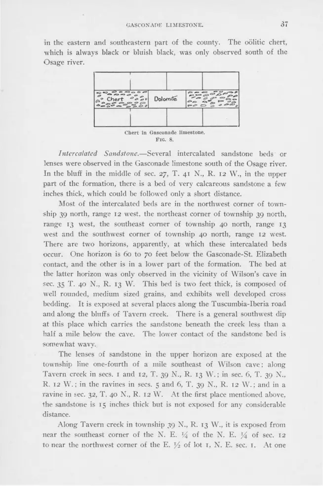
GASCO!'< ADE LDIESTONE. 37
in the eastern and southeastern part of the county. The oolitic chert, which is always black or bluish black, was only observed south of the Osage river.
Chel"t In Gasconade limestone. FIG. 8.
Intercalated SaHdstoue.-Several intercalated sandstone beds or lenses were observed in the Gasconade limestone south of the Osage river. In the bluff in the middle of sec. 27, T. 41 N., R. 12 W., in the upper part of the formation, there is a bed of very calcareous sandstone a few inches thick, which could be followed only a short distance.
Most of the intercalated beds are in the northwest corner of township 39 north, range 12 west. the northeast corner of township 39 north, range 13 west, the southeast corner of township 40 north, range 13
west and the southwest corner of township 40 north, range r2 west. There are two horizons, apparently, at which these intercalated beds occur. One horizon is 60 to 70 feet below the Gasconade-St. Elizabeth contact, and the other is in a lower part of the formation. The bed at the latter horizon was only observed in the vicinity of Wilson's cave in sec. 35 T. 40 N., R. 13 W. This bed is two feet thick, is composed of well rounded, medium sized grains, and exhibits well developed cross bedding. It is exposed at several places along the Tuscumbia-Iberia road and along the bluffs of Tavern creek. There is a general southwest dip at this place which carries the sandstone beneath the creek less than a half a mile below the cave. The lower contact of the sandstone bed is -somewhat wavy.
The lenses of sandstone in the upper horizon are exposed at the township line one-fourth of a mile southeast of ·wilson cave; along Tavern creek in secs. I and 12, T. 39 N., R. 13 'N.; in sec. 6, T. 39 N., R. 12 W.; in the ravines in secs. 5 and 6, T. 39 N., R. 12 Vv.; and in a ravine in sec. 32, T. 40 N., R. 12 \V. At the first place mentioned above, the sandstone is 1 S inches thick but is not exposed for any considerable distance.
Along Tavern creek in township 39 N ., R. 13 W., it is exposed from near the southeast corner of the N. E. ~1 of the N. E. y,;: of sec. 12
to near the northwrst corner of the E. 0 of lot 1, r. E. sec. I. At one
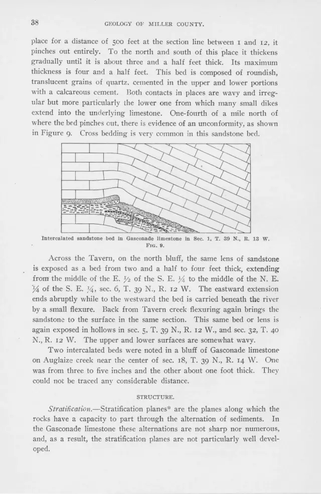
38 GEOLOGY OF MILLER COUNTY.
place for a distance of 500 feet at the section line between I and 12, it pinches out entirely. To the north and south of this place it thickens gradually until it is about three and a half feet thick. Its maximum thickness is four and a half feet. This bed is composed of roundish, translucent grains of quartz. cemented in the upper and lower portions with a calcareous cement. Both contacts in places are wavy and irregular but more particularly the lower one from which many small dikes extend into the underlying limestone. One-fourth of a mile north of where the bed pinches out. there is evidence of an unconformity, as shown in Figure 9. Cross bedding is very common in this sandstone bed.
Intercalated sandstone bed in Gasconade limestone in Sec. 1, T. 39 N., R. 13 W. Fm. 9.
Across the Tavern, on the north bluff, the same lens of sandstone is exposed as a bed from two and a half to four feet thick, extending from1 the middle of the E. Y2 of the S. E. 74 to the middle of the N. E. }i of the S. E. ~4, sec. 6, T . 39 N., R. 12 W. The eastward extension ends abruptly while to the westward the bed is carried beneath the river by a small flexure. Back from Tavern creek flexuring again brings the sandstone to the surface in the same section. This same bed or lens is again exposed in hollows in sec. 5, T. 39 N., R. 12 W., and sec. 32, T. 40
N., R. 12 vV. The upper and lower surfaces are somewhat wavy. Two intercalated beds were noted in a bluff of Gasconade limestonP
on Auglaize creek near the center of sec. 18, T. 39 N., R. 14 W. One was from three to five inches and the other about one foot thick. They could not be traced any considerable distance.
STRUCTURE.
Stratification.-Stratification pianes* are the planes along which the rocks have a capacity to part through the alternation of sediments. In the Gasconade limestone these alternations are not sharp nor numerotJS, and, as a result, the stratification planes are not particularly well developed.

GASCONADE LIMESTONE. 39
Bedding.-Bedding':' differs from stratification in that, while in the latter there is only a capacity to part, in the former actual parting has taken place. The dolomite beds of this formation, as seen in the bluffs along the river, were originally deposited in heavy, massive beds, having an average thickness of perhaps 15 to 20 feet or more. While varying somewhat in texture in different places, each bed was practically homogeneous from top to bottom, and the bedding planes were even and regular. Through secondary changes, particularly silicification, the bedding planes are now more wavy and the beds, depending primarily on whether they are exposed in balls on the hillsides or in bluffs, are much thinner. The bedding planes in fine chert are much more regular than those in cherty dolomite.
Folding.-The (iasconacle limestone formation has been gently though complexly flexured and folded. Steep clips were observed in several localities. The best examples are on the east side of Coon creek, where in a number of places the strata dip 6o 0 S. 70° W., and in the
S. E. }4 of 1he N. W. X of sec. 30, T. 41 N., R. 13 V./. where on a continuation of the same fold the beds clip 20° S. 70° vV. The beds sur
rounding areas of Carboniferous rocks usually exhibit steep local dips. J ointfng.-The strike and dip of the joints in the Gasconade lime
stone were taken at several hundred places over the county, and it was found that they were very closely related to one another. The average strike of the major joints i K 70 ' E. and N. 15° W. (see page 132).
In the steep bluffs the joints are particularly well clevelopecl, and in the cherty horizons they are very abundant. In the cherty and hard,
dense dolomites they are more numerous than in the chertle s and ofter arenaceous beds.
Fault?°n.g.-The largest fault observed in the Gasconade limestone is in the western part of sec. IO, T. 41 N., R. 15 vV. In a branch of the Saline valley, the upper beds of the Gasconade limestone occur
at the same elevation as the bottom beds of the Jefferson City forma
tion, the two formations being separated by only four or five feet. This
condition can only be accounted for by normal faulting having an east
and west strike and a clownthrow of 150 feet. There is no evidence that
this fault continues more than one-fourth of a mile. Along the Osage river in the north central part of sec. IO, T. 40 N.,
R. 15 1W., is a small fault which strikes N. 55° E., and has an apparent
downthrow to the east of four feet. The fault dies out in a poorly ex
posed "ball" IOO yards a:Vay. On the east side of a railroad cut in the
N. W. 74 of sec. 4, T. 40 N., R. 15 vV., is a small normal fault which
•The buildng and ornamental stones of Wisconsin by E. R. Buckley, p. 457.

40 GEOLOGY OF MILLER COUNTY.
strikes approximately N. 65° VI'., clips .55 ° N. 25° E., and has a clownthrow of about eight feet. Along Tavern creek in the northeast corner
of s~c. 8.' T. 39 N., R. 12 vV., occurs a large fault, having a strike of N. 55° W. ' The amount of upthrow to the west could not be definitely determined, · but it is approximately 120 feet. The fault soon dies out,
but steeply clippii1g beds can be traced at intervals along the direction of its strike for over a mile.
Near the line between secs. 2 ancl 3, T. 39 N ., R. l 5 vV., is a fault which can be traced for a half a mile. It has a strike of N. 60° W., but the clownthrow to the west could not be determined.
Brecciation.-Horizontal zones of brecciation are confined to the chert horizons in which brittle chert and siliceous dolomite occur in thin layers. Slight compressive and tensile stresses break these· beds into small irregular polygonal pieces which. frequently, are recemented with silica or calcium carbonate. Brccciation in vertical zones is not common. In the
S. W. ;1%- of the N. W. 34 of sec. 29, T. 41 N., R. 13 W., occur two feet of close grained brecciated dolomite, the fragments of whcih have been cemented with silica and the remaining voids later filled with calcite. On
the weathered surface the quartz frequently stands out in relief r.esembling a growth of fungi.
RELATIONS TO OTHER FORMATIONS.
The Gasconade limestone conformably overlies the Gunter sandstone. At the contact at Brockman's ford and in the outcrops opposite King's bluff, the two formations grade into each other. At other places the contact is always represented by thin transitional beds of sandstone and dolomite.
In a very few place in the county the Gasconade limestone has the appearance of being unconformably below the St. Elizabeth formation, but there is insufficient evidence to warrant the statement that an unconformity exists between the two. The greater number of contacts show an abrupt change of sedimentation, but there is no sign of a structural break. At the places where an apparent unconformity exists the contact is somewhat wavy and occasional small, irregular dik~s of sandstone from the St. Elizabeth formation extend down a few inches into the Gasconade limestone. This may be due to local oceanic conditions at the time of sedimentation. or to later solution of the limestone and
settling of the overlying sand into the voids. Srnal! areas of Carboniferous rocks, either as beds at the surface
or pockets, lie unconforrnably above the Gascoriade limestone. The wide difference in the fauna! content of these formations gives evidence of a long erosion interval between the deposition of the two.

GASCONADE LIMESTONE. 41
ECONO!IHC CONSIDERATIONS.
Soils.-The residual oil resulting from the decomposition of the •Ga conade limestone is found in very few places and is very thin. A few small area , perhap t\\'O or three acres in extent, show it to be dark ,colored, clayey, compact and fairly productive. The transported soil, which covers this formation in the lower courses of the valleys and ravines, is more loamy and finer grained than the re idual soil, being better :adapted to agricultural pursuits.
Lead alld Zinc.- p to the present time the greater part of the lead and zinc ores min d in 11iller county have come from this formation. Galena ( Pb ) , lead ore. and . phalerite, known as blends or jack, ( ZnS) zinc ore, are the two most common ores. Some Smithsonite (ZnCOa), and Cerussite ( PbCO~), have been found associated with them. To mention all the localitie, where traces of these ores have been found would occupy more space than is at our command. It i only necessary to say that from the county line on the west to the county line on the east and on either 0 ide of the riv r, wherever the Gasconade limestone is the sur· face rock, prospecting in hundreds of places has uncovered small deposits ·of lead and zinc ores. It is especially noticeable that along the larger creeks and valley , particularly on the south side of the Osage river, in
the Gasconade limestone areas, the people always manifest considerable interest in prospecting for lead and zinc ores. In the regions away from the Gasconade lime tone, there is very little interest in this industry. On the north side of the river the lead and zinc ores are more widely distributed through the different formations, although most abundant in the Gasconade limestone.
Si/ica.-Silica, known locally as chalk. is a soft, white, porous sub-tance closely resembling tripoli. It is a decomposition product of chert
and, wherever found i11 commercial quantities, the chert, from which it "has been derived, is econdary after dolomite. The chalk occurs almost entirely in the cherty horizons and frequently in a single specimen one will find all gradations from dolomite to chalk. It occurs in many places in the Gasconade limestone.
lron.--A few small depo its of iron ore \\·ere found in this formation , and, on the ridges, boulders of limonite, probably residual from the overlying formation , are common. Thin veins of limonite, filling jointino- planes, were observed along many of the bluffs. In the N. W. 74 of the . W. ,% of sec. 13, T. 40 N., R. q \V., are a number of boulders of limonite, and in one place in a small ravine, a bed of limonite, apparently in place, four inches thick and three feet long, was found between

42 GEOLOGY OF :t.IILLER COUNTY.
horizontal beds of dolomite. The limonite occurs either in solid, botryoidal or tubular masses.
Copper.-Azurite (3CuO, 2CO,, H 20), and malachite (2CuO, CO2 ,
~ 20), the hydrous carbonates of copper, occa ionally occur associated with the limonite and barite. but in such minnte quantities as to be of no economk importance.
Barite.-Barite occurs in a number of places in the county and in the past has been mined and shipped. It usually occurs in crevices or pockets in the dolomite beds. Along Cattail creek, Barren fork and Bailey's branch it occurs associated with black chert either in pockets or in beds.
, RESUME.
The Gasconade limestone consists of beds of magnesian limestone or dolomite; chert, either bedded, nodular or disseminated; and an occasional lense of sandstone, all of which were deposited in horizontal beds in a comparatively shallow sea. During deposition the sea bottom was not altogether quiescent, and at times was, apparently, elevated locally above the surface. The parts thus elevated were slightly eroded as shown by some of the intercalated sandstone beds. The cross-bedding, which is so common in the intercalated s::rndstone beds and in the dolomite, at various places in the entire thickness of the formation, shows that the sea bottom was uniformily within reach of the waves, tides and currents.
A change of sedimentation, rather than a structural break, marked the close of the deposition of the Gasconade limestone. The composition and texture of the rocks of this formation have been altered, chiefly through silicification. Compressive and tensile stresses have fractured and moved the beds.

Bou.Ide ;-~
ofdolom1f~ a.nd
chert
FIG. 10.
106 No. 1
2
3
4
5
6
7
8
9
10
11
12
13
14
GASCONADE LIMESTONE. 43
DE'l'AILED COLUMNAR SECTIONS.
Section No. 2, Fig. 10.
On Osage River, :IA, Mlle East of Morgan County Line.
E lev. 92-200
82-92
77-82
62-7T
57-62
54-57
51-54
48-51
46-48
31-46
26-31
108 feet of boulders of DOLOMI'.l'E and CHERT.
Ten feet of DOLOMITE and CHERT, very much jointed.
Five feet unexposed.
15 feet of DOLOMITE, coarse grained and pinkish gray.
Five feet of CHERT and DOLOMITE thinly bedded.
Three feet unexposed.
Three feet of pinkish DOLOMITE, fine grained nucl sandy.
Three feet unexposed.
Three feet BRECCIATED DOLOMITE.
F ifteen feet TALUS.
Five-foot bed of gray DOLOMITE, rather fine grained and chertless. Lies conformably over the Gunter sandstone, the contact being somewhat wavy. Transition from Gunter sandstone to Gasconade limestone abrupt.
20-26 GUNTER SANDSTONE.
10-20 PROCTOR LIWilSTONE.
0-10 Teo feet ALLUVIUM.

.44
6
t·· 7
r- · 8
L. 3 t··
~ -- ~,o .. 10 Q Q , p i ... - c::>_o -II 7
t ·· ~ -j 12 s·
t·· ··i 13 15'
l River 5tope.
!,O
. .1 FIG. 11.
No. 1
2
3
4
5
6
7
8
9
10
11
12
13
14
GEOLOGY OF MILLER COUNTY.
Sect-ion No. 3, Fig. 11.
East bluff of Osage river, Sec. 21, T. 40 N., n. 15 W.
Elev. 217-270
171-217
161-171
146-lGl
121-14 6
111-J 21
101-111
7G-101
71-76
61-71
54-61
45-54
30-45
0-30
Flfty-tbree foot slope with occas ional thin becls of CREJil1' ancl cherty DOLOMITE.
40 feet, DOLOMITE, vertical wall.
10 feet CREllT horizon.
Five three-foot becls of DOLO)IITEJ, arenaceous and chertless.
2Ci feet. CHF.llT horizon. Contains an occasional thick bed of dolomite with thin layers of chert, che,·t.y dolomite and dolomite. Unde rcutting has occurred at this horizon. The bedding planes are very undulating.
10 toot bed of DOLOMITE; the lower two feet are very cherty. •
10 feet of TALUS.
25 feet of DOL011ITE, arenaceous and che,·tless. Ueav lly bedded and projects slightly out over the underlying strata.
5-foot c:rnmT horizon.
'l'wo 5-foot beds of DOLOMI'.rEJ, fine grained, very cherty and contains calcite.
7-foot bP<l of DOLOMITE, pitted with sma.1 1 cavities, often filled with calcite.
O feet of DOLOMITE, CHERT and cherty DOLO)[ITFJ thinly bedded, contains thin horizontal seams of calcite.
15 feet of DOLO)[ITE.
River slope.

l.. z .
r 3
l.. q
~:: 6
t: .. 8 ii,
f l l b
r-17
[_ 18 t· 19
lo 1-
i?.I· 2.1!
~ --r 24
-~ ck 1 27
Ja ·-
9 • ~
.. 31
3 ;!
--
I 1
.3
-
GASCONADE LIMESTONE.
S ect ion Ko. 4, l•'ig. 12.
Cberr boulders -1
5t Elizabeth formahon -··
'l'he lower 1.05 feet of this sec tion was macle on the Osage river in tile S. \V. 'A of the N. ,v. 'A of Sec. 19. '.l'. 40 N .. R. 14 \Y.; the upper 45 feet from the west comer of Sec. 17, T. 40 N., H. 14 w.
Unexposed
I I
I I I
I I --- - -Dolomrte boulders
-1-- 1-:-1 ".: < I - -1 -
Poorly expooed do!-
om1t"e~
,.Some c hert
I I Unexposed
I I I I
I l I
I I I I I
I I I l I
I I I I
I I I I I
I I I I I
R 1ver .S lope.
FIG. 12.
5'
··1 1.s'
-- t ::t.
"'1.5 .:t r
2 5 '
___ f I
·1 es
l 5'
~. 10
--l 6 ' -I
--f ,,o
JI
,-.L ·-1
14
--l 7'
:\'o. ]
2 3 4
5 6
7 8
9
10
11
12
13 14 15
16
17
1 10 20
21 22
23
24
IDlev. 240-to top of ridge. c1nal'!' bou lclet·s of the St. Elizabeth
fo l' mation . 23;';-240 Upper contact heels of much pitted DOLOMITE. 220-235 15 feet unexpo eel. 21\i \1.,-22011., 4 feet of mecl inm grained DOLOMITE; grayish
to rose color. 213 \1., -216¥., Poorly exposed. 209-213¥., 4 %-foot heel of noLO~HTE. 'Solution bas been
active a long this bed as shown by thesmall caves and cavities with which it is lined.
206-20!) 3 feet of pink ish DOLOMITE, medium grained. 202-206 4 feet of coal'se grained DOLOMITI!; light crnam col
Ol'ed. 201-202 1 foot oC DOLOMITE, coarse grninecl. L ight gi·eeni 11
color. 190 \1.,-201 111, feet of DOLOMI'l'E, coarse grained and cream
colored. l!J8ll, -199lh 1 foot of DOLOMITE, fine grained and close·
jointed. 195-19811, 311., feet of DOLOlIITE, compact and med I nm
grained. J 93-1.!)5 168-103 16G-168
rn5-166
130-JG;'i
J 25-130 115-123 1.00-J l 5
108-109 103-108
93-103
2-foot becl of CHERT which resembles dry bone. 25 feet of DOLOMITE bou lders. 3 feet of DOLO)lTTE, med ium to coarse grained and
crenm colored. 11 fee t of DOLOMITE: the lower pn l' t is coal'se
grained and the upper part fine grninecl. 'l'his bed sometimes forms a sheer clill', lllljointed ancl massive; sometimes it Is broken into severa l beds. It conta ins a few nodules of chert.
2:'i feet of DOLO)UTE; heels pool'ly exposed, contains some 'bone" chert.
5 feet of DOLO)fTTE, fine grained and gray. 10 feet unexposed. G feet of DOLO"J'J'ta. medi um grnin£'1 , much pitted
and gray ish. 1 foot of DOLOMfi'ta, medium gl'ainecl and white. 5 feet of ooLO)HTE, medium gra ined and much
jointed: weathers into layers one inch to. one foot in thickness.
10 feet of DOLOMr.rn, mediu m grnined and much jointed: has a pitted su l'face.
11 feet of DOLO)IITE, coarse grnined. :{ s· 25 26
82-93 8111, -82 79-81¥2
11, foot of DOLO)Il'rE, clark co lored and much jointe<I 211, feet of DOT.OMrrE, medium grained and grayish,
conta ins much ca lcite. r 4
I
27
28
65-79
38-65
53-58
14 feet of black. grayl:b DOLOMITF.; weathers with a smooth surfn ce.
7 feet of DOLO)fl'l'E, medium grained, crystall ine ancl dark .colored.
5 feet of DOLO)U1'E, med ium grained and contain. considerable calcite .
30 51 lA,-53 1 % feet of DOLO)IJTE. 31 4811, -5111, 3 feet unexposed. 32 40-48¥., 8¥., feet of white DOLO)II1'E , fine grnined. 33 0-40 River slope.

46
3
4
Soil.
- =-;::;;. "!..---"" ----- - a-~- .,0. ~ _,,.,_ -
- =. "C>"'!? .. - .do
C, - - - - -
BotA)der~
cH ert 'I, dolom1fe
FIG. 13.
e::s·
45
GEOLOGY OF MILLER COUNTY.
Section No. ti, Fiy. 13.
On the Osage river in N. W. y, of Sec. :<9, '1'. 41 N., R. rn W.
No. Ellev. 1 225-250 Soi!.
2
3
4
5
G
7
8
9
10
11
1~
13
14
15
1so-22u
147-180
107-147
67-107
G9-67
55-u9
53-55
35-u3
19-35
13-lD
11-13
7-11
4-7
0-4
45 feet of arenaceous DOLOMITE.
33 feet of heavy CHERT.
40 feet of slope covered by chert and dolomite boulders.
40 feet of poorly exposed beds of DOLOMI'.rE. '.Chey contain very llttle chert.
8 feet of brown DOLO)U'l'El , medium grained.
4 feet of CllER'.r and DOLOMITE, thinly bedded. The chert is mainly concretlonary.
2 feet unexposed.
10 feet of DOLOMITEJ, coarse grained, bluish and thinly bedded.
16 feet unexposed.
G feet of pinkish brown DOLOMI'm , fine grained and contains a few pieces of white chert in the lower two feet.
2-foot bed which in some places is nrenaceous DOL· OMT'l'E and in others almost pure SANDSTONE with occasional lenses of dolomite carrying small pieces of chert.
GUNTER SAXDS'l'ONE.
PROCTOR LL\IESTONE.
Unexposed .
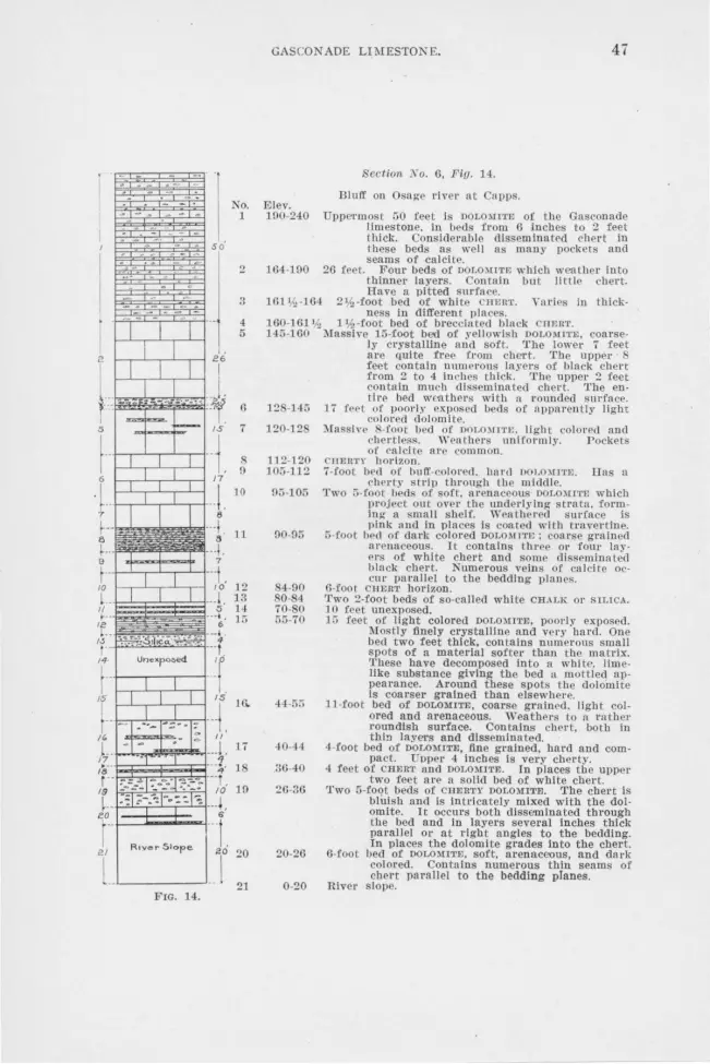
• s o·
River Slope 20
.. l FIG. 14.
No. 1
20
21
GASCONADE Ll1\IESTONE. 47
Section 'No. 6, Fig. H.
Illlev. Blull' on Osage river at apps.
l 00-240 Uppe,·mo t CiO feet is DOLOMtTl!l of t he Gasconade limestone. In beds from O lnches to 2 feet thick. Consiclernble disseminated chert in these beds as well as many pockets and seams of calcite.
104-190 20 feet. Four beds of DOL0)!1TEJ which weather into thinner layers. Contain but little chert. Have a pitted sm·face.
lGlV:,-104 211:,-foot bed of white CHEIIT. Yarics in thickness in different place .
100-101 11., l'h -foot bed of brecci[ttecl black 111rn'.I'. 14:l-100 Massirn !Ci-foot bed of yellowish DOLO~!l'rEJ, coar e
ly crystaII!ne and soft. The lower 7 feet are quite free from chert. 'l'he upper 8 feet contain numerous layers of black chert from 2 to 4 inches thick. The upper 2 feet contain much disseminated chert. The entire bed weathers with a t·ounded surface.
128-145 17 feet of poorly exposed beds of apparently ligh t colored dolomite.
120-128 Massin 8-foot bed of DOt.O)n·1·1~. ligh t colored and chertless. \Yeathers uniformly. P ockets of calcite are common.
112-120 CJJEHTY horizon. 10Ci-ll.2 7-foot bed oc buff-colo,·ecl. hard 1101.0mm. llas a
che1·t.v ·trip through the middle. !l:l-105 Two :l-foot beds of soft. >trenaceous DOLO)!ITE which
project out over the underlyin_g- strata. forming a small shelf. Weatbernd surface is
00-95
84-90 80-84 70-80 5ti-70
44.5;;
40-4-l
30-40
20-36
20-26
0-20
pink and in places is coated with t ravertine. 5-foot bed of dark colored DOLOMJT": coarse grained
arenaceous. It contains three or four iaye,·s of white chert and some disseminated black chert. Numerous veins of calcite oc-cur parnlle! to tbe bedding plnucs.
0-fool CHERT horizon. Two 2-foot beds of so-called white CH.UK 01· SILICA. 10 feet unexposed. 1Ci feet of light colored DOLO)IITE, poo,·ly exposed.
l\Iostly finely crystalline and very hnrd. One heel two feet thick, contains numerous small spots of a material softer thau the matrix. These have decomposed into a white. limelike substance giving the bed :1. mottled appearance. Around these spots t he dolomite Is coarser grained than elsewhe1·e.
Jl-foot bed of DOLOMITE, coarse grained. light colored and arenaceous. Weathe,·s to ,1 rn ther roundish surface. Contains chert, both in thin layers and dlssemlna ted.
4-foot bed of DOLOMITE, fine grained, hard and compact. Upper 4 inches is very cberty.
4 feet of CHERT and DOLOMITE. In places tbe upper two feet are a solid bed of white chert.
'l'wo 5-foot beds of CHER'rY DOLO)UTE. The chert is bluish and is Intricately mixed with the dolomite. It occurs both disseminated through the bed and In layers several inches thick parnllel or at right angles to the bedding. In places the dolomite grades Into the chert.
6-foot bed of DOLOMITE, soft, arenaceous, and dn rk colored. Contains numerous tbin seams of chert parallel to the bedding planes.
River slope.

48
Chert" bad~ l ~t. Eh2abeth formahon 90
4S
eo Une,q,o:ied
I .. FIG. 15.
GEOLOGY OF ~[ILLER COl'NTY.
Section No. 7, Fig. 15.
'o. Ele,·. On O age river at the Osage county line.
1 H0-1 u Hugged breccla ted c1rnnT beds o.f the St. Eli,abeth, formation. Contact between Gasconade and St. EUzabeth formations not exposed.
2 05-HO 45-foot clil'C of mass ive noLOM1'rEJ beds. The dolo-
3 7G-9 ;:;
4 G -,G
u 6i-6S 0 01-07
7 ;; -61 3:;.,3
D 47.5:; JO ,15.47
43.4;,
40-H
:34-40
:n-3-1
2 7-31
2.3-27
22 \,1,-2:.
22-22 L~
1!l 20-22 0-20
mite is arenaceous and conta ins ·hert, both disseminated noel In layers. ln the latter form It Is black. With th exception or n 2-foot b cl of black chert. 10 feet below the u1Jper contact. the upper half of these beds Is very free from chert.
10-foo t crmn'.n: horizon, coated with travertine and limonlte.
, feet of alternating layer· of c 111m·1• and DOLO)ttTE. 1-foot bed of black crnc:uT. G feet of cberly DOLOMITE. '.l.'hln layers of banded black CHERT, oolitic In places. !l-foot bed of CilERT.
feet unexposed. 2-foot bed of white c1rn1<1• coutalnlng inclusions of
blui h chert. having a banded or concretlouary structure. Some or the blue chert con tulns mall ca ,·ilies filltd with quartz crystals.
2-foot bed of cherty, light colorrd, slliceouij DOLO-)tITJ~. In places this heel is so lid chert.
Similar lo )lo. 11. U feet of cherty DOLO)U'rE. 3 feet of arenaceous DOLOlCITE. which Is split into
thin layers; somewhat cherly. 4-foot bed of DOLO)nTrn, chertless, darlc colot'ed ancl
arenaceous. 2-foot becl of DOLO)U'l'N. with a five-inch layer of
black chert. Considerab le truverl lne and llmolllte In thin seams.
Simila!' to "'o. lG. Contains disseminated white-and black cher t.
Thin layer. or noLOl11T1, and block cnt~nT. 2-foot becl of One grained, pinkish DOLOllTTE. rnexposed.

G-4
GASCON ADE Lli\IESfONE. 49
Section No. 8, Fig. 16.
On 'l' aYero creek near middle of Sec. 27, T. 41 N., R. 12 W. Only the upper 82 feet are exposed.
No. 1
15
1G
Elev. 82-100
48-82
46'h -48
46-46 'h
42-46
88-42 35-38
26-85 23-26
19-23 18-19 14-18
12-14 7'!.,-12
5-7 1h
0-5
feet of ta! us con talnlng scattering boulders of sandstone ancl chert derived from the St. Elizabeth formation.
34 feet of bedded DOLOMITE, poorly exposed. Most of the beds are pitted and contain more or less disseminated white chert. 20 feet below the upper contact Is a bed of white chert 15 inches thick.
1% feet of DOLOMITE; contains black chert and is arenaceous. rasses gradually into sandstone below.
G Inches of SANDSTONE, medium grained; very compact . and grayish. It Is inter laminated with a few thin seams of blue clay. This is the only sandstone that was found in the Gasconade limestone near tlle river.
4 feet of yellow, arenaceous DOLOMITE; weathers irregularly, forming thin shaley layers.
Bed similar to No. 5. 3 feet of soft, light colored, arenaceous DOLOMITE,
which splits into thin layers; considerable travertine along the bedding plane~.
DOLOMITE similar to No. 7. 3 feet of DOLOMITI! , fine grnined, hard and having
a grnylsh brown color. 4-foot bed of DOLOMITE. Black CHERT. 4 feet of cherty DOLO)!ITJ•:. 'l'he chert is black and
disseminated. 2 feet of brecciated DOLOMITE and black chert.
4 '!., feet of grayish DOLOMI'l ' E ; fine grained and contains crystals of limonite and malachite. Trnvertine along the joint planes.
21h feet of brecciated DOLOMITE, containing black chert.
2 beds· of pinkish to grayish DOLOMI'rE ; arenaceous and weathers with an even surface. Between t he two beds Is a three to eight inch layer of white and black chert: some calcite and trnvertine.
50 GEOLOGY OF MILLER COUNTY.
CHAPTER V.
ST. ELIZABETH FORMATION.
( Second Sandstone ( in part) of Swallow and later geologists.)
INTRODUCTORY>
Of the Cambre-Ordovician formations in Miller county, the Gasconade limestone and the Jefferson City, are well defined, easily recognizable, and markedly uniform lithologically. Each is composed of characteristic dolomi!es, and each · contains chert, though in varying abundance, and each contains a few thin, intercalated beds of sandstone. Between these two formations is a complex consisting of beds of sandstone, chert, quartzite, dolomite and shale. all of very uncertain thickness and areal extent. The beds of this complex formation exhibit great diversity in lithological character, thickness and manner of occurrence.
This complex has been named the St. Elizabeth because it is typically developed in the town of St. Elizabeth, Miller county. South of the Osage river the sandstone beds or lenses are sufficiently well developed over certain limited areas to warrant mapping them as a distinct member of this formation. From the typical exposures along Bolin creek in township 39 north, range 12 west, the sandstone lenses have been called the Bolin Creek sandstone.
The St. Elizabeth formation in Miller county includes Meek's 2nd , Sandstone, together with beds of dolomite, quartzite, chert and sandstone, which he included either in the top beds of the 3rd Magnesian limestone ( Gasconade limestone) , or in the lower beds of the 2nd Magnesian limestone (Jefferson City formation). On page 121 of his report, Meek says of the 2nd sand tone: "This formation varies much, as well in thickness as in lithological characters, at different localities, being usually a fine grained regularly stratified quartzose sandstone of a light grayish brown color, but sometimes passing into a heavy bedded light gray or white sandstone. At places there is much chert in it, and at other places it seems to pass almost entirely into beds of rugged chert. I have estimated its maximum thickness in the county at 6o feet. It is evidently much thinner than this at most places." While recognizing the heavy beds of rugged chert, and including them in the Second sandstone,
•Mo. Geo!. Sur. 1855-71, pp. 112-134.

ST. ELIZABETH FORMATION. 51
his main differentiation of this formation lay in the uninterrupted succession of sandstone beds, or a single massive bed of sandstone. His second sandstone was composed mostly, therefore, of the sandstone which we have mapped as the Bolin Creek sandstone member. In this report the rugged chert beds are not included in this member, but are placed in the St. Elizabeth formation. Meek, finding masses of what we have mapped as Graydon sandstone in various places all over the county, away from the region of the Bolin Creek sandstone member, considered them to be a part of the Second sandstone, and thus reported that formation to be very persistent ·over the county. No heavy beds of sandstone such as he included in the Second sandstone, occur north of the Osage river. Unfortunately, the different Silurian formations were not differentiated on his map, so that the exact areal distribution of his Second sandstone is not known, although he correctly observed that the best development and greatest surface distribution was on the south side of the Osage river.
Since the Bolin Creek sandstone member has such a limited extent, and since over the entire north half and over large areas of the south half of the county, sandstone beds are so nearly lacking, some geologists, conversant with the stratigraphy of the Ordovician rocks of the Ozarks, may perhaps question the advisibility of mapping a separate formation, except 'where there are heavy beds of sandstone, such as were recognized by Meek. However, one who studies this area carefully must recognize a complex formation of from 70 to 120 feet, which includes a part of Swallow's "Second l\,fagnesian" limestone, all of the "Second" !'andstone and a part of the "Third Magnesian" limestone. The lithologic, economic, topographic .and structural difference between the Gasconade limestone and the St. Elizabeth formation are too great to allow their being considered parts of the same formation.
Lithological Differences.-The different dolomite beds of the Gasconade limestone ~re very similar, being uniformly medium to coarse grained, light grayish or pinkish colored and of nearly the same poros~ty. The St. Elizabeth formation includes some beds of dolomite similar to those of the Gasconade limestone, but the majority are very fine grained, dense and hard. They are in fact almost novaculites, being nonporous and breaking with a conchoidal fracture. The St. Elizabeth formation also contains beds of shale and argillaceous dolomite, which never occur in the Gasconade limestone.
The cherts are much better developed in the St. Elizabeth formation, often occurring in beds from 6 to IO feet thick. In the Gasconade limestone the chert beds are much thinner and less abundant. Aside from the Bolin Creek sandstone member, there are other intercalated beds of sandstone and quartzite in the St. Elizabeth formation.

52 GEOLOGY OF :\llLLER COU:\'TY.
Topographic Differe11cc.-Une of the mo t striking differences in the two formations is in the topog-raph y. Regions underlain with Gasconade limestone are always rough and rugged havino- na1-ro11· ridges with steep slopes.
Areas underlain by the St. Elizabeth formation have a much gentler topography, the ridges being flat-topped and broad, and except at the heads of the hollows the slopes are much gentler.
Economic Diff ercnce-Both formations contain barite, but the lead and zinc ores and silica or ( ''chalk") occur mainly in the Gasconade limestone, while the iron ores occur more generally in the St. Elizabeth formation. With the exception of the sandstone the latter formation contains no stone sutiable for building purpose , while the dolomite of the Gasconade constitutes an improtant source of building stone.
Str11ct11ral D£-ffcrernc.-The St. Elziabeth formation being heterogeneous, is not structurally a unit, as is the Gasconade limestone. The joints in the fine dense dolomite are much closer together and strike differently than in the heavy sandstone beds. mall flextures due to ink holes and solution are common everywhere in the St. Elizabeth format:on, while in the Gasconade limestone they are less common.
Taking all of the above facts into consideration, it is thought that one is justified in mapping, in this ar1!a, the complex between the Jefferson City and Gasconade formation as a distinct and separate formation.
AREAL DJSTRJDUTJON.
The St. Elizabeth formation has its greatest surficial distribution on the outh side of the Osage river, particularly in townships 38, 39, 40 and 41 north , range 12 west and Lown hip 39 north. i-ange 13 west, where it constitutes about two-thirds of the surface rock. On the north side it occurs most extensively in township 41 north, ranges 15 and 16 west. In township 41 north, range 13 west it caps a wile flat ridge. Clo e to the river, except in township 41 north, range 12 west, it usually occurs only on the higher ridges and its areal di tribution is limited.
THICKNESS.
This formation varies considerably in thickness. One mile north of Iberia it is only 70 feet thick, while in sec . 13, 24 and 25 T. 41
N., R. 16 W., the thickne s is apparently 160 feet. The thickness at the latter place may appear somewhat greater than it really is, owing to the very poor exposures and the possibility of a slight dip. North of the Osage river the formation has an average thickness nearly everywhere of 120 feet, although in the vicinity of Mary's Home, it is

:11ISSO!: RI BUREA u OF GEOLOGY A:-.D l\lr:-.Es. VOL. I. , SERIES 2, PLATE VI.
FLAT TOPPED RIDGE UNDEID,AIN BY THL ST. ELIZABETH F0Rl\1ATI0N.

•.

ST. ELIZABETH FORMATION. 53
only 8o feet. Soi;th of the Osage river the average thickness is IOO. feet, varying from 70 to 140 feet. In the region around Mill creek the average thi{.'.kness it between 100 and 120 feet. In the eastern part of the county, the average is between 80 and 100 feet. Along Sandstone creek the Bolin Creek sandstone member makes up about half of the entire thickness of the formation.
TOPOGRAPHY.
The areas underlain by the St. Elizabeth formation are characterized by a relatively gentle topography compared with the areas underlain by the other formations. The ridges are broad, the slopes gradual, and the crests flat and level. ( See Plate VI.) Beds of rock are seldom exposed on the tops of these ridges.
The valleys conform, as a rule, to the gentle topography and have more af a. U than a V shape. There is, however, an exception to this general statement in the case of the valleys and ridges along ·the larger streams which have cut clown nearly through the entire thickness of the formation. Such valleys have almost the same shape as those in the Gasconade limestone, the bluffs being steep and precipitous. Here, however, the similarity ends for above the steep bluffs the ridges usually rise to the crest with a gradual slope.
The roundish pouch shaped heads to the valleys while very pronounced in this formation are not as much so as in the Gasconade limestone. They are often as precipitous but seidom as high or as wide.
WEATHERING.
The chrrts weather similarly. but the fine grained, dense dolomites, with their very smooth rounded surfaces, weather very differently from the corresponding rocks of the Gasconade limestone. Undercutting is common at the base of the Bolin Creek sandstone member, but the recession are not as deep as those occurring in the Gasconade limestone.
CHARACTER OF THE DOLOi\UTI':.
Except in townships ;18, 39, 40 and 41, range 12 west, the dolomite comprises from 50 to 75 per cent. of the formation, the latter percentage holding good over nearly all the county north of the Osage river. In the townships above mentioned, the Bolin Cr:eek sandstone, as well as the beds of rugged chert, reach their greatest development, constituting in places over 6o per cent of the formation. Though some of the dolomite is similar to that of the Gasconade formation, the greater part is very different, being especially characteristic of the St.Elizabeth formation. The characteristic dolomite is very hard, fine grained and . dense, having a texture and conchoidal fracture very similar to that of the chert. These

54 GEOLOGY OF MILLER COUNTY.
dolomite beds are from 9 to 15 inches thick, and weather to a smooth · roundish surface. In many places the beds are very thinly banded. Occasional streaks one-eighth to one-fourth inch thick of clear rounded grains of sand are imbedded in the dolomite matrix. These sandy str~ks are hard and weather the same as the dolomite. A very peculiar fine grained dolomite was observed in "situ" in a single place in this formation and as boulders in the Saline Creek cave-congolomerate at a number of places. The texture of this dolomite is similar to the other fine grained varieties, but the rock is more porous, having a structnre which, for want of a better name, may be called "curling." This structure is shown in Plate VII. Figure I shows the upper surface along the bedding plane, while Figure 2 is a side view of the same specimen. This curling dolomite ordinarly has a pinkish color. This dolomite is commonly cherty, the chert being disseminated either in small irregular pieces or in nodules. Sometimes _the dolomite bears the same relation to isolated lenses or nodular shaped masses of chert as does the dolomite in the Gasconade limestone, as exhibited near the Stevens mines. ( See page 36.) The relation is well shown on a branch of Mill creek one-fourth mile north of Brumley.
The dolomites, which 'are lithologically similar, are perhaps more cherty than those of the Gasconade limestone. The cherty beds occur mainly in the lower part of the formation, while the fine grained variety occurs in the middle and upper portions where the Bolin Creek sandstone is wanting.
A very argillaceous, compact, fine grained dolomite, much softer than the ·ordinary fine grained dense dolomite, known as "cotton rock," occurs closely associated with the Bolin Creek sandstone, but aside from this, it has no definite horizon. The "cotton rock" is a yellowish or buff colored stone exhibiting dendritic markings. It is very thinly bedded and the strata are often separated by thin layers of shale. It is very free from chert, differing in this respect, considerably, from the cotton rock of the Jefferson City formation.
In townships 40 and 41 north, range 12 west, the upper contact beds always contain beds of fine dense dolomite and· cotton rock. In township 39 north, range 13 west, the dolomite of the upper contact beds is generally coarse grained and porous, while the basal beds contain morl.! or less cotton rock, shale and dense dolomite. On Mill creek, one-half mile below Brumley, all of the varieties of dolomite· occur in the basal beds.
All gradations between sandstone and dolomite show in t!)e outcrops along the creeks which flow through this formation. These beds of arenaceous aolomite usually have a bluish black color and from their weathered surface it is diffcult to say whether they are sandstone or dolo-

UrsSOt;RI BUREAU 0~' GEOLOGY A:<D ~ IJ N!;S. VOL. I., SERIES 2, PLATE VII.
CU HLl NG TB "C'l' His IN 1101.0M I',1"8 OL~ TUE ST ELIZABETLI FORi\lA'L"IO N.
l. , ·1ew n long hedlling plnnc. 2. 8ide view.


ST. ELIZABETH FORMATION. 55
mite. In the bed of Brumley creek, in the N. E. Y<i of sec. 9, T. 38 N., R. 14 W., there is an excellent three-foot exposure of quartzose dolomite. The dolomitic phase of this bed frequently contains pockets, 2 to 3 feet in diameter, of conglomeritic sandstone. The lower portion of this bed, where it is most sandy, is also conglomeritic, containing small pebbles of water worn chert. The dolomitic part also contains chert pebbles. Above tli,is bed, as shown in Figure 17. there is a nearly perfect lens of conglomeritic sandstone 30 feet in diameter and two and one-half
Sandstone lens in the St. Elizabeth formation. Fro. 17.
£eet 'thick at the center. A few feet south of this lens are dolomite beds occupying the same horizon as the sandstone lens. The grains of sand forming this "augen" are of irregular shape and size, as are also the slightly worn pebbles of black and white chert. Near this place occur several thin sandstone layers with ripple marks which strike in different directions in nearly every layer.
A bed very similar to the one just described outcrops in the bed of a small stream in the S. E. 54 of sec. 7, T. 39 N., R. 13 W. A short distance above is a bed of light colored sandy dolomite, containing seams filled with black chert that occasionally seggregates at one place as a nodule. At other places in this bed the thin seams are apparently filled with a mud-like sandy conglomerate, the pebbles of which are broken pieces of black chert. These seams, although similar in shape to those mentioned above, are wider and somewhat more regular. (See Figure
Conglomerate chert filling suncracks In dolomite. Fro. 18.

56 GEOLOGY OF MILLER COUNTY.
18.) Above this occurs a one and one-half foot bed of sanely conglomerate, such as fills the little seams in the underlying bed.
CHARACTER OF THE CHERT.
This is the most cherty of the Cambro-Orclovician formations in the county. The heavy bed or bed of rugged brecciated chert which, with few exceptions, occur at the base of the formations, are the most uniform and characteri tic. In places where they attain a considerable thickness, the cirque-like heads of the hollows are especially well developed,
particularly in the eastern part of the county in townships 40 and 41 north , range 12 west, and portions of township 40 north, range 13 west, and in township 40 north, range 15 west. Along the smaller streams they form a minor escarpment, which is very well displayed along the Little Gravois creek, in the western part of the county.
The beds composing this rugged chert near the mouth of Sugar
creek in sec. 2, T. 4r N. , R. 12 W ., have a total thickness of 40 feet. Five miies west on the Osage river. at the mouth of Tavern creek, they are 30 feet thick. North of the river these rugged chert beds, except in the vicinity of Aurora Springs, form the base of this formation,
and vary in thickness from 3 to 20 feet. The rugged chert of these beds weathers to a reddish brown color,
although the fresh surface is grayish white, yellow or black The chert at the mouth of Sugar creek, is almost entirely black; three miles further south the black and white cherts occur in about equal proportions; while in the sourthern part of township 40 north, range 12 west, the chert is almost entirely black. North of the river black chert was observed.
These cherts are very porous, and usually brecciated, particularly the heavier bed . Perhaps the most characteristic chert fragments of the upper part of the formation are the cellular or honeycombed cherts. It is thought that these cherts were originally conglomerate sandstone or arenac<::0us dolomite which has been silicified. The weathered surface is
usually'"whitish or pinkish colored and the fragments have roundish outlines. The pebbles which have leached out of the stone producing the cellular structure, were probably limestone, although in some instances they may have been chert.
The beds containing the honey-combed chert occur in nearly every locality, where the upper 30 feet of this formation is exposed. North of the Osage river the cellular chert occurs at the contact with the Jefferson City formation, while south of the river it i either the contact bed or within IO feet of the contact. In two places a bed of similar chert was found about 40 feet below the top of the formation.
With the exception of a few localities, the beds of fine grained, dense
s ·1. J,LlZ ,\l'.J::Tll VOIC\lJ\TlON. fl7
dolomite are not very cherty. Where the chert 1s abundant it occurs either in thin layers, disseminated or in nodules. The nodular chert often occurs along the jointing planes, in which position it is nowhere found in the other Cambre-Ordovician formations of this county. The chert in the coarse grained dolomite occurs in layers, lenses and nodules as in the Gasconade limestone. Plate VIII is a photograph showing the differential weathering of chert from this formation.
Sandstone Beds.-Besides the sandstone beds of the Bolin Creek sandstone member there are other thin beds at different horizons in the formation. However, the entire thickness of these beds, if placed upon one another would not exceed a few feet. The average thickness of these beds north of the Osage river is from 5 to 7 feet. Over large areas on this side there is not a single sandstone bed exposed in the formation. Near Mary's Home, as shown in columnar section No. 25, the formation is unusually sandy, the total thickness of the sandstone beds being about 12
feet. In the western part of sec. 24, T. 41 N .. R. 16· W., there is a 6 foot bed exposed. In other localities where sandstone outcrops it is usually very thinly bedded, and shows ripple marks. Fifty paces
. south of the half section corner between secs. 2 ar.d 3, T. 42 N., R. 15 W., 12 feet below the upper contact occurs two and one-half feet of fine grained white sandstone, made up of. layers from one-half to two inches thick. This bed grades above into a medium to coarse grained dolomite. Above this occurs one foot of sandy dolomite, which passes abruptly into a six inch bed of sandstone. The contact bed here is the cellular conglomeritic chert, or a very indurated sandstone, from which the boulders of the honey-combed chert have been derived.
South of the Osage river sandstone beds are everywhere found in the St. Elizabeth formation, although in the region up the Osage river from Tuscumbia, there is probably not more than four feet of sandstcne in the entire formation, and this is seldom exposed. These thin sand~tone beds, wr1ich do not belong to the Bolin Creek sandstone member. vary greatly in size of grain, color, texture and cementation, their only similarity being either their ripple marks, fucoidal markings or sun cracks. The upper few feet of the formation also frequently contain very thinly b_edded sandstone and vitreous chert in nodules, similar to that in the cotton rock at the base of the Jefferson City formation. The white thinly bedded cherts are almost quartzite, being exceedingly dense and vitreous. They are sometimes o,':>litic, the oi:ilites consisting of concentrically banded silica and not of sand grains.
In the bed of a small creek near the two faults in sec. 5, T. 38 N., R. 13 W., the upper contact shows no unconformity, although the upper bed of this formation is a somewhat . indurated conglomeritic sandstone.

58 GEOLOGY OF MILLER CO{,JNTY.
The pebbles are water worn, and are from less than one-fourth up to eight inches in diameter. They consist of white and black chert, both
oolitic and non-oolitic. The beds from which the fragments were delivered could not be located.
STRUCTURE.
Stratification.-The beds of the St. Elizabeth formation are thinner than those of the Gasconade limestone. Owing to the sudden changes in sedimentation which occured during the deposition of the materials comprising this formation, the stratification planes are therefore more abundant than in the Gasconade. ·
Bed'ding.-Throughout this formtaion the bedding planes are irregular and wavy. The beds of chert and sandstone are thicker than the Gasconade limestone, but the dolomites are much thinner. None of the beds in this formation have an original thickness of more than six feet. Many of the beds of the Gasconade limestone, on the other hand, originaily had a thickness of from 15 to 25 feet.
Jot"nting.-Owing to the variable character of the strata comprising this formation, no very definite system of jointing could be made
out in the cherts and dolomites. See page 133. The chert beds are broken into very small polygonial pieces by numerous jointing planes which apparently strike and dip in many directions and at various angles. The Bolin Creek sandstone member exhibited two sets of joints striking N. 20° W. and N. 6o 0 E. These joints vary through an angle of about 20° and occur a considerable distance apart.
Folding.-This formation is complexly flexured very much the same as the Gasconade limestone underneath. Steeply dipping beds are more common in this formation than in any other. Many of them have rewlted from the falling in of the roofs of caverns due to underground solution.
Faultin.g.-Most of the faults of this formation are in township 38 north, range 13 west. In the N. W . .)l,i. of sec. 6 of this township and range,
occurs a fault striking east and west which has a downthrow of approximately 50 to 60 feet to the south. In the S. W. 34 of sec. 5, one and onehalf miles southeast of the above fault, two faults occur which strike nearly
at right angles to each other. In the middle of the S. W. 34 of the N. W. 34 of sec. I I occurs a fault striking north-northwest which has a displace
ment of 120 feet with a downthrow to the southwest. On the section line between sections r3 and 14, about one-fourth of a mile north of the county line, occurs a small block fault which has lowered beds of Jefferson City limestone about r50 feet. The fanlt in sec. ro, T. 41 N., R. 15 vV.,

MISSOURI BURF.AU OF GF.Ol.OC:Y AND 1 INES . \" 0 1.. . I.1
Sr:nn:s 2, PL.\'l't·: , · 111.
[)JFFrnnrnNTfAT, WUl.\TEIUlHING Ol~ OIWOVIC[AN CTIIWT.

,

ST. ELIZABETH FORMATION. 59
with a throw of I 50 feet, has already been referred to in connection with the Gasconade limestone.
It is difficult to determine in many cases whether these faults have been due to underground solution and subsequent caving in of the roofs of subterranean caverns or whether they are due to tensile stresses by
which the strata on one side of the fault have been lowered vyith respect to the other side. The faults occurring in this formation are described in detail in the chapter dealing with structure.
Brecciation.-The heavy chert beds occurring throughout this formation are frequently broken into small angular fragments and recemented with thin seams of limonite and quartz. The brecciation has occurred along the horizontal beds and not in vertical zones or along planes of faulting. In some of the crevices formed through solution along joint planes, pieces of rock were found cemented by various mineral substances. Such agglomerate masses are not true br·eccias which are formed by
orogenic . movements. These masses might better be called solution breccias.
FOSSILS.
The St. Elizabeth is more fossiliferous than the underlying formations. The fossils occur mainly in the chert beds, where they are present as siliceous casts.
These fossils have been referre<l to the paleontologist of the United States Geological Survey for determination. The results of such determination will be published at a later time.
RELATIONS TO ADJACENT FORMATIONS.
In some places there may have been a slight erosion interval between the deposition of the Gasconade and St. Elizabeth formations. The best evidence of this is found in sec. 9, T. 41 N., R. 15 W., at which place roundish boulders of Gasconade dolomite one foot in diameter occur in a bed of sandstone at the base of the St. Elizabeth formation. In some places where the bed of sandstone occurs at the base of this formation, little dikes extend into the limestone underneath. These so-called dikes may be merely solution cavities filled with sand. The contact is also often irregular and wavy.
Many of these minor discordances in bedding may be attributed to ocean scour, as was suggested by :rvir. Bailey Willis of the United States Geological Survey. This being the case one is hardly justified in presuming that an unconformity exists between these formations.
In most places the St. Elizabeth and .T efferson City formations
60 GEOLOGY OF MILLER COCNTY.
grade into each other through sandstones, conofomeritic sandstones, shales and cotton r ck. The uppe1· bed of the St. Elizabeth formation, over a considerable area, is t!1P. very cellular, honey-combed chert
above referred to. The lower beds of the Jefferson ity formation consist mainly of . hale, cotton rock and occasional thin layer of sandstone. The same kind of nodular chert is found in the upper beds of the St. Elizabeth and the lower part of the J fferson ~ity formation.
In a number of places this formation is overlain with Graydon sandstone, oal ::.\'fea ure shale, coal pockets and Burlin~on limestone. They rest unconformably above this formation and occur in
a manner very similar to those above the Gasconade limestone.
ECONOMIC CONSIDERATION .
That portion of the county which is immediately underlain by this formation is primarily important for its farming and grazing
lands. The broad flat-topped ridges in the eastern and southern parts of the county are excellent examples.
Lead and Zinc.--The -:\Ic~'I illan and Crump Digging-son the north side of the river are the only mines in this formation from which any considerable amount of ore has been taken. The McMillan Diggings ar e reported to have prodncecl 200,000 pounds of lead, but the outpnt of the Crump Digging could not be ascertained. Traces of lead and zinc occur throughout the entire formation, but the mo t promising horizon :s near the contact with the ·;asconade limestone.
BalJ'ite.-The barite or.cur. mostly associated with the brecciated chert . On the south side of the Osage river it was only found as fl oat, while on the north side there are several deposits in place. Apparently there i no definite horizon at which the barite ccurs.
Silica.- In some place. the chert has been decompo ed into silica or "chalk," but no bodies of commercial imp rtance arc known to <'Xist in thi formation.
lron.-A large part of lhe iron of this county i in the St. Elizabeth formation south of the Osage river. The hematite are o-enerally associated with the Bolin Creek andstone member.
Copper.-Occasional green stai ns of copper carbonate occur in the small pieces of limonite and lime lone br ccia. In ec. r, T. 40
r., R. r3 W., one mile east of Capps, a few · crystal of azurite and malachite were found in small pieces of float limonite which had probably been derived from this formation. A number of pits have bc,en sunk in search for copper. hllt they have a\1 been abandoned.

ST. ELIZADET!l FORMATJON. 61
The St. Elizabeth formation comprises depo its which were laiJ down in a very shallow sea. The character and kind of sediment often change suddenly and the interruptions t0 deposition were frequent. Dolomite passe suc!denlY into sandstone or shale, and vice versa. The numerous changes in sedimentation are evidenced by the thinness of the beds and the n tt merou s planes of stratification . The sun cracks a11d ripple marks in the samlstone, at all horizons, show that the formation was often above sra level. There is no evidence that deep sea condition prevail ed at any time.
The principal changes which have occurred since deposition are the alternti n of a portion of the dolomitr to chert, and the formation
of econdary structures. inchirli ng folding, faulting, join ting. brecciation crevices, caves and caverns.
J;OLJ K CREEK SANDSTONE M F.MllER.
ThiJ member of the c;t. Elizabeth formation comprises the heavy
deposits of sandstone, all of which occur south of the Osag.e river. The sandstone beds of which it is composed consist of lenses or lentel of varying size and thickness, and occur either as single massive beds or as a number of thinner on~s in uninterrupted succession. North of the Osage river there are only one or two localities in which the sandstone of this formation attains a th_ickness of seven feet, and since these beds conlrl not be traced over 100 feet they are not included in this member.
The Bolin reek sandstone is best exposed in town.ships 38 and 39 north, range 12 west, where it attains its greatest development. It is typically exposed along Bolin and Sandstone creeks in township 38 north, range I2 west. Tavern creek, which flow through these townships, defines very closely the we tern edge of the lar~;e,;t and most important lens. For several miles west of the creek very few heavy beds of sandstone occur. 1n crossing Tavern creek from the east, in almost any locality in these townships, the change from the sandstone to the non-sandstone area is very apparent even to the casual observer. Besides the above mentioned localities this sandstone is found in township 39 north, range 13 west. along Barren and Brushy forks, and in township 39 north, range 14 west.
Thiclmess.-This member varies in thickness from one to fifty feet, the maximum thickness being along Sandstone creek in secs. 25 and 26, T. 39 N ., R. I2 vV. vVhethcr this is the same lens which

62 GEOLOGY OF MILLER COUNTY.
outcrops 111 townships 40 and 41 north , range 12 west, could not be de.finitely determined. In some placlc' it is thought to be a different lens, inasmuch as its thickest place is from 30 to 50 feet above th~ base of the St. Elizabeth formation, and from 20 to 30 feet of the top. Its position ,vith reference to the upper contact of the formation is much more constant than with reference to the lower contact. In everal places in townships 40 and 41 north, this member outcrops consicterably lower down in the formation than does the main lens in tcwnships 38 and 39 north, but a majority of the exposures correspond in general to the position of the main lens.
In mo t parts of townships .10 and 41 north, range 1·2 west, and around t. Elizabeth, this member is from ro to 18 feet thick, and
occurs in the upper p.art of the formation just above the bed of very fine grained. dense dolomite and underneath beds of black vitreous oolitic chert. Although sometimes cherty, this member is seldom quartzitic in secs. 2.~ and 25, T. 40 N., R. 12 W., where it is quite thinly bedded. Two miles southwest, in sec. ~3, T. 40 N., R. 12 W., the sandstone is 25 feet thick, non-quartzitic and very heavily bedded. From their position in the formation it is thought that these beds belono- to the main lens. Northwest of this locality the main lens cannot be defi
nitely recognized. From sec. 33, T. 40 N., R. 12 W., to secs. 25 and :26, T. 39 N. R. 12 W., this lens gradually increases in thickness to 50 feet. outh of here, to the county line, and southwest to sec. 18, T. 38 N .. R. 12 W., it again. thins to about 20 feet.
The Bolin Creek member is expo ed at many places along Barren · and Brushy forks in township ~9 north, ranges 13 and 14 west. varying in thickness from 5 to 12 feet. It is lower down in the formaton at these places than the main Jens, beino- from 50 to 70 feet below the top of the formation. In the western part of township,; 38 and 39 north, range 14 west, it occurs in the upper part of the formation, has a thickness of from 7 to 15 feet and more nearly resembles the main lens than at any of the other exposures.
Beddi11g.-l!sually this member consists of massive beds of sand-tone. This is particularly true of the main Jens, which, along Sand
stone and Bolin creeks. occnrs fre1uently as a mas ive bed, from 20
to 40 feet thick This lens, as well as those along Barren and Brushy forks, is very homogeneous and comparatively free from chert. In townships 40 and 4 T north, range. 12 west, the sandstone is more heterogeneous and cherty, and the beds are much thinner ..
The basal bedding planes of tltis member are always more or less irregtfar, while the others are quite smooth and regular. At the

ST. ELIZABETH FORMATION. 63
mouth of Bolin creek, just north of the center of ec. 16, T. 39 N., R. 12 W., a narrow dike two feet long penetrates the underlying cotton rock, as shown in the diagram, causing the latter to form a pronounced
shelf above the sandstone dike, as shown in Fig. 19.
Onexpo~ed
Irregular lower conta<:t of Bolin creek sandstone in Sec. 16, T. 39 N., R. 12 W. FIG. 19.
Text1tre.-The sandstone of this formation is composed of well rounded grains of quartz which vary considerably in size even in the same bed. For example, in a quarry in the N. E. .% of sec. 32, T . 41 N., R 12 W., a three and a half foot bed, which is fine grained
at the bottom, grades gradually into a very coarse grained sandstone at the top. A similar variation was observed in the main lens on Sand
stone creek and at a number of other localities throughout the county. Some of the beds have an oi-ilitic texture. The oolites are
sometimes smaller than a pin head and have nuclei of rounded, clear quartz covered by a thin white coating of silica. These oolitic beds,
which are thinly laminated and usually quite indurated, are most abundant in townships 40 and 4r north , range 12 west, and at the Cannon mines in sec. 15, T. 38 N., R. J2 W.
Cementing Materfol.-Th~ common cementing material 'of the sandstone is silica. At the Cannon , mines the bottom three feet of the heavy sands~one beds are quartzite.. Some heavy quartizite beds occur in sec. 25, T. 40 N., R. 12 Vi., and thinner beds were observed
:n sec. 29, T. 41 N., R. 12 W. Iron oxide is a very common cement, ::md occasionally the green iron silicate serves this purpose. No cal
car·eous cement was observed in this sandstone. Porosity.-This sandstone is very porous and naturally consti
wtes an important water bearing horizon. It is the source of most of the springs in the St. Elizabeth formation.
Color.-The sandstone varies in color from a pure white, yellow,
deep brown or reddish brown to nearly black, depending upon the

64 ,;Eo1.oc;y OF :\llL,LER COUNTY.
amount and character of th e iron L)xid e present. It usually ha the deepest color of the urfac , in many instances having a steel black tint.
~Veathering.-\\lhere this member is exposed near the top of the ridges it preserves its massiveness. and at the heads of the valleys or ravines forms numerous small water-fall . \ Vhere the heavy bed are exposed at the brow of a hill, they often break up into larg-c blocks whi h are car cely distinguishable from block of Graydon !-ands tone.
Sun craclu, Ripple !lfar!?s and Cross Bedding.- un cracks, ripple marks or cross beddin g are found almost everywhere alono- the bedding planes of this member. In a creek bed in the . E. ~ of sec. 18, T. 38 N., R. 12 \ 1V., the sandstone splits into th in layers which show both ripple marks and sun cracks. In one instance the strike of the ripple mark was N. 40° E ., while four feet away along the same bed the strike was nearly . at right angles. In other instances the direction of the rippie marks in contiguous layers is entirely different. Fig. 20
i a photograph of a bed of this sandstone showing well cl fined cross
bedd ing.
ross bedding in Bolin C,·eek sandstone. FIG. 20.

ST. EUZADETU FOR).lATlOX. 65
Cherty Contents.- Exc,~pt in townships 40 and 41 north, range 12
west, this member is remarkably free from chert. In these townships, chert occurs either in thin layers or in small, flat pieces arranged in sheets oarallel to the bedding planes. It has a white. bluish white, yellow or rarely dark color and is both oolitic and nonoolitic. Everywhv:-e small pieces of chert are disseminated irregularly through the bed or beds comprising the main lens. In secs. 25 and 26, T. 39 N., R. 12 \ \· .• the upper part of the main !ens includes a 5-foot horizon of chert, having a matrix of granular decomposed sandstone, through which small irregular shaped pieces of black and white oolitic chert ·are uniformily disseminated . . Above and below this bed the sandstone has the usual non-cherty character. In sec. 36, T. 39 N., R. 12 \V., and in township J8 north, range 12 west, this cherty bed grades into a quartzitic, brecciated chert which is not included in this member.
Snm.inary.-From the well rounded, water-worn character of the sand grains, the ripple marks and cross bedding, it is evident that this member is a beach deposit, and was laid down unifo1:mily near shore.
DETAILED COUJ:\[N R.
ECTIONS OF THE ST. ELIZABETH FOR~[ATIO:\"
eoulder.s ··1. ! Sand:~.: and 'f
lJi!llili 1' .J ·--t ...
' L •·· ... 1 ,, v· t ~~.:i:~;,~:::,'::,~::: J:
FIG. 21.
G-5
Section No. D, Fig. 21.
At Brny's mill, on '.l.'avern creelc in sec. 9, T. 39 N., R. 12 W.
No. 1
2
3 4 5
6 'j
8
9
10
11
F r om top to bottom. E lev.
55-70 15-:foot slope covered with boulder of loose SAND· STONE, OOLITIC CHERT and QUARTZITE.
3;;.35 20-foot bed of brown SANDSTONE, medium grained. which belon1?s to the Bolin creek sandstone member. This bed is much jointed. The mo t prominent sets strike N. 50° W., and N. 45° El., and are vertical.
22-35 l3 feet unexposed. :.0-22 2:root bed of white CIIERT, almost quartzite. 13¥., -20 6¥.i feet of thinly bedded, dark colored fine grained,
dense DOLOMITE. 13-13¥., 6-lnch bed of SANDSTONE. J0-13 3 feet of DOLOMITE, similar to No. 5 . 7-10 3-foot bed of white SANDSTONE . The bottom foot con
tains considerable black oolitic chert. 6-7 1-foot b'ed of DOLOMITE, arenaceons and cherty, the
chert being blue and nodular. 3-6 3 feet of pinkish DOLOMITE, fine grained and dense.
Weathers with rounded surfaces. 0-3 3-feet contact bed of white friable SANDSTONE.

66
FIG. 22.
GEOLOGY OF :MILLER COU TTY.
Section No. 10, Fig. 22.
Along Tavern creek in the S. E. 14 of sec. 17, T. 39 K, R. 12 W., Is a high blufl', the upper 80 feet belonging to the St. Elizabeth formation.
No. 1
2
3
4
5
6
7
8 V
10 11
12 13
H
15
16 17
l 10
20 21 22
Elev. From top to bottom.
03- 0 17 feet covered with Jorge boulders and blocks of SANDSTONE from the Bolin creek sandstone member, together with chert, cherty sandstone and honey-combed chert.
00-03 3 feet of SANDSTONE of Bolin creek member. Shows cross bedding.
49-60 11 feet of thinly bedded, very dense, fine grained DOLO· MITE.
4i-49 2-foot bed of very calcareous sA=STONE. The grnins of sand are clear noel are bedded in a whitish matrix of much finer sand and limestone.
41-47 6 feet of thinly bedded, fine grained DOLOlIITE and SANDSTONE.
37-41 4 feet of bull' colored DOLO)nTE, fine grained and rlense.
35-3i 4 inches of pinkish. fine :,:rained. banded DOLOMITE; 8 Inches of a white oolitic CHERT, and 1 foot of white lndurated SANDSTONE, containing dissem-
2 -Su 27-28 2:'l-27 22-25
inated oolitic and white chert. 7 feet unexposed. 1-foot bed of pinkish, chert.,, sanely DOLOMITE. 2 feet unexposed. 3 feet of a greenish blue, fine grained arenaceous
DOLOMITE. 20-22 2-foot bed similar to No. 9. 1611.,-20 41(, feet of very cberty, fine grained, DOLOMITE.
The chert is most!~· In Inrers. Bottom 2 Inches of this bed are mnde up of alternating thin laminae of white, compact dolomite and yellow, soft, sandy dolomite.
lu-1511., 6-inch becl of fine grnlned, pink DOLOMITE. Contains much dissemlnat~cl. white banded chert.
13-15 2-foot becl of vitreous, oolitic. white QUARTZITE, containing disseminated white chert throughout.
11-13 2 feet unexposed. 10-11 1 foot of white, fine grnlnecl DOLOMITE. Weathers to
a very smooth. roundish surface. i"Ph-10 4 ¥., feet unexpo eel . 4 2-3-611,, 10-inch bed of light colored, fairly fine grained
DOLOMITE. 3-4 2-3 20-lnch bed slmllnr to No. 4.
0-3 Contact unexposc-cl. 80 feet of Gasconade limestone. The upper becl Is
med_lum grained. cherlless, light colored nncl has a pitted surface.

··1. .. I
FIG. 23.
ST. ELIZABETH FORMATION. 67
Section No. 11, Fig. 23.
On Tavern cr eek in the S. W. '!. of sec. 1, T. 38 N., R. 13 W.
Ko. 1
2 3 4 5 6 7 8 9
10
11
12
13
H 15 1G 17
18 lf)
~o 21 22
23 24 25
26
27
28
2!) 30
From top to bottom. Elev.
85-110 25 feet of talus contain ing many pieces of black and white oolitic CHERT and QUARTZITE.
82'1.,-85 2'Ai-foot bed of white. meclium grained SANDSTONE. 81-82¥, l'h-foot bed of fine grained calcareous S.1.XDSTONE. 78-81 3 feet of thinly beddecl black oo liti c CHERT. 77-78 1 foot of DOLOMITE. Fine grained a nd dense. 68 'h-77 8 Yo feet unexposed. 68-68'1., 6 Inches of thin layers of SANDSTONE and DOLOMITE. G6-68 2 feet unexposed . 64-66 2-foot bed of white. medium grained SA..'-DSTOXE. Con
tains a little chert. 63-64 '1-foot bed of fine grained, dense DOLO:UITE. It is
sandy and slightly cher ty . 60-63 3-foot bed of compact, fine grained, ca lcareous SAND·
STONE. 138-60 2 feet of fine grained. dense DOLO,n'l.'Fl, containing
nodules of black chert. 40-58 9 feet of poorly exposed. but apparently fine grained,
dense, cherty ooLo,rrrE ; the chert is both black and white and oolitic.
4 7-40 2 feH of arenaceous DOLO>UTFJ . 46%-47 6 inches of black oolitic CIIERT. 44 'h-46 'h 2 feet unexposed. 43.-44 '/2 llh feet of fine grained. dense, cberty DOLOMITE.
39-43 36-30 32-36 22-32 17-22
~'he chert is both black and white. Like Ko. 17. 3 feet of cherty noLml'ITE. 4-foot bed of bancled white and bluish black CHERT. 10 feet of Dor.o,uTE. 5 feet of bluish white. whitish 'yellow and black
oolitic CEETI'l', containing a few small nodules of dolomite. 'l.'he chert is all bandecl.
J :;y,.17 llh foot of cherty DOLOMITfl. l 5-J 5¥, r; inches of bluish white CHERT. J3-15 2 feet of cherty DOLo,nTE, in which whitish blue chert
occurs In regular layers. 11-13 2 feet of brecciated black CIIERT, with a littl e dolo-
mite. 7-11 3 feet, 8 inches of banded white CHERT, secondary
afte r do,omite, ancl 4 inches of dolomite. There is an occasional streak of vitreous, black chert· in the mass of white chert.
4-7
4-5 0-G
3 feet of a lternating becls of CHERT and DOL01IITE of" about €'q ua! t hickness. The uppermost inch is. black oolitic chert, which changes graclually into white oolitic chert.
1 foot unexposed. 3-foot contnct bed of incluratecl yellowish SANDSTONE.
containing streaks of oolitic chert ancl green stnins of iron silicate. Contact is smooth.

68
r· : ... ·,.'on c.h. •_; 't1me.shme.- 1 -
Fro. 24.
••
r·· ...:JdeMonF•ty~ ··1 t --+---'-"___.____.__._" _I
olope-.
Fro. 25.
:lio. 1 2 3
4 5 (l 7
8
0
12
13 H
15 16
No. 1 2 3
4
5 6
7
8 0
10
11 12 13
14 15 16
GEOLOGY OF MILLER COUNTY.
Section No. 12, Ji'ig. U.
Sec. 31, •r. 41 N., R. H w. FL"om top to base of fol'ma tion.
Elev. 125 Beds of Jell'el'son City limestone'. 79-125 46 feet unexposed. 73-79 6 feet of white SAND TONE in very thin layel'S. Bot-
tom 5 feet ls somewhat couglomeratic. 53-73 20 feet unexposed. [jl .53 2 feet of DOLOMITE. 44 % -51 611, feet unexposed . 43%-44¥., 1 foot of chel'ty, fine grained DOLOlIITE. Some
of chel't nodules have a thiclmE:ss of 6 inches. 42%-43'h 1-foot bed of soft, medium gmined DOLOlIITE,
ovel'lain by a thin layel' of qual'tzite. :.1011,-42¥., 2 feet of thinly bedded. l'e-cemented, gL"eenlsh
and drab DOLOMITE, containing sbaley partings and a little white chert. Where the rock has a green color it is most strongly cemented. Where the rock has a drab color the beds are more comoact. Ali tile bedding planes are wavy. In places tile dolomite bas rnunded grains !mbedded in tile secondary cement.
Hi 14 -40 V, 25 feet unexposed. 12* ·15'h 3 feet 2 inches of coarse grained intensely red
DOLOlll'.l'E. 1111,, -12 1-3 10 inches of closely jointed CHERT and SHALE,
Barite occurs in the join'ts. 10-1111, 111,, feet of fine grained, brownish gray DOLO:llITE.
8-10 2 feet of decomposed, medium gl'ained DOLOlIITE. Secondal'y chert occul's in il'regulal' lense$; some pal'aliel to the bedding, others along the jointing planes.
7 -8 1 foot unexposed, thinly bedded DOLOMITE. 5-7 2 feet of medium grained DOLOMITE, splitting, in some
places, into three or four iayel's. Chel't nodules occur eithel' in a bed 01· Isolated. These nodules consist of concentric black and white bands.
0-5 Unexposed.
Elev. 80
65-80 62-65
57-62
53-57 47-53
46-47
42-46 25-42 26-28
18-26 15-18 13-15
11-13 10-11
0-10
Section No. 13, Fig. 25.
Sec. 16, T. 41 N., R. 13 W.
From lop to bottom.
Jeifel'son City limestone contact. 15 foot slope, covered by boulders. 3 foot bed of cellular, honey-combed, indurnted SAND·
STONE or chert. 5 feet unexposed. The space ls coveL"ed with sand
stone bouldel's. 4 feet of fine grained DOLOMITE. 6 foot bed of quartzitic SANDSTONE, containing many
cavities. OL'iginaiiy this bed was apparently a conglomerate from which the pebbles have been removed.
1 foot bed of oolitic chert, considerably jointed and containing some calcite.
4 feet of fine grained, grayish DOL01UTE. 14 feet unexposed. 2 foot bed of SANDSTONE, containing small, beautifully
preserved ripple marks. 8 feet unexoosed. 3 feet of fine grained DOLOMITE. 2 feet of thinly bedded CHERT and DOLOlIITE. In the
chert are sma.11 ro ettes of bal'ite crystals. 2 feet of fine grn ined DOLOMl'IE. 1 foot bed of SANDSTONE, ba ving ripple marks. 10 feet unexposed.

JEl'FER ON c:ITY FOR MATIOK. 69
CHAPTER VI.
J EFFERS()): lTY FOR:s[ATIO~.
ARE.\ Dl TR1BUTI0N.
The J efferson City formation. so named by "\Yinslow because it is typically expo ed at J effer on City, -:\[i ouri, underlie the higher
portions of the connty on both sides of the Osage river. Its areal distribution south of this river is more irregular than it is north, owing to the more broken character of the land. The main area un
derlain by this formation on the south side of the river comprises over one-half of town hip 38 and 39, range 14 west, and two-thirds of township 38, range 13 west. Aside from this area, the formation occurs only on the tops of the higher ridges. \Vith a few exceptions :he line between tmvn hips 39 and 40 north, marks the northern extent of the Jefferson City formation on the south side of the Osage river. orth of the river this formation underlies practically all of the prairie region a well a capping the broad ridrre in township 41 north, ranrre 13 west.
T HICK F:SS.
The J effer on ity formation has its greatest thickness in the southern part of the county where, in one place, it attains a thick
ness of about 200 feet. At this place there is a considerable thickness of residual chert derived from interlaminated beds, which have been inciude<l in the formation in estimating its thickness. The greatest thickness of this formation, 1 :,O feet, is alonrr the county line
in sec. 14, T. 38 r., R. 13 "\V. The ayerage thickness of the exposed bed outh of the O age river is about 100 feet. In the eastern part
the thickness is less. while in the southern and middle portions it is som what greater. The average thickness north of the 'O age river is 60 feet, although near Elclon it i 104 feet. :.\Ieek* states that in this
county it attains its greate. t thickne s in the northern townships, and
estimates it at 150 feet. From Eldon there is a northerly d·ip of 30 feet per mile, which fact :-reek appearently did not take into considera
tion. His estimate wa probably based upon the different elevations at which outcrops \\·ere ob erved.
•Geo 1. Sur. :\lo. , J Stij-71 , p. 1 .
70 GicOLOCY OF l\ULLER COUNTY.
This formation consists principally of heels of dolomite, containing chert nodules and in places interstratifiecl with thin layers of chert, sandstone and shale. The dolomite is either very hard, dense and fine grained; soft, argillaceous and arenaceous as in the "Cotton rock;" or coarse, vesicular and hackly.
TOPOGRAPHY.
The Jefferson City formation underlies the gently rolling prairie land north of the Osage river, the ridge land near the village of Ullman, and the broken hill country in township 38 north, ranges 12 and
13 west in the southern part of the county. The ridges which are capped by this formation are steeper and
more precipitous on one side than on the other. The cirque-like valley heads, allhough occasionally present, are not nearly as numer·· ous as in the Gas.conade and St. Elizabeth formations.
In Miller county the Jefferson City formation, as compared with other formations, shows a disinclination to form cliffs, although along the Moreau creek in the northern part of the county some occur
which arc from 20 to 30 feet high. Along .Barren forks and Mill creek, on the south side of the river, in two or three places, small cliffs are closely associated with sharp local tiexures or faults. This tendency not to form cliffs is 'cine to the ease with which the comparatively thin beds flake off, forming step-like slopes rather than precipitous bluffs.
The Jefferson City format.ion has a tendency to form "balls," which may occnr at almost any horizon from the base to the top. In the rougher portions of the county, particnlarly along Brushy and Barren forks and Mill creek, the en tire thickness of the formation occurs as a "ball." Some of the "balls'·' cover several acres, being much larger than those of the Gasconade limestone.
WEATHERING.
The m:rnncr in which the dolomite weather~ is especially characteristic of this formation. The snrface of the cotton rock is usually smooth and ronndect. Frequently it is covered with little saucer-like depressions, resembling- the prints of rain drops on sand. In many instances these are the result of the removal of small limonite concretions which occur abundantly in these beds. In some cases they · may have re·sulted from temperature changes through which small spa.ls were detached from the rock.
The heavy massive beds are considerably harder than the cotton rock beds and the \Y eathered surface is rough and hackly as a result
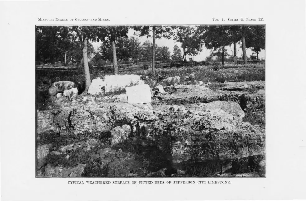
)!I . S0t:lll t:t:r:F..lt: OF GEOL Gl" .\:SD )JJ:-<E · . Y OL. I., SERIES 2, PL.i'l'E IX.


JEFFERSON CITY FORMATION. 71
of inequalities in the hardness of the dolomite. The pitted surface of the heavy beds of this formation differs from that of the Gasconade limestone in that the pits are uniformity deeper, broader and more irregular in shape, while the intervening ridges or projections are sharper and more uneven. The accompanying illustration, Plate IX, shows a typical .veathered surface. The plate also shows the step-like manner in which the beds occur in most of the "balls."
Little geodes of white chert, lined w ith tiny crystals of quartz, :are common in many of the massive pitted beds. They stand out prnminently on the weathered surface.
The joints in the pitted beds on the south side of the Osao-e river :are usually short and O'ently curved. y\reathering often enlarg-es these seams near the surface, forming open gaping fis ures.
COMPOSITION OF THE ROCK COMPRISING THE FORMATION.
Cotton Rock.-Cotton rock is an argillaceous, siliceous dolomite. It is very fine grained and dense, but relatively soft. It has an earthy or clayey textnre, being neither granular nor crystalline. It usually splits with a conchoidal fracture. The color is white, o-ray, yellow or buff. Dendritic markings are common.
With a few exceptions in sec. 31, T. 41 N ., R. 14 W., and in the eastern part of township 39 north, range 12 west, the basal beds of the Jefferson City formation are cotton rock. The cotton rock at ~his horizon attains its greatest thickness, 30 feet, in the northwest corner of the county. East, southeast and south of this place the thick
ness decreases. In the northeast corner of the county, township 41 north, range I2 west, it is not more than IO feet thick. South of the Osage river in townships 38 and 39 north, ranges 14 and IS west, the average thickn 1s from I 5 to 20 feet, while further east the beds decrease until thev die out entir ly. Thin shaly partings are -common.
Cotton rock al. o occurs at other horizons throughout the entire formation. On the north side of the Osage river, and at a few localities on the outh side, there i a somewhat persistent horizon of cotton rock about 45 feet above the base of the formation. The next :mportant horizon is about 70 or 80 feet above the base, and the last is at the verv top of thf:' formation. This uppermost horizon has
it greatest development in the southern part of the county. At all of these horizons the cotton rock has essentially the same character-istics. The main difference is in the quantity of chert and the manner in which it occurs.

72 GEOLOGY OF MILLER COUNTY.
H ackly Pitted Dolomite.-The beds of this dolomite are remark-' ably uniform and persistent over the entire county, giving to the forma-
tion its chief distinguishing characteristic.
The principal variation in these beds is in the content of chert which, in some places, is very abundant and in others almost entirely absent. There is a soft, white or yellow powdery material scattered through the beds, usually in planes parallel to the bedding, which :mparts a streaked or mottled appearance to the freshly exposed surfaces. The rock breaks with a hackly fracture.
Dense Dolomite.-In a few places in the county this formation contains beds of fine grained dense dolomite, such as characterizes
the St. Elizabeth formation. This dolomite breaks with a conchoidal
fracture and is very free from argillaceous or arenaceous material. Dolomite beds of this character occur 25 or 30 feet above the base of the formation in the S. W. Yi of sec. :H, T. 39 N., R. 13 W., and near the base of the formation in the N. vV. ;14 of sec. 6, T. 38 N., R. 13 w.
Chert.-This formation contains less chert than the Gasconade
limestone or the St. Elizabeth formation. Only in the southern part of township 39 north, range 12 west, where the. dolomite is associated with intercalated be.els of sandstone, were heav/ chert beds observed. In sections 31 and ;32 of the township above ref.erred to, and
100 feet from the base of the formation, there is a three-foot bed of black, oolitic, brecciated chert, closely resembling that of the St
Elizabeth formation. The other chert beds, averaging about four inches in thickness, occur mostly in the rntton rock and sandstone horizons. The chert is black, bluish white or white and frequently oolitic. The nodular chert is entirely confined to the cotton rock horizon. Tn the lower horizons it sometimes forms thin layers, although it is usually in distinct nodules. The nodules are of various shapes and sizes, although usually flat. Often they are not more than one or two inches thick, eight to twelve inches long, and four to six inches wide. As a rnle, the outside of all the nodules is white, while the interior may be wh:te, yellow, brown, black or bluish. They are quite uniformily banded, and often contain a cavity lined with quartz at the center. Plate X shows a· peculiar form of chert nodule occur
ring in this formation. In sec. 36, 'f. 39 N., R. 14 W., in the cotton: rock horizon 100 feet above the base, the nodular cherts are cylindrical in shape ancl gently curved. The surface is often rough, due to innum'
erable tiny projections. Small irregular shaped pieces of disseminated
bluish chert are common in th e heavy pitted beds.

i\IISSOURI BUREAU OF GEOLOGY AND ~IINE S. YOL. !, SERIES 2 , PLATE X.
PECULIAR FOK\I OF CHERT NODULE.

' .

JEl'FERSON C[TY FOR~1ATI0K. 73
Sandsto11e.-Thcr are a number of intercalated beds of sandstone, of varying thickness, in this formation. Except in railroad cuts and deep gullies, all but the most prominent of these beds are concealed by the way in which the dolomite beds weather. Their presence, however, is shown by numerous small fragments occurring everywhere on the slopes underlain by this formation.
The sandstone beds vary in thickness from one inch to five feet. The thin beds are most common and together make up a larger part of the entire thickness of the-· sandstone. However, they are so poorly exposed as to he usually overlooked. They occur at all horizon~ throughout the formation. Ordinarily they consist of well rounded, fine to medium sized grains of quartz, deeply stained with iron oxide. They always contain more or less nodular chert and are usually soft and friable.
There are a number of beds from one to five feet in thickness, • I
which are relatively conspicuous. These beds vary in composition from calcareous sandstone to arenaceous dolomite. The weathered surfaces of the highly calcareons sandstone beds are somewhat rough and irregular. In color they also closely resemble the dolomite. There is a 4-foot bed of this character in sec. 7, T. 41 N., R. 15 W., in which the grains have been partly recrystallized. A v,ery calcareous bed, two and a half to five feet thick, is persistent over much of the eastern part of township 39 north, range 12 west. It is 45 feet from the base of the formation, and its position is everywhere easily recognized by the springs which issue from it. In sec. 13, T. 38 N., R. 14 \V., there is a 2-foot bed of sandstone similar to that in the upper part of the formation, and in the S. Vv. :1 of sec. 30, T. 39 N., R. 12 'vV., there is another two and one-half-foot bed of 'this sandstone belonging to the lower 30 feet.
A greater part of the heavier intercalated sandstone beds are m·edium grained and friable; have a deep reddish brown color; and weather with rounded surfaces. A heel of sandstone of this character, having a thickness of from three inches to two and one-half feet, occurs everywhere north of the river and to a lesser extent south of the river in the lower 25 feet of the formation.
South of the ea t and west fault along Barren forks, in sec. 6, T. 38 N ., R. 13 W., there is a bed of white friable sandstone in which the grains are well rounded. This bed varies in thickness from two and one-half to four feet, and can be traced almost continuously for about two miles up the creek from the fault. In many places it is oolitic and frequently it is cherty. Cross be ldinrr is common. Just ·

74 G!':OLOGY OF i\lILLER COUNTY.
south of the fault the slabs broken off from this bed are so numerous that one might easily mistake them for blocks of Graydon sandstone. This sandstone outcrops in numerous places in secs. r and 12,
T. 38 N., R. I4 W. In the northeast quarter of sec,. 9, T. 39 N., R. r3 W., two other
beds· of sandstone are intercalated with the dolomite of this formation. One of these beds is two and one-half feet thick; has a 'white, yellow or brown color and is very friable. It can be traced about a half a mile before it apparently dies out. Other intercalated sandstone beds occur in the N. E. 3,-'.i of sec. q, T. 42 N., R. TS W.; in the N. E. 3,-'.i of the
N. W. ;,'.4 ot sec. 3, T. 38 •N., R. r3 W.; in secs. 25 and 36, T. 39 N., R. 14 W.; in the N. E. part T. 39 N., R. r4 W., and in ~he S. W. 34 of sec. 32, T. 40 N., R. 13 W.
STRUCTURE.
Strat£fication.-Stratification planes in this formation , are a result mainly of thin laminae of shale which occur throughout the formation separating the dolomite beds from one another. With the exception of these, the changes in sedimeritation are not usually abrupt. Considerable thicknesses of both cotton rock and heavy pitted dolomite show no other change in sedimentation.
Bedding.-The bedding planes are close together, five or six feet
being an unusnal separating distance, and beds of this thickness occur only in hackly or pitted dolomites. The average thickness of the beds of cotton rock, as ordinarily exposed, is but a few inches. W'here exposed in cuts or <]narries, the thickness is more variable. In quarries of cotton rock, it was noticed that near the snrface the beds were from one-eighth to one-fourth inch thick, while deeper clown they increased t0 six or eight inches. The bedding planes, particularly in the sandstone and cotton rock, are slightly wavy, havmg in many places discordances in hedding which have the appearance of unconformities. , However, the general field relations cl~ady show that no unconformity exists. l\fr. Bailey Willis has suggested that this discordance in bedding may be the result of ocean scour, combined with other conditions existing at the time the sediments were originally deposited.
Foldi,n.g.-The beds of the Jefferson City formation are seldom
perfectly horizontal. but exhibit slight local dips in addition to the general dip of the formation. Complex flexuring similar to· that in the formations underneath occurs in this formation. No flexuring of
· importance ·was observe:d, except in the immediate vicinity of a fault, or close to some of the large masses of Graydon sandstone. South

JEFFERSON. CITY FORMATION. 75
of the Osage river there are a number of flexures having- an amplitude of about 100 feet.
In the northern part of the county the strata clip north 30 feet per mile.
Fa11!ti11g.-The principal faults in this formation have already
been mentioned in the description of the St Elizabeth formation. In addition to these, faults were observed in township 38 north, range 13 west, and in townships 38 and 39 north, range r4 west.
J ointing.-This formati011 has curved jointing planes, which are 1:ot co111mon in the other formiations. These somewhat peculiar joints occur both in the cotton rock and the heavy pitted dolomite, althongh best developed in the former. These joints are · in planes at all angles to the bedding, and occasionally result in the formation of nodular shaped pieces of rock within the heds. In the heavy pitted beds the joints are not continuous, but die out within comparatively short distances. They are so broadly curved that, south of the river, although a great number of observations were taken, no definite average strike could be determined. Along the joints in the heavy pitted beds uosion and solution are very active.
RELATIONS TO OTHER FORMATIONS.
The Jefferson City formation is conformable with the St. Elizabeth formation. In some places the transition between the two is abrupt, and in others it is gradual. \ 1\There the transition is abrupt
the s.hale or cotton rock of the Jefferson City formation rests on a conglomeritic bed of sandstone.
The relation be~ween this formation and the Carboniferous is similar to that between the St. Elizabeth formation and the Carboniferous. They are evervwhere t111conforn1ablc.
ECONOMIC CO);SIDERATIONS.
S oifs.-The disintegration of the dolomite, sandstone and shale
of the Jefferson City formation furnishes the best soil of any of the formations in Miller county. Consequently the hest farming land1
outside of the river bottoms, is in the prairie country north of the Osage river. In the southern part the most productive soil is on the broad ridges and valleys underlain hy the Jefferson City formation, as illustrated by the region around Ullman. Besides having a more desirable composition, this soil retains the moisture 'longer than
that of the other formations. Lead and Zinc.-Very little can be said of the lead and zinc ores
of this formation in Miller county. They are more evenly distributed

76 GEOLOGY OF i\HLLER COUNTY.
in this than in the St. Elizabeth formation, although the production
has not been as large. They usually occur as float in the surface day; as loose fragments in the crevices; as pockets or thin veins in
semi-decomposed dolomite; and occasionally in the cavities of the pitted dolomite.
Barite.-Barite occnrs wi<lely disseminated throughout the for
mation either along · joints or in small ca vi tie? of the pitted dolomite. I ron.- mall boulders of blue specular and hard reel hematite
and limonite were observed among the chert ancl sandstone fragments on the higher ridges.
RESUME.
Like the other Cambro-Ordovician formations in Mill er county, the Jefferson City is essentially a shallow water formation. Evidences 0£ this are abundant. In the railroad cut in the S. W. 34 of the S. E. ,0 of sec. 25, T. 42 N., R. 15 Vv., is a bed of conglomerate one and one-half inches thick. The pebbles are chert, cotton rock and dolomite from the heavy pitted beds. In the railroad cut through this formation
in the :::-J. E. ,0 of sec. 32, T. 42 N., R. 15 W. occurs a bed of
conglomerate, some of the pebbles of which are six inches in diameter. Sun cracks and ripple marks were ohserved in a number of places, not only in the intercalatecl sandstone beds where they are common phenomena, but also in the cotton rock and heavy pitted_ dolomite.
The Jefferson City formation, after deposition, was elevateq -above sea level and then subjected to erosion. This was followed by a
period ' of submergence, dnring which the Pacific andstone was de
posited.

.I/. I I I .SO' I I
I I I I I
I I I
JEFFERSON CITY FORMATION. 77
DETAILED COLUllii\'AR SECTIOi\'S OF THE JEFFERSON CITY FORJIIATION .
. Section No. 14, Fig. 26.
Sec. 7, T. 41 N., R. 15 W.
From top to bottom. No. Elev.
1 89-104 15 feet of COTTON ROCK, exceptionally white.
2 64-89 25 feet of poorly exposed, tine grained DOL03IITE .
3 60-64 4 foot bed of SANDSTONE; coarse grained, white and somewhat calcareous. Grades gradually into the dolomite above.
4 30-60 30 feet poorly exposed. l\Iade up of six inch to one foot beds of PITTED DOLOMITE.
1 30' 5 0-30 30 feet of COTTON ROCK.
J. Fro. 26.
( 2 C:'ne.rt"'and Sa.r,d- 35, l Sfone. BoT.Alder..$.
-~-3 I I ,o·
I I I
FIG. 27.
Section No. 15, Flo. 21.
On Tavern Creek, S. E. ',4, Sec. 13, T. 38 K, R. 13 W.
From top to bottom. No. Elev. 1 145-150 5 foot "ball" of typical PITTED DOLOMITE. Scattered
over this "ball" are pieces of COTTON ROCK.
2 110-145 35 feet unexposed. Man:v boulders of chert and sandstone. The chert Is rough and brecciated like that of the St. El!zabeth formation.
3 100-110 10 feet of PITTED DOT.O)CITE.
4
5
6
7
8
9
10
11
50-100
45-50
35-45
25-35
20-25
10-20
8-10
0-8
50 feet unexposed. Slope covered with boulders of sandstone. some of which are cherty. White, disseminated chert occurs in the quartzitic sandstone.
5 feet of cherty COTTON ROCK, having dendrltic markings.
10 feet of PITTED DOLOlIITE, containing llttle druses tilled with quartz and white disseminated chert.
10 feet of llght colored DOLOMITE, and thin beds of .intercalated SANDSTONE and CHERT. Springs occur at this horizon.
5 feet of PITTED DOLOMITE .
10 feet of COTTON ROCK, with dendritic markings. Contains nodules of white chert.
2 feet of PITTED DOLOMITE.
8 feet of thinly bedded, dark yellowish COTTON ROCK.

78
i ,~iii!
.. 1 frc.9menf'.s 15,
: ... , •• ,.._,.a,.,.r --t
go'
~ --1 20'
,______,_______ ... i 14-'
~--'---1··1 . =l
I 19'
13!1 .. --- - - ·l'ti!>_ - - . - - -
FIG. 28.
FIG_ 29.
No. 1
2
3
4
u
6
7
14
0
10
11
12
GEOLOGY OF MILLER COUNTY .
Section No. 16, .Fig. 28.
At the fault on Harren forks in Sec. 6, '1'. 38 N. , n. 13 'I\.
Elev. 150-165
130-150
110-130
96-110
From top to bottom.
15 foot slope covered wi tb loose bonldei·s of chert and small slaus of sandstone. Gasterapods occur
in the chert near the top.
20 foot slope covered with boulders of rITTED DOLO· MITE and co·rroN ROCK, the r emnants of a '·balL" l\Iany large nodules of white chert and fragments of fossiliferous chert.
20 feet unexposed.
1 or 3-0G
14 feet of rTTTED POLOMJTEJ,
14 feet un exposed.
78- 1 or 83
50-78
5-71/o
46-51
1311.,-46
12¥.,-1311.,
10-121/o
711.,-10
5-71/o
4-5
0-4
4 feet of $,\ NDSTOXE.
19 foot slope strewn with labs of SANDSTOXE.
21!,, feet of cherty PITTED DOLOllUTJil.
5 foot bed of rJTTED DOLOUJTE.
3211., feet of r1TTED DOLOMITE, somewhat cherc~-. Beds are from six inches to one foot th ick.
1 foot bed of PI1'TElD DOLOMJTE.
211., feet of COTTON ROCK. containing thin layer and noclnles of chert. The layers of chert have a banded blue and white color. Calcite occurs along the jointing planes.
2 % feet unexposed.
211., feet of chetry rJT'l'Ell DOLO)[JTEL
1 foot bed of white CIIERT, secondary af;er dolomite.
4 feet of thinly beclcled, siliceous DOLO)!ITE; fine grained. dark colored and contains a few blue
bale laminae and occasional white chert nodules.
Section No. 17, Fig. 29.
Section along road lea ding from Rrushy Forks to top of the ridge in the south ern part of Sec. H , '.l' . 39 N. , R. J 4 \\'.
No. 1
2
3
4 5
6 7 8 0
10
11
12 13 14
1u·
EJlev. 120-130
106-120
From top to bottom.
10 feet of rITTED DOLOMTTE. A shor t distan ce n01·th of the road is a six Inch becl of snud:ton intercalated with these upper pitted dolomite beds.
14 feet of COTTON ROCK. Four feet from the bottom Is a four Inch layer of white, vlt1·eons. ooll tlc chert.
J Ou'l.,-106 0 Inch bed of SANDSTONE:; fine grained, white and cherty.
105-105 11., 104-105
90-104 96-99 90-96 00-00
{j;j\~-60
53-551).,
50-53 20-uO
lG-20 4
0-10
6 Inches of blue SHALE. 1 foot heel of brown SANDSTONE. Round medium :ized
grain. 5 feet of white COTTON ROCK. 3 feet of thin layers of SANDSTONE and SHALE. 6 feet of COTTON ROCK and SHALE. 30 feet of PITTED DOLO)IITE. 41/o feet of COTTON ROCK, cimtainiug nodules of white
vitreous , oolitic chert. 211., foot bed of co.nglomerltlc SANDSTONEl: the pebbles
consist of smnll rounded fragments of chert. 3 feet of COTTOX ROCK and SHALE. 30 feet of PITTED DOLOMITE. feet of poorly exposed, thinly bedded AXDSTO.:<E and
CHERT, J4 feet of very thinly bedded COTTO:< uOCK and " 'b ite
SUALE.

PACJFJC SAXDSTOXE. 79
CHAPTER VII.
PACIFIC SANDSTONE_,:,
(First . anclstone of Swallow.)
South of the Osage river, particularly in townships 38 and 39 north, ranges 13 and 14 west. on the tops of the highe t ridges, where the dolomite of the Jefferson City formation has a develop
ment of from 100 to 150 feet. there are numerous fragments of sandstone, chert and quartzite .. . Although the fragments are abundant, the beds from which they were derived are exposed in very few localities. However, s11ch as rPmain indicate clearly that at one time at least portions of the southern half of the country were overlain bv a sandstone formation which ha since been almost entirely removed. This formation, although poorly exposed, corresponds in position,
manner of occurrence aud lithological character to the F irst Sac
charoiclal sandstone of Swallow. This fori11ation is exposecl in "situ." or nearly so, in four places,
namely, ;n the eastern part of sec. 30, T. 40 . ·., R. 13 \V.: in the southern part of sec. 26, T. 39 N., R. 14 \ V.: on the line Ix-tween secs .. 12 and 13,
T. 38 N"., R. 14 \Y .. and in the N. W. }i of the S. W. ;4 of sec. 33, T. 39 N., R., 14 W.
In the eastern part of sec. 30. T. 40 N., R 13 Vv., slabs of sand
stone cap the summit of a high mound which is underlain by 100 feet of the J effer on City formation. These slabs, which are several ·feet
long, two or three feet . wide, and six to ten inches thick, are not exactly in place, but approximately so. The unexposed portion of the mound between the cotton rock and the summit has a thickness of 30 feet. The sandstone p-rains are of medium size and well rounded. The stone is usually friable and in some places contains chert. The color
varies from white to reddish brown. The chert is white and compact. ome of the chert fragments, alt.hough not well rounded, are apparently
of fragmental origin. Slabs from the base of the formation have in places the appearance of an intraformational conglomerate. The matrix
•see lntroduetion. There is a strong probability that some of the snnclstonc mapped and considered In this report as Grayclon Is raciflc andstone.-E. n. Buckley.

80 CEOLOGY OF MILLER COUNTY.
of this conglomeritic bed consists of fine grained, sandy dolomite, in
which are embedded numerous large, well rounded grains of translucent quartz and irregular shaped pieces of cotton rock similar to that of the underlying beds.
The best exposur s of this sc1 ndstone observed are at the heanJ of Mill creek. In the southern part of sec. 26, T. 39 N., R. 14 \V. , this sandstone has its greatest clevelopment in lVIiller county. It outcr_ops ten feet above the uppermost beds of cotton rock.
The following sect ion shows the succession of beds:
No. Elev. 1 30
2 24'1, -30
3 23-2411,
4 18-23 5 13-18
6 3-18 7 2-3
8 0-2
Section 18.
T op of hill. Unexposecl slope covered with fragments of_ CH ERT and SANDSTONE. At the very top of the ridge two pieces of fine grained dol omite resembling cotton rock were fo nucl , which may be remnants of t he First ?llagnesian limestone, which In other localiti es in this state overli es the Pacific sandstone.
Large blocks ancl slabs of rugged, brecciated, CHERT, which are nearly in plaee.
llh foot bed of cherty SANDSTONE. The sandstone and chert are both white.
Unexposed. Slope is covered with sandstone slabs. 2 beds of cherty SANDSTONE. TIie sandstone is com
posed of round grains of auartz . It has a brown or yellow color ancl Is friabl e. The chert is black and oolitic. The fragments have an irregular shape ancl are f rom less than one to several Inches Ion11: and from three to fou,· inches thick. They are arranged In rows In the sandstone.
Unexposed. 1 foot bed of white SANDSTONE composed of round ,
medium sized grains. Shows sun cracks. 2 foot bed of SANDSTONE and CHERT. The bottom 8
Inches is chertless. Above this is a 6 to 8 inch bed of medium grained yellowish snnclstone couta lnin11: a li ttle white oolitic chert. The uppe,· 10 Inches is black, oolitic, vitl'eous cher t.
About a half a mile sontheast of this place, in a ravine 111 sec.
35, T. 39 N., R. 14 W ., th e uppermost cotton rock beds of tl~e Jefferson City formation are covered with large boulders and slabs of this sandstone. For the most part they are identical with those described in the section given above.
The sandstone varies from fine to coarse grained, and often has a worm-eaten appearance. Along the Iberia-Brumley road, from the latter town to the ridge at the head of :Mill creek, boulders of this
sandstone occur at a number of placeB. Near the half section corner between secs. 12 and 13, T. 38 N .,
R. 14 W., there are slabs of sandstone similar to that which outcrops
three miks further north. further north.
In the N. W. Vi of the S. W. % of sec. 33 , T. 39 N., R. 14 W., where the Jefferson City formation has a thickness of 130 feet, there is a single two-foot bed of sandstone about 20 feet above the topmost
bed of cotton rock and· 30 feet below the crest of the ridge· This sand-

PACIFIC SANDSTONE. 81
stone 1s coarse grained and friable and has a dull brown color. In some places it contains small white specks of decomposed chert and small angular pieces of white oolitic chert. Above this bed to the top of the ridge, are small boulders of black, brecciated, oolitic chert, resembiing that found at the head of Mill creek.
RESUME.
The Pacific sandstone, as it occurs in this county, is a ver-'~ heterogeneous formation, apparently composed of thin beds of chert, sandstone and cherty sandstone. The sandstone and cherty sandstone resemble in their lithological characters, occurrence and position, the beds of First sandstone ·. exposed near Graydon Springs in Polk
county and described by Dr. E. M. Shepard* in his report on the geology of Greene county. In position and manner of occurrence they resemble the First or Pacific sand.stone, as typically exposed at Pacific. Lithologically, however, they are entirely different.
This formation in Miller county lies unconformably above the Jefferson City fom1ation, as indicated by the conglomerate in sec- 30, T. 40 N., R. 13 W., and also by the very different elevations, not accounted for by faulting, at which it occurs.
*Mo. Geol. Sur. Vol. XII, Part I, p. 57.
H Ci

2 t:EOLO(;y OF ~I LLLER COUNTY.
CHAPTER VIII.
LOWER ARB NU EROU
'.l.'UE CUO U'.l.'EAU.
A t a number of localities in this county several disconnected out
crops of Lower Carboniferous lime tone were observed which r esemble bed of Chouteau, as described by wallow in the early reports
of this Bureau. At J. E. ullen' quarry in sec. 26, T. 42 N., R. 14 v ., fo r example, th re are bed of shale and buff colored, siliceous lime tone which differ from the rocks of the Burlington formation and resemble very much those of the Chouteau at the type locality in Cooper county.
Fragments of a g ray or buff. siliceou limestone, observed in the vicinity of other of the Burlington lime tone outcrops, are thought to belong to the Chouteau.
The areas of probable .hout an arc, however , too limited to be represented on the geological map.*
'l'HE UPPER B RLINCTON LIMES'l.'ONE.
GEOGRAPHl AL DISTRIBUTION.
The Upp r Burlington lim e ton<' ha a ver:v limited areal distribution in Miller county. It occur in small. isolated areas called outliers; as chert boulder and pebbles: and a chert and limcst c.., ne fragments in the Saline Creek cave-concrlomerate, the Coal Measure shale
and the Graydon sandstone. The outhern bo\lndarv of the main area of U pper Burlington limes tone is about twenty mile. north of Miller county.
In thi county the Upper Burlington limestone outliers occur 111
the eastern part o f township 42 north, range 15 west: in township 4:2
north, rang-e r 4 w est; in the northeastern corner of township 41 north, range 14 west: and near the northern boundary of township 41 north, range 13 west. In these four townships there are about thirty lisconnected areas of Upper Burlino-ton limestone, most of which are
Jess than roo yards in their greate t diameter and cover less than four acres. The position occnpied by these outliers has no relation to the pre ent topography. They ocrnr indiscriminately, in the valley bottom s, on the hill tops, and along the intermediate slopes.
•The iclenliflcatlon of the houteau beds was made after this report was In the hands ot the dlrector.-E. R. B.

LOWER CARBONIFEROUS. 83
The Upper Burlington chert usually occurs in the form of residual
boulders from four inches to two feet in diameter. They are more or Jess perfectly ronnd, angular fragments being rar,e. These boul
ders are much more widely distributed than the limestone itself, heing found in many localities in the northwestern part of the county.
Two of the places where they were observered are as follows: N. E. Y-i of sec. 11, T. 41 N., R r6 W., and the N. W. and S. W. y,i. of sec. 1_2, T. 41 N., R. 16 Vi/. Along the rrorthern border of the county chert boulcle1 s are very abundant, while large portions of the surface of secs. 2, 3
and IO, T. 42 N., R. 14 \ i\/., are thickly strewn with them. In the southern part of the county, in the N. E. y; of the S. E. Ji of sec. 14, T. 39 N., R. 13 W., these boulders are abundant.
Fragments of Upper Burlington chert in Graydon 5andstone were observed in the center of . ec. l, T. 40 N., R. 14 W., in the S. E. 34 of
the N. E. y,(. of sec. 14, T. 41 N ., R 16 W.; in the centre of the E . .0 of sec. 8, T. 41 N., R. 13 VV.; in the west centre of the S. W. 34 of sec.
9, T. 41 N., R. 13 Vv.; in the north centre of the · N. 'E. ;14 of sec. 15, T. 42 N., R. 14 W. The fragments thus far observed in the 'Graydon
sandstone are typical flint pebbles with no trac~s of limestone. In the Coal Measure shale, fragments of Upper Burlington limestone
and chert have been noted in three places. At the "Little Nugget" mine near Mary's Home, numerous boulders of both limestone and chert were found imbedded in · the shale throughout the entire depth of the 135 foot shaft. The limestone boulders are somewhat rounded. The carbonaceous matter of the shale has stained some of the limestone a dark gray, the fossil shells in some instances being black. In an exposure along the Chicago, Rock Island and Pacific R. R. on the line between secs. 25 and 26, T. 42 N., R. 14 W., bonlclers of Burlington limestone were observed in Coal Measure shale. The Coal Measure shale in 'the north centre of the N . E. 0 of sec. 15, T. 42 r., R. 14 W., also contains boulders of Upper Burlington chert.
TOPOGRAPHY.
The very limited area underlain by the Upper Burlington limestone gives it very littie, if any, control over the major topographic features of the county. Wherever the Upper Burlington limestone occurs the rnrface is rounded. ·wherever the Upper Burlington chert occurs in sma11 areas it forms steep sloped, almost perfectly conical hillocks. Typical examples of these hillocks are found in the S . W. 1'4 of sec. 5, T.
41 N. , R. 13 W.: just north ' of the centre of the N . .0 of sec. 1, T. 41 N. R. 14 W., and in the J. E. _34 of sec. 35, T. 42 N., R. 14 W. Where ·

84 GEOLOGY OF MILLER COUNTY.
the chert covers large areas the slopes a re much gentler, although the summit still has a tendency to be conical. In some places the boulders form an almost continu ous pavement, rendering the land too stony for farming. These hill s which are largely confined to township 42 north, range 14 west are forest clad.
WEATHERING.
Good exposures of the Upper Burlington limestone are few. The led)!eS are usually well rounded and the rock is often obscured by soil. Loose, slab-like blocks, with rounded edges and corners are common near the outcrops.
The weathered surface of this limestone is very rough, owing to the unequal hardness of the fossils and their matrix. Frequently the matrix is almost entirely removed be.fore the fossils have begun to disintegrate. On account of this, the surface is unu sually rough.
It is difficult to determine the extent to which solution has effected this limestone. Its ready solubility has undoubtedly hastened very materially its removal from .Miller county. The existing areas a re too small to admit of the development of caves and sinks of any considerable size. However, it is ex tremely difficult to distinguish dips which may be due to possible post-Burlington folding from those connected with sink hole phenomena.
Burlington limestone showing local dip. FJG. 30.

LOW ER CARBONIFEROUS. 85
THICKNESS.
Dr. C. R. Keyes* says that the average thickness of the Upper Burlington limestone in -Missouri is 6o feet. Dr. E. M. Shepard'~* states that
the maximum thickness of the Upper Burlington limestone in Greene county is 240 feet. In Miller county the Upper Burlington limestone has a maximum thickness of 35 feet, in Sullen' quarry in the center of ec. 26, T . 42 N., R. r4 W. The variations in thickness, although the
re ult, in part, of the unevenness of the surface upon which the Upper
Burlington limestone was deposited, are largely due 'to post-Burlington erosion.
LITHOLOGICAL CHARACTERtSTICS.
The Upper Burlington lime tone is very pure calcium carbonate, and is composed very largely ,of fossils embedded in a calcareous matrix.
Color.-A fre h surface of the limestone is usually a dazzling white, although grayish, yellowish and pinkish tints are common. ·weathered surface usually have a dark gray color.
Te.-.t1we.-This limestone is completely crystalline and, as a rule, rather coarse grained. The cleavage faces of the calcite crystals, of which the crinoid stems are composed, are often a fourth of an inch broad.
Althotwh, as a rule, the stone is cour e grained, beds occur which are compact and fine grained. The precentage of fos ils in the stone is not constant but varies in different parts of the individual areas examined.
An exposure in the center of the N. ;0. of sec. 20, T. 42 N., R. 14
VI/,. exhibits coarse grained stone at the south encl and fine grained at the north end.
Nodules of chert occur along the bedding, jointing and tylolitic planes.
Chert.-The Upper Burlington chert varie from an extremely porous, friable variety, to one " ·hich i dense, fin e grained and compact. The former, which is the more abundant, contains numerous fossils.
Some of the chert are merely a ma of ilicified shells and crinoid stem or their casts. Thi. fossil iferous chert is undoubtedly secondary after
the limestone, as proven by collected amples which show every crraclation between the limestone and chert.
The dense fine grained chert ,ms only observed in the "Little ~ ug-
•Mo. Geol. Sur., Vol. IV, p, 30 . .. l\Io. Geol. Sm:., Vol. XII , p. Jll.

86 GEOLOGY OF MILLER COUNTY.
get" mme. Here it had a sharp conchoidal fracture. All gradations between the fossiliferous and dense, fine grained cherts were observed in hand specimens collected from this mine.
That these fossi liferous chert fragments are of Upper Burlington age is shown by the fossil<; which they contain. That they were originally limestone is shown by the partly silicified boulders which show every gradation between the Upper Burlington limestone and chert. In the outcrops of Burlington limestone the chert is found very generally along bedding, jointing or stylolitic planes.
Thin sections of partially silicified Upper Burlington limestone, examined under the microscope, show that the crinoid stems are the last to silicify. The spaces between the fossil fragments and the holes in the crinoid stems are filled with a mosaic of rather coarse grained chalcedony. The crinoid stems themselves are sometim es partially silicified, the silica being very fin e grained. The most completely silicified portion of the crinoid is the interior of the stem.
The best evidence of the origin of the fossiliferous chert is shown in a railroad cut on the line between secs. 25 and 26, T. 42 N., R. 14 W., and in an exposure along the Missouri Pacific railroad three miles north of Olean.
As stated above, it is thought that the chert is mainly a metasomatic replacement, more or less complete, of the limestone. It seems most probable that the silica which replaced the limestone was derived from the underlying Cambro-Silurian formations .
Assuming that the sil(cification of the Burlington limestone was prior to Coal 1\Ieasure times, we are compelled to believe that the underlying sandstone and siliceous dolomite were the immediate ource of the silica. That silicification occurred prior to Coal Mea urc time is sho\Yn by the silicified fragments of Burlington chert occurring in the Graydon sandstone. Cavities in these fragments were found to be filled with sand, which argues that prior to the deposition of the Graydon sandstone the chert had become porous. Fragments of U pper Burlington chert also occur in the pockets of Coal Measure shale.
STRUCTURE.
Stratification, Bedding Planes and J ointing.-Stratification planes* are poorly developed in the Upper Burlington limestone of this county, due probably to the very uniform conditions of deposition. Weathering, however, often shows one stratum to be less fossiliferous and finer grained that~ another. The laminae often seem very fine, in some cases
•Building nnd ornamental stones of Wisconsin. I!J. R. Buckley, 4::iG.

LOWER CARBONIFEROUS. 87
twenty being counted to an inch. Although the bedding planes are slightly wavy, no indication of cross bedding was observed. Deformation has emphasized some of the stratification planes, forming bedding planes.* The beds are, as a rule, from four to five inches thick, although in a few places from one to two feet.
Besides the bedding planes, there are two sets of joints, dipping at
an angle of from 45° to 90°. The strike of the joints varies in different localities and no persistent system could be made out.
Stylolitic Pa1'tings.-Stylolitic partings, commonly known as crowfoot seams, are quite common. They occur both perpendicular and parallel to the bedding.
Folding.-As stated above, it i often difficult in places to determine whether an exposure is a part of a ledge or a part of a re idual block. The beds of limestone comprising these isolated areas have, as a rule, more or Jess of a synclinal form. The · older rocks enclosing them may or may not be flexed.
Fcmlting.-Only one fault ,.vas noted in the Upper Burlington lime
stone. This is near the center of ec. 3, T. 42 ., R. 14 W. That minor faulting has accompanied the deformation of the Upper Bur
lington limestone is very probable, although it has not been noted. F ossils.-The fossils which so largely compose both the limestone
and chert are beautifully preserved, showing none of the water worn characteristics ascribed to some of those of Greene county by Dr. Shep:ud.t rinoids are by far the 1110 t characteristic fossils, although bryozoans, brachiopods and blastoids are c.ommon. The following is a list of Lower Carboniferous fossils collected in this area and named by Dr. Georo-e H. Giety of the United States Geological Survey:
Crinoid ( undet) . Productus Burlingtonc.:nsi
( 3 specimens.) Prooductus cf Scabriculus. Productus setigeru . Productus sp. Platyceras, small incl. spec. Spiriferina subelliptica. Spirifer Logani (3 specimens.) Spirifer or Spiriferina inclet. Spirifer cf. pinguis Phillips,
( 2 specimens.)
*Ibid 457. tMo. Geol. Sur., Vol. XII, p. 120.
Phillipsia tuberculata·. (2 speci-
mens). Spirifer Keokuk ( 5 specimens.) Zaphren tis sp. ( 6 specimens.) Rhipidomella Burlington ensis
( 5 specimens.) Athyris sp. Rhipidomella Michelini. Chonetes sp. Am plexus sp. ( 2 specimens.) Polypora sp. . eminula ? sp.
88 GEOLOGY OF MILLER COUNTY.
Athyris incrasata. Athyris lamellosa. Productus, small indeterminable
spec. (2 ·specimens).
Productus punctatus. (2 specimens).
Productus cf. Gallatinensis, ( 3 specimens.)
Productus near scabriculus. Syringothyris Carteri. Platyceras sp. (3 specimens.) A viculopecten sp.
Fenestella cf. tenax (3 specimens.) Fenestella, fragments, several spp. Pentremites cf. conoideus. Syringopora sp. (cast). Camarophoria subtrigona. Reticularia pseudolineata ?. Seminula subquadrata. Glyptopora near Michelinia. Eumetria v,erneuiliana ?. Fenestella several spp. Fenestelloid. Pentremites indeterminable.
ECONOMIC CONISlDERATIONS.
The upper Burlington limestone burns into a very execellent lime. As a rule it has too many joints to be of value as a building stone. It has been used to a small extent for foundations and the Missouri Pacific railroad has used it in several places for bridge piers and road ballast. iast.
No ore has been found in the Burlington limestone of this county.
Rl':LATIONS TO OTHER FORMATIONS.
The Upper Burlington limestone is the most easily recognizable formation in Miller county. Not only are its lithological and paleontological characters striking and constant, but it is separated from the formations above and below by distinct unconformities. The unconformity between the Upper Burlington and the Cambra-Silurian formations is everywhere clear and well defined. The Upper Burlington limestone has been observed above and in contact with both the J efferson City and St. Elizabeth formations, while Burlington chert was found upon Gasconade limestone.
Unconforrnably above the Upper Burlington limestone are exposures of Graydon sandstone and Coal Measure shale. In the south central part of the S. W. 34 of sec. 6, T. 41 N .. R. 13 W., and near the center of sec. 26, T. 42 N., R. 14 W., are exposures of shale surrounded by Upper Burlington limestone. The almost constant association of Upper Burlington limestone and Graydon sandstone is very striking. There i scarcely an exposure of Upper Burlington limestone in this county which is not associated in one way or another with the Graydon sandstone.

LOWER CARBONIFEROUS. 89
I
RESU:\JE.
The reports of the early geological surveys mention numerous Upper Burlington limestone exposures in Cole,* Moniteau** and Morgant counties . The reports of Swallow mention Burlington chert in Ozarkt and Wright§ counties, while Winslow§§ states that "Lower Carboniferous chert" is found in Howell and Crawford counties. As a result of the present survey, Upper Burlington limestone has been located on the most elevated parts of the northeast townships of Miller county.
That the topography was rugged prior to the Upper Burlington limestone deposition is indicated by the fact that apparently undisturbed outliers occupy not only the slopes and tops of the hills, but also the
north of the center of sec. I, T. 41 N., R . 14 'vV., on a hill top on the Tuscumbia-Spring Garden road. At this place there is an exposure
of Upper Burlington limestone having rather sharp dips. A quarter of a mile south, in the valley of a fork of Saline creek, 75 feet below, there is another exposure of undisturbed Upper Burlington limestone. The
beds at this place are practically horizontal as would be expected if they were deposited in a comparatively wide valley. In a stream bed in the
N. E. 34 of sec. 35, T . 42 N., R. 14 W., Upper Burlington limestone is in contact with the Jefferson City formation. The hill slopes on either
~ide are more than so feet high and at their summits, the Jefferson City formation is exposed.
The Upper Burlington limestone appears to have been laid down in a sea of. moderate depth, teeming ·with animal life. The absence of vegetable remains and clayey matter indicates that the strata were deposited at some distance from the shore. As crinoids are usually inhabitants of a comparatively quiet sea, their presence in such vast numbers indicate the absence of strong currents. That the conditions of deposition remained undisturbed for a considerable time is shown by the constant lithological character of the limestone.
•Report of the Geot. Sur. of the State of Missouri, Including field work of 1873-4. Garland C. Broadhead, State Geologist. Jefferson City, 1874, p. 324 .
.. The first and second annual reports of the Geol. Sur. of Mo., 1855, Part II,
page 99. tReports on the Geol. Sur. of the State of Mlssolll'i, 1855-71, p. 135-156. tGeol. Sur. of Mo., 1855-71, p. 190. §Ibid, page 206. §'§Mo. Geot. Sur., Vol. VII, p. 439.

90 GEOLOGY OF l\1ILLER COUNTY.
CHAPTER IX.
THE COAL MEASURE FORMATIONS.
The Coal Measure sediments in this area con ist of conglomerate, sandstone and shale. The conglomerate is represented by certain ir
regular deposits of the so-called Saline Creek cave-conglomerate; the sandstone, by the Graydon formation; and the shaJ.e, by shales and clay
with which coal is often associated. The sandstone of the Coal Measure rocks has every appearance of
that which has been called Graydon by Dr. E. M. Shepard,* and its relations to the other formations are very similar. For these reasons this sandstone has been called Graydon. Until the relation between the Graydon sandstone and the Coal Measure shale is more thoroughly understood the shale will be provisionally called the Coal Measure shale.
Observations in the field indicate that the Graydon sandstone, in
part at least, and the Coal Measure shale are probably phases of the same formation. However, conclusive proof of this hypothesis is not at hand. As yet no large deposit of typical Graydon sandstone has been observed grading into typical Coal Measure shale.
Near the middle of lot I sec. 4, T. 39 N ., .R. 13 W., residual boulders of Graydon sandstone cover a small area underlain by Coal Measure shale. The Graydon sandstone is of the ordinary type, except that it contains numerous small inclnsions of carbonaceous shale.
In the north cenh"al portion of ec. 26, T. 41 N., R. 16 W., there
is a huge mass of Graydon sandstone lying on the St. Elizabeth formation. It is medium grained sandstone which upon weathering takes
on a purplish cast. The stratification planes are curved antd mor·e or less disconnected. They are at times emphasized by parting planes of green, unctuous shale. In some places more firmly cemented sandstone
pebbles occur in the sand tone. giving it the appearance of an intraformational conglomerate.
Three-eights of a mile north east of Olecm on the east bank of Blyth's fork there is an exposure, which i partially Graydon sandstone and partially Saline Creek cave-conO'lomerate. One hundred and twenty-five
Mo. Geol. Sur., Vol. XII , p. J 24.

THE COAL MEASURE FORMATIONS. 91
feet from the north end of the exposure the beds of the St. Elizabeth formation dip 30° S. 20° vV., and this dip increases up to the Saline Creek cave-conglomerate contact where it is 9(l degrees. 011 the south side, the dolomite dips toward the sandstone, although less steeply. At the north end of the 250 feet intervening between the Carnbro-Orqovican ' dolomites, there is a typical exposure of Saline Creek cave-conglomerate. At the south end Graydon sandstone conglomerate is exposed. This sandstone grades above into another containing round shale pebbles. Weathering removes Lhese, leaving a pitted surface. In the sandstone there are also well rounded flint pebbles, several inches in diameter, similar to those occurring in the Coal Measure shale. A short distance away the shale increases until the rock becomes an arenaceous shale. This is gradually replaced by an almost pure sandstone. The mass is well joined, the following joints having been recorded: N. 55° E. ( dip 65° N. 35 ° W.): N. 80° E. (clip 9() 0 N. I0° W.); N. 35° w: (dip So 0 S. 55 ° W.), and N. 40° E. (clip 65° N. 50° W.).
In the center of sec. 26, T. 42 N. , R. 14 W., there is a large outlier of Burlington limestone. In the valley eroded in this limestone there is exposed a deposit of argillaceous, non-calcareous sandstone. It is fine grained and quite incoherent. The layers are from one-fourth to one-half an inch thick and dip 85° K. 22° W. The relation which this sandstone bears to the Upper Burlington limestone is not clear, although it appears to be above it. The Upper Burlington beds in this vicinity dip very little, while the sandstone stands on ~dge. This may be due either to faulting or to a cave in. It would probably be most satisfactory to consider this a result of solution of the limestone through which a mass of sandstone, originally situated on higher ground, has been nnderminecl and thus allowed to slide into the valley.
Three-eights of a mile northwest of tlie last mentioned deposit is an exposure of arenaceous shale, in which are thin intercalated beds of red sandstone. The sandstone beds abut against practically horizontal beds of Jefferson City limestone. Near the Jefferson City formation the bedding of the shale 1s disturbed, and at a moderate distance from the Jefferson City limestone the shale dips 26°, 40° S. 120 E . .
The shale and sandstone may or may not be phases of the same formation. They may have been deposited contemporaneously. There is some evidence, however, that this is not true of all the sandstone and hale. In the deposit in sec. 4, T. 39 N., R. r3 W., mentioned on page
90, the Graydon sandstone appears to be younger than the Coal Measure shale, while in the S. W . . 14 of 5ec. 20, T. 42 N., R. 14 W., the Coal Measure shale appears to be younger than the Graydon sandstone. At

92 GEOLOGY OF MILLER COUNTY.
this place an excavation shows two inverted cones of Coal Measure shale four feet in diameter at the surface and five feet deep. Throughout the sandstone are small pockets of white or purplish red, unctuous shale of very fine grain. It is the usual plastic Coal Measure shale, containing some typical, well rounded chert pebbles. The contact between the shale and the sandstone is sharp. It was not shown whether these were original deposits in the sandstone or were introduced afterwards by circulating waters.
THE SALINE CREEK CAVE CONGLOMERATE.
This formation receives its name from Saline creek near whos.! headwaters it is well exposed. Small caves, cave galleries and open seams filled with the conglomeritic masses of this formation are scattered throughout the county, where good exposures of the CambroOrdovician rocks occur. They are especially aboundant near the headwaters of Saline creek an·d in the vicinity of the coal deposits in township 41 north, ranges I 5 and 16 west.
Thickness.-On acount of the manner in which this formation occurs its thickness is not the same in any two places. The thickest development observed is in sec. 27, T. 41 N., R. 12 W., where the conglomerate is at least 60 feet thick.
Origin and Lithological Characteristics.-From such evidence as has been gathered, it is believed that this formation is a cave deposit younger in age than the Burlington but older or contemporaneous with the Coal Measure formations. The conglomerate is very coarse, the boulders having in some instances a diameter of 20 feet. The large boulders, as a rule, have angular outlines, while the small ones are often well worn. The boulders are derived from all 9f the older formations including the Up~ per Burlington limestone. The matrix is either argillaceous limestone, calcareous shale, or calcareous sandstone.
Strncture.-There are no indications in this formation of either stratification or bedding. Joints are extremely rare.
TYPICAL EXPOSURES.
E:rposures alo11g the Chica.go, Roclt J slan.d arn'd Pacific Railroad.The cuts along this railroad in sec. 2.5 and 26, T. 42 N., R. 14 W., expose numerous pockets and joints filled with Saline Creek cave-conglomerate (see Figure 3 I). At these places the conglomerate is composed of arenaceous and calcareous shale in which are embedded boulders of dolomite, cotton rock and black flint from the Jefferson City formation, and limestone from the Upper Burlington. Some of the boulders are five feet in diameter.

Saline C'l'eek cnve conglomerate.
THEJ SALINEJ CREEJK CAVEJ CONGLOMERATE.
Cut on tbe C .. R. I. and P. R. R. on line between secs. 25 and 26, 'I'. 42 N., Tl. 14 W. Vel'tlcal scale, 1"=133'. Horizontal scale, 1"=2G6'.
FIG. 31.

94 GEOLOGY OF MILLER COUNTY.
Exposure along Tcivern Creell.-The largest exposure of the Saline Creek cave-conglomerate observed in Miller county occurs in the center of sec. 27, T. 41 N. , R. 12 vV., on the road from Tavern creek to St. Elizabeth. Its length east and west, the only other obtainable dimension than its thickness, is 250 feet. It is at least 60 feet thick. The boulders include both cotton rock an'd pitted dolomite from the Jefferson City formation , and dolomite and sandstone from the St. Elizabeth formation. Some of the boulders have a diameter of 18 feet. The larger ones are very angular, although many of the smaller ones are well rounded. They constitute a distinctly unassorted congl~eritic mass. Portions of the deposit are made up of boulders imbedded in a bluish, sandy shale matrix. Other portions of the deposit consist of perfectly rounded pebbles one to one and a half inches in diameter imbeddecl in an arenaceous shale matrix. For 150 feet on either side of this conglomerate the Gasconade limestone beds dip toward it. Whether this is a filfrd sinkhole, a cave or the• worked-over talus slope of a filled valley, it is difficult to determine. The local clips are more commonly associated with sink holes and caves than with river valleys. For this reason, the sink hole or cave origin is favored.
Ramsey.-In a cistern at Mr. James Ramsey's residence, in the N. E . X of sec. 28, T. 40 N., R. 13 W., a small crevice in the lower portion of the Jefferson City formation was followed down twenty-two 'f.eet. At a depth of 18 feet the crevice widened and at the bottom it was eleven feet across. The cr,evice is filled with a conglomerate of well rounded cotton rock, chert and shale pebbles from the Jefferson City formation. These pebbies are one-eighth of an inch to five inches in diameter. The matrix is an arenaceous, non-calcareous shale.
Whitaker's Shaft.-In the E. ,0 of lot 6 N. E . of sec. 2 ., T. 39 N ., R. 12 W., in lhe bed of a small stream, is a cr,evice striking N. 33° W . This enlarged joint is filled with a conglomerate with a matrix of calcareous, arenaceous shale. Some of the pebbles are well rounded, while
others are angular or sub-angular. A shaft about 125 feet S. ::;0° E. from this place penetrates the
same deposit. Fourteen feet S. 30° E. of the sha.ft, the walls of the crevice come together. Beyond this bar the crevice again opens out. Northwest of the bar galer,a is found in the crevice, while southeast
of it, blende is the ore. The Cannon "11,fines."-The Cannon "mines,' located in sec. 15, T.
38 N., R. 12 V'1., are sunk in a deposit of the Saline Creek cave-conglomerate. This deposit is 40 feet wide, and can be traced 500 feet N. 40° W. The main shaft, which is 73 feet deep, is said to have

THE COAL MEASURE FORMATIONS. 95
passed throc1gh a thin layer of blue and yellow clay, and, following · a wall of the St. Elizabeth formation, it continued in Saline Creek cave-conglomerate to the bottom. The matrix is a greenish, argillaceous sandstone in which are embedded pebbles ·of gray, concretionary and black chert from the St. Elizabeth formation~ and gray, green and brown limestone of several different varieties. Pebbles of black dolomite with
small calcite druses were also noted. The Saline Creek cave-conglomerate lies unconformably upon the
Cambro-Ordovician and Upper Burlington formations, and is overlain, conformably, by the Graydon sandstone and Coal Measure shale. The
Saline Creek cave-conglomerate and the Coal M·easure shale grade into one another and in many cases the contact between the two is extremely
difficult to detennine.
GRAYDON SA N"DSTONE.
AREAL DISTRIBUTION.
There are about 150 separate and distinct areas of Graydon sand~tone in Miller county, three-fourths of which are north of the river. All but thirty of these are found in a belt six miles wide adjacent to the Osage river. On the south side of the river, they occur most abundantly
in the most southern townships. The Graydon sandstone was deposited upon the uneven surface of
the pre-Coal Measure land area. The comparatively few areas of Graydon sand tone immediately along the Osage river may be attributed to the lower level to which the Osage river and · its tributaries have since eroded that part of the county. Unless the Graydon sandstone was deposited in an unusually deep canyon or gulch. erosion has removed all traces of it. Near the river the Graydon sandstone areas have a somewhat trail-like course and are called "trails of sandstone" by the inhabitants. One of these, in the N. W. :14 of sec. 13, T. 40 N., R. 15 W., is 500 feet wide and about a quarter of a mile long. Another, passing
through the northeast corner of sec. 4, T. 40 N., R. 15 W., is 100 feet wide and almost a half a mile long. A third, in the southwest. part of
sec. 2, T. 41 N ., R. 14 V./., is 35 fret wide and 250 feet long. On the highlands along the north and south borders of the county, the Graydon sandstone areas have a more or less circular or elliptical shape. This shape is a natural result of the removal of all but isolated remnants of a formation which was deposited on a ~omparatively level surface. If the Graydon sandstone near the north and south limits of the county had been deposited
upon a surface in which the pre-Coal Measure drainage lines were as well developed as they appear to have been in the vicinity of the Osage

96 GEOLOGY OF ~IILLER COUNTY.
river, it is very probable that the outliers of today in !he highlands would occur in a more trail-like manner.
It 2.ppears . from the distribution of these sandstone outliers that, prior to the deposition of the Coal Measure rocks, the country in the vicinity of the Osage river was more hilly and rough than the country back from that stream.
The area covered by any one of these sandstone outliers nowhere ex
ceeds 20 acres, while some of the areas are not over 100 square feet. Topographically, the Graydon sandstone is found in every position imaginable,-on the tops and slopes of the hills and in the valley bottoms.
TOPOGRAPHY.
On account of their small size, the Graydon sandstone areas have very little effect upon the major topographic features, although they have had a marked local influence. The sandstone weathers into large, rounded blocks ::if narrow pinnacles usually with rounded surfaces, although in places they are somewhat craggy.
THICKNESS.
Occurring as it does in isolated, closely circumscribed areas, the original thickness of the Graydon sancj..stone in this county cannot be determined. In many places it is now only a foot thick, but in others,
as in the N. W. ;4 of sec. r3, T. 40 N., R. 15 Vv., it has a thickness of at least 75 feet. Probably the thickness at this last place was originally 150 feet. If this Graydon sandstone is a continuation of that in the northern part of the county, in places the thickness must have been at
least 500 feet.
WEATHERING.
The loose blocks are, as a rule, more or less rectangular in shape, due to the well developed systems of joints. Hy differential weathering, small
cave-like recessions, and even small natural bridges are formed. Unequal distribution of the iron oxide cement causes unequal weathering, which results in the formation of the peculiar pits and rings which show
conspicuously on the weathered surface. The surface of much of the sandstone is marked with cracks aver
aging one-half an inch in depth and one-fourth of an inch in width. In places these cracks intercept one another at right angles, both dying out within a space of from six to twelve inches; at other places they cross at such angles as to form a rough polygon with slightly curved faces. In some places these polygons are almost perfect hexagons. The largest polygons are eight inches and the smallest are an eighth of an inch in
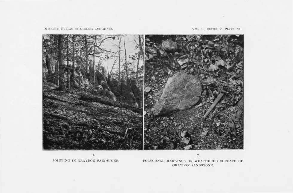
~lrssoc nr Bi.:nE.-\ t: OF GEOLOGY A:SO ~I:SES.
l.
JOIKTIKG IN GRAYDON SANDSTOK I,;.
VOL. I., SERIF.S 2, PLATE XI.
2.
l'OLYGONAL ~IAHKIN GR ON \YI•,ATrmHEJ> SUH l<'A('E 01~
GRAYDON SA:,;iD8TOKK

THE COAL MEASUL{E, FORMATIONS. 97
diameter. Plate XI.. Figure 2 is a photograph of a small sandstone
boulder, showing the5-e markings. That these are not impressions of sun cracks is proved by the fact
that they occur along jointing as well as bedding planes. While some of these impressions may possibly be due to weathering along joints, we believe that such cases are rare. It is thought that they are probably due to stresses caused by sudden changes in temperature. Where the case hardened surface of a Graydon · sandstone block is truck with a hammer. crack having a imilar outline are formed. A sudden alternation of heat and cold would undoubtedly prodpce the sam~ effect. When once a crack 1s produced. the further widening would be merely a question of time.
LJTJlOLOGlCAL CHARACTERISTICS.
The Graydon sandstone is composed of fine to medium grained, well rounded quartz sand. The individuals are cemented by quartz and iron oxide. The grains are often secondarily enlarged . The sandstone varies greatly in coherence, it being in some places quartzitic and in others so friable as to be easily crt; ' hed between the fingers. The quartzite is usually a local phase of the less indurated sandstone.
Iron oxide often occurs in the Graydon sandstone in more or less parallel layers along joint or fault planes. Limonite concretions, onefourth to eight inches in diameter, are very characteristic of some exposures. The largest concretions were observed in the S. W. :4 of
sec. 29, T. 4r N., R. TS v,r .. where they are strewn abundantly over the valle~· slope.
This sand tone is often conglomeritic. The pebbles are either rather large and sparse or small and very numerous. The coarse conglomc·ritic phase of thi sandstone occurs in the center of sec. 1, T. 41 N.,
R. I4 W., in the S. E . . 0 of sec. 14, T. 41 N'., R. 16 W., and in the . E. ;~ of sec. 35, T. 42 N .. R. 14 \i\ ' . The second phase of the conglomerate is well developed near the base of nearly all the larger exposures.
The lithological characteristic of this format ion are a constant as those of the Burlington limestone or any of the other well differentiatec:l formations in the county.
STRUCTURES.
Beddillg.-The typical Graydon sandstone is altogether lacking in stratification and bedding planes. Its massive structure is one of its most striking characteristics. However, in the southwest corner of the out
crop in sec. 1.3, T. 40 N., R. 15 W., beds 1;>:; feet thick were noted. Other outcrops having bedding planes are located in the north center of sec.
G-7
98 GEO LOGY OF MILLER COU NTY.
19, T. 42 r., R. 15. '\\! ., in the S. W. 0 of sec. 7, T. 41 N., R. 15 W., ;i nd in the west center of sec. 26, T. 4I N., R. 16 W. Cross-bedding was observed, but it is not characteristic.
J O'inting.-The sandstone is broken into polygonal blocks by well developed systems of joints. Each sandstone area seems to possess its own system of joints.
Faults.-Faults of any importance were not observed in the Graydon andstone. However, considerable readjustment has taken place in the
formation, and doubtless many minor faults exist. Although slickensided boulders are comparatively common, slickensicles, in situ, were observed in but four instances. . Two occur in an outcrop in the N. E. ;.;,i of sec. 15, 1 . ..J.2 N. , R. q Vi., (clipping 60° N. 35° W. and 50° N. 25° E.), and two in the type exposure in the N. W. }4 of sec. 13, T. 40 N., R. 15 W. The latter two dip 90° and strike north 10° E. or practically parallel to the long direction of the outlier. This would indicate that the easiest direction of relief was at right angles to the resistant dolomite beds again t which the sandstone abuts.
FOSSILS.
~o fossils were found in this formation.
ECONOi\fIC.
Sandstone is regarded as a rock in which lead and zinc ores are pnlikely to occur and in Miller county there is no exception to this rule. The crushed sandstone has been used locally in plaster and was utilized to a small extent in the concrete used for the bridge abutments along the Chicago, Rock Island & Pacific Railroad. The sand is free from impurities, but unfortunately the grains are, as a rule, too round for use in concrete. Some of the sandstone is snowy white, but the quantity is too uncertain and the clanger of striking a joint along which iron has infiltrated too great to warrant the quarrying of it for the manufacture of ghss . It does not possess the necessary clay film, and is too coarse to be used as a moulding sand.
RELATIO ' S TO OTHER FORMATIONS.
In difficult places immediately underlying hte Graydon sandstone there have been observed, besides the Saline Creek cave-conglomerate, the Gasconade limestone, the St. Elizabeth and Jefferson City formation and the Upper Burlington limestone. That the sandstone is unconformable with the last four fom1atio11s is indicated by the variety of the underlying rock; by the valley-like depression in which the Graydon sandstone so often occurs; and by the pebbles of older rocks which occur in the con-

THE COAL MEASURE FORMATIONS. 99
glomeritic phase. In four localities the actual contact with the underlying formations has been obesrvecl. Two of the exposures show the sandstone resting on the Jefferson City formation, and two on the St. Elizabeth formation. In each of these places the base of the sandstone is conglomeritic. In places the Saline Creek cave-conglomera,te appears to underlie it conformably, in others unconformably.
TYPICAL EXPOSURES.
The Adcocli E.rposure.-The Adcock exposure is located in the N. \V. 0 of _ sec. 13, T. 40 N., R. 15 W. It is situated on the side of a small gully leading from the Osage river. It is 500 feet wide from east to west, and about one-fonrth of a mile long from north to south. Fig. 1, Plate XII., is a general view taken from the river bottoms, and Fig. 2 is a near view. Figures 32 and 33 are sections east and northeast across it. The Gasconade limestone outcrops within three feet of the sandstone, and on either side the beds are horizontal. The sandstone outcrops above the surface in huge blocks and masses some of which are twenty f.eet high. The sandstone is mostly medium grained, although in places conglomerate pockets are numerous. The pebbles in these pockets are from y,i: of an inch to 4 inches in diameter and are beautifully rounded. The chert pebbles have been derived from the concentrically handed chert of the St. Elizabeth formation, and from the secondary chert of the Gasconade limestone.
~ · ~R,ve.[eve/ Graydon sandstone. Adcock exposure. 1"=400'.
FIG. 32.
The markings due to differential weathering are common. The exposed surfaces are stained red with iron oxide, although the mass of the
stone is light colored. The stone in this outcrop has very few stratification planes. Bed
ding planes occur in the southwest part of the exposure. The joints

100 GEOLOGY OF MILLER COUNTY.
are prominent, the following being a list of the most conspicuous sets: strike E. and ·w. ,-clip 65 ° N.; strike N. W.-S. E.,-clip 75° S. 45 ° W.; strike K. 75 ° E.,-dip 6° l\. I 5° 'vV.; strike N. I 5° £.,-dip 80° S. 75° E.; strike N. 68° W.,-dip 78° S. 22° \A/ .; strike N. 70° E.,-dip 17° S. 20° E.; strike I . and S. ,-dip 25 ° W. Slickensided surfaces having a strike of N. ro 0 E. were noted. Cross-bedding and ripple mark were observed in several places.
The Ma.nil'ing E.1·pos11re.-In Mr. George Manning's yard in the S. E. Y-i. of sec. 7, T. 42 N., R. 15 Vv., is a depressed dome-shaped mass of Graydon sandstone 25 feet in diameter and four feet high. Other exposures of the sandstone occur in this vicinity. covering an area 750 feet long and roo feet wide.
Cub Creek Expos11re.-In a valley in the S. E. Y,. of sec. 23, T.
4r K ., R. 13 'vV., 55 feet below the contact of the Gasconade limestone and the St. Elizabeth formation, are two exposures of Graydon sanclstohe, separated from each other by a rib of Gasconade limestone 5 feet wide. The major exposure trending northwest · is a fourth of a mile long and 200 feet wide, while the minor, trending N. rs° E ., is 150 feet long and IO feet wide. One of the sandstone exposure shows minor faulting with displacements of from !4 to 0 of an inch.
Dog Creeli E.rpos11re.-On Dog creek, near the middle of ser. I ,
T. 40 l\'. , R. 14 \I\/., the Graydon sandstone is again typically deYeloped. I olatecl boulder t.ight inches in diameter occur in the sand. tone: A boulder of Upper Burlington chert, which apparently had weathered out of the andstone. \\·as found near the exposure.
The Mill Creel? E.i·posure ( See Fig. 34) .-The main mass of Gravdon sandstone in the N. E. 1,'.J of the N. W. 0 of sec. 33 . T. 39 N., ~R. T 4 \A/ .. has lhe shape of a crescent. being 375 feet from tip to tip. In cross section it is 75 feet broad at the ba. e and four feet at the apex. It is . urroun led on the east, south and west by outcrops of Jefferson City limestone. At the east end the Jefferson City formation has weathered away close to the Graydon sandstone and, in consequence, the latter formation ~tancls out in bold relief. The sandstone close to the Jefferson City formation is quartzitic. To the east of the main expo ure for 400 feet is a broken trail of Graydon sandstone boulders striking N. 60° E.
COAL MEASURE SilALE.
GEOGRAPHICAL DISTRIBUTION.
As in the case of the Graydon sandstone, the outliers of Coal Measure shale occur mainly on the north side of-,, the Osage river. About 6o isolated areas were located on the north side, while but 20 were observed

M1sso u nr Bt:llF.AU OF GEOLOG'f AXD J\IJ)IES.
1.
2.
VOL. I., SERIES 2, PLATE XII.
GRAYDON SANDSTONE. ADCOCK EXPOSURE.
l. Genera I view. 2. Near view of several blocks.

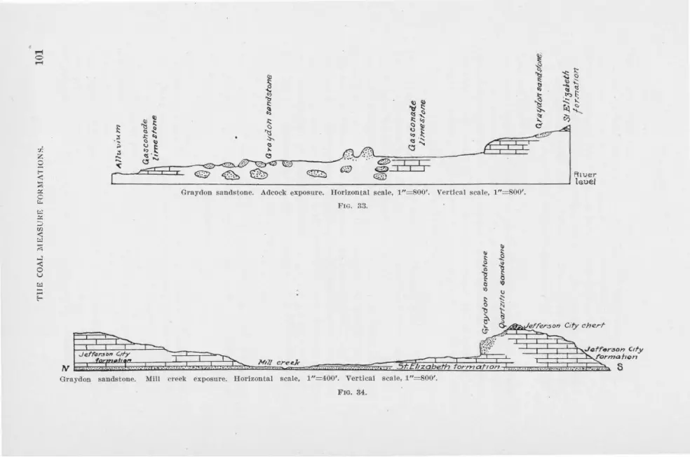
:r. z 0
...:: -t: 0 u t:l
Graydon sandstone. Adcock exposure. H orizontal scale, 1"=800'. Vet·tical scale, 1"=800'.
FIG. 33 .
Je.ff~r.$M C,fy
TV Nill cree.k
5t: Eltzabeth for!'Mafton
Grayclon sandstone. l\1!11 creek exposu re. Horizontal scale, 1"=400'. Vertical scale, 1"= 800'.
FIG. 34.
R1uer leuel
City chert-

102 GEOLOGY OF MILLER COUNTY.
on the south side. These shale pockets are also more numerous away from the river than they are near it. On the north side they are espe
, cially abundant in the "brakes" just south of the Osage-Moreau divide between the west side of sec. 4, T. 41 N., R. 15 W., and the Morgan county line. Here, in an area of approximately four square miles, nearly one-half of the shale areas are located.
All of these areas are small, the largest not having a ·diameter of more than 700 feet. The pockets are situated on the tops of hills, along the slopes and in valle)' bottoms, with no regard for the present topography.
TOPOGRAPHY.
The small size of the areas of Coal Measure shale, composed, as they are, of soft rocks, have very little effect, except locally, upon the topography.
THICKNESS.
The Coal Measure shale was only observed m places where it had been protected by the resistent dolomite of the Cambro-Ordovician formations. On account of this it was impossible to make a satisfactory determination of its thickness. The shaft of the Sight Me Prospect passed through r 50 feet of shale, the greatest thickness known in the county. There is no way of knowing how many feet deeper the shale extends or how many feet have been removed by erosion from the present surface of the deposit. Furthermore, faulting and flexing of the beds in these pockets have undoubtedly exaggerated their actual thickness. This shale may originally have been five hundred or more feet thick.
WEATHERING.
The weathered zone is usually less than six feet deep. In many cases weathering has extended less than a foot below the surface. Upon the exposure to the atmosphere the black shale changes to a rusty brown while the green becomes bleached. When badly decomposed, the shale is, in places. difficult to distinguish from the residual clays of the CambroOrdovician formations.
LITHOLOGICAL CHARACTERISTICS.
The Coal Measure shaie is extremely variable in compos1t1on and texture. In some places it is a pure shale, in other places a slightly argillaceous sandstone, and in others it is an extremely calcareous shale. The carbonaceous content varies greatly. In some places there is practically no carbonaceous material in the shale, while in other places the shale is sufficiently carbonaceous to burn readily.

THE COAL MEASURE FORMATIONS. 103
Cannel coal, which is a shale containing a very high percentage of carbonaceous material, was observed in five different localities in the county.
R. B. Snyder reports three feet of cannel coal at a depth of 19 feet in a well on the S. E. X of sec. 2 , T. 41 N ., R. 16 W. ( Sec. 19, Fig 35.)
11~11 ... . .. ·- - ·. -· -1' 5 3 ,. __ ---·
FIG. 35:
A similar coal seam is reported from the well at the school house in the center of sec. II , T. 41 N., R. 16 W. In the south center of the N. W. ;l'.4 of the N . E. }i of sec. 3. T. 41 N., R. 16 W., on land owned by Mr. J oseph Cotton, twelve to fourteen feet of cannel coal was passed through at a dept of 8 feet. ( Sec. 20, Fig. 36.) In the S. W. 74 of the N. W. 74 of sec. 3, T . 41 N., R. 16 W., cannel coal is exposed for mo feet along a small stream: In two prospect holes on the hill side north of this outcrop, the same grade of coal was encountered.
Cannel coal is exposed in the bed of a small stream in the center of the W. 0 of the S. W. 74 of sec. 2, T. 41 N., R. 16 W. (See Fig. 37.)
FIG. 36.
It is underlain by above 50 feet of shale. At this place there is exposed every gradation between typical shale and cannel coal. Nodules of iron pyrites with their long dimensions parallel to the bedding planes are common. A 40-foot shaft at this place is entirely in cannel coal with the exception of I ,% feet of carbonaceous sp.ale. Near the center of sec. JT , T . 41 N ., R. r6 W., cannel coal is reported to have been struck at a depth of 48 feet.
As a rule the nearer one approaches the contact with the underlying formation the more conglomeritic the shale becomes. The shale

Jer/'er.son C1(y f'orma!lon
Residuo.l Je(ferson c 1/y Cheri
<? ,:,o
, ~"' E
Section across a small stream in the S. W. 1,4 of sec. 2. ' I'. 41 N., R. 1G W. Ilot'izonlal scale, 1"=400'. Vertica l sca le, 1"=800'.
F1G. ;J7°.

THE COAL l\IEASURE. FORMATIONS. 105
which occurs in joints and small crevices in the Cambre-Ordovician rocks is almo t invariably conglomeritic and usually of a sandy type. The differentiation of the Saline Creek cave-conglomerate and the lower bed of the Coal Measure shale is often extremely difficult. The two grade
into each other.
STR CTURES.
Bedding.-Vsually the stratification planes of the Coal Measure shale are obliterated or obscured by slickensides, although in a number of instances, they were strongly developed. The shale which accompanies the cannel coal at J uliu Cotton's prospect in the center of the 'vV. ;.Ii of the S. W. 0 of sec. 2. T. 4I N., R. 16 \fl/., split parallel to the bedding :nto thin plate one-fourth to one inch thick.
Folding.-In ome places the shale beds have apparently been flexed or folded, as shown by the steep dips. However, unless the beds are unu ually well exposed, it is difficult to determine whether the e dips are due to folding, faulting or undermining by solution and ubsequent settlino-.
Fa1tlting.-Faulting with measurable throw was not observed. That most of the pockets have been subjected to stresses of some kind is shown by the complex slickensided surfaces o common in the shale. The brecciation and the scratched and poli hed surfaces of some of the limestone and sandstone boulders in the ' 'Little Nugget" mine is also evidence. ( ee Plate XIII.) The e boulders, which are mainly cotton rock, are more or· less subangular and arc cratched and ·grooved, in places, to a depth of an eighth of an inch. They bear a striking resemblance to the striated limestone of the glaciated region. The scratches have evidently resulted from the rubbing of the hard chert fragments against the soft cotton rock.
SINK-HOLE DEPOSITS.
The more or le s circular form of some of the shale deposits and their great depth in proportion to their areal extent has been referred to above. This combined with the disturbed condition of the beds of the Jefferson City and other formations in the vicinity has lead to the belief that these shale pockets are of sink-hole origin.
FO SILS.
Fo sils are common in the Coal Measure shale. Fossil wood, poorly preserved, was found in the Coal Measure shale in ec. 2, T. 41 N., R. 14 W., near the Loveall diggino-s. A fern impression was collected from shale in the X. ·w. :0 of the N. E. :4 of sec. 3, T. 41 N., R. 16 'vV., at the Joseph otton zinc prospect. .At McClure's zinc mine, beau ti-

106 GEOLOGY OF MILLER COUNTY.
fully preserved fossil nuts were found and presented to the Bureau by Dr. Thomas R. Thornton of Lees Summit. A petrified log is said to have been found in the "Little Nugget" mine. Fossil shells are common in the limestone at the Republic coal mine.
The fossils collected were submitted, through the Director of the United States Geological Survey, to Dr. G. H. Giety and Dr. David White for determination. Their report showed the following invertebrates and fossil plants in the collection. These species indicate the geological age to be rather early in the Coal Measures.
PLANTS.
Exogenous wood. Neuropteris rarinervis.
Plant fragments. Calamites sp. indet.
Trigonocarpon Dawesii :
ANIMALS.
Pleurotomaria sp. indet. Productus semireticulatus
( 4 specimens). Productus cora ( 2 specimens). Spirifer cameratus (3 specimens). Spirifer sp. Spirifer rockymontanus.
Seminula subtilita (3 specimens). Chonetes flemingi. Pleurotomaria sp. · Derbya crassa. Marginifera wabashensis
( 3 specimens.) Fusulina sylindrica.
ECONOMIC CONSIDERATIONS.
Both cannel and bituminous coal are associated with the Coal Measure shale. Where the shale is pure and sufficiently abundant, it constitutes a valuable material for the manufacture of brick. Gypsum and barite occur in the shale, but neither is present in commercial quantities. lron pyrites occurs abundantly throughout the shale, although never in commercial · quantities. Zinc blende and galena are widely distributed through the formation.
RELATIONS TO OTHER FORMATIONS.
The Coal Measure shale is underlain by the Saline Creek cave-conglomerate, the l!pper Burlington limestone, Jefferson City and St. Elizabeth formations and the Gasconade limestone. It lies conformably upon the Saline Creek cave-conglomerat~ and unconformably upon the other
formations.
TYPICAL EXPOSURES.
The Little Nugget Mine.-The type locality of the Coal Measure shale in this county is in the S. E. 0 of the N. W. Yi of sec. 15, T. 41

Mrssounr D nnF.AU 01' GEOLOGY AND MINES. VOL. I.. SERIES 2, PLATl!l XIII.
1.
1. SHALE SHOWING SL!CKEN SIDES. 2. BOULDER OF FAUL'l'ED LIMESTONE SHOWING PLANNING AND SCRATCHING.


THE COAL MEASURE FORMATIONS. 107
N., R. 13 vV., one-fourth of a ri1ile east of Mary's Home. The shale is not exposed at the surface and the knowledge of the formation has been obtained entir,ely from the shafts and dumps of the Little Nugget mine.
The shaft, which is farthest south, shows that the shale deposit is enclosed, in part at least, by Upper Burlington limestone. As nearly as can be estimated, this shale covers an area of two acres and is at least 135 feet deep. From comparisons with similar deposits elsewhere there is no hesitancy in saying that this deposit fills a pre-Coal Measure sink hole.
At the bottom of the main shaft there is a greenish gray, fine grained shale, containing variable percentages of calcium carbonate and quartz sand. Many boulders and pebbles of St. Elizabeth sandstone, banded and oolitic chert and dolomite, Jefferson City dolomite and cotton rock, and Upper Burlington limestone and chert are embedded in this shale. The boulders, some of which are five feet in diameter, are mostly angular, although some are well rounded. The small pebbles an_ all smooth and apparently water worn_ Charcoal-like vegetable matter is widely and abundantly disseminated through the shale. In the shaft at a depth of between 8o and 90 feet, it is reported that a log was found which extended across one corner of the shaft.
The shale is broken into small roundish, polygonal or lense shaped masses which are slickensided on nearly every surface. The shale wraps itself very closely around the boulders and usually shows considerable movement. The chert and dolomite boulders are usually slickensided. A trail of small angular fragments extends away from some of the sandstone boulders, apparently a result of drag.
Calcite, barite, galena and blende occur in the dolomite, chert, shale and sandstone.
Sight Me Prospect.-The Coal Measure pocket upon which the Sight Me Prospect is situated, is located on a branch of the South Moreau 300
yards north of the· center of sec. 6, T. 41 N., R. 15 W. This pocket covers an area of approximately two acres and is at least 156 feet thick. The shaft, which is 156 feet deep, is reported to have passed through the beds shown in the accompanying section.
Section 21. No. Depth. 1 0-8 8 feet, soil. 2 8-70 62 feet, carbonaceous shale. 3 70-156 86 feet, "boulder formation .·•
From an examination of specimens on the ·dump it is evident that both the shale and boulder formation belong to the Coal Measure formation·s. Scattered here and there in the dark shale are small lenses of white clay and chert. Some of the lenses have been elongated and fis-
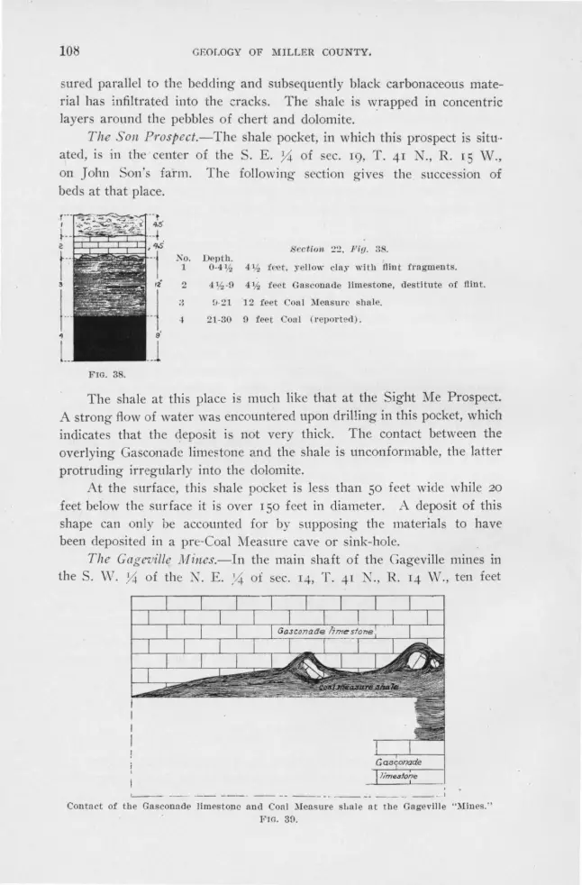
108 GEOLOGY OF MILLER COUNTY.
sured parallel to the bedding and subsequently black carbonaceous material has infiltrated into the cracks. The shale is wrapped in concentric layers around the pebbles of chert and dolomite.
The Son Prospect.-Thc shale pocket, in which this prospect is sittt·· ated, is in the center of the . E . ;4 of sec. 19, T. 41 N., R. 15 W., on John Son's farm. The following section gives the succession of beds at that place.
FIG. 38.
Ko. 1
2
..
Section. 2:! . Piy. 3 . Depth.
0-41h 411:, fret, ~-ello\\- clay with tlint fragments.
4 V:,-0 4¥:, feet Gasconade limestone, destitute of flint.
:.,.21 12 feet Coal )leasurC' shale.
21-30 0 feet Con! ( r eported) .
The shale at this place is much like that at the Sight Me Prospect. A strong flow of water was encountered upon drilling in this pocket, which indicates that the deposit is not very thick. The contact between the overlying Gasconade lirne~tone and the shale is unconformable, the latter protruding irregularly into the dolomite.
At the surface, this shale pocket is less than 50 feet wide while 20
feet below the surface it is over I 50 feet in diameter. A deposit of this shape can only be accounted for by supposing the materials to have been deposited in a pre-Coal Measure cave or sink-hole.
The Gagl!'"uille J11ines.-ln the main shaft of the Gageville mines in 1.he S. \V. Y-i of the K. E . . '4 of sec. 14, T. 41 ' ., R . 14 W., ten feet
, __ _ -- -- ----- --- -· ---- ---· I
Contnct of the Gasconade limes tone and Con! )Iens ure sbul e at the Gagevi ll e "Mines.'' FIG. 30.

TILE COAL :\LEASURE FORMATIONS. 109
of Coal Measure hale was pa$ ed through at a depth of 52 feet. Two feet of shale wa·s again encountered in a prospect hole 125 feet, S. 25° Vv. of the main shaft. In the bottom of the gulch, southwest of the main shaft, Coal Measure shale \\"aS again encountered in the prospect hole.
The contact of the shale and Gasconade limestone, although in a general way parallel to the bedding planes of the dolomite, is very irreguiar. This is especially \\·ell shown in the drift connecting the air shaft ,Yith the main haft. Fio-ure 39 shows the relation of the shale to the overlying formation.
The shale in the mai n shaft is intensely slicken icled. Some of the dolomite near the shale is considerably brecciated, while it is all greatly lecornposed. Above the shale unusually rich ore wa found (see page
171). The shale in the drift and at the first prospect apparently fills the
gallery of a cavern, alternately thinning ai1d thickening. Whether or not the shale in the 0'1.Jlch was at one time connected with that in the hill it i impossible to say.
The Republic Coal Jline (abando11ed) .-The R 1 ublic coal mine, formerly kno\\'n as the Barnard Coal Bank, i located in the N. vV. Y~ of lhe . E . . Y-i of sec. 7, T. 41 N., R. 15 W. The shale pocket in \\'hich thi. mine is locatccl occupies a basin in the Jefferson City formation and has dimension of approximately 200 feet north and south and 250 feet east and west.
t this mine the succession of the Coal Uea urc shale from top c!O\yn i as follows :

llO
6
l 7·r s L
{0·/1 ~-le 1'{.:.
I
/4
L
t 9l
---jj
Repubhc C0<1! Mme.
FIG. 40.
.. I -·1 s)'i -L 21
~+
=+ 7 '
'GEOLOGY OF Yl:ILLER COUNTY.
No. 1
2 3
4
5
6
7
s !)
10 11 12 13
14
Elev. 0-4
4-4;~ 41.4-51,4
(i',4-7%
7%-17¥.,
S ection 23, Fig. 40.
4 feet varionsly colored chert having fractme. Decomposed In places. one foot is especially fossiliferous, brachiopods predominating.
1h-3 inches yellow calcareous shale.
a conchoidal The lowest
crinoids and
1 foot limestone; yellowish when weathered, dark gray when fresh ; rather fine grained and contains a few coarse calcite crystals. A few brachiopods were observed.
2¥., feet finely fissile shale, yellow to black when fresh. Very calcareous and contains very little sand. Small nodules of limonite, the a lteration product of iron pyrites, are common.
911, feet argillaceous limestone. The lower foot and n half is virtually a calcareous shale. This becomes increasingly carbonaceous with depth, grading into the coal below. A well rounded boulder two feet long and one and a half feet thick composed of a blackish gray limestone closely resembling No. 3, was found embedded in these shales. Fossils are abundant In this member. Small pieces of a charcoal-like substance are scattered irregularly through the limestone, especiall y near the base.
17~-24'h 7 feet 3 inches bituminous coal. Rather soft and very light. Three feet six inches from the bottom of the coal is a shaley parting, varying from s ix inches to one foot two inches in thickness. There are numerous other smaller pyritiferous shale lenses, two to three feet long and one to two inches thick throughout the cofl.l seam. The shale ls considerably slickensided. The coal is closely jointed. Occasional thin sheets of zinc blende occur parallel to t he long diameter of the shale lenses. Thin films of gypsum occur abundan t ly along the jointing planes.
24'h -24 % 2 inches very carbonaceous shale, rather sandy in places. ·
24%-25 4 inches bituminous coal. ~5-301,1., 5'h feet arenaceous . carbonaceous shale. In places
this shale encloses lenses of sand about four feet long and two inches thick. Well rounded boulders, from 3 to 6 inches in 'diameter, are of frequent occurrence. Some of the larger slickensided surfaces shine under a lamp like huge mir-
301,1.,-321/, 321,:..33
33-36 3G-37%
3711,-45
rors . Others are complex and wavy. 2 feet bituminous coal and shale lenses.
6 inches shale like No. 9. 3 feet bituminous coal. 1% feet shale lnterbedded with layers of impure,
bituminous coal. Lenses of coal are also abundant.
7 feet Intensely sllckensided shale.
A section made 30 feet west of the above shows very much less coal. The coal is replaced horizontally by shale. ( Figs. I and 2, Plate XIV. are sections across this mine.)

M1sso c;n1 BUREAU OF GEOLOGY A:-.o )Ir:-.Es. YOL. I., SERIES 2, !'LATE XI 1·.
N78°c S 78 'VV.
CROSS SECTIONS REPUBLI C COAL :\IINE.


THE COAL MEASURE FORMATIONS. 111
The M cCliwe Prospect.-The shale pocket in which the McClure prospect is situated, it at the head of a cirque-shaped valley in the S. E. Y-i of the S. W. Y-4 of sec. 12, T. 41 N., R. 16 W.
This pocket of shale lies in the Jefferson City formation. ( See Fig. 41.) Horizontal beds of dolomite of the Jefferson City formation are exposed 125 feet northeast of the shaft in the steam bed 125 feet N. 20° E., and 175 feet S. 20° W. The valley slopes on either side are so steep that it is scarcely probable that shale underlies them. The de
posit at this place is a cylinderical mass of Coal Measure rocks, less
than 275 feet in diameter and about 130 feet thick. Tpis shale was
undoubtedly deposited in a sink-bole.
N.W
Co..l Cool
,., ,,.. Cross section of McClure prospect. Horizontal scale, 1"=200'.
FIG. 41.
The following is a columnar section showing the succession of beds from top to bottom :
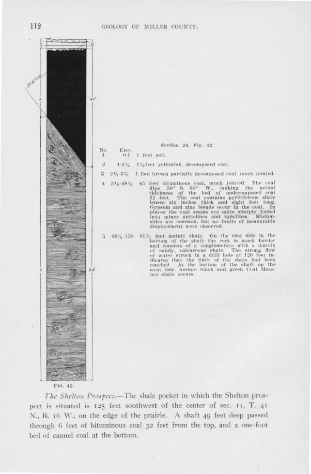
112
FIG. 42.
GWLOGY OF MILLER COUNTY.
No. ]
2
3
4
Elc ,·. 0-1
1 -2 \/..,
Srrtion :!~. 1-'iy. ~:!.
J foot so il.
l \/.., f eet ~·e l I owl sh . dPc:ompoiS<'cl roa I.
J foot brown partially cl ecompoficd con l . 111u ·h jointed.
4::i f eet bituminous coa l. much j oiutcd . Tlw coal dips 50 ° K G0° W., making t he actual thickness of t he bed or undecom pos d coai 32 f eet. '.rhe coo l ontalns pyl'itlferous shale len ses six inches thi ck and eight feet long. Gnisum and zinc bl encle occur ln the coal. In place· t he coa l seams ul'e quite sharply f lded inlo minOl' nntl clines and synclines. Sllcken sides are common. hut no faults of mea. umble cli sp lacemen t wel'e obsen ·ecl.
~11 ( , feet mninlY slrnl c. On thr ea:t side In the ·hoi-tom or the shaft t he rock i s much hnrder n1tcl consists of a conglom~ralP wllh n matrix or .·a nd)·. cal ca l'eous shal e. The str ong- flow of watPr stn,ck in a dril l hole nt 12(i feel incli catefi that the limit or the hal e had lleen reach cl At thP hotlom of t he shn ft on the w est siclP. normnl hind, nncl ,rreen C'o,11 )[ens-ure slu1le oecll1'$.. ·
T he Sh e//011 Prospecr.-Th shale p cket in which the helton pros! ect is si tuated is J25 feet southwest of the center of ec. II , T . 41
N .. R. 16 W ., on the edge of the prairie. A shaft 49 feet deep pa ed through G feet of bituminous coal 32 feet from the top, and a one-foot bed of cannel coal at the bottom.

THE COAL MEASURE FOR:l[ATIOKS. 113
An interesting modification 0£ the coal is found 111 the S. vV. 0 of the S. E. Y-i of the S. E. !1 of section 3. T. 41 N., R. r6 W., on Mr. Shelton's land. At this place a small trench in a gully exposes a bank of coke. Not only has the coal been coked, but the shale associated \\·:th it is also baked to a reel and purple cinder-like mass. Pieces of the shale are incipiently fused. On ::di sides dolomite beds of the Jefferson City formation surround the pocket, which is about 200 feet in diameter.
The coal was doubtless ignited by forest fires or possibly by spontaneous combustion, and, clue to natural conditions, was coked. Ko record could be found that the coal had ever been on fire. The coking may have occurred prior to the settlement of this county by the white man.
In April, 1897, the forest in the vicinity of McClure's coal bank was burned over. The coal in the bank caught fire and burned until September. \i\Then the fire was extinguished a portion of the coal was found to have been coked.
The Knowall Prospect.-ln the S. W. ;4 of the S. E. 1 -i of sec. 31,
FIG. 43. G-8

114 r~EOLOGY OF MILLER COUNTY.
T. 42 N., R. 15 'vV., Mr. H. M. Knowall s1111k a shaft 85 feet deep, the upper 35 feet of which was in coal, and the remainder in shale (see Fig. 43). Zinc blende occurs in the shale. A shaft 100 feet south of this
one passed through an unrecorded thickness of coal, which is said to have been horizontally bedded. To determine the extent of the deposit,
four drill holes were put down, one .situated 250 feet N. 40° " ' ·, another 400 feet N. 65° E; still another 400 feet S. 6o 0 E., and the last 300 feet S. 25° W., from the main shaft. Coal was not found in any of them.
The Scott Shaft.-A prospect shaft, put down on the farm of Messrs.
B. A. and E. A. Scott in the S. E. % of S. E . Yi of sec. r I. T. 42 N., R. 15 W. , passed through IO to 12 inches of bituminous coal at a depth of 26 feet.
It is reported that four feet of coal was discovered in a drill hole :200 feet southwest of this shaft.
The Spa11ldi11g Prospect.-In the S. E. Y-i of sec. 2, T. 41 N., R. 14 'vV:, in a dry branch, there is a shale pocket in which Mr. Edward Spaulding sunk a shaft. The following beds were passed through:
Section 25. No. Ele,•. 1 0-5 5 feet pytitlferous shale with more or less coal in
small lenses. 2 5-22 Ji feet bituminous coal ancl shale lnterlaminated-
about half coal ancl half shale. A 2 foot ,eln of coal, carrying blende and pyrite, was encountered.
Southeast of the center of sec. 2, T. 4 T X., R. 14 \V .. on the St. Elizabeth formation is a small Coal Measure shaJ.e pocket in which a
few inches of coal were found at a depth of 15 feet. The Garner Well Sectio11.-In 1875 Mr. T. B. Garner, of Iberia,
struck a thin seam of coal in a well at a depth of 23 feet, and at 53 feet the drill passed through a 6I1 foot seam. Yellow clay is reported both above and below the coal. Some iron pyrites and gysum were found. The coal is a bright, very oily-looking, bituminous coal. An analysis
gave:*
Moisture expelled at 218 degrees F ................ - . . . . . . . I. 324 Volatile matter at reel heat. ....... ...... .... ....... ....... 25.784 Fixed carbon ........................................ · . · · , 52,445 .Ash . . . . . . . . . . . .. .. .... .. .... ... . ... ...... .... ...... ·. - · 20.447
Sulphur in ash .......................................... . Total coke ........... ... .......... ... .... _ .............. . Color of ash, grayish pink.
I00 .00 5.810
72.912
•We are Indebted to 1111-. Garner for this analysis. Analyst Prof. Chas. P. Williams, Missouri School of Mines. Analysis performed In 1873.
TI-JE COAL MEASUR J:; l'ORl\f1\TlONS. 115
11Iisrclla 11 co 11 s Outcrops.-In the south center of sec. I 1, T. 38 I .,
R . q \\i ., on a creek bank are fo ur pits, snnk twenty-five years ago, from which coal was obtained. Tn the creek bed a thin seam of coal, dippino- r5 ° S., 45° E., outcrops.
Meek* states that coal occttrs in the \ V. 0 of lot I, N . E. of sec. 4, T. 39 N., R. I~ VI. At this place on :-fr. \~Tait"s Janel , on the top of a high ri dge. are several small pits now almost entirely fill ed. O n the dump are bi ts 0f very black, carb naceous shale or impure cannel coal. The pocket is I 50 feet long . 50 feet wide, bein~ enclosed by dolomite beds of the J efferson City formation.
TilE UNDIFFEilENTJA'L'ED JEFFEHSO:"i CITY FOlD[A'l'IO::S: COAL 1IEASUR8 SIT.ALE AREA.
This area lies in the west center of the county along the junction of the prairie land an I the "brakes." It is a country of rounded hills and valleys. which, compared to those of the southern portion of the "brakes," are low and gently sloping. Along the streams are exposures of the Jefferson City formation and Coal Measure shale. All but the stream beds and some few "ball " are covered with Aint fragments. Many of these are of oolitic chert from the J efferson City formation, others are from the cherts above the coa l. while still oth ers are the well rounded cherts so characteristic of the Coal Measure shale.
\ ,V hile 99 per cent. of the area is underlain by the J efferson City formation. there are certainly concealed pockets of Coal Measure shale, and fo r this reason, the area has been mapped separately. In going over the area. it is utterly impossible to tell whether J efferson City or Coal Measur rocks underly the surface.
'1'118 DEPOSI T I ON OF Tlrn COAL )JEA SUHE noCKS .
. -\fter th Upper Burlington limestone had been laid down 1'he land was elevated above the ·ca. That thi s elevation was considerable is shown by the fact that solution and mechanical erosion produced sink-holes, the bottom of which are at least 25 feet below the present water Jeni. The fact that solution, except under unusual circumstances, is not active below the level of ground water, leads one to conclude that these sink-holes were formed when the rocks were in the belt of weathering. t
Coincident with the elevation of the land above the sea, valleys were carved and sink-holes formed. The importance of solution in shaping
•neport on the Geol. Sur. of the State of !IIissouri, JSli:i-1871, p. 118. tYnn Ill ·e. "Rome principles controll ing deposition o[ Ores:· Gen esis of ore '.l ··posits.
Am. Inst. of ]\Jin. Eng., p. B'.!7.

116 GEOLOGY OF l\JJLLER COUNTY.
the pre-Coal :\Ieasure topography ,rn. doubtle s much g reater than at present. The surface rock \Yas the pure Upper Burlington limestone upon \\·hich solution 11111st have acted with unusua! rapidity. At the present day, the country t.nderlain by Upper Burlington limestone is characterized by numerous caves and sink-holes. Greene county, Missouri, is a striking example::, ·. inks \\·ere formed in the various underlying members of the Cambra-Ordovician series, as well as in the Upper Burlington limestone. That the dolomites of the Cambra-Ordovician series are in a measure favorable to the formation of sinks is shown by the sink-hoks, which occur in them to-day. Some, perhaps many, sinkholes were formed in the dolomites after the Upper Burlington limestone had been locally removed . During the formation of these sinks Yarous sized boulders fell from the overhanging sides. These boulders with the sand and clay \\·ashed in from the surface and limestone deposited by the cave waters formed the a!ine creek cave-conglomerate. ·while many of the Saline creek cave-conglomerate deposits are older than those of the oal :\[casure shale. it is probable that others arc contemporaneouc:c.
That this erosion interval was of considerable duration is shown by the removal of the greater part of the Upper Burlington limestone, and by the character of the Upper Burlington chert boulders which occur in the Graydon andstone and Coal l\feasure shale. These chert boulders show that the metamorphism of the limestone to chert occurred prior to the deposition of the Coal Measure strata.
Following the erosion interval the land was depressed until finall:v the Ozark region, with the possible exception of the St Francois Mountains, ·were either a coastal plain or below sea level. Miller county seems to have been on the coast, being alternately above and below the sea. It was a period of slow and at times intermittent depression and elevation. At this time it is inferred that almost, if not quite, all of Miller count:v was submerged. Loose material which lay in the immediate vicinity of the sinks was washed into them, forming the cave-conglomerate above mentioned. The boulders are noticeable local in their origin and too large to be handled by any but the strongest streams, demanding a declivity which the inferred pre-Coal Measure topography was insufficient to afford. Moreover, the softness of the cotton rock of the Jefferson City formation and the lime tone of the lipper Burlington formation precludes the possibility of transportation for any considerable distance.
It seems generally true that the more arenaceous shales are located either on the St. Elizabeth formation or upon arenaceous beds of the Jefferson City formation. The composition of the shale of various pockets
•E. hl. Shepard, 1Io. Geo!. Sur .. l OS, Yo!. XII, port I, p. 33.

TllE CO.\L .HFASURE FORM.'\T!OKS . 117
..:orresponds in a general ,my with the composition of the present residual soil of these formations.
The carbonaceous material in the shale was probably partially in the soil, although the larger part seems to have been washed in from the neighboring hillsides. In places the shale contains such a high percentage of vegetable matter that it forms cannel coal.
The immense amount 0£ vegetable matter required to make the thick beds of coal can be best appreciated when it is understood that one foot of coal is calculated to represent IS feet of peat. In other words the 32 feet of coal at McClure's mine represents a peat deposit of 480 feet. ·
That the conditions of deposition were very local is indicated by the fact that pockets but a few miles apart apparently have an entirely different succession of beds.
In places the region seems to have been beneath the sea, and the streams from the land to the south and southeast brought in immense quantities of sand which was later consolidated forming the Graydon san cl stone.
The pre-Coal Mea~ure drainage must have been practically the same .:,s it is to-clay, else there \YOuld be more exposures 0£ Graydon sandstone in the elevated parts of the county. The sandstone is taken into rnlution very slowly by circulating waters and. when protected from corrosion by the surrounding dolomite, it is very persistent. This is evidence that the old stream-channels were deeper that those ·of the present day, even in the vicinity of the Osage river.
Both sandstone and shale occur on almost the highest elevations in Miller county, and there is no doubt but that at the close of this period the entire county was overlain with shale and sandstone, which in some places must have been at least 500 feet thick. That a continuous sheet of coal at one time covered this county seems improbable.
The Saline creek cave-conglomerate is in a general way the oldest Coal Measure rock, the hale itseif next, and the sandstone the youngest. However there are many exceptions to this rule. It may very well be that the sandstone belongs to two, three or more separate depressions of the land, and that the hale and sandstone were being deposited at the same time in different parts of the county. That the sea in which the sandstone was laid <lmn1 was shallow is proved by the cross bedding and sun cracks.
The Graydon sandstone of ::\Iiller county occupies channel-like depressions \I hich ..:an bc!it be explained by erosion. Both shale and sandstone occur in the joints and crevices of the Cambra-Ordovician rocks.
Since these indi ations of low "·ater deposition occur at the very base of the Graydon sandstone as exposed in Miller county, we must conclude

118 GI': LOCY OF MILLER COUNTY .
that the depression was gradual and that shaliowing through deposition kept pace ,Yith depression. The first sandstone beds were doubtless deposited in estuaries which by continued depression widened until the whole county was submer~ed .
In speaking of the Coal Measure coal deposits Swallow* states " these abnormal deposits are found in ravines and cavities of denunciation in the rocks of all ages from the Archimedes limestone clown to the Calciferous sandrock." )J eek':":' states that those of l\Ioniteau countv ( the adjoining county on the north) are clue to the filling of depressions in the older rocks and also to the slipping of masses of Coal Measure rocks from the surrounding hill tops. ·winslow':"''* suggests ravines and sink-holes as the places of deposition.
All the more striking coal and shale deposits seem to occu r in basinlike depressions. These vary in shape from the comparatively gently sloping Republic Coal Company deposit to the deep straight sided Knowall pocket. The sink-hole hape of these deposits might be clue either to the deposition of the hale ir: sink-holes of pre-Coal Measure age, or to the dropping clown of the shale into sink-holes of later origin. W e believe the fo rmer supposition to be the true one, since the shale, although considerably slicken-sidecl, does not apear to be as greatly disturbed as would be expected if it had reached it present position in the latter way. l\Iorcover sink-holes J 50 feet deep do not occur among those of the present cycle. In some cases, at least, the shale was deposited in preCoal J\feasure caves and sink . T his is true in the case of the shale in the Gageville Mine.
These shale and coal pockets have been some\',hat folded and much slickensided by the readj u trnent resulting from stresses. The sinking of the mass of peat as it changed to coal must have been an important factor in producing slickensicl <"s and minor faults.
The present position of the Coal :i[easure strata is determined by the pre-Coal Measure topography and by the post-Coal i\Ieasure erosion. The durability of the enclosi ng Carnbro-O rclovician dolomite has protected the formation, pre,·enting its complete removal.
Since its deposition, the sandstone has been cemented by silica and iron. Differential movements have jointed it intimately, and in places has produced slickensides. The coal and hale have been jointed, and in these open joints galena and blencle haYe been deposited. U nderground waters have also deposited in the shale ".dice lead'' and "strawberry jack." ( See page r 8 I.)
*First. nnd second annunl reports of the <:eol. i"ur. ot' ) Io .. is;;;; , p. !lO. G. C'. Swallow. State Geo logist.
**Ibid , p. 11:!. Heport ou )l ouiteau county. •• •rre!i rninar~- report on co:11, JS!.ll. Geo!. Sm., p. 38.

]\[£SOZ0IC, CEXOZOIC AND QO.-\TERKARY. 119
CHAPTER X.
:-IESOZOIC, CE~OZOlC AN D QUATERNARY.
Deposits of Mesozoic or Tertiary age have not been recognized in l\Iilicr county. It is not altogether improbable that Cretaceous sediments were at one time present in i\1iller county, but all traces of them have been removed.
PLEISTOCENE.
Glacial Age.-In the hilly and upland country there is no evidence of glaciation. The Kansan, the oldest Glacial epoch recognized in this country, is the one during which the ice reached its maximum southern limit in Missour_i. James E. Todd* states that "Probably the ice sheet during the Kansan epoch may have extended as for south as Clinton, Carroll and Randolph counties."
Glacial boulders were found at eight localities in the bottom land of the Osage river and its tributaries, and three other erratics, preserved in private collections, were examined. In the N. E. :4 of sec. 6, T . 41 N. , R. 12 vV., in a wagon road, is a granite boulder one foot long and six inches thick. Two hundred feet away from this are three other granite boulders, averaging two and a half feet long, two feet wide and one and a half feet thick. One-fourth of a mile west of these, another slightly larger boulder occurs in the alluvium. Mr. Joseph Hoecker, the owner 0f the land. states that other g ranite boulders occur in this vicinity, but at the time o{ our visit they were covered with soil. All of these boulders are in the bottom land and from 20 to 30 feet above the low :water level of the Osage river.
In Judge J. C. LL!rton's orchard in the S. W. 34 of sec. 29, T . 41 N., R. 13 vV., in the bottom land of the Osage river, and 30 feet above !ow water, is a boulder of granite. measuring 3x3x2 feet. At the same elevation above the river, at King's Bluff, one-eighth of a mile west of this place, two other smal1 granite boulders were observed.
In the E. 0 of the S. E. Y-i of sec. I, T. 40 K, R. I4 W., are manerous small granite boulder~ strewn over the fields and along the edge of the bluff bordering the bottom land of Dog creek. ( See Plate No.
•Formation of the Quaternary Deposits. Mo. Geo!. Sur., Vol. X, 189G. Chas R.
Keyes , State Geologist, p. '.?13.

120 GEOLOGY OF :.\IILLER COUNTY.
II, Fio-urc 2·) These are al least (,o fret above lhc low water level of
the Osage river. On \Yi;liam , \. I',arron·s land in the S . E. )~ of the S . \\·. )'~ of
sec. 20, T. 40 ?\ ., R. 14 \ , . . , a large granite boulder four feet in diameter lies on the river bank. :.\Ir. Barron stated that another rock exactly like
this ,yas formerly expo c·l, b11t h~td rec ntly been covered by riYer silt.
The e boulders are 25 feet above low water level. On John \\'eitz's farm, on a tributary of Shut-in branch in the middle
of the · W. Y-i of the X. \\". }~ of sec. 10 T. 40 K., R. 14 W., a considerable number of granite bot:!ders have been found. Several cart
loads have been removed, and new ones arc unearthed in ploughing each
year. i\Io t of these are small, although one measured 2;/ix3Y-(xr0 feet. They are abolit 50 feet above low water level of the Osage river.
Just east of the ford on Saline creek, in the . E. 1.,".'.i of sec. 25, T.
41 X., R. 14 \\' .. a boukler of granite containing epidote was found in
the Osage river bottom, about 25 feet above low water level.
In the S. W. 5:; of ec. 19, T. 41 ;-l., R. 13 Vi., in a field just south of the :dary's I-Jome-Tuscumbia road, .:. red granite boulder \\"as discovered in ploughing a field in the Jim II enry creek bottoms. In the
,vest edge of the N . E . . % of the S· vV. J4 of the same section, another granite boulder ,..-as found. These are well polished on one side, as if
by o-lacial action. The\" are situaterl 75 feet above the low water mark
of the Osage rivr-r. Mr. John Buster owns a granite boulder which he says came from
the~- E. Y-i of sec. 2. T. 40 N., R. r.+ \V st. It was found at the edge
of the bluff 40 feet above the river. :.\fr. Samuel La"·son possessec; a smail pebble of diorite which he foun~l in the bed of Saline creek in the X. E . Y-i of sec. 26. T. 41 -., R. 14 W. Mr. H. M. Compton has a granite boulder, which he states came from the Saline creek bottom :n the S. W . . ~~ of the S. E. _14 of sec. 23, T. 41 N., R. 14 W.
These boulders are subangular and arc in some instances polished on one side. No glacial striae were noted.
That these granite boulder a re not deri,·ecl from dykes in the country
rock is sho,rn by their granite texture, the schistose character of some
of them and the unmetamorphisecl condition of the dolomites surrounding the localities at which they occur. The lack of granite outcrops and the
presence of the boulders only along the Osage river and its tributaries indicate that they are foreign.
~leek* writing in the fifties concerninO" a granite boulder found in
*Reports on the Geol. Rur. of the Stnte of )!lssolll'i, 1855-71, Jefl'erson Cit.,·. 1873, page 137.

:.UESOZOIC, CENOZOIC AND QUATERNARY. 121
the valley of the Big Gravois in Morgan, the adjoining county on the west, states "that it was most probably transported here by floating ice from some locality far north of thi during the glacial period."
James E. Todd* believes that, previous to the Kansan epoch of the Glacial age, the Osage river may have flowed much farther northest than at present "by way of the valley of the Auxvasse or Big Muddy to the valley of Salt river and northeast passing somewhere near Qunicy." If such be the case, and the southern extension of the ice sheet were in Clinton, Carrol and Randolph counties, a damming back of the Osage river would be a certainty. If, on the Qther hand, the Osage river flowed as it now does and the a sumed extension of the ice be correct, the damming back of the O age river must have been clue to the immense floods of water derived from the melting ice sheet.
The occurrence of several boulders at almost every locality noted, indicates that they were probably transpoi-tecl on icebergs. When the icebergs melted the boulders sank and became embedded in the river allnvium.
The approximate Jeyels abo\'e the sea at which the ob ervecl boulders occur, is as follows:
LOCALITY. ELEVATION.
N. W. IA, of the N. El. IA, of sec. 6, T. 41 N., R. 12 W., and vicinity ..... .. .. .... ..... 535-545 King's bluff ....... ..... ........... . . .......... .... . .............................................. 550 Ford of Saline creek ...............................................................•. ... ......... 550 Judge Lurton·s .....................•....................................................•....... 555 Barron's ......................................................... .. ......•...............•........ 560 Dog creel, ..... . .... .... .. ............................ ................. ........ •... ............... . 590 Weitz"s ............................................................ •................... ... ......... 580 Section 19, township 41 north, range 13 west ............ : ....................... . ........... 605
The last eleYation indicates that during or at the close of the first Glacial epoch the river at Tuscumbia was at least 75 feet higher than at present. This rise would affect the Osage river at least as far west as Benton county.
The presence of these boulders along the Osage river and its tributaries, and their absence from the surrounding hill country, ir.dicates that the Osage river and its tributaries prior to the first Glacial epoch occupied practically their present channels.
RECl'JN'l'.
ALLUVIAL DEPOSITS OF THE OSAGE AND MOREAU RIVERS AND THEIR TRIBU
TARIES.
During the later part of the Glacial period the streams sunk their channels to a considerably greater depth than they are at the present
•Reports of the :.Ulssouri Geo!. Sur., Vol. X, 1890, p. 213.

122 GEOLOt~Y OF Ml U.ER COUNTY.
time. Since then they have been e1wagecl in refilling these channels and again cutting them out.
The alluvial deposit in 1Iiller county are confined to the Osage and Moreau rivers and the lower reaches of their tributaries. However, d1.1ring high water, patches of alluvium are laid clown even near the heads of some of the tributaries of these streams. The character of the alluvial deposits changes greatly from place to place. Close to the banks of the Osage river the clay content is high and the alluvium is a fine grained, yellowish, clayey loam, in which occur lenses of sand. Farther away from the stream, where deposits are made only in times of high water, the alluvium is a dark loam with a high percentage of vegetable matter. In the oxbows the organic content of the soil is much higher.
The beds of the Osaae and the l\loreau rivers are composed of flint pebbles, mainly angular but occasionally well rounded. In places these are cemented into a conglomerate. A striking example of this is seen on the west edge of sec. 2r, T. 40 N .. R. 12 Vv., where iron oxide
seeps from the bank of the Osao·e river and cements the gravel, forming
a conglomerate.
TRAVERTINE.
Travertine is very common along the bluffs of the Osage river. It is confined largely to the broken hert horizons through which the seep
age of water is greate t. In the various caves stalactites, stalagmites and incrustations are common.
PO IL REMAINS.
F ossils in the Pleistocene or R ecent rocks are rare. Near the middle
of the N. W . . 0 of sec. 13, T. 39 N., R. 14 W., a :Mr. Sidwell exhumed some bones, reported to be of immense size. They were found in a marshy area surrounding a spring. Although the bones were not seen, we judge from the description that they doubtless belonged to a mastodon.
(See section 26, Figure 44, which is a generalized section of all the formations in ::vriller county.)

Pleistocene ~ - .....-;:~-:--:-::-;::-:i_-J~
Soil nncl gi·a ,·el
Carboniferous
Undifferentiated
Cambro-OrdoYici an.
Cambrian
FlG. -!--l. Genern I izecl
,so· Con! Measm·e shale
,s o· Grnyclon s·a nclstone
Saline Creek Cave Conglomern te
Upper BUL'lington limestone
Pacific sandstone
~od J eil'e l'son City formation
160· St. Elizabeth formation
~50 Gasconade limestone
r 57'
... I section of
Gunter sandstone
Pl'OCtor limestone .
a Ii fol'mn tions.

124 GEOLOGY OF )llLLER COUNTY.
CHAPTER XI.
STRUCTURE.
FOLDING AND FLEXURING.
In nr.1· fe,Y places in Miller county ar~ the strata sufficiently bent to warrant one in speaking of them as being folded. The gentle undulations, which are common in most parts of the county, may be more correctly spoken of as flexures. Both the folds and flexures are frequently complex, having superimposed upon them other folds and flexures of the second and third order.
The axes 0£ the folds of the higher orders usually strike and dip in different directions and at different angles from those of the primary folds and B.exures. This cross folding developes what are known as canoe shaped basins and domes.
All of the Iara-er folds or flexures in Milier county are unsymmetrical, one limb being shorter and steeper than the other. A number of observations were made on the dip and strike of the limbs of the various shorter and steeper limbs with reference to one another. In some in&tances this limb was on the west and in others it was on the east side of fllexures and folds but no uniformity was found in the position of the a north and south fold, and similarly in regard to east and west folds.
The general dip of the strata over large areas is, as a rule, too slight to be recorded by a clinometer compass, on account of which the determination of the position and extent of most of the larger synclines and anticlinfis were necessarily made by determining the elevation of the contacts of the various formations . The majority of the dips measured were on limbs of the minor flexnrcs.
Broadly speaking Miller county is a qua-quaversal dome with its crests near Sycamore Spring hollow and Ramsey postoffice in township 40 north, range 13 west. From its crest to the north line of the county the average dip per mile is 40 feet, to the east 23 feet, to the south 18 feet and to the west 8 feet. It has already been stated that superimposed upon the limbs of the dome are numerous secondary flexures, domes and basins.
On the east, south and west sides of the crest of the dome occur the only folds large enough to warrant special attention as such. On the

STRUCT\JRE. 125
west side of the crest strata of Ga conade limestone, dipping from 10°
to 6o 0• S. 70° \V., outcrop in the hollo\\·s fro m sec. 20. T . ..J.O X .. R. 13
\i\-., north-nortlrn·est to a pcint two miles north of the Osage riyer in
tom1ship 41 north, ranges 13 and I..J. \H' t. Coon creek flo,Y for most of its di tance approximately parallel to the strike of these beds. \\·here the beds are unexposed in the ridges in the region of the stecpe t clip·
their course is easily followed by a row of chert boulder cleriYed from the ~ t. Elizabeth formation. \Vest of the strike of the steeply dipping strata these fragments and boulckrs are YCr)· ::ibundant. :while to the east the boulders are all from the Gasconade limestone. The line between the two is quite sharp. On the ea. t and son th side of the crest the .teeply dipping beds cannot be traced for any considerable distance. The dip on the south is 15° S., ,Yhile that on the east is 23°. X. 6 · 0 E.
Be ides the above mentioned folds there are senral prominent flexures :n the county. In sec. 30. T . ..J.O ~- , R. I..J. \\· .. near Drockman·s ford i 'l small qua-qnaversal dome resembling in many \Ya~· the one preYiously de cribec!. In township ...J.I north. range 12 and 13 \\-e t. the O age river flo,Ys near!? north along the axis of an 1111 yrnmetrical anticline. The west limb is one mile " ·bile the cast limb i · six miles Iona.
From E ldon north to the co1111ty line 1.he strata clip 30 feet per mile. ..-'\.long the we~tern edg·e of the county in township ..J.O
north. range 1Ci west, the strata dip at the rate of qo feet per mile. The southeast corner of township 3() north, range I..J. west, is the loci of a la rg-e ynclinal l)asin. The high ridge in the southern part of to\\'11ship 39 north. range 13 we t. marks the crest of a large east
and ,nst flexnre, while the crest of a large north and south flexure at right ang les to the ahoYe traYcrsrs sections r 1, q. 23 and 26 of thi township. In the southeast corn rr of the county. on the east line, the beds dip west-southwest r2;; fret prr mil e. instead of in the u ual east-northea. t direction.
Tavern creek from Bray's mill in sec. 9, T. 39 K ., R. 12 \ \'., to near \ Vilson·s cave in the southeast corner of township ..J.O K., R. 13 \ V.,
flm\' at the foot of the short limb of an unsymmetrical flexures whose axis strikes N. 65° \\ ., and dips slightly S. 65° E. The dip of the short limb is from 5 degrees to 25 degrees and the amplitude of the flexure is about 100 feet.
teep local dips are common in the vicinity of the Coal )[easure rock . These dips are often as steep as 3 · 0 to .+5° or eYen 75°. T\\·entyfive ieet north of the cannel coal expo ure in the S. \\·. ]~ of the X. ,\'. ~ of sec. 3, T. 41 N., R. 14 \V., the Jefferson City formation dips r degre north, 11 degrees east. At the Coal :i\kasure shale outcrop in

126 GEOLOGY OF MJLLER COUNtY.
the K. "\\'. 1'.'; of the N. E. Y.i of sec. 13. T ... p ::(., R. 16 VI/., the Jefit·rson City formation clip toward the , hale 35 °, S. 85° E. These clips in all
cases rapidly di e out. The gentle thmwh complex folds and flexures of this region were
not due to a single great orogenic movement, confined practically to one period, but are the re ults of q11ite superficial mo,·emen ts , of greater or less intensity h~g-,inning and continuing through the period of deposition of the oldest rocks up to the last great uplift, usually
regarded as ?ccurring in T ertiar:v times and which is attributed with having elevated this region.
::\Io t of these were simply vertical movements practically independent of horizontal thnist and were due to the gradual rising and lowering of the earth's crust. In Miller county there are five well marked unconformities besides other local ones in the Gasconade limestone and St. Elizabeth ancl Jefferson City formations. All of these unconformities denote elevation or subsidence and each movement, however slight, procl11cf'd som.e deformation of the strata. The place where rocks are once bent is a plane of weakness along which later deformation acts most readily. The la ~t great uplift not only developed one major independent system of flexures, but it al o emphasized more strongly the previously existing structures.
The steep local clips in the vicinity of the Coal J\f easure rocks are primarily cine to th e pre-Coal ~i[easure solution, but have undoubtedly been inten sified lw post-Coal :d easure folding.
The Uppf'r Burlington limestone bed s clip, as a rule, rather steeply anci where typically exposed form s_vnclinal basins. Figure 45 shows the plan and structure of an Upper Burlington limestone ·outli er located in the northwest wrner of sec. 8. T. 4 t K .. R. 13 W. The synclinical form of th e Upper Burlington limestone bed in this county is partially clue to the initial dip of deposition. But, surrounded as they are b? the more resi stant Cambro-Ordovician dolomites, pre ure has undoubtedly emphasized these synclinal basins.
FAULTING.
The faults south of the Osage river in ::\[iller county are alt tension d gravity fauits. Raven's bluff in the northeast comer. sec. 8, T. 39 ~-, R. 12 VI/. , one of the famous Janel marks along, T ayern creek, is a big uptnrnecl block of faulted Gasconade limestone 130 feet high.* ( ee Plate XV.) This big block is at the west end of a narrow
*The cllsplocement at this place may be the r esul t oE unclercnttlng or cuYing, as suggested elsewhere.-E. R. Buckl ey.

:MISSOURI BUREAU OF GEOLOGY AXD ilIXES. \"OL. I. , i;:EnIES 2, PLATE :S:V.
RAYEXS BLUFF.


STRUCTURE. 127
ridge, separating Tavern creek from two of its small tributaries. The bluff slopes rapidly from its summit to the valley to the west .with about the same inclination as the dip of the beds. The ridge of horizontally bedded strata east of the titled block is 150 feet high and capped with 20 feet of loose boulders and soil of the St. Elizabeth formation. For a space of about 250 feet between the horizontal strata and the tilted block, ihe beds are concealed with a talus. The tilted block consists of beds of Gasconade limestone. The steepest clips, 55°, S. 35° W., occur close to the fault line. Away from it they decrease until at the base they are less than 25 °. The total displacement could not be positively determined, but it is probably not less than roo feet. This fault is along the strikeabout N. 70° 'vV.--of steeply dipping beds that have been traced for Two miles.
An east and west fault with a clownthrow to the south of 50 to 6o
feet was observed along a branch of Barren forks in the N. W. 34 of sec. 6, T. 38 N., R. 13 \V. This fault strikes across the branch, and upon the upthrow side there are 6o feet of the St. Elizabeth formation capped with .T efferson City limestone. South of the fault, on the downthrow, shale and cotton rock beds which form the b<1se of the Jefferson City formation are exposed in the bed of the creek. The exact line of faulting is obscured by talus and loose boulders. The last beds exposed, just north of the fault, dip slightly toward it. The extent of faulting could not be definitely determined, but it is persistent enough to entirely cut out the St. Elizabeth formation to the south. This fault can be made out along the wagon road from Brumley to Faith, where the ridge leaves Barren forks. At that place one passes suddenly from the cherty sandstone beds of the Sr. Elizabeth formation to the heavy pitted beds of the Jefferson City formation, which are about 6o feet above the base of that formation.
In the S. W. Yi of sec. 5, T. 38 N., R. 13 W., along another branch of Barren forks the strata have been much disturbed both by folding and faulting. Two faults at right angles · to each other were made out at this place. One strikes nearly N. and S., parallel with the valley, with its downthrow to the east, while the other strikes N. 80° E ., with its downthrow to the south. Ten feet abpve the creek bed on the ,Yest side are beds and slabs of sandstone from the St. Elizabeth formation, which belong 60 feet below the top of that formation. From these beds up to the contact of the St. Elizabeth and Jefferson City formations, the slope is very gentle, and in the gutter along the roadside are many exposures of chert and sandstone belonging to the upper beds of the St. E!izabeth formation. Across the creek, east of the

~ f l'enon Clfy f onnat,on ~ ~ ~§ ~~ ~t ~t l? 1:: vpper B 0r /m9 ron limeston e ~ !:
~~ ~ ~ - ~
S.W NE.
.3efferson C,ty l'or m at,on
Upper nu,·llng lon limeston e outlier ln t h~ ~. 11·. ,·01·. or s01·. 8, '.l'. fl N., R. 13 W.
Fro. 4a.
:;) C'l 0 r 0 Cl ><::
0 '::j
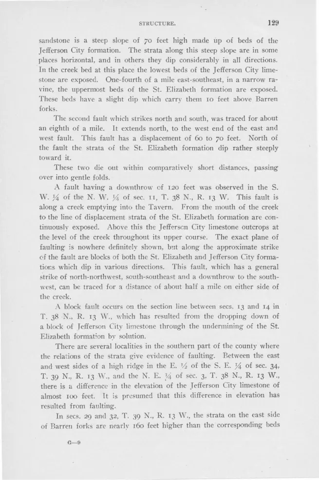
STRUCTURE. 129
sandstone is a steep slope of 70 feet high made up of beds of the Jefferson City formation. The strata along this steep slope are in some places horizontal, and in others they dip con iderably in all directions. In the creek bed at this place the lowest beds of the Jefferson City limestone arc exposed. One-fourth of a mile east-southeast, in a narrow ravine, the uppermost beds of the St. Elizabeth formation are exposed. These beds have a slight clip which carry them IO feet above Barren forks.
Th s concl fault which strikes north and south, was traced for about an eighth of a mile. It extends north, to the west end of the east and west fault. This fault has a displacement of 6o to 70 feet. North of the fault the strata of the St. Elizabeth formation clip rather steeply toward it.
These two die out within comp:iratively short distances, passing over into gentle folds.
A fault having a clownthrow of 120 feet was observed in the S.
W. 3i of the N. W. Yi: of sec. II, T. 38 N., R. 13 W. This fault is along a creek emptying into the Tavern. .From the mouth of the creek to the line of displacement strata of the St. Elizabeth formation are continuou ly exposed. Above this the J efferscn City limestone outcrops at the level of the creek throughout its upper course. The exact plane of faulting is nowhere definitely shown, but along the approximate strike of the fault are blocks of both the St. Elizabeth and Jefferson City forrnatior:s which clip in various clirec1.ions. This fault, which has a general strike of north-northwest, south-southeast and a clownthrow to the south
west, can be traced for a distance of about half a mile on either side of the creek.
A block fault occurs on the section line between secs. 13 and 14 in T. 38 N., R. 13 Vv., which has resulted from the dropping clown of a block of Jefferson City limestone through the undermining of the St. Elizabeth formation by solution.
There are several localities in the southern part of the county where the relations of the strata ~ive evidence of faulting. Between the east and west sides of a high ridge in the E. _rh of the S. E. 'A of sec. 34,
T. 39 N., R. 13 W., and the N. E. ~4 of sec. 3. T. 38 N., R. 13 W., there is a cl ifference in the elevation of the J effer on City limestone of almost 100 feet. 1t is pr~sumed that this difference in elevation has
resulted from faulting. In secs. 29 and 32, T. :N N., R. 13 \V., the strata on the east side
of Barren forks are nearly 160 feet higher than the corresponding beds
G-9

130 GEOLOGY OF :MILLER COUNTY.
on the west side. There are no dips which will account for this difference in elevation·. It is probable that there is a fault parallel to the creek.
In the N. ,i\-. !4 of sec. 36, T. 39 N., R. 14 'IV., where 'the IberiaBrumley road crosses the Crocker-Tuscumbia road, the so-called cotton
rock of the Jefferson City limestone is found at an elevation of 1050 feet. One-fourth of a mile west the same beds of cotton rock occur at an elevation of 970 fret. This was ob erved at various places for a
distance of from one to two miles north and south of the road crossings.
~ o sharp folding' was observed and it is probable that a fault occurs at this place parallel with the ridge.
In the N. 'IV. ii of sec. 13, T. 38 N ., R. 14 W., within a distance of a fou:-th of a mile there if> a difference of elevation of 9() feet between outcrops of the same beds of cotton rock. The difference in the eleva
tion of the beds at the two places can only be accounted for by faulting.
In the N. vV. ~ of sec. 4, T. 40 N., R. 15 \V., on the we t side of a cut on the Bagnell branch of the ::vt:issouri Pacific railroad, is a tension fault striking N. 65° W., and clipping 5.5°, N . :26° E. The beds on the
north side clip slightly toward the fault.
In the north center of sec. IO, T. 40 N., R. 15 vV., on the north cliff
of the Osage river, is a tension fault in the Gasconade limestone. The
apparent displacement is four feet, the southeast side being the clownthrow. The fault strikes N . 55° E., and can be traced one-eighth of a mile.
Near the center of sec. 4, T. 41 N., R. 15 W., a fault striking northwest is poorly exposed. The clownthrow side is to the northeast and the
displacement is about 35 feet. It is a tensiori fault throwing the upper
beds of the St. Elizabeth against the lower beds of the Jefferson City formation.
In the S. E. 0. of sec. I, T. 4r N., R. 15 W., there is an apparent
fault in the creek bed. On the north side the lower beds of the J ef
ferson City formation are at creek level while on the south side of the
valley they are 30 feet above it. This fault dies out within a quarter mile in either direction.
In the western portion of sec. 10, T. 41 N., R. 15 W., in the valley of a small tributary of Saline creek, is a fault which near . the junction
of the Eldon-Tuscumbia and Aurora Springs-Tuscumbia roads, has a
displacement of at ieast r6o feet. The cross section ( Fig. 46) , shows the manner of occurrence. The main fault strikes east and west, lowering the Jefferson City formation on the north side of a small hill until it abuts against the upper portions of the Gasconade limestone. Extend-
STRUCTURE. 131
ing from this fault in a northwesterly direction are two faults dropping a block of the J efferson City clown into the St. Elizabeth formation. The faults apparently die out in a quarter of a mile and are re-placed by dips which grow continually less steep. '
i l ~
-~ -:::: (:1
v;, Jefferson Cihf (orm at/on
S/5'W ~Oc:=r:::;:::::::;:aI::I sco:=~ad=~ !.:;:::,,...,,,t=~-<;5-$#§1±~~. ~wfi';;'i=},~af5fh'~l9f€41¥§~~--·~·,.-,,.,
Fault in sec. 10, T. 41 N., R. 15 W. Scale 1"=133'. FIG. 4Cl.
i Faults of several feet displacement are common in the railroad cut~
in the east part of the county. These are all in the Jefferson City formation.
Minor faulting is common. It was ·observed in the Gunter sandstone near the Morgan county line, in the Graydon sandstone in the S.
E . 31.4 of sec. 23, T. 41 N., R. 13 W., and in numerous places in the J efferson City formation. The minor faults. as a. rule, have a displacement not exceeding several inches. In the Coal Measure shale minor faulting is not uncommon. Stresses in the shale pockets have been relieved by distributive faults apparently absolutely without system as regards direction. The resultant movement expressed itself in innumerable slickensided surfaces.
JOINTING.
Between 600 and 650 observations were made upon the strike of the joints. Two-thirds of these were made on joints in the Gasconade limestone, in which formation they are well developed. The strike of the j'Oints in each town.ship has been averaged s·eparately for each formation.
Except in the "cotton rock" of the Jefferson City formation and the Graydon sandstone, the joints were mainly vertical or nearly so. Possibly one joint in a hundred in the other formations had a variation 'Of from 5 degrees to IO degrees from the vertical. In the following discussions, unless otherwise stated, the joints referred to are vertical.
The joints in the Proctor limestone are well developed and resemble in every way those in . the more widely exposed Gasconade limestone.

132 GEOLOGY OF MILLER COUNTY.
The major set of joints strikes N. 70° E and N. 15 ° W. In the S. W.
coiner of sec. 23, 1'. 40 N., R. 13 W., joints striking N. 45 ° vV. and N. 47_0 ° E.~ were observed in beds pitching 15° N. 30° E.
The joints in the Gunter sandstone are well developed. Readings could not be obtained along the Osage river where the sandstone forms cliffs, but a number were taken in the vicinity of Sycamore spring hollow. The averao-e directions of the two major sets were N. 57° E. and N. 25 ° W. One reading gave two sets striking N. 65° vV. and N. 40° E.
The joints in the Gasconade limestone vary in different townships and in consequence have been separately tabulated. The following table
shows the course of these in the various townships:
'I' . 41 N., R. 13 W. N. 20° W., N. 62¥., 0 E . T. 41 N., R. 14 W. Major N. 18° W., N. 751{, 0 E.
J\flnor N. 34° E. , N. 60° W. T. 41 N., R. 15 W. N. 13° W., N. 82° E. 'J.'. 40 N .. R. 16 W. N. 38 ° W .. N. 48 ° E.* T. 40 N., R. 15 W . (north of the river) "· 20 ° W ., 1'- . :J Y., 0 E. T . 40 N., R. 15 W. (S. of the river) Major N. 18% W., N. 76 ° E.
Minor N. 2G 0 E ., N. 65 ° W.
T. 40 N. , R. 14 YI' . (north of the river) hfa.iol' N. 18° W. (18 read ings), 4:) Y., 0 W., (9 readings) . Minot· N. 7 V:, 0 E., (G readings) ; N. G2 ° W., (2 l'eadings ) .
'I.'. 40 N. , R. 14 W. ( ecs. 13, 24, 36, 35, 34. 33. 32, 31.) l\fajo1· _F. 2-1 ° J1J. (12 readings); N. 75 ° W. (11 readings): l\Iinor N. 15 ° W. (3 readings); N. 70 ° E . (5 readings).
'l'. 40 N .. R. 14 \\'. (south of the rivel' wilh the exception of the Hbove sections.) J\fajor N. J4° ,,. (Hi rendings) : N. 75 ° E.
(12 readings. ) Minor N. 47 ° E . (ti readings.)
'l'. 40 N. , R. J :1 W. Majo1· N. l 2 ° W., N. 70 ° E . Minor N. ;37 ° El. , N. Gl O W .
Minor N. 45 ° E. 'l'. 41 N., R. 12 W. l\fnjor K l 2',.(, 0 W., N. 70 ° E. Min or N. 4:i 0 E . T . 40 N., R. 12 W.
T. 39 N. , R. 14 W. 'l'. 39 N. , R. 13 W. 'l'. 30 N., R. 12 W. 'I.'. 38 N., R. 12 w.
l\Injor N. 73 ° E ., N. 19° W . Minor N. 31 ° m .. N. G2'h O w. N. 30 ° ,v., 1• 75 ° E. "· 1 ' 0 \V., N. G2 ° E .
N. 23 ° W., N. 62 ° E . N. 10° W .. N. 60 ° E .
These figures, based on more than 400 readings, show that there are two sets of major joints, on~ striking from N. 38° Vv. to :N. 13° vV., and the other from N. 83% 0 E. to N. 60° E. These joints strike approximately parallel to the axes of the main fold s. Van Hiset explains these as tension joints due to the tensile forces set up by folding on the convex halv<.>c- of anticline,; and synclines in the zone of fracture.
I
*Too few readings were taken in this township to la.,, any dependence on lbe above figures.
tC. R. Van Hise Principles of p1·e-Cambrian Geology. 16th annual report, U. S. G . S., p. 669.

STRUCTURE. 133
In the south and southeast part of township 40 north, range 14 west, the major joints strike east of north and south of east. The reason for this is not apparent, the only dip being a slight one to the southwest ( about IO feet per mile) . There is here a minor set 'Of joints striking parallel to the ordinary major joints. In several of the townships there is a minor set of joints striking approximately northeast and N. 60° W. In the northern part of township 40 north, range 14 west, the northeast set becomes more important than the N. 70° E. set. We are unable to determine whether or not this is on the axis of a local are from 2 to 20 feet apart-the more massive the dolomite beds the
further apart are the joints. The joints in the St. Elizabeth formation are, as a rule, much more
poorly developed and less continuous than those in the Gasconade limestone. The heavy beds of the Bolin creek sandstone in the southeastern part of the county are an exception, there being two distinct sets of joints which st;ike N. 20° vV. and N. 6o" E.
On the north side of the river but few readings were obtained in this formation, but snch as were taken correspond in a general way to those in the Gasconade limestone. The following is a list of the readings observed:
T. 41 N., R. 16 W. N. 25 ° W., N. 70 ° E . •.r. 41 N., R. 15 W. N. 1S 0 W .. !-<. 77:lh O El.
T. 41 N., R. 14 W. Two sets ~- 50 ° El .. N. 50° w. N. 20° El., N. 85 ° W.
T. 41 N .. R. 12 W. N. 2 ° El., N. 780 W. T. 40 N., n. 12 w. N. 33° w., N. G1: 0 F-.
'.l'. 3() N., R. 13 W. N. 10° W., N. 55 ° El. '.l'. 39 N., R. 12 W. Major N. 19° W., N. 63 ° El.
Minor N. 39 ° El. , N 51 ° W'.
'l'. 38 N., R. 13 W. N. 13° 'I\'., N. H O E. T. 38 N., R. 12 W. N. 28:lh O W., N. 60 ° E.
The joints in the pitted dolomite beds of the Jefferson City formation are poorly developed and less persistent than those in the Gasconade limestone. On the south side of the Osage river the joints in the Jefferson City formation are variable in direction, being more or Jes curved. The following are average readings taken on the north side 'Of the Osage nver:
T . 41 N., R. 14 W. N. 25 ° W.•
T. 41 N .. R. 16 W. N. 60 ° W., N. 43° El. T . 42 N. , R. 15 W. N. 18° W. , N. 5 ° El , T. 42 N., R. 14 W. Major N. 34 ° W., N. 73° El.
Minor N. 60 ° W., N. T. 41 N., R. 13 W. N. 19° W. , N. 67 ¥., 0 El.
•only one outcrop and ouly one set of joints apnarent.

134 GEOLOGY OF MILLER COUNTY.
The cotton rock of the Jefferson City formation seems to have no well defined system of joints, although perhaps there are more that strike northeast than in any other direction. The joints are not persistent in direction, and in places as rµany as six sets were observed. The joints very often cut the be~s with knifelike sharpness. Many joints in the cotton rock cross the bedding planes at an angle of approximately 45 degrees, which is the only evidence among the joint planes of compressive stresses.
Curved or spherical joints are characteristic of the cotton rocks. These explain the shell-like fracture of many masses as well as the crescent or heart-shaped boulders which are of common occurrence.
In general, it may be said that in the Cambro-Ordovician rocks there is a persistent set of joints striking approximately N. 20° iW. and N. 75° E., and :i minor set striking N. 45 ° E . and N. 60° W., the former set be111g the more persistent.
As far as our observations extend, the Proctor limestone possesses joints which do not occur in the overlying formations. The dike-like ma ses of sandstone fill what appear to be joints which strike N. 45° E. The Upper Burlington limestone in sec. 34, T. 42 N., R. 14 W., occupies what appear to be joint-like cavities in the Jefferson City formation, while deposits of Saline Creek cave-conglomerate and Coal Measure shale filling enlarged joints, are commlon. V\T e may safely say that the major joints were formed after the deposition of the Jefferson City formation and prior to that of the Coal Measure rocks and probably prior to the deposition of the Upper Burlington limestone.
As mentioned above, the joints in the Upper Burlington limestone strike differentlv in each basin. The presence of Upper Burlington chert in the Coal Measure rocks may indicate the existence of joints in that formation prior to the Coal Measure subsidence, although the limestone prior to the Coal Measure deposition may have been changed to chert only along the bedding planes.
The joints in the Graydon sandstone are highly developed and it is due to weathering along these joints that the sandstone so often occurs in rectangular blocks.
In an exposure of Graydon sandstone in a tributary of Saline creek in the S. E. ;4 of sec. 2, T. 41 N., R. 15 V\T., numerous sets of discontinuous joints were observed. (See Fig. 47 ). In a space 7x8 feet the following vertical joints occur: N. 5° E., N. 20° E'., . 27° E., N: 42° E., N. 70° E. and E. and W. ()'n comparing a considerable number
of observations on joints in this formation no system is apparent.. In exposures whose length is relatively great in comparison to their width,

STRUCTURE. 135
N
Joints In Graydon sandstone. S. E. 14 of sec. 2, T. 41 N., R. 15 W. FIG. 47.
joints were noted in the . Vv. 0 of sec. 13, T. 40 N., R. 15 W., in the N. W. }4 of sec. 3, T. 40 N., R. 15 W., and in the S. E. ~ of sec. 2,
T. 41 N., R. 15 W. One quarter of a mile east of the southwest corner of sec. 3, T. 38
N ., R. 14 W., is a Graydon sandstone mass elongated N. 70° W. to S. 70° E. It is ten feet wide at the west end, three feet wide at the east end and 125 feet long. Parallel to the long direction of the Graydon sandstone mass is a very well developed set of joints. At the east end this approaches almost to fissility.
Besides the joints, now existing as such, there are others filled with quartz, the relative age of which could not be determined. It appears, however, that in most cases the filled j•oints are in the shearing planes.
UN CONFORMITIES.
Well defined unconformities exist between the Proctor limestone and the Gunter sandstone; between the Saline Creek cave-conglomerate and the Gasconade, the St. Elizabeth, the Jefferson City and the Upper Burlington formations; between the Graydon sandstone and the Jefferson City, the St. Elizabeth, Gasconade and the Upper Burlington formations;

136 GEOLOGY OF MILLER COUNTY.
and between the Coal Measure shale and the Jefferson City, the St. Elizabeth and the Gasconade formations." Local unconformities exist between the Graydon sandstone and the Coal Measure shale. In places there is a conglomerate at the base of the St. Elizabeth formation, and also ,ll/1thin that formation itself. Local interruptions in sedimentation have been noted in the Gasconade limestone while in one place, evidence of a pos3ible hiatus between the Gasconade limestone and the Gunter sandstone was observed.
The Proctor Dimestone-Gimter Sandstone Unconfor1nity.-The evidences of an unconformity between the Proctor limestone and the Gunter sandstone consists in the irregular surface upon which the Gunter sandstone was deposited and the presence of boulders of Proctor limestone in the Gunter sandstone.
In the center of the S. W. }'4 of sec. 15 T. 40 N., 'R. 16 W., the Gunter sandstone thickens, within a distance of 30 yards, from 7 to 18 feet. ( See Fig. 3.) In the vicinity of Brockman's ford in sec. 30, T. 40 N., R. 14 '0.l., the Gunter sandstone is from z,0 to 5 feet thick; in sec. 29, T. 41 N., R. 13 W., the thickness varies from 4 to 6 feet. At Ramsey's postoffice it is 12 feet thick, ·while in Sycamore Spring hollow, two miles away, it is only 6 feet thick. Although these varia
tions in thickness might be accounted for by difference in original deposition, they are doubtles$ partially due to the unequal erosion to which the Proctor limestone was snbj ectecl prior to the deposition of the ~andstone.
East of the center of the S. W. ii of sec. 15, T. 40 N., R. 16 W., the contact between the sandstone and the underlying limestone is very irregular, the former frequently filling depressions two feet deep and iwo feet wide. Sandstone "dykes" four feet long and one and a half inches wide fill the more or less regular crevices in the Proctor limestone. Cavities formed by the solution of portions of the limestone are also filled with sandstone. Boulders of Proctor limestone 2 to 12 inches in diameter· are embedded in the sandstone. Plate III shows the contact between the two formations as seen on the Camden county side of the river at this place. It shows distinctly a depression of the riv,er at this place.
At other places in Miller county the unconformity is poorly exhibited. At Brockman's ford the top of the Proctor limestone. is slightly uneven, while at Ramsey's postoffice •"veinlets" of sandstone penetrate
•It the sandstone called Graydon In this county is mainly Pacific. then one of the most striking unconformlties Is between this sandstone and the older formations. '£he description of the Graydon unconformity will In a large measme cover thls.-E. R. Buckley.

STRUCTURE. 137
the limestone. ln sec. 29, T. 4r N., R. r3 ,,v. , the unconformity is not
apparent.
The absence of fo sils leaves us without a clue to determine the length of time represented by this break in sedimentation. The apparent unconformity is not great, although it may represent a very great length of
time. The Upper Burlington L imestone-St. Elizabeth and Jefferson City
Formations Unconformity.-The evidences of an unconformity between
the Upper Burlington limestone and the St. Elizabeth and Jefferson City formations are: ( r) 1iscordance in bedding, ( 2) a conglomerate at the
base of the Upper Burlington limestone, (3) the fossil content and (4) the general field relations.
The Upper Burlington limestone, wherever typically exposed, dips at a considerable angle. The underlying St. Elizabeth and Jefferson City formations are usually horizontal. A conglomerate at the base of the Upper Burlington limestone was observed roo feet northwest of the cen
ter of the N . E. .i;,;_ of sec. 35, T. 42 N., R. 14 W ., in a creek bed along which the Jefferson City formation outcrops. At this place the Upper Burlington limestone fills the open joints and other depressions in a gray,
medium grained. sandstone belonging to the Jefferson City formation. The south end of the exposure shows a conglomerate with Upper Bur
lington matrix, containing fairly well rounded pebbles, of dolomite and
sandstone from the Jefferson City and possibly from the St. Elizabeth for
mation. ( See Fig. 48.)
· . . ... . • . .. ·.
. : .. . ' . . .,
.. :. ·. -~~li~;so~c;,/ fp~~~t~~n~.-:.: · . . ·. ." · 5and:sto!1e · 'layer.5 : · ·: ·. · ..
. . . ·: .· : ·.: .. :, ·: ·: ·. ~ . .. •. ·. : :; ·. · .. : . : . . . . . .
. . . . . ·. : : ~- ~- -...:· .. :· ; . · .. ·:_ ', • J ••
·: · .· . . .. · ... ·.. . . . . :_ .: ' . · . . . . • ' . ..
. · . .. .. .... I • • • • • •
. . . . "' .. , ·. : .... ~ ... · . . :·· · · .... ...
Conglomerate at base of the Upper Burlington limestone. Scale 1"=2'8". FIG. 48.

138 GEOLOGY OF MILLER COUNTY.
The Upper Burlington limestone is extremely rich in fossils of 1.Jower Carboniferous age. The few fossils of the St. Elizabeth and Jefferson City formations are all of Cambra-Ordovician age. The fossils thus indicate a hiatus representing the Devonian and portions of the Ordovican and Lower Carboniferous ages.
The fact that the Upper Burlington limestone rests upon the St. Elizabeth and Jefferson City formations without regard to topographic position is evidence of the unconformity of the two formations.
The Saline Creek Ca-ve-Conglomerate-Gasconade, St. Elizabeth, Jefferson City and Upper Biwlington Formations Unconformity.-The Saline Creek cave-conglomerate fills caves, sinks and enlarged joints in the older formations. Pockets of the conglomerate have been found above the Ga conade, St. Elizabeth, Jefferso!l City and Upper Burlington. formations. The Saline Creek cave-conglomerate contains boulders and pebbles derived fr.om all of these formations. Figure 30 shows the relations between the Saline Creek cave-conglomerate and the Jefferson City f_ormation as found in a cut on the Chicago, Rock Island and Pacific railroad in the southeast corner of the N. W. ;4. of sec. 26, T. 42 ., R. 15 W.
The Gr(Jlydon Sandsto11.e-Ga.sconade Limestone, St. Elizabeth and Jefferso11, City Fonna,tions Unconformity.t-The evidence of unconformity between these formations is as clear as that between the Upper Burlington and the underlying formations. However, as the Graydon sandstone, as far as our observations have extended, is unfossiliferous, paleontologic evidence is wanting.
Figure 32 shows the Graydon sandstone as it occurs in the N. W . .:14 of sec. 13, T. 40 r., R. 15 W., almost abutting against the flat lying beds of Gasconade limestone. Steep dips in the Cambro-Ordovician strata are not as common in the vicinity of the Graydon sandstone as near the Coal Measure shale pockets. This is probably due to the fact that the sandstone fills valley of erosion, while the latter usually fills sink-holes.
The general field relations existing between the Graydon sandstone and the underlying formations plainly indicate the unconformity. The Graydon sandstone rests upon the Gasconade, St. Elizabeth, Jefferson City and Upper Burlington formations. The outliers are found on the hill tops, along the intermediate slopes and in the bottoms of the valley .
As previously mentioned, scattered throughout the Graydon sandstone are pockets of pebbles and single boulders derived from nearly all of the older formation .
tProvlded the Graydon sandstone, as considered in this report , Is part Pacific, this will represent two uncouformities of which the Pacific wiU be the most wide sptead.-E. R. Buckley.

STHUCTU I!L 139
At four places-north center of the~- E. Y-i. of sec. 15, T. 42 K., R. 14 W., center of the N. 0 of sec. 29, T. 42 N., R. 15 W., . ·w. H of the N. E. .X of sec 12, T. 42 N., R. 15 W., and the S. E . .X of sec. 9, T. 42 N ., R. 15 W-basal conglomerates were observed. t the last locality the sandstone forms a cliff 25 feet high and 100 feet long on the southeast side of a branch of South Moreau creek. The Graydon sandstone exposure ext,ends back into the county 125 feet where it is almost in contact with the heavy beds of the Jefferson City formation. ( See Fig. 49.) Sev,enty-five feet down stream from the end of the bluff boulders of J efferson City and St. Elizabeth dolomites, partially rounded, are embedded in the sandstone. The Graydon sandstone also fills crevices and cavities in the St. Elizabeth formation.
The Coal M ea"Sure Shale-Gasconade, St. Elizabeth, J e-fferson City and Upper Burlington Unconformity.-This unconformity is shown by (1) discordance of bedding, (2) basal conglomerates, (3) fossils and (4) general field relations. Almost without exception, the shale beds dip at a considerable angle, while the urrounding Cambra-Ordovician and Lower Carboniferous strata are virtually horizontal. Although the shale pockets may be 150 feet deep, the surrounding strata are essentially horizontal. In some cases solution prior to the deposition of the shale has disturbed the immediately surrounding rock. Figure 39 represents the uneven contact between the shale and the Gasconade limestone in the Gageville, mine. At the Son mine, a "cap" of Gasconade limestone is present, covering the Coal Measure shale, while in the 1W. Yz of lot 1,,
N. E. sec. 4, T. 39 i T., R. 13 Vv., a Jefferson City formation ledge overhangs the shale two feet.
On a neighborhood road in the east center of sec. 14, T. 41 N., R. 16 W., the cracks and joint · in dolomite bed of the Jefferson City formation are filled with Coal Mea ure hale. In the south· center .of the
S. E. Y-i. of the N. W . y,( of sec. 1, T. 41 X., R. 16 W., in a branch of the South Moreau creek, patches of black shale fill grottoe and joints in the Jefferson City formation.

5.W.
S.£.
Jef(ft rsonCily ro r rnat,on
SI.E hJabetl, forma fton
NE.
NW.
Con tact of the Graydon sandstone, and St. Elizabeth and Jell'erson City formations in the E. center of sec. 9, T . 42 N., R. 15 w. Scale 1'=165'.
FIG. 49.

STRUCTURE. 141
Figure 50 was drawn from the outh wall of a zinc prospect south of the center of sec. 8, T. 41 .N., R. 15 V./. The south and west sides of the shaft are formed of sluk, while the north and east walls are composed of cotton rock of the J effcrson City formation. The cotton rock near the top of the shaft is somewhat crushed, and embedded in it is a mass of shale. Below the cotton rock, shale, containing boulders of dolomite, is common. In other parts of the shaft, the shale fills joints in the cotton rock.
The typical Coal Measure shale contains some boulders from the sttrrounding older formations. Those portions immediately in contact with the Cambro-Ordovician rocks seem especially conglomeritic.
The plant fossils which are common in the shale pocket indicate a time break between the deposition of the Cambro-Ordovician series and the Coal :Measure shale, covering a portion of the Ordovician and all of the DeV'onian and Lower Carboniferous ages.
R. 15 W. Scale 1"=3 . 5'. FIG. 50.
Local Unconformities.-The local unconforrnities present in places at certain horizons in the Ga conadc limestone have already been described (See page 42). The unconformity between the Coal Measure shale and the Graydon sandstone has also been mentioned.
SECTIO 0 S ACROSS THE COU TTY.
Plate XV, figures 1-4 are sections across the county along the lines A-G, B-D, C-F and E-H, as indicated on the Geological map accompanying this report.

142 ,-;EOLOGY Of.' :\JILi.ER COUNTY.
CHAPTER XII.
DOLOMITE AND CHERT AND THEIR ORIGIN.
DOLOMITE.
As stated elsewhere, there is no pure or even approximately pure limestone in the Cambro-Ordovican formations of Miller county. All
are sufficiently high in magn~sium carbonate to. be classed as dolomite. Moreover the general field relations and the analyses of five typical specimens from about 6oo feet of strata indicate that dolomitization was quite general and uniform thr_oughout the entire thickness of these formations. As a recapitulation of what has already been stated in the descriptions of · the various forinations of this series, it may be said that the dolomites of the older, and therefore the lower, formations are less impure than those of the younger and higher formations . The cotton rock of the St. Elizabeth and Jefferson City formations, which is in many instances almost a calcareous shale, is the most argillaceous of the dolomites. The very fine grained dense dolomite of the St. Elizabeth formafron, however, is very free from impurities.
The percentage of magnesium and calcium carbonate in the rocks varies with the amount of impurities. The fine grained, det;se dolomite of the St. Elizabeth formation contains the highest percentage and the cotton rock the lowest.
MgC03 contained in typical samples.
No. 1. From Lower Gasc.onade limestone, . .. .. .. .. .. .. .. .. .. .. . .. .. . .. .. .. . .. .. .. . .. .. . .. 42. 34% 2. From Upper Gasconade limestone, . .. . . . . . . .. . . . . . . . . . . .. . . . . . . .. . . . . . . .. . . . . .. . . . 41. 98% 3. From cotton rock of St. Ellizabeth formation, .. .. .. .. .. .. .. . .. .. .. .. .. .. .. .. .. . 38. 98% 4. From very fine grained, dense dolomlt of St. Elizabeth formation, . . . . . . . . . . 44. 74% 5. From typical, heavy, pitted beds of Jefferson City formation, .............. 40.22%
Theoretically pure dolomite contains 54. 35 per cent. of CaC03 and 45.65 per cent. o_f MgC03 • No. 4 lacks .91 per cent. of containing enough MgC03 to make it a tlieoretically pure dolomite, providing it is only composed of calcium and magnesium carbonate and contains no impunt1es. No. 3, a cotton rock, lacks 6.67 per cent., while Nos. I, 2 and 5 are intermediate between the two. These analyses are valuable only in that they show quite uniform dolomitization throughout about 6oo feet of the Cambra-Ordovician strata in this county. Number 5 was collected

DOL0l\1[TE AND CHERT A~D THEIR ORIGIN. 143
from a bed about 600 feet above No. r, and between the two are beds of chert, sandstone, dolomite and shale.
It is generally held among geologists that dolomite may be formed in two ways,-either secondarily by the replacement of limestone, or directly by chemical precipitation. vVith the possible exception of the very dense, hard, compact dolomite of the St. E lizabeth formation, it is thought that the dolomites in this county were formed by secondary replacement of limestone.
*There are a number of cases on record where secondary replacement is very clearly the origin of the dolomite. In the north of England and elsewhere the Carboniferous limestone has been altered for a few feet on either side of joint planes into a dull yellow dolomite. Dana** has found elevated coral reefs heavily impregnated with magnesium. tSamuel Calvin and H. F. Bain have traced certain fossiliferous strata from the 11011-magnesian Trenton formation into the dolomitic Galena fom1ation. In Miller county a few fossils were found which had been entirely altered to dolomite.
The generally very porous character of the dolomite oeds is strong evidence that the dolomitization was secondary. It has been estimated that the change from limestone to dolomite impli,es a decrease in volume,
or shrinkage, of about I 3 per cent. This shrinkage would largely account for the innumerable small cavities contained in these dolomites.
The fact that dolomitization has occurred throughout all of the Cambra-Ordovician strata of this region, with indications that it was quite uniform, leads one to believe that it occurred practically simultaneous with the deposition of the limestone. Dolomitization was not found to be more pronounced along fault, bedding or joint planes than elsewhere; neither does it stop at shale beds, as usually happens when dolomitization is secondary. Furthermore, it appears that all the dolomitization occurred prior to Carboniferous time, as shown by the non-magnesian Burlington limestone which rests unconformably above the Ordo
vician rocks. The cotton rock is a non-porous, soft, argillaceous dolomite, very
different from the ordinary pitted, porous type. Although in a few places in the Jefferson City formation, the two apparently grade very gradually into each other, both vertically and horizontally, ordinarily, they are sharply separated from each other. The presence, in the same formation, of
•Text book of Geology, Geikie, 3rd. Ed. o. 321. ••coral and Coral Islands, by J'as. D. Dana, Dodd, Mead & Co., N. Y. 3rd Ed. , 1880,
pp. 393-94. tiowa Geo!. Sur., Geology of Dubuque county, by Samuel Calvin and H. F. Bain,
pp. 492-93.

144 GEOLOGY OF MILLER COUNTY.
hackly and non-hackly dolomite, brings up the question as to whether or not the dolomitization of the beds occurred in the same way and at the same time. If they were deposited in a similar manner, why should one be porous and break with a hackly fracture·, and the other non-porous and break with a conchoida! fracture? It is generally true that there are more shaly partings in the cotton rock than in the other beds, indicating some difference in sedimentation. However, until we have more knowledge of how these rocks were deposited and of the changes which have occurred ince that time, the true conditions will remain hidden.
The very hard, dense, compact dolomite in the St. Elizabeth formation may have been precipitated directly from sea waters. We are lead to believe this because of its purity and non-porous texture.
CHERT.
The quantity, di tribution, manner of occurrence, and character of the chert of the different formations have already been discussed in connection with the descriptions of the formations, but a brief recapitulation may not be out 'Of place.
Quantity and Distr£bution.-In the Proctor limestone, Gunter sandstone and the Jefferson City formation, the cherts form but a small percentage of the rocks, while in the Gasconade limestone they comprise from JO to IS per cent., and in the St. Elizabeth formation from IS to 30 per cent. In the few places that the Pacific sandstone was exposed, it was very cherty.
Manner of Ocrnrrence.-Chert occurs either in beds; disseminated through the dolomite and sandstone; or in bunchy masses, either connected or isolated, but usually a ociated with fine-grained, dense dolomite in the St. Elizabeth formation.
Bedded Chert.-The most persi tent chert beds occur in the St. Elizabeth formation. In this formation beds varying from a few inches up to eight feet in thickness can be traced over large areas. The heavy beds invariably present a crushed and brecciated appearance while the thin beds are but slightly fractured.
In the Gasconade limestone the chert bed seldom exceed two and a half feet in thickness and only three or four of these could be recognized over large area . A great many of the beds are discontinuous, grading gradually into cherty dolomite and finally into dolomite. In the Proctor limestone there are occasional thin layers of chert, but these are not common. The beds of chert in the Jefferson City formation are ordinarily thin, and are mainly nodular, being limited to the shale or cotton rock. The nodules have various shapes and sizes and are usually connected by a thin sheet of banded chert of the same character.

DOLOMlTE AND CHERT AND THEIR ORIGIN. 145
The bedding planes eparating the chert beds from the dolomite are always sharp and distinct, and seldom to any degree undulating except in the case of the nodular chert beds above described.
Irregularly D£sse111i11ated Chert.-A large part of the chert in the Gasconade limestone belongs to this class. ( See page 36) . It also occurs in the St. Elizabeth and Jefferson City formations, but not so abundantly. In the Gasconade limestone it varies from irregular fragments a fraction of an inch in diameter, to large, irregular seams several feet in length branching out in every possible direction. ( See figures 5, 6, 7 and
_8). The line of eparation between the dolomite and these chert nodules is often ven · obscure, because the two usually grade into each other.
PETROCRAPHlCAL CH ARAC:TERS.
Thin sections of a few of the Cambra-Ordovician cherts were studied under the microscope. This study showed al,! of the cherts examined to be cryptocrystalline and of a chalcedonic nature. A majority of the sec-tions showed the chalcedony to be spherulitic. Where the spherulites are 2.bove the average size the chert is oolitic. Tn some oolitic chert specimem the nuclei of the oi:i lites were grains of quartz around which silica had been deposited. ] n a section of an oolitic specimen from the J efferson City formation, the n deus of one of the oolites was triclinic feldspar.
ORIGIN OF THE CHERT.
There has been considerable diversity of opinion regarding the origin of chert. Some geologi ts have held that it is of organic and others that it is 'Of chemical origin. Sollas, describing the flints of Trimingham Chalk, beli eves them to be of organic origin .':' Hinde found the chert beds of Axel I sland, which are 26o meters thick, to be of organic origin.** Dr. C. R. Keyes states that the Lower Carboniferous cherts of Northeast Missouri are secondary, being si liceous concretions formed long after the origi nal deposition of the be<ls.t Hovey believes that the cherts of the the Lower Silurian and L'Ower Carboniferous formations of northern and southwestern Mis ouri are chemical precipitates, either at the time of the depo ition of the strata in which they occur or before their consolidation.t
Concerning the source of the silica forming the Trimingham chert, Sollast. states that it was derived from di ssolved siliceous organi sms.
*i\lonogrnph , XXX . U. S. G. S., p. 18. **Monogrnpb , XIX , U. S. G. S., p. 252. tLead a nd Zinc Depos its of ::IIissonl'i. \Vinslow , JJ . n;L +Loe. cited, p. 20.
G- 10
146 C,EOLOGY or :".IIILLER COUNTY.
Messrs. Murray and Renard* hold that pel~gic organisms which secrete silica obtain it from the hydrated silicate of alumina or clay held in suspension, as wen as from silica held in solution and, in case of siliceous
sponges rooted for the most part in 'Oozes and clay, from the siJ.ica in solution in sea water. Prof. Prestwich** states as his opinion in regard to the cretaceous flints of the chalk formation that silica in the colloidal or soluble state was present as a chemical precipitate in the mud of the chalk seas, and that, the colloidal silica having a strong affinity for other forms of ~i ii ca, gelatinous substances ( like the sarcode of sponges and other foreign bod:es), aggregated about sponge spicules replacing the sarcode as they decayed, and about the tests of echinoderms and the shells of mollusks. The irregular masses thus produced continued to grow so long as there was any colloidal silica within the range of attraction.
It is now generally conceded that chemical deposits of cherts derive their silica from the circulating underground waters which carry silicic acid in s'Olution.
A great majority, if not all, of the cherts in the Cambro-Ordovician formations in Miller county are of chemical origin and are secondary after dolomite. Some of the chert of the St. Elizabeth formation, from its manner of occurrence, /s probably original, either through direct chemical precipitation or through organic agencies.
The evidence of the secondary origin of much of the chert is so plain that it cannot be· doubted. Every gradation between the chert and dolomite has been observed. Nearly all of the fossils in the chert of the Cambro-Ordovician formations originally had calcareous casts which are now silicified and altered into chert. The beds of chert in the Gasconade limestone, for example, are ·not only between beds of dolomite, hut their
. structure indicates that they are secondary after dolomite. In the same way some of the thinner basal beds of the St. Elizabeth formation in the southeast part 'Of the county have exactly the same structure as the beds of somewhat cherty dolomite, directly associated with them. For some of the chert the evidence of secondary origin is not so clear.
The secondary cherts were formed through the action of circulating underground waters, through which the dolomite was replaced by silica. ·while the silica which replaced the dolomite was probably mainly derived from the quartz in the different formations, the original sonrce of some of the silica was probably the chert which was deposited simultaneously with the dolomite . .
Although the texture and structure of the rocks were to a great ex-
• :Monograph XXX, U. S. G. S., r. 20. ••Lead and Zinc Deposits of Missoul'i. \Yinslow, p. i :J2.

DOLOMITE AND CHERT AKD TIIElR ORIGIN. 147
tent influential in determining the position of much of the secondary chert, original iliceous masses in th e rock undoubtedly have determined the position of many of the chert bodies as they occur today.
Mr. Bailey \,Villis has suggested that certain thin beds of dense, vitreous, oolitic chert in the upper portion of the St. Elizabeth formation are probably secondary after arenaceous dolomite.
There are two kinds of oolitic chert,. that in which the oolites are
of rounded grains of sand , and that in which they are of spherulitic chall·edony. The spherulitic, ooliti c chert is found maialy south of the O age
river in the upper beds of the Gasconade limestone. The nucula.r, oolitic chert was formed when the sandy dolomite became silicified, the sand grains acting as centers about which the silica seggi::egated.
Probably all of the nodular chert is secondary after dolomite. Some
, ·of the nodules consist of alternating layers of siliceous dolomite and chert or alternate layers of variously colored chert, all of which points to its secondary origin.
U ntil evidence to the contrary is found, the heavy brecciated chert beds found so _generally at the 1 ase of the St. Elizabeth formation, and
the bunchy masses of cherts so common throughout the entire formation , will be considered, in part at least, original.
The heavy brecciated chert beds which are typically exposed at the mouth of Sugar creek in townshi1; 41 north, range 12 west, and in sec.
3, T. 41 N., R. 15 W ., have a thickness of from 20 to 40 feet, and show absolutely no evidence of being secondary after dolomite. Dofomite is in no way associated with these beds either in isolated fragments in
the beds or otherwise. There are no gradational phases, and no fossils of calcareous organisms were found. The great uniform thickness and persistence of these chert beds is additional evidence of their organic origin. They may represent the accumulation of vast numbers of siliceous remains of sea organisms but evidences ·of these remains have been entirely obliterated through subsequent solution, deposition and recrystal
lization. I
Resume.-From what is said above it will be easily inferred that a
large part of the chert is thought to be secondary. The silicified casts of gasteropods and the gradations between chert and dolomtie clearly prove
this in many cases. Although the heavy brecciated chert beds at the base of the St. Elizabeth formation may be secondary, the evidence at hand points most strongly to their being of organic origin, i. e., original.

148 CEOLOGY OF l\flLLER (OUNTY.
CHAPTER XIII.
ECONOl\fIC COKSJDERATION
BARITE.
Darite, or barium sulphate;- (BaS04 ), 111 this county is commonly
i:alled "tiff" by the miners, while the mines or "diggings" are known as
"tiff banks." This mineral occurs in all parts of the county either in crevices and cavities in the rock or as fragments in the residual clays. The latter deposits have been the source of nearly all the barite shipped from Miller county. In the "tiff banks," it is mainly concentrated next
t0 the underlying country rock, although small pieces are scattered through . '
the clay. Although the largest prospects occur in clay resting on the
Gasconade limestone, it is evident from the rock fragments attached to the barite that at least a part of it has been derived from the once 'Overlying St. Elizabeth formation. Barite was found in place in the Gasconade limes.tone and the St. Elizabeth, Jefferson City and the Coal Meas
ure formations. Galena, blencle and calcite are the most commonly associated min
erals, although pyrite, chalcopyrite, limonite, azurite and malachite are of
frequent 'Occurrence. While calcite at times occurs with the barite in the clay, it is more often represented by casts of the typical scalenoheclral and rhornbohedral form . Pyrite and limonite frequently occur as long pencil-like stalactite embedded in barite. The barite is, in many instances, of two generations, an older, ·which is granular or crystalline, and
;1 younger, which is welJ crytalJized. Both generations are apparently
younger than the associated minerals. The Seigel Martin ''tiff bank'' located in the ?\. \A;. ;:'.i of the N. E.
5{ of sec. r2, T. 40 N. , R. to\\/., on the top of a high bluff overlookino
the Little Gravois creek, is a type of the "tiff banks" of Miller county.
In this bank the baritc occur in reddish clay overlying the Gasconade limestone and is about 40 feet from the top of the formation. Nearly all the barite is seg·gregated in the two feet of clay in,me<:liately above the
rock. It occurs in more or less rounded masses of the crystalline variety. The surfaces of the fraaments are usually stained reel with iron oxide,
but the interior is white. Some bluish colored crystals with inclusions
of small hematite and malachite crystals were observed. Brecciated.

ECONOMIC CONSIDERATIONS. 149
uolitic chert from the St. Elizabeth formation, 111 which the fragments are cemented with barite, occurs in the clay. Crystals and casts of crystals of calcite are common in the barite.
The barite in this county is usually mined at odd times by the farmers. The strip pit method is employed in mining and the cleaning is done by" hand. The product is mainly sold to local merchants who ship it to St. Louis. Although one of the most abundant minerals in Miller county, it is being mined very little.
DUIJ.DTNG STONE.
· Excellent building stone for rough masonry abounds in Miller county. The wide distribution of good rock, coupled with the thinness of the soil, accounts for the numerous small quarries and the absence of any large ones. With a greater demand for substantial buildings and the introduction of better railroad and higfo:vay facilities, Miller county might become a considerable producer of dimension stone.
There are many horizons in the Gasconade limestone, in different parts of the county, from which stone of good quality for foundations, bridge abutments, and other rough masonry can be obtained. A careful selection of the quarry site would insure a coarse grained, even textured dol'Omite free from flint and of a pleasing ,vhite or drab color. Blocks eight to fifteen feet long and fifteen to twenty inches thick are obtainable. Two well developed sets of joints, one striking a little north of east and the other west of north, will greatly facilitate quarrying. That the stone is durable is indicated by the hard, rugged character of the outcrops.
·William Whetnall operates a quarry in the Gasconade limestone in the N. E. ,% of sec 5, T. 39 N., R. 14 W. The quarry has a ten-foot face and is 6o feet long. Two beds are quarried, the upper of which is 20 inches thick. ·with the exception of an occasional dark gray chert nodule, the stone in this bed is a compact, coarse grained dolomite. Tfie lower bed is 30 inches thick and the stone is harder and more compact than in the upper. Six inches from the top there is a thin seam of black chert. The joint strike N., 8.5° W. N'. and S., and are sufficiently far apart to permit the quarrying- of blocks over 12 feet long. Both hyers have a pleasing drab color and work well under the hammer. The stone is used chiefly for tombstones and fire places.
On the north side of the Osage river the St. Elizabeth formation cont.~ins very little stone suitable for constructional purposes, while on the south side sandstone of good quality can be obtained. It has been qttite extensively quarried in the vicinity of St. E1izabeth. The ne,v Catholic church at this place is being built of sandstone obtained from a
150 GEOLOGY OF MILLER COUNTY.
quarry in the N. "\V . . r4 of sec. 32. T. 4r N., R. 12 W. A lower bed · eight inches thick and an upper one three and a half feet thick are being
quarried. The color varies from white to reddish brown. In places it
1s fine grained and in others coarse grained. Some of it is soft and friable, but most of it is hard and compact. The sandstone of the St.
Elizabeth formation varies. within short distances, in iron content, in size of the grains and in compactness.
The Jefferson City formation furnishes two different stones which
are used for building purposes, the "cotton rock" and the massive, pitted dolomite.
The "cotton rock" has been used extensively as a building stone throughout central Missouri. It is a compact, fine grained, argillaceous
dolomite, having a white or cream color. It is soft and can be cut and dressed very easily. This rock occurs abundantly in the extreme northern and southern portions of Miller county where it is quarried on a small scale. When newly laid it has a pleasing appearance, but weathering has '
a tendency to open up the stratification planes with the result that layers scale off. .Iron pyrites is a common impurity, and frequently through
decomposition it produces brown streaks and patches. The pitted dolomite beds occur in many parts of the county and con
stitute an excellent source of supply for rough dimension stone. The
numerous cavities and occasional siliceous patches render it unfit for hammer dressed work. The rock is medium to coarse grained, and ~s strong and durable. It can be obtained in large blocks, and is well
adapted for heavy foundation or footing purposes. Small deposits of travertine or so-called lvfexican onyx occur in many
of the caves in the county, but no attempt has yet been made to market
it. On the McDonald property in sec. 22, T . 40 N., !\. 13 Vl., two shafts ! S. feet apart reached a deposit of travertine filling a crevice zYz feet
wide in the upper beds of the Gasconade limestone. Some of this onyx
:s white and takes an excellent polish. Finely banded red , brown and yellow onyx also occurs. Near the McDonald deposit there is a cave
in which the onyx occurs in the form of stalactites.
CE)IE N'.I.'.
Up to the present time no cement has been manufactured in Miller county. There is a bare possibility that certain strata in the Cambro
Ordovician formations might be used for the manufacture of na~mral hydraulic cement. However, the dolomites thus far examined contain too much magnesium to fit them for this purpose.
Although the Upper Burlington limestone and Coal Measure shale

_ECONO!lfIC CONSIDERATIONS. 151
may in some places constitute excellent materials for the manufacture of Portland ceme~t, tliey have not been found together in sufficient quantity to warrant the erection of a cement plant.
CLAY.
Both residual and transported clays occur 111 Miller county. The residual and stream clays will probably never be used for making anything but common brick. The C'Oal Measure shale, while equally good for brick, is also adapted for tile and some of the common grades of pot
tery. It may in places be suitable for vitrified and .refractory wares. The brick in. the Iberia Academy building were made out of clay ob
tained in the western part of the village near the head of Lenox branch. This clay is residual from the dolomite of the Jefferson City formation.
In a gulch along the section line, one-fourth of a mile south of the
northwest corner of sec. T 4, T. 38 N., R. 13 W., is an exposure of white day originating from the decomposition _of calcareous shales near the base of the Jefferson City formation. In the creek just north of Brumley
is a similar bed of clay resulting from the decomposition of the shales of the St. Eiizabeth forn1ation.
In sec. 20, T. 40 ~-, R. 14 W., on the bank of Lick creek, a bed of clay 100 feet long and 20 feet thick is exposed. This is in the river bottom, and therefore its areal extent could not be determined. This clay
is plastic, has a brown color, and ought to make good brick. In other
localities in the bottom land of the Osage river, transported clays suitable for brick probably occur, although they were not observed.
The clays and shales of the Coal Measure shale pockets are the highest grade clays in this county. They are variable in composition. the lime, sand and kaolin content changing rapidly from one depth to
another in the same pocl:et. At Mr. Henry Carrol's, in. sec. 14, T. 38 N., R. 13 W., a grayish
white shale having a considerable degree of plasticity occurs. At the
Robinet Mines, 300 yards north of the center of sec. 32, T. 39 N., R. 14 W., a simila•r shale was observed. At Joseph Cotton's, in the south
center of the N. W . . Vi of the N. E. % of sec. 3, T. 41 N., R. 16 W., a greenish, fine grained, rather pla tic shale occurs. Henry A. Wright sunk a shaft in the northeast corner of sec. 25, T. 42 N., R. 14 W.,
passing through white and gray shale banded with red and black. These shales have considerable plasticity and are fine grained. This pocket is
less than mo feet in diameter. In the S. \V. % of the N. E. ;/,j of sec. 27, T. 41 N., R. 16 W., on the bank of a tributary of the Little Gravois,
decomposed Coai Measure shale is exposed for 100 feet. It has a gray

152 GEOLOGY OF MILLER COUNTY.
color and is very plastic. In the S. W. part of the S. E. 0 of the N. Vv. 7,4. of sec. II, T. 41 N., R. 16 vV., G. Vv. Shelton has a prospect from which a yellow, unctuous, plastic clay is obtained. Blue_ Coal Measure
shale occurs in the north center of the N. E. 7,4. of sec. 15, T. 42 N.,
R. 1'4 VI/. It i unctuous and reasonably plastic. Small lenses of plastic gray shale occur interbedded with the coal
at McClure's coal bank. At the Republic coal mine, a two and a half
foot bed of shale lies nine and a half feet above the coal. This shale when fresh is yellow to black in color. Limb like masses of pyrite and limo
nite l to 2 inches long and ~ inch in diameter are disseminated through
it. In the N. W. 34 of sec 7, T. 41 N .. R. 13 \V. occur two small gulches on the sides of which fine grained, plastic, gray colored clay is exposed. The clay was too poorly exposed to determine whether it is Coal Measure shale, somewhat decomposed, or residual clay from the Jefferson City formation.
COAL.
From the earliest times, geologi ts have recocrnized and reported the true nature of the coal deposits of Miller county. Henry King,* who
passed up the Osage river in the fall of 1839, writes in regard to these coal deposits: "It is necessarily very limited in its extent and should
not deceive those intere ted into any false hopes or great expense in its
exploration. I deem this caution the more necessary as I have already seen persons ignorant of the ubject imposed upon by its spacious appearances." Swallow,*'~ Meek,*':;: Pottert and Winslow,t all speak in similar
terms concerning this coal. For local needs the coal is valuable, bnt the supply is totally inade
quate to warrant the erecti'On of extensive coal mining plants. The geology and location of the chief pockets in Miller county have
been described in connection with the Coal Measure shale.
The Rep11blic coal mine, formerly known as the Barnard coal bank, was first wo,·ked In the eighties, the product being largely consumed in the Immediate locality, although some coal was shipped to Jefferson City. In the faIJ of 1901, the Republic Coal company of Chicago constructed a spur from the Missouri Pacific tracks to the mine and instailed an expensive conveyor. In the spring of 1902, the mine wns abnndoned.
*Report of a Geological reconnoissance of that part of the State of Missouri ad_fa. cent to the Osage river, macle to Wm. H. Morrell, chief eul(ineer of the state, by order of the Board of Internal Improvement, by Henry King, M. D. Geologist, president of the Western Academy of Natural Science, etc., etc.
**First and second annual reoorts of the Geol. Sur. of Mo., G. C. Swailow, State Geologist, Jefferson City, 1855, p. 134.
•••Ibid (Moniteau county), p. 112, also reports of th Geo!. Sur. of the State of :l!issouri, 1855-71, p. 133.
t Geoi. S.ur. of Mo. Iron Ores nnd Coal Ftelcls, 1872, p. 28J . tPrelim!nary report on coal, l\lo. Geo!. Snr., 1801 , p. 171.

ECONOMIC CONS1DERATIONS. 153
M cO!ure's coal bank was opened fifteen or sixteen years ago, and has supplied about 150 tons of coal to the blacksmiths of the neighborbood and to stores at Eldon _ and Aurora Springs. Mr. McClure's prospect, which is located in the southwest corner of the S. E. 1.4 of sec. 12, T. 41 N., R. 16 W. , was opened up some thirty years ago. The one in the east center of the N . W. 14 of the N. W. 14 of sec. 13, T. 41 N., R. 16 W., was
worked before the Civil War, the product being used by the neighboring blacksmiths. Other localities in which coal has been fou nd are as follows:
In a prospect hole on Blyth's fork, one half mi le southwest of Olean. In the bed of a small branch of Sa line creek in the S. W. 1A of the N. E. 1A of
sec. 35, T.42 N. of R. 14 w., on James Miller's land. The opening which was made here is now filled. On the dump is a badly decomposed bituminous substance reported _ to be bituminous coal.
In the N. E. 1A of the S. E. 1.4 of sec. 2, and three-eights of a mile north of the southeast corner of sec. 2, T . 41 N., R. 14 W. , are old prospects from which coal is reported. At present the rock on the dump is too badly decomposed to determine its exact character.
In the southwest corner of the S. E. 1.4 of the N. E. 1.4 of sec. 18, T. 41 N., R. 15 W., on Mr. Bunch's land, a prospect is reported to have penetrated 131/, feet of coal and
not to have reached bottom. Mr. G. W. Shelton reports 6 to 8 feet of bituminous coal and an unknown thickness
of cannel coal in a prospect near the center of sec. 11, T. 41 N., R. 16 W. In the N. E. 1A of tbe S. W . 1A of sec. 11, T. 41 N ., R. 16 W., in a prospect on a
branch of Indian creek, the Simmons heirs have 6 feet of coal at the bottom of a shaft. Fig. 51 shows two cross sections of this prospect.
w. Jeffe.reon crty !'or
Shol•.,."--'-------"""R" E
c-,
Cross sections of Simmons heirs coa l prnspect. Scale 1"=200'. Fro. 51.
Coal, badly decomposed, lies on the dump of a prospect in the N. W. 1.4 of the N. E. 1A of sec. 17, T. 41 N .. R. 15 W.
Thirty-five feet of coal is reported in a prospect in the south center of sec. 31, T. 42 N. , R. 15 W., on H. N. Knowall's land in the South Moreau valley. Some coal has been mined at this place and sold in Eldon. The prospect is now abandoned.
Impure coal and bituminous shale were observed on a dump located west of the center of the S. E. 1.4 of sec. 31, T. 42 N., R. 15_ W.
In the north center of the S. W. 1/.i of sec. 3, T. 41 N., R. 16 W., badly decomposed coal occurs in Coal Measure shale. The quantity of coal is not great.
Coal occurs on the dumps of several small prospects in the south center of sec. 11, T. 38 N., R. 14 W.; also in the W. :y. of lot 1 N. E ., sec. 3, T. 39 N., R. 13 W.
Coa l is r eported in the following wells: T. W. Cotton , N. W. 1.4 of sec. 11, T. 41 N., R. 16 W. ; Mrs. Martha Babcock, west
center of S. W. 1A of the S. E. 1A of sec. 16, 'l'. 41 N., R. 15 W.; Mrs. Boan, east center of S. W. 1.4 of sec. 17, T. 41 N. , R. 15 W. : C. H . Coykendall, near center of sec. 17,

154 GEOLOGY OF MILLER COUNTY.
T. 41 N., R. 15 W.; James L. Jobe, one-eighth mile west of the center of sec. 11, T. 41 N., R. 16 W.
In Iberia, T . B. Garner reports a thin seam of coal at 23 feet, and a 6 \6 foot seam at 53 feet. In Ramsey's well , at the same place , a six foot vein of coal Is r eported.
The above list includes nearly all the places at which coal was observed or where there is good reason to believe that it exists, and there is no evidence to warrant the belief that any of the deposits are very extensive. The exposures of Cambro-Ordovician dolomite. are usually so near the coal that the diameter of the Coal Measure areas cannot in any case exceed a few hundred feet and, in most cases, less than a hundred. The chances are that the intercalated shales of the Jefferson City formation may have been in some instances mistaken for Coal Measure shale 111
some of the wells enumerated. The coal is relatively light in weight and is much jointed, in con
sequence of which there is considerable waste in mining. The best grade: of coal from the pockets is said to be an excellent steam coal.
The localities at which cannel coal has been found are enumerated on pages 103-rn5. The deposits are as limited in area as are those of bituminous coal.
The area in the west central portion of the north half of Miller county which is mapped as undetermined Jefferson City Coal Measure strata doubtless contains some coal pockets hidden beneath the chert covered hills. However, these pockets cannot be expected to be of greater areal extent than those already discovered.
There appears to be no evidence to support the theory that the prairie land to the north of the hill country is underlain with a continuous bed of coal. There is no evidence of coal except such as may occur in occasional pockets.
GAS AND PETROLEUM.
The conditions for the origin, storage and preservation, of these fuels do not exist in this county, and the presumption is altog,ether against their
occurrence. GOLD AND SILVER.
The visitor to Miller county everywhere hears rumors of gold and silver discoveries. The belief in the existence of these metals in Miller county ccin be traced to four sources: (I) to the finding of iron pyrite which bears a slight resemblance to some gold ores; ( 2) to the tradition of rich silver mines once worked by the Indians and Spaniards; (3) to the reports issued by 1.uireliaole assayers; and (4) to the socalled Colorado "miner" and the "divining rod expert." Iron pyrite is not gold and of itself has no value except when it occurs in large quanti-

ECONOMIC COKSIDF:RATIONS. 155
ties ; the tradition of sil\'er mines i indefinite and unreliable: the value of assays depends upon the reliability of the assayer; and "divining rod experts" should be avoided as unreliable. Gold and siI:ver ores very rarely occur in any rocks except such as have been modified by igneous intrusions. There is very little, if any, probability that these ores occur
in Miller county. IRON.
Nason,* in his report on the lron ores of Mjssouri-included Miller
county in the so-called Osage district. All of the iron ore in this county \\"ith the exception of a few scattering boulders of Jim nite, occurs south of the Osage. river. Although found in many localities, the largest de
posits ar-e in townships 39 and 40 north. ranges 12 and 13 west.
HISTORY OF IRON MINING IN MILLER COUNTY.
Very little could be learned of the history of iron mining in Miller county. Iron deposits were known to exist in this and neighboring counties at a very early date. The earliest mention of the deposits in Miller
county was made in Meck' t report. At the time Meek made his survey of Miller connty, Mr. Charles Sample, of St. Louis, had dug a number
of shallow pits in limonite deposits in secs. 15, 22 and 23, T. 40 N., R. 13 vV. Besides the deposits in these localities Meek observed others of considerable size elsewhere in the connty.
About ten years after the close of the Civil War, and shortly after
the publication of Meek's report on the Geology of Miller county, and that of Adolph Schmidt** on the Iron Ores of Missouri, there was a boom in iron mining in Miller county, as a result of which a number of new banks were developed. The mining was carried on by large outside
corporations, who prospected the southern part of the county very thor'Oughly. Innumerable shallow pit were dng, but in not more than a dozen localities were the deposits considered important enough to work.
Statistics as to the output of the various banks could not be obtained. It is known, however, that some 'Of the ore was carried by wagon to the
railroad at Hancock and Dixon, and some was hauled to Capps and
shipped by boat down the Osage river. At several of the "banks" the ore was never moved from the dump piles. Considerable of the ore hauled
to Capps was never shipped and may be seen today in pile near the steamboat landing.
Mining was carried on more or less spasmodically for a period of · five years, when it was entirely abandoned. Since that time scarcely any
•Nason, Frank L. Report on Iron Ore of ~issourl, p. 174. tGeol. Sur. of Mo., 1855·71, p. 112·34. • •Geo!. Sur. Mo., 1879.

156 GEOLOGY OF MILLER COUNTY.
attempt has been made to develop these properties, although several new ore bodies have been located. Poor transportation facilities, combined with the discovery of enormous deposits of iron ore in the Lake Superior region, are the most potent reasons for the cessation of iron mining 111
the county. CHARACTER OF THE ORE.
Hematite and limonite are the two important iron ores of thi county. The hematite occurs as soft red, hard red and blue specular ore. The latter is very finely crystalline and frequently contains small cavities nearly filled with tiny crystals of quartz. The limonite occurs mainly as the peculiar "pipestem" oie which occnrs as boulders strewn over some of the ridges and as massive and reniform deposits in the rock. No large bodies of the pipestem ·ore were observed in place, although Meek* ob
served it in situ in the Sample mine in sec. 23, T. 40 N., R. 13 W. This ore consists of long slender tubes, resembling very closely stalactites or stalagmites. These tubes are frequently united in a signle mass having a roughly cylindrical shape, and are from one to fifteen inches in diameter. Sometimes they are so united as to form a nearly solid mass but more often each pipestem preserves its individual shape. Pyrite, marcasitc and the copper carbonates, malachite and azurite are often associated with the iimonite.
METHOD OF OCCURRFNCE.
The iron ores occur as loose boulders. lying on the slopes or tops of ridge,:; as residual mass,es, in day, a few feet below the surface of the ground; as pocket like deposits in the rocks: and occasionally as thin beds between horizontal strata of dolomite.
DISTRIBUTION OF THE ORES.
The limonite is closely associated · with chert and dol'Omite, while the hematite, with few exceptions, occurs with either Ordovician or Carboniferous sandstone. A greater part of the limonite, both in "situ" and as boulders, occurs in the region along the Osage river, which is very li!rgely underlain by Gasconade limestone. The amount of hematite 111
this region is small compared with the limonite. While there are no known deposits of iron ore in the Jefferson City formation, in this county, there are numerous boulders of limonite and specula~ hematite scattered over the ground which it underlies. In the southeast part of the county, where the Bolin creek sandstone member has its greatest development and where nearly all of the larger deposits of hematite are located, very little limonite has been found.
•Mo. Geo!. Sur. , 1855-71 , p. 130.

ECONOMIC CONSTDERATIONS. 157
DESCRIPTION OF IRON BA::SKS.
7'he ]fcDonald Bani, No. 1.-This bank includes a number of small pits in a lar.e;e sink hole in the upper part of the Gasconade limestone, in the southeast corner of S. W.
11,,,, sec. 15, T. _40 N., R. 13 W. The ore is mainly limonite, although some hematite was observed. '£he limonite occurs either as a cement binding the brecciated chert beds, or as small beds or lenses. Very little ore was observed except what was exposed on the dump pile. This consisted of limonite, some pyrite and occasional boulders of pipe stem
ore. McDonald Bank No. 2.- This bani( is located in tbe S. W .. 1,4 of sec. 23, T. 40 N.,
n 13 W., at the contact of the Gunter sandstone and the Gasconade limestone. The pit is
60x4rix8 feet. · The limonite occurs as a horizontal ledge having a maximum observed thickness of 5 feet. In places it Is apparently much thicker. The limonlte is porous and the cavities contain soft yellow rust and thin streaks of marcasite. The surface of the limonite often shows the crystal fo rms of marcasite, of which it is probably an alteration product.
Lambert Iron Banl,.- This bank is located on Brushy Fork, in the W. % of lot 1 N. W., sec. 5, 'L'. 37 N., R. 13 W. 'l'he ore Is massive mammary or soft hematite and underlies about an acre of ground. It occurs near the bottom of the St. Elizabeth formation and is ass0ciated with steeply dipping beds which are suggestive of faulting. Crystals of quartz and calcite are scattered abundantly through the ore.
Bond Iron Banl,s.- '.rhese banks consist of two nits located in carboniferous sandstone on the N. E. 11,,, of sec. 15, 'L'. 39 N., R. 13 W. The ore is a soft r ed, greasy hematite, some of which is suitable for mineral paint. The hematite in some cases bas a radiat
ing structure, and all of it is so Impregnated with calcite that it effervesces fl'eely. In the center of some of the pieces of soft red hematite were found small pieces of hara
blue specular ore. Minute cavities in the ore are commonly lined with tiny crystals of quartz or hematite.
These iron banks in Cat·hon iferous sandstone are surrounded with beds of sandstone, chert and dolomite, belong:11,,· to th · ~t. Elizabeth formation. Except south of the banks, where there is a dip of 30°, N. 2G 0 E., the beds of the St. Elizabeth formation are horizontal.
Bolin Greek Banl,.-This iron bank is located in the S. W. 1,4 of sec. 15, T. 39 N .. R. J2 W. The ot'e consists of residual boulders of hard siliceous hematite embedded in the greasy, red clay of a sink hole in the Bolin creek sandstone. The clay is some
times used by neighbol'ing farmel's as a substitute for paint. The s,uiclstone in which the deposit occul's is deer,ly stained by Jimonite .
.i1Hscellaneo11s.-Besides the above mentioned banks there al'e two otbel's, located respectively in the S. E. 1,4 of the N. E. ~ sec. l 4. T. 38 N., R. 12 W., and in the N. E. 1/, sec. 2G, T. 39 N. , R. J 2 W. At both pluces _the ore is hematite, and occurs in the Bolin creek sandstone. 'l'here are numerous otbel' places in the county where undeveloped deposits of iron ol'e occur, the locations of whi<;h are shown on the economic map accompanying this repol't.
ORIGIN OF THE IRON ORES.
There are two factors of primary importance 111 the genesis of the iron ores of this region. These are ( 1) the structure of the strata in which they occur, and (2) the influence of the wall rock. All of the deposits are in areas of folding, brecciation or sinks due to the solution of the underlying rocks. These structures combined with the porous nature of the vari'Ous fo rmations would afford a very free underground water circulation along definite channels. The limonite occurs only in the limestone and chert, whi:e the hematite is confined to the sandstone either of Carboniferous or Silurian age.

158 GEOLOGY OF MILLER COUNTY.
The original source of the iron ,ms probably in the various formations, in Khich the iron " ·as disseminated in small amounts in the fo rm of 1he carbonate or the sulphide, though probably the former. As the genesis of the limonite and hematite is different they will be treated separately.
Limonitc.-'The limonite deposits al'e a ll seconclal'y rrftel' py ri te Ol' marcnsite ,,,hich were largely l'eplaceolf'nt proclucts of dolomite and chel't. Some. however, as shown by theil' stalactitic ancl stalagmitic forms, were depositecl in caves or caverns. The iron disseminatecl in the formalions was taken into solution by percolating waters. probably as the cal'bonate Ol' sulphate. These waters converged into definite ancl favorable channels and, meeting with reducini; agents such as l;l:2S ot· cat·bonaceous matel'ial the iron was precipitated as the sulphicle. Often the dolomite and chert wel'e dissolved s imultaneously with the precipitation of the il'on sulphide. Later as oxidizing watel's frnm the sul'face became dominant the su lphides wel'e changed by oxidation in to limonite.
Hematite-The sandstone in which the hematite occurs clifferecl from the dolomite and chert, in that it contained but li ttle carbonaceous Ol' reducing matter and affordecl a nearly direct water course fol' descending oxidizing watel'S. 'l'he iron of the present deposits was probably derived by the leaching out of the iron con ta ined in ,the sandstone near the place where they n ow occur. In two or three of t he il'on banks the sands tone on either side of the depos it had been thoroughly leached of its iron content and was nearly pure white, while furt her away it resumed its norma l reddish brown color. Descending waters, chargecl with organic acids, laking the iron in so lution , probably as the carbonate, were converged into the sinks and sharp troughs of synclinal folds , and thel'e the addition oi' oxidizing watel's pwcipi ta ted the il'on accot'ding to the following reaction.
2Feco.+Oo=Fe20a+2co2: LIME.
up to the present time, lime burning 111 thi s county has been carried ·on in a very primitive manner. - In the rural districts each farmer makes his own lime by heaping and burning together wood and limestone boulders which have been covered with earth and sod. Sometimes a hole is dug in the hillside and in this the lime is burned.
The dolomite of the Cambra-Ordovician formation and the nonmagnesian limestone of the Upper Burlingt'On are both suitable for the manufacture of quick lime.
The pitted, massive dolomite beds of the Jefferson City formation and the massive beds of the Gasconade limestone are fairly well adapted to the manufacture of lime. At Jefferson City, Cole county, the heavy pitted dolomite of the Jefferson City limestone is used extensively for the manufacture of I ime. It is said, however, that, outside of Jefferson City, this lime, probablY_ on account of its color, is unable to compete with the lime produced from. the Upper Burlington limestone. Lime made from dolomite is dark colored and slow to set, but it is claimed to be especially strong after hardening.
The areal extent of the Upper Burlington limestone in Miller county is indicated on the general geological map. Its thickness is variable and ow in g to the poor exposures the quantity can only be determined by
drilling.

ECONO)IIC co · swERATIONS .
:.\fr. J. E. Sullen has operated a kiln in the center of sec. 26, T . . 'J.2
X., R. l4 VI., intermittently, for eight years. He states that during this time he has so!d $52.5 worth of lime, of which nearly om·half was produced in 1900. The entire output was sold to farmer and towns people in the immediate vicinity. Abandoned or temporary kilns are found on nearly all the exposures of Upper Burlington limPstone. A modern lime kiln, situated on the Chicago and Rock Island railroad, should be able to supply the local demand for lime for at least 100 miles of railroad.
The Upper Burlington limestone produces a very pure, white lime. It is quick setting and slacks rapidly. This is the same kind of stone
used for manufacturing the well known Ash Grove lime. Experience at Ash Grove has . hown that as a fuel for burning lime, black oak is
superior to coal or any other kind of wood.* Black oak abounds in the forests in the vicinity of the Upper Burlington limestone outcrops. The occurrence of good limestone combined with cheap and superior fuel makes this an excellent county for the manufacture. of quick lime. How
ever, owing to the limited extent of some of the Upper Burlington lime
stone areas, the ground should be prospected by drilling before a plant is located.
LEAD AND ZINC.
Miller county is within the so-called Central Niissouri lead district. This district, as a whole, has been much less exploited than either the Southwestern or Southeastern, and the product is consequently small.
The greater share of the lead output of Miller county has been
mined along the Saline and the North Little Saline creeks, in secs.
2j 5, 8, IO, rr, 13, 14, 23 and 24, T. 41 N., R. 14 W. This area, known as the "Saline diggings," extends four miles east and west, and five miles north and south. Other "diggings" are scattered throughout the county.
HISTORY OF LEAD )IINI:-;G I ' :.\IILLER COUNTY.
Mr. H. M. Breckenridge, Jr., r was among- the-first, if not the first
writer to mention the occurrence of lead in the region tributary to the Osage river. He says that as early as 18II, hunters reported an abundance of lead in the country adjacent to the Osage river. Soon after this, Schoolcraft** stated that lead had been found in the Osage coun-
*E. i\I. Shepard, Geol. Sur. of Mo. , Vol. XII. p. 20!:l.
tViews of Louisiana, together with a Journal of n Journey Up the Missouri River in 1811, p. 146.
**Schoolcraft, H. R., "A view of the lend mines of i\[o., " p. GO-Gl.

160 GEOLOGY OF MILLER COUNTY.
tn·. Henry Eing, M. D./' in his report of 1839 stat that lead is found everywhere along the Osage river, and that the Little Tavern, the Saline and the Little Gravois, are among the creeks on which good lead indications exist.
In the .fiftie , it i said, that the pioneers gathered galena from the ..:reek beds and smelted it in hollow logs to obtain lead with which to make bullets.
Up to the tim~ of Meek'st visit to Miller county in 1855, only a few insignificant pro pect holes had been sunk and little or no "mineral"
had been produced. He notes the occurrence of galena both in the rock and in the clay at a number of places.§
Capp's diggings are said to have flourished before the war, anr. enough galena was mined to warrant the errection of a smelter. Temple
E. Bell, in 185J, employed two slave miners on the present Loveall tract, but during the war time , active mining wa discontinued. \Vonderful bonanzas reported to have b en discovered were at thi time lost,
never to be re-found.
Shallow mining 11egan on a large scale in 1868 or 1869. J erhaps the first mining was at the Cla , Diggings in ·the N. W. 34 of ec.
15, T. 42 N., R. 14 W. The discovery of the I•ox Diggings soon fol
lowed, and then that of the Curty and 1 ndian Grove Diggings. About
this time the Loveall Diggings ,vere re-opened and worked on a large
scale. In 1871 or 1872 follo,rcd the discovery of the most important producers, known as the \,\Talker, ,rass. Roots and the Gageville Diggings. All of the galena produced came from the clay and in conse
quence the cost of mining the ore was very little. The deepest shafts. sunk to bed rock, repre rnted but a half week' work, and the most improved hoist ·was a portable " ·ind!as .
ln 1878 the price of lead fell from $5.1 :i to $3-40 p r hundred ,reight, and lead mining in Miller county became unprofitabl . !so about this time "\lillcr county became a center for the production of railroad tics. and the farmer who had formerly employed his winter
months profitahly in mining, found more lucrative employment in cutting tie . The low price of lead and the abundance of tie timber partially account for the lapse in lead mining in :\Iiller count:v.
•Report of a Geol. Reconnolssancc of tbat part of tbe State of hlo. adjacent lo tbe <1, age river. mode to \Ym. H. Mol'l'cll. Chief lsng. of llle Slul··, u.\' order of the Boa,·d oi Internal Improvement, lJy Henry King, l\l. D., Geologist. l'res. or lbe \Yesu•,·n Acnd. of Nat. ·Sciences, etc.
tGeol. Snr. of l\Iissouri 1 JJ-H, pp. 11~- l;J~.
§Ibid 1:ll -l ~'.! .

ECO 'O::IUC CONSIDERATIONS. 161
SMELTING.
The first lead smeiter , of which we have any record, was operated
at Capp's before the Civil \Var. In 1870, a lead furnace was erected on Saline creek one-fourth of a mife north of the northwest corner of sec. z6, T. 41 N ., R. 14 \V. Soon after, a second furnace was erected on the site of Mr. Greene Blackburn's house in the S. E. 34 of
S. W. % of sec. 23, T. 4.1 N., R. 14 W. In the fall of 1874, a furnace was built at the Gageville mines on the ridge northwest of the main shaft. In 1881-2, a second smelter was built at GaO'eville, in the valley south of the main shaft. The ruins of this furnace are still standing.
All the othtrs have disappeare<l.
THE PROfJlKTlO:\' •F LEAD AND ZINC.
Mr. Winslow':' gives the following table of production for Miller county:
Lead. Zinc. P eriod.
Ores. Metal . Ores . Metal.
Tons. Values. 'l'ons. Values. Ton s. V:tlues. Tons. , Values. Before 1870.... ...... .......... JOO $6,000 70 $11,900 ................................. ..
l 70-1879.. ... ........ . ... ... .. 2,()(,0 100,000 1,410 166,380 .......... .. . .. ................... .
1880-1993 .... ...... ............ _100 4,300 - 70 5,740 ....................... .. 1 ... .... . .
Totals . .. .. . . .. .... . . . ... 2,200 $110. 300 / 1.550 $184.020 .......... .. ......... .... . 1 ........ .
Our estimates for the fir st and the last period are almost identical with Mr. \Vinslow's. For the production between "1870-1879," our
es timate of the output is from 150-250 tons less than Mr. Winslow's. From 1894-1902, th e output approximated 16o tons, of which the :vrcBride and Lawson diggings produced 75 tons , the Gageville mines, 270 tons, and the Loveall diggings, I2;h tons.
During the same period, 3,000 pounds of zinc blende were sold, 2,000 being from the Sight Me prospect.
•Mo. Geol. Sur., Vol. VII , page 526.
G-11
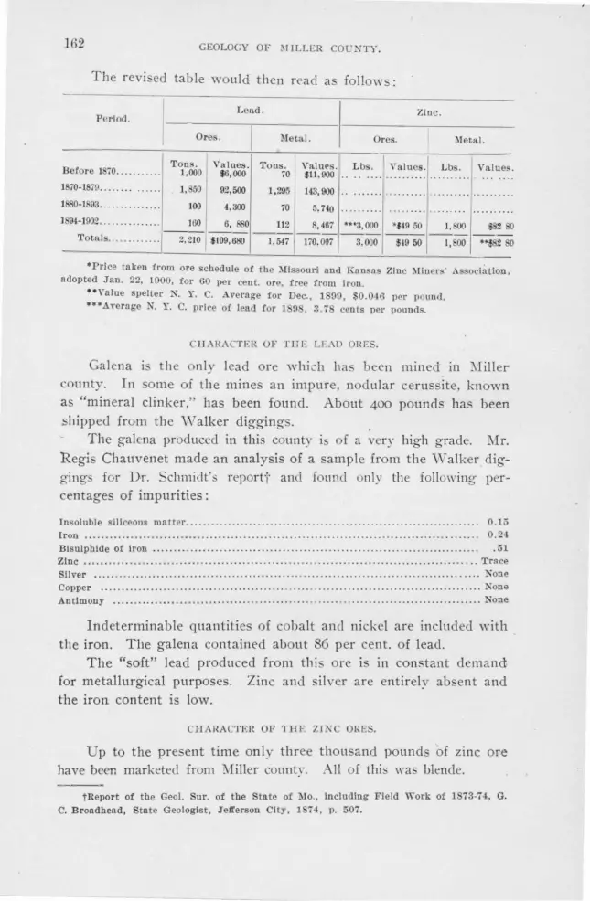
162 GEOLOGY OF .MILLER CO!JNTY.
The revi ed table would then rC:'ad a follows :
Period. Lead. Zinc.
Ores. Metal. Ores. llletal.
T o ns. Before l 70........ ... 1,000
Values. $6,000
Tons. 70
VSLIUl'S. $11,900
Lbs. Yalues. Lbs . Values.
1870-1879 ............ ..
1880-1 03 ........ ..... ..
1, 50
100
92,500
4,300
1,295
70
143,900
5. 740
1894-1902.. ............. 160 6, 880 112 8,467 **'3,000 *!49 50 J, S(J(l $82 80
Totals ... · ·· ··· ... . 2,2W $109,680 --1,547 li0,007 3,000 $19 50 1,800 ••$82 80
•Price taken from ore schedule of the :\llssouri and Kansas Zinc :\liners· Association, adopted J'an. 22, 1000, for 60 per cen t. ore, f ree from Iron.
••Yalue spelter X Y. C. .Average for Dec., 1 9(), $0.046 per pound . ... Average N. Y. C. price of lead !or 1 () . 3.7 cents per pounds.
CHARA TER OF THE LEAD HES.
Galena the only lead ore which ha been mined in :-Iiller county. In some of the mines an impure, nod ular cerussite, known as "mineral clinker," has been found. About 400 pounds has been shipped from the Walker diggings.
The galena produced in this county is of a very high grade. Mr. Regis Chauvenet made an analysis of a sample from the ""Walker digging for Dr. Schmidt' · reporti' and found only the following percentages of impurities:
Insoluble siliceous matter................... .......... ... ... . .......... . ....................... 0.15 Iron .... ....... .. ...... .. .... ... ...... . . ....... ........... .. .. .. ...... . .......... .. .......... . .. . . 0.24 Bls ulphlde of Iron . . . . . . . .. . . . . . . . . . . . . . . . . . . . . . . . . . . . . . . . . . . . . . . . . . . . . . . . . . . . . . . . . . . . . . . . . . . . . . . 51 Zinc ...... ...... .. ...................... .... .... .. ................. . .............. .. ... ... .... . . .. Trace Sliver ................................ .. . ......................................................... None Copper . . ... ... .................. .. .................. . ....................... .. . . . ........... ..... None Antimony ............... .... .... ... .... . ........................................... .. ........... . None
Indeterminable quantities of cobalt and nickel are included with . the iron. The galena contained about 86 per cent. of lead.
The "soft" lead produced from this ore is in constant demand, for metallurgical purposes. Zinc and silver are entirelv absent and the iron content is low.
CHARACTER OF THE ZINC ORES.
Up to the present time only three thousand pound of zinc ore have been marketed from 1Iiller county. II of this was blende.
tReport of the Geo!. Sur. of the State of l\Io., including Field TI'ork of 1873-74, G. C. Broadhead, State Geologist, J'efferson City, 1 74, p. 507.
ECO~OMIC CONSIDERATIONS. 163
ASSOCIATED MINERALS.
The as ociated minerals include barite, calcite, crystallized dolomite, pyrite, marcasite and chalcopyrite.
Earite is by far the most abundant of the associated minerals, while calcite stands next in importance. There is a greater prepon
derance of barite over calcite in the residual clay than in the rock. At the McBride and Lawson diggings calcite is comparatively common in the rocks, while almost lacking in the clay. At the Fox diggings, it was noted that calcite was more abundant and the pieces of greater size as the rock was approached. This is not true of the barite. This condition is due to the fact that calcite is more readily soluble than barite.
Crystallized dolomite was observed associated with the ore at the Stevens' prospect, but it is not common. Pyrite and marcasite are rarely fo und with the galena. They occur most abundantly in the Coal ::\I easnre shale. Chalcopyrite, and its decomposition products, limoni te, azurite and malachite, were noted at several of the diggings. notably the "\ATaite prospect, the l\ifeyer prospect and the Walker diggings.
MODE OF OCCURRENCE.
The ore deposits of Miller county can be divided into ( r) disseminated ores, (2) sheets, (3) chimneys, (4) circles and (5) residual ores. The first is characteristic of the Coal Measure shale pockets, the second of the coal and Cambro-OrdoYician strata, the next two of the CambroOrdovician formations. and the last of the clay overlying the CambroOrdovician formations.
Disseminated Ores.-Shale, when deformed through pressure, has a tendency to bend instead of break, and consequently joints or other parting planes sufficiently open for an abundant circulation of water are not formed. Water penetrates the mass much more uniformly than it does the jointed Cambre-Ordovician formations. As a result "pe;bbles" of zinc biende or gaiena form wherever the mineralized waters encounter a strong precipitant. These "pebbles" are distributed . throughout the mass and are entirely independent of one another.
\Vhile disconnected crystals of galena occur along the crevices in the dolomite of the Cambro-Ordovician fom1ations, no true disseminated ores
were found . Sheets.-Sheets are ore bodies whose length and breadth, when lying
horizontally, and ·whose length and depth when standing vertically, are relatively great as compared with their thickness. The ore mav com-

164 GEOLOGY OF MILLER COUNTY.
pletely fill the opening between the walls, and where the country rock is undecomposed the sheet is said to be "tight." The country rock adjacent to the sheet may be badly decomposed, and the galena, broken into pieces, may be imbedded in residual clay.
The horizontal sheets, which are usually located along bedding planes, are of little commercial importance in this county. The galena and zinc blende in the coal occur mainly in horizontal, although sometimes in vertical, sheets.
The vertical sheets, commonly called crevices, are usually in joints which have been enlarged by solution. The formation of joints and their direction and persistence in the various formations have been discussed in another part of this report (See pages 131-135.) As to the number and direction · of the ore bearing crevices in Miller county, the following data may be of interest:
PROSPECTS IN THE JEFFERSON CITY FORMATION.
I 1 . -S.-; 2 N.25 °W.; 4 from E. -N.82°E.; I N.55°E.
PROSPECTS IN THE ST. ELIZABETH FORMATION.
3 from N.70°-80°E.; I N.45°E; I N.-S.; I N.20°W.
PRODUCTIVE (OVER I,000 LBS.) PROSPECTS IN THE GASCONADE LIMESTONE.
2 N.-s. :- 1 N. 5·w.; 2 N.10°w.; 1 N.12·w.; 1 1 .25°W.; 2 N.35°w.; 2 N .50°\V.; 1 N.57°W.; 1 -.65°·w.; r N.75°W.; 1 .78°W.; 1 N. 85°W.; 1 N.89°\V.; 2 E. -w.; 3 N.85°£.; 1 N.83°E.; 1 N.8o 0 E.; 4 N.75°E.; I N.74°E.; 1 N.72°E.; 4 N.70°E.; 2 N.65°E.; 2 N.6o0 E.; 4 N. 55°E.; 1 N-45 °E.; 1 N.33°E.; 1 N.20°E.; 1 N.I2°E.; 1N.8°E.
NON-PRODVCING PROSPECTS IN THE GASCONADE LIMESTONE.
I K.-S.; I N.20°W.; I N.25 °W.; I N.30°W.; I l .35°W.; I N.8o 0 W.; I N.85°W.; I E.-W.; I N.50°E.; 2 N.45°E.; I N.20°E.; I N.15°E.; I N.10°E.
The observations in the Jefferson City and the St. Elizabeth formations are too limited to generalize upon, although the approximately east and west crevices in both formations are more numerous than those in all other directions. Three of those striking east and west in the J efferson City formation were obtained from Meek's report.
The data on crevices in the Gasconade limestone are at least abundant enough to make some provisional generalizatio.ns. The readings have been divided into two classes, first, those from which 1,000 pounds or more of ore have been produced ( Fig. 52), and second, those from which less than 1,000 pounds have been mined. (Fig. 53.) The dia-

I ECONOl\UC CONSIDERATIONS. 165
grams are decidedly unlike. Twenty-one of the eighty-two rich crevices strike from E. a'nd \ V. to N. 60° E. In the same position on the "poor
Diagram showing direction and number of crevices in Gasconade limestone which have . produced over 1,000 pounds of galena.
FIG. 52.
crevice" diagram, there are no crevices. On both diagrams there are several crevices coursing a little . of W., but the proportion of those on the ')oor creviGe" diagram is much greater. One-fifth of the '·poor crevices" are within .S degrees of N. 45° E., while of the rich crevices only one lies between I . 40'' E. and N. 50° E. About one-sixth of each set strike from K I 2 ° W., N. I 2 ° E. It would be well in prospecting for lead in the Gasconade limestone, to pay special attention to those crevices striking between N. 60° E. and E. and W. The richest crevices thus far worked in the Gageville, the Walker and the Grass Root diggings, strike in these directions. The crevices striking or ..:cursing a little west of north are the richer and here again the diagram shows that the rich crevices coursing a little west of north are more numerous than those coursing east of north. Whether or not future developments will bear out these conclusions, time alone can determide.
en "' :z
Diagram showing direction and number of non-productive crevices. FIG. 53.

166 GEOLOGY OF MILLER COUNTY.
Chi11111c_,·s.-Chimneys are more or less conical open.ings in the rock, which are commonly the upward extention of sheets. They are usually formed at the junction of . and S. and E. and \V. joint and are ordinarily fi!led with clay. It is of interest to note that the large t masses of galena, which have been found in Miller county, have occurred in chimneys. Thi finds ready explanation in the fact that such were the natural places for solutions of diverse nature to mingle, causing active local precipitation.
Circles.-Dr. Schmidt con iders circles, which are deposits having thl:' shape of truncated cones and in which the galena occurs in seams and fragments in semi-disin_tegrated dolomite boulders, to have originatect "by a gradual disintegration by a vertical water course or spring in the underlying limestone."~· There are two circles in Miller county, the Walker minf's circle and the Loveall circle. Owing to the fact that neither of these were in a condition to be examined, leaves us without data upon ·which to draw conclusions as to origin.
Residual Deposits.-ln the residual deposits galena is distributed in the clay, especially in that immediately overlying the rock. The galena is more or less rounded, is usually associated with barite or calcite, and streaks are often found which are especially rich. Development shows that these rich streaks correspond to ore bearing crevices in the rock~. The galena in these residual deposits originally occurred in seams in the rock. The disintegration and decomposition of the rock has removed the more soluble constituents leaving the mineral embedded in clay. Crevices, which have been enlarged by solution are frequently found filled with a red, plastic clay. Along the walls and in the lower part of these seams the galena is usually concentrated.
RELATION OF ORE DEI'O ITS TO STRUCTUREJ.
Except in the case of the jointing there appears to be very little relation between the structure and the position of the ore deposits. Ore has been mined both on gentle anticlines and synclines, as well as from horizontal strata.
Brecciation occurs in places, but usually it is unaccompanied by faulting. Appan~ntly the breccias have been formed by sol.ution through which fragments were detached from the sides of the crevice and recemented by calcite or barite. No faults of consequence occur associated with the lead mines. In the shale pockets, movement has caused the shale to be slickensided, but the faulting, of which they are · evidence, could not be measured.
• Report of the Geo!. Sur. of the State of l\Io., G. C. B-roadhead, State Geologist, Jefferson City, 1874, p. 522.

ECONOMIC CONSIDERATIONS. 167
At Gageville, there is a distinct enrichment of ore in the dolomite above an impervious layer of Coal Measure shale at the 55 foot level. The miners consider the upper surface of both Coal Measure shale and 1he intercalated shales of the Cambra-Ordovician formations extremely favorable positions for ore. They speak of both shales as "mineral band."
THE GEOLOGICAL DISTRIBUTION OF PROSPECTS.
The Proctor Limestone and Gunter Sandstone.-These formations underlie only a few square miles, most of which area is covered by alluvium. No ore has been reported from either formation.
The Gasconade Limestone.-The Gasconade limestone is very porous and consequently contains many openings in which minerals may be deposited. As the beds of Gasconade limestone are homogeneous and massive, the fractures produced are well defined and continuous.
Out of two hundred and eleven localities, at which galena or zinc blende have been found in this county, one hundred and ten, or over one-half are in the Gasconade limestone. Of these, eighteen are within 25 feet of the contact with the St. Elizabeth formation; in thirty-two cases, the ore continues to a depth of 50 feet below the top of the formation; in thirty-one instances, the ore has been found at a depth of 80 feet, and in fourteen, at a depth of 120 feet. At only three localities was ore found in the lower half ( 120 feet) of the formation. In eleven instances the occurrence of lead was merely reported and its stratigraphical position was not definitely determined.
In many of these cases the galena occurred in clay which had resulted from the decomposition of dolomite beds above those upon which the clay rests. This fact emphasizes the importance of the upper beds as the ore bearing horizon of this formation, and the almost entire uselessness of prospecting for ores in Miller county below the upper half of this formation. at least. In some instances it is very probable that the ore in the clay was derived from the overlying Jefferson City and St. Elizabeth formations. At the vValker and Loveall diggings, galena was found in brecciated. oolitic chert which must have been derived from the once overlying St. Elizabeth strata. At the Gageville mines a very small amount of ore has been found above the lowest bed of the St. Elizabeth formation. The miners call galena in that position "lost mineral."
The richness of the ore in the upper beds of the Gasconade limestone is probably due to the porosity of the lower beds of the overlying St. Elizabeth formation and to the fact that the upper beds of the Gasconade limestone are usually situated well above the level of ground water, the topographical position most favorable to deposits originating largely through downward percolating waters.

168 GEOLOGY OF 1ULLER COUNTY.
The St. Eli:::abeth forniatio!l.-The lithological character of this formation makes it unfavorable to the production of ore deposits qf commercial importance.
Thirty occurrences of lead ore, about 14 per cent. of the total number, are located in the St. Elizabeth formation. No zinc blende was observed in the frrmation. There seems to be no definite or persistent horizon at which the galena occurs.
Five per cent. of the marketed galena of :\1[iller county has come from this formation, and of this amount the McMillan diggings }.lave furnished practically 95 per cent.
The Jefferson City Formation.-Lithologically, this formation, with its alternation of impervious shales and cotton rocks and its relatively pervious sandstones and porous dolomites, is rather favorable to ore deposition. This same alternation, however, wrould tend to the development of several small ore horizons rather than one large one. The mines at Fortuna, Moniteau county, are in the Jefferson City formation. wher,e the rock is lithologically more uniform.
Prospects are more abundant in this formation than in the St. Elizabeth, thirty-nine being located. Up to the present time, however, the Jefferson City formation has produced less than the St. Elizabeth, its output being but 3 per cent. of the total. The product
· comes from four or five different diggings showing it to he more widely distributed.
The Coal Measure Shale.-The deposits in the Coal Measure shale are altogether different from thost' occurring in thf:' CambroOrdovician rocks. The ore occurs in four forms: as "pebble" or "strawberry" ore, disseminated throughout the mass of the shale; as a thin layer coating the surface of boulders; filling cavities in boulders; and as thin sheets in the shale, either as lenses or as discontinuous sheets normal to bedding.
The ore is very fine and in the case of the "pebble jack" is beautifully crystallized.
A striking difference between these deposits and those of the Cambra-Ordovician rocks fa the preponderance of zinc blende, which in the latter formation is seldom encountered. The shale pockets are too abundant and widespread to be exphincd by a mere local segregation of zinc salts in the mineralizing solutions. Their wide distribution is shown by the locati'on of the Little Nugget mine, which is in the northeast portion of the county, the 'Nhitaker shaft which is in the south central part of the county, and the McClure shaft which is in the northwest corner. At the Gageville mines no blende is re-

ECONOJ\II CO);SlDERATIONS. 169
ported from the Gasconade limestone, whiie 111 the Coal Measure shale, penetrated by the main s],aft, an<l in a shale pocket in the -gulch near the smelter, zinc blende occurs. At the Loveall diggings no blende is reported from the circle in the Gasconade limestone, bm in the shale pocket, less than one-fourth of a mile north, blende alone was found. A strong affinity must exist between the soluble zinc salts and the organic precipitant present in the shale por:kets.
Calcite and baritc occur in the cavities of the boulders included -in the Coal Measure shale, although rarely associated with ore. At the Little Nugget mine galena and barite were found coating sandstone boulders.
There are thirty-seven prospects in the Coal l\Iea nre shale, of which number fifteen are in coal. Zinc blende is either found alone •or associated with lead. Of the twenty-two prospects in the Coal Measure shale, zinc blende occurs in fifteen; galena and zinc blende in fiye; galena in one and cerussite 111 one.
PROSPECTS IN 'l'EIE ST. ELIZABETH FORJ\IATION.
The Orump Diggings.-Tbe Crump lend diggings, located in the S. W. ~ of the ·s. E. %. of sec. 2, T. 42 N., R. 15 W. , nm said to have been nt oue time very productive. "'l'be galena occurred loose In the clay, occasionally attached to a fragment of oolitic chert. At the middle of the north llne of sec. 11, T . .J.2 N .• R. 15 W., Jilt-. Tate, of Euon, i\Iissouri , -sunk a shaft 100 feet deep. The upper 10 feet of this shaft is in the Jeil'erson City llme-·
-stone and the remainder in the St. Elizabeth formation. The shaft at present Is abandoned. "The rock on the dump has no appearance of being brecciated. Narrow seams in the dolomite showed small pil'ttlcles of galena. In a smnll clay pocket in the dolomite, a few scattered -crystals of lilende were noted.
The ' McMillan Diggings.-The J\Ic:'11lllan diggings , more commonly known as the "Hazel Root Diggings," are located In secs. 33 and 34, T. 42 N., R. 14 W. They are -situated on a gently sloping hill 60 feet above the base of the St. Elizabeth formation. Calcite and barlte are both associated with the galena, being most abundant at the northern end of the diggings. The galena occurred mainly In clay contained In crevices striking N. 70° to 75° E. Schmidt,• who visited the Mci\Illlan dlgglngs when they were being worked , from 1870-73, states that dolomite was reached at a depth of from 10-25 feet. · The dolomite was much altered and softened and " in places contains thin seams of galena." He places the output at 200,000 pounds.
Tipton's Prospect.-In the east center of the S. E. 1/.,. of the N. E. V... of sec. 14, 'l'. 41 X, R. 16 W., on Little Gravois creek, N. A. Tipton hns sunk a ten-foot shaft In the upper twenty feet of the St. Elizabeth formation. At this place tbe dolomite and flint are somewhat brecciated. Galena occurs as Isolated cubes both In calcite and dolomite. In some cases the galena Is older than the calcite.
Bunke,~s Prnspect.-In the southwest corner of the N. W. V... of the S. W. V... of sec. 10, T. 41 N., R. 15 W., blende occurs imbedded in the crevices of a porous, calcite filled dolomite, in a creek b~d. Blende also occurs in the calcite and ls reported from the clny in that vicinity. Some of the blende bas been altered to smitbsonite. The main -c,·evlces strike N. 80° E. and N. 20° W., the former being the better defined.
0 . H. Ooykenclall!s Prnspect.-On the Coykendall property in the N. E. 1/.,. of the S. W. ~~ of sec. 17, T. 41 N., R. 15 W., a ten-foot shaft bas been sunk to a depth of 45 feet. The shaft is tra~ersed from north to south by a n1·tical clay opening 5 feet wide
*Ibid, page 567.

170 GEOLOGY OF :SI1LLER COUNTY.
and 20 feet cleep, tlllecl with reel clny. "umerous boulders clel'ivcd from the country rock are lmbccldecl in the clny and pal'tiallr rounclecl t,y solution. Other seams branch off !rom this main one aucl each is {liiell with clny and houllle1·s. The gul~un occurs either loo eln the cla)• or filling crncks in brnccintcd chert and dolomite. About 2,000 pound · ha,·e been minecl.
l'HOSI'ECTS IN T l li'J J8Ji'l?JJ:llSON CITY LDlESTONE.
7'hc llof( Diggings .-These cllggings, known also as the Wine Sap Diggings , are locatNt In the northeast corner of sec. G. '1'. 41 K , H. 13 \Y., and are sltuatecl on the gentle slopes of n north :rncl south rlclge.
l\lr. ,\dolf Schmidt,• who ,·I sited these mines when the.v wel'e being opernted, says that they were cliscovered In 1 i2. He says in the report referred to, that two crevices rnnnlng "· E. and S. W. (by compass they strike (N. 5G 0 E.,) connected by a run
at rlgbt angles were being worked. ln these creYices and the numerous connectc(t chimneys. the galena was found as oclatecl wilh calcite In the clay. erussire. known no "l!inernl linker," also occul'l'ecl in the clay with the galena. Dr. Schmidt says that from 1 i2 to 1 74 the diggings were worked Intermittently by two men producing in nil 21, ilOO pounds of galenn. l.:p to the present date, the production has probabl.v been nbout 35,000 pouncls. No mining has been clone for several years.
Tho Olean 1Jir1gi11gs.-In the N. 11., of section 18, and the S. 1h of sec. 7, T. -!Z N., R. 14 W., about two miles a little south of east of Olean, from 50,000 to 60,0llO pound of galena "·as dug from the clay during the latter half of the 70's. This production of galena bas incluced seyernl companies to sink shafts Into lhe rnck at rbis place. Up to the present time these explorations have not been successful.
'l' ll e 1•'1'<m ldi1• Diggings, located In the . \Y. lJ,. of the N. 'IY. 1A, of sec. l ~. T. 4:!
X, R. H \\"., were worked mainly from 1 75-i8. Galena bas been found lu the clay which fills east and west crevices at this place. Cerusslte Is frequently foun l with the gnlenn In the clay. None of these mines were over 20 feet cleep. Mr. B. P. Franklin, the owner, says that 17,000 to 18,000 pouncls of galena bas been producecl. A shaft was rec ntly sunk in the north center of the north forty in which th se diggings occur, and some lend was found In the cavities of the henvy d9lomlte beds. 'l'be shaft followccT a crevice striking N. 82° E.
Jolin M. Sta,·U11r,'s Diggings, locnt cl in the S. E. 1.4. of the N. El. 1,4 sec. 1 , T. -!2 N., R. 14 " ··, have produced about l 2,000 pounds of galena. One shaft, at present tilled \\'Ith water, is 90 feet deep. Galena is found mainly associated with barite, although cerusslte nnd limonite after pyrite are common.
Loug's Diggings, located in the ·. \Y. ,~ of the N. E. 11,, of sec. 1 , T. 42 N. , R. H,
\Y., a,· mninly in clay. Galena and cel'Ussite, nssociated with barite, occur In the clay. 7'1i o 11' . P. Gilleland Diggings are located in the N. E. 1.4. of the N. W. 't~ of sec. 18
and the ·. W. 1.4. of S. \Y. 1,4 of sec. 7, T. 42 '., R. 14 \Y. Galena, cerusslte and calcit~
occur ns ociatecl together in the clny at this place. In n prospect hole In sec. 7, shale containing gyp um cry tals Is reportecl to have been passed through. llfr. Gillelancl estimated the output at from 25,000 to 30.000 pouncls.
TIie Van Mete,· Dig17i11gs.- Thes diggings arc located In the N. E. 1,4 of the K W. % of ec. 18, T. 41 N., R. l0 \\'., nncl are ituatc<.l In a small branch of the Little Gravois c1·e k. A great many ho! were dug at this pince, the deepest of which is saicl to have been 52 feet. The gnleua was mo tly founcl in the clny, nlthough some Is reportecl to hn,·e been· taken from the rock. Cnlclte Is the only mineral associated with the galena at this place. The output of these illgglngs has been estimated at approximately 50,000 pounds.
The Jlcyei·s Prospect.-Thls pro pect Is located in the S. W. 1/1 of sec. 31, T. 41
N., R. H \Y .. and is situated on the gentle slope of a high ridge. Gnlena, barite, calcite, cha lcopyrlte, limonite, malachite and azurite haYe be n found in lbe decomposed dolomite along joint planes which strike N. 25° W. rnstitlcntlont is at times present. The order
•Ibid, p. 5:tl. tPosepnr "Genesis of Ore D posits." N. Y. 1902, p. 12.

ECONO:IIJC CON lDF:RATIONS. 171
from the dolomite wall rock being, (1) cbalcopyrlte largely altered lo llmonlte, malachite and azurlte; (2) barite or calcite, and (3) galena. Tb.e prospect boles which are from 4 to 20 feet deep have produced about 20 P.Ouncls of lead.
PROSPECTS IN THE GASCONADE LDIES'rONE.
The Gagcvi!le .Mi11es.-Tbe Gngevllle mines, which are also known as tbe Hackney diggings, nave been operated more extens ively than any of the other mines in tbls county. They are owned by the Gngeville :IJ!nlng Co., of which G. C. Hamsey of Jefferson Clty is president ancl Jose.Ph N. Delhi ls manager. These mines nre located In the W. ¥., of the N. E. 1,4 of sec. 14, T. 41 N., R. 14 W. They are situated upon a north and south ridge which bas been covered with shallow clay diggings. The richest prospects are reported to have been at the south end of the ridge.
In March, 1872, W. A. Hackney and John Buster opened a shaft In a sink hole l 25 feet west, ancl 10 feet below the present main shaft. This sink hole proved to be a chimney 18 feet deep ancl 7 feet In diameter, which was flllecl with reel clay carrying a hlgh percentage of galena . .At the bottom of the chimney there Is a crevice striking N. 74° E., which was followed feet, where It ran Into a pocket of Coal Measure ebale. The upper surface of the shale was followed 75 feet ancl the rock Immediately above Is salcl to have been very rich. Sixty thousand pounds of galena are reported to have been taken from this prospect.
From the time of this strike up to the present, more or less m!nlng has been done on different parts of the ridge. During the winter of 1901-02 there were three drillers and from twelve to eighteen miners on the bill.
The main shaft of the Gageville mines, which Is 132 feet deep, ls, with the exception of 11 feet of Coal l\Iensure shale, In the Gasconade limestone. The dolomite beds are undisturbed, nlthough slightly wavy. Galena occurs in the dolomite throughout the entire depth of the shaft. Pockets of red clay are reported at the bottom of the shaft. a lthough they are less abundant than at the 70 to 80 foot levels. The ore is reported to have been richest lmmecllately above noel below the shale. The rich horizon above the shale wns from 5 to 20 feet thick. From 150,000 to 200,000 pounds of galena wns mined from clay openings in the rock.
A. drift 60 feet long. extending N. 25° El., was macle to connect the main shaft with the air shaft. This drift follows annroxlmntely the contact of the Coal Measure shale ancl the Gasconade lime'Stone. The dolomite In places Is closely jointed and In others partly brecciated. \\'here cemented, the cracks are usually filled with barlte.
The following section from the top clown was obtained In the nir shaft:
Section 26.
0-2 feet yellow soil contn ining many flint frngments. 2-7:Y. feet very compact red clay with many flint fragments.
7%-13¥., feet a heavy brecciated chert bed characteristic of the ba e of the St. Elllzabeth formation, called ")Ioory"• flint. It is sti ll practically horizontal.
13lh-56 feet heavily beclclecl dolomite, in some places bacl!y clf'composed, forming a dolomitic snnd. Some galena occurs at the bottom of the shaft.
James Buster and David .Alberson nre "·orkiug- a shaft 80 feet north of the main shaft . .At this place the following- uc ess:on was noted:
Section 27.
0-2 feet yellowish soil nncl flint fragments. 2-l O feet compact reel clay with many flint frngml'nts.
l 0-J 8 feet ··~Ioory" flint. 18-10 feet clay opening between the "llfoory" flint ancl the under
lying heavily bedded dolomite. 10-80 feet badly decomposed dolomite. Two cl1·ifts have heen run
nt this Jeni following joints which strike K. ancl . and X 70° E.
Although practically horizontal the rock is badly jointed and very much decomposed. Solution breccias recementecl with barlte are common. The galena occurs In cubes 3-4
•Winslow so spells the name. )Io. Geo!. ur., Vol. VI, p. 335.

172 GEOLOGY OF MILLER COUNTY.
inches In dia meter, either In the clay or rock, or ""itbout barlte. The cubes are usually somewhat corroded. '.l'he galena occurs In a rudely defined nipe-like body, the longer diameter of which coincides with the joiutlng plane. At the Intersection of the N. and S. and N. 70° E. joints occur cone-shaped openings filled with very red clay. These openings are known to the miners as chimneys. From September 7, 1901, to January 18, 1902, this shaft was worked In termittently by two men who, together mined 36,920
.r,ounds of galena. . Pinkston and Harbison have a prospect 150 yards north of this, which Is situated
upon an east and west run. One hundred yards west of the main shaft Johnston Bros. nnd Rush have a prospect In the badly decomposed dolomite. The galena occurs both In t he clay and In an east and west joint.
John Buster Is working a prospect 125 feet N .. 60° E. of the main shaft. At this place the galena occurs through the dolomite being es pec ia ll y abundant above a thin layer of shale.
The heaviest depos its of ore have occurred in the upper 50 to SO feet of the Gasconade limestone. The greater part of the ore which bas been sold was obtained from the clay diggings.
Nodular cerusslte, which In one instance enclosed a badly decomposed piece of galena, occurs In the clay with the galena. The galena varies In size fr.om minute particles up to bunches weighing as much as 15,000 pounds.
Zinc blende was found In the Coal Measure shale but not In the dolomite. Barlte Is more commonly associated with the galena than calcite. The miners say that In this locality the white, finely granular barite Is a more favorable Indication of paying galena than the common white, crystalline variety.
The Gagevllle Mining Co. has drilled about 3,000 feet during the last year. The rate of drilling -In the open ground on the hlll was from 20 to 40 fee·t a day. while in the hard ground In the valley only from 10 to 15 feet could be made.
The output of the Gagevllle mines to May, 1874, according to Dr. Schmidt's • report, wns 300,000 pounds. About 55 ,000 pounds were produced from l\Iny 1901 to March 1902. The total output will reach approximately 700,000 to 800,000 pounds.
GraBB Root DiggingB.-The ' Grass Root diggings are located in the N. W. l/, of the
S. W. 'A. of sec. 33, T . 41 N., R. 14 W. Galena was discovered at this pl~ce by Reuben Yaughn In the spring of 1872, and for two years forty men mined at this place. Since 1874 the area has only been worked intermittently.
The diggings are situated on a high, steep hill near Saline creek. The prospect holes are loc_ated on all sides of the hill , although It ls 1·eported that those on the northeast have been the richest. The main crevice crosses the crest of the hill and strikes N. 75° El. It has a width of 12 feet at the surface but narrows down to a thin seam at a depth of 20 feet. From this seam 200,000 pounds of ore was mined.
Other crev!~es striking N. 20° El., S. 25 ° El. and N. 50°. W. occur at this place. Mos.t of the galena mined at this place was obtained from red clay seams, from chimneys or from the loose clay covering the surface of the ground.
Dr. Schmldtt states that on the upper part of the northeastern slope "A shaft was sunk to a depth of 80 feet and passed thrnugh 25 feet of clay so rich In galena that 100, -000 pounds were raised. The shaft then struck solid limestone with occasional seams and specks of galena and penetrated 55 feet Into It, until It struck a chert layer. As the galena was very scarce and the work not paying , the exploration was stopped for the present."
The galena obtained from the Grass Root diggings was coarse "cog" mineral. Associated with the galena were some nodular masses of ceruss!te, barlte and calcite, some of which have a rich amber color. The total production of galena has been In the neighborhood of 500,000 pounds.
The Walke1· Diggfngs.-These diggings, which are also known as the Conlogue mines , a1·e located in lhe S. W. 'A. of sec. 5, T. 41 N., H. 14 W. Mr. F. V. Conlogue of Blldon,
•Report of the lllo. Geo!. Sur .. 1874. G. C. Broadhead. State Geologist. Jeil'erson City, p. 569.
tihld, p. 569.

ECONOMIC CONSIDERATIONS. 173
Missouri, Is the principal owner. The diggings are situated on the sides of the ridge bor
dering a branch of Saline creek. Although the upper part of the shafts are In the St. Elizabeth formation, the ore all occurs In the Gasconade limestone or the clay contained In It. This famous "circle" Is a cone-shaped depression, 5 feet deep and 8 feet In diameter at the top.
Both Dr. Schmidt• and hlr. Winslow .. visited these mines, the former In 1874 and the latter In the early 90's. Dr. Schmidt describes the "circle" as follows: ''These shafts followed a crevice In the altered rocks and were very productive. The uppermost shafts, sunk on the summit of the spur, strucl, finally a very large circular deposit which Is being worked at present."
Seotio,~ 28.
The shafts pass through about: 3 feet of soil. G feet of fractured chert layers, with chert sand.
10 feet clay, with chert fragments. 15 feet hard, bluish crystalline, magnesian limestone: porous, ow
ing to numerous dentlculated cavities throughout tbe whole mass.
"This rock exists here In fissured layers. Below It a very large circular opening was struck, 30 to 40 feet wide above and getting rapidly wider with the depth and filled with loose, soft and wet red clay (tallow clay), in Its upper part. while the lower part was filled with broken down masses of llpiEstone more or less altered and softened, mostly angular, with broken veins and seams of barite and galena through and between them. Large cavities between the broken masses are filled with red clay. The whole mixture contained In Its main portion 5 to 10 per cent. of galena, mostly slabs and chunks. The excavation bas now reached a depth of 85 feet, at which depth the deposit bas a diameter of nearly 80 feet. The walls are in some places very marked and cut off the galena; In other places, however, thick seams of galena run Into the moderately hard wall rock. Some of these have been followed to a distance of over 30 feet. Seams of galena also ·extend to a greater depth, but the rock appears to get ha1·der and more solid."
Mr. Winslow states, "The galena as seen In the undisturbed pillars is firmly Imbedded In calcite or barite lining cavities. Sheets of barite were seen attached to the "·all of the chamber, and galena Is said to have been found in similar sheets both attached to the surfaces and penetrating crevices lu the wall and floor. "
At present a tunnel extends along an east and west crevice ,from a branch of the bottom of the "ci rcle." Some galena Is exposed along this tunnel '. In places the country rock forms a solution breccia. The ore-bearln- zone Is vPr t'aa J and about six Inches wide.
The main crevices In the Walker diggings have a strike of from N. 85° El. to El. and W. A second less important series bas a strike of N. 35° W.
The barite at this mine Is unusually abundant. Excellent transparent crystals and pseudomorphs of barite after calcite are common. Some are marked with dedrltes of manganE'Se oxide. Amber and amethystine-tinted calcite is abundant. Chalcopyrlte and its alteration products are common. Although most of the ore was galena, about 400 pounds of cerusslte has been obtained.
The order of crustffication of the couutry rock Is as fol lows: (1) Ch!Llcopyrlte, largely altered to malachite; (2) Crystalline barite; (3) Chalcopyrlte; (4) Crystallized
barlte. _ In the S. E. 1A o:ll the S. W. 1A of sec. 5, T. 41 N., R. 14 W., thin seams of
galena striking S. 89° El . and N. 50° W., occur in the dolomite. Dr. Schmidtt places the output at the time of his visit at about 1,000,000 pounds.
The men who mined here at that time were Interviewed during the present season and without exception their estimate of the output was from 350,000 to 800,000 pounds.
The Fo/D Diggings.-The Fox Diggings are located in the N. W. 1A of sec. 31, T. 41 ~ .• R. 14 W. These diggings, which are said to have been opened In 1871, are situated on the sides of a ridge capped by the St. Elizabeth formation.
•Ibid, p. 567. ••Mo. Geol. Sur., Vol. VII. C. R. Keyes State Geo.ogist, .Jefferson City, 1894. p. 707. tibld, p. 568.

174 GEOLOGY OF MILLER COUNTY.
The greater part of the galena mined was found in the clay within 10 feet of the surface and in crevices and chimneys. Mr. Edward Spaulding, to whom we are indebted for this Information, stated that apparently t he galena pinched out upon reaching the rock.
The trend or the strike of the crevices in these diggings Yaries greatly. The following Is the strike of some of the ore-producing qevlces: N. 8° E., N. 55° E., N. 70° E., N. 85° I!J., N. 75 ° W., N. 57° W.
The galena occurrnd in unusually Ia rge bunches, one of whi ch weighed 7,000 pounds. Calcite and cerussite both occur with the galena.
The Tate company of Enon sunk a shaft at this place In the summer of 1901. It was filled with water at the time that part of the county was being surveyed and therefore could not be examined. The dump pile showed some shale which resembled lltbologically the Coal Measure shale of this region. Ur. <:paulding stated that this shale was ,found about 30 feet below the surface. In some places it pinches out and In others it is 3 feet thick. Above th is shale the ore ls r eported to be good. The output of these diggings bas been in the neighborhood of 175,000 pounds.
McBride and La,c on Diggings.-Messrs. l\IcBride :,,nd Lawson own several groups of diggings in the N. W. Y, of sec. 24, T. 41 '· R. 14 W.
In the northwest corner of this section there a,·e a number of prospect holes situated 10 to 15 feet below the St. Elizabeth-Gasconade contact. Galena was discovered here by Mr. Alberson ten years ago. The ore occurred ln clay near the top of the ground and in openings In the rock. It was associated with calcite. barite and iron pyrite. One opening, striking N. 5° E. contained a flat deposit of galena one rard wide and ft'om one-fourth of an inch to six inches thick.
' In the west centrnl part of the northwest quarter of the same section, occurred a rich run of ore 40 feet below the Gasconade-St. Elizabeth contact with a general north direction, (the majority of the readings being N. 5° W.) Mr. Alberson reports that
the ore was mostly in clay, the pay dirt being from tour to ten feet wide and from two to t hree feet deep. The width of the deposit seemed to have no effect upon the quantity of o re. The ore which at times went under bridges of solid rock was followed 150 feet Into the dolomite. In the rock the clay opening was In places 6xi feet, while at others It was almost completely closed by clolomite boulders known to the miners as "key rocks." In one place where a " key rock" was removed from the opening, a cave seven feet blgb and fifteen feet long and five feet wide was encountered. Hanging from the cap rock of this cave were stalactites of block l!'.alena, some weighing 500 pounds. The floor of the cave was fi lled with four feet of clay and lead, the latter of which bad :fallen from the roof. No galena was found attached to the rock on the bottom of the cave. In the narrowe,· portions the ore occurred iu hot·izoutal and nrtical sheets, usually
the former. Galena Is said to ba,,e been present In the rock as far as t he t unnel extended. One
piece of galena was found which weighed 9!l7 pounds. Large "!eces of ca lcite were commonly present In the rock, although very little occurred in the clay. lliucb of t he ca lcite has a beautiful amber tint. 'l.'hese diggings were apparently abandoned because the blastIng which Is required in the bard ground wns too ex pens Ive.
In the center of the northwest quarter of the same section and · across the ridge from the diggings above descl'ibed , 1\1,·. Alberson prnspected along an opening striking N. 65° w. After following this opening 75 yards a cross seam striking N. 1!! 0 W. was encountered. Both of these openings produced galena, wblcb occurred mainly in the clay. These deposits occur 40 feet below the contact of the Gasconade and St. Elizabeth formations. Barlte, cerusslte and calcite a,·e associated with the galena.
In the north middle of the S. E. Y. of the N. W. Y. are severa l prospects known as the Whip-poor-will Diggings. The openings at this place have a strike of N. 80° E. to S. 80° W. The galena occurs associated with barlte of two generations.
The combined output of thuie diggings Is estimated by i\Ir. McBride at 250,000 pounds of galena. Of this amount 150,000 pounds have been produced during the last seven or eight years.
•

ECONOMIC CONSIDERATIOKS. 175
The o,,,-tv Diggi11gs.-The Curty diggings are located in the ' . E. lA, of the N. W. lA, of sec. 11, 'l'. 41 N., R. 14 W. They :ue situated on the sides and bottom of a rather steep gulch and are from 10 to 70 feet below the top of the Gasconade limestone.
The lead occurs in clay openings In the rock and in badly decomposed dolomite. Most of the openings strike N. 85 ° m., although one was observed which had a strike of N. 10° W . Small areas of brecciated flint were observed at this place. The ore Is mainly galena , although cerusslte Is of common occurrence. A gray variety of cernssl te, having the nppenrance of badly corroded galena, Is commonly known b~· the mlne1·s as "burnt" lead. Calcite Is commonly associated with both the galena ancl cernssice.
These diggings were discovered In 1871 or early in the spring of 1872, siuce which time they have produced approxlmatel.v 200 ,000 pounds of galena.
Lovean Digoi11gs.-Tbese diggings are, with pe,·haps one exception, the oldest in Miller county. Meek* apparently mentions them when he says "In the S. W. lA, of sec. 2, T. 41 N., R. 14 W., In the bed of a small branch of Saline creek, about 150 feet below the summit of the country. I aw, in some gray lay ,. of . econd ;\Iag
ups ian limestone, occasiona I crystals of lead ore: and Mr. Belche Informed me he has picked up loose, in the bed of this creek, near here, several hund,·ed pounds of ore. It does not appear to exist here In a fissure , but ls disseminated In the form of Isolated crystals through the rock. "
As early as 1858, Mr. Temple E. Bell had two negro s laves working the trnct and hP ls said to have · gotten out a few thousand pounds. Two years ago considerable w01:k wns done on these diggings, but since then the~· have been worked Intermittently.
The diggings at·e situated In the center of the S. % of sec. 2, T. 41 N., R. H " ··, along the gently sloping sides and bottom of a small t ribu,tary of Saline creek. They are In the Gasconade limestone within 40 feet of the St. Elizabeth-Gasconade contact.
The galena occurred scattered through the clay on the top of the rock and in a "chimne~··' or "circle" in the stream bed. '.fhls was tbe site of the recent work mentioned abo,e. '.fhe "circle" at the surface Is 100 feet frnm east to west and 65 feet from north t o south. It graduall;y contracts towards the bottom, and at a depth of 60 feet Its dimensions are less than half those of the surface. The "ct,·cle." which wns originally filled wi th clay and rounded boulders of dolomite and chert is now filled with water. The best ore Is said to have come from within 3 to 4 feet of the clrcu ln r walls. The g~ Jena from this part of the circle varied In size from a pea to that of one's fist. In the cen ter of the circle the galena was more sparsely disseminated. although In larger mosses. The ore is all galena and the gangue cons ists of two generatlons of barite. Some gal enn. associated with oolitic chert has been clearly derived from the S,t. Elizabeth formation. In t he neighboring clay diggings some cerussite has been found. North of the "cir· cle" ' Is a deposit of Coal Measure shale in which are boulders containing blende. No blmde is reported from the "clrcle."
The output of galena from these diggings has been ap11roximately 45 ,000 pounds, of which 2;;.000 pounds was obtained two years ago.
The Jnci'ian Gmve D'iggings.- Th se diggings are located in the N. W. 1A, of sec. 14, '!'. 41 :N .. i,;:, 14 W., on a gap In a north and south ridge, 20 feet below the top of the Gasconade limestone. '.fhe diggings were named from two huge plies of dolomite boulders 20 feet In dlameter and 5 feet high, clearly marking Indian graves. The galena was found in the black soil and white dolomitic sand, filling crevices st1·iking N. 70° m. '.fhe pl'Ospect holes were not over l 5 feet deep and the galena crystals occur associated with
barlte. These diggings were abandoned when the Gageville mines were discovered. noel have
been worked very li ttle since. The output is placed at 10,000 pounds. Th e Melton Diggi11gs.-'l'hese dlgglngs are located In the northeast comer of sec. 23,
'l'. 41 X, R. 14 w., on a gentle hill slope from O to 60 feet below the base of the St. Ellzabeth formation. The galena was found In clav openings and chimneys. The more Important crevices strike N. 75 ° E., N. 12° E. nnd N. 33 ° m. Exceptlonally pure calcite and two generations of barlte are found with the galena.
•Geo!. Sur. ot Mo., 1855-74, p. 132.

176 GEOLOGY OF MILLER COUNTY.
1111'. Winslow• gi,~s the output as 50,000 pounds. The Sicallow Diggings.-These diggings are located In the S. W. 11', of sec. 14, T. 41
::-.., R. 14 W. , and have produced about 20,000 pounds of ore. The ore occurs In clay crevices, striking N. 83 ° E., and about 60 feet below the top of the Gasconade lime tone.
The galena Is associated with barite of two generations. In the center of the east half of the same quarter, are some diggings 40 feet below
the top of the Gasconade limestone. The galena occurs In clay. Til e Blacl.bttni Diggings.-These diggings are located in the N. E. :IA, of sec. 10, T.
41 N. , R. 14 W., on G. L. Wlmmial 's farm. There are two distinct mining tracts. One Is on a gentle slope of the valley of the north Little Saline and about 100 feet below t he top of the Gasconade limestone. Here the ore occurs lmbedded In clay openings in t he intercalated 1lint of the Gasconade limestone.
The second t ract, from "·hich most of the galena has been obtained, is frnm O to 40-feet below the top of the Gasconnde limestone. '.l' he ore occurs in the rock and in clay openings, and ls associated with amber or lemon-colored calcite. in pieces as large ag. onts bead. One crevice strikes N. 45 ° E. The tot.al product of these digg1ngs Is iQ. the neighborhood of 150,000 pounds.
Compto,i Diggings.-The Compton diggings are located near the center of t.he S. El. 14 of sec. 8. T. 41 N. , R. 14 W., In the upper 100 feet of the Gasconade limestone an<f are situated on the slope of the vnJley of the Walker Mines bran ch of Saline creek. Both calcite and barite occur associated with the gnlena. The crevices, whi ch strike :i 60° E., are fl.lied with clay In which the galena occurs. The mines have been worked Intermittently from the early seventies until 1901. In 1900. some 4,000 pounds were procluced. 111r. H. 11!. Compton. the owner gives the total product as 33,000 pounds.
In the western part of the N. E. 1;. of the same section, In the upper 80 feet of theGasconade limestone, occur other old digging . One et of crevices strikes N. 55° E. , and nnother N. 12 ° 'II. The ore is in reel clay und ls associated with barlte. The product is said to hnYe been 5.000 pounds of lead and 33 tons of bnrlte. During 1901, n shaft was sunk 72 feet through decomposed dolomite containing clay pockets. Galena was encountered in seams in the dolomite. Barite was abundant In the Intercalated chert beds, some of which are brecciated. Calcite Is present but not associated with the galena. From the 44 foot leve l to the bottom of the shaft some bl ende was encountered. Above the 44 foot le,el n few crystal casts, apparently of blende, were found In the barite. Iron pyrite, cbalcopyrite and Its decomposition products, limontte and malachite, also occur.
From a mass of dolomite 4x8;10 feet In the south center of .the same section, )Jr. C'ompton has cleaned 700 pountls of ore. The dolomite was exceeding!)' opf!ll and the lead. associated with calcite, occurred cllssemlnated throughout the mass. Malachite stains· were noted.
rnosrECTS OUTSIDE OF TUP, SALl~E CllEEK DISTRICT.
Johnston B.-os.' Prospcct.-In the S. ,..,., '4 of the S. E, 14 of sec. 24, T. 41 N., R. 1:l'
W., Johnston Brothers recently mined 920 pounds of lead from the clay in a N. 72 ° E. crevice. This prospect ls situated on a "ball" about 30 feet below the top of the Gasconade limestone. The dolomite ls, In places, very much decomposed. The galena occurs, with barlte and limonite, the latter an alteration product of pyrite. Thin seams of galena penetrate the limestone on el ther side of the opening.
Hutchison's P,·ospect.-Tbls prospect Is located on William Hutchison's land in the· S. W. 1,4 of the N. W. 1,4 of sec. 3, T. 40 N., R. 16 W., in the upper 40 feet of the· Gasconade limestone. A St. Louis company, several years ago, surtk two shafts on this· place, one 20 and the other 45 feet deep, and connected them with a drift. The dolomitels very open, much jointed and ·badly decomposed. Breccias, cemented with calcite. were observed. The ore o~curs In the soft dolomite. Running nearly at right angles from themain crevice are many seams containing some galena.
In a gulch 100 feet north of these shafts, galena has been found In the clay and' brecciattd chert about 70 feet below the top of the Gasconade limestone.
Galena was first found at this place about ten years ago and the production bas been, about 3,200 pounds.
*Mo. Geo!. Sur., Vol. VII, Jell'erson City, 1899, p. 700.

ECONOMIC CONSIDERATIOKS. 177
Th e Waite Prospcct.-Iu lot 3, K. \V. sec. 3, T. 39 K., R. J3 \\·., on the slope of
Barren forks, Is a pl'Ospect hole 10 feet deep, on a N. 75 ° E. crevice. The shaft is on the crest of a gentle anticline and in tho upper 30 feet of the Gasconade limestone. The dolomite is rather siliceous and contains thin, blue, shaly parting planes. Along the bedding planes occur layers of barite and calcite, one to three inches In thickness. These minerals also occur in the numerous cavities in the limestone. Blende occurs sparsely disseminated through the dolomite and associated with the ba·
rite. Some of the blende has been altered to brownish, mammillary smithsonite. Chalcopyrite and its decomposition products, limonlte, malachite a11d azurite, occur with the barlte. While In some Instances the chalcopyrite Is sm·,·otmded by barite , as a rule , it Is next to the country rock and the barlte iuc rusts it. Small particles of galena occur In the barlte.
At the foot of the slope, fifteen feet below the shaft. there is a two and a half foot bed of black and bluish chert. The cavities in this chert are mainly filled with barite,
although some galena ls reported to have been found. On the Little TaYel'll in lot 6, N. W. sec. 2, 'l'. 39 N., R. 12 W., in the upper 20
feet of the Gasconade limestone, is a clay seam striking N. 80 ° W., In which galena was found. Galena Is also reported at the bottom of the crevice and in the wall rock.
Two hundred yards south of the last prospect, in the northwest corner of the W. ¥., of lot 5, N. E., is another pl'Ospect on land owned by Mr. Whitaker. This prospect is on a N. 35 ° W. crevice, 10 feet Jong and 2 feet wide, in the tipper 40 feet of the Gasconade limestone. The sides of this pocket-like opening are coated with bleude. Iron pyrites and barlte are abundant. The order of crnstificatiou is (1) country rock, (2) Jimonite (after marcaslte or iron pyrite), (3) bleude, (4) barite. l\Ir. Whitaker reports · that a vein of blende and barite which has never been worked dips under the creek at this place.
The Rothwell illine.-Thls mine is located in the W. 11, of lot 5 N. E ., sec.
2, T. 39 N., R. 12 W. It is situated 20 feet above the bed of Little Tavern creek and in the upper 40 feet of the Gasconade lime tone. The ore Is blende, some of which has been altered to smlthsonite. It is associated with a little marcasite and pyrite and considerable bat·Ite. At the time the .mine was visited, the shaft could not be entered, so that it ls necessary to incorporate the following from Winslow's• report: "Tb_e adjoining sketches illustrate the conditions of occunence. The vertical gosh vein, Illustrated In A, is traceable In a sinuous line across the bottom of the pit and up its two sides, a horizontal distance of about 4 feet. It pinches out at the top. In a flat open· Ing on the WE'Stern side, a little above the vertical deposit, a mass of galena and barite about a foot in diameter was found. Some galena occul'l'ed mixed with the blende In several openings, and a l o some copper pyrites and smithsoulte. Tile sul'face of the magnesian limestone at the contact with the ore is generally stained a red color."
Stark's P1·oapect.-Stark's prospect is located in the S. W. 1A of the S. E. 1A of sec. 17, T. 40 N., R. 13 W. A small seam of galena along a bedding plane of the Gasconade limestone, dipping 60 °, S. 70 ° w., has been mined. '£bis seam varies from a mere knife edge to a sheet,5 inches thick. Calcite, which is apparently older than the galena, occurs with it. In other places In th.ls vicinity, galena has been found both In the clay and in the dolomite. Mr. Stark reports that 300 pounds of i:-alena have been mined from this prospect.
The Stevens .illvne.-Iu the southeast corner of sec. 23, T . 40 N., R. 14 W., in the upper 100 feet of the Gasconade limestone, the Central Missouri Mining and Mineral Company sunk a shaft 87 feet deep, on land owned by Joshua Stevens. The shaft ls situated In the bottom of a small ravine and Is at present filled with water.
At a depth of 22 feet, blue flint carrying blmde and chalcopyrite was penetrated. At 43 feet, a 2-foot bed of cherty dolomite, In which a little galena and blende Is imbedded, was passed through. From 43 to 87 feet the rock is ,·eportE'(} to be barren. In places, breccias, probably solution breccias , occur, in which the fragments have been cemented together with barlte.
• Mo. Geo!. Sur .. Yoi. YII, p. 709.
G-12

178 GEOLOGY OF MILLER COUNTY.
The ore, whLch is mainly blencle, occurs both alone ancl with barite. Chalcopyrite Is frequently present and is clearly olcler than the barite. In places stellate aggt·egates of pink and gray crystals of dolomite lin e the cavities. The order of crnstiflcatlon is (1) country rock, (2) crystallized dolomite, (3) chnlcop:vrite, (4) barite.
In the bed of Cattail creek, just east of the mine, is a white dolomite, containing disseminated black chert, thin seams of barite, chalcopyrite , blende and galena. This is the ore horizon of the 22-foot level In the mine. This dolomite contains great chert concretions two to four feet In diameter and one to two feet In height. The outer layer is a blue or black barren chert, while within there is a confused mass of dolomite, blue Or black chert, barlte, blende and galena. '!.'be mass has apparently been formed by the removal in solution of the more soluble portions of the chert and dolomite and the subsequent infiltration of barite, galena, blende and pyrite. Nearly all of the pockets at the surface have been worked out. This mine has produced about 300 pounds of minernl, while about 400 pounds of galena and blende together have been obtained from the flint
concretions. Capp's Diggings.-Tbese diggings are located In the N. W. 1A, of the S. W. 1A.
of sec. 7, T. 40 N., R. 13 W. They are situated in the upper portion of the Gasconade limestone. They were worked before the Civil War and, at that time, a small lead smelter was operated In connection with them. They were reopened l:1 the 70's and have been worked lntel'mlttently ever since. The property bas changed
hands several times and Is now being worked by the Kansas City Mining Company. Practically all the ore so far produced bas been derived from the clay on top of the rock and In crevices. Some work bas been done In the solid rock with lndlfrerent success. Calcite and some barlte are associated with the galena.
Schmidt* places the total product at from 30,000 to 40,000 pounds. The Pope Diggings.-'l'bese diggings are located In the N. ¥.., of sec. 6, T. 40 N.,
R. 12 W., In the upper eighty feet of the Gasconade limestone. Galena Is reported to have been found in the soil on the hillside and in places thln seams of galena occur In the rock. A crevice three feet wide and striking N. 70° Ill., occurs at this place. It contains a vein of lead varying In thickness from a mere knife edge to 3 or 4 inches. On the north side of the hlll a crevice was worked which bad a strike of K 65 ° E .. ancl a dip of 5 ° N., 25° w.
The diggings are situated on both the north and south sides of the bill. The badly decomposed dolomite in which the lead occurs contains a few thin partings of greenish blue shale.
In 1000 a shaft was sunk 25 feet deep, which passe.d through a bed of black chert at a depth of 15 feet. It is reported that, at the surface, in the vicinity of this shaft, galena was especially abundant, while deeper down the mineral almost entirely disappeared.
On the south side of the hill barite is abundant in the clay, while on the north side both calcite and barite are abundant. The rocks in the vicinity of the shaft contain many very thin seams of galena.
Near the middle of the N. lA, of sec. 6, T. 40 N., R. 12 W., below the above mentioned black flint layer, galena occul's in thin sheets alnog the bedding planes of the dolomite. Clay pockets carrying large sized pieces of ga1ena, calcite and barlte occur at this place.
In the bed of a small ravine in the N. Ill. 1A, of sec. 6, T. 40 N., R. 12 W., lead occurs In knife eclge seams which strike N. and S.
It was impossible to approximate the former output of these old diggings. In 1000 about 15,000 pounds of galena were produced.
GALENA AND BLENDE IN COAL.
Swallow** and Meek** mention the occurrence of galena and blencle '.11 the coal pockets of Central Missouri. Winslowt in his discus-
*Rep. of the Geo!. Sur. of Mo., 1873-74, Jefferson City, 1874. G. C. Broadhead. State Geologist, p. 570.
••First and second annual reports of the Geo!. Sur. of Mo. G. C. Swallow, State Geologist, Jefferson City, J 855, pp. 91, 192, and Meek's Rep. same Vol., p. 113.
t Mo. Geo!. Sur., Yol. VII, Jefferson City, p. 486.

ECONOJ\IIC CONSlDERATlONS. 179
ion of the origin of the 1Esso ori lead allcl zinc ores incidental[y speaks of finding both of these ores "in coal.
At the Republic Coal ~fine lenses of blendc occur parallel to the bedding. l\Ir. Rower immons reports that in the bituminous coal in the northwest cornet of the N. E. Yi of Jhe S. W. ;Vi of sec. II, T. 41
N .. R. r6 "\V., twelve seams of blencle from a half inch to three inches thick occur parallel to the beddin~ planes, and from one to one and a half feet apart.
In the southwest corner of the S. E. Y..i. of the N. E. 0 of sec. 18, T. 4r N., R. rs W ., Mr. Bunk reports that nodules of blende occur in the upper portion of a 13-foot bed of bituminou coal. At the bottom of the bed the blende occurs in sheets along joint planes perpendicular to the bedding. Thes,_ heets. three in number, were from one to one and a haif inches thick.
At McClure's "coal bank" lenses of blencle, three to four feet in diameter and one-half to one and one-half inches thick, are common The e Jen es are parallel to the bedding of the coal. They are sometimes accompanied hy or incased in gypsum. Innumerable thin veinlets of blende extend from the main blende seams on all sides. Some of these occur at right angles to the main bed, while others are inclined at an angle. These minor veins, although at times but one sixty-fourth of an inch apart, arc usually one-eighth of an inch apart. They appear to occur along t.wo systems of joints approximately at right angles to one another. (See Fig. 54.) Galena is frequently associated \\·ith the c al in a similar manner.
-Coal c:::x:x:::J
B lende lffl!lll!ffl
wh1t.eshale
Blencle, galena ancl coal from l\IcClure·s prospect.
FIG. :H.
~ Galena

180 GEOLOGY OF MILLER COUNTY.
The blende which occurs in the coal pockets has a dark amber to black color. Peacock blende -is common. That from McClure's coal bank is said to run 1'S6.t/i per cent. zinc.
The blende appear. to have been deposited after the coal wa~ fonned. Some at lea. t, was deposited after the joints were formed. At the Stover "co:tl bank," in l\[organ county, blende occur along both ~eclding planes and vertical joints. In some places vngs one foot long and one-half an inch wi.Je were observed .in which blencle crystals were beautifully developed on the walls. At the l\fcClure coal bank a piece of blende wa fnund, upon the exterior of which is a perfect imprint of a fern. Apparently, in this case, the blende had not filled a pre-existing cavity, but had rnetasomatically replaced the coal. That all movement had not ceased prior to the deposition of at least rnme of the galE'na and hlencle is hO'\vn by the fact that both of these minE'rals are found having beautifully slicken ided urfaces. The occurrence of gypsum with the blende may indicate that the zinc was carried in solution as the sulphate. However, it must be borne in mind that gypsum in the presence of limestone is an or<linary decomposition product of iron pyrites. which is common in the coal. The small veinlets of blencle and g-akna extend both above and below the main lenses In the interior of the hlencle white clay sometimes occurs in small amounts. Thi white bleached clay contrasts strongly with the black shales characteristic of the coal pockets. Their carbonaceous content may very well have acted as a precipitant for the mineral carried in solution.
The prospectors in Miller county often expres the view that the presence of blende in coa.l is against all the theories of geology. On the contrary, however, provided the coal is sufficiently jointed to permit a free c_irc.ulation of water, and provided the circulating waters contain metallic salts in solution, its presence in coal is to be expected. The extremely common occurrence of iron pyrites in coal is a case analogus to that of blende, the one being the sulphide of iron and the other the sulphide of zinc. The occurrence of blencle in the coal deposits of l\filler county is clue to tbe free circulation of mineral charged waters from the surrounding Cambro-Ordovician rocks through the open seams in the coal which furnishes favorable conditions for precipitation.
PROSPECTS IN THE COAL MEASURE SHALE.
The Little Nt1gget Mine.-The Little Nugget 111ine is located In the N. W. 14, of sec. 15, T. 41 N., R. 13 W. Galena and blende occur in two distinct ways, first disseminated through the shale, and second filling cracks and crevices In tb.e Imbedded boulders. The first method of occurrence Is the more common. The dissem-

1'Irsso1·Rr EURE.\U OF GEOLOGY A'.'>D :\II~ES. VOL. I., SERIES :!, PLATE XY!I.
,_ al SAKDSTONE INCilUSTED WITH CRYSTALS OF GALE~A l<' IlO~l f.I'l'TLFJ NUGGET MINFJ.


ECONOMlC CO~SIDERATIONS. 181
tnated crystals vary from one-half to one-sixteenth of an Inch In diameter. Galena predominates. The galena crystals are a combination of the cube and octahedron. On some of t he cube faces Yi cinal octaheclral f,1ces form a slightly raised truncated pyramid. Blende is crystallized in fine trisoctahedrons. The blend.i is a high grade "rosin jack. " Crystals are especially abundant in some parts of the clay , while In others they are ent irely wanting. The perfection of both the galena and ble'llde crystals Is due to the slight res istance which the soft slmlc oll'ers to the crystallizing forces. ·since the shale . Is quite insoluble it Is thought that the sulphitle-s, · in forming, forced the plastic shale aside to make room for the growing crystal.
A crystal of blende exactly similar to those occurring In the shale was found imbedcled In n piece of Upper Burlington lim estone. The removal of the blende crystals left perfect casts of the crystals In t he limestones. 'l'hese crystals probably assi1med their present position after the Upper Burlini;:ton limestone was deposited In the Coal Measure pocket. Not onlJ· arc they mineral ogicallv like the bl encle ln the shale, but their position in the limeston e was such thn t .I f the.I' were of earli er or igin they would either have been knocked oll' or somewhat altered b.v erosion ancl weathering. One of two explanations seem most possible,-either the force of c,·ystal growth was sufficient to crush the limestone into a rucle approximation of the crystal form after whi ch the limestone was cemented around it, or the lim estone was removed b.v solution as the crystals grew.
The <'dice mineral" ancl "strawberry jack" are clisseminatecl throughout the shale pocket. l\Ir. John Holtzhauser. the superintendent. states that ore was most abundant at the 40-50-foot level, the best being at 45 feet.
Galena ancl blende are also fo uncl iu the cavities of chert. dolomite and limestone boulders. The ore in the concret lolll1l')' cherts is often In concentric rings, occupying cavitle formed b.v the remo,,nl of solubl e la .vers. Barite ancl calcite also occur ln cavities cementing the brecciated sandstone nncl lime ·tone. Some iron pyrites occur in the crevices.
Galena ;lso occurs on the ·surface ancl in the open crevices of sandstone and lime
stone boulders, especially in the case of the former. (See plate XVII. ) In such cases it is usually associated with crystn lllr.ecl antl cr.rstall ine bari te, the latter .of whi ch Is the
older. At least a part of the galena Is older than the barite . .As before mentioned, the country rock in the vicinity of the mine is considerably
disturbed. Breccias occur, the cementing ma terial being both ca lcite noel dolomite. All the ore in the main shafts, although above wnter level, is absolutely fresh. A
small prospect seven feet cleeu showed some leacl cubes slightly onoclecl. '.rhe freshness of the ore is due to the s low circula t ion of t he water , re ulting from the impervious characte,· of the shale ancl t he cleoxidlzing effect of the carbonnceous matter in the shale. Surface water circulating slowly would oon lose its oxidizing power in this highly carbonaceous shale.
The mine is on R. L. ?\Iorgan·s land ancl Is Jeasecl by the Little Nugget l\Iining Company of J ell'erson City. This compan y has one well -t imbered haft 13::i feet deep ; a second shaft 48 feet cleep, in the distu l'hed rock at the edge of the deposit; ancl a third, which is a, pre ent being sunk. About 7,000 pounds of ga lena have been washed from
the shale ancl sold. The McOlttre Prospect.-(See Fig. 33). 'l'he metbocl of occurrence of the ore in this
prospect is s imilar to that at the Little ~ugget mine. Blencle Is the predominant ore and
it occurs in crystal aggregates f rom three-quarters of an inch to two inches in diameter. It Is usuall y a high gracle rosin jack. In places ii;alena is associa ted with the blende.
Galenn and blE'llcle occur in the c1·ey ices of t he vn r ious houlclers. being especially common in the concentri c cavit ies of the coucret ionarv cherts. Th e ore is a ll fresh, showing little evidence of weathering. The small bits of carbonaceous mnterial, previously refer red to as scat tered throughout the shnle . have fo rm ed the nnc.lei a round which tbe ;<strawben;v jack" has been preclpirn ted. (Ree fig. 36). In those piecrs in which trace-s of the carbonaceous material still exist I be crystals of the aggregate radiate from the carbonaceous materlnl in much the same manner ns t he separnte seeds of a fir cone radiate from the stem. '!'here is eYery grncln.tlon, f rom crysta I aggregate in which the r.arbonn.ceous matter predominates to those in which it is entirely nbsent. Often a crystal aggregate which shows no cnrbonncrnus ma te rial on the exte rior encloses a bit of vegetable matter In Its Interior. About one pie e in four still con ta ins ca rbonaceous matter but the
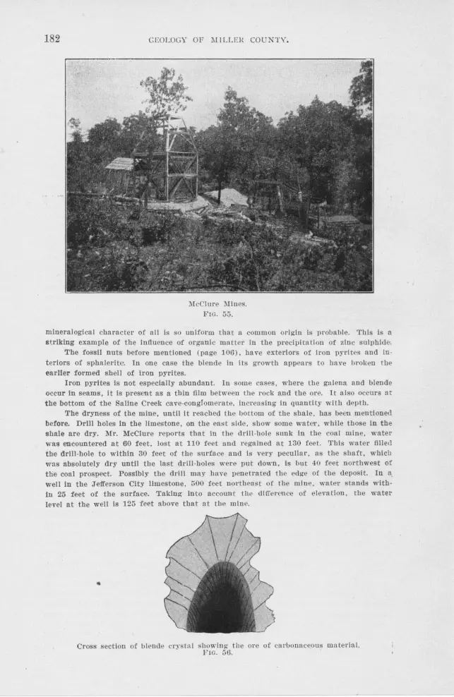
182 CEO LOGY OF 1111 LLEI{ COUNTY.
11IcClure ~Jines. Fro. 55.
mineralogical character of all is so uniform that a common ongm is prnbable. This is a striking example of the influence of organic matter in the precipitation of zinc sulphide.
The fossil nuts before mentioned (page 106). have exteriors of irnn pyrites and interiors of sphalerite. In one case the blende in its geowth appeaes to have brnken the earlier formed shell of iron pyrites.
Iron pyrites is not especially abundant. In some cases, where the galena and blende occur in seams, it is present as a thin film between the rock and the ore. It also occurs at the bottom of the Saline Creek cave-conglomerate, increasing in quantity with depth.
The dryness of the mine, until it reached the bottom of the shale, has been mentioned before. Drlll holes In the limestone, on the east side, show some water, while those in the shale are dry. Mr. McClure reports that in the drill-hole sunk in the coal mine, water was encountered at 60 feet, lost at 110 feet and regained at 130 feet . This water filled the drlll-hole to within 30 feet of the surface and is very peculiar , as the shaft, which was absolutely dry until the last drill-holes were put down, ls but -10 feet northwest of the coal prospect. Possibly the drill may have penetrated the edge of the deposit. In a. well in the Jefferson City limestone, 500 feet northeast of the mine. watet· stands withIn 25 feet of the surface. Taking into account tile di treen1ce of elevation, the water level at the well is 125 feet above that at the mine .
•
Cross section of blende crystn I showing the ore of caebonaceous mateeial. FIG. 56.

ECONOMIC" CONSIDERATIONS. 183
)Ir . .\lcClure reports that the cuttings from 20 feet of the lower 30 feet of the trial drill-hole would average 20 per cent. In blende. The shaft is J 36 feet deep and is all tim· bered. A horse powet· hoist bas been used in sinking, although at the time of our last visit, a steam hoist and pump were being installed. As .vet no ore has been sold.
The Sight Me Prospeot.-For location, geology and water conditions see page 107. This prospect. which Is located on the Foote land, was worked during the winter ot
1901-02 by the "Sight Me Mining Company," of Kansas City. The ore Is mainly blende. Galena and blende occur princiJ)ally In cavities in boulders. The galena is mainly confined to the chert boulders, although a few pieces were found In sandstone. The blende occurs in "cotton rock," dolomite. chei·t and sandstone. Some crystals were noticed In the shale. In one place a small sheet of blende was observed occupying a joint J)erpen· dicular to the bedding in the shale. On account of the sparsity of joints in the shale, such occurrences are uncommon.
)Ir. McLaughlin• states that this mine, under the former management, produced In 1898, 1,000 pounds of blendes.
The Son Prnspeot.-The location and geology of this prnspect have alrmdy been described on page 108.
The ore Is mainly blende, which occurs In concretlonary chert and as a cement In certain apparently brecciated cherts. This prospect was worked by the Centrnl )Iissourl Mining ancl Developing Company of Kansas City, during the winter of 1901-02. The development consisted of drilling three holes. from which rich cuttings are reported, sink· Ing a 33-foot shaft and running two short drifts.
No water was struck in the last drill-bole down to a depth of 100 feet. At this point a strong stream was encountered which flowed out at the top. The shaft was flooded when the drift cut into this drill-hole.
Joseph Cotton's Prnspeot.-(See page 103). This prnspect contains blende, both as "pebble" jack in the shale and as sheets parallel to the bedding planes In the cannel coal. Galena also occurs to a less extent In the shale and cavities in the flint boulders. A piece of grayish, calcareous chert with attached blende crystals was found, In which the blencle crystals had made a perfect Impression. There seem two possible explanations for this phenomena-either the chert Is younger than the blende and so formed around the blende, or the crystallizing force of the blende was strong enough either to Impress Its crystal form into the chert or to control the solution of the chert sufficiently to form n cast of the blende crystals in It. The chert seems to grade Into a siliceous dolomite, the whole resembling closely the chert and dolomite noted In vat·lous places In the lower portion of the Jefferson City formation, for example, sec. 11, T. 42 N., R. 15 W. One is Inclined to regard the latter explanation as the more probable.
E. A. lratt's Prospect.-Tbls prospect is located in the west center of the S. El. 1,4 ot the N. W. 1,4 of sec. 1, T. 41 N., ~- 16 W., along a small tributary of the South Moreau. The shaft was sunk on the contact of the Jefferson City formation and the Coal Measure
shale. Both galena and blende In the form of pebble ore were found In the shale while the pits In the decomposed dolomite forming the foot wall canied considerable blende.
In the N. El. 1,4 of the N. El. 1,4 of sec. 7, T. 42 N., R. 15 W., In a stream bed, L. G. Berkley has sunk several ten-foot holes in a small deposit of Coal Measure shale apparently occupying a cre\"ice In the Jefferson City limestone.
The dolomite surrounding the shale Is very much decomposed and Is full of very fine grained blende. At the surface the blende Is replaced by smithsonite (zinc carbonate), or is represented by crystal ~asts.
GEJNEJRAL CONSIDERATIONS.
The Coal :!\J easure shale is slickensideci , but the surfaces fit one another so perfectly that little space is left for the circulation of water. It is along the joints that the maximum deposition of ore has taken place in the Cambro-Orclovician rocks. Not only does the
*Manuscript notes on the lead and zinc of Central Missouri, gathered during )Ir. Leo Gallaher·s administration.

184 GEOLOGY O·F MILLER COUNTY.
shale lack the larger openings so nec(0 Ssary to a comparatively rapid and free water circulation , but it lacks the small cavities by virtu e of which the dolomites are so porous. The Coal Measure shales are particularly impervious and on this account water circulation cannot have been on a large scale. The large amount of organic matter present in the shale rather than the abundant circulation of water seems largely to have determined the deposition of the minerals.
The Cambra-Ordovician rocks in the vicinity of the shale pocket~ are very soft and badly decayed. This rock is an idtal place for the deposition of minerals and the few shafts sunk in the dolomite near tl]e contact look more promising than do those :;,,ituatecl in the shale. Not only is the rock porous in the viGinity of the shale, affording a free water circulation, but the shale acts as a dam, ponding back the waters and allowing them to become thoroughly mixed.
It is a well known fact that ore deposits in contact with shale& are often especially rich. In the \i\Tisconsin lead and zinc field rich "flats" of ore lay above the "oil" rock, a very carbonaceons shale at the top of the Trenton limestone. An especially rich blencle depqsit occurs in a brecciated and decomposed white chert beneath Coal Measure shale at the Massasoit mine at Joplin.* At the Moss Back mine at Galena, Kansas,** a similar rich zone lies beneath the shale. Winslow in speaking of the Alba Company's mine one half mile south of Alba, :'.\Iissouri, states: *''*;'A consideration of all t hese facts plainly shows that we have here another instance of a coal pocket, around the margin of which the or,es occur in a breccia of residuary materials derived from the Lower Carboniferous rocks."
In prospecting for lead and zinc outside of the shale pockets two things shouB he borne in mind. First, one cannot expect the immunity from water so peculiar to the prospects in the shale. Adequate preparations should he made to take care of the water. althouo-h more will not necessarily be encountered near the Coal Measure shalt! than in the Cambra-Ordovician strata away from it. Second, it will doubtless be ascertained that the size of the ore bodies is roughly in direct t"ct.tio to tha.t of the Coal Measure shale areas. Therefore, it is important that one shonlcl determine the size of the shale deposit prior to expending any money on development.
*Preliminary report on tbe lead and zinc deposits of the Ozark Region. H . F. Bain 22nd annual report U. S. Geo!. Sur. , TI"asbington , D. C., 1902, p. 180.
**Ibicl., p. 184. ***Missouri Geological Survey, Vol. VII, p. 577.

ECONO}UC CON lDERATIO ' 5. 185
THE DEPOSITION OF TCTE ORES IN THE CAMERO-ORDOVICIAN FORMATIONS.
The comparativel_v small amount and the shallowness of the mining which has been done in Miller connty render a comprehensive discussion of the ore deposits an impossibility. However, certain. conclusions were reached whi .. h may be of interest.
The lead deposits of Miller county, situated in the CambroOrdovician formations, belong to the third and most important class of Van Hise's genetic classification of ore deposits, namely: "Ores which receive a first concentration by ascending waters, and a second concentration by descending waters ."* In Miller county it is thought that the work of descending waters has been far more important than that of ascending waters.
As before mentioned, the Cambra-Ordovician series was laid down in shallow water, which condition is very favorable to the precipitation of the minute metallic content held in solution by sea water. Doubtless, in many cases, organic matter may have generated by its decomposition hydrogen s11lphide which is a powerful precipitant.
Robertson's anal)rses of Carnbrn-Ordovician dolomites in the central districts show the presence of minute quantities of lead and zinc. Among the rocks anahzed was one from a prospect shaft near the Rothwell m'ines. The rock contained no visible ore. The analysis, which W<1S run in cl_uplicate, is given below:**
Lead-Per cent.
.00156
.00143
Zinc-Per cent.
.oooso
.00024
Copper-Per cent.
.00040
.00064
Manganese-Per cent.
.00049
It is altogether probable that water was active in the concentration of this minute metallic content into crevices during the period when Miller . i::ounty was land, prior to the deposition of the Upper Burlington limestone, and again after that period and prior to the deposition of the Coal Measure rocks. However, at present it is impo sible to differentiate such concentration from ·that of later origin.
That the ore now worked was at least partially concentrated after the Coal Meas.ire deposition, i proven by the fact that there is above the Coal Measure shale in the Gageville mine a considerable secondary
•Some principles controlltng deposition of ores. "Van Hise, p. 428 In Genesis of Ore Deposits," A. I. 1\1. E., 1901.
.. Mo. Geo!. Sur., Yo!. Yil , p. 480.

186 GEOLOGY OF MILLER COUNTY.
enrichment. Moreover if the present crevices had been opened by solution at that time the Saline Creek cave-conglomerate or the Coal Measure shale would most certainly have fi!led them. Ore is also found in the Coal Measure shale. and it is probable that the deposition of this ore was contemporaneous with the chief enrichment of the Cambro-Ordovician strata.
Van Hise*, in his discussion of the origin of the central Missouri me deposits, names the Devono-Carboniferous shales as the upper impervious bed bounding the water circulai~on of the first concentration. In Miller county the Devonian shales may never have existed, but if they did, they were eroded away prior to tfre deposition of the Upper Burlington limestone. In Miller county the Coal Measure shales are probably partially replaced by sandstones. Moreover, before the close of the Coal Measure period they were completely eroded from some portions of the county. The Coal Measure shale may not have been sufficiently continuous at the close of the Coal Measure period to control the water circulation. It may be that the sandstone strata formed outlets for the escape of the ascending water. No relation has as yet been noted between the Graydon sandstone and the mining prospects. Leaving the Devono-Carboniferous shales out of consideration, the intercalated shales and fine grained argillaceous dolomites ("cotton rocks") of the St. Elizabeth and Jefferson City formations are perhaps sufficiently impervious to confine the water circulation.
The chief water bearing horizon was doubtless then, as now, the Gunter sandstone, although the cavernous dolomite of the Gasconade formation and the sandstone of the St. Elizabeth formation doubtless carried much water. We are unable to reconstruct the topography of 1\1iller couniy at the time of the elevation of the Coal 'Measure rocks. It is thought that the more broken country was in the vicinity of the present Osage river, but this stream does not appear to have cut down to sufficient depth to sever the northern portion of the county from the artesian circulation of the Ozark Plateau. Waters found their way into the rocks to the south and in their descent along the north dipping strata dissolved, from the rock traversed, minute quantities of the included metals. These matallic salts were carried in solution down the slope by ihe water and were deposited wherever the waters found a passage to the surface. Perhaps the present "diggings" are situated along especially open joints or at places from which the overlying impervious beds were first removed. That this first concentration was not very in}Portant
•Preliminary report on the lead and zinc deposits of the Ozark Region. H. F . Bain, C. R. Van Hise and Geo. I. Adams, 22nd annual U. S. G. S., p. 55.

ECONOMIC CONSIDERATIONS. 1 7
is indicated by the fact that in the Gageville mines no great enrichment lies immediately below the Coal l\leasure rocks. How the water passed through this, we ar~ unable to state. The shale probably pinches out in places, since some prospect holes have not penetrated it. In this first -concentration by ascending waters th e intermingling of solutions was probably the most important cause of precipitation.
With the partial removal of th e imperfectly impervious beds :ibove the ore' of first concentration, surface waters began a second concentration, which in Miller county seems to have very largely determined the present position of the ore bodies. This water being cha;-ged with carbonic acid and other solvents, derived from the air and the vegetation, ,ms potent in enlarging, by solution, the crevices, leaving in the crevices, clay, which is the insoluble residue of the dolomite. At the same time the galena contained in the crevice and the surrounding rocks was detached and remained in the clay. As erosion wore away the upper beds, this clay and lead descended with the rock. While much of the clay was washed away, the greater specific gravity of the galena caused its d escent to approximate the vertical. In consequence the galena in the clay, even on the surface of the rocks, closely preserves the direction of the crevice from which it was derived. Thus the ore which originally occupied a vertical seam, perhaps through several hundred feet of rock, has been mechanically concentrated in ten or twenty feet of clay at the surface.
While one portion of this second concentration was mechanical another wa s chemical, as Van Hise and Weed have recently shown. The lead in the clay is ail more or less rounded and corroded. This is due to the fact that surface waters have the power of dissolving galena with exceeding slowness. The lead salt was carried downward in solution and on meeting a precipitant was thrown down as the sulphide. A very good example of secondary enrichment is the rich zone lying above the Coal Measure shale in the Gageville mine. Here the precipitant was probably hydrogen sulphide, which was carried by water oozing from the carbonaceous shale. Shale is in the miners parlance "mineral band" and the miners state that galena ·is always found above the "mineral band ." While in some cases, the carbonaceous matter in the shale was doubtless the dominant precipitant, in others, where the shale is iess carbonaceous, the check offered to circulating waters by the shale and the consequent commingling of solutions from different sources may have been more important. We are unable to state, that chemical reaction between the iron and the zinc sulphides and the soluble lead salts has' been important in precipitating the galena of this district. ~1ining

188 GEOLOGY OF MILLER COUNTY.
development has not been extensive enough to prove the presence of sphalerite and iron pyrites at lower depths.
We believe that the position of the ore was largely determined by descending waters. Not only does the greater enrichment above the shale bed indicate this, but the galena found suspended from the roofs of caves points in this direction.
Above ground water level some secondary ores were formed. In the Saline diggings considerable amounts of impure cerussites ( "mineral clinker") are present, while outside small amounts of cerussite and smithsonite occur. The formation of these carbonates is probably due to re:iction between calcium carbonate (limestone) and the soluble metallic salts.
ROADS AND ROAD MATERIALS.
The upland area in the northern part of the county 1s sufficiently level, so that the roads are usually located on land lines. The grades are comparatively gentle, except in the vicinity of the larger streams. Clay, thickly studded with chert fragments, constituting what is known as "hard pan," usually underlies the soil at a depth of from 6 inches to 2 feet. This forms an excellent sub-soil for a road foundation. The soil which lies above the "hard pan" makes excellent roads in ummer and fall , but in winter and spring these roads are almost impassable. Once or twice a year the roads are "worked" by scraping t!ie dirt from the sides up into tlie middle of the road. Seldom, however, are any permanent improvements made.
The roads on the upland area are the most traveled of any in Miller county. The farming population is most dense on the prairies, but much of the produce raised by the people of the hilly country and bottom lands is transported to the market, a part of the way, at least, on the upland roads. In consequence, ·these upland roads should be the first, in Miller county, to be improved. The various streams afford an abundance of gravel, well adapted for the improvement of the clay roads.
Gravel containing pebbles over 230 inches in diameter should be screened before being used. Gi:avel which contains clay, iron oxide or calcium carbonate in sufficient quantity to serve as a binder is usually preferable to the clean gravel. However, the presence of a bir~der in Miller county is less important than in some districts. Prior to surfacing a road with gravel, the large stones and stumps should be removed and the road graded and rolled.
The roads in the brakes and bottom land country follow topographic rather than land lines. They are located either on the ridges or in the valleys. \Vith the exception of where the roads pass from the

ECONOMIC CONSIDERATIONS. 189
ridges to the valleys, the grades are, as a rule, very gentle. The residual gravel of all the Cambro-Ordovician formations is an excellent material for surfacing the roads.
This gravel drains rapidly, is free from dust in the summer and at all times forms a smooth hard surface. It possesses sufficient iron oxide to bind naturally. The ridge roads carry the principal traffic in the hilly country.
Rock exposures are numerous along all the roads and stone for macadam could be obtained very cheaply. A portable stone crusher cculd be used to advantage. The heavy pitted dolomite beds of the Jefferson City formation and the massive dolomite beds of the Gasconade limestone are doubtless best suited for this purpose. Both of these rocks have a uniform texture and are semi-crystalline. They would crush with comparative ease and would bind well. The cotton rock has been used locally to a small extent as a road material, and although it binds very readily it is soft and wears rapidly.
SAND.
There are two rnndstones, the Graydon and the Bolin Creek member of the St. Elizabeth formation, which are frequently incoherent enough to be cheaply crushed into sand. The Graydon sandstone is most abundant on the north side, while the Bolin Creek sandstone occurs altogether on
the south side of the Osage river. The Graydon sandstone is more frequently soft and friable than the Bolin Creek, and therefore constitutes the more valuable source of sand supply.
While in places both sandstones are almost without iron, the quantity of such sand is insufficient to constitute a source of supply for glass making. The sand possesses neither the fineness of grain nor the admixture of clay essential to a good moulding sand.
Both sands have been used locally for a number of years in mortar, and as far as kno,vn have given good satisfaction. If the grains were more angular they would impart greater strength to the mortar.
Sand for mortar is obtained from a 35 foot ledge of the Bolin Creek sandstone along Bolin Creek. Graydon sandstone has been quarried for sand on the south side of the Osage river at three localities: on the Fitzgerald farrn in the center of sec. 10, T. 40 N., R. rs Vl.; in the S. W.
,ri of sec. r9, T. 40 N., R. r3 V,l., near the range line; and in the north
center oi sec. 33, T. 39 N., R. r4 W. On the north side of the Osage river Graydon sandstone has been crushed for sand at the following loc~l-1ties: N. E. A of sec. 25, T. 42 N., R. I4 W.; S. E. }i of sec. 2, T. 4r
N., R. 15 vV.; northeast corner of sec r6, T . 42 N ., R. r5 vV.; north center

190 GEOLOGY OF MILLER COUNTY.
of sec. 19, T. 42 N., R. rs w.; and s. w. A of sec. 20, T. 42 N., R. ' 14 w.
In the construction of. the Chicago and R ock Island Railroad, considerabie crushed Graydon sandstone was used in the concrete. In theconstruction of the bridge across the Osage river, crushed dolomite from
the Gasconade limestone was substituted. The beds of the streams throughout Miller county contain almost
inexhaustible quantities of excellent gravel, while in the Osage river bottom there is an abundant supply of sand. This latter, however, is not· as clean as th~t derived from the sandstones.
SILICA.
Both of the term~ "chalk" and "kaolin," as used in this county, refer to a white powdery silica which has been formed by the disintegra- · tion of chert with the removal of a large portion of the associated impurities. Decomposed chert in this form is known commercially as . " silica." It is a soft, white incoherent substance which is unctuous to the touch arid very absorbent.
The gradual alteration of chert into silica both horizontally and· vertically can be observed in all the silica banks. In places the silica is found in the form of the concretionary chert nodules. The interior of some of these nodules is still unaitcred chert, while in other instances 1he alteration has only taken place where parting planes occur between· concentric layers of the nodules.
The Gasconade limestone is the only formation in which "silica" occurs in commercial quantities. In this formation the chert from which it is chiefly derived is secondary. Small quantities of silica occur where
ever the chert of the Gasconade limestone has been weathered for a long time. The more important occurrences of silica are enumerated below.
A bank belonging to Mr. West Hackney is located in the ~- V.f.
;4 of sec. 36, T. 41 N., R. 14 W. This is an open cut 250 feet long, 40
feet wide and 15 feet deep. The following is a section of the cut from top to bottom :
No. Elev. 1 141h-17'h 2 12-14 1h
3 11%-12
4 8'1s-ll'ls
5 5'7s-8'/s 6 31/e-52/s
7 2%-31/. 8 21/e-2'1. 9 1'/s-21/e
10 llh-1'/s 11 0-1 1/2
Section 29.
3 feet of soil. 2¥., feet of silica and chert in beds varying in
thickness. 4 inches of decomposed dolomite, stained dark
brown by limonlte. 3 feet of dolomite, chert and silica. These con
tinually replace one another laterally. 3 feet of talus. 2'h feet of dolomite with disseminated silica and
chert. 6 inches of silica and chert in thin beds. 6 inches of slllca, partially de-composed. 6 Inches of dolomite. 2 inches of silica and decomposed dolomite. 1 'h feet of silica.

ECONOMIC CONSIDERATIONS. 191
1he silica near the bottom of the bank is better in quality than that at the top. This bank has produced a large quantity of silica.
In the northeast corner of the N. E. Yi of the S. E. ,14 of sec. 14, T. 40 N., R. 14 W., considerable silica has been mined. At this place two laye::-s, two and a half feet thick respectively, have been quarried. A white seam of chert which run through the second layer in places completely replaces the silica and in others is itself almost entirely re
placed by silica. One-eighth of a mile southeqst of the last locality the same beds,
somewhat thinner, are quarried. This bank is owned by Mr. Alvin Reine.
Mr. Joseph B. Johnson has a silica bank in the southwest corner of sec. 19, T. 41 N., R. 13 W., from which eight to ten tons of silica have bee::;. shipped .
· Silica also occrus along Dog creek in sec. 12, T. 40 N., R. 14 W.; on Coon creek in the S. E. % of sec. 1, T. 40 N., R. 14 Vv.; on a cliff overhanging the Osage river on the line between secs. 27 and 34, T. 41 N., R. 13 W.; and in the N. W. }~ of the S. W. 0 of sec. 6, T. 40 N., R. 12 'vV. A three foot be<l was observed in a ravine in sec. 23, T. 40
N., R. 15 W. Silica is usually shipped to St. Louis by boat, although sometimes
by rail. The usual price is said to be $2.00 per ton at the bank.
SOILS.
The soils of Miller county are of two kinds, residual and transported. The transported soils occur mainly in the bottom lands as a result of stream deposition. The residual soils are found almost exclusively on the tops of the hills, ridges and tablelands and are a Rroduct of the decomposition of the rocks which immediately underlie them. The latter class includes all soils which have not been trasported for any considerable distance.
Residual Soils.-Proctor limestone and Gunter sandstone. The areas underlain by the Proctor limestone and the Gunter sand
stone are either largely covered by transported soils or lacking in soil of any kind.
The Gasconade Liniestone.-The areas underlain by Gasconade limestone, with the exception of the bottom iands where the soils are transportecr, are very little cultivated. This is due largely to the ruggedness of the topography and not to the unproductiveness of the soil. The tops of the ridges are so narrow and the hill sides so steep that the decomposition products are washed away almost as soon as they are formed. It is unusual to find arable tracts of over two or three acres. There is
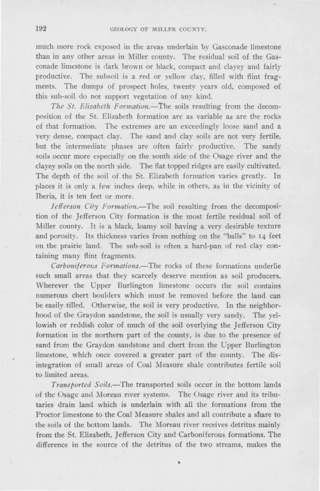
192 GEOLOGY OF MILLER COU 'TY.
much more rock exposed in the areas underlain by Gasconade limestone than in anv other areas in Miller county. The residual soil of the Gasconade limestone is dark brown or black, compact and clayey and fairly productive. The subsoil is a red or yellow clay, filled with flint fragments. The dumps of prospect holes, twenty years old, composed of this sub-soil do not support vegetation of any kind.
The St. EliI:abeth Forina:tion.~The soils resulting from the decomposition of the St. Elizabeth formation are as variable as are the rocks cf that formation. The extremes are an exceedingly loose sand and a very dense, compact clay. The sand and clay soils are not very fertile, but the intermediate phases are often fairly productive. The sandy soils occur more especially on the south side of the Osage river and the clayey soils on the north side. The flat topped ridges are easily cultivated. The depth of the soil of the St. Elizabeth formation varies greatly. In places it is only a few inches deep, while in others, as in the vicinity of Iberia, it is ten feet or more.
Jefferson City Formation.-The soil resulting from the decomposition of the Jefferson City formation is the most fertile residual soil of Miller county. It is a black, loamy soil having a very desirable texture and porosity. Its thickness varies from nothing on the "balls" to 14 feet on the prairie land. The sub-soil is often a hard-pan of red clay containing many flint fragments .
Carboniferous Formations.-The rocks of these formations underlie such small areas that they scarcely deserve mention as soil producers. \Nherever the upper Burlington limestone occurs the soil contains numerous chert boulders which must be removed before the land can be easily tilled. Otherwise, the soil is very productive. In the neighborhood of the Graydon sandstone, the soil is usually very sandy. The yellowish or reddish color of much of the soil overlying the Jefferson City formation in the northern part of the county, is due to the presence of ~and from the Graydon sandstone and chert from the Upper Burlington limestone, which once cov·ered a greater part of the county. The disintegration of small areas of Coal Measure shale contributes fertile soil to limited areas.
Transported Soils.-The transported soils occur in the bottom lands of the Osage and l\Ioreau river systems. The Osage river and it tributaries drain land which is underlain with all the formations from the Proctor iimestone to the Coal Measure shales and all contribute a s!1are to the soils of the bottom lands. The Moreau river receives detritus mainly from the St. Elizabeth, Jefferson City and Carboniferous formations. The difference in the source of the detritus of the two streams, makes the

ECONOMIC CONSIDERATIONS. 193
soils somewhat different both in composition and texture. The soil of the Osage bottom land is deeper than that of the Moreau and is ordinarily more finely comminuted.
Soils and Industries.-Until recently the chief crops raised in this county were corn and wheat. Within the past few years, however, apple orchards have been planted with a remarkable degree of success. The high iron content of the soils of the ridge land renders them especially favorable to apple cult,ure. With the completion of the Chicago and Rock Island Railroad, a large territory should be opened up to this pursuit. The climate seems too vigorous for the successful cultivation of the peach.
There is much land underlain by the Gasconade limestone and the
St. Elizabeth formation, which is almost valueless for agricultural purposes. If the underbrush and black oak were cut out and the white oak saplings allowed to mature, much of this land would pr0duce timber which is especially valuable for ties. With the removal of the underbrush, the grass would rapidly regain its original growth and the grazing value of the land would ·be greatly increased.
' In the future cattle raising will undoubtedly be a more important industry than it is at the present time. Sheep raising and the introduction of the Angora goat are among the very probable developments of the future.
WATER SUPPLY.
Few ·counties surpass Miller in the abundance and purity of their water supply. The water is obtained from four sources, (I) springs,
( 2) streams, ( 3) wells and ( 4) artificial ponds. Of the rain which falls upon the earth, a portion evaporates, an
other portion runs off of the surface and the remainder percolates down
ward into the rocks.
SPRINGS.
The springs in the hill country have determined the location of many of the farm houses. A map showing the location of the houses would snve almost equally as well as a map of the location of the springs. The water, when not contaminated by nearness ,to barns and outbuildings, is of excellent quality, usually hard and cold. The springs are usually situated along the 0utcrops of the water bearing horizons mentioned on
page 195. Tn the S. vV. 0 of sec. 19, T. 40 N., R. 14 W., an unusually fine
i-pring issues from the Gunter anclstone which is 3Yz feet thick at that place. A rapidly flowing stream 2 feet ,vide and 6 inches deep is formed by it. The spring has eaten back into the Proctor limestone and the
G-13

Hl4 GEOLOGY OF MlLLER COUNTY.
Gunter sandstone. forming a cave IO feet wide at the base and 5 feet high. In sec. 29. T. 41 N., R. 13 W., a large spring issues at the con
tact of the Gunter sandstone and Gasconade limestone. Sixty feet up the
bluff, a smaller spring issues from the Gasconade limestone, but disappears in a crevice 30 feet lower down.
Half way between St. Elizabeth and Iberia, by the road side, is a large spring flowing from the upper part of the Gasconade limestone.
Near the Camden county line in the southwest corner of the S. E. ~ of sec. 17, T. 38 N., R. 14 'W., is a creek IO feet wide which heads in a spring flowing from the upper part of the Gasconade limestone.
There are fewer springs along the Moreau and its tributaries than on the Osage river. This is due to the fact that the valleys of the former have not cut through any important water-bearing horizon. The best spring observed along the Moreau or its tributaries was in the southeast
corner of sec. 1, T . 41 N., R. 16 vV. Several farmers have piped spring water into their houses. The
Brumley hotel usues for domestic purposes a spring issuing from the contact of the St. Elizabeth and Jefferson City formations.
The Composition of Spring Water.-All spring water contains a greater or less per cent. of mineral matter in solution. A mineral water may be defined as a natural water, which, from its peculiar chemical composition, is of value in the treatment of disease.
Sulphur water flows from the upper 40 feet of Gasconade limestone on Mr. Hale's lan1, on the county line, in sec. 12, T. 38 N., R. 12 W.
In the ~outhwest corner of the S. E. y,i of sec. 23, T. 41 N., R. 14 W., a sulphur spring issues from the east bank of Saline creek. The stream is about one inch in diameter, but is said to flow constantly. The water has a slight sulphur taste. Pebbles in the spring are blackened and smell strongly of sulphur, while those in the creek near by ha·v-e been
colored :ed. Gas in considerable quantities bubbles from this spring. The water is said to be beneficial in the treatment of diseases of the eye.
The Aurora springs, situated in the S. E. ~ of the S. E:. 7-4 of sec.
9, T. 41 N., R. 15 W., flow from the upper 35 feet of the Gasconade limestone. At one time these springs were considered among the most valu
able of Missouri's medicinal waters. The following analysis appears in Bulletin 32 of the United States Geological Survey, page 168:
Grains per gallon .......... . .................. . . . .......... . ................ . ........ . ..... . . . 20.878 Iron carbonate ....... .... .... .............. . .... . . . .. ......................... . . .... .. . .. ... .. 5.130 Calcium sulphate ..... ... ..... .. ............. . ... . ........ . ... . .... . . .. .... . ................ . .. 2.427 Sodium chloride • . . .. . . . . . . . . . . . . . . . . . . • . . . . . . . . . . . . . . . . . . . . . . . . . . . . . . . . . . . . . . . . . . . . . . . . . . .. . . 4. 009 Magnesium chloride . ... . . ....... .. .. ... .............. •.. ..... ... ... ..... .. .. ...... . ...... . .. .. 6.949 Lithia ••.•. •. . •••........ ...... . ... . ....... ... . . ... . .. . .° .. .... ... ... .... .. ....... ... •. ... ... .... . 1.430 Ferrous oxide . . . . . . . . . . . . . . . . . . . . . . . . . . . . . . . • . . . . . . . . . . . . . . . • . . . . . . . . . . . . . . . . . . . . . . . . . . . . . . . . . . 933

ECONOMIC CONSIDERATIONS. 195
WELLS.
The townspeople and farmers residing on the ridges usually depend, for their domestic needs, either on ( 1) rock penetrating wells, ( 2) cisterns and dug wells, or (3) flowing wells.
Water Bearing Horizons.-The rain water which percolates downward into the earth is largely contained in horizons of porous rock. It is from these horizons that the wells derive their water and it is from these that the springs flow.
Here, as elsewhere, sandstone is the most important water-bearing rock. The Gunter sandstone is perhaps the most important water-bearing formation in this county. The shattered chert beds of the Gasconade limestone are zones of considerable water flowage, as shown by the masses of travertine deposited upon their outcrops.
There are three horizons in the St. Elizabeth formation along which water circulates abundantly. The most persistent of these is the broken chert bed at the base of the formation. On the south side of the Osage river the Bolin Creek member is an important water bearer. The cellular conglomerate sandstone at the top of the formation is also an almost constant aquifer.
The intercalated sandstone beds in the Jefferson City formation are also water.:bearing horizons.
Rock-Penetrating Wells.-Water can usually be obtained in the Gasconade limestone at from 30 to 50 feet from the surface. At Tuscumbia the wells at the base of the bluff encounter an abundant supply of water at from 20 to 30 feet, but those on the hill, which is surrounded on three sides by steep slopes, do not strike water at less than 100 feet.
Wells in the St. Elizabeth formation usually have an abundance of water, though in some localities the use of cisterns is necessary. The wells in the vicinity of the Aurora Springs depot are from 105 to 120 feet deep. · In drilling these wells, it is reported that from 70 to 8o feet of ct'olomite and 8 to IO feet of flint were passed through before entering the water-bearing sandstone. The water rises from 20 to 30 feet above this sandstone and is said to be practically inexhaustible.
Where the Jefferson City formation is thin the wells usually penetrate the upper beds of the St. Elizabeth formation and from these water is obtained in abundance. The wells at Mary's Home are from 30 to 100 feet deep, although sufficient water is usually obtained at a depth of from 30 to 50 feet. The water is apparently derived from the upper beds of the St. Elizabeth formation.
Cisterns and Dug W ells.-1Where comparatively deep wells are required to reach a water-bearing horizon, cisterns are in common use.

196 GEOLOGY OF MILLER COUNTY.
Cement-lined cisterns furnish water to the people living on the ridge at Tuscumbia. Cisterns are common on all the more elevated ridges in the areas underlain with the St. Elizabeth and Jefferson City formations. Shallow wells dug in the alluvium furnish water to many of the families in the bottom land areas. The water, as a rule, is soft.
Flowing Wells.-Several flowing wells are situated in the valley of Blyth's fork in the vicinity of Olean. One on Mr. J. C. Johnston's place is said to have passed through IO feet of alluvium and 57~ feet of interstratified flint and sandstone. Before rock was struck, an abundance of water is reported. This well flows 7~ gallons per minute. Mr. Johnston has a second flowing well in his yard, and there are others at the canning factory, the flour mill, the livery stable and Johnston Brothers' store. The last two do not flow at present, the former because of imperfect piping and the latter because of wells which have been since sunk at a lower level. Alternating beds of impervious shale and porous sandstone and chert combined with the dip of the beds give rise to conditions favorable for flowing wells at this place. There is very little hope of obtaining artesian wells where the land is more than 25 feet above the level of the creek at Olean.
One of the drill holes at the Son prospect in sec. 19, T. 41 N., R. 15 W., is a flowing well. This is situated near the top of the Gasconade limestone. The hole is 140 feet deep, no water ha.ving been struck up to 100 feet. The well is 12 feet above the bottom of the Little Gravois creek at that place. In the bottom of Bailey's Branch, two and a half miles northwest of Iberia, George Graves obtained a flowing well at 6o feet in the Gasconade limestone.
The Purity of Well Water.-Through man's negligence and ignorance well water frequently becomes contaminated. The shallow wells sunk in the bottom land areas are especially dangerous since the alluvium not only carries a high percentage of organic matter, but, being porous allows impurities to readily enter the well. Comparatively deep wells situated near stables are a constant source of danger. All wells should be cased with iron pipe to a point beiow some bed of clay, shale, or other impervious strata.
ARTIFICIAL PONDS.
In Miller county the farmers living on the ridges construct small, artificial reservoirs in the impervious clay subsoil. During the winter and spring, these depressions are filled with rain water from surface drainage. These reservoirs provide sufficient water for the stock except during the most severe droughts.

ECONOMIC CONSIDERATIONS. 197
WATER POWER.
The larger springs of this county have a sufficient flow to furnish power to mills of small capacity.
G. L. Wright runs a small carding mill, using for power the "Big Spring" situated on the section line in the N. E. ~ of sec. 34, T. 41 N., R. 14 W. At this place the water issues from a number of holes in the ''hard pan" in the bottom of Little Saline cr,eek. A circular embankment .25 feet in diameter and 5 feet high has been built above the bottom of the creek to confine the water. From this reservoir the water passes into a
race and onto an over-shot wheel. The amount of water fluctuates somewhat, although entirely independent of local rains. The drought of the summer of 1901 somewhat reduced its flow.
Springs situated somewhat less than one-fourth of a mile up a gulch tributary to Tavern creek, furnish power for Bray's flour mill in sec. 9, T. 39 N., R. 12 W.


INDEX.
Page. .Acknowledgments . . . .. . . . . . . . . . . . . . . . .. . .. IX .Adams, Geo. I., referred to .............. 186 .Alba Company's mine . .. .............. .. . 184 .Albertson, David, refened to ....... l 7l, 174 .Allee, Dr. W. S .. acknowledgments to. IX .Alluvial deposits .......................... 122 .Alluvial plains . ... ....... ..... .. ... . . ..... . 2
area of.......... ... . . . . ............... 2 .Altitudes, table of..... ... ................ 13 .Archimedes limestone. ..... .. ........... .. 11 Artesian wells at Olean. ... .... .......... 18 Aurora Springs, analyses of wa te ,· from l 94
description of ........................ 194 .Auglaize creek ... .... .........•......... .4, l 7 Babcock, Mrs., coal in well of . ......... 15:l Balley branch. ....................... .... .. Hi Bain, H. F ,, r eferred to .. .... 143, 184, 1 6 "Balls" ....... .... ... . .... .... .. ......... .. 7
in Gasconade limestone ..... ....... 7. 31 in Jefferson City formation .. . ... 7, 70 in vlcin! ty of Sycamore Spring
Hollow ............................. 8 Bar!te ..... . ... ..... .. .. ...... ......... ..... 106
associated with black chert.. ... .. . 42 associated with galena . ............. 14 In the Con! Measure formations .... 106 in the Gasconade limestone.... .... 42 in the Je!l'erson City formation. . .. 76 in the Loveall diggings, two gen-
erations of . . . .. . . .. . .. .. . . . .. . . . . . 175 in the t. lllllzabeth form a tlon.... 60 market for . . . . .. . . . .. . . . . . . . . . . .. . . . . . 149 Martin's diggings ... . ................ l48 methods of mining ... . ... . .. . . ...... .. 149 occurrence of ... . ..................... 148
Barren Forks . .............. ... ........ 4, 16 Barron. Wm. A., referred to ............ 120 Bear Creek . .. . . . . . . . . .. . . .. . . . . . . .. . . . . . . . 4 Beckman's cave............................ 12 Bedding . . . .... .......... .... ..... ...... 59, 74
discordance In .... ... ........ . . ...... . 175 In Bolin Creek sandstone ........ 62. 64 in Coal Measure shale .. . ........... 105 in Gasconade limestone . . . . . . . . . . . . . 39 in Graydon sandstone ........... . 97, 98 In Gunter sandstone.................. 26 in Je!l'erson City formation........ 74 in Low~r Carboni f~rous ......... 6, 87 in Proctor limestone. ........... . .... 23 In St. llliizaheth formation ......... : 5
Belcher, Mr. , referred to ................ . Bell , Tempie Ill., referred to ........ 160. 11;; B erkley prospects of ...................... 183 Blackbyrn diggings .... ........ . . ... . ...... 17fi Bien de, at McClure's c·oal bnnk. age of. 180
associated with barite. galena a11<l coal .... .. .. ......... .. .. . . .... . 148, 179
associated with galena in coal. .... 178 erystals of, In vugs.................. 180 fossils In ............... ... ... .. ... . .. l 0 in coa l. . .... ...................... 11 8, 17H In Coa l l\leasnre shale .. . . 106, 16 , li2
Page . Blende, in Gasconade nmestone . .... .-11, 167
In Jefferson City formation .. 75, 76, 168 In St. lllllzabeth formation ...... 60, 168 Influence of organic matter in pre-
clp!tnt!on of ...... .. ..... ..... ...... 182 occurrence of. wl th gypsum. . . . . . . . 180 "peacock." r efered to ................ 180 production of, with lead .. ... ....... 161 "strawberry" variety .......... . . l 18, 181 (see spbalerite).
Blythe Fork. .............................. . 18 Boan, Mrs., coal In weU of ... . . ....... 153 Rolin Creek, referred to ..... . ...... .. 16, 61 Rolin Creek sandstone, basal bedding
planes of ..... ..... .............. r.2, 64 chert in .... ..... .. .... ... .......... C.2. 65 color of.. .. . . .......... . . ...... . ....... 68 general descript ion of................ 61 Iron bank, description of ............ 157 jointing In . ........... .... ............ 133 position of in St. llllizabeth forma-
tion ..... .. ..... ... . . . . . . .. .. .... .. . 62 summary ............................. 65 thickness of ... ..... . ... .......... 61, 62 typical exposure of.................. 61 used for mortar... ... ....... .... . . .. . 189
" Bone" chert............. ........ . ......... 315 Hranner, Dr. J. C., referred to.......... 15 Bray's Mill ................................. 197 Breccias, solution ..................... 166, 171 Breckinridge. H. M. , Jr .. r eferred to .... 159 nroadhead, G. C .. referred to . . 162. 172, 178 Rrumley creek...... ...... ... ... .. .. . ..... .. 17 Brumle:v Hotel, springs at .... ... ... ... . .. 194 Brush creek........... ... .... .... . ..... ... . l8 Rrushy For!, of Tnvern creek ....... .4, 16 Buckley, El. R., r efrrred to . .. ..... .. 86, 138 Ruliclin~ stone .............. . .. ........ 149, 150 Bunche. llfr., coal on land of ... ......... 153 Bunk. M,·., referred to .................... 179 Bunker's prospect, crevices in .... ...... .. 169
description of ..... ..... . .............. 169 Burlington limestone. unconformltv
with St. lllllzabeth formation .. .". 60 nushwhackers .. . . .. . . . .. . .. . .. .. . . .. .. . .. 20 Ruster, .Tnmes, referred to.... . .......... 171 Ruster, John,. referred to .......... 171, 172 ra tciferous sand rock ............ ... ...... 118 ('n I vin, Samuel. r eferred to .... . .. .. ..... l.48 C'ambro-Sllurlan, unconformity with
Upper Burlington limestone...... 88 rannel coal, at R. B. Snyder's ....... ... 103
in sec. 2, T. 41 N., R. 16 W .. .. .. 103 in sec. 3. T . 41 N., R. 16 W ....... 103 in sec. 11, T. 41 '. , R. 16 W .... 103 origin of......... .......... ............ 117
Cannon mines ..................... . 63, 94, 95 Capp's blu!l'.. .. . ........................... 30
columnnr S(\C'tlon of . . . . . . . . . . . . . . . . . 47 C'npp's diggings ..... . . .. . ...... . .... . .. l 60, 178 C'app·s smelter ............................. 161

200 GEOLOGY OF MILLER COUNTY.
Pnge. Carbonnceous material in bleude crys-
tal .................................. 18:! Carbonaceous shale In sec. 26, T . 42
N., R. 14 W.... ......... ......... 83 Carbonates, formation of ................ 188 C,1rbonlferous formation, soil resulting
from decomposition of. ........... 192 Carboniferous shale in Grnydon sand-
stone . . . . . . . . . . . . .. . . . . . . . . . . . . . . . . . 90 Caves .......................... . ... 11, 12. 13 ('ave In sink bole topography ............ 116 Cedar Blull'...... .............. ....... ..... 5 Cements ................................. . .. 150 Central Missouri lead district. ......... 159 Central Missouri Mining & Developing
C01Dpany ........................ . .. 183 Central llJ;lssourl Mining & Mineral
Company . . . . . .. . . . . . . . . . . . . . . . . . . . l 77 Cerusslte In Gasconade limestone....... 41 Cerusslte, nodular ... : ..... ............. . .. 172 Chalk (see silica) ...... . ................ . Character of pitted surface of Jell'erson
City limestone....... . .. ............ 71 Cham·enet. Regis .. ... . . ................... 162 Chert . . . . . . . .... .. . . .. . . . . . . .. . . . . . . . . . . . . . 72
at base of St. Elizabeth formntion. 8 disseminated .. . ............ . .. ... . :l6, 145 distribution of ........... . .......... 144 esca rpm en t formed hy............ . .. 56 banded character of In Gasconade
limestone . . . . . . . . . .. . . . . . . . . . . .. . . . 35 fine grained from Little Nugget
mine ................. .. ............. 85 fossiliferous In UpDer Burlington
limestone .................... . .. s~. 86 honeycombed ..................... 116, 60 in Bolin creek sandstone . .... . .. r.2. 65 in Gasconade l!meston e ... . ...... ~-1. 144 in Jefferson Cl ty fornrn tlon......... 72 in Proctor limestone....... 21\ in St. Elizabeth formation ...... rm. 57 lead. zinc and barite assoc!nted
with . . . . . . . .. .. . . . . .. . . . . . . . . . . . . . . . 36 manner of occurrence........ 144 nodular ....................... 72. 14-1, 147
tn Ga conade l!m estone........ 3:i in Upper Burlington limestone 81\ In Jointing planes...... ..... ... 57
oolitic, in Gasconade limestone.... 37 origin of .............. . ... 1-11\, 14G, 147 petrographical character or...... 1 4ri relation of, to dolomite ........... . 145 secondary ..... ... ................. 3G, 85 source of sill ca of . . . . . .. . . . . . . . . . . . . 86
Cherty horizons.... ....... . ..... 34 Chimneys ..... ............. 13:l. 1 GG. 171, 171\ Chouteau limestone. . .... .... ...... ........ 2 Circles · ................................ 1 G3, 175
description of ...............•......... 166 Cirque llke valley beads ....... . ..... 70, 111
origin of.................. . ........... 6 Cisterns . .. . . . . . . . . . . . . . . . .. .. . . . . . . . . . . . . . . 10:i Clay diggings .................. . ........ . .. 160 Clay from Coal Measure shale .... . ..... 151
on bank of Lick creek.......... . . . . . . 151 Clinking Beard Hollow .................... 16 Coal at Bt.vthe's Fork ......... . .......... 1::;::i
at IIJerla ........................ . ..... 15·1 bank, of Stover, referred to ........ 180 bituminous, G. W. Shelton's pros-
pect .. . ...... ... .................... 15:l deposits, manner of 'occmrence .... 11
size of ............... .. ...... 102. 15-1 galena In . .............. . ......... 106, 118 Garner well section ... ............... 114 H. N. Nownll's pro Jlect ............ 153 in ('. H. Coykenclall"s welt. ......... 154 in James L . .Jobe·s well. ............. Hi-I iu )111 ler count.,......... . . .. . . .. 152 ln )ft· .. Boan·s well. ................. l :rn in ,frs. i\fnl'thn P.nhcock·s w~ll. ... 1;;:i
Page. Coal, tu Ramse.v's well .. .................. 154
in sec. a. 'I'. an X. n. 13 w ........ 15::i In sec. 4. T. 39 N., R. 13 W ........ 116 In sec. 11. T. 38 N., R. 14 w .. 115, 153 ' In sec. 3:i. T. 42 N., R. 15 W ...... 153 In T. W. Cotton's well. ..... . ....... 153 metasomattcally replaced by blende 180 on Jlfr. Bunche's land ............... 153 prospect ln sec. 17, T. 41 N., R. 15
w . .......... ........................ 153 prospect of Jullus Cotton... . ...... 105 reported tn sec. 2, T. 41 N., R. 14
w. ······· ······· ···················· 153 Simmon heirs' prospect ..... . . . ...... 153
Coal Measure formljtlons, description of 90 Coal Measure rocks. deposition of ...... 115 Coal Measure shale ..................... 1, 2
bedding ln .................. ...... .... 105 Burlln_iiton chert ln .......... ........ 83 columnar section of at Republlc
coal mine ............•............. . 110 faulting in ....................... . .... 105 folding of ........................... . . 105 fossils Ju ......................... 105. 106 galena in ....................... . . 106, 168 geographic distribution of .....•.... 100 I lthological characteristics of...... 102 relations to other formations ...... 106 thickness of ............ . .. . . ..... . .... 102 topography Imparted by .. ' .......... 102 unconformity with Gasconade lime-
stone, St. Flllzabetb formation. Jell'erson Ctty formation, and Upper Burlin.ii ton limestone ..... 139 unconformity with St. J]Jlizabetb formation . . . . . . . . . . . . . . . . . . . . . . . . . . 60
weathering of ........................ 102 Cobalt and galena..... . . .. . . . . • . . . . . . . . . . 162 Cog mineral................... .......... ... 172 Coke .. ...................................... 11:l Cole county........... .. .. . ................. 8!l Compton, H. M., refer1·ed to ...... ...... 176 Com1Jton diggings ... .. . .................. 4, 17 Concrete . . . . . . . . . . . . . . . . . . . . . . . . . . . . . . . . . . . 190 Concret!ooary structure of sand. tone .. 27 Conglomerate. basal. ...... .. .... . ......... 13!)
Couglo~~~.:!tio;h~'.·~ .. '.n .. . ~.t: .. ~'. i.~~~:.t.~ 55 Conglomerate In Graydon sandstone.... 97
iutraformatlonal ....... . ...... 24. 34. 7!l Con log. T. B .. referred to ... ............. 172 Con log circle. description of ..... . ........ 171 Contog diggings (See Walker diggings) Coon creek ... ·~· ·. , .. . ................... .4. 17 Copper .... ... ............... . ............. .
in Gnsconnde limestone.. ..... 42 In St. Elizabeth formation .. . . .. ,._. 6n
Corroded galena ........ ......... ... . ....... 187 Cotton. T. W., coal in well of . ......... 15::i Cotton rock . . ..... . ..................... 71, 143
concretions of limonite In... 70 horizons ln Jeffer on City forma -
tion . . . . . . . . . . . . . . . . . . . . . . . . . . . . . . . . 71 texture of............... . ............. 71
Coykencla 11 's, C. H.. prospect. desert p-tiou of ..................... . ... 16!1, 170
Crawford county...................... ... . !l c,·evlces enlargeq. by solution ........... 166
non-procluctive ln Gasconacle lime-stone, strike of .................... 165
productive In Gascounde limetone. strike of.... . ............... 11l5
non-proclucing. !n Gasconacle lime-stone . . . . . . . . . .. . . . . .. . . . . 1(14
ore-bearing ln Gasconade limestone 1 r,4 In .Teff rson C'it:v formation ........ 164 in St. Elizabeth formation . ....... 1R4
r,·iuoids. sllicificntion of....... ........... 86 Cross heddlng- ..... . ..................... :l4 . 64 C'ross sections across the count)" ..... .. . 141 CrumD diggings...... ...................... 60

INDEX. 201
Page. Crump diggings, description of .......... 169 Crustlfication, order of, Walker dig-
gings .......... ... ... ............ .. . 173 SL"ystaliza tlon, forces of.. . . . ............. 181 c,·ystallzed ore ............................ 168 Cub creek. exposure of Graydon sand-
stone near .......................... 100 Current river.............................. 1 Curved stratification planes.. .... ........ 90 Curty diggings ..................... .. ...... 160
descrlp.tlon of ... . ..... . ............ ... 175 Customs of the "hill people' '... ..... .... 21
Dana, James D., referred to ........... 143 Davis, W. M., referred to................ 14 Dendrit!c drainage.... ................ .... 5
markings .......................... 54, 71 Deposi tion of ores ........................ 185 Dice mineral. ......................... 118, 181 Diehl . J oseph M ....... ........ ............. 171 Diggings (See Prospects) . DiQrlte pebble . .. . .. . .. .. . .. .. .. . .. .. . .. .. . 120 Dip of 'Cpper Burllngton limestone .... 12G Disseminated ores .................... 163, 180 Divides . .. . • . . . . . . .. . . . . . .. . . .. . . . .. .. . . . . . 18 Dog creek ................................ 4, 17 Dolomite. general character of ..... . .... 142
conchoidai fracture in .... . ......... . 72 origin of ...................... . .. . 143, H4 table showing percentage of mag-
nes ium carbonate contained In . . 142 Dolotml tizatlon, loss of volume during . 143
results of...... ............. ..... ... .. 10 Dykes in Bolln c t·eek sandstone...... 63
Eldon , dip of strata at ......... .... .... . 60 Erosion, mechanical agents of.......... 2 Escarpment formed by chert ....... - .. 1 , 56
at the base of the St. Elizabeth for-mation . .. .. . .. .. .. . .. .. . .. .. .. .. .. . 8
Fancher Hollow, Gunter sandstone In.. 2!\ Faul in Fancher Hollow . .... . .. . . . . .... .2!\
in sec. 11. •.r. RS N., R. 13 W ...... 129 in sec. 13, T. 38 N., R. 13 W .... .. 12!1 in sec. 14, T. 38 N., R. 13 W ...... 120 in sec. 4, T. 40 N., R. 15 W ..... . 130 in sec. 10. T . 40 N., R. 15 W ....... 130 in sec. 1.,_ T. 41 N .. R. 15 W ...... 130 in ec. 4, T . 41 N .. R. 15 W ...... 130 in sec. 10, T . 41 N., R. 15 W ...... 130 in ec. 6. T . 38 N. , R. 13 W ...... 127 in sec. 5. T . 38 N .. R. 13 W ...... 127
Faul ts, i,ra,·lty ot· normal. .......... ..... l 26 Faul ting. e,-idences of . .. .... ..... ... 129, 130
in Coal i\feasure shale . .... .. .. ..... 105 in Gasconnde limestone . ...... .. . 39, 40 in Gra~•don sandstone............... 98 In .Tefferson City formati on. ..... . . 75 In ,;r. Elizabeth fo,·matTon........ 68 in l:ppel' Burlin)?ton limestone..... Si
.Feldspar. u-iclinic. in oo litic chert . ... 145 F erries, location of... .. .. . .. .. . .. .. .. . 15 Ferry (see ferries). Fisslll ty .. .................. ................ 135 Float lead.. . .... ... .. . .... ... . ... . ........ . 76 Flowing wells .............................. 196 Folds, description of . ..... . . . ... . .... 125. 126
kincls of ......... ....... : ......... 124, 125 origin of .............................. l 26 planes of weakness a long ........... l 26
F ords. locn t lon of . .. .. .. .. . . .. . .. . .. .. .. . 15 Fossil nuts ... ..... ................ .. ...... . 182 Fossils-
In blende .. ...... ........... ... ........ 180 In f:r. Elizabeth formation.......... 5!l In Coal Measure s hale ..... ... 105, 106 in Upper Bnrllngton limestone.87, 8
Fox diggings .......................... 160, 165 iles~riptlon of.................... .. . .. l 73
Franklin . R. P .• referL"ed to .. ......... , i Q
Page. Frnnklin diggings, description of .. . . , . . 170 Fucoldal markings......... ....... . .. ..... 57 Gagevllle mines ................ . .......... .
108, 118, 160, 161. 167, 168, 172, 187 descl"iptlon of ....... ....... . ......... 171
Gageville !fining Company ... .. . .. .. 171, 173 Galena, analyses of ........... ............ . 162
associated with barite ..... ... . ...... 148 associated with blende in coal. ... 178 corroded . .. . . .. . .. .. . . .. .. .. .. . . . . .. . . 187 c,·ystals encrusted on sandstone ... 181 in coal................................. 118 in Coal Measure shale ... ....... 106, 168 In Gasconade limestone ......... .41, 167 In Graydon sandstone .. ... .. ...... ... 60 In Jefferson City formation .. 75, 76, 168 in St. Elllzabeth formation ...... 60, 168 smelted in hollow logs .............. 160
Galena limestone ......... .. ............... 143 Garner, T. B., referred to ........ 114, 154 Gas ............ .. ...... ........... . ........ 154
In springs ............................. 194 Gasconade llmestone, areal distribution
of ...... ............................. 30 bedding In ........ . ... ... . .. ........... 39 cerusslte In .. ............... ..... .... .. 41 chert of... ........... .. ...... .......... 34 color of cher ts in ................ 36, 37 color of weathered surfQce. . ... ... 31 columnar sections of .............. 43 , 49 copper In. ......... . ................... 42 differences between St. Elizabeth
formation and ................ .. 51, 52 dolomite of . .. ...... . .. .......... .... .. 33 faulting In ......................... 39, 40 galena In ......... ... ...... ....... .41, 167 general character of...... . .......... 50 horizontal zone of breccintlon in .. 40 iron in ....... ... ....................... 41 jointing In .............. . ...... ... 30, 132 nodnlai;._ chert In.... ......... .. .. .. .. 35 oolitic chert In.......... ............. 37 oolitic dolomites in ....... .. . ........ 33 OL'e bearing crevices In . . .. .. ........ 164 ore bearing horizons in ........ .. .... 167 relation of, to Gunter snndstone.. 40
to St. Elizabeth formation.... 40 resume . . .. . .. .. .. .. . . . . . .. . .. . . . . .. .. . 42 secondary changes in.... ....... ..... 39 smithsonite in ........................ 41 sphalerl te In .. .. .. .. .. .. . .. .. .. .. .. . 41 soil r esnl ting from decomposition
of ..... ................ .. ............ 191 stratification planes in .. .. . .. .. .. .. . 38 structure of........................... 38 thickness of. . . .. .. .. . . . .. . .. .. . .. . . .. . 30 topography of region underlain by. 30 unconformity with Carboniferous
rocks .. . .. .. . .. . . . . . . .... . . .. .... .. . 40 Gasconade river. .. .......... . ..... . . . . . . . . . 1 Gille la nd diggings, description of .. ... . 170 Glacln I age ... .............................. 119 Glacial boulders , location of ...... 119, 120 Gold ..................... .... .. ...... .... ... 194 Granite boulders (See Glacial boulders) . Grass Root diggings .................. 160, 172 Graydon sandstone. a!Jsence of bedding
planes In..... .. .. .................. 97 Adcock exposure . . . . . .. .. . . . . .. . .. .. . 99 ar~a I dis t ribution of................. 95 bedding of ...... ..... .............. !\7, 98 Burlington chel't in . . ....... .... .... . 83 Carboniferous shale in.............. 90 concret ions of limonite In.......... 97 Cub c reek exposure . .............. . . . 100 Coal Measure s hal e prnbnblr
phase of same forma tion ...... .. 80 c·1·escPntric shape of. in ;11111 ('reek exposure ................. . ............ 100 Dog creek CX[) OS lll" P ........ . ......... 100

202 GEOLOGY OF MILLER COUNTY.
Page. Graydon sandstone. elliptical shape of. 95
economic considerations............. 60 exposure In sec. 4, T. 39 N., R. 13
W . .................... . .. ....... .... 90 exposure near Olean . .... ... .... ...... 90 faµltlng lo.......... ... ............... 98 formation of . . . . . . . . . . . . . . . .. .. . . . . . 117 galena In............. .. ............... 60 jolotiD!? in .. .. . . . .. .. .. .. .. .. .. .. .. .. . ni lithological characteristics.......... 97 Manning exposure ..... ........... . ... 100 Mill creek exposure .......... .... . ... 100 polygonal markings on surface of. !16 size of an outlier of................ !16 thickness of . .. . . . .. .. . . .. .. .. .. . . .. . . 96 topography Imparted by............ 96 trails of boulders of................ 95 uncooformitles in . ............... 98, 99 unconformity with Gasconadde
limestone. Jell'erson City forma-tion and St. Elizabeth formation 188
unconformity with St. llllizaheth formation .. .. . . . . .. .. . .. . . . .. . . .. . . 60
unconformity with Upper Burlington limestone.................. 88
weathering of................... ... ... 90 Gunter sandstone ................ . ..... 26. 186
arell of............................... . 26 beddln11: of............................. 26 color of................................ 28 composition of........................ 2S lo Sandstone and Fancher hollows 29 jointing lo .... .......... ........ ...... 182 Proctor limestone uncooform i ty... . 2!l rein lion of, to Gasconade limestone 40
to other formations............ 2!l ripple marks In...................... 26 sr.rtnirs occurring In ... . ........ 193. 194 stratification of .. ........ ... ........ . texture of ..... ... .................... . thickness of .......................... . unconformity with Proctor lime-
?~ _, 28 26
stone .. ........ . ............. .... 24, 136 wea therlng of......................... 27
G~·psiim ....................... .... ..... 106, 114 with blende ......... .... ...... ... ..... 180
Hackney chalk bank ................... . .. 180 Hackney, W. A., referred to ...... 171, 190 Hard pan ......... .. ....... ... .............. 188 Hazel Root diggings (See Mcl\Illlan
. diggings) ................... .. ... . . 169 Hematite ........................ . 156. 157, 158
In Bolin Creek sandstone.... .. ... ... 60 In .Jeft'erson City form1ttlon....... . 76 In St. Elizabeth formation .......... 60
Hlll:r or broken country (See types of surface relief).
Hinde, referred to........................ 145 Hoecker. Joseph. referred to .............. 119 Holl' diggings, description of ............ 170 Holzhauser, John. referred to .......... 181 Honey combed chert ... .. . .. . .. . ...... 56, 60 Ho,ey. referred to .. ......... ........ ..... 145 Howell county... . . . . . . . .. . . .. . .. .. .. . . . . .. . 8!l Humphrey ci:eek.... .. .. . . .. . . . . . . . . .. .. .. . 4 Hutchlson·s prospect ................. .... . 176
Iberia . . . . . . . . . . . . . . . . . . . . . . . . . . . . . . . . . . . . . . 21 Illustrations .... .. .. ........ ...... ...... . V, VI Indian Grave diggings .................... 160
description of. . . . . . .. . .. .. .. . . . . .. . .. . 175 output of .............................. 175
Intraformational conglomerate ... 24, 34, 79 Introduction ........................ ... XI-XVI Iron. distribution of ......... ............ .. 156
In Bolin creek sandstone............ 60 In Gasconad(' limestone.............. 41 lo Jeff'erson City formation......... 76 In St. Elizabeth formation.......... 60 method of occun-ence . ....... ..... ... 156
Page. Iron mining, history of ............... .. . 155 Iron ore, origin of ........................ 157
"Jack" (See blende and sphalerite ). Jell'erson City formation, areal distribu-
tion of................. . ... . . ....... 69 bedding planes In.................... 74 character of Joints in ....... .. ...... 71 chert In......... .... ................ ... 72 columnar sections of .... . ........ 77, 78 faulting In... . ... ..... ............. ... 75 galena In ..... ... .. ........ .... 75. 76, 168 general character of ... · ........... 50, 70 Iron 10 ................................. 76 joints lu.:...... ..... ........ .. ........ 7:; jointing In.,................. ......... 183 ore bearing crevices In .. . .... ....... 164 resume ... . ........... ........ ..... .... 76 soil resulting from decomposi tion
of ..... . ...... .. ...... . .. .. .. .... 75. 192 stratification planes lo...... . . .. .... 74 structure of ........ ...... 69, 70, 74, 75 thickness of.... . ...................... 69 topogrnphy of region underlain
by .. ~ .............................. !l. 70 uncQnformlty with Pacific sand-
stone . .. . .. . .. .. . . . .. . .• . . . . . . .. . .. . 81 undill'erentla ted area ot .. .... .. .. .. 115 weathering of......................... 70
Jim town ..... .,_..... . .. .. ..... .. . .. ..... .... 17 .Jobe . . James L., coal in well of ......... . 154 Johnson, J. C .. referrecl to ....... .. . ..... 196 Johnson Bros. & Rush's prospect ...... 172 .Tohnson Bros.' prospect.. .... .. .. . .. .. .. . 176 .Johnson's chalk bank ...................... 191 Joints. character! tics of, cotton rock .. 134
character of, in Jefferson City for-mation . •c" .•. .• . .• •. . . • • •• •. .. .. .. 71
curved ....... ... ................ .. 75. 183 discontinuous .. . . . .. . . . . .. .. . . . 75. 134 effect of weathering on............. . 71 enlarged by solution .. ....... ...... .. 164 In tb_e Bolin creek sandstone ...... 183 In Gasconade limestone .......... 3!}. l 82
table of . .. .. . . . .. .. .. . . .. . . . .. .. . . . 132 In Graydon slllldstone................ 91 in Gunter sandstone . .. . . .. . .. .. . .. . 182 In Jell'erson City formation ...... .. 183 In Proctor Limestone .... 131, 182, 134 In St. Elizabeth formation ...... 58. 133 In Upper Burlington limestone. 87, 184 kinds of . . .. .. .. .. .. . .. . .. . . .. . .. .. .. . 181 origin of..................... ......... 182
Joseph Cotton cnnnel coal exposure .... 103 J"oseph Cotton's mine ................. 151, 182 JulluA Cotton. coal prospect of .......... 105
Kan ·an e11och ................. ..... ... 119, 121 Kansas City Mining Company .... ....... 178 !feyes, c._ r;., referred to .... . . 85, 145, 173 Key rocks ........................... .... 174
King. Henry, M. D., referred to .... 152. 160 Kl!ogner's cave........................ .... 12 Kllnner's cave........ ........ ........ ... . . . 6 Knowall, H. M., referred to ........ ..... 114 Knowall. prospects ot .............. .. 118, 15~
Lambert Iron bank, description of ..... . 157 i,aney, 1r~ancls B. , mapping done by .. VH ,awson diggings ....................... .. . 163
Lawson. Samuel. referred to ......... .. . 120 Lend furnaces ......... ..... ....... ......... 161 Lend In Wisconsin, reference to ......... 184 Lead, minerals associated with ......... 163
table showing production of .... 161, 162 (See galena) .
Lenox branch............................... 16 Lenses of conglomeritlc sandstone lo St.
Elizabeth formation...... .. ...... . 55 Letter of Transmittal. ... .... . ..... nr. VIII Lime .................................. 15 , 159
/!';ee Upper Burlington limestone).

INDEX. 203
Page.' Lime kiln, of Sullen ...................... 159 Limestone, "Trenton," referred to.143, 184 Limonite (See Iron). Llmonlte concretions in Graydon sand-
stone ............................... 97 in cotton rock........................ 70 minerals assocl'ated with ............ 156 stalactitlc .. .. .. .. . .. .. . . . . . .. . .. . .. .. 148
Little Nugget .mine.83, 86, 105, 106, 168, 169 description of ......................... 180
Little Nugget Mining Company .......... 181 Little Gravois creek ............... .4, 16, 19 Little Tavern creek No. 1 .. .... .. .. .. .. 16
No. 2 ............... 16 No. 3 .............. 16
Long'a diggings, description of .......... 170 Lost mineral .............................. 167 Loveall diggings .................... . . 167, 169
description of ......................... 175 Loveall tract ............................... 160 Lurton, J. C., acknowledgments to.... IX
referred to ............... 119
Macadam .................................. 189 Marmillnry smithsonlte In Waite pros-
pect ................................ 177 Massassoit mine........................... 184 Mastodon .. .. .. .. .. .. .. .. . . .. .. . . .. .. .. .. .. 122 McBride & Lawson diggings ............ 163
description of......................... 174 output of ...................... .. ...... 161
McBride. Mord, acknowledgment to.... IX referred to.. .. .. .. .. .. .. . 174
McClure coal bank ................... 168, 180 description of......................... 153
McClure-Green, quoted .................... 183 McClure's prospect .................. 111, 168
description of ............ 181- 182 McDonald iron bank No. 1, description
of ....... 157 No. 2, description
of ....... 157 McLaughlin, Mr., quoted .......•......... 183 McMillan diggings........................ 60
description of....................... 169 Meek, F. B., referred to .... 50, 51, 69,
115, 118, 120, 152, 155, 156, 160, 178 Melton diggings, description of ... , .... 175 Meramec river .. . . . .. .. .. .. .. .. .. .. .. .. .. . 1 Metamorphism ............................ 116 Mexican onyx ....... . ...................... 150 Meyer's diggings, description of ......... 170 Mill creek, .............................. 17, 70
exposure of Graydon sandstone near ................................ 100
Miller county, general description of.. 1 history of ............... 1, 2 hlsto~y ()f lead mining in 159
Miller, James, referred to ................. 153 Mine (See prospect) ................ 167, 187 Mines-
Cannon ........................ 63. 94, 95 Gageville ........................ 108,
118, 160, 161, 167, 168, 172, 187 Joseph Cotton's ................ 151, 182 Lambert . . . .. .. .. .. . . . . . . . . .. . . . • . . . . . 157 Little Nugget ...................... ..
.... 83. 86, 105, 106, 168, 169, 180 Massassolt . . . . . .. .. .. . . .. . .. . . . . • .. . . . 184 McClures .................... 153, 168, 180 McDonald . . . . . .. . . . .. .. .. . . . . . .. . .. .. 157 Mossback . . . . . . . .. . . .. . . .. .. . . . .. .. .. . 184 Republic .................... 109, 152, 179 Robinet ......................... : .. .. . 151 Rothwell ........................ 177, 185 Sample .. . ............................. 156 Stevens ...................... 163, 177, 178
"Mineral bank."-Minerals. associated with lead and zinc. 163
associated with limonite ............ 156 Mineral clinker. .. .. . .. . . . . .. • .. . . . . . • .. . .. • 1 70
Page. Monadnocks . .. .. .. . . . . . . .. .. .. .. .. .. . .. . .. 3 Moniteau county .. . .. .. .. .. .. .. .. .. .. . .. 89 Moreau creek............................... 70 Moreau river ........... ,................... 17 Morgan county............................. 89 Morgan, R. L..,,, referred to .............. 181 Morrell, Wm. H., referred t.o ............ 160 Mossba~k mine . .. .. .. . .. . .. .. . . .. .. .. . .. .. 184 Mountalp., St. Francois, referred to .... 116 Murray & Renard, referred to ..........• 146 Musser. L. N., acknowldegments to.. IX
Nason, Frank L., referred to ............ 155 Natural bridges ........................ 10, 13 Nodular cerussite., ....................... 172 Nodular chert .................... 72. 144, 147
in Gasconade limestone........ 35 In Upper Burlington limestone 85 occurrence along jointing
planes .... .. . . .. .. . .. ...... ... 57 North Moreau creek...................... 17
8ft\itc:~~-~~::::: :: : : : : :: : : :: ::: : : : : :: : ::::: i~: Olean diggings, description of .......... 170 Olean, exposure of Graydon sandstone
near ................................ 90 Oolitic chert ........................ 57, 65, 72
kinds of ............................... 147 Ore-bearing crevices In Gasconade limeOolitic sandstone . .. .. .. .. .. . .. .. .. .. . .. . . 73 Oolitic texture of Bolin creek sandstone 63 Ore-bearing crevices in Gasconade lime-
stone ............ 164 in .r efferson City
formation ....... 164 in St. Elizabeth
formation ....... 164 Ore-bearing horizons in Gasconade
limestone ................................ 167 Ore bodies associated with shales ..... . . 184 Ore deposits, mode of occurrence ....... 163
relation of, to structure .... 166 Ore flats . .. . .. .. . .. .. .. . . . . . .. .. .. . . . .. . . . . 184 Ores, residual .......................... . .. 163
secondary concentration of ... 187, 188 Organic matter, influence of, in precipi
tating blende .. .. .. .. .. .. .. . . . . .. .. .. . .. 182 Osage river ........................ 1, 4, ,5, 14
damming back of . . . .. .. .. .. . 121 Ozark county . .. .. . . .. .. .. .. .. .. .. . .. .. .. . 89 Ozark Plateau, general description of.. 1
location of Miller county in ............ :.......... 1
Pacific sandstone, exposures of .... . .. 79, 81 unconformity with Jeffer--
son City formation..... 81 Panther creek ............................ 4, 8 Peacock blende .. .. . .. .. .. .. .. . . .. .. .. .. . .. 180 Peat ................................... 118, 164 Pebble ore ............................ 163, 168 Petroleum . . . . • . . .. .. .. . . .. .. .. .. .. .. .. . .. .. 154 Pinkston & Harbison, referred to........ 172 Pipe stem ore . .. . .. . .. .. .. .. .. .. . . .. . . . .. 156 Polygonal markings of Graydon sand-
stone ............. .... ...... .............. 96 Polygonal markings of Graydon sand-
stone ....................... . . ...... 96 origin of ........................ -.. -. . 97
Ponds ................. .. .... .. . . ........... 196 Pope diggings .. .. . .. . . . .. . . .. . . .. .. . .. . . . . 178 Posepny, referred to ...................... 170 Pottll,r, Mr., referred to .. . .............. 152 Precipitation, agents of ........ . ......... 180 Pre-Coal Me11sure drainage ..... . ........ 117
topography . .. .. . .. .. 96 Prestwich. Prof., referred to ............ 146 Proctor limestone, bedding in............ 23
description of . ... 23- 25 jointing ln .. 131., 132, 134 relations of Gunter
sandstone . . .. . . .. • • 29

204 CEOLOGY OF MILLER COUNTY.
Page. Proctor limestone, unconformity with
Gunter sandstone .. 24, 136
Prospecting . . . .. . . . . .. . . . . . . . . . . . . . . . .. . .. . 184 Pi·ospects-
Bunker's ................... .......... . 169 Clay ................................... 160 Compton ........................... .4, 17 Conlog (See Walker diggings). Coykendall's ..... ...... .... ...... 169, 170 Crump ..... ... ..................... 60. 169 Curty .. . .. .. ........................ .. 160 Fox ......... ................ 160, rn;;. 173 Franklin .. . .. . .. .. . .. . . .. .. . .. .. . . . .. . 170 Gilleland . . . . . . . . . . . . . . . . . . . . . . . . . . . . . 170 Grass Root ...................... 160. 172 Hazel Root ... ........................ 169 Hoff .......... ... ...... ..... ........... 170 Hutchison's . . . . . . . . . . . . . . .. . . . . . . . . . . 176 in Coal Measure slrnle .......... 168, 169 In Gasconade limestone ......... .41. 167 In Jefferson City fo,·matlon .... 16S.. 170 In Proctor llmestone and Gunte"
sandstone .... ...................... 167 in St. Elizabeth format ion ..... 168, 169 Indian Grave .................... 160, 175 In sec. 17, T. 41 N .. R. 15 \V ...... 153 Johnson Bros. & Rush·s ............ . 172 Johnson Bros. . .................... . . 176 Jullus Cotton's ..................... . 105 Knowall .. ... . .................... 113, 153 Lawson ........ . ...................... 163 Long·s ................................ 170 Loveall ..................... 167, 169, 175 McB,·lde-Lawson .......... 161, 163, 1 d, McClure's . ................ . 111, 181, 182 McMillan .................. ... .... 60, 169 Melton ... . .... ........................ 175 Meyer's .. ...................... ....... 170 Olean ................... .. ... . . .. ..... 170 Pope .................................. 178 Reine's . .. .. . .. .. .. .. . .. .. . .. .. .. . .. .. . 191 Saline ... .. ............................ 159 Sc9tt's . .. .. .. . . . .. . . . . . . .. . . . . . . . .. .. . 114 Selgel's. Mnrt '. n ...................... 148 Shelton .. ... ................ 112, 152, 153 Sight Me ..... .. ...... 102, 107, 161, 183 Simmon Heirs .................... .... 153 Son ... . ..................... 108, 139, 1 3 Spaulding ............... ..... .. . ..... 114 Stark's ......... . ...................... 177 Starling .. . .. .. .. .. . . . . .. . .. .. . .. .. .. . 170 Stover ................................ 180 Swallow . .............. ...... ....... .. 176 Tip ton's . . . . .. . . . .. . . . . . .. . . . .. . . . .. .. . 169 Van Mete,· .. . . . .. . . . . .. . . . .. .. .. . . .. . HO Wnlte ................................. 177 Walker . .. ............ 160, 167, 172, 173 Watt's ................................ 183 Whippoo,·wlll . .. .. . . .. . .. . . . . . . . . . .. . ... d
Whittaker ................... 94, 168, 177 Winesap (See Hoff digging ) .
rseudomorpl)s . .. .. . . .. .. .. . .. .. . . . . . . . . . . . 173 Pyrite and llmonite In shale .. . .......... 152 Quaquaversal dome .................. 124. 125 Quarries-
near St. Elizabeth .................. 150 Sullen ·s . .. .. .. .. . .. . . .. .... ... .. .. .. . . 85 Whetnali .................. .... ....... 149
Railroads . .. .. .. .. .. . . . . . . . .. .. . . .. . .. .. .. . 21 Railroad tie industrr. ..................... 21 Ramsey, G. C., referr cl to . . ............ 171 Ramsey, exposure of Saline Creek Cave
Conglomerate at ................. ... :... 94 Rnmse:t Postofflce, geological strncture
ln vicinity of ........................... 124 Ramse:v's well, coal in . . ....... ........... 154 Range 12 w., T. as x ............... 132, 133
. ec. l 2 . .. .. . .. .. . 104 T. 39 N ....... . ....... 132. 133
sec. 2 ......... .. 177
Page. Range 12 W., T. 39 N. , sec. 8 ........... 126
sec. 9 ....... 65, 197 sec. 17 ...... ..... 66
Range 12 w., T. 40 N ..... . . ......... 132, 133 sec. 6 ...... 178, 191
T. 41 N ....... , ..... .. 132, 133 sec. 6 ........... 119 sec. 27 ...... .. .... 49 sec. 32 . .. .. .. .. .. 150·
Range 13 W., T . 38 N ..................... 133 · sec. 1 ........... 67
sec. 3 ....... . .. 129 sec. 5 ...... 127, 129 sec. 6 ....... 78, 127 sec. 11 ........... 129 sec. 13 ....... 77, 129 sec. 14 ...... 129, 151
T. 39 N ....... ........ 132, 133 sec. 2 ........... 129 sec. 3 ...... 153, 177 sec. 4 ........ 90, 115 sec. 14 ........... 139 sec. 29 ..... ., . . .. 129 sec. 34 .... .. ..... 129
T. 40 N .................... 132 sec. 15 .... . ...... 155 sec. 17 ........... 177 sec. 19 ......... . . 189 sec. 22 ...... 150, 155 sec. 23 ........... 155
T. 41 N ....... ........ 132, 133 sec. 6 ........... 170 sec. 7 ........... 152 sec. 15 ........... 106
Range 13 W., T. 41 N., sec. 16 ...... _.... 68 sec. 19 ...... 120, 191 sec. 23 ........... 131 sec. 2,l ......... 3, 176 sec. 27 ........... 119 sec. 29 .. 46, 119, 194 sec. 31 ....... .. .. 8 sec. 34 ........... 191
Range 14 W., T . 38 N., sec. 3 .. .... ..... 13:'i sec. 11 ........... l 53 sec. 13 ....... .... 130 sec. 17 ........... 194
T. 39 N ..... .. ............. 132 sec. 5 ....... .... 149 sec. 14 ... .. ..... . 78 sec. 32 ........... 151 sec. 33 ........... 18!1 sec. 36 ....... . ... 130
T. 40 N ..... . ............. . 132 sec. 1 ........... 191 sec. 10 ........... 120 sec. 12 .. . ........ 191 sec. 14 ........... 191 sec. 19 .. .... .45, 193 sec. 20 ...... 120, 151 sec. 23 ........... 177
Range l4 w. , T. 41 N .................. 132, 133 sec. 2. 114, 153, 159. l 75 sec. li ............... 159 sec. 8 ........... 159, 176 sec. 10 ............... 176 sec. 11 ............... 175 sec. 14.108, 159, 171, 176 sec. 23.159, 161, 175, 194 sec. 24 .. , ....... 159, 174 sec. 25 ............. . 120 sec. 26 ............... 161 sec. 31 ..... 68, 170, 173 sec. 33 ...... .. ....... 172
T. 42 N ........... .. ......... 133 sec. 7 ............... 170 sec. 15 .......... 139, 160 sec. 18 ............... 170 sec. 20 ............... 190 sec. 25 .. ...... .. 151, 189 sec. 26 ............ 83, 159 sec. 33 ............... 169

INDEX, 205
Page. Range 14, T. 42 N., sec. 34 .......... 134, 169
sec. 35 ............... 153 Range 15 W., T. 40 N............ .......... 132
sec. 3 ............... 135 sec. 4 ............... 130 sec. 10 .......... 130, 189 sec. 13 ............... 135 sec. 21 .... ......... .. 44 sec. 23 ... ............ 191
Range 15 W., T. 41 N .................. 132, 133 .sec. 1 ............... 130 sec. 2 .... 134, 135, 189 sec. 4 ............... 130 sec. 6 ............... 107 sec. 7 ........... 77, 109 sec. 10 .......... 130, 159 sec. 11 ............... 159 sec. 13 ............... 159 sec. 17 .......... 153, 169 sec. 18 .... 153, 170, 179 sec. 19 ...... .... 108, 169
T. 42 N ........... ............ 133 sec. 2 ....... ...... .. 169 sec. 7 ............... 188 sec. 11 . .. . 114, 169, 183 sec. 12 .... .. .... ..... 139 sec. 16 ............... 189 sec. 19 .......... 139, 190 sec. 29 . ....... .. ..... 139 sec. 31 .......... 114, •153
Range 16 W., T. 40 N ....................... 132 sec. 3 ............... 176 sec. 12 ............... 14b
T. 41 N ....................... 132 sec. 1 ... . 139, 183, 194 sec. 2 ............... 103 sec. 3 ..... ... .. 103, 153 sec. 11 .... 103, 112,
152, 153, 179 sec. 12 .......... 111, 153
Range 16 W., T. 41 N., sec. 13 ............. 153 sec. 14 ...... 139, 169 sec. 27 ........... 151
Raven's Blutl' .. . .. .. .. . .. .. . .. .. .. .. .. . .. .. 126 Reine's silica bank.. ...... ..... .... ....... 191 Renard & Murray, referred to ............ 146 Republic coal mine .. ... ..... .. 109, 152, 179 Residual; ore deposits, description of. . .. 166 Residual ores ............................. 163 Ripple marks ...................... 55, 57, 64 River systems . . . . . . . . . . . . . . . . . . . .. . . . . . . . . 13 Roads and road materials . .. ..... ........ 188 Robertson, analyses by . .. .. .. .. .. . .. .. .. . 185 Robinet mines .. .. .. .. .. . .. .. . .. . .. . .. .. .. . 151 Rocky Mount .. .. .. . .. .. .. . .. . .. .. .. .. .. .. . 19 Rollins creek . .. .. . . .. . . . . .. .. . . . . . . . . . .. .. 1 7 Rosin jack .. .. .. .. .. .. . .. .. .. .. .. .. .. .. .. . 181 Rothwell mines .... ........... ....... 177, 185 Saline creek ......................... .4, 6, 18 Saline creek cave conglomerate ... 90, 91, 92
age of ..... 116, 117 at Whittaker's
sbaft ........ 94 in secs. 25 and
26, T. 42 N., R. 14 w.. .... 92
lithological characteristics of ............. 92
origin of .... 92, llG Ramsey expos-
ure ._.......... 94 structure of . . . 92 thickness of . . . 92 Tavern creek
exposure . . . . 94 typical expos
ures of ...... 92 unconformity of
witb Gascon-ade limestone,
Saline creek cave conglomerate, Page St. Elizabeth formation, .T etl'erson City formation, and Upper Burl!ngton llmestone .. .. 138
Saline diggings .. .. .. .. .. .. .. . .. .. . .. .. .. . 159 Sample, Charles, referred to ............ Ui5 Sample mine . .. ..................... .. .... 156 Sand. exploitation of .................... 189 Sandstone Creek ...................... 16, 61 Sandstone, concretlonary structure in... 27
for building mirposes ....... .. 149 intercalated beds of, in Gas
conade limestone ........ 37, 38 intercalated beds of, in J ef
ferson City formation..... 73 secondary enlargement of
grains of . .. .. .. .. .. .. .. .. .. . 28 springs issuing from . . . . . . . . . 73
Sandstone Hollow, Gunter sandstone in, 29 sinks occurring In... 29
Schmidt, Adolph, referred to .......... .. , 155, 162, 166, 169, 170, 172, 173, 178
Schoolcraft, H. R. , referred to. . .. ...... 159 Scott's shaft .. ... ........ . . ................ 114 Scott, B. A., referred to .................. 114 Scott, E. A .. referred to ................ .. 114 Second sandstone ( St. Elizabeth forma-
tion) of Meek. general description of .............................. .... 50, 51
Secondary chert ....................... 36, 85 Secondary concen tration and enrich-
ment of ores .. ............ ...... 187, 188 Secondary enlargement of grains of
sandstone .. . .. . .. . . .. .. . .. . .. .. . .. .. . . 2~ Sections (See cross sections).
col.umnar, of Gasconade lime-stone . , .. . ........ ; ... .' ..... .43- 49
columnar, of St. Elizabeth for-mation ..... . ................ 65- 68
cross ..................... .... .. . .. 141 Seigel, Martin. barite bank ... , ... .... . .. 14S Shale, at Henry' Carroll's ................ 151
at Henry Wright's ................ 151 at Republic ~oal mine .. ....... . .. 152 on tr:ibutary of Little Gravois
creek . . . . , ....................... 151 deposits, manner of occurrence .. 118 for brick .. . ....... . ................ 106 ore bodies assoc iated with .. ..... 18! pyrite and limonite ' in ........ . ... 152
Sheets, description of ............... 163, 164 Shelton prospect ..................... 112, 152 Shepard, E. M .. acknowledgments to, .. . IX
referred to ... 81, 85, 90, 159 Sidwell, Mr. , referred to ....... ... ... .. .. 122 "Sight life'' Mining Company ............ 183 "Sight Me" prospect . . .... 102, 107, 161, 183 Silica ....... _, .................... .41, 190, 191
in Gasconade limestone . ..... . .... 41 in St. Elizabeth formation .. .... 60
Silver ................................... 19, 154 Simmons, Rower, referred to .... ..... . . . 179 Sink holes ..... .. ............... 6, 10, 11, 29 Sink hole deposits ......................... 105 Sinks in Sandstone Hollow..... ... ....... 29 Slaves. reference to .. .. . .. .. .. . .... . .. .. .. 20 Slickensides ..... 98, 107, 109, 166, 180, 188 Smlthsonite, in Gasconade limestone.... 41
mammillary, In Waite prospect . .. .. .. .. .. . .. . .. 177
Soil , from <;arboniferous formations .... l!l2 from Gasco11ade limestone.......... 1 !l1 from Jetl'erson City formation .. 75, 192 from St. Ellizabeth formation ....... 192
Soils , and industries ...................... 193 residual .. . .. .. .. .. .. .. .... . .. .. . .. . .. J!ll trnnsported . ... ............ .... 191, 192

206 GEOLOGY OF MILT.ER COUNTY.
Page. Solution breccias ..... ......... ...... 166, 171 Solution. results of dill'erentlal.......... 10 Soll as, referred to .......... ............. .. 145 Son prospe~t ...... .. ...... .. .. .. 108, 139. 183 South Moreau creek ... .. . .. .......... 17, 18 Spanish silver mines..................... . 19 Spaulding, Edward, referred to .. . . 114, 174 Spaulding prospect ...................... . lH Sphalerlte (See Blende).
in Gasconade limestone........ 41 Spring at Brumley hotel. ................ 194 Springs ............................ 2, 193, 194
from Gunter sandstone ...... 193, 194 gas occurring in ................. . 19{ issuing from sandstone........... 7~ sources of . . . .. . . .. .. .. .. .. .. . .. .. . 63
Stalactites .. . .. . . .. . . . . . .. . .. .. .. .. ... .. . .. 12 of galena ...................... 174
Stalactltlc llmonite ... ... ... . ............. 148 pyrite ... . ....... ........ .. ..... 148
Stalagmite.§ _............. ................... 12 Stark's cave . . . . . . .. . . . .. . . . . . . .. . . . .. . .. .. 11 Stark's prospect .......................... 177 Starling, John M. , diggings, description
of ..... . ....... .. .... . .................. 170 Stevens, Joshua, referred to ............. . l 77 Stevens mines ........... . ...... 163, 177, 1 78 Stone (See Building stone, quarry, mac-
adam). Stover coal bank . . . . . . . . . . . . . . . . . . . . . . . . . 180
trawberry jack ..................... 118, l 81 Strawberry ore ...... . . . ... .... ......... ... 168 Strata, dip o!, at Eldon .. .... .. . ......... 69 Strike of non-productive crevices In
Gasconade limestone . . .. ........... 165 Strike of productive crevices In Gas-
conade limestone ... . ............... 165 Structure, relation of ore bodies to ...... 166 Stylolltlc joints .. . . . .. .. . .. .. . . . . . .. . .. . . 87 St. Elizabeth, town of .. . . . . . . .. . . . . . . . .. . 21 St. Elizabeth format ion, areal distribu-
tion of ............ 52 barite In .. . . .. . ...... 60 bedding In .. . .. . . . . .. . 5 brecciatlon In . . . . . . . . 59 character of chert of. 56 columnar sections of .. 65-68 con tact beds of. . . . . . . D.4 copper In . . . . . . . . . . . . . 60 curling structure of
dolomite of . . . .. . . . 54 differences between
Gasconade limestone and .............. 51, 52
dip of beds In ..... 58, 91 dolomite of ..... ... . . 53 faulting In .. . .. . . .. .. . 68 fossils In . . .. . . . .. . . . 59 (2nd Sandstone of
Swallow), general description of . . . . . 50
galena in ...... . ... 60, 168 grndation between
sandstone and dolomite of .. .. . .. . . . 54
Iron In ................ 60 jointing In . . . . . . . . . . . . 133 joints In ,. . .. . . . . .. . . . 58 ore-bearing crevices In 164 relation of, to Gas-
conade limestone... 40 relations to adjacent
formations . .. .. .. . . 59 Resum(\ .............. . 61 Secondary structures
In ................... 61 soil, resulting from
decomposition of .. . 192 stratification planes
in . .'................. 58 structure of .. .. .. . .. . 58
Page. St. Elizabeth formation, thickness of... 52
thickness of beds of. . 54 topograpby of region
underlain by .... 9. 53 typically exposed at
St. Elizabeth . . . . . 50 unconformity with
Bnl"lington llme-stone . . . . . . . . . . . . . . . 60
unconformity with Coal Measure shale 60
unconformity with Graydon saudstone 60
weathering of . . . . . . . . 53 St. Francois mountains .. .. .......... .. .. 116 Sugar creek . . . . . .. . .. . . . . . . . . . . . . . . . . . .. . 4 Sullen, J . E .. referred to .... . ........... 159 Sullen 's lime kiln ......... . .............. 15!l Sullen's quarry . . . . . . . . . . . . . . . . . . . . . . . . . . 8;; Sun cracks .................... 34, 57, 64, 117 Sulphur water ............................ 194 Swallow digging~ .. . ...................... 176 Swallow, G. C., referred to .. 89, 118. 152, 178 Swanson. George. acknowledgements to. IX Sycamore S[)rlng Hollow. structure
about ................................. 124 Table giving elevations of glacial boul-
ders .......... . ......... . .............. 121 Table of Cop tents ......................... III
showing production of lead and zinc ................ ... ... ..... 161, 162
Tate Company . ....... .................... 174 'l'ate, Mr .. referred to .................... 1/l!'I Tavern creek ........ . ....... ... .... .4, 16. 6 l
exposure of Saline Creek Cave Conglomerate at.. 94
Ties (See Railroad). Tlpton's prospect, descl'iptlon of ........ 16!l Todd, James E .. referred to ......... 119, 121 Topography imparted by Gasconade lime-
stone .... .... ... 30 by Jell'erson City
formation .... 9, 70 by St. Elizabeth
formation .... 9. 53 of the hilly coun try ... . .. -~.. 10
Travertine ... ... ..... ... ................... 122 'l'renton limestone .......... .......... 143. 184 Unconformltles, local .................... 141
nconformity, Upper Burlington and Coal Measure shale. .... 88
between Coal Measure shale and Gasconade limestone. St. Elizabeth format ion. Jell'erson City formation and Upper Burlington lime-stone .................... 139
between Gasconade llmestone and Carboniferous beds ...... .... .. . ........ 40 ·
between Graydon sandstone and Gasconade limestone, Jell'e r s o n City, and St. Elizabeth formations .............. 138
between Pacific sandstone, and Jefferson City for-mation ................... 81
between Proctor limestone and Gunter sand-stone ................. 24, 136
between Saline C r e e k Cave conglomerate, Gasconade limestone, St. Elizabeth form a t I on, Jefferson City formation, and Upper Burlington limestone....... 138

[ 'DEX. 207
[•nge. Unconformity, between St. Elizabeth for
mation and Burlington limestone .. .. . . . . .. .. .. .. 60
between St. Elizabeth for-ma tlon and oal l\1eas-m·e shale .. .. .. ..... .. .. . 60
between St. Elllznbeth fQr· matfon and Omydon sandstone .. .. .. . .. .. . .. . 60
between Uppel' .Burling-ton limestone and Gray-don sandstone...... ..... 60
between Upper Burlinglimestone and the am
bro. Sllurlnn forma-tions .................... .
between Upper Burlington limestone and Gray-don sandstone ......... ..
between Upper Burlington limestone, t. Elizabeth and Jefferson City formations ......... 137, 13
fossil evidence of .......... 141 Undel'cut cliffs ........................... 5, 31l Undift'erentlated Jelferson City forma-
tion nod Coal Measure shale ... llG Upland area ( See Types of Surface Re·
llet) ................................ 9 Upper Burlington chert . . . . . .. . . . . . . . . . . 2
in Coal Mens-ure shale.... 3
In Graydon sandstone .. 3
in Upper Con! Measure pockets .. . .. 6
near Graydon sandstone . . 100
limestone, bed d I n g planes in. 6, 'i
color of........ ;; conditions dur-
ing deposi-tion of....... 9
dip of sll'n ta In ....... ·l, 7
exp,osures, synclinal form ot .......... 126
faulting In .. .. fossils of . .. 7. geographl c a I
distt·ibutlo n ot ........... 82
jointing In. 7, 134 lltholo g I c a I
chnracterl>t--tlcs of....... 5
llme from...... 88 nodular chert
in ........... 5 resume ........ 0
solubility of -1
Pag~. Upper Burlington limestone, stratification
planes in.... 86 thickness of.. 85 typical expos-
ures of...... 83 unconformi t y
above n n d below ....... 88
unconfot·mi t y with· Cnmbro-Silul'lan 88
unconforml t y with Graydon sand
tone ....... wea therin~ of. 4
Vall eys ........................... ......... 4 Value of land pet· ncre.................... 21 \"an )!eter diggings , ctesct·iption of ..... . 170 Van Hise, C. R., referred to ......... .. .
.......... ............ 132, 1 5, 1 6, 187 Vanghn, Reuben. referred to . ........... 172 Vugs, blende crystals in .................. 1 0
Waite prospect ............................. 177 Walker digglngs ........... 16<l. 167, 172, 173 Water-bearing horizons . ...... ....... .. 63, 195 Water falls........... ........ ...... ........ 64 \Yater, sulphur ............................. 194 Water power ............................... 197 Water SUpJ;!lY .............................. , 193 Watts' pl'Ospect............. .. ....... ...... 1 3 \\'eathering, dift'el'ential. ......... 32, 96, 99 Wells (See Water upply ) . Whetnal quarry ............................ 149 Whippoorwlil diggings .................... 174 White river................................. 15 Whittakel' pl'Ospect ........... ........ 168, 177
crnstificatlon of ore at 177 Wild game.................................. 20 Williams, Charles P., analyses by ...... 114 Williams, George, acknowledgments to.. I:S: W!llis, Balley, I\Cknowledgments to.... I:S:
refel'red to ....... 59, 7-1, 147 Wilson's cave............................... 12 Wlmmials. G. L., referred to ...... , ..... 176 Winesap diggings (See Hoff diggings). Winslow, Arthur, referred to.15. 69, 89,
118, 152, 161, 173, 176. 177, 178, 1 4 TI'lsconsln lead and ztnc fields .......... 1 4 Wright county ................. ,........... 89 Wright's card[ng mlll .................... 19'i Wright, H. A., referred to.............. 19
Zinc, In Wisconsin, reference to . . .... . . 1 -1 minerals associated with ........... 163 ore, character of ...................... 162 table showing production of. .. 161, 162 ( See blende and sphalerite).