Embed Size (px)
Citation preview

University of Vermont University of Vermont
UVM ScholarWorks UVM ScholarWorks
UVM Honors College Senior Theses Undergraduate Theses
2016
Inclusion of Mobile Home Parks in Vermont Emergency Planning Inclusion of Mobile Home Parks in Vermont Emergency Planning
Rachel A. Heath University of Vermont
Follow this and additional works at: https://scholarworks.uvm.edu/hcoltheses
Recommended Citation Recommended Citation Heath, Rachel A., "Inclusion of Mobile Home Parks in Vermont Emergency Planning" (2016). UVM Honors College Senior Theses. 106. https://scholarworks.uvm.edu/hcoltheses/106
This Honors College Thesis is brought to you for free and open access by the Undergraduate Theses at UVM ScholarWorks. It has been accepted for inclusion in UVM Honors College Senior Theses by an authorized administrator of UVM ScholarWorks. For more information, please contact [email protected].

1 Inclusion of Mobile Home Parks in Vermont Emergency Planning
Inclusion of Mobile Home Parks in Vermont Emergency Planning
Rachel A. Heath
Undergraduate Thesis, advisor Daniel Baker
University of Vermont, College of Agriculture and Life Sciences
Department of Community Development and Applied Economics

2 Inclusion of Mobile Home Parks in Vermont Emergency Planning
Contents Acknowledgments ......................................................................................................................................... 3
List of Acronyms .......................................................................................................................................... 4
List of Tables ................................................................................................................................................ 5
Abstract ......................................................................................................................................................... 6
Introduction ................................................................................................................................................... 6
Literature Review: Overview of US Mobile Home Vulnerabilities and Why Mobile Home Parks Should
Prepare .......................................................................................................................................................... 7
Vulnerabilities of Vermont’s Mobile Home Parks and Residents .............................................................. 11
Emergency Planning Nationally ................................................................................................................. 16
Emergency Planning in Vermont ................................................................................................................ 16
2016 LEOP Modifications .......................................................................................................................... 17
Previous BEOP Research ............................................................................................................................ 18
Methodology ............................................................................................................................................... 19
Results ......................................................................................................................................................... 21
Tables of results: ..................................................................................................................................... 21
General Hazards: ................................................................................................................................. 21
Flood Hazards: .................................................................................................................................... 24
Rail Road Hazards: ................................................................................................................................. 26
Summary: ............................................................................................................................................ 29
SPPS Analysis ......................................................................................................................................... 30
Previous BEOP Research ........................................................................................................................ 32
Limitations .................................................................................................................................................. 32
Findings and Discussion ............................................................................................................................. 33
Conclusion .................................................................................................................................................. 34
Citations ...................................................................................................................................................... 36
Appendices .................................................................................................................................................. 42
Appendix 1: Vocabulary ......................................................................................................................... 42
Appendix 2: Rail Road Hazard Table ..................................................................................................... 43
Appendix 3: Title 20 Section 32 ............................................................................................................. 45
Appendix 4: Interview Script .................................................................................................................. 45
Appendix 5: LEOP Base Plan ................................................................................................................. 46

3 Inclusion of Mobile Home Parks in Vermont Emergency Planning
Acknowledgments
I would like to extend my gratitude to those who were instrumental in the writing of this
thesis:
- To my thesis advisor, Dr. Daniel Baker, for his valuable and constructive suggestions
during the planning and development of this research.
- To Janet Murnane, Crystal Baldwin, and Jason Duquette-Hoffman for providing public
record of Irene complaints and their continuous support throughout this study.
- To the staff of the Champlain Valley Office of Economic Opportunity for their expertise,
input, and advice. I would like to offer my special thanks to Sarah Woodward, Annik
Paul, Anna Stevens, and Jonathon Bond of this organization.
- To Scott Hamshaw for providing rail road and flood plain data and his assistance in
understanding this data.
- To Emily Harris, Department of Public Safety, for her time and expertise in Vermont
emergency planning history.
- To lecturer Thomas Desisto for his help with data analysis and framing the conclusion.
I would like to thank the following Regional Planning Commission members for their
assistance with the collection of my data, their insights, and opportunities for sharing the results
of this thesis:
- Michael Batcher, Bennington
- Walter Klinger, Bennington
- Shaun Coleman, Northwest
- Alyssa Sabetto, Windham
- Mary Lamson, Rutland
- Bruce Melendy, Northeastern
- Ken Morton, Williston EMD and
Fire Chief
- Tim Bouton, Addison
- Al Barber, Hinesburg EMD and Fire
Chief
- Allison Hopkins, Southern Windsor
- Lee Krohn, Chittenden
- Laura Ranker, Central
- Kevin Geiger, Two Rivers-
Ottauquechee
- Taylar Foster, Lamoille
I am particularly grateful for the assistance given by my review committee including their
time, feedback, and expertise: Dr. Jane Kolodinsky, Research Specialist and Lecturer Kelly
Hamshaw, Dr. Joshua Farley, and Dr. Doug Johnson. Also to Tina Haskins for her time and
support which has made various meetings and opportunities possible.
I wish to acknowledge the Hinesburg Affordable Housing Committee and Mountain View
Mobile Home residents for their help and participation in past research that contributed to my
understanding of mobile home parks in Vermont. Further I would like thank residents of
Kountry Trailer Park, Lauritsen’s Mobile Home Park, and Williston Woods Cooperative for
providing their time and insights to the present study.

4 Inclusion of Mobile Home Parks in Vermont Emergency Planning
List of Acronyms
CVEOE Champlain Valley Office of Economic Opportunity
HUD US Department of Housing and Urban Development
HAHC Hinesburg Affordable Housing Committee
VEIC VT Energy Investment Corporation
FEMA Federal Emergency Management Agency
DHCD US Department of Housing and Community Development
CAP Consumer Assistant Program, Vermont
GIS Geographical Information System
USDA United States Department of Agriculture
NIFA National Institute of Food and Agriculture
Catex Catastrophic Exercise
DEMHS Department of Emergency Management and Homeland Security
LEPC Local Emergency Planning Committee
VCF Vermont Community Foundation
EPA United States Environmental Protection Agency
RPC Regional Planning Commission
SNAP Supplemental Nutrition Assistance Program
EPCRA Emergency Planning and Community Right-to-Know Act
NEA National Emergencies Act
NIMS National Incident Management System
NRF National Response Framework
ESF Emergency Support Function
EOP Emergency Operations Plan
BEOP Basic Emergency Operations Plan
LEOP Local Emergency Operations Plan
ERAF Emergency Relief and Assistance Fund Rule
EMD Emergency Management Director

5 Inclusion of Mobile Home Parks in Vermont Emergency Planning
List of Tables
1) Towns that mention one or more mobile home park in LEOPs………………………………22
1.b) Parks per county that mention one or more mobile home parks in their emergency plans…23
2) Flood Hazard: The number of towns that have at least one mobile home park located in a
flood hazard area that mention these parks in their LEOPs……………………………………...24
3) Flood Hazard: The number of mobile home parks located in a flood hazard area that are
mentioned in LEOPs relative to the total number of parks with a flood hazard…………………25
4) Flood Hazard: The number of parks that flooded during Hurricane Irene and/or that are
located in the floodway that are mentioned in LEOPs…………………………………………..26
5) Rail Road Hazard: The number of towns with mobile home parks located within 500 feet of a
rail road that mention one or more of these parks in LEOPs…………………………………….27
6) Rail Road Hazard: The number of mobile home parks located within 500 feet of a rail road
mentioned in LEOPs……………………………………………………………………………..28
7) Flood and Rail Road Hazards: The percent of parks mentioned in an LEOP that contain both a
flood and rail road hazard………………………………………………………………………..29
8) Summary of Results…………………………………………………………………………...30
9) The mention of parks located in a flood hazard area and/or within 500 feet of a rail road track
in emergency plans………………………………………………………………………………31
10) BEOP Comparison…………………………………………………………………………32

6 Inclusion of Mobile Home Parks in Vermont Emergency Planning
Abstract In 2009, Tropical Storm Irene exposed many of the physical and social problems of
mobile home parks in Vermont, including poorly constructed housing, limited economic
resources, and the placement of parks in the flood plain. In December 2013, the Vermont
Department of Housing and Community Development contracted a report on the effects of
Tropical Storm Irene. Among the conclusions was the recommendation that mobile home parks
should develop emergency plans as a strategy for building resilience. Vermont researchers have
collaborated with parks to create plans unique to residents. Further, they have worked to
integrate mobile home parks into local town-wide emergency plans. To assess these efforts, this
thesis details the vulnerabilities of mobile home parks, along with key federal and state
emergency planning laws. Further it examines the mention of mobile home parks as high risk
populations in official town-wide plans. These results are compared to previous research
conducted by the Champlain Valley Office of Economic Opportunity in 2012.
Keywords: Tropical Storm Irene, mobile home parks, emergency plans, building
resilience, Vermont, vulnerabilities, high risk populations
Introduction
Vermont mobile home parks are exposed to many hazards and risks. Some of these
hazards include poor infrastructure within the park (such as outdated water systems), limited
emergency vehicle access, close proximity to rail roads, siting in flood hazard areas, and
placement of houses too close together. Generally to improve resiliency and reduce the likely
hood of loss during a disaster, local entities within the state create emergency plans.
Most towns in the state of Vermont have a Local Emergency Operations Plan (LEOP) in
order to meet Emergency Relief and Assistance Fund requirements (DEMHS, 2016). Those that
do not have a LEOP operate under a county wide multi-jurisdictional plan. All towns are
instructed to include a list of vulnerable populations, which generally includes senior housing,
day care centers, and other high risk populations. In 2012, Sarah Woodward of the Champlain
Valley Office of Economic Opportunity (CVOEO), contacted towns across the state to obtain
their emergency plans to investigate if and how mobile home parks were incorporated. She
received 80 town plans. Every town sent her at least one plan written prior to Tropical storm
Irene, 10 towns also sent her their plans from post-Irene. The present study seeks to further this
research by examining post-Tropical Storm Irene plans.
The entirety of this research was conducted prior to 2016. At the start of 2016, the
Department of Emergency Management and Homeland Security (DEMHS) updated specific
requirements within local emergency plans. DEMHS now requires that all LEOPs include a
complete list of mobile home parks (Harris, 2016). It is up to the entities in a town who adopt
the plan, typically the select board, to make sure that mobile home parks are mentioned. The
Department does not have an additional system in place to ensure that all mobile home parks are
listed (Harris, 2016). Regional Planning Commission staff is also trained to assist towns with
their plans. However, since updates can be made to the previous year’s plans, the 2016 additions
may not be present in all of the plans that will be adopted in 2016, though they are likely to be
present in most.
Research Question: Are mobile home parks integrated into town’s emergency plans?

7 Inclusion of Mobile Home Parks in Vermont Emergency Planning
Hypothesis: Mobile home parks located within 500 feet of a rail road and/or in a flood hazard
zone will be mentioned more frequently in town emergency plans than parks without one or
more of these hazards.
Null Hypothesis: Mobile home parks located in a higher risk area will not be mentioned more
frequently in town emergency plans than parks in without a flood hazard and/or within 500 feet
of a rail road.
Literature Review: Overview of US Mobile Home Vulnerabilities and Why
Mobile Home Parks Should Prepare
The present study focuses on emergency planning in Vermont and how mobile home
parks are or are not integrated into this planning. To gain a deeper understanding of the details
and context of this research, a broader picture of mobile home parks across the United States will
be investigated here. Research on mobile home parks takes place in the context of under-served
and under-studied populations. Largely, the research that has been done focuses on stigma
towards residents, the location of homes, safety and durability, and the risks and benefits of
living in a mobile home park.
Residents have been subject to discrimination, which includes characterizations such as
“trailer trash,” “newlyweds” or “nearlydeads” (Aman & Yarnal, 2010; Baker, Hamshaw, &
Beach, 2011; MacTavish, 2007; Shen, 2005). After the market crashed in 1929, many families
resorted to living in trailers year-round (Aman & Yarnal, 2010). Since then, the most common
perception of trailer dwellers has been a picture of transient and out of work families moving
from town to town, living in dirty and unsanitary trailer parks trying to find work, which has led
to some of the stigma around mobile homes (Genz, 2001). Most news media leads to stigma for
mobile home residents by depicting dilapidated and inadequate homes (Kusenbach, 2009).
According to R. Genz in his article Why Advocates Need to Rethink Manufactured Housing
(2001), “Bias contributes to neglect of issues important to [mobile home] households, which
typically have low incomes and little wealth” (393). Stereotypical portrayals often lead to
negative and inadequate attention from local community members and governments. Further, it
compounds the struggles of low-income families in these parks (Notter, MacTavish, & Shamah,
2008).
While many mobile home dwellers are often viewed as transient, statistics illustrate that
the homes themselves are less likely to be moved than the media may lead us to believe. Mobile
homes are expensive to move, and it is often difficult to find suitable relocation sites (Aman &
Yarnal, 2010). In 2001, 99% of all mobile homes were expected to stay on their original lot
(Genz, 2001). In Vermont, it was estimated in 2010 that 66% of mobile homes in parks would
never move (Baker et al., 2011). For many Vermonters, their homes will not move simply
because the infrastructure of their home would not be able to withstand the impact of being
moved to another park.
The fact that many homes do not move has serious implications that add to mobile home
families’ vulnerabilities. If families cannot move their home, then landlords in states where there
is no legislation regarding rent prices, which is not the case in Vermont, can raise rents to unfair
prices with the knowledge that their tenants cannot do anything about it (CFED, 2016).

8 Inclusion of Mobile Home Parks in Vermont Emergency Planning
In 1976, the US government’s Department of Housing and Urban Development (HUD)
identified that many trailers were not being used as vacation homes but as permanent dwellings
(Castro, n.d.). They thus established codes to make homes more durable and safe for permanent
living. This marks the change in name for factory built homes: manufactured homes built on a
chassis prior to 1976 are trailers, those built after 1976 are mobile or manufactured homes
(Campany, n.d.; Castro, n.d.). Manufactured homes not built on a chassis are called modular
homes.
Mobile home construction was also improved in 1994 to make homes more wind
resistant, as a response to the damage caused by Hurricane Andrew in 1992 south of Miami,
Florida (Zhang & Law, 2009). Hurricane Andrew destroyed 97% of mobile homes, though only
11% of single family homes were destroyed (Zhang & Law, 2009).
While homes built after 1994 are more durable and safe, they are not held to the same
strict local zoning codes and state regulations that traditional stick built (not built in a factory)
homes are. Additionally, because these homes are manufactured, owners often need to hire
contractors with special skills which can also be costly (Aman & Yarnal, 2010). Finally, since
the homes are manufactured, many of the parts cannot be found in a hardware store.
Aside from being expensive to repair, another consequence of poor building quality is
low efficiency (Aman & Yarnal, 2010). Low efficiency typically leads to high electric and fuel
bills. Across the United States, the Energy Department’s Weatherization Assistance Program
provides energy efficiency retrofits to income-qualified residents through local agencies. This
program is often able to assist low-income mobile home residents with weatherizing their home
(Adams & Swineford, 2013). According to the US Department of Energy based on their
Weatherization Program, for every $1.00 spent on weatherization work, residents experience
$1.65 in energy savings and society experiences $1.07 worth of non-energy benefits, all of which
can be considered significant savings to society and residents (U.S. Department of Energy,
2012).
Many mobile homes are manufactured in warm climates and are therefore not generally
well suited to colder areas. In Vermont, the Champlain Valley Office of Economic Opportunity
(CVOEO) is generally the entity that assists residents with weatherization, though some town’s
affordable housing committees, such as Hinesburg’s, have also helped residents. In January of
2013, the Hinesburg Affordable Housing committee (HAHC), supported by the Vermont Energy
Investment Corporation (VEIC), and owner of Mountain View Mobile Home park collaborated
to assist six mobile home owners to improve the health, safety, and efficiency of their homes
(Heath, 2015). Overall, the HAHC found the project to be a worthwhile experience. The homes
were built between 1965 and 2010. Residents for whom data was available, saved on average
$402 on fuel between 2013 and 2014, with savings ranging from $74 to $727 (Heath, 2015).
Many of the residents expressed gratitude after the project. One resident sent an email to the
committee stating, “Again, we really appreciate the work provided by the [HAHC]—it clearly
made a substantial difference in our heating costs. Thank you!!”
While efficiency is one issue, location in rural areas is another issue that many mobile
home park residents face. Over half of all mobile homes in America are located in rural areas
(Aman & Yarnal, 2010). One risk associated with living in rural areas is the increased distance
to positive public institutions such as hospitals, police stations, and fire houses. In two studies,
mobile homes were found to be located farther from positive public institutions than other types
of housing in the same area (MacTavish, 2007; Shen, 2005). One study conducted by Katherine
MacTavish, PhD, in 2007 additionally found that mobile homes were more likely to be located

9 Inclusion of Mobile Home Parks in Vermont Emergency Planning
near negative infrastructure (such as landfills or airports) because this land is less desirable and
therefore relatively less expensive. However, Guoqiang Shen, PhD, in his 2005 study found no
evidence that the town in his study was more likely to place mobile homes in negative areas than
any other type of housing.
In addition to being more likely to be located further from positive infrastructure, many
parks across the US were established prior to land use regulations (“Policy Guide on Factory
Built Housing,” 2001). As a result, many current parks are located in areas susceptible to natural
disasters, including flooding.
While the rural location of parks may increase risk, there are many benefits to living in a
mobile home park. One benefit is ownership. For many residents, especially couples and
families, owning a mobile home has the advantage of having their own parcel of land and not
needing to make the same considerations for their neighbors as in an apartment complex (Aman
& Yarnal, 2010). However, according to Aman and Yarnal, high demand compounded with
little space in parks has been a long standing issue. Especially as the price of land increased
during the housing boom of the late 1990’s to early 2000’s, many parks closed as owners sold
their land for higher prices to speculators (Sloat & Cvitanic, 2013).
Another benefit of owning a mobile home is affordability. Mobile homes account for a
sufficient portion of affordable housing across the United States (MacTavish, 2007). An
estimated 2.6 million households in the U.S. live in mobile homes (George & Yankausas, 2011).
According to Matthew Furman in his study with Harvard, mobile homes cost $35 dollars per
square foot on average, versus $89 for a traditional stick built home (2014). Mobile home parks
are one of the leading sources of non-government subsidized affordable housing (Collins, 2003;
MacTavish, 2007).
Another aspect of affordability for mobile homes is the fact that they are manufactured.
In some states, they benefit from not needing local building permits that can be costly. They can
also benefit from economies of scale (Furman, 2014). By being built in a factory, high amounts
of production can allow for low costs of material and high worker efficiency. Ironically, many
of the aspects that make these homes affordable, such as being built on a chassis and therefore
not requiring a foundation, also create financial barriers for residents (Aman & Yarnal, 2010).
Because these homes are viewed by traditional lending institutions as mobile, most banks will
not finance them, except for small local institutions. In many cases, mobile homes are financed
in the same way cars are, drawing root from their days as vacation trailers when they were
moved frequently (Aman & Yarnal, 2010). In response to these issues, Genz, recommends that
widespread paradigms that view mobile home residents as transient need to be corrected and
financing for manufactured housing should be incorporated into mainstream policy to improve
the industry (2001).
The benefit of affordability leads to additional risks. Mobile home owners on average
have significantly lower incomes than that of owners of traditional stick built homes (Aman &
Yarnal, 2010). “The poor are more susceptible to certain hazards due to lack of resources, poor-
quality housing, and the inability to recover quickly” (Burton, Kates, & White, 1993; Cutter,
Mitchell, & Scott, 2000; Dasgupta, 1995). In a study on the effects of Hurricane Katrina in New
Orleans on different socio-economic groups, people of low socio-economic status were found to
have a harder time recovering from the disaster (Masozera, Bailey, & Kerchner, 2007).
According to Fothergill and Peek in their 2004 study, low-income households perceive
their risk of a disaster in their environment to be relatively greater than higher-income
households, but do less to prepare for these disasters (Fothergill & Peek, 2004). In his 2013

10 Inclusion of Mobile Home Parks in Vermont Emergency Planning
graduate thesis, An Examination of Vermonters’ Disaster Preparedness Practices, Johnathan
Bond, M.S., suggested that these findings may be a result of the fact that those with low
socioeconomic status lack the financial resources necessary to prepare for an emergency. While
the richest households in America may experience greater material losses following a disaster,
low income residents, such as those who live in mobile home parks, suffer more from disasters
and experience a greater material loss relative to their income. Bond found through his research
that when considering demographic characteristics and physical risk factors associated with the
type of construction and placement of parks, mobile home park residents can be twice as
vulnerable to hazards as single family residents (2013). This illustrates the importance of
recognizing the potential risks present to mobile home park residents.
Bond’s research was based on the Vermonter Poll, in which Vermonters across the state
are called and asked to give their opinions on questions created by local government, nonprofit,
and for-profit business, and the 2011 Mobile Home Park Survey conducted by Dr. Dan Baker
and his team of researchers. Bond found that housing type was not a significant variable in the
number of steps a household takes to prepare for a disaster. While this encourages us to believe
that in Vermont mobile home park residents take just as many steps to prepare for a disaster as
other homeowners, many mobile home residents face more potential hazards than members of
traditional stick built homes and would therefore benefit from taking more steps. Bond did find,
however, that ownership of the home (regardless of type), does have a positive effect on the
number of steps taken to prepare for a disaster. Considering information cited in this literature
review that many mobile home park residents own their home, this may mean that mobile home
park residents have a tendency to prepare more than their low-income counterparts who rent their
housing.
Generally, households, firms, and government agencies that prepare for a disaster are
better off for three main reasons (FEMA, 2013). The first is that they may be able to prevent the
loss of human life. In preparing for a disaster, plans are established that can help prioritize
procedures and action steps before, during, and after a disaster. The second reason is that entities
are more likely to be able to maintain pre-disaster activities. For example, when a household is
prepared for a power outage, they may have a backup generator. This ensures that when the
power goes out, they will still be able to cook food, shower, clean clothes, and maintain power to
necessary medical supplies such as an oxygen tank. They will also be able to continue to work
and pay their necessary bills. They can continue the activities that are essential to maintaining a
pre-disaster standard of living. The third reason to prepare for a disasters is to keep damages and
the cost of repairs to a minimum, for example, preparing for a flood by purchasing flood
insurance will reduce costs significantly (FEMA, 2013).
As illustrated in this literature review, while there are benefits to living in a mobile
home park, there are also many potential risks that make mobile home park residents vulnerable.
The benefit of ownership has its own unique difficulties arising from the structure of financing.
The benefit of affordability leads to increased difficulties in preparing and responding to a
disaster. Further, much of what makes a mobile home affordable, leads to poor building quality
that can result in greater damage during a natural disaster. Because mobile home residents have
lower incomes, parks tend to be located on cheaper, less desirable land which has led to
additional risk factors such as increased distance to positive public infrastructure, closer
proximity to negative infrastructure, and increased likelihood of flooding. The following section
discusses some of the risks specific to mobile home parks in Vermont and the work being done
to reduce these risks.

11 Inclusion of Mobile Home Parks in Vermont Emergency Planning
Vulnerabilities of Vermont’s Mobile Home Parks and Residents Many vulnerabilities are present in Vermont’s mobile home parks. Some of these
vulnerabilities include poor infrastructure within the park (such as outdated water systems),
limited emergency vehicle access, close proximity to rail roads, siting in flood hazard areas, and
placement of houses too close together.
Vermont law not only defines a mobile home (see appendix 1), but it also defines what a
park is for the purpose of regulating relations between residents and owners. Vermont law
Conservation and Development, chapter 153, defines a mobile home park as a single parcel of
land with two or more mobile homes. The definition excludes up to four homes provided to
agricultural workers by their employers as a condition or benefit of employment. It also
excludes parks intended for temporary or vacation dwellings (Title 10: Conservation and
Development, n.d.).
Vermont State law requires all mobile home parks to register with the Department of
Housing and Community Development (DHCD). DHCD releases information on registered
parks in a report every three years. The last report at the start of writing this thesis was released
in January 2014, and accounted for the years 2010 to 2013. Over the previous ten years, the
number of parks had decreased from 254 to 244, a trend that is expected to continue (Hamlin,
2014). “At the same time median lot rent has increased by an average of 2.6% annually. The
vacancy rate that stayed between 3.7% and 3.9% from 2004 through 2009 has increased”
(Hamlin, 2014). Vacancy rate is the number of available rental properties that are not occupied
in a given area per year. These trends demonstrate a loss of affordable housing to Vermont
residents. Chittenden County contains 27% of Vermont’s mobile home parks, the vacancy rate
of which was only 2% in 2012 (Baker, Hamshaw, & Hamshaw, 2014; Hamlin, 2014). Generally
to be considered affordable, vacancy rates need to be at least 5% (Green & Haines, 2012). Thus,
mobile home parks in Chittenden County are not affordable. To compound this issue,
Chittenden County is one of the state’s largest employment centers (Hamlin, 2014). This is just
one example of low housing availability in areas of high employment in Vermont.
In 2011, University of Vermont professor Dr. Daniel Baker, research specialist and
lecturer Kelly Hamshaw, M.S., and Corey Beach from the Champlain Valley Office of
Economic Opportunity (CVOEO), surveyed nine mobile home parks (Baker et al., 2011). They
found that 74% of residents self-reported earnings at or below HUD 2010 low income levels and
41% self-reported very low or extremely low incomes (Baker et al., 2011). They also found that
1 out of 5 mobile homes were constructed prior to 1976 (n=306). Again, 1976 was a critical year
for mobile home safety; in this year HUD established the first regulations for mobile home
construction, though these codes are not as strict as local zoning and building codes. The
average age of homes was found to be 24 years (Baker et al., 2011). Less than one-third reported
knowing whether or not their home was tied down or anchored, and many may have
overestimated as the researchers reported some amount of confusion from the residents regarding
what anchoring was. Anchoring is when a system is put in place to secure the home to a
foundation preventing it from moving during severe weather (Bosch & Hannon, 2005).
Anchoring is often the determining factor between destroyed homes and damaged homes during
emergency disasters.
In Vermont, Tropical Storm Irene exposed many of the vulnerabilities of Vermont’s
mobile home parks. Mobile homes account for 7% of Vermont’s housing stock, yet owners of
mobile homes received 15% of FEMA’s individual assistance awards as a result of damage from
Irene (Baker et al., 2014). As of 2013, flooding from Irene damaged 17 mobile home parks and
12 Inclusion of Mobile Home Parks in Vermont Emergency Planning
more than 235 homes within these parks (Hamlin, 2014). Within 14 parks, 133 homes were
destroyed (Baker, Woodward, & Hamshaw, 2013). Since this time, more homes have been
recognized as having been damaged by the storm as the long term affects, such as mold, become
apparent. Despite the fact that Irene occurred over four years ago, recovery efforts continue.
The storm exposed the physical and social susceptibilities of these rural communities and
exacerbated the problems of poorly constructed housing, limited economic resources, and the
issues associated with being located in flood plains.
The Consumer Assistance Program (CAP) handles consumer complaints for the Vermont
Attorney General's Office. This office provides a letter mediation process for written consumer
complaints. These complaints remain on file for six years and are public record. After Tropical
Storm Irene, the office developed a protocol to flag complaints in which consumers referenced
the storm. Due to potential human error upon entry or if the consumer did not identify Irene in
their complaint, it is possible that not all complaints received that related to Tropical Storm Irene
were labeled as such. However, for those that were marked as "Irene," a total of 43 complaints
were taken from September 9th, 2011 to November 14th, 2014. Of the 43 complaints received
that specifically related to Irene, eight (19%) contained specific references to mobile homes.
Out of the 43 complaints submitted, ten were identified with the "home improvement"
trade code. Seven of these ten were specific complaints about improper repairs on mobile
homes. Letter mediation done in the CAPs office is a service available to all consumers in
Vermont, though not every Vermont resident may be aware of the program's existence.
However, it is likely that residents of mobile home parks are just as aware of this program as
residents of any other housing type, therefore it would be expected that the number of complaints
received by mobile home residents would be representative of their proportion of housing stock.
However, while mobile homes account for 7% of Vermont's housing stock, they accounted for 7
out of the 10 home improvement complaints received about Irene, this is 70% of the
complaints. Of the complaints about mobile homes, one was resolved, three were closed unable
to be resolved, one was referred to another agency, one is still pending a response from the
consumer, and one was resolved through a court order.
In addition to home improvement complaints, one mobile home complaint was related to
the complaint trade code “Housing and Real Estate.” A total of five complaints had the trade
code “Housing and Real Estate” for all consumers relating to Irene. While five is not a
significant sample size, one of these five complaints related to a mobile home, which is slightly
more than what would be expected considering that mobile homes account for 7% of the housing
stock. This complaint was closed unable to be resolved.
The effects of Tropical Storm Irene were so profound, that in December 2013, DHCD
contracted Daniel Baker, Ph.D., Kelly Hamshaw, MS, and two additional consultants to prepare
a report for the Vermont Legislature, titled Report on the Viability and Disaster Resilience of
Mobile Home Ownership and Parks. Among the conclusions was the recommendation that
mobile home parks develop emergency plans as a strategy for building resilience in these
communities (Luciano, Baker, Hamshaw, Riegler, & the Department of Housing and
Community Development of the Agency of Commerce and Community Development, 2013).
In September of 2010, Dr. Baker, Kelly Hamshaw, and GIS specialist Scott Hamshaw,
Ph.D., teamed up with the Mobile Home Program of the CVOEO as part of a USDA National
Institute of Food and Agriculture (NIFA) Disaster Resilience for Rural Communities Program
grant (Hamshaw, 2016). As part of this grant in 2013, Dr. Baker, Kelly Hamshaw, and Scott
Hamshaw created a GIS spatial overlay to analyze the position of parks. They found that nearly
13 Inclusion of Mobile Home Parks in Vermont Emergency Planning
32% of all Vermont mobile home parks have some amount of land located in the flood plain, and
20% have at least one mobile home located in the flood plain (Baker et al., 2014). The flood
plain, or flood hazard zone, includes three levels of flood hazard. The floodway and the 100 year
floodplain have a 1% chance of flooding in a given year (FEMA, 2015). The most vulnerable
flood zone is the floodway, where the most rapid and deepest current is expected during a flood.
The 500 year flood plain has a 0.2% chance of flooding in any given year (FEMA, 2015).
According to the GIS spatial overlay research, 6.1% of parks are located in the floodway, 12.1%
of parks are located in the 100 year flood plain, and 2.0% of parks are located in the 500 year
flood plain in Vermont (Baker et al., 2014).
Across the state, 11.7% of all mobile home lots in parks are located in a flood hazard
area. Meanwhile, 6.3% of mobile homes located on private land and only 4% of single family
homes are located in a flood hazard area (Baker et al., 2014).1 Considering that mobile homes
account for 7% of Vermont’s housing stock, it is shocking that mobile homes in parks are almost
three times more likely to be located in a flood hazard area than single family homes.
One factor, according to the researchers, that may have led to the placement of mobile
home parks in flood hazard areas is the fact that a large portion of Vermont’s mobile home parks
were built prior to the adoption of land use Act 250. As of 2010, 65% of all registered mobile
home parks were built before 1970 (Baker et al., 2014)). This means that many of these parks
are likely to be in areas that today would not be allowed due to state and local zoning
regulations. Act 250 designates marshland, swamps, and other naturally prone flood hazard
areas as undevelopable. These lands are also less appropriate for development which leads to a
lower market value. Since mobile home park residents tend to be low income, this further
compounds the likelihood that a large percentage of mobile home parks built prior to 1970 would
be located in flood hazard areas. Across the US, many parks were established prior to land use
regulations that would have prevented them from being located in vulnerable areas such as
floodplains (Baker et al., 2014; “Policy Guide on Factory Built Housing,” 2001).
Also in the 2010 USDA NIFA grant, the team worked with residents of two
cooperatively owned mobile home parks to create emergency plans. Cooperative parks were
selected because these parks were the most willing to work with their neighbors and the research
team. The parks selected were the Milton Mobile Home Cooperative and the Bunker Hill
Community Cooperative. The team also worked with the residents of these parks and local
emergency planners to practice and refine these plans through a table top exercise and a full scale
exercise as part of the state wide catastrophic exercise (Catex) (Hamshaw, 2016). Catex was
Vermont’s first catastrophic event exercise organized by the Vermont Division of Emergency
Management and Homeland Security (DEMHS) held in the last week of March, 2014 (Baker,
2014).
The Bunker Hill Cooperative is located in the 100 year flood plain and faces many of the
same hazards of other parks in Vermont including extreme cold, high winds, fire hazards from
homes being too close together, falling tree limbs, and close proximity to heavily trafficked
areas. Some of the key vulnerabilities that the Milton Cooperative has specifically faced in the
past are structural fires, a ravine, low social capital (inability or unwillingness of residents to
cooperate with each other), and close proximity to a tire dump and truck Route 7. The scenario
of the Milton Cooperative exercise was of a fire at the tire dump. In this exercise, the researchers
1 In this context, “single family homes” refers to traditional stick built or modular homes placed on private land. It does not include mobile homes on private land or in parks; it also does not include condos, apartments, or any other multi-family housing.

14 Inclusion of Mobile Home Parks in Vermont Emergency Planning
found several strengths, such as the ability of residents on the emergency planning team to notify
neighbors quickly and recruit volunteers to help with the notification process. Areas for
improvement included inconsistent messaging, and inconsistent record keeping. Based on this,
researchers have created scripts that are now included in the emergency planning documents
residents receive during training prior to exercises.
During these exercises, the research team also recognized areas where they needed to
improve training residents. Another area for improvement lay in communicating with
emergency planners from the state. Local emergency planners were not included in these
original exercises; to improve upon this the researchers have met with several Local Emergency
Planning Committees (LEPCs), as well as invited local Emergency Management Directors to
exercises conducted with park residents.
The team continued mobile home park emergency planning with a one year grant from
Vermont Community Foundations (VCF) and a two year grant from the US EPA. Both of these
grants began in late 2014. The research focused on the positive impacts of emergency planning
by engaging Vermont’s low income rural communities in mobile home parks with the
surrounding communities of emergency planners. Using a community-based action research
approach, the team worked with mobile home park residents to improve resiliency in a series of
workshops to create and exercise emergency plans. Presentations were given to Regional and
Local Emergency Planning Committees (RPC/LEPCs). Additionally, further efforts were made
to improve communication and coordination between park residents and local emergency
planners.
During this research, in the summer of 2015, team members went door to door in three
parks in Bristol to gauge interest in workshops and meet residents. The team also handed out
flyers on emergency planning as well as smoke detectors provided by the Red Cross. Many
residents expressed interest in participating in an emergency planning workshop, but not with
their neighbors, exhibiting low social capital in these communities.
Doing the door to door illuminated some of the other characteristics of mobile home
parks that make these communities vulnerable. Many residents took the opportunity to express
their more immediate concerns. For the residents in the park an unplanned and unexpected
emergency was not their priority. One resident expressed that her failing health, her teenage
daughter’s pregnancy, and a place for her daughter to live were current priorities. Another
woman expressed her concerns over making the monthly rent, fear that her bathtub might fall
through the floor the next time she used it, and apprehension of going another winter without
water. The issue of frozen pipes is a common issue for many mobile home residents, since the
hook up between the main water supply and the house is a series of underground pipes that come
out of the ground and are exposed where they hook up to the house. This becomes a problem in
the winter, since water does not flow continuously. Though heat tape can be used to keep the
pipes warm, it is not always sufficient in the frigid Vermont temperatures. For the Bristol
resident, her fear extended to the fact that each row of the park had a separate water hook up to
the main line at the road. Her house was second in line; the first house had been vacant since the
previous winter when her neighbor passed away and without him using the water the pipes under
the ground had frozen. She also asked for information regarding how to apply for SNAP
benefits. Many residents had similar concerns. These anecdotes are intended to serve as
illustrations of obstacles that make it difficult for residents who are highly vulnerable to plan for
emergencies.

15 Inclusion of Mobile Home Parks in Vermont Emergency Planning
Many parks also face an additional hazard due to their proximity to rail road tracks.
Across Vermont, 45 parks are located within 500 feet of a rail road track, accounting for 18% of
all parks.2 In addition, many rail road tracks have been built in valleys adjacent to rivers out of
convenience (Klinger, 2015). Unfortunately these valleys are prone to flooding. In the state of
Vermont, 33% of parks located within 500 feet of a rail road track also have some amount of
land located in a flood hazard zone.3 And 22% of all parks located in a flood hazard area have a
railroad hazard as well.4 While this is not a majority, it does illustrate that many parks located
within 500 feet of a rail road have the additional hazard of a flood risk.
A Pownal RPC representative, Walter Klinger, was introduced to researchers Kelly
Hamshaw, Sarah Woodward, and myself during a presentation we gave to the RPC. At this time
he presented us with a letter he had written to the Vermont Agency of Transportation regarding
their draft rail road use plan. In this letter, Klinger described many of the pressing concerns of
rail roads and their proximity to mobile home parks. While this is anecdotal information, it is
illustrative of the problems towns and mobile home parks face. Limited information is available
as to the specific type and quantity of cargo on many of Vermont’s rail roads. As Klinger’s letter
illustrates though, much of this cargo is hazardous materials. Klinger wrote, “Data from the draft
plan indicates that an estimated 5,100 car loads of petroleum products, and some 3,500 car loads
of related products per year go through [Pownal, Vermont].” The letter also detailed the
significant concerns of air flow in the Hoosick river valley, which the PanAm main line travels
through. This rural area has limited access for emergency vehicles, especially to parks located
near the rail road. Additionally, complex meteorological air flow patterns complicate the issue
more: “Any attempt to get people out of harm’s way under typical winter conditions could be
greatly hampered by the complex flow problems inherent to the this area.” Klinger recommends
VTRANS and the Vermont Department of Public Safety perform a comprehensive risk analysis
of potential rail emergencies for the PanAm main line in Pownal. He further recommends that
they provide Pownal’s volunteer fire department with the appropriate resources and training for
the possibility of a hazardous materials emergency. Again, while this is anecdotal information, it
illustrates the potential hazards that parks close to rail roads face.
While researchers are continuing efforts to work with park residents, residents still face
many additional risks. As discussed, many residents are low income and in the face of financial
stressors their preparedness is greatly hindered. Further low income residents have fewer
resources for recovering after a disaster. As of 2010, 65% of mobile home parks in Vermont
were established prior to land use Act 250 (Baker et al., 2014). Nearly 32% of Vermont parks
have some amount of land located in the flood plain and 20% have at least one mobile home
located in the flood plain (Baker et al., 2014). Planning for emergencies, both on a personal and
town-wide level can help mobile home residents in responding and recovering from disasters.
2 This percent was calculated by dividing 45 by 245, the number of mobile home parks registered in 2014 minus Gevry’s which has closed, though it continues to be listed on the registry as vacant because they are in the process of re-opening. Rail road data was provided by Scott Hamshaw as a spread sheet via email. See appendix __ for a copy of the table. It is also available online at uvm.edu/mobilehomes by searching individual parks. 3 This number was found by counting the number of parks with a rail road hazard and located in a flood hazard area (15) and then dividing by the total number of railroad hazard parks (45). 4 This number was found by counting the number of parks that are located in a flood hazard area that also contain a rail road hazard (15) and then dividing by the total number of parks that are located in a flood hazard (69).

16 Inclusion of Mobile Home Parks in Vermont Emergency Planning
Emergency Planning Nationally
In the US, many laws regarding emergency planning and response have been passed.
The Federal government operates under the National Response Plan (LEPC #12, 2013). This
plan is intended to reduce the likelihood of a disaster, increase the effectiveness of emergency
response, and improve the efficiency and effectiveness of recovery efforts.
In 1986, the federal Emergency Planning and Community Right-to-Know Act (EPCRA)
was passed in response to the growing possibility of hazardous materials emergencies (US EPA,
2016). The act requires that federal, state, and local governments, as well as Indian tribes and
industry create a hazardous chemical emergency plan. Further, it requires that all industry report
all storage, use, and release of hazardous chemicals to federal, state, and local governments.
This law has been adopted by the state of Vermont, and requires that all Local Emergency
Planning Committees (LEPCs) create an emergency response plan with stakeholder participation
and review it at least once annually. It also requires that LEPCs provide information about
chemicals to their communities (US EPA, 2016).
The National Emergencies Act (NEA) gives the president the power to declare a National
Emergency(ASTHO, 2013). The Robert T. Stafford Disaster Relief and Emergency Assistance
Act (Stafford Act) allows the president to declare a major disaster or emergency area based on
recommendation from the governor. After the president declares a major disaster or emergency
area, the Federal Emergency Management Agency (FEMA) is responsible for coordinating
delivery of resources and assistance (ASTHO, 2013).
The National Incident Management System (NIMS) policy establishes incident command
(ASTHO, 2013). The Department of Homeland Security devised this system to coordinate
emergency response efforts in all levels of the government and private sectors. This system can
be used regardless of a federal emergency declaration. Using NIMS, the National Response
Framework (NRF) coordinates response activities. This policy includes 15 Emergency Support
Function (ESF) documents to detail the roles and responsibilities of certain key government and
private sector capacities. Finally, the National Strategy documents are a series of documents
created by mandates intended to compliment NRF. They address plans for coordinating with
state, local, territorial, and tribal governments, as well as the private sector(ASTHO, 2013).
Emergency Planning in Vermont
Vermont State statute Title 20, Internal Security and Public Safety, Chapter 1 Emergency
Management, outlines the state's provisions for emergency preparedness and response. Section 3
provides for the establishment of the Vermont emergency management division (DEMHS)
within the department of public safety. The director of this division is appointed by the
commissioner of public safety and approved by the governor. The director coordinates the
activities of all emergency management organizations within Vermont. The director also acts as
the liaison of emergency management agencies and organizations of the federal government,
other states, and Canada; and is also responsible for any additional duties that may be required in
order to comply with applicable laws (Title 20: Internal Security and Public Safety, n.d.).
According to section 3a of Title 20, the emergency management division is also
responsible for establishing emergency planning zones. Within these zones, DEMHS must
17 Inclusion of Mobile Home Parks in Vermont Emergency Planning
maintain a comprehensive state emergency management strategy that includes an emergency
operations plan. Further, the division must create and maintain a radiological emergency
response plan. Subsection 1 requires the division to, “prepare an all-hazards mitigation plan in
cooperation with other states, regional, and local agencies for use in such zones and in
compliance with adopted federal standards for emergency management” (Title 20: Internal
Security and Public Safety, n.d.)
Section 5 of Title 20, provides for the division of the state into public safety districts by
the governor, one per police troop area. Each district has an emergency management executive,
known as the district coordinator. The district coordinator is responsible for discharging
emergency management power within his/her district. Further, according to section 5, “Each
public safety district shall maintain on file an all-hazards incident response plan in cooperation
with any local emergency planning committee (LEPC) in that district and other state and local
agencies” (Baker et al., 2013).
To comply with Title 20 requirements, each county in the state has a Multi-Jurisdictional
All Hazards Mitigation Plan. These plans are intended to provide long term policies and actions
to reduce risk and future loss (Albrecht, 2015). Each plan helps identify likely hazards and
prepare for them (LEPC #1, 2015; LEPC #12, 2013). Every county has one plan and annexes for
every municipality within the county. These plans are updated every five years and must be
approved by the Federal Emergency Management Agency (FEMA) (Albrecht, 2015). Once
approved, towns adopt the plan and respective municipality annex (LEPC #1, 2015). If these
plans are not updated, the county will not qualify for FEMA grants, and in the event of the
FEMA-declared disaster, municipalities will be required to provide a larger share of repairs to
infrastructure.
Title 20, section 6, Local organization for emergency management, provides for the
establishment of local emergency management directors (EMDs). Each town and city is to
establish a local organization for emergency management. The EMD is given direct
responsibility for the organization, administration, and coordination of the local emergency
management organization, including the ability to appoint the emergency management
coordinator (from Section 5) and other staff necessary to carry out the law. Subsection c requires
that each local organization “participate in the development of an all-hazards plan with the local
emergency planning committee and the public safety district.” The EMD is also responsible for
informing the LEPC of the organizations ability to perform emergency functions.
Section 32 of Title 20, applies to the creation and duties of Local Emergency Planning
Committees (LEPCs). LEPCs are appointed by the state emergency response commission.
These committees carry out the requirements of Emergency Planning and Right-to-Know Act
(EPCRA) including preparing a local emergency planning committee response plan. The law
further clarifies requirements of this plan, see appendix 3. Further requirements of the LEPC
include review of funding requests; coordinate with local emergency management services; and
work to support emergency services.
2016 LEOP Modifications
To further improve response during an emergency, most towns in Vermont have an
Emergency Operations Plan (EOP). These plans typically include call lists, decision trees, lists
of resources, and relevant statutes. Originally called Basic Emergency Operations Plans

18 Inclusion of Mobile Home Parks in Vermont Emergency Planning
(BEOPs), they have now been replaced by Local Emergency Operations Plans (LEOPs).
According to personal communication from Emily Harris, Vermont Department of Public Safety
within the Division of Emergency Management and Homeland Security (DEMHS), prior to the
use of LEOPs when a federal declared disaster occurred, the federal government would pay for
75% of costs incurred from the disaster and the state and local municipality would automatically
split the remaining 25% equally. In 2012, the Emergency Relief and Assistance Fund Rule
(ERAF) was adopted, and implemented in October 2014 (Vermont Emergency Relief and
Assistance Fund, 2012). This new rule changed the amount of money the state gave to towns as
a default from 12.5% to 7.5% (Harris, 2016). Towns can receive the original 12.5% split from
the state if they take additional hazard mitigation steps, one of which is adopting an LEOP. The
BEOP template was amended in 2013 in order to improve on lessons learned from previous
disasters, such as Tropical Storm Irene (Harris, 2016). With these amendments, the name
changed to LEOPs in order to follow the same language used in the ERAF rule.
Most towns began using the new templates in 2014. LEOPs are the “most basic town-
based emergency plans” (LEPC #12, 2013). They are updated annually between Town Meeting
Day (March 1st) and May 1st, adopted by a town’s select board, city council, or village trustees
and submitted to the respective RPC (DEMHS, 2016; Harris, 2016; LEPC #12, 2013). Updated
LEOPs are sent to DEMHS in order to meet Emergency Relief, Assistant Fund, and grant
requirements, every year (DEMHS, 2016; Harris, 2016).
In 2016 after the research of this thesis was conducted, DEMHS updated specific
requirements within LEOPs. Appendix 5 has a blank template of the 2016 LEOP. The DEMHS
updated the template of LEOPs to include mobile home parks as a requirement under Planning
Task 1: High Risk Populations List and a link to the mobile home park registry located on the
DHCD website has been included in an example guidance document (Harris, 2016). It is up to
the entities in a town who adopt the plan, typically the select board, to make sure that mobile
home parks are mentioned, there is no system in place for the DEMHS to ensure that all towns
are listing the mobile home parks in their area (Harris, 2016). RPC staff is trained to assist towns
with their plans if they notice any discrepancies when the town submits them. It is necessary for
towns to have a complete plan on file with DEMHS, as stated above, to receive grant funding
after a disaster, but the completeness of a plan is deemed by the town. This means that if a town
decides based on other populations in their area that a mobile home park has a relatively lesser
risk, they can choose not to include the park in their plan.
In the 2016 LEOP modifications, the Department also included in Task 1 a special note
that individuals are not to be listed, only high risk groups (DEMHS, 2016). Additionally under
Response and Recovery Guidelines #6) Contact the Shelter Coordinator and American Red
Cross…, a check box has been included for marking emergency shelters that allow pets. Since
updates can be made to the previous year’s plans, these additions may not be present in all of the
adopted 2016 plans, though they should be present in most.
Previous BEOP Research
In the early fall of 2012, the Champlain Valley Office of Economic Opportunity’s Mobile
Home Director, Sarah Woodward, collected Basic Emergency Operations Plans (BEOPs) from
across the state. Woodward contacted 92 towns for their BEOPs and 80 towns responded (Baker
et al., 2013). Three of the towns that responded provided both pre- and post-Irene plans. Of the
19 Inclusion of Mobile Home Parks in Vermont Emergency Planning
plans received, 73 were created prior to Irene. Out of these plans, 14 (19%) specifically
mentioned parks, and 59 (81%) did not mention parks. Out of the remaining 10 plans created
after Irene, three plans (30%) specifically mentioned parks, and 7 plans (70%) did not. In total,
17 plans (20%) mentioned parks, the remaining 66 (80%) did not.
The present study sought to further this research by examining post-Irene plans.
Research Question: Are mobile home parks integrated into town’s
emergency plans?
Hypothesis: Mobile home parks located in a flood hazarder area
and/or within 500 feet of a rail road track will be mentioned more
frequently in town emergency plans than parks without these
hazards.
Null Hypothesis: Mobile home parks located in a higher risk area
will not be mentioned more frequently in town emergency plans
than parks without these hazards
Methodology
Vermont has 95 towns that contain 242 Mobile Home Parks, as of 2015 (Hamlin, 2016).
As discussed above, nearly 32% of all parks in Vermont have some amount of land located in the
flood plain, and 20% have at least one mobile home located in the flood plain. Further, 45 parks
or 18% are located within 500 feet of a rail road track (Baker et al., 2014). Town emergency
plans are created with the purpose of prioritizing high risk areas. It is therefore assumed that
parks located in the flood way would be mentioned more than parks in general and more than
parks located in any flood hazard area (i.e. flood way, 100 year flood plain, and 500 year flood
plain). It was also assumed that parks located within 500 feet of a rail road would be mentioned
more than mobile home parks in general. Finally, it is assumed that parks located within 500
feet of a rail road and have some amount of land in a flood hazard zone, would be mentioned
more frequently than parks in general and more than parks located in a flood hazard area
regardless of proximity to a rail road.
To evaluate the research question, “Are mobile home parks integrated into town’s
emergency plans?,” every town that has a mobile home park in Vermont was asked for a copy of
their most up to date emergency plan. To collect these plans, every Regional Planning
Commission (RPC) was called in November and December of 2015 and asked to provide
emergency plans for the specific towns in their region that contain parks (see appendix 4 for the
interview scripts). RPCs were asked for 2015 plans, however, for towns that had not completed
2015 plans the most up to date emergency plans were requested. A few towns had not recently
provided emergency plans to the RPCs, for these towns, individual town Emergency
Management Directors (EMDs) were contacted.
The towns that did not have updated plans on record with their RPC were Hinesburg and
Derby. For Hinesburg, the EMD was able to respond via email that no parks were mentioned in

20 Inclusion of Mobile Home Parks in Vermont Emergency Planning
the LEOP, though he hoped to meet with emergency planning researchers from UVM and the
CVOEO soon to discuss the addition of parks to the LEOP. The Derby EMD was not available.
At the time in which the RPC was initially contacted, no updated plan was available. However,
the town and RPC adopted a plan on December 7th, 2015. This plan was made available for this
research early in 2016, along with the updated 2016 plan. While the 2015 plan did not mention
any mobile home parks, the 2016 plan mentioned all mobile home parks in the area. Since most
of this research was conducted in 2015 and no other plans were received from 2016, it was
decided that the 2015 plan would be used for the analysis.
As plans were received, they were investigated for their mention of parks. Notes were
made regarding the type of plan, the date the plan was adopted, the name of the parks mentioned,
and where these parks were listed (for LEOPs this would be Task 1: High Risk Populations List,
or Task 2: Major High Hazard and/or Vulnerable Sites List). Special note was taken of parks not
mentioned that are either located in the flood plain or within 500 feet of a rail road track. Flood
hazard data is available online on the Vermont Agency of Commerce and Community
Development webpage, under the topic of Mobile Home Program and titled Mobile Home
Program Risk Assessment tool. This can be downloaded as an Excel spread sheet and was
downloaded during the summer of 2015 for the purposes of this research. This tool was created
by Dr. Dan Baker, Scott Hamshaw, and Kelly Hamshaw. The rail road information used in this
study was graciously provided by Scott Hamshaw. Rail road data is also available online on the
UVM webpage: Vermont Mobile Home Park Research Collaborative, under the Vermont Mobile
Home Park Community Data tab by searching individual parks.
Also taken into consideration were whether or not emergency planning researchers had
met with representatives of these areas over the summer in 2015 as part of the VCF and EPA
grant work or in previous years and their response to which parks are located in a flood hazard
area. Based on summer meetings with the LEPCs, only one mobile home park needed to be
excluded from this research: According to LEPC #8, Gevry’s Mobile Home Park in Waltham
has closed. Therefore, it was not included for the purposes of this research. For Addison
County, this brought the number of parks located in a flood hazard area down from five to four.
It did not affect the number of towns with mobile home parks, since there are other parks in
Waltham. It also did not affect the number of towns with rail road hazards since there are no
towns in Addison with parks located within 500 feet of a rail road.
The main data collected:
1) Percent of towns per county that mention one or more mobile home park(s).
2) Flood Hazards: Percent of towns that have mobile home parks located in a flood
hazard area that mention these parks in their LEOPs. Percent of mobile home parks
located in a flood hazard area mentioned in LEOPs relative to the number of Parks
with a flood hazard.
3) Rail Road Hazards: The number of towns with mobile home parks located within
500 feet of a rail road that mention one or more of these parks in LEOPs. The
number of rail road hazard mobile home parks mentioned in LEOPS for towns with
rail road hazards.
4) Flood and Rail Road Hazards: The percent of parks mentioned that are both located in
a flood hazard area and within 500 feet of a rail road track.

21 Inclusion of Mobile Home Parks in Vermont Emergency Planning
This data was compared to the data in Sarah Woodward’s, CVOEO, evaluation in 2012.
Since Woodward was not able to obtain plans from every town, comparisons were made to only
towns for which she had data. Finally, further investigation was made towards which parks
changed their plans: which towns and how many towns added or excluded parks from their
emergency plans since 2012.
Results
This study examined two different types of hazards: proximity to rail roads and location
in a flood hazard area. Overall, 45% of all towns in Vermont mention one or more parks in their
LEOP, regardless of hazard. Out of the total 242 parks in Vermont, 69 parks have some amount
of land located in a flood hazard area, totaling 28% of parks. Of the parks with a flood hazard,
29 parks or 42% are mentioned in LEOPs. Regarding the second hazard investigated, 45 parks
or 19% of all Vermont parks are located within 500 feet of a rail road. Eighteen or 40% of the
parks located within 500 feet of a rail road are mentioned in LEOPs. The two hazards were also
investigated together, since 23, or almost 10% of Vermont parks have some amount of land
located in a flood plain and within 500 feet of a rail road. Of the 23 parks located in the flood
plain and within 500 feet of a rail road 9 or 39% are mentioned in LEOPs.
Tables of results:
General Hazards:
On average, 35% of towns that have at least one mobile home park within their borders
mention one or more of these parks in their plans. Within counties, the mention ranges from no
towns mentioning parks (0%) to all the towns in the county mentioning one or more mobile
home parks (100%). There are a total of 14 counties, seven of which have more towns than
average that mention at least one mobile home park, while the remaining seven counties have
fewer than average towns that mention parks.

22 Inclusion of Mobile Home Parks in Vermont Emergency Planning
Table 1
Towns per county that mention one or more mobile home parks
County
Number of towns that
mentioned mobile
home parks in LEOPs
Number of towns
with one or more
mobile home parks
Percent of towns that mention
one or more mobile home
parks in LEOPs
Addison 2 8 25%
Bennington 1 6 17%
Chittenden 2 11 18%
Caledonia 0 4 0%
Essex 1 2 50%
Orleans 0 4 0%
Franklin 7 7 100%
Grand Isle 2 2 100%
Lamoille 2 5 40%
Orange 2 7 29%
Rutland 1 10 10%
Washington 4 8 50%
Windham 4 9 44%
Windsor 5 12 42%
Totals: 33 95 35%
As discussed in the methodology, Derby, located in Orleans County, provided both the
2015 and 2016 plan. The 2016 plan had not been adopted yet, though it did mention all parks in
the area. The 2015 plan did not mention any parks but was used for the analysis of this research
since no other plans from 2016 were received for the purposes of this research and 2016 was the
first year that mobile home parks were included in the list of potentially hazardous sites by the
DEMHS.
The counties of Franklin and Grand Isle, located in Northwest RPC district, mention
parks the most often; these counties mention at least one park or more in every town LEOP.
Caledonia and Orleans, both located in Northeastern Vermont Development Association
(NVDA), do not mention any parks.
Table 1.b below illustrates the number of parks that are mentioned in emergency plans.
Table 1 is the total number of towns that mention any number of mobile home parks in their
emergency plans, while table 1.b is the actual number of parks mentioned relative to the total
number of parks in each county.

23 Inclusion of Mobile Home Parks in Vermont Emergency Planning
Table 1.b
Parks per county that mention one or more mobile home parks in their emergency plans
County Number of parks
mentioned in LEOPs
Total number of
parks
Percent of Parks
mentioned in
LEOPs
Addison 4 15 27%
Bennington 2 25 8%
Chittenden 2 24 8%
Caledonia 0 12 0%
Essex 1 2 50%
Orleans 0 9 0%
Franklin 27 27 100%
Grand Isle 2 2 100%
Lamoille 2 8 25%
Orange 7 15 47%
Rutland 2 28 7%
Washington 12 25 48%
Windham 6 17 35%
Windsor 6 33 18%
Totals: 73 242 30%
While 45% of towns mention mobile home parks, 30% of all parks across the state are
mentioned in emergency plans. In other words, 95 towns contain 242 parks, of which 73 are
mentioned.
The totals reflected in table 1 and 1.b are the number of towns or parks that mention any
park located in their town. These parks are not necessarily located in a hazardous area. Little
data is available on the vulnerabilities of parks aside from flood and rail road hazards in
Vermont, such as the average income or age of citizens. While a few parks, especially nonprofit
parks, have certain requirements that can make the community more vulnerable, such as age,
income, and disability requirements, these requirements are not always easy to find information
on. This contributes to the difficulty faced by emergency planners in determining whether or not
every park in their town needs to be mentioned. Subsequent tables will more precisely illustrate
flood and rail road hazards.

24 Inclusion of Mobile Home Parks in Vermont Emergency Planning
Flood Hazards:
Table 2 shows the number of towns that have at least one park located in a flood hazard
area that are mentioned in the LEOP. As illustrated in the table, 43 towns have at least one
mobile home park located in a flood hazard area, out of which 20 (45%) mention one or more
parks in their plans. Orleans County and Grand Isle County do not appear in table 2 because
they do not have any parks located in a flood hazard area.
Table 2
Flood Hazard: The number of towns that have mobile home parks located in a flood hazard area
that mention these parks in their LEOPs
County
Number of towns with
parks located in a flood
hazard area mentioned
in LEOPs
Total number of towns
with parks located in a
flood hazard area per
county
Percent of towns that have
parks with land in a flood
hazard area that are
mentioned in LEOPs
Addison 2 4 50%
Bennington 1 3 33%
Chittenden 1 2 50%
Caledonia 0 1 0%
Essex 1 2 50%
Franklin 2 2 100%
Lamoille 1 2 50%
Orange 2 4 50%
Rutland 1 4 25%
Washington 2* 5 40%
Windham 3 5 60%
Windsor 4** 9 44%
Totals: 20 43 45%
Note. *An additional plan states "see planning task spread sheet," which is not included.
**Includes a multi-jurisdictional plan with a discrepancy in the estimated risk.
Windsor County has nine parks with some amount of land located in a flood hazard area.
Four of these parks are mentioned in the most up to date emergency plan. One of these four
plans, Ludlow, has a multi-jurisdictional plan. This plan was adopted in 2014, and states that the
flood risk is moderate. There is a discrepancy between the level of risk identified in the plan and
the level of risk estimated in the risk assessment tool used to conduct this research which
identifies the flood hazard risk as high.
Table 2 is the number of towns that have at least one mobile home park located in a
flood plain and mention one or more of these parks. It does not illustrate the total number of
parks that are mentioned by these towns. Table 3 was created to specifically count the number
of parks that are located in a flood hazard area that are mentioned. Results range from 0% to
100%, for counties Caledonia and Franklin, respectively. Again, Orleans and Grand Isle
Counties are not shown in table 3, since they do not have any parks located in a flood hazard
area.

25 Inclusion of Mobile Home Parks in Vermont Emergency Planning
Table 3
Flood Hazard: The number of mobile home parks located in a flood hazard area mentioned in
LEOPs relative to the total number of parks with a flood hazard
County Number of parks located in a
flood hazard area that are
mentioned in LEOPs
Actual number of
parks located in a
flood hazard area
Percent of parks mentioned in
LEOPs that are located in a
flood hazard area
Addison 4 6 67%
Bennington 2 10 20%
Chittenden 0 2 0%
Caledonia 0 1 0%
Essex 1 2 50%
Franklin 2 2 100%
Lamoille 2 3 67%
Orange 2 4 50%
Rutland 1 7 14%
Washington 6* 11 55%
Windham 4 10 40%
Windsor 5** 11 45%
Totals: 29 69 42%
Note. *An additional plan states "see planning task spread sheet," which is not included. **Includes a multi-jurisdictional with a discrepancy in the estimated risk.
As seen in tables 2 and 3 (“Windsor: #**”), and as discussed above, the multi-
jurisdictional plan includes a discrepancy between the risk estimated in the plan and in the
hazard assessment tool used in this research for the flood risk of the park.
In Vermont, 69 parks are located in flood plains, and 29 (42%) of them are mentioned in
LEOPs. Towns range from mentioning 100% of parks in Franklin County to 0% in Chittenden
and Caledonia counties. The differences between table 2 and 3 illustrate the instances in which
towns mention parks that have other hazards (such as elderly populations). For example, table 2
states that in Chittenden County one town mentions a park, but according to table 3 there are two
parks located in a flood hazard area and neither of these parks are mentioned in the plans.
As discussed earlier, the flood plain has three levels of hazard. Throughout this thesis
parks located in the floodplain have also been referred to as parks that have some amount of land
in a flood hazard area. The highest level of hazard is the floodway. This is the area that has a
1% of chance of flooding in any given year (FEMA, 2015). The floodway is where the most
rapid and deepest current is expected during a flood. In Vermont 6.1% of parks are located in
the floodway (Baker et al., 2014).
Not all parks located in the floodway were flooded during Hurricane Irene since
Hurricane Irene did not affect all areas of the state equally. For this same reason, not all the
parks that flooded during Hurricane Irene are located in the floodway. Though other flooding
events have affected parks in Vermont, these events are not included in table 4 because they are
not the focus of this study. A total of 17 parks flooded during Hurricane Irene (Baker et al.,
2014). Table 4 illustrates that of a total of 19 parks located in the floodway and/or flooded
during Hurricane Irene, 58% are mentioned in emergency plans. Addison, Chittenden, Essex,

26 Inclusion of Mobile Home Parks in Vermont Emergency Planning
Orleans, Franklin, Grand Isle, and Lamoille Counties are absent from table 4 since they do not
contain any parks that flooded during Hurricane Irene and/or that are located in the floodway.
Table 4
Flood Hazard: The percent of parks that flooded during Hurricane Irene and/or that are located
in the floodway that are mentioned in LEOPs
County
Number of parks that
flooded and/or are
located in the floodway
mentioned LEOPs
Actual number of
parks located in a
floodway and/or that
flooded
Percent of parks that
flooded and/or are located
in the floodway that are
mentioned in LEOPs
Bennington 1 1 100%
Caledonia 0 1 0%
Orange 1 1 100%
Rutland 1 2 50%
Washington 3 6 50%
Windham 2 4 50%
Windsor 3* 4 75%
Totals: 11 19 58%
Note. *Includes a multi-jurisdictional plan with a discrepancy in the estimated risk, see
discussion under table 2 for more detail.
Rail Road Hazards:
While table 4 looks at flooding and floodway risk, table 5 looks at rail road proximity.
Rail Road hazard refers to parks that are located within 500 feet of a rail road in the context of
this research. Table 5 illustrates how many towns mention parks located within 500 feet. Of the
towns that have at least one mobile home park located within 500 feet of a rail road, 41%
mention at least one or more parks. The percent of towns that mention one or more parks ranges
from 0% to 100%. Addison, Essex, Orleans, Grand Isle, and Lamoille Counties are not present
in table 5 because they do not contain any parks located within 500 feet of a rail road.

27 Inclusion of Mobile Home Parks in Vermont Emergency Planning
Table 5
Rail Road Hazard: The number of towns with mobile home parks located within 500 feet of a
rail road that mention one or more of these parks in LEOPs
County
Number of towns with
at least one mobile
home park located
within 500 feet of a rail
road that are mentioned
in LEOPs
Actual number of
towns with at least one
mobile home park
located within 500 feet
of a rail road
Percent of towns that have
at least one mobile home
park located within 500
feet of a rail road that are
mentioned in LEOPs
Bennington 1 4 25%
Chittenden 1 3 33%
Caledonia 0 2 0%
Franklin 4 4 100%
Orange 2 3 67%
Rutland 1 3 33%
Washington 2* 3 67%
Windham 0 1 0%
Windsor 0* 5 0%
Total: 11 28 39%
Note. NA was used in towns that do not have any rail road hazards.
*Not included, additional plan states "see planning task spread sheet" which was never received.
**Does not include Ludlow’s multi-jurisdictional plan.
In the Windsor row of table 5, the multi-jurisdictional plan of Ludlow is not counted as
mentioning a mobile home park located within 500 feet of a rail road track. While the Ludlow
plan does mention one park, it mentions this park only in reference to a moderate flood hazard.
Due to the specificity of a multi-jurisdictional, this plan was not included as mentioning a park
within 500 feet of a rail road.
While table 5, similar to table 2 illustrates the number of towns with a hazard that
mention one or more of these parks, table 6, similar to table 3, compares the actual number of
parks with the specific hazard that are mentioned in LEOPs. Across the state, 39% of parks that
are located within 500 feet of a rail road are mentioned in the corresponding LEOP. The per
county range spans from 0% to 100% of parks that are located within 500 feet of a rail road
being mentioned in an LEOP. Counties Addison, Essex, Orleans, Grand Isle, and Lamoille are
not seen table 6 since they do not have any mobile home parks located within 500 feet of a rail
road.

28 Inclusion of Mobile Home Parks in Vermont Emergency Planning
Table 6
Rail Road Hazard: The number of mobile home parks located within 500 feet of rail road
mentioned in LEOPS
County
Number of parks located
within 500 feet of a rail
road that are mentioned in
LEOPs
Actual number parks
located within 500 feet of
a rail road
Percent of parks located within
500 feet of a rail road that are
mentioned in LEOPs
Bennington 2 7 29%
Chittenden 1 3 33%
Caledonia 0 4 0%
Franklin 8 8 100%
Orange 2 3 67%
Rutland 1 5 20%
Washington 3* 7 43%
Windham 0 1 0%
Windsor 1* 7 14%
Total: 18 45 40%
Note. *An additional plan states "see planning task spread sheet," which is not included. **Not
included: Ludlow does mention one park in its multi-jurisdiction plan but not in reference to the
proximity of the rail road, see discussion above.
Parks that are located near a river valley are also likely to be located near a rail road track
since many rail roads follow river valleys due to the relative ease of building them there
(Klinger, 2015). This can lead to highly vulnerable parks; 23 or 9% of Vermont mobile home
parks are located both within 500 feet of a rail road and within a floodplain. Table 7 illustrates,
that of the 23 parks that have both a rail road and flood hazard, 9 (39%) are mentioned in the
respective LEOP. Addison, Essex, Orleans, Grand Isle, Lamoille and Windham Counties are not
included in table 7 because these towns do not have parks with both a flood and rail road hazard.

29 Inclusion of Mobile Home Parks in Vermont Emergency Planning
Table 7
Flood and Rail Road Hazards: The percent of parks mentioned in an LEOP that contain both a
flood and rail road hazard
County
Number of parks with both
a flood and rail road hazard
that are mentioned in
LEOPs
Actual Number of
parks with both a
flood and rail road
hazard
Percent of parks with both
a flood and rail road hazard
that are mentioned in
LEOPs
Bennington 2 5 40%
Chittenden 0 1 0%
Caledonia 0 1 0%
Franklin 2 2 100%
Orange 1 2 50%
Rutland 1 3 33%
Washington 3* 6 50%
Windsor 0** 3 0%
Totals: 9 23 39%
Note. NA was used in towns that do not have any hazards.
*Not included, additional plan states "see planning task spread sheet" which was never received.
**Not included: Ludlow's multi-jurisdictional.
Summary:
Many of the tables in this study are similar and only have very subtle differences between
each other. Table 8 is intended to serve as a summary table. The first column is the question
that was answered in the original table, which appeared as the table’s title. The next column is
the same as the second column of the original table: it answers either the question how many
towns mention the corresponding park or how many parks are mentioned in LEOPs. The third
column, which also corresponds to the third column of the original tables, is the total number of
towns or relevant parks in the state. And finally, the last column is the corresponding present.

30 Inclusion of Mobile Home Parks in Vermont Emergency Planning
Table 8
Summary of results
Question/table number Relevant entity
to LEOP Total number Percent
1) Towns that mention one or more
mobile home park in LEOPs
33 towns 95 towns 35%
1.b) Parks per county that mention one or
more mobile home parks
73 parks 242 towns 30%
2) Flood Hazard: The number of towns
that have at least one mobile home park
located in a flood hazard area that mention
these parks in their LEOPs
20 towns 43 towns 45%
3) Flood Hazard: The number of mobile
home parks located in a flood hazard area
that are mentioned in LEOPs relative to
the total number of parks with a flood
hazard
29 parks 69 parks 42%
4) Flood Hazard: The number of parks
that flooded during Hurricane Irene and/or
that are located in the floodway that are
mentioned in LEOPs
11 parks 19 parks 58%
5) Rail Road Hazard: The number of
towns with mobile home parks located
within 500 feet of a rail road that mention
one or more of these parks in LEOPs
11 towns 28 towns 39%
6) Rail Road Hazard: The number of
mobile home parks located within 500 feet
of a rail road mentioned in LEOPs
18 parks 43 parks 40%
7) Flood and Rail Road Hazards: The
percent of parks mentioned in an LEOP
that contain both a flood and rail road
hazard
9 parks 23 parks 39%
SPPS Analysis The above data analysis was done in excel, using very few software features. To gain a
more accurate understanding and test the hypothesis, the data was also coded into SPSS and

31 Inclusion of Mobile Home Parks in Vermont Emergency Planning
analyzed using the “crosstabs” function. Only parks in the 2015 registry were used for this part
of the analysis. As a result, Gevry’s was included in this analysis because while it is closed
temporarily they are planning to re-open and have therefore continued to register. Further, seven
parks that were included in the rest of the results were not included here. The reason for doing
this is that the analysis above was sorted by county, while this SPSS analysis was sorted by park
based on an exact copy of the registry. One reason for why parks mentioned in plans are not in
the registry could be that the names in the plans are different from what is on the registry and
while there was considerable effort made to check names, some could have been missed.
Another reason is that some parks mentioned in plans may be camp grounds mistaken for mobile
home parks. Finally, it could have been a coder error.
There was only one coder for this data, therefore this test lacks reliability. While there
was extreme caution taken to ensure the accuracy of the data, some amount of error may be
present. The data is, however, highly valid since the hypothesis is about town emergency plans,
and every towns’ emergency plan was used in this investigation.
Table 9
The mention of parks located in a flood hazard area and/or within 500 feet of a rail road track in
emergency plans
Mentioned in
plan?
Presence of hazard?
No Yes
No
117
59
Yes 34 33
Total 151 92
Note. n=243
As seen in table 9, which is the results of the chi-squared test, the vast majority of parks
are not mentioned in plans; only 67 of 243 or 28% of parks are mentioned in emergency plans.
Of those mentioned, 33 are located in a flood hazard area and/or within 500 feet of a rail road.
Of the 92 parks that are located within 500 feet of a rail road and/or in a flood hazard area, 59 are
not mentioned in plans. Thirty-four of the parks mentioned are not located in a flood hazard area
and/or within 500 feet of a rail road. To summarize, there are 34 out of 151 parks (23%)
mentioned that are not located in a hazardous area, compared to 33 out of 92 parks (36%) that
are located in a hazardous area. The results show a p-value of .024. Since this number is below
0.1, the null hypothesis, which stated that there was no relationship between hazards in parks and
mention of those parks in plans, is rejected in favor of the alternative hypothesis. The results of
the chi-square test illustrate that a total of 28% of parks are mentioned in emergency plans
regardless of hazard. Parks located in a hazardous are mentioned a higher percent of the time
than parks without a hazard.

32 Inclusion of Mobile Home Parks in Vermont Emergency Planning
Previous BEOP Research
In the early fall of 2012, Sarah Woodward collected Basic Emergency Operations Plans
(BEOPs). Woodward contacted 92 towns for their BEOP’s and 80 towns responded. Three of
the towns that responded provided plans from both pre- and post-Irene. Of the plans received, 73
were created prior to Irene. Out of these plans 14 (19%) specifically mentioned parks, and 59
(81%) did not mention parks. Out of the remaining 10 plans created after Irene, three plans
(30%) specifically mentioned parks, and 7 plans (70%) did not. In total, 17 plans (20%)
mentioned parks, the remaining 66 (80%) did not.
Compared to the current research, 95 town plans were collected. All of these plans were
written after Irene. In total, 33 (35%) of these towns mentioned mobile home parks. This is a 15
percentage point increase from 2012. Surprisingly, three towns that mentioned parks in 2012 did
not mention them in 2015; Wells in Rutland County, and Lyndon and St. Johnsbury in Caledonia
County. Towns that added parks were Vergennes in Addison County; Jamaica, and Putney in
Windham County; Bolton and Williston in Chittenden County; Georgia, Sheldon, St. Albans,
and Swanton in Franklin County; Grand Isle in Grand Isle County; Johnson in Lamoille County;
Randolph in Orange County; and Barre and Moretown in Washington County. The following
were not collected in 2012 by Woodward and therefore may not necessarily have added parks
since 2012: East Montpelier in Washington County, Alburg in Grand Isle County, Highgate in
Franklin County, and Brattleboro in Windham County.
Table 10 highlights the general findings that are similar between the current study and
Woodward’s BEOP research.
Table 10
BEOP comparison
Number of plans
received
Previous BEOP Research Current Research
80 plans 95 plans
Number of towns that
mention mobile home
parks
17 towns
33 towns
Limitations
LEOPs are not public record, since they contain personal contact information for
emergency planners. All RPCs were willing to do what they could in order to provide the
information necessary for this research. Almost all RPCs were able to release the LEOPs under
the condition that they would not be released to anyone else. Northwest RPC was not able to
release the LEOPs due to a written agreement with their respective towns. However, the RPC

33 Inclusion of Mobile Home Parks in Vermont Emergency Planning
graciously gave a complete list of all mobile home parks mentioned in the LEOPs, including
which section of the plan the park(s) was (were) mentioned and what date the plan was adopted
on.
Most towns had LEOPs, though six plans were multi-jurisdictional plans. Dates ranged
from 2012 to 2014 for multi-jurisdictional plans. For towns with LEOPs, three plans were from
2014, the rest were from 2015. All of the multi-jurisdictional plans were from towns in the
Southern Windsor RPC district. These towns are currently going through the process of creating
LEOPs, and the RPC representative asked for specific recommendations in how to integrate
mobile home parks into the new plans.
In LEOPs, many towns mentioned street names under Task 2: Major High Hazards
and/or Vulnerable Sites List. Road names that were not followed by a specific note about a
mobile home park or trailer park were not counted as mentioning a mobile home park in the plan.
Also in LEOPs, under Task 1: High Risk Populations List, there were several instances in
which the name of an entity was not described (i.e. described as hospital, mobile home park,
senior housing). While there was considerable effort made to use the list of registered mobile
home parks available on the Vermont Agency of Commerce and Community Development’s
Mobile Home Program website to check unidentified entities, there is still the possibility that
some were missed.
An additional limitation lies in the data used to determine flood hazard. The location of
parks in a flood hazard was created using available FEMA maps, which may be outdated. As the
possibility for disasters increases in an increasingly volatile climate this data may need to be
considered more seriously than before. It should be noted, though, that this analysis was
conducted by experts and efforts have been made to reconcile the data with emergency planners’
experiences.
Findings and Discussion
The original hypothesis predicted that parks with higher risk hazards would be mentioned
more frequently than parks in lower risk areas in emergency plans. The results of the analysis
done using excel, showed that 30% of parks in general are mentioned in plans while 39% of
parks with both a flood hazard and within 500 feet of rail road hazard are mentioned. Further,
42% of parks in a flood hazard, 58% of parks in the floodway and/or that flooded during
hurricane Irene, and 40% of parks within 500 feet of a rail road are mentioned in emergency
plans. The SPSS analysis also illustrates that parks with a specific hazard are mentioned more
than parks in general, with 28% of parks being mentioned in general, 36% of parks with a
specific hazard, and 23% of parks without any hazard, thus the null hypothesis is rejected in
favor of the alternative hypothesis.
While parks with hazards are mentioned more often than parks in general, it is also very
clear that the majority of parks are not mentioned in plans. By enlarge, 70% of parks are not
mentioned in emergency plans. Two possible reasons for this will be explored: First, it is
possible, and likely, based on previous conversations with LEPCs before and during this research
that EMDs across the state are not equally aware of the hazards that mobile home parks face.
One of the most frequent questions from planners is “what qualifies officially as a mobile home
park.” This is an opportunity for further education on the available data and laws regarding
mobile home parks. While data on the flood and rail road hazards of parks is available on the

34 Inclusion of Mobile Home Parks in Vermont Emergency Planning
state’s Agency of Commerce and Community Development’s Mobile Home Program website
and UVM’s Mobile Home Research Collaborative website, many EMDs probably do not make
use of this data since it is very specific and not about all relevant populations to their towns.
The second possible explanation is that plans mention areas that are the most hazardous
compared to other areas in the town. While it may be true that a park located in the 500 year
flood plain and within 500 feet of a rail road track is more vulnerable than a park without either
of these hazards, it is also true that this high hazard park may be less of a concern during a
disaster than another area in the town. EMDs create plans as a way to rank the hazards in their
town. For towns with many hazards and large amounts of infrastructure and land in the
floodplain, a park may not be as much of a concern as, for example, a senior home located in the
floodway. It is up to EMDs to determine the relative risk of parks in their area compared to other
infrastructure and prioritize accordingly.
The fact that emergency plans represent the relative risk of populations within a town is
likely the reason that towns in the Bennington area do not mention all parks located in their area.
Based on personal communication with the Bennington County RPC in July 2015, the majority
of towns in this county are located in floodplains. In Bennington County, one of six towns
mentions parks in general, and two of five parks in the county that are located within 500 feet of
rail road hazard and in a flood plain are mentioned in LEOPs. Bennington County has seven
parks located within 500 feet of a rail road hazard of which two are mentioned in the LEOPs.
Further, Bennington has ten parks located in a flood hazard area of which 2 are mentioned in
LEOPs. Finally, Bennington has one park that flooded during Hurricane Irene and this park is
mentioned in the corresponding LEOP. While Bennington mentions parks located within 500
feet of a rail road or within a flood hazard less often than other towns in the state on average,
Bennington does prioritize the mention of parks to those that are located within 500 feet of a rail
road hazard and within a floodplain, which is in line with the initial hypothesis.
In 2016, as discussed in the Vermont Emergency Planning section, DEMHS changed the
official LEOP template to include mobile home parks under task 1. Since the research of this
thesis was conducted prior to the 2016 LEOP modifications, it is likely that another study would
produce different results. The hope is that this modification will increase mention of mobile
home parks to close to 90% or higher, though possibly not 100% since towns are allowed to
update previous plans and it is up to the towns to ensure that all parks are mentioned.
Conclusion
There were 242 parks at the time this data was collected in 95 towns in Vermont, not
including Gevry’s. Sixty-nine of these parks have some amount of land located in a flood hazard
area, totaling 28% of parks. Of the parks with flood hazards, 29 (42%) are mentioned in LEOPs.
There are 45 parks in Vermont located within 500 feet of a rail road, accounting for 19% of
parks. Eighteen of these parks are mentioned in LEOPs, accounting for 40%. Twenty-three, or
almost 10%, of Vermont’s parks have both a flood and rail road hazard, of which 9 (39%) are
mentioned in LEOPs.
The Chittenden RPC asked that the results of this research be presented in April to their
committee members. This presentation was an opportunity to share with the committee which
mobile home parks are currently mentioned in Chittenden County plans and which ones should
be. This was also an opportunity to share with the emergency planners the 2016 modifications

35 Inclusion of Mobile Home Parks in Vermont Emergency Planning
that have been made to the base LEOP template. Further, the planners recommended several
email lists and online websites that emergency planners frequent on which the results of this
research could be summarized to aid these planners in updating their plans before they are
adopted on May 1st.
This research can be utilized in two main ways. Firstly, this research can be used to
identify which plans will need to be amended to reflect the 2016 LEOP modifications. Secondly,
it can be used to illustrate why the 2016 LEOP modifications are important. The low rate of
mention for mobile home parks located in highly hazardous areas compounded with additional
risk factors such as low incomes and social capital reviewed in the literature review help to
illuminate the importance of identifying parks as high risk populations. Since it is up to
emergency planners to decide which populations need to be responded to first during a disaster
based on these plans, is it important for emergency planners to recognize these parks and
understand their actual vulnerabilities.
While it is true that mobile home parks tend to be more vulnerable and have higher rates
of low income populations than other portions of communities, emergency planners evaluate the
risks relative to other populations in their communities and choose priorities based on a full
evaluation of their town. Emergency planners and community partners, such as affordable
housing committees, who have worked with these parks would be the most knowledgeable about
their actual risks. For parks that emergency planners are unfamiliar with, it may be beneficial to
visit the park or meet with law enforcement officers to discuss their knowledge of the park. In
the cases of nonprofit parks, the requirements are often available online (such as age restrictions,
income bracket requirements, and disabilities). It is the responsibility of emergency planners and
the entity within a town that adopts the emergency plan, usually the select board, to ensure that
the full risks of parks are evaluated and included in the planning process.

36 Inclusion of Mobile Home Parks in Vermont Emergency Planning
Citations
Adams, B., & Swineford, K. (2013, October 29). Q&A: The Weatherization Assistance Program.
Retrieved February 6, 2016, from http://www.energy.gov/eere/articles/qa-weatherization-
assistance-program
Adger, W. N. (2006). Vulnerability. Global Environmental Change, 16, 268–281.
Albrecht, D. (2015, May 4). Chittenden County Municipalities Prepare Emergency Plan.
Retrieved March 17, 2016, from http://vtdigger.org/2015/05/04/chittenden-county-
municipalities-prepare-emergency-plan/
Aman, D. D., & Yarnal, B. (2010). Home sweet mobile home? Benefits and challenges of mobile
home ownership in rural Pennsylvania. Applied Geography, 30(1), 84–95.
http://doi.org/10.1016/j.apgeog.2009.09.001
ASTHO. (2013, May). Key Federal Laws and Policies Regarding Emergency Authority and
Immunity | State Public Health. Retrieved March 9, 2016, from
http://www.astho.org/Programs/Preparedness/Public-Health-Emergency-
Law/Emergency-Authority-and-Immunity-Toolkit/Key-Federal-Laws-and-Policies-
Regarding-Emergency-Authority-and-Immunity/
Baker, D. (2014, May 28). Baker: Building Resilience. Retrieved January 16, 2016, from
http://digital.vpr.net/post/baker-building-resilience
Baker, D., Hamshaw, K., & Beach, C. (2011). A Window Into Park Life: Findings From a
Resident Survey of Nine Mobile Home Park Communities in Vermont. Journal of Rural
and Community Development, 6(2), 53–70.
Baker, D., Hamshaw, S. D., & Hamshaw, K. A. (2014). Rapid Flood Exposure Assessment of
Vermont Mobile Home Parks Following Tropical Storm Irene. Retrieved from

37 Inclusion of Mobile Home Parks in Vermont Emergency Planning
https://webmail.uvm.edu/imp/view.php?actionID=view_attach&id=2&uid=13&mailbox=
U3VtbWVyIFJlc2VhcmNo&uniq=1429225739314
Baker, D., Woodward, S., & Hamshaw, K. (2013, October). Emergency Preparedness for Mobile
Home Park Communities. Presented at the Vermont Emergency Management 2013
Eergency Prepardness Conference.
Bond, J. (2013). An Examination of Vermonters’ Disaster Preparedness Practices (Master of
Community Development and Applied Economics). The University of Vermont.
Bosch, T., & Hannon, E. (2005, November 8). How To Tornado-Proof Your Mobile Home.
Slate. Retrieved from
http://www.slate.com/articles/news_and_politics/explainer/2005/11/how_to_tornadoproo
f_your_mobile_home.html
Burton, I., Kates, R., & White, G. F. (1993). The Environment as Hazard (second). New York:
Guildford Press.
Campany, L. C. (n.d.). Regulating Manufactured Homes. Missippi State University. Retrieved
from http://www.mscat.msstate.edu/pdfs/Manufactured_Homes.pdf
Castro, J. (n.d.). HUD- Manufactured Housing and Standards. Retrieved January 3, 2016, from
http://portal.hud.gov/hudportal/HUD?src=/program_offices/housing/ramh/mhs/faq
CFED. (2016). Housing & Homeownership: Resident Ownership, Titling and Zoning of
Manufactured Homes. Retrieved March 27, 2016, from
http://assetsandopportunity.org/scorecard/
Collins, M. (2003). Rural America’s housing of choice? Exploring manufactures housing’s
growth role. Rural Voices, (Summer), 1–2.

38 Inclusion of Mobile Home Parks in Vermont Emergency Planning
Cutter, S. L. (1996). Vulnerability to Environmental Hazards. Progress in Human Georgraphy,
20, 529–539.
Cutter, S. L., Barnes, L., Berry, M., Burton, C., Evans, E., Tate, E., & Webb, J. (2008). A place-
based model for understanding community resilience to natural disasters. Global
Environmental Change, 18(4), 598–606. http://doi.org/10.1016/j.gloenvcha.2008.07.013
Cutter, S. L., Mitchell, J. T., & Scott, M. S. (2000). Revealing the Vulnerability of People and
Places: A Case Study of Georgetown County, South Carolina. Annals of the Association
of American Geographers, 90(4), 713–737. http://doi.org/10.1111/0004-5608.00219
Dasgupta, P. (1995). Population, Poverty, and the Local Environment. Scientific American, 272,
40–45.
DEMHS. (2016, February 24). Local Emergency Operations Plans must be updated between
Town Meeting Day and May 1st. Retrieved March 17, 2016, from
http://demhs.vermont.gov/news/local-emergency-operations-plans-must-be-updated-
between-town-meeting-day-and-may-1st
FEMA. (2013, July 26). Why Prepare: Are You Ready? Retrieved from
https://www.fema.gov/media-library-data/20130726-1549-20490-4325/why_prepare.pdf
FEMA. (2015, April 23). Floodplain Management Requirements: Unit 3: NFIP Flood Studies
and Maps. Retrieved March 29, 2016, from https://www.fema.gov/floodplain-
management-requirements
Fothergill, A., & Peek, L. (2004). Poverty and Disasters in the United States: A Review of
Recent Sociological Findings. Natural Hazards, 32, 89–110.

39 Inclusion of Mobile Home Parks in Vermont Emergency Planning
Furman, M. (2014). Eradicating Substandard Manufactured Homes: Replacement Programs as
a Strategy (pp. 1–68). Havard’s Joint Center for Housing Studies and Neighbor Works
America.
Genz, R. (2001). Why advocates need to rethink manufactured housing. Housing Policy Debate,
12(2), 393–414. http://doi.org/10.1080/10511482.2001.9521411
George, L., & Yankausas, J. (2011). Preserving affordable manufactured home communities in
rural America: A case study (Preserving affordable manufactured home communities in
rural America: A case study). Washington, D.C: Housing Assistance Council.
Green, G. P., & Haines, A. (2012). Asset building & community development (3rd ed). Thousand
Oaks, Calif: SAGE.
Hamlin, A. (2014, January). Vermont Mobile Home Park Program: 2013 Regsitry and Mobile
Home Parks Report.
Hamlin, A. (2016, January). Mobile Home Facts | Agency of Commerce & Community
Development. Retrieved January 17, 2016, from
http://accd.vermont.gov/strong_communities/housing/mobile_home_parks/facts
Hamshaw, K. (2016, February 3). Mobile Home Questions.
Harris, E. (2016, March 29). Questions regarding town LEOPs.
Heath, R. (2015). Hinesburg Affordable Housing Committee Mobile Home Energy Efficiency
Improvements Report for Public Release (pp. 1–41).
Holling, C. S. (1973). Resilience and stability of ecological systems. Annual Review of Ecology
and Systematics, 4, 1–23.
Klinger, W. A. (2015, July 15). Vermont State Rail Plan Draft, Comments Submitted to
VTRANS.

40 Inclusion of Mobile Home Parks in Vermont Emergency Planning
Kusenbach, M. (2009). Salvaging Decency: Mobile Home Residents’ Strategies of Managing the
Stigma of “Trailer” Living. Qualitative Sociology, 32(4), 399–428.
http://doi.org/10.1007/s11133-009-9139-z
LEPC #1. (2015). Hazard Mitigation Plan. Retrieved March 17, 2016, from
http://www.ccrpcvt.org/our-work/emergency-management/hazard-mitigation-plan/
LEPC #12. (2013). Emergency Plans. Retrieved March 17, 2016, from
http://www.lepc12.org/emergency-plans/
Luciano, P., Baker, D., Hamshaw, K., Riegler, N., & the Department of Housing and Community
Development of the Agency of Commerce and Community Development. (2013,
December). Report on the Viability and Disaster Resilience of Mobile Home Ownership
and Parks.
MacTavish, K. A. (2007). The Wrong Side of the Tracks: Social Inequality and Mobile Home
Park Residence. Community Development, 38(1), 74–91.
http://doi.org/10.1080/15575330709490186
Masozera, M., Bailey, M., & Kerchner, C. (2007). Distribution of impacts of natural disasters
across income groups: A case study of New Orleans. Ecological Economics, 63(2-3),
299–306. http://doi.org/10.1016/j.ecolecon.2006.06.013
Notter, M. L., MacTavish, K. A., & Shamah, D. (2008). Pathways Toward Resilience Among
Women in Rural Trailer Parks*. Family Relations, 57(5), 613–624.
http://doi.org/10.1111/j.1741-3729.2008.00527.x
Policy Guide on Factory Built Housing. (2001, March 11). Retrieved February 6, 2016, from
https://www.planning.org/policy/guides/adopted/factoryhousing.htm

41 Inclusion of Mobile Home Parks in Vermont Emergency Planning
Shen, G. (2005). Location of manufactured housing and its accessibility to community services:
a GIS-assisted spatial analysis. Socio-Economic Planning Sciences, 39(1), 25–41.
http://doi.org/10.1016/j.seps.2003.10.008
Sloat, S., & Cvitanic, O. (2013). The Battle Between Owners and Residents of Mobile-Home
Parks Across America. Retrieved from
http://go.galegroup.com.ezproxy.uvm.edu/ps/i.do?id=GALE%7CA346046162&v=2.1&u
=vol_b92b&it=r&p=ITOF&sw=w&asid=e12f5529003932b216a08eab0a543e13
Title 10: Conservation and Development, § Chapter 153: Mobile Home Parks. Retrieved from
http://legislature.vermont.gov/statutes/title/10/153
Title 20: Internal Security and Public Safety, § 3,5,6,32. Retrieved from
http://legislature.vermont.gov/statutes/title/20
U.S. Department of Energy. (2012). What is the Weatherization Assistance Program? Retrieved
from http://waptac.org/data/files/website_docs/briefing_book/10_additionalres_final.pdf
US EPA. (2016, February 17). Emergency Planning and Community Right-to-Know Act
(EPCRA) [Collections and Lists]. Retrieved March 9, 2016, from
http://www.epa.gov/epcra
Vermont Emergency Relief and Assistance Fund. RULES FOR STATE MATCHING FUNDS
UNDER THE FEDERAL PUBLIC ASSISTANCE PROGRAM (2012). Retrieved from
http://demhs.vermont.gov/sites/demhs/files/pdfs/plans/C1-ERAF-Final-Rule.pdf
Zhang, S., & Law, R. (2009). CAT 360: Catastrophe Risk from Every Perspective. ACE
Tempest Re. Retrieved from http://www.acegroup.com/bm-
en/assets/acetempestrenewsletterjune09.pdf

42 Inclusion of Mobile Home Parks in Vermont Emergency Planning
Appendices
Appendix 1: Vocabulary
Stick built homes- conventional homes. Homes that are not built in a factory and are therefore
required to comply with local building and zoning regulations.
Manufactured home- “built to the Manufactured Home Construction and Safety Standards
(HUD Code) and displays a red certification label on the exterior of each transportable section.
Manufactured homes are built in the controlled environment of a manufacturing plant and are
transported in one or more sections on a permanent chassis” (Castro, n.d.). Generally a mobile
home can also be referred to as manufactured home.
Modular home- modular homes are built to state or local building codes, the same as
conventional site-built homes. Modular homes are not necessarily built on a permanent chassis
(Castro, n.d.).
Mobile Home- Vermont Law Title 10, chapter 153, subchapter 001 defines a mobile home as a
structure designed to be used as “a dwelling built on a permanent chassis, with or without a
permanent foundation when connected to the required utilities.” It must also, “be transportable
in one or more sections and at least eight feet wide, 40 feet long, or when erected has at least 320
square feet; or if the structure was constructed prior to June 15, 1976, at least eight feet wide or
32 feet long; or any structure that meets all the requirements of this subdivision (1) except the
size requirements, and for which the manufacturer voluntarily files a certification required by the
U.S. Department of Housing and Urban Development and complies with the construction and
safety standards established under Title 42 of the U.S. Code” (Title 10: Conservation and
Development, n.d.)
Hazard mitigation- “any action taken to reduce or eliminate the threat to persons or property
from all-hazards.” (Vermont Statutes: Title 20: Internal Security And Public Safety
Chapter 001 : Emergency Management § 2. Definitions)
All-hazards- “any natural disaster, health or disease-related emergency, accident, civil
insurrection, use of weapons of mass destruction, terrorist or criminal incident, radiological
incident, significant event, and designated special event, any of which may occur individually,
simultaneously, or in combination and which poses a threat or may pose a threat, as determined
by the commissioner or designee, to property or public safety in Vermont.” (Vermont Statutes:
Title 20: Internal Security And Public Safety Chapter 001 : Emergency Management § 2.
Definitions)
Special Flood Hazard Area (SFHA)- the area that has a 1% chance of flooding in a given year
and where floodplain management regulations must be enforced. A SFHA includes two different
zones, the floodway and the 100 year flood plain. (FEMA, 2015)
Floodway- the channel of a river and the area immediately next to it, where flood waters are
deepest and fastest. This area is included in the SFHA. (FEMA, 2015)
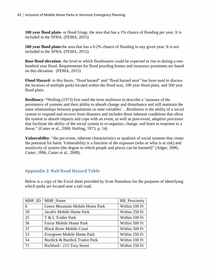
43 Inclusion of Mobile Home Parks in Vermont Emergency Planning
100 year flood plain- or flood fringe, the area that has a 1% chance of flooding per year. It is
included in the SFHA. (FEMA, 2015)
500 year flood plain-the area that has a 0.2% chance of flooding in any given year. It is not
included in the SFHA. (FEMA, 2015)
Base flood elevation- the level to which floodwaters could be expected to rise to during a one-
hundred year flood. Requirements for flood proofing homes and insurance premiums are based
on this elevation. (FEMA, 2015)
Flood Hazard- in this thesis, “flood hazard” and “flood hazard area” has been used to discuss
the location of multiple parks located within the flood way, 100 year flood plain, and 500 year
flood plain.
Resiliency- “Holling (1973) first used the term resilience to describe a ‘measure of the
persistence of systems and their ability to absorb change and disturbance and still maintain the
same relationships between populations or state variables’…Resilience is the ability of a social
system to respond and recover from disasters and includes those inherent conditions that allow
the system to absorb impacts and cope with an event, as well as post-event, adaptive processes
that facilitate the ability of the social system to re-organize, change, and learn in response to a
threat.” (Cutter et al., 2000; Holling, 1973, p. 14)
Vulnerability- “the pre-event, inherent characteristics or qualities of social systems that create
the potential for harm. Vulnerability is a function of the exposure (who or what is at risk) and
sensitivity of system (the degree to which people and places can be harmed)” (Adger, 2006;
Cutter, 1996; Cutter et al., 2008).
Appendix 2: Rail Road Hazard Table
Below is a copy of the Excel sheet provided by Scott Hamshaw for the purposes of identifying
which parks are located near a rail road.
MHP_ID MHP_Name RR_Proximity
6 Green Mountain Mobile Home Park Within 100 Ft
18 Jacob's Mobile Home Park Within 250 Ft
25 T & L Trailer Park Within 100 Ft
36 Farrar Mobile Home Park Within 500 Ft
37 Black River Mobile Court Within 500 Ft
53 Evergreen Mobile Home Park Within 250 Ft
54 Burdick & Burdick Trailer Park Within 100 Ft
71 Richford - 215 Troy Street Within 250 Ft

44 Inclusion of Mobile Home Parks in Vermont Emergency Planning
77 Sunset Terrace Estates Within 500 Ft
78 Mobile Acres Mobile Home Park Within 100 Ft
82 Lakeview Mobile Home Park Within 100 Ft
92 Post Mobile Home Park Within 500 Ft
100 N & A Pine Haven Inc Within 100 Ft
111 Roy's Mobile Home Park Within 100 Ft
112 Simonds Mobile Home Park Within 100 Ft
118 Brierwood Mobile Home Park Within 100 Ft
123 Green Lantern Mobile Home Park Within 500 Ft
125 Oak Street Mobile Home Park Within 250 Ft
133 Whistle Stop Mobile Home Park Within 100 Ft
138 Fernwood Manor Within 500 Ft
141 Olcott Falls Mobile Home Park Within 100 Ft
146 Alta Garden Estates Mobile Home Park Within 100 Ft
154 Berlin Mobile Home Park Within 250 Ft
155 River Run Mobile Home Park Within 100 Ft
156 RMC Mobile Home Park Within 250 Ft
166 Smith's Mobile Home Park Within 100 Ft
171 94 North Main Mobile Home Park Within 100 Ft
172 Tucker Mobile Home Park Within 100 Ft
182 Eldredge Mobile Home Park Within 500 Ft
189 McGill Avenue Mobile Home Park Within 500 Ft
196 Riverview Estates Within 250 Ft
204 Bunker Hill Community Co-op Within 250 Ft
206 Mears Mobile Home Park Within 100 Ft
207 Brookside Mobile Home Park Within 100 Ft
211 FWMHP, LLC Within 100 Ft
225 Dorr Mobile Home Park Within 100 Ft
228 Allen Street Mobile Home Park Within 500 Ft
230 Country Acres Within 100 Ft
233 Willows Mobile Home Park Within 100 Ft
234 Merrimac Mobile Home Park Within 100 Ft
238 Riverview Commons Within 100 Ft
241 Stryhas Trailer Park Within 100 Ft
252 Evergreen Mobile Home Park Within 100 Ft
275 Mussey Street Mobile Home Park Within 500 Ft
318 Depot Street Fair Haven Mobile Home
Park
Within 500 Ft

45 Inclusion of Mobile Home Parks in Vermont Emergency Planning
Appendix 3: Title 20 Section 32
The following are additional requirements laid out in Title 20 Section 32 for LEPC plans:
(A) Identifies facilities and transportation routes of extremely hazardous substances.
(B) Describes emergency response procedures, including those identified in facility plans.
(C) Designates a local emergency planning committee coordinator and facility coordinators to
implement the plan.
(D) Outlines emergency notification procedures.
(E) Describes how to determine the probable affected area and population by releases of
hazardous substances.
(F) Describes local emergency equipment and facilities and the persons responsible for them.
(G) Outlines evacuation plans.
(H) Provides for coordinated local training to ensure integration with the state emergency
operations plan.
(I) Provides methods and schedules for exercising emergency response plans.
Appendix 4: Interview Script
This script was used to collect town emergency plans from RPC representatives:
For the towns that provided BEOPs in the past:
Hello, my name is Rachel Heath; I am a research assistant for Dr. Daniel Baker in the
Community Development and Applied Economics Department at the University of Vermont. In
2012 you provided Dr. Baker and Sarah Woodward of the Champlain Valley Office of Economic
Opportunity with copies of emergency plans for towns in your region. We are doing a follow up
study and would appreciate being sent the most recent plans you have.
For RPC’s we visited this summer:
Hello, my name is Rachel Heath; I am a research assistant for Dr. Daniel Baker in the
Community Development and Applied Economics Department at the University of Vermont.
We presented at your RPC meeting this past summer on research concerning the emergency
preparedness of Mobile Home Parks in your town. We are doing a follow up study regarding
town’s inclusion of vulnerable parks in their Emergency Plans and would appreciate you sending
us the most recent plans you have.
For everyone else:

46 Inclusion of Mobile Home Parks in Vermont Emergency Planning
Hello, my name is Rachel Heath; I am a research assistant for Dr. Daniel Baker in the
Community Development and Applied Economics Department at the University of Vermont.
Dan has been doing research concerning the emergency preparedness of Mobile Home Parks
throughout the state of Vermont for the last 5 years. We are doing a study regarding town’s
inclusion of vulnerable parks in their Emergency Plans and would appreciate you sending us the
most recent plans you have.
Appendix 5: LEOP Base Plan
Note that this plan is from 2016, and that all of the plans collected for this research had been
created prior to 2016. The main difference between this plan and 2015 plans are that 2016 plans
include Mobile Homes as Task 1 areas and there is also a check box provided for whether or not
shelters allow pets