Embed Size (px)
Citation preview
Published in: Annals of Agrarian Science 9/3 (2011), 13-17.
Investigations of the fluvial dynamics in eastern Georgia as a contribution to
palaeoenvironmental research of the region
Hans von Suchodoletz1,2*, Dominik Faust2** & Daniel Wolf2*** 1Institute of Geography, Leipzig University, Johannisallee 19a, D - 04103 Leipzig, Germany, 2Institute of Geography, Technical University of Dresden, Helmholtzstrasse 10, D – 01069 Dresden,
Germany
Abstract: Fluvial systems are important recorders of environmental change. Thus, using field and
laboratory methods the past fluvial dynamics in two regions in eastern Georgia (Marneuli and Alazani
depression) is investigated. Based on the literature and first field studies in the Marneuli depression, a
preliminary model of the Cenozoic landscape evolution could be built up for the region. Although
physical age determinations are still largely missing, these first results point to a strong change of the
fluvial dynamics in the Marneuli depression during the Late Quaternary, amongst others probably in
connection with tectonic activity in the region.
ИЗУЧЕНИЕ ФЛЮВИАЛЬНОЙ ДИНАМИКИ В ВОСТОЧНОЙ ГРУЗИИ КАК ВКЛАД В ПАЛЕОЭКОЛОГИЧЕСКОЕ ИССЛЕДОВАНИЕ РЕГИОНА
Ханс фон Суходолетц, Доминик Фауст, Даниель Вольф
Флювиальные системы являются важным показателем изменения окружающей среды. В статье приведены результаты полевых и лабораторных исследований флюиальной динамики в Восточной Грузии (Марнеульская и Алазанская депрессии). На основе литературных источников и первых полевых исследований в Марнеульской депрессии была восстановлена первичная модель ценозоического рaзвития ландшафта региона. Хoтя физический возраст объектов по-прежнему сильно отсутствует, эти первые результаты показали сильно изменение флювиальной динамики в Марнеульской депрессии в течении позднего четвертичного периода, между прочим в связи с тектонической активностью в регионе.
1. introduction
Fluvial systems and their deposits are ubiquitously found and known to be very sensitive
recorders of environmental change. Furthermore, due to their flat topography and fertile soils,
fluvial plains are often areas with a concentrated population so that the fluvial dynamics has a
strong impact on human activity and health. Thus, a deeper understanding of the fluvial
dynamics, also derived from studies about their past, is an urgent need. However, reading fluvial
archives is never simple, due to several factors influencing their dynamics as there are climate,
tectonics, human influence and last but not least the internal behaviour of a river, causing a
change of its sedimentation pattern without any external trigger1. In spite of these problems, a
careful study of the change of incision and aggradation of a fluvial system during the past, as well
as of its sedimentation pattern following a longer part of its course can give valuable information
on changes of its influencing factors. In combination with data from neighbouring river systems
or other palaeoenvironmental archives, exact triggers of fluvial change can thus be identified2,3.
In Georgia as well as in the whole Caucasian area, only limited studies on palaeoenvironmental
change exist until today, mainly focussing on lacustrine deposits and peat bogs4,5. Whereas some
studies on fluvial deposits in Georgia were carried out during the Soviet period6,7, only recently
some fluvial systems were studied in detail in Abkhazia8 and southern Armenia9, whereas no
studies were carried out in eastern Georgia during the last years.
However, understanding the fluvial dynamics in eastern Georgia is essential, since most cities are
located in bedrock river valleys and floodplains regularly hit by inundations (e.g. Tbilisi, Gori,
Rustavi, Marneuli, Bolnisi). To do so, it is also necessary to know about past changes of fluvial
systems: For example, archaeologists suggest that a change in the fluvial dynamics caused a
significant change of the human settlement pattern already about 6 ka ago10. Furthermore, the
eastern Caucasus-area is tectonically highly active, showing a recent convergence rate of 14
mm/a and an uplift rate of 8 mm/a11. For example, from the study in the Lesser Caucasus in
Southern Armenia it is known that tectonic activity dramatically changed fluvial regimes during
the Pleistocene9. A similar situation can be expected in eastern Georgia, where 30-40 % of
regional crustal shortening has been taken up by the so-called Kura thrust-and-fold-belt during
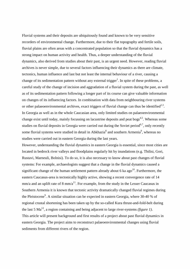
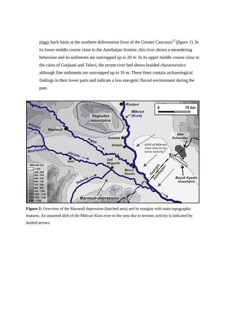
the last 5 Ma12, a region containing and being adjacent to large river-systems (figure 1).
This article will present background and first results of a project about past fluvial dynamics in
eastern Georgia. The project aims to reconstruct palaeoenvironmental changes using fluvial
sediments from different rivers of the region.
Figure 1: Overview of the Republic of Georgia showing the study areas and the Kura thrust-and-fold-belt.
The area shown in figure 2 is indicated by a dotted rectangle.
2. Study area
The study focuses on fluvial deposits of two regions in the eastern part of the Republic of
Georgia:
1. The Marneuli-depression in the Kvemo Kartli region south of Tbilissi: This tectonic
depression with an extension of about 10 * 25 km2 contains up to 135 m of cenozoic
sediments7, whereof the upper layers are partly composed of gravely to clayey fluvial
material derived from the rivers Mashavera, Khrami, Algeti, Debeda and Mtkvari (Kura)
as well as their tributaries (figures 1, 2). These rivers, together with their deposits are
embedded in redeposited gravelly molasse deposits and loess-borne colluvial-fluvial
material, the latter covering the footslopes and partly underlying coarser fluvial
sediments. The rivers outcropped both fluvial and loess-borne sediments up to 40 m
(figure 3).
2. Fluvial sediments of the Alazani river in the Alazani depression in the Kakheti region in
northeastern Georgia: The river flows in the about 15 km wide Alazani depression, a
piggy back basin at the southern deformation front of the Greater Caucasus12 (figure 1). In
its lower middle course close to the Azerbaijan frontier, this river shows a meandering
behaviour and its sediments are outcropped up to 20 m. In its upper middle course close to
the cities of Gurjaani and Telavi, the recent river bed shows braided characteristics
although fine sediments are outcropped up to 10 m. These fines contain archaeological
findings in their lower parts and indicate a less energetic fluvial environment during the
past.
Figure 2: Overview of the Marneuli depression (hatched area) and its margins with main topographic
features. An assumed shift of the Mtkvari Kura river to the west due to tectonic activity is indicated by
dashed arrows.
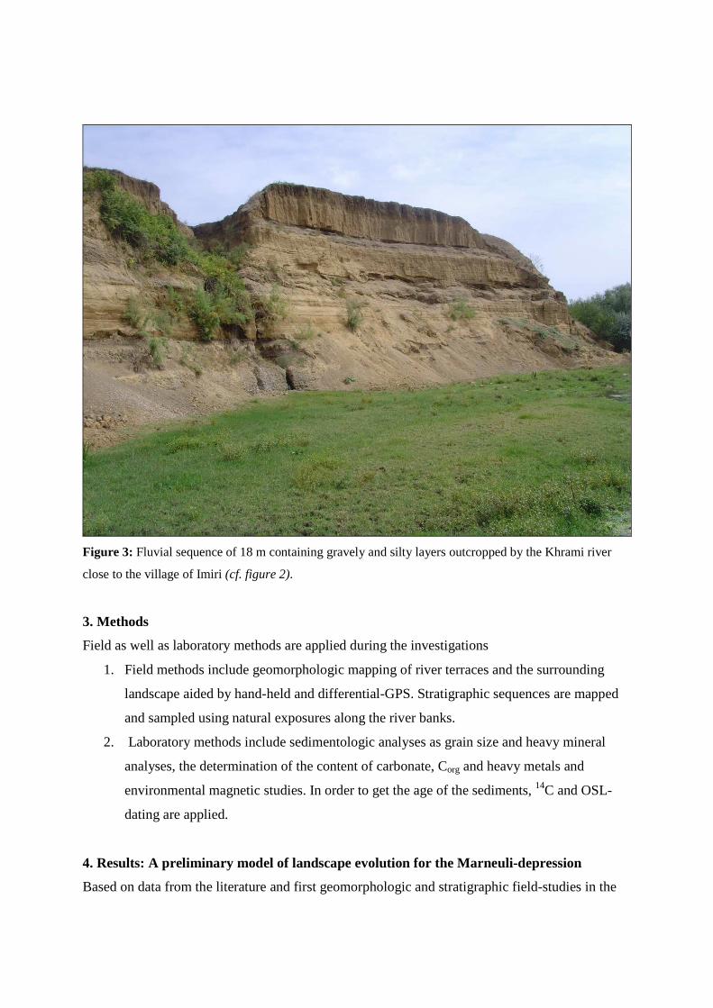
Figure 3: Fluvial sequence of 18 m containing gravely and silty layers outcropped by the Khrami river
close to the village of Imiri (cf. figure 2).
3. Methods
Field as well as laboratory methods are applied during the investigations
1. Field methods include geomorphologic mapping of river terraces and the surrounding
landscape aided by hand-held and differential-GPS. Stratigraphic sequences are mapped
and sampled using natural exposures along the river banks.
2. Laboratory methods include sedimentologic analyses as grain size and heavy mineral
analyses, the determination of the content of carbonate, Corg and heavy metals and
environmental magnetic studies. In order to get the age of the sediments, 14C and OSL-
dating are applied.
4. Results: A preliminary model of landscape evolution for the Marneuli-depression
Based on data from the literature and first geomorphologic and stratigraphic field-studies in the
Marneuli-depression, we are able to present a preliminary landscape model for that region. The
landscape evolution model of the Marneuli depression includes six fundamental phases (figure
4):
1. Phase 1: Beginning with the first uplift of the Caucasus mountains above the sea level
from the upper Eocene (35 Ma), clayey-marly gypsum-bearing marine molasse and flysch
sediments were deposited throughout the region13.
2. Phase 2: An acceleration of orogenetic uplift from the middle Miocene (from about 15
Ma) raised these deposits above sea level, and subsequently they were capped forming
large pediplanation-surfaces. Concomitantly, the strong middle/upper Miocene uplift
caused the deposition of thick continental inner molasse gravels. These gravels partly
contain gypsum accumulations that are locally mined e.g. in the Yagludzha-mountains
above the city of Rustavi (figure 2). Molasse gravel deposition was especially active
during the Sarmatian phase from 11-8 Ma13.
3. Phase 3: Due to a shift of main orogenetic activity from the Greater Caucasus mountains
towards the Kura thrust-and-fold belt in their southern foreland during the Pliocene from
5 Ma12, gravely molasse deposits were eroded and redeposited on pediplanation surfaces.
Here they form large-scale glacis deposits today.
4. Phase 4: During the next phase we see strong aeolian activity with large-scale loess
deposition. However, this material was immediately redeposited so that it is found as silty
slope sediments, also forming a large part of the marginal fluvio-colluvial sedimentary
infill especially in the north of the Marneuli depression e.g. along the Algeti river east of
the city of Marneuli (figure 2). To our knowledge, not reworked aeolian loess is rarely
conserved in Georgia, however easily found in neighbouring regions of southern Russia,
Armenia, southern Azerbaijan and northern Iran6,14,15. We assume a Pleistocene age for
this phase, since a large quantity of silt was produced in the glaciated headwater areas of
the rivers and neighbouring areas in the Lesser and Greater Caucasus6,16, and probably an
increased amount of aeolian dust was brought from other regions as e.g. the shelves of the
Caspian and Black Sea15, 17. However, a high atmospheric aerosol load is also known from
the recent warm period in the Transcaucasus region during a part of the year18. The strong
aeolian phase was obviously finished with an erosional event.
5. Phase 5: Subsequently, about 30 m of layered silty-sandy sediments with several darker
clayey layers were deposited in the south of the Marneuli depression, where the loess-
borne material was largely eroded. These layers are well outcropped along the Mtkvari
(Kura) river between the village of Ilmazlo and the Azerbaijan border, as well as along
the Khrami river from the Azerbaijan border to the village of Didi Muganlo (figure 2).
Sandy-gravely and silty layers are fluvial in origin, whereas interbedded cross-stratified
sandy layers are probably aeolian in origin. A single OSL-age of about 6.6 ka ca. 3 m
below the recent land-surface south of the village of Meore Kesalo (figure 2) suggests a
Middle/Late Pleistocene till may be early Holocene age of these deposits, although this is
not backed by other data yet. We assume that these sediments originate from a calm
sedimentation regime with the character of floodout-sediments when mainly fine-textured
material was deposited, with singular aeolian phases when sand was blown out and
formed dunes. However, the reason for this conspicuous kind of sedimentation is not clear
now. Also this phase finished with an erosional event.
6. Phase 6: The last phase was characterized by several cycles of fluvial aggradation and
incision, leaving behind different fluvial terraces consisting of distinct layers of gravely
and silty material along all rivers of the Marneuli depression. At very few places they also
contain clayey palaeosols or palaeosol sediments. Correlating these terraces yields a
pattern of four distinct levels along the Khrami and Debeda rivers (21-18 m, 15-12 m, 7-5
m, 4-2 m). At the Algeti river, it seems that there are only the three lower levels found,
possibly caused by a shift of the river-course from north to south in the depression as
already formerly assumed7. Consequently, coarse gravely sediments outcropped along the
Mtkvari (Kura) river close to the village of Keshalo could possibly be explained by a
former course of the Algeti river, aggrading sediments equivalent to the 21-18 m terrace
at the Khrami and Debeda rivers before the Algeti river changed its course into its recent
bed (figure 2). A 14C-age obtained from charcoal found at the base of a 10 m-terrace at the
Mtkvari (Kura) river close to the confluence with the Algeti river near the village of
Meore Kesalo yields about 2.5 ka, in agreement with several other 14C-datings obtained
from this terrace along the Mtkvari river19. Consequently, this terrace can be surely placed
into the Late Holocene and is tentatively correlated with the 7-5 m terrace level at the
Khrami/Debeda rivers.
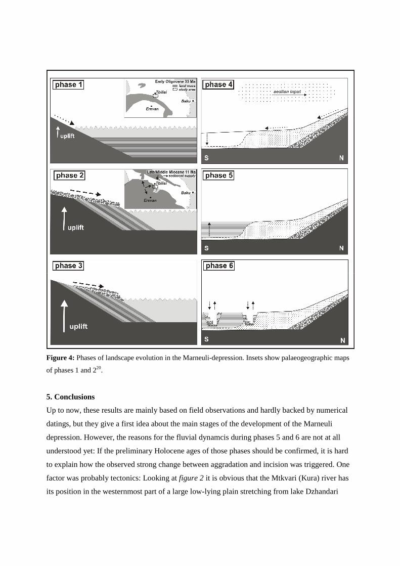
Figure 4: Phases of landscape evolution in the Marneuli-depression. Insets show palaeogeographic maps
of phases 1 and 220.
5. Conclusions
Up to now, these results are mainly based on field observations and hardly backed by numerical
datings, but they give a first idea about the main stages of the development of the Marneuli
depression. However, the reasons for the fluvial dynamcis during phases 5 and 6 are not at all
understood yet: If the preliminary Holocene ages of those phases should be confirmed, it is hard
to explain how the observed strong change between aggradation and incision was triggered. One
factor was probably tectonics: Looking at figure 2 it is obvious that the Mtkvari (Kura) river has
its position in the westernmost part of a large low-lying plain stretching from lake Dzhandari
about 12-14 km to the west, so that this position could possibly be explained by tectonic
deflection due to strong anticlinal movements observed in the Beyuk Kyasin mountains close to
lake Dzhandari (Forte et al. 2010). Such a migration of the river bed of the Mtkvari (Kura) river
would cause a lowering of the erosional base for the rivers in the Marneuli depression during
phase 6, a possible explanation for erosional phases. Another reason could be a shift of the ratio
between sediment load and river transport capacity due to i) climatic (e.g. thawing of glaciers
during the late glacial, little ice age, dry periods) ii) anthropogenic (land use modifications)
and/or iii) tectonic (e.g. damming of river-courses) changes.
We will try to answer these questions during the project that will last from 2010 – 2013. A
separation of different influencing factors on the fluvial dynamics will only be possible when
comparing the results of the rivers from the Marneuli depression with those from the Alazani
river and with those from other studies in the region. However, our first results from the Marneuli
depression already demonstrate that dramatic changes of fluvial activity in that region occurred
during the late Pleistocene and early Holocene. This can give hints on the future development of
fluvial dynamics in the densely populated fluvial plains in eastern Georgia when environmental
factors will be changed.
References: 1 Charlton, R. (2008): Fundamentals of fluvial geomorphology. Routledge, London, 234 pp. 2 Collins, P.E.F., Rust, D.J., Bayraktutan, M.S. & S.D. Turner (2005): Fluvial stratigraphy and
palaeoenvironments in the Pasinler Basin, eastern Turkey. Quaternary International 140-141, 121-
134. 3 Zielhofer, C., Bussmann, J., Ibouhouten, H. & K. Fenech (2010): Flood frequencies reveal Holocene
Rapid Climate Changes (Lower Moulouya River, NE Morocco). Journal of Quaternary Science (in
press) 4 Kvavadze, E.V. & S.E. Connor (2005): Zelkova carpinifolia (Pallas) K. Koch in Holocene sediments of
Georgia - an indicator of climatic optima. Review of Palaeobotany and Palynology 133, 69-89. 5 Connor, S.E., Thomas, I. & E.V. Kvavadze (2007): A 5600-yr history of changing vegetation, sea levels
and human impacts from the Black Sea coast of Georgia. The Holocene 17/1, 25-36. 6 Tsereteli, D.V. (1966): Pleistocene deposits of Georgia. Edition Metsnerieba, Tbilisi, 583 pp (in Russian) 7 Maruashvili, L.I. (ed.) (1971): Geomorphology of Georgia. The relief of the Georgian SSR in the aspects
of layers, origin, dynamics and history. Edition Metsnerieba, Tbilisi, 609 pp. (in Russian) 8 Arslanov, K.A., Dolukhanov, P.M. & N.A. Gei (2007): Climate, Black Sea levels and human settlements
in Caucasus littoral. Quaternary International 167-168, 121-127. 9 Ollivier, V., Nahapetyan, S., Roiron, P., Gabrielyan, I., Gasparyan, B., Chataigner, C., Joannin, S.,
Cornée, J.-J., Guillou, H., Scaillet, S., Munch, P. & W. Krijgsman (2010): Quaternary volcano-
lacustrine patterns and palaeobotanical data in southern Armenia. Quaternary International 223/224,
312-326. 10 Kavtaradze, G.L. (2004): The chronology of the Caucasus during the Early Metal Age: Observations
from central Trans-Caucasus. In: Sagona, A.: A view from the Highlands. Archaeological studies in
honour of Charles Burney. Ancient Near East Studies, supplement 12, Edition Peeters, 539-556. 11 Cloetingh, S.A.P.L. et al. (2007): TOPO-EUROPE: The geoscience of coupled deep Earth-surface
processes. Global and Planetary Change 58/1-4, 1-118. 12 Forte, A.M., Cowgill, E., Bernardin, T., Kreylos, O. & B. Hamann (2010): Late Cenozoic deformation
of the Kura fold-thrust belt, southern Greater Caucasus. GSA Bulletin, 122, 465–486. 13 Saintot, A., Brunet, M.-F., Yakovlev, F., Sébrier, M., Stephenson, R., Ershov, A., Chalot-Prat, F. & T.
McCann (2006): The Mesozoic-Cenozoic tectonic evolution of the Greater Caucasus. In: Gee, D.G.
& R.A. Stephenson (eds.): European lithosphere dynamics. Geological Society, London, Memoirs,
277-289. 14 Velichko, A.A. (1990): Loess-palaeosol formation on the Russian Plain. Quaternary International 7/8,
103-114. 15 Kehl, M., Sarvati, R., Ahmadi, H., Frechen, M. & A. Skowronek (2005): Loess paleosol-sequences
along a climatic gradient in Northern Iran. Eiszeitalter und Gegenwart 55, 149-173. 16 Gobejishvili, R. (2004). Late Pleistocene (Würmian) glaciation of the Caucasus. In: Ehlers, J. & P.L.
Gibbard (Eds): Quaternary Glaciations - extent and chronology. Elsevier, 129-134. 17 Buggle, B., Glaser, B., Zöller, L., Hambach, U., Markovic, S., Glaser, I. & N. Gerasimenko (2008):
Geochemical characterization and origin of Southeastern and Eastern European loesses (Serbia,
Romania, Ukraine). Quaternary Science Reviews 27, 1058-1075. 18 Kokkalis, P., Mamouri, R.E., Todua, M., Didebulidze, G.G., Papayannis, A., Amidiris, V., Basart, S.,
Perez, C. & J.M. Baldasano (submitted): Strong dust event over Abastumani/southern Caucasus,
Georgia during may 2009. Sun-photometric/lidar ground based and satellite observations and dust
model simulation. International Journal of Remote Sensing. 19 Dzhanelidze, S.C. (2007): About the age of the first uplifted terrace of the Kura river and its tributaries.
In: Prikladnye voprosy geografii I geologii gornykh oblastey alpiiskogo gimalaiskogo poyasa.
Materialy konferencii, posvyashchennoi 90-letiyu professora C.P. Balnyana. Erevan, 25-28 aprelya
2007 g., 214-215. (in Russian) 20 Popov, S.V., Ilyina, L.B., Paramonova, N.P., Goncharova, I.A. et al. (2004): Lithological-
paleogeographic maps of Paratethys. Courier Forschungsinstitut Senckenberg 250, 1–46.