Embed Size (px)
Citation preview
GEOLOGICAL SURVEY OF GEORGIA
S. W. McCALLIE, State Geologist
BULLETIN NO. 34
REPORT
ON
THE SLATE DEPOSITS OF
GEORGIA
BY
H. K. SHEARER
Assistant State Geologist
Atlanta, Ga. BYRD PRINTING COMPANY, State Printers
1918
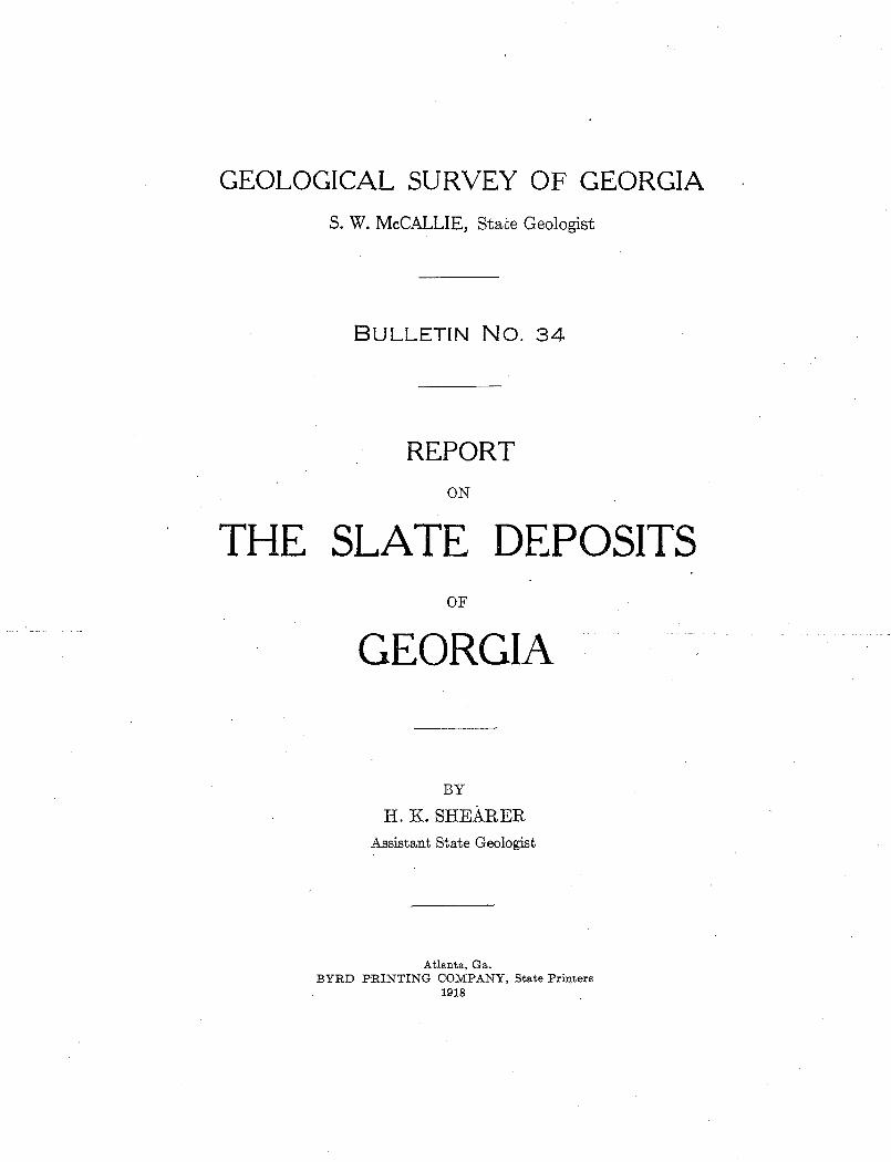
SLATE DEPOSITS OF GEOBGIA FRONTISPIECE-PLATE I
OLD DEVER QUARRY, ROCKMART, POLK COUNTY, WHILE OPERATED BY THE GEORGIA SLATE COMPANY, BETWEEN 1893 AND 1900.
LETTER OF TRANSMITTAL
GEOLOGICAL SuRVEY OF GEORGIA,
ATLANTA., November 20, 1918.
To His Excellency, HuGH M. DoRSEY, Governor and President of the Advisory Board of the Geological s~wvey of Georgia.
SIR: I have the honor to transmit herewith the report of Mr. H. K.
Shearer;-Assistant State Geologist, on the Slate Deposits of Georgia, to ·
be published as Bulletin No. 34, of this Survey.
Very respectfully,
S. W. McCALLIE,
State Geologist.
PREFACE AND ACKNOWLEDGMENTS
The prep•aration of a report on the slate deposits of Georgia was begun in 1912 by Dr. T. Poole Maynard, formerly Assistant State Geologist. The work was again taken up in 1914, when Dr. Oliver B. Hopkins s:pent some time in field work. These men both resigned from the G~orgia Survey before writing up the material on slate. They had, however, done detailed field work in the Rockmart
1
•and Fairmount districts, the Cartersville district being a more recent discovery. Their notes, together with photographs and coilections of specimens, have been of much assistance in my work, although I have re-examined all of the important deposits and have made additional collections.
For helpful information in regard to slate deposits, tests, and methods of working I am especirally indebted to the report of T. Nelson Dale and others, "Slate in the United States," Bulletin 586 of the United States Geological Survey.
All of the analyses used in this report, unless otherwise accredited, ;were made by Dr. Edgar Everhart, Acting Chemist of the Geological Survey of Georgia. A number of these analyses were made for private individuals and corporations, who have kindly given _permission to publish them.
In January, 1916, when the sericite deposits first attracte¢1. attention as a possible source of potash, I spent two weeks examining the Pickens .County deposits. Since that time I have made several brief
·visits to note the progress in development. A description of the seri-• cite deposits is included in this report as an •appendix, in order to have all information on the potash-bearing dep<?sits of the State, with the exception of feldspar, in one volume.
Although. the slate industry in Georgia has been inactive for a number of years, several of the property owners have expressed their intention of re-opening the quarries for roofing and other slate •as soon as war conditions permit the obtaining of labor and machinery.
Development of the high-potash slates of the Cartersville district may be expected soon, whether the war continues or not. It is hoped that the publication of this report will call the •attention of oper- · ators and investors to these valuable deposits of the State, and give helpful information in locating and opening them.
HAROLD K. SHEARER,
Assistant Strate Geologist. November, 1918.
TABLE OF CONTENTS
ADVISORY BOARD ...............•..•....
LETTER OF TRANSMITTAL ............... .
PREFACE AND ACKNOWLEDGMENTS ....... .
TABLE oF CoNTENTS .........•..........
LIST OF ILLUSTRATIONS ...•..•...•......
HISTORY OF THE SLATE INDUSTRY ................................... .
Production of slate ............................................... . SLATE 0 0 0 0 0 0 0 0 0 0 0 0 0 0 0 0 0 0 0 0 0 0 0 0 0 0 0 0 0 0 0 0 0 0 0 0 0 0 0 0 0 0 0 0 0 0 0 0 0 0 0 0 0 0 0 0 0 0 0 0 0
Definition and classification ....................................... . Physical characteristics ........................................... .
Texture ...................................... , ................ . Bedding .......................... · .............. , ............. . Slaty cleavage .................................................. . False cleavage ................................................. . Grain ................................. ; ...................... . Joints ...............•.......................................... Faults· •........................................................ Shear zones and cleavage bands. 0 •••••••••••••••••••••••••••••••••
Veins ......................................................... . Dikes . .-.............. ·.~ ................................................ ..
Chemical composition ............................................ . Chemical chang!'ls in weathering .................................... . Mineralogical composition ........................................ . Age and geologic relations ............................ 0 •••••••••••••
Origin .......................................................... . Methods of testing .......................... · .................... . Tests of Georgia slates ........................................... . Conditions affecting development ................................... . Methods of working .............................................. .
Winning of raw material. ....................................... . Manufacturing processes ....................................... .
Uses ........................................................... . Roofing slate .................................................. . Mill stock ..................................................... . Electrical uses .................................... 0 •••••••••••••
Other uses .................................................... . Slate waste ................................................... .
PAGE
ii iii iv v
ix
1°5 3-5
6-41 6-7
7 8
8-11 ]1°13 13-14 14-15
15 16 16 16 17
17-20 20-22 22-26 26-27 27-30 30-32 33-34 34-36 37-38
37 38
38-41 38 39
39-40 40
40-41 SLATE DEPOSITS OF GEORGIA •......................................... 42-163
General features· of the Appalachian Valley in Georgia ............... ; 43-54 Physiography . . . . . . . . . . . . . . . . . . . . . . . . . . . . . . . . . . . . . . . . . . . . . . . . . . 43-44
v
l'ABLE OF CONTENTS
Structure ......... ·"· .......................................... . _Geology ...................................................... .
Cambrian ............................................ , ..... . Weisner quartzite ......................................... . Beaver Emestone ............................... :: .......... . CartersviUe formation ..................................... . Apison shale .............................................. . Rome formation ........................................... . Conasauga formation .................. : . ...... ; ............ .
Cambro-Ordovician .......................................•.... Knox dolomite· ............................................ .
Ordovician .......... · ................................... : . . . . . · Chickamauga formation .................................... . Chickamauga limestone ..................................... . Rockmart slate ............................................ .
Silurian ........................................ ;· ........... . Devonian .................... ; .............................. . Carboniferous .........•......................................
Geologic history ............................................... . The Rockmart district ................................... : ........ .
Geology of the Rockmart slate .................. : . ............... . Areal distribution ....................... '. ·- ................ . Stratigraph:c relations ....................................... . Lithologic characters .............................. : .......... . Structure and thickness·. . . . . . . . . . . . . . . . . . . . . . . . : . . . . . . . . . . . . . .. Physiographic expression ..................................... . Paleontology ................................... · ........ : .... .
Typical sections .......................................... · ... · .. . Seaboard Air Line section ..................................... . Southern Railway section ........................ : . ........... .
Descriptions of individual deposits ............................... . Polk County ................................................. .
The Rockmart Shale Brick & Slate Co. property, lot 86·5 ......... . The Southern States Portland Cement Co. property, lot 925 ..... . The Cherokee Slate Co. property ....... , ..................... . Ellis Davis & Son quarry ............................. ; ...... .
~ .Dever property .............................. ; . :: . ......... . Philpott property ....................... : ................. . Everett property .............................. ·. ·.- ........... . Sibley quarries ............................ · ...... : . ........ . The Southern States' Portland Cement Co. shale· quarr:es ...... . Black Diamond quarries .................. : . ................. . Columbia quarries ......................................... . Portland quarry ........................................... . Fish Creek area ............................................ .
vi
PAGE
44-45 45-52 47-50
47 47-48 48-49
49 49
49-50 50-51 50~51
51 51 51 51 52 52 52
52-54 54-99 54-59 54-55 55-56 56-57 57-58 58-59
59 59-65 59~63
63-65 65-99 65-99 65-72 72-75 75-82 82-83 83-84
84 85
85-87 87-88 88-92 92-93 93-94
94
TABLE OF CONTENTS
PAGE
Hollan slate prospect . . . . . . . . . . . . . . . . . . . . . . . . . . . . . . . . . . . . . . . 95 Cedartown area . . . . . . . . . . . . . . . . . . . . . . . . . . . . . . . . . . . . . . . . . . . . 95·97 Cornelius quarry . . . . . . . . . . . . . . . . . . . . . . . . . . . . . . . . . . . . . . . . . . . . 97-99
The Fairmount district. . . . . . . . . . . . . . . . . . . . . . . . . . . . . . . . . . . . . . . . . . . . 99-128 Geology of the green slate belt of the Conasauga formation .......... 99-104:
Areal distribution . . . . . . . . . . . . . . . . . . . . . . . . . . . . . . . . . . . . . . . . . . . . . 99 Stratigraphic relations ........................................ 99-100 Lithologic characters ................ , ........................ 100-101 Structure and th:cknes·s ........................................ 101-102 Physiographic expression ...................................... 102-104
Descriptions of individual deposits ................................ 104-128 Bartow County ............................................... 104-121
The Georgia Green Slate Co. property .......................... 104-107 Bolivar station ............................................. 108-111 Adair property ............................................. 111-112 McDaniel property . . . . . . . . . . . . . . . . . . . . . . . . . . . . . . . . . . . . . . . . . . 112 Tilly property .............................................. 112-115 The Southern Green Slate Co. property ........................ 115-117 McCoy property ............................................ 117-120 Bagwell property ............................................ 120-121 Woody property . . . . . . . . . . . . . . . . . . . . . . . . . . . . . . . . . . . . . . . . . . . . 121
Gordon County .... , ........................................ ~ .. 121-128 Starkweather property ....................................... 121-123 N eel property . · ... _. : ..... ~ .................................. 123-124 Yarbrough property . . . . . . . . . . . . . . . . . . . . . . . . . . . . . . . . . . . . . . . . . 125 Mahan and Hickens property .......................... : . . . . . . 126 Disharoon property ........................................ 126-127 Tate property .............................................. 127-128
The Cartersville district ......................................... ~ 128-163 Geology of the Cartersville formation .............................. 128-132
Areal distribution . . . . . . . . . . . . . . . . . . . . . . . . . . . . . . . . . . . . . . . . . . . . 128 Stratigraphic relations ........................................ 128-129 Lithologic characters ................ ' .......................... 129-130 Structure and thickness. . . . . . . . . . . . . . . . . . . . . . . . . . . . . . . . . . . . . . . . 130 Physiograph·c expression . . . . . . . . . . • . . . . . . . . . . . . . . . . . . . . . . . . . . . 131 Paleontology ........................... ·. . . . . . . . . . . . . . . . . . . . . . 131 Economic geology ............................................ 131-132
The Cartersville slates as a source of potash ..................... 132-140 Developments ................................................ 136-140
The American Potash Company .............................. 136-137 The American Metal Company ................................ 137-138 The Vithumus Company .................................... 138-139 The Georgia Potash & Chemical Company. . . . . . . . . . . . . . . . . . . . . . 139 John T. Norris ... · .......................................... 139-140
Descriptions of individual deposits ................................ 140-163
vii
T .ABLE OF CONTENT;:;
PAGE
Bartow County .............. : ............................... 140-163 Yancey property ......................................... : .140-146 McMillan property .......................................... 146-150 American Potash Company properties ......................... 150-152
. Belt between Cartersville and White ........................... 152-154 Belt northeast of White ...................................... 154-158
Baker property .......................................... 156-157 Jones property .................... · ....................... 157-158 Bradley. property . .. . . . . . . .. .. . . . . . . . .. . . . . . . . . . . . . . . . . . . . . . . . . 158
Deposits near Cassville ..... · ................................. 158-161 Headden property . . . . . . . . . . . . . . . . . . . . . . . . . . . . . . . . . . . . . . . . 159 Walker property . . . . . . . . . . . . . . . . . . . . . . . . . . . . . . . . . . . . . . . . . . 160 Daves pro]>erty . . . . . . . . . . . . . . . . . . . . . . . . . . . . . . . . . . . . . . . . . . . 1601
Johnson property ........................................ 1-60-161 Other exposures . . . . . . . . . . . . . . . . . . . . .. . . . . . . . . . . . . . . . . . . . . . . 161
Deposits near Grassdale ...................................... 161-162 Carpenter property ....................................... 161-162 Other exposures .... : . . . . . . . . . . . . . . . . . . . . . . . . . . . . . . . . . . . . . 162
Oass Station and localities farther west ....... · ................. 162-163 APPENDIX ........•.........•........................... 0 •••••••• 0 0 .165-188
'rhe sericite schist deposits of Pickens Gounty ........................ 165-188 Introduction . . . . . . . . . . . . . . . . . . . . . . . . . . . . . . . . . . . . . . . . . . . . . . . . . . . 165 Location and general relations .. ·: ................................ 167-169 Character of the material ......................................... 169-176
Physical characteristics ........................................ 169-172 Chemical and mineralogical composition .......................... 172-17 6
Mode of occurrence ............................................. 176-177 Origin . . . . . . . . . . . . . . . . . . . . . . . . . . . . . . . . . . . . . . .. . . . . . . . . . . . . . . ... . . 177 Uses .............................. · ............................ 177-178 Descriptions· of individual depos:ts ................................ 178-188
Lot 9-6 ....................................................... 178-179 Lot i21 ....................................................... 180-182 Lot 120 ............................................. · .......... 182-185 Lot 119 ...................... : ... · ......................... · ... 185-186 Le~s 97 and 98 ................................................. 186-187 Lot 99 ........................................ · .. , . . . . . . . . . . . . . 187 Lot 84 . . . . . . . . . . . . . . . . . . . . . . . . . . . . . . . . . . . . . . . . . . . . . . . . . . . . . . . 188
viii
ILLUSTRATIONS
PLATE FACING PAGE
I. Old Dever Quarry, Rockmart, Polk County, while operated by the Georgia Slate Company, between 1893 and 1900 ................. . Frontispiece
II. A. Showing method of weathering of the Rockmart slate, Seaboard Railroad cut % mile southeast of R.ockmart, Polk County. . . . . . 8
B. Conspicuously ribboned slate in the Ollie Davis opening on the Southern States Portland Cement Company property, Rockmart, Polk County ... : . . . . . . . . . . . . . . . . . . . . . . . . . . . . . . . . . . . . . . . . . . . . 8
III. A. Brown's North quarry, property of the R.ockmart Shale Brick & Slate Company, Rockmart, Polk County. . . . . . . . . . . . . . . . . . . . . . . . 36
B. Dump of slate waste, Brown's North quarry, R.ockmart, Polk County ............................................ ·......... 36
IV. A. Old Dever quarry, Rockmart, Polk County, while worked by the Georgia Slate Company. . . . . . . . . . . . . . . . . . . . . . . . . . . . . . . . . . . . . . . 7 4
B. Splitting shanties of the Georgia Slate Company, Rockmart, Polk County . . . . . . . . . . . . . . . . . . . . . . . . . . . . . . . . . . . . . . . . . . . . . . . . . . . . . 74
V. A. Old Dever quarry, Rockmart, Polk County, showing a secondary calcite vein and joints. . . . . . . . . . . . . . . . . . . . . . . . . . . . . . . . . . . . . . . . 78
B. Old Dever quarry, Rpckmart, Polk County, showing prominent joints almost perpendicular to the cleavage ........... _ .................. .78
VI. A. Black Diamond slate quarry, 3 miles northeast of Rockmart, Polk County . . . . . . . . . . . . . . . . . . . . . . . . . . . . . . . . . . . . . . . . . . . . . . . . . . . . . 90
B. Ollie Davis opening on the property of the Southern States Portland Cement Company, Rockmart, Polk County. . . . . . . . . . . . . . . . . . . . . . 90
VII. A. View of the foothills belt of green slate near Fairmount, Gor-don County . . . . . . . . . . . . . . . . . . . . . . . . . . . . . . . . . . . . . . . . . . . . . . . . . 102
B. View of the green slate belt near Bolivar, Bartow County. . . . . . . . 102 VIII. A. Exposure of green slate east of Bolivar, Bartow County, showing
a fold and a small fault in the cleavage ........................ 120 B. Exposure of green slate in the L.ouisville & Nashville Railroad cut
near the Cartersville Poor Farm, Bartow County. . . . . . . . . . . . . . . . 120 IX. A. Quarry of the Georgia Green Slate Company near Bolivar, Bartow
County, showing jointing ..................................... 134 B. Sawing shed of the Georgia Green Slate Company near Bolivar,
Bartow County . . . . . . . . . . . . . . . . . . . . . . . . . . . . . . . . . . . . . . . . . . . . . . 134 X. A. Exposure of green slate on the property of the Southern Green
Slate Company, Bartow County. . . . . . . . . . . . . . . . . . . . . . . . . . . . . . . . 148 B. View of the green slate ridge on the M'cCoy property, Bartow County 148
XI. A. L·ooking east from the Tennessee Road near the Cartersville Poor Farm, Bartow County, showing the Cartersville shale and slate belt 160
B. Shale mine of the American Potash Company near White, Bartow
ix
!.'LATE FACING PAGE
County ..................................................... 160 XII. A. Sericite schist, "pit No. 7," lot 120, Pickens County. . . . . . . . . . . . 168
B. Seric~te schist, "pit No. 81 " lot 120, Piekens County ....... ·. . . . . . 168 XIII. A, B, C, and D. Microphotographs of sericite sehists from Piekens
County ..................................................... 170 ·
FIGLJRES PAGE
1. Sketches of the eleavage surfaces of slates from Rockmart ............... 10 2. Sketeh showing the relations of rib boris· and. eleavage in a bloek of slate
from the J?rown quarri~s, Roekmart. . . . . . . . . . . . . . . . . . . . . . . . . . . . . . . . . . 11 3 . Sketeh showing the relations of bedding and eleavage in slate folded .
between harder .beds . . . . . . . . . . . . . . . . . . . . . . . . . . . . . . . . . . . . . . . . . . . . . . 12 4. Map of Roekmart and vieinity, showing land lots and the prineipal slate
quarries .... · ...... · .. .- . . . . .. . . . . . . . . . . . . . . . . . . . . . . . . . . . . . . . . . . . . . . . . . 6-6 5. Sketeh showing the relations ·of bedding, grain, and eleavage in slate from
the Bl9-ek Diamond quarries ....................... ,................ 90 6. .Plan and section showing potash explorations, Yaneey property. . . . . . . . 145 7. .Pla:n and ~e~tions showing potash explorations, MeMillan property ...... 147 8. Map of the Piekens County sericite schist area, showing land lots and loca
tions of the prineipal mines and prospeet pits .... 1
• • • • • • • • • • • • • • • • • • • • 166
MAPS PAGE
·r: Irrdex map' showing the distribution of slate-bearing formations in Georgia· ........................ ; : ...... ; . . . . . . . . . . . . . . . . . . . . . . . 42
IL. Map· of the Rockmart district, showing 'the areal distribution of the Rockmart slate ·formation . . . . . . . . . . . . . . . . . . . . . . . . . . . . . . . . . . . . . . . . 57
III. Map of the Cartersville and Fairl?lount districts, showing the areal distribution of the Cartersville formation and ·the slate-bearing portion of the Conasauga formation ......................................... 132
X
SLATE DEPOSITS OF GEORGIA
HISTORY OF THE SLATE INDUSTRY
Little is known of the beginnings of the slate industry. The peculiar properties of slate must long ago have been recognized as making it desirable for a structural material, but at first it was quarried only for local uses, and was not mentioned in literature. .According to the Century Encyclopedia, slate was worked in Wales as early as the twelfth century, and it is probable that the French deposits were also known and opened during the Middle .Ages.
In the United States, according to local tradition, slate was quarried in Harford County, Maryland, in 1750; and slate from that area is known to have been used for roofing· a church built in 1805.1 W. B. Rogers called attention to the slate deposits of Buckingham, Flu~ vannah and Fauquier counties, Virginia, in annual reports of the Virginia Survey from 1835 to 1841, stating that a quarry was first opened to procure slate for roofing the State CapitoP .A. slate quarry was opened in .Arkansas as early as 1859, but the product was found unsuitable for roofing, and no more work was done in that area for many years. 3
The first to recognize the value of the Rockmart slates in Georgia was Joseph G. Blance. He owned the property now controlled by the Cherokee Slate Company, where he made the first opening about 1850; although the oldest _real quarry is said to be one on the property of the Southern States Portland Cement Company, lot 925. Blance was the grandfather of J. F. Dever, and members of the Dever family were interested in the slate industry until the greater part of their property was sold to the Cherokee Slate Company in 1907.
1 Maryland Geol. Survey, vol. 6, p. 189, 1906. 2 Quoted by Watson, T. L., Mineral resources of Virginia: Virginia Jamestown
Exposition Commission, p. 42, 1907. 3 Purdue, A. H., The slates of Arkansas: U. S. Geol. Survey Bull. 430, p. 317, 1910.
2 GEOLOGICAL SURVEY OF GEORGIA
Lot 925 was owned by Colonel Seaborn Jones, who started development at a.bout the. same time as Blance.
The quarries ·were operated from 1850 until the outbreak of the Civil War. Work was stopped during the war and for a number of years after. ·About 1880 the quarries were reopened, and from that year until1900 was the period of greatest development. The largest reported production was in 1894, with 5,000 squares, valued at $22,500. Until 1883 the slate was hauled in wagons to Rome and Cartersville, but in that year the East Tennessee, Virginia & Georgia Railroad, now the Southern Railway, was completed, and two years later the East & West Alabama Railway, now the Seaboard Air Line, rwas built.
The total production of slate in Georgi~ reported i:q. the United States Geological Survey Mineral Resources from 1879 to 1917 was 38,097 squares, valued at $165,918. Besides this amount there ha.s been the production of the years when no statistics were published on account of there being less than three operators, and the unreported produetien of slate <quarried by individuals for their oWn. use, so the total producti:on,o:f the Rockma:r,t district must have·heen about 50,000 squar.es.r
Since ·1906 there have not been more than two producers in any
year, so the production can not be given, but it has been very small.
The Ellis Davis & Son quarry was worked in 1909 and 1910, and the
· most recent work done in the district was by Ollie Davis., who made
a small· opening in 1913.
The decline of slate quarrying in the Rockmart district seems to
have been, due to the death of some of the ·older operators, together
with increased cost of labor, as the average price per square of slates
produced in the United States has increased steadily since 1901, when
it reached the low point of $3.01 per square. Also, the unsystematic methods of working most of the quarries made the overburden and
waste increasingly difficult and expensive to handle. No serious attempt was made to utilize the waste, which probably amounted to over
90 per cent of the slate quarried, and no mill stock was produced, although much of the Rockmart. slate is well suited for that use.
SLATE DEPOSITS OF- GEORGIA:
The green slate belt of Bartow, Gordon and Murray counties was first prospected by G. W. Davis, a practical slate miner from Pennsylvania, who had been employed in the Rockmart district. He noticed fragments of slate in the cars used in transporting rock from the cuts on the Cartersville and Etowah line of the Louisville & Nashville Railroad, which was then under construction. After the completion of the railroad, about 1908, Davis went along the line for the purpose of locating the most promising prospects. Most of the test pits in the district were sunk under his direction.
The only work on a commercial scale ever done in the green slate belt was at the quarry of the Georgia Green Slate Company, which was opened in 1910 and operated for about a year. According to J. R. Smith, vice-president of the company, $20,000 worth of slate wa.s sold at a price of $7.00 per square at the quarry. This was nearly double the average price paid for slate at that time, and shows that the product was in good demand. The principal difficulties in working were the inexperience of the workmen and the large amount of waste produced on account of the broken character of the slate. The quarry was finally closed by a strike, after which no attempt was made to reopen it.
The silver-gray and purplish slates of the Cartersville formation, near White, Bartow county, have been known for a number of years, and several small pits were dug by G. W. Davis. However, the unusual composition of these states was not known until a sample collected by the writer was analyzed in 1916. Since the announcement of this discovery, exploration work has been done and options taken on properties by several companies, -with the intention of using the slates for the extraction of potash.
Production of SZate1 .-Considering the United States as a whole, the production of slate has been stationary for many years, and the condition of the industry has not been very satisfactory. The production of roofing slate remained about constant at a little over 1,000,000 squares a year from 1899 to 1914, but from 1915 to 1917 it showed
1 Statistics from U. S. Geol. Survey reports on Mineral Resources, 1879-1917.
4: GEOLOGICAL SURVEY OF GEORGIA
a marked decrease, only 703,668 squares being produced in 1917. The production of mill stock and slate for ''other uses'' ha,s shown some tendency to increase, largely because o.f the demand for electrical apparatus. The valuE:J of sla:te for ''other uses,'' including school slates, . . blackboards, billiard-ta'ble tops, tomb stones, "inlaid slate," and ground slate for roofing exceeded $1,000,000 · for the first time in 1917.
The price of roofing slate in 1917, $4.85 per square, is the highest ever reported; but even this does not equal the increase ill cost o·f production. The increase in selling price over 1916 was 19 per cent, but the average general cost of production, according to some producers, increased 40 or 50 per cent.1 The use of slate for roofing is declining, because so many structures are now built with flat roofs and ·covered with various artificial roofing materials. .. Inlaid slate, or slate .in asphaltic ·composition materials may be used for any kind of roofs, and it is probable that these uses could be stimulated by advertising. However, mos~ o.f the quarry operators have .been very conservative, and•have,not adopted !new;method:s. noi'i so-ught.new mar.kets very, actively. In s.ome years.' pn0duetion ·has ,been ;reduced, by str[kes and by falls ·of rcrem;·in ·the la.:tger quaiT.ies, .
The amount and value of slate prodU.ced in Georgia;,siru~e statistics have been collected, t6gether with the ·total value of slate produced in the United States and the .average price per square for roofing slate: are shown in the following table :
1 Loughlin, G. F., U. S. Geol. Survey Mineral Resources, 1917, pt. 2, p. 128, 1918.
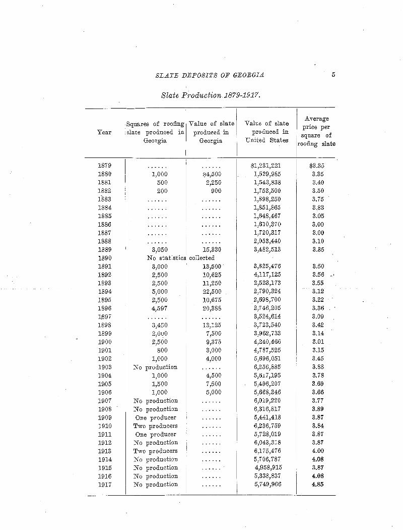
SLATE DEPOSITS OF GEORGIA 5
Slate Production 1879-1917.
Squares of roofing Value of slate Value of slate Average
Year slate produced in produced in produced in price per
square of Georgia Georgia United States roofing slate
I '
1879 i $1,231,221 $3.35 . .. .. . . . •••• 0 •
1880 1,000 $4,500 1,529,985 3.35 1881 500 2,250 1,543,838 3.40 1882 200 900 1,753,500 3.50 1883 . . . . .. . ...... 1,898,250 3.75 1884 ...... . ..... 1,851,865 3.83 1885 ...... . ..... 1,648,467 3.05 18816 ....... . ..... 1,610,370 3.00 1887 ...... . ..... 1,720,317 3.00 1888 ...... . ..... 2,053,440 3.10 1889 3,050 15,330 3,4:82,513 3.35 1890 No stat:stics collected 1891 3,000 13,500 3,825,476 3.50 1892 2,500 10,625 4,117,125 3.56 ,,
1893 2,500 ll,250 2,523,173 3.55 1894 5,000 22,500 2,790,324 3.12 1895 2,500 10,675 '2,698,700 3.22 1896 4,597 20,388 2,746,205 3.36 1~97 • • .. • .. 0 ...... 3,524,614 3.09 1898 3,450 13,125 3,723,540 3.42 1899 2,ouo 7,500 3,962,733 3:14 1900 2,500 9,375 4,240,466 3.01 1901 800 3,000 4,787,525 3.15 1902 1,000 4,000 5,·696,051 3.45 1903 No production ........ 6,256,885 3.88 1904 1,000 4,500 5,tH7,195 3.78 19105 1,500 7,500 5,496,207 3.69 1906 1,000 5,000 5,668,346 3.66 1907 No production ...... 6,019,220 3.77 1908 No production ...... 6,316,817 3.89 1909 One producer ...... 5,4:41,418 3.87 1910 Two producers •••• 0. ·6,236, 759 3.84 19ll One producer ...... 5,728,019 3.87 1912 No production •••• 0. 6,043,318 3.87 1913 Two producers ........ 6,175,476 4.00 1914 No production ........ 5,706,787 4.08 1915 No production 0 ••••• 4,958,915 3.87 1916 No production ........ 5,338,837 4.08 1917 No production ...... 5,749,966 4.85
6 GEPLOGIOAL SURVEY OF GEORGIA
. DEFINITION AND CLASSIFICATION
Slate is defined by Dale as follows : ''The term slate, in ordinary usage, denotes a rock which has more
or less perfect cleavage, being thus adapted to various commercial uses, and in which the constituent particles, with very few exceptions: cannot .. he distinguished except-in thin section under a microscope. In contradistinction a schist is a rock that may be of identical chemical and mfueral composition, but is either made up of coarser particles or possessesa wavy structure, or else is marked by both of these features. Both slates and schists may have originated in deposits of identical character, but they have undergone different processes.''
Slates are classified according to origin into sedimentary and igneous, but igneous slates are of very little imf)ortance. According to stru:.eture and composition, the sed!i.mentary.slates ar'e classified into clay slates and mica slates, and the latter may be either fading or un-, , . fading.: Clay slates~~ftl!e those in w~ch the cotnp.onent particles have been consolidated by pressure and cemented by carbonates, kaolin or limonit~; without the Clevelopme:nt · of Iiew minerais, Their fissility, strength and elasticity are low. ~In mica slates a considerable part of the ':potash and soda-bearing minerals have recrystallized under pressure into mica, forming a fab~c of scales in ·parallel dimensional arrangement, and showing aggregate polarization under the microscope in thin sections perpendicular to the cleavage. .A.ll gradations betweeti ·clay slates and mica slates exist, and some slates strong enough for co:r)?.mercial use, b~t showing only very faint ~ggregate polarization, ail'e classed as clay slates.
The- fading or unfading quality of slate depends chiefly on the percen~age of iron carbonate, which causes discoloration on long ex-
1 T. Nelson Dale and others, in U. S. Geol. ·survey Bull. 586, pp. 2~0, 1914, entitled "S').ate in the United States," have set forth the scientific knowledge as to origin, structure, texture and composition of slate, economic geology of slate deposits, including methods of prospecting, testing and working, and more or less detailed descriptions of all productive districts. • The bulletin also includes a complete bibliography of slate. The brief general discussion of slate in this report is largely abstracted from BuR. 586, to which the reade;r is referred for til.e latest and most detailed information available on the subject.
~ \. ....
SLATE DEPOSITS OF GEORGIA 7
posure to the weather. Further distinctions may be made on the basis of color, texture and :fissility. Dale's classification is as follows:
Classification of Slate.
1. Aqueous sedimentary:
A. Clay slates: Matrix without any or with very faint aggregate polarization.
B. Mica slates: Matrix with marked aggregate polarization.
1. Fading: With sufficient Fe003
to discolor considerably on pro-longed exposure.
(a) ·carbonaceous or graphitic. (b) Chloritic (greenish). (c) Hematitic and chloritic (purplish).
2. Unfading: Without sufficient Fe003
to produce any but very slight discoloration on prolonged exposure.
(a) Graphitic.
II. Igneous:
(b) Hematitic (reddish). (c) Chloritic (greenish). (d) Hematitic and chloritic (purplish). (e) Hematitic, specular, and graphitic (bluish blackish).
A. Ash slates. B. Dike slates.
All of the Georgia deposits are mica slates of sedimentary origin. The Rockmart slates and green slates are slightly fading, but the silver
gray, high-potash slate of the Cartersville district is absolutely un
fading.
PHYSICAL CHARACTERISTICS
Texture and structure, the physical characteristics of slate, are of
more practical importance than the chemical composition, which may
vary widely. "Texture" refers to the relations of the individual mineral particles, as distinguished from ''structure,'' which refers to re
lationships involving larger masses of rock, such as bedding, cleavage,
grain, faults, joints, etc.
8 GEOLOGICAL SURVEY OF GEORGIA
.T.EXTURE
The majorlcy .of ·the minerals of ·slates ·a;e too finely crystalline to' be visible to tlie naked eye, so the textures must be studied in thin sections under the microscope. By this means . they are seen to have a wide range of texture. Some, as the high-potash slates from Bar:tow Qounty, -have a texture approach}ng that of sericite schists,. wi~Ji .uni-, __ .,· ' . . . . . ' . . .
formly fine and parallel scales of mica. This texture produces. smooth and lustrous cleavage surfaces. The Georgia· green :slates have very :fihely le:J?:ticular texture, giving them a smooth and slightly -lustrous cleavage. However, many o.f the. slates froni this belt contain crystals of chlorite of much larger size· than t~e .mica particles, and ;irregularly oriented, and these crystals produce .. small .elevations and depressions on the'deavage- su.rfaces.. The R0clmiart·slates are mad:e· u:p of· :ininera1 grains which are on the average much coarser tha:ri those of the green and silver-gray slates, and in addition they h·ave a strongly marked lenticular texture, although the size of the lenses varies in slates from different quarries. The lenses are ftattened and elongated parallel to the cle~vage, which crosses the bedding ribbons at any angle. They are made up o-f masses of crystals of quartz, feldspar, or .i~r~gul~rl~ oriented sericite flakes evidently due to the alteratioi!- of," feld~par, around which the bands of mica and carbonaceous matter bend. Some q£, ,tlg~.}en13e~- are .as laJtg,e as 1 by 0.25 mm., .. although the average size
• • • ' ., • 4. • ' ••
is '!TIUCn' smaller. This texture produces a cleavage which, although goo:d ~nd.straig~t, is·lu.ster]ess and roughish.
BEDDING
When the: .. s~dunentS .no~ ·forilling slate depo$,its .. were laid down, bedding planes were formed approximately parallel 'to :the surface of the .;it~r. ·· Naturilly, all ;miiiera1 particles 'h:aving U:tteciual dim:ensi~ns wouia:. tend to. be :dep~S:ited with their longer dimensions parallel to the;b~ddirig. ·Mi:hor)edding planes'·:may·ha'v-e bee:n·produced by. very slight' changes in the size, composition,· or arrangement of ·the particles depo-sited,' or may have resulted from contracti~n in drying,· or f~om vertical co:p:Lpression, or from simple interruption of deposition, d11ring
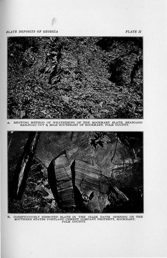
SL.t11'E DEPOSITS OF GEORGI.t1 PLATE 11
A. SHOWING METHOD OF WEATHERING OF THE ROCKMART SLATE, SEABOARD RAILROAD CUT% MILE SOUTHEAST OF ROCKMART, POLK COUNTY.
B. CONSPICUOUSLY RIBBONED SLATE IN THE OLLIE DAVIS OPENING ON THE SOUTHERN STATES PORTLAND CEMJ<~NT COMPANY PROPERTY, ROCKMART,
POLK COUNTY.
SLATE DEPOSITS OF GEORGIA
periods in which decomposed vegetable matter sank and annelids crept over the bottom, leaving their trails and impressions. Such small changes may have been due to annual seasonal variations in rainfall and vegetation on the land areas supplying the sediments, or may even have been caused by coarser materials brought into the sea by occasional storms.
Greater changes in depositional conditions caused sediments of entirely different character to be laid down. Thus an upheaval of the land would put the area of mud deposition closer to the shore, where sand was being deposited, and when the mud was metamorphos.ed into slate the sand went over into sandstone or quartzite. Depression of the shore-line caused organic deposition to predominate, so that beds of limestone were laid down. Such changes may have been gradual or sudden, and may have persisted for long or short periods, so that the sandstone and limestone beds vary from a few inches to hundreds of feet in thickness. Considering the Georgia slate deposits, the Rockmart slates iiJ, the vicinity of Rockmart were deposited close to the shore, and contain many thin beds o..E sandstone and conglomerate, but few of limestone. In the Cedartown area, however, beds of slate and limestone alternate. In the silver-gray slate belt there is no limestone, but the slate is interbedded with quartzite and feldspathic sandstone, the latter containing almost as much potash as the micaceous slate. The green slates occur in the Conasauga formation, which, as a whole, contains almost as much limestone as shale and slate.
The determination of the direction of the bedding is of great importance in prospecting for slate, because the cleavage, generally has not the same direction as the bedding, and ·slates of equal quality are to be sought along the direction of the bed, rather than the cleavage. Besides, where the slate comes in contact with more resistant beds it is likely to be extensively faulted or jointed, with disturbance of the cleavage.
The small beds due to minor changes in composition of the deposits are known as "ribbons," and are vis1ble in almost all slates, unless the cleavage happens to be exa.ctly parallel to the bedding. Ribbons can not be considered objectionable unless the variation in color makes them
10 GEOLOGICAL SURVEY OF GEORGIA
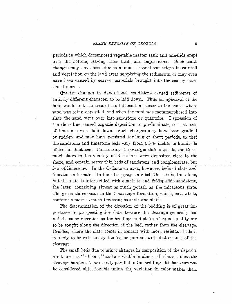
conspicuous, or unless the difference in composition is so great as to affect the working and wearing qualities of· t:P.e slate. Tlie Rock:rp.art slates are, as a rule, strongly ribboned. The variation in the bands seems to he principally in the content of carbonaceous matter, but so:n;te small beds contain more quartz than the m~ss of the slate. At .. some places the ribbons in
dicate close folding of the bedding~. (See fig. 1, reproduced from U. S. Geol. , Survey Bull. 586, p. 32, 1914), At other places the ribbons .consist of groups of.. thin 'siliceous beds, :which produce a slight defl:.ection of the cleavage direction. (See fig. 2) . In atleast one quarry the ribboning is so marked that
·,,·there is: a tendency: for the
Fig. 1. Sketches of ·the cleavage surfaces of two roofing sla~es from the Pritchard & · Davis quarry, Ro.ckmart, Ga., showing greatly plieated bedding crossing the cleavage at a very acute angle,. with the grain· nearly at riglit angles to both. The little beds contain more quartz and carbonate than the intervening slate.-Fro:in U. S. Geol. Survey Bull. 586, p. 32.
. slate :to break along the bedding planes; w h i c h make a considerable angle with the cleavage. The Cartersville. · high - potash slates show no ribbons, and so far as can be determined by ins.pection, the cleavage seems to be parallel to the bedding. The Georgia green slates are ribboned, but the beds vary only a little in the proportions
of chlori.te and carbonates contained, so the variation in color is slight, and in some cases ribbons are almost invisible.
SLATE DEPOSITS OF GEORGIA
"::;:;;
~ ::::::
""'" ~ -:::::-~
~ ~ - ~ "'" ~ ~
"':::::--"""- -
~--
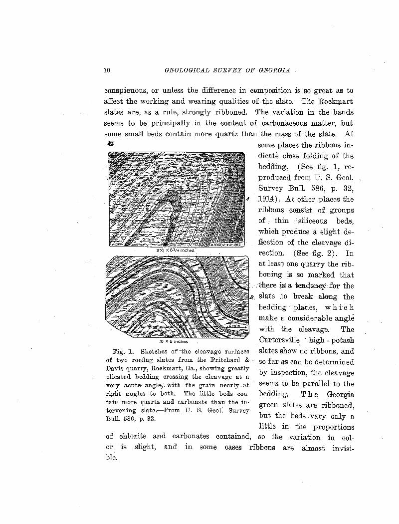
'~X 1Z.X e.
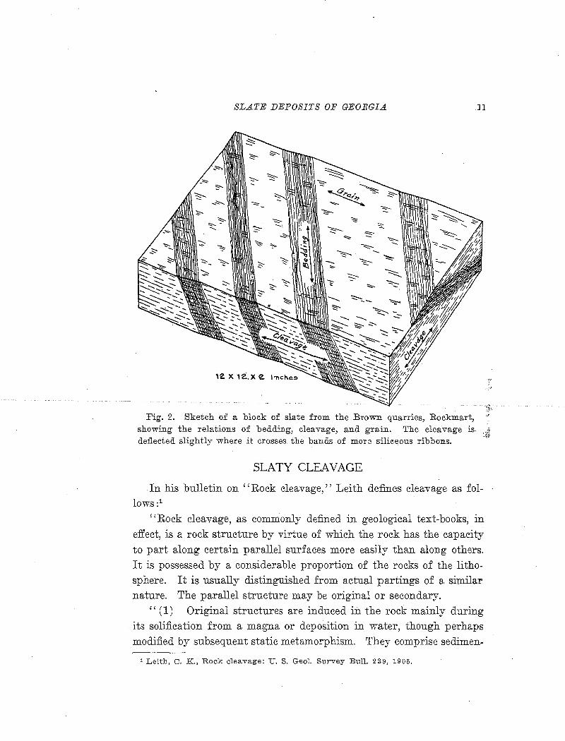
Fig. 2. Sketch of a block of slate from the Brown quarries, Rockmart, showing the relations of bedding, cleavage, and grain. The cleavage is defl.ected slightly where it crosses the bands of more siliceous ribbons.
SLATY CLEAVAGE
11
In his bulletin on "Rock cleavage," Leith defines cleavage as follows :1
"Rock cleavage, as commonly defined in geological text-books, in effect, is a rock structure by virtue of which the rock has the capacity to part along certain parallel surfaces more easily than along others. It is possessed by a considerable proportion of the rocks of the lithosphere. It is usually distinguished from actual partings of a similar nature. The parallel structure may be original or secondary.
"(1) Original structures are induced in the rock mainly during its solification from a magna or deposition in water, though perhaps modified by subsequent static metamorphism. They comprise sedimen-
1 Leith, C. K., Rock cleavage: U. S. Geol. Survey Bull. 239, 1905.
12 GEOLOGICAL SUEVErY OF GEOEGI.A
tary bedding, flow structures of lavas, cert~in gneissic structures, and pegmatite structures.''
"(2) Secondary structures are· :induced by deformation through metamorphic processes subsequent tb'·the formation of the rock. They have been given various names, sucp. as cleavage, slatiness, schistosity, foliation, fisility, etc.''
Slaty cleavage is a secondary structure, differing from fiss,ility in that it is brought about principally by recrystallization, and from schistosity in straightness of cleavage and fineness .of grain. Most
.· . slates were originally deposited. as muds, co:utaining a large propor-tion of elements which could enter into combination in mica and· chlorite. These minerals, besides crystallizing in flat pl~tes, have very perfect mineral cleavages, so the ·cieavages· w1phin the individual crystals add to the perfection of th~ slhty cle~v~ge. Theeleavage is also aided to some extent by the rotation of the resistant grains originally present in the deposit, espeCially quartz and feldspar, into such positions that their-longer dimensions are'parallel to the cleavage.
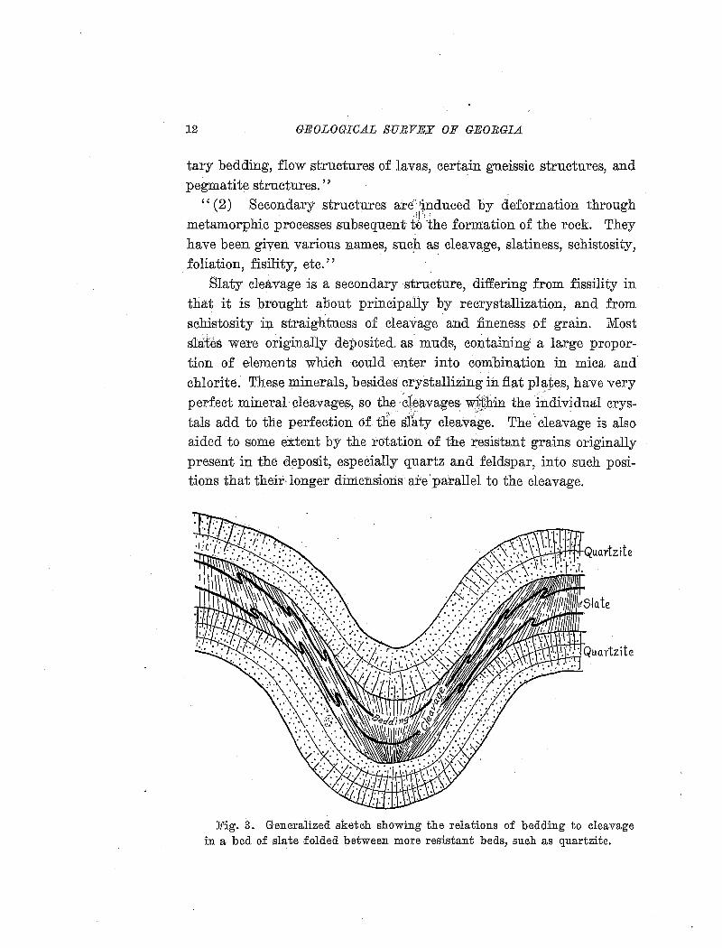
Fig. 3. Generalized sketeh showing the relations of bedding to eleavage in a bed of slate folded between more resistant beds, sueh as quartzite.
SLA1'E DEPOSITS OF GEORGIA 13
In general, the cleavage of slate does not coincide with the bedding. In the very common case where slate is formed by the folding of a weak bed of shale between two beds of harder rock, such as quartzite) the cleavage will tend to develop as shown in fig. 3. Under differential and rotational stress developed by the motion of the massive beds the cleavage is developed in fan shape; intersecting the bedding at a small angle on the limbs of the fold, but almost perpendicularly near the axis. The relations of cleavage and bedding, however, are further complicated by the fact that the beds are in almost all cases thrown into minor folds. The cleavage in such cases will be parallel to the axes of both major and minor folds.
In general, slates rwith very smooth and perfect cleavage are weak, but if slate is otherwise good a slight roughness of cleavage surfaces .is not objectionable. Cleavage of slate is never perfectly straight, b~t small slivers or "leaves" are left on cleavage surfaces, and the perfection of the cleavage may be estimated by the fineness of the "leaves." Curved cleavage planes occur in some slates, and such have sometimes been used on the roofs of towers. Curvature may occur normally on approaching more resistant beds, or may be due to secondary movement. In some of the Rockmart slates the cleavage is de:fiected where crossing ribbons, producing large-angled zigzags.
Cleavage is disastrously affected by freezing and thawing of the slate, or even by drying after quarrying. Therefore, the perfection of cleavage can be judged only by examination of damp or ''green'' samples, freshly quarried or preserved under water. Such samples are, of course, impossible to obtain from the Georgia slate quarries, where no work has been done for many years, and all slate in sight has been repeatedly frozen and thawed.
FALSE CLEAVAGE
The ''false cleavage'' of slate quarrymen consists of more or less closely spaced planes of parting crossing the true or slaty cleavage. This structure Leith1 includes under fracture cleavage, while Dale2
1 Leith, C. K., Structural geology, p. 61, 1"913. 2 U. s. Geol. S>urvey Bull. 586, p. 37, 1914.
14 GF;OLOGICA.L SURVEY OF GEORGIA.
prefers the term slip cleavage.; Luckily, it is a structure more common to schists than to. slate, since it entirely destroys the utility of slate for roofing and most other purposes.
False cleavage is a capacity to part along parallel· incipient joints, although there is usually no actual fracturing of the mass. The planes may be closely spaced, but the cleavage does not pervade the entire mass, as does true cleavage. In slate it is generally due to minute monoclinal folding of the particles of cleavable minerals, without faulting.. Such cleavage is produced by minor stresses and movements after the development of the platy minerals under ro~k flowage conditions.
GRAIN •t~j;
Slates break more readily in one than in the other of~fuJtt:e two planes perpendicular to the cleavage. This direction. of easy br~~age is called the ''grain,'' and usually shows itself in more or less obscure striations of the cleavage surfaces in a directi0n nearly parallel to the cleavage dip. Th'e grain is utilized in breaking down la:rge blo:ck~ of slate to workable propurtions, and roofing slates are airways cut with their long
' , >
sides~paraH:eFto: 'tJi~ ·grarri: · T1±~; eas~:·of·'fi~aetur~ a::i:ong 'th~ 'gra1~ varies greatly in slates from different qU'ar,ries; and some show scarcely any gram.
Grain may apparently be due to two causes; Most commonly it is · developed contemporaneously with the cleavage arid perpendicular tQ the direction of i:q.termediate pressure (the intermediate axis of the strain ellipsoid). It may also be prqduced by slight secondary pressure, in which case it is related to false cleavage. In the first case the ' mineral particles, which have their flat surfaces perpendicular to the direction of greatest p;ressure, have developed with their longest axis in the direction of least pressure. Naturally, the direction of easiest relief of pressure is upward, so the longest axes of the crystals, which determine the grain, are about parrallel to the cleavage dip. It has: also been found that some crystals of chlorite and many small scales of muscovite lie perpendicular to the cleavage, with their flat faces in the d~rection of the grain, and distorted octahedra of magnetite, distorted cubes of pyrite, erysiJals of staurolite, etc., which are larger than the crystals
SLATE DEPOSITS OF GEORGIA 15
of the slate-forming minerals, are all elongated in the grain· direction. Crystals of this sort are prominent in some of the Georgia green slates.
Some of the Rockmart slates, especially those from the Black Diamond quarries, have a very conspicuous grain of the type related to false cleavage. In a thin section parallel to the grain the cleavage is straight, but in a section perpendicular to both grain and cleavage it shows fine wrinkling, with bending of the individual muscovite flakes. Grain of this sort must have been produced by a slight second~ry move-' ment. In other slates with only normal grain there is little difference observable in such sect1ons. Large :&akes of chlorite and small scales of muscovite flattened in the grain direction are noticeable in some cases, and sections parallel to the grain may polarize more brilliantly than those across it.
JOINTS
Joints are ruptures in continuity of •a rock mass, in general with little or no movement. They may be produced by either tensile or compressive stresses, and the same stress may produce several sets of joints.
Joints, especially in.slate, are classified as strike joints (parallel to I
the strike), dip joints (parallel to the dip), diagonal joints (diagonal to the strike and dip), and horizontal or fiat joints; according to their relations to cleavage or bedding.
Occasionally joints are curved or plicated. Gently curved joints may have been so formed, but closely folded or plic•ated joints are due to secondary movements. Very commonly joints are filled by films or veinlets or guartz or calcite, and occasionally other minerals. Many of the joints in the slates of Georgia seem to be merely incipient fractures or planes of weakness, along which the slate breaks when weath· ered. Thus the slate at the surface is broken into very small pieces, but most of the joints disappear at a depth of a few feet.
Joints are of great economic importance in slate quarrying. If few. and widely spaced they facilitate quarrying, but joints too close to.
gether or at inconvenient angles to the cleavage cause an undue amount of waste.
16 GEOLOGICAL SURVEY OF GEORGIA
FAULTS
F.aults of small ~agnitude are common in slate re~io~s, but the *ork .·in the Georgia quarries has not been extensive enough to show their abundance and importance. Faults have-been noted in the de, posits. near Bolivar.
Both the Rockmart and Conasauga slate belts follow the great Cartersville fault, one of the major thrust faults of the southern Appalachians. The available evidence indicates .that the pressure caused minor disturbances which have rendered the slates useless for a distance of· about a mile from the outcrop of the fault plane.
SHEAR ZONES AND CLEAVAGE BANDS
Shear zones ·are defined as angular plications, or series of such plications, due to shearing pressure on somewhat rigid material, where the pressure was insufficient to produce more than slight faulting. Although not usually affecting any large mass of slate,· they cause the
slate to break into irregu1ar blocks,. produ~ing much. waste. Shear zon'es may be pr~duced{b~'force~ a littf~ ni:dre.intense 'th~h those producing false cleavage of the monodj'nal fold type. If th~ pressure is stili more intense, cleavage banding is pr~duced; consisting of alt~rn:tting bands with ;and without cleavage. This prenomenon is of common occurrence in the Vermont and New York slate belt, but has not been noted in Georgia.
VEINS
Quartz veins, or ''flints,'' are common features m most slate quarries, and a cause of great difficulty in mining. Veins m:ay cut the slate in any direction, and commonly they ramify irregularly, spoiling large masses of slate. The vein-filling material is chiefly milky quartz often with associated C'alcite, chlorite and biotite. The veins are the result of openings produced by various secondary stresses, and the fillings have been deposited from solution, consisting of material dissolved from the slate itself or from associated rocks.
SLATE DEPOSITS OF GEORGIA 17
DIKES
Volcanic dikes are not uncommon in some slate deposits, but none are known in the Georgia slate belts.
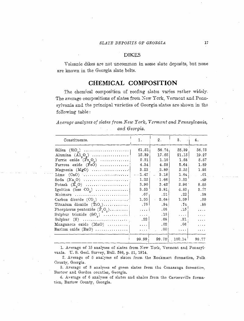
CHEMICAL COMPOSITION The chemi0al composition of roofing slates varies rather widely.
The .average compositions of slates from New York, Vermont and Penn
sylvania and the principal varieties o·f Georgia slates are shown in the
following table :
Average analyses of slates from New· York, Vermont and Pennsylvania, and Georgia.
Constituents.
Silica ( SiO 2
) ••••.•••••••••••••••••
Alumina (A1 0 ) ................. . 2 3
Ferric oxide (:F'e20 3 ) · .. •• · • • • • • · • •
Ferrous oxide (FeO) ............. . Magnesia (MgO) .................. -Lime (CaO) ..................... .
Soda (Na20) ... : .... · ·. · · · · · · · · · · · Potash (K20) ...... - .... · · · · · · · · · · Ignition (less CO) ............... . Moisture ......................... . Carbon dioxide (C0
2) •••••••••••••• ·
Titanium dioxide (Ti02
) ••••••••••••
Phosphorus pentoxide (P20
5) •••••••••
Sulphur trioxide (SO) ........... . Sulphur (S) ..................... . Manganous oxide (MnO) ......... . Barium oxide (BaO) ............... .
1. ----
61.51 15.39 2.21 4.34 3.23 1.47 1.22 3.90 3.53
.67 1. 55
.75
.22
I 2. I 3. . 4.
'--------------56.74 55.39 56.73 17.65 21.-15 19.27 1.10 1.58 5.57 4.58 5.64 1.89 2.89 2.55 1.93 3.18 1.64 .01 1. 66 1.33 .49 3 .42' 2.96 8.85 3.81 4.83 3.77
.21 .22 .38 2.64 1.59 .00
.94 .74 .88
.08 .15
.18
.68 .31
.02 .06
.00 ----------------J-----~-------------
99.99 I 99.78'1 . 100.14 99.77
1. Average of 15 analyses of slates from New York, Vermont and Pennsylvania. U. S. Geol. Survey, Bull. 586, p. 51, 1914.
2. Average of 5 analyses of slates from the :R.ockmart formation, Polk County, Georgia.
3. Average of 8 analyses of green slates from the Conasauga formation, Bartow and Gordon counties, Georgia.
4. Average of 6 analyses of slates and shales from the Cartersville formation, Bartow County, Georgia.
18 GEOLOGICAL SURVEY OF GEORGIA
Silica and. alumina, the most abUlil.dant oxides in all slates, va'i-y from 55 to 67 and from 11 to 22 pe/ cent, respectively, in .American and European slates which have been successfully used for roofing.1
After these, the mos.t essential constituents are magnesia, ferrous oxide and potash, which enter into the platy minerals~ chlorite and mica, and must be present in considerable amounts in order to give adequate slaty cleavage to the rock. The relative proportions of these three oxides very greatly, but it is notable that in almost all analyses of
· roofing slates the tot~l of the three is between 10 and 12 per cent. As ~ rule, the ferrous oxide and magnesia are high in green
slates, while potash predominates in gray slates, although carbonaceous coloring matter may hide the green color of chlorite. Thus, in the Georgia green slates the ferrous oxide is high and the ma,anesia moderately high, shorwing a high percentage of chlorite, which accounts for the color. The Rockmart slates also have rather high ferrous iron and magnesia:, but the green color of chlorite is obscured by the car-
. bonaceous matter present. The light gray Cartersville slates have low contents of ferrous iron and magnesia, with correspondingly highpotash.
Ferric oxide ,i~ slates oceurs chiefly in the minerals hematite and magnetite. These .minerals'ha'Ve little effect on the stre11~th or working qualities. Hematite in large proportion gives to the slate a red or purplish color, which may add to its desirability-and value. Magnetite is undesirable in slates for electrical uses, on account of its high conductivity.
In all American and in practically all European slates the potash is considerably in excess of the soda. The potash occurs chiefly in muscovite mica (sericite), 'which is in most slates much more important than chlorite in giving cleavage. Soda may also enter into the
• mica, taking the place of a part of the potash moJecules. Both soda an¢1. potash occur in detrital or recrystallized grains of feldspar, which is present to some extent in all slates.
Li:tne occurs to a small extent in silicate minerals, but is chiefly in the form of carbonate. The carbonate present, however, is not pure
1 U. S. Geol. Survey Bull. 586, pp. 50·51, 1914.
SLATE DEPOSITS OF GEORGIA 19
calcite, but contains more or less ferrous oxide, magnesia and manganous oxide as an isomorphous admixture of siderite, dolomite and
rhodochrosite molecules.
The determination of ca.rbon dioxide in slates is of great importance, because it gives a measure of the quantity of minerals which cause disintegration and fading. Any slate containing a high percent
age of carbonates will be weak and liable to rapid disintegration under the influence of weather and acids present in the atmosphere of cities. Ferrous carbonate is an easily oxidizable mineral, and is kno·wn to be
the principal cause of fading and staining of slates. Unfortunately, it is not possible to determine by chemical ana1ysis the proportion of calcium, magnesium and iron combined in the form of carbonate in slate, because of the complex mineral composition of the rock and the
fact that each of these elements may enter into several different minerals. The three average slates which contain carbon dioxide all have a small excess over the amount combinable with the lime presenti
showing that some magnesium or iron carbonate must exist.
The •sulphur in slates occurs chiefly in the iron sulphides, pyrite
and marcasite, and the small amount of sulphur trioxide sometimes found is probably an oxidation product. In the analyses as stated in
this report, the iron combined with the sulphur is included with the
ferrous oxide. The figures for ferrous oxide, therefore, include a small
amount of oxygen not actually present. After ferrous carbonate, the
iron sulphides are believed to be the principal causes of fading and
staining. Marcasite is more easily oxidizable than pyrite, therefore it
is more undesirable. When the sulphide mineral is pyrite, occurring in
relatively large crystals tightly enclosed by leaves of mica, as is gen
erally the case in Georgia slates, it weathers very slowly and is not
likely to c~use trouble unless it makes up several per cent of the rock.
This is shown by the fact that fresh, bright crystals of pyrite are
found in slate which has been exposed to the weather for many years.
Titanium dioxide is present in all slates, generally constituting a
little less than one per cent. The usual mode of occurrence is in
minute rutile ''needles.''
20 GEOLOGICAL SUEVEJ[ OF GEORGIA
Loss on ignition represents principally combined water, but includes also carbon and a;ny volatile matter that may be present. It has been found in calculating the mineral compositions of a number of slates that if the loss on ignition is ·assumed to be entirely combined water, there is usually a· slight excess over that theoretical1y combinable _!n the minerals likely to be present.
Other elements generally present in slates are phosphorous, manganese, barium, chromiunl., vanadium ap.d zirconium. The amounts are scarcely more than traces, and are not usually determined.
Summing up the chemistry of slate, Dale1 calls attention to the fact that the chemical analysis of a slate is not sufficiently characteristic to pl.'love t~at it is not a shale, a clay, or a schist. Ex-cept for the low soda and high combined water content of sla;fies, many granites syenites, porphyries, diorites and basalts could pass chemically as roofing slate. He says :
"It follows . · . . that while considerable scientific interest attaches to the chemi•stry of slate there is little ·correJ.a;tion between its chemical; cCOTIJ;p;0sitio:a an:d its p.hysica1 p.mperties. These. d.epend primarily on its te~ture; and seconda:rlly on its, mineral, comp;osition, and both :o:f these ar.e·.hest. <;lete'rmine.d..·hy, II\icr~sco.pic· examination.
''That there should be chemical similarity between slate, shale and clay results primarily from the fact that the slate here considered is simply metamorphosed shale and that shale is compressed clay. What: ever mineralogic changes metamorphism brought about, the same ele-
' ments persisted. In some mica slates the grains of quartz, feldspar, zircon and other minerals are the identical ones o·f the original cl,ay
sediment.''
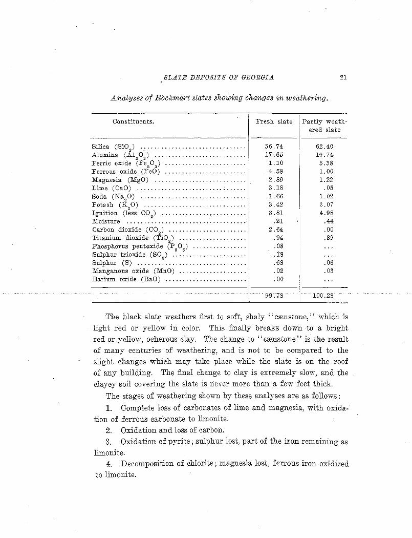
CHEMICAL CHANGES IN WEATHERING The changes in the Rockmart sl:3,te in weathering are illustrated by
the following pair of analyses. The first is a:q. average of five fresh samples from various quarries in the Rockmart district; the second is an average of two samples of partly weathered slate or '' crenstone'' from the Rockmart Shale Brick & Slate Company property:
1 U. S. Geol. Survey Bull. 586, p. 52, 1914.
SLATE DEPOSITS OF GEORGIA.. 21
Analyses of Rockmart slates showing changes in weathering.
Constituents.
Silica (SiO ) .............................. . 2 -
Alumina (A120) ................ · · · · · · · · · · ·
Ferric oxide (Fe20 3 ) •. • •• • • • • • · • • • · • • • • • • • • •
Ferrous oxide (FeO) ..... · .................. . Magnesia (MgO) .......................... . Lime (CaO) ............................... .
Soda (Na20) ............ · · · · · · · · · · · · · · · · · · · Potash (K20) .......... · · · · · · · · · · · · · · · · · · · · Ignition (less CO
2) •......••••..• ~ .. · · · · · · · ·
Fresh slate
56.74 17.65
1.10 4.58 2.89 3.18 1. 66 3.42 3.81
Moisture ................................... · .21 Carbon dioxide (C0
2) •••••••••••••••••••••••
Titanium dioxide (Ti02
) .................. ..
Phosphorus pentoxide (P20
5) •..•••••..•• · • ••
Sulphur trioxide (S03
) ••••••..••••••••••••••
Sulphur (S) ............................... . Manganous oxide (MnO) ................... . Barium oxide (BaO) ....................... .
2.64 .94 .08 .1'8 .68 .02 .00
·I· .. 99.78
Partly weath· ered slate
62.40 19.74 5.38 1.00 1.22
.05 1.02 3.07 4.98
.44
.00
.89
.06
.03
- 100.28
The black slate weathers first to soft, shaly '' crenstone,'' which is light red or yellow in color. This finally breaks down to a bright red or yellow, ocherous clay. The change to '' crenstone'' is the result of many centuries of weathering, and is not to be compared to the slight changes which may take place while the slate is on the roof of any building. The final change to clay is extremely slow, and the clayey soil covering the slate is never more than a few feet thick.
The stages of weathering shown by these analyses are as follows:
1. Complete loss of carbonates of lime and magnesia, with oxidation of ferrous carbonate to limonite.
2. Oxidation and loss of carbon. 3. Oxidation of pyrite; sulphur lost, part of the iron remaining as
limonite. 4. Decomposition of chlorite ; magnesia lost, ferrous iron oxidized
to limonite.
22 GEOLOGICAL SURVEY OF GEORGIA
5. Kaolinization of feldspars, with loss of a large part of the soda and some _potash.
The results, chemically, are: '
1. Relative increase in the stable oxides; silica, alumina and total Iron.
2. Actual increase in combined water and ferric iron. 3. Total loss of carbon dio;:x:ide, lime, carbon, sulphur and ferrous .
iron; considerable loss of magnesia and soda; slight loss of potash. The potash mica is a very stable mineral under ordinary weather
ing conditions, and is one of t'he Jast to go. In the :final cbange to clay the mica also i~ kaolinized, with loss of the potash, and free silica is leached out, leaving essentially a mixture of kaolin and limonite.
The Conasauga, and Carrtersville slates show weatheriJig phenomena of the s.ame character, but on account of their higher percentage of mica; these slates weather even more slowly than those of the Rockmart formation. In the Conasauga green slate area slightly weathered fragmental material from the formation covers the, S)l'r&~ce ·over l~rge ( areas. The· Cartersville shales and slates, with their hjgh potash con-tent, sh~w t1t:e sta:biliity of• the micas· even when: S'lihjected to weather-ing for an enormous period of time.
MINERALOGICAL COMPOSITION Slate, being formed from the debris, of granitic or other ingeous
rocks, may contain any of the common rock-forming minerals. Most important in producing texture, cleavage and working qualities, however, are a small group of secondary or authigenous minerals formed during metamorphism. These metamorphic minerals are of comparatively simple and uniform composition, and are formed •at the expense of any of the original fine-grained clastic minerals which happen to contain the proper elements.
Dale's1 classification of the principal minera.l constituents of slates
is here quoted.
"A.s the min.eral constituents were either (1) derived from older rocks and dep_osited either as mechanical sediments or chemical precipitates, or (2) formed
1 Dale, T. N., U. S. Geol. S'urvey Bull. 586, p. 22, 1914.
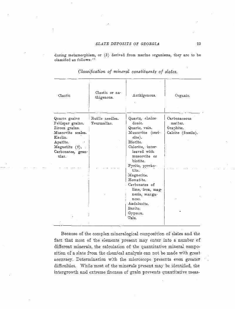
SLATE DEPOSITS OF GEORGIA 23
during metamorphism, or (3) derived from marine organisms, they are to be classified as follows: ''
Classification of mineral constituents of slates.
Clastic or au-Clastic thigenous. Authigenous. Organic.
Quartz grains Rutile needles. I Quartz, chalce- Carbonaceous Feldspar grains. Tourmaline. donie. matter. Zircon grains. Quartz, vein. Graphite. Muscovite scales. Muscovite (seri- Calcite (fossils). Kaolin. cite). Apatite. ' Biotite. Magnetite ( ~). Chlorite, inter-Carbonates, gran- leaved with
nlar. muscovite or biotite.
Pyrite, pyrrho-~~ ~
tit e. Magnetite. Hematite. Carbonates of
lime, iron, mag-nesia, manga-nese.
Andalusite. Barite. Gypsum. -Tale.
Because of the complex mineralogical composition of slates and the fact that most of the elements present may enter into a number of different minerals, the calculation of the quantitative mineral composition of a slate from the chemical analysis can not be made with great accuracy. Determination with the microscope presents even greater difficulties. While most of the minerals present may be identified, the intergrowth and extreme fineness of grain prevents quantitative meas-
24 GEOLOGICAL SURVEY OF GEORGIA
uremeiits such as can be made on sections of 'more coarsely crystalline rocks.
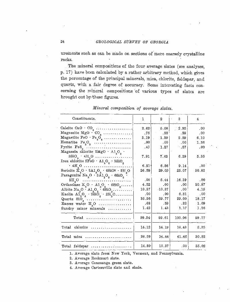
The rn.ineral compositions of the four average slates (see analyses2
p. 17) have been calculated by a rather arbitrary method, which gives the percentage of the principal minerals, mica, chlorite, feldspar, and quartz, with a fair degree of accuracy. Some interesting facts concerning the mineral compositions of various types of slates are brought out by /these figures.
Mineral composition of average slates.
Co;nstituents.
Cale.ite OaO C02
•••••••••••••••••••
Magnesite MgO CO2
•••••••••••••••
Magnetite FeO · Fe20
3 ••••••••••••• •
Hematite Fe20
3 •••.•••.•••••••••••
Pyrite Fe82
•••••••••••••••••••••••
Magnesia chlorite- 5Mg0 A\ 0 3
3Si0 4H 0 .................. . . 2 2
Iron chlorite 5Fe0 A12 0
3 • 3Si0
2 4H
20 .................... · .... .
Sericite K20 3A1
20
3 6Si02 · 2H
20
Paragonite Na 0 3A1 0 6Si0 2 .2 3 2
.2H20 ........................ .
Orthoclase K20 .A:1
20
3 6Si0
2 ••••••
Albite Na2
0 · A120
3 • 6Si0
2 •• · ••••••••
Kaolin A12 0
3 2Si0
2 • 2H
2 0 ........ .
Quartz SiO 2
•••••••••••••••••••••••
Excess water H2 0 ................ .
Sundry minor minerals ........... .
1 1 2 3 4 _________ ___...:. ___ 1-------
2.62· 5,68 2.92 .00 .76 .28 .59 .00
3.19 1.59 2.29 6.10 .00 .00 .00 1.36 .41 1.27 .57 .00
7.91 7.63 6.29 5.35
6.21- 6.56 9.14 .00 26.59 29.0.0 25.07 30.82
.00 5.44 16.39 .00 4.52 .00 .00 30.87
10.37 10.37 .00 4.15 .00 .00 6.31 .00
35.26· 29.77 29.00 18.17 .68 .59 .32 1.69
1.42 1.43 1.17 1.26 ______________ ____:__ ---- -----r-----f-----
Total . . . . . . . . . . . . . . . . . . . . . . . 99. 94· 99. 61 100. 06 99. 77 ---- -----r------f-----
Total chlorite .................... . 14.12 14.19 15.43 5.35 -~-------------- --~r-----r-----f-----
Total miea .. . . . . .. .. . . .. .. . . .. .. .. 26.59 34.44 41.46 30.82 -----'----------~- ---------r-------1----Total feldspar . . . .. .... . . .. . . . .. .. . 14.89·\ 10.37 .00 35.02
1. Average slate from New York, Vermont, and Pennsylvania. 2. Average Rockmart slate. 3. Average Conasauga green slate. 4. Average Cartersville slate and shale.
SLATE DEPOSITS OF GEOBGI.A 25
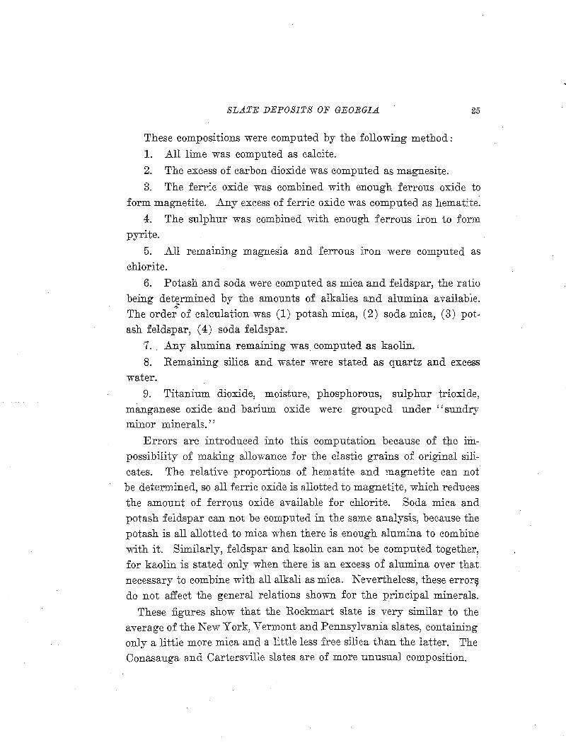
These compositions were computed by the following method:
1. All lime was computed as calcite.
2. The excess of carbon dioxide was computed as magnesite.
3. The ferric oxide was combined with enough ferrous oxide to form magnetite. Any excess of ferric oxide was computed as hematite:
4. The sulphur was combined with enough ferrous iron to form pyrite.
5. All remaining magnesia and ferrous iron were computed as chlorite.
6. Potash and soda were computed as mica and feldspar, the ratio being de~rmined by the amounts of alkalies and alumina available. ,,. .
The order of calculation was (1) potash mica, (2) soda mica, (3) pot-ash feldspar, (4) soda feldspar.
7. Any alumina remaining was computed as kaolin.
8. Remaining silica and water were stated as quartz and excess water.
9. Titanium dioxide, moisture, phosphorous, sulphur trioxide, manganese oxide and barium oxide were grouped under ''sundry minor minerals.''
Errors are introduced into this computation because of the impossibility of making allowance for the clastic grains of original silicates. The relative proportions of hematite and magnetite can not be determined, so all ferric oxide is allotted to magnetite, which reduces the amount of ferrous oxide available for chlorite. Soda mica and potash feldspar can not be computed in the same analysis, because the potash is all allotted to mica when there is enough alumina to combine -with it. Simila.rly, feldspar and kaolin can not be computed together, for kaolin is stated only when there is an excess of alumina over that necessary to combine with all alkali as mica. Nevertheless, these error~ do not affect the general relations shown for the principal minerals.
These figures show that the Rockmart slate is very similar to the average of the New York, Vermont and Pennsylvania slates, containing only a little more mica and a little less free silica than the latter. The Conasauga and Cartersville slates are of more unusual composition.
'
26 GEOLOGICAL SURVEY OF GEORGIA
The Conasauga green slates are more micaceous than the ot:Q.ers, and have a high per cent of iron-bearing chlorite, although the total chlorite is not much higher than usual. In this slate no feldspar is indicated by the analysis, as the percentage ·of alumina is more than enough to form mica with all the potash and soda. In the average Conasauga slate there is enough combined -water to form kaolin with the excess of alumib.a, but in some of the ib.dividual analyses there is a deficiency of water, indicating that some alumina occurs in the form of aluminum silicate, andalusite" sillimanite or cyanite.
The Cartersville slates, in spite of their high percentage of potash, can not run extremely high in mica because of the low alumina content. .Ail of the soda and more than half of the potash must occur as feldspar molecules. This indicates a total feldspar percentage greater than that of mica, while the excess of free snica is much less than in any other slate. Micro~copic examination of thin sections shows a grea;t deal' of feldspar, but the visible amount is not nearly as large as that indicated by calculation from the molecular ratios. The percentage of hem?-tite shown in the sections is greater than that indicate.cil:~c by-, ~h~ttyOJI!;piUJted tC:Q:0.1]~Jo;;;itiqn; te::JE~irt:g;:;.SOJilile'. ferrous [ron to enter ib.to chlorite, but even with this addition the percentage of chlorite r.emains~ urrRsually low.
AGE AND GEOLOGIC RELATIONS Most, if not all, slates of commercial value are found in forma-
tions of Paleozoic age. In general, the pre-Cambrian rocks have been too intensely metamorphosed, while those of Mesozoic and Cenozoic age are 1hot sufficently consolidated. The Georgia slates, as well as those of other states in 'the Appalachian province, belong to the Cambrian and Ordovician systems of early Paleozoic age.
Slates can occur only near the borders of granitic land masses which served as sources of supply of the original materials. Thus, t~e slate deposits of Georgia, although they belong to three geologic formatio:ns, all occur just northwest of the old continental mass of preCambrian rocks.
SL.A1'E DEPOSITS OF GEORGIA 27
After deposition the sediments must have been subjected to dynamic metamorphism, during which the pressure must not have been too intense and must have come mainly from one direction.. Two major periods of metamorphism, Ordovician and Carboniferous, occurred in the Appalachian province. The latter metamorphic period had little effe·ct on the Georgia formations west of the Cartersville fault, but east of that fault the earlier Cambrian formations, the Nantahala slate and parts of the Brasstown schist and Valleytown formation have been too much metamorphosed to serve as commercial slates, although their chemical composition is suitable.
ORIGIN1
''With the exception of the rare slates of igneous or1gm, slates originate in marine deposits of clay and sand. TJ;.e common occurrence of angular grains of feldspar and of quartz in slate implies the nearness of shores or land masses of granitic rocks to such deposits. The alternation of beds of slate with beds of quartzite or grit ("ribbons," "hards," altered sandstone) corresponds to the alternation of extremely fine clayey sediments, derived from the waste of such granitic land masses with sandy sediments consisting of coarser material from the same source. The repeated alternation of such fine and coarse sediments is attributed to the alternation of calm water, favorable to the deposition of fine material, with strong currents that brought coarse sediments more rapidly from the shore. These materials consisted largely of quartz, feldspar and mica, but included also zircon and other silicates, various compounds of iron, lime and magnesia, and kaolin arising from the decomposition of feldspar. Where the slate is· interbedded with fossiliferous limestone, it is evident that periods of such changing conditions in the water also alternated with periods when marine life abounded and the sediments were entirely calcareous. Black slates owe their blackness to carbonaceous matter, probably derived from the decomposition of marine organisms on the sea floor. Red slates owe their color to the access of ferruginous matter from the land, and purplish
1 Quoted from Dale, T. N., U. S. Geol. Survey Bull. 586, pp. 11-14, 1914.
28 GEOLOGICAL SURVEY OF GEORGIA
slates to an admixture of such matter and a green. magnesian mineral (chlorite) o.f secondary o;rigin. In both the reddish and the.purplish sll:!-tes .. the iron is supposed to have been originally precipitated in the fo;rm of the rust-colored limonite (2Fe2 0 3 • 3H20) from iron-bearing solutions and to have been afterward altered by loss of water ( H 20) to the reddish hematite (:Fe2 0 3 ) •
1
''An:. accumulation of several hundred feet of such clayey and sandy. sediments when buried under several thousand feet more of other sediments of like origin on a gradually subsiding sea bottom must have been subjected to sufficient vertical pressure, in connection with a small amount of moisture, to be cemented together and hardened-the clay into shale and the sand into sandstone. During this process the particles in thBse sediments retained the .general horizon-
~· I ' \
tal and parallel arrangement which they had received from their dis-tribution by sea water, but became :firmly compacted and thus acquired a bedding foliation.
''The next stage_in the formation of slate is attributed ultimately to the radiation of heat from the earth's interior into sp_ace., resulting
· in.~ a conina:ction; o£ th-e inter:ior .and .cons~quentl~ in .. a cor ruga-.. , ~- ·, .. - \ ,·,. . " "" . . , . -,~ • ._ , ' . ..:: . r . ,t·!,- . ,_.. . • ..
tion of the outer portion. This corrugation, for reasons not yet per-fectly, evident; ·took. p1aee, so-£ar as:·,obserw.ation ex,te:ads, chiefly within certain belts in. which the mountain systems were formed from the lateral compression of a great mass of parallel strata. The :first effeet of this compression was to bend at least the lower portion of the strata into wavelike folds, and thus to shorten its horizontal area in one direction and increase its vertical thickness. But another effect of this compression was to metamorphose the shale into slate. This metamorphism probably did not take place until the folding was
. . . ~
well initiated. The transformation included two processes, and it is uncertain which preceded. Each individual sedimentary. particle rwas rotated ~rom·. its original horizontal position in the bedding foliation into one forming' a considerable angle to the direction of pressure. The~e was also, under th~ combined presence of moist~re and the effect of pressure and heat, both the heat which must have been gen-
1 See on these changes VanHise, C. R., A treatise on metamorphism: U. S. Geol. Survey Mon. 47, pp. 225, 232, 1904.
SLA1'E DEPOSITS OF GEORGIA 29
erated by the pressure and that which pervaded the strata at the depth at which they were bu:J?ied, such a chemical recombination of the silica, alumina, potash, iron and water of the feldspar, kaolin and ferro-magnesian minerals of the shale as to generate new potash mica in amount sufficient to constitute, in the mica slates, over 33 per cent of the resulting slate. This muscovite was formed in ·scales of in-. finitesimal thinness and generally of longish, tapering, or ribbonlike outline. Most of these scales arranged themselves with their flat sides parallel to or overlapping one another, but facing the direction from which the pressure came and also with an angle of inclination governed by that pressure. .A small but variable proportion, however, of these scales took such a position that their flat sides became parallel to the direction of the pressure. .As mica crystallizes in columnar crystals, and as the plates or scales due to its molecular structure are transverse to the crystal column, and as a slab of slate consists largely of parallel scales of mica it may be said to correspond when held horizontally to such a crystal held vertically. When a mica slate is cut in thin section across the cleavage its optical behavior under polarized light is like that of a mica crystal cut across its crystal cleavage. Yet as not only a considerable number of the mica scales in slate lie across the cleavage, but as some scales of chlorite and crystals of other minerals do also, the texture of a mica slate combines some of the features of a crystal with some of· .those of a tissue. Extremely thin sections
of slate transverse to the cleavage may show this interlacing of the two sets of scales on their attenuated edges. It is to this microscopic texture that the slate largely owes its peculiar properties.
''This crystalline fabric may inclose in its meshes any sedimentary
particles of quartz, zircon, feldspar, kaolin, or other minera1s which
were not or could not be made over into mica or secondary quartz, but whose alignment became more or less parallel to that of the major part of the new mica. During this metamorphism other chemical combinations were formed by the constituents of the shale, which crystallized in isolated scales or crystals of chlorite, biotite (magnesia mica), various carbonates, pyrite, magnetite, graphite, tourmaline, andalusite, etc. These arranged themselves variously-some in the
30 GEOLOGICAL SUEVEJ! OF GEORGIA
cleavage direction, some in the· grain direction. Lenses consisting of some one: mineral surround.ed by one or two others were also formed and concentrically or radiately arranged. ·The limonite became hematite._ During these changes in the fine sediments the intercalated beds of sandstone passed into quartzite and metamorphic grit by the formation o'f siliceous and micaceous cement between their particles.
"The general ·microscopic texture of slate is such as to warrant the assumption that the compression which produced it operated not only rwith great uniformity, but also very gradually.
"Alter the ·s1a,te was formed the mass was subjected to various stresses (tensions, shears, contractions), which resulted in several systems of joints, in faults, slip cleavage ("false cleavage"), shear zones ("hogba~ks"), and irregular openings in which veins 6f quartz and calcite were forll1ed by infiltration. Some masses- were· also traversed by fissur:es penetrating to the molten zone and thus permitting the exudation of lava-like material which formed dikes.
"From the foregoing stateme:mits it may be seEm that a piece of slate is in itself a record of a long series of complex geographic, geologic, chemii<:~all; mine:r:alogic a;:B1d. physical processes· of gi!Jeat 13cientific interest."
METHODS OF TESTING
The usual tests of slate, as outlined by Dale1 are as follows:
Sonorousness.-Slate of good molecular structure yields a distinct ring when tapped.
OleaJtHilbiW:y.-This test must be made on a block of moist, unfrozen, freshly quarried slate by an experienced workman.
"ScuLping. "-The test to determine the character of the fracture along the grain should be made by an expe,rienced workman. It is also an advantage if the slate will "betel break" across both cleavage and grain without shattering.
1 U. s. Geol. Survey Bull. 586, pp. 172-181, 1914.
SLATE DEPOSITS OF GEORGIA 31
Character of Cleavage Surface.-. Examination with a hand lens will show the grain, false cleavage, ribbons, coarse crystals producing roughness of the surface and micaceous leaves indicating good cleavage.
Presence of Lime.-Test for effervescence with hydrochloric acid on the edge of a block or on powdered slate.
Color and Discoloration.-Comparison of fresh slate with that exposeO. to the weather for some years.
Presence of Clay.-Slate containing clay has an argillaceous odor when breathed upon.
Presence of Marcasite.-Marcasite upon exposure forms a yellowish-white film and rusty spots. Pyrite in small quantity is not detrimental.
Presence of Magnetite.-May be determined quantitatively by powdering the slate and extracting the magnetite with a strong magnet.
Electric Resistance.-Determined by comparison with a standard resistance.1 This test is important if the slate is to be used for electric· switchboards. The resistance depends largely on the scarcity of magnetite.
Strength.-This test is made with Merriman's apparatus. 2 The piece to be tested is supported upon knife-edges 22 inches apart, and the load is placed upon another knife-edge midway between. The nodulus of rupture of the best slate ranges from 7,000 to 10,000 pounds to the square inch.
Toughness or Elasticity.-Measured by the ultimate deflection when placed on supports 22 inches apart. The deflection of certain Pennsylvania slates tested by Merriman ranges from 0.270 to 0.313 inch; that of the Rockmart, Georgia, slate is 0.160 inch.
1 Purdue, A. H., The slates of .Arkansas: U. S. Geol. Survey Bull. 430, pp. 329-330, 1910.
Bristol, W. A., High tension testing of Vermont slate and marble: Report of the Vermont State Geologist, 1911-1912, pp. 196-219.
2 Merriman, Mansfield, Am. Soc. Civil Eng. Trans., vol. 27, nos. 3 and 6, 1892; vol. 32, pp. 529-539, 1894.
32 GEOLOGICAL SIJ1WEY OF GEORGIA
Density or Specific Gravity.-·Determined in the ·usual manner, by weighing a piece in air and- in water, after· air is expelled by boill.ng in dfstilled ::water.
Porosity.-Determined by the amount of water absorbed in the pores. May be determined roughly by observing the ascent of water by capillary attraction in a.' piece partly immersed in water.
H ard1tess or Resistance . to Abrasion.-Relative hardness is determined by the weight removed by a definite number of revolutions of a sta;ndard grindstone under a constant pressure.
Corrodibi~ity.-Tested.by solubility in dilute acid. Merriman used a solution with one per cent each of hydrochloric and sulphuric acids.
Mic1~oscopic .A.nalysis.-Determination of minerals present and their textural relations by examination of thin sections under the microscope. Sections should be cut both parallel and perpendicular to the cleavage, and should be cut much thinner than· the usual sections of igneous rocks, in order that very high magnification may be
·used.
ChermricaL AnaLysis.-Ohemical analysis of slates should be consid-· ered in connection with the microscopic examination and other tests, because the analysis alone gives little evidence as to the value of a slate. In order to be worth anything at all an analysis must be complete, show:i:ng especially soda, p6tash, ferrous iron, sulphur and carbon dioxide. Merriman~ concludes that:
''The strongest slate stands highest in weathering qualities, so that a flexural test affords an excellent index of all its properties, particularly if the ultimate deflection and the manner of rupture be noted. The strongest and best slate has the highest percentage of silicates of iron and alumina, but is not necessarily the lowest in carbonates of lime and magnesia. Chemical analyses give only imperfect conclusions regarding the weathering qualities of slates and do not satisfactorily explain their physical. properties.''
1 Op. cit.
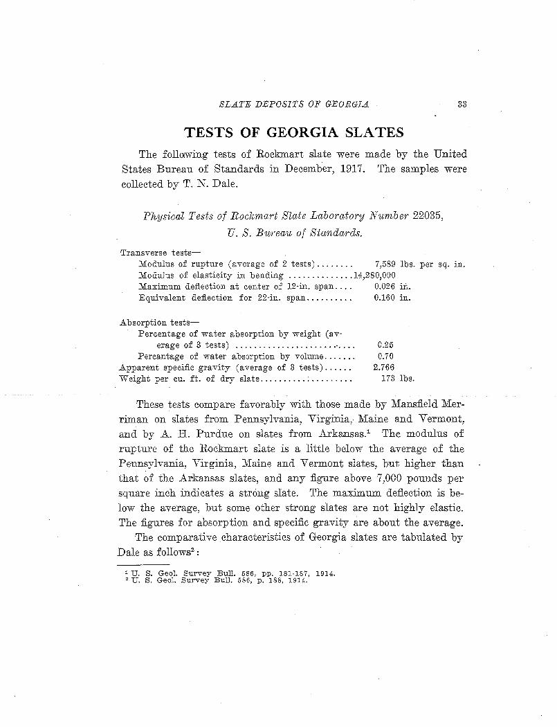
SLATE DEPOSITS OF GEORGIA 33
TESTS OF GEORGIA SLATES The follo:wing tests of Rockmart slate were made by the United
States Bureau of Standards in December, 1917. The samples were collected by T. N. Dale.
Physical Tests of Rockmart Slate Laboratory Number 22035,
U. S. Bureau of Standards.
Transverse tests-Modulus of rupture (ave1·age of 2 tests)........ 7,589 lbs. per sq. in. Modulus of elasticity in bending .............. 14,280,000 Maximum deflection at center of 12·in. span. . . . 0.026 i:ti. Equivalent deflection for 22·in. span.......... 0.160 in.
Absorption tests-Percentage of water absorption by weight (av-
erage of 3 tests) ...................... · ... . Percantage of water absorption by volume ....... .
Apparent specific gravity (average of 3 tests) ..... . Weight per cu. ft. of dry slate ................... .
0.25 0.70
2.766 173 lbs.
These tests compare favorably with those made by Mansfield Merriman on slates from Pennsylvania, Virginia, Maine and Vermont, and by A. H. Purdue on slates from Arkansas.1 The modulus of rupture of the Rockmart slate is a little below the average of the Pennsylvania, Virginia, Maine and Vermont slates, but higher than that of the Arkansas slates, and any figure above 7,000 pounds per square inch indicates a strong slate. The maximum deflection is below the average, but some other strong slates are not highly elastic. The figures for absorption and specific gravity are about the average.
The comparative characteristics of Georgia slates are tabulated by Dale as follows2
:
1 U. S. Geol. S·urvey Bull. 586, pp. 181-187, 1914. ' U. S. Geol. Survey Bull. 586, p. 188, 1914.
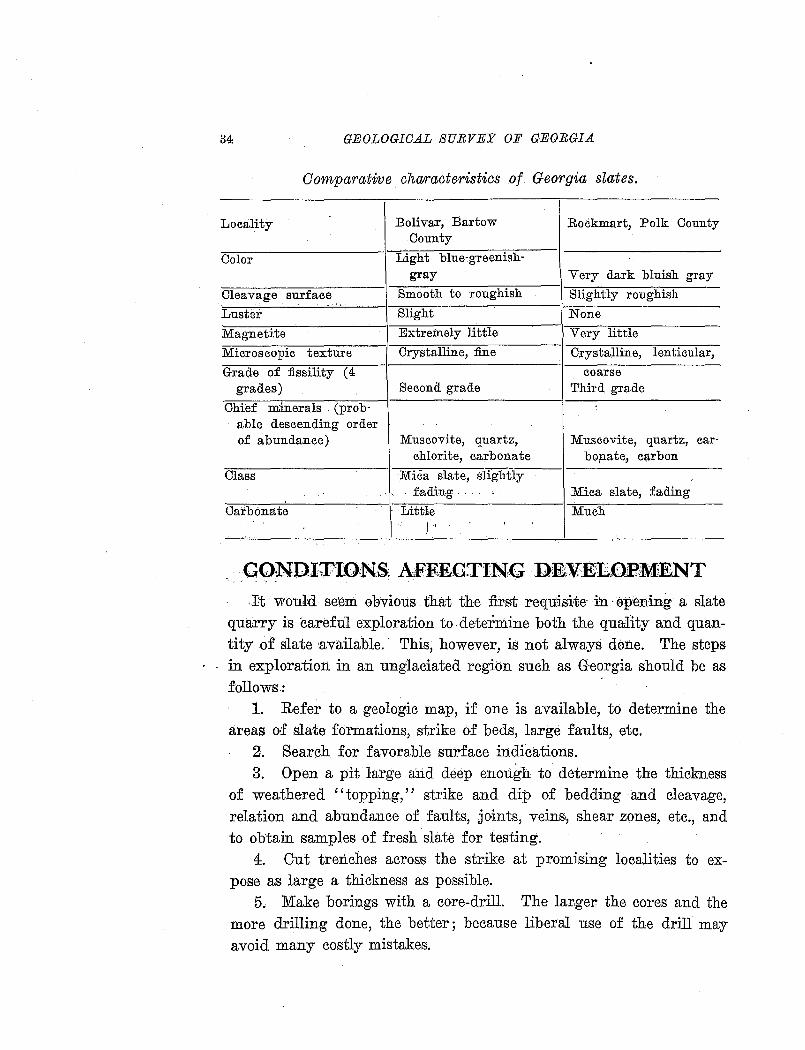
GEOLOGICAL SURVEY OF GEORGIA
Comparative characteristics o{ Georgia slates.
Locality Bolivar, Bartow Rockmart, Polk County County
--Color Light blue-greenish-gray Very dark bluish gray
Cleavage surface Smooth to roughish Slightly roughish
Luster Slight None
Magnetite Extremely little Very little
Microscopic texture Crystalline, fine Crystalline, . lenticular,
Grade of :fissility (4 coarse grades) Second grade Third grade
Ohief minerals (prob-able descending order of abundance) Muscovite, quartz, Muscovite, quartz, car-
chlorite, carbonate bo;nate, c;;trbon
Class Mica slate, sJightiy '.'. . fading .. Mica slate, fading
Carbonate Lit tie Much I, '
.,, .
.It would se·em obvious that the first requisite· m ·opening a slate quarry is careful exploration to-determine both the quality and quantity of slate available. This, however, is not always done. The steps in exploration in an unglaciated region such as Georgia should be as follows:
1. Refer to a geologic map, if one is available, to determine the areas of slate formations, strike of beds, large faults, etc.
2. Search for favorable surface indications. 3. Open a pit large and deep enough to determine the thickness
of weathered ''topping,'' strike and dip of bedding ·and cleavage, relation and abundance of faults, joints, veins, shear zones, etc., and to obtain samples of fresh slate for testing.
4. Out trenches across the strike at promising localities to expose as large a thickness as possible.
5. Make borings with a core-drill. The larger the cores and the more drilling done, the better; because liberal use of the drill may avoid many costly mistakes.
SLATE DEPOSITS OF GEOEGIA 35
6. Make a topographic map, as accurately as practicable, of the area where quarries, buildings, ~umps, etc., are to be located.
7. From the topographic map and drill records construct struc· ture sections. These should show the dip and thickness of workable slate, and from them estimates of the quantities of waste and workable slate should be made, especially an estimate of the slate above the lowest level at which natural drainage can be secured.
Topography, drainage, and quantity of overburden are important considerations. The Georgia slate deposits occur in hilly, or even mountainous areas, and the slate formations are resistant enough to form hills, so that the topographical features are generally favorable for quarrying. Quarries may be opened in the lower slopes of the hills, and large amounts of slate may be quarried without hoisting the rock or pumping out water. In some cases it may be necessary or desirable to drive tunnels for drainage, as was done at one of the old quarries near Rockmart. Waste dumps should be placed on the lowest ground available, and great care should be taken that they do not cover slate which it will be desirable to quarry in the future.
In Georgia, as in any area where the mantle of decomposed rock has not been removed by glaciation, the fresh, solid slate is covered by a considerable thickness of overburden, generally called "topping" in slate quarries. There js a gradation downward from the superficial soil or clay to the fresh slate, so that no sharp line can be drawn, but the thickness of waste material is usually from 10 to 30 feet. The partly weathered slate from the Rockmart formation may be utilized for making "shale" brick or portland cement. That from the Conasauga formation will not do for cement manufacture, because of its
high content of alumina. Relations to transportation, markets, fuel, and labor, and climatic
conditions are also important. The Georgia slate belts are well supplied with railroads, so that
all. deposits are within a few miles of transportation. However, a deposit on a railroad line, or one which can be reached by a short spur track is much more valuable than one from which the slate must be transported several miles by road. Not only is transportation by
36 GEOLOGICAL SURVEY OF GEORGIA .·'1
t i
wagon or truck expensive, but slate is likely to be lost by breakage at each ·handling.
A. market exists or could be developed in the Sot1thern States for a considerable amount of roofing and structural slate. A.t present there are no operating slate quarries closer than those· of Pennsylvania and· Virginia:, so that the advantage in freight rates ~lone should insure a profit to a quarry in Georgia in supplying several of the Southeastern 'States. It is true that not much roofing slate has been used in Southern cities in recent years, but it is likely that the demand will increase as ordinances requiring fireproof construction are ·passed, and no material has been found superior to sl~te fqr fireproof roofing on dwelling houses and other small buildings. The Georgia slates, on acco.unt · of their small percentage of magnetite, should also be adapted to use in electrical apparatus, although the requirement for such uses in the territory supplied· is small at pre~ent.
Co.al is available in the Georgia slate districts at moderate prices, being shipped 0ver the L.ouisville & Nashville Railroad from Tennessee and over the Seaboard A.ir Line from . Alabama. There are also · coal ~eposits. aBd _a :few operating mines iB northwestern Georgia, witbjn 50 miles .. o£ the slate deposits. Large areas in the slate belts are wooded, so the ne~essary 'timber and fuel for heating. may be ob-., . tained easily.
Th~ supply of labor i~ starting a new industry will naturally prese~t difficulties. Under normal conditions there is plenty of common labor in the slate belts of Georgia, but slate quarrying and manufacturing pr?cesses require a considerable number of highly skilled workmen. It will be necessar;r to import SOJ?.e skilled laborers from the slate quarrying districts of the Northern States .
. . 'P4e; climate of_ the ~eorgia slate region is such as to permit outside work throughout the year .. The rainfall is between 40 and 50 inches p_er year, and aver~ges about the -saw~ ·for a~l months. Snow falls occasionally during.December, January and February, but rarely covers the ground. for m<?re than two or thre_e days at ·a time. The temperature· has occasionally fallen to zero (Fahrenheit)_, but almost always rises above freezing point in the middle of the day.
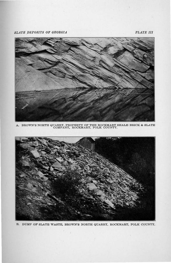
SLATE DEPOSITS OF GEORGIA PLATE I II
A. BROWN'S NORTH QUARRY, PROPERTY OF THE ROCKMART SHALE BRICK & SLATE COMPANY, ROCKMART, POLK COUNTY.
B. DUMP OF SLATE WASTE, BROWN'S NORTH QUARRY, ROCKMART, POLK COUNTY.
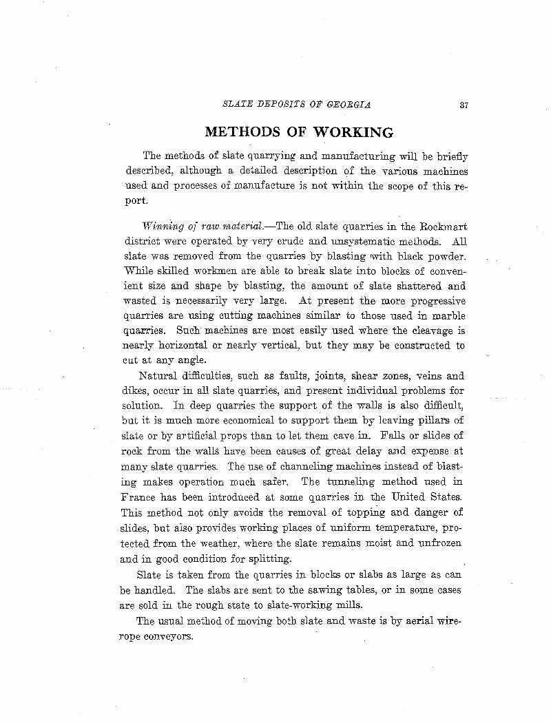
SLATE DEPOSITS OF GEORGIA 37
METHODS OF WORKING
The methods of slate quarrying and manufacturing will be briefly described, although a detailed description of the various ma.chines used and processes of manufacture is not within the scope of this report.
Winning of raw material.-The old slate quarries in the Rockmart district were operated by very crude and unsystematic methods. All slate was removed from the quarries by blasting with black powder. While skilled workmen are able to break slate into blocks of convenient size and shape by blasting, the amount of slate shattered and wasted is necessarily very large. At present the more progressive quarries are using cutting machines similar to those used in marble quarries. Such machines are most easily used where the cleavage is nearly horizontal or nearly vertical, but they may be constructed to cut at any angle.
Natural difficulties, such as faults, joints, shear zones, veins and dikes, occur in all slate quarries, and present individual problems for solution. In deep quarries the support of the walls is also difficult, but it is much more ·economical to support them by leaving pillars of
slate or by artificial props than to let them cave in. Falls or slides of
rock from the walls have been causes of great delay and expense at
many slate quarries. The use of channeling machines instead of blasting makes operation much safer. The tunneling method used in
France has been introduced at some quarries in the United States.
This method not only avoids the removal of topping and danger of slides, but also provides working places of uniform temperature, pro
tected from the weather, where the slate remains moist and unfrozen
and in good condition for splitting.
Slate is taken from the quarries in blocks or slabs as large as can
be handled. The slabs are sent to the sawing tables, or in some cases are sold in the rough state to slate-working mills.
The usual methoc1 of moving both slate and waste is by aerial wirerope conveyors.
\
.38 GBOI;OGIC.AL SUEVEY OF GEORGIA
Manufacturing p1·ocesses.-· The slate slabs from the quarries are sent :first to the sawing tables,· where the rough edges are sawn off and the blocks cut to the desirable sizes. Slate for mill-stock, etc., is split to the proper thickness and planed, carved, or turned by appropriate machinery. That' for ·roo:fing· is made into blocks of convenient size, with one or more sawn edges, and sent to the splitting shanties.
The men engaged in making roofing slate are organized into "shanties," each sh?-nty having three skilled workmen known as the block-maker, splitter, and dresser. The output of a shanty is five
. squares or more a day.
Recently a slate-splitting machine, the invention of Vincent F. Lake/ has been introduced.o T.his mach]pe requires little. skill to operate and makes commercial slate from blocks which could not be split by hand, thus reducing the. cost and proportion of waste .
. USES
Roofing slat e.-Roofing slate is always ·sold by the "square" in the United States, a square being the amount necessary to cover an area 10 feet square, when laid with a 3~inch lap. The usual sizes range from 7 by 9 to 16 'by 24 inches. The number of pieces t~ 'the square ranges frO!ll 85 to 686, according to the size, al1d the Weight of a square of slate of ordinary thickness is about 650 pounds. 2 In France and England the unit used is the "mille," a mille being 1200 slates of any given sjze, plus 60 to cover loss by breakage.
The usual thickn~ss of roofing slates is from one-eighth to one'fourth inch. very strong slates may be split thinner than the average, but it is poor economy to split slates too thin, because of the breakage in handling and the likelihood of di'sintegTation on the roof ..
The selling price per square varies greatly, depending on· the size and thickness 0.£ the pieces, color and other qualities of the slate, and also on the distance from competing quarries. Ordinary slates of good quality generally sell between $3.50 a:o.d $10.00 per square,
1 U. S. Geol. Survey Bull. 586, pp. 190, 1914. 2 Coons, A. T., U. S. Geol. Survey Mineral Resources, 1912, pt. 2, p. 681, 1913.
SLATE DEPOSITS OF GEORGIA 39
but specially prepared slate of selected color or extra thickness and size may be worth as much as $200.00. "Architectural" slate ranges from three-sixteenth inch to 2 inches in thickness, and that 10 inches
thick has been sold for $50 per square.1
Red and green slates are quoted at higher prices than other slates of equal quality but of more ordinary colors. Georgia slates should bring prices well above the average, on account of the attractive color of the green slate and the high freight rates on shipments from com
peting quarries in Northern States.
Mill stock.-Mill stock .slate is used for s,tructural and sanitary purposes; including flooring, wainscoting, mantels, hearths, well caps, tiles, vats, sinks, laundry tubs, grave vaults, sanitary ware, refrigerator shelves, flour bins and dough troughs for bakers, billiard, laboratory, kitchen, and other table tops. These uses require a fine, evengrained slate, not too hard, with fairly uniform color and smooth cleavage, but preferably not highly fissile. It is sold in slabs from 1 to 3 inches thick, at prices ranging from 4 to 50 cents per square foot. The price depends on the size, thickness, quality, and the work done upon it. The average price in 1917 was 23 cents per square foot.
Electrical uses.-Slate is recognized as a superior material for electrical switchboards, bases for electrical machines, and other uses where insulating power and mechanical strength are needed. As a dielectric, slate falls far below marble,2 but on account of its superior toughness and ease of working, combined with low~r cost, slate is more generally used.
The requirements for electrical" slate are strength; good working qualities, so that it can be drilled and sawed without scaling; uniform composition, which is indicated by fairly uniform color; and high electrical resistance, which depends principally on the absence of magnetite and metallic veins. No electrical tests have been made on the Georgia slates, but the Conasauga green slate is rated as extremely low in magnetite content, and the Rockmart slate as very low. On
1 Loughlin, G. F., U. S. Geol. Survey Mineral Resources, 1917, pt. 2, p. 123, 1918. 2 Bristol, W. A., High tension testing of Vermont slate and marble: Report of
the Vermont State Geologist, 1911-1912, p. 218, 1912.
40 GEOLOGICAL SURVEY OF GEORGIA
account of the low magnetite content, good working qualities, and uniform color it is certai:n'that these slates will prove satisfactory for electrical uses.
Other uses.-.Slate for "other uses" includes school slates, blackboard material, tombstones, "inlaid slate,?' ground s~ate for use in composition roofing, and small quantities for special purposes. Slate used in brick making and ground slate for fertilizer :filler might also be included.
T~e requirements for most of these uses are the same as for mill stock. Blackboard material, which makes ;up nearly half the value of slate classified under ''other uses,'' and school slates requi~e a rather soft gray slate with ~mooth cleavage and extremely u:o.iform. color and composition. .A.ll of these products are supplied by a few quarries in Pennsylvania. The production of school slates arri.ounts to more than 4,000,000 a year, most of which are exported.
Slate waste;-The waste at slate quarries producing only roofing slate amounts to from 75 to 90 per cent of the rock quarried. To say nGthing,ofitslack·of value, the ha11dlmg and disposal of this large amount of material is difficult and expensive. In. recent years numerous uses have beelf suggested and tried, but.the problem is not yet solved.
Uses of slate waste are discussed in some detail in the Mineral Resources report for 1910.~ Of .first importance is the prevention of waste, by the use of cutting machines in the quarries and by substituting mechanical fo:r hand methods of working and splitting. Much of the slate wasted by quarries producing roonng slate exclusively is suitable for the smaller sizes of mill stock. Pieces too small for roofing slates may be split thin and used for veneers or for inlaid slate roofing, when backed by slate concrete or asphalt. Finely ground slate of suitable color is used for coating flexible roofing materials.
Slate topping and waste is suitable for brick and cement manufacture, but in most cases the quarrying of this material directly for
1 Coons, A. T., U. S. Geological Survey Mi.neral Resources, 1910, pt. 2, pp. 627-641, 1911. Includes quotations from Barnhar:h, George, Mechanical slate splitting and slate veneers: Stone, October, 1910, p. 516.
SLATE DEPOSITS OF GEOBGIA 4:1
use will be cheaper than handling the waste from slate quarries. This was found to be the case at Rockmart, Georgia, where both brick and
. cement plants were started with the intention of using slate waste, but the idea of producing slate was abandoned. Tests of slate waste for brick making have been made by the United States Bureau of Standards.1 The material lacks plasticity, and the only process by which it can be shaped into bricks is by dry pressing. It was found that the weathered top material makes much better bricks than the waste from fresh slate, because a large part of the lime and other fluxes have been leached from the former.. This has also been found true at Rockmart, where the fresh slate will not make a vitrified bride strong enough to use in street paving.
1 U. S. Geol. Survey Mineral Resources, 1912, pp, 678-679, 1918.
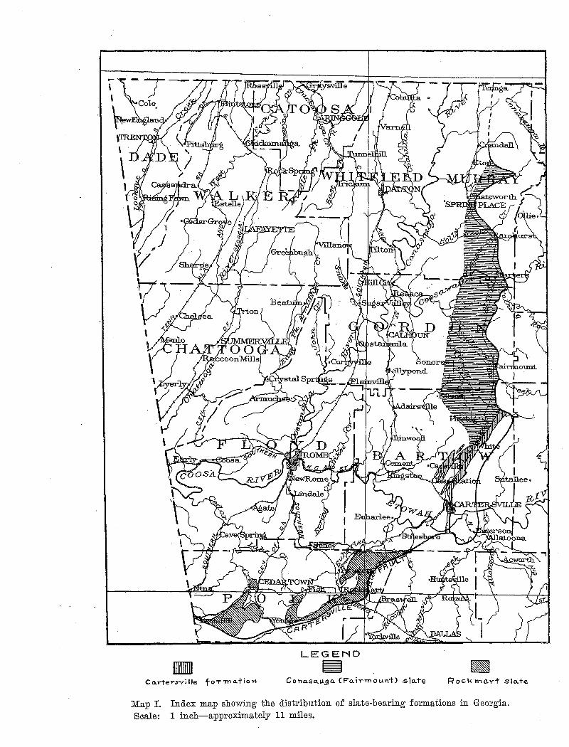
LEGEND • ~ C o.rtersvi lie fo-r 1'Yl a. t io >1 Cona.sa.u,ga. (Fo..irmount) .slo.+e Rock mo.rt slo.te
Map I. Index map showing the distribution of slate-bearing formations in Georgia. Scale: 1 inch-approximately 11 miles.
SLATE DEPOSITS OF GEORGIA 43
SLATE DEPOSITS OF GEORGIA The deposits of commercial slate in Georgia all occur in the Ap
palachian Valley physiographic province, but they· are in three distinct geologic formations. (See Map I.) After a brief discussion of the general features of the area, the slate belts and individual deposits w.ill be described in detail.
GENERAL FEATURES OF THE APPALACHIAN VALLEY IN GEORGIA
PHYSIOGRAPHY
The Appalachian Valley is a well defined physiographic division, extending from New Jersey southwestward into Alabama. The valley in Georgia is about 40 miles. wide, extending across the northwestern c10rner of the State, and is mostly drained by Coosa River and its tributaries, Etowah, Oostanaula, Conasauga and Coosawattee rivers, although a portion is drained by tributaries of Tennessee River.
The valley belt is made up of several parallel valleys separated by narrow ridges. The topography is entirely dependent on the character of the underlying rocks. The valleys are underlain by limestone or soft shale, while the ridges are formed by harder beds of sandstone or chert. The altitude varies from about 600 feet above sea level where Coosa River crosses the Alabama line to nearly 2000 feet at the summits of the highest valley ridges. These ridges, however, are not quite so high as the mountainous areas lying east and west .of the great valley.
The Appalachian Valley is bounded on the east by the Appalachian Mountains and Piedmont Plateau provinces, and on the west by the Cumberland Plateau. North of Chatsworth, Murray County, the Cohutta Mountains rise abruptly from the valley, with an escarpment over 2000 feet high. South of Chatsworth the boundary between the Appalachian Valley and the Piedmont Plateau is marked by a less abrupt change in topography although a1ong this line is one of the most rugged portions of the Piedmont, with Pinelog Mountain
44 GEOLOGICAL SURVEY OF GEORGIA
and Dugdorwn Mountain rising 200 to 300 feet above the level of the valley. West of the valley lies a dissected and mountainous section of the Cumberland Plateau, with the escarpment of Lookout lVloUlltain forming the boundary.
STRUCTURE
The rocks of the Appalachian Valley have the typical Appalachian structure, characterized by folding and faulting on a large scale. The pressure acted from the old continental mass which existed to the southeast, throwing the strata into great anticlines and synclines, some of which are hundreds of miles in length. At many places the folds developed into faults, and great masses of rock were thrust northwestward over the younger formations. The folds and faults are in general parallel to each other and to the old shore line, but minor disturbances have been produced by later mo:vements. The eastern ind southeastern bbundary of. the Appalachian Valley division is formed by the Cartersville fault, which extends more than 100 miles across Georgia and far into A1ahama and Tennessee. This is one of
.•-."· ·'" i.' -": ', .: . -.:' j . .:.. . • ' . j . -, .. .
the largest fault~ in the Appalachlan region, both in length and amount of throw. ·
The rocks of the Valley division, as well as those of the Appalachian province as a whole, are progressively less folded aJ?-d metamorphosed from east to west. In the eastern part of the Valley the folds have heen so closely compressed that the beds on both limbs are almost parallel, and in most cases nave been overturned so that all beds dip ·Steeply to the east or southeast, and there are evidently many minor thrust fa~ts with the same dip, besides the major thrust faults, which dip to the east at low angles. In the western part of the Valley the folding is much more open. However, the beds gener~lly dip at angles of 10 degrees or more, while farther west in the· Cumberland Plateau division the strata lie almost horizontal.
The degree of metamorphism corresponds closely with the amount of folding and faulting. In the Appalachian Mountains and Piedmont Plateau all o~ the rocks have been intensely metamorphosed and recrystallized into schists and gneisses, while in the Cumberland
SLATE DEPOSITS OF GEORGIA 45
Plateau there is practically no metamorphism aside from that due to the weight of overlying 'beds. The rocks of the Valley division are intermediate in character. The western Valley rocks are little altered shales, sandstones, and limestones, and it is only along the eastern border, within a few miles of the Cartersville fault, that metamorphism and recrystallization have progressed far enough to give to the originally shaly beds the hardness and cleavage necessary for commercially valuable slates.
GEOLOGY
.The geologic formations of the Appalachian Valley and Cumberland Plateau areas of Georgia are shown in the accompanying table.
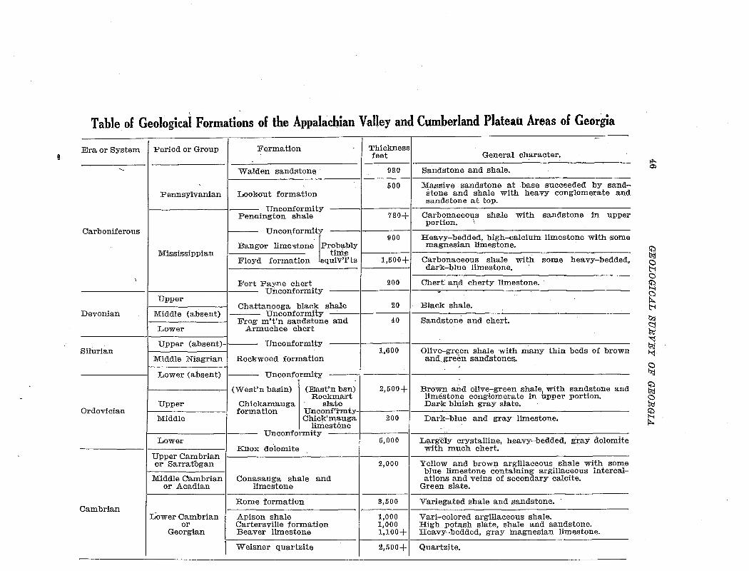
Table of Geological Formations of the Appalachian Valley and Cumberland Plateau Areas of Georgia
Era or System Period or Group
Pennsylvanian
Carboniferous
Mississippian
Formation
Walden sandstone
Lookout formation
Unconformity Pennington shale
Thickness feet
93.0
500
780+
General character.
Sandstone and shale.
Massive sandstone at base succeeded by sandstone and shale with heavy conglomerate and sandstone at top.
Carbonaceous shale with sandstone in upper portion. \
UnCOI\formity
f
900 Heavy-bedded, high-calcium limestone with some Bangor lime':ltone Prob:;tbly magnesian limestone. ·
time Floyd formation equiv"i'ts 1,500+ Carbonaceous shale with so:n;te heavy-bedded,
dark-blue limestone.
Fort Payne chert 200 -------I I Unconformity
Chert an,d. cherty limestone.
Devonian
Silurian
Ordovician
Cambrian
Chattanooga black shale I 20 I Black shale. --Unconformity ------,------------------'--Frog m't'n sandstone and 40 Sandstone and chert.
Upper
Middle (absent)
Lower Armuchee chert
Upper (absent)-1-- Unconformity
Rockwood formation Middle Niagrian
Lower (absent) UnconformitY.
1,600 Oliv&-green shale with many thin beds of brown and gre€m sandstones.
r---------..,,-1 (West'n basin) (East'n bsn) 2,500+ Brown and olive-green shale, with sandstone and Rockmart limestone conglomerate in upper portion.
Upper
Middle
Lower
Upper Cambrian or Sarratogan
Middle Cambrian or Acadian
Lower Cambrian or
Georgian
Chickamauga sla-te Dark bluish gray slate. formation tJnconf'rnrrty- -------·----------------------------------------
Chick'mauga 200 Dark-blue and gray limestone. limestone
Unconformity --· --~-t---------- -------'--------------'--------------------
Knox dotomite
Conasauga shale and limestone
Rome formation
Apison shale Cartersville formation Beaver limestone
Weisner quartzite
5,000
2,000
8,500
1,000 1,000 1,100+
Largely crystalline, heavy-bedded, gray dolomite with much chert.
Yellow and brown argillaceous shale with some blue limestone containing argillaceous· intercalations and veins of secondary calcite.
Green slate.
Variegated shale and sandstone.
Vari-colored argillaceous shale. High potash slate, shale and sandstone. Heavy-bedded, gray magnesian limestone.
2,500+1 Quartzite.
fl>. m
~ g a ~ S2 t-1 ~
~ ~ f-<:j.
~ ~ a !?;;j
~ ~
SLATE DEPOSITS OF GEOEGIA 47
CAMBRIAN
The Cambrian rocks of Georgia consist of sandstones, quartzites, conglomerates, shales, slates, schists, dolomites, limestones, and marbles. To the east of the Cartersville fault the lower Cambrian rocks make up the semi-crystalline or metamorphosed Paleozoic area. These formations correspond with the ''Ocoee group'' of Tennessee, and have not been correlated with the formations west of the fault. Metamorphism has been so intense that no slates of possible commercial value exist, so the geology need not be further considered.
WEISNER QUARTZITE
The Weisner quartzite, of lower Cambrian age, is the oldest of the Appalachian Valley formations. It outcrops in two areas in Georgia, making up Indian Mountain which extends from Alabama into northwestern Polk County, and a belt about 15 miles long just east of Cartersville. The formation consists of vitreous quartzite, quartz-sericite schist, beds of fine conglomerate, and considerable beds of softer, siliceous shales. Hayes1 estimates the thickness at 2000 to 3000 feet. The fragmental and poorly assorted character of the materials of the formation, together with the great variations in thickness in a small area indicate that it consists largely, of delta deposits.
BE.A. VER LIMESTONE
The Beaver limestone overlies the Weisner quartzite, occupym.g several belts and irregular areas in an area about 18 miles long, chiefl.y in and north of Cartersville. The relations are complicated by much folding and faulting, and on account of the deep weathering and similarity of composition the Beaver limestone can hardly be distinguished from the limestone of the higher Conasauga formation, since the two may have been brought into contact by faulting at some places. .Another area of Beaver limestone extends along the southeast side of Indian Mountain. in Polk County.
1 Hayes, C. W., Geological relations of the iron ores in the Cartersville district, Georgia: Trans. Am. Inst. Min. Eng., vol. 30, p. 404, 1901.
48 GEOLOGICAL SURVEY OF GEORGIA
The .Beaver consists of argillaceous, dolomitic limestone. On account of its solubility it generally forms valleys, and is covered by thick deposits of da~k-rea residual clay and· fragmental material derived from the Weisner quartzite, so that few exposures of fresh rock occur. The formation is of economic importance, because most of the deposits o£ brown iron ore, manganese, and barite of fue Cartersville district are found in the residual clay derived from it.
Hayes estimates the thickness at 800 to 1200 feet. The Beaver limestone is believed to correspond to the Shady limestone of Tennessee and Virginia and to the Murphy marble of the more highly metamorphosed Cambrian area east of the Cartersville fault. The correlation with the Shady limestone is strengthened by a fossil, Ethmoph4Jnum? p1:ofJtndum (Billings) Walcott, recently found in the barite of this formation by J. P. D. Hull.
CARTERSVILLE FORMATION
.In . the Cartersv~lle district the Beaver limestone is overlain by a formatioiJ. of sla-te, shale; , and ·feldspa.:thic· sandst0ne, most· of which is characterized by an unusually high content of potash. This formation outcrops in a belt about 15·miles long and half a mile wide, extending from Cartersville northeastward to Martins Mill, and probably also underlies the alluvial deposits of the Etowah bottom to a point south of the river. The formation is repeated by folding or faulting, so that outcrops occur almost as far west as Cassville.
The formation can. probably be correlated with the Apison shale
or the Rome formation of the Rome, Ringgold and Cleveland quad
rangles, and the Watauga shale of the Roan Mountain quadrapgle.
However, as the exposures near Cartersville are not really continuous with these formations, .and as the lithologic character is very
different, the local name ''Cartersville formation'' has been adopted,
after consultation with Laurence La Forge1 of the United States Geological Survey.
l. The geology of the Cartersville quadrangle was mapped by C. W. Hayes about 1900. Later La Forge revised the mapping of the area of the Cartersville Special sheet, but the time of publication of the folio is uncertain.
SLATE DEPOSITS OF GEOBGI.A 49
The distribution and character of the Cartersville formation is discussed in more detail in connection with the description of the slate deposits (Seep. 128).
APISON SHALE
The .Apison shale underlies the Rome formation in the Ringgold quadrangle, and is the lowest formation exposed in that quadrangle. In the Knoxville quadrangle it is mapped as underlying the Beaver limestone. This formation consists of argillaceous shales of various colors. Exposures in Georgia, so far as known, are confined to two small areas in Catoosa and Whitfield counties. .Although the .Apison shale is evidently approximately equivalent to the Cartersville formation in age, the exposures are in the western part of the .Appalachian Valley, where the formation has not been sufficiently metamorphosed to produce slate.
The thickness is estimated by Hayes as not less than 1000 feet.
ROME FORMATION
The Rome formation consists of sandstone and shale, occupying a place above the .Apison shale wherever that formation is found. The belt of high-potash shale and sandstone near Cartersville, here called the ''Cartersville formation,'' was included in the Rome formation by Hayes, on the basis of stratigraphic position. With this belt excluded, the exposures of the Rome formation are confined to the central and western portions of the .Appalachian Valley, where metamorphism has not been intense enough ta- change the shale into slate.
CONASAUGA FORMATION
'rhe Conasauga formation of middle Cambrian age covers a larger area in the .Appalachian Valley of Georgia than any other formation except the Knox dolomite. Hayes estimates the thickness as 1500 to
2000 feet in the Ringgold quadrangle, but in the area east of Dalton
it may be even thicker.
50 GEOLOGICAL SUEVEY OF GEORGIA
In southern Whitfield and Murray counties the belt of continuous outcrop of the Conasauga formation is 17 miles wide, from east to west. ·Northward the formation is split into four belts, with areas of Knox dolomite between. Southward there are three belts. The eastern, with an average width about 10 miles, extends south to Cartersville. The central belt extends down the valley of Oothkalooga Creek past Adairsville, and the western swings southwestward past Rome and widens to 13 miles in the Coosa Vailey along the ..c\J.abama line. There are also several narrower belts in the western part of the Appalachian Valley.
The Conasauga formation consists of interbedded limestone and shales. Limestones occur chiefly near the bottom and top of the formation, while the middl~ beds consist chiefly of shale. J'he s~ales of the formation are fine-grained argillaceous rocks characterized by their color, which varies from yellowish-green to bluish-green. Although the entire mass of shales have· approximately the same chemical composition, it is only in the eastern part of the belt, within 4 or 5 miles of the Cartersville fault, that they have been metamorphosed into a sufficiently hard and cleavable condition to 'serve as commercial slate. The geology of the slate-beaning. portion of the formation w:ill.be more fully discussed under the descr.iptions of slate deposits. (Seep. 99).
CAMBRO-ORDOVICIAN
KNOX DOLOMITE
The Knox dolomite is shown by paleontological evidence to include both the upper part of the Cambrian and the lower part of the Ordovician; The formation attains a thickness of 4000 to 5000 feet, being the thickest and areally the most extensive formation of the Paleozoic group in Georgia. The principal area is the broad valley between Cartersville and Rome, extending from southern Murray County southwestward to the Alabama line, but there ·are a number of other extensive areas farther northJWest.
The formation consists entirely of dolomite, and all except the lower part contains abundant chert. The chert in the residual ma-
SL.A1'E DEPOSITS OF GEOBGI.A 51
terial makes erosion of the formation, in general, slower than that of the Conasauga formation, so the Knox dolomite areas are characterized by low, irregular hills and ridges.
ORDOVICIAN
CHICKAMAUGA FORMATION
The Chickamauga formation, representing middle and upper Ordovician time in Georgia, consists of sediments of two distinct types, deposited in separate basins. The rocks of the western part of the Appalachian Valley consist of interbedded limestones and shales, having a thickness of about 1800 feet, and outcropping in a number of long, narrow areas.
Along the southeastern border of the Appalachian Valley._ the formation covers two large irregular ar:eas south of Rockmart and Cedartown, and is divided into the Chickamauga limestone and the Rockmart slate members.
CHICKAMAUGA LIMESTONE
The Chickamauga limestone member forms the lower part of the Chickamauga formation in the eastern area. It is 100 to 200 feet
thick .and consists of both high-calcium and magnesian limestones. In the area north of Rockmart the high-calcium limestone is used in the manufacture of portland cement.
ROCKMART SLATE
The Rockmart slate member consists of dark-colored slate and slaty shale, weathering olive-green or yellow, with only minor beds of sandstone, limestone, and conglomerate. According to Hayes the thickness may be 2500 to 3000 feet, but it is repeated by folding, so that any accurate estimate is impossible. The distribution and geology will be discussed more fully under the descriptions of slate deposits
(Seep. 54).
52 GEOLOGICAL SURVEY OF GEORGIA
SILURIAN
Silurian deposition in Georgia is represented by the Rockwood formation, corresponding to tlie Clinton iron-bearing formation of New York. It consists of sandstones, shales, conglomerates and limestones, !With a thickness of 600 to 1600 feet. All exposures are in the· central and western portions of the Appalachian Valley, where metamorphism has not been intense enough to form slates.
DEVONIAN
The Devonian rocks of Georgia consist of the Armuchee chert, Frog Mountain sandstone, and Chattanooga black shale. All these formations are thin, and the outcrops are of small extent.
CARBONIFEROUS
The Carboniferous formations of Georgia are the Fort Payne chert, Floyd formation, Oxmoor sandstone, Bangor formation, Lookout formation and Walden sandstone. Of these· the first four belong to the Mississippian period; the last two to the Pennsylvanian. The total thickness is about 4000 feet, and the formations outcr0p in extensive -areas in the central and western parts of the Appalachian Valley, besides forming the greater part of the Cumberland Plateau area.
GEOLOGIC HISTORY
Early in Cambrian time the Appalachian region sank and the sea intruded from the northwest, while a continental mass remained at the southeast, probably extending far beyond the present Atlantic Coast line. Deposition started with beds of sand and gravel, then under changing conditions beds of conglomerate, sandstone, shale and limestone were laid down.
The Weisner quartzite, the oldest of the Valley formations, is of ea:rly Cambrian age,· although probably not as old as some of the metamorphosed Cambrian formations east of the Cartersville fault, with which no correlation is possible in the present state of knowledge.
SLATE DEPOSITS OF GEORGIA 53
This formation consists of coarse, poorly-assorted materials, indicating continental or shallow water conditions of deposition. With the gradual transgression of the sea the Beaver limestone was laid down, but this impure limestone was evidently deposited in comparatively shallow water.
A slight rise in the land must have occurred at the close of Beaver deposition, for the character of the Cartersville formation shows deposition in very shallow water. Thin alternating beds of widely different composition show changing conditions. The high potash content of the shale and feldspathic sandstone beds shows that the materials were transported rapidly from the granitic mass:es to the east, and were deposi..ted without opportunity to suffer much chemical change by weathering. At approximately the same time that the Cartersville formation was being fomed along the shore the Rome
. formation and Apison shale were being laid down in the slightly deeper water farther west.
In middle Cambrian time the sea transgressed over a larger area, but the water still remained shallow, and a number of oscillations occurred, while the alternatinglimestones and shales of the thick Coria:. sauga formation were deposited. A gradual submergence continued during middle and late Cambrian .and Ordovician time, when the Appalachian sea reached its greatest depth and the enormous Knox dolomite formation was deposited.
Before the close of the Ordovician a great upheaval of the land occurred, and the greater part of the Appalachian Valley was temporarily above sea level, so that a part of the Knox dolomite was eroded away before the Chickamauga formation was laid down. It is probable that the pressure producing the upheaval of the land caused some folding, so that the Valley was divided into separate basins by narrow land ridges. In the southeastern basin or bay the Chickamauga limestone was deposited, then after a brief upheaval which caused an erosion uncomformity, the land sank and the Rockmart slate was laid down in shallow water close to the shore line.
Periods of uplift occurred in Silurian and Devonian times, with comparatively brief int'ervals of submergence during twhich the Rock-
54 Gl[rOLOGIC.AL SVEVEY OF GEOEGI.A
wood formation and the thin Devonian formations were deposited. In late Devonian· a period of transgression by the sea started, and persisted during: the Mississippian, followed by an uplift. Shallow waters covered the western .part of the Appalachia,n Valley during the Pennsylvanian, when sandstones, shales, and coal beds were deposited .
..At or near the close of the Carboniferous period uplift and compression were renewed, the deformation resulting in the final withdrawal of the sea from the entire Appalachian province and the up-heaval of a great mountain system. The folded and faulted structure
. of the V:alley formations is due principally to this period of deforma+' uiOn. .
The great Cartersville fault was evidently formed by the postCarboniferous deformation, and movement alon~· this plane probably continued for a long period. The fault was a controlling .factor in the formation of the deposits of commercial slate, a:p,d those in all three of the slate-bearing formations are found within a few miles west of the fault plane. Farther west the shale formations were not metamorphosed enough to produce strong slates with good cleavage, while east of the fault the metamorphism was too intense, prodncing mica schists or slates with distorted and ''false'' cleavage.
THE ROCKMART DISTRICT GEOLOGY OF THE ROCKMART SLATE
The Rockmart slate member of the Chickamauga formation was named by Hayes1 from its typical development in the vicinity of Rockma.rt, Polk County.
Areal distribution.-The Rockmart shales and slates occupy two areas in Georgia, which may be described as the Rockmart and Cedar-town areas. (See Map II.)
The Rockmart area starts with a very narrorw belt at a point 7 miles southwest of Cartersville and 12 miles northeast of Rockmart.
1 U. S. Geol. Survey Geologic Atlas: Rome Folio, No. 78, 1902.
SLATE DEPOSITS OF GEORGIA 55
From this point the belt extends west to Posco and Portland (Davitte), widening gradually until it covers an area 3 miles in width
southwest of those places. Then the direction of strike swings to the
south and the belt splits into two divisions, one of which terminates
in the prominent hill about a mile southwest of Red Ore. The other or main belt continues south through the town of Rockmart, then swings to southwest and extends a total distance of 9 miles southwest of Rockmart. At Rockmart the width of the belt is 2 miles, but it narrows to less than half a mile 8 miles farther southwest. At the ex
tremity the belt doubles back and an area a mile wide and 5 miles
long extends northeast almost to Fish.
The Cedartown area is irregular in shape, and evidently represents an eroded syncline. It extends from the southern part of the city of
Cedartown southwest to the Alabama line near Esom Hill, a distance of 9 miles. The maximum width from northwest to southeast is about 4 miles, but where it crosses the Alabama line it is only a few
hundred yards in width.
Stratigraphic relations.-The Rockmart slate is of Ordovician age, and probably represents the middle and upper parts of that system. Its stratigraphic position is immediately above the Chickamauga limestone which in the Rockmart district is only about 200 feet thick. The relations between the slate and limestone are unconformable in at least a part of the area. The observed contacts near Rockmart show that the bedding of the slate does not always dip at the same angle as that of the limestone, that in places a band of red clay separates the two formations, and that the upper surface of the limestone is more or less irregular. Conglomerates with fragments of limestone occurring in the slate show that at least a part of the Chickamauga limestone was subjected to erosion while the slates were being deposited. In the Cedartown area no evidence of an unconformity between the limestone and slate has been found.
In and north of Rockmart and in the vicinity of Fish and Cedar
' town the Chickamauga limestone is exposed immediately below the
Rockmart slate, but south of Rockmart, Fish and Cedartown, the slate
56 GEOLOGICAL SURVEY OF GEO:RGIA
lies upon the· K.nox dolomite. The thin Chickamauga limestone m these area$ may. have been entirely eroded awa;y, or may never have been deposited; or the, slate may have been thrust into contact with the dolomite along ·:raults. ireas underlain by Knox dolomite are easily distinguishable from those underlain by Chickamauga limestone, even rwhere ·there are no outcrops, because of the abundance of chert in the
· soil derived from the Knox.
The Chickamauga formation in the western Appalachian Valley is overlain by the Rockwood formation of Silurian age. That formation, h6wever, is absent i:n the Rockmart a:rea. Some of the hills within the slate area south of Cedartown are capped by chert with fossils showing that it belongs to the Fort Payne chert of Devonian age/ but the southern bnl1rl,dary of both slate a~·efls is formed by the Cartersvi11~ falilt, and any yoti.llger fo~matio~s· wh1ch ma;Y- have existed over the greater p~t of the slate .area have been eroded away. .Along the fault .line the Rockmart Slate com'es in contact with mica schists and
· phyllites of the highly: metamorphosed early ·Cam:brian.fo:rmations.
, .. ,.JJ"jtfiplqgib phar«>ct~~;s.:-;:;::-,W}J:e Jo;w;e:~?.115Q~~Lfe,e,t, {>f .t:b!e,r;J;i()q)x:rrva;;rt. slate f'' ''~ ~.t·:-, ';_;. , '(:.-·.~:, :. :..:.Ji• '>'.:;y: .. '~,, ·< -.;; .:l''\ .~.:;_. ,, ~· :~-~--. ,". ,,.,__:: :_ --:;1· :;.) •.•• &_:'···;-'';C.··~ ,·cr. ,, ;."' dl-'•'-.' -l·,. ":.--: • - -~~,., _. ,.. ··.•'''· ,,_~~~~ ~ <~• .._ <.c <. • \_,," ,• --~· -.o~ ·' <,-''-"'><'l-" .<. '· ~ · I v
cqqsists of fine-grained _CI._?-!J.r. ~olq!'~~sl~te, a11d sha~: remar.J~_~l:>ly uni-:fg~jJ:!. ,lithologic Gh~1'ac:t.~:t;" ,a:g;,d :chemieaL..eo~Ro~1i~o;p,.- ~bo:ve the unifor.J;ll slate in the area near· Rockmart occurs a bed -of lin;testone' Col:\:glomerate, gen~rally 15 feet or more in tP,ickness. 'The •Mnglomerate coiLSists o-f fragments derived from the underlying Chickamauga limestone, imbedded in a siliceous matrix. The· conglomerate is overlain by a bed of brown sandstone about 4 feet thick. About 3000 feet east of' the lower limestone conglo:p:te:rate is found a bed of similar conglomerate with sandstone below. It seems probable that the two conglomerate and sandstone exposures belong to the same beds, repe/lted in revers:ed . sequence by an o;verturned fold.
Proceeding eastward and stratigraphically upward across the Rockmart slate formation the sediments b'ecome less uniform i:n composition, with thin layers o·f conglomera~e and siliceous or calcareous beds. This upper part of the formation was deposited in very shallow
1 Spencer, :r. W.: The Paleozoic group, Geol. Survey of Ga., 1893.
SLA1'E DEPOSI1'S OF GEOEGiil 57
water under rapidly changing conditions. The rocks for a distance of half a mile from the Cartersville fault plane have also been more intensely and irregularly metamorphosed than those farther west, developing crumpled cleavage or schistosity. For several hundred feet from the fault the Rockmart slate has been. metamorphosed into a true schist, which is hardly distinguishable from the older crystalline rocks on the.,east side of the fault, so the exact location of the fault plane is not easily determined.
On account of the varia.bility of the upper beds of the formation and the effects of proximity to the fault, the slates of probable commercial value in the Rockmart area are confined to a belt about half a mile wide in the lower or northwestern part of the main area of outcrop, and to a belt near the base of the formation at Portland (Davitte), where the formation is repeated and the outcrop widened by folding.
Westward from Rockmart, in the Fish and , Cedartown areas, deposition evidently took place in slightly deeper water. The slate in these areas is interbedded with impure limestone, and is much softer and more calcareous than that near Rockmart. While some of the slates of the Cedartown area are of good appearance and have excel-· lent cleavage it is unlikely that they have the strength ~nd resistance to weathering necessary for roofing slate.
Structure and thickness.-The structure of the Rockmart slate is known in a general way, but the details are difficult to determine. The occurrence of the slate just northwest of the Cartersville fault has subjected it to peculiar dynamic and metamorphic conditions. The clays after original deposition in a long narrow basin were consolidated into shales, and after being lifted above sea level were subjected to the great lateral pressure which accompanied the faulting. .As a result of this metamorphism the shales were transformed into slates and the original bedding planes were obliterated to a large extent.
The present apparent strike and dip of the rocks represent cleavage rather than bedding. At those places where the bedding is still determinable and not greatly contorted its dip is to the southeast at
' , , -.~ ,~--
' · ... -·· ...
I
' I
'
Rockmart slate
MAP II. MAP OF THE ROCKMART SLATE DISTRICT SHOWING THE DISTRIBUTION OF THE FORMATION AND LOCATIONS OF QUARRIES
fROM THE ROME. TALLAPOOSA, CARTERSVILLE AND MARIETTA TOFOGRAPHIC MAPS OF THE U . S . GEOLOGICAL SURVEY
SCALE 1 : 125.000 CONTOUR INTERVAL 100 FEET
"
I
58 GEOLOGICAL SURVEY OF GEORGIA
a smaller angle than .the dip of the cleavage. The original ·bedding is best represented by quartzitic laminae and conglomerate·· beds,
.....
which rep'resent differences in the character of sedimentation.
The strike of the· cleavage in all of the slate areas is approximately parallel to the long dimension of the belt of outcrop. South of Rockmart the strike is northeast, but east of the town it changes to almost north. The strike of the ·bedding is parallel to the strike -of the cleavage, except for local variations. The dip of the cleavage is always southeast or east, at an average angle of about 45 degrees, and dips of less than 40 degrees are of rare occurrence. The angle of dip of the bedding is generally from 5 to 30 degrees less than that of the cleav;:tge, as may be s:een by reference. to t~e descriptions: of individual proper.ties.
The repetition of apparently similar conglomerates and the great width of the belt of outcrop, especially north of Rockmart and south of Cedartown, indicate a thickening of the formation by folding and faul'tmgv'but .on .account. o£ the difficu1ty: irr .. determmirrg:,the bedding the e;x:actlocation of folds and faults is not dete:mnin:able., The width .@f~thie~rbe-~t-o£ o1il:1mrop·, which at!some···pla:ees;~J:s,a;S·gmeaitras;;3, or 4 miles, indicates. a thick formation. The most" reliable~estimates, of the total thiek:rl:ess a:re from 2500 to 3000 feet) but iti may be even thicker . ..
Physiographic expression.-The Rockmart slate is an important factor in the general physiographic expression of the area in which it outcrops. In its resistance to weathering the slate is intermediate between the soluble Chickamauga limestone and Knox dolomite which lie to t:he northwest and the hard crystalline schists southeast of the Carter-sville fault. Therefore, it forms a b_elt of foo·thills to the low mountains of the metamorphic area.
In the Rockmart area t:he main belt of slate forms a high ridge dissected into a number of separate hills by streams !Which have cut through it. In Signal Mountain, where the formation contains a number of siliceous beds, the ridge reaches a height of 1,3r6 feet, which is higher than any of the Piedmont hills of the vicinity. Northwest of the ridge, Euharlee Creek has cut its valley down into the
SLATE DEPOSITS OF GEOBGI.A 59
limestone and dolomite to an elevation of less than 800 feet above sea level. Many hills in the eastern portion of the valley are capped by the slate.
Northeast of Rockmart the slate comes into contact with the ''mountain rock'' without any decided break in topography, but southeast of Rockmart a number of short streams have cut valleys along the contact, so that the fault line passes through valleys and across low divides, with the prominent slate ridge to the north and the escarpment of Dugdown Mountain to the south.
In the Cedartown area the valleys of Lime Branch and Cedar Creek are cut down in an area of Chickamauga limestone, while the slate underlies a large hilly area south of the city, with summits reaching an elevation of over 1200 feet. In this area also there are small valleys in the southern part of the slate belt, and the Cartersville fault passes near the foot of the slope of Dugdown Mountain.
Paleontology.-The rocks of the Chickamauga formation m the western part of the Appalachian Valley contain an abundant fauna. In the Rockmart slate no fossils are known to have been found, although no careful search has ever been made. The character of the sediments is such that not many fossils could be expected, and any which were .present have probably been destroyed by metamorphism. The Chickamauga limestone near Rockmart and Cedartown is also practically barren of fossils. Correlation with the western areas is on the basis of stratigraphic position.
TYPICAL SECTIONS
Sections across the entire outcrop of the Rockmart formation are exposed along the Southern Railway and the Seaboard Air Line Railway, running east and southeast from Rockmart.
Seaboard Air Line section.-The Rockmart slate is exposed along the Rockmart and Atlanta branch of the Seaboard Air Line Railway from a point near Rockmart station, about 6163,4 miles by the mileposts, southeastward to 613% miles.
60 GEOLOGICAL SURVEY OF GEORGIA
The Cartersville fault, the contact of the Rockmart slate and the Cambrian rocks, crosses the railroad in the valley a quarter of a mile east of the 614 milepost. A small cut at the 614 milepost shows practically the stratigraphic top of the Rockmart formation. This cut is mostly in weathered material, apparently derived from calcareous shale. A hundred and fifty yards east of the milepost is a 10-foot bed of slaty limestone conglomerate, striking N. 50°E., and di!f.Ping 35°SE. The limestone pebbles are flattened and elongated. The conglomerate is fresh, but is associated with weathered soft sandst.one and arkosic shale. The poorly developed cleavage in the conglomerate is parallel to the dip, but in the softer material the cleavage dips a little ste·eper than the bedding.
About 400 yards west of the 614 milepost is another bed of limestone conglomerate·; strike N. 30°E., dip 90°; with cleavage striking N. 50°E., dipping 45°SE. Like the other conglomerate bed this rock is fresh, while the surrounding sandstone and shale are weathered. I:ti this ease the pebblesare not so much elongated, asthe pressure was not·normal to the bedding.
F~.Om this·point,nor.tliwest to the· crossitig.of the Rockmart-Yorkville public road, a distance of almost half a mile, the exposures are of mixed~ sandstone ami!:, shale, en.tire1y · wea:the'red\ to a red or yellow clay. Both bedding and cle:avage are' much distorted, and the residual material is cut by occasional quartz veins up to 6 inches thick. The fresh material is not vi~Sible, but there was no hard slate in this part of the formation, because the· good slate does not weather so deeply and so completely.
Northwest of the road the railroad passes through a cut over 3000 feet long. The 615 milepost is at the middle of the cut, at the top of unit 14 in the following section. The measurements given are horizontal distances, and the direction of traverse is stated for each group of units, the direction being, on the average, nearly at right angles to the strike of the beds.
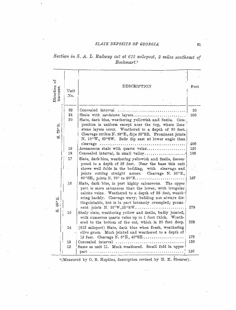
SLATE DEPOSITS OF GEOEGIA. 61
Section inS. A. L. Rat7way cut at 615 maepost, 2 miles southeast of Rockmart.1
Unit No.
DESCRIPTION
--------------------------------------------------Concealed interval
Feet
50 21 Shale with sandstone layers. . . . . . . . . . . . . . . . . . . . . . . . . . 200 20 Slate, dark blue, weathering yellowish and :fissile. Com-
position is uniform except near the top, where limestone layers occur. Weathered to a depth of 30 feet. Cleavage strikes N. 58°E., dips 55°SE. Prominent joints N. 10°W., 63°SW. Beds dip east at lower angle than cleavage . . . . . . . . . . . . . . . . . . . . . . . . . . . . . . . . . . . . . . . . . . . 400
19 Arenaceous shale with quartz veins. . . .. . . . . . . . . . . . . . . . 150 18 Concealed interval, in small valley .................... ~ 100
17 Slate, dark-blue, weathering yellowish and fissile, decom-posed to a depth of 25 feet. Near the base -this unit shows well folds in the bedding, with cleavage and joints cutting straight across. Cleavage N. 55°E., 60°SE., joints N. 70° to 90°E......................... 157
16 Slate, dark blue, in part highly calcareous. The upper part is more calcareous than the lower, with irregular calcite veins. Weathered to a depth of 25 feet, we a th-' ering hackly. Cleavage wavy; bedding not always distinguishable, but- is in part intensely crumpled; promi-nent joints N. 30°W.,52°SW......................... 278
15 Shaly slate, weathering yellow and :fissile, badly jointed,
14
13 12
with numerous quartz veins up to 1 foot thick. Weath-ered to the bottom of the cut, which is 20 feet deep. 228
(615 milepost) Slate, dark blue when fresh, weathering olive green. Much jointed and weathered to a depth of 15 feet. Cleavage N. 5°E., 40°SE........ . . . . . . . . . . . . . 172
Concealed interval .................. _ . . . . . . . . . . . . . . . 150 Same as unit 11. Much weathered. Small fold in upper part . . . . . . . . . . . . . . . . . . . . . . . . . . . . . . . . . . . . . . . . . . . . . . . 150
1(Measured by 0. B. Hopkins, description revised by R. K. Shearer).
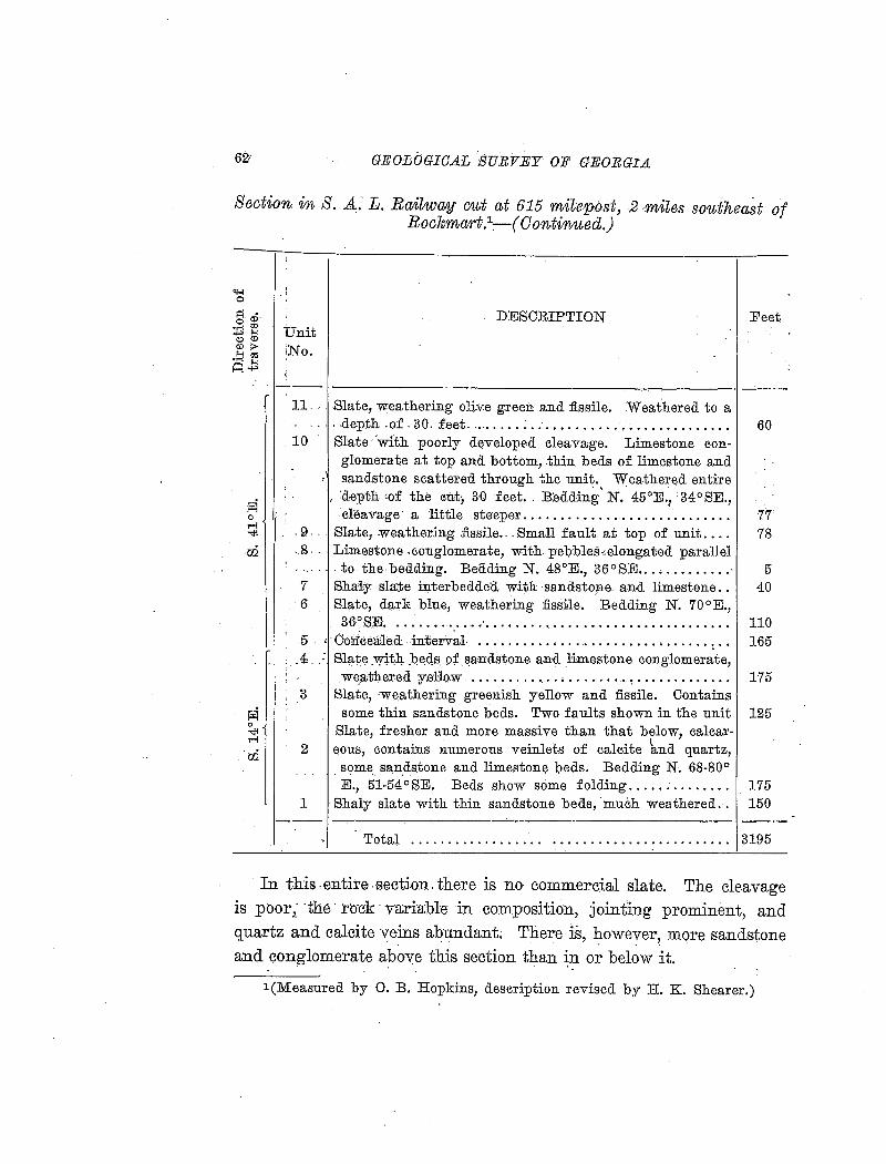
GEOiiJGIOAL SURVEY OF GEORGIA
Section in S. A. L. Railtway cut at 615 milepost, 2 miles southeaSt of Rockmart-.1
-. ( 0 ontinued.)
"1-1 0
' . '
DESCRIPTION Feet. ~ a)·
::P ~ Unit <:>CD <DI> N .!:: ~ i o. A...,
-----------------------------------------------·-----11.- . .Slate, weathering oliv:e green and :fissile. Weathered to a
.... .depth .of. 30. f.eet ..................................... . 10 Slate 'with poorly dElveloped cleavage. Limestone con-
glomerate at top and bottom, .thin beds of limestone and • sandstone scattered through the unit. Weathered entire
, :depth :of the cut, 3·0 feet. : B:edding' N. 45°E., 34°SE., cleavage· a little steeper ........................... .
. 9 ... Slate, :weathering .fissile ... Small fault at top of unit ... .
. g ... Limestone .conglomerate, with pebbles~elongated parallel - ..... to. the-bedding. Beading N. 48°E., 36°SE ............. -7 Shaiy slmte interbedded with sandsto:ne and limestone .. 6 Slate, dark blue, weathering :fissile. Bedding N. 70°E.,
36°S:EJ ............................................. .
60
77 78
5 40
110 5 ; Oo:rueeale.d interval . . . . . . . . . . • . . . . . . . . . . . . . . . . . . . . . . . 165 .i.
3
2
1
S.late :w,:i:t4 J~Eld,S. pf ~andstone and limestone conglomerate, weathered yeHo:w ............. , ........ ~............. 175
Slate, ·weathering greenish yellow and :fissile. Contains some thin sandstone beds. Two faults shown in the unit 125
Slate, fresher and more massive than that below, calcar-eous, contains numerous veinlets of calcite l:tnd quartz,
some san_dstone and limestone beds. Bedding N. 68-80° E., 51-54 ° SE. Beds show some folding ..... ; . . . . . . . . 175
Shaly slate with thin sandstone beds, ·much weathered.. 150 --~----------------~---------------------------
Total .. - .............. . 3195
In this .entire .section. there is no commercial slate. The cleavage is poor,: ·the· rm~k ·variable- in composition, jointing prominent, and quartz and calcite veins abundant; There is, 1?-owever, more sandstone and conglomerate above this section than in or below it.
. . ' . '.
l(Measured by 0. B. Hopkins, description revised by H. K. Shearer.)
SLATE DEPOSITS OF GEOEGIA 63
Northwest from the measured section to Van Wert, the suburb southeast of Rockmart, a distance of a little more than a mile, the railroad crosses a valley, where there are no rock exposures.
A good section is again exposed along the Seaboard Air Line where it follows the east fork of Euharlee Creek in the trench cut through the slate ridge, just southeast of Rockmart station. The first cut southeast of the station is about 600 feet long, showing bluish-black slate, weathering yellowish. The cut is not deep enough to show perfectly fresh slate, but the prospects for commercial slate :ln the hill to the northeast are good. From the southeast end of this cut the Old Dever quarry, Tunnel quarry, and the small quarry in the center of lot 926, all on the property of the Cherokee Slate Company (see locality descriptions), show the section across the belt, about 1000 feet wide, which carries the best slate.
Southern Railway section.-The Cartersville fault crosses the Southern Railway about half a mile east of. the northeast corner 0f the Tallapoosa quadrangle; that is, 3.2 miles due east of the Rockmart station. The upper part of the Rockmart formation, for a diRtance of a mile west of the fault, consists of shaly slate with interbedded sandstone and conglomerate, ·without any prospect of commercial slate.
Just west of the second railroad crossing on the road leading east from Rockmart, 2.3 miles from the station, is an exposure of limestone conglomerate. The bed dips to the east, and measures 130 feet across the strike.· To the west, that is, underlying the conglomerate, is a heavy-bedded brown sandstone.
For 0.8 mile west of this road crossing the railroad runs along the base of Signal Mountain (Carnes Mountain), and the slate beds worked in the Sibley quarries are cut. This part of the section contains a considerable amount of sandstone and hard, rough slate.
Just east of the overhead bridge, the first railroad crossing of the road leading east from Rockmart, 1.5 miles from the station, is a section showing a bed of limestone conglomerate.
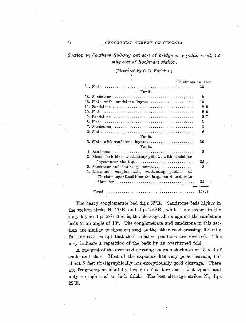
64 GEOLOGICAL SU.RVEY OF GEORGIA
Section in Southern .Rali~waty cut east of bridge over public road, 1.5
mile east of Rockma1·t station.
(Measured by 0. B. Hopkins.)
Thickness in feet. 14. Slate . . . . . . . . . . . . . . . . . . . . . . . . . . . . . . . . . . . . . . . . . . . 30
Fault. 13. Sandstone . . . . . . . . . . . . . . . . . . . . . . . . . . . . . . . . . . . . . . 2 12. Slate with sandstone layers. . . . . . . . . . . . . . . . . . . . . . 10 il. Sandstone . . . . . . . . . . . . . . . . . . . . . . . . . . . . . . . . . . . . . . . 2. 5 10. Slate . . . . . . . . . . . . . . . . . . . . . . . . . . . . . . . . . . . . . . . . . . . 2.5 9. Sandstone ....... ~. . . . . . . . . . . . . . . . . . . . . . . . . . . . . . 0. 7 8. Slate . . . . . . . . . . . . . . . . . . . . . . . . . . .. . . . . . . . . . . . . . . . . 3
. 7. Sandstone . . . . . . . . . . . . . . . . . . . . . . . . . . . . . . . . . . . . . . 2 6. Slate . . . . . . . . . . . . . . . . . . . . . . . . . . . . . . . . . . . . . . . . . . . 6
Fault. 5. Slate with sandstone layers. . . . . . . . . . . . . . . . . . . . . . . 30
Fault. 4. Sandstone ....................... ·. . . . . . . . . . . . . . . 2 3. Slate, dark blue, weathering yellow, with sandstone
layers neat the top ........... , . . . . . . . . . . . . . . . . · 35 / 2. Sandstone and fine conglome:mte.................. 8 1: Limestone conglomerate; containing pebbles of
Cliick:amauga'··1im.es:tiotrre···•3is\ large·· ·as·4 inches' in diameter . . . . . . . . . . . . . . . . . . . . . . . . . . . . . . . . . . . • . 25
Total . . . . . . . . . . . . . . . . . . . . . . . . . . . • . . . . . . . . . . . . . . 158. 7
The heavy conglomerate bed dips 32°E. Sandstone l:)eds higher in the section strike N. 17°E. and dip 15°SE., while the cleavage in the slaty layers dips 28°; that is, the cleavage abuts against the sandstone beds at an angle o.f 13°. The conglomerate and sandstone in this section are similar to those exposed at the other road crossing, 0.8 mile farther east, except that their relative positions are reversed. This may indicate a repetition of the beds by an overturned fold.
A. cut west of the overhead crossing shows a thickness o·f 15 feet of shale and slate: Most of the exposure has very poor cleavage, but about 5 feet stratigraphically has exceptionally good cleavage. There are fragments accidentally broken off as large as a foot square and only an eighth of an inch thick. The best cleavage strikes N., dips 22°E.
SLATE DEPOSITS OF GEORGIA 65
The Rockmart slate area extends about 0.8 mile west of this bridge,
or within 0.7 mile of Rockmart station. The contact with the Chicka
mauga limestone here crosses a valley, and exposures of the lower
beds of the slate are not good, but there is a possibility that commer
cial slate will be found.
DESCRIPTIONS OF INDIVIDUAL DEPOSITS
POLK COUNTY
THE ROCKMART SHALE BRICK & SLATE COMPANY PROPERTY
(Map locality 1)
The Rockmart Shale Brick & Slate Company owns lot 865, 18th.
district, 3d. section, Polk County, consisting of about 40 acres, sit
uated just southeast of the business section of Rockmart. On this lot
are three abandoned slate quarries, besides the quarries from which
the weathered slate or '' caenstone'' us.ed in the manufacture of vitri
fied brick is obtained. The quarry locations in the immediate vicinity
of Rockmart are shown and lettered on the map of Rockmart (:fig. 4),
others are numbered on the general map of the Rockmart area (Map II.)
The slate quarries were worked by Robert H. Brown, from rwhom
the lot was purchased by the brick company. Brown is said to have
lost much money in the work, but the loss was due largely to inef
ficient working methods. The quarries were worked in such a manner
that the slate was badly shattered by blasting, thus causing an un
reasonable amount of waste. The sawing and splitting shed was at
the top of the ridge south of the brick plant, so all of the slate had to
be raised over 100 feet, although a good location for the shed could
have been selected down the valley south of the quarries.
Lot 865 is crossed by a prominent east-west ridge rising about 120
feet above the level of the brick plant. It lies entirely within the area
of outcrop of the Rockmart slate, but the material shows considerable

849 850
854
92.3 N
I o 300 bOO qoo 1
SCALE IN FEET'
927
b E oO
c('>
865
936
Lime~tone ~ Q.u.a.ny E •
QSawi11g Shed
79~4
8.66
935
Fig. 4. Map of Rockmart and vicinity, showing land lots and locations of the principal slate quarries.
Cl'l Cl'l
~ a t; a ~
~ l:"L.l
§ ~ 1-<:j
~ ~ a ~
~
SLATE DEPOSITS OF GEOEGIA 67
variations in perfection of cleavage and depth of weathering. Of course, all of the slate exposed at the time of examination had been repeatedly frozen and thawed, so the cleavage in none was as good as in the fresh slate. The openings are described in detail below.
Brick plant quarries (A) .-The Rockmart Shale Brick & Slate Company was started with the intention of quarrying slate and utilizing the overburden and waste in the production of brick. No slate, however, has been produced, and the only product of the plant is vitrified paving brick. The brick are made from the much weathered slate near the base of the Rockmart formation, and it has been found that
. . . . brick made from the fresh or slightly weathered slate such as slate quarry waste and topping rwould provide are not hard and tough enough to stand the required rattler test for abrasion of paving blocks. For this reason the fresher slate is avoided.
The brick plant quarries are near the base of the ridge on the north slope. The old quarries have been worked to a distance of 200 feet south and 300 feet east of the plant, and in October, 1916, the face being worked was just west of the plant. The latter opening had a face 200 feet long with a maximum height of 30 feet. .All of the material is weathered to a yellow, red or greenish color except a small mass of gray but soft slate beneath the highest part of the face.
In the south end of the large quarry south of the brick plant comparatively fresh slate is exposed, with cleavage, bedding and joints at unusual angles, as follows:
Cleavage: Strike N. 70°E., dip l5°SE. Bedding: Strike N. 40°W., dip l0°SW. (Marked by conspicuous groups of ribbons.) Joints: Horizontal. (Most prominent series, at 2 to 3 foot intervals.)
At other points in the quarry the cleavage and bedding are more nearly normal, as shown by the following measurements:
Cleavage: Strike N. l5°E., dip 68°SE. Bedding: Strike N. 82°E., dip l7°SE.
Strike N. 49°E., dip l2°SE. Strike N. 55°E., dip 25°SE.
68 GEOLOGICAL SURVEY OF GEORGIA
The material used in brick-making grades from gray slate through soft, partly weathered slate, usually of red or yellow color and locally knorwn ·as'·' caenstone, '' in.to yellow or red ocherous clay. The average composition of the caenstone is shown by the following analyses, one of. a sample taken by T. Poole Maynard while studying the cement materials Qf north Georgia; and S-267, an average S!lmple of the working face in October, 1916.
Analyses of weathered slates used for nt(JJJ1,~~tacture of vitrified brick.
M-31 'Silica (Si0
2) ........................... 66.32
1
Alumina (..8..12 0
3) .. • • • • • • • .. • .. • • .. .. • .. 19.79
Ferric oxide (Fe20
3) .................. •
Ferrous oxide (F'eO) .............•.. · .. . Magnesia (MgO) ...................... . Lime (OaO) ........................... . Soda (Na~p) ,, ......................... . Pot~~h. (K
20) ..................... - .. ,.
Ign1t1on .............................. . Moisture ............................. . Carbon dio:x;id:e ('00
2) ••••••••••••
1 •••••••.
'J:itanio,;m <,dioJ!iid;e (,'.J:~i02.), • • • • • • • • • • • • • • • •
:P'hbsph~r;;_; pentoxid~"'(:p · 0 ) .. , ......... . . . . . 2 5
Siilphlif trioxide (S03
) •••••••••••• · •••••
Sulphur (S) ....... :. :: .................. . Manganous oxide (MnO) ............... . Barium oxide (BaO) ................... .
3.91
.40
.10 1.23 1.94 5.20
.30
.00
.82
.06
100.07
Sc267 58.4:7 19 .. 68
6.84 2.01 2.05
.00
.82 4.20 4.76
.59
.00
.!)6;
.00
.00
.11
.00
.00
100.4:9
Old q~~arry on the slope above the brick plant (B) .-This quarry is an opening about 50 feet square in the hillside south of the brick plant. The maximum height o·f the opening is 40 feet, but the sides slope toward the center, so that the v'ertical height does· not exceed 25. feet and the quantity of splitting slate available is small .. The topping amounts to 10 to 15 feet of weathered slate, and 10 or 12 feet (stratigraphically) ·of fresh slate is exposed i:ri the bottom of the pit.
The sJ.ate is very much ribboned, and the cleavage not particularly good. It is said that only thick, hard slates were made here. Measurements of strike and clip are as follows :
1 Geol. Sl!rvey of Ga., Bull. 27, p. 133, 1912.
SLA1'E DEPOSITS OF GEOBGI.A
Cleavage: Strike N. 16°E., dip 29°SE. Strike N. 18°E., dip 32°SE. Strike N. 22°E., dip 33°SE. Strike N. 33°E., dip 32°SE.
Bedding: Strike N. 52°E., dip 21 °SE. Strike N. 54°E., dip 28°SE. Strike N. 57°E., dip 21 °SE. Strike N. 47°E., dip 25°SE. Strike N. 46°E., dip 23°SE.
Joints: (1) Strike E.-W., dip 78°N. (2) Strike N. 26:lh 0 E., dip 81 °SE. (3) Strike N. 88°E., dip l3°SE. (4) Strike N. 51°E., dip 481h 0 SE.
69
Joints of series (1) are most prominent. Those of series (3) and ( 4) give rise to wedge shaped blocks .
.A.s the cleavage of the slate dips into the hill, the quarry is situated on the wrong side of the hill for convenient working.
Brown's So~rth q~wr-ry (C) .-The opening is in the south slope of the ridge, 150 yards southwest of the splitting shed. It is irregular in shape, measuring 180 feet from east to west, and 130 feet from north to south. The deeper parts of the pit, in the southeast and southwest corners, were filled vvith water when examined. The maximum height of the north face above water level was 60 feet, but the highest vertical face was 35 feet, in the east end of the pit, and the water was al;>parently 10 feet or more in depth. In the upper part of the pit the face is not vertical, hut follows the slope of the hill. The topping of slate too much rweathered for use varies from 15 to 25 feet, so the amount of splitting slate exposed is only about 10 feet stratigraphically.
The strike and dip of cleavage and bedding vary considerably in different parts of the quarry, and the slate is cut by a number of systems of joints, which evidently caused a great amount of waste in working. Ribbons are conspicuous at some places, but at others are absent for 4 to 6 feet across the bedding. The ribbons consist of groups of thin layers of material varying in composition from the
70 GEOLOG;ICA.·L .SURVEY OF GEORGIA
rest of the slate. A specimen taken from the splitting. shed measures 12 by 12 by 13/z inches and· contains four groups of ribbons, which make an angle o·f 35° to 40° with the cleavag~. The groups of ribbons average half an inch in thickness, spreading out to an inch or more on the cleavage surface, and the cleavage is deflected
1
3° from its normal direction where it crosses the bands. (See fig. 2, p. 11).
Brown's North quarry (D) .-This quarr:y is another large opening about 200 feet northwest of the South quarry. The pit is about 100 feet in diameter and the height from the level of the water which filled the bottom of the pit, when examined, to the top of the north face was 85 feet.
All sides of the pit except at the entrance are vertical for 40 or 50 feet above water level, so most of the slate was inaccessible for measurement or sampling. Near the entrance the cleavage strikes N. 50°E. and dips 38°SE. The slate is of about the same quality as that in the Sou~h quarry, and in. the highest part of the face the upper 40 feet appears -to be too much weathered for splitting slate.
The slate from the -Brown quarries is of a dark bluish gray color, with a roughish, lusterless cleavage surface. It is sonorous and effervesces with acid.· An average sample (S-265) from the South quarry was taken for analysis, and slides were cut from a typical ribbonded specimen obtained from the splitting shed (S-2SI). '
Ana~ysis of slate from Brown's South quarry.
S-265
" Silica ( SiO 2
) ................ , • • • • • • • • • • • • • • • • • • • • • 56. 54 Alumina (A1
20
3).................................. 17.75
Ferric oxide (Fe 0 ) . . . . . . . . . . . . . . . . . . . . . . . . . . . . . . . 56 2 3 .
Ferrous oxide (F"eO) .. .. .. . .. .. . .. . .. . . .. . . .. .. .. . 4. 90 Magnesia (MgO) .................... : . . . . . . . . . . . . . 3 . 26 Lime (CaO) . . . . . . . . . . . . . . . . . . . . . . . . . . . . . . . . . . . . . . . 3.28 Soda (Na
20)...................................... 1.91
Potash (K2 0) .......................... ·. . . . . . . . . . . 3. 20
Ignition (less CO2
) • • • • • • • • • • • • • • • • • • • • • • • • • • • • • • • • 4. 28 Moisture . . . . . . . . . . . . . . . . . . . . . . . . . . . . . . . . . . . . . . . . . .16 Carbon dioxide (C0
2).............................. 2.10
Titanium dioxide (Ti02
) ••••••• :................... .96
SL.A1'E DEPOSITS OF GEORGIA
Phosphorus pentoxide (P20
5) ••••••..••••••••••••••••
Sulphur trioxide (S03
) ••••••••.•••••••••••••••••••
Sulphur (S) ...................................... . ldanganous oxide (ldnO) .......................... . Barium oxide (BaO) .............................. .
.00
.34
.47
.00
.00
99.71
71
Sections perpendicular and parallel to the clea.vage were cut from
one of the ribboned bands of specimen S-25I. The ribboning is conspicuous in both sections. In the section perpendicular to the cleav
age the ribbons are fine and make an angle of 30° with the cleavage,
while in the other section the light and dark bands are broader, owing to the smaller angle of intersection.
The structure is rather coarsely lenticular, consisting of an ag
gregate of fine-grained mica and chlorite stained by carbonaceous matter, surrounding colorless lens-shaped areaJs. This lenticular structure produces the roughness of cleavage surfaces, as other finer grained
slates from the same district have much smoother cleavage. The lenses
consist of quartz, sometimes granulated, with some feldspar, and finely
crystalline, irregularly oriented sericite scales, evidently due to alteration of feldspar. The quartz occurs as rounded or angular grains,
usually arranged rwith. their longest dimensions parallel to the cleav
age. .A few grains have maximum dimensions as great as 0.1 mm.
The aggregate or ground mass surrounding the lenticular areas
shows aggregate polarization, which is somewhat obscured by the car
bonaceous matter present, but is made easily visible by the use of a
mica or gypsum tint plate. The aggregate consists of finely crystal
line mica with a subordinate amount of interleaved greenish ~scales of
chlorite, much fine carbon, and abundant spherules and isometric
crystals of opaque pyrite. The opaque grains range up to 0.015 mm.
in diameter, but are mostly much smaller. Extremely fine rutile
needles up to 0.01 mm. in length are very abundant.
The dark ribbons contain more of the finely divided graphitic car
bon than the light ones, but otherwise the composition apparently does
not differ greatly.
72 GEOLOGICAL SURVEY OF GEORGIA
Carbonate grains and rhombs, with maximum dimensions of 0.09 mm. are abundant and about equally distributed through both light and dark ribbons.
The constituents, in descending order of abundance, appear to be mica, quartz, chlorite, car:bonate, feldspar (largely detrital plagioclase), carbon, pyrite, magnetite, and rutile.
I
THE SOUTHERN STATES PORTLAND CEMENT COMPANY PROPERTY, LOT 925
Lo·t 925, 21st district, 3d. section, belonging to the Southern States .Portland Cement Company, lies west o·f lot 865 and south of the business section of Rockmart. This lot formerly belonged to Colonel Seaborn Jones, one of the originators of the Rock:fuart slate industry. From Jones the property was purchased by the Georgia Slate Company, which was the parent of the Southern States Portland Cement Company. The latter company was organized for the purpose of using the oveTburden and refuse from the slate quarries in the manufacture of cement, but in the development of the property north of Rockmart, where the limestone quarries were located, an ample supply of partly weathered slate or shale was :Eound, more sati~factory for cement manufacture than fresher waJSte slate from the quarries.
Therefore this company has confined its ope·rations to the manufacture of cement, and, like the Rockmart Shale Brick & Slate Company, has
never started the production o.f -slate on a commercial scale.
The oldest slate quarry in the district is on lot 925, beside-s a small
opening made by Pritchard and Davis in 1912. The lot also includes a portion· of the old Dever quarry, -which is mostly on the property of the Cherokee Slate Company. These openings are· described in detail below, the numbered locations being shnwn on the map o.f Rock~ mart (fig. 4).
Pritchard & Davis opening (E) .-This opening, made in 19J 2, represents the most recent attempt to work the Rockmart slate on a
commercial scale. The quarry is near the center of lot 925, and about
SLATE DEPOSITS OF GEORGIA
Phosphorus pentoxide (P 2 0
5) •••.•••..••••••.••... • ••
Sulphur trioxide (S03
) •••••••.••••••••••••••••••••
Sulphur (S) ...................................... . Manganous oxide (MnO) .......................... . Barium oxide (BaO) .............................. .
.00
.34
.47
.00
.00
99.71
71
Sections perpendicular and parallel to the cleavage were cut from one of the ribboned bands of specimen S-25I. The ribboning is conspicuous in both sections. In the section perpendicular to the cleavage the ribbons are fine and make an angle of 30° with the cleavage, while in the other section the light and dark bands are broader, owing to the smaller angle of internection.
The structure is rather coarsely lenticular, consisting of an aggregate of fine-grained mica and chlorite stained by carbonaceous matter, surrounding colorless lens-shaped areaJs. This lenticular structure produces the roughness of cleava.ge surfaces, as other finer grained slates from the ~same district have much smoother cleavage. The lenses consist of quartz, sometimes granulated, with some feldspar, and finely crystalline, irregularly oriented sericite scales, evidently due to alteration of feldspar. The quartz occurs as rounded or angular grains, usually arranged rwith. their longest dimensions parallel to the cleavage. A few grains have maximum dimensions as great as 0.1 mm.
The aggregate or ground mass surrounding the lenticular areas sho·ws aggregate polarization, which is somewhat obscured by the car
bonaceous matter present, but is made easily visible by the use of a mica or gypsum tint plate. The aggregate consists of finely crystalline mica with a subordinate amount of interleaved .greenish 'scales of chlorite, much fine carbon, and abundant spherules and isometric crystals of opaque pyrite. The opaque grains range up to 0.015 mm. in diameter, but are mostly much smaller. Extremely fine ruti}e needles up to 0.01 mm. in length are very abundant. ·
The dark ribbons contain more of the finely divided graphitic carbon than the light ones, but otherwise the composition apparently does not differ greatly.
74 GEOLOGICAL SURVEY OF GEORGIA
"The' slate 'is of very dark bluish-gray color and of slightly roughisli, lusterless surface. It is sono:rous and ~ffer:vesces: with aCid test. The--sawn face· shows minute magnetite; the powder shows. very little magne~ite 'buij?irithch~ carbon ana' ·effervesces very freely' with jacid··test:
·''Under the r~.icr.:oscope aggregate polarization is somewhat obs.cu:tediby carbonacBous irratter.' The general te:xtu~e is-'ili'eritieUlar ·and Some~ hat coarse, the quartz grains measuring. up- t?· 0~047 mm; Small bed~ ·:(L'();wu to o:i2': rom. thick, Wit!{ quartz ·gt•:aifig:'>t~r 0:09 mm: and
. " much ca;.rbo:ri.ate, intersect the cleavage at 14 degrees. The matrix contailis~-ln.uch :fine carbon, much carbonate, chlorite scales interlea¥e.d with muscovite,. abundant· spherules and grains of pyrite, andrutiie need1~s. The section ·p·ara1ler;to ~le·av~ge is ~rowdea 'With car-bonate; · . -·· ,_ .. - ,
. ~ :.~.· ... -~ ·.!;;;. ; '-' •
'''The c6nst1tuents, .na~ed 1n descending o-rder of abundance, ap-pear to be mt~;E;co~tej_ quartz ((letri~al}, ca~:t>utJ;~te;:· carbon, chlorite, kaolin, pyrite, magnetite, rutile, and plagioclase (detrital).
''This is a mica· slate of the fading series, although· some obtained from a tunnel at .one of ~he quarrje-s·js :ueported to have kept its color £0-r ,rriairi;y·J~ai-8. 1:ts ,-fiss11:t:t¥·'is''1ia1~!'1' ,'_ , -· -· -'" :;-.' ,·
' '
CJt'itest q~r,arry (F) .-The ·6ia~st ··quarry 1n tli~tRiYckina~t district is • • > •
situa;t..~~ near the center of lot 925, just over the crest of t];le ridge froili ~Rbckma.rt, and 150 feet northeast of the Pritchard a'nd Davis op'i:nri:ilg., ·
~he. pit is almost circular and about 100 feet in diameter. rr·l.ie most extensive work was done in the northeast corner of the pit, where there· is·~- vertical' fa~e of· 3o 'feet above the water which :fills the bottGJtt: ,: A't ·this poirit the topping is lightest, from 10 to 12 · feet. {)'n
the other sides of the pit the overburden is heavier, and no splitting slate is exp·o·sed. The· quarry is 'lai'gely :filled with_ d~ht-ls ·from abbve
. and waste -:Erom the splitting of slate from the re·cent openi'ng.
The quarry ''worked itself out,'' an illustration of 'poor management in quarry development. The pit was·worked' into a 'funnel~shape, in which the slate was necessarily much shattered by bla.Sting, resulting in heavy loss. If the overburden had been removed over a larger
!
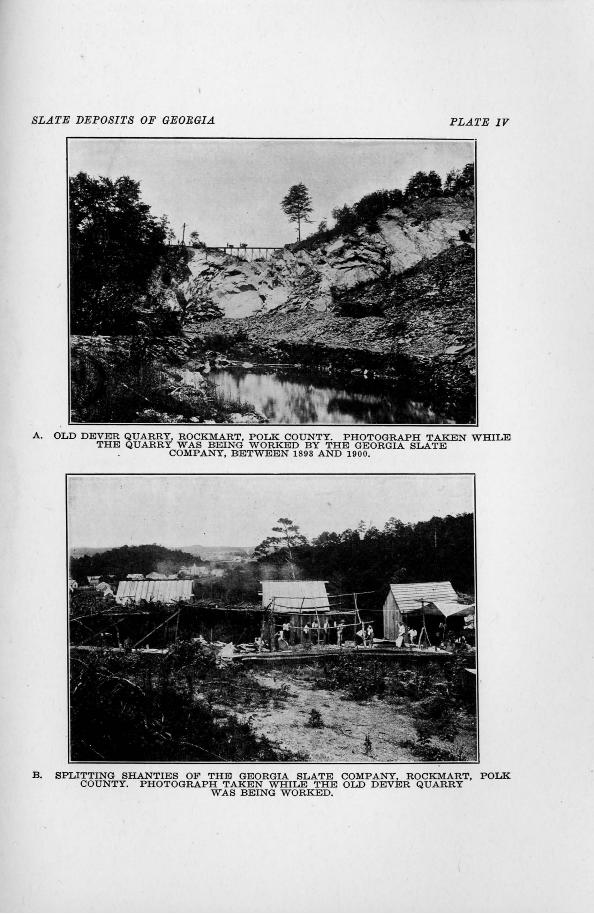
SLATE DEPOSITS OF GEORGIA PLATE IV
A. OLD DEVER QUARRY, ROCKMART, POLK COUNTY. PHOTOGRAPH TAKEN WIDLE THE QUARRY WAS BEING WORKED BY THE GEORGIA SLATE
COMPANY, BETWEEN 1893 AND 1900.
B. SPLITTING SHANTIES OF THE GEORGIA SLATE COMPANY, ROCKMART, POLK COUNTY. PHOTOGRAPH TAKEN WHILE THE OLD DEVER QUARRY
WAS BEING WORKED.
SLATE DEPOSITS OF GEORGIA 75
area and the slate worked out along the cleavage the production could have been much larger and more economical.
The cleavage has an average strike of N. 42°E., dip 43°SE. Ribboning is conspicuous, and the ribbons are often arranged in groups. The quality of slate is about the same as that in the Pritchard and Davis quarry, previously described.
CHEROKEE SLATE COMPANY PROPERTY
(Map locality 2)
In 1907 the Cherokee Slate Company, of rwhich A. G. Rhodes and C. J. Haden, of Atlanta, are president and vice-president, respectively, purchased from the heirs of Mrs. Sarah J. Dever, lot 936, 18th district, 3d. sectio;n, lots 926, 927, 928, 929, the north half of lots 995 and 996, and four acres in the southeast corner of lot 924, 21st district, 2d
section, besides several other small pieces of property. All of these lots are nominally 40 acres, and the total holdings of the company amount to a little more than 250 acres. This property extends for a distance of 1}i miles from east to west along the slate ridge south of Rockmart, including the quarries which produced the greater part of the slate quarried in the Rockmart district and many of the best and most accessible prospects. The old Dever quarry, the largest in the district, is principally on this property, and the Tunnel quarry, the second largest and one of the best, is on lot 926.
It is the intention of the company to open the quarries again with improved methods as soon as the war is over and machinery obtainable.
Old Dever quarry (G).-The quarry north of the Seaboard Air Line tracks, 200 yards southeast of the station, commonly known as the Old Dever quarry, is the largest in the Rockmart district. Most of the work has been done on lots 924, 926, and 927, the property of the Cherokee Slate Company, but a part of the quarry extends onto lot 925, the property of the Southern States Portland Cement Company.
The quarry has a maximum length from west to east of nearly 500 feet. In outline it followed a curve in the east fork of Euharlee
/
76 GEOLOGICAL SURVEY OF GJJORGTA.
Creek, which was straightened when the Rockmart to Atlanta branch of the Seaboard Air Line was built. The quarry was worked back into the hill almost 200 feet, and the face has a maximum height (not vertical, however) of 125 feet from the level of the road at the base.
The following section was measured and the units described as accurately as possible under the conditions of· difficult accessibility.. The
traverse starts in the northern part o-f the quarry and run-s southeast, across the average strike of the bedding, and the units are numbered from lowest to highest, stratigraphically. The measurement-s stated
are horizontal distances, and are therefore greater than the strati-' graphic thickness of the beds.
Section in o~d Dever qua1·ry.
Feet 7. Slate, thin bedded and contorted, containing nmb.erous veins, and of no
commercial value. Exposed over the pond in the east end of the . quarry .............. ~ ............ ! ............... ·,· ... ,. . . . . . . . . 15
6. Slate, dark, bh~e, massive. J 6ints are less prominent than in the underlying unit, and are :filled with calcite. Overburden about 15 fee't. Expose'd mbove pond .... ; . ~ .. : .. / ... • .. : ~ .... :· ... ·'·.,,.... 40
5. Splitting slate; with few ribbons but very ptominent jointin.gs. Contains short, disco.nnected stringers in a north-south dh;ection, and most of the joints are :filled with calcite. Measurements of strike and d:i.p are as follows:
Cleavage: Strike N. 1
45°E., dip 47°SE. Joints: (1) Strike N. 56°W., dip 84°SW.
Strike N. 60°W., dip 82°SW. (2) Strike N. 00°S., dip 51 °W. (3) Strike N. 45°E., dip 67°SE. (4) Strike N. 35°W., dip 82°SW.
The joints of series (1) and (2) are very prominent, those of series (1) .being closer together but not as continuous as (2), and both are filled by sheets of calcite one-eighth to one-fourth inch thick. These joints cause a part of the slate to break up into pieces 8 to 10 inches wide, 3 to 4 feet long, and up to 1 foot thick ............................... :. . . . . . . . . . . . . . . . . . . . . . . . . . . 66 4. Slate, badly jointed and much weathered to a depth of 35 feet. On
weathering the slate breaks down to small rectangular platy pieces. Measurements of strike and dip are as follo·ws:
Bedding: Strike N. 44°E., dip 36°SE. Strike N. 40°E., dip 30°SE.
SL.A.1'E DEPOSITS OJ!' GEORGIA
Joints: (1) Strike N. 30°W., dip goo. (2) Strike N. 10°E., dip 70°NW. (3) Strike N. 85°E., dip 60°SE.
77
50 3. Slate cut by many calcite veins, very little splitting slate .... , . . . . . . . 18 2. Slate with sandstone layers, intimately intersected by calcite veins.. 18 1. Dark blue-gray slate, with good cleavage and almost no ribbons.
Some joints have calcite fillings, and there are a few calcite stringers near the upper part of the unit. Measurements of strike and dip are as follows:
Cleavage: Strike N. 56°E., dip 41 °SE. Bedding: Strike N. 58°E., dip 38°SE.
Strike N. 52°E., dip 38°SE. Strike N. 54°E., dip sgosE.
Joints: (1) Strike N. 20°W., dip goo. Strike N. 80°E., dip 80°SE. Strike N. l4°E., dip 74°NW. Strike N. 70°E., dip 69°SE. Strike N. 62°W., dip 80°SW.
This unit apparently contains the best splitting slate in the quarry. The overburden is 10 to 15 feet. . . . . . . . . . . . . . . . . . . . . . . . . . . . . . . . . . 46
The portion of the quarry extending from the north point about 400 feet southwest to the railroad is at about the same horizon as the lower unit of the section, but extending a little lower. Good splitting slate is exposed in this portion of the quarry, and the relation of the cleavage direction to the slope is favorable for working. In working the higher units there would be much waste on account of jointing and calcite stringers.
The overburden is greatest near the middle of the quarry, above unit No. 4, and decreases to east and west.
Samples were taken from the lower 46-foot unit, which represents the best s:late in the quarry. S-264 is an average sample taken for analysis, and S-257 a typical specimen from which sections were cut. The analysis is as follows :
Analysis of slate fTom old Dever quarry.
S-264 Silica (Si0
2) •••••••••••••••••••••••••••••••••••••• 56.32
Alumina (A120
3) .....•.......••••.•••••.•.••..•••• 17.24
Ferric oxide (F e2 0) . . . . . . . . . . . . . . . . . . . . . . . . . . . . . 1. 36
78 GEOLOGICAL SURVEY OF GEORGIA
Ferrous oxide (F'eO) .... , . . . . . . . . . . . . . . . . . . . . . . . . . 5. 04 Magnesia (MgO) .. . . .. .. .. . .. .. .. .. .. .. . .. .. .. .. .. 3.10 Lime (CaO) . . . . . . .. . .. . . . . . . . . . . . . . . . . . . . . . . . . . . . . . . 3.27 Soda (Na
20)...................................... 1.64
Potash (K2 0) .......................... , . . . . . . . . . . 3 . 72
Ignition (less CO .J . . . .. . . . .. .. .. . . . .. .. .. .. .. . . .. . 3 . 83 Moisture ...... :. . . . . . . . . . . . . . . . . . . . . . . . . . . . . . . . . . .10 Carbon dioxide (00
2).............................. 1. 75
Titanium dioxide (TiO 2
) ••••• " • • • • • • • .. • • .. • • .. .. • 1.15 Phosphorus pentoxide (P
2 0
5). .. • • • • • • • • • • • • • • • • • • • • • • 00
Sulphur trioxide (SO 3).. • • • • • • • • • • • • • • • • • • • • • • • • • • .14
Sulphur (S) . . . . . . . . . . . . . . . . . . . . . . . . . . . . . . . . . . . . . . . . 66 Manganous oxide (MnO) ............... ~.......... . . 00 Barium oxide (BaO) . . . . . . . . . . . . . . . . . . . . . . . . . . . . . .. . . 00
99.32
Mega:scopically, this slate is darker in color and :finer in texture than the slate from the Brown quarry on an adjacent lot. It has slightly smoother and better cleavage, and shows no ribbons. The analysis indicates a little more magnetite and· .pyrite, but less car
bonate.
·: ·Under the microscope t'he slate shows :finer teoctuwe ·and. much more
fi.nelylen.ticular structure than the slate,from thE} Brown quarry. Ag
gfe~kte· poTI.arizat1on. i~ the section perpendicular t0 cleavage is not
bri1liant; but distinct, while the section parallel to cleavage also shows a slight aggregate polarization, detectable with the :first order red gypsum plate. The aggregate polarization in the latter section is
evidently due to the orientation of some of the mica flakes with their long axes parallel to the grain of the slate.
Quartz and calcite are scattered through the slides, no grains hav
i:rig maximum ·dimensions :over 0.1 mm. Rutile needles and small opaque isometric crystals of magnetite and pyrite are abundant.
Chlorite is J?-Ot definitely determinable, but fine scales of greenish mineral are scattered through the mica ground mass, and must be chlorite, as the magnesia shown by analysis evidently exists in that form. The scales of chlorite and of dark carbo:p.aceous material or graphite are
more conspicuous in the section parallel to cleavage, as they are so
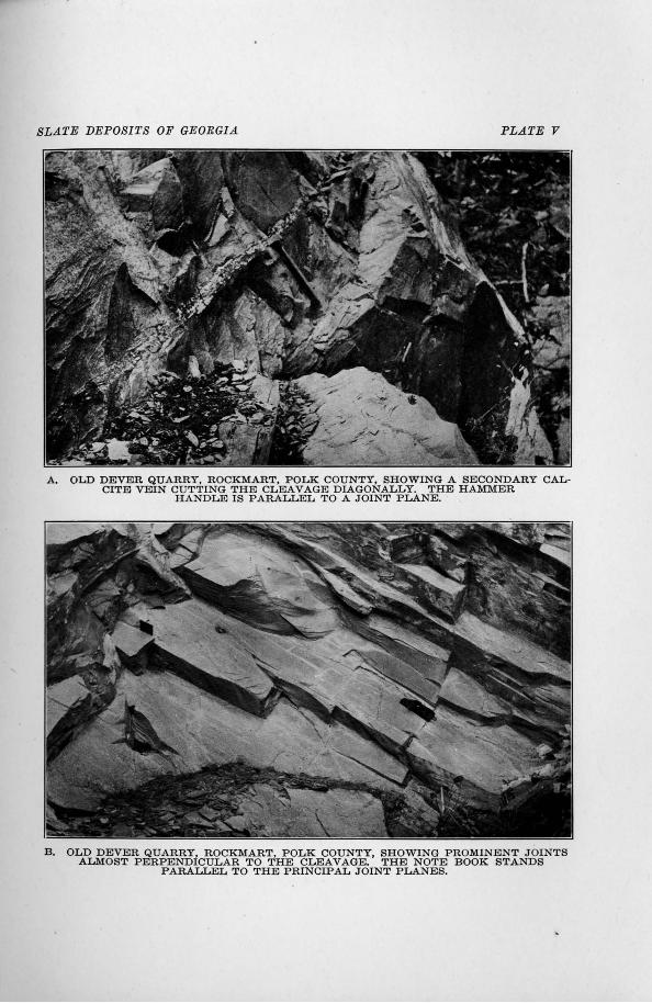
SLATE DEPOSITS OF GEORGIA. PLATE V
A. OLD DEVER QUARRY, ROCKMART, POLK COUNTY, SHOWING A SECONDARY CALCITE VEIN CUTTING THE CLEAVAGE DIAGONALLY. THE HAMMER
HANDLE IS PARALLEL TO A JOINT PLANE.
B . OLD DEVER QUARRY, ROCKMART, POLK COUNTY, SHOWING PROMINENT JOINTS ALMOST PERPENDICULAR TO THE CLEAVAGE. THE NOTE BOOK STANDS
PARALLEL TO THE PRINCIPAL JOINT PLANES.
SLATE DEPOSITS OF GEORGIA 79 i
finely interleaved with the mica that they do not show up strongly in the other section.
The minerals, in order of abundance, seem to be mica, quartz, chlorite, feldspar, carbonate, magnetite, pyrite, carbon, and rutile.
. Tunnel q~&arry (H) .-The Tunnel quarry is on the property of the Cherokee Slate Company lot 926, south of the east fork of Euharlee Creek, and opposite the large quarry described above.
The quarry was started on the north slope of the hill and rworked in the direction of the strike, with increasing depth to the southeast. The opening is about 200 feet long, and the face has a height of 100 feet, but as the face slopes with the hill the· vertical depth is hardly 50 feet at any point. There was a tunnel from the bottom of the quarry, opening lower on the slope near the creek, but this is now :filled with debris. The topping of weathered slate is generally 10 to 15 feet thick normal to the slope of the hill, amounting to about 25 feet vertcially.
The cleavage is wavy at places, and some of the slate in the upper part of the quarry presents a gnarled appearance. This secondary
folding led to a great deal of waste, but some of the best slates in the Rockmart area were quarried here, being of uniform color, free from ribbons, and having good straight cleavage. Quartz veins are prominent locally, and there are some calcite veins up to an inch in
. thickness. There is only one prominent and persistent serieS; of joints, but there are numerous other minor and irregular joints.
Measurements of strike and dip are as follows:
Cleavage: Strike N. 49°E., dip 52°SE. Strike N. 54°E., dip 42°SE. Strike N. 49°E., dip 45°SE.
Prominent joints: Strike N. 45°W., dip 86°NE.
There is a small opening between the above described quarry and the creek. It is 25 feet wide, 50 feet long, and 25 feet deep at the south end. Jointing is as in the other quarry, quartz occurs abund
antly in pockets at certain places, and rwavy cleavage is found.
80 GEOLOGICAL SURVEY OF GEORGIA
These openings are stratigraphically at a higher horizon than the old Dever quarry north of the creek.
· There is also a good exposure of slate in the cut made by th~ Sea. board Air Line to straighten the course of the creek. The cut is
' about 100 yards long, all in slate. The rock has suffered some folding since the development of the cleavage, causing locally wavy and gnarled cleavage planes. Calcite joint fillings and. quartz veins are also present. There is one very prominent series of joints, strike N. 8°W., dip 56°SW.; and a less prominent series, strike N. 64°E., dip 72°SE. The west (lorwer) part o£ the exposure in the cut is at about the same horizon as the oid Dever quarry north of the creek.
Sample S-266 is an average of a number of samplings from the Tunnel qi:rarry, and S-259 is a typieal specimen of the good slate The analysis is as follows :
Analysis of slate from the Tunnel quarry.
S-266 Siliea (Si0
2) •••• :................................. 57. oo
··kllliiima (Al203
) •••••••••• , •••••••••• ·-·...... •.• • • • 17 .'88 ]'er.rie oxide (Fe
20
3).............................. .64
Ferrous oxide (F'eO). . . . . . . . . . . . . . . . . . . . . . . . . . . . . . 5. 04 Magnesia (MgO) . . . . . . . . . . . . . . . . . . . . . . . . . . . . . . . . . . 3.05 Lime (CaO) . . . . . . . . . . . . . . . . . . . . . . . . . . . . . . . . . . . . . . . 2.62 Soda (Na
20)....... .• . . . . . . . . . . . . . . .. . . . . . . . . . . . . . 1.60
Potasli. (K2 0) . . . . . . . . . . . . . . . . . . . . . . . . . . . . . . . . . . . . . 3. 78
Ignition (less CO ) .. .. .. .. .. .. .. .. .. .. .. .. .. .. .. .. 3. 76 . . . I 2 Mo1sture ..................................... , . . . .18 Carbon dioxide (CO).............................. 1.98
2 ' Titanium dioxide (Ti0
2)........................... 1.05
Phosphorus pehtoxide (P 2 0
5) • • • • • • • • • • • • • • • • • • • • • • • • • 00
Sulphur trioxide (S03)............................ .12
Sulphur (S)....................................... .56 Manganous oxide (MnO) . . . . . . . . . . . . . . . . . . . . . . . . . . . . 00 B'arium oxide (BaO). . . . . . . . . . . . . . . . . . . . . . . . . . . . . . . . 00
99.26
Specimen S-259 is a very dark blue-gray slate, with good straight cleavage and no ribbons. It resembles the slate from the old Dever
SLATE DEPOSITS OF GEOEGIA 81
quarry, having :finer texture and smoother cleavage than the slate from the Brown quarries.
Under the microscope the slate is almost identical in texture and general appearance with that from the old Dever quarry. The aggregate polarization is rather strong in the- section perpendicular to the 'cleavage, and the section parallel to the cleavage shows slight aggregate polarization and elongation of the mineral particles in the grain direction. The ,structure is :finely lenticular, the lenses consisting of shattered quartz or feldspar grains and mica scales in irregular orientation, surrounded by a ground-mass of parallel-oriented mica, chlorite and graphite :flakes. Carbonate grains and rhombs are scattered through the section. Most of the carbonate grains measure less than 0.05 mm., and the quartz grains are on the average even smaller than the carbonate.
The order of abundance of the minerals present is apparently mica, quartz, chlorite, feldspar, carbonate, magnetite, pyrite, carbon, and rutile.
Small q~larry on lot 926 (1).-There is a small quarry in •a westward sloping draw near the center of lot 926. About 10 feet, stratigraphically, of splitting slate is exposed, with 15 feet of overburden. The overburden would be likely to increase on working into the slopes, and the situation of the quarry in a narrow valley with the cleavage dipping into the hill is unfavorable for working.
The slate is extensively ribboned, with ribbons less than a quarter . of an inch apart. The cleavage is good, but the slate has a tendency to break along the ribbons. There is only one series of prominent joints, which are :filled with calcite. The slate has a pronounced grain, and when partly weathered it tends to break into regular rhombs, the faces of which are cleavage, bedding and grain. Measurements of strike and dip are as follows:
Cleavage: Strike N. 40°E., dip 30° to 35°SE. Bedding: Strike N. 45°E., dip 10° to 20°SE. Joints: Str.ike N. 3<0°E., dip 75° to 85·0 SE.
The fresh slate is dark gray-blue, and shows no sign of stain or fading since the quarry was worked.
82 GEOLOGICAL SVEVEY OF GEOEGIA
ELLIS DAVIS & SON QUARRY
(Map LocaLity 3)
The property of Mrs. Ellis Davis consists of a part (28 acres) of
lot 866, 18th district, 3d section, lying within the city limits of Rock
mart and just east of the Rock:J;nart Shale Brick and Slate Company property, lot 865.
The abandoned quarry ( J) is near the northwest corner of the lot, and at the northeast end of the Rockmart slate ridge. The quarry consists of a large opening in the hillside, 100 feet in length, 50 feet in depth from front to back, and 50 feet in height, with three cuts
·through the o·verburden to the s:lope on rwhich the waste was dumped. Steel rails 'for cars lead through the middle cut to the dump. The quarry is now so filled with debris that no splitting slate is exposed. The visible pa,rt of the working face consists of weathered slate, form-
. ing the overburden, which was exceptionally thick, at least 30 feet, at this locality.
The bottom of th~ qua,rcy- is about 30 feet .above· the -valley to the rrortJi. On the • ·slope' ber6w Ute qua<r:"i'y · are·· e:x::posures · "Of· the Chickamauga limestone. The quarry was :started immediately at the base of the slate formation which overlies the limestone with apparent conformity.
The slate shows ribbons at places, but these are widely spaced and apparently not detrimental to any considerable degree. There are a
few sandstone beds several inches thick. Joints are .Prominent but not destructive. Judging from the slate taken from the quarry, the cleavage is good, straight and clean. The great disadvantage is the
heavy overburden, which rwould probably prohibit commercial working unless some use can be found for the waste.
M'easurements of strike a~d dip are as follows:
Cleavage: Strike N. 33°E., dip 37°SE. Strike N. 45°E:, dip 51 °SE. Strike N. 20°E., dip 45°SE. Strike N. l9°E., dip 49°SE.
SL.A1'E DEPOSITS OF GEOBGI.A
Bedding: (measured sandstone layers): Strike N. 34°E., dip 36°SE. Strike N. 36°E., dip 34°SE.
Joints: (1) Strike N. 82°E., dip 77°NW. Strike N. 80°E., dip 58°NW. Strike N. 64°E., dip 56°NW.
(2) Strike N. 70°E., dip 67°SE. (3) Strike N. 1 °W., dip 49°E.
83
No samples were taken for analysis or microscopic examination but the slate is very similar to that from the property of the Rockmart Shale Brick & Slate Company property, lot 865.
DEVER PROPER'J;'Y
(Map locality 4)
On the property of J. F. Dever, a mile southwest of Rockmart, there are three openings, from one of which a small quantity of slate was obtained.
The first opening i~ on the north slope of a ridge, just south of Euharlee Creek. The pit measures 75 feet long from east to west, and the face is 45 feet high, but the face is not vertical, so the actual depth is not more than 15 feet at any point. As worked, only a little perfectly fresh slate is exposed, but the overburden is not more than 10 or 15 feet.
The cleavage is good and straight, ribboning not noticeable, and the bedding seems to be for the most part almost parallel to the cleavage. rrhe cleavage strikes N.53°E. to N.60°E., dips 30° to 33°SE. Strike and dip joints are the only series present, and they are not sufficiently numerous to interfere with working.
The slate is hard and strong, and while perhaps it could not be split very thin, it breaks well across the cleavage without splintering.
Two hundred yards east is a second opening, 50 feet, :with a face 15 feet high. The character of slate is the same as in the other, but the pit is not worked in far enough to show any completely fresh slate. These openings are very old, as pine trees 8 to 10 inches in diameter are growing in them.
/
84 GEOLOGI~AL SURVEY OF GEORGIA
.A quarter of a mile farther east is a third and more recerl.t open
ing, just west of a small b:ranch which flows north into Euharlee Creek. The face is 50 feet long and 10 feet high. No splitting slate
was obtained from this opening, as all of the exposure is considerably
weathered.
The slate is dark blue, even when s9ftened by weathering, very
:fissile, and has straight cleavage. The cleavage strikes N.55°E. and· dips 40° to 50°SE. There aYe no ribbons, and 'judging by the ap
pearance of the slate the bedding seems to; be parallel to the cleavage. There are two series o.f joints; strike joints at an angle of 90° to the
cleavage and dip joints almost parallel to the cleavage.
If the overburden is not too hea·vy, this se~tns to be a very favor
able point for opening a quarry. The cleavage 'dips with the slope of
the hill, but a little steeper, making the slate acceSISible with a mi:p.i
mum of waste. The ridge to south and west rises 200 feet or more above drainage le:vel, so all workings could have natural drainage. The fiat bottom of Euharlee Creek provides ample room for splitting _
sheds;•td;q.mps~ .. etc.,,P!Qid;~f1;.;~;,Q;~d."o:p.:tr~m~~y.eo:uld,,be bui~t.a.mi}e, down the valley to Rockmart without difficulty..
PHILPOTT PROPERTY
(Map locality 5)
.A small pit was dug by Jackson Young on the property of Reuben
Philpott about 1900. The property is on the south slope of the slate ridge, 3 miles southwest of Rockmart, and near the contact of the
Roc~art ·slate with the crystalline rocks.
The pit measures 10 by 10 feet, with a face 5 feet high. .AU the slate exposed is weathered,. but it has good straight cleavage, striking N.46°E. and dipping 42°SE. The bedding is· obscure, and joints are not conspicuous.
The locality is evidently too far from rail transportation to be
worked commercially, since equally good slate is found much closer to Rockmart. '
..

SLATE DEPOSITS OF GEORGIA 85
EVERET PROPERTY
(Map locality 6).
The property of W m. Everet lies 6 miles southwest of Rockmart, in an air line, and 4 miles south of Fish. The slate prospect is at the head of a small hollow, a quarter of a mile north of the public road. The opening measures 100 feet across the front, running back 15 feet, rwith a face 20 feet high. It is partly filled with debris and grown up with bushes and small trees, making accurate study difficult.
All of the slate exposed is more or ·less weathered. It is dark blue and conspicuously ribboned, the ribbons making a considerable angle with the cleavage at some places. The cleavage strikes N. 30°E., dips 30°SE., while the bedding strikes and dips at varying angles. Jointing is moderately developed, and a few calcite veins were noted.
On account of the heavy overburden and long distance from any railroad, it is not likely that the slate on this property will be of commercial value.
SIBLEY QUARRIES
(Map locality 7 ).
A small amount of slate was quarried by the Southern Slate Company, which started work in 1902. The quarries are on the north slope of Signal Mountain (Carnes Mountain of the Tallapoosa topographic sheet), south of the Southern Railway and 2 miles east of Rockmart. R. P. Sibley is president of the company and owner of lots 873 and 92-8, 18th district, 3d section, on which Signal Mountain proper is situated.
The :first and la~gest opening is in a small hollorw a quarter of a
mile south of the Southern Railway and 50 feet above the track level, or 130 feet above the level of Rockmart station. The opening measures 50 feet across the front, in a direction approximately parallel to the strike, is worked back about 30 feet, and the maximum height
86 GEOLOGICAL SURVEY OF GEORGIA
-of the face is 40 feet. The ~ottom of the quarry is partly filled by debris.
All of the slate in sight is weathered, the upper 20 feet badly, tbe lower 20 feet only slightly. The slate weathers first to a gray-green,. then to yellowish-green. The weathered slate seems to split well but locally the cleavage is somewhat irregular and rwavy. The slate is strongly ribboned, with the bedding, as shown by the ribbons, dipping &t a lower angle than the cleavage. Two systems. of joints are prominent, causing the slate to break into angular blocks which would make wo;rking difficult. Measurements of strike and dip are as foUows:
Cleavage: Strike N. 39°E., dip 46°SE. Strike N. 37°E., dip 47°SE.
Bedding·: Stf.ike N, 3•8°E .• , dip 36°SE. Strike N. 44°E., dip 34°SE .
.Joints: (1) §trike N. 74°E., dip 57°SE. Strike N. 67°E., dip 55°SE.
(2) Strike N. l4°E., dip 76°NW. Strike N. 5°E., dip 71°NW.
(3) Strike N. 44°W., dip 49°SW.
The heavy overburden,· extensive jointing, and inconvenient location on the srteep slope of the' mormtain detract from the commercial value of the quarry.
The second opening is higher up the hollo·w, about 500 feet southeast of, and 100 feet above the pr~ceding. The pit is 25 Jeet long, 8 feet wide, and shows a face 18 feet high, the long dimension of the quarry being perpendicular to th~? strike of the cle·avage.
The slate is hard, bluish-black and fresh, with not more than 5 feet of weathered topping. Ribbons are visible, although not so· prominent as in the lower quarry, but there are a number of small lenses of limes.tone and conglomerate, and all of the slate effervesces strongly with acid. The limestone lenses., a.n inch in thickness, seem to be parallel to the cleavage, but the bedding ribbons locally cut it at considerable angles. The cleavage is not very good, and is wavy at places. The average strike of the cleavage is N. 45 °E., dip 45 ° to 50°SE. There are no prominent joints in the pit.
SLATE DEPOSITS OF GEORGIA 87
This opening shows the best slate seen on Signal Mountajn but on account of the poor and ~wavy cleavage and lenses of limestone and conglomerate, the proportion of waste would necessarily be very large.
The third opening is a very small prospect pit in a small ravine high on the slope of the mountain. The cleavage strikes N. 45°E., dips 45°SE.
Slate outcrops at many places on the mountain, but the extent of the outcrops is small, and there is usually a considerable thickness of weathered slate forming overburden or topping, although at the top and on the upper slopes of the mountain the overburden is thin. The slopes are so steep as to render quarrying and working dif:ficult at most pla.ces. The slate in the vicinity of Signal Mountain is less uniform in qu?-lity than near Rockmart, and slate of splitting quality is interbedded with limestone, conglomerate, and quartzitic layers; the mountain evidently owing its existence to some resista...nt beds in the slate formation. On acco1mt of this irregularity in bedding and depth of overburden it is especially desirable that a property such as this be thoroughly tested by. core drilling before attempting to open a quarry. At present nothing can be said as to the quantity of commercial slate available.
SOUTHERN STATES PORTLAND CEMENT COMPANY SHALE QUARRIES
(Map locality 8).
The "shale" pits of the Southern States Portland Cement Company are on the south and east slopes of the prominent hill 1_Yz miles north of the Southern Railway station at Rockmart. The ''shale'' used for mixing with limestone in the manufacture of portland cement is a weathered phase of the Rockmart slate.
The shale pit worked in 1916 is in a small hollow a quarter of a mile southwest of the cement plant, and northeast of the power house. The rworking face when visited was 100 yards long and had
a maximum height of 25 feet.
88 GEOLOGICAL SURVEY OF GEORGIA
All of the material. in sight has been much weathered, becoming red and yellow along joints and water channels and greenish in the interior·. .At one point a little gray-blue, very fissile sil.ate was struck, but even this had beeri affected by weather, and was too soft for roofing slate. It is evident that the overburde-n over roo.fing slate in thls hill is very heavy, and 25 feet may be considered a minimum.
In the shale pit the cleavage strikes N. 6°'E., dips 52°E. The clea;va,ge in the weathered :rp.aterial is good and straight, and seems to be alrrwst parallel to the bedding. Throughout the hill the strike of bedding and cleavage is almost north and south.
Exposures of weathered sil.ate extend around the south end of the hill to E:ulrarlee Creek. The freshest ex:12:osure is in the bank of the creek at the dam, where the slate has good,- straight cleavage and would .probably be 'Ot splitting q'Jlality_ o:n working into the hill, but the overb:t;trden would be heavy.
BLACK DJAMOl'ifD QUARRJES
(Map locality 9).
Tlie proper~tf of the Black TJiari'tond- ·Slate Oompa]]_y consists of lots 65'7 and 712, 18th district, 3d section, 23/z miles' in an air line and · 3 miles by road northeast of Rod:lririart. Tlie·· ·quarries are near the base of the Rockmart slate formation, almost on the contact with the Chickama\.ga limestone. ·
The pits are four in number, arranged at the corners of a rectangle, two on the north· and two on the south side of a small hollow which drains west from a slate ridge running north and south. The splitting shed was located at the mouth of the hollow; 150 feet west of the western quarries. The shed was on the area of Chickamauga limestone, which underlies the broad valley to the rwest, and the eontact passes some~here between the shed and the quarries.
The southwestern of the four quarries is the largest, measuring 80 feet across the front and worked back 80 :teet, exposing a face 25 feet above the water which fills the bottom. The topping o.£ weathered slate is 20 to 25 feet thick, and the only fresh. slate exposed above water level is about 6 feet in the southeast corner of the pit.
SLATE DEPOSITS OF GEORGIA. 89
The northeastern quarry, 80 feet east of the preceding and on the other side of the hollow, measures 50 feet across the front and is worked in about 40 feet. The face shown is 15 feet above water level, most of which is weathered, but the water in the bottom seems to be quite deep.
The northwestern and southeastern quarries are small openings extending through the weathered slate, but not showing any large amount of splitting slate.
Measurements of strike and dip, mostly taken in the large south~ western quarry, are as follows:
Cleavage: Strike N. 7°W., dip 34°NE. Strike N. S0 W., dip 31 °NE. Strike N. 9°W., dip 30°NE. Strike N. 5°W., dip 34°NE. Strike N. 1 °W., dip 37°NE.
Bedding: Strike N. 3°W., dip 23°NE. Strike N. l9°W., dip 22°NE. Strike N. 31 °W., dip 22°NE. Strike N. S0 W., dip 25°NE. Strike N. 25°W., dip 2S 0 NE.
Joints: (1) Strike N. l6°E., dip 60°NW. (2) Strike N. ICE., dip 42°SE.
Strike N. 8°W., dip 3S 0 NE. Strike N. 6°E., dip 46°SE.
(3) Strike N. 7S 0 W., dip SS 0 NE.
rrhe slate from the Black Diamond quarries is a little lighter in color than the slates from the immediate vicinity of Rockmart. The cleavage is good in some parts of the quarries, but very poor in other parts. Practically all is ribboned. The ribbons are not arranged iJ: groups, but are distributed through the mass, and the cleavage is not generally bent nor distorted in crossing the ribbons. The bedding and cleavage have nearly the same average strike, but the cleavage dips more steeply, so the ribbons cross the cleavage at an angle of about 15°. The grain is perpendicular to the strike of bedding and cleavage, and is strongly marked. Fracture along the grain is easy in all portions, and locally the grain has developed into false cleavage. · The relations of bedding, grain and cleavage are shown in the accompanying drawing (fig. 5).
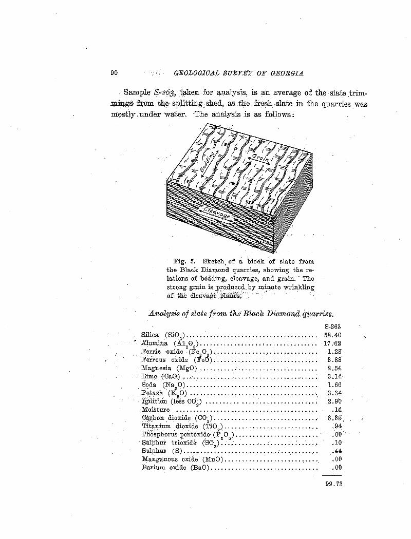
90 GEOLOGICAL SURVEY OF GEORGIA
.. Sampl(l 8"260,, ~aken for analysis, is an average of the slate ,trim.l)li;Il.gs· from. th~· splitting_, shed, .as the fre~h .-slate in the. quarries . was m~stly. under water. The analysis is as fol~ows:
Fig. 5. Sketch, of a block of· slate from the Black Diamond quarries, showing the relations of bedding, cleavage, and grain. · The strong grain is J>Fodp.ced. by mll:!:ute wrinkling of' the cleavage' plane'ei/ ·: . . ' . . .
Analysis _of slate from the· Black Diamond quar.ries.
Silica (SiO ) ...... · ............................... . ' . 2 .
.Almnina (Al 0 ) ..................•............... . 2 3 Ferric oxide (Fe 0 ) .............................. .
. . ' ,. " . 2 3 . Ferrous oxide (F'eO) ............ , ................. .
· Magnesia (MgO) ............... , ................. . :Cim.e (GaO) ~ ............... · .................. , .... .
. ~oda (~a20) .............................. " ...... . Po1tash GK 0) ................... · · .. · · · · · · · · · · · · · ·. . .:. '!':'"; ". ' ' .-2· . . ~
Ignition (less co~) ............................... : . Moisture ......................................... . G~~bon . dioxide (CO
2) •••••••••••••••••••••••••• • • • •
Titanium dioxide (TiO ) .......................... . . j ~.._ ~ ' ' ' • . • • •. 2
Phosphorus pentoxide· (P o ) ........................ · . ,. ' • 2 5·
· Sul]?nur trioxide' (S03
) •••. .' •••••••••••••••••• :. • • • ·.•
Sulr>hur (S). ···:··· ...................... ; .. ·.·. • .... . Manganous oxide (MnO) ........................... . Barium oxide (BaO) .............................. .
S-263 58.40 17.;62
1.28 3.88' 2.54 3.14 1.66 3.34 2.9'0
.14 3.35
.94
.00.
.-10
.44
.00
.00
99.73
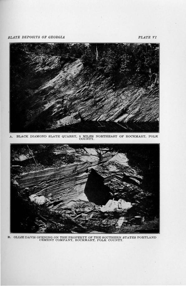
SLATE DEPOSITS OF GEORGIA PLATE VI
A. BLACK DIAMOND SLATE QUARRY, 3 MILES NORTHEAST OF ROCKMART, POLK COUNTY.
B. OLLIE DAVIS OPENING ON THE PROPERTY OF THE SOUTHERN STATES PORTLAND CEMENT COMPANY, ROCKMART, POLK COUNTY.
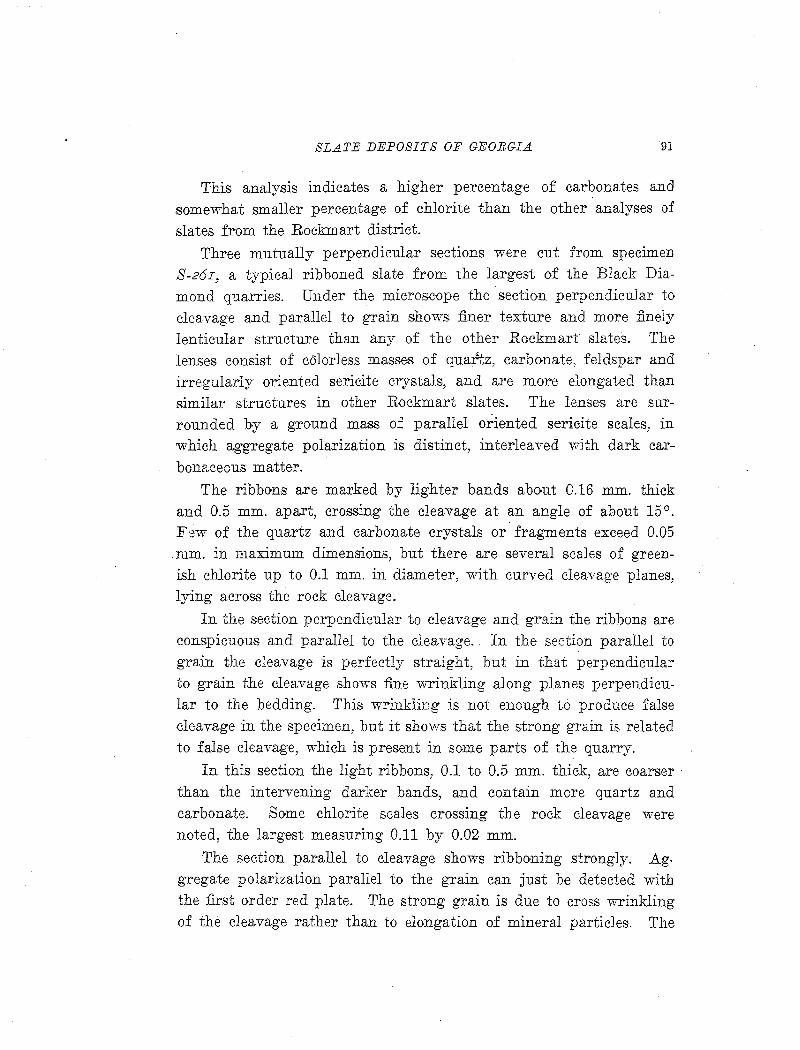
SLATE DEPOSITS OF GEORGIA 91
This analysis indicates a higher percentage of carbonates and somewhat smaller percenta,ge of chlorite than the other analyses of slates from the Rockmart district.
Three mutually perpendicular sections were cut from specimen S-26I, a typical ribboned slate from the largest of the Black Diamond quarries. Under the microscope the section perpendicular to cleavage and parallel to grain shows finer texture and more finely lenticular structure than any of the other Rockmart slates. The lenses consist of colorless masses of quartz, carbonate, feldspar and irregularly oriented sericite crystals, and are more elongated than similar structures in other Rockmart slates. The lenses are surrounded by a ground mass of parallel oriented sericite scales, in which aggregate polarization is distinct, interleaved with dark carbonr.ceous matter.
The ribbons are marked by lighter bands about 0.16 mm. thick and 0.5 mm. apart, crossing the cleavage at an angle of about 15°. F·~w of the quartz and ca.rbonate crystals or fragments exceed 0.05 rum. in maximum dimensions, but there are several scales of greenish chlorite up to 0.1 mm. in diameter, with curved cleavage planes, lying across the rock cleavage.
In the section perpendicular to cleavage and grain the ribbons are conspicuous and parallel to the cleavage. In the section parallel to grain the cleavage is perfectly straight, but in that perpendicular to grain the cleavage sho"Yvs fine wrinkling along planes perpendicular to the bedding. This wrinkling is not enough to produce false cleavage in the specimen, but it shows that the strong grain is related to false cleavage, which is present in some parts of the quarry.
In this section the light ribbons, 0.1 to 0.5 mm. thick, are coarser · than the intervening darker bands, and contain more quartz and carbonate. Some chlorite scales crossing the rock cleavage were noted, the largest measuring 0.11 by 0.02 mm.
The section parallel to cleavage shows ribboning strongly. Ag. gregate polarization pa.rallel to the grain can just be detected with the first order red plate. The strong grain is due to cross wrinkling of the cleavage rather than to elongation of mineral particles. The
92 GEOLOGICAL SURVEY OF GEORGIA
section shows much opaque material,. both finely divided graphite or carbonaceous material and isometric crystals O·f pyrite and magnetite up to 0.06 mm. in diameter.
The constituents, in descending order of abundance, appear to be mica, quartz, chlorite, carbonate, feldspar, pyrite, magnetite, carbon, and rutile .
. On the Black Diamond property the. fresh slate seems to occur principally below water level in the small valley in which the quarries are located. The ove~urden increases rapidly to 25 feet in the. large quarry, and is likely to become e:ven heavier on working back into the hills. The west slope of the ridge north and south of the
...-Black Diamond quarries is eo;vered with frag:paents of weathered slate, a large part of which is very ~ile, and it is evident that much splitting slate could be found. However, the exposures in the quarries show that portions of the slate have inadequate cleavage, or are ruined by false cleavage, while joints· would cause a great deal of waste. Any development work should be. preceded by core drilling to determine the thickness of o;verburden and the character of slate to be obtained below.
COLUMBIA QUA~RIES
(Map locality Io).
The prospects of the Columbia Slate Company are on the west slope of the same ridge, half a mile south of the Bla.ck Diamond quarries; and geologie conditions are very similar. There are nine openings in the bottom of a small hollow, extending over a distance of about 100 yards. The largest pit is 10 by 12 feet and 12 feet deep . .A. small amount o.£ splitting slate is exposed in several openings, and the slate is quite fresh at a depth of 8 to 10 feet .
.All of· the slate is conspicuously ribboned; but the cleavage is eomparative~y smooth and straight. Measurements of strike and dip
are as follows:
Cleavage: Strike N. l2°E., dip 31 °SE. Strike N. 25°E., dip 37°SE. Strike N. 6°E., dip 38°SE.
SLATE DEPOSITS OF GEOBGIA
Strike N. 16°E., dip 34°SE. Strike N. 12°E., dip 34°SE. Strike N. 20°E., dip 36°SE.
Bedding: Strike N. 18°E., dip 24°SE. Strike N. 25°E., dip 25°SE. Strike N. 15°E., dip 21 °SE. Strike N. 11 °E., dip 27°SE.
Joints: (1) Strike N. 75°E., dip 67°SE. (2) Strike N. 65°W., dip 63°SW.
Strike N. 60°W., dip 64°SW. (3) Strike N. 3°E., dip 74°SE. (4) Strike N. 35°E., dip 59°SE.
PORTLAND QUARRY
(Map locality II).
93
There is an old slate quarry a quarter o.f a mile east of Portland (Davitte on the Rome topographic sheet), on the Seaboard .Air Line, 5 miles north of Rockmart ..
The quarry is in the north side of a narrow V-shaped valley, and measures 100 feet across the front, worked in 30 feet, and the maximum ·height of the face above the water in the bottom of the pit is 45 feet. All of the slate above water level is more or less weathered, and the splitting slate, of which four or :five carloads are said to have been shipped, must have come from the part of the pit :filled with water.
Measurements of strike and dip are as foUorws:
Cleavage: Strike N. 22°E., dip 25°SE. Strike N. 15°E., dip 32°SE. Strike N. 19°E., dip 30°SE.
Bedding: Strike N. 23°E., dip 21 °SE. Strike N. 20°E., dip 27°SE.
Joints: (1) Strike N. 95°E., dip 68°SE. Strike N. 75°E., dip 47°SE.
(2) Strike N. 28°E., dip 48°NW.
Joints of series (1) are very prominent. Those of series (2) are less prominent, but carry disconnected stringers of calcite.
The fresh. sJ.ate from the old splitting shed is dark gray-blue in color, has good straight cleavage, and the ribbons are inconspicuous.
94 GEOLOGICAL SURVEY Olf' GEORGIA
Apparently slate of good quality could be obtained, but the situation
of the quarrry is not convenient for working, and the overburden is heavy. The quarry is near the base of the Rockmart slate formation,
as there is an outcrop of the Chickamauga limestone 400 feet west of . . the pit.
FISH CREEK AREA. .
A narrow synclinal area of Rockmart shale and slate extends
from a little southwest of Fish, a station on the Seaboard Air Line 5
miles west of 'Rockmart, southwest to the contact with the crystalline
rocks along the Cartersville fa.ult, which passes a little south of
Shades. The area is connected by a narrow belt of slate with the
Roclrrriart area, but is not conti:i:mous. with the Cedartown area.
When viewed from the east this area sh01ws little difference in
topography from the area underlain by Knox dolomite; from the west, owing to the valley o,f Fish Creek, it stands up as an· almost continuous belt of low rounded hillS.
The' s:tr'iitigr:'iiiE}liy o£:tli~.';b\~]t ·is v~ry ;sjmilar to that p;f, the Rock
mart area, but some rather promii).en,t layers. of quartzite and con
gl9meriie are present. As ·a whole . the material is less metamor
phosed than in the Rockmart area, a.nd the resulting slates are less
crystalline and consequently weaker. Mos.t of .the rock of the belt
is a shale with slaty cleavage and not a slate from a commercial stand
point.
The rocks of the belt are closely folded and s.ta.nd almost vertical
ly, while the cleavage dips at high angles to south and east. The
. cleavage generally cuts the ·bedding at considerable angles.
Toward the southwestern part of the belt weathering has pro
gressed much faster than to the northeast, b.ut .fresh rock is not seen in any natural exposures throughout the entire belt, and at many
places the rock is s0 badly weathered that it is not possible to determine the strike and dip.
SLA1'E DEPOSITS OF GEORGIA
HOLLAN SLATE PROSPECTS
(Map locality I2).
!:!5
The only prospecting for slate in the Fish Creek area was done about 1885 or 1890, on the D. Hollan property, 1;6 miles south of Grady.
There are three prospect pits, extending over a distance of 100 yards along the north slope of Camp Creek. The eastern pit is the largest, measuring 12 feet square and 15 feet deep on the up-hill side. All slate in sight is somewhat rweathered and very weak. A part has fair cleavage, part is gnarly. The slate is finely ribboned, ribbons making various angles with the cleavage. The cleavag~
strikes N. 28°E. to N. 36°E., dips 81° to 86°SE., and there are two prominent series of joints, one N. 39°E., 82°SE., the other N. 58°W., 79°SW. The joints of the first series are closely spaced and make a small angle with the cleavage, causing fracture into wedge-shaped
pieces. The other pits show slate similar in character, but with poorer
cleavage. Two hundred yards west of the western pjt there are outcrops of sandy shale with almost no cleavage.
Although this seems to be one of the most favorable localities in the Fish Creek area, it is not likely that the slate has any commercial value. The overburden would be very heavy, and the fresh slate when reached can not be expected to be very strong, "'i'lhile the poor and distorted cleavage and joints i"VIrould cause much waste.
CEDARTOWN AREA
South and southwest of Cedartown is a synclinal area of the Ro·ckmart formation, discontinuous with the Ro·ckmart and Fish Creek areas. This area extends from just south of Cedartown southwest to Esom Hill, a distance of 9 miles, and has a maximum width of about 4 miles. To the south the b8lt is cut off by the Cartersville fault, and to the west it narrows down until at Esom Hill, . where it crosses the State Line into Alabama, the outcrop of the Rockmart formation has a width of only a few hundred yards.
96 GEOLOGICAL SUEVEY OF GEOEGIA
The Rockmart shale and slate fu this area resembles that of the Fish Creek area. The material appears to have been much more calcareous when originally deposited than that of the Rockmart area, and cousists in general of deeper water deposits. Thus sandstones and quartzites are not so abundant, conglomerates are almost absent, but highly calcareous shales, shaly and cherty limestones predominate. Throughout the greater part of the Cedartown area, metamo:rphism has been less intense than in the Rockmart area, consequently the sJ.ates are weak with poor cleavage and a large proportion of the shale we3Jthers hackly or penciliform rather than fissile. The contact o.f the Rockmart shales with the crystalline rocks of the Ocoee
. series, however, is ·always accompanied by much wrinkling and folding of the former, with the consequent development of a semi-crystalline structure and very irregular cleavage.
It is almost impossible to map the Rockmart shale separately from the Chickamauga limestone in the Cedartown area. The ·limestone underlies the relatively flat area of 5 or 6 square. miles in and surroUn.ding Cedartown, and a tongue extends southwest for seveT-al rriiles up the valley of Lime. Brarw]l. In. the area of .Roekmart foT-... ,;_, .. • ... '·.·;· .,., . . . , .... · ...... . mation farther_ south t'.Q.ere are numerous mino~ beds o·f limestone. The high hill 3 miles south O·f Cedartown ana th.e. ;ri~9-ge extending southwest from Berry are caused by resiSitant beds O·f cherty limestone and sandstone in the shale.
Structurally, the limestone and shale of the Cedartown area has ·the form .of a closely folded syncline in rwhich the beds stand vertically or dip to the southeast at high angles. The shales dip to the west at only a few places on the east side. To the south the syncline is interrupted by the Cartersville fault, which has thrust the rocks of the Ocoee series upon thos:e of Ordovician age.
From an economic standpoint, slates are best developed' in a narrow belt along the western edge of the area, parallelling the Seaboard Air Line from CedartoiWTI. to and beyond Berry. This belt.is limited on the west by the Knox dolomite, and on the east by the cherty and sandy beds of the Roekmart formation. To the east the cleavage of the shales is less developed and the composition of the beds is
SLATE DEPOSITS OF GEOBGIA 97
less uniform. However, even in the western belt the slates are highly calcareous and very weak.
CORNELIUS QUARRY
(Map locality 13)
The only quarry in the Cedartown area which produced slate commercially was that operated by W. 0. Cornelius, on the property now OIWIJ.ed by J. W. Phinizy, 3 miles southwest of Cedartown.
The quarry is in a level meadow several hundred yards south of the Seaboard .Air Line, and was worked vertically. The pit is 65 feet square, and is said to be 75 feet deep, but when examined it was :filled with water to within 3 feet of the top. The soil covering is little more than a foot, and the slate .is fresh. a few feet below the surface. Measurements of strike and dip are as follows:
Cleavage: Strike N. 30°E., dip 70°SE. Strike N. 29°E., dip 71 °SE.
Bedding: Strike N. 50°E., dip 38°SE. Strike N. 50°E., dip 39°SE. Strike N. 48°E., dip 39°SE.
Joints: (1) Strike N. 52°E., dip 59°SE. (:) Strike N. 51 °E., dip 40°NE.
The slate is very dark gray in color, darker than most of the Rockmart slates. It is ribboned throughout, and the ribbons, which make an angle of a:bout 30° with the cleavage, are not segregated into bands. It is extremely :fissile, 1with :finer texture and smoother cleavage than the Rockmart slates. It effervesces strongly with acid, and calcite :fills joints and forms veins. Some large masses seen on the dump are cut by parallel, discontinuous veinlets of calcite :filling joints spaced only a fraction of an inch apart .
.An analysis of slate from this quarry (specimen H-29) is as ' follows:
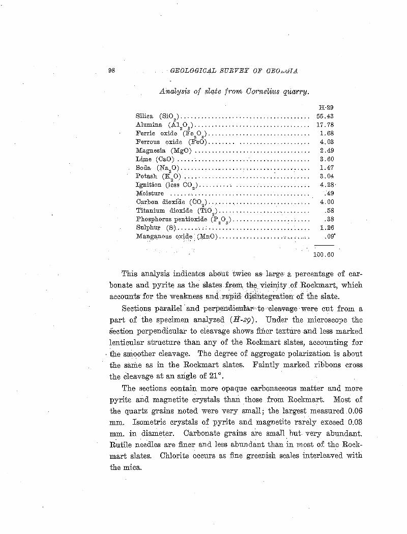
98 GEOLOGICAL S!JRVEY OF GEO.Lui.HA
AnaLysis of slate from Gorneli~ts quarry.
H-29 Silica (SiO
2) • • • • • • • • • • • • • • • • • • • • • • • • • • • • • • • • • • • • • • 55 .43
Alumina (A120
3) •••••••••••••••••••••••••••••••..• 17.78
Ferric oxide (Fe 2 0
3) • • • • • • • • • • • • • • • • • • • • • • • • • • • • • • 1. 68
Perrous oxide (FeO)........ . . . . . . . . . . . . . . . . . . . . . 4. 03 Magnesia (MgO) . . . . . . . . . . . . . . . . . . . . . . . . . . . . . . . . . . 2 . 49 Li;m.e. (CaO) ... ; . . . . . . . . . . . . . . . . . . . . . . . . . . . . . . . . . . . 3. 60 Soda (N.a 0) ..... ,. . . . . ... . . . . . . . . . . . . . . . . . . . • . . . . . . 1.47 - 2 ' , Potash (K
2 0) ._.. . . . . . . . . . . . . . . . . . . . . . . . . . . . . . . . . . . 3. 04
Ignition (less CO2
) • . • • • • • • • • . . • • • • . • • • • • • • • • • • • • • • 4. 28 · Moisture ..... .-.. . . . . . . . . . . . . . . . . . . . . . . . . . . . . . . . . . . .-49 Carbon dioxfde (00
2)....... •. • • .. • • • • • • • • • • • • • • • .. • 4. 00
Titanium dioxide (Ti02)................. .... • • • • • .. .58
Phosphorus pentioxide (P20,,) .................. ~.... .38
Sulphur (S) ......... : ............................•. 1.26 Manganous oxide· (111n0) ................... ·, ..... ,. . 09'
':"I • '
100.60
This analysis indicates about twice as la,rge a percentage of carbonate and pyrite as the slates fr0-m, the v:iciu:ity .of Rock:rnart, which accounts !or the weakness andd<~a:pid d~~integratium of the slate.
Sections parallel · 3illd peii'petr<llieE:1ar• to ··cieav-rug.e ·were cut from a part of the specimen analyzed (H-29). Under the microscope the section perpendicular to cleavage shows finer texture .and less marked lenticular structure than any of the Rockmart slates, accounting for
, tbe smoother cleavage. The degree of aggregate polarization is about the same as in the Rockmart slates. Faintly marked rilibons cross the cleavage at an angle of 21°.
The sections contain more opaque carbonaceous matter and more pyrite and magnetite crystals than those from Rockmart. Most of the quartz grains noted were very small; the largest measured .0.06 mm. Isometric crystals of pyrite and magnetite rarely exceed 0.03 mm. in diameter. Carbonate grains a~e small. hut very abundant. R~tile needles are finer and less abundant than in most of the Rock-. '
mart slates. Chlorite occurs as fine greenish scales interleaved with
the mica.
SLATE DEPOSITS OF GEOBGIA 99
The mineral constituents, in descending order of abundance appear to be mica, quartz, carbonate, chlorite, feldspar, pyrite, magnetite, carbon, and rutile .
.All slate on the dump, some of which was in large masses, bad. crumbled badly in 1916, although the quarry was worked as recently as 1907 or 1908. A roof of this slate on a house near the quarry had to be replaced after a few years on account of the disintegration of the slate. This slate is much too ~weak for use as roofing, and there is little indication that any of better quality will be found in the Cedartown area. It is a very poo-r policy to put such slate on the :pJ.arket, because it is certain to prove unsatisfactory, and may bring the entire slate producing region of the State into bad reputation.
THE FAIRMOUNT DISTRICT .
GEOLOGY OF THE GREEN SLATE BELT OF THE CONASAUGA FORMATION
Areal distribution.-.Although the Conasauga formation is areally one of the mos,t important of the Paleozoic area of Georgia, the green slate deposits are confined to a comparatively small belt along the eastern border of the outcrop of the formation. (See Map III.)
It may be .said that there is a possibility of finding workable deposits of slate in a belt 5 miles wide, extending from a little south of Pinelog, Bartow County, to a little north of Chatsworth, Murray County. The eastern boundary of this belt is the Cartersville fault, while the western boundary is indefinite. The total length of the belt of possible slate occurrences is 35 miles, but the most promising prospects are confined to an area about 5 miles wide and 7 miles long in northern Bartow and southern Gordon counties, between Pinelog and Fairmount.
Stratigraphic relations.-The Conasauga formation is stratigraphically above the Cartersville and Rome formations and belorw the Knox dolomite. Irr the slate-bearing area of the formation no younger formations are present, because this part of the Conasauga
100 GEOLOGICAL SURVEY OF GEORGIA
comes :in contact with the older Cambrian rocks along the Cartersville fault, except thl:\.t the extreme southern part of the belt comes in contact with the Cartersville formation.
On account of the folding and faulting it is impossible to say whether the slate ·beds represent the top or the bottom of the Conasauga foii'ma,tion. Limestone beds are prominent along the minor valley fo~owed by the· Louisville & Nashville Railroad, while 1he hills to the west ar.e composed. chiefly of slate. If the structure is normal,
. the ·beds near the fault represent the upper part of the formation .
. Lithologic characters.-The Conasauga formation consists of sedime:p.ts deposited in· somewhat deeper water than the underlying Rome and Cartersville fo-rmations. The deposits consist of alternating beds of shale and limestone, with very little sandstone or other coarse sedimentary material.
The limestones occur in beds and lenses, some of which are several· hundred feet thick, vacying greatly in physical and chemical character. In chemiea:l coinp·~sition they range from high-calcium l~~~tone .a1mQ~t·c<t~ d~lom1,te, .. a])l€bth~~; g:ra(il:e born rather pure limestone of, cil'[email protected] .. :argilliaiceolls -limestorre· t0 :·,e:ailiea;reo:as shale. Most.o£ the>,liiinestone·. is."blne ·or:gwaycin. color an:cL.contains bedded argillaceous impurities which stand out as conspicuous ribs or ridges on weathexed surfaces. Chert, which is so characteristic of the Knox dolomite and Beaver limestone, does not occur in the Conasauga limestone. Commonly the dark colored limestone js cut by small veins of white caleite which run in all directions, where fractures formed in the comparatively rigid limestone during folding were filled by calcium carbonate dissolved and redeposited by percolating solutions.
The Consauga shales and slates are very :fine-grained argillaceous rocks, of fairly uniform composition over great areas and through a great thickness. The shales have the composition of ordinary mud deposits such as· would be derived from the thoroughly weathe:red granitic and gneissic rocks of the crystalline area to the east. Beds of sandy shale are rare, owing to the lack of CO'arse sediments. Prac-
. tically all of the shale is more or less calcareous, and even the hard . .
SLATE DEPOSITS OF GEORGIA 101
slates contain enough calcite to effervesce slightly with acid. The most notable characteristic of both slates and shales is the green color, caused by the abundance of chlorite. Generally the perfectly fresh material has a blue-green color, which fades to a yellowish green in the :first stage of weathering. As weathering proceeds farther the rock breaks down into platy or hackly fragments, and the color becomes some shade of brown, pink or maroon by oxidation of the iron, but the shale is very resistant to complete disintegration. Little clay is formed, and the soil over the shale ~reas contains much fragmental
'r ' material. This shaly soil forms gock;l, hard road surfaces, which are easily kept in condition and nevj-'~ 'become muddy, contrasting strongly with the sticky red clay ft)fmed from the limestones of the same formation.
The distinction between shales and slates is based solely on the degree of metamorphism, as both have the same chemical character. West of a line from Chatsworth to Folsom most of this material may properly be called shale, while east of that E:cP a large part has hardness and cleavage sufficiently developed to be called slate, although only locally are there good prospects for slate of commercial splitting quality.
Structure and thickness.-On account of the great mass of similar sediments making up the Conasauga formation, it is very difficult to determine the structure. The limestones, which might serve as horizon markers, are not sufficiently continuous to be correlated across
any great areas.
In the eastern, slate-bearing belt of the Conasauga formation both the bedding of the limestone and the cleavage of the slates dip to the east at an angle averaging about 45 degrees. Generally the bedding in the slate is invisible, but where it can still be distinguished it is highly contorted and is cut by the cleavage at all angles. During the period of folding, the limestones acted as competent layers and yielded by fracture, while the slates gave way by :flowage, thus greatly dis
turbing the original bedding.
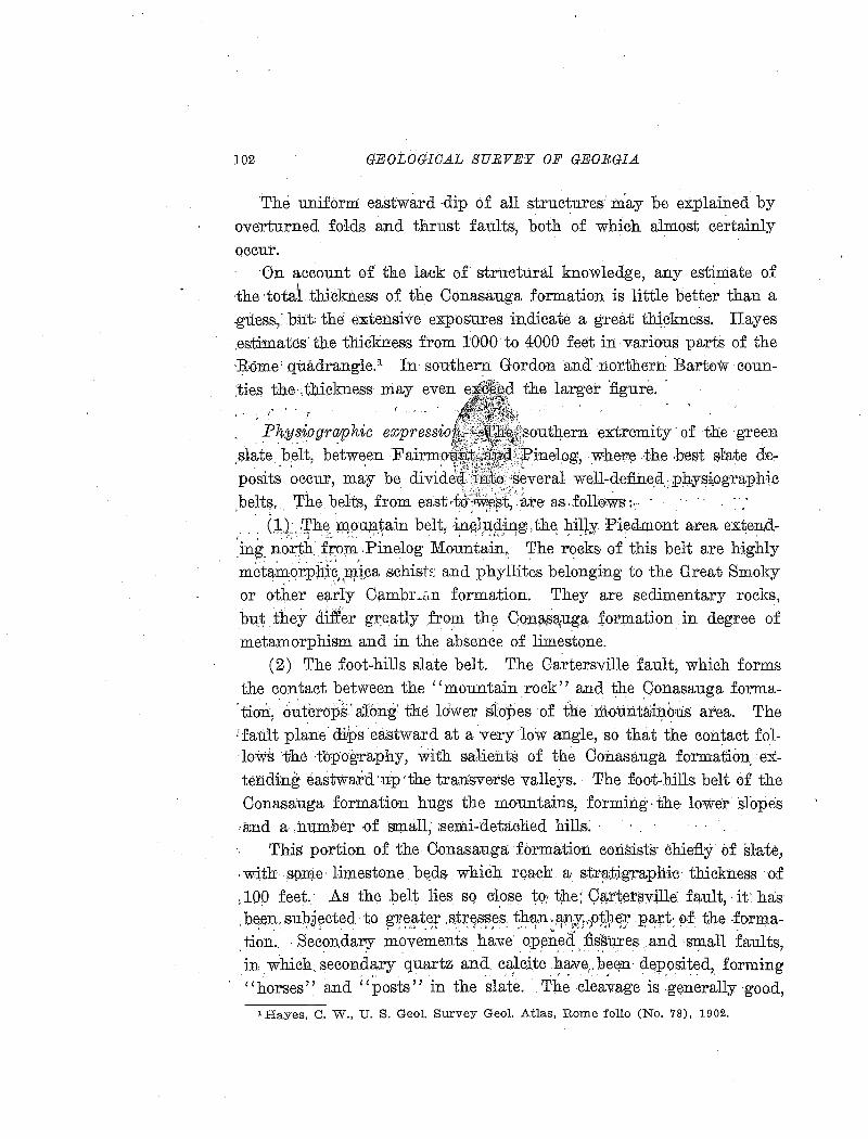
102 GEOLOGICAL SURVEY OF GEORGIA
'The uniform: eastward -dip o-f all structures· may be explained by overturned folds and thrust faults, both o.f wh1c.h almos.t ce~tainly occur.
·On account o-f the lack of structural knowledge, any estimate of the total thickness of the Conasauga formation is little better than a -gUess,: but: the extensive exposures indicate a great thickness. Hayes .es:timates'the thicknes1s from 1000 to 4000 feet in variousparts of the ·Rome' quadrangle.1 In southern Gordon and· Iior.therr1 Bartow coun;ties the·,thickness niay even e ""it~, a the larger figure. . . ~ ..
. Ph:ysiogra:phic expressio ~outltern extremity· of the green ,slate belt, between Fairmo , :X}?inelpg, wher~ the ,best s:tate· de-posit~ ~ccur, may be divide;GJ. j,Jift~, s~veral well~define_a. pi;hyE?~ogr~phic beltf;l, 'rhe bdts, from east,tid·'M~~t.;··are as.fdll0Ws: .. · .
' ;. ' • • t ,.· .• ,· •
. . . : (~1; .. ~h~. m,?un.~ain belt, ·~Gl,~§:in,g. th~ J:li!fY. Pi~dmont are~ extend_ing. north from .Pinelog Mountain.. The r<?cks of. this belt are highly metamql:pll;i:~,piica schist:=: and phyllites belonging to the Great Smoky or other early CambL<Ln formation. They are sedimentary rocks, but they differ greatly fro?l the Qoill~a,uga £.ormation in degree of metamorphism and in the absence of limestone.
(2) The foot-hills slate belt. The Cartersville fault, which fo-rms the contact between the "mountain rock" and the Conasauga forma
. tion, · o~tcrops: along' the ldwer slopes of the · niount~inb.us area. The :fault plane· di.lps eastward at a very low angle, so that the contact fol·l0·ws the topography, with s;a1ients of the Conasauga formation. extendhJ.g eastward ·up 'the transverse valleys. The foot-hills belt of the Conasauga formation hugs the mountains, forming· the· lower 'slopes .a;nd a ,number- ·Of small, ;semi-detached hills:
This portion of the Conasauga formation eo:risists· chiefl.y of slate, -with spn;t.e· limestone. b~ds which r~acb: a- str~;tj,g.raphic· thickness ·o:f : lOQ feet.· A.s the :pelt lies sq c~ose to: t;t.e; Qf.(.r·tet$ville: fault,· it: has
. b:~en, sub,j~cted to ~~~t-~:r .&tr,~s~~s: ~P,~n}Pi~·Pt¥~:r :ea;:rt: of: the -~o·rma-tion .. Secon,dary movements have· o:pened fissu.res and ·small faults, . . . . . ' .. ' ; .. . in which. secondary quartz ana calcite ha.ve,. beE)n· deposited, forming
- ' ; ! I ' • . J • ' • • • , .
"horses" and "posts" in the slate .. The cleavage is generally ·good,
lHayes, C. W., U. S. Geol. Survey Geol. Atlas, Rome folio (No. 78), 1902.
SLATE D_EPOSITS OF GEORGIA PLATE Vll
A. VIEW•OF THE FOOTHILLS BELT OF GREEN SLATE, LOOKING EAST FROM THE TENNESSEE ROAD l')i MILES NORTH OF FAIRMOUNT. GORDON COUNTY.
B. VIEW OF THE GREEN SLATE BELT, WITH HILLS OF METAMORPIDC ROCKS IN THE BACKGRUND, LOOKING NORTHEAST FROM A HILL 'h MILE SOUTH OF
BOLIVAR, BARTC'W COUNTY.
SL.A'l'E DEPOSITS OF GEORGIA 10;)
but the broken zones are likely to cause much waste in quarrying. The overburden is generally heavy, consisting not only of weathered slate but also of soil and float rock which have come down from the mountains. On a.ccount of these difficulties any attempt at quarrying slate in this belt should be preceded by careful exploration by drilling.
The one slate quarry in the Conasauga formation which bas actually produced slate is in the foothills belt. This quarry produced slate of good quality, but with a great deal of waste.
(3) The valley belt. Just west of the foot-hills belt lies the longitudinal valley which is followed by the Louisville & Nashville Railroad from Cartersville north to the Tennessee line. In the southern part of the green slate belt the va~ley is from half a mile to a mile wide. All of the principal streams flow directly westward across the valley, but it is occupied for short distances by a number of small streams. The divides between these minor streams, however, are sa low that the continuity of the valley is easily visible, and railroad construction with long tangents and very little grading was possible.
The course of this valley, at right angles to the main drajnage lines of the area, is determined by the position of heavy beds of easily soluble limestone in the Conasauga formation. There is evidently little slate, and the original ro.ck is covered by a heavy mantle of transported and residual clay, except where limestone ledges outcrop along the streams. Even if slates occur they are of no probable value on account of their low position and heavy overburden.
( 4) The western hills belt. This is a belt, several miles in width,
of irregular hills with broken topography, across which the principal
streams pursue a general northwesterly course. The rock of this
broad belt consists principally of slate, with little limestone. It is
far enough removed from the Cartersville fault to have escaped the
damage done in that vicinity by secondary movements near the fault
plane. The cleavage is in general goo~ and straight, with little development of false cleavage or quartz and calcite veins. For these
reasons most of the promising green slate prospects occur in the hills
belt, within a distance of two or three miles west of the Louisville &
104 GEOLOGICAL SURVEY OF GEORGIA
Nashville Railroad. There are, however, some beds of sandy slate and toward the rwest the formation grades into shaly slates, too soft to . be of possible value.
North of Fairmount the topographical relations are about the same, but the 'belts described above are not so well defined as in the area between Pinelog and Fairmount. South and southwest of Pinelog the Cartersville formation occupies the foothills, valley, and western hills topographic belts. In this area the Conasauga formation swings off to the southwest, 5· miles o:r more from the Cartersville fault, and consists of ·limestone and · soft shale which has not been metamorphosed· into slate.
DESCRIPTIONS OF INDIVIDUAL DEPOSITS
BARTOW COUNTY
GEORGIA GREEN SLATE OOMP ANY PROPERT¥
(Map locaUty 1)
The property of the Georgia Green ~late Company, W. W. Griffin and J. R. Smith, of Atlanta, president and vice-:president, consists of about 180 acres, situated in the northern part of Bartow County, 1_% miles northeast of Bolivar, .a station on the Louisville &
Nashville Railroad. The property was formerly owned by John Bagwell and' G. W.
Davis made the :first opening in the green slate belt on this property. Prospecting was done in 1908, and the quarry was opened by the
' . company in 1909 and operated until 1911 or 1912. R. L. Proctor worked the quarry under lease from February to June, 1913. No rwork has been done sincE: the latter date.
Mr. Smith states that while the quarry was operated by the Georgia Green Slate Company $20,000 worth of slate was taken out, all of which was sold for $7.00 pe:r square at the quarry. He says also that the slate used on his residence in Atlanta, after eight years on the roof, is still in good condition ru.1d shows no noticeable fa.ding or staining.
SLATE DEPOSITS OF GEORGIA 105
The quarry is in a small hollow draining northwest, at the border of the foothills belt, and half a mile east of the Louisville & Nashville Railro~d, which follows the longitudinal valley. The opening is 175 feet long in a direction N. 60°W., and about 50 feet wide on the northeast side of the hollow. On the southwest side is a smaller opening. When examined (October, 1916) the bottoms of both pits were :filled with water, and a maximum height of 40 feet of slate was exposed in the northeast corner. The slate is too much weathered to be useful for a depth of 10 to 20 feet. Measurements of ~trike and dip are as follows:
Cleavage: Strike N. 33°E., dip l0°SE. Strike N. 32°E., dip l3°SE. Strike N. 55°E., dip 9°SE.
Bedding: (~)Strike N. 38°E., dip l8°SE . .Joints: (1) Strike N. 75°E., dip 81°SW.
Strike N. 66°W., dip 74°NE. (2) Strike N. l9°.E., dip l7°NW. (3) Strike N. 25°E., dip 23°SE.
Strike N. 39°E., dip l4°SE. (4) Strike N. 69°E., dip 79°NW. (5) Strike N. 70°E., dip vertical.
The dip joints of s.eries (1) are most prominent and persistent, one of them forming the north face of the quarry, but they do not cause so much damage as the joints of series (2) and (3), which cause the slate to break into small rhombic ·blocks . .Joints v·f series ( 4) are well de'Veloped but not numerous and one of them foriiL3 the east face of the pit.
The quarry is not far west of the outcrop of the great Cartersville fault, and movement along the fault plane has caused disturbances which have ruined a great part of the slate. The cleavage, where straight, is good. However, besides the waste caused by the numerous joints, .the cleavage is locally wrinkled, leading to false cleavage; curly cleavage causing a rough, lumpy appearance ]s present, and calcite and quartz veinlets are very damaging at some places.
The exact course of the bedding is difficult to determine, but blocks on the dump show ribbons intersecting the cleavage at 20 de-
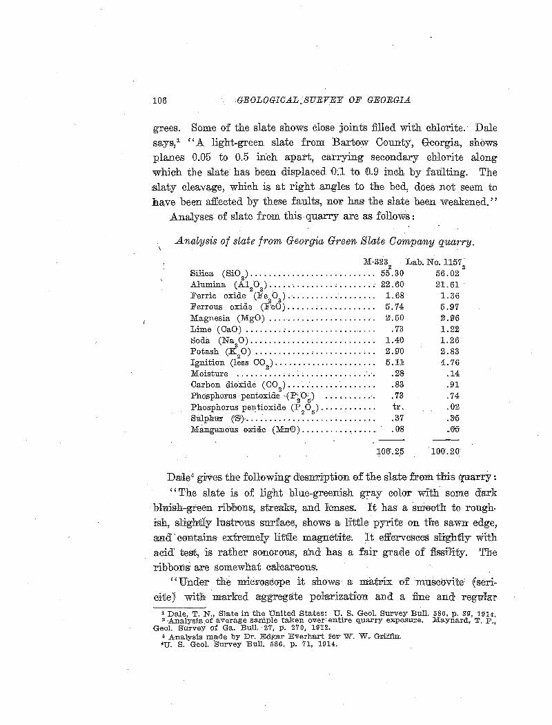
106 .GEOLOGICA.L.SURVEY OF GEORGIA.
grees. Some of the slate shows close joints filled with chlorite. Dale says/ "A light-green slate from Bart<Dw County, Georgia, shows planes 0.05 to 0.5 inch apart, carrying secondary chlorite along which the slate has been displaced 0:.1 to ([);,9 inch by faulting. The :slaty cleavage, which is at right angles to the bed, does not seem to Jh,ave been affeeted by these faults,. nor has the slate been weakened.''
Analyses of slate from this quarry are as follows:
Analysis of slate from Georgia Green Slate Company quarry.
M-3232
Lab. No.l1573
Silica (Si02
) ••••••••••••••••••••••••••• 55.30 56.02 Alumina (A1
20
3) ....................... 22.60 21.61
Ferric oxide (Jfe20)········ ........... 1.68 1.36
Ferrous oxide (F'eO) ...... , .. .. .. .. .. .. 5. 74 5. 97 Magnesia (MgO) . . . . . . . . . . . . . . . . . . . . . . . 2.50 2-.96 Lime (OaO) ........ ~................... . 73 1.Z2 Soda (Na
20)........................... 1.40 1.26
Potash (K20) ............ , .. .. .. .. .. . .. 2.9'0 2.83
Ignition (less 002
) ...................... 5.11 4.76 Moisture .......... : ................ : .·. . 2'8 .14 Carbon dioxide (00
2) .... ,'.............. .83 .91
Pho.sphorus pentoxide ·EP~O!) ... '·....... . 73 . 74 Phosphorus pen, tioxide (P
2 0
5) . • • • • • • • • • • • tr. . 02
Slilpb:m• CS')............................ .3·7 .3;5 MarrgaJnous oxide (MD!0)..... .. . . . . . • .. . . .. ..0:8 .. (')15
. ~Otl'.2,5 100.20
DaJie., gives the fo11owing desnription of the slate- from this quarry :
''The slate is of light blue-greenish gray colo'r with some dark bluish-green ribbons, st.rea:ks, and !enses:. It has· a sm0·oth to rough. :ish, slightly lustrous surface, shows a little· pyrite on the sawn edge, aiDd · eo:atains extremely little magnetite~'. It effervesces slightly mth acid' test, is rather sonorous:, and has a fair· grade of fism'11ty. The ribbons~ are somewhat calcareous.
''Under tfi~· mic'liOS'Cope it shows a ma;cr-±x ·e>f' mus:e0vite: fserieite J with ·ma:rked a:g·gregate po·ra;rizatian and a fine and r·egullar
1 Dale, T. N., Slate in the United States: U. S. Geol. Survey Bull. 586, p. 3"9", 1914. 2 ·Analysis. of average sample taken over: e·nti.Fe quarry expos.ure. Maynard,, 'F. P.,
Geol. Survey of Ga. Bull. 27, p. 270, 19'12. a Analysis made by Dr. Edga:r Everhart :!!OiL" W. W. Griffin. 4U. S. Geol. ·survey Bull. 586, p. 71, 1914.
SLATE DEPOSITS OF GEORGIA 107
cleavage, also abundant rutile needles. It contains a little carbon
ate in fine particles or rhombs and a little pyrite in spherules and
irregular grains. There are lenses of chlorite up to 0.34 by 0.009
mm. "J.lhe chlorite scales measure as much as 0.009 mm. and the qua.rtz grains 0.047 mm.
''The constituents, named in descending order of abundance, ap
pear to be muscovite, quartz, chlorite, carbonate, pyrite, magnetite,
and rutile .
. ''This is a mica slate with a fair fissility and attractive color.
Although the amount of carbonate is not so large as in the sea.-green
slate of Vermont, it is probably sufficient to produce in time some
discoloration. The slates about the quarry, exposed not over two years, show but slight discoloration.''
The quarry equipment consisted of two saw tables, one overhead carrier in the splitting shed, one channel drill, three squaring machines, one car with dumping attachment, and two cable convey
ors with towers 80 or 90 feet high for conveying refuse to the dump and splitting slate to the mill. At first one saw table was used in
the hollow, later the mill was moved to the top of the hill southwest of the quarry and additional machinery was installed.
In 1916 there was a stack of good roofing slates near the mill, es
timated to contain about 30,000 pieces. These slates range from
6 by 10 to 10 by 20 inches and from 0.2 to 0.25 inch in thickne·ss.
They are of good quality, but for some reason were not shipped after
operations ceased in 1913.
J. R. Smith states that the quarry could have been operated suc
cessfully if experienced managers and workmen had been available.
The final closing down was caused by a strike, after which work was
not resumed. Other disadvanta.ges were the inconvenier1t location of
the quarry, distance to the railroad, and the great amount of waste caused by false cleavage, jointing, veining, and irregular character
of the slate. The property seems to be too close to the Cartersville fault at the eastern boundary of the slate belt, and more uniform
slate could be found at many localities farther west.
108 GEOLOGICAL SURVEY OF GEORGIA
BOLIVAR STATION '
(Map looality.2)
The slate property controlled by W. 0. Watson, of Charlottesville, Virginia, consists of 30 acres, more or less., just west of 'the Louisville & Nashville Railroad at Bolivar station. The property parallels the railroad for about 1,000 feet. A report on this property was prepared for Mr. Watson in 1912 by Dr. T. Poole Maynard, of Atlanta. The following description is partly abstracted from that report.
. Prospecting has been done in the east slope o.f the hill opposite Bolivar station and just north of Pinelog Creek. At the foot of the bill directly west of the station is a pit 6 feet long and 6 feet deep, showing somewhat weathered,' very fissile slate. The slate has a good green color and has not. faded in sever~l years since the openiri.g was' made. The cleavage is slightly ·m:i.rved: with average strike N. 70°E., dip 20°SE.
A little farther north is a series of step-like pits up the slope Showing slate with good Cleavage, but all is weathered red ·and yellow. At the southwest end of the hill, near Pinelog Creek, is an exposure of
white quartzite, probably 20 feet thick, and quartz fragments are ;abundant on the north slope. ·Na·tural exposures ·on the property are nbt goo.d, and the: knowledge of the quantity and quality of slate present depends l~rg.ely on drill holes. Four holes were bo:red with a core dr,ill. T'Wo holes near the north end of the hill did not sho:W slate of sufficient thickness for commercial development. The sections in the southern. holes are as follows :
Section of green slate, d1·~'LZ hole No.3.
Inches. 1. Yellowish to bluish green slate, cleavage and texture o. k........... 20
. 2. Bluish green slate, cleavage and texture o. k ............. ; . . . . . . . . . 20 3. Bluish green slate, cleavage and texture o. k.; an inch or two of sec
ondary quartz at bottom ..... ·................•................ 20 4. Bluish green slate; drill hung,. core largely lost by grinding........ 20 5. Upper 8 inches badly weathered, lower 12 inches weathered, but shows
good cleavage and texture . . . . . . . . . . • . . . . . . . . . . . . . . . . . . . . . . . . . . . 20 6: · Bluish green weathered slate, with some loose quartz in crevice at
bottom ... ·. . . . . . . . . . . . .. . . • . . . . . . . . . . . . . . . . . . . . . . . . . . . . . . . . . . . . . 20 7. Bluish green slate, o. k., with lh inch of quartz at bottom............. 20 8. Blue green slate, ci. k ..... , ~...................................... 20
SLATE DEPOSITS OF GEOBGIA
9. Upper 6 inches contains many blue streaks which are ;o.ot seriously objectionable. Lower 24 inches o. k., but on account of drill hanging
109
the cores were largely ground up ........... - . . . . . . . . . . . . . . . . . . 30 10. Upper 12 inches o. k., lower 12 inches quartz and rough slate. . . . . . . . 24 ll. Upper 12 inches intercalated quartz and green slate, lower 12 inches
o. k ......................................... -.................. 30 12. Good green slate ............................. - . . . . . . . . . . . . . . . . . . 60 13. Some quartz in upper few inches of unit, while lower 5 inches contains
much quartz-between the top and bottom occurs good slate. . . . . . 66
370
Section of green s"late, drill hole No. 4.
Inches. 1. Yellow and reddish yellow topping, good cleavage . . . . . . . . . . . . . . . . . . 72 2. Yellowish green slate, containing :;4, inch of quartz at bottom, all
·i); good slate ........................ ·; . . . . . . . . . . . . . . . . . . . . . . . . . . . 132
3. Bluish green slate, o. k............ . . . . . . . . . . . . . . . . . . . . . . . . . . . . . . . 48 4. Bluish green slate, o. k........................................... 48 5. Bluish green slate, o. k., with about 6 inches of quartz at the bottom 60
360
The drilling was undertaken to determine the size of a quarry which could be opened. Maynard states that a stratigraphic thickness of 100 feet of slate, with fine texture and good ·cleavage, and without false cleavage, has been shown. At leas:t 75 per cent of the core shows slate of e:xlcellent quality, while about 25 per cent will result in waste consisting of quartz (secondary silica deposited in open fractures after
. the slate was formed) and some slate in contact with the quartz, which will not make good commercial slate.
Slate underlies the entire property, and is weathered to an average depth of about 20 feet, that is, about 20 feet of topping must be removed to secure good commercial slate. The average dip of the cleavage seems to be toward the east at a low angle. · However, in the railroad cut and along the wagon road just east of the station the slate is thrown into synclines and anticlines, 50 to 100 feet across, with limbs dipping about 30 degrees (steeper dip on east side) and pitching south. It is likely that this disturbance of the cleavage persists in the hill west of the station, and would cause difficulty and loss in
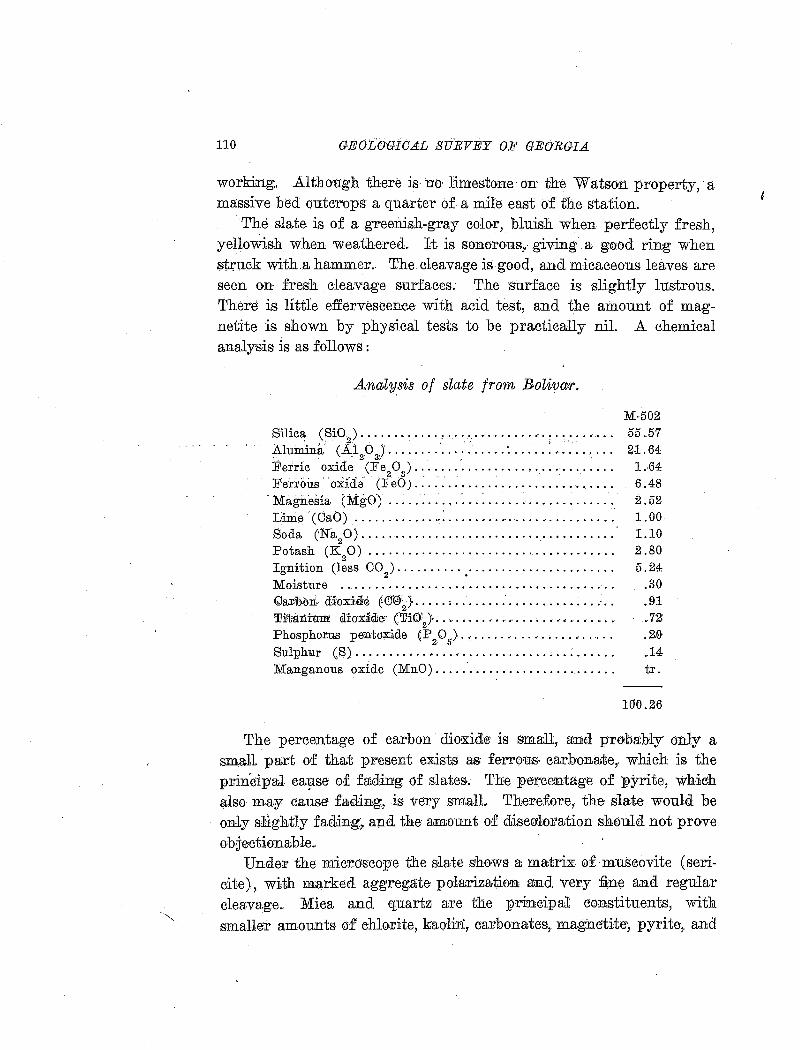
110 GEOLO'GICAL SURVEY OF GEORGIA
working. .Altho'Etgh there is no limestone on the Wats-on property, a massive bed outcrops- a quarte1· of. a mile east of the station.
The slate is of a greenish-gray color, bluish when perfectly fresh, yellowish when weathered. It is sonorous.,. giving a good ring when struck with.a hammer .. The cleavage is-good, and micaceous leaves are seen on fresh cleavage surfaces.. The surface is slightly lustrous. There is little effervescence with acid test, and the amount of magnetite is shown by physical tests to be practically nil. A chemical analysis is as follows :
Analysis of slate j1·mn Bolivar.
Silica (SiO) ............ , ............... : .....•... Alumina (Al 0.) .................. · ...... : ....... .. .. •, ' 2 3> ' Ferric oxide (Fe 0 ) ............................. .
2 3 . . . Ferrous · o:ifde (:E eO) .....................•..•.•...
· Magnesia (:M:go) .. : .........•. : .................. . Lime ··ccaO) .............. : .....•..................... Soda (Na20) ............... · · · · · · · · · · · · · · · · · · · · · · · · Potash (K
2 0) .................................... .
Ignition (less CO ) . . . . . . . . . . . .................... . 2 •
Moisture ......................................... . <Uar~h<nt· <l:iioxi&e E00~J ..... ; ....... : . ............. · .. Ti'tanrnm · dio·x~dec ('Fi0~} ........ " ...........•..•.... Phosphorus pentoxide 'p 0 ) ........................ .
2· (,.
Sulphu.r (S) .............................. , .. : . .... . Manganous oxide (MnO) .......................... .
M-502 55.57 2·1.64 1 .. 64 6.48 2.52 1.00 1.10 2.80 5.24
.30
.!n .72' .2.0 .14 tr.
100.26
The percentage of carbon diooci<ite· is small, and probably on]y a small part of that present e:x.ists as: feiTom.s, earl::ronate,. which is the princip·aJ. ca~se o.f fading of slates. The pe-rcentage of P.Yrite, whieh also may cause fading, is -very smalL Therefore, the slate would be only slightly failing~. and the amount of diseo<1oration should not prove o:bjiectionable ..
Under the mie:roscope the &late shows a matrix o.f mTIBcovite (sericite}, with marked aggregate polarization aD.d very ~ne and regular clea;vage.. Mica and quartz are the principal constituents, with sm.alle'T amounts. a.f ehh}rite, kaolin, carbonates, magnetite',. pyrite,. and
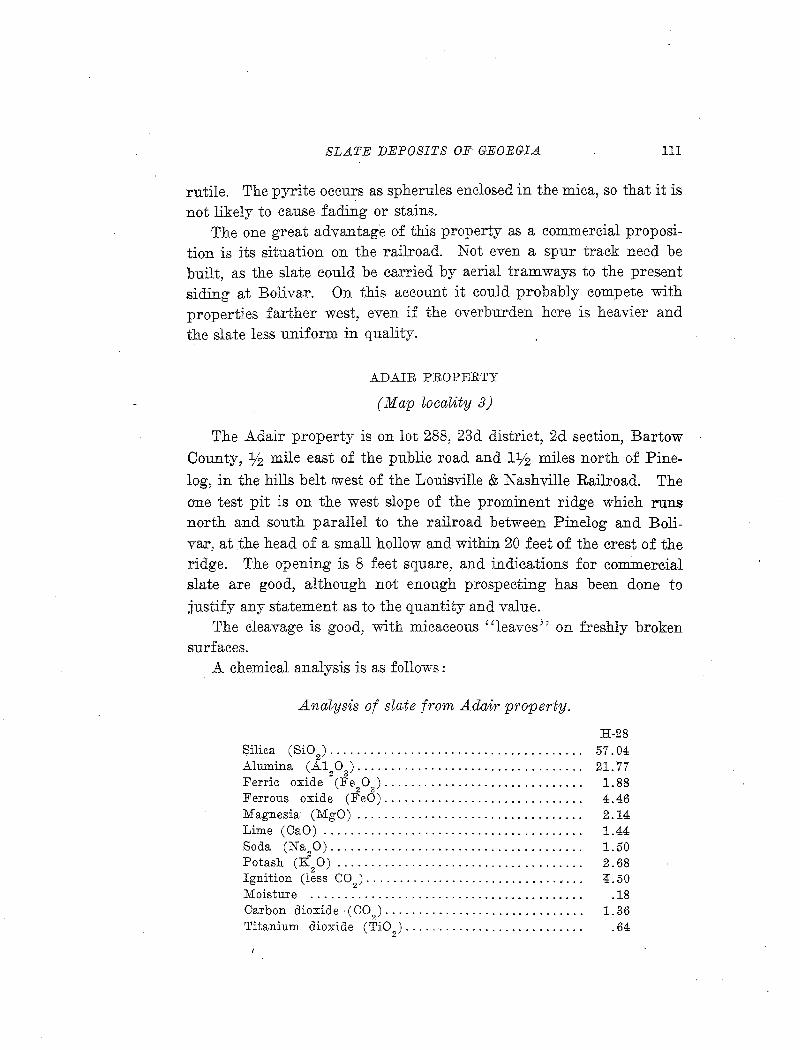
SLATE DEPOSITS OF GEORGIA 111
rutile. The pyrite occurs as spherules enclosed in the mica, so that it is not likely to cause fading or stains.
The one great advantage of this property as a commercial proposition is its situation on the railroad. Not even a spur track need be built, as the slate could be carried by aerial tramways to the present siding at Bolivar. On this account it could probably compete with properties farther west, even if the overburden here is heavier and the slate less uniform in quality.
ADAIR PROPERTY
(Map locaMty 3)
The Adair property is on lot 288, 23d district, 2d section, Bartow County, :y2 mile east of the public road and 1% miles north of Pine
log, in the hills belt rwest of the Louisville & Nashville Railroad. The one test pit is on the west slope of the prominent ridge which runs north and south parallel to the railroad between Pinelog and Boliva.r, at the head of a small hollow and within 20 feet of the crest of the ridge. The opening is 8 feet square, and indications for commer,eial slate are good, although not enough prospecting has been done to
justify any statement as to the quantity and value. The cleavage is good, with micaceous ''leaves'' on freshly broken
surfaces. A chemical analysis is as follows:
..Analysis of slate from Adair property.
H-28 Silica (Si0
2) ...................................... 57.04
Alumina (A120).................................. 21.77
Ferric oxide (Fe20
3).............................. 1.88
Ferrous oxide (F'eO).............................. 4.46 Magnesia (MgO) . . . . . . . . . . . . . . . . . . . . . . . . . . . . . . . . . . 2 .14 Lime (CaO) . . . . . . . . . . . . . . . . . . . . . . . . . . . . . . . . . . . . . . . 1.44 Soda (Na
20)...................................... 1.50
Potash (K20) ..................................... 2.68
Ignition (less C02)................................. 4.50
Moisture . . . . . . . . . . . . . . . . . . . . . . . . . . . . . . . . . . . . . . . . . .18 Carbon dioxide (C0
9).............................. 1.36
Titanium dioxide (Ti02)........................... .64
112 GEOLOGICAL SURVEY OF GEORGIA.
Phosphorus pentoxide (P 2 0
6) •••••••••••••••••••• , • • • 24
Sulphur (S).... .. . . . . . . . . . . . . . . . . . . . . . . . . . . . . . . . . . . .49 Manganous oxide (MnO)........................... .06
100.38
This analysis indicates no objectionable qualities. The pyrite content is les.s than .one per cent, and the carbon dioxide is lower than in many roofing slates on the market. These constituents indieate that the slate· would fade moTe or less on long exposure, but probably not
I
to an objeetionable degree.
McDANIEL. PROPERITY
(Map locality 4)
The MeDaniel place, owned by W. D. MeDaniel, N. A. White, P. H. Durham, and others, consists of lots 254, 286, and 287,. 23d district, 2d section, Bartow County, located on the Louisville & Nashville Railroad about a mile south of Boiivar.
Lots 2_54 and 287 take in the east slope .of the prominent ridge west o:E the railroad, and 287 adjpinstheAdair property, lot 2$8 .. The slope is covered with fragments of slate of varying quality; some have smooth .and straight cieavage, others curled. and knotty. Fragments of ve1n quartz are also abundant locally. The. only exposures in place are at the top of the ridge, so drilling would be necessary to determine the availability of the slate and amount of overburden.
On lot 286, east of the Tennessee road and a branch, there ar~ cliff exposures o.f slate, most of which is sandy or quartzitic, without adequate cleavage.
TILLY PROPERTY
(Map locality 5)
W. P. Cla;rk and G. W. DaVis hold options on 415 acres .of land including lots 269 and 270, 6th district, 3d section, in the western hills belt in northern Bartow County, l:Y2 to 2 miles northwest of Pinelog. This tract includes the Tilly, Long, and Brya~t properties but exploration work has been done only on the Tilly property, lot 270.
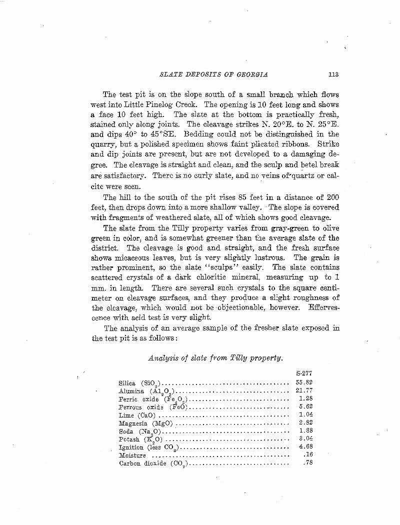
SLATE DEPOSITS OF GEORG-IA 113
The test pit is on the slope south of a small branch which flows west into Little Pinelog Creek. The opening is 10 feet long and shows a face 10 feet high. The slate at the bottom is practically fresh, stained only along joints. The cleavage strikes N. 20°E. toN. 25°E. and dips 40° to 45 o SE. Bedding could not be distinguished in the quarry, but a polished specimen shows faint plicated ribbons. Strike and dip joints are present, but are not developed to a damaging degree. The cleavage is straight and clean, and the sculp and betel break are satisfactory. There is no curly slate, and no veins of'quartz or calcite were seen.
The hill to the south of the pit rises 85 feet in a distance of 200 feet, then drops down into a more shallow valley. The slope is covered with fragments of weathered slate, all of which shows good cleavage.
The slate from the Tilly property varies from gray-green to olive green in color, and is somewhat greener than the average slate of the district. The deava.ge is good and straight, and the fresh surface show,s micaceous leaves., but is very slightly lustrous. The grain is rather prominent, so the slate "sculps" easily. The slate contains scattered crystals of a dark chloritic mineral, measuring up to 1 mm. in length. There are several such crystals to the square centimeter on cleavage surfaces,, and they produce a slight roughness of the cleavage, wh}ch would not be objectionable, however. Effervescence with acid test is very slight.
The analysis of an average sample of the fresher slate exposed in the test pit is as follows:
Ana~ysis of s~ate from Tilly property.
Silica (SiO ) ...................................... . 2
Alumina ( A1 0 ) ................................. . 2 3
Ferric oxide (Fe 0 ) ............................. . 2 3
Ferrous oxide (F'eO) .............................. . Lime (CaO) ................................. · ... · · Magnesia (MgO) ................................. . Soda (Na 0) .... · ................................. .
2 Potash (K
20) ................................... · ·
Ignition (less CO ) ................................ . . 2
Moisture ................................. · · ·. · · · · Carbon dioxide (CO ) ............................. .
2
S-277 55.82 21.77 1.28 5.62 1.04 2.82 1.88 3.04 4.68
.16
.78
114 GEOLOGICAL· •S.URVEY OF GEORGIA
Titanium dioxide (Ti02).... • • • • • • • • • • • • • • • • • • • • • • .91
Phosphorus pentoxide (P 0 ) . . . . . . . • . . . . . . . . . . . . . . . . 00 ' 2 5 .
Sulphur (S) . . . . . . . . . . . . . . . . . . . . . . . . . . . . . . . . . . . . . . . . 04 Manganous oxide (MnO) . . . . . . . . . . . . . . . . . . . . . . . . . . . . 00
99.84
The analysis indicates that the slate would be pra;ctically unfading. The perc.en,tage of carbon dioxid-e is very low; and most of it is evidently combi:u.ed as calcium carbonate, rather than ferrous carbonate, which is the mineral most likely to cause fading or staining. There is hardly more than a trace of pyrite, and the content of magnetite is also very low ..
Sections perp.endicular and parallel to cleavage were cut from typical specimen (S-276). Microscopic examination shows fine texture, about the same as the finest of the Rockmart slates, and slightly lenticular st:r:uctu,re. .Aggregate polarization is- much more brilliant than in any of the. Rockmart slates, but not s.o brilliant as in the highly micaceous gray. slates from the Cartersville formation .
. The slate is inade up· 'of bands, forming a sort of web, of parallel · oriented Ill:ica i ·plat.es. 'Sitlt!r';r..ou.ndmg lens ·shaped areas, . Th:e material in the latter areas consists la:t>gely of sericite scales, but in irregular orielllta;tion. Quatt"tz rund :EEHdspar are not determinable threugh6ut most of the area of the sections. The analysis indicates little or no feldspar, but quartz in micrc:.rystalline form is evidently present in the micaceous matrix. The ribbons show up in the slide perpendicula;r to cleavage by slightly coarser ·~··.:..ture, and contain quartz grains up to 0.03mm.
Carbonate is rare in the slides, but is mo-st abundant in the quartzose. ribbons. It occurs as rhombs and irregular grains, mostly under 0.03 mm. The opaque mineral present seems to be all ma,O'Jletite, occurring as small isometric· crystals, mostly less than 0.01 mm., scattered through the slide and more abundant in the quartzose ribbons.. Rutile needles are very abundant, and are mostly arranged with long axes parallel to cleavage, so they are more conspicuous in the section parallel to cleavage.
Porphyritic greenish crystals of chlorite are scattered through tile mass, with irregular orientation. In the section perpendicular to
SLATE DEPOSITS OF GEOEGIA 115
cleavage they measure up to 0.05 by 0.09 mm., and in the se-ction parallel to cleavage one 0.2 by 0.3 mm., was noted, with mineral cleavage almost at right angles to the slaty cleavage.
The minerals, in descending order o1 abundance, appear to be mica, quartz, chlorite, carbonate, magnetite, rutile, and pyrite.
The situation of the prospect is very satisfactory for working, as the overburden and waste are apparently not excessive and a great deal of slate could be obtained above water level. The principal disadvantage is the distance of about 3 miles over hilly roads to Rydal, the nearest railroad station.
On the Long property (Map Zoca.rity 6), about a mile northwest of the Tilly prospect, green slate with very good cleavage and only slightly weathered is exposed on the banks of Little Pinelog Creek. The cleavage strikes N. l0°E. and dips 30° to 40°SE.
SOUTHERN GREEN SLATE COMPANY PROPERTY
(Map locality 7)
The Southern Green Slate Company, R. L. Proctor, of College Park, Georgia, president, owns 238 acres of land lying east of the Tennessee Road and 100 yards east of the Louisville & Nashville Railroad, just north of the Georgia Green Slate Company property and 3 miles south of Fairmount. This property lies in the foothills belt of green slate. Dr. T. Poole Maynard, of Atlanta, explored the property by calyx-drilling and prepared a report from which some of the following information has been obtained.
Two hills have been tested, one on the Tennessee Road and one just north of the Georgia Green Slate Company property. On the latter there are two small test pits showing beds of slate, fissile but partly wrinkled, and other beds of crumpled, knotty material. As a whole this part of the property is about the same as the Georgia Green Slate Company property, but the slate has a somewhat lighter and grayer green color than that worked by the latter company.
The principal prospects are in a hill just east of the Tennessee Road, % mile northwest of the Georgia Green Slate Company quarry. The hill is elongated in a northeast-southwest direction, that is, parallel to the strike of the cleavage, and rises 130 feet above the valley
116 GEOLOGICAL SURVEY OF GEORGIA
I
bottom to the north. The bes.t exposures are along the -road, at tJ:ie southwest end of the· hill. The following is the section in a direction N. 57°W., the distances being measured horizontally.
Section along Tennessee Road, Southern G1·een Sl(J)te Company property.
Feet. 6. Limestone . . . . . . . . . . . . . . . . . . . . . . . . • . . . . . . . . . . . . . . . . . . . . . . . . . . . . . • ' 5. Slate, largely concealed, cleavage not so good as· in underlyillg material 50 4. Slate, weathered and partly concealed ................. ,· ....... ·..... 40 3. Best. slate ...................... .-· ................................. ~. 160 ·2. ·-w;eathered slate .................. · ........ ·.· .................... ~. 30 1. Lim~stone ......................... , ......... · ... : .............. ·· . . . '
The 160-foot unit is largely good'·slate. It contains some limestone nodules and rough slate, and is extensively jointed, but no'wrinkling nor false cleavage was noted. The·unit has a thickness of 'go ·£eet, measured at right angles to the !cleavage,· and it exte:J?-dS through the long dimension of the hill.
Almost 40 feet above the road exposure 'is a test pit 6 feet deep, sho'Wing~fresilii, 'iiglrt::eolor<~·a, blmsh;;g;re·f3n ·slate ill th{bottom. A part of the' slate ·in' the pit is :finely wrinkled, and a p·art shows knotty or ''augen·'' structure, due to· calcite nodUles:
Measurements of strike and dip ·in the ex:posures at the· southwest ehd of the hill are as follows : . '
Cleavage: Strike N. 37°E., dip 43°SE. Strike,.N. 26~E.,- dip ·32°S;EJ.
Bedding (limestone): Strike N. 45°E., dip 50°SE. Joints (most prominent series): Strike N. 64°W., dip 79°SW.
Strike N. 40°_E., dip 78°SE.
A small pit at the northwest end of the hill shows only weathered slate. The cleavage there strikes N. 47°E.,· and dips·33°SE.
Maynard states .in his .report that drilling and other exploration work --showed up a bed of slate estimated to be 75 feet thick and 1400 feet long.
The slate 'has a good greenish-gray color and e:XJcellent cleavage. The cleavage seems to be· about parallel to the bedding; no ribbons
SLATE DEPOSITS OF GEOBGI.A 117
could be detected. Partial analyses of average samples from drill cores are as follows :
No. 1 No. 2 Silica ( SiO
2). . . • • • . • . . • . • . • • . . . • . • . • • • . 54.95 53.87
Alumina (A120
3) .•...•..........•..•... 22.71 23.26
Ferric oxide (Fe20
3)................... .56 1.20
Ferrous oxide (FeO) . . . . . . . . . . . . . . . . . . . 7. 20 5. 90 Carbon dioxide (CO Q). . . . . . . . . . . . . . . . . . . 1. 30 1. 34 Titanium dioxide (TiO
2)..... . . . . . • • . • • • • 60 . 72
Sulphur (S) .......... ,................. 1.08 .93
These analyses show that the percentage of carbonate is about the average for the district; some green slates carry considerably more, and some considerably less. The content of pyrite, as shown by the sulphur determinations, is unusually high, and might cause spotting and staining on long exposure to the weather. The magnetite content is very lorw, and the slate takes a high polish, which makes it suitable for electrical purposes.
The situation is very favorable for quarrying, as the deposit is not over 1,000 feet from the railroad, the overburden is apparently not heavy, there is a great deal of slate above water level, and the level valley bottom to the north affords ample room for buildings and dumps.
The bed of slate exposed on the Southern Green Slate Company property also extends through the smaller and lower hill west of the Tennessee road, on the property of Monte Dooley.
McCOY PROPERTY
(Map locality 8)
The property of Mr. Gus McCoy, of Fairmount, is commonly known as the Hughes pla.ce. It is situated near the northern boundary of Bartow County, 2V2 miles south of Fairmount. The slate deposits are in the hills belt west of the Louisville & Nashville Railroad.
Development work consists of two small prospect pits, about 200 yards west of the Louisville & Nashville Railroad and 25 feet above the track level. The pits are at the lower end of a small V-shaped valley whose sides rise 50 to 100 feet above the bottom.
118 GEOLOGICAL SVEVEY OF GEOEGLA
The lower pit measures 10 feet across the front, extending hack 8 feet, and showing a vertical face of about 10 feet. Moderately fresh slate is exposed in the bottom, but it is hardly of splitting quality. The soil cov<:>ring is only about a foot thick, but the UP,per part of the slate is weathered.
The upper pit is about 60 feet northwest of the other, and also exposes a vertical face o·f 10 feet. The weathered slate is covered by· scarcely 6 inches of soil, and the lower 2 feet of the exposure is almost fresh •
. The cleavage is straight and clean, and no wrinkled or knotty slate is seen in either pit. The average strike is N. 45°E., dip 35°SE. In parts of the exposure the slate .shows contorted ribbons, which indicate that the cleavage does not correspond with the bedding. The ribbons are faant, and do' not interfere with the ·cleavage.
Joints are prominent, but pro'bably not to a detrimental degree. The most conspicuous seri~ of joints st:rik.re about N. 70°E. and ·dip northwest at high angles,. These joints are spaced 10 inches to 2,% feet apart in the weathered material, hut they may be expected to be less numerous at greater depth.
The-fresher sJ.ate has: a good blue.:.green:coler; Where pa;r,tl;y: wea.thered it changes to yellowish or olive green, but the change is uniform, without ·spotting or bad staining. The cleavage is straight and clean, and false cleavage is absent. The grain is not extremely strong, but is pronounce.d enough to make '' sculping'' easy. A part of the slate contains small "porphyritic" crystals of some chloritic mineral, up to 1 mm. in length, and elongated in the direction of the grain. These crystals produce a slight roughening of the cleavage surfaces, but would probably not be objectionable.
The analysis of a specimen collected by 0. B. Hop1cins is as follows:
Analysis of slate from MoOoy property.
Silica (SiO 2
) •••••••••• ' ••••••• · •••••••••••••••••• • • •
Alumina (.A.l 0 ) ........................ ·. · ·. ·. · · · 2 3 '
Ferric . oxide (Fe 0 ) .......... .- .................. . ' 2 g
Ferrous oxide (F'eO) ............................. . Magnesia (MgO) ................................. . Lime (CaO) ...... · ................................ .
H-30
54.40 21.34
.88 6.77 1.78 2.65
SLATE DEPOSITS OF GEORGIA 119
Soda (Na90)...................................... 1.23
Potash (K20)..................................... 2.45
Ignition (less CO2). • • • • • • • • • • • . • • • • • • • • • • • • • • • • • • • • 4. 38
Moisture . . . . . . . . . . . . . . . . . . . . . . . . . . . . . . . . . . . . . . . . . . 31 Carbon dioxide (UO).............................. 2.40 Titanium dioxide (TiO) . . . . . . . . . . . . . . . . . . . . . . . . . . . . 52 Phosphorus pentoxide (P
2 0
5)....................... .24
Sulphur (S)....... . . . . . . . . . . . . . . . . . . . . . . . . . . . . . . . . .43 Manganous oxide (MnO)........................... .18
99.96
This analysis indicates no objectionable qualities. The content of carbon dioxide and pyrite is a little higher than the average, indicating some fading on long exposure, but the quantity is smaller than in some slates extensively used for roofing.
Microscopic examination of sections from the specimen analyzed (H-3o), shows a matrix of sericite with fine texture and slightly lenticular structure, having brilliant aggregate polarization. A slight aggregate polarization in the direction of the grain is also noticeable.
The section perpendicular to cleavage shows ribbons of coarse material intersecting the cleavage at small angles, and the section parallel to cleavage cuts a ribbon in such a way that it shows an irregular triangular area, 1.5 by .5 em., consisting largely of carbonate and chlorite. The coarser ribbons contain more quartz, chlorite, carbonate, and opaque minerals (magnetite and pyrite) than the micaceous groundmass. The ribbon cut by the section parallel to cleavage consists of over half carbonate, in grains up to 0.1 mm., with a few quartz grains nea:dy as large. The spaces between are filled by very fine pale green scales of chlorite.
Opaque, isometric crystals of magnetite and pyrite are scattered through the sections, and rutile needles are present.
The minerals, in descending order of abundance, appear to be mica, quartz, chlorite, carbonate, magnetite, pyrite, and rutile.
Since the amount of exploration work is so small, little can be said as to the quantity of workable slate available and as to conditions of quarrying. However, the property is centrally located in the extensive slate belt, and the indications are that a large area is underlain by good slate. The overburden is probably light, as the slate at a depth of 10
120 GEOLOGICAL SURVEY OF GEORGIA
feet is practically fresh.· · In regard· to transportation the property could not be more favorably situated, and the level vall~y between the slate hills and t~e railroad .a£E~rds ample ~pa~e for splitting sheds, dumps, etc; '
.. BAGWELL PROPERTY . . .
(Map locality 9)
The property of W. H. Bagwell consists of 42 acres on lot 218, 23d district, 2d section, Bartow County, half a mile north of Bolivar station and a quarter of a mile west of the Louisvi~le & Nashville Railroad. It H~s ~h the western _hills belt, and theprospect~ are in the gentiy sioPing' ridge ·which parallels the railroad at this point.
There are two small openings, one .east and one west of the crest of the ridge. The e~st pit is 6 feet deep and 7 feet square, and within 4 feet of the surface the slate has a good c,olor and appears quite fresh.
· The west pit shows moderately fresh .and very fissile, hut soft slate at a depth of 7 feet. Between the two openings are only small exposur:es and scattered fragments of. slate, most of which is wrinkled and
'··' ,',:·· ·-·~·--·"·' ,,•·• l ., • ! .···~'~' __ , ~··~--··· .-.~·{;,~: ~.~·--~~-·-· --.:~· l '-:-~--,t ....
not a1tr'active in appea~ance. In· a small branch to the ~~outh of the western open~g there is an expqsur~. of slate fo:r.a distadce of several hundred !~et, ending in ~ loc~ f~Id i~ which large masses of quartz are' developed and the cleavage is badly wrinkl~d .. On the: east side of the .ridge slate is exposed in a small draw ~lmo~t continuously for a distance of '550· feet in a direction N. 85 °W. . . " .... .
Measurements of strike and dip are as follows:
East slope: Oleavage: Strike N. 11 °E., dip 59°SE. Joints: (1) Strike N. l1°E., dip H 0 SE ..
Strike N. 2°W., dip H 0 NE. Strike N. ·89°W., dip 80°NE.
West pit.: . <;Jle~vage: Strike N. 16~E., dip42 6 SE.
· The altn.ost horizontal strike jbints of series (1) are mcist promi- · nent, cutting the slate into blocks 20 to 5 feet long. The bedding is much distorted, and fine ribbons in various directions are present.
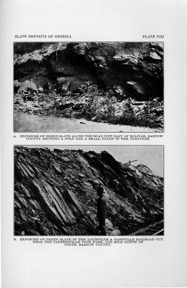
SLATE DEPOSITS OF GEORGIA PLATE Vlli
A. EXPOSURE OF GREEN SLATE ALONG THE ROAD JUST EAST OF BOLIVAR, BARTOW COUNTY, SHOWING A FOLD AND A SMALL ·FAULT IN THE CLEAVAGE.
B. EXPOSURE OF GREEN SLATE IN THE LOUISVILLE & NASHVILLE RAILROAD CUT NEAR THE CARTERSVILLE POOR FARM, ONE MILE NORTH OF
WHITE, BARTOW COUNTY.
SLATE DEPOSITS OF GEORGIA 121
The slate from this property, in general, is grayer with less of a green tint than most slates of the belt. Most of it is soft, evidently containing more calcite than the average, and would therefore be likely to fade and disintegrate. A great deal has false cleavage or incipient jointing a'lt a small angle to the true cleavage, which would make splitting impossible, and wrinkled slate with calcite and quartz stringers is abundant. Small, porphyritic, dark colored crystals of chloritic mineral, elongated in the direction of the grain are present, as in most slates from this portion of the belt.
The beds of slate on this property have suffered considerable disturbance subsequent to the development of the cleavage. This secondary movement has rendered a large part of the slate unsuitable for ·Commercial use. Careful prospecting would be necessary to determine the location and extent of workable slate.
WOODY PROPERTY
(Map loe-ality 10)
The property ofL. D. Woody is on lot 145, 23d district, 2d section, on the northern boundary of Bartow County.
There is a pit 20 feet square and 10 feet deep on the west s.ide of a small branch which :flows north. Good slate was found in the bottom of the pit, which was filled with water when visited. Slate is also exposed in the branch, where it preserves its green color in spite of the effects of the weather, but red specks, probably due to oxidation of pyrite, are abundant.
The bed of splitting slate can not be very thick, and the location is not favorable for quarrying. The valley bottom, where the slate is ex.: posed, is 100 yards wide, with a hill of limestone to the west and a hill of knotty, wrinkled, calcareous slate to the east.
GORDON COUNTY
STARKWEATHER PROPERTY
(JJiap locality 11)
J. W. Starkweather, of Knoxville, Tennessee, owns lot 249, 6th district,. 3d section, 160 acres, and 20 acres at the northwest corner of lot
122 GEOLOGICAL SURVEY OF GEORGIA
264. The property is situated on :Pinelog Creek, on the southern boundary of Gordon County, and 4 miles in an air line southwest of FairmoUJ1t.
The exploration pits a:re along Pinelog Creek south of the· public road. Pit No. 1, the southernmost west of the creek, is th~ largest.
It is 40 feet long and worked in 6 to 8 feet, showing about 25 feet of slate at right angles to the cleavage. The bottom of the pit is at creek le:v:el. ;Most of the slate shows excellent straight cleavage, but some is knotty and finely wrinkled. The bedding is obscure but there are some indistinct ribbons making angles of 15° to 20° with the cleavage.
Pit N(). 2 !s 14 feet north of No. 1. It' is a small opening exposing 8 feet of slate· which is very fissile, with clean, straight cleavage. No ribbons nor w.rinkling were seen.
Pit No.3, about 150 feet north of No.2, is a small opening in a draw about 15 feet above creek level. It shows some good splitting slate about 8 feet below the surface.
Pit No. 4, 75 feet north of No. 3, is a.small opening about 8 feet above creek level. The slate does not appear so good as in the former op-enings:
Pit No. 5 is a ... small o:peni©.g jn a ~uciace· outcrQ]) _about 150 feet north of'No. 4.
Fit· N-o; 6 is a s:inali opentng,on the· e~:~st side of the .·cr~ek at about the same horizon as the southern pits rwest of the creek. It shows some good slate.
The cleavage is fairly uniform and a number of measurements show a variation in strike from N. 20°E. to N. 32°E., ·dip 27° to 53°SE. The bedding in the slate is hardly distinguishable, but limestone beds strike N. 25°E., and dip 40°SE. at the bridge ovef Pinelog Creek, and strike N.3°E. and dip 11°SE. at Worley's mail box, 500 yards east of the creek. The most prominent joints in the slate are dip joints, varying in strike from N.55°W. to N.76°W. and in dip from 75° to 80°NE. Several other series of joints are also present, but probably would not cause much loss in the fresh material. Calcite is searce, but quartz is deposited along some of the joint planes.
The slate has a good gray-green color, and the cleavage is good, but surfaces are slightly roughened by ''porphyritic''· crystals of dark colored, ehloritie mineral, elongated in the direction of the grain. It is
SLATE DEPOSITS Oli' GEORGIA 123
sonorous, and effervesces only very slightly with acid. A few roofing slates have been prepared by G. W. Davis, sho~ring that the working qualities are good, and some of these have remained on a roof for severalye.ars rwithout noticeable fading.
There is evidently a workable bed of slate on the property, but exploration to a greater depth by pits and borings is desirable to form an estimate of the quantity. The situation on the steep slope near the creek is not ideal, but the slate and waste could be transported by aerial cable to the fiat area east of the creek mthout great difficulty. A serious handicap, as compared with other properties nearer the railroad, is the haul to F:;Lirmount, more than 5 miles by road.
The slate bed, which has been tested on the Starkweather property, also underlies a part of the remaining 140 acres of lot 264, belonging to A. Worley.
NEEL PROPERTY
(Map locality 12)
The property of Mrs. J. W. Neel consists of about 600 acres lying along Pinelog Creek north of the Starkweather and Worley properties, and about 4 miles, air-line distance, southwest of Fairmount. The entire property is underlain by green slates and limestones of the Conasauga formation, but prospecting has been done only on lot 250, 6th dis-: trict, 3d section, near an old mill on Pinelog Creek.
Several blasts have been made in the dip slope west of the creek, above the old mill and half a mile north of the Fairmount-Adai:rs.ville public road. These openings show fresh green slate with good cleavage, at a depth of 5 feet. The cleavage strikes N. 40°E. and dips 48° SE. The only prominent joints are strike joints at wide intervals, which rwould assist in working.
Half a mile down stream, below the saw mill site, there are exposures in the steep banks of the creek. At this point all of the slate is knotty or contorted, with poor cleavage, and much calcite along joints and in the form of nodules and stringers, and some thin beds of limestone. A well at the saw mill brought up fresh green slate, but it is of no value on account of poor cle~vage and calcite nodules.
124 GEOLOGICAL SURVEY OF GEORGIA
The cleavage of the slate from the best exposures is good, showing micaceous leaves on fresh s"W'faces .. A part has strong enough grain to be worked by sculping, but some beds show little grain, and must be sawed. .As in most other slates from this part of the green slate belt, there are crystals of a chloriti·c mineral large enough to he visible to the naked eye. These crystals are elongated in the direction of the grain, and cause a.little roughness on cleavage surfaces. The amount o£ n1agp.etite, 3.$ revealed by physic~l and microscopic analyses, is very small.
Maynard1 gives the following description of microscopic examination:
''Two slides were studied-one cut parallel to cleavage and one perpendicular .to cleavag~. The three principal mineral constituents are muscovite mica (sericite), chlorite, and quartz;. the accessory constituents are pyrite, rutile, calcite, siderite, and a few other minerals which are so rarely found that they do not affect the slate commercially.
''The sections s~ow the cleavage to he good and no false cleavage or ribbons were observed. The calcite anq. siderite are very difficult to
di~tin,g~~s:J;t,;; hew;~~erlj .~er;(j ~~,~~~9tr~,\~"tt:~di~~e~t <l'?-ant~~Y o£ hq:th to ,cause discoloration. 7'he pyrite occurs throughm;rt the slate, occasionally in irr-egular leilS"'li~e.»asses:, b;ui;(:q:Su~Jly;.,;:ts::Sn;:t,aJl cuhes or .. spherules enclosed in the sericite. The cubes and spherules of pyrite . which are thus enclosed would not cause any discoloration of the slate, and as irregular lenses of pyTite oc;cur only occasionally it is not thought that they will be of any serious objection." . While the entire area of the properly is underlain by the slate for
mation, openings or drillings are necessary to determine the possibility of economic development. The presence of beds of resistant limestone has caused disturbance of the cleavage which renders much of the slate unfit for splitting. The distance t.o the railroad at Fairmount; 5 m~les by road, is a serious disadvantage.
1 Special report, unpublished, Nov. 1910.
SLATE DEPOSITS OF GEORGIA
YARBROUGH PROPERTY
(Map locality 13)
125
Hiram Yarbrough owns several land lots north of the Neel property. The entire property is underlain by shale, slate, and limestone of the Conasauga formation, but the best exposures of slate are on lots 220 and 221, 6th district, 3d section, near Yarbrough's Mill, at the junction of Pinelog and Little Pinelog creeks.
No exploration work has been done, but slightly weathered slate is exposed in a bluff 30 feet or more in height on the south side of Pinelog Creek below the mill. Measmrements of the strike and dip of the cleavage at various points along the bluff are as follows:
Strike N. 74°E., dip 46°SE. Strike N. 60°E., dip 45°SE. Strike N. 85°E., dip 50°SE. Strike N. 81 °E., dip 41 °SE.
The slate at this exposure, measuring 30 feet a,cross the cleavage and several hundred feet long, has good straight cleavage. Naturally there would be some waste beds, but no particularly curly or knotty layers were noted. In the natural exposure the slate is stained along cleavage planes by infiltration of iron, but the fresh slate will probably have a good gray-green color, similar to that of other properties in the vicinity. No false cleavage and very little wrinkling of the cleavage was seen at this locality. It is far enough from the Cartersville fault to have escaped the ba<i effects of secondary movements:
The slate of the exposure al~mg the creek must be worked from the southeast side of the hill, opposite the creek, and the topping is likely to be heavy. The hill rises steeply about 100 feet above the creek level, and exposures of slate on the upper slopes do not look so good as that in the bluff, but this appearance may be due to the greater degree of weathering.
There are also good exposures of slate along the road leading to the mill, and along the public road to Fairmount. It is likely that good prospects for commercial slate can be found in the area of the Y arbrough property east of Pinelog Creek. However, the distance from the railroad would cause difficulty, as it is 6 miles by road from Y arbrough's Mill to Fairmount.
126 GEOLOGICAL S.VRVEY OF GEORGIA
M'AHAN AND HICKENS PROPERTY
(Map locality 14)
The Mahan and Hickens property consists of lot 281, 6th district, 3d section, lying east of the Worley property, and on the southern
' boundary of Gordon County. There is an opening on the west side of a small valley, three quarters
of a mile east of Pinelog Creek. The pit exposes a face ld feet high, with almost fresh slate in the bottom. The a~erage strike o£ the cleavage is N. 40°E., dip 40°S.E. There is one prominent system of joints, striking N. 65°E. and dipping 65°SE. These joints are locally so closely spaJced as to amount to false cleavage in the weathered material, but probably will not affect the fresh slate to so great an extent. Except for these joints the slate appears good. The color is bluish green, weathering to olive green. ,The cleavage is straight and clean, and no wrinkled or curly slate and no calcite veins or nodules were seen.
The slate bed shows up- on the other side of the hill, 200 yards southwest of the pit, hut the thic]mess of good slate can not be estimated without more exploratian. The situation is favorable for quarryi'P:g_~ Tnfs s1llite-' 'o·e<i' is\ ,stra'tig±apili:icallw aboveth'at·· on tne Starkweather and Wol-ley' properties, with one· or more beds of limestone between.
DISHAROON PROPERTY
(Map locality 15)
There are slate prospects on the property of E. Q. Disharoon, lot 72, 23d district, 2d section, Gordon County, 1~ miles in an air line northrwest of Fairmount.
The first prospect pit is on the west slope of a hill, about 75 feet below the top. A second pit, the bottom of which is 20 feet above the bottom of the first, shows a 15-foot face. Quite fresh slate is exposed in the hattom of the lower pit, about 6 feet from the surface. The slate in this pit contains limestone layers and nodules and occasional sand partings along the cleavage, while a part .shows very conspicuous false cleavage.
SLATE DEPOSITS OF GEORGIA 1,),... ~I
In the upper pit all of the slate is considerably weathered, excepting about a foot in the bottom. In this pit false cleavage was not noted, but there are some curly and nodular layers and lenses, most of which are less than 6 inches thick. The defective layers make up only a small part of the mass; the rest has good straight ·cleavage.
Outcrops of slate occur on the slope for a distance of 63 feet vertically above the bottom of the lower pit. Apparently the proportion of slate which must be wasted on account of curly or false cleavage and limestone beds becomes less toward the top of the section, but as exposures are not very good the entire thickness should 'be tested by pits or core-drilling.
The strike of the cleavage varies only slightly from north and south, and the dip is 10° to 21° east; that is, the cleavage dips into the hill. No ribbons were noted, and the bedding is approximately parallel to the cleavage, as shown by limestone layers and sand partings. There are some heavy beds of limestone in the Conasauga formation in this locality, and extensive outcrops occur near the Disharoon residence and along the public road leading north.
Across a small valley, about 200 yards from the pits above described, is a pit 10 feet square and 5 feet deep in a hillside sloping gently to the southeast. The bottom of the pit shows fairly fresh slate, but all is curly and wrinkled, causing very uneven split and locally false cleavage. This pit is at a lower ho-rizon than those in the other hill, and the prospect for commereial slate is not nearly so good.
The good slate on the property seems to be of excellent quality. Its color is grayish green, not quite so green as some slates in the Fair-
, mount district. The surface exposures are yellow-green, due to weathering and oxidation of the iron. The slate is clean, free from specks and ribbons, and according to G. W. Davis, it has good working qualities.
TATE PROPERTY
(Map locality 16) '·
The property of Mrs. Philip Tate adjoins the Disharoon property on the south. There are outcrops of slate along the south slope of a small branch which flows east. The slate is weathered, but has a bluish
128 GEOLOGICAL SURVEY OF GEORGIA
green color, with exceptionally good and straight cleavage. The strike is prB~ctically north and south, dip 35°E. This exposure is at abou:t the same horizon as the Disharoon prospects.
THE CARTERSVILLE DISTRICT
GEOLOGY-OF THE CARTERSVILLE FORMATION
AreaL dist1·ibution.-The Cartersville formation outcrops in a belt with an average width o:E about half a mile, extending through Cartersville and 15 miles northeast of that city. At the northeast end the belt is cut off by the Cartersville fault. It is traceable for about 2 miles south of the city, where it disappears u.nder;the alluvial deposits of the Etowah Valley, but it evidently extends on southward under the bottom to be again cut off by the Cartersville fault a short distance south of Etowah River. (See Map III.) .
In and immediately north o:E Cartersville there are irregularities in the belt of outcrop, probably explainable by an overthrust of the Beaver limestone along a fault plane dipping eastward at a low angle. From 5 to 8 miles northeast ()f Cartersville the belt spreads out to a width of 2 miles, and includes. at least. one limestone area, lying northwest of McCallie. From White northeast the belt is fairly uniform, but widens a little toward the north.
Between Grassdale and Cassville the Cartersville formation outcrops in an area more than a mile wide. This area tapers off to the north, but- to the south there are fingers extending along the three prominent parallel ridges southeast of 9assville, almost to the Dixie Highway and the Western & Atlantic Railroad. This area is joined by a narrow belt to the main area northeast o:E Cartersville. There are also several small outliers northwest of the main belt.
All exposures of the Cartersville formation are "in the eastern half of Bartow County.
·Stratigraphic reLations.-The Cartersville formation, occurring in an isolated area cut off by a fault at both ends, and being barren o:E fossils, •can be correlated •with other formations only on the basis of its stratigraphic position. Other formations occupying approximately the same position in the stratigraphic column, and with which the
SL.A1'E DEPOSITS OF GEORGIA 129
Cartersville formation might be correlated, are the Watauga shale of the Roan Mountain quadrangle; the Apison shale o·f the Knoxville, Cleveland and Rome quadrangles ; and the Rome formation of the Knoxville, Cleveland and Rome quadrangles.
The position of the formation is between the Beaver limestone, below and the Conasauga formation, above. The nature of the contacts has not been determined. The ·contact with the underlying Beaver limestone in the vicinity of Cartersville is almost certainly a thrust fault, the limestone bejng thrust over toward the west so that it caps the hills, while the Cartersville formation is exposed in the valleys. Northeast of Cartersville the contact may be along a fault, but the exact ·character and situation are not determinable on account of the mantle of float rock which has come down from Little Pinelog and other mountains.
The contact of the Cartersville with the Conasauga formation is determinable only with great difficulty. The Cartersville rocks prevailingly carry more potash, and limestones are lacking, 'but some phases of both formations are very similar, and there is no evidence of unconformity. In fact, the Cartersville formation might he considered a member at the base of the Conasauga formation.
Lithologic cha1·acters.-The Cartersville formation eonsists of beds of variable lithologic character, typical of sediments laid down in very shallow rwater. The principal negative chara.cteristic is the absence of limestone or other calcareous sediments.
The deposits may be divided into four general types, as follows: (1) Gray or purplish gray slate. This slate contains from 9 to 10
per cent potash, having practically the composition of a sericite schist, although the texture and cleavage is that of a roo£ng slate. This slate forms minor beds and lenses in the formation. The maximum thickness of any single lens rarely if ever exceeds 50 feet. The slate must have been formed by metamorphism of sediments which originally consisted almost entirely of muscovite mica and orthoclase feldspar.
(2) Soft, light colored shale making up the greater part of the formation. This rock is similar in composition to the slate, but as originally deposited must have contained a larger proportion of feldspathic and arkosic impurities. While the slate is fresh almost to the surface,
130 GEOLOGICAL SURVEY OF GEORGIA
the shale in natural exposures is considerably weathered. In spite of the weathe:riiJ.g, nuriJ.erous samples of the shale show it to contain from 6 to 9 per cent potash:
( 3) Feldspathic sandstone. This appears to be an ordinary soft sandstone, but a number of analyses show it to contain from 4 to 8 per cent potash. Microscopic examination· shows much feldspar and sericite distributed between the quartz grains. In natural exposures the rock is generally softened by weathering and partial kaolinization of the· feldspars, but in depth it may be expected to become a rather hard sandstone.
(4) Sandstone and quartzite. The formation contains a number of thin beds of common siliceous sandstone, some of which is so hard that it may properly be called quartzite. Although none of the beds are known to· be more than a few feet thick, the hard sandstone outcrops prominently,. and its debris covers large areas.
,.A.ll of these varieties of rdck are typical of near~shore deposition, and consist of material removed rapidly from a fresh, granitic land surface and redeposited with very little opportunity for chemical weathering and leaching out of potash. The soft shale forms the bulk o.f the formation, with only ~inor lenses of the other types of rock. There are no sections complete enough to show the relative ·order of deposition, and it is very difficult to determine which is the top and which the bottom of the formation.
Structure and th:ickness.-Except for small local variations the bedding .and cleavage of the Cartersville formation str~ke north or northeast and dip east or southeast at angles of 30 degrees or more. The structure is complicated, and has no,t been worked out in any detail; but there are indications of overturned folds and a number of thrust faults. The outcrop area doubles in width just south of White, which must be due to a fold or fault. The three parallel belts east ·of Cassville are probably produced by parallel thrust faults, of small throw as compared with the Cartersville and other major faults.
, On account of the folding and the uncertainty as to the top and bottom of the formation, no accurate estimate of the thickness is possible. The extent of the expos'ures indicates a thickness riot greater than 1,000 feet, and it may be considerably iess.
SLATE DEPOSITS OF GEORGIA 131
Physiographic expression.-The rocks of the Cartersville formation are more resistant to erosion than the surrounding limestones of the Beaver and Conasauga formations, but less so than the ''mountain rocks'' of the Piedmont area. Therefore the formation forms a belt of foothills west of Pine and Pinelog mountains, and three prominent ridges in the area east of Cassville.
In the vicinity of Cartersville the formation consists entirely of the soft shales, so it has little topographic effect. Farther north the beds of slate and sandstone produce hills !Which rise more than 100 feet above the valley areas. ·These hills are generally covered by great · quantities of sandstone and quartzite float, although the beds of such rock shown in test pits are thin.
Paleontology.-The character of materials making up the Cartersville formation indicates a depositional environment unfavorable to all. forms of life, and the metamorphism has been so intense that any fossils originally preserved have probably been destroyed. None have ever been found.
Econmic geoLogy.-Some of the beds of gray slate in the Cartersville formation have the qualities desirable for roofing slate, but these beds are thin, and most of the slate shows false cleavage or other damage caused by secondary movements. On this account it is not likely that roofing slate from the formation can be worked on any extensive scale.
The chief value of the formation seems to lie in its high potash content. Some silicate minerals coptain higher percentages of potash · but at no other place except in the Leucite Hills of Wyoming is there known to be such an enormous tonnage of easily workable material containing 8 per cent or more of potash.
The occurrence of gray slate in the vicinity of White has been known for several years, but its unusual composition was not suspected until a sample collected by the writer was analyzed by Dr. Edgar Everhart, acting chemist of the State Geological Survey, in December, 1916. During the following summer the extent of the deposits was investigated and a number of other samples were analyzed. The results of the analyses were sent to the property owners, but the first public announcement was made in the quarterly report of the State Geologist in
132
Septemiber, 1911. A-brief lihesnri~tkJn,?f the d:ep.esits rw.as publish.eGl by S:. W. 1\feG:alli.e, State 1{}aoJnglist; in tire lErrgm~ering and JM;ining Jo:rn.r
naF and in severaq daily p·a-peir>s 1n 10'eor@a in Oetober, 1'917. I .
THE CARTERSVILLE SLATE'? AS A SOURCE OF POTASH
A g;reat many processes for the extraction of po~ash from silicate rock-s and minerals have been devisea: and patented. Abstracts of .anumbel' of the patents are given in a.. previous ;publication of the Geological 'Survey o£ Georgia. 8
The shales and slates of the Cartersville formation are as suitable for these processes of direct extraction of potash .as any other rocks of equal potash eontent. The American Potash Company is now treating this slate on a sma,ll srcale for the extraction. of pDtash alone, but evidently the·mo'st prb:fitable I;ha:t;i::il~r df ·;haaid11fig such material would be
·the manuf'acitt~~ of porti~na eement with ·recovery of the potash as a hypro·uuct.
The following riotes on the recovery of potash from dust from cement works were supplied by Mr. A. W. Stockett, of the United States Bureau of Mines:
· ~' Pt~fea,:sJi ·\i'S:·;nf>w 'beln;g 'Iie~t:Jv-ereil if-Tom ~'tlie'·\aust-~ 1Erom ;·eem'ent kilns ai a l1'11mlBe:r ·ef ,];)ian't~,. rrhe priudipal on:e m: the east 1:s -a;t·the· J)lan t of t-he .JSBcuii:'ity ·0em~n%·,;&·lliiim!~· ·fDo'mrp•iny·LnBa~r~!Ht:ligerst{l)WD:;' 1Macyland.
I
At thi~ plant the dlitiSt' is 'r-eeov.er.ed hy meaELS ·of t'fi€·-Oentre11 e'i:eetrie pT.ecipiilator. .Sittll:!liaall! p'lan:ts ·a'X~ ijj·cing instllilled. flit,.: N21za:'re'i}n, PJeiln:sylvania; Ironton, Ohio ; N ewa:go, Michigan;· and Kingsport, Tenness'ee~ 'ilrhe r.eBuilts oibta:ined at Se:eurrity- have been vecy sat:i~fa>etory !ffi:El:'an:~ dally, :as the entlire cost of tlae plant was :vetrurned from the pr:olfits o£ ti!w &st year's i()J)).eiration. It is estimated th.:at p.otash ellill b:e produeed at less than 60'cents per unit (20 pounds) of K 2D, which is less than the pr,e-waf' price.
''It would be very useful t<D have su-eh .a plant in the southeasilie;rn States, as nfty p.er cent of aU the potash imported i,s used in the foM Cotton .States, North Carolina, South Carolina, .Alahama, and G.e0rg.ta.
1 Eng,ine-er.i:ng ;:md M.i.lllallg .Jt0\!Wnail., ¥G>L W4. B•.G.. 10, .P· i>Ml,. ·Oct. 1\3,, 1.917. 2 The term "slate" as used in t:lie followi.ng descriptions, refers in general to
b0th .SJa!f:e and Shaie of thie Car·ter,sviiH:e formation, a-s d<eser.ib~1i ·on page 12-9, un·less the sense of the text is clearly different.
a Galpin, s. L.. Feldspar and mi'ea tde·posiits of Georgia: Geol. Survey of Ga. Bull. 30, pp. 17 5·1 '79, 1915.
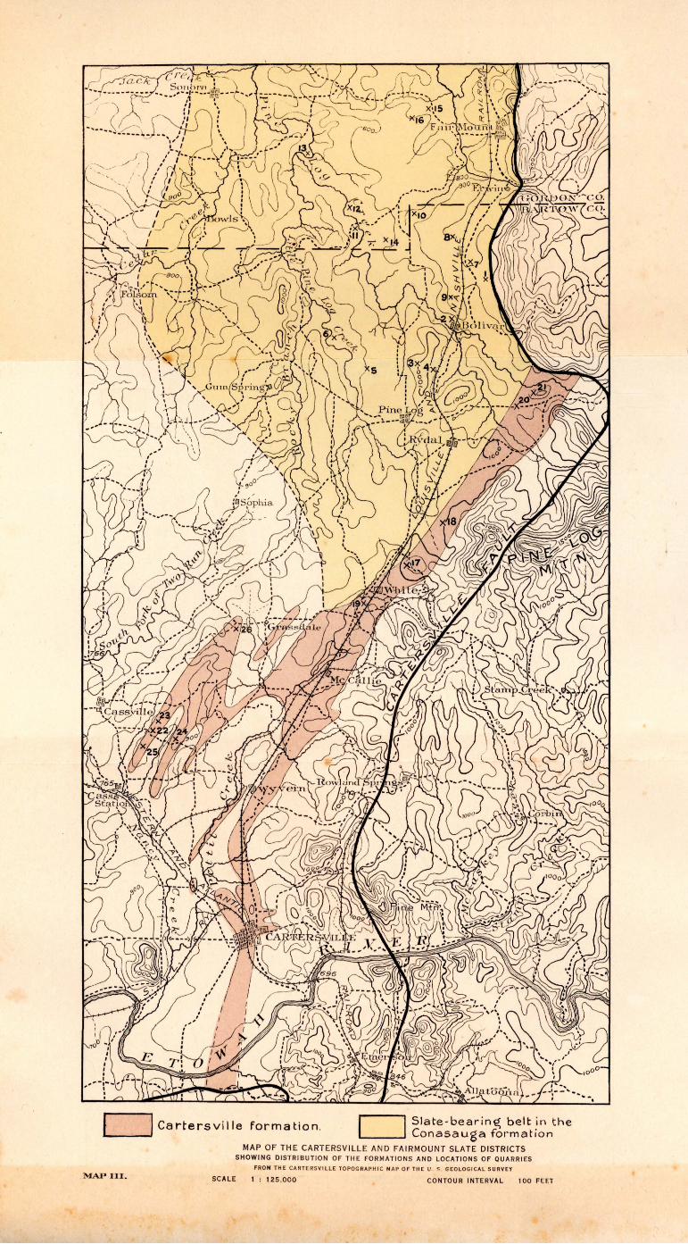
c===J Cartersville formation. Slate - bear ine: belt in the Conasauga formation
MAP III.
MAP OF TH E CART ERSVI LLE AND FAIRMOUNT SLATE DISTRICTS SHOWING DISTRIBU TION OF THE FOR MATION S AND LOCATIONS OF QUARRIES
FROM THE CARTER SVILLE TOPO GRAPHI C MA P OF THE U . S. GE OLO GIC A L SURVEY
SCALE 1 : 125 ,000 CONTOUR INTERVAL 100 FHT
SLATE DEPOSITS OF GEORGIA 133
"The Southern States Portland C~ment Company, at Rockmart, Georgia, would be a very suitable location for a potash recovery plant. . . . . The present raw mix contains 0.98 per cent of K 20, which is well above the average. In addition, it is quite close to the sericite deposits/ and it is probable that a certain amount of this could be
which would increase the amount of potash materj ally. At the present price of potash, approximately $5.00 per unit, it is probable that the pro:fit from the potash would exceed that from the cement.
''The cost of the necessary installation for either the electrical precipitation or some other method would probably not exceed $100,000.
''The Bureau of Mines is very anxious to see as many sources of potash supply developed as possible, in order to make this country independent of the German potash monopoly after the war. The Bureau will assist as far as possible in obtaining priority for materials and fuel and favora.ble consideration by the Capital Issues Committee."
While the Pickens County sericite schists are mentioned, Mr. Stockett did not know of the advantages of the Cartersville slate when the preceding memorandum was written. He has since made an examination of the Cartersville deposits.
The sericite schists must be mined by underground methods in order to obtain any large production, must be hauled five miles or more over very had roads, transported more than a hundred miles by rail, and their composition is not suitable for cement manufacture on account of the high percentage of alumina and low percentage of silica. On the other hand, the C.artersville slate deposits may be mined by steam shovel in open cuts, are on a main railroad line only 22 miles by rail fro_m Rockmart, and have almost the ideal chemical composition for shales to go into cement mixtures. The best selected samples of sericite schist contain a fraction of a per cent more potash than the best samples of Cartersville slate, but, considering the run-of-mine product obtainable by any practicable mining method, it is almost certain that the potash content of the slate could be kept higher than that of the seri,cite.
The shale now used at the Southern States Portland Cement Company plant comes from the Rockmart slate formation, and contains
1 Referring to the sericite schists of Pickens county.
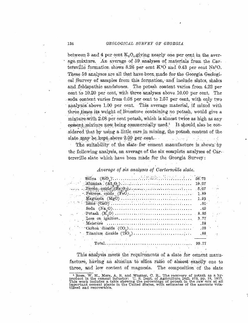
134 GEOLOGICAL SURVEY OF GEORGIA
betw:een 3 and 4 per cent K 2.0,,,giving. nearly one per cent in the aver-. ~ ' ' . " . '. . i '· • ' • - • • • < • • •
a·ge. mixture. .An average -o.f 59 analyses· of materials from the .Oar-t~rs.ville formation shows-8.2,6 per cent K 26 and. 0.43 p~r cent Na20.
. . . . ' . . - . . . . TJ?-es~ 59. ana:lyses are all that hav.e.been :rp.ade ~or the Georgia Geologi-cal ~-urvey of samples from this for:rp.ation, ·and include slates, shales and.f~ldspathic ~andstones .. The potash content varies from 4.22per cent-to 10.20 per cent; with three analyses above 10.00 per cent The soda; yontent varies from 0.08 per cent to 1~57 .per cent, with on;I.y two
. • . . ' . . . . . . . £j
· ?.nalyses:· above 1.00 per cent. This average material, if mixed with three tin:J.es its weight of; limestone containing no potash, would give a .· . ,. ... ) '" , ..... ' .. , . . . . .. . . ' ,.
rrd.~tu~e!With 2.08.per cent potash,-which is almost twice as high as any cement,mixture norw. being commercially used.1 It· should also be con-... ; • ·~· ~~ "' • ' __ : • ~ ~ ···'. ' • ~ J. ,. • . : • • • • •
side;~a. that l,:ry usi~g a:lit~l~ ~are _in mining, tl:le potash, content of the sla,,te-,~~~:)1:; ~,~)k;eiRt . a:'J?0ye · ~.Qp ,:p~:r ·::Ce~t .. ·
The 's~i'tability· of the slate· for ~ement. ml:l,m:ifacture is shown· ·by the following analysis, an average of the six complete analyses of Car- · ·tersville slate which have been made for the Georgia Survey:
Average of six ana~yses of Ca1'tersville slate.
;Sillca (Sici ) .. , ...... : ... ·.·.< ;·: {~;,_'.:;:. J ~ ; ... ··.: ••. ·: •. > . .:.A:1umirra :ci.iuQ'J• ~ ... ; ... : ..... ~ ......... -...... .' ... .
..... , ·t ·~"~~trf§;r~Mi,~~i):(%~,~ffi?),;r._.,,., ...... · .. · · ··· ... •; · ·· ·· · · · · · ·: ·· · · · ··. Fer.rous, oXide (F·~o J .•......•....•••... · ..•.......••
·. ,~~~f~.si~----~~·go) ..... : ~ ..... ~ ._. ........ : ......... . ":"' ·, B1-me : (~0ru0 )~ ........ · ........ ; ...................... .
So:da (Na20} ............ · · · · · · · · · · · · · • · · · · · · · · · · · · . ·~HotasJi . (~2~ ) ............................... ; ..... . , .Los13 on Ignition., ................................. . · iv.r'oisture ........................ : ................ . ··c'arboh · ctioxid~ · (co,) . ~ ........................ , .. .
T.itaninnt dioxide ( T.iO 2
) •••••••••••••••••••••••• : •••
56':'73 19~·27 5 .• :•5'7 :1,.89 1.9?
.OI
.49 8.85 3.77
.38
.o·o ,
.88
Total ..... · ........................ , ........... ·. 99. 77
......
This analysis meets tb.e. requite~ents of a slate for cem~nt manufacture, having an alurilina to. sili<ca ratio or all:h@st. exa~tly one to three, and low content of magnesia. The compositio~ ~£ the slate
1 Ross, W. H., Merz, A. R. and .Wagner, C. R:, The recovery of potash as a byproduct in the cement industry: U. S. Dept. of Agriculture. Bull. 57.2, pp. 22, 191 '7. This work includes a table showing the percentage of potash in the raw mix at an important cement plants in the United States, with estimates of the amounts vola-tilized and recoverable. ·
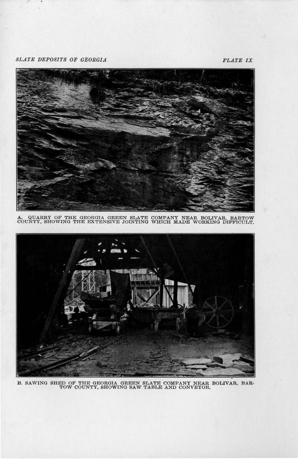
SLATE DEPOSITS OF GEORGI.tl PLATE IX
A. QUARRY OF THE GEORGIA GREEN SLATE COMPANY NEAR BOLIVAR, BARTOW COUNTY, SHOWING THE EXTENSIVE JOINTING WHICH MADE WORKING DIFFICULT.
B. SAWING SHED OF THE GEORGIA GREEN SLATE COMPANY NEAR BOLIVAR, BAR· TOW COUNTY, SHOWING SAW TABLE AND CONVEYOR.
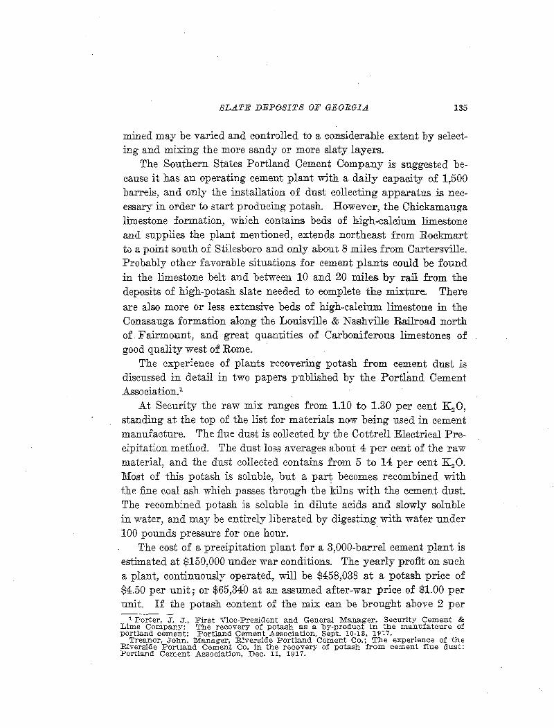
SLATE DEPOSITS OF GEORGIA 135
mined may be varied and controlled to a considerable extent by selecting and mixing the more sandy or more slaty layers.
The Southern States Portland Cement Company is suggested because it has an operating cement plant with a daily capacity of 1,500 barrels, and only the installation of dust collecting apparatus is necessary in order to start producing potash. However, the Chickamauga limestone formation, which contains beds of high-·calcium limestone and supplies the plant mentioned, extends northeast from Rockmart to a point south of Stilesboro and only about 8 miles from Cartersville. Probably other favorable situations for cement plants could be found in the limestone belt and between 10 and 20 miles by rail from the deposits of high-potash slate needed to complete the mixture. There
are also more or less extensive beds of high-calcium limestone in the Conasauga formation along the Louisville & Nashville Railroad north of Fairmount, and great quantities of Carboniferous limestones of good quality west of Rome.
The experience of plants recovering potash from cement dust is discussed in detail in two papers published by the Portland Cement Association.1
At Security the raw mix ranges from 1.10 to 1.30 per cent K 2 0, standing at the top of the list for materials now being used in cement manufacture. The flue dust is collected by the Cottrell Electrical Precipitation method. The dust loss averages about 4 per cent of the raw material, and the dust collected contains from 5 to 14 per cent K 2 0. Most of this potash is soluble, but a part becomes recombined with the fine coal ash which passes through the kilns with the cement dust. The recombined potash is soluble in dilute acids and slowly soluble in water, and may be entirely liberated by digesting with water under 100 pounds pressure for one hour.
The cost of a precipitation plant for a 3,000-barrel cement plant is estimated at $150,000 under war conditions. The yearly profit on such a plant, continuously operated, will be $458,038 at a potash price of $4.50 per unit; or $65,340 at an assumed after-war price of $1.00 per unit. If the potash content of the mix can be brought above 2 per
1 Porter, J. J., First Vice-President and General Manager, Security Cement & Lime Company: The recovery of potash as a by-product in the manufatcure of portland cement: Portland Cement Association, Sept. 10-13, 1917.
Treanor, John. Manager, Riverside Portland Cement Co.; The experience of the Riverside Portland Cement Co. in the recovery of potash from cement flue dust: Portland Cement Association, Dec. 11, 1917.
136 GEOLOGICAL SURVEY OF GEORGIA
cent, potash may become the principal product, exceeding the cement in value.
The precipitation plant at Riverside, Los .Angeles, California, was installed before the rwar, the purpose being to catch the cement dust, without regard to its potash content or other value. .After the installation it was found possible tl) sell the dust collected for its potash con-
. tent at more than its value a8 raw cement material. Electrical precipitation was first used, but later a straight water precipitation was developed, which gave a higher percentage of potash recovery. The electrical precipitation used, however, was not of the type especially designed to recover- potash.
The p·otash content of the raw mix is 0.50 per cent. By addition of :fhiorspar to the mix 85 per cent of the potash is volatilized, and 96 per. cent of that volatilized is saved by the water precipitator. .Addition of ·common salt to the mix also increases volatilization. .At this
·plant oii is used for fuel, so the difficulty caused by recombination of -potash with. coal ash is not encountered.
DEVELOPMENTS
The American Potash Oompany.-.The .American Potash Company, .A. T. Thomas, manager, is the only one rwhich has up to the present used the Georgia sericites and slates as a source of potash on a commerciaJ scale .. The company controls properties in the sericite belt near Jasper, Pickens County, and in the Cartersville slate belt near White, Bartow County. The material is treated at the plant of the Piedmont Portland Cement Company at Portland, Polk County, a plant which had not been in operation for several years.
~Mining was started on ~he Padgett lot, Pickens County, where a deposit of sericite with over 10 per cent potash occurred. It was found in mining,- however, that it was difficult to maintain the average grade of commercial material even as high as 8 per cent, and the costs of mining and transportation were high. Therefore, the mine was moved to a locality just south of White, Bartow County (for description o.f the mine, see pp. 150-152).
Details of the process of treatment have not been made public by the company. Horwever, the shale is mixed with reagents, evidently
SLATE DEPOSI1'S OF GEORGIA 137
limestone and salt, and ignited in the cement kiln. The cinder or clinker produced contains from 4 to 5 per cent of rwater-soluble potash (K2 0) and is sold at a price of about $4.00 per unit, without extraction and further purification of the potash. Such low grade material finds a ready market under war conditions, although more concentration of the potash salts would probably be demanded in normal times.
An attempt is made to keep the temperature below the point of volatilization of potash, but some is lost with the stack dust, which is not precipitated. Starting with a 9 per cent raw material, mixing limestone, etc., and finishing with 4 to 5 per cent soluble indicates that considerably more than half of the potash present is saved and rendered available.
The capacity of the plant is 125 tons per 24 hours, but the work has been largely experimental and that rate of production has not been maintained.
The American Metal Company.-The American Metal Company became interested in the Cartersville slate deposits late in 1917. The deposits were examined and explored by Messrs. Heath Steele, A. H. Rogers, M. W. Hayward, G. B. Corless, and W. A. Nelson. Options or leases were taken on several of the most promising properties (for descriptions, see pp. 140-150) ..
This company plans to erect a large plant to treat the slates by the method of _the Rody and Burkey patents, Nos. 1,151,148; 1,151,133; and 1,263,705. The method was first developed for use on the leucite of Wyoming, which contains from 10 to 11 per cent potash. It is believed that the Georgia slate deposits can be worked more profitably than the Wyoming leucite, in spite of the somewhat lower ·content of potash, on account of their closeness to supplies and markets and more moderate climate permitting outside work throughout the year.
The method is based on the fact that when a potash-bearing silicate is- heated to a sintering temperature with limestone (or other alkaliearth metal oxide or other salt), the mixture being proportioned so that there are two molecules of lime (or other alkali-earth oxide) to each molicule of silica, calcium orthosilicate and soluble potassium aluminate are formed. The potassium aluminate is leached from the sinter, the alumina is precipitated in pure form by the methods used in
138 GEOLOGICAL SURVEY OF GEORGIA
p:urifying alumina. from bauxite, and the potash is reeo;vered ID(Y evaporation @L the. S01u.tion. The leached sinter mig.kt be employed in the manufaeture of portland cement by mixing more limestene or material needed to give it a suitable composition.
ALthough the use of magnesium carbonate and calcium and magnesium chlorides is covered in the patentS; in practie.e a high calcium
·limestone,, containing less. than ~· per cent each of magnesia alilid silica, is desi~ed. Some- beds od: .1imestoiDie :in n0rthwestern Georgia are known
· to meet ~hese requirements,, but the size and extent of the deposits have not been tharoughly investigated.
The Vithum?as O'ompa.ny'.-The Vithilmus Company started mining
sericite schist on the Kuhtrnan property, Pickens. County, in 1917. Later the Rufus Jones and If. Goode properties- in the northern part of the Cartersville bert w:ere !eased or purchased, but no mining has h0en done there. The exploration and development workwas done by Mr. J. E. Brantly.
Vitirumus. is described as a "soil-builder., containing more than a
dozen necessary crop elements.'' The potash-bearing silicates used in the mi:p;.tur{( ~~ -J;!:Ot ,tre;:t:te€Lin s;u,ch,.a wa,y. as,:to~x:ender.~xtheq;~otash watersolubre,. ~d the product is not. sold en the. soluble p.otash,. phosphorus and nitrogen bas1s o£ commercial fertilizers.~-
Tests by Dr.. Everhart, acting chemist of the State Geolog_ical Survey1; Qn a number o£ samples from the Cartersville formatio:ra show that they contain potash soluble in 2 per cent hydrochlorl.e aeid, :t:anging from 0.2.7 to 0.88 per cent. This. amount of potash may be con~ sidered immediately available for plant food,, and as. it is removed more will become soluble. The ·potash in naturally fertile soils is derived from. the breaking down of silicate minerals, but ordinary elay~ and soils, after long exposure to weathering, contain only a smaTI fraction of a per cent of potash in either soluble or insoluble form. It has been found by experience. that soils overlying Cartersv~lle 'f0rmation and. certain highly potassic areas of Oo.nasauga shale are permanently fertile in respect to potash,. which need not be j1dded in commercial fertilizers.. Therefore, it seems evident that a. liberal application of very finely ground potash-bearing silicate, either feldspar, mica 0r shale, thoroughly worked into the soil, would provide a basis for enduring
SLATE DEPOSITS OF GEORGIA 139
fertility, and would at least reduce the need for soluble potash in the form of commercial fertilizers.
The Georgia Potash and Chemical Corporation.-The Georgia Potash & Chemical Corporation, of which :Mr. Sam Tate is president, and Dr. T. P. :Maynard is vice-president and general manager, was organ-
1
ized in 1918, for the purpose of extracting potash from Georgia sericite, shales or slates. The company controls about 1,000 acres of land in the Pickens County sericite belt and in the Cartersville slate belt, and other properties will probably be obtained. Among the properties in the Cartersville belt are the Clark and Leech, Leech, Boston and Parker properties, along the Louisville & Nashville Railroad near the American Potash Company mine, a short distance southwest of White.
The Georgia Potash & Chemical Corporation has obtained from the Research Corporation1 the rights to the Cottrell process in Georgia as applied to the production of potash from potassium-aluminum silicates and not as a by-product of cement manufacture. It is believed that potash can be produced at a profit without regard to alumina or other by-products which may be obtained.
John T. Norris.-Mr. John T. Norris, of Cartersville, is agent for the following properties in the Cartersville district. High-potash
shales and slates have been found on most of these.
5th district, 3d section.
Banks, Dr. G. T.-15 A., lot 289. Carman, B. F.'--90 A., lots 202 and 203. Carpenter, W. W.-50 A., lot 191. Dav-idson, .T. P.-74 A., lot 169; 57 A., lot 192. Denman, M. H.-22 A., lot 192. Gaddis, G. J. and G. W.-79 A., lot 157; 80 A., lot 158. Headden, G. H.-60 A., lot 130. Henderson, Malinda-35 A., lot 258. Parker, J. L.-20 A., lot 318. Peace, G. W.-79 A., lot 158. Pinion, W. I.-50 A., lots 225 and 226.
1 The Cottrell processes in six Western States and as applied to the po~l~nd cement industry throughout the country are controlled by the Western PreCipitation Co., of Los Angeles, Cal. The Research Corporation of New Yo~k controls the patents as applied to all other uses. T. Poole Maynard, of Atlanta, IS Southern Representativ-e for the Research Corporation.
140 GEOLOGICAL SURVEY OF GEORGIA
Rutland, Blake-40 A., lot 191; 30 A., lot 190. Shellhorse, J. R.-3514 A., lot 191. Stewart, S. C.-75 A., lots 157 and 168. Teague, J. L.-20 A., lot 193. Walke1·, J. R.-105 A., lot 130; 150 A., lots 159 and 166. West, N. B.-35 A., lots 129, 130, 159 and 160.
23d district, 2d section.
Allen, S. J._;160 A., lots 217, 218, and 219. Bennett, J. J.-20 A., lot 217 .
. Land, W. A.-100 A., lots 181 and 216.
bESCRIPTIONS OF· INDIVIDUAL DEPOSITS
"BARTOW COUNTY
YANCEY PROPERTY
(Map locaUty 17)
The property of J. M, Yancey·was· the :Eirst in the Cartersville district to . be prospected for slate. This first work was done by G. W. Davis, but in 1917 a lease or option was taken by the American Metal Company. The property consists of the· southeast portion of lot 317, 5th district, 3d section,· inelUiding- tJ:re, sU:mm1t ood west slope of the prominent hill at the foot of Little Pinelog Mountain, just east of t4e Louisville & Nashville Railroad and a mile northeast of White station. The eastern slope of the hill' belongs to the Georgia Steel Company.
The hill containing the slate beds rises 190 feet above the level of the railroad at the base. It is elongated east and. west, with a prominent ridge or spur running toward the west, and the average diameter is about half a mile.
The original exploration work done by Davis consisted of four small pits. Later the American Metal Company cut a trench 800 feet long and from 3 to 10 feet deep, joining the tes.t pits and running approximately across the strike.
The first of the Davis pits is just east of the summit of the hill and within 50 feet of the southeast corp.er of. the land lot. The pit measures 30 feet long, across the cleavage, 5 feet wide and 5 feet deep. The covering of . soil is hardly a foot thick, and at a depth of '5 feet is
•
SLATE DEPOSITS OF GEORG-IA 141
practically fresh gray slate. Measurements of strike and dip are as follows:
Cleavage: Strike N. 5°E., dip 35°SE. Strike N. l8°E., dip 31 °SE. Strike N. 23°E., dip 30°SE .
.Joints: (1) Strike N. 45°E., dip 80°NW. Strike N. 55°E., dip 78°NW. Strike N. 65°E., dip 72°NW.
(2) Strike N. 54°W., dip 84°SW.
The joints of the first series have minor variations in strike and dip, as sho·wn by the three measurements, and are very prominent. Bedding is not distinguishable, and is probably about parallel with the cleavage.
The second pit is on the north slope of the hill, 225 feet northwest of the first. This pit shows 4 feet, vertically, of practically fresh slate, overlain by 4 feet of weathered slate and 1 foot of soil. The cleavage strikes N. 4°E. and dips 27°SE., and there is one prominent series ~f joints striking N.75°W. and dipping 88°NE.
The third pit is 450 feet northwest of the second and near the base of the hill. It shows 8 feet of slate, which is only slightly weathered. The cleavage strikes N. 5° E. toN. l0°E., and dips 25°SE. The fourth pit is a small opening just above the third.
The slate from these pits, especially that from the first, appears to be of good quality for roofing, although the locality is not far from the Cartersville fault, where the rocks are usually dis,torted by secondary movements. The cleavage is 'mostly straight and uniform, and although locally it is slightly wrinkled, the later movements were apparently not great enough to produce false cleavage. The grain is not marked. G. W. Davis states that the working qualities of the slate are entirely satisfactory.
The slate is silver-gray in color, much lighter than any slate of the Rockmart formation, and without the green tint characteristic of the slate of the Conasauga formation. Cleavage surfaces are smooth and lustrous, and when freshly broken show mjcaceous "leaves" indicative of good cleavage. No ribbons were noted, and the grain is much less conspicuous than in slates from the Rockmart district. The slate is strong and sonorous and does not effervesce with acid.
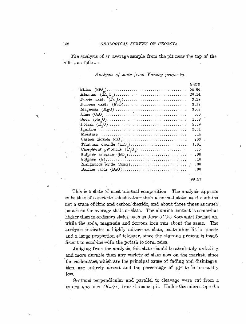
142 GEOLOGICAL SURVEY OF GEORGIA
The anal-ysis of an average· sample from the pit near the top of the hill is as :follows :
Analysis of slate from Y(mcey propm·ty.
S-273 , Silica ( SiO
2) • • • • • • • • • • • • • • • • • • • • • • • • • • • • • • • • • • • • • • 54. 66
Alumina (AI 0) .... '· .... , ....................... 20.14 2 '3
Ferric oxide (Fe20
3).............................. 3.28
Ferrous oxide (F'eO) . . . . . . . . . . . . . . . . . . . . . . . . . . . . . . 3 .17 Magnesia (MgO) . . . . . . . . . . . . . . . . . . . . . . . . . . . . . . . . . . 3 . 09 Lim<e (OaO) ............. .'. . . . . . . . . . . . . . . . . . . . . . . . . . 00 Soda. (Na
20).................................. ... . 1.08
• Potash (K 0) . . . . . . . . . . . . . . . . . . . . . . . . . . . . . . . . . . . . . 9.39
!gnit'.i:on -~·····~·-·····'··························· 3.51 Moisture ................................ : . .... , . . . .14 Carbon dioxide (<J02). . • • . . . . . • • . . . . . . . . • • . . . . . • • . .• ~ 00 Titanium .dioxide (TiO:;.)........................... 1. 01 Phosphorus pentoxide (P 0 ) . . . . . . . . . . . . . . . . . . . . . . . . 00
2 5 ' Sulphur triuxiile' {SO
3) • • • • . • • • • • • .. • • • • .. . . • • .. • • • • 00
Suilphux (Sj .... ~ .................•............. , . . . .10 Manganous 'oxide (MmG) . . . . . . . . . . . . . . . . . . . . . . . . . . . . Q.O Barium oxide (BaO) ........................... , . . . . 00
99.57
This is a slate of most unusual composition. The analys.is appears to be that of a sericite schist rather than a normal slate, as it contains not a trace of lime and carbon· dioxide, .aJJJd about three times as much pGrtasb.-:as the average shale or slate. The alumina content is somewhat higher than in ordinary slates, such as those of the Rockmart formation, while the soda, magnesia and ferrous iron run about the same. The analysis indicates a highly micaceous slate, containing little quartz and a lmrge pmporti0n of feldspar, since the alumina present is insufficient to combine 'With the potash to form mica.
Judging from the a:m.a!lysis, this slate should be absolutely unfading a.Iid more durable than any variety of slate now .on the market, sl.nce the carn:on:ates1 wb.i~h·are the principal cause of fading and disintegration, ar·e entirely absent and the percentage of pyrite =is unusually low.
Sections perpendicular and parallel to cleavage were cut from a typical specimen (8-271) from the same pit. Under the microseope the
SLA1'E DEPOSITS OF GEORGIA 143
slate is seen to have very fine texture and straight cleavage, without lenticular structure. It consists principally of a matrix of sericite with brmiant aggregate polarization in shades of yellow, red, and green. Practically aU of the mica crystals are in parallel .orientation, instead of a bare majority, as in the Rockmart slates. In the section parallel to cleavage the uniform orientation of the mica plates makes the mass act almost as a single crystal, giving a negative interference figure of very small optic angle, due to the super-position of scales with their optic planes in various directions.
As indicated by the analysis, feldspar is abundant in the thin sections. There are about 50 angular, colorless, transparent grains or crystals to the square millimeter, occasionally with maximum dimensions as great as 0.1 mm. Some of the transparent grains may be detrital quartz, but so far as could be determined all are feldspar. Many show albite twinning, some also pericline twinning, and all interference
figures secured from untwinned grains were biaxial, so the presence of quartz could not be shoiWTI.. The feldspar seems to be principally microcline and orthoclase, with perhaps a little albite. The mica leaves show some tendency to bend around the feldspar crystals, but without producing lenticular structure such as is observed in the Rockmart slates. The crystals are angular, showing no shattering nor strain effects, and there is only a slight tendency tow.ard arrangement with the long dimensions parallel to the cleavage. The angularity and lack of shattering of the feldspar indicates that it may have crystallized porphyritically after the development of cleavage, and the clearness of the crystals indicates the same, as detrital feldspars are usually cloudy.
Chlorite is not definitely determinable, but it occurs finely interleaved with the micaceous matrix, giving a greenish tint to the sections, especially in areas immediately surrounding the feldspar crystals.
The opaque minerals present, magnetite, pyrite, and probably some hematite, occur in small grains or lenses, generally with long dimensions parallel to cleavage. The opaque grains and lenses are not abundant in the section perpendicular to cleavage, and are very :rare in the section parallel to cleavage, as they lie along cleavage planes and are easily ground away. There is apparently no carbonaceous or graphitic
144 GEOLOGICAL SURVEY OF' GEORGIA
material, but very small and scattered opaque grains may be either graphite or magnetite.
The minerals present, in decreasing order of abundance, appear to be mica, feldspar, chlorite, quartz, magnetite, pyrite, and rutile.
Although the slate described is apparently of good quality for roofing, the quantity is limited. The best bed, that at the top of the hill, measures about 30 feet thick across the cleavage, a:q.d .the other beds are ev~n thinner, On this account slate quarrying can not be done on a large scale, and probably it will pay better to work the entire formation for potash, disregarding the slate. The character of rock associated with the slate is shown in the trench cut by the American Metal Company (See plan and section, :fig, 6). The beds of true slate do not extend much beyond the original pits, which !Were dug on outcrops. The interbedded material is chiefly a light-colored, sandy and feldspathic shale, softened by weathering, but still containing a high percentage of potash. The summit and east slope of the hill are almost
/-
covered with hard s.andstone float, but the exploration shows only a few beds of this material, and none over 5 feet thick.
The sect~on (fig. 6) shows the. potash content of samples taken along the trench and analyzed by Dr. Edgar Everhart for the American Metal Company. This section has a horizontal length of 800 feet, and, assuming an average dip of 30 degrees, represents a stratigraphic thickness of 500 feet. The average potash content shown by all analyses is 8.19 per cent, which is pro·bably a little below the actual -a;verage, because the lower grade samples represent smaller units than those of higher grade.
Other determinations of potash and soda made for the Survey are as follows:
Pa.rtia.l a.nalyses of sarmples from the J. M. Y a.ncey property.
S-273 S-289 S-290 S-291 Soda (Na
20) .............. 1. 08 .14 .16 .14
Potash (K20) .............. 9.39 9.64 9.32 9.14
S-273. Average sample, 15 ft. of beds, pit No. 1 S-289. Average sample, 15 ft. of beds, pit No. 1 8·290. Average sample, 6 ft .. of beds, pit No. 2 S-291. Average sample, 9 ft. of beds, pit No. 3
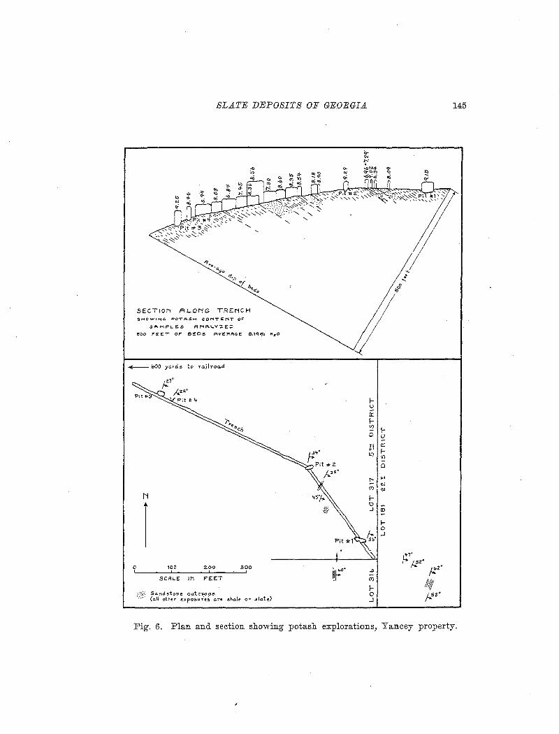
SLATE DEPOSITS OF GEORGIA 145
SECTION ALONG TRENCH S,"oiOWING POTA.SI-I CONTENT OF
SP.MPL-E..S .c::INAI...Y'ZEO
:tOO F"EET OF' BEDS PIVEFi'A<rE: 8,1qoCIJ" KzO
-bOO yanis to ro.aroa.d
f-u 0:: f-'2 !-0 u
;':I 0:: f-II) 1/)
0
!'- •• "' <')
"' N f-
1
0 J ID
f-0 .J
0,.7"
~ j..!z•
t~· ..!l ;.:z• (I')
Ill!; f-
100 2.00 300
SCALE IN FEET
0 ps· ..J
So.nd.stone ou.tc~ps (a./.1 other 42xposur.es a.n oho.le OT' sla.te.)
Fig. 6. Plan and section showing potash explorations, Yancey property.
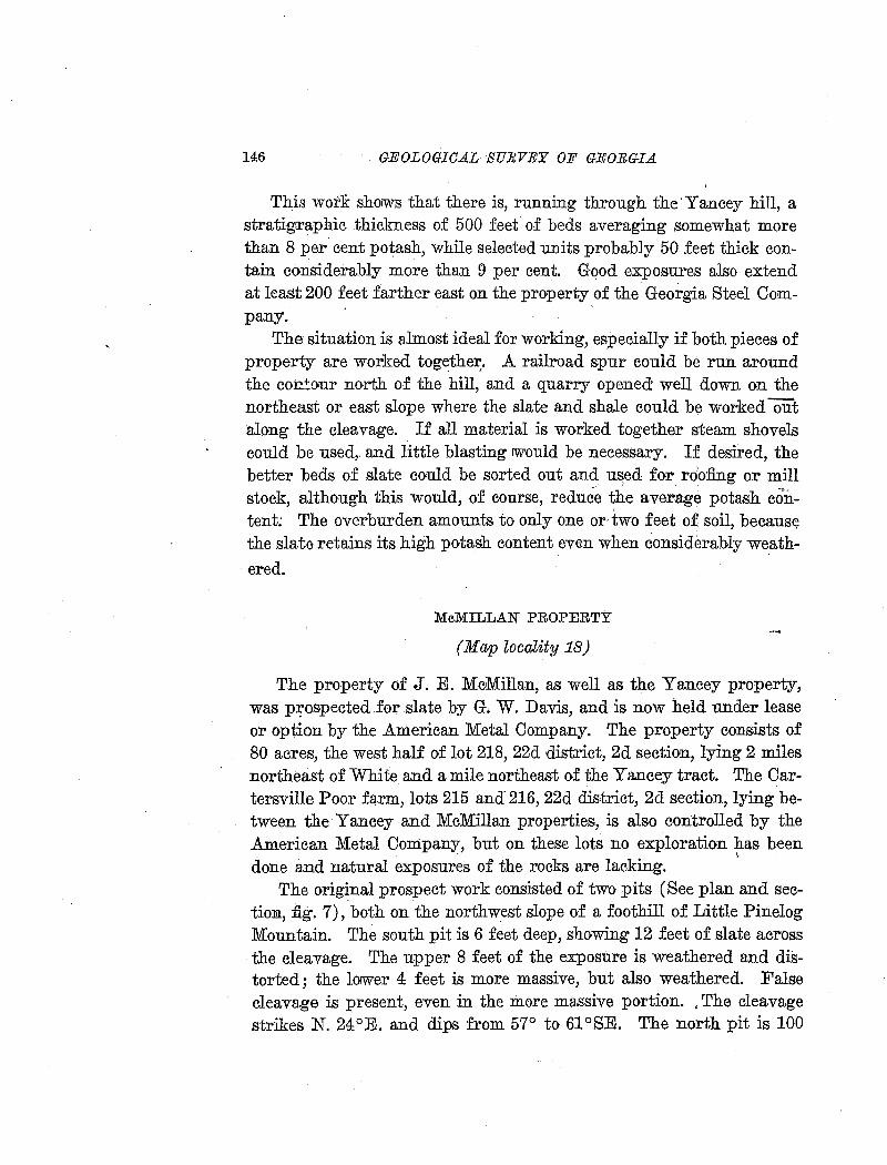
146 GEOLOGICAL SURVEY OF GEOEGI.A
Th.is wor:B: shoiWs that there is, running through the'Yancey hill, a stratigraphic thickness of 500 feet of beds averaging somewhat more than 8 per. cent potash, while .selected units probably 50 feet thick con-, .
tain considerably more than 9 per cent. Gqod exposures also extend at least 200 feet farther eas.t on the property of the Georgia Steel Company.
The situation is almost ideal for working, especially if both pieces of property are worked together:. .A railroad spur could be run around the co:c:~our north of the hill, and a quarry opened well down on the northeast or east slope where the slate and shale could be worked ()ii"'t along the cleavage. If all material is worked together steam shovels could be used,. and little blasting iW'ould be necessary. If desired, the better beds of slate could be sorted out and u~ed for rOofing or mill stock, although this would, of course, reduce the average potash content; The overburden amounts to only one or two feet of soil, becaus~ the slate retains its high potash content even when considerably weath-
ered.
McMILLAN PROPERTY
(Map locality 18)
The property of J. E. M-cMillan, as well as the Yancey property, was p:J;ospected for slate by G. W. Davis, and is now held under lease or option by the .American Metal Company. The property consists of 80 acres, the west half of lot 218, 22d district, 2d section, lying 2 miles northeast of White and a mile northeast of the Yancey tract. The Cartersville Poor farm, lots 215 and 216, 22d dis·trict, 2d section, lying between the Yancey and McMillan properties, is also controlled by the .American Metal Company, but on these lots no exploration has been done and natural exposures of the rocks are lacking. ··
The orig~nal prospect work consisted of two pits (See plan and sectima, fig. 7), both on the northwest slope of a foothill of Little Pinelog Mountain. The south pit is 6 feet deep, showing 12 feet of slate across the cleavage. The upper 8 feet of the exposure is weathered and distorted; the loiWer 4 feet is more massive, but also weathered. False cleavage is present, even in the more massive portion. , The cleavage strikes N. 24°E. and dips from 57° to 61 °SE. The north pit is 100
A
\ os•
:6 North Pit
N
·0 100
SLATE DEPOSITS OF GEOEGI.A
SECTIONS ALONG TRENCHES SHOWING POTASH CONTENT OF
SAMPLES ANALYZED
B
~~·" " " " " " " " " zoo 300 '1-00
~
SCAI...E IN F"EET "' r
j.."a• D
147
0
Fig. 7. Plan and section showing potash explorations, McMillan property.
yards north of the first, and lower topographically and stratigraphically. It is 6 feet deep, showing 10 feet of slate across the cleavage. The cleavage is better than :in the south pit, but false cleavage is de-
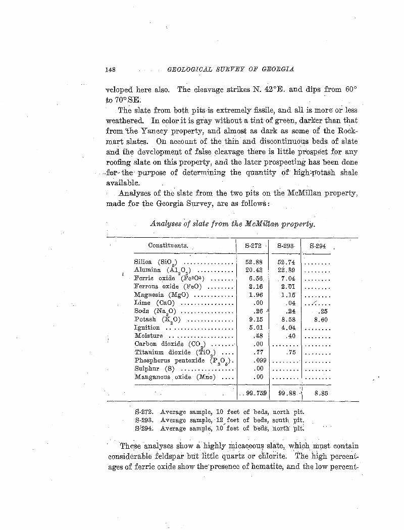
148 GEOLOGICAL SURVEY OF GEORGIA
veloped here also. The cleavage strikes N. 42°E. and dips from 60° to 70°SE.
The slate from both pits is extremely fissile, and all is more· or less weathered. In color it is gray without a tint of green, darker than that from 'the Yancey property, and almost as dark as some of the Ro~kmart slates. On account of the thin and discontinuous beds of slate and the development of false cleavage there is little p~ospe<;t for any roofing slate on this property, and the later prospecting has been done
.. :for·· the. purpose of determining the quantity of high:p-otash shale available .
.Analyses of the slate from the two pits on the McMillan property, made for the Georgia Survey, are as follows: ·
'
I
Analyses of slate from the McMilZan pr6Jperty.
Constituents. S-272 S-293- S-294 . -
Silica (SiO 2
) ............... 52.88 52.74 . ....... Alumina (A1 0) ........... 20.43 22.89 • ••• 0 •••
2 3 Ferric oxide (Fe203) •••••• 0 6 .. 56 7.04 .....• 0. Ferrous oxide (FeO) ........ 2.16 2.D1 . ....... Magnesia (MgO) ............ 1.96 1.15 . ....... Lime (CaO) .00 .04 /
• 0 ••• 0 •••••••••• . ....... Soda (Na
20) ................ .26 .I .24 .25
Potash (K20) .............. 9.15 8.58 8.60 Ignition . . .................. 5.01 4.04 . ....... Moisture .. • • • • • • 0 •••••••••• .48 .40 . ........ Carbon dioxide (C02) ....... .00 o. 0 e I 0 o o ........ Titanium dioxide (Ti0
2) .... .77 .75 . .......
Phosphorus pentoxide (P205). .099 . . . . . . . . ••••• 0 ••
Sulphur (S) •••••••••••• 0 ••• .00 . ....... . . . . .. . . . Manganous_oxide (Mno) .... .00 . ....... . . . . . . . .
- -.. 99.759 99.88
S-272. Average sample, 10 feet of beds, north pit. S-293. Average sample, ·12 ~feet of beds, south pit. S!294~ Average saniple, 10 feet of b'eds, north pit:
. . . .
8 .. 85
The.se analyses show a highly :ri:tica~eou~ slate, ~hich. mp.st contain considerable feldspar but 1ittle quartz or chlo:dte. The high percent·ages of ferric oxide show the·presence of hematite, and the low percent-·
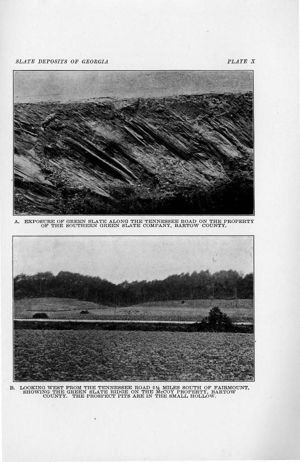
SLATE DEPOSITS OF GEORGIA PLA1'E X
A. EXPOSURE OF GREEN SLATE ALONG THE TENNESSEE ROAD ON THE PROPERTY OF THE SOUTHERN GREEN SLATE COMPANY, BARTOW COUNTY.
B. LOOKING WEST FROM THE TENNESSEE ROAD 2'h MILES SOUTH OF FAIRMOUNT, SHOWING THE GREEN SLATE RIDGE ON THE McCOY PROPERTY, BARTOW
COUNTY. THE PROSPECT PITS ARE IN THE SMALL HOLLOW.
SLATE DEPOSITS OF GEORGIA 149
ages of ferrous oxide indicate little chlorite, as a part must be combined with ferric, oxide in magnetite. Except for the larger percentage: of hematite, which accounts for the darker color, this slate is very sim-
. ilar to that on the Yancey property. A thin section of specimen S-272 was examined under the micro
scope. The matrix is :finely crystalline, with brilliant aggregate polarization, and !Without lenticular structure. The section parallel to deavage gives a negative biaxial interference figure of small optic angle.
Angular crystals of feldspar are abundant, although smaller and less numerous than in the Yancey slate. The grains show some tendency to arrangement with the long dimensions parallel to cleavage.
The opaque minerals are magnetite and hematite, but no pyrite. Finely granular dark material is segregated in small lenses elongated parallel to cleavage. One of the largest lenses measures 0.01 by 0.14 mm. Carbonaceous matter and graphite occur in very small quantity, if at all. The slate owes its color to micaceous hematite, occurring interleaved with the mica,ceous matrix. The hematite flakes are large and thick enough to give a gray instead of a red color to the slate in mass, but in the section parallel to cleavage dark red translucent scales are very abundant.
Green flakes of chlorite are visible under the highest power, but that mineral is not abundant enough to give a green tint even in thin section.
The slate beds are not only thin, but they pinch out rapidly along the strike of the cleavage. Thus the trench cut only 10 feet north of the north pit shows no hard slate, although the strike of the exposure in the pit should carry it across the trench.
The potash contents of the separate units of beds in the pits and trenches are shown in fig. 7. The potash average of the north pit and trenches, across a horizontal width of 200 feet, is 6.40 per cent. The south pit aud trench, across a width of 150 feet, show an average of 5.50 per cent potash. Each of these trenches shows one unit of beds with less than 3 per cent potash, which is far below the average for the Cartersville formation as a whole, as indicated by all analyses available. However, this low potash content may be explained partly by the degree of weathering, because the trenches are not deep enough to reach even approximately fresh material.
150 GEOLOGIG.A..L SUlWEJ! OF GEORGIA.
The continuation of the trench southeast of the south pit, on the east slope of the hill, shows the beds for a horizontal distance of 141 feet across the strike, with average potash content of 6.40 per. cent. About 300 yards south of the end of this.tre:nch, and on the east slope of the hill :near the south line of the land lot, there are four more trenches and a small pit. Ninet~en samples collected from these by G. B. Corless range from 3.85 to l0.26 per cent potash, with an average of 7.43 per cent.1
The McMillan property has not been completely explored, but the work done indicates that the average potash content of the material obtainable 'by steam-shovel mining .would not exceed 7- per cent; although selecteQ. beds would yield 9 per cent or more .. The situation .is ·favorable for working, as the deposits occur in a \hill rising 100 feet above the valley level, and the-Louisville & Nashville and Iron Belt railroads pass within a quarter of a mile to the west and east, respectively.
AMERICAN POTASH OOMPA.N:Y PR0J>ER.TIES
(M:ap·loca•lity 19) . ·
The American Potash Company controls thB Pyr~n pr<:>p13:rty of 20 acres,·4·mil~s·north:of'Gartersville; and the· T.: A .. Bennett p:roperty, 8 acres, harlf ·a: mile SOl,]}trhwres.t .of. White; M:i!ruirig:;has: been· done· only· on the Bennett property.
The Bennett property, a part of lot 298, 5th district, 3d section, lies along the Louisville & Nashville Railroad, and. a g~od section of the beds is shown in a railroad cut .. There are 16 beds of purplish, slaty shale totaling about 60 feet, in a total stratigraphic thickness of 250 or 200 feet. The strike varies from N. 45°E. toN. 72°E., and the dip from 40° to 70°SE. The beds o~ bluish slaty shale, which contain the most potash,. are interbedded with light-colored,· weathered shale and feldspathic sandstone. There is only one thin bed of true quartzite, which· outcrops at the north end of the section.
The quarry is in the hill just west of the railroad cut, .where the surface is about 20 feet above the railroad level. · The .quarry was opened in April, 1918, and in June the opening was about 200 feet long, 50 feet
i The section and a number of ilnalyses· were given by Mr. M. W. Hayward and Mr. G. B. Corless, geologists for the American Metal Comp:;~.ny. All analyses were made by Dr. Edgar Everhart. ·
"
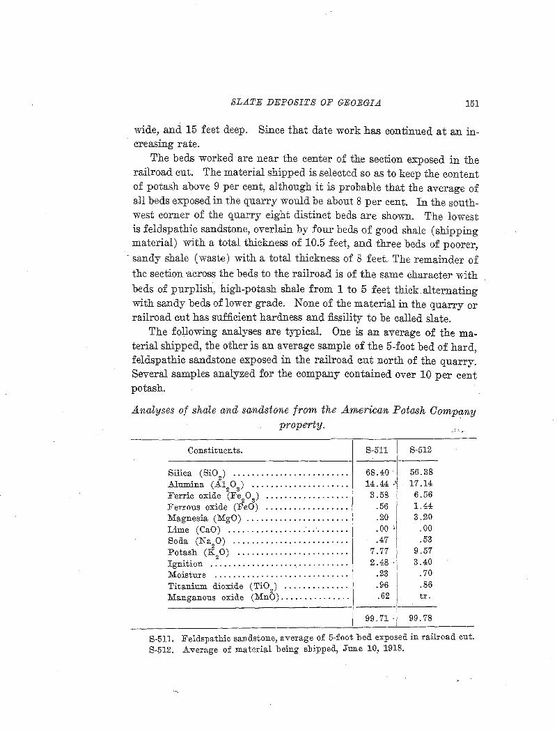
SLATE DEPOSITS OF GEORGIA 151
wide, and 15 feet deep. Since that date work has continued at an increasing rate.
The beds worked are near the center of the section exposed in the railroad cut. The material shipped is selected so as to keep the content of potash above 9 per cent, although it is probable that the average of all beds exposed in the quarry would be about 8 per cent. In the southwest corner of the quarry eight distinct beds are shown. The lowest is feldspathic sandstone, overlain by four beds of good shale (shipping material) with a total thickness of 10.5 feet, and three beds of poorer,
- sandy shale (waste) with a total thickness of 8 feet. The remainder of the section •across the beds to the railroad is of the same character with beds of purplish, high-potash shale from 1 to 5 feet thick alternating with sandy beds of lower grade. None of the material in the quarry or railroad cut has sufficient hardness and :fissility to be called slate.
The following analyses are typical. One is an average of the material shipped, the other is an average sample of the 5-foot bed of hard, feldspathic sandstone exposed in the railroad cut north of the quarry. Several samples analyzed for the company contained over 10 per cent potash.
Analyses of shale and sandstone from the American Potash Company property.
Constituents.
Silica (Si02
) ••••••••••••••••••••••• • •
Alumina (Al20
3) •••••••••••••••••• • ••
:F'erric oxide (Fe20 3 ) •• • • • • • • • • • • • • • • • •
Ferrous oxide (FeO) ................. . Magnesia (MgO) ..................... . Lime (CaO) ................ ." .. · ...... .
Soda (Na9 0) ... · · · · · · · · · · · · · · · · · · · · · · Potash (K 0) ....................... .
2 Ignition ........................ · ... · · · Moisture ...................... · .... · · Titanium dioxide (TiO) ............. . Manganous oxide (MnO) .............. .
S-511
68.40. 14.44 ·1
3.58 .56 .20 .00 ) .47
7.77 2.48 .
.23
.96 . 62
99.71.
S-512
56.38 17.14
6.56 1.44 3.20
.00
.53 9.57 3.40
.70
.86 tr .
99.78
S-511. Feldspathic sandstone, average of 5-foot bed exposed in railroad cut. S-512. Average of material being shipped, Jun.e 10, 1918.
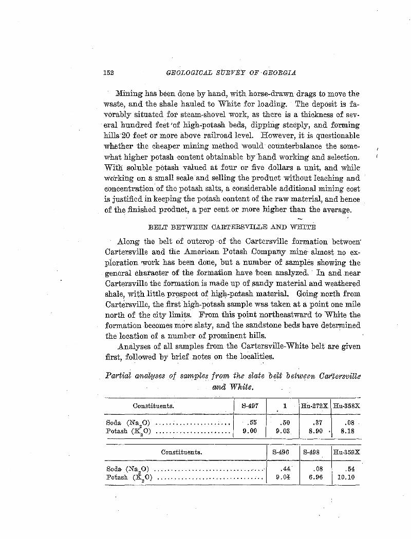
152 GEOLOGICAL SURVEY OF GEORGIA
Mining has been done by hand, with horse-drawn drags to move the waste, and the shale hauled to White for loading. The deposit is favorably situated for steam-shovel work, as there is a thickness of several hundred feet 'of high-potash beds, dipping steeply, and forming hills 20 feet or more above railroad level. · However, it is questionable whether the cheaper mining method would counterbalance the somewhat higher potash content obtainable byhand working and selection. With soluble potash valued at four or five dollars a unit, and while working on a small scale and selling the product without leaching and concentration. of the potash salts, a considerable additional mining cost is justified in keeping the potash content of the raw material, and hence of the finished product, a per cent or more higher than the average .
. BELT BETWEEN CARTERSVILLE AND WRITE
.Along the belt of outcrop ·of the Cartersville formation between' Cartersville and the .American Potash .Company mine· almost no exploration rwork has been done, but a number of samples showing the general character of the formation have 'been analyzed. In and near Cartersville the formation is made up of _sandy material and weathered shale, with.little.prospect of hig}f.-po:tash materiaL Going north from Cartersville, the first high-potash sample was taken at a point one mile north of the city limits: From this point northeastward to White the formation becomes more slaty, and the sandstone beds have determined the location of a number of prominent hills .
.Analyses of all samples from the Cartersville-White belt are given first, foll01wed by brief notes on the localities.
Partial anal;yses of samples from the slate b~lt befnv.~en OartersviUe
and White.
Constituents.
Soda (Na20) ........... · · · · · · · · · · • Potash (K20) .......... · · · · · · · · · · · ·
Constituents.
1:3-497
.55 9.00
Soda. (Na20) •• 0 0 ..... 0 •••• 4 •••••••••••••••••••
Potash (K20) •••• " •••••••••••••••• 0 ••• 0 •• 0 ••
S-496 S-498 Ru-359X
.44" .08 .54 9.04 6.96 10.10
SLA1'E DEPOSITS OF GEORGIA. 153
S-497. Tennessee road, 1 mile north of Cartersville city limits. 1. B. F. Gorman property, lot 202, 5th district, 3d section. Sample sent by
J. T. Norris. Hu-372-X. F. E. Matthews property, lot 230, 5th district, 3d section. Sam
ple collected by J. P. D. Hull. Hu-358-X. Mrs. Joe G. Green property, lot 229, 5th district, 3d section.
Sample collected by J.P. D. Hull. S-496. From the prominent hill 1 mile southwest of White. S-498. Tennessee Road near overhead crossing of L. & N. Railroad, 1 mile
south of White. Hu-359-X. E. W. Hicks property, lot 299, 5th district, 3d section. Sam
ple collected by J. P. D. Hull.
The first sample ( S-497) was taken from an exposure beside the Tennessee Road at the crossing of a branch a mile north of the Cartersville city limit and probably on lot 194, 4th district, 3d section. The exposure, of which the sample represents an average, shows 25 feet stratigraphically of light gray, partly weathered shale, of which only 1 foot is hard enough to be called slate. The cleavage strikes N. 15 o
E. and dips 60°SE. Lots 202, 230, and 229, from which the next three samples were
taken, are in a hilly area west of the Louisville & Nashville Railroad and 5 miles due north of Cartersville. The Cartersville formation here contains some sandstone lenses which form the back-bones of hills over a hundred feet high, but there are also beds of slaty, high-potash shale. Sample Hu-372-X represents a thickness of 15 or 20 feet of beds of gray slate, alternating with gray or yellowish shale through a thickness of 35 or 40 feet, exposed in a ditch. The strike is N. 45 °E., with a steep dip to the southeast. Sample Hu-358-X is from the next land lot to the north, from an exposure north of the public road and east of a branch of Pettit Creek, near the residence of J. C. Carson (colored). The sample represents a 12-inch and an 18-inch layer of purplish shale separated by 20 feet of alternatfng layers of gray and yellowish weathered shale and sandy shale. The strike is N. 65°E., dip 55°SE.
Sample S-496 is from the hill south of the Grassdale road a mile southwest of White, and on lot 262 or 263, 5th district, 3d section. No exposures of rock in place were found on the hill, which is largely covered with fragmental sandstone. The sample was taken from fragments of gray slate float which are found over a considerable area near the summit of the west slope of the hill.
154: GEOLOGICAL SURVEY OF GEORGIA
Sample S-ZJ-98 represents 10 feet of beds exposed in the road cut on the Tennessee road just north of the overhead ·bridge of the Louisville & Nashville Railroad a mile south of White. All. of the material is much weathered and clayey in appe-arance, so the potash content of nearly ·7 per cent is remarkably high. The beds strike N. 45°E., and dip 50°SE.
Samp~e Hu-359-:X is from the E. W. Hicks property, lot 299, 5th .. - district, 3d section, just south of the American Potash Company quar
ry. 'J..1he shale is exposed in a road cut and in several small pits, from one of which the sample was taken.
\ BELT NORTHEAST OF WHIT:B1
. The slate belt from White northeast to the place where it is cut off by the Cartersville fault varies from half a mile to a mile in width. No exploration work has been done, excepting on the Yancey and McMillan properties. Partial analyses of a number of samples £rom road cuts and natural exposures are listed below, followed by brief notes ·on the localities.
Partial analyses of samples from fh;e · slate belt nor-theast of White.
Constituents S-477 1 S-483 S-515 S-484 S-487
"
Potash (K20)· ... .51 .46 .20 .53 .18 .16
5.48 Soda (Na20) .. 9.44 8.02 7.61 8.40 8.35
S-489 S-490 I S-495 2 S-295
Soda- (Na20) ...... .15 .52 .54 .39 .19
8.38 Potash (K20) ..... 7.84 7.22 7.92 8.86
Complete aJJt(J;lysis of sample S-296.
Silica (Si02
) •••••••••••••••••••••••••••••••••••••• 55.25 ..Alumina (A1 0 ) . . . . . . . . . . . . . . . . . . . . . . . . . . . . . . . . . . 20.60
2 3 Ferric oxide (Fe 0 ) . . . . . . . . . . . . . . . . . . . . . . . . . . . . . . 6.40
2 R Ferrous oxide (F'eO).............................. 2.01
S-296
.36 8.64
S-494
.37 7.34
SLATE DE-POSITS OF GEORGIA
Magnesia (MgO) ................................. . Lime (CaO) ...................................... .
Soda (Na20) ...... · ·. · ... · · · · · · · · · · · · · · · · · · · · · · · · · Potash (K.,O) .................................... . Ignition . : . ............................... , ....... . Moisture ........................................ . Titanium dioxide (Ti0
2) ••••.•••.••..••.•••••••••••
1.98 .00 .36
8.64 4.17
.34
.96
Total . . . . . . . . . . . . . . . . . . . . . . . . . . . . . . . . . . . . . . . .100. 71
S-477. Railroad cut Ph miles east of White. 1. Dysart property, lot 217, 22d district, 3d section. S-483. Near residence of 0. J. Smith, lot 319, 22d district, 3d section. S-515. Road cut 2 miles east-southeast of Pinelog. S-484. Junction of Sugar Hill road and Pinelog-Waleska road. S-296. Pinelog-Waleska road 2:lh miles east of Pinelog. S-487. Pinelog-Waleska road 2:lh miles east of Pinelog. S-489. Pinelog-Waleska road 2lh miles east of Pinelog. S-490. Pinelog-Waleska road 2:lh miles east of Pinelog.
155
S-495. One-fourth mile north of Pinelog-Waleska road 2:lh miles east of Pinelog.
2. Rufus Jones property, lot 294, 23d district, 2d section. S-295. Rufus Jones property) lot 294 23d district, 2d section. S-494. Mrs. L. J. Bradley property, lot 283, 23d district, 2d section.
Sample S-477 iWas taken from a small exposure in a cut on the Iron Belt Railroad 1~ miles east of White. This locality is east of the principal high-potash slate deposits, and may be only an outlier. The hill just west of the exposure is covered by fragments of quartzite, of which some masses appear to be in place.
The Dysart property, lot 217, 22d district, lies west of the McMillan property, and is largely underlain by the Conasauga formation, to which the shale (No. I) containing 5.48 per cent of potash may belong. The Louisville & Nashville Railroad cut just southwest of the Cartersville Poor Farm is near the southwest corner of this lot. The slate exposed in the cut is a typical green slate of the Conasauga formation, and an average sample contains 2.75 per cent potash and 1.47 per cent soda. Apparently the whole of the prominent hill just east of the railroad is of similar material.
Sample S-483 represents about 6 feet of beds exposed on each side of the public road in front of the residence of 0. J. Smith, just north of the crossing of Little Pinelog Creek. The material is a weathered shale
156 GEOLOGICAL SVRVEY•OF GEORGIA
of clayey appearance, and the potash content o·f a little over 8 per cent is remarkably high.· .A sample collected by M. W. Hayward from a corn field on the same lot contained 8.30 per cent potash.
SampleS-SIS is from an exposure in a road cut a mile east of Rydal, and near the western boundary of the Cartersville fo·rmation area. These beds extend through the prominent hill south of the Sugar Hill branch of Pinelog Creek, but t:q.e formation in this hill seems to consist largely of sandy or quartzitic beds.
Baker property.-Dr. T...: H. Baker, of Cartersville, owns a great deal of property in the northern part of the Cartersville slate belt, including the following 160-acre lots: . 321, 320, 319, and 318; 23d district, 2d section; 252, 254, 255, 256, 257, 283, and 284, 22d· district, 2d section. Exposures along the Pinelog-Waleska road, which is shown on the Bartow County map as crossing lots 293; 294, and 295, 23d district, 2d section, are also said to be on properties belonging to Dr. Baker.
Going east on the Pinelog-Waleska road from the Tennessee road there is a considerable area of calcareous shale and impure, magnesian 1imestcme, ·evidently belong to the Conasauga formation, and yielding a dark~ red soil. . ' .At the top olf the hill east of ;tJie· Sugar Ni1LEork of Pinelog Creek, the boundary between the Conasauga and Cartersville formations is crossed. The field at the top of the hill is covered wit)l sandstone float,
. and in front of the house north of the road and 0.5. mile east of the creek is a well from which both sandstone and gray' slate were taken. (Map·looality 20.) Sample S-487 is an average of the slate fragments on the dump at the well.
· Starting down the east slope· of the hill, 220 yards east of the well is a bed of.:gray slate exposed in the roadside cut. The cleavage strikes N. 47°E. and dips 60°StE., and the thieknessof the mass o:f practically fresh slate is about 75 feet across the cleavage, that is to say, one of the thickest continuous gray slate beds in the district. Sample S-489 is an average of the entire thickness, while sample S-296 represents only, the hardest beds. .An average sample was also collected by M. W. Hayward, and showed 8.02 per cent potash. This slate would not be suitable for roofing on account ·of ''false'' and irregular cleavage. It con-
SLATE DEPOSITS OF GEORGIA 157
tains a considerable amount of finely crystalline hematite, which gives it a purplish color. This excess of ferric oxide seems to be the principal rea_son for the potash content falling about one per cent lower than that of the gray slates .farther south.
For 90 yards eastward and down the slope from this bed of slate is much-weathered, clayey shale. At this point is a 7-foot bed of hard, fresh, blue-gray slate, striking N. 44°E. and dipping 38°SE. From here on down to the foot of the hill to the east are exposures of much weathered shale with a few thin beds of comparatively fresh shale. Sample S-490 is an average of this entire unit, starting with the 7-foot bed of hard slate and measuring 190 yards eastward along the road. The potash content of over 7 per cent is remarkably high, as most of the material appears to contain no more potash-bearing minerals than any ordinary residual clay.
At the end of the section from which the preceding samples were taken a branch road turns north to the Rufus Jones residence. Two hundred yards north of the main road is an area of about an acre thickly covered with gray slate float in a cultivated :field. Sample S-495 is an average of this float.
Half a mile east of these exposures, at the junction of the PinelogW aleska road and the Sugar Hill road, is the exposure from which sample S-484 was taken. The sample is from a 3-foot bed of partly weathered gray slate, rwhich forms an open syncline, with the axis striking northwest. The overlying and underlying material is softer and more weathered. A short distance east of this locality is the eastern boundary of the Cartersville formation, but the Beaver limestone and the Weisner quartzite are exposed up the valley of Pinelog Creek as far east as Martins Mill.
Jo1~es property (Map locality 2I).-Rufus Jones owns a part of lot 294, 23d district, 2d section, lying north of Dr. Baker's property along the Pinelog-Waleska road, 3 miles east of Pinelog. The property is now (1918) controlled by the Vithumus Company.
Sample No.2 in the preceding table was sent in by Jones. S-295 was collected by S. W. McCallie and the writer from an exposure along the road just east of Jones' house. Good beds of high-potash slate strike northeast through the property, with exposures along the north-
158 GEOLOGICAL SURVEY OF GEORGIA
south public road and in the hills both east and west of a branch of P.inelog Creek.
Bradley property.-Mrs. L. J. Bradley owns- lot 282 and the east half of lot 283, north of the Jones property. The slate beds from the Jones property continue northeast onto these lots, where they are cut off by the Cartersville fault. The prominent hills in the northeast part of the Bradley property are made up of the early Cambrian "mountain rock.'' Farther north the Conasauga formation abuts against the "mountain rocks" along the great ·fault, the Cartersville formation oeing cut 01:!-t entirely.
Hample S-494 is from an exposure in a gully on the Bradley property about half a mlle northeast of Rufus Jones's residence.- The sample represents 10' feet of beds of greeniSh-'gray· :slate. This. slate resembles some portions of the Conasauga formation in appearance, but. its high~potash · content. indicates that it belongs'.· to the Cartersville for:rilation.
DEPOSITS NEAR CASSVILLE
Belts of the Carters:cille .formation containing much high-potash material'· outcrop' along the' tliree1par:allel, nor-theast:tre:riding. ridges southeast of Ca.Ssville: The three belts are each about 2 miles long, and are united into a single broad area at.tlie north. The·valley-s ·Between the ridges are covered with residual soil and transported material whose charact~rindicates'that it is underlain by limestone.
Most of the sarriples analyzed have been taken from a group of properties from 1 . to 1 Yz miles southeast o.f CassVille. All o·f these partial analyses are here listed, followed by brief notes on the properties.
Partial analyses of slate from the vicinity of Oassv·iUe.
Constituents S-491 1 ·2 3 4 5 6
Soda (Na20) .. .80 .25 .19 .76 .36 .16 .27
Potash (K20). 9.12 9.00 8.96 9.16 7.56 8.34 7.60
SLATE DEPOSITS OF GEORGIA 159
Constituents S-492 S-493 7 8 9 10 11
Soda (Na20) .. .35 .57 .14 .55 1.57 .37 .87
Potash (K20). 10.08 6.86 10.20 6.98 8.38 9.85 9.29
Constituents 12 13 Hu-372 Hu-373 Hu-374 Hu-375 S-519
Soda (Na20) .. .34 .36 .41 .22 .89 .87 .20
Potash (K20). 7.99 5.37 5.48 6.14 7.02 5.76 7.08
S-491, 1, 2, 3, 4, 5, and 6.-G. H. Headden property, south half of lot 130, 5th district, 3d section.
S-492, S-493, 7, 8, and 9-J. H. Walker property, north halves of lots 130, 159, and 166, 5th district, 3d section.
10.-Lot 159, 5th district, 3d section. Sent by J. T. Norris.
11, 12, and 13.-W. W. Daves property, parts of lots 159, 160 and l66, 5th district 3d section.
Hu-372, Hu-373, and Hu-374.-M. L. Johnson property, lots 124 and 125, 5th district, 3d section ..
Hu-375.-Lot 127, 5th district, 3d section, %, mile east of Cass Station.
S-519.-Isolated exposure on public road 2 miles northwest of Cartersville.
Headden property (Map locality 22).-The property of G. H. Headden, of Cassville, consists of 60 acres in the southern part of lot 130, 5th district, 3d section. This lot includes a part of the western of the three slate ridges, along the middle public road leading eastward :from the Dixie Highway between Cass Station and Cassville.
Sample S-49I was taken at the top of the ridge near the public road. It represents 5 feet of actual outcrop and float slate :for a distance of 100 feet down the east slope. In the outcrop the cleavage strikes N. 43°E. and dips 46°SE. There are also small outcrops of sandstone and much sandstone float along the top of the ridge.
Samples Nos.1 and 2 were sent in by Headden, and Nos. 3, 4, 5, and 6 were collected by S. W. McCallie. All are from natural exposures on the property. No exploration work has been done on the property to show thickness and continuity of the high-potash shale beds, but the natural exposures are rather extensive, and the situation is very favorable for working.
160 GEOLOGICAL SURVEY OF GEORGIA
Walker property (Map locality 2 3) .-The property of J. H. Walker consists of 255 acres in the north portion of lots 130, 150 and 166, 5th district, 3d section. The property lies north of the Headden property. Its maximum length from east to west is 1~ miles aud it extends across both the western and middle slate ridges.
Sample S-492 is from an exposure in a gully near the bottom Q.f the east slope of the rwest ridge."' The sample is an aver~ge of all the beds
. . . -~ .
of greenish and purplish slate which make up about half of an interval o£'60 feet across the .cleavage. The other b~ds of the exp~sure are mor~
· orlesEf feldspathic sandstone. The cleavage strikes N: 40° to 50°E. and dips 3.5° to 60°SE. . . .
Sample S-493 is an average of a 6-foot and an 8-foot bed of p:Ur-·p1ish.:.gray slafte exposecfhigher on the ·siope, along an· abandoned road rwhich crossed a·saddle in tb,e ridge. · S~:r;nple No, ·?'.:was taken by 1V.Ir. walker .from 'a naturai exposure near tlie' foot of tlie west ~lope. of the 'w~st ridge, and' this sample has. a higher pot~sh contetit than any other coilected from the Cartersville formation up to the present time. Sample No. 8 is a feldspathic sandstone from the west ridge, .and No. 9 is from an exposure on the middle ridge .
.Although: no explorat1on wo'rk' has·lJeen done· on this property', the indications are that the rwest ridge, which is between 100 and 150 feet 'high, consists· larg6~Y of slate or. shale containing from 7 to more. than 10 per cent potash. The· situation is very favorable for steam shovel 'working,. and a spur track cou1d be built up the level ·valley from Cass Station on the Western & Atlantic Railway, a distance of 2 miles, ~thou~ great trouble or expense.
Daves. p~operty (11Iap locality 24).-W. W. Daves, of Cartersville, ·OW'P-S parts. e-f, lot~ .159, 16Q,. and 166, 5th district, 8d section. This pr~p'erty is oll, 't~e mi~cn~ siate ridge, east of theHe·adden and south of the Walker properties.
Saniple No.10, -takeri·by J. T. Norris, is from lot 159·, but may be from· either the Walker o'r Da~e.s property. Nos .. 11, 12, and 13, col-lected by W. W. Daves, are from lots 159, 160, and 166; respectively.
johnson property (Map .locality 25) .-M. L. Johnson owns lots 124, 125, 128, and 129, 5th district, 3d section, a total of 640 acres, including
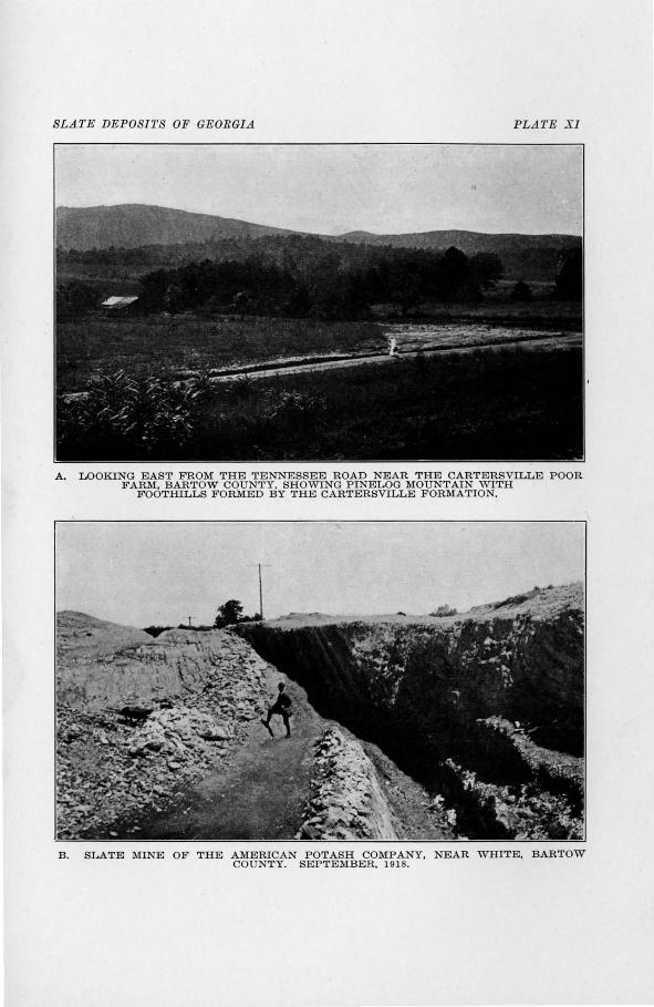
SLATE DEPOSITS OF GEORGIA PLATE X I
A. LOOKING EAST FROM THE TENNESSEE ROAD NEAR THE CARTERSVILLE POOR FARM, BARTOW COUNTY, SHOWING PINELOG MOUNTAIN WITH
FOOTHILLS FORMED BY THE CARTERSVILLE FORMATION.
B . SLATE MINE OF THE AMERICAN POTASH COMPANY, NEAR WHITE, BARTOW COUNTY. SEPTEMBER, 1918.
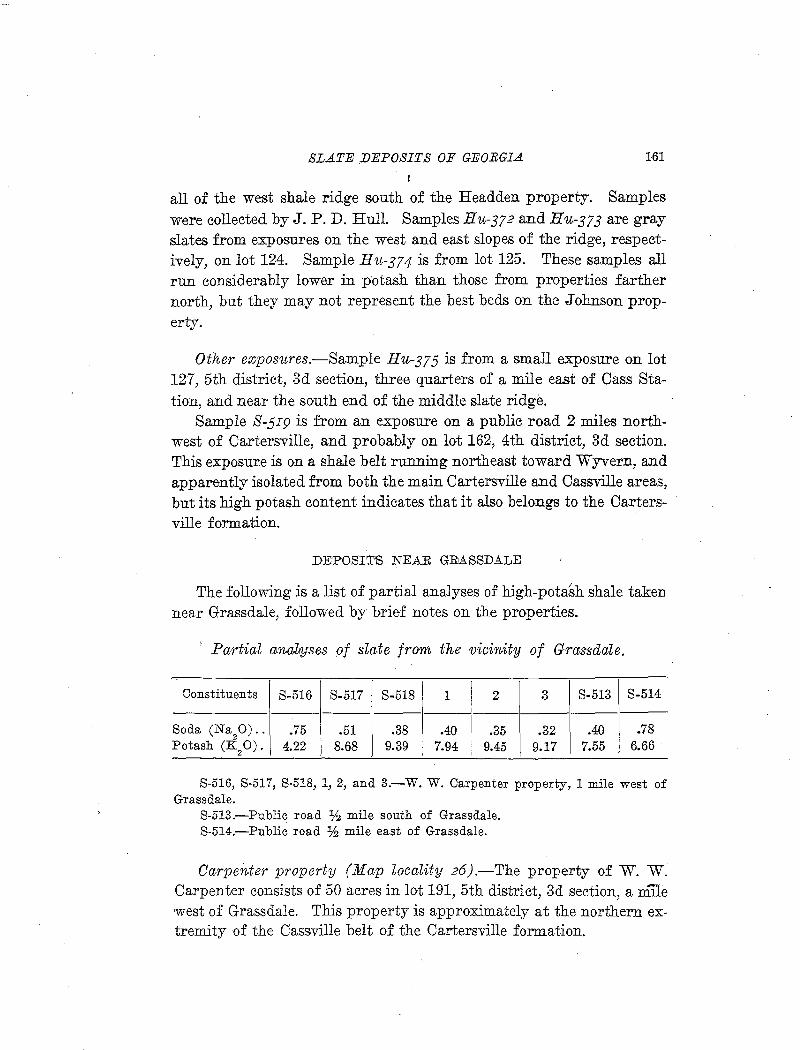
SLATE DEPOSITS OF GEORGIA 161
all of the west shale ridge south of the Headden property. Samples were collected by J.P. D. Hull. Samples Hu-372 and Hu-373 are gray slates from exposures on the west and east slopes of the ridge, respectively, on lot 124. Sample Hu-374 is from lot 125. These samples all run considerably lower in potash than those from properties farther north, but they may not represent the best beds on the Johnson property.
Other exposures.-Sample Hu-375 is from a small exposure on lot 127, 5th district, 3d section, three quarters of a mile east of Cass Station, and near the south end of the middle slate ridge.
Sample S-SI9 is from an exposure on a public road 2 miles northwest of Cartersville, and probably on lot 162, 4th district, 3d section. This exposure is on a shale belt running northeast toward W yvern, and apparently isolated from both the main Cartersville and Cassville areas, but its high potash content indicates that it also belongs to the Cartersville formation.
DE~POSIT'S NEAR GIMSSDALE
The following is a list of partial analyses of high-pota~h shale taken near Grassdale, followed by brief notes on the properties.
Padia~l aJnaliyses of slate from the vicinity of Grassdale.
Constituents S-516 S-517 S-518 1 2 3 S-513 S-514
Soda (Na20) .. .75 .51 .38 .40 .35 .32 .40 .78
Potash (K2 0). 4.22 8.68 9.39 7.94 9.45 9.17 7.55 6.66
S-516, S-517, S-518, 1, 2, and 3.-W. W. Carpenter property, 1 mile west of Grassdale.
S-513.-Public road lf.J mile south of Grassdale. S-514.-Public road ~ mile east of Grassdale.
Carpen,ter property (Map locality 26).-The property of W. W_ Carpenter consists of 50 acres in lot 191, 5th district, 3d section, a mile west of Grassdale. This property is approximately at the northern extremity of the Cassville belt of the Cartersville formation.
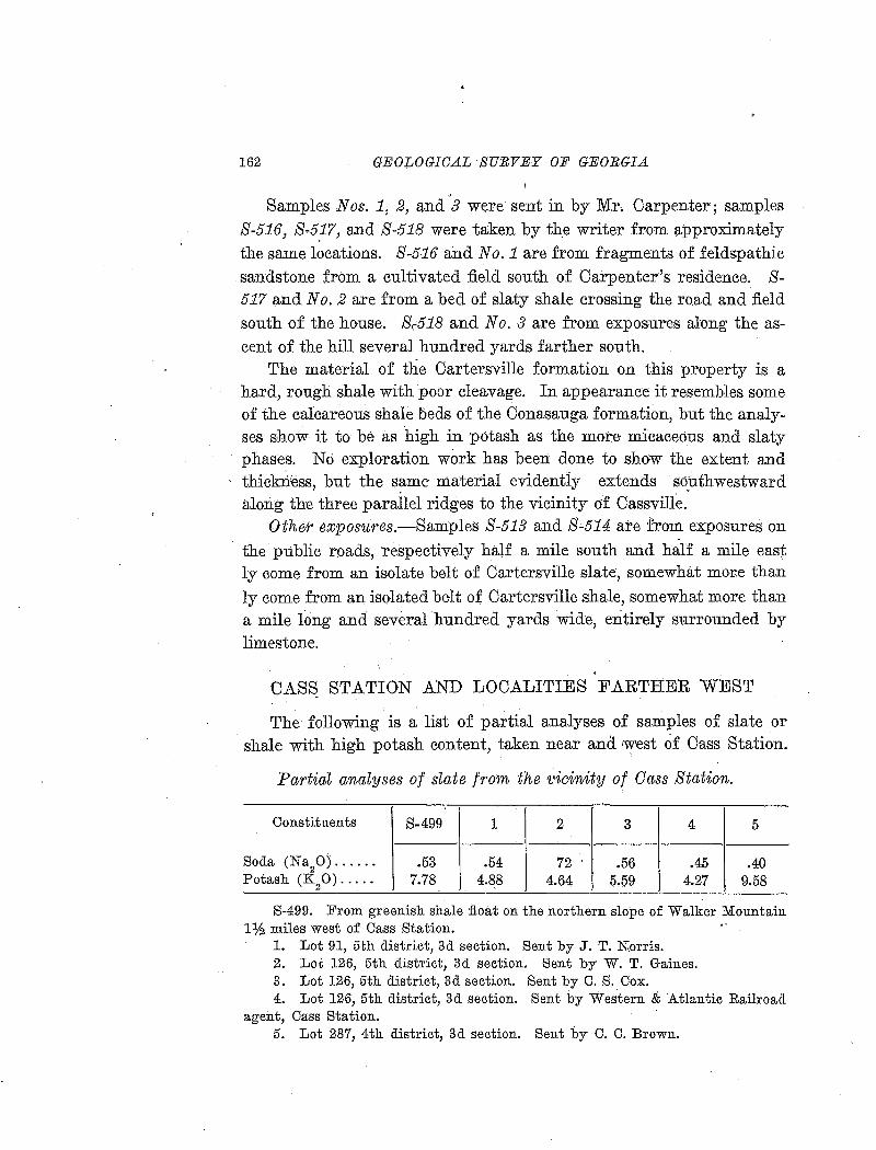
162 GEOLOGICAL SURVEY OF GEORGIA
Samples Nos. 1, 2, and 3 were sent in by Mr, Carpenter; samples S-516, S-5!7, and S-518 were taken by th.e writer from approximately the same locations. S-516 and No.1 are from fragments of feldspathic sandstone from a cultivated :field south of Carpenter's residence~ S-517 and No.2 are from a bed of slaty shale crossing the road and :field south of the house. 8,518 and No. 3 are from exposures along the ascent of the hill several hundred yards farther south.
The material of tlie Cartersville formation on this property is a hard, rough shale with poor cleavage. In appearance it resembles some of the crucareous shale beds of the Conasauga formation, but the analyses show it to be as high in potash as the more micaceous and slaty phases. No exploTation work has been done to show the extent and thickriess, but the same material evidently extends southwestward alori.g the three parailel ridges to the vicinity of Cassville.
Other exposures.-Samples S-513 and S-514 are !rom exposures on · the public roads, respectively half a mile south and hal:E a mile east
ly come from an isolate belt of Cartersville slate, somewhat mo:t:e than ly come from an isolated belt of Cartersville shale, somewhat more than a mile long and several hundred yards wide, entirely surrounded by limestone.
I
CASS STATION AND LOCALITIES FARTHER WEST
The following is a list of partial analyses of samples of slate or shale with high potash content, taken near and west of Cass Station.
Partial analyses of slate from the t•icinity of Cass Station . ..
'
Constituents S-499 1 2 3 4 5
Soda (Na20) ...... .53 .54 72 .56 .45 .40
Potash (K20) ..... 7.78 4.88 4.64 5.59 4.27 9.58
S-499. From greenish shale float on the northern slope of Walker Mountain Ph miles west of Cass Station.
1. Lot 91, 5th district, 3d section. Sent by J. T. Norris. 2. Lot 126, 5th district, 3d section. Sent by W. T. Gaines. 3. Lot 126, 5th district, 3d section. Sent by C. S. Cox. 4. Lot 126, 5th district, 3d section. Sent by Western & Atlantic Railroad
agent, Cass Station. 5. Lot 287, 4th district, 3d section. Sent by C. C. Brown.
SLA1'E DEPOSITS OF GEORGIA 163
Lots 91 and 126, 5th district, 3d section, include Cass Station. The shales from these lo~s and from the north slope of Walker Mountain are greenish, and evidently belong to the Conasauga formation. Their potash content averages higher than that of most of the Conasauga green shales, but not quite as high as that of the typical Cartersville shale and slate. The high potash content is not especially remarkaole, because depositional conditions must have been very similar while both formations were being laid down, and some parts of the Conasauga formation may be found considerably above the average in potash.
Sample No. 5 has an extremely high potash content, and comes from lot 287, 4th district, 3d section. This lot is 5 miles in an air-line west of Cartersville and 3 miles southwest of Cass Station. This locality is far west of the previously recognized areas of the Cartersville formation, but the high potash content of the sample indicates that it comes from that formation. The area is probably an outlier produced by folding or faulting and there is a possibility that others may be found west of the explored deposits.

THE SERICITE SIGRIST DEPOSITS OF PICKENS OOVNTY. 165
APPENDIX
THE SERICITE SCHIST DEPOSITS OF PICKENS COUNTY
INTRODUCTION
Before the discovery of the high-potash slate and shale of the Cartersville district, the sericite schist deposits of Pickens County had attracted attention as a possible source of potash. .A brief description of the deposits was published by Hopkins1 in 1914. Since the publication of that report the deposits have been examined in more detail · by members of the State Survey, and the material has been mined on a small scale by several companies.
In 1912 four carloads of sericite from lot 121 were shipped to Hewitt, North Carolina, where it was ground and marketed under the trade name '' pyrophyllite. '' During 1915 and 1916 a small quantity was mined from lot 120 by the .American Mica Company and ground at the plant in Canton, Georgia. The .American Mica Company has for several years mined chlorite schist in Cherokee County. This material is finely pulverized and sold under the name of ''ground mica'' for use in foundry facings, elect11ical insulation composition, etc. The sericite was probably put to the same uses. In 1917 the deposits on lots 97 and 99 were opened by the .American Potash Company. These are the largest workings in the district. The material was shipped to Portland, Georgia, and treated by a process which renders the potash available. (See p. 136.) The mines were abandoned when the company started to work the high-potash shale of the Cartersville district. The deposit on lot 118 was <worked by the Vithumus Company in 1917 and 1918, the small amount of material mined being used in a "soil builder." In 1918 the Georgia Potash & Chemical Corporation secured control of a number of the properties, but little, if any, work has been done.
Most of the properties have changed hands several times, and have been held on short time leases or options, so the descriptions of individual deposits are here arranged by land lots.
i Hopkins, Dr. 0. B., Asbestos, talc, and soapstone deposits of Georgia: Geol. Survey of Ga. Bull. 29, Appendix, pp. 304-309. 1914.
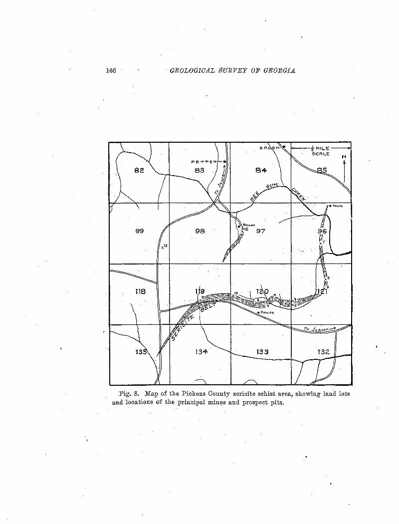
166 GEOLOGICAL SURVEY OF GEORGIA
Fig. g. Map of the Pickens County sericite schist area, showing lana. lots and locations of the principal min~s and prospect pits.
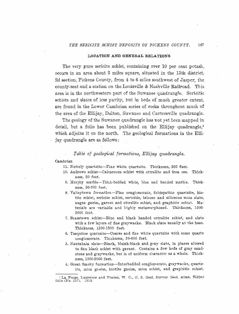
THE SERICITE S-CHIST DEPOSITS OF PICKENS COUNTY. 167
LOCATION AND GENERAL RELATIONS
The very pure sericite schist, containing over 10 per cent potash,
occurs in an area about 2 miles square, situated in the 13th district,
2d section, Pickens County, from 4 to 6 miles southwest of Jasper, the
county-seat and a station on the Louisville & Nashville Railroad. This
area is in the northwestern part of the Suwanee quadrangle. Sericitic
schists and slates of less purity, but in beds of much greater extent,
are found in the Lower Cambrian series of rocks throughout much of
the area of the Ellijay, Dalton, Suwanee and Cartersville quadrangle.
The geology of the Suwanee quadrangle has not yet been mapped in
detail, but a folio has been published on the Ellijay quadrangle/ which adjoins it on the north. The geological formations in the Elli
jay quadrangle are as follows:
Table of geological formations, Ellijay quadrangle.
Cambrian
11. N ottely quartzite-Fine white quartzite. Thickness, 200 feet. 10. Andrews schist-Calcareous schist with ottrelite and iron ore. Thick
ness, 50 feet. 9. Murphy marble-Thick-bedded white, blue and banded marble. Thick
ness, 50-300 feet. 8. Valleytown formation-lFine conglomerate, feldspathic quartzite, bio
tite schist, sericite schist, sericitic, talcose and siliceous mica slate, augen gneiss, garnet and ottrelite schist, and graphitic schist. Materials are variable and highly metamorphosed. Thickness, 1200-2000 feet.
7. Brasstown schist-Blue and black banded ottrelite schist, and slate with a few layers of :fine graywacke. Black slate usually at the base. Thickness, 1200-1500 feet.
6. Tusquitee quartzite-Coarse and :fine white quartzite with some quartz conglomerate. Thickness, 20-600 feet.
5. Nantahala slate-Black, bluish-black and gray slate, in places altered to fine black schist with garnet. Contains a few beds of gray sandstone and graywacke, but is of uniform character as a whole. Thickness, 1000-2000 feet.
4. Great Smoky formation-"Interbedded conglomerate, graywacke, quartzite, mica gneiss, biotite gneiss, mica schist, and graphitic schist.
1 La Forge, Laurence and Phalen, W. C., U. S. Geol. Survey Geol. Atlas, Ellijay folio (No. 187). 1913.
168 GEOLOGICAL SURVEY OF GEORGIA
Thick c?nglomerat~ and staurolite gneiss in the loyver part. Thickness, 5000-6500 feet.
(Unconformity) Archean ·
a .. Granite and other intrusives. 2. Roan gneiss . . 1. Caroiina gneiss.
All of the formations above the Archean belong to the earliest Cambri~n; n~ed the' Ocoee group in Tennessee by. Sa:fford.1 These formations in Georgia are not fossiliferous, but in Tennessee and Virginia foss1ls of the lower Cambrian Olenellus fauna have been found as low as the middle of the group.
·n.r:··t,a:·:Forge,. th.e author of the Ellijay folio, has visited. the seri
cite' d~p~sits, but' he is uncertain with ~w~ch' .of.the ~m;mations of that folio they should be correlat~d. The available evidence ·indicates that the deposits occur in one of the formations above the Great Smoky, . . . . . .
but below· the Murphy marble.
The earLy Cambrian or Ocoee rocks occupy the area between the Appalachian Mountain mass and the Cartersville fault, and have. been
.. . . .. .. ""'\ "·.·· ~ . .. . .. ' - ·. ' ''";. ... . . . . sub}ecte'il: to intense metamorphism, which has cau-s~d the recrystalli-zation of mQst io:f,:.the.-,\m~ne;r~stsoifri ithe'-'oi>:Fgiira'l ·se:aim_eifts:• Ali of the rocks show the effects of at least two periods of .. disturbance, one of which p·:r;.6·auc~d· th:e .. $chf~t~~e ~r ~laty texture, and later. mo~e~ents . . ' . ,. . ~ . . .. .. \ . . "
threw the original cleavage planes into folds, with development of con-spicuous· false cleavage.
The sericite district is in the Piedmont PlJteau .physiographic di
vision, buti~ within a;few miles o£ t1;J.e southern end·.ofthe Blue Ridge escarpment. This part of the Piedmont has rugged and broken topbgraplif. Th_e sericite depositS are at an 8ltitude o£ about i5o·o feet
above sea level, ap.d the -relie£ in the se.ricite district is about 500 feet,
but Sharp Mountain; one mile west of the deposits, rises to an altitude of ~ore tha.n 2,400 feet. The two roads to Jasper are both.hilly and unimproved, making the haul of 5 or 6 miles to the railroad expensive and, in 'Wet weather, very difficult. Building a railroad or tramway to
1 Safford, J'. M., Geolog;y of Tennessee, 1869.
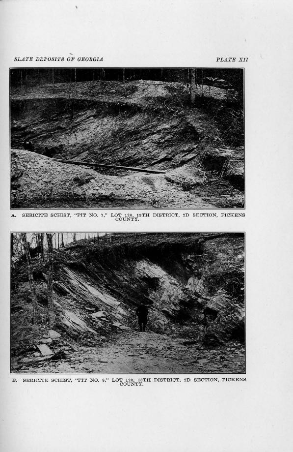
.... SLATE DEPOSITS OF GEORGIA PLATE Xll
A. SERICITE SCHIST, "PIT NO. 7," L OT 120, 13TH DISTRICT, 2D SECTION, PICKENS COUNTY.
B. SERICITE SCHIST, "PIT NO. 8," LOT 120, 13TH DISTRICT, 2D SECTION, PICKENS COUNTY.
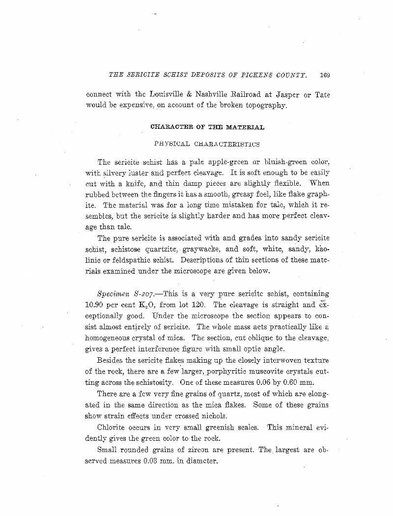
THE SERICITE S!CHIST DEPOSITS OF PICKENS COUNTY. 169
connect with the Louisville & Nashville Railroad at Jasper or Tate would be expensive, on account of the broken topography.
CHARACTER OF THE MATERIAL
PHYISIUAL UHARAUTERISTIUS
The sericite schist has a pale apple-green or bluish-green color,
with silvery luster and perfect cleavage. It is soft enough to be easily cut with a knife, and thin damp pieces are slightly flexible. When
rubbed between the fingers it has a smooth, greasy feel, like flake graphite. The material was for a long time mistaken for talc, which it re
sembles, but the sericite is slightly harder and has more perfect cleav
age than talc.
The pure sericite is associated with and grades into sandy sericite
schist, schistose quartzite, graywacke, and soft, white, sandy, kao
linic or feldspathic schist. Descriptions of thin sections of these mate
rials examined under the microscope are given below.
Specimen S-207.-This is a very pure sericite schist, containing
10.90 per cent K 20, from lot 120. The cleavage is straight and exceptionally good. Under the microscope the section appears to con
sist almost ent~rely of sericite. The whole mass acts practically like a
homogeneous crystal of mica. The section, cut oblique to the cleavage,
gives a perfect interference figure with small optic angle.
Besides the sericite flakes making up the closely inter~woven texture
of the rock, there are a few larger, porphyritic muscovite crystals cut
ting across the schistosity. One of these measures 0.06 by 0.60 mm.
There are a few very :fine grains of quartz, most of which are elong
ated in the same direction as the mica flakes. Some of these grains
show strain effects under crossed nichols.
Chlorite occurs in very small greenish scales. This mineral eVI
d-ently gives the green color to the rock.
Small rounded grains of zircon are present. The largest are ob
served measures 0.03 mm. in diameter.
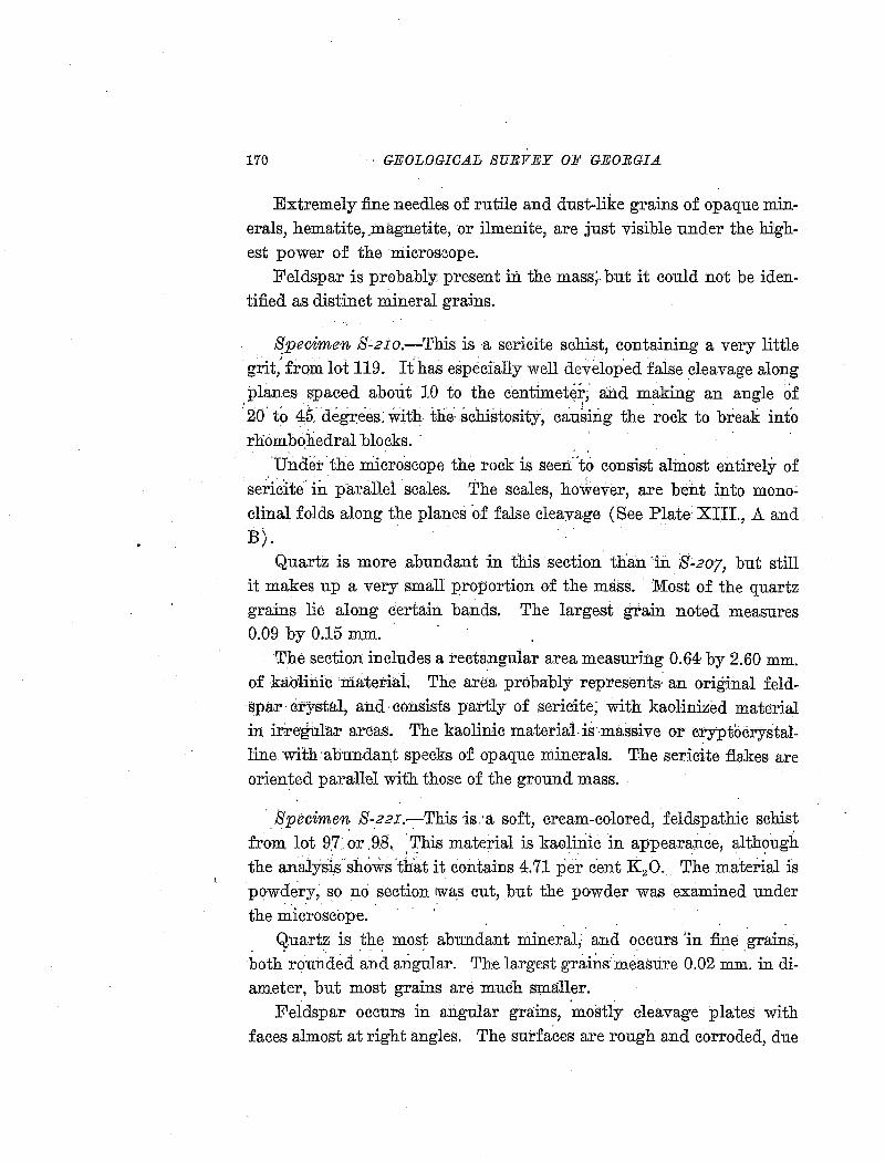
170 GEOLOGICAL SURVEY OJJ' GEORGIA
Extremely fine needles of rutile and dust-like grains of opaque minerals, hematite, ,magnetite, or ilmenite, are just visible under the highest power of the microscope.
Feldspar is probably present in the mass; but it could not be identified as distinct mineral grains.
Specimen S-2Io.-This is ·a sericite schist, containing a very little grit: from lot 119. Ithas especially well developed faise cleavage along ,Planes spaced about 10 to the centimete~;- and making an angle of '20' to 45- de~ees: with- thi .schistosity, causing the rock to break into rhombohedral blocks. ·
Under-the microscope the rock is seert"to consist almost entirely of sericite· in parallel scales. The scales, ho~ever, are bent into mono~ clinal folds along the planes o-f false cleavage (See Plate XIII., A and B).
Quartz is more abundant in this section than ·in S:.2o7, but still it makes up a very small proportion of the mass. Most of the quartz grains lie along certain bands. The largest grain noted measures 0.09 by 0.15 mm.
The section includes a rectangular area measuring 0.64 by 2.60 mm. of kablinie materiaL The area probably represents· an original feldspar· crystal, and· consists partly of sericite; with kao-linized material in irregular areas. The kaolinic materialis·-massive o1> cryptocrystalline with ·abulldant specks of opaque minerals. The sericite flakes are oriented parallel with those of the ground mass.
· Specimen S-22I:-This ·is:a soft, cream-colored, feldspathic schist from lot 9.7 ~r .98._ :This material is kaoliriic in appearance, alth?ugh the analysis-shows 'that it contains 4.71 per cent K 20. The mate:dal is powdery, so no section IWa_s cut, but the powder was examined under
. . · the microscope.
Quartz is the most abundant mineral; and occurs 'in fine grains, both. rou~ded .and a:rigclar. The largest grainsme:asure 0.02 ~~-in diameter, but most grains are much SJ::naller.
Feldspar occurs in angular grains, mostly cleavage plates with faces almost at right angles. Th'e surfaces are rough and corroded, due
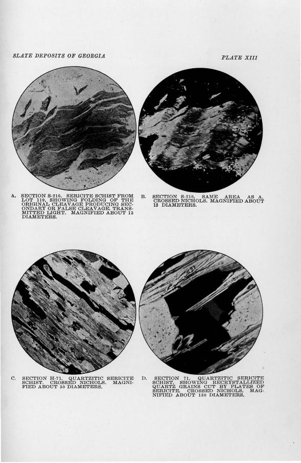
SLATE DEPOSITS OF GEORGIA
A.. SECTIO.N S-210. SERICITE SCHIST FROM LOT 119, SHOWING FOLDING OF THE ORIGINAL CLEAVAGE PRODUCING SEC· ONDARY OR F ALSE CLEAVAGE. TRANS· MITTED LIGHT. MAGNIFIED ABOUT 13 DIAMETERS.
C. SECTION H -71. QUARTZITIC SERICITE SCHIST. CROSSED NICHOLS. MAGNIFIED ABOUT 50 DIAMETERS.
PLATE XIII
B. SECTION S-210. SAME AREA AS A. CROSSED NICHOLS. MAGNIFIED ABOUT 13 DIAMETERS.
D. SECTION 71. Q UARTZITIC SERICITE SCHIST, SHOWING RECRYSTALLIZED QUARTZ GRAINS CUT BY PLATES OF SERICITE. CROSSED NICHOLS. MAGNIFIED ABOUT 130 DIAMETERS.
THE SERICITE &CHIST DEPOSITS OF PICKENS COUNTY. 171
to partial kaolinization. The maximum size of the feldspar grains is about tbe same as of the quartz, but the average size is smaller.
Very small, colorless, crystalline scales are abundant. They have very low birefringence, visible only with the red tint plate. 'l'hese scales may be both kaolin and hydro-mica, but they are too small to be definitely determined by microscopic tests. There is also a little finely granular, white, kaolinic material, in which no crystalline structure is visible.
The only other minerals noted were a few grains of green material, probably chlorite, and a few black, opaque grains, proha.b1y magnetite.
Specimen H-42.-This is a quartzitic sericite schist from lot 120. Q·11artz, recrystallized in interlocking grains, makes up about 75 per cent of the area of the section; sericite, in parallel oriented flakes makes up hardly 25 per cent.
Accessory minerals are rounded grains of zircon, elongated needles of apatite, a brown, slightly pleochroic mineral, probably staurolite, and a little chlorite.
Specimen H-43.-This is a slightly schistose graywacke from lot
120. The principal minera.ls are feldspar and quartz, with feldspar slight
ly predominating. The rock is roughly banded, hut contains only enough sericite to produce a very imperfect cleavage.
Most of the feldspar is orthoclase (potash feldspar) ; but there is some plag~oclase, probably albite (soda feldspar) ; and many grains of banded feldspar, apparently a perthitic intergrowth of orthoclase and albite. The orthoclase shows beautifully the alteration of feldspar to sericite. Small scales of sericite are developed along the cleavage planes in the feldspar, and all of the flakes are oriented parallel to the mineral cleavages of the feldspar grains. The largest feldspar grains measure 1.0 mm. in diameter.
The feldspar grains are much larger than any of the quartz grains. Quartz occurs in interlocking grains, shorwing much more evidence of recrystallization than the feldspars. Some bands of the rock consist of
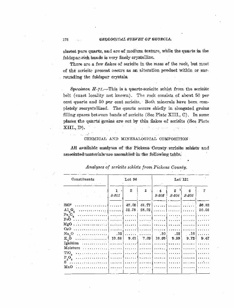
l'il'2
almost pu.re quartz, and are of .med:ium textu:re, whlle the quartz in the feldspar"rich bands is very finely crystalline.
Therte are a few flakes of sericite in the mass of the r{i)ck, but most of the sericitr present oeetirs as an alteration product within or surrouB.ding the .fuldspa:r cry-Stals ..
Sp.ecimen H-7I.-· This is a quartz-sericite s!Chist from th:e sericite belt (exact locality not known). The rock consists of about 50 per cent qu.artz and 50 pe,r cent sericite. Both minerals have been completely ;rre{}rysta Uized. The quartz occurs chiefly in elongated grains filling spaces between bands of sericite (See Plate XIII., 0). In some planes thEHI'Iliarlz grain·s are· eut by thin :fiakes of serieite {See Plate XIII.,.D) ..
CHEMICAL AND MINERALOGICAL COMPOSITION
AU availalill'HaxJa4.<yses of the P.i~Cken:s•·elonnty:seriei~ seh<ists and assecia'il;edt'\n:lawr.ia1s•'ar~; n;ssembl~d.' i~, ttte· feUowin.'g. ta:blw.:
Analyses of sericite schists from Pickens County.
Constituents
Sli02 ••••••••••••••••
A1'2·03 •••••••• • .... .
Fe20.
3 ............... .
FeO ................ .
1 S-201
MgO .. · •...••....•.... · •. : ·· .. CaO ••.•............. Na
20 .. .. .. . ..... . .. . .32
K20 .. .... .. . .. .. .. . lQ.£8
Ignitibn . . . . . . . . ....•. Moisture ........... . Ti0
2 ............... .
P205 ................ I •••.•••
s .................. . MnO ...................... .
Lot 96 Lot.121
:g 3 4 5 I 6 S-203 .S-204 S-205
--41.02 51.11 . " ....... .32 .78 28.12
. . . . . . . ......
. ...... . . . .... . .. ~ ...... ' . ~ .....
.... . . ... . . . ... . . . ...... .30 .22 .16
'9 .61 7 .0'9: 1'(!).5'(!) '9.99 '9.'72
• ~ •••• ~ ••• ·, ••• ! ..... " -·
.. ....... j '• ••••• ~ ........ ..
·• ........ I ........ .
. ........... . '
'l
5·0.82 30.08
9.47
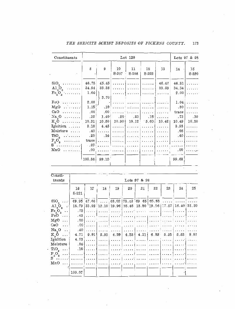
THE SERICITE SCHIST DEPOSITS OF P!:GKENS COUNTY. 173
Constituents
8
SiO 2 .............. 46.75 A1 0 2 3
.......... 34.94 Fe20
3 · ••••••.• 1. 04·
FeO ........... 2.00 MgO . . ....... 1.15· CaO .......... ;00 Na20 .......... .32 K
20 ......... 10.31
Ignition ........ 3.18 Moistme ..... .40 TiO
2 . . . . . . .. . .20
P205 ........ trace s ............. .07· MnO ..... ,. .... .00
100.36
Constituents
Si02
•••
Al 0 .· 2 3
Fe20
3 ••
FeO MgO ... GaO Na 0 ..
2 ' K20 ...
Ignition Moistare TiO
2
P205
16 S-221
69.95 18.79
.72 .43 .00 .00 .40'
4.71 4. 73
17
47.fi6 33.92
9.91·
.'24: .....
.1<Y .•••••
s ...... · .. ,. .... ·--·-MnO
100.071--
Lot 120 Lots 97 & 98
9 10 11 12 13 14 15 8-207 S-208 S-222 S-220 -- ---
45.45· . ....... 46.47 46.31 33.38 33.59 34.34
1 2.00 t 3. 70
J 1.04 .10 .30 .00 trace
1.40 .20 .23 .15· .73 .30 10.50 10.90 10.12 · 5.6G 10.42 10.49 10.20 4.45 3.93
.05 .H . ...... ........ .40
• • •'" • • I .. ......
.. ..... - .00 ...... •..,f"
--99.12' 99.68
Lots 97 & 98
18 19 20 21 .22 23 24 25
-- --68.'02 73.48 f:i9 65 '65.8'3 .. . .. . . ......
12.10 19.'96 ]5.46 ' 18. 8{) '19.16 17.57 16.4D 31.20 ......
......
......
2.93' 4.29 4.53 4.21' 6.05· 5.53' 5.53 8.97 ............. ·1 •••••
.,. ..... : ...... . ..... ·
----,-- ---- ---.
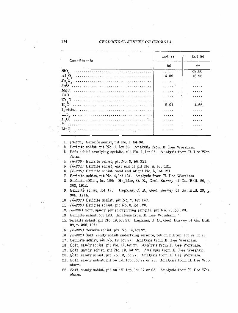
174 GEOLOGICAL SUEVEY OF GEORGIA.
Constituents
Si02
•••••••••••••••••••••••••.•.•••••••••••••
.A120
3 ••••••••••••••••••••••••••••••••••••••
Fe20
3 ••••••••••••••••••••••••.•••••••••••••
FeO ................................ · ....... .
MgO ··········:·························:·· CaO ...................................... . Na
2·0 ...•.....................................
K20 ....................................... ·
Ignition ................................... . Ti0
2 •••••••••••.•••••••••••••••••••••••••••
p 0 ········································
MnO ...................................... . , ..
Lot 99
26
16.82
2.91
Lot 84
27 68.50 18.96
4.66,
s.2 .5 ...•......................•...... · ....... ·t
------------~------------~-----------
1. ( S-201} Sericite schist, pit No. 1, lot 96. 2. Sericite schist, pit No. 1, lot 96. Analysis from E. Lee Worsham. 3. Soft schist overlying S!3ricite, pit No. 1, lot 96. Analysis from E. Lee Wor-
sham. 4. (S-203} Sericite schist, pit No.3, lot 121. 5. ( S-204} Seri'cite schist, east end of pit No. 4, lot 121. 6. (S-205} Sericite schist, west end of pit No.4, lot 121. 7. Sericite schist, pit No. 4, lot 121. Analysis from E. Lee Worsham. 8. Sericite schist, lot 120; Hopkins, 0. B., Geol. Survey of Ga. Bull. 29, p.
305, 1914. 9. Sericite schist, lot 120. Hopkins, 0. B., Geol. Survey of Ga. Bull. 29, p.
305, 1914. 10. (S-207} Sericite schist, pit No,. 7, lot 120. 11. (8·208} Sericite schist, pit No.8, lot 120. 12. (S-222) Soft, sandy schist overlying sericite, pit No. 7, lot· 120. 13. Sericite schist, lot 120. Analysis from E. Lee Worsham. · 14. Sericite schist, pit No. 12, lot 97. Hopkins, 0. B., Geol. Survey of Ga. Bull.
29, p. 305, 1914. 15. ( S-220) Sericite schist, pit No. 12, lot 97. 16. ( S-221} Soft, sandy schist underlying sericite, pit on hilltop, lot 97 or 98. 17. Sericite schist, pit No. 12, lot 97. Analysis from E. Lee Worsham. 18. Soft, sandy schist, pit No. 12, lot 97. Analysis from E. Lee Worsham. 19. Soft, sandy schist,. pit No. 12, lot 97. Analysis from E. Lee Worsh!:l-m. 20. Soft, sandy schist, pit No. 12, lot 97. Analysis. from E. Lee Worsham,. 21. Soft, sandy schist, pit on hill top, lot 97 or 98. Analysis from E. Lee Wor
sham. 22. Soft, sandy schist, pit on hill top, lot 97 or 98. An11lysis from E. Lee Wor
sham.
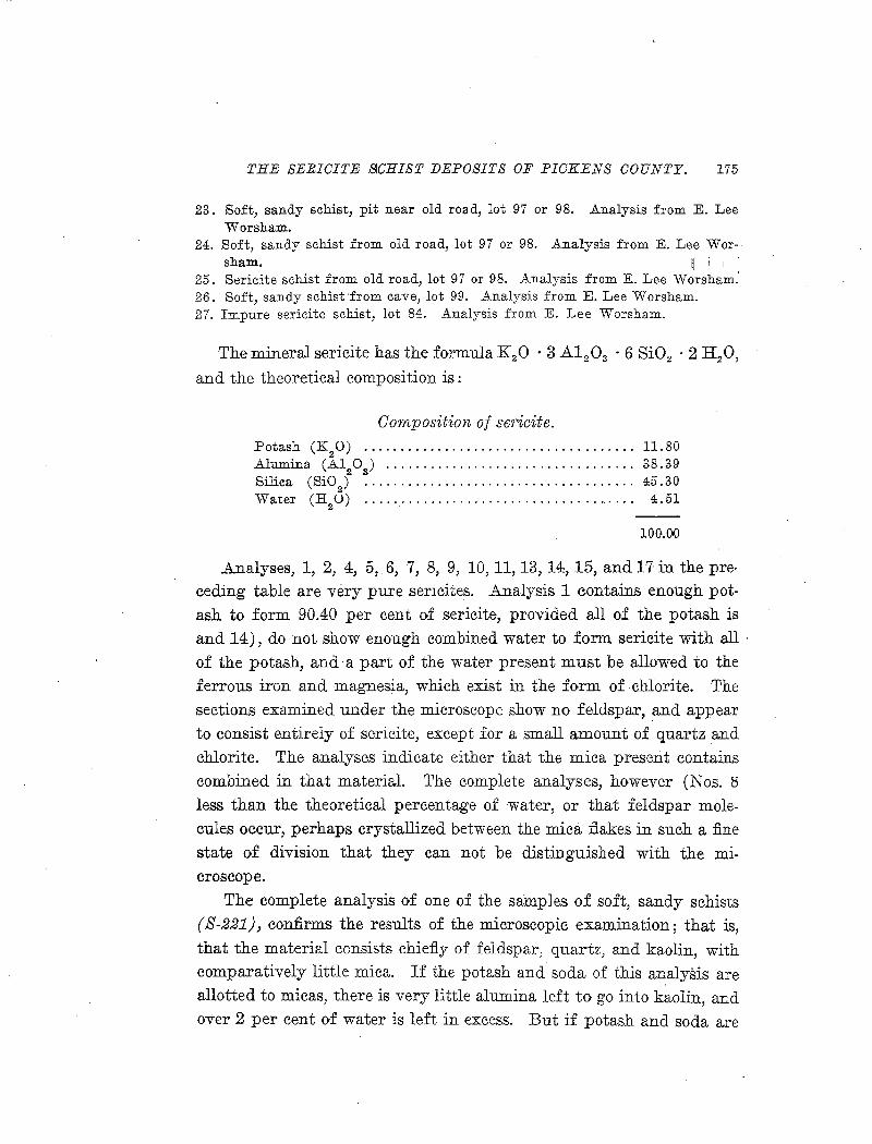
THE SERICITE SICHIST DEPOSITS OF PICKENS COUNTY. 175
23. Soft, sandy schist, pit near old road, lot 97 or 98. Analysis from E. Lee Worsham.
24. Soft, sandy schist from old road, lot 97 or 98. Analysis from E. Lee Wor-sham. ~ i 1 •
25. Sericite schist from old road, lot 97 or 98. Analysis from E. Lee Worsham.' 26. Soft, sandy schist·from cave, lot 99. Analysis from E. Lee Worsham. 27. Impure sericite schist, lot 84. Analysis from E. Lee Worsham.
The mineral sericite has the formula K 20 · 3 Al2 0 3 • 6 Si02 • 2 H 20,
and the theoretical composition is:
Composition of se1·icite. Potash (K
20) ..................................... 11.80
Alumina (A120
3) .................................. 38.39
Silica (Si02
) •.....•.•.••.•.••.••.....••••••.•.... 45.30 Water (H
2U) . . . . . . . . . . . . . . . . . . . . . . . . . . . . . . . . . . . . . 4.51
100.00
Analyses, 1, 2, 4, 5, 6, 7, 8, 9, 10, 11, 13, 14:, 15, and 17 in the pre· ceding table are very pure sericites. Analysis 1 contains enough pot
ash to form 90.40 per cent of sericite, provided all of the potash is and 14), do not show enough combined water to form sericite with all ·
of the potash, and· a part of the water present must be allowed to the ferrous iron and magnesia, which exist in the form of chlorite. The
sections examined under the microscope show no feldspar, and appear to consist entirely of sericite, except for a small amount of quartz and chlorite. The analyses indicate either that the mica present contains
combined in that material. 'rhe complete analyses, however (Nos. S
less than the theoretical percentage of 1water, or that feldspar molecules occur, perhaps crystallized between the mica flakes in such a :fine
state of division that they can not be distinguished with the microscope.
The complete analysis of one of the samp]es of soft, sandy schists ( S-221), confirms the results of the microscopic examination; that is,
that the material consists chie:fiy of feldspar, quartz, and kaolin, with
comparatively little mica. If the potash and soda of this analysis are allotted to micas, there is very little alumina left to go into kaolin, and over 2 per cent of water is left in excess. But if potash and soda are
176 GEOLOGICAL SURVEY OF GEORGIA.
combined with the smaller· quantity of alumina neeessary to :form·the feldspars a considerable quantity of alumina is left) which~ in the f?rm of kaolin, will take up the high percentage of combined water:. The mineral composition indicated for sample S'-22I is about one-third quartz, one-third kaolin, and one-thi:rd feldspar. Of course> both feldspar and mica are present in such material, and the feldspar greatly
·predominates, ·hut the exact ratio of the two minerals is not determinable either by chemical or microscopic analysis.
MODE OF OCCURRENCE
Most of the. o.eeurrences. of the pu:Ee .sericite s.e?±st,. eo<tl!taining 10 per ce:ht·or more of potash, are along a single kad about 4 miles long, crossing lots 96, 121, 120 and 119. There is a smaller lead near the boundary between lots 97 and fJ8, and an isolated occurrence in a small syncline on lot 99. (See map, fig. 8). .Although a considerable amount of e.:x;[i>loratio.n has, been dcme in the' surroTI.Ikding area, no other deposits of lJ!mre sericite have been found ....
The deposits rolf. hig:P. .. grildE; sericite are.in. thin,, le:aticul~ beGls. The thiekest~mg~ p.ed;1kno:wiEbdS.,,l-Q, ,Jreati,b.u t ibe.ds,(JVJel:·3 :Eee;trthickane: iiiD
usua]:;.?;:p.d, the_. a;v.erage_:thiekn:essjs-probably less_. thaa <l\L.$o.Qt, •.. *'-'ltb;ough the ~e~d is pract~eally continuous., the individual be¢ls. pineh o.ut along the. s~rik~. . The de_po~it~ ar~ ;n?t all at th~ ,SfJ,:rne s.trat~g:faphie ho:r~Qn,
ht;lt ~ro~ 9verlapping .lenses .through a th~ckn~ss of sever~ hm!\.dr:ed f~~t of ~ed§. !or insta:Q.c.e, i:p. one pit there_ tare 8 _beds of pu:r:e sericite, . with ,a total thic:Jme~s o(S t~~~, in a strat~grapb;ie.tlllekness of 33 :feet .
. . . Tfl.e m!l~r.i~l.bet:w.e.e:Jf t:P.e_ beds .of_ p:u.r~ .sericite ia prineipaJJ.y the . - -lig;J?.t-:col9r~d~ Jel4~athic, sa~dy ~ch~t q:f w~eh a_ n-p:m~~r of analyses ~a~ b~e~ giye~. :rh~ materi~l ~o:ata;ins fr.~R.J.. 3 to 8 per: cent potash and from 16 to 20 per cent alumina, the variation depending an the p;ropor}ion of admix~d ,quartz sand. In mining, if this material is, taken
alo:r~~ :IW,ith th~ ser.icit~ it is probal!le t~31t. l!1Q. ~v~:cage potash content between 5· and 7 per cent, with alumina about 20 per cent, can be found through conside~able thicknesses of beds, workable by open cut methods. However, if pure sericite alone is desired, the thin. beds must soon be worked underground, and the associated soft schist will make
THE SERICITE SCHIST DEPOSITS OF PIICKENS COUNTY. 177
walls very difficult to support, even though the rock may be expected to become somewhat harder with depth.
Other rocks associated with the sericite are blue, slaty, impure sericite schist, quartz-sericite schist, quartzite, and hard gray-wacke. All of these rocks occur in thin beds, and evidently make up a much smaller part of the formation than the soft, feldspathic schist.
ORIGIN
The sericite schist originated by the intense metamorphism of a sedimentary formation rich in potash feldspar and mica (orthoclase and muscovite). The original source of the material was the granite and gneiss of the mountainous area to the east. Probably the beds of pure sericite were originally deposited largely as detrital rimscovite, because the feldspar in the associated beds does not show .nearly so complete an alteration to mica.
The original formation of the seriqite deposits rwas very similar to. that from which the Cartersville shales and slates were derived, although the Pickens County deposits are on a much smaller scale. By more intense metamorphism the high-potash Cartersville slate, with the associated sandstones and feldspa.thic sandstones, would pass over into something very like the Pickens County sericite deposits.
USES
The Pickens County sericite schist has been considered as a possible source of potash, but it now seems unlikely that the material can compete with the much larger and more accessible deposits, containing practically as much potash, in the Cartersville formation, Bartow County.
The physical properties of the pure sericite :fit it for many of the uses of ground mica, talc, and chlorite, all of which are now marketed.
Finely ground sericite is the same thing as ''ground mica,'' although it has a little less luster than the flakes produced by wet grinding of larg_e muscovite crystals. Sericite free from grit would serve as well as any other mica as a lubricant. It could replace coarsely ground or "bran mica" as a ·coating to prevent sticking of tarred "i~oo:fing ma-

178 GEOLOGICAL SURVEY OF GEORGIA.
terials, and for heat insulation. Sericite ha.S a very high electri~al resistance, and would therefore be as satisfactory as ground mica or
· chlorite schist in the manufacture of composition electrical insulators. Sericite can not replace talc for pencils, on account of its cleav
age; and its greater btardness would prevent substitution for the higher
grades of ground talc. For foundry facings, dressing for leather, etc., it would probably be equal to talc.
DESCRIPTIONS OF INDIVIDUAL DEPOSITS
The distribution of the sericite deposits and the locations of the pl1incipal mines and prospect pits are shown on the map., figure 8. The
I . .
pits. numbered are described below. Analyses of the materials are omitted from the .locality descriptions, becau~e all available analyses have been collected in one table . .C See pp. 170-172-). On account of some uncertainty as to ownership .and present status of leases and options,
the deposits are described by land lots.
L0\1;' 96
Lot 96 is knoWn: as- the Richar-ds lot, and has been explored by William Ri·c:haras; o£;Ja;sp;er:··
There is a house in the north central part of the lot. Pit No. 1 is near the south line of the·lot, almost half a mile S. 25°W. from the house. ·Both the house and the pit are on the summit of a ridge which is due to resistant quartzitic beds in the generally softer schists. The trerid of the ridge is straight from the house to the pit, but Bee Gum Creek has. cut a gap through it about midway between. The altitude of the house is 1420 feet, Bee Gum Creek, 1290 feet, the summit of the ridge near the pit, 1435 feet, by aneroid measurements. At the house the beds strike a little east of south, while at the pit the strike i~ S. 30"W., ,starting a swing to west which continues in the adjacent lots. The dips are all to east and southeast; varYing from 2010
. to 5oo. Pit No. 1 is a little to the west of the top of th~ :cld~e·, and is 20
feet long with a maximum depth, at the north end, of 18 feet. The sericite bed varies from 16 inches to 2 feet iri. thickness, strikes N.'
THE SERICITE SICHIST DEPOSITS OF PICKENS CODN1'Y. 179
30°E., and the dip increases uniformly from 40°SE. in the south end to 48°SE. in the north end. It is overlain and underlain by soft feldspathic schist, which is mostly white, but contains black and ironstained layers and some sandy or quartzitic layers. The sericite itself is very pure and free from grit. When fresh and damp it has an apple-green color. At the surface, where weathered, it can hardly be distinguished from the associated schists, but at a depth of several feet its greater resistance to weathering becomes apparent. It is harder than, and sharply separated from the other schists, which are deeply softened by weathering. The schistosity in the sericite has a dip a
very little steeper than the bedding. By later movement, the schistosity has been crimped along lines parallel to the strike, developing incipient fracture cleavage or false cleavage on plane perpendicular to the schist cleavage. The sericite bed increases a few inches in thickness down the dip in the exposure in the pit, but there is nothing to indicate that any great increase in thickness is to be expected on working down.
At the highest point on the ridge, 100 feet southwest of the large pit, a small opening was made from which pieces of sericite schist were taken, but none could be seen in place.
Two hundred feet south of the house a small outcrop of sericite is seen in the road. The bed is not over a foot thick, and is overlain by Eght red clay and underlain by white feldspathic schist. At other points along the road between the house and the creek are exposures of ferruginous and quartzitic schists of widely varying composition.
In the course of the creek only the quartzitic beds outcrop ; the areas o£ so·fter schist, including the sericite if any is present, are covered by alluvium.
The exposures near the house •and in the pit are at the same strati
graphic horizon, and it is pos"Sible that the bed of sericite is. continuous in the intervening distance, a.lthough there are no other exposures. As the greatest known thickness of the bed is only 2 feet, the amount which can be worked by open cut methods is very small; while underground mining wm certainly be expensive on account of the thinness of the bed, steepness of dip, and soft character of the wan rock.
180 GEOLOGICAL SURVEY OF GEORGIA ..
LOT 121
Lot 121, known as the Allred place, lies south of lot 96.
Pit No. 2 is the northernmost operi.ing on this lot, and is situated
a little more than a quarter of a mile slightly east or south from pit No.
1 on lot 96. The pit is in the west slope of a ridge, 30 feet above the
level of a branch which :flows north.
/ The principal bed of sericite schist is 12 inches thick, striking N.
30°E. and dipping 35°SE.
The schist is gray-green to blue-green in color, and is slightly less . ·.
pure and more ferruginous than that on lot 96. The schistosity dips
a little steeper than the bedding.
Below the prineipal sericite bed is a gradational phase, one foot
thick, of soft,. blue-gray, coarse-grained sericite with iron stains along
the cleavage planes, underrain by 8 feet of ferruginous schist rwhich
has weathered to 'a yellow clay. Above the sericite is another soft,
stained gradational phas~e of one foot; 2 feet of light colored feldspa
thic sclli.s~; a ~-foot 'bed o(seriei~e;, sof~er .and mor~ &taine:d than the f • .,·. • ;. .• . ~ • •
bed below~ and 2 feet of light colored weathered schist and clayey soil.
. Pit No .. 3 is in the same slope, 200 feet in a directionS. 10°W. from
pit.No. 2. The pit has been opened for a distance of 30 feet along the
strike, showing a bed of good sericite •with an average thickness of 15
inches, striking N. 60°E., dipping 30° to 40°SE. The sericite is not
iron stained, but has a deeper and bluer green color than that o:f lot
96. It is underlain by several inches of soft, iron stained sericite and
2 feet of hard? pink, schistose graywacke·; and overlain by4 feet of im
pure sericite schist with iron stains and stringers of vein quartz, ·and
light colored decomposed schist and soil. The whole mass .has been
intensely folded.· ·
Pits Nos. 2 and 3 are. along the. strike -of the same bed, which ap
pears to be at a higher.·horizon than that on lot 96; but a smail fault
or a· slight fold would be surfrci~nt to account fo-~ the relative posi
tion of the e'xposures !f they ar~, ~s s.eem~ probable, p,arts of .the same
J.'HE SERICITE SICHIST DEPOSITS OF PICKENS COUNTY. 181
stratum. South of these two pits the direction of strike swings around to the west and the dip changes from east to south, so that the sericite beds pass out of the west side of the lot.
Pit No. 4 is the pit of which Hopkins1 has published a photograph and is the largest opening on the lot. It is on the south slope of a hill, within a few feet of the west boundary of the lot, across the branch from the preceding, and 80 feet above the level of the branch. The strike of the beds is N. 80°E., and the dip is 20° to 25°SE., a little steeper than the slope. The pit has a length of 60 feet from east to west.
In the east end the section is:
Section in east end of Pit No.4. Feet
4. Clay soil .................... 0 •••••••• 0 ••• o • 0 •••••••••••••••••••• 0 • 1-2 3. Hard sericite schist, mostly rather impure and iron stained. The de-
gree of purity varies considerably both along and across the strike. . . . 2 2. Soft, coarser-grained, slate-blue mica schist, mottled with red iron
stains. This material is ·called ''slate'' by the local prospectors.· .. 0 • • 72 1. Buff colored schist .... 0 •••••••••••••••• 0 ••• 0 • • • • • • • • • • • • • • • • • • • • • i
In the west end the bottom of the pit was :filled with water. Above water level the section exposed was:
Section in west end of Pit No. 4. Feet
3. Sericite schist, slightly more stained than that in east end of the pit 4 2. Soft blue '·'slate" ......... 0 ••••••• 0 •••• 0 • 0 •••••••• 0 ••••••• a few inches 1. Buff colored feldspathic schist .............................. 0 • • • • • ( )
Pit No. 5 is a trench with a shaft at the end, situated down the slope 100 feet south of pit No. 4. When visited the shaft was :filled with water within 8 feet of the top, and all material in sight was white, feldspathic schist containing numerous quartz stringers. Hopkins states that at the time of his examination the shaft sho1wed 5 feet of fresh, solid sericite beneath 8 feet of weathered material.
J. E. Brantly, in 1917, had a number of trenches cut across the formation between pits Nos. 2 and 4. This exploration shows that the
~Geological Survey of Georgia. Bull. 29, p. 306, 1914.
182 GEOLOGICAL SURVEY OF GEORGIA,
sericite beds are continuous.· across the lot, hut the sericite shown in some of the trenches is rather sandy.
LOT 120
Lot 120, the Gabriel Martin place, lies west of lot 121.. All the work of/the American Mica Company has been done' on this lot, besides some prospecting by other parties. Pits Nos. 4 and 5 on lot 121 are within a few feet of the 1ot line. Exploration work on lot 120 has been started near these pits, and the beds of sericite schist have been traced entirely across the lot.
Pit No. 6 is 150 feet- southwest of pit No.4, lot 121. It is a small opening uncovering only a few square feet of a sericite bed. The lowest bed exposed is pure; pale-green sericite, one foot thick, rwith the base of the bed not shown. The strike is N. 75°E., dip 35°SE. The pure sericite is overlain by 2lh. feet of white, feldspar schist and 6 inches of sericite, softer and less pure than the lower pe:d.
Pit No. 7 (See Plate XII., A) where. the American Mica-Company has done most_of it~ work,is next to the larg.est.pit·in.thedis:trict. T:P,e working fac-e is about;4Q :Eeet long"amih~2(j):·£.e·e·thigh; T1te.pit'is situated . .
200 yardS west of- pit No. 6; at the edg.e Of"the valley bottom west of a branch.
The lower part of the pit was worked below the level of the branch and was :filled with 'water. The average strike of the beds is N. 80°E., dip 30°SE. The lowest exposure, stratigraphically, is schistose
· quartzite, of which only a few i'uches are seen in the pit, but other outcrops around the slope to the north show quartzite and graywacke of considerable thickness. The quartzite is overlain by a 3-foot bed of
solid, lig'ht-green, very pure· sericite schist. Above this is 15 feet of soft, light-colored, kaolinized and feldspathic schist of varying composiiion,: with thin beds and small lenses of sericite schist, which is a
little softer and more iron-stained 'than the lower bed. FolloWing the
feldspathic material is a 2~foot bed' of deep green sericite schist containing pockets a:nd stringers of quartz, and showing iron st~ins al;ng cleavage planes. The upper 5 or 6. feet of beds exposed in ·the pit are
THE SERICITE SICHIST DEPOSITS OF PICKENS COUNTY. 183
soft, light-colored, weathered feldspathic schist without any beds of
good sericite. The 20 feet of beds between and including the two principal seri
cite beds apparently contain a little less than half pure sericite while the remainder is more or less kaolinized micaceous and feldspathic schist. In the work done up to the present time the harder masses of sericite have been sorted out from the softer and weathered materials. The pure sericite contains over 10 per cent potash, and the overlying beds without any visible sericite over 5 per cent (Analysis 12, p. 171). The intervening beds have not been carefully sampled, and an average sample would be hard to get, but it is evident that the mass as a whnle contains 6 to 8 per cent potash and 20 to 25 per cent alumina.
Several carloads of good sericite were taken from the pit in the bottom of the valley, which was filled with water when examined. This sericite came principally from the lower 3-foot bed shown in the !WOrking face described above. The resistant beds exposed in the southeastflowing branch are a continuation of those seen in the pits. In the following section the figures represent the horizontal extent of the beds across the strike, the average dip being 30°.
Section along branch, lot 120.
:F·eet 5. Schists of varying composition .................................. . 4. Pure sericite schist ........................... '.... . . . . . . . . . . . . . . . 7 3 . Schistose quartzite . . . . .. . . . . . . . . . . . . . . . . . . . . . . . . . . . . . . . . . . . . . . . . . . 8 2. Pure sericite schist . . . . . . . . . . . . . . . . . . . . . . . . . . . . . . . . . . . . . . . . . . . . . . 3 1. Highly siliceous seriCite schist and graywacke ..................... .
These beds are overlain and underlain by softer schists which are not exposed in the branch.
Up. the slope, about 100 feet west of pit No. 7 and 32 feet higher, is a more recent opening. The working face measures 50 feet across from north to south and ha.s a maximum height of 22 feet.
The bedding strikes N. 60°E. and dips 30°SE. The face shows 7 beds of very pure sericite, from 6 to 12 inches thick, also one bed 3 feet thick, which is a little more sandy than the thinner beds. These
I I
I
184 GEOLOGICAL SURVEY OF'(JEORGI.A.
8 beds are separated by beds of more or less kaol,inized feldspathic schist from 1 to 8 feet thick. There is a total of 22 feet of ·this materiai, besides a 1-foot bed of impure, blue, slaty sericite schist, and a 2-foot bed of hard graywacke at the base of the exposed section. The sericite beds made up a total of 8 feet out nf a' section of 33 feet across
the bedding.
Pit No. 8 (See Plate XII., B) lies around the end of the hill, 400 feet west o.f pit No. 7. It is almost as large as the former and shows a very similar section. Near t~e base of the section is a 3-foot bed of solid, pure sericite, underlain by white feldspathic schist and overlain
by 10 feet'o·f weathered schist of varying composition. !Which contains thin beds and small lenses Q.f pure sericite. The strike o:f the beds is N. ggb:BJ.~ dip'30° tb 35°SE ..
' '
· From the pit a trench rims east, up arid around the end of the hill toward p1t No. 7 f<ir: a distance o!"rncwe than 200 feet. The trench ex:pos.es ·the lower 3.:0foot bed o.f sericHe all the wa;y, showing that the bed i~ continhous. and' of un:lform thiekness thr~ugh the hill.
: • '-. . ,::_,, . : ., ·i : · .. ,,· ' - ' ... ~ : \ . . . • . . ... . .
Up th!e ;SlQJ?~ to th~::~giJltg~~tRl'th/~_,J28~~~i.;~i~~a~,~lj>~~}V~~'!?- .Pits No. 7 and No. 8 are two small openings exposing. serieite beds 60 feet and
. +
200 feet, horizontiealiy, f:r0nt the l:red· exposed in the long trench. The thiekness of these upper sericite beds eould not be aeeurately measured '
but is not great. However, the exposures show that beds of pure sericite may be expeeted in .this vicinity through a thiekness of more than 100 feet of beds, made up· principally of feldspathic or micaceous
schists softened by weathering, and including some thin beds of quartzite and graywacke.
·Pit·No·. 9 is dn. the· same side o·f the branch as No.6, 300 feet northeast of No.7, and at a height of 25 feet above the level of the· branch. The wbrk consi~ts princip:ally in st:Hppiiig, but ·a little sericite has been
taken out. A trench has been cut across the· bedding, showing excellent sericite with a thickness o'r l()' £eet, 'measured acto'sr{ihe cleavage.
This unii includes only one 6-inch bed of impure material, and· is the
thickest single bed of pure sericite which has been ·found anywhere in •
the district. In the, west end of the opening the strike is N. 50°E., dip
THE SERICITE SCHIST DEPOSITS OF PICKENS COUNTY. 185
35°SE. At the east end the line of strl.ke bends to the north, and the
beds dip nearly east. Pit No. 10 is in the west central part of lot 120, about 100 yards
from the line of lot 119, nearly half a mile west of the principal workings on lot 120. The pit is in a steep hillside sloping south, near the head of a small hollow. The sericite bed is a little over 3 feet thick, but is impure, containing ferruginous laminae and much granular quartz in some beds. The strike is due east, dip 30° to 50°S., a little
steeper than the slope of the hill.
The sericite lead from this pit passes into lot 119.
LOT 119
Lot 119, known as the Kuhtman place, lies west of lot 120. The sericite belt enters the lot near the center of the east side, swings to the south, and passes out of the south side nea.r the southwest corner.
The deposit at locality No. 11, near the center of the lot, was worked by J. E. Brantly for the Vithumus Company. Enough sericite to make several carloads has been mined and piled up along the road, but only test shipments rwere made. The sericite piled up is selected material, and may be expected to average 10 per cent potash.
Work was done in two pits, one above and one below the public road, which runs northeast to southwest. The upper pit is 25 feet northwest of the road. It has a maximum depth of 10 feet and has been worked for 25 feet along the strike, showing a bed of sericite 5 feet thick, measured across the cleavage. The cleavage strikes N. 55 ° E. and dips 45°8E., apparently a little steeper than the dip of the true bedding. The associated·material is weathered to a red clay.
The lower pit is just below the road, south of the first, and along the same bed, which also outcrops in the road. This pit is worked 30 feet along the strike. The bcttom of the pit was filled rwith water when examined, but there was a thickness of 3 feet of slightly sandy sericite in sight, striking N. 55°E. and dipping 35°SE.
The sericite from these pits is much wrinkled and contorted by folding after the development of the schistosity, and very perfect false
186 GEOLOGICAL SURVEY OF GEORGIA.
cleavage is developed in some portions. Most of it contains granular quartz in q~antity too small to· decrease the potash content very much, but the grit would prevent its use as a substitute for .talc or ground mica in lubricants .
.A.bou~ 300 feet west of the principal workings is a trench showing somesandy sericite schist and several thin beds of good sericite, none more than a .few inch~s thick.
Back of Brantly's camp, 400 feet east of the workings, is another trench showing a 2-foot bed of slightly sandy sericite, striking N. 60°E., dipping 45°S.E. The associated material is the usual light-col-ored feldspathic schist. "
The sericite belt has not been explored southwest of these pits, but farther southwest there is a SJ;Uall exposure of fairly pure sericite in the public· road on lot 135. The bed is 12'1ncheEtthick; and. strikes N. 60°E.
_LOTS :f)7 AN:P 98
'r:ae Ki~- Padg,ett.·proper>ty; .late>r; purchased -by,Whlliam: Rrichards, includes ·:!rot 98 amrd ·a r>art of· lot 97: These- lots: aie· norlhwest of the main .seJ!i~i'lle-:·be-l~jl~"~J!I.(~,,tktl.Mlepxrs;i~s-~mnm~·.t:!Jeilio:Q;go;;ifoi,a;:st~ati:gn&phieally· lower bed,. mile8s; thei~~pr~s-~nc~ .is-to ·he e~plain:ed by' a-large fairlt: · · The most ex.tensi¥e work:ilm;!:!IJhe1 di'S:t:Pict''wlli~vd01E£e::ttb!fot.J9of llyi't1ie :Ain:etican: Potash Company.
Pit·No.l2, the mine of the American Potash Company was started at an outcrop of a 3-foot bed of pure, solid sericite schist, 150 feet south·Qf the-house, which ~s situated near the west line o.f lot 97. There. are three large pits, cbvering most of an area 200 by 300 feet· in extent; on the ·west slope· of a hilL · · ·
There are some thin beds of pure sericite schist with over 10 per cent.potash, but most of·the material is sandy, rough, and iron stained. The material shipped was not selected· with great care; and is said to have ave;raged· only a.bout 8 per cent potash. The sericite is interbed·ded ~i.tp. soft felqspathic schist and hard, quar.tzose gray'wacke.
The schistosity dips in various directions, and is folded into small open synclines and anticlines, but on the· average it dips to the east' at a low angle, following the slope of the hill·.
THE SERICITE SCHIST DEPOSITS OF PICKENS COUNTY. 187
.At the top of a hill, about a quarter of a mile southwest of the
house, is a pit 6 feet deep. It cuts 3 feet of sericite; somewhat less pure
than the original exposure near the house, underlain by soft feld
spathic schist (See analysis S-22I). This pit is probably on lot 98.
The sericite bed strikes N. 70°W. and dips 20°NE., less steeply than
the slope of the hill, so that it forms only a capping on the upper part
of the slope. The sericite bed on the hill may be a continuation of
that near the house, but it could not be traced between the two ex
posures. Near the abandoned ridge road, on lot 98, is another pit 7 or 8 feet
deep, cutting white feldspathic schist but no pure sericite .
.LOT 99
On lot 99, the Burrell property, a pit was opened by Major George
Miles, and about a carload of sericite was shipped by the .American
Potash Company. Pit No. 13 is on. the west slope near the top of a
ridge, just east of the new public road.
The pit is worked in 50 feet from west to east, has a maximum
depth of 17 feet, and a width of 15 feet from north to south. .A bed of
pure sericite forms a syncline in the east face of the pit. The bed is
2 feet thick on the limbs, but is somewhat thicker at the bottom along
the axis of the fold. There are several beds of sericite 2 or 3 inches
thick interbedded with the soft schist above the principal sericite bed ..
The associated material is the usual soft, white or yellow-stained feld
spathic schist. The sericite is much crumpled by the later folding, and
is more coarsely crystalline than most deposits. It contains some
pockets of vein quartz and is somewhat iron-stained, but the potash
content is evidently at least 10 per cent.
The fold pitches to the east at an angle of approximately 5°, so
the sericite should come out lower on the other side of the ridge, which
trends northwest.
188 GEOLOGICAL SURVEY OF GEORGIA
LOT 84
On lot 84, the Pendley place, a short distance south of the old Pettett Post Office, are several small exposures of sericite schist. The schist is blue-gray in color, impure, soft, and slraty, and seems. to occur in very thin beds in soft white schist, The stratigraphic position is evidently lower than that of the pure sericite in lots 97 and 98 .
..
INDEX
PAGE
A Adair slate property ........... 111-112 Age of slate ...................... 26-27 Allred place, sericite schist on .. 180-182 American Metal Company, Analyses of sericite schist ...... 172-175
137-138, 140, 144, 146 American Mica Company ...... 164, 182 American Potash Company,
132, 136-137, 165, 186-187 properties of ............... 150-152
Analyses of slate, 17, 21, 68, 70-71, 77-78, 80, 9~ 98 106, 110, 111-112, 113-114, 117 118-119, 134, 142, 144; 148, 151 152, 154-155, 158-159, 161, 162
Apison shale of Georgia. . . . . . . . . . . . 49 Appalachian Valley in Georgia ... 43-54
geologic history of ........... 52-54 geology of .............. ; .... 45-52 physiography of ............ 43-44 structure of ................. 44-45
Arkansas slate deposits . . . . . . . . . . 1
B Bagwell, John, slate property. . . . . 104 Bagwell, W. H., slate property, 120-121 Baker, Dr. T. H., slate prop-
erty .................... 156-157 Bartow County, slate deposits of,
140-163 Bedding of slate ................. 8-11 Bennett, T. A., slate property, 150-152 Black Diamond Slate Company
property ................. 88-92 Blance, Joseph G., slate prop-
erty . . . . . . . . . . . . . . . . . . . . . . . 1 Bolivar Station, slate deposits
near ................... 108-111 Bradley, Mrs. L. J., slate prop-
erty ....................... 158 Brantly, J. E. . ................ 138, 185 Bristol, W. A., cited ............. 31, 39 Brown quarries, Rockmart, sketch
of slate on . . . . . . . . . . . . . . . . 11 Brown, Robert H., slate miner.... 65
c Cambrian rocks of Georgia ....... 47-50 Cambro-Ordovician rocks .of Georgia,
50-51 Carboniferous formations of
Georgia . . . . . . . . . . . . . . . . . . . 52 Carpenter, W. W., slate prop-
erty .................... 161-162 Cartersville district ............ 128-163 Cartersville fault . . . . . . . . . . . . . . . . . . 44 Cartersville formation ... 48-49, 128-132
areal distribution of ........... 128 economic geology of ....... 131-132 geology of .................. 128-132 lithologic characters ....... 129-130 paleontology of ................ 131
PAGE
physiographic expression of. . . 131 potash shales and slates of,
131, 132-163 stratigraphio relations of. .. 128-129 structure and thickness of. . . . . 130
Cartersville Poor Farm slate de-posits ..................... 146
Cartersville slate ........... 3, 7, 22, 26 Cartersville-White slate belt .. 152-154 Cass Station, slate deposits near,
162-163 Cassville, slate deposits near ... 158-161 Cedartown slate area ............ 95-97 Cement dust, recovery of potash
from .............. 132, 134-136 Chemical analysis of slate.. . . . . . . . 32 Chemical changes in weathering of
slate ..................... 20-22 Chemical composition of
sericite schist of Pickens Coun-ty ...................... 172-175
slate ......................... 17-20 Cherokee Slate Company.......... 1
property ...................... 75-81 Chickamauga formation of Georgia 51 Chickamauga limestone of Georgia 51 Clark, W. P. . ..................... 112 Classification of slate ............ 6, 7 Cleavability of slate . . . . . . . . . . . . . . 30 Cleavage, slaty .................. 11-13 Columbia Slate Company pros-
pects ..................... 92-93 Conasauga formation; Fairmount
slate district ............ 99-104 Conasauga formation of Georgia, 49-50 Conasauga green slate ........... 22, 26 Canasauga green slate belt. ..... 22, 26 Coons, A. T., cited .............. 38, 40 Corless, G. B .................. 137, 150 Cornelius, W. 0., slate property .. 97-99 Corrodibility of slate . . . . . . . . . . . . . 32 Cost of production of slate........ 4 Cottrell electric precipitation, 132, 139 Cumberland Plateau, Geology of, 45, 46
D Dale, T. Nelson, quoted,
6, 22-23,27-30, 30-32, 34, 74,106-107 cited ..................... 13, 33, 73
Daves, W. W., slate property ..... 160 Davis, G. W. . . . . . . . . . . . . . . . . . . . . . 112
slate miner ........ 3, 104, 140, 146 Davis, Mrs. Ellis, slate property .. 82-83 Definition of
schist . . . . . . . . . . . . . . . . . . . . . . . . . 6 slate . . . . . . . . . . . . . . . . . . . . . . . . . . 6
Development of slate deposits .... 34-36 Dever, J. F. slate property .... 1, 83-84 Dever, Mrs. Sarah J., slate prop-
erty . . . . . . . . . . . . . . . . . . . . . . . 75 Devonian rocks of Georgia. . . . . . . . 52 Dikes in slate .. .. .. . .. .. .. .. .. .. . 17 Discoloration of slate . . . . . . . . . . . . 31 Disharoon, E. Q., slate property,
126-127 Durham, P. H., slate property .... 112
190 INDEX
PAGE Dysart slate property . . . . . . . . . . . . . 155
E Electric resistance of slate........ 31 Electrical uses of slate .......... 39-40 Ellijay folio, U. S. Geological Sur-
. vey ....................•.. 167 Ellis Davis & Son slate quarry ... 82-83 Engineering & Mining Journal. . . . 132 Everett,- William, slate prospect ... 85 Everhart, Dr. Edgar,
analyst . . . . . . . . . . . . . . . . . . . . . . . . 106 cited .................. 138, 144, 15p
F' False cleavage ................... 13-14 Fairmount .district .............. 99-128 Faults in slate ............... ·. . • . . 16 Fish Creek slate area . . . . . . . . . . . . 94 Fossill found J. P. D. Hull .. •..... 48
G Galpin, S. L. . ..................... 132 Geologic . history of Appalachian
Valley ................... 52-54 Geologic,.reiations •of. slate ... ~ ..... 26-217 Geologic• history of Appalachian '
Vca;lle<y> ·in· Georgia1 table-. . . 46 Geology :o'f';,:· . • . :!!!•·: · . · ·
· A:Ppa:lachiam: Vall~~ Georgia:i45~f>:4.' Cartersville district ........ 128.-132 Fat:imo:unt. distr·ict __ ..... , : . ~ . : 9:9.:1o·4 P.ickens County seriCite . d'e·~
:i;li!is'its.~'·;:,c·,·.,::.;::::: .~--;;· .. :t65',;±6.9·. Rockmart district ............ 54-59
Georgia, App:Hachian, Valle~ o£. .. 4•3 ... 5.4, Georgiai Gi1een Slate. CompanY, ..... .,. 3.
· · :Property . , ................. ro"4..:fo7 Georgia Potash & Chemical Cor-
. i;iciratiori . .' ............. 139, 165 d:eorgia slate .................... 43-54
condition affecting develop-ments of ................. 34-36
tests of . . . . . . . . . . . . . . . . . . . . . . . 33 Georgia slate deposits . . . . . . . . . . . . 43 Gordon County, slate deposits of,
121-128 Grain of slate .................... 14-15 Grassdale, slate deposits near .. 161-162 Green slate belt of the Conasauga
formation ............... 99'-104 areal distribution of. . . . . . . . . . . 99 geology of : : ..... : .......... 99-104 lithologic characters of ..... 100-101 physiographic expression of 102-104 stratigraphic relations of .... 99-100 structure and thickness of .. 101-102
Griffi;n; W. W ................. 104, 106
H Haden, C. J. . . . . . . . . . . . . . . . . . . . . . . 75 Hardness of slate . . . . . . . . . . . . . . . . 32 Hayes, C. W., cited ...... 47, 48, 49, 54 Hay:Ward, M. W ........... 137, 150, 156 Headden, G. W., slate property ... 159 Hicks, E. W., slate property: ..... 154 History of the slate industry ...... 1-5 Hollan·, D., slate property......... 95
PAGE Hopkins, Dr. 0. B., cited,
61, 62, 64, 118, 164 Hull, J. P. D., fossil found by 48
J Joints in slate . . . . . . . . . . . . . . . . . . . . 15 Johnson, M. L., slate property .. 160-161 Jones, Colonel Seaborn . . . . . • . . . . . 72
slate property .. .. . .. .. . .. .. .. 2 Jones, Rufus, slate property .... 157-158
K Knox dolomite of Georgia ........ 50-51 Kuhtman sericite property ..... 185-186
L La Forge, Dr. Laurence, cited,
48, 167, 168 Lake, Vincent F., slate splitting
machine . . . . . . . . . . . . . . . . . . 38 Leith, C. K., quoted .......... 11-12, 13 Lot 84, se·ricite schist deposH:s on.. 188 Lot 96,. sericite ·schist ·deposits on
178-179 Lots 97 and · 98, sericite schist de-
. pos·its · on ............... 186-187 Lot 99, sericite schist deposits on .. 187 Lot 119, sericite schist deposits on,
' '! • 185-186 Lot- 120, sericite schist .deposi·ts on,
. . . . 182-185 Lot 121, ·seriCite ·sch-ist deposits· on,
. 180-182 Loughlin;.· G." F;,: ·crtea: · ........... 4, 39
,.,(i
McCallie, s. W ................ 157; 159 McCoy,· 'Gus,· slate property ... :117-120 McDaniel, W. D., slate property... 112 McMillan, J. E~; slate property .. 146-150
M Mahan and Hickens slate prop-
erty ......................... 126 Map of slate-bearing formations in
Georgia . . . . . . . . . . . . . . . . .. . 42 Martin, Gabriel, sericite schist · property ............... 182-185 Maynard, Dr. T. Poole ........... 139
cited ...... 68, 106, 108-109, 115, 124 Merriman, Mansfield, cited ...... 31, 32
.Merz, A. R., cited ................ 134 Methods of working slate ........ 37-38 Microscopic analysis of slate. . . . . . . 32 Microscopic sections of sericite
· schist .................. 169-172 Miles, Major George .............. 187 lv.fineralogical composition .of slate,
22-26
N Nee!, Mrs. J. W., slate property, 123-124 .Nelson, W. :A; ......•.........•... 137 Norris, John T., agent for slate
property ............... 139-140
INDEX 191
PAGE
0 Ordovician .rocks of Georgia....... 51 Origin of slate ................... 27-30
p
Padgett, Kim, sericite schist prop-erty .................... 186-187
Pendley sericite property. . . . . . . . . . 188 Phalen, W. C., cited ............. 167 Philpott, Reuben, slate property.. 84 Phinizy, J. W., slate property ... 97-99 Physical characteristics of slate .. 7-17 Physiography of Appalachian Val-
ley, Georgia .............. 43-44 Pickens County, sericite schist de-
posits of ............... 165-188 Polk County, slate deposits of ... 65-99 Porter, J. J., cited ............... 135 Porosity of slate . . . . . . . . . . . . . . . . . 32 Portland Cement Association, arti-
cles on potash recovery ......... 135 Portland Slate quarry ............ 93-94 Potash shales and slates, Carters-
ville district ....... 131, 132-136 developments in ........... 136-140 individual deposits of ...... 140-163
Potash, sources of .... 131, 132-136, 165 Price per square of slate ......... 2, 4 Pritchard & Davis slate mines .. 72, 74 Pritchard & Davis slate quarry,
sketch of slate in......... 10 Procter, R. L. . ................... 115 Production of slate in Georgia and
United States ............. 3-5 Purdue, A. H., cited .......... 1, 31, 33 Pyron slate property ............. 150
R Research Corporation ............. 139 Rhodes, A. G. . . . . . . . . . . . . . . . . . . . . 75 Ribbons in slate ................. 9-11 Richard, William ............ , . . . . 186
sericite schist property ..... 178-179 Rockmart district ............ 2, 54-99 Rockmart Shale Brick & Slate
Company ................ 65-72 analysis of slate from . . . . . . . . 21
Rockmart slate .............. 51, 54-59 areal distribution of ......... 54-55 geology of ................... 54-59 lithologic characters of ..... 56-57 paleontology of . . . . . . . . . . . . . . . 59 physiographic expression of .. 58-59 stratigraphic relations of. ... 55-56 structure and thickness of. .. 57-58
Rockmart slates .......... 7, 22, 25, 51 tests of . . . . . . . . . . . . . . . . . . . . . . . 33 typical sections .............. 59-65
Rody and Burkey patents ........ 137 Roofing slate .................... 38-39 Rogers, A. H. . . . . . . . . . . . . . . . . . . . . 137 Rogers, W. B., cited.............. 1 Rome formation of Georgia....... 49 Ross, W. H., cited ................ 134
J. s
Seaboard Air Line section, slate exposures ................ 59-63
Schist, definition of . . . . . . . . . . . . . . 6
PAGE Sculping of slates . . . . . . . . . . . . . . . . . 30 Sections of Rockmart slate ...... 59-65 Security Cement & Lime Com-
pany ................... 132-135 Sericite schist deposits of Pickens
County ................ 164-188 chemical composition of .... 172-175 mode of occurrence of. ..... 176-177 origin of . . . . . . . . . . . . . . . . . . . . . . 177
Sericite schists, microscopic sec-tions of ................ 169-172
Shale quarries of Southern States Portland Cement Company,
87-88 Shear zones in slate . . . . . . . . . . . . . . 16 Sibley, R. P., slate property ..... 85-87 Silurian deposits of Georgia...... 52 Slate,
age and geologic relations of. 26-27 analyses of, See Analyses bedding of .................... 8-11 chemical composition of ..... 17-20 classification of ............... 6, 7 cleavage of .................. 11-14 cost of production of . . . . . . . . . 4 definition of . . . . . . . . . . . . . . . . . . 6 dikes in . . . . . . . . . . . . . . . . . . . . . . 17 electrical uses of ............ 39-40 faults in . . . . . . . . . . . . . . . . . . . . . . 16 grain of ...................... 14-15 joints in . . . . . . . . . . . . . . . . . . . . . . 15 methods of testing ...... ,,~ .. 30-32
working .............. .,,,, ... 37-38 mineral composition of, ta;,ble. 24
constituents of, classification 23 mineralogical composition;,~f .. 22-26 origin of ............... ·'•''' .. 27-30 physical characteristics ~~ ... 7-17 price per square of ...... ·,' .... 2, 4 production in Georgia, to.tal. . 2
United States ......... \ .... 3-5 quarries, development of." ... 34-36 ribbons in .................... 9-11 roofing ................... :··: .. 38-39 sections of Rockmart ........ 59-65 shear zones and cleavage
bands in . . . . . . . . . . . . . . . . . 16 tests of Georgia . . . . . . . . . . . . . . 33 texture of . . . . . . . . . . . . . . . . . . . . 8. uses of ................... .4, 38-40 veins in . . . . . . . . . . . . . . . . . . . . . . 16 waste ........................ 40-41
Slate deposits of, Arkansas . . . .. . . . . . . .. . . . . . . . . 1 G~oq;·i?- . . . . . . . . . . . . . . . . . . . . . . . 43 V1rg1n1a . . . . . . . . . . . . . . . . . . . . . . 1
Slate industry, history of ........ 1-5 Smith, J. R. .................. 104, 107 Smith, 0. .r., slate property ... 155-156 Sonorousness of slate . . . . . . . . . . . . 30 Southern Green Slate Company
property .......... ; .... 115-117 Southern Railway section, slate
exposures in ............ 63-65 Southern Slate Company prop-
erty ..................... 85-87 Southern States Portland Cement
Company ........... 1, 133. 135 shale quarries ............... 87-88 slate property ............... 72-75
Specific gravity of slate . . . . . . . . . . 32 Spencer, J. W., cited . . . . . . . . . . . . . 56 Starkweather, J. W., slate prop-
erty ................... 121-123 Steele, Heath ..................... 137 Stockett, A. W., quoted ........ 132-133
192 INDEX
P.A.GE Strength of slate . . . . . . . . . . . . . . . . . 31 Structure of Appalachian_ Valley,_
Georgia .................. 44-45
u United States Bureau of Stand-
ards ........................ 33, 41 Uses· of slate ................. 4, 38-40
v
P.A.GE
w Wagner, C. R., cited ............. 134 Walker; J. H., slate property ...... 160 Watson, T. L., cited . . . . . . . . . . . . . 1 Watson, W. 0., slate property .... 108 Weisner quartzite d:f' Georgia..... 47 Woody, L. D., slate property ..... 121 White-Cartersville slate belt, 152-154 White, N~ A.,. slate property ...... 112 White, slate deposits near ..... 154-158
Van Hise, C. R., cited ............ _ 28 y Veins in slate .. : . . . . . . . . . . . . . . . . . 16 Virgiiiia slate deposits . . . . . . . . . . . . 1 Yarbrough, Hiram, slate property 125 Vithumus Company ... 138-139, 165, 185 Yancey, J. M., slate property .. 140-146