Embed Size (px)
Citation preview
Pacific Alliance, Ponce 1
The Pacific Alliance, the Unlikely Alliance?
Jorge Ponce
Latin American and Caribbean Center
Florida International University
Pacific Alliance, Ponce 2
Introduction
For South America, the breakup of centuries old colonial links during the nineteenth
century not only involved the creation of new republics and national anthems. It also involved an
economic rupture with established colonial trade routes. Spanish South America has been
contemplating integrationist ideas for almost two hundred years. In order to understand current
geopolitical trends in the region we are required to look back at the republics formative years of
the nineteenth century, and to comprehend that those countries actual centers of powers were
established during colonial times.
The nineteenth century was a period were both, Buenos Aires and Lima, had to deal with
internal and external consolidation. Professor, Gabriella Hoberman (FIU), mentioned once in a
conversation that there is not much literature about South America that focuses on the nineteenth
century. This statement in addition to countless conversations with FIU colleagues, professors and
classmates encouraged the focus of this paper on that period. The author decided to focus primarily
on the cities of Buenos Aires and Lima for several reasons. Lima, along with Mexico City, was
one of the main centers of Spanish power in the Western Hemisphere. Although Lima’s power
was greatly diminished in the eighteenth century, the Viceroyalty of Perú was the last royalist
stronghold in the region and it was here where the last anti-royalist important continental battles
were fought (Ayacucho and Junín). Post-colonial era relationships between the South American
members of the Pacific Alliance (to be introduced shortly) has been marked by conflicts and wars
with very limited success in the integrationist process. For example, has had conflicts with both
Chile and Colombia, which are members of the Alliance, however, Chile and Colombia have not
entered into any kind of war against each other.
Pacific Alliance, Ponce 3
Buenos Aires, although not a members of the Pacific Alliance yet, was chosen because of
the country’s territorial size, economic power, and geopolitical relevance. Buenos Aires became
the leading Spanish city during the late nineteenth and early twentieth century (both economic and
politically) to the fast growing Brazilian power in the region. This task currently appears to be in
the hands of the Pacific Alliance. The dynamics between those cities and their surrounding
territories are used in this study. A proper alliance of Spanish South America will not be complete
without Buenos Aires.
This research is loosely based on the theoretical guidelines established by Philip Kelly in
Checkerboards and Shatterbelts, The Geopolitics of South America. In this work, he analyzes
current geopolitical processes in the region placing special emphasis on what is known in
International Relations as Realism. This theory states that political actions are driven by self-
interest among competing states. In this book Kelly defines geopolitics as “the impact of certain
geographic factors on a country’s foreign policy”. Kelly analyzes the geographical location, access
to resources, size, climate and demography as determining factors in a country’s influence and role
in a specific region, as “these influence national diplomacy and the continent’s international
affairs.”i
This paper analyzes current events in the international relations of South America, but takes
into account and offers and overview of the region’s history as this is a factor of essential
importance. Understanding the norms and practices of colonial Latin America provides a more
comprehensive and factual view of current issues affecting the area. Therefore an overview of
Lima’s history, geography and interacting dynamics with their neighboring countries is provided
as it was under the initiative of former President Alan Garcia that this new entity with economic
integration at its core was formed, the Pacific Alliance. The several military conflicts that have
Pacific Alliance, Ponce 4
taken place during the past 200 years of history between Lima and its neighbors, should lead us to
believe that the Pacific Alliance should have not been formed.
The field of international relations, because of its dynamic nature, requires constant
updated analysis. It is because of this characteristic that this paper presents up to date information
but with the understanding that providing the most current information is not feasible. Some critics
may argue that the approach taken between the Spanish speaking countries of South America and
Brazil in this paper is confrontationist and it does not reflect the current amicable relations between
Brasilia and Lima. As a matter of fact, Brazilian President Dilma Rousseff paid a state visit to
President Humala in Lima in November of 2013 demonstrating regional closeness and
collaboration efforts.
As history demonstrates and this paper addresses, the relationship between nations are not
always predictable. Friends and enemies can become enemies and friends at different points in
time, depending on their respective interests. This dynamic does not imply that they will maintain
this type of relationship forever. As shown in this study, treaties are negotiated, borders established
and later abolished or not recognized according to national geopolitical needs. The current trend,
however, demonstrates that a cohesive economic alliance, namely, a stronger alliance of Spanish
speaking countries (Pacific Alliance) will provide them with greater negotiating power with Brazil
and the rest of world.
The Pacific Alliance, the Unlikely Alliance?
The Argentinean economic miracle that followed the 1880sii brought a transformation in
the balance of power in South American region. The beginning of the twentieth century saw
Buenos Aires, the capital city, becoming a modern and vibrant city that opaque its regional
competitors. After decades of internal and external struggle the central government consolidated
Pacific Alliance, Ponce 5
its power over most of the country with the Treaty of 1881. A unified Argentina presented itself in
the world arena after the treaty.
For most of the first half of the twentieth century Argentina was the preeminent military
power in the Rio de la Plata basin, and among the strongest in the South American region.
Economically speaking, it surpasses its regional peers to the point of becoming the tenth biggest
economy by the beginning of the mentioned century.
Internal development and geography forced Argentina to develop an active diplomatic
corps to secure its gains; its competence in the geopolitical field serves as a testimony of it. The
country's geopolitical writers still account among the most actives in the region. Philip Kelly
(1997) states that the late American University professor and Latin American expert, Jack Child
argued that Estrategia (published from 1969 until 1984) is “clearly Latin America’s (and possibly
the world) most sophisticated and penetrating journal of geopolitics.”
The decline of the Argentinean main trade partner, the British Empire in the aftermath of
World War II, and the Market Crash of 1929 profoundly affected the Argentinean economy
(Professor Denkberg, summer 2012). World War II changed the balance of power in the South
American region and placed Brazil in the forefront of military competition. Argentina gradually
started to lose its leading role and hegemony in the region.
The beginning of the twenty-first century presented a new reality in the South American
context. Buenos Aires faces strong competition from other South American capitals in different
ways. Among them, Brazil, its old geopolitical rival, has become the biggest regional economy
with a gross domestic product (PPP) of $2,394,000, 000,000 USD (2012 est.) versus an Argentina’s
$755,300,000 USD (2012 est.)iii
Argentina used to present itself as the leader of the Spanish speaking South American
Pacific Alliance, Ponce 6
countries, and the rivalry with Brazil served to balance the region geopolitics. The South American
republics experienced Brazilian territorial encroachments in detriment of their national interest
during the nineteenth and early twentieth centuries, a continuation of the Portuguese Brazilians
policies of the sixteenth century.
Argentina’s economic power served the country during the first part of the twentieth
century to position Buenos Aires in the forefront of regional diplomacy. The country level of
confidence led it to challenge Washington on more than one occasion. For example, during the
Chaco War between Paraguay and Bolivia, the Argentinean government explicitly questioned
United States’ leadership in the peace process by setting and leading a commission of neutral
countries even though the U.S. was negotiating peace agreements between La Paz and Asunción
in Washington D.C. in 1932.
Argentina recruited Brazil, Chile and Perú as members of its own peace commission having
Buenos Aires as the center for negotiations. After an initial setback, Buenos Aires succeeded.
Argentina's negotiating initiative took control over the peace process. The defiance against
Washington was explicit, as described by Paz and Ferrari, on the Argentine accounts: “…in view
of present negotiations elsewhere between Bolivia and Paraguay for a settlement of the Chaco
question, the commission of neutrals (created by U.S.) had nothing to do in the affair and
contributed best to the establishment of peace by withdrawing from the situation…Experience has
demonstrated that when there is more than one center of negotiation, confusion and lack of
agreement are the inevitable results…”
Now a day, it would be very unlikely, for any Latin American country to explicitly stand-
up to the United States and successfully removed it from a negotiation that the U.S. desires to
participate and lead. Although, several Latin American countries have been experiencing high and
Pacific Alliance, Ponce 7
sustained economic growth for more than a decade, the diplomatic and military might of the United
States is still uncontested. This example demonstrates the magnitude of the Buenos Aires
assertiveness and regional power before World War II. In 2010, without the backing of the U.S.,
Brasilia tried to flex some diplomatic muscle by pursuing an initiative with Turkey over the Iranian
nuclear program. Brazil stopped further negotiations after receiving a cold response from the
United Statesiv.
Geopolitics played a key role in the international relations of Argentina, and the
containment of Brazil was one of the fundamental pillars of it. Kelly (1997) claims that for a long
time “Argentina has seen itself as responsible for maintaining a Spanish dike against Portuguese
hegemony on the continent, for neutralizing Brazil-United States intrigue in the Southern Cone”.
Kelly adds that Buenos Aires has taken on the role of safeguarding the buffer states’ sovereignty,
and of blocking Brasilia’s and Santiago’s territorial and maritime encirclement.
Arguably the most important geopolitical concern of Buenos Aires has been keeping the
control of the Rio de la Plata estuary over colonial and post-colonial Portuguese pretensions and
to block any British and French colonization attempts (during the nineteenth-century). Britain
unsuccessfully invaded Buenos Aires in 1806 and 1807. Furthermore, most of the South American
region’s stability depended, to a certain degree, on the Argentinean – Brazilian balance of power.
Brazil’s manifest destiny looked for a westward expansion and because of its size, location and
wealth Argentina was the best suited country to prevent it.
Authors like Kelly and Scenna present an historic vision of the South American region
under a geopolitical perspective, where tacit agreements where created between countries who
follow realpolitik concepts. The War of Pacific (1879 – 1883) brought a new reality to the South
American geopolitics. Lima, the former seat of power of the powerful Viceroyalty of Perú suffered
Pacific Alliance, Ponce 8
a humiliating defeat by Santiago. Bolivia, which at different times belonged to both Perú and de
la Plata Viceroyalties, lost its sea outlet. Santiago was able to acquire lands full of nitrate and
copper, and Buenos Aires, through a skilful diplomatic move, secured the Patagonia region from
any Chilean future claim. The consequences of War of the Pacific would be felt for more than a
century. La Paz and Lima would remain under unfriendly terms with Santiago for many decades.
Rumors and preparations for war will be heard during the 1970s and 1980s between Perú and
Chile, and Argentina and Chile respectively. Even today, Bolivia does not have full diplomatic
relationships with Chile and its preparing a law suit at The International Hague Court against
Santiago.
For most of its republican history Argentina had to deal with Chilean’s Patagonia and later
Tierra del Fuego claims on its western flank and with Brazil on its northeastern flank. Kelly and
Scenna mention that Chile became a natural ally for Brazil; Kelly proposed the same for Perú and
Argentina.
Brazil is geographically blocked from access to the Pacific coast by Perú and Bolivia.
Perú’s economy and military tradition outweigh the Bolivian one, so it made it a more plausible
partner for Argentina. Kelly highlights that “traditionally, Brazil has aligned itself with Chile
against Perú and Argentina (Burr 1955) as a way of preventing Spanish encirclement and of
preserving the Southern Cone buffer states”. The author argues that such equilibrium has most
likely prevented the expansion to the Pacific for both Brazil and Argentina.
The nature of the relationship between the South American countries is not set in stone, but
they have been fairly predictable until the1980s. Scenna states that during the leftist government
of Allende, the attitude of the right-wing government of Brasilia toward Santiago made Chile tilt
towards Argentina, at least of a brief period. Since formal alliances were not established, and any
Pacific Alliance, Ponce 9
type of record or understanding among those countries is probably sealed to the public, we are
forced to assume possible outcomes.
The Malvinas War serves as an example of informal military understandings among the
South American countries. It is a classic example of realpolitik. We observe how old Buenos
Aires’s rival, Santiago, helped Buenos Aires’s foe, London, and old Santiago’s foe, Lima, helped
Buenos Aires. The Peruvian support came openly in the diplomatic front and disguised, as a
channel for military equipment. Perú helped Argentina with fighter jets. Chile provided logistical
support for Great Britain.
The 1980s, or the so-called “Lost Decade” for Latin America, brought important changes
for the South American countries. By the end of the decade, most of the republics' military
governments left power and return to the democratic path ensued. Economic and internal crisis
accompanied the return to democracy. Argentina was not excluded from the turmoil. The country
barely averted a military confrontation with Chile. Argentina's morale and military institutions
were severely damaged because of the military junta atrocities and the loss of the Malvinas War.
The Malvinas debacle is still an open wound for the Argentinians. A walk in Buenos Aires
will provide us with a sense of how deep is the scar left by the war and the former military junta
years. The numerous city gratifies serve a reminder of those years. Argentinians eagerly share their
points of view about those topics when asked.
The military as an institution commands little respect from several segments of the society
and it’s currently underfunded. The following diplomatic note from Ritter in 1938, Hitler’s
ambassador to Rio de Janeiro, illustrates how things changed for the Argentinian republic: “The
only potential adversary of Brazil in the military field is Argentina. But at present, and for a long
time to date, Brazil from the military point of view has found herself in a situation of inferiority
Pacific Alliance, Ponce 10
with respect to Argentina” (Ferrari Paz, 1966). Several factors caused the Argentinean military’s
decline in the region. The country position during World War II helped Brazil solidify its
relationship with Washington, and the Lend-Lease system reconfigured the Brazilian military
machine. According to Paz and Ferrari, this collaboration provided Brazil with enormous benefits
at all levels. For example it reequipped the military and increased its capability. It is sufficient to
say that Brazil alone received more than two-thirds of all the wartime aid sent to Latin America,
thus forming in the military aspect the first power of South America, at the expense of Argentina.
It could be argued that the United States paid a favor to Brazil for its promptly war efforts
and punished Argentina for its neutrality and for its record of pursuing foreign policies not
necessarily in favor of U.S. interest in the region. After WWII the balance of power started to tilt
towards Brazil in the military spectrum. Argentina's economic might was challenged as well.
The 1980s and the 1990s brought a new sense of “friendship” in the region. Argentinean
geopolitical writer Nicolas Boscovich is cited by Kelly in a 1990 article stating that collaboration
between the two nations (Argentina and Brazil), could bring the Southern Cone “into world
competitiveness and away from global marginality” (Kelly, 1997). Boscovich’s position changed
dramatically from previous decades where he was preoccupied by Argentinian’s decline and
Brazilian’s rise. He stated that “Argentinean “decadence” has strengthened this challenge
(preventing Brazil from Southern Cone dominance) and placed the region’s independence at
‘grave risk‘” (Kelly, 1997).
Integration is not a new phenomenon in Latin America. This trend can be traced to Simon
Bolivar's ideals during the South American Independence wars during the 1810s and 1820s. Since
then, the region has been creating several initiatives geared toward this objective. In comparison
with the European Union (arguably the most successful economic and political union created in
Pacific Alliance, Ponce 11
the past century), the level of integration in the Latin American region has been unsuccessful. Two
major South American economic blocks could account for some limited success. La Comunidad
Andina (Andean Community) and Mercado Común del Sur - Mercosur (Common Southern
Market).
The Andean Community was established in 1969v as the Andean Pact. Mercosur was
created in 1991, with the signing of the Treaty of Asuncionvi. Although, commerce was the primary
motor behind the creation of both entities, geopolitics should be taken into consideration when
understanding the limited success of both regional bodies. Philip Kelly argues that “manifest
destiny” led to “rapprochement” in the Brazilian-Argentine relations (Kelly, 1997). Brazil and
Argentina, the biggest economies in the South American region, have been playing a checkerboard
game since independence times. Relations have been improving in the past 20 years, but 200 years
of animosity cannot be easily discarded. The current Argentine economic protectionist measures
are an example of current tensions among Mercosur members.
Although, the South American region has not witnessed full scale internal wars in the past
100 years, the region has remained skeptical about political integration. In 2004, at Cuzco, Perú,
the Union of South American Nations (Unasur) was createdvii. It is probably the most ambitious
organism in the myriad of Latin American and Caribbean (LAC) economic and political entities.
With the exception of Mexico and probably Panama, Unasur incorporates the most developed
economies in the Latin American region, and accounts for the greater share of the LAC population.
Although, Unasur can be considered an important milestone in the integration process of
the South American region, it is worth to mention that animosities and historic rivalries still exist
among its members. A few examples would be: the Bolivian – Chilean feud over Bolivian access
to the Pacific, Venezuelan’s claim over the Essequibo region, Peruvian current case at The Hague
Pacific Alliance, Ponce 12
court against Chile over sea border limits, Antarctic conflict over land jurisdiction, and the
Argentinian’s Malvinas claim, the only territorial conflict that involves a foreign power (United
Kingdom).
Professor Diez (2012), from the Universidad of Buenos Aires, stated that the creation of
Mercosur helped Brazil in obtaining the upper hand in the Argentinean – Brazilian relations. For
example, the Brazilian labor market is comparatively cheaper and has historically been less
developed that the Argentinean. According to Scenna, by 1975, almost 100% of the Argentinean
economic active population participated in the economy. In Brazil, only 50% of the population did
it. A visitor to Argentina and Uruguay can observe the quantity of Brazilian products sold in those
countries. Brazilian banks and gas stations are also a permanent fixture in the region. Paraguay,
the less developed country of the Mercosur bloc, is having an internal dilemma with all the
Brazilian migrants that purchased lands over its territory. Oxfam International states: “Soya
aggravates the land conflict in the areas along Paraguay's border with Brazil. The border is now
completely in the hands of Brasiguayos, Brazilians who use more than a million hectares of
Paraguayan territory for livestock rearing.viii”
After fifty years of economic and political decline, Argentina reached its lowest point
during the economic crisis of 1998 and 2001 (Professor Denkberg, summer 2012). Argentina is in
no position (at least in the near future) to exert its post-independence historic role as the Brazilian
counterweight. Some may argue that in the post-World War II era, military interventions and
conquests are a thing of the past; however history tends to prove otherwise.
In South America, where Buenos Aires is in no position to counterweight Brasilia, a group
of Pacific Rim countries formed a union based on economic grounds. From its origins, the Alianza
del Pacifico (Pacific Alliance) presented itself as a different regional entity. It was conceptualized
Pacific Alliance, Ponce 13
as a union of the exchange markets of Bogotá, Lima and Santiago. Former Peruvian president,
Alan Garcia (2006 - 2011) proposed this idea to its counterparts in Santiago and Bogotá.
Considering the historical animosity between Colombia, Chile, and Perú, this rapprochement
presented a break in how those countries have managed their bilateral relations since the 1820s.
The newly created union of the three exchange stocks is called Mercado Integrado
Lationamericano (MILA). It was rapidly approved and ratified by its three members. MILA
combined market capitalization value of $655 billion surpasses Mexico’s $468 billion (2012
numbers). Under the presented variable, MILA becomes the second biggest stock exchange in the
LAC region. Brazil continues to be ahead with a market capitalization value of $3.79 billionix.
The Pacific Alliance (PA) was born out of the Declaration of Lima in April 2011.
Undersigning members included the MILA countries and Mexico, Panama was invited as an
observer. Panama and Costa Rica are scheduled to become full members during the second half of
2013. Australia Canada, New Zealand, Spain and Uruguay became observers by November 2012x.
The rationale behind this union seems to lay in the economic integration for the sake of mutual
development. Gustavo de Lima Palhares, from the COHA Research, mentioned, “Unlike
Mercosur, the social, educational, and cultural aspects of the union will be a secondary
consequence of the Alliance”. He adds that as a result of its economic focus, the member nations’
will see an enhancement of their business competitiveness, an increase in their developmental
efforts, and a growth in job creation, resulting in the desired overall economic progress.
On March 2012, the P.A. members (plus Costa Rica and Panama), agreed on creating an
integrated area where not only economic capital will flow, but also people and services. This is a
significant step in the PA integration process. Although, it has to be taken into consideration that
it is a work in progress and internal political pressures might derail or alter the current plans, if
Pacific Alliance, Ponce 14
implemented it has the potential of creating a new kind of economic entity not previously
established in the region.
For the past decades, Mercosur, an organization dominated by Brazil and to a lesser extent
Argentina, has been the preeminent economic bloc in the region. Uruguay and Paraguay are unable
to fill the vacuum left by Argentina who now is more preoccupied with internal affairs and whose
foreign policy appears to be nonexistent (Professor Diaz, summer 2012).
The Pacific Alliance represents a population of 209 million, fifty percent of Latin
America’s imports and export, and over thirty-five percent of the Latin American and Caribbean
Gross National Product (GNP) xi. The PA association surpassed the trade volume of Mercosurxii.
In the economic sphere, further economic integration - within the block and with the rest of the
world - can serve as a tool for the member countries in their quest toward development. (See map
4).
For most of the twentieth century the leadership of Argentina in the South American region
was uncontested and served to balance the relationships in the region. Brazil, Argentina’s main
contender managed to surpass its former rival in the economic and military fronts, and positioned
itself as the prime Latin American power in the region.
The balance of power has tilted toward Brazil, at least for the time being. Its estimated
population of over two hundred million and its geostrategic location occupying approximately half
of the South American landmass makes Brazil a country without match in the region. The dynamic
economies and combined population of the countries of the Pacific Alliance may serve as the new
“Spanish dike” to counterbalance Brazilian regional aspiration. Argentina, a country with an
enormous suitable territory for diverse economic activities and vast human capital will certainly
recover from its economic and political crisis.
Pacific Alliance, Ponce 15
The demographic, economic and development gap continues to be reduced between
Argentina and the PA countries. In 2012 Colombia’s gross domestic product at purchase power
parity reached 511 billion USD, Chile’s USD 325 billion, Mexico’s 1,788 trillion USD and Perú’s
332 billion USD. Argentina’s continues to be higher than its South American neighbors with 755
billion USDxiii. A stronger and recovered Argentina may not regain its former regional hegemony
among the Spanish speaking countries. Nonetheless, if the Pacific Alliance continues to attract
regional countries and decides to transform itself into a more cohesive political and economic
entity who wants to negotiate with Brazil and the rest of the world players, on equal terms there
may be a point in time that Buenos Aires's participation will be necessary.
European Roots
The history of the Spanish South American countries began few centuries before the 1820s,
which marks the independence of most South American countries. The majority of the current
literature on the region has established the birth of countries with the independence movements
during the first decades of the nineteenth century. When Spain started claiming certain regions of
the Western Hemisphere it began founding cities that resembled the European style of life and its
political and economic types of government. Spanish American cities like Buenos Aires (1536),
Lima (1535), and Santiago de Chile (1541) will later become capitals of new republics.
The independence process of the early nineteenth century did not involve a complete
destruction of the established order. Therefore, the colonial social and cultural structures were not
severely altered after the independence process. For example, the Spanish American criollos and
mestizos continued to be in charge of government and wealth while Blacks and Native
Americansxiv remained in the lower echelons of society even until todayxv. Spanish cities were not
torn apart in order to found a new type of societies; instead they went from being Spanish cities to
Pacific Alliance, Ponce 16
Argentinean, Chilean and Peruvian. We can argue that the national building processes began with
the foundation of the Spanish American cities.
Before independence those geopolitical entities (Virreinatos y Capitanías Generales) were
integral parts of the Spanish Empire. Based on this statement this paper will establish the
emergence of those nations. We can also argue that the development of the Pacific Alliance follows
pre-republican commercial links that were severed with the ending of the Spanish Empire. This
paper argues against the notion established by the Indigenistxvi movement of the early twentieth
century which portrayed pre-colonial cultures in a favorable manner while diminishing the quality
of the Spanish legacy. Although this movement was able to succeed, to a certain degree in countries
like Mexico and Perú, where many nationals perceive the Spanish legacy as negative, we cannot
obviate the fact that Aztec Kingdom and the Inca Empire are not the basis of what today constitutes
the political, economic, and social structures of those countries, and of the region in general. This
is argued by Miguel Angel Centeno (2002) who states that the governments of Porfirio Diaz in
Mexico (1877) and General Velasco Alvarado in Perú (1968) made extensive use of indigenous
iconography in order to create a popular nationalism.
As noted before after independence, the South American nations not only kept the pre-
colonial structures, but fomented the European models of society, education, by promoting
European immigration of people and ideas. Why is this relevant to this paper? Because in order to
conduct a proper analysis of South American politics, international relations and history we are
required to take into consideration the academic trend (reinforced by the Indigenist movement) to
neglect the European roots and institutions and theirs roles as precursors of today’s social
structures in the region. It is important to note that those structures were consolidated in the capital
cities of the Virreinatos and Capitanías Generales and exported thereafter to the rest of the nations.
Pacific Alliance, Ponce 17
During colonial times the main cities of the Virreinatos and Capitanías Generales
constituted the centers of power in the region. The independence process that lasted more than a
decade (1810 - 1825) involved internal and external warfare that disrupted the colonies’ trade
routes. As a consequence their economic and political stability were affected by the decline of
wealth and order. This, in turn, triggered the efforts to reconstruct the economy and social structure
of those nations which culminated in the attempts to consolidate their borders. The scarcity of
resources, lack of complete control over newly formed national territories and empty treasures
hindered the development of a fully functioning state. Centeno (2002) stated that “the most
important consequence of the wars was the fracturing of political power. Not only did the Spanish-
American Empire dissolved into several nations (a process that continued through the 1820s), but
even within the new borders, governments exercised little authority and had even less control.”
According to Centeno the civilian administration that followed was severely damaged throughout
the region. These administrations’ opposition to the independence efforts debilitated the rest of the
already established institution such as the church. The wars also damaged other aspects of the
economic infrastructure of Spanish American, especially the mining sector. Centeno adds that in
contrast to Europe, where the end of the Napoleonic Wars established the basis for almost a century
of political stability and economic advances, the independence wars in Spanish America left a
legacy of instability and destruction that remains throughout the region.
As historic overview of the region shows that cities started to be founded throughout the
Spanish American Empire in the sixteenth century. Until the Bourbon Reforms in the late
eighteenth century, Spanish America saw two main centers of power: Ciudad de Mexico and Lima,
each governing the Viceroyalty of New Spain and of Perú, respectively. Present important cities
Pacific Alliance, Ponce 18
like Buenos Aires (Argentina) and Los Angeles (U.S.A.) will have to wait couple of centuries for
different economic and political conditions in order to attain current levels of regional importance.
In comparison with the majority of the North American and European landmass, South
America presents a very inhospitable landscape for European style of settlements, agricultural
practices and therefore economic development. The sub-continent is divided from north to south
by the Andes - second highest mountain chain after the Himalayas - and in its northern part, it is
divided west to east by the amazon rainforest. Geography may account as one of the main reasons
for the scarcity of Spanish towns throughout South America, their widespread location, and its
proximity to coastal areas. Most of the South American countries have their capital cities in close
proximity to coastal areas. The exceptions are Brasilia which is the only capital city located further
inland into the South American landmassxvii, and Asuncion and La Paz which because of the
countries geographical location had to establish their capitals away from coastal areasxviii. (See
Map 1 and 2).
Although by the beginning of the twenty-first century most border’s disputes in South
America have been solved, national territorial consolidation continues unachieved; huge
geographical areas in the region remain without governmental administration. Lima and Buenos
Aires present similarities in their political consolidation as capital cities, and in their role as
artifices of territorial expansion and geographical union. Because of its rugged geography, and
highly developed and numerous pre-colonial civilizations, Perú still presents a more challenging
scenario for government for Lima than Argentina for Buenos Aires. Although Argentina
encompasses a larger landmass than Perú, its geographical core - Buenos Aires and the surrounding
areas - are mostly flat. In addition, the Andes has historically served as a natural boundary with
Chile which has permitted better territorial management and expansion of human capital. Also, in
Pacific Alliance, Ponce 19
comparison to Perú, Argentina did not experience the development of a high civilization such as
the Incas which afforded Buenos Aires with a better opportunity to execute its power over the new
republic.
Buenos Aires acquired a great amount of land for the new country with the conquest of its
last frontier, La Patagonia region. This region was conquered and secured first through the Desert
Campaigns Wars and through accords with Chile in the late nineteenth centuryxix.
Lima also secured huge amount of lands through its “Conquista de la Selva Norte” xx, but
in contrast to Buenos Aires, this city continues to battle for control of the national territory. In the
internal front the fight has been mostly conducted in the Selva region against narco-terrorists. In
the external front, Lima has also undertaken a legal battle to consolidate its southern borders. This
case is currently being reviewed at The Hague Court against Chile for complete delimitation of
maritime borders in what can be described as the final sequel of the War of the Pacific.
Although much Peruvian and non-Peruvian literature makes reference to the War of the
Pacific, and without a doubt the scars of defeat, loss and re-gain of territory are still alive in Lima,
this paper focuses more on what its author calls “La Conquista de la Selva Norte.” This mostly
forgotten story about how Lima secured huge amounts of land in its northern and northeastern
frontiers hasn’t received the required attention in accordance to its importance. This episode in the
history of the region resulted in Perú securing roughly 23%xxi of its actual territory while losing
4.6%xxii of its territory to Chilexxiii.
Historian Henry Kamen (2004) argues that Spain never fully colonized its domains and
how dealing with local inhabitants was key for their survival and for their colonial project. An
overview of the region reveals several scenarios that corroborate the work of Kamen. We can see
how norms, customs, religions, and social structures reflect European origins and influence in
Pacific Alliance, Ponce 20
major cities like Buenos Aires, Santiago and Lima. In contrast we encounter a different reality, one
that demonstrates how pre-Hispanic cultures have permeated the reality of cities. As we move
further away from the main cities we find a world that increasingly reflects the region pre-colonial
past. It is from those colonial cities that countries of Spanish South America were formed.
A contrasting analysis shows how Buenos Aires rose to power at the end of the nineteenth
century and became the new center of Spanish American power. During the same period, Lima,
the most powerful city in the region for over 200 years saw its power erode by the end the
mentioned century. The twenty-first century has witnessed the decline of Buenos Aires as a leading
power even though temporarily, and the rebirth of Lima’s leading capabilities. This period has also
shown the positioning of other capitals like Bogotá and Santiago as major centers of regional
power.
This paper analyzes the current trends in South American geopolitical context based on an
historic perspective. It focuses on Buenos Aires’ decline from the center of Spanish American
power during the late nineteenth-century and twentieth century, and how the nascent Pacific
Alliance (Chile, Colombia, Perú and Mexico) is fulfilling Argentina's role as the counterweight to
Brazil’s hegemonic power.
From National to Transnational Consolidation: Lima and Buenos Aires
1. The City of Kings: From the Desert to the Jungle
Lima was founded as “La ciudad de los Reyes” by Francisco Pizarro in 1535xxiv. This city
holds approximately one third of the population of Perú, and throughout its history, it has
accounted for a greater amount of wealth than the rest of the provinces in colonial and modern
history. The city is located in a desert and surrounded by one. As previously mentioned the city
commanded the powerful Viceroyalty of Perú since its inceptions in 1542 until its dawn in 1824.
Pacific Alliance, Ponce 21
The creation of the Viceroyalty of New Granada (1717 – 1723 and from 1740 until 1819) and Rio
de la Plata (1776 -1810/14) represented severe blows to Lima and its regional hegemony. The
consequences of the creation of the Viceroyalty of New Granada will be felt until 1995 when Perú
and Ecuador fought the last of a series of armed conflicts that began in 1829 for the control of the
actual departments of Loreto, Cajamarca and Tumbes in Perú and Guayaquil and the eastern half
of Ecuador.
Limeños like Bonaerenses still lament historic loss of territories. In the case of the people
of Perú, it is not uncommon to hear them stating that their country controlled much of South
America. This is an erroneous conceptualization since their country did not exist until 1821. Like
in the case of Buenos Aires, Lima controlled the country main port (El Callao) and commanded
disproportionally amounts of wealth and power in comparison to the rest of the country.
Most Limeños (and foreigners) would point out that the “Spaniards” conquered Perú. Perú
is a geopolitical entity that was formed from the creation of the Viceroyalty of Perú. In other words,
Perú did not exist before the arrival of the Spaniards (as with the rest of Spanish South America).
The region was dominated by the Andean culture of the Quechuas (Incas) who developed an
empire called Tahuantinsuyo which was taken by the Europeans and the non-Inca natives who
were fighting the Incas (just like the Aztecs were also defeated by a combined force of Europeans
and local groups)xxv. The borders that establish present Perú don’t follow previous Inca ones,
instead they follow the Viceroyalty ones. This discrepancy also coexists with the idea that “Perú”
owned the western part of South America; as we pointed out, the Viceroyalty of Perú and not Perú
was the geopolitical entity that was, technically, in control of the greater part of the South
American landmass.
Although it is true that the Inca Empire and the Viceroyalty of Perú were centered in what
Pacific Alliance, Ponce 22
it is now Perú, the centers of power of those geopolitical entities were different geographically,
culturally and ethnically. Lima was the center of the Viceroyalty and Cuzco of the Inca Empire.
Cuzco was an Inca imperial city that was re-founded by the Spaniards but Lima was built as a
European city that was mostly inhabited by Europeans, criollos and mestizos during most of its
almost 500 years historyxxvi. Massive migrations from the Andes started to occur during the second
half of the twentieth century. Although it is common to believe that a “melting pot” occurred in
most of Spanish America, there are still clearly established divisions on who controls power and
wealth in the region. Perú, a country that normally brings mental pictures of Machupichu and the
Andes has yet to be governed by a Native American! Alejandro Toledo was the first person of
indigene’s descent who became president in 2001 after almost 200 years of republican life. He
cannot be considered culturally indigenous since he was raised in an environment where European
inspired culture (i.e. Spanish language, Catholicism, social traditions) and U.S.A influence are the
norm. Although we can observe changes in upper mobility during the past 20 years, most of the
wealth and power has continuously been amassed by the white and mestizo elites of Lima (as in
most South American cities).
Perú became two or more countries in one geographic area after independence. The mostly
white-mestizo coast and the predominantly Native American Sierra and Selva have been
coexisting without great deal of communication for centuries. The Andes cuts the country almost
in half from its northern tip to the south, thus creating a natural barrier between those worlds.
We could write an entire treatise on national identity and ethnicities, and their access to
power, however, that goes beyond the scope of this paper. The main purpose of these introductory
ideas is to obtain a broader picture of Lima and of Perú in general and the dynamics between Lima
Pacific Alliance, Ponce 23
and the rest of the country. From this point this paper explores what this author has coined “La
Conquista de la Selva Norte.”
The wars and treaties between Perú and its republican neighbors have led to believe the
majority of Peruvians that their borders were severely reduced since the independence days. Most
of the historic maps printed in Perú will validate this claim. Upon reviewing maps from non-
Peruvian sources and by analyzing the strategic steps that Lima has been taken throughout its
Cancillería (Foreign Affairs Ministry) since the nineteenth century it can be inferred that it is not
a valid claim. On the contrary, this paper argues that Lima successfully consolidates its power over
an extensive amount of disputed lands and has been able to regain control of the Department of
Tacna, without firing a gun. The recuperation of Tacna involved the formal loss of the city of Arica
during the 1929 negotiations, but that Arica was already under Chilean control since 1879.
The War of the Pacific changed the regional dynamics by placing Lima, the most powerful
city in Spanish South America until the nineteenth century, in a position of a conquered city by the
Chilean forces in 1881. Páez asserts in La guerra del pacifico i deberes de América (1881) that
“…Chile has destroyed the land and sea power of Perú…and has won the predominance of the
Pacific…Chile will be master from the Straits to Ecuador, for the present, and…as neither Ecuador
nor Colombia has a navy, Chile will rule from the Straits to the Isthmus of Panama…” (as cited in
Burr, 1955).
War of 1828 – End of First Republic of Colombia
The newly formed Republic of Perú inherited a significantly reduced territory because of
the Bourbon reforms of 1776. Peruvian maps pointed out that the new republic should encompass
the lands north of the Rio Marañón up to the eastern half of Ecuador and to the Rio Caquetá (actual
Pacific Alliance, Ponce 24
Colombia). Guayaquil, the best natural seaport located south of Panama in the western part of this
hemisphere was a much desired price for the newly republics of Perú and Colombia.
It was in Guayaquil that Jose de San Martin and Simon Bolivar met in 1822. This was the
first encounter between the forces of Bolivar and San Martin after their respective military
campaigns. The topics of discussion at that meeting continue to be a source of debate since it was
conducted in a secretive manner. The Universidad Andina Simón Bolívar revealed on July 22, 2013
a document that contains information about this meeting. According to the Colombian historian
Armando Martinez the meeting among those leaders was about the fate of Perú. According to his
findings, San Martin was in favor of installing a monarchy in Lima (with a European prince) since
that will suit more Lima and its elite. Bolivar was against it arguing that having a prince in Lima
will not be beneficial for Colombia and for his geopolitical plans (federative union of all Spanish
South America with the exception of the United Provinces).
After the Guayaquil meeting San Martin returned to Lima and from Lima he went on exile
to Europe. Bolivar continued the invasion of the Virreinato del Perú. The city of Guayaquil will
remain under Bogotá’s power until 1830 when Ecuador (former Audiencia de Quito) was
constituted.
Lima based its claims over the disputed lands of Jaén, Maynas and Tumbes on the Cedula
Real de 1802. According to Lima, the Royal Decree of 1802 returned Jaén, Maynas and Tumbes
to the Viceroyalty of Perú. Ecuador based its claims in eighteenth century borders between the
Viceroyalty of Perú and New Granada. Ecuador questioned the validity of the Royal Decree of
1802.
In 1828, four years after the battle of Ayacucho the armies of Perú and Colombia clashed
for land control, and probably political prestige. This was the first of a series of battles between
Pacific Alliance, Ponce 25
Lima against Quito and Bogotá. It was well known Bolivar’s desire of forming a new country that
encompassed most of the former Spanish possession in the region. Bogotá, the center of the short-
lived Colombia (1819 – 1830) wanted to become the center of power for Bolivar’s dreams. Lima,
a city that had been outweighing Bogotá in many aspects (i.e. wealthier, most populated, major
port city) for the past couple of centuries had not the desired of becoming subjugated to it. Bonilla
states that according to the Guía de Forasteros published in 1828, Lima inhabitants numbered
148,112 (Bethel, 1987). In addition, Deas points that no city in the federative state (Colombia) had
forty thousand inhabitants (Bethel, 1987). The War of 1828 against Colombia originated from
Lima’s successful attempt in driving the Colombian military, and its influence, out of Bolivia to
the northern side of South America. Peruvian president La Mar ordered the expeditions.
Bolivia, known during colonial times as Alto Perú, has been historically linked to the region
of what is now Perú during and before colonial times. We can safely argue that the partition of
both regions did not sit well among Lima’s elite. Further attempts to form a confederation during
the nineteenth century can validate this claim. The war between Lima and Bogotá was fought in
and for the northern unmarked frontier, where the limits of both Viceroyalties met. Lima and
Bogotá fought for the control of Guayaquil, Jaén, Maynas and Tumbes.
During the war Lima gained the control of the sea until the end of the conflict, and the
cities of Loja and Cuenca (current Ecuador) were occupied. Colombia regained the upper hand in
the Battle of Portete de Tarqui. A military coup against La Mar paved the way for negotiations
and peace. According to Coronel Dellepiane (1941), Mariscal Gamarra invited the Colombians to
Cuartel General de Piura (Perú) to cease the hostilities against Colombia. According to the
Peruvian Congress archivesxxvii, the Larrea - Gual Treaty that followed the war stipulated that Perú
recognized Colombian rights over Guayaquil and Colombia recognized Peruvian rights over
Pacific Alliance, Ponce 26
Tumbes, Jaén and Maynas. The treaty states that each country will govern over the previous
territories established by the former Viceroyalties. This presented a delicate situation for Lima
because during the eighteenth century the borders were moved to the Maranon River, south of the
desired frontier for Lima. Lima argued that the content of the Royal Decree of 1802 (this decree
allegedly returned the disputed lands to the Viceroyalty of Perú) provided them with title over the
disputed lands. An appendix was, disputably, signed between Perú and Colombia to proceed with
land demarcation after the signing of the Larrea – Gual Treaty.
The agreement that followed the previously mentioned treaty is called Pedemonte –
Mosquera Protocol (1830). Lima claims that no such agreement was ever signed. Allegedly, in
this agreement Lima agrees that the frontier of each country will be delimited by the Maranon
River. Quito supported the validity of this treaty to make further claims on the disputed lands.
Lima also stated that any agreement signed with Colombia during 1819 – 1830 is nulled since that
federation ceased to exist and gave way to Ecuador, New Granada and Venezuela. The validity of
those treaties has been a matter of much controversy. The Peruvian Cancillería does not provide
copies of those agreements or show any record about them. Although it will be a very interesting
academic challenge, finding the truth about the validity of protocol will require a separate research
paper and an increase in time and resources.
Lima was not able to obtain a complete military victory over Bogotá and successfully
annex Guayaquil to Perú. Nonetheless, the city was able to expel the Colombians from Bolivia,
blockade the port of Guayaquil during the entire conflict, and occupy part of current Ecuador. To
Bolivar and its prestige this may have signified a severe blow. The disintegration of Colombia in
1830, less than a year after the war, may be considered a huge bonus for Lima (if not a direct
consequence of the war). Although a loose geopolitical entity, Colombia encompasses bigger
Pacific Alliance, Ponce 27
landmass than Perú and almost the same amount of population. According to Deas and Bonilla,
the population of Colombia and Perú was around 1.1 million and 1.2 million, respectively (Bethel,
1987). Also, Colombia had a geostrategic position commanding the Panama isthmus, and it is also
geographically closer to trade routes with Europe and the growing U.S.A. Preventing further
development, and unification of Colombia made easier for Lima to negotiated and wage war with
Bogotá and Quito during the following decades for control of the disputed areas.
Invasion of Guayaquil 1860
This brief military campaign is also the result of the disputed borders between Lima and
Quito. In 1850 the government of Ramón Castilla established the department of Loreto (Porras
Barnechea, 1930). The current size of Loreto region (formerly known as Maynas) is 368,851 sq.
km (142,414 sq. mi). Loreto took more than half of what Quito considered its territory. Ecuador
actual territorial size is 283,561 sq. km (109, 484 sq. mi).
In 1854 the government of Quito decided to make debt payments by giving extensive
Amazonian land areas to England. Lima raised its voice in protest. When the government of Quito
decided not to pay attention to his complains, President Ramón Castilla (army General) decided to
build a strong military force and occupy Guayaquil. According to Dellepiane, 8,000 strong troops
were dispatched and the port of Guayaquil was blocked by Peruvian naval ships. Quito was in no
position to challenge the Peruvian forces. During the 1850s Lima’s coffers were bountiful since
the city was experiencing an economic boom because of a monopoly in the guano exports to
Europe. The Treaty of Mapasingue was signed on January 25, 1860 between Castilla and
Guillermo Franco Herrera, self-proclaimed president of Ecuador. In that treaty, his government
agreed with Lima’s territorial requests. The Royal Decree of 1802 was used as valid legal
document. The Franco government was not recognized by the other Ecuadorian leaders – Ecuador
Pacific Alliance, Ponce 28
was politically and military fragmented in part because of the Peruvian invasion. This treaty was
never ratified in Quito or in Lima (Buriano, 2009).
War of the Pacific – The Fall of Lima
The War of the Pacific presented an excellent opportunity to Ecuador and Colombia to
force Perú to accept their claims over the disputed frontier borders. According to Porras Barnechea
(1930) Quito took advantage of the situation and occupied disputed territories up to the Coca River
in the Napo region. Fortunately for Lima, nor Bogotá or Quito decided to wage war against Perú.
Lima knew that it will be impossible to fight against any of those countries under the awful
circumstances of the ongoing war.
Lima governs a country surrounded by five nations. All those nations are geographically
far from the Peruvian capital. Lima is separated from Chile by a long coastal desert, from Ecuador
by desert and the Amazon, from Brazil and Colombia by the Andes and the Amazon, and from
Bolivia by the Andes and Lake Titicaca. The Amazon and the Andes can protect Lima but the sea
creates an open space difficult to defend. During the independence wars, Lima was invaded by
the San Martin forces through the ocean. Chilean troops arrived to Lima also by sea. Geography
makes it very difficult for Lima to communicate, to govern, and to control its frontiers.
The destruction that suffered the country and the city of Lima during this war (i.e. burnings
of city areas, sacking of the National Library, stealing of machinery) let to a recovery, and in the
late 1890s negotiations begun - again - with Ecuador and Colombia for the disputed territories.
Negotiations reached a climax with the signing of the Treaty of García-Herrera between
Lima and Quito in 1890. The treaty was never ratified. The treaty recognized Quito’s claims over
the Maynas (Loreto for Perú). According to Porras Barnechea (1930), since Perú still had to deal
with the southern provinces that were held under Chilean control, the country thought that it may
Pacific Alliance, Ponce 29
have to sacrifice mostly “non-populated” Amazonian lands in favor of the populated provinces.
The ratification of that treaty would have signified the loss of 300,000 sq. km (115,830 sq. mi) [an
area slightly bigger than the U.S. state of Arizona].
In 1929, Lima and Santiago finally settled the question of Tacna and Arica. U.S. Secretary
of State Frank B. Kellogg was previously appointed under U.S. President Calvin Coolidge to serve
in the negotiations after Lima and Santiago agreed to mediate the problem in Washington D.C.
The Treaty of Lima stipulated that the province of Tacna will return to Perú, Chile will keep the
province of Arica and will compensate Lima with six million U.S. dollars, port facilities, and other
concessions. The Treaty of Ancon (1883) stipulated that a plebiscite will be conducted to determine
the fate of Arica and Tacna. By 1929 both cities had been under direct military control of Chile for
46 years. It is difficult to imagine a peaceful return of conquered lands. Alsace and Lorraine
switched hands twice between France and Germany in less than fifty years because of war, not
negations. Lima’s diplomacy won the provinces of Tarata (1925) and Tacna (1929) back to
Peruvian territory without firing a bullet.
The final resolution to the disputed territories of Arica and Tacna gave a freer hand to Lima
to re-focus on its northern claims. Four years after the signing of the Treaty of Lima, limited war
involved Colombia and Perú. In 1941 Perú and Ecuador were involved in another war and the Rio
de Janeiro Protocol was signed in 1942 between Lima and Quito with Peruvian military forces in
Ecuadorian territory.
Leticia Conflict of 1933 - Rupture in the Colombo-Ecuadorian Front
In 1933 during the government of President Luis Miguel Sanchez Cerro a war against
Colombia erupted. For Peruvians the “loss” of the city of Leticia to Colombia fueled the idea of
“always losing.” By analyzing the consequences and aftermath of the war we can infer that
Pacific Alliance, Ponce 30
although Leticia was kept by Colombia, a huge amount of land was secured and more importantly,
Bogotá was taken out of the picture in bilateral borders negotiations between Lima and Quito.
On March 24, 1922 Colombia and Perú signed the secret Salomón-Lozano treaty. Bryce
Wood (1966) states that the signing of the treaty involved Lima’s renouncing to 10,359 sq. km
(4,000 sq. mi) in the Leticia quadrilateral. Colombia obtained the much desired status of an
Amazonian nation since Leticia provides access to it. The Amazon River is the longest and biggest
body of water in South America. This river is born in the Peruvian Andes and continues until the
Brazilian Atlantic Ocean. Although much of the area is not as developed as the Pacific and
Southern Atlantic coasts of the region, access to the Amazon River provided Colombia with
strategic access to the Amazon area plus potentially bringing economic benefits in the long term.
Lima received from the treaty territories located north of the Napo and Putumayo Rivers.
(See map 3). Wood states that the size of the area was: 482 km (300 miles) long and about 64 km
(40 miles) wide. That made the extension of the area received by Lima as 30,348 sq. km (11,717
sq. mi). Lima received more land than Bogotá, but the real success of this treaty was not only based
on the sq. kms obtained for Lima, but on what this newly marked border area represented.
Bogotá and Quito signed the Muñoz Vernaza-Suárez treaty in 1916. That treaty established
the borders between Colombia and Ecuador on the same borders of the future Salomón-Lozano
treaty between Bogotá and Lima. The signing of the Salomón-Lozano treaty established the
Colombian borders limits with Perú and not Ecuador on the disputed territories. Wood also states
that Peruvians focused on the loss of Leticia and not on the acquired territories or on the diplomatic
moves that involved taking Bogotá out of any possible border discrepancy with Quito. From now
on, the border dispute will be a matter of two countries instead of three. Until today Peruvian
textbooks continue to disregard this important success.
Pacific Alliance, Ponce 31
Since the beginning of the republican era, Ecuador has served as a buffer state between
Colombia and Perú, much like Paraguay and Uruguay between Brazil and Argentina. Ecuador has
traditionally allied to Colombia, like Uruguay to Argentina or Bolivia to Perú. The rupture between
Colombia and Ecuador represented a big diplomatic win for Lima: “Quito broke off diplomatic
relations with Bogotá when the former treaty’s (Salomón-Lozano) terms became known in 1925.
The Ecuadorians were brusquely confronted by a three hundred mile boundary with their enemy,
Perú, instead of the same line with Colombia, a country they had formerly regarded as a friend”
(Wood).
The War of 1933 represented a brief military conflict between Bogotá and Lima. Peruvians
invaded the city of Leticia and in response Bogotá embarked on a diplomatic and military
campaign to recuperate the territory and expel the Peruvians. Colombia was ill-prepared for the
war and diplomacy was the best option to solve the conflict. Wood points that the Colombian
government had decided that the most beneficial course of action to take was to prepare for war
expecting that if Colombia was sufficiently prepared Perú would hesitate to begin hostilities. This
conflict was limited to the Leticia region in the Amazon.
After negotiations Peruvians retired from Leticia. Kelly (1997) states that: “… (this
conflict) involved more Inter-American diplomacy and intrigue than actual armed struggle.”
Brazil and the U.S. participated actively in the resolution”. The Salomón-Lozano treaty was
upheld and paved the way for future conflicts between Lima and Quito.
War of 1941 – The Forgotten Victory
The war of 1941 is a direct consequence of the Colombian – Peruvian war of 1933 and the
upholding of the Salomón-Lozano treaty. Quito was technically without marked borders on its
Pacific Alliance, Ponce 32
eastern frontier. Both sides blamed the other for the beginning of hostilities. It will be necessary to
access private held documentation by both governments to find the right answer to that question.
The war of 1941 represented a complete military defeat for Quito. By July 26, twenty one
days after hostilities began, Wood states, the Ecuadorian Foreign Minister, Juan Tobar Donoso said
that Quito was facing a force of 13,000 Peruvians on the west, Peruvian planes bombarding their
positions, and heavy artillery. Ecuador’s army of 1,200 men was demoralized and ceased to exist
as an organized force. Lima occupied the eastern frontier and, most importantly, the province of
El Oro. Guayaquil, the lifeblood of Ecuadorian economy was few kilometers from the Peruvian
forces. The port, although not taken was effectively blocked by the Peruvian navy.
From a military perspective the war of 1941 presented the best scenario for Lima to finally
settle its northeastern frontier. Diplomacy surrounding this issue involved a scenario were Lima
tried to keep Santiago out of negotiations to solve this conflict. Buenos Aires advocated in favor
of Lima and Brazil and the U.S.A. presented a quasi-neutral position. The U.S.A provided Ecuador
with a coast guard vessel that Lima interpreted not as very neutral position (Wood). Lima’s military
and diplomacy successfully forced Ecuador into the signing of the Protocolo de Rio de Janeiro.
This conflict had several repercussions for Lima and Quito. Lima regained its status as a
regional power and Quito must have realized that buffer zone countries do not present much
relevance in the South American context. During the Inter-American Rio Conference in 1942, in
a conversation between Humberto Albornoz, delegate of the Ecuadorian diplomatic mission, and
an unknown statesman (Wood assumes that it may be Oswaldo Aranha, Brazilian Foreign
Minister) Quito received a pure Machiavellian answer when looking for an alliance against Lima.
Albornoz claims - in a rather Wilsonian way - that Ecuador had depended on the principles of
international law and Pan Americanism in its war negotiations with Lima. The statesman
Pacific Alliance, Ponce 33
responded: “(Pan Americanism) exists to solve problems. You are not a problem for America. You,
with your lack of military resistance, have not made your problem an American problem.” (Wood).
A defeated and occupied Ecuador had to accept long held Peruvian claims over the Jaén, Maynas
and Tumbes regions in order not to have the Peruvian military taking possession of Guayaquil and
other provinces.
Victories are celebrated and exaggerated by victors. One may assume that Lima would
exploit this military triumph and the Rio de Janeiro Treaty, but Peruvian produced literature fail to
mention that military campaign. The focus of the country continues to be placed on the War of the
Pacific. We can only speculate why this war is not instilled in the minds of the Peruvians. We can
argue that Lima decided to keep fresh the wounds inflicted by the loss of Arica and Tarapacá in
order not to forget that those provinces were Peruvian, and maybe to wait for the right conditions
to reclaim those lands (legal actions against Chile during the twentieth-first century my corroborate
this premise). Also, since for Peruvians the northern territories of Jaén, Maynas and Tumbes were
claimed under a Royal Decree that Ecuador – the other claimant – never recognized, we can infer
that the Peruvian government desires to give this matter a very low profile. Woods quotes the U.S.
Ambassador Dearing reporting from Lima: “All Peruvian maps for the past twenty-five years have
shown the Eastern Ecuadorian frontier to be about twenty kilometers East of Riobamba and
Lacutanga and only forty kilometers East of Quito”. The Ambassador added that the Peruvian
population is so used to this boundary delimitation that they have assumed this line is definitive
and will never be contested. He also points that Peruvians act surprised when told about Ecuador
claiming such a large territory.
Pacific Alliance, Ponce 34
The End of the Northern Campaigns
The Rio de Janeiro Protocol of 1942 finalized the borders disputes between Lima and
Quito, at least in theory. During 1981 a border incident occurred called the Falso Paquisha. This
incident resulted in another Peruvian victory over Ecuador. Peruvian president Fernando Belaunde
Terry presided over the actions. In 1995, the last - we hope - of the incidents between Lima and
Quito took place, the so-called Cenepa Incident which took place over unmarked territory. The Rio
Protocol failed to demark several kilometers of land which served as a contentious point. The
Cenepa Incident marked a turning point in the dynamics between Lima and Quito. Although both
sides claimed victory, this was the first time in an almost two hundred year old dispute that Lima
could not claim a clear victory against Quito. Lima’s territorial claims were upheld but this time
Quito received a prize: one sq. km (0.38 sq. mi) was given to them on perpetuity (without
sovereignty) on the area of the incident. This incident was solved by the signing of Acta
Presidencial de Brasilia in 1998. Since then, relations between both countries have dramatically
improved. The commerce between Ecuador and Perú grew up from US$280 million in 1998 to
US$2,900 million in 2011xxviii.
The geographic position and terrain of Perú makes it very difficult to govern and to protect
from the isolated coastal Lima. Since colonial times this city has been governing over a Viceroyalty
and later a country that encompasses several and extremely diverse cultural and ethnic groups.
Even though coastal Perú, and specially Lima, experienced great migrations from the Andean
regions of the country, its population continues to present a more European and U.S.A. oriented
culture than people from the Andes and the Amazon regions.
The history of this city involves a rich colonial past where it was the center of Spanish
power in South America and at the same time enormous period of crisis, such as during the Chilean
Pacific Alliance, Ponce 35
occupation during the War of the Pacific. Lima was able to secure its northern frontiers after almost
200 years after the proclamation of independence took place (1821). The people of Lima continue
to disregard the accomplishments that a consistent foreign policy was able to achieve. Lima was
able to secure around 300,000 sq. km (115,830 sq. mi) of disputed territory for the country through
both, the labor of skill diplomats and military initiatives.
After securing in 1998 the northern frontier with the signature of the Acta Presidencial de
Brasilia, Lima turned once again to the southern border and in 2008 it took Chile to the
International Hague Court. Lima is looking to demarcate what it considers unmarked territorial
waters. Ruling is expected to be delivered by the beginning of 2014. As previously exposed,
Peruvians continue to be obsessed with the War of the Pacific; however, this ruling might represent
the end of it. As in the case of Ecuador after it obtained the 1 sq. km from Perú (Acta Presidencial
de Brasilia), Limeños may be able to leave the War of the Pacific aside after a favorably ruling at
The Hague Court. The disputed maritime area at stake encompass 37,900 sq. km (14,600 sq. mi).
Hopefully the newly formed Alianza del Pacifico, an economic driven block, will serve to
channel past resentments among Lima, Bogotá and Santiago. The benefits of further economic
integration may help to leave aside each country’s geopolitical related concerns and mutual distrust
in order to form, with Colombia, Mexico and future members like Costa Rica and Panama, a bigger
and more powerful entity able to negotiate on better grounds with Brazil and the rest of world
powers like E.U. and U.S. Trade between Perú and Chile (Lima’s main adversary) has been
continuously growing at an impressive rate of 14.8% annually since 2003. Also, during the year
2012, commerce among them reached US$3,885 million and mutual investment accounted about
US$9,550 millionxxix.
Pacific Alliance, Ponce 36
2. Buenos Aires: From the Fringes of the Empire to a Premier Place in South America
Although Argentina is not part of the Pacific Alliance, its history, economy and relevance
among the South American countries forced us to study its national consolidation process and its
intra-hemispheric relations. During colonial times Buenos Aires was a major trading port for the
Spanish Empire. After independence, income from port revenues served the country in its national
consolidation process. On the international field, Argentina was considered the most suited country
to prevent further Brazilian expansionism into the region. Even though, the Pacific Alliance is not
a self-described political entity and presents itself as an economic driven one, politics and
economics cannot be taken apart.
The history of the rise of Buenos Aires can be exemplified in Juan Bautista Alberdi phrase:
“Gobernar es poblar” (in order to govern it is necessary to populate). The city of Buenos Aires
was founded and abandoned by the Spanish crown several times during the sixteenth century.
Because of the lack of a developed native population and mining resources the Spanish conquerors
did not pay much attention to this geographical area. The future country of Argentina will have to
wait for the right economic conditions until late into the nineteenth century to capitalize on this
land extensive agrarian and cattle potential.
Clashes and competition between the Spanish and Portuguese crowns in the Rio de la Plata
basin created the necessity for Spain to populate the area and thus, prevented further Portuguese
advances into the Viceroyalty of Perú. The rivalry between the Spanish and Portuguese would later
be repeated by the Argentinians and Brazilians throughout their republican history.
Buenos Aires joined the rank of Bogotá, and to a lesser degree the ones of Mexico City and
Lima by becoming the capital of the newly founded Viceroyalty of the Rio de la Plata in 1776. The
creation of this Viceroyalty entitled the city of Buenos Aires to administer several dependencies
Pacific Alliance, Ponce 37
previously governed from Lima. Probably the most important was the Upper Perú region (current
state of Bolivia) and its rich Potosi silver mines (Professor Denkberg, summer 2012).
The creation of the Viceroyalty placed the city of Buenos Aires as the center of power in
the southern cone of the continent. Buenos Aires will govern over what is now Bolivia, Paraguay,
Uruguay and Argentina. The Viceroyalty of Rio de la Plata was flanked on its eastern side by the
Andes and the Capitanía General de Chile. This Capitanía was a quasi-independent entity under
the government of the Viceroyalty of Perú. Lack of political and geographical dominance over the
east side of the Andes will prevent Buenos Aires expansion toward the Pacific and will set the
stage for further confrontations with Santiago over Patagonia and Tierra Del Fuego during the
nineteenth and twentieth century.
The Viceroyalty of Rio de la Plata provided Buenos Aires with a huge geographic area to
govern but it did not provide it with the required population to match such territory. After
independence the core region of the Viceroyalty will be loosely united to form the United
Provinces of South America. By the 1850s the population of the United Provinces did not exceed
1,000,000 inhabitants. The United Provinces were facing a much bigger population in Bolivia
(1,374,000), Chile (1,443,000), and Perú (2,001,000). Its population will not surpass the population
of those countries until late in the nineteenth century. The consolidation of power by the city of
Buenos Aires against rival cities in the confederation (United Provinces), with the consequent
creation of the Argentine Republic created the economic and social conditions to receive mass
migrations from Europe. By the 1900s Argentina's population ranked second in South America
with 4,693,000 inhabitants. Only Brazil surpassed Argentina's with 17,980,000 habitants (Dabene,
1999).
Pacific Alliance, Ponce 38
The history of the rise of Buenos Aires as a center of the United Provinces of South America
and later as one of the richest and most important cities in South America is a history of
consolidation, conquest and expansion in a territory that would later constitute the Republic of
Argentina.
Consolidation of Power
In contrast with the other three capital cities of the former Spanish Viceroyalties, Buenos Aires
was not able to immediately consolidate its position as capital city of the new republic. Buenos
Aires will have to fight several battles against the provinces before securing its place.
Juan Manuel de Rosas (1829-1852) dictatorship started the consolidation and internal
pacification process of the country but was not able to place Buenos Aires above the provinces
(Dabene, 1999). In 1859, the Rosas dictatorship was put to an end by another military leader, the
Governor of Entre Rios province, General Urquiza. This situation created a setback for Buenos
Aires and for a brief period it had to adhere to the confederation’s rules. Dabene highlights that
Buenos Aires prosperity and modernity contrasted with the rest of the provinces. It is relevant to
mention that Buenos Aires, because off its geographical position, controlled the port and its
revenues, and that was a critical point in the relationship between the city and the provinces
(Professor Denkberg, summer 2012).
In 1861, after a series of military battles Buenos Aires consolidated its power over the
provinces under the command of Bartolome Mitre. “The remnants of the Confederate Army
(provinces) were soundly beaten on November 21 (…), and by mid-1862, most of the interior was
under control of the Buenos Aires forces” (Rauch, 1999). By October first Buenos Aires was
designated the capital and Bartolome Mitre became president of the republic. The city obtained its
mentioned status on a temporarily basis under the “Ley de compromiso entre Buenos Aires y la
Pacific Alliance, Ponce 39
Nación.” (Compromise Law between the capital and the nation). The following locations were
also considered as possible seat of government: Isla Martin Garcia, Villa Maria, and Rosario. The
status of the city and final location of the government seat will not be fully resolved until 1880xxx.
The election of Mitre (1862) followed a period of two decades of domination by the liberal
party; during this time the national unification process advanced. The temporary status of Buenos
Aires as the capital city helped to solidify the formation of the formal Republica de la Argentina.
For more than fifty years the core of the former Viceroyalty fought wars intermittently with the
provincial cities for power. The peace that brought the final resolution of the power struggle
between Buenos Aires and the provinces permitted the government to re-focus on the conquest of
vast unincorporated lands. The government was finally able to embark in its final desert military
campaign (Dabene, 1999).
The Conquest of the Desert – First Campaign
The Conquest of the Desert were military campaigns that sought to expand the actual
controlled territories into the lands dominated by the natives and to prevent further Chilean
expansion into the Patagonia region. Juan Manuel Rosas, the governor of Buenos Aires, started
the first conquest of the desert in 1833. “The area the Argentines called 'the desert' included vast
sectors of fertile lands, from Rio Negro to the provinces of Buenos Aires, Cordoba, Mendoza, and
Santa Fe” (Rauch, 1999). Rauch also adds that “desert” encompasses 321,000 square kilometers
(an area slightly smaller than Norway), and stretched from the Andes to the Atlantic Ocean. Rosas
military campaign was well prepared and a plan was devised to prevent the natives to escape
throughout the Andes to Chile. The campaign cost the lives of 3,200 natives; 1,000 were captured
and 1,000 non-natives were freed. Rauch recount that the frontier line was expanded and 2,900
square leagues of territory were made safe for development. No further desert campaign followed
Pacific Alliance, Ponce 40
this one until the arrival of the Roca’ desert campaign in 1879. The gap between campaigns
provided time for the indigenous population to regroup and grow.
Authors like George von Rauch and Alfredo M. Serres (1979) point out that lack of
territorial expansion from the Chilean government, which maintained its frontier borders since
colonial times, and observed the traditional natives’ frontier line by 1830 (south of the Bio Bio),
helped the native-Americans by providing them with a safe haven. Serres also adds that that the
government of Chile pursued politics of instability by helping the natives in their dealings with the
Argentineans. Rosas' desert campaign provided a relatively state of peace for the United Provinces
until his fall from power in 1852
Rauch pointed out that the frontier was being continuously expanded further south because
of punitive strikes conducted against the natives in 1839, 1844, 1845, and 1849. The raids were
conducted in order to punish the natives for their attacks on the non-natives population. As
previously mentioned, the crisis that ensued the fall of Rosas led the natives to recuperate lands
from the United Provinces. During the 1855-1858 campaigns the natives regained almost 64,000
sq. km (24,710 sq. mi) from the province of Buenos Aires.
Instability and internal fighting among the provinces continued to prevent the formation of
a cohesive state able to acquire and secure the most lands of the former Viceroyalty (excluding
Bolivia, Paraguay and Uruguay who declared their complete independence from the former
Viceroyalty after the independence years).
Although the Rosas campaign can be described as successful, it failed to acquire all the
land east of Andes under the United Provinces control. A second and last desert campaign will be
required, under the command of the General Roca, for the Argentine republic to consolidate its
borders up to most of its present extension.
Pacific Alliance, Ponce 41
By 1880 the city of Buenos Aires managed to recover its interdependence from the
provinces and established itself as the seat of the Argentine government. The established capital
city was not yet in control over the entire national territory. Patagonia and Tierra de Fuego were
mostly occupied by natives. Also, the Chilean government was starting to lay claims over those
lands. The consolidation process would not be completed until those lands were under direct
control of the republic.
The Conquest of the Desert - The Natives
General Roca is portrayed by Miguel Angel de Marco as a man of action and also as an
avid reader of classical texts. He is also described as an ingenious person with a developed sense
of humor. Alfredo M. Serres, presents Roca as a man who is determined to continue the path of
the men who revolted against Spain in 1810. In both descriptions we observe a need to portray the
General like a national hero who was fulfilling a mission dedicated to the glory of the nation. No
doubt that the actions of General Roca cemented the statehood of the Argentine nation but there is
still room for debate about the role of the natives in this process. They were portrayed as savages
that terrorized the white population of Buenos Aires by both authors. Was this true? Or were they
the victims of the Argentinean version of the Black Legend? Maybe both scenarios coexisted to a
certain degree. Although, we are not going to focus or debate if the actions of General Roca
reflected continued abuse against the indigenous populations in the region, it will be important to
mention that both authors failed to address that question, and on the contrary they present the
actions of the native population as barbaric and even evil. According to Alfredo M. Serres, General
Roca continued with the objectives delineated during the 1810s and he also addressed the problems
caused by natives since the time of conquest.
Pacific Alliance, Ponce 42
The relationship between the Spaniards and the natives in this region presents a particular
case if we compare it to other regions of the Spanish Empire in the continent. It is generally
understood that the Spanish conquerors and later the non-native settlers (i.e. Europeans and Middle
Eastern) established themselves mostly in areas that were already populated by natives; the Aztec
Kingdom and Inca Empire serve as well-known examples. In the case of future Argentina, it
appears that the natives became a burden instead of a source of labor (forced-labor) and/or help.
In comparison to the complex civilizations of the Aztecs and Incas the core and south of Argentina
(Inca's empire reached up to the north of what is today Argentina) was scarcely populated by
mostly nomadic tribes. No gold or silver were found on mass quantities as was the case of certain
regions of the Aztec and Incas’ territories. Lack of a highly structured civilization that can
contribute with a steady labor force and all the benefits that conquering and/or dealing with such
civilization can bring were absent in this land. This may help in explaining the antagonist
relationship between the settlers and the natives.
Mr. Serres also mentions that one of the main objectives during the 1810 emancipation
process was to preserve the boundaries of the Viceroyalty of the Rio de la Plata. Buenos Aires was
unable to hold power over its surrounding areas, much less to preserve the former colonial
boundaries. The partition of the short-lived Viceroyalty continues to play a role among the
Argentineans. Professor Diez (Summer 2012) states that a sense of dismemberment was felt during
the consolidation process of the current borders. Even in today’s date, it is not uncommon to hear
from the Argentine population that lands were taken away from them. Most of the inhabitants of
the former Spanish South American territories also feel the same sense of territorial mutilation.
Lands were taken, exchanged, and or given during colonial and post-colonial times among the
Viceroyalties. Although the Viceroyalty of the Rio de la Plata lasted only 38 years (if we use the
Pacific Alliance, Ponce 43
capitulation of Montevideo of 1814 as an ending point) the sense of power that comes with
allegedly controlling such vast tracks of lands appears to have left deep feelings among the heirs
of that Viceroyalty.
The centuries old colonial (and pre-colonial) links established between the region of the
Upper Perú and the Viceroyalty of Perú and the trade between the northern part of the La Plata
Viceroyalty (i.e. Tucuman) and the Upper Perú region were not severed by the formation of the
new Viceroyalty. This situation leads us to argue that the city of Buenos Aires did not have the
power of retaining the integrity of the former Viceroyalty. Nonetheless, the city of Buenos Aires
managed to consolidate itself over great extensions of land, and by the late nineteenth century it
became the indisputable center of power of the second biggest country in South Americanxxxi.
The Conquest of the Desert - Second Campaign
The Roca’s desert campaign started in 1878. The General learned from the previous
campaigns against the natives of the Chilean Manuel Bulnes (1831), and the Argentinian Juan
Manuel Rosas (1833-1834). By the time of Roca’s campaign, war techniques and strategies had
dramatically changed. The U.S Civil War brought new sophisticated weapons and the Franco-
Prussian war showed how important communications lines were in the battle front. General Roca
took note of it, and he prepared accordingly. The harassing raids foreseen by Roca were greatly
facilitated by the introduction of the two major innovations, the telegraph and the railways (Rauch
1999). Furthermore, Roca focused on national security and expansion. He was determined to
secure and consolidate the borders of the republic. This exemplified General Roca’ position toward
the lands expansion, economic development and security:
El Poder Ejecutivo cree llegado el momento de presentar a la sanción del H. Congreso el
proyecto adjunto, en ejecución de la ley del 23 de agosto de 1867 que resuelve de una manera
Pacific Alliance, Ponce 44
definitiva el problema de nuestras fronteras por el Oeste y por el Sud adoptando resueltamente, el
sistema que, desde el siglo pasado vienen aconsejando la experiencia y el estudio, como el único
que, a una gran economía, trae aparejada una complete seguridad, la ocupación militar del Rio
Negro, como frontera de la Republica con los indios de la pampaxxxii.
The General exposed that Argentina needed security for its economy to flourish. The only
way to attain it is through the military occupation of the Rio Negro and the establishment of it as
the frontier between the republic and the Pampa Indians. Roca’ strategy was quite simple, he
wanted to deprive the natives of their livelihood: the cattle. The Congress was behind Roca’s plan.
He was the War Ministry.
By 1878 he had secured 1.6 Million pesos, and 6,000 well-armed and well fed soldiers. It
took General Roca and its troops two months and twenty days to conquest the desert. Over 15,000
natives were taken prisoner, 1,313 killed, and 15,000 square leagues of territory effectively added
to the national patrimony (Slatta, 1992). The actions of General Roca helped the city of Buenos
Aires solidify its control over the Patagonia region, but it would require more years to fully
subjugate the native population. Also, the Chilean territorial question was not solved, and on the
contrary Santiago started to perceive the Argentine military maneuvers as possible preparations
for war against them.
The successful military campaign of the General Roca increased dramatically its chances
for the presidency of Argentina. In contrast to President Avellaneda, a more pragmatic president
Roca will not hesitate in securing an agreement between Buenos Aires and Santiago over the
disputed Patagonian lands. Before the Roca presidency, the city of Buenos Aires and the provinces
had to go through another crisis. The decades old power struggle between the city and provinces
would be finally resolved by the end to this conflict. General Roca returned to Buenos Aires on
Pacific Alliance, Ponce 45
July, 1879 from the desert campaign and it took a little more than a year of fighting and arguing
for the city and provinces to finally get to an agreement. More than 3,000 Argentineans died during
the conflict.
Julio A. Roca became president of the Argentine nation on October 12, 1880 with Buenos
Aires as its definite capital city under a federate status. During his inaugural speech, President
Roca stated, “The secret of our prosperity resides in the conservation of peace and the absolute
respect for the constitution. Can I say, without bragging, that the seal of my government would be
peace and administration” (Serres, 1979). These words will become prophetic since Argentina
was about to take a prosperity path that would catapult this nation into one of the tenth wealthiest
nations by 1913 (Professor Denkberg, summer 2012). The Desert Campaign of General Roca and
the federalist position attained by Buenos Aires were important steps toward this development.
Although the internal front was mostly consolidated, the external was not. There was a
pending issue with its western trans-Andean neighbor that had to be resolved. The War of the
Pacific will provide the perfect grounds for placing the Patagonia region under undisputed
Argentine control, but border disputes will continue well into the twentieth century.
The War of the Pacific
The War of the Pacific was a military conflict between Chile, Perú and Bolivia (1879 -
1883). The government of Perú tried to forge an alliance with Argentina in order to force Chile to
fight on each of its frontiers, but the Avellaneda government (1874-80) was reluctant to the idea.
After being asked by the Chilean envoy Balmaceda, gave the following response about Argentina's
neutrality in 1879:“La Argentina no es un país que aprovecha las dificultades de un adversario,
para tener ventajas; eso no sería de caballeresco; vaya usted a Chile y lleve la seguridad de
nuestra completa neutralidad…” (Serres, 1979), this can be translated as: Argentina is not a
Pacific Alliance, Ponce 46
country that would benefit from its adversary’s difficulties in order to take advantages; that would
be the non-gallantry; tell your government that we are completely neutral in this war. Although
Argentina's neutrality was verbally assured, Chile knew that an Argentinean military intervention
will highly jeopardize their war efforts against Perú and Bolivia. Santiago would have to relinquish
any further claims to the Patagonia region and by these actions Buenos Aires would consolidate
its national boundaries to near actual limits.
During the government of President Roca, the Argentinean government signed the
Boundary Treaty of 1881 with the government of Chile. This treaty sealed the Patagonia dispute.
The agreement warranted that Patagonia remained under Buenos Aires control, and Santiago
forfeited any territorial claims. The treaty failed to prevent further territorial disagreements to the
extent that war almost broke out late into the twentieth century for the disputed Tierra del Fuego
(south of Patagonia). Both governments came to a final boundary agreement in 1984.
The city of Buenos Aires grew from a colonial trading post in the sixteenth century to
become one of the richest and more developed cities in South America. At the beginning of its
history the city was rebuilt several times because of fights with the native population. Buenos Aires
managed to successfully battle native warriors and, after independence, jealous provinces that
sought to receive dividends and power from the city port revenues. Juan Bautista Alberdi’s phrase
“Gobernar es poblar” appears to accurately describe the history of Buenos Aires, it is a tale of
territorial expansion and consolidation with the help of massive migrations from Europe during
the late nineteenth and early twentieth century. By the beginning of the twentieth century Buenos
Aires was already a modern and bustling city. The city boasted its first subterranean railroad in
1913 (the first one in South America).
Pacific Alliance, Ponce 47
Although Buenos Aires has lost a bit of its shine over the last decades and cities like
Bogotá, Lima and Santiago, raised their profiles and regional relevance, this city governs a country
of 42 million inhabitants (third largest in South America) with a gross domestic product (purchase
price parity index) of 755,300,000,000 USD (2012 est.) that is only surpassed by Brazil's
2,394,000,000,000 USDxxxiii in South America. Buenos Aires history as a center of power,
economic relevance and geographical location (commanding the entrance of Rio de la Plata) could
mean that this city will continue to play an important role in the regional power politics of South
America, although maybe not the most important role as it did during much of the twentieth
century.
The current government of President Cristina Fernández de Kirchner is considered to be
friendlier to what can be described as an antagonist bloc to the Pacific Alliance, the ALBA (Alianza
de los Países Bolivarianos). We don’t know how long the ALBA is going to last, but since the
death of former Venezuelan President, and ALBA leader Hugo Chavez (2013), we can argue that
the bloc is leaderless. Current Venezuelan President, Nicolas Maduro lacks Chavez charisma and
he is facing a country with the worst economic conditions in South America. Future Argentinean
government may see the benefits of closer economic associations with the Pacific Alliance
countries and may look to adhere to it. Buenos Aires does not have the economic clout to compete
with Brasilia by itself and it will be in its best interest to participate in an economic bloc that
continues to grow.
Conclusion
The origins of the South American republics can be traced back to the founding of their
cities during the sixteenth century. A proper analysis of the region requires a study of their Spanish
and European legacy in order to construct a more holistic approach and to arrive at a more
Pacific Alliance, Ponce 48
comprehensive conclusion. Throughout this paper we have been using the cities as a unit of
analysis. The study of the Pacific Alliance required a geopolitical and historical analysis of South
America. We focused on Lima because of its long history of animosity against fellow Pacific
Alliance members Bogotá and Santiago. Buenos Aires was chosen instead of Bogota or Santiago
because of its historic relevance based on its economic weight and geopolitical tradition. These
two capitals shared the particularities of been their respective countries most important cities in
the political, social and economic realm. Both cities are port cities and both of them have been
struggling with external forces throughout their history. Buenos Aires had to mostly deal with the
provinces and later with Brazil and the U.S.A for regional and hemispheric control, respectively.
Lima had to deal with a geographic and ethnically divided country. Lima was occupied (by Chile)
and in turn invaded its northern neighbors (Ecuador and Colombia). After the last partition of the
Viceroyalty of Perú in 1776 Lima had to relinquish any hegemonic aspiration.
As demonstrated in this paper, the sociopolitical infrastructure of these two capital cities
was based on European models and consequently the government extended from there into the rest
of the country, recreating the relationship between metropolis and colonies. Both, Buenos Aires
and Lima, derived their influence since colonial times from their geographical location. Spanish
mercantilist policies allowed commerce to be conducted only in specific ports which included El
Callao and Puerto de Santa María de los Buenos Ayresxxxiv (actual Buenos Aires).This influence
has been maintained in post-colonial times. Two centuries later, the importance of these port-cities
has evolved from exerting their influence at the local to a transnational level, the Pacific Alliance.
This alliance is not the mere result of current economic and political negotiations, but the logical
consequence of a common history marked by geographic elements and colonial practices.
The formation of the Pacific Alliance serves as a counterbalance to other regional entities
Pacific Alliance, Ponce 49
of such as Mercosur and Unasur. The Pacific Alliance, however, has demonstrated a significant
and steady growth and regional influence at a faster rate than the other two organizations.
Detractors may argue that animosities among Perú versus Chile and Colombia should be a
motive for this alliance to not exist or to fail. We have exposed how those countries fought several
armed conflicts but at the same time we can argue that the last full scale war took place in 1879.
Also, if countries that had fought several wars throughout their history like England, France,
Germany, and Spain are coexisting and forming an economic bloc (like E.U.) the much younger
countries of the Pacific Alliance should be able to continue their economic integrationist process.
The existence of the Pacific Alliance is based on the region former colonial past. As
previously exposed, the addition of Buenos Aires will reestablish the union of the core four Spanish
Viceroyalties. None of the previously economic regionals blocs (CAN or MERCOSUR) enclose
all of the former Viceroyalties. Also, the past feud between former Presidents Alan Garcia and
Hugo Chavez may have served as a driving force behind Alan Garcia’s initiative. During the
presidency of Hugo Chavez, Lima complained about allegedly Venezuelan meddling into Peruvian
internal affairs.
Another relevant factor that may have helped the members of the Pacific Alliance to place
aside their historic distrust is their shared value for export driven economies. All of them have free
trade agreements with the U.S.A., the E.U., China and several other countries. The Chinese factor
should be taken into consideration since China represents another important market where these
countries export their products. China competes with the U.S.A. for the title of main economic
partner for the countries of South America, including the Pacific Alliance ones.
The Pacific Alliance countries, because of their Pan-American nature will greatly benefit
and will be solidified with the inclusion of Buenos Aires as a member. This will make it a more
Pacific Alliance, Ponce 50
effective organization with greater potential to compete with Brazil, the main economic power in
the region. Furthermore, this union will greatly increase the regional ability of Spanish America to
negotiate at the global level with other entities of significant relevance such as the European Union,
China, and the U.S.
The author hopes that this paper serves to raise more questions about South America, its
history and its integrationist process. As suggested by Professor Arrarás (FIU) and Professor
Johnson (FIU), we could ask ourselves if this integrationist process is unique and/or will only work
in this region. We cannot provide a clear answer to it, but we can point out that in comparison to
other regions of the world, South America and Spanish America in general, presents a unique
region. An area that encompasses more than 400 million inhabitants living in a contiguous
extension of land – with the exception of the islands where all of their countries can trace their
origins to the former Spanish Empire.
Pacific Alliance, Ponce 51
References
Alianza del Pacifico
<http://alianzapacifico.net/en/>
Bonilla, H. (1987). Spanish America after Independence c.1820-c.1870. Leslie Bethel(Ed.).
Cambridge, The Pit Printing.
Buriano, A. (2009). La Nación y su Historia, América Latina Siglo XIX. Guillermo
Palacios(Ed.). México, D.F.: El Colegio de México.
Direccion General Centro Documental de Informacion y Archivo Legislativo
<http://www.cedom.gov.ar/es/ciudad/barrios/ciudad/ciudad.html>
CIA World Factbook
<https://www.cia.gov/library/publications/the-world-factbook/geos/ar.html>
Ciudad de Buenos Aires Website
<http://www.buenosaires.gov.ar/areas/ciudad/historico/calendario/destacado.php?menu_i
d =23203&ide=143>
Consejo de Defensa Sudamericano
<http://www.unasurcds.org/>
Comunidad Andina de Naciones
<http://www.comunidadandina.org/>
Dabene, O. (1999). America Latina En El Siglo XX. Madrid: Sintesis Editorial
Datamyne. (2013). Suffering by comparison: Spotlight on Pacific Alliance trade bloc casts
unflattering light on Mercosur. 5 Jun, 2013.
http://www.datamyne.com/markets/suffering-by-comparison/>
Deas, M. (1987). Spanish America after Independece c.1820-c.1870. Leslie Bethel(Ed.).
Cambridge, The Pit Printing.
Denkberg, A. (2012, summer). History of Argentina. Lecture conducted from University of
Buenos Aires, Buenos Aires. Argentina.
Diaz, E (2012, summer). International Relations of Argentina. Lecture conducted from
University of Buenos Aires, Buenos Aires. Argentina.
Dellepiane, C. (1941). Historia Militar del Perú. Circulo Militar Argentino. Buenos Aires.
Pacific Alliance, Ponce 52
de Lima Palhares, G. “Latin America’s Pacific Alliance Plans for 2012. Dec 21, 2011.
Council on Hemispheric Affairs <http://www.coha.org/latin-americas pacific- alliance-
plans-for-2012/>
De Marco, M. (2010). La Guerra de la Frontera. 1.Buenos Aires: Emece, 2010
El Comercio, 2013. “Intercambio comercial entre Perú y Chile crece a 14,8% cada año desde
2003” 14 May 2013. http://elcomercio.pe/economia/1576362/noticia-intercambio-
comercial-entre-Perú-chile-crece-148-cada-ano-desde-2003
El Universal, 2013. “Se revela documento histórico sobre generales Bolívar y San Martín en
Guayaquil” 29, Jul, 2013. http://www.eluniverso.com/vida-
estilo/2013/07/22/nota/1197191/se-revela-documento-historico-sobre-generales-bolivar-san-
martin
Ferrari, Gustavo, and Alberto Conil Paz. (1966) Argentina's Foreign Policy 1930-1962. 1. Notre
Dame: University of Notre Dame
Garcilaso de la Vega, Inca. [1609]1991 Comentarios Reales de los Incas. México, D.F.: Fondo
de Cultura Económica.
Heritage Foundation
http://www.heritage.org/research/reports/2001/04/argentinas-economic-crisis-an-
absence-of-capitalism
Kamen, H. (2002). How Spain Became a World Power 1492-1763. London: Penguin Books Ltd.
Kamen, H. (2002). How Spain Became a World Power 1492-1763 [map]. London: Penguin
Books Ltd. (p.xvi).
Kelly, P. (1997). Checkboard and Shatterbelts. 1. Austin:University of Texas
Kinney, D. (1989). National Interest / National Honor. 1. NewYork: Praeger Publishers
Mercado Integrado Latinoamericano
<http://mercadointegrado.com/>
MercoPress, 2012. “Lima Declaration seals the Pacific Alliance of Perú, Chile, Colombia
and Mexico” 29 April, 2011. <http://en.mercopress.com/2011/04/29/lima-declaration-
seals-the-pacific-alliance-of-Perú-chile-colombia-and-mexico>
Mercopress, 2013. “Pacific Alliance again shows its trade growth muscle in 2012” 6 Sep, 2013.
< http://en.mercopress.com/2013/09/06/pacific-alliance-again-shows-its-trade-growth-muscle-in-
2012>
Pacific Alliance, Ponce 53
Mercosur
<http://www.mercosur.int/msweb/portal%20intermediario/>
Oxfam International
<http://www.oxfam.org/en/paraguay>
Porras Barnechea, Raúl. (2011). Historia de los Limites del Perú. Lima:
Instituto Raúl Porras Barnechea. (Original work published 1930)
Perú 21, 2012, “México se uniría al MILA en julio” 26 June, 2012
<http://Perú21.pe/2012/06/28/economia/mexico-se-uniria-al-mila-julio-2030804>
Perú 21, 2012, “Comercio entre Perú y Ecuador creció en US$2,620 millones en trece
años” 23, Oct, 2012. http://Perú21.pe/economia/comercio-entre-Perú-y-ecuador-crecio-
us2620-millones-trece-anos-2100192
Rauch, G. (1999). Conflict in the Southern Cone. 1. Connecticut: Praeger
Republica de la Argentina. Ministerio de la Presidencia. 2008
La Erosion de la Geopolitica Unipolar. Buenos
Aires: Ministerio de Defensa, 2009. Print.
Republica de la Argentina. Presidencia de la Nacion.
Consejo de Defensa Suramericano:Una mirada
desde la Argentina. Buenos Aires: Ministerio de
Defensa, 2009. Print.
Robert B. (1955). The Balance of Power in Nineteenth-Century South America: An Exploratory
Essay The Hispanic American Historical Review Vol. 35, No. 1 pp. 37-60 Published by: Duke
University Press
Romero, L. (2001). A History of Argentina in the Twentieth Century. 1. Buenos Aires: Fondo de
Cultura Economica
Scenna, M. (1975). Argentina – Brasil Cuatro siglos de rivalidad. 1. Buenos Aires: Editorial
Astrea
Slatta, R. (1992). Gauchos and Vanishing Frontier. Nebraska: University of Nebraska Press
Serres Guiraldes, A. (1979). La Estrategia del General Roca. Buenos Aires: Pleamar
The Guardian, 2010, “Cool response to Iran's nuclear fuel swap with Turkey” 17 May, 2010
http://www.guardian.co.uk/world/2010/may/17/iran-nuclear-fuel-swap-turkey
The Economist. Latin American Geonomics: A continental divide [map]. (2012). Scale not given.
http://www.economist.com/news/americas/21578056-region-falling-behind-two-
alternative-blocks-market-led-pacific-alliance-and
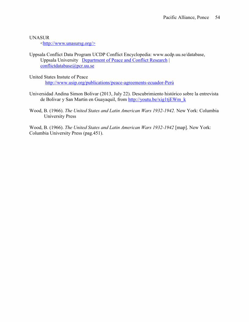
Pacific Alliance, Ponce 54
UNASUR
<http://www.unasursg.org/>
Uppsala Conflict Data Program UCDP Conflict Encyclopedia: www.ucdp.uu.se/database,
Uppsala University Department of Peace and Conflict Research |
United States Instute of Peace
http://www.usip.org/publications/peace-agreements-ecuador-Perú
Universidad Andina Simon Bolivar (2013, July 22). Descubrimiento histórico sobre la entrevista
de Bolivar y San Martin en Guayaquil, from http://youtu.be/xig1tjEWm_k
Wood, B. (1966). The United States and Latin American Wars 1932-1942. New York: Columbia
University Press
Wood, B. (1966). The United States and Latin American Wars 1932-1942 [map]. New York:
Columbia University Press (pag.451).
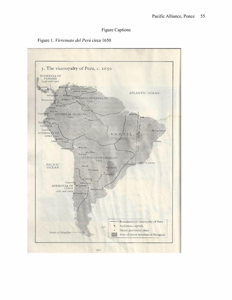
Pacific Alliance, Ponce 55
Figure Captions
Figure 1. Virreinato del Perú circa 1650
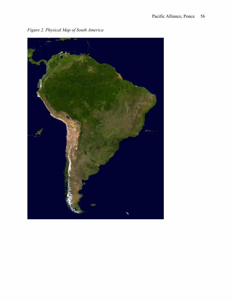
Pacific Alliance, Ponce 56
Figure 2. Physical Map of South America
Pacific Alliance, Ponce 57
Figure 3. Colombian – Peruvian Border Agreements
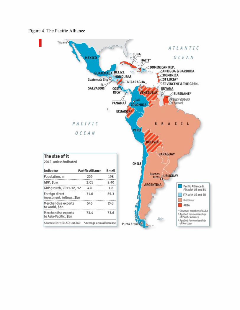
Figure 4. The Pacific Alliance
Endnotes
i See introduction to chapter 1. ii With the pacification of the country and the new advances in freight technology Argentina was able to
substantially developed its cattle and farming industry. Population also grew up dramatically because of migrations.
A quarter million immigrants came mostly from Europe at the end of the nineteenth century. For further information
see Bushnell & Macaulay. The Emergence of Latin America in the Nineteenth Century. iii Data obtained from the CIA The World Factbook https://www.cia.gov/library/publications/the-world-factbook/
(10/24/2013). iv Foreign Policy Magazine. 2010. “Secretary Clinton's cold shoulder on the Iranian fuel-swap deal” 26 May,
2010 http://mideast.foreignpolicy.com/posts/2010/05/26/secretary_clintons_cold_shoulder_on_the_iranian_fuel_sw
ap_deal v Data obtained from Comunidad Andina de Naciones http://www.comunidadandina.org/ (04/102013). vi Data obtained from Mercosur http://www.mercosur.int/msweb/portal%20intermediario/ (04/10/2013). vii Data obtained from Unasur http://www.unasursg.org/ (04/10/2013). viii The information was obtained by the Oxfam website accessed on April 12, 2013.
http://www.oxfam.org/en/paraguay ix Data obtained from Mercado Integrado Latinoamericano http://mercadointegrado.com/ (04/12/2013). x Data obtained from Alinza del Pacifico http://alianzapacifico.net/en/ (04/12/2013). xi Data obtained from Mercopress. www.mercopress.com (10/22/2013). xii Data obtained from Datamyne www.datamyne.com (10/22/2013). xiii Data obtained from the CIA The Word FactBook https://www.cia.gov/library/publications/the-world-
factbook/rankorder/2001rank.html?countryname=Chile&countrycode=ci®ionCode=soa&rank=43#ci
(10/12/2013) xiv I used this term in reference to both North and South American indigenous population. xv Although the past decades have saw a dramatic increase in the wealth of lower and lower middles classes with the
slowly rise of Native Americans and Blacks into the upper middle class. xvi For further information see Jose Carlos Mariátegui, “Siete ensayos de la realidad Perúana” (1928) xvii The capital city of Brazil was relocated because of internal policies in the 1960. Rio de Janeiro, a coastal city
located in Southern Brazil used to the capital city. xviii Upon a quick review to a South American map we can observe that the most of the cities founded by the
Spaniards, Portuguese, French and Dutch are located very close to the shorelines. Those centers of power continue
being the same since colonial times. A physical map shows that most the South American landmass is covered by
the Andes, Amazon and Parana Rainforest. xix For further information se Serres Guiraldes, A. La Estrategia del General Roca. Buenos Aires (1979). xx See introduction of definition of this term xxi Data obtained from Porras Barnechea. Historia de los Limites del Perú (1930). xxii Data obtained from Biblioteca Nacional de Chile http://siit2.bcn.cl/nuestropais/region1/ (07/20/2013). xxiii An explanation of this resolution is provided in the segment about Lima (pages 12 through 34). xxiv For further information see Garcilaso de la Vega, Inca [1609]1991 Comentarios Reales de los Incas. xxv For further information see Kamen, How Spain Became a World Power, 1492-1763 xxvi Natives were living out of the city walls in what was called “El Cercado de Lima” xxvii Perúvian Congress Archives, accessed August 20, 2013. http://www.congreso.gob.pe/museo/index.html xxviii Perú 21, 2012, “Comercio entre Perú y Ecuador creció en US$2,620 millones en trece años” 23 Oct, 2012.
http://Perú21.pe/economia/comercio-entre-Perú-y-ecuador-crecio-us2620-millones-trece-anos-2100192 xxix El Comercio, 2013. “Intercambio comercial entre Perú y Chile crece a 14,8% cada año desde 2003” 14 May
2013. http://elcomercio.pe/economia/1576362/noticia-intercambio-comercial-entre-Perú-chile-crece-148-cada-ano-
desde-2003 xxx This information was obtained from the Buenos Aires website accessed on July 18, 2013.
http://www.buenosaires.gov.ar/areas/ciudad/historico/calendario/destacado.php?menu_id=23203&ide=143 xxxi According to CIA World Factbook, Argentina is the eighth biggest country in the world. xxxii The executive power believes that the moment has arrived to solicit from Congress the enclosed project. In
according to the execution of the created Law in August 23 of 1867 that address in a definite manner our frontier
problems on the west and with the south, adopting by unanimity, the system advising from the previous century that

only through study and experience a great economy can accompany complete security. This recommends the
military occupation of the Rio Negro region as a borderland of the Republic with the Indians of la Pampa. xxxiii 2012 est. by CIA Worldfact. July 20, 2013. https://www.cia.gov/library/publications/the-world-
factbook/geos/ar.html xxxiv The city of Buenos Aires received this name because of Nuestra Señora de los Buenos Aires, in honor of
Virgen María originaria de Cagliari, Cerdeña – Spanish possession at that time- . Sailors prayed to her for
protection. For further information see Direccion General Centro Documental de Informacion y Archivo Legislativo.
http://www.cedom.gov.ar/es/ciudad/barrios/ciudad/ciudad.html (10/30/2013).