Embed Size (px)
Citation preview
SUBSECTION 8.16: PALEONTOLOGICAL RESOURCES
8.16 Paleontological Resources 8.16.1 Introduction Paleontological resources are fossils, the remains of prehistoric plants and animals, and are important scientific and educational resources because of their use in: (1) documenting the presence and evolutionary history of particular groups of both extinct and extant organisms, (2) reconstructing the environments in which these organisms lived, and (3) in determining the relative ages of the strata in which they occur and the geologic events that resulted in the deposition of the sediments that formed these strata. This subsection summarizes the paleontological resources and the potential impacts on paleontological resources that may result from construction of the AES Highgrove project.
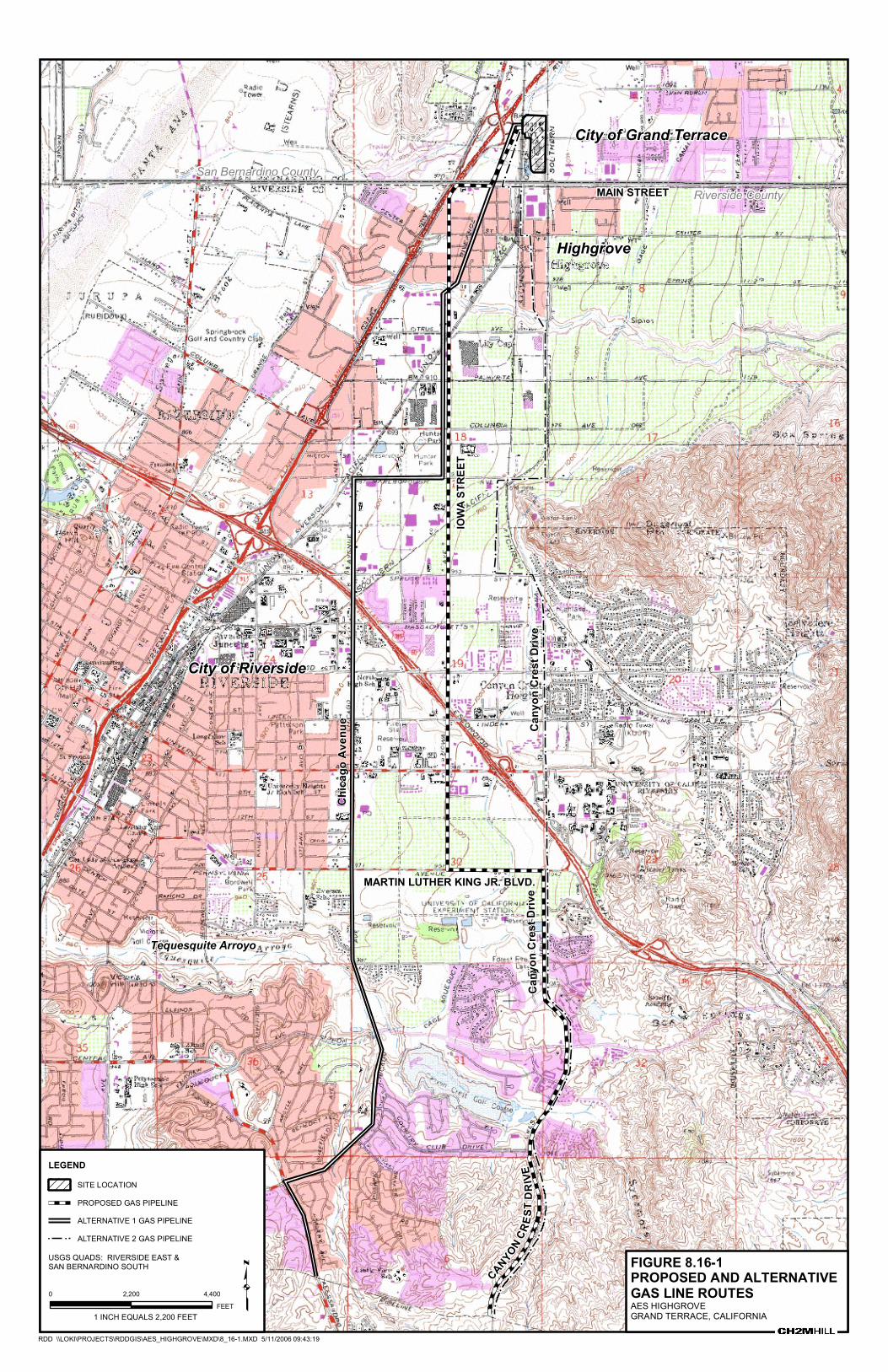
8.16.1.1 Project Description The AES Highgrove project is the proposed construction of a nominal 300-megawatt (MW) peaking facility consisting of three natural-gas-fired turbines, and associated equipment. The proposed generating facility site is located on the property of the former Southern California Edison (SCE) Highgrove Generating Station in the City of Grand Terrace, in San Bernardino County. The proposed generating facility site is located in an industrially-zoned area of the City. It will connect to SCE’s electrical transmission system via the adjacent 115-kV Highgrove Substation. Natural gas for the facility will be delivered to the generating station via a natural gas pipeline that will connect to an existing Southern California Gas (SoCalGas) transmission line (Line 2001) located approximately 7 miles (11.5 km) south of the project site in Riverside County. A proposed gas line and two alternate gas pipeline routes are reviewed (see Figure 8.16-1) and are included in this paleontologic resources assessment.
The natural gas line and short potable water line will be the only offsite laterals for this project. Industrial water will be supplied by an existing onsite well. Potable water for drinking and sanitary uses will be provided by the Riverside Highland Water Company from a water main about 1,300 feet south of the plant site on Main Street. Similarly, sanitary wastewater disposal will be via a hookup to the city’s sanitary sewer, which is located on Taylor Street, bordering the plant. The power plant parcel will consist of approximately 9.8 acres of land under the Applicant’s control.
8.16.2 Laws, Ordinances, Regulations, and Standards Paleontological resources are non-renewable scientific and educational resources and are protected by several federal and state statutes (California Office of Historic Preservation, 1983; see also Marshall, 1976; West, 1991; Gastaldo, 1999), most notably by the 1906 Federal Antiquities Act and by the State of California’s environmental regulations (California Environmental Quality Act [CEQA], Section 15064.5). Professional guidelines for the assessment and mitigation of impacts to paleontological resources have been disseminated by the Society of Vertebrate Paleontology (SVP; 1995, 1996). Construction of the proposed AES Highgrove project will be conducted in accordance with all laws, ordinances, regulations, and standards (LORS) applicable to paleontological resources. Federal, State, and County LORS applicable to paleontological resources are summarized in Table 8.16-1 and discussed briefly below, along with SVP guidelines. The cities of Grand Terrace and Riverside do not have LORS applicable to paleontological resources.
EY042006001SAC/322752/061110009 (008-16.DOC) 8.16-1
SUBSECTION 8.16: PALEONTOLOGICAL RESOURCES
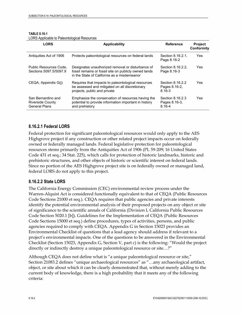
TABLE 8.16-1 LORS Applicable to Paleontological Resources
LORS Applicability Reference Project Conformity
Antiquities Act of 1906 Protects paleontological resources on federal lands Section 8.16.2.1, Page 8.16-2
Yes
Public Resources Code, Sections 5097.5/5097.9
Designates unauthorized removal or disturbance of fossil remains or fossil site on publicly owned lands in the State of California as a misdemeanor
Section 8.16.2.2, Page 8.16-3
Yes
CEQA, Appendix G(j) Requires that impacts to paleontological resources be assessed and mitigated on all discretionary projects, public and private
Section 8.16.2.2 Pages 8.16-2, 8.16-3
Yes
San Bernardino and Riverside County General Plans
Emphasize the conservation of resources having the potential to provide information important in history and prehistory
Section 8.16.2.3 Pages 8.16-3, 8.16-4
Yes
8.16.2.1 Federal LORS Federal protection for significant paleontological resources would only apply to the AES Highgrove project if any construction or other related project impacts occur on federally owned or federally managed lands. Federal legislative protection for paleontological resources stems primarily from the Antiquities Act of 1906 (PL 59-209; 16 United States Code 431 et seq.; 34 Stat. 225), which calls for protection of historic landmarks, historic and prehistoric structures, and other objects of historic or scientific interest on federal lands. Since no portion of the AES Highgrove project site is on federally owned or managed land, federal LORS do not apply to this project.
8.16.2.2 State LORS The California Energy Commission (CEC) environmental review process under the Warren-Alquist Act is considered functionally equivalent to that of CEQA (Public Resources Code Sections 21000 et seq.). CEQA requires that public agencies and private interests identify the potential environmental analysis of their proposed projects on any object or site of significance to the scientific annals of California (Division I, California Public Resources Code Section 5020.1 [b]). Guidelines for the Implementation of CEQA (Public Resources Code Sections 15000 et seq.) define procedures, types of activities, persons, and public agencies required to comply with CEQA. Appendix G in Section 15023 provides an Environmental Checklist of questions that a lead agency should address if relevant to a project’s environmental impacts. One of the questions to be answered in the Environmental Checklist (Section 15023, Appendix G, Section V, part c) is the following: “Would the project directly or indirectly destroy a unique paleontological resource or site…?”
Although CEQA does not define what is “a unique paleontological resource or site,” Section 21083.2 defines “unique archaeological resources” as “…any archaeological artifact, object, or site about which it can be clearly demonstrated that, without merely adding to the current body of knowledge, there is a high probability that it meets any of the following criteria:
8.16-2 EY042006001SAC/322752/061110009 (008-16.DOC)
SUBSECTION 8.16: PALEONTOLOGICAL RESOURCES
1. [It] contains information needed to answer important scientific research questions and that there is a demonstrable public interest in that information.
2. It has a special and particular quality such as being the oldest of its type or the best available example of its type.
3. [It] is directly associated with a scientifically recognized important prehistoric or historic event.”
Making accommodation for the type of antiquity involved, this definition of “unique archaeological resources” is equally applicable to recognizing “a unique paleontological resource or site.” Additional guidance is provided in CEQA Section 15064.5 (a)(3)(D), which indicates “generally, a resource shall be considered historically significant if it has yielded, or may be likely to yield, information important in prehistory or history.”
Section XVII, part a, of the CEQA Environmental Checklist asks a second question equally applicable to paleontological resources: “Does the project have the potential to eliminate important examples of the major periods of California history or pre-history?” Fossils are important examples of the major periods of California prehistory. To be in compliance with CEQA, environmental impact assessments, statements, and reports must answer both these questions in the Environmental Checklist. If the answer to either question is yes or possibly, a mitigation and monitoring plan must be designed and implemented to protect significant paleontological resources.
The CEQA lead agency having jurisdiction over a project is responsible to ensure that paleontological resources are protected in compliance with CEQA and other applicable statutes. The lead agency with the responsibility to ensure that fossils are protected during construction of the proposed AES Highgrove project is the CEC. California Public Resources Code Section 21081.6, entitled Mitigation Monitoring Compliance and Reporting, requires that the CEQA lead agency demonstrate project compliance with mitigation measures developed during the environmental impact review process.
Other state requirements for paleontological resource management are in California Public Resources Code Chapter 1.7, Section 5097.5 (Stats. 1965, c. 1136, p. 2792), entitled Archaeological, Paleontological, and Historical Sites. This statute defines any unauthorized disturbance or removal of a fossil site or fossil remains on public land as a misdemeanor and specifies that state agencies may undertake surveys, excavations, or other operations as necessary on state lands to preserve or record paleontological resources. This statute would not apply to the proposed AES Highgrove project since construction or other related project impacts would not occur on publicly owned or managed lands.
8.16.2.3 County and City LORS California Planning and Zoning Law requires each county and city jurisdiction to adopt a comprehensive, long-term General Plan for its development. The General Plan is a policy document designed to give long-range guidance to those making decisions affecting the future character of the planning area. It represents the official statement of the community’s physical development as well as its environmental goals. The General Plan also acts to clarify and articulate the relationship and intentions of local government to the rights and expectations of the general public, property owners, and prospective investors. Through its
EY042006001SAC/322752/061110009 (008-16.DOC) 8.16-3
SUBSECTION 8.16: PALEONTOLOGICAL RESOURCES
general plan, the local jurisdiction can inform these groups of its goals, policies, and development standards; thereby communicating what must be done to meet the objectives of the general plan.
Both the San Bernardino County and Riverside County General Plans have Conservation Elements that emphasize the conservation of resources that are important to the history of the area, including cultural resources. Paleontological resources are commonly subsumed under this category at the local level because they too have the potential to provide “information important in history and prehistory.” Per CEQA, the cultural resources section of the “San Bernardino County Initial Study Environmental Checklist Form” specifically asks if a given project would directly or indirectly destroy a unique paleontological resource.
8.16.2.4 Professional Standards To assist in the compliance with applicable laws, the SVP, an international scientific organization of professional vertebrate paleontologists, has disseminated guidelines (SVP, 1995; 1996) that outline acceptable professional practices in the conduct of paleontological resource assessments and surveys; monitoring and mitigation; data and fossil recovery; sampling procedures; and specimen preparation, identification, analysis, and museum curation. The SVP’s guidelines are a commonly used standard against which paleontological monitoring and mitigation programs are evaluated. Briefly, SVP guidelines recommend that each project have literature and museum archival reviews, a field survey, and, if there is a high potential for disturbing significant fossils during project construction, a mitigation plan that includes monitoring by a qualified paleontological monitor, salvage of fossils if encountered, preparation and identification of salvaged fossils, and placement of curated fossil specimens into a permanent, retrievable public museum collection (such as the San Bernardino County Museum).
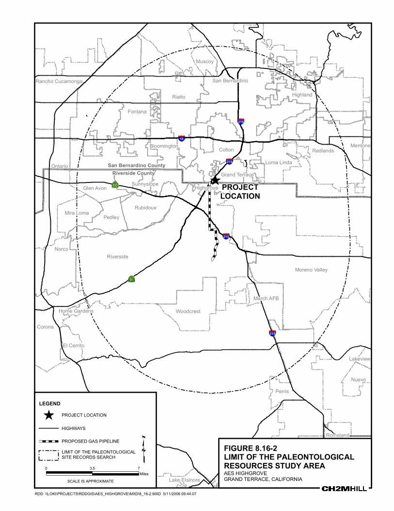
8.16.3 Setting The study area includes the AES Highgrove plant site as well as three alternate natural gas pipeline routes that extend approximately 7 miles (11.5 km) south of the plant site to a point of interconnection with a regional gas transmission pipeline, Line 2001 (see Figure 8.16-2).
8.16.3.1 Geographic Setting The project area lies in the Inland Empire area of southern California between the San Bernardino and San Jacinto mountains of the Transverse Ranges to the northeast and east, respectively, and the Chino Hills and Santa Ana mountains to the west and southwest, respectively. Physiographically, it lies on the northwestern portion of the Perris Block, an eroded surface of Mesozoic crystalline rock between the Santa Ana and the San Jacinto mountains (Woodford et al., 1971). The Box Springs Mountains lie immediately to the east of the pipeline alternate routes. The La Loma Hills lie immediately to the west and northwest of the plant site. Father to the east, the San Jacinto Fault Zone lies at the eastern base of the Box Springs Mountains and marks the eastern edge of the Perris Block. To the west, the Elsinore and Chino Fault Zones lie along the eastern margin of the Santa Ana Mountains and mark the western limit of the Perris Block.
Within the context of the Perris Block, the project area encompasses two distinct physiographic units. To the north of Tequesquite Arroyo, the plant site and approximately
8.16-4 EY042006001SAC/322752/061110009 (008-16.DOC)
SUBSECTION 8.16: PALEONTOLOGICAL RESOURCES
5 miles (8.2 km) of the proposed gas pipeline and alternate routes lie within the Santa Ana River Valley in the vicinity of Riverside and Colton (Figure 8.16-1). The remaining southern portion of the gas pipeline routes to the south ascend onto the northwestern margin of the Perris Plain, represented by the northwestern edge of the Perris Surface (Woodburn et al., 1971). The northeast-southwest trending northern margin of the Perris Plain may be structurally controlled, but no fault is currently mapped in that area (Morton and Cox, 2001; Woodford et al., 1971). Elevations in the Santa Ana River Valley are generally below about 1,000 feet (305 m), while elevations on the Perris Plain are about 1,700 feet (520 m) on the Perris Surface near the southern termini of the gas pipeline route alternatives. The northwestern edge of the Paloma Surface of the Perris Plain lies about 1.5 miles (2.5 km) east of the southern termini of the gas pipeline routes, and elevations on that surface there are around 1,500 feet (460 m). Morton and Cox (2001) note that, in this area, the lower-elevation Paloma Surface is mantled with alluvium while the higher Perris Surface is generally characterized by exposed or very thinly mantled bedrock.
8.16.3.2 Geologic Setting Limited exposures of metamorphic rocks of probable Paleozoic age are present in the project area. These rocks, originally sedimentary in nature, were subject to high-temperature metamorphism during the emplacement of the Mesozoic igneous batholith in this area. They include biotite schist, impure quartzite, marble, and other calc-silicate rocks (Morton and Cox, 2001).
Igneous rocks emplaced in the crust primarily during the Late Mesozoic dominate the basement geology. In the project area, these rocks are of the Peninsular Range Batholith (Morton and Miller, 2003). In most areas they were originally overlain by varying depths of Quaternary alluvium and, in some cases, by artificial fill (ibid.; Morton and Cox, 2001). Rocks of the Peninsular Range Batholith were emplaced during the Cretaceous Epoch, which ended about 64 million years ago. These granitic rocks vary in mineralogical composition and, in the project area, are principally tonalite and granodiorite (Morton and Cox, 2001), represented chiefly by the Val Verde tonalite.
Quaternary (Pleistocene and Holocene) sediments exposed in the project area are primarily alluvial fan deposits issuing from the Box Springs Mountains to the east along the northern portion of the pipeline alternative routes north of Tequesquite Arroyo and the plant site. Older alluvium of less certain provenance lies along the southern portion of the pipeline routes south of the Tesquesquite Arroyo, on the northwest edge of the Perris Plain. Artificial fill and Holocene eolian and sheet wash sediments typically mantle these units. In areas south of Tequesquite Arroyo extensive excavations associated with roadway and housing tract development have removed this alluvium in many places and exposed the underlying Val Verde tonalite.
The project area has been subject to considerable development and, as a consequence, much of the geology is obscured by buildings, pavement, landscaping, and artificial fill. South of the Tequesquite Arroyo deep road cuts reveal primarily extensive exposures of Cretaceous Val Verde tonalite.
EY042006001SAC/322752/061110009 (008-16.DOC) 8.16-5
SUBSECTION 8.16: PALEONTOLOGICAL RESOURCES
8.16.4 Resource Inventory 8.16.4.1 Resource Inventory Methods A records search and literature review was conducted for this project by the San Bernardino County Museum, the regional repository for paleontological records in this area. It is included as Confidential Appendix 8.16A (Scott, 2005). Subsequent to the receipt of the results of the records search, an initial paleontological field survey of the project area was conducted by Mr. Russel Hasting on February 5, 2005. Mr. Hasting is a trained field paleontologist with more than 4 years of paleontological field experience in California, including other projects licensed by the CEC, such as the Walnut Energy Center. This was followed by a field review of the project area on April 11, 2005, by the project Paleontologic Resource Specialist, Dr. Geoffrey Spaulding. Areas where undisturbed or possibly undisturbed sediments were accessible were walked, while areas where the ground surface was obscured were subject to a windshield survey. Prior to field work and during the preparation of this assessment, the geological literature covering the project area also was consulted.
The potential paleontological productivity of each rock unit in the study area was assessed based on the abundance of fossil remains it has yielded and previously recorded fossil sites it contains in the broader study area of the Inland Empire (Riverside, San Bernardino, and the Perris Plain).
8.16.4.2 Results: Geology and Stratigraphy 8.16.4.2.1 Rocks Lacking or Unlikely To Yield Fossils The results of the paleontological records review, available geological literature and geologic mapping, and the field surveys were used to determine the nature of the geology and the paleontological sensitivity of the rocks in the vicinity of the project. The study area is largely developed and little of the ground surface is visible. Therefore, greater reliance was placed on the literature and records review than on the negative results of the field surveys.
Paleozoic Rocks South of Tequesquite Arroyo and west of Chicago Street there are mapped a number of limited outcrops of calc-silicate metamorphic rock of probable Paleozoic age (Morton and Cox, 2001). Other Paleozoic calc-silicate rocks and schists intermixed with Cretaceous granitic rocks also outcrop within one mile (1.6 km) of the southern portion of the pipeline routes.
These rocks were extensively altered by metamorphism during the emplacement of the adjacent Mesozoic granitic batholiths. Due to their highly metamorphosed nature, the probability of recovering fossils from these rocks is extremely remote. Therefore, they possess low paleontological potential.
Mesozoic Rocks Crystalline igneous rocks of the Val Verde pluton and the Box Springs plutonic complex comprise the Mesozoic igneous suite in the project area. From their southern termini the gas pipeline extends north over the Cretaceous Val Verde tonalite until about the position of the Tequesquite Arroyo. Heterogeneous porphyritic granodiorites of the Box Springs plutonic
8.16-6 EY042006001SAC/322752/061110009 (008-16.DOC)
SUBSECTION 8.16: PALEONTOLOGICAL RESOURCES
complex comprise the ridge extending west from Sugar Loaf Mountain, immediately to the east of the project area. Porphyritic granodiorite also comprises the proximal portion of the La Loma Hills to the west and northwest of the plant site.
Although igneous volcanic rocks (chiefly volcanic ash and volcanic debris flow deposits) may occasionally yield fossil materials, these plutonic rocks represent molten material that cooled at depth beneath the earth’s crust. Plutonic igneous rocks, therefore, do not contain fossils and therefore possess no paleontological potential.
Artificial Fill Artificial fill is mapped by Morton and Cox (2001) between Chicago Avenue and Canyon Crest Drive, south of Tequesquite Arroyo. This fill is associated with residential development of the generally steep terrain descending from the Perris Plain and Box Springs Mountains to the Santa Ana River Valley. Field review revealed that artificial fill is widespread elsewhere in the study area south of Tequesquite Arroyo. In areas north of the arroyo, agricultural activities and urban development in the Riverside area have resulted in the deposition of variable thicknesses of disturbed sediments and artificial fill.
Artificial fill could have fragmentary fossil material transported from other sites. Even if such were the case, this material would be out of stratigraphic context and, therefore, have no scientific value and minimal, if any, educational value due to its lack of context and fragmentary nature. Therefore, artificial fill has low paleontological potential.
8.16.4.2.2 Potentially Fossiliferous Sediments The results of the field survey indicate that the surficial geology of much of the plant site and the gas pipeline route alternatives is obscured by industrial, urban and residential development, and by agricultural activities. Therefore, geological maps were the primary source used to determine the extent of potentially fossiliferous sedimentary units in the project area.
Although alluvial fan deposits are generally thought to be subaerial, coarse-grained sediments deposited in a high-energy regime with consequently low paleontological sensitivity, experience in the study area has shown that certain facies of these alluvial units yield important vertebrate fossils (see below). Other sedimentary rocks, such as the highly fossiliferous San Timoteo Formation found farther east in the San Jacinto Valley, are not known to be present in the project area (Morton and Cox, 2001; Morton and Miller, 2003; Scott, 2005).
Early to Middle Pleistocene AlluviumOlder alluvium of probable Early to Middle Pleistocene age occurs intermittently through the study area (Morton and Cox, 2001; and Morton and Miller, 2003). Outcrops are mapped primarily south of Tequesquite Arroyo, and along the western piedmont of the Box Springs Mountains. It also underlies the general vicinity of the plant site. It is well-oxidized and indurated, and commonly contains local duripans and silcretes indicative of soil formation processes in a more humid climatic regime than the semi-arid climate typical of the area today. Morton and Miller (2003) note that alluvial clasts in the La Loma Hills were transported from the San Gabriel Mountains, suggesting that some of these older alluvial units may have originated from more distant sources than the Box Springs Mountains.
EY042006001SAC/322752/061110009 (008-16.DOC) 8.16-7
SUBSECTION 8.16: PALEONTOLOGICAL RESOURCES
Middle to Late Pleistocene Alluvium Younger alluvial fan deposits extending west and northwest from the Box Springs Mountains to the Santa Ana River Valley are mapped by Morton and Cox (2001) and Morton and Miller (2003) as Middle to Late Pleistocene in age. These deposits occur north of the Tequesquite Arroyo. They are usually indurated and oxidized, but neither the degree of induration nor the reddening of these sediments is as strongly developed as the older Pleistocene alluvium.
Late Pleistocene to Holocene Alluvium The youngest alluvial deposits in the study area are usually restricted to well-defined drainages and arroyos extending west from the topographic high represented by the Box Spring Mountains. In contrast to the oxidized soils of the older alluvial units, there is little to no evidence of reddening in these sediments and their color is buff to gray. They are often somewhat consolidated, but are rarely indurated to the degree exhibited by the older alluvium. Late Pleistocene alluvium, as well as the older alluvial units, is commonly blanketed by middle to late Holocene eolian and sheet wash sediments. In areas of low relief, this Holocene overburden can reach a depth of up to 15 feet (4.6 m) and, normally, attains a depth of at least 5 feet (1.5 m) (e.g., Onken, 2001).
8.16.4.3 Results: Paleontological Resources The paleontological resources records review conducted for this project encompassed an area extending 9 miles (14.7 km) in all directions from the proposed pipeline routes and the plant site (Confidential Appendix 8.16A). No previously recorded fossil sites have been documented within the footprint of the plant site or of the alternate gas pipeline routes. No previously recorded fossil site occurs within 4 miles of the project area. The majority of vertebrate and paleobotanical sites recorded in this search area are from the highly fossiliferous San Timoteo beds of Frick (1921), which are assigned a Plio-Pleistocene age. The closest outcrops of the San Timoteo beds lie approximately 3.6 miles (5.9 km) east of the plant site along the San Jacinto Fault Zone, where local tectonic uplift has exposed these sediments (Morton and Miller, 2003).
No paleontological resources were identified in the course of the field survey. The underlying geology of most of the project area, including the proposed pipeline and alternative routes, is obscured by development, vegetation, and Holocene or artificial overburden.
8.16.4.3.1 Paleontological Sensitivity of Paleozoic and Mesozoic Rocks The Paleozoic and Mesozoic rocks in the study area are either highly metamorphosed, or are igneous in origin. No fossils have been recorded for these rocks, and none are expected in the project area. Therefore, these rocks are assigned a Low Sensitivity rating for paleontological resources.
8.16.4.3.2. Paleontological Sensitivity of Pleistocene (Irvingtonian and Rancholabrean) Sediments At least three different-age alluvial units are recognized in the project area, and they range in age from Early Pleistocene to Late Pleistocene and Holocene. There is no record of these specific geologic units having yielded fossils in the immediate vicinity of the project, but similar alluvial sediments elsewhere in the area have yielded rich records of primarily Rancholabrean fauna and flora. These finds have varied in depth from about 13 feet (4 m)
8.16-8 EY042006001SAC/322752/061110009 (008-16.DOC)
SUBSECTION 8.16: PALEONTOLOGICAL RESOURCES
below original ground surface, to greater than 437 feet (133 m) below ground surface, and have come to light mainly as a result of construction-related excavations (Reynolds and Reynolds, 1991; Springer et al., 1998, 1999). They include records of saber-tooth cat (Smilodon fatalis), mammoth (Mammuthus columbi), mastodon (Mammut americanum), horse (Equus spp.), camel (Camelops hesternus), and other members of the extinct Pleistocene megafauna that used to inhabit these valleys. Paleobotanical remains that have been recovered from these sediments include logs of juniper or cedar (Cupressaceae), the seeds and cone scales of ponderosa pine (Pinus ponderosa), and the seeds and fruit of manzanita species (Arctostaphylos spp.). These plant species now occur only at higher elevations in the surrounding mountains
Because of the abundant and significant fossil material that has been recovered from Pleistocene alluvium in the region, these sediments are assigned a High Sensitivity rating for paleontological resources.
8.16.4.3.3. Paleontological Sensitivity of Holocene Sediments and Artificial Fill Throughout the area, Holocene sediments occur as a mantle over older alluvium, and normally consist of carbonate-rich eolian silts and fine sands, and sheet wash debris. A distinct unconformity and soil usually separates these sediments from underlying Pleistocene sediments. Significant paleontological resources have not been recovered from Holocene-age sedimentary units in the region. Holocene sediments are, therefore, assigned a Low Sensitivity rating for paleontological resources. However, some of the Late Pleistocene age fossil finds in the region have been dated by radiocarbon and are as young as 13,000 to 14,000 years, placing them only 3,000 to 4,000 years older than the Pleistocene/Holocene boundary. Therefore, monitoring of excavations of these sediments should take place if a reasonable probability exists that construction would disturb underlying Pleistocene deposits.
While artificial fill may contain fragmentary fossil material, that material would be out of stratigraphic context and, therefore, of no scientific value. Similarly, the educational value of any fragmentary material recovered from artificial fill would be minimal. Consequently, this soil is assigned a Low Sensitivity rating for paleontological resources. However, like Holocene units, monitoring of excavations of artificial fill should take place if there is a reasonable probability that construction would disturb underlying Pleistocene deposits.
8.16.5 Impacts Impacts to paleontological resources from construction and operation of the AES Highgrove facility are evaluated in the following subsections.
8.16.5.1 Discussion of Impacts 8.16.5.1.1 Paleontological Resource Significance Criteria In its standard guidelines for assessment and mitigation of adverse impacts to paleontological resources, the SVP (1995) established three categories of sensitivity for paleontological resources: high, low, and undetermined. The paleontological importance or sensitivity of a stratigraphic unit reflects: (1) its potential paleontological productivity (and thus sensitivity), and (2) the scientific significance of the fossils it has produced. The potential paleontological productivity of a stratigraphic unit exposed in a project area is based on the abundance of fossil specimens and/or previously recorded fossil sites in
EY042006001SAC/322752/061110009 (008-16.DOC) 8.16-9
SUBSECTION 8.16: PALEONTOLOGICAL RESOURCES
exposures of that unit in or near that project site. The underlying assumption of this assessment method is that exposures of a stratigraphic unit are most likely to yield fossil remains in quantity (and quality) similar to those previously recorded from that unit.
An individual fossil specimen is considered scientifically important and significant if it is: (1) identifiable, (2) complete, (3) well preserved, (4) age diagnostic, (5) useful in paleoenvironmental reconstruction, (6) a type or topotypic specimen, (7) a member of a rare species, (8) a species that is part of a diverse assemblage, and/or (9) a skeletal element different from, or a specimen more complete than, those now available for that species (SVP, 1995). For example, identifiable land mammal fossils are considered scientifically important because of their potential use in providing age determinations and paleoenvironmental reconstructions for the sediments in which they occur. Moreover, vertebrate remains are comparatively rare in the fossil record. Although fossil plants are less frequently considered to be significant fossils, as sessile (attached in place) organisms they are actually more sensitive indicators of their environment and, thus, more valuable than mobile mammals for paleoenvironmental reconstructions.
Under SVP (1995) standard guidelines, stratigraphic units in which fossils have been previously found are deemed to have a high sensitivity and a high potential to produce additional fossils. In areas of high sensitivity, full-time monitoring by a professionally trained paleontologist is recommended during any project ground disturbance. Stratigraphic units that are not sedimentary in origin or that have not been known to produce fossils in the past are deemed to have low or undetermined sensitivity and monitoring is usually not recommended nor needed during project construction in these units. Stratigraphic units that have not had any previous paleontological resource surveys or fossil finds are deemed undetermined until surveys and mapping are done to determine their sensitivity. After reconnaissance surveys, observation of exposed strata, and possibly subsurface testing, a qualified paleontologist can usually determine whether the stratigraphic unit should be categorized as having high, low, or undetermined sensitivity; that is, whether there is a high, low, or undetermined potential to encounter fossil resources during construction. In keeping with the significance criteria of the SVP (1995), all vertebrate fossils are categorized as being of significant scientific value and all stratigraphic units in which vertebrate fossils have previously been found have high sensitivity. According to SVP (1995) standard guidelines, sensitivity comprises both: (a) the potential for yielding abundant or significant vertebrate fossils or for yielding a few significant fossils, large or small, vertebrate, invertebrate, or botanical; and (b) the importance of recovered evidence for new and significant taxonomic, phylogenetic, paleoecologic, or stratigraphic data.
Using the criteria of the SVP (1995), the significance of the potential adverse impacts of earthmoving on the paleontological resources of each stratigraphic unit exposed in and near the project site was assessed, including the proposed gas pipeline route and alternatives. The paleontological sensitivity of the stratigraphic unit in turn reflects the potential for fossil remains and fossil sites being encountered during earthmoving. However, it should be noted that any impact on a fossil site or a fossil-bearing rock unit during construction would be considered significant, regardless of the previously determined paleontological importance of the rock unit in which the site or fossiliferous layer occurs. For example, grading in an area underlain by a rock unit with low sensitivity would have only a low potential to disturb fossil remains (i.e., the rock unit would have low sensitivity to adverse impacts). However, the loss of any fossil remains from that rock unit would be a significant impact.
8.16-10 EY042006001SAC/322752/061110009 (008-16.DOC)
SUBSECTION 8.16: PALEONTOLOGICAL RESOURCES
8.16.5.2 Paleontological Resource Impact Assessment No impacts to non-renewable paleontological resources would occur from operation of the proposed AES Highgrove facility or associated gas pipeline. Impacts to paleontological resources would only occur from construction-related excavations that would be sufficiently deep to affect sediments possessing high paleontological sensitivity. Based on prior detailed geomorphologic investigations on the Perris Plain (Onken, 2001), the depth below which paleontologically sensitive sediments (if present) have the potential to be disturbed is considered to be the minimal depth of the Holocene overburden, or about 5 feet (1.5 m) below original ground surface.
Significant impacts to paleontological resources would occur from construction-related excavations at depth greater than 5 feet at the plant site to the extent that those excavations would disturb underlying Pleistocene alluvium, which is mapped as occurring in the area. Similarly, significant impacts would occur from trenching along the gas pipeline route in those areas that are underlain by Pleistocene alluvium, primarily north of Tequesquite Arroyo.
No significant impacts to paleontologic resources would occur from trenching along the pipeline route in those areas underlain by Paleozoic metamorphic rocks, by Mesozoic granitic rocks, or by artificial fill. These areas occur primarily south of Tequesquite Arroyo.
Site grading at depths of less than 5 feet below original ground surface is not expected to result in significant adverse impacts to paleontological resources, as the ground surface in the area is already relatively flat, is covered by Holocene overburden, and has already been disturbed by previous construction activities. Support activities such as the emplacement of temporary construction offices, proposed laydown area(s), and parking areas, are also expected to have no significant adverse impact on paleontological resources, as they also would be located on ground previously disturbed and will not involve ground disturbance at depths greater than 5 feet (1.5 m). However, deeper excavations for foundations, pipelines and conduits, and drainage basins, as well as trenching for the gas pipeline, would impact paleontologically sensitive sediments, and therefore, result in adverse impacts to paleontological resources.
8.16.6 Mitigation 8.16.6.1 Proposed Mitigation Measures This section describes Applicant-proposed mitigation measures that would be implemented to reduce potential adverse impacts to significant paleontological resources resulting from construction of the power generation facility and gas pipeline. These proposed paleontological resource mitigation measures would reduce to an insignificant level the direct, indirect, and cumulative adverse impacts to paleontological resources that would result from project construction. The mitigation measures proposed below are in compliance with CEC environmental guidelines (CEC, 2000) and with SVP standard guidelines for mitigating adverse construction-related impacts on paleontological resources (SVP, 1995; 1996).
8.16.6.1.1 Paleontological Monitoring During construction, earthmoving construction activities will be monitored where these activities occur at a sufficient depth and in a paleontologically sensitive geological unit and,
EY042006001SAC/322752/061110009 (008-16.DOC) 8.16-11
SUBSECTION 8.16: PALEONTOLOGICAL RESOURCES
therefore, would potentially disturb previously undisturbed sediment. Monitoring of surface grading and other activities at depths less than 5 feet (1.5 m) below the original ground surface is not proposed. These shallow activities have minimal probability to disturb paleontologically sensitive sediments. Monitoring will not be conducted in areas of artificial fill, in areas immediately underlain by metamorphic and igneous rocks, and in areas where exposed sediment will be buried but not otherwise disturbed.
8.16.6.1.2 Paleontological Resource Monitoring and Mitigation Plan Prior to construction, a qualified paleontologist will be retained to design and implement a paleontological resources monitoring and mitigation program (PRMMP). The PRMMP will include a description of where and when construction monitoring will be required; emergency discovery procedures including avoidance of discovered resources; sampling and data recovery protocol; preparation, identification, and museum curation of any fossil specimens and data recovered; preconstruction coordination; worker education; and reporting.
This PRMMP will be consistent with SVP standard guidelines for the mitigation of construction-related adverse impacts on paleontological resources (SVP, 1995), as well as the requirements of the designated museum repository for any fossils collected. The Division of Geological Sciences of the San Bernardino County Museum in Redlands is the regional repository for recovered paleontological specimens.
Scientific recovery, preparation, identification, determination of significance, and curation into a public museum is considered by most land management agencies and by the SVP (1995) to adequately mitigate impacts to paleontological resources in most circumstances. Therefore, the implementation of these mitigation measures would reduce potentially significant adverse environmental impact of project-related ground disturbance on paleontological resources to an insignificant level by allowing for the recovery of fossil remains and associated specimen data, and corresponding geologic and geographic site data, that otherwise would be lost. With a well-designed and implemented PRMMP, project construction could actually result in beneficial impacts through the possible discovery of fossil remains that would otherwise not have been exposed without project construction and, therefore, would not have been known to science. The identification and analysis of fossil remains discovered on other projects in this area have helped answer important questions regarding the paleobiogeography, paleoecology, stratigraphy, and age of fossiliferous sediments in the Riverside region (e.g., Springer et al., 1998, 1999).
8.16.6.1.3 Construction Personnel Education Prior to start of construction, construction personnel involved with earthmoving activities will be given a worker education briefing providing them with information that: fossils may be encountered, the appearance of fossils, and proper avoidance and notification procedures. This worker training will be prepared and presented by a qualified paleontologist.
8.16.6.2 Significant Unavoidable Adverse Impacts Because potential impacts on paleontological resources resulting from construction of the AES Highgrove facility can be mitigated to an insignificant level, the proposed project would not cause significant unavoidable adverse impacts as defined by CEQA.
8.16-12 EY042006001SAC/322752/061110009 (008-16.DOC)
SUBSECTION 8.16: PALEONTOLOGICAL RESOURCES
8.16.6.3 Cumulative Impacts Disturbance or destruction of paleontological resources during project excavation has the potential to contribute to cumulative impacts. Impacts from this and other projects that may take place in the reasonably foreseeable future could cumulatively result in significant, adverse impacts to paleontological resources. These impacts would include the destruction of nonrenewable paleontological resources as a consequence of disturbance by earthmoving, and the consequent loss of their scientific data and educational potential.
However, the potential cumulative impacts to paleontological resources during project-related ground disturbance would be low as long as the mitigation measures proposed above are fully-implemented to: recover the resources, ensure they are identified, have their significance determined, have a written report is prepared, and ensure they are curated into a public museum. When properly implemented, the mitigation measures proposed above would effectively recover the value to science of any significant fossils discovered during project construction. Thus, with mitigation the proposed project would not cause or contribute to significant cumulative impacts to paleontological resources.
8.16.6.4 Project Conformity Development and implementation of these monitoring and mitigation measures will maintain conformity with the LORS identified in Section 8.16.2.
8.16.7 Involved Agencies and Agency Contacts There are no state or local agencies having specific jurisdiction over paleontological resources. However, in San Bernardino County, the Division of Geological Sciences of the San Bernardino County Museum maintains an active paleontological resources mitigation program, and acts on behalf of the County on issues dealing with paleontological resources mitigation and management. The CEQA lead agency having specific responsibility to ensure that paleontological resources are protected in compliance with CEQA and other applicable statutes during construction of the AES Highgrove facility is the CEC. California Public Resources Code Section 21081.6, entitled Mitigation Monitoring Compliance and Reporting, requires that the CEQA lead agency demonstrate project compliance with mitigation measures developed during the environmental impact review process.
8.16.8 Permits Required and Permit Schedule No state or local agency requires a paleontological collecting permit to allow for the recovery of fossil remains discovered as a result of construction-related earthmoving on private or public lands, except for federal lands. Removal of paleontological resources from federal lands requires a Cultural Resource Use Permit from the Bureau of Land Management. However, since no federal lands are involved in this project, no permits will be required.
EY042006001SAC/322752/061110009 (008-16.DOC) 8.16-13
SUBSECTION 8.16: PALEONTOLOGICAL RESOURCES
8.16.9 References (CEC) California Energy Commission. 2000. “Paleontological Resources.” p. 35. In Energy Facility Licensing Process – Developer’s Guide of Practices & Procedures. 70 p.
California Office of Historic Preservation. 1983. Summary of State/Federal Laws Protecting Cultural Resources. 10 p.
Frick, Childs. 1921. “Extinct Vertebrate Faunas of the Badlands of Bautista Creek and San Timoteo Canyon, Southern California.” Univ. California Department of Geological Sciences Bulletin 12: 277-409.
Gastaldo, R. A. 1999. “International Laws: Collecting, Transporting and Ownership of Fossils – USA.” P. 330-338. In T. P. Jones and N. P. Rowe (eds), Fossil Plants and Spores. The Geological Society. London, England. 396 p.
Marshall, L. G. 1976. “Paleontological Salvage and Federal Legislation.” Journal of Paleontology. Vol. 50. P. 346-348.
Morton, D. M., and B. Cox, 2001. Geologic Map of the Riverside East 7.5’ Quadrangle, Riverside County, California. U.S. Geological Survey Open-File Report 01-452. Denver Federal Center, Boulder, CO.
Morton, D. M. and F.K. Miller, 2003. Preliminary Digital Geologic Map of the San Bernardino 30’ x 60’ Quadrangle, California, Version 1.0. U.S. Geological Survey Open-File Report 03-293. Denver Federal Center, Boulder, CO.
Onken, J. A. 2001. “Geomorphology: Prehistoric Land-Use Patterns in Context of Landscape Change.” In Metropolitan Water District of Southern California Eastside Reservoir Project Final report of Archaeological Investigations, Volume IV: Prehistoric Archaeology Synthesis of Findings, pp. 249-269. Applied EarthWorks, Hemet, CA.
Reynolds, S. F. B. and R. L. Reynolds, 1991. “The Pleistocene Beneath Our Feet: Near-Surface Pleistocene Fossils in Inland Southern California Basins.” In Inland Southern California: The Last 70 Million Years, M.O. Woodburne, S.F.B. Reynolds, and D.P. Whistler, eds. San Bernardino County Museum Special Publication 38: 41-43.
Scott, Eric, 2005. Paleontology Literature and Records Review, AES Highgrove Power Generation Project, Grand Terrace Region, San Bernardino and Riverside Counties, California. Letter Report. Division of Geological Sciences, San Bernardino County Museum.
Society of Vertebrate Paleontology (SVP). 1996. “Conditions of Receivership for Paleontologic Salvage Collections.” Society of Vertebrate Paleontology News Bulletin. Vol. 166, P. 31-32.
Society of Vertebrate Paleontology (SVP). 1995. “Assessment and Mitigation of Adverse Impacts to Nonrenewable Paleontologic Resources – Standard Guidelines.” Society of Vertebrate Paleontology News Bulletin, Vol. 163, P. 22-27.
Springer, K.B., E. Scott, L.K. Murray and W.G. Spaulding, 1998. “Partial Skeleton of a Large Individual of Mammut americanum from the Domenigoni Valley, Riverside County, California.” Journal of Vertebrate Paleontology 18(3): 78-A.
8.16-14 EY042006001SAC/322752/061110009 (008-16.DOC)
SUBSECTION 8.16: PALEONTOLOGICAL RESOURCES
Springer, K.B., E. Scott, J.C. Sagebiel and K.M. Scott, 1999. “A Late Pleistocene Lake Edge Vertebrate Assemblage from the Diamond Valley, Riverside County, California.” Journal of Vertebrate Paleontology 19(3): 77-A.
West, R. M. 1991. State Regulation of Geological, Paleontological, and Archaeological Collecting – 1991. Unpublished manuscript, American Museum of Natural History. New York, NY. 30 p.
Woodford, A. O., J. S. Shelton, D. O. Doering, and R.K. Morton. 1971. “Pliocene-Pleistocene History of the Perris Block, Southern California.” Geological Society of American Bulletin 82: 3,421-3,448.
EY042006001SAC/322752/061110009 (008-16.DOC) 8.16-15
City of Grand Terrace
Highgrove
City of Riverside
San Bernardino CountyRiverside County
IOWA
STR
EET
MAIN STREET
MARTIN LUTHER KING JR. BLVD.
CANYON CRE
ST D
RIVE
Tequesquite Arroyo
Chica
go A
venu
e
Cany
on C
rest D
rive
Cany
on C
rest D
rive
0 2,200 4,400FEET
RDD \\LOKI\PROJECTS\RDDGIS\AES_HIGHGROVE\MXD\8_16-1.MXD 5/11/2006 09:43:19
FIGURE 8.16-1PROPOSED AND ALTERNATIVEGAS LINE ROUTESAES HIGHGROVEGRAND TERRACE, CALIFORNIA
LEGENDSITE LOCATIONPROPOSED GAS PIPELINEALTERNATIVE 1 GAS PIPELINEALTERNATIVE 2 GAS PIPELINE
1 INCH EQUALS 2,200 FEET
USGS QUADS: RIVERSIDE EAST &SAN BERNARDINO SOUTH
10
6
215
215
215
215
6
Riverside CountySan Bernardino County
PROJECTLOCATION
Riverside
Perris
Fontana
Rialto
Moreno Valley
San Bernardino
Colton Redlands
Corona
Norco
Highland
Ontario
Woodcrest
Rubidoux
Rancho Cucamonga
Sun City
Pedley
Glen Avon
Mira Loma
Loma Linda
Nuevo
March AFB
Muscoy
Bloomington
El Cerrito
Lake Elsinore
Romoland
Grand Terrace
Quail Valley
Mentone
Lakeview
Sunnyslope Highgrove
Canyon Lake
Home Gardens
RDD \\LOKI\PROJECTS\RDDGIS\AES_HIGHGROVE\MXD\8_16-2.MXD 5/11/2006 09:44:07
LEGENDPROJECT LOCATION
HIGHWAYS
PROPOSED GAS PIPELINELIMIT OF THE PALEONTOLOGICAL SITE RECORDS SEARCH
FIGURE 8.16-2LIMIT OF THE PALEONTOLOGICALRESOURCES STUDY AREAAES HIGHGROVEGRAND TERRACE, CALIFORNIA
0 3.5 7Miles
SCALE IS APPROXIMATE