Embed Size (px)
Citation preview
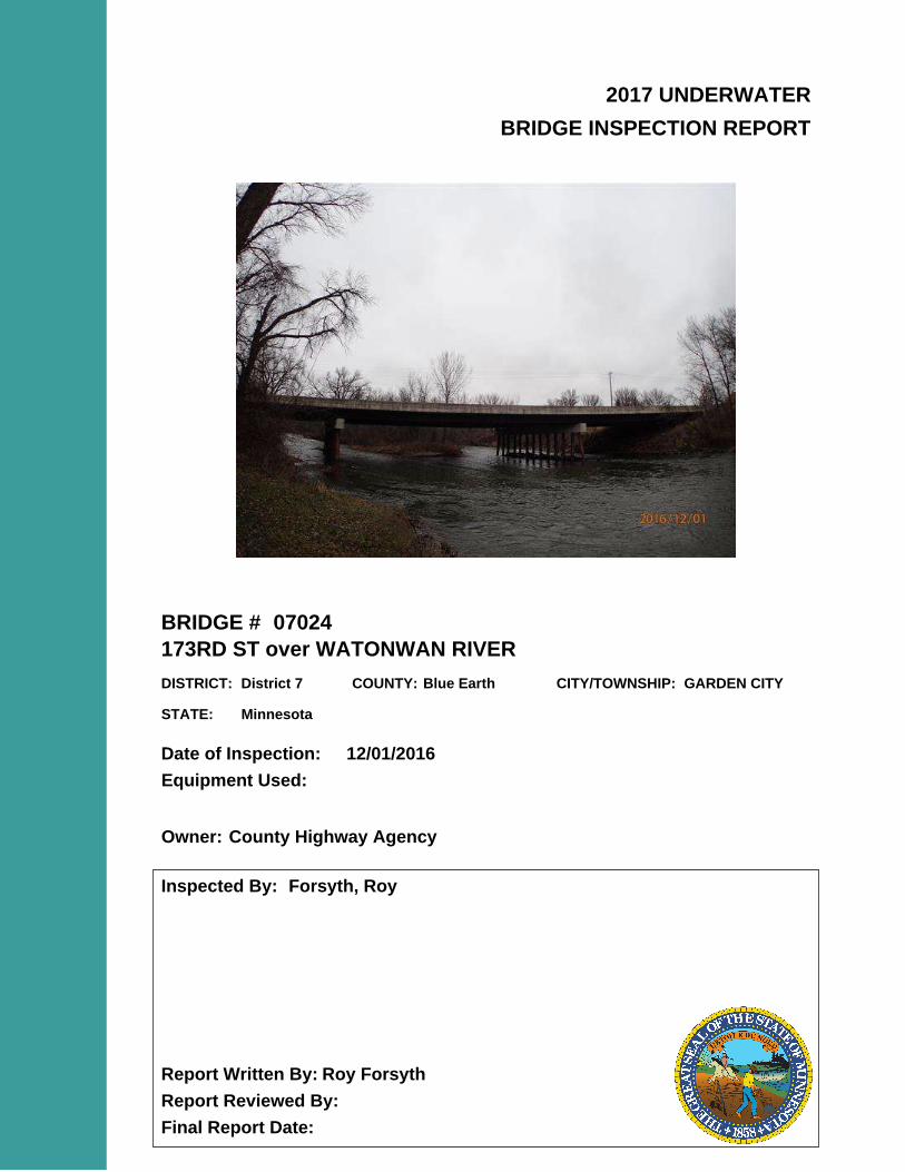
2017 UNDERWATER
BRIDGE INSPECTION REPORT
BRIDGE #
DISTRICT: COUNTY: CITY/TOWNSHIP:
Date of Inspection:
Equipment Used:
Inspected By:
Report Written By:
Report Reviewed By:
Final Report Date:
07024
173RD ST over WATONWAN RIVER
District 7 Blue Earth GARDEN CITY
12/01/2016
Forsyth, Roy
Roy Forsyth
County Highway AgencyOwner:
MinnesotaSTATE:
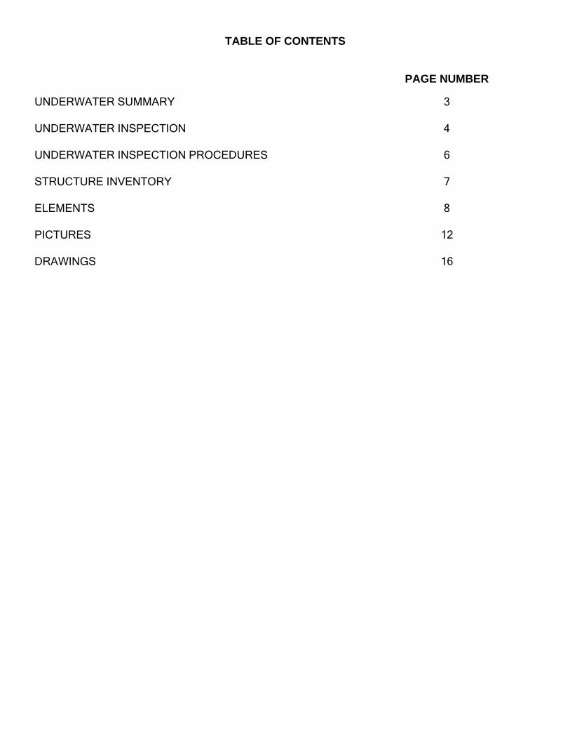
UNDERWATER SUMMARY 3
UNDERWATER INSPECTION 4
UNDERWATER INSPECTION PROCEDURES 6
STRUCTURE INVENTORY 7
ELEMENTS 8
PICTURES 12
DRAWINGS 16
TABLE OF CONTENTS
PAGE NUMBER
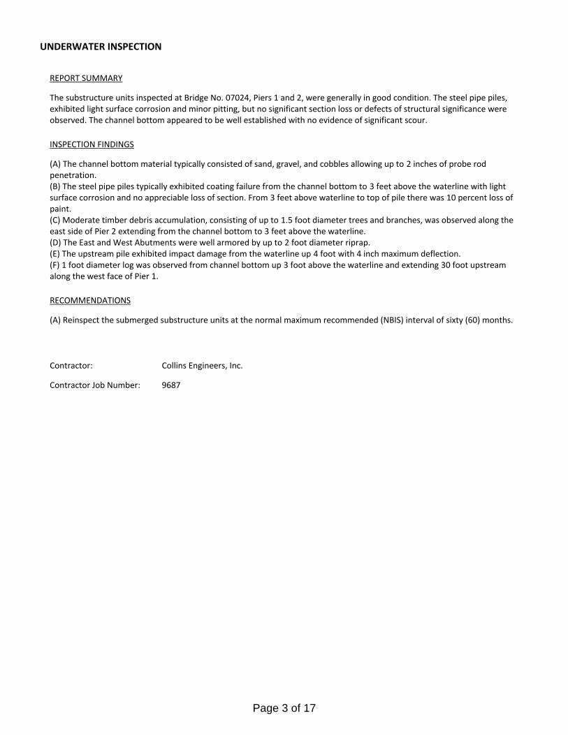
Contractor:
(A) Reinspect the submerged substructure units at the normal maximum recommended (NBIS) interval of sixty (60) months.
Collins Engineers, Inc.
9687Contractor Job Number:
RECOMMENDATIONS
REPORT SUMMARY
UNDERWATER INSPECTION
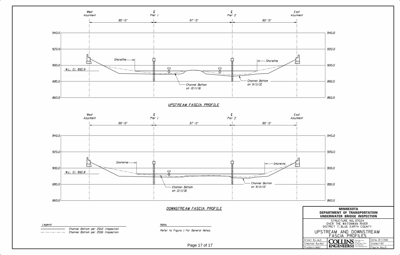
The substructure units inspected at Bridge No. 07024, Piers 1 and 2, were generally in good condition. The steel pipe piles, exhibited light surface corrosion and minor pitting, but no significant section loss or defects of structural significance were observed. The channel bottom appeared to be well established with no evidence of significant scour.
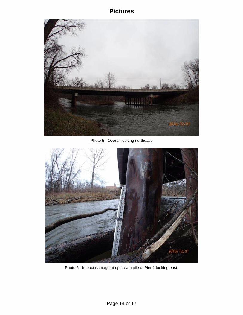
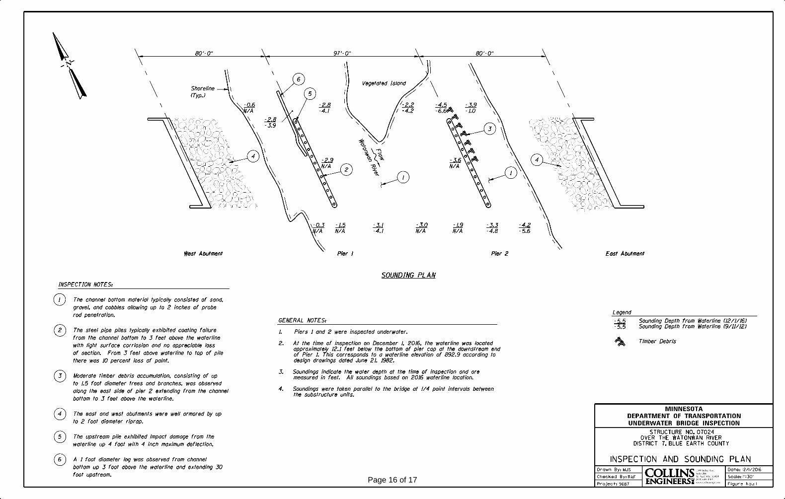
(A) The channel bottom material typically consisted of sand, gravel, and cobbles allowing up to 2 inches of probe rod penetration.(B) The steel pipe piles typically exhibited coating failure from the channel bottom to 3 feet above the waterline with light surface corrosion and no appreciable loss of section. From 3 feet above waterline to top of pile there was 10 percent loss of paint. (C) Moderate timber debris accumulation, consisting of up to 1.5 foot diameter trees and branches, was observed along the east side of Pier 2 extending from the channel bottom to 3 feet above the waterline. (D) The East and West Abutments were well armored by up to 2 foot diameter riprap.(E) The upstream pile exhibited impact damage from the waterline up 4 foot with 4 inch maximum deflection.(F) 1 foot diameter log was observed from channel bottom up 3 foot above the waterline and extending 30 foot upstream along the west face of Pier 1.
INSPECTION FINDINGS
Page 3 of 17
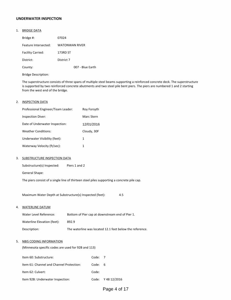
Bottom of Pier cap at downstream end of Pier 1. Water Level Reference:
WATERLINE DATUM
Waterline Elevation (feet):
The waterline was located 12.1 feet below the reference. Description:
892.9
4.
Piers 1 and 2Substructure(s) Inspected:
SUBSTRUCTURE INSPECTION DATA
General Shape:
4.5Maximum Water Depth at Substructure(s) Inspected (feet):
The piers consist of a single line of thirteen steel piles supporting a concrete pile cap.
Code:Item 62: Culvert:
6
Y 48 12/2016Code:Item 92B: Underwater Inspection:
Code:
(Minnesota specific codes are used for 92B and 113)
NBIS CODING INFORMATION5.
Item 60: Substructure:
Item 61: Channel and Channel Protection:
7Code:
District 7District:
173RD ST
County:
The superstructure consists of three spans of multiple steel beams supporting a reinforced concrete deck. The superstructure is supported by two reinforced concrete abutments and two steel pile bent piers. The piers are numbered 1 and 2 starting from the west end of the bridge.
Bridge Description:
007 - Blue Earth
Facility Carried:
BRIDGE DATA1.
UNDERWATER INSPECTION
Bridge #:
WATONWAN RIVERFeature Intersected:
07024
Underwater Visibility (feet):
Cloudy, 30FWeather Conditions:
1
3.
1Waterway Velocity (ft/sec):
12/01/2016
Professional Engineer/Team Leader:
INSPECTION DATA2.
Roy Forsyth
Date of Underwater Inspection:
Marc SternInspection Diver:
Page 4 of 17
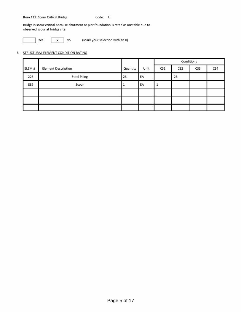
885 Scour 1 EA 1
STRUCTURAL ELEMENT CONDITION RATING
Conditions
6.
U
Bridge is scour critical because abutment or pier foundation is rated as unstable due to observed scour at bridge site.
Item 113: Scour Critical Bridge: Code:
No (Mark your selection with an X)Yes X
225
CS3 CS4
Steel Piling 2626 EA
CS2ELEM # Unit CS1Element Description Quantity
Page 5 of 17
The routine underwater inspection of Bridge 07024 (173rd St. over Watonwan River) was completed on December, 1, 2016. Theunderwater inspection was conducted from shore. The inspection was conducted by a team consisting of a PE-Diver with a valid
MnDOT Team leader certification, a backup diver and a dive tender. The inspection utilized commercial dive equipment and techniques (SSA and/or SCUBA) in accordance with OSHA regulations. Profiles were taken along the upstream and downstreamfaces of the bridge and around the periphery of substructure units to determine the presence, location and area of scour. The bridge elements inspected consisted of 26 steel CIP piles. Inspection procedures followed FHWA guidance and the MnDOT Bridge and Structure Inspection Program Manual with channel bottom probing to search for bottom of foundations. The routine underwater inspection frequency is recommended to remain at 60 months based on those findings and risk factors. Also, inspection procedures should continue to follow the above approach and standard guidance with 100% Level I and 10% Level II intensity efforts.
INSPECTION PROCEDURES
UNDERWATER INSPECTION
Page 6 of 17
Spec. Feat.Pier Foundation (Material/Type)
3 - STEELCantilever ID
+ W A T E R W A Y +Number of Spans Historic Status
4 - PILE BENT
Underwater 60Culvert Type 3 - FTG PILE
Pinned Asbly.
12/01/2016
Barrel Length
262.1 ft. Navigation Control
Waterway Opening (sf.) 2690Structure Length
ft. Year Painted 1983
0 - No nav. control on waterwayDeck Width (Out-to-Out) 56.7
+ P A I N T +
APPR: 0 TOTAL:5 - Not eligible
MAIN: 3
Main Span Length 97.0 ft.Drainage Area (sq. mi.) 849.0
B R I D G E D A T A +Main Span Detail
N - NOT REQUIRED+ M I S C.
Appr. Span Type Structure Flared
GR Termini N - NOT REQUIRED
Appr. Guardrail
Main Span Type 4 - Steel Continuous Median Width On Bridge
ft. Bridge Railing 1 - MEETS STANDARDS
1 - MEETS STANDARDS
Main Span Design 01 - Beam Span
ft. GR Transition
Skew 25 LEFT
Y/N Freq Date
Abutment Foundation (Material/Type)
1 - CONC Frac. Critical
4 - Bolted
D E P T H I N S P. +Appr. Span Design
0 - No flare+ I N
Appr. Span Detail Field Conn. ID
Parallel Structure N - No parallel structure
Pier Protection
0 - Not Required
Rating Date 10/17/201612271 sq. ft. Traffic
ft. 50B. Rt 0.00Sidewalk Width 50A. Lt 6.00
Roadway Area (Curb-to-Curb)
Posted Load 0 - Not Required
PostingStructure Area (Out-to-Out) 14861 sq. ft.
DBL:VEH: SEMI:
Rt 22 ARail Type Lt 22 C 1 - No Restriction
1 - No Restriction
B 1 - No Restriction
N - Not Applicable Overweight Permit CodesCurb Height Lt
ft. Horizontal 0 - Not Required
0.00 ft. Vertical0.00 ft. Rt
Wear Surf Install Year
sq. ft. Nav. Vert. Lift Bridge Clear. (ft.)
U - CRIT - PROT REQD
Year 2009Primer Type 6 MN Scour Code
Painted Area
Unsound Paint % Nav. Clr. (ft.)Deck Material 1 - Concrete Cast-in-Place 0.0Wear Surf Type 1 - Monolithic Concrete
(concurrently placed with stru
Vert. 0.0 Horiz.
S I G N S +Operating Rating 2 - HS TRUCK
1 - Epoxy Coated Reinforcing + B R I D G E
Inventory Rating 2 - HS TRUCK 23.60
39.40Deck Rebars Install Year 1983
Deck Rebars
Finish Type K - Unpainted 3309 SteelWear Course/Fill Depth 0.00 ft.
0 - None
Design Load 5 - HS 20
+ C A P A C I T Y R A T I N G S +Deck Membrane
44 ° 2
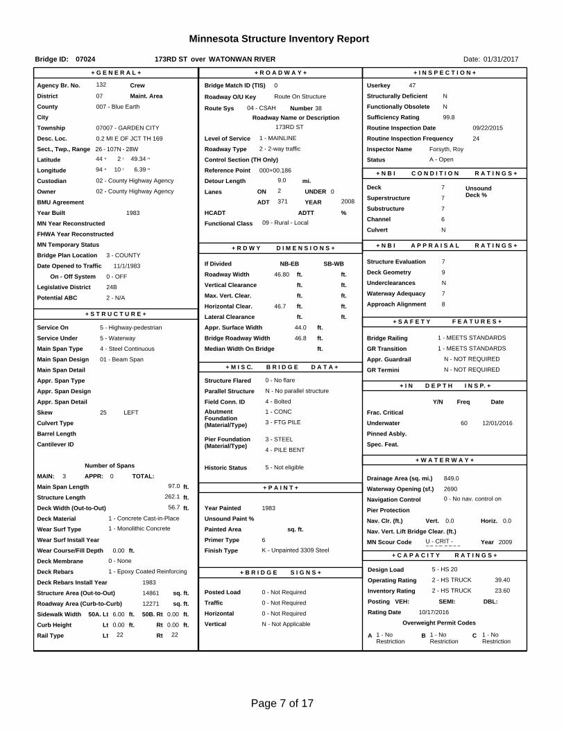
Inspector Name Forsyth, Roy
Latitude Control Section (TH Only) Status' 49.34 ''
2 - 2-way traffic
Routine Inspection Frequency 24
Sect., Twp., Range
0.2 MI E OF JCT TH 169 Level of Service 1 - MAINLINE
- 28W Roadway Type26 - 107N
Detour Length 9.0 mi.R A T I N G S +
Custodian 02 - County Highway Agency
Owner 02 - County Highway AgencyDeck 7 Unsound
Deck %
C O N D I T I O N° 10 '
A - Open
Longitude 94 000+00.186 + N B I 6.39 '' Reference Point
132 Crew
+ I N S P E C T I O N +
Agency Br. No. 47
District 07
Bridge Match ID (TIS) 0 Userkey
173RD ST over WATONWAN RIVER
Minnesota Structure Inventory Report
Bridge ID: 07024
+ G E N E R A L + + R O A D W A Y +
Date: 01/31/2017
Sufficiency Rating 99.8Roadway Name or Description
38
City
Routine Inspection Date 09/22/2015
Desc. Loc.
Township 07007 - GARDEN CITY 173RD ST
Number
NRoadway O/U Key Route On StructureMaint. Area Structurally Deficient
NRoute Sys 04 - CSAHCounty 007 - Blue Earth Functionally Obsolete
Lanes
Waterway Adequacy 7Max. Vert. Clear.
ft.Legislative District 24Bft.Potential ABC 2 - N/A ft.
ft.On - Off System Roadway Width 46.80 ft.
Vertical Clearance ft.0 - OFF
Underclearances N
Service On 5 - Highway-pedestrian Appr. Surface Width+ S A F E T Y F E A T U R E S +
5 - Waterway Bridge Roadway Width 46.8
44.0 ft.
Service Under
ft.
46.7 ft. Approach Alignment 8Horizontal Clear.
ft.
ft.+ S T R U C T U R E + Lateral Clearance
HCADT ADTT7
Year Built 1983
MN Year Reconstructed Functional Class
%Channel 6
Substructure
0Superstructure 7
ON 2 UNDER
371 YEAR 2008BMU Agreement ADT
Structure Evaluation 7If Divided
D I M E N S I O N S +Bridge Plan Location 3 - COUNTY
11/1/1983Deck Geometry 9
NB-EB SB-WBDate Opened to Traffic
+ R D W Y
FHWA Year Reconstructed
MN Temporary Status
09 - Rural - LocalCulvert N
A P P R A I S A L R A T I N G S ++ N B I
Page 7 of 17
County:
City:
Township:
Township:Section: Range:
Span Type:
NBI Deck: Super: Sub: Chan: Culv:
Appraisal Ratings - Approach: Waterway:
Required Bridge Signs - Load Posting:
Horizntal:
Traffic:
Vertical:
MN Scour Code:
Open, Posted, Closed:
Location:
Route:
Control Section:
Local Agency Bridge Nbr.:
Ref. Pt.:
Maint. Area:
Length:
Deck Width:
Rdwy. Area/ Pct. Unsnd:
Paint Area/ Pct. Unsnd:
Culvert:
Blue Earth
07007 - GARDEN CITY
107N26 28W
4 - Steel Continuous 2 -Stringer/Multi-beam or Girder
7 7 7 6 N
8 7
0 - Not Required
0 - Not Required
0 - Not Required
N - Not Applicable
U - CRIT - PROT REQD
0.2 MI E OF JCT TH 169
04 - CSAH 38
132
000+00.186
262.1
56.7
12271 sq. ft. / %
sq. ft. / %
N/A
A - Open
ft.
ft.
Postings:List:
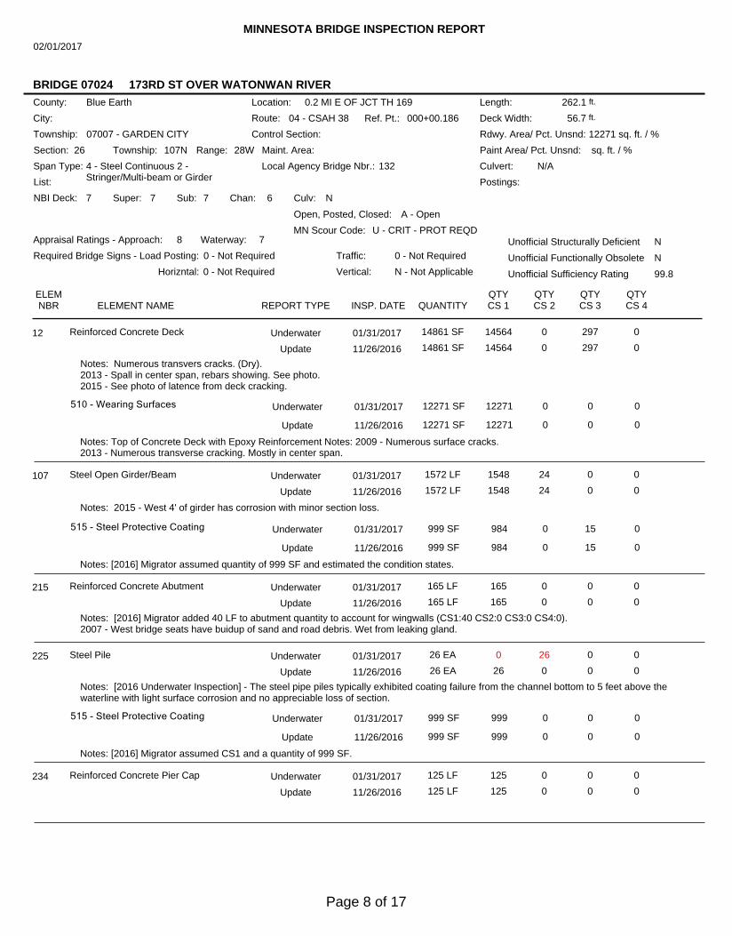
MINNESOTA BRIDGE INSPECTION REPORT
02/01/2017
BRIDGE 07024 173RD ST OVER WATONWAN RIVER
Unofficial Structurally Deficient N
NUnofficial Functionally Obsolete
Unofficial Sufficiency Rating 99.8
ELEMNBR ELEMENT NAME INSP. DATE QUANTITY
QTYCS 1
QTYCS 2
QTYCS 3
QTYCS 4REPORT TYPE
Reinforced Concrete Deck 01/31/2017 14861 SF 14564 0 297 012 Underwater
11/26/2016 14861 SF 14564 0 297 0Update
Notes: Numerous transvers cracks. (Dry).2013 - Spall in center span, rebars showing. See photo.2015 - See photo of latence from deck cracking.
510 - Wearing Surfaces 12271 SF 12271 0 0 0
Notes: Top of Concrete Deck with Epoxy Reinforcement Notes: 2009 - Numerous surface cracks.2013 - Numerous transverse cracking. Mostly in center span.
Underwater 01/31/2017
12271 SF 12271 0 0 0Update 11/26/2016
Steel Open Girder/Beam 01/31/2017 1572 LF 1548 24 0 0107 Underwater
11/26/2016 1572 LF 1548 24 0 0Update
Notes: 2015 - West 4' of girder has corrosion with minor section loss.
515 - Steel Protective Coating 999 SF 984 0 15 0
Notes: [2016] Migrator assumed quantity of 999 SF and estimated the condition states.
Underwater 01/31/2017
999 SF 984 0 15 0Update 11/26/2016
Reinforced Concrete Abutment 01/31/2017 165 LF 165 0 0 0215 Underwater
11/26/2016 165 LF 165 0 0 0Update
Notes: [2016] Migrator added 40 LF to abutment quantity to account for wingwalls (CS1:40 CS2:0 CS3:0 CS4:0).2007 - West bridge seats have buidup of sand and road debris. Wet from leaking gland.
Steel Pile 01/31/2017 26 EA 0 26 0 0225 Underwater
11/26/2016 26 EA 26 0 0 0Update
Notes: [2016 Underwater Inspection] - The steel pipe piles typically exhibited coating failure from the channel bottom to 5 feet above thewaterline with light surface corrosion and no appreciable loss of section.
515 - Steel Protective Coating 999 SF 999 0 0 0
Notes: [2016] Migrator assumed CS1 and a quantity of 999 SF.
Underwater 01/31/2017
999 SF 999 0 0 0Update 11/26/2016
Reinforced Concrete Pier Cap 01/31/2017 125 LF 125 0 0 0234 Underwater
11/26/2016 125 LF 125 0 0 0Update
Page 8 of 17
Strip Seal Expansion Joint 01/31/2017 125 LF 0 63 0 62300 Underwater
11/26/2016 125 LF 0 63 0 62Update
Notes: 5 FT of the W gland is punctured.2009 - Heavy accumulation of road debris on west bridge seat.2011, 2013, 2015 - West gland 75% damaged.
Pourable Joint Seal 01/31/2017 161 LF 121 40 0 0301 Underwater
11/26/2016 161 LF 121 40 0 0Update
Notes: Minor failure of a section of joint.
Elastomeric Bearing 01/31/2017 24 EA 24 0 0 0310 Underwater
11/26/2016 24 EA 24 0 0 0Update
Notes: Several bearing show minor movement.2015 - Movement is minor.
Reinforced Concrete Approach Slab 01/31/2017 1760 SF 1760 0 0 0321 Underwater
11/26/2016 1760 SF 1760 0 0 0Update
Notes: [2016] Migrator assumed an approach slab length of 20FT and used the inventory quantity of 44FT for the width.2011 - Minor cracking in approach slab
Metal Bridge Railing 01/31/2017 262 LF 0 262 0 0330 Underwater
11/26/2016 262 LF 0 262 0 0Update
Notes: Railing along walkway.2007 - Minor rust.
515 - Steel Protective Coating 999 SF 999 0 0 0
Notes: [2016] Migrator assumed CS1 and a quantity of 999 SF.
Underwater 01/31/2017
999 SF 999 0 0 0Update 11/26/2016
Reinforced Concrete Bridge Railing 01/31/2017 525 LF 0 525 0 0331 Underwater
11/26/2016 525 LF 0 525 0 0Update
Notes: 2007 - Railing weathered and stained.2011 - about 3' concrete spalled at SE end
Critical Deficiencies or Safety Hazards 01/31/2017 1 EA 1 0 0 0800 Underwater
11/26/2016 1 EA 1 0 0 0Update
Notes: No critical findings observed during the 2015 inspection.
Concrete Decks - Cracking & Sealing 01/31/2017 0 LF 0 0 0 0810 Underwater
11/26/2016 0 LF 0 0 0 0Update
Notes: 2011 - minor cracking.
Secondary Members (Superstructure) 01/31/2017 1 EA 1 0 0 0855 Underwater
11/26/2016 1 EA 1 0 0 0Update
Concrete Shear Cracking 01/31/2017 1 EA 1 0 0 0883 Underwater
11/26/2016 1 EA 1 0 0 0Update
Notes: Use this element to monitor the presence of shear cracking on concrete elements. Pay particular attention to the concrete pier caps.
Scour 01/31/2017 1 EA 1 0 0 0885 Underwater
11/26/2016 1 EA 1 0 0 0Update
Notes: U - Scour Critical - protection required. Monitoring required.2008 - Stream flow is very low, no scour problems.
ELEMNBR ELEMENT NAME INSP. DATE QUANTITY
QTYCS 1
QTYCS 2
QTYCS 3
QTYCS 4
BRIDGE 07024 173RD ST OVER WATONWAN RIVER
REPORT TYPE
Page 9 of 17
Other Bridge Signing 01/31/2017 1 EA 1 0 0 0891 Underwater
11/26/2016 1 EA 1 0 0 0Update
Notes: 2011 - SW bridge marker missing.
Slopes & Slope Protection 01/31/2017 1 EA 1 0 0 0892 Underwater
11/26/2016 1 EA 1 0 0 0Update
Notes: 2015 - Some trees have been cut; still some growing in rip rap and at corners of the bridge.
Guardrail 01/31/2017 1 EA 1 0 0 0893 Underwater
11/26/2016 1 EA 1 0 0 0Update
Notes: 2011 - SW section, 1 post missing blocking and bolt. No guardrail on east end of bridge.
Deck & Approach Drainage 01/31/2017 1 EA 0 1 0 0894 Underwater
11/26/2016 1 EA 0 1 0 0Update
Notes: 2008 - Catch basin outlet on SE slope is partially blocked.
Sidewalk, Curb, & Median 01/31/2017 1 EA 1 0 0 0895 Underwater
11/26/2016 1 EA 1 0 0 0Update
Protected Species 01/31/2017 1 EA 1 0 0 0900 Underwater
11/26/2016 1 EA 1 0 0 0Update
Notes: Use this element to track the presence of protected species living on this structure.
General Notes: Most of old noted conditions still apply. Pat Madden *Bridge 07024 3-16 No change on bridge. (185) Cut brush and smalltrees. 10-2 (90)(95) No change. (180) Debris is lodged at piers. 5-9 Snooper inspected. (90) West gland has 2' puncture.(180) NE channel bank should be monitored. (184) CM drain outlet from SW ditch is crushed. Outlet from SE is partiallyblocked. (158) 450 lin. ft. of random transverse cracks. (185) Tree and brush growth should be cut. (90) One bolt missing, twobolts loose at NE cover plate. 6-27 (180) One large tree is caught on east pier. 10-16 Same conditions exist.BR # 07024 has been transfered to Blue Earth County due to re-alighnment of TH 169. PM. [2001]Channel - Buildup of trees and debris is lodged at the east pier. Bridge condition is generally the same as previous inspectionsindicate. (90) 5 FT of the west gland is punctured. (185) Some trees have been cut; still some growing in riprap areas and atcorners of the bridge.2008 - 10/16/2008 Snooper inspected, underside of deck, weathering steel girders and diaphragms, all bolted connectionsand coverplates, bearing assemblies at piers. No problems found. P. Madden, A. Fritz.2009 - walked the deck and below at both ends, no new problems.2011 - Trees and brush hung up on east pier, see photos.2012 - Underwater inspection by Collins Engineers, Inc. on 9-11-2012. See report.2015 - MN/DOT snooper truck on site for bridge inspection 09-08-2015.
58. Deck NBI:
36A. Brdg Railings NBI:
36B. Transitions NBI:
36C. Appr Guardrail NBI:
36D. Appr GuardrailTerminal NBI:
59. Superstructure NBI:
60. Substructure NBI:
61. Channel NBI:
62. Culvert NBI:
71. Waterway Adeq NBI:
72. Appr RoadwayAlignment NBI:
Guardrail at west end of bridge.
Rating revised as per Collins Enginners, Inc recommendation 9-11-2012.
Revised as per Collins Engineers, Inc inspection 9-11-2012.
Rating revised as per Collins Engineers, Inc recommendation 9-11-2012.
ELEMNBR ELEMENT NAME INSP. DATE QUANTITY
QTYCS 1
QTYCS 2
QTYCS 3
QTYCS 4
BRIDGE 07024 173RD ST OVER WATONWAN RIVER
REPORT TYPE
Page 10 of 17
ELEMNBR ELEMENT NAME INSP. DATE QUANTITY
QTYCS 1
QTYCS 2
QTYCS 3
QTYCS 4
BRIDGE 07024 173RD ST OVER WATONWAN RIVER
REPORT TYPE
Inspector's Signature Reviewer's Signature
Page 11 of 17
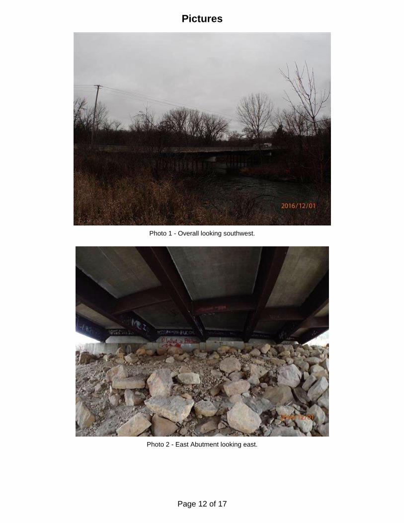
Photo 1 - Overall looking southwest.
Photo 2 - East Abutment looking east.
Pictures
Page 12 of 17
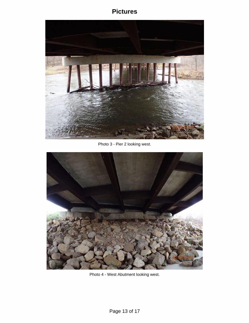
Pictures
Photo 3 - Pier 2 looking west.
Photo 4 - West Abutment looking west.
Page 13 of 17
Pictures
Photo 5 - Overall looking northeast.
Photo 6 - Impact damage at upstream pile of Pier 1 looking east.
Page 14 of 17
Pictures
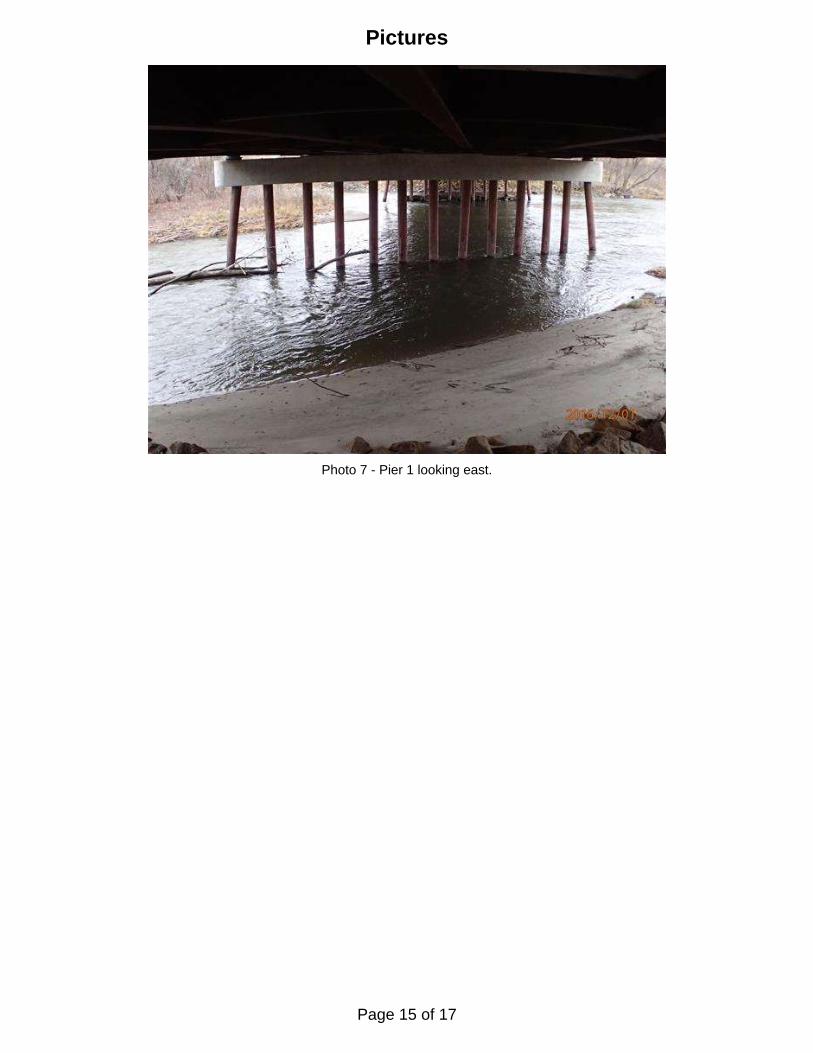
Photo 7 - Pier 1 looking east.
Page 15 of 17
Page 16 of 17
UPSTREAM FASCIA PROFILE
80'-0" 80'-0"97'-0"
Abutment
West
Abutment
East
Pier 1
~
Pier 2
~
900.0
W.L. El. 892.9
ShorelineShoreline
on 9/11/12
Channel Bottom
920.0
940.0
880.0
860.0
900.0
920.0
940.0
880.0
860.0
80'-0" 80'-0"97'-0"
Abutment
West
Abutment
East
Pier 1
~
Pier 2
~
900.0
on 9/11/12
Channel Bottom
920.0
940.0
880.0
860.0
900.0
920.0
940.0
880.0
860.0
DOWNSTREAM FASCIA PROFILE
Refer to Figure 1 for General Notes.
Note:
UPSTREAM AND DOWNSTREAMFASCIA PROFILES
DISTRICT 7, BLUE EARTH COUNTY
OVER THE WATONWAN RIVER
STRUCTURE NO. 07024
Legend
Channel Bottom per 2012 Inspection
Channel Bottom per 2016 Inspection
W.L. El. 892.9
ShorelineShoreline
on 12/1/16
Channel Bottom
on 12/1/16
Channel Bottom
12/1/2016
1"=30'
MJS
RAF
9687
UNDERWATER BRIDGE INSPECTION
DEPARTMENT OF TRANSPORTATION
MINNESOTA
Checked By: Scale:
Figure No.: 2
Drawn By: Date:
www.collinsengr.com
(651) 646-8502
St. Paul, MN. 55104
Suite 206
1599 Selby Ave.
Project: Page 17 of 17