Embed Size (px)
Citation preview
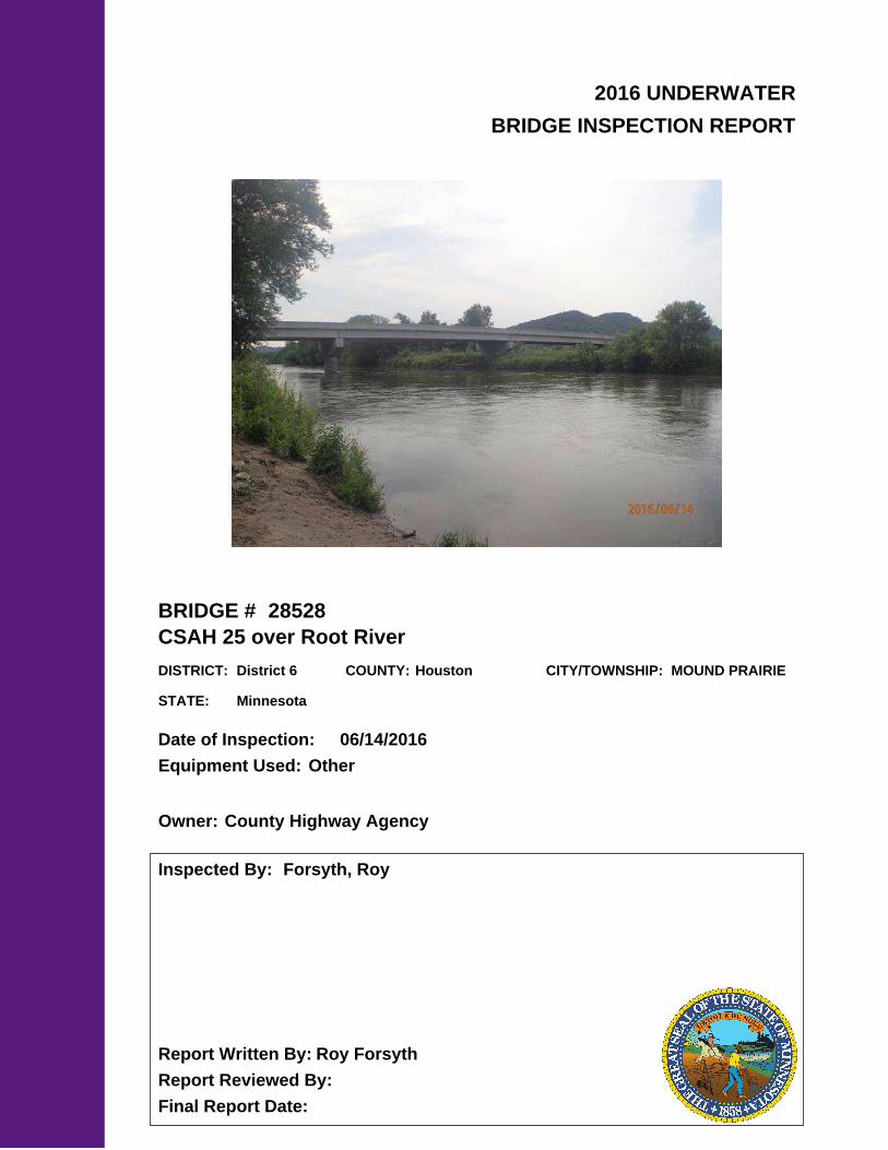
2016 UNDERWATER
BRIDGE INSPECTION REPORT
BRIDGE #
DISTRICT: COUNTY: CITY/TOWNSHIP:
Date of Inspection:
Equipment Used:
Inspected By:
Report Written By:
Report Reviewed By:
Final Report Date:
28528
CSAH 25 over Root River
District 6 Houston MOUND PRAIRIE
06/14/2016
Other
Forsyth, Roy
Roy Forsyth
County Highway AgencyOwner:
MinnesotaSTATE:

UNDERWATER SUMMARY 3
UNDERWATER INSPECTION 4
UNDERWATER INSPECTION PROCEDURES 6
STRUCTURE INVENTORY 7
ELEMENTS 8
PICTURES 11
DRAWINGS 13
TABLE OF CONTENTS
PAGE NUMBER
Contractor:
(A) Reinspect the submerged substructure units at the normal maximum recommended (NBIS) interval of sixty (60) months.
Collins Engineers, Inc.
9687Contractor Job Number:
RECOMMENDATIONS
REPORT SUMMARY
UNDERWATER INSPECTION
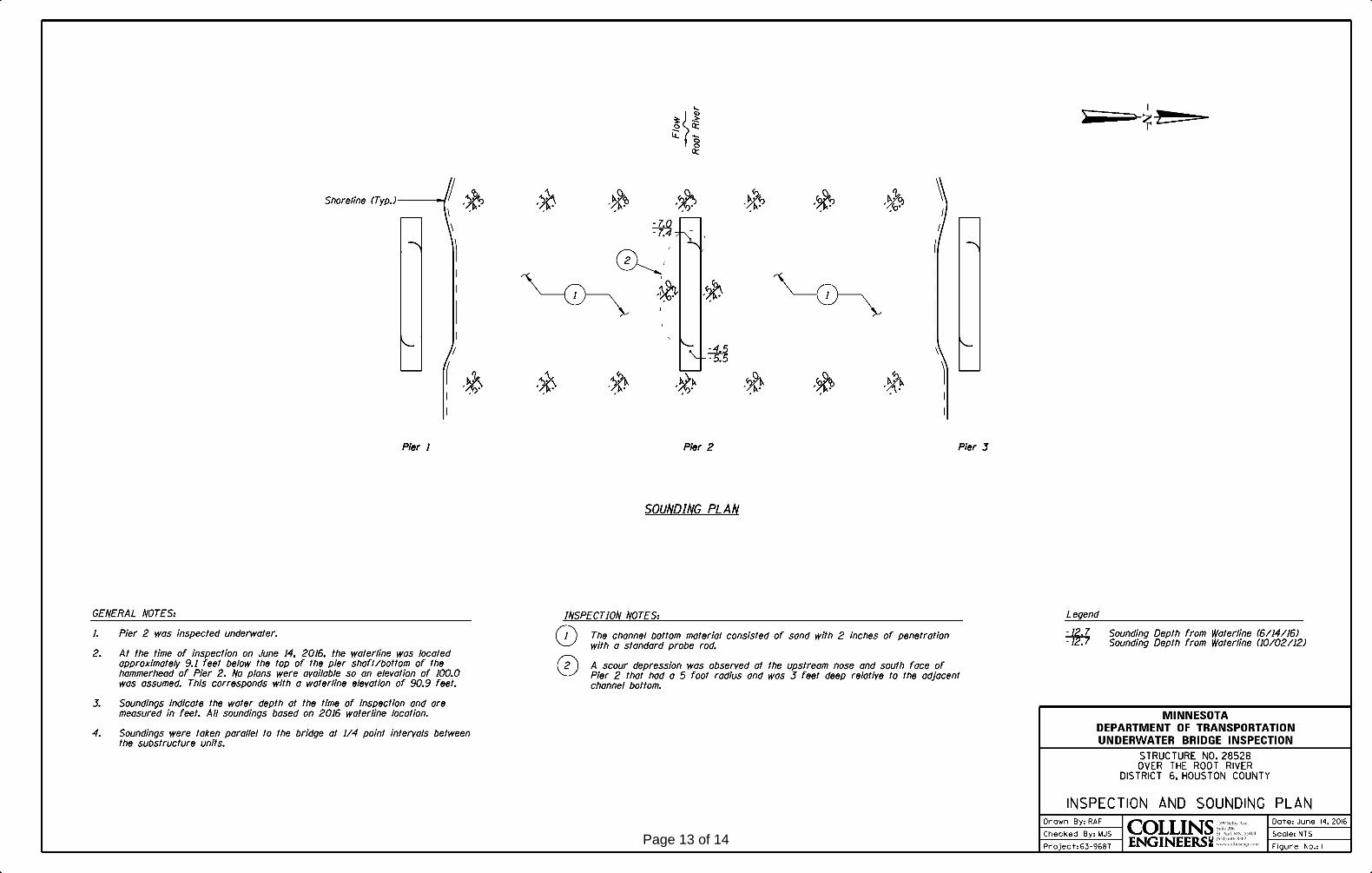
The substructure unit inspected at Bridge No. 28528, Pier 2, was found to be in good condition. The concrete of the pier shaft was sound and exhibited no appreciable deficiencies. The channel bottom appeared stable with a minor scour depression along the south face of the pier.
(A) A scour depression was observed at the upstream nose and south face of Pier 2 measuring 5 feet wide and 3 feet deep relative to the adjacent channel bottom.
(B) The channel bottom material consisted of sand with 2 inches of standard probe rod penetration.
INSPECTION FINDINGS
Page 3 of 14

Top of pier shaft/bottom of the hammerhead of Pier 2. Assumed reference elevation = 100.0Water Level Reference:
WATERLINE DATUM
Waterline Elevation (feet):
The waterline was approximately 9.1 feet below the reference. Description:
90.9
4.
Pier 2Substructure(s) Inspected:
SUBSTRUCTURE INSPECTION DATA
General Shape:
7.0Maximum Water Depth at Substructure(s) Inspected (feet):
The piers consist of a rectangular concrete shaft with a hammerhead cap supporting six precast concrete girders. No plans were available and the foundation configuration is unknown.
Code:Item 62: Culvert:
7
Y 48 06/2016Code:Item 92B: Underwater Inspection:
Code:
(Minnesota specific codes are used for 92B and 113)
NBIS CODING INFORMATION5.
Item 60: Substructure:
Item 61: Channel and Channel Protection:
7Code:
District 6District:
CSAH 25
County:
The bridge consists of four spans of precast concrete girders. The superstructure is supported by two reinforced concrete abutments and three reinforced concrete hammerhead piers. The piers are labeled Piers 1 through 3 starting from the southerly direction.
Bridge Description:
028 - Houston
Facility Carried:
BRIDGE DATA1.
UNDERWATER INSPECTION
Bridge #:
Root RiverFeature Intersected:
28528
Underwater Visibility (feet):
Sunny, 70°FWeather Conditions:
1 ft.
3.
2.0 ft/sWaterway Velocity (ft/sec):
06/14/2016
Professional Engineer/Team Leader:
INSPECTION DATA2.
Roy A. Forsyth
Date of Underwater Inspection:
Roy A. ForsythInspection Diver:
Page 4 of 14

885 Scour 1 1EA
STRUCTURAL ELEMENT CONDITION RATING
Conditions
6.
N
Bridge is scour critical because abutment or pier foundation is rated as unstable due to observed scour at bridge site.
Item 113: Scour Critical Bridge: Code:
No (Mark your selection with an X)Yes X
210
CS3 CS4
Reinforced Concrete Pier Wall 1818 LF
CS2ELEM # Unit CS1Element Description Quantity
Page 5 of 14

The routine underwater inspection of Bridge 28528 (CSAH 25 over the Root River) was completed on June, 14, 2016. The underwater inspection was conducted from shore. The inspection was conducted by a team consisting of a PE-Diver with a valid MnDOT Team leader certification, a backup diver and a dive tender. The inspection utilized commercial dive equipment and techniques (SSA and/or SCUBA) in accordance with OSHA regulations. Profiles were taken along the upstream and downstream faces of the bridge and around the periphery of substructure units to determine the presence, location and area of scour.
The bridge elements inspected consisted of 1 reinforced concrete pier wall. No plans were available and the foundation configuration is unknown. Inspection procedures followed FHWA guidance and the MnDOT Bridge and Structure Inspection Program Manual with channel bottom probing to search for bottom of foundations. The routine underwater inspection frequency is recommended to remain at a maximum of 60 months based on those findings and risk factors. Also, inspection procedures should continue to follow the above approach and standard guidance with 100% Level I and 10% Level II intensity efforts.
INSPECTION PROCEDURES
UNDERWATER INSPECTION
Page 6 of 14

Spec. Feat.Pier Foundation (Material/Type)
1 - CONCCantilever ID
+ W A T E R W A Y +Number of Spans Historic Status
3 - FTG PILE
Underwater 60Culvert Type 3 - FTG PILE
Pinned Asbly.
06/14/2016
Barrel Length
475.4 ft. Navigation Control
Waterway Opening (sf.) 5427Structure Length
ft. Year Painted
0 - No nav. control on waterwayDeck Width (Out-to-Out) 39.1
+ P A I N T +
APPR: 0 TOTAL:5 - Not eligible
MAIN: 4
Main Span Length 117.9 ft.Drainage Area (sq. mi.) 65.6
B R I D G E D A T A +Main Span Detail
0 - SUBSTANDARD+ M I S C.
Appr. Span Type Structure Flared
GR Termini N - NOT REQUIRED
Appr. Guardrail
Main Span Type 5 - Prestress or Precast Median Width On Bridge
ft. Bridge Railing 1 - MEETS STANDARDS
0 - SUBSTANDARD
Main Span Design 01 - Beam Span
ft. GR Transition
Skew 0
Y/N Freq Date
Abutment Foundation (Material/Type)
1 - CONC Frac. Critical
D E P T H I N S P. +Appr. Span Design
0 - No flare+ I N
Appr. Span Detail Field Conn. ID
Parallel Structure N - No parallel structure
Pier Protection
0 - Not Required
Rating Date 2/3/200817115 sq. ft. Traffic
ft. 50B. Rt 0.00Sidewalk Width 50A. Lt 0.00
Roadway Area (Curb-to-Curb)
Posted Load 0 - Not Required
PostingStructure Area (Out-to-Out) 18620 sq. ft.
DBL:VEH: SEMI:
Rt 22 ARail Type Lt 22 C N - N/AN - N/A B N - N/A
N - Not Applicable Overweight Permit CodesCurb Height Lt
ft. Horizontal 0 - Not Required
0.00 ft. Vertical0.00 ft. Rt
Wear Surf Install Year
sq. ft. Nav. Vert. Lift Bridge Clear. (ft.)
N - STBL - LIM SCOUR
Year 2002Primer Type MN Scour Code
Painted Area
Unsound Paint % Nav. Clr. (ft.)
1 - Not required
Deck Material 1 - Concrete Cast-in-Place 0.0Wear Surf Type 1 - Monolithic Concrete
(concurrently placed with stru
Vert. 0.0 Horiz.
S I G N S +Operating Rating 2 - HS TRUCK
1 - Epoxy Coated Reinforcing + B R I D G E
Inventory Rating 2 - HS TRUCK 27.6
60.4Deck Rebars Install Year 2001
Deck Rebars
Finish TypeWear Course/Fill Depth 0.00 ft.
0 - None
Design Load 9 - HS 25 (OR GREATER)
+ C A P A C I T Y R A T I N G S +Deck Membrane
43 ° 46
Inspector Name Forsyth, Roy
Latitude Control Section (TH Only) Status' 53.57 ''
2 - 2-way traffic
Routine Inspection Frequency 24
Sect., Twp., Range
0.3 mi S of jct CSAH 21 Level of Service 1 - MAINLINE
- 05W Roadway Type28 - 104N
Detour Length 12.0 mi.R A T I N G S +
Custodian 02 - County Highway Agency
Owner 02 - County Highway AgencyDeck 7 Unsound
Deck %
C O N D I T I O N° 26 '
A - Open
Longitude 91 001+00.250 + N B I 44.50 '' Reference Point
Crew
+ I N S P E C T I O N +
Agency Br. No. 68
District 06
Bridge Match ID (TIS) 0 Userkey
CSAH 25 over Root River
Minnesota Structure Inventory Report
Bridge ID: 28528
+ G E N E R A L + + R O A D W A Y +
Date: 07/14/2016
Sufficiency Rating 98.8Roadway Name or Description
25
City
Routine Inspection Date 06/14/2016
Desc. Loc.
Township 28011 - MOUND PRAIRIE CSAH 25
Number
NRoadway O/U Key Route On StructureMaint. Area Structurally Deficient
NRoute Sys 04 - CSAHCounty 028 - Houston Functionally Obsolete
Lanes
Waterway Adequacy 9Max. Vert. Clear.
ft.Legislative District 31Bft.Potential ABC 2 - N/A ft.
ft.On - Off System Roadway Width 32.00 ft.
Vertical Clearance ft.0 - OFF
Underclearances N
Service On 1 - Highway Appr. Surface Width+ S A F E T Y F E A T U R E S +
5 - Waterway Bridge Roadway Width 32.0
32.0 ft.
Service Under
ft.
ft. Approach Alignment 8Horizontal Clear.
ft.
ft.+ S T R U C T U R E + Lateral Clearance
HCADT ADTT7
Year Built 2001
MN Year Reconstructed Functional Class
%Channel 7
Substructure
0Superstructure 7
ON 2 UNDER
185 YEAR 2008BMU Agreement ADT
Structure Evaluation 7If Divided
D I M E N S I O N S +Bridge Plan Location 3 - COUNTY
Deck Geometry 7NB-EB SB-WBDate Opened to Traffic
+ R D W Y
FHWA Year Reconstructed
MN Temporary Status
08 - Rural - Minor CollectorCulvert N
A P P R A I S A L R A T I N G S ++ N B I
Page 7 of 14

County:
City:
Township:
Township:Section: Range:
Span Type:
NBI Deck: Super: Sub: Chan: Culv:
Appraisal Ratings - Approach: Waterway:
Required Bridge Signs - Load Posting:
Horizntal:
Traffic:
Vertical:
MN Scour Code:
Open, Posted, Closed:
Location:
Route:
Control Section:
Local Agency Bridge Nbr.:
Ref. Pt.:
Maint. Area:
Length:
Deck Width:
Rdwy. Area/ Pct. Unsnd:
Paint Area/ Pct. Unsnd:
Culvert:
Houston
28011 - MOUNDPRAIRIE
104N28 05W
5 - Prestressed Concrete 2 -Stringer/Multi-beam or Girder
7 7 7 7 N
8 9
0 - Not Required
0 - Not Required
0 - Not Required
N - Not Applicable
N - STBL - LIM SCOUR
0.3 mi S of jct CSAH 21
04 - CSAH 25 001+00.250
475.4
39.1
17115 sq. ft. / %
sq. ft. / %
N/A
A - Open
ft.
ft.
Postings:List:
MINNESOTA BRIDGE INSPECTION REPORT
09/12/2016
Inspector: CO Bridge
BRIDGE 28528 CSAH 25 OVER Root River
Unofficial Structurally Deficient N
NUnofficial Functionally Obsolete
Unofficial Sufficiency Rating 98.8
ELEMNBR ELEMENT NAME INSP. DATE QUANTITY
QTYCS 1
QTYCS 2
QTYCS 3
QTYCS 4REPORT TYPE
Reinforced Concrete Deck 07/14/2016 18620 SF 18620 0 0 012 Underwater
06/14/2016 18620 SF 18620 0 0 0Routine
Notes: Top of Concrete Deck with Epoxy Reinforcement Notes: 2016 - No underdeck cracks or spalls between beams. A few cracks withefflorescence along the slab overhang near the piers.
510 - Wearing Surfaces 17115 SF 0 17115 0 0
Notes: Top of Concrete Deck with Epoxy Reinforcement Notes: 2010 - There are no spalls, delaminations or patches in the surface of the deck.There are numerous surface sealed longitudinal cracks in the deck that were not visible on previous inspections. These cracks appear to besurface only and do not project through the deck. In 2010, the entire deck was surface sealed. 2012-[2014] - No changes 2016 - Widespreaddeck cracking.
Underwater 07/14/2016
17115 SF 0 17115 0 0Routine 06/14/2016
Prestressed Concrete OpenGirder/Beam
07/14/2016 3297 LF 3296 1 0 0109 Underwater
06/14/2016 3297 LF 3296 1 0 0Routine
Notes: 2010-[2013] - No cracks or spalls noted. 2014-[2015] - No changes noted. 2016 - Small 11"x8" delamination on the edge of the bottomflange of the West fascia beam on span 2 near pier 1.
Reinforced Concrete Pier Wall 07/14/2016 52 LF 52 0 0 0210 Underwater
06/14/2016 52 LF 52 0 0 0Routine
Notes: 2010-[2013] - No cracks or spalls noted. 2014-[2016] - No changes noted.
Reinforced Concrete Abutment 07/14/2016 119 LF 108 11 0 0215 Underwater
06/14/2016 119 LF 108 11 0 0Routine
Notes: 2010-[2013] - No cracks or spalls noted. 2014 - 3 minor cracks in the face of the North abutment. 7 minor cracks on face and backwallof the South abutment. 2015 - 4 minor cracks in the face of the North abutment. 7 minor cracks on face and backwall of the South abutment.2016 - No change
Wingwall notes: 2011-[2013] - No cracks or spalls noted. 2014-[2016] - No change
Reinforced Concrete Pier Cap 07/14/2016 121 LF 113 8 0 0234 Underwater
06/14/2016 121 LF 113 8 0 0Routine
Notes: 2010-[2013] - No cracks or spalls noted. 2014-[2015] - Vertical cracks on both sides of pier 1 and pier 3 under G2 and G6. Pier 2 couldnot be examined at this time without a snooper. 2016 - A few minor vertical and horizontal cracks on both sides of all caps.
Strip Seal Expansion Joint 07/14/2016 75 LF 75 0 0 0300 Underwater
06/14/2016 75 LF 75 0 0 0Routine
Notes: 2010-[2013] - The strip seals were full of dirt and debris. There are no signs of leakage at the bridge seat. 2014 -[2016] - No change
Page 8 of 14

Pourable Joint Seal 07/14/2016 105 LF 105 0 0 0301 Underwater
06/14/2016 105 LF 105 0 0 0Routine
Notes: 2012-[2013] - Poured joints over each pier. 2014-[2016] - joints are in good condition at time of inspection.
Elastomeric Bearing 07/14/2016 42 EA 42 0 0 0310 Underwater
06/14/2016 42 EA 42 0 0 0Routine
Notes: The elastomeric bearings are located at piers 1 and 3 and the abutments. 2011-[2013] - The bearings are functioning as intended.2014-[2016] - No change
Fixed Bearing 07/14/2016 14 EA 14 0 0 0313 Underwater
06/14/2016 14 EA 14 0 0 0Routine
Notes: The fixed bearings are located at pier 2. 2011-[2013] - The bearing is functioning as intended. 2014-[2016] - No change
Reinforced Concrete Bridge Railing 07/14/2016 958 LF 877 81 0 0331 Underwater
06/14/2016 958 LF 877 81 0 0Routine
Notes: 2010 - Minor hairline cracks with no efflorescence. No spalls or delaminations were noted. 2012 - Minor hairline cracks with minirefflorescence at the bottom of the railings. No spalls or delaminations were noted. 2013 - Approximately 40 minor cracks in each rail.2014-[2016] - No change
Critical Deficiencies or Safety Hazards 07/14/2016 1 EA 1 0 0 0800 Underwater
06/14/2016 1 EA 1 0 0 0Routine
Notes: 2012-[2013] - None found 2014-[2016] - no critical findings were noted at the time of inspection.
Concrete Decks - Cracking & Sealing 07/14/2016 10000 LF 10000 0 0 0810 Underwater
06/14/2016 10000 LF 10000 0 0 0Routine
Notes: 2010 - There are numerous longitudinal cracks in the deck that were not visible on previous inspections. These cracks appear to besurface only and do not project through the deck. The cracks are of moderate size and density. In 2010, the entire deck was surface sealed.2012 - No change 2013 - Element CS should be a 1 as the cracks are sealed at this time. 2014-[2015] - No change 2016 - Appx. 10,000 LF ofdeck cracks. Not all cracks are sealed. Map cracking is very minor in size (1"-16" square pattern).
Bituminous Approach Roadway 07/14/2016 2 EA 0 2 0 0822 Underwater
06/14/2016 2 EA 0 2 0 0Routine
Notes: 2011-[2012] - Bituminous has been added at both approaches. There are no signs of settlement. 2013 - There is 1 full width unsealedtransverse crack on the South approach. 2014 - One full length, unsealed longitudinal crack at the centerline on the North approach. 2015 - Onefull length, unsealed, longitudinal crack at the centerline on the North approach. One full width transverse crack and a partial longitudinal crackat the centerline of the South approach. 2016 - No change
Concrete Shear Cracking 07/14/2016 1 EA 1 0 0 0883 Underwater
06/14/2016 1 EA 1 0 0 0Routine
Notes: Use this element to monitor the presence of shear cracking on concrete elements. Pay particular attention to the prestressed concretebeams. 2016 - no shear cracking noted.
Scour 07/14/2016 1 EA 0 1 0 0885 Underwater
Notes: [2016] Underwater Inspection - A scour depression was observed at the upstream nose and south face of Pier 2 measuring 5 feet wideand 3 feet deep relative to the adjacent channel bottom.
Other Bridge Signing 07/14/2016 1 EA 1 0 0 0891 Underwater
06/14/2016 1 EA 1 0 0 0Routine
Notes: 2010-[2013] - All signs are inplace. 2014-[2016] - No change
Slopes & Slope Protection 07/14/2016 1 EA 0 1 0 0892 Underwater
06/14/2016 1 EA 0 1 0 0Routine
Notes: 2010 - The riprap in front of both abutments is in good condition. There is minor slope erosion at the ends of the Southwest andSoutheast wingwalls. 2012 - The embankment slopes are stable. 2013-[2016] - No changes
ELEMNBR ELEMENT NAME INSP. DATE QUANTITY
QTYCS 1
QTYCS 2
QTYCS 3
QTYCS 4
BRIDGE 28528 CSAH 25 OVER Root River
REPORT TYPE
Page 9 of 14

Deck & Approach Drainage 07/14/2016 1 EA 1 0 0 0894 Underwater
06/14/2016 1 EA 1 0 0 0Routine
Notes: 2010-[2013] - All drains are open. 2014-[2016] - No change
Miscellaneous Items 07/14/2016 1 EA 0 1 0 0899 Underwater
06/14/2016 1 EA 0 1 0 0Routine
Notes: There is graffiti written on the pier walls of pier 1 and 3, and a small amount on the Northwest end of the rail and the North abutmentparapet wall. There are swallow nests on the bridge. The East edge of the slab has a 1" metal conduit bolted to the top of the slab behind thebridge railing. 2012 - Routine bridge inspection by Robert Pyfferoen. 2013 - Routine bridge inspection by Tom Miles. 2014 - Routine bridgeinspection by Tom Miles & Tony Bale. 2015 - Routine bridge inspection by Tom Miles. 2016 - Routine inspection by Gary Waletzki and RobertPyfferoen.
Protected Species 07/14/2016 1 EA 0 1 0 0900 Underwater
06/14/2016 1 EA 0 1 0 0Routine
Notes: 2016 - Swallow nests present.
General Notes:
Inspector's Signature Reviewer's Signature
Inventory Notes:
The bridge was inspected utilizing the snooper in 2007, 2008, 2009, 2010, & 2011. CHANNEL - NBI 7 There are minor areasof bank erosion both up and downstream of the bridge. The timber debris pile reported in 2010 has been removed. 2012 - Nochange
58. Deck NBI:
36A. Brdg Railings NBI:
36B. Transitions NBI:
36C. Appr Guardrail NBI:
36D. Appr GuardrailTerminal NBI:
59. Superstructure NBI:
60. Substructure NBI:
61. Channel NBI:
62. Culvert NBI:
71. Waterway Adeq NBI:
72. Appr RoadwayAlignment NBI:
Moderate sealed cracking. 2016 - NBI deck has been raised to a 7 due to language in the new AASHTO manual.
Minor cracks in rails
Minor cracks in abutments and pier caps. Very minor scour at pier 2 indicated in 2012 underwater inspection report.
There is minor areas of bank erosion both up and down stream of the bridge. The timber debris pile reported in 2010 has beenremoved.
ELEMNBR ELEMENT NAME INSP. DATE QUANTITY
QTYCS 1
QTYCS 2
QTYCS 3
QTYCS 4
BRIDGE 28528 CSAH 25 OVER Root River
REPORT TYPE
Page 10 of 14

Photo 2 - View of North Abutment, looking north.
Photo 3 - View of South Abutment, looking south.
Pictures
Page 11 of 14

Pictures
Photo 4 - View of Pier 2, looking southeast.
Page 12 of 14
Page 13 of 14

Page 14 of 14