Embed Size (px)
Citation preview
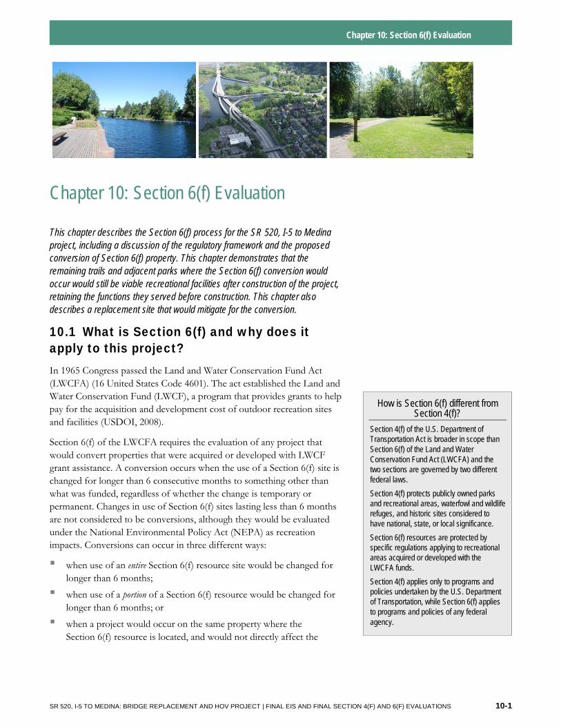
Chapter 10: Section 6(f) Evaluation
Chapter 10: Section 6(f) Evaluation
This chapter describes the Section 6(f) process for the SR 520, I-5 to Medina project, including a discussion of the regulatory framework and the proposed conversion of Section 6(f) property. This chapter demonstrates that the remaining trails and adjacent parks where the Section 6(f) conversion would occur would still be viable recreational facilities after construction of the project, retaining the functions they served before construction. This chapter also describes a replacement site that would mitigate for the conversion.
10.1 What is Section 6(f) and why does it apply to this project? In 1965 Congress passed the Land and Water Conservation Fund Act (LWCFA) (16 United States Code 4601). The act established the Land and Water Conservation Fund (LWCF), a program that provides grants to help pay for the acquisition and development cost of outdoor recreation sites and facilities (USDOI, 2008).
Section 6(f) of the LWCFA requires the evaluation of any project that would convert properties that were acquired or developed with LWCF grant assistance. A conversion occurs when the use of a Section 6(f) site is changed for longer than 6 consecutive months to something other than what was funded, regardless of whether the change is temporary or permanent. Changes in use of Section 6(f) sites lasting less than 6 months are not considered to be conversions, although they would be evaluated under the National Environmental Policy Act (NEPA) as recreation impacts. Conversions can occur in three different ways:
▪ when use of an entire Section 6(f) resource site would be changed for longer than 6 months;
▪ when use of a portion of a Section 6(f) resource would be changed for longer than 6 months; or
▪ when a project would occur on the same property where the Section 6(f) resource is located, and would not directly affect the
How is Section 6(f) different from Section 4(f)?
Section 4(f) of the U.S. Department of Transportation Act is broader in scope than Section 6(f) of the Land and Water Conservation Fund Act (LWCFA) and the two sections are governed by two different federal laws.
Section 4(f) protects publicly owned parks and recreational areas, waterfowl and wildlife refuges, and historic sites considered to have national, state, or local significance.
Section 6(f) resources are protected by specific regulations applying to recreational areas acquired or developed with the LWCFA funds.
Section 4(f) applies only to programs and policies undertaken by the U.S. Department of Transportation, while Section 6(f) applies to programs and policies of any federal agency.
SR 520, I-5 TO MEDINA: BRIDGE REPLACEMENT AND HOV PROJECT | FINAL EIS AND FINAL SECTION 4(F) AND 6(F) EVALUATIONS 10-1
Chapter 10: Section 6(f) Evaluation
Section 6(f) resource, but would affect access to or other reasonable use of the Section 6(f) resource on the site for more than 6 months.
In order to construct and operate the SR 520, I-5 to Medina project, WSDOT would convert Section 6(f) resources. The Preferred Alternative and all SDEIS options would result in a conversion of land within Washington Park Arboretum and East Montlake Park through permanent right-of-way acquisitions and temporary closure of portions of these parks lasting longer than 6 months. The Preferred Alternative, along with SDEIS Options A and L, would also result in a conversion of a segment along the Ship Canal Waterside Trail. In addition to LWCFA funding used by the City of Seattle and the UW to build the Arboretum Waterfront Trail, the City of Seattle also received Aquatic Lands Enhancement Account (ALEA) funds to later reconstruct the boardwalk segment of the Arboretum Waterfront Trail and build the Ship Canal Waterside Trail. Recreation property purchased or developed with state ALEA grants has maintenance and conversion approval requirements similar to those of the LWCFA, so the requirements of both grants are being addressed simultaneously through this project’s Section 6(f) process.
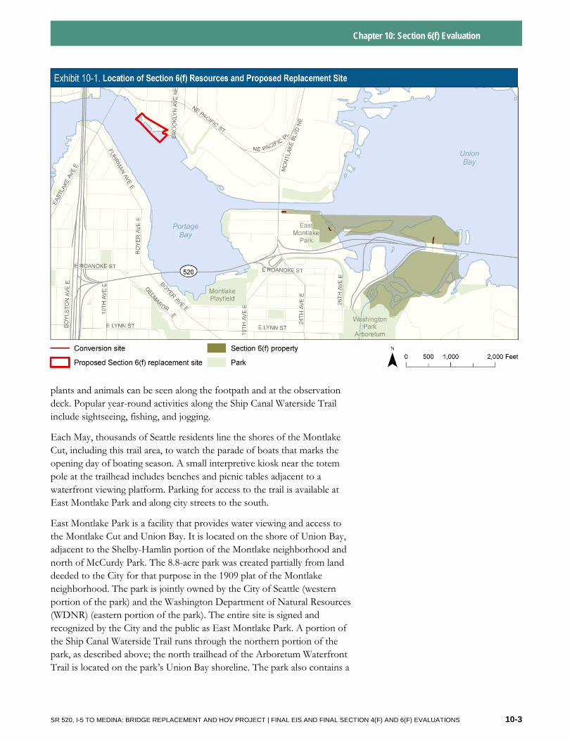
10.2 What are the Section 6(f) resources that would be affected by the project? The SR 520, I-5 to Medina project occurs in the vicinity of a trail complex consisting of the Ship Canal Waterside Trail, the Arboretum Waterfront Trail, and two parks associated with the trails—East Montlake Park and Washington Park Arboretum. The parks themselves were not purchased or developed through the LWCFA (or ALEA), but they provide access to and context for the Section 6(f) trails. The boundary for the Section 6(f) property for this project was established by the National Park Service (NPS) and Washington State Recreation and Conservation Office (RCO). Exhibit 10-1 shows the location of the Section 6(f) resources (as well as the location of the proposed replacement site discussed in Section 10.5).
Ship Canal Waterside Trail and East Montlake Park
The Ship Canal Waterside Trail is a Section 6(f) resource that runs along the south side of the Montlake Cut. It is a pedestrian trail that extends eastward from the City of Seattle’s West Montlake Park to the Montlake Bridge, then crosses Montlake Boulevard and continues into East Montlake Park, where it ends at a viewing platform on the waterfront. At this point, the trail connects to the Arboretum Waterfront Trail. Designed by the U.S. Army Corps of Engineers (USACE) and the Seattle Garden Club, the Ship Canal Waterside Trail was constructed in 1970 and designated as a National Recreation Trail a year later.
The Seattle Parks and Recreation Department maintains the trail. People use the shoreline area along the trail for viewing wildlife, and a variety of
SR 520, I-5 TO MEDINA: BRIDGE REPLACEMENT AND HOV PROJECT | FINAL EIS AND FINAL SECTION 4(F) AND 6(F) EVALUATIONS 10-2
Chapter 10: Section 6(f) Evaluation
plants and animals can be seen along the footpath and at the observation deck. Popular year-round activities along the Ship Canal Waterside Trail include sightseeing, fishing, and jogging.
Each May, thousands of Seattle residents line the shores of the Montlake Cut, including this trail area, to watch the parade of boats that marks the opening day of boating season. A small interpretive kiosk near the totem pole at the trailhead includes benches and picnic tables adjacent to a waterfront viewing platform. Parking for access to the trail is available at East Montlake Park and along city streets to the south.
East Montlake Park is a facility that provides water viewing and access to the Montlake Cut and Union Bay. It is located on the shore of Union Bay, adjacent to the Shelby-Hamlin portion of the Montlake neighborhood and north of McCurdy Park. The 8.8-acre park was created partially from land deeded to the City for that purpose in the 1909 plat of the Montlake neighborhood. The park is jointly owned by the City of Seattle (western portion of the park) and the Washington Department of Natural Resources (WDNR) (eastern portion of the park). The entire site is signed and recognized by the City and the public as East Montlake Park. A portion of the Ship Canal Waterside Trail runs through the northern portion of the park, as described above; the north trailhead of the Arboretum Waterfront Trail is located on the park’s Union Bay shoreline. The park also contains a
SR 520, I-5 TO MEDINA: BRIDGE REPLACEMENT AND HOV PROJECT | FINAL EIS AND FINAL SECTION 4(F) AND 6(F) EVALUATIONS 10-3
Chapter 10: Section 6(f) Evaluation
launch point for canoes and kayaks, three observation decks, a waterfront viewing platform with views of area waters and the Cascade Mountains, a grassy open space, and parking.
The portion of East Montlake Park included in the Section 6(f) boundary includes most of the park (see Exhibit 10-2). The area of park not included in the Section 6(f) boundary contains the Museum of History and Industry building and a developed area just north of the building, neither of which support the functions of the Ship Canal Waterside Trail.
Washington Park Arboretum and the Arboretum Waterfront Trail
The part of the Arboretum subject to Section 6(f) is in the northern portion of the park; it consists of the landscape that surrounds and supports the Arboretum Waterfront Trail, including Foster and Marsh Islands. The Section 6(f) boundary established for purposes of the SR 520, I-5 to Medina project extends from the parking lot in the south end where the Waterfront Trail begins and through Marsh Island (see Exhibit 10-2). The activities available in this portion of the Arboretum primarily include enjoyment of open space, water viewing, wildlife viewing, hand-carry boat launching, and educational opportunities.
The Section 6(f) resource known as the Arboretum Waterfront Trail was established in 1967. The trail begins near the Graham Visitors Center in the Arboretum, travels out onto Foster Island, and meanders on a series of floating piers and structures through the marsh land that connects Foster and Marsh Islands to East Montlake Park. The trail then continues north through East Montlake Park to connect with the Ship Canal Waterside Trail.
Raised observation platforms through the marshy areas in the north end of the Arboretum and northwest toward East Montlake Park provide views of the various wetlands around the islands. Wildlife viewing along the trail is a popular activity. The trail also has views of Union Bay and the Ship Canal, Lake Washington, and Husky Stadium. The trail’s connection to the Ship Canal Waterside Trail creates a continuous trail from the Arboretum to the Montlake Bridge and then to West Montlake Park. Parking for access to the trail is available at the Arboretum as well as in and near East Montlake Park.
The Washington Park Arboretum began as Washington Park in the early 1900s, on private park land acquired by the City of Seattle. The Washington Park Arboretum was officially set aside as a botanical garden and arboretum in March 1924, and in 1934 the City and the University of Washington (UW) agreed to jointly use and manage Washington Park as an arboretum.
In that agreement, the City gave the UW permission to design, construct, plant, and manage an arboretum and botanical garden in Washington Park. The Washington Park Arboretum, which is now cooperatively managed by
Why is there no Section 6(f) conversion of the Arboretum
Waterfront Trail?
No conversion would occur on the Arboretum Waterfront Trail because the construction easements and closures would last for less than 6 months at a time, which would not constitute a Section 6(f) use.
SR 520, I-5 TO MEDINA: BRIDGE REPLACEMENT AND HOV PROJECT | FINAL EIS AND FINAL SECTION 4(F) AND 6(F) EVALUATIONS 10-4
Union Bay
Portage Bay
EastMontlake
Park
WashingtonPark
Arboretum
MO
NT
LA
KE
BL
VD
E
24T
H A
VE
E
W M
ON
TLAK
E PL
E
E MO
NTLAKE PL E
Chapter 10: Section 6(f)
520
A
B
C D
Arboretum Waterfront Trail Ship Canal
Waterside Trail
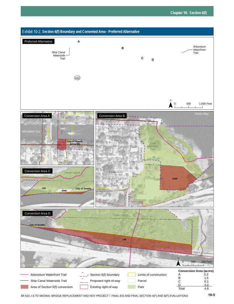
Exhibit 10-2. Section 6(f) Boundary and Converted Area - Preferred Alternative
DNR
East Montlake
Park
Union Bay
E SHELBY ST
E HAMLIN ST
24T
H A
VE
E
E P
AR
K D
R E
City of Seattle
(USACE)
MO
NT
LA
KE
BR
Montlake Cut
UW DNR
City of Seattle
Marsh Island
UW
City of Seattle
Foster Island
0 500 1,000 Feet
0 100 200 Feet
Conversion Area A Conversion Area B
Conversion Area C
Conversion Area D
Preferred Alternative
Conversion Area (acres) Arboretum Waterfront Trail Section 6(f) boundary Limits of construction A 0.2
B 1.5 Ship Canal Waterside Trail Proposed right-of-way Parcel C 0.1
D 3.0 Area of Section 6(f) conversion Existing right-of-way Park Total 4.8
SR 520, I-5 TO MEDINA: BRIDGE REPLACEMENT AND HOV PROJECT FINAL EIS AND FINAL SECTION 4(F) AND 6(F) EVALUATIONS 10-5
Chapter 10: Section 6(f) Evaluation
the Seattle Parks and Recreation Department and the UW, is home to a nationally and internationally recognized woody plant collection. While the City maintains the park functions, the UW owns, maintains, and manages the plant collections and associated programs through paid and volunteer staff. The Arboretum Foundation manages fund raising, membership, and volunteer services. The City owns most of the Arboretum; however, three entities each own portions of the lands subject to Section 6(f) within the Arboretum:
▪ WDNR owns most of Marsh Island, as well as a strip of land at the northern end of Foster Island.
▪ UW owns the lands around the perimeter of Foster Island on the south side of SR 520, a strip of land across Foster Island on the north side of SR 520, and a small segment of land at the south end of Marsh Island.
▪ The City of Seattle owns the central part of Foster Island south of SR 520 as well as a small segment of land at the south end of Marsh Island.
Foster and Marsh Islands are peat and marsh landscapes lying near the southern shore of Union Bay within the northern section of the Arboretum. Foster Island was purchased in 1917 to be included as a part of Washington Park. The island grew considerably when the opening of the Ship Canal and the Hiram M. Chittenden Locks lowered the water level of Lake Washington by 9 feet. The original SR 520 project in 1963 crossed through the central part of the island, and a pedestrian underpass for the Waterfront Trail was provided under the highway in this area. The islands are wetland and waterway landscape features and the waterways surrounding these islands consist of marshes and open-water channels with native and non-native vegetation. Four designated non-motorized watercraft landings with access to the waterfront trail system are located in the waterways around the islands.
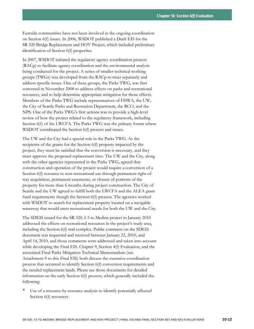
10.3 How would the conversion occur, and how would it affect the Section 6(f) resources? This section provides an overview of the activities that would lead to a conversion, the acreages involved, and a description of the resulting effects on the existing Section 6(f) resources. The Preferred Alternative would convert 4.8 acres of Section 6(f) property for use as part of a transportation facility. Exhibit 10-1 shows the location of the Section 6(f) resources (as well as the location of the replacement site discussed in Section 10.5). In comparison, Options A, K, and L would result in conversion of approximately 5.6, 9.3, and 8.3 acres, respectively.
Under the Preferred Alternative, a portion of the converted lands would be returned to their existing recreational uses after construction of the SR 520, I-5 to Medina project. Nearly half of the 4.8 acres converted, approximately
KEY FINDING
The Preferred Alternative permanently acquires the least amount of Section 6(f) property, compared to the options evaluated in the SDEIS, and the affected Section 6(f) resource would remain viable for recreational use during and after construction.
SR 520, I-5 TO MEDINA: BRIDGE REPLACEMENT AND HOV PROJECT | FINAL EIS AND FINAL SECTION 4(F) AND 6(F) EVALUATIONS 10-6
Chapter 10: Section 6(f) Evaluation
2.2 acres, would be available for recreational use after construction of the project. This Section 10.3 demonstrates that the Preferred Alternative permanently acquires the least amount of Section 6(f) property, compared to the options evaluated in the SDEIS, and that the affected Section 6(f) resources would remain viable for recreational use during and after construction. As previously discussed in Section 10.1, permanent or temporary changes to the use of a Section 6(f) resource that last more than 6 months are considered conversions. During construction, portions of a Section 6(f) property that would be affected or closed for less than 6 months are not considered a conversion under Section 6(f). For more information pertaining to effects on the parks discussed in this chapter, including construction closures of less than 6 months, see Chapters 5 and 6.
Ship Canal Waterside Trail
Under the Preferred Alternative and Option A, WSDOT proposes to use 0.2 acre of the Ship Canal Waterside Trail and surrounding land during construction of the new bascule bridge across the Montlake Cut. Of this, 0.1 acre would be permanently acquired and the remaining 0.1 acre would return to recreational use after completion of construction.
Option L would result in a 0.4 acre conversion of the Ship Canal Waterside Trail, but permanent conversion would be less than 0.1 acre of for construction of the new bascule bridge. Option K would not require a conversion of the Ship Canal Waterside Trail because the tunnel would be constructed to the east of its trailhead.
Under all options, access to the part of the Ship Canal Waterside Trail west of Montlake Boulevard would still be available during and after construction, and access to the eastern portion of the trail and its connection to the Arboretum Waterfront Trail would be available from East Shelby Street, East Hamlin Street, and East Montlake Park during and after construction. After construction, a connection from the Ship Canal Waterside Trail to the new bascule bridge would be provided, similar to the current stairs up to the existing bridge and Montlake Boulevard.
East Montlake Park
Under the Preferred Alternative, a permanent conversion of 1.5 acres would occur in East Montlake Park with the construction and operation of a stormwater pond primarily where a large parking lot is currently located. The northern portion of the park would be closed intermittently for periods lasting less than 6 months, and would be available for park uses, including onsite parking, after construction is completed.
Option A would result in a permanent conversion of 2.2 acres of property in East Montlake Park to construct the stormwater facility and outfall. An additional 0.4 acre would be used as a construction easement, but would
SR 520, I-5 TO MEDINA: BRIDGE REPLACEMENT AND HOV PROJECT | FINAL EIS AND FINAL SECTION 4(F) AND 6(F) EVALUATIONS 10-7
Chapter 10: Section 6(f) Evaluation
not be considered a conversion because the use would last for less than 6 months.
Option K would permanently acquire 6.5 acres in East Montlake Park. 6 acres of this area would be acquired for roadway and a stormwater facility and 0.1 acre for construction easement needed for the 50 months of construction. Of the 6.5 acres that would be permanently acquired, 0.4 acre would be for an easement over the proposed tunnel beneath the Montlake Cut. Tunnel boring within this additional easement would occur entirely below ground, with no surface disturbance during construction.
Under Option L, there would be a permanent acquisition of 4.0 acres for the stormwater facility, with 0.7 acre returned to park use after construction. An additional 0.3 acre construction easement would be needed for construction of the stormwater facility, but this would only last for a period of up to 3 months and would not be a conversion.
Compared to Options A, K, and L, the Preferred Alternative would require the least amount of Section 6(f) conversion in East Montlake Park.
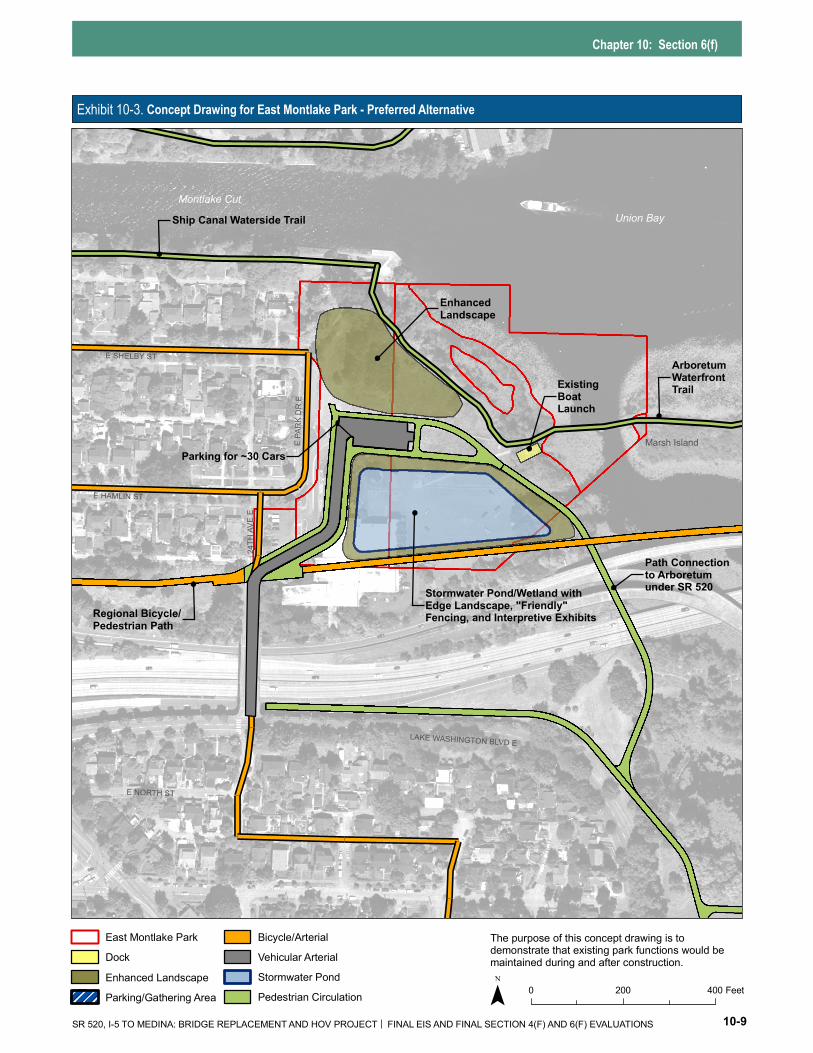
Under the Preferred Alternative and all SDEIS options, the areas of East Montlake Park not closed to the public during construction would continue to provide access to adjacent Lake Washington and the Montlake Cut, where most passive uses at this park generally occur. After construction, the park would continue to provide the functions that it does now. See Exhibit 10-3 for a conceptual drawing of how the park features could be restored after construction of the Preferred Alternative. The non-motorized boat launch and access to the Ship Canal Waterside Trail and the Arboretum Waterfront Trail would retain their current condition and setting both during construction and afterward.
Onsite parking at East Montlake Park would be available for most of the construction period. An appropriate number of parking spaces for the park and trail, as determined by the City, would be provided at the end of construction in this area. Onsite parking cannot be maintained during construction of this final parking lot.
The new stormwater facility is intended to be compatible with the remaining East Montlake Park and would provide a positive visual effect for trail users by replacing the existing parking lot with a more natural-appearing landscape that would be compatible with the adjacent shoreline. This treatment facility would be designed to blend in with the existing surroundings and would only be bound by fencing where public safety concerns occur, such as where the lid wall ends between the bike trail and the south and west sides of the stormwater pond. The fence would be landscape-friendly and would include transitions to different fencing and heights to fit in with the landscaping and topography. Where possible, no fencing would be included.
SR 520, I-5 TO MEDINA: BRIDGE REPLACEMENT AND HOV PROJECT | FINAL EIS AND FINAL SECTION 4(F) AND 6(F) EVALUATIONS 10-8
Chapter 10: Section 6(f)
Exhibit 10-3. Concept Drawing for East Montlake Park - Preferred Alternative
Union Bay Montlake Cut
Regional Bicycle/Pedestrian Path
Stormwater Pond/Wetland withEdge Landscape, "Friendly" Fencing, and Interpretive Exhibits
Path Connection to Arboretum under SR 520
ArboretumWaterfront TrailExisting
Boat Launch
EnhancedLandscape
Parking for ~30 Cars Marsh Island
Ship Canal Waterside Trail
E PAR
K DR
E
24TH
AVE
E
E NORTH ST
E HAMLIN ST
E SHELBY ST
LAKE WASHINGTON BLVD E
East Montlake Park Bicycle/Arterial The purpose of this concept drawing is todemonstrate that existing park functions would be Dock Vehicular Arterial maintained during and after construction.
Enhanced Landscape Stormwater Pond 0 200 400 FeetPedestrian Circulation Parking/Gathering Area
SR 520, I-5 TO MEDINA: BRIDGE REPLACEMENT AND HOV PROJECT FINAL EIS AND FINAL SECTION 4(F) AND 6(F) EVALUATIONS 10-9
Chapter 10: Section 6(f) Evaluation
Washington Park Arboretum and the Arboretum Waterfront Trail
Under the Preferred Alternative and all SDEIS options, no conversion of the Arboretum Waterfront Trail would occur. However, 3 acres of conversion would occur at two locations within the Arboretum (on Foster Island and Marsh Island).
The first location would be a 0.1 acre conversion on Marsh Island for a construction easement where a work bridge would be installed north of the existing bridge, from which the new bridge would be constructed. This area would be available for recreational use after construction is completed.
The second location would be a 2.9-acre conversion on Foster Island adjacent to the existing SR 520, which includes both permanent acquisition and a long-term easement. A permanent conversion of 1.0 acre at the Foster Island location would become WSDOT right-of-way with the new wider SR 520, although the Arboretum Waterfront Trail would continue to travel through this area and underneath SR 520 after construction, as it does today. The 1.9-acre temporary conversion would be for a long-term construction easement where work bridges would be installed north of the existing bridge, from which the new bridge would be constructed. This area would also be available for recreational use after construction is completed.
No conversions would occur south of SR 520 in the Arboretum. This area would remain open and available for use during and after construction. The unique waterside portions of the Arboretum Waterfront Trail west of Foster Island would still be accessible from East Montlake Park while the area underneath and around SR 520 is being used for construction. Throughout the construction period, park users would be able to access portions of the Arboretum Waterfront Trail, although segments may be closed at different times for less than 6 months.
Under Option A, a pier and span bridge would cross Foster Island that would require work bridges on and adjacent to Foster and Marsh Islands for about 32 consecutive months. This would result in conversion of 1.0 acre for permanent acquisition and 2.2 acres for construction exceeding 6 months. The work bridges would be removed after completion of the permanent structure. On the south side of SR 520, a 0.1-acre construction easement would be used for trail construction for a period of approximately 3 months and, therefore, would not be a Section 6(f) conversion. After construction, the construction easements would be returned to park use.
Option K would cross the Arboretum and Foster Island beneath a land bridge. The roadway would be at or slightly below the existing grade, but would be lidded by a large berm. The Arboretum Waterfront Trail would be reconstructed to pass over the land bridge. This design option would result in 2.8 acres of conversion within the Washington Park Arboretum—
SR 520, I-5 TO MEDINA: BRIDGE REPLACEMENT AND HOV PROJECT | FINAL EIS AND FINAL SECTION 4(F) AND 6(F) EVALUATIONS 10-10
Chapter 10: Section 6(f) Evaluation
1.5 acres of permanent acquisition and 1.3 acres of construction easement. Two additional construction easements, totaling 3.5 acres, would be required for construction of the berm and reconstructed trail. These easements would be used for less than 5 months and would not constitute a Section 6(f) conversion.
Similar to the Preferred Alternative and Option A, Option L would cross Foster Island on a bridge. Option L would result in 4.0 acres of conversion within the Washington Park Arboretum—0.7 acre of permanent acquisition and 3.2 acres of construction easement for temporary work bridges that would be in place for up to 38 months.
Table 10-1 summarizes the amount of acreage that would be converted by the Preferred Alternative and the SDEIS options and lists the construction duration for each.
Table 10-1. Summary of Section 6(f) Conversion and Construction Durations for the Preferred Alternative and Options A, K, and L
Preferred
Section 6(f) Resource
Preferred Alternative
Conversiona
(acres)
Alternative Construction
Duration (months)
Option AConversiona
(acres)
Option A Construction
Duration (months)
Option K Conversiona
(acres)
Option K Construction
Duration (months)
Option L Conversiona
(acres)
Option L Construction
Duration (months)
Ship Canal Waterside Trail
0.2 29 0.2 27 0 N/A 0.4 30
East Montlake Park 1.5 24 2.2 32 6.5 50 4.0 34
Arboretum Waterfront Trail
0 N/A 0 N/A 0 N/A 0 N/A
Washington Park 3.1 24 3.2 32 2.8 32 4.0 32 - 38 Arboretum
Total Section 6(f) Conversionb
4.8 5.6 9.3 8.3
a Total conversion acreage from permanent or temporary impacts lasting 6 months or longer, including permanent easements. b Total value may not equal sum of column due to rounding. N/A = not applicable
10.4 What was the Section 6(f) process for the project?
Analysis of the impacts of the SR 520 Bridge Replacement and HOV Program, including the Section 6(f) evaluation, began in 2000 with the initiation of the NEPA/State Environmental Policy Act (SEPA) environmental review process. Beginning in 2001, WSDOT coordinated with the agencies with jurisdiction over parks and recreational facilities to evaluate expected project impacts and likely mitigation measures. These agencies included the City of Seattle, the UW, the NPS, and the RCO, along with communities east of Lake Washington. There are no Section 6(f) impacts associated with this project east of Lake Washington; therefore, the
SR 520, I-5 TO MEDINA: BRIDGE REPLACEMENT AND HOV PROJECT | FINAL EIS AND FINAL SECTION 4(F) AND 6(F) EVALUATIONS 10-11
Chapter 10: Section 6(f) Evaluation
Eastside communities have not been involved in the ongoing coordination on Section 6(f) issues. In 2006, WSDOT published a Draft EIS for the SR 520 Bridge Replacement and HOV Project, which included preliminary identification of Section 6(f) properties.
In 2007, WSDOT initiated the regulatory agency coordination process (RACp) to facilitate agency coordination and the environmental analysis being conducted for the project. A series of smaller technical working groups (TWGs) was developed from the RACp to meet separately and address specific issues. One of these groups, the Parks TWG, was first convened in November 2008 to address effects on parks and recreational resources, and to help determine appropriate mitigation for those effects. Members of the Parks TWG include representatives of FHWA, the UW, the City of Seattle Parks and Recreation Department, the RCO, and the NPS. One of the Parks TWG’s first actions was to provide a high-level review of how the project related to the regulatory framework, including Section 6(f) of the LWCFA. The Parks TWG was the primary forum where WSDOT coordinated the Section 6(f) process and issues.
The UW and the City had a special role in the Parks TWG. As the recipients of the grants for the Section 6(f) property impacted by the project, they must be satisfied that the conversion is necessary, and they must approve the proposed replacement sites. The UW and the City, along with the other agencies represented in the Parks TWG, agreed that construction and operation of the project would require a conversion of a Section 6(f) resource to non-recreational use through permanent right-ofway acquisition, permanent easements, or closure of portions of the property for more than 6 months during project construction. The City of Seattle and the UW agreed to fulfill both the LWCFA and the ALEA grant fund requirements though the Section 6(f) process. The agencies worked with WSDOT to search for replacement property located on a navigable waterway that would meet recreational needs for both the UW and the City.
The SDEIS issued for the SR 520, I-5 to Medina project in January 2010 addressed the effects on recreational resources in the project’s study area, including the Section 6(f) trail complex. Public comment on the SDEIS document was requested and received between January 22, 2010, and April 14, 2010, and those comments were addressed and taken into account while developing the Final EIS. Chapter 9, Section 4(f) Evaluation, and the associated Final Parks Mitigation Technical Memorandum (see Attachment 9 to this Final EIS) both discuss the extensive coordination process that occurred to identify Section 6(f) conversion requirements and the needed replacement lands. Please see those documents for detailed information on the early Section 6(f) process, which generally included the following:
▪ Use of a resource-by-resource analysis to identify potentially affected Section 6(f) resources
SR 520, I-5 TO MEDINA: BRIDGE REPLACEMENT AND HOV PROJECT | FINAL EIS AND FINAL SECTION 4(F) AND 6(F) EVALUATIONS 10-12
Chapter 10: Section 6(f) Evaluation
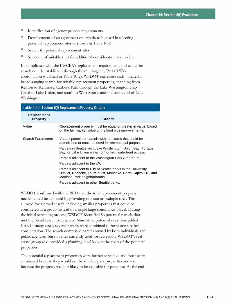
▪ Identification of agency process requirements
▪ Development of an agreement on criteria to be used in selecting potential replacement sites as shown in Table 10-2
▪ Search for potential replacement sites
▪ Selection of suitable sites for additional consideration and review
In compliance with the LWCFA’s replacement requirement, and using the search criteria established through the multi-agency Parks TWG coordination (outlined in Table 10-2), WSDOT real estate staff initiated a broad-ranging search for suitable replacement properties, spanning from Renton to Kenmore, Carkeek Park through the Lake Washington Ship Canal to Lake Union, and south to West Seattle and the south end of Lake Washington.
Table 10-2. Section 6(f) Replacement Property Criteria
Replacement Property Criteria
Value Replacement property must be equal or greater in value, based on the fair market value of the land plus improvements.
Search Parameters Vacant parcels or parcels with structures that could be demolished or could be used for recreational purposes.
Parcels in Seattle with Lake Washington, Union Bay, Portage Bay, or Lake Union waterfront or with waterfront access.
Parcels adjacent to the Washington Park Arboretum.
Parcels adjacent to the UW.
Parcels adjacent to City of Seattle parks in the University District, Roanoke, Laurelhurst, Montlake, North Capitol Hill, and Madison Park neighborhoods.
Parcels adjacent to other Seattle parks.
WSDOT confirmed with the RCO that the total replacement property needed could be achieved by providing one site or multiple sites. This allowed for a broad search, including smaller properties that could be considered as a group instead of a single large continuous parcel. During the initial screening process, WSDOT identified 86 potential parcels that met the broad search parameters. Nine other potential sites were added later. In many cases, several parcels were combined to form one site for consideration. The search comprised parcels owned by both individuals and public agencies, but not sites currently used for recreation. WSDOT’s real estate group also provided a planning-level look at the costs of the potential properties.
The potential replacement properties were further screened, and most were eliminated because they would not be suitable park properties and/or because the property was not likely to be available for purchase. At the end
SR 520, I-5 TO MEDINA: BRIDGE REPLACEMENT AND HOV PROJECT | FINAL EIS AND FINAL SECTION 4(F) AND 6(F) EVALUATIONS 10-13
Chapter 10: Section 6(f) Evaluation
of this screening process, the Parks TWG agreed that four sites were potentially suitable as a replacement park.
WSDOT then initiated reconnaissance-level real estate appraisals of these sites to determine whether they would satisfy the LWCFA criteria for value. At the same time, WSDOT began work on a Section 6(f) Environmental Evaluation to identify the potential effects of developing the replacement sites for recreational use (see Attachment 15 to this Final EIS). This process led to the selection of the Bryant Building site, which was determined to best meet the criteria, is available, and is able to be developed as a park.
Shortly after the site selection and during development of the Section 6(f) Environmental Evaluation, WSDOT signed a Memorandum of Understanding (MOU) with the City and the UW regarding completion of the Section 6(f) coordination process (WSDOT 2010g). The MOU includes the following:
▪ An acknowledgment by the parties that the existing Section 6(f) property will be converted;
▪ The commitment to ensuring that the remaining park area around the converted sites will retain its recreational functions and uses;
▪ An agreement by the parties to use the Bryant Building site for replacement of the converted property in fulfilling the Section 6(f) and ALEA replacement criteria; and
▪ A description of the roles and responsibilities of each party needed to complete the Section 6(f) conversion process.
In compliance with Section 6(f), WSDOT released the Section 6(f) Environmental Evaluation for a 30-day public comment period, from November 9, 2010, until December 8, 2010. A number of public comments were received, and WSDOT considered all comments pertaining to the environmental evaluation of the replacement site. Since selection of the replacement property remains at the sole discretion of the grantee agencies (City of Seattle and UW), alternative sites suggested in comments could not be considered.
After public comments were received and considered, the final findings regarding the Section 6(f) conversion and replacement property were developed. WSDOT then prepared the final Section 6(f) Environmental Evaluation and forwarded it to the City and the UW for use in their conversion application, which was submitted at a later date to RCO.
During this time, WSDOT’s appraisal process confirmed the value for the converted and replacement properties, and indicated that the value for the replacement site was higher than for the converted property. The appraisal demonstrated that the equivalent or higher value criterion of Section 6(f) would be fulfilled with the Bryant Building site.
SR 520, I-5 TO MEDINA: BRIDGE REPLACEMENT AND HOV PROJECT | FINAL EIS AND FINAL SECTION 4(F) AND 6(F) EVALUATIONS 10-14
Chapter 10: Section 6(f) Evaluation
As the environmental process for the project nears completion, WSDOT will be entering into legal agreements with both the City and the UW, as the original grantees, regarding funding for the purchase and development of the new park land at the Bryant Building site. WSDOT will transfer funds to the City and the UW after FHWA issues its NEPA record of decision (ROD) for the SR 520, I-5 to Medina project and after the NPS approves the Section 6(f) conversion. As noted in the MOU between the parties, the UW and the City were the sponsoring agencies for the original LWCF and ALEA grants used to develop the existing Section 6(f) resources. This means that they will be the parties to design the final project, obtain permits and approvals from regulatory agencies, construct the project, and manage the site once it is operational.
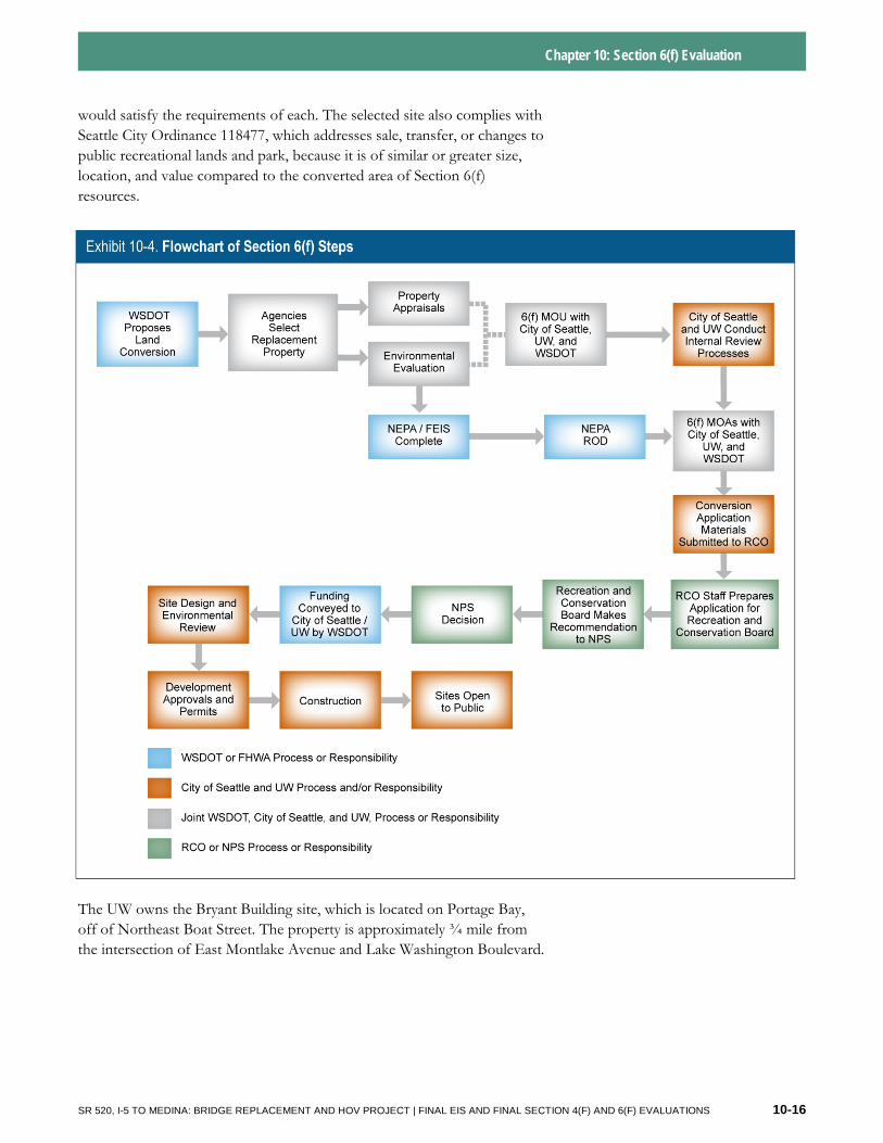
Any proposed Section 6(f) conversions must be approved by the NPS. For projects in Washington State, there is a multi-step process in which project proponents identify Section 6(f) property that would be converted to non-park uses, then forward the information to the RCO, which is the state agency that administers the LWCF and prepares the application and draft recommendation to the Recreation and Conservation Funding Board. The Recreation and Conservation Funding Board makes the official recommendation to NPS on the approval of conversions. The NPS and the RCO must ensure that all practical alternatives to converting Section 6(f) properties have been evaluated. Where no practical alternative exists to a conversion, the LWCFA requires that replacement property be acquired for those lands to be converted, and the agencies are charged with ensuring that proposed replacement lands would be of reasonably equivalent usefulness, monetary value, and location to those being converted. Exhibit 10-4 provides an overview of the Section 6(f) coordination process involving WSDOT, RCO, NPS, the City of Seattle, and the UW.
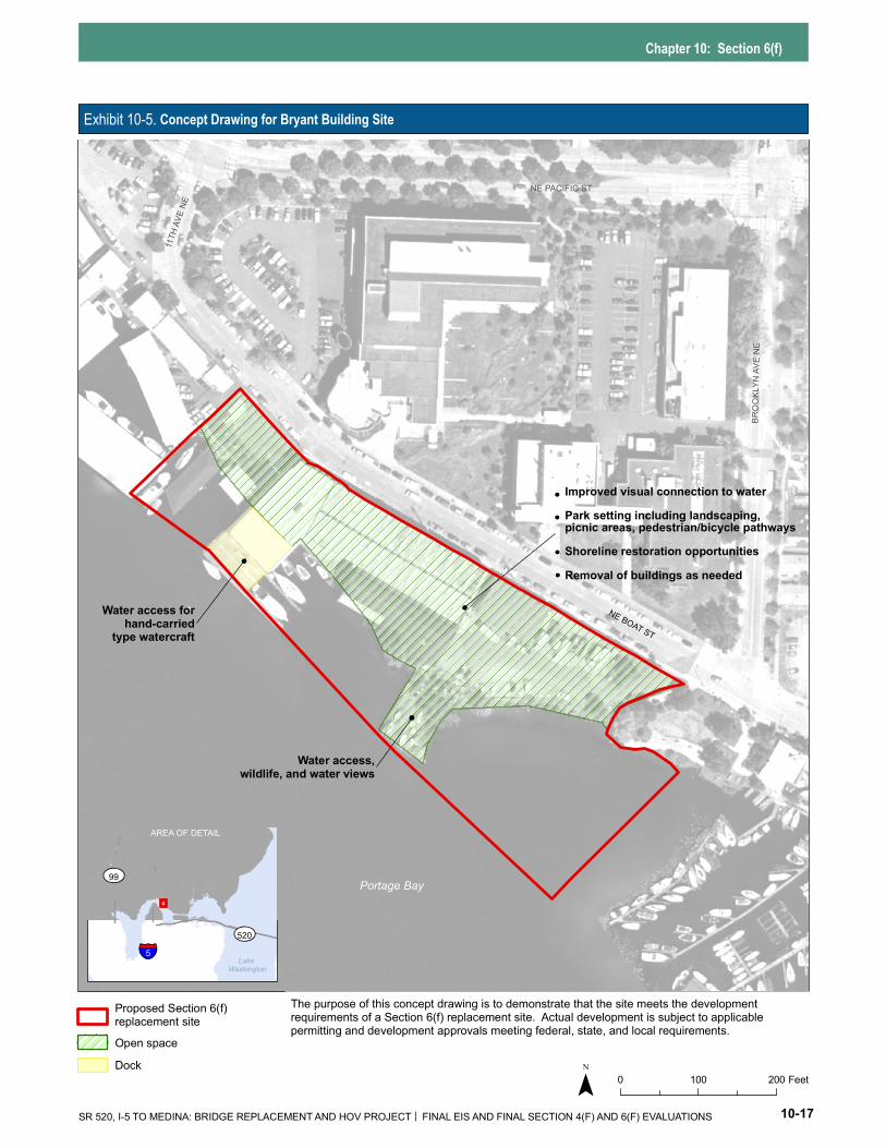
10.5 What site was chosen as the Section 6(f) replacement site and how could it be used? The Bryant Building site was chosen as the Section 6(f) replacement site. The site’s location is shown on Exhibit 10-1 and the site itself is shown on Exhibit 10-5. This site was selected following WSDOT’s coordination with the City of Seattle and the UW, and through the collaboration of the Parks TWG members.
This site would provide 3.9 acres of recreational space. It would meet all of the LWCFA recreational needs as well as the replacement criteria that the City and the UW identified. The site would also fulfill the navigable water access criterion needed to meet ALEA grant requirements. Similar to the LWCFA requirements, ALEA also requires replacement with lands of equivalent market value and recreation function within the same political jurisdiction of the converted property. The LWCFA and ALEA programs are both administered by the RCO, and selection of the Bryant Building site
SR 520, I-5 TO MEDINA: BRIDGE REPLACEMENT AND HOV PROJECT | FINAL EIS AND FINAL SECTION 4(F) AND 6(F) EVALUATIONS 10-15
Chapter 10: Section 6(f) Evaluation
would satisfy the requirements of each. The selected site also complies with Seattle City Ordinance 118477, which addresses sale, transfer, or changes to public recreational lands and park, because it is of similar or greater size, location, and value compared to the converted area of Section 6(f) resources.
The UW owns the Bryant Building site, which is located on Portage Bay, off of Northeast Boat Street. The property is approximately ¾ mile from the intersection of East Montlake Avenue and Lake Washington Boulevard.
SR 520, I-5 TO MEDINA: BRIDGE REPLACEMENT AND HOV PROJECT | FINAL EIS AND FINAL SECTION 4(F) AND 6(F) EVALUATIONS 10-16
Chapter 10: Section 6(f)
Exhibit 10-5. Concept Drawing for Bryant Building Site
Portage Bay
NE PACIFIC ST
NE BOAT ST
BROO
KLYN
AVE
NE
11TH
AVE N
E
Water access,wildlife, and water views
Improved visual connection to water Park setting including landscaping,picnic areas, pedestrian/bicycle pathways Shoreline restoration opportunities Removal of buildings as needed
Water access forhand-carried
type watercraft
LakeWashington
5
99
520
AREA OF DETAIL
Proposed Section 6(f) opment replacement site requirements of a Section 6(f) replacement site. Actual development is subject to applicable
permitting and development approvals meeting federal, state, and local requirements.Open spaceDock
0 100 200 Feet
The purpose of this concept drawing is to demonstrate that the site meets the devel
SR 520, I-5 TO MEDINA: BRIDGE REPLACEMENT AND HOV PROJECT FINAL EIS AND FINAL SECTION 4(F) AND 6(F) EVALUATIONS 10-17
Chapter 10: Section 6(f) Evaluation
The Bryant Building site parcel is a total of approximately 8.0 acres and is bisected by Brooklyn Avenue Northeast right-of-way. The eastern portion of the site includes the area known as Sakuma Viewpoint, which is a public park, so this area is not proposed as Section 6(f) replacement. The remainder (the western portion) of the Bryant Building site is 4.1 acres in size. It is currently used for services necessary for UW functions such as surplus equipment storage and sales and police department offices. The site also includes docks with private moorage space for lease.
The City of Seattle and the UW will be the replacement site sponsors and will determine final uses of the site based on their planning processes. However, a concept plan for site use was developed by the Parks TWG to demonstrate that development of the Bryant Building site for recreation could reasonably replace the land converted as a result of the SR 520, I-5 to Medina project. The analysis of the environmental effects of using the site for recreation is provided in the Section 6(f) Environmental Evaluation (Attachment 15).
The Bryant Building site concept drawing (Exhibit 10-5) identifies areas that could be used for water and wildlife viewing and connection to existing bicycle and pedestrian pathways. As required for the ALEA grant conversion process, and in accordance with City Ordinance 118477, the Bryant Building site would provide access to the navigable waters of Portage Bay, Union Bay, and Lake Washington for hand-carried watercraft.
The preliminary concept for the Bryant Building site (see Exhibit 10-5) includes a recreational facility to complement existing recreational uses along the shoreline of Portage Bay and to enhance the open feel of this area as envisioned by the UW’s master plan (UW 2003).
The facility would provide enhanced views and a greater sense of connection to the waterfront for bicyclists and pedestrians on the nearby streets and Burke-Gilman Trail, as well as a casual open space for other users. The new space would provide water viewing and access for the University District.
10.6 What steps did WSDOT take to avoid and minimize Section 6(f) conversions? The LWCFA requires that prior to conversion of Section 6(f) properties, the agency proposing the conversion must ensure that “all practical alternatives” to converting Section 6(f) properties have been evaluated. Throughout the environmental review process, WSDOT looked for ways to first avoid and then minimize project effects on Section 6(f) resources. WSDOT considered new corridors, operational changes, design-specific avoidance measures, new travel modes, and the No Build Alternative itself. Although the No Build Alternative evaluated in the SDEIS would not affect any Section 6(f) properties, it would not meet the project purpose and need.
Development of the Bryant Building site would likely require future approvals and permits, which could include:
Additional SEPA analysis on specific park development proposals
City of Seattle shoreline permits or exemptions
City of Seattle grading permit
City of Seattle conditional use permit
City of Seattle street use permit
USACE 404 Nationwide Permit
Ecology 401 water quality certification
WDFW Hydraulic Project Approval
Additional ESA consultation
Section 106 consultation with the SHPO
SR 520, I-5 TO MEDINA: BRIDGE REPLACEMENT AND HOV PROJECT | FINAL EIS AND FINAL SECTION 4(F) AND 6(F) EVALUATIONS 10-18
Chapter 10: Section 6(f) Evaluation
The NPS has agreed that there are no practical alternatives to the conversion of Section 6(f) property (U.S. Department of Interior 2010).
Although Section 6(f) impacts could not be avoided, WSDOT has done substantial work to reduce Section 6(f) impacts, as evidenced by the reduced conversion acreage for the Preferred Alternative, compared to the options evaluated in the SDEIS. Under the Preferred Alternative, 4.8 acres of Section 6(f) land would be converted through long-term construction easements and permanent right-of-way acquisitions. As stipulated in the Section 6(f) Memorandum of Agreement (MOA) (WSDOT 2011b), WSDOT would mitigate for this acquisition by funding the purchase and/or development of the Bryant Building site as replacement for the project’s Section 6(f) conversions. The development of the 3.9-acre Bryant Building site would result in a total net gain of 1.3 acres of Section 6(f) recreational space in the Seattle area, after 2.2 acres of the 4.8 converted acreage is returned to recreational use at the end of construction.
SR 520, I-5 TO MEDINA: BRIDGE REPLACEMENT AND HOV PROJECT | FINAL EIS AND FINAL SECTION 4(F) AND 6(F) EVALUATIONS 10-19