Embed Size (px)
Citation preview
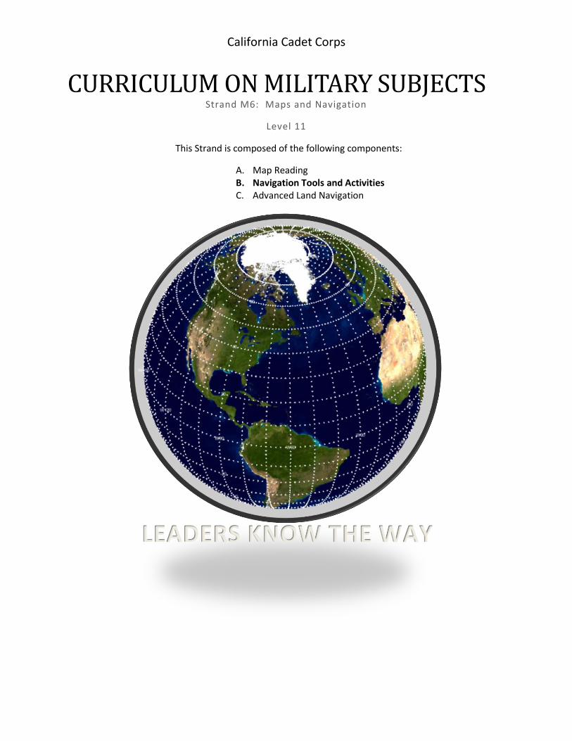
California Cadet Corps
CURRICULUM ON MILITARY SUBJECTS Strand M6: Maps and Navigation
Level 11
This Strand is composed of the following components:
A. Map Reading B. Navigation Tools and Activities C. Advanced Land Navigation
LEADERS KNOW THE WAY
2
Table of Contents
B. Navigation Tools ....................................................................................................................................... 3
B1. Using a Compass. ............................................................................................................................ 4
B2. Alternative Direction Finding Methods .......................................................................................... 8
B3. Pace Count .................................................................................................................................... 10
B4. Moving by Terrain Association ..................................................................................................... 11
B5. Global Positioning System GPS ..................................................................................................... 12
B6. Compass Course. ........................................................................................................................... 14
B7. Orienteering. ................................................................................................................................. 18
B6. How to Design an Orienteering Course for your Unit. .................................................................. 27
B8. Geocaching.................................................................................................................................... 29
3
B. Navigation Tools
Objectives DESIRED OUTCOME (Followership) Cadets will be proficient in dead reckoning (Map+ Pace count), terrain association, beginning orienteering and geo-cashing. B1. Use a lensatic compass to navigate a course.
B2. Demonstrate how to find the four cardinal directions without a compass during cloudless daytime
and nighttime hours.
B3. Determine your 100m pace count for flat ground, uphill, and downhill terrain.
B4. Given a map only, describe or demonstrate, how you would move from one point to another using
terrain association.
B5. Identify the situations that are best suited for handheld GPS or cell-phone GPS.
B6. Design or conduct a compass course at your school.
B7. Explain the sport of Orienteering and how it works.
B8. Find or design an orienteering course for your battalion.
B9. Find the nearest geo-cashes to your school or bivouac.
4
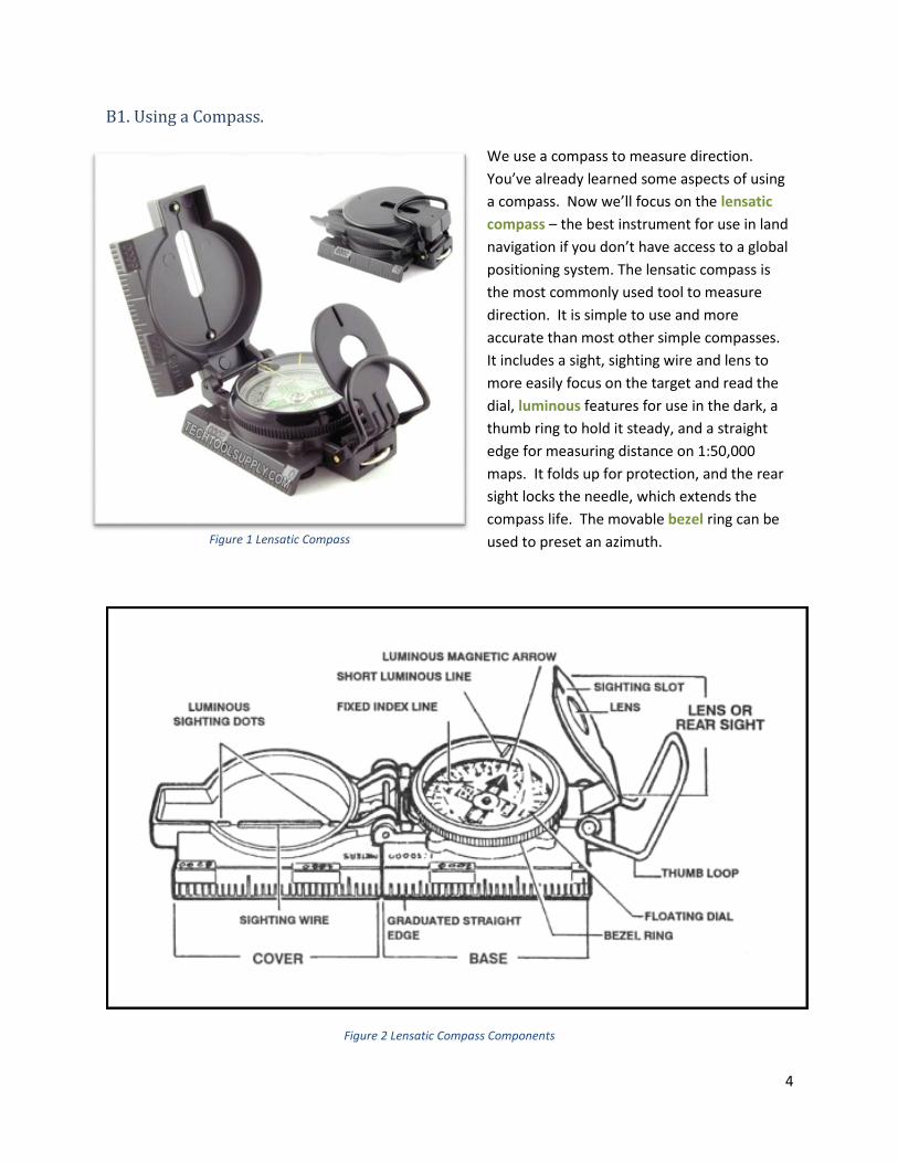
B1. Using a Compass. We use a compass to measure direction.
You’ve already learned some aspects of using
a compass. Now we’ll focus on the lensatic
compass – the best instrument for use in land
navigation if you don’t have access to a global
positioning system. The lensatic compass is
the most commonly used tool to measure
direction. It is simple to use and more
accurate than most other simple compasses.
It includes a sight, sighting wire and lens to
more easily focus on the target and read the
dial, luminous features for use in the dark, a
thumb ring to hold it steady, and a straight
edge for measuring distance on 1:50,000
maps. It folds up for protection, and the rear
sight locks the needle, which extends the
compass life. The movable bezel ring can be
used to preset an azimuth.
Figure 2 Lensatic Compass Components
Figure 1 Lensatic Compass
5
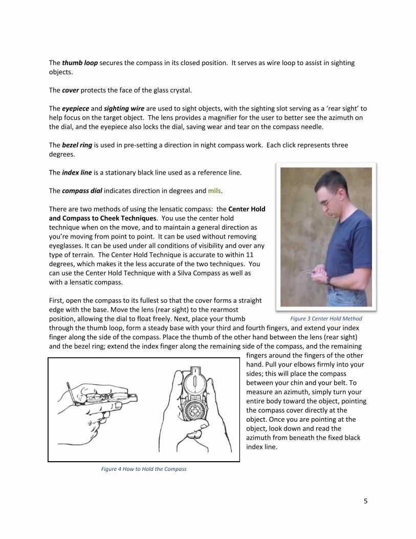
The thumb loop secures the compass in its closed position. It serves as wire loop to assist in sighting objects. The cover protects the face of the glass crystal. The eyepiece and sighting wire are used to sight objects, with the sighting slot serving as a ‘rear sight’ to help focus on the target object. The lens provides a magnifier for the user to better see the azimuth on the dial, and the eyepiece also locks the dial, saving wear and tear on the compass needle. The bezel ring is used in pre-setting a direction in night compass work. Each click represents three degrees. The index line is a stationary black line used as a reference line. The compass dial indicates direction in degrees and mils. There are two methods of using the lensatic compass: the Center Hold and Compass to Cheek Techniques. You use the center hold technique when on the move, and to maintain a general direction as you’re moving from point to point. It can be used without removing eyeglasses. It can be used under all conditions of visibility and over any type of terrain. The Center Hold Technique is accurate to within 11 degrees, which makes it the less accurate of the two techniques. You can use the Center Hold Technique with a Silva Compass as well as with a lensatic compass. First, open the compass to its fullest so that the cover forms a straight edge with the base. Move the lens (rear sight) to the rearmost position, allowing the dial to float freely. Next, place your thumb through the thumb loop, form a steady base with your third and fourth fingers, and extend your index finger along the side of the compass. Place the thumb of the other hand between the lens (rear sight) and the bezel ring; extend the index finger along the remaining side of the compass, and the remaining
fingers around the fingers of the other hand. Pull your elbows firmly into your sides; this will place the compass between your chin and your belt. To measure an azimuth, simply turn your entire body toward the object, pointing the compass cover directly at the object. Once you are pointing at the object, look down and read the azimuth from beneath the fixed black index line.
Figure 3 Center Hold Method
Figure 4 How to Hold the Compass
6
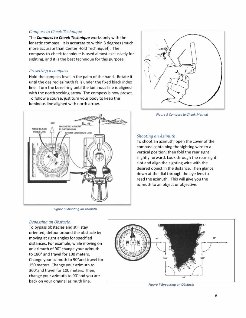
Compass to Cheek Technique
The Compass to Cheek Technique works only with the lensatic compass. It is accurate to within 3 degrees (much more accurate than Center Hold Technique!). The compass-to-cheek technique is used almost exclusively for sighting, and it is the best technique for this purpose.
Presetting a compass
Hold the compass level in the palm of the hand. Rotate it until the desired azimuth falls under the fixed black index line. Turn the bezel ring until the luminous line is aligned with the north seeking arrow. The compass is now preset. To follow a course, just turn your body to keep the luminous line aligned with north arrow.
Shooting an Azimuth To shoot an azimuth, open the cover of the compass containing the sighting wire to a vertical position; then fold the rear sight slightly forward. Look through the rear-sight slot and align the sighting wire with the desired object in the distance. Then glance down at the dial through the eye lens to read the azimuth. This will give you the azimuth to an object or objective.
Bypassing an Obstacle. To bypass obstacles and still stay oriented, detour around the obstacle by moving at right angles for specified distances. For example, while moving on an azimuth of 90° change your azimuth to 180° and travel for 100 meters. Change your azimuth to 90°and travel for 150 meters. Change your azimuth to 360°and travel for 100 meters. Then, change your azimuth to 90°and you are back on your original azimuth line.
Figure 6 Shooting an Azimuth
Figure 5 Compass to Cheek Method
Figure 7 Bypassing an Obstacle
7
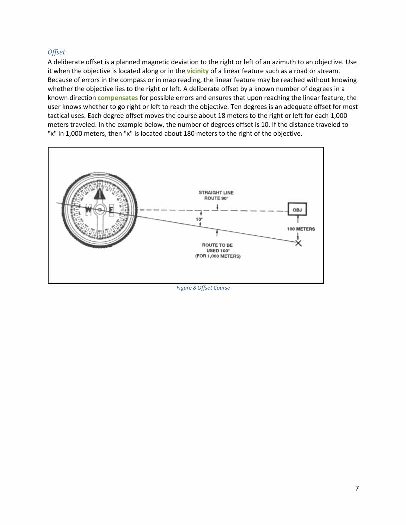
Offset
A deliberate offset is a planned magnetic deviation to the right or left of an azimuth to an objective. Use it when the objective is located along or in the vicinity of a linear feature such as a road or stream. Because of errors in the compass or in map reading, the linear feature may be reached without knowing whether the objective lies to the right or left. A deliberate offset by a known number of degrees in a known direction compensates for possible errors and ensures that upon reaching the linear feature, the user knows whether to go right or left to reach the objective. Ten degrees is an adequate offset for most tactical uses. Each degree offset moves the course about 18 meters to the right or left for each 1,000 meters traveled. In the example below, the number of degrees offset is 10. If the distance traveled to "x" in 1,000 meters, then "x" is located about 180 meters to the right of the objective.
Figure 8 Offset Course

8
B2. Alternative Direction Finding Methods
When a compass is not available, different techniques can be used to determine the four cardinal directions.
Sunrise and Sunset:
The sun rises in the general direction of east and sets in the general direction of west every day, so you can use the location of sunrise or sunset to get an approximate idea of direction. Face the sunrise and you are facing east; north will be on your left and south will be on your right. Face the sunset and you are facing west; north will be on your right and south will be on your left. Just remember this is accurate only on the 1st day of spring and the 1st day of fall. In Central California, after Spring, the sun processes slowly up to 30 degrees toward south, and after Fall the sun processes slowly up to 30 degrees toward north. This means in the summer if you face the sun at sunrise, you’ll be facing 060° (approx. East Northeast), and in winter if you face the sun at sunrise, you’ll be facing 120° (approx. East Southeast)
The Shadow-Tip Method:
Step 1: Place stick in ground and mark tip of shadow with stone. Step 2: Wait 10-15 minutes and mark new position of shadow tip. Step 3: Draw a straight line between the 2 marks . Step 4: Stand with the first mark to your left, you are now facing north
Figure 9 Shadow-Tip Method
9
The Watch Method:
A watch can be used to determine the approximate true north and true south. In the North Temperate Zone only, the hour hand is pointed toward the sun. A south line can be found midway between the hour hand and 1200 hours, standard time. If on daylight saving time, the north-south line is found between the hour hand and 1300 hours. If there is any doubt as to which end of the line is north, remember that the sun is in the east before noon and in the west after noon. The watch may also be used to determine direction in the South Temperate Zone; however, the method is different. The 1200-hour dial is pointed toward the sun, and halfway between 1200 hours and the hour hand will be a north line. If on daylight saving time, the north line lies midway between the hour hand and 1300 hours. Step 1: Point the hour hand toward the sun Step 2: The south line is mid-way between the hour hand and 1200 (1300 during Daylight Saving Time) (This is when you’re glad you don’t have a digital watch!)
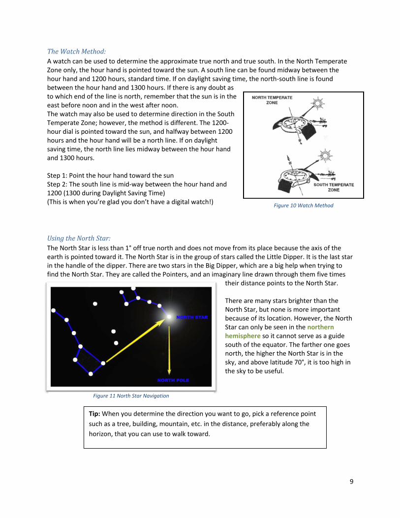
Using the North Star:
The North Star is less than 1° off true north and does not move from its place because the axis of the earth is pointed toward it. The North Star is in the group of stars called the Little Dipper. It is the last star in the handle of the dipper. There are two stars in the Big Dipper, which are a big help when trying to find the North Star. They are called the Pointers, and an imaginary line drawn through them five times
their distance points to the North Star. There are many stars brighter than the North Star, but none is more important because of its location. However, the North Star can only be seen in the northern hemisphere so it cannot serve as a guide south of the equator. The farther one goes north, the higher the North Star is in the sky, and above latitude 70°, it is too high in the sky to be useful.
Tip: When you determine the direction you want to go, pick a reference point
such as a tree, building, mountain, etc. in the distance, preferably along the
horizon, that you can use to walk toward.
Figure 10 Watch Method
Figure 11 North Star Navigation
10
B3. Pace Count
It is very useful to know your pace count. It’s a good way to get a rough measurement of how far you’re walking. A pace count is the number of paces it takes you to walk a certain distance – usually 100 meters. Everyone’s pace count is unique – you have to measure your own. To set up a pace count, use a measuring tool (an engineer’s wheel measure or a long tape measure or a 100m long piece of rope) to measure 100 meters. Put a Start Line and a Stop Line that won’t get erased by stepping on it. The individual walks from the Start to Stop Line, counting every step (alternately, you can count every
other step). Don’t talk while you’re pacing, just count! When you reach the Stop point, note the number of paces it took you.
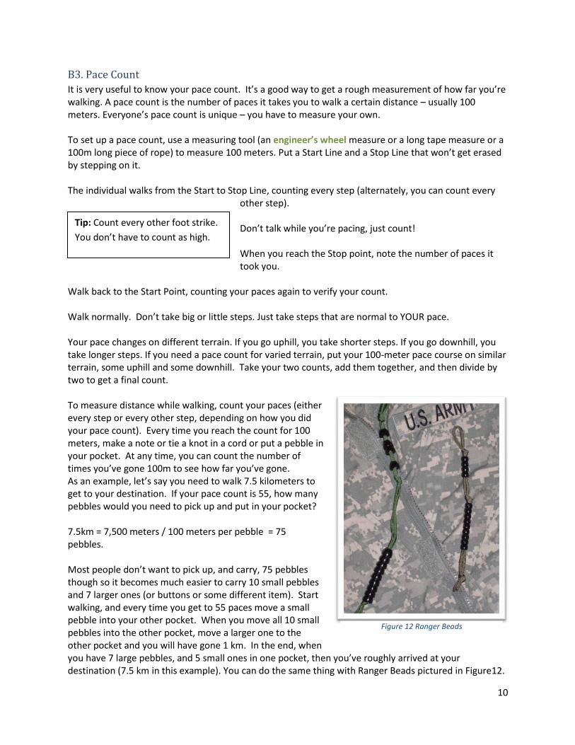
Walk back to the Start Point, counting your paces again to verify your count. Walk normally. Don’t take big or little steps. Just take steps that are normal to YOUR pace. Your pace changes on different terrain. If you go uphill, you take shorter steps. If you go downhill, you take longer steps. If you need a pace count for varied terrain, put your 100-meter pace course on similar terrain, some uphill and some downhill. Take your two counts, add them together, and then divide by two to get a final count. To measure distance while walking, count your paces (either every step or every other step, depending on how you did your pace count). Every time you reach the count for 100 meters, make a note or tie a knot in a cord or put a pebble in your pocket. At any time, you can count the number of times you’ve gone 100m to see how far you’ve gone. As an example, let’s say you need to walk 7.5 kilometers to get to your destination. If your pace count is 55, how many pebbles would you need to pick up and put in your pocket? 7.5km = 7,500 meters / 100 meters per pebble = 75 pebbles. Most people don’t want to pick up, and carry, 75 pebbles though so it becomes much easier to carry 10 small pebbles and 7 larger ones (or buttons or some different item). Start walking, and every time you get to 55 paces move a small pebble into your other pocket. When you move all 10 small pebbles into the other pocket, move a larger one to the other pocket and you will have gone 1 km. In the end, when you have 7 large pebbles, and 5 small ones in one pocket, then you’ve roughly arrived at your destination (7.5 km in this example). You can do the same thing with Ranger Beads pictured in Figure12.
Figure 12 Ranger Beads
Tip: Count every other foot strike.
You don’t have to count as high.
11
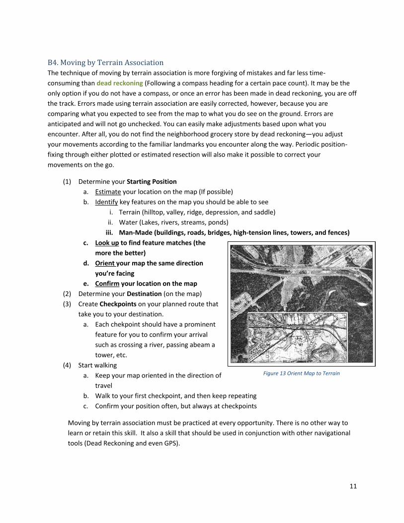
B4. Moving by Terrain Association
The technique of moving by terrain association is more forgiving of mistakes and far less time-
consuming than dead reckoning (Following a compass heading for a certain pace count). It may be the
only option if you do not have a compass, or once an error has been made in dead reckoning, you are off
the track. Errors made using terrain association are easily corrected, however, because you are
comparing what you expected to see from the map to what you do see on the ground. Errors are
anticipated and will not go unchecked. You can easily make adjustments based upon what you
encounter. After all, you do not find the neighborhood grocery store by dead reckoning—you adjust
your movements according to the familiar landmarks you encounter along the way. Periodic position-
fixing through either plotted or estimated resection will also make it possible to correct your
movements on the go.
(1) Determine your Starting Position
a. Estimate your location on the map (If possible)
b. Identify key features on the map you should be able to see
i. Terrain (hilltop, valley, ridge, depression, and saddle)
ii. Water (Lakes, rivers, streams, ponds)
iii. Man-Made (buildings, roads, bridges, high-tension lines, towers, and fences)
c. Look up to find feature matches (the
more the better)
d. Orient your map the same direction
you’re facing
e. Confirm your location on the map
(2) Determine your Destination (on the map)
(3) Create Checkpoints on your planned route that
take you to your destination.
a. Each chekpoint should have a prominent
feature for you to confirm your arrival
such as crossing a river, passing abeam a
tower, etc.
(4) Start walking
a. Keep your map oriented in the direction of
travel
b. Walk to your first checkpoint, and then keep repeating
c. Confirm your position often, but always at checkpoints
Moving by terrain association must be practiced at every opportunity. There is no other way to
learn or retain this skill. It also a skill that should be used in conjunction with other navigational
tools (Dead Reckoning and even GPS).
Figure 13 Orient Map to Terrain
12
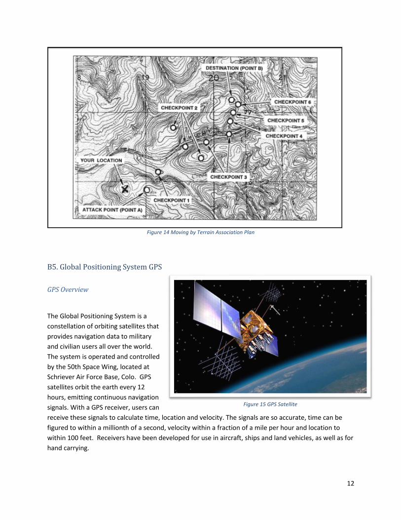
Figure 14 Moving by Terrain Association Plan
B5. Global Positioning System GPS
GPS Overview
The Global Positioning System is a
constellation of orbiting satellites that
provides navigation data to military
and civilian users all over the world.
The system is operated and controlled
by the 50th Space Wing, located at
Schriever Air Force Base, Colo. GPS
satellites orbit the earth every 12
hours, emitting continuous navigation
signals. With a GPS receiver, users can
receive these signals to calculate time, location and velocity. The signals are so accurate, time can be
figured to within a millionth of a second, velocity within a fraction of a mile per hour and location to
within 100 feet. Receivers have been developed for use in aircraft, ships and land vehicles, as well as for
hand carrying.
Figure 15 GPS Satellite
13
The GPS constellation is designed and operated as a 24-satellite system, consisting of six orbital planes,
with a minimum of four satellites per plane.
How Does GPS Work? (4m 50s sciBRIGHT video on Youtube)
https://www.youtube.com/watch?v=FU_pY2sTwTA
The Truth About GPS: How it works (3m 11s US Air Force Space Command Video on YouTube)
https://www.youtube.com/watch?v=fpPwMu3foGg&list=PL55179C4C04759E94&index=2&feature=plpp
_video
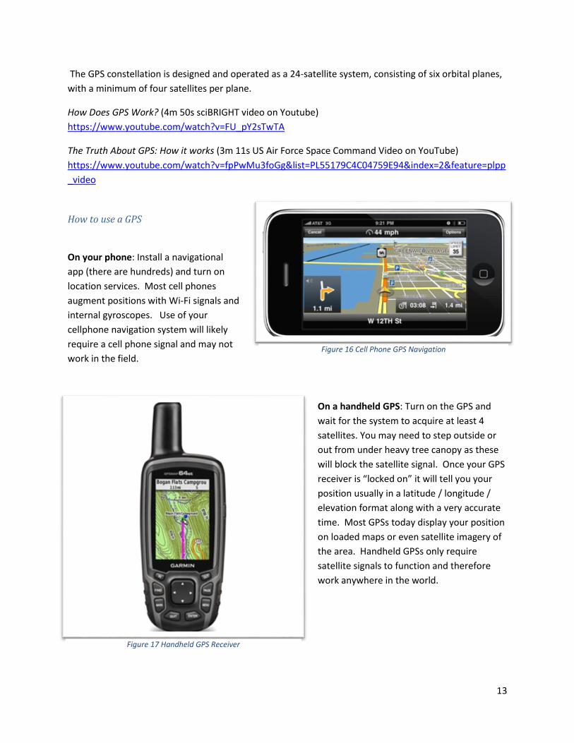
How to use a GPS
On your phone: Install a navigational
app (there are hundreds) and turn on
location services. Most cell phones
augment positions with Wi-Fi signals and
internal gyroscopes. Use of your
cellphone navigation system will likely
require a cell phone signal and may not
work in the field.
On a handheld GPS: Turn on the GPS and
wait for the system to acquire at least 4
satellites. You may need to step outside or
out from under heavy tree canopy as these
will block the satellite signal. Once your GPS
receiver is “locked on” it will tell you your
position usually in a latitude / longitude /
elevation format along with a very accurate
time. Most GPSs today display your position
on loaded maps or even satellite imagery of
the area. Handheld GPSs only require
satellite signals to function and therefore
work anywhere in the world.
Figure 16 Cell Phone GPS Navigation
Figure 17 Handheld GPS Receiver
14
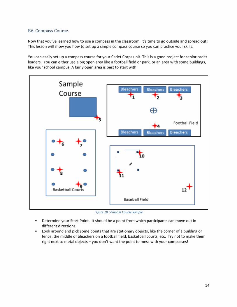
B6. Compass Course. Now that you’ve learned how to use a compass in the classroom, it’s time to go outside and spread out! This lesson will show you how to set up a simple compass course so you can practice your skills. You can easily set up a compass course for your Cadet Corps unit. This is a good project for senior cadet leaders. You can either use a big open area like a football field or park, or an area with some buildings, like your school campus. A fairly open area is best to start with.
Figure 18 Compass Course Sample
• Determine your Start Point. It should be a point from which participants can move out in different directions.
• Look around and pick some points that are stationary objects, like the corner of a building or fence, the middle of bleachers on a football field, basketball courts, etc. Try not to make them right next to metal objects – you don’t want the point to mess with your compasses!
15
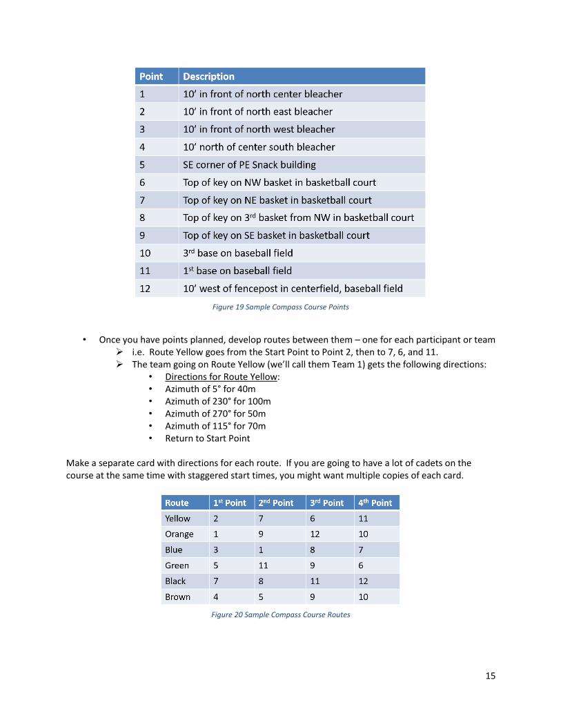
Figure 19 Sample Compass Course Points
• Once you have points planned, develop routes between them – one for each participant or team
➢ i.e. Route Yellow goes from the Start Point to Point 2, then to 7, 6, and 11. ➢ The team going on Route Yellow (we’ll call them Team 1) gets the following directions:
• Directions for Route Yellow: • Azimuth of 5° for 40m • Azimuth of 230° for 100m • Azimuth of 270° for 50m • Azimuth of 115° for 70m • Return to Start Point
Make a separate card with directions for each route. If you are going to have a lot of cadets on the course at the same time with staggered start times, you might want multiple copies of each card.
Figure 20 Sample Compass Course Routes
16
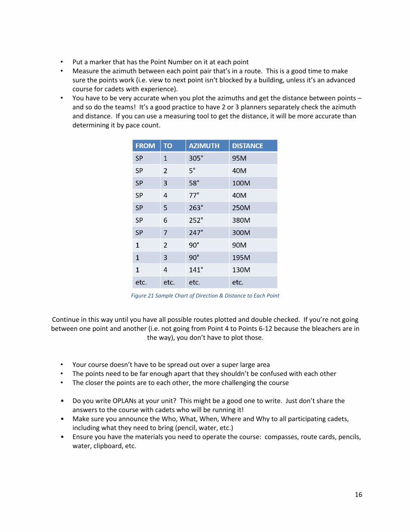
• Put a marker that has the Point Number on it at each point • Measure the azimuth between each point pair that’s in a route. This is a good time to make
sure the points work (i.e. view to next point isn’t blocked by a building, unless it’s an advanced course for cadets with experience).
• You have to be very accurate when you plot the azimuths and get the distance between points – and so do the teams! It’s a good practice to have 2 or 3 planners separately check the azimuth and distance. If you can use a measuring tool to get the distance, it will be more accurate than determining it by pace count.
Figure 21 Sample Chart of Direction & Distance to Each Point
Continue in this way until you have all possible routes plotted and double checked. If you’re not going between one point and another (i.e. not going from Point 4 to Points 6-12 because the bleachers are in
the way), you don’t have to plot those.
• Your course doesn’t have to be spread out over a super large area • The points need to be far enough apart that they shouldn’t be confused with each other • The closer the points are to each other, the more challenging the course • Do you write OPLANs at your unit? This might be a good one to write. Just don’t share the
answers to the course with cadets who will be running it! • Make sure you announce the Who, What, When, Where and Why to all participating cadets,
including what they need to bring (pencil, water, etc.) • Ensure you have the materials you need to operate the course: compasses, route cards, pencils,
water, clipboard, etc.
17
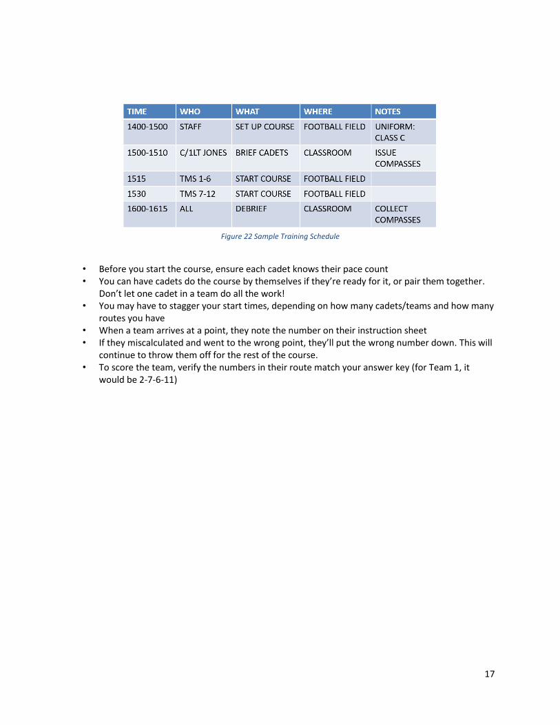
Figure 22 Sample Training Schedule
• Before you start the course, ensure each cadet knows their pace count • You can have cadets do the course by themselves if they’re ready for it, or pair them together.
Don’t let one cadet in a team do all the work! • You may have to stagger your start times, depending on how many cadets/teams and how many
routes you have • When a team arrives at a point, they note the number on their instruction sheet • If they miscalculated and went to the wrong point, they’ll put the wrong number down. This will
continue to throw them off for the rest of the course. • To score the team, verify the numbers in their route match your answer key (for Team 1, it
would be 2-7-6-11)
18
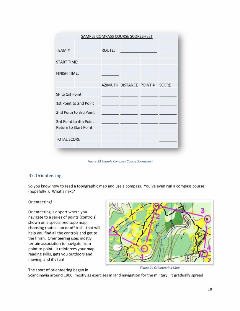
Figure 23 Sample Compass Course Scoresheet
B7. Orienteering. So you know how to read a topographic map and use a compass. You’ve even run a compass course (hopefully!). What’s next? Orienteering!
Orienteering is a sport where you navigate to a series of points (controls) shown on a specialized topo map, choosing routes - on or off trail - that will help you find all the controls and get to the finish. Orienteering uses mostly terrain association to navigate from point to point. It reinforces your map reading skills, gets you outdoors and moving, and it’s fun! The sport of orienteering began in Scandinavia around 1900, mostly as exercises in land navigation for the military. It gradually spread
Figure 24 Orienteering Map
19
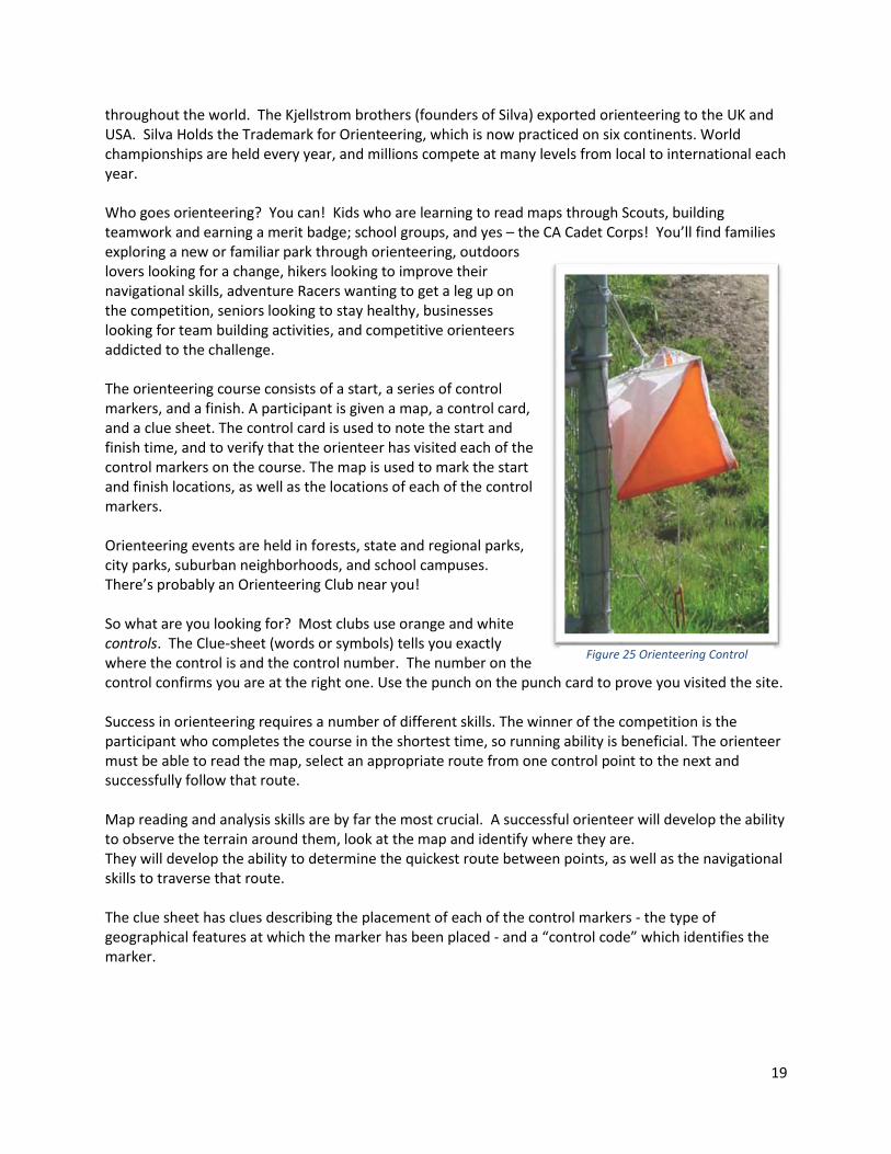
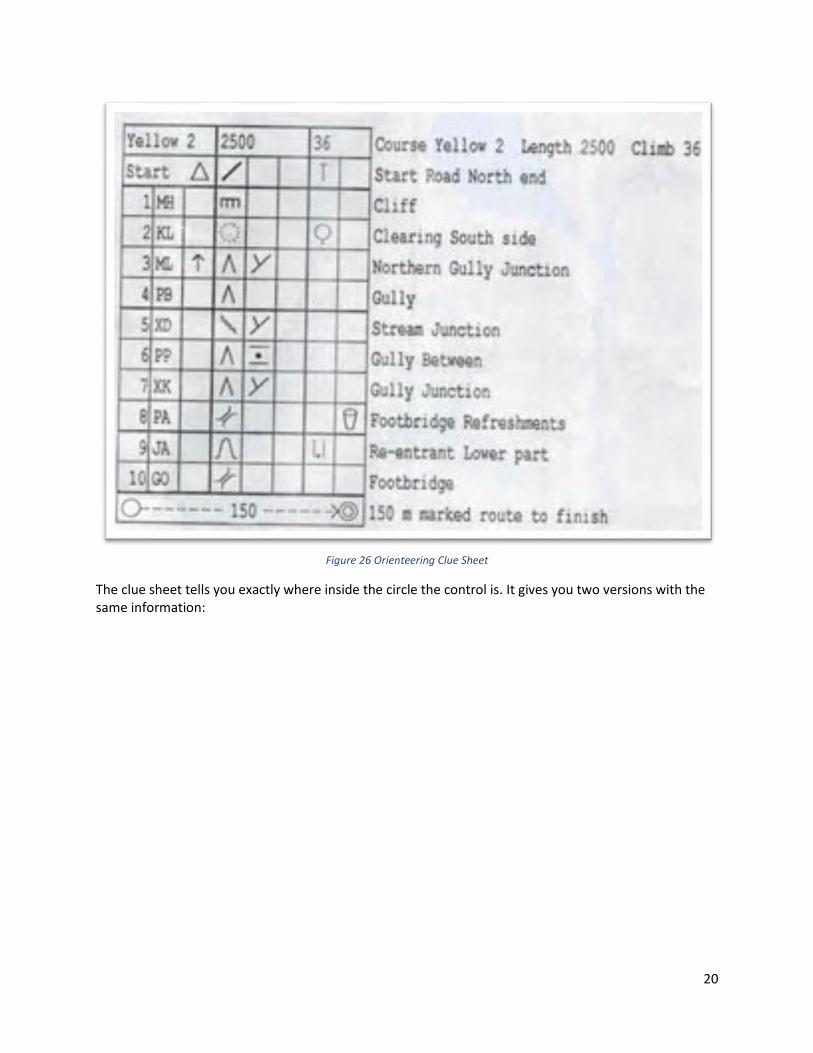
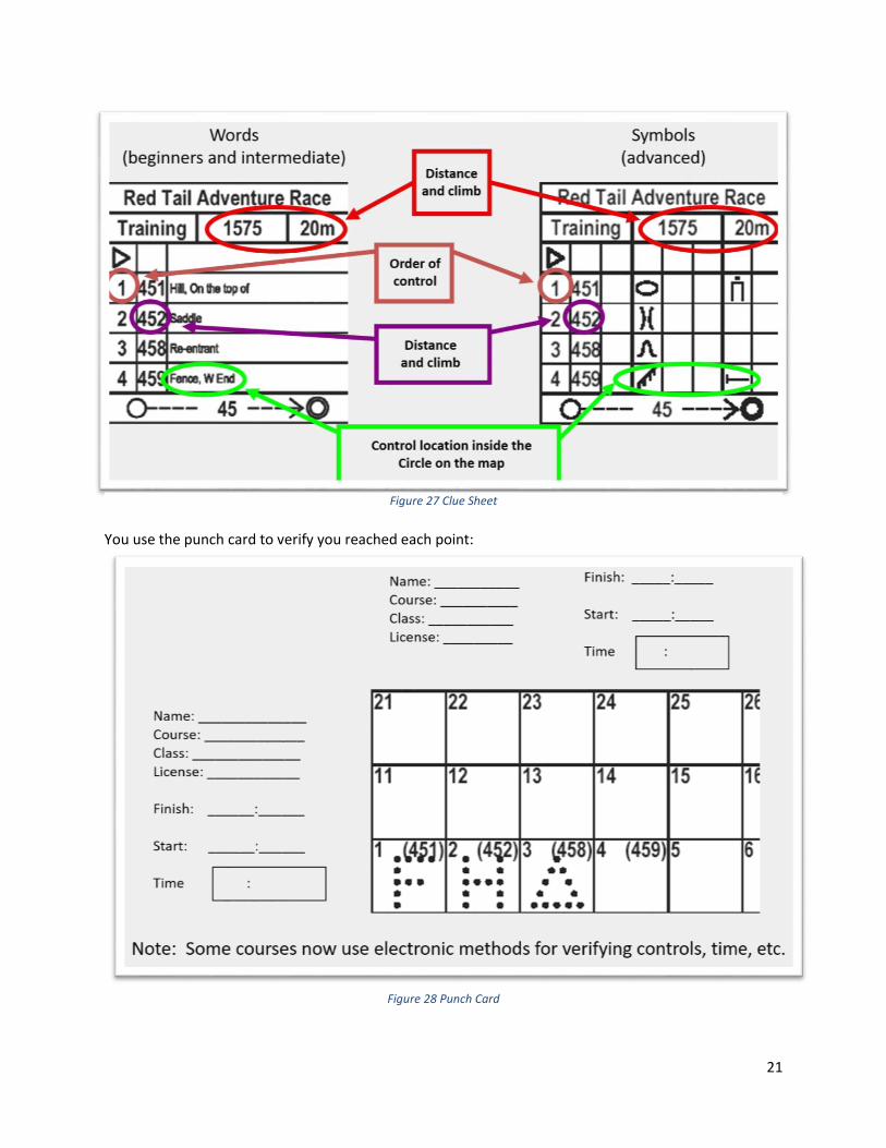
throughout the world. The Kjellstrom brothers (founders of Silva) exported orienteering to the UK and USA. Silva Holds the Trademark for Orienteering, which is now practiced on six continents. World championships are held every year, and millions compete at many levels from local to international each year. Who goes orienteering? You can! Kids who are learning to read maps through Scouts, building teamwork and earning a merit badge; school groups, and yes – the CA Cadet Corps! You’ll find families exploring a new or familiar park through orienteering, outdoors lovers looking for a change, hikers looking to improve their navigational skills, adventure Racers wanting to get a leg up on the competition, seniors looking to stay healthy, businesses looking for team building activities, and competitive orienteers addicted to the challenge. The orienteering course consists of a start, a series of control markers, and a finish. A participant is given a map, a control card, and a clue sheet. The control card is used to note the start and finish time, and to verify that the orienteer has visited each of the control markers on the course. The map is used to mark the start and finish locations, as well as the locations of each of the control markers. Orienteering events are held in forests, state and regional parks, city parks, suburban neighborhoods, and school campuses. There’s probably an Orienteering Club near you! So what are you looking for? Most clubs use orange and white controls. The Clue-sheet (words or symbols) tells you exactly where the control is and the control number. The number on the control confirms you are at the right one. Use the punch on the punch card to prove you visited the site. Success in orienteering requires a number of different skills. The winner of the competition is the participant who completes the course in the shortest time, so running ability is beneficial. The orienteer must be able to read the map, select an appropriate route from one control point to the next and successfully follow that route. Map reading and analysis skills are by far the most crucial. A successful orienteer will develop the ability to observe the terrain around them, look at the map and identify where they are. They will develop the ability to determine the quickest route between points, as well as the navigational skills to traverse that route. The clue sheet has clues describing the placement of each of the control markers - the type of geographical features at which the marker has been placed - and a “control code” which identifies the marker.
Figure 25 Orienteering Control
20
Figure 26 Orienteering Clue Sheet
The clue sheet tells you exactly where inside the circle the control is. It gives you two versions with the same information:
21
You use the punch card to verify you reached each point:
Figure 28 Punch Card
Figure 27 Clue Sheet
22
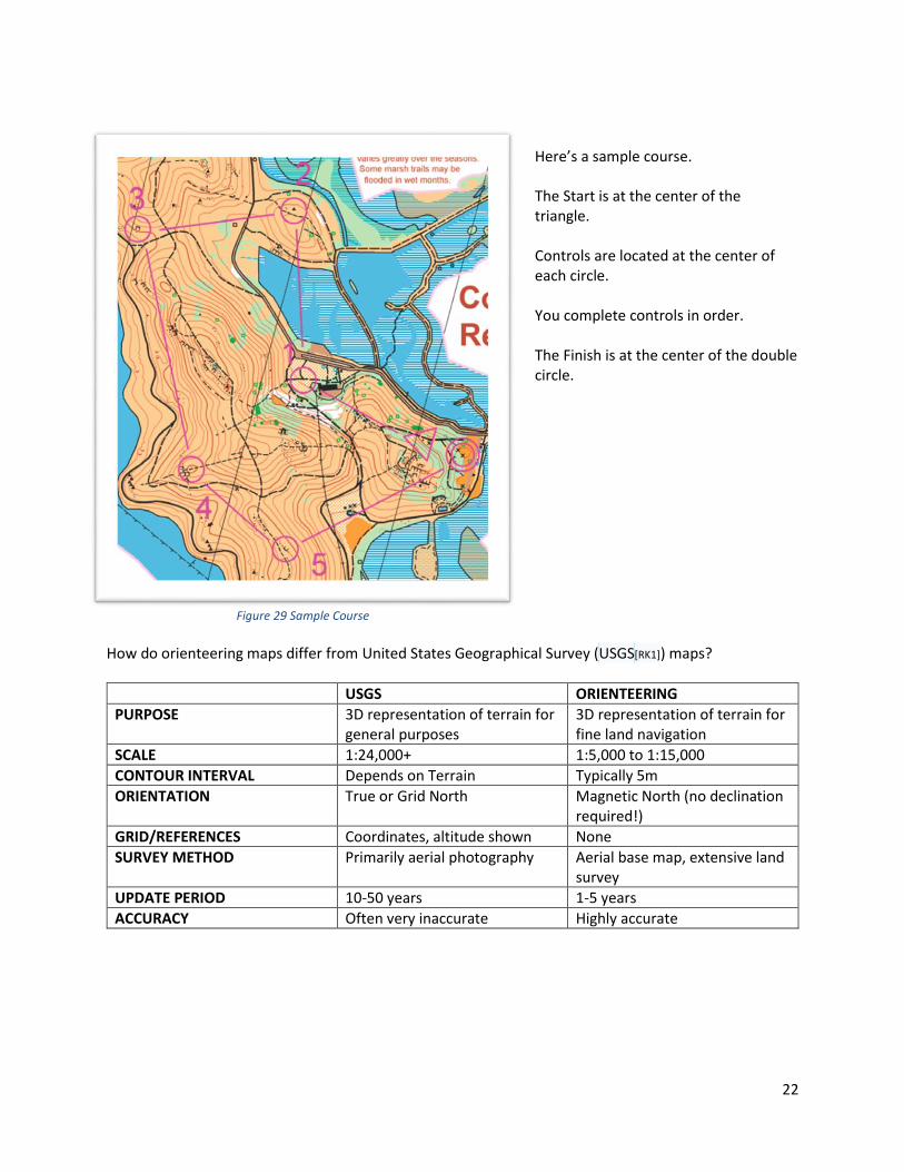
Here’s a sample course. The Start is at the center of the triangle. Controls are located at the center of each circle. You complete controls in order. The Finish is at the center of the double circle.
How do orienteering maps differ from United States Geographical Survey (USGS[RK1]) maps?
USGS ORIENTEERING
PURPOSE 3D representation of terrain for general purposes
3D representation of terrain for fine land navigation
SCALE 1:24,000+ 1:5,000 to 1:15,000
CONTOUR INTERVAL Depends on Terrain Typically 5m
ORIENTATION True or Grid North Magnetic North (no declination required!)
GRID/REFERENCES Coordinates, altitude shown None
SURVEY METHOD Primarily aerial photography Aerial base map, extensive land survey
UPDATE PERIOD 10-50 years 1-5 years
ACCURACY Often very inaccurate Highly accurate
Figure 29 Sample Course
23
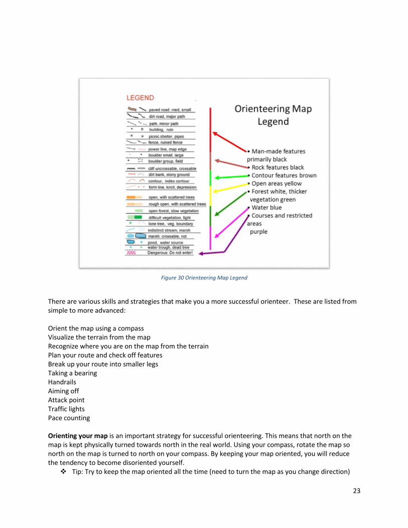
Figure 30 Orienteering Map Legend
There are various skills and strategies that make you a more successful orienteer. These are listed from simple to more advanced: Orient the map using a compass Visualize the terrain from the map Recognize where you are on the map from the terrain Plan your route and check off features Break up your route into smaller legs Taking a bearing Handrails Aiming off Attack point Traffic lights Pace counting Orienting your map is an important strategy for successful orienteering. This means that north on the map is kept physically turned towards north in the real world. Using your compass, rotate the map so north on the map is turned to north on your compass. By keeping your map oriented, you will reduce the tendency to become disoriented yourself.
❖ Tip: Try to keep the map oriented all the time (need to turn the map as you change direction)
24
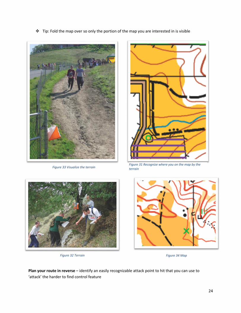
❖ Tip: Fold the map over so only the portion of the map you are interested in is visible
Plan your route in reverse – identify an easily recognizable attack point to hit that you can use to
‘attack’ the harder to find control feature
Figure 33 Visualize the terrain Figure 31 Recognize where you on the map by the terrain
Figure 32 Terrain Figure 34 Map
25
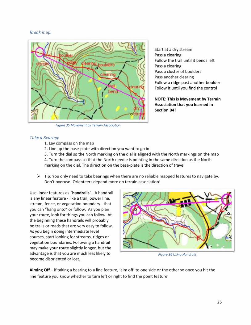
Break it up:
Start at a dry stream Pass a clearing Follow the trail until it bends left Pass a clearing Pass a cluster of boulders Pass another clearing Follow a ridge past another boulder Follow it until you find the control NOTE: This is Movement by Terrain Association that you learned in Section B4!
Take a Bearing:
1. Lay compass on the map 2. Line up the base-plate with direction you want to go in 3. Turn the dial so the North marking on the dial is aligned with the North markings on the map 4. Turn the compass so that the North needle is pointing in the same direction as the North marking on the dial. The direction on the base-plate is the direction of travel
➢ Tip: You only need to take bearings when there are no reliable mapped features to navigate by.
Don’t overuse! Orienteers depend more on terrain association! Use linear features as “handrails”. A handrail is any linear feature - like a trail, power line, stream, fence, or vegetation boundary - that you can “hang onto” or follow. As you plan your route, look for things you can follow. At the beginning these handrails will probably be trails or roads that are very easy to follow. As you begin doing intermediate level courses, start looking for streams, ridges or vegetation boundaries. Following a handrail may make your route slightly longer, but the advantage is that you are much less likely to become disoriented or lost.
Aiming Off – if taking a bearing to a line feature, ‘aim off’ to one side or the other so once you hit the
line feature you know whether to turn left or right to find the point feature
Figure 35 Movement by Terrain Association
Figure 36 Using Handrails
26
Traffic-light approach
– Go fast (green) when looking for large, easy to identify features (a
major trail junction
– Go steady (yellow) when looking for smaller, harder to identify features
– Go slow (red) when looking for small, easily missed features
Pace counting – when the terrain is vague and you want to ensure you don’t go too far/stop too early.
This really slows you down, so you should only do it when you’re not sure about the terrain.
There are different levels of course, differentiated by color: • White – beginners’ courses, follow trails and other linear features. Good for first timers and kids
age ~9-12. 1.5 – 3.0km • Yellow – controls in less obvious locations, more off-
trail. A great next step after successfully trying white course. 2-4km
• Orange – Intermediate controls that require cross-country travel. Can be quite challenging, physically and mentally.
• Brown, Green, Red, Blue – Advanced courses with the most demanding navigational requirements. NOT RECOMMENDED until some success with orange.
• Different lengths from Brown up to Blue (longest)
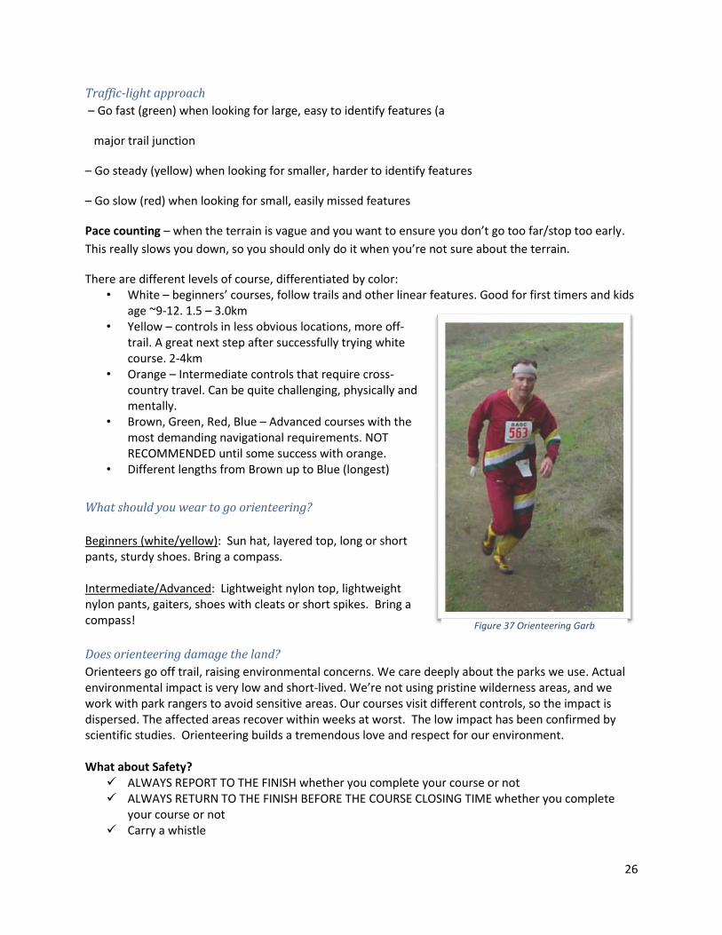
What should you wear to go orienteering?
Beginners (white/yellow): Sun hat, layered top, long or short pants, sturdy shoes. Bring a compass. Intermediate/Advanced: Lightweight nylon top, lightweight nylon pants, gaiters, shoes with cleats or short spikes. Bring a compass!
Does orienteering damage the land?
Orienteers go off trail, raising environmental concerns. We care deeply about the parks we use. Actual environmental impact is very low and short-lived. We’re not using pristine wilderness areas, and we work with park rangers to avoid sensitive areas. Our courses visit different controls, so the impact is dispersed. The affected areas recover within weeks at worst. The low impact has been confirmed by scientific studies. Orienteering builds a tremendous love and respect for our environment. What about Safety?
✓ ALWAYS REPORT TO THE FINISH whether you complete your course or not ✓ ALWAYS RETURN TO THE FINISH BEFORE THE COURSE CLOSING TIME whether you complete
your course or not ✓ Carry a whistle
Figure 37 Orienteering Garb
27
✓ Know your limits (physical and navigational) and stay within them ✓ Take precautions if allergic to poison oak, bee stings, etc.
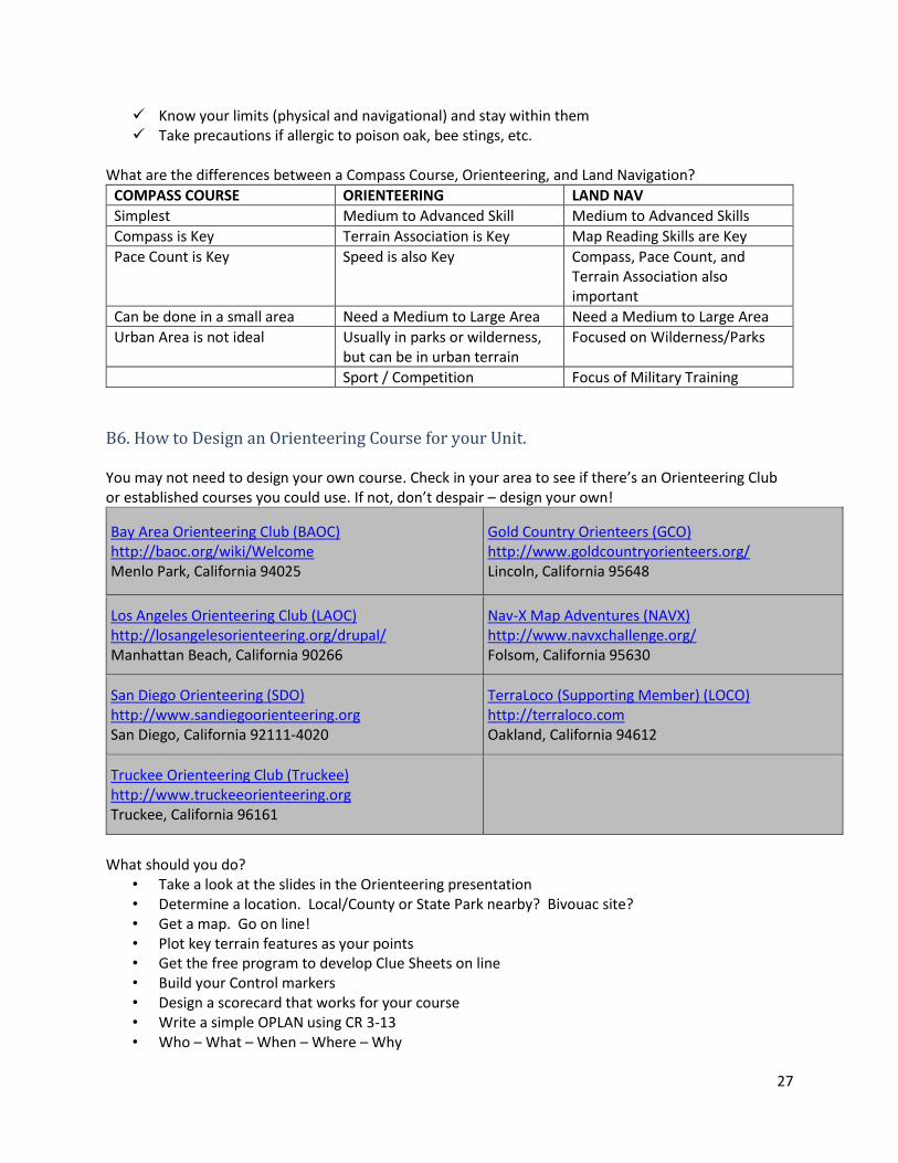
What are the differences between a Compass Course, Orienteering, and Land Navigation?
COMPASS COURSE ORIENTEERING LAND NAV
Simplest Medium to Advanced Skill Medium to Advanced Skills
Compass is Key Terrain Association is Key Map Reading Skills are Key
Pace Count is Key Speed is also Key Compass, Pace Count, and Terrain Association also important
Can be done in a small area Need a Medium to Large Area Need a Medium to Large Area
Urban Area is not ideal Usually in parks or wilderness, but can be in urban terrain
Focused on Wilderness/Parks
Sport / Competition Focus of Military Training
B6. How to Design an Orienteering Course for your Unit. You may not need to design your own course. Check in your area to see if there’s an Orienteering Club or established courses you could use. If not, don’t despair – design your own!
Bay Area Orienteering Club (BAOC) http://baoc.org/wiki/Welcome Menlo Park, California 94025
Gold Country Orienteers (GCO) http://www.goldcountryorienteers.org/ Lincoln, California 95648
Los Angeles Orienteering Club (LAOC) http://losangelesorienteering.org/drupal/ Manhattan Beach, California 90266
Nav-X Map Adventures (NAVX) http://www.navxchallenge.org/ Folsom, California 95630
San Diego Orienteering (SDO) http://www.sandiegoorienteering.org San Diego, California 92111-4020
TerraLoco (Supporting Member) (LOCO) http://terraloco.com Oakland, California 94612
Truckee Orienteering Club (Truckee) http://www.truckeeorienteering.org Truckee, California 96161
What should you do?
• Take a look at the slides in the Orienteering presentation • Determine a location. Local/County or State Park nearby? Bivouac site? • Get a map. Go on line! • Plot key terrain features as your points • Get the free program to develop Clue Sheets on line • Build your Control markers • Design a scorecard that works for your course • Write a simple OPLAN using CR 3-13 • Who – What – When – Where – Why
28
➢ Our Battalion [RK2]is running an Orienteering Course at X Park on (date) to practice map skills and have fun.
• Get school authorization for an off-campus activity • Invite other students and teachers! • Come up with rewards for winners (maybe a local veterans organization could sponsor this)
Orienteering doesn’t take as much work to set up as the Compass Course. You don’t have to get direction and distance between points. You just need to make sure you set your points exactly where you put them on the map! The orienteers will find them by terrain association.
29
B8. Geocaching
Geocaching Overview: https://www.geocaching.com/play Geocaching in California: https://www.geocaching.com/local/default.aspx?state_id=5 The following article on Geocaching is from Wikipedia
Geocaching
International Geocaching Logo
Nicknames Caching, Treasure Hunting
First played May 3, 2000
Clubs Yes
Characteristics
Team
members Optional
Type Outdoor Recreation Activity
Equipment GPS receiver or GPS-enabled mobile
device, writing implement
30
Geocaching is an outdoor recreational activity, in which participants use a Global Positioning System
(GPS) receiver or mobile device and other navigational techniques to hide and seek containers, called
"geocaches" or "caches", at specific locations marked by coordinates all over the world.
A typical cache is a small waterproof container containing a logbook and sometimes a pen or pencil. The
geocacher enters the date they found it and signs it with their established code name, in order to prove
that they found it. After signing the log, the cache must be placed back exactly where the person found
it. Larger containers such as plastic storage containers (Tupperware or similar) or ammunition boxes can
also contain items for trading, such as toys or trinkets, usually of more sentimental worth than financial.
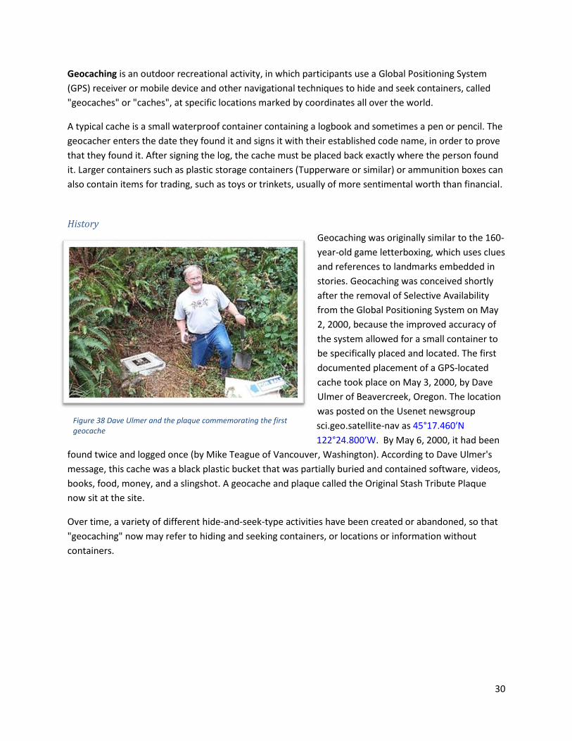
History
Geocaching was originally similar to the 160-
year-old game letterboxing, which uses clues
and references to landmarks embedded in
stories. Geocaching was conceived shortly
after the removal of Selective Availability
from the Global Positioning System on May
2, 2000, because the improved accuracy of
the system allowed for a small container to
be specifically placed and located. The first
documented placement of a GPS-located
cache took place on May 3, 2000, by Dave
Ulmer of Beavercreek, Oregon. The location
was posted on the Usenet newsgroup
sci.geo.satellite-nav as 45°17.460′N
122°24.800′W. By May 6, 2000, it had been
found twice and logged once (by Mike Teague of Vancouver, Washington). According to Dave Ulmer's
message, this cache was a black plastic bucket that was partially buried and contained software, videos,
books, food, money, and a slingshot. A geocache and plaque called the Original Stash Tribute Plaque
now sit at the site.
Over time, a variety of different hide-and-seek-type activities have been created or abandoned, so that
"geocaching" now may refer to hiding and seeking containers, or locations or information without
containers.
Figure 38 Dave Ulmer and the plaque commemorating the first geocache

31
Geocaches
For the traditional geocache, a geocacher will
place a waterproof container containing a log
book (with pen or pencil) and trade items or
trackables, then record the cache's coordinates.
These coordinates, along with other details of the
location, are posted on a listing site (see list of
some sites below). Other geocachers obtain the
coordinates from that listing site and seek out the
cache using their GPS handheld receivers. The
finding geocachers record their exploits in the
logbook and online, but then must return the
cache to the same coordinates so that other
geocachers may find it. Geocachers are free to
take objects (except the logbook, pencil, or
stamp) from the cache in exchange for leaving
something of similar or higher value
Typical cache "treasures", also known in the geocaching
world as “swag” are not high in monetary value but may
hold personal value to the finder. Aside from the logbook,
common cache contents are unusual coins or currency,
small toys, ornamental buttons, CDs, or books. Although
not required, many geocachers decide to leave behind
signature items, such as personal Geocoins, pins, or craft
items, to mark their presence at the cache location.
Disposable cameras are popular as they allow for anyone
who found the cache to take a picture which can be
developed and uploaded to a Geocaching web site listed
below. Also common are objects that are moved from cache to cache called "hitchhikers", such as Travel
Bugs or Geocoins, whose travels may be logged and followed online. Cachers who initially place a Travel
Bug or Geocoins often assign specific goals for their trackable items. Examples of goals are to be placed
in a certain cache a long distance from home, or to travel to a certain country, or to travel faster and
farther than other hitchhikers in a race. Less common trends are site-specific information pages about
the historic significance of the site, types of trees, birds in the area or other such information. Higher-
value items are occasionally included in geocaches as a reward for the First to Find (called "FTF"), or in
locations which are harder to reach. Dangerous or illegal items, weapons, food and drugs are not
allowed and are specifically against the rules of most geocache listing sites.
Figure 39 A classic geocache – trade items in a military ammunition box
Figure 40 A Smokey Bear Geocoin

32
If a geocache has been vandalized or stolen, it is said to have been "muggled". The former term plays off
the fact that those not familiar with geocaching are called muggles, a term borrowed from the Harry
Potter series of books which was rising in popularity at the same time geocaching got its start.
(Wikipedia, The Free Encyclopedia, 2017)

33
REFERENCES
References
Wikipedia, The Free Encyclopedia. (2017, May 8). Geocaching. Retrieved from Wikipedia:
https://en.wikipedia.org/w/index.php?title=Geocaching&oldid=771717033