Embed Size (px)
Citation preview

Developing the Road Asset Management System (RAMS) for Myanmar
Roadroid Workshop in Bangkok 13.11.2014
Jukka Torniainen, Team Leader / Highway Engineer

Background
The total road length in Myanmar is 150 000 km. More than 80% of all freight transport and passenger traffic is using the road network.
The Ministry of Construction (MOC) is responsible for the maintenance and development of the most important part of the road network. This includes all types of roads from tracks to 600 km long 4-lane express highway connecting Yangon, Nay Pyi Taw and Mandalay.
MOC road network, totally 40 000 km, is divided into national roads, which are financed by Union budget and regional roads, which are financed by Regional Government budgets.
MOC with the assistance of ADB is now developing a RAMS tool to better manage the existing road network.

Major road network in Myanmar
Total road network 150 000 km
MOC road network 40 000 km
- 20 000 km national roads
- 20 000 km provincial roads
50% are paved

MAIN STEPS FOR DEVELOPING RAMS
�To carry out the detailed inventory and surveying of the road network
�To establish a system to store the collected and surveyed information
�To develop a road network management system

COMPONENTS OF RAMS
Raw Data (collected, surveyed)
RDB (Road Data Base)
HDM-4 (Highway Development and Management)
GIS (Geographic Information System)

FROM DATA TO KNOWLEDGE
tcsuftvufrSA[kokw
odkhf
DATAtcsuftvuf
INFORMATIONowif;tcsuftvuf
GOOD ROADS aumif;aomvrf;r
sm;?
KNOWLEDGE
A[kokw

IMPORTANCE OF INFORMATION
ta&;BuD;onfh owif;tcsuftvuf
No information
owif;tcsuftvufr&S
d
Old information
owif;tcsuftvufft
a[mif;New information
owif;tcsuftvuftopf

RAMS - Road Data Base
Road Database
Location Reference
System
Road inventory
Road condition:
- Roughness
- Surface defects
- Traffic speed
Traffic data
Unit costs
Features of roads
Parameters

ROADROID CONCEPT
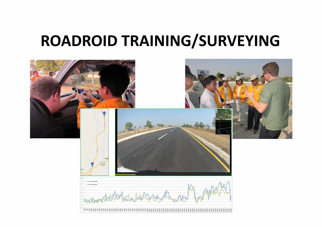
ROADROID TRAINING/SURVEYING

SURVEY PLANS
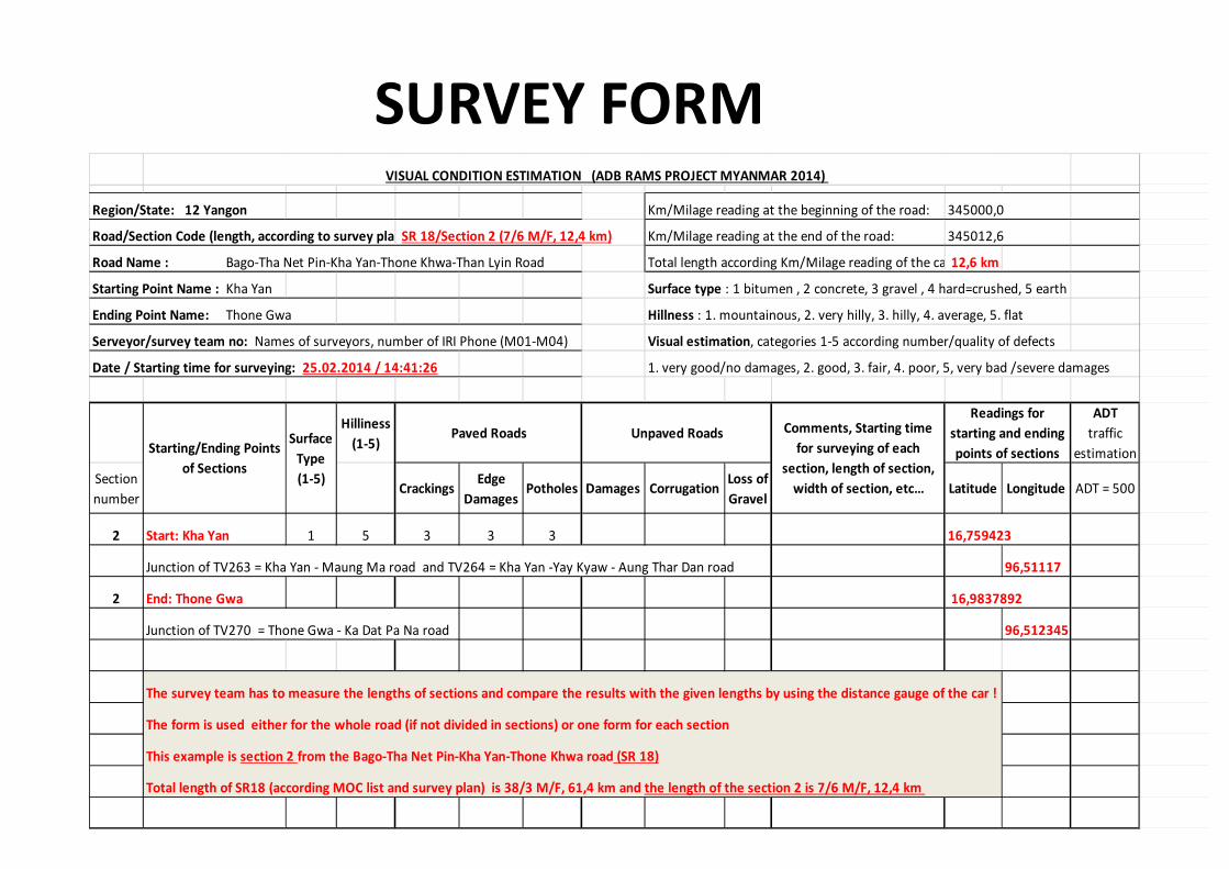
SURVEY FORM
Region/State: 12 Yangon Km/Milage reading at the beginning of the road: 345000,0
Road/Section Code (length, according to survey plan): SR 18/Section 2 (7/6 M/F, 12,4 km) Km/Milage reading at the end of the road: 345012,6
Road Name : Bago-Tha Net Pin-Kha Yan-Thone Khwa-Than Lyin Road Total length according Km/Milage reading of the car : 12,6 km
Starting Point Name : Kha Yan Surface type : 1 bitumen , 2 concrete, 3 gravel , 4 hard=crushed, 5 earth
Ending Point Name: Thone Gwa Hillness : 1. mountainous, 2. very hilly, 3. hilly, 4. average, 5. flat
Serveyor/survey team no: Names of surveyors, number of IRI Phone (M01-M04) Visual estimation, categories 1-5 according number/quality of defects
Date / Starting time for surveying: 25.02.2014 / 14:41:26 1. very good/no damages, 2. good, 3. fair, 4. poor, 5, very bad /severe damages
Hilliness
(1-5)
ADT
traffic
estimation
Section
numberCrackings
Edge
DamagesPotholes Damages Corrugation
Loss of
GravelLatitude Longitude ADT = 500
2 Start: Kha Yan 1 5 3 3 3 16,759423
Junction of TV263 = Kha Yan - Maung Ma road and TV264 = Kha Yan -Yay Kyaw - Aung Thar Dan road 96,51117
2 End: Thone Gwa 16,9837892
Junction of TV270 = Thone Gwa - Ka Dat Pa Na road 96,512345
The survey team has to measure the lengths of sections and compare the results with the given lengths by using the distance gauge of the car !
The form is used either for the whole road (if not divided in sections) or one form for each section
This example is section 2 from the Bago-Tha Net Pin-Kha Yan-Thone Khwa road (SR 18)
Total length of SR18 (according MOC list and survey plan) is 38/3 M/F, 61,4 km and the length of the section 2 is 7/6 M/F, 12,4 km
Readings for
starting and ending
points of sections
Paved Roads Unpaved Roads
VISUAL CONDITION ESTIMATION (ADB RAMS PROJECT MYANMAR 2014)
Starting/Ending Points
of Sections
Surface
Type
(1-5)
Comments, Starting time
for surveying of each
section, length of section,
width of section, etc…

SURVEY AND DATA-INPUT
PLAN OCTOBER 2014 1 2 3 4 5 6 6
DATA INPUT PLAN
10 11
Magway Region
7 8 9
Aye Yar Waddy Region
52 4
SURVEY PROGRESS
SURVEY PROGRAM
3
DATA INPUT
112
Mon State
UPDATED PROGRAM FOR ROUGHNESS SURVEY AND DATA INPUT
Northern Shan State
Kayin State
Yangon Region
Bago Region
Mandalay Region
Thaninthaye Region
Nay Pyi Taw Region
Kayah State
Rakhine State
Kachin State
Chin State
Sagaing Region
Southern Shan State
Eastern Shan State
2014 2015

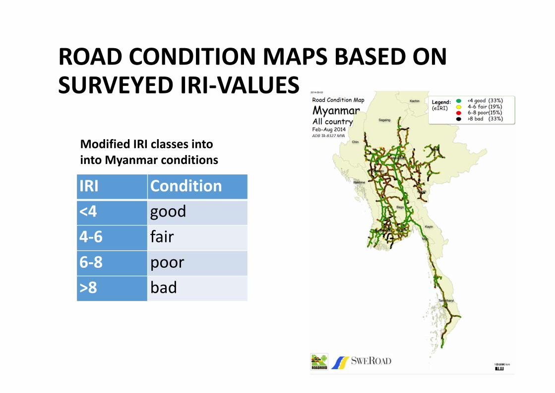
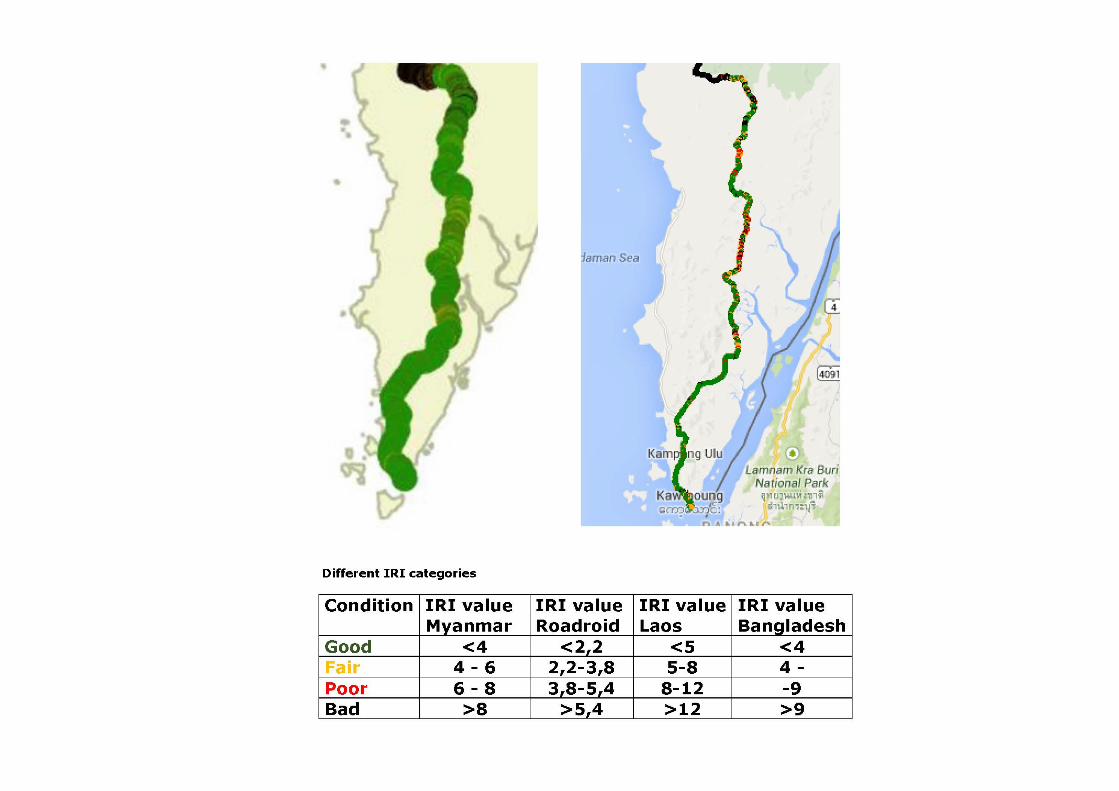
ROAD CONDITION MAPS BASED ONSURVEYED IRI-VALUES
IRI Condition
<4 good
4-6 fair
6-8 poor
>8 bad
Modified IRI classes into
into Myanmar conditions

Region/State Good Fair Poor Bad
Yangon 37% 22% 17% 24%
Bago 58% 16% 11% 15%
Mandalay/NPT 42% 19% 15% 25%
Mon (AH112) 60% 18% 10% 12%
Thaninthaye 31% 20% 15% 34%
Aye Yar Waddy 37% 18% 14% 32%
Magway 25% 18% 17% 40%
Kayah 13% 18% 20% 50%
Southern Shan 26% 21% 18% 36%
AVERAGE 33% 19% 15% 33%
CONDITION
DIVISION IN THE
SURVEYED
REGIONS/STATES


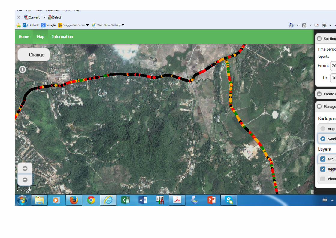

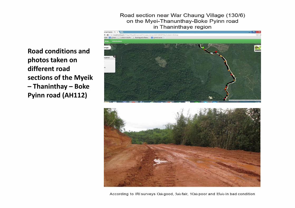
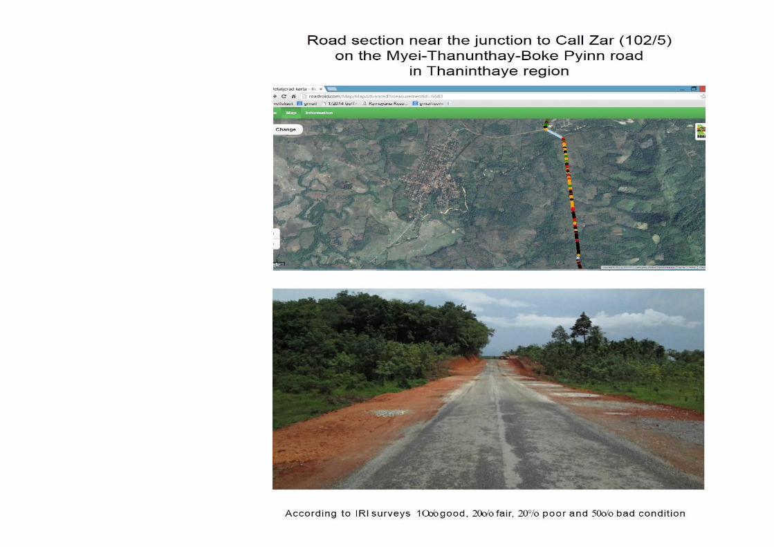
Road conditions and
photos taken on
different road
sections of the Myeik
– Thaninthay – Boke
Pyinn road (AH112)

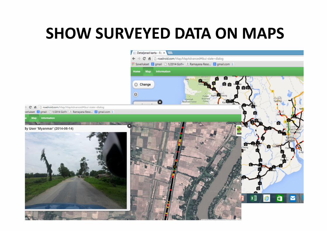
SHOW SURVEYED DATA ON MAPS
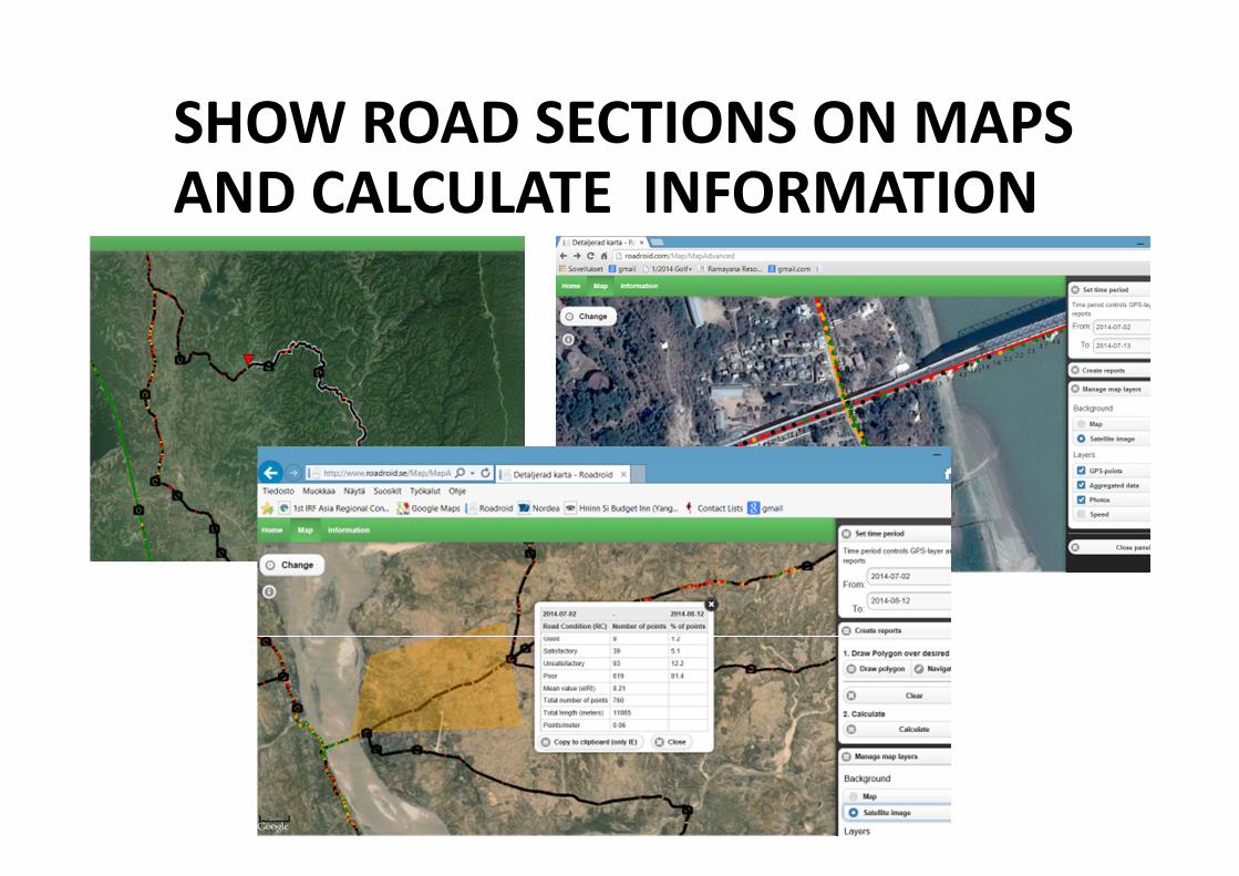
SHOW ROAD SECTIONS ON MAPS AND CALCULATE INFORMATION

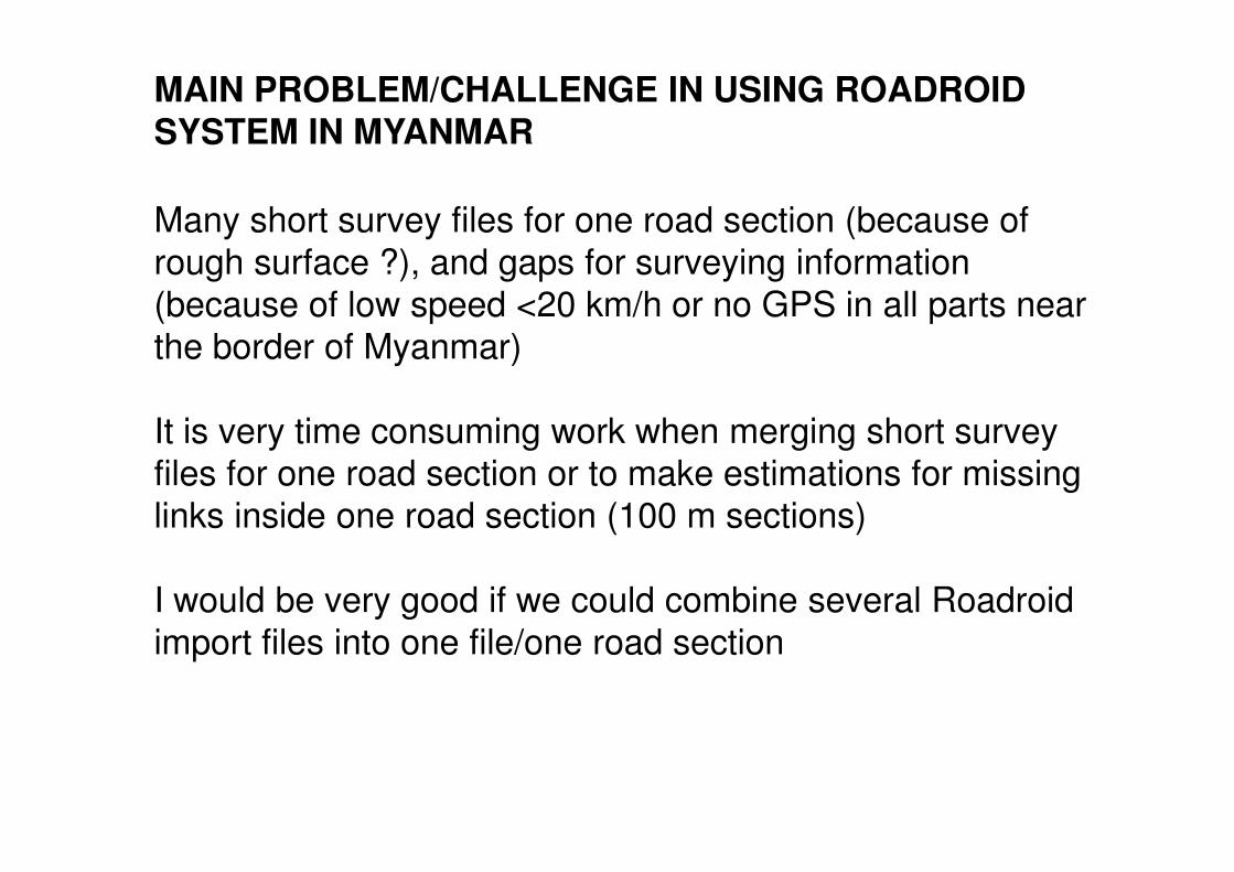
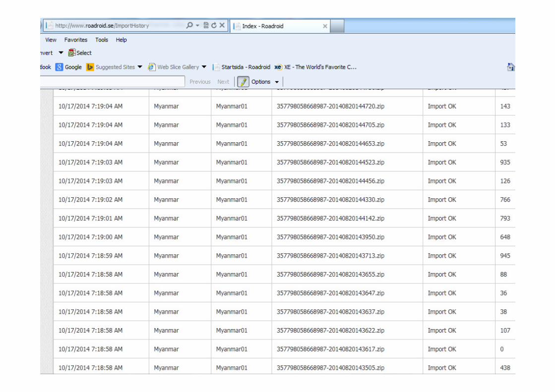
MAIN PROBLEM/CHALLENGE IN USING ROADROID SYSTEM IN MYANMAR
Many short survey files for one road section (because of
rough surface ?), and gaps for surveying information
(because of low speed <20 km/h or no GPS in all parts near
the border of Myanmar)
It is very time consuming work when merging short survey
files for one road section or to make estimations for missing
links inside one road section (100 m sections)
I would be very good if we could combine several Roadroid
import files into one file/one road section