Embed Size (px)
Citation preview
DEVLEOPING A SPATIO-TEMPORAL DATA MODEL FOR AN EXPLORATORY STUDY ON THE LAND USE-TRANSPORTATION INTERACTION: A TEMPORAL GIS ATTEMP
Xiaohong Xin*, Shi-Lung Shaw**, Hui Lin*
*The Chinese University of Hong Kong, Hong Kong **The University of Tennessee, Knoxville, USA
ABSTRACT While GIS (Geographic Information Systems) are equipped with exploratory analysis for spatial patterns, there are few tools available for the analysis of spatio-temporal data in terms of their spatial patterns and temporal patterns. Temporal GIS is proposed addressing the need by providing a promising method to explicitly reveal characteristics at a temporal scale with the originally available spatial scale. However, research on the temporal GIS over the last two decades has not seen a framework with spatio-temporal data models to be integrated into commercial GIS software. The lack of out-of-box temporal GIS functions makes the investigation of a spatio-temporal data model within a problem domain become possible. The paper targets on the exploration of the land use and transportation interaction. It is expected that a spatio-temporal data model designed and implemented for the land use and transportation interaction provides a basis as further provision of temporal GIS analysis functions for other problems. KEY WORDS: data model, temporal GIS, land use, transportation 1. INTRODUCTION
Bringing time into geography is not a new topic. David Harvey speculated that the basic tenet of the geographic thought was to have “a general theory in geography that examined the interaction between temporal process and spatial form” (Harvey, 1969 p. 484). In fact, since it is detrimental to explore spatial problems by ignoring how they change over time, geographers have been studying geographic phenomena through putting an emphasis on processes and their dynamic characteristics. A land use-transportation system is one of many examples which geographers study. How interaction between land use development and transportation improvements affects spatial patterns over time is of great interest. The land use-transportation system includes several relationships between a transport system, activities, land use, and accessibility. Land uses, such as residential, industrial or commercial, determine the locations of human activities such as living, working, shopping, education or leisure. Human activities in space require spatial interaction or trips in the transport system to overcome the distance between the locations of activities. Infrastructure in the transport system creates opportunities for spatial interaction and can be measured as accessibility. Accessibility in space co-determines location decisions and so results in changes of the land use system.
The effects of transportation system changes on land use, and vice versa, occur at varying spatial and temporal scales. For example, the construction of a new rail transit line tends to have large effects on land use changes along the transit line corridor and around the rail stations than on the urban area as a whole. A highway construction project may introduce a traffic increase shortly after its completion and lead to some land use changes in its immediate vicinity. However, its impacts on land use patterns at the regional scale may be insignificant in both short and long terms due to the relatively
1
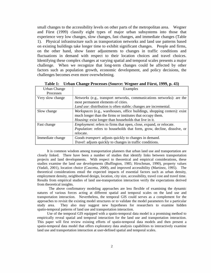
small changes to the accessibility levels on other parts of the metropolitan area. Wegner and Fürst (1999) classify eight types of major urban subsystems into those that experience very low changes, slow changes, fast changes, and immediate changes (Table 1). Physical infrastructure such as transportation networks and land use patterns based on existing buildings take longer time to exhibit significant changes. People and firms, on the other hand, show faster adjustments to changes in traffic conditions and fluctuations in demand with respect to their location choices and travel choices. Identifying these complex changes at varying spatial and temporal scales presents a major challenge. When we recognize that long-term changes could be affected by other factors such as population growth, economic development, and policy decisions, the challenges becomes even more overwhelming.
Table 1: Urban Change Processes (Source: Wegner and Fürst, 1999, p. 43)
Urban Change Processes
Examples
Very slow change Networks (e.g., transport networks, communications networks): are the most permanent elements of cities. Land use: distribution is often stable; changes are incremental.
Slow change Workspaces (e.g., warehouses, office buildings, shopping centers): exist much longer than the firms or institutes that occupy them. Housing: exist longer than households that live in it.
Fast change Employment: refers to firms that open, close, expand, or relocate. Population: refers to households that form, grow, decline, dissolve, or relocate.
Immediate change Goods transport: adjusts quickly to changes in demand. Travel: adjusts quickly to changes in traffic conditions.
It is common wisdom among transportation planners that urban land use and transportation are
closely linked. There have been a number of studies that identify links between transportation projects and land developments. With respect to theoretical and empirical considerations, these studies examine the land use developments (Buffington, 1985; Hirschman, 1990), property values (Vadali, 2001), location choice (Cascetta, 2000), and improved accessibility (Martinez, 1995). The theoretical considerations entail the expected impacts of essential factors such as urban density, employment density, neighborhood design, location, city size, accessibility, travel cost and travel time. Results from empirical studies of land use-transportation interaction verify the expectations derived from theoretical insights.
The above confirmatory modeling approaches are less flexible of examining the dynamic natures of various forces acting at different spatial and temporal scales on the land use and transportation interaction. Nevertheless, the temporal GIS could serves as a complement for the approaches to revisit the existing model structures or to validate the model parameters for a particular study area. They also may suggest new hypotheses for researchers to examine hidden spatio-temporal patterns of land use and transportation interaction.
Use of the temporal GIS equipped with a spatio-temporal data model is a promising method to empirically reveal spatial and temporal interaction for the land use and transportation interaction. This paper will first review existing efforts of spatio-temporal data models and then present a spatio-temporal data model that offers exploratory data analysis capabilities to interactively examine land use and transportation interaction at user-defined spatial and temporal scales.
2
2. SPATIAL DATA MODELS AND SPATIO-TEMPORAL DATA MODELS
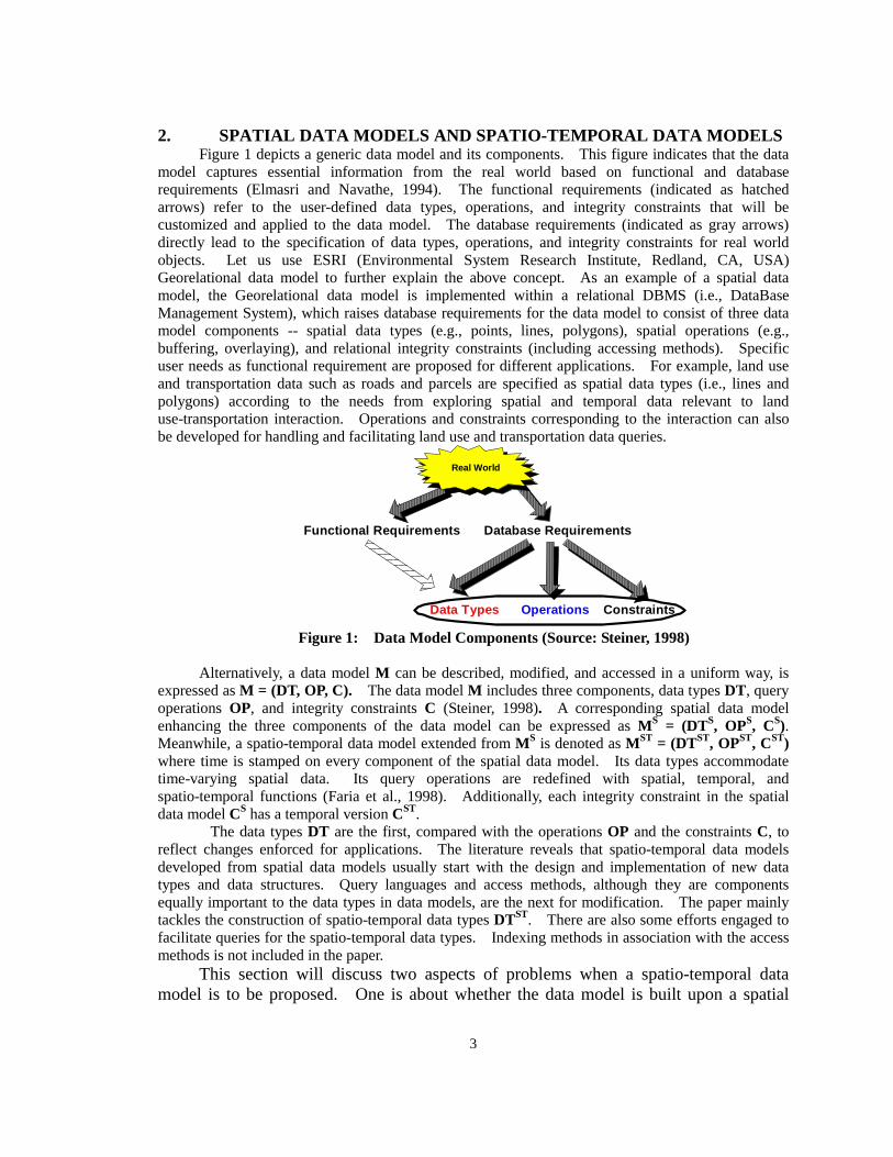
Figure 1 depicts a generic data model and its components. This figure indicates that the data model captures essential information from the real world based on functional and database requirements (Elmasri and Navathe, 1994). The functional requirements (indicated as hatched arrows) refer to the user-defined data types, operations, and integrity constraints that will be customized and applied to the data model. The database requirements (indicated as gray arrows) directly lead to the specification of data types, operations, and integrity constraints for real world objects. Let us use ESRI (Environmental System Research Institute, Redland, CA, USA) Georelational data model to further explain the above concept. As an example of a spatial data model, the Georelational data model is implemented within a relational DBMS (i.e., DataBase Management System), which raises database requirements for the data model to consist of three data model components -- spatial data types (e.g., points, lines, polygons), spatial operations (e.g., buffering, overlaying), and relational integrity constraints (including accessing methods). Specific user needs as functional requirement are proposed for different applications. For example, land use and transportation data such as roads and parcels are specified as spatial data types (i.e., lines and polygons) according to the needs from exploring spatial and temporal data relevant to land use-transportation interaction. Operations and constraints corresponding to the interaction can also be developed for handling and facilitating land use and transportation data queries.
Real World
Functional Requirements Database Requirements
Operations Constraints
Data Types
Figure 1: Data Model Components (Source: Steiner, 1998)
Alternatively, a data model M can be described, modified, and accessed in a uniform way, is expressed as M = (DT, OP, C). The data model M includes three components, data types DT, query operations OP, and integrity constraints C (Steiner, 1998). A corresponding spatial data model enhancing the three components of the data model can be expressed as MS = (DTS, OPS, CS). Meanwhile, a spatio-temporal data model extended from MS is denoted as MST = (DTST, OPST, CST) where time is stamped on every component of the spatial data model. Its data types accommodate time-varying spatial data. Its query operations are redefined with spatial, temporal, and spatio-temporal functions (Faria et al., 1998). Additionally, each integrity constraint in the spatial data model CS has a temporal version CST.
The data types DT are the first, compared with the operations OP and the constraints C, to reflect changes enforced for applications. The literature reveals that spatio-temporal data models developed from spatial data models usually start with the design and implementation of new data types and data structures. Query languages and access methods, although they are components equally important to the data types in data models, are the next for modification. The paper mainly tackles the construction of spatio-temporal data types DTST. There are also some efforts engaged to facilitate queries for the spatio-temporal data types. Indexing methods in association with the access methods is not included in the paper.
This section will discuss two aspects of problems when a spatio-temporal data model is to be proposed. One is about whether the data model is built upon a spatial
3
data model or a temporal model. The other is how to use timestamping methods to integrate time with spatial data types to form spatio-temporal data types. 2.1 The Temporal Extension of Spatial Data Models
Spatio-temporal data models may be developed through a spatial extension (i.e., adding the space component on top of a temporal data model) or a temporal extension (i.e., adding the time component on top of a spatial data model). Paton, et al. (2000) favor the spatial extension because the provision of a collection of spatial types within a temporal database yields a spatio-temporal data model that only requires extending the set of supported types (to include, say, points, lines, and polygon). By contrast, the temporal extension requires not only extending the set of supported types (instants and intervals), but also making provisions for all (or at least many) spatial data types to be associated with a history. Erwig (1999) also supports the spatial extension and mathematically proves that spatio-temporal objects are special cases of temporal objects. Meanwhile, temporal database research has contributed many proposals that facilitate the spatial extension (Dey et al., 1996).
While there are several groups (e.g., TimeCenter, National Technical University of Athens) conducting research on the spatial extension of temporal data models, an integrated support for spatial data in a temporal data model is still largely absent. In fact, the spatial extension has fewer implementations than the temporal extension according to the literature. Additionally, the temporal database technology that the spatial extension relies on is still under research and is not as well developed as the spatial database technology. The temporal extension of spatial models, therefore, is the research focus of this paper so that the exploration of adding the time component to a spatial data model may lead to an operational spatio-temporal data model.
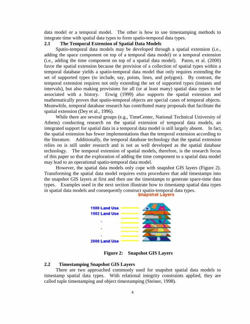
However, the spatial data models only cope with snapshot GIS layers (Figure 2). Transforming the spatial data model requires extra procedures that add timestamps into the snapshot GIS layers at first and then use the timestamps to generate space-time data types. Examples used in the next section illustrate how to timestamp spatial data types in spatial data models and consequently construct spatio-temporal data types.
Figure 2: Snapshot GIS Layers
2.2 Timestamping Snapshot GIS Layers There are two approached commonly used for snapshot spatial data models to
timestamp spatial data types. With relational integrity constraints applied, they are called tuple timestamping and object timestamping (Steiner, 1998).
4
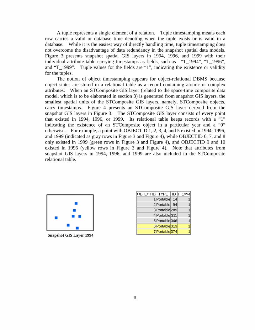
A tuple represents a single element of a relation. Tuple timestamping means each row carries a valid or database time denoting when the tuple exists or is valid in a database. While it is the easiest way of directly handling time, tuple timestamping does not overcome the disadvantage of data redundancy in the snapshot spatial data models. Figure 3 presents snapshot spatial GIS layers in 1994, 1996, and 1999 with their individual attribute table carrying timestamps as fields, such as “T_1994”, “T_1996”, and “T_1999”. Tuple values for the fields are “1”, indicating the existence or validity for the tuples.
The notion of object timestamping appears for object-relational DBMS because object states are stored in a relational table as a record containing atomic or complex attributes. When an STComposite GIS layer (related to the space-time composite data model, which is to be elaborated in section 3) is generated from snapshot GIS layers, the smallest spatial units of the STComposite GIS layers, namely, STComposite objects, carry timestamps. Figure 4 presents an STComposite GIS layer derived from the snapshot GIS layers in Figure 3. The STComposite GIS layer consists of every point that existed in 1994, 1996, or 1999. Its relational table keeps records with a “1” indicating the existence of an STComposite object in a particular year and a “0” otherwise. For example, a point with OBJECTID 1, 2, 3, 4, and 5 existed in 1994, 1996, and 1999 (indicated as gray rows in Figure 3 and Figure 4), while OBJECTID 6, 7, and 8 only existed in 1999 (green rows in Figure 3 and Figure 4), and OBJECTID 9 and 10 existed in 1996 (yellow rows in Figure 3 and Figure 4). Note that attributes from snapshot GIS layers in 1994, 1996, and 1999 are also included in the STComposite relational table.
Snapshot GIS Layer 1994
OBJECTID TYPE ID T 19941 Portable 14 12 Portable 94 13 Portable 289 14 Portable 311 15 Portable 346 16 Portable 313 17 Portable 374 1
5

Snapshot GIS Layer 1996
OBJECTID TYPE ID T 1996
1 Portable 14 12 Portable 94 13 Portable 289 14 Portable 311 15 Portable 346 1
Snapshot GIS Layer 1999
OBJECTID TYPE ID T_1999 1 Portable 14 1 2 Portable 94 1 3 Portable 289 1 4 Portable 311 1 5 Portable 346 1 6 Portable 347 1 7 Portable 348 1 8 Portable 406 1
Figure 3: Snapshot Spatial Data after Tuple Timestamping
OBJECTID TYPE_T1994 TYPE_T1996 TYPE_T1999 ID_T1994 ID_T1996 ID_T1999 T1994 T1996 T19991 Portable Portable Portable 14 14 14 1 1 12 Portable Portable Portable 94 94 94 1 1 13 Portable Portable Portable 289 289 289 1 1 14 Portable Portable Portable 311 311 311 1 1 15 Portable Portable Portable 346 346 346 1 1 16 Portable 347 0 0 17 Portable 348 0 0 18 Portable 406 0 0 19 Portable 313 1 0 0
10 Portable 374 1 0 0
Figure 4: STComposite Spatial Data after Object Timestamping 3. PREVIOUS RESEARCH ON SPATIO-TEMPORAL DATA MODELS
Means and ways are different when researchers specifically define spatio-temporal data types, spatio-temporal operations, and spatio-temporal constraints to form spatio-temporal data models. In general, they apply two approaches to altering the data model components. One approach not only alters data types, but also the other two components so that spatial data models may be extended or integrated to become spatio-temporal data models. By extension it is meant that the approach involves the development of either spatio-temporal operations or integrity constraints. By integration it is meant that every component of a data model is “tuned” for a spatio-temporal use. Modeling of Application Data with Spatio-temporal features (MADS) is an example extending spatial schemas for a spatio-temporal use (Parent et al., 1999). As an object-relational conceptual data model designed
6
in cooperation with applications related to land management or utility networks, MADS allows the specification of integrity rules for data models as well as relationships that define space and/or time-related semantics. There exists small comprehensive research for the integration of spatial data models into spatio-temporal data models. Nevertheless, there are several ongoing projects – CHOROCHRONOS by the European Union, TimeCenter by cooperative research groups of scientists from European Countries and the United States, and Spatial and Temporal Object Databases (2002) at Keele University, United Kingdom. Their research efforts cover many theoretical and practical issues. Since the extension and integration of the spatio-temporal data models involve many unsolved research topics, this paper is not going to further review that approach, but shift to the second approach, which tackles only the data types and represents spatio-temporal data types through available data type “date” from spatial data models and abstract data types. This approach forms the conceptual foundation on which this paper bases its proposed spatio-temporal data model. 3.1 Data Type “Date”
One easy way of developing spatio-temporal data types within spatial data models is to use data type “date.” Applications adopting the data type “date” are mostly built on relational or object-relational DBMSs. The data type “date” specifies user-defined time attributes and timestamp attributes in spatial data model schemas, which means that timestamps are defined either as attributes of a relational table or time instants assigned as a timestamp of a relational table (Armstrong, 1988; Clifford, 1983; Hunter and Williamson, 1990; Lum et al., 1984; Snodgrass and Ahn, 1985; Stickler et al., 1992). This method is simple, but it has problems in terms of its data maintenance and efficiency. The lack of direct query support for spatio-temporal data leads to complex query operations, which in turn results in the difficulty of maintaining the data model. It is also unable to solve data redundancy from the snapshot spatial data model, which manages time-varying spatial data with separate GIS layers. 3.2 Spatio-Temporal Abstract Data Types (ADT)
One of the basic ideas behind spatio-temporal data models is that, in addition to the normal built-in data type defined as “date”, user-defined types may also be employed. These types may be used in the same way as built-in types. For example, columns in relational tables may be defined as taking values of user-defined types, as well as built-in types. A user-defined Abstract Data Type (ADT) definition encapsulates attributes and operations in a single entity. An abstract data type (ADT) is defined by specifying a set of declarations of the stored attributes that represent the value of the ADT, the operations that define the equality and ordering relationships of the ADT, and the operations that define the behavior (and any virtual attributes) of the ADT. ADTs can also be defined as subtypes of other ADTs. A subtype inherits the structure and behavior of its supertypes (multiple inheritance is supported). Instances of ADTs can be persistently stored in the database by storing them in columns of tables. Points, line, and polygons in the Georelational data model are examples of spatial ADT stored in table columns. Spatio-temporal ADT is a research topic that attracts many researchers, and is represented by the Event-based Spatio-temporal Data Model, the STComposite data model, and the Worboys data model.
The Event-based Spatio-Temporal Data Model (ESTDM) (Peuquet, 1994; Peuquet and Wentz, 1994; Peuquet and Duan, 1995; Peuquet and Qian, 1995) represents dynamic geographic objects (Figure 5) through organizing changes under an event list that is composed of individual event entries. Each event entry has a time stamp and consists of a set of components. A component stores the new value of all grid cells that experienced changes of a specific attribute from ti-1 to ti and the locations of grid cells that changed to the new value. Run-length encoding is employed to store the locations of grid cells with changing values as token arrays in order to reduce the storage space requirement. Each grid cell is equivalent to the smallest spatial feature stored in the space-time composite model that permits the storage of its change history. The ESTDM also includes a header with a time stamp of t0 pointing to the base raster layer of the initial state of the entire study area. This design allows the ESTDM to record only amendments with respect to the initial and previous states. ESTDM has several shortcomings. ESTDM is developed only for raster-based GIS. It might be insufficient to meet needs from applications requiring vector topology. Moreover, ESTDM relies on ADT 7

programming for building the event lists. The integration of the event list with DBMSs needs sophisticated programming skills.
Figure 5: Event-Based Spatio-Temporal Data Model (ESTDM) (Source: Peuquet
and Duan, 1995)
The Space-Time Composite (STComposite) data model (Langran and Chrisman 1988, Langran 1992) improves the snapshot spatial data model by combining separate GIS layers representing different time points into a single STComposite GIS layer of all changes that have occurred over all time periods. Each record of the STComposite GIS layer represents the smallest geographic unit that experienced changes in history and is assigned with time stamps to keep track of its changes over time. For example, Figure 6 shows an STComposite GIS layer that combines the land-use parcels of T1, T2, T3, and T4. The time stamps indicate that the land parcel with a solid color existed as a rural land-use type all the time and the one with a crossed hatch changed to urban land-use from rural land use starting at T2. Implementing STComposite GIS layers does not need extra procedures on ADT programming. The smallest geographic units, in comparison with the event list unit, gain spatial intactness over a span of time, but lose an ESTDM feature with the event lists carrying spatial information across areas of interest.
Figure 6: Spatio-Temporal Composite (STComposite) Data Model (Source: Langran, 1989)
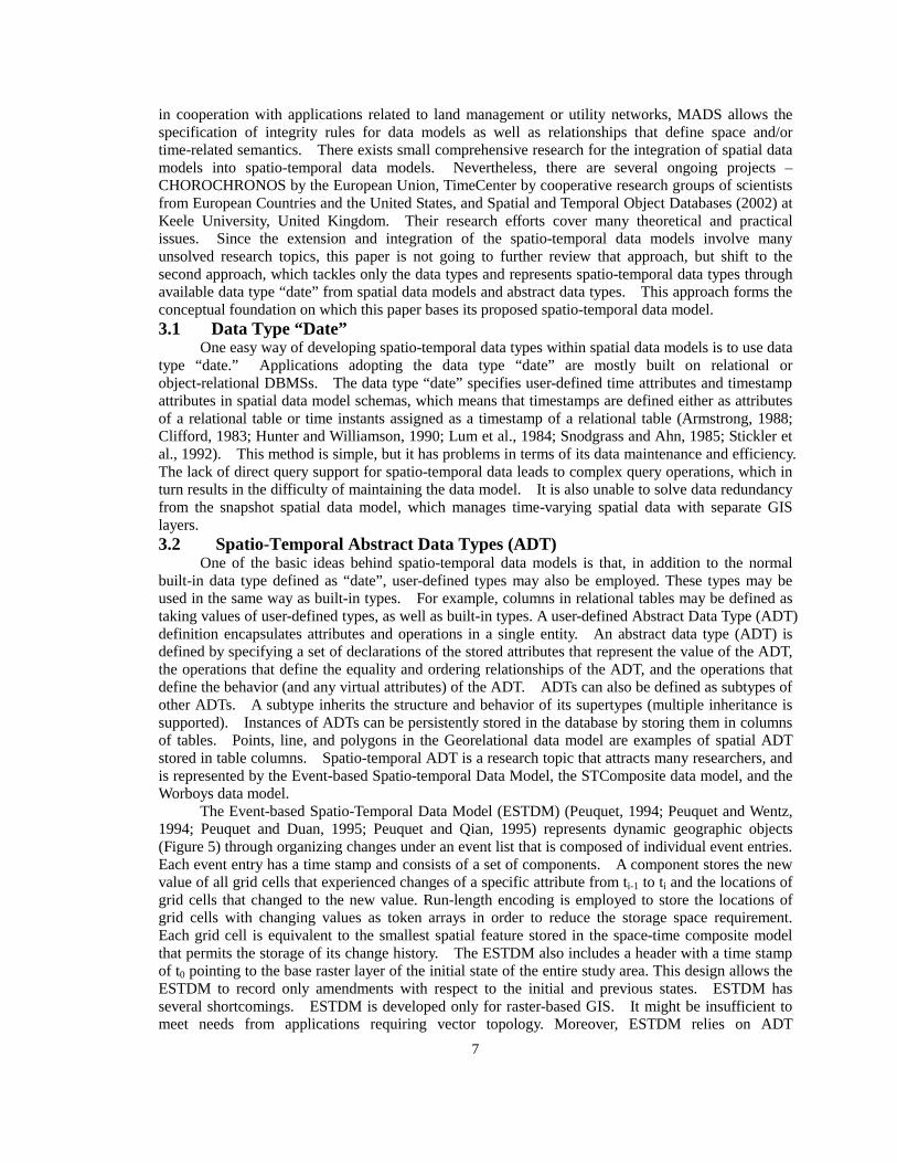
Worboy (1992 and 1994) proposes an object-oriented spatio-temporal data model that represents objects as two-dimensional spatial objects along with a third dimension for the event time associated with each object (Figure 7). Conceptually, Worboys data model combines the characteristics of ESTDM and STComposite data model in such a way that the data are organized along a temporal dimension (e.g. event lists) and a spatial dimension (e.g., smallest geographic units). The temporal dimension of Worboys data model, according to its definition, is orthogonal to the spatial dimension. The basic elements in the data model are spatio-temporal atoms that have homogeneous properties in both space and time. The spatio-temporal atoms (ST-atoms) form spatio-temporal objects (ST-objects) that represent changes of real world entities. The data model maintains persistent object identifiers for both ST-atoms and ST-objects in order to uniquely keep track of their associations and the changing history. Worboys (1998) later extended this approach to
8
a spatio-bitemporal model that includes both event time and database time as two orthogonal axes to record the existence of an object in the real world and in a database system, respectively.
Figure 7: ST-objects and ST-atoms in Worboys Data Model (Source: Worboys,
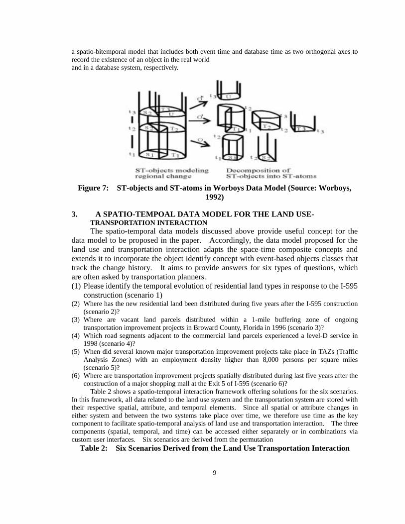
1992) 3. A SPATIO-TEMPOAL DATA MODEL FOR THE LAND USE-
TRANSPORTATION INTERACTION The spatio-temporal data models discussed above provide useful concept for the
data model to be proposed in the paper. Accordingly, the data model proposed for the land use and transportation interaction adapts the space-time composite concepts and extends it to incorporate the object identify concept with event-based objects classes that track the change history. It aims to provide answers for six types of questions, which are often asked by transportation planners. (1) Please identify the temporal evolution of residential land types in response to the I-595
construction (scenario 1) (2) Where has the new residential land been distributed during five years after the I-595 construction
(scenario 2)? (3) Where are vacant land parcels distributed within a 1-mile buffering zone of ongoing
transportation improvement projects in Broward County, Florida in 1996 (scenario 3)? (4) Which road segments adjacent to the commercial land parcels experienced a level-D service in
1998 (scenario 4)? (5) When did several known major transportation improvement projects take place in TAZs (Traffic
Analysis Zones) with an employment density higher than 8,000 persons per square miles (scenario 5)?
(6) Where are transportation improvement projects spatially distributed during last five years after the construction of a major shopping mall at the Exit 5 of I-595 (scenario 6)?
Table 2 shows a spatio-temporal interaction framework offering solutions for the six scenarios. In this framework, all data related to the land use system and the transportation system are stored with their respective spatial, attribute, and temporal elements. Since all spatial or attribute changes in either system and between the two systems take place over time, we therefore use time as the key component to facilitate spatio-temporal analysis of land use and transportation interaction. The three components (spatial, temporal, and time) can be accessed either separately or in combinations via custom user interfaces. Six scenarios are derived from the permutation
Table 2: Six Scenarios Derived from the Land Use Transportation Interaction
9
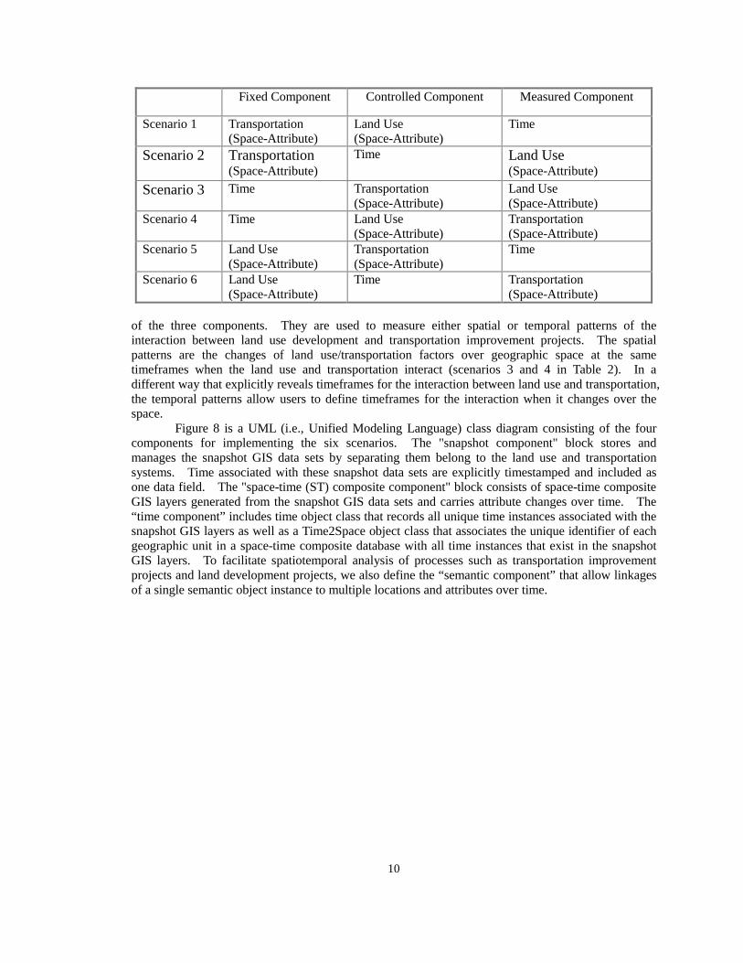
Fixed Component Controlled Component Measured Component
Scenario 1 Transportation (Space-Attribute)
Land Use (Space-Attribute)
Time
Scenario 2 Transportation (Space-Attribute)
Time Land Use (Space-Attribute)
Scenario 3 Time Transportation (Space-Attribute)
Land Use (Space-Attribute)
Scenario 4 Time Land Use (Space-Attribute)
Transportation (Space-Attribute)
Scenario 5 Land Use (Space-Attribute)
Transportation (Space-Attribute)
Time
Scenario 6 Land Use (Space-Attribute)
Time Transportation (Space-Attribute)
of the three components. They are used to measure either spatial or temporal patterns of the interaction between land use development and transportation improvement projects. The spatial patterns are the changes of land use/transportation factors over geographic space at the same timeframes when the land use and transportation interact (scenarios 3 and 4 in Table 2). In a different way that explicitly reveals timeframes for the interaction between land use and transportation, the temporal patterns allow users to define timeframes for the interaction when it changes over the space.
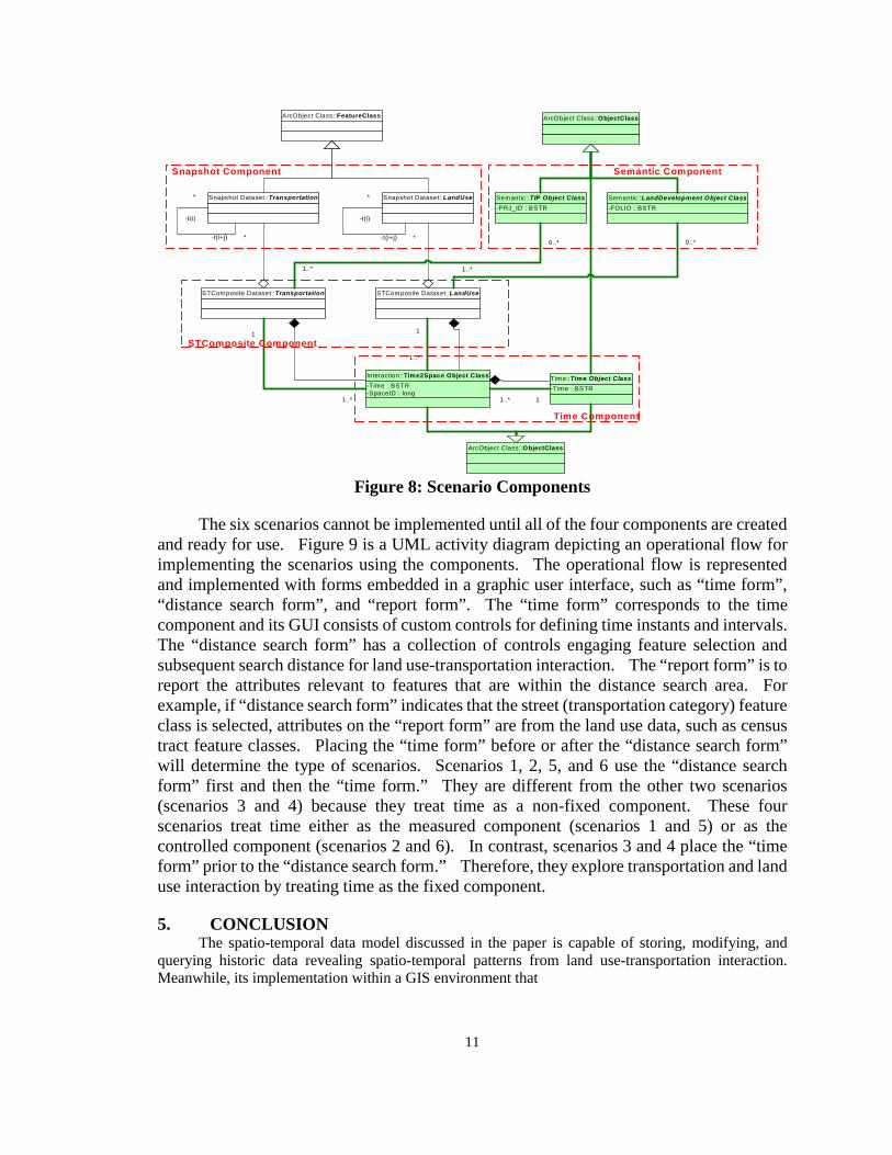
Figure 8 is a UML (i.e., Unified Modeling Language) class diagram consisting of the four components for implementing the six scenarios. The "snapshot component" block stores and manages the snapshot GIS data sets by separating them belong to the land use and transportation systems. Time associated with these snapshot data sets are explicitly timestamped and included as one data field. The "space-time (ST) composite component" block consists of space-time composite GIS layers generated from the snapshot GIS data sets and carries attribute changes over time. The “time component” includes time object class that records all unique time instances associated with the snapshot GIS layers as well as a Time2Space object class that associates the unique identifier of each geographic unit in a space-time composite database with all time instances that exist in the snapshot GIS layers. To facilitate spatiotemporal analysis of processes such as transportation improvement projects and land development projects, we also define the “semantic component” that allow linkages of a single semantic object instance to multiple locations and attributes over time.
10
ArcObject Class::ObjectClass
-Time : BSTRTime::Time Object Class
ArcObject Class::FeatureClass
Snapshot Dataset::Transportation Snapshot Dataset::LandUse
STComposite Dataset::Transportation STCom posite Dataset::LandUse
-t(i)
*
-t(i+j) *
-t(i)
*
-t(i+j) *
-Time : BSTR-SpaceID : long
Interaction::Time2Space Object Class
1
1..* 1..* 1
1
1..*
-PRJ_ID : BSTRSemantic::TIP Object Class
-FOLIO : BSTRSemantic::LandDevelopment Object Class
1..*
0..*
1..*
0..*
ArcObject Class::ObjectClass
STComposite Component
Snapshot Component Semantic Component
Time Component
Figure 8: Scenario Components
The six scenarios cannot be implemented until all of the four components are created and ready for use. Figure 9 is a UML activity diagram depicting an operational flow for implementing the scenarios using the components. The operational flow is represented and implemented with forms embedded in a graphic user interface, such as “time form”, “distance search form”, and “report form”. The “time form” corresponds to the time component and its GUI consists of custom controls for defining time instants and intervals. The “distance search form” has a collection of controls engaging feature selection and subsequent search distance for land use-transportation interaction. The “report form” is to report the attributes relevant to features that are within the distance search area. For example, if “distance search form” indicates that the street (transportation category) feature class is selected, attributes on the “report form” are from the land use data, such as census tract feature classes. Placing the “time form” before or after the “distance search form” will determine the type of scenarios. Scenarios 1, 2, 5, and 6 use the “distance search form” first and then the “time form.” They are different from the other two scenarios (scenarios 3 and 4) because they treat time as a non-fixed component. These four scenarios treat time either as the measured component (scenarios 1 and 5) or as the controlled component (scenarios 2 and 6). In contrast, scenarios 3 and 4 place the “time form” prior to the “distance search form.” Therefore, they explore transportation and land use interaction by treating time as the fixed component. 5. CONCLUSION
The spatio-temporal data model discussed in the paper is capable of storing, modifying, and querying historic data revealing spatio-temporal patterns from land use-transportation interaction. Meanwhile, its implementation within a GIS environment that
11

Show "Scenario Form"
Initialize global variables for database paths
Initialize variables for derived classes
Select a scenario and click "Continue" button to proceed
[Scenario 1,2,5,6] [Scenario 3,4]
Show "Distance Search Form" Show "Time Form"
Choose a time instant (e.g. year)[Scenario 3,4]
[Scenario 2]
Adjust land use feature classes
[Scenario 6]
Adjust transportation feature classes
Initialize interaction feature class variables
Select between semantics or data
Select features for buffering
[Scenario 2, 6]
Show "Report Form"
[Scenario 1,3,4,5]
[Scenario 4,5,6][Scenario 1,2,3]
Change the form for land use Change the form for transportation
Choose variables and create reports
Figure 9: Scenario Flow is based on the snapshot spatial data model provides ready solutions for urban planners engaging the
12
study related to the land use and transportation interaction. There are still many unsolved issues related to the spatio-temporal data model. For example, what space and time relationships are to be represented in spatio-temporal data models? Do we need to develop spatio-temporal query languages and indexing methods? What are the gains and loss of proposing a spatio-temporal data model based on either the spatial extension of a temporal data model or the temporal extension of a spatial data model? With recent advancements of GIS technology and an ongoing research progress on spatio-temporal data models, it is hoped that we are going to be equipped with better research tools to tackle complex geographic processes in the future. ACKNOWLEDGES We are grateful for the funding provided by the Florida Department of Transportation’s University Research Program to support this research project. We also would like to acknowledge the inputs from our research collaborators in the Department of Civil and Environment Engineering at Florida International University. REFERENCES Armstrong, M. (1988). "Temporality in spatial databases", In Proceedings of GIS/LIS '88, Vol. 2
ASPRS/ACSM, Bethesda, Maryland, pp. 880-889. Buffington, J. L., Chui, M. K. and Memmott, J. L. (1985). "Effects of freeway satge construction on
nearby land uses and vehicles user costs",Transportation Research Record, 1046, 62-69. Cascetta, E., Nuzzolo, A. and Coppola, P. (2000). "A system of mathemetical models for the simulation
of land use and transport interactions", In Sixth International Conference on Urban Transport and the Environment for the 21th Century, pp. 167-177.
CHOROCHRONOS (2002), National Technical University of Athens. http://www.dbnet.ece.ntua.gr/~choros/
Clifford, J. (1983). "Formal semantics for time in database", ACM Transactions on Database Systems, 8, 214-254.
Dey, D., Barron, T. M. and Storey, V. C. (1996). "A complete temporal relational algebra", The VLDB Journal, 5, 167-189.
Elmasri, R. and Navathe, S. (1994). Fundamentals of Database Systems, Benjamin/Cummings Publishing Company.
EPSRC. Spatial and Temporal Object Databases, Keele University, UK. http://www.keele.ac.uk/depts/cs/gis/projects/tripod/
Erwig, M. (1999). "Spatio-temporal data types: An approach to modeling and querying moving objects in database", GeoInformatica, 3, 269-296.
Faria, G., Mederios, C. B. and Nascimento, M. A. (1998). "An extensible framework for spatio-temporal database applications", TimeCenter.
Harvey, D. (1969) Explanation of Geography, Arnold, London. Hirschman, I. and Henderson, M. (1990). "Methodology for accessing local land use impacts of
highways", Transportation Research Record,35-40. Hunter, G. and Williamson, I. P. (1990). "The development of a historical digital cadastral database",
International Journal of Geographical Information Systems, 4, 169-179. Langran, G. and Chrisman, N. (1988). "A framework for temporal geographic information",
Cartographica, 25, 1-14. Langran, G. (1989). "A review of temporal database research and its use in GIS applications",
International Journal of Geographical Information Systems, 3, 215--232. Langran, G. (1992) Time in Geographic Information Systems, Taylor & Francis, London. Lum, V., Dadam, P., Erbe, R., Guenauer, J., Pistor, P., Walch, G., Walch, H., Werner, H. and Woodfill, J.
(1984). "Designing dbms support for the temporal dimension", ACM SIGMOD Record, 14, 115-130.
Martinez, F. J. (1995). "Access: The transport-land use economic link",Transportation Research Part B: Methodological, 29, 457-470.
Parent, C., Spaccapietra, S. and Zimanyi, E. (1999). "Spatio-temporal conceptual models: Data structure + space + time", In Proc. of the 7th ACM Symposium on Advances in Geographic Information
13
Systems, GIS'99, Kansas City, USA. Paton, N. W., Fernandos, A. A. A. and Griffiths, T. (2000). "Spatio-temporal databases: Contentions,
components and consolidation", http://www.cs.man.ac.uk/~norm/papers/asdm.pdf Peuquet, D. J. (1994). "It's about time: A conceptual framework for the representation of temporal
dynamics in geographic information system", Annals of the Association of American Geographers, 84, 441-461.
Peuquet, D. J. and Wentz, E. (1994). In Advance in gis research proceedings of the 6th int. Symp. On spatial data hamdling(Eds, Waugh, T. C. and Healy, R. G.) Taylor & Francis.
Peuquet, D. J. and Duan, N. (1995). "An event-based spatiotemporal data model (ESTDM) for temporal analysis of geographical data", International Journal of Geographical Information Systems, 9, 7-24.
Peuquet, D. and Qian, L. (1995). "An integrated database design for temporal gis", In Advances in GIS Research II: Proceedings of the Seventh International Sysposium on Spatial Data Handling(Eds, Kraak, M.-J., Molenaar, M. and Fendel, E. M.) Taylor & Francis, pp. 21-31.
Snodgrass, R. T. and Ahn, I. (1985). "A taxonomy of time in databases", In Proceedings of the SIGMOD '85 Conference in Austin, Texas, pp. 236-245.
Steiner, A. (1998). A generalization approach to temporal data models and their implementations, Swiss Federal Institute of Technology, Zurich, Zurich.
Stickler, G. J., Shearn, V. J. and Browning, G. P. (1992). "Handling overlapping parcels in arc/info",ESRI.
Vadali, S. R. and Sohn, C. (2001). "Tracking changes in spatially segregated location premiums using GIS: An alternative evaluation method of assessing residential land use impacts of transportation projects",Transportation Research Board.
Wegner, M. and Furst, F. (1999). “Land use transport interaction: State of the art” In Deliverable 2a of the project TRANSLAND of the 4th RTD Framework Programme of the European CommissionInstitut fur Raumplanung, Univeristat Dortmund.
Worboys, M. F. (1992). "Object-oriented models of spatiotemporal information", In Proceedings of GIS/LIS '92ASPRS/ACSM, Bethesda, Maryland, pp. 825-834.
Worboys, M. F. (1994). "A unified model for spatial and temporal information", The Computer Journal, 37, 27-34.
Worboys, M. F. (1998). In Spatial and temporal reasoning in geographic information systems(Eds, Egenhofer, M. J. and Golledge, R. G.) Oxford University Press, New York, pp. 25-39.
14