Embed Size (px)
Citation preview

STATE OF CALIFORNIA • DEPARTMENT OF TRANSPORTATION
TECHNICAL REPORT DOCUMENTATION PAGE TR0003 (REV 10/98)
ADA Notice For individuals with sensory disabilities, this document is available in alternate
formats. For information call (916) 654-6410 or TDD (916) 654-3880 or write
Records and Forms Management, 1120 N Street, MS-89, Sacramento, CA 95814.
1. REPORT NUMBER
CA15-2293
2. GOVERNMENT ASSOCIATION NUMBER 3. RECIPIENT'S CATALOG NUMBER
4. TITLE AND SUBTITLE
Enhancement and Technical Support of Intelligent Roadway Information System (IRIS) in
Caltrans Districts 1, 2, 5 and 10
5. REPORT DATE
December 31, 2014
6. PERFORMING ORGANIZATION CODE
AHMCT Research Center, UC Davis
7. AUTHOR
Travis Swanston, Kin Yen, Bahram Ravani & Ty Lasky
8. PERFORMING ORGANIZATION REPORT NO.
UCD-ARR-14-12-31-01
9. PERFORMING ORGANIZATION NAME AND ADDRESS
AHMCT Research Center
UCD Dept. of Mechanical & Aerospace Engineering
Davis, California 95616-5294
10. WORK UNIT NUMBER
11. CONTRACT OR GRANT NUMBER
65A0397, Task ID 2293
13. TYPE OF REPORT AND PERIOD COVERED
Final Report
June 2011 – December 2014 12. SPONSORING AGENCY AND ADDRESS
California Department of Transportation
P.O. Box 942873, MS #83
Sacramento, CA 94273-0001 14. SPONSORING AGENCY CODE
Caltrans
15. SUPPLEMENTARY NOTES
16. ABSTRACT
This report documents the research project “Enhancement and Technical Support of Intelligent Roadway Information System (IRIS) in
Caltrans Districts 1, 2, 5 and 10,” performed under contract 65A0397, Task ID 2293. It presents a current overview of IRIS, and its design
and function. The report also documents knowledge transfer for IRIS development from AHMCT researchers to two contractors. This
knowledge transfer process included updates and improvements to the static mapping tool chain and the IRIS build process. IRIS provides
Advanced Traffic Management System (ATMS) capabilities to Caltrans rural districts. IRIS is currently deployed in Caltrans Districts 1, 2, 5,
and 10.
17. KEY WORDS
Advanced Traffic Management System (ATMS), Traffic
operations, Open source
18. DISTRIBUTION STATEMENT
No restrictions. This document is available to the
public through the National Technical Information
Service, Springfield, Virginia 22161.
19. SECURITY CLASSIFICATION (of this report)
Unclassified
20. NUMBER OF PAGES
51
21. COST OF REPORT CHARGED
Reproduction of completed page authorized
Copyright 2015, AHMCT Research Center, UC Davis
DISCLAIMER/DISCLOSURE STATEMENT
The research reported herein was performed as part of the Advanced Highway Maintenance
and Construction Technology (AHMCT) Research Center, within the Department of Mechanical
and Aerospace Engineering at the University of California – Davis, and the Division of
Research, Innovation and System Information at the California Department of Transportation. It
is evolutionary and voluntary. It is a cooperative venture of local, State and Federal governments
and universities.
This document is disseminated in the interest of information exchange. The contents of this
report reflect the views of the authors who are responsible for the facts and accuracy of the data
presented herein. The contents do not necessarily reflect the official views or policies of the State
of California, the Federal Highway Administration, or the University of California. This
publication does not constitute a standard, specification or regulation. This report does not
constitute an endorsement of any product described herein.
For individuals with sensory disabilities, this document is available in Braille, large print,
audiocassette, or compact disk. To obtain a copy of this document in one of these alternate
formats, please contact: the Division of Research, Innovation and System Information, MS-83,
California Department of Transportation, P.O. Box 942873, Sacramento, CA 94273-0001.
Copyright 2015, AHMCT Research Center, UC Davis
Advanced Highway Maintenance and Construction Technology
Research Center
Department of Mechanical and Aerospace Engineering
University of California at Davis
Enhancement and Technical Support of
Intelligent Roadway Information System (IRIS)
in Caltrans Districts 1, 2, 5 and 10
Travis Swanston, Kin Yen, Bahram Ravani &
Ty A. Lasky: Principal Investigator
Report Number: CA15-2293
AHMCT Research Report: UCD-ARR-14-12-31-01
Final Report of Contract: IA65A0397, Task ID 2293
December 31, 2014
California Department of Transportation
Division of Research, Innovation and System Information
Copyright 2015, AHMCT Research Center, UC Davis
Enhancement and Technical Support of Intelligent Roadway Information System (IRIS) in Caltrans Districts 1, 2, 5 and 10
ii
ABSTRACT
This report documents the research project “Enhancement and Technical Support of
Intelligent Roadway Information System (IRIS) in Caltrans Districts 1, 2, 5 and 10,” performed
under contract 65A0397, Task ID 2293. It presents a current overview of IRIS, and its design
and function. The report also documents knowledge transfer for IRIS development from
AHMCT researchers to two contractors. This knowledge transfer process included updates and
improvements to the static mapping tool chain and the IRIS build process. IRIS provides
Advanced Traffic Management System (ATMS) capabilities to Caltrans rural districts. IRIS is
currently deployed in Caltrans Districts 1, 2, 5, and 10.
Copyright 2015, AHMCT Research Center, UC Davis

Enhancement and Technical Support of Intelligent Roadway Information System (IRIS) in Caltrans Districts 1, 2, 5 and 10
iii
TABLE OF CONTENTS
Abstract ..................................................................................................................................... ii
Table of Contents .................................................................................................................... iii
List of Figures ........................................................................................................................... v
List of Tables ........................................................................................................................... vi
List of Acronyms and Abbreviations ..................................................................................... vii
Acknowledgments.................................................................................................................... ix
Chapter 1: Introduction ........................................................................................................... 1
Background....................................................................................................................................... 1
Research Approach .......................................................................................................................... 2
Overview of Research Results and Benefits ................................................................................... 2
Chapter 2: IRIS Background .................................................................................................. 3
Chapter 3: IRIS Design and Function .................................................................................. 10
IRIS Environment .......................................................................................................................... 10
Challenges ....................................................................................................................................... 11
Successes ......................................................................................................................................... 13
IRIS Functional Areas ................................................................................................................... 14
Automated Warning System ......................................................................................................... 19
Vehicle Detection Systems ............................................................................................................. 20
Roadway Configuration ................................................................................................................ 22
Communication Diagnostics .......................................................................................................... 23
Data Flow and Architecture .......................................................................................................... 24
Video ................................................................................................................................................ 29
IRIS System Maintenance ............................................................................................................. 30
Mapping .......................................................................................................................................... 31
Completed Enhancements ............................................................................................................. 31
Future Enhancements .................................................................................................................... 32
Chapter 4: Knowledge Transfer for System Maintenance ................................................... 34
KSD Enhancement of IRIS Static Map ........................................................................................ 34
SwRI Test Case Development ....................................................................................................... 34
Improvement and Simplification of the IRIS Build Process ...................................................... 35
Chapter 5: Conclusions ......................................................................................................... 36
Lessons Learned ............................................................................................................................. 36
Future Work ................................................................................................................................... 37
Copyright 2015, AHMCT Research Center, UC Davis
Enhancement and Technical Support of Intelligent Roadway Information System (IRIS) in Caltrans Districts 1, 2, 5 and 10
iv
References .............................................................................................................................. 38
Appendix A: Release Notes .................................................................................................... 39
Copyright 2015, AHMCT Research Center, UC Davis
Enhancement and Technical Support of Intelligent Roadway Information System (IRIS) in Caltrans Districts 1, 2, 5 and 10
v
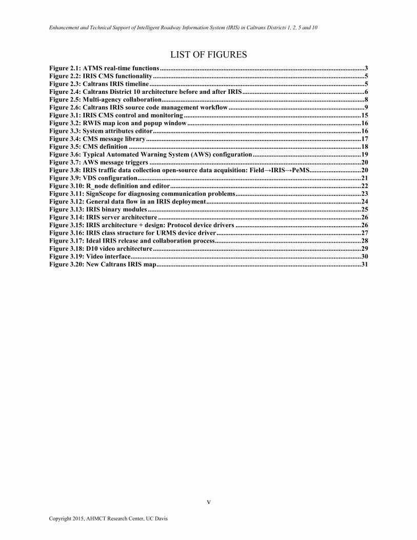
LIST OF FIGURES
Figure 2.1: ATMS real-time functions ....................................................................................................................... 3 Figure 2.2: IRIS CMS functionality ........................................................................................................................... 5 Figure 2.3: Caltrans IRIS timeline ............................................................................................................................. 5 Figure 2.4: Caltrans District 10 architecture before and after IRIS ....................................................................... 6 Figure 2.5: Multi-agency collaboration...................................................................................................................... 8 Figure 2.6: Caltrans IRIS source code management workflow ............................................................................... 9 Figure 3.1: IRIS CMS control and monitoring ....................................................................................................... 15 Figure 3.2: RWIS map icon and popup window ..................................................................................................... 16 Figure 3.3: System attributes editor ......................................................................................................................... 16 Figure 3.4: CMS message library ............................................................................................................................. 17 Figure 3.5: CMS definition ....................................................................................................................................... 18 Figure 3.6: Typical Automated Warning System (AWS) configuration ............................................................... 19 Figure 3.7: AWS message triggers ........................................................................................................................... 20 Figure 3.8: IRIS traffic data collection open-source data acquisition: Field→IRIS→PeMS.............................. 20 Figure 3.9: VDS configuration .................................................................................................................................. 21 Figure 3.10: R_node definition and editor ............................................................................................................... 22 Figure 3.11: SignScope for diagnosing communication problems ......................................................................... 23 Figure 3.12: General data flow in an IRIS deployment .......................................................................................... 24 Figure 3.13: IRIS binary modules ............................................................................................................................ 25 Figure 3.14: IRIS server architecture ...................................................................................................................... 26 Figure 3.15: IRIS architecture + design: Protocol device drivers ......................................................................... 26 Figure 3.16: IRIS class structure for URMS device driver .................................................................................... 27 Figure 3.17: Ideal IRIS release and collaboration process ..................................................................................... 28 Figure 3.18: D10 video architecture ......................................................................................................................... 29 Figure 3.19: Video interface ...................................................................................................................................... 30 Figure 3.20: New Caltrans IRIS map ....................................................................................................................... 31
Copyright 2015, AHMCT Research Center, UC Davis
Enhancement and Technical Support of Intelligent Roadway Information System (IRIS) in Caltrans Districts 1, 2, 5 and 10
vi
LIST OF TABLES
Table 2.1: Benefits of IRIS: Before and after comparison ....................................................................................... 7
Copyright 2015, AHMCT Research Center, UC Davis
Enhancement and Technical Support of Intelligent Roadway Information System (IRIS) in Caltrans Districts 1, 2, 5 and 10
vii
LIST OF ACRONYMS AND ABBREVIATIONS
Acronym Definition
AHMCT Advanced Highway Maintenance and Construction Technology
API Application Programming Interface
ASE Advanced Systems Engineering Consulting
ATMS Advanced Transportation Management System
AWS Automated Warning System
Caltrans California State Department of Transportation
CAWS Caltrans Automated Warning System
CCB Change Control Board
CCTV Closed-Circuit TV
CHP California Highway Patrol
CMS Changeable Message Sign
COCOMO Constructive Cost Model
COTS Commercial-Off-the-Shelf
CWWP Commercial Wholesale Web Portal
DMS Dynamic Message Sign
DRISI Division of Research, Innovation and System Information
EIS Electronic Integrated Systems
FSR Feasibility Study Report
GB Gigabyte
GNU GNU’s Not Unix
GPL GNU General Public License
HAR Highway Advisory Radio
HTTP Hypertext Transport Protocol
IRIS Intelligent Roadway Information System
JWS Java Web Start
KML Keyhole Markup Language
KSD Knowledge Systems Design, Inc.
KSD Knowledge Systems Design
LCS Lane Control Signal
LDAP Lightweight Directory Access Protocol
MB Megabyte
MITTENS Messaging Infrastructure for Travel Time Estimates to a Network of Signs
MnDOT Minnesota Department of Transportation
MVDS Microwave Vehicle Detection Station
NDA Non-Disclosure Agreement
NDOR Nebraska Department of Roads
OS Operating System
OSM OpenStreetMap
PeMS Performance Measurement System
PTZ Pan, Tilt, and Zoom
RAM Random Access Memory
RTMS Remote Traffic Microwave Sensor
RWIS Road Weather Information System
SLES SUSE Linux Enterprise Server
SOCCS Satellite Operations Center Command System
SQL Structured Query Language
SSI Surface Systems, Inc.
SUSE Software und System-Entwicklung (German for system and software development)
SwRI Southwest Research Institute
Copyright 2015, AHMCT Research Center, UC Davis
Enhancement and Technical Support of Intelligent Roadway Information System (IRIS) in Caltrans Districts 1, 2, 5 and 10
viii
Acronym Definition
TMC Transportation Management Center
TMCAL Transportation Management Center Activity Logging
TMS Traffic Monitoring Station
UCD University of California-Davis
URMS Universal Ramp Metering System
VDS Vehicle Detection Station
VM Virtual Machine
WYDOT Wyoming Department of Transportation
XML Extensible Markup Language
Copyright 2015, AHMCT Research Center, UC Davis
Enhancement and Technical Support of Intelligent Roadway Information System (IRIS) in Caltrans Districts 1, 2, 5 and 10
ix
ACKNOWLEDGMENTS
The authors gratefully acknowledge the Division of Research, Innovation and System
Information (DRISI) of Caltrans which has supported this work through the AHMCT Research
Center at the University of California-Davis, under contract 65A0397 Task ID 2293, and thank
Roya Hassas, Fred Yazdan, and Melissa Clark in particular. The authors also thank Stan Slavin
for his continuing commitment and strong guidance to on-going IRIS development and use. The
authors thank Doug Lau of MnDOT for his leading work on IRIS and his support for
collaborative development. The authors also thank James Kranig of MnDOT for his leading
management on IRIS, including its release as an open-source project. The authors are also
grateful to Kai Leung and David Wells of Caltrans Headquarters Traffic Operations, and Chris
Binger, David Busler, and Brian Sordi of Caltrans Headquarters Information Technology. From
District 1, the authors thank Jim Sandford, John Carson, and Joe Dower. From District 2, the
authors thank Ian Turnbull, Clint Burkenpas, Keith Koeppen, and Joe Baltazar. From District 5,
the authors thank Sherwyn Gilliland and Steven Gee. From District 10, the authors thank
Mohammad Battah, Veronica Cipponeri, Arlene Cordero, Toni Moon, John Castro, Wilmar
Kuhl, and Joe Silvey. The authors also thank Michael Darter and Karl Petty of Berkeley
Transportation Systems, and Sik Shum, Wee-Meng Tan, and John Keith of KSD. The authors are
also grateful to Dan Rossiter and Tucker Brown of the Southwest Research Institute. The authors
also thank Stephen Donecker and Kin Yen of the AHMCT Research Center for their assistance.
The authors would like to send a special thanks to all of the dispatchers at the District 10 TMC,
some of whom have been with the IRIS development since 2008, as they worked with IRIS and
provided much of the info needed for feature requests and updates: Antoinette Moon, George
Anzo, James Westphal, Tina Nunes, Lyn Serpa, Beth Robinson, Kit Sherlock, Rudy Anzo,
Rachel George, Ingrid Donaville, John Ragusa, Laura Williams, Brenda Threadgill, Tami
Harrison, Gracie Munoz, Stephany Kirkpatrick, Angela Duhart, Josh Neal, Kim Berry, and Pam
Matedne. Finally, the authors thank the members of the Change Control Board and the remaining
dedicated managers and operators in Districts 1, 2, 5, and 10.
Copyright 2015, AHMCT Research Center, UC Davis

Enhancement and Technical Support of Intelligent Roadway Information System (IRIS) in Caltrans Districts 1, 2, 5 and 10
1
CHAPTER 1:
INTRODUCTION
Background
In Phase I research and development [2], the Advanced Highway Maintenance and
Construction Technology (AHMCT) Research Center tailored and extended the open-source
Intelligent Roadway Information System (IRIS) originally (and currently) developed by the
Minnesota Department of Transportation (MnDOT). This research was successfully
demonstrated and deployed in District 10, Stockton as a Proof of Concept project.
In a Phase II effort, AHMCT next provided low-level deployment support (maintenance,
software patches, and technical support) for IRIS in District 10 [1]. Additional districts
(District 1-Eureka, District 2-Redding, and District 5-San Luis Obispo) began testing a subset of
IRIS functionality (Changeable Message Sign (CMS) control) to provide feedback for the
Caltrans Feasibility Study Report (FSR) process. At this time, full IRIS capability, including
video, for the added districts, required device driver development beyond the resources available
for the Phase II research. In addition, until the FSR process was completed, these added districts
were required to remain in the testing mode for CMS.
AHMCT provided IRIS testing and technical support under the Phase II effort. The Phase II
effort also included providing technical information in support of Caltrans’ preparation and
execution of the IRIS FSR.
The current Phase III research followed the indications of the successful FSR produced
during Phase II. This led to development of IRIS Release 9.3, and its full deployment in
Districts 1, 2, 5, and 10. This was followed by a 9.4 maintenance release. Then, as a key part of
the current effort, the Caltrans IRIS source code was merged with the MnDOT source tree in
order to bring many needed new features and bug fixes into Caltrans IRIS. This new, merged tree
formed the basis of IRIS Release 10.0.0. Now, an effort is underway to submit these changesets
to MnDOT so that they can be included in the official MnDOT code. As of this report, the
Caltrans IRIS source code has 66 outstanding changesets comprising approximately 17
functional enhancements waiting for acceptance by MnDOT. Fully integrating these changesets
into the official MnDOT code will be accomplished by the Southwest Research Institute (SwRI)
in a pending 10.0.1 release. This merge and acceptance process is a key component in each
release, and is discussed in detail herein.
Most urban Advanced Transportation Management System (ATMS) programs are typically
not well-suited to rural districts, in terms of both features and cost. As such, rural districts often
address their needs with a set of disparate solutions, with associated management,
administration, and operating difficulties. There is a need for a unified ATMS that is specifically
designed for rural districts. IRIS now meets that need for Caltrans.
Rural districts cannot easily justify the one-time and recurring costs of an urban ATMS.
IRIS, a low-cost alternative, provides significant operational capabilities to the districts, with
substantial savings to the Department.
Copyright 2015, AHMCT Research Center, UC Davis
Enhancement and Technical Support of Intelligent Roadway Information System (IRIS) in Caltrans Districts 1, 2, 5 and 10
2
Research Approach
The research tasks were as follows:
IRIS technical support for Caltrans districts
IRIS enhancements for Caltrans districts
Software engineering process for IRIS ticket requests from Districts 1, 2, 5, and 10,
subject to Change Control Board (CCB) guidance.
Overview of Research Results and Benefits
First and foremost, deployment of IRIS to Districts 1, 2, 5, and 10 was successful. Each of
the districts has fully deployed IRIS in their districts. Secondly, the number of traffic
management software applications and servers in the four districts has been reduced, with IRIS
assuming their roles. Finally, through knowledge transfer from the research team, the IRIS
support role is successfully transitioning to a third-party contractor, Southwest Research Institute
(SwRI).
IRIS is a platform that:
Provides cost-effective ATMS capabilities for rural districts
Is extensible, reliable, and scalable, with support for a diverse set of field elements
Reduces life cycle costs by approximately 72% versus the existing ATMS [2]
Shows the importance and benefit of an open development process.
Copyright 2015, AHMCT Research Center, UC Davis
Enhancement and Technical Support of Intelligent Roadway Information System (IRIS) in Caltrans Districts 1, 2, 5 and 10
3
CHAPTER 2:
IRIS BACKGROUND
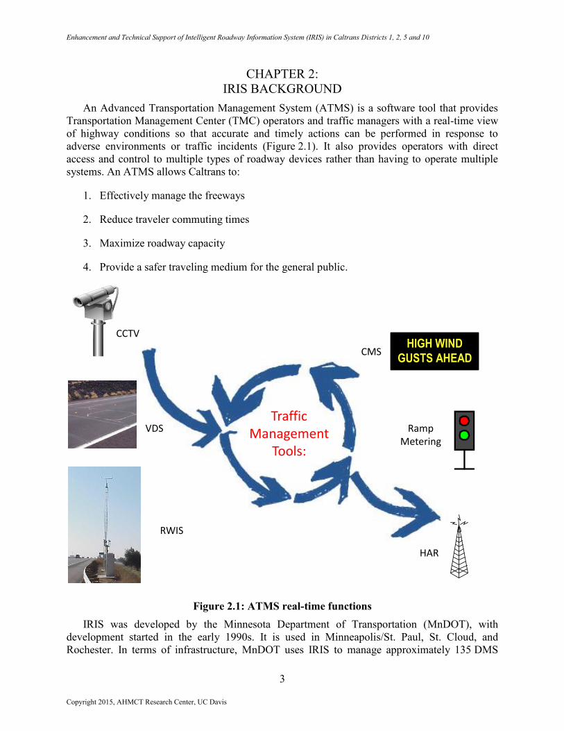
An Advanced Transportation Management System (ATMS) is a software tool that provides
Transportation Management Center (TMC) operators and traffic managers with a real-time view
of highway conditions so that accurate and timely actions can be performed in response to
adverse environments or traffic incidents (Figure 2.1). It also provides operators with direct
access and control to multiple types of roadway devices rather than having to operate multiple
systems. An ATMS allows Caltrans to:
1. Effectively manage the freeways
2. Reduce traveler commuting times
3. Maximize roadway capacity
4. Provide a safer traveling medium for the general public.
Figure 2.1: ATMS real-time functions
IRIS was developed by the Minnesota Department of Transportation (MnDOT), with
development started in the early 1990s. It is used in Minneapolis/St. Paul, St. Cloud, and
Rochester. In terms of infrastructure, MnDOT uses IRIS to manage approximately 135 DMS
Traffic Management
Tools:
HIGH WIND
GUSTS AHEAD
CCTV
Ramp Metering
CMS
HAR
RWIS
VDS
Copyright 2015, AHMCT Research Center, UC Davis
Enhancement and Technical Support of Intelligent Roadway Information System (IRIS) in Caltrans Districts 1, 2, 5 and 10
4
(Dynamic Message Sign1), 476 cameras, 5452 VDS (Vehicle Detection Station), 433 ramp
meters, 4 RWIS (Road Weather Information System), 194 LCS (Lane Controll Signal2), 1 Lane
Marking (in-road lighting), and 2 static signs with wig-wag beacons. IRIS was 100% developed
in-house, and represents a significant MnDOT investment (COCOMO3: > $4 million).
MnDOT released IRIS as open-source software under the GNU General Public License
(GPL) in May 2007. At least four agencies are using or evaluating IRIS. Agencies using IRIS
include MnDOT, Caltrans, and Wyoming DOT (WYDOT, for at least DMS and cameras).
Agencies evaluating IRIS include Nebraska Department of Roads (NDOR) and the City of
Bloomington, Minnesota. MnDOT’s motivations for open-sourcing IRIS included:
Ensuring affordable and manageable longevity of IRIS
Fostering collaboration with other transportation agencies
Getting source contributions back to IRIS
Cultivating additional IRIS developers
Lowering risks.
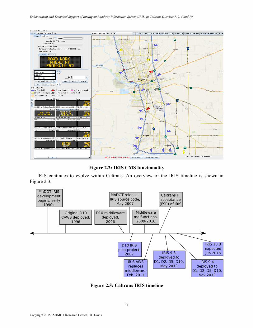
IRIS has provided ATMS capabilities to Caltrans rural districts. It is now deployed in
Districts 1, 2, 5, and 10. A sample IRIS CMS4 control operating in Stockton is shown in
Figure 2.2.
1 California uses the term Changeable Message Sign (CMS) 2 In California, LCS = Lane Closure System 3 Constructive Cost Model 4 Minnesota and many other states refer to CMS as Dynamic Message Sign (DMS)
Copyright 2015, AHMCT Research Center, UC Davis
Enhancement and Technical Support of Intelligent Roadway Information System (IRIS) in Caltrans Districts 1, 2, 5 and 10
5
Figure 2.2: IRIS CMS functionality
IRIS continues to evolve within Caltrans. An overview of the IRIS timeline is shown in
Figure 2.3.
Figure 2.3: Caltrans IRIS timeline
Copyright 2015, AHMCT Research Center, UC Davis
Enhancement and Technical Support of Intelligent Roadway Information System (IRIS) in Caltrans Districts 1, 2, 5 and 10
6
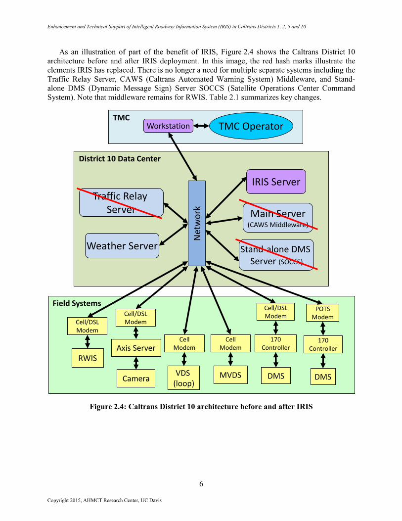
As an illustration of part of the benefit of IRIS, Figure 2.4 shows the Caltrans District 10
architecture before and after IRIS deployment. In this image, the red hash marks illustrate the
elements IRIS has replaced. There is no longer a need for multiple separate systems including the
Traffic Relay Server, CAWS (Caltrans Automated Warning System) Middleware, and Stand-
alone DMS (Dynamic Message Sign) Server SOCCS (Satellite Operations Center Command
System). Note that middleware remains for RWIS. Table 2.1 summarizes key changes.
Figure 2.4: Caltrans District 10 architecture before and after IRIS
DMSCamera MVDS
RWIS
Field Systems
Axis Server
POTSModem
Cell/DSLModem
VDS (loop)
DMS
Cell/DSLModem
CellModem
CellModem
Cell/DSLModem
170Controller
170Controller
TMCTMC OperatorWorkstation
District 10 Data Center
Main Server(CAWS Middleware)
Stand-alone DMS Server (SOCCS)
Traffic Relay Server
Weather Server
IRIS Server
Net
wo
rk
Copyright 2015, AHMCT Research Center, UC Davis
Enhancement and Technical Support of Intelligent Roadway Information System (IRIS) in Caltrans Districts 1, 2, 5 and 10
7
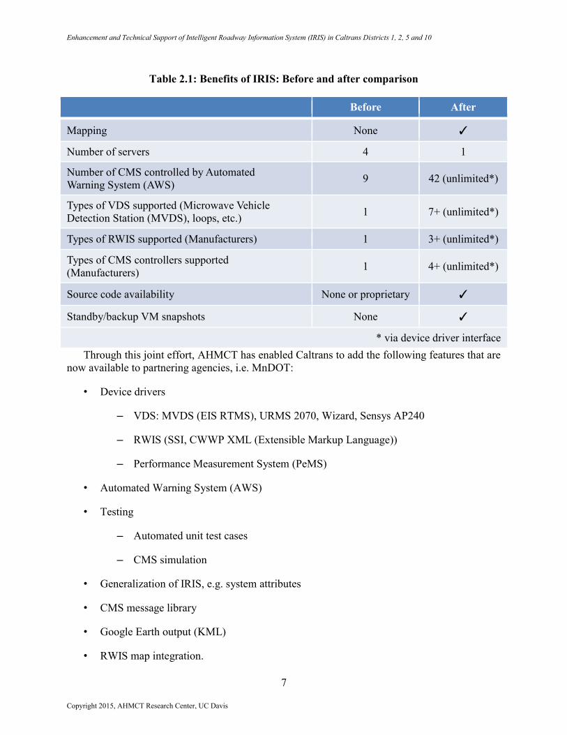
Table 2.1: Benefits of IRIS: Before and after comparison
Before After
Mapping None ✓
Number of servers 4 1
Number of CMS controlled by Automated
Warning System (AWS) 9 42 (unlimited*)
Types of VDS supported (Microwave Vehicle
Detection Station (MVDS), loops, etc.) 1 7+ (unlimited*)
Types of RWIS supported (Manufacturers) 1 3+ (unlimited*)
Types of CMS controllers supported
(Manufacturers) 1 4+ (unlimited*)
Source code availability None or proprietary ✓
Standby/backup VM snapshots None ✓
* via device driver interface
Through this joint effort, AHMCT has enabled Caltrans to add the following features that are
now available to partnering agencies, i.e. MnDOT:
• Device drivers
– VDS: MVDS (EIS RTMS), URMS 2070, Wizard, Sensys AP240
– RWIS (SSI, CWWP XML (Extensible Markup Language))
– Performance Measurement System (PeMS)
• Automated Warning System (AWS)
• Testing
– Automated unit test cases
– CMS simulation
• Generalization of IRIS, e.g. system attributes
• CMS message library
• Google Earth output (KML)
• RWIS map integration.
Copyright 2015, AHMCT Research Center, UC Davis
Enhancement and Technical Support of Intelligent Roadway Information System (IRIS) in Caltrans Districts 1, 2, 5 and 10
8
Figure 2.5: Multi-agency collaboration
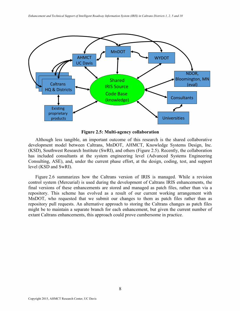
Although less tangible, an important outcome of this research is the shared collaborative
development model between Caltrans, MnDOT, AHMCT, Knowledge Systems Design, Inc.
(KSD), Southwest Research Institute (SwRI), and others (Figure 2.5). Recently, the collaboration
has included consultants at the system engineering level (Advanced Systems Engineering
Consulting, ASE), and, under the current phase effort, at the design, coding, test, and support
level (KSD and SwRI).
Figure 2.6 summarizes how the Caltrans version of IRIS is managed. While a revision
control system (Mercurial) is used during the development of Caltrans IRIS enhancements, the
final versions of these enhancements are stored and managed as patch files, rather than via a
repository. This scheme has evolved as a result of our current working arrangement with
MnDOT, who requested that we submit our changes to them as patch files rather than as
repository pull requests. An alternative approach to storing the Caltrans changes as patch files
might be to maintain a separate branch for each enhancement, but given the current number of
extant Caltrans enhancements, this approach could prove cumbersome in practice.
Caltrans Districts
SharedIRIS Source
Code Base(knowledge)
MnDOT
WYDOT
NDOR,Bloomington, MN
(eval)
Consultants
Caltrans Districts
Caltrans HQ & Districts
AHMCTUC Davis
Universities
Existing proprietary
products
Copyright 2015, AHMCT Research Center, UC Davis

Enhancement and Technical Support of Intelligent Roadway Information System (IRIS) in Caltrans Districts 1, 2, 5 and 10
9
Figure 2.6: Caltrans IRIS source code management workflow
Copyright 2015, AHMCT Research Center, UC Davis
Enhancement and Technical Support of Intelligent Roadway Information System (IRIS) in Caltrans Districts 1, 2, 5 and 10
10
CHAPTER 3:
IRIS DESIGN AND FUNCTION
IRIS Environment
The following are important aspects of the IRIS runtime and development environments:
Client-server architecture
All dependent software packages (e.g. Java, PostgreSQL, Apache HTTP (Hypertext
Transport Protocol), Apache Tomcat, Apache Ant) are open-source
o Free, no purchase requisition forms
o No non-disclosure agreement (NDA) required
IRIS is written in the Java programming language
o ~350K lines of code
o IRIS’s design is heavily object-oriented, with ~3200 classes. The code is
relatively complex, yet well-organized.
o The IRIS build environment is Linux-based, and utilizes Java, Apache Ant, and
the Mercurial distributed version control system. IRIS may be transitioning to Git.
Git is a distributed revision control system with an emphasis on speed, data
integrity, and support for distributed, non-linear workflows. Git was initially
designed and developed by Linus Torvalds for Linux kernel development in 2005,
and has since become the most widely adopted version control system for
software development5.
Server
o On the server side, our IRIS implementation consists of several independent
services, including the main IRIS server, the IRIS video server (a video stream
handler for closed-circuit TV (CCTV) video), SensorServer (a communications
module for SignView-based CMS), Casper (a CMS simulator), and a handful of
other services that help support various other IRIS functions, such as reports,
CMS XML feeds, log management, etc.
o Server-side requirements include Java, Apache HTTP (web server), Apache
Tomcat (web server and servlet container), and the PostgreSQL relational
database (a.k.a. “Postgres”), all of which are free, open-source technologies.
5 https://en.wikipedia.org/wiki/Git_(software)
Copyright 2015, AHMCT Research Center, UC Davis

Enhancement and Technical Support of Intelligent Roadway Information System (IRIS) in Caltrans Districts 1, 2, 5 and 10
11
o IRIS can optionally use LDAP (Lightweight Directory Access Protocol) to
authenticate users based on their Caltrans credentials.
Client
o The IRIS client software is launched using JWS (Java Web Start) technology, so
nothing needs to be installed on the client machine in order to run IRIS (other
than a Java runtime environment, which most machines already have installed).
o Being a Java application, the IRIS client is cross-platform, and should
theoretically run on any Java-compatible system. Current testing has proven its
compatibility on various Windows and Linux platforms.
Challenges
In developing IRIS code, there were distinct challenge areas and successes. Both are noted
here. Many of the challenges remain.
At the start of this phase of the research, IRIS was well established in District 10, and
district staff had acquired extensive experience with system. The system was fairly stable.
There remained some defects that had been identified earlier; however, since they could
not be reproduced, these defects simply remained “on the radar.” Having achieved a
stable, well-established system in District 10, the Department was able to officially
approve the current project to deploy this system to other districts. The focus was
therefore shifted to deploying IRIS elsewhere in Caltrans to Districts 1, 2, and 5. With
this full-fledged project now underway, having started in June 2011, some weaknesses
were revealed in the ability to continue developing and deploying this system for other
locations. Unlike the early days of IRIS research and development, at this phase only one
primary developer was assigned to this project. This had a detrimental effect on the
project when that resource was no longer available to the project. The project was able to
redirect a new development resource. Due to the lack of an adequate transition period
with the previous developer, the project suffered several months of delay.
Managing ticket priorities: to defer or fix bugs? It can be difficult to properly allocate
development resources between maintenance and new development. New development is
subject to a schedule with deadlines. However, maintenance and bug fixes are often
urgent. With limited resources, this prioritization is difficult. The current project was
focused on maintenance instead of new features or major enhancements. Great care needs
to be taken in estimating level of effort and managing customers’ expectations for
enhancements.
Bottom-up versus top-down design: Some features were not anticipated in the initial IRIS
design, so there is often a trade-off between forcing a new feature to fit into the existing
framework and modifying the framework itself to better support the new feature.
Under previous phase efforts, some unexpected regressions were experienced after
developing new features or fixes:
Copyright 2015, AHMCT Research Center, UC Davis
Enhancement and Technical Support of Intelligent Roadway Information System (IRIS) in Caltrans Districts 1, 2, 5 and 10
12
o The creation of automated test cases has helped to catch regressions
o End-to-end automated test cases throughout IRIS are needed.
Scarcity of mid- and low-level technical documentation:
o Software is documented using Javadoc comments within the “classes” and
“packages” of the source code. This is very helpful to developers, but not
sufficient.
o There is no system architecture document
o There are no data flow diagrams
o There are no detailed software or interface design documents
o Existing installation/administration/maintenance documentation is lacking in
some areas.
Differing approaches to documentation by participating agencies. Caltrans has been
working towards upfront detailed design. MnDOT has taken a more dynamic but less
detailed approach that does not match well with the current Caltrans approach. In an
open-source effort such as IRIS, highly detailed, upfront documentation efforts can be
rendered obsolete quite easily as one party modifies related code in a manner inconsistent
with existing documentation. This is not intended as a criticism of Caltrans’ or MnDOT’s
approach. Rather, it is a fundamental characteristic of open-source development.
Developing a consistent and effective approach to documentation for an open-source
project with multiple contributors is a challenging issue, and approaches that can be quite
effective for monolithic efforts may not be successful for open-source development.
There are effective models available in the open-source community.
Tradeoffs between customized, agency-specific development and generalized
development (i.e., implementing features that other agencies can make use of), and the
pressures and time constraints associated with making these tradeoffs:
o Writing agency-specific code is easier and significantly faster
o Generalizing an existing feature (i.e., to make it something other agencies can
make use of) can be complex and consume significantly more developer time
o However, generalized code, if ultimately merged upstream, reduces the
complexity of maintaining multiple parallel development branches and
changesets, saving an enormous amount of developer time in the longer-term
o Code merges are voluntary (by both AHMCT and MnDOT). However,
maintaining unmerged changesets is extremely undesirable, difficult, and time-
consuming, especially over the long-term; therefore the tendency should be to
merge as much as possible, and only keep unmerged those changesets which
Copyright 2015, AHMCT Research Center, UC Davis
Enhancement and Technical Support of Intelligent Roadway Information System (IRIS) in Caltrans Districts 1, 2, 5 and 10
13
absolutely cannot be merged. This requires more resources upfront, but tends to
minimize resource requirements in the future.
Handling and timing of merges between agencies:
o Requires constant communication between agencies to identify common features
versus agency-specific features and how best to incorporate them
Has resulted in a long back log of unmerged change sets between agencies
o The serial, single-branch model used by AHMCT to manage its changesets has
shortcomings and has made cherry-picking features for upstream merging
difficult as features are often intermingled among multiple changesets. In the
future, a parallel model based on feature-centric branches is highly recommended.
Excellent generalized designs take additional effort, as support must be maintained for
operation modes that, though not used by Caltrans, may be used by another agency.
Communicating how the open-source process is different:
o The collaborative development model is important, but may be hard to convey
o Cost savings are easy to explain.
Successes
IRIS has succeeded in providing proven-useful ATMS functionality:
o Being open-source and well designed, the ability to customize IRIS for an agency
is endless
During this project phase, IRIS has been successfully put into production use in Caltrans
Districts 1, 2, and 5, bringing the current number of districts using IRIS to four
The application scope of IRIS has been successfully extended to fulfill new district
requirements and feature requests
o Developed new features (e.g., video wall control, CCTV connection management,
external video viewer support, CCTV “return home” feature, new CMS feed,
CMS composer enhancements, many new options to manage CCTV usage,
customized site naming and location description formatting)
o Developed new device drivers (e.g., Cohu PTZ, Axis PTZ, Sensys AP240, Axis
decoder, RTMS G4 backport)
o Enhanced reporting (e.g., status reports, monthly CMS activation reports)
Copyright 2015, AHMCT Research Center, UC Davis

Enhancement and Technical Support of Intelligent Roadway Information System (IRIS) in Caltrans Districts 1, 2, 5 and 10
14
o Generated a custom California map to meet the specific requirements of the
districts using IRIS.
The complex build and deployment process for the Caltrans IRIS implementation has
been greatly improved and automated, and a number of tools have been developed to
manage it. This significantly eases the burden of training new developers.
IRIS administration and development knowledge transfer to the incoming IRIS
maintenance contractor (SwRI) has been good, and SwRI has already begun to perform
IRIS builds in their development environment. SwRI began its maintenance work on
IRIS in July 2014, and is assuming full responsibility for IRIS maintenance through June
2017 as of July 1, 2015.
Under a previous project phase, IRIS assumed Automated Warning System (AWS)
functionality (4 months start to end)
o Developed VDS (Vehicle Detection Station) data acquisition (RTMS or Remote
Traffic Microwave Sensor, loops)
o Developed RWIS data acquisition and user interface
o Forwards traffic to PeMS (Performance Measurement System)
o Developed AWS module
o Testing and verification
Reliability and code quality of IRIS are good. IRIS is quite robust
Low cost, less than one-fourth the cost of proprietary ATMS [2].
IRIS Functional Areas
The IRIS functional areas are described next. Screen shots are provided to illustrate each
area, followed by brief descriptive text.
Copyright 2015, AHMCT Research Center, UC Davis
Enhancement and Technical Support of Intelligent Roadway Information System (IRIS) in Caltrans Districts 1, 2, 5 and 10
15
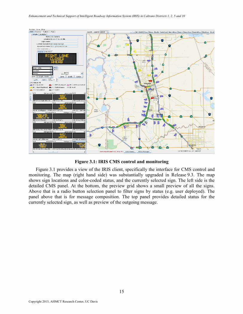
Figure 3.1: IRIS CMS control and monitoring
Figure 3.1 provides a view of the IRIS client, specifically the interface for CMS control and
monitoring. The map (right hand side) was substantially upgraded in Release 9.3. The map
shows sign locations and color-coded status, and the currently selected sign. The left side is the
detailed CMS panel. At the bottom, the preview grid shows a small preview of all the signs.
Above that is a radio button selection panel to filter signs by status (e.g. user deployed). The
panel above that is for message composition. The top panel provides detailed status for the
currently selected sign, as well as preview of the outgoing message.
Copyright 2015, AHMCT Research Center, UC Davis
Enhancement and Technical Support of Intelligent Roadway Information System (IRIS) in Caltrans Districts 1, 2, 5 and 10
16
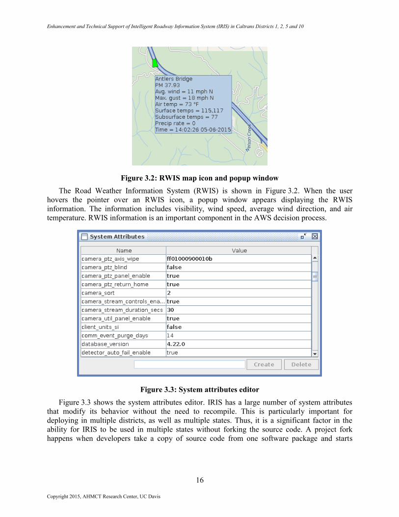
Figure 3.2: RWIS map icon and popup window
The Road Weather Information System (RWIS) is shown in Figure 3.2. When the user
hovers the pointer over an RWIS icon, a popup window appears displaying the RWIS
information. The information includes visibility, wind speed, average wind direction, and air
temperature. RWIS information is an important component in the AWS decision process.
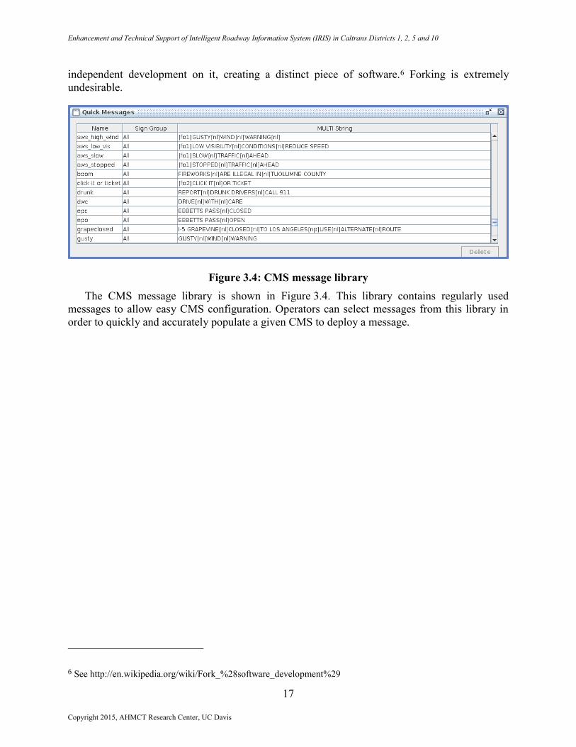
Figure 3.3: System attributes editor
Figure 3.3 shows the system attributes editor. IRIS has a large number of system attributes
that modify its behavior without the need to recompile. This is particularly important for
deploying in multiple districts, as well as multiple states. Thus, it is a significant factor in the
ability for IRIS to be used in multiple states without forking the source code. A project fork
happens when developers take a copy of source code from one software package and starts
Copyright 2015, AHMCT Research Center, UC Davis
Enhancement and Technical Support of Intelligent Roadway Information System (IRIS) in Caltrans Districts 1, 2, 5 and 10
17
independent development on it, creating a distinct piece of software.6 Forking is extremely
undesirable.
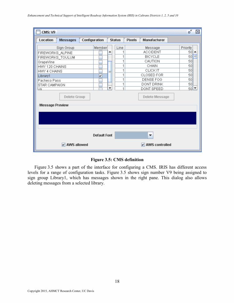
Figure 3.4: CMS message library
The CMS message library is shown in Figure 3.4. This library contains regularly used
messages to allow easy CMS configuration. Operators can select messages from this library in
order to quickly and accurately populate a given CMS to deploy a message.
6 See http://en.wikipedia.org/wiki/Fork_%28software_development%29
Copyright 2015, AHMCT Research Center, UC Davis
Enhancement and Technical Support of Intelligent Roadway Information System (IRIS) in Caltrans Districts 1, 2, 5 and 10
18
Figure 3.5: CMS definition
Figure 3.5 shows a part of the interface for configuring a CMS. IRIS has different access
levels for a range of configuration tasks. Figure 3.5 shows sign number V9 being assigned to
sign group Library1, which has messages shown in the right pane. This dialog also allows
deleting messages from a selected library.
Copyright 2015, AHMCT Research Center, UC Davis
Enhancement and Technical Support of Intelligent Roadway Information System (IRIS) in Caltrans Districts 1, 2, 5 and 10
19
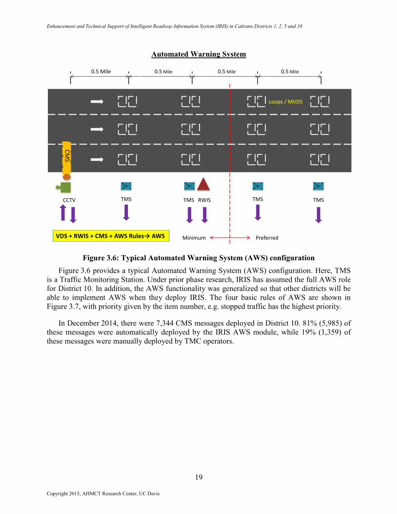
Automated Warning System
Figure 3.6: Typical Automated Warning System (AWS) configuration
Figure 3.6 provides a typical Automated Warning System (AWS) configuration. Here, TMS
is a Traffic Monitoring Station. Under prior phase research, IRIS has assumed the full AWS role
for District 10. In addition, the AWS functionality was generalized so that other districts will be
able to implement AWS when they deploy IRIS. The four basic rules of AWS are shown in
Figure 3.7, with priority given by the item number, e.g. stopped traffic has the highest priority.
In December 2014, there were 7,344 CMS messages deployed in District 10. 81% (5,985) of
these messages were automatically deployed by the IRIS AWS module, while 19% (1,359) of
these messages were manually deployed by TMC operators.
0.5 Mile 0.5 Mile 0.5 Mile 0.5 Mile
CCTV TMS TMS RWIS TMS TMS
PreferredMinimum
CM
S
VDS + RWIS + CMS + AWS Rules→ AWS
Loops / MVDS
Copyright 2015, AHMCT Research Center, UC Davis
Enhancement and Technical Support of Intelligent Roadway Information System (IRIS) in Caltrans Districts 1, 2, 5 and 10
20
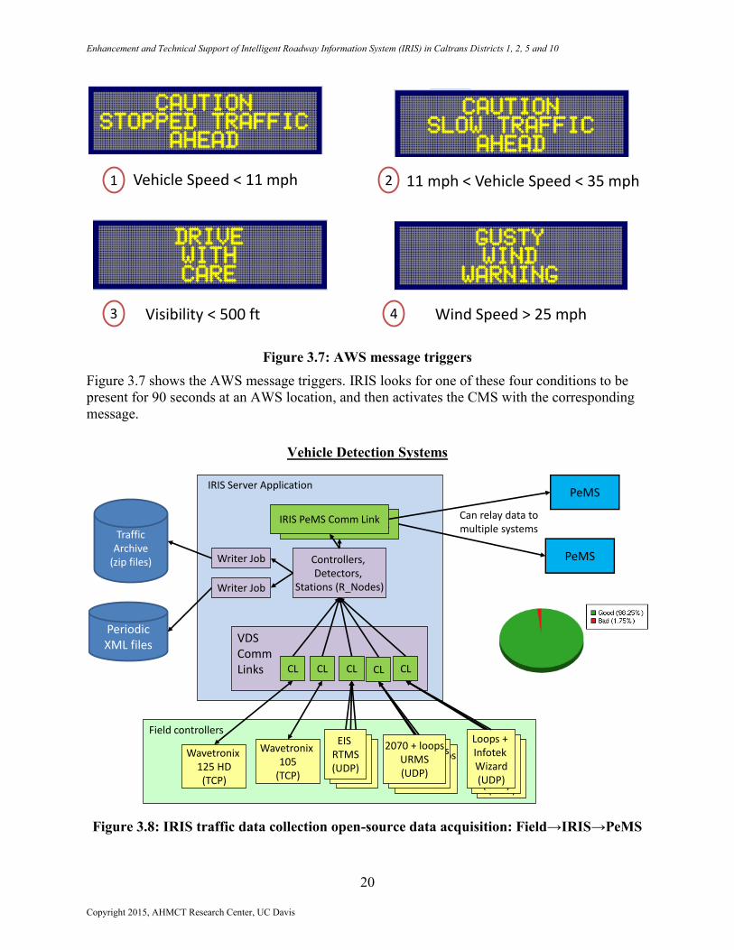
Figure 3.7: AWS message triggers
Figure 3.7 shows the AWS message triggers. IRIS looks for one of these four conditions to be
present for 90 seconds at an AWS location, and then activates the CMS with the corresponding
message.
Vehicle Detection Systems
Figure 3.8: IRIS traffic data collection open-source data acquisition: Field→IRIS→PeMS
Vehicle Speed < 11 mph 11 mph < Vehicle Speed < 35 mph
Visibility < 500 ft Wind Speed > 25 mph
1
43
2
2070 + loopsURMS(UDP)
PeMS
Wavetronix 105
(TCP)
2070 + loopsURMS(UDP)
Wavetronix 125 HD(TCP)
Field controllers
EIS RTMS(UDP)
Loops + InfotekWizard(UDP)
IRIS PeMS Comm Link
IRIS Server Application
Traffic Archive
(zip files)
Periodic XML files
Controllers, Detectors,
Stations (R_Nodes)
PeMS
CLCLCLCLCL
VDS Comm Links
Writer Job
Writer Job
IRIS PeMS Comm Link
EIS RTMS(UDP)
EIS RTMS(UDP)
2070 + loopsURMS(UDP)
Loops + InfotekWizard(UDP)
Loops + InfotekWizard(UDP)
Can relay data to multiple systems
Copyright 2015, AHMCT Research Center, UC Davis
Enhancement and Technical Support of Intelligent Roadway Information System (IRIS) in Caltrans Districts 1, 2, 5 and 10
21
Figure 3.8 illustrates the IRIS capabilities with respect to a wide range of Vehicle Detection
Systems (VDS), and its link with external systems, in particular PeMS.
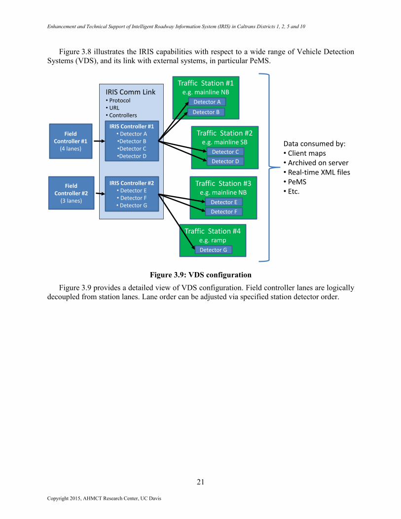
Figure 3.9: VDS configuration
Figure 3.9 provides a detailed view of VDS configuration. Field controller lanes are logically
decoupled from station lanes. Lane order can be adjusted via specified station detector order.
Field Controller #1
(4 lanes)
IRIS Controller #1• Detector A•Detector B•Detector C•Detector D
IRIS Comm Link• Protocol• URL• Controllers
IRIS Controller #2• Detector E• Detector F• Detector G
Field Controller #2
(3 lanes)
Traffic Station #1e.g. mainline NB
Data consumed by:• Client maps• Archived on server• Real-time XML files• PeMS• Etc.
Traffic Station #2e.g. mainline SB
Detector A
Detector B
Detector C
Detector D
Traffic Station #3e.g. mainline NB
Detector E
Detector F
Traffic Station #4e.g. ramp
Detector G
Copyright 2015, AHMCT Research Center, UC Davis
Enhancement and Technical Support of Intelligent Roadway Information System (IRIS) in Caltrans Districts 1, 2, 5 and 10
22
Roadway Configuration
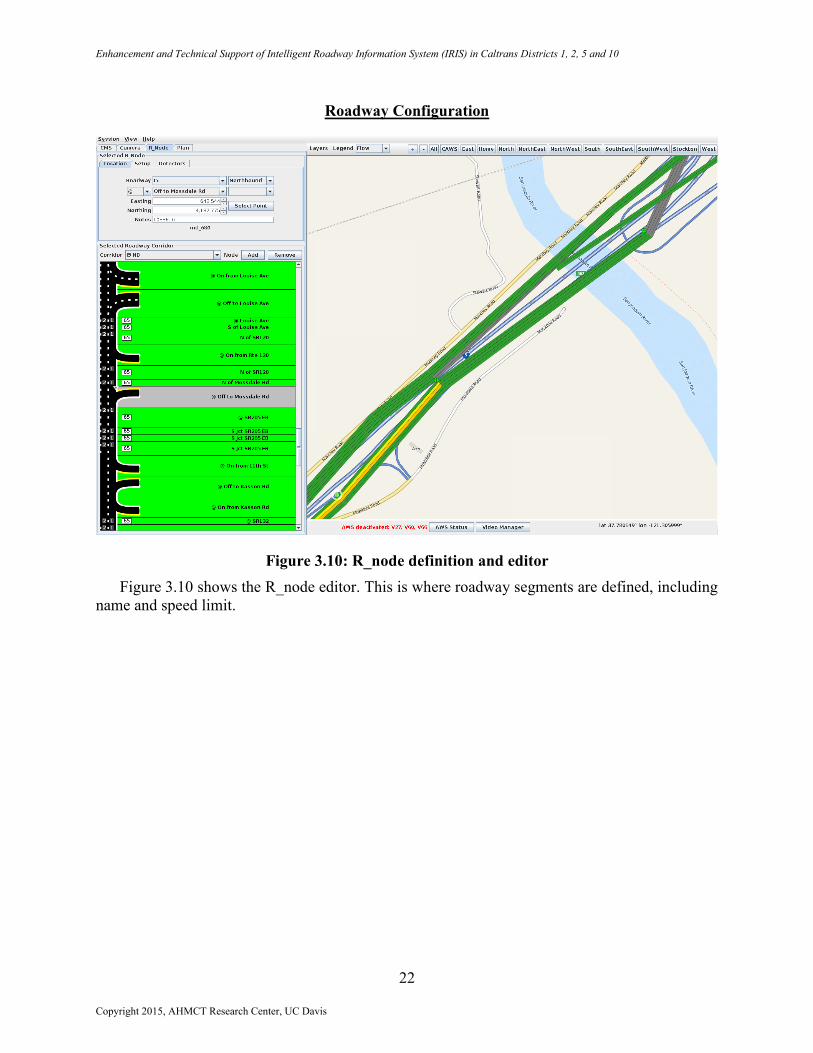
Figure 3.10: R_node definition and editor
Figure 3.10 shows the R_node editor. This is where roadway segments are defined, including
name and speed limit.
Copyright 2015, AHMCT Research Center, UC Davis
Enhancement and Technical Support of Intelligent Roadway Information System (IRIS) in Caltrans Districts 1, 2, 5 and 10
23
Communication Diagnostics
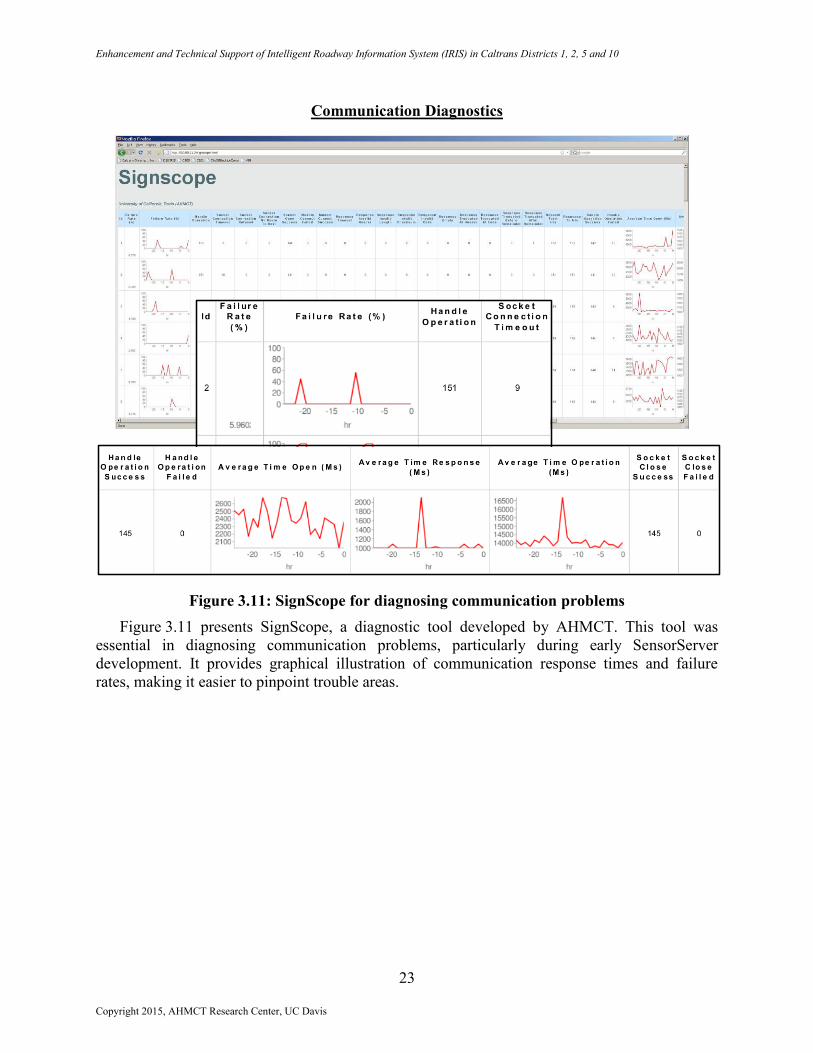
Figure 3.11: SignScope for diagnosing communication problems
Figure 3.11 presents SignScope, a diagnostic tool developed by AHMCT. This tool was
essential in diagnosing communication problems, particularly during early SensorServer
development. It provides graphical illustration of communication response times and failure
rates, making it easier to pinpoint trouble areas.
Copyright 2015, AHMCT Research Center, UC Davis
Enhancement and Technical Support of Intelligent Roadway Information System (IRIS) in Caltrans Districts 1, 2, 5 and 10
24
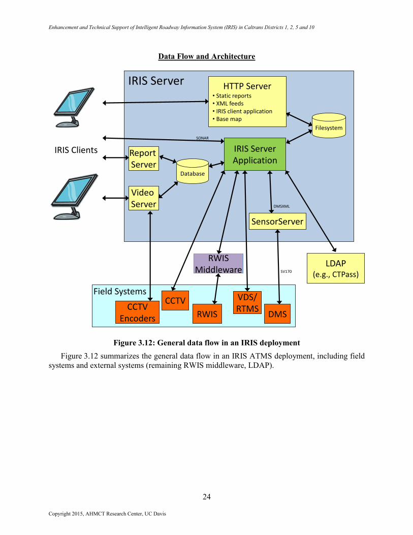
Data Flow and Architecture
Figure 3.12: General data flow in an IRIS deployment
Figure 3.12 summarizes the general data flow in an IRIS ATMS deployment, including field
systems and external systems (remaining RWIS middleware, LDAP).
SensorServer
IRIS Clients
CCTVEncoders
IRIS Server
Database
DMSRWIS
Video Server
VDS/RTMS
LDAP(e.g., CTPass)
HTTP Server• Static reports• XML feeds• IRIS client application• Base map
Field Systems
DMSXML
IRIS ServerApplication
Report Server
SONAR
SV170
CCTV
RWISMiddleware
Filesystem
Copyright 2015, AHMCT Research Center, UC Davis

Enhancement and Technical Support of Intelligent Roadway Information System (IRIS) in Caltrans Districts 1, 2, 5 and 10
25
Figure 3.13: IRIS binary modules
Figure 3.13 presents the binary modules for IRIS, and their interconnections.
IRIS Client• CMS, RWIS, Video, etc.• AWS• Mapping• Etc.
Mapbean(mapping)
Tdxml(XML)
Video
Log(logging)
SONAR(communications)
Scheduler
IRIS Server• Device drivers• CMS, RWIS, Video, etc.• Incidents• CAWS• Active Traffic Management• Etc.
GeoKit(geospatial library)
Common(shared functionality)
Copyright 2015, AHMCT Research Center, UC Davis
Enhancement and Technical Support of Intelligent Roadway Information System (IRIS) in Caltrans Districts 1, 2, 5 and 10
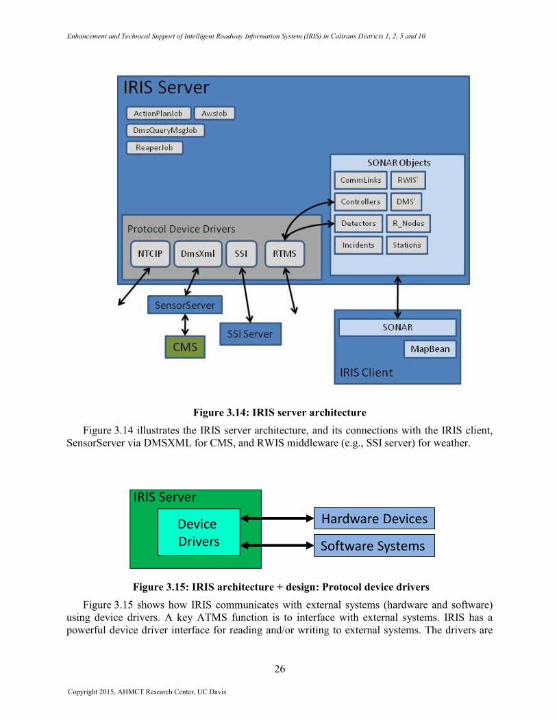
Figure 3.14: IRIS server architecture Figure 3.14 illustrates the IRIS server architecture, and its connections with the IRIS client,
SensorServer via DMSXML for CMS, and RWIS middleware (e.g., SSI server) for weather.
Figure 3.15: IRIS architecture + design: Protocol device drivers Figure 3.15 shows how IRIS communicates with external systems (hardware and software)
using device drivers. A key ATMS function is to interface with external systems. IRIS has a powerful device driver interface for reading and/or writing to external systems. The drivers are
26
Copyright 2015, AHMCT Research Center, UC Davis
Device
Drivers
IRIS Server
Software Systems
Hardware Devices
Enhancement and Technical Support of Intelligent Roadway Information System (IRIS) in Caltrans Districts 1, 2, 5 and 10
27
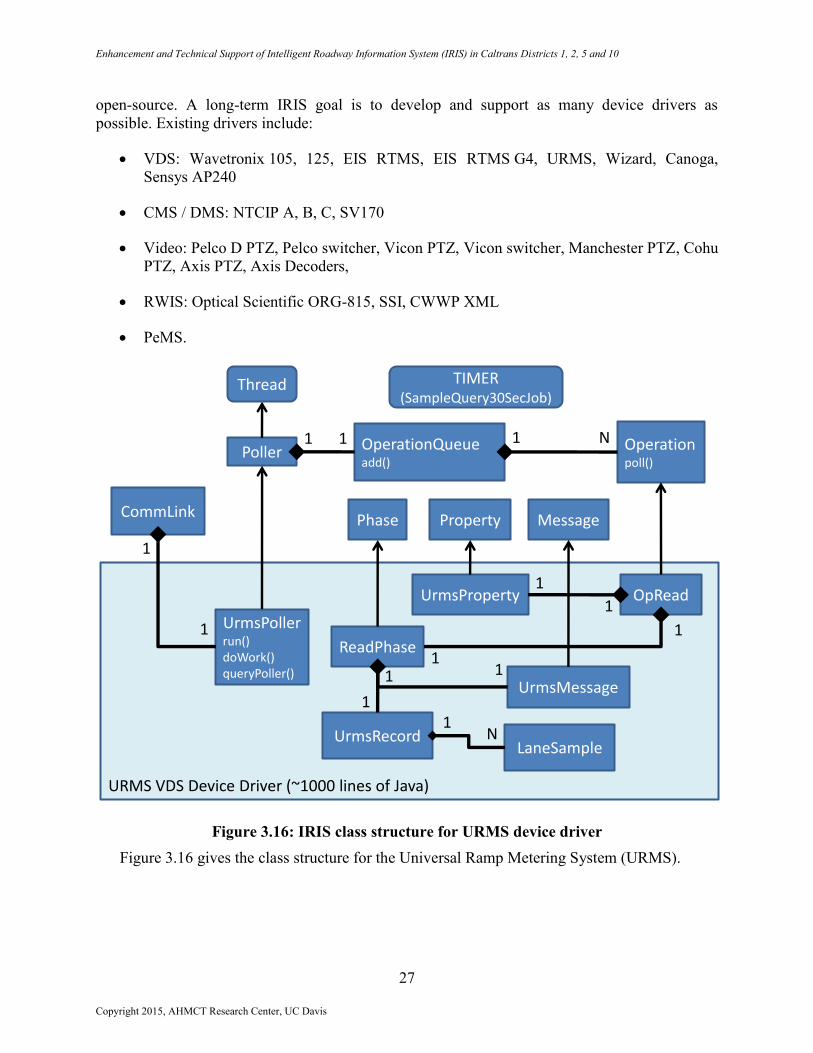
open-source. A long-term IRIS goal is to develop and support as many device drivers as
possible. Existing drivers include:
VDS: Wavetronix 105, 125, EIS RTMS, EIS RTMS G4, URMS, Wizard, Canoga,
Sensys AP240
CMS / DMS: NTCIP A, B, C, SV170
Video: Pelco D PTZ, Pelco switcher, Vicon PTZ, Vicon switcher, Manchester PTZ, Cohu
PTZ, Axis PTZ, Axis Decoders,
RWIS: Optical Scientific ORG-815, SSI, CWWP XML
PeMS.
Figure 3.16: IRIS class structure for URMS device driver
Figure 3.16 gives the class structure for the Universal Ramp Metering System (URMS).
UrmsPollerrun()doWork()queryPoller()
CommLink
OperationQueueadd()
Operationpoll()
ReadPhase
OpRead
Poller
Property
UrmsProperty
URMS VDS Device Driver (~1000 lines of Java)
Phase
UrmsRecordLaneSample
1 1 1
1
1
1
11
1
1
1
1
N
N
Message
UrmsMessage1
Thread TIMER(SampleQuery30SecJob)
Copyright 2015, AHMCT Research Center, UC Davis
Enhancement and Technical Support of Intelligent Roadway Information System (IRIS) in Caltrans Districts 1, 2, 5 and 10
28
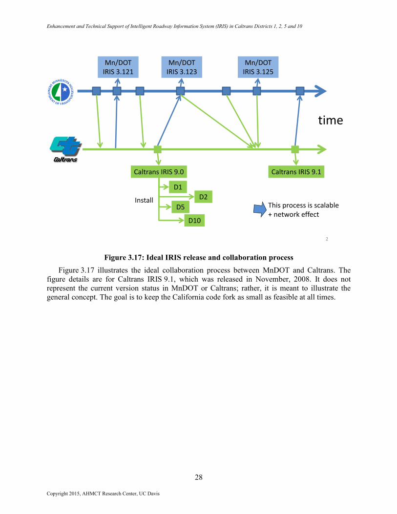
Figure 3.17: Ideal IRIS release and collaboration process
Figure 3.17 illustrates the ideal collaboration process between MnDOT and Caltrans. The
figure details are for Caltrans IRIS 9.1, which was released in November, 2008. It does not
represent the current version status in MnDOT or Caltrans; rather, it is meant to illustrate the
general concept. The goal is to keep the California code fork as small as feasible at all times.
Caltrans IRIS 9.0 Caltrans IRIS 9.1
time
Mn/DOT IRIS 3.121
Mn/DOT IRIS 3.125
Mn/DOT IRIS 3.123
D1
D2
D10
D5
2
This process is scalable + network effect
Install
Copyright 2015, AHMCT Research Center, UC Davis

Enhancement and Technical Support of Intelligent Roadway Information System (IRIS) in Caltrans Districts 1, 2, 5 and 10
29
Video
Figure 3.18: D10 video architecture
Figure 3.18 provides the District 10 video architecture.
Copyright 2015, AHMCT Research Center, UC Davis
Enhancement and Technical Support of Intelligent Roadway Information System (IRIS) in Caltrans Districts 1, 2, 5 and 10
30
Figure 3.19: Video interface
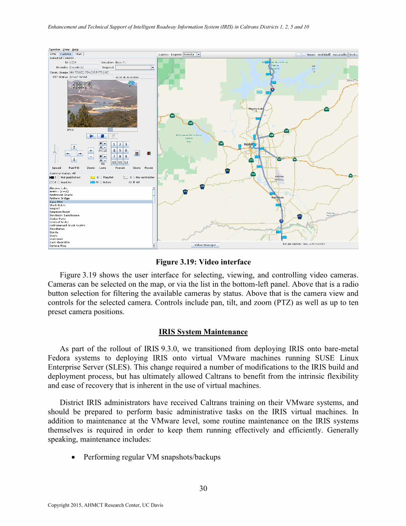
Figure 3.19 shows the user interface for selecting, viewing, and controlling video cameras.
Cameras can be selected on the map, or via the list in the bottom-left panel. Above that is a radio
button selection for filtering the available cameras by status. Above that is the camera view and
controls for the selected camera. Controls include pan, tilt, and zoom (PTZ) as well as up to ten
preset camera positions.
IRIS System Maintenance
As part of the rollout of IRIS 9.3.0, we transitioned from deploying IRIS onto bare-metal
Fedora systems to deploying IRIS onto virtual VMware machines running SUSE Linux
Enterprise Server (SLES). This change required a number of modifications to the IRIS build and
deployment process, but has ultimately allowed Caltrans to benefit from the intrinsic flexibility
and ease of recovery that is inherent in the use of virtual machines.
District IRIS administrators have received Caltrans training on their VMware systems, and
should be prepared to perform basic administrative tasks on the IRIS virtual machines. In
addition to maintenance at the VMware level, some routine maintenance on the IRIS systems
themselves is required in order to keep them running effectively and efficiently. Generally
speaking, maintenance includes:
Performing regular VM snapshots/backups
Copyright 2015, AHMCT Research Center, UC Davis
Enhancement and Technical Support of Intelligent Roadway Information System (IRIS) in Caltrans Districts 1, 2, 5 and 10
31
Updating operating system packages
Ensuring that sufficient free disk space exists
Updating IRIS configuration if field elements change or are added (e.g., VDS, CMS,
CCTV, RWIS sites, AWS configuration)
Mapping
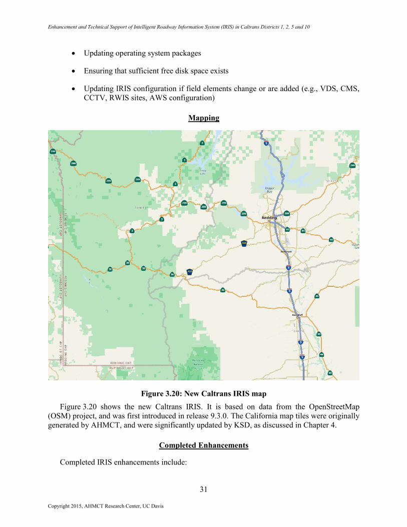
Figure 3.20: New Caltrans IRIS map
Figure 3.20 shows the new Caltrans IRIS. It is based on data from the OpenStreetMap
(OSM) project, and was first introduced in release 9.3.0. The California map tiles were originally
generated by AHMCT, and were significantly updated by KSD, as discussed in Chapter 4.
Completed Enhancements
Completed IRIS enhancements include:
Copyright 2015, AHMCT Research Center, UC Davis
Enhancement and Technical Support of Intelligent Roadway Information System (IRIS) in Caltrans Districts 1, 2, 5 and 10
32
IRIS Release 9.3
o Support for D1/D2/D5 CCTV infrastructure
o Support for Axis video decoders
o Support for Cohu and Axis PTZ protocols
o Support for PTZ presets
o Enhanced VDS support (including RTMS G4 and Sensys devices)
o OpenStreetMap support
o CMS status XML feeds to provide data to external applications
o Various new reports, including monthly CMS activation report
o Support for SUSE Enterprise Linux
IRIS Release 10.0
o Merge of California IRIS code with MnDOT version 4.22
o Updated base map
o Assorted bug fixes
o Acceptance testing planned for May 2015
o Release planned in June 2015
Future Enhancements
Future IRIS enhancements include:
IRIS Release 10.1 and beyond
o CCTV home presets for daylight and nighttime schedules
o Bulk configuration for field elements
o Ability to configure AWS with IRIS client
o Integration with weigh-in-motion
o Support for Bluetooth-based travel times
o Spell check CMS messages, including abbreviations
Copyright 2015, AHMCT Research Center, UC Davis
Enhancement and Technical Support of Intelligent Roadway Information System (IRIS) in Caltrans Districts 1, 2, 5 and 10
33
o CMS XML feed
o PeMS enhancements
o Monitoring and control of portable CMS
o Add support for district chain control operations
o Ramp metering
o Integration with TMCAL (Transportation Management Center Activity
Logging)
o URMS ramp-metering support
o HAR support
o Lane-closure support
o Inter-district travel time generation
IRIS Release 10.1 and future releases are anticipated biannually under maintenance contract
with SwRI. AHMCT has participated on the requirements definition for Release 10.1. SwRI is
now established as the Caltrans’ IRIS maintenance contractor for the next two years.
Competitively bid IRIS software maintenance contracts are expected to continue into the future.
In addition to ongoing maintenance, it is anticipated that Caltrans will pursue more substantial
enhancements to IRIS, including potential capabilities such as Highway Advisory Radio, ramp
metering, and extensive graphical user interface features. These more extensive enhancements
are beyond IRIS maintenance, and will require additional resources. As such, it is anticipated
that Caltrans will go to bid for development of these enhancements as they are identified and
prioritized by the Caltrans IRIS team, and as funding becomes available.
Copyright 2015, AHMCT Research Center, UC Davis
Enhancement and Technical Support of Intelligent Roadway Information System (IRIS) in Caltrans Districts 1, 2, 5 and 10
34
CHAPTER 4:
KNOWLEDGE TRANSFER FOR SYSTEM MAINTENANCE
With the successful deployment of IRIS to four rural districts in Caltrans, this project is the
closing phase for active research on the IRIS platform. Caltrans has established a maintenance
contract with SwRI, and AHMCT supported knowledge transfer to SwRI during the final months
of this project. This process will continue beyond the end of the current project. AHMCT has
also supported knowledge transfer to its subcontractor, KSD, during their work on multiple IRIS
tickets. Those efforts will be detailed here.
KSD Enhancement of IRIS Static Map
The IRIS OSM-based static map was added in IRIS 9.3, using tiles generated by AHMCT.
This was a substantial improvement over prior IRIS mapping, which was simply line images
representing roadways. However, several potential improvements were identified by the
operators and managers, including:
Updating the map to reflect the current OSM database
Enhancing the visibility of county boundaries
Reducing the density of highway signs
Adding highway exit numbers
And adding California Highway Patrol (CHP) dispatch boundaries and labels.
KSD performed this work from October through December 2014. An essential component of
this effort involved updating the mapping tool chain, which was last used in 2012. Many of the
tools used in the mapping process changed significantly in this period. Executables had to be
updated, configuration files had to be revised, and mapping scripts required modification.
AHMCT updated the mapping tool chain, and provided a fast mapping server for KSD’s use.
The mapping tool chain is documented in the California IRIS developer documentation for future
reference. As mapping updates are generally a significant effort, mapping updates are relatively
infrequent, and it is highly likely that the tool chain will need significant updating each time the
map is updated.
SwRI Test Case Development
SwRI began its role as the IRIS maintenance contractor in July 2014. Their staff attended
regular and as-needed IRIS meetings throughout the remainder of the project, and beyond. To
facilitate the knowledge transfer process, Caltrans organized an in-person meeting, held at the
AHMCT Research Center, on July 8 - 9, 2014.
In order to rapidly get SwRI up to speed, SwRI was tasked with acceptance test case
development for IRIS 10.0. SwRI began working on test cases in August 2014, and finished the
Copyright 2015, AHMCT Research Center, UC Davis
Enhancement and Technical Support of Intelligent Roadway Information System (IRIS) in Caltrans Districts 1, 2, 5 and 10
35
final test cases at the end of this research project. Final IRIS 10.0 acceptance testing and release
will follow the conclusion of this project.
Improvement and Simplification of the IRIS Build Process
The IRIS build process had been developed by and for AHMCT researchers. It was
appropriate for such use. However, when the time came for transfer to another development
team, it was clear that the process could be improved, simplified, and streamlined. AHMCT has
made these process improvements in order to facilitate transitioning of development and support
to SwRI. The current IRIS build process is detailed in the California IRIS developer
documentation for future reference.
Copyright 2015, AHMCT Research Center, UC Davis
Enhancement and Technical Support of Intelligent Roadway Information System (IRIS) in Caltrans Districts 1, 2, 5 and 10
36
CHAPTER 5:
CONCLUSIONS
Key contributions of this research project included:
Deployment of IRIS to Districts 1, 2, 5, and 10
Enhancements and maintenance of IRIS for four districts
A substantially simplified, improved, and streamlined IRIS build process
Significantly improved IRIS mapping.
Benefits from the research and the continuing availability of the tools and data include:
Availability of IRIS as a traffic management system for rural TMCs
A unified tool and interface for device control and monitoring
A collaborative model for cooperative development among multiple DOTs,
universities, and private companies.
Lessons Learned
Over the course of the project, the challenges encountered have given us insight which may lead
to better manage IRIS development and support into the future:
More detailed communications with the Caltrans districts is important, especially
during the design phase of new enhancements. Meeting the requirements alone does
not guarantee acceptance by the district.
Better developer transition planning is needed. At one point the project lost its lead
developer and the transition to a new developer introduced undesirable delays.
Having more than one developer with a comprehensive understanding of IRIS would
help significantly. In addition, more complete internal documentation is needed to
decrease the amount of time required for a new developer to get up-to-speed on the
project.
Maintaining unmerged code (forking) is not recommended. In order to prevent this, it
is essential that feedback from MnDOT is solicited as early as possible in the
requirements or design phase, since designing enhancements to be as general as
possible increases the likelihood that the changes will be accepted upstream. While
this approach requires more time upfront, it will save time in the long run, since
maintaining a code fork is extremely time-consuming. With unmerged changesets,
each of these changesets must be refactored during every merge. In addition, writing
more general code means that time will also be saved when attempting to support new
Caltrans districts.
Copyright 2015, AHMCT Research Center, UC Davis
Enhancement and Technical Support of Intelligent Roadway Information System (IRIS) in Caltrans Districts 1, 2, 5 and 10
37
The serial, single-branch model used by AHMCT to manage its changesets has
shortcomings, and adds to the difficulty of upstream merges to MnDOT. In the future,
a parallel model based on feature branches is suggested.
Future Work
With IRIS deployed into Districts 1, 2, 5, and 10, on-going software maintenance will
continue through third-party software integrators using the State’s competitive bidding process.
It is important to plan for continued maintenance, but also to have a mechanism to gear up for
major enhancements and overhauls, i.e. enhancements that are above and beyond the capacity of
planned maintenance team efforts.
Under previous phase efforts, some unexpected regressions were experienced after
developing new features or fixes. The creation of automated test cases has helped to catch
regressions in advance of acceptance testing and release. End-to-end automated test cases
throughout IRIS are needed. Significant work has been spent in developing such tests. However,
further work is needed, and this should be an ongoing area of effort and attention.
As noted in Chapter 3, developing a consistent and effective approach to documentation for
an open-source project with multiple contributors is challenging. Approaches that can be
effective for monolithic efforts may not be successful for open-source development. There are
effective models available in the open-source community. Evaluating effective models and state-
of-practice for open-source project documentation would be an important future task.
MnDOT continues its own IRIS development at a rapid pace. Keeping up with MnDOT’s
code changes is a difficult but vital task. Handling change management is a particularly
challenging area that can delay system delivery and, if not handled properly, can lead to forking
of a software project, with resultant loss of collaborative benefits. Unintentional de facto forking
can result from a lack of attention toward change management. For continuing IRIS efforts, for
both maintenance and enhancements, it will be essential for the two DOTs and any of their
contractors to collaborate more closely and effectively. It would be extremely useful to look at
existing and previous related projects in open-source and transportation software development,
identify best practices and procedures, and develop recommendations for future Caltrans
collaborative efforts, including ongoing efforts such as IRIS. Improved change management
procedures will enhance the results and value of Caltrans collaborative software development,
and allow Caltrans to more easily and fruitfully collaborate with other agencies.
Given the discussion in the previous paragraph, it is clear that proper code management to
avoid forking takes developer effort. Given the maturity of California’s IRIS implementation, it
is reasonable to ask whether it might make sense to fork at this time, and focus this effort into
exclusive California developments. There are advantages and disadvantages to this. Most
obviously, no further effort would be needed to manage the code to keep current with another
agency’s code. The developer time that would have been spent on this effort could be channeled
into development focused exclusively on Caltrans’ needs. However, a decision to permanently
fork has serious implications. Caltrans would then lose the benefit of any future developments by
MnDOT. In addition, Caltrans would not see any benefits from contributions to IRIS by other
states, e.g. Nebraska and Wyoming, who would most likely continue participating in MnDOT’s
Copyright 2015, AHMCT Research Center, UC Davis

Enhancement and Technical Support of Intelligent Roadway Information System (IRIS) in Caltrans Districts 1, 2, 5 and 10
38
IRIS project. In fact, it would likely be difficult to attract any other states to participate with
California, given the tendency of Caltrans to develop its own field element standards. In
addition, it would be less attractive to consultants to bid on California-specific IRIS
development. A key current motivation for consultants to bid and develop expertise in IRIS is
that they can anticipate leveraging this expertise through work with other states. In general,
Caltrans would lose the known and demonstrated benefits of participating in an open-source
project, were they to deliberately fork [2]. It would be instructive to quantify this issue by
tracking the amount of time or money spent on code management to prevent forking vs. the
benefits of developments provided by MnDOT and other participants. It must be emphasized that
the level of effort experienced in the current project to get back in synch with MnDOT is far
higher than what would be experienced using proper code management practices once Caltrans is
back in synch with MnDOT. Our estimate is that by keeping current with MnDOT on at least a
monthly basis, the effort required would be approximately one to two hours per month. Our
strong belief is that Caltrans will be better served by continuing as a part of the MnDOT IRIS
open-source project.
New features and enhancements are regularly requested along with ongoing maintenance and
minor bug fixes. SwRI is now established as the Caltrans IRIS maintenance contractor for the
next two years. Competitively bid IRIS software maintenance contracts are expected to continue
into the future. In addition to ongoing maintenance, it is anticipated that Caltrans will pursue
more substantial enhancements to IRIS, including potential capabilities such as Highway
Advisory Radio, ramp metering, and extensive graphical user interface features. These more
extensive enhancements are beyond IRIS maintenance, and will require additional resources. As
such, it is anticipated that Caltrans will go to bid for development of these enhancements as they
are identified and prioritized by the Caltrans IRIS team, and as funding becomes available.
REFERENCES
1. M.T. Darter, T.B. Swanston, K.S. Yen, B. Ravani, and T.A. Lasky, "Ahmct Intelligent
Roadway Information System (Iris) Technical Support and Testing," Advanced Highway
Maintenance and Construction Technology Research Center Rept. # UCD-ARR-11-12-
31-01, 2011.
2. M.T. Darter, K.S. Yen, T.B. Swanston, B. Ravani, and T.A. Lasky, "Research &
Development of Open-Source Advanced Transportation Management System Hardware
and Software Components," Advanced Highway Maintenance and Construction
Technology Research Center Rept. # UCD-ARR-09-08-31-01, 2009.
Copyright 2015, AHMCT Research Center, UC Davis
Enhancement and Technical Support of Intelligent Roadway Information System (IRIS) in Caltrans Districts 1, 2, 5 and 10
39
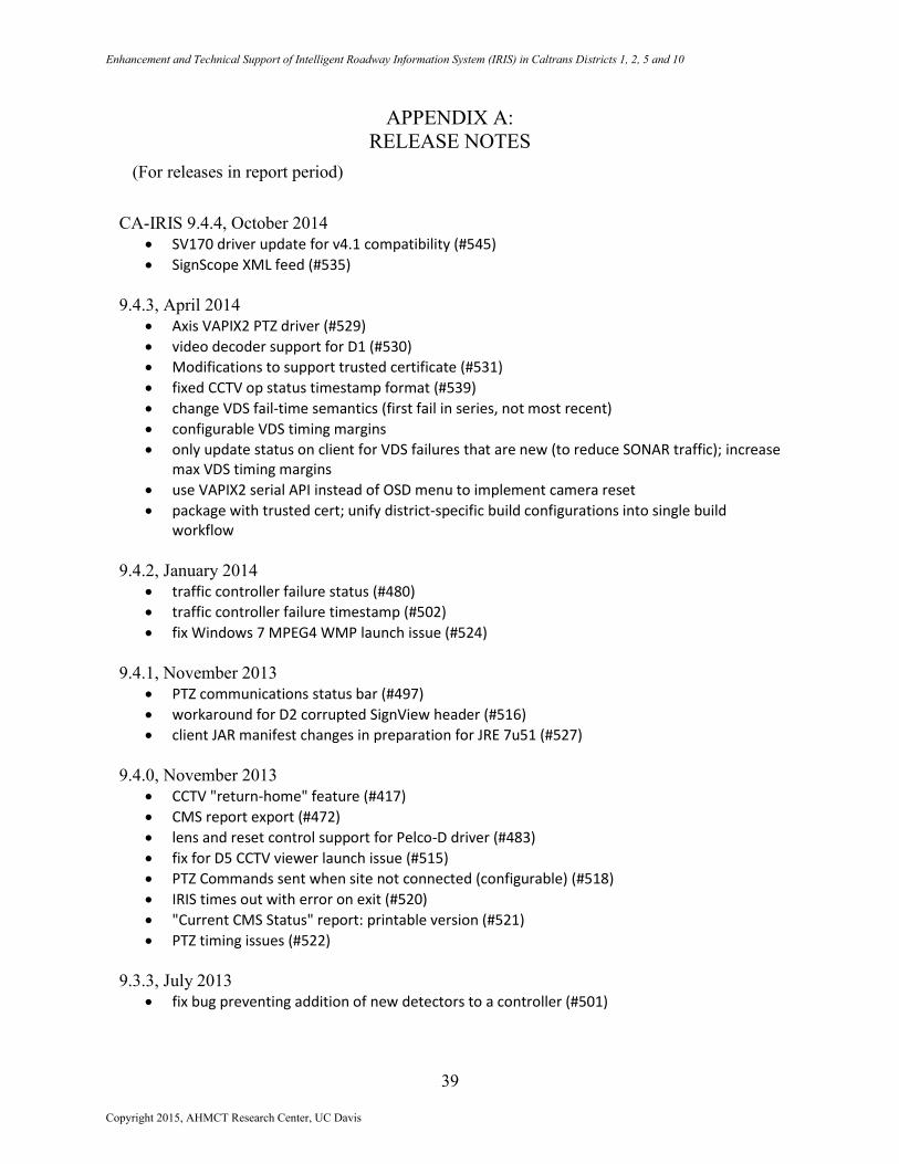
APPENDIX A:
RELEASE NOTES
(For releases in report period)
CA-IRIS 9.4.4, October 2014
SV170 driver update for v4.1 compatibility (#545)
SignScope XML feed (#535)
9.4.3, April 2014
Axis VAPIX2 PTZ driver (#529)
video decoder support for D1 (#530)
Modifications to support trusted certificate (#531)
fixed CCTV op status timestamp format (#539)
change VDS fail-time semantics (first fail in series, not most recent)
configurable VDS timing margins
only update status on client for VDS failures that are new (to reduce SONAR traffic); increase max VDS timing margins
use VAPIX2 serial API instead of OSD menu to implement camera reset
package with trusted cert; unify district-specific build configurations into single build workflow
9.4.2, January 2014
traffic controller failure status (#480)
traffic controller failure timestamp (#502)
fix Windows 7 MPEG4 WMP launch issue (#524)
9.4.1, November 2013
PTZ communications status bar (#497)
workaround for D2 corrupted SignView header (#516)
client JAR manifest changes in preparation for JRE 7u51 (#527)
9.4.0, November 2013
CCTV "return-home" feature (#417)
CMS report export (#472)
lens and reset control support for Pelco-D driver (#483)
fix for D5 CCTV viewer launch issue (#515)
PTZ Commands sent when site not connected (configurable) (#518)
IRIS times out with error on exit (#520)
"Current CMS Status" report: printable version (#521)
PTZ timing issues (#522)
9.3.3, July 2013
fix bug preventing addition of new detectors to a controller (#501)
Copyright 2015, AHMCT Research Center, UC Davis
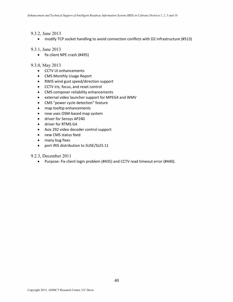
Enhancement and Technical Support of Intelligent Roadway Information System (IRIS) in Caltrans Districts 1, 2, 5 and 10
40
9.3.2, June 2013
modify TCP socket handling to avoid connection conflicts with D2 infrastructure (#513)
9.3.1, June 2013
fix client NPE crash (#495)
9.3.0, May 2013
CCTV UI enhancements
CMS Monthly Usage Report
RWIS wind gust speed/direction support
CCTV iris, focus, and reset control
CMS composer reliability enhancements
external video launcher support for MPEG4 and WMV
CMS "power cycle detection" feature
map tooltip enhancements
now uses OSM-based map system
driver for Sensys AP240
driver for RTMS G4
Axis 292 video decoder control support
new CMS status feed
many bug fixes
port IRIS distribution to SUSE/SLES 11
9.2.3, December 2011
Purpose: Fix client login problem (#435) and CCTV read timeout error (#440).
Copyright 2015, AHMCT Research Center, UC Davis