Embed Size (px)
Citation preview

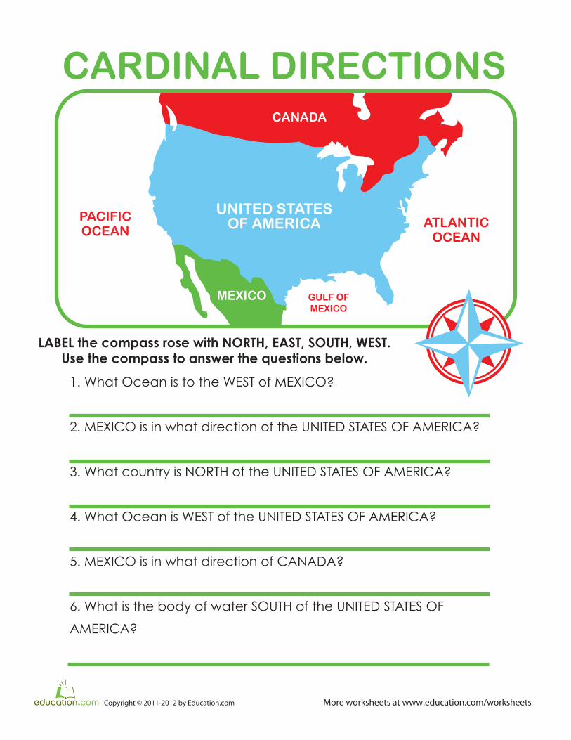
UNITED STATES OF AMERICA
MEXICO
CANADA
MEXICO
PACIFICOCEAN
GULF OFMEXICO
ATLANTICOCEAN
120 W110 W
105 W100 W 95 W 90 W 85 W 80 W 75 W 70 W
115 W
40 N
45 N
35 N
30 N
UNITED STATESOF AMERICA
Map It Out
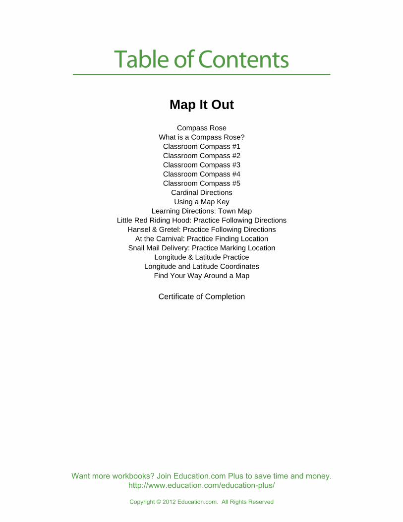
Table of Contents
Copyright © 2012 Education.com. All Rights Reserved
Want more workbooks? Join Education.com Plus to save time and money.http://www.education.com/education-plus/
Map It Out
Compass RoseWhat is a Compass Rose?
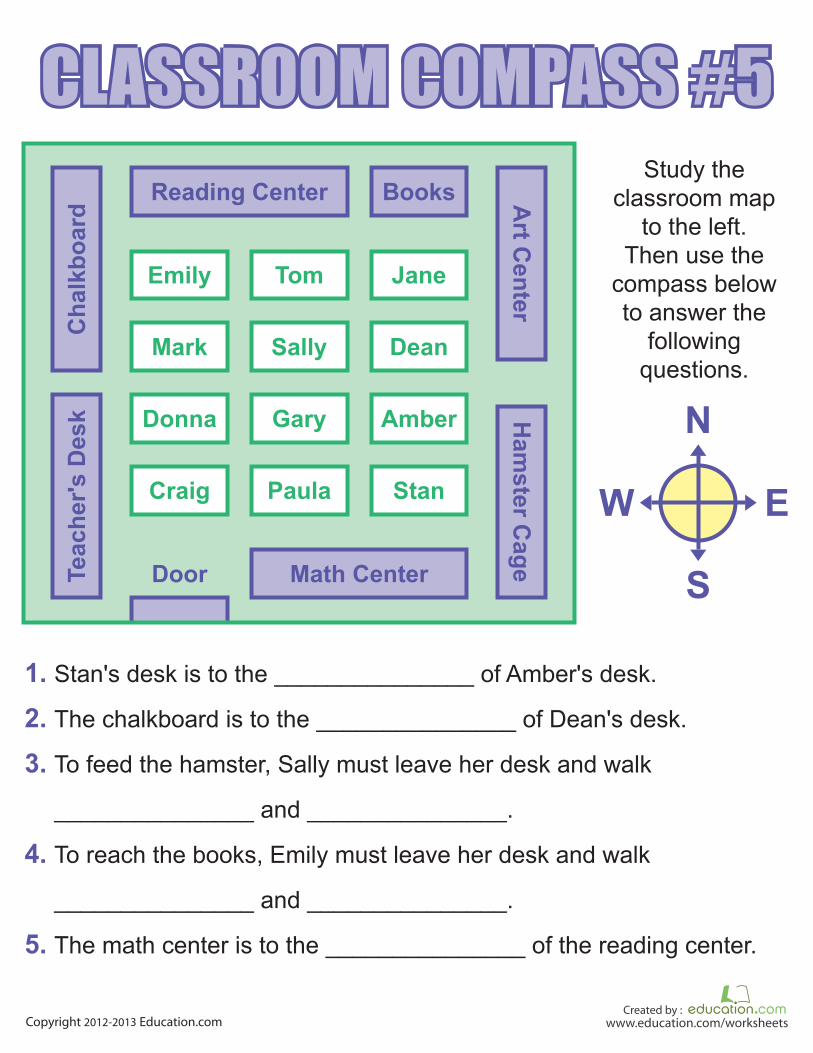
Classroom Compass #1Classroom Compass #2Classroom Compass #3Classroom Compass #4Classroom Compass #5
Cardinal DirectionsUsing a Map Key
Learning Directions: Town MapLittle Red Riding Hood: Practice Following Directions
Hansel & Gretel: Practice Following DirectionsAt the Carnival: Practice Finding Location
Snail Mail Delivery: Practice Marking LocationLongitude & Latitude Practice
Longitude and Latitude CoordinatesFind Your Way Around a Map
Certificate of Completion
COMPASS ROSE
More worksheets at www.education.com/worksheetsCopyright © 2011-2012 by Education.com
Fill in the directions from the word box onto the points of
the compass rose.
WORD BOX:
NORTH. NORTHWEST. NORTHEAST. EAST. SOUTH. SOUTHEAST. SOUTHWEST. WEST
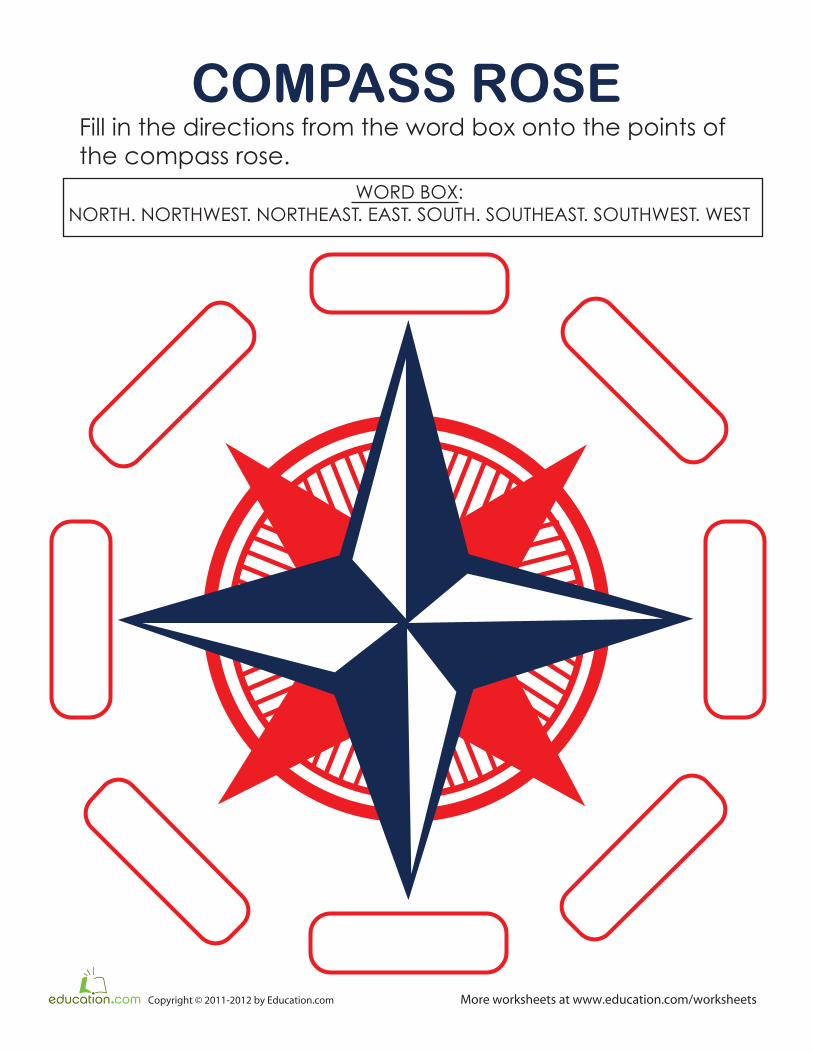
A compass rose is a figure on a map, chart, or compass that displays
the directions. Most show points for the “cardinal directions”: North,
South, East, and West. Some, like the one below, also have points
for Northeast, Northwest, Southeast, and Southwest.
Answer the questions below to practice using the compass rose.
Then, color it in!
Compass Rose
1. If you walked North, then made a left turn, what would be your new
direction? ______________
2. If you were walking in the Northwest direction, then turned to walk
the opposite way, what would be your new direction? ___________
Answers: 1) WEST 2) SOUTHEAST


UNITED STATES OF AMERICA
MEXICO
UNITED STATES
OF AMERICA
CANADA
MEXICO
PACIFIC
OCEAN
GULF OF
MEXICO
ATLANTIC
OCEAN
CARDINAL DIRECTIONS
LABEL the compass rose with NORTH, EAST, SOUTH, WEST.
Use the compass to answer the questions below.
1. What Ocean is to the WEST of MEXICO?
2. MEXICO is in what direction of the UNITED STATES OF AMERICA?
3. What country is NORTH of the UNITED STATES OF AMERICA?
4. What Ocean is WEST of the UNITED STATES OF AMERICA?
5. MEXICO is in what direction of CANADA?
6. What is the body of water SOUTH of the UNITED STATES OF
AMERICA?
More worksheets at www.education.com/worksheetsCopyright © 2011-2012 by Education.com


TOWN MAP
LABEL the compass rose with N, S, E, W.
Write NORTH, SOUTH, EAST OR WEST to complete each sentence.
1. Harriet heads to go to school.
2. Larry goes to go to Harriet’s house.
3. Kim heads to go to the supermarket.
4. A police officer would go to the supermarket.
5. Kids at school head to play at the park.
6. Harriet’s dad is a police officer. He heads to go
to work.
7. Larry heads to go to school.
8. Kim heads to visit Larry.
More worksheets at www.education.com/worksheetsCopyright © 2011-2012 by Education.com
KEY
MAPLE PARK
MA
PLE
L
AN
E
ANDREWS STREET
MCBEAN STREET
DEYOUNG STREET
HEM
ING
A
VEN
UE
SU
GA
R A
VE.
OR
AN
GE
AV
EN
UE
HOUSE
POLICE STATION
SUPERMARKET
SCHOOL
Kim’s HouseLarry’s House
Harriet’s House

Little
More worksheets at www.education.com/worksheetsCopyright © 2010-2011 by Education.com
Help Little Red Riding Hood �nd her way to meet her grandmother.
Follow the instructions below.
1st
Grade
Math
GeometryRed HoodRiding
Go one block to your right
Go one block down.
Go two blocks to your right.
Go down one block.
Go one block to your left.
Go down. Go one block to
your right.
Meet the grandma!
Practice Following Directions
START
FINISH

More worksheets at www.education.com/worksheetsCopyright © 2010-2011 by Education.com
Help Hansel and Gretel �nd their way home. Be careful not to go to the gingerbread house!
Follow the directions below.
1st
Grade
Math
Geometry Hansel & Gretel
Directions:
Go one block up. Go one block to your right.
Go one block up. Go another block to your right.
Go one block down. Go one block to your right.
Go two blocks up. Go two blocks to your left.
Practice Following Directions
START
FINISH
More worksheets at welcomeness/worksheetsCopyright © 2010-2011 by Educationally
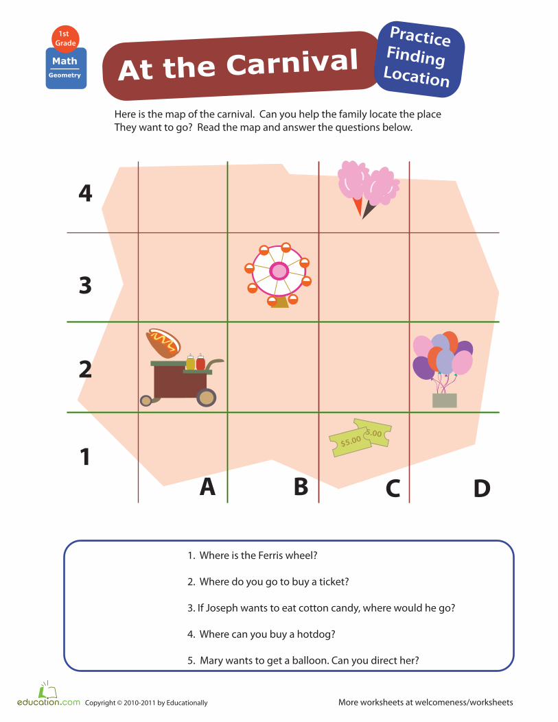
Here is the map of the carnival. Can you help the family locate the place
They want to go? Read the map and answer the questions below.
1. Where is the Ferris wheel?
2. Where do you go to buy a ticket?
3. If Joseph wants to eat cotton candy, where would he go?
4. Where can you buy a hotdog?
5. Mary wants to get a balloon. Can you direct her?
At the CarnivalPracticeFinding Location
1st
Grade
Math
Geometry
4
3
2
1
A B C D
$5.00
$5.00

More worksheets at www.education.com/worksheetsCopyright © 2010-2011 by Education.com
Help the Snail mailman deliver letters. Find each house on his route using
the letter and number coordinates. Then check that the mail has been delivered.
1st
Grade
Math
Geometry
Practice
Marking Location
4
5
3
2
1A B C D E
A2
A4
Snail Mail Delivery
1.12
B5
B3
C3
D2
E1
E4

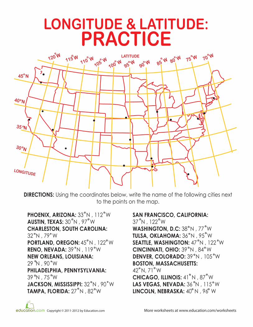
LONGITUDE & LATITUDE:
PRACTICE
More worksheets at www.education.com/worksheetsCopyright © 2011-2012 by Education.com
120 W
110 W
105 W
100 W95 W
90 W 85 W 80 W 75 W 70 W115 W
40 N
45 N
35 N
30 N
DIRECTIONS: Write the name of the city and state matching the coordinates.
34 N LATITUDE , 118 W LONGITUDE
25 N LATITUDE, 80 W LONGITUDE
42 N LATITUDE, 83 W LONGITUDE
39 N LATITUDE, 94 W LONGITUDE
43 N LATITUDE, 87 W LONGITUDE
32 N LATITUDE, 96 W LONGITUDE
43 N LATITUDE, 116 W LONGITUDE
40 N LATITUDE, 111 W LONGITUDE
45 N LATITUDE, 93 W LONGITUDE
LOS ANGELES,CALIFORNIA
BOISE,IDAHO
DALLAS,TEXAS
MIAMI,
FLORIDA
DETROIT,MICHIGAN
MILWAUKEE,CHICAGO
MINNEAPOLIS,MINNESOTA
KANSAS CITY,MISSOURI
SALT LAKE CITY,UTAH
LONGITUDE & LATITUDE:
PRACTICE
More worksheets at www.education.com/worksheetsCopyright © 2011-2012 by Education.com
120 W
110 W
105 W
100 W95 W
90 W 85 W 80 W 75 W 70 W115 W
40 N
45 N
35 N
30 N
LATITUDE
LONGITUDE
DIRECTIONS: Using the coordinates below, write the name of the following cities next
to the points on the map.
PHOENIX, ARIZONA: 33 N , 112 W
AUSTIN, TEXAS: 30 N , 97 W
CHARLESTON, SOUTH CAROLINA:
32 N , 79 W
PORTLAND, OREGON: 45 N , 122 W
RENO, NEVADA: 39 N , 119 W
NEW ORLEANS, LOUISIANA:
29 N , 90 W
PHILADELPHIA, PENNYSYLVANIA:
39 N , 75 W
JACKSON, MISSISSIPPI: 32 N , 90 W
TAMPA, FLORIDA: 27 N , 82 W
SAN FRANCISCO, CALIFORNIA:
37 N , 122 W
WASHINGTON, D.C: 38 N , 77 W
TULSA, OKLAHOMA: 36 N , 95 W
SEATTLE, WASHINGTON: 47 N , 122 W
CINCINNATI, OHIO: 39 N , 84 W
DENVER, COLORADO: 39 N , 105 W
BOSTON, MASSACHUSETTS:
42 N, 71 W
CHICAGO, ILLINOIS: 41 N , 87 W
LAS VEGAS, NEVADA: 36 N , 115 W
LINCOLN, NEBRASKA: 40 N , 96 W
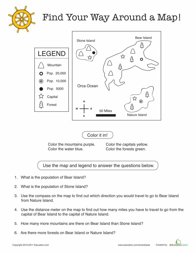
Find Your Way Around a Map!
Copyright 2010-2011 Education.com www.education.com/worksheets Created by:
Color the mountains purple.
Color the water blue.
Use the map and legend to answer the questions below.
N
E
S
W
Stone IslandBear Island
Orca Ocean
LEGEND
Mountain
Pop. 5000
Capital
Pop. 20,000
Pop. 10,000
Forest
Nature Island
50 Miles
1. What is the population of Bear Island?
2. What is the population of Stone Island?
3. Use the compass on the map to find out which direction you would travel to go to Bear Island
4. Use the distance meter on the map to find out how many miles you have to travel to go from the
5. How many more mountains are there on Bear Island than Stone Island?
6. Are there more forests on Bear Island or Nature Island?
from Nature Island.
capital of Bear Island to the capital of Nature Island.
Color the capitals yellow.
Color the forests green.
Color it in!

is an Education.com reading superstar
Great job!