Embed Size (px)
Citation preview
14 MEASURE WHAT MATTERS
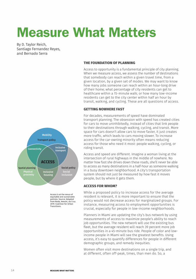
ACCESS
Transport policy
Social policySpatial planning
Connectivity
Mobility
Physical proximity
Inclusive housing
Inclusive transport
Social inclusion
Access is at the nexus of equitable and sustainable policies. Source: Adapted from Rode, Heeckt, da Cruz. 2019. Coalition for Urban Transitions.
Measure What Matters
THE FOUNDATION OF PLANNING
Access to opportunity is a fundamental principle of city planning. When we measure access, we assess the number of destinations that somebody can reach within a given travel time, from a given location, by a given set of modes. We may want to know how many jobs someone can reach within an hour-long drive of their home; what percentage of city residents can get to healthcare within a 15-minute walk; or how many low-income residents can get to the city center within half an hour by transit, walking, and cycling. These are all questions of access.
GETTING NOWHERE FAST
For decades, measurements of speed have dominated transport planning. The obsession with speed has created cities for cars to move uninhibitedly, instead of cities that link people to their destinations through walking, cycling, and transit. More space for cars doesn’t allow cars to move faster, it just creates more traffic, which leads to cars moving slower. To increase access for the car-owning minority often means reducing access for those who need it most: people walking, cycling, or riding transit.
Access and speed are different. Imagine a woman living at the intersection of rural highways in the middle of nowhere. No matter how fast she drives down these roads, she’ll never be able to access as many destinations in a half-hour as someone walking in a busy downtown neighborhood. A city's transportation system should not just be measured by how fast it moves people, but by where it gets them.
ACCESS FOR WHOM?
While a proposed policy to increase access for the average resident is relevant, it is more important to ensure that the policy would not decrease access for marginalized groups. For instance, measuring access to employment opportunities is crucial, especially for people in low-income neighborhoods.
Planners in Miami are updating the city’s bus network by using measurements of access to maximize people’s ability to reach job opportunities. The new network will use the existing bus fleet, but the average resident will reach 39 percent more job opportunities in a 45-minute bus ride. People of color and low-income people in Miami will see the greatest benefits. Using access, it’s easy to quantify differences for people in different demographic groups, and remedy inequities.
Women often visit more destinations on a single trip, and at different, often off-peak, times, than men do. So, a
By D. Taylor Reich, Santiago Fernandez Reyes, and Bernado Serra
15JANUARY 2021sustainable transport
transportation system that makes it easy to take one long trip but difficult to take many small trips is a transportation system that perpetuates structural sexism.
MEASURING ACCESS IN THE GLOBAL SOUTH
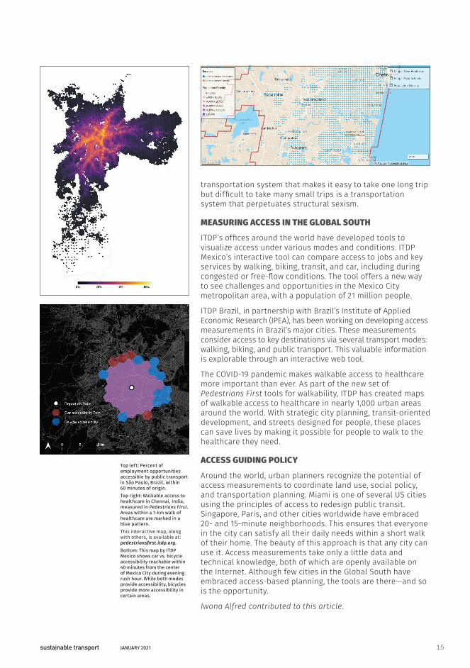
ITDP’s offices around the world have developed tools to visualize access under various modes and conditions. ITDP Mexico’s interactive tool can compare access to jobs and key services by walking, biking, transit, and car, including during congested or free-flow conditions. The tool offers a new way to see challenges and opportunities in the Mexico City metropolitan area, with a population of 21 million people.
ITDP Brazil, in partnership with Brazil’s Institute of Applied Economic Research (IPEA), has been working on developing access measurements in Brazil’s major cities. These measurements consider access to key destinations via several transport modes: walking, biking, and public transport. This valuable information is explorable through an interactive web tool.
The COVID-19 pandemic makes walkable access to healthcare more important than ever. As part of the new set of Pedestrians First tools for walkability, ITDP has created maps of walkable access to healthcare in nearly 1,000 urban areas around the world. With strategic city planning, transit-oriented development, and streets designed for people, these places can save lives by making it possible for people to walk to the healthcare they need.
ACCESS GUIDING POLICY
Around the world, urban planners recognize the potential of access measurements to coordinate land use, social policy, and transportation planning. Miami is one of several US cities using the principles of access to redesign public transit. Singapore, Paris, and other cities worldwide have embraced 20- and 15-minute neighborhoods. This ensures that everyone in the city can satisfy all their daily needs within a short walk of their home. The beauty of this approach is that any city can use it. Access measurements take only a little data and technical knowledge, both of which are openly available on the Internet. Although few cities in the Global South have embraced access-based planning, the tools are there—and so is the opportunity.
Iwona Alfred contributed to this article.
Top left: Percent of employment opportunities accessible by public transport in São Paulo, Brazil, within 60 minutes of origin. Top right: Walkable access to healthcare in Chennai, India, measured in Pedestrians First. Areas within a 1-km walk of healthcare are marked in a blue pattern. This interactive map, along with others, is available at: pedestriansfirst.itdp.org.Bottom: This map by ITDP Mexico shows car vs. bicycle accessibility reachable within 40 minutes from the center of Mexico City during evening rush hour. While both modes provide accessibility, bicycles provide more accessibility in certain areas.