Embed Size (px)
Citation preview
National Park ServicePaleontological Research
United States Department of the Interior•National Park Service•Geological Resource Division
Edited by Vincent L. Santucci and Lindsay McClellandTechnical Report NPS/NRGRD/GRDTR-99/03
NPS Fossil Resources

TECHNICAL REPORT NPS/NRGRD/GRDTR-99/3
Copies of this report are available from the editors.Geological Resources Division12795 West Alameda Parkway
Academy Place, Room 480Lakewood, CO 80227
Please refer to: National Park Service D-1341 (October 1999).
Cover IllustrationLife reconstruction of Metamynodon planifrons and an extinct crowned crane, Balearica sp. in a riparian habitat during the early Oligocene.Based on work conducted in Badlands National Park. The original painting was produced by Carl Buell.
NATIONAL PARK SERVICEPALEONTOLOGICAL RESEARCH
VOLUME 4
EDITED BY
Vincent L. SantucciNational Park Service
PO Box 592Kemmerer, WY 83101
AND
Lindsay McClellandNational Park Service
Room 3223 - Main Interior1849 C Street, N.W.
Washington, DC 20240-0001
Geologic Resources Division Technical ReportNPS/NRGRD/GRDTR-99/03
October 1999
TECHNICAL REPORT NPS/NRGRD/GRDTR-99/3
To Dr. Michael Soukup,National Park ServiceAssociate Director for
Natural Resource Stewardship & Science
iii

TECHNICAL REPORT NPS/NRGRD/GRDTR-99/3
CONTENTS
INTRODUCTION ................................................................................................................................................................ vii
BADLANDS NATIONAL PARKVertebrate paleontology of the Pierre Shale and Fox Hills formations (Late Campanian - Late Maastrichtian)of Badlands National Park, South Dakota David J. Cicimurri, Gordon L. Bell, Jr. and Philip W. Stoffer .................................................................................... 1Locomotor adaptations in Metamynodon planifrons compared to other amynodontids (Perissodactyla,Rhinocerotoidea) William P. Wall and Kristen L. Heinbaugh ................................................................................................................. 8
BIGHORN CANYON NATIONAL RECREATION AREAA preliminary assessment of paleontological resources at Bighorn Canyon National Recreation Area,Montana and Wyoming Vincent L. Santucci, David Hays, James Staebler, and Michael Milstein .............................................................. 18
CANYONLANDS NATIONAL PARKAn aetosaur (Reptilia:Archosauria) from the Upper Triassic Chinle Group, Canyonlands National Park, Utah Andrew B. Heckert, Spencer G. Lucas and Jerald D. Harris ................................................................................... 23
CHANNEL ISLANDS NATIONAL PARKGiant island/pygmy mammoths: The Late Pleistocene prehistory of Channel Islands National Park Larry D. Agenbroad and Don P. Morris ................................................................................................................... 27
CHESAPEAKE AND OHIO CANAL NATIONAL HISTORIC PARKStratigraphic and paleontologic record of the Sauk III regression in the central Appalachians David K. Brezinski, John E. Repetski and John F. Taylor ....................................................................................... 32
CURECANTI NATIONAL RECREATION AREANon-marine trace fossils from the Morrison Formation (Jurassic) of Curecanti National Recreation Area, Colorado Anthony R. Fiorillo .................................................................................................................................................. 42
DENALI NATIONAL PARK & PRESERVEAll is not quiet on the paleontological front in Denali National Park R.B. Blodgett and Phil Brease .................................................................................................................................. 47
FLORISSANT FOSSIL BEDS NATIONAL MONUMENTFossil birds of Florissant, Colorado: With a description of a new genus and species of cuckoo
Robert M. Chandler .................................................................................................................................................. 49
FOSSIL BUTTE NATIONAL MONUMENTPaleoecology and paleoenvironments during the intial stages of Eocene Fossil Lake, SW Wyoming
Roberto E. Biaggi and H. Paul Buchheim ............................................................................................................... 54Vegetational history and climatic transition in an Eocene intermontane basin: Plant microfossil evidence fromthe Green River Formation, Fossil Basin, Wyoming Robert A. Cushman ................................................................................................................................................... 66Caddisfly (Trichoptera) larval cases from Eocene Fossil Lake Mark A. Loewen, V. Leroy Leggit and H. Paul Buchheim ........................................................................................ 72
PETRIFIED FOREST NATIONAL PARKIncised valley fills in the lower part of the Chinle Formation, Petrified Forest National Park, Arizona: Complete measuredsections and regional stratigraphic implications of Upper Triassic Rocks Russel F. Dubiel, Stephen T. Hasiotis and Timothy M. Demko ................................................................................ 78
v
Probable reptile nests from the Upper Triassic Chinle Formation, Petrified Forest National Park, Arizona Stephen T. Hasiotis and Anthony J. Martin ............................................................................................................. 85Occurrences of Zamites powelli in oldest Norian strata in Petrified Forest National Park, Arizona
Alisa S. Herrick, David E. Fastovsky and Gregory D. Hoke ................................................................................... 91New discoveries of Late Triassic dinosaurs from Petrified Forest National Park, Arizona
Adrian P. Hunt and Jeremiah Wright ....................................................................................................................... 96The oldest Triassic strata exposed in Petrified Forest National Park, Arizona revisited
Francois Therrien, Matthew M. Jones, David E. Fastovsky, Alisa S. Herrick, and Gregory D. Hoke .................. 101
TIMPANOGOS CAVE NATIONAL MONUMENTAn investigation of the Late Pleistocene fauna of Timpanogos Cave National Monument, Utah Christian O. George ............................................................................................................................................... 109
WALNUT CANYON NATIONAL MONUMENTAn inventory of paleontological resources from Walnut Canyon National Monument, Arizona Vincent L. Santucci and V. Luke Santucci, Jr. ....................................................................................................... 118
MULTIPLE PARKSContinental ichnofossils from the Upper Jurassic Morrison Formation, Western Interior, USA: What organism behaviortells us about Jurassic environments and climates Stephen T. Hasiotis ................................................................................................................................................ 121
APPENDIX ........................................................................................................................................................................ 126
vi
TECHNICAL REPORT NPS/NRGRD/GRDTR-99/3
INTRODUCTION
During this last year of the century, the list of NationalPark Service areas identified with paleontological resourceshas grown to 134. Along with redwoods, grizzlies, geysers,and ancient ruins, the national parks preserve a remarkablerecord of life extending back over a billion years. The richpaleontological resources found in parks have attracted con-siderable research interest. Paleontological research fromwithin national parks is reported regularly at scientific con-ferences and provides numerous graduate students with the-sis projects.
This fourth National Park Service Paleontological Re-search Volume compiles 20 papers representing paleonto-logical research in 12 different National Park Service areas.The individual reports reflect a cross-section of the types ofpaleontological research being conducted throughout theNational Park System by academic scientists, their students,and U.S. Geological Survey staff. The contributions fromeach of the investigators and their research teams are recog-nized and acknowledged in this volume.
I am again proud to include reports documenting awide diversity of paleontological research in the nationalparks. The volume continues to include a number of papersfocusing on the biostratigraphy of Triassic sediments at Pet-rified Forest National Park. A student from Franklin andMarshall College has prepared a report on his research onthe cave fauna uncovered at Timpanogos Cave NationalMonument. Other papers in this volume include work on thePleistocene mammoths from Channel Islands National Park,marine reptiles from Badlands National Park, and a descrip-tion of a new bird from Florissant Fossil Beds National Monu-ment.
Thanks to Sid Ash, Ron Blakey, Ken Carpenter, BillCobban, Russell Dubiel, Dave Gillette, Steve Hasiotis, AdrianHunt, Clay Kyte, Greg McDonald, Steve Mitchelson, DonProthero, Tom Olson, Kris Thompson, William Wall, andMichael Whalen, for their willingness to review manuscripts.Additional thanks to Dave Shaver, Bob Higgins, DaveMcGinnis, Arvid Aase, Kris Thompson, Graeme MacDonald,Erin Retelle, Marikka Hughes and Bianca Santucci for theirsuggestions and support relative to this research publica-tion. I am indebted to Lindsay McClelland, the co-editor ofthis volume, for many contributions that helped to promotethe management, protection and research of paleontologicalresources in the national parks.
This volume is dedicated to Mike Soukup, AssociateDirector for Natural Resource Stewardship and Science inthe National Park Service. His leadership in building supportfor science-based decisionmaking has strengthened the man-agement and protection of all park natural resources. Fossilshave been key beneficiaries of these policies, as parks in-creasingly recognize the importance of paleontological re-search and the value of paleontological resources.
Finally, through the combined efforts of the womenand men already mentioned, along with many others, theNPS Paleontological Resource Program continues to grow.Many research questions remain to be explored within thenational parks and monuments. Likewise, the increasing num-bers of paleontological inventories being initiated in the parkscontinue to uncover new evidence about the biological past.A holistic approach to managing paleontological resources,which includes research, is becoming the standard practicein national parks.
Vincent L. SantucciNational Park Service
vii
VERTEBRATE PALEONTOLOGY OF THE PIERRE SHALEAND FOX HILLS FORMATIONS
(LATE CAMPANIAN - LATE MAASTRICHTIAN) OF BADLANDS NATIONAL PARK, SOUTH DAKOTA
DAVID J. CICIMURRI1, GORDEN L. BELL, JR.2, AND PHILIP W. STOFFER3
1Bob Campbell Geology Museum, Clemson, South Carolina 296342Museum of Geology, South Dakota School of Mines and Technology, Rapid City, South Dakota 57701
3U.S.G.S. Menlo Park, San Jose, California 95192
____________________
ABSTRACT—Recent field investigations were concentrated in the Pierre Shale and Fox Hills formations (Late Cretaceous)exposed in Badlands National Park (BADL). Here we describe the occurrence of vertebrate fossils from the two lithostratigraphicunits within BADL. Specimens include a tooth of the sand tiger shark, Odontaspis; a teleost tooth and scales; a partial leftmaxilla and associated dorsal vertebrae of a juvenile Mosasaurus conodon; and an isolated anterior caudal vertebra of a largeunidentified mosasaur. A rich and varied invertebrate assemblage was also found that includes: ammonites, nautiloids,gastropods, pelecypods, scaphopods, decapods, inarticulate brachiopods, bryozoa, and scleractinian corals.
The juvenile specimen of Mosasaurus conodon and the teleost tooth were collected from the Baculites cuneatusbiozone of the Verendrye Member, Pierre Shale. The teleost scales were associated with Baculites clinolobatus and Hoploscaphitesburkelundi, and were found in the Mobridge Member, Pierre Shale. The Odontaspis tooth was collected from the Elk ButteMember, Pierre Shale, whereas the isolated mosasaur caudal vertebra was collected from the upper part of the Fox HillsFormation.
____________________
INTRODUCTION
During much of the Late Cretaceous, a vastnorth-south trending epicontinental seaexisted in the Western Interior of North America.
The eastern margin of the seaway was formed by the low-lying stable Canadian Shield, while the entire western marginwas flanked by an unstable cordilleran highland (MacDonaldand Byers, 1988).
Rapid sea level rise during the late Early Campanian re-sulted in a shift from chalk deposition of the Niobrara Sea-way to muds of the Pierre Seaway (McGookey et al., 1972).During the existence of the Pierre Seaway, several minor trans-gressive/regressive events occurred that are recorded in therocks of the Pierre Shale exposed in Badlands National Park.Retreat of the seaway began in early Maastrichtian time dueto an increase in both tectonic activity and rate of coarseclastic deposition (McGookey et al., 1972). The Fox HillsFormation represents a nearshore transition between the ma-rine environments of the Pierre Shale and terrestrial environ-ments of the Hell Creek Formation.
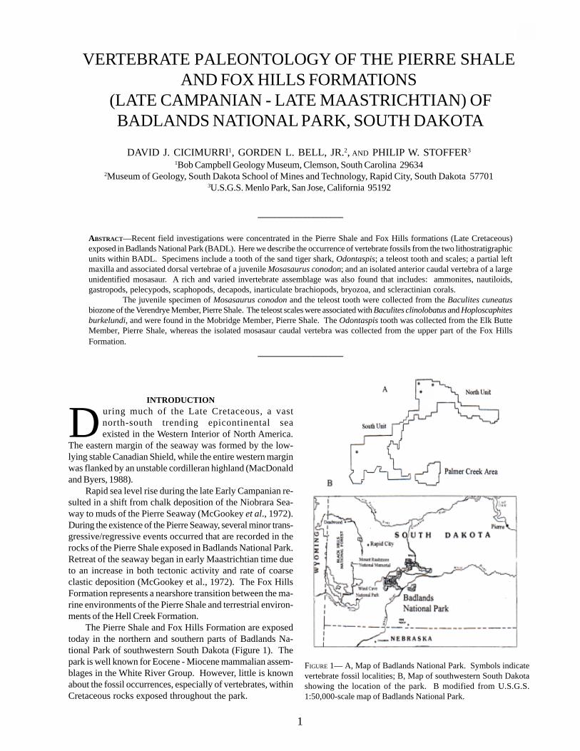
The Pierre Shale and Fox Hills Formation are exposedtoday in the northern and southern parts of Badlands Na-tional Park of southwestern South Dakota (Figure 1). Thepark is well known for Eocene - Miocene mammalian assem-blages in the White River Group. However, little is knownabout the fossil occurrences, especially of vertebrates, withinCretaceous rocks exposed throughout the park.
FIGURE 1— A, Map of Badlands National Park. Symbols indicatevertebrate fossil localities; B, Map of southwestern South Dakotashowing the location of the park. B modified from U.S.G.S.1:50,000-scale map of Badlands National Park.
1

TECHNICAL REPORT NPS/NRGRD/GRDTR-99/3
Abbreviations - BADL, Badlands National Park, SDSM,Museum of Geology, South Dakota School of Mines andTechnology. All specimens are stored in the Museum ofGeology. Precise stratigraphic and geographic information ison record at Badlands National Park.
HISTORY OF COLLECTINGVery little is known about the fossil resources of Creta-
ceous rocks exposed in BADL. Meek and Hayden (1862)were the first to recognize the presence of the “Fort PierreFormation” (Pierre Shale) in the Sage Creek area of the Park(North Unit). Since then, this formation has received littleattention. However, recent field research has documentedfossils within Cretaceous strata of BADL, including ammo-nites, pelecypods, gastropods, scaphopods, crustaceans,brachiopods, nautiloids, bryozoans, corals, scaphopods, andbelemnites (Table 1). The majority of the fossils are from thePierre Shale, but several ammonites and the belemnites, aswell as a lobster tail, were recovered from the Fox Hills Forma-tion. Meager vertebrate remains, consisting of isolated te-leost scales and teeth, a single mosasaurine caudal vertebra,and vertebrae and jaw fragment of Mosasaurus conodon,were also discovered. This small assemblage probably re-flects a collecting bias (as exposure surface is limited), ratherthan actual low abundance.
Several important marine reptile discoveries have beenmade outside the park boundary. The type specimen ofPrognathodon overtoni (KU 950) was collected from “... nearthe top of the Pierre deposits of the Cheyenne River of SouthDakota” (Russell, 1967; Williston, 1897, p. 95), and an addi-tional specimen (SDSM 3393) was recovered from “... theVirgin Creek Member, Upper Pierre Shale Formation ... south-west of Cuny Table, Shannon County, South Dakota” (Russell,1967). The preservation of SDSM 3393 indicates that thebones were collected from the Yellow Mounds Paleosol.
An additional mosasaur skeleton, probably Mosasaurus,was collected by SDSMT personnel over 30 years ago northof Scenic, South Dakota. The specimen consists of a nearlycomplete skeleton. Unfortunately, only the skull, limbs, andpart of the tail were collected at the time of discovery. Thebones are encased in hard, yellowish limestone derived fromthe Yellow Mounds Paleosol. This material has been pre-pared with acetic acid to dissolve the limestone. Several teethof the dogfish, Squalus, were also discovered in the lime-stone. This association may indicate, as has been docu-mented from the Pierre Shale of the Missouri River area ofSouth Dakota, that the mosasaur carcass was scavenged bya school of dogfish (Bell et al., in press).
In 1926, a stratodont osteichthyan, probably Stratodus(SDSM 2674 and 2675), was collected from Cuny Table, Sh-annon County, by the Museum of Geology. The remainsconsist of a complete dentary, premaxilla, edentulous jaw frag-ments with a double row of equally sized alveoli, isolatedteeth, and scales. Some of the bones are encased in hardyellow and pink phosphatic nodules that are characteristic ofthe Yellow Mounds Paleosol.
CRETACEOUS STRATIGRAPHY OF BADLANDS NATIONAL PARK
Cretaceous rocks of BADL consist of the Pierre Shale,and bluish, fine-grained glauconitic sandstone of the FoxHills Formation. Extensive outcrops of the Pierre Shale arefound throughout the Sage Creek Wilderness area of theNorth Unit and within tributaries of the Cheyenne River inthe South Unit. Overlying the Pierre Shale is a yellow weath-ered unit, variously referred to as the “Interior Zone”, “Inte-rior Formation”, Rusty Member” (Stoffer et al., 1998), and“Yellow Mounds Paleosol” (Pettijohn, 1965). Dunham (1961)recognized that pre-Eocene weathering was responsible forthe bright yellow sediments of the “Interior Formation”.However, it was uncertain as to whether these sedimentsbelonged to the Pierre Shale or Fox Hills Formation (Agnewand Tychsen, 1965). Recent work by Stoffer et al. (1998) hasestablished that the “Yellow Mounds Paleosol” is the resultof meteoric weathering of both the upper Pierre Shale andFox Hills Formation. Exposures of the Fox Hills Formation are
FIGURE 2— Composite stratigraphic section of Cretaceous rocks ofBadlands National Park. Eo = Eocene. Modified from Stoffer et al.(1998).
found throughout the North Unit of BADL.Collecting efforts have been concentrated in the Pierre
Shale during the past several years, and several ammonitebiozones have been recognized, including: Didymocerascheyennense, Baculites compressus, B. cuneatus, B. reesidei,B. jenseni and B. eliasi, B. baculus, B. grandis, B.clinolobatus, and Hoploscaphites burkelundi (oldest toyoungest). These biozones have been used to subdivide thePierre Shale into several biostratigraphic units. In BADL, thelithologic composition correlates with the DeGrey, Verendrye(Crandall, 1958), Virgin Creek, Mobridge, and Elk Butte(Searight, 1937) members of the Pierre Shale of central SouthDakota (Figure 2).
Fossils are scarce in the Fox hills Formation, but thismay reflect a collecting bias because this unit has largelybeen neglected. Those fossils that do occur are generally inpoor condition because they have been subjected to severalepisodes of subaerial exposure. The Fox Hills Formation ofBADL has been divided into lower and upper units (Stofferet al., 1998), although correlation of the Fox Hills with thetype area in Central South Dakota (Waage, 1961) is hinderedby the poor preservation of invertebrate fossils. The lowerunit is no older than late early Maastrichtian, because thisinterval overlies the Baculites clinolobatus biozone of thePierre Shale (Cobban et al., 1994). Sr87/SR86 values of belem-nites found in the upper unit yielded an age of 67 mya (Stofferet al., 1998).
SYSTEMATIC PALEONTOLOGYClass Chondrichthyes Huxley, 1880
Order Lamniformes Berg, 1958Family Odontaspididae Muller and Henle, 1839
Genus Odontaspis Agassiz, 1838
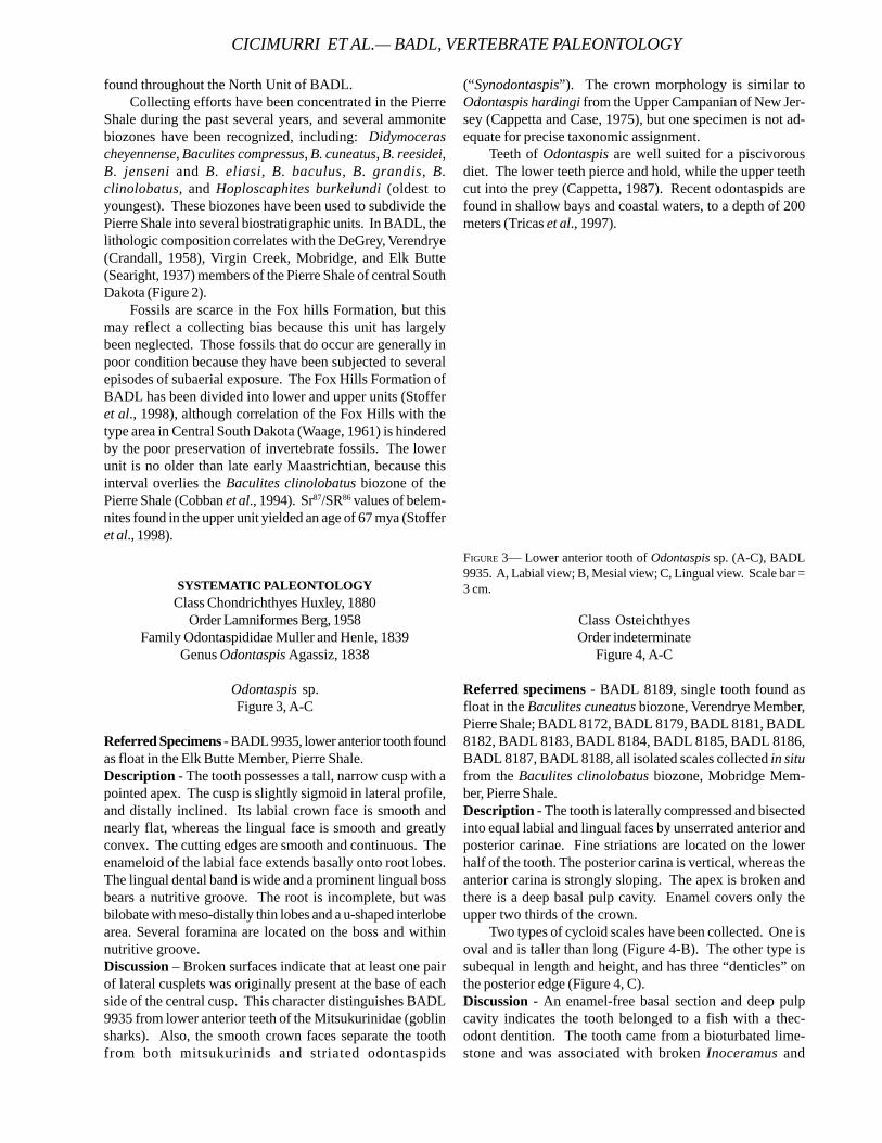
Odontaspis sp.Figure 3, A-C
Referred Specimens - BADL 9935, lower anterior tooth foundas float in the Elk Butte Member, Pierre Shale.Description - The tooth possesses a tall, narrow cusp with apointed apex. The cusp is slightly sigmoid in lateral profile,and distally inclined. Its labial crown face is smooth andnearly flat, whereas the lingual face is smooth and greatlyconvex. The cutting edges are smooth and continuous. Theenameloid of the labial face extends basally onto root lobes.The lingual dental band is wide and a prominent lingual bossbears a nutritive groove. The root is incomplete, but wasbilobate with meso-distally thin lobes and a u-shaped interlobearea. Several foramina are located on the boss and withinnutritive groove.Discussion – Broken surfaces indicate that at least one pairof lateral cusplets was originally present at the base of eachside of the central cusp. This character distinguishes BADL9935 from lower anterior teeth of the Mitsukurinidae (goblinsharks). Also, the smooth crown faces separate the toothfrom both mitsukurinids and striated odontaspids
(“Synodontaspis”). The crown morphology is similar toOdontaspis hardingi from the Upper Campanian of New Jer-sey (Cappetta and Case, 1975), but one specimen is not ad-equate for precise taxonomic assignment.
Teeth of Odontaspis are well suited for a piscivorousdiet. The lower teeth pierce and hold, while the upper teethcut into the prey (Cappetta, 1987). Recent odontaspids arefound in shallow bays and coastal waters, to a depth of 200meters (Tricas et al., 1997).
FIGURE 3— Lower anterior tooth of Odontaspis sp. (A-C), BADL9935. A, Labial view; B, Mesial view; C, Lingual view. Scale bar =3 cm.
Class OsteichthyesOrder indeterminate
Figure 4, A-C
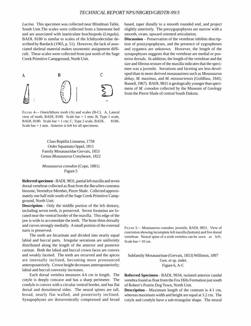
Referred specimens - BADL 8189, single tooth found asfloat in the Baculites cuneatus biozone, Verendrye Member,Pierre Shale; BADL 8172, BADL 8179, BADL 8181, BADL8182, BADL 8183, BADL 8184, BADL 8185, BADL 8186,BADL 8187, BADL 8188, all isolated scales collected in situfrom the Baculites clinolobatus biozone, Mobridge Mem-ber, Pierre Shale.Description - The tooth is laterally compressed and bisectedinto equal labial and lingual faces by unserrated anterior andposterior carinae. Fine striations are located on the lowerhalf of the tooth. The posterior carina is vertical, whereas theanterior carina is strongly sloping. The apex is broken andthere is a deep basal pulp cavity. Enamel covers only theupper two thirds of the crown.
Two types of cycloid scales have been collected. One isoval and is taller than long (Figure 4-B). The other type issubequal in length and height, and has three “denticles” onthe posterior edge (Figure 4, C).Discussion - An enamel-free basal section and deep pulpcavity indicates the tooth belonged to a fish with a thec-odont dentition. The tooth came from a bioturbated lime-stone and was associated with broken Inoceramus and
CICIMURRI ET AL.— BADL, VERTEBRATE PALEONTOLOGY
TECHNICAL REPORT NPS/NRGRD/GRDTR-99/3
Lucina. This specimen was collected near Blindman Table,South Unit.The scales were collected from a limestone bedand are associated with inarticulate brachiopods (Lingula).BADL 8180 is similar to scales of the Ichthyodectidae de-scribed by Bardack (1965, p. 51). However, the lack of asso-ciated skeletal material makes taxonomic assignment diffi-cult. These scales were collected from just north of the SageCreek Primitive Campground, North Unit.
based, taper distally to a smooth rounded end, and projectslightly anteriorly. The prezygopophyses are narrow with asmooth, ovate, upward oriented articulation.Discussion – Preservation of the vertebrae inhibits descrip-tion of postzyopophyses, and the presence of zygosphenesand zygantra are unknown. However, the length of thesynapophyses suggests that the vertebrae are medial or pos-terior dorsals. In addition, the length of the vertebrae and thesize and fibrous texture of the maxilla indicates that the speci-men was a juvenile. Serrations and faceting are less devel-oped than in more derived mosasaurines such as Mosasaurusdekay, M. maximus, and M. missouriensis (Goldfuss, 1845;Russell, 1967). BADL 9831 is geologically younger than speci-mens of M. conodon collected by the Museum of Geologyfrom the Pierre Shale of central South Dakota.
FIGURE 4— Osteichthyes tooth (A) and scales (B-C). A, Lateralview of tooth, BADL 8189. Scale bar = 1 mm; B, Type 1 scale,BADL 8180. Scale bar = 1 cm; C, Type 2 scale, BADL 8186.Scale bar = 1 mm. Anterior is left for all specimens.
Class Reptilia Linnaeus, 1758Order Squamata Oppel, 1811
Family Mosasauridae Gervais, 1853Genus Mosasaurus Conybeare, 1822
Mosasaurus conodon (Cope, 1881)Figure 5
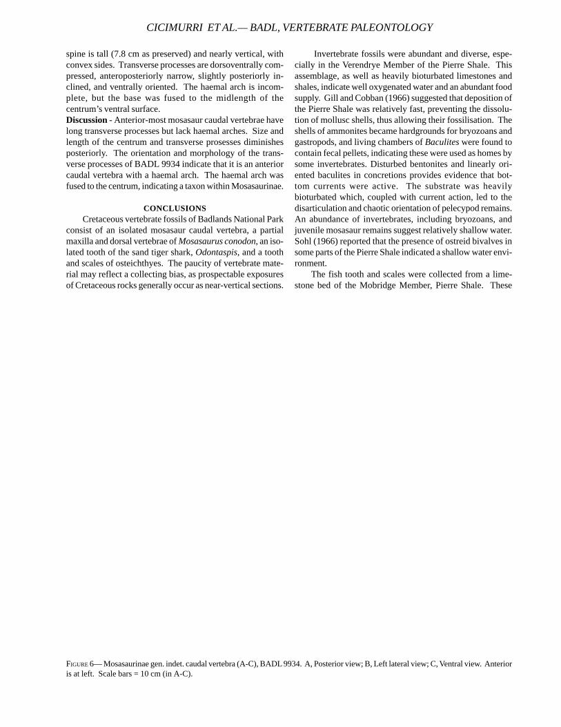
Referred specimen - BADL 9831, partial left maxilla and sevendorsal vertebrae collected as float from the Baculites cuneatusbiozone, Verendrye Member, Pierre Shale. Collected approxi-mately one half mile south of the Sage Creek Primitive Camp-ground, North Unit.Description - Only the middle portion of the left dentary,including seven teeth, is preserved. Seven foramina are lo-cated near the ventral border of the maxilla. This edge of thejaw is wide to accomodate the teeth. The bone thins dorsallyand curves strongly medially. A small portion of the externalnaris is preserved.
The teeth are bicarinate and divided into nearly equallabial and buccal parts. Irregular serrations are uniformlydistributed along the length of the anterior and posteriorcarinae. Both the labial and buccal crown faces are convexand weakly faceted. The teeth are recurved and the apicesare internally inclined, becoming more pronouncedanteroposteriorly. Crown height decreases anteroposteriorly;labial and buccal convexity increases.
Each dorsal vertebra measures 4.6 cm in length. Thecotyle is deeply concave and has a sharp perimeter. Thecondyle is convex with a circular ventral border, and has flatdorsal and dorsolateral sides. The neural spines are tall,broad, nearly flat walled, and posteriorly inclined.Synapophyses are dorsoventrally compressed and broad
FIGURE 5— Mosasaurus conodon, juvenile, BADL 9831. View ofconcretion showing incomplete left maxilla (bottom) and five dorsalvertebrae. Neural spine of a sixth vertebra can be seen at left.Scale bar = 10 cm.
Subfamily Mosasaurinae (Gervais, 1853) Williston, 1897 Gen. et sp. indet.
Figure 6, A-C
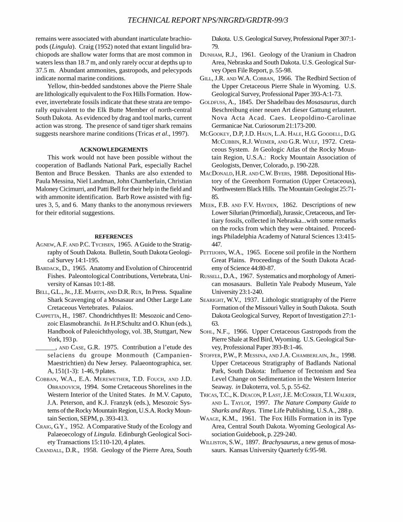
Referred Specimen - BADL 9934, isolated anterior caudalvertebra found as float from the Fox Hills Formation just southof Robert’s Prairie Dog Town, North Unit.Description - Maximum length of the centrum is 4.1 cm,whereas maximum width and height are equal at 3.2 cm. Thecotyle and condyle have a sub-triangular shape. The neural
spine is tall (7.8 cm as preserved) and nearly vertical, withconvex sides. Transverse processes are dorsoventrally com-pressed, anteroposteriorly narrow, slightly posteriorly in-clined, and ventrally oriented. The haemal arch is incom-plete, but the base was fused to the midlength of thecentrum’s ventral surface.Discussion - Anterior-most mosasaur caudal vertebrae havelong transverse processes but lack haemal arches. Size andlength of the centrum and transverse prosesses diminishesposteriorly. The orientation and morphology of the trans-verse processes of BADL 9934 indicate that it is an anteriorcaudal vertebra with a haemal arch. The haemal arch wasfused to the centrum, indicating a taxon within Mosasaurinae.
CONCLUSIONSCretaceous vertebrate fossils of Badlands National Park
consist of an isolated mosasaur caudal vertebra, a partialmaxilla and dorsal vertebrae of Mosasaurus conodon, an iso-lated tooth of the sand tiger shark, Odontaspis, and a toothand scales of osteichthyes. The paucity of vertebrate mate-rial may reflect a collecting bias, as prospectable exposuresof Cretaceous rocks generally occur as near-vertical sections.
Invertebrate fossils were abundant and diverse, espe-cially in the Verendrye Member of the Pierre Shale. Thisassemblage, as well as heavily bioturbated limestones andshales, indicate well oxygenated water and an abundant foodsupply. Gill and Cobban (1966) suggested that deposition ofthe Pierre Shale was relatively fast, preventing the dissolu-tion of mollusc shells, thus allowing their fossilisation. Theshells of ammonites became hardgrounds for bryozoans andgastropods, and living chambers of Baculites were found tocontain fecal pellets, indicating these were used as homes bysome invertebrates. Disturbed bentonites and linearly ori-ented baculites in concretions provides evidence that bot-tom currents were active. The substrate was heavilybioturbated which, coupled with current action, led to thedisarticulation and chaotic orientation of pelecypod remains.An abundance of invertebrates, including bryozoans, andjuvenile mosasaur remains suggest relatively shallow water.Sohl (1966) reported that the presence of ostreid bivalves insome parts of the Pierre Shale indicated a shallow water envi-ronment.
The fish tooth and scales were collected from a lime-stone bed of the Mobridge Member, Pierre Shale. These
FIGURE 6— Mosasaurinae gen. indet. caudal vertebra (A-C), BADL 9934. A, Posterior view; B, Left lateral view; C, Ventral view. Anterioris at left. Scale bars = 10 cm (in A-C).
CICIMURRI ET AL.— BADL, VERTEBRATE PALEONTOLOGY
TECHNICAL REPORT NPS/NRGRD/GRDTR-99/3
remains were associated with abundant inarticulate brachio-pods (Lingula). Craig (1952) noted that extant lingulid bra-chiopods are shallow water forms that are most common inwaters less than 18.7 m, and only rarely occur at depths up to37.5 m. Abundant ammonites, gastropods, and pelecypodsindicate normal marine conditions.
Yellow, thin-bedded sandstones above the Pierre Shaleare lithologically equivalent to the Fox Hills Formation. How-ever, invertebrate fossils indicate that these strata are tempo-rally equivalent to the Elk Butte Member of north-centralSouth Dakota. As evidenced by drag and tool marks, currentaction was strong. The presence of sand tiger shark remainssuggests nearshore marine conditions (Tricas et al., 1997).
ACKNOWLEDGEMENTSThis work would not have been possible without the
cooperation of Badlands National Park, especially RachelBenton and Bruce Bessken. Thanks are also extended toPaula Messina, Niel Landman, John Chamberlain, ChristianMaloney Cicimurri, and Patti Bell for their help in the field andwith ammonite identification. Barb Rowe assisted with fig-ures 3, 5, and 6. Many thanks to the anonymous reviewersfor their editorial suggestions.
REFERENCESAGNEW, A.F. AND P.C. TYCHSEN, 1965. A Guide to the Stratig-
raphy of South Dakota. Bulletin, South Dakota Geologi-cal Survey 14:1-195.
BARDACK, D., 1965. Anatomy and Evolution of ChirocentridFishes. Paleontological Contributions, Vertebrata, Uni-versity of Kansas 10:1-88.
BELL, G.L., JR., J.E. MARTIN, AND D.R. RUX, In Press. SqualineShark Scavenging of a Mosasaur and Other Large LateCretaceous Vertebrates. Palaios.
CAPPETTA, H., 1987. Chondrichthyes II: Mesozoic and Ceno-zoic Elasmobranchii. In H.P.Schultz and O. Khun (eds.),Handbook of Paleoichthyology, vol. 3B, Stuttgart, NewYork, 193 p.
______, AND CASE, G.R. 1975. Contribution a l’etude desselaciens du groupe Monmouth (Campanien-Maestrichtien) du New Jersey. Palaeontographica, ser.A, 151(1-3): 1-46, 9 plates.
COBBAN, W.A., E.A. MEREWETHER, T.D. FOUCH, AND J.D.OBRADOVICH, 1994. Some Cretaceous Shorelines in theWestern Interior of the United States. In M.V. Caputo,J.A. Peterson, and K.J. Franzyk (eds.), Mesozoic Sys-tems of the Rocky Mountain Region, U.S.A. Rocky Moun-tain Section, SEPM, p. 393-413.
CRAIG, G.Y., 1952. A Comparative Study of the Ecology andPalaeoecology of Lingula. Edinburgh Geological Soci-ety Transactions 15:110-120, 4 plates.
CRANDALL, D.R., 1958. Geology of the Pierre Area, South
Dakota. U.S. Geological Survey, Professional Paper 307:1-79.
DUNHAM, R.J., 1961. Geology of the Uranium in ChadronArea, Nebraska and South Dakota. U.S. Geological Sur-vey Open File Report, p. 55-98.
GILL, J.R. AND W.A. COBBAN, 1966. The Redbird Section ofthe Upper Cretaceous Pierre Shale in Wyoming. U.S.Geological Survey, Professional Paper 393-A:1-73.
GOLDFUSS, A., 1845. Der Shadelbau des Mosasaurus, durchBeschreibung einer neuen Art dieser Gattung erlautert.Nova Acta Acad. Caes. Leopoldino-CarolinaeGermanicae Nat. Curiosorum 21:173-200.
MCGOOKEY, D.P, J.D. HAUN, L.A. HALE, H.G. GOODELL, D.G.MCCUBBIN, R.J. WEIMER, AND G.R. WULF, 1972. Creta-ceous System. In Geologic Atlas of the Rocky Moun-tain Region, U.S.A.: Rocky Mountain Association ofGeologists, Denver, Colorado, p. 190-228.
MACDONALD, H.R. AND C.W. BYERS, 1988. Depositional His-tory of the Greenhorn Formation (Upper Cretaceous),Northwestern Black Hills. The Mountain Geologist 25:71-85.
MEEK, F.B. AND F.V. HAYDEN, 1862. Descriptions of newLower Silurian (Primordial), Jurassic, Cretaceous, and Ter-tiary fossils, collected in Nebraska...with some remarkson the rocks from which they were obtained. Proceed-ings Philadelphia Academy of Natural Sciences 13:415-447.
PETTIJOHN, W.A., 1965. Eocene soil profile in the NorthernGreat Plains. Proceedings of the South Dakota Acad-emy of Science 44:80-87.
RUSSELL, D.A., 1967. Systematics and morphology of Ameri-can mosasaurs. Bulletin Yale Peabody Museum, YaleUniversity 23:1-240.
SEARIGHT, W.V., 1937. Lithologic stratigraphy of the PierreFormation of the Missouri Valley in South Dakota. SouthDakota Geological Survey, Report of Investigation 27:1-63.
SOHL, N.F., 1966. Upper Cretaceous Gastropods from thePierre Shale at Red Bird, Wyoming. U.S. Geological Sur-vey, Professional Paper 393-B:1-46.
STOFFER, P.W., P. MESSINA, AND J.A. CHAMBERLAIN, JR., 1998.Upper Cretaceous Stratigraphy of Badlands NationalPark, South Dakota: Influence of Tectonism and SeaLevel Change on Sedimentation in the Western InteriorSeaway. in Dakoterra, vol. 5, p. 55-62.
TRICAS, T.C., K. DEACON, P. LAST, J.E. MCCOSKER, T.I. WALKER,AND L. TAYLOr, 1997. The Nature Company Guide toSharks and Rays. Time Life Publishing, U.S.A., 288 p.
WAAGE, K.M., 1961. The Fox Hills Formation in its TypeArea, Central South Dakota. Wyoming Geological As-sociation Guidebook, p. 229-240.
WILLISTON, S.W., 1897. Brachysaurus, a new genus of mosa-saurs. Kansas University Quarterly 6:95-98.
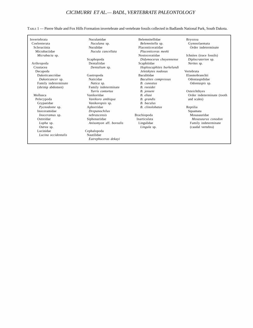
InvertebrataCoelenterata
ScleractiniaMicrabaciidae
Micrabacia sp.
ArthropodaCrustacea
DecapodaDakoticancridae
Dakoticancer sp.Family indeterminate(shrimp abdomen)
MolluscaPelecypoda
GrypaeidaePycnodonte sp.
InoceramidaeInoceramus sp.
OstreidaeLopha sp.Ostrea sp.
LucinidaeLucina occidentalis
NuculanidaeNuculana sp.
NuculidaeNucula cancellata
ScaphopodaDentaliidae
Dentalium sp.
GastropodaNaticidae
Natica sp.Family indeterminate
Turris contortusVanikoridae
Vanikoro ambiquaVanikoropsis sp.
AphorridaeDrepanochilusnebrascensis
SiphonariidaeAnisomyon aff. borealis
CephalopodaNautilidae
Eutrephoceras dekayi
BelemnitellidaeBelemnitella sp.
PlacenticeratidaePlacenticeras meeki
NostoceratidaeDidymoceras cheyennense
ScaphitidaeHoploscaphites burkelundiJeletzkytes nodosus
BaculitidaeBaculites compressusB. cuneatusB. reesideiB. jenseniB. eliasiB. grandisB. baculusB. clinolobatus
BrachiopodaInarticulata
LingulidaeLingula sp.
BryozoaGymnolaemata
Order indeterminate
Ichnites (trace fossils)Diplocraterion sp.Nerites sp.
VertebrataElasmobranchii
OdontaspididaeOdontaspis sp.
OsteichthyesOrder indeterminate (toothand scales)
ReptiliaSquamata
MosasauridaeMosasaurus conodon
Family indeterminate(caudal vertebra)
TABLE 1 — Pierre Shale and Fox Hills Formation invertebrate and vertebrate fossils collected in Badlands National Park, South Dakota.
CICIMURRI ET AL.— BADL, VERTEBRATE PALEONTOLOGY
TECHNICAL REPORT NPS/NRGRD/GRDTR-99/3
LOCOMOTOR ADAPTATIONS IN METAMYNODONPLANIFRONS COMPARED TO OTHER AMYNODONTIDS
(PERISSODACTYLA, RHINOCEROTOIDEA)
WILLIAM P. WALL AND KRISTEN L. HEINBAUGHDept. of Biology, Georgia College & State University, Milledgeville, GA 31061
____________________
ABSTRACT—The association of Metamynodon specimens with channel sandstones (particularly with the Orellan section ex-posed in the southern unit of Badlands National Park) has contributed heavily to the common perception that all amynodontidrhinoceroses were semi-aquatic. An analysis of anatomical traits in a variety of amynodontids was conducted to determine themost likely mode(s) of life for these extinct perissodactyls. The characters providing the most useful information on life habitsin amynodontids are: orbital position on the skull (high or low); relative development of the nuchal ligament (as determined bythoracic spine size); the relative size of the olecranon process compared to the length of the radius; and reconstruction ofhindlimb musculature with reference to locomotor adaptations. Based on these results primitive amynodontids were subcursorialterrestrial mammals similar to a variety of Eocene ungulates. Cadurcodontines were tapir-like terrestrial mammals. Only onegroup of amynodontids, the Metamynodontini, was adapted to a semi-aquatic mode of life. The genus Metamynodon possiblyrepresents the extreme stage in amynodontid evolution toward this mode of life. Middle Eocene metamynodontines are foundin both North America (Megalamynodon) and Asia (Paramynodon). Migration between these two areas may be a significantfactor in tracing the lineage culminating in the hippo-like Metamynodon.
____________________
INTRODUCTION
Amynodontids are commonly called swamp rhinocer-oses or aquatic rhinoceroses in reference to theirpresumed amphibious life style. Although aquatic
habits for amynodontids are firmly ingrained in the paleonto-logical literature today, this has not always been the case.Marsh’s (1877) original description of a skull of Amynodonadvenus (Uintan, Eocene) made no mention of aquatic hab-its. Scott and Osborn (1882) likewise did not discuss aquatichabits when they described a skull of Orthocynodon (=Amynodon) and raised the amynodontids to a separate fam-ily within the Rhinocerotoidea. Even when a skull and skel-eton of Metamynodon was described (Scott and Osborn,1887, and Osborn and Wortman, 1894) no reference was madeto aquatic habits in amynodontids. Osborn (1898), in hismonograph on rhinoceroses, stated for the first time thatamynodontids were aquatic. Osborn must have assumedthat a semi-aquatic mode of life for amynodontids was com-mon knowledge since he did not justify his statement.Taphonomic evidence may have contributed to the interpre-tation of aquatic habits for amynodontids.
The vast majority of Metamynodon specimens are foundin or near Orellan (early Oligocene) channel sandstones (seeRetallack, 1983, and 1992). These channels are particularlywell exposed in the Southern Unit of Badlands National Park(Prothero and Whittlesey, 1998). For twenty-one years priorto Osborn’s statement on aquatic habits, amynodontids hadnever been described in the literature as amphibious animals.Since Osborn’s paper, however, no one questioned the aquaticmode of life for all amynodontids until Wall (1980). The pur-
pose of this paper is to look in detail at various lines of ana-tomical evidence alluding to aquatic habits in amynodontids.
MATERIALS AND METHODSFossil specimens used in this study are housed in the
American Museum of Natural History (AMNH); GeorgiaCollege & State University Vertebrate Paleontology Collec-tion (GCVP); the Museum of Comparative Zoology, Harvard(MCZ); the South Dakota School of Mines and Technology(SDSM); and the University of Florida (UF). Modern mam-mals from the American Museum of Natural History (AMNH);Georgia College & State University Mammalogy Collection(GCM); and the University of Massachusetts, Amherst(UMA) were used for comparative purposes. All measure-ments were taken with Helios dial calipers. General informa-tion on name, origin, insertion, and function of muscles comesfrom Sisson and Grossman (1953). Amynodontid taxonomyis based on Wall (1989).
ANATOMICAL EVIDENCEPrevious attempts (Troxell, 1921; Scott, 1941) at analyz-
ing evidence for aquatic habits in amynodontids were basedsolely on the genus Metamynodon. In the discussion belowwe have analyzed the characters presented by Troxell andScott (as well as others they did not mention) from a broaderperspective, looking at the entire range of anatomical fea-tures present in amynodontids. Where appropriate we haveincluded two well known sympatric North American Miocenerhinocerotids that are generally regarded as having distinctlydifferent life habits, Aphelops, a terrestrial browser, and
8
Teleoceras, an amphibious grazer (see Prothero, 1998), totest the general applicability of our biomechanical interpreta-tions.
DentitionScott (1941) stated that resemblance between the large
canine tusks of Metamynodon, Hippopotamus, andAstrapotherium was probably due to their similar aquatic lifestyle. Scott did not mention why large canines would beindicative of aquatic habits in mammals. Recent hippos usetheir canines as weapons and for intraspecific display (Her-ring, 1975), a function that is also true of many terrestrialmammals including pigs and peccaries (Herring, 1972). Al-though metamynodontines exhibit an extreme in canine sizefor the family, large canines are typical of amynodontids ingeneral (including the tapir-like cadurcodontines, Wall, 1980;1989). Canine size in amynodontids varies in a manner imply-ing sexual dimorphism. If that is the case, canine size prob-ably had a behavioral function independent of the animal’sother life habits. The tusk-like lower incisors of the presum-ably terrestrial Aphelops are relatively larger than those ofthe supposed semi-aquatic Teleoceras. Canine size does notappear to be of any value in deciding whether amynodontidswere aquatic or terrestrial.
Cranial CharactersThere are a series of skull characters that can be used to
help determine whether amynodontids were aquatic. Most
of these characters have been used with variable success byother authors dealing with aquatic adaptations in fossil ver-tebrates.
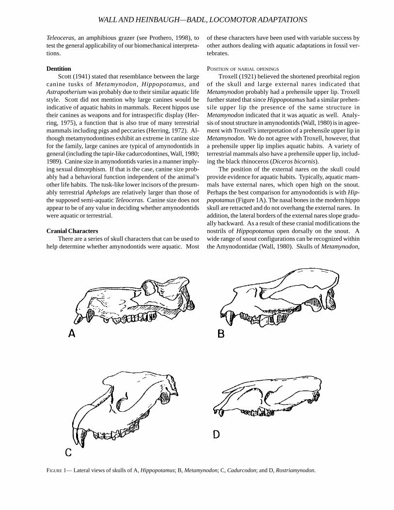
POSITION OF NARIAL OPENINGS
Troxell (1921) believed the shortened preorbital regionof the skull and large external nares indicated thatMetamynodon probably had a prehensile upper lip. Troxellfurther stated that since Hippopotamus had a similar prehen-sile upper lip the presence of the same structure inMetamynodon indicated that it was aquatic as well. Analy-sis of snout structure in amynodontids (Wall, 1980) is in agree-ment with Troxell’s interpretation of a prehensile upper lip inMetamynodon. We do not agree with Troxell, however, thata prehensile upper lip implies aquatic habits. A variety ofterrestrial mammals also have a prehensile upper lip, includ-ing the black rhinoceros (Diceros bicornis).
The position of the external nares on the skull couldprovide evidence for aquatic habits. Typically, aquatic mam-mals have external nares, which open high on the snout.Perhaps the best comparison for amynodontids is with Hip-popotamus (Figure 1A). The nasal bones in the modern hipposkull are retracted and do not overhang the external nares. Inaddition, the lateral borders of the external nares slope gradu-ally backward. As a result of these cranial modifications thenostrils of Hippopotamus open dorsally on the snout. Awide range of snout configurations can be recognized withinthe Amynodontidae (Wall, 1980). Skulls of Metamynodon,
FIGURE 1— Lateral views of skulls of A, Hippopotamus; B, Metamynodon; C, Cadurcodon; and D, Rostriamynodon.
WALL AND HEINBAUGH—BADL, LOCOMOTOR ADAPTATIONS
TECHNICAL REPORT NPS/NRGRD/GRDTR-99/3
Cadurcodon, and Rostriamynodon are also illustrated (Fig-ures 1B, 1C, and 1D respectively). Rostriamynodon, a primi-tive amynodontid (Wall and Manning, 1986), has elongatenasal bones, which extend far over the external nares. It isunlikely therefore that the nostrils could have opened dor-sally on the skull. A certain amount of nasal retraction isapparent in both Cadurcodon and Metamynodon, but theoverall construction of the snout region in the twoamynodontids is different. Cadurcodon has a verticallyheightened nasal opening that is partially roofed by thick-ened nasal bones. Numerous cranial features of Cadurcodonare convergent with tapir skulls (Wall, 1980) therefore it islikely that advanced cadurcodontines probably had a pro-boscis. Since the nostril openings are invariably at the distalend of a proboscis, this structure would rule out any possi-bility that cadurcodontines had a dorsally positioned nasalopening. Metamynodon, however, does show some similar-ity to the snout region of Hippopotamus. Figure 1 showssome nasal overhang above the external nares, but this is notalways the case in Metamynodon. In some skulls the nasalbones do not overhang the external nares at all. The configu-ration of the snout region in Metamynodon does allow forthe possibility of a dorsal opening for the nostrils.
Troxell (1921) believed that the far posterior placementof the internal nares in amynodontids was an adaptation toallow a continuous passage of air from nostrils to larynx whenthe mouth was under water. It is true that in all amynodontidsthe internal narial opening is far back on the palate (at thelevel of the M3 protoloph), but this does not in itself provethat the larynx had an unbroken soft tissue connection withthe internal nares. A second problem with interpreting theposterior position of the internal nares as an aquatic charac-ter is that direct connection of the larynx to the internal naresalso may be advantageous in a terrestrial mammal. As Troxellpointed out, horses have direct connections between thelarynx and external nares. Troxell believed this adaptationprevented dust from entering the lungs while the horse waseating. Since Troxell realized that the same respiratory ar-rangement could be found in terrestrial and aquatic mam-mals, his interpretation of amynodontid internal nares posi-tion as an aquatic character was based solely on his priorbias that amynodontids were aquatic.
The only reliable narial character for interpreting aquaticlife habits appears to be the relative position of the nostrils.Using this character to interpret amynodontid life habits, three“groups” of amynodontids can be recognized. A primitivegroup, including Rostriamynodon, lacked any modificationsbeyond the primitive perissodactyl condition in nostril posi-tion. Cadurcodontines were derived but the nostrils prob-ably opened low on the face at the end of a short proboscis.Snout structure in metamynodontines does allow for dorsalopening of the nostrils; therefore this is the only amynodontidgroup showing modifications of the snout for aquatic life.
REDUCED OLFACTORY ABILITY IN AQUATIC MAMMALS
Poor sense of smell has commonly been regarded as aby-product of adopting aquatic habits (see Howell, 1930;
and Mitchell and Tedford, 1973). Troxell (1921) believed that,because of lateral constriction by preorbital fossae and ven-tral constriction resulting from a highly concave secondarypalate, the snout region of amynodontids could not haveprovided space for abundant nasal epithelium. Direct evi-dence on olfactory ability in amynodontids is limited.Amynodontid endocranial anatomy is poorly known; only asingle brain cast has been made (that of Amynodon figured inMarsh, 1886). Olfactory bulbs in Amynodon show no signifi-cant reduction in size compared to an endocranial cast ofHyrachyus (although the cerebral hemispheres in Amynodonwere relatively larger than in Hyrachyus).
Troxell’s indirect evidence regarding reduced olfactoryability in amynodontids is open to interpretation. It is truethat laterally positioned preorbital fossae reduce the internalsurface area of the snout, but we believe Troxell was mis-taken as to the function of the fossae (he believed they werefor snout muscle attachment; see Wall, 1980 for snout muscleattachment sites). If amynodontid preorbital fossae housedenlarged nasal diverticula (as asserted by Gregory, 1920a),there still would be ample room for nasal epithelium. Thus,ascertaining the function of preorbital fossae inamynodontids is an integral part of determining whether theseanimals had reduced olfactory abilities. There are only twolikely functions of preorbital fossae in amynodontids: thefossae provided space for either nasal diverticula or scentglands.
Gregory (1920a) argued that preorbital fossae in someextinct horses (such as Onohippidium) were developed toallow room for large, laterally directed nasal diverticula. Asevidence for his theory, Gregory cited similar fossa develop-ment in modern tapirs that (as shown by dissected animals)clearly contain a nasal diverticulum. Gregory applied a nasaldiverticula function to a host of fossil mammals exhibitingpreorbital fossa. Although this may be true of some fossilmammals, evidence from amynodontids does not entirelysupport Gregory’s viewpoint. In tapirs, the preorbital fossaconnects with the external nares via a distinct groove, whichprovides passage for the nasal diverticulum. No such con-nection exists in amynodontids; in fact, the large canine rootproduces a maxillary bulge, which might have formed a bar-rier to migration of nasal diverticula into the preorbital fossa.
An alternative function for preorbital fossae inamynodontids is that they housed scent glands of some type.Gregory disregarded this idea because the shape of mostpreorbital fossae were not as circular or as distinctly rimmedas the depression housing the larmier gland in deer and ante-lopes. Clearly the preorbital fossa in amynodontids is nothomologous to the larmier fossa in artiodactyls, however,that does not rule out similarity in function.
Both of the most probable functions for the amynodontidpreorbital fossa are associated with a good sense of smell. Ifthe fossa is well developed it can be assumed that olfactoryability was also acute. Figure 2 illustrates the relative devel-opment of preorbital fossae in the three tribes within theAmynodontinae. The primitive preorbital fossa condition isseen in Amynodon; in this animal the fossa is large but be-
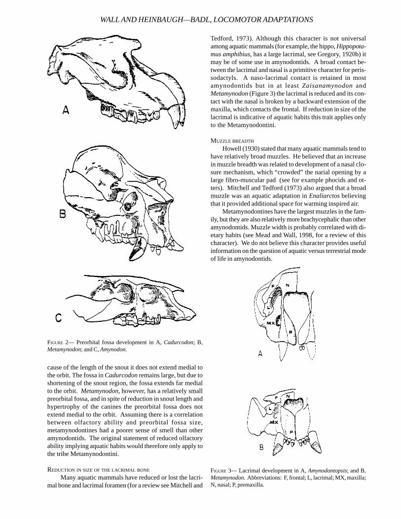
cause of the length of the snout it does not extend medial tothe orbit. The fossa in Cadurcodon remains large, but due toshortening of the snout region, the fossa extends far medialto the orbit. Metamynodon, however, has a relatively smallpreorbital fossa, and in spite of reduction in snout length andhypertrophy of the canines the preorbital fossa does notextend medial to the orbit. Assuming there is a correlationbetween olfactory ability and preorbital fossa size,metamynodontines had a poorer sense of smell than otheramynodontids. The original statement of reduced olfactoryability implying aquatic habits would therefore only apply tothe tribe Metamynodontini.
REDUCTION IN SIZE OF THE LACRIMAL BONE
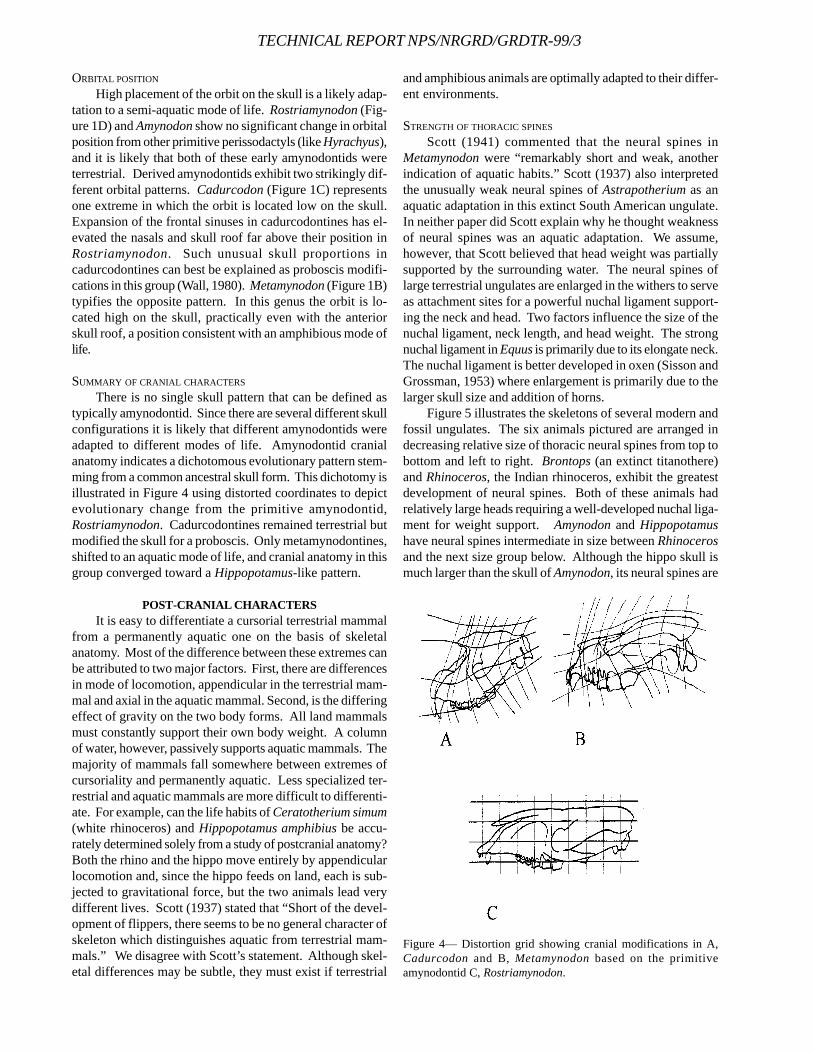
Many aquatic mammals have reduced or lost the lacri-mal bone and lacrimal foramen (for a review see Mitchell and
Tedford, 1973). Although this character is not universalamong aquatic mammals (for example, the hippo, Hippopota-mus amphibius, has a large lacrimal, see Gregory, 1920b) itmay be of some use in amynodontids. A broad contact be-tween the lacrimal and nasal is a primitive character for peris-sodactyls. A naso-lacrimal contact is retained in mostamynodontids but in at least Zaisanamynodon andMetamynodon (Figure 3) the lacrimal is reduced and its con-tact with the nasal is broken by a backward extension of themaxilla, which contacts the frontal. If reduction in size of thelacrimal is indicative of aquatic habits this trait applies onlyto the Metamynodontini.
MUZZLE BREADTH
Howell (1930) stated that many aquatic mammals tend tohave relatively broad muzzles. He believed that an increasein muzzle breadth was related to development of a nasal clo-sure mechanism, which “crowded” the narial opening by alarge fibro-muscular pad (see for example phocids and ot-ters). Mitchell and Tedford (1973) also argued that a broadmuzzle was an aquatic adaptation in Enaliarctos believingthat it provided additional space for warming inspired air.
Metamynodontines have the largest muzzles in the fam-ily, but they are also relatively more brachycephalic than otheramynodontids. Muzzle width is probably correlated with di-etary habits (see Mead and Wall, 1998, for a review of thischaracter). We do not believe this character provides usefulinformation on the question of aquatic versus terrestrial modeof life in amynodontids.
FIGURE 2— Preorbital fossa development in A, Cadurcodon; B,Metamynodon; and C, Amynodon.
FIGURE 3— Lacrimal development in A, Amynodontopsis; and B,Metamynodon. Abbreviations: F, frontal; L, lacrimal; MX, maxilla;N, nasal; P, premaxilla.
WALL AND HEINBAUGH—BADL, LOCOMOTOR ADAPTATIONS
TECHNICAL REPORT NPS/NRGRD/GRDTR-99/3
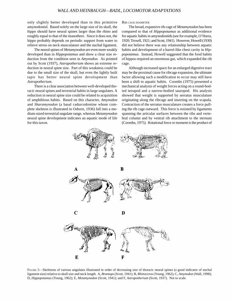
ORBITAL POSITION
High placement of the orbit on the skull is a likely adap-tation to a semi-aquatic mode of life. Rostriamynodon (Fig-ure 1D) and Amynodon show no significant change in orbitalposition from other primitive perissodactyls (like Hyrachyus),and it is likely that both of these early amynodontids wereterrestrial. Derived amynodontids exhibit two strikingly dif-ferent orbital patterns. Cadurcodon (Figure 1C) representsone extreme in which the orbit is located low on the skull.Expansion of the frontal sinuses in cadurcodontines has el-evated the nasals and skull roof far above their position inRostriamynodon. Such unusual skull proportions incadurcodontines can best be explained as proboscis modifi-cations in this group (Wall, 1980). Metamynodon (Figure 1B)typifies the opposite pattern. In this genus the orbit is lo-cated high on the skull, practically even with the anteriorskull roof, a position consistent with an amphibious mode oflife.
SUMMARY OF CRANIAL CHARACTERS
There is no single skull pattern that can be defined astypically amynodontid. Since there are several different skullconfigurations it is likely that different amynodontids wereadapted to different modes of life. Amynodontid cranialanatomy indicates a dichotomous evolutionary pattern stem-ming from a common ancestral skull form. This dichotomy isillustrated in Figure 4 using distorted coordinates to depictevolutionary change from the primitive amynodontid,Rostriamynodon. Cadurcodontines remained terrestrial butmodified the skull for a proboscis. Only metamynodontines,shifted to an aquatic mode of life, and cranial anatomy in thisgroup converged toward a Hippopotamus-like pattern.
POST-CRANIAL CHARACTERSIt is easy to differentiate a cursorial terrestrial mammal
from a permanently aquatic one on the basis of skeletalanatomy. Most of the difference between these extremes canbe attributed to two major factors. First, there are differencesin mode of locomotion, appendicular in the terrestrial mam-mal and axial in the aquatic mammal. Second, is the differingeffect of gravity on the two body forms. All land mammalsmust constantly support their own body weight. A columnof water, however, passively supports aquatic mammals. Themajority of mammals fall somewhere between extremes ofcursoriality and permanently aquatic. Less specialized ter-restrial and aquatic mammals are more difficult to differenti-ate. For example, can the life habits of Ceratotherium simum(white rhinoceros) and Hippopotamus amphibius be accu-rately determined solely from a study of postcranial anatomy?Both the rhino and the hippo move entirely by appendicularlocomotion and, since the hippo feeds on land, each is sub-jected to gravitational force, but the two animals lead verydifferent lives. Scott (1937) stated that “Short of the devel-opment of flippers, there seems to be no general character ofskeleton which distinguishes aquatic from terrestrial mam-mals.” We disagree with Scott’s statement. Although skel-etal differences may be subtle, they must exist if terrestrial
and amphibious animals are optimally adapted to their differ-ent environments.
STRENGTH OF THORACIC SPINES
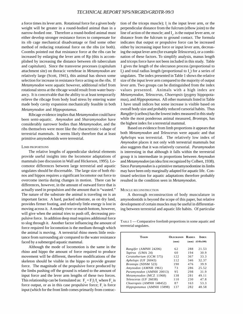
Scott (1941) commented that the neural spines inMetamynodon were “remarkably short and weak, anotherindication of aquatic habits.” Scott (1937) also interpretedthe unusually weak neural spines of Astrapotherium as anaquatic adaptation in this extinct South American ungulate.In neither paper did Scott explain why he thought weaknessof neural spines was an aquatic adaptation. We assume,however, that Scott believed that head weight was partiallysupported by the surrounding water. The neural spines oflarge terrestrial ungulates are enlarged in the withers to serveas attachment sites for a powerful nuchal ligament support-ing the neck and head. Two factors influence the size of thenuchal ligament, neck length, and head weight. The strongnuchal ligament in Equus is primarily due to its elongate neck.The nuchal ligament is better developed in oxen (Sisson andGrossman, 1953) where enlargement is primarily due to thelarger skull size and addition of horns.
Figure 5 illustrates the skeletons of several modern andfossil ungulates. The six animals pictured are arranged indecreasing relative size of thoracic neural spines from top tobottom and left to right. Brontops (an extinct titanothere)and Rhinoceros, the Indian rhinoceros, exhibit the greatestdevelopment of neural spines. Both of these animals hadrelatively large heads requiring a well-developed nuchal liga-ment for weight support. Amynodon and Hippopotamushave neural spines intermediate in size between Rhinocerosand the next size group below. Although the hippo skull ismuch larger than the skull of Amynodon, its neural spines are
Figure 4— Distortion grid showing cranial modifications in A,Cadurcodon and B, Metamynodon based on the primitiveamynodontid C, Rostriamynodon.
only slightly better developed than in this primitiveamynodontid. Based solely on the large size of its skull, thehippo should have neural spines larger than the rhino androughly equal to that of the titanothere. Since it does not, thehippo probably depends on periodic support from water torelieve stress on neck musculature and the nuchal ligament.
The neural spines of Metamynodon are even more weaklydeveloped than in Hippopotamus and show a clear size re-duction from the condition seen in Amynodon. As pointedout by Scott (1937), Astrapotherium shows an extreme re-duction in neural spine size. Part of this weakness could bedue to the small size of the skull, but even the lightly builttapir has better neural spine development thanAstrapotherium.
There is a clear association between well-developed tho-racic neural spines and terrestrial habits in large ungulates. Areduction in neural spine size could be related to acquisitionof amphibious habits. Based on this character, Amynodonand Sharamynodon (a basal cadurcodontine whose com-plete skeleton is illustrated in Osborn, 1936) fall into a me-dium-sized terrestrial ungulate range, whereas Metamynodonneural spine development indicates an aquatic mode of lifefor this taxon.
RIB CAGE DIAMETER
The broad, expansive rib cage of Metamynodon has beencompared to that of Hippopotamus as additional evidencefor aquatic habits in amynodontids (see for example, O’Harra,1920; Troxell, 1921; and Scott, 1941). However, Howell (1930)did not believe there was any relationship between aquatichabits and development of a barrel-like chest cavity in Hip-popotamus. Instead, Howell suggested that the food habitsof hippos required an enormous gut, which expanded the ribcage.
Although increased space for an enlarged digestive tractmay be the proximal cause for ribcage expansion, the ultimatefactor allowing such a modification to occur may still havebeen a shift to aquatic habits. Coombs (1975) presented amechanical analysis of weight forces acting on a round-bod-ied tetrapod and a narrow-bodied sauropod. His analysisshowed that weight is supported by serratus musculatureoriginating along the ribcage and inserting on the scapula.Contraction of the serratus musculature creates a force pull-ing the rib cage outward. This force is resisted by ligamentsspanning the articular surfaces between the ribs and verte-bral column and by ventral rib attachment to the sternum(Coombs, 1975). Rotational force or moment is the product of
FIGURE 5—Skeletons of various ungulates illustrated in order of decreasing size of thoracic neural spines (a good indicator of nuchalligament size) relative to skull size and neck length. A, Brontops (Scott, 1941); B, Rhinoceros (Young, 1962); C, Amynodon (Wall, 1998);D, Hippopotamus (Young, 1962); E, Metamynodon (Scott, 1941); and F, Astrapotherium (Scott, 1937). Not to scale.
WALL AND HEINBAUGH—BADL, LOCOMOTOR ADAPTATIONS
TECHNICAL REPORT NPS/NRGRD/GRDTR-99/3
a force times its lever arm. Rotational force for a given bodyweight will be greater in a round-bodied animal than in anarrow-bodied one. Therefore a round-bodied animal musteither develop stronger resistance forces to compensate forits rib cage mechanical disadvantage or find some othermethod of reducing rotational force on the ribs (or both).Coombs pointed out that resistance force at the ribs can beincreased by enlarging the lever arm of Rp (this is accom-plished by increasing the distance between rib tuberculumand capitulum). Since the transverse processes (capitulumattachment site) on thoracic vertebrae in Metamynodon arerelatively large (Scott, 1941), this animal has shown someselection for increase in resistance force acting on the ribs. IfMetamynodon were aquatic however, additional relief fromrotational stress at the ribcage would result from water buoy-ancy. It is conceivable that the ability to at least temporarilyrelieve the ribcage from body load stress by entering watermade body cavity expansion mechanically feasible in bothMetamynodon and Hippopotamus.
Ribcage evidence implies that Metamynodon could havebeen semi-aquatic. Amynodon and Sharamynodon haveconsiderably narrower bodies than Metamynodon, and theribs themselves were more like the characteristic t-shape ofterrestrial mammals. It seems likely therefore that at leastprimitive amynodontids were terrestrial.
LIMB PROPORTIONS
The relative lengths of appendicular skeletal elementsprovide useful insights into the locomotor adaptations ofmammals (see discussion in Wall and Hickerson, 1995). Lo-comotor differences between large terrestrial and aquaticungulates should be discernable. The large size of both rhi-nos and hippos requires a significant locomotor out force toovercome inertia during changes in motion. There can bedifferences, however, in the amount of outward force that isactually used in propulsion and the amount that is “wasted.”The nature of the substrate the animal is traveling on is animportant factor. A hard, packed substrate, as on dry land,provides firmer footing, and relatively little energy is lost inmoving across it. A muddy river or marsh bottom, however,will give when the animal tries to push off, decreasing pro-pulsive force. In addition deep mud requires additional forceto slog through it. Another factor influencing the amount offorce required for locomotion is the medium through whichthe animal is moving. A terrestrial rhino meets little resis-tance from surrounding air compared to the water resistancefaced by a submerged aquatic mammal.
Although the mode of locomotion is the same in therhino and hippo the amount of force required to producemovement will be different, therefore modifications of theskeleton should be visible in the hippo to provide greaterforce. The magnitude of the propulsive force produced bythe limbs pushing off the ground is related to the amount ofinput force and the lever arm lengths of these two forces.This relationship can be formulated as: Fo = FiIi/Io where Fo isforce output, or as in this case propulsive force; Fi is forceinput (which for the front limb comes primarily from contrac-
tion of the triceps muscle); Ii is the input lever arm, or theperpendicular distance from the fulcrum (elbow joint) to theline of action of the muscle; and Io. is the output lever arm, ordistance from the fulcrum to ground contact. The formulaindicates that output or propulsive force can be increasedeither by increasing input force or input lever arm, decreas-ing the output lever arm (for example Teleoceras), or a combi-nation of these factors. To simplify analysis, manus lengthand triceps force have not been included in this study. Table1 gives the length of the olecranon process (proportional toIi) and total radius length (proportional to Io) for a series ofungulates. The index presented in Table 1 shows the relativesize of the input lever arm compared to the majority of outputlever arm. Two groups can be distinguished from the indexvalues presented. Animals with a high index areMetamynodon, Teleoceras, Choeropsis (pygmy hippopota-mus), and Hippopotamus. All other mammals listed in Table1 have small indices but some increase is visible based onoverall body size and probably reduced cursorial habits. ThusRangifer (caribou) has the lowest index measured in this studywhile the most ponderous animal measured, Brontops, hasthe highest index for a terrestrial mammal.
Based on evidence from limb proportions it appears thatboth Metamynodon and Teleoceras were aquatic and thatAphelops was terrestrial. The relatively low index ofAmynodon places it not only with terrestrial mammals butalso suggests that it was relatively cursorial. Paramynodonis interesting in that although it falls within the terrestrialgroup it is intermediate in proportions between Amynodonand Metamynodon (an idea first recognized by Colbert, 1938).Since Paramynodon is a primitive metamynodontine its limbsmay have been only marginally adapted for aquatic life. Con-tinued selection for aquatic adaptations therefore probablyresulted in the condition seen in Metamynodon.
MUSCLE RECONSTRUCTION
A thorough reconstruction of body musculature inamynodontids is beyond the scope of this paper, but relativedevelopment of certain muscles may be useful in differentiat-ing between terrestrial and aquatic life habits. Of particular
TAXON OLECRANON RADIUS INDEX
(mm) (mm) (O/Rx100)
Rangifer (AMNH 24206) 6 2 288 21.53Tapirus (UMA 24) 6 0 194 30.9Ceratotherium (GCM 575) 122 367 33.3Aphelops (UF 26043) 112 346 32.37Brontops (SDSM 523) 190 476 39.9Amynodon (AMNH 1961) 7 3 286 25.52Paramynodon (AMNH 20013) 9 5 298 31.9Metamynodon (MCZ 11968) 138 281 49.11Teleoceras (UF 26038) 110 230 47.8Choeropsis (AMNH 148452) 8 7 163 53.3Hippopotamus (AMNH 15898) 137 282 48.58
TABLE 1 — Comparative forelimb proportions in some aquatic andterrestrial ungulates.
interest are several muscles in the hind limb: Mm. popliteus,gastrocnemius, soleus, extensor digitalis longus, and pero-neus tertius.
The same selection factors bringing about proportionalchanges in limb elements of aquatic and terrestrial mammalswill also have an affect on the musculature operating thelimbs. Relative muscle development can be determined byexamination of the muscle’s site of origin and insertion.
The popliteus originates in a pit on the lateral epicondyleof the femur. In Hippopotamus, Teleoceras, andMetamynodon, this pit is large and distinct. In Ceratotheriumand Aphelops the popliteus pit is shallower and not as dis-tinct. Difference in pit size between these two groups impliesthat Mm. popliteus is performing differently in these twogroups of animals. The popliteus inserts high on the tibia,functionally it can act as a synergist, aiding the Mm. gastroc-nemius/soleus complex (which inserts on the calcaneum) inplantar flexion of the foot. Enlargement of the gastrocne-mius/soleus musculature in Hippopotamus, Teleoceras, andMetamynodon is also indicated by increased roughness ofthe femoral supracondyloid crests and head of the calca-neum (the calcaneal tuber in Metamynodon is also relativelylonger than in terrestrial rhinos). The reason for the differ-ences cited above becomes apparent from a study of hindlimb mechanics. The ankle joint is functionally analogous tothe elbow joint (they can both act as Class I levers) and thesame relationship between in forces and out forces describedabove holds true for the ankle as well. The amount of propul-sive force applied to the ground (Fo) is proportional to theinput force and lever arm. For plantar flexion at the ankle jointthe input force is provided by Mm. popliteus, gastrocne-mius, and soleus. The input lever arm is the length of thecalcaneum tuber. Since both of these components are en-larged in Hippopotamus, Teleoceras, and Metamynodon,these animals could produce greater propulsive force than ispossible in the relatively equal-sized terrestrial rhinos. Asmentioned above, an aquatic animal meets more resistancewhile walking than a terrestrial mammal. This evidence sup-ports an amphibious mode of life for Metamynodon andTeleoceras.
Mm. extensor digitalis longus and peroneus tertius areimportant in maintaining the stifle joint which locks the hindlimb in place while the animal is standing (as in horses). Bothof these muscles originate from the extensor fossa on thedistal end of the femur just posterior to the lateral ridge of thetrochlea. Ceratotherium and Aphelops have an expanded,distinct extensor fossa. Hippopotamus, Metamynodon andTeleoceras, however, have a reduced extensor fossa. Asmentioned above, Mm. extensor digitalis longus and pero-neus tertius help maintain the stifle-joint, an important weightbearing adaptation in terrestrial ungulates. The relativelypoor development of this mechanism in Hippopotamus,Metamynodon and Teleoceras could be due to acquisition ofaquatic habits, which provided weight support from surround-ing water.
The only amynodontid available for comparison withMetamynodon is the primitive genus, Amynodon. In
Amynodon the popliteus pit is distinct, but the crests alongthe supracondyloid fossa are not enlarged, the fossa itself isshallow and the calcaneum tuber is relatively smaller than inMetamynodon. These skeletal characters suggest thatAmynodon had a large popliteus but that its gastrocnemius/soleus complex was not enlarged. Most cursorial ungulates,including Equus, have a large popliteus. Terrestrial mediportalmammals generally show a reduction in size of M. popliteus,whereas large amphibious ungulates increase the size of thepopliteus. Apparently the popliteus is serving a differentpurpose in all three groups (cursorial, mediportal, and semi-aquatic). In cursorial mammals M. popliteus increases springin the leg, particularly in saltators like Gazella. Heavy terres-trial mammals do not rely on speed to as great an extent andtherefore M. popliteus is reduced. In semi-aquatic mammalsM. popliteus adds to plantar flexion force (acting with thegastrocnemius and soleus), and therefore would be large inthese mammals. Amynodon also has a well-developed exten-sor fossa indicating this animal probably had an efficientstifle joint.
Summarizing characters of hind limb musculature,Metamynodon and Teleoceras show aquatic adaptations simi-lar to those of Hippopotamus. Amynodon, however, doesnot; this animal shows characters more typical of a cursorialor subcursorial mammal. It seems evident therefore that primi-tively amynodontids were subcursorial, terrestrial mammalsand that metamynodontines shifted to a semi-aquatic modeof life.
ADAPTIVE RADIATION OF METAMYNODONTINESIntermediate evolutionary stages between Amynodon
and Metamynodon are seen in two Asiatic amynodontids,Paramynodon and Zaisanamynodon and one North Ameri-can genus, Megalamynodon. These genera show a cleartrend toward increasing adaptation for an amphibious modeof life. Zaisanamynodon in particular comes close to (butdoes not equal) Metamynodon in a number of these charac-ters. The initial radiation of metamynodontines occurredduring the middle Eocene. Megalamynodon andParamynodon exhibit roughly equivalent adaptive stages inNorth America and Asia. Unfortunately, the relatively poorfossil record for both of these primitive metamynodontinesdoes not allow for a definitive systematic review of the rela-tionship between these two taxa.
Historically, Megalamynodon is viewed as the ancestorof Metamynodon (Scott, 1945), however, the AsiaticZaisanamynodon shares more derived characters withMetamynodon (Wall, 1989). Migration between Asia andNorth America was a significant factor in amynodontid evo-lution from the middle Eocene to the middle Oligocene (Wall,1998). Hanson (1996) has assigned the amynodontid speci-mens from Hancock Quarry (upper Clarno Formation,Duchesnean) to the Asiatic taxon Procadurcodon. Hansonsuggested that Procadurcodon could be a sister taxon toZaisanamynodon. This scenario would open up the possi-bility that Metamynodon is derived from an Asiatic sourcerather than descending from Megalamynodon.
WALL AND HEINBAUGH—BADL, LOCOMOTOR ADAPTATIONS
TECHNICAL REPORT NPS/NRGRD/GRDTR-99/3
COOMBS, W.P., 1975. Sauropod habits and habitats.Palaeogeograpy, Palaeoclimatology, Palaeoecology, 17:1-33.
GREGORY, W.K., 1920a. Studies in comparative myology andosteology, no. V, On the anatomy of the preorbital fos-sae of Equidae and other ungulates. Bulletin AmericanMuseum Natural History 42: 265-284.
______, 1920b. Studies in comparative myology and osteol-ogy, no. IV, A review of the evolution of the lachrimalbone of vertebrates with special reference to that of mam-mals. Bulletin American Museum Natural History 42: 95-263.
HANSON, C.B., 1996. Stratigraphy and vertebrate faunas ofthe Bridgerian-Duchesnean Clarno Formation, north-central Oregon. p. 206-239, In D. R. Prothero and R. J.Emry (eds.), The terrestrial Eocene-Oligocene transitionin North America. Cambridge University Press.
HERRING, S.W., 1972. The role of canine morphology in theevolutionary divergence of pigs and peccaries. Journalof Mammalogy 53(3): 500-512.
______, 1975. Adaptations for gape in the hippopotamusand its relatives. Forma et Functio, 8: 85-100.
HOWELL, A.B., 1930. Aquatic mammals. Charles C. Thomas,338 p.
MARSH, O.C., 1877. Notice of some new vertebrate fossils.American Journal Science, 3rd Series 14(81): 249-256.
______, 1886. Dinocerata a monograph of an extinct order ofgigantic mammals. United States Geological SurveyMonograph, X, 243 p.
MEAD, A.J. AND W.P. WALL, 1998. Paleoecological implica-tions of the craniodental and premaxilla morphologies oftwo rhinocerotoids (Perissodactyla) from Badlands Na-tional Park, South Dakota. p. 18-22. In V. L. Santucci andL. McClelland (eds.), National Park Service Paleonto-logical Research. Technical Report NPS/NRGRD/GRDTR-98/01.
MITCHELL, E. AND R.H. TEDFORD, 1973. The Enaliarctinae, anew group of extinct aquatic Carnivora and a consider-ation of the origin of the Otariidae. Bulletin AmericanMuseum Natural History 151(3): 201-284.
O’HARRA, C.C., 1920. The White River Badlands. South Da-kota School Mines. Bulletin, 13: 181 p.
OSBORN, H.F., 1898. The extinct rhinoceroses. Memoirs Ameri-can Museum Natural History, 1: 75-164.
______, 1936. Amynodon mongoliensis from the upperEocene of Mongolia. American Museum Novitates,Number 859: 9 p.
______, AND G.L. WORTMAN, 1894. Fossil mammals of theWhite River Beds. Bulletin American Museum NaturalHistory 7: 40.
PROTHERO, D. R., 1994. The Eocene-Oligocene Transition:Paradise Lost. Columbia University Press: New York.
______, 1998. Rhinocerotidae. p. 595-605, In C. M. Janis, K.M. Scott, and L. L. Jacobs (eds.), Evolution of TertiaryMammals of North America Volume 1: Terrestrial carni-vores, ungulates, and ungulatelike mammals. CambridgeUniversity Press.
Metamynodon is a rare component of the late Eocenemammal fauna of North America. Fossils of Metamynodonare significantly more abundant from early Oligocene (Orellan)strata. This apparent increase in Metamynodon populationsize might be an artifact of the extensive channel sandstonesfrom this time period exposed in the southern unit of Bad-lands National Park (in fact these beds are extensively re-ferred to in the literature as Metamynodon channel sand-stones). A decline in Metamynodon numbers probably oc-curred during the Whitneyan since this taxon is not evidentin the Protoceras channel sandstones (Poleslide Member ofthe Brule, well exposed in the southern unit and Palmer Creekareas of Badlands National Park). Metamynodon specimensare reported from Whitneyan deposits in North Dakota, mak-ing for a more complicated evolutionary scenario than previ-ously thought.
The taxonomic relationship of the enigmatic“Cadurcotherium” indicum from the Miocene of India isopen to question. Wall (1989) placed this taxon in theMetamynodontini based primarily on dental characters. Un-til recently the skull and skeleton of this genus was unknown.The dentition in this rhino is the most highly derived of anyamynodontid, but is most like Cadurcotherium cayluxi. Bo-nis (1995) described a skull and partial skeleton ofCadurcotherium cayluxi from the European Oligocene. Thisanimal is clearly more like cadurcodontines thanmetamynodontines. If the amynodontid from the Miocene ofIndia is not a metamynodontine, then Metamynodon may bethe most derived member of the tribe.
In summary, anatomical evidence supports thetaphonomic association of Metamynodon with a riparian habi-tat. The front cover illustration for this volume presents thelikely appearance of this amphibious rhino in a streamsideswale habitat with herbaceous vegetation (the habitat recon-struction is based on Retallack, 1983).
ACKNOWLEDGEMENTSWe thank Drs. Philip Bjork, Farish Jenkins, David
Klingener, Bruce MacFadden, Malcolm McKenna, and DavidWebb for access to specimens in their respective collections.We thank Ms. Rachel Benton of Badlands National Park forher extensive support of our research efforts. We also thankthree anonymous reviewers for their useful comments on themanuscript. Finally we thank Mr. Vince Santucci for his en-thusiasm and support for paleontological research in theNational Parks. This research was partially funded by fac-ulty research grants from Georgia College & State University.
REFERENCESBONIS, L. DE., 1995. Le garouillas et les sites contemporains
(Oligocene, MP25) des phosphorites du Quercy (Lot,Tarn-Et-Garonne, France) et leurs faunes de vertebras. 9Perissodactyles: Amynodontidae. Palaeontographica236: 157-175.
COLBERT, E.H., 1938. Fossil mammals from Burma in the Ameri-can Museum of Natural History. Bulletin American Mu-seum Natural History 74(6): 255-436.
______, AND K. E. WHITTLESEY, 1998. Magnetic stratigraphyand biostratgraphy of the Orellan and Whitneyan land-mammal “ages” in the White River Group. GeologicalSociety of America Special Paper 325: 39-61
RETALLACK, G.J., 1983. A paleopedological approach to theinterpretation of terrestrial sedimentary rocks: the mid-Tertiary fossil soils of Badlands National Park, SouthDakota. Geological Society of America Bulletin, 94: 823-840.
______, 1992. Paleosols and changes in climate and vegeta-tion across the Eocene/Oligocene boundary. Eocene/Oligocene Climate and Biotic Evolution. Princeton Uni-versity Press: New York.
SCOTT, W.B., 1937. The Astrapotheria. Proceedings AmericanPhilosophical Society 77: 309-394.
______, 1941. Part 5, Perissodactyla. In W.B. Scott and G.L.Jepsen (eds.), The mammalian fauna of the White RiverOligocene. Transactions American Philosophical Soci-ety 28:747-980.
______, 1945. The Mammalia of the Duchesne River Oli-gocene. Transactions American Philosophical Society34:209-252.
______, AND H.F. OSBORN, 1882. Orthocynodon, an animalrelated to the rhinoceros, from the Bridger Eocene. Ameri-can Journal Science, 3(24): 223-225.
______, AND ______, 1887. Preliminary account of the fossilmammals from the White River Formation contained inthe Museum of Comparative Zoology. Bulletin MuseumComparative Zoology, 13:151-171.
SISSON, S. AND G.D. GROSSMAN, 1953. The anatomy of thedomestic animals. Saunders, 972 p.
TROXELL, E.L., 1921. New amynodonts in the Marsh collec-tion. American Journal Science, 5th series, 2:21-34.
WALL, W.P., 1980. Cranial evidence for a proboscis inCadurcodon and a review of snout structure in the fam-ily Amynodontidae (Perissodactyla: Rhinocerotoidea).Journal of Paleontology, 54(5): 968-977.
______, 1989. The phylogenetic history and adaptive radia-tion of the Amynodontidae. p. 341-354. In D. R. Prothero& R. M. Schoch (eds.), The Evolution of Perissodactyls.Oxford University Press.
______, 1998. Amynodontidae. p. 583-588. In C. M. Janis,K. M. Scott, and L. L. Jacobs (eds.), Evolution of TertiaryMammals of North America Volume 1: Terrestrial carni-vores, ungulates, and ungulatelike mammals. CambridgeUniversity Press.
______, AND W. HICKERSON, 1995. A biomechanical analysisof locomotion in the Oligocene rhinocerotoid,Hyracodon. p. 19-26. In V. L. Santucci and L. McClelland(eds.), National Park Service Paleontological Research.Technical Report NPS/NRPO/NRTR-95/16.
______, AND E. MANNING, 1986. Rostriamynodon grangerin. gen., n. sp. of amynodontid (Perissodactyla,Rhinocerotoidea) with comments on the phylogenetichistory of Eocene Amynodontidae. Journal of Paleon-tology, 60(4): 911-919.
YOUNG, J.Z., 1962. The Life of Vertebrates. Oxford UniversityPress. 820 pp.
WALL AND HEINBAUGH—BADL, LOCOMOTOR ADAPTATIONS
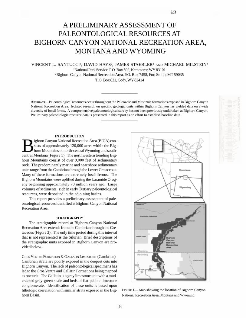
TECHNICAL REPORT NPS/NRGRD/GRDTR-99/3
A PRELIMINARY ASSESSMENT OFPALEONTOLOGICAL RESOURCES AT
BIGHORN CANYON NATIONAL RECREATION AREA, MONTANA AND WYOMING
VINCENT L. SANTUCCI1, DAVID HAYS2, JAMES STAEBLER2 AND MICHAEL MILSTEIN3
1National Park Service, P.O. Box 592, Kemmerer, WY 831012Bighorn Canyon National Recreation Area, P.O. Box 7458, Fort Smith, MT 59035
3P.O. Box 821, Cody, WY 82414
____________________
ABSTRACT—Paleontological resources occur throughout the Paleozoic and Mesozoic formations exposed in Bighorn CanyonNational Recreation Area. Isolated research on specific geologic units within Bighorn Canyon has yielded data on a widediversity of fossil forms. A comprehensive paleonotological survey has not been previously undertaken at Bighorn Canyon.Preliminary paleontologic resource data is presented in this report as an effort to establish baseline data.
____________________
INTRODUCTION
Bighorn Canyon National Recreation Area (BICA) con-sists of approximately 120,000 acres within the Big-horn Mountains of north-central Wyoming and south-
central Montana (Figure 1). The northwestern trending Big-horn Mountains consist of over 9,000 feet of sedimentaryrock. The predominantly marine and near shore sedimentaryunits range from the Cambrian through the Lower Cretaceous.Many of these formations are extremely fossiliferous. TheBighorn Mountains were uplifted during the Laramide Orog-eny beginning approximately 70 million years ago. Largevolumes of sediments, rich in early Tertiary paleontologicalresources, were deposited in the adjoining basins.
This report provides a preliminary assessment of pale-ontological resources identified at Bighorn Canyon NationalRecreation Area.
STRATIGRAPHYThe stratigraphic record at Bighorn Canyon National
Recreation Area extends from the Cambrian through the Cre-taceous (Figure 2). The only time period during this intervalthat is not represented is the Silurian. Brief descriptions ofthe stratigraphic units exposed in Bighorn Canyon are pro-vided below.
GROS VENTRE FORMATION & GALLATIN LIMESTONE (Cambrian)Cambrian strata are poorly exposed in the deepest cuts intoBighorn Canyon. The lack of paleontological specimens hasled to the Gros Ventre and Gallatin Formations being mappedas one unit. The Gallatin is a gray limestone unit with a mud-cracked gray-green shale and beds of flat-pebble limestoneconglomerate. Identification of these units is based uponlithologic correlation with similar strata exposed in the Big-horn Basin.
FIGURE 1— Map showing the location of Bighorn CanyonNational Recreation Area, Montana and Wyoming.
18
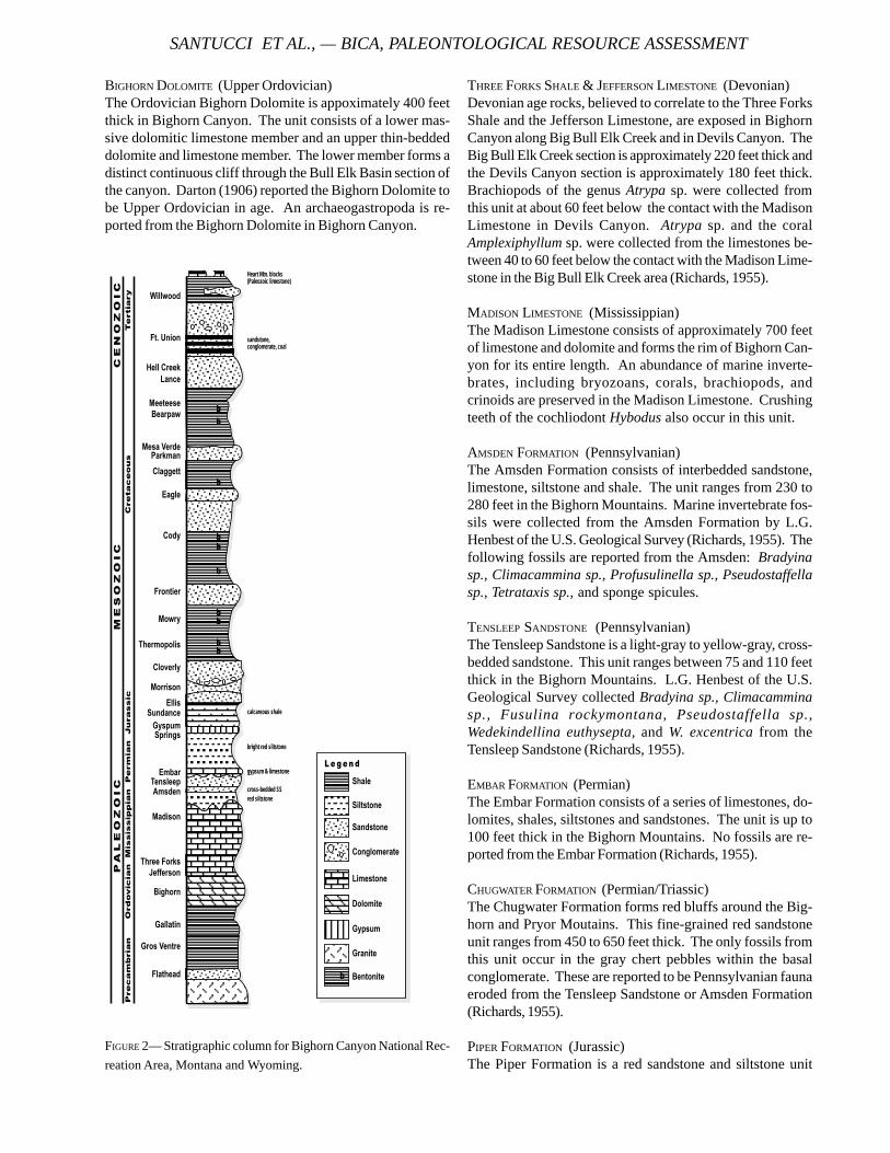
BIGHORN DOLOMITE (Upper Ordovician)The Ordovician Bighorn Dolomite is appoximately 400 feetthick in Bighorn Canyon. The unit consists of a lower mas-sive dolomitic limestone member and an upper thin-beddeddolomite and limestone member. The lower member forms adistinct continuous cliff through the Bull Elk Basin section ofthe canyon. Darton (1906) reported the Bighorn Dolomite tobe Upper Ordovician in age. An archaeogastropoda is re-ported from the Bighorn Dolomite in Bighorn Canyon.
THREE FORKS SHALE & JEFFERSON LIMESTONE (Devonian)Devonian age rocks, believed to correlate to the Three ForksShale and the Jefferson Limestone, are exposed in BighornCanyon along Big Bull Elk Creek and in Devils Canyon. TheBig Bull Elk Creek section is approximately 220 feet thick andthe Devils Canyon section is approximately 180 feet thick.Brachiopods of the genus Atrypa sp. were collected fromthis unit at about 60 feet below the contact with the MadisonLimestone in Devils Canyon. Atrypa sp. and the coralAmplexiphyllum sp. were collected from the limestones be-tween 40 to 60 feet below the contact with the Madison Lime-stone in the Big Bull Elk Creek area (Richards, 1955).
MADISON LIMESTONE (Mississippian)The Madison Limestone consists of approximately 700 feetof limestone and dolomite and forms the rim of Bighorn Can-yon for its entire length. An abundance of marine inverte-brates, including bryozoans, corals, brachiopods, andcrinoids are preserved in the Madison Limestone. Crushingteeth of the cochliodont Hybodus also occur in this unit.
AMSDEN FORMATION (Pennsylvanian)The Amsden Formation consists of interbedded sandstone,limestone, siltstone and shale. The unit ranges from 230 to280 feet in the Bighorn Mountains. Marine invertebrate fos-sils were collected from the Amsden Formation by L.G.Henbest of the U.S. Geological Survey (Richards, 1955). Thefollowing fossils are reported from the Amsden: Bradyinasp., Climacammina sp., Profusulinella sp., Pseudostaffellasp., Tetrataxis sp., and sponge spicules.
TENSLEEP SANDSTONE (Pennsylvanian)The Tensleep Sandstone is a light-gray to yellow-gray, cross-bedded sandstone. This unit ranges between 75 and 110 feetthick in the Bighorn Mountains. L.G. Henbest of the U.S.Geological Survey collected Bradyina sp., Climacamminasp., Fusulina rockymontana, Pseudostaffella sp.,Wedekindellina euthysepta, and W. excentrica from theTensleep Sandstone (Richards, 1955).
EMBAR FORMATION (Permian)The Embar Formation consists of a series of limestones, do-lomites, shales, siltstones and sandstones. The unit is up to100 feet thick in the Bighorn Mountains. No fossils are re-ported from the Embar Formation (Richards, 1955).
CHUGWATER FORMATION (Permian/Triassic)The Chugwater Formation forms red bluffs around the Big-horn and Pryor Moutains. This fine-grained red sandstoneunit ranges from 450 to 650 feet thick. The only fossils fromthis unit occur in the gray chert pebbles within the basalconglomerate. These are reported to be Pennsylvanian faunaeroded from the Tensleep Sandstone or Amsden Formation(Richards, 1955).
PIPER FORMATION (Jurassic)The Piper Formation is a red sandstone and siltstone unit
FIGURE 2— Stratigraphic column for Bighorn Canyon National Rec-reation Area, Montana and Wyoming.
SANTUCCI ET AL., — BICA, PALEONTOLOGICAL RESOURCE ASSESSMENT
Heart Mtn. blocks(Paleozoic limestone)
sandstone,conglomerate, coal
gypsum & limestone
bright red siltstone
calcareous shale
red siltstonecross-bedded SS
���
��
��
���
���
���
��
�
�����
���
���
��
��
��
��
��
����
���
���
�
��
�
����
���
�
��
��
��
��
�
��
��
���
�
��
��
���
��������
�������
�������������
���������������
����������������
��������
�����
����
��������
�����
� ���������
���!����
��������
�����"#������$���#�"������
��%����������&�����
�������
� ��������'�((�����
��� ���
$�������
$���������
���� ���
��
��
�
��
�
��
������������
"��������
" ���
���������
)�������
$���#�
"��������
$������
����������
�� ����
TECHNICAL REPORT NPS/NRGRD/GRDTR-99/3
with beds of gray limestone and gypsum. This unit is be-tween 150 and 200 feet thick in the Bighorn Mountains. Nofossils are reported from the Piper Formation.
SUNDANCE FORMATION (Jurassic)The Sundance Formation, previously referred to as theRierdon and Swift Formations, is a series of fossiliferousmarine sandstones and shales. The total thickness of thisunit is about 500 feet on the eastern flank of the BighornMountains. The lower section contains numerous Belem-nites sp., Gryphaea sp., and the star-shaped crinoid columnalsPentacrinus sp.. The upper section contains a lenticularfossiliferous sandstone bed at the top of the unit (Richards,1955).
MORRISON FORMATION (Jurassic)The Morrison Formation is a gray-green siltstone and sand-stone unit that ranges in thickness between 140 to 280 feet inthe Bighorn Mountains. Fragmentary dinosaur bones arepreserved in the non-marine Morrison Formation. A sauro-pod track locality was identified on the west side of SykesMountain in the upper portion of the Salt Wash Member(Engelmann and Hasiotis, 1999).
CLOVERLY FORMATION (Early Cretaceous)The Early Cretaceous Cloverly Formation was first describedby Darton for exposures on the east flank of the BighornMountains (Darton, 1904). The formation is exposed in thenorthern and eastern portions of the Bighorn Mountains andranges between 300 to 400 feet thick. This formation con-sists of a basal conglomeratic sandstone member, a middlevariegated shale member, and upper shale, siltstone, and sand-stone member. Fossils have not been reported from this for-mation in the Bighorn Mountains.
THERMOPOLIS SHALE (Early Cretaceous)A section of the Thermopolis Shale was measured in theBighorn Mountains on the east side of Soap Creek dome(Rogers, et al., 1948). This unit consists of approximately 425feet of dark-gray shale with many bentonite beds and iron-stone concretions. The unit is crosscut by fine-grained sand-stone dikes. Fossils are not reported from this unit in theBighorn Mountains.
MOWRY SHALE (Early Cretaceous)The Mowry Shale lies conformably over the ThermopolisShale in the Bighorn Mountains. This unit is exposed on theeastern edge of the Bighorns and ranges in thickness be-tween 350 and 400 feet. The Mowry consists of dark-grayshale and light-gray siltstone and sandstone. Fish scale im-pressions are abundant in the Mowry Shale (Richards, 1955).
FRONTIER FORMATION (Late Cretaceous)The Late Cretaceous Frontier Formation consists about 260feet of dark-gray concretionary, sandy shale with interbeddedbentonite (Richards, 1955). This unit contains a few lensesof cherty sandstone in the Bighorn Mountains and in the
Bighorn Basin. Fossils are not reported from this unit in theBighorn Mountains.
CODY SHALE (Late Cretaceous)The Cody Shale is approximately 2000 feet thick and is com-posed of seven members (Thom, et al., 1935). All of themembers are fossiliferous except for the lowest member ofthe Cody Shale. Identification of the fossil material was madeby W.A. Cobban (Richards, 1955).
Greenhorn Calcareous Member: Allocrioceras annulatum,Mytiloides labiatus, Ostrea sp., Plicatula sp.,Pseudaspidoceras sp., Quitmaniceras sp., Scaphitesdelicatulus, Vascoceras catinus, Watinoceras reesidei, andfish bones.
Carlile Shale Member: Baculites besairiei, Crassatellitesreesidei, Inoceramus altus, I. flaccidus, Membraniporinasp., Nucula sp., Ostrea congesta, Placenticeras stantoni,Prionocyclus wyomingensis, Scaphites corvensis, S.nigricollensis, Tritonium kanabense, and Veniellagoniophora.
Niobrara Shale Member: Anomia sp., Baculites codyensis, B.mariasensis, B. sweetgrassensis, Clioscaphites vermiformis,Inoceramus deformis, Ostrea congesta, Pteria nebrascana,Scaphites impendicostatus, Veniella sp. and indeterminantnautiloids, gastropods, pelecypods, echinoid spines, and fishscales.
Telegraph Creek Member: Baculites sp., Ostrea sp., andScaphites hippocrepis.
Shale Member equivalent to the Eagle Sandstone: This unitis considered equivalent to the Eagle Sandstone based uponthe fossil assemblage including: Anomia sp., Baculitesaquilaensis, B. haresi, B. minerensis, B. thomi, Callista pel-lucida, Capulus microstriatus, Cardium whitei,Corbulamella gregaria, Crenella elegantula, Cymbophorasp., Cymella montanensis, Drepanochilus evansi,Glyptoxoceras novimexicanus, G. rubeyi, Goniochasmacrockfordi, Inoceramus barabini, I. saskatchewanensis, I.subdepressus, Leptosolen conradi, Lima sp., Lithophaga sp.,Pholadomya subventricosa, Pinna dolosoniensis,Placenticeras meeki, P. planum, Scaphites aquilaensis, S.hippocrepis, S. stantoni, Spironema tenuilineata,Syncyclonema halli, Tellina scitula, Volsella meeki, crusta-cean remains, fish scales and reptilian bones.
Claggett Shale Member: Baculites aquilaensis, B.asperiformis, B. haresi, Caprinella coraloidea, Inoceramusbarabini, I. sagensis, I. saskatchewanensis, I. vanuxemi,Jeletzkytes brevis, Pteria notukeuensis, and Yoldia sp.
PARKMAN SANDSTONE (Late Cretaceous)The Parkman Sandstone is a sandy shale and sandstone ap-proximately 250 feet thick in Bighorn Canyon. Darton, who
first described this unit, made a small collection of fossilsfrom the Parkman Sandstone (Darton, 1906). These fossilswere identified by T.W. Stanton as being Late Cretaceousmarine organisms. The beds above the basal sandstone ofthe Parkman Sandstone, that occur northwest of Hardin, havebeen suggested to be a continuation of the fresh-water andbrackish-water beds of the Judith River Formation (Hancock,1920; Thom et al., 1935).
BEARPAW SHALE (Late Cretaceous)The Bearpaw Shale is a fossiliferous, dark-gray marine shalethat is exposed in the Ninemile area. The unit is approxi-mately 850 feet thick. Richards (1955) divides the BearpawShale into three members.
Upper Member: Baculites compressus, B. grandis,Cymbophora cf. gracilis, Chlamys nebrascensis,Discoscaphites nicolletti, Inoceramus altus, I. barabini,Jeletzkytes nodosus, Lucina occidentalis, L. subundata,Nucula planimarginata, Ostrea sp., Placenticeras meeki, P.planum, Polinices concinna, Protocardia subquadrata,Pteria linguaeformais, and Yoldia evansi.
Bentonitic Member: Acmaea? occidentalis, Baculitescompressus, Cuspidaria moreauensis, C. ventricosa,Cymbophora gracilis, Cymella meeki, Dentaliumpauperculum, Drepanochilus evansi, D. nebrascensis,Ellipsoscapha occidentalis, E. subcylindrica, Fasciolariagracilenta, Gervillia recta, Inoceramus vanuxemi, I.tenuilineatus, Jeletzkytes brevis, J. nodosus, J.quadrangularis, Lucina subundata, Ostrea subalata,Placenticeras intercalare, P. meeki, Polinices concinna,Pteria parkensis, Syncyclonema halli, Yoldia evansi, and Y.ventricosa.
Lower Member: Baculites compressus, Didymocerasnebrascense, Inoceramus barabibi, I. cf. palliseri, I. sagensis,I. saskatchewanensis, I. tenuilineatus, Lucina sp., Ostreasp., Placenticeras meeki, and Yoldia sp.
Tertiary and Quaternary gravels and alluvium are presenton the flanks of the Bighorn Mountains. Six principal ter-races are associated with the Bighorn River and its tributar-ies. No fossils have been reported from the terraces.
PALEONTOLOGICAL RESOURCE PROTECTIONTwo case incident reports related to the unauthorized
collecting of paleontological resources were produced in 1994.Both incidents documented park visitors involved with theillegal collection of invertebrate fossils from Mesozoic rockunits, possibly the Sundance Formation, within BICA. Inboth cases, the unauthorized fossil collecting occurred in theSykes Mountain area.
PALEONTOLOGICAL RESOURCE INTERPRETATIONThe Bighorn Canyon Visitor Center in Lovell has pale-
ontological displays titled “Rocks Reveal the Past”. The
following specimens are included in this interpretive exhibit.CAMBRIAN
· algal stromatolite· trilobiteORDOVICIAN
· sponge· coral (honeycomb and large vesicles)· molluskMISSISSIPPIAN
· brachiopod casts and molds· coralTRIASSIC
· coralJURASSIC
· dinosaur bone fragments· gastroliths· oysters (Gryphea)· pelecypods· belemnitesCRETACEOUS
· ammonites, baculites, and scaphites· bivalves – pelecypods· shark’s teeth· crocodile teeth
PALEONTOLOGICAL RESOURCESNEAR BIGHORN CANYON
The remains of an Allosaurus were collected fromMorrison Formation on BLM land about 20 miles south ofBighorn Canyon National Recreation area.
Bighorn Basin: A thick sequence of fossiliferous Paleoceneand Eocene strata, including the Polecat Bench, Fort Union,and Willwood Formations, occurs in the Bighorn Basin. Thefossil-bearing strata have been divided into thirteen differentmammal zones including: two Torrejonian zones, five Tiffanianzones, one Clarkforkian zone, and 5 Wasatchian zones(Woodburne, 1987).
Natural Trap Cave: Natural Trap Cave is a karst sinkholefeature developed within the Mississippian Madison Lime-stone on the western slope of the Bighorn Mountains innorth-central Wyoming. Late Pleistocene paleontological re-sources have been excavated from stratified sediments withinNatural Trap Cave (Anderson, 1974).
ACKNOWLEDGEMENTSThanks to the Bighorn Canyon National Recreation Area
staff including Rick Lasko, Theo Huggs, and SuperintendentDaryl Cook for support of this project. Additional thanks toDr. Bill Cobban (U.S.G.S.), Lindsay McClelland (NPS), ShawnDuffy, and Kris Thompson for technical review of this report.
REFERENCESANDERSON, E., 1974. A survey of the late Pleistocene and
Holocene mammal fauna of Wyoming. In M. Wilson,ed., Applied geology and archeology: the Holocene his-
SANTUCCI ET AL., — BICA, PALEONTOLOGICAL RESOURCE ASSESSMENT
TECHNICAL REPORT NPS/NRGRD/GRDTR-99/3
tory of Wyoming: Geol. Surv. Wyoming, Rep. Inv., 10,p.78-87.
DARTON, N.H., 1904. Comparison of the stratigraphy of theBlack Hills, Bighorn Mountains, and Rocky MountainFront Range. Geol.Soc.Amer.Bull., 15:379-448.
______, 1906. Geology of the Bighorn Moutains.U.S.Geological Survey Professional Paper, No. 51.
ENGELMANN, G. F. AND S.T. HASIOTIs, 1999. Deep dinosaurtracks in the Morrsion Formation: Sole marks that arereally sole marks. In Gillette, D.D. (ed.), Vertebrate Pale-ontology in Utah. Utah Geological Survey Miscella-neous Publication 99-1, p. 179-183.
HANCOCK, E.T., 1920. Geology and oil and gas prospects ofthe Huntley field, Montana. U.S. Geologic Survey Bulle-tin, No. 711-G, p. 105-148.
KNECHTEL, M.M. and S.H. PATTERSON, 1956. Bentonite depos-its in marine Cretaceous Formations, Hardin District,Montana and Wyoming. U.S. Geological Survey Bulle-tin 1023, 116pp.
MISSOURI BASIN PROJECT, 1952. Appraisal of the archeological– paleontological resources of the Yellowtail Reservoirsite, Montana and Wyoming. Smithsonian InstitutionMissouri Basin Project, 21pp.
PROCHASKA, E.J., 1960. Foraminifera from two sections of theCody Shale in Fremont and Teton Counties, Wyoming.University of Wyoming, Unpublished M.S. Thesis,Laramie.
RICHARDS, Paul. W., 1955. Geology of the Bighorn Canyon –Hardin area, Montana and Wyoming. U.S. GeologicalSurvey Bulletin 1026.
ROGERS, C.P., P.W. RICHARDS, L.C. CONANT, and others, 1948.Geology of the Worland-Hyattville area, Bighorn andWashakie Counties, Wyoming. U.S. Geological SurveyOil and Gas Investigations Preliminary Map 84.
SHAW, A.B., 1954. The Cambrian – Ordovician of the PryorMountains, Montana and the northern Bighorn Moun-tains, Wyoming. Guidebook to the 5th Annual Confer-ence of the Billings Geological Society.
THOM, W.T., G.M. HALL, C.H. WEGEMANN, and G.F. MOUTON,1935. Geology of Bighorn County and the Crow IndianReservation, Montana. U.S. Geological Survey Bulletin,No. 856.
WOODBURNE, M.O., 1987. Cenozoic Mammals of NorthAmerica: Geochronology and Biostratigraphy. Univer-sity of California Press, Berkeley, 336 p.
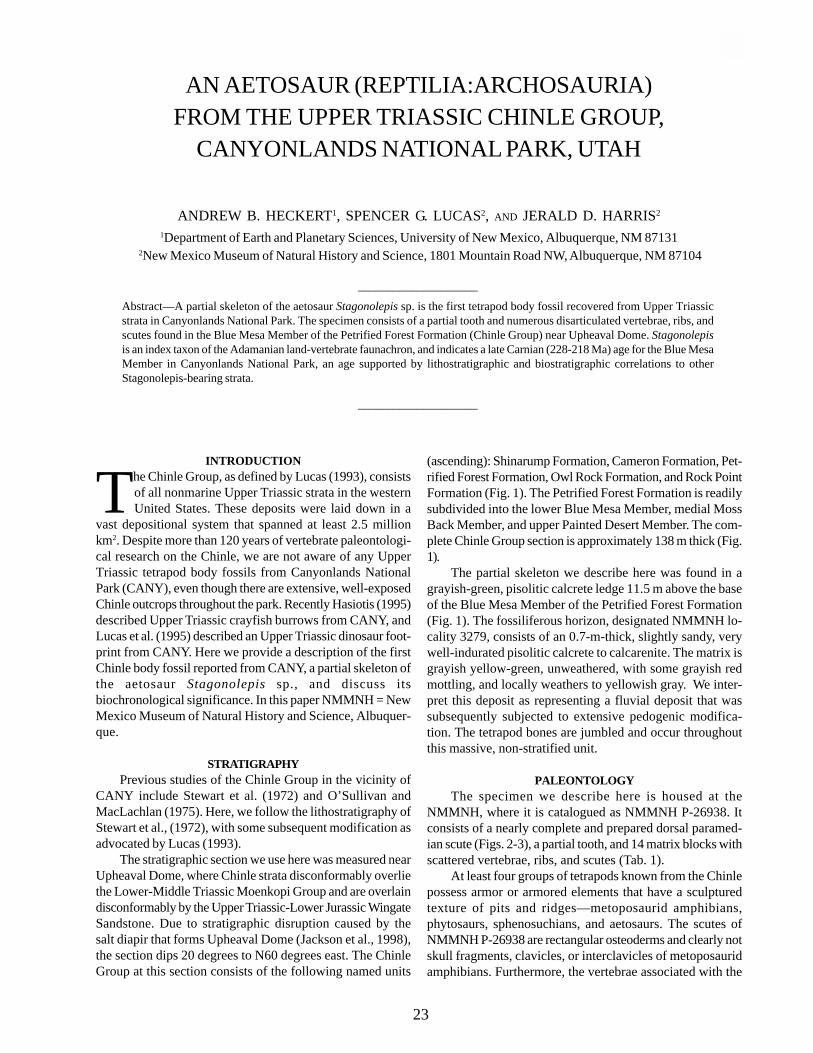
AN AETOSAUR (REPTILIA:ARCHOSAURIA)FROM THE UPPER TRIASSIC CHINLE GROUP,
CANYONLANDS NATIONAL PARK, UTAH
ANDREW B. HECKERT1, SPENCER G. LUCAS2, AND JERALD D. HARRIS2
1Department of Earth and Planetary Sciences, University of New Mexico, Albuquerque, NM 87131 2New Mexico Museum of Natural History and Science, 1801 Mountain Road NW, Albuquerque, NM 87104
____________________
Abstract—A partial skeleton of the aetosaur Stagonolepis sp. is the first tetrapod body fossil recovered from Upper Triassicstrata in Canyonlands National Park. The specimen consists of a partial tooth and numerous disarticulated vertebrae, ribs, andscutes found in the Blue Mesa Member of the Petrified Forest Formation (Chinle Group) near Upheaval Dome. Stagonolepisis an index taxon of the Adamanian land-vertebrate faunachron, and indicates a late Carnian (228-218 Ma) age for the Blue MesaMember in Canyonlands National Park, an age supported by lithostratigraphic and biostratigraphic correlations to otherStagonolepis-bearing strata.
____________________
INTRODUCTION
The Chinle Group, as defined by Lucas (1993), consistsof all nonmarine Upper Triassic strata in the westernUnited States. These deposits were laid down in a
vast depositional system that spanned at least 2.5 millionkm2. Despite more than 120 years of vertebrate paleontologi-cal research on the Chinle, we are not aware of any UpperTriassic tetrapod body fossils from Canyonlands NationalPark (CANY), even though there are extensive, well-exposedChinle outcrops throughout the park. Recently Hasiotis (1995)described Upper Triassic crayfish burrows from CANY, andLucas et al. (1995) described an Upper Triassic dinosaur foot-print from CANY. Here we provide a description of the firstChinle body fossil reported from CANY, a partial skeleton ofthe aetosaur Stagonolepis sp., and discuss itsbiochronological significance. In this paper NMMNH = NewMexico Museum of Natural History and Science, Albuquer-que.
STRATIGRAPHYPrevious studies of the Chinle Group in the vicinity of
CANY include Stewart et al. (1972) and O’Sullivan andMacLachlan (1975). Here, we follow the lithostratigraphy ofStewart et al., (1972), with some subsequent modification asadvocated by Lucas (1993).
The stratigraphic section we use here was measured nearUpheaval Dome, where Chinle strata disconformably overliethe Lower-Middle Triassic Moenkopi Group and are overlaindisconformably by the Upper Triassic-Lower Jurassic WingateSandstone. Due to stratigraphic disruption caused by thesalt diapir that forms Upheaval Dome (Jackson et al., 1998),the section dips 20 degrees to N60 degrees east. The ChinleGroup at this section consists of the following named units
(ascending): Shinarump Formation, Cameron Formation, Pet-rified Forest Formation, Owl Rock Formation, and Rock PointFormation (Fig. 1). The Petrified Forest Formation is readilysubdivided into the lower Blue Mesa Member, medial MossBack Member, and upper Painted Desert Member. The com-plete Chinle Group section is approximately 138 m thick (Fig.1).
The partial skeleton we describe here was found in agrayish-green, pisolitic calcrete ledge 11.5 m above the baseof the Blue Mesa Member of the Petrified Forest Formation(Fig. 1). The fossiliferous horizon, designated NMMNH lo-cality 3279, consists of an 0.7-m-thick, slightly sandy, verywell-indurated pisolitic calcrete to calcarenite. The matrix isgrayish yellow-green, unweathered, with some grayish redmottling, and locally weathers to yellowish gray. We inter-pret this deposit as representing a fluvial deposit that wassubsequently subjected to extensive pedogenic modifica-tion. The tetrapod bones are jumbled and occur throughoutthis massive, non-stratified unit.
PALEONTOLOGYThe specimen we describe here is housed at the
NMMNH, where it is catalogued as NMMNH P-26938. Itconsists of a nearly complete and prepared dorsal paramed-ian scute (Figs. 2-3), a partial tooth, and 14 matrix blocks withscattered vertebrae, ribs, and scutes (Tab. 1).
At least four groups of tetrapods known from the Chinlepossess armor or armored elements that have a sculpturedtexture of pits and ridges—metoposaurid amphibians,phytosaurs, sphenosuchians, and aetosaurs. The scutes ofNMMNH P-26938 are rectangular osteoderms and clearly notskull fragments, clavicles, or interclavicles of metoposauridamphibians. Furthermore, the vertebrae associated with the
23
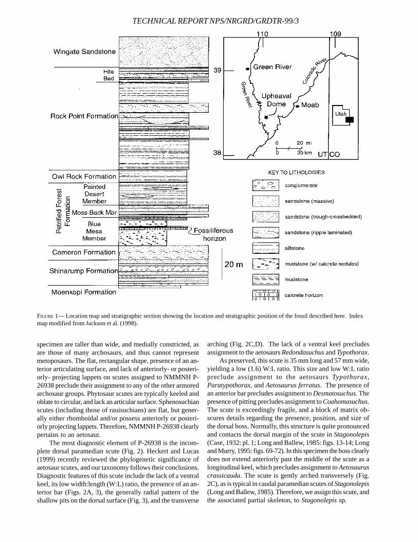
TECHNICAL REPORT NPS/NRGRD/GRDTR-99/3
specimen are taller than wide, and medially constricted, asare those of many archosaurs, and thus cannot representmetoposaurs. The flat, rectangular shape, presence of an an-terior articulating surface, and lack of anteriorly- or posteri-orly- projecting lappets on scutes assigned to NMMNH P-26938 preclude their assignment to any of the other armoredarchosaur groups. Phytosaur scutes are typically keeled andoblate to circular, and lack an articular surface. Sphenosuchianscutes (including those of rauisuchians) are flat, but gener-ally either rhomboidal and/or possess anteriorly or posteri-orly projecting lappets. Therefore, NMMNH P-26938 clearlypertains to an aetosaur.
The most diagnostic element of P-26938 is the incom-plete dorsal paramedian scute (Fig. 2). Heckert and Lucas(1999) recently reviewed the phylogenetic significance ofaetosaur scutes, and our taxonomy follows their conclusions.Diagnostic features of this scute include the lack of a ventralkeel, its low width:length (W:L) ratio, the presence of an an-terior bar (Figs. 2A, 3), the generally radial pattern of theshallow pits on the dorsal surface (Fig. 3), and the transverse
arching (Fig. 2C,D). The lack of a ventral keel precludesassignment to the aetosaurs Redondasuchus and Typothorax.
As preserved, this scute is 35 mm long and 57 mm wide,yielding a low (1.6) W:L ratio. This size and low W:L ratiopreclude assignment to the aetosaurs Typothorax,Paratypothorax, and Aetosaurus ferratus. The presence ofan anterior bar precludes assignment to Desmatosuchus. Thepresence of pitting precludes assignment to Coahomasuchus.The scute is exceedingly fragile, and a block of matrix ob-scures details regarding the presence, position, and size ofthe dorsal boss. Normally, this structure is quite pronouncedand contacts the dorsal margin of the scute in Stagonolepis(Case, 1932: pl. 1; Long and Ballew, 1985: figs. 13-14; Longand Murry, 1995: figs. 69-72). In this specimen the boss clearlydoes not extend anteriorly past the middle of the scute as alongitudinal keel, which precludes assignment to Aetosauruscrassicauda. The scute is gently arched transversely (Fig.2C), as is typical in caudal paramedian scutes of Stagonolepis(Long and Ballew, 1985). Therefore, we assign this scute, andthe associated partial skeleton, to Stagonolepis sp.
FIGURE 1— Location map and stratigraphic section showing the location and stratigraphic position of the fossil described here. Indexmap modified from Jackson et al. (1998).
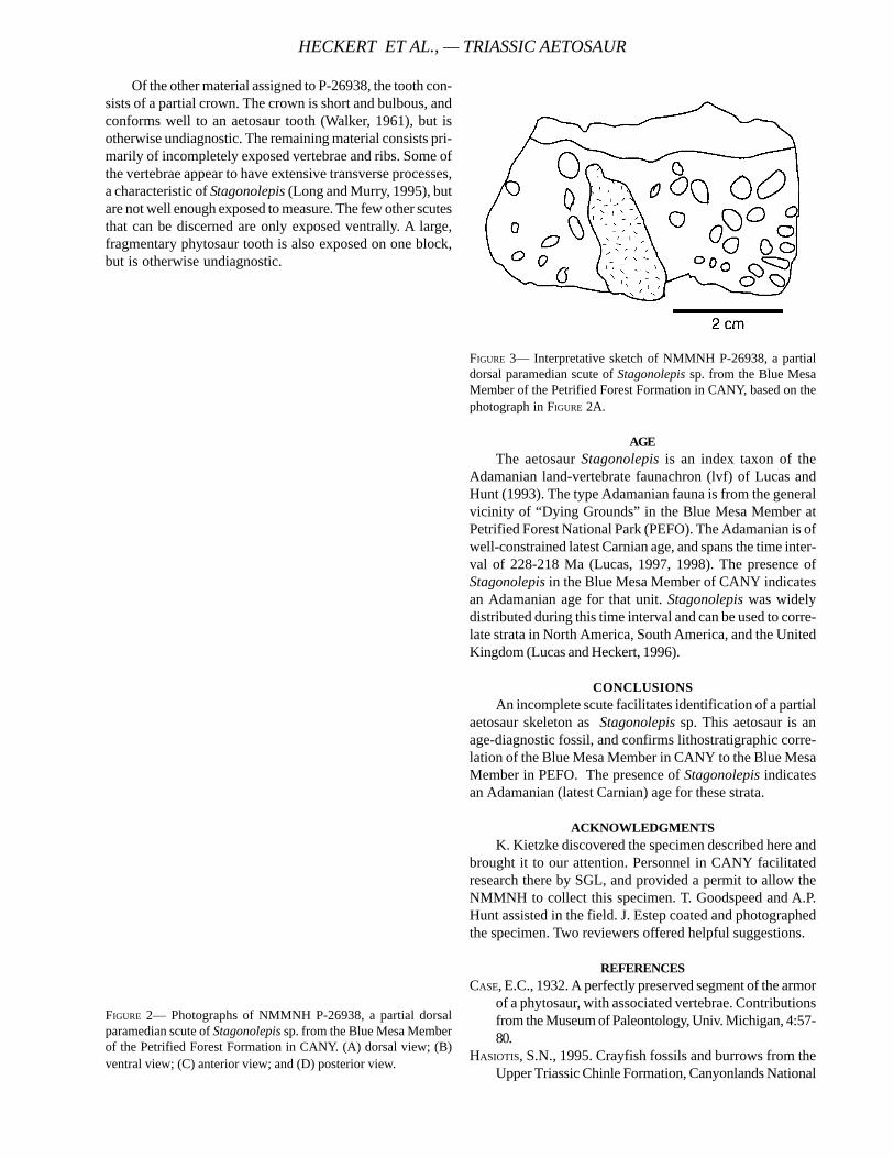
Of the other material assigned to P-26938, the tooth con-sists of a partial crown. The crown is short and bulbous, andconforms well to an aetosaur tooth (Walker, 1961), but isotherwise undiagnostic. The remaining material consists pri-marily of incompletely exposed vertebrae and ribs. Some ofthe vertebrae appear to have extensive transverse processes,a characteristic of Stagonolepis (Long and Murry, 1995), butare not well enough exposed to measure. The few other scutesthat can be discerned are only exposed ventrally. A large,fragmentary phytosaur tooth is also exposed on one block,but is otherwise undiagnostic.
FIGURE 2— Photographs of NMMNH P-26938, a partial dorsalparamedian scute of Stagonolepis sp. from the Blue Mesa Memberof the Petrified Forest Formation in CANY. (A) dorsal view; (B)ventral view; (C) anterior view; and (D) posterior view.
FIGURE 3— Interpretative sketch of NMMNH P-26938, a partialdorsal paramedian scute of Stagonolepis sp. from the Blue MesaMember of the Petrified Forest Formation in CANY, based on thephotograph in FIGURE 2A.
AGEThe aetosaur Stagonolepis is an index taxon of the
Adamanian land-vertebrate faunachron (lvf) of Lucas andHunt (1993). The type Adamanian fauna is from the generalvicinity of “Dying Grounds” in the Blue Mesa Member atPetrified Forest National Park (PEFO). The Adamanian is ofwell-constrained latest Carnian age, and spans the time inter-val of 228-218 Ma (Lucas, 1997, 1998). The presence ofStagonolepis in the Blue Mesa Member of CANY indicatesan Adamanian age for that unit. Stagonolepis was widelydistributed during this time interval and can be used to corre-late strata in North America, South America, and the UnitedKingdom (Lucas and Heckert, 1996).
CONCLUSIONSAn incomplete scute facilitates identification of a partial
aetosaur skeleton as Stagonolepis sp. This aetosaur is anage-diagnostic fossil, and confirms lithostratigraphic corre-lation of the Blue Mesa Member in CANY to the Blue MesaMember in PEFO. The presence of Stagonolepis indicatesan Adamanian (latest Carnian) age for these strata.
ACKNOWLEDGMENTSK. Kietzke discovered the specimen described here and
brought it to our attention. Personnel in CANY facilitatedresearch there by SGL, and provided a permit to allow theNMMNH to collect this specimen. T. Goodspeed and A.P.Hunt assisted in the field. J. Estep coated and photographedthe specimen. Two reviewers offered helpful suggestions.
REFERENCESCASE, E.C., 1932. A perfectly preserved segment of the armor
of a phytosaur, with associated vertebrae. Contributionsfrom the Museum of Paleontology, Univ. Michigan, 4:57-80.
HASIOTIS, S.N., 1995. Crayfish fossils and burrows from theUpper Triassic Chinle Formation, Canyonlands National
HECKERT ET AL., — TRIASSIC AETOSAUR
TECHNICAL REPORT NPS/NRGRD/GRDTR-99/3
Park, Utah. In Santucci. V.L. and L. McClelland (eds.),National Park Service Paleontological Research, Techni-cal Report NPS/NRPO/NRTR-95/16, pp. 49-53.
HECKERT, A.B. AND S.G. LUCAS, 1999. A new aetosaur(Archosauria: Crurotarsi) from the Upper Triassic of Texasand the phylogeny, and paleogeography of aetosaurs.Journal of Vertebrate Paleontology, 19:50-68.
JACKSON, M.P.A., D.D. SCHULTZ-ERA, M.R. HUDEC, I.A. WATSON,AND M.L. PORTER, 1998. Structure and evolution of Up-heaval Dome: a pinched-off salt diapir. GSA Bulletin110:1547-1573.
LONG, R.A., AND K.L. BALLEW, 1985. Aetosaur dermal armorfrom the Late Triassic of southwestern North America,with special reference to material from the Chinle Forma-tion of Petrified Forest National Park. Museum of North-ern Arizona Bulletin, 54: 45-68.
LONG, R.A., AND P.A. MURRy, 1995. Late Triassic (Carnian andNorian) Tetrapods from the southwestern United States.New Mexico Museum of Natural History and ScienceBulletin, 4:1-254.
LUCAS, S.G., 1993. The Chinle Group: revised stratigraphyand biochronology of Upper Triassic nonmarine stratain the western United States. Museum of Northern Ari-zona Bulletin, 59:27-50.
______, 1997. The Upper Triassic Chinle Group, westernUnited States, nonmarine standard for Late Triassic time:pp. 200-228 in Dickins, J.M., Yin, H., & Lucas, S.G., eds:Permo-Triassic of the circum-Pacific: Cambridge Univer-
sity Press, Cambridge.______, 1998. Global Triassic tetrapod biostratigraphy and
biochronology. Palaeogeography, Palaeoclimatology,Palaeoecology, 143(4):347-384.
______, AND A.B. HECKERT, 1996. Late Triassic aetosaurbiochronology. Albertiana, 17:57-64.
______, AND A.P. HUNT, 1993. Tetrapod biochronology ofthe Chinle Group (Upper Triassic), Western UnitedStates. New Mexico Museum of Natural History andScience Bulletin, 3:327-329.
______, ______, AND M.G. LOCKLEY, 1995. Dinosaur foot-print from the Upper Triassic Rock Point Formation ofthe Chinle Group, Canyonlands National Park. InSantucci, V.L. and L. McClelland (eds.), National ParkService Paleontological Research, Technical Report NPS/NRPO/NRTR-95/16, pp. 58-60
O’SULLIVAN, R.B., AND M.E. MACLACHLAN, 1975. Triassicrocks of the Moab-White Canyon Area, southeasternUtah. Canyonlands Country, Four Corners GeologicalSociety Guidebook 8:129-143.
STEWART, J.H., F.G. POOLE, AND R.F. WILSON, 1972. Stratigra-phy and origin of the Chinle Formation and related Up-per Triassic strata in the Colorado Plateau region: U.S.Geological Survey, Professional Paper 690, 336 p.
WALKER, A.D., 1961. Triassic reptiles from the Elgin area:Stagonolepis, Dasygnathus and their allies. Royal Soci-ety of London, Proceedings, Series B., 244:103-204.
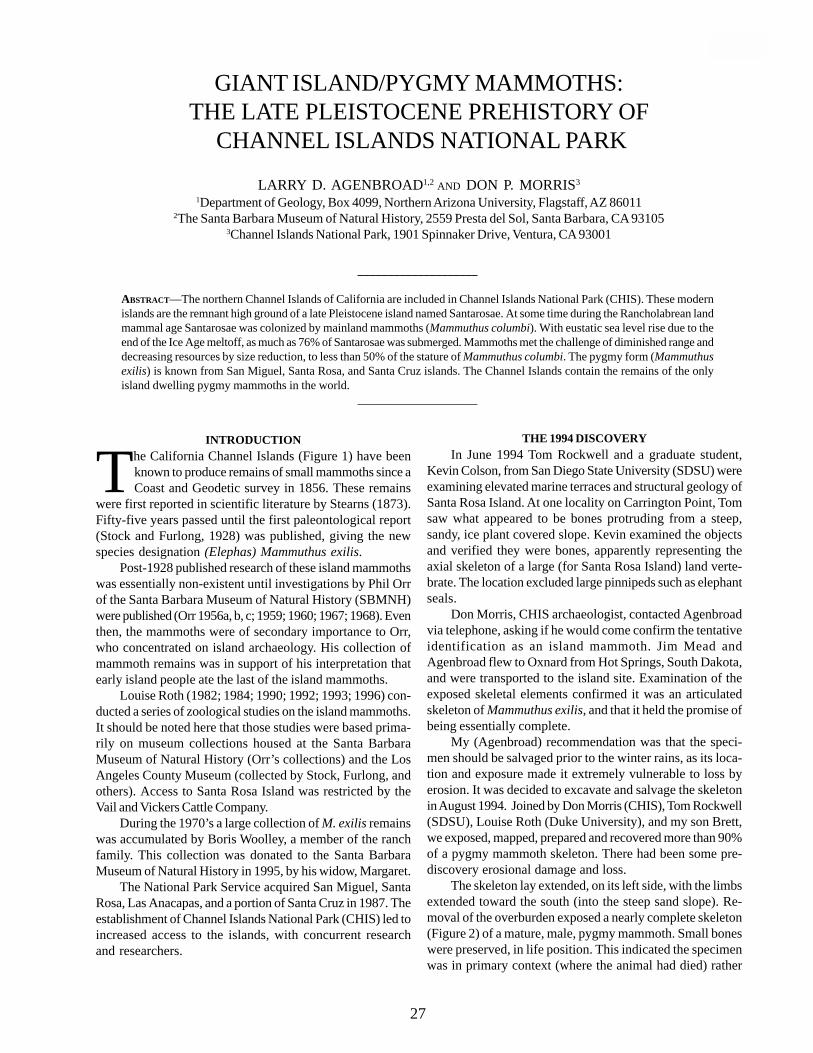
____________________
ABSTRACT—The northern Channel Islands of California are included in Channel Islands National Park (CHIS). These modernislands are the remnant high ground of a late Pleistocene island named Santarosae. At some time during the Rancholabrean landmammal age Santarosae was colonized by mainland mammoths (Mammuthus columbi). With eustatic sea level rise due to theend of the Ice Age meltoff, as much as 76% of Santarosae was submerged. Mammoths met the challenge of diminished range anddecreasing resources by size reduction, to less than 50% of the stature of Mammuthus columbi. The pygmy form (Mammuthusexilis) is known from San Miguel, Santa Rosa, and Santa Cruz islands. The Channel Islands contain the remains of the onlyisland dwelling pygmy mammoths in the world.
____________________
GIANT ISLAND/PYGMY MAMMOTHS:THE LATE PLEISTOCENE PREHISTORY OF
CHANNEL ISLANDS NATIONAL PARK
LARRY D. AGENBROAD1,2 AND DON P. MORRIS3
1Department of Geology, Box 4099, Northern Arizona University, Flagstaff, AZ 860112The Santa Barbara Museum of Natural History, 2559 Presta del Sol, Santa Barbara, CA 93105
3Channel Islands National Park, 1901 Spinnaker Drive, Ventura, CA 93001
INTRODUCTION
The California Channel Islands (Figure 1) have beenknown to produce remains of small mammoths since aCoast and Geodetic survey in 1856. These remains
were first reported in scientific literature by Stearns (1873).Fifty-five years passed until the first paleontological report(Stock and Furlong, 1928) was published, giving the newspecies designation (Elephas) Mammuthus exilis.
Post-1928 published research of these island mammothswas essentially non-existent until investigations by Phil Orrof the Santa Barbara Museum of Natural History (SBMNH)were published (Orr 1956a, b, c; 1959; 1960; 1967; 1968). Eventhen, the mammoths were of secondary importance to Orr,who concentrated on island archaeology. His collection ofmammoth remains was in support of his interpretation thatearly island people ate the last of the island mammoths.
Louise Roth (1982; 1984; 1990; 1992; 1993; 1996) con-ducted a series of zoological studies on the island mammoths.It should be noted here that those studies were based prima-rily on museum collections housed at the Santa BarbaraMuseum of Natural History (Orr’s collections) and the LosAngeles County Museum (collected by Stock, Furlong, andothers). Access to Santa Rosa Island was restricted by theVail and Vickers Cattle Company.
During the 1970’s a large collection of M. exilis remainswas accumulated by Boris Woolley, a member of the ranchfamily. This collection was donated to the Santa BarbaraMuseum of Natural History in 1995, by his widow, Margaret.
The National Park Service acquired San Miguel, SantaRosa, Las Anacapas, and a portion of Santa Cruz in 1987. Theestablishment of Channel Islands National Park (CHIS) led toincreased access to the islands, with concurrent researchand researchers.
THE 1994 DISCOVERYIn June 1994 Tom Rockwell and a graduate student,
Kevin Colson, from San Diego State University (SDSU) wereexamining elevated marine terraces and structural geology ofSanta Rosa Island. At one locality on Carrington Point, Tomsaw what appeared to be bones protruding from a steep,sandy, ice plant covered slope. Kevin examined the objectsand verified they were bones, apparently representing theaxial skeleton of a large (for Santa Rosa Island) land verte-brate. The location excluded large pinnipeds such as elephantseals.
Don Morris, CHIS archaeologist, contacted Agenbroadvia telephone, asking if he would come confirm the tentativeidentification as an island mammoth. Jim Mead andAgenbroad flew to Oxnard from Hot Springs, South Dakota,and were transported to the island site. Examination of theexposed skeletal elements confirmed it was an articulatedskeleton of Mammuthus exilis, and that it held the promise ofbeing essentially complete.
My (Agenbroad) recommendation was that the speci-men should be salvaged prior to the winter rains, as its loca-tion and exposure made it extremely vulnerable to loss byerosion. It was decided to excavate and salvage the skeletonin August 1994. Joined by Don Morris (CHIS), Tom Rockwell(SDSU), Louise Roth (Duke University), and my son Brett,we exposed, mapped, prepared and recovered more than 90%of a pygmy mammoth skeleton. There had been some pre-discovery erosional damage and loss.
The skeleton lay extended, on its left side, with the limbsextended toward the south (into the steep sand slope). Re-moval of the overburden exposed a nearly complete skeleton(Figure 2) of a mature, male, pygmy mammoth. Small boneswere preserved, in life position. This indicated the specimenwas in primary context (where the animal had died) rather
27
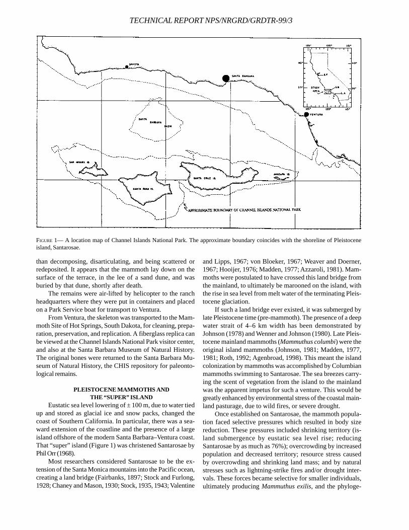
TECHNICAL REPORT NPS/NRGRD/GRDTR-99/3
than decomposing, disarticulating, and being scattered orredeposited. It appears that the mammoth lay down on thesurface of the terrace, in the lee of a sand dune, and wasburied by that dune, shortly after death.
The remains were air-lifted by helicopter to the ranchheadquarters where they were put in containers and placedon a Park Service boat for transport to Ventura.
From Ventura, the skeleton was transported to the Mam-moth Site of Hot Springs, South Dakota, for cleaning, prepa-ration, preservation, and replication. A fiberglass replica canbe viewed at the Channel Islands National Park visitor center,and also at the Santa Barbara Museum of Natural History.The original bones were returned to the Santa Barbara Mu-seum of Natural History, the CHIS repository for paleonto-logical remains.
PLEISTOCENE MAMMOTHS ANDTHE “SUPER” ISLAND
Eustatic sea level lowering of ± 100 m, due to water tiedup and stored as glacial ice and snow packs, changed thecoast of Southern California. In particular, there was a sea-ward extension of the coastline and the presence of a largeisland offshore of the modern Santa Barbara–Ventura coast.That “super” island (Figure 1) was christened Santarosae byPhil Orr (1968).
Most researchers considered Santarosae to be the ex-tension of the Santa Monica mountains into the Pacific ocean,creating a land bridge (Fairbanks, 1897; Stock and Furlong,1928; Chaney and Mason, 1930; Stock, 1935, 1943; Valentine
and Lipps, 1967; von Bloeker, 1967; Weaver and Doerner,1967; Hooijer, 1976; Madden, 1977; Azzaroli, 1981). Mam-moths were postulated to have crossed this land bridge fromthe mainland, to ultimately be marooned on the island, withthe rise in sea level from melt water of the terminating Pleis-tocene glaciation.
If such a land bridge ever existed, it was submerged bylate Pleistocene time (pre-mammoth). The presence of a deepwater strait of 4–6 km width has been demonstrated byJohnson (1978) and Wenner and Johnson (1980). Late Pleis-tocene mainland mammoths (Mammuthus columbi) were theoriginal island mammoths (Johnson, 1981; Madden, 1977,1981; Roth, 1992; Agenbroad, 1998). This meant the islandcolonization by mammoths was accomplished by Columbianmammoths swimming to Santarosae. The sea breezes carry-ing the scent of vegetation from the island to the mainlandwas the apparent impetus for such a venture. This would begreatly enhanced by environmental stress of the coastal main-land pasturage, due to wild fires, or severe drought.
Once established on Santarosae, the mammoth popula-tion faced selective pressures which resulted in body sizereduction. These pressures included shrinking territory (is-land submergence by eustatic sea level rise; reducingSantarosae by as much as 76%); overcrowding by increasedpopulation and decreased territory; resource stress causedby overcrowding and shrinking land mass; and by naturalstresses such as lightning-strike fires and/or drought inter-vals. These forces became selective for smaller individuals,ultimately producing Mammuthus exilis, and the phyloge-
FIGURE 1— A location map of Channel Islands National Park. The approximate boundary coincides with the shoreline of Pleistoceneisland, Santarosae.
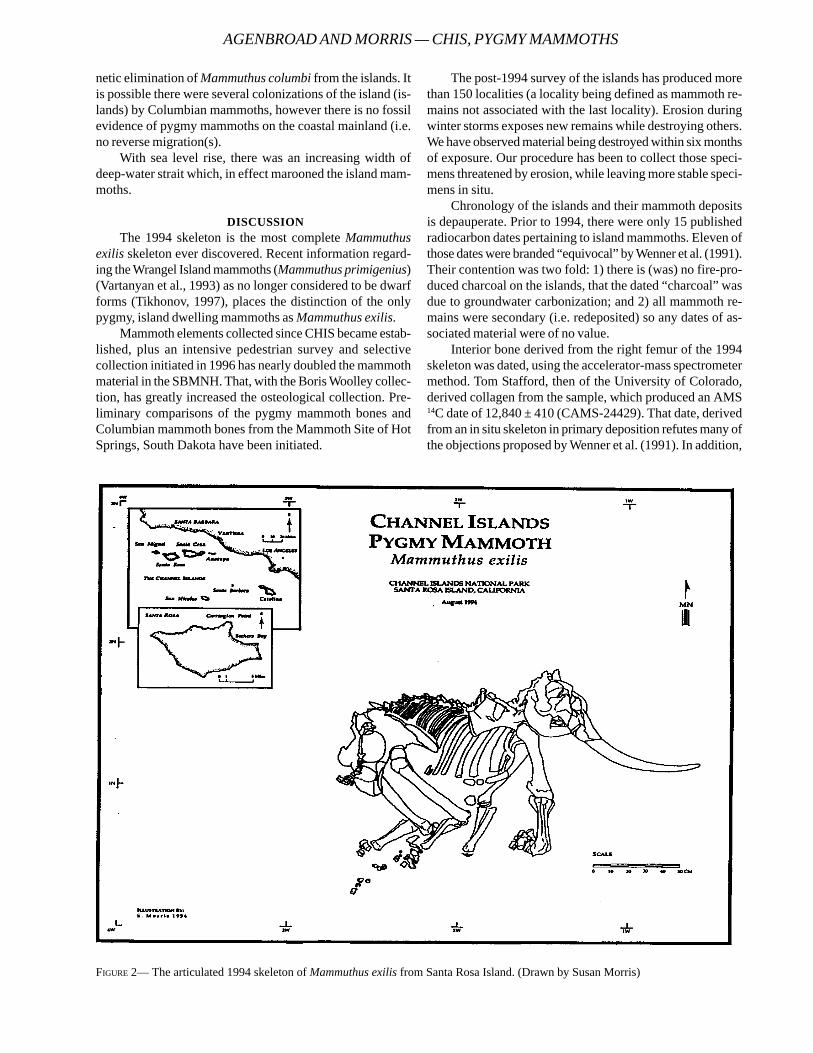
netic elimination of Mammuthus columbi from the islands. Itis possible there were several colonizations of the island (is-lands) by Columbian mammoths, however there is no fossilevidence of pygmy mammoths on the coastal mainland (i.e.no reverse migration(s).
With sea level rise, there was an increasing width ofdeep-water strait which, in effect marooned the island mam-moths.
DISCUSSIONThe 1994 skeleton is the most complete Mammuthus
exilis skeleton ever discovered. Recent information regard-ing the Wrangel Island mammoths (Mammuthus primigenius)(Vartanyan et al., 1993) as no longer considered to be dwarfforms (Tikhonov, 1997), places the distinction of the onlypygmy, island dwelling mammoths as Mammuthus exilis.
Mammoth elements collected since CHIS became estab-lished, plus an intensive pedestrian survey and selectivecollection initiated in 1996 has nearly doubled the mammothmaterial in the SBMNH. That, with the Boris Woolley collec-tion, has greatly increased the osteological collection. Pre-liminary comparisons of the pygmy mammoth bones andColumbian mammoth bones from the Mammoth Site of HotSprings, South Dakota have been initiated.
The post-1994 survey of the islands has produced morethan 150 localities (a locality being defined as mammoth re-mains not associated with the last locality). Erosion duringwinter storms exposes new remains while destroying others.We have observed material being destroyed within six monthsof exposure. Our procedure has been to collect those speci-mens threatened by erosion, while leaving more stable speci-mens in situ.
Chronology of the islands and their mammoth depositsis depauperate. Prior to 1994, there were only 15 publishedradiocarbon dates pertaining to island mammoths. Eleven ofthose dates were branded “equivocal” by Wenner et al. (1991).Their contention was two fold: 1) there is (was) no fire-pro-duced charcoal on the islands, that the dated “charcoal” wasdue to groundwater carbonization; and 2) all mammoth re-mains were secondary (i.e. redeposited) so any dates of as-sociated material were of no value.
Interior bone derived from the right femur of the 1994skeleton was dated, using the accelerator-mass spectrometermethod. Tom Stafford, then of the University of Colorado,derived collagen from the sample, which produced an AMS14C date of 12,840 ± 410 (CAMS-24429). That date, derivedfrom an in situ skeleton in primary deposition refutes many ofthe objections proposed by Wenner et al. (1991). In addition,
FIGURE 2— The articulated 1994 skeleton of Mammuthus exilis from Santa Rosa Island. (Drawn by Susan Morris)
AGENBROAD AND MORRIS — CHIS, PYGMY MAMMOTHS
TECHNICAL REPORT NPS/NRGRD/GRDTR-99/3
ERLANDSON, J. M., D. J. KENNETT, B. L. INGRAM, D. A. GUTHRIE,D. P. MORRIS, M. A. TVESKOV, G. J. WEST, AND P. L. WALKER,1996. An archaeological and paleontological chronol-ogy for Daisy Cave (CA-SMI261), San Miguel Island,California. Radiocarbon 38:1–29.
______, M. A. TVESKOV, D. J. KENNETT, AND B. L. INGRAM,1997. Further evidence for a terminal Pleistocene occu-pation of Daisy Cave, San Miguel Island, California.Current Research in the Pleistocene 13:161–168.
FAIRBANKS, H. W., 1897. Oscillations of the coast of Californiaduring the Pliocene and Pleistocene. American Geolo-gist 20:213–245.
HOOIJER, D. A., 1976. Observations on the pygmy mammothsof the Channel Islands, California. in Essays onPalaeontology in honor of Loris Shano Russell. C. S.Churcher (ed.) Athlon. Royal Ontario Museum, Ontario,Canada. pp. 220–225.
JOHNSON, D. L., 1978. The origin of island mammoths and theQuaternary land bridge history of the Northern ChannelIslands, California. Quaternary Research 10:204–225.
five more dates for CHIS mammoth remains have been pro-duced on associated material (Agenbroad 1999).
Additional radiocarbon dates are essential to understandthe time of extinction, rate of dwarfing, possible environmen-tal stresses and the potential for contemporaneity with theearliest humans on the islands. Recent archaeological inves-tigations (Erlandson et al. 1996; 1997) have increased theantiquity of humans on the islands to greater than 11,000years. Perhaps Orr (1968) was correct; maybe the last mam-moths met the first people to arrive on the islands. A tightchronologic framework of the most recent mammoth remainswill be crucial to evaluate that possibility.
ACKNOWLEDGMENTSThe CHIS mammoth research is indebted to the early
researchers, plus the support of the National Park Service,the Santa Barbara Museum of Natural History, Northern Ari-zona University, the American Philosophical Society, and thegenerosity of James Jensen of Denver, Colorado.
REFERENCESAGENBROAD, L. D., (in submission) Radiocarbon geochronol-
ogy of Mammuthus exilis on the California Channel Is-lands: A review plus new 14C dates since 1994.
______, 1998. New pygmy mammoth (Mammuthus exilis)localities and radiocarbon dates from San Miguel, SantaRosa, and Santa Cruz Islands, California. in Weigand, P.,ed., Contributions to the Geology of the Northern Chan-nel Islands, Southern California. Pacific Section of theAmerican Association of Petroleum Geologists, Bakers-field, California: 169–175.
AZZAROLI, A., 1981. About pigmy mammoths of the NorthernChannel Islands and other island faunas. QuaternaryResearch 16:423–5.
CHANEY, R. W., AND H. L. MASON, 1930. A Pleistocene florafrom Santa Cruz Island, California. Carnegie Institute ofWashington Publication 415:1–24.
______, 1981. More comments on the northern Channel Is-land mammoths. Quaternary Research 15:105–106.
MADDEN, C. T., 1977. Elephants of the Santa Barbara ChannelIslands, southern California. Geological Society ofAmerica. Abstracts with Programs 9:458–459.
______, 1981. Letters to the editor: origin(s) of mammothsfrom Northern Channel Islands, California. QuaternaryResearch 15:101–104.
ORR, P. C., 1956a. Radiocarbon mammoths, and man on SantaRosa Island. Geological Society of America Bulletin67:1777.
______, 1956b. Radiocarbon dates from Santa Rosa Island.Bulletin of the Santa Barbara Museum of Natural His-tory 2:1–10.
______, 1956c. Dwarf mammoth and man on Santa Rosa Is-land. University of Utah Anthropological Papers 26:75–81.
______, 1959. Santa Rosa Island dwarf mammoths. MuseumTalk. Santa Barbara Museum of Natural History. pp. 25–29.
______, 1960. Radiocarbon dates from Santa Rosa Island II.Bulletin of the Santa Barbara Museum of Natural His-tory 3:1–10.
______, 1967. Geochronology of Santa Rosa Island, Califor-nia. In Philbrick, R. N. (ed.) Proceedings of the sympo-sium on the biology of the California Islands, Santa Bar-bara Botanic Garden, Santa Barbara. pp. 317–325.
______, 1968. Prehistory of Santa Rosa Island. Santa Bar-bara Museum of Natural History. 253 p.
ROTH, V. L., 1982. Dwarf mammoths from the Santa Barbara,California Channel Islands: size, shape, development,and evolution. Unpublished Ph.D. Dissertation. YaleUniversity. University Microfilms. Ann Arbor.
______, 1984. How elephants grow: heterochrony and thecalibration of developmental stages in some living andfossil species. Journal of Vertebrate Paleontology 4:126–145.
______, 1990. Insular dwarf elephants: a case study in bodymass estimation and ecological inference. In Body sizein mammalian paleobiology: estimation and biologicalimplications. (eds. J. Damuth, and B. J. MacFadden),Cambridge University Press, Cambridge, p. 151-179.
______, 1992. Inferences from allometry and fossils: dwarf-ing of elephants on islands. In Oxford surveys in evolu-tionary biology. Volume 8 (eds., D. Futuyma, and J.Antonovics), Oxford University Press, New York, p. 259-288.
______, 1993. Dwarfism and variability in the Santa RosaIsland mammoth: an interspecific comparison of limbbone sizes and shapes in elephants. in Third CaliforniaIslands symposium: recent advances in research on theCalifornia Islands (ed. F. G. Hochberg), pp. 433–342. SantaBarbara Museum of Natural History.
______, 1996. Pleistocene dwarf elephants from the Califor-nia Islands. In The Proboscidea (eds., J. H. Shoshani,and P. Tassy), University of Oxford Press, Oxford, UnitedKingdom. pp. 249–253.
STEARNS, R. E. C., 1873. [no title: paraphrase of commentsattributed to Stearns in minutes of Academy’s regularmeeting] Proceedings of the California Academy of Sci-ences 5:152.
STOCK C., 1935. Exiled elephant of the Channel Islands, Cali-fornia. Scientific Monthly 41:205–214.
______, 1943. Foxes and elephants of the Channel Islands.Los Angeles County Museum Quarterly 3:6–9.
______, AND E. L. FURLONG, 1928. The Pleistocene elephantsof Santa Rosa Island, California. Science 68:140–141.
TIKHONOV, A., (brief report) 1997. Zoological Institute Rus-sian Academy of Sciences, St. Petersburg, Russia. De-partment of History of fauna. EroMam Newsletter:14–15.
VALENTINE, J. W., AND J. H. LIPPS, 1967. Late Cenozoic historyof the southern California Islands. Proceedings of theSymposium of the Biology of the California Islands (SantaBarbara: Santa Barbara Botanic Garden, R. N. Philbrick,ed.), pp. 13–20.
VARTANYAN, S. L., V. E. GARUTT, AND A. V. SHER, 1993. Holocenedwarf mammoths from Wrangel Island in the Siberian
Arctic. Nature 362:337–340.VON BLOEKER, J. R., Jr., 1967. The land mammals of the south-
ern California Islands. In Proceedings of the symposiumon the Biology of the California Islands (ed., R. N.Philbrick), Santa Barbara Botanic Garden, Santa Bar-bara, California, p. 245-263.
WEAVER, D. W., AND D. P. DOERNER, 1967. Western Anacapia—a summary of the Cenozoic history of the Northern Chan-nel Islands. In Proceedings of the Symposium on theBiology of the California Islands (ed., R. N. Philbrick),Santa Barbara Botanic Garden, Santa Barbara, Califor-nia, p. 13-20.
WENNER, A. M., J. CUSHING, E. NOBLE, AND M. DALY, 1991.Mammoth radiocarbon dates from the northern ChannelIslands, California. Proceedings of the Society for Cali-fornia Archaeology 4:1–6.
______, AND D. L. JOHNSON, 1980. Land vertebrates on theCalifornia Channel islands: sweepstakes or bridges? InThe California Islands: proceedings of a multidisciplinarysymposium (ed., D. M. Power), Santa Barbara Museumof Natural History, p. 497–530.
AGENBROAD AND MORRIS — CHIS, PYGMY MAMMOTHS
TECHNICAL REPORT NPS/NRGRD/GRDTR-99/3
STRATIGRAPHIC AND PALEONTOLOGIC RECORD OF THESAUK III REGRESSION IN THE CENTRAL APPALACHIANS
DAVID K. BREZINSKI1, JOHN E. REPETSKI2 AND JOHN F. TAYLOR3
1Maryland Geological Survey, 2300 St. Paul St., Baltimore, MD 212182U.S. Geological Survey, MS 926A National Center, Reston, VA 20192
3Geoscience Department, Indiana University of Pennsylvania, Indiana, PA 15705
____________________
ABSTRACT—The Beekmantown and St. Paul Groups in western Maryland, including the mostly complete section exposed alongthe Chesapeake & Ohio Canal National Historic Park, preserve the best record available of deposition during the Early and MiddleOrdovician in the central Appalachian basin. Conodonts and trilobites from this area can be used, not only to document the ageand correlations of the formations and their members, but also to test and constrain the sequence/cycle stratigraphy anddepositional history for this time interval in this part of eastern Laurentia.
____________________
INTRODUCTION
Early Paleozoic strata in the central Appalachian basinrecord a prolonged deepening and shallowing event(first-order cycle of Vail and others, 1977) that began
in the latest Precambrian and continued into the early MiddleOrdovician. Sloss (1963) termed the unconformity-boundedpackage created by this cycle the Sauk Sequence. Vail andothers (1977) concluded that the transgressive apex of thisfirst-order cycle coincided with shorter term second- and third-order transgressive episodes that all reached their maximasometime in the early Ordovician. Although the stratigraphicposition of this transgressive peak is evident throughout thecratonic interior of the United States, it is not as well con-strained within the marginal orogenic belts, in part owing toregional tectonic signals. In the central Appalachians, thismajor deepening maximum resulted in the deposition of theLower Ordovician Stonehenge Limestone, which Hardie (1989)and Taylor and others (1992) interpreted as a third-order cycle.If these interpretations are correct, the Stonehenge Lime-stone represents the time of maximum deepening for the SaukSequence, or at least for the highest of three subsequences(Sauk III) delineated by Palmer (1981) and subsequently rec-ognized by Read (1989) as his Sequence 5. Rock exposures inand near C & O Canal National Historic Park in western Mary-land provide one of the most complete stratigraphic sectionsto preserve a record for this interval of time anywhere in theAppalachian region. [As with all artifacts, plants, and ani-mals, the fossils from this and other National Parks can becollected only with formal permission from the appropriatePark Superintendent.] The section described in this paperoccurs along the Potomac River in Washington County,Maryland, approximately from mile-markers 101 to 103.5. Itbegins in the upper member of the Lower OrdovicianStonehenge Limestone and continues upward through the
remainder of the Lower Ordovician and the entire MiddleOrdovician. This paper reports on work in progress towardrefining the cyclostratigraphy and biostratigraphy of theBeekmantown Group, which represents the apex and regres-sive phase of Sauk III in the central Appalachians. Brezinskiprovided the cyclostratigraphic interpretations. Repetski andTaylor contributed the sections on conodont and trilobitefaunas, respectively.
LITHOSTRATIGRAPHYThe stratigraphic section along the canal was first de-
scribed by Sando (1957), who measured (up-section fromwest to east) 3852 feet (1174 m) of the Beekmantown Group(Stonehenge Limestone through Pinesburg Station Dolomite),370 feet (113 m) of the St. Paul Group (Neuman, 1951), and 300feet (91 m) of the Chambersburg Limestone. While this spec-tacular stratigraphic section spans most of the Lower and allof the Middle Ordovician, we will concentrate in this paperon the Lower Ordovician part of the section, i.e., theBeekmantown Group. The lowest formation in the group isthe Stonehenge Limestone, a regionally-extensive limestone-dominated unit in the central Appalachians that is approxi-mately 300 m thick in the study area. It is divisible into threemembers: the Stoufferstown Member at the base, overlain byunnamed middle and upper members (Sando, 1958). TheStoufferstown Member consists of ribbon-bedded, siliceouslimestone and is up to 70 m thick. It is best developed inPennsylvania and Maryland, north of the Potomac, and isnot as easily recognized in northern Virginia. The middlemember is composed of approximately 100 m of thick-bed-ded, locally cyclic microbial boundstone and associatedgrainstones that Taylor and others (1992) interpreted as rep-resenting a barrier reef complex. The upper member com-prises 150 m of thin-bedded limestone with abundant
32
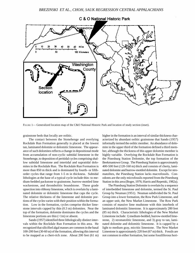
grainstone beds that locally are oolitic.The contact between the Stonehenge and overlying
Rockdale Run Formation generally is placed at the lowesttan, laminated dolomite or dolomitic limestone. The appear-ance of such dolomites reflects a change in depositional modefrom accumulation of non-cyclic subtidal limestone in theStonehenge, to deposition of peritidal cycles comprising shal-low subtidal limestone and intertidal and supratidal dolo-mites in the Rockdale Run. The Rockdale Run Formation ismore than 850 m thick and is dominated by fourth- or fifth-order cycles that range from 1-5 m in thickness. Subtidallithologies at the base of a typical cycle include thin- to me-dium-bedded packstone to grainstone, burrow-mottled limewackestone, and thrombolitic boundstone. These gradeupsection into ribbony limestone, which is overlain by a lami-nated dolomite or dolomitic limestone that caps the cycle.The relative thickness of the limestone and dolomite por-tions of the cycles varies with their position within the forma-tion. Low in the formation, cycles comprise thicker lime-stone intervals capped by thin (0.3 m) dolomites. Near thetop of the formation, dolomite dominates the cycles and thelimestone portions are thin (<1m) or absent.
Sando (1957) identified three lithologically distinct inter-vals within the Rockdale Run Formation in this area. Herecognized that silicified algal masses are common in the basal100-200 feet (30-60 m) of the formation, allowing this intervalto be mapped as a chert-rich zone. About 200 feet (61 m)
higher in the formation is an interval of similar thickness char-acterized by abundant oolitic grainstone that Sando (1957)informally termed the oolitic member. An abundance of dolo-mite in the upper third of the formation defined a third mem-ber, although the thickness of this upper dolomite member ishighly variable. Overlying the Rockdale Run Formation isthe Pinesburg Station Dolomite, the top formation of theBeekmantown Group. The Pinesburg Station is approximately400-500 feet (120-160 m) thick and consists of cherty, lami-nated dolomite and burrow-mottled dolomite. Except for stro-matolites, the Pinesburg Station lacks macrofossils. Con-odonts are the only microfossils reported from the PinesburgStation in this area (Boger, 1976; Harris and Repetski, 1982a).
The Pinesburg Station Dolomite is overlain by a sequenceof interbedded limestone and dolomite, termed the St. PaulGroup by Neuman (1951). Neuman subdivided the St. PaulGroup into a lower formation, the Row Park Limestone, andan upper unit, the New Market Limestone. The Row Parkconsists of massive lime mudstone with thin interbeds oflaminated dolomitic limestone. It is approximately 280 feet(85 m) thick. Characteristic lithologies of the New MarketLimestone include: 1) medium-bedded, burrow-mottled lime-stone, 2) stromatolitic limestone, and 3) gray to tan, lami-nated dolomite and dolomitic limestone. It is capped by alight to medium gray, micritic limestone. The New MarketLimestone is approximately 220 feet (67 m) thick. Fossils arenot common in either formation, but some fossiliferous hori-
FIGURE 1— Generalized location map of the C&O National Historic Park and location of study section (inset).
BREZINSKI ET AL., CHOH, SAUK REGRESSION CENTRAL APPALACHIANS
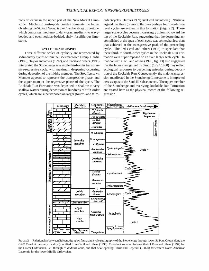
TECHNICAL REPORT NPS/NRGRD/GRDTR-99/3
zons do occur in the upper part of the New Market Lime-stone. Macluritid gastropods (snails) dominate the fauna.Overlying the St. Paul Group is the Chambersburg Limestone,which comprises medium- to dark-gray, medium- to wavy-bedded and even nodular-bedded, shaly, fossiliferous lime-stone.
CYCLE STRATIGRAPHYThree different scales of cyclicity are represented by
sedimentary cycles within the Beekmantown Group. Hardie(1989), Taylor and others (1992), and Cecil and others (1998)interpreted the Stonehenge as a single third-order transgres-sive-regressive cycle, with maximum deepening occurringduring depostion of the middle member. The StoufferstownMember appears to represent the transgressive phase, andthe upper member the regressive phase of the cycle. TheRockdale Run Formation was deposited in shallow to veryshallow waters during deposition of hundreds of fifth-ordercycles, which are superimposed on larger (fourth- and third-
order) cycles. Hardie (1989) and Cecil and others (1998) haveargued that three (or more) third- or perhaps fourth-order sealevel cycles are evident in this formation (Figure 2). Theselarger scale cycles become increasingly dolomitic toward thetop of the Rockdale Run, suggesting that the deepening ac-complished at the apex of each cycle was somewhat less thanthat achieved at the transgressive peak of the preceedingcycle. This led Cecil and others (1998) to speculate thatthese third- to fourth-order cycles in the Rockdale Run For-mation were superimposed on an even larger scale cycle. Inthat context, Cecil and others (1998, fig. 13) also suggestedthat the faunas recognized by Sando (1957, 1958) may reflectecological responses to deepening episodes during deposi-tion of the Rockdale Run. Consequently, the major transgres-sion manifested in the Stonehenge Limestone is interpretedhere as apex of the Sauk III subsequence. The upper memberof the Stonehenge and overlying Rockdale Run Formationare treated here as the physical record of the following re-gression.
FIGURE 2— Relationship between lithostratigraphy, fauna and cycle stratigraphy of the Stonehenge through lower St. Paul Group along theC&O Canal at the study locality (modified from Cecil and others (1998). Conodont zonation follows that of Ross and others (1997) forthe Lower Ordovician, i.e., through R. andinus Zone, and that developed by Harris and Repetski (1982b) for eastern North America/Laurentia for the lower Middle Ordovician.
The vertical arrangement of lithologies within thePinesburg Station Dolomite and St. Paul Group led Mitchell(1982) and Brezinski (1996) to interpret these units as sepa-rate transgressive and regressive pairs. In most areas ofNorth America, a lowstand in sea level in the early MiddleOrdovician produced a major unconformity that separatesthe Lower and Middle Ordovician Series. Based on con-odont data from scores of sections spanning the Lower toMiddle Ordovician boundary interval along the U.S. Appala-chians from Alabama to Vermont, Harris and Repetski (1982a,b; Repetski and Harris, 1982; 1986) demonstrated that themajor unconformity, known in the central Appalachians asthe Knox/Beekmantown unconformity, was pre-Blackriveran,with the maximum lowstand most likely occurring during thelate Whiterockian or Chazyan. Derby and others (1991), us-ing numerous fossil groups, as well as physical stratigraphy,applied to the thick Ordovician succession of southern Okla-homa, concluded that the maximum regional regression mark-ing the Sauk III-Tippecanoe mega-sequence boundary oc-curred during the middle Whiterockian. Placed thusly, thisevent boundary falls within the middle to upper part of thePinesburg Station Dolomite in the central Appalachian basindepocenter, that is, in the area including the C & O Canalsection. The subsequent Ordovician deepening event in thecentral Appalachians produced the Chambersburg Limestoneand likewise was the result of the onset of downwarping thatoccurred during the Taconic orogeny. This deepening pro-duced the graptolitic black shales of the overlyingMartinsburg (Brezinski, 1996).
BIOSTRATIGRAPHYCONODONTS
The conodont succession of the Lower and Middle Or-dovician of the central Appalachians is known only in thebroad sense, as very few of the details of that succession arepublished. However, it is clear that they are among the mostuseful guides for the correlation of these strata. Conodontsare present in nearly all of the lithologies of the Beekmantownand St. Paul Groups sampled thus far, even though ratherlarge samples (ca. 6 kg) often are needed in the dolomites ofthe intertidal to supratidal facies to extract useful faunas.
Conodonts identified by Wilbert Hass, of the U.S. Geo-logical Survey, were the first published from the Sauk III suc-cession of the eastern U.S. (in Sando, 1958). These smallcollections were extracted from limestone chips remainingfrom Sando’s splitting for crack-out trilobites, brachiopods,and mollusks in the latter’s study of the Beekmantown inwestern Maryland, south-central Pennsylvania, and north-western Virginia. Hass had available only two previous pub-lications on Lower Ordovician conodonts from North Americaon which to base his identifications, so most of his taxa are inopen nomenclature. However, he was able to characterizecorrectly, if somewhat broadly, the stratigraphic position ofnearly all of Sando’s faunas in terms of the Missouri (Branson& Mehl, 1933) and upper Mississippi Valley (Furnish, 1938)successions that were the subjects of those previous stud-ies.
Since 1958, J. Boger (1976; Boger and Bergström, 1976)examined the conodonts of the upper part of the RockdaleRun Formation, Pinesburg Station Dolomite, and St. PaulGroup from several localities in western Maryland, andRepetski and A.G. Harris collected the C & O Canal section,largely as part of their larger study of the Lower/Middle Or-dovician boundary interval in the U.S. Appalachians (Harris& Repetski, 1982a, b; Repetski & Harris, 1982, 1986). Thesecollections, as well as others collected recently in the courseof our study of the Stonehenge interval (e.g., Taylor andothers, 1992; Taylor and others, 1996) contributed to thisstudy as well. Because of these previous studies, most of ourdata are from these two intervals; currently we are filling inthe database for the lower through middle parts of theRockdale Run Formation.
From our work elsewhere in the central Appalachians,we know that the base of the Stonehenge, representing theonset of a broad regional transgression, falls at or near thebase of the Cordylodus angulatus Zone (following the NorthAmerican Lower Ordovician conodont zonation as used inRoss and others, 1997). The succeeding Rossodusmanitouensis Zone begins well into the Stoufferstown Mem-ber of the Stonehenge. As elsewhere, this zone extendsthrough a thick stratigraphic interval, and, while distinctiveand widespread, its resistance to reliable subdivision thusfar has hampered somewhat its utility for more precise corre-lation. The R. manitouensis Zone extends a short way, a fewfeet to a few tens of feet, depending on one’s specific choiceof contact horizon, into the basal part of the Rockdale RunFormation, where a major faunal turnover occurs (Ethington& Clark, 1971; Ethington and others, 1987). The succeeding“Low Diversity Interval” spans part of Sando’s (1957) lowerchert member of the Rockdale Run, thus also largely coincid-ing with the shallowing episode of depositional Cycle 2 asused herein.
Our preliminary work on the lower and middle parts ofthe Rockdale Run Formation indicates that the Macerodusdianae Zone ranges from low in the oolitic member throughsome part of the overlying Lecanospira local macrofaunalzone at the C & O Canal section. Thus, the temporal range ofthe M. dianae Zone approximates much of the transgressive-regressive depositional Cycle 2 in this area. Details of theboundaries of this zone, and of the overlying Acodusdeltatus—Oneotodus costatus Zone are not yet preciselyknown. However, the appearance of Oepikodus communisand Diaphorodus delicatus at at least 435 ft below the top ofthe Rockdale Run indicates that the base of the O. communisZone falls within the transgressive part of depositional Cycle3.
The upper part of the Rockdale Run and all of thePinesburg Station Dolomite represent chiefly very shallowenvironments (Cycle 4 herein). Macrofossils are extremelyscarce (Rockdale Run) to lacking entirely (Pinesburg Station)through this interval, suggesting stressed conditions mostlikely involving elevated salinities. Thus, dating and correla-tion using shelly fossils is difficult to impossible. The con-odonts are present in this interval but are scarce at many
BREZINSKI ET AL., CHOH, SAUK REGRESSION CENTRAL APPALACHIANS
TECHNICAL REPORT NPS/NRGRD/GRDTR-99/3
levels. Enough diagnostic taxa have been obtained to enableidentification of all of the recognized biozones of the earlyand middle Whiterockian for warm shallow-water carbonatefacies of eastern North America (Harris and Repetski, 1982b).The Sauk III-Tippecanoe sequence boundary, which mostlikely occurs in the upper part of the Histiodella holodentataor lower part of the Phragmodus polonica Zone, thus fallswithin the middle or upper part of the Pinesburg Station.Physical evidence for unconformity has not been demon-strated in the western Maryland area, and all of the zones arerepresented. Thus, any hiatus in this interval would be ofminor magnitude. Strata of the overlying St. Paul Group arelimestones, reflective of more normal marine conditions ac-companying the initial transgressive phase of the Tippecanoesequence. They contain more eurytopic conodont taxa andalso show the return and upward increase of macrofaunas.
TRILOBITES
Trilobites collected from the lowest and highest beds ofthe Stonehenge Limestone establish the position of the trans-gressive and regressive phases of the Stonehenge deposi-tional cycle within a finely resolved framework of zones andsubzones developed for basal Ordovician strata in Oklahoma(Stitt, 1983). Collections from the basal few meters of theStonehenge in northern Virginia (Orndorff and others, 1988)and central Pennsylvania (Taylor and others, 1992) includeClelandia texana Winston and Nicholls, and Hystricurusmillardensis Hintze. These species are restricted to theSymphysurina Zone and occur only in the middle(Symphysurina bulbosa Subzone) to upper (Symphysurinawoosteri Subzone) part of that zone. No trilobites have beenrecovered yet from the basal beds of the Stonehenge Lime-stone along the C & O canal. Identifiable specimens havebeen found at two horizons within the basal StoufferstownMember in a pasture exposure near St. Pauls Church, ap-proximately two miles north of the canal. Both collections,one (Sample SP4) from the basal bed of the Stonehenge andanother (Sample SP5.9) from 47 feet (14.3m) above the base ofthe formation, are dominated by several species ofSymphysurina. Sample SP4 includes two cranidia (centralportion of the head) and one pygidium (tail). The cranidium(Figure 4A-B) differs from that of all previously describedspecies of Symphysurina in possessing a deep, trough-likeborder furrow at the front. The same bed yielded one py-gidium (Figure 4C), but too few specimens were recoveredfrom that horizon to evaluate whether it represents the samespecies as the new cranidium. While discovery of a newspecies is always welcome, it obviously has little immediateutility for correlation to other areas.
Sample SP5.9, collected from a thin, normally-graded bed,provided a much larger collection. The dominant species(Figure 4D) exhibits a typical, non-furrowed cranidium with asmall, shelf-like anterior border. The associated pygidium ismore distinctive, with a posterior margin that is flared out-ward slightly, particularly near the axis, producing a distinctlytriangular shape. This species has not been identified yet,but a systematic search of the literature is under way to evalu-
ate the more than 25 species of Symphysurina that have beennamed in previous studies. Sample SP5.9 also provided asecond Symphysurina pygidium (Figure 4F), which resemblesthat of Symphysurina woosteri, the eponymous species ofthe highest of three subzones recognized by Stitt (1983) inthe Symphysurina Zone in Oklahoma. However, no cranidiumor librigena (“free cheek”) was recovered to allow confidentassignment to this species.
Sample 5.9 also provided a few specimens of Clelandia,another genus whose species are useful for determining po-sition within the Symphysurina and Bellefontia-XenostegiumZones. Although the material is fragmentary, some speci-mens (Figure 4E) were complete enough to display distinctlateral glabellar furrows like those that characterize C. texanaand C. albertensis, the two species that occur in the lower tomiddle part of the Symphysurina Zone throughout NorthAmerica. Collectively, therefore, species recovered from theStoufferstown Member of the Stonehenge Limestone nearSt. Paul’s Church support earlier studies that attributed thetransgression at the base of this formation to sea-level riseduring deposition of the middle subzone (Symphysurinabulbosa Subzone) of the Symphysurina Zone. Additionalstudy of the collections already in hand, and supplementalsampling of the upper half of the Stoufferstown Member inand near the C&O Canal, should allow refinement of correla-tion between the Appalachians and the Oklahoma standardsuccession.
Additional sampling is needed to establish the positionof the base of the Bellefontia-Xenostegium Zone within theStonehenge Limestone. Neither of the collections from theSt. Pauls Church section includes species of Bellefontia andXenostegium, indicating that the base of the Bellefontia-Xenostegium Zone lies higher within the formation. Recentdiscovery of Clelandia parabola and Xenostegiumfranklinense, two species characteristic of the lower part ofthe Bellefontia-Xenostegium Zone, in the upper half of theStoufferstown Member in central Pennsylvania (Taylor, inpress) assigns the highest beds of that member and all of theoverlying reef-dominated middle member to the Bellefontia-Xenostegium Zone in that area. No diagnostic trilobite spe-cies have yet been identified from the upper Stoufferstownor the middle member in Maryland to establish whether thatzonal boundary lies at approximately the same level withinthe Stonehenge in the Great Valley. For that reason, we alignthat zonal boundary with the member boundary in Figure 2,adding a question mark to express the uncertainty as to itsposition within the formation.
The scarcity of trilobite collections within the middlemember also poses a problem in establishing the position ofsubzonal boundaries within the Bellefontia-XenostegiumZone. The abundant occurrence of Bellefontia collieana ingrainstones of the upper member in Pennsylvania and Mary-land assigns those beds to the middle subzone, the Bellefontiacollieana Subzone. Whether the apex of the Sauk Sequence,represented by the middle member of the Stonehenge, lieswithin that subzone or the underlying Xenostegiumfranklinense Subzone, cannot be established in the absence
of trilobite data from that member. Additional sampling in themiddle member is planned to resolve that issue.
Trilobites from the upper member of the Stonehengeconstrain the timing of the regression recorded by a return tocyclic peritidal deposition at the contact with the overlyingRockdale Run Formation. This culmination of the“Stonehenge Regression” apparently occurred during depo-sition of the Bellefontia collieana Subzone of the Bellefontia-Xenostegium Zone because the highest collections from theupper member of the Stonehenge in Maryland and Pennsyl-vania contain Bellefontia collieana (Figure 4G-K), which isrestricted to the subzone that bears its name. The recoveryof Xenostegium franklinense (Figure 4L) from beds near thetop of the upper member in the C&O Canal section providesadditional support for that subzonal assignment. This spe-cies occurs only in the lower two subzones of the Bellefontia-Xenostegium Zone in Oklahoma; it is not known to occur ashigh as the Bellefontia chamberlaini Subzone. Collectionsfrom the upper member of the Stonehenge lack Bellefontiachamberlaini, whose lowest occurrence defines the base ofthe B. chamberlaini Subzone in Oklahoma. Similarly,Hystricurus missouriensis, which is also characteristic of thehighest subzone, has not been found despite the recovery oflarge collections that include at least three other species ofHystricurus from the upper member in central Pennsylvania.Little information on faunas younger than the Bellefontiacollieana Subzone is likely to emerge from the central Penn-sylvania succession because the Stonehenge is overlain inthat area by the Nittany Dolomite, which provides very fewmacrofossils, especially from low within the formation. Theless pervasively dolomitized facies of the Rockdale Run For-mation, exceptionally well-exposed along the C&O Canal,offers much greater potential for advancing our knowledgeof trilobite faunas and conditions through the Early Ordovi-cian as additional sampling is conducted in the BeekmantownGroup in the central Appalachian region.
CONCLUSIONSOur preliminary work demonstrates the importance of
integrating biostratigraphic and physical stratigraphic datain interpreting the depositional history of the BeekmantownGroup. Improved biostratigraphic control provides greateraccuracy and precision in identifying and correlating spe-cific depositional cycles within the thick Lower Ordoviciancarbonate succession of this region. For example, by betterconstraining the limits of the Macerodus dianae conodontZone, we can determine whether the oolitic member of theRockdale Run Formation (Cycle 2 in this paper) correlateswith an interval of off-platform carbonates at the top of theGrove Limestone in the shelfbreak succession in the FrederickValley of Maryland (Taylor and others, 1996). Work inprogress in both these areas is aimed at increasing our levelof biostratigraphic control at the C & O Canal section andsurrounding areas.
ACKNOWLEDGEMENTS We thank our colleagues at the National Park Service, C& O Canal National Historic Park, for their continuing inter-
est and cooperation in our studies. We also thank the manylandowners, especially the Hamby brothers of Williamsport,Maryland, who granted us access to their properties. C.B.Cecil, J.T. Dutro, Jr., R.L. Ethington, and an anonymous re-viewer provided helpful reviews of the paper. B.K. Sell andS.W. Kish assisted in preparation of the trilobite figure. J.F.Taylor acknowledges donors of the Petroleum Research Fund,administered by the American Chemical Society, for partialsupport of this research.
REFERENCESBOGER, J.B., 1976. Conodont biostratigraphy of the upper
Beekmantown Group and the St. Paul Group (MiddleOrdovician) of Maryland and West Virginia. UnpublishedM.S. thesis, The Ohio State University, Columbus, OH,180 p.
BOGER, J.L., AND S.M. BERGSTRÖM, 1976. Conodont biostratig-raphy of the upper Beekmantown Group and the St. PaulGroup (Early and Middle Ordovician) of Maryland andWest Virginia [abs.]. Geological Society of America, Ab-stracts with Programs, 8: 465.
BRANSON, E.B., AND M.J. MEHL, 1933. Conodonts from theJefferson City (Lower Ordovician) of Missouri. Mis-souri University Studies, 8: 53-64, Pl. 4.
BREZINSKI, D.K., 1996. Carbonate ramps and reefs, Paleozoicstratigraphy and paleontology of western Maryland.Fieldtrip for the North American Paleontological Con-vention VI, Maryland Geological Survey Geologic Guide-book 6, 25 p.
CECIL, C.B., D,K. BREZINSKI, AND F. DULONG, with contribu-tions by J.E. REPETSKI, C. EBLE, AND N. FEDORKO, 1998.Allocyclic controls on Paleozoic sedimentation in thecentral Appalachian Basin. Geological Society ofAmerica, Field Trip Number 4. U.S.G.S. Open File Report98-577, 75 p.
DERBY, J.R., J.A. BAUER, W.B. CREATH, R.I. DRESBACH, R.L.ETHINGTON, J.D. LOCH, J.H. STITT, T.R. MCHARGUE, J.F.MILLER, M.A. MILLER, J.E. REPETSKI, W.C. SWEET, J.F.TAYLOR, AND M. WILLIAMs, 1991. Biostratigraphy of theTimbered Hills, Arbuckle, and Simpson Groups, Cam-brian and Ordovician, Oklahoma: a review of correlationtools and techniques available to the explorationist. inJohnson, K. (ed.). Late Cambrian-Ordovician geologyof the southern midcontinent, Oklahoma Geological Sur-vey Circular 92, p. 15-41.
ETHINGTON, R.L., AND D.L. CLARK, 1971. Lower OrdovicianConodonts in North America. in Sweet, W.C., andBergström, S.M. (eds.), Symposium on conodont bios-tratigraphy: Geological Society of America Memoir, p.63-82.
______, K.M. ENGEL, AND K.L. ELLIOTT, 1987. An abruptchange in conodont faunas in the Lower Ordovician ofthe Midcontinent province. in Aldridge, R.J., (ed.),Palaeobiology of conodonts, Ellis Horwood, Ltd.,Chichester., p. 111-128.
FURNISH, W.M., 1938. Conodonts from the Prairie du Chien(Lower Ordovician) beds of the upper Mississippi Val-ley. Journal of Paleontology, 12(4): 318-340.
BREZINSKI ET AL., CHOH, SAUK REGRESSION CENTRAL APPALACHIANS
TECHNICAL REPORT NPS/NRGRD/GRDTR-99/3
GATHRIGHT, T.M., II, W.S HENIKA, AND J.L. SULLIVAN, III, 1978.Geology of the Grottoes quadrangle, Virginia. VirginiaDivision of Mineral Resources Publication 10, text and1:24,000 scale map.
HARDIE, L.A. 1989. Cyclic platform carbonates in the Cambro-Ordovician of the central Appalachians, p. 51-78, inWalker, K.R., J.F. Read, and L.R. Hardie, leaders, Cambro-Ordovician banks and siliciclastic basins of the UnitedStates Appalchians. Field Trip T161, 28th InternationalGeological Congress, Washington D.C., American Geo-physical Union.
HARRIS, A. G., AND J.E. REPETSKI, 1982A. Conodonts revisethe Lower-Middle Ordovician boundary and timing ofmiogeoclinal events in the east-central Appalachian ba-sin [abs.]. Geological Society of America, Abstracts withPrograms, 14(5): 261.
______, AND ______, 1982B. Conodonts across the Lower-Middle Ordovician boundary - U.S. Appalachian basin:Maryland to New York (abs.). in Jeppsson, L., and A.Lofgren, (eds.), Third European Conodont Symposium(ECOS III) Abstracts. Publications from the Institutes ofMineralogy, Paleontology, and Quaternary Geology, Uni-versity of Lund, Sweden No. 238, p. 13
MITCHELL, R.W., 1982. Middle Ordovician St. Paul Group. inLyttle, P.T., (ed.), Central Appalachian Geology: FieldtripGuidebook to combined Northeast-Southeast Meetingof the Geological Society of America, p. 175-216.
NEUMAN, R.B. 1951. St. Paul Group: A revision of the “StonesRiver” Group of Maryland and adjacent states. Bulletinof the Geological Society of America, 62:267-324.
ORNDORFF, R.C., J.F. TAYLOR, AND R.W. TRAUT, 1988. Upper-most Cambrian and lowest Ordovician conodont andtrilobite biostratigraphy in northwestern Virginia. VirginiaMinerals, 34: 13-20.
PALMER, A.R., 1981. Subdivision of the Sauk Sequence. inTaylor, M.E. (ed.), short Papers for the Second Interna-tional symposium on the Cambrian System. U.S. Geo-logical Survey Open-File Report 81-743, p. 160-162.
READ, J.F., 1989. Controls on Evolution of Cambrian-Ordovi-cian passive margin, U.S. Appalachians. in Crevello,P.D., J.F. Sarg, and J.F. Read, (eds.), Controls on carbon-ate platform and basin development. Society of Eco-nomic Paleontologists and Mineralogists Special Publi-cation, p. 147- 165,.
REPETSKI, J. E. AND A.G. HARRIS, 1982. Conodonts across theLower-Middle Ordovician boundary - U.S. Appalachianbasin: Maryland to Tennessee (abs.). in Jeppsson, L.and Lofgren, A. (eds.): Third European Conodont Sym-posium (ECOS III) Abstracts. Publications from the In-
stitutes of Mineralogy, Paleontology, and QuaternaryGeology, University of Lund, Sweden No. 238, p. 19, 20.
______, AND ______, 1986, Conodont biostratigraphy andbiofacies of upper Knox/Beekmantown Groups and over-lying Ordovician rocks in Appalachian basin, New Yorkto Alabama (abs.). American Association of PetroleumGeologists Bulletin, 70(5): 637-638.
ROSS, R.J. JR., L.F. HINTZE, R.L. ETHINGTON, J.F. MILLER, J.E.TAYLOR, AND J.E. REPETSKI, 1997, The Ibexian, lowermostseries in the North American Ordovician. in Taylor, M.E. (ed.), Early Paleozoic biochronology of the Great Ba-sin, western United States: U. S. Geological Survey Pro-fessional Paper 1579, 50 p.
SANDO, W.J., 1957. Beekmantown Group (Lower Ordovician)of Maryland. Geological Society of America Memoir 68,161 p.
______, 1958. Lower Ordovician section near Chambersburg,Pennsylvania. Geological Society of America, 69: 837-855.
SLOSS, L. L., 1963. Sequences in the cratonic interior of NorthAmerica. Bulletin of the Geological Society of America,74: 93-113.
STITT, J.H., 1983. Trilobite biostratigraphy and lithostratigraphyof the McKenzie Hill Limestone (Lower Ordovician),Wichita and Arbuckle Mountains, Oklahoma: OklahomaGeological Survey Bulletin 124, 54 p.
TAYLOR, J.F., in press, Distribution and stratigraphic utility ofClelandia in the Lower Ibexian of North America. ActaUniversitatis Carolinae Geologica 43.
______, J.R REPETSKI,AND R.C. ORNDORFF, 1992. TheStonehenge Transgression: A rapid submergence of thecentral Appalachian platform in the Early Ordovician. inWebby, B.D., and J.R. Laurie, (eds.), Global Perspectiveson Ordovician Geology. Proceedings of the Sixth Inter-national Symposium on the Ordovician System, Balkema,p. 409-418.
______, ______, AND C.A. ROEBUCK, 1996. Stratigraphicsignificance of trilobite and conodont faunas from theCambrian-Ordovician shelfbreak facies in the FrederickValley, Maryland, in Brezinski, D.K., and J.P. Reger, (eds.),Studies in Maryland Geology - In commemoration of thecentennial of the Maryland Geological Survey. Mary-land Geological Survey Special Publication No. 3, p. 141-164.
VAIL, P.R., R.M. MITCHUM, AND S. THOMPSON, 1977. Seismicstratigraphy and global changes of sea level. in Payton,C.E., (ed.) Seismic Stratigraphy- Applications to hydro-carbon exploration. American Associations of Petro-leum Geologists Memoir 26.
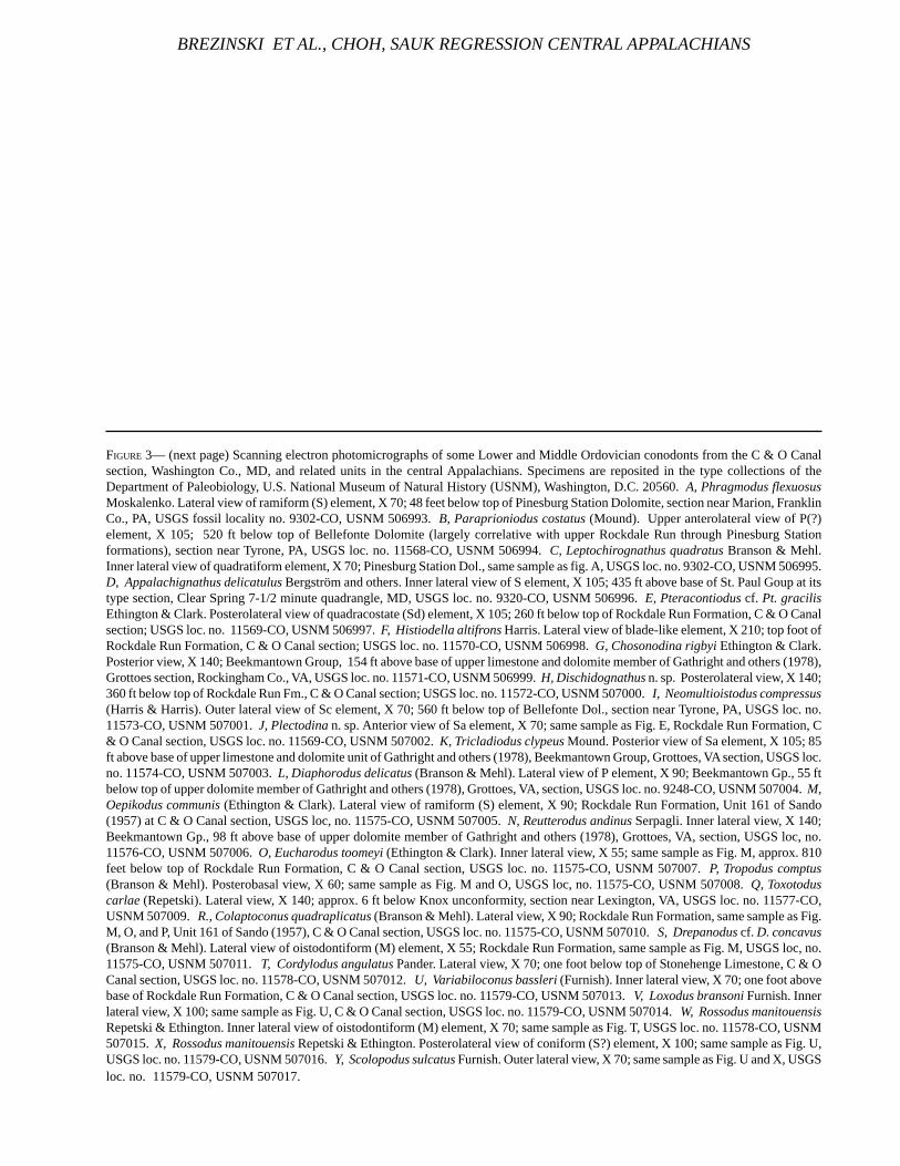
FIGURE 3— (next page) Scanning electron photomicrographs of some Lower and Middle Ordovician conodonts from the C & O Canalsection, Washington Co., MD, and related units in the central Appalachians. Specimens are reposited in the type collections of theDepartment of Paleobiology, U.S. National Museum of Natural History (USNM), Washington, D.C. 20560. A, Phragmodus flexuosusMoskalenko. Lateral view of ramiform (S) element, X 70; 48 feet below top of Pinesburg Station Dolomite, section near Marion, FranklinCo., PA, USGS fossil locality no. 9302-CO, USNM 506993. B, Paraprioniodus costatus (Mound). Upper anterolateral view of P(?)element, X 105; 520 ft below top of Bellefonte Dolomite (largely correlative with upper Rockdale Run through Pinesburg Stationformations), section near Tyrone, PA, USGS loc. no. 11568-CO, USNM 506994. C, Leptochirognathus quadratus Branson & Mehl.Inner lateral view of quadratiform element, X 70; Pinesburg Station Dol., same sample as fig. A, USGS loc. no. 9302-CO, USNM 506995.D, Appalachignathus delicatulus Bergström and others. Inner lateral view of S element, X 105; 435 ft above base of St. Paul Goup at itstype section, Clear Spring 7-1/2 minute quadrangle, MD, USGS loc. no. 9320-CO, USNM 506996. E, Pteracontiodus cf. Pt. gracilisEthington & Clark. Posterolateral view of quadracostate (Sd) element, X 105; 260 ft below top of Rockdale Run Formation, C & O Canalsection; USGS loc. no. 11569-CO, USNM 506997. F, Histiodella altifrons Harris. Lateral view of blade-like element, X 210; top foot ofRockdale Run Formation, C & O Canal section; USGS loc. no. 11570-CO, USNM 506998. G, Chosonodina rigbyi Ethington & Clark.Posterior view, X 140; Beekmantown Group, 154 ft above base of upper limestone and dolomite member of Gathright and others (1978),Grottoes section, Rockingham Co., VA, USGS loc. no. 11571-CO, USNM 506999. H, Dischidognathus n. sp. Posterolateral view, X 140;360 ft below top of Rockdale Run Fm., C & O Canal section; USGS loc. no. 11572-CO, USNM 507000. I, Neomultioistodus compressus(Harris & Harris). Outer lateral view of Sc element, X 70; 560 ft below top of Bellefonte Dol., section near Tyrone, PA, USGS loc. no.11573-CO, USNM 507001. J, Plectodina n. sp. Anterior view of Sa element, X 70; same sample as Fig. E, Rockdale Run Formation, C& O Canal section, USGS loc. no. 11569-CO, USNM 507002. K, Tricladiodus clypeus Mound. Posterior view of Sa element, X 105; 85ft above base of upper limestone and dolomite unit of Gathright and others (1978), Beekmantown Group, Grottoes, VA section, USGS loc.no. 11574-CO, USNM 507003. L, Diaphorodus delicatus (Branson & Mehl). Lateral view of P element, X 90; Beekmantown Gp., 55 ftbelow top of upper dolomite member of Gathright and others (1978), Grottoes, VA, section, USGS loc. no. 9248-CO, USNM 507004. M,Oepikodus communis (Ethington & Clark). Lateral view of ramiform (S) element, X 90; Rockdale Run Formation, Unit 161 of Sando(1957) at C & O Canal section, USGS loc, no. 11575-CO, USNM 507005. N, Reutterodus andinus Serpagli. Inner lateral view, X 140;Beekmantown Gp., 98 ft above base of upper dolomite member of Gathright and others (1978), Grottoes, VA, section, USGS loc, no.11576-CO, USNM 507006. O, Eucharodus toomeyi (Ethington & Clark). Inner lateral view, X 55; same sample as Fig. M, approx. 810feet below top of Rockdale Run Formation, C & O Canal section, USGS loc. no. 11575-CO, USNM 507007. P, Tropodus comptus(Branson & Mehl). Posterobasal view, X 60; same sample as Fig. M and O, USGS loc, no. 11575-CO, USNM 507008. Q, Toxotoduscarlae (Repetski). Lateral view, X 140; approx. 6 ft below Knox unconformity, section near Lexington, VA, USGS loc. no. 11577-CO,USNM 507009. R., Colaptoconus quadraplicatus (Branson & Mehl). Lateral view, X 90; Rockdale Run Formation, same sample as Fig.M, O, and P, Unit 161 of Sando (1957), C & O Canal section, USGS loc. no. 11575-CO, USNM 507010. S, Drepanodus cf. D. concavus(Branson & Mehl). Lateral view of oistodontiform (M) element, X 55; Rockdale Run Formation, same sample as Fig. M, USGS loc, no.11575-CO, USNM 507011. T, Cordylodus angulatus Pander. Lateral view, X 70; one foot below top of Stonehenge Limestone, C & OCanal section, USGS loc. no. 11578-CO, USNM 507012. U, Variabiloconus bassleri (Furnish). Inner lateral view, X 70; one foot abovebase of Rockdale Run Formation, C & O Canal section, USGS loc. no. 11579-CO, USNM 507013. V, Loxodus bransoni Furnish. Innerlateral view, X 100; same sample as Fig. U, C & O Canal section, USGS loc. no. 11579-CO, USNM 507014. W, Rossodus manitouensisRepetski & Ethington. Inner lateral view of oistodontiform (M) element, X 70; same sample as Fig. T, USGS loc. no. 11578-CO, USNM507015. X, Rossodus manitouensis Repetski & Ethington. Posterolateral view of coniform (S?) element, X 100; same sample as Fig. U,USGS loc. no. 11579-CO, USNM 507016. Y, Scolopodus sulcatus Furnish. Outer lateral view, X 70; same sample as Fig. U and X, USGSloc. no. 11579-CO, USNM 507017.
BREZINSKI ET AL., CHOH, SAUK REGRESSION CENTRAL APPALACHIANS

TECHNICAL REPORT NPS/NRGRD/GRDTR-99/3
FIGURE 3
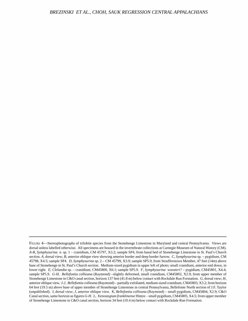
FIGURE 4—Stereophotographs of trilobite species from the Stonehenge Limestone in Maryland and central Pennsylvania. Views aredorsal unless labelled otherwise. All specimens are housed in the invertebrate collections at Carnegie Museum of Natural History (CM).A-B, Symphysurina n. sp. 1 – cranidium, CM 45797, X3.2; sample SP4, from basal bed of Stonehenge Limestone in St. Paul’s Churchsection. A, dorsal view; B, anterior oblique view showing anterior border and deep border furrow. C, Symphysurina sp. – pygidium, CM45798, X4.5; sample SP4. D, Symphysurina sp. 2 – CM 45799, X3.9; sample SP5.9, from Stoufferstown Member, 47 feet (14m) abovebase of Stonehenge in St. Paul’s Church section. Medium-sized pygidium in upper left of photo; small cranidium, anterior end down, inlower right. E, Clelandia sp. – cranidium, CM45800, X6.1; sample SP5.9. F, Symphysurina woosteri? – pygidium, CM45801, X4.4;sample SP5.9. G-H, Bellefontia collieana (Raymond) –slightly deformed, small cranidium, CM45802, X2.9; from upper member ofStonehenge Limestone in C&O canal section, horizon 137 feet (41.8 m) below contact with Rockdale Run Formation. G, dorsal view; H,anterior oblique view. I-J, Bellefontia collieana (Raymond) – partially exfoliated, medium-sized cranidium, CM45803, X3.2; from horizon64 feet (19.5 m) above base of upper member of Stonehenge Limestone in central Pennsylvania, Bellefonte North section of J.F. Taylor(unpublished). I, dorsal view; J, anterior oblique view. K, Bellefontia collieana (Raymond) – small pygidium, CM45804, X2.9; C&OCanal section, same horizon as figures G-H. L, Xenostegium franklinense Hintze – small pygidium, CM45805, X4.5; from upper memberof Stonehenge Limestone in C&O canal section, horizon 34 feet (10.4 m) below contact with Rockdale Run Formation.
BREZINSKI ET AL., CHOH, SAUK REGRESSION CENTRAL APPALACHIANS
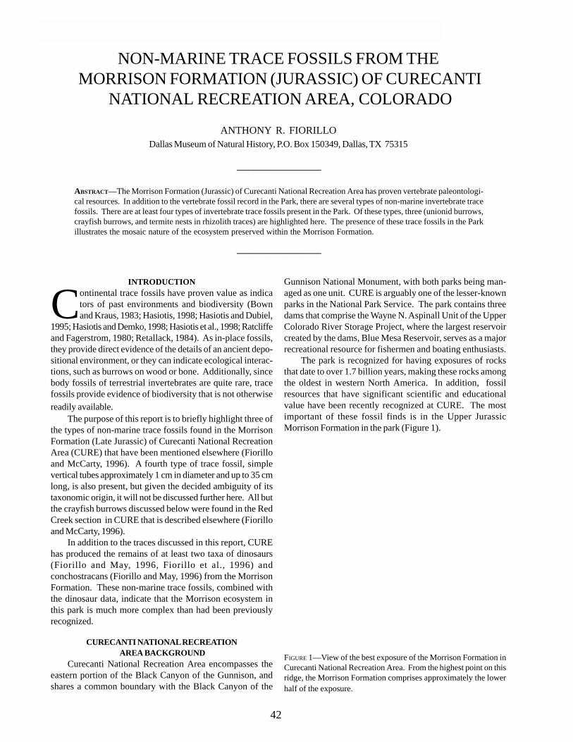
TECHNICAL REPORT NPS/NRGRD/GRDTR-99/3
NON-MARINE TRACE FOSSILS FROM THE MORRISON FORMATION (JURASSIC) OF CURECANTI
NATIONAL RECREATION AREA, COLORADO
ANTHONY R. FIORILLODallas Museum of Natural History, P.O. Box 150349, Dallas, TX 75315
____________________
ABSTRACT—The Morrison Formation (Jurassic) of Curecanti National Recreation Area has proven vertebrate paleontologi-cal resources. In addition to the vertebrate fossil record in the Park, there are several types of non-marine invertebrate tracefossils. There are at least four types of invertebrate trace fossils present in the Park. Of these types, three (unionid burrows,crayfish burrows, and termite nests in rhizolith traces) are highlighted here. The presence of these trace fossils in the Parkillustrates the mosaic nature of the ecosystem preserved within the Morrison Formation.
____________________
INTRODUCTION
Continental trace fossils have proven value as indicators of past environments and biodiversity (Bownand Kraus, 1983; Hasiotis, 1998; Hasiotis and Dubiel,
1995; Hasiotis and Demko, 1998; Hasiotis et al., 1998; Ratcliffeand Fagerstrom, 1980; Retallack, 1984). As in-place fossils,they provide direct evidence of the details of an ancient depo-sitional environment, or they can indicate ecological interac-tions, such as burrows on wood or bone. Additionally, sincebody fossils of terrestrial invertebrates are quite rare, tracefossils provide evidence of biodiversity that is not otherwisereadily available.
The purpose of this report is to briefly highlight three ofthe types of non-marine trace fossils found in the MorrisonFormation (Late Jurassic) of Curecanti National RecreationArea (CURE) that have been mentioned elsewhere (Fiorilloand McCarty, 1996). A fourth type of trace fossil, simplevertical tubes approximately 1 cm in diameter and up to 35 cmlong, is also present, but given the decided ambiguity of itstaxonomic origin, it will not be discussed further here. All butthe crayfish burrows discussed below were found in the RedCreek section in CURE that is described elsewhere (Fiorilloand McCarty, 1996).
In addition to the traces discussed in this report, CUREhas produced the remains of at least two taxa of dinosaurs(Fiorillo and May, 1996, Fiorillo et al., 1996) andconchostracans (Fiorillo and May, 1996) from the MorrisonFormation. These non-marine trace fossils, combined withthe dinosaur data, indicate that the Morrison ecosystem inthis park is much more complex than had been previouslyrecognized.
CURECANTI NATIONAL RECREATION AREA BACKGROUND
Curecanti National Recreation Area encompasses theeastern portion of the Black Canyon of the Gunnison, andshares a common boundary with the Black Canyon of the
Gunnison National Monument, with both parks being man-aged as one unit. CURE is arguably one of the lesser-knownparks in the National Park Service. The park contains threedams that comprise the Wayne N. Aspinall Unit of the UpperColorado River Storage Project, where the largest reservoircreated by the dams, Blue Mesa Reservoir, serves as a majorrecreational resource for fishermen and boating enthusiasts.
The park is recognized for having exposures of rocksthat date to over 1.7 billion years, making these rocks amongthe oldest in western North America. In addition, fossilresources that have significant scientific and educationalvalue have been recently recognized at CURE. The mostimportant of these fossil finds is in the Upper JurassicMorrison Formation in the park (Figure 1).
FIGURE 1—View of the best exposure of the Morrison Formation inCurecanti National Recreation Area. From the highest point on thisridge, the Morrison Formation comprises approximately the lowerhalf of the exposure.
42
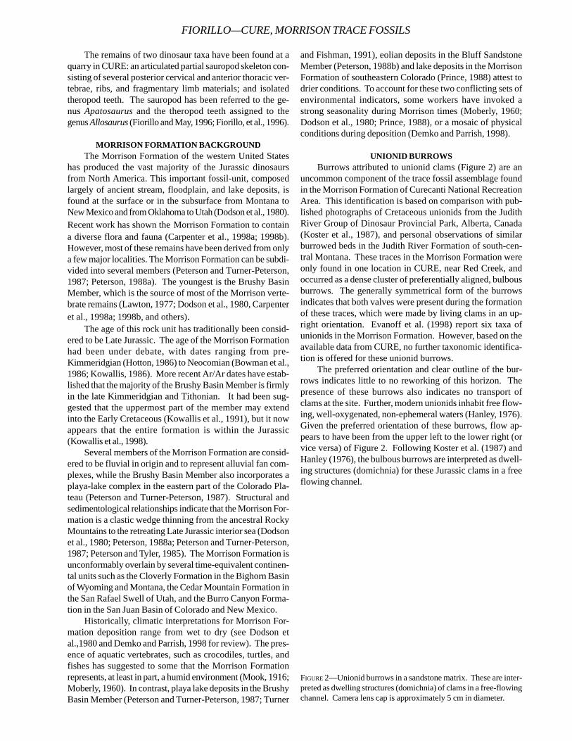
The remains of two dinosaur taxa have been found at aquarry in CURE: an articulated partial sauropod skeleton con-sisting of several posterior cervical and anterior thoracic ver-tebrae, ribs, and fragmentary limb materials; and isolatedtheropod teeth. The sauropod has been referred to the ge-nus Apatosaurus and the theropod teeth assigned to thegenus Allosaurus (Fiorillo and May, 1996; Fiorillo, et al., 1996).
MORRISON FORMATION BACKGROUNDThe Morrison Formation of the western United States
has produced the vast majority of the Jurassic dinosaursfrom North America. This important fossil-unit, composedlargely of ancient stream, floodplain, and lake deposits, isfound at the surface or in the subsurface from Montana toNew Mexico and from Oklahoma to Utah (Dodson et al., 1980).Recent work has shown the Morrison Formation to containa diverse flora and fauna (Carpenter et al., 1998a; 1998b).However, most of these remains have been derived from onlya few major localities. The Morrison Formation can be subdi-vided into several members (Peterson and Turner-Peterson,1987; Peterson, 1988a). The youngest is the Brushy BasinMember, which is the source of most of the Morrison verte-brate remains (Lawton, 1977; Dodson et al., 1980, Carpenteret al., 1998a; 1998b, and others).
The age of this rock unit has traditionally been consid-ered to be Late Jurassic. The age of the Morrison Formationhad been under debate, with dates ranging from pre-Kimmeridgian (Hotton, 1986) to Neocomian (Bowman et al.,1986; Kowallis, 1986). More recent Ar/Ar dates have estab-lished that the majority of the Brushy Basin Member is firmlyin the late Kimmeridgian and Tithonian. It had been sug-gested that the uppermost part of the member may extendinto the Early Cretaceous (Kowallis et al., 1991), but it nowappears that the entire formation is within the Jurassic(Kowallis et al., 1998).
Several members of the Morrison Formation are consid-ered to be fluvial in origin and to represent alluvial fan com-plexes, while the Brushy Basin Member also incorporates aplaya-lake complex in the eastern part of the Colorado Pla-teau (Peterson and Turner-Peterson, 1987). Structural andsedimentological relationships indicate that the Morrison For-mation is a clastic wedge thinning from the ancestral RockyMountains to the retreating Late Jurassic interior sea (Dodsonet al., 1980; Peterson, 1988a; Peterson and Turner-Peterson,1987; Peterson and Tyler, 1985). The Morrison Formation isunconformably overlain by several time-equivalent continen-tal units such as the Cloverly Formation in the Bighorn Basinof Wyoming and Montana, the Cedar Mountain Formation inthe San Rafael Swell of Utah, and the Burro Canyon Forma-tion in the San Juan Basin of Colorado and New Mexico.
Historically, climatic interpretations for Morrison For-mation deposition range from wet to dry (see Dodson etal.,1980 and Demko and Parrish, 1998 for review). The pres-ence of aquatic vertebrates, such as crocodiles, turtles, andfishes has suggested to some that the Morrison Formationrepresents, at least in part, a humid environment (Mook, 1916;Moberly, 1960). In contrast, playa lake deposits in the BrushyBasin Member (Peterson and Turner-Peterson, 1987; Turner
and Fishman, 1991), eolian deposits in the Bluff SandstoneMember (Peterson, 1988b) and lake deposits in the MorrisonFormation of southeastern Colorado (Prince, 1988) attest todrier conditions. To account for these two conflicting sets ofenvironmental indicators, some workers have invoked astrong seasonality during Morrison times (Moberly, 1960;Dodson et al., 1980; Prince, 1988), or a mosaic of physicalconditions during deposition (Demko and Parrish, 1998).
UNIONID BURROWSBurrows attributed to unionid clams (Figure 2) are an
uncommon component of the trace fossil assemblage foundin the Morrison Formation of Curecanti National RecreationArea. This identification is based on comparison with pub-lished photographs of Cretaceous unionids from the JudithRiver Group of Dinosaur Provincial Park, Alberta, Canada(Koster et al., 1987), and personal observations of similarburrowed beds in the Judith River Formation of south-cen-tral Montana. These traces in the Morrison Formation wereonly found in one location in CURE, near Red Creek, andoccurred as a dense cluster of preferentially aligned, bulbousburrows. The generally symmetrical form of the burrowsindicates that both valves were present during the formationof these traces, which were made by living clams in an up-right orientation. Evanoff et al. (1998) report six taxa ofunionids in the Morrison Formation. However, based on theavailable data from CURE, no further taxonomic identifica-tion is offered for these unionid burrows.
The preferred orientation and clear outline of the bur-rows indicates little to no reworking of this horizon. Thepresence of these burrows also indicates no transport ofclams at the site. Further, modern unionids inhabit free flow-ing, well-oxygenated, non-ephemeral waters (Hanley, 1976).Given the preferred orientation of these burrows, flow ap-pears to have been from the upper left to the lower right (orvice versa) of Figure 2. Following Koster et al. (1987) andHanley (1976), the bulbous burrows are interpreted as dwell-ing structures (domichnia) for these Jurassic clams in a freeflowing channel.
FIGURE 2—Unionid burrows in a sandstone matrix. These are inter-preted as dwelling structures (domichnia) of clams in a free-flowingchannel. Camera lens cap is approximately 5 cm in diameter.
FIORILLO—CURE, MORRISON TRACE FOSSILS
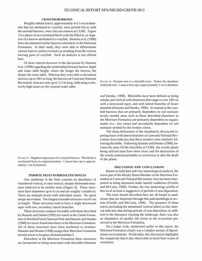
TECHNICAL REPORT NPS/NRGRD/GRDTR-99/3
CRAYFISH BURROWSRoughly tubular traces, approximately 4 to 5 cm in diam-
eter that are attributed to crayfish, were present but as withthe unionid burrows, were also uncommon at CURE. Figure3 is a photo of an overturned block with the filled in, or nega-tive of a burrow attributed to a crayfish. Hasiotis et al. (1998)have documented similar burrows elsewhere in the MorrisonFormation. In their study, they were able to differentiatevarious burrow surface textures as resulting from the variousmoving parts of crayfish. Such an analysis is not offeredhere.
Of more interest however is the discussion by Hasiotiset al. (1998) regarding the relationship between burrow depthand water table height, where the longer the burrow, thedeeper the water table. Whereas they were able to documentburrows up to 100 cm long, the burrows at Curecanti NationalRecreation Area are only up to 15 cm long, indicating a rela-tively high mean (or dry season) water table.
and Demko, 1998). Rhizoliths have been defined as beingtubular and vertical with diameters that range to over 100 cmwith a downward taper, and with lateral branches of lesserdiameter (Hasiotis and Demko, 1996). In contrast to the cray-fish burrows that are primarily dependent on soil moisturelevels, termite nests such as those described elsewhere inthe Morrison Formation are primarily dependent on organicmatter (i.e., tree roots) and secondarily dependent on soilmoisture needed for the termite colony.
The sharp delineation of the chambered, downward ta-pering traces with lateral branches at Curecanti National Rec-reation Area indicates that these termites were similarly fol-lowing rhizoliths. Following Hasiotis and Demko (1998), be-cause the nests fill the rhizoliths at CURE, the woody plantsbeing utilized must have been intact and the destruction ofthe woody material probably occurred near or after the deathof the plants.
DISCUSSION AND CONCLUSIONSBased on field data and clay mineralogical analysis, the
lower part of the Brushy Basin Member of the Morrison For-mation in Curecanti National Recreation Area has been inter-preted as being deposited under humid conditions (Fiorilloand McCarty, 1996). Further, the clay mineralogy profile ofthis local section is suggestive of periods of non-deposition.
The trace fossils described here are all found in sand-stones that are dispersed through this paleopedological sec-tion (Fiorillo and McCarty, 1996). The presence of thesetraces (including the mentioned vertical tubes) in this inter-val indicates that during periods of non-deposition, in addi-tion to the dinosaurs roaming the landscape, there was alsoan abundance of smaller life forms in the ecosystem pre-served in the Morrison Formation.
On a larger scale, mentioned earlier in this report, theMorrison Formation clearly was a complex mosaic of deposi-tional environments. Predictably, this discussion highlightsthe complexity that is also observable at much finer scales ofresolution.
FIGURE 3—Negative impression of a crayfish burrow. This block isoverturned from its original position. Camera lens cap is approxi-mately 5 cm in diameter.
TERMITE NESTS IN RHIZOLITH TRACESOne sandstone in the Park contains an abundance of
chambered vertical, or near vertical, sharply delineated struc-tures believed to be termite nests (Figure 4). These struc-tures have diameters up to 6 cm and are roughly cylindrical.There are multiple levels with individual rooms. No spiralramps are evident. The longest traceable structure was 65 cmin length. These structures tend to have a slight downwardtaper with rare, secondary lateral branches.
These structures compare favorably with those describedby Hasiotis and Dubiel (1995) for traces in the Chinle Forma-tion of Petrified Forest National Park and Hasiotis and Demko(1998) for traces found elsewhere in the Morrison Formation.All of these structures have been attributed to termites.Hasiotis and Demko (1998) assign their Morrison Formationtermite traces to Isoptera (Kalotermitidae?).
Elsewhere in the Morrison Formation these structuresare interpreted as being associated with rhizoliths (Hasiotis
FIGURE 4—Termite nest in a rhizolith trace. Notice the chamberswithin the nest. Camera lens cap is approximately 5 cm in diameter.
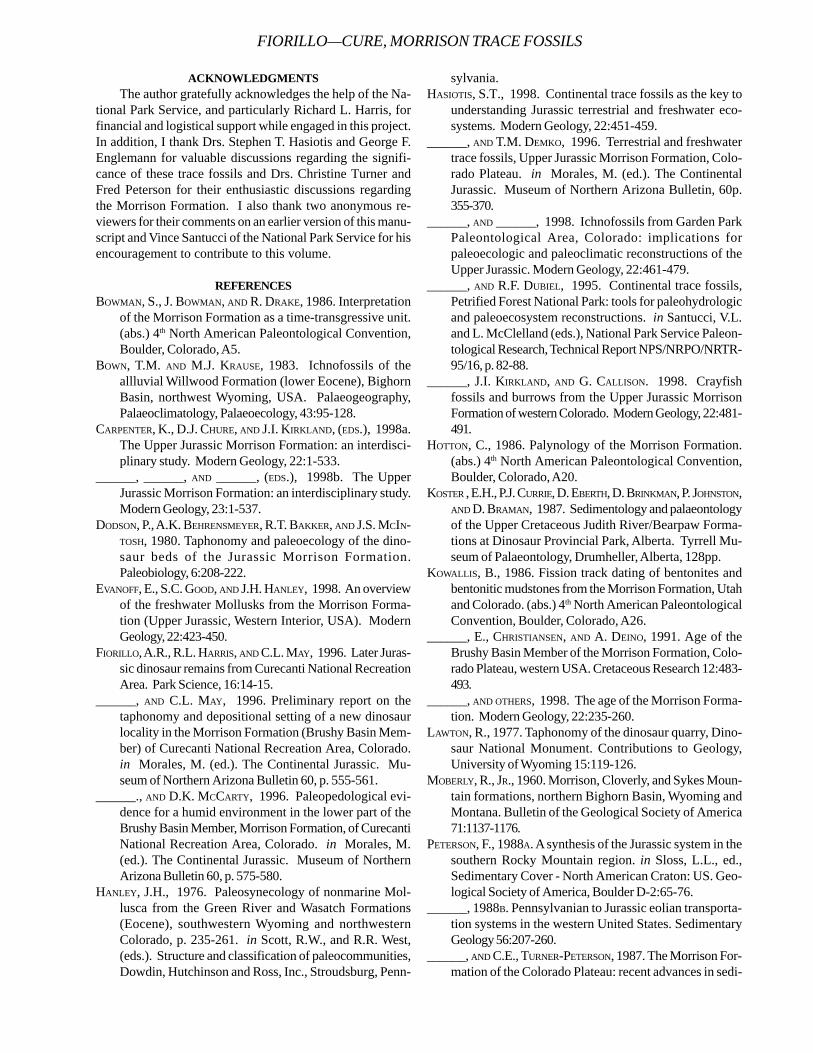
ACKNOWLEDGMENTSThe author gratefully acknowledges the help of the Na-
tional Park Service, and particularly Richard L. Harris, forfinancial and logistical support while engaged in this project.In addition, I thank Drs. Stephen T. Hasiotis and George F.Englemann for valuable discussions regarding the signifi-cance of these trace fossils and Drs. Christine Turner andFred Peterson for their enthusiastic discussions regardingthe Morrison Formation. I also thank two anonymous re-viewers for their comments on an earlier version of this manu-script and Vince Santucci of the National Park Service for hisencouragement to contribute to this volume.
REFERENCESBOWMAN, S., J. BOWMAN, AND R. DRAKE, 1986. Interpretation
of the Morrison Formation as a time-transgressive unit.(abs.) 4th North American Paleontological Convention,Boulder, Colorado, A5.
BOWN, T.M. AND M.J. KRAUSE, 1983. Ichnofossils of theallluvial Willwood Formation (lower Eocene), BighornBasin, northwest Wyoming, USA. Palaeogeography,Palaeoclimatology, Palaeoecology, 43:95-128.
CARPENTER, K., D.J. CHURE, AND J.I. KIRKLAND, (EDS.), 1998a.The Upper Jurassic Morrison Formation: an interdisci-plinary study. Modern Geology, 22:1-533.
______, ______, AND ______, (EDS.), 1998b. The UpperJurassic Morrison Formation: an interdisciplinary study.Modern Geology, 23:1-537.
DODSON, P., A.K. BEHRENSMEYER, R.T. BAKKER, AND J.S. MCIN-TOSH, 1980. Taphonomy and paleoecology of the dino-saur beds of the Jurassic Morrison Formation.Paleobiology, 6:208-222.
EVANOFF, E., S.C. GOOD, AND J.H. HANLEY, 1998. An overviewof the freshwater Mollusks from the Morrison Forma-tion (Upper Jurassic, Western Interior, USA). ModernGeology, 22:423-450.
FIORILLO, A.R., R.L. HARRIS, AND C.L. MAY, 1996. Later Juras-sic dinosaur remains from Curecanti National RecreationArea. Park Science, 16:14-15.
______, AND C.L. MAY, 1996. Preliminary report on thetaphonomy and depositional setting of a new dinosaurlocality in the Morrison Formation (Brushy Basin Mem-ber) of Curecanti National Recreation Area, Colorado.in Morales, M. (ed.). The Continental Jurassic. Mu-seum of Northern Arizona Bulletin 60, p. 555-561.
______., AND D.K. MCCARTY, 1996. Paleopedological evi-dence for a humid environment in the lower part of theBrushy Basin Member, Morrison Formation, of CurecantiNational Recreation Area, Colorado. in Morales, M.(ed.). The Continental Jurassic. Museum of NorthernArizona Bulletin 60, p. 575-580.
HANLEY, J.H., 1976. Paleosynecology of nonmarine Mol-lusca from the Green River and Wasatch Formations(Eocene), southwestern Wyoming and northwesternColorado, p. 235-261. in Scott, R.W., and R.R. West,(eds.). Structure and classification of paleocommunities,Dowdin, Hutchinson and Ross, Inc., Stroudsburg, Penn-
sylvania.HASIOTIS, S.T., 1998. Continental trace fossils as the key to
understanding Jurassic terrestrial and freshwater eco-systems. Modern Geology, 22:451-459.
______, AND T.M. DEMKO, 1996. Terrestrial and freshwatertrace fossils, Upper Jurassic Morrison Formation, Colo-rado Plateau. in Morales, M. (ed.). The ContinentalJurassic. Museum of Northern Arizona Bulletin, 60p.355-370.
______, AND ______, 1998. Ichnofossils from Garden ParkPaleontological Area, Colorado: implications forpaleoecologic and paleoclimatic reconstructions of theUpper Jurassic. Modern Geology, 22:461-479.
______, AND R.F. DUBIEL, 1995. Continental trace fossils,Petrified Forest National Park: tools for paleohydrologicand paleoecosystem reconstructions. in Santucci, V.L.and L. McClelland (eds.), National Park Service Paleon-tological Research, Technical Report NPS/NRPO/NRTR-95/16, p. 82-88.
______, J.I. KIRKLAND, AND G. CALLISON. 1998. Crayfishfossils and burrows from the Upper Jurassic MorrisonFormation of western Colorado. Modern Geology, 22:481-491.
HOTTON, C., 1986. Palynology of the Morrison Formation.(abs.) 4th North American Paleontological Convention,Boulder, Colorado, A20.
KOSTER , E.H., P.J. CURRIE, D. EBERTH, D. BRINKMAN, P. JOHNSTON,AND D. BRAMAN, 1987. Sedimentology and palaeontologyof the Upper Cretaceous Judith River/Bearpaw Forma-tions at Dinosaur Provincial Park, Alberta. Tyrrell Mu-seum of Palaeontology, Drumheller, Alberta, 128pp.
KOWALLIS, B., 1986. Fission track dating of bentonites andbentonitic mudstones from the Morrison Formation, Utahand Colorado. (abs.) 4th North American PaleontologicalConvention, Boulder, Colorado, A26.
______, E., CHRISTIANSEN, AND A. DEINO, 1991. Age of theBrushy Basin Member of the Morrison Formation, Colo-rado Plateau, western USA. Cretaceous Research 12:483-493.
______, AND OTHERS, 1998. The age of the Morrison Forma-tion. Modern Geology, 22:235-260.
LAWTON, R., 1977. Taphonomy of the dinosaur quarry, Dino-saur National Monument. Contributions to Geology,University of Wyoming 15:119-126.
MOBERLY, R., JR., 1960. Morrison, Cloverly, and Sykes Moun-tain formations, northern Bighorn Basin, Wyoming andMontana. Bulletin of the Geological Society of America71:1137-1176.
PETERSON, F., 1988A. A synthesis of the Jurassic system in thesouthern Rocky Mountain region. in Sloss, L.L., ed.,Sedimentary Cover - North American Craton: US. Geo-logical Society of America, Boulder D-2:65-76.
______, 1988B. Pennsylvanian to Jurassic eolian transporta-tion systems in the western United States. SedimentaryGeology 56:207-260.
______, AND C.E., TURNER-PETERSON, 1987. The Morrison For-mation of the Colorado Plateau: recent advances in sedi-
FIORILLO—CURE, MORRISON TRACE FOSSILS
TECHNICAL REPORT NPS/NRGRD/GRDTR-99/3
mentology, stratigraphy, and paleotectonics. Hunteria2(1):1-18.
______, AND N. TYLER, 1985. Field guide to the Upper SaltWash alluvial complex. in Flores, R.M., and M. Harvey,eds., Field guidebook to modern and ancient fluvial sys-tems in the United States: Proceedings of the Third In-ternational Fluvial Sedimentology Conference, ColoradoState University, Rocky Mountain Section SEPM, p. 45-64.
PRINCE, N.K., 1988. Lacustrine deposition in the JurassicMorrison Formation, Purgatoire River Region, southeast-ern Colorado (M.S. thesis). University of Colorado, Den-ver.
RATCLIFFE, B.C. AND J.A. FAGERSTROM, 1980. Invertebratelebensspuren of Holocene floodplains: Their morphol-ogy, origin, and paleoecological significance. Journal ofPaleontology, 54:614-630.
RETALLACK, G.J., 1984. Trace fossils of burrowing beetlesand bees in an Oligocene paleosol, Badlands NationalPark, South Dakota. Journal of Paleontology, 58:571-592.
TURNER, C.E., AND N.S. FISHMAN, 1991. Jurassic LakeT’oo’dichi’: A large alkaline, saline lake, Morrison For-mation, eastern Colorado Plateau. Geological Society ofAmerica Bulletin 103:538-558.
ALL IS NOT QUIET ON THE PALEONTOLOGICAL FRONT IN DENALI NATIONAL PARK
R.B. BLODGETT1 AND PHIL BREASE2
1Department of Zoology, Oregon State University, Corvallis, Oregon 973312Denali National Park, P.O. Box 9, Denali Park, Alaska 99755
____________________
ABSTRACT—Recent paleontological investigations of Paleozoic and Mesozoic fossil faunas from Denali National Park arechallenging much of the previous stratigraphic and paleotectonic interpretations of the area. Faunas from two tectonostratigraphicterranes, heretofore considered to have had origins in southerly latitudes, suggest that at least some of their early depositionalhistories took place in higher, cooler paleolatitudes. A few faunas demonstrate a close association, if not a direct tie, to theSiberian continent in early Paleozoic time. These findings suggest that the current tectonic model of the accretionary history ofAlaska may need re-examination.
____________________
SUMMARY
It has long been generally accepted that most of Alaska iscomposed of accreted “tectonostratigraphic terranes”,representing bits and pieces of island arcs, ocean crust,
and rifted continental margins that have been swept acrossthe vast reaches of the Pacific Ocean and smashed onto thewestern margin of the North American continent. In Denali,previous investigators have identified up to eight differentterranes, found either wholly or partially within the Park orPreserve. These include the Pingston (turbidite apron),McKinley (island arc), Mystic and Dillinger (continental shelfand slope), and Chulitna (oceanic crust and continental mar-gin), which were originally described during the 1980’s (Jonesand others 1981, 1982, 1983, 1984, 1987), and were, for themost part, interpreted to have origins in more southerly lati-tudes. In most cases, these terranes or stratigraphic pack-ages have only been reconnaissance mapped, and little de-tail is known about their origins or displacement histories.
A mapping investigation, conducted by the Alaska Di-vision of Geological & Geophysical Surveys along the south-eastern margin of the Park in rocks of the Healy A-6 quad-rangle, has brought a number of paleontologists into thechallenge of unravelling the relative ages of a number ofgeological units in the infamous “Chulitna Terrane”. A num-ber of faunal groups are under investigation by the followingspecialists: Paleozoic radiolarians, Mun-zu Won (Natural Sci-ence College, Pusan, Korea); Permian brachiopods and othermegafauna, Robert B. Blodgett (Oregon State Univ.); Paleo-zoic-Triassic conodonts, Norman M. Savage (Univ. of Or-egon); Triassic brachiopods, Michael R. Sandy and MonicaStefanoff (Univ. Dayton, OH); Triassic scleractinian coralsand hydrozoans, George D. Stanley, Jr. (Univ. of Montana);and Triassic bivalves, Christopher McRoberts (SUNY atCortland, NY). Several papers and abstracts are currently inpress or preparation on the radiolarian and brachiopod fau-nas of this terrane (Won and others, in press; Stefanoff and
others, 1999)The Triassic faunas are especially noted for their exotic
character in relation to North American cratonal faunas, andindicate that this terrane was then situated near or at thepaleoequator (Nichols and Silberling, 1979; Blodgett andClautice, 1998). Additionally, the warm water, transgressiveUpper Triassic carbonate lithologies suggest either a lowpaleolatitude, or a sheltered embayment or inland sea (Whalenand others, 1999). In contrast, Permian faunas from the sameterrane indicate that previously it was probably situated atmuch higher, cooler paleolatitudes in the Northern Hemisphere,as it contains many elements of the well-known “Arctic Per-mian” fauna (Blodgett and Clautice, 1998).
Much attention is now also being focused on rocks ofanother separate tectonic entity, the Mystic terrane (nowranked as a subterrane of the Farewell terrane) which isbroadly exposed across much of the northern and westernparts of the Park. Conodonts from early Late Devonian(Frasnian) age rocks in the Healy C-6 quadrangle, near theWest Fork of the Toklat River, are being described in an ar-ticle by Savage and others (in press). Rocks of the Mysticterrane are especially well-exposed in the area of ShellabargerPass in the Talkeetna C-6 quadrangle, and fossils in the im-mediate area rank amongst the best in terms of preservationanywhere within the Park. Fossil calcareous sponges of Sil-urian age were described several years back by J. Keith Rigby(Brigham Young Univ., Provo, UT) and others from atoll-likealgal reefs (Rigby and others, 1994). Several manuscripts aresubmitted or nearing completion on Devonian brachiopodsby Blodgett, A.J. Boucot (Oregon State Univ.), and Breaseand on Early Jurassic spiriferid brachiopods (the first everrecognized in North America) by Sandy and Blodgett (sub-mitted). Fossils from Emsian (late Early Devonian) strata atthe base of the Mystic “terrane”, along with the aforemen-tioned Silurian sponges are of Siberian and/or Uralian affini-ties, and suggest that the Mystic terrane most probably rep-
47
TECHNICAL REPORT NPS/NRGRD/GRDTR-99/3
resents a rifted sliver of the Siberian continent (Blodgett,1998; Blodgett and Brease, 1997).
The recent explosive growth of paleontological investi-gations within Denali National Park and Preserve indicatethat we are now entering a “Golden Age” for the understand-ing of the park’s geology and fossils. At this time, we eagerlyanticipate many new exciting results on the fossil faunas ofthe park, as well as for the modelling of the accretionarygrowth of interior Alaska.
REFERENCESBLODGETT, R.B., 1998. Emsian (Late Early Devonian) fossils
indicate a Siberian origin for the Farewell terrane, inClough, J.G. and F. Larson, (eds.), Short Notes on Alas-kan Geology 1997. Alaska Division of Geological andGeophysical Surveys Professional Report 118, p. 53-61.
______, AND P.F. BREASE, 1997. Emsian (late Early Devonian)brachiopods from Shellabarger Pass, Talkeetna C-6 quad-rangle, Denali National Park, Alaska indicate Siberianorigin for Farewell terrane (abst.). Geological Society ofAmerica Abstracts with Programs, v. 29, no. 5, p. 5.
______, AND K.H. CLAUTICE, 1998. New insights into thestratigraphy and paleontology of the Chulitna terraneand surrounding area, Healy A-6 quadrangle, south-cen-tral Alaska (abst.), in Karl, S.M., (ed.), The Alaska Geo-logical Society 1998 Science and Technology Confer-ence, ‘Cutting Edge in Alaska’, 2 p.,
JONES, D.L., 1987. Lithotectonic terrane map of Alaska (westof the 141st meridian). U.S.Geological survey Miscella-neous Field Studies Map MF-1874, scale 1:250,000.
JONES, D.L., N.J. SILBERLING, H.C. BERG, AND G. PLAFKER, 1981.Map showing tectonostratigraphic terranes of Alaska,columnar sections, and summary descriptions of terranes.U.S. Geological Survey Open-File Report 81-792, 20p., 2sheets, scale 1:2,500,000.
______, ______, W. Gilbert, and P.J. Coney, 1982. Character,distribution, and tectonic significance of accretionaryterranes in the central Alaska Range. Journal of Geo-physical Research, v. 87, p. 3709-3717.
______, ______, and P.J. Coney, 1983. Tectono-stratigraphic
map and interpretative bedrock geologic map of theMount McKinley region, Alaska. U.S. Geological Sur-vey Open-File Report 83-11, 2 sheets, scale 1:250,000.
______, ______, ______, and G. Plafker, 1984. Lithotectonicterrane map of Alaska (west of the 141st meridian), inSiberling, N.J., and D.L. Jones, (eds.), Lithotectonic ter-rane maps of the North American Cordillera. U.S. Geo-logical Survey Open-File Report 84-523, scale 1:250,000.
NICHOLS, K.M. AND N.J. SILBERLING, 1979. Early Triassic(Smithian) ammonites of paleoequatorial affinity from theChulitna terrane, south-central Alaska. U.S. GeologicalSurvey Professional Paper 1121-B, 5 p.
RIGBY, J.K., M.H. NITECKI, C.M. SOJA, AND R.B. BLODGETT,1994. Silurian aphrosalpingid sphinctozoans from Alaskaand Russia. Acta Palaeontologica Polonica, v. 39, p.341-391.
SANDY, M. R., AND R.B. BLODGETT, (in press). Early Jurassicspiriferid brachiopods from Alaska and their paleogeo-graphic significance: Geobios.
SAVAGE, N. M., R.B. BLODGETT, AND P.F. BREASE, (in press).Late Devonian (early Frasnian) conodonts from theDenali National Park, Alaska. Short Notes on AlaskanGeology 1999: Alaska Division of Geological and Geo-physical Surveys Professional Report.
STEFANOFF, M., M.R. SANDY, AND R.B. BLODGETT, (in press).Late Triassic brachiopods from the central belt of theUpper Chulitna district, south-central Alaska, and theirpaleogeographic significance. Geological Society ofAmerica Abstracts with Programs (for Annual NationalMeeting, Oct. 1999, Denver, Colorado).
WHALEN, M.T., J.G. CLOUGH, R.B. BLODGETT, G.D. STANLEY,JR., K. CLAUTICE, AND R.J. NEWBERRY, 1999. Late Paleo-zoic and Early Mesozoic Carbonate Rocks and Deposi-tional History of the Chulitna Terrane. in Alaska Geo-logical Society Science and Technology Conference, R.Reifehstuhl, (ed.).
WON M-.Z., R.B. BLODGETT, K.H. CLAUTICE, AND R.J. NEWBERRY,(in press). Short Notes on Alaskan Geology 1999. AlaskaDivision of Geological and Geophysical Surveys Profes-sional Report.
FOSSIL BIRDS OF FLORISSANT, COLORADO: WITH A DESCRIPTION OF A NEWGENUS AND SPECIES OF CUCKOO
ROBERT M. CHANDLERDepartment of Biological and Environmental Sciences
Georgia College & State University, Milledgeville, GA 31061-0490
____________________
ABSTRACT—Specimens of fossil birds, both skeletons and feathers, have been known from deposits near Florissant,Colorado since the late 1870s. Three species of birds have been named from this area. One specimen is tentativelyidentified as belonging in the Coraciiformes (rollers and their relatives). The phylogenetic relationships of the other twospecies are unclear and they have been placed into Aves: incertae sedis. A recently collected fossil with an almost completeskeleton, except for the skull, is a very important find. Herein this specimen is described as a new genus and species withaffinities to the arboreal cuckoos (Cucuiformes, Cuculidae, Cuculinae) of the Old World.
____________________
INTRODUCTION
The fossil birds from Florissant, Colorado are few butextremely interesting for several reasons. The twobest preserved and prepared specimens have affini-
ties with two Old World groups of birds: rollers (Coraciiformes:Coraciidae; Olson, 1985:139) and cuckoos (Cuculiformes:Cuculidae, Cuculinae; described herein). Modern rollers andcuckoos (subfamily Cuculinae) are found in Europe, Africa,and southern Asia to Australia. Rollers get their commonname from their acrobatic flight. They are medium-sized birdsthat do not walk well, but have a labored hop when on theground. In trees they fly from perch to perch and seldomclimb. The Old World “typical” cuckoos (Cuculinae) are bestknow because they all are parasitic breeders, laying theireggs in other birds nests. These medium-sized birds aregood fliers, some migrating long distances.
The first fossil bird described from the Florissant LakeBeds was a new genus and species of small oscine perchingbird (Passeriformes), Palaeospiza bella (Allen, 1878:443).Wetmore (1925:190) felt that though P. bella was “handsometo look upon” it lacked sufficient characters to show a rela-tionship with any known group of birds. Therefore, he placedit in its own family, Palaeospizidae. In his “Catalogue offossil birds, Part 5 (Passeriformes)” Brodkorb (1978:216) listedP. bella under Aves Incertae Sedis and mentioned that “eventhe ordinal assignment may be incorrect.” Olson (1985:139)stated that he had examined the specimen and “Because it isanisodactyl it is most likely some sort of coraciiform.”
The next fossil bird to be described was in 1880 whenEdward Drinker Cope described a plover, Charadriussheppardianus, from the “Amyzon Shales” near Florissant.Olson (1985:175) examined the holotype and found it “impos-
sible even to assign the specimen to order, much less togenus.” Therefore, he assigns the specimen to Aves incertaesedis. Another avian species from Florissant is Fontinalispristina, which was originally identified by Lesquereux (1883)as a moss, but this was later rectified by Knowlton (1916)who recognized it as a feather.
METHODS AND MATERIALSThe Florissant fossil cuckoo was identified and de-
scribed using the skeletons of modern species of birds in thecomparative osteology collection in the Ornithology Divi-sion, Florida Museum of Natural History (UF); the Divisionof Birds, the Field Museum of Natural History (FMNH); andGeorgia College Ornithology Collection (GCOC). After com-paring and eliminating all other orders and most of the livingfamilies of birds the following specimens were used for com-parison and detailed descriptive osteology. Cuculidae:Centropus superciliosus (UF 33856), Clamator cafer (FMNH319965), Clamator glandarius (UF 38176, 38731), Coccyzuserythropthalmus (GCOC 579), Crotophaga ani (UF 38970),Cuculus canorus (UF 38175), Cuculus saturatus (FMNH357422), Geococcyx californiana (FMNH 317279);Musophagidae: Corythaixoides leucogaster (UF 21422),Musophaga rossae (UF 38727), Tauraco corythaix (UF 38726);Opisthocomidae: Opisthocomus hoazin (UF 33314);Bucconidae: Bucco teetus (UF 33259), Chelidopterateuebrosa (UF 33263), Monasa atra (UF 33260), Monasamorphoeus (UF 33261).
The osteological terminology used is from Howard (1929)and Nomina Anatomica Avium (Baumel, 1979). The Latinterms are replaced by the English equivalents. All measure-ments are in millimeters and were taken with dial calipers.
49
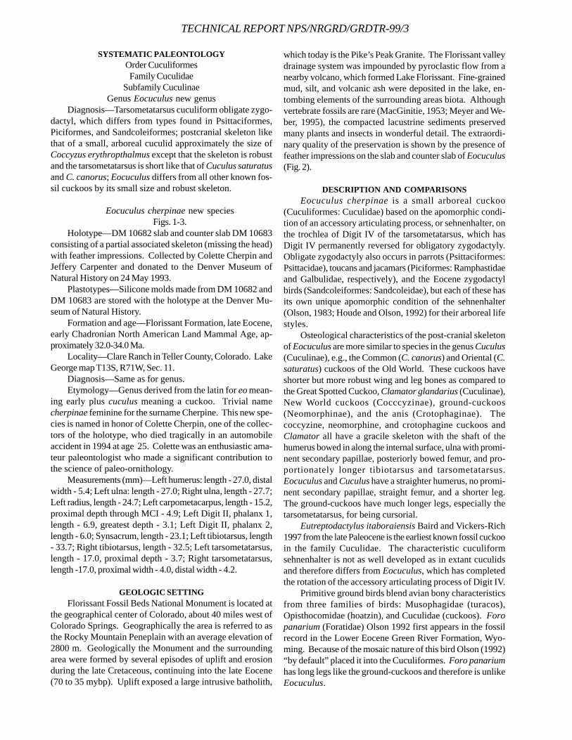
TECHNICAL REPORT NPS/NRGRD/GRDTR-99/3
SYSTEMATIC PALEONTOLOGYOrder CuculiformesFamily Cuculidae
Subfamily CuculinaeGenus Eocuculus new genus
Diagnosis—Tarsometatarsus cuculiform obligate zygo-dactyl, which differs from types found in Psittaciformes,Piciformes, and Sandcoleiformes; postcranial skeleton likethat of a small, arboreal cuculid approximately the size ofCoccyzus erythropthalmus except that the skeleton is robustand the tarsometatarsus is short like that of Cuculus saturatusand C. canorus; Eocuculus differs from all other known fos-sil cuckoos by its small size and robust skeleton.
Eocuculus cherpinae new speciesFigs. 1-3.
Holotype—DM 10682 slab and counter slab DM 10683consisting of a partial associated skeleton (missing the head)with feather impressions. Collected by Colette Cherpin andJeffery Carpenter and donated to the Denver Museum ofNatural History on 24 May 1993.
Plastotypes—Silicone molds made from DM 10682 andDM 10683 are stored with the holotype at the Denver Mu-seum of Natural History.
Formation and age—Florissant Formation, late Eocene,early Chadronian North American Land Mammal Age, ap-proximately 32.0-34.0 Ma.
Locality—Clare Ranch in Teller County, Colorado. LakeGeorge map T13S, R71W, Sec. 11.
Diagnosis—Same as for genus.Etymology—Genus derived from the latin for eo mean-
ing early plus cuculus meaning a cuckoo. Trivial namecherpinae feminine for the surname Cherpine. This new spe-cies is named in honor of Colette Cherpin, one of the collec-tors of the holotype, who died tragically in an automobileaccident in 1994 at age 25. Colette was an enthusiastic ama-teur paleontologist who made a significant contribution tothe science of paleo-ornithology.
Measurements (mm)—Left humerus: length - 27.0, distalwidth - 5.4; Left ulna: length - 27.0; Right ulna, length - 27.7;Left radius, length - 24.7; Left carpometacarpus, length - 15.2,proximal depth through MCI - 4.9; Left Digit II, phalanx 1,length - 6.9, greatest depth - 3.1; Left Digit II, phalanx 2,length - 6.0; Synsacrum, length - 23.1; Left tibiotarsus, length- 33.7; Right tibiotarsus, length - 32.5; Left tarsometatarsus,length - 17.0, proximal depth - 3.7; Right tarsometatarsus,length -17.0, proximal width - 4.0, distal width - 4.2.
GEOLOGIC SETTINGFlorissant Fossil Beds National Monument is located at
the geographical center of Colorado, about 40 miles west ofColorado Springs. Geographically the area is referred to asthe Rocky Mountain Peneplain with an average elevation of2800 m. Geologically the Monument and the surroundingarea were formed by several episodes of uplift and erosionduring the late Cretaceous, continuing into the late Eocene(70 to 35 mybp). Uplift exposed a large intrusive batholith,
which today is the Pike’s Peak Granite. The Florissant valleydrainage system was impounded by pyroclastic flow from anearby volcano, which formed Lake Florissant. Fine-grainedmud, silt, and volcanic ash were deposited in the lake, en-tombing elements of the surrounding areas biota. Althoughvertebrate fossils are rare (MacGinitie, 1953; Meyer and We-ber, 1995), the compacted lacustrine sediments preservedmany plants and insects in wonderful detail. The extraordi-nary quality of the preservation is shown by the presence offeather impressions on the slab and counter slab of Eocuculus(Fig. 2).
DESCRIPTION AND COMPARISONSEocuculus cherpinae is a small arboreal cuckoo
(Cuculiformes: Cuculidae) based on the apomorphic condi-tion of an accessory articulating process, or sehnenhalter, onthe trochlea of Digit IV of the tarsometatarsus, which hasDigit IV permanently reversed for obligatory zygodactyly.Obligate zygodactyly also occurs in parrots (Psittaciformes:Psittacidae), toucans and jacamars (Piciformes: Ramphastidaeand Galbulidae, respectively), and the Eocene zygodactylbirds (Sandcoleiformes: Sandcoleidae), but each of these hasits own unique apomorphic condition of the sehnenhalter(Olson, 1983; Houde and Olson, 1992) for their arboreal lifestyles.
Osteological characteristics of the post-cranial skeletonof Eocuculus are more similar to species in the genus Cuculus(Cuculinae), e.g., the Common (C. canorus) and Oriental (C.saturatus) cuckoos of the Old World. These cuckoos haveshorter but more robust wing and leg bones as compared tothe Great Spotted Cuckoo, Clamator glandarius (Cuculinae),New World cuckoos (Cocccyzinae), ground-cuckoos(Neomorphinae), and the anis (Crotophaginae). Thecoccyzine, neomorphine, and crotophagine cuckoos andClamator all have a gracile skeleton with the shaft of thehumerus bowed in along the internal surface, ulna with promi-nent secondary papillae, posteriorly bowed femur, and pro-portionately longer tibiotarsus and tarsometatarsus.Eocuculus and Cuculus have a straighter humerus, no promi-nent secondary papillae, straight femur, and a shorter leg.The ground-cuckoos have much longer legs, especially thetarsometatarsus, for being cursorial.
Eutreptodactylus itaboraiensis Baird and Vickers-Rich1997 from the late Paleocene is the earliest known fossil cuckooin the family Cuculidae. The characteristic cuculiformsehnenhalter is not as well developed as in extant cuculidsand therefore differs from Eocuculus, which has completedthe rotation of the accessory articulating process of Digit IV.
Primitive ground birds blend avian bony characteristicsfrom three families of birds: Musophagidae (turacos),Opisthocomidae (hoatzin), and Cuculidae (cuckoos). Foropanarium (Foratidae) Olson 1992 first appears in the fossilrecord in the Lower Eocene Green River Formation, Wyo-ming. Because of the mosaic nature of this bird Olson (1992)“by default” placed it into the Cuculiformes. Foro panariumhas long legs like the ground-cuckoos and therefore is unlikeEocuculus.
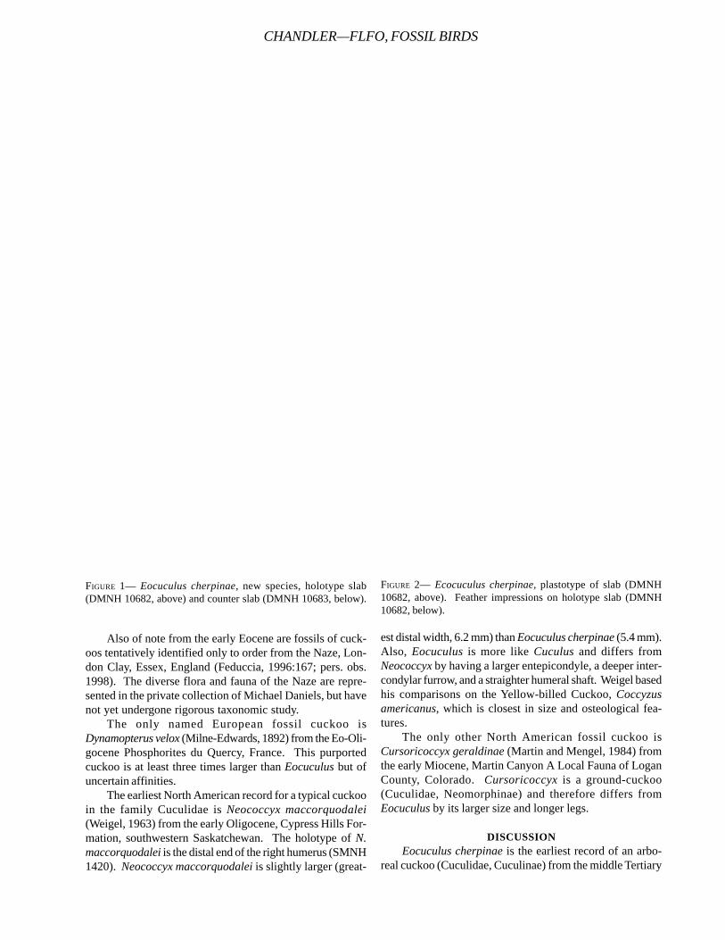
Also of note from the early Eocene are fossils of cuck-oos tentatively identified only to order from the Naze, Lon-don Clay, Essex, England (Feduccia, 1996:167; pers. obs.1998). The diverse flora and fauna of the Naze are repre-sented in the private collection of Michael Daniels, but havenot yet undergone rigorous taxonomic study.
The only named European fossil cuckoo isDynamopterus velox (Milne-Edwards, 1892) from the Eo-Oli-gocene Phosphorites du Quercy, France. This purportedcuckoo is at least three times larger than Eocuculus but ofuncertain affinities.
The earliest North American record for a typical cuckooin the family Cuculidae is Neococcyx maccorquodalei(Weigel, 1963) from the early Oligocene, Cypress Hills For-mation, southwestern Saskatchewan. The holotype of N.maccorquodalei is the distal end of the right humerus (SMNH1420). Neococcyx maccorquodalei is slightly larger (great-
est distal width, 6.2 mm) than Eocuculus cherpinae (5.4 mm).Also, Eocuculus is more like Cuculus and differs fromNeococcyx by having a larger entepicondyle, a deeper inter-condylar furrow, and a straighter humeral shaft. Weigel basedhis comparisons on the Yellow-billed Cuckoo, Coccyzusamericanus, which is closest in size and osteological fea-tures.
The only other North American fossil cuckoo isCursoricoccyx geraldinae (Martin and Mengel, 1984) fromthe early Miocene, Martin Canyon A Local Fauna of LoganCounty, Colorado. Cursoricoccyx is a ground-cuckoo(Cuculidae, Neomorphinae) and therefore differs fromEocuculus by its larger size and longer legs.
DISCUSSIONEocuculus cherpinae is the earliest record of an arbo-
real cuckoo (Cuculidae, Cuculinae) from the middle Tertiary
FIGURE 1— Eocuculus cherpinae, new species, holotype slab(DMNH 10682, above) and counter slab (DMNH 10683, below).
FIGURE 2— Ecocuculus cherpinae, plastotype of slab (DMNH10682, above). Feather impressions on holotype slab (DMNH10682, below).
CHANDLER—FLFO, FOSSIL BIRDS
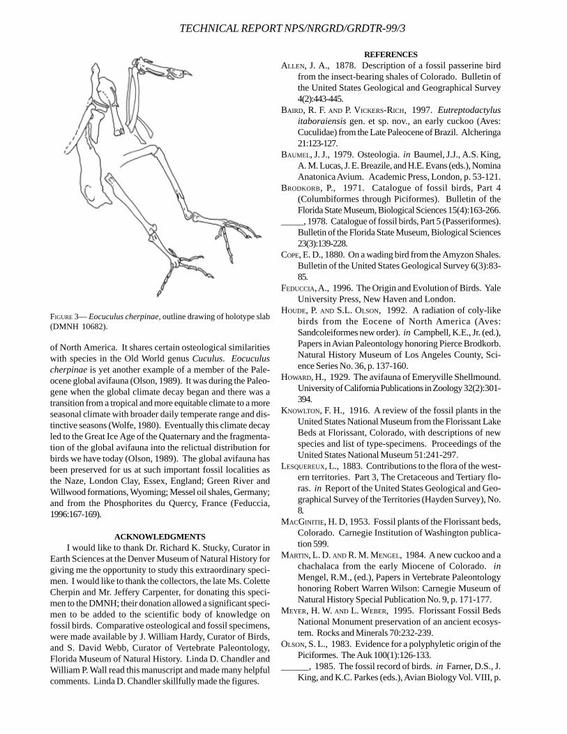
TECHNICAL REPORT NPS/NRGRD/GRDTR-99/3
of North America. It shares certain osteological similaritieswith species in the Old World genus Cuculus. Eocuculuscherpinae is yet another example of a member of the Pale-ocene global avifauna (Olson, 1989). It was during the Paleo-gene when the global climate decay began and there was atransition from a tropical and more equitable climate to a moreseasonal climate with broader daily temperate range and dis-tinctive seasons (Wolfe, 1980). Eventually this climate decayled to the Great Ice Age of the Quaternary and the fragmenta-tion of the global avifauna into the relictual distribution forbirds we have today (Olson, 1989). The global avifauna hasbeen preserved for us at such important fossil localities asthe Naze, London Clay, Essex, England; Green River andWillwood formations, Wyoming; Messel oil shales, Germany;and from the Phosphorites du Quercy, France (Feduccia,1996:167-169).
ACKNOWLEDGMENTSI would like to thank Dr. Richard K. Stucky, Curator in
Earth Sciences at the Denver Museum of Natural History forgiving me the opportunity to study this extraordinary speci-men. I would like to thank the collectors, the late Ms. ColetteCherpin and Mr. Jeffery Carpenter, for donating this speci-men to the DMNH; their donation allowed a significant speci-men to be added to the scientific body of knowledge onfossil birds. Comparative osteological and fossil specimens,were made available by J. William Hardy, Curator of Birds,and S. David Webb, Curator of Vertebrate Paleontology,Florida Museum of Natural History. Linda D. Chandler andWilliam P. Wall read this manuscript and made many helpfulcomments. Linda D. Chandler skillfully made the figures.
REFERENCESALLEN, J. A., 1878. Description of a fossil passerine bird
from the insect-bearing shales of Colorado. Bulletin ofthe United States Geological and Geographical Survey4(2):443-445.
BAIRD, R. F. AND P. VICKERS-RICH, 1997. Eutreptodactylusitaboraiensis gen. et sp. nov., an early cuckoo (Aves:Cuculidae) from the Late Paleocene of Brazil. Alcheringa21:123-127.
BAUMEL, J. J., 1979. Osteologia. in Baumel, J.J., A.S. King,A. M. Lucas, J. E. Breazile, and H.E. Evans (eds.), NominaAnatonica Avium. Academic Press, London, p. 53-121.
BRODKORB, P., 1971. Catalogue of fossil birds, Part 4(Columbiformes through Piciformes). Bulletin of theFlorida State Museum, Biological Sciences 15(4):163-266.
_____, 1978. Catalogue of fossil birds, Part 5 (Passeriformes).Bulletin of the Florida State Museum, Biological Sciences23(3):139-228.
COPE, E. D., 1880. On a wading bird from the Amyzon Shales.Bulletin of the United States Geological Survey 6(3):83-85.
FEDUCCIA, A., 1996. The Origin and Evolution of Birds. YaleUniversity Press, New Haven and London.
HOUDE, P. AND S.L. OLSON, 1992. A radiation of coly-likebirds from the Eocene of North America (Aves:Sandcoleiformes new order). in Campbell, K.E., Jr. (ed.),Papers in Avian Paleontology honoring Pierce Brodkorb.Natural History Museum of Los Angeles County, Sci-ence Series No. 36, p. 137-160.
HOWARD, H., 1929. The avifauna of Emeryville Shellmound.University of California Publications in Zoology 32(2):301-394.
KNOWLTON, F. H., 1916. A review of the fossil plants in theUnited States National Museum from the Florissant LakeBeds at Florissant, Colorado, with descriptions of newspecies and list of type-specimens. Proceedings of theUnited States National Museum 51:241-297.
LESQUEREUX, L., 1883. Contributions to the flora of the west-ern territories. Part 3, The Cretaceous and Tertiary flo-ras. in Report of the United States Geological and Geo-graphical Survey of the Territories (Hayden Survey), No.8.
MACGINITIE, H. D, 1953. Fossil plants of the Florissant beds,Colorado. Carnegie Institution of Washington publica-tion 599.
MARTIN, L. D. AND R. M. MENGEL, 1984. A new cuckoo and achachalaca from the early Miocene of Colorado. inMengel, R.M., (ed.), Papers in Vertebrate Paleontologyhonoring Robert Warren Wilson: Carnegie Museum ofNatural History Special Publication No. 9, p. 171-177.
MEYER, H. W. AND L. WEBER, 1995. Florissant Fossil BedsNational Monument preservation of an ancient ecosys-tem. Rocks and Minerals 70:232-239.
OLSON, S. L., 1983. Evidence for a polyphyletic origin of thePiciformes. The Auk 100(1):126-133.
______, 1985. The fossil record of birds. in Farner, D.S., J.King, and K.C. Parkes (eds.), Avian Biology Vol. VIII, p.
FIGURE 3— Eocuculus cherpinae, outline drawing of holotype slab(DMNH 10682).

76-252.______, 1989. Aspects of Global Avifaunal Dynamics dur-
ing the Cenozoic. in Ouellet, H., (ed.), “1988” Acta XIXCongressus Internationalis Ornithologici, vol. 2. Ottawa,p. 2023-2029.
______, 1992. A new family of primitive landbirds from theLower Eocene Green River Formation of Wyoming. inCampbell, K.E., Jr., (ed.), Papers in Avian Paleontologyhonoring Pierce Brodkorb. Natural History Museum ofLos Angeles County, Science Series No. 36, p. 127-136 .
WEIGEL, R. D., 1963. Oligocene birds from Saskatchewan.Quarterly Journal of the Florida Academy of Science26(3):257-262.
WETMORE, A., 1925. The systematic position of Palaeospizabella Allen, with observations on other fossil birds.Bulletin. Museum of Comparative Zoology 67(2):183-193.
WOLFE, J. A., 1980. Tertiary climates and floristic relation-ships at high latitudes in the Northern Hemisphere.Palaeogeog., Palaeoclim., Palaeoecol. 30:313-323.
CHANDLER—FLFO, FOSSIL BIRDS
TECHNICAL REPORT NPS/NRGRD/GRDTR-99/3
PALEOECOLOGY AND PALEOENVIRONMENTS DURING THE INITIAL STAGES
OF EOCENE FOSSIL LAKE, SW WYOMING
ROBERTO E. BIAGGI1,2 AND H. PAUL BUCHHEIM1
1Geology Section, Department of Natural Sciences, Loma Linda University, Loma Linda, CA 923502Ciencias Naturales – UAP, Libertador San Martin, Entre Ríos 03103, Argentina
____________________
ABSTRACT—Initial development of Fossil Lake resulted from ponding of freshwater in the southern half of Fossil Basin.Detailed stratigraphic analysis of the lower unit of the Fossil Butte Member (Green River Formation) revealed a well-developedlacustrine sequence south of Fossil Butte, and indicates four major depositional facies: (1) open lacustrine, (2) marginallacustrine, (3) carbonate mudflat, and (4) marginal fluvio-deltaic. The open lacustrine facies is characterized by kerogen-rich tokerogen-poor finely laminated micrites that consist of calcite and very little dolomite. These carbonates contain well- preservedfossil fish, ostracods, mollusks and amorphous kerogen (produced mainly by algae). These rocks grade laterally into bioturbatedmicrites, and ostracodal and gastropodal limestones. Nearshore carbonates consist mostly of calcite and are typically wellbioturbated. Common fossils include mollusks and ostracods. In some localized areas limestones can be oolitic, contain sometypical nearshore plant remains and occasionally lag deposits of vertebrate bones. The carbonate mudflat facies is mainlyrestricted to the eastern margin where sediments were subaerially exposed and conditions favored precipitation of dolomite asindicated by several dolomitic units with mudcracks. Sheet-wash events along the margins during lowstands ripped upcarbonates on the mudflats and redeposited them over scoured surfaces. Although fluvial events occurred throughout the lifeof the lake, towards the end of lower unit time fluvial activity increased. At this time a Gilbert-type delta developed from thesouthwest, prograded into the lake, virtually filled the whole lake, and culminated lower unit deposition.
____________________
INTRODUCTION
The Green River Formation of southwestern Wyoming,northwestern Colorado, and northeastern Utah wasdeposited in a system of three lakes that existed in
intermontane basins during the Early and Middle Eocene(Bradley, 1963). Fossil Lake, the smallest, and adjacent to themuch larger Lake Gosiute (Greater Green River Basin), occu-pied the Fossil Syncline, now called Fossil Basin (Figure 1).Fossil Butte National Monument is near the geographicalcenter of Fossil Basin.
Sediments and fossils of the lower unit (informal termcoined by Buchheim, 1994a) of the Fossil Butte Member,Green River Formation, were studied to reconstruct the pa-leogeography and paleoenvironments of a sedimentary ba-sin that records a complete sequence of lacustrine facies andcontains an abundant fossil fauna and flora, as well as thehistory of the initial stages of Fossil Lake.
This study is significant because the lower unit is prob-ably the least studied and least understood of the FossilButte Member units. Its nature, extent and total thicknesswere not known until this study. Because the entire deposi-tional sequence occurs in a comparatively small area (1,500km2, versus 17,000 km2 in the adjacent Green River Basin) adetailed basin analysis is possible in relatively short dis-tances and stratigraphic thicknesses.
PREVIOUS WORK Pioneering studies in Fossil Basin started in the mid-
1800s. Under the auspices of the U. S. Department of theInterior, Geological and Geographical Survey of the Territo-ries, several workers produced extensive reports, includingthe first geological and paleontological descriptions fromFossil Basin.
The structure and geology of Fossil Basin were mappedin the early 1900s, whereas the geologic units were formallydescribed by Oriel and Tracey (1970) who subdivided theGreen River Formation in the basin into the Fossil Butte andAngelo members. Other mapping and geology were done byRubey et al. (1975), Vietti (1977) and M’Gonigle and Dover(1992). Buchheim (personal communication) informally sub-divided the Fossil Butte Member into the lower, middle andupper units, and recognized that the lower unit thickenedconsiderably in the southern half of the basin. This led Biaggi(1989) to his documentation of an early previously unknownlacustrine phase. Petersen (1987) described the occurrenceand geologic history of a “Gilbert-type” delta system in thesandstone tongue of the Wasatch Formation, especiallyprominent in the southern half of Fossil Basin. Buchheim(1994a, b) discussed the lithofacies, paleoenvironments andthe history of saline fluctuations, and proposed a detaileddepositional model for the Fossil Butte Member. Buchheim
54
and Biaggi (1988) in their study of a time-synchronous unit atthe base of the middle unit discovered significant variation inthe number, thickness and organic content of laminae withinthe bed and questioned the varve interpretation for that ho-rizon. Trivino (1996) studied the mineralogy and isotopiccomposition of the laminae of this bed and concluded thatthe deposition of these lamina were primarily a result of fresh-water inflow events. Loewen and Buchheim (1997) describedfresh-water to saline transitions in the later stages of FossilLake.
McGrew (1975), McGrew and Casilliano (1975), Buchheim(1986), Elder and Smith (1988), Grande and Buchheim (1994)and Ferber and Wells (1995) discuss aspects of the paleo-ecology and taphonomy of the fossil fishes. Grande (1984)provided a rather complete catalogue and description of thefossils of the basin as well as other Green River Formationbasins in Wyoming, Colorado, and Utah. Leggitt (1996) andLeggitt and Buchheim (1997) described fossil bird mass mor-tality beds both in the Angelo and Fossil Butte members.Cushman (1983) interpreted the palynoflora of the Fossil Buttemember in his study of the depositional environments, pa-
leoecology and paleoclimatology of these sediments in Fos-sil Basin. For a comprehensive bibliography of the geologyof the Green River Formation in the region see Smith (1990).
This study proposes to complement these investiga-tions and provide a more complete picture of the deposi-tional environments and paleoecology of the lower unit ofthe Fossil Butte Member, which contains a well-preservedfauna and flora. The lower unit represents a lake that existedearlier, and had a depocenter further to the south, than themain body of the Green River Formation sediments in FossilBasin.
GEOLOGIC STRUCTUREPonded basins (e.g., Green River Basin and others, Fig-
ure 1) in the core of the Laramide province occur adjacent tothe overthrust belt and formed large freshwater and salinelakes that became regional sediment traps (Dickinson et al.,1988). Within the overthrust belt itself, Fossil Basin is asmall, linear and structurally controlled basin.
Fossil Basin was formed during the Late Cretaceous-Early Tertiary on the hanging wall of the Absaroka thrust
FIGURE 1—Maps showing the location of Fossil Basin within the overthrust belt of southwestern Wyoming, the study localities, andlocation of other ponded basins in the foreland province. Important structural features are indicated. Study location abbreviations: AR,Angelo Ranch; BD, Bear Divide; CC, Clear Creek; CaC, Carter Creek; ChC, Chicken Creek; FB, Fossil Butte; FR, Fossil Ridge; HC, HillCreek; LMC, Little Muddy Creek; MC, Muddy Creek; ShC, Sheep Creek; S/LMC, Sheep/Little Muddy Creek; WC, Warfield Creek(After Lamerson, 1982 and Dickinson et.al., 1988).
BIAGGI AND BUCHHEIM—FOBU, PALEOECOLOGY FOSSIL LAKE
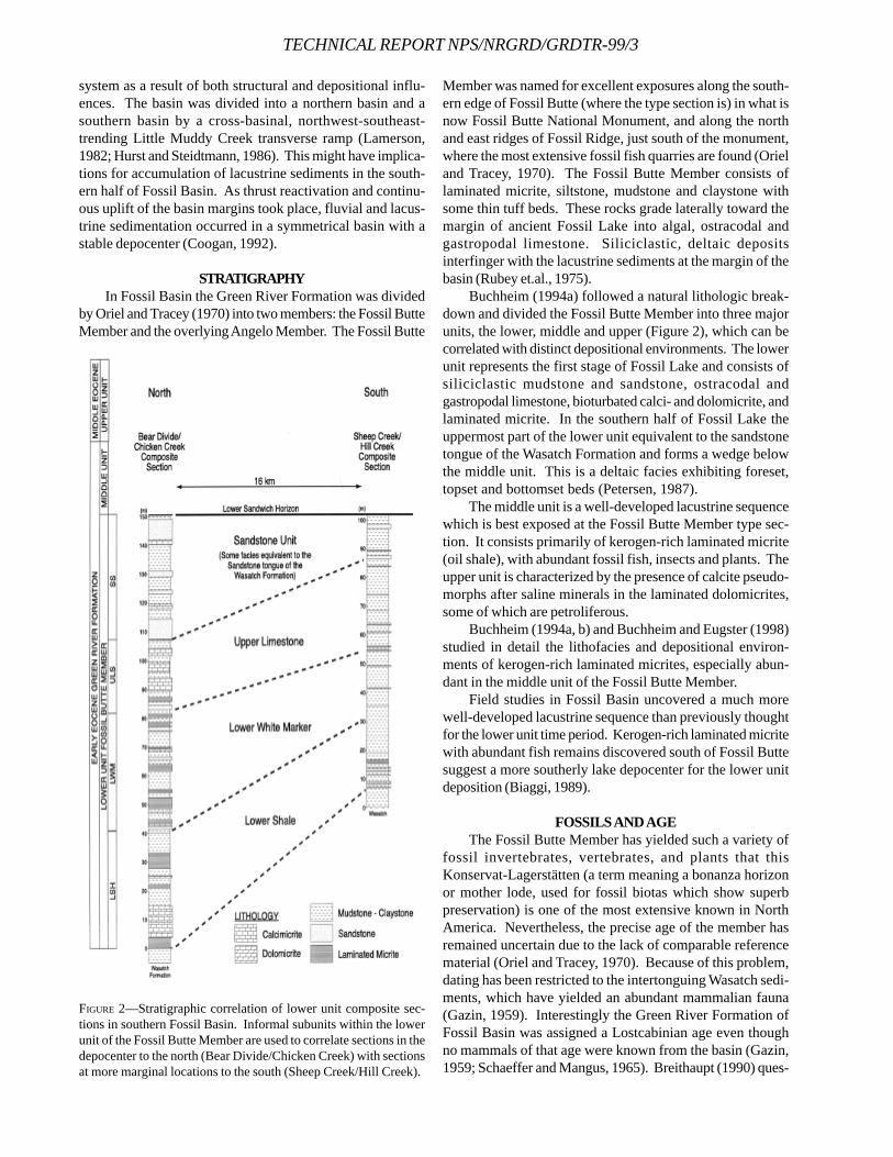
TECHNICAL REPORT NPS/NRGRD/GRDTR-99/3
system as a result of both structural and depositional influ-ences. The basin was divided into a northern basin and asouthern basin by a cross-basinal, northwest-southeast-trending Little Muddy Creek transverse ramp (Lamerson,1982; Hurst and Steidtmann, 1986). This might have implica-tions for accumulation of lacustrine sediments in the south-ern half of Fossil Basin. As thrust reactivation and continu-ous uplift of the basin margins took place, fluvial and lacus-trine sedimentation occurred in a symmetrical basin with astable depocenter (Coogan, 1992).
STRATIGRAPHYIn Fossil Basin the Green River Formation was divided
by Oriel and Tracey (1970) into two members: the Fossil ButteMember and the overlying Angelo Member. The Fossil Butte
Member was named for excellent exposures along the south-ern edge of Fossil Butte (where the type section is) in what isnow Fossil Butte National Monument, and along the northand east ridges of Fossil Ridge, just south of the monument,where the most extensive fossil fish quarries are found (Orieland Tracey, 1970). The Fossil Butte Member consists oflaminated micrite, siltstone, mudstone and claystone withsome thin tuff beds. These rocks grade laterally toward themargin of ancient Fossil Lake into algal, ostracodal andgastropodal limestone. Siliciclastic, deltaic depositsinterfinger with the lacustrine sediments at the margin of thebasin (Rubey et.al., 1975).
Buchheim (1994a) followed a natural lithologic break-down and divided the Fossil Butte Member into three majorunits, the lower, middle and upper (Figure 2), which can becorrelated with distinct depositional environments. The lowerunit represents the first stage of Fossil Lake and consists ofsiliciclastic mudstone and sandstone, ostracodal andgastropodal limestone, bioturbated calci- and dolomicrite, andlaminated micrite. In the southern half of Fossil Lake theuppermost part of the lower unit equivalent to the sandstonetongue of the Wasatch Formation and forms a wedge belowthe middle unit. This is a deltaic facies exhibiting foreset,topset and bottomset beds (Petersen, 1987).
The middle unit is a well-developed lacustrine sequencewhich is best exposed at the Fossil Butte Member type sec-tion. It consists primarily of kerogen-rich laminated micrite(oil shale), with abundant fossil fish, insects and plants. Theupper unit is characterized by the presence of calcite pseudo-morphs after saline minerals in the laminated dolomicrites,some of which are petroliferous.
Buchheim (1994a, b) and Buchheim and Eugster (1998)studied in detail the lithofacies and depositional environ-ments of kerogen-rich laminated micrites, especially abun-dant in the middle unit of the Fossil Butte Member.
Field studies in Fossil Basin uncovered a much morewell-developed lacustrine sequence than previously thoughtfor the lower unit time period. Kerogen-rich laminated micritewith abundant fish remains discovered south of Fossil Buttesuggest a more southerly lake depocenter for the lower unitdeposition (Biaggi, 1989).
FOSSILS AND AGEThe Fossil Butte Member has yielded such a variety of
fossil invertebrates, vertebrates, and plants that thisKonservat-Lagerstätten (a term meaning a bonanza horizonor mother lode, used for fossil biotas which show superbpreservation) is one of the most extensive known in NorthAmerica. Nevertheless, the precise age of the member hasremained uncertain due to the lack of comparable referencematerial (Oriel and Tracey, 1970). Because of this problem,dating has been restricted to the intertonguing Wasatch sedi-ments, which have yielded an abundant mammalian fauna(Gazin, 1959). Interestingly the Green River Formation ofFossil Basin was assigned a Lostcabinian age even thoughno mammals of that age were known from the basin (Gazin,1959; Schaeffer and Mangus, 1965). Breithaupt (1990) ques-
FIGURE 2—Stratigraphic correlation of lower unit composite sec-tions in southern Fossil Basin. Informal subunits within the lowerunit of the Fossil Butte Member are used to correlate sections in thedepocenter to the north (Bear Divide/Chicken Creek) with sectionsat more marginal locations to the south (Sheep Creek/Hill Creek).
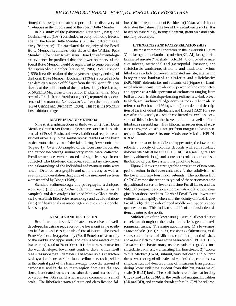
tioned this assignment after reports of the discovery ofOrohippus in the middle unit of the Fossil Butte Member.
In his study of the palynoflora Cushman (1983) andCushman et al. (1984) concluded an early to middle Eoceneage for the Fossil Butte Member (i.e., late Lostcabinian toearly Bridgerian). He correlated the majority of the FossilButte Member sediments with those of the Wilkins PeakMember in the Green River Basin. Based on sedimentologi-cal evidence he predicted that the lower boundary of theFossil Butte Member would be equivalent to some portion ofthe Tipton Shale Member (Cushman, 1983). See Cushman(1998) for a discussion of the palynostratigraphy and age ofthe Fossil Butte Member. Buchheim (1994a) reported a K-Arage date on a sample of feldspar from the “K-spar tuff” nearthe top of the middle unit of the member, that yielded an ageof 50.2±1.9 Ma, close to the start of Bridgerian time. Morerecently Froelich and Breithaupt (1997) reported the occur-rence of the mammal Lambdotherium from the middle unit(F2 of Grande and Buchheim, 1994). This fossil is typicallyLostcabinian in age.
MATERIALS AND METHODSNine stratigraphic sections of the lower unit (Fossil Butte
Member, Green River Formation) were measured in the south-ern half of Fossil Basin, and several additional sections werestudied especially in the southernmost reaches of the basinto determine the extent of the lake during lower unit time(Figure 1). Over 200 samples of the lacustrine carbonatesand carbonate-bearing sedimentary rocks were collected.Fossil occurrences were recorded and significant specimenscollected. The lithologic character, sedimentary structures,and paleontology of the individual sedimentary units werenoted. Detailed stratigraphic and sample data, as well asstratigraphic correlation diagrams of the measured sectionswere recorded by Biaggi (1989).
Standard sedimentologic and petrographic techniqueswere used (including X-Ray diffraction analysis on 51samples), and data analysis included Markov Chain Analy-sis (to establish lithofacies assemblage and cyclic relation-ships) and basin analysis mapping techniques (i.e., isopachs,facies maps).
RESULTS AND DISCUSSIONResults from this study indicate an extensive and well-
developed lacustrine sequence for the lower unit in the south-ern half of Fossil Basin, south of Fossil Butte. The FossilButte Member at its type locality (Fossil Butte) consists mainlyof the middle and upper units and only a few meters of thelower unit (a total of 70 to 90m). It is not representative forthe well-developed lower unit south of there, which itselfmeasures more than 120 meters. The lower unit is character-ized by a dominance of siliciclastic sedimentary rocks, whichin the central part of the basin average twice the amount ofcarbonates and in the southern region dominate the sec-tions. Laminated rocks are less abundant, and interbeddingof carbonates with siliciclastics is more common on a smallscale. The lithofacies nomenclature and classification fol-
lowed in this report is that of Buchheim (1994a), which betterdescribes the nature of the Fossil Basin carbonate rocks. It isbased on mineralogy, kerogen content, grain size and sedi-mentary structures.
LITHOFACIES AND FACIES RELATIONSHIPS The most common lithofacies in the lower unit (Figure
3) are kerogen-poor laminated micrite (KPLM), kerogen-richlaminated micrite (“oil shale”, KRLM), bioturbated or mas-sive micrite, ostracodal and gastropodal limestone, andsiliciclastic sandstone, siltstone and mudstone. Minorlithofacies include burrowed laminated micrite, alternatingkerogen-poor laminated calcimicrite and siliciclastics(KPLMSil), dolomicrite, and volcanic tuff (Figure 3). Lami-nated micrites constitute about 50 percent of the carbonates,and appear as a wide spectrum of carbonates ranging frombuff to brown, friable slope-forming sediments to dark brownto black, well-indurated ledge-forming rocks. The reader isreferred to Buchheim (1994a, table 1) for a detailed descrip-tion of the individual lithofacies, and Biaggi (1989) for a se-ries of Markov analyses, which confirmed the cyclic succes-sion of lithofacies in the lower unit into a well-definedlithofacies assemblage. This lithofacies succession, a lacus-trine transgressive sequence (or from margin to basin cen-ter), is Sandstone-Siltstone-Mudstone-Micrite-KPLM-KRLM.
In contrast to the middle and upper units, the lower unitreflects a paucity of dolomite deposits with some isolateddolomicrite beds at localities CC, ChC, BD (see Figure 1 forlocality abbreviations), and some ostracodal dolomicrites atthe AR locality in the eastern margin of the basin.
Figure 2 shows the stratigraphic correlation of two com-posite sections in the lower unit, and a further subdivision ofthe lower unit into four major subunits. The northern BD/ChC/CC composite section is typical of the sections near thedepositional center of lower unit time Fossil Lake, and theShC/HC composite section is representative of the more mar-ginal/nearshore localities. North of Fossil Butte, lower unitsediments thin rapidly, whereas in the vicinity of Fossil Butte-Fossil Ridge the best-developed middle and upper unit se-quences occur. This indicates a shift of the basin deposi-tional center to the north.
Subdivision of the lower unit (Figure 2) allowed bettercorrelation throughout the basin, and reflects general envi-ronmental trends. The major subunits are: 1) a lowermost“Lower Shale”(LSH) subunit, consisting of alternating mud-stone, calcimicrite and siliceous calcimicrite, and oil shaleand organic rich mudstone at the basin center (ChC, RH, CC).Towards the basin margins this subunit grades intosiliciclastics with a few alternating thin limestones. 2) “LowerWhite Marker”(LWM) subunit, very noticeable in outcropdue to weathering of oil shale and calcimicrite, contains fewsiliciclastics, and denotes a time of maximum transgressionduring lower unit time evident from thin but extensive oilshale (KRLM) beds. These oil shales are thickest at localityCC, extend as far as ShC in the south and marginal localities(AR and BD), and contain abundant fossils. 3) “Upper Lime-
BIAGGI AND BUCHHEIM—FOBU, PALEOECOLOGY FOSSIL LAKE

TECHNICAL REPORT NPS/NRGRD/GRDTR-99/3
FIGURE 3—Lithofacies of the lower unit. 1-2. Kerogen-rich laminated micrite (KRLM), CC-07. Dark kerogen laminae (klm) alternate withlighter calcite laminae (clm). 1, small divisions on scale - 1mm; 2, scale bar = 0.1mm. 3. Kerogen-poor laminated micrite (KPLM), fromChC-14. 4. Peculiar type of quartz-rich kerogen-poor laminated micrite (KPLMSil) showing siliceous (sil) alternating laminae, from FB-46. 5. Bioturbated micrite showing burrows (b), from HC-22. 6. Bioturbated kerogen-poor laminated micrite showing disrupted kerogen(klm) and calcite (clm) laminae, from ChC-87; scale bar = 0.5mm. 7. Analcimic tuff from CC-04. 8. Abundant ostracods (os) one mm inlength dominate this ostracodal limestone, S/LMC-40.
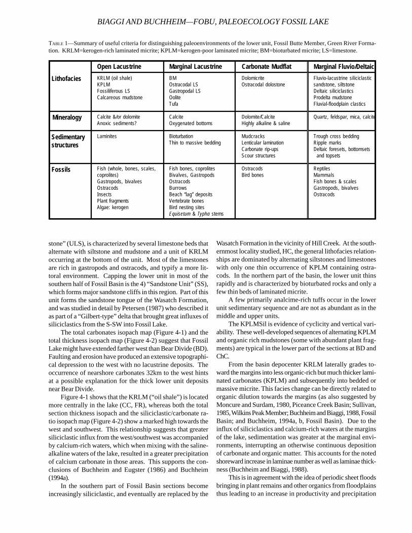
stone” (ULS), is characterized by several limestone beds thatalternate with siltstone and mudstone and a unit of KRLMoccurring at the bottom of the unit. Most of the limestonesare rich in gastropods and ostracods, and typify a more lit-toral environment. Capping the lower unit in most of thesouthern half of Fossil Basin is the 4) “Sandstone Unit” (SS),which forms major sandstone cliffs in this region. Part of thisunit forms the sandstone tongue of the Wasatch Formation,and was studied in detail by Petersen (1987) who described itas part of a “Gilbert-type” delta that brought great influxes ofsiliciclastics from the S-SW into Fossil Lake.
The total carbonates isopach map (Figure 4-1) and thetotal thickness isopach map (Figure 4-2) suggest that FossilLake might have extended farther west than Bear Divide (BD).Faulting and erosion have produced an extensive topographi-cal depression to the west with no lacustrine deposits. Theoccurrence of nearshore carbonates 32km to the west hintsat a possible explanation for the thick lower unit depositsnear Bear Divide.
Figure 4-1 shows that the KRLM (“oil shale”) is locatedmore centrally in the lake (CC, FR), whereas both the totalsection thickness isopach and the siliciclastic/carbonate ra-tio isopach map (Figure 4-2) show a marked high towards thewest and southwest. This relationship suggests that greatersiliciclastic influx from the west/southwest was accompaniedby calcium-rich waters, which when mixing with the saline-alkaline waters of the lake, resulted in a greater precipitationof calcium carbonate in those areas. This supports the con-clusions of Buchheim and Eugster (1986) and Buchheim(1994a).
In the southern part of Fossil Basin sections becomeincreasingly siliciclastic, and eventually are replaced by the
BIAGGI AND BUCHHEIM—FOBU, PALEOECOLOGY FOSSIL LAKE
Wasatch Formation in the vicinity of Hill Creek. At the south-ernmost locality studied, HC, the general lithofacies relation-ships are dominated by alternating siltstones and limestoneswith only one thin occurrence of KPLM containing ostra-cods. In the northern part of the basin, the lower unit thinsrapidly and is characterized by bioturbated rocks and only afew thin beds of laminated micrite.
A few primarily analcime-rich tuffs occur in the lowerunit sedimentary sequence and are not as abundant as in themiddle and upper units.
The KPLMSil is evidence of cyclicity and vertical vari-ability. These well-developed sequences of alternating KPLMand organic rich mudstones (some with abundant plant frag-ments) are typical in the lower part of the sections at BD andChC.
From the basin depocenter KRLM laterally grades to-ward the margins into less organic-rich but much thicker lami-nated carbonates (KPLM) and subsequently into bedded ormassive micrite. This facies change can be directly related toorganic dilution towards the margins (as also suggested byMoncure and Surdam, 1980, Piceance Creek Basin; Sullivan,1985, Wilkins Peak Member; Buchheim and Biaggi, 1988, FossilBasin; and Buchheim, 1994a, b, Fossil Basin). Due to theinflux of siliciclastics and calcium-rich waters at the marginsof the lake, sedimentation was greater at the marginal envi-ronments, interrupting an otherwise continuous depositionof carbonate and organic matter. This accounts for the notedshoreward increase in laminae number as well as laminae thick-ness (Buchheim and Biaggi, 1988).
This is in agreement with the idea of periodic sheet floodsbringing in plant remains and other organics from floodplainsthus leading to an increase in productivity and precipitation
Lithofacies
Mineralogy
Sedimentarystructures
Fossils
Open Lacustrine Marginal Lacustrine Carbonate Mudflat Marginal Fluvio/DeltaicFluvio-lacustrine siliciclasticsandstone, siltstoneDeltaic siliciclasticsProdelta mudstoneFluvial-floodplain clastics
Quartz, feldspar, mica, calcite
Trough cross beddingRipple marksDeltaic foresets, bottomsets
and topsets
ReptilesMammalsFish bones & scalesGastropods, bivalvesOstracods
DolomicriteOstracodal dolostone
Dolomite/CalciteHighly alkaline & saline
MudcracksLenticular laminationCarbonate rip-upsScour structures
OstracodsBird bones
BMOstracodal LSGastropodal LSOoliteTufa
CalciteOxygenated bottoms
BioturbationThin to massive bedding
Fish bones, coprolitesBivalves, GastropodsOstracodsBurrowsBeach “lag” depositsVertebrate bonesBird nesting sitesEquisetum & Typha stems
KRLM (oil shale)KPLMFossiliferous LSCalcareous mudstone
Calcite &/or dolomiteAnoxic sediments?
Laminites
Fish (whole, bones, scales,coprolites)Gastropods, bivalvesOstracodsInsectsPlant fragmentsAlgae: kerogen
TABLE 1—Summary of useful criteria for distinguishing paleoenvironments of the lower unit, Fossil Butte Member, Green River Forma-tion. KRLM=kerogen-rich laminated micrite; KPLM=kerogen-poor laminated micrite; BM=bioturbated micrite; LS=limestone.
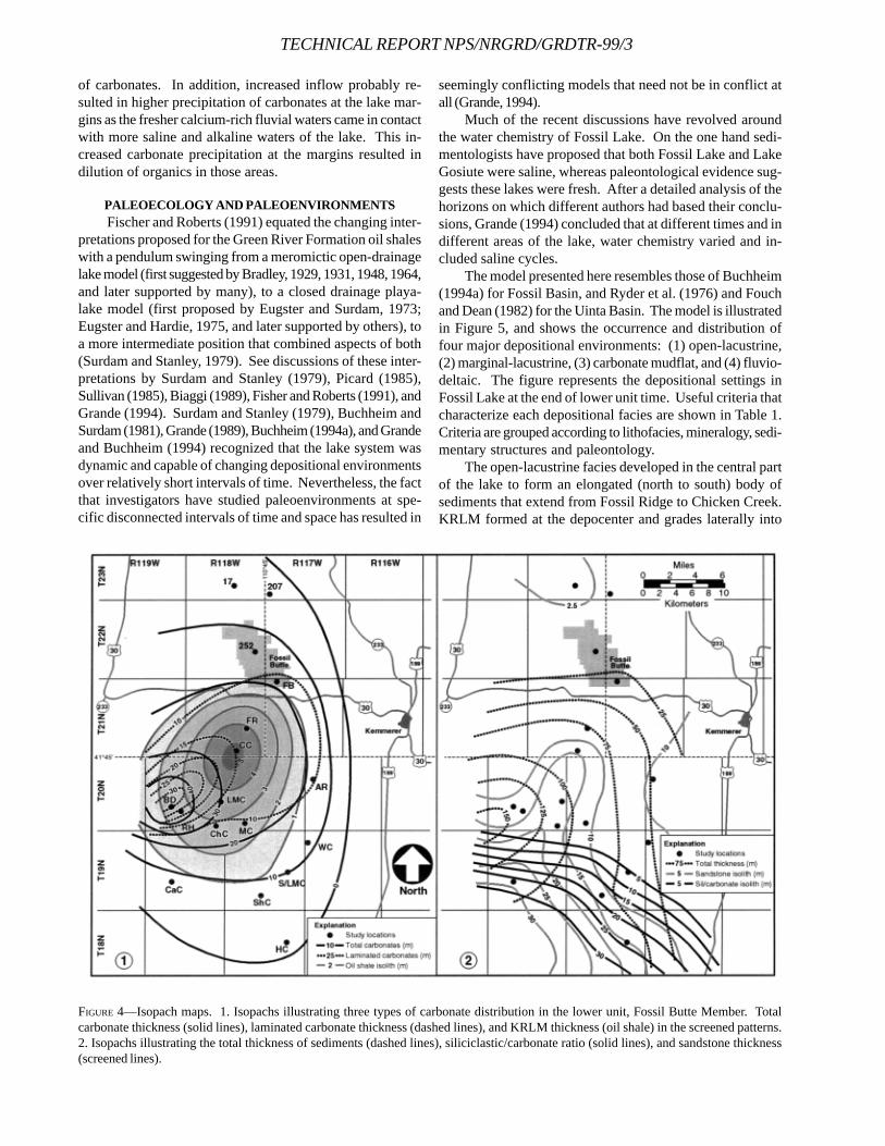
TECHNICAL REPORT NPS/NRGRD/GRDTR-99/3
of carbonates. In addition, increased inflow probably re-sulted in higher precipitation of carbonates at the lake mar-gins as the fresher calcium-rich fluvial waters came in contactwith more saline and alkaline waters of the lake. This in-creased carbonate precipitation at the margins resulted indilution of organics in those areas.
PALEOECOLOGY AND PALEOENVIRONMENTS Fischer and Roberts (1991) equated the changing inter-
pretations proposed for the Green River Formation oil shaleswith a pendulum swinging from a meromictic open-drainagelake model (first suggested by Bradley, 1929, 1931, 1948, 1964,and later supported by many), to a closed drainage playa-lake model (first proposed by Eugster and Surdam, 1973;Eugster and Hardie, 1975, and later supported by others), toa more intermediate position that combined aspects of both(Surdam and Stanley, 1979). See discussions of these inter-pretations by Surdam and Stanley (1979), Picard (1985),Sullivan (1985), Biaggi (1989), Fisher and Roberts (1991), andGrande (1994). Surdam and Stanley (1979), Buchheim andSurdam (1981), Grande (1989), Buchheim (1994a), and Grandeand Buchheim (1994) recognized that the lake system wasdynamic and capable of changing depositional environmentsover relatively short intervals of time. Nevertheless, the factthat investigators have studied paleoenvironments at spe-cific disconnected intervals of time and space has resulted in
seemingly conflicting models that need not be in conflict atall (Grande, 1994).
Much of the recent discussions have revolved aroundthe water chemistry of Fossil Lake. On the one hand sedi-mentologists have proposed that both Fossil Lake and LakeGosiute were saline, whereas paleontological evidence sug-gests these lakes were fresh. After a detailed analysis of thehorizons on which different authors had based their conclu-sions, Grande (1994) concluded that at different times and indifferent areas of the lake, water chemistry varied and in-cluded saline cycles.
The model presented here resembles those of Buchheim(1994a) for Fossil Basin, and Ryder et al. (1976) and Fouchand Dean (1982) for the Uinta Basin. The model is illustratedin Figure 5, and shows the occurrence and distribution offour major depositional environments: (1) open-lacustrine,(2) marginal-lacustrine, (3) carbonate mudflat, and (4) fluvio-deltaic. The figure represents the depositional settings inFossil Lake at the end of lower unit time. Useful criteria thatcharacterize each depositional facies are shown in Table 1.Criteria are grouped according to lithofacies, mineralogy, sedi-mentary structures and paleontology.
The open-lacustrine facies developed in the central partof the lake to form an elongated (north to south) body ofsediments that extend from Fossil Ridge to Chicken Creek.KRLM formed at the depocenter and grades laterally into
FIGURE 4—Isopach maps. 1. Isopachs illustrating three types of carbonate distribution in the lower unit, Fossil Butte Member. Totalcarbonate thickness (solid lines), laminated carbonate thickness (dashed lines), and KRLM thickness (oil shale) in the screened patterns.2. Isopachs illustrating the total thickness of sediments (dashed lines), siliciclastic/carbonate ratio (solid lines), and sandstone thickness(screened lines).
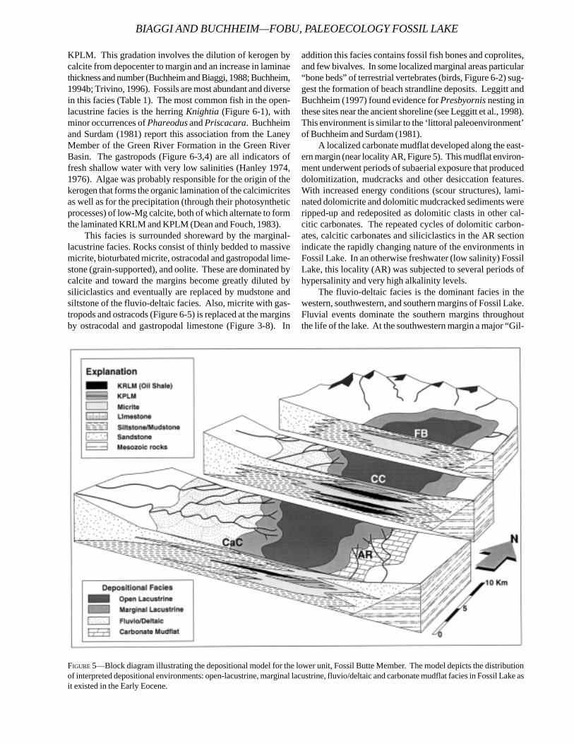
BIAGGI AND BUCHHEIM—FOBU, PALEOECOLOGY FOSSIL LAKE
KPLM. This gradation involves the dilution of kerogen bycalcite from depocenter to margin and an increase in laminaethickness and number (Buchheim and Biaggi, 1988; Buchheim,1994b; Trivino, 1996). Fossils are most abundant and diversein this facies (Table 1). The most common fish in the open-lacustrine facies is the herring Knightia (Figure 6-1), withminor occurrences of Phareodus and Priscacara. Buchheimand Surdam (1981) report this association from the LaneyMember of the Green River Formation in the Green RiverBasin. The gastropods (Figure 6-3,4) are all indicators offresh shallow water with very low salinities (Hanley 1974,1976). Algae was probably responsible for the origin of thekerogen that forms the organic lamination of the calcimicritesas well as for the precipitation (through their photosyntheticprocesses) of low-Mg calcite, both of which alternate to formthe laminated KRLM and KPLM (Dean and Fouch, 1983).
This facies is surrounded shoreward by the marginal-lacustrine facies. Rocks consist of thinly bedded to massivemicrite, bioturbated micrite, ostracodal and gastropodal lime-stone (grain-supported), and oolite. These are dominated bycalcite and toward the margins become greatly diluted bysiliciclastics and eventually are replaced by mudstone andsiltstone of the fluvio-deltaic facies. Also, micrite with gas-tropods and ostracods (Figure 6-5) is replaced at the marginsby ostracodal and gastropodal limestone (Figure 3-8). In
addition this facies contains fossil fish bones and coprolites,and few bivalves. In some localized marginal areas particular“bone beds” of terrestrial vertebrates (birds, Figure 6-2) sug-gest the formation of beach strandline deposits. Leggitt andBuchheim (1997) found evidence for Presbyornis nesting inthese sites near the ancient shoreline (see Leggitt et al., 1998).This environment is similar to the ‘littoral paleoenvironment’of Buchheim and Surdam (1981).
A localized carbonate mudflat developed along the east-ern margin (near locality AR, Figure 5). This mudflat environ-ment underwent periods of subaerial exposure that produceddolomitization, mudcracks and other desiccation features.With increased energy conditions (scour structures), lami-nated dolomicrite and dolomitic mudcracked sediments wereripped-up and redeposited as dolomitic clasts in other cal-citic carbonates. The repeated cycles of dolomitic carbon-ates, calcitic carbonates and siliciclastics in the AR sectionindicate the rapidly changing nature of the environments inFossil Lake. In an otherwise freshwater (low salinity) FossilLake, this locality (AR) was subjected to several periods ofhypersalinity and very high alkalinity levels.
The fluvio-deltaic facies is the dominant facies in thewestern, southwestern, and southern margins of Fossil Lake.Fluvial events dominate the southern margins throughoutthe life of the lake. At the southwestern margin a major “Gil-
FIGURE 5—Block diagram illustrating the depositional model for the lower unit, Fossil Butte Member. The model depicts the distributionof interpreted depositional environments: open-lacustrine, marginal lacustrine, fluvio/deltaic and carbonate mudflat facies in Fossil Lake asit existed in the Early Eocene.

TECHNICAL REPORT NPS/NRGRD/GRDTR-99/3
FIGURE 6—Fossils of the lower unit. 1. Knightia (herring). 2. Vertebrate bones (possibly Presbyornis), ShC. 3. Gastropods from CC andShC include Omalodiscus (o) and more common Physa. 4. Juvenile gastropods, Goniobasis (g) 2mm long from ShC-06, with unidentifiedlarger gastropod. 5. Ostracods (os) in laminae plane of a KRLM, length = 1.3mm, CC-11. 6. Insect, 1 cm long, CC-11. 7. Equisetum(horsetail). 8. Flower from CC-11.
bert-type” delta at the end of lower unit time gradually cov-ered most of the southern half of Fossil Lake with deltaicsandstone and related siliciclastics, which graded laterallyinto claystone at Fossil Butte. The deltaic environment de-veloped when a modified “Gilbert-type” and Catatumbo River-type delta prograded into Fossil Lake from the southwest tothe northeast. Petersen (1987) identified typical deltaicsubenvironments. Prodelta mudstone extended as far northas Fossil Butte where it alternates with carbonate laminae ina four meter sequence at the top of the lower unit.
FOSSIL LAKE HISTORY, ‘THE BEGINNINGS’During the Late Cretaceous-Early Eocene tectonic de-
velopment of Fossil Basin fluviatile infilling was the domi-nant mode of deposition. Since Campanian-Maastrichtiantime, the basin was divided by a paleotopographic ridge, theLittle Muddy Creek transverse ramp. Because of this tec-tonic setting, the lower unit accumulated primarily in south-ern Fossil Basin, whereas the northern half was characterizedby fluvial deposition. The initial filling of Fossil Lake, duringthe Late Early Eocene (lower unit time) resulted in an exten-sive freshwater lake with a well-established shoreline. Closeto the shore Presbyornis colonies became established alongthe western (Bear Divide) and eastern (Warfield Creek) mar-gins. The lake had its center of deposition (from distributionof oil shales in the lower unit) in the vicinity of the ClearCreek locality, around which an open lacustrine depositionalfacies developed. Here, KRLM (oil shale) and KPLM weredeposited from the depocenter towards the margin respec-tively, alternating with calcareous mudstone. A rich commu-nity flourished in this environment and is characterized byhigh productivity, as seen from the abundance of kerogenand fossils preserved in the sediments. Surrounding thisopen-lacustrine environment was a marginal-lacustrine set-ting, which sustained a variety of organisms and facilitatedthe deposition of micrite, fossiliferous limestone andsiliciclastics. These conditions fluctuated during most of thelife of Fossil Lake, when climatic and or tectonic events (in-cluding a few volcanic events that deposited ash layers overthe bottom of the lake) caused regressions and transgres-sions, as well as sudden increased input of siliciclastics inthe lake by sheet floods or storm processes. After sedimentinfilling of the southern end of Fossil Basin by lacustrine anddeltaic processes, Fossil Lake expanded to its maximum, re-sulting in deposition of the oil shale- and fossil-rich middleunit.
CONCLUSIONS1. The lower unit of the Fossil Butte Member is a well-
developed lacustrine sequence in Fossil Basin. Because oftectonic basinal features it was deposited mostly in the south-ern half of Fossil Basin, but extends from the vicinity of Loc.17 to near Hill Creek where it grades into the intertonguingWasatch Formation. The eastern shoreline of Fossil Lake rannorth to south just east of Angelo Ranch. Additional stud-ies are needed to determine the western extent of Fossil Lake,but there is good evidence that it might have extended much
further west (even during lower unit time), possibly up to thevicinity of Bear Lake (Utah).
2. Lithofacies include laminated and non-laminatedmicrites: KRLM (kerogen-rich laminated micrite), KPLM(kerogen-poor laminated micrite), bedded to massive micrite(with varying degrees of bioturbation), ostracodal andgastropodal limestone, dolomicrite, and KPLMSil (kerogen-poor laminated micrite with high alternating clay lamina);siliciclastics: fluvial and deltaic sandstone, siltstone andmudstone; occasional tuff and chert. The absence of salineminerals and the analcime-rich nature of the tuffs attest to thefresh (low salinity) nature of the water and the carbonatesindicate the alkaline nature of Fossil Lake.
3. Lithofacies of the lower unit of the Fossil Butte Mem-ber change laterally and vertically; variety and cyclicity indi-cate a dynamic system. These lithofacies were deposited infour major depositional environments: 1) open-lacustrine, 2)marginal-lacustrine, 3) carbonate mudflat, and 4) fluvio-del-taic. The open-lacustrine facies is characterized by KRLM,KPLM and associated calcareous mudstone, and was con-ducive to the preservation of abundant fossils, probably byrapid sedimentation and by anoxic conditions below the sedi-ment-water interface. Lamination indicates a low-energy en-vironment, whereas the varied fossil fauna suggest shallowfreshwater conditions. Lithofacies grade into each other fromdepocenter to margin, in relationships that are dependent oncalcareous precipitation and siliciclastic sediment inflow fromthe margins, and factors such as distance from depocenter tomargins, changes in depth, oxygenation and water chemis-try. At the depocenter of the lake KRLM grades towards themargin into KPLM and subsequently into bedded to massivemicrite, and/or fossiliferous limestone (grainstone). Laminaethickness and number increase towards the margins, as or-ganic matter (kerogen) is diluted by increased calcite precipi-tation and siliciclastic sedimentation in the marginal areas.The marginal-lacustrine facies occurs in these areas, wheremicrite is dominant as well as ostracodal and gastropodallimestone. This facies also sustained a varied fauna but pres-ervation is not as good, probably due to the action ofbioturbators. Another type of marginal facies is the carbon-ate mudflat, restricted to the Angelo Ranch area where sig-nificant subaerial exposure and evaporation was conduciveto precipitation of dolomite. The fourth depositional facies isthe fluvio-deltaic paleoenvironment, characterized by depo-sition of sandstone, siltstone and mudstone, with some as-sociated limestone. This deltaic depositional event culmi-nated lower unit lake sedimentation and set the stage fordeposition of middle unit sediments throughout Fossil Ba-sin.
REFERENCESBIAGGI, R. E., 1989. Paleogeography and paleoenvironments
of the lower unit, Fossil Butte Member, Eocene GreenRiver Formation, Southwestern Wyoming. UnpublishedM.S. thesis, Loma Linda University, California, 134 p.
BRADLEY, W. H., 1929. Varves and climate of the Green Riverepoch. USGS Professional Paper, 158E:87-110.
BIAGGI AND BUCHHEIM—FOBU, PALEOECOLOGY FOSSIL LAKE
TECHNICAL REPORT NPS/NRGRD/GRDTR-99/3
_____, 1931. Origin and microfossils of the oil shale of theGreen River Formation of Colorado and Utah. USGS Pro-fessional Paper, 168, 58 p.
_____, 1948. Limnology and the Eocene lakes of the RockyMountain region. GSA Bulletin, 59:635-648.
_____, 1963. Paleolimnology, p. 621-648. in D. G. Frey (ed.),Limnology in North America. The University of Wis-consin Press, Madison.
_____, 1964. Geology of the Green River Formation andassociated Eocene rocks in southwestern Wyoming andadjacent parts of Colorado and Utah. USGS ProfessionalPaper, 496A, 86 p.
BREITHAUPT, B. H., 1990. Eocene mammals from the FossilButte Member of the Green River Formation, Fossil Ba-sin, Wyoming: Chronological and environmental impli-cations. GSA Abstracts with Programs, 22(6):4.
BUCHHEIM, H. P., 1986. Paleoenvironments and sediment-fossil fish relationships: a case study from the EoceneGreen River Formation, Wyoming. 4th North AmericanPaleontological Convention, Boulder, Colorado, Ab-stracts with Programs, 4:A7.
_____, 1994a. Eocene Fossil Lake: a history of fluctuatingsalinity, p. 239-247. in R. Renaut, and W. Last (eds.),Sedimentology and geochemistry of modern and ancientsaline lakes. SEPM Special Publication, 50.
_____, 1994b. Paleoenvironments, lithofacies and varves ofthe Fossil Butte member of the Eocene Green River For-mation, Southwestern Wyoming. Contributions to Ge-ology, 30(1):3-14.
_____, AND R. BIAGGI, 1988. Laminae counts within a syn-chronous oil shale unit: a challenge to the “varve” con-cept. GSA Abstracts with Programs, 20(7):A317.
_____, AND H. P. EUGSTER, 1986. Paleoenvironmental con-straints controlling deposition of oil shale in Eocene Fos-sil Lake, Wyoming. AAPG Bulletin, 70(5):569-570.
_____, AND _____, 1998. Eocene Fossil Lake: The GreenRiver Formation of Fossil Basin, Southwestern Wyo-ming, p. 1-17. in J. Pittman, and A. Carrol (eds.), Modernand Ancient Lacustrine Depositional Systems. Utah Geo-logical Association Guidebook 26.
_____, AND R. C. SURDAM, 1981. Paleoenvironments and fos-sil fishes of the Laney Member, Green River Formation,Wyoming, p. 415-452. in Gray, J., A. J. Boucot, and W. B.N. Berry (eds.), Communities of the Past. HutchinsonRoss Publishing Company, Stroudsburg, Pennsylvania.
COOGAN, J. C., 1992. Structural evolution of piggyback ba-sins in the Wyoming-Idaho-Utah thrust belt, p. 55-81. inP. K. Link, M. A. Kuntz, and L. B. Platt (eds.), RegionalGeology of Eastern Idaho and Western Wyoming. Geo-logical Society of America Memoir, 179.
CUSHMAN, R. A., 1983. Palynology and paleoecology of theFossil Butte member of the Eocene Green River Forma-tion in Fossil Basin, Lincoln County, Wyoming. Unpub-lished M.S. thesis, Loma Linda University, California, 88p.
_____, 1998. Palynostratigraphy and age of the Green RiverFormation in Fossil Basin, Wyoming, p. 68-72. In V. L.
Santucci and L. McClelland (eds.), National Park ServicePaleontological Research, V. 3, Technical Report NPS/NRGRD/GRDTR-98/1.
_____, H. P. BUCHHEIM, AND L.H. FISK, 1984. Palynology,depositional environments, and oil shale genesis in theGreen River Formation, Wyoming. AAPG Bulletin,67:1208.
DEAN, W. E. AND T. D. FOUCH, 1983. Lacustrine Environment,p. 98-130. in P. A. Scholle et al. (eds.), Carbonate Depo-sitional Environments. AAPG Memoir, 33.
DICKINSON, W.R., M.A. KLUTE, M. J. HAYES, S. U. JANECCKE, E.R. LUNDIN, M.A. MCKITTRICK, AND M. D. OLIVARES, 1988.Paleogeographic and paleotectonic setting of Laramidesedimentary basins in the central Rocky Mountain re-gion. GSA Bulletin, 100:1023-1039.
ELDER, R. L., AND G. R. SMITH, 1988. Fish taphonomy andenvironmental inference in paleolimnology.Palaeogeography, Palaeoclimatology, Palaeoecology,62:577-592.
EUGSTER, H. P., AND L. A. HARDIE, 1975. Sedimentation in anancient playa-lake complex: the Wilkins Peak Member ofthe Green River Formation of Wyoming. GSA Bulletin,86:319-334.
______, AND R.C. SURDAM, 1973. Depositional environmentof the Green River Formation of Wyoming: a preliminaryreport. GSA Bulletin, 84:1115-1120.
FERBER, C.T., AND N.A. WELLs, 1995. Paleolimnology andtaphonomy of some fish deposits in “Fossil” and “Uinta”Lakes of the Eocene Green River Formation, Utah andWyoming. Palaeogeography, Palaeoclimatology,Palaeoecology, 117:185-210.
FISCHER, A. G., AND L. ROBERTS, 1991. Cyclicity in the GreenRiver Formation (Lacustrine Eocene) of Wyoming. Jour-nal of Sedimentary Petrology, 61:1146-1154.
FOUCH, T.D., AND W.E. DEAN, 1982. Lacustrine Environments,p. 87-114. in P. A. Scholle et al. (eds.), Sandstone Depo-sitional Environments. AAPG Memoir, 31.
FROEHLICH, D.J., AND B.H. BREITHAUPT, 1997. A Lambdotheriumspecimen from the Fossil Butte Member of the GreenRiver Formation, with comments on its biostratigraphicand paleoenvironmental importance and the phyloge-netic significance of its postcrania. Journal of Verte-brate Paleontology, 17(3):47A.
GAZIN, C. L., 1959. Paleontological exploration and dating ofthe Early Tertiary deposits in basins adjacent to the UintaMountains (Utah-Wyoming-Colorado). IntermountainAssoc. Petroleum Geologists Guidebook, 10th Ann. FieldConf., p. 131-138.
GRANDE, L., 1984. Paleontology of the Green River Forma-tion, with a review of the fish fauna. Second edition.The Geological Survey of Wyoming Bulletin, 63, 333 p.
______, 1989. The Eocene Green River Lake system, FossilLake, and the history of the North American fish fauna,p. 18-28. in J. Flynn (ed.), Mesozoic/Cenozoic verte-brate paleontology: classic localities, contemporary ap-proaches. 28th International Geological Congress FieldTrip Guidebook T322, American Geophysical Union.
______, 1994. Studies of paleoenvironments and historicalbiogeography in the Fossil Butte and Laney members ofthe Green River Formation. Contributions to Geology,30(1):15-32.
______, and H. P. Buchheim, 1994. Paleontological andsedimentological variation in early Eocene Fossil Lake.Contributions to Geology, 30(1):33-56.
HANLEY, J.H., 1974. Systematics, paleoecology, and bios-tratigraphy of nonmarine mollusca from the Green Riverand Wasatch Formations (Eocene), southwestern Wyo-ming and northwestern Colorado. Ph.D. dissertation,University of Wyoming, 285 p.
______, 1976. Paleosynecology of nonmarine Mollusca fromthe Green River and Wasatch Formations (Eocene),southwestern Wyoming and northwestern Colorado, p.235-261. in R. W. Scott and R. R. West (eds.), Structureand Classification of Paleocommunities. Dowden,Hutchinson and Ross, Stroudsburg, Pennsylvania.
HURST, D.J. AND J.R. STEIDTMANN, 1986. Stratigraphy andtectonic significance of the Tunp Conglomerate in theFossil Basin, southwest Wyoming. The Mountain Ge-ologist, 23(1):6-13.
LAMERSON, P. R., 1982. The Fossil Basin and its relationshipto the Absaroka thrust system, Wyoming and Utah, p.279-340. In R. B. Powers (ed.), Geologic studies of theCordilleran Thrust Belt, Volume1. Rocky Mountain As-sociation of Geologists, Denver.
LEGGITT, V. L., 1996. An avian botulism epizootic affecting anesting site population of Presbyornis on a carbonatemudflat shoreline of Eocene Fossil Lake. UnpublishedM.S. thesis, Loma Linda University, California, 114 p.
______, AND H.P. BUCHHEIM, 1997. Presbyornis (Aves:Anseriformes) eggshell from three avian mass mortalitysites: Eocene Fossil Lake, Lincoln County, Wyoming.Journal of Vertebrate Paleontology, Abstracts of Papers,17 (supplement to Number 3):60A.
______, ______, and R.E. BIAGGI, 1998. The stratigraphicsetting of three Presbyornis nesting sites: Eocene Fos-sil Lake, Lincoln County, Wyoming, p. 61-68. In V. L.Santucci and L. McClelland (eds.), National Park ServicePaleontological Research, V. 3, Technical Report NPS/NRGRD/GRDTR-98/1.
LOEWEN, M., AND H.P. BUCHHEIM, 1997. Freshwater fish in ahypersaline lake: evidences of a salinity gradient inEocene Fossil Lake (Green River Formation). GSA Ab-stracts with Programs, 29(6):A43.
MCGREW, P. O., 1975. Taphonomy of Eocene fish from FossilBasin, Wyoming. Fieldiana, 33(14):257-270.
______, AND M. CASSILLIANO, 1975. The Geological historyof Fossil Butte National Monument and Fossil Basin.National Park Service Occasional Paper No. 3, 37 p.
M’GONIGLE, J.W. AND J.H. DOVER, 1992. Geologic map of theKemmerer 30’ x 60’ quadrangle, Lincoln, Uinta, andSweetwater Counties, Wyoming. U.S. Geological Sur-vey Miscellaneous Investigations Series Map, I-2079.
MONCURE, G., AND R.C. SURDAM, 1980. Depositional environ-ment of the Green River Formation in the vicinity of theDouglas Creek Arch, Colorado and Utah. Contributionsto Geology, 19(1):9-24.
ORIEL, S.S., AND J.I. TRACEY, JR., 1970. Uppermost Creta-ceous and Tertiary stratigraphy of Fossil Basin, south-western Wyoming. USGS Professional Paper, 635, 53 p.
PETERSEN, F. S., 1987. Lacustrine deltaic deposits of the Sand-stone Tongue of the Wasatch Formation, Fossil Basin,Wyoming. Unpublished M.S. thesis, Loma Linda Uni-versity, California, 217 p.
PICARD, M. D., 1985. Hypothesis of oil shale genesis, GreenRiver Formation, northeast Utah, northwest Colorado,and southwest Wyoming, p. 193-210. in M. D. Picard(ed.), Geology and energy resources, Uinta Basin, Utah.Utah Geological Association Publication.
RUBEY, W.W., J.I. TRACEY, AND S.S. ORIEL, 1975. Geology ofthe Sage and Kemmerer quadrangles, Lincoln County,Wyoming. USGS Professional Paper, 855, 18 p.
RYDER, R.T., T.D. FOUCH, AND J.H. ELISON, 1976. Early Ter-tiary sedimentation in the western Uinta Basin, Utah.GSA Bulletin, 87(4):496.
SCHAEFFER, B., AND M. MANGUS, 1965. Fossil lakes from theEocene. Natural History, 74(4):11-21.
SMITH, M.C., 1990. Bibliography of the geology of the GreenRiver Formation, Colorado, Utah, and Wyoming, to July1, 1990. USGS Open File Report, OF 90-0486.
SULLIVAN, R., 1985. Origin of lacustrine rocks of Wilkins PeakMember, Wyoming. AAPG Bulletin, 69:913-922.
SURDAM, R.C., AND K.O. STANLEY, 1979. Lacustrine sedimen-tation during the culminating phase of Eocene LakeGosiute, Wyoming (Green River Formation). GSA Bulle-tin, 90:93-110.
TRIVINO, E., 1996. Freshwater inflow and carbonate deposi-tional patterns in Eocene Fossil Lake. Unpublished M.S.thesis, Loma Linda University, California, 57 p.
VIETTI, J.S., 1977. Structural geology of the Ryckman Creekanticline area, Lincoln and Uinta Counties, Wyoming, p.517-522. in E. R. Norwood, P. H. Wech, and L. A. Hale(eds.), Rocky Mountain thrust belt geology and re-sources. Wyoming Geological Association 29th FieldConference Guidebook, Teton Village, Wyoming.
BIAGGI AND BUCHHEIM—FOBU, PALEOECOLOGY FOSSIL LAKE
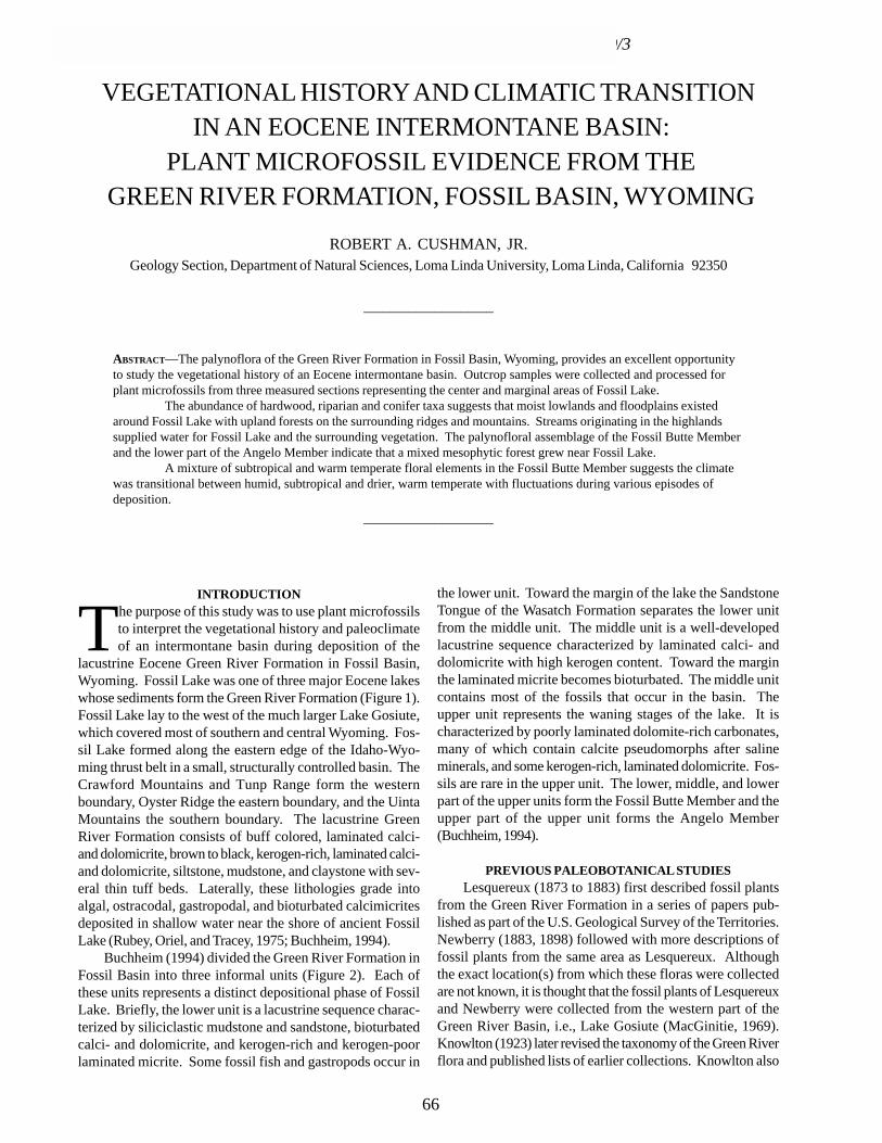
TECHNICAL REPORT NPS/NRGRD/GRDTR-99/3
VEGETATIONAL HISTORY AND CLIMATIC TRANSITION IN AN EOCENE INTERMONTANE BASIN:
PLANT MICROFOSSIL EVIDENCE FROM THE GREEN RIVER FORMATION, FOSSIL BASIN, WYOMING
ROBERT A. CUSHMAN, JR.Geology Section, Department of Natural Sciences, Loma Linda University, Loma Linda, California 92350
INTRODUCTION
The purpose of this study was to use plant microfossilsto interpret the vegetational history and paleoclimateof an intermontane basin during deposition of the
lacustrine Eocene Green River Formation in Fossil Basin,Wyoming. Fossil Lake was one of three major Eocene lakeswhose sediments form the Green River Formation (Figure 1).Fossil Lake lay to the west of the much larger Lake Gosiute,which covered most of southern and central Wyoming. Fos-sil Lake formed along the eastern edge of the Idaho-Wyo-ming thrust belt in a small, structurally controlled basin. TheCrawford Mountains and Tunp Range form the westernboundary, Oyster Ridge the eastern boundary, and the UintaMountains the southern boundary. The lacustrine GreenRiver Formation consists of buff colored, laminated calci-and dolomicrite, brown to black, kerogen-rich, laminated calci-and dolomicrite, siltstone, mudstone, and claystone with sev-eral thin tuff beds. Laterally, these lithologies grade intoalgal, ostracodal, gastropodal, and bioturbated calcimicritesdeposited in shallow water near the shore of ancient FossilLake (Rubey, Oriel, and Tracey, 1975; Buchheim, 1994).
Buchheim (1994) divided the Green River Formation inFossil Basin into three informal units (Figure 2). Each ofthese units represents a distinct depositional phase of FossilLake. Briefly, the lower unit is a lacustrine sequence charac-terized by siliciclastic mudstone and sandstone, bioturbatedcalci- and dolomicrite, and kerogen-rich and kerogen-poorlaminated micrite. Some fossil fish and gastropods occur in
____________________
ABSTRACT—The palynoflora of the Green River Formation in Fossil Basin, Wyoming, provides an excellent opportunityto study the vegetational history of an Eocene intermontane basin. Outcrop samples were collected and processed forplant microfossils from three measured sections representing the center and marginal areas of Fossil Lake.
The abundance of hardwood, riparian and conifer taxa suggests that moist lowlands and floodplains existedaround Fossil Lake with upland forests on the surrounding ridges and mountains. Streams originating in the highlandssupplied water for Fossil Lake and the surrounding vegetation. The palynofloral assemblage of the Fossil Butte Memberand the lower part of the Angelo Member indicate that a mixed mesophytic forest grew near Fossil Lake.
A mixture of subtropical and warm temperate floral elements in the Fossil Butte Member suggests the climatewas transitional between humid, subtropical and drier, warm temperate with fluctuations during various episodes ofdeposition.
____________________
the lower unit. Toward the margin of the lake the SandstoneTongue of the Wasatch Formation separates the lower unitfrom the middle unit. The middle unit is a well-developedlacustrine sequence characterized by laminated calci- anddolomicrite with high kerogen content. Toward the marginthe laminated micrite becomes bioturbated. The middle unitcontains most of the fossils that occur in the basin. Theupper unit represents the waning stages of the lake. It ischaracterized by poorly laminated dolomite-rich carbonates,many of which contain calcite pseudomorphs after salineminerals, and some kerogen-rich, laminated dolomicrite. Fos-sils are rare in the upper unit. The lower, middle, and lowerpart of the upper units form the Fossil Butte Member and theupper part of the upper unit forms the Angelo Member(Buchheim, 1994).
PREVIOUS PALEOBOTANICAL STUDIESLesquereux (1873 to 1883) first described fossil plants
from the Green River Formation in a series of papers pub-lished as part of the U.S. Geological Survey of the Territories.Newberry (1883, 1898) followed with more descriptions offossil plants from the same area as Lesquereux. Althoughthe exact location(s) from which these floras were collectedare not known, it is thought that the fossil plants of Lesquereuxand Newberry were collected from the western part of theGreen River Basin, i.e., Lake Gosiute (MacGinitie, 1969).Knowlton (1923) later revised the taxonomy of the Green Riverflora and published lists of earlier collections. Knowlton also
66
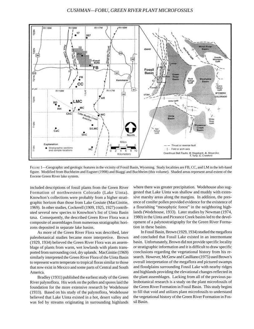
included descriptions of fossil plants from the Green RiverFormation of northwestern Colorado (Lake Uinta).Knowlton’s collections were probably from a higher strati-graphic horizon than those from Lake Gosiute (MacGinitie,1969). In other studies, Cockerell (1909, 1925, 1927) contrib-uted several new species to Knowlton’s list of Uinta Basintaxa. Consequently, the described Green River Flora was acomposite of assemblages from numerous stratigraphic hori-zons deposited in separate lake basins.
As more of the Green River Flora was described, laterpaleobotanical studies became more interpretive. Brown(1929, 1934) believed the Green River Flora was an assem-blage of plants from warm, wet lowlands with plants trans-ported from surrounding cool, dry uplands. MacGinitie (1969)similarly interpreted the Green River Flora of the Uinta Basinto represent warm temperate to tropical floras similar to thosethat now exist in Mexico and some parts of Central and SouthAmerica.
Bradley (1931) published the earliest study of the GreenRiver palynoflora. His work on the pollen and spores laid thefoundation for the more extensive research by Wodehouse(1933). Based on his study of the palynoflora, Wodehousebelieved that Lake Uinta existed in a hot, desert valley andwas fed by streams originating in surrounding highlands
where there was greater precipitation. Wodehouse also sug-gested that Lake Uinta was shallow and muddy with exten-sive marshy areas along the margins. In addition, the pres-ence of conifer pollen provided evidence for the existence ofa flourishing “mesophytic forest” in the neighboring high-lands (Wodehouse, 1933). Later studies by Newman (1974,1980) in the Uinta and Piceance Creek basins led to the devel-opment of a palynostratigraphy for the Green River Forma-tion in these basins.
In Fossil Basin, Brown (1929, 1934) studied the megafloraand concluded that Fossil Lake existed in an intermontanebasin. Unfortunately, Brown did not provide specific localityor stratigraphic information and it is difficult to draw specificconclusions regarding the vegetational history from his re-search. However, McGrew and Casilliano (1975) used Brown’soverall interpretation of the megaflora and pictured swampsand floodplains surrounding Fossil Lake with nearby ridgesand highlands providing the elevational changes reflected inthe plant assemblages. Lacking from all of the previous pa-leobotanical research is a study on the plant microfossils ofthe Green River Formation in Fossil Basin. This study beginsto fill that void and utilizes plant microfossils to understandthe vegetational history of the Green River Formation in Fos-sil Basin.
FIGURE 1—Geographic and geologic features in the vicinity of Fossil Basin, Wyoming. Study localities are FB, CC, and LM in the left-handfigure. Modified from Buchheim and Eugster (1998) and Biaggi and Buchheim (this volume). Shaded areas represent areal extent of theEocene Green River lake system.
CUSHMAN—FOBU, GREEN RIVER PLANT MICROFOSSILS
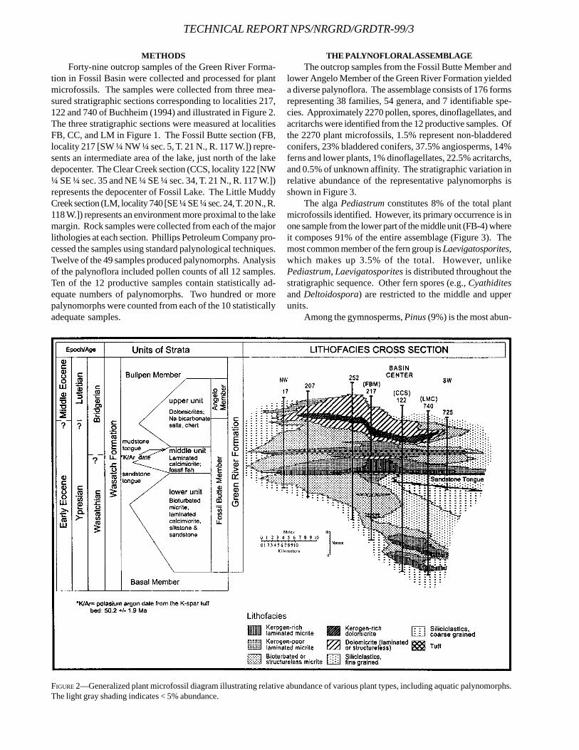
TECHNICAL REPORT NPS/NRGRD/GRDTR-99/3
FIGURE 2—Generalized plant microfossil diagram illustrating relative abundance of various plant types, including aquatic palynomorphs.The light gray shading indicates < 5% abundance.
METHODSForty-nine outcrop samples of the Green River Forma-
tion in Fossil Basin were collected and processed for plantmicrofossils. The samples were collected from three mea-sured stratigraphic sections corresponding to localities 217,122 and 740 of Buchheim (1994) and illustrated in Figure 2.The three stratigraphic sections were measured at localitiesFB, CC, and LM in Figure 1. The Fossil Butte section (FB,locality 217 [SW ¼ NW ¼ sec. 5, T. 21 N., R. 117 W.]) repre-sents an intermediate area of the lake, just north of the lakedepocenter. The Clear Creek section (CCS, locality 122 [NW¼ SE ¼ sec. 35 and NE ¼ SE ¼ sec. 34, T. 21 N., R. 117 W.])represents the depocenter of Fossil Lake. The Little MuddyCreek section (LM, locality 740 [SE ¼ SE ¼ sec. 24, T. 20 N., R.118 W.]) represents an environment more proximal to the lakemargin. Rock samples were collected from each of the majorlithologies at each section. Phillips Petroleum Company pro-cessed the samples using standard palynological techniques.Twelve of the 49 samples produced palynomorphs. Analysisof the palynoflora included pollen counts of all 12 samples.Ten of the 12 productive samples contain statistically ad-equate numbers of palynomorphs. Two hundred or morepalynomorphs were counted from each of the 10 statisticallyadequate samples.
THE PALYNOFLORAL ASSEMBLAGEThe outcrop samples from the Fossil Butte Member and
lower Angelo Member of the Green River Formation yieldeda diverse palynoflora. The assemblage consists of 176 formsrepresenting 38 families, 54 genera, and 7 identifiable spe-cies. Approximately 2270 pollen, spores, dinoflagellates, andacritarchs were identified from the 12 productive samples. Ofthe 2270 plant microfossils, 1.5% represent non-bladderedconifers, 23% bladdered conifers, 37.5% angiosperms, 14%ferns and lower plants, 1% dinoflagellates, 22.5% acritarchs,and 0.5% of unknown affinity. The stratigraphic variation inrelative abundance of the representative palynomorphs isshown in Figure 3.
The alga Pediastrum constitutes 8% of the total plantmicrofossils identified. However, its primary occurrence is inone sample from the lower part of the middle unit (FB-4) whereit composes 91% of the entire assemblage (Figure 3). Themost common member of the fern group is Laevigatosporites,which makes up 3.5% of the total. However, unlikePediastrum, Laevigatosporites is distributed throughout thestratigraphic sequence. Other fern spores (e.g., Cyathiditesand Deltoidospora) are restricted to the middle and upperunits.
Among the gymnosperms, Pinus (9%) is the most abun-
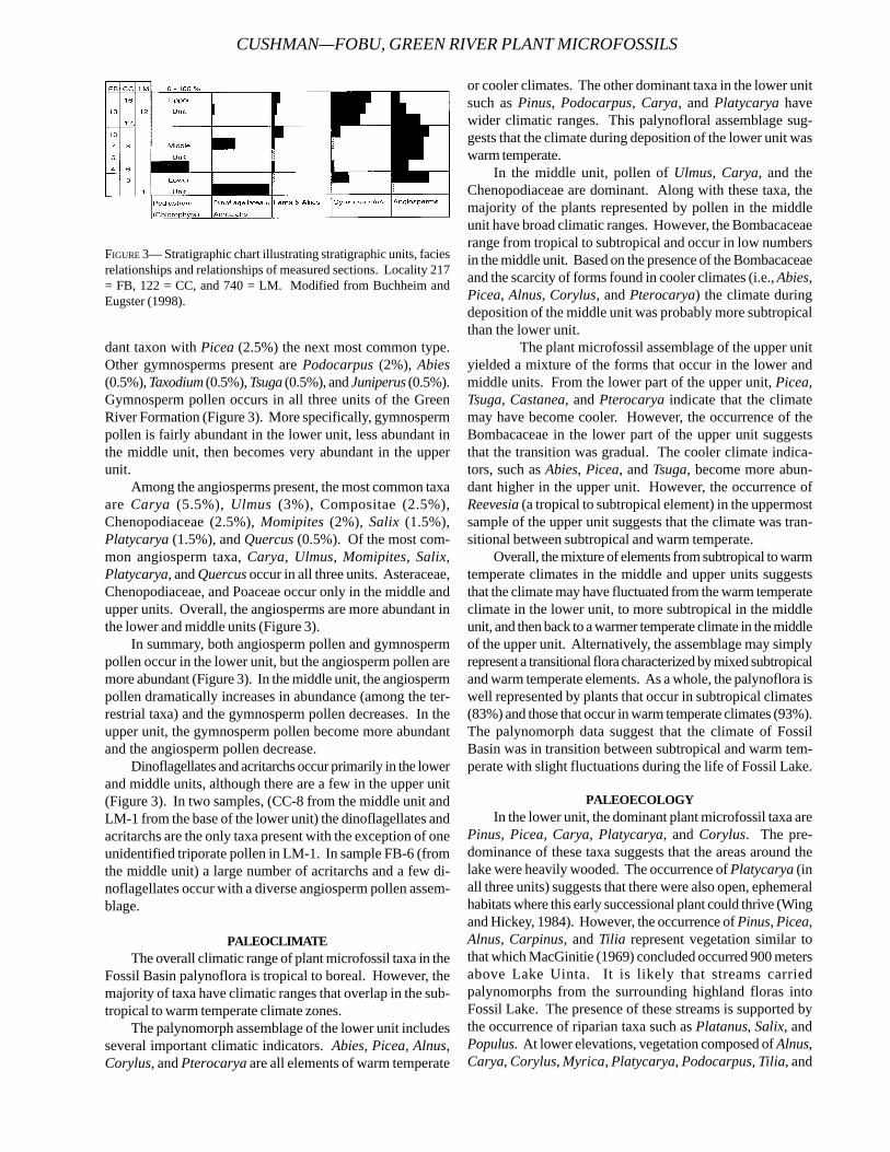
dant taxon with Picea (2.5%) the next most common type.Other gymnosperms present are Podocarpus (2%), Abies(0.5%), Taxodium (0.5%), Tsuga (0.5%), and Juniperus (0.5%).Gymnosperm pollen occurs in all three units of the GreenRiver Formation (Figure 3). More specifically, gymnospermpollen is fairly abundant in the lower unit, less abundant inthe middle unit, then becomes very abundant in the upperunit.
Among the angiosperms present, the most common taxaare Carya (5.5%), Ulmus (3%), Compositae (2.5%),Chenopodiaceae (2.5%), Momipites (2%), Salix (1.5%),Platycarya (1.5%), and Quercus (0.5%). Of the most com-mon angiosperm taxa, Carya, Ulmus, Momipites, Salix,Platycarya, and Quercus occur in all three units. Asteraceae,Chenopodiaceae, and Poaceae occur only in the middle andupper units. Overall, the angiosperms are more abundant inthe lower and middle units (Figure 3).
In summary, both angiosperm pollen and gymnospermpollen occur in the lower unit, but the angiosperm pollen aremore abundant (Figure 3). In the middle unit, the angiospermpollen dramatically increases in abundance (among the ter-restrial taxa) and the gymnosperm pollen decreases. In theupper unit, the gymnosperm pollen become more abundantand the angiosperm pollen decrease.
Dinoflagellates and acritarchs occur primarily in the lowerand middle units, although there are a few in the upper unit(Figure 3). In two samples, (CC-8 from the middle unit andLM-1 from the base of the lower unit) the dinoflagellates andacritarchs are the only taxa present with the exception of oneunidentified triporate pollen in LM-1. In sample FB-6 (fromthe middle unit) a large number of acritarchs and a few di-noflagellates occur with a diverse angiosperm pollen assem-blage.
PALEOCLIMATEThe overall climatic range of plant microfossil taxa in the
Fossil Basin palynoflora is tropical to boreal. However, themajority of taxa have climatic ranges that overlap in the sub-tropical to warm temperate climate zones.
The palynomorph assemblage of the lower unit includesseveral important climatic indicators. Abies, Picea, Alnus,Corylus, and Pterocarya are all elements of warm temperate
or cooler climates. The other dominant taxa in the lower unitsuch as Pinus, Podocarpus, Carya, and Platycarya havewider climatic ranges. This palynofloral assemblage sug-gests that the climate during deposition of the lower unit waswarm temperate.
In the middle unit, pollen of Ulmus, Carya, and theChenopodiaceae are dominant. Along with these taxa, themajority of the plants represented by pollen in the middleunit have broad climatic ranges. However, the Bombacaceaerange from tropical to subtropical and occur in low numbersin the middle unit. Based on the presence of the Bombacaceaeand the scarcity of forms found in cooler climates (i.e., Abies,Picea, Alnus, Corylus, and Pterocarya) the climate duringdeposition of the middle unit was probably more subtropicalthan the lower unit.
The plant microfossil assemblage of the upper unityielded a mixture of the forms that occur in the lower andmiddle units. From the lower part of the upper unit, Picea,Tsuga, Castanea, and Pterocarya indicate that the climatemay have become cooler. However, the occurrence of theBombacaceae in the lower part of the upper unit suggeststhat the transition was gradual. The cooler climate indica-tors, such as Abies, Picea, and Tsuga, become more abun-dant higher in the upper unit. However, the occurrence ofReevesia (a tropical to subtropical element) in the uppermostsample of the upper unit suggests that the climate was tran-sitional between subtropical and warm temperate.
Overall, the mixture of elements from subtropical to warmtemperate climates in the middle and upper units suggeststhat the climate may have fluctuated from the warm temperateclimate in the lower unit, to more subtropical in the middleunit, and then back to a warmer temperate climate in the middleof the upper unit. Alternatively, the assemblage may simplyrepresent a transitional flora characterized by mixed subtropicaland warm temperate elements. As a whole, the palynoflora iswell represented by plants that occur in subtropical climates(83%) and those that occur in warm temperate climates (93%).The palynomorph data suggest that the climate of FossilBasin was in transition between subtropical and warm tem-perate with slight fluctuations during the life of Fossil Lake.
PALEOECOLOGYIn the lower unit, the dominant plant microfossil taxa are
Pinus, Picea, Carya, Platycarya, and Corylus. The pre-dominance of these taxa suggests that the areas around thelake were heavily wooded. The occurrence of Platycarya (inall three units) suggests that there were also open, ephemeralhabitats where this early successional plant could thrive (Wingand Hickey, 1984). However, the occurrence of Pinus, Picea,Alnus, Carpinus, and Tilia represent vegetation similar tothat which MacGinitie (1969) concluded occurred 900 metersabove Lake Uinta. It is likely that streams carriedpalynomorphs from the surrounding highland floras intoFossil Lake. The presence of these streams is supported bythe occurrence of riparian taxa such as Platanus, Salix, andPopulus. At lower elevations, vegetation composed of Alnus,Carya, Corylus, Myrica, Platycarya, Podocarpus, Tilia, and
FIGURE 3— Stratigraphic chart illustrating stratigraphic units, faciesrelationships and relationships of measured sections. Locality 217= FB, 122 = CC, and 740 = LM. Modified from Buchheim andEugster (1998).
CUSHMAN—FOBU, GREEN RIVER PLANT MICROFOSSILS
TECHNICAL REPORT NPS/NRGRD/GRDTR-99/3
Ulmus grew. Around Fossil Lake itself, forests of Populus,Pterocarya, and Salix grew on the floodplains, while in themoist lowlands, cattails, ferns, and horsetails thrived.
During deposition of the middle unit the vegetation ad-jacent to Fossil Lake remained much the same as in the lowerunit. However, the vegetation at the lower elevations be-came better developed and taxonomically more diverse, per-haps due to increased rainfall and a more subtropical climate.During this time, the upland vegetation was partially dis-placed upward by elements from the warmer, lowland vegeta-tion. The sedimentological data suggest that during deposi-tion of the middle unit the lake reached its peak development(see Buchheim and related papers, this volume).
During deposition of the upper unit the dominant veg-etation around Fossil Lake was once again the upland flora.Carya, Myrica, Platycarya, Populus, Quercus, Tilia, andUlmus are still well represented. However, rainfall was prob-ably more restricted to the highlands where Abies, Picea,Pinus, Podocarpus, and a variety of ferns flourished. Theshallowing of the lake is indicated by the increased abun-dance of Taxodium-type pollen in the upper unit and wouldalso corroborate with the deposition of evaporite sequencesthat occur in the upper unit. The changes in the flora and theshallowing of the lake during deposition of the upper unitprobably resulted from the onset of a cooler, drier climate.
CONCLUSIONSOverall, the vegetation that existed around Fossil Lake
during deposition of the lower, middle, and upper units of theGreen River Formation in Fossil Basin indicates that the lakeexisted in an intermontane basin and was affected by slightfluctuations in climate and rainfall.
The abundance of hardwood, riparian, and conifer taxasuggests that moist lowlands and floodplains existed aroundFossil Lake with upland forests on the surrounding ridgesand mountains. The occurrence of Platycarya throughoutthe section suggests that there were also open, ephemeralhabitats where this early successional plant thrived. Theseephemeral habitats were a result of fluctuating lake levelsthroughout the life of Fossil Lake (see Buchheim and relatedpapers, this volume). Streams originating in the highlandssupplied water for Fossil Lake and the surrounding vegeta-tion. The palynoflora assemblages of the Fossil Butte Mem-ber and the lower part of the Angelo Member indicate a mixedmesophytic forest grew near Fossil Lake.
The mixture of subtropical and warm temperate floralelements in the Fossil Butte Member suggests the climatewas transitional between humid, subtropical and drier, warmtemperate with fluctuations during various episodes of depo-sition.
REFERENCESBRADLEY, W. H., 1931. Origin and microfossils of the oil shale
of the Green River Formation of Colorado and Utah. U. S.Geological Survey Professional Paper, 168:1-58.
BROWN, R.W., 1929. Additions to the flora of the Green RiverFormation. U. S. Geological Survey Professional Paper,
154J:279-292.______, 1934. The recognizable species of the Green River
flora. U. S. Geological Survey Professional Paper, 185C:45-77.
BUCHHEIM, H. P., 1994. Eocene Fossil Lake, Green River For-mation, Wyoming: A history of fluctuating salinity, p.239-247. in R. Renaut and W. Last (eds.), Sedimentologyand geochemistry of modern and ancient saline lakes.SEPM Special Publication Number 50.
______, AND H.P. EUGSTER, 1998. Eocene Fossil Lake: TheGreen River Formation of Fossil Basin, southwesternWyoming, p. 1-17. in J. K. Pitman and A. Carroll (eds.),Utah Geological Association Guidebook Number 26, SaltLake City.
COCKERELL, T.D.A., 1909. Eocene fossils from Green River,Wyoming. American Journal of Science, 29:447-448.
______, 1925. Plant and insect fossils from the Green RiverEocene of Colorado. U. S. National Museum Proceed-ings, 66, article 19:1-13.
______, 1927. A new oak from the Green River Eocene.Torreya, 27(5):94-95.
KNOWLTON, F.H., 1923. Revision of the flora of the GreenRiver Formation. U. S. Geological Survey ProfessionalPaper, 131F:133-182.
LESQUEREUX, L., 1873. The lignitic formation and its fossilflora. U. S. Geological Survey of the Territories (Hayden),Report, 6:317-427.
______, 1878. Contributions to the fossil flora of the west-ern territories - part II, The Tertiary flora. U. S. GeologicalSurvey of the Territories (Hayden), Report, 7:1-366.
______, 1883. The Cretaceous and Tertiary floras - part III.U. S. Geological Survey of the Territories (Hayden), Re-port, 8:127-220.
MACGINITIE, H.D., 1969. The Eocene Green River Flora ofnorthwestern Colorado and northeastern Utah. Univer-sity of California Publications in Geological Sciences,83, 203 p.
MCGREW, P.O., AND M. CASILLIANO, 1975. The geologicalhistory of Fossil Butte National Monument and FossilBasin. National Park Service Occasional Paper, 3:1-37.
NEWBERRY, J.S., 1883. Brief descriptions of fossil plants,chiefly Tertiary, from western North America. U. S. Na-tional Museum Proceedings, 5:502-514.
______, 1898. The later extinct floras of North America. U. S.Geological Survey Monograph, 35.
NEWMAN, K.R., 1974. Palynomorph zones in early Tertiaryformations of the Piceance Creek and Uinta Basins, Colo-rado and Utah, p. 47-55. in D. K. Murray (ed.), Guide-book to the energy resources of the Piceance Creek Ba-sin, Colorado. Rocky Mountain Association of Geolo-gists, 25th Annual Field Conference.
______, 1980. Geology of oil shale in Piceance Creek Basin,Colorado, p. 199-203. in H. C. Kent and K. W. Porter(eds.), Colorado Geology. Rocky Mountain Associationof Geologists, Denver.
RUBEY, W.W., S.S. ORIEL, AND J.E. TRACEY, JR., 1975. Geologyof the Sage and Kemmerer quadrangles, Lincoln County,

Wyoming. U.S. Geological Survey Professional Paper,855:1-18.
WING, S.L., AND L J. HICKEY, 1984. The Platycarya perplexand the evolution of the Juglandaceae. American Jour-
nal of Botany, 71(3):388-411.WODEHOUSE, R.P., 1933. Tertiary pollen - II, The oil shales of
the Eocene Green River Formation. Torrey Botanical ClubBulletin, 60(7):479-524.
CUSHMAN—FOBU, GREEN RIVER PLANT MICROFOSSILS
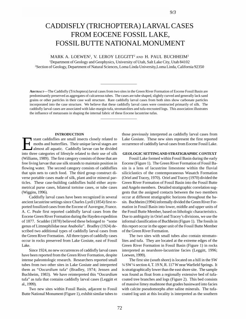
TECHNICAL REPORT NPS/NRGRD/GRDTR-99/3
CADDISFLY (TRICHOPTERA) LARVAL CASES FROM EOCENE FOSSIL LAKE,
FOSSIL BUTTE NATIONAL MONUMENT
MARK A. LOEWEN1, V. LEROY LEGGITT2 AND H. PAUL BUCHHEIM3
1Department of Geology and Geophysics, University of Utah, Salt Lake City, Utah 841022Section of Geology, Department of Natural Sciences, Loma Linda University,Loma Linda, California 92350
____________________
ABSTRACT—The Caddisfly (Trichoptera) larval cases from two sites in the Green River Formation of Eocene Fossil Basin arepredominantly preserved as aggregates of calcareous tubes. The cases are tube shaped, slightly curved and generally lack sandgrains or other particles in their case wall structure. Rare caddisfly larval cases from both sites show carbonate particlesincorporated into the case structure. We believe that these caddisfly larval cases were constructed primarily of silk. Thecaddisfly larval cases are associated with lake-margin tufa, stromatolites and tufa-encrusted logs. This association illustratesthe influence of metazoans in shaping the internal fabric of these Eocene lacustrine tufas.
____________________
INTRODUCTION
Extant caddisflies are small insects closely related tomoths and butterflies. Their unique larval stages arealmost all aquatic. Caddisfly larvae can be divided
into three categories of lifestyle related to their use of silk(Williams, 1989). The first category consists of those that arefree living larvae that use silk strands to maintain position inflowing water. The second category consists of caddisfliesthat spin nets to catch food. The third group construct di-verse portable cases made of silk, plant and/or mineral par-ticles. These case-building caddisflies build either asym-metrical purse cases, bilateral tortoise cases, or tube cases(Wiggins, 1996).
Caddisfly larval cases have been recognized in severalancient lacustrine settings since Charles Lyell (1854) first re-ported fossilized cases from the Eocene of Auvergne, France.A. C. Peale first reported caddisfly larval cases from theEocene Green River Formation during the Hayden expeditionof 1877. Scudder (1878) believed these belonged to “somegenus of Limnephilidae near Anabolia”. Bradley (1924) de-scribed two additional types of caddisfly larval cases fromthe Green River Formation. All three types of caddisfly casesoccur in rocks preserved from Lake Gosiute, east of FossilLake.
Since 1924, no new occurrences of caddisfly larval caseshave been reported from the Green River Formation, despiteintense paleontologic research. Researchers reported smalltubes from two other sites in Lake Gosiute and interpretedthem as “Oocardium tufa“ (Bradley, 1974; Jensen andBuchheim, 1983). We have reinterpreted this “Oocardiumtufa” as tufa that contains caddisfly larval cases (Leggitt etal., 1999).
Two new sites within Fossil Basin, adjacent to FossilButte National Monument (Figure 1), exhibit similar tubes to
those previously interpreted as caddisfly larval cases fromLake Gosiute. These new sites represent the first reportedoccurrence of caddisfly larval cases from Eocene Fossil Lake.
GEOLOGIC SETTING AND STRATIGRAPHIC CONTEXTFossil Lake formed within Fossil Basin during the early
Eocene (Figure 1). The Green River Formation of Fossil Ba-sin is a lens of lacustrine limestone within the fluvialsiliciclastics of the contemporaneous Wasatch Formation(Oriel and Tracey, 1970). Oriel and Tracey (1970) divided theGreen River Formation of Fossil Basin into the Fossil Butteand Angelo members. Detailed stratigraphic correlation sug-gests that the assigned contacts between the two membersoccur at different stratigraphic horizons throughout the ba-sin. Buchheim (1994) informally divided the Green River For-mation in Fossil Basin into lower, middle and upper units ofthe Fossil Butte Member, based on lithologic characteristics.Due to ambiguity in Oriel and Tracey’s divisions, we use theinformal classification of Buchheim (Figure 1). The fossils inthis report occur in the upper unit of the Fossil Butte Memberof the Green River Formation.
The two sites with small tubes also contain stromato-lites and tufa. They are located at the extreme edges of theGreen River Formation in Fossil Basin (Figure 1) in rocksinterpreted as nearshore-lacustrine facies (Leggitt, 1996;Loewen, 1999).
The first site (south shore) is located on a hill in the SW¼ SW ¼ section 4, T. 19 N, R. 117 W near Warfield Springs. Itis stratigraphically lower than the east shore site. The samplewas found as float from a regionally extensive bed of tufa-coated tree branches and logs (Figure 2). This bed consistsof massive limey mudstone that grades basinward into facieswith calcite pseudomorphs after saline minerals. The tufa-coated log unit at this locality is interpreted as the southern
72
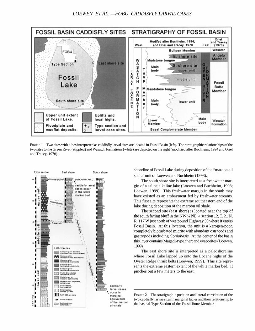
shoreline of Fossil Lake during deposition of the “maroon oilshale” unit of Loewen and Buchheim (1998).
The south shore site is interpreted as a freshwater mar-gin of a saline alkaline lake (Loewen and Buchheim, 1998;Loewen, 1999). This freshwater margin in the south mayhave existed as an embayment fed by freshwater streams.This first site represents the extreme southeastern end of thelake during deposition of the maroon oil shale.
The second site (east shore) is located near the top ofthe south facing bluff in the NW ¼ NE ¼ section 12, T. 21 N,R. 117 W just north of westbound Highway 30 where it entersFossil Basin. At this location, the unit is a kerogen-poor,completely bioturbated micrite with abundant ostracods andgastropods including Goniobasis. At the center of the basinthis layer contains Magadi-type chert and evaporites (Loewen,1999).
The east shore site is interpreted as a paleoshorelinewhere Fossil Lake lapped up onto the Eocene highs of theOyster Ridge thrust belts (Loewen, 1999). This site repre-sents the extreme eastern extent of the white marker bed. Itpinches out a few meters to the east.
FIGURE 1—Two sites with tubes interpreted as caddisfly larval sites are located in Fossil Basin (left). The stratigraphic relationships of thetwo sites to the Green River (stippled) and Wasatch formations (white) are depicted on the right (modified after Buchheim, 1994 and Orieland Tracey, 1970).
FIGURE 2—The stratigraphic position and lateral correlation of thetwo caddisfly larvae sites in marginal facies and their relationship tothe basinal Type Section of the Fossil Butte Member.
LOEWEN ET AL.,—FOBU, CADDISFLY LARVAL CASES

TECHNICAL REPORT NPS/NRGRD/GRDTR-99/3
FIGURE 3—A, Porous tufa with bark impressions forms the base of the south shore specimen. This is covered by a stromatolite layer (blackarrows). Larval cases are located on top of the stromatolite layer. B, The forked end of the east shore specimen is covered with a finelylaminated stromatolite coating and larval cases. Dashed lines indicate the surface on which the entire structure was deposited. Arrowsindicate the finely laminated stromatolite layers.
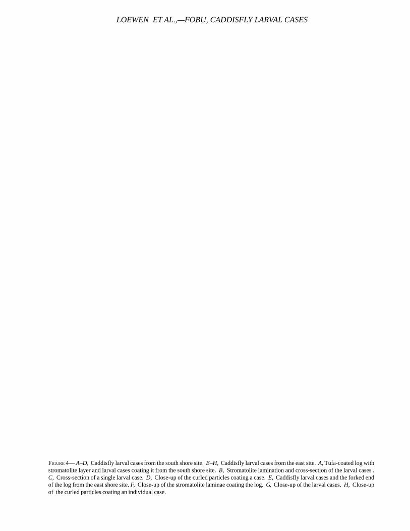
FIGURE 4— A–D, Caddisfly larval cases from the south shore site. E–H, Caddisfly larval cases from the east site. A, Tufa-coated log withstromatolite layer and larval cases coating it from the south shore site. B, Stromatolite lamination and cross-section of the larval cases .C, Cross-section of a single larval case. D, Close-up of the curled particles coating a case. E, Caddisfly larval cases and the forked endof the log from the east shore site. F, Close-up of the stromatolite laminae coating the log. G, Close-up of the larval cases. H, Close-upof the curled particles coating an individual case.
LOEWEN ET AL.,—FOBU, CADDISFLY LARVAL CASES
TECHNICAL REPORT NPS/NRGRD/GRDTR-99/3
DESCRIPTION OF THE TUBES AND TUFA FROM BOTH SIDES
The south shore specimen has bark impressions on itsbasal surface. The bark impression is coated with a 43 mmthick layer of porous carbonate interpreted as tufa (Figure3A, 4A). This tufa includes ostracods and pockets of finelylaminated stromatolitic material (Figure 4B). The tufa is suc-ceeded by a layer of finely-laminated columnar stromatolite12 mm thick. This stromatolite layer is covered with smalltubes (Figure 4C, 4D). The entire structure is coated with a 2mm thick layer of finely-laminated stromatolite.
The specimen from the east shore consists of a roughlycylindrical, elongate shape resembling a log resting horizon-tally sub-parallel to the paleoshoreline. It is coated with finelylaminated carbonate and surrounded by small tubes (Figure3B, 4E). The cylindrical shape is interpreted as originallyconsisting of a log or tree branch. The wood later rotted andwas replaced by bioturbated micrite. The log is 60 cm longwith one end that is 24 cm wide and 11 cm high. The otherend forks into two branches about 9 cm in diameter (Figures3B and 4E), and is coated with a 3 – 4 mm thick layer of finely-laminated stromatolite material (Figure 4F). The stromatolitesurface is covered with small tubes (Figure 4G). Carbonatedetritus and ostracods form the matrix around the cases. Theentire structure is coated on the top surface with a 3 mm thicklayer of finely-laminated stromatolite.
The small tubes at both sites consist of cylindrical,slightly curved elongate structures. The tubes are slightlytapered. They range from about 15 to 20 mm long and 1.7 to2.0 mm in internal diameter. External diameter ranges from 1.9to 2.2 mm. In cross section the tube walls exhibit rare angularand curved carbonate fragments from 0.1 to 0.2 mm in diam-eter comprising the tube wall (Figure 3D, 3H). The tube wallsalso contain rare, angular quartz grains about 0.1 mm in diam-eter. The tubes are coated inside and out by finely laminatedcarbonate.
DISCUSSIONThe slightly curved tubes from both sites are interpreted
as caddisfly larval cases. They are similar to other reportedcaddisfly larval cases from the Green River Formation(Scudder, 1878; Bradley, 1924). The larval cases from FossilBasin may have been primarily constructed from silk becausecase-building particles are rarely observed. Some of the casescontain small carbonate grains, which have been incorpo-rated into the case structure. These curved carbonate grainsmay be small clastic fragments or pieces of stromatolites andtufa that the larvae harvested from their surroundings. Simi-lar quarrying behavior has been noted in modern caddisflies(Drysdale, 1999). The finely laminated carbonate coating thetubes inside and out was probably deposited after the caseswere abandoned.
The logs with tubes coating them from both sites arecoated with either porous tufa or a layer of finely laminatedstromatolite material. This suggests that the log was sub-merged in place for a period of time. Caddisfly larvae subse-quently colonized this surface. The aggregation of cases
formed a chaotic, rigid latticework that may have acted as abaffle that collected small carbonate particles between thecases. Ostracods occur in the matrix surrounding the casesin both specimens.
Today, caddisfly larvae are associated with shallow, well-lighted, well-oxygenated, nearshore-lacustrine and fluvialenvironments (Mackay and Williams, 1979). They have beenused as indicators of nearshore-lacustrine paleoenvironmentsin the Green River Formation (Bradley, 1928). The tubes in-terpreted as caddisfly larval cases from the two sites in FossilBasin are consistent with the marginal lacustrine interpreta-tion of these two sites (Loewen, 1999).
The co-occurrence of caddisflies with tufa at these sitessuggests a link between metazoan insect larvae and the tufa-and stromatolite-building processes. It is likely that thecaddisfly populations directly contributed to megascopic tufafabric formation and were strongly involved in reshaping themicro- and macroscopic fabric of this tufa. Recent studieshave shown the importance of aquatic insect larvae, includ-ing Trichoptera larvae, in the development and alteration ofsome modern tufa fabrics (Humphreys et al., 1995; Drysdale,1999).
ACKNOWLEDGEMENTSA research grant from Fossil Butte National Monument
and financial support from Loma Linda University supportedthis research. The rangers and staff of Fossil Butte NationalMonument provided encouragement and logistical support,which has proved invaluable to several of our ongoingprojects. In particular we would like to thank David McGinnis,Vince Santucci, and Arvid Aase of Fossil Butte NationalMonument.
REFERENCESBRADLEY, W.H., 1924. Fossil caddis fly cases from the Green
River Formation of Wyoming. American Journal of Sci-ence, 7:310-312.
______, 1928. Algae reefs and oolites of the Green RiverFormation, U.S. Geological Survey Professional Paper154-G: 203-223.
______, 1974. Oocardium tufa from the Eocene Green RiverFormation of Wyoming. Journal of Paleontology,48(6):1289-1294.
BUCHHEIM, H.P., 1994. Eocene Fossil Lake: a history of fluctu-ating salinity. in Renaut, R., and W. Last, (eds.), Sedi-mentology and Geochemistry of Modern and AncientSaline Lakes. Society for Sedimentary Geology SpecialPublication 50: 239-247.
DRYSDALE, R.N., 1999. The sedimentological significance ofhydropsychid caddis-fly larvae (Order: Trichoptera) in atravertine-depositing stream: Louie Creek, northwestQueensland, Australia. Journal of Sedimentary Research,69(1):145-150.
HUMPHREYS, W.F., S.M. AWRAMIK AND M.H.P. JEBB, 1995.Freshwater biogenic tufa dams in Madang Province,Papua New Guinea. Journal of the Royal Society of West-ern Australia, 78:43-53.
JENSEN, R. AND H.P. BUCHHEIM, 1983. Oocardium tufa depos-its: a record of near-shore sedimentation in Eocene LakeGosiute, Wyoming. Geological Society of America Ab-stracts with Programs, 15(5):413.
LEGGITT, V. L., 1996. An avian botulism epizootic affecting anesting site population of Presbyornis on a carbonatemudflat shoreline of Eocene Fossil Lake. UnpublishedM.S. Thesis: Loma Linda University, 114 p.
LEGGITT, V.L., M.A. LOEWEN, H.P. BUCHHEIM, AND R.E. BIAGGI,1999. A reinterpretation of “Oocardium tufa” from theEocene Green River Formation of Wyoming. Abstractsof the 2nd International Congress of Limnogeology, P:30– 31.
LOEWEN, M.A., 1999. Lateral salinity gradients during hyper-saline lake stages of Eocene Fossil Lake, Wyoming. Un-published M.S. Thesis: Loma Linda University, 62 p.
______, and H. P. Buchheim. 1998. Paleontology and paleo-ecology of the culminating phase of Eocene Fossil Lake,Fossil Butte National Monument, Wyoming. NationalPark Service Paleontological Research Volume, 3:73-80.
LOEWEN ET AL.,—FOBU, CADDISFLY LARVAL CASES
LYELL, C., 1854. A manual of elementary geology or thechanges of the earth and its inhabitants, as illustratedby geological monuments. Appelton and Company: NewYork, p, 175-190.
MACKAY, R.J. AND G.B. WILLIAMS, 1979. Ecological diversityin Trichoptera. Annual Reviews of Entomology, 24:185-208.
ORIEL, S.S., AND J.L. TRACEY, 1970. Uppermost Cretaceousand Tertiary stratigraphy of Fossil Basin, SouthwesternWyoming. U.S. Geological Survey Professional Paper,635:53p.
SCUDDER, S.H., 1878. An account of some insects of unusualinterest from the Tertiary rocks of Colorado and Wyo-ming. United States Geological and Geographical Sur-vey of the Territories Bulletin, 4:542-543.
WIGGINS, G.B., 1996. Larvae of the North American caddisflygenera (Trichoptera). Second Edition. University ofToronto Press, Toronto, Canada.
WILLIAMS, N.E., 1989. Factors affecting the interpretation ofcaddisfly assemblages from Quaternary sediments. Jour-nal of Paleolimnology, 1:241-248.
TECHNICAL REPORT NPS/NRGRD/GRDTR-99/3
INCISED VALLEY FILLS IN THE LOWER PART OF THECHINLE FORMATION, PETRIFIED FOREST
NATIONAL PARK, ARIZONA: COMPLETE MEASURED SECTIONS AND REGIONAL STRATIGRAPHICIMPLICATIONS OF UPPER TRIASSIC ROCKS
RUSSELL F. DUBIEL1, STEPHEN T. HASIOTIS2, AND TIMOTHY M. DEMKO3
1U.S. Geological Survey, MS 939 Box 25046 DFC, Denver, CO 802252Exxon Production Research Company, P.O. Box 2189, Houston, TX 77252
3University of Arizona, Department of Geoscience, Tucson, AZ 85721
____________________
ABSTRACT—Sedimentologic analysis and complete measured stratigraphic sections of the entire Upper Triassic ChinleFormation exposed in Petrified Forest National Park, Arizona have identified a succession of incised paleovalley cut-and-fill complexes in the lower part of the Chinle. These paleovalley complexes are similar in aspect and process of formationto the sediment-filled scours in the Petrified Forest Member of the Chinle Formation in the Park that were described byearlier workers. In addition, this research highlights the first recognition of exposures of the Moenkopi Formation andShinarump Member of the Chinle Formation within Petrified Forest National Park.. The uppermost part of the Moenkopihas been incised by a paleovalley cut prior to deposition of the Shinarump, and the Moenkopi that was exposed oninterfluves between Shinarump paleovalleys was peodogenically modified into “mottled strata” typical of similar Moenkopiexposures elsewhere on the Colorado Plateau. Outcrops of the Shinarump, Monitor Butte, and Mesa Redondo Membersof the Chinle Formation in Petrified Forest National Park are similar to other exposures in this region of northeasternArizona in that they successively fill paleovalleys cut into underlying older units. Recognition of the paleovalley cuts andtheir subsequent fill elucidates the stratigraphic complexity of the lower Chinle and the relative ages of the units.
____________________
INTRODUCTION
The Upper Triassic Chinle Formation has long beenknown to have been deposited in a fully continentalbasin (Stewart et al., 1972, and references therein).
Based on detailed mapping and measurement of stratigraphicsections by various workers over the past forty years, thelower part of the Chinle (Shinarump, Mesa Redondo, andMonitor Butte Members and their stratigraphic equivalents)was previously described as a complexly interfingered suc-cession of strata (Witkind, 1956, 1961; Cooley, 1959; Phoenix,1963; Witkind and Thaden, 1963; Davidson, 1967; Stewart etal., 1972). More recently, however, sedimentologic analysesand application of concepts from other continental case stud-ies have led to reinterpretations of much of the “complexinterfingering” as a succession of incised paleovalley cut-and-fill complexes (Blakey and Gubitosa, 1983, 1984; Pierson,1984; Kraus and Bown, 1986; Dubiel, 1987, 1992, 1994; Haney,1987; Kraus and Middleton, 1987; Blakey, 1989; Demko,1995a,b; Demko et al., 1998). These paleovalley erosionalsystems and their subsequent stratal fill are replete with val-ley walls, interfluve areas with superposed paleosols, andtributary drainage systems. Petrified Forest National Park(PEFO) is located near the interfluve (drainage divide) be-
tween two major Shinarump Member paleodrainages (Figure1): the Painted Desert and the Vermillion Cliffs paleovalleysof Blakey (1989). In addition, Petrified Forest National Park’sposition is also on the margin of a younger Monitor Buttepaleovalley system (Demko et al., 1998), compounding thecomplexity of stratal relations in the lower part of the Chinle.Because of its position in this paleogeographic setting, thestratigraphy of the lower part of the Chinle Formation withinPetrified Forest National Park is characterized by thinner stratalpackages and more evidence of pedogenesis than is typicalof some of the Chinle Formation in areas to the east or west ofthe Park that are within the axes of the Shinarump paleovalleys(Figure 2). Although even younger paleovalley erosionalsurfaces and their fills are present in the upper part of theChinle Formation in and around Petrified Forest National Park(Kraus and Bown, 1986; Kraus and Middleton, 1987) andelsewhere in the Chinle on the Colorado Plateau (Stewart etal., 1972; Dubiel, 1994), they are not described here.
STRATIGRAPHIC SETTINGMapping and stratigraphic section measurement for sedi-
mentologic research on the Chinle Formation throughout theColorado Plateau (Dubiel, 1987, 1994; Demko, 1995a; Hasiotis,
78
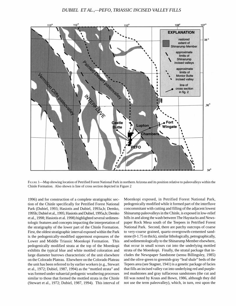
1996) and for construction of a complete stratigraphic sec-tion of the Chinle specifically for Petrified Forest NationalPark (Dubiel, 1993; Hasiotis and Dubiel, 1993a,b; Demko,1995b; Dubiel et al., 1995; Hasiotis and Dubiel, 1995a,b; Demkoet al., 1998; Hasiotis et al. 1998) highlighted several sedimen-tologic features and concepts impacting the interpretation ofthe stratigraphy of the lower part of the Chinle Formation.First, the oldest stratigraphic interval exposed within the Parkis the pedogenically-modified uppermost exposures of theLower and Middle Triassic Moenkopi Formation. Thispedogenically modified strata at the top of the Moenkopiexhibits the typical blue and white mottled coloration andlarge diameter burrows characteristic of the unit elsewhereon the Colorado Plateau. Elsewhere on the Colorado Plateauthe unit has been referred to by earlier workers (e.g., Stewartet al., 1972; Dubiel, 1987, 1994) as the “mottled strata” andwas formed under subaerial pedogenic weathering processessimilar to those that formed the mottled strata in the Chinle(Stewart et al., 1972; Dubiel, 1987, 1994). This interval of
Moenkopi exposed, in Petrified Forest National Park,pedogenically modified while it formed part of the interfluveconcommitant with cutting and filling of the adjacent lowestShinarump paleovalleys in the Chinle, is exposed in low-reliefhills in and along the wash between The Haystacks and News-paper Rock Mesa south of the Teepees in Petrified ForestNational Park. Second, there are patchy outcrops of coarseto very-coarse grained, quartz-overgrowth-cemented sand-stone (0-1.75 m thick), similar lithologically, petrographically,and sedimentologically to the Shinarump Member elsewhere,that occur in small scours cut into the underlying mottledstrata of the Moenkopi. Finally, the stratal package that in-cludes the Newspaper Sandstone (sensu Billingsley, 1985)and the olive-green to greenish-gray “leaf shale” beds of theTepees area (see Stagner, 1941) is a genetic package of faciesthat fills an incised valley cut into underlying red and purple-red mudstones and gray tuffaceous sandstones (the cut andfill was noted by Kraus and Bown, 1986, although they didnot use the term paleovalley), which, in turn, rest upon the
FIGURE 1—Map showing location of Petrified Forest National Park in northern Arizona and its position relative to paleovalleys within theChinle Formation. Also shown is line of cross section depicted in Figure 2
DUBIEL ET AL.,—PEFO, TRIASSIC INCISED VALLEY FILLS
TECHNICAL REPORT NPS/NRGRD/GRDTR-99/3
coarse-grained sandstones of the Shinarump and the mottledstrata at the top of the Moenkopi (Demko, 1995a,b; Dubiel etal., 1995). This entire package is capped by a thick, well-developed, red calcareous vertisol that forms a distinctive,easily correlatable red band around the Tepees area and eastto Blue Mesa (Demko, 1995a,b).
INTERPRETATIONWe have interpreted the succession of facies described
above, from “mottled strata” developed on the MoenkopiFormation through the distinctive red vertisol, to be time-equivalent, in ascending order, to the pedogenically modi-fied uppermost exposures of the Moenkopi Formation, andto the Shinarump, Mesa Redondo, and Monitor Butte Mem-bers of the Chinle Formation (Dubiel et al., 1995) as they arerecognized and described farther to the east of Petrifed For-est National Park where they were deposited within the axesof the aforementioned paleovalleys. The mottled unit at thebase of our measured sections in Petrified Forest NationalPark is identical to pedogenically modified Moenkopi ob-served elsewhere on the Colorado Plateau (Stewart et al.,1972; Dubiel 1987; 1994), whereas the coarse-grained, quartz-cemented sandstones that overlie this unit are petrographi-cally and sedimentologically identical to thicker and betterexposed Shinarump Member sandstones within the PaintedDesert paleovalley trend and to other Shinarump outcropsthroughout the Colorado Plateau (Witkind, 1956; Phoenix,1963; Witkind and Thaden, 1963; Davidson, 1967; Stewart etal., 1972; Blakey and Gubitosa, 1983, 1984; Pierson, 1984;Dubiel, 1987, 1994; Haney, 1987). The thin and patchy natureof the coarse-grained sandstones are interpreted to reflectthe relative position of Petrifed Forest National Park on aninterfluve of the main Shinarump paleovalley systems. Fur-thermore, because these small Shinarump outcrops are topo-graphically higher than exposures of the Shinarump adjacentto the Park, we interpret the coarse sandstones as depositsof stratigraphically higher, and thus slightly younger, smallfluvial deposits relative to the main trunk paleodrainage sys-tem within the major Shinarump paleovalley.
The succession of red and purple-red mudstones andtuffaceous sandstones that overlie the pedogenically modi-fied mottled strata of the Moenkopi and the coarse Shinarumpsandstones is equivalent to the Mesa Redondo Member ofCooley (1958; 1959) and to the “lower red member” of Stewartet al. (1972). These strata were the youngest to be depositedwithin the Shinarump-age paleovalleys, and at their lateststages, they were deposited in a position such that the MesaRedondo units overtopped the interfluves. They are charac-terized by gleyed, well-drained paleosols and trough cross-bedded sandstones. This succession was then incised againdue to degradation of the drainage system (see Figure 7 inStewart et al., 1972), which cut a subsequent paleovalley al-most paleogeographically coincident with the underlyingShinarump paleovalley (Figure 1). This second paleovalleywas subsequently filled by the greenish-gray and olive shalesand fine-grained, ripple-laminated sandstones of the Moni-tor Butte Member. The correlation of these strata with the
thicker sections of the Monitor Butte Member to the east andnortheast of Petrifed Forest National Park is supported byboth sedimentology (Stewart et al., 1972a; Dubiel, 1994;Demko, 1995a) and by plant microfossil (Litwin et al., 1991)and macrofossil zonations (Ash, 1970, 1972a,b, 1975, 1989).Within this and other Monitor Butte paleovalley axes, thereis evidence of a series of cutting and filling episodes markedby well-developed paleosols and mass-movement slumps ofthe paleovalley walls (previously described by Green, 1956;Ash, 1978; and Dubiel et al., 1993). However, at PetrifedForest National Park, on the edge of the paleovalley, only thelast cut-and-fill episode is recorded by the preserved strata,which includes the comparatively thin “leaf shale” and News-paper sandstone on the edge of this paleovalley system (seeAsh, 1978; Billingsley, 1985; and Demko, 1995a for terminol-ogy). The well-developed red calcareous vertisol at the topof Monitor Butte-equivalent strata represents pedogenicmodification of the final stages of aggradation of thepaleovalley system; above this stratigraphic level there wasa change in Chinle fluvial style from the paleovalley-wall con-fined systems of the Shinarump through Monitor Butte, tothe more unconfined rivers (that is, not confined withinpaleovalley walls) of the overlying Petrified Forest Member(Blakey and Gubitosa, 1984; Dubiel, 1994; Demko, 1995).
DISCUSSIONHeckert and Lucas (1998) suggested that the oldest strata
in PEFO were their “Blue Mesa Member of the Petrified For-est Formation” and that Dubiel et al. (1995) misidentified andmiscorrelated certain strata within Petrifed Forest NationalPark. The basis of their assignment rests on the generalcomposition and coloration of the mudstones and sandstonesthat commonly occur below the Sonsela Sandstone and ontheir interpretation of tetrapod biostratigraphy (Lucas, 1993,1997). Their “Blue Mesa Member of the Petrified Forest For-mation”, as well as many other units they describe, is pur-ported to be present and laterally continuous from west-cen-tral New Mexico to southeastern Nevada (Lucas, 1993; 1997).
Based on our interpretation, summarized above in thispaper, we submit that Heckert and Lucas (1998) misidentifiedthe Mesa Redondo and Shinarump Members of Cooley (1958,1959) and Repenning et al. (1969) and included it within their“Petrified Forest Formation” (Lucas, 1993) and that theymiscorrelated these and other lithostratigraphic units. Wealso note that Heckert and Lucas (1998) misquoted and in-correctly restated lithologic descriptions and interpretationsfrom Dubiel et al. (1995). Part of their figure 4 (Heckert andLucas, 1998, p. 133) in which they attributed a Chinle strati-graphic column and interpretation to “Dubiel et al., 1995”could not have been constructed from the information in thatreport. The report by Dubiel et al. (1995) is an abstract withno illustrations and with insufficient verbal information toreconstruct a section and attribute it to those authors. Thus,Hechert and Lucas (1998) erroneously attributed a diagram-matic interpretation to us that does not represent what ouractual published data and interpretations state. Heckert andLucas’ (1998, p. 133) figure 4 was soley based on their strati-
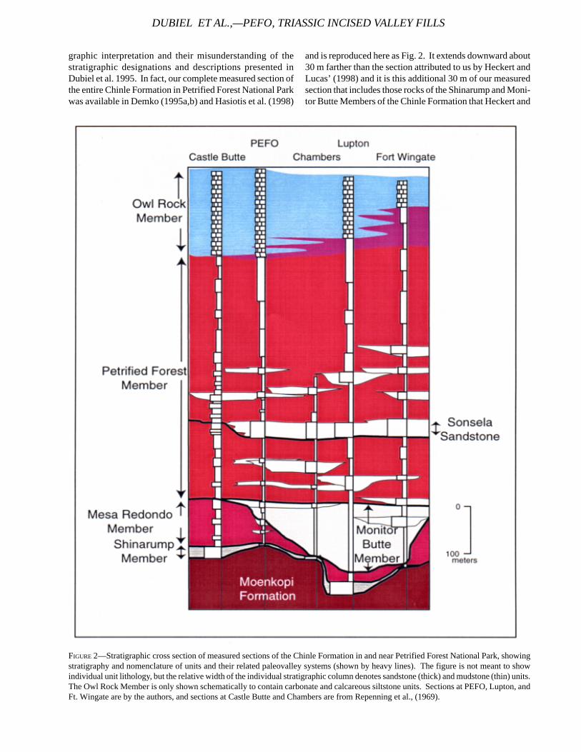
graphic interpretation and their misunderstanding of thestratigraphic designations and descriptions presented inDubiel et al. 1995. In fact, our complete measured section ofthe entire Chinle Formation in Petrified Forest National Parkwas available in Demko (1995a,b) and Hasiotis et al. (1998)
and is reproduced here as Fig. 2. It extends downward about30 m farther than the section attributed to us by Heckert andLucas’ (1998) and it is this additional 30 m of our measuredsection that includes those rocks of the Shinarump and Moni-tor Butte Members of the Chinle Formation that Heckert and
DUBIEL ET AL.,—PEFO, TRIASSIC INCISED VALLEY FILLS
FIGURE 2—Stratigraphic cross section of measured sections of the Chinle Formation in and near Petrified Forest National Park, showingstratigraphy and nomenclature of units and their related paleovalley systems (shown by heavy lines). The figure is not meant to showindividual unit lithology, but the relative width of the individual stratigraphic column denotes sandstone (thick) and mudstone (thin) units.The Owl Rock Member is only shown schematically to contain carbonate and calcareous siltstone units. Sections at PEFO, Lupton, andFt. Wingate are by the authors, and sections at Castle Butte and Chambers are from Repenning et al., (1969).
TECHNICAL REPORT NPS/NRGRD/GRDTR-99/3
Lucas (1998) did not attribute to our section in their illustra-tion and that they contend are not present in Petrified ForestNational Park. Thus, the arguments in Heckert and Lucas(1998) that “Dubiel et al., 1995” misidentified or miscorrelatedstrata at the base of the Chinle in Petrifed Forest NationalPark are deprived of practical significance because those ar-guments are based on their misunderstanding of our workand their failure to identify or recognize the critical outcropsunder discussion. It is possible that Heckert and Lucas (1998)simply made an error in referencing “Dubiel et al. (1995)”rather than Demko (1995a or 1995b) or Hasiotis et al. (1998),each of which do contain our published measured section,but if that is the case, then they incorrectly reproduced theactual stratigraphic units and measured stratigraphic thick-nesses that we reported in our measured section. The entirediscussion by Heckert and Lucas (1998) that outcrops ofMoenkopi and Shinarump strata can not occur in PetrifiedForest National Park based on their assumed lithostratigraphyis obviated by the fact that they failed to observe or note thecritical outcrops of these units in Petrifed Forest NationalPark and their lack of recognition of the sedimentologic posi-tion of these strata within paleovalleys.
The recognition of paleovalley systems, and successivecut and fill events, is of signal importance to the relativestratigraphy of the strata and the biostratigraphy interpretedfrom those rocks. Facies that might first appear to be laterallyadjacent, and thus correlative, may in fact be separated byscoured surfaces; their subsequent fill by younger rocksplaces strata of different ages in an apparent laterally adja-cent position, a relation previously described for the boththe Petrified Forest Member of the Chinle Formation higherin the section in Petrifed Forest National Park and for theWillwood Formation of the Bighorn Basin (Bown and Kraus,1981a,b; Bown, 1984; Kraus and Middleton, 1984; Kraus andBown, 1986). In the lower part of the Chinle Formation inPetrified Forest National Park (and in the Petrified ForestMember as noted by earlier workers), recognition and docu-mentation of these paleovalley fills, their relative ages, andtheir relative paleogeography, are crucial for defining strati-graphic and biostratigraphic relations.
In addition to the signal importance of the identificationof the Moenkopi Formation and Shinarump Member of theChinle Formation in Petrified Forest National Park for strati-graphic and biostratigraphic correlation and sedimentologicanalyses of depositional systems, there are other major rami-fications for the application of old and new nomenclature tothese Triassic rocks, especially over large areas. Such asituation exists in the attempt to raise the Chinle Formation togroup-status. Discussions describing the utility of estab-lished Chinle Formation nomenclature have already been wellpresented by Dubiel (1994). The accepted member designa-tions within the Chinle Formation (e.g., Stewart et al., 1972a;Dubiel, 1994) are well-defined and of local significance be-cause they represent several disparate facies and succes-sions of strata (Dubiel, 1994). Many of the deposits belongto specific incised paleovalley-fill systems (e.g., Blakey, 1989;Dubiel, 1994). The well-established formal and informal names
also represent rocks that were deposited under distinct sub-sidence rate, base-level, and climatic settings. These majorcontrols manifest themselves as alluvial, lacustrine, and eo-lian sequences with unique internal geometries that cannotbe randomly correlated lithostratigraphically across large re-gions of a fully-continental basin, especially when large-scaleincised paleovalleys are present. An attempt to do so (Lucas,1993, 1997) illustrates major flaws using simple layer-cakelithostratigraphic correlations to reproduce stratigraphic re-lations within Upper Triassic rocks in the western UnitedStates. Continued usage of group-designation and superflu-ous formation names associated with it (sensu Lucas, 1993)will mislead subsequent workers with regard to the local andregional correlation of Upper Triassic rocks, and it also cre-ates confusion by adding previously discarded and extrane-ous new names into the literature.
ACKNOWLEDGEMENTSWe thank the superintendents, staff, and volunteers of
Petrified Forest National Park for facilitating research withinthe Park over the last several years. The Petrified ForestMuseum Association has provided research grants to eachof the authors over the years; we are grateful for their contin-ued support. Dubiel’s work was supported by the CentralRegion Energy Team of the U.S. Geological Survey. Demkowas also supported by National Science Foundation GrantEAR 9305087. We thank Sidney Ash (University of NewMexico and New Mexico Museum of Natural History) andFred Peterson (U.S. Geological Survey) for reviews of an ini-tial manuscript, and we thank three anonymous reviewers ofthis volume for their constructive comments on the sedimen-tology and presentation of this paper. We also thank VincentSantucci and Lindsay McClelland for the invitation to presentour research in this volume.
REFERENCESASH, S.R., 1967. The Chinle (Upper Triassic) megaflora of the
Zuni Mountains, New Mexico: New Mexico GeologicalSociety, 18th Annual Field Conference, p. 125-131.
______, 1970. Ferns from the Chinle Formation (Upper Tri-assic) in the Fort Wingate area, New Mexico: USGS Pro-fessional Paper 613D, 40 p.
______, 1972a. Late Triassic plants form the Chinle Forma-tion in northeastern Arizona: Palaeontology, 15: 598-616.
______, 1972b. Plant megafossils of the Chinle Formation: inBreed, C.S. and Breed, W.J., eds., Investigations in theTriassic Chinle Formation: Museum of Northern ArizonaBulletin, 47: 23-43.
______, 1974. The Upper Triassic Chinle flora of PetrifiedForest National Park: in Ash, S.R., ed., Guidebook toDevonian, Permian, and Triassic Plant,Localities, East-central Arizona: Paleobotany Section, Botanical Societyof America, p. 43-50.
______, 1975. The Chinle (Upper Triassic) flora of south-eastern Utah: Four Corners Geological Society Guide-book, 8th Field Conference: Canyonlands, p.143-147.
______, 1978. ed., Geology, paleontology, and paleoecology
of a Late Triassic lake, wetsern New Mexico: BrighamYoung University Geology Studies, 25 (2): 95 p.
______, 1989. The Upper Triassic Chinle flora of the ZuniMountains, New Mexico: 1989 New Mexico GeologicalSociety Guidebook, 40th Field Conference: Southeast-ern Colorado Plateau, p. 225-230.
BILLINGSLEY, G.H., 1985. General satratigraphy of the Petri-fied Forest National Park, Arizona, in Cobert, E.H., andJonson, R., eds., The Petrified Forest Through the Ages:Museum of Northern Arizona Press, Bulletin Series 54,p. 3-8.
BLAKEY, R.C., 1989. Triassic and Jurassic Geology of thesouthern Colorado Plateau. in Jenny, J.P. and Reynolds,S. J., eds., Geologic evolution of Arizona. Arizona Geo-logical Society Digest 17, p. 369-396.
______, AND R. GUBITOSA, 1983. Late Triassic paleogeogra-phy and depositional history of the Chinle Formation,southern Utah and northern Arizona: in Reynolds, M.W. and Dolly, E. D., eds., Mesozoic Paleogeography ofthe West-Central United States. Rocky Mountain Sec-tion SEPM, p. 57-76.
______, AND ______, 1984. Controls of sandstone bodygeometry and archtiecture in the Chinle Formation (LateTriassic), Colorado Plateau. Sedimentary Geology, p. 51-86.
BOWN, T.M., 1984. Biostratigraphic significance of baselevelchanges during deposition of the Willwood Formation(lower Eocene), Bighorn Basin, Wyoming: GeologicalSociety of America, Abstracts with Program, 16: 216.
______, AND M.J. KRAUS, 1981a. Lower Eocene alluvialpaleosols (Willwood Formation, northwest Wyoming,USA) and their significance for paleoecology, paleocli-matology, and basin analysis: Paleogeography,Paloeclimatology, and Paleoecology, 34: 1-30.
______, AND ______, 1981b. Vertebrate fossil-bearingpaleosol units (Willwood Formation, northwest Wyo-ming, USA): implications for taphonomy, biostratigra-phy, and assemblage analysis: Paleogeography,Paloeclimatology, and Paleoecology, 34: 1-30.
______, AND ______, 1987. Integration of channel and flood-plain suites in aggrading fluvial systems: Developmen-tal sequence and lateral realtions of lower Eocenepaleosols, Willwood Formation, Bighorn Basin, Wyo-ming: Journal of Sedimentary Petrology, 57: 587-601.
COOLEY, M.E., 1958. The Mesa Redondo Member of the ChinleFormation, Apache and Navajo counties, Arizona. Pla-teau, 31:7-15.
______, 1959. Triassic stratigraphy in the state line region ofwest-central New Mexico and east-central Arizona. NewMexico Geological Society Guidebook of West-CentralNew Mexico, Tenth Field Conference, p. 66-73.
DAVIDSON, E.S., 1967. Geology of the Circle Cliffs area, Garfieldand Kane Counties, Utah: USGS Bulletin 1229, 140 p.
DEMKO, T. M., 1995a. Taphonomy of fossil plants in the Up-per Triassic Chinle Formation: Ph.D. Dissertation, Uni-versity of Arizona, 274 p.
______, 1995b. Taphonomy of fossil plants in Petrified For-
est National Park, Arizona: Fossils of Arizona - Vol. III,Proceedings of the 1995 Southwest Paleontological So-ciety and Mesa Southwest Museum, Mesa, Arizona, p.37-51.
______, R.F. DUBIEL, AND J.T. PARRISH, 1998. Plant taphonomyin incised valleys: implications for interpretingpaleoclimate from fossil plants. Geology, 26:1119-1122.
DUBIEL, R.F., 1987. Sedimentology of the Upper TriassicChinle Formation, southeastern Utah: PhD dissertation,CU-Boulder, 217 p.
______, 1993. Depositional setting of the Owl Rock Memberof the Upper Triassic Chinle Formation, Petrified ForestNational Park and vicinity, in Lucas, S.G., and Morales,M., eds., The Nonmarine Triassic: New Mexico Mu-seum of Natural History and Science, Bulletin 3, p. 117-121.
______, 1994. Triassic deposystems, paleogeography, andpaleoclimate of the Western Interior: in Caputo, M. V.,Peterson, J. A., and Franczyk, K. J., eds., Mesozoic sys-tems of the Rocky Mountain region, USA. Rocky Moun-tain Section, SEPM, Denver, Colorado, p. 133-168.
______, S.R. ASH, AND S.T. HASIOTIS, 1993. Syndepositionaldeformation in the Monitor Butte Member of the ChinleFormation at Ft. Wingate, NM and St. Johns, AZ, inLucas, S.G., and Morales, M., eds., The Nonmarine Tri-assic: New Mexico Museum of Natural History and Sci-ence, Bulletin 3, p. G27-G29.
______, S.T. HASIOTIS, T.M. DEMKO, N.R. RIGGS, C.L. MAY,S.R. ASH, AND R.J. LITWIN, 1994. A composite measuredsection, Upper Triassic Chinle Formation, Petrified For-est National Park, Arizona: in Santucci, V. (ed.), PetrifiedForest National Park Research Abstracts, Petrified For-est National Park, AZ, 3: 6-7.
______, ET AL., 1995. Triassic paleoecosystem reconstruc-tion via fossil, ichnofossil, isotopic, and sedimentologicevidence integrated into a complete measured section -Chinle Formation, Petrified Forest National Park, AZ.1995. Rocky Mountain Section, Geological Society ofAmerica Regional Meeting, 27(4): 9.
GREEN, T.E., 1956. Disturbed Chinle beds near St Johns,Apache County, Arizona: MS Thesis, The University ofTexas, 71 p.
HANEY, E.M., 1987. Depostional history of the Upper Trias-sic Shinarump Member of the Chinle Formation, CircleCliffs, Utah: M.S. Thesis, Northern Arizona University,102 p.
HASIOTIS, S.T., 1996. Invertebrate trace fossils in the ChinleFormation: PhD dissertation, University of Colorado atBoulder, 235 p.
______, AND R.F. DUBIEL, 1993A. Trace fossil assemblages inChinle Formation alluvial deposits at the Teepees, Petri-fied Forest National Park, Arizona, in Lucas, S.G., andMorales, M., eds., The Nonmarine Triassic: New MexicoMuseum of Natural History and Science, Bulletin 3, p.G42-G43.
______, AND ______, 1993b. Continental trace fossils of theUpper Triassic Chinle Formation, Petrified Forest Na-
DUBIEL ET AL.,—PEFO, TRIASSIC INCISED VALLEY FILLS
TECHNICAL REPORT NPS/NRGRD/GRDTR-99/3
tional Park, Arizona, in Lucas, S.G., and Morales, M.,eds., The Nonmarine Triassic: New Mexico Museum ofNatural History and Science, Bulletin 3, p. 175-178.
______, AND ______, 1995a. Termite (Insecta: Isoptera) nestichnofossils from the Upper Triassic Chinle Formation,Petrified Forest National Park, Arizona: Ichnos (SpecialVolume on Continental Trace Fossils), 4(1): 1-12.
______, AND ______, 1995b. Continental trace fossils, Pet-rified Forest National Park, Arizona: Tools forpaleohydrologic and paleoecosystem reconstructions,in Santucci, V., ed., The 1994 Paleontologic Research inNational Parks of the United States: National Park Ser-vice Research Series, 11 p.
______, AND ______, P.T. KAY, T.M. DEMKO, K. KOWALSKA,AND D. MCDANIEL, 1998. Research update on hy-menopteran nests and cocoons, Petrified Forest NationalPark, Arizona, in Santucci, V., and McClelland, L., eds.,National Park Service Paleontologic Research, GeologicResource Division Technical Report NPS/NRGRD/GRDTR-98/01, p. 116-121.
HECKERT, A.B., AND S.G. LUCAS, 1998. The oldest Triassicstrata exposed in the Petrified Forest National Park, Ari-zona, in Santucci, V., and McClelland, L., eds., NationalPark Service Paleontologic Research, Geologic ResourceDivision Technical Report NPS/NRGRD/GRDTR-98/01,p. 129-134.
KRAUS, M. J. AND T.M. BOWN, 1986. Paleosols and time reso-lution in alluvial stratigraphy, in Wright, V.P., ed.,Paleosols - Their recognition and interpretation:Blackwell, p. 180-207.
______, AND L.T. MIDDLETON, 1987. Dissectedpaleotopography and base-level changes in a Triassicfluvial system: Geology, v. 15, p. 18-21.
LITWIN, R.J., A. TRAVERSE, AND S.R. ASH, 1991. Preliminarypalynological zonation of the Chinle Formation, south-western USA and its correlation to the Newark Super-group (eastern USA): Review of Palaeobotany and Pa-lynology, 62: 269-287.
LUCAS, S. G., 1993. The Chinle Group: revised stratigraphyand biochronology of Upper Triassic nonmarine stratain the western United States: in, Morales, M., ed., As-pects of Mesozoic Geology and Paleontology of theColorado Plateau. Museum of Northern Arizona Bulle-
tin, 59:27-51.______, 1997. Upper Triassic Chinle Group, western United
States: a nonmarine standard for Late Triassic time: inDickens, J. M., ed., Late Paleozoic and Early MesozoicCircum-Pacific Events and their Global Correlation, Cam-bridge University Press, Cambridge, p. 209-228.
______, AND S.N. HAYDEN, 1989. Triassic stratigraphy ofwest-central New Mexico. New Mexico Geological Soci-ety Field Guidebook, 40:191-211.
PIERSON, L.C., 1984. Depositional environments of theShinarump and Monitor butte Members of the ChinleFormation, in the White Canyon area of southeasternUtah: M.S. Thesis, Flagstaff, Northen Arizona Univer-sity, 106 p.
PHOENIX, D.A., 1963. Geology of the Lees Ferry area, CoconinoCounty, Arizona: USGS Bulletin 1137, 86 p.
REPENNING, C. A., M.E. COOLEY, AND J.P. AKERS, 1969. Stratig-raphy of the Chinle and Moenkopi Formations, Navajoand Hopi Indian Reservations, Arizona, New Mexico,and Utah. U.S. Geological Survey Professional Paper521-B, p. B1-B31.
STAGNER, H.R., 1941. Geology of the fossil leaf beds of thePetrified Forest National Monument: in Daugherty, L.H.,The Upper Triassic flora of Arizona: Contributions toPaleontology, Carnegie Institution of Washington Pub-lication 526, p. 9-17.
STEWART, J. H., F.G. POOLE, AND R.F. WILSON, 1972. Stratigra-phy and origin of the Chinle Formation and related Tri-assic strata in the Colorado Plateau region with a sectionon sedimentary petrology by R. A. Cadigan and on con-glomerate studies by W. Thordarson, H. F. Albee, and J.H. Stewart: U.S. Geological Survey Professional Paper690, 336 p.
WITKIND, I.J., 1956. Uranium deposition at the base of theShinarump conglomerate, Monument Valley, Arizona:USGS Bulletin 1030-C, p. 99-130.
______, 1961. The uranium-vanadium ore deposit at theMonument No.1-Mitted No. 2 mine, Monument Valley,Navaho County, Arizona: USGS Bulletin 1107-C, 242 p.
______, AND R.E. THADEN, 1963. Geology and uranium-va-nadium deposits of the Monument Valley area, Apacheand Navaho Counties, Arizona: USGS Bulletin 1103, 172p.
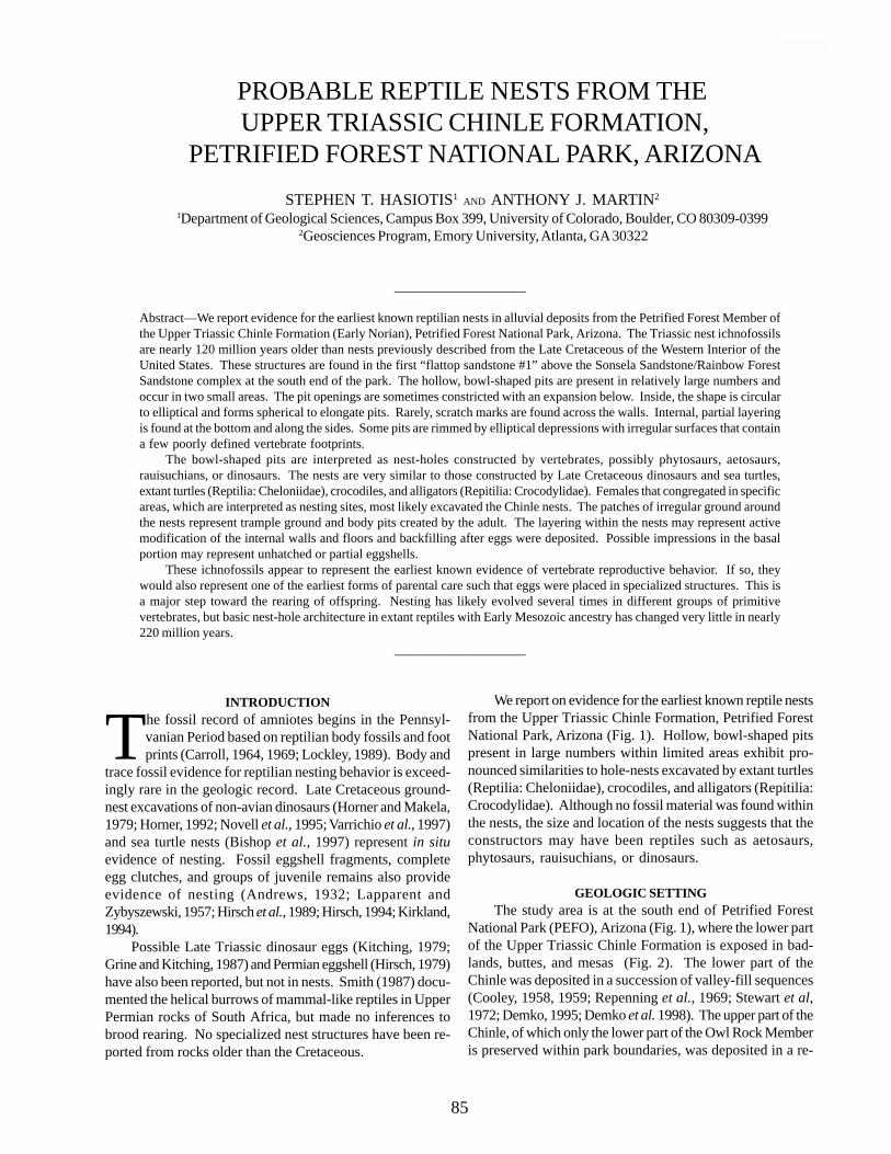
PROBABLE REPTILE NESTS FROM THE UPPER TRIASSIC CHINLE FORMATION,
PETRIFIED FOREST NATIONAL PARK, ARIZONASTEPHEN T. HASIOTIS1 AND ANTHONY J. MARTIN2
1Department of Geological Sciences, Campus Box 399, University of Colorado, Boulder, CO 80309-0399 2Geosciences Program, Emory University, Atlanta, GA 30322
____________________
Abstract—We report evidence for the earliest known reptilian nests in alluvial deposits from the Petrified Forest Member ofthe Upper Triassic Chinle Formation (Early Norian), Petrified Forest National Park, Arizona. The Triassic nest ichnofossilsare nearly 120 million years older than nests previously described from the Late Cretaceous of the Western Interior of theUnited States. These structures are found in the first “flattop sandstone #1” above the Sonsela Sandstone/Rainbow ForestSandstone complex at the south end of the park. The hollow, bowl-shaped pits are present in relatively large numbers andoccur in two small areas. The pit openings are sometimes constricted with an expansion below. Inside, the shape is circularto elliptical and forms spherical to elongate pits. Rarely, scratch marks are found across the walls. Internal, partial layeringis found at the bottom and along the sides. Some pits are rimmed by elliptical depressions with irregular surfaces that containa few poorly defined vertebrate footprints.
The bowl-shaped pits are interpreted as nest-holes constructed by vertebrates, possibly phytosaurs, aetosaurs,rauisuchians, or dinosaurs. The nests are very similar to those constructed by Late Cretaceous dinosaurs and sea turtles,extant turtles (Reptilia: Cheloniidae), crocodiles, and alligators (Repitilia: Crocodylidae). Females that congregated in specificareas, which are interpreted as nesting sites, most likely excavated the Chinle nests. The patches of irregular ground aroundthe nests represent trample ground and body pits created by the adult. The layering within the nests may represent activemodification of the internal walls and floors and backfilling after eggs were deposited. Possible impressions in the basalportion may represent unhatched or partial eggshells.
These ichnofossils appear to represent the earliest known evidence of vertebrate reproductive behavior. If so, theywould also represent one of the earliest forms of parental care such that eggs were placed in specialized structures. This isa major step toward the rearing of offspring. Nesting has likely evolved several times in different groups of primitivevertebrates, but basic nest-hole architecture in extant reptiles with Early Mesozoic ancestry has changed very little in nearly220 million years.
____________________
INTRODUCTION
The fossil record of amniotes begins in the Pennsyl-vanian Period based on reptilian body fossils and footprints (Carroll, 1964, 1969; Lockley, 1989). Body and
trace fossil evidence for reptilian nesting behavior is exceed-ingly rare in the geologic record. Late Cretaceous ground-nest excavations of non-avian dinosaurs (Horner and Makela,1979; Horner, 1992; Novell et al., 1995; Varrichio et al., 1997)and sea turtle nests (Bishop et al., 1997) represent in situevidence of nesting. Fossil eggshell fragments, completeegg clutches, and groups of juvenile remains also provideevidence of nesting (Andrews, 1932; Lapparent andZybyszewski, 1957; Hirsch et al., 1989; Hirsch, 1994; Kirkland,1994).
Possible Late Triassic dinosaur eggs (Kitching, 1979;Grine and Kitching, 1987) and Permian eggshell (Hirsch, 1979)have also been reported, but not in nests. Smith (1987) docu-mented the helical burrows of mammal-like reptiles in UpperPermian rocks of South Africa, but made no inferences tobrood rearing. No specialized nest structures have been re-ported from rocks older than the Cretaceous.
We report on evidence for the earliest known reptile nestsfrom the Upper Triassic Chinle Formation, Petrified ForestNational Park, Arizona (Fig. 1). Hollow, bowl-shaped pitspresent in large numbers within limited areas exhibit pro-nounced similarities to hole-nests excavated by extant turtles(Reptilia: Cheloniidae), crocodiles, and alligators (Repitilia:Crocodylidae). Although no fossil material was found withinthe nests, the size and location of the nests suggests that theconstructors may have been reptiles such as aetosaurs,phytosaurs, rauisuchians, or dinosaurs.
GEOLOGIC SETTINGThe study area is at the south end of Petrified Forest
National Park (PEFO), Arizona (Fig. 1), where the lower partof the Upper Triassic Chinle Formation is exposed in bad-lands, buttes, and mesas (Fig. 2). The lower part of theChinle was deposited in a succession of valley-fill sequences(Cooley, 1958, 1959; Repenning et al., 1969; Stewart et al,1972; Demko, 1995; Demko et al. 1998). The upper part of theChinle, of which only the lower part of the Owl Rock Memberis preserved within park boundaries, was deposited in a re-
85
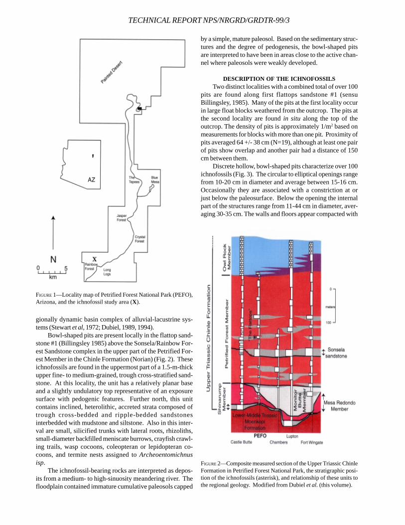
TECHNICAL REPORT NPS/NRGRD/GRDTR-99/3
gionally dynamic basin complex of alluvial-lacustrine sys-tems (Stewart et al, 1972; Dubiel, 1989, 1994).
Bowl-shaped pits are present locally in the flattop sand-stone #1 (Billingsley 1985) above the Sonsela/Rainbow For-est Sandstone complex in the upper part of the Petrified For-est Member in the Chinle Formation (Norian) (Fig. 2). Theseichnofossils are found in the uppermost part of a 1.5-m-thickupper fine- to medium-grained, trough cross-stratified sand-stone. At this locality, the unit has a relatively planar baseand a slightly undulatory top representative of an exposuresurface with pedogenic features. Further north, this unitcontains inclined, heterolithic, accreted strata composed oftrough cross-bedded and ripple-bedded sandstonesinterbedded with mudstone and siltstone. Also in this inter-val are small, silicified trunks with lateral roots, rhizoliths,small-diameter backfilled meniscate burrows, crayfish crawl-ing trails, wasp cocoons, coleopteran or lepidopteran co-coons, and termite nests assigned to Archeoentomichnusisp.
The ichnofossil-bearing rocks are interpreted as depos-its from a medium- to high-sinuosity meandering river. Thefloodplain contained immature cumulative paleosols capped
by a simple, mature paleosol. Based on the sedimentary struc-tures and the degree of pedogenesis, the bowl-shaped pitsare interpreted to have been in areas close to the active chan-nel where paleosols were weakly developed.
DESCRIPTION OF THE ICHNOFOSSILSTwo distinct localities with a combined total of over 100
pits are found along first flattops sandstone #1 (sensuBillingsley, 1985). Many of the pits at the first locality occurin large float blocks weathered from the outcrop. The pits atthe second locality are found in situ along the top of theoutcrop. The density of pits is approximately 1/m2 based onmeasurements for blocks with more than one pit. Proximity ofpits averaged 64 +/- 38 cm (N=19), although at least one pairof pits show overlap and another pair had a distance of 150cm between them.
Discrete hollow, bowl-shaped pits characterize over 100ichnofossils (Fig. 3). The circular to elliptical openings rangefrom 10-20 cm in diameter and average between 15-16 cm.Occasionally they are associated with a constriction at orjust below the paleosurface. Below the opening the internalpart of the structures range from 11-44 cm in diameter, aver-aging 30-35 cm. The walls and floors appear compacted with
FIGURE 1—Locality map of Petrified Forest National Park (PEFO),Arizona, and the ichnofossil study area (X).
FIGURE 2—Composite measured section of the Upper Triassic ChinleFormation in Petrified Forest National Park, the stratigraphic posi-tion of the ichnofossils (asterisk), and relationship of these units tothe regional geology. Modified from Dubiel et al. (this volume).
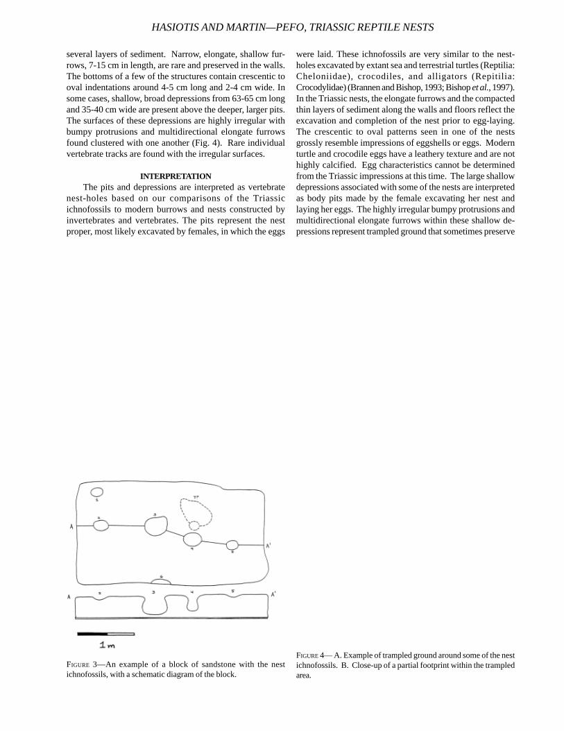
several layers of sediment. Narrow, elongate, shallow fur-rows, 7-15 cm in length, are rare and preserved in the walls.The bottoms of a few of the structures contain crescentic tooval indentations around 4-5 cm long and 2-4 cm wide. Insome cases, shallow, broad depressions from 63-65 cm longand 35-40 cm wide are present above the deeper, larger pits.The surfaces of these depressions are highly irregular withbumpy protrusions and multidirectional elongate furrowsfound clustered with one another (Fig. 4). Rare individualvertebrate tracks are found with the irregular surfaces.
INTERPRETATIONThe pits and depressions are interpreted as vertebrate
nest-holes based on our comparisons of the Triassicichnofossils to modern burrows and nests constructed byinvertebrates and vertebrates. The pits represent the nestproper, most likely excavated by females, in which the eggs
were laid. These ichnofossils are very similar to the nest-holes excavated by extant sea and terrestrial turtles (Reptilia:Cheloniidae), crocodiles, and alligators (Repitilia:Crocodylidae) (Brannen and Bishop, 1993; Bishop et al., 1997).In the Triassic nests, the elongate furrows and the compactedthin layers of sediment along the walls and floors reflect theexcavation and completion of the nest prior to egg-laying.The crescentic to oval patterns seen in one of the nestsgrossly resemble impressions of eggshells or eggs. Modernturtle and crocodile eggs have a leathery texture and are nothighly calcified. Egg characteristics cannot be determinedfrom the Triassic impressions at this time. The large shallowdepressions associated with some of the nests are interpretedas body pits made by the female excavating her nest andlaying her eggs. The highly irregular bumpy protrusions andmultidirectional elongate furrows within these shallow de-pressions represent trampled ground that sometimes preserve
HASIOTIS AND MARTIN—PEFO, TRIASSIC REPTILE NESTS
FIGURE 3—An example of a block of sandstone with the nestichnofossils, with a schematic diagram of the block.
FIGURE 4— A. Example of trampled ground around some of the nestichnofossils. B. Close-up of a partial footprint within the trampledarea.
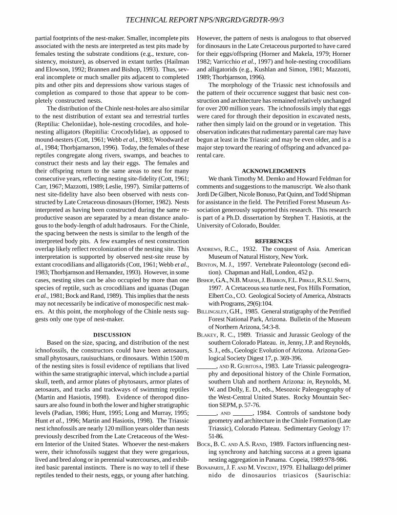
TECHNICAL REPORT NPS/NRGRD/GRDTR-99/3
partial footprints of the nest-maker. Smaller, incomplete pitsassociated with the nests are interpreted as test pits made byfemales testing the substrate conditions (e.g., texture, con-sistency, moisture), as observed in extant turtles (Hailmanand Elowson, 1992; Brannen and Bishop, 1993). Thus, sev-eral incomplete or much smaller pits adjacent to completedpits and other pits and depressions show various stages ofcompletion as compared to those that appear to be com-pletely constructed nests.
The distribution of the Chinle nest-holes are also similarto the nest distribution of extant sea and terrestrial turtles(Reptilia: Cheloniidae), hole-nesting crocodiles, and hole-nesting alligators (Repitilia: Crocodylidae), as opposed tomound-nesters (Cott, 1961; Webb et al., 1983; Woodward etal., 1984; Thorbjarnarson, 1996). Today, the females of thesereptiles congregate along rivers, swamps, and beaches toconstruct their nests and lay their eggs. The females andtheir offspring return to the same areas to nest for manyconsecutive years, reflecting nesting site-fidelity (Cott, 1961;Carr, 1967; Mazzotti, 1989; Leslie, 1997). Similar patterns ofnest site-fidelity have also been observed with nests con-structed by Late Cretaceous dinosaurs (Horner, 1982). Nestsinterpreted as having been constructed during the same re-productive season are separated by a mean distance analo-gous to the body-length of adult hadrosaurs. For the Chinle,the spacing between the nests is similar to the length of theinterpreted body pits. A few examples of nest constructionoverlap likely reflect recolonization of the nesting site. Thisinterpretation is supported by observed nest-site reuse byextant crocodilians and alligatorids (Cott, 1961; Webb et al.,1983; Thorbjarnson and Hernandez, 1993). However, in somecases, nesting sites can be also occupied by more than onespecies of reptile, such as crocodilians and iguanas (Duganet al., 1981; Bock and Rand, 1989). This implies that the nestsmay not necessarily be indicative of monospecific nest mak-ers. At this point, the morphology of the Chinle nests sug-gests only one type of nest-maker.
DISCUSSIONBased on the size, spacing, and distribution of the nest
ichnofossils, the constructors could have been aetosaurs,small phytosaurs, rauisuchians, or dinosaurs. Within 1500 mof the nesting sites is fossil evidence of reptilians that livedwithin the same stratigraphic interval, which include a partialskull, teeth, and armor plates of phytosaurs, armor plates ofaetosaurs, and tracks and trackways of swimming reptiles(Martin and Hasiotis, 1998). Evidence of theropod dino-saurs are also found in both the lower and higher stratigraphiclevels (Padian, 1986; Hunt, 1995; Long and Murray, 1995;Hunt et al., 1996; Martin and Hasiotis, 1998). The Triassicnest ichnofossils are nearly 120 million years older than nestspreviously described from the Late Cretaceous of the West-ern Interior of the United States. Whoever the nest-makerswere, their ichnofossils suggest that they were gregarious,lived and bred along or in perennial watercourses, and exhib-ited basic parental instincts. There is no way to tell if thesereptiles tended to their nests, eggs, or young after hatching.
However, the pattern of nests is analogous to that observedfor dinosaurs in the Late Cretaceous purported to have caredfor their eggs/offspring (Horner and Makela, 1979; Horner1982; Varricchio et al., 1997) and hole-nesting crocodiliansand alligatorids (e.g., Kushlan and Simon, 1981; Mazzotti,1989; Thorbjarnson, 1996).
The morphology of the Triassic nest ichnofossils andthe pattern of their occurrence suggest that basic nest con-struction and architecture has remained relatively unchangedfor over 200 million years. The ichnofossils imply that eggswere cared for through their deposition in excavated nests,rather then simply laid on the ground or in vegetation. Thisobservation indicates that rudimentary parental care may havebegun at least in the Triassic and may be even older, and is amajor step toward the rearing of offspring and advanced pa-rental care.
ACKNOWLEDGMENTSWe thank Timothy M. Demko and Howard Feldman for
comments and suggestions to the manuscript. We also thankJordi De Gilbert, Nicole Bonuso, Pat Quinn, and Todd Shipmanfor assistance in the field. The Petrified Forest Museum As-sociation generously supported this research. This researchis part of a Ph.D. dissertation by Stephen T. Hasiotis, at theUniversity of Colorado, Boulder.
REFERENCESANDREWS, R.C., 1932. The conquest of Asia. American
Museum of Natural History, New York.BENTON, M. J., 1997. Vertebrate Paleontology (second edi-
tion). Chapman and Hall, London, 452 p.BISHOP, G.A., N.B. MARSH, J. BARRON, F.L. PIRKLE, R.S.U. SMITH,
1997. A Cretaceous sea turtle nest, Fox Hills Formation,Elbert Co., CO. Geological Society of America, Abstractswith Programs, 29(6):104.
BILLINGSLEY, G.H., 1985. General stratigraphy of the PetrifiedForest National Park, Arizona. Bulletin of the Museumof Northern Arizona, 54:3-8.
BLAKEY, R. C., 1989. Triassic and Jurassic Geology of thesouthern Colorado Plateau. in, Jenny, J.P. and Reynolds,S. J., eds., Geologic Evolution of Arizona. Arizona Geo-logical Society Digest 17, p. 369-396.
______, AND R. GUBITOSA, 1983. Late Triassic paleogeogra-phy and depositional history of the Chinle Formation,southern Utah and northern Arizona: in, Reynolds, M.W. and Dolly, E. D., eds., Mesozoic Paleogeography ofthe West-Central United States. Rocky Mountain Sec-tion SEPM, p. 57-76.
______, AND ______, 1984. Controls of sandstone bodygeometry and architecture in the Chinle Formation (LateTriassic), Colorado Plateau. Sedimentary Geology 17:51-86.
BOCK, B. C. AND A.S. RAND, 1989. Factors influencing nest-ing synchrony and hatching success at a green iguananesting aggregation in Panama. Copeia, 1989:978-986.
BONAPARTE, J. F. AND M. VINCENT, 1979. El hallazgo del primernido de dinosaurios triasicos (Saurischia:
Prosauropoda), Triasico superior de Patagonia, Argen-tina. Ameghiana, 16:173-182.
BRANNEN, N.A. AND G.A. BISHOP, 1993. Nesting traces of theloggerhead sea turtle (Caretta caretta Linne), St.Catherine Island, Georgia: Implications for the fossilrecord. in, Farrell, K. M., Hoffman, C. W., and Henry, V.J., Jr., eds., Geomorphology and facies relationships ofQuaternary barrier island complexes near St. Mary’s,Georgia. Georgia Geological Society Guidebook, 13(1):30-96.
CARR, A., 1967. So excellent a fish: a natural history ofturtles. The Natural History Press, American Museumof Natural History, New York, 248 p.
CARROLL, R.L., 1964. The earliest reptiles. Journal of theLinnean Society, Zoology, 45:61-83.
CARROLL, R.L., 1969. A middle Pennsylvaniancaptorhinomorph and the interrelationships of primitivereptiles. Journal of Paleontology, 43:151-170.
COOLEY, M.E., 1958. The Mesa Redondo Member of the ChinleFormation, Apache and Navajo counties, Arizona. Pla-teau, 31:7-15.
______, 1959. Triassic stratigraphy in the state line region ofwest-central New Mexico and east-central Arizona. NewMexico Geological Society Guidebook of West-CentralNew Mexico, Tenth Field Conference, p. 66-73.
COTT, H.B., 1961. Scientific results of an inquiry into theecology and economic status of the Nile crocodile(Crocodylus niloticus) in Uganda and northern Rhode-sia. Transactions of the Zoological Society of London,29:211-356.
DEMKO, T. M., 1995. Taphonomy of fossil plants in the UpperTriassic Chinle Formation: Ph.D. Dissertation, Univer-sity of Arizona, 274 p.
______, R.F. DUBIEL, AND J.T. PARRISH, 1998. Plant taphonomyin incised valleys: implications for interpretingpaleoclimate from fossil plants. Geology, 26:1119-1122.
DUBIEL, R.F., 1989. Depositional and climatic setting of theUpper Triassic Chinle Formation, Colorado Plateau. in,Lucas, S. G. and Hunt, A. P., eds., Dawn of the Age ofDinosaurs, New Mexico Museum of Natural HistorySpring Field Conference Guidebook, p. 171-187.
______, 1994. Triassic deposystems, paleogeography, andpaleoclimate of the Western Interior: in, Caputo, M. V.,Peterson, J. A., and Franczyk, K. J., eds., Mesozoic sys-tems of the Rocky Mountain region, USA. Rocky Moun-tain Section, SEPM, Denver, Colorado, p. 133-168.
DUGAN, B.A., A.S. RAND, G.M. BURGHARDT, AND B.C. BOCK,1981. Interactions between crocodiles and iguanas. Jour-nal of Herpetology, 15:409-414.
GRINE, F.E. AND J.W. KITCHING, 1987. Scanning electron mi-croscopy of early dinosaur eggshell structure: a com-parison with other rigid sauropsid eggs. Scanning Mi-croscopy, 1:615-630.
HAILMAN, J.P. AND A.M. ELOWSON, 1992. Ethogram of thenesting female loggerhead turtle (Caretta caretta).Herpetologia, 48(1):1-30.
HIRSCH, K.F., 1979. The oldest vertebrate egg? Journal of
Paleontology, 53:1068-1084.______, 1994. Upper Jurassic eggshells from the Western
Interior of North America. in, Carpenter, K., Hirsch, K.F., and Horner, J. R., (eds.), Dinosaur eggs and babies,Cambridge University Press, Cambridge, p. 137-150.
______, K. STADTMAN, W. MILLER, AND J. MADSEN, 1989.Upper Jurassic dinosaur egg from Utah. Science,243:1711-1713.
HORNER, J.F., 1982. Evidence of colonial nesting and “sitefidelity” among ornithiscian dinosaurs. Nature, 297:676-678.
______, AND R. MAKELA, 1979. Nest of juveniles providesevidence of family structure among dinosaurs. Nature,282:296-298.
HUNT, A.P., 1995. Stratigraphy and taphonomy of Late Trias-sic dinosaur localities, Petrified Forest National Park,northeastern Arizona. Program and Abstracts of Pre-sented papers and Posters of the Third Biennial Confer-ence of Research on the Colorado Plateau, p. 26.
______, T.P. OLSON, P. HUBER, T. SHIPMAN, P. BIRCHEFF, AND
J.E. FROST, 1996. A new theropod locality at PetrifiedForest National Park with a review of Late Triassic dino-saur localities in the park. in, Boaz, D., Dierking, P., Dornan,M., McGeorge, R., and Tegowski, B. J., eds., Proceed-ings of the Fourth Annual Fossils of Arizona Sympo-sium, Mesa Southwest Museum and Southwest Paleon-tological Society, Mesa, Arizona, p. 55-61.
KIRKLAND, J.I., 1994. Predation of dinosaur nests by terres-trial crocodilians. in, Carpenter, K., Hirsch, K. F., andHorner, J. R., (eds.), Dinosaur eggs and babies, Cam-bridge University Press, Cambridge, p. 124-133.
KITCHING, J.W., 1979. Preliminary report on a clutch of sixdinosaurian eggs from the Upper Triassic Elliot Forma-tion, North Orange Free State. PaleontographicaAfricana, 22:41-45.
KUSHLAN, J.A. AND J.C. SIMON, 1981. Egg manipulation bythe American alligator. Journal of Herpetology, 15:477-488.
LAPPARENT, A. AND G. ZYBYSZEWSKI, 1957. Les dinosauriensdu Portugal. Memoires du Service Geologique de Portu-gal, 2:1-63.
LESLIE, A.J., 1997. The ecology and physiology of the Nilecrocodile, Crocodylus niloticus, in Lake St. Lucia.Kwazulu/Natal, South Africa (osmoregulation, estuary,sex determination). Unpublished dissertation, DrexelUniversity, Philadelphia, Pennsylvania, 316 p.
LOCKLEY, M.G., 1989. Middle Pennsylvanian paleoecologyof the Eagle Basin region, central Colorado. 21st CongresInternational de Stratigraphie et de geologie duCarbonifere, Beijing, 1987, Compte redu 3:245-250.
LONG, R.A. AND P.A. MURRAY, 1989. Late Triassic (Carnianand Norian) tetrapods from the Southwestern UnitedStates. Museum of Northern Arizona Bulletin, 59:27-50.
MAZZOTTI, F.J., 1989. Factors affecting the nesting successof the American crocodile, Crocodylus acutus, in FloridaBay. Bulletin of Marine Science, 44:220-228.
NOVELL, M.A., J.M. CLARK, L.M. CHIAPPE, AND D.M.
HASIOTIS AND MARTIN—PEFO, TRIASSIC REPTILE NESTS
TECHNICAL REPORT NPS/NRGRD/GRDTR-99/3
DASHZEVEG, 1995. A nesting dinosaur. Nature, 378:774-776.
PADIAN, K., 1986. On the type material of Coelophysis(Saurischia: Theropoda) and a new specimen from thePetrified Forest of Arizona (Late Triassic: Chinle Forma-tion). in Padian, K., ed., The beginning of the age ofdinosaurs: faunal change across the Triassic-Jurassicboundary, Cambridge University Press, Cambridge, p.45-60.
REPENNING, C.A., M.E. COOLEY, AND J.P. AKERS, 1969, Stratig-raphy of the Chinle and Moenkopi Formations, Navajoand Hopi Indian Reservations, Arizona, New Mexico,and Utah. U.S. Geological Survey Professional Paper521-B, p. B1-B31.
SMITH, R.M.H., 1987. Helical burrow casts of therapsid originfrom the Beufort Group (Permian) of South Africa.Palaeogeography, Palaeoclimatology, Palaeoecology,57:285-331.
STEWART, J.H., F.G. POOLE, AND R.F. WILSON, 1972, Stratigra-phy and origin of the Chinle Formation and related Tri-assic strata in the Colorado Plateau region with a section
on sedimentary petrology by R. A. Cadigan and on con-glomerate studies by W. Thordarson, H. F. Albee, and J.H. Stewart. U.S. Geological Survey Professional Paper690, 336 p.
THORBJARNSON, J.B., 1996. Reproductive characteristics ofthe Order Crocodylia. Herpetologia, 52:8-24.
______, AND G. HERNANDEZ, 1983. Reproductive ecology ofthe Orinoco crocodile (Crocodylus intermedius) in Ven-ezuela. I. nesting ecology and clutch relationships. Jour-nal of Herpetology, 27:363-370.
VARRICCHIO, D.J., F. JACKSON, J.J. BORKOWSKI, AND J.R. HORNER,1997. Nest and egg clutches of the dinosaur Troodonformosus and the evolution of avian reproductive traits.Nature, 385:247-250.
WEBB, G.J.W., W.R. BUCKWORTH, AND S.C. MANOLIS, 1983.Crocodylus johnstoni in the McKinley River area, N. T.VI. Nesting biology. Australian Wildlife Research, 10:607-637.
WOODWARD, A., T. HINES, C. ABERCROMBIE, AND C. HOPE,1984. Spacing patterns in alligator nests. Journal ofHerpetology, 18:8-12.
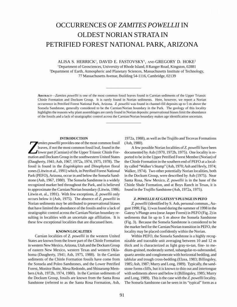
OCCURRENCES OF ZAMITES POWELLII IN OLDEST NORIAN STRATA IN
PETRIFIED FOREST NATIONAL PARK, ARIZONA
ALISA S. HERRICK1, DAVID E. FASTOVSKY1, AND GREGORY D. HOKE2
1Department of Geosciences, University of Rhode Island, 8 Ranger Road, Kingston, 028812Department of Earth, Atmospheric and Planetary Sciences, Massachusetts Institute of Technology,
77 Massachusetts Avenue, Building 54-1116, Cambridge, 02139
INTRODUCTION
Zamites powellii provides one of the most common fossilleaves, if not the most common fossil leaf, found in thelower part (Carnian) of the Upper Triassic Chinle For-
mation and Dockum Group in the southwestern United States(Daugherty, 1941; Ash, 1967, 1972a, 1974, 1975, 1978). Thefossil is found in the Eoginkigites and Dinophyton floralzones (Litwin et al., 1991) which, in Petrified Forest NationalPark (PEFO), Arizona, occur in and below the Sonsela Sand-stone (Ash, 1967, 1980). The Sonsela Sandstone is a widelyrecognized marker bed throughout the Park, and is believedto approximate the Carnian/Norian boundary (Litwin, 1986;Litwin et. al., 1991). With few exceptions, Z. powellii onlyoccurs below it (Ash, 1975). The absence of Z. powellii inNorian sediments may be attributed to preservational biasesthat have limited the abundance of the fossils and/or a lack ofstratigraphic control across the Carnian/Norian boundary re-sulting in localities with an uncertain age affiliation. It isthese few exceptional localities that are discussed here.
KNOWN LOCALITIESCarnian localities of Z. powellii in the western United
States are known from the lower part of the Chinle Formationin western New Mexico, Arizona, Utah and the Dockum Groupof eastern New Mexico, western Texas and western Okla-homa (Daugherty, 1941; Ash, 1975, 1988). In the Carniansediments of the Chinle Formation fossils have come fromthe Sonsela and Poleo Sandstones, and the Lower PetrifiedForest, Monitor Butte, Mesa Redondo, and Shinarump Mem-bers (Ash, 1972b, 1974, 1980). In the Carnian sediments ofthe Dockum Group, fossils are known from the Santa RosaSandstone (referred to as the Santa Rosa Formation, Ash,
1972a, 1988), as well as the Trujillo and Tecovas Formations(Ash, 1980).
A few possible Norian localities of Z. powellii have beendocumented by Ash (1970, 1972b, 1975). One locality is re-ported to be in the Upper Petrified Forest Member (Norian) ofthe Chinle Formation in the southern end of PEFO at a local-ity called “Walker’s Stump” (Ash, 1970; Ash and Hevly, 1974;Walker, 1974). Two other potentially Norian localities, bothin the Dockum Group, were described by Ash (1975). NearSanta Rosa, New Mexico, Z. powellii is in the base of theChinle Shale Formation, and at Boys Ranch in Texas, it isfound in the Trujillo Sandstone (Ash, 1972a, 1975).
Z. POWELLII AT GATESY’S PLUNGE IN PEFOZ. powellii (identified by S. Ash, personal commun., Au-
gust 1998; Fig. 1) was found during the summer of 1998 in theGatesy’s Plunge area (near Jasper Forest) in PEFO (Fig. 2) insediments that lie up to 5 m above the Sonsela Sandstone(Fig. 3). Because the Sonsela Sandstone is considered to bethe marker bed for the Carnian/Norian transition in PEFO, thelocality may be placed confidently within the Norian.
Within PEFO, the Sonsela Sandstone is a highly recog-nizable and traceable unit averaging between 10 and 12 mthick and is characterized as light gray-to-tan, fine- to me-dium-grained, moderately sorted, subangular-to-subrounded,quartz arenite and conglomerate with horizontal bedding, andtablular and trough cross-bedding (Elzea, 1983; Billingsley,1985; Ash, 1987; Murry and Long, 1989). Typically, the sand-stone forms cliffs, but it is known to thin out and intertonguewith sediments above and below it (Billingsley, 1985; Murryand Long, 1989). This is the case with the Z. powellii locality.The Sonsela Sandstone can be seen in its “typical” form as a
____________________
ABSTRACT—Zamites powellii is one of the most common fossil leaves found in Carnian sediments of the Upper TriassicChinle Formation and Dockum Group. It is rarely found in Norian sediments. Here, however, we report a Norianoccurrence in Petrified Forest National Park, Arizona. Z. powellii was found in channel-fill deposits up to 5 m above theSonsela Sandstone, generally considered to be the Carnian/Norian boundary in the Park. The geology of this localityhighlights the reasons why plant assemblages are rarely found in Norian deposits: preservational biases limit the abundanceof the fossils and a lack of stratigraphic control across the Carnian/Norian boundary makes age identification uncertain.
____________________
91
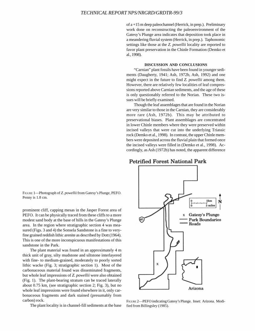
TECHNICAL REPORT NPS/NRGRD/GRDTR-99/3
prominent cliff, capping mesas in the Jasper Forest area ofPEFO. It can be physically traced from these cliffs to a moremodest sand body at the base of hills in the Gatesy’s Plungearea. In the region where stratigraphic section 4 was mea-sured (Figs. 3 and 4) the Sonsela Sandstone is a fine to very-fine grained reddish lithic arenite as described by Dott (1964).This is one of the more inconspicuous manifestations of thissandstone in the Park.
The plant material was found in an approximately 4 mthick unit of gray, silty mudstone and siltstone interlayeredwith fine- to medium-grained, moderately to poorly sortedlithic wacke (Fig. 3; stratigraphic section 1). Most of thecarbonaceous material found was disseminated fragments,but whole leaf impressions of Z. powellii were also obtained(Fig. 1). The plant-bearing stratum can be traced laterallyabout 0.75 km, (see stratigraphic section 2; Fig. 3), but nowhole leaf impressions were found elsewhere in it, only car-bonaceous fragments and dark stained (presumably fromcarbon) rock.
The plant locality is in channel-fill sediments at the base
of a +15 m deep paleochannel (Herrick, in prep.). Preliminarywork done on reconstructing the paleoenvironment of theGatesy’s Plunge area indicates that deposition took place ina meandering fluvial system (Herrick, in prep.). Taphonomicsettings like those at the Z. powellii locality are reported tofavor plant preservation in the Chinle Formation (Demko etal., 1998).
DISCUSSION AND CONCLUSIONS“Carnian” plant fossils have been found in younger sedi-
ments (Daugherty, 1941; Ash, 1972b, Ash, 1992) and onemight expect in the future to find Z. powellii among them.However, there are relatively few localities of leaf compres-sions reported above Carnian sediments, and the age of theseis only questionably referred to the Norian. These two is-sues will be briefly examined.
Though the leaf assemblages that are found in the Norianare very similar to those in the Carnian, they are considerablymore rare (Ash, 1972b). This may be attributed topreservational biases. Plant assemblages are concentratedin lower Chinle members where they were preserved withinincised valleys that were cut into the underlying Triassicrock (Demko et al., 1998). In contrast, the upper Chinle mem-bers were deposited across the fluvial plain that formed oncethe incised valleys were filled in (Demko et al., 1998). Ac-cordingly, as Ash (1972b) has noted, the apparent difference
FIGURE 1—Photograph of Z. powellii from Gatesy’s Plunge, PEFO.Penny is 1.8 cm.
FIGURE 2—PEFO indicating Gatesy’s Plunge. Inset: Arizona. Modi-fied from Billingsley (1985).
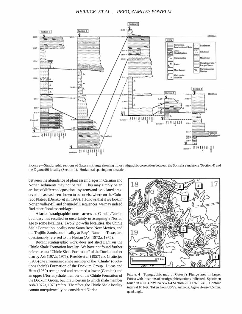
between the abundance of plant assemblages in Carnian andNorian sediments may not be real. This may simply be anartifact of different depositional systems and associated pres-ervation, as has been shown to occur elsewhere on the Colo-rado Plateau (Demko, et al., 1998). It follows that if we look inNorian valley-fill and channel-fill sequences, we may indeedfind more floral assemblages.
A lack of stratigraphic control across the Carnian/Norianboundary has resulted in uncertainty in assigning a Norianage to some localities. Two Z. powellii localities, the ChinleShale Formation locality near Santa Rosa New Mexico, andthe Trujillo Sandstone locality at Boy’s Ranch in Texas, arequestionably referred to the Norian (Ash 1972a, 1975).
Recent stratigraphic work does not shed light on theChinle Shale Formation locality. We have not found furtherreference to a “Chinle Shale Formation” of the Dockum otherthan by Ash (1972a, 1975). Reeside et al. (1957) and Chatterjee(1986) cite an unnamed shale member of the “Chinle” (quota-tions their’s) Formation of the Dockum Group. Lucas andHunt (1989) recognized and renamed a lower (Carnian) andan upper (Norian) shale member of the Chinle Formation ofthe Dockum Group, but it is uncertain to which shale memberAsh (1972a, 1975) refers. Therefore, the Chinle Shale localitycannot unequivocally be considered Norian.
FIGURE 3—Stratigraphic sections of Gatesy’s Plunge showing lithostratigraphic correlation between the Sonsela Sandstone (Section 4) andthe Z. powellii locality (Section 1). Horizontal spacing not to scale.
FIGURE 4—Topographic map of Gatesy’s Plunge area in JasperForest with locations of stratigraphic sections indicated. Specimenfound in NE1/4 NW1/4 NW1/4 Section 20 T17N R24E. Contourinterval 10 feet. Taken from USGS, Arizona, Agate House 7.5 min.quadrangle.
HERRICK ET AL.,—PEFO, ZAMITES POWELLI
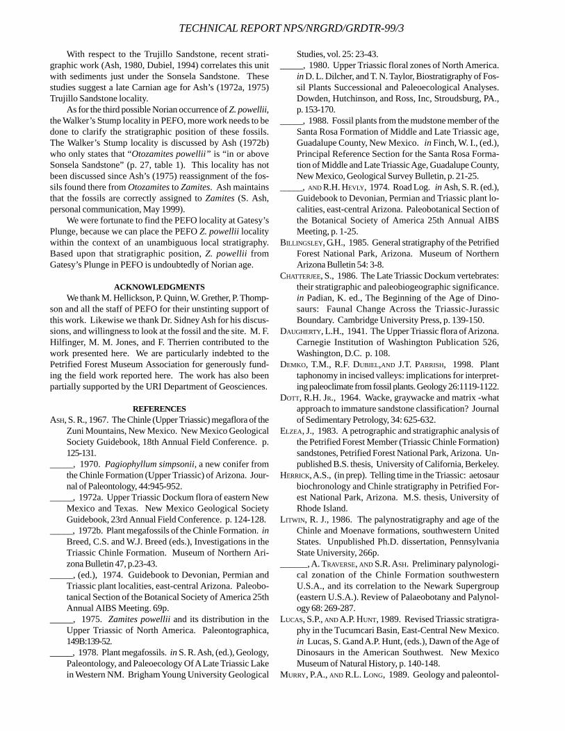
TECHNICAL REPORT NPS/NRGRD/GRDTR-99/3
With respect to the Trujillo Sandstone, recent strati-graphic work (Ash, 1980, Dubiel, 1994) correlates this unitwith sediments just under the Sonsela Sandstone. Thesestudies suggest a late Carnian age for Ash’s (1972a, 1975)Trujillo Sandstone locality.
As for the third possible Norian occurrence of Z. powellii,the Walker’s Stump locality in PEFO, more work needs to bedone to clarify the stratigraphic position of these fossils.The Walker’s Stump locality is discussed by Ash (1972b)who only states that “Otozamites powellii” is “in or aboveSonsela Sandstone” (p. 27, table 1). This locality has notbeen discussed since Ash’s (1975) reassignment of the fos-sils found there from Otozamites to Zamites. Ash maintainsthat the fossils are correctly assigned to Zamites (S. Ash,personal communication, May 1999).
We were fortunate to find the PEFO locality at Gatesy’sPlunge, because we can place the PEFO Z. powellii localitywithin the context of an unambiguous local stratigraphy.Based upon that stratigraphic position, Z. powellii fromGatesy’s Plunge in PEFO is undoubtedly of Norian age.
ACKNOWLEDGMENTSWe thank M. Hellickson, P. Quinn, W. Grether, P. Thomp-
son and all the staff of PEFO for their unstinting support ofthis work. Likewise we thank Dr. Sidney Ash for his discus-sions, and willingness to look at the fossil and the site. M. F.Hilfinger, M. M. Jones, and F. Therrien contributed to thework presented here. We are particularly indebted to thePetrified Forest Museum Association for generously fund-ing the field work reported here. The work has also beenpartially supported by the URI Department of Geosciences.
REFERENCESASH, S. R., 1967. The Chinle (Upper Triassic) megaflora of the
Zuni Mountains, New Mexico. New Mexico GeologicalSociety Guidebook, 18th Annual Field Conference. p.125-131.
_____, 1970. Pagiophyllum simpsonii, a new conifer fromthe Chinle Formation (Upper Triassic) of Arizona. Jour-nal of Paleontology, 44:945-952.
_____, 1972a. Upper Triassic Dockum flora of eastern NewMexico and Texas. New Mexico Geological SocietyGuidebook, 23rd Annual Field Conference. p. 124-128.
_____, 1972b. Plant megafossils of the Chinle Formation. inBreed, C.S. and W.J. Breed (eds.), Investigations in theTriassic Chinle Formation. Museum of Northern Ari-zona Bulletin 47, p.23-43.
_____, (ed.), 1974. Guidebook to Devonian, Permian andTriassic plant localities, east-central Arizona. Paleobo-tanical Section of the Botanical Society of America 25thAnnual AIBS Meeting. 69p.
_____, 1975. Zamites powellii and its distribution in theUpper Triassic of North America. Paleontographica,149B:139-52.
_____, 1978. Plant megafossils. in S. R. Ash, (ed.), Geology,Paleontology, and Paleoecology Of A Late Triassic Lakein Western NM. Brigham Young University Geological
Studies, vol. 25: 23-43._____, 1980. Upper Triassic floral zones of North America.
in D. L. Dilcher, and T. N. Taylor, Biostratigraphy of Fos-sil Plants Successional and Paleoecological Analyses.Dowden, Hutchinson, and Ross, Inc, Stroudsburg, PA.,p. 153-170.
_____, 1988. Fossil plants from the mudstone member of theSanta Rosa Formation of Middle and Late Triassic age,Guadalupe County, New Mexico. in Finch, W. I., (ed.),Principal Reference Section for the Santa Rosa Forma-tion of Middle and Late Triassic Age, Guadalupe County,New Mexico, Geological Survey Bulletin, p. 21-25.
_____, AND R.H. HEVLY, 1974. Road Log. in Ash, S. R. (ed.),Guidebook to Devonian, Permian and Triassic plant lo-calities, east-central Arizona. Paleobotanical Section ofthe Botanical Society of America 25th Annual AIBSMeeting, p. 1-25.
BILLINGSLEY, G.H., 1985. General stratigraphy of the PetrifiedForest National Park, Arizona. Museum of NorthernArizona Bulletin 54: 3-8.
CHATTERJEE, S., 1986. The Late Triassic Dockum vertebrates:their stratigraphic and paleobiogeographic significance.in Padian, K. ed., The Beginning of the Age of Dino-saurs: Faunal Change Across the Triassic-JurassicBoundary. Cambridge University Press, p. 139-150.
DAUGHERTY, L.H., 1941. The Upper Triassic flora of Arizona.Carnegie Institution of Washington Publication 526,Washington, D.C. p. 108.
DEMKO, T.M., R.F. DUBIEL,AND J.T. PARRISH, 1998. Planttaphonomy in incised valleys: implications for interpret-ing paleoclimate from fossil plants. Geology 26:1119-1122.
DOTT, R.H. JR., 1964. Wacke, graywacke and matrix -whatapproach to immature sandstone classification? Journalof Sedimentary Petrology, 34: 625-632.
ELZEA, J., 1983. A petrographic and stratigraphic analysis ofthe Petrified Forest Member (Triassic Chinle Formation)sandstones, Petrified Forest National Park, Arizona. Un-published B.S. thesis, University of California, Berkeley.
HERRICK, A.S., (in prep). Telling time in the Triassic: aetosaurbiochronology and Chinle stratigraphy in Petrified For-est National Park, Arizona. M.S. thesis, University ofRhode Island.
LITWIN, R. J., 1986. The palynostratigraphy and age of theChinle and Moenave formations, southwestern UnitedStates. Unpublished Ph.D. dissertation, PennsylvaniaState University, 266p.
______, A. TRAVERSE, AND S.R. ASH. Preliminary palynologi-cal zonation of the Chinle Formation southwesternU.S.A., and its correlation to the Newark Supergroup(eastern U.S.A.). Review of Palaeobotany and Palynol-ogy 68: 269-287.
LUCAS, S.P., AND A.P. HUNT, 1989. Revised Triassic stratigra-phy in the Tucumcari Basin, East-Central New Mexico.in Lucas, S. G.and A.P. Hunt, (eds.), Dawn of the Age ofDinosaurs in the American Southwest. New MexicoMuseum of Natural History, p. 140-148.
MURRY, P.A., AND R.L. LONG, 1989. Geology and paleontol-

ogy of the Chinle Formation, Petrified Forest NationalPark and vicinity, Arizona and a discussion of vertebratefossils of the southwestern Upper Triassic. in S. G. Lucas,and A. P. Hunt (eds.), Dawn of the Age of Dinosaurs inthe American Southwest. New Mexico Museum of Natu-ral History, p. 29-64. .
REESIDE, J.B., ET AL., 1957. Correlation of the Triassic forma-
tions of North America exclusive of Canada. Bulletin ofthe Geological Society of America, 68: 1451-1514.
WALKER, M.V., 1974. Early scientific work in the PetrifiedForest. in Ash, S. R. (ed.), Guidebook to Devonian, Per-mian and Triassic plant localities, east-central Arizona.Paleobotanical Section of the Botanical Society ofAmerica 25th Annual AIBS Meeting, p. 51-56.
HERRICK ET AL.,—PEFO, ZAMITES POWELLI
TECHNICAL REPORT NPS/NRGRD/GRDTR-99/3
NEW DISCOVERIES OF LATE TRIASSIC DINOSAURS FROMPETRIFIED FOREST NATIONAL PARK, ARIZONA
ADRIAN P. HUNT AND JEREMIAH WRIGHTMesalands Dinosaur Museum, Mesa Technical College, 911 South Tenth Street, Tucumcari, NM 88401
____________________
ABSTRACT—The Mesalands Dinosaur Museum has been conducting research during the last four years at Petrified ForestNational Park under the auspices of the Dawn of the Dinosaurs Project. Twelve new dinosaur localities have been discoveredto add to the three previously known. This success is due to use of the taphofacies approach to exploration. All of the dinosaurlocalities occur in two narrow stratigraphic intervals above and below the Sonsela Member in the Petrified Forest Formation incalcareous paleosols. Blue Mesa Member (Carnian) localities yield small and large theropods, whereas Painted Desert Member(Norian) localities include both theropods and the ornithischian Revueltosaurus. Associated faunas are dominated by small,terrestrial tetrapods.
____________________
INTRODUCTION
Petrified Forest National Park is famous for exquis-itely preserved petrified wood that is abundant in theUpper Triassic strata of the area (Heckert and Lucas,
1998a). However, these rocks also contain a significant recordof fossil vertebrates that elucidate one of the most importantturnovers in terrestrial tetrapods.
The Late Triassic saw the replacement of archaic faunasdominated by dicynodonts, rhynchosaurs andtemnospondyls by the archosaurian faunas that were to domi-nate the remainder of the Mesozoic (e. g., dinosaurs, ptero-saurs) as well as the advent of many other significant clades(e. g., mammals, turtles). The most critical time period in thistransition is the late Carnian through the early Norian whenall the major clades emerged and archaic groups such as thedicynodonts and rhynchosaurs became extinct (Hunt, 1991).The area in and around Petrified Forest National Park haslong yielded significant specimens of fossil vertebrates fromthis time interval (e. g., Camp, 1930, Long et al., 1989). How-ever, until 1982 no dinosaur specimens had been recoveredfrom the Park (Hunt et al., 1998). In the early 1980’s fieldparties from the University of California Museum of Paleon-tology collected from three dinosaur localities (Padian, 1986;Long and Murry, 1995). In 1996, field parties from theMesalands Dinosaur Museum started the Dawn of the Dino-saurs Project to study early dinosaur evolution in the Parkand elsewhere (Hunt et al., 1996; Hunt, 1998). This projecthas resulted in the discovery of an additional 12 dinosaurlocalities, an increase of 400% (Figure 1). The purpose of thispaper is to present initial findings from the 1998 and 1999field seasons and to relate them to previous work. MDMrefers to Mesalands Dinosaur Museum, PEFO to PetrifiedForest National Park and UCMP to University of CaliforniaMuseum of Paleontology.
GEOLOGIC SETTINGAll Upper Triassic strata preserved in Petrified Forest
National Park pertain to the Petrified Forest, Owl Rock andBluewater Creek formations of the Chinle Group (Lucas, 1993,1995; Heckert and Lucas, 1998b). Significant vertebrate fos-sils are restricted to the Blue Mesa and Painted Desert Mem-bers of the Petrified Forest Formation that are respectivelylate Carnian and early-middle Norian in age (Hunt and Lucas,1995). The majority of vertebrate fossils from these units, andall the dinosaur fossils reported herein, are from narrow strati-graphic intervals above and below the Sonsela Member whichdivides the Blue Mesa and Painted Desert members (Figure1).
96
FIGURE 1—Stratigraphic distribution of dinosaur localities withinthe Upper Triassic Petrified Forest Formation, Petrified ForestNational Park.
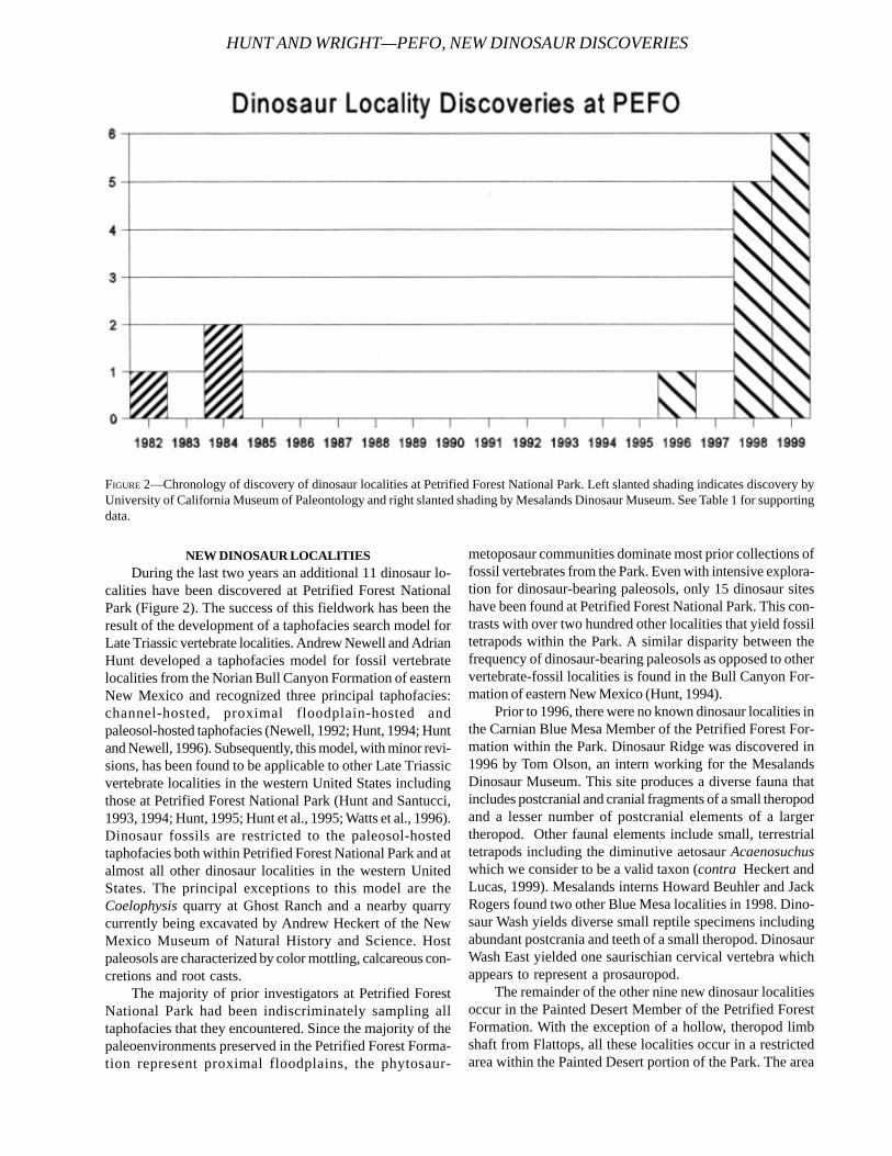
NEW DINOSAUR LOCALITIESDuring the last two years an additional 11 dinosaur lo-
calities have been discovered at Petrified Forest NationalPark (Figure 2). The success of this fieldwork has been theresult of the development of a taphofacies search model forLate Triassic vertebrate localities. Andrew Newell and AdrianHunt developed a taphofacies model for fossil vertebratelocalities from the Norian Bull Canyon Formation of easternNew Mexico and recognized three principal taphofacies:channel-hosted, proximal floodplain-hosted andpaleosol-hosted taphofacies (Newell, 1992; Hunt, 1994; Huntand Newell, 1996). Subsequently, this model, with minor revi-sions, has been found to be applicable to other Late Triassicvertebrate localities in the western United States includingthose at Petrified Forest National Park (Hunt and Santucci,1993, 1994; Hunt, 1995; Hunt et al., 1995; Watts et al., 1996).Dinosaur fossils are restricted to the paleosol-hostedtaphofacies both within Petrified Forest National Park and atalmost all other dinosaur localities in the western UnitedStates. The principal exceptions to this model are theCoelophysis quarry at Ghost Ranch and a nearby quarrycurrently being excavated by Andrew Heckert of the NewMexico Museum of Natural History and Science. Hostpaleosols are characterized by color mottling, calcareous con-cretions and root casts.
The majority of prior investigators at Petrified ForestNational Park had been indiscriminately sampling alltaphofacies that they encountered. Since the majority of thepaleoenvironments preserved in the Petrified Forest Forma-tion represent proximal floodplains, the phytosaur-
metoposaur communities dominate most prior collections offossil vertebrates from the Park. Even with intensive explora-tion for dinosaur-bearing paleosols, only 15 dinosaur siteshave been found at Petrified Forest National Park. This con-trasts with over two hundred other localities that yield fossiltetrapods within the Park. A similar disparity between thefrequency of dinosaur-bearing paleosols as opposed to othervertebrate-fossil localities is found in the Bull Canyon For-mation of eastern New Mexico (Hunt, 1994).
Prior to 1996, there were no known dinosaur localities inthe Carnian Blue Mesa Member of the Petrified Forest For-mation within the Park. Dinosaur Ridge was discovered in1996 by Tom Olson, an intern working for the MesalandsDinosaur Museum. This site produces a diverse fauna thatincludes postcranial and cranial fragments of a small theropodand a lesser number of postcranial elements of a largertheropod. Other faunal elements include small, terrestrialtetrapods including the diminutive aetosaur Acaenosuchuswhich we consider to be a valid taxon (contra Heckert andLucas, 1999). Mesalands interns Howard Beuhler and JackRogers found two other Blue Mesa localities in 1998. Dino-saur Wash yields diverse small reptile specimens includingabundant postcrania and teeth of a small theropod. DinosaurWash East yielded one saurischian cervical vertebra whichappears to represent a prosauropod.
The remainder of the other nine new dinosaur localitiesoccur in the Painted Desert Member of the Petrified ForestFormation. With the exception of a hollow, theropod limbshaft from Flattops, all these localities occur in a restrictedarea within the Painted Desert portion of the Park. The area
HUNT AND WRIGHT—PEFO, NEW DINOSAUR DISCOVERIES
FIGURE 2—Chronology of discovery of dinosaur localities at Petrified Forest National Park. Left slanted shading indicates discovery byUniversity of California Museum of Paleontology and right slanted shading by Mesalands Dinosaur Museum. See Table 1 for supportingdata.
TECHNICAL REPORT NPS/NRGRD/GRDTR-99/3
between Dinosaur Hill and Zuni Well Mound contains sev-eral abandoned channels filled with pedogenically-modifiedmudstones that yield abundant terrestrial vertebrate fossils,including dinosaurs. These facies are genetically related inan area that was initially heavily scoured and was subse-quently subject to repeated flooding. The sequence of eventswas: (a) the area was incised by channelized flow; (b) the areawas subject to periodic flooding that filled scours with mud-stone and siltstone - during this time period no streams tra-versed the area; and (c) there was pedogenic modification ofthe overbank deposits between flood events. During thesecond and third stages vertebrate remains were incorpo-rated into the strata. The sedimentologic context of the PaintedDesert localities is thus analogous to that of dinosaur-bearinglocalities in the Revuelto Creek area of eastern New Mexicoin the contemporaneous Bull Canyon Formation (Hunt, 1994).These data underscore the conceptual validity of the EarlyRevueltian (early Norian) acme zone for terrestrial tetrapodsproposed by Hunt and Lucas (1993).
The most common dinosaur in Painted Desert localitiesis Revueltosaurus callenderi which is known from tens ofteeth. No other specimens of this early ornithischian haveyet been identified. The second most common dinosaur is asmall theropod that is represented at most localities by verte-brae and limb fragments. The most significant individual speci-men is a partial skeleton of the larger theropod that Padian(1986) erroneously referred to Coelophysis bauri. This speci-men was found in 1999 at Jeremiah’s Perch and is currentlyonly partially excavated, but it includes at least femora, tibiae,cervical vertebrae, teeth as well as many other elements.
The most common member of the associated fauna is thediminutive metoposaurid Apachesaurus gregorii that had amuch more terrestrial habit than other members of its family(Hunt et al., 1993). This taxon is known from abundantintercentra, several partial skeletons, partial skulls, claviclesand interclavicles. Small terrestrial reptiles are also commonat these localities including Hesperosuchus, a Vancleavea-likeanimal, a new armored crurotarsan described by Hunt (1994)from New Mexico and other taxa. Lungfish toothplates and apartial skull are also present as are abundant coprolites andrarer gastropods. Phytosaur specimens are ubiquitous in thePark, but most dinosaur localities yield only a small numberof fragments of these crurotarsans and a disproportionatenumber of specimens represent juveniles.
CONCLUSIONSThere are two distinctive features of the Late Triassic
dinosaur localities at Petrified Forest National Park: (1) alllocalities occur in pedogenically modified fills of scours; and(2) all localities occur in two narrow stratigraphic intervals(Figure 1). The restriction of dinosaur fossils to calcretesstrongly suggests that Late Triassic dinosaurs were living inwell-drained, open country in contrast to thephytosaur-metoposaur communities that are found in wetter,proximal-floodplain settings and which representchannel-margin ecosystems (cf. Hunt, 1991). The restrictionof dinosaur specimens to narrow stratigraphic intervals is
probably related to the developmental stage of transgres-sive systems tracts, but needs further study (Hunt and Lucas,1993).
It is clear that the taphofacies approach to fossil explora-tion has been highly successful in the last few years and weare confident that additional dinosaur-bearing localities willbe found in the future utilizing this methodology. Much addi-tional work needs to be done to analyze the taxonomy andfaunal associations of the dinosaurs from the Park. This analy-sis will greater increase our understanding of the early evolu-tionary ecology and diversification of the dinosaurs in thecontext of the major faunal changes of the Late Triassic.
ACKNOWLEDGMENTSWe thank Howard Beuhler, Phil Bircheff, Jennifer Cot-
ton, Andy Heckert, Phil Huber, Tom Olson, Jack Rogers, andTodd Shipman for assistance with fieldwork. Funding wasprovided by the National Park Service and the Petrified For-est Museum Association. This study would not have beenpossible without the generous support of National Park Ser-vice personnel including Karen Beppler, Gary Cummins, MarkDePoy, David Dewitt, Bill Grether, Michelle Helickson, PatQuinn, Vince Santucci, and Pat Thompson.
REFERENCESCAMP, C. L., 1930. A study of the phytosaurs with description
of new material from western North America. Memoirs ofthe University of California, 10: 1-175.
HECKERT, A. B., AND S. G. LUCAS, 1998a. Stratigraphic distribu-tion and age of petrified wood in Petrified Forest Na-tional Park, Arizona. in V. L. Santucci and L. McClelland(eds.), National Park Service Paleontological Research.National Park Service Technical Report NPS/NRPO/NRTR-98/01, p. 125-129.
______, AND ______, 1998b. The oldest Triassic strata ex-posed in the Petrified Forest National Park, Arizona. inV. L. Santucci and L. McClelland (eds.), National ParkService Paleontological Research. National Park Service,Technical Report NPS/NRPO/NRTR-98/01, p. 129-134.
______, AND ______, 1999. A new aetosaur (Reptilia:Archosauria) from the Upper Triassic of Texas and thephylogeny of aetosaurs. Journal of Vertebrate Paleon-tology, 19: 50-68.
HUNT, A. P. 1991. The early diversification pattern of dino-saurs in the Late Triassic. Modern Geology, 16: 43-60.
______, 1994. Vertebrate paleontology and biostratigraphyof the Bull Canyon Formation (Chinle Group: Norian),east-central New Mexico with revisions of the familiesMetoposauridae (Amphibia: Temnospondyli) andParasuchidae (Reptilia: Archosauria). University of NewMexico, Albuquerque, New Mexico, 403 p.
______, 1995. Stratigraphy and taphonomy of Late Triassicdinosaur localities, Petrified Forest National Park, north-eastern Arizona. Program and Abstracts of Third Bien-nial Conference of Research on the Colorado Plateau:26.
______, 1998. Preliminary results of the Dawn of the Dino-
saurs Project at Petrified Forest National Park, Arizona.in V. L. Santucci and L. McClelland (eds.), National ParkService paleontological research. Denver, National ParkService (Technical Report NPS/NRPO/NRTR-98/01, p.135-137.
______, AND S. G. LUCAS, 1993. Sequence stratigraphy and atetrapod acme zone during the Early Revueltian (LateTriassic: Early Norian) of western North America. Bulle-tin of New Mexico Museum of Natural History and Sci-ence, 3: G46.
______, AND ______, 1995. Two Late Triassic vertebrate fau-nas at Petrified Forest National Park. in V. L. Santucciand L. McClelland (eds.), National Park Service paleon-tological research. Denver, National Park Service Tech-nical Report NPS/NRPO/NRTR-95/16, p. 89-93.
______, AND A.J. NEWELL, 1996. Taphofacies and early dino-saur evolution: an example from the Bull Canyon Forma-tion (Upper Triassic: Norian), east-central New Mexico.New Mexico Geology, 18: 55.
______, AND V.L. SANTUCCI, 1993. The record of Late Triassicdinosaurs at Petrified Forest National Park. Petrified For-est National Park Research Abstracts. in Santucci, V.L.,(ed.), National Park Service Technical Report NPS/NRPEFO/NRTR-93/11: 97, p. 14.
______, AND ______, 1994. Taphonomy and faunal associa-tions of Late Triassic dinosaurs at Petrified Forest Na-tional Park: implications for the paleoecology of earlydinosaurs. Petrified Forest National Park Research Ab-stracts, 3: 17-18.
______, ______, AND A.J. NEWELL, 1995. Late Triassic ver-tebrate taphonomy at Petrified Forest National Park. inV. L. Santucci and L. McClelland, (ed.), National ParkService Paleontological Research. National Park ServiceTechnical Report NPS/NRPO/NRTR-95/16, p. 97-100.
______, ______ , AND W.P. WALL, 1993. Paleoecology ofLate Triassic metoposaurid amphibians: evidence fromPetrified Forest National Park. Park Science, 13: 12.
______ , T. J. OLSON, P. HUBER, T. SHIPMAN, P. BIRCHEFF, AND J.E. FROST, 1996. A new theropod locality at Petrified For-est National Park with a review of Late Triassic dinosaurlocalities in the park; in Boaz, D., P. Dierking, M. Dornan,
R. McGeorge, and B.J. Tegowski, (eds.), Proceedings ofthe Fourth Annual Fossils of Arizona Symposium: Mesa,Mesa Southwest Museum and Southwest Paleontologi-cal Society, p. 55-61.
______, S. G. LUCAS, A. B. HECKERT, R. M. SULLIVAN, AND M.G. LOCKLEY, 1998. Late Triassic dinosaurs from the west-ern United States. Geobios, 31: 511-531.
LONG, R. A. AND P. A. MURRY, 1995. Late Triassic (Carnianand Norian) tetrapods from the Southwestern UnitedStates. Bulletin of New Mexico Museum of Natural His-tory and Science, 4: 1-254.
______ , S. G. LUCAS, AND A. P. HUNT, 1989. Charles Camp:collecting Late Triassic vertebrates in the AmericanSouthwest during the 1920’s and 1930’s. in S. G. Lucas,and A. P. Hunt (eds.), Dawn of the Age of Dinosaurs inthe American Southwest. Albuquerque, New MexicoMuseum of Natural History, p. 65-71.
LUCAS, S. G., 1993. The Chinle Group: revised stratigraphyand biochronology of Upper Triassic nonmarine stratain the western United States. Museum of Northern Ari-zona Bulletin, 59: 27-50.
______, 1995. Revised Upper Triassic stratigraphy, PetrifiedForest National Park. in V. L. Santucci and L. McClelland(eds.), National Park Service paleontological research.Denver, National Park Service (Technical Report NPS/NRPO/NRTR-95/16, p. 102-105.
NEWELL, A. J., 1992. Sedimentological controls on vertebratetaphonomy in Triassic fluvial environments [Ph. D. Dis-sertation]: Belfast, Queen’s University of Belfast, 350 p.
PADIAN, K., 1986. On the type material of Coelophysis(Saurischia: Theropoda) and a new specimen from thePetrified Forest of Arizona (Late Triassic: Chinle Forma-tion). in K. Padian (ed.), The beginning of the age ofdinosaurs: faunal change across the Triassic-Jurassicboundary. Cambridge, Cambridge University Press, p.45-60.
WATTS, B. R., A. P. HUNT, S. G. LUCAS, A. B. HECKERT AND M. G.LOCKLEY, 1996.The vertebrate fauna of the Redonda For-mation (Upper Triassic: Rhaetian), east-central NewMexico. Journal of Vertebrate Paleontology, 16 (Supple-ment to No. 3): 71A.
HUNT AND WRIGHT—PEFO, NEW DINOSAUR DISCOVERIES
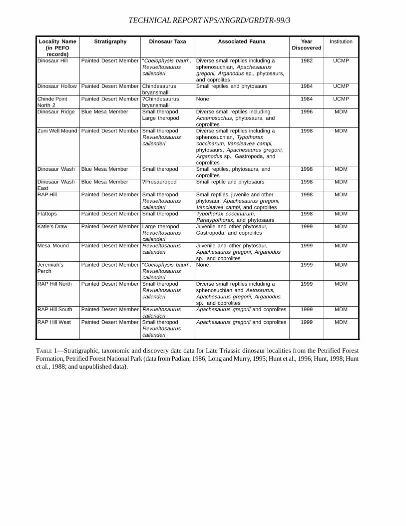
TECHNICAL REPORT NPS/NRGRD/GRDTR-99/3
Locality Name(in PEFOrecords)
Dinosaur Hill
Dinosaur Hollow
Chinde PointNorth 2Dinosaur Ridge
Zuni Well Mound
Dinosaur Wash
Dinosaur WashEastRAP Hill
Flattops
Katie’s Draw
Mesa Mound
Jeremiah’sPerch
RAP Hill North
RAP Hill South
RAP Hill West
Stratigraphy
Painted Desert Member
Painted Desert Member
Painted Desert Member
Blue Mesa Member
Painted Desert Member
Blue Mesa Member
Blue Mesa Member
Painted Desert Member
Painted Desert Member
Painted Desert Member
Painted Desert Member
Painted Desert Member
Painted Desert Member
Painted Desert Member
Painted Desert Member
Dinosaur Taxa
“Coelophysis bauri”,Revueltosauruscallenderi
Chindesaurusbryansmalli?ChindesaurusbryansmalliSmall theropodLarge theropod
Small theropodRevueltosauruscallenderi
Small theropod
?Prosauropod
Small theropodRevueltosauruscallenderiSmall theropod
Large theropodRevueltosauruscallenderiRevueltosauruscallenderi
“Coelophysis bauri”,RevueltosauruscallenderiSmall theropodRevueltosauruscallenderi
RevueltosauruscallenderiSmall theropodRevueltosauruscallenderi
Associated Fauna
Diverse small reptiles including asphenosuchian, Apachesaurusgregorii, Arganodus sp., phytosaurs,and coprolitesSmall reptiles and phytosaurs
None
Diverse small reptiles includingAcaenosuchus, phytosaurs, andcoprolitesDiverse small reptiles including asphenosuchian, Typothoraxcoccinarum, Vancleavea campi,phytosaurs, Apachesaurus gregorii,Arganodus sp., Gastropoda, andcoprolitesSmall reptiles, phytosaurs, andcoprolitesSmall reptile and phytosaurs
Small reptiles, juvenile and otherphytosaur, Apachesaurus gregorii,Vancleavea campi, and coprolitesTypothorax coccinarum,Paratypothorax, and phytosaursJuvenile and other phytosaur,Gastropoda, and coprolites
Juvenile and other phytosaur,Apachesaurus gregorii, Arganodussp., and coprolitesNone
Diverse small reptiles including asphenosuchian and Aetosaurus,Apachesaurus gregorii, Arganodussp., and coprolitesApachesaurus gregorii and coprolites
Apachesaurus gregorii and coprolites
YearDiscovered
1982
1984
1984
1996
1998
1998
1998
1998
1998
1999
1999
1999
1999
1999
1999
Institution
UCMP
UCMP
UCMP
MDM
MDM
MDM
MDM
MDM
MDM
MDM
MDM
MDM
MDM
MDM
MDM
TABLE 1—Stratigraphic, taxonomic and discovery date data for Late Triassic dinosaur localities from the Petrified ForestFormation, Petrified Forest National Park (data from Padian, 1986; Long and Murry, 1995; Hunt et al., 1996; Hunt, 1998; Huntet al., 1988; and unpublished data).
THE OLDEST TRIASSIC STRATA EXPOSED INPETRIFIED FOREST NATIONAL PARK REVISITED
FRANÇOIS THERRIEN, MATTHEW M. JONES, DAVID E. FASTOVSKY, ALISA S. HERRICK, AND GREGORY D. HOKE
Department of Geosciences, University of Rhode Island, 8 Ranger Road, Suite 2, Kingston, 02881
____________________
ABSTRACT—The measured sections show that the oldest strata in Petrified Forest National Park are present in the vicinityof the Haystacks. Controversial units are exposed in this vicinity; these include sandstones, siltstones, mudstones and apurple mottled horizon, whose characteristics are reminiscent of strata of the Moenkopi Formation (Early to MiddleTriassic) and “mottled strata” respectively. Recently, some authors questioned the affinity of these units to the MoenkopiFormation and have correlated them instead to the Bluewater Creek Formation present at Fort Wingate (NM) on the basisof similar lithologies. A detailed investigation of the area reveals that the stratigraphy does not rule out the possibility offinding Moenkopi strata in PEFO. Correlation of the PEFO units with the New Mexico strata seems unlikely as they areshown to be of limited lateral extent and highly variable over short distances.
____________________
INTRODUCTION
Petrified Forest National Park (PEFO) is one of the bestplaces in the American Southwest to study the LateTriassic Chinle Formation due to the extent and the
quality of its exposures. Although extensive sedimentologi-cal and stratigraphical work has been done in the vicinity ofPEFO (Gregory 1917; Cooley, 1958, 1959; Roadifer, 1966;Stewart et al., 1972a; Billingsley, 1985a,b; Kraus and Middleton,1984, 1987; Kraus et al. 1984; Middleton et al., 1984; Ash,1987, 1992; Murry, 1990; Demko, 1994, 1995a,b; Demko et al.,1998; Hasiotis and Dubiel, 1993a,b; Dubiel, 1993; Dubiel andHasiotis, 1994a,b; Dubiel et al., 1995; Lucas, 1993a, 1995; Lucasand Heckert, 1996; Heckert, 1997; see also Hasiotis et al.,1993), there has been some ambiguity over the identity of thebasal strata. Previous researchers (Dubiel et al., 1995; Dubiel,personal communication, 1998; Demko, personal communi-cation, 1998; Demko, 1995a; Lucas, 1993a; Heckert, 1997) haverecognized that the stratigraphically lowest Chinle exposuresin PEFO are in the western part of the Tepees, near the Hay-stacks (Fig. 1). Dubiel et al. (1995) identify these strata asbasal Chinle with local exposure of the Early to Middle Trias-sic Moenkopi Formation. However, Heckert and Lucas (1998)disagree with this interpretation and assign the strata to theBluewater Creek Formation of the Late Triassic Chinle Group(sensu Lucas, 1993a), as described in the vicinity of FortWingate, New Mexico.
In the summer of 1998, we constructed a detailed, centi-meter-by-centimeter, composite stratigraphic section of thePEFO by measuring 33 columnar sections throughout thePark (Fig. 2). Although several researchers have publishedcomposite sections of the PEFO (Dubiel et al., 1995; Demko,1995a; Murry, 1990; Lucas, 1993a; Lucas and Heckert, 1996;Heckert, 1997), the extreme lateral variability of the Chinlestrata have hindered the development of a robust stratigra-
phy; thus, we physically traced beds from outcrop to out-crop to establish correlations. The measured sections de-scribed in this paper (Fig. 3) represent the basal portion ofour composite stratigraphic section. The sections documentthe presence of the controversial exposures, although theirrelationship to the Moenkopi Formation remains uncertain.
As noted above, in a complex fluvial system like the onerepresented by the Chinle Formation, the high lateral vari-ability of facies can hinder correlation of lithostratigraphicunits over long distances. Therefore, we refrain from usingany stratigraphic nomenclature for “members” or “formations”to correlate localities as too often they resemble facies ratherthan correlatable lithostratigraphic units.
MOENKOPI/CHINLE CONTACT INNORTHEASTERN ARIZONA
MOENKOPI FORMATION—The uppermost unit of the MoenkopiFormation (the Holbrook Member first named by Hager[1922]), consists of interstratified and interfingering beds ofsandstone and siltstone, although a significant mudstonecomponent may be present (McKee, 1954; Stewart et al.,1972b, Lucas, 1993b). The sandstone beds in the uppermostMoenkopi vary greatly in thickness and are discontinuousor irregularly interfingering with the siltstone beds (Stewartet al., 1972b). These sediments have been interpreted asrepresenting deposition in a fluvial system with associatedfloodplain deposits (McKee, 1954; Stewart et al., 1972b;Blakey, 1974; Dubiel, 1994).
MOENKOPI/CHINLE UNCONFORMITY—A regional unconformitypresent between the Moenkopi Formation and the overlyingChinle Formation was first recognized by Gilbert (1875). Apre-Chinle-aged degradational fluvial system apparentlyeroded the Moenkopi Formation and formed an irregular to-
101
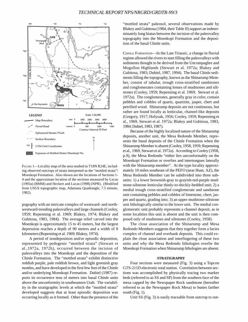
TECHNICAL REPORT NPS/NRGRD/GRDTR-99/3
pography with an intricate complex of westward- and north-westward-trending paleovalleys and large channels (Cooley,1959; Repenning et al. 1969; Blakey, 1974; Blakey andGubitosa, 1983, 1984). The average relief carved into theMoenkopi is approximately 15 to 45 meters, but the largestdepression reaches a depth of 90 meters and a width of 8kilometers (Repenning et al. 1969; Blakey, 1974).
A period of nondeposition and/or episodic deposition,represented by pedogenic “mottled strata” (Stewart etal.,1972a, 1972b), occurred between the incision ofpaleovalleys into the Moenkopi and the deposition of theChinle Formation. The “mottled strata” exhibit distinctivereddish purple, pale reddish brown, and light greenish graymottles, and have developed in the first few feet of the Chinleand/or underlying Moenkopi Formation. Dubiel (1987) re-ports its occurrence tens of meters into basal Chinle unitsabove the unconformity in southeastern Utah. The variabil-ity in the stratigraphic levels at which the “mottled strata”developed suggests that at least episodic deposition wasoccurring locally as it formed. Other than the presence of the
“mottled strata” paleosol, several observations made byBlakey and Gubitosa (1984, their Table II) support an indeter-minately long hiatus between the incision of the paleovalleytopography into the Moenkopi Formation and the deposi-tion of the basal Chinle units.
CHINLE FORMATION—In the Late Triassic, a change in fluvialregime allowed the rivers to start filling the paleovalleys withsediments thought to be derived from the Uncompaghre andMogollon Highlands (Stewart et al. 1972a; Blakey andGubitosa, 1983; Dubiel, 1987, 1994). The basal Chinle sedi-ments filling the topography, known as the Shinarump Mem-ber, consist of tabular, trough cross-stratified sandstonesand conglomerates containing lenses of mudstones and silt-stones (Cooley, 1959; Repenning et al. 1969; Stewart et al.1972a). The conglomerates, generally gray in color, containpebbles and cobbles of quartz, quartzite, jasper, chert andpetrified wood. Shinarump deposits are not continuous, butrather are found locally as lenticular, channel-like deposits(Gregory, 1917; Holyoak, 1956; Cooley, 1959; Repenning etal., 1969, Stewart et al. 1972a; Blakey and Gubitosa, 1983,1984; Dubiel, 1983, 1987).
Because of the highly localized nature of the Shinarumpdeposits, another unit, the Mesa Redondo Member, repre-sents the basal deposits of the Chinle Formation when theShinarump Member is absent (Cooley, 1958, 1959; Repenninget al., 1969, Stewart et al. 1972a). According to Cooley (1958,p.9), the Mesa Redondo “either lies unconformably on theMoenkopi Formation or overlies and intertongues laterallywith the Shinarump member”. At the type locality approxi-mately 10 miles southeast of the PEFO (near Hunt, AZ), theMesa Redondo Member can be subdivided into three sub-units: 1) a lower brownish-gray to grayish-red-purple mud-stone-siltstone lenticular thinly-to-thickly-bedded unit; 2) amedial trough cross-stratified conglomerate and sandstoneunit containing pebbles and cobbles of limestone, chert, jas-per and quartz, grading into; 3) an upper mudstone-siltstoneunit lithologically similar to the lower unit. The medial con-glomeratic unit probably represents a channel deposit, as insome localities this unit is absent and the unit is then com-posed only of mudstones and siltstones (Cooley, 1958).
The close association of the Shinarump and MesaRedondo Members suggests that they together form a faciescomplex of channel and overbank deposits. This could ex-plain the close association and interfingering of these twounits and why the Mesa Redondo lithologies overlie theMoenkopi Formation when Shinarump lithologies are absent.
STRATIGRAPHYFour sections were measured (Fig. 3) using a Topcon
GTS-211D electronic total station. Correlation between sec-tions was accomplished by physically tracing two markerbeds (referred to as SS and SP) from the southern face of themesa capped by the Newspaper Rock sandstone (hereafterreferred to as the Newspaper Rock Mesa) to buttes farthersouth (Fig. 1).
Unit SS (Fig. 3) is easily traceable from outcrop to out-
FIGURE 1—Locality map of the area studied in T18N R24E, includ-ing observed outcrops of strata interpreted as the “mottled strata”/Moenkopi Formation. Also shown are the locations of Sections 1-4 and the approximate location of the sections measured by Lucas(1993a) (BMM) and Heckert and Lucas (1998) (NPR). (Modifiedfrom USGS topographic map, Adamana Quadrangle, 7.5 minute,1982).
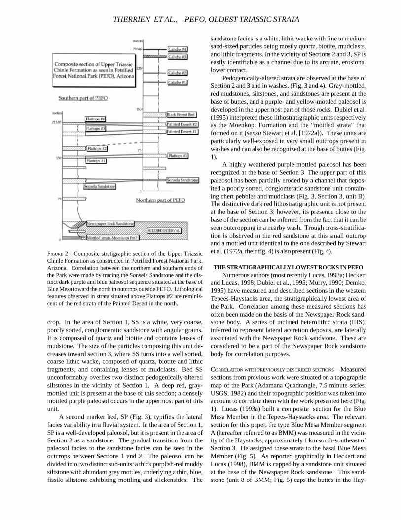
crop. In the area of Section 1, SS is a white, very coarse,poorly sorted, conglomeratic sandstone with angular grains.It is composed of quartz and biotite and contains lenses ofmudstone. The size of the particles composing this unit de-creases toward section 3, where SS turns into a well sorted,coarse lithic wacke, composed of quartz, biotite and lithicfragments, and containing lenses of mudclasts. Bed SSunconformably overlies two distinct pedogenically-alteredsiltstones in the vicinity of Section 1. A deep red, gray-mottled unit is present at the base of this section; a denselymottled purple paleosol occurs in the uppermost part of thisunit.
A second marker bed, SP (Fig. 3), typifies the lateralfacies variability in a fluvial system. In the area of Section 1,SP is a well-developed paleosol, but it is present in the area ofSection 2 as a sandstone. The gradual transition from thepaleosol facies to the sandstone facies can be seen in theoutcrops between Sections 1 and 2. The paleosol can bedivided into two distinct sub-units: a thick purplish-red muddysiltstone with abundant grey mottles, underlying a thin, blue,fissile siltstone exhibiting mottling and slickensides. The
sandstone facies is a white, lithic wacke with fine to mediumsand-sized particles being mostly quartz, biotite, mudclasts,and lithic fragments. In the vicinity of Sections 2 and 3, SP iseasily identifiable as a channel due to its arcuate, erosionallower contact.
Pedogenically-altered strata are observed at the base ofSection 2 and 3 and in washes. (Fig. 3 and 4). Gray-mottled,red mudstones, siltstones, and sandstones are present at thebase of buttes, and a purple- and yellow-mottled paleosol isdeveloped in the uppermost part of those rocks. Dubiel et al.(1995) interpreted these lithostratigraphic units respectivelyas the Moenkopi Formation and the “mottled strata” thatformed on it (sensu Stewart et al. [1972a]). These units areparticularly well-exposed in very small outcrops present inwashes and can also be recognized at the base of buttes (Fig.1).
A highly weathered purple-mottled paleosol has beenrecognized at the base of Section 3. The upper part of thispaleosol has been partially eroded by a channel that depos-ited a poorly sorted, conglomeratic sandstone unit contain-ing chert pebbles and mudclasts (Fig. 3, Section 3, unit B).The distinctive dark red lithostratigraphic unit is not presentat the base of Section 3; however, its presence close to thebase of the section can be inferred from the fact that it can beseen outcropping in a nearby wash. Trough cross-stratifica-tion is observed in the red sandstone at this small outcropand a mottled unit identical to the one described by Stewartet al. (1972a, their fig. 4) is also present (Fig. 4).
THE STRATIGRAPHICALLY LOWEST ROCKS IN PEFONumerous authors (most recently Lucas, 1993a; Heckert
and Lucas, 1998; Dubiel et al., 1995; Murry, 1990; Demko,1995) have measured and described sections in the westernTepees-Haystacks area, the stratigraphically lowest area ofthe Park. Correlation among these measured sections hasoften been made on the basis of the Newspaper Rock sand-stone body. A series of inclined heterolithic strata (IHS),inferred to represent lateral accretion deposits, are laterallyassociated with the Newspaper Rock sandstone. These areconsidered to be a part of the Newspaper Rock sandstonebody for correlation purposes.
CORRELATION WITH PREVIOUSLY DESCRIBED SECTIONS—Measuredsections from previous work were situated on a topographicmap of the Park (Adamana Quadrangle, 7.5 minute series,USGS, 1982) and their topographic position was taken intoaccount to correlate them with the work presented here (Fig.1). Lucas (1993a) built a composite section for the BlueMesa Member in the Tepees-Haystacks area. The relevantsection for this paper, the type Blue Mesa Member segmentA (hereafter referred to as BMM) was measured in the vicin-ity of the Haystacks, approximately 1 km south-southeast ofSection 3. He assigned these strata to the basal Blue MesaMember (Fig. 5). As reported graphically in Heckert andLucas (1998), BMM is capped by a sandstone unit situatedat the base of the Newspaper Rock sandstone. This sand-stone (unit 8 of BMM; Fig. 5) caps the buttes in the Hay-
FIGURE 2—Composite stratigraphic section of the Upper TriassicChinle Formation as constructed in Petrified Forest National Park,Arizona. Correlation between the northern and southern ends ofthe Park were made by tracing the Sonsela Sandstone and the dis-tinct dark purple and blue paleosol sequence situated at the base ofBlue Mesa toward the north in outcrops outside PEFO. Lithologicalfeatures observed in strata situated above Flattops #2 are reminis-cent of the red strata of the Painted Desert in the north.
THERRIEN ET AL.,—PEFO, OLDEST TRIASSIC STRATA
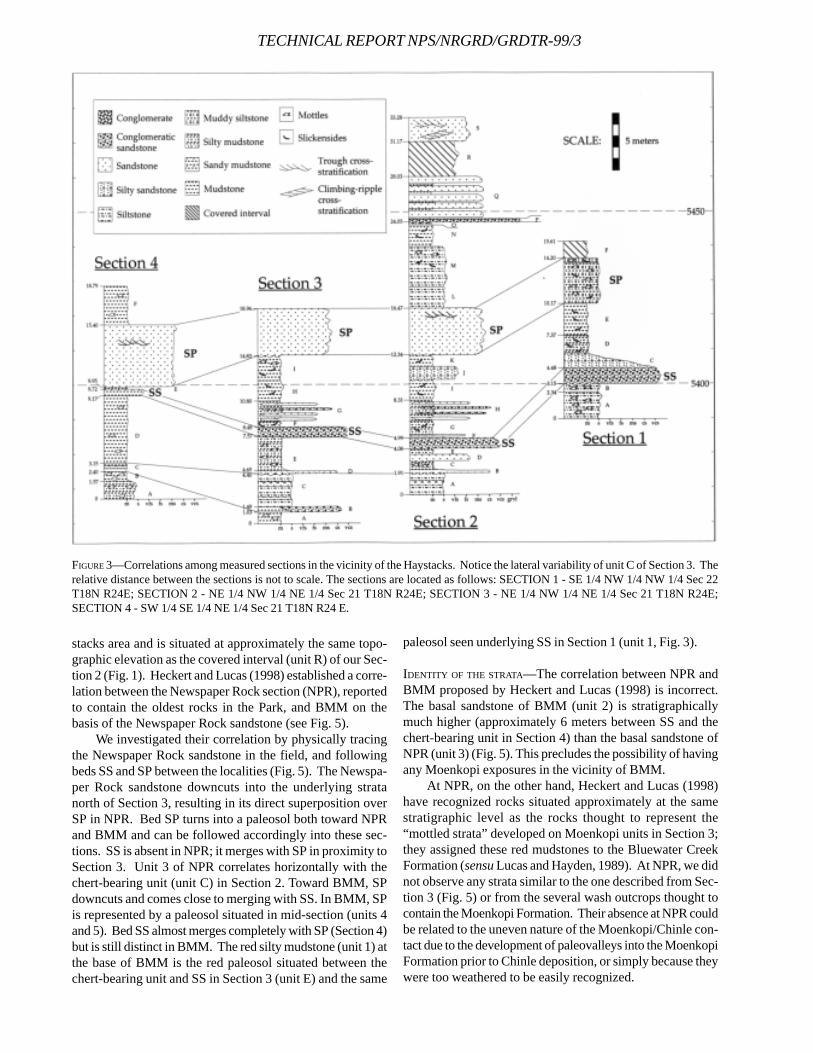
TECHNICAL REPORT NPS/NRGRD/GRDTR-99/3
stacks area and is situated at approximately the same topo-graphic elevation as the covered interval (unit R) of our Sec-tion 2 (Fig. 1). Heckert and Lucas (1998) established a corre-lation between the Newspaper Rock section (NPR), reportedto contain the oldest rocks in the Park, and BMM on thebasis of the Newspaper Rock sandstone (see Fig. 5).
We investigated their correlation by physically tracingthe Newspaper Rock sandstone in the field, and followingbeds SS and SP between the localities (Fig. 5). The Newspa-per Rock sandstone downcuts into the underlying stratanorth of Section 3, resulting in its direct superposition overSP in NPR. Bed SP turns into a paleosol both toward NPRand BMM and can be followed accordingly into these sec-tions. SS is absent in NPR; it merges with SP in proximity toSection 3. Unit 3 of NPR correlates horizontally with thechert-bearing unit (unit C) in Section 2. Toward BMM, SPdowncuts and comes close to merging with SS. In BMM, SPis represented by a paleosol situated in mid-section (units 4and 5). Bed SS almost merges completely with SP (Section 4)but is still distinct in BMM. The red silty mudstone (unit 1) atthe base of BMM is the red paleosol situated between thechert-bearing unit and SS in Section 3 (unit E) and the same
paleosol seen underlying SS in Section 1 (unit 1, Fig. 3).
IDENTITY OF THE STRATA—The correlation between NPR andBMM proposed by Heckert and Lucas (1998) is incorrect.The basal sandstone of BMM (unit 2) is stratigraphicallymuch higher (approximately 6 meters between SS and thechert-bearing unit in Section 4) than the basal sandstone ofNPR (unit 3) (Fig. 5). This precludes the possibility of havingany Moenkopi exposures in the vicinity of BMM.
At NPR, on the other hand, Heckert and Lucas (1998)have recognized rocks situated approximately at the samestratigraphic level as the rocks thought to represent the“mottled strata” developed on Moenkopi units in Section 3;they assigned these red mudstones to the Bluewater CreekFormation (sensu Lucas and Hayden, 1989). At NPR, we didnot observe any strata similar to the one described from Sec-tion 3 (Fig. 5) or from the several wash outcrops thought tocontain the Moenkopi Formation. Their absence at NPR couldbe related to the uneven nature of the Moenkopi/Chinle con-tact due to the development of paleovalleys into the MoenkopiFormation prior to Chinle deposition, or simply because theywere too weathered to be easily recognized.
FIGURE 3—Correlations among measured sections in the vicinity of the Haystacks. Notice the lateral variability of unit C of Section 3. Therelative distance between the sections is not to scale. The sections are located as follows: SECTION 1 - SE 1/4 NW 1/4 NW 1/4 Sec 22T18N R24E; SECTION 2 - NE 1/4 NW 1/4 NE 1/4 Sec 21 T18N R24E; SECTION 3 - NE 1/4 NW 1/4 NE 1/4 Sec 21 T18N R24E;SECTION 4 - SW 1/4 SE 1/4 NE 1/4 Sec 21 T18N R24 E.
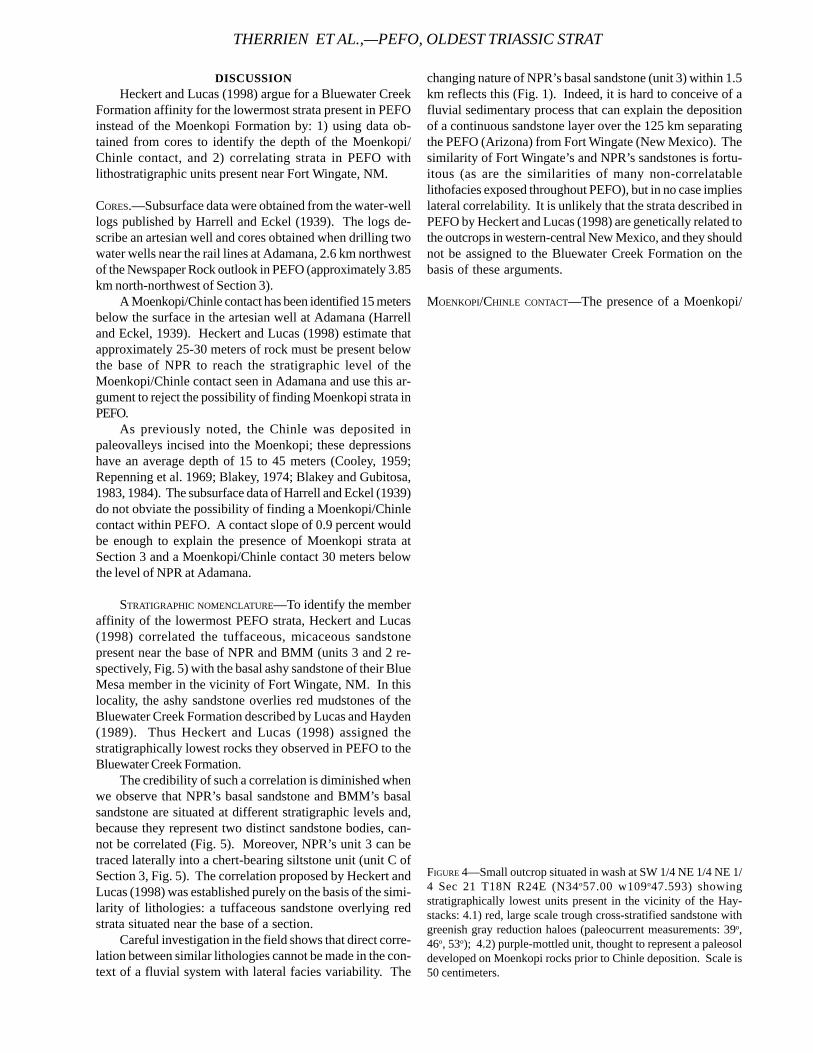
DISCUSSIONHeckert and Lucas (1998) argue for a Bluewater Creek
Formation affinity for the lowermost strata present in PEFOinstead of the Moenkopi Formation by: 1) using data ob-tained from cores to identify the depth of the Moenkopi/Chinle contact, and 2) correlating strata in PEFO withlithostratigraphic units present near Fort Wingate, NM.
CORES.—Subsurface data were obtained from the water-welllogs published by Harrell and Eckel (1939). The logs de-scribe an artesian well and cores obtained when drilling twowater wells near the rail lines at Adamana, 2.6 km northwestof the Newspaper Rock outlook in PEFO (approximately 3.85km north-northwest of Section 3).
A Moenkopi/Chinle contact has been identified 15 metersbelow the surface in the artesian well at Adamana (Harrelland Eckel, 1939). Heckert and Lucas (1998) estimate thatapproximately 25-30 meters of rock must be present belowthe base of NPR to reach the stratigraphic level of theMoenkopi/Chinle contact seen in Adamana and use this ar-gument to reject the possibility of finding Moenkopi strata inPEFO.
As previously noted, the Chinle was deposited inpaleovalleys incised into the Moenkopi; these depressionshave an average depth of 15 to 45 meters (Cooley, 1959;Repenning et al. 1969; Blakey, 1974; Blakey and Gubitosa,1983, 1984). The subsurface data of Harrell and Eckel (1939)do not obviate the possibility of finding a Moenkopi/Chinlecontact within PEFO. A contact slope of 0.9 percent wouldbe enough to explain the presence of Moenkopi strata atSection 3 and a Moenkopi/Chinle contact 30 meters belowthe level of NPR at Adamana.
STRATIGRAPHIC NOMENCLATURE—To identify the memberaffinity of the lowermost PEFO strata, Heckert and Lucas(1998) correlated the tuffaceous, micaceous sandstonepresent near the base of NPR and BMM (units 3 and 2 re-spectively, Fig. 5) with the basal ashy sandstone of their BlueMesa member in the vicinity of Fort Wingate, NM. In thislocality, the ashy sandstone overlies red mudstones of theBluewater Creek Formation described by Lucas and Hayden(1989). Thus Heckert and Lucas (1998) assigned thestratigraphically lowest rocks they observed in PEFO to theBluewater Creek Formation.
The credibility of such a correlation is diminished whenwe observe that NPR’s basal sandstone and BMM’s basalsandstone are situated at different stratigraphic levels and,because they represent two distinct sandstone bodies, can-not be correlated (Fig. 5). Moreover, NPR’s unit 3 can betraced laterally into a chert-bearing siltstone unit (unit C ofSection 3, Fig. 5). The correlation proposed by Heckert andLucas (1998) was established purely on the basis of the simi-larity of lithologies: a tuffaceous sandstone overlying redstrata situated near the base of a section.
Careful investigation in the field shows that direct corre-lation between similar lithologies cannot be made in the con-text of a fluvial system with lateral facies variability. The
FIGURE 4—Small outcrop situated in wash at SW 1/4 NE 1/4 NE 1/4 Sec 21 T18N R24E (N34o57.00 w109o47.593) showingstratigraphically lowest units present in the vicinity of the Hay-stacks: 4.1) red, large scale trough cross-stratified sandstone withgreenish gray reduction haloes (paleocurrent measurements: 39o,46o, 53o); 4.2) purple-mottled unit, thought to represent a paleosoldeveloped on Moenkopi rocks prior to Chinle deposition. Scale is50 centimeters.
changing nature of NPR’s basal sandstone (unit 3) within 1.5km reflects this (Fig. 1). Indeed, it is hard to conceive of afluvial sedimentary process that can explain the depositionof a continuous sandstone layer over the 125 km separatingthe PEFO (Arizona) from Fort Wingate (New Mexico). Thesimilarity of Fort Wingate’s and NPR’s sandstones is fortu-itous (as are the similarities of many non-correlatablelithofacies exposed throughout PEFO), but in no case implieslateral correlability. It is unlikely that the strata described inPEFO by Heckert and Lucas (1998) are genetically related tothe outcrops in western-central New Mexico, and they shouldnot be assigned to the Bluewater Creek Formation on thebasis of these arguments.
MOENKOPI/CHINLE CONTACT—The presence of a Moenkopi/
THERRIEN ET AL.,—PEFO, OLDEST TRIASSIC STRAT
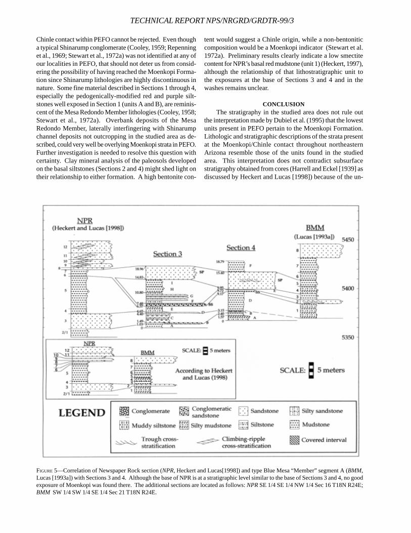
TECHNICAL REPORT NPS/NRGRD/GRDTR-99/3
FIGURE 5—Correlation of Newspaper Rock section (NPR, Heckert and Lucas[1998]) and type Blue Mesa “Member” segment A (BMM,Lucas [1993a]) with Sections 3 and 4. Although the base of NPR is at a stratigraphic level similar to the base of Sections 3 and 4, no goodexposure of Moenkopi was found there. The additional sections are located as follows: NPR SE 1/4 SE 1/4 NW 1/4 Sec 16 T18N R24E;BMM SW 1/4 SW 1/4 SE 1/4 Sec 21 T18N R24E.
Chinle contact within PEFO cannot be rejected. Even thougha typical Shinarump conglomerate (Cooley, 1959; Repenninget al., 1969; Stewart et al., 1972a) was not identified at any ofour localities in PEFO, that should not deter us from consid-ering the possibility of having reached the Moenkopi Forma-tion since Shinarump lithologies are highly discontinuous innature. Some fine material described in Sections 1 through 4,especially the pedogenically-modified red and purple silt-stones well exposed in Section 1 (units A and B), are reminis-cent of the Mesa Redondo Member lithologies (Cooley, 1958;Stewart et al., 1972a). Overbank deposits of the MesaRedondo Member, laterally interfingering with Shinarumpchannel deposits not outcropping in the studied area as de-scribed, could very well be overlying Moenkopi strata in PEFO.Further investigation is needed to resolve this question withcertainty. Clay mineral analysis of the paleosols developedon the basal siltstones (Sections 2 and 4) might shed light ontheir relationship to either formation. A high bentonite con-
tent would suggest a Chinle origin, while a non-bentoniticcomposition would be a Moenkopi indicator (Stewart et al.1972a). Preliminary results clearly indicate a low smectitecontent for NPR’s basal red mudstone (unit 1) (Heckert, 1997),although the relationship of that lithostratigraphic unit tothe exposures at the base of Sections 3 and 4 and in thewashes remains unclear.
CONCLUSIONThe stratigraphy in the studied area does not rule out
the interpretation made by Dubiel et al. (1995) that the lowestunits present in PEFO pertain to the Moenkopi Formation.Lithologic and stratigraphic descriptions of the strata presentat the Moenkopi/Chinle contact throughout northeasternArizona resemble those of the units found in the studiedarea. This interpretation does not contradict subsurfacestratigraphy obtained from cores (Harrell and Eckel [1939] asdiscussed by Heckert and Lucas [1998]) because of the un-
even nature of the Moenkopi/Chinle contact.Our work challenges the feasibility of correlating distant
localities using descriptive lithostratigraphic units, as sug-gested by Lucas (1993a) and Heckert and Lucas (1998), in thecontext of a fluvial system with extreme lateral variation. In afluvial system, facies are highly lenticular and the impositionof a simple, layered, sequential stratigraphy serves more tocloud issues than to elucidate them. The use of “members”nomenclature appears inappropriate, because these moreclosely resemble facies than lithostratigraphic units of timesignificance. For this reason, “members” cannot be used tocorrelate distant localities.
ACKNOWLEDGMENTSGrants from the Petrified Forest Museum Association sup-ported the fieldwork upon which this research is based. Wewish to thank Russell Dubiel and Tim Demko for their fieldnotes and readiness to share data and ideas. Special thanksare also due to Andy Heckert, whose valuable insights andopen communication helped in the writing of this paper andthe development of our ideas, and to three anonymous re-viewers for their constructive comments. Finally, we want tothank the Park staff, especially superintendent MickiHellickson, Pat Quinn, Pat Thompson, Bill Grether and TedBolich, whose support and understanding made this workpossible. Partial funding was provided by Fonds FCAR (Québec) to F. Therrien as part of his M.S. research. This workwas partially supported by the Department of Geosciencesof the University of Rhode Island.
REFERENCESASH, S.R., 1987. Petrified Forest National Park, Arizona, p.405-
410. in Beus, S.S. (ed.), Rocky Mountain section of theGeological Society of America, Centennial field guide,Geological Society of America, Boulder.
, 1992. The Black Forest Bed, a distinctive unit in theUpper Triassic Chinle Formation, northeastern Arizona.Journal of the Arizona-Nevada Academy of Science, 24-25:59-73.
BILLINGSLEY, G.H., 1985a. General stratigraphy of the PetrifiedForest National Park, Arizona, p.3-8. in Colbert E.H., andJohnson, R.R. (eds.), The Petrified Forest Through theAges. Museum of Northern Arizona Press, Bulletin Se-ries 54.
, 1985b. Geologic map of Petrified Forest National Park,Arizona: Report to Petrified Forest Museum Associa-tion, unpublished.
BLAKEY, R.C., 1974. Stratigraphic and depositional analysisof the Moenkopi Formation, southeastern Utah. UtahGeological and Mineral Survey, Bulletin, 104, 81p.
, AND R. GUBITOSA, 1983. Late Triassic paleogeogra-phy and depositional history of the Chinle Formation,southeastern Utah and northern Arizona, p.57-76. inReynolds, M.W. and Dolly, E.D. (eds), Mesozoic Paleo-geography of West-Central United States. SEPM, RockyMountain Section, Denver.
, AND , 1984. Controls of sandstone body
geometry and architecture in the Chinle Formation (Up-per Triassic), Colorado Plateau. Sedimentary Geology,38:51-86.
COOLEY, M.E., 1958. The Mesa Redondo Member of theChinle Formation, Apache and Navajo Counties, Ari-zona. Plateau, 31(1):7-15.
, 1959. Triassic stratigraphy in the state line region ofwest-central New Mexico and east-central Arizona.Tenth field conference, New Mexico Geological Societyguidebook, 1:66-73.
DEMKO, T.M., 1994. Candy-striped Teepees: sedimentologyand plant taphonomy of a Triassic channel-levee-cre-vasse complex, Petrified Forest National Park, Arizona.Abstracts with programs, Geological Society of America,26(6):10-11.
, 1995a. Taphonomy of fossil plants in the Upper Tri-assic Chinle Formation. Unpublished Ph.D. dissertation,University of Arizona, Tucson, 289p.
, 1995b. Taphonomy of fossil plants in Petrified ForestNational Park, Arizona. Fossils of Arizona Symposium,Proceedings, Southwest Paleontological Society andMesa Southwest Museum, 3:37-51.
, R.F. DUBIEL, AND J.T. PARRISH, 1998. Plant taphonomyin incised valleys: Implications for interpretingpaleoclimate from fossil plants. Geology, 26(12):1119-1122.
DUBIEL, R.F., 1987. Sedimentology of the Upper Triassic ChinleFormation, southeastern Utah. Unpublished Ph.D. dis-sertation, University of Colorado, Boulder, 132p.
, 1993. Depositional setting of the Owl Rock Memberof the Upper Triassic Chinle Formation, Petrified ForestNational Park and vicinity, Arizona, p.117-121. in Lucas,S.G., and Morales, M. (eds.), The Nonmarine Triassic.New Mexico Museum of Natural History & Science Bul-letin No.3.
, 1994. Triassic deposystems, paleogeography, andpaleoclimate of the Western Interior, p.133-168. in Caputo,M.V., Peterson, J.A., and Franczyk, K.J. (eds.), Mesozoicsystems of the Rocky Mountain region, USA. SEPM(Society for Sedimentary Geology), Rocky MountainSection, Denver.
, AND S.T. HASIOTIS, 1994a. Paleosols and rhizofaciesas indicators of climate change and groundwater fluc-tuations: the Upper Triassic Chinle Fm. Abstracts withPrograms, Geological Society of America, 26(6):10-12.
, AND , 1994b. Integration of sedimentology,paleosols, and trace fossils for paleohydrologic andpaleoclimatic interpretations in a Triassic tropical allu-vial system. Abstracts with Programs, Geological Soci-ety of America, 26(7):502.
, T.F. DEMKO, S.T. HASIOTIS, N.R. RIGGS, C.L. MAY, S.R.ASH, AND R.J. LITWIN, 1995. Triassic paleoecosystem re-construction via fossil, ichnofossil, isotopic, and sedi-mentologic evidence integrated into a complete measuredsection, Chinle Formation, Petrified Forest National Park,AZ. Abstracts with Programs, Rocky Mountain Section,Geological Society of America, 27(4):9.
GILBERT, G.K., 1875. Report on the geology of portions of
THERRIEN ET AL.,—PEFO, OLDEST TRIASSIC STRAT
TECHNICAL REPORT NPS/NRGRD/GRDTR-99/3
Nevada, Utah, California, and Arizona. U.S. Geographi-cal and Geological Surveys W. 100th Meridian, 3:17-187.
GREGORY, H.E., 1917. Geology of the Navajo Country-a recon-naissance of parts of Arizona, New Mexico, and Utah.U.S. Geological Survey Professional Paper, 93, 161p.
HAGER, D., 1922. Oil possibilities of the Holbrook area in north-east Arizona. Mining and Oil Bulletin, 8(1):23-26, 33-34,8(2):71-74, 81, 94, 8(3):135-140.\
HARREL, M.A., AND E.B. ECKEL, 1939. Ground-water resourcesof the Holbrook region, Arizona. U.S. Geological Survey,Water-Supply Paper, 836B:19-105.
HASIOTIS, S.T., AND R.F. DUBIEL, 1993a. Continental trace fos-sils of the Upper Triassic Chinle Formation, PetrifiedForest National Park, Arizona, p.175-178. in Lucas, S.G.,and Morales, M (eds.), The Nonmarine Triassic. NewMexico Museum of Natural History & Science Bulletin,no.3.
, and , 1993b. Trace fossil assemblages in ChinleFormation alluvial deposits at the Tepees, Petrified For-est National Park, Arizona, p.G42-G43. in Lucas, S.G.,and Morales, M (eds.), The Nonmarine Triassic. NewMexico Museum of Natural History & Science Bulletin,no.3.
, C.E. MITCHELL, AND R.F. DUBIEl, 1993. Application ofmorphologic burrow interpretations to discern continen-tal burrow architects: lungfish or crayfish? Ichnos, 2:315-333.
HECKERT, A.B., 1997. Litho- and biostratigraphy of the LowerChinle Group, east-central Arizona and west-central NewMexico, with a description of a new theropod(Dinosauria:Theropoda) from the Bluewater Creek For-mation. Unpublished M.S. thesis, University of NewMexico, Albuquerque. 278p.
, AND S.G. LUCAS, 1998. The oldest Triassic strataexposed in the Petrified Forest National Park, Arizona,p.129-134. in Santucci, V.L. and McClelland, L. (eds), Na-tional Park Service Paleontological Research. Denver,National Park Service (Technical Report NPS/NRGRD/GRDTR-98/01).
HOLYOAK, D.M., 1956. Stratigraphy of the Shinarump Con-glomerate and associated Chinle Formation. The Com-pass of Sigma Gamma Epsilon, 34 (1):35-46.
KRAUS, M.J., AND L.T. MIDDLETON, 1984. Dissectedpaleotopography and base level fluctuations in an an-cient fluvial sequence. Abstracts with programs, Geo-logical Society of America, 16(4):227.
, AND , 1987. Dissected paleotopography andbase-level changes in a Triassic fluvial sequence. Geol-ogy, 15(1):18-21.
, , AND T.M.BOWN, 1984. Recognition of episodicbase-level changes in the fluvial Chinle Formation, Ari-zona. Abstracts with programs, Geological Society ofAmerica, 16(6):565.
LUCAS, S.G., 1993a. The Chinle Group: revised stratigraphyand biochronology of Upper Triassic nonmarine stratain the western United States, p.27-50. in Morales, M.(ed.), Aspects of Mesozoic Geology and Paleontologyof the Colorado Plateau. Museum of Northern ArizonaBulletin, 59.
, 1993b. Type section of Holbrook Member ofMoenkopi Formation, northeastern Arizona, p.G49. inLucas, S.G., and Morales, M. (eds), The Nonmarine Tri-assic. New Mexico Museum of Natural History & Sci-ence Bulletin, no.3.
, 1995. Revised Upper Triassic stratigraphy, PetrifiedForest National Park, p.102-105. in Santucci, V.L. andMcClelland, L. (eds), National Park Service Paleonto-logical Research. Denver, National Park Service (Techni-cal Report NPS/NRGRD/GRDTR-95/16).
, AND S.N. HAYDEN, 1989. Triassic stratigraphy of west-central New Mexico, p.191-211. In Anderson, O.J., Lucas,S.G., Love, D.W., and Cather, S.M. (eds), 40th Field Con-ference, Southeastern Colorado Plateau. New MexicoGeological Society Guidebook.
, AND A.B. HECKERT, 1996. Vertebrate biochronologyof the Late Triassic of Arizona, p.63-81 in Boaz, D,Dierking, P., Dornan, M., McGeorge, R., and Tegowski,B.J. (eds), Proceedings of the Fourth Annual Fossils ofArizona Symposium. Mesa Southwest Museum andSouthwest Paleontological Society.
McKee, E.D. 1954. Stratigraphy and history of the MoenkopiFormation of Triassic age. Geological Society of AmericaMemoir, 61, 133p.
MIDDLETON, L.T., M.J. KRAUS, AND T.M BOWN, 1984. Recon-struction of Upper Triassic alluvial systems, Chinle For-mation, Petrified Forest National Park, Arizona. Abstractswith programs, Geological Society of America, 16(6):595.
MURRY, P.A., 1990. Stratigraphy of the Upper Triassic Petri-fied Forest Member (Chinle Formation) in Petrified For-est National Park, Arizona, USA. Journal of Geology,98:780-789.
REPENNING, C.A., M.E. COOLEY, AND J.P AKERS, 1969. Stratig-raphy of the Chinle and Moenkopi Formations, Navajoand Hopi Indian Reservations, Arizona, New Mexico,and Utah. U.S. Geological Survey Professional Paper,521B, 34p.
ROADIFER, J.E., 1966. Stratigraphy of the Petrified Forest Na-tional Park. Unpublished Ph.D. dissertation, Universityof Arizona, Tucson, 152p.
STEWART, J.H., F.G. POOLE, AND R.F. WILSON, 1972a. Stratigra-phy and origin of the Chinle Formation and related Up-per Triassic strata in the Colorado Plateau region. U.S.Geological Survey Professional Paper, 690, 336p.
, , and , 1972b. Stratigraphy and origin ofthe Triassic Moenkopi Formation and related strata inthe Colorado Plateau region. U.S. Geological Survey Pro-fessional Paper, 691, 195p.
A SYSTEMATIC STUDY AND TAPHONOMIC ANALYSIS OFTHE MAMMAL REMAINS FROM THE PACKRAT MIDDENSOF TIMPANOGOS CAVE NATIONAL MONUMENT, UTAH
CHRISTIAN O. GEORGEFranklin & Marshall College, Lancaster, Pennsylvania 17604
____________________
ABSTRACT—An excavation of the fossil bearing packrat middens of Timpanogos Cave National Monument was undertaken togain insight into the prehistoric fauna of the American Fork Canyon. The fauna found in this cave have not previouslyreceived any systematic study. The primary excavations were of abandoned packrat middens found near the entrances to thecaves. Identification of the remains was limited to the mammals, which form the majority of the collection. These proved tobe extant species that are still living in the canyon. Of primary taphonomic interest is that the packrats collected a broad rangeof species and the specimens were very well preserved.
____________________
INTRODUTION
This paper describes the fauna excavated fromvarious locations within Timpanogos Cavein May 1998. Excavation sites were originally iden-
tified by the park Cave Resource Manager, Rod Horrocks,during cave surveying and a project in which fill was re-moved from the Entrance Room of Hansen Cave (Horrocks1994 and 1995). As an experienced caver, Horrocks recog-nized the importance of these fossils and proposed that theybe excavated. However, he lacked the necessary fundingand the time. In searching for a senior independent researchproject I contacted Vincent Santucci, at Fossil Butte NationalMonument, who suggested this project to me. This studyrepresents the first attempt to categorize the fossil depositsof this park.
The only related research done in this canyon was anexcavation of American Fork Cave in 1938 by George Hansenand William Lee Stokes for its archeological remains. Thiscave is within Timpanogos Cave National Monument, butlies only 140 feet above the river bed. The faunal assem-blage was created by human activity when it was occupiedby Native Americans. The authors identified 13 species ofmammals, all of them similar to these found in this investiga-tion (Hansen and Stokes 1941).
During this excavation fossil birds, reptiles and mam-mals were found, but this study is limited to the identifica-tion and analysis of the mammal fossils. Specimens wereidentified to species level or to the most specific taxonomiccategory that could be reached with confidence. Eleven mam-mal species were identified, all of which still live in the can-yon today. This makes it probable that the fauna are Ho-locene in age. However, without absolute dating this cannotbe determined.
GEOGRAPHIC AND GEOLOGIC SETTINGLOCAL GEOLOGY—Timpanogos Cave National Monument isin the American Fork Canyon, which cuts into the WasatchFront near Salt Lake City, Utah. The cave is situated belowtree-line, approximately 366 m (1200 ft.) above the floor of thecanyon. It is accessible only by a footpath that winds itsway up the mountain side. The terrain is rugged with steepcliff faces.
The Wasatch Front is a north-south block fault that formsthe eastern boundary of the Salt Lake and Utah basins andon a larger scale, the eastern edge of the Great Basin. TheGreat Basin is an area of north-south trending horst and gra-ben mountain ranges formed by extension. Throughout thisarea, fault blocks form ranges that are separated by down-faulted alluvial basins. The western fault scarp of theWasatch mountains rises sharply out of the Salt Lake andUtah basins. This fault block is dissected by a series ofparallel streams that have cut east-west canyons through theblock. The American Fork Canyon formed near the intersec-tion of the Uinta fold axis and the Wasatch Fault. The blockfaulting in this area is still active (White and Van Gundy1974).
The rocks that make up the Wasatch Front illustrate thePre-Cambrian and Paleozoic history of the area. The oldestgeologic formation within the American Fork Canyon is theMutual Formation. This unit is a Proterozoic conglomeratewith quartz sandstone and shale members. The Mutual For-mation is overlain by a clastic and conglomerate transgres-sive Cambrian sequence 600 m thick (Baker and Crittenden1961).
Above the Cambrian there is an unconformity, associ-ated with uplift and subsequent erosion that lasted until themiddle Paleozoic. The Fitchville Formation begins a trans-
109
TECHNICAL REPORT NPS/NRGRD/GRDTR-99/3
gressive sequence of Mississipian carbonates. At the baseof this formation is a dolomitic sandstone and on top of thatare two thick layers of massive dolomite. The next formationis the Gardison. This has 3-6 m of dark gray coarse grainedand crossbedded dolomite. The next 24-30 m are bandedlayers of limestone and siltstone. The top of the formation is120 m of massive limestone and dolomite.
Above this is a cliff-forming unit called the Deseret. It iscomposed of light to dark gray limestone and dolomite, 130m, thick with lenticular cherts. There is a limited amount offossil material in this formation, but it has been identified asbeing of Middle Mississipian age. Timpanogos Cave lieswithin this formation.
During the Miocene, extension caused the normal fault-ing that raised the Wasatch. This has continued to thepresent, but much of the Pleistocene and Holocene geologicactivity has been carving of the terrain by frost, streams andglaciers (Baker and Crittenden, 1961).
The American Fork Canyon is a very deep and narrow v-shaped stream valley. Though there is evidence of Pleis-tocene glaciation at higher elevations in this area, there is noevidence that the canyon was created by glacial activity.The even slope of the walls and the sharp v-shape of thecanyon suggest that it was the American Fork River andfrost action that did the work (White and Van Gundy 1974).The steep slope of the canyon begins where the valley flooris at 1,700 m in elevation and rises to 2,400 m at the SagebrushFlats, the top of the canyon. The cave lies at 2,000 m, cutalmost straight into the side of Mount Timpanogos.
Mt. Timpanogos is one of the most prominent peaks inthe Wasatch Front, rising to an elevation of 3,600 m. Likemost of the high peaks in this area it records past glacialmodification. There are large cirques on the north and eastslopes as well as glacial moraine sediments (White and VanGundy, 1974). Today there are no glaciers in this area. TheTimpanogos ôglacierö is a misnomer. It is a snowfield thatoften melts completely in the summer (Baker and Crittenden,1961).
CAVE DESCRIPTION—Timpanogos Cave National Monumentwas established to protect three caves, Hansen, Middle andTimpanogos Caves. They are collectively referred to asTimpanogos Cave. These caves have been connected bytunnels to allow easier access for tourists. The first cavediscovered was Hansen Cave. The first area excavated wasthe Entrance Room of Hansen Cave. The room is 9 m acrossand 21 m long. Small alcoves in the walls of this room thatcontain packrat middens were excavated.
Middle Cave consists of a single high and narrow pas-sage. This cave contains some of the most spectacular for-mations, including aragonite needles and helictites. Nothingwas excavated from this cave during the project. The en-trance to this cave may contain Pleistocene-Holocene de-posits. However it is difficult to access. There were severalplaces of difficult access throughout the cave system thatwe speculated to be fossil bearing localities. We did notexcavate these so that a maximum amount of time could be
spent on known fossil bearing localities.Timpanogos Cave may be somewhat independent from
the other two. It is the longest cave of the three at 180 m.What makes it independent is that the length of the cave isoriented at a slightly different bearing than the other two.Near the entrance to this cave we conducted limited excava-tion of a small area known as the Boneyard.
CLIMATE—The general climate of the western United States ischaracterized by the western mountains blocking moisturefrom the Pacific Ocean making it drier (Petersen, 1994). Inaddition to this the elevation makes it cooler. This creates apattern across the region where high mountains are moistand cool, alternating with warm dry lowlands.
Mountains also produce major effects on the local cli-mate, and may have a separate climate themselves. Maximumprecipitation occurs between 1200-2400m. Thus a mountaincan become a moisture island and develop good vegetativecover. There is often a large climate difference over shortdistances. This depends on the slope and aspect of a moun-tain. Mountain flora and fauna are strongly influenced bytemperature and precipitation because there are often manychanges in climate there are often very different ecologicalcommunities along a mountain slope (Petersen, 1994).
PACKRAT BIOLOGYPackrats or woodrats, as they are also known, are mem-
bers of the family Muridae. This is the largest mammalianfamily and includes rats and mice. The packrats of NorthAmerica are all members of the genus Neotoma, of whichthere are 21 living species. The earliest known Neotomaspecies is 6.6 million years old. The extant species of packratsin the southwestern United States are known from middensat least 50,000 years old (Vaughan 1990).
Packrats are compact long tailed rodents that weigh be-tween 100-400g. They have strong feet for grasping andclimbing. Their molars are flat-crowned with prismatic ridges.This is typical of animals adapted to eating low nutritionfibrous plants, like grasses. Their diet is opportunistic, con-trolled by the plants found in the environment they are in-habiting.
The distribution of packrats covers most of NorthAmerica, from 2¦ south of the Arctic circle to Nicaragua. Somespecies have restricted ranges and may only occur in onemountain range. In contrast N. cinerea ranges from the Dis-trict of Mackenzie in Canada to Arizona. This species is mostoften boreal, and is the best candidate to be the packrat re-sponsible for the middens in Timpanogos Cave.
All packrat species build more or less substantialmiddens. This provides shelter and they will often improve anatural shelter with a midden of sticks, plant material, bonesand mammal dung. This material is collected from a 30-50 mradius area. Inside the midden is the nest. It is 20-30 cm indiameter and made of soft shredded plant fibers. It can befound in the center of the midden, in burrow beneath it or inrock crevice below it. Middens are occupied by one packratat a time except during breeding (Vaughan 1990).
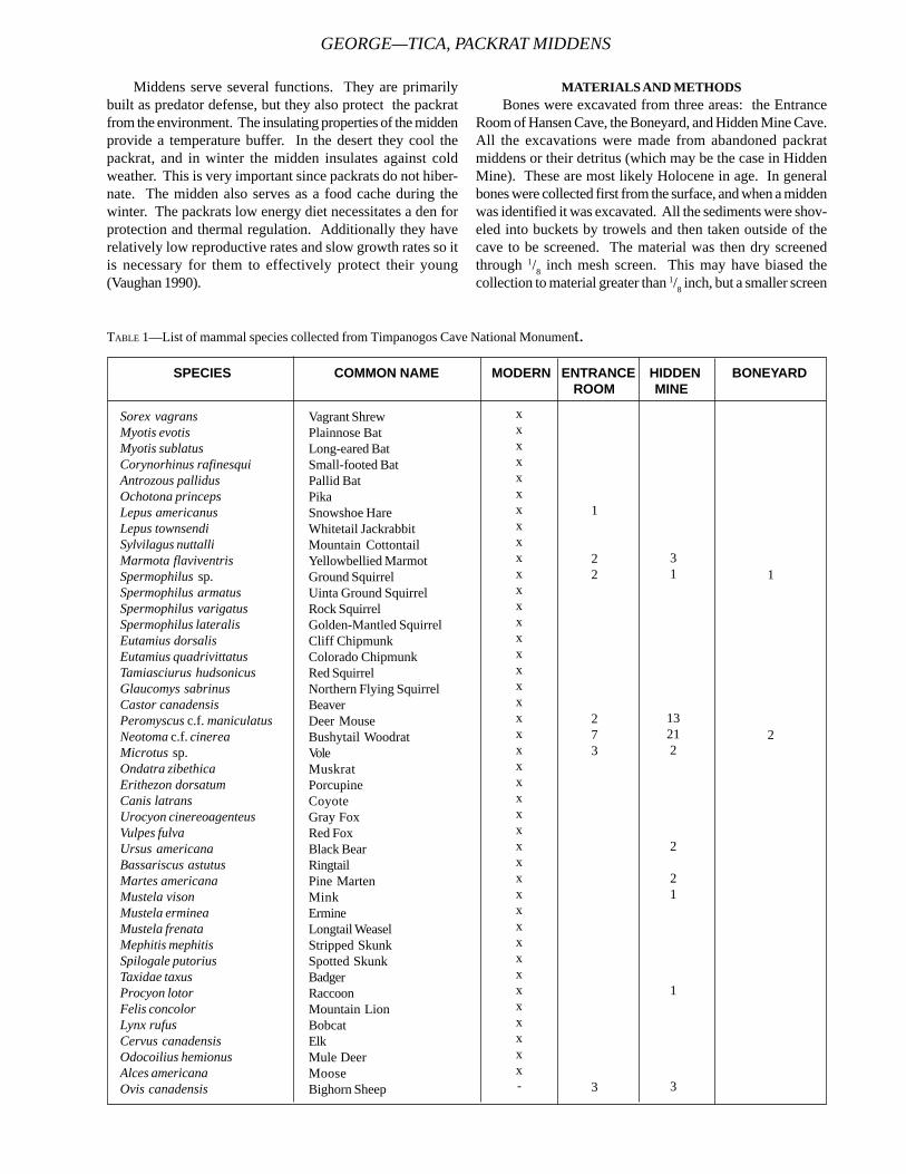
Middens serve several functions. They are primarilybuilt as predator defense, but they also protect the packratfrom the environment. The insulating properties of the middenprovide a temperature buffer. In the desert they cool thepackrat, and in winter the midden insulates against coldweather. This is very important since packrats do not hiber-nate. The midden also serves as a food cache during thewinter. The packrats low energy diet necessitates a den forprotection and thermal regulation. Additionally they haverelatively low reproductive rates and slow growth rates so itis necessary for them to effectively protect their young(Vaughan 1990).
MATERIALS AND METHODSBones were excavated from three areas: the Entrance
Room of Hansen Cave, the Boneyard, and Hidden Mine Cave.All the excavations were made from abandoned packratmiddens or their detritus (which may be the case in HiddenMine). These are most likely Holocene in age. In generalbones were collected first from the surface, and when a middenwas identified it was excavated. All the sediments were shov-eled into buckets by trowels and then taken outside of thecave to be screened. The material was then dry screenedthrough 1/8 inch mesh screen. This may have biased thecollection to material greater than 1/8 inch, but a smaller screen
GEORGE—TICA, PACKRAT MIDDENS
SPECIES COMMON NAME MODERN ENTRANCE HIDDEN BONEYARD ROOM MINE
Sorex vagransMyotis evotisMyotis sublatusCorynorhinus rafinesquiAntrozous pallidusOchotona princepsLepus americanusLepus townsendiSylvilagus nuttalliMarmota flaviventrisSpermophilus sp.Spermophilus armatusSpermophilus varigatusSpermophilus lateralisEutamius dorsalisEutamius quadrivittatusTamiasciurus hudsonicusGlaucomys sabrinusCastor canadensisPeromyscus c.f. maniculatusNeotoma c.f. cinereaMicrotus sp.Ondatra zibethicaErithezon dorsatumCanis latransUrocyon cinereoagenteusVulpes fulvaUrsus americanaBassariscus astutusMartes americanaMustela visonMustela ermineaMustela frenataMephitis mephitisSpilogale putoriusTaxidae taxusProcyon lotorFelis concolorLynx rufusCervus canadensisOdocoilius hemionusAlces americanaOvis canadensis
Vagrant ShrewPlainnose BatLong-eared BatSmall-footed BatPallid BatPikaSnowshoe HareWhitetail JackrabbitMountain CottontailYellowbellied MarmotGround SquirrelUinta Ground SquirrelRock SquirrelGolden-Mantled SquirrelCliff ChipmunkColorado ChipmunkRed SquirrelNorthern Flying SquirrelBeaverDeer MouseBushytail WoodratVoleMuskratPorcupineCoyoteGray FoxRed FoxBlack BearRingtailPine MartenMinkErmineLongtail WeaselStripped SkunkSpotted SkunkBadgerRaccoonMountain LionBobcatElkMule DeerMooseBighorn Sheep
xxxxxxxxxxxxxxxxxxxxxxxxxxxxxxxxxxxxxxxxxx-
1
22
273
3
31
13212
2
21
1
3
1
2
TABLE 1—List of mammal species collected from Timpanogos Cave National Monument.
TECHNICAL REPORT NPS/NRGRD/GRDTR-99/3
size was not used because of the moisture content in thecave sediments. In most cases the sediment was so muddythat it clumped in the screen. Wet screening was not usedbecause there was no water source near the cave and it wasnot practical to move a large amount of material up and downthe mountain.
FOSSIL LOCALITIESENTRANCE ROOM OF HANSEN CAVE—Excavations were made inseven different areas within the Entrance Room to HansenCave (will be referred to as the Entrance Room). The areasexcavated were somewhat disturbed since they lie along thecave trail and most of the floor was covered with rock debrisfrom the tunnel connecting this cave to middle cave. Thesediment from these areas was dark red-brown and about 80-90% organic material. It consisted of a great deal of plantremains: twigs, pine needles, pine cones, leaves, and rodentfeces.
HIDDEN MINE CAVE—Hidden Mine was a completely differ-ent type of excavation. Hidden Mine is a drift mine that wasexcavated near the turn of the century. Miners staked a claimin this area because of iron oxide staining found near a fis-sure in the limestone. The miners blasted an adit into the sideof the canyon to reach the narrow fissure more easily. Uponreaching the fissure they expanded it and continued tunnel-ing. The expansion of the fissure by the miners providedaccess to sediments in the side of the lower fissure. Werappelled down the fissure and excavated the deposit whilehanging from a rope. We collected the sediment in bucketsand hauled it out to be screened.
BONEYARD—Located near the outside entrance toTimpanogos cave, the Boneyard is a small area only acces-sible by crawling into a small alcove (Figures 2 and 7). Thisarea contained an abandoned packrat midden, but producedso little bone that it was not included in some analyses. Thesediment was very similar to the Organ Pipe Room.
IDENTIFICATION AND ANALYSISAll identifications were made by comparing the recenly
collected material with the mammal collections at the Acad-emy of Natural Sciences, Philadelphia, Pennsylvania. Allspecies identifications were based on cranial material. Post-cranial elements in rodents are treated differently than cranialelements because it is nearly impossible to identify rodentspecies from post-cranial elements. For this analysis I di-vided post-cranial elements into two subsets by size. Thelarge rodent group represents rodents the size of packratsand larger. The small rodent group represents rodents smallerthan packrats. Of the identified rodent species Neotoma,Marmota, Lepus and Spermophilus are large rodents andPeromyscus and Microtus are small rodents. It is likely thatother species that were not identified from cranial elementsare represented by post-cranial elements. This is anotherreason for classifying post-cranial elements by size only.
The large and small rodent classification was qualitative
rather than quantitative. This will add error to the counting,but facilitates a quick division of the sample. The divisionwas done through visual comparison to packrat post-cranialmaterial. Larger bones were considered large rodents andsmaller bones were classified as small rodents.
RESULTSFAUNAL ANALYSIS—Eleven species of mammals were identi-fied from these deposits. Table 1 lists the mammal speciesthat have been identified as living in the American Fork Can-yon today. This is list was given to me by Natural Resourcemanagement of Timpanogos Cave National Monument. Alsoincluded are the minimum number of individuals (MNI) ofeach species for the three excavation areas. Ovis canadensis,the Bighorn sheep, is the only species not now living in thecanyon. The Bighorn sheep did occupy the canyon duringhistorical times, but it was hunted to extinction in this area(Rod Horrocks, personal conversation, 1998).
Listed below is a description of each taxon recoveredfrom the excavation. A general description of the remains ofeach species is given. In addition to this the present andfossil biogeography is given.
REPTILIA
One mandible from an unknown species of snake wasrecovered from Hidden Mine. It is 2.5 cm long and remark-ably well preserved. The full dentition is preserved, but noother reptile elements were recovered from any site. This isnot surprising given the high elevation and typically cooltemperatures of the canyon.
AVES
There is a small number of bird bones in the collection.They represent a minor part of the assemblage, so are notincluded in this study. These bones are all postcranial, andof a relatively large size.
MAMMALIA
LEPIDAE
(Rabbits)Lepus americanus Erxleben, 1777
(snowshoe rabbit)
Material: Several mandibles as well as isolated teeth.(Figure 4 to 6 provide the locations in which the cranial mate-rial of the rodent species was found)
The oldest known fossils of snowshoe rabbits date tothe late Irvingtonian. Today they range into the southernAppalachian and Rocky Mountains. It is a small specieswith small ears and relatively large feet, adaptations for coldand snow. Typical habitats include swamps, forest and moun-tains. (Kurten and Anderson 1980).
SCIURIDAE
(Squirrels)Marmota flaviventris (Audobon and Bachman), 1841
(yellow-bellied marmot)
Material: Several broken crania, several mandibles andpost-cranial material. (Figure 4 to 6 for complete list)
Yellow-bellied marmots are found from central Californiato the foothills of Colorado, and south to the mountains ofNew Mexico. It is also common in the fossil record fromWisconsinan age. Marmots require a high moisture environ-ment to provide the luxuriant plant growth they eat (Kurtenand Anderson 1980). It presently inhabits high elevation inforests or along streams at lower elevations (Mead and Phillips1981).
Spermophilus sp.(ground squirrel)
Material: Several incomplete maxillae and mandibles.(Figure 4 to 6 for complete list)
Among different species of ground squirrels there is nota great deal of variation in tooth morphology. Identificationis normally made from the dentition, cranial characteristicsand the baculum (Kurten and Anderson 1980). This assem-blage did not have a large enough sample to identify thespecies with any confidence.
Found in many habitats from Arctic circle to deserts,ground squirrels hibernate to escape climate extremes. Theearliest records come from the Middle Miocene, and they area very common Pleistocene fossils (Kurten and Anderson1980).
MURIDAE
(Rats and Mice)Peromyscus c.f. maniculatus (Wagner), 1843
(deer mouse)
Material: Teeth, mandibles, maxillae and crania (Figure 4to 6 for complete list)
Deer mice have an enormous geographic range fromAlaska to the southern United States. Because they are highlyadaptable, they have come to occupy every type of environ-ment except the extreme north and the southeast. Typicallyvariation within this species can be greater than betweenother species (Kurten and Anderson 1980). Therefore I wasnot extremely confident in the species designation, but chosethe most appropriate designation.
Neotoma c.f. cinerea (Ord), 1815(bushytail woodrat)
Material: Isolated teeth, crania, mandibles, largevolume of post cranial material. (Figure 4 to 6 for completelist)
Identification to the genus level was made usingthe occlusal pattern of the molars. The occlusal pattern inpackrats is rather distinctive and consists of a simple patternof 3 confluent or offset lophids. This pattern has three gen-eral subsets. One for the Blancan age taxa and two derivedvariants represented by Neotoma alleni and Neotoma ci-
nerea (Zakarzewski 1993). In general the difference withinsubsets is not enough to differentiate species, only subsets.For this reason exact identification of the packrat specieswas not possible. However, N. cinerea is the most likelycandidate because of tooth morphologly, habitat, and middenbuilding characteristics.
The folding pattern of the upper molars of N. ci-nerea tends to be distinctive. In M1 the anteriorbucal fold isin contact with the mesolingual fold. In N. alleni, the othermodern type, the folds are offset (Appendix I A). This pat-tern is also repeated in the M2 and M3. In the lower molar setthis is true for both species. However, N. alleni has S-shapedM3 that is rather distinct. This differs from the more symmet-ric M3 of N. cinerea. In some cases the upper M3 has a closedanterior triangle and two confluent posterior loops (Appen-dix I B M1-3) (Zakarzewski 1993).
It would be of great value to have specific quantifi-able characteristics that could differentiate between speciesof packrats. There are several problems with developingthis. First many species are closely related and are differen-tiated by unpreservable characteristics such as hair color.Secondly many species will occupy a given area and stronglyoverlap in range. There are 8 species of packrats north ofMexico in the western US. These species are known to over-lap in range, but will have different habitats (Mead and Phillips1981). Also the variability within a species can be greaterthan between species. Finally the greatest difficulty is in themost important characteristic of fossil: wear can change theocclusal pattern. Since it is so difficult to identify packratspecies this creates significant biogeographic and paleoeco-logical implications. N. cinerea is known from theRancholabrean and Holocene in Wyoming, Idaho, Colorado,New Mexico and California. It inhabits mountain slopes andpinewoods in fissures and under logs. Of the common spe-cies of packrats N. cinerea is an almost obligate cliff or cavedweller. Their middens are an excellent source for quater-nary vegetation and fauna.
In general mammal teeth tend to be the most identifiableelement in the skeleton. This is especially true in animalswith a similar body forms like rodents. One reason for this isthat once an mammal has its adult teeth the teeth do not gogrow. Therefore none of the variation can be from ontogeny.However some rodent species have molars that continue togrow and they also experience a kind of reverse ontogenycaused by wear. This is true in packrats. Their diet is oftenhigh in grasses which cause considerable wear because ofmicroscopic silica particles in grasses. This causes a differ-ences in the perceived degree of fold development and theexpression of lophids. According to Zakarzewski (1993) allfolds can be lost with enough wear. Folds are dependent onlength of the fold on the side of the crown, the depth of thefold into the crown and the amount of wear.
Refer to Appendix II B and C and Appendix III A and Bfor variation in the occlusal patterns of packrats from HiddenMine. Appendix II A shows general subset patterns (takenfrom Zakarzewski 1993)
These difficulties in identifying species have limited what
GEORGE—TICA, PACKRAT MIDDENS
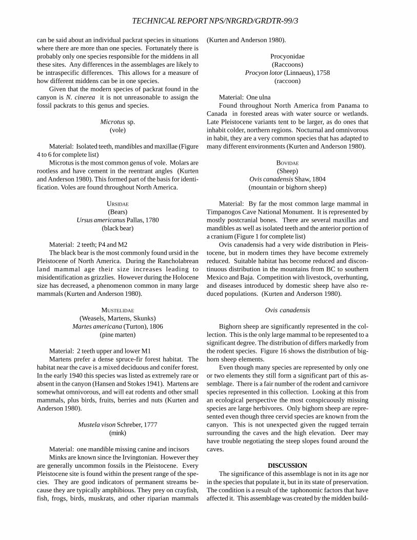
TECHNICAL REPORT NPS/NRGRD/GRDTR-99/3
can be said about an individual packrat species in situationswhere there are more than one species. Fortunately there isprobably only one species responsible for the middens in allthese sites. Any differences in the assemblages are likely tobe intraspecific differences. This allows for a measure ofhow different middens can be in one species.
Given that the modern species of packrat found in thecanyon is N. cinerea it is not unreasonable to assign thefossil packrats to this genus and species.
Microtus sp.(vole)
Material: Isolated teeth, mandibles and maxillae (Figure4 to 6 for complete list)
Microtus is the most common genus of vole. Molars arerootless and have cement in the reentrant angles (Kurtenand Anderson 1980). This formed part of the basis for identi-fication. Voles are found throughout North America.
URSIDAE
(Bears)Ursus americanus Pallas, 1780
(black bear)
Material: 2 teeth; P4 and M2The black bear is the most commonly found ursid in the
Pleistocene of North America. During the Rancholabreanland mammal age their size increases leading tomisidentification as grizzlies. However during the Holocenesize has decreased, a phenomenon common in many largemammals (Kurten and Anderson 1980).
MUSTELIDAE
(Weasels, Martens, Skunks)Martes americana (Turton), 1806
(pine marten)
Material: 2 teeth upper and lower M1Martens prefer a dense spruce-fir forest habitat. The
habitat near the cave is a mixed deciduous and conifer forest.In the early 1940 this species was listed as extremely rare orabsent in the canyon (Hansen and Stokes 1941). Martens aresomewhat omnivorous, and will eat rodents and other smallmammals, plus birds, fruits, berries and nuts (Kurten andAnderson 1980).
Mustela vison Schreber, 1777(mink)
Material: one mandible missing canine and incisorsMinks are known since the Irvingtonian. However they
are generally uncommon fossils in the Pleistocene. EveryPleistocene site is found within the present range of the spe-cies. They are good indicators of permanent streams be-cause they are typically amphibious. They prey on crayfish,fish, frogs, birds, muskrats, and other riparian mammals
(Kurten and Anderson 1980).
Procyonidae(Raccoons)
Procyon lotor (Linnaeus), 1758(raccoon)
Material: One ulnaFound throughout North America from Panama to
Canada in forested areas with water source or wetlands.Late Pleistocene variants tent to be larger, as do ones thatinhabit colder, northern regions. Nocturnal and omnivorousin habit, they are a very common species that has adapted tomany different environments (Kurten and Anderson 1980).
BOVIDAE
(Sheep)Ovis canadensis Shaw, 1804(mountain or bighorn sheep)
Material: By far the most common large mammal inTimpanogos Cave National Monument. It is represented bymostly postcranial bones. There are several maxillas andmandibles as well as isolated teeth and the anterior portion ofa cranium (Figure 1 for complete list)
Ovis canadensis had a very wide distribution in Pleis-tocene, but in modern times they have become extremelyreduced. Suitable habitat has become reduced and discon-tinuous distribution in the mountains from BC to southernMexico and Baja. Competition with livestock, overhunting,and diseases introduced by domestic sheep have also re-duced populations. (Kurten and Anderson 1980).
Ovis canadensis
Bighorn sheep are significantly represented in the col-lection. This is the only large mammal to be represented to asignificant degree. The distribution of differs markedly fromthe rodent species. Figure 16 shows the distribution of big-horn sheep elements.
Even though many species are represented by only oneor two elements they still form a significant part of this as-semblage. There is a fair number of the rodent and carnivorespecies represented in this collection. Looking at this froman ecological perspective the most conspicuously missingspecies are large herbivores. Only bighorn sheep are repre-sented even though three cervid species are known from thecanyon. This is not unexpected given the rugged terrainsurrounding the caves and the high elevation. Deer mayhave trouble negotiating the steep slopes found around thecaves.
DISCUSSIONThe significance of this assemblage is not in its age nor
in the species that populate it, but in its state of preservation.The condition is a result of the taphonomic factors that haveaffected it. This assemblage was created by the midden build-
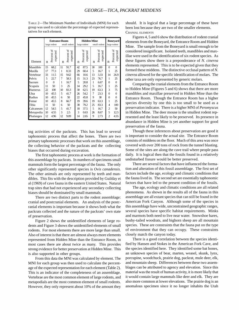
GEORGE—TICA, PACKRAT MIDDENS
ing activities of the packrats. This has lead to severaltaphonomic process that affect the bones. There are twoprimary taphonomic processes that work on this assemblage,the collecting behavior of the packrats and the collectingbiases that occurred during excavation.
The first taphonomic process at work is the formation ofthis assemblage by packrats. In numbers of specimens smallmammals form the largest percentage of the fauna. The onlyother significantly represented species is Ovis canadensis.The other animals are only represented by teeth and man-dibles. This fits with the description provided by Guilday etal (1969) of cave fauna in the eastern United States. Naturaltrap sites that had not experienced any secondary collectingbiases should be dominated by small mammals.
There are two distinct parts to the rodent assemblage:cranial and postcranial elements. An analysis of the postc-ranial elements is important because it shows both what thepackrats collected and the nature of the packrats’ own stateof preservation.
Figure 2 shows the unidentified elements of large ro-dents and Figure 3 shows the unidentified elements of smallrodents. For most elements there are more large than small.Also of interest is that there are almost always more elementsrepresented from Hidden Mine than the Entrance Room, inmost cases there are about twice as many. This providesstrong evidence for better preservation at Hidden Mine. Thisis also supported in other groups.
From this data the MNI was calculated by element. TheMNI for each group was then used to calculate the percent-age of the expected representation for each element (Table 2).This is an indicator of the completeness of an assemblage.Vertebrae are the most common element of large rodents, andmetapodials are the most common element of small rodents.However, they only represent about 10% of the amount they
should. It is logical that a large percentage of these havebeen lost because they are two of the smaller elements.CRANIAL ELEMENTS
Figures 4, 5 and 6 show the distribution of rodent cranialelements from the Boneyard, the Entrance Room and HiddenMine. The sample from the Boneyard is small enough to beconsidered insignificant. Isolated teeth, mandibles and max-illae were used in the identification of six rodent species. Asthese figures show there is a preponderance of N. cinereaelements represented. This is to be expected given that theyformed these middens. The distinctive occlusal pattern of N.cinerea allowed for the specific identification of molars. Theother taxa are only represented by generic molars.
Comparing the cranial elements from the Entrance Roomto Hidden Mine (Figures 5 and 6) shows that there are moremandibles and maxillae preserved in Hidden Mine than theEntrance Room. Though the Entrance Room has a higherspecies diversity by one this is too small to be used as apreservation indicator. There is a higher MNI of Peromyscusin Hidden Mine. The deer mouse is the smallest rodent rep-resented and the least likely to be preserved. Its presence inabundance in Hidden Mine is yet another support for goodpreservation of the fauna.
Though these inferences about preservation are good itis important to consider the actual site. The Entrance Roomconsists of middens on the floor. Much of this area was oncecovered with over 200 tons of rock from the tunnel blasting.Some of the sites are along the cave trail where people passdaily. It is logical then that the fossils found in a relativelyundisturbed fissure would be better preserved.
There are several factors that have influenced the forma-tion and alteration of this fossil assemblage. The first set offactors include the age, ecology and climatic conditions thatthe fauna lived in. The second set are essentially taphonomicfactors that have led to the present condition of the fossils.
The age, ecology and climatic conditions are all relatedphenomena. As shown in the results all of the fauna in thisassemblage are all extant species that can still be found in theAmerican Fork Canyon. Although some of the species inthis assemblage have wide, unconstrained geographic ranges,several species have specific habitat requirements. Minksand marmots both need to live near water. Snowshoe hares,bushy-tailed woodrats, and bighorn sheep are all mountainspecies. These are constraints that the fauna put on the typeof environment that they can occupy. These constraintsclosely match the canyon today.
There is a good correlation between the species identi-fied by Hansen and Stokes in the American Fork Cave, andthe species identified here. They identified some bat bones,an unknown species of bear, marten, weasel, skunk, lynx,porcupine, woodchuck, prairie dog, packrat, mule deer, elk,and mountain sheep. Differences between these two assem-blages can be attributed to agency and elevation. Since thismaterial was the result of human activity, it is more likely thatit would contain large mammals like deer and elk. They arealso more common at lower elevations. The prairie dog is ananomalous specimen since it no longer inhabits the Utah
Mandible 15 68.2 11 91.7 42 87.5 30 100 0 0Maxilla 17 77.3 1 8.33 29 60.4 5 16.7 1 25Vertebrae 33 11.5 15 9.62 66 10.6 13 3.33 14 26.9Pelvis 5 22.7 7 58.3 15 31.3 23 76.7 1 25Sacrum 0 0 1 16.7 5 20.8 1 6.67 0 0Scapula 11 50 3 25 14 29.2 5 16.7 1 25Humerus 22 100 10 83.3 30 62.5 19 63.3 3 75Ulna 10 45.5 5 41.7 26 54.2 7 23.3 0 0Radius 10 45.5 6 50 22 45.8 9 30 0 0Femur 10 45.5 8 66.7 19 39.6 19 63.3 1 25Tibia 11 50 6 50 38 79.2 25 83.3 4 100Calcaneum 12 54.5 5 41.7 18 37.5 5 16.7 2 50Metapodia 10 4.55 3 2.5 3 0.63 26 8.67 5 12.5Phalanges 12 4.96 12 9.09 14 2.65 9 2.73 2 4.55
Entrance Room Hidden Mine Boneyardlarge rodent small rodent large rodent small rodent large rodent
Perc
ent o
fex
pect
ed
n Perc
ent o
fex
pect
ed
nPerc
ent o
fex
pect
ed
nPerc
ent o
fex
pect
ed
nPerc
ent o
fex
pect
ed
nElement
TABLE 2—The Minimum Number of Individuals (MNI) for eachgroup was used to calculate the percentage of expected represen-tatives for each element.
TECHNICAL REPORT NPS/NRGRD/GRDTR-99/3
valley and is not known from that high an elevation. Theauthors propose that it was brought to the site by the hu-mans. An interesting correlation in fauna is that AmericanFork Cave is also rich in mountain sheep. Hansen and Stokesidentified over 100 individuals. This may have been the pri-mary prey of the hunters (Hansen and Stokes 1941).
No radiometric dates were determined for this assem-blage. Since the fauna is similar to modern species it is mostlikely a few hundred to a few thousand years old, certainlyrepresenting the Holocene. Naturally the climate and eco-system of an area will determine what animals will make upthe source of an assemblage. Since the assemblage is similarto today the climate and ecosystem are also likely to havebeen similar. Radiometric dates would show at least howlong these conditions have existed.
ACKNOWLEDGEMENTSI thank Vincent Santucci of Fossil Butte for introducing
me to this project and providing support towards the publi-cation of this paper. Rod Horrocks, former Cave Specialist atTimpanogos Cave National Monument, provided me a greatdeal of help in the excavation and information about the cave.Roger Thomas, Professor of Geology and Paleontology atFranklin & Marshall College, served as my advisor this pastyear and provided a great deal of help in my research andwriting of this paper. Ron Kerbo, Cave Management Special-ist with the National Park Service Geologic Resources Divi-sion, provided financial support for radiometric analysis. Ithank Franklin & Marshall College’s Committee on Grantsand the John Marshall Scholarship program for the fundingthat made this project possible.
REFERENCESBAKER, A.A. AND M.D. CRITTENDEN, 1961. Geologic Map of
the Timpanogos Cave Quadrangle, Utah. United StatesGeologic Survey, 7.5 minute series.
GUILDAY, J.E., H.W. HAMILTON AND A.D. MCCRADY, 1969. ThePleistocene Vertebrate Fauna of Robinson Cave, Overton
County, Tennessee. Palaeovertebrata. 2:25-75.HANSEN, G.H. AND W.L. STOKES, 1941. An Ancient Cave in
American Fork Canyon. Proceedings of the Utah Acad-emy of Sciences, Arts and Letters. vol. 18.
HINTZE, L.F., 1988. Geologic history of Utah. Brigham YoungUniversity Geology Studies Special Publication 7.
HORROCKS, R., 1995. Artificial Fill Removal Project:Timpanogos Cave System. NSS News 102-107.
______, 1994. The Story of Timpanogos Cave. NSS News6-27.
KURTEN, B. AND E. ANDERSON, 1980. Pleistocene Mammals ofNorth America. Columbia University Press, New York.
MEAD, J.I. AND A.M. PHILLIPS, 1981. The Late Pleistoceneand Holocene fauna and flora of Vulture Cave, GrandCanyon, Arizona. The Southwest Naturalist 26(3):257-288.
PALMER, A. AND P. PALMER, 1990. Comments on cave originand mineral stability in Timpanogos Cave. Unpublishedreport to Timpanogos Cave National Monument.
PETERSEN, K.L., 1994. Modern and Pleistocene Climatic Pat-terns in the West. in K.T. Harper, L.L. St. Clair, K.H.Thorne, and W.M. Hess (eds.), Natural History of theColorado Plateau and Great Basin, University Pressof Colorado.
SCHULTZ, C.B. AND E.B. HOWARD, 1936. The fauna of BurnetCave, Guadalupe Mountains, New Mexico. Proceed-ings of the Academy of Natural Sciences of Philadel-phia. vol. LXXXVII.
VAUGHAN, T.A., 1990. Ecology of living packrats. inBetancourt, Van Devender and Martin (eds.), Packratmiddens: The last 40,000 years of biotic change. Uni-versity of Arizona Press, Tucson.
WHITE, W.B. AND J.J. VAN GUNDY, 1974. Reconnaissancegeology of Timpanogos Cave, Wasatch County, Utah.The NSS Bulletin 36(1):5-17.
ZAKARZEWSKI, R.J., 1993. Morphological change in woodrat(Rodentia: Cricetidae) molars. in R.A. Martin and A.D.Barnosky (eds.), Morphological Change in Quater-nary Mammals of North America, Cambridge Univer-sity Press, Cambridge.
GEORGE—TICA, PACKRAT MIDDENS
FIGURE 1—Elements of Ovis canadensis by excavation area. Noelements were found in the Boneyard.
FIGURE 2—Postcranial elements of large rodents.
FIGURE 5—Cranial elements of rodent species found in the EntranceRoom.
FIGURE 6—Cranial elements of rodent species found in Hidden Mine.
FIGURE 3—Postcranial elements of small rodents. FIGURE 4—Cranial elements of rodent species found in the Boneyard.
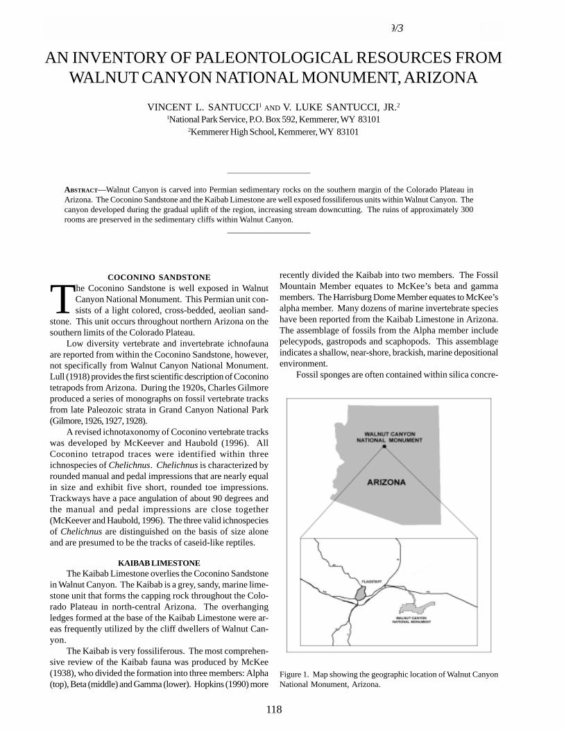
TECHNICAL REPORT NPS/NRGRD/GRDTR-99/3
AN INVENTORY OF PALEONTOLOGICAL RESOURCES FROMWALNUT CANYON NATIONAL MONUMENT, ARIZONA
VINCENT L. SANTUCCI1 AND V. LUKE SANTUCCI, JR.2
1National Park Service, P.O. Box 592, Kemmerer, WY 831012Kemmerer High School, Kemmerer, WY 83101
____________________
ABSTRACT—Walnut Canyon is carved into Permian sedimentary rocks on the southern margin of the Colorado Plateau inArizona. The Coconino Sandstone and the Kaibab Limestone are well exposed fossiliferous units within Walnut Canyon. Thecanyon developed during the gradual uplift of the region, increasing stream downcutting. The ruins of approximately 300rooms are preserved in the sedimentary cliffs within Walnut Canyon.
____________________
COCONINO SANDSTONE
The Coconino Sandstone is well exposed in WalnutCanyon National Monument. This Permian unit con-sists of a light colored, cross-bedded, aeolian sand-
stone. This unit occurs throughout northern Arizona on thesouthern limits of the Colorado Plateau.
Low diversity vertebrate and invertebrate ichnofaunaare reported from within the Coconino Sandstone, however,not specifically from Walnut Canyon National Monument.Lull (1918) provides the first scientific description of Coconinotetrapods from Arizona. During the 1920s, Charles Gilmoreproduced a series of monographs on fossil vertebrate tracksfrom late Paleozoic strata in Grand Canyon National Park(Gilmore, 1926, 1927, 1928).
A revised ichnotaxonomy of Coconino vertebrate trackswas developed by McKeever and Haubold (1996). AllCoconino tetrapod traces were identified within threeichnospecies of Chelichnus. Chelichnus is characterized byrounded manual and pedal impressions that are nearly equalin size and exhibit five short, rounded toe impressions.Trackways have a pace angulation of about 90 degrees andthe manual and pedal impressions are close together(McKeever and Haubold, 1996). The three valid ichnospeciesof Chelichnus are distinguished on the basis of size aloneand are presumed to be the tracks of caseid-like reptiles.
KAIBAB LIMESTONEThe Kaibab Limestone overlies the Coconino Sandstone
in Walnut Canyon. The Kaibab is a grey, sandy, marine lime-stone unit that forms the capping rock throughout the Colo-rado Plateau in north-central Arizona. The overhangingledges formed at the base of the Kaibab Limestone were ar-eas frequently utilized by the cliff dwellers of Walnut Can-yon.
The Kaibab is very fossiliferous. The most comprehen-sive review of the Kaibab fauna was produced by McKee(1938), who divided the formation into three members: Alpha(top), Beta (middle) and Gamma (lower). Hopkins (1990) more
recently divided the Kaibab into two members. The FossilMountain Member equates to McKee’s beta and gammamembers. The Harrisburg Dome Member equates to McKee’salpha member. Many dozens of marine invertebrate specieshave been reported from the Kaibab Limestone in Arizona.The assemblage of fossils from the Alpha member includepelecypods, gastropods and scaphopods. This assemblageindicates a shallow, near-shore, brackish, marine depositionalenvironment.
Fossil sponges are often contained within silica concre-
Figure 1. Map showing the geographic location of Walnut CanyonNational Monument, Arizona.
118
tions in the Kaibab. The brachiopods include productid andspiriferid species. Below is a composite list of paleontologi-cal resources from Walnut Canyon and the surrounding area.
PHYLUM BRYOZOAUnidentified bryozoans are known only as fragmentary
remains from the lower portion of the Alpha Member of theKaibab Limestone.
PHYLUM MOLLUSCA Class Gastropoda
Baylea sp.Bellerophon deflectusEuomphalus sp.Euphemites sp.Goniasma sp.Murchisonia sp.Naticopsis sp.Pennotrochus arizonensisSoleniscus sp.Busyconid gastropods
Class PelecypodaAllorisma sp.Astarella sp.Aviculopecten kaibabensisDozierella sp.Edmondia sp.Gramatodon politusJaneia sp.Kaibabella curvilinataMyalina sp.Myalinella aduncaNuculana sp.Nuculopsis sp.Palaeonucula levatiformisParallelodon sp.Permophorous albequusPleurophorus albequusSchizodus texanusSolemya sp.Solenomorpha sp.
Class ScaphopodaPlagioglypta canna
Class CephalopodaAulometacoceras sp.Metacoceras unklesbayiStearoceras sp.Tainoceras sp.
PHYLUM BRACHIOPODAChonetes sp.Composita arizonicaDictyoclostus sp.Marginifera sp.Peniculauris bassiQuadrochonetes kaibabensisRugatia paraindica
PHYLUM ARTHROPODA Class Trilobita
Anisopyge sp.Ditomopyge sp.
PHYLUM ANNELIDAWorm tubes have been identified on a specimen of the
brachiopod Marginifera.
PHYLUM CHORDATAA variety of shark’s teeth are known from the Kaibab
Limestone including: Sandalodus, Deltodus, Symmorium,Petalodus, Orrodus and phyllodont tooth plates.
PALEOECOLOGYAccording to McKee (1938) the Alpha member of the
Kaibab formation represents a regressive shallow marine fa-cies. This member consists of dolomites, dolomitic sand-stones and intraformational conglomerates. Nicol (1944) sug-gests that the pelecypod Schizodus indicates a shallow hy-persaline environment within the Alpha member of the KaibabFormation. The assemblage represents a near shore brackishenvironment which is supported by the absence of corals.Bryozoans are known only as fragmentary remains from thelower portion of the Alpha Member. The fossil assemblagesalso reflect a thanatocoenoses (a collection of dead organ-isms or parts of organisms that have accumulated after death- death assemblage). The Beta member (Nicol, 1944) in-cludes sponges and echinoderms.
ACKNOWLEDGEMENTSWe would like to acknowledge the support of the staff at
Walnut Canyon National Monument including SteveMitchelson and Jeri DeYoung. Thanks to Tom Olson forreviewing this publication and to David Hays and MarikkaHughes for providing assistance with the locality map. Ad-ditional thanks to Deb Hill who provided assistance withresearch at the Museum of Northern Arizona.
REFERENCESBEUS, S., 1965. Permian fossils from the Kaibab Formation at
Flagstaff, Arizona. Plateau, 38:1-5.CHRONIC, H., 1952. Molluscan fauna from the Permian Kaibab
Formation, Walnut Canyon, Arizona. Geological Soci-ety of America Bulletin, 63:95-166.
GILMORE, C.W., 1926. Fossil footprints from the Grand Can-yon. Smithsonian Miscellaneous Collections, 77(9), 41p.
______, 1927. Fossil footprints in Arizona, second contribu-tion: Smithsonian Miscellaneous Collections, 80(3), 78p.
______, 1928. Fossil footprints from the Grand Canyon, thirdcontribution. Smithsonian Miscellaneous Collections,80(8), 16p.
HOPKINS, R.L., 1990. Kaibab Formation. in S.S. Beus and M.Morales (eds.), Grand Canyon Geology, Oxford Univer-sity Press, p.225-245.
LULL, R.S., 1918. Fossil footprints from the Grand Canyon ofthe Colorado. American Journal of Science, 45:337-346.
SANTUCCI AND SANTUCCI—WACA, PALEONTOLOGICAL INVENTORY

TECHNICAL REPORT NPS/NRGRD/GRDTR-99/3
MCKEE, E.D., 1938. The environment and history of Toroweapand Kaibab formations of northern Arizona and south-ern Utah. Carnegie Inst. Washington, Publ. 492, 268 p.
MCKEEVER, P.J. AND H. HAUBOLD, 1996. Reclassification ofvertebrate trackways from the Permian of Scotland andrelated forms from Arizona and Germany. New MexicoMuseum of Natural History and Science Bulletin, 6: 251-261.
NICOL, D., 1944. Paleoecology of three fanules in the PermianKaibab Formation at Flagstaff, Arizona. J. Paleontology,18(6):553-557.
SNOW, J.I., 1945. Trilobites of the Middle Permian Kaibabformation of northern Arizona. Plateau 18:17-24.
VANDIVER, V.W., 1936. Walnut Canyon Geological Report.Southwestern Monuments Special Report, Supplementfor June, p. 492-498.
CONTINENTAL ICHNOFOSSILS FROM THE UPPER JURASSIC MORRISON FORMATION, WESTERN INTERIOR,
USA: WHAT ORGANISM BEHAVIOR TELLS US ABOUT JURASSIC ENVIRONMENTS AND CLIMATES
STEPHEN T. HASIOTISDepartment of Geological Sciences, University of Colorado, Campus Box 399, Boulder, CO 80309-0399
Present address: Exxon Production Research Company, P.O. Box 2189, Houston, TX 77252-2189
____________________
ABSTRACT—A large number of previously undescribed continental trace fossils are now known from the Late Jurassic as aresult of the three year interdisciplinary project “The Morrison Formation Extinct Ecosystem Project” funded by theNational Park Service. This study examined rocks of the Upper Jurassic Morrison Formation associated with national parks,monuments, and historical sites and adjacent areas in the Western Interior of the United States. Continental ichnofossils areextremely important pieces of evidence for understanding ancient environmental, ecological, and climatic settings. First,ichnofossils, which preserve evidence of organism-substrate interactions, record invertebrate, vertebrate, and plant biodiversityunder-represented by body fossils in the Morrison. This new ichnofossil evidence demonstrates that there was an abundanceof invertebrates predominantly representing terrestrial and freshwater insects. Ecological tiering of these traces providesvertical and lateral evidence of ancient soil development and water table and soil moisture levels dictated by the localpaleohydrologic regime. The local and regional climatic setting controls these components of the environment, in turn.Invertebrates and plants are particularly sensitive to changes in the physical, chemical, and biological components of theirenvironment, and thus, are useful paleoclimatic barometers.
Ichnofossil diversity and community composition from the base to the top of the Morrison suggest that the climatein the lower part of the Morrison (Tidwell, Salt Wash Members) was semi-arid to seasonal with pronounced wet and dryperiods. Through time, the climate became wetter with a less pronounced drier interval and more annually distributed rainfallin the upper part of the Morrison (Recapture, Westwater, and Brushy Basin Members). Some areas in the western part ofthe Morrison depositional basin experienced a possible rainshadow effect due to mountains/highlands to the west. Thislikely produced locally drier climates as a result of annually reduced rainfall that is reflected in depauperate ichnofossilassemblages. However, further to the east (Utah/Colorado/Wyoming borders) ichnofossil diversity is much higher, reflectingannually wetter climates.
____________________
INTRODUCTION
The National Park Service funded a three year interdis-ciplinary project entitled “The Morrison FormationExtinct Ecosystem Project” that gathered geologic,
paleontologic, and geochemical data used to more accuratelyreconstruct the Late Jurassic ecosystem inhabited by gigan-tic herbivores, small armored herbivores and omnivores, andferocious meat eaters. This study examined the Upper Juras-sic Morrison Formation associated with national parks, monu-ments, paleontological areas, historical sites, and adjacentareas in the Western Interior of the United States (Turner andPeterson, 1998).
One of the results of this project was the discovery of alarge number of previously undescribed continental tracefossils (Fig.1), some of which have evolutionary and ecologi-cal implications for understanding organisms and ecosys-tems in the Mesozoic. The traces of Jurassic plants andanimals reveal important information about ancient environ-mental, ecologic, and climatic settings in the Rocky Moun-tain region between 155-145 million years ago. Organismslike bees, ants, termites, wasps, dung beetles, carrion beetles,
crayfish, caddisflys, mayflys, and many others have burrows,nests, and other traces of their existence in lakes, rivers, flood-plains, and dunes (e.g., Hasiotis and Demko, 1996, 1998;Hasiotis, 1998b; Hasiotis et al., 1998a, b). This study is thefirst systematic search for evidence of terrestrial and fresh-water organisms not preserved or under-represented by bodyfossils in Jurassic continental rocks in North America. Rootpatterns, burrows, nests, tracks, and trails preserve detailsabout organism behavior-substrate interactions that reflectphysical, chemical, and biological conditions of the: (1) depo-sitional setting, (2) ecosystem, (3) hydrologic regime, (4) soilformation, (5) seasonality of precipitation and temperature,and (6) climatic trends throughout the Late Jurassic (Hasiotis,1998a).
RESEARCH SUMMARYAt least 38 Jurassic outcrop localities were studied be-
tween the 1994 and 1996 field seasons in the Rocky Moun-tain region from northwestern New Mexico to northwesternMontana. Numerous outcrops were visited in and aroundnational parks and monuments and paleontological areas.
121
TECHNICAL REPORT NPS/NRGRD/GRDTR-99/3
These include Arches National Park [ARCH] (UT), BighornCanyon National Recreation Area [BICA] (WY), CanyonlandsNational Park [CANY] (UT), Capital Reef National Monu-ment [CARE] (UT), Cleveland-Lloyd Quarry [CLQ] (UT), Colo-rado National Monument [COLM] (CO), Comanche NationalGrasslands [CNG] (CO), Curecanti National Recreation Area[CURE] (CO), Garden Park Paleontological Area [GPP] (CO),Dinosaur National Monument [DINO] (UT/CO), DinosaurRidge National Historic Site [DRN] (CO), Fruita Paleontologi-cal Area [FPA] (CO), Picket Wire Natural Area [PWN] (CO),Red Rocks State Park [RRS] (NM), and Roxborough StatePark [RSP] (CO). Other Morrison localities were investigatedin portions of Colorado (Boulder [BO], Dillon [DI], GlenwoodSprings [GS], Park Creek Reservoir [PCR], Rabbit Valley [RV]),Montana (Bridger [BR], Belt [BE], Gibson Reservoir [GR],Great Falls [GF]), New Mexico (Aneth [AN], Gallup [GP]),Utah (I-70 Corridor [I-70U], Beclabito Dome [BD], Hanna [HA],Moore Cutoff [MC], Montezuma Creek [MZ], Ruby Ranch[RR], Salt Valley Anticline [SVA]), and Wyoming (Arminto[AR], Alcova [AV], Como Bluff [CB], Grey Bull [GB],Thermopolis [TH]).
Ichnofossils from these areas have been documentedand photographed. In some cases, specimens were collectedfor further study, after which they will be deposited in theGeology Section of the University of Colorado Museum,Boulder.
RESULTSThe Morrison ichnofossils and their implications are pre-
sented as a suite of observations used to interpret environ-mental, ecological and climatic settings for terrestrial andfreshwater deposits within one or more closely related inter-vals. Nine intervals were defined from formal and informalmembers of the Morrison (Peterson and Turner, 1989; Turnerand Fishman, 1991; Peterson, 1995) as “time-related se-quences” and were based on relative stratigraphic equiva-lency and chronostratigraphic data such as age dates fromvolcanic ash beds and biostratigraphic ages of microfossils,like pollen and ostracodes. The intervals are as follows:
1). Basal contact surface/interval of the Morrison For-mation and correlative rocks (J-5 and correlativesurface).
2). Windy Hill and Tidwell Members beneath the loweralluvial complex (or lower rim Salt Wash Member)in the Colorado Plateau region, lowermost bedsof the Bluff Sandstone and Junction Creek Sand-stone Member, and Swift Member in Wyomingand Montana.
3). Lower alluvial complex and “Lower Rim” of the SaltWash Member in western Colorado Plateau, aswell as correlative beds of the Tidwell, Bluff, andJunction Creek Members, and correlative beds inthe Recapture Member.
4). Middle alluvial sandstone and mudstone complex ofthe Salt Wash Member in the Colorado Plateauand middle mudstone unit in the eastern part ofthe Plateau; also includes correlative beds in the
Tidwell Member where the lower beds of the SaltWash pinch-out, Bluff and Junction Creek Mem-bers, and correlative beds of the Recapture Mem-ber.
5). Upper alluvial sandstones and mudstones of the SaltWash member in the western part of the ColoradoPlateau and “Upper Rim” of the Salt Wash in theeastern Colorado Plateau; also includes correla-tive beds in the Tidwell Member, Bluff and Junc-tion Creek Members, and correlative beds of theRecapture Member.
6). Lower part of the Brushy Basin Member from the topof the Salt Wash to the clay change within theBrushy Basin; near the top includes the lowerpart of the Westwater Canyon Member in easternColorado Plateau, the lower and middle mudstonesand alluvial sandstones of the Fiftymile Memberin the Kaiparowits Plateau, and the uppermostRecapture Member in the southern Colorado Pla-teau.
7). Upper part of the Brushy Basin Member from the claychange to the base of the uppermost Morrisonalluvial sandstone beds including the middle andupper Westwater Canyon Member and upper al-luvial sandstones in the Fiftymile Member.
8). Uppermost part of the Brushy Basin Member, includ-ing the Jackpile Sandstone Member in the south-ern Colorado Plateau and correlative, unnamedalluvial Morrison sandstones elsewhere.
9). Upper contact/interval of the Morrison Formationwith the Lower Cretaceous rocks above the K-1or K-2 where present.
The following section contains the environmental, eco-logical, and climatic interpretations of the intervals describedabove. The groups of intervals are based on their ichnofossildiversity, distributions, and relationship to paleosols. Eachsection begins with a summary of ichnofossil occurrences, abrief description of the paleoenvironments present, and apaleoecologic and paleoclimatic interpretation of the setting.
INTERVALS 1-2In the area of the Colorado Plateau (Shitamoring Canyon
[SC], Trachyte Ranch [TR], Hanna [HA], Alcova [AV], Colo-rado National Monument [COLM], Dinosaur National Monu-ment [DINO], Como Bluff [CB], etc.), ichnofossils includemarine and brackish-water stromatolites (with and withoutbivalve borings), oyster encrusting grounds, horseshoe crabtrails, unidentified crustacean burrows and surface feedingtraces, clam resting traces, amphipod suspension feedingburrows, polychaete deposit-feeding burrows, snail grazingtrails, nematode crawling trails, pterosaur tracks and feedingtraces, and theropod and sauropod dinosaur tracks. Most ofthese traces are found in low diversity, high abundance as-semblages found in shallow, single to compound tiers of nomore than 2-3 cm thick. These traces suggest marine and
marginal-marine to tidal environments (Windy Hill Member)with low to high depositional energy and salinity-stresseddeposystems in warm to hot humid settings. The brackish-water and tidal ichnofossils imply that coastlines had severalembayments to form sequences of tidal sediments.The tracesin lacustrine settings (Tidwell Member) include mayfly de-posit-feeding burrows, midge fly and crane fly deposit-feed-ing burrows (Diptera), aquatic earthworm trails, nematodetrail, pterosaur tracks and feeding traces (scratched surfaces),clam resting traces, crayfish burrows and crawling trails andsmall horizontal burrows, and theropod and sauropod dino-saur footprints. Ichnofossils are found in single 2-4 cm deeptiers that are subdivided into shallow and deep tiering com-partments; small traces are typically in the shallow part (may-fly, caddisfly burrows), while larger, deeper traces are in thedeep compartment (crayfish burrows). These continentaltraces suggest that the marginal-lacustrine and lacustrineenvironments had episodic depositional rates and season-ally high water tables, which would have also resulted inimperfectly drained and poorly developed paleosols.
Trace fossils in fluvial and overbank deposits (Salt WashMember), modified by pedogenesis, contain solitary and so-cial bee nests, crayfish burrows, beetle burrows, bug bur-rows, root traces and mottling patterns, pith casts (not truetrace fossils) of large 10 cm diameter horsetails(Neocalamites), and theropod and sauropod dinosaur foot-prints. Up to four tiers are present in these environments, thedeepest of which approximate the water table depth; how-ever, in most places the deepest tier reflects the intermediatevadose zone. Alluvial environments had weakly developedsoils, many with simple to mature, cumulative and compoundprofiles resulting in successions of weakly modified distaloverbank deposits. Many of these ancient soils containweakly-developed B horizons, or zones of clay accumulationdue to water infiltration and animal activity, with mottling ofgray, green, yellow, and purple. These colors suggest sea-sonally imperfectly drained settings (gray, green, and yel-low) with drier intermediate periods (purple and red).
Small eolian dune fields persisted in the Four Cornersarea and were scattered up through western Colorado andWyoming. Ichnofossils are sparse and simple, composed ofmainly indistinct horizontal and vertical burrows. These duneswere associated with the marginal-marine and marginal-lacus-trine environments.
In the Front Range of Colorado (Horsetooth Reservoir[HR], Park Creek Reservoir [PCR]), ichnofossils are similar tothat of the Colorado Plateau, but are dominated by stromato-lites (also with borings) and polychaete feeding burrows.These traces indicate that predominately marine and mar-ginal-marine (estuarine and tidal) environments existed in theFort Collins area. Lacking is the more common high-abun-dance, low-diversity brackish-water to stressed-marine as-semblages of the Colorado Plateau region. Here, ichnofossiltiering is similar to marine and marginal-marine environmentson the Plateau. These Front Range ichnofossil occurrencessuggest a more restricted environment with either higher sa-linity or higher energy settings. The climatic setting in the
Front Range was probably similar to that of the Plateau; how-ever, there may have been less precipitation and higher evapo-ration in the Front Range due to the orographic effects to thewest in western Utah.
INTERVAL 3-5In the Colorado Plateau and surrounding areas
(Shitamoring Canyon [SC], Trachyte Ranch [TR], Hanna [HA],Alcova [AV], Dinosaur National Monument [DINO], ComoBluff [CB], etc.), abundant and diverse ichnofossils includeat least four types of large and small termite nests, four typesof ant nests, three types of bee nests, wasp cocoons, at leastfive types of beetle burrows (vertical and horizontal), dungbeetle nests, soil bug burrows, bivalve resting traces, snailtrails, crayfish burrows, various types of plant roots (smallplants up to large trees), and several types of sauropod andtheropod footprints. These traces suggest the environmentswere dominated by proximal and distal alluvial floodplainsthat formed on and between channel and sheet sandstoneswith less intercalated overbank fine-grained sediments(greater amounts of fines in western Colorado Plateau). Inseveral localities termite and ant nests co-occur with severaltypes of beetle burrows and solitary bees’ nests in moder-ately to well-developed simple paleosols. Up to four tiers arepresent in these environments, the deepest of which approxi-mate the water table depth. In places where the water table isvery deep, the deepest tier reflects the intermediate vadosezone. Many of the paleosols that contain discernible tracefossils (e.g., Shitamoring Canyon, Bullfrog, Curecanti) indi-cate that bioturbation out-paced pedoturbation (soil-form-ing processes) and sedimentation. For other types of maturepaleosols (e.g., Hanna, Salt Valley Anticline), pedoturbationout-paced bioturbation and sedimentation. In general, manylocalities contained paleosols that had parent material andpedogenic characters that were strongly dominated by sedi-mentation rates that out-paced pedoturbation.
In the Four Corners area (Bluff Member and Eolian Fa-cies of the Recapture Members) isolated eolian erg fieldspersisted from Interval 1-5. During these intervals, the sedi-mentary facies and ichnofossils suggest increasingly wettersettings that eventually stabilized the erg systems with veg-etation and paleosols. These vegetated surfaces includedintensive nesting by solitary and social insects. In the areaof Gallup, New Mexico, the upper parts of the ergs (Recap-ture) contain rhizoliths and giant termite nests. The upper-most part contains termite nests 30+ m long that followedrhizoliths of trees and small shrubs below the surface. Thebulk of the nests are within the top 15 m. However, galleriesand stacked chambers can be traced to the base of the Bluff,for a total length of nearly 40 m. In this area, termite galleriesthat are interpreted to reach the paleo-water table at a depthof nearly 32 m represent the deepest ichnofossil tier.
INTERVAL 6-7In the Colorado Plateau and surrounding areas (Beclabito
Dome [BD], Bighorn Res. [BR], Hanksville [HK], Canon City-Marsh Felch [MF at GPP], Montezuma Creek [MZ], Moore
HASIOTIS—MISC., MORRISON ICHNOFOSSILS

TECHNICAL REPORT NPS/NRGRD/GRDTR-99/3
FIGURE 1—A few examples of Morrison trace fossils. A-B, Ant nest from Hanksville (UT) area and a rock cross-section through part ofthe nest; C-D, Termite nests from the Gallup (NM) area with clos-up of internal morphology; E-F, Bees nest from the southern HenryMountains (UT) area with close-up of some of the cell morphology.
Cutoff [MC]), the trace fossils included crayfish burrows,termite nests, ant nests, cicada burrows, beetle burrows (hori-zontal and vertical), rare beetle larvae burrows (Scoyenia),beetle-borings (pupal chambers) in dinosaur bones, earth-worm pellets and burrows, various sizes of plant roots (smallto large diameter, tree-size), and several types of sauropodand theropod footprints.
The ichnofossils in these rocks suggest that largeramounts of precipitation fell during the rainy season in theseintervals and intervals 8-9. Crayfish burrows are more abun-dant than ant nests and termite nests in proximal overbankdeposits in the Brushy Basin and Recapture Members (GPP,RV, AN, MC). In more distal facies (also better drainedpaleosols) ant nests are more dominant than termite nests inmost areas (HA, MC, SC), but both are shallower in overalldepth compared to similar structures in the lower part of theMorrison. There are more occurrences of solitary to primi-tively-social bees’ nests in these intervals as well (MZ, GPP).Ichnofossil tiering is similar, but the overall depth of all fourtiers is shallower due to higher water tables.
INTERVAL 8-9Ichnofossils in these intervals include indistinct hori-
zontal and vertical burrows, large (but rare) termite nests,beetle burrows, soil bug burrows, crayfish burrows, and vari-ous sized root traces. These traces predominantly occur inpaleosols developed on fine-grained overbank deposits andin buried channel/levee deposits on floodplains. In interval8, numerous paleosols occur as immature to mature, simpleand cumulative sequences. Many of the paleosols devel-oped on paludal to marginal-lacustrine settings in Wyoming,or were developed on poorly drained overbank floodplainswith episodic deposition. Near the end of this interval andincluding interval 9 (the boundary), paleosols became in-creasingly better developed and more mature.
Paleosols that formed at interval 9 are quite variable andwere the result of different lengths of subaerial exposure un-der particular types of groundwater regimes and depositionalsettings. For example, the thick sequence of paleosols (10m+) developed at Ruby Ranch are composed of cumulativeand compound profiles dominated by crayfish burrows andrhizoliths. These paleosols formed during seasonally highand fluctuating groundwater table conditions in an imper-fectly drained area. Four ichnofossil tiers are present, a littledeeper than in the previous intervals, possibly due to envi-ronmental or climatic changes. These ichnofossils andpaleosols were later calcretized by an early Cretaceous event.The boundary paleosols (2 m+) at Salt Valley Anticline aredrab-colored olive-green, mottled red, yellow, and brown pro-duced by interactions between the primary and secondarytaproot rhizoliths (with finer-scale rootlets) and the substrate.The boundary paleosol at Dinosaur Ridge National HistoricSite is a thick, clay accumulation (2 m) that is well developedand represents a long-term surface of exposure. The paleosolis dominated by red and purple mottles with minor amountsof yellow and white mottles and is intensely bioturbated withfine rootlets, soil bugs and beetle burrows.
CONCLUSIONSBased on the ichnofossil assemblages and their asso-
ciation with paleosols in the rocks of the Upper JurassicMorrison Formation, the Morrison environments became in-creasingly wetter from the Tidwell and Salt Wash to the endof Brushy Basin and equivalent deposits. Paleosols are localand regional discontinuity features (e.g., Kraus and Bown,1986; Bown and Kraus, 1987; Hasiotis 1997; Demko et al.,1998) that, in the Morrison, also reflect increasingly wetterclimates through time. They also record extensivebioturbation by rooted vegetation from the Salt Wash upthrough the Brushy Basin. Paleosols also preserve short tolong periods of infrequent deposition and regional subaerialexposure. On these surfaces, trace-making organisms, fromplant roots and beetles to huge sauropods, left attributesthat reflect the hydrologic and climatic setting of that time.The various paleosols resulted in surfaces that could be usedas sequence stratigraphic boundaries signaling changes inregional base level, sedimentation, climate, and tectonicsthrough time.
Morrison ichnofossils are important because they rep-resent the activity of different types of invertebrates, verte-brates, and plants that otherwise are not preserved as bodyfossils. Ichnofossils also record the interactions ofpaleocommunity elements with one another. Since traces arefound in place, understanding their presence and distribu-tion produces more accurate paleoecological interpretations(e.g., Hasiotis and Bown, 1992). Invertebrate ichnofossilsare the most useful paleoenvironmental and paleoecologicalindicators because they are physiologically constrained tospecific moisture and substrate conditions, and salinityranges, by their environment. Thus, ichnofossils provideinformation that is complementary to interpretations inferredfrom body fossils. Together they can resolve: 1) salinitygradients, 2) frequency and magnitude of depositional events,3) sedimentation rates, 4) soil moisture and water table re-gimes, 5) other physico-chemical gradients, 6) habitat energyflow, 7) environmental stability, 8) changes inpaleoecosystems, and 9) changes and trends in paleoclimate.
ACKNOWLEDGMENTSI thank Timothy Demko and Howard Feldman for com-
ments and suggestions to the manuscript. The National ParkService funded this research through the Morrison Forma-tion Extinct Ecosystem Project. I am indebted to ChristineTurner and Fred Peterson for introducing me to the MorrisonFormation and broadening my ichnofossil research horizons.This research was part of a Ph.D. dissertation conducted atthe University of Colorado, Boulder.
REFERENCESBOWN, T. M. AND M.J. KRAUS, 1987a. Integration of channel
and floodplain suites, I. Developmental sequence andlateral relations of alluvial paleosols. Journ. Sed. Pet.,57: 587-601.

TECHNICAL REPORT NPS/NRGRD/GRDTR-99/3
DEMKO, T. M., B.S. CURRIE, AND K.A. NICOLL, 1996. Paleosolsat sequence boundaries in the Upper Jurassic MorrisonFormation, Colorado Plateau and Rocky Mountain re-gions, USA. Geological Society of America, Abstractswith Program, 28(7):185.
HASIOTIS, S. T., 1998a. In search of Jurassic continental tracefossils: Unlocking the mysteries of terrestrial and fresh-water ecosystems. Modern Geology Special Paper, TheMorrison Formation: An Interdisciplinary Study, Part 1,v. 22(1-4): 451-459.
______, AND T.M. BOWN, 1992. Invertebrate trace fossils:The backbone of Continental Ichnology. In Maples, C.,and West, R., eds., Trace Fossils: Their paleobiologicalaspects. Paleontological Society Short Course, Number5, p. 64-104.
______, AND T.M. DEMKO, 1996. Terrestrial and freshwatertrace fossils, Upper Jurassic Morrison Formation, Colo-rado Plateau. Continental Jurassic Symposium, Museumof Northern Arizona, Number 60, p. 355-370.
______, and ______, 1998. Continental trace fossils associ-ated with the Felch Quarry Sandstone, Garden Park Pale-ontological Area, Canyon City, Colorado. Modern Geol-ogy Special Paper, The Morrison Formation: An Inter-disciplinary Study, Part 1, v. 22(1-4): 461-479.
______, J.I. KIRKLAND, AND G. CALLISON, 1998. Crayfishfossils and burrows, Upper Jurassic Morrison Forma-tion, Western Colorado: Evolutionary andpaleohydrologic implications. Modern Geology SpecialPaper, The Morrison Formation: An Interdisciplinary
Study, Part 1, v. 22(1-4): 481-491.______, ______, W. WINDSCHESSEL, AND C. SAFRIS, 1998.
Fossil caddisfly cases (Trichoptera), Upper JurassicMorrison Formation, Fruita Paleontological Area, West-ern Colorado. Modern Geology Special Paper, TheMorrison Formation: An Interdisciplinary Study, Part 1,v. 22(1-4): 493-502.
KRAUS, M. J. AND T.M. BOWN, 1986. Paleosols and time reso-lution in alluvial stratigraphy. in Wright, V.P., (ed.),Paleosols, their recognition and interpretation, PrincetonUniversity Press, Princeton, p. 180-207.
PETERSON, F., 1995. Sand dunes, sabkhas, streams, and shal-low seas: Jurassic paleogeography in the southern partof the Western Interior Basin. in M. V. Caputo, J. A.Peterson, and K. J. Franczyk, (eds.), Mesozoic Systemsof the Rocky Mountain Region, USA. Rocky MountainSection Society for Sedimentary Geology (SEPM), Den-ver, CO, p. 233-272.
PETERSON, F. AND C.E. TURNER-PETERSON, 1989. Geology ofthe Colorado Plateau. International Geological CongressField Trip Guidebook T130, 65 p.
TURNER, C. E. AND N.S. FISHMAN, 1991. Jurassic lake T’oo’dichi’:a large alkaline, saline lake, Morrison Formation, easternColorado Plateau. Geological Society of America Bulle-tin 103(4): 538-558.
______, AND F. PETERSON, 1998. Late Jurassic Ecosystemreconstruction in the Western Interior of the UnitedStates. In, Santucci, V. and McClelland, L., eds., Na-tional Park Service Paleontological Research, 3:158-162.
HASIOTIS—MISC., MORRISON ICHNOFOSSILS
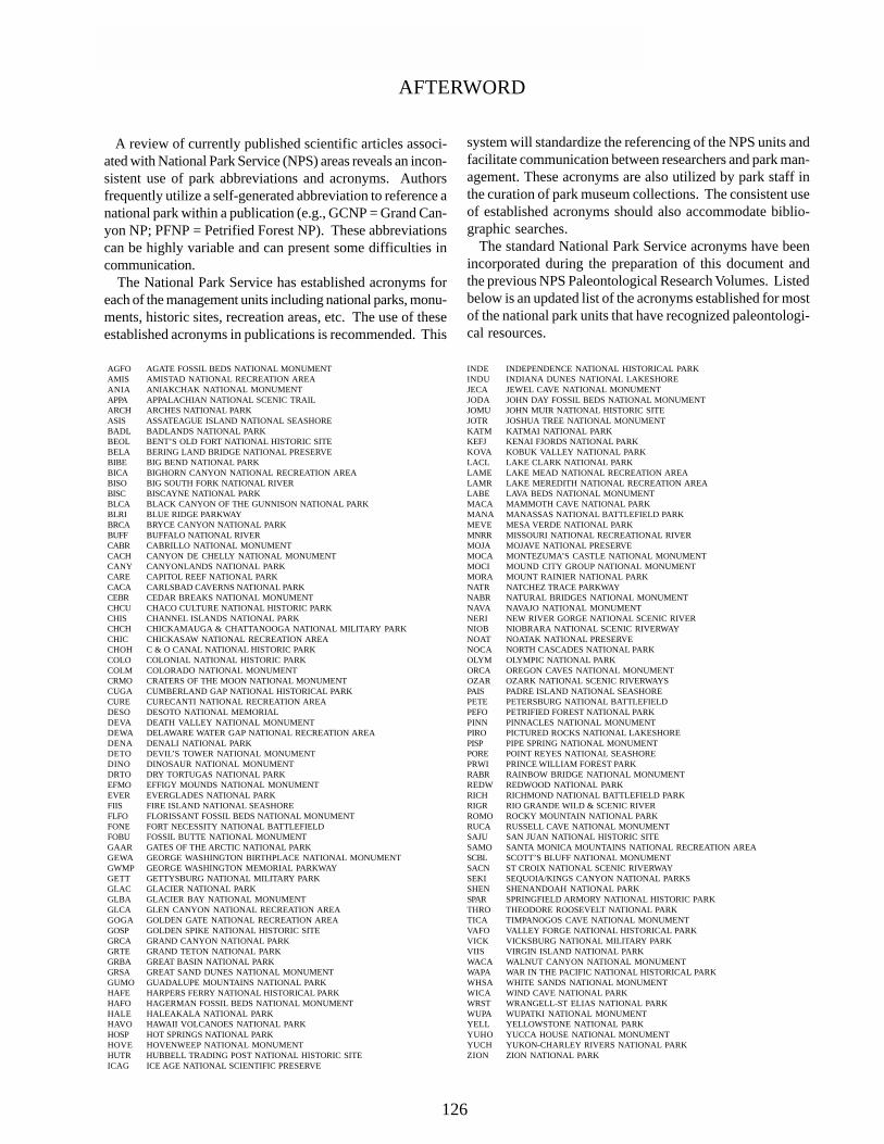
A review of currently published scientific articles associ-ated with National Park Service (NPS) areas reveals an incon-sistent use of park abbreviations and acronyms. Authorsfrequently utilize a self-generated abbreviation to reference anational park within a publication (e.g., GCNP = Grand Can-yon NP; PFNP = Petrified Forest NP). These abbreviationscan be highly variable and can present some difficulties incommunication. The National Park Service has established acronyms foreach of the management units including national parks, monu-ments, historic sites, recreation areas, etc. The use of theseestablished acronyms in publications is recommended. This
system will standardize the referencing of the NPS units andfacilitate communication between researchers and park man-agement. These acronyms are also utilized by park staff inthe curation of park museum collections. The consistent useof established acronyms should also accommodate biblio-graphic searches. The standard National Park Service acronyms have beenincorporated during the preparation of this document andthe previous NPS Paleontological Research Volumes. Listedbelow is an updated list of the acronyms established for mostof the national park units that have recognized paleontologi-cal resources.
AFTERWORD
AGFO AGATE FOSSIL BEDS NATIONAL MONUMENTAMIS AMISTAD NATIONAL RECREATION AREAANIA ANIAKCHAK NATIONAL MONUMENTAPPA APPALACHIAN NATIONAL SCENIC TRAILARCH ARCHES NATIONAL PARKASIS ASSATEAGUE ISLAND NATIONAL SEASHOREBADL BADLANDS NATIONAL PARKBEOL BENT’S OLD FORT NATIONAL HISTORIC SITEBELA BERING LAND BRIDGE NATIONAL PRESERVEBIBE BIG BEND NATIONAL PARKBICA BIGHORN CANYON NATIONAL RECREATION AREABISO BIG SOUTH FORK NATIONAL RIVERBISC BISCAYNE NATIONAL PARKBLCA BLACK CANYON OF THE GUNNISON NATIONAL PARKBLRI BLUE RIDGE PARKWAYBRCA BRYCE CANYON NATIONAL PARKBUFF BUFFALO NATIONAL RIVERCABR CABRILLO NATIONAL MONUMENTCACH CANYON DE CHELLY NATIONAL MONUMENTCANY CANYONLANDS NATIONAL PARKCARE CAPITOL REEF NATIONAL PARKCACA CARLSBAD CAVERNS NATIONAL PARKCEBR CEDAR BREAKS NATIONAL MONUMENTCHCU CHACO CULTURE NATIONAL HISTORIC PARKCHIS CHANNEL ISLANDS NATIONAL PARKCHCH CHICKAMAUGA & CHATTANOOGA NATIONAL MILITARY PARKCHIC CHICKASAW NATIONAL RECREATION AREACHOH C & O CANAL NATIONAL HISTORIC PARKCOLO COLONIAL NATIONAL HISTORIC PARKCOLM COLORADO NATIONAL MONUMENTCRMO CRATERS OF THE MOON NATIONAL MONUMENTCUGA CUMBERLAND GAP NATIONAL HISTORICAL PARKCURE CURECANTI NATIONAL RECREATION AREADESO DESOTO NATIONAL MEMORIALDEVA DEATH VALLEY NATIONAL MONUMENTDEWA DELAWARE WATER GAP NATIONAL RECREATION AREADENA DENALI NATIONAL PARKDETO DEVIL’S TOWER NATIONAL MONUMENTDINO DINOSAUR NATIONAL MONUMENTDRTO DRY TORTUGAS NATIONAL PARKEFMO EFFIGY MOUNDS NATIONAL MONUMENTEVER EVERGLADES NATIONAL PARKFIIS FIRE ISLAND NATIONAL SEASHOREFLFO FLORISSANT FOSSIL BEDS NATIONAL MONUMENTFONE FORT NECESSITY NATIONAL BATTLEFIELDFOBU FOSSIL BUTTE NATIONAL MONUMENTGAAR GATES OF THE ARCTIC NATIONAL PARKGEWA GEORGE WASHINGTON BIRTHPLACE NATIONAL MONUMENTGWMP GEORGE WASHINGTON MEMORIAL PARKWAYGETT GETTYSBURG NATIONAL MILITARY PARKGLAC GLACIER NATIONAL PARKGLBA GLACIER BAY NATIONAL MONUMENTGLCA GLEN CANYON NATIONAL RECREATION AREAGOGA GOLDEN GATE NATIONAL RECREATION AREAGOSP GOLDEN SPIKE NATIONAL HISTORIC SITEGRCA GRAND CANYON NATIONAL PARKGRTE GRAND TETON NATIONAL PARKGRBA GREAT BASIN NATIONAL PARKGRSA GREAT SAND DUNES NATIONAL MONUMENTGUMO GUADALUPE MOUNTAINS NATIONAL PARKHAFE HARPERS FERRY NATIONAL HISTORICAL PARKHAFO HAGERMAN FOSSIL BEDS NATIONAL MONUMENTHALE HALEAKALA NATIONAL PARKHAVO HAWAII VOLCANOES NATIONAL PARKHOSP HOT SPRINGS NATIONAL PARKHOVE HOVENWEEP NATIONAL MONUMENTHUTR HUBBELL TRADING POST NATIONAL HISTORIC SITEICAG ICE AGE NATIONAL SCIENTIFIC PRESERVE
INDE INDEPENDENCE NATIONAL HISTORICAL PARKINDU INDIANA DUNES NATIONAL LAKESHOREJECA JEWEL CAVE NATIONAL MONUMENTJODA JOHN DAY FOSSIL BEDS NATIONAL MONUMENTJOMU JOHN MUIR NATIONAL HISTORIC SITEJOTR JOSHUA TREE NATIONAL MONUMENTKATM KATMAI NATIONAL PARKKEFJ KENAI FJORDS NATIONAL PARKKOVA KOBUK VALLEY NATIONAL PARKLACL LAKE CLARK NATIONAL PARKLAME LAKE MEAD NATIONAL RECREATION AREALAMR LAKE MEREDITH NATIONAL RECREATION AREALABE LAVA BEDS NATIONAL MONUMENTMACA MAMMOTH CAVE NATIONAL PARKMANA MANASSAS NATIONAL BATTLEFIELD PARKMEVE MESA VERDE NATIONAL PARKMNRR MISSOURI NATIONAL RECREATIONAL RIVERMOJA MOJAVE NATIONAL PRESERVEMOCA MONTEZUMA’S CASTLE NATIONAL MONUMENTMOCI MOUND CITY GROUP NATIONAL MONUMENTMORA MOUNT RAINIER NATIONAL PARKNATR NATCHEZ TRACE PARKWAYNABR NATURAL BRIDGES NATIONAL MONUMENTNAVA NAVAJO NATIONAL MONUMENTNERI NEW RIVER GORGE NATIONAL SCENIC RIVERNIOB NIOBRARA NATIONAL SCENIC RIVERWAYNOAT NOATAK NATIONAL PRESERVENOCA NORTH CASCADES NATIONAL PARKOLYM OLYMPIC NATIONAL PARKORCA OREGON CAVES NATIONAL MONUMENTOZAR OZARK NATIONAL SCENIC RIVERWAYSPAIS PADRE ISLAND NATIONAL SEASHOREPETE PETERSBURG NATIONAL BATTLEFIELDPEFO PETRIFIED FOREST NATIONAL PARKPINN PINNACLES NATIONAL MONUMENTPIRO PICTURED ROCKS NATIONAL LAKESHOREPISP PIPE SPRING NATIONAL MONUMENTPORE POINT REYES NATIONAL SEASHOREPRWI PRINCE WILLIAM FOREST PARKRABR RAINBOW BRIDGE NATIONAL MONUMENTREDW REDWOOD NATIONAL PARKRICH RICHMOND NATIONAL BATTLEFIELD PARKRIGR RIO GRANDE WILD & SCENIC RIVERROMO ROCKY MOUNTAIN NATIONAL PARKRUCA RUSSELL CAVE NATIONAL MONUMENTSAJU SAN JUAN NATIONAL HISTORIC SITESAMO SANTA MONICA MOUNTAINS NATIONAL RECREATION AREASCBL SCOTT’S BLUFF NATIONAL MONUMENTSACN ST CROIX NATIONAL SCENIC RIVERWAYSEKI SEQUOIA/KINGS CANYON NATIONAL PARKSSHEN SHENANDOAH NATIONAL PARKSPAR SPRINGFIELD ARMORY NATIONAL HISTORIC PARKTHRO THEODORE ROOSEVELT NATIONAL PARKTICA TIMPANOGOS CAVE NATIONAL MONUMENTVAFO VALLEY FORGE NATIONAL HISTORICAL PARKVICK VICKSBURG NATIONAL MILITARY PARKVIIS VIRGIN ISLAND NATIONAL PARKWACA WALNUT CANYON NATIONAL MONUMENTWAPA WAR IN THE PACIFIC NATIONAL HISTORICAL PARKWHSA WHITE SANDS NATIONAL MONUMENTWICA WIND CAVE NATIONAL PARKWRST WRANGELL-ST ELIAS NATIONAL PARKWUPA WUPATKI NATIONAL MONUMENTYELL YELLOWSTONE NATIONAL PARKYUHO YUCCA HOUSE NATIONAL MONUMENTYUCH YUKON-CHARLEY RIVERS NATIONAL PARKZION ZION NATIONAL PARK
126

TECHNICAL REPORT NPS/NRGRD/GRDTR-99/3

As the nation’s principle conservation agency, the Department of Interior has responsibility for most of our nationally ownedpublic lands and natural and cultural resources. This includes fostering wise use of our land and water resources, protectingour fish and wildlife, preserving the environmental and cultural values of our national parks and historical places, andproviding for enjoyment of life through outdoor recreation. The department assesses our energy and mineral resources andworks to ensure that their development is in the bests interests of all our people. The department also promotes the goals ofthe Take Pride in America campaign by encouraging stewardship can citizen responsibility for the public lands and promot-ing citizen partcipation in their care. The department also has a major responsibility for American Indian reservationcommunities and for people who live in island territories under U.S. administration.
NPS D-1056 October 1999

TECHNICAL REPORT NPS/NRGRD/GRDTR-99/3