Embed Size (px)
Citation preview
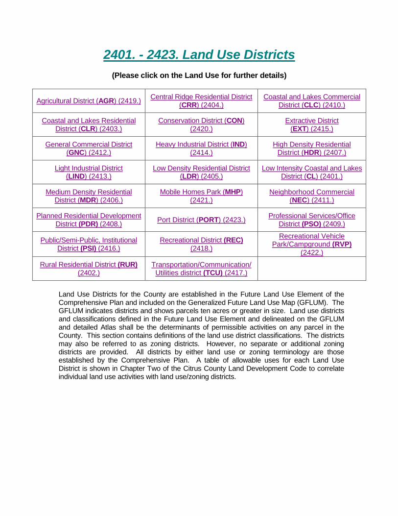
2401. - 2423. Land Use Districts
(Please click on the Land Use for further details)
Agricultural District (AGR) (2419.) Central Ridge Residential District (CRR) (2404.)
Coastal and Lakes Commercial District (CLC) (2410.)
Coastal and Lakes Residential District (CLR) (2403.)
Conservation District (CON) (2420.)
Extractive District (EXT) (2415.)
General Commercial District (GNC) (2412.)
Heavy Industrial District (IND) (2414.)
High Density Residential District (HDR) (2407.)
Light Industrial District (LIND) (2413.)
Low Density Residential District (LDR) (2405.)
Low Intensity Coastal and Lakes District (CL) (2401.)
Medium Density Residential District (MDR) (2406.)
Mobile Homes Park (MHP) (2421.)
Neighborhood Commercial (NEC) (2411.)
Planned Residential Development District (PDR) (2408.) Port District (PORT) (2423.) Professional Services/Office
District (PSO) (2409.)
Public/Semi-Public, Institutional District (PSI) (2416.)
Recreational District (REC) (2418.)
Recreational Vehicle Park/Campground (RVP)
(2422.) Rural Residential District (RUR)
(2402.) Transportation/Communication/ Utilities district (TCU) (2417.)
Land Use Districts for the County are established in the Future Land Use Element of the Comprehensive Plan and included on the Generalized Future Land Use Map (GFLUM). The GFLUM indicates districts and shows parcels ten acres or greater in size. Land use districts and classifications defined in the Future Land Use Element and delineated on the GFLUM and detailed Atlas shall be the determinants of permissible activities on any parcel in the County. This section contains definitions of the land use district classifications. The districts may also be referred to as zoning districts. However, no separate or additional zoning districts are provided. All districts by either land use or zoning terminology are those established by the Comprehensive Plan. A table of allowable uses for each Land Use District is shown in Chapter Two of the Citrus County Land Development Code to correlate individual land use activities with land use/zoning districts.
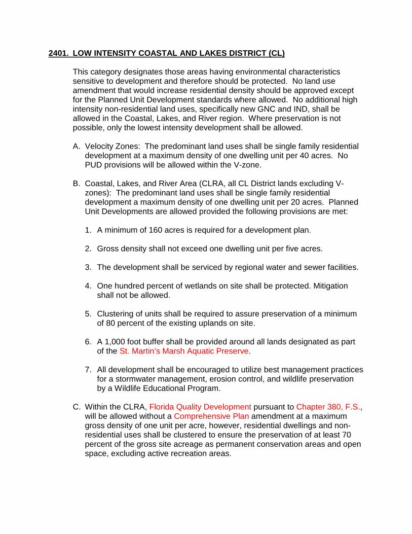
2401. LOW INTENSITY COASTAL AND LAKES DISTRICT (CL)
This category designates those areas having environmental characteristics sensitive to development and therefore should be protected. No land use amendment that would increase residential density should be approved except for the Planned Unit Development standards where allowed. No additional high intensity non-residential land uses, specifically new GNC and IND, shall be allowed in the Coastal, Lakes, and River region. Where preservation is not possible, only the lowest intensity development shall be allowed.
A. Velocity Zones: The predominant land uses shall be single family residential
development at a maximum density of one dwelling unit per 40 acres. No PUD provisions will be allowed within the V-zone.
B. Coastal, Lakes, and River Area (CLRA, all CL District lands excluding V-
zones): The predominant land uses shall be single family residential development a maximum density of one dwelling unit per 20 acres. Planned Unit Developments are allowed provided the following provisions are met:
1. A minimum of 160 acres is required for a development plan.
2. Gross density shall not exceed one dwelling unit per five acres.
3. The development shall be serviced by regional water and sewer facilities.
4. One hundred percent of wetlands on site shall be protected. Mitigation
shall not be allowed.
5. Clustering of units shall be required to assure preservation of a minimum of 80 percent of the existing uplands on site.
6. A 1,000 foot buffer shall be provided around all lands designated as part
of the St. Martin’s Marsh Aquatic Preserve.
7. All development shall be encouraged to utilize best management practices for a stormwater management, erosion control, and wildlife preservation by a Wildlife Educational Program.
C. Within the CLRA, Florida Quality Development pursuant to Chapter 380, F.S.,
will be allowed without a Comprehensive Plan amendment at a maximum gross density of one unit per acre, however, residential dwellings and non-residential uses shall be clustered to ensure the preservation of at least 70 percent of the gross site acreage as permanent conservation areas and open space, excluding active recreation areas.
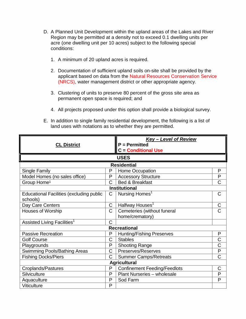
D. A Planned Unit Development within the upland areas of the Lakes and River Region may be permitted at a density not to exceed 0.1 dwelling units per acre (one dwelling unit per 10 acres) subject to the following special conditions:
1. A minimum of 20 upland acres is required.
2. Documentation of sufficient upland soils on-site shall be provided by the
applicant based on data from the Natural Resources Conservation Service (NRCS), water management district or other appropriate agency.
3. Clustering of units to preserve 80 percent of the gross site area as
permanent open space is required; and
4. All projects proposed under this option shall provide a biological survey.
E. In addition to single family residential development, the following is a list of land uses with notations as to whether they are permitted.
CL District Key – Level of Review
P = Permitted C = Conditional Use USES
Residential Single Family P Home Occupation P Model Homes (no sales office) P Accessory Structure P Group Home¹ C Bed & Breakfast C
Institutional Educational Facilities (excluding public schools)
C Nursing Homes1 C
Day Care Centers C Halfway Houses1 C Houses of Worship C Cemeteries (without funeral
home/crematory) C
Assisted Living Facilities1 C Recreational
Passive Recreation P Hunting/Fishing Preserves P Golf Course C Stables C Playgrounds P Shooting Range C Swimming Pools/Bathing Areas C Preserves/Reserves P Fishing Docks/Piers C Summer Camps/Retreats C
Agricultural Croplands/Pastures P Confinement Feeding/Feedlots C Silviculture P Plant Nurseries – wholesale P Aquaculture P Sod Farm P Viticulture P
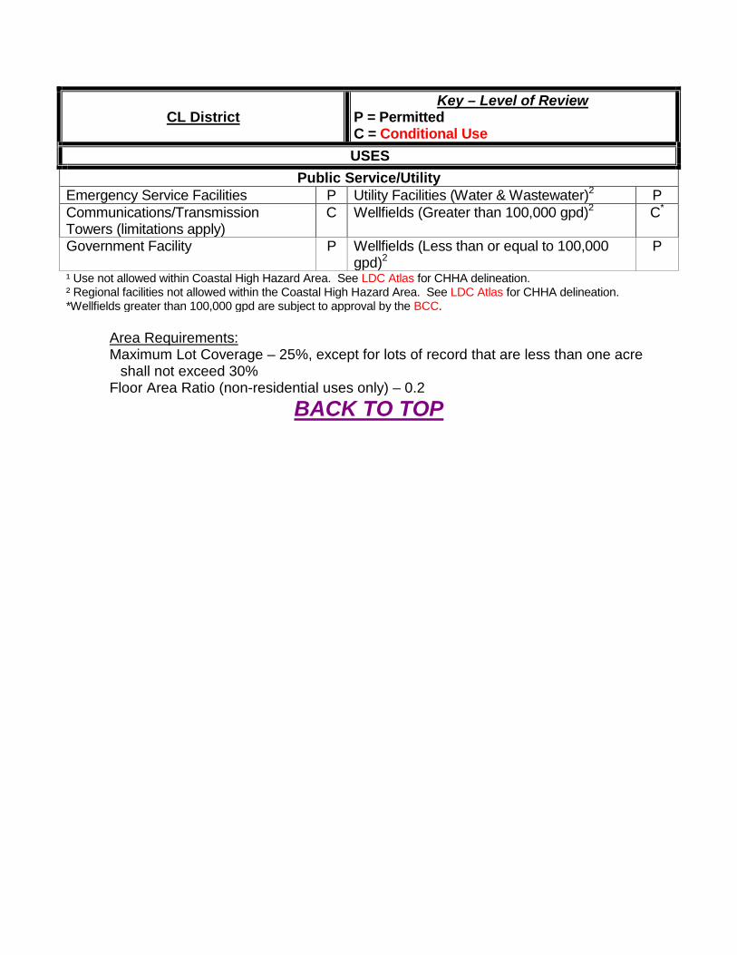
CL District Key – Level of Review
P = Permitted C = Conditional Use USES
Public Service/Utility Emergency Service Facilities P Utility Facilities (Water & Wastewater)2 P Communications/Transmission Towers (limitations apply)
C Wellfields (Greater than 100,000 gpd)2 C*
Government Facility P Wellfields (Less than or equal to 100,000 gpd)2
P
¹ Use not allowed within Coastal High Hazard Area. See LDC Atlas for CHHA delineation. ² Regional facilities not allowed within the Coastal High Hazard Area. See LDC Atlas for CHHA delineation. *Wellfields greater than 100,000 gpd are subject to approval by the BCC.
Area Requirements: Maximum Lot Coverage – 25%, except for lots of record that are less than one acre
shall not exceed 30% Floor Area Ratio (non-residential uses only) – 0.2
BACK TO TOP
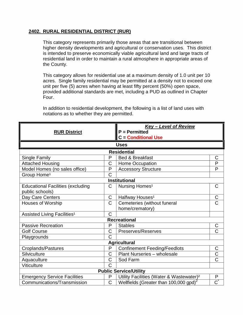
2402. RURAL RESIDENTIAL DISTRICT (RUR)
This category represents primarily those areas that are transitional between higher density developments and agricultural or conservation uses. This district is intended to preserve economically viable agricultural land and large tracts of residential land in order to maintain a rural atmosphere in appropriate areas of the County. This category allows for residential use at a maximum density of 1.0 unit per 10 acres. Single family residential may be permitted at a density not to exceed one unit per five (5) acres when having at least fifty percent (50%) open space, provided additional standards are met, including a PUD as outlined in Chapter Four. In addition to residential development, the following is a list of land uses with notations as to whether they are permitted.
RUR District Key – Level of Review
P = Permitted C = Conditional Use
Uses Residential
Single Family P Bed & Breakfast C Attached Housing C Home Occupation P Model Homes (no sales office) P Accessory Structure P Group Home¹ C
Institutional Educational Facilities (excluding public schools)
C Nursing Homes¹ C
Day Care Centers C Halfway Houses¹ C Houses of Worship C Cemeteries (without funeral
home/crematory) C
Assisted Living Facilities¹ C Recreational
Passive Recreation P Stables C Golf Course C Preserves/Reserves C Playgrounds C
Agricultural Croplands/Pastures P Confinement Feeding/Feedlots C Silviculture C Plant Nurseries – wholesale C Aquaculture C Sod Farm C Viticulture C
Public Service/Utility Emergency Service Facilities P Utility Facilities (Water & Wastewater)² P Communications/Transmission C Wellfields (Greater than 100,000 gpd)2 C*

Towers (limitations apply) Railroad rights of way (storage facilities, or related structures)
C Wellfields (Less than or equal to 100,000 gpd)2
P
Government Facility C ¹ Use not allowed within Coastal High Hazard Area. See LDC Atlas for CHHA delineation. ² Regional facilities not allowed within the Coastal High Hazard Area. See LDC Atlas for CHHA delineation. *Wellfields greater than 100,000 gpd are subject to approval by the BCC.
Area Requirements: Maximum Lot Coverage – 20%, except for lots of record that are less than one acre
shall not exceed 30% Floor Area Ratio (non-residential uses only) – 0.2
BACK TO TOP
2403. COASTAL AND LAKES RESIDENTIAL DISTRICT (CLR)
This category recognizes lawful unrecorded and recorded subdivisions within the coastal, lakes, and river regions of the County. Density shall be limited to the maximum provided by the final development order approved for the underlying subdivision plat. Replatting to accomplish clustering and/or development consistent with current standards will be permitted provided gross density is not increased.
CLR District Key – Level of Review
P = Permitted C = Conditional Use
Uses Residential
Single Family P Group Home¹ C Attached Housing (Density limited to underlying subdivision plat.)
P Home Occupation P
Multifamily1X (Density limited to underlying subdivision plat.)
P Accessory Structure P
Model Homes (no sales office) C Institutional
Educational Facilities (excluding public schools)
C Nursing Homes¹ C
Day Care Centers C Halfway Houses¹ C Houses of Worship C Assisted Living Facilities¹ C
Recreational Passive Recreation P Fishing Docks/Piers P Golf Course P Playgrounds P
Public Service/Utility Emergency Service Facilities P Utility Facilities² P Communications/Transmission Towers (limitations apply)
C Wellfields (Greater than 100,000 gpd)2 C*
Government Facility C Wellfields (Less than or equal to 100,000 gpd)2
P
1xUse not allowed within the Coastal High Hazard Area except areas east of US-19 as a Conditional Use. See LDC Atlas for CHHA delineation.
¹ Use not allowed within Coastal High Hazard Area. See LDC Atlas for CHHA delineation. ² Regional facilities not allowed within the Coastal High Hazard Area. See LDC Atlas for CHHA delineation *Wellfields greater than 100,000 gpd are subject to approval by the BCC.
Area Requirements: Maximum Lot Coverage – 35%, except for lots of record that are less than 10,000 square
feet one acre shall not exceed 40% Floor Area Ratio (non-residential uses only) – 0.2
BACK TO TOP

2404. CENTRAL RIDGE RESIDENTIAL DISTRICT (CRR)
This category is designed to protect the rural character of existing large lot subdivisions by prohibiting any increase in residential density beyond the approved final plat or accepted unrecorded subdivision plan. This district consists of lawful unrecorded and recorded subdivisions located within the Planned Service Area (PSA). Density shall be limited to the maximum provided by the final development order under the approved subdivision plat and any subsequent lot divisions up to the effective date of the established CRR District on the GFLUM. Lot reconfiguration is permitted. Replatting to accomplish clustering and/or development consistent with the current standards is permitted provided the gross density is not increased. This category, permitted only within the PSA, allows for single family residential development at a density no greater than the density of the existing subdivision. This category may be assigned to only a portion of a subdivision and shall not apply to undivided land.
CRR District Key – Level of Review
P = Permitted C = Conditional Use
Uses Residential
Single Family P Home Occupation P Attached Housing P Accessory Structure P Model Homes (no sales office) P Group Home¹ C
Institutional Educational Facilities (excluding public schools)
C Nursing Homes¹ C
Day Care Centers C Halfway Houses¹ C Houses of Worship C Cemeteries (without funeral
home/crematory) C
Assisted Living Facilities¹ C Recreational
Passive Recreation P Stables C Golf Course C Shooting Range C Playgrounds C Preserves/Reserves C Summer Camps/Retreats C Hunting/Fishing Preserves C
Agricultural Silviculture C Plant Nurseries – wholesale C Aquaculture C Sod Farm C Viticulture C
Public Service/Utility Emergency Service Facilities P Utility Facilities² P
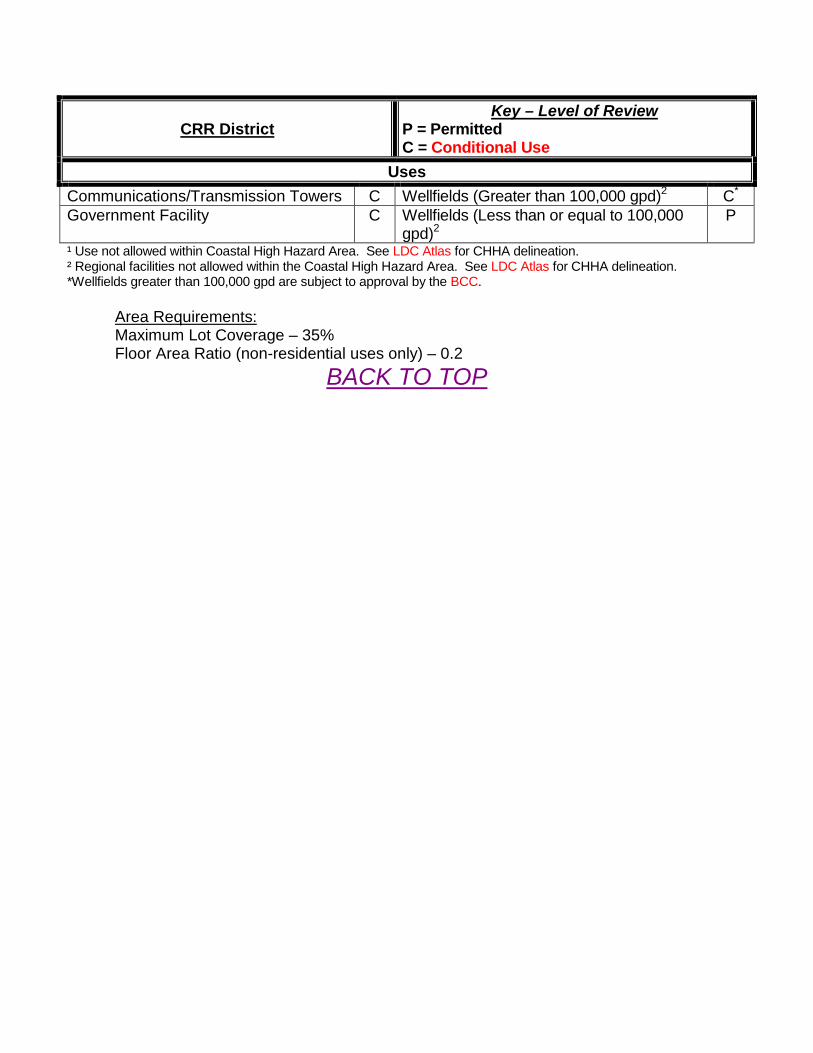
CRR District Key – Level of Review
P = Permitted C = Conditional Use
Uses Communications/Transmission Towers C Wellfields (Greater than 100,000 gpd)2 C* Government Facility C Wellfields (Less than or equal to 100,000
gpd)2 P
¹ Use not allowed within Coastal High Hazard Area. See LDC Atlas for CHHA delineation. ² Regional facilities not allowed within the Coastal High Hazard Area. See LDC Atlas for CHHA delineation. *Wellfields greater than 100,000 gpd are subject to approval by the BCC.
Area Requirements: Maximum Lot Coverage – 35% Floor Area Ratio (non-residential uses only) – 0.2
BACK TO TOP
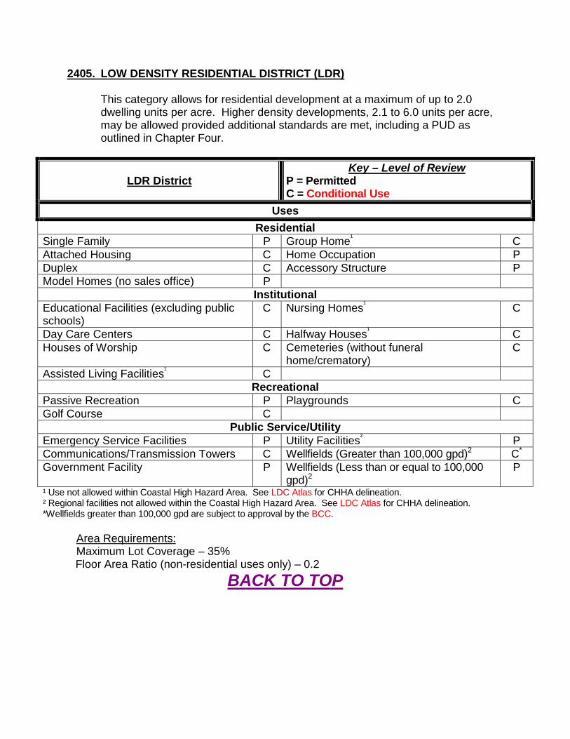
2405. LOW DENSITY RESIDENTIAL DISTRICT (LDR)
This category allows for residential development at a maximum of up to 2.0 dwelling units per acre. Higher density developments, 2.1 to 6.0 units per acre, may be allowed provided additional standards are met, including a PUD as outlined in Chapter Four.
LDR District Key – Level of Review
P = Permitted C = Conditional Use
Uses Residential
Single Family P Group Home¹ C Attached Housing C Home Occupation P Duplex C Accessory Structure P Model Homes (no sales office) P
Institutional Educational Facilities (excluding public schools)
C Nursing Homes¹ C
Day Care Centers C Halfway Houses¹ C Houses of Worship C Cemeteries (without funeral
home/crematory) C
Assisted Living Facilities¹ C Recreational
Passive Recreation P Playgrounds C Golf Course C
Public Service/Utility Emergency Service Facilities P Utility Facilities² P Communications/Transmission Towers C Wellfields (Greater than 100,000 gpd)2 C* Government Facility P Wellfields (Less than or equal to 100,000
gpd)2 P
¹ Use not allowed within Coastal High Hazard Area. See LDC Atlas for CHHA delineation. ² Regional facilities not allowed within the Coastal High Hazard Area. See LDC Atlas for CHHA delineation. *Wellfields greater than 100,000 gpd are subject to approval by the BCC.
Area Requirements: Maximum Lot Coverage – 35% Floor Area Ratio (non-residential uses only) – 0.2
BACK TO TOP
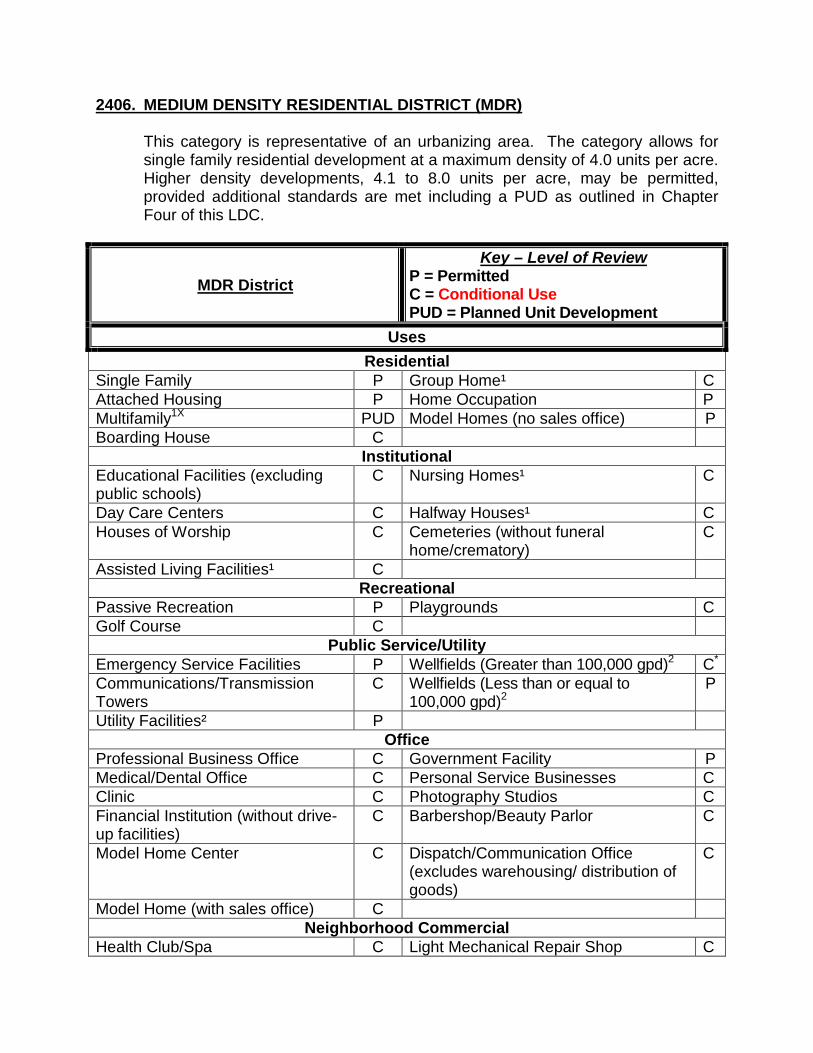
2406. MEDIUM DENSITY RESIDENTIAL DISTRICT (MDR)
This category is representative of an urbanizing area. The category allows for single family residential development at a maximum density of 4.0 units per acre. Higher density developments, 4.1 to 8.0 units per acre, may be permitted, provided additional standards are met including a PUD as outlined in Chapter Four of this LDC.
MDR District Key – Level of Review
P = Permitted C = Conditional Use PUD = Planned Unit Development
Uses Residential
Single Family P Group Home¹ C Attached Housing P Home Occupation P Multifamily1X PUD Model Homes (no sales office) P Boarding House C
Institutional Educational Facilities (excluding public schools)
C Nursing Homes¹ C
Day Care Centers C Halfway Houses¹ C Houses of Worship C Cemeteries (without funeral
home/crematory) C
Assisted Living Facilities¹ C Recreational
Passive Recreation P Playgrounds C Golf Course C
Public Service/Utility Emergency Service Facilities P Wellfields (Greater than 100,000 gpd)2 C* Communications/Transmission Towers
C Wellfields (Less than or equal to 100,000 gpd)2
P
Utility Facilities² P Office
Professional Business Office C Government Facility P Medical/Dental Office C Personal Service Businesses C Clinic C Photography Studios C Financial Institution (without drive-up facilities)
C Barbershop/Beauty Parlor C
Model Home Center C Dispatch/Communication Office (excludes warehousing/ distribution of goods)
C
Model Home (with sales office) C Neighborhood Commercial
Health Club/Spa C Light Mechanical Repair Shop C

MDR District Key – Level of Review
P = Permitted C = Conditional Use PUD = Planned Unit Development
Uses Community Center C Restaurants (No drive-up facilities) C Fraternal Organization/Lodge C Open Air Café Dance/Martial Arts/Instructional Studio
C Bed & Breakfast C
Small Retail Shops C Art Gallery/Museum C Strip Center – multi-use C Library C Funeral Home/Mortuaries (no crematorium)
C Tackle/Bait Shop C
Specialty Food Store C Veterinary Off/Animal Hosp./Pet Groom (No outside kennels)
C
Services Businesses C Convenience Store C Laundries/Dry Cleaners C 1XUse not allowed within the Coastal High Hazard Area except areas east of US-19 as a Planned Unit
Development. See LDC Atlas for CHHA delineation. ¹ Use not allowed within Coastal High Hazard Area. See LDC Atlas for CHHA delineation. ² Regional facilities not allowed within the Coastal High Hazard Area. See LDC Atlas for CHHA delineation *Wellfields greater than 100,000 gpd are subject to approval by the BCC.
Area Requirements: Maximum Lot Coverage – 50% Floor Area Ratio (non-residential uses only) – 0.40
BACK TO TOP
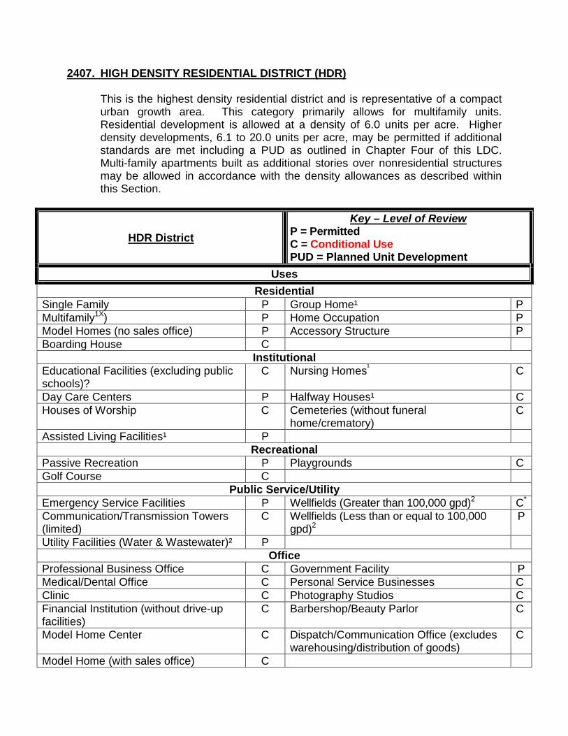
2407. HIGH DENSITY RESIDENTIAL DISTRICT (HDR)
This is the highest density residential district and is representative of a compact urban growth area. This category primarily allows for multifamily units. Residential development is allowed at a density of 6.0 units per acre. Higher density developments, 6.1 to 20.0 units per acre, may be permitted if additional standards are met including a PUD as outlined in Chapter Four of this LDC. Multi-family apartments built as additional stories over nonresidential structures may be allowed in accordance with the density allowances as described within this Section.
HDR District Key – Level of Review
P = Permitted C = Conditional Use PUD = Planned Unit Development
Uses Residential
Single Family P Group Home¹ P Multifamily1X) P Home Occupation P Model Homes (no sales office) P Accessory Structure P Boarding House C
Institutional Educational Facilities (excluding public schools)?
C Nursing Homes¹ C
Day Care Centers P Halfway Houses¹ C Houses of Worship C Cemeteries (without funeral
home/crematory) C
Assisted Living Facilities¹ P Recreational
Passive Recreation P Playgrounds C Golf Course C
Public Service/Utility Emergency Service Facilities P Wellfields (Greater than 100,000 gpd)2 C* Communication/Transmission Towers (limited)
C Wellfields (Less than or equal to 100,000 gpd)2
P
Utility Facilities (Water & Wastewater)² P Office
Professional Business Office C Government Facility P Medical/Dental Office C Personal Service Businesses C Clinic C Photography Studios C Financial Institution (without drive-up facilities)
C Barbershop/Beauty Parlor C
Model Home Center C Dispatch/Communication Office (excludes warehousing/distribution of goods)
C
Model Home (with sales office) C
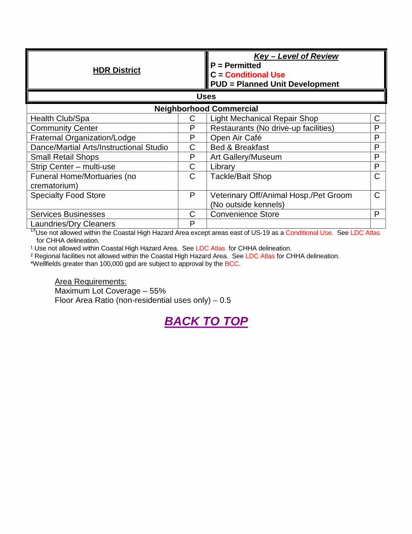
HDR District Key – Level of Review
P = Permitted C = Conditional Use PUD = Planned Unit Development
Uses Neighborhood Commercial
Health Club/Spa C Light Mechanical Repair Shop C Community Center P Restaurants (No drive-up facilities) P Fraternal Organization/Lodge P Open Air Café P Dance/Martial Arts/Instructional Studio C Bed & Breakfast P Small Retail Shops P Art Gallery/Museum P Strip Center – multi-use C Library P Funeral Home/Mortuaries (no crematorium)
C Tackle/Bait Shop C
Specialty Food Store P Veterinary Off/Animal Hosp./Pet Groom (No outside kennels)
C
Services Businesses C Convenience Store P Laundries/Dry Cleaners P 1XUse not allowed within the Coastal High Hazard Area except areas east of US-19 as a Conditional Use. See LDC Atlas
for CHHA delineation. ¹ Use not allowed within Coastal High Hazard Area. See LDC Atlas for CHHA delineation. ² Regional facilities not allowed within the Coastal High Hazard Area. See LDC Atlas for CHHA delineation. *Wellfields greater than 100,000 gpd are subject to approval by the BCC.
Area Requirements: Maximum Lot Coverage – 55% Floor Area Ratio (non-residential uses only) – 0.5
BACK TO TOP
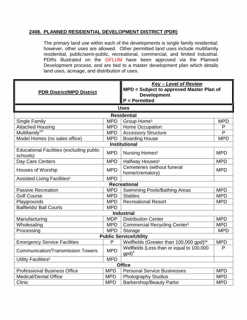
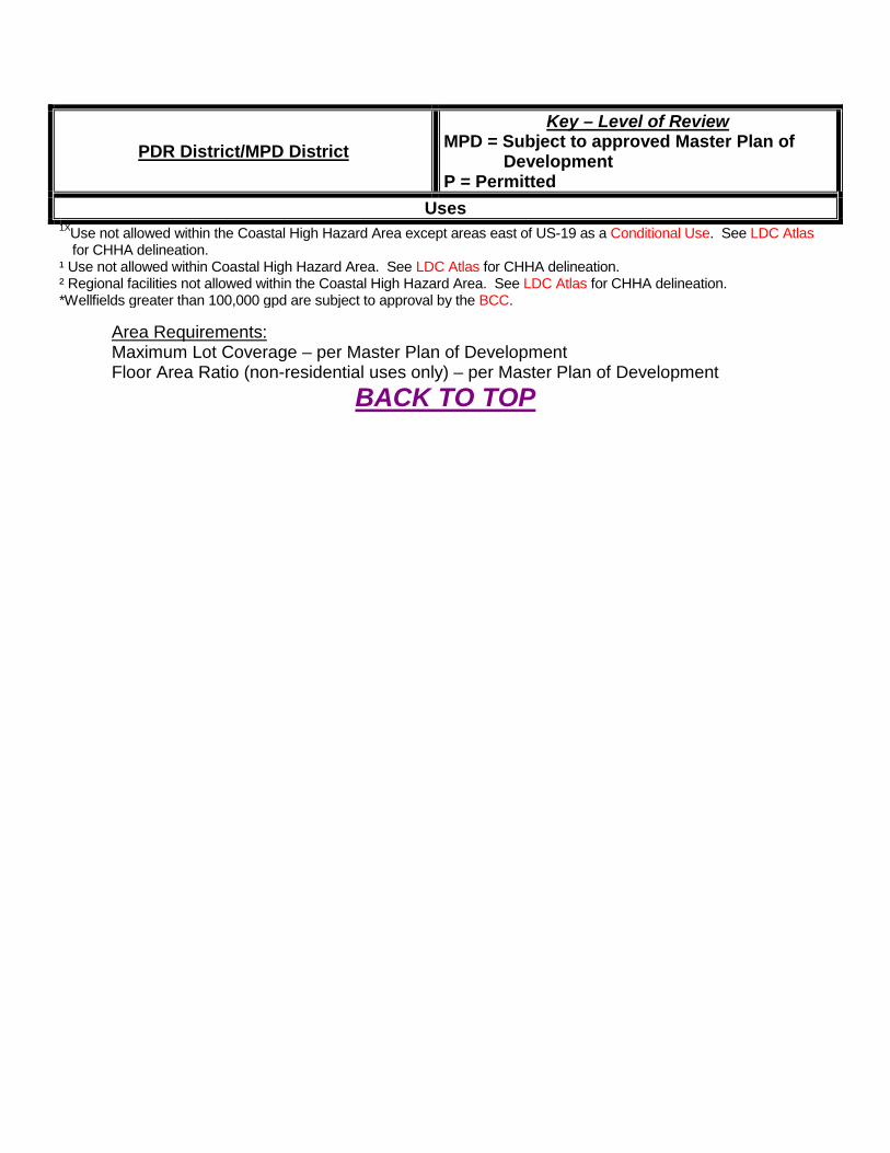
2408. PLANNED RESIDENTIAL DEVELOPMENT DISTRICT (PDR)
The primary land use within each of the developments is single family residential; however, other uses are allowed. Other permitted land uses include multifamily residential, public/semi-public, recreational, commercial, and limited industrial. PDRs illustrated on the GFLUM have been approved via the Planned Development process, and are tied to a master development plan which details land uses, acreage, and distribution of uses.
PDR District/MPD District Key – Level of Review
MPD = Subject to approved Master Plan of Development
P = Permitted Uses
Residential Single Family MPD Group Home¹ MPD Attached Housing MPD Home Occupation P Multifamily1X MPD Accessory Structure P Model Homes (no sales office) MPD Boarding House MPD
Institutional Educational Facilities (excluding public schools) MPD Nursing Homes¹ MPD
Day Care Centers MPD Halfway Houses¹ MPD
Houses of Worship MPD Cemeteries (without funeral home/crematory) MPD
Assisted Living Facilities¹ MPD Recreational
Passive Recreation MPD Swimming Pools/Bathing Areas MPD Golf Course MPD Stables MPD Playgrounds MPD Recreational Resort MPD Ballfields/ Ball Courts MPD
Industrial Manufacturing MDP Distribution Center MPD Wholesaling MPD Commercial Recycling Center¹ MPD Processing MPD Storage MPD
Public Service/Utility Emergency Service Facilities P Wellfields (Greater than 100,000 gpd)²* MPD
Communication/Transmission Towers MPD Wellfields (Less than or equal to 100,000 gpd)2
P
Utility Facilities² MPD Office
Professional Business Office MPD Personal Service Businesses MPD Medical/Dental Office MPD Photography Studios MPD Clinic MPD Barbershop/Beauty Parlor MPD

PDR District/MPD District Key – Level of Review
MPD = Subject to approved Master Plan of Development
P = Permitted Uses
Financial Institution (without drive-up facilities) MPD
Dispatch/Communication Office (excludes warehousing/distribution of goods)
MPD
Model Home Center MPD Government Facility MPD Model Home (with sales office) MPD
Neighborhood Commercial Health Club/Spa MPD Light Mechanical Repair Shop MPD Community Center MPD Restaurants (No drive-up facilities) MPD Fraternal Organization/Lodge MPD Open Air Café MPD Dance/Martial Arts/Instructional Studio MPD Bed & Breakfast MPD Small Retail Shops MPD Art Gallery/Museum MPD Strip Center – multi-use MPD Library MPD Funeral Home/Mortuaries (no crematorium) MPD Tackle/Bait Shop MPD
Specialty Food Store MPD Veterinary Office/Animal Hosp./Pet Groom (No outside kennels) MPD
Service Businesses MPD Convenience Store MPD Laundries/Dry Cleaners MPD Other substantially similar uses MPD
General Commercial Sales, Rental, Service, Repair – motorized vehicles MPD Lawn Care Operations MPD
Truck Stops MPD Funeral Home/Mortuary (with Crematorium) MPD
Car Wash Facilities MPD Hotel/Motel MPD Gasoline Sales & Service MPD Hospital/Sanitarium¹ MPD Mobile Home Sales and Service MPD Theater/Auditorium MPD Mobile Home/Manufactured Home Park¹ MPD Golf Driving Range/Miniature Golf MPD
Tavern, Bar, Lounge, Night Club, Dance Hall MPD Retail Plan Nurseries MPD
Financial Institution (with drive-up facilities) MPD Commercial/Trade Schools MPD
ATM MPD Retail Sales MPD Research Lab MPD Shopping Center MPD Restaurants with Drive-up Facilities MPD Grocery Store/Supermarket MPD Race Track/Outdoor Arena MPD Mini Warehouses MPD Veterinary Office/Animal Hosp./Pet Groom (with outside kennels) MPD Distribution Center MPD
Kennels MPD Building/Trades Contractors (with outside storage) MPD
PDR District/MPD District Key – Level of Review
MPD = Subject to approved Master Plan of Development
P = Permitted Uses
1XUse not allowed within the Coastal High Hazard Area except areas east of US-19 as a Conditional Use. See LDC Atlas for CHHA delineation.
¹ Use not allowed within Coastal High Hazard Area. See LDC Atlas for CHHA delineation. ² Regional facilities not allowed within the Coastal High Hazard Area. See LDC Atlas for CHHA delineation. *Wellfields greater than 100,000 gpd are subject to approval by the BCC.
Area Requirements: Maximum Lot Coverage – per Master Plan of Development Floor Area Ratio (non-residential uses only) – per Master Plan of Development
BACK TO TOP
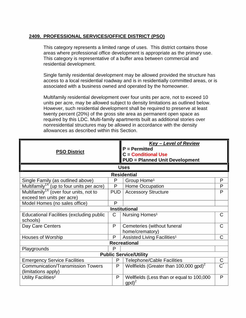
2409. PROFESSIONAL SERVICES/OFFICE DISTRICT (PSO)
This category represents a limited range of uses. This district contains those areas where professional office development is appropriate as the primary use. This category is representative of a buffer area between commercial and residential development. Single family residential development may be allowed provided the structure has access to a local residential roadway and is in residentially committed areas, or is associated with a business owned and operated by the homeowner. Multifamily residential development over four units per acre, not to exceed 10 units per acre, may be allowed subject to density limitations as outlined below. However, such residential development shall be required to preserve at least twenty percent (20%) of the gross site area as permanent open space as required by this LDC. Multi-family apartments built as additional stories over nonresidential structures may be allowed in accordance with the density allowances as described within this Section.
PSO District Key – Level of Review
P = Permitted C = Conditional Use PUD = Planned Unit Development
Uses Residential
Single Family (as outlined above) P Group Home¹ P Multifamily1X (up to four units per acre) P Home Occupation P Multifamily1X (over four units, not to exceed ten units per acre)
PUD Accessory Structure P
Model Homes (no sales office) P Institutional
Educational Facilities (excluding public schools)
C Nursing Homes¹ C
Day Care Centers P Cemeteries (without funeral home/crematory)
C
Houses of Worship P Assisted Living Facilities¹ C Recreational
Playgrounds P Public Service/Utility
Emergency Service Facilities P Telephone/Cable Facilities C Communication/Transmission Towers (limitations apply)
P Wellfields (Greater than 100,000 gpd)2 C*
Utility Facilities² P Wellfields (Less than or equal to 100,000 gpd)2
P
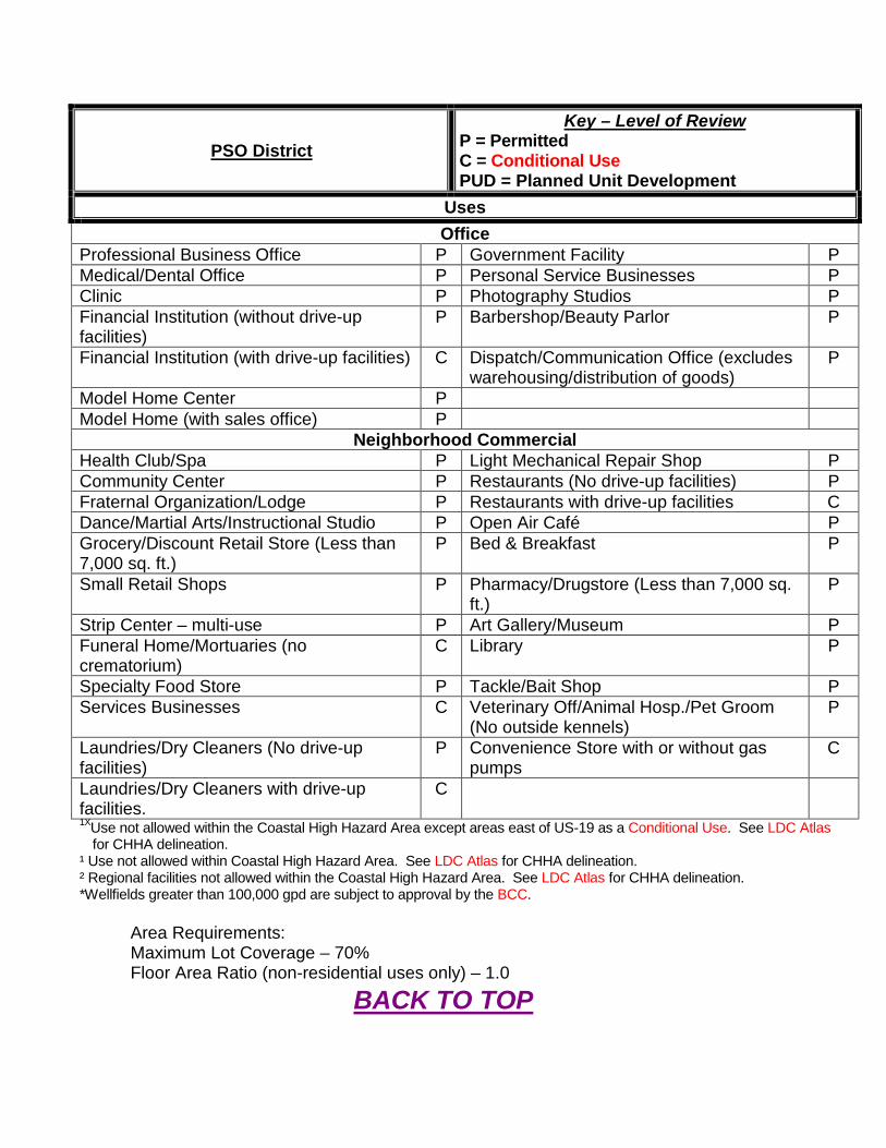
PSO District Key – Level of Review
P = Permitted C = Conditional Use PUD = Planned Unit Development
Uses Office
Professional Business Office P Government Facility P Medical/Dental Office P Personal Service Businesses P Clinic P Photography Studios P Financial Institution (without drive-up facilities)
P Barbershop/Beauty Parlor P
Financial Institution (with drive-up facilities) C Dispatch/Communication Office (excludes warehousing/distribution of goods)
P
Model Home Center P Model Home (with sales office) P
Neighborhood Commercial Health Club/Spa P Light Mechanical Repair Shop P Community Center P Restaurants (No drive-up facilities) P Fraternal Organization/Lodge P Restaurants with drive-up facilities C Dance/Martial Arts/Instructional Studio P Open Air Café P Grocery/Discount Retail Store (Less than 7,000 sq. ft.)
P Bed & Breakfast P
Small Retail Shops P Pharmacy/Drugstore (Less than 7,000 sq. ft.)
P
Strip Center – multi-use P Art Gallery/Museum P Funeral Home/Mortuaries (no crematorium)
C Library P
Specialty Food Store P Tackle/Bait Shop P Services Businesses C Veterinary Off/Animal Hosp./Pet Groom
(No outside kennels) P
Laundries/Dry Cleaners (No drive-up facilities)
P Convenience Store with or without gas pumps
C
Laundries/Dry Cleaners with drive-up facilities.
C
1XUse not allowed within the Coastal High Hazard Area except areas east of US-19 as a Conditional Use. See LDC Atlas for CHHA delineation.
¹ Use not allowed within Coastal High Hazard Area. See LDC Atlas for CHHA delineation. ² Regional facilities not allowed within the Coastal High Hazard Area. See LDC Atlas for CHHA delineation. *Wellfields greater than 100,000 gpd are subject to approval by the BCC.
Area Requirements: Maximum Lot Coverage – 70% Floor Area Ratio (non-residential uses only) – 1.0
BACK TO TOP
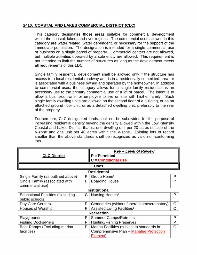
2410. COASTAL AND LAKES COMMERCIAL DISTRICT (CLC)
This category designates those areas suitable for commercial development within the coastal, lakes, and river regions. The commercial uses allowed in this category are water related, water dependent, or necessary for the support of the immediate population. The designation is intended for a single commercial use or business on a single parcel of property. Commercial centers are not allowed, but multiple activities operated by a sole entity are allowed. This requirement is not intended to limit the number of structures as long as the development meets all requirements of this LDC. Single family residential development shall be allowed only if the structure has access to a local residential roadway and is in a residentially committed area, or is associated with a business owned and operated by the homeowner. In addition to commercial uses, the category allows for a single family residence as an accessory use to the primary commercial use of a lot or parcel. The intent is to allow a business owner or employee to live on-site with his/her family. Such single family dwelling units are allowed on the second floor of a building, or as an attached ground floor unit, or as a detached dwelling unit, preferably to the rear of the property. Furthermore, CLC designated lands shall not be subdivided for the purpose of increasing residential density beyond the density allowed within the Low Intensity Coastal and Lakes District, that is, one dwelling unit per 20 acres outside of the V-zone and one unit per 40 acres within the V-zone. Existing lots of record smaller than the above standards shall be recognized as valid non-conforming lots.
CLC District Key – Level of Review
P = Permitted C = Conditional Use
Uses Residential
Single Family (as outlined above) P Group Home¹ P Single Family (associated with commercial use)
P Boarding House P
Institutional Educational Facilities (excluding public schools)
C Nursing Homes¹ P
Day Care Centers P Cemeteries (without funeral home/crematory) C Houses of Worship P Assisted Living Facilities¹ C
Recreation Playgrounds P Summer Camps/Retreats P Fishing Docks/Piers P Hunting/Fishing Preserves P Boat Ramps (Excluding marina facilities)
P Marina Facilities (subject to standards in Comprehensive Plan – Manatee Protection Element)
C
CLC District Key – Level of Review
P = Permitted C = Conditional Use
Uses Agricultural
Aquaculture P Public Service/Utility
Emergency Service Facilities P Parking Facilities P Communication/Transmission Towers (limitations apply)
P Wellfields (Greater than 100,000 gpd)2 C*
Utility Facilities² P Wellfields (Less than or equal to 100,000 gpd)2
P
Office Professional Business Office P Government Facility P Medical/Dental Office P Personal Service Businesses P Clinic P Photography Studios P Financial Institution (without drive-up facilities)
P Barbershop/Beauty Parlor P
Model Home Center P Dispatch/Communication Office (excludes warehousing/distribution of goods)
P
Model Home (with sales office) P Neighborhood Commercial
Health Club/Spa C Light Mechanical Repair Shop P Community Center P Restaurants (No drive-up facilities) P Fraternal Organization/Lodge P Open Air Café P Dance/Martial Arts/Instructional Studio
P Bed & Breakfast P
Grocery/Discount Retail Store (Less than 7,000 sq. ft.)
P Pharmacy/Drugstore (Less than 7,000 sq. ft.) P
Small Retail Shops P Art Gallery/Museum P Strip Center – multi-use C Library P Funeral Home/Mortuaries (no crematorium)
C Tackle/Bait Shop P
Specialty Food Store P Veterinary Office/Animal Hosp./Pet Groom (No outside kennels)
P
Service Businesses C Convenience Store (without gas pumps) P Laundries/Dry Cleaners P
General Commercial Sales, Rental, Service, Repair – motorized vehicles
C Car Wash Facilities C
Gasoline Sales & Service C Golf Driving Range/Miniature Golf C Mini Warehouses C Retail Plant Nurseries P Tavern, Bar, Lounge, Night Club, Dance Hall
C Hotel/Motel C
Veterinary Office/Animal Hosp./Pet Groom (with outside kennels)
C Mobile Home Sales and Service C
CLC District Key – Level of Review
P = Permitted C = Conditional Use
Uses Financial Institution (with drive-up facilities)
C Restaurants with drive-up facilities C
Building/Trades Contractors (with outside storage)
C Lawn Care Operations C
¹ Use not allowed within Coastal High Hazard Area. See LDC Atlas for CHHA delineation. ² Regional facilities not allowed within the Coastal High Hazard Area. See LDC Atlas for CHHA delineation. *Wellfields greater than 100,000 gpd are subject to approval by the BCC.
Area Requirements: Maximum Lot Coverage – 35% Floor Area Ratio (non-residential uses only) – 0.3
BACK TO TOP

2411. NEIGHBORHOOD COMMERCIAL DISTRICT (NEC)
The NEC District is intended to serve the needs of nearby residents, visitors, and businesses (within two to three miles). Uses in the NEC District are limited to neighborhood commercial uses and must be located on either a collector or arterial roadway. Single family residential development, up to 6 dwelling units per acre, shall be allowed only if the structure has access to a local residential roadway and is in a residentially committed area, or is associated with a business owned and operated by the homeowner.
NEC District Key – Level of Review
P = Permitted C = Conditional Use Uses
Residential Single Family (as outlined above) P Group Home¹ P Model Homes (no sales office) P Accessory Structure P Boarding House P
Institutional Educational Facilities (excluding public schools)
P Assisted Living Facilities¹ C
Day Care Centers P Nursing Homes¹ C Houses of Worship (less than 100 required parking spaces)
P Houses of Worship (100 or more required parking spaces)
C
Outdoor Recreation Passive Recreation P Playgrounds P
Public Service/Utility Emergency Service Facilities P Wellfields (Greater than 100,000 gpd)2 C* Communications/Transmission Towers (limitations apply)
P Wellfields (Less than or equal to 100,000 gpd)2
P
Utility Facilities² P Office
Professional Business Office P Personal Service Businesses P Medical/Dental Office P Photography Studios P Clinic P Barbershop/Beauty Parlor P Government Facility P
Neighborhood Commercial Health Club/Spa P Motor Vehicle Repair (limited to two bays) P Community Center P Restaurants (No drive-up facilities) P Fraternal Organization/Lodge P Open Air Café P Dance/Martial Arts/Instructional Studio
P Tavern/Lounge P
Grocery/Discount Retail Store (Less than 7,000 sq. ft.)
P Pharmacy/Drugstore (Less than 7,000 sq. ft.)
P
Small Retail Shops P Bed & Breakfast P
NEC District Key – Level of Review
P = Permitted C = Conditional Use Uses
Strip Center – multi-use C Art Gallery/Museum P Funeral Home/Mortuaries (no crematorium)
P Library P
Specialty Food Store P Tackle/Bait Shop P Service Businesses P Veterinary Off/Animal Hosp./Pet Groom
(No outside kennels) P
Laundries/Dry Cleaners P Convenience Store P Light Mechanical Repair Shop P Fruit/Vegetable Stands P Light Equipment Repair Shops P 1XUse not allowed within the Coastal High Hazard Area except areas east of US-19 as a Conditional Use. See
LDC Atlas for CHHA delineation. ¹ Use not allowed within Coastal High Hazard Area. See LDC Atlas for CHHA delineation. ² Regional facilities not allowed within the Coastal High Hazard Area. See LDC Atlas for CHHA delineation. *Wellfields greater than 100,000 gpd are subject to approval by the BCC.
Area Requirements: Maximum Lot Coverage – 70% Floor Area Ratio (non-residential uses only) – 0.5
BACK TO TOP
2412. GENERAL COMMERCIAL DISTRICT (GNC)
This district is limited to commercial activity and activities of similar impact or consistent with commercial activity. No new GNC shall be allowed in the Coastal, Lakes, and River region. Multifamily residential development over six units per acre, not to exceed ten units per acre, shall be allowed. However, such residential development shall be required to preserve at least twenty percent (20%) of the gross site area as permanent open space as required by this LDC. Single family residential development shall be allowed only if the structure has access to a local residential roadway and is in a residentially committed area, or is associated with a business owned and operated by the homeowner. Multi-family apartments built as additional stories over nonresidential structures may be allowed in accordance with the density allowances as described within this Section.
GNC District Key – Level of Review
P = Permitted C = Conditional Use PUD = Planned Unit Development Uses
Residential Single Family (as outlined above) P Boarding House P Multifamily1X (up to six units per acre)
P Group Home¹ P
Multifamily1X (over six units per acre, not to exceed 10 units per acre)
PUD Accessory Structure (limitations apply) P
Model Homes (no sales office) P Institutional
Educational Facilities P Nursing Homes¹ P Day Care Centers P Halfway Houses¹ P Houses of Worship P Cemeteries P Assisted Living Facilities¹ P
Outdoor Recreation Golf Driving Range/ Miniature Golf Course
P Boat Ramps (excluding marina facilities) P
Playgrounds P Summer Camps/Retreats P Ballfields/ Ball Courts P Shooting Range C Swimming Pools/Bathing Areas P Recreational Resort C Fishing Docks/Piers P
Industrial Distribution Center C Commercial Recycling Center¹ C
Public Service/Utility Emergency Service Facilities P Truck/Bus Terminals P
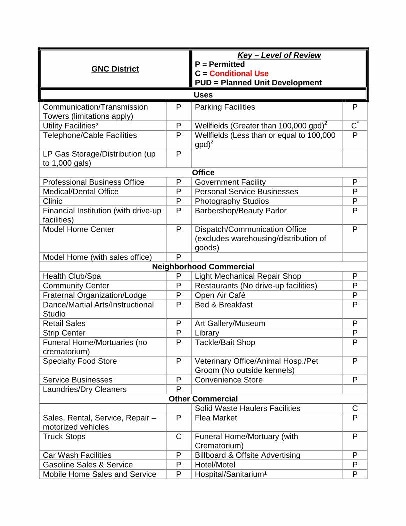
GNC District Key – Level of Review
P = Permitted C = Conditional Use PUD = Planned Unit Development Uses
Communication/Transmission Towers (limitations apply)
P Parking Facilities P
Utility Facilities² P Wellfields (Greater than 100,000 gpd)2 C* Telephone/Cable Facilities P Wellfields (Less than or equal to 100,000
gpd)2 P
LP Gas Storage/Distribution (up to 1,000 gals)
P
Office Professional Business Office P Government Facility P Medical/Dental Office P Personal Service Businesses P Clinic P Photography Studios P Financial Institution (with drive-up facilities)
P Barbershop/Beauty Parlor P
Model Home Center P Dispatch/Communication Office (excludes warehousing/distribution of goods)
P
Model Home (with sales office) P Neighborhood Commercial
Health Club/Spa P Light Mechanical Repair Shop P Community Center P Restaurants (No drive-up facilities) P Fraternal Organization/Lodge P Open Air Café P Dance/Martial Arts/Instructional Studio
P Bed & Breakfast P
Retail Sales P Art Gallery/Museum P Strip Center P Library P Funeral Home/Mortuaries (no crematorium)
P Tackle/Bait Shop P
Specialty Food Store P Veterinary Office/Animal Hosp./Pet Groom (No outside kennels)
P
Service Businesses P Convenience Store P Laundries/Dry Cleaners P
Other Commercial Solid Waste Haulers Facilities C Sales, Rental, Service, Repair – motorized vehicles
P Flea Market P
Truck Stops C Funeral Home/Mortuary (with Crematorium)
P
Car Wash Facilities P Billboard & Offsite Advertising P Gasoline Sales & Service P Hotel/Motel P Mobile Home Sales and Service P Hospital/Sanitarium¹ P
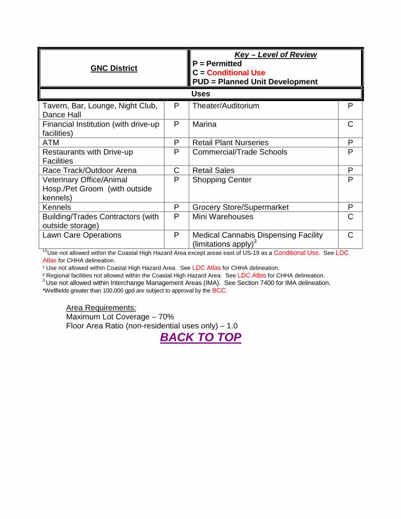
GNC District Key – Level of Review
P = Permitted C = Conditional Use PUD = Planned Unit Development Uses
Tavern, Bar, Lounge, Night Club, Dance Hall
P Theater/Auditorium P
Financial Institution (with drive-up facilities)
P Marina C
ATM P Retail Plant Nurseries P Restaurants with Drive-up Facilities
P Commercial/Trade Schools P
Race Track/Outdoor Arena C Retail Sales P Veterinary Office/Animal Hosp./Pet Groom (with outside kennels)
P Shopping Center P
Kennels P Grocery Store/Supermarket P Building/Trades Contractors (with outside storage)
P Mini Warehouses C
Lawn Care Operations P Medical Cannabis Dispensing Facility
(limitations apply)3 C
1XUse not allowed within the Coastal High Hazard Area except areas east of US-19 as a Conditional Use. See LDC Atlas for CHHA delineation. ¹ Use not allowed within Coastal High Hazard Area. See LDC Atlas for CHHA delineation. ² Regional facilities not allowed within the Coastal High Hazard Area. See LDC Atlas for CHHA delineation. 3 Use not allowed within Interchange Management Areas (IMA). See Section 7400 for IMA delineation. *Wellfields greater than 100,000 gpd are subject to approval by the BCC.
Area Requirements: Maximum Lot Coverage – 70% Floor Area Ratio (non-residential uses only) – 1.0
BACK TO TOP

2413. LIGHT INDUSTRIAL DISTRICT (LIND)
The purpose of the LIND District is to encourage light industrial development by providing an environment exclusively for such development, subject to standards that protect the nearby residential, commercial, agricultural, and public uses of property from hazards, noise, and other disturbances.
LIND District Key – Level of Review
P = Permitted C = Conditional Use Uses
Outdoor Recreation Shooting Range P
Agricultural Aquaculture P Viticulture P
Industrial Light Manufacturing – includes compounding, assembling or treatment or personal articles and household goods, articles of merchandise from previously prepared products, malleable metals, signs, instruments, toys, or similar goods.
P
Spraying supplies/equipment P Mini-warehouses (retail limited to 15% of gross floor area)
P
Automotive/Truck/Equipment Rental P Blacksmith P Towing Services P Welding P Motor Vehicle Assembly/Repair P LP Gas Storage/Distribution (up to 1,000
gals.) P
Auto Body/Fender Shops P Building Trade Assembly P Truck/Bus/Heavy Equipment Garages
P Cement Batch Plant C
Distribution Center P Warehousing (associated with light manufacturing)
P
Processing C Public Service/Utility
Emergency Service Facilities P Truck/Bus Terminals C Communication/Transmission Towers (limitations apply)
P Parking Facilities P
Utility Facilities² P Wellfields (Greater than 100,000 gpd)2 C* Maintenance Facilities P Wellfields (Less than or equal to 100,000
gpd)2 P
LP Gas Storage/Distribution (up to 1,000 gals)
P
Office General Office (associated with industrial park)
P Government Facility P
Neighborhood Commercial Catering/Food Service P Financial Institutions (with drive-up
facilities) P
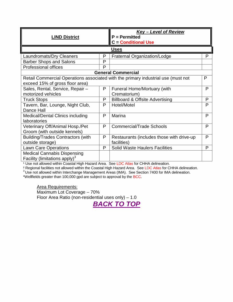
LIND District Key – Level of Review
P = Permitted C = Conditional Use Uses
Laundromats/Dry Cleaners P Fraternal Organization/Lodge P Barber Shops and Salons P Professional offices P
General Commercial Retail Commercial Operations associated with the primary industrial use (must not exceed 15% of gross floor area)
P
Sales, Rental, Service, Repair – motorized vehicles
P Funeral Home/Mortuary (with Crematorium)
P
Truck Stops P Billboard & Offsite Advertising P Tavern, Bar, Lounge, Night Club, Dance Hall
P Hotel/Motel P
Medical/Dental Clinics including laboratories
P Marina P
Veterinary Off/Animal Hosp./Pet Groom (with outside kennels)
P Commercial/Trade Schools P
Building/Trades Contractors (with outside storage)
P Restaurants (includes those with drive-up facilities)
P
Lawn Care Operations P Solid Waste Haulers Facilities P Medical Cannabis Dispensing Facility (limitations apply)3
¹ Use not allowed within Coastal High Hazard Area. See LDC Atlas for CHHA delineation. ² Regional facilities not allowed within the Coastal High Hazard Area. See LDC Atlas for CHHA delineation. 3 Use not allowed within Interchange Management Areas (IMA). See Section 7400 for IMA delineation. *Wellfields greater than 100,000 gpd are subject to approval by the BCC.
Area Requirements: Maximum Lot Coverage – 70% Floor Area Ratio (non-residential uses only) – 1.0
BACK TO TOP
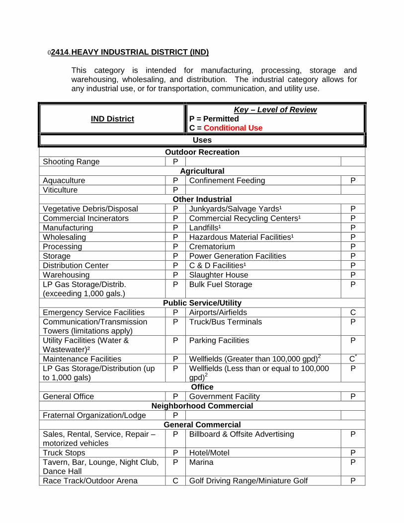
02414. HEAVY INDUSTRIAL DISTRICT (IND)
This category is intended for manufacturing, processing, storage and warehousing, wholesaling, and distribution. The industrial category allows for any industrial use, or for transportation, communication, and utility use.
IND District Key – Level of Review
P = Permitted C = Conditional Use Uses
Outdoor Recreation Shooting Range P
Agricultural Aquaculture P Confinement Feeding P Viticulture P
Other Industrial Vegetative Debris/Disposal P Junkyards/Salvage Yards¹ P Commercial Incinerators P Commercial Recycling Centers¹ P Manufacturing P Landfills¹ P Wholesaling P Hazardous Material Facilities¹ P Processing P Crematorium P Storage P Power Generation Facilities P Distribution Center P C & D Facilities¹ P Warehousing P Slaughter House P LP Gas Storage/Distrib. (exceeding 1,000 gals.)
P Bulk Fuel Storage P
Public Service/Utility Emergency Service Facilities P Airports/Airfields C Communication/Transmission Towers (limitations apply)
P Truck/Bus Terminals P
Utility Facilities (Water & Wastewater)²
P Parking Facilities P
Maintenance Facilities P Wellfields (Greater than 100,000 gpd)2 C* LP Gas Storage/Distribution (up to 1,000 gals)
P Wellfields (Less than or equal to 100,000 gpd)2
P
Office General Office P Government Facility P
Neighborhood Commercial Fraternal Organization/Lodge P
General Commercial Sales, Rental, Service, Repair – motorized vehicles
P Billboard & Offsite Advertising P
Truck Stops P Hotel/Motel P Tavern, Bar, Lounge, Night Club, Dance Hall
P Marina P
Race Track/Outdoor Arena C Golf Driving Range/Miniature Golf P
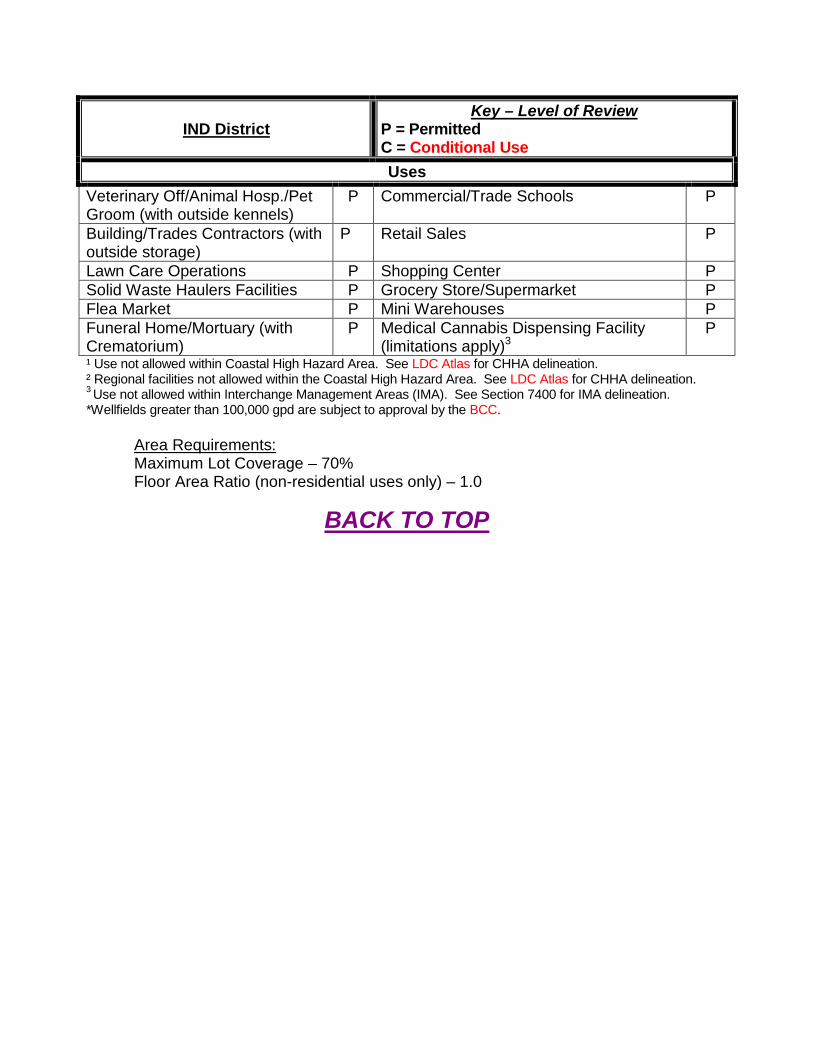
IND District Key – Level of Review
P = Permitted C = Conditional Use Uses
Veterinary Off/Animal Hosp./Pet Groom (with outside kennels)
P Commercial/Trade Schools P
Building/Trades Contractors (with outside storage)
P Retail Sales P
Lawn Care Operations P Shopping Center P Solid Waste Haulers Facilities P Grocery Store/Supermarket P Flea Market P Mini Warehouses P Funeral Home/Mortuary (with Crematorium)
P Medical Cannabis Dispensing Facility (limitations apply)3
P
¹ Use not allowed within Coastal High Hazard Area. See LDC Atlas for CHHA delineation. ² Regional facilities not allowed within the Coastal High Hazard Area. See LDC Atlas for CHHA delineation. 3 Use not allowed within Interchange Management Areas (IMA). See Section 7400 for IMA delineation. *Wellfields greater than 100,000 gpd are subject to approval by the BCC.
Area Requirements: Maximum Lot Coverage – 70% Floor Area Ratio (non-residential uses only) – 1.0
BACK TO TOP
2415. EXTRACTIVE DISTRICT (EXT)
The extractive category allows for surface mining operations and encompasses areas rich in limestone and dolomite. This category permits rock quarries as well as strip mines such as clay, sand, gravel, and peat. Industrial complexes where extracted material is refined, packaged, or further processed are also allowed in this category.
EXT District Key – Level of Review
P = Permitted C = Conditional Use Uses
Recreational Preserves/Reserves P Race Track/Outdoor Arena C Shooting Range P Heavy Recreation P
Agricultural Croplands/Pastures P Viticulture P Silviculture P Plant Nurseries – wholesale P Aquaculture P Sod Farms P
Industrial Commercial Incinerators P C & D Facilities¹ C Mining P Railroad rights of way (including
switching, freight, or storage yards) P
Manufacturing** Processing** Storage P Power Generation Facilities C Landfills¹ C Vegetative Debris/Disposal P
Public Service/Utility Emergency Service Facilities P Maintenance Facilities P Communication/Transmission Towers (limitations apply)
P Wellfields (Greater than 100,000 gpd)2 C*
Utility Facilities (Water & Wastewater)²
P Wellfields (Less than or equal to 100,000 gpd)2
P
¹ Use not allowed within Coastal High Hazard Area. See LDC Atlas for CHHA delineation. ² Regional facilities not allowed within the Coastal High Hazard Area. See LDC Atlas for CHHA delineation. *Wellfields greater than 100,000 gpd are subject to approval by the BCC. **Manufacturing or processing uses not directly related to mining activity requires a minimum lot size of 50 acres of EXT.
Area Requirements: Maximum Lot Coverage – 70% Floor Area Ratio (non-residential uses only) – 1.0
BACK TO TOP
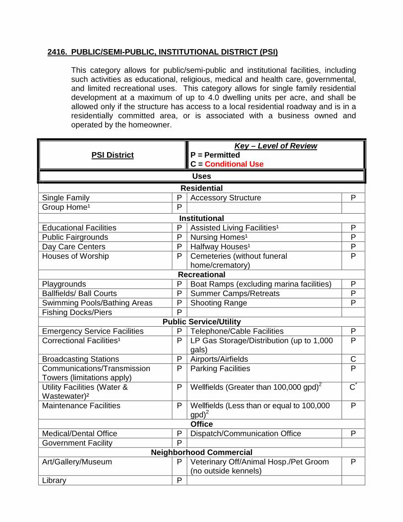
2416. PUBLIC/SEMI-PUBLIC, INSTITUTIONAL DISTRICT (PSI)
This category allows for public/semi-public and institutional facilities, including such activities as educational, religious, medical and health care, governmental, and limited recreational uses. This category allows for single family residential development at a maximum of up to 4.0 dwelling units per acre, and shall be allowed only if the structure has access to a local residential roadway and is in a residentially committed area, or is associated with a business owned and operated by the homeowner.
PSI District Key – Level of Review
P = Permitted C = Conditional Use Uses
Residential Single Family P Accessory Structure P Group Home¹ P
Institutional Educational Facilities P Assisted Living Facilities¹ P Public Fairgrounds P Nursing Homes¹ P Day Care Centers P Halfway Houses¹ P Houses of Worship P Cemeteries (without funeral
home/crematory) P
Recreational Playgrounds P Boat Ramps (excluding marina facilities) P Ballfields/ Ball Courts P Summer Camps/Retreats P Swimming Pools/Bathing Areas P Shooting Range P Fishing Docks/Piers P
Public Service/Utility Emergency Service Facilities P Telephone/Cable Facilities P Correctional Facilities¹ P LP Gas Storage/Distribution (up to 1,000
gals) P
Broadcasting Stations P Airports/Airfields C Communications/Transmission Towers (limitations apply)
P Parking Facilities P
Utility Facilities (Water & Wastewater)²
P Wellfields (Greater than 100,000 gpd)2 C*
Maintenance Facilities P Wellfields (Less than or equal to 100,000 gpd)2
P
Office Medical/Dental Office P Dispatch/Communication Office P Government Facility P
Neighborhood Commercial Art/Gallery/Museum P Veterinary Off/Animal Hosp./Pet Groom
(no outside kennels) P
Library P
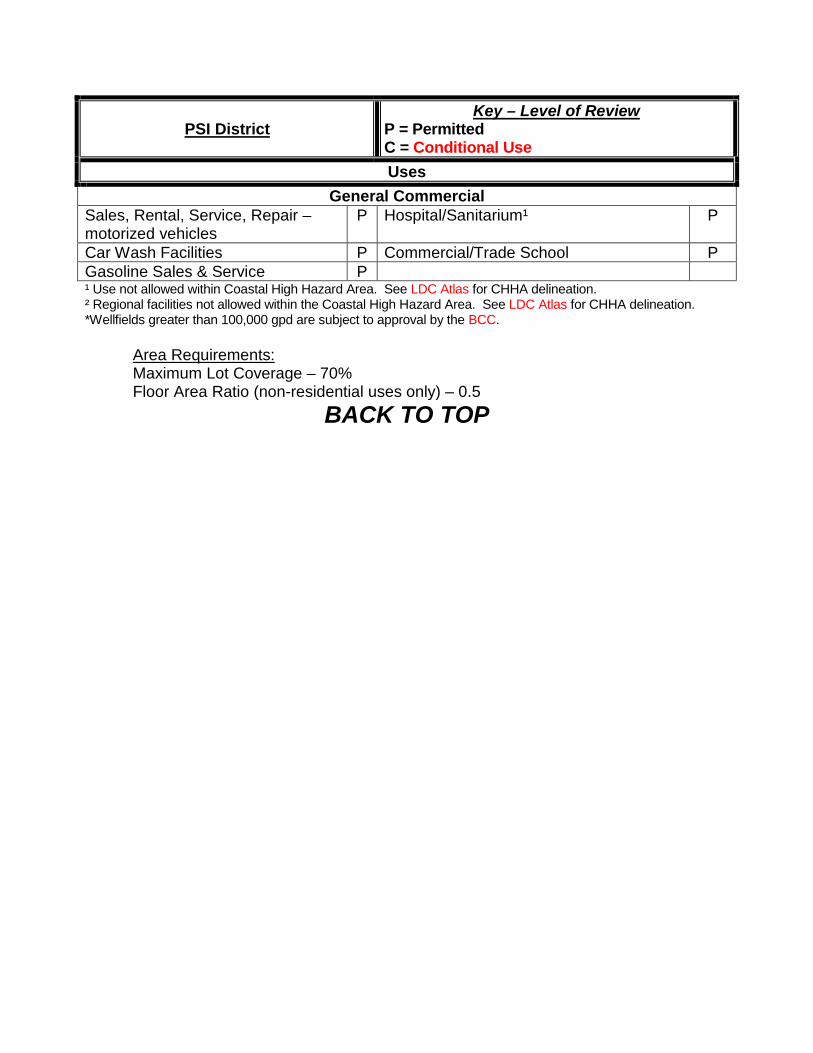
PSI District Key – Level of Review
P = Permitted C = Conditional Use Uses
General Commercial Sales, Rental, Service, Repair – motorized vehicles
P Hospital/Sanitarium¹ P
Car Wash Facilities P Commercial/Trade School P Gasoline Sales & Service P ¹ Use not allowed within Coastal High Hazard Area. See LDC Atlas for CHHA delineation. ² Regional facilities not allowed within the Coastal High Hazard Area. See LDC Atlas for CHHA delineation. *Wellfields greater than 100,000 gpd are subject to approval by the BCC.
Area Requirements: Maximum Lot Coverage – 70% Floor Area Ratio (non-residential uses only) – 0.5
BACK TO TOP
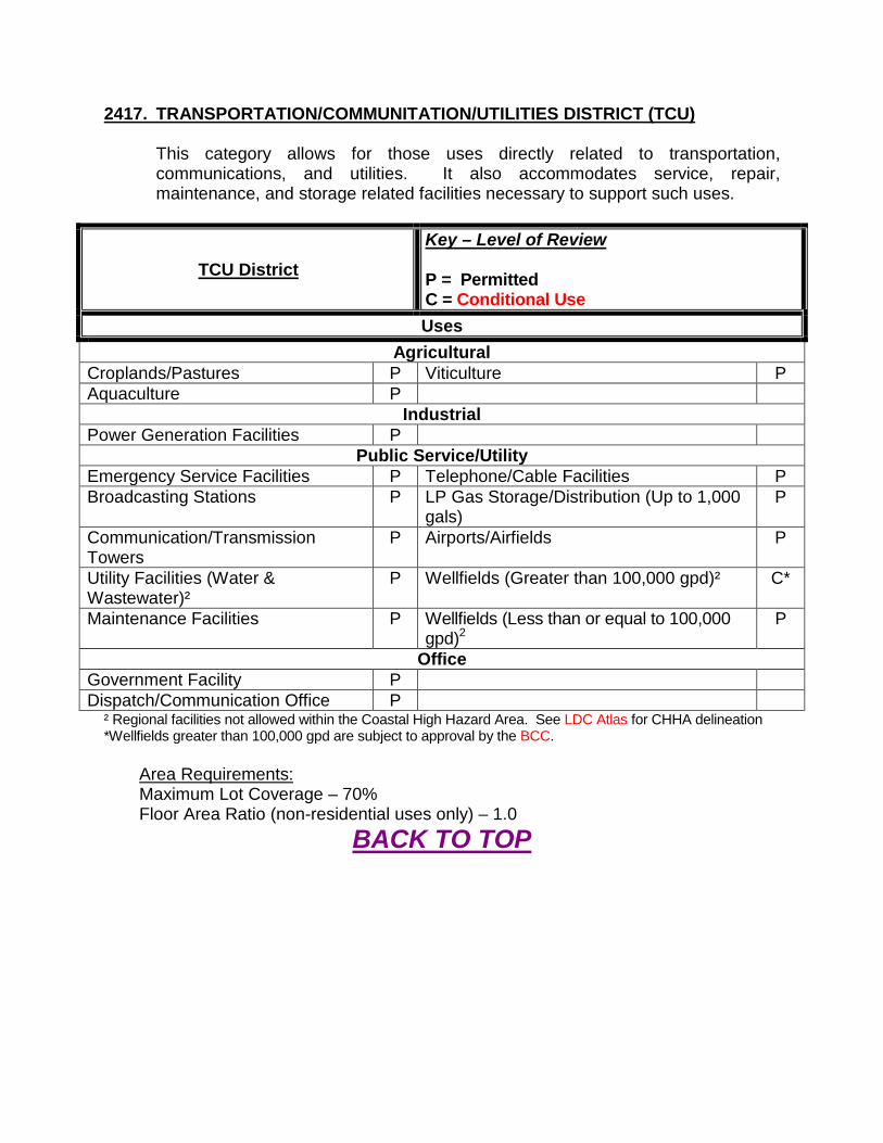
2417. TRANSPORTATION/COMMUNITATION/UTILITIES DISTRICT (TCU)
This category allows for those uses directly related to transportation, communications, and utilities. It also accommodates service, repair, maintenance, and storage related facilities necessary to support such uses.
TCU District Key – Level of Review P = Permitted C = Conditional Use Uses
Agricultural Croplands/Pastures P Viticulture P Aquaculture P
Industrial Power Generation Facilities P
Public Service/Utility Emergency Service Facilities P Telephone/Cable Facilities P Broadcasting Stations P LP Gas Storage/Distribution (Up to 1,000
gals) P
Communication/Transmission Towers
P Airports/Airfields P
Utility Facilities (Water & Wastewater)²
P Wellfields (Greater than 100,000 gpd)² C*
Maintenance Facilities P Wellfields (Less than or equal to 100,000 gpd)2
P
Office Government Facility P Dispatch/Communication Office P
² Regional facilities not allowed within the Coastal High Hazard Area. See LDC Atlas for CHHA delineation *Wellfields greater than 100,000 gpd are subject to approval by the BCC.
Area Requirements: Maximum Lot Coverage – 70% Floor Area Ratio (non-residential uses only) – 1.0
BACK TO TOP
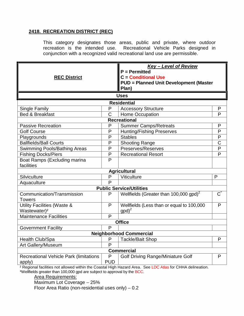
2418. RECREATION DISTRICT (REC)
This category designates those areas, public and private, where outdoor recreation is the intended use. Recreational Vehicle Parks designed in conjunction with a recognized valid recreational land use are permissible.
REC District
Key – Level of Review P = Permitted C = Conditional Use PUD = Planned Unit Development (Master Plan)
Uses Residential
Single Family P Accessory Structure P Bed & Breakfast C Home Occupation P
Recreational Passive Recreation P Summer Camps/Retreats P Golf Course P Hunting/Fishing Preserves P Playgrounds P Stables P Ballfields/Ball Courts P Shooting Range C Swimming Pools/Bathing Areas P Preserves/Reserves P Fishing Docks/Piers P Recreational Resort P Boat Ramps (Excluding marina facilities
P
Agricultural Silviculture P Viticulture P Aquaculture P
Public Service/Utilities Communication/Transmission Towers
P Wellfields (Greater than 100,000 gpd)2 C*
Utility Facilities (Waste & Wastewater)²
P Wellfields (Less than or equal to 100,000 gpd)2
P
Maintenance Facilities P Office
Government Facility P Neighborhood Commercial
Health Club/Spa P Tackle/Bait Shop P Art Gallery/Museum P
Commercial Recreational Vehicle Park (limitations apply)
P PUD
Golf Driving Range/Miniature Golf P
² Regional facilities not allowed within the Coastal High Hazard Area. See LDC Atlas for CHHA delineation. *Wellfields greater than 100,000 gpd are subject to approval by the BCC.
Area Requirements: Maximum Lot Coverage – 25% Floor Area Ratio (non-residential uses only) – 0.2

BACK TO TOP
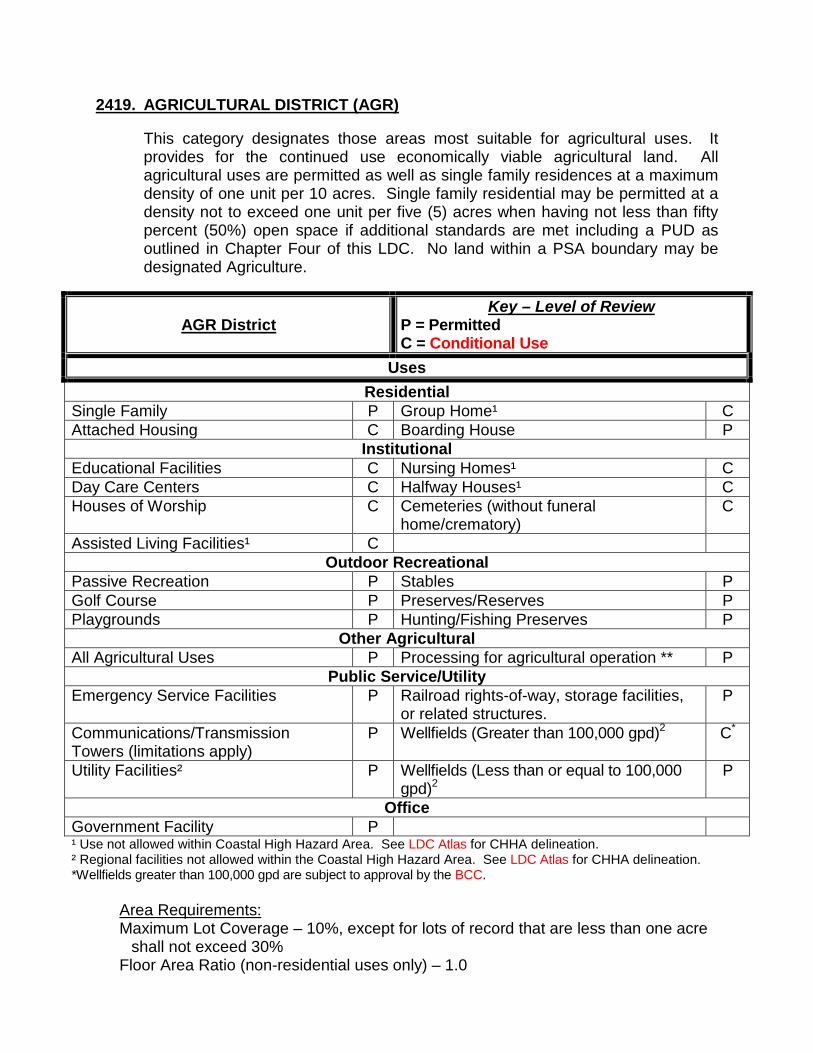
2419. AGRICULTURAL DISTRICT (AGR)
This category designates those areas most suitable for agricultural uses. It provides for the continued use economically viable agricultural land. All agricultural uses are permitted as well as single family residences at a maximum density of one unit per 10 acres. Single family residential may be permitted at a density not to exceed one unit per five (5) acres when having not less than fifty percent (50%) open space if additional standards are met including a PUD as outlined in Chapter Four of this LDC. No land within a PSA boundary may be designated Agriculture.
AGR District Key – Level of Review
P = Permitted C = Conditional Use
Uses Residential
Single Family P Group Home¹ C Attached Housing C Boarding House P
Institutional Educational Facilities C Nursing Homes¹ C Day Care Centers C Halfway Houses¹ C Houses of Worship C Cemeteries (without funeral
home/crematory) C
Assisted Living Facilities¹ C Outdoor Recreational
Passive Recreation P Stables P Golf Course P Preserves/Reserves P Playgrounds P Hunting/Fishing Preserves P
Other Agricultural All Agricultural Uses P Processing for agricultural operation ** P
Public Service/Utility Emergency Service Facilities P Railroad rights-of-way, storage facilities,
or related structures. P
Communications/Transmission Towers (limitations apply)
P Wellfields (Greater than 100,000 gpd)2 C*
Utility Facilities² P Wellfields (Less than or equal to 100,000 gpd)2
P
Office Government Facility P ¹ Use not allowed within Coastal High Hazard Area. See LDC Atlas for CHHA delineation. ² Regional facilities not allowed within the Coastal High Hazard Area. See LDC Atlas for CHHA delineation. *Wellfields greater than 100,000 gpd are subject to approval by the BCC.
Area Requirements: Maximum Lot Coverage – 10%, except for lots of record that are less than one acre
shall not exceed 30% Floor Area Ratio (non-residential uses only) – 1.0

BACK TO TOP
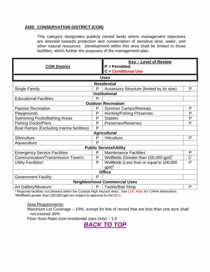
2420. CONSERVATION DISTRICT (CON)
This category designates publicly owned lands where management objectives are directed towards protection and conservation of sensitive land, water, and other natural resources. Development within this area shall be limited to those facilities, which further the purposes of the management plan.
CON District Key – Level of Review
P = Permitted C = Conditional Use
Uses Residential
Single Family P Accessory Structure (limited by lot size) P Institutional
Educational Facilities P Outdoor Recreation
Passive Recreation P Summer Camps/Retreats P Playgrounds P Hunting/Fishing Preserves P Swimming Pools/Bathing Areas P Stables P Fishing Docks/Piers P Preserves/Reserves P Boat Ramps (Excluding marina facilities) P
Agricultural Silviculture P Viticulture P Aquaculture P
Public Service/Utility Emergency Service Facilities P Maintenance Facilities P Communication/Transmission Towers P Wellfields (Greater than 100,000 gpd)2 C* Utility Facilities² P Wellfields (Less than or equal to 100,000
gpd)2 P
Office Government Facility P
Neighborhood Commercial Uses Art Gallery/Museum P Tackle/Bait Shop P ² Regional facilities not allowed within the Coastal High Hazard Area. See LDC Atlas for CHHA delineation. *Wellfields greater than 100,000 gpd are subject to approval by the BCC.
Area Requirements: Maximum Lot Coverage – 10%, except for lots of record that are less than one acre shall
not exceed 30% Floor Area Ratio (non-residential uses only) – 1.0
BACK TO TOP
2421. MOBILE HOME PARK (MHP)
This category is established to recognize existing manufactured housing and mobile home parks as well as to provide for the development of new ones. This category is intended to encourage compact, affordable, high quality housing developments with adequate amenities which are compatible with surrounding land uses. The maximum permitted density is six dwelling units per acre. Up to nine units per acre may be allowed. Convenience retail and personal services to serve park residents may be allowed up to 5,000 square feet, located within the development and not accessible from any county arterial or collector road.
MHP District Key – Level of Review
P = Permitted C = Conditional Use Uses
Residential Caretaker’s Residence P
Outdoor Recreational Passive Recreation P Boat Ramps (Excluding marina facilities) P Golf Course P Summer Camps/Retreats P Playgrounds P Hunting/Fishing Preserves P Ballfields/Ball Courts P Preserves/Reserves P Swimming Pools/Bathing Areas P Fishing Docks/Piers P
Public Service/Utility Emergency Service Facilities P Maintenance Facilities (private) P Communications/Transmission Towers (limitations apply)
P Telephone/Cable Facilities P
Utility Facilities (Water & Wastewater)²
P
Limited Commercial To Serve Park Residents (not more than 5,000 square feet cumulative)
Community Center P Restaurants (No drive-up facilities) P Fraternal Organization/Lodge P Open Air Café P Small Retail Shops P Tackle/Bait Shop P Specialty Food Store P Convenience Store P Service Businesses P Laundries/Dry Cleaners P ¹ Use not allowed within Coastal High Hazard Area. See LDC Atlas for CHHA delineation. ² Regional facilities not allowed within the Coastal High Hazard Area. See LDC Atlas for CHHA delineation.
Area Requirements: Maximum Lot Coverage – 40% Floor Area Ratio (non-residential uses only) – 0.2
BACK TO TOP

2422. RECREATIONAL VEHICLE PARK/CAMPGROUND DISTRICT (RVP)
This category is intended to recognize existing Recreational Vehicle (RV) Parks and Campgrounds, as well as to provide for the location and development of new parks for recreational vehicles. Such parks are intended specifically to allow temporary living accommodation for recreation, camping, or travel use. Convenience retail and personal services to serve park residents may be allowed up to 5,000 square feet, located within the development and not accessible from any county arterial or collector road.
RVP District Key – Level of Review
P = Permitted C = Conditional Use
Uses Residential
Caretaker’s Residence P Outdoor Recreational
Passive Recreation P Boat Ramps (Excluding marina facilities) P Golf Course P Summer Camps/Retreats P Playgrounds P Stables P Ballfields/Ball Courts P Preserves/Reserves P Swimming Pools/Bathing Areas P Recreational Resort P Fishing Docks/Piers P
Public Service/Utility Emergency Service Facilities P Maintenance Facilities (private) P Communications/Transmission Towers P Telephone/Cable Facilities P Utility Facilities (Water & Wastewater)² P
Limited Commercial to Serve Campers (no more than 5,000 square feet cumulative)
Community Center P Restaurants (No drive-up facilities) P Fraternal Organization/Lodge P Open Air Café P Small Retail Shops P Tackle/Bait Shop P Specialty Food Store P Convenience Store P Service Businesses P Laundries/Dry Cleaners P ¹ Use not allowed within Coastal High Hazard Area. See LDC Atlas for CHHA delineation. ² Regional facilities not allowed within the Coastal High Hazard Area. See LDC Atlas for CHHA delineation.
Area Requirements: Maximum Lot Coverage – 40%, Floor Area Ratio (non-residential uses only) – 0.2
BACK TO TOP

2423. PORT DISTRICT (PORT)
The purpose of the Port District is to promote a waterfront community in Citrus County. This district recognizes those areas suitable for integrating residential, commercial, industrial, and supporting utility uses with water related and water dependent uses. Port Districts require a Subarea Plan Text and Map Amendment to the Comprehensive Plan. The specific uses are outlined in the Subarea Plan. Prohibited uses include junkyards/salvage yards, commercial recycling centers, slaughterhouse, cemeteries, landfills, hazardous materials facilities, commercial incinerators, confinement feeding, and C&D facilities. Multi-family apartments built as additional stories over nonresidential structures may be allowed in accordance with the density allowances as described within this Section.
PORT District
Key – Level of Review P = Permitted C = Conditional Use MPD = Subject to approved Master Plan of
Development Uses
Residential Single Family (up to six units per acre) P Boarding House P Multifamily (up to six units per acre)3 P Workforce Housing1 (up to seven units per
acre) P
Single Family Cluster Housing (up to six units per acre)
P
Institutional Educational Facilities P Nursing Homes3 C Day Care Centers P Halfway Houses3 C Houses of Worship P Assisted Living Facilities3 C
Outdoor Recreation Marinas (Wet & Dry Slips) P RV Parks MPD Golf Driving Range/ Miniature Golf Course
P Boat Ramps P
Playgrounds P Summer Camps/Retreats P Ballfields/ Ball Courts P Shooting Range C Swimming Pools/Bathing Areas P Recreational Resort P Fishing Docks/Piers P Golf Courses P Hunting Reserves P Cruise Ship Facilities2 P
Agricultural Croplands P Aquaculture P Silviculture P Viticulture P
Public Service/Utility Emergency Service Facilities P Heliport C
PORT District
Key – Level of Review P = Permitted C = Conditional Use MPD = Subject to approved Master Plan of
Development Uses
Communication/Transmission Towers P Government Facilities P Utility Facilities (Water & Wastewater)² P Wellfields (Greater than 100,000 gpd)2 C* Telephone/Cable Facilities P Wellfields (Less than or equal to 100,000
gpd)2 P
LP Gas Storage/Distribution (up to 1,000 gals)
P Dispatch/Communication Facility P
Commercial Professional Business Office P Commercial Fishing Operations P Medical/Dental Office P Personal Service Businesses P Clinic P Barbershop/Beauty Parlor P Financial Institution (with drive-up facilities)
P Flea Market P
Health Club/Spa P Hospital/Sanitarium C Model Home Center P Theater/Auditorium P Model Home (with sales office) P Billboard & Offsite Advertising P Retail Sales/ Strip Center P Light Mechanical Repair Shop P Community Center P Restaurants (with drive-up facilities) P Fraternal Organization/Lodge P Open Air Café Dance/Martial Arts/Instructional Studio P Bed & Breakfast P Funeral Home/Mortuaries (no crematorium)
P Art Gallery/Museum P
Service Businesses P Library P Car Wash Facilities P Tackle/Bait Shop P Gasoline Sales & Service P Veterinary Office/Animal Hosp./Pet Groom
(with outside kennels) C
Hotel/Motel P Veterinary Office/Animal Hosp./Pet Groom (without outside kennels)
P
Laundries/Dry Cleaners P Convenience Store P Tavern, Bar, Lounge, Night Club, Dance Hall
P Grocery Store/Supermarket P
ATM P Kennels C Restaurants with Drive-up Facilities P Retail Plant Nurseries P Building/Trades Contractors (with outside storage)
P Commercial/Trade Schools P
Lawn Care Operations P Outdoor Arena P Resorts and Extended Stay Facilities P Open Storage P Boat Sales/Maintenance/Repair P Marine Fueling P
Industrial Distribution Center P Wholesaling P Mini Warehouses P Power Generation Facilities P

PORT District
Key – Level of Review P = Permitted C = Conditional Use MPD = Subject to approved Master Plan of
Development Uses
Solid Waste Haulers Facilities C Manufacturing and Craft Industries P Heavy Industrial Uses identified in this section
C Processing and Shipping of mined material adjacent to existing mine (barge operations)
P
Truck Terminals C Truck Stops C Bus Terminals P Parking Facilities P LP Gas Storage/Distribution P Warehousing P Bulk Fuel Storage P 1 Workforce housing is allowed as a temporary use in the industrial area of the PORT District. The provisions for
temporary use workforce housing shall be defined by the Subarea Plan. 2 Cruise Ship Facilities are allowed subject to the requirements of Florida Statutes. 3 Uses not allowed within the Coastal High Hazard Area. See LDC Atlas for CHHA delineation. *Wellfields greater than 100,000 gpd are subject to approval by the BCC.
Specific Criteria Port District
A. Residential uses shall be clustered and may have a density not to exceed 6 units per acre.
B. Residential development shall be entitled to an additional density of one unit per acre above the residential density standard of the Port District, provided such density is clustered and legally dedicated to workforce housing.
C. Residential development within the Industrial areas of the Port District will require a Planned Unit Development.
D. Community design elements shall be promoted within the waterfront area. These include: 1. A complementary vertically and horizontally mixed range of land uses including
educational, recreational, commercial, residential and cultural uses; 2. Interconnected networks of street designed to encourage golf carts, walking, and
bicycling, with traffic calming techniques utilized where appropriate; 3. Appropriate densities and intensities of uses within walking distance of transit stops; 4. Daily activities within walking distance of residences, allowing independence of
persons who do not drive; 5. Public uses, streets, and squares that are safe, comfortable, and attractive for the
pedestrian, with adjoining buildings open to the street; 6. Parking not interfering with pedestrian, transit, automobile, and truck travel modes. 7. Linear pedestrian and bicycle cross access between uses; and 8. Development along the waterfront will allow for appropriate public access.
E. All development within the Port district must comply with the Subarea Plan Standards and provide mitigation to maximize compatibility between uses. Mitigation shall include: 1. Appropriate buffers and proper plantings and may include fences, walls and berms; 2. Stormwater Management systems appropriate for Karst Sensitive Areas as
outlined in the Plan; 3. Impacts of waterfront development on Manatees as outlined in the Plan; and
4. Use of best management practices outlined in the Clean Marina Program for Marina development within the PORT district.
F. Any residential component of a Port District shall comply with the standards of, “Animals” and “Trucks” in Selected Land Use Districts”, of this LDC.
G. RV Parks in the Port District (if authorized) shall comply with the standards of the Recreational Vehicle Parks section of this LDC.
H. Communication/Transmission Towers are limited to the PORT Industrial and PORT Commercial areas as outlined in the specific Subarea Plan and shall comply with all standards in the Communication/Transmission Towers section of this LDC.
Area Requirements: Maximum Lot Coverage – 50% (or as outlined in the Sub-Area Plan) Floor Area Ratio (non-residential uses only) – 0.3 (or as outlined in the Sub-Area Plan)
BACK TO TOP