Embed Size (px)
Citation preview
The Putumayo-Oriente-Maranon Province of Colombia, Ecuador, and Peru—Mesozoic-Cenozoic and Paleozoic Petroleum Systems
U.S. Geological Survey Digital Data Series 63
U.S. Department of the Interior U.S. Geological Survey
The Putumayo-Oriente-Maranon Province of Colombia, Ecuador, and Peru—Mesozoic-Cenozoic and Paleozoic Petroleum Systems
By Debra K. Higley
U.S. Geological Survey Digital Data Series 63
U.S. Department of the Interior U.S. Geological Survey
U.S. Department of the Interior Gale A. Norton, Secretary
U.S. Geological Survey Charles G. Groat, Director
First replication 2001
For sale by U.S. Geological Survey, Information ServicesBox 25286, Federal CenterDenver, CO 80225
This report is also available online at: http://geology.cr.usgs.gov/pub/dds/dds-063/
Any use of trade, product, or firm names in this publicationis for descriptive purposes only anddoes not imply endorsement by the U.S. Government
Library of Congress Cataloging-in-Publication Data
Higley, Debra K. The Putumayo-Oriente-Maranon Province of Colombia, Ecuador, and Peru, Mesozoic-
Cenozoic and Paleozoic petroleum systems [computer file] / [by Debra K. Higley]. 1 computer optical disc ; 4 3/4 in. – (USGS digital data series ; DDS-063) System requirements PC: 386 IBM-compatible PC; 8MB RAM; PC-DOS 3.3; Windows
95 or Microsoft Windows NT 4.0 with Service Pack 3; extended VGA video board with 640 x 480 resolution and 256 colors; 10MB free hard disk space; CD-ROM drive capable of supporting ISO 9660 standards; mouse.
System requirements for Macintosh: Macintosh II series with 68020 processor (includes all Power Macintosh computers); 4.5MB application RAM; MacOS 7.1.2; 8MB hard disk space; thirteen-inch color monitor; CD-ROM drive capable of supporting ISO 9660 or HFS standards.
Title from disc label. Audience: Geologists. 1. Petroleum—Geology—Colombia—Putumayo (Dept.). 2. Petroleum—Geology—Ec
uador—Oriente. 3. Petroleum—Geology—Peru—Maranon River Valley. I. Geological Survey (U.S.). II. Title. III. Series: U.S. Geological Survey digital data series ; DDS-063.
TN873.C7 553.2—dc13
00-038641
ISBN=0–607–94823–X
Published in the Central Region, Denver, ColoradoManuscript approved for publication May 23, 2000Graphics by the authorPhotocomposition by Norma J. MaesEdited by Lorna Carter
Contents
Foreword................................................................................................................................................ 1Abstract ................................................................................................................................................. 1Introduction........................................................................................................................................... 2Acknowledgments ............................................................................................................................... 4Province Geology ................................................................................................................................. 4
Structural History ........................................................................................................................ 4Exploration History...................................................................................................................... 7
Petroleum Occurrence ....................................................................................................................... 8Source Rocks........................................................................................................................................ 11
Source Rock Characteristics .................................................................................................... 11Migration History......................................................................................................................... 17
Types of Traps ...................................................................................................................................... 20Reservoir Rocks ................................................................................................................................... 22Seal Rocks ............................................................................................................................................ 24Undiscovered Petroleum by Assessment Unit................................................................................ 24Summary................................................................................................................................................ 29Selected References ........................................................................................................................... 29
Figures
1. Map showing Putumayo-Oriente-Maranon province 6041 .......................................... 32. Cross section through the Maranon Basin ..................................................................... 53. Stratigraphic column of formations in the Putumayo-Oriente-Maranon
province ................................................................................................................................ 64. Histogram of field size distribution by time ranges of discovery of known
recoverable oils................................................................................................................... 95. Histogram of API gravity of oils from Lower and Upper Cretaceous
reservoirs in the Putumayo-Oriente-Maranon province, Mesozoic-Cenozoic TPS (604101) ......................................................................................................................... 10
6–8. Events charts for:
6. Conventional oil and gas within the Mesozoic-Cenozoic TPS (604101) .......... 127. Hypothetical Basin-Center Gas assessment unit of the Oriente and
Maranon Basins........................................................................................................ 138. Hypothetical Permian Ene Formation assessment unit of the Oriente and
Maranon Basins........................................................................................................ 14
9–11. Charts showing:
9. Distribution of delta 13C isotopes for saturated and aromatic hydrocarbons, Putumayo-Oriente-Maranon province .................................................................. 16
10. API gravity and weight percent sulfur of oil from fields across the Putumayo-Oriente-Maranon province .................................................................. 18
11. Nickel and vanadium ratios in oil............................................................................ 1912. Whole crude gas chromatograph of oil from Cretaceous Vivian Formation
in Jibaro field, Maranon Basin.......................................................................................... 2113. Histogram of field size distribution for all production in the Putumayo-
Oriente-Maranon province and its components; Upper Cretaceous andTertiary reservoirs, and Lower Cretaceous formations................................................ 25
14. Graph showing history of field discovery dates and cumulativevolumes of known recoverable oil across the Putumayo-Oriente-Maranonprovince ................................................................................................................................ 27
15. Histogram of number of new-field wildcat wells and field discovery year ............... 28
III

Tables [Tables follow page 31]
1. Background statistics for oil and gas fields in the Putumayo-Oriente Maranon province, petroleum system 604101
2. Statistics for recoverable oil for fields with 1 MMBO or greater reserves 3. Assessment results summary for the Hollin-Napo assessment unit (60410101) of the
Mesozoic-Cenozoic Total Petroleum and the Permian Ene Formation assessment unit (60410201) of the Paleozoic TPS
IV
The Putumayo-Oriente-Maranon Province of Colombia, Ecuador, and Peru—Mesozoic-Cenozoic and Paleozoic Petroleum Systems By Debra K. Higley
Foreword
This report is a product of the World Energy Project of the U.S. Geological Survey (U.S. Geological Survey World Energy Assessment Team, 2000). For this project, the land surface of the Earth was divided into 8 regions and 937 geologic provinces for purposes of assessing global oil and gas resources (Klett and others, 1997). Provinces were then ranked based on volumes of discovered petroleum, and on this basis 76 “priority” provinces and 25 “boutique” provinces were selected for individual study. Priority provinces are all outside the U.S. and were selected for their high ranking. Boutique provinces are also exclusive of the U.S. and were chosen for various geologic and other reasons. The petroleum geology of these provinces is described in a series of reports like the one presented here. Complete oil and gas resource assessment results are planned for a later publication, although some data and results are contained within individual province reports.
The Total Petroleum System (TPS) is the basic geologic unit that is being assessed for as yet undiscovered oil and gas resources. A TPS is defined as a system that includes the essential elements and processes of reservoir and common hydrocarbon source rocks, favorable thermal and burial history, and trapping conditions for the generation, migration, and accumulation of oil and (or) gas (modified from Magoon and Dow, 1994). The minimum petroleum system is that portion of the TPS for which the presence of these essential elements and processes has been proved.
An assessment unit within a TPS is a mappable volume of rock that encompasses petroleum fields (discovered and undiscovered) that have the same hydrocarbon source rock(s), and similar socio-economic factors that affect resource emplacement, exploration, and development. The oil and gas fields in an assessment unit should be sufficiently homogeneous in terms of geology, exploration strategy, and risk so that the chosen method of resource assessment is applicable. A TPS might equate to a single assessment unit, or it may be subdivided into two or more assessment units depending on whether differences are sufficient to warrant separation. Determination of assessment units can also be influenced by quality and availability of hydrocarbon source, reservoir, and production data. Each assessment unit can incorporate several exploration plays that are based on different reservoir formations, trap types, exploration strategies, and discovery histories. Although assessment units may be grouped in a single resource assessment for the TPS, components of the assessment units may be described separately. An example of this is the Napo-Hollin assessment unit of the Mesozoic-Cenozoic Petroleum System (TPS). Most reported oil is commingled for
formations of the Putumayo-Oriente-Maranon province, and production is grouped in the resource assessment. However, separate descriptions are given for this assessment unit because geologic and geochemical research suggests that hydrocarbons generated from Lower Cretaceous source rocks are distinct from those of Upper Cretaceous source rocks.
Assessment units are considered established if they contain more than 13 oil and (or) gas fields, frontier if 1 to 13 fields exist, and hypothetical if there is no produced oil and (or) gas. A numerical code identifies each region, province, TPS, and assessment unit; these codes established by Klett and others (1997) are uniform throughout the World Energy Project. They are as follows: • Region, single digit 6 • Province, three numbers to the right of the region code 6041 • Total Petroleum System, two digits to the right of the
province code 604101 • Assessment unit, two numbers to the right of the
petroleum system code 60410101 Primary purposes of describing Total Petroleum Systems
(TPS) are to aid in assessing the quantities of oil, gas, and natural gas liquids that have the potential within 30 years to enhance current worldwide and regional reserves. These additional volumes either reside in undiscovered fields whose sizes exceed the stated minimum-field-size cutoff for assessment, or occur as reserve growth of fields that are already producing. Field growth (increase through time of estimated recoverable resources) may result from discovery of new productive facies or formations within the field, production of a greater percentage of original-oil-in-place through improved secondary or tertiary recovery methods, and perhaps a recalculation of reserves that were originally underestimated. Hypothetical assessment units are described to explore the potentials of possible new or under-evaluated petroleum plays and formations. Analogs to other areas of the world are used to assign potential environments of deposition of source and reservoir rocks, to describe the burial history of the area, and to assess possible reservoir properties of formations within the hypothetical assessment unit.
The primary sources of field and well production and geochemical data for this report are the GeoMark (through 1997) and Petroconsultants (through 1996) databases.
Abstract
More than 2.88 billion barrels of oil (BBO) and 660 billion cubic feet of gas (BCFG) have been produced from the Putumayo-Oriente-Maranon province in eastern Colombia, Ecuador, and Peru. Estimated undiscovered recoverable
1
resources at the 5 to 95 percent confidence levels for all petroleum systems in the province range from 1,030 to 6,060 BBO, 236 to 4,600 BCFG, and 4 to 182 MMBNGL. This is one of the major geologic provinces for which undiscovered oil and gas resources were assessed for the World Energy Assessment Project of the U.S. Geological Survey. Reservoirs in this province that produce from Upper Cretaceous and Tertiary sand-stones have as much as 2.84 BBO and 616 BCFG cumulative production from 150 fields; reservoirs from 65 fields that list Lower Cretaceous production have cumulative recovery of as much as 1.16 BBO and 448 BCFG. The sum of these production figures is more than the basin total, largely because 43 of the more than 172 oil fields in the basin list recovery from both Lower and Upper Cretaceous reservoirs and reported production is commingled.
The main oil and gas reservoirs for the Putumayo Basin in Colombia are in the Cretaceous Caballos and Villeta Formations and the Tertiary Pepino Formation. Ecuador’s Oriente Basin production is mostly from sandstones of the Cretaceous Hollin and Napo Formations, and Peru’s Maranon Basin reservoirs are sandstones of the Cretaceous Cushabatay, Agua Caliente, Chonta, and Vivian Formations. These formations are grouped into the Hollin-Napo assessment unit of the Mesozoic-Cenozoic TPS because of similarities in structural, depositional, and diagenetic histories for source and reservoir rocks. Although no production exists from Jurassic and Triassic formations, marine shales within the Triassic and Jurassic Pucara Group and Jurassic Sarayaquillo Group are thermally mature for oil and (or) gas generation throughout much of the region and Jurassic-age source rocks in the southern Maranon Basin may lie within the gas generative window.
For the Putumayo-Oriente-Maranon province, estimated recoverable oil is 6.62 BBO, and estimated ultimate recoverable oil plus gas and condensate is 6.89 billion barrels of oil equivalent for all fields and formations of the Hollin-Napo assessment unit of the Mesozoic-Cenozoic TPS.
Oil from Cretaceous rocks of the Corrientes and several other fields in the Maranon Basin may have been sourced from the Permian Ene Formation with migration updip along local fault systems. This formation is thermally mature for oil generation across the western third of the Putumayo-Oriente-Maranon province, and probably mature for gas generation in areas close to the western boundary. Some potential exists for field discoveries within the Ene Formation or other units of the Permian Mitu Group in the southern portion of the province. A thick interval of Triassic salt in the western Maranon Basin is a potential seal and may have contributed to possible structural traps; strati-graphic and combination traps may also occur.
Primary petroleum source rocks of Cretaceous age are marine and mixed marine-terrestrial shales of the Caballos Formation and the “U” sandstone of the Villeta Formation in the Putumayo Basin, the Hollin and Napo Formations in the Oriente Basin, and the Raya and Chonta Formations in the Maranon Basin. Possible source rocks in the Maranon Basin are the Permian Ene Formation, the Triassic and Jurassic Pucara Group, and the Jurassic Sarayaquillo Group. The Pucara Group is a significant potential source of hydrocarbon in the Ucayali Basin, which is located at the southern border of the Maranon Basin. Cretaceous source rocks are currently thermally mature for oil
generation over the western third of the province, and possibly for gas generation in an area close to the western boundary of the Oriente and Maranon Basins. If these source rocks are thermally mature for gas generation, then some potential exists for gas reserves within low-permeability sandstone facies from nearshore marine and shoreface sandstones of the Cretaceous Napo, Chonta, and Agua Caliente Formations of the hypothetical Basin-Center Gas assessment unit.
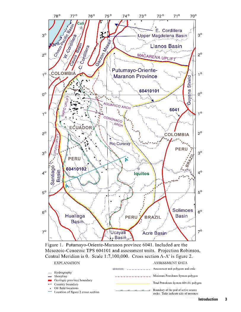
Introduction The Putumayo-Oriente-Maranon province borders the east-
ern flank of the Andes Mountains (fig. 1). This province is an asymmetric foreland basin that covers about 320,000 square kilometers (km2 )(124,000 square miles (mi2)) (Mathalone and Montoya, 1995). The names of individual parts of the basin are based on political boundaries with the Putumayo Basin situated in Colombia, the Oriente Basin in Ecuador, and the Maranon Basin in Peru. The area of the Oriente Basin is greater than 80,000 km2 (31,000 mi2) (White and others, 1995).
The Putumayo-Oriente-Maranon foreland basin is bounded on the west by a 50–200 km (30–125 mi) wide sub-Andean belt of thrusted Mesozoic sedimentary rocks (Mathalone and Montoya, 1995). This belt includes the Garzon Massif, the Central and Western Cordillera, and the Santiago and Huallaga Basins (fig. 1). Northern border of the Putumayo Basin portion is the Macarena uplift, which separates it from the Llanos Basin. The Guyana Shield and Solimoes Basin border the Putumayo-Oriente-Maranon province on the east. The Maranon Basin is bounded on the south by the Ucayali and Acre Basins (fig. 1).
Much of the Putumayo-Oriente-Maranon province is covered by rain forests of the upper Amazon River drainage basin. The province’s location within the rain forest, coupled with the economics of the region, makes access difficult, and complicates any potential plans for road building, development of petroleum storage, transport, and refining facilities, and construction of housing and other infrastructure. Environmental impacts that are associated with exploration and production of oil and gas in the rain forest can include primary deforestation that results from construction of facilities, such as roads, housing, drill pads, and power supplies, and secondary deforestation, which is primarily due to colonization as the rain forest becomes more accessible. Endeavors to minimize impacts include (1) Occidental Exploration and Production Company’s use of satellite and remote sensing imagery to assess and control potential areas of deforestation on their 200,000 km2 (77,000 mi2) lease block in the Oriente Basin of Ecuador—a study indicated that the amount of deforestation over a 10-year period was 6 percent outside the lease block and 3.2 percent within it (Groth, 1998; Occidental, 1999); (2) Shell Prospecting and Development’s Amazon basin drilling projects; use of helirigs instead of building roads to the prospects, to minimize both land impact and access to these remote sites (Wasserstrom and Reider, 1998); and (3) agreement by Royal Dutch/Shell, Mobil Corporation, and ARCO to allow non-government organizations and Indian groups to monitor the environment during exploration and development programs in Ecuador and Peru (Wasserstrom and Reider, 1998). Environmental organizations also have websites that discuss potential environmental impacts of exploration and development within the region.
2 The Putumayo-Oriente-Maranon Province of Colombia, Ecuador, and Peru
INTRODUCTION Introduction 3
The petroleum system approach to determining oil and gas resources integrates information about tectonic, depositional, and diagenetic factors that control hydrocarbon generation, migration, and accumulation in reservoirs. Initial assignment of formations to petroleum systems is based on whether they have the same hydrocarbon source rock(s). It is assumed that the formations are oil and (or) gas productive or potentially productive. This method of resource assessment is used to quantify current and estimated ultimate reserves at basin scales, and to estimate potential for additional oil and gas from unexplored and under-explored areas. This study divides the Putumayo-Oriente-Maranon province into two Total Petroleum Systems—Mesozoic-Cenozoic (604101) and Paleozoic (604102). Assessment units for these systems are named and numbered as follows: • Hollin-Napo (60410101) • Basin-Center Gas (60410102), and • Permian Ene Formation (60410201)
All current production and estimated reserves within the province are from the Hollin-Napo assessment unit of the Mesozoic-Cenozoic system. Subsurface extent of the area that may contain potential reservoir formations is highly generalized in figure 1, primarily because of lack of data. The Basin-Center Gas assessment unit is hypothetical and is based upon similarities of structural and depositional histories and of characteristics of Cretaceous source rock and potential reservoirs between this basin and other basins that contain basin-center gas fields. The Paleozoic TPS is also hypothetical because no oil or gas has been produced from strata of Paleozoic age in the province; however, published and other information indicates the presence of Paleozoic-sourced oil in several Cretaceous reservoirs of the Maranon Basin in Peru. Some reservoirs may be present in the western part of this basin, particularly in structural and combination traps below the Triassic salt (fig. 2), but because the subsurface extent of the area that may contain Paleozoic reservoirs is unknown, none is shown in figure 1. The boundary of this Paleozoic TPS (604102) is generalized to that of the Mesozoic-Cenozoic system (fig. 1). The primary sources of information regarding subsurface distribution of formations, including reservoir and source rock facies, are Mathalone and Montoya (1995) and Pindell and Tabbutt (1995).
Acknowledgments
I thank Sandy Rushworth, of Bellaire, Texas, a petroleum geologist previously with Texaco, for her assistance in evaluating the petroleum potential of the province. W.R. Keefer and C.J. Schenk of the U.S. Geological Survey, and Michele Bishop, a contract geologist with the USGS, provided valuable technical reviews.
Province Geology
Structural History
Sub-Andean basins of Colombia, Ecuador, and Peru-formed from evolution of the plate margins. During the Cambrian and Early Ordovician the continental edge was
characterized by an Atlantic-type passive margin (Mathalone and Montoya, 1995). Episodic plate events along the Ecuadorian margin of the South American craton resulted in families of structures and structural styles that involved Precambrian basement and Phanerozoic cover rocks (Balkwill and others, 1995). Basement under the entire Oriente Basin is believed to consist of Proterozoic metamorphic and plutonic rocks of the Amazon craton (Baldock, 1982; Canfield and others, 1982).
Lower Paleozoic sediments were deposited on a fault-con-trolled passive margin that was adjacent to a collision zone (Mathalone and Montoya, 1995). The pre-Andean terrane of the Maranon Basin comprised a suite of Paleozoic rifts and interbasin highs. Major faulting and erosion alternately preserved and eroded thick Paleozoic sections; occurrence and thickness of Paleozoic rocks are highly variable across the Putumayo-Oriente-Maranon province. The Paleozoic succession across most Andean basins is largely undeformed (Mathalone and Montoya, 1995) beneath the thrusted strata of Triassic and younger age, an observation that is based largely on information generated by seismic surveys. Middle Ordovician time is the earliest dated collision of the plate boundaries (Mathalone and Montoya, 1995).
The sub-Andean foothills can be divided into two structural domains. To the west, faulting is dominated by thrusts that detach in Triassic salt in the north (fig. 2) or Devonian shale to the south. Toward the east, an uplifted zone is dominated by basement-involved thrusting (Mathalone and Montoya, 1995). Formation of the basin from middle Permian through Early Triassic time was controlled by subduction-related strike-slip deformation and associated transtensional and transpressional conditions, referred to as the Eohercynian deformation (Sempere, 1995). The Lower/Upper Permian unconformity that over-lies the Mitu Group (fig. 3) is interpreted by Carpenter and Berumen (1999) to correlate with the onset of back-arc extension, where oceanic crust west of the basins was subducted beneath continental crust. Back-arc extension is created in fore-land/back-arc environments when the rate of convergence is less than the rate of subduction; this back-arc extension is recognized in Andean outcrops of the Upper Permian and Triassic Mitu Group, and Carpenter and Berumen (1999) associated this structural event with the foreland basin depositional sequence in basins south of the Maranon Basin. Paleozoic arches in basins south of this basin give evidence of Middle Triassic tectonic activity that is locally known as the Jurua orogeny (Mathalone and Montoya, 1995; Carpenter and Berumen, 1999). The mod-ern subduction system is dated as Early Jurassic (Mathalone and Montoya, 1995). The Middle Triassic to Middle Jurassic back-arc extension period appears to have preceded the physical breakup of the Pangea supercontinent (Carpenter and Berumen, 1999). The Western and Central Colombian Andes have been tectonically transported eastward a distance of at least 150 km (93 mi) (Dengo and Covey, 1993).
At the end of Cretaceous time, the tectonics of northwest-ern South America changed from passive to convergent margin (Villegas and others, 1994). Cretaceous through Pliocene tectonic events created subtle folds, anticlines, and thrust faults; these events also inverted normal-fault structures and caused structural enhancement of stratigraphic reservoirs and seals (Mathalone and Montoya, 1995). Three major compressional
4 The Putumayo-Oriente-Maranon Province of Colombia, Ecuador, and Peru
Acknowledgments Province Geology 5
AGE W
Pleistocene Pliocene
TE
RT
IAR
YC
RE
TAC
EO
US
PERMIAN
CARBONIFEROUS
DEVONIAN
JURASSIC
TRIASSIC
SILURIAN
ORDOVICIAN
CAMBRIAN
PRECAMBRIAN
Miocene
Oligocene
Paleocene
Eocene
Santonian
Campanian
Aptian
Albian
Cenomanian
Turonian
Coniacian
Maastrichtian
Caballos
Villeta
Putumayo Oriente
Ene Mitu Group
Pucara Gp.
Sarayaquillo Gp.
CopacabanaTarma Ambo
Cabanillas
Motema
Napo sr
Vivian
Agua Caliente
Cushabatay
Raya
Chonta
Yahuarango
Olini Gp. Nivel de Lutitas y Arenas
Hollin
Tena
Pumbuiza
Macuma
Santiago Chapiza
Chalcana
Misahualli volc
(Metamorphics)
M1\Vivian Ss
M2 Lst
A Lst
U Ss
B Lst
T Ss
"T" Ss
"N" Ss
Rumiyaco
sr
(Metamorphics) (Metamorphics)
Contaya
Ipururo Chambira
Orito Gp.
Ospina
Caiman Guamues
Pozo
Orteguaza
Pepino Tiyuyacu
Chambira / CurarayArajuno / Curaray
sr
sr
sr
sr
sr
"U" Ss
sr
sr
?
?
?
?
?
ER
AC
EN
OZ
OIC
ME
SO
ZO
ICP
AL
EO
ZO
IC
PR.
sr
sr
E Maranon
Figure 3. Stratigraphic column of formations in the Putumayo-Oriente-Maranon province (modified from Dashwood and Abbotts, 1990; Mathalone and Montoya, 1995; Isaacson and Diaz Martinez, 1995; Ramon, 1996; Mann and Stein, 1997; and White and others, 1995). Wavy lines are periods of erosion or nondeposition. Primary reservoir formation names and intervals are in green text and green dots. Source rock intervals are labeled with a gray "sr." The Permian Ene Formation is labeled in orange as a potential reservoir and source rock. The Devonian Cabanillas and Carboniferous Ambo Formations are thermally mature to overmature for oil generation in the Ucayali and Ene Basins to the south (Mathalone and Montoya, 1995).
6 The Putumayo-Oriente-Maranon Province of Colombia, Ecuador, and Peru
Acknowledgments
events are recognized in the basin. These are named the (1) Middle Triassic, (2) Lower Cretaceous, associated with major unconformities in some areas, and (3) a regionally pervasive late Miocene–early Pliocene (Quechua III) event that is expressed by thrusting and compressional folding over most of sub-Andean Peru (Mathalone and Montoya, 1995). Baby and others (1999) indicate that Pliocene-Quaternary time corresponds to transpressive deformation of the Oriente-Maranon Basin with associated sub-Andean and Oriente Basin uplift; subsidence has been recorded only in the Maranon Basin. The Triassic event was one of the most significant erosional events of sub-Andean Peru (Mathalone and Montoya, 1995). Present-day basin structure results primarily from the late Miocene–early Pliocene event. Intermontane basins located west of the Putumayo-Oriente-Maranon province were initiated during the late Oligocene with reactivation of Andean tectonism; structural movements ended in latest Miocene time (about 7 Ma) (Marocco and others, 1995).
Regional geometry of Cretaceous-Cenozoic structures in the Oriente Basin part of the foreland indicates that the network of basement faults and associated folds comprise two immense lobes, that meet at a structural reentrant crossed by the Curaray River (Rio Curaray, fig. 1) and extend westward to the Poyo depression, which is located between the Cutucu and Napo uplifts (fig. 1). This 30-km (19 mi) wide zone contains abundant short, variably oriented, Cenozoic faults and associated folds. The depression separates the dominant north-northeastward structural grain of the northern Oriente and Putumayo Basins from the dominant north-northwestward grain of the southern Oriente and the Maranon Basins (Balkwill and others, 1995). The most significant structures in the Oriente Basin foreland comprise a network of steeply dipping faults arranged in north-trending en echelon sets (Balkwill and others, 1995). The faults rose from basement into various stratigraphic levels and disrupted overlying formations as forced (drape) folds; strike directions are approximately parallel to structural trends in the contiguous sub-Andean Napo and Cutucu uplifts (fig. 1) (Balk-will and others, 1995). Oil fields are also aligned generally along these structural and depositional trends (fig. 1); the main oil fields correspond to Permo-Triassic and Jurassic grabens or half-grabens that are inverted along three north-northeast to south-southwest right-lateral convergent wrench fault zones (Baby and others, 1999). Balkwill and others (1995) inferred that the regional structural trends result from interconnected through-going deep basement fabric. Some of this is shown for the Maranon and Santiago Basins in a northeast-southwest cross section (fig. 2). The western margins of the Maranon foreland basin are steeply dipping sedimentary sequences that are cut by basement faults. The gentler eastern flank of the basin is dissected by faults of both Paleozoic and Cenozoic ages.
Eustatic sea level changes and regional and local tectonics resulted in 11 major depositional cycles, each corresponding with one of the Cretaceous stages (Burgl, 1961). Lower Cretaceous sedimentation patterns result primarily from rapid subsidence, whereas eustacy controlled sedimentation during Late Cretaceous time (Mann and Stein, 1997). The Putumayo-Oriente-Maranon province contains as much as 4,000 m (13,000 ft) of Tertiary molasse deposits that was shed from the Cordillera rising to the west (Mathalone and Montoya, 1995). The
Putumayo Basin sedimentary section, ranging in age from Jurassic to Holocene (Caceres and Teatin, 1985), is more than 3,000 m (9,800 ft) thick (Ramon, 1996).
Primary reservoir intervals are (1) the Cretaceous Villeta Formation in the Putumayo Basin, with lesser amounts of oil in the Cretaceous Caballos and Tertiary Pepino Formations, (2) the “U” and “T” sandstones of the Cretaceous Napo Formation in the Oriente Basin with lesser production from the Tena Formation and the M1 Sandstone of the Napo Formation, and (3) Cretaceous Agua Caliente, Chonta, and Vivian Formations in the Maranon Basin. Formation ages, approximate lateral equivalents, and periods of erosion and nondeposition are shown in figure 3.
Exploration History
Exploration in the Oriente Basin was initiated in 1921, although it was not until 1937 that Shell Exploration drilled the first well (Tschopp, 1953). The first listed field discovery is Orito, 1963, in the Putumayo Basin (Petroconsultants, 1996). This is the fifth largest field in the province, with about 280 mil-lion barrels of oil equivalent (MMBOE) contained in discovered recoverable reserves. Of this, nearly 99 percent of the reserves has been produced with about 20 MMBOE remaining (Petroconsultants, 1996). Reservoirs are the sandstones referred to as the X, Y, and Z sandstones of the Eocene Pepino Formation, sand-stones of the Cretaceous Caballos Formation, and the “N,” “U,” and “T” sandstones of the Villeta Formation (fig. 3). Production is from structural traps that resulted from deformation of basement rocks (Mathalone and Montoya, 1995). The largest field in the province is Shushufindi-Aguarico (1969) with approximately 1.6 billion barrels of oil equivalent (BBOE) discovered recover-able reserves (Petroconsultants, 1996). This structural trap resulted from inversion of a north-northeast- to south-southwest-trending Late Triassic to Early Jurassic rift that emerges in the Cutucu uplift area and the Santiago Basin (fig. 1) (Baby and others, 1999). Depth of production ranges from 2,420 to 2,515 m (7,940 to 8,250 ft). For all reservoirs across the province, reservoir average depth is 2,686 m (8,813 ft) and range of depths is from 30 to 4,150 m (90 to 13,615 m) (Petroconsultants, 1996).
There are 172 fields across the province that contain estimated ultimate recovery of hydrocarbons of greater than 1 MMBOE; 132 fields contain 1 MMBOE or greater cumulative production (Petroconsultants, 1996). No hydrocarbon production has been reported from Paleozoic reservoirs. At least 43 fields produce from both Lower and Upper Cretaceous reservoirs. Reported production is frequently commingled, which must be taken into account to minimize overestimation of production and reserves for the Hollin-Napo assessment unit (60410101). Lower Cretaceous reservoirs are productive in 65 fields. One hundred and fifty fields have production from Upper Cretaceous and Tertiary reservoirs. Several fields indicated production from Paleocene (2) and Oligocene (1) formations; combined, there are 11 entries for production from Paleocene and Upper Cretaceous (Maastrichtian) reservoirs. Nineteen fields listed by Petroconsultants (1996) produce from both Upper Cretaceous and Tertiary formations.
Province Geology 7
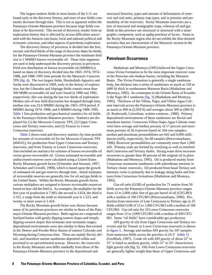
The largest onshore fields in most basins of the U.S. are found early in the discovery history, and sizes of new fields commonly decrease through time. This is not as apparent within the Putumayo-Oriente-Maranon province because large fields continue to be discovered. This record of discovery results from an exploration history that is affected by access difficulties associated with the Amazon rain basin, local and national political and economic concerns, and other aspects of petroleum exploration.
The discovery history of provinces is divided into the first, second, and third thirds of the range of discovery dates for fields; for the Putumayo-Oriente-Maranon province the minimum field size is 1 MMBO known recoverable oil. These time segments are used to help understand the discovery process in provinces. Field size distribution of known recoverable oil (MMBO) is based on dates of discovery divided into the 1963–1974, 1974– 1988, and 1988–1995 time periods for the Mesozoic-Cenozoic TPS (fig. 4). The two largest fields, Shushufindi-Aguarico and Sacha were discovered in 1969, early in the history of exploration, but the Liberador and Ishpingo fields contain more than 300 MMB recoverable oil and were found in 1980 and 1992, respectively; this was during the last two thirds of exploration. Median size of new field discoveries has dropped through time; median size was 23.6 MMBO during the 1963–1974 period, 9 MMBO during 1974–1988, and 6 MMBO during 1988–1995. Table 1 lists production and geochemical statistics for oil fields in the Putumayo-Oriente-Maranon province. Statistics are displayed for (1) the Mesozoic-Cenozoic TPS, (2) Upper Cretaceous and Tertiary reservoirs, and (3) Triassic to Lower Cretaceous reservoirs.
Table 2 shows total and discovery statistics by time periods for amounts of recoverable oil for the Mesozoic-Cenozoic TPS (604101), for production from Upper Cretaceous and Tertiary reservoirs, and from Triassic to Lower Cretaceous reservoirs. Also included are statistics for volumes of known recoverable oil versus grown recoverable oil. Grown estimated recoverable and undiscovered reserves were calculated using a United States Rocky Mountain growth factor (Schmoker and Attanasi, 1997; Schmoker and Crovelli, 1998), which is based upon the growth of estimated oil and gas reserves through time. Initial estimates of recoverable reserves are generally low for oil and gas fields in the United States. Within the Rocky Mountain growth factor, various multipliers are assigned to known recoverable resources based on how old the field is. As examples, the multiplier for the first year of production is 7.903, the second is 3.654, the third is 2.312, a range from the tenth to nineteenth year is 1.523, and twenty or more years is 1.424.
The Rocky Mountain growth factor was chosen because many of its petroleum provinces are similar to those of the Putumayo-Oriente-Maranon province. Both regions are composed of foreland basins with gently dipping eastern slopes and steeply dipping western slopes that terminate near mountain ranges; depositional environments were also similar to those that existed in the Denver and Powder River Basins of eastern Colorado and Wyoming during Cretaceous time. These are mainly fluvial, deltaic, and nearshore marine sandstones deposited within and proximal to an epicontinental seaway. However, the reservoirs in the Rocky Mountain area differ markedly from those of the Putumayo-Oriente-Maranon province in the depositional and
structural histories, types and amount of deformation of reservoir and seal units, primary trap types, and in porosity and permeability of the reservoirs. Rocky Mountain reservoirs are a mix of structural and stratigraphic traps, whereas oil and gas fields in this province are structural or structural with a strati-graphic component, such as updip pinchout of facies. Strata in the Rocky Mountain region also do not exhibit the thin-skinned tectonics that are characteristic of the Mesozoic section in the Putumayo-Oriente-Maranon province.
Petroleum Occurrence
Mathalone and Montoya (1995) believed the Upper Cretaceous Vivian Formation to be the most important reservoir zone of the Peruvian sub-Andean basins, including the Maranon Basin. The Vivian Formation is generally a single sandstone body, but thickens into a series of sandstones as much as 150 m (490 ft) thick in northeastern Maranon Basin (Mathalone and Montoya, 1995). Its counterpart in the Oriente Basin of Ecuador is the Napo M-1 sandstone (fig. 3) (Mathalone and Montoya, 1995). Thickness of the Villeta, Napo, and Villeta-Agua Caliente intervals across the Putumayo-Oriente-Maranon province is as much as 900 m (2,950 ft) and averages about 300 m (984 ft) (S. Rushworth, Consultant, written commun., 1998). Primary depositional environments of these sandstones are fluvial and nearshore marine. Cretaceous Villeta-Napo-Agua Caliente reservoirs have average and median porosity of 17 percent and maxi-mum porosity of 26.4 percent based on 104 core samples; median and maximum permeabilities are 642 and 6,000 millidarcies (mD), respectively, for 68 samples (Petroconsultants, 1996). Reservoir permeabilities are commonly more than 1,000 mD. Primary seals are formed by overlying as well as interbedded Cretaceous and Tertiary shales. Strong water drive increases recoveries to greater than 40 percent of the original oil in place (Mathalone and Montoya, 1995). Oil is produced mainly from Cretaceous nonmarine sandstones with subordinate amounts in Tertiary clastic reservoirs. Oil produced from basal Tertiary sedimentary rocks is primarily due to leakage along faults and fractures from Cretaceous formations (Mathalone and Montoya, 1995).
Gas-oil ratio (GOR) of production for 71 entries from 50 fields across the Putumayo-Oriente-Maranon province ranges from 12 to 2,000 cubic feet of gas per barrel of oil (CFG/BO) with a median of 160 CFG/BO (Petroconsultants, 1996). Production from reservoirs of Late Cretaceous to Tertiary age in 25 fields exhibit GOR of 12 to 1,060 CFG/BO with a median of 160 CFG/BO. Gas-oil ratio for 19 Lower Cretaceous reservoirs ranges from 15 to 2,000 CFG/BO with a median of 450 CFG/ BO. Some “oil fields” have considerable gas production.
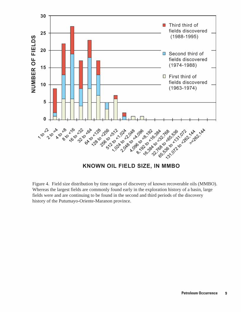
API gravity of oils from Upper Cretaceous and Tertiary reservoirs and for Triassic to Lower Cretaceous reservoirs is shown in figure 5. Average and median API gravity for 347 samples from numerous fields across the province is 24.3° (table 1) (GeoMark, 1997). Crude oil with API gravity of about 22° to 31° is listed as medium gravity, while 31° to 55° characterizes light gravity oils (fig. 5). Oils from Lower Cretaceous reservoirs are generally lighter weight than those of Upper Cretaceous and
8 The Putumayo-Oriente-Maranon Province of Colombia, Ecuador, and Peru
Petroleum Occurrence
128
to <
256
256
to <
512
512
to <
1,02
4
1,02
4 to
<2,
048
2,04
8 to
<4,
096
16,3
84 to
<32
,768
32,7
68 to
<65
,536
65,5
36 to
<13
1,07
2
30
25 N
UM
BE
R O
F F
IEL
DS
20
15
10
5
0
1 to
<2
2 to
<4
4 to
<8
8 to
<16
16 to
<32
32 to
<64
64 to
<12
8
4,09
6 to
<8,
192
8,19
2to
<16
,384
131,
072
to <
262,
144
>=26
2,14
4
KNOWN OIL FIELD SIZE, IN MMBO
Figure 4. Field size distribution by time ranges of discovery of known recoverable oils (MMBO). Whereas the largest fields are commonly found early in the exploration history of a basin, large fields were and are continuing to be found in the second and third periods of the discovery history of the Putumayo-Oriente-Maranon province.
Petroleum Occurrence 9
10 The Putumayo-Oriente-Maranon Province of Colombia, Ecuador, and Peru
Tertiary reservoirs; respective median API gravities are 29° and 21°. This difference may result largely from location in the basin—oil production from Lower Cretaceous reservoirs is largely along the western boundary of the basin, west of the productive areas of Upper Cretaceous and Tertiary reservoirs. Oil gravity commonly increases to the east as water washing and biodegradation of oils becomes more prevalent, although biodegradation of oil near the western boundary of the province can result from influx of water from the west.
The reported percentage of sulfur in produced oil for 222 fields within the Putumayo-Oriente-Maranon province ranges from 0.03 to 3.21 percent, with a median of 0.76 percent (table 1); a subset of this data for 81 fields that contains no duplicate samples has listed median and average sulfur values of 0.61 percent and 0.93 percent, respectively (GeoMark, 1997). Median sulfur value of 32 oils from Lower Cretaceous reservoirs is 0.96 percent and the median value for 77 samples from Upper Cretaceous rocks is about the same (1.0 percent). Low-sulfur oils are characterized as containing 1 percent or less (Tis-sot and Welte, 1984). Sulfur percentages varied somewhat for duplicate samples within oil fields. An example is the San Jacinto field in the Maranon Basin, where six Cretaceous oils ranged from 0.39 to 1.71 percent S. Samples in most oil fields exhibited less variation than this, for example, the Corrientes field of the Maranon Basin, where 15 samples of oils from Cretaceous formations ranged from 0.35 to 0.5 percent S; probable hydrocarbon source rocks were Cretaceous and Permian marine shales.
Source Rocks
Source Rock Characteristics
Pindell and Tabbutt (1995) indicated that the five main Mesozoic-Cenozoic settings for source rock deposition and preservation in Andean foreland basins are:
1. Restricted rift basins with varying access to the sea during times of back-arc extension. Examples include the Triassic and Jurassic Pucara Group and Santiago Formation.
2. Thermally subsiding passive margin sections that developed during periods of slow sediment accumulation and high long-term relative sea level; an example is the Villeta Formation of the Putumayo Basin.
3. Rift structures that cross southern South America, aulacogens of the South Atlantic; an example is the San Jorge Basin of southeastern South America.
4. Tectonically downflexed foredeep basins that formed east of the developing Andes, such as the Putumayo-Oriente-Maranon province. These were periods of long-term, high eustatic sea level, such as during the Peruvian phase of the Andean orogeny. Examples are the Cretaceous Napo and Chonta Formations in the north-central and central Andes.
5. Slow rates of terrigenous sedimentation at various times and places along the Andean fore-arc where relief of emergent sediment source areas was low and where upwelling, currents, and other marine influences contributed to the hydrocarbon potential of the region (Ziegler and others, 1981).
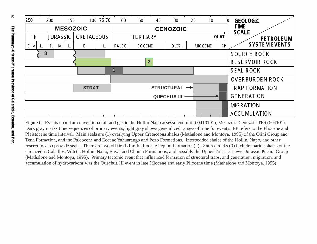
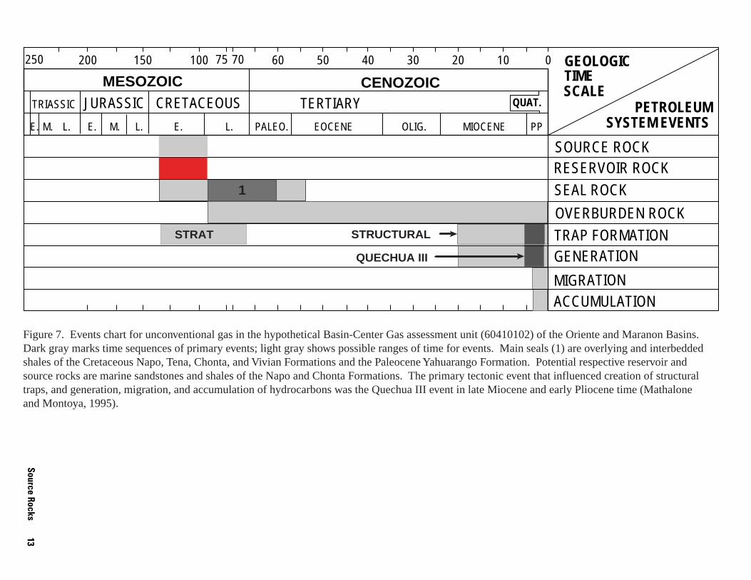
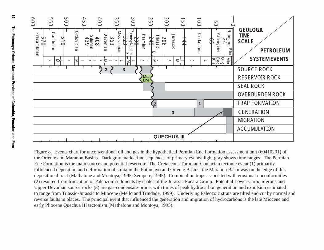
During Cretaceous time tectonic evolution of the sub-Andean region triggered suboxic and anoxic conditions (Fabre, 1985; Mann, 1995). Geochemical data indicate that Upper Cretaceous source rocks account for more than 90 percent of the discovered oil in sub-Andean basins (Mello and Trindade, 1999). The primary oil and gas source rocks in the Putumayo-Oriente-Maranon province (fig. 3) are Cretaceous shales of marine and mixed marine and terrestrial depositional environments. Because of different stratigraphic naming conventions for the Putumayo, Oriente, and Maranon portions of the province, hydrocarbon source rocks are described for the respective basin areas. Events charts (figs. 6 through 8) were prepared to show time intervals of source, reservoir, seal and overburden rocks, trap formation, and generation, migration, and accumulation of hydrocarbons. Illustrations are for the Mesozoic-Cenozoic TPS Hollin-Napo (60410101, fig. 6), and Basin-Center Gas (60410102, fig. 7) assessment units, and for the Paleozoic TPS Permian Ene Formation assessment unit (60410201, fig. 8). The Hollin-Napo assessment unit of the Mesozoic-Cenozoic TPS refers to all production and potential reservoir intervals in this age range across the entire basin. The Permian Ene Formation assessment unit incorporates all potentially productive Paleozoic intervals.
According to Ramon (1996), vertical segregation of Putumayo Basin oils into Lower and Upper Cretaceous formations indicates vertical heterogeneity as indicated by the presence of two separate sets of source rocks, and associated petroleum systems. This observation is based on biomarker fingerprinting of 20 crude oils. Kairuz and others (2000) listed two separate petroleum systems and source rocks for the Villeta Formation of Albian age versus those of ages between the Albian and Coniacian; this work is based on geochemical characteristics of 48 oil samples from 35 wells that produced from the two intervals. They further indicated that crudes of the Villeta-Caballos systems are associated with the Albian to Coniacian carbonate source rocks and that oil and gas from the Villeta-Pepino system are from Albian age marine shales; only the western portion of the Putumayo Basin is thermally mature for hydrocarbon generation. Putumayo Basin reservoirs for the Lower Cretaceous Caballo and Villeta “U” sandstones contain oils derived from a mixed marine and terrestrial source (Ramon, 1996). These sediments were deposited in a marginal “oxic” marine setting. Upper Cretaceous Villeta “T” and “N” sandstones and Tertiary reservoirs contain oils that exhibit marine algal input (Ramon, 1996), which resulted from their being deposited in a carbonate-rich, chemically reducing environment. Probable source rocks are (1) the marginal marine shales of the Lower Cretaceous Caballos Formation, and (2) marginal marine and terrestrial shales of the Villeta “U” Sandstone (Ramon, 1996). The highest total organic carbon (TOC) contents are located in the upper-most black shale intervals of the Caballos Formation (8.8 wt. percent) and middle to upper part of the Hondita Formation (10.95 wt. percent) in the Magdalena Valley; geochemical information indicates that Caballos Formation shales are composed of sediments from a terrigenous source (Mann and Stein, 1997). TOC of the 41 samples ranged as high as 16.67 wt. percent; all but 9 samples contained greater than 3 wt. percent (Mann and Stein, 1997). The presence of oil in basal Tertiary sedimentary rocks is probably due to upward leakage along faults and fracture networks from Cretaceous formations.
Source Rocks 11
12The Putum
ayo-Oriente-M
aranon Province of Colombia, Ecuador, and Peru
MIGRATION ACCUMULATION
TRAP FORMATION
OVERBURDEN ROCK
RESERVOIR ROCK
SEAL ROCK
SOURCE ROCK
PETROLEUM SYSTEM EVENTS
GEOLOGIC TIME SCALE
01020304050607075100150200250
GENERATION
2
STRUCTURALSTRAT
QUECHUA III
1
3
1
MESOZOIC CENOZOIC TR JURASSIC CRETACEOUS TERTIARY QUAT.
E. M. L. E. M. L. E. L. PALEO. EOCENE OLIG. MIOCENE PP
Figure 6. Events chart for conventional oil and gas in the Hollin-Napo assessment unit (60410101), Mesozoic-Cenozoic TPS (604101). Dark gray marks time sequences of primary events; light gray shows generalized ranges of time for events. PP refers to the Pliocene and Pleistocene time interval. Main seals are (1) overlying Upper Cretaceous shales (Mathalone and Montoya, 1995) of the Olini Group and Tena Formation, and the Paleocene and Eocene Yahuarango and Pozo Formations. Interbedded shales of the Hollin, Napo, and other reservoirs also provide seals. There are two oil fields for the Eocene Pepino Formation (2). Source rocks (3) include marine shales of the Cretaceous Caballos, Villeta, Hollin, Napo, Raya, and Chonta Formations, and possibly the Upper Triassic-Lower Jurassic Pucara Group (Mathalone and Montoya, 1995). Primary tectonic event that influenced formation of structural traps, and generation, migration, and accumulation of hydrocarbons was the Quechua III event in late Miocene and early Pliocene time (Mathalone and Montoya, 1995).
MIGRATION ACCUMULATION
TRAP FORMATION
OVERBURDEN ROCK
RESERVOIR ROCK
SEAL ROCK
SOURCE ROCK
PETROLEUM SYSTEM EVENTS
GEOLOGIC TIME SCALE
01020304050607075100150200250
GENERATION
STRUCTURALSTRAT
QUECHUA III
1
MESOZOIC CENOZOIC TRIASSIC JURASSIC CRETACEOUS TERTIARY QUAT.
E. M. L. E. M. L. E. L. PALEO. EOCENE OLIG. MIOCENE PP
Figure 7. Events chart for unconventional gas in the hypothetical Basin-Center Gas assessment unit (60410102) of the Oriente and Maranon Basins. Dark gray marks time sequences of primary events; light gray shows possible ranges of time for events. Main seals (1) are overlying and interbedded shales of the Cretaceous Napo, Tena, Chonta, and Vivian Formations and the Paleocene Yahuarango Formation. Potential respective reservoir and source rocks are marine sandstones and shales of the Napo and Chonta Formations. The primary tectonic event that influenced creation of structural traps, and generation, migration, and accumulation of hydrocarbons was the Quechua III event in late Miocene and early Pliocene time (Mathalone and Montoya, 1995).
Source Rocks 13
14The Putum
ayo-Oriente-M
aranon Province of Colombia, Ecuador, and Peru
0
100
200
300
400
500
600
50
150
250
350
450
550
Paleogene
Cretaceous
Jurassic
Triassic
Perm
ian
65
144
206
248
363
570
510
439
408
Precam
brian
Cam
brian
Ordovician
Silurian
Devonian
290
323
E
M
L
E
E
E
E
E
E
E
E
E
M
M
M
M
M
L L L L L
L
L L L
Mississipian
Pennsylvanian
Neogene
24
Pal
Eoc
Olig
Mio
Plio
TRAP FORMATION
OVERBURDEN ROCK
RESERVOIR ROCK
SEAL ROCK
SOURCE ROCK
PETROLEUM
SYSTEM EVENTS
GEOLOGIC TIME SCALE
GENERATION MIGRATION
ACCUMULATION QUECHUA III
Mitu Ene
12
3
33
Figure 8. Events chart for unconventional oil and gas in the hypothetical Permian Ene Formation assessment unit (60410201) of the Oriente and Maranon Basins. Dark gray marks time sequences of primary events; light gray shows time ranges. The Permian Ene Formation is the main source and potential reservoir. The Cretaceous Turonian-Coniacian tectonic event (1) primarily influenced deposition and deformation of strata in the Putumayo and Oriente Basins; the Maranon Basin was on the edge of this depositional tract (Mathalone and Montoya, 1995; Sempere, 1995). Combination traps associated with erosional unconformities (2) resulted from truncation of Paleozoic sediments by shales of the Jurassic Pucara Group. Potential Lower Carboniferous and Upper Devonian source rocks (3) are gas-condensate-prone, with times of peak hydrocarbon generation and expulsion estimated to range from Triassic-Jurassic to Miocene (Mello and Trindade, 1999). Underlying Paleozoic strata are tilted and cut by normal and reverse faults in places. The principal event that influenced the generation and migration of hydrocarbons is the late Miocene and early Pliocene Quechua III tectonism (Mathalone and Montoya, 1995).
Dashwood and Abbotts (1990) indicated that analyses of oils from the Hollin and Napo reservoirs in the Oriente Basin show one genetic family. Lithology, environmental conditions, and organic matter types of Oriente Basin source rocks were predicted based on oil biomarker characteristics. Organic-rich zones of the Napo Formation have been considered the source of almost all hydrocarbons in the Oriente Basin, although oil-to-source correlation is still poorly documented in the literature (Lozada and others, 1985; Rivadeneira, 1986; Dashwood and Abbotts, 1990).
Shales in the upper part of the Hollin Formation were deposited in open marine environments (White and others, 1995); these mudstones may be a source of hydrocarbons. Organic-rich marine shales of the Napo Formation in the Oriente Basin are believed to be a source of oil and gas (Dashwood and Abbotts, 1990). Based largely on oil-to-source correlation using 13C data, Mathalone and Montoya (1995) have identified five groups of source rocks for the Ucayali, Santiago, Oriente, and Maranon Basins. These are listed as the (1) Ucayali Basin Jurassic and Permian (type III) source rocks; (2) Santiago Basin (type I) oil seeps; (3) Ecuadorian Oriente oils (Cretaceous source rocks), (4) the Maranon Basin (Vivian type I, Cretaceous source in the northwest area near the border with Ecuador and Chonta type I, Cretaceous source in the northwest area); and (5) type II (Permian source). Two families of oils are differentiated in the Maranon Basin and are related to Permian and Cretaceous source rocks (Mathalone and Montoya, 1995). Oils from Cretaceous Napo and Chonta source rocks in the Oriente Basin correlate with Cretaceous oils from the Maranon Basin (Mathalone and Montoya, 1995). Chalco (1999) has stated the belief that the Jurassic-age marine shales are the primary hydrocarbon source rocks of the southern Maranon Basin; his two-dimensional basin modeling paper lies in the area of figure 2. Chalco (1999) also indicated that lowermost Cretaceous source rocks entered the oil window by late Oligocene (30 Ma) time, and Jurassic shales began generating oil from late Albian (97 Ma) to early Oligocene (35 Ma) with peak oil generation at the end of the Cretaceous (65 Ma). He also stated that most of the Jurassic oil (as much as 70 percent) was expelled after the early Eocene (50 Ma) and before the early Miocene (22 Ma).
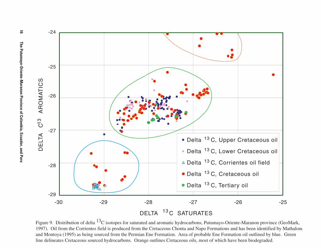
The 13C distribution of saturated and aromatic hydrocarbons from oils across the Putumayo-Oriente-Maranon province is shown in figure 9. Oils are identified using the GeoMark database (through 1997). The blue-circled area on the lower left of figure 9 is Cretaceous-reservoir production that is probably sourced from Paleozoic shales, likely from the Permian Ene Formation (fig. 3). The Paleozoic source area includes multiple oil analyses from the Corrientes, Capirona, and Yanayacu fields. Single oil analyses in this population included the Pavayacu, Phillips, San Juan, and Sun fields. The Capirona and Pavayacu field locations are illustrated on the Maranon Basin cross section (fig. 2); the geologic relations shown suggest that the migration pathways for these fields are along a series of faults that extend to basement.
Most of the analyzed oil, including that from the Tertiary Pepino Formation, is from Cretaceous source rocks, and is grouped within the central population of Cretaceous oils shown in figure 9. The values near the upper right corner of figure 9
are from Cretaceous oils; most of these are single samples for a field, or have commingled production from numerous Lower and Upper Cretaceous formations. San Jacinto field in the Maranon Basin has four values in the upper right hand group for figure 9 and five from the Cretaceous group in the middle of the figure; production is from the Cretaceous Chonta and Vivian Formations. The group near the upper right corner probably represents mixing of oils from both Lower and Upper Cretaceous source rocks, or is more tied to analytical methods, maturation histories, or biodegradation of hydrocarbons. Chonta Formation oils from this field are among the few biodegraded oils from this formation (Mathalone and Montoya, 1995). Although some scatter occurs in the central group (green line in fig. 9) of Cretaceous-sourced oils, there is not enough differentiation to isolate Lower and Upper Cretaceous source rocks. The primary Upper Cretaceous hydrocarbon source rocks are marine shales of the Chonta Formation, northern Maranon Basin, and the Napo Formation of the Oriente Basin, where the average TOC exceeds 3 wt. percent (Mathalone and Montoya, 1995). These formations were deposited in a shelf setting that shoals southward in the Maranon Basin. Marine shales of the Lower Cretaceous Raya Formation are also source rocks (Mathalone and Montoya, 1995).
Rivadeneira (1986) suggested that Lower Jurassic shales located in southern Ecuador and northern Peru may be hydro-carbon source rocks. These are the Triassic and Jurassic Pucara Group and possibly the overlying Jurassic Sarayaquillo Group Formation in the Maranon Basin (fig. 3). The Pucara Group is an important potential oil source rock in the western Maranon and Ucayali Basins (Mathalone and Montoya, 1995). The formation comprises shales, platform carbonates, and organic-rich limestones. Total organic carbon (TOC) contents in the limited number of samples range as much as 5 wt. percent; sapropelic sediments dominate TOC (Mathalone and Montoya, 1995). Pindell and Tabbutt (1995) believed these rocks to be oil-prone source rocks whose deposition probably fits models of rifted basins with marine access and restricted circulation.
Although the Permian Ene Formation does not produce oil or gas in the Putumayo-Oriente-Maranon province, it is a reservoir and shows good oil-to-source correlation in the Ucayali Basin, located south of the province, and in western basins of Peru. Outcrop samples of the Ene Formation in the Ucayali Basin exhibit moderate to high levels of TOC and hydrogen indices (Carpenter and Berumen, 1999). In the Maranon Basin the formation is mature to overmature for oil generation, based on thermal maturation data (Mathalone and Montoya, 1995). However, the Paleozoic section in the province is mostly undrilled. Some potential exists for discoveries within the Permian Ene Formation or other units of the Mitu Group in the southern portion of the province. The Triassic salt (fig. 2) is a potential seal and may have contributed to possible hydrocarbon accumulation in structural traps; stratigraphic and combination traps may also occur. Evaporitic shales in the Ene Formation are the probable hydrocarbon source rocks for a family of crude oils from Cretaceous reservoirs in the southern part of the Maranon Basin according to Mathalone and Montoya (1995), whose work, particularly in the Corrientes field, is based on geochemical differences among oils across the basin.
Source Rocks 15
16•The Putum
ayo-Oriente-M
aranon Province of Colombia, Ecuador, and Peru
-24�
-25
-26
13
C
AR
OM
AT
ICS
�
-27�
DE
LTA
�
-28
-29
-30 -29 -28 -27 -26 -25�
DELTA 13 C SATURATES�
Figure 9. Distribution of delta 13C isotopes for saturated and aromatic hydrocarbons, Putumayo-Oriente-Maranon province (GeoMark, 1997). Oil from the Corrientes field is produced from the Cretaceous Chonta and Napo Formations and has been identified by Mathalone and Montoya (1995) as being sourced from the Permian Ene Formation. Area of probable Ene Formation oil outlined by blue. Green line delineates Cretaceous sourced hydrocarbons. Orange outlines Cretaceous oils, most of which have been biodegraded.
Delta , Upper Cretaceous oil
Delta , Lower Cretaceous oil
Delta , Corrientes oil field
Delta , Cretaceous oil
Delta , Ter tiary oil
13
13
13
13
13
C
C
C
C
C
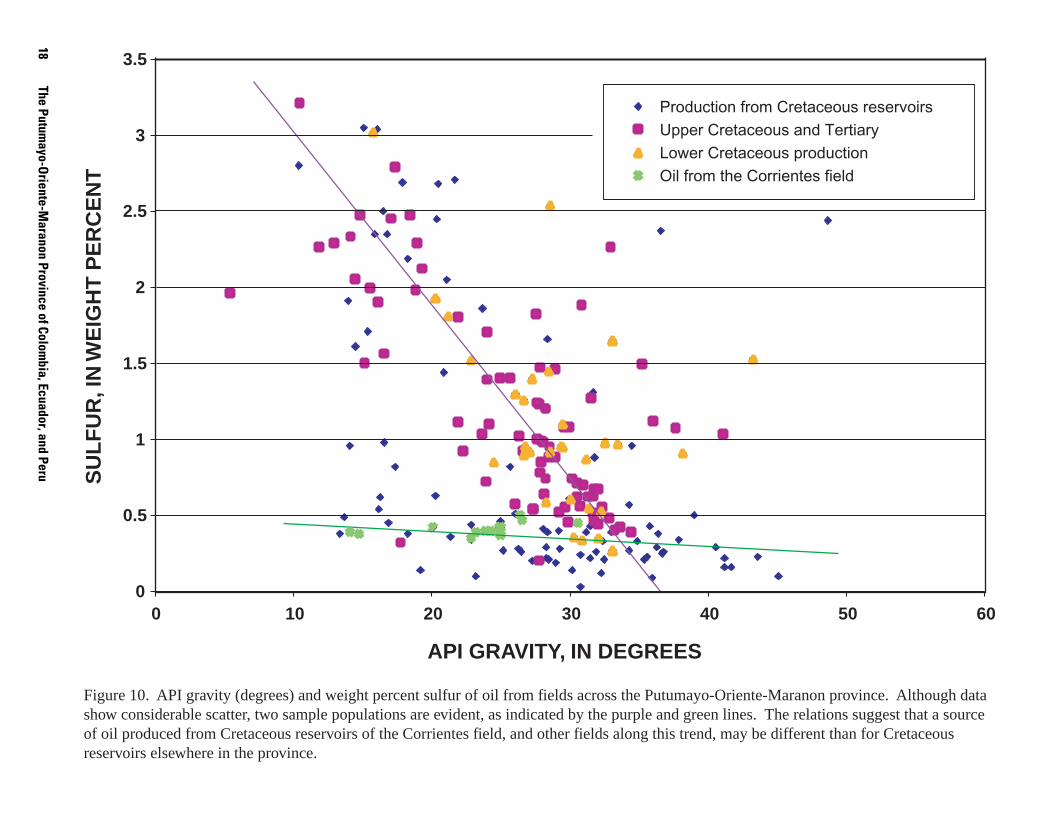
Figure 10 shows weight percent sulfur versus API gravity of oils for fields across the Putumayo-Oriente-Maranon province (Geo-Mark, 1997). Although scatter in data is considerable, two sample populations suggest two different sources of oil in the reservoirs. Mathalone and Montoya (1995) indicated that samples from the Corrientes field (fig. 10) may include oil from Ene Formation source rocks. Percent sulfur and API gravity of oils are also influenced by migration history, biodegradation, evaporation of oils, and other geologic and geochemical factors. Thickness of the Ene Formation is as much as 600 m (2,000 ft) of organic-rich shales and dolomites with minor sandstones. Out-crops of the formation are as much as 300 m (1,000 ft) thick, and the shales contain an average TOC of 2–3 wt. percent; kerogen types II and I predominate (Mathalone and Montoya, 1995). Other fields for which numerous geochemical analyses are avail-able are located within this “Ene” trend, including the Yanayacu and Capirona fields (GeoMark, 1997). Fields that are along this zone of low percent sulfur are the Bretana, Dorrisa, Huayuri, Huayuri Sur, Sun, Tetete, and Valencia. These are all distributed along the northwesterly trend of fields in the western part of the Maranon Basin (fig. 1).
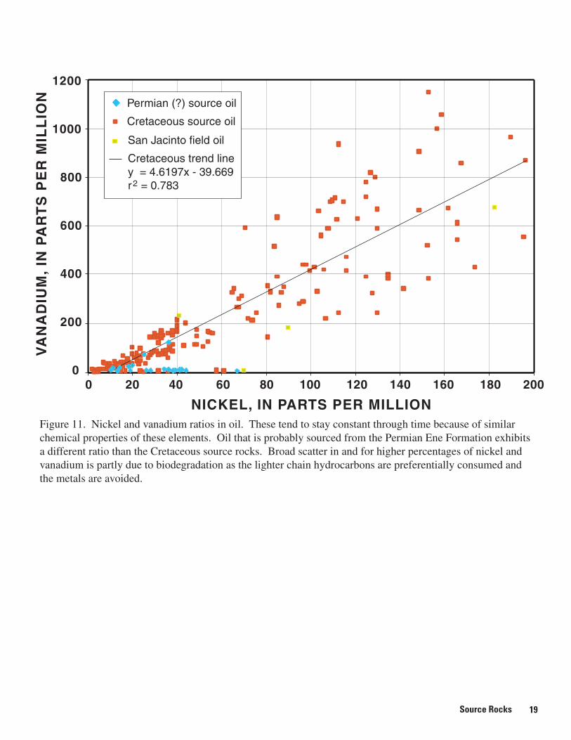
Figure 11 shows the ratio of nickel to vanadium in oils across the Putumayo-Oriente-Maranon province. Because nickel and vanadium atoms exhibit similar chemical properties, their ratio is relatively stable through time. The area of greater amounts of these elements (and associated broader scatter of control points) may result mainly from biodegradation, migration history, and other factors that remove lighter chain hydro-carbons and tend to concentrate metallic elements. Cretaceous oils in some fields, such as the San Jacinto field in the Maranon Basin, show widely different amounts of nickel and vanadium that are associated with varying degrees of biodegradation (fig. 11). Average is 57.2 parts per million (ppm) nickel and 216 ppm vanadium for all 208 samples across the province (GeoMark, 1997). Twenty-four oil samples from possible Ene Formation source rocks (fig. 9) have average values of 41.1 ppm nickel and 62.7 ppm vanadium (fig. 11). The generally lower ratio of vanadium relative to nickel for these fields suggests that the oil had a different hydrocarbon source rock than for the Cretaceous reservoirs across most of the province. Less scatter in this smaller subset of data also indicates less biodegradation. All of the geochemical samples are from the Maranon Basin and are from reservoir intervals identified as Cretaceous (GeoMark, 1997). Because some of these fields are large (Corrientes has more than 150 MMBO produced (Mathalone and Montoya, 1995)), the Permian Ene Formation may be a significant source of hydrocarbons in this basin. Paleozoic rocks in the Putumayo and Oriente Basins may also be an adequate source of hydrocarbons, but little geochemical and other subsurface information exists with which to evaluate this potential or to define their subsurface distribution. Cretaceous formations in these basins directly overlie Precambrian rocks in a north-trending band that is proximal to and east of the eastern boundary of oil production (Balkwill and others, 1995). Sub-surface distribution of Paleozoic strata is also variable in the Maranon Basin, as is illustrated in figure 2.
The Devonian Cabanillas and Carboniferous Ambo Formations (fig. 3) are thermally mature to overmature for oil
generation in the Ucayali Basin (fig. 1) and in the Ene Basin to the south (Mathalone and Montoya, 1995). Mello and Trindade (1999) stated their belief that an Upper Devonian marine epicontinental oil system is widespread around sub-Andean basins of Argentina, Bolivia, and Peru, although its oil and gas potential and reserves are considered to be insignificant, accounting for no more than 2 percent of the discovered oil in place along the entire sub-Andean trend. Thermal modeling of potential Upper Devonian source rocks, based on burial history and vitrinite reflectance analyses, indicates that these shales are gas-condensate-prone, with times of peak oil generation and expulsion ranging from Jurassic-Triassic to Miocene (Mello and Trindade, 1999). The sub-Andean orogeny (late Miocene), followed by uplift and erosion, caused biodegradation, reservoir leaking, oil remobilization, and destruction of preexisting oil accumulations; subsequent overthrust structural movements caused secondary oil and gas cracking in most areas of the Upper Devonian petroleum systems, enhancing their gas-condensate hydrocarbon potential (Mello and Trindade, 1999).
Organic-rich shales of the Ordovician Contaya Formation in the Maranon Basin (fig. 3) are thermally overmature and unlikely to contribute substantially to the hydrocarbon system (Soto and Vargas, 1985). However, analyses were run on only a few wells within the areas of thermally mature Cretaceous source rocks. The level of thermal maturation probably decreases east of the basin margin. Devonian shales of the Cabanillas Formation (fig. 3) are thin and preserved as small remnants in the Maranon and North Ucayali Basins (Mathalone and Montoya, 1995). Because they are thin in these areas, they would probably not be adequate source or reservoir rocks. Again, thickness and areal distribution of these Devonian shales across the province are poorly known.
Migration History
The green lines with double ticks on figure 1 outline the areas of the Putumayo-Oriente-Maranon province that are thermally mature for oil (outer line) and for gas (inner line) generation from Cretaceous source rocks, and locations of producing oil fields. Depth to the top of the oil-generation window for these source rocks in the Maranon Basin and the Ucayali Basin to the south varies from 2,000 to 3,300 m (6,600 to 11,000 ft); variation is attributed partly to the pat-tern of connate water convection from the basin depocenter in the west (Mathalone and Montoya, 1995). Almost all of the current production in the Putumayo-Oriente-Maranon province is from the zone of thermally mature source rocks, suggesting that migration is primarily vertical, with only limited lateral migration. Ramon (1996) believed that oil migration in the Putumayo Basin has also primarily been stratigraphically updip, with only limited vertical migration through faults; each reservoir interval in a field is laterally drained and vertically compartmentalized. This interpretation is based on differences in oil geochemistry, but such data are sparse because exploration is limited outside this area due to access problems, decrease in oil quality to the east (decrease in API gravity due to water washing and biodegradation), and the fact that large structural traps across the province are concentrated
Source Rocks 17
18 3.5
3
2.5
2
1.5
1
0.5
0 0 10 20 30 40 50 60
Production from Cretaceous reservoirs Upper Cretaceous and Tertiary Lower Cretaceous production Oil from the Corrientes field
API GRAVITY, IN DEGREES
Figure 10. API gravity (degrees) and weight percent sulfur of oil from fields across the Putumayo-Oriente-Maranon province. Although data show considerable scatter, two sample populations are evident, as indicated by the purple and green lines. The relations suggest that a source of oil produced from Cretaceous reservoirs of the Corrientes field, and other fields along this trend, may be different than for Cretaceous reservoirs elsewhere in the province.
The Putumayo-O
riente-Maranon Province of Colom
bia, Ecuador, and Peru SU
LF
UR
, IN
WE
IGH
T P
ER
CE
NT
1200
1000
800
600
400
200
0 0 20 40 60 80 100 120 140 160 180 200
Cretaceous trend line y r
Cretaceous source oil
Permian (?) source oil
2
San Jacinto field oil
= 4.6197x - 39.669 = 0.783
NICKEL, IN PARTS PER MILLION Figure 11. Nickel and vanadium ratios in oil. These tend to stay constant through time because of similar chemical properties of these elements. Oil that is probably sourced from the Permian Ene Formation exhibits a different ratio than the Cretaceous source rocks. Broad scatter in and for higher percentages of nickel and vanadium is partly due to biodegradation as the lighter chain hydrocarbons are preferentially consumed and the metals are avoided.
VA
NA
DIU
M,
IN P
AR
TS
PE
R M
ILL
ION
Source Rocks 19
closer to the Andes Mountains. The potential for eastward migration of hydrocarbons along fluvial systems of the Napo Formation may exist, but the previously mentioned factors would probably limit field size and oil quality, and primary traps may not be structural but rather stratigraphic or a combination of stratigraphic and structural.
Tectonic events that the mark the beginning of the Cretaceous, and again in late Miocene through Pliocene (Quechua III) time reflect changes in plate convergence and stress fields (Math-alone and Montoya, 1995). Although indications are strong since Mesozoic time for movement of Triassic salt and for basin inversion, the main episode of folding and thrusting was late Miocene to Pliocene; this is supported by apatite fission track analysis (AFTA) and modern seismic data (Marksteiner and Ale-man, 1996). A thick sedimentary wedge of the Upper Cretaceous Tena Formation east of the Napo and Cutucu uplifts (fig. 1), which are located near the western and southwestern border of the Oriente Basin, documents Late Cretaceous and Paleocene deformation (Peruvian Andean Phase); AFTA data in the western Putumayo Basin, Napo uplift, and Cutucu uplift document a middle Eocene uplift (Incaic Phase) followed by a late Miocene and Pliocene renewal of uplift (Marksteiner and Aleman, 1996). Previous depocenters were inverted and the Andean fold and thrust belt encroached to the east; this late Tertiary deformation created many of the structural traps and led to source rock maturation and associated hydrocarbon generation and migration (Mathalone and Montoya, 1995).
Across South America source rock units as old as Ordovician and as young as Neogene (Miocene and Pliocene) have become mature in the Neogene phase(s) of basin development (Pindell and Tabbutt, 1995). Kairuz and others (2000) used geochemical modeling to assign Miocene time (5–10 Ma) as the onset of oil generation in the Putumayo Basin. Marksteiner and Aleman (1996) believed the main phase of hydro-carbon generation and migration was from Late Cretaceous to middle Eocene time. Although several structures are present that show Mesozoic thinning against the Triassic salt, the major episodes of salt withdrawal took place during the Tertiary (Marksteiner and Aleman, 1996). Dashwood and Abbotts (1990) indicated that much of the oil discovered in the Maranon and Oriente Basins was generated from the western mar-gins of the basins, before the onset of Miocene deformation of the Eastern Cordillera. Estimated onset of oil generation was 8 Ma for the base of the Napo Formation in the south-central Oriente Basin, based on a reconstruction of the burial history from data obtained in the Bobonaza-1 well (Dashwood and Abbotts, 1990). By extrapolation to the deepest part of the present-day basin, onset of oil generation was about 11–8 Ma; oil generation and migration did not begin until middle Miocene time (Dashwood and Abbotts, 1990) (fig. 6).
Water salinity and gas-oil-ratio data for Hollin and Napo “T,” “U,” and “M-1” (fig. 3) reservoirs show that various processes have affected hydrocarbon migration into and distribution in reservoirs of the Oriente Basin (Dashwood and Abbotts, 1990), and probably also influenced hydrocarbon generation, migration, and trapping in the Putumayo and Maranon portions
and includes the Quechua III and other events. Dashwood and Abbotts (1990) listed these processes as:
1. Pre-Miocene (early Andean) time involved lateral migration of oil from the west (perhaps as much as 300 km).
2. Pre-Miocene fresh water influx from the west caused water washing and biodegradation of trapped and migrating oils.
3. Some reservoirs currently have active water drive. 4. Fresh water influx during the late Andean resulted in water
washing and biodegradation of oil in shallower reservoirs. 5. Late Andean basin subsidence in the southwest caused
local re-migration and late-stage generation of hydrocarbons.
6. Late Andean structural movement involved breaching of oil-bearing traps.
7. Increased structural and (or) stratigraphic relief on some traps helped preserve unaltered oils.
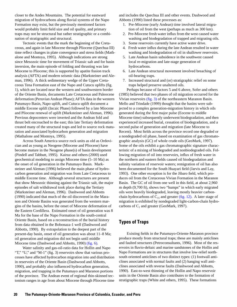
Perhaps because of factors 5 and 6 above, Sofer and others (1985) believed that two phases of oil migration occurred for the Vivian reservoirs (fig. 3) of the northeastern Maranon Basin. Mello and Trindade (1999) thought that the basins were subjected to a complex generation-migration history in which oils generated during the first major pulse (Eocene to middle Miocene time) subsequently underwent biodegradation, and then experienced increased burial, cessation of biodegradation, and a second pulse of generation and migration (late Miocene to Recent). Most fields across the province record one degraded or a nondegraded oil phase, based on examination of gas chromatographic analysis (GC) of whole crude oils (GeoMark, 1997). Some of the oils exhibit a gas chromatographic signature characteristic of a mixing of biodegraded and nonbiodegraded oils. Following migration of oil into reservoirs, influx of fresh water in the northern and eastern fields caused oil biodegradation and salinity variation of reservoir waters; remigration of oil has also been documented for the South Huayari field (Jarvis and Lay, 1993). One other exception is for the Jibaro field, which produces oil from the Cretaceous Vivian Formation in the Maranon Basin. The GC of oil from one well in this field, at about 2,960 m depth (9,700 ft), shows two “humps” in which early migrated oils were heavily biodegraded, leaving mostly heavier carbon-chain hydrocarbons of C15 and greater (fig. 12). A later stage of migration is exhibited by nondegraded light-carbon-chain hydro-carbons of C1 and greater (GeoMark, 1997).
Types of Traps
Existing fields in the Putumayo-Oriente-Maranon province produce mostly from structural traps; these are mainly anticlines and faulted structures (Petroconsultants, 1996). Most of the reservoirs in fluvio-deltaic and marine sandstones of the Hollin and Napo Formations are in structures that involve low-relief north-south oriented anticlines of two distinct types: (1) footwall anti-clines associated with normal faults and (2) hanging wall anti-clines associated with reverse faults (Dashwood and Abbotts, 1990). East-to-west thinning of the Hollin and Napo reservoir
of the province. The Andean event of regional thin-skinned tec units in the Oriente Basin also contributes to the formation of-tonism ranges in age from about Miocene through Pliocene time stratigraphic traps (White and others, 1995). These formations
20 The Putumayo-Oriente-Maranon Province of Colombia, Ecuador, and Peru
TYPES OF TRAPS
RE
SP
ON
SE
20000
17500
15000
12500
10000
7500
5000
2500
0 5 10 15 20 25 30 35 min
FID1 A,
C15+
(GPR_001.D)
fraction
CARBON NUMBER
Figure 12. Whole crude gas chromatograph of oil from the Cretaceous Vivian Formation in the Jibaro field, Maranon Basin (GeoMark, 1997; image used with verbal permission from Steven Brown of GeoMark, on May 26, 1999). The hydrocarbon fraction to the right of C15 is highly biodegraded. A later phase of migration is indicated by presence of nonbiodegraded C1 to C15 hydrocarbons.
Types of Traps 21
originated as mostly eastward sourced fluvial and deltaic sediments that prograded westward along with deposition of marine shoreline and shelf mudstones and sandstones. Primary strati-graphic traps are formed by termination of porous and permeable fluvial or marine sandstone facies against lower energy mudstone and mudstone-sandstone depositional sequences. Handford and Kairuz (2000) categorized sequence boundaries for the Villeta and Caballos Formations in the Putumayo Basin; they indicated that “potentially large stratigraphic traps” may occur as a result of onlap and pinchout of porous sandstones and limestones against marine shales.
Basin-Center Gas reservoir trap types (60410102) are commonly a combination of stratigraphic and structural. D.K. Higley, D.O. Cox, and R.J. Weimer have evaluated the reservoir geologic and engineering properties of the Wattenberg basin-center gas field, Denver Basin, Colorado, U.S.A.; the following characteristics of basin-center gas fields are largely a result of this research and its application as an analog to similar foreland basins, such as the Putumayo-Oriente-Maranon province. Basin-center gas fields occur on flanks or in lows of basins as opposed to structural highs. Typically, there is no gas-water con-tact, and reservoir intervals are low-permeability and normal to underpressured. The major traps and seals are formed by inter-bedded and (or) overlying low-permeability mudstones or salts, pinch-out of reservoir intervals against “tight” sandstones or shales, facies change such as offshore marine sandstone bars that are isolated by marine shales, and fault offset of reservoir intervals with truncation against permeability barriers.
If Paleozoic reservoirs are present, the primary trap types are probably structural or a combination of stratigraphy and structure. Structural traps would most likely be either truncation and offset by faults of reservoir intervals, or possible pinch-outs of sandstone (or dolomite beds?) against salt flow structures of Paleozoic evaporite zones or against the overlying Triassic salt. Stratigraphic traps would probably be facies changes from sand-stone to a less permeable facies. The Paleozoic succession beneath most Andean basins is largely undeformed by the Tertiary Quechua III and other thin-skinned tectonic events. The dominant structural style of the eastern ramp of the Maranon Basin is reactivated and inverted normal faults of Paleozoic age (Mathalone and Montoya, 1995). A post-Permian hiatus resulted from pre-rift uplift and erosion during a Middle Jurassic tectonic event (Dashwood and Abbotts, 1990). Nondeposition and erosion during this and other tectonic events resulted in a highly variable distribution and thickness of Paleozoic strata across the Putumayo-Oriente-Maranon province. Cretaceous formations overlie Precambrian basement rocks over much of the east half of the Oriente Basin (Baldock, 1982; Rosania and Morales, 1986; Balkwill and others, 1995).
Reservoir Rocks
Figure 1 includes the generalized distribution of assessment units for the Mesozoic-Cenozoic TPS (60410101 and 60410102). Subsurface extent of potential reservoir formations is derived from sources that include Balkwill and others (1995), Mathalone and Montoya (1995), Pindell and Tabbutt (1995), and Petroconsultants (1996). Intervals of reservoir and source
rocks for all petroleum systems are shown on the stratigraphic column (fig. 3). Maximum extent of the Napo-Hollin assessment unit (60410101) is an approximation of the subsurface distribution of Cretaceous and Tertiary formations based on the references just named. Minimum extent of this assessment unit (fig. 1) incorporates both the 0.6 percent mean random vitrinite reflectance (Ro) contour, as the area of hydrocarbon source rocks that are thermally mature for oil generation (Mathalone and Montoya, 1995), and the areal limit of petroleum production across the province. Some oil and gas potential exists east of this boundary, particularly along approximately east-west-trending fluvial systems of the Napo Formation. However, water washing and biodegradation could adversely affect resources in the eastern part of the province; biodegradation of oil increases near the eastern and western margins of current production. Probably the greatest potential for new fields within the Mesozoic-Cenozoic TPS is along the northwest-southeast trend of current oil and gas production, inasmuch as many relatively unexplored and inaccessible areas lie between the fields, and the focus of exploration has been on finding large fields associated with structural traps.
The boundary of the Basin-Center Gas hypothetical assessment unit (60410102) was determined using the 1.0 percent Ro
contour for Lower Cretaceous source rocks (Mathalone and Montoya, 1995). This is the inferred lower limit for the generation and migration of thermogenic gas from the types II and III source rocks that are present within this petroleum system. Greatest potential for gas production from the hypothetical Basin-Center Gas assessment unit is centered within this portion of the southwestern Oriente and northwestern Maranon Basins. The most favorable reservoir facies would be low-permeability nearshore marine sandstones of the Napo, Chonta, and Agua Caliente Formations. Some potential exists within shoreface, deltaic, and fluvial sandstones where faulting, erosional truncation, or diagenetic cementation isolates these facies. This has the effect of slowing migration of gas out of the generative basin.
Maximum and minimum extents of the Napo-Hollin assessment unit (60410101) (fig. 1) are also used to delineate the hypothetical Paleozoic TPS (604102). The subsurface distribution of Paleozoic rocks across the basin is highly variable because of complex faulting and folding and erosion prior to deposition of Mesozoic rocks, as is indicated in figure 2. Greatest potential for hydrocarbon production from Paleozoic rocks is in sandstones of the Permian Ene Formation in the Maranon Basin. As discussed in the section on source rocks, several fields in this area produce oil from Cretaceous reservoirs that is typed as being generated by Ene Formation source rocks. Information is currently insufficient to determine whether the Ene Formation in this basin has suitable reservoirs, as it does in the Ucayali Basin to the south.
Oil and gas in the Putumayo-Oriente-Maranon province are produced primarily from Cretaceous sandstones of shallow marine origin. The depositional environments include deltaic, shelf, shoreline, and transitional marine-nonmarine settings. Petroconsultants (1996) reported depositional environments for about 360 reservoir intervals in the province. Of these, about 25 percent are from terrestrial, mostly fluvial environments; the remainder is from shallow marine, nearshore marine, and deltaic environments. Thirty-seven of the 172 fields listed by
22 The Putumayo-Oriente-Maranon Province of Colombia, Ecuador, and Peru
Petroconsultants (1996) produce from fluvial depositional environments. Reservoir facies across the province are predominately sandstone, including glauconitic, argillaceous, carbonaceous, and quartzose sandstones, with several fields producing from Napo A, B, and M2 limestones (Petroconsultants, 1996).
The primary reservoir rocks in the Putumayo Basin are the Lower Cretaceous (Aptian and Albian) Caballos Formation, and the unconformably overlying Lower and Upper Cretaceous (Albian to Campanian) Villeta Formation (Ramon, 1996). Oil is also produced from the Eocene Pepino Formation. The Caballos Formation in the Putumayo Basin is primarily characterized by braided stream to deltaic strata (Ramon, 1996). Fourteen fields produce oil from the Caballos Formation. The unconformably overlying Villeta Formation is mainly shale, limestone, and sandstone deposited in shallow marine settings within a shallow shelf environment (Ramon, 1996). Twenty-six fields produce oil from the Villeta “U,” “T,” and “N” sandstones (Petroconsultants, 1996). Most of these fields record commingled oil production from both formations. The Vivian Formation in the northeastern Maranon Basin is productive in 26 fields. The formation exhibits variable depositional environments across the region and is mostly fluvial. Its counterpart in the Oriente Basin of Ecuador is the Napo M-1 sandstone (Mathalone and Montoya, 1995).
The axis of the Oriente Basin in Ecuador plunges from north to south toward a depocenter in northernmost Peru that contains in excess of 5,000 m (16,000 ft) of Cretaceous and Tertiary sedimentary rocks (Dashwood and Abbotts, 1990). Oriente Basin production is mainly from the Napo U and T sand-stones, and the underlying Hollin Formation. About 25 fields produce oil from mostly fluvial sandstones of the Maastrichtian Tena Formation (Petroconsultants, 1996). The Cretaceous Hollin-Napo interval is as much as 500 m (1,600 ft) thick and consists of continental and marine sandstones, shales, and carbonates. The east-southeast-oriented Aguarico and Cononaco arches in the eastern basin (fig. 1) both provided sources of sediments and localized the approximately east-west-trending fluvial systems of the Hollin and Napo Formations (White and others, 1995). The lower Albian part of the Hollin Formation consists largely of stacked crossbedded sandstone, and thinner intervals of interbedded mudstone and sandstone. The upper part of this braidplain sequence forms the main oil reservoirs in the western Oriente Basin (White and others, 1995). Primary depositional environments of Hollin Formation reservoirs are fluvial, shore-line, and shallow marine (Petroconsultants, 1996).
Shoreline position for Cretaceous sediments is toward the western margin of the Putumayo-Oriente-Maranon province. Both the Hollin and Napo Formations comprise successions of eastward-sourced fluvial and deltaic sedimentary deposits that prograded westward into shoreline and marine shelf para-sequences. East to west thinning of these reservoir units contributes to the possible formation of stratigraphic traps. The eastern part of the Lower and Upper Cretaceous Napo succession in the Oriente Basin contains southwest-thinning and southwest-fining stacked wedges of quartz arenites and subarkoses. These are informally named the Napo T, U, and M1 sandstones and the M2 limestone (fig. 3). Sandstones are separated by shales and lime-stone beds (Balkwill and others, 1995). Thickness of the Hollin Formation ranges from zero along the eastern Oriente Basin
margin to nearly 200 m (650 ft) near the western boundary of the basin (White and others, 1995). The Hollin reservoirs are dominantly alluvial plain sandstones that occupy much of the Oriente Basin. Facies in the uppermost part of the Hollin in the western Oriente grade vertically into open marine strata with isolated tidal- and storm-influenced sandstone beds. The overlying Napo Formation is also predominately sand rich strata of fluvial and deltaic origin in the eastern Oriente, and this sequence abruptly changes to marine shales and limestones and lowstand valley-fill sandstones in the western part of the basin (White and others, 1995). Depositional environments of more than 160 entries in the Petroconsultants database (1996) list Napo reservoir facies as deltaic (8 percent), fluvial (24 percent), and nearshore and shallow marine (68 percent).
The Hollin Formation in the Villano field, Oriente Basin, produces from transgressive deposits within an anticlinal trap; estimated original oil in place (OOIP) is more than 650 MMBO (Jordan and others, 1997). The informally named main Hollin is the primary reservoir. Jordan and others (1997) indicated that gross sandstone thickness in the field is nearly 150 m (500 feet) and consists of fine- to coarse-grained, crossbedded quartzarenite to subarkosic sandstones. Excellent porosity (20 percent), permeability (greater than 1 darcy), and low water saturation of 5 percent results from an abundance of intergranular pores and a lack of clays. Sandstones in the lower part of the main Hollin were deposited by braided streams that traversed incised valleys of the Chapiza Formation. The upper part of the main Hollin was deposited in point bars of a sandy meandering river. Estimated noneroded thicknesses of individual point bars are 15 to 20 m (50 to 65 feet). Jordan and others (1997) interpreted poorer reservoir quality sandstones and siltstones in the upper part of the Hollin Formation to have originated as crevasse splay, levee, and chute-fill deposits.
The Triassic and Lower Jurassic Santiago Formation in Ecuador has been recognized only in the Santiago River area (in the Cutucu uplift of the Andean Foothill Belt (fig. 1)), and possibly in the Sacha Profundo-1 well (Rivadeneira, 1986). The Santiago Formation comprises transgressive marine, thinly bedded carbonates, and black bituminous shales that are overlain by a regressive sandstone-siltstone sequence. Total formation thickness in the Oriente Basin may exceed 250 m (820 ft) (Dashwood and Abbotts, 1990).
Uppermost Silurian and Lower Devonian strata are the oldest that have been drilled in the Oriente Basin; these deformed and mildly metamorphosed limestones, slates, and slaty shales and sandstones of the Pumbuiza Formation (Dashwood and Abbotts, 1990) have no apparent reservoir or source rock potential. This unit is overlain by as much as 750 m (2,500 ft) of thinly bedded carbonates and shales of the Macuma Formation; these strata, of Pennsylvanian to latest Permian in age, were deposited in a shallow marine carbonate shelf over an extensive area (Dashwood and Abbotts, 1990).
Oil and gas production from the Maranon Basin is largely from sandstones of the Cretaceous Cushabatay, Agua Caliente, Chonta, and Vivian Formations. Chonta Formation sandstones were deposited in shelf settings and are represented by strand plain and barrier island environments (Jarvis and Lay, 1993). The Peruvian phase of the Andean orogeny ended marine deposition in the basin as indicated by deposition of the Upper
Reservoir Rocks 23
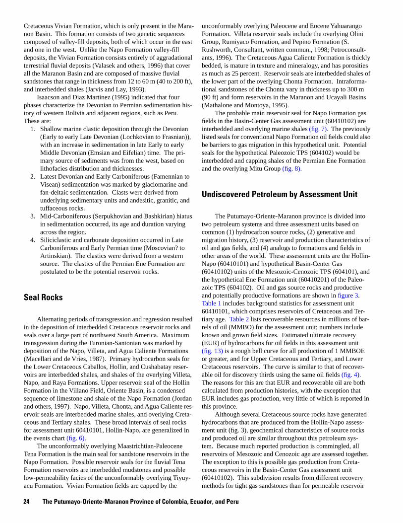
Cretaceous Vivian Formation, which is only present in the Maranon Basin. This formation consists of two genetic sequences composed of valley-fill deposits, both of which occur in the east and one in the west. Unlike the Napo Formation valley-fill deposits, the Vivian Formation consists entirely of aggradational terrestrial fluvial deposits (Valasek and others, 1996) that cover all the Maranon Basin and are composed of massive fluvial sandstones that range in thickness from 12 to 60 m (40 to 200 ft), and interbedded shales (Jarvis and Lay, 1993).
Isaacson and Diaz Martinez (1995) indicated that four phases characterize the Devonian to Permian sedimentation his-tory of western Bolivia and adjacent regions, such as Peru. These are:
1. Shallow marine clastic deposition through the Devonian (Early to early Late Devonian (Lochkovian to Frasnian)), with an increase in sedimentation in late Early to early Middle Devonian (Emsian and Eifelian) time. The primary source of sediments was from the west, based on lithofacies distribution and thicknesses.
2. Latest Devonian and Early Carboniferous (Famennian to Visean) sedimentation was marked by glaciomarine and fan-deltaic sedimentation. Clasts were derived from underlying sedimentary units and andesitic, granitic, and tuffaceous rocks.
3. Mid-Carboniferous (Serpukhovian and Bashkirian) hiatus in sedimentation occurred, its age and duration varying across the region.
4. Siliciclastic and carbonate deposition occurred in Late Carboniferous and Early Permian time (Moscovian? to Artinskian). The clastics were derived from a western source. The clastics of the Permian Ene Formation are postulated to be the potential reservoir rocks.
Seal Rocks
Alternating periods of transgression and regression resulted in the deposition of interbedded Cretaceous reservoir rocks and seals over a large part of northwest South America. Maximum transgression during the Turonian-Santonian was marked by deposition of the Napo, Villeta, and Agua Caliente Formations (Macellari and de Vries, 1987). Primary hydrocarbon seals for the Lower Cretaceous Caballos, Hollin, and Cushabatay reservoirs are interbedded shales, and shales of the overlying Villeta, Napo, and Raya Formations. Upper reservoir seal of the Hollin Formation in the Villano Field, Oriente Basin, is a condensed sequence of limestone and shale of the Napo Formation (Jordan and others, 1997). Napo, Villeta, Chonta, and Agua Caliente reservoir seals are interbedded marine shales, and overlying Cretaceous and Tertiary shales. These broad intervals of seal rocks for assessment unit 60410101, Hollin-Napo, are generalized in the events chart (fig. 6).
The unconformably overlying Maastrichtian-Paleocene Tena Formation is the main seal for sandstone reservoirs in the Napo Formation. Possible reservoir seals for the fluvial Tena Formation reservoirs are interbedded mudstones and possible low-permeability facies of the unconformably overlying Tiyuyacu Formation. Vivian Formation fields are capped by the
unconformably overlying Paleocene and Eocene Yahuarango Formation. Villeta reservoir seals include the overlying Olini Group, Rumiyaco Formation, and Pepino Formation (S. Rushworth, Consultant, written commun., 1998; Petroconsultants, 1996). The Cretaceous Agua Caliente Formation is thickly bedded, is mature in texture and mineralogy, and has porosities as much as 25 percent. Reservoir seals are interbedded shales of the lower part of the overlying Chonta Formation. Intraformational sandstones of the Chonta vary in thickness up to 300 m (90 ft) and form reservoirs in the Maranon and Ucayali Basins (Mathalone and Montoya, 1995).
The probable main reservoir seal for Napo Formation gas fields in the Basin-Center Gas assessment unit (60410102) are interbedded and overlying marine shales (fig. 7). The previously listed seals for conventional Napo Formation oil fields could also be barriers to gas migration in this hypothetical unit. Potential seals for the hypothetical Paleozoic TPS (604102) would be interbedded and capping shales of the Permian Ene Formation and the overlying Mitu Group (fig. 8).
Undiscovered Petroleum by Assessment Unit
The Putumayo-Oriente-Maranon province is divided into two petroleum systems and three assessment units based on common (1) hydrocarbon source rocks, (2) generative and migration history, (3) reservoir and production characteristics of oil and gas fields, and (4) analogs to formations and fields in other areas of the world. These assessment units are the Hollin-Napo (60410101) and hypothetical Basin-Center Gas (60410102) units of the Mesozoic-Cenozoic TPS (604101), and the hypothetical Ene Formation unit (60410201) of the Paleozoic TPS (604102). Oil and gas source rocks and productive and potentially productive formations are shown in figure 3. Table 1 includes background statistics for assessment unit 60410101, which comprises reservoirs of Cretaceous and Tertiary age. Table 2 lists recoverable resources in millions of barrels of oil (MMBO) for the assessment unit; numbers include known and grown field sizes. Estimated ultimate recovery (EUR) of hydrocarbons for oil fields in this assessment unit (fig. 13) is a rough bell curve for all production of 1 MMBOE or greater, and for Upper Cretaceous and Tertiary, and Lower Cretaceous reservoirs. The curve is similar to that of recover-able oil for discovery thirds using the same oil fields (fig. 4). The reasons for this are that EUR and recoverable oil are both calculated from production histories, with the exception that EUR includes gas production, very little of which is reported in this province.
Although several Cretaceous source rocks have generated hydrocarbons that are produced from the Hollin-Napo assessment unit (fig. 3), geochemical characteristics of source rocks and produced oil are similar throughout this petroleum system. Because much reported production is commingled, all reservoirs of Mesozoic and Cenozoic age are assessed together. The exception to this is possible gas production from Cretaceous reservoirs in the Basin-Center Gas assessment unit (60410102). This subdivision results from different recovery methods for tight gas sandstones than for permeable reservoir
24 The Putumayo-Oriente-Maranon Province of Colombia, Ecuador, and Peru
NU
MB
ER
OF
FIE
LD
S
45
40
35
30
25
20
15
10
5
0 <1 1 to <2 2 to <4 4 to <8 8 to <16 16 to 32 to 64 to 128 to 256 to 512 to 1,024 to
<32 <64 <128 <256 <512 <1,024 <2,048
ESTIMATED ULTIMATE RECOVERY FIELD SIZE (MMBOE)
Figure 13. Field size distribution for all production in the Putumayo-Oriente-Maranon province petroleum system 604101 and its components; Upper Cretaceous and Tertiary reservoirs; and Lower Cretaceous formations (Petroconsultants, 1996). Production is commonly commingled from Cretaceous and Tertiary reservoirs, resulting in overestimation of reserves and resources from some fields.
Undiscovered Petroleum by Assessment Unit 25
sandstones (Higley, Cox, and Weimer, written commun., 2000); reservoir characteristics, traps, and seals are also different for conventional versus unconventional fields. Tight gas reservoirs commonly require fracture and other treatments; initial moderate to high rates of gas production commonly decrease rapidly due to the low permeability, and to lack of communication between reservoir intervals.
The Hollin-Napo assessment unit has produced more than 2.88 billion barrels of oil (BBO) and 660 billion cubic feet of gas (BCFG) in the Putumayo-Oriente-Maranon province (Petroconsultants, 1996). Reservoirs in the Putumayo-Oriente-Maranon province that produce from Upper Cretaceous and Tertiary sand-stones have as much as 2.84 BBO and 616 BCFG cumulative production from 150 fields; 65 fields that list Lower Cretaceous production have cumulative recovery of as much as 1.16 BBO and 448 BCFG (Petroconsultants, 1996). The sum of these production figures is more than the basin total, largely because 43 of the more than 172 oil fields in the basin list production from both Lower and Upper Cretaceous reservoirs. Most reported production is commingled from numerous formations and intervals. White and others (1995) indicated that, through 1992, the Napo Formation in the Oriente Basin had cumulative production of 1.17 BBO, and the Hollin Formation cumulative production was 1.70 BBO (through Dec. 1992). Production estimates for the next 20 years are about 2 BBO; this is from existing fields in the Oriente Basin and those currently under development (White and others, 1995).
Estimated ultimate recoverable (EUR) oil and gas is 6.89 BBOE for 172 fields in the Hollin-Napo assessment unit (60410101) in the Mesozoic-Cenozoic TPS; estimated ultimate oil recovery is 6.62 BBO using the Petroconsultants database (1996). The mix of EUR for 60410101, divided according to ranges of formation ages, is shown in figure 13. Mathalone and Montoya (1995) listed total reserves for the basin as 5.05 BBO; respective amounts for the Putumayo, Maranon/Ucayali, and Oriente regions (fig. 1) are 0.40, 1.35, and 3.30 BBO. Kronman and others (1995) divided Latin American basins into a two-tiered classification of high (greater than 50 percent) and low (less than 50 percent) exploration efficiencies; the Putumayo-Oriente-Maranon province has high efficiency. This suggests that the larger fields were found early in the exploration of the basin, and most remaining fields will be smaller. Based on field size distribution in the basin, potentially economic field discoveries may range from 50 to 250 MMBO, and undiscovered recoverable resources may total 1 to 5 BBO (Kronman and others, 1995).
Table 3 shows the U.S. Geological Survey statistics for remaining undiscovered oil, gas, and natural gas liquids (NGL) resources for the Hollin-Napo assessment unit of the Mesozoic-Cenozoic TPS and the Permian Ene assessment unit of the Paleozoic TPS (USGS, 2000). Listed are undiscovered recoverable resources at the 5 to 95 percent confidence levels. These statistics were generated for this total petroleum system by integrating Petroconsultants (through 1996) and Geomark (through 1997) data, areal and temporal distribution of drilling and production, and evaluating the structural, depositional, and geochemical his-tory of the region. Estimated undiscovered recoverable resources for all TPS in the province at the 5 to 95 percent confidence levels range from 1,030 to 6,060 BBO, 236 to 4,600
BCFG, and 4 to 182 MMBNGL. The following undiscovered resource values represent the 50 percent confidence level (USGS, 2000). Estimated recoverable oil, gas, and natural gas liquids (NGL) reserves from undiscovered fields in the Hollin-Napo assessment unit in the province are 2.78 BBO, 674 BCFG, and 13 MMBNGL; reserves for the Permian Ene assessment unit are 7 MMBO, 73 BCFG, and 3 MMBNGL.
Figure 4 shows field size distribution based on periods of discovery for known recoverable oil by field, versus the number of fields in each size range. The largest fields were primarily discovered during the initial period (1963–1974). Estimating the size of future fields is partly based on the size distribution curve and comparison of this curve to those of other basins across the world. The “dip” in the known field size curve at 64 to less than 128 MMBO suggests that other fields may be found in this range. The discovery trend through time for production across the province is shown in figure 14. This figure illustrates exploration intensity through concentration of discoveries in short time increments, and success rate by the jumps in the cumulative known volume of oil. The large jump in volume in 1969 is for the Shushufindi-Aguarico field. Fewer than 100 wildcat wells were drilled in Ecuador or Peru during 1980–1990 (fig. 15); average success ratio was 60 percent for Ecuador and 30 percent for Peru (Kronman and others, 1995). However, the period of 1990 to 1995 experienced a large increase in the number of new fields with 63 total across the province (Petroconsultants, 1996).
There is no hydrocarbon production from the Basin-Center Gas assessment unit (60410102). Exploration has been limited, with about a dozen drillholes scattered across this area of the basin (fig. 1); two of these recorded shows of oil, and the rest are listed as dry holes (Petroconsultants, 1996). The primary analog used for this assessment unit is the Wattenberg basin-center gas field in the Denver Basin, Colorado, U.S. Similarities between the two regions include the following:
1. Both regions are foreland basins that are flanked on the west by a mountain range and have had complex structural histories that have influenced generation, migration, and trapping of hydrocarbons.
2. The 1.0 percent Ro contour is around a structural low in the Oriente and Maranon Basins. This contour in the Wattenberg field outlines an area of thermogenic gas production that trends along the Denver Basin syncline.
3. Primary hydrocarbon source rocks for the Wattenberg field are the overlying bounding marine shales of the Cretaceous Mowry and Graneros Shales. Correspondingly, the primary source rocks for the Putumayo-Oriente-Maranon province are marine shales of the Napo, Chonta, and Raya Formations.
4. The major Wattenberg field seals are overlying and inter-bedded marine shales. Lateral seals are primarily fault offsets, facies change, and variable amounts of cementation. The most probable seals for the Basin-Center Gas assessment unit (60410102) are comparable factors.
5. Similarities exist in potential reservoir facies. Gas production within the Wattenberg field is largely from low-permeability nearshore marine sandstones of the Lower Cretaceous Fort Collins Member of the Muddy (“J”) Sandstone; gas is also produced from mostly valley-fill sandstones in the unconformably overlying Horsetooth
26 The Putumayo-Oriente-Maranon Province of Colombia, Ecuador, and Peru
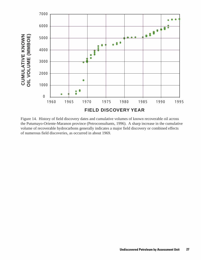
7000
6000
5000
4000
3000
2000
1000
01960 1965 1970 1975 1980 1985 1990 1995
FIELD DISCOVERY YEAR
Figure 14. History of field discovery dates and cumulative volumes of known recoverable oil across the Putumayo-Oriente-Maranon province (Petroconsultants, 1996). A sharp increase in the cumulative volume of recoverable hydrocarbons generally indicates a major field discovery or combined effects of numerous field discoveries, as occurred in about 1969.
CU
MU
LA
TIV
E K
NO
WN
O
IL V
OL
UM
E (
MM
BO
E)
Undiscovered Petroleum by Assessment Unit 27
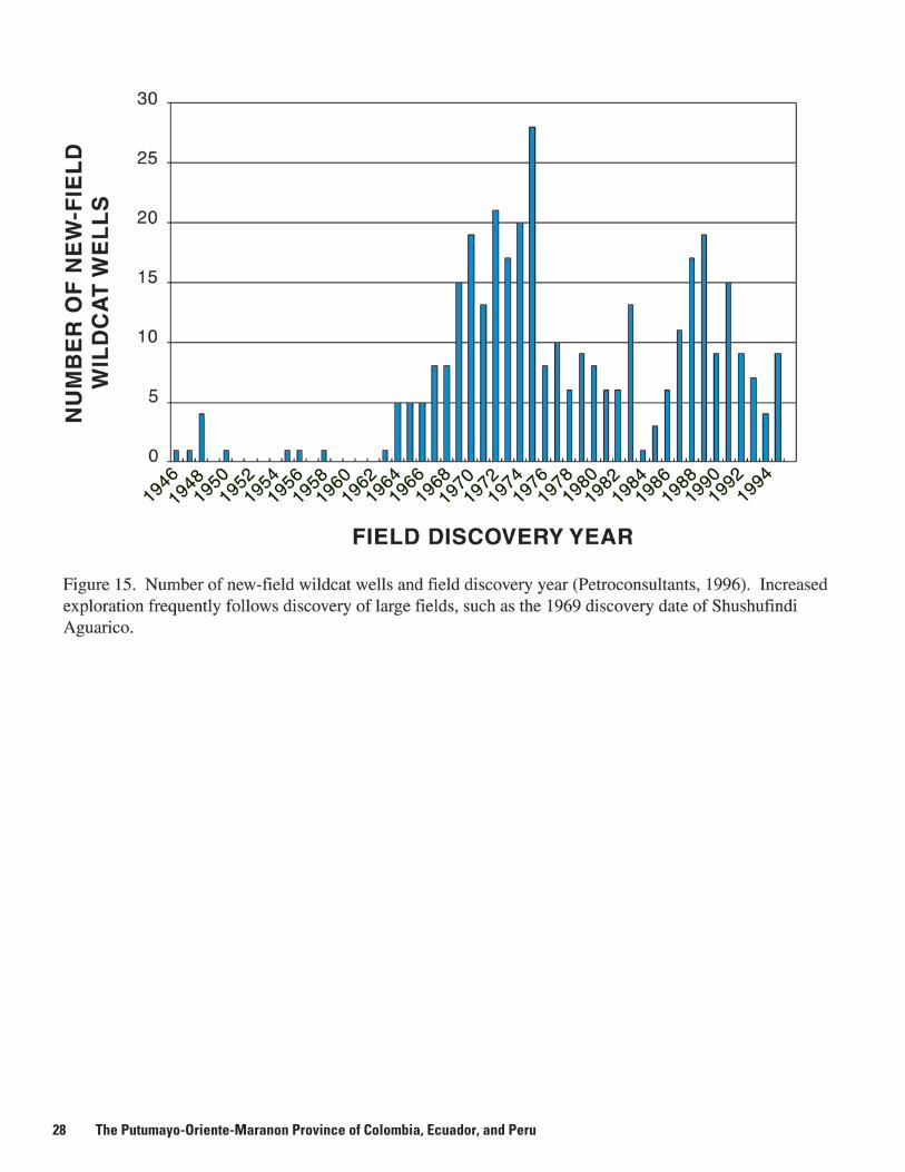
28 The Putumayo-Oriente-Maranon Province of Colombia, Ecuador, and Peru
RESERVOIR ROCKS
Member. The most favorable reservoir facies in the Oriente-Maranon Basin are the low-permeability near-shore marine sandstones of the Cretaceous Napo, Chonta, and Agua Caliente Formations. Some potential also exists within shoreface, deltaic, and fluvial sandstones where faulting, erosional truncation, or diagenetic cementation would isolate these facies.
Dissimilarities are that oil and gas generation, migration, and trapping in the Denver Basin are tied to the Late Cretaceous–early Tertiary Laramide orogeny and a more recent emplacement of a batholith beneath the present area of the Wattenberg field (Higley, Cox, and Weimer, written commun., 2000), whereas the structural and hydrocarbon history of the Putumayo-Oriente-Maranon province is more complex and deformation occurred at a younger age. The Wattenberg field also exists partly because of movement along northeast-trending right-lateral wrench faults that cut and bound the field. Vertical and lateral movement along these faults provided seals that slowed migration of gas outside the area that is thermally mature for gas generation. Faulting is extensive in the Putumayo-Oriente-Maranon province, but the effects upon possible Basin-Center Gas trapping and migration are unknown. Gas from the Wattenberg field is produced from current depths of about 2,100 to 2,700 m (7,000 to 9,000 ft). Estimated drill depths for the Basin-Center Gas assessment unit (60410102) are 3,300 to 4,900 m (11,000 to 16,000 ft), with a median of 4,000 m (13,000 ft), based on drilling depths in the surrounding Tambo-Tambo Sur, Pastachocha 1, and Papahuari Norte fields that produce oil from sandstones in the Vivian and Chonta Formations.
The Permian Ene Formation, which is a probable source of oil for several fields in the Maranon Basin, is treated as a hypothetical assessment unit (60410201) because no discoveries have been made from this formation or from other potential Paleozoic reservoirs in this province. However, oil is produced from the Ene Formation in the Ucayali Basin (fig. 1), where the Cashiriari and San Martin fields also have minor reserves; total estimated recoverable reserves for these fields are more than 7 trillion cubic feet of gas and 400 MMB of condensate (Mathalone and Montoya, 1995; Oil and Gas Journal, 1998); the Mipaya field (discovered 1987) has estimated ultimate recovery of 14 MMBOE from Ene Formation sand-stones. Primary traps in the Ucayali Basin are structural. Pre-Andean terrane in the Maranon and Ucayali Basins comprises a suite of Paleozoic rifts and interbasin highs (Mathalone and Montoya, 1995). Potential Maranon Basin Paleozoic reservoirs exist within structural traps that resulted from movement of the Triassic salt, and (or) from fault movement and associated truncation of sandstone beds against lateral or overlying seals (fig. 2). Stratigraphically trapped hydrocarbons are also possible, but limited and irregular areal extent of the Paleozoic formations decreases the reservoir favorability and increases exploration risks.
Summary
Oil and gas production in the Putumayo-Oriente-Maranon province is from Cretaceous reservoirs, with minor production
from Tertiary formations. This is the Mesozoic-Cenozoic TPS 604101, with cumulative production of more than 2.88 BBO and 660 BCFG. Estimated ultimate recoverable hydrocarbons for all fields is 6.89 BBOE. Petroleum system 604101 is divided into the 60410101 (Hollin-Napo) and 60410102 (Basin-Center Gas) assessment units. Basin production is from Cretaceous and Tertiary formations of the Hollin-Napo assessment unit. Reservoirs are the Caballos, Villeta, and Pepino Formations of the Putumayo Basin, the Hollin and Napo Formations of the Oriente Basin, and the Cushabatay, Agua Caliente, Chonta, and Vivian Formations of the Maranon Basin. Primary hydrocarbon source rocks for the Hollin-Napo assessment unit are marine and mixed marine-terrestrial shales of the Cretaceous Villeta “U”, Caballos, Napo, Hollin, Chonta, and Raya Formations. Potential source rocks are the Triassic and Jurassic Pucara Group and possibly the Jurassic Sarayaquillo Group, but there is no known production of hydrocarbons that were generated from these strata.
The Basin-Center Gas assessment unit (60410102) has no production and is hypothetical; this assessment is based largely upon structural and depositional similarities of the Putumayo-Oriente-Maranon province to foreland basins of the Rocky Mountains in the U.S. that contain unconventional basin-center gas fields. Potential reservoir intervals are marine sandstones of the Napo, Chonta, and Agua Caliente Formations in the western Oriente and Maranon Basins. Probable hydrocarbon source rocks and seals are interbedded and bounding marine shales.
The Paleozoic TPS, 604102, has no production and is also hypothetical. The assessment unit is the Permian Ene Formation (60410201), which is a hydrocarbon source and reservoir rock in the Ucayali Basin, south of the Putumayo-Oriente-Maranon province. Oil from Cretaceous rocks of the Corrientes field and several other fields in the Maranon Basin may have been sourced from the Permian Ene Formation. Graphs of weight percent sulfur versus API gravity of oils from fields across the province suggest that two or more source rocks may have generated oils, including a separate population for potential Ene Formation hydrocarbons. Triassic salt that is concentrated in the western Maranon Basin may have formed structural traps during the time of movement and deformation. Although Ene Formation source rocks are thermally mature for oil and possibly for gas generation, the limited drilling through 1996 to the Paleozoic formations has not encountered potential reservoirs.
Selected References
Alvarado, G., Bonilla, G., De Rojas, G., and De Arroyo, R.Z., 1982, Analisis sedimentologico de la Zona Arenisca Napo “T” en la Cuencadel Napo, in Simposio Bolivariano, exploracion petrolera en las Cuencas subandinas de Venezuela, Colombia, Ecuador y Peru: Asociacion Colombiana de Geologos y Geofisicos del Petroleo, Bogota.
Baby, P., Gil Rodriquez, W., Christophoul, F., Barragan, R., and Bernal, C., 1999, Structural style and timing of hydrocarbon entrapments in the Oriente-Maranon foreland basin: Exploration and exploitation of petroleum and gas, Ingepet ’99 seminar, Lima, Peru, Oct. 26–29, 1 CD-ROM, EXPR-3-PB-03.pdf, 6 p.
Baldock, J.W., 1982, Geology of Ecuador (Explanatory Bulletin of the National Geologic Map of the Republic of Ecuador); Ministerio de
References Cited 29
Resursos Naturales y Energeticos, Direccion General de Geologia y Minas, Quito, Ecuador, 59 p.
Balkwill, H.R., Rodrique, G., Paredes, F.I., and Almeida, J.P., 1995, North-ern part of Oriente Basin, Ecuador; reflection seismic expression of structures, in Tankard, A.J., Suarez Soruco, R., and Welsink, H.J., Petroleum basins of South America: American Association of Petroleum Geologists Memoir 62, p. 559–571.
Burgl, H., 1961, Sedimentacion Ciclica en el geosynclinal Cretaceo de la Cordillera Oriental de Colombia: Boletin Geologico Servicio Geologico Nacion, v. 7, no. 1–3, p. 85–118.
Caceres, H., and Teatin, P., 1985, Cuenca del Putumayo provincia petrol-era meridional de Colombia: II Simposio Bolivariano, Exploracion petrolera en las cuencas subandinas, Bogota, Colombia.
Canfield, R.W., Bonilla, G., and Robbins, R.K., 1982, Sacha oilfield of Ecuadorian Oriente: American Association of Petroleum Geologists Bulletin, v. 66, no. 8, p. 1076–1090.
Carpenter, D.G., and Berumen, M., 1999, Geological and geochemical modeling of the fold and thrust belt of southeastern Peru: Exploration and exploitation of petroleum and gas, Ingepet ’99 seminar, Lima, Peru, Oct. 26–29, 1 CD-ROM, EXPR-3-DC-08.pdf, 12 p.
Chalco, A., 1999, Two dimensional basin modeling of the eastern flank of the Maranon Basin, Peru: Exploration and exploitation of petroleum and gas, Ingepet ’99 seminar, Lima, Peru, Oct. 26–29, 1 CD-ROM, EXPR-3-ACH-01.pdf, 16 p.
Dashwood, M.F., and Abbotts, I.L., 1990, Aspects of the petroleum geology of the Oriente Basin, Ecuador, in Brooks, J., ed., Classic petroleum provinces: Geologic Society Special Publication v. 50, p. 89– 117.
Dengo, C.A., and Covey, M.C., 1993, Structure of the Eastern Cordillera of Colombia; Implications for trap styles and regional tectonics: American Association of Petroleum Geologists Bulletin, v. 77, no. 8, p. 1315–1337.
Duque-Caro, H., 1990, The Choco block in the northwestern corner of South America; structural, tectonostratigraphic, and paleogeographic implications: Journal of South American Earth Science, v. 3, p. 1–14.
Fabre, A., 1985, Dinamica de la sedimentacion Cretacica en la region de la Sierra Nevada del Cocuy. [Further information unavailable.]
GeoMark Research, Inc., 1997, Oils; Oil Information Library System digital database, Version 1.0: Database available from GeoMark Research, Inc., 9748 Whithorn Drive, Houston, TX 77095, U.S.A., 1 CD-ROM.
Groth, F.H., 1998, Managing biodiversity: EOM (Earth Observation Magazine), November 1998, p. 12–15.
Hanford, D.R., and Kairuz, E.C., 2000, High-frequency sequences and stratigraphic entrapment, Cretaceous Villeta Formation, Putumayo Basin, Colombia, in VII Simposio Bolivariano exploracion petrolera en las cuencas Subandinas: Memoria, Sociedad Venezolans de Geologos, p. 434–459, Caracas, Venezuela September 10–13, 2000 PDVSA.
Isaacson, P.E., and Diaz Martinez, E., 1995, Evidence for a Middle–Late Paleozoic foreland basin and significant paleolatitudinal shift, Central Andes, in Tankard, A.J., Suarez Soruco, R., and Welsink, H.J., Petroleum basins of South America: American Association of Petroleum Geologists Memoir 62, p. 231–249.
Jarvis, H.A., and Lay, V., 1993, The 1-AB Block fields—A giant oil accumulation in eastern Peru: American Association of Petroleum Geologists Bulletin, abstracts with meeting, v. 77, no 2, p. 327.
Jordan, D., Wade, H.W., Schultz, D., Vavra, C., and Reinoso, H.,1997, Transgressive deposits of the Hollin Formation, Oriente Basin, Ecuador: Annual Meeting Abstracts—American Association of Petro
leum Geologists and Society of Economic Paleontologists and Mineralogists, 6th meeting, p. 57.
Kairuz, E., Cordoba, F., Moorish, J., Calderon, W., and Buchelli, F., 2000, Systems petroliferos del Putumayo, Colombia, in VII Simposio Bolivariano exploracion petrolera en las cuencas Subandinas: Memo-ria, Sociedad Venezolans de Geologos, p. 521–528, CD-ROM, Caracas, Venezuela September 10–13, 2000 PDVSA.
Klett, T.R., Ahlbrandt, T.S., Schmoker, J.W., and Dolton, G.L., 1997, Ranking of the world's oil and gas provinces by known petroleum volumes: U.S. Geological Survey Open File Report 97-463, 1 CD-ROM, Adobe Acrobat format.
Kronman, G.E., Rushworth, S.W., Jagiello, K., and Aleman, A., 1995, Oil and gas discoveries and basin resource predictions in Latin America, in Tankard, A.J., Suarez Soruco, R., and Welsink, H.J., Petroleum basins of South America: American Association of Petroleum Geologists Memoir 62, p. 53–61.
Lozada, F.T., Endara, P.B., Cordero, C.A., 1985, Exploracion y desarrollo del Campo Libertador: 2nd Simposio Bolivariano de Explorcion Petrolera en las Cuencas Subandinas Asoc Colomb Geol Geof Petr, Bogota, p. 1–8.
Macellari, C.E., 1988, Cretaceous paleogeography and depositional cycles of western South America: Journal of South American Earth Science, v. 1, p. 373–418.
Macellari, C.E., and de Vries, T.J., 1987, Late Cretaceous upwelling and anoxic sedimentation in northwestern South America: Palaeogeography, Palaeoclimatology, Palaeoecology, v. 59, p. 279–292.
Magoon, L.B., and Dow, W.G., 1994, The petroleum system, in Magoon, L.B., and Dow, W.G., eds., The Petroleum System—From source to trap: American Association of Petroleum Geologists Memoir 60, p. 3–23.
Mann, U., 1995, Genese kretazischer Schwarzschiefer in der westlichen Verlangerung der Tethys (Kolumbien); globale vs. regionale/lokale Prozesse: Berichte, Fachbereich Geowissenschaften, Universitat, Bremen, v. 63, 153 p.
Mann, U., and Stein, R., 1997, Organic facies variations, source rock potential, and sea level changes in Cretaceous black shales of the Quebrada Ocal, Upper Magdalena Valley, Colombia: American Association of Petroleum Geologists Bulletin, v. 81, no. 4, p. 556–576.
Marksteiner, R., and Aleman, A.M., 1996, Petroleum systems along the foldbelt associated to the Maranon-Oriente-Putumayo foreland basins: American Association of Petroleum Geologists Bulletin, v. 80, no. 8, p. 1311.
Marocco, R., Lavenu, A., and Baudino, R., 1995, Intermontane Late Paleogene–Neogene Basins of the Andes of Ecuador and Peru; sedimentologic and tectonic characteristics, in Tankard, A.J., Suarez Soruco, R., and Welsink, H.J., Petroleum basins of South America: American Association of Petroleum Geologists Memoir 62, p. 597– 613.
Mathalone, J.M.P., and Montoya R., M., 1995, Petroleum geology of the sub-Andean basins of Peru, in Tankard, A.J., Suarez Soruco, R., and Welsink, H.J., Petroleum basins of South America: American Association of Petroleum Geologists Memoir 62, p. 423–444.
Mello, M.R., Koutsoukos, E.A.M., and Erazo, W.Z., unknown date, The Napo Formation, Oriente Basin, Ecuador; hydrocarbon source potential and paleoenvironmental assessment: Petrobras, Brazil, and Petroproduction, Ecuador, p. 167–181.
Mello, M.R., and Trindade, L.A.F., 1999, Petroleum systems of subandean basins based on geochemical characterization of oils: Exploration and exploitation of petroleum and gas, Ingepet ’99 seminar, Lima, Peru, Oct. 26–29, 1 CD-ROM, EXPR-3-MR-07.pdf, 11 p.
30 The Putumayo-Oriente-Maranon Province of Colombia, Ecuador, and Peru
RESERVOIR ROCKS
Occidental Petroleum Co., accessed December 1999, websites: http:// www.oxy.com/ and http://www.oxy.com/rainforest/awalk.htm
Oil and Gas Journal, 1998, Exploration interest high in Peru’s Ucayali basin: Oil and Gas Journal, July 6, 1998, p. 84.
Petroconsultants, 1996, Petroleum exploration and production database: Database available from Petroconsultants, Inc., P.O. Box 740619, Houston, TX 77274-0619, U.S.A.
Pindell, J.L., and Tabbutt, K.D., 1995, Mesozoic-Cenozoic andean paleogeography and regional controls on hydrocarbon systems, in Tankard, A.J., Suarez Soruco, R., and Welsink, H.J., Petroleum basins of South America: American Association of Petroleum Geologists Memoir 62, p. 101–128.
Ramon, J.C., 1996, Oil geochemistry of the Putumayo Basin: Ciencia, Tecnologia y Futuro, v. 1, no. 2, p. 25–34.
Reed, R.N., and Wheatley, M.J., 1983, Oil and water production in a reservoir with a significant capillary transition zone, in Proceedings of Annual Conference of the Society of Petroleum Engineers of AIME, San Francisco, California.
Rivadeneira, M.V., 1986, Evaluacion geochemica de Rocas Madres de la Cuenca Amazonica Ecuadoriana, in IV Congresso Ecuatoriano de Geologia, Minas y Petroleo: Colegio de Ingemieros Geologogos de Minas y Petroleos de Pichincha, Quito, p. 31–48.
Rivadeneira, M., 1988, Characteristicas geologicas fundamentales y problemas exploratoria que plantean las principales cuencas sedimentarias ecuatorianas: Segundo Congreso Latinoamericano de Hidrocarburos, Rio de Janeiro, p. 1/18–18/18.
Rosania, G., and Morales, M., 1986, Compilacion paleogeografica del Oriente Ecuatoriano: Segundo Congreso Colombiano de Petroleo, Moranoranias Tomo 1, p. I/5–I/21.
Schmoker, J.W., and Attanasi, E.D., 1997, Reserve growth important to U.S. gas supply: Oil and Gas Journal, Jan. 27, p. 95–96.
Schmoker, J.W., and Crovelli, R.A., 1998, A simplified spreadsheet pro-gram for estimating future growth of oil and gas reserves: Nonrenewable Resources, v. 7, no. 2, p. 149–155.
Sempere, T., 1995, Phanerozoic evolution of Bolivia and adjacent regions, in Tankard, A.J., Suarez Soruco, R., and Welsink, H.J., Petroleum basins of South America: American Association of Petroleum Geologists Memoir 62, p. 207–230.
Sofer, Z., Zumberge, J.E., and Lax, V., 1985, Stable carbon isotopes and biomarkers as tools to understanding genetic relationship, maturation, biodegradation and migration of crude oils in the northern Peruvian Oriente (Maranon) Basin: Organic Geochemistry, v. 10, p. 377– 389.
Soto, F., and Vargas, J., 1985, Posibilidades hidrocarburiferas del precretacico en el Oriente del Peru: Boletin Tecnico ARPEL, v. 14, p. 131– 143.
Tissot, B.P., and Welte, D.H., 1984, Petroleum formation and occurrence, Second edition: Berlin, Springer-Verlag, 699 p.
Tschopp, T.J., 1953, Oil explorations in the Oriente of Ecuador 1938–1950: American Association of Petroleum Geologists Bulletin, v. 68, p. 31– 49.
U.S. Geological Survey World Energy Assessment Team (USGS), 2000, U.S. Geological Survey world petroleum assessment 2000— Description and results: U.S. Geological Survey Digital Data Series DDS-60, 4 CD-ROMs, Adobe Acrobat format. http://greenwood.cr.usgs.gov/energy/WorldEnergy/DDS-60/
Valasek, D., Aleman, A.M., Antenor, M., and Marksteiner, R., 1996, Cretaceous sequence stratigraphy of the Maranon-Oriente-Putumayo Basins, northeastern Peru, eastern Ecuador, and southeastern Colombia: American Association of Petroleum Geologists Bulletin, v. 80, no. 8, p. 1341–1342.
Villegas, M.E., Bachu, S., Ramon, J.C., and Undershultz, J.R., 1994, Flow of formation waters in the Cretaceous-Miocene succession of the Llanos Basin, Colombia: American Association of Petroleum Geologists Bulletin, v. 78, no. 12, p. 1843–1862.
Wasserstrom, R., and Reider, S., 1998, Petroleum companies crossing new threshold in community relations: Oil and Gas Journal, Dec. 14, 1998, p. 24–27.
White, H.J., Skopec, R.A., Ramirez, F.A., Rodas, J.A., and Bonilla, G., 1995, Reservoir characterization of the Hollin and Napo Formations, west-ern Oriente Basin, Ecuador, in Tankard, A.J., Suarez Soruco, R., and Welsink, H.J., Petroleum basins of South America: American Association of Petroleum Geologists Memoir 62, p. 573–596.
Ziegler, A.M., Barrett, S.F., and Scotese, C.R., 1981, Paleoclimate, sedimentation, and continental accretion: Philosophical Transactions of the Royal Society of London, v. A301, p. 253–264.
Selected References 31
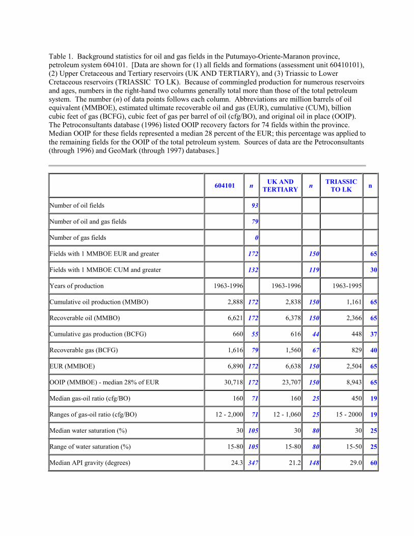
Table 1. Background statistics for oil and gas fields in the Putumayo-Oriente-Maranon province, petroleum system 604101. [Data are shown for (1) all fields and formations (assessment unit 60410101), (2) Upper Cretaceous and Tertiary reservoirs (UK AND TERTIARY), and (3) Triassic to Lower Cretaceous reservoirs (TRIASSIC TO LK). Because of commingled production for numerous reservoirs and ages, numbers in the right-hand two columns generally total more than those of the total petroleum system. The number (n) of data points follows each column. Abbreviations are million barrels of oil equivalent (MMBOE), estimated ultimate recoverable oil and gas (EUR), cumulative (CUM), billion cubic feet of gas (BCFG), cubic feet of gas per barrel of oil (cfg/BO), and original oil in place (OOIP). The Petroconsultants database (1996) listed OOIP recovery factors for 74 fields within the province. Median OOIP for these fields represented a median 28 percent of the EUR; this percentage was applied to the remaining fields for the OOIP of the total petroleum system. Sources of data are the Petroconsultants (through 1996) and GeoMark (through 1997) databases.]
604101 n UK AND TERTIARY n TRIASSIC
TO LK n
Number of oil fields 93
Number of oil and gas fields 79
Number of gas fields 0
Fields with 1 MMBOE EUR and greater 172 150 65
Fields with 1 MMBOE CUM and greater 132 119 30
Years of production 1963-1996 1963-1996 1963-1995
Cumulative oil production (MMBO) 2,888 172 2,838 150 1,161 65
Recoverable oil (MMBO) 6,621 172 6,378 150 2,366 65
Cumulative gas production (BCFG) 660 55 616 44 448 37
Recoverable gas (BCFG) 1,616 79 1,560 67 829 40
EUR (MMBOE) 6,890 172 6,638 150 2,504 65
OOIP (MMBOE) - median 28% of EUR 30,718 172 23,707 150 8,943 65
Median gas-oil ratio (cfg/BO) 160 71 160 25 450 19
Ranges of gas-oil ratio (cfg/BO) 12 - 2,000 71 12 - 1,060 25 15 - 2000 19
Median water saturation (%) 30 105 30 80 30 25
Range of water saturation (%) 15-80 105 15-80 80 15-50 25
Median API gravity (degrees) 24.3 347 21.2 148 29.0 60
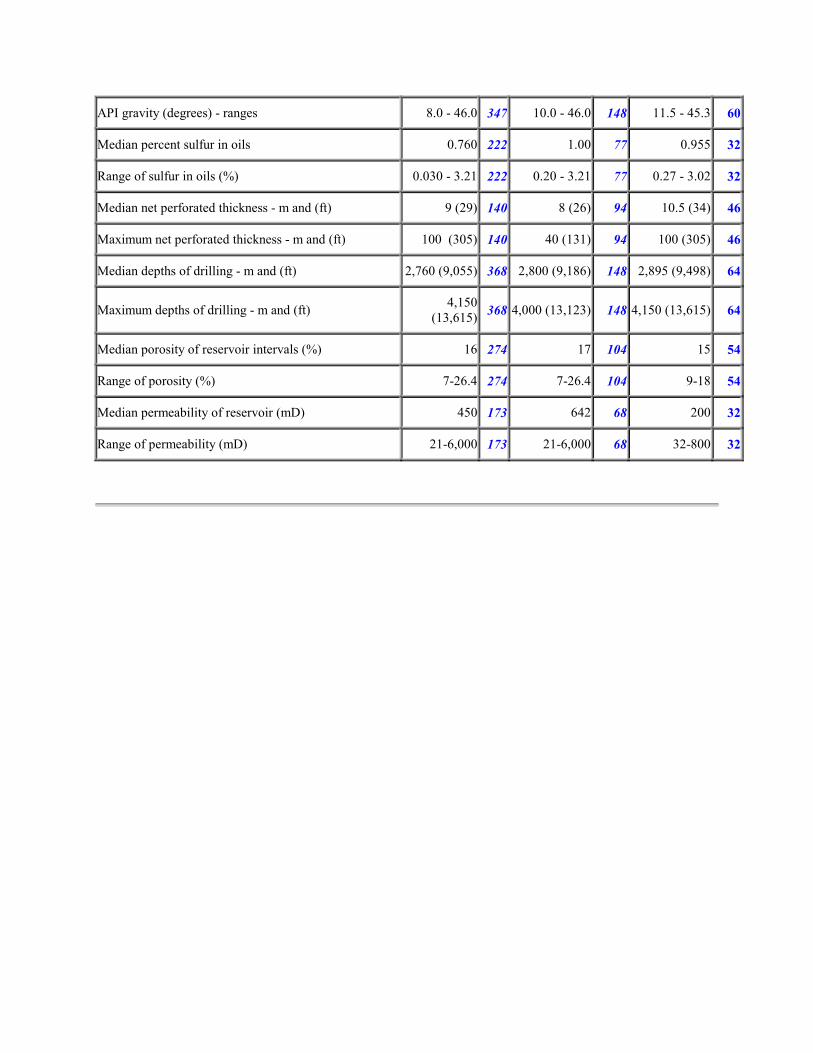
API gravity (degrees) - ranges 8.0 - 46.0 347 10.0 - 46.0 148 11.5 - 45.3 60
Median percent sulfur in oils 0.760 222 1.00 77 0.955 32
Range of sulfur in oils (%) 0.030 - 3.21 222 0.20 - 3.21 77 0.27 - 3.02 32
Median net perforated thickness - m and (ft) 9 (29) 140 8 (26) 94 10.5 (34) 46
Maximum net perforated thickness - m and (ft) 100 (305) 140 40 (131) 94 100 (305) 46
Median depths of drilling - m and (ft) 2,760 (9,055) 368 2,800 (9,186) 148 2,895 (9,498) 64
Maximum depths of drilling - m and (ft) 4,150 (13,615) 368 4,000 (13,123) 148 4,150 (13,615) 64
Median porosity of reservoir intervals (%) 16 274 17 104 15 54
Range of porosity (%) 7-26.4 274 7-26.4 104 9-18 54
Median permeability of reservoir (mD) 450 173 642 68 200 32
Range of permeability (mD) 21-6,000 173 21-6,000 68 32-800 32
Table 2. Statistics for recoverable oil (MMBO) for fields with 1 MMBO or greater reserves. [All
production, all fields in the Hollin-Napo assessment unit, Upper Cretaceous and Tertiary reservoirs
(UK-TERTIARY), and Triassic to Lower Cretaceous reservoirs (TRIASSIC-LK). Numbers may be
slightly inflated for production by age of reservoir due to commingling of reported production in
numerous oil fields (Petroconsultants data through 1996). The range of years for field discoveries is
divided into three time periods; known and grown statistics are shown for each time period.]
All production 1963-74 1974-88 1988-95 Total Oil Total Oil 1963-74 1974-88 1988-95
Known Known Known Known Grown Grown Grown Grown Mean 99.0 25.8 25.6 50.3 77.7 137.5 40.4 55.9Median 23.6 9.0 6.0 10.0 19.2 31.5 13.2 12.2Minimum 1.0 1.4 1.0 1.0 1.2 1.2 1.4 1.2Maximum 1500 315.0 460.0 1500 2136 2136 479.8 1000Sum 4355 1134 1100 6589 10564 6187 1859 2517Pct change 160 142 164 229Count 44 44 43 131 136 45 46 45Number Years 11 14 7 32 32 11 14 7
UK-TERTIARY 1963-74 1974-88 1988-95 Total Oil Total Oil 1963-74 1974-88 1988-95
Known Known Known Known Grown Grown Grown Grown Mean 108.5 27.7 23.0 53.1 83.7 165.0 42.2 53.0Median 26.0 10.0 5.5 13.5 22.5 42.7 12.2 12.8Minimum 1.0 2.0 1.0 1.0 1.2 1.2 2.5 1.2Maximum 1500 315.0 460.0 1500 2136 2136 479.8 1000Sum 4340 1108 921.9 6370 10040 6104 1814 2122Pct change 158 141 164 230Count 40 40 40 120 120 37 43 40Number Years 11 14 8 33 32 11 14 7
LK-TRIASSIC 1963-74 1974-88 1988-95 Total Oil Total Oil 1963-74 1974-88 1988-95
Known Known Known Known Grown Grown Grown Grown Mean 90.1 25.7 17.7 45.4 66.0 104.3 19.9 44.9Median 18.3 10.0 4.7 7.5 14.1 21.4 9.6 14.8Minimum 2.1 2.5 1.5 1.5 1.2 1.2 1.4 3.6Maximum 820.0 120.0 162.0 820.0 1168 1168 90.1 352.3Sum 1621 437.6 300.6 2359 3434 2503 258.5 672.8Pct change 146 154 59 224Count 18 17 17 52 52 24 13 15Number Years 8 16 7 22 32 10 14 7
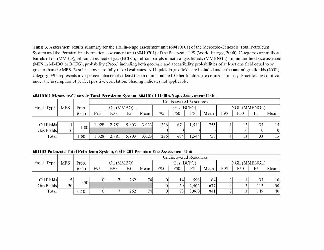
Table 3. Assessment results summary for the Hollin-Napo assessment unit (60410101) of the Mesozoic-Cenozoic Total Petroleum System and the Permian Ene Formation assessment unit (60410201) of the Paleozoic TPS (World Energy, 2000). Categories are million barrels of oil (MMBO), billion cubic feet of gas (BCFG), million barrels of natural gas liquids (MMBNGL), minimum field size assessed (MFS in MMBO or BCFG), probability (Prob.) including both geologic and accessibility probabilities of at least one field equal to or greater than the MFS. Results shown are fully risked estimates. All liquids in gas fields are included under the natural gas liquids (NGL) category. F95 represents a 95-percent chance of at least the amount tabulated. Other fractiles are defined similarly. Fractiles are additive under the assumption of perfect positive correlation. Shading indicates not applicable.
60410101 Mesozoic-Cenozoic Total Petroleum System, 60410101 Hollin-Napo Assessment Unit
Field TypeUndiscovered Resources
MFS Prob. Oil (MMBO) Gas (BCFG) NGL (MMBNGL)(0-1) F95 F50 F5 Mean F95 F50 F5 Mean F95 F50 F5 Mean
Oil Fields 1 1.00 1,028 2,781 5,803 3,023 236 674 1,544 755 4 13 33 15Gas Fields 6 0 0 0 0 0 0 0 0
Total 1.00 1,028 2,781 5,803 3,023 236 674 1,544 755 4 13 33 15
604102 Paleozoic Total Petroleum System, 60410201 Permian Ene Assessment Unit
Field TypeUndiscovered Resources
MFS Prob. Oil (MMBO) Gas (BCFG) NGL (MMBNGL)(0-1) F95 F50 F5 Mean F95 F50 F5 Mean F95 F50 F5 Mean
Oil Fields 5 0.50 0 7 262 74 0 14 598 164 0 1 37 10Gas Fields 30 0 59 2,462 677 0 2 112 30
Total 0.50 0 7 262 74 0 73 3,060 841 0 3 149 40