Embed Size (px)
Citation preview

Southern York County Regional Comprehensive Plan - (Update) XII. Transportation System -179
XII. TRANSPORTATION SYSTEM ___________________
Mobility has become one of the most sought-after qualities of life of this century. The widespread use and development of automobiles, trucks and their road networks have enabled motorists to travel independently with great flexibility as to origins and destinations. Only recently, with increased congestion, has society begun to realize that the extensive use of the automobile may, in fact, be threatening both mobility and safety. This realization has led to efforts to better understand the relationship between transportation planning and land use planning, and has created renewed interest in alternative modes of transport.
This chapter will inventory the Southern York County Region's transportation system, begin-ning by categorizing roadway functional classifications, as determined by the York County Planning Commission, describing roadway design standards, and presenting available traffic volume data and accident locations according to PennDOT records. A brief discussion of re-gional traffic impacts is followed by a description of alternative modes of transport. All of this data is then analyzed and applied to the Region's development objectives and other available plan information to form the basis for the chapter's recommendations on future transportation needs, land use scenarios and implementation strategies. Such information should also be useful in reviewing traffic studies associated with proposed developments; each municipality should adopt comprehensive traffic impact study regulations within their subdivision and land development ordinances.
A. ROADWAY CLASSIFICATIONS AND DESIGN STANDARDS Functional classification of roadways refers to a system by which roads are described in
terms of their utility. Theoretically, roads provide for two separate functions. First, roads provide for mobility—the ability to go from one place to the next. Second, roads provide a measure of access to adjoining properties. Transportation experts use these two roadway characteristics to determine a road's functional classification.
The diagram on the following page depicts the relationship between roadway mobility and roadway land access for each of the three (3) general road types: arterials, collectors and locals. Roads that provide for greater mobility provide for reduced land access, and vice versa. This important relationship should always be considered when allocating future land uses along existing or planned roads. These basic road types can be further subdivided into any number of different categories, depending upon the complexity of the roadway network. However, for the purpose of this Plan, the Region's roadway network is described as consisting of arterials, major collectors, minor collectors, and local roads. The roads within the Region are classified and identified on the Roadway Characteristics Map.
180 - XII. Transportation System Southern York County Regional Comprehensive Plan – (Update)
FIGURE 21 RELATIONSHIP BETWEEN MOBILITY VS. LAND ACCESS IN ROADWAY FUNCTIONAL CLASSIFICATION ARTERIALS Arterials are intended to provide for a greater degree of mobility than land access. Hence,
individual driveway intersections with arterials should occur infrequently. Arterials generally convey between 10,000 and 25,000 average daily trips (ADT) for distances greater than one (1) mile. Arterials often connect urban centers with outlying communities and employment or shopping centers. Consequently, arterials are often primary mass transit routes that connect with “downtown” areas of nearby communities.
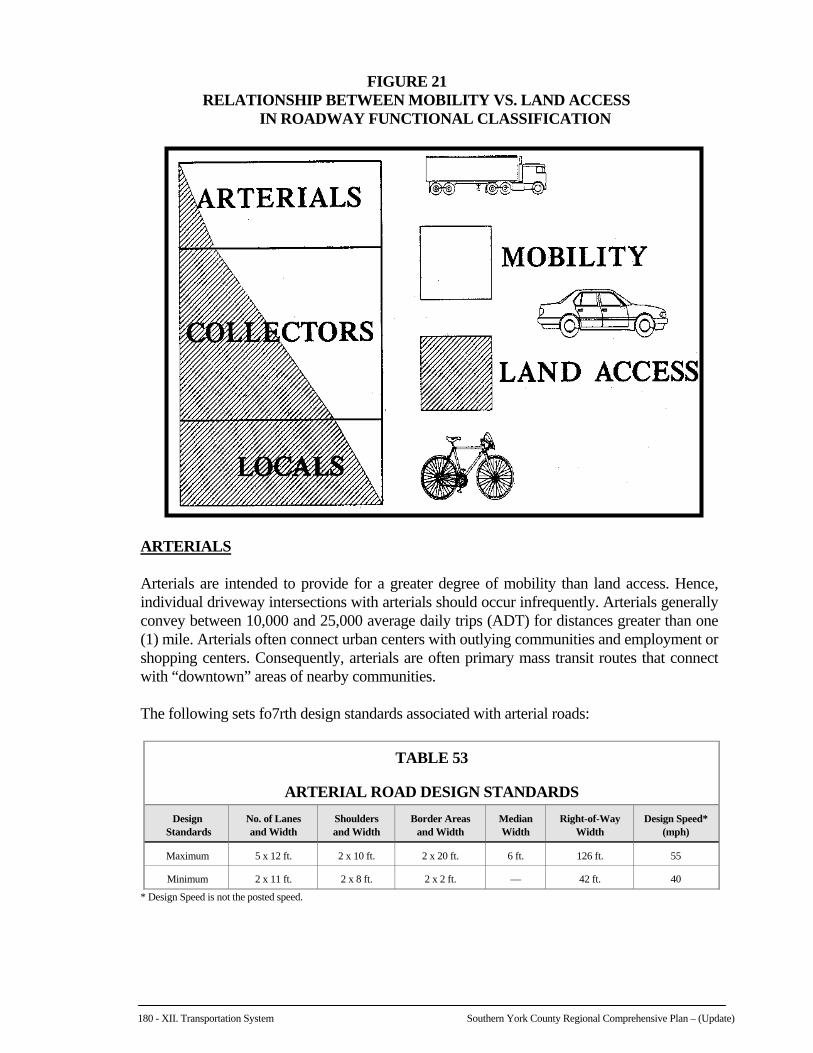
The following sets fo7rth design standards associated with arterial roads:
TABLE 53
ARTERIAL ROAD DESIGN STANDARDS
Design Standards
No. of Lanes and Width
Shoulders and Width
Border Areas and Width
Median Width
Right-of-Way Width
Design Speed* (mph)
Maximum 5 x 12 ft. 2 x 10 ft. 2 x 20 ft. 6 ft. 126 ft. 55
Minimum 2 x 11 ft. 2 x 8 ft. 2 x 2 ft. — 42 ft. 40
* Design Speed is not the posted speed.

Southern York County Regional Comprehensive Plan - (Update) XII. Transportation System -181
ROADWAY CHARACTERISTICS MAP – 11 X 17”

182 - XII. Transportation System Southern York County Regional Comprehensive Plan – (Update)

Southern York County Regional Comprehensive Plan - (Update) XII. Transportation System -183
The following PennDOT data summarizes the existing characteristics of the Region's arterial roadways:
TABLE 54
ARTERIAL ROADWAY CHARACTERISTICS
Road Name
Route No.
Municipality
Est. AADT (2006)
No. Lanes
Cartway Width
Shoulder Widths/Ea.
MPH
I-83 0083 Shrewsbury Twp. NB – 22,417 SB – 21,882
2 2
12'/lane 12'/lane
9.5/lane 9.5/lane
65 65
Susquehanna Trail 3001 Shrewsbury Twp. 8,331 – 6,537 2 22 3–6 35–45
Main Street 3001 Shrewsbury Boro. 9,655 – 6,537 2 22–38 01–6 25–35
Forrest Avenue 0851 Shrewsbury Boro./Twp. 21,807 – 9,630 2 22–24 0–5 25–45
As compared to the 1998 estimated annual average daily traffic (AADT) volumes presented in the 2000 Plan, all arterial roadways have experienced an increase in traffic. I-83 has experienced the most significant increase, approximately 58% northbound and 55% southbound. Increased traffic on the Susquehanna Trail ranged from seven percent (7%) to 17%. In the case of Main Street and Forrest Avenue, the AADT resulted in a traffic increase on the “high” end and a traffic decrease on the “low” end. For Main Street, the high end increased by 15% and the low end decreased by 25%; while Forrest Avenue experienced a high end increase of 71% and a low end decrease of five percent (5%). A 1995 study by the York County Planning Commission listed Forrest Avenue, between Tolna Road in Shrewsbury Township and Main Street in Shrewsbury Borough, as being among the 16 most congested roads in the County.
MAJOR COLLECTORS Major collectors provide for medium length travel distances (generally less than one mile)
and convey between 1,500 and 10,000 ADT. Major collectors also provide land access to major land uses, such as regional shopping centers, large industrial parks, major subdivisions, and community-wide recreation facilities. Major collectors primarily serve motorists between local streets and community-wide activity centers or arterial roads.
The following sets forth design standards for major collector roads:
TABLE 55
MAJOR COLLECTOR ROAD DESIGN STANDARDS
Design Standards
No. of Lanes and Width
Shoulders and Width
Border Areas and Width
Right-of-Way Width
Design Speed* (mph)
Maximum 2 x 12 ft. 2 x 10 ft. 2 x 20 ft. 84 ft. 50
Minimum 2 x 11 ft. 2 x 8 ft. 2 x 2 ft. 42 ft. 40
* Design Speed is not the posted speed.
184 - XII. Transportation System Southern York County Regional Comprehensive Plan – (Update)
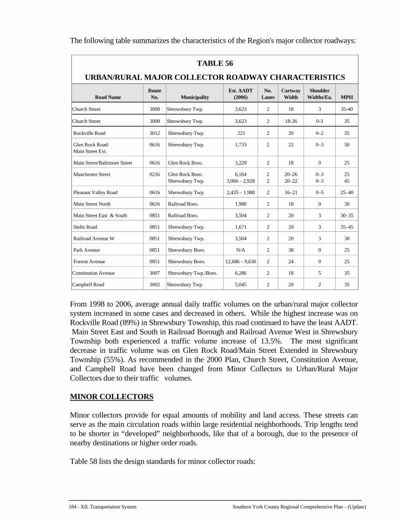
The following table summarizes the characteristics of the Region's major collector roadways:
TABLE 56
URBAN/RURAL MAJOR COLLECTOR ROADWAY CHARACTERISTICS
Road Name
Route No.
Municipality
Est. AADT (2006)
No. Lanes
Cartway Width
Shoulder Widths/Ea.
MPH
Church Street 3008 Shrewsbury Twp. 3,623 2 18 3 35-40
Church Street 3008 Shrewsbury Twp. 3,623 2 18-26 0-3 35
Rockville Road 3012 Shrewsbury Twp. 221 2 20 0–2 35
Glen Rock Road/ Main Street Ext.
0616 Shrewsbury Twp. 1,733 2 22 0–3 50
Main Street/Baltimore Street 0616 Glen Rock Boro. 3,229 2 18 0 25
Manchester Street 0216 Glen Rock Boro. Shrewsbury Twp.
6,164 3,066 – 2,928
2 2
20–26 20–22
0–3 0–3
25 45
Pleasant Valley Road 0616 Shrewsbury Twp. 2,435 – 1,980 2 16–21 0–5 25–40
Main Street North 0616 Railroad Boro. 1,980 2 18 0 30
Main Street East & South 0851 Railroad Boro. 3,504 2 20 3 30–35
Steltz Road 0851 Shrewsbury Twp. 1,671 2 20 3 35–45
Railroad Avenue W 0851 Shrewsbury Twp. 3,504 2 20 3 30
Park Avenue 0851 Shrewsbury Boro. N/A 2 38 0 25
Forrest Avenue 0851 Shrewsbury Boro. 12,686 – 9,630 2 24 0 25
Constitution Avenue 3007 Shrewsbury Twp./Boro. 6,286 2 18 5 35
Campbell Road 3002 Shrewsbury Twp. 5,045 2 20 2 35
From 1998 to 2006, average annual daily traffic volumes on the urban/rural major collector
system increased in some cases and decreased in others. While the highest increase was on Rockville Road (89%) in Shrewsbury Township, this road continued to have the least AADT. Main Street East and South in Railroad Borough and Railroad Avenue West in Shrewsbury Township both experienced a traffic volume increase of 13.5%. The most significant decrease in traffic volume was on Glen Rock Road/Main Street Extended in Shrewsbury Township (55%). As recommended in the 2000 Plan, Church Street, Constitution Avenue, and Campbell Road have been changed from Minor Collectors to Urban/Rural Major Collectors due to their traffic volumes.
MINOR COLLECTORS
Minor collectors provide for equal amounts of mobility and land access. These streets can
serve as the main circulation roads within large residential neighborhoods. Trip lengths tend to be shorter in “developed” neighborhoods, like that of a borough, due to the presence of nearby destinations or higher order roads.
Table 58 lists the design standards for minor collector roads:

Southern York County Regional Comprehensive Plan - (Update) XII. Transportation System -185
TABLE 57
MINOR COLLECTOR ROAD DESIGN STANDARDS
Design Standards
No. of Lanes and Width
Shoulders and Width
Border Areas and Width
Right-of-Way Width
Design Speed* (mph)
Maximum 2 x 11 ft. 2 x 10 ft. 2 x 20 ft. 86 ft. 50
Minimum 2 x 10 ft. 2 x 4 ft. 2 x 2 ft. 32 ft. 40
*Design Speed is not the posted speed.
The following table summarizes the characteristics of the Region's minor collector roadways:
TABLE 58
MINOR COLLECTOR ROADWAY CHARACTERISTICS
Road Name
Route No.
Municipality
Est. AADT (2006)
No. Lanes
Cartway Width
Shoulder Widths/Ea.
MPH
West Clearview Drive 3006 Shrewsbury Boro./Twp. 1,067 2 18–20 0–4 35
Clearview Drive 3006 Shrewsbury Boro. 868 2 20 4–5 35
Plank Road 2074 Shrewsbury Boro. 2,837 2 20 2–7 40
Bowser Road 3004 Shrewsbury Twp. 711 2 14 5 45
Windy Hill Road 2078 Shrewsbury Twp. 874 2 18 0–2 35
The minor collector roadway system also experienced a mix of increases and decreases in average annual daily traffic volumes from 1998 to 2006. The most significant increases were on Campbell Road (29%) in Shrewsbury Township and Plank Road (20%) in Shrewsbury Borough, while the most significant decreases were on Clearview Drive (52%) in Shrewsbury Borough and West Clearview Drive (24%) in Shrewsbury Township.
LOCAL ROADS
Local roads are intended to provide immediate access to adjoining land uses. These roads are generally short and narrow, and comprise the bulk of road area within urban setting developments and rural areas. Local roads are intended to only provide for transportation within a particular neighborhood, or to one of the other road types already described. All of the roads not previously classified as arterials or collectors are considered local roads.
The following describes the design standards for local streets.
TABLE 59
LOCAL ROAD DESIGN STANDARDS
Design Standards
No. of Lanes and Width
Shoulders and Width
Border Areas and Width
Right-of-Way Width
Design Speed* (mph)
Maximum 2 x 11 ft. 2 x 8 ft. 2 x 8 ft. 54 ft. 40
Minimum 2 x 10 ft. 2 x 4 ft. 2 x 2 ft. 28 ft. 40
*Design Speed is not the posted speed.
186 - XII. Transportation System Southern York County Regional Comprehensive Plan – (Update)
B. ALTERNATIVE FORMS OF TRANSPORTATION
When considering the transportation system serving the region, it is important to look at alternative forms of travel. These include bus, air, and rail transportation, as well as car pooling and pedestrian/bicycle travel. BUS TRANSPORTATION Rabbittransit, based in York City, is the primary provider of public transportation services in York County. It offers fixed route, shuttle, and paratranist services. In addition, on February 2, 2009, rabbittransit initiated an Express Bus Service three (3) year demonstration project that provides service between York and Northern Maryland along the I-83 corridor. If ridership demands prove to be sufficient, the service will be continued into the future. Only one (1) fixed bus route (#17) services the Southern Region. The weekday service route currently begins at the Downtown Transfer Center in York City and ends at Shrewsbury Commons. Interim stops on the route include Apple Hill Medical Center, Jacobus Borough, and Loganville Borough. However, through a program entitled “Stop Hopper,” residents in Glen Rock and Shrewsbury Boroughs can obtain bus service to Shrewsbury Commons where they can access Fixed Route 17 to York. This service requires an advance reservation and there are no scheduled pick –up times. A transition to scheduled stops and pick-up times is under development, but advanced reservation will still be required. The bus will NOT stop unless a reservation has been made. Paratransit service provides curb-to-curb van service countywide for the general public. All of the vans are wheelchair equipped. The system operates on a 24 hour advanced reservation basis. Although the service is available to anyone who wishes to use it, the relatively high fares make it cost prohibitive to use on a regular basis. Senior citizens and persons with disabilities may qualify for discounts. The majority of users, however, have some type of sponsorship. RAIL TRANSPORTATION Presently, there is no passenger rail service available in York County. The nearest facilities are the AMTRAK terminals in the cities of Harrisburg and Lancaster. A light rail passenger service to Baltimore City and Baltimore Washington International Airport can be accessed at Hunt Valley. Three (3) rail freight providers operate in York County, but none of the lines are located within the Southern Region. These facilities are primarily located within the Greater York and Hanover areas, as well as along the Susquehanna River. AIR TRANSPORTATION The only air facility located in the Region is a small private airstrip in northern Shrewsbury Borough. Shoestring Airport, a small public use airport for ultra light aircraft, is located just outside the Region in neighboring North Hopewell Township. Harrisburg International Airport, to the north, and Baltimore Washington International Airport, to the south, offer the nearest passenger airline service. These facilities are located equal distance from the Region.
Southern York County Regional Comprehensive Plan - (Update) XII. Transportation System -187
CAR POOLING There is one (1) Park & Ride Lot located in the Southern Region. It is situated on Forrest Avenue (SR 851), just east of the Exit 4 interchange of Interstate 83. Park & Ride lots serve to increase carpooling and ride sharing opportunities among commuters, thereby reducing the number of automobiles on the roads and lessening the amount of air pollution. In an effort to reduce congestion along the southern corridor of Interstate 83, rabbittransit launched a regional vanpool initiative in 2007. This program is conducted in partnership with VPSI, Inc., the largest commuter vanpool provider in the world, and Commuter Services of South Central Pennsylvania. Although targeted to the southern corridor, vanpools can originate and travel to many destinations; participants determine their daily schedule and commuter route. The vanpool program provides a vehicle, 24-hour roadside assistance, maintenance, insurance and an emergency ride home program for a monthly fee that is shared by the participants. As an incentive, rabbittransit offers subsidies to vanpools. Rabbittransit also encourages employers to be come involved in this initiative and offer incentives to employees who take advantage of a vanpool. PEDESTRIAN/BIKE FACILITIES As discussed in Chapter X, Parks and Recreation, Heritage Rail Trail County Park traverses the Southern Region and provides a public corridor for non-motorized pedestrian and bicycle travel, as well as horseback riding. This 21 mile corridor connects with Maryland’s Northern Central Rail (NCR) Trail that extends 20 miles south to its terminus in Ashland, Maryland. The Heritage Rail Trail is open to the public year round from dawn to dusk.
C. TRAFFIC SAFETY In addition to reducing congestion, traffic safety is another important consideration in the
scheduling of roadway improvements. High accident locations result from factors such as inadequate road design, insufficient sight distance, inappropriate relationship between land use and road classification, improper speed limits, and driver frustration and/or error. This section describes traffic accident statistics within the Region to gain a general understanding of their location and severity so that planning recommendations can acknowledge them.
The Pennsylvania Department of Transportation, Center for Highway Safety, provided
accident data for the period between 2002 and 2006. This five-year period provides the most recent reportable accident data available. A reportable accident is one in which an injury or fatality occurs, or at least one of the vehicles involved requires towing from the scene. The locations of the majority of accidents discussed on the following pages have been plotted on the Traffic Accidents Map.
Specific accident locations are ranked by frequency for the Region. These specific locations
are ranked and reported in two (2) categories. First, accidents that occurred at specific intersections of two (2) or more roads are identified and ranked. Second, accidents that occurred along a road, or mid-block accidents, are enumerated and ranked. Mid-block accidents also include accidents that occurred along public roads at an intersection with a driveway.
188 - XII. Transportation System Southern York County Regional Comprehensive Plan – (Update)
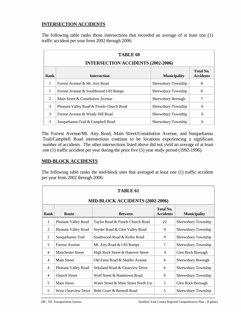
INTERSECTION ACCIDENTS The following table ranks those intersections that recorded an average of at least one (1)
traffic accident per year from 2002 through 2006:
TABLE 60
INTERSECTION ACCIDENTS (2002-2006)
Rank
Intersection
Municipality
Total No. Accidents
1 Forrest Avenue & Mt. Airy Road Shrewsbury Township 8
1 Forrest Avenue & Southbound I-83 Ramps Shrewsbury Township 8
2 Main Street & Constitution Avenue Shrewsbury Borough 7
3 Pleasant Valley Road & Fissels Church Road Shrewsbury Township 6
3 Forrest Avenue & Windy Hill Road Shrewsbury Township 6
3 Susquehanna Trail & Campbell Road Shrewsbury Township 6
The Forrest Avenue/Mt. Airy Road, Main Street/Constitution Avenue, and Susquehanna
Trail/Campbell Road intersections continue to be locations experiencing a significant number of accidents. The other intersections listed above did not yield an average of at least one (1) traffic accident per year during the prior five (5) year study period (1992-1996).
MID-BLOCK ACCIDENTS The following table ranks the mid-block sites that averaged at least one (1) traffic accident
per year from 2002 through 2006:
TABLE 61
MID-BLOCK ACCIDENTS (2002-2006)
Rank
Route
Between
Total No. Accidents
Municipality
1 Pleasant Valley Road Taylor Road & Fissels Church Road 22 Shrewsbury Township
2 Pleasant Valley Road Snyder Road & Glen Valley Road 9 Shrewsbury Township
2 Susquehanna Trail Southwood Road & Keller Road 9 Shrewsbury Township
3 Forrest Avenue Mt. Airy Road & I-83 Ramps 7 Shrewsbury Township
4 Manchester Street High Rock Street & Hanover Street 6 Glen Rock Borough
4 Main Street Old Farm Road & Shaffer Avenue 6 Shrewsbury Borough
4 Pleasant Valley Road Seitzland Road & Clearview Drive 6 Shrewsbury Township
4 Church Street Wolf Street & Hametown Road 6 Shrewsbury Township
5 Main Street Water Street & Main Street North Ext 5 Glen Rock Borough
5 West Clearview Drive Bohr Court & Rennoll Road 5 Shrewsbury Township

Southern York County Regional Comprehensive Plan - (Update) XII. Transportation System -189
ACCIDENTS MAP – 11 X 17”

190 - XII. Transportation System Southern York County Regional Comprehensive Plan – (Update)
Southern York County Regional Comprehensive Plan - (Update) XII. Transportation System -191
Only one (1) of the mid-block accident locations listed above (Main Street between Old Farm Road & Shaffer Avenue in Shrewsbury Borough) was included as a significant accident location in the 2000 Plan. The number of accidents during a five (5) year time span, however, has dropped from 12 (1992-1996) to six (6) (2002-2006).
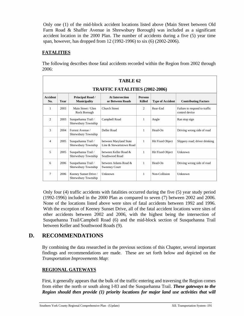
FATALITIES The following describes those fatal accidents recorded within the Region from 2002 through
2006:
TABLE 62
TRAFFIC FATALITIES (2002-2006)
Accident No.
Year
Principal Road / Municipality
At Intersection or Between Roads
Persons Killed
Type of Accident
Contributing Factors
1 2003 Main Street / Glen Rock Borough
Church Street 2 Rear-End Failure to respond to traffic control device
2 2003 Susquehanna Trail / Shrewsbury Township
Campbell Road 1 Angle Ran stop sign
3 2004 Forrest Avenue / Shrewsbury Township
Deller Road 1 Head-On Driving wrong side of road
4 2005 Susquehanna Trail / Shrewsbury Township
between Maryland State Line & Stewartstown Road
1 Hit Fixed Object Slippery road; driver drinking
5 2005 Susquehanna Trail / Shrewsbury Township
between Keller Road & Southwood Road
1 Hit Fixed Object Unknown
6 2006 Susquehanna Trail / Shrewsbury Township
between Adams Road & Sweeney Court
1 Head-On Driving wrong side of road
7 2006 Keeney Sunset Drive / Shrewsbury Township
Unknown 1 Non-Collision Unknown
Only four (4) traffic accidents with fatalities occurred during the five (5) year study period (1992-1996) included in the 2000 Plan as compared to seven (7) between 2002 and 2006. None of the locations listed above were sites of fatal accidents between 1992 and 1996. With the exception of Keeney Sunset Drive, all of the fatal accident locations were sites of other accidents between 2002 and 2006, with the highest being the intersection of Susquehanna Trail/Campbell Road (6) and the mid-block section of Susquehanna Trail between Keller and Southwood Roads (9).
D. RECOMMENDATIONS By combining the data researched in the previous sections of this Chapter, several important
findings and recommendations are made. These are set forth below and depicted on the Transportation Improvements Map:
REGIONAL GATEWAYS First, it generally appears that the bulk of the traffic entering and traversing the Region comes
from either the north or south along I-83 and the Susquehanna Trail. These gateways to the Region should then provide (1) priority locations for major land use activities that will
192 - XII. Transportation System Southern York County Regional Comprehensive Plan – (Update)
generate new traffic, and (2) linkages for new/improved roadways that seek to alleviate existing and future traffic congestion. As the Region grows it is highly probable that these same corridors will convey daily traffic to and from the Region. By strategically locating new uses and roads along these corridors, additional congestion can be minimized and existing congestion can be intercepted before it impacts the towns (particularly Shrewsbury Borough) and neighborhoods.
In contrast to the above, once traffic leaves I-83 and/or the Susquehanna Trail, it is generally
moving in an east/west direction. The major intersections where these east/west collector roads connect with the Susquehanna Trail (e.g., Church Street, Plank, West Clearview Drive, Forrest Avenue, Constitution Avenue, and Campbell Road) experience much traffic congestion and many traffic accidents. These conditions will only worsen unless additional connectors and improved intersections are made available. In fact, the present traffic volume along Plank Road greatly exceeds the maximum 1,500 vehicles per day usually associated with “minor” collector roads. This corridor should be reclassified as a “major” collector.
NEW ROADS AND REALIGNMENTS To reduce congestion and enhance safety, new roads and realignments of existing roads are
often necessary. Below is a listing of specific projects that could improve traffic conditions in the Southern Region.
Glen Rock Bypass Unlike the rest of the Region, traffic to-and-from Glen Rock appears to come from all
directions. Annual average daily traffic estimates indicate that the largest single volume of traffic approaches from Codorus Township and Jefferson Borough to the west along Manchester Street (AADT 6,164). This is followed by 3,623 (AADT) vehicles traveling Church Street, to the northeast. Next, 3,229 (AADT) vehicles follow Baltimore Street to the southeast of the Borough and, finally, 1,733 (AADT) vehicles come and go along Main Street Extended to the north. This traffic converges “downtown” creating congestion. All of these roads can be described as rural approaches and presumably carry local traffic, except for Church Street (SR 216) which serves as a collector link with the Region’s two (2) major arteries (Susquehanna Trail and Interstate 83). As additional growth is planned around Glen Rock and in adjoining Codorus Township, it is expected that the Church Street approach will carry more and more traffic.
Traffic fatalities at the terminus of Church Road in Glen Rock have reinforced the need to
create a “bypass” around the Borough’s center. A northern bypass, which would avoid Glen Rock altogether, would likely use Foust and Distillery Roads between Church Road and SR 216, which would be wholly within neighboring Springfield Township. A southern bypass would be in Shrewsbury Township and likely use Hametown Road to Valley Road, entering Glen Rock at Baltimore Street. Bypassing Glen Rock entirely via a southern route would require an expensive new road and would be very difficult because of terrain and the need to traverse Critical Environmental Areas. Should a bypass road ever come to fruition, it is critical to the economic health of the Borough that no new commercial development be proposed along this new bypass that would compete with those businesses that are more appropriately provided in “downtown” Glen Rock.
Southern York County Regional Comprehensive Plan - (Update) XII. Transportation System -193
TRANSPORTATION IMPROVEMENTS MAP – 11 X 17”

194 - XII. Transportation System Southern York County Regional Comprehensive Plan – (Update)
Southern York County Regional Comprehensive Plan - (Update) XII. Transportation System -195
Road Realignments As mentioned above, Church Street is expected to carry increasing volumes of traffic as
continued growth occurs around Glen Rock Borough. Thus, it is important that this road, which connects Exit 8 of I-83 and Glen Rock Borough, be improved to safely convey the increased traffic. Most particularly, in neighboring Springfield Township, Church Street should be moved northward to line-up with Seaks Run Road (SR 216). This new four (4)-way intersection should be fitted with exclusive turning lanes to facilitate convenient and safe traffic flow during peak traffic periods, without impacting the existing heavy volumes of through traffic. In time, this intersection will also likely require signalization as volumes increase. The Springfield Township Comprehensive Plan and Official Map Ordinance currently depict this realignment.
Two (2) other approaches to Glen Rock, Pleasant Valley Road and West Clearview Drive,
are both winding and have a high frequency of traffic accidents. These roads should be improved through realignment, widening and the installation of shoulders. One particular realignment to West Clearview Drive between Glen Valley Road and Bohr Court would eliminate most of the tight turns in this corridor and thus be especially beneficial.
The intersection of Stewartstown and Adams Roads with the Susquehanna Trail, as well as
the intersection of Windy Hill and Campbell Roads with the Susquehanna Trail, are noted for traffic congestion and unsafe conditions due to their offset alignment. Each of these roads is projected to operate at a peak hour level of service F (extreme delays that warrant improvements) by the year 2021 without any signalization improvements. Thus, it is recommended that these roads be realigned to create two (2) four (4)-way signalized intersections with the Susquehanna Trail.
Elm Drive Extension In order to alleviate traffic flow between Exit 4 of I-83 and the growth areas south of
Shrewsbury and New Freedom Boroughs, Elm Street is proposed as a “future” collector street. This will involve an extension of the roadway southeastward to intersect with Windy Hill Road.
In an effort to acquire additional right-of-way to implement transportation improvement
projects, Shrewsbury Township has identified the Stewartstown/Adams Roads and Windy Hill/Campbell Roads realignments, the Glen Rock Bypass and the Elm Drive Extension projects in its Official Map Ordinance.
INTERSECTION IMPROVEMENTS Intersection improvements are another means to improve safety and reduce congestion.
Specific projects for the Region are listed below. Exit 4 Interstate 83 The intersection of the I-83 ramps with Forrest Avenue (SR 851) has a very high incidence of
accidents as noted earlier in this Chapter. An Interchange Feasibility Study for York County

196 - XII. Transportation System Southern York County Regional Comprehensive Plan – (Update)
conducted by the Pennsylvania Department of Transportation (PENNDOT) in 2003 included the intersection of I-83 and SR 851. It examined the possibility of reconstructing the existing Exit 4 interchange and suggested five (5) options. Three (3) of the options have been selected for further study. These options are briefly described as follows: Option B – utilizes a partial cloverleaf design in the southeast quadrant, maintains the
existing diamond configuration for the southbound ramps and the northbound entrance ramp and replaces the northbound exit ramp with a partial cloverleaf design.
Option C – reconfigures the interchange as a Single Point Urban Interchange which involves controlling the intersection with one (1) three (3) phase signal with minimal design change.
Option E – a short term option to improve safety that involves lengthening the acceleration and deceleration lanes to meet current design standards and possibly replacement of the I-83 bridge over SR 851.
SR 616 (Pleasant Valley Road) & Fissels Church Road This “Y” intersection has experienced a high number of accidents. To improve this site, the intersection should be modified to create a “T” intersection with vehicles approaching SR 616 from Fissels Church Road operating under a full-stop condition. Creating a northbound left turn lane could further improve the intersection. Shrewsbury Township has identified both of these intersection improvement projects in its Official Map Ordinance. BRIDGE IMPROVEMENTS
The Transportation Plan component of the York County Comprehensive Plan identifies four
(4) bridges over I-83, in Shrewsbury Township, as being “low clearance.” As such, they do not meet the Federal height requirement of 16’6” for overpasses. The bridges are located at Hain Road/I-83, Plank Road/I-83, Windy Hill Road/I-83, and Stewartstown Road/I-83. These bridges should be improved to meet the minimum standard. The Township has identified these bridges in its Official Map Ordinance.
It is also noted that the State Bridge Management System accounts for 12 bridges within the
Region. These bridges are routinely inspected and municipalities are made aware of needed repairs or maintenance. However, bridges that measure 20 feet or less in length are not eligible for inspection under the Bridge Management System. In order to assure that all bridges in the Region are well maintained, each municipality should create an inventory of all bridges within their respective jurisdiction, as well as bridges that are jointly owned with a neighboring municipality. Once an inventory has been completed, a method for inspecting and funding improvements to the bridges should be established.
ACCESS CONTROL As important as road design is land use access. As discussed earlier in this Chapter, an
effective conveyor of traffic cannot provide for unlimited land access. Each driveway or roadway intersection introduces conflicting traffic movements that reduce a road’s ability to convey traffic quickly and safely. Therefore, these new and realigned roads should not be
Southern York County Regional Comprehensive Plan - (Update) XII. Transportation System -197
burdened with unnecessary driveway and road cuts. Local officials must enforce strict policies that will minimize such connections to ensure efficient traffic flow so that this new route does not become just another of the Region’s congested roads. Similarly, local officials should seek to reduce the number of driveway cuts that plague the Region’s existing collector roads. This process is a long-term strategy that will take many years and should start now! Zoning and subdivision/land development regulations can limit permitted driveway cuts, require wider lots, and provide for incentives and design flexibility that encourages adjoining properties to share vehicular access among other things (e.g., parking, loading, signage, storm water control, etc.). For access on State roads, local officials should persuade PennDOT officials to limit highway access to the minimum required.
One means to accomplish access control is to work with PENNDOT to develop a Regional
Access Management Plan for the area, especially the growth areas. Some of the primary elements of access management include driveway design standards, limited number of road entrances, traffic impact analysis for new development, left and right turn lanes constructed at road and access drive intersections, installation of medians, adequate parking lot/internal circulation design in developments, shared access to properties, and improved intersection design/spacing.
SHREWSBURY PARK & RIDE LOT As stated previously, this is the only Park & Ride facility in the Region and it is located on
the south side of Forrest Avenue just east of the I-83 Exit 4 Interchange in the Township. As congestion, commute times, and the price of fuel increases, motorists will be looking for ways to save time, money and energy. One option is to participate in a car or van pool. Should more motorists choose this option, an expansion of the Park & Ride lot may be warranted in the future. This would require the acquisition of additional land. Shrewsbury Township has included the Park & Ride Lot in its Official Map Ordinance as a means to acquire land for the expansion should neighboring lands be proposed for development.
PEDESTRIAN IMPROVEMENTS One of the themes of this Comprehensive Plan is to distinguish between “growth” areas
where a full range of public services and utilities are provided, and “rural” areas where the protection of the natural environment is given priority over, and protected from, development. Consequently, areas depicted for growth and development should include conveniently accessible schools, churches and parks. These “growth” areas will also, by function, include higher relative densities. To offset increased congestion, municipalities should consider requiring the installation of handicapped accessible sidewalks and curbs in all new developments within the identified growth areas. This could reduce reliance upon vehicular traffic for short trips and promote neighborly interaction. It may not be necessary to line both sides of every street with sidewalks, but some basic system that enables residents to walk safely throughout the development would be a good gauge.
Consideration should be given to widening highways and connecting roads to allow for a
bicycle/pedestrian lane contiguous with the cartway. This would create an inviting environment that would encourage use of alternatives to the automobile.

198 - XII. Transportation System Southern York County Regional Comprehensive Plan – (Update)
Trail Connections Chapter X, Parks and Recreation, listed “Future Linear Park Opportunities” as connections
to the existing York County Heritage Rail Trail. It is important to reiterate these potential trail projects in this Chapter as they also provide opportunities for pedestrian and bicycle travel. Increased linkages to the Heritage Rail Trail can result in more people using trails to travel to their destination as they provide a safe route.
a. Use the Stewartstown Railroad Company line, which extends from New Freedom
Borough to Stewartstown Borough, to link the Heritage Rail Trail with Shrewsbury Borough and Shrewsbury Elementary School, as well as other sites along the corridor.
b. Another possible linkage is from Railroad Borough through the Township to
Shrewsbury Borough along a tributary of the South Branch of Codorus Creek. This linkage could begin at Railroad Park and run parallel to Kirchner and Stone Arch Roads, then link up with the Stewartstown Railroad line and extend as far as Shrewsbury Elementary School.
c. Main Street in Railroad Borough provides a ready-made linkage for bicyclists who
wish to cycle into Shrewsbury Borough. This connection has the advantages of pro-viding access to Shrewsbury Borough's attractive historic center and the Sweeney Memorial Park.
d. Potential extension of the Springfield Township proposed Potosi Greenway into
Shrewsbury Township along the portions of Potosi and Park Roads in the Township. To create a greenway loop in this locale, Shrewsbury Township should consider creating a greenway that would extend from Potosi Road along Sawmill, White Oak School, Brillstrick, and Line Roads, then reconnect with Potosi Road. This greenway/trail concept provides a linkage to Spring Valley County Park and has been included in the Shrewsbury Township Official Map Ordinance.
e. Potential extension of the Glen Valley Road Greenway to connect with Heritage
Rail Trail County Park could continue along Glen Valley Road in Shrewsbury Township to Raver Road, parallel Raver Road to Valley Road, and parallel Valley Road to the Heritage Rail Trail in Glen Rock Borough. This route would also parallel the Glen Rock Valley stream, creating another scenic route for pedestrians and bicyclists
Each of these potential connections would likely require that a feasibility study and/or master plan be prepared to determine what measures would be necessary to implement these concepts. In some cases, signage and possibly a bicycle/pedestrian lane may be all that would be needed to create the linear connection, but in other cases a substantial amount of improvement may be warranted. In any event, the goal would be to create a trail with an adequate level of safety for both bicyclists and pedestrians.
Southern York County Regional Comprehensive Plan - (Update) XII. Transportation System -199
OTHER REMEDIAL IMPROVEMENTS General improvements to bring public roads and intersections into compliance with the
minimum design standards set forth in the local Subdivision and Land Development Ordinances should be given consideration as resources permit. Local officials should program and accomplish those projects that offer the most benefit (maximize traffic flow and minimize safety hazards). Some remedial projects may be accomplished by developers, in conjunction with a subdivision or land development plan. Local officials should be ever mindful of the opportunity to partner with the development community in the provision of needed transportation improvements. Currently, only Shrewsbury Township requires developers to submit a Traffic Impact Study in conjunction with major subdivision and land development plans. The Boroughs should also require Traffic Impact Studies as a means to identify potential traffic issues and to work with developers to address them.
In neighborhoods where cut-through traffic, speeding, or accident frequency/severity has
become an issue, traffic calming devices may warrant some consideration. Traffic calming devices are intended to reduce vehicle speed; improve safety for motorists, pedestrians and residents; and enhance the quality of life on neighborhood streets. The general methods of traffic calming are active speed reduction controls (constructing barriers to traffic movements), passive speed reduction controls (installation of signage, pavement markings, on-street parking), streetside design (installation of landscaping that changes the appearance of the area and driver attitudes), regional planning efforts that direct external traffic to other routes that can better handle the traffic, and opportunities for the use of alternative modes of transportation.
In giving traffic calming devices consideration, it is important that the traffic issues be
specifically identified and that all the device options be evaluated with regard to benefits, drawbacks and cost. For example, although passive speed reduction controls can be relatively inexpensive, they are often ignored and require local enforcement. It is also recommended that neighborhood residents be involved in any discussion and selection of traffic calming devices to get their buy-in and support for the project.
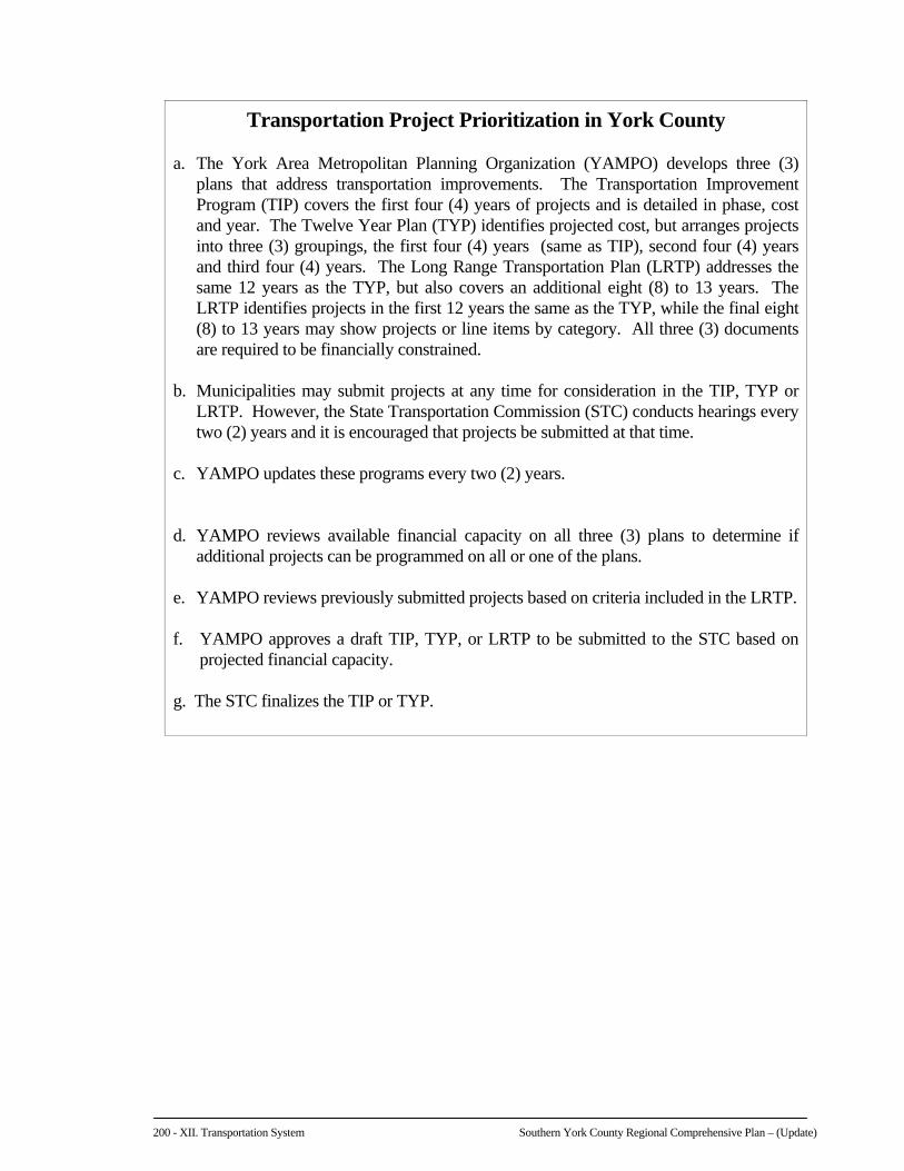
E. TRANSPORTATION IMPROVEMENTS PROGRAMMING The narrative presented on the following page, which was developed by the York County
Planning Commission, describes the process by which transportation improvement projects are submitted, prioritized and approved through a coordinated effort involving local, County and State agencies.
The Region should form its own committee to submit its respective list of priority projects
every two (2) years. All municipalities should support the recommendations of the Regional Committee to lend political “muscle” for its selected projects. Regional representatives should also inform their elected State representatives, both of whom are members of the York County Transportation Coalition. This will increase the likelihood that the Region's projects will be given greater consideration.
200 - XII. Transportation System Southern York County Regional Comprehensive Plan – (Update)
Transportation Project Prioritization in York County a. The York Area Metropolitan Planning Organization (YAMPO) develops three (3)
plans that address transportation improvements. The Transportation Improvement Program (TIP) covers the first four (4) years of projects and is detailed in phase, cost and year. The Twelve Year Plan (TYP) identifies projected cost, but arranges projects into three (3) groupings, the first four (4) years (same as TIP), second four (4) years and third four (4) years. The Long Range Transportation Plan (LRTP) addresses the same 12 years as the TYP, but also covers an additional eight (8) to 13 years. The LRTP identifies projects in the first 12 years the same as the TYP, while the final eight (8) to 13 years may show projects or line items by category. All three (3) documents are required to be financially constrained.
b. Municipalities may submit projects at any time for consideration in the TIP, TYP or
LRTP. However, the State Transportation Commission (STC) conducts hearings every two (2) years and it is encouraged that projects be submitted at that time.
c. YAMPO updates these programs every two (2) years. d. YAMPO reviews available financial capacity on all three (3) plans to determine if
additional projects can be programmed on all or one of the plans. e. YAMPO reviews previously submitted projects based on criteria included in the LRTP. f. YAMPO approves a draft TIP, TYP, or LRTP to be submitted to the STC based on
projected financial capacity. g. The STC finalizes the TIP or TYP.