Luke Air Force Base Auxiliary Field #1 and
Gila Bend Air force Auxiliary Field / Barry M. Goldwater Range
Joint land use study
Part Two: Gila Bend Air force Auxiliary Field /
Barry M. Goldwater Range
Arizona military regional compatibility project
February 2005
Prepared for:
Prepared by:
This study was prepared under contract with the Arizona Department of Commerce with financial support from the Office of Economic Adjustment, Department of Defense. The content does not necessarily reflect the views of the Office of Economic Adjustment.
GILA BEND AIR FORCE AUXIL IARY F IELD /
BARRY M. GOLDWATER RANGE JOINT LAND USE STUDY
FEBRUARY 2005 ACKNOWLEDGEMENTS i
ACKNOWLEDGEMENTS
Policy advisory committee members (PAC) Roger Ames, Project Coordinator, Vanguard
Rep. Amanda Aguirre, Arizona House of Representatives, District 24
Sen. Marsha Arzberger, Arizona State Senate, District 25
Lisa Atkins, Co-Chair, Arizona Military Affairs Commission
Patricia Bailey, Bureau of Land Management Yuma Field Office
Rep. Jennifer Burns, Arizona House of Representatives, District 25
Sen. Robert Cannell, Arizona State Senate, District 24
Rep. Jim Carruthers, Arizona House of Representatives, District 24
Col. James Cooney, Commanding Officer, Marine Corps Air Station (MCAS) Yuma
Gene Dahlem, Manager, Sonoran Desert National Monument – Bureau of Land Management, Phoenix Field Office
Linda Davis, President, Gila Bend Chamber of Commerce
Steven Holt, Council Member, Town of Gila Bend
Richard Hubbard, Deputy Commissioner, Arizona State Land Department
Spencer Kamps, Vice-President of Legislative Affairs, Home Builders Association of Central Arizona
Rusty Mitchell, Director, Community Initiatives Team, Luke Air Force Base
Rep. John Nelson, Arizona House of Representatives, District 12
Larry Nelson, Mayor, City of Yuma
Chris Riggs, Mayor, Town of Gila Bend
Earl Runte, Landowner
Rich Schiffli, Western ARNG Aviation Training Site
Lenore Stuart, Yuma County Supervisor, District 1
Dusty Thomas, Director of Operations, H&S Developers, Inc.
Mike Toriello, Deputy Base Civil Engineer, Davis-Monthan Air Force Base
Col. USAF (Ret.) James Uken, Director, 56th Range Management Office, Luke Air Force Base
Mary Rose Wilcox, Maricopa County Supervisor, District 5
Bob Woodman, Owner, Woodman Realty
GILA BEND AIR FORCE AUXIL IARY F IELD /
BARRY M. GOLDWATER RANGE JOINT LAND USE STUDY
FEBRUARY 2005 ACKNOWLEDGEMENTS I I
Working group and project team members Jennifer Albers, City of Yuma
Maggie Carrasco, Yuma County
Mike Davis, Department of Defense Office of Economic Adjustment
John DeMartino, Parsons
Bob Duchek, Parsons
Lynn Farmer, Town of Gila Bend
Tracey Ferguson, Parsons
Dion Flynn, State of Arizona Governor’s Office
Heather Garbarino, Arizona Department of Commerce
Bill Gillies, Luke Air Force Base
Terry Hansen, Luke Air Force Base
Matt Holm, Maricopa County
Greg Keller, Arizona State Land Department
Alan Maguire, The Maguire Company
Jennifer Meyer, Davis-Monthan Air Force Base
Kevin O’Berry, Luke Air Force Base
Gene Santarelli, S’relli Consulting, LLC
Lt Col. William Sellars, MCAS Yuma Range Office
Deb Sydenham, Arizona Department of Commerce
Paul Walker, Luke Air Force Base
GILA BEND AIR FORCE AUXIL IARY F IELD /
BARRY M. GOLDWATER RANGE JOINT LAND USE STUDY
FEBRUARY 2005 TABLE OF CONTENTS i i i
TABLE OF CONTENTS
ACKNOWLEDGEMENTS ....................................................................... I 1. INTRODUCTION..........................................................................1-1
1.1 Project Purpose.............................................................................................. 1-4
1.2 Project Goals.................................................................................................. 1-4
1.3 Guiding Principles......................................................................................... 1-5
1.4 Public Participation ...................................................................................... 1-5
1.5 Plan Implementation .................................................................................... 1-6 2. STUDY AREA OVERVIEW.............................................................2-1
2.1 Growth and Development ............................................................................. 2-1
2.2 Growth Potential and Planned Land Use – Municipal and County........... 2-4
2.3 Range and Airfield Operations..................................................................... 2-9
2.4 Land Ownership.......................................................................................... 2-16 3. REVIEW OF EXISTING LEGISLATION..........................................3-1
3.1 Existing Land Use Compatibility Legislation, Ordinances, and Guidelines............................................................................................... 3-1
3.2 Differences Between Federal and State Guidance for Compatible Uses............................................................................................ 3-3
4. DEVELOPMENT TRENDS AND ISSUES..........................................4-1 5. LAND USE COMPATIBILITY.........................................................5-1
5.1 Noise and Safety Considerations.................................................................. 5-1
5.2 Land Use Compatibility – Gila Bend AFAF ................................................ 5-5
5.3 Land Use Compatibility – BMGR Boundary Areas .................................. 5-14
5.4 Land Use Compatibility Plan and Compatibility Policy Implementation ................................................................................ 5-27
6. IMPLEMENTATION PROGRAM.....................................................6-1 6.1 Introduction................................................................................................... 6-1
6.2 Implementation Strategies ........................................................................... 6-2
GILA BEND AIR FORCE AUXIL IARY F IELD /
BARRY M. GOLDWATER RANGE JOINT LAND USE STUDY
FEBRUARY 2005 TABLE OF CONTENTS iv
LIST OF APPENDICES
Appendix A: Arizona Land Use Compatibility Legislation ................................................ A-1
Appendix B: Arizona Regional Compatibility Project Model Resolution .......................... B-1
Appendix C: Glossary of Acronyms ..................................................................................... C-1
Appendix D: Resources Consulted .......................................................................................D-1
LIST OF TABLES Table 3-1: Compatibility of Uses – AICUZ Program ........................................................3-4
Table 3-2: Compatibility of Uses – ARS §28-8481 ............................................................3-4
Table 4-1: Growth Rates of Jurisdictions in the JLUS Study Area.................................4-1
Table 5-1: Recommended Land Use Compatibility Criteria – Gila Bend AFAF ..........5-10
LIST OF FIGURES
Figure 1-1: Military Lands in Arizona ...............................................................................1-2
Figure 2-1: Vicinity Map.....................................................................................................2-2
Figure 2-2: Vicinity Map - Western Segment ..................................................................2-12
Figure 2-3: Vicinity Map - Eastern Segment ...................................................................2-13
Figure 5-1: Vicinity Box - Gila Bend AFAF .......................................................................5-6
Figure 5-2: F-16 Noise Contours - Gila Bend AFAF..........................................................5-7
Figure 5-3: F-18E Noise Contours - Gila Bend AFAF.......................................................5-8
Figure 5-4: Accident Potential Zones - Gila Bend AFAF ..................................................5-9
Figure 5-5: Compatible Land Use Plan Zones - Gila Bend AFAF ..................................5-13
Figure 5-6: South Mesa Focus Area .................................................................................5-16
Figure 5-7: Foothills Focus Area ......................................................................................5-17
Figure 5-8: East County 1 Focus Area .............................................................................5-18
Figure 5-9: East County 2 Focus Area .............................................................................5-19
Figure 5-10: Stoval Airfield Focus Area.............................................................................5-22
Figure 5-11: Auxiliary Field #6 Focus Area.......................................................................5-23
Figure 5-12: Manned Range 1 Focus Area.........................................................................5-24

GILA BEND AIR FORCE AUXIL IARY F IELD /
BARRY M. GOLDWATER RANGE JOINT LAND USE STUDY
FEBRUARY 2005 CHAPTER 1 : INTRODUCT ION 1 - 1
1. INTRODUCTION
In June 2004, a Joint Land Use Study (JLUS) for Gila Bend Air Force Auxiliary Field / Barry M. Goldwater Range (BMGR) began under the sponsorship of the Arizona Department of Commerce (ADOC). Partially funded by a grant from the Department of Defense Office of Economic Adjustment, this JLUS is Part Two of a Joint Land Use Study; Part One, for Luke Air Force Base Auxiliary Field #1, was completed in May 2004.
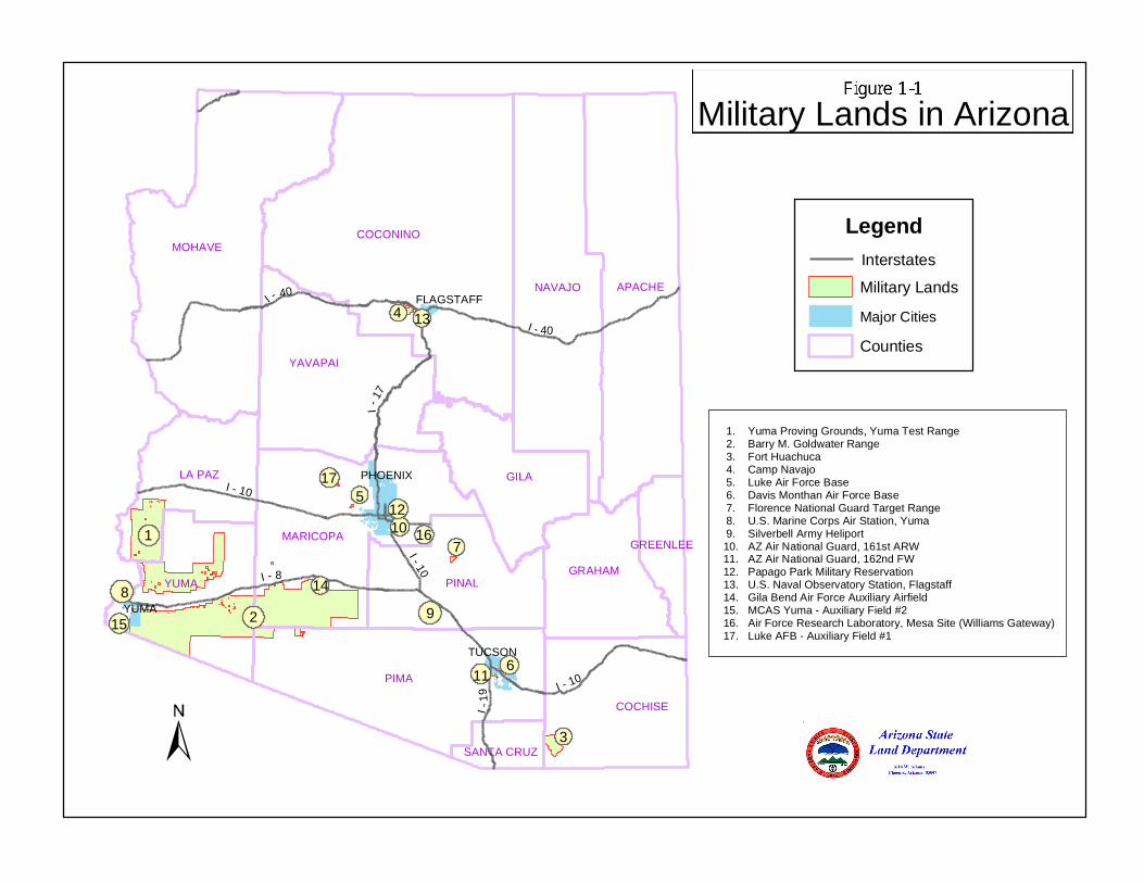
The Gila Bend Air Force Auxiliary Field / Barry M. Goldwater Range and Luke Air Force Base Auxiliary Airfield #1 JLUS is part of the Arizona Military Regional Compatibility Project, which was conceived as a proactive statewide endeavor to convene the stakeholders around each base — the relevant jurisdictions, base personnel, landowners, and other interested parties — to address land use compatibility issues. Arizona is home to a network of United States military airports and installations including Luke Air Force Base, Yuma Proving Ground and Marine Corps Air Station (MCAS) Yuma, Davis-Monthan Air Force Base, Fort Huachuca, the Western ARNG Aviation Training Site (WAATS) and the BMGR Complex (Figure 1-1).
As issues of growth and development have moved to the forefront in many parts of Arizona, the bases and jurisdictions where the bases are located play key roles in addressing compatibility. Through the statewide Compatibility Project, the State is endeavoring to provide the tools to address land use conflicts that might affect the ability of each base to conduct its mission, and to ensure land use compatibility around active military airports, as required under Title 28, Article 7 of the Arizona Revised Statues (ARS). Appendix A summarizes the applicable ARS land use compatibility legislation.
Consistent with the statewide interest in land use compatibility issues and sustainability of military installations and recognizing the combined importance of the Gila Bend Air Force Auxiliary Field (AFAF), Barry M. Goldwater Range (BMGR), and Auxiliary Field #1, a comprehensive approach to these facilities is being taken in this JLUS.
BMGR is a critical facility because it is authorized for live-fire training, which is made possible through military control of the surface and airspace. Also critical are the designated Military Training Routes (MTR) crisscrossing Arizona, eight of which provide essential access to BMGR. These routes are used by the military to practice high-speed, low-altitude maneuvers (generally below the 10,000-foot altitude and at airspeeds greater than 400 miles per hour).
Gila Bend AFAF, occupying 1,885 acres of BMGR, is located four miles south of the Town of Gila Bend and east of Highway 85. Approximately 45,000 operations per year are conducted at Gila Bend AFAF. Aircraft including F-16s from Luke Air Force Base routinely use the airfield for practicing traffic pattern and emergency simulated engine flameout procedures. It is also used for emergency recoveries of military aircraft that experience malfunctions on BMGR and diversion of aircraft due to factors such as bad weather at their home base, unsafe ordnance, or low fuel. The total aircraft diversions to Gila Bend account for approximately 250 operations annually, with approximately 70 emergency and/or weather diversions.
I - 40
I - 40
I - 1
7
I - 10
I - 10
I - 10
I - 8
I - 1
9PHOENIX
FLAGSTAFF
TUCSON
YUMA
PIMA
COCONINOMOHAVE
APACHENAVAJO
GILA
YUMA
YAVAPAI
PINAL
MARICOPA
COCHISE
LA PAZ
GRAHAM
GREENLEE
SANTA CRUZ
Military Lands in Arizona
2
1
3
4
5
6
7
89
LegendInterstates
Military Lands
Major Cities
Counties
10
11
12
13
14
15
16
17
1. Yuma Proving Grounds, Yuma Test Range 2. Barry M. Goldwater Range 3. Fort Huachuca 4. Camp Navajo 5. Luke Air Force Base 6. Davis Monthan Air Force Base 7. Florence National Guard Target Range 8. U.S. Marine Corps Air Station, Yuma 9. Silverbell Army Heliport10. AZ Air National Guard, 161st ARW11. AZ Air National Guard, 162nd FW12. Papago Park Military Reservation13. U.S. Naval Observatory Station, Flagstaff14. Gila Bend Air Force Auxiliary Airfield15. MCAS Yuma - Auxiliary Field #216. Air Force Research Laboratory, Mesa Site (Williams Gateway)17. Luke AFB - Auxiliary Field #1

GILA BEND AIR FORCE AUXIL IARY F IELD /
BARRY M. GOLDWATER RANGE JOINT LAND USE STUDY
FEBRUARY 2005 CHAPTER 1 : INTRODUCT ION 1 -3
As stated in the Report of the Governor’s Military Facilities Task Force:1
Each military facility in Arizona has a mission to carry out in support of the nation’s defense. However, the sustainability of the installation to carry its mission depends not only on the ability to maintain its own capabilities, but also on its linkages with a network of other facilities and installations in the State.
For each of the individual bases to sustain its mission, it needs not only to protect the capabilities of the Base itself, but also to protect the capability of BMGR and Gila Bend AFAF from incompatible use so that these facilities can continue to accommodate the necessary training activities.
In response to issues of incompatible uses that expose people to safety and noise effects ranging from nuisance to physical harm, State legislation amending Title 28, Article 7, Airport Zoning & Regulation (ARS §28-8461, §28-8481, and §28-8482) mandated that areas within high-noise or accident potential zones be addressed in municipal general plans and county comprehensive plans and required that land development within the high-noise or accident potential zones be compatible with military airport operations. Recent legislation extended this mandate to the areas affected by operations at ancillary military facilities including Gila Bend AFAF and MCAS Yuma Auxiliary Field #2. Appendix A summarizes the applicable ARS land use compatibility legislation.
The State of Arizona, through amendments to existing law, including ARS §9-461.05, §9-461.06, §9-462.04, §11-806, §11-821, §11-824, and §11-826 enacted Growing Smarter and Growing Smarter Plus measures that address growth and land development issues through changes in community planning and rezoning processes. These measures require political jurisdictions with property within territory in the vicinity of a military airport or ancillary military facilities, as defined in ARS §28-8461, to include consideration of military airport operations in their General Plans and Comprehensive Plans and to allow an opportunity for official comment by the military airport officials on the Plans.
In addition to the specific requirements for territory in the vicinity of military airports, the Growing Smarter statute requires that plans provide for a rational pattern of land development and an extensive public participation program. Compliance with these Growing Smarter and Growing Smarter Plus objectives serves as a key guiding principle for the overall Arizona Military Regional Compatibility Project as well as in the preparation of this JLUS.
The U.S. Department of Defense has created the Air Installation Compatible Use Zone (AICUZ) Program to assist communities around military airports in planning for compatible land use. Elements from this national program were also considered in developing the recommendations of this Study.
1Report of the Governor’s Military Facilities Task Force, Executive Order 2003-18, December 2003.

GILA BEND AIR FORCE AUXIL IARY F IELD /
BARRY M. GOLDWATER RANGE JOINT LAND USE STUDY
FEBRUARY 2005 CHAPTER 1 : INTRODUCT ION 1 -4
This JLUS was developed through a collaborative effort that included two public informational meetings, broad participation of a Policy Advisory Committee (PAC) and Working Group, individual meetings, and frequent correspondence.
1.1 PROJECT PURPOSE
The purpose of the Joint Land Use Study for Gila Bend Air Force Auxiliary Field / Barry M. Goldwater Range is to facilitate the implementation of compatible land uses around the Range and Auxiliary Field through a cooperative coordinated program among the affected jurisdictions in Maricopa and Yuma Counties that have the authority and responsibility to implement land use regulations for their communities, along with Luke Air Force Base, MCAS Yuma, and other interested and affected parties, including institutions, corporations, and individuals. To accomplish this, the JLUS Program uses existing data to understand issues of land use compatibility and proposes specific and achievable implementation strategies based upon sound compatibility criteria.
1.2 PROJECT GOALS
To accomplish the purpose, the primary goals of this JLUS are:
• Compile and analyze existing plans and studies to identify existing data, data needs, and points of consistency and conflict among the existing documentation in the area of encroachment prevention.
• Identify approaches to land use compatibility that are acceptable and feasible in areas around the Gila Bend Air Force Auxiliary Field and Barry M. Goldwater Range.
• Provide opportunities for meaningful input by landowners, county and municipal governmental agencies, educational institutions, and other stakeholders.
• Develop an implementation plan based on defined compatibility criteria that recommends actions to prevent encroachment by incompatible development and its resulting impacts on military missions and sustainability.
• Identify existing and develop new land use planning and zoning tools, strategies, and techniques and develop new tools, strategies, and techniques that fairly allocate impacts of achieving land use compatibility with respect to federal, State, and local governments, private landowners, and the military.
As the Project Team met with local jurisdictions, the Base, residents, landowners, and other stakeholders, additional goals were identified:
• Define areas affected by high noise and accident potential that are based upon specific standards that reflect current aircraft and levels of operations at Gila Bend AFAF and BMGR and that also consider the likely impacts of changes as future aircraft and mission changes occur.
• Develop compatibility criteria that recognize the differences in risk and impacts from aircraft operations and from other operations at BMGR.
GILA BEND AIR FORCE AUXIL IARY F IELD /
BARRY M. GOLDWATER RANGE JOINT LAND USE STUDY
FEBRUARY 2005 CHAPTER 1 : INTRODUCT ION 1 -5
1.3 GUIDING PRINCIPLES
The Arizona Military Regional Compatibility Project defined the following guiding principles for the compatibility planning process. These principles became a foundation of the JLUS and apply to each element and phase of the process.
• Create feasible and sustainable solutions that are consistent with Title 28, Article 7, Airport Zoning and Regulation and the Growing Smarter and Growing Smarter Plus legislation
• Address areas within the vicinity of military airports in municipal general plans and county comprehensive plans to ensure development is compatible with the high-noise or accident potential generated by military airport operations, as defined under ARS §28-8481
• Ensure openness to varying viewpoints throughout the process
• Focus on fair and equitable solutions for all affected parties
• Establish, maintain, and enhance consistency and continuity in the decision-making process
• Achieve consent among the stakeholders on the means to control encroachment
• Devise compatible land use solutions that accommodate urban development while preserving the operational capabilities of the Gila Bend Air Force Auxiliary Field and Barry M. Goldwater Range.
1.4 PUBLIC PARTICIPATION
The public participation program provided opportunities for interested parties to contribute to shaping the outcome of the Joint Land Use Study through the public outreach process. The vision for public participation was that no one interest dominated the public process, but that all stakeholders in the affected area and all other interested parties had access to frequent and timely progress reports, meaningful and convenient methods of participation, and timely access to draft documents in advance of public meetings.
To achieve this vision, the public participation program consisted of a variety of communication opportunities:
• Posting project information on the Arizona Department of Commerce web site (http://www.azcommerce.com)
• Distributing project information to a mailing list of more than 450 community organizations, agencies, and individuals via monthly bulletins, e-mail notices, and direct mailings
• Encouraging local media coverage of Military Compatibility Project achievements, milestones, and events through distribution of press releases and public service announcements
• Providing for participation in the JLUS Policy Advisory Committee by key constituent groups, community organizations, Luke Air Force Base and MCAS
GILA BEND AIR FORCE AUXIL IARY F IELD /
BARRY M. GOLDWATER RANGE JOINT LAND USE STUDY
FEBRUARY 2005 CHAPTER 1 : INTRODUCT ION 1 -6
Yuma representatives, and local political jurisdictions to provide input and policy direction
• Conducting two Public Informational Meetings (one in the Town of Gila Bend and one in the City of Yuma) to provide residents and stakeholders an opportunity to receive information on issues and to provide input and comments in a comfortable environment
• Distributing documents in hard copy, web, email, and data disc formats
1.5 PLAN IMPLEMENTATION
The JLUS recommendations are the foundation for future action by a variety of public and private entities as it relates to compatible land use around the Base. The JLUS is designed to be implemented at several levels, including the State of Arizona and local political jurisdictions, and by cooperative efforts among local jurisdictions, Luke Air Force Base, MCAS Yuma and public / private partnerships. The implementation program for the JLUS is contained in Chapter 6.
GILA BEND AIR FORCE AUXIL IARY F IELD /
BARRY M. GOLDWATER RANGE JOINT LAND USE STUDY
FEBRUARY 2005 CHAPTER 2 : S TUDY AREA OVERVIEW 2 - 1
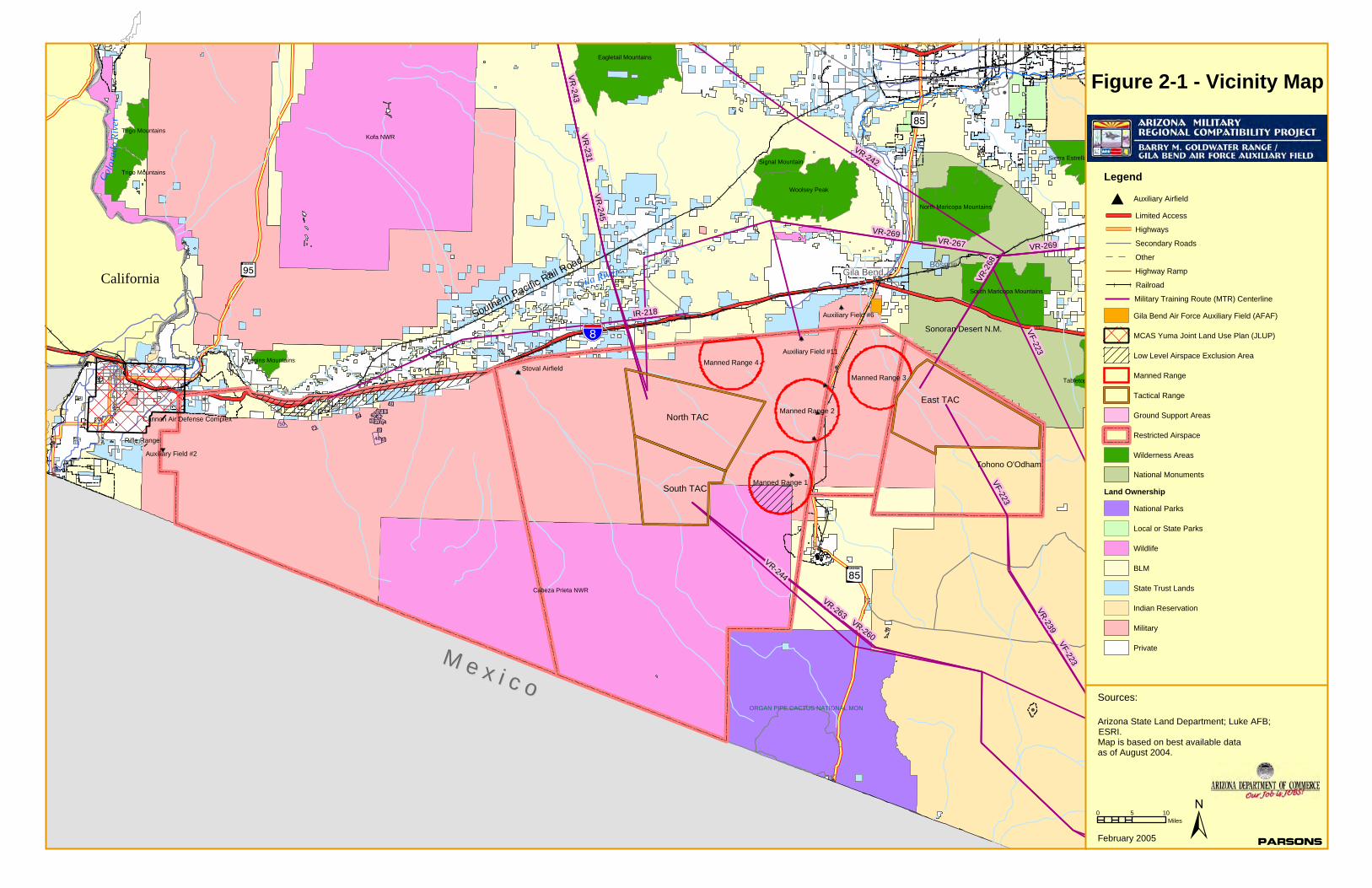
2. STUDY AREA OVERVIEW
The study area for the Gila Bend Air Force Auxiliary Field / Barry M. Goldwater Range JLUS extends approximately seven miles outward from the boundary of the Range and Field (Figure 2-1). The study area includes portions of the Town of Gila Bend, the City of Yuma, the City of Somerton, the Town of Wellton, the City of San Luis and unincorporated Maricopa and Yuma counties. This Chapter presents an overview of the existing conditions in the study area, and briefly describes the area’s historical growth and development, as well as current development trends and growth potential. The chapter also presents overviews of airspace considerations, the military operations at the Range and Auxiliary Fields, and the land ownership pattern in the study area.
2.1 GROWTH AND DEVELOPMENT
2.1.1 Historical Development
When the first Europeans arrived in southwestern Arizona in 1540, they found native peoples who had been living there for centuries. By the 1700’s the Spanish were calling these people the Yumas and today the descendents of these early peoples are known as the Quechan. From 1540 to until the mid-19th century, the area was under the flags of Spain and Mexico. Lands north of the Gila River became part of the United States in 1848, and lands south of the Gila River were acquired by the U.S. through the Gadsden Purchase in 1853. Fort Yuma was established in 1849 on the California side of the Colorado River, and the first Anglo American settlers also arrived at Yuma in 1849. However, the single event that transformed the Gila River valley into a well-traveled route used by gold prospectors and settlers alike was the California gold rush of the mid-1800s. It is estimated that by 1851 more than 60,000 people had passed through the Gila River valley and adjacent areas on their journey to the California gold fields. Yuma became the major river crossing of the California gold seekers. From the 1850s to the 1870s, steamboats on the Colorado River transported passengers and goods to mines, ranches and military outposts in the area.
On March 3, 1877, the Desert Land Act was passed by the U.S. Congress to encourage and promote economic development of the arid and semiarid public lands of the Western United States. The Act permitted settlers to obtain title to 640 acres of those public lands identified as arid and semiarid if they agreed to reclaim, irrigate, and cultivate the property within three years.
Also in 1877, the first railroad in Arizona crossed the Colorado River at Yuma. By the 1880s the railroad had reached Gila Bend and by the 1890s lands in the Gila River valley had been irrigated, which attracted more settlers to the region. Through the first part of the 20th Century, Anglo settlement increased with the continued development of large-scale irrigation and the increased production of copper and other minerals. Irrigation and agriculture production accelerated with the first reclamation projects on the Colorado River in l909 and the entry of Arizona into the Union in 1912.
!
!
!
! !
!
!
!
!
!
!
!
!
!
!(
! !
!
!
!
!
!
!
!
!
!
!
!
!
!
!
!
!
!
!
!
!
!
!
!
!
MM ee xx ii cc oo
!"̀$
?Ù
!$
Color
ado
Rive
r
Gila River
ORGAN PIPE CACTUS NATIONAL MON
Cabeza Prieta NWR
Southern Pacific Rail Road
Tohono O'Odham
Sonoran Desert N.M.
Kofa NWR
CaliforniaBosque
Gila Bend
Woolsey Peak
Eagletail Mountains
North Maricopa Mountains
South Maricopa Mountains
Sierra Estrella
Trigo Mountains
Trigo Mountains
Signal Mountain
Tabletop
Muggins Mountains
VR-269VR-269
IR-218
VR-231
VR-267
VR-2
68
VR-243
VR-239
VR-244
VR-245
VR-263VR-260
VF-223
VF-223
VF-223
VR-242
Manned Range 2
Manned Range 1
Manned Range 3
Manned Range 4
48
50
60
62
21
65543937
63
64
61
40
49
0 5 10Miles
Figure 2-1 - Vicinity Map
±
?Í
?Í
Arizona State Land Department; Luke AFB;ESRI.Map is based on best available dataas of August 2004.
Sources:
ParsonsFebruary 2005
Auxiliary Field #6
Stoval Airfield
Auxiliary Field #2
Rifle Range
Cannon Air Defense Complex North TAC
South TAC
East TAC
Auxiliary Field #11
Legend
Limited Access
Highways
Secondary Roads
Other
Highway Ramp
Railroad
MCAS Yuma Joint Land Use Plan (JLUP)
Low Level Airspace Exclusion Area
Manned Range
Tactical Range
Wilderness Areas
National Monuments
Land Ownership
Auxiliary Airfield#
Gila Bend Air Force Auxiliary Field (AFAF)
Ground Support Areas
Restricted Airspace
Military Training Route (MTR) Centerline
National Parks
Local or State Parks
Wildlife
BLM
State Trust Lands
Indian Reservation
Military
Private
GILA BEND AIR FORCE AUXIL IARY F IELD /
BARRY M. GOLDWATER RANGE JOINT LAND USE STUDY
FEBRUARY 2005 CHAPTER 2 : S TUDY AREA OVERVIEW 2 -3
Through the first half of the 20th century, the study area’s economy remained primarily agricultural, with Yuma and Gila Bend as the urban settlements providing services to the surrounding areas and access to the Southern Pacific rail line. In 1915, the construction of the Ocean-to-Ocean bridge across the Colorado River at Yuma completed the first true national coast to coast highway route, and by the 1920s, the improved accessibility had generated the beginnings of tourism to the area, with seasonal visitors drawn by the mild winter climate. However, with the national depression in the 1930s, the area’s population grew slowly.
The post-World War II period brought increasing growth and development to many parts of the study area. While agriculture remained an important part of the economy, increased tourism and an expanded military presence, along with industrial diversification contributed to increased population. The area’s climate proved to be attractive to retirees, and retirement communities soon became part of the area’s growth pattern. Retail and service-related businesses followed the increasing population. Interstate Highway 8, along with the parallel Union Pacific rail line is the principal east-west transportation corridor, and traveler and tourism related uses have developed at the interchanges along the Interstate. With the area’s proximity to Mexico, the area has also seen increased cross-border trade.
2.1.2 Local Jurisdictions
Although most of the land within the study area is located in unincorporated Maricopa County or in unincorporated Yuma County, the study area also includes portions of five municipalities. The Town of Gila Bend is located in Maricopa County, approximately 3 miles north of Gila Bend AFAF, and the Town’s planning area extends to the northern boundary of BMGR on either side of Arizona Highway 85. The Town of Wellton is located in Yuma County, approximately 30 miles east of Yuma, approximately 4 miles north of the BMGR boundary. The northwesterly portion of BMGR is within the municipal limits of the City of Yuma. The City extends north and northwest of BMGR, and the City’s planning area extends from Avenue 10E along the northerly and westerly boundaries of the Range to County 17th Street. The City of Somerton is located southwest of the City of Yuma, on Highway 95, approximately 8 miles west of the western BMGR boundary. The Somerton planning area includes areas to the west of the East Main Canal, and the easterly boundary of the planning area is approximately 5 miles from the western BMGR boundary. The City of San Luis is located south of Somerton; its easterly boundary (at Avenue A) is approximately 4 miles west of the western BMGR boundary, although the built-up portions of the City are located 6 to 7 miles west of the boundary. The San Luis planning area extends west of Avenue A from County 19th Street on the north to the U.S.-Mexico border on the south.
2.1.3 Existing Development Patterns
Development patterns within the JLUS Study Area vary substantially in character. The most intensely developed areas are in the Yuma urban area at the western end of BMGR, the Foothills area and in and around the Towns of Gila Bend and Wellton. However, even in these areas, most of the land adjacent to BMGR is rural in character. Travel and
GILA BEND AIR FORCE AUXIL IARY F IELD /
BARRY M. GOLDWATER RANGE JOINT LAND USE STUDY
FEBRUARY 2005 CHAPTER 2 : S TUDY AREA OVERVIEW 2 -4
tourism related uses are clustered around the Interstate Highway 8 interchanges. The remaining lands are characterized by a mix of agricultural uses and open land.
2.2 GROWTH POTENTIAL AND PLANNED LAND USE – MUNICIPAL AND COUNTY
The General Plans of the City of Yuma, City of Somerton, City of San Luis, Town of Wellton, Town of Gila Bend and the Maricopa County and Yuma County Comprehensive Plans all address land use and related planning issues within or adjacent to their boundaries. The City of Yuma General Plan was adopted in 2002; the Town of Gila Bend’s Master Plan Update was adopted in 1996 (although it is currently being updated); the City of Somerton General Plan was adopted in 2001; the City of San Luis General Plan was adopted in 2001; and the Town of Wellton General Plan was adopted in 2003. The Maricopa County 2020 Comprehensive Plan was adopted in October 1997 and amended in August 2002, and the Yuma County 2010 Comprehensive Plan was adopted in December 2001.
These Plans are regulated by various State laws, including the Growing Smarter and Growing Smarter Plus legislation and by ARS §28-8481, among others. The major issues driving the plans are future population growth and development and the various land uses and geographic areas that are required to enable that growth.
2.2.1 City of Yuma
The City of Yuma 2002 General Plan is an update of the original 1983 City of Yuma General Plan, and is intended to promote focused, orderly growth, and provide a balanced mix of uses while preserving natural resources, and to be coupled with supportive, efficient public facilities/infrastructure. The General Plan addresses four different areas: the incorporated City limits, Planning Area, Joint Land Use Plan Boundary, and the Focus Area (which is where urban development is primarily anticipated). In addition to the area within the City’s boundaries, the Planning Area includes areas east to Avenue 10E and south to County 17th Street. The Focus Area includes all of the Planning Area except for areas within the BMGR and other Federal lands to the south. The Plan identifies a 2040 population projection between 136,516 (State of Arizona Department of Economic Security 1997 Projection Series) and 244,000 (City/County Joint Land Use Plan build out population estimates). The Yuma Valley, West Mesa, and East Mesa residential centers are the three areas where this population increase will primarily be focused under the Plan.
The City of Yuma established a Growth & Development Policy by resolution in June 1999. This policy consolidated previously adopted water and annexation policies, intended to serve as a guide to growth and development in the City of Yuma. Section 12 of the Policy provides that the City should take appropriate action to protect City taxpayers’ long-term interests in a number of areas, including, “Military facilities or properties owned by the military and areas around them to provide land development management and buffering.” Of primary importance for this Joint Land Use Study, is the Joint Land Use Plan (JLUP), adopted jointly by the City of Yuma and Yuma County in 1996. The Joint Land Use Plan includes all of the areas adjacent to the northern BMGR boundary as far east as Avenue 10E and along the western BMGR boundary as far south as County 17th Street. When the JLUP was adopted in 1996, the portions of the Plan area south of 40th Street and east of the
GILA BEND AIR FORCE AUXIL IARY F IELD /
BARRY M. GOLDWATER RANGE JOINT LAND USE STUDY
FEBRUARY 2005 CHAPTER 2 : S TUDY AREA OVERVIEW 2 -5
East Main Canal were identified as a “Suburban Development Study Area” (SUDSA). This designation recognized that more intense development of the Area would require future infrastructure and urban services along with a long-term water source. Land uses within this area were designated as Agriculture / Industrial within the 70 Ldn noise contour for MCAS Yuma operations, and Rural Density Residential (with a 2-acre minimum lot size) for the remainder of the Area. In 1998, the Plan was amended to designate a portion of the Area south of 40th Street between Avenue 6E and Avenue 8E for Suburban Density Residential (1 dwelling unit per two acres to 3 dwelling units per acre) as part of the Lakes of Yuma master plan. However, the areas adjacent to BMGR remain designated Rural Density Residential with a 2-acre minimum lot size.
The City of Yuma and Yuma County have agreed to amend the Joint Land Use Plan as follows:
• Create a new land use designation “Estate Residential” with a Maximum Density of 2 dwelling units (du) per 1 acre (ac).
• Change the “Rural Density Residential” land use designations (1du/5 ac – 2du/1ac) outside of the SUDSA boundary to a new land use designation “Estate Residential” with a Maximum Density of 2 du/1 acre. This new land use designation would be situated between the “Rural Density Residential” land use designation and the “Suburban Density Residential” land use designation.
• Change the Rural Density Residential land use designation (Interim 2 acre Minimum) inside of the SUDSA to Rural Density Residential with a Maximum Density of 1 du/2 acres.
• Remove the following references from the JLUP map: 2-Acre Minimum/Site-Built Only, Interim 2 Acre Minimum, and 2 Acre Minimum.
• Change the SUDSA Boundary and SUDSA reference in the map legend to read RDA (Rural Development Area).
• Add the High Noise / Accident Potential Zone (APZ) boundary (cones and 65 db noise contour) to the JLUP map and reference it in the legend to reflect Arizona state law.
The effect of these changes as they affect the areas adjacent to BMGR is to establish the 2-acre minimum lot size for residential uses as a permanent rather than interim measure.
2.2.2 Town of Gila Bend
The Town of Gila Bend’s Master Plan Update was adopted in 1996. The Plan does not specifically address land use compatibility with BMGR or Gila Bend AFAF and the southerly boundary of the Master Plan area is approximately 1 mile north of the northerly BMGR boundary. The southerly tier of the Town’s Planning Area south of the Union Pacific rail line would have the greatest potential for issues of compatibility related to operations at BMGR and Gila Bend AFAF. Planned land use designations under the Master Plan south of the Union Pacific rail line under the Master Plan are primarily low-density residential (defined as 1 to 5 dwelling units per acre) along with Light Industrial along the rail line.
GILA BEND AIR FORCE AUXIL IARY F IELD /
BARRY M. GOLDWATER RANGE JOINT LAND USE STUDY
FEBRUARY 2005 CHAPTER 2 : S TUDY AREA OVERVIEW 2 -6
Gila Bend is in the process of updating its Plan; however, the updated Plan is not expected to be adopted until after the completion of the JLUS. Major changes in land use in the updated Plan would focus on the Merrill-Paloma Ranch, located to the west of the presently built-up portions of the Town. The ranch is planned as a 10,000-acre mixed-use development with a range of housing densities, neighborhood commercial areas and an open space system. The Development Agreement for the ranch, approved by the Town in April 2004, includes a Land Use Plan as part of the Master Development Plan for the ranch. In the area south of Intestate 8, which is the portion of the planned development closest to BMGR, the proposed uses include a range of residential uses with target densities from 10 to 16 dwelling units per acre, along with open space areas and areas for general business, neighborhood business, light industrial, mobile home, and recreational vehicle uses.
2.2.3 City of Somerton
The City of Somerton Planning Area extends from the City’s easterly boundary at the Somerton Canal easterly to the East Main Canal, which is approximately 5 miles west of the western boundary of BMGR. Future land use proposed in the eastern part of the Planning Area is generally agriculture and “ranchettes” (up to 2 dwelling units per acre), with a “Growth Area” (bounded by Main Street, Avenue D, County 15th and Avenue E) within which there would be medium-density residential development (6 to 10 dwelling units per acre) along with commercial development along Main Street.
2.2.4 City of San Luis
The City of San Luis Planning Area extends from the U.S. – Mexico border on the south to County 19th Street on the north and to Avenue A on the east, which is approximately 3 miles west of the westerly boundary of BMGR. Proposed future land use in the easterly part of the Planning Area between Avenue C and Avenue A is primarily agriculture and “ranchettes” (up to 2 dwelling units per acre), with employment areas planned adjacent to the State Prison on Avenue B, and south of County 19th between Avenue C and Avenue A. To the west of Avenue C, the General Plan proposes a mix of land uses, including residential and employment, related to the proposed new port of entry south of County 25th Street.
2.2.5 Town of Wellton
The Town of Wellton General Plan was adopted in December 2003. The Wellton Planning Area is generally located north of Interstate Highway 8, although portions of the planning area extend south to County 12th Street; which is approximately 2 miles north of the BMGR boundary. Planned land uses south of Interstate 8 are primarily residential, with Low-Density Residential designation (up to 4 dwelling units per acre) between Interstate 8 and the Wellton Canal, with Medium-Density Residential (4 to 8 dwelling units per acre) south of the Wellton Canal to County 12th Street. Areas of Industrial and Freeway Commercial uses are also planned between the Wellton Canal and Interstate 8, and an area of planned Neighborhood Commercial use is located at the Wellton Canal and Avenue 29E.
GILA BEND AIR FORCE AUXIL IARY F IELD /
BARRY M. GOLDWATER RANGE JOINT LAND USE STUDY
FEBRUARY 2005 CHAPTER 2 : S TUDY AREA OVERVIEW 2 -7
2.2.6 Maricopa County
Land adjacent to BMGR from the Yuma County line on the west to the easterly boundary of the JLUS Study Area at the Sonoran Desert National Monument is located in unincorporated Maricopa County. The Maricopa County Comprehensive Plan, “Maricopa County 2020, Eye to the Future”, was adopted by the Board of Supervisors in October 1997 and subsequently updated with new elements in 2001 and 2002. One of these elements was the Environmental Effects Element, and among the environmental effects addressed in the element was noise compatibility. The element includes the following objective and policies for noise compatibility:
Objective E5 Encourage noise abatement in new development located near noise generating activities, according to federal, state, and local regulations and guidelines.
Policy E5.1 Encourage compatible land uses in noise problem areas.
Policy E5.2 Encourage disclosure of noise control problems for areas known to have existing problems.
Policy E5.3 Encourage public education emphasizing an individual’s responsibility to understand noise control issues and the responsibility each citizen has in noise abatement.
Policy E5.4 Promote development that uses the latest available energy efficiency technology in building materials and construction practices.
The Maricopa County Comprehensive Plan also addresses the need for compatible land use planning; specifically, Policy L4.3 encourages “development patterns and standards compatible with the continuing operation of military and civilian airports, and other noise generating employment centers.”
The Comprehensive Plan recognizes municipal plans by designating areas within a municipal General Plan as General Plan Development Areas. The General Plan Development Area for Gila Bend includes areas north of Interstate Highway 8. Outside the General Plan Development Area for the Town of Gila Bend, lands in unincorporated Maricopa County are designated as Rural Development Area (RDA). Land within the RDA is designated Rural according to the county land use categories. These areas are typically vacant land or rural in character with minimal, if any, infrastructure or public services. Residential development will be allowed at a very low density, generally not to exceed one house per five acres. As described in the Comprehensive Plan,
The purpose of the RDA is to preserve the opportunity for low-density rural living as a lifestyle choice. Residents choosing a rural lifestyle should not expect urban services. These areas generally rely on wells and on-site septic systems, rather than municipal water and sewer systems. Further, residents in rural areas can expect longer travel times to schools, libraries, shopping, and parks. While the primary land uses of the RDA are residential and agricultural, other compatible public and private nonresidential uses may be located within these areas. Appropriate uses could include agricultural support services, ranching, hunting clubs, recreational areas, dude ranches, RV parks, churches, home-based businesses, and small-scale cottage
GILA BEND AIR FORCE AUXIL IARY F IELD /
BARRY M. GOLDWATER RANGE JOINT LAND USE STUDY
FEBRUARY 2005 CHAPTER 2 : S TUDY AREA OVERVIEW 2 -8
industries. Such development, when appropriate, would be required to meet standards for rural development.
2.2.7 Yuma County
The Yuma County 2010 Comprehensive Plan was adopted in 2001, and with respect to land use compatibility, the Land Use element of the Plan contains the following goal, objective and policy:
Goal: Maintain Land Use Compatibility
Objective: Monitor land use patterns to ensure development occurs in a coordinated, contiguous and comprehensive manner.
Policy: Yuma County will designate land use classifications in a manner that is complementary and/or compatible with adjacent land uses and the surrounding environment.
The Comprehensive Plan divides the county into six planning areas, one of which consists of BMGR and the adjacent Cabeza Prieta National Wildlife Refuge. Three of the planning areas – Dateland / East County; Dome Valley / Wellton; and Yuma, Foothills & South County – include portions of the JLUS Study Area. The Yuma, Foothills & South County Planning Area is divided into four Sub-Regional Planning Areas, three of which are within the BMGR JLUS Study Area: City of Yuma / Yuma County Element of the 2010 Comprehensive Plan; Foothills Sub-Regional Planning Area; and South Mesa Sub-Regional Planning Area.
Yuma County adopted the City of Yuma/Yuma County Joint Land Use Plan in 1996. This Plan guides future land use decisions within the JLUP and the Land Use element of the Comprehensive Plan identifies continued commitment to the provisions identified in the JLUP as a concern to be addressed in the Comprehensive Plan. (For a description of the Plan as it relates to the BMGR JLUS Study Area, please see Section 2.3.1 of this Chapter.)
The Foothills Sub-Regional Planning Area includes the area east of Avenue 10E, north of the BMGR boundary, and extending east to the Gila Mountains. This area was traditionally a destination for winter visitors, but since the 1990s has seen an increase in the number of permanent residents and commercial activities. In 2000, approximately 75 percent of the housing in the area consisted of mobile homes and recreational vehicle parks. Planned land uses adjacent to BMGR are Suburban Density Residential (one dwelling per 2 acres up to 2 dwelling units per acre) between Avenue 10E and Foothills Boulevard, and Urban Density Residential (from 10 to 18 units per acre) from Foothills Boulevard east to the Gila Mountains. Planned land use in the Gila Mountains adjacent to BMGR is Agriculture / Rural Residential with an Open Space Overlay.
The South Mesa Sub-Regional Planning Area extends along the western border of BMGR from County 17th Street on the north to the U.S. – Mexico border. The areas adjacent to BMGR are primarily agricultural. Planned land uses adjacent to BMGR are Agriculture / Rural Residential (10 acre parcels) between County 17th and County 19th Streets; Agriculture / Rural Preservation (40 acre parcels) between County 19th and County 23rd Streets; and Sensitive Areas & Resource Lands south of County 24th Street.
GILA BEND AIR FORCE AUXIL IARY F IELD /
BARRY M. GOLDWATER RANGE JOINT LAND USE STUDY
FEBRUARY 2005 CHAPTER 2 : S TUDY AREA OVERVIEW 2 -9
The Dome Valley / Wellton Planning Area extends from the Gila Mountains on the west to approximately Avenue 52E on the east. The area is predominantly agricultural in character, although mesa lands outside the valley are generally desert with little land in agricultural production. Non-agricultural development on the mesa lands has been primarily focused in the Town of Wellton; however, the Wellton Hills area adjacent to the BMGR boundary at Avenue 29E is a residential development established prior to adoption of the Comprehensive Plan. Planned land uses adjacent to BMGR are Agriculture / Rural Preservation, except for the Wellton Hills area, which is planned for Rural Density Residential (with density from 1 dwelling unit per 10 acres to 1 dwelling unit per 2 acres), and an area between Avenue 39E and Avenue 44E, south of Tacna, which is planned for Heavy Industrial. An oil refinery has been proposed for a site north of Interstate Highway 8 at Avenue 45E, approximately 2 miles north of the BMGR boundary. The proposed refinery required an amendment to the County’s 2010 Comprehensive Plan, which was approved by the County.
The Dateland / East County Planning Area extends from approximately Avenue 52E on the west to the Yuma – Maricopa County line on the east. The portion of the planning area adjacent to BMGR is primarily rural in character with extensive agricultural uses; non-agricultural uses are located primarily in the community of Dateland, which is on Interstate Highway 8 between Avenue 64E and Avenue 66E, approximately 2 miles north of the BMGR boundary. Planned land uses adjacent to BMGR are Agriculture / Rural Preservation, except for a small area of Suburban Density Residential (from 1 dwelling unit per 2 acres to 2 dwelling units per acre) at Interstate Highway 8 north of the Stoval Airfield. Planned future land use in the Dateland community provides for additional residential development north of Interstate 8, with areas of Commercial and Industrial uses adjacent to Interstate 8 and the Union Pacific rail line.
2.2.8 Bureau of Reclamation
The Bureau of Reclamation (BOR) maintains primary jurisdiction of certain lands and associated resources within a zone 5 miles wide and 13 miles long north of the U.S. – Mexico border. This “5-mile zone” was established pursuant to an agreement between the United States and Mexico to solve salinity problems in Colorado River water delivered to Mexico under a 1944 treaty. BOR owns most of the land within the portion of the 5-mile zone east of the East Main Canal, including all of the land within the 5-mile zone adjacent to BMGR. The Resource Management Plan (RMP) prepared by BOR for these lands defines a 10-year management framework for natural and cultural resources. Under the RMP, lands within the 5-mile zone adjacent to BMGR are designated as “Restricted Land Use.” This designation significantly restricts use, with specific prohibitions on agricultural use, improved roads, off-highway vehicle use or developed recreational facilities. Limited public access and hunting may be allowed; permanent land uses may be allowed only for public health, safety and security purposes.
2.3 RANGE AND AIRFIELD OPERATIONS
The Barry M. Goldwater Range is the nation’s second largest tactical aviation range and has been essential for developing and maintaining the combat readiness of the tactical air forces of the U.S. Air Force, Marine Corps, Navy, and Army. Since the beginning of World

GILA BEND AIR FORCE AUXIL IARY F IELD /
BARRY M. GOLDWATER RANGE JOINT LAND USE STUDY
FEBRUARY 2005 CHAPTER 2 : S TUDY AREA OVERVIEW 2 - 10
War II, the Goldwater Range has accommodated the training requirements of changing air combat capabilities and missions. The changing capabilities have been significant: military aircraft in World War II could shoot down enemy aircraft from a distance of about 600 feet, while today's aircraft can engage and shoot down an enemy from as far as 25 miles.
2.3.1 History of the Range
When Luke Air Force Base was established in 1941, it was seen that the public lands south and west of Gila Bend could be used as an aerial gunnery and bombing range. Initially established in September 1941, the range was divided into eastern and western segments comprising 1.1 million acres. The western segment was identified as the Yuma Aerial and Gunnery and Bombing Range, while the eastern segment became the Gila Bend Gunnery Range, later known as the Ajo-Gila Bend Gunnery Ranges. The entire range was expanded during World War II by the progressive additions of six separate parcels until it totaled nearly 2.1 million acres by 1943. Executive orders and public land orders issued during President Franklin Roosevelt's administration were used to create the range by administratively withdrawing public lands and reserving them for use by the War Department as an aviation training area.
Six auxiliary airfields were constructed in 1941-1942, each to a standard triangular configuration of three runways approximately 150 feet wide and 3,700 feet long. This configuration allowed the fields to be used under almost all wind conditions. Aprons were appended to one side of the runway triangles for parking aircraft.
During the years of World War II, more than 17,000 pilots trained at Luke Field using the range gunnery training. By 1944 student pilots from bases at Yuma and Kingman, as well as Las Vegas and Victorville, California, were also being sent to Ajo and Gila Bend for gunnery training. The Chinese government also sent pilots to the United States for training, and some of them went through the advance flying school and gunnery training at Luke.
After several administrative deletions and additions to the range following World War II, the Goldwater Range reached its present size of 1.65 million acres in 1962. These additions were required because the old World War II ranges were too small and close together to accommodate jet fighter aircraft. From 1946 - 1951 when Luke was closed, it was renamed the Williams Bombing and Gunnery Range. After Luke was reactivated and took over management of both the east and west components, the range was redesignated in 1963 as Luke Air Force Range, although the Marine Corps and Navy used the western side of the range for their training operations.
Significant improvements were made to the range over the years. From 1952 to 1956, five air-to-ground gunnery ranges were improved, a tactical range was developed and airspace above the complex was reserved for an air-to-air range; in 1975 and 1976 the tactical ranges were modified for theater-specific scenarios: Europe, Middle East, and Asia. Improvements included acquiring realistic targets, such as decommissioned tanks and trucks. The completed tactical improvements significantly enhanced realism for pilots in air-to-ground ordnance delivery.
Various types of jet fighters trained on the range over the years. The supersonic F-100 replaced the subsonic F-84; the F-4 and A-7 later replaced the F-100, while the F-5 and F-
GILA BEND AIR FORCE AUXIL IARY F IELD /
BARRY M. GOLDWATER RANGE JOINT LAND USE STUDY
FEBRUARY 2005 CHAPTER 2 : S TUDY AREA OVERVIEW 2 - 1 1
104 were introduced for foreign pilot training. The F-15 was used from 1974 to 1993, and the F-16 replaced the F-4 in 1983.
Public Law 99-606, passed by Congress in 1986, renewed the range for a 15-year period by withdrawing and reserving all of the various parcels of the range in one legal instrument. It also renamed the range in honor of Senator Barry M. Goldwater, who had served as director of ground training at Luke during part of World War II.
Public Law 106-65, passed by Congress in October 1999, renewed the range for another 25 years. Although that law allows for continued military over flights, it did not include the 822,000 acres of Cabeza Prieta land in the acreage withdrawn for military purposes. Cabeza Prieta continues to serve as a safety buffer for the training activities that occur in the overlying restricted airspace. There are no military activities on the ground within Cabeza Prieta, other than some unmanned transmitters.
About one-third of the land area included in the Goldwater Range (822,000 acres) was set aside in 1939 by President Roosevelt as part of the 861,000-acre Cabeza Prieta National Wildlife Refuge, which is under the jurisdiction of the U.S. Department of the Interior Fish and Wildlife Service Although more than 95 percent of the Refuge is within the Goldwater Range, military activities in the Cabeza Prieta portion are limited to four remotely located radio transmitters and flight training operations in the overlying airspace.
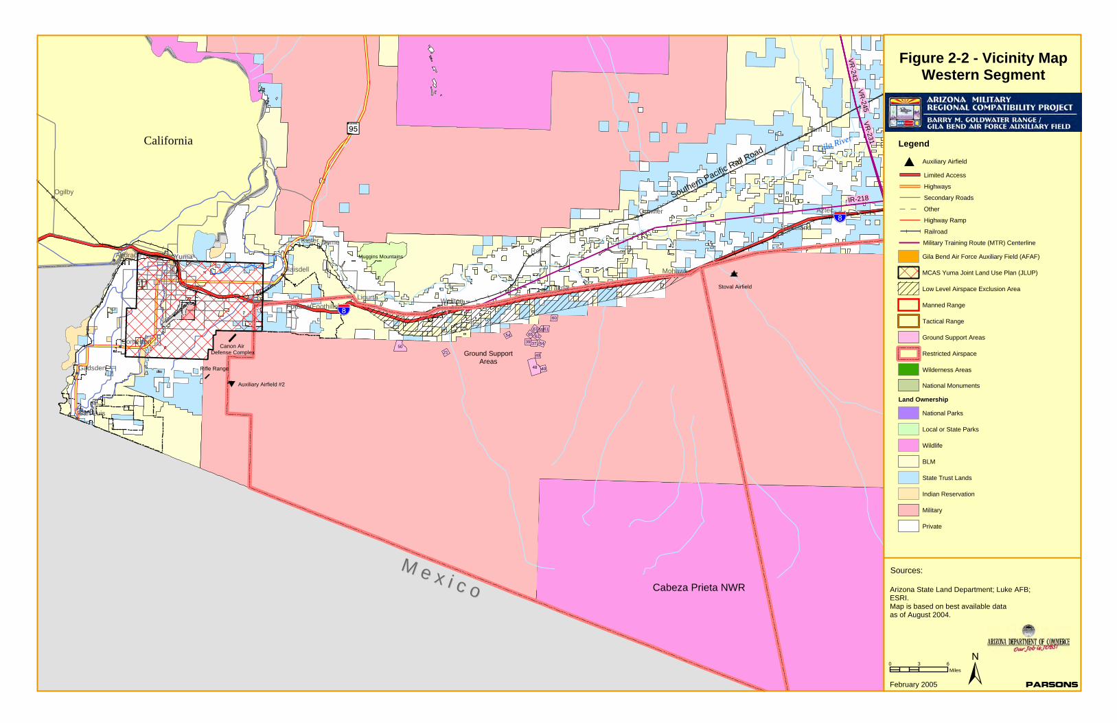
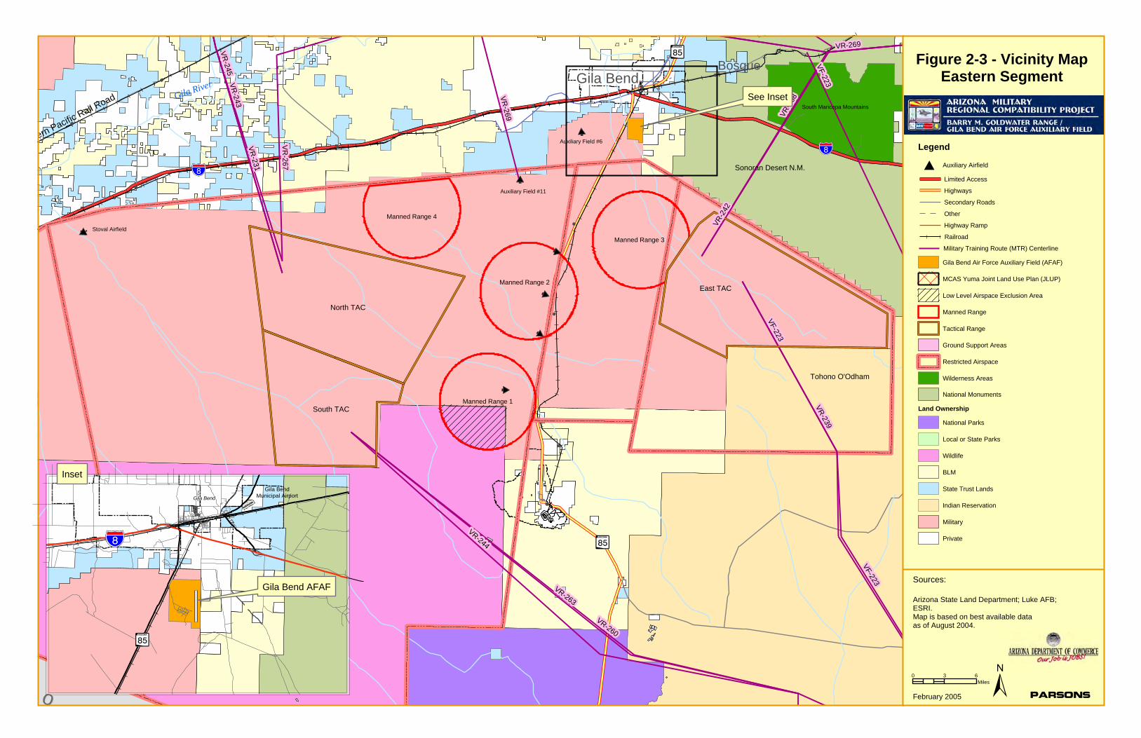
2.3.2 Operations at the Range
The two principal agencies that use the Goldwater Range for combat aircrew training are the US Air Force and the US Marine Corps, although the range is also used by the US Navy; US Army, The Air Force Reserves, the Air National Guard and the Western ARNG Training Site. Military units from northern locations during winter months and aircrews of allied nations also use the Range for combat aircrew training. In addition, the Range is used for large multiple unit exercises or special operations.
The land management responsibilities for BMGR are delegated to the secretaries of the Navy and Air Force in accordance with Public Law 106-65. The land area of the Gila Bend (eastern) segment, is approximately 1,050,000 acres; and the land area of the Yuma (western) segment, is approximately 1,017,000 acres. The airspace and lands of the Gila Bend segment are controlled by the Air Force; the Yuma segment is controlled by the US Marine Corps. A five-mile wide air and ground buffer zone transecting the Mohawk and Sierra Pinta mountains separates the two segments.
Figures 2-2 and 2-3 show the primary facilities and airspace at the Range.
!
!
!
!!(
!!
!
!
!
!
!
!
!
!
!
!
!
!
!
MM ee xx ii cc oo
!"̀$
?ÙGila River
Cabeza Prieta NWR
Southern Pacific Rail RoadCalifornia
!"̀$
Ground SupportAreas
Muggins MountainsYumaRoll
Dome
Horn
Tacna
Aztec
Mohawk
Kinter
Ogilby
Gadsden
WelltonLigurta
Growler
Andrade
San Luis
Somerton
Dateland
Blaisdell
Fortuna Foothills
IR-218
VR-231
VR-243
VR-245
48
50
60
62
21
655439 37
63
64
61
40
49
55
Figure 2-2 - Vicinity MapWestern Segment
Stoval Airfield
Auxiliary Airfield #2
Canon Air Defense Complex
Rifle Range
Legend
Limited Access
Highways
Secondary Roads
Other
Highway Ramp
Railroad
MCAS Yuma Joint Land Use Plan (JLUP)
Low Level Airspace Exclusion Area
Manned Range
Tactical Range
Wilderness Areas
National Monuments
Land Ownership
Auxiliary Airfield#
Gila Bend Air Force Auxiliary Field (AFAF)
Ground Support Areas
Restricted Airspace
Military Training Route (MTR) Centerline
National Parks
Local or State Parks
Wildlife
BLM
State Trust Lands
Indian Reservation
Military
Private
0 3 6Miles ±
Arizona State Land Department; Luke AFB;ESRI.Map is based on best available dataas of August 2004.
Sources:
ParsonsFebruary 2005
!
!
!
!
!
!
!
!
!
!
!
!
!
cc oo
!"̀$
Gila River
Cabeza Prieta NWR
ern Pacific Rail Road
Tohono O'Odham
Sonoran Desert N.M.
!"̀$
BosqueGila Bend
Manned Range 2
Manned Range 1
Manned Range 3
Manned Range 4
South Maricopa Mountains
VR-269
VR-269
VR-231
VR
-267
VR-2
68
VR-243
VR-239
VR-244
VR-245
VR-263
VR-260
VF-223
VF-223
VF-223
VR-2
42
!"̀$
Gila Bend
Gila Bend AFAF
?Í
See Inset
Inset
0 3 6Miles
Figure 2-3 - Vicinity MapEastern Segment
±
?Í
?Í
Arizona State Land Department; Luke AFB;ESRI.Map is based on best available dataas of August 2004.
Sources:
ParsonsFebruary 2005
Auxiliary Field #6
Gila BendMunicipal Airport
Stoval Airfield
North TAC
South TAC
East TAC
Auxiliary Field #11
Legend
Limited Access
Highways
Secondary Roads
Other
Highway Ramp
Railroad
MCAS Yuma Joint Land Use Plan (JLUP)
Low Level Airspace Exclusion Area
Manned Range
Tactical Range
Wilderness Areas
National Monuments
Land Ownership
Auxiliary Airfield#
Gila Bend Air Force Auxiliary Field (AFAF)
Ground Support Areas
Restricted Airspace
Military Training Route (MTR) Centerline
National Parks
Local or State Parks
Wildlife
BLM
State Trust Lands
Indian Reservation
Military
Private
GILA BEND AIR FORCE AUXIL IARY F IELD /
BARRY M. GOLDWATER RANGE JOINT LAND USE STUDY
FEBRUARY 2005 CHAPTER 2 : S TUDY AREA OVERVIEW 2 - 14
MCAS Yuma is currently preparing a Range Air Installation Compatible Use Zone (RAICUZ) study. This study, which is scheduled for completion in early 2006, will evaluate the noise and safety impacts (both off-range and on-range) for operations on the western portion of BMGR, and will make recommendations for land use compatibility with the military operations.
Military activities and facilities occurring within the Yuma segment of the Goldwater Range include:
• Restricted airspace used by fixed-wing and rotary-winged aircraft for air-to-air and air-to-ground training (not involving live ammunition)
• Moving Sands and Cactus West air-to-ground target complexes (not involving live ammunition)
• West Coast TACTS Range
• An auxiliary airfield
• Parachute drop
• Cargo recovery zone
• Explosive ordnance disposal
• Rifle / pistol / machine gun range
• Air Defense Complex
• Ground support areas
Military activities occurring with the Gila Bend segment include:
• Airspace use
• Four manned air-to-ground ranges
• Three simulated air-to-ground target areas (East TAC, North TAC and South TAC)
• Four auxiliary airfields
• Stoval Airfield
• Explosive ordnance disposal
Three blocks of FAA-designated restricted airspace overlie the majority of the Gila Bend segment. Air Force range and target installations within these blocks include:
• Air-to-air ranges, used for basic and advanced air combat training
• Manned Ranges 1-4, used to train pilots in basic air-to-ground delivery of conventional ordnance and special weapons
• North, South and East Tactical Ranges, providing pilots with realistic battlefield target arrays for a variety of tactical missions
Numerous air-to-air missions are flown in the airspace overlying the range. These include:
• Intercepts, where two or more aircraft beyond visual range engage and close on one another for identification and/or attack

GILA BEND AIR FORCE AUXIL IARY F IELD /
BARRY M. GOLDWATER RANGE JOINT LAND USE STUDY
FEBRUARY 2005 CHAPTER 2 : S TUDY AREA OVERVIEW 2 - 1 5
• Basic Fighter Maneuvers (BFM) where two aircraft engage in a dogfight scenario
• Air combat maneuvers (ACM), a scenario where the basic fighting element of two aircraft engage a single bandit
• Air combat tactics (ACT) which combines air combat maneuvers with intercepts and tactical scenarios
• Dissimilar Air Combat Training (DACT), using dissimilar types of aircraft in simulated combat
The manned air-to-ground ranges have conventional and special weapons delivery targets. Range control officers are stationed in observation towers near the target to ensure range safety and to score the accuracy of a practice ordnance delivery. Some are scored on a hit or miss basis; others are scored electronically showing degrees of accuracy. The manned target complex consists of a combination of several target types: tactical strafe, strafe, bomb/rocket circle, and special weapons delivery. Each target is approached at different airspeeds, angles, and altitudes by the attack aircraft. All manned ranges have night operations capability for special weapons deliveries. Manned ranges are periodically closed for maintenance activities and removal of inert practice bombs, ball-ammo cannon rounds, and any of unexploded training ordnance.
The three tactical ranges – North, South and East TAC – are unmanned, diverse target complexes for air-to-ground attack on simulated tactical target arrays. North and South TAC present a composite of simulated combat targets that include:
• Simulated airfieldsirfields with aircraft in revetments, on taxiways and runways, as well as control towers, hangars, and administrative buildings
• Field artillery batteries and missile launchers
• Truck convoys and railroad yards with trains
• Friendly and enemy tank groups and regiments
• Maverick missile training targets (plywood and real tanks)
• Surface-to-air missile (SAM) sites with reveted missiles and associated radar equipment
• High explosive hills (targets for live high explosive bombs and rockets)
Targets on East TAC include:
• Airfield complex with runway, hangars, revetments, and storage buildings
• SAM sites with reveted missiles and associated radar equipment
• ICBM site consisting of a covered silo and associated buildings
• Railroad yard with warehouse and simulated train
• Single span bridge crossing a dry wash
• Enemy radar sites with reveted missiles
• Tanks and trucks randomly spaced along dirt roads
GILA BEND AIR FORCE AUXIL IARY F IELD /
BARRY M. GOLDWATER RANGE JOINT LAND USE STUDY
FEBRUARY 2005 CHAPTER 2 : S TUDY AREA OVERVIEW 2 - 16
• Randomly spaced artillery pieces serving as heavy artillery for a forward battle staging area
• Forward battle area with friendly and enemy tanks deployed, mobile surface to air missile (SAM) units, artillery, and ZSU23/4 unit troops
• Maverick missile training targets
• Enemy command, control, and communications (C3) center
• High explosive hill ordnance target
Other non-target, combat support features on East TAC include:
• NATO Hill, an observation hill with helicopter landing pad
• Water wells
• Communication hill containing communication equipment for use by ground forward air controllers (GFAC)
Goldwater Range is authorized for live-fire training, which is essential to the abilities of aircrews to survive and win in combat. Live-fire training can be conducted on the Goldwater Range only because the military has the authority to control entry by both surface and airspace users. This authority is critical to protect the safety of both the public and military personnel and to prevent scheduled training operations from being interrupted by non-participating surface users or aircraft.
2.4 LAND OWNERSHIP
Land ownership in the study area can be divided into four principal classifications: federal, state, county / municipal, and private. The ownership patterns across the study area are shown in Figures 2-2 and 2-3 and are briefly described below.
• Federal Lands – Outside the boundaries of BMGR, there are extensive Federal land holdings in the study area. Major concentrations of Bureau of Land Management (BLM) properties are located southeast of Gila Bend AFAF; north of Manned Range 4; and in the Gila Mountains. The Sonoran National Monument is located adjacent to BMGR east of Gila Bend and the Cabeza Prieta National Wildlife Refuge is located south of BMGR. BMGR itself constitutes one of the largest contiguous areas of Federal land in southern Arizona.
• State Trust Land – There are numerous parcels of State Trust Lands in the study area. Major concentrations of Trust Lands adjacent to BMGR are to the north of the Gila Bend Auxiliary Field; south of Dateland and Tacna in eastern Yuma County; in the Yuma Foothills area between County Avenue 7E and the Gila Mountains; west of Auxiliary Field #2.
• County, Municipal and Other Public Lands – A number of municipal and county properties, including parks and public building sites, as well as some school facilities are also located in the study area, primarily within the Yuma and Gila Bend areas, typically at distances of two miles or more from the BMGR boundary. Approximately 50,000 acres of land in the Wellton area is in the process of being
GILA BEND AIR FORCE AUXIL IARY F IELD /
BARRY M. GOLDWATER RANGE JOINT LAND USE STUDY
FEBRUARY 2005 CHAPTER 2 : S TUDY AREA OVERVIEW 2 - 17
transferred to the Wellton-Mohawk Irrigation District from the Bureau of Reclamation and Bureau of Land Management under Congressional authorization.
• Private Lands – The remaining lands in the study area, which are the majority of the property in the study area, are in private ownership.
GILA BEND AIR FORCE AUXIL IARY F IELD /
BARRY M. GOLDWATER RANGE JOINT LAND USE STUDY
FEBRUARY 2005 CHAPTER 3 : REVIEW OF EXI ST ING LEG I SLATION 3 - 1
3. REVIEW OF EXISTING LEGISLATION
Land use compatibility within the vicinity of Barry M. Goldwater Range is regulated primarily by county and municipal laws and regulations. The guidelines of the Department of Defense’s Air Installation Compatible Use Zone program apply to Gila Bend Air Force Auxiliary Field and Auxiliary Field #2, as does the recently enacted State of Arizona legislation (House Bill 2141) concerning ancillary military facilities. At the present time, the AICUZ program and the State Statutes (specifically ARS §28-8481) contain the best available current guidance for land use compatibility and therefore this chapter includes a discussion of that guidance. The nature and status of the existing land use compatibility guidance (including federal, State and local guidelines and regulations) are addressed in the first section of this chapter, while the second section identifies differences between the federal and State compatibility guidelines.
3.1 EXISTING LAND USE COMPATIBILITY LEGISLATION, ORDINANCES AND GUIDELINES
3.1.1 U.S. Department of Defense
The Air Installation Compatible Use Zone (AICUZ) Program2 was implemented in 1973 by the U.S. Department of Defense to promote compatible land use development around military airfields. The AICUZ Program creates standard land use guidelines for areas affected by possible noise exposure and accident potential combinations and provides local government jurisdictions with information that can be used to regulate land use and development. Included in the AICUZ program is a table of accident potential zones, noise zones, and guidance concerning the compatibility of various uses.
The Air Force adopted the NOISEMAP computer model to describe noise impacts created by aircraft operations. NOISEMAP is one of two Environmental Protection Agency (EPA) approved models. The other is the Integrated Noise Model (INM), which is used by the Federal Aviation Administration (FAA) for civilian airports. In 1974, EPA designated the noise descriptor “Ldn,” or Day-Night Average Sound Level as the standard measurement for noise impacts. Ldn refers to the average sound level exposure, measured in decibels, over a 24-hour period, with a 10-decibel penalty added to sound levels for operations
2Guidance for the United States Air Force AICUZ program is contained in Air Force Instruction 32-7063, Air
Installation Compatible Use Zone Program; guidance for the United States Navy and United States Marine Corps AICUZ program is contained in OPNAV Instruction 11010.36B, Air Installation Compatible Use Zone (AICUZ) Programs. This guidance implements Department of Defense Instruction 4165.57, Air Installations Compatible Use Zones.

GILA BEND AIR FORCE AUXIL IARY F IELD /
BARRY M. GOLDWATER RANGE JOINT LAND USE STUDY
FEBRUARY 2005 CHAPTER 3 : REVIEW OF EXI ST ING LEG I SLATION 3 -2
occurring during the hours of 10 p.m. to 7 a.m. This penalty is applied due to the increased annoyance created by noise events that occur during this time.
Accident Potential Zones (APZs) are one aspect of the AICUZ program where military application differs from civilian airfields. An analysis of aircraft accidents worldwide within 10 nautical miles of a military airfield for the period of 1968–1972 led to defining areas of high accident potential known as the Clear Zone (CZ), Accident Potential Zone I (APZ-I), and Accident Potential Zone II (APZ-II). The majority of these accidents (about 52 percent) occurred within the Clear Zones or APZs, while about 23 percent were associated with the runway and 25 percent occurred in other areas within 10 nautical miles. It was concluded that the Clear Zone warranted special attention due to the high potential for accidents that severely limited acceptable land uses. The Air Force has spent approximately $65 million to acquire real property interests within the clear zones at bases nationwide. The percentages of accidents within the two APZs are such that some land use control is essential. The Department of Defense recommendation for the APZs is to limit the number of people exposed to noise and safety hazards through appropriate land use planning.
3.1.2 State of Arizona
From the 1990s through 2004, the State of Arizona passed legislation to address the issue of residential development and other compatibility issues around Arizona’s military airports. The major statutes, including ARS §28-8481 and ARS §28-8461, were most recently amended in 2004 through the enactment of House Bill 2140 and House Bill 2141. With the passage of these bills, the State requires political subdivisions in the vicinity of a military airport, and in the vicinity of “ancillary military facilities” (defined in the legislation as Luke Air Force Base Auxiliary Field #1, Gila Bend AFAF and MCAS Yuma Auxiliary Field #2) to adopt land use plans and enforce zoning regulations that assure development compatible with the high-noise and accident potential generated by military airport operations. State legislation, specifically ARS §28-8481, also regulates land uses in hazard zones and high-noise areas, but allows a landowner to undertake development of property for which a development plan was approved before December 31, 2000, (or for lands subsequently added to “territory within the vicinity of a military airport or ancillary military facility”, December 31 of the year the land was added) even though the uses may not be compatible with the regulations under ARS §28-8481. It is the responsibility of the local jurisdiction and landowner to work cooperatively on these “grandfathered” plans to mitigate potential future development conflicts where possible. The provisions of the various statutes related to the operation of military airports are summarized in Appendix A.
3.1.3 Local Jurisdictions
Regulations and ordinances that typically may be implemented by local political jurisdictions include, zoning, military airport zoning, airport impact and noise overlay districts, notification areas, building code insulation (noise attenuation), and navigational easements.
GILA BEND AIR FORCE AUXIL IARY F IELD /
BARRY M. GOLDWATER RANGE JOINT LAND USE STUDY
FEBRUARY 2005 CHAPTER 3 : REVIEW OF EXI ST ING LEG I SLATION 3 -3
Interior noise level reductions related to noise generated by the operation of military aircraft are addressed in the Uniform Building Code adopted by the City of Yuma, Town of Gila Bend, and Maricopa and Yuma Counties.
Both the City of Yuma and Yuma County require disclosure statements for property located within restricted airspace. This disclosure is recorded to acknowledge on behalf of the grantor and its successors that a property is within the restricted airspace.
Maricopa County also has requirements for notification to future home owners regarding military aircraft operations, including posting various forms of notification in model ;home sales offices, notification on plats and public reports, and disclosure in Covenants, Conditions & Restrictions (CC&Rs) for housing developments.
3.2 DIFFERENCES BETWEEN FEDERAL AND STATE GUIDANCE FOR COMPATIBLE USES
In 1995, the State of Arizona passed legislation, ARS §28-8481, requiring all political subdivisions in the vicinity of a military airport to adopt land use plans and enforce zoning regulations that assure development compatible with the high noise and accident potential generated by military airport operations. That legislation created a table of compatibility with reference to hazard zones and high noise areas. With the enactment of House Bill 2141 in 2004, these compatibility requirements were extended to “ancillary military facilities” (defined in the Bill as Gila Bend AFAF and MCAS Yuma Auxiliary Field #2).
The tables concerning compatible land use in AICUZ and ARS §28-8481 do not address the same hazard zones and they organize the noise zones differently. For example, ARS §28-8481 does not recognize or identify a Clear Zone nor does it regulate uses in that high hazard zone, and an additional noise zone, 85+ decibels, is included in ARS §28-8481 that is not identified in the AICUZ Program.
Certain uses allowed in the AICUZ Guidance are not permitted under Arizona law and uses that are not recommended in the AICUZ guidelines are allowed under Arizona law. Specific land use categories addressed in the AICUZ guidelines are not addressed in ARS §28-8481. Examples of this inconsistency include schools and public assembly uses, which are not listed as separate land uses in the State legislation but are listed in the AICUZ guidelines.
The AICUZ guidelines list wholesale trade, retail sale of building materials and automobiles, business services, repair services as compatible uses in APZ I and APZ II, and also lists a variety of service uses, amusements, recreation, and single-family residential up to two dwelling units per acre as compatible uses in APZ II. The AICUZ guidelines (Table 3-1) also list most types of retail trade and services as compatible within noise zones 65 Ldn through 79 Ldn. Single-family residential, schools, churches, hospitals, and retail-food uses are listed as compatible in noise categories 65 to 74 decibels. Public assembly uses are listed as compatible in the 65-69 Ldn category.
GILA BEND AIR FORCE AUXIL IARY F IELD /
BARRY M. GOLDWATER RANGE JOINT LAND USE STUDY
FEBRUARY 2005 CHAPTER 3 : REVIEW OF EXI ST ING LEG I SLATION 3 -4
Table 3-1: Compatibility of Uses – AICUZ Program
Source: Prepared by Parsons from U.S. Air Force data.
In ARS §28-8481, indoor recreation, and several types of commercial-retail trade, wholesale trade, retail sale of building materials and government services are permitted within APZ II and noise zones 65 Ldn through 79 Ldn (Table 3-2). Outdoor amphitheaters and music shells, retail sale of general merchandise, retail apparel, water-based recreation, eating and drinking, and retail-food uses are permitted within noise zones 65 Ldn through 79 Ldn. Churches, medical and health services, auditoriums and concert halls, and other public and quasi-public services are permitted within noise zones 65 Ldn through 74 Ldn.
Table 3-2: Compatibility of Uses – ARS §28-8481
Source: Prepared by Parsons from ARS §28-8481 data.
Although ARS §28-8481 does not consider single-family residential uses compatible in any of the hazard or noise zones (Table 3-2), it is silent about uses in the Clear Zone, since the law does not define such a zone.
3Suggested maximum density of 1-2 dwelling units per acre. 4The use is allowed in the AICUZ Guidance but is not permitted under Arizona law. 5Schools as a specific land use category are not addressed in ARS §28-8481; the data provided above are for the
category: Other Public and Quasi-Public Services. 6Public Assembly as a specific land use category is not addressed and it is not defined in ARS §28-8481; the data
provided above are for the category: Other Public and Quasi-Public Services. 7The use is allowed under Arizona law, but not under the AICUZ Program.
Selected Land Uses Clear Zone APZ I APZ II 65-69 Ldn
70-74 Ldn
75-80Ldn
80+ Ldn
Single-Family Residential N N Y3 Y Y N N Schools N N N Y Y N N Churches N N N Y Y N N Hospitals N N N Y Y N N Public Assembly N N N Y N N N Outdoor Amphitheaters N N N N N N N Retail-Food N N Y Y Y Y N
Selected Land Uses APZ I APZ II 65-69 Ldn
70-74 Ldn
75-79 Ldn
80-84 Ldn
85+ Ldn
Single-Family Residential N N4 N3 N3 N N N Schools5 N N N N N N N Churches N N Y Y N N N Hospitals N N Y Y N N N Public Assembly6 N N N N N N N Outdoor Amphitheaters N N Y7 Y6 Y6 N N Retail-Food N N3 Y Y Y N N
GILA BEND AIR FORCE AUXIL IARY F IELD /
BARRY M. GOLDWATER RANGE JOINT LAND USE STUDY
FEBRUARY 2005 CHAPTER 4 : DEVELOPMENT TRENDS AND I S SUES 4 - 1
4. DEVELOPMENT TRENDS AND ISSUES
Growth trends in the JLUS study area directly and indirectly affect the ability of BMGR and Gila Bend AFAF to carry out their present and future mission by generating demand for new housing and related facilities; and this creates issues of compatibility due to the increased tempo of development of residential and other urban and suburban uses in the vicinity of the Range and Airfield.
Yuma and Maricopa Counties have been among the fastest growing in the nation. Metropolitan Yuma (Yuma County) is the third fastest growing area in the United States, with the County’s population increasing by 3.1percent between 2002 and 2003. Over the last forty years (1960-2000), the population of Maricopa County more than quadrupled from 664,000 to more than three million (Table 4-1).
Table 4-1: Growth Rates of Jurisdictions in the JLUS Study Area
Jurisdiction 1990 2000 2003 City of Yuma 54,923 77,515 83,330
Percent Change 41% 7.5% Yuma County 106,895 160,026 175,045
Percent Change 50% 9% Town of Gila Bend 1,747 1,980 2,025
Percent Change 13% 2% Maricopa County 2,122,101 3,072,149 3,396,875
Percent Change 45% 10.5%
Source: U.S. Census Bureau (1990 and 2000); Arizona Department of Economic Security (2003).
Approximately 75 percent of Yuma County’s population is located in the western part of the County, in the cities of Yuma, Somerton and San Luis and adjacent unincorporated areas. Of the unincorporated areas, the Foothills area, located to the north of BMGR between Avenue 9E and the Gila Mountains, has the largest population (over 20,000 according to the 2000 Census). The Foothills area (including portions in the City of Yuma as well as unincorporated portions is one of the principal focuses of development in Metropolitan Yuma.
Growth in Maricopa County has tended to radiate from the center of Phoenix. Through the periods of the 1970s, 1980s, and 1990s much of the growth was concentrated in the eastern portion of the County. The leading edge of that growth moved further east (away from central Phoenix) as time continued, with the most recent growth occurring in the furthest eastern jurisdictions. Today, a similar pattern is currently occurring and will continue in western Maricopa County, with the leading edge of growth reaching the Buckeye area, approximately 30 miles north of BMGR. While the portion of Maricopa County in the vicinity of BMGR has not yet seen the same levels of growth as in the West Valley to the north, the Town of Gila Bend is poised for significant population growth with the recent
GILA BEND AIR FORCE AUXIL IARY F IELD /
BARRY M. GOLDWATER RANGE JOINT LAND USE STUDY
FEBRUARY 2005 CHAPTER 4 : DEVELOPMENT TRENDS AND I S SUES 4 -2
annexation of the Merrill-Paloma Ranch, which when fully developed, will have as many as 6,000 homes.
The Town of Gila Bend, City of Yuma and Yuma County are expected to continue to grow, creating additional pressures for development in areas adjacent to BMGR. According to Arizona Department of Economic Security projections contained in the Yuma County 2020 Comprehensive Plan, the County’s population is expected to increase to 239,565 by 2010, an increase of 37 percent over the estimated 2003 population.
The most rapidly growing areas in the County have been the City of San Luis, in the southwestern part of Metropolitan Yuma, and the Foothills area extending along Interstate 8 from Avenue 9E to the Gila Mountains. San Luis is located beyond the area of anticipated impacts from BMGR operations; however, the Foothills area abuts BMGR’s northern boundary, and the portion of the Foothills area south of Interstate 8 lies under the Restricted Airspace associated with BMGR. This Restricted Airspace serves as a staging area for sorties flown at BMGR and serves as a primary route for helicopters as well as fixed-wing aircraft to access BMGR.
As the Foothills area becomes more fully developed, the areas of the County east of the Gila Mountains are likely to experience more development pressures. The portions of the eastern County south of Interstate 8 also are overflown by aircraft accessing BMGR, and the aircraft entry to or exit from the range can be at an altitude as low as 200 feet above the ground.
GILA BEND AIR FORCE AUXIL IARY F IELD /
BARRY M. GOLDWATER RANGE JOINT LAND USE STUDY
FEBRUARY 2005 CHAPTER 5 : LAND USE COMPATIBIL ITY 5 - 1
5. LAND USE COMPATIBILITY
The ability of Gila Bend AFAF and BMGR to maintain their operational capabilities, which is critical to the missions of other military bases in Arizona, including MCAS Yuma, Luke Air Force Base, Davis-Monthan Air Force Base and the Western Arizona Army Training Site at Silverbell Army Heliport, is related in large part to the compatibility of the land uses in the vicinity of the Range and Field. Recognizing that areas adjacent to the Range are growing rapidly and that the tempo of growth is likely to increase in the future, it is essential to define land uses are compatible with the operations of the Range and Field, while also contributing to the balanced growth of the local communities.
5.1 NOISE AND SAFETY CONSIDERATIONS
BMGR’s mission is to support the military with air-to-air, air-to-ground, and live drop areas, and it is the only low-altitude night-vision training area in Arizona. Above BMGR are 57,000 cubic miles of airspace where pilots practice air-to-air maneuvers and engage simulated battlefield targets on the ground. More than 50 aircraft can simultaneously operate on the range while performing independent training missions and pilots fly over 68,000 sorties in the range annually. Gila Bend Air Force Auxiliary Field (AFAF) is an integral part of operations at BMGR with a primary mission to support BMGR’s use by all branches of the military for air-to-air and air-to-ground training. Because the primary mission of BMGR and Gila Bend AFAF is oriented to aircraft operations, the principal noise and safety considerations for land use compatibility are those related to aircraft operations.
5.1.1 Noise Considerations
Noise is “unwanted sound” and can be perceived as a nuisance that disturbs our routine activities or our peace, and that at louder levels may cause feelings of mounting annoyance, irritation, or anger. The loudness of sounds is dependent upon many factors, including sound pressure level and frequency content, and within the usual range of environmental noise levels, perception of loudness is relatively predictable. Sounds that are perceived as noise may vary among listeners and sounds that are not objectionable to some can be bothersome to others.
Aircraft or artillery noise may be experienced as particularly annoying because it may startle people, cause windows to rattle and houses to shake, or cause people to fear a crash or explosion. In addition to varying levels of annoyance, adverse impacts associated with exposure to noise may include interruption of sleep and conversation.
Some common terms used in assessing the effects of noise are:
• The Decibel (dB) is the unit used to measure the magnitude or intensity of sound. Decibel means 1/10 of a Bel (named after Alexander Graham Bell). The decibel uses a logarithmic scale to cover the very large range of sound pressures that can be heard by the human ear. Under the decibel unit of measure, a 10 dB increase will
GILA BEND AIR FORCE AUXIL IARY F IELD /
BARRY M. GOLDWATER RANGE JOINT LAND USE STUDY
FEBRUARY 2005 CHAPTER 5 : LAND USE COMPATIBIL ITY 5 -2
be perceived by most people to be a doubling in loudness (80 dB seems twice as loud as 70 dB).
• The A-weighted Decibel (dBA) is the most common unit used for measuring environmental sound levels. It adjusts, or weights, the frequency components of sound to conform with the normal response of the human ear at conversational levels. dBA is an international metric that is used for assessing environmental noise exposure of most noise sources.
• The C-weighted Decibel (dBC) is used for measuring sound levels of heavy weapons operation, because it adjusts or weights the frequency components to emphasize higher and lower frequencies and therefore provides a way of capturing the most annoying characteristic of tank guns and artillery, which are house vibrations induced by low frequency sound.
Sound levels are plotted in decibels (abbreviated dB), a logarithmic measure of the magnitude of a sound, and may be plotted as either “A-weighted” (dbA) or as “C-weighted” (dbC). The “A-weighting” accounts for the fact that humans do not hear low frequencies and high frequencies as well as they hear middle frequencies. The A-weighting corrects for the relative efficiency of the human ear at the different frequencies. Conversely, the “C-weighting” accounts for the fact that low frequencies cause vibration, which is the principal noise impact of heavy weapons firing.
An additional important factor in measuring a sound environment is the occurrence of sound events at night. People are normally more sensitive to intrusive sound events at night and background sound levels are normally lower at night because of decreased human activity. Therefore, a “penalty” may be added to sound levels that occur during night hours. By accepted scientific convention, a 10-decibel penalty is added to sound levels occurring between 10:00 p.m. and 7:00 a.m. the following morning. This 10 dB penalty means that one nighttime sound event is equivalent to 10 daytime events of the same level. The 24-hour average sound level, including the 10 dB penalty, is known as the day-night average sound level (Ldn). Extensive research has found that the day-night average sound level correlates very well with community annoyance from most environmental noise sources, and Ldn is used by all Federal agencies and internationally in the assessment of potential noise impacts.
Relying on a considerable body of scientific research on noise impacts, federal agencies have adopted guidelines for compatible land uses and environmental sound levels. Compatible land uses are normally determined by planning and zoning regulations that segregate types of activities, such as residential, industrial, or commercial. Noise levels that are unacceptable for homes may be quite acceptable for other uses, such as agriculture or certain industries.
General guidelines for noise compatibility identify sound levels from aircraft operations between 55 and 60 dB as “moderate exposure” and as generally acceptable for residential uses. Both the Department of Defense’s Air Installation Compatible Use Zone (AICUZ) guidance and the Federal Aviation Administration’s Airport Noise Compatibility Planning Toolkit discourage residential use in the 65 Ldn contour and higher.
GILA BEND AIR FORCE AUXIL IARY F IELD /
BARRY M. GOLDWATER RANGE JOINT LAND USE STUDY
FEBRUARY 2005 CHAPTER 5 : LAND USE COMPATIBIL ITY 5 -3
5.1.2 Safety Considerations
Areas around airports are exposed to the possibility of aircraft accidents even with well-maintained aircraft and highly specialized flight crews. Despite stringent maintenance requirements and intense pilot and crew training programs, history demonstrates that aircraft related accidents will occur around airports. Risk may be defined as:
The potential for realization of unwanted, adverse consequences to human life, health, property, or the environment; estimation of risk is usually based on the expected value of the conditional probability of the event occurring times the consequence of the event given that it has occurred.8
Although the risk to people on the ground of being killed or injured by a military aircraft accident is very small, such an event is by its nature of high consequence and may be catastrophic in the breadth and extent of its impact.
In order to address the issue of public exposure to safety hazards related to flight, the Air Force undertook an accident study based on crash patterns for reported incidents between 1968 and 1972. As a result of the study, it was concluded that the designation of safety zones around the airfield and restriction of incompatible land uses could reduce the public’s exposure to safety hazards. Recommended dimensions for these zones are based on distribution of accidents and the debris scatter. The land use recommendations for each zone are based on the level of risk, the area of highest risk has the most restrictions, while areas of lesser risk have lesser restrictions. Although safety zones are areas where there is the highest potential for an aircraft mishap based upon historical locations of accidents, these zones do not reflect the totality of the locations where accidents may happen.
In a subsequent Air Force accident study, data was plotted in relation to the airfield for 838 major accidents at U.S. Air Force bases from 1968 through 1995. These were all Class A accidents (defined as involving a loss of life or more than $1 million worth of damage) that occurred within 10 nautical miles of the airfield. This study showed that the accidents clustered along the runway and its extended centerline. Approximately 43% of the accidents occurred with the clear zones and APZs, approximately 25% occurred on the runway, and approximately 32% occurred in other areas within 10 nautical miles of the airfield. The study also showed that the majority of accidents were associated with landing (61%) vs takeoff (30%) and that 80% of the accidents were associated with fighter/training aircraft..
5.1.3 Land Use Compatibility
Two critical issues define compatibility of uses: safety and noise. A fundamental goal of compatibility criteria is to avoid concentrations of people exposed to noise and safety hazards, and is achieved in principle by:
• limiting exposure of people and noise-sensitive activities to high noise levels, and
8The Society for Risk Analysis, Risk Glossary, accessed at http://www.sra.org, July 16, 2003.
GILA BEND AIR FORCE AUXIL IARY F IELD /
BARRY M. GOLDWATER RANGE JOINT LAND USE STUDY
FEBRUARY 2005 CHAPTER 5 : LAND USE COMPATIBIL ITY 5 -4
• limiting concentrations of people and safety-sensitive activities in areas of highest probable accident impact.
Each of these critical principles can be translated into specific types of land uses that are affected by operations at the Barry M. Goldwater Range and Gila Bend Air Force Auxiliary Field.
• Noise-sensitive land uses that are incompatible with high noise levels, particularly within the high-noise zones defined as the 65 Ldn contour and higher. Noise-sensitive uses include:
o Residences and places where people normally sleep such as hotels, hospitals, and nursing homes.
o Uses such as schools, libraries, churches, museums, cultural centers, theaters, hotels, outdoor auditoriums, and concert halls, where it is important to avoid interference with such activities as speech, music, meditation, and concentration on reading or visual material.
Noise attenuation may mitigate the effects of the average noise exposure (as expressed in Ldn), on these uses; however, it is important to note that single-event noise levels at significantly higher decibels may not be fully mitigated by attenuation.
• Land uses that result in concentrations of people or that have special safety considerations are generally incompatible with high hazard areas, which include the Clear Zones, APZ-I, and APZ-II. Uses that result in concentrations of people include the following:
o Residences and similar uses where people reside, such as hotels and nursing homes.
o Employment uses with a high density of employees such as offices and labor-intensive industrial use.
o Uses where people may gather in large numbers such as churches, schools, shopping centers, retail establishments, bars and restaurants, auditoriums, sports arenas, and spectator sports.
• Land uses that have special safety considerations include the following:
o Uses involving significant quantities of hazardous materials or explosives.
o Critical public health and safety uses, such as hospitals, fire stations, and police communications facilities.
o Landfills and agricultural row crops that are attractive to large flocks of birds.
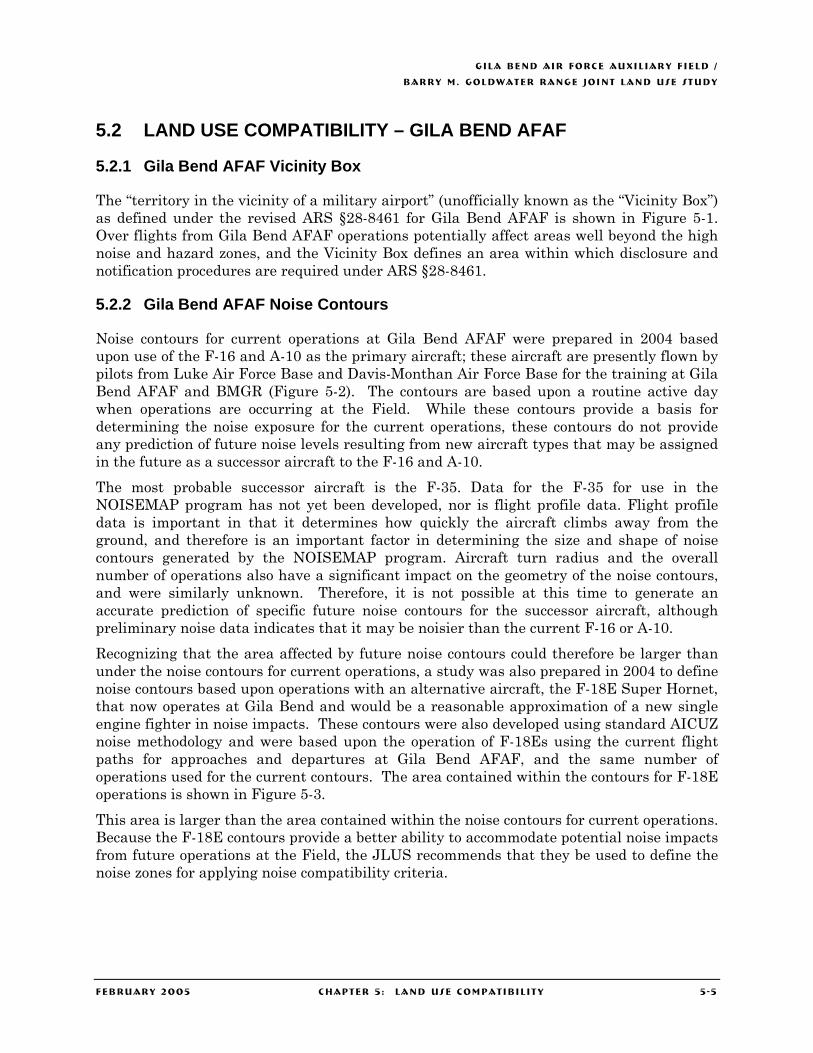
GILA BEND AIR FORCE AUXIL IARY F IELD /
BARRY M. GOLDWATER RANGE JOINT LAND USE STUDY
FEBRUARY 2005 CHAPTER 5 : LAND USE COMPATIBIL ITY 5 -5
5.2 LAND USE COMPATIBILITY – GILA BEND AFAF
5.2.1 Gila Bend AFAF Vicinity Box
The “territory in the vicinity of a military airport” (unofficially known as the “Vicinity Box”) as defined under the revised ARS §28-8461 for Gila Bend AFAF is shown in Figure 5-1. Over flights from Gila Bend AFAF operations potentially affect areas well beyond the high noise and hazard zones, and the Vicinity Box defines an area within which disclosure and notification procedures are required under ARS §28-8461.
5.2.2 Gila Bend AFAF Noise Contours
Noise contours for current operations at Gila Bend AFAF were prepared in 2004 based upon use of the F-16 and A-10 as the primary aircraft; these aircraft are presently flown by pilots from Luke Air Force Base and Davis-Monthan Air Force Base for the training at Gila Bend AFAF and BMGR (Figure 5-2). The contours are based upon a routine active day when operations are occurring at the Field. While these contours provide a basis for determining the noise exposure for the current operations, these contours do not provide any prediction of future noise levels resulting from new aircraft types that may be assigned in the future as a successor aircraft to the F-16 and A-10.
The most probable successor aircraft is the F-35. Data for the F-35 for use in the NOISEMAP program has not yet been developed, nor is flight profile data. Flight profile data is important in that it determines how quickly the aircraft climbs away from the ground, and therefore is an important factor in determining the size and shape of noise contours generated by the NOISEMAP program. Aircraft turn radius and the overall number of operations also have a significant impact on the geometry of the noise contours, and were similarly unknown. Therefore, it is not possible at this time to generate an accurate prediction of specific future noise contours for the successor aircraft, although preliminary noise data indicates that it may be noisier than the current F-16 or A-10.
Recognizing that the area affected by future noise contours could therefore be larger than under the noise contours for current operations, a study was also prepared in 2004 to define noise contours based upon operations with an alternative aircraft, the F-18E Super Hornet, that now operates at Gila Bend and would be a reasonable approximation of a new single engine fighter in noise impacts. These contours were also developed using standard AICUZ noise methodology and were based upon the operation of F-18Es using the current flight paths for approaches and departures at Gila Bend AFAF, and the same number of operations used for the current contours. The area contained within the contours for F-18E operations is shown in Figure 5-3.
This area is larger than the area contained within the noise contours for current operations. Because the F-18E contours provide a better ability to accommodate potential noise impacts from future operations at the Field, the JLUS recommends that they be used to define the noise zones for applying noise compatibility criteria.
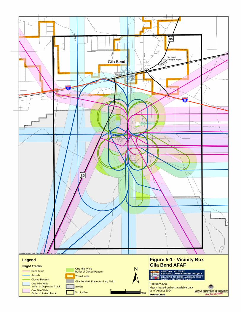
?Í
?Í
!"̀$
!"̀$
Gila BendMunicipal Airport
Stout
Watermelon
Crow
ley
315t
h
Indian
Martin
Figure 5-1 - Vicinity BoxGila Bend AFAF
Sources: Arizona State Land Department; ESRI; Luke AFB; Parsons
Legend
BMGR±
0 1 2Miles
Gila Bend Air Force Auxiliary Field
Vicnity Box
Flight TracksDepartures
Arrivals
Closed PatternsOne Mile WideBuffer of Departure TrackOne Mile WideBuffer of Arrival Track
One Mile WideBuffer of Closed Pattern
Parsons
February 2005Map is based on best available dataas of August 2004.
Town Limits
Gila Bend
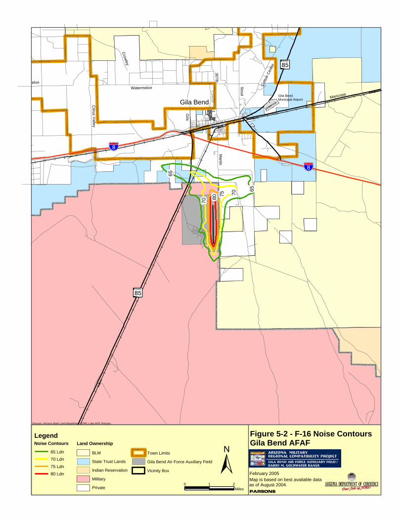
?Í
?Í
!"̀$
!"̀$
Gila BendMunicipal Airport
80 75 70
70
65
65
Maricopa
Stout
30 7th
Watermelon
Crow
ley
Citrus Val le y
elon
Martin
Cotto
n Ce
nter
Gila
Figure 5-2 - F-16 Noise ContoursGila Bend AFAF
Sources: Arizona State Land Department; ESRI; Luke AFB; Parsons
±0 1 2
Miles
Legend
65 Ldn70 Ldn75 Ldn80 Ldn
Land Ownership
Parsons
February 2005Map is based on best available dataas of August 2004.
Gila Bend Air Force Auxiliary Field
Vicinity Box
BLM
State Trust Lands
Indian Reservation
Military
Private
Town Limits
Noise Contours
Gila Bend
?Í
?Í
!"̀$
!"̀$
Gila BendMunicipal Airport
807575
70
70
65
65
65
Maricopa
Stout
30 7th
Watermelon
Crow
ley
Citrus Val le y
melon
Martin
Cotto
n Ce
nter
Gila
Figure 5-3 - F-18E Noise ContoursGila Bend AFAF
Sources: Arizona State Land Department; ESRI; Luke AFB; Parsons
±0 1 2
Miles
LegendNoise Contours
65 Ldn70 Ldn75 Ldn80 Ldn
Land Ownership
Parsons
February 2005Map is based on best available dataas of August 2004.
Gila Bend Air Force Auxiliary Field
Vicinity Box
BLM
State Trust Lands
Indian Reservation
Military
Private
Town Limits
Gila Bend

?Í
?Í
!"̀$
!"̀$
Gila BendMunicipal Airport
Stou t
315t
h
Watermelon
Indian
Crow
ley
GILA BEND
Thayer Martin
Indian
Figure 5-4 - Accident Potential ZonesGila Bend AFAF
Parsons
February 2005Map is based on best available dataas of August 2004.
Sources: Arizona State Land Department; ESRI; Luke AFB; Parsons
Legend Land Ownership
±0 1 2
Miles
Gila Bend Air Force Auxiliary Field
APZ II
APZ I
Clear Zone
BLM
State Trust Lands
Indian Reservation
Military
Private
Town Limits

GILA BEND AIR FORCE AUXIL IARY F IELD /
BARRY M. GOLDWATER RANGE JOINT LAND USE STUDY
FEBRUARY 2005 CHAPTER 5 : LAND USE COMPATIBIL ITY 5 - 10
5.2.3 Gila Bend AFAF Safety Zones
The safety zones for Gila Bend AFAF, as shown on Figure 5-4, include Clear Zones and APZs at either end of the primary runway along the extended runway centerline that have been defined to reflect the unique operations at Gila Bend AFAF. These Clear Zones and APZs are not necessarily consistent with standard Air Force guidance, but are designated under State of Arizona legislation (ARS §28-8481 and ARS §28-8461, as amended by House Bill 2140 and House Bill 2141).The Field has two departure paths that involve either a right hand or left hand turn for departures to the north. These “left-turn” and “right-turn” departures begin before the end of the runway and the Clear Zones and APZs have been defined following the curves of these departure paths, rather than a “straight-out” departure (Figure 5-3).
5.2.4 Land Use Compatibility Criteria for Gila Bend AFAF
Table 5-1 identifies the recommended compatible land use criteria for areas within the State-defined Clear Zone, APZ I and APZ II, and the 65 Ldn noise contour and higher around Gila Bend AFAF. Uses that result in concentrations of people are considered incompatible in the Clear Zone, APZ I and APZ II. Noise-sensitive uses are considered incompatible in noise zones of 65 Ldn noise contour and higher. Uses not specifically listed in Table 5-1 should be considered on a case-by-case basis, utilizing the compatibility principles delineated in Section 5.1.3 above. In addition, as discussed in Section 5.2.4, the Compatible Land Use Plan recognizes that existing uses would be permitted to continue, even if normally not considered compatible.
Table 5-1: Recommended Land Use Compatibility Criteria – Gila Bend AFAF
Noise Zones
Use Clear Zone1
APZ I1
APZ II1
65 – 69
Ldn
70 – 74
Ldn
75 – 80
Ldn 80+ Ldn
Agriculture (limited to row crops only, with no structures or live stock)
Y Y Y Y Y Y Y
General Agriculture / Livestock (excluding accessory retail sales)
N Y Y Y Y Y Y
General Agriculture / Livestock (including accessory retail sales)
N N N Y3 Y3 Y3 Y3
Agricultural processing and services N N Y2 Y3 Y3 Y3 Y3 Residential N N N N N N N Schools and Other Educational Facilities N N N N N N N Cultural Activities and Churches N N N N N N N Medical Facilities, including Hospitals, Clinics, Extended Care Facilities and Nursing Homes
N N N N N N N
Public Assembly, including auditoriums, stadiums, and amphitheaters
N N N N N N N
Retail Sales N N N Y3 Y3 Y3 N
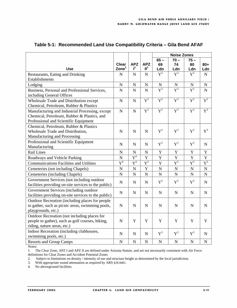
GILA BEND AIR FORCE AUXIL IARY F IELD /
BARRY M. GOLDWATER RANGE JOINT LAND USE STUDY
FEBRUARY 2005 CHAPTER 5 : LAND USE COMPATIBIL ITY 5 - 1 1
Table 5-1: Recommended Land Use Compatibility Criteria – Gila Bend AFAF
Noise Zones
Use Clear Zone1
APZ I1
APZ II1
65 – 69
Ldn
70 – 74
Ldn
75 – 80
Ldn 80+ Ldn
Restaurants, Eating and Drinking Establishments
N N N Y3 Y3 Y3 N
Lodging N N N N N N N Business, Personal and Professional Services, including General Offices
N N N Y3 Y3 Y3 N
Wholesale Trade and Distribution except Chemical, Petroleum, Rubber & Plastics
N N Y2 Y3 Y3 Y3 Y2
Manufacturing and Industrial Processing, except Chemical, Petroleum, Rubber & Plastics, and Professional and Scientific Equipment
N N Y2 Y3 Y3 Y3 Y3
Chemical, Petroleum, Rubber & Plastics Wholesale Trade and Distribution, Manufacturing and Processing
N N N Y3 Y3 Y3 Y3
Professional and Scientific Equipment Manufacturing N N N Y3 Y3 Y3 N
Rail Lines N N N Y Y Y Y Roadways and Vehicle Parking N Y4 Y Y Y Y Y Communications Facilities and Utilities Y4 Y4 Y2 Y Y3 Y3 Y3 Cemeteries (not including Chapels) N N Y N N N N Cemeteries (including Chapels) N N N N N N N Government Services (not including outdoor facilities providing on-site services to the public) N N N Y3 Y3 Y3 N
Government Services (including outdoor facilities providing on-site services to the public) N N N N N N N
Outdoor Recreation (including places for people to gather, such as picnic areas, swimming pools, playgrounds, etc.)
N N N N N N N
Outdoor Recreation (not including places for people to gather), such as golf courses, hiking, riding, nature areas, etc.)
N Y Y Y Y Y Y
Indoor Recreation (including clubhouses, swimming pools, etc.) N N N Y3 Y3 Y3 N
Resorts and Group Camps N N N N N N N Notes: 1. The Clear Zone, APZ I and APZ II are defined under Arizona Statute, and are not necessarily consistent with Air Force definitions for Clear Zones and Accident Potential Zones 2. Subject to limitations on density / intensity of use and structure height as determined by the local jurisdiction. 3. With appropriate sound attenuation as required by ARS §28-8481. 4. No aboveground facilities.

GILA BEND AIR FORCE AUXIL IARY F IELD /
BARRY M. GOLDWATER RANGE JOINT LAND USE STUDY
FEBRUARY 2005 CHAPTER 5 : LAND USE COMPATIBIL ITY 5 - 12
Along with the criteria listed in Table 5-1, the guidelines for land use compatibility include the following provisions:
• Vested development as defined under Arizona Statutes may occur, although not compatible with the criteria in Table 5-1.
• Existing uses incompatible with the criteria in Table 5-1 may be continued although expansion of these uses may be subject to restrictions.
• Uses not otherwise considered compatible may be allowed by mutual agreement of the respective local jurisdiction and the affected military installation upon determination that they would not adversely affect the operation of the installation.
5.2.5 Compatible Land Use Plan for Gila Bend AFAF
The Compatible Land Use Plan for Gila Bend AFAF, as shown in Figure 5-5, is structured in seven separate zones, incorporating the State-defined Clear Zones and APZs and noise exposure zones, as listed below.
• Zone 1, consisting of the three Clear Zones (one at the south end of the main runway, one along the “left hand departure” flight path and one along the “right hand departure” flight path). In Zone 1, recommended compatible uses are those that are primarily open space with no permanent above ground structures, consistent with the purpose of a Clear Zone. Because Zone 1 is also contained within the noise zones defined for Gila Bend AFAF, uses within this zone shall also comply with the noise reduction standards contained in the table of uses in ARS §28-8481 and sound attenuation standards contained in ARS §28-8482.
• Zone 2, consisting of the three APZ-Is (one at the south end of the main runway, one along the “left hand departure” flight path and one along the “right hand departure” flight path). In Zone 2, recommended compatible uses are those that do not involve concentrations of persons. Because Zone 2 is also contained within the noise zones defined for Gila Bend AFAF, uses within this zone shall also comply with the noise reduction standards contained in the table of uses in ARS §28-8481 and sound attenuation standards contained in ARS §28-8482.
• Zone 3, consisting of the three APZ-IIs (one at the south end of the main runway, one along the “left-hand departure” flight path and one along the “right-hand departure” flight path). In Zone 3, recommended compatible uses are non-residential uses that have relatively low employment density (number of persons per acre). These are primarily industrial uses along with other uses that have low concentrations of persons. Because Zone 3 is also contained within the noise zones defined for Gila Bend AFAF, uses within this zone shall also comply with the noise reduction standards contained in the table of uses in ARS §28-8481 and sound attenuation standards contained in ARS §28-8482.
• Zone 4, consisting of those portions of the 80+ Ldn Noise Zone outside the Clear Zones, and APZs. Uses within this zone shall comply with the noise reduction standards contained in the table of uses in ARS §28-8481 and sound attenuation standards contained in ARS §28-8482..
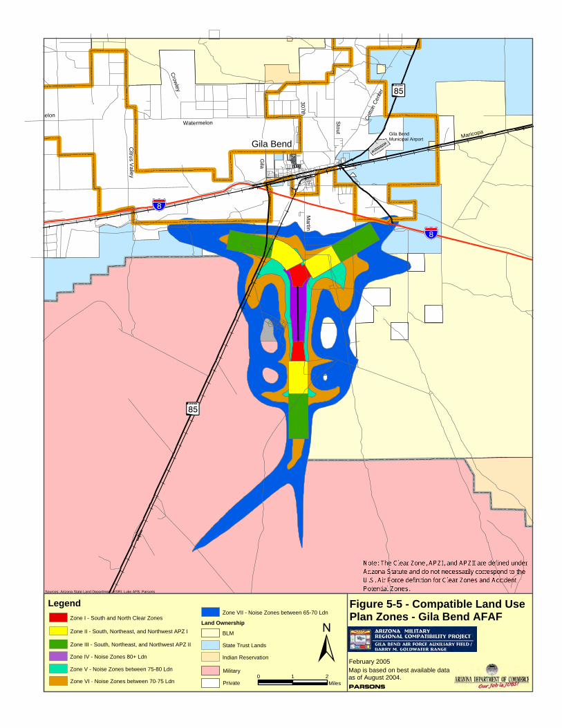
?Í
?Í
!"̀$
!"̀$
Gila BendMunicipal Airport Maricopa
Stout
30 7th
Watermelon
Crow
ley
Citrus V
al le y
melon
Martin
Cotto
n Ce
nter
Gila
Figure 5-5 - Compatible Land Use Plan Zones - Gila Bend AFAF
Sources: Arizona State Land Department; ESRI; Luke AFB; Parsons
±0 1 2
Miles
Legend
Land Ownership
Parsons
February 2005Map is based on best available dataas of August 2004.
BLM
State Trust Lands
Indian Reservation
Military
Private
Zone I - South and North Clear Zones
Zone II - South, Northeast, and Northwest APZ I
Zone III - South, Northeast, and Northwest APZ II
Zone IV - Noise Zones 80+ Ldn
Zone V - Noise Zones between 75-80 Ldn
Zone VI - Noise Zones between 70-75 Ldn
Zone VII - Noise Zones between 65-70 Ldn
Gila Bend
GILA BEND AIR FORCE AUXIL IARY F IELD /
BARRY M. GOLDWATER RANGE JOINT LAND USE STUDY
FEBRUARY 2005 CHAPTER 5 : LAND USE COMPATIBIL ITY 5 - 14
• Zone 5, consisting of those portions of the 75 to 79 Ldn Noise Zone outside the Clear Zones and APZs. Uses within this zone shall also comply with the noise reduction standards contained in the table of uses in ARS §28-8481 and sound attenuation standards contained in ARS §28-8482.
• Zone 6, consisting of those portions of the 70 to 74 Ldn Noise Zone outside the Clear Zones and APZs. Uses within this zone shall also comply with the noise reduction standards contained in the table of uses in ARS §28-8481 and sound attenuation standards contained in ARS §28-8482
• Zone 7, consisting of those portions of the 65 to 69 Ldn Noise Zone outside the Clear Zones and APZs. Uses within this zone shall also comply with the noise reduction standards contained in the table of uses in ARS §28-8481 and sound attenuation standards contained in ARS §28-8482.
The Compatible Land Use Plan, shown in Figure 5-5, identifies the location of each zone; the uses within each of the zones are defined above and in Table 5-1.
5.3 LAND USE COMPATIBILITY – BMGR BOUNDARY AREAS
BMGR is a critical facility for all of the State’s installations with a flying mission and supports these installations with air-to-air, air-to-ground, and live drop areas, and it is the only low-altitude night-vision training area in Arizona. To be effective in carrying out its mission, BMGR needs to be able to continue to:
• Safely accommodate many independent but simultaneous operations, permitting cost- and time-effective flight training.
• Support training at or near the full capability of existing and planned aircraft and weapons systems.
• Maintain the capacity, when multiple subranges are used in blocks or the range is used as a whole, to accommodate realistic training exercises involving complex battle scenarios with large forces of friendly and adversary aircraft.
• Absorb future changes in tactics, targets, and increased aircraft performance – which may be greater than those that have occurred in the past 60+ years that the Goldwater Range has been in use.
Above BMGR are 57,000 cubic miles of airspace where pilots practice air-to-air maneuvers and engage simulated battlefield targets on the ground, and more than 50 aircraft may be operating simultaneously on the range while performing independent training missions. Only about six percent of the Range’s land surface is used for roads, targets, and support areas; the remaining 94 percent is largely undisturbed.
Reflecting this intensive use of airspace, the principal impacts of operations over BMGR occur from aircraft operations. Aircraft operations may occur above any part of the Range and aircraft may over fly areas adjacent to the Range as part of these operations. In addition, Military Training Routes (MTRs), which are airspace corridors used by military aircraft for low-level navigation and tactical training, are crucial for access and training on the Range. Within these typically ten-mile wide corridors military aircraft may fly as low as 200 feet above ground level at speeds above 500 knots Eight of the routes provide
GILA BEND AIR FORCE AUXIL IARY F IELD /
BARRY M. GOLDWATER RANGE JOINT LAND USE STUDY
FEBRUARY 2005 CHAPTER 5 : LAND USE COMPATIBIL ITY 5 - 15
essential access to BMGR, as shown on Figures 2-2 and 2-3. Along the northern boundary of the Range, these include the IR-218 route, which parallels the northern BMGR boundary west of Sentinel, and enters the Range south of Wellton; and the VR-231, VR-243, VR-245 and VR-267 routes all of which enter the Range between Aztec and Sentinel. Recently enacted State legislation requires notification to purchasers of property within the MTR corridors that they are located in areas subject to over flights and associated noise from military aircraft.
Compatible land use along the BMGR boundary is necessary to meet evolving tactical aviation training requirements and to keep pace with the evolution of aircraft technology and changing tactics of aerial warfare, so that the Range will continue to be a viable asset for ensuring national defense air power readiness. The following sections summarize the concerns affecting land use compatibility for the western (Yuma) and eastern (Gila Bend) portions of the Range boundary.
5.3.1 BMGR Boundary Compatibility Concerns – Western (Yuma) Portion
MCAS Yuma is responsible for the western (Yuma) part of BMGR, which extends from the western Range boundary to approximately the Mohawk Mountains on the east (corresponding to the Restricted Airspace Area R2301W, which overlies this part of the Range). This portion of the Range is within Yuma County, and in addition to the County, the jurisdictions responsible for development along the western Range boundary are the City of Yuma and Town of Wellton. Four distinct areas along this portion of the boundary were identified, as shown in Figures 5-6 through 5-9:
• South Mesa – This area includes those portions of the western boundary from County 17th Street on the north to the U.S.-Mexico border on the south. The Vicinity Box for Auxiliary Field #2 extends from County 17th Street on the North to County 24th Street on the south, extending west to Avenue D. Within the Vicinity Box, the noise and hazard zones defined for Auxiliary Field #2 cover most of the land between County 19th Street and County 23rd Street; compatible land uses within these zones are regulated by the table of uses in ARS §28-8481. The land along the western border south of County 23rd Street is under the control of the Bureau of Reclamation, and is designated in their Resource Management Plan (RMP) as “Restricted Land Use” under which permanent land uses may be allowed only for public health, safety and security purposes (Section 2.3.5).
• Foothills – This area includes the portions of the northern BMGR boundary from Avenue 10E to the Gila Mountains. It has been one of the most rapidly growing portions of the Yuma Metropolitan Area. Commercial and other non-residential uses have tended to locate along Interstate Highway 8, while residential development has been predominant in the areas south of Interstate 8. Existing and planned residential development to the east and west of Foothills Boulevard extends to the Range boundary along County 14th Street.
• East County 1 – This area extends from the Gila Mountains east to Avenue 31E, and includes the Wellton area. Although this area has not grown as rapidly as the Foothills area to the west, it is expected to show increasing growth in the future.
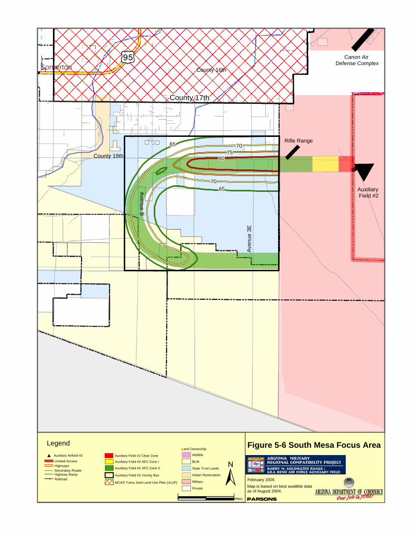
County 16th
County 19th
Aven
ue 3
E
A venu e B
County 17th
I¡Somerton
Parsons
February 2005
Map is based on best availible dataas of August 2004.
Limited AccessHighwaysSecondary RoadsHighway RampRailroad
Auxiliary Airfield #2# Wildlife
BLM
State Trust Lands
Indian Reservation
Military
Private
Legend
±0 2
Miles
Figure 5-6 South Mesa Focus AreaLand Ownership
Auxiliary Field #2
Auxiliary Field #2 Clear Zone
Auxiliary Field #2 APZ Zone I
Auxiliary Field #2 APZ Zone II
Auxiliary Field #2 Vicinity Box
MCAS Yuma Joint Land Use Plan (JLUP)
Rifle Range
Canon Air Defense Complex
7065
7065
7580
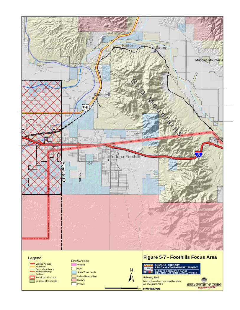
!"̀$
Avenue 10
GGii ll aa MM
oo uu nn tt aa ii nn ss
Fortuna40th
I¡
Muggins Mountains
DomeKinter
Ligurta
Blaisdell
Fortuna Foothills
Parsons
February 2005
Map is based on best availible dataas of August 2004.
Limited AccessHighwaysSecondary RoadsHighway RampRailroad
National Monuments
WildlifeBLMState Trust LandsIndian ReservationMilitaryPrivate
Legend
±0 1 2
Miles
Figure 5-7 - Foothills Focus AreaLand Ownership
Restricted Airspace

!"̀$
Aven ue 31 E
County 10th
Aven
ue 2
4
Aven
ue 2
1
County 9th
Muggins Mountains
WelltonLigurta
50
21
Parsons
February 2005
Map is based on best availible dataas of August 2004.
Low Level Airspace Exclusion Area
Limited AccessHighwaysSecondary RoadsHighway RampRailroad
National Monuments
Ground Support Areas
BLMState Trust Lands
MilitaryPrivate
Legend
±0 2
Miles
Figure 5-8 - East County 1 Focus AreaLand Ownership
Restricted Airspace
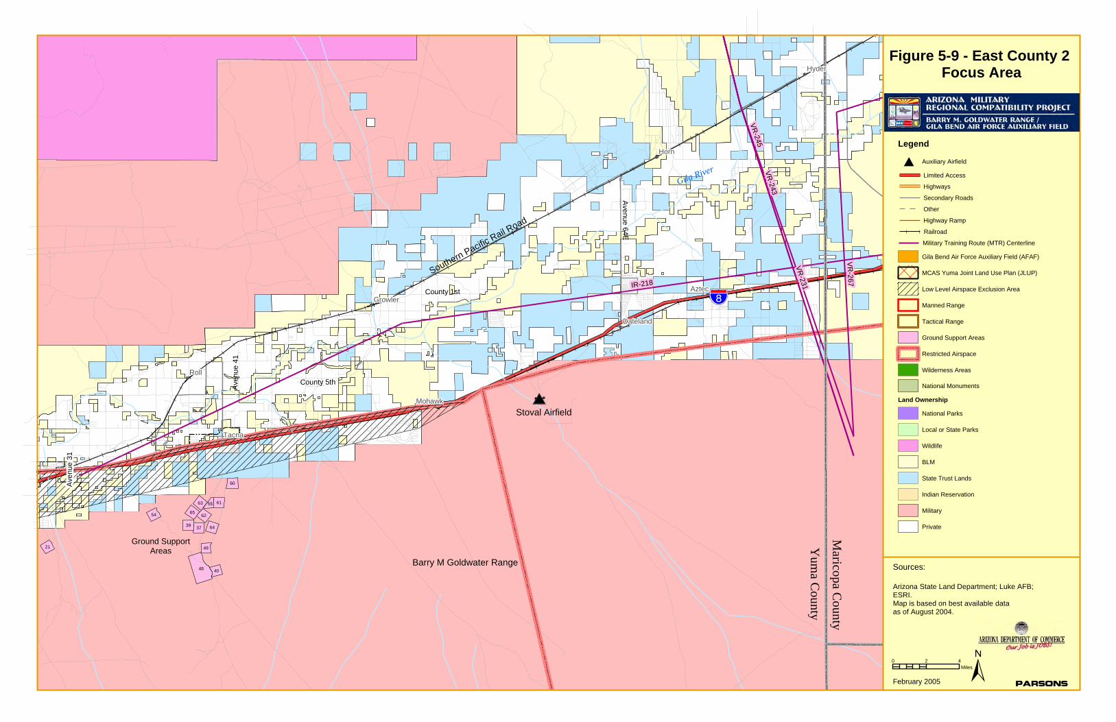
!
!
!
!
!
!
!
!
!
!"̀$
Gila River
Southern Pacific Rail Road
Ave
nue
31
County 5th
County 1st
Ave
nue
41
Av e nu e 6 4 E
Roll
Horn
Tacna
Aztec
Hyder
Mohawk
Growler
Dateland
IR-218
VR-231
VR
-267
VR-243
VR-245
48
60
62
21
6554
39 37
63
64
61
40
49
55
0 2 4Miles
Figure 5-9 - East County 2 Focus Area
±
Arizona State Land Department; Luke AFB;ESRI.Map is based on best available dataas of August 2004.
Sources:
ParsonsFebruary 2005
Legend
Limited Access
Highways
Secondary Roads
Other
Highway Ramp
Railroad
MCAS Yuma Joint Land Use Plan (JLUP)
Low Level Airspace Exclusion Area
Manned Range
Tactical Range
Wilderness Areas
National Monuments
Land Ownership
Auxiliary Airfield#
Gila Bend Air Force Auxiliary Field (AFAF)
Ground Support Areas
Restricted Airspace
Military Training Route (MTR) Centerline
National Parks
Local or State Parks
Wildlife
BLM
State Trust Lands
Indian Reservation
Military
Private
Maricopa C
ounty
Yum
a County
Barry M Goldwater Range
Ground SupportAreas
Stoval Airfield
GILA BEND AIR FORCE AUXIL IARY F IELD /
BARRY M. GOLDWATER RANGE JOINT LAND USE STUDY
FEBRUARY 2005 CHAPTER 5 : LAND USE COMPATIBIL ITY 5 -20
Existing residential development is located adjacent to the Range boundary in the Wellton Hills area east and west of Avenue 29E; residential development in the Town of Wellton is occurring south of the Wellton Canal to County 12th Street.
• East County 2 – This area extends from Avenue 31E to the Mohawk Mountains (at approximately Avenue 52E). This area is predominantly rural, with only scattered development, primarily along Interstate Highway 8. However, an oil refinery has been proposed for a site in the Tacna area north of Interstate 8 near Avenue 45E; if this project is implemented, it would increase the potential for spin-off development, both residential and non-residential uses in this part of Yuma County.
Particular concerns related to land use compatibility along the boundary of the Yuma portion of BMGR are:
• The Restricted Airspace (Area R2301W) that overlies the western portion of the Range extends north of the Range’s land boundary, generally to Interstate Highway 8, although in a few locations it extends north of the Interstate. This airspace is used by aircraft from MCAS Yuma to access the Range (as well as by other aircraft coming to the Range from west of Yuma). Aircraft may enter and exit the Range at any point and the Foothills and East County areas south of Interstate 8 are potentially affected by over flights from aircraft entering or exiting the range.
• The Restricted Airspace over the Foothills area is also used for staging for sorties and for helicopter routes to access the Range. These activities create additional potential for noise conflicts due to the different types and frequency of noise.
• Aircraft may enter or exit the Range at altitudes as low as 200 feet above ground level; this increases the potential for noise conflicts with noise-sensitive uses along the Range boundary.
• The access to the Range provided by the MTRs (including IR-218 in the eastern part of Yuma County) is critical and therefore the effectiveness of the MTR disclosure process mandated by State legislation is critical to maintaining the Range’s capabilities.
• Activities along the western boundary of BMGR, including the Rifle Range, “Practice Ordnance” Drops, and Ordnance Disposal potentially affect development in the South Mesa area. Continuing the Bureau of Reclamation’s “Restricted Land Use” designation for its land adjacent to BMGR would maintain compatibility in this area.
• Unauthorized access to the Range, particularly from County 14th Street along the northern Range boundary creates potential safety concerns.
These compatibility concerns are addressed by the recommended Boundary Compatibility Policies in Section 5.3.3 and the recommended Implementation Program in Chapter 6.
5.3.2 BMGR Boundary Compatibility Concerns – Eastern (Gila Bend) Portion
Luke Air Force Base, through its Range Management Office, is responsible for the eastern (Gila Bend) part of BMGR, which extends from approximately the Mohawk Mountains on
GILA BEND AIR FORCE AUXIL IARY F IELD /
BARRY M. GOLDWATER RANGE JOINT LAND USE STUDY
FEBRUARY 2005 CHAPTER 5 : LAND USE COMPATIBIL ITY 5 -2 1
the west to the eastern boundary of the Range. The eastern part of the Range is overlain by three Restricted Airspace Areas (R2301E, R2304 and R2305).
Portions of the eastern part of the Range are located in Yuma, Maricopa and Pima Counties, and along with the Town of Gila Bend are responsible for development along the Range boundary. Three particular areas along this portion of the boundary were identified as having potential compatibility concerns. These areas, as described below, are shown in Figures 5-10 through 5-12:
• Stoval Airfield – This airfield, located southwest of Dateland and east of the Mohawk Mountains, is used by both fixed wing aircraft (KC-130) and helicopters (CH-47 and CH-53). The usage by the KC-130 aircraft is 20 to 30 days per year with 3 day and 3 night missions per day. The primary runway used at Stoval runs northeast to southwest and the typical approach for the KC-130s is from Baragan Mountain to the north-northeast, which brings the aircraft over areas to the south and west of Dateland at altitudes of 300 to 1,000 above ground level, day or night. Patterns flown from the airfield are generally to the north and east within 5 nautical miles of the airfield at altitudes below 5,000 feet. The airfield is also used as a drop zone for equipment and on night missions, aircraft will drop flares. The off-range impacts of operations at Stoval Airfield would potentially affect an area within a 5-nautical mile radius of the airfield, as shown in Figure 5-10. The off-range areas within this radius are primarily rural, although there are tourist- and recreation-oriented uses at the Dateland interchange of Interstate Highway 8.
• Auxiliary Field #6 – This airfield, located approximately four miles west of Gila Bend AFAF, will be used by both fixed wing aircraft (HC-130s) and helicopters (HH-60s) for landings and refueling, and as a drop zone for personnel, vehicles and equipment. Primary runways run east-west and northeast-southwest, and approach and patterns flown will be similar to those at Stoval airfield, with the initial approach from the north or northeast, and patterns flown to the north and east of the airfield. As at Stoval, the patterns would be flown within a 5-nautical mile radius and at altitudes of less than 5,000 feet. Projected usage is for HC-130 landings day a week (3 landings per day); personnel and equipment drops once per week (day and night); and HH-60 landings twice per week (30 minutes each time). The area of off-range impacts from the operation of Auxiliary Airfield #6 is shown in Figure 5-11. The off-range areas within this radius are primarily rural at present, although portions of the planned Merrill-Paloma Ranch mixed-use development are within the affected area.
• Manned Range 1 – This range, located in the southeastern part of BMGR west of Highway 85, is used by F-16 and A-10 aircraft for air-to-ground combat training. The primary approach is normally from the southeast to the northwest at altitudes of 500 feet above ground level; the aircraft then return to the southeast at altitudes of 3,000 feet and make a pylon turn around the Ajo Airport to line up for the next run. This pattern takes the aircraft over primarily BMGR and BLM land, although the southwesterly leg of the pattern also overflies other land in the Ajo area.
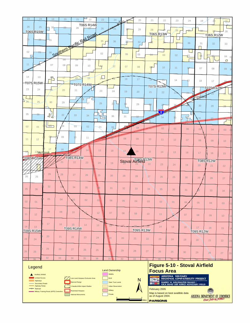
!
!
!
!"̀$
Southern Pacific Rail Road
Kofa
Mohawk
Dateland
18
01 01
25
10
29
02
29 28 27
25
09
04
32
05 03
07
19
19
2830
08
33
25
33
17
33
2121
16
35
23
10
21
26
31
26
09
33
1518
28
32
29
35
19
13
30
24
11
07
20
36
24
12
36
0912
16
09
3236
28
10
28
06 04
28
16
20
08
09
01
2927
17
34
13
34
15
33
22 23
25
17
22
29
14
28
24
36
21
36
16
16
09
26
10
09
29
36
20
33
24
27
34
01
2526
04
32
07
15
09
17
16
23
13
18
21
25
36
08
25
35
25
31
19
30
10 12
13
27
16
11
30
15
26
08
05
17
20
36
22
05
29
29
34
04
15
12
27
10
17
25 29
23
27
26
0812
27
18
03
08
32
22
05
32
14
21
08
17
3534
05
14
22
29
01
23
02
11
03
10
20
25
15
13
22
26
06
24
34
04
11
14
28
36
11
01
28
35
03
05
22
35
28
14
12
02
17
27
24
07
12
21
20
0203
15
24
11
20
20
29
29
20
13
09
27
17 16
08
32
25
2421
21
28
08
13
25
33
22
28
24
26
13
30
1012
14
31
15
23
01
27
16
04
33
13
32
30
30
18
31
19
12
07
19
18
30
06
31
31 31
06
30
07
30
07
18
19
06
31
26
35
02
11
14
23
04 030601 0504 020301 06
26
0502030405
35
02
11
14
23
26
2120
35
02
1924
11
2322
14
21
23
20
26
1924
32 33
23
34
2221
35
26
20
36 31
23
19
14
32
24
33
11
34
23
02
35
35
36 36
26
31
23
32
14
34
33
11
27
35 34
22
02
15
10
03
30
19
18
06
07
31
30
18
19
31
07
06
T07S R14W T07S R13W
T08S R13W
T09S R13W
T08S R14W
T09S R14W
T08S R12W
T09S R12W
T07S R12W
T06S R13W
T06S R14W
T07S R15W
T08S R15W
T09S R15W
T06S R12WT06S R15W
Stoval Airfield
Parsons
February 2005
Map is based on best availible dataas of August 2004.
Low Level Airspace Exclusion Area
Manned Range
Limited Access
Highways
Secondary RoadsHighway Ramp
Railroad
Auxiliary Airfield#
Military Training Route (MTR) Centerline
National Monuments
Wildlife
BLM
State Trust Lands
Indian Reservation
Military
Private
Legend
±0 1 2
Miles
Figure 5-10 - Stoval Airfield Focus AreaLand Ownership
5 Nautical Mile Impact Radius
Restricted Airspace
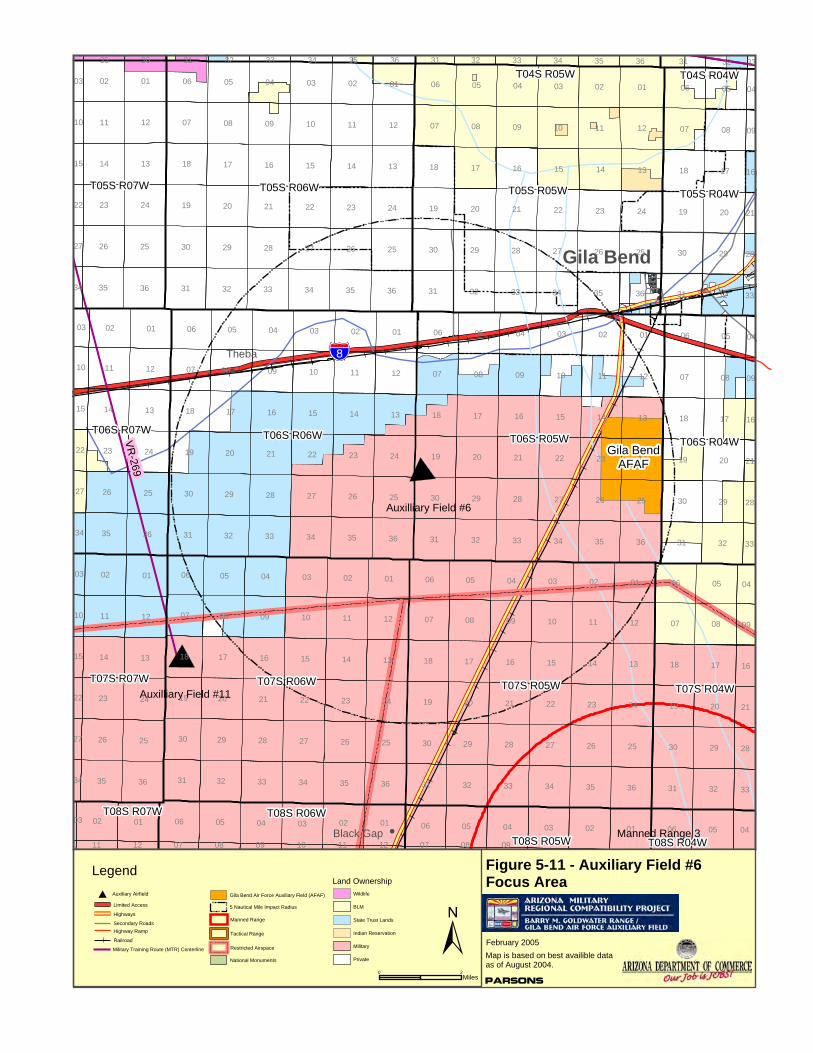
!
!
!
!"̀$Theba
Black Gap
Gila Bend
VR-269
01
12
14 13
07
2526
24
01
34
35 36
29
01
34
33
28
03
32
26
01
36 32
16
27
11
18 17
02
19
31
18
35
15
02
23
08
36 32
22
08
10
20
05
20
33
03
06
25
15
2529
24
12
05
27
12
17
22
10
05
30 2725
11
17
21
20
08
09
16
23
32
15
28
35
01
26
23
23
1313
08
14
36
2929
14
21
12
34
04
15
31
10
24
11
28
16
09
33
24
08
10
14
05
26
25
35
11
11
24
31
17
09
19
12
25
14
04
22
20
29
19
27
02
1107
23
23
30
1816
30
22
17
12
14
09
29
25
36
12
23
05
21
13
32
36
02
26
24
28
17
26
13
21 20
13
26
18
28
35
35 33
07
29
32 34
11
20
32
08
16
21
17
29
14
35 36
07
11
24
01
08
23
25
17
09
20
13
32
2727
22
08
24
13
26
15
10 12
31
22
35
29
03
17
3234
06
20
05
15
26
36
01
30
25
12
02
33
03
21 23
36
28
09
16
04 04
14
10
01
08
02
06
13
20
0206
05
24
11
34
14
04 03
02
33 35
19
31
31
30
19
06
19
18
30
07
31
03
30
07
06
18
19
18
07
06
07
04
19
18
30
06 05
05
31
050104 0203 01 02
050304
01
05 06
02
02
01
06
06
31
30
18
07
19
06
33
04
28
21
16
09
04
10
03
15
22
27
31
33
32
33
34
28
28
03
21
36
21
10
16
35
10
03
1615
09
34
22
15
27
04
09
33
22
34
04
11
32
27
12
36 31
34
07
35
08
3433
09
32
10
3135 36
11 12
03
07
33
08 09
T05S R05W
T06S R05W
T05S R06W
T06S R06W
T07S R05WT07S R06WT07S R04W
T06S R07W
T05S R04W
T06S R04W
T05S R07W
T07S R07W
T08S R06W
T08S R05W T08S R04W
T08S R07W
T04S R05W T04S R04W
Auxilliary Field #6
Parsons
February 2005
Map is based on best availible dataas of August 2004.
Manned Range
Tactical Range
Limited Access
Highways
Secondary RoadsHighway Ramp
Railroad
Auxiliary Airfield#
Military Training Route (MTR) Centerline
National Monuments
Wildlife
BLM
State Trust Lands
Indian Reservation
Military
Private
Legend
±0 2
Miles
Figure 5-11 - Auxiliary Field #6Focus AreaLand Ownership
Auxilliary Field #11
Gila BendAFAF
Manned Range 3
5 Nautical Mile Impact Radius
Gila Bend Air Force Auxiliary Field (AFAF)
Restricted Airspace

!
!
?Í
Manned Range 1
Ajo
Childs
VR-244
VR-263
VR-260
0102 05 04 0103 02 05 020304 01 050606 06
04
12
13
08
03
11
22
24
1714
17
12
14
05
23
11
15
12
20
02
13
27
29
01
20
01
08
14
25
24
10
03
17
12
13
11 10
32
36
32
23
34 36
08
02
04
26
29
20
32
05
08
26
29
04
28
23
26
15
10
36
27
35
23
25
32
24
15
29
14
26
35
25
33
22
33
09
25
13
35
25
34
35
16
21
28
16
13
05
11
35
21
28
36
35
21
36
09
34
27
21
09
23
33
16
34
21
28
05
26
22
14
24
16
33
24
09
26
28
36
17
29
33
31
11
02
34
10
16
02
24
04
20
32
28
33
12
04
01
33
03
01
23
28
36
14
15
25
29
09
22
34
33
20
10
15
13
35
25
3131
27
04
09
29
11
17
27
12
27
32
08
22
21
13
22
36
12
03
28
16
08
32
25
05
09
13
24
29
29
21
15
20
09
32
32
24
17
10
21
20
17
20
29
08
05
21
16
28
17
01
36
12
13
04
08
16
20
25
08
12
17
01
24
30
11
19
18
07
06
31
30
19
31
30
30
19
18
07
07
06
18
16
30
19
18
07
06
14
31
30
19
30
18
18
31
19
30
19
07
25
18
06
31
06
07
30
07
19
18
0907
06
31
30
19
18
23
07
2627
26
28
35
29
02
30
11
25
14
26
23
27
26
28
35
29
02
30
11
25
36
14
26
23
31 32
26
33 34 35 36 31 32 33 34 35 3635 31 32
34
33
33
2728
27
22
15
10
03
34
27
34
22
15
10
03
34
T10S R07W T10S R06W
T11S R06WT11S R07W
T12S R07W T12S R06W
T11S R05W
T10S R05W
T12S R05W
T10S R08W
T09S R06W
T11S R08W
T09S R07W
T12S R08W
T09S R05WT09S R08W
Parsons
February 2005
Map is based on best availible dataas of August 2004.
Low Level Airspace Exclusion Area
Manned Range
Tactical Range
Limited Access
Highways
Secondary RoadsHighway Ramp
Railroad
Auxiliary Airfield#
Military Training Route (MTR) Centerline
Wildlife
BLM
State Trust Lands
Indian Reservation
Military
Private
Legend
±0 1 2
Miles
Figure 5-12 - Manned Range 1Focus AreaLand Ownership
Restricted Airspace
Impact Area
GILA BEND AIR FORCE AUXIL IARY F IELD /
BARRY M. GOLDWATER RANGE JOINT LAND USE STUDY
FEBRUARY 2005 CHAPTER 5 : LAND USE COMPATIBIL ITY 5 -25
As for the western portion of BMGR, the principal compatibility concerns for the eastern portion of the Range are related to aircraft over flights. These may occur at low altitudes and at high speeds, which create greater potential for noise conflicts. Also as for the western portion of the Range, access to the eastern portion of BMGR from the Military Training Routes (MTRs) is critical to the Range’s mission. Access points from four MTRs (VR-231, VR-243, VR-245 and VR-267) converge along the northern Range boundary between Aztec and Sentinel. Other MTRs enter the Range east and west of the Town of Gila Bend as well as from the Ajo area to the south.
Manned Range #4 is located near the northern border of the Range, and operational impacts from its operations would affect the land to the north, which is controlled by the Bureau of Land Management (BLM). Although uses currently allowed under the relevant BLM management plans and programs would be generally compatible with the operation of Manned Range #4, there are some aspects of certain uses that would be potentially incompatible. For example, a large 24-hour mining operation with lights could create potential incompatibility with nighttime operations at Manned Range #4. In addition, certain kinds of recreation could be incompatible. Maintaining the compatibility of use and avoiding potential incompatibilities on the BLM land is necessary for the continued effectiveness of training activities at Manned Range #4.
Compatibility concerns for the Gila Bend portion of the Range are addressed by the recommended Boundary Compatibility Policies in Section 5.3.3 below and in the recommended Implementation Program in Chapter 6.
5.3.3 BMGR Boundary Compatibility Policies
The recommended Compatibility Policies for the BMGR Boundary are based upon the same principles that apply to airfield operations. A fundamental goal of compatibility is to avoid concentrations of people exposed to noise and safety hazards, and is achieved in principle by:
• limiting exposure of people and noise-sensitive activities to high noise levels, and
• limiting concentrations of people and safety-sensitive activities in areas of highest probable accident impact.
The following recommended policies also reflect the understanding that the areas most affected by off-range impacts are those closest to the range boundaries, and that the severity of the impacts is likely to decrease as the distance from the range boundaries increases.
Policy 1: Notification • Require Range avigation disclosure extending 0-3 miles from BMGR land
boundary.
• Include all land under BMGR restricted airspace and land affected by off-range impacts for Stoval Airfield, Auxiliary Field #6 and Manned Range #1. (Note: in some areas this may extend beyond 3 miles from the Range land boundary.)
• Require review by Luke Air Force Base or MCAS Yuma for all proposed development in Notification Area.
GILA BEND AIR FORCE AUXIL IARY F IELD /
BARRY M. GOLDWATER RANGE JOINT LAND USE STUDY
FEBRUARY 2005 CHAPTER 5 : LAND USE COMPATIBIL ITY 5 -26
Policy 2: Zone of Influence • Within 0-1 mile from BMGR land boundary:
o Maintain existing zoning and no new residential development (other than permitted by existing zoning), except,
o Within the “Foothills” area recommend to maintain existing zoning for an interim period until the RAICUZ is released, at which time appropriate residential densities would be applied.
• Within 1-3 miles from BMGR land boundary (Note: for land under BMGR restricted airspace and land affected by off-range impacts for Stoval Airfield, Auxiliary Field #6 and Manned Range #1 this may extend beyond 3 miles from the Range land boundary):
o Implement the Graduated Density Concept (see Policy 3, below).
Policy 3: Graduated Density Concept • Allow increased density of development as distance from Range land boundary
increases.
• Within 0-1 mile from BMGR land boundary:
o Maintain existing zoning and no new residential development (other than permitted by existing zoning), except,
o Within the “Foothills” area recommend to maintain existing zoning for an interim period until the RAICUZ is released, at which time appropriate residential densities would be applied.
• Within 1-3 miles from BMGR land boundary (Note: for land under BMGR restricted airspace and land affected by off-range impacts for Stoval Airfield, Auxiliary Field #6 and Manned Range #1 this may extend beyond 3 miles from the Range land boundary):
o Allow graduated densities to be determined by the local jurisdiction so that at the furthest extent of the zone of influence, allowable densities are similar to those allowed in adjacent areas outside the zone of influence.
Policy 4: Limited Access Along BMGR Boundary • Limit private property access to roadways bordering the BMGR boundary
(particularly County 14th Street in Yuma County) to reduce the opportunities for unauthorized access to the Range.
In addition to these policies, the following should also be implemented within the zone of influence.
• Vested development as defined under Arizona Statutes may occur, although not compatible with the policies for the zone of influence.
• Existing uses incompatible with the policies for the zone of influence may be continued although they may be subject to restrictions on their expansion.
GILA BEND AIR FORCE AUXIL IARY F IELD /
BARRY M. GOLDWATER RANGE JOINT LAND USE STUDY
FEBRUARY 2005 CHAPTER 5 : LAND USE COMPATIBIL ITY 5 -27
• Uses not otherwise considered compatible with the policies for the zone of influence may be allowed by mutual agreement of the respective local jurisdiction and the affected military installation upon determination that they would not adversely affect the operation of the installation.
5.4 LAND USE COMPATIBILITY PLAN AND COMPATIBILITY POLICY IMPLEMENTATION
The Compatible Land Use Plans for Gila Bend AFAF and Compatibility Policies for the BMGR boundary areas are guides and tools to be applied by local political jurisdictions to protect and promote the health, welfare, and safety of the public. The Plan and Policies also recognizes that vested development as defined under Arizona Statutes may occur, although not compatible with the Plans, and that existing incompatible uses may be continued although subject to restrictions on their expansion.
Integration of the recommendations for compatible land uses into general and comprehensive plans during the Growing Smarter major amendment process is appropriate implementation. Given that Arizona is a local control State, it is the responsibility of each community to determine which of the uses in the Compatible Land Use Plans and which of the recommended Boundary Compatibility Policies are appropriate for each jurisdiction and to implement those decisions through development regulations, land use plan policies and development reviews. It is also appropriate for each jurisdiction to determine how to implement criteria for the non-compatible uses.
GILA BEND AIR FORCE AUXIL IARY F IELD /
BARRY M. GOLDWATER RANGE JOINT LAND USE STUDY
FEBRUARY 2005 CHAPTER 6 : IMPLEMENTATION PROGRAM 6 - 1
6. IMPLEMENTATION PROGRAM
6.1 INTRODUCTION
This Joint Land Use Study (JLUS) for the Barry M. Goldwater Range and Gila Bend Air Force Auxiliary Field is intended to guide the decisions made by a variety of public and private entities in relation to compatible land use around the Range and Field. In addition to the State of Arizona and its agencies, Luke Air Force Base, MCAS Yuma, local jurisdictions, and private interests within the area can contribute to the implementation of the recommendations of the JLUS.
The Compatible Land Use Plan presented in Chapter 5 of this JLUS defines recommended compatible uses and performance standards that are intended to be used by the Town of Gila Bend, City of Yuma and Maricopa and Yuma Counties to guide development in order to maintain the operational capabilities of the Range and Field, while facilitating the economic development of other key sectors in ways that are compatible with the mission of these critical military facilities. Implementation of the Compatible Use Plan is fundamental to achieving these goals and integration of land use recommendations into general and comprehensive plans and zoning ordinances is a key element in implementing the JLUS. However, successful implementation requires that other tools be utilized to achieve the JLUS goals. These tools are contained in the implementation program presented in the following sections.
The implementation program has been developed in recognition of the ongoing planning by Luke AFB, MCAS Yuma and the local jurisdictions, as well as considering the divergent viewpoints expressed through the project’s process, and the need to present strategies that realistically accomplish the goal of maintaining the operational capabilities of the Range and Field. While the changing nature of economics and politics may change the scope and timing of the implementation strategies, these recommendations provide the framework and guidance for achieving long-term compatibility of development with continued military operations.
The following sections present the recommended Implementation Strategies. Three aspects of implementation that are integral to the process follow a brief description of each strategy. The first aspect of implementation, Priority / Timing, establishes the importance of the action and the timeframe within which the Strategy is to be effected as follows:
o High — by December 2005,
o Moderate — within 2–3 years, that is by December 2007, or
o Low — 4–5 years, that is by December 2009.
The second aspect of implementation, Responsible Party(s), indicates the governmental agency, local political jurisdiction, and other parties responsible for implementing the Strategy. The third aspect of implementation, Evaluation Measures, presents recommendations concerning review and monitoring to facilitate adjustments if the
GILA BEND AIR FORCE AUXIL IARY F IELD /
BARRY M. GOLDWATER RANGE JOINT LAND USE STUDY
FEBRUARY 2005 CHAPTER 6 : IMPLEMENTATION PROGRAM 6 -2
strategy is not meeting its desired results. One of the appropriate functions for the State would be to monitor the implementation and effectiveness of the recommended measures through the Arizona Department of Commerce or other State agency.
6.2 IMPLEMENTATION STRATEGIES
6.2.1 Joint Land Use Study Recognition While the JLUS is not adopted in the traditional sense by local jurisdictions and is not a legal document, the completion of the JLUS and its status as guidance for land use decisions in the vicinity of the Barry M. Goldwater Range and Gila Bend Air Force Auxiliary Field should be recognized by the City of Yuma, Town of Gila Bend, Town of Wellton, Maricopa County, Yuma County, Luke Air Force Base and MCAS Yuma. Appendix B contains a model resolution for consideration by the Town, City and Counties.
• Priority / Timing – High
• Responsible Party(s) – City of Yuma, Town of Gila Bend, Town of Wellton, Maricopa County, Yuma County, Luke Air Force Base and MCAS Yuma
• Evaluation Measures – Resolution or similar official acknowledgement adopted in 2005
6.2.2 Revision of Local Plans and Ordinances The JLUS study defines compatible land uses for the Clear Zones, APZ-I, APZ-II, and high-noise zones around Gila Bend AFAF, as well as along the BMGR boundary. The General Plans and ordinances of the Town of Gila Bend, the Town of Wellton, the City of Yuma and Maricopa and Yuma Counties are the primary means of implementing the recommended compatible uses. The Town, City and Counties should review their respective plans and ordinances to identify changes that are necessary to implement the recommended compatible uses and policies and prepare necessary amendments to the plans and ordinances for consideration and adoption by their respective governing bodies.
• Priority / Timing – High
• Responsible Party(s) – Town of Gila Bend, Town of Wellton, City of Yuma, Maricopa County and Yuma County
• Evaluation Measures – Plan and Zoning Ordinance amendments adopted in 2005
6.2.3 Coordination with the Governor’s Military Affairs Commission The Military Affairs Commission, created by Executive Order in March 2004, is the permanent body to monitor and make recommendations to the Governor on executive, legislative and federal actions necessary to sustain and grow Arizona’s network of military installations, training and testing ranges and associated airspace. Creation of the Military Affairs Commission (MAC) was a recommendation of the Governor’s Military Facilities Task Force in its Report of December 2003. Other recommendations of the Task Force, including the designation of dedicated funding to assist military installation preservation and expansion projects have been implemented by legislative action. The Town of Gila Bend, Town of Wellton, City of Yuma and Maricopa County, along with interested
GILA BEND AIR FORCE AUXIL IARY F IELD /
BARRY M. GOLDWATER RANGE JOINT LAND USE STUDY
FEBRUARY 2005 CHAPTER 6 : IMPLEMENTATION PROGRAM 6 -3
community and civic organizations should be actively involved in coordinating their activities related to BMGR with the Military Facilities Commission, and support implementation of its recommendations at the State level.
• Priority / Timing – High
• Responsible Party(s) – Town of Gila Bend, Town of Wellton, City of Yuma, Maricopa County, Yuma County and other organizations
• Evaluation Measures – Development of coordination mechanisms
6.2.4 Support for State Trust Land Reform The ability for the State Trust to engage in land exchanges and the ability to transfer densities and land uses between various State Trust lands is potentially an important element for achieving compatibility in the development of State Trust lands in the vicinity of Gila Bend AFAF and BMGR. Although the most recent attempt to provide this important tool through a constitutional amendment was defeated in the November 2004 election, indications are that various groups may support a future measure to provide for such transfers. As any future mechanism to allow this will likely require legislative action and / or a vote of the electorate to modify the State Constitution, the local jurisdictions around Gila Bend AFAF and BMGR and other interested organizations should actively support efforts to develop and adopt such a mechanism.
• Priority / Timing – High
• Responsible Party(s) – Town of Gila Bend, Town of Wellton, City of Yuma, Maricopa County, Yuma County and other organizations
• Evaluation Measures – Enactment / adoption of measures to allow transfer of State Trust lands around military installations
6.2.5 Ongoing Coordination for JLUS Implementation
Efficient and effective communication between the local jurisdictions,, area landowners, other local organizations, Luke Air Force Base and MCAS Yuma is critical to the successful implementation of the JLUS. To provide a means to maintain communication and coordination as the JLUS recommendations are carried out, the local jurisdictions and military installations should consider the joint designation of an ongoing coordinating body. This body, which could be an existing organization, should include representatives from area landowners and other local organizations that have an interest in compatible land use around the Base. This body could also serve as the interface with the State Military Affairs Commission on issues related to Gila Bend AFAF and BMGR.
• Priority / Timing – High
• Responsible Party(s) – Town of Gila Bend, Town of Wellton, City of Yuma, Maricopa County, Yuma County, Luke AFB, MCAS Yuma, area landowners and other local organizations
• Evaluation Measures – Ongoing
GILA BEND AIR FORCE AUXIL IARY F IELD /
BARRY M. GOLDWATER RANGE JOINT LAND USE STUDY
FEBRUARY 2005 CHAPTER 6 : IMPLEMENTATION PROGRAM 6 -4
6.2.6 Department of Defense Land Acquisition Local jurisdictions along with the installations and other interested groups such as the Gila Bend Chamber of Commerce and Yuma County Chamber of Commerce should work with the State’s Congressional delegation to obtain additional appropriations in the Department of Defense budget dedicated to the purchase of critical parcels to protect the BMGR mission, including critical parcels in the Gila Bend AFAF safety zones. In addition to working for an appropriation in the next budget year (2006), efforts should be made for additional appropriations in the following years.
• Priority / Timing – High to moderate
• Responsible Party(s) – Town of Gila Bend, Town of Wellton, City of Yuma, Maricopa County, Yuma County, Arizona Congressional delegation
• Evaluation Measures – Appropriated funding in the Department of Defense budget
6.2.7 Department of Defense Purchase of Conservation Easements The Department of Defense (DOD) is implementing a program of purchase of conservation easements around military installations in order to address environmental and encroachment issues.
The “Bob Stump National Defense Authorization Act” for Fiscal Year 2003 (P.L. 107-314) provided new statutory authority that permits the Department of Defense to enter into agreements with eligible entities to address the use or development of real property near a military installation, and to accept on behalf of the United States Government any property or interest acquired pursuant to such agreements. The Department of Defense is working to determine how this new authority will be used, and each of the Military Departments are developing specific program guidance.
In general terms the new authority includes the following specific elements.
Eligible entities are States, political subdivisions or private conservation organizations.
The amendment provides for the acquisition by an eligible entity of all right, title, interest in and to any real property, and sharing by the Government and the entity in acquisition costs. The amendment also requires the entity, upon request of the DOD, to transfer to the Government the minimum property or interests necessary to avoid encroachment from the use or management of the property.
Department of Defense funds may be used for such agreements for purchase from willing sellers. It is important to note that the amendment does not provide specific funding for these purchases. The Department of Defense will determine if, and how much funding will be available for this initiative.
The amendment also permits Department of Defense to convey surplus real property to states or other eligible entities for conservation of natural resources.
The local jurisdictions around Gila Bend AFAF and BMGR should work with Luke Air Force Base, MCAS Yuma and the Department of Defense to acquire conservation easements in appropriate locations within the Clear Zones and APZs.
• Priority / Timing – High to Moderate
GILA BEND AIR FORCE AUXIL IARY F IELD /
BARRY M. GOLDWATER RANGE JOINT LAND USE STUDY
FEBRUARY 2005 CHAPTER 6 : IMPLEMENTATION PROGRAM 6 -5
• Responsible Party(s) – Town of Gila Bend, Town of Wellton, City of Yuma, Maricopa County, Yuma County, Luke Air Force Base, MCAS Yuma, Department of Defense and private landowners
• Evaluation Measures – Completed purchase of conservation easements
6.2.8 Land and Water Conservation Fund The Land and Water Conservation Fund (LWCF) was established by Congress in 1964 to create parks and open spaces, protect wilderness, wetlands, and refuges, preserve wildlife habitat, and enhance recreational opportunities. The LWCF has a matching grants program that provides funds to states for planning, developing and acquiring land and water areas for state and local parks and recreation areas. These funds could be used to match state monies to purchase critical parcels of land around the Field for use as conservation / open space.
• Priority / Timing – High
• Responsible Party(s) – Federal and State governments
• Evaluation Measures – Use of land and water conservation funds as appropriate
6.2.9 Military Installation Fund One of the recommendations of the Governor’s Military Facilities Task Force was the creation of a Military Installation Fund (MIF), to be administered by the State and funded by dedicated revenue at the State level. The MIF, as established under ARS §41.1512.01, will provide grants to local governments for land acquisition or other activities to preserve or expand military installations. The City, Towns and Counties should consider use of MIF funding to support acquisition of land or development rights in critical areas (most likely in combination with other funding), or for other activities that would support compatible land use.
• Priority / Timing – High to Moderate
• Responsible Party(s) – City of Yuma, Town of Gila Bend, Town of Wellton, Maricopa County, Yuma County and State of Arizona
• Evaluation Measures – Use of MIF funds as provided for in grant
6.2.10 Purchase of Development Rights An alternative to the purchase of land is the purchase of development rights which would be negotiated with the owner of the development rights. Participation in the purchase of development rights would be voluntary on the part of the owner. This type of acquisition may be effective in appropriate situations and areas, particularly where the issue of compatibility involves density of development rather than the type of land use proposed. When development rights are purchased, a landowner is paid fair market value for the rights that are purchased. The value of the purchased rights is roughly equal to the value of the land without any special restriction less the value of the land with the land use restrictions. The use of this strategy would be dependent on securing funding for the purchase through one of the other strategies identified in this chapter.
GILA BEND AIR FORCE AUXIL IARY F IELD /
BARRY M. GOLDWATER RANGE JOINT LAND USE STUDY
FEBRUARY 2005 CHAPTER 6 : IMPLEMENTATION PROGRAM 6 -6
• Priority / Timing – High to Moderate
• Responsible Party(s) – Federal government, State government, and local jurisdictions
• Evaluation Measures – Development Rights are purchased
6.2.11 Transfer of Development Rights The use of Transfer of Development Rights (TDRs) can reduce the intensity and density of use in areas identified as significant to preserving the Base’s mission while increasing density in other areas by encouraging local political jurisdictions to create incentives for developers to use the density transfer technique in appropriate situations and areas affected by aircraft operations. The transfer of development rights is similar to the purchase of development rights, except rather than a public agency buying development rights, which are then in effect “retired”, the landowner is compensated by having the permitted uses of other land expanded or intensified. The land to which the rights are transferred may be owned either by the landowner, or by someone else. In the latter case, compensation is paid to the “sending” landowner by the “receiving” landowner. Participation in TDR programs would be voluntary on the part of the landowner(s). Under the TDR scenario, the use of land currently zoned for lower intensity use outside the affected areas could be modified to allow higher density development at the same time the use of land in the affected areas currently zoned to permit higher density development would be restricted to lower density use.
• Priority / Timing – High to Moderate
• Responsible Party(s) – Local jurisdictions
• Evaluation Measures – TDR programs are adopted by the local municipalities (and by Maricopa and Yuma County, if State legislation is enacted to allow the Counties to use TDRs)
6.2.12 Partnerships with Non-Governmental Organizations to Facilitate Transfers of Development Rights
Governmental or non-governmental entities such as the Trust for Public Land (TPL), may acquire development rights for land adjacent to a military installation or facility, especially for land in the high hazard and noise zones, and dedicating it to uses compatible with military missions or to transferring those lands to public ownership for conservation or open space uses. TPL also has a program to assist communities in pursuing a preservation ballot initiative, providing services that include political analysis and campaign strategy.
• Priority / Timing – High to Moderate
• Responsible Party(s) – Local jurisdictions and TPL or other entity
• Evaluation Measures – Acquisition of development rights by TPL or other entity
6.2.13 Enhanced Local Notification and Disclosure The Governor’s Military Facilities Task Force recommended that current notification and disclosure provisions in State law for military facilities be strengthened, including a
GILA BEND AIR FORCE AUXIL IARY F IELD /
BARRY M. GOLDWATER RANGE JOINT LAND USE STUDY
FEBRUARY 2005 CHAPTER 6 : IMPLEMENTATION PROGRAM 6 -7
recommendation that the Arizona Department of Real Estate develop a “rule” to strengthen and standardize the notification process for its licensees. Increasingly, communities have determined that there is value to their citizens in going beyond the minimum public notification and disclosure standards outlined in State law. Each of the local jurisdictions should adopt a requirement for a recorded avigation disclosure statement within the Area of Notification as recommended in the BMGR Boundary Compatibility Policies, and also implement procedures to ensure that this notification is passed on to succeeding property owners.
Other mechanisms to enhance public notification and disclosure that should be considered by local jurisdictions include:
• Requiring notices and maps to be posted in real estate sales and leasing offices, including identification of noise contours.
• Requiring notices placed in model home complexes and sales offices advising potential buyers that the area is subject to military aircraft over flight.
• Requiring avigation easements and indemnification / release of liability language on all recorded subdivision plats.
• Installing over flight signage at roadway intersections within the noise contour lines.
Experience has shown that notification is highly effective in educating nearby residents about the presence of military activities and avoiding complaints.
• Priority / Timing – High to Moderate
• Responsible Party(s) – City of Yuma, Town of Gila Bend, Town of Wellton, Maricopa County and Yuma County
• Evaluation Measures – Enhanced Notification and Disclosure procedures in place
6.2.14 Best Practice Techniques A process to assess the usefulness of various techniques used by other political jurisdictions with similar military air base encroachment issues is an effective means to ensure that the “best practices” are being used to guide development around the State’s military facilities. This evaluation of “best practice” techniques will need to determine their potential to be adapted to the needs of various political jurisdictions in the State, and the State will continue its role as convener and clearinghouse in these efforts. Other stakeholders are anticipated to participate in this data collection in support of the statewide effort. Results of the Best Practices research will be compiled into the State Policy Guide developed as part of the statewide effort by the Department of Commerce to address land use compatibility and encroachment issues under the Arizona Military Regional Compatibility Project.
• Priority / Timing – Development of State Policy Guide – High; continuing assessment is ongoing
• Responsible Party(s) – State government, local jurisdictions, and other stakeholder groups
• Evaluation Measures – Development of State Policy Guide and ongoing assessment

GILA BEND AIR FORCE AUXIL IARY F IELD /
BARRY M. GOLDWATER RANGE JOINT LAND USE STUDY
FEBRUARY 2005 CHAPTER 6 : IMPLEMENTATION PROGRAM 6 -8
6.2.15 Monitoring the Military Training Route (MTR) Notification Process Because the access provided to BMGR by the Military Training Routes (MTRs) is critical to the effective utilization of the Range, it is in the interests of both MCAS Yuma and Luke AFB that the notification process for property under the MTRs mandated by recent State legislation be effective. MCAS Yuma and Luke AFB, along with the affected jurisdictions in the vicinity of the Range should monitor the effectiveness of the notification process to ensure that it accomplishes the intent of making purchasers of property under the MTRs aware of the potential exposure to effects of aircraft operations at low elevations.
• Priority / Timing –Ongoing
• Responsible Party(s) – MCAS Yuma, Luke AFB, and affected local jurisdictions
• Evaluation Measures – Successful implementation of MTR notification requirements
6.2.16 Coordination with Bureau of Land Management and Bureau of Reclamation Lands under the control of the Bureau of Land Management (BLM) and Bureau of Reclamation (BOR) adjacent to BMGR are currently managed by their respective agencies. While these plans generally provide for uses that are compatible with the training operations at BMGR, certain aspects of permitted uses may be potentially incompatible, as described in section 5.3.2 above. The Range managers (MCAS Yuma and Luke AFB) should continue close coordination with both BLM and BOR to ensure that these lands are planned and managed for compatible uses in the future.
• Priority / Timing –Ongoing
• Responsible Party(s) – MCAS Yuma, Luke AFB, Bureau of Land Management and Bureau of Reclamation
• Evaluation Measures – Maintenance of compatible uses on BLM and BOR lands adjacent to BMGR
GILA BEND AIR FORCE AUXIL IARY F IELD /
BARRY M. GOLDWATER RANGE JOINT LAND USE STUDY
FEBRUARY 2005 APPENDIX A : STATE LAND USE COMPATIBIL ITY LEGI SLATION A - 1
APPENDIX A: ARIZONA LAND USE COMPATIBILITY LEGISLATION
To view the full text of the Arizona Revised Statues (ARS) discussed below visit the Arizona State Legislature’s web site at www.azleg.state.az.us/ArizonaRevisedStatutes.asp.
1.0 TITLE 9
Title 9 of the ARS contains legislation governing cities and towns; the cited sections are especially concerned with municipal planning issues.
ARS §9-461.05. This section stipulates that the general plan prepared by municipalities within the territory in the vicinity of a military airport or ancillary military facility have a land use element that includes consideration of military airport operations. This section also requires that the plan identify high noise areas or accident potential zones defined in ARS §28-8461 for the purpose of planning compatible land uses pursuant to the requirement of ARS §28-8481.
ARS §9-461.06. This section requires that the governing body shall consult with, advise, and provide an opportunity for official comment on the plan or major amendment to the plan by the military airport if the municipality has territory in the vicinity of a military airport or ancillary military facility as defined in ARS §28-8461. If the municipality has territory in a high noise area or accident potential zone, the plan or major amendment must also be submitted to the attorney general for review and comment.
This section also provides that if the municipality includes property in the high noise or accident potential zone of a military airport or ancillary military facility, the governing body of the municipality shall send notice of the approval, adoption or readoption of the general plan or major amendment to the general plan to the attorney general. If the attorney general determines the land uses in the high noise or accident potential zone is not in compliance with ARS §28-8481, the municipality shall receive the notice of noncompliance Within thirty days after the receipt of a determination of noncompliance by the attorney general as, the governing body of the municipality shall reconsider any approval, adoption or readoption of, or major amendment to, the general plan that impacts property in the high noise or accident potential zone of a military airport or ancillary military facility. If the governing body reaffirms a prior action subject to an attorney general’s determination of noncompliance, the attorney general may institute a civil action.
ARS §9-462.04. In proceedings involving rezoning of land that is located within territory in the vicinity of a military airport or ancillary military facility the public notice shall include a general statement that the matter applies to property located in the high noise or accident potential zone, and the military airport shall be provided with a copy of the notice. If the military airport provides comments or
GILA BEND AIR FORCE AUXIL IARY F IELD /
BARRY M. GOLDWATER RANGE JOINT LAND USE STUDY
FEBRUARY 2005 APPENDIX A : STATE LAND USE COMPATIBIL ITY LEGI SLATION A -2
analysis concerning the compatibility of the proposed rezoning with the high-noise or accident potential generated by military airport or ancillary military facility operations the board shall consider and analyze the comments or analysis before making a final determination.
2.0 TITLE 11
Title 11 of the ARS contains legislation governing counties; the cited sections are especially concerned with county planning and zoning.
ARS §11-806. The section requires that counties with territory in the vicinity of a military airport or ancillary military facility must prepare a comprehensive plan that includes consideration of military airport operations. This section also requires that the plan identify high noise areas or accident potential zones defined in ARS §28-8461 for the purpose of planning compatible land uses pursuant to the requirement of ARS §28-8481.
ARS §11-824. This section requires that the county shall consult with, advise, and provide an opportunity for official comment on the plan or major amendment to the plan by the military airport if the municipality has territory in the vicinity of a military airport or ancillary military facility as defined in ARS §28-8461. If the county has territory in a high noise area or accident potential zone, the plan or major amendment must also be submitted to the attorney general for review and comment.
This section also provides that if the county includes property in the high noise or accident potential zone of a military airport or ancillary military facility, the governing body of the county shall send notice of the approval, adoption or readoption of the general plan or major amendment to the general plan to the attorney general. If the attorney general determines the land uses in the high noise or accident potential zone is not in compliance with ARS §28-8481, the county shall receive the notice of noncompliance Within thirty days after the receipt of a determination of noncompliance by the attorney general as, the governing body of the county shall reconsider any approval, adoption or readoption of, or major amendment to, the general plan that impacts property in the high noise or accident potential zone of a military airport or ancillary military facility. If the governing body reaffirms a prior action subject to an attorney general's determination of noncompliance, the attorney general may institute a civil action.
ARS §11-829. In proceedings involving rezoning of land that is located within territory in the vicinity of a military airport or ancillary military facility the public notice shall include a general statement that the matter applies to property located in the high noise or accident potential zone, and the military airport shall be provided with a copy of the notice. If the military airport provides comments or analysis concerning the compatibility of the proposed rezoning with the high-noise or accident potential generated by military airport or ancillary military facility operations the board shall consider and analyze the comments or analysis before making a final determination.
GILA BEND AIR FORCE AUXIL IARY F IELD /
BARRY M. GOLDWATER RANGE JOINT LAND USE STUDY
FEBRUARY 2005 APPENDIX A : STATE LAND USE COMPATIBIL ITY LEGI SLATION A -3
3.0 TITLE 15
Title 15 of the ARS contains legislation governing education; the cited sections are especially concerned with financing school development.
ARS §15-2002. The executive director of the school facilities board is required to establish procedures in compliance with the official notice and hearing requirements that, with respect to monies to fund the construction of new school facilities proposed to be located in the territory in the vicinity of a military airport, the military airport receive notification of the application for funding at least thirty days before any hearing.
ARS §15-2041. The section requires that, with respect to monies to fund the construction of new school facilities proposed to be located in the territory in the vicinity of a military airport the board shall consider and analyze the comments or analysis from military airport before making a decision.
4.0 TITLE 28
Title 28 of the ARS contains legislation governing transportation; the cited sections are especially concerned with airport zoning and regulation and joint powers airport authorities.
ARS §28-8461. This section is concerned with a number of definitions that directly relate to military airport operations. It defines Accident Potential Zone 1 and Accident Potential Zone 2, Clear Zone, high-noise or accident potential zones, military airport, ancillary military facility, territory in the vicinity of a military airport, etc.
ARS §28-8480. This section allows political subdivisions to acquire or lease land or interests in land for the continued operation of a military airport.
ARS §28-8481. This section requires a political subdivision that has territory in the vicinity of a military airport or ancillary military facility to adopt comprehensive and general plans for property in the hazard zone to assure development compatible with the high-noise and accident potential generated by military airport operations, which includes noise reduction standards for specific land uses within noise zones of 65 Ldn or higher. It also includes specific requirements that:
o Political subdivisions that have property in a high-noise or accident potential zone cannot grant zoning variances without a specific finding that the purpose of military airport compatibility is preserved.
o A political subdivision that has territory in a high-noise or accident potential zone is required to notify the owner or owners of property in that zone of any additions or changes to the general plan, comprehensive plan, zoning regulations applicable to property in those zones. The political subdivision shall provide a notice of such additions or changes including a statement that the property is located in a high-noise or accident potential zone. Each political subdivision that has territory that includes property in a high-noise or accident potential zone is required to
GILA BEND AIR FORCE AUXIL IARY F IELD /
BARRY M. GOLDWATER RANGE JOINT LAND USE STUDY
FEBRUARY 2005 APPENDIX A : STATE LAND USE COMPATIBIL ITY LEGI SLATION A -4
file with the attorney general a report that demonstrates compliance during the previous reporting period.
ARS §28-8482. This section requires political subdivisions in the vicinity of a military airport to incorporate sound attenuation standards in their building codes.
ARS §28-8483. The State Real Estate Department and political subdivisions that have territory in the vicinity of a military airport are required to request from the military airport a registry of certain information concerning flight operations and contact persons; this registry shall be available to the public on request.
ARS §28-8484. Any public report applicable to property located within territory in the vicinity of a military airport is required to include the statements that: the property is located within territory in the vicinity of a military airport; the maps of military flight operations provided by the military airport are available to the public on request. Each military airport may provide the State Real Estate Department and each political subdivision with territory in the vicinity of the military airport with a map that shows the boundaries of each territory in the vicinity of a military airport and the boundaries of each high-noise or accident potential zone.
ARS §28-8485. This section allows the state or a governing body of a political subdivision that operates an airport to designate an airport influence area of all property that is exposed to aircraft noise and over flights and has a 65 Ldn noise level or higher. If such an airport influence area is established it shall be recorded with the appropriate county recorder so as to be sufficient to notify owners or potential buyers of property that the area is currently subject to aircraft noise and over flights.
ARS §28-8486. This section defines the terms, public airport and territory in the vicinity of a public airport and directs the State Real Estate Department to make available to the public a map showing the boundaries of each territory in the vicinity of a public airport.
ARS §28-8521. This section allows two or more political jurisdictions to enter into an agreement establishing a joint powers airport authority in connection with the closing of a military facility.
ARS §28-8521. This section defines a joint powers airport authority.
ARS §28-8523. The procedures for an annual operating budget for a joint powers airport authority are established in this section.
ARS §28-8524. This section establishes procedures for a joint powers airport authority to allocate funds, hold public hearings, adopt a development plan and a capital improvement plan, etc.
ARS §28-8526. The procedures for a joint powers airport authority to admit additional members established in this section.
ARS §28-8527. The official procedures for a joint powers airport authority to operate established in this section.

GILA BEND AIR FORCE AUXIL IARY F IELD /
BARRY M. GOLDWATER RANGE JOINT LAND USE STUDY
FEBRUARY 2005 APPENDIX A : STATE LAND USE COMPATIBIL ITY LEGI SLATION A -5
ARS §28-8528. If a joint powers airport authority is established under the statute, the President of the Senate and the Speaker of the House of Representatives shall establish a joint legislative military airport reuse committee and stipulates its membership and duties.
ARS §28-2113. This section establishes requirements for disclosure applicable to property that is located within territory in the vicinity of a military airport: “This property is located within territory in the vicinity of a military airport and may be subject to increased noise and accident potential.”
ARS §28-2181. This section establishes notification requirements of intentions to subdivide lands and requires a statement as to whether all or any portion of the property is located within territory in the vicinity of a military airport or a public airport, or a high-noise and accident potential zone.
5.0 TITLE 32
Title 32 of the ARS contains legislation governing professions and occupations; the cited sections are especially concerned with real estate transactions and land development.
ARS §32-2181.01. Permits the commissioner to exempt certain land subdivisions or fractional; interests from one or more of the stipulations of the statute.
ARS §32-2181.02. Defines the exempt land transactions.
ARS §32-2181.03. Defines the requirements of a lot reservation.
ARS §32-2183. If any of the lots, parcels, or fractional interests within a subdivision are located within territory in the vicinity of a military airport the report shall include the statements required pursuant to applicable Arizona law and, if the department has been provided a map prepared pursuant to applicable Arizona law, the report shall include a copy of the map.
ARS §32-2195. This section requires the commissioner to be notified of the intent to offer unsubdivided lots or parcels for sale or lease; that notice shall include a statement as to whether the property is located within territory in the vicinity of a military airport or within territory in the vicinity of a public airport, or a high-noise and accident potential zone.
ARS §32-2195.03. Establishes the requirements for the commissioner to issue a report on unsubdivided lands and determines that if the unsubdivided land is located within territory in the vicinity of a military airport such a statement shall be included as shall be a map showing its location within the vicinity of a military airport.
6.0 TITLE 41
Title 41 of the ARS contains legislation regulating state government; the cited sections are especially concerned with the duties of the State Department of Commerce with respect to military facilities.
GILA BEND AIR FORCE AUXIL IARY F IELD /
BARRY M. GOLDWATER RANGE JOINT LAND USE STUDY
FEBRUARY 2005 APPENDIX A : STATE LAND USE COMPATIBIL ITY LEGI SLATION A -6
ARS §41-1531. This section determines the procedures to establish military reuse zones at closed military facilities.
ARS §41-1532. This section establishes the conditions for tax incentives with respect to activities in a military reuse zone.
ARS §41-1533. This section defines the duties of the State Department of Commerce with respect to military reuse zones.
7.0 TITLE 48
Title 48 of the ARS contains legislation regulating special taxing districts; the cited sections are especially concerned with agriculture preservation districts and military airports.
ARS §48-5702. This section establishes and defines an agriculture preservation district; requires these districts to take actions that are consistent with the continued use and operation of military airports.
ARS §48-5703. The procedures for the operation of an agriculture preservation district determined in this section and the district location with respect to an existing military airport or decommissioned military airport are defined.
GILA BEND AIR FORCE AUXIL IARY F IELD /
BARRY M. GOLDWATER RANGE JOINT LAND USE STUDY
FEBRUARY 2005 APPENDIX B : ARIZONA REGIONAL COMPATIBIL ITY B - 1
PLAN MODEL RESOLUT ION
APPENDIX B: ARIZONA REGIONAL COMPATIBILITY PROJECT MODEL RESOLUTION
The following is a model resolution for Council or Board adoption of the Joint Land Use Study. This should not be construed as legal advice, as it is advisable to consult with your jurisdiction’s legal advisor on specific language for adoption.
ARIZONA REGIONAL MILITARY COMPATIBILITY PROJECT – JOINT LAND USE STUDY MODEL RESOLUTION
A resolution expressing the will of the Mayor and Council (Board of Supervisors) of [Insert Community Name Here] to protect the public health, safety, and welfare of citizens in the vicinity of the Barry M. Goldwater Range and Gila Bend Air Force Auxiliary Field and maintain a strong collaborative partnership with Luke Air Force Base and MCAS Yuma to maintain the operational viability of these critical military facilities.
Whereas we, the Mayor and Council (Board of Supervisors) of the City (Town) (County) of [Insert Community Name Here] in our elected posts are charged with a responsibility to protect the public health safety and welfare of [Insert Community Name Here] citizens and,
Whereas land within the jurisdiction of the City (Town) (County) of [Insert Community Name Here] falls within an area of operations at the Barry M. Goldwater Range (and Gila Bend Air Force Auxiliary Field) and,
Whereas as growth occurs, the City (Town) (County) of [Insert Community Name Here] commits to working diligently towards ensuring the development of land uses compatible with the long-term sustainability of operations at the Barry M. Goldwater Range and Gila Bend Air Force Auxiliary Field and,
Whereas citizens should be protected to a reasonable extent from the continued long term exposure to higher levels of noise, and,
Whereas citizens should be protected to a reasonable extent from the higher level of risk associated with over-flights that are integral to operations at the Barry M. Goldwater Range and Gila Bend Air Force Auxiliary Field and,
Whereas recommended land use compatibility zones have been defined by the Joint Land Use Study for the Barry M. Goldwater Range and Gila Bend Air Force Auxiliary Field, therefore,
Be it resolved, that we the Mayor and City (Town) Council (Board of Supervisors) of [Insert Community Name Here] will protect the public health, safety and welfare by consideration of these aspects as decision-making components in all discretionary development decisions.
GILA BEND AIR FORCE AUXIL IARY F IELD /
BARRY M. GOLDWATER RANGE JOINT LAND USE STUDY
FEBRUARY 2005 APPENDIX B : ARIZONA REGIONAL COMPATIBIL ITY B -2
PLAN MODEL RESOLUT ION
Be it also resolved therefore, that City (Town) (County) staff shall provide early and salient notification to Luke Air Force Base or MCAS Yuma (as appropriate) on all discretionary development approval requests within the Zone of Influence designated in the Joint Land Use Study for the Barry M. Goldwater Range and within the Vicinity Boxes for Gila Bend Air Force Auxiliary Field and Marine Corps Air Station Yuma Auxiliary Field #2.
Be it also resolved that City (Town) (County) staff will incorporate the comments from the base for formal consideration by the Planning Commission and City (Town) Council (Board of Supervisors) in the approval process.
Be it finally resolved therefore, that we, the Mayor and Council (Board of Supervisors) of [Insert Community Name Here] shall work towards the implementation of recommendations contained within the Joint Land Use Study (JLUS) for the Barry M. Goldwater Range and Gila Bend Air Force Auxiliary Field, shall integrate the recommended JLUS Compatibility Plan into its General (Comprehensive) Plan, and shall consider this information in the deliberation of all discretionary development approval requests.
Resolved this day of ________, 200___.
GILA BEND AIR FORCE AUXIL IARY F IELD /
BARRY M. GOLDWATER RANGE JOINT LAND USE STUDY
FEBRUARY 2005 APPENDIX C : GLOSSARY OF ACRONYMS C - 1
APPENDIX C: GLOSSARY OF ACRONYMS
A
AB – Assembly Bill
ACC – Air Combat Command
ACM – Air Combat Maneuvers
ACT – Air Combat Tactics
ADOC – Arizona Department of Commerce
ADOT – Arizona Department of Transportation
AFAF – Air Force Auxiliary Field
AGL – Above Ground Level
AICUZ – Air Installation Compatible Use Zone
APZ – Accident Potential Zone
ARS – Arizona Revised Statutes
B
BFM – Basic Fighter Maneuvers
BLM – Bureau of Land Management
BMGR – Barry M. Goldwater Range
BOR – Bureau of Reclamation
BRAC – Base Realignment and Closure
C
CC&Rs – Covenants, Conditions &Restrictions
CPNWR – Cabeza Prieta National Wildlife Refuge
CZ – Clear Zone
D
DACT – Dissimilar Air Combat Maneuvers
dB – Decibel
dBA – A-weighted Decibel
GILA BEND AIR FORCE AUXIL IARY F IELD /
BARRY M. GOLDWATER RANGE JOINT LAND USE STUDY
FEBRUARY 2005 APPENDIX C : GLOSSARY OF ACRONYMS C -2
dBC – C-weighted Decibel
DOD – Department of Defense
E
EPA – Environmental Protection Agency
ESRI – Environmental Systems Research Institute
F
FAA – Federal Aviation Administration
FW – Fighter Wing
G
GADA – Greater Arizona Development Authority
GFAC – Ground Forward Air Controllers
GIS – Geographic Information System
H
I
ICAO – International Civil Aviation Organization
ICBM – Intercontinental Ballistic Missile
ILS – Instrument Landing System
INM – Integrated Noise Model
J
JLUP – Joint Land Use Plan
JLUS – Joint Land Use Study
L
Ldn – Day-Night Average Sound Level
LWCF – Land and Water Conservation Fund
M
MAG – Maricopa Association of Governments
MCAS – Marine Corps Air Station
MIF – Military Installation Fund
GILA BEND AIR FORCE AUXIL IARY F IELD /
BARRY M. GOLDWATER RANGE JOINT LAND USE STUDY
FEBRUARY 2005 APPENDIX C : GLOSSARY OF ACRONYMS C -3
MTR – Military Training Route
N
NAS – National Airspace System
NATO – North Atlantic Treaty Organization
NLR – Noise Level Reduction
P
PAC – Policy Advisory Committee
P.L. – Public Law
PUD – Planned Unit Development
R
RAPCON – Radar Approach Control
RASP – Regional Aviation Systems Plan
RMP – Resource Management Plan
S
SAM – Surface to Air Missile
SLT – Simulated Laser Target
SUDSA – Suburban Development Study Area
T
TAC – Tactical Range
TACAN – Tactical Air Navigation
TACTS – Tactical Air Combat Training System
TDR – Transfer of Development Rights
TPL – Trust for Public Land
TRACON – Terminal Radar Approach Control
U
USAFB – United States Air Force Base
V
VFR – Visual Flight Rules
GILA BEND AIR FORCE AUXIL IARY F IELD /
BARRY M. GOLDWATER RANGE JOINT LAND USE STUDY
FEBRUARY 2005 APPENDIX D : RESOURCES CONSULTED D - 1
APPENDIX D: RESOURCES CONSULTED
Arizona Military Regional Compatibility Project. Western Maricopa County / Luke Air Force Base Regional Compatibility Plan. March 2003.
Maricopa County. Comprehensive Plan, 1997 (as amended 2002)
_____. Zoning Ordinance. 2002
San Luis, City of. General Plan 2002.
Somerton, City of. General Plan. November 2001.
The Society for Risk Analysis, Risk Glossary, accessed at http://www.sra.org, July 16, 2003.
U.S. Air Force. Air Installation Compatible Use Zone Program. 1994.
_____. HQ USAF. Air Installation Compatible Use Zone (AICUZ) Handbook, Volumes I, II, and III. 1992.
U.S. Department of Defense. DOD Instruction 4165.57, Air Installations Compatible Use Zones. 1977.
_____. Joint Land Use Study: Program Guidance Manual. 1993.
Wellton, Town of. General Plan 2003.
Yuma, City of. 2002 General Plan, accessed at http://www.ci.yuma.az.us.
Yuma County. 2010 Comprehensive Plan. December 2001.
Recommended