Embed Size (px)
Citation preview
A simplified GIS-based model for Large Wood
recruitment and connectivity in mountain basins
Franceschi Silvia, Antonello Andrea, Lucía Ana, Cavalli Marco, Crema Stefano,
Comiti Francesco, Giustino Tonon
EGU Vienna 14 April 2015

INTRODUCTION
● practically all the basins in the Alps have been impacted by humans since ancient times
● forests were regularly and heavily harvested mainly for timber and firewood production and eliminated to create pastures, livestock and agriculture

INTRODUCTION
● in the 20th century we assisted at the decline of the rural and forest economy and the depopulation of upland areas: forest become old, shrubs and trees encroach abandoned crop and pasture lands
● between 1880 and 2000, the average increase of woodland in Switzerland has been 21.6%
● vegetation influence erosion, input, transport and deposition of sediment and wood in streams

INTRODUCTION

INTRODUCTION
● GIS-based tool for predicting the magnitude of LW transport during flood events at any given section within a river basin
● two main processes related to wood debris:
– LW recruitment from hillslopes
– LW transport/propagation along the network

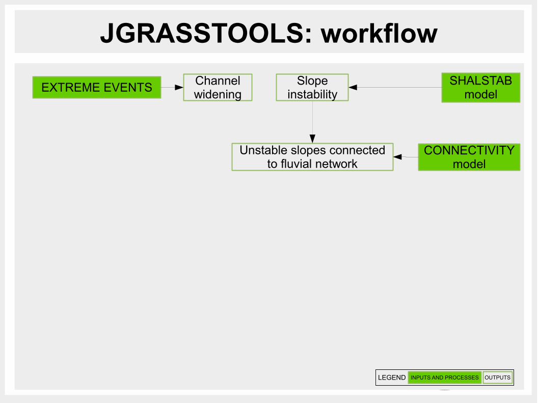
JGRASSTOOLS: workflow
SHALSTABmodel
Channelwidening
Slopeinstability
EXTREME EVENTS
INPUTS AND PROCESSES OUTPUTSLEGEND
JGRASSTOOLS: workflow
SHALSTABmodel
Unstable slopes connectedto fluvial network
CONNECTIVITYmodel
Channelwidening
Slopeinstability
EXTREME EVENTS
INPUTS AND PROCESSES OUTPUTSLEGEND

JGRASSTOOLS: workflow
SHALSTABmodel
Unstable slopes connectedto fluvial network
CONNECTIVITYmodel
AREAS THAT PROVIDES LW
Channelwidening
Slopeinstability
EXTREME EVENTS
INPUTS AND PROCESSES OUTPUTSLEGEND

JGRASSTOOLS: workflow
SHALSTABmodel
Unstable slopes connectedto fluvial network
CONNECTIVITYmodel
AREAS THAT PROVIDES LW
TREE HEIGHT ANDFOREST STAND VOLUME
CHM and semi-empirical model
Channelwidening
Slopeinstability
EXTREME EVENTS
INPUTS AND PROCESSES OUTPUTSLEGEND
Volume and dimensionsof available LW
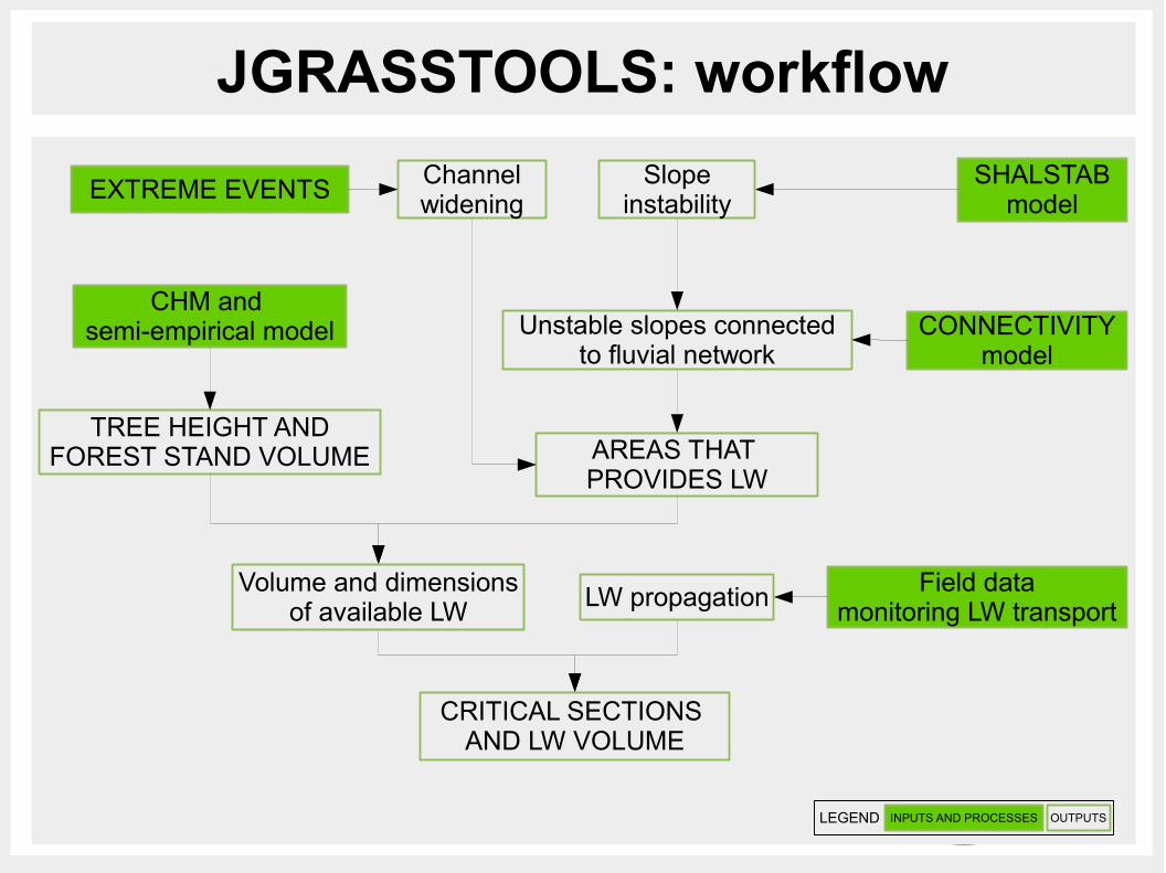
JGRASSTOOLS: workflow
SHALSTABmodel
Unstable slopes connectedto fluvial network
CONNECTIVITYmodel
AREAS THAT PROVIDES LW
TREE HEIGHT ANDFOREST STAND VOLUME
CHM and semi-empirical model
CRITICAL SECTIONS AND LW VOLUME
Channelwidening
Slopeinstability
EXTREME EVENTS
INPUTS AND PROCESSES OUTPUTSLEGEND
Volume and dimensionsof available LW
LW propagationField data
monitoring LW transport

JGRASSTOOLS: workflow

JGRASSTOOLS: input
● digital models of the terrain and vegetation: DTM, DSM, FSV
● DTM derived geomorphology attributes: TCA, slope, connectivity, watershed delineation
● extension of the bankfull area: area covered by water during standard flow conditions
● position and dimensions of bridges and dams: field survey or available cadaster
● superficial geology: rock and deposits (erodible)

JGRASSTOOLS: input & output
clogging sectionscumulated volume
TotalContributingArea
ExtractNetwork
FlowDirections
GEOMORPHOLOGY
DSM
FSV
DTM
INPUT
BANKFULLPOLY
Shalstab
DownSlopeConnectivity
Slope
SuperficialGeology
CheckDams
Bridges
OUTPUT
LW ALGORITHMS
source of logs
MapCalculator

JGRASSTOOLS: network attributes
● creates the vector of the network with hierarchical attributes based on an input raster network
● Input:
– network raster layer– map of flow directions– map of TCA
● Output:
– vector layer of network split at each confluence– attributes: strahler, hack, pfafstetter enumeration

JGRASSTOOLS: network attributes
PfafstetterStrahler Hack
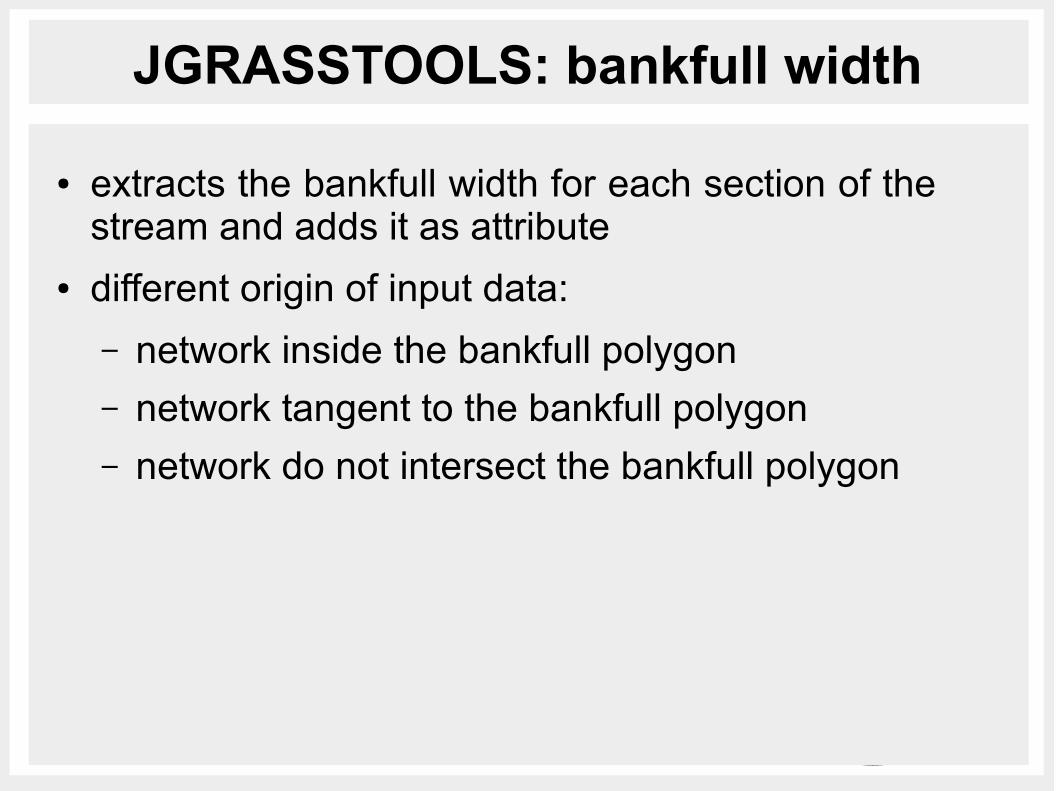
JGRASSTOOLS: bankfull width
● extracts the bankfull width for each section of the stream and adds it as attribute
● different origin of input data:
– network inside the bankfull polygon– network tangent to the bankfull polygon– network do not intersect the bankfull polygon

JGRASSTOOLS: bankfull width
network inside polygon
network tangent polygon
network outside polygon

JGRASSTOOLS: bankfull width
● Input:
– bankfull polygon layer– vector of the network– maximum distance between network and bankfull
● Output:
– vector layer of network with width as attribute
– vector layer of the bankfull sections– vector layer with the problematic sections

JGRASSTOOLS: bankful width

JGRASSTOOLS: bankful width

JGRASSTOOLS: bridges + dams width
● corrects the bankful width where a bridge or a check dam is located
● Input:
– vector of the network– vector layer of the bridges– vector layer of the check dams
● Output:
– vector layer of network with corrected width as attribute
– vector layer with the problematic bridges (no width)

JGRASSTOOLS: area providing LW
● calculates the possible areas along the channel network where there is the possibility for the water during extreme events to erode and recruit material from outside the river
● the extent is calculated following a power law where new width is a function of the bankfull width and channel slope, parameters of the power law should be derived from field observations (input parameters)
● if available, widening would be limited by the presence of rock
newWidth=width+k⋅slopen

JGRASSTOOLS: area providing LW

JGRASSTOOLS: area providing LW
rock
deposits

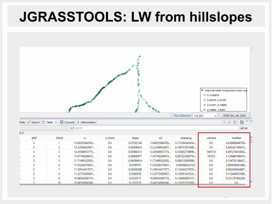
JGRASSTOOLS: LW from hillslopes
● calculates the median vegetation height and total timber volume of the vegetation coming from the hillsopes
● steps for the evaluation of LW from hillslopes
Unstable ConnectedAreas
SubBasins
TSV
Shalstab
DownSlopeConnectivity
h_vegVegetation Parameters

JGRASSTOOLS: LW from hillslopes
JGRASSTOOLS: LW from hillslopes

JGRASSTOOLS: propagation
● identifies the critical section for the transit of LW in the given stream network
● based on the comparison between the length of the logs and channel width

JGRASSTOOLS: propagation

JGRASSTOOLS: propagation
criticalnon critical
● improve the propagation algorithm to consider also the height of the water in the river
● connect the results of the elaboration of LiDAR data for the evaluation of the position, the height and the diameter of the logs
FUTURE PLANS

USEFUL LINKShttp://www.jgrasstools.org
http://bit.ly/stage_downloads
Franceschi [email protected]
EGU Vienna 14 April 2015
THANKS FOR THE ATTENTION!