Embed Size (px)
Citation preview
This document was produced by scanning the original publication.
Ce document est le produit d'une numerisation par balayage de la publication originale.
GEOLOGiCAL SURVEY OF CANADA PAPER 90-9
ADVANCES IN ORDOVECIAN GEOLOGY
Edited by Christopher R. Barnes and S. Henry Williams
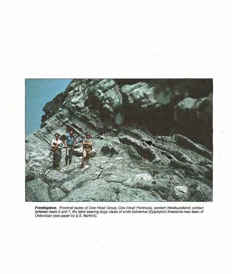
Frontispiece. Proximal facies of Cow Head Group, Cow Head Peninsula, western Newfoundland; contact befween beds 6 and 7, the latter bearing large clasts of white biohermal (Epiphyton) limestone near base of Ordovician (see paper by B.S. Norford).
GEOLOGICAL SURVEY OF CANADA
PAPER 90-9
ADVANCES IN ORDOVICIAN GEOLOGY
Christopher R. Barnes and
S . Henry Williams
(Editors)
o Minister of Supply and Services Canada 1991
Available in Canada through
authorized bookstore agents and other bookstores
or by mail from
Canadian Communication Group - Publishing Ottawa, Canada KIA 0S9
and from
Geological Survey of Canada offices:
601 Booth Street Ottawa, Canada K I A OE8
3303-33rd Street N.W., Calgary, Alberta T2L 2A7
100 West Pender Street Vancouver. B.C. V6B 1R8
A deposit copy of this publication is also available for reference in public libraries across Canada
Cat. No. M44-90/9E ISBN 0-660-13997-9
Price subject to change without notice
Cover Description
Proposed Cambrian-Ordovician boundary stratotype, Cow Head Group, Green Point, western Newfoundland; proposed base of Ordovician is at level of third person from right. Section is overturned and represents distal toe-of-slope environment on continental margin (see paper by B.S. Norford).
Camera-ready figures provided by authors
Final manuscript received : 1990 - 08 - 16
CONTENTS
C.R. BARNES and S.H. WILLIAMS Introduction / Introduction
R.A. FORTEY, M.G. BASSETT, D.A.T. HARPER, R.A. HUGHES, J.K. INGHAM, S.G. MOLYNEUX, A.W. OWEN, R.M. OWENS, A.W.A. RUSHTON, and P.R. SHELDON Progress and problems in the selection of stratotypes for the bases of series in the Ordovician System of the historical type area in the U.K.
B.S. NORFORD The international working group on the Cambrian-Ordovician boundary: report of progress
M. APOLLONOV Cambrian-Ordovician boundary beds in the U.S.S.R.
B.D. WEBBY, A.H.M. VANDENBERG, R.A. COOPER, I. STEWART, J.H. SHERGOLD, R.S. NICOLL, C.F. BURRETT, B. STAIT, B.J. COOPER, J. LAURIE, and L. SHERWIN Subdivisions of the Ordovician System in Australia
C.E. MITCHELL and S.M. BERGSTROM New graptolite and lithostratigraphic evidence from the Cincinnati region, U.S.A., for the definition and correlation of the base of the Cincinnatian Series (Upper Ordovician)
E.L. YOCHELSON Contributions of 19th century Canadian geologists to the adoption of the Ordovician System
G.R. DUNNING and T.E. KROGH Stratigraphic correlation of the Appalachian Ordovician using advanced U-Pb zircon geochronology techniques
D.K. ELLIOTT, A.R.M. BLIECK, and P.-Y. GAGNIER Ordovician vertebrates
S.V. DUBININA Upper Cambrian and Lower Ordovician conodont associations from open ocean paleoenvironments, illustrated by Batyrbay and Sarykum sections in Kazakhstan
K.A. STAIT and C.R. BARNES Conodont biostratigraphy of the upper St. George Group (Canadian to Whiterockian), western Newfoundland
A. ACHAB Biogeography of Ordovician Chitinozoa
M.J. MELCHIN and C.E. MITCHELL Late Ordovician extinction in the Graptoloidea
T.N. KOREN Evolutionary crisis of the Ashgill graptolites
R.E. SLOAN A chronology of North American Ordovician trilobite genera
Himantian trilobites and brachiopods in space and time
M . ROMANO Lower to Middle Ordovician trace fossils from the Central Iberian Zone of Portugal and Spain
R.J. ELIAS Environmental cycles and bioevents in the Upper Ordovician Red River-Stony Mountain solitary rugose coral province of North America
F.R . ETTENSOHN Flexural interpretation of relationships between Ordovician tectonism and stratigraphic sequences, central and southern Appalachians, U.S.A.
R.J. DIECCHIO Taconian sedimentary basins of the Appalachians
B.A. STAIT and C.R. BARNES Stratigraphy of the Middle Ordovician Long Point Group, western Newfoundland
T.M. S ~ C H E Z , J.L. BENEDETTO, and E. BRUSSA Late Ordovician stratigraphy, paleoecology, and sea level changes in the Argentine Precordillera
I.F. NIKITIN, N.M. FRID, and V.S. ZVONTSOV Paleogeography and main features of volcanicity in the Ordovician of Kazakhstan and North Tien Shan
C.R. SCOTESE and W.S. McKERROW Ordovician plate tectonic reconstructions
P. WILDE Oceanography in the Ordovician
J.CHEN Bathymetric biosignals and Ordovician chronology of eustatic variations
P.D. MIDDLETON, J.D. MARSHALL, and P.J. BRENCHLEY Evidence for isotopic change associated with Late Ordovician glaciation, from brachiopods and marine cements of central Sweden
P.J. BRENCHLEY, M. ROMANO, T.P. YOUNG, and P. STORCH Hirnantian glaciomarine diamictites - evidence for the spread of glaciation and its effect on Upper Ordovician faunas
Advances in Ordovician Geology
Christopher R. I3arnes1 and S. Henry ~ i l l iams"
INTRODUCTION
The Ordovician Period is one of the longest and most complex in the Phanerozoic. .In order to review current research and develop strategies for future studies and international collaboration, the Fifth International Sympo- sium on the Ordovician System (VISOS) was held at Memorial University of Newfoundland in St. John's in August, 1988. The present volume contains selected pa- pers from the symposium, and is one of a series of bench- mark volumes on Ordovician geology that have been produced from the five symposia held to date.
The 'Ordovician Period has many distinctive charac- teristics, having been a time of major eustatic sea level changes, prominent anoxic conditions, widespread devel- opment of carbonate platforms on different cratons, marked faunal provincialism, and an overall greenhouse climatic state that reversed to an icehouse state at the end of the period. The Ordovician biota marks the change from the arthropod-dominated faunas of the Cambrian to more abundant and diverse faunas and floras, which developed in more complex community patterns through a wider range of habitats. The actual physical and chemical con- trols and thresholds that were dominant during this period are poorly understood and, unfortunately, the chronostra- tigraphic framework that is essential for global correlation of events is inadequately defined.
The precise recognition and definition of time in stra- tigraphy is a continuing priority in geological research. This has been accentuated in recent years by the focus toward short-term geological and biological events in the stratigraphic record. A principal thrust of the symposium was therefore on chronostratigraphy, with particular refer- ence to the definition of the series within the Ordovician. The program of publication of Ordovician correlation
INTRODUCTION
L'Ordovicien est une des p6riodes les plus longues et les plus complexes du PhanCrozo'ique. Le cinquibme symposium inter- national sur le Systkme ordovicien [Fifth International Sympo- sium on the Ordovician System (VISOS)] a eu lieu B I'UniversitC Memorial B St. John's (Terre-Neuve), en aoiit 1988; on y a passe en revue les recherches en cours et Blabor6 des strategies en matibre d'Ctudes futures et de collaboration internationale. Le present volume se veut un recueil de certains rapports qui ont Ct6 pr6sentCs au cours du symposium; il fait partie d'une s6rie de volumes sur la gCologie de l'ordovicien qui sont le resultat des cinq symposiums tenus 21 ce jour.
Les caractCristiques de l'ordovicien sont nombreuses : fluc- tuations eustatiques majeures, conditions principalement an- oxiques, construction Ctendue de plates-formes carbonatees sur divers cratons, provincialisme marquC de la faune et, dans l'en- semble, climat de serre qui s'est transform6 en climat de glacikre B la fin de la pCriode. L'Ordovicien marque le passage des faunes cambriennes B prkdominance d'arthropodes aux faunes et aux flores plus abondantes et plus vari6es qui ont produit des com- munautts plus complexes dans une vaste gamme d'habitats. Nous connaissons ma1 les seuils et contrales physiques et chimiques qui ont domine B I'Ordovicien; en outre, le cadre chronostratigraphique qui est essentiel B la corrClation globale des 6vCnements n'est pas suffisamment bien dCfini.
Les travaux stratigraphiques continus d'hre axes sur la re- connaissance et la d6finition exacte du temps. En outre, depuis quelques annCes, les chercheurs se penchent sur des 6vCnements gkologiques et biologiques de courte durCe dans le profil stratig- raphique. Par consequent, le symposium a port6 principalement sur la chronostratigraphie, notamment sur la definition des s6ries de l'ordovicien. La publication de tableaux de corrklation de l'ordovicien, selon le programme Ctabli par le sous-comit6 de la stratigraphie de l'ordovicien, est en grande partie terminee.
1 Centre for Earth and Ocean Research, University of Victoria, Victoria, B.C. V8W 3P6 2 Department of Earth Sciences, Memorial University of Newfoundland, St. John's, Newfoundland AlB 3x5
charts initiated by the Subcommission on Ordovician Stra- tigraphy is largely complete and has enabled groups in many countries to redefine regional chronostratigraphic subdivisions. In this volume, authors from the United Kingdom, Canada, Australia, and the United States con- tribute to this process with the aim of achieving an inter- nationally accepted internal chronostratigraphic subdivision for the Ordovician System by the mid-1990's. The development of refined geochronological methods is particularly noteworthy and illustrates the potential for achieving an integrated, high precision chronostratigraphy and geochronology for the Ordovician in the near future. This, in turn, will enable new interpretations of the dy- namic systems operating during the Ordovician, such as those emerging from Mesozoic and Cenozoic research programs.
A section of this volume is devoted to recent advances in Ordovician paleontology and biostratigraphy. Empha- sis is given to conodonts, graptolites and trilobites, which have been Of greatest value to date in biostratigraphic studies. There is particular interest by several authors in the response of faunas to the Late Ordovician glaciation event. The effects of severe faunal provinciality during the entire Ordovocian is documented in some studies.
The interrelationships of stratigraphy, eustasy, tecton- ics and volcanism are explored in another section of this volume. Particular attention is paid to the Appalachian Orogen, for which there has been a rapid evolution of ideas for tectonic and event-stratigraphic models. Valuable new data are also reported from the less well known regions of the Argentine Precordillera, and from Kazakhstan and Tien Shan in the U.S.S.R.
The final section of the volume documents some of the new data and interpretations of Ordovician paleo- ocean- ography, paleoclimatology and paleogeography. A new paleogeographic reconstruction for each series of the Or- dovician System is provided, as well as interpretations of the changing patterns of Ordovician oceanographic circu- lation. The application of isotope geochemistry to Ordo- vician problems is still in its infancy, but some current work related to the glacial event is reported and many different studies are now in progress.
Future research on the long and complex Ordovician Period must focus more on the particular physical, chemi- cal and biological controls and thresholds that were opera- tive. Intensive studies and new techniques are needed to resolve these problems and to construct more precise models of Ordovician paleogeography, paleoclimatology, and paleooceanography. The present volume is not in- tended to be summary volume for these issues, but to report primary search on various facets.We hope that this volume will assist in the advance of knowledge of Ordovician geology and provide a foundation for the sci- entific studies to be reported at the.Sixth International Symposium on the Ordovician System, University of Syd- ney, Australia, in July, 1991.
Grgce 2 ces tableaux, des groupes dans de nombreux pays ont pu redCfinir les subdivisions chronostratigraphiques rCgion- ales. Dans le present volume, des chercheurs proyenant du Royaume-Uni, du Canada, de I'Australie et des Etats-Unis contribuent B ce processus en vue de l'Ctablissement, d'ici 1995, d'une subdivision chronostratigraphique interne de l'ordovicien qui aura un statut international. La mise au point de mCthodes g~ochronologiques perfectionndes est digne de mention et montre la possibilitC d'Ctablir, dans un proche avenir, une chronostratigraphie et une gtochronologie in- ttgrCes, hautement prtcises, de l'ordovicien. Cela donnera lieu h de nouvelles interpritations des systbmes dynamiques qui ont exist6 h I'Ordovicieti, comme ceux qui Cmergent des programmes de recherche sur le MCsozoi'que et le CCno- zoi'que.
Une section du volume porte sur les realisations en paleon- tologie et en biostratigraphie de l'ordovicien. On met l'accent sur les conodontes, les graptolites et les trilobites qui, h ce jour, sont les organismes les plus utiles pour les travaux biostratig- raphiques. Plusieurs chercheurs s'interessent particulikrement B la riection des faunes h 1'CvCnement glaciaire de l'ordovicien suptrieur. Certaines Ctudes renseignent sur les effets de la pro- vincialitt marquee de la faune tout au long de l'ordovicien.
Une autre section du volume examine les liens qui existent entre la stratigraphie, I'eustasie, la tectonique et le volcanisme. On accorde une attention particulibre h l'orogbne des Appa- laches, pour lequel il y a eu Cvolution rapide des modbles tectoniques et des modbles de la stratigraphie des tvtnements. On y prCsente aussi de nouvelles donnCes fort utiles qui provi- ennent des rCgions moins bien connues de la PrCcordillbre en Argentine et du Kazakhstan et du T'ien-Shan en URSS.
La dernibre section du volume renseigue dur certaines nou- velles donnCes sur la pal~o-ocCanographie, la palCoclimatologie et la palCogCographie de l'ordovicien, et les nouvelles inter- pretations qui en decoulent. I1 prCsente une nouvelle reconstitu- tion palCogCographique pour chaque sCrie de l'ordovicien, de mCme que des interpretations des changements survenus dans la circulation octanique B l'ordovicien. Bien que I'application de la gCochimie des isotopes aux problbmes ordoviciens en soit encore B ses dtbuts, le volume prksente des comptes rendus de certains travaux en cours qui sur 1'CvQnement glaciaire; en outre, plusieurs autres etudes differentes ont BtC commenctes.
A l'avenir, les recherches sur I'Ordovicien devront porter davantage sur les seuils et les contr6les physiques, chimiques et biologiques qui ont exist6 au cours de cette periode longue et complexe. I1 faudra entreprendre des Ctudes approfondies et Claborer de nouvelles techniques afin de resoudre ces problbmes et d'ktablir des modbles plus exacts de la pal6ogCographie. de la pal~oclimatologie et de la palto-octanographie de l'ordovicien. Le volume ne se veut pas un simple resume de ces questions, mais i l cherche plut8t B prtsenter les recherches de base qui portent sur leurs divers aspects. Nous espCrons qu'il contribuera B Blargir nos connaissances de la gCologie de l'ordovicien et qu'il servira de fondement pour les Ctudes scientifiques qui seront presentees A 1'UniversitC de Sydney, en Australie, en juillet 1991, B l'occasion du sixikme symposium international sur le Systkme ordovicien.
Finally, we gratefully acknowledge the sponsors of the Fifth International Symposium on the Ordovician System: the I.U.G.S. Subcommission on Ordovician Stratigraphy, the International Geological Correlation Project 216 (Global Bioevents in Earth History), the Natural Sciences and Engineering Research Council of Canada, the Geological Survey of Canada, the New- foundland Department of Mines and Energy, and Memo- rial University of Newfoundland. Financial support or support-in-kind was contributed by these sponsors to the symposium, the field trips, the program and guidebooks, and to this Geological Survey of Canada Paper. We particularly thank many colleagues in the Centre for Earth Resources Research and the Department of Earth Sciences at Memorial University of Newfoundland for their organizational and technical assistance with the symposium. Copies of the program and abstracts volume and of the three separate field guidebooks may be pur- chased from the department.
Enfin, nous tenons B remercier les promoteurs du cinquibme symposium international sur le Systcme ordovicien : la Subcom- mission on Ordovician Stratigraphy de 1'Union internationale des sciences gCologiques, le International Geological Correla- tion Project 216 (Global Events in Earth History), le Conseil de recherches en sciences naturelles et en gCnie du Canada, la Commission gkologique du Canada, le ministbre des Mines et de 19~nergie de Terre-Neuve et 1'UniversitC Memorial de Terre- Neuve. Ces organismes ont foumi un soutien financier ou autre pour le symposium, les excursions, le programme, les guides et cette Ctude de la Commission gCologique du Canada. Nous tenons 2i remercier tout particuli&rement nos nombreux collbgues au Centre for Earth Resources Research et au DCpar- tement des sciences de la Terre de 11Universit6 Memorial de Terre-Neuve, qui ont contribu6 h l'organisation et B l'aspect technique du symposium. On peut se procurer des exemplaires du programme, du volume des rCsumCs et des trois guides auprks du DCpartement des sciences de la Terre.

Progress and problems in the selection of stratotypes for the bases of series in the Ordovician System
of the historical type area in the U.K.
1 R.A. Fortey , M.G. Bassett, D.A.T. Harper, R.A. Hughes, J.K. Ingham, S.G. Molyneux, A.W. Owen, R.M. Owens,
A.W.A. Rushton, and P.R. Sheldon
Fortey, RA., Bassett, M.G., Harper, DA.T., Hughes, RA., Ingham, J.K., Molynew, S.G., Owen, A.W., Owens, R.M., Rushton, A.W.A., and Sheldon, P.R., Progress and problems in the selection of stratowes for the bases of series in the Ordovician System of the historical type area in the U.K.; &Advances in Ordovician Geology, C.R. Barnes and S.H. Williams (ed.); Geological Survey of Canada, Paper 90-9, p. 5-25,1991.
Abstract
The series 'of the Ordovician System in the Anglo-Welsh area have been a standard reference in Ordovician chronostratigraphy for many years, and should remain so in the interest of a common language for international use. Their original definition was not in accord with modern stratigraphic precision, and to this end it is necessary to redefine bases for the series within continuous sequences. Such sequences have been identified for the bases of all the series. Even though there are breaks in the succession locally or in the original type areas, these shortcomings are minimized by considering these other sections in the Anglo-Welsh area as potential stratotypes. The Anglo-Welsh faunas include widespread taxa virtually throughout the Ordovician, which permit international correlation; the monographic coverage of these faunas compares with thatfiom anywhere in the world. It is thought to be possible to modify the horizon at which series boundaries were drawn originally in the interests of international correlation, as long as nomenclature is conserved. The possible stratotypes for bases of the series of the Ordovician System in the type area are reviewed briefly, and new faunal logs are given where necessary. The base of the Trernadoc is taken at an horizon coincident with the appearance of nematophorous graptolites, the only practicable horizon in the type area. The base of the Arenig poses particular problems because of the poorly fossiliferous nature of available sections. However, newly discovered sections in the Lake District indicate that there may have been tw major break in sedimentation at the top of the Tremadoc. A fossiliferous mixed graptolite-trilobite section is available for the base of the Llanvirn. Although there are candidates for the base of the Llandeilo (current usage), the comparative brevity of this series suggests that it nmy be better united with the Llanvirn to form a new, combined series commensurate in extent with the other series of the Ordovician. The name Llandeilo could be retained for this new concept. The Llanvirn could also be retained as the earlier stage within it, and a new stage name, for which the Dyneforian is suggested, proposedfor the later part, equivalent to some or all of the traditional Llandeilo; just how much will depend on the definition of the base of the Caradoc, for which three possibilities are proposed as a basis for discussion. The base of the Ashgill has been locatedprecisely in a section in the Murthwaite Inlier, Cautley, which is proposed as a suitable international type section.
Les se'ries du Sysdme ordovicien qui se trouvent duns lu re'gion anglo-galloise servent d'e'talon pour la chronostratigraphie ordovicienne depuis de nombreuses anne'es et, par souci d u n langage commun international, il ne faudrait pas les remplacer. Puisque leur dkfinition d'origine n'avait pas la pre'cision
' See end of report for Authors' addresses
stratigraphique d'aujourd'hui, il devient nkcessaire de redgfinir les bases des skries qui se situent duns des stquences continues. Or, les bases de routes les skries se trouvent dam de telles skquences. Bien que la succession soit interrompue localement ou dans les rkgions types d'origine, on peut minimiser ces problEmes en prenant comme stratotypes tventuels les autres coupes de la rtgion anglo-galloise. Presque tout au long de I'Ordovicien, les faunes de cette rkgion comprennent des t m o m h n t la rkpartition gtographique est vaste, ce qui permet leur corrklation mondiale; leur couverture monographique se compare d celle den'importe quel endroit au monde. I1 serait vraisemblablement possible, d desfins de corrklation mondiale, de modifier l'horizon auquel avaient ktkfixkes d l'origine les limites des skries, dam la rnesure od l'on conserve la nomenclature. Le rapport donne un apercu des stratotypes kventuels pour les bases des skries du Systdme ordovicien dam la rkgion type et, au besoin, il prksente de nouveaux enregistrements fauniques. La base du Trkmadocien est fixe'e d un horizon qui coiizcide avec l'apparition de graptolites dmatophores, soit le seul horizon praticable duns la rkgion type. La base de l'drknigien pose des probldmesparticuliers en raison de la nature peu fossilifdre des coupes disponibles. Or, des coupes nouvellement de'couvertes dans le <<Lake Districtw indiquent qu'il pourrait n'y avoir eu aucune interruption majeure de la skdimentation au sommet du Tre'madocien. I1 existe une coupe fossil$i?re d graptolites et d trilobites pour la base du Llanvirnien. Bien qu'il y ait des possibilite's pour la base du Llandeilien (usage courant), cette skrie couvre un intervalle de temps relativement court, et il faudrait peut-2tre la re'unir au Llanvirnien afin de former une nouvelle skrie combinke dont I'e'tendue serait comparable d celle des autres stries de l'ordovicien. On retiendrait le nom allandeilien~ pour cette nouvelle skrie. En outre, le nom Llanvirnien dksignerait l'ktage plus ancien qui s'y trouve et un nouveau nom, par exemple le Dynkforien, serait donne' a la partie plus rkcente, qui e'quivaut d /'ensemble ou d une partie du Llandeilien classique, selon la dkfinition de la base du Caradocien, pour laquelle on propose trois possibilitks d des fins de discussion. La base de l'dshgillien est situke avec prkcision dam une coupe duns la fengtre de Murthwaite, d Cautley, que l'on propose comme coupe type mondiale.
INTRODUCTION THE BRITISH AREA REMAINS The series of the Ordovician System, as defined originally in APPROPRIATE FOR DEFINITION OF England and Wales, have been used for many years as a STANDARD SERIES standard reference in Ordovician chronostratiGaphy. These series have provided a common language that stratigraphers and paleontologists can use to discuss international correla- tion. The more recent emergence of event stratigraphy has also required a common calibration for international use. Nonetheless, the scope of the series has been employed somewhat loosely outside the historical type area, and it is a proper objective of the Subcommission on Ordovician Stra- tigraphy to urge greater precision. Following the Fourth In- ternational Symposium on the Ordovician System in Oslo, a group of British workers (Whittington et al., 1984) attempted to summarize the historical background to the proposition of the series, and to encapsulate the problems involved in ob-
Although the British Isles has a historical claim to precedence as the type area of the Ordovician System - and this is not to be disregarded - there are other reasons why the Anglo- Welsh basin is a suitable region in which to define the type sections of the series. The limitations of the type area are rather obvious. Structural complexities are common. Expo- sure of long, continuous sequences is not usual. Clastic rock types predominate, which makes the recovery of conodonts in some parts of the sequence difficult. These limitations should not be allowed to obscure several positive aspects, which may not be obvious to those accustomed to working in platform carbonate successions. These aspects are:
taining a more refined definition o i their bases. 1. The Anglo-Welsh area occupied a marginal site through
There were numerous problems, and many of these re- main, but a certain measure of progress has been made over the last few years that is worth summarizing. In this paper it is assumed that the Tremadoc Series is included within the Ordovician System. The earlier literature was reviewed in Williams et al. (1972) and Whittington et al. (1984). The introductory sections of this paper were drafted by R.A. Fortey, with the approval of the Stratigraphy Committee of the Geological Society of London. The authorship of the
the Ordovician Period; platform endemic faunas are jux- taposed closely with deeper water faunas, which include species with wide distribution and international potential for correlation. At the base of the Tremadoc, for example, several of the deep water trilobite species have a distribu- tion beyond the confines of western Gondwana. For most parts of the column, graptolitic and shelly facies are present in nearby areas, even if the different kinds of facies faunas do not co-occur in the same section.
accounts of possible stratotype sections is indicateh where 2. Sedimentation was generally rapid, and thick sequences appropriate. are present across many of the critical intervals. It should be
possible, therefore, to define stratotypes in sections free
of hiatuses, such as may be present in cratonic sequences. For example, marginal sites may escape the effects of eustatic cycles - or local tectonic effects may serve to offset their influence. The paradox is that platformal sites may afford a "clearer" boundary, precisely because new taxa appear there simultaneously, but the arbitrary nature of a boundary (drawn at the first appearance of a particular species, for example) in a thicker, fuller succession is to be seen as an advantage, not as a disadvantage.
3. The "provincial" affinities of the Anglo-Welsh shelly faunas in toto change through the Ordovician. from Gond- wanan to BalticINorth American - although even in the Caradoc Series some Gondwana-type trilobites such as Kloucekia remained part of the fauna. Whether this is because of an independent tectonic history of the Avalon microcontinent, or a general convergence of the Gond- wanan with the Baltic and North American continents, is immaterial in this context. What does matter is that the British Ordovician encapsulates some of the significant changes that occurred during Ordovician times. No area in the world has sections that allow for correlation every- where throughout the Ordovician, but the type area is as representative as any.
4. Fossil faunas from the type Ordovician are relatively well known, and are still being studied actively. For example, since the publication of the previous review of Ordovician Series (Whittington et al., 1984), substantial additions to our knowledge of the ostracodes (Jones, 1986, 1987), acritarchs (Turner, 1985; Molyneux, 1987), graptolites (Hughes, 1989), the Arenig Series faunas and stratigraphy (Fortey and Owens, 1987), and conodonts both across series boundaries and within some of the series (Savage and Bassett, 1986; Bergstrijm et al., 1987) have been published. All these have proved to be useful stratigraphi- cally. Few other areas can boast such intensive coverage, especially now when systematic studies are not generally fashionable.
These four arguments are scientific, and separate from the undeniable historical claims of the Anglo-Welsh area as the location of the type sections. The series of the Ordovician System provide the common language for chronostratigra- phy, and it is a practical common language.
CONDITIONS FOR SUITABLE STRATOTYPE SECTIONS The historical problem is that the series were defined origi- nally in a patchwork but by no means random fashion, taking their names from areas scattered over Wales and northern England. Boundaries were drawn at unconformities, or at least where radical faunal changes appeared (Whittington et al., 1984). Modem stratigraphic usage demands that these boundaries be moved to continuous sequences. This should present no formal problem, as it is obvious that the Anglo- Welsh area as a whole constitutes the type area, in which the various series names are distributed. We are justified, there- fore, in selecting sections, possibly at some distance from the historical type areas, that show the best continuous sequences,
and which are of service in international correlation. Partly because of the marginal and tectonically unstable setting of the type area, it is possible to discover such sections for all the series boundaries with which we are concerned. The following criteria should apply:
1. Sections should be within the Anglo-Welsh area, and south of the Solway Line. This is because the Solway Line is generally accepted as marking the Iapetus suture (e.g., Fortey et al., 1989; McKerrow and Soper, 1989) and separates (broadly speaking) the Ordovician Gondwana and Laurentia paleocontinents. There is no doubt that the Ordovician series as defined originally belonged within the former Gondwana geographic entity.
2. Only the base of a series need be defined. What lies below that base belongs in the underlying series by definition. This avoids apparent problems such as the so-called "un- classified intervals"; one of these was illustrated recently by Bergstrom et al. (1987, Fig. 18.8) as lying between the Llanvirn and Llandeilo. If the base of the Llandeilo is defined formally, then the interval below is simply part of the upper Llanvim.
3. The horizon at which the base was originallv defined need not be rigidly adhered to, especially if it is acceptable to move type sections for the bases of series from the original areas of definition. Because these bases were often de- scribed at the bottom of a lithostratigraphic unit (e.g., Llandeilo) or at an unconformity (e.g., Caradoc), in ac- cordance with nineteenth century practice, these horizons may themselves pose considerable problems in correla- tion. There is no reason why such horizons may not be adjusted upward or downward in the interests of useful- ness for international correlation (Fortey, 1988). There is already some precedent for this in the inclusion of the Pusgillian Stage within the Ashgill (Ingham and Wright, 1970). By adopting this flexible approach, we believe that the horizon eventually chosen can be one that is capable of being recognized in each of the main paleogeographic regions. If a similarly flexible approach is applied also to chronostratigraphic divisions in other regions, such as North America, there is a chance that the standard series may be understood readily in the same way internationally (Fig. 8). We therefore discuss more than one possible horizon in the accounts that follow; which one is chosen will depend on international application, following further study and discussion by the Subcommission.
POSSIBLE STRATOTYPES FOR THE BASE OF EACH SERIES There now follows a chronological account of sections that we believe to be suitable for definition as international stra- totypes for each series within the Ordovician System. The information currently available varies from one section to another; some have only been investigated recently. A pre- liminary account is useful at this point, however, in order to focus attention on the problems with the horizon chosen, and the limitations of the sections themselves. A brief account of the history of the series is given in Whittington et al. (1984).
We believe that each of the sections discussed below has the potential to meet the criteria recommended for the estab- lishment of Global Standard Stratotypes as set out by Cowie et al. (1986).
TREMADOC (A.W.A.R.)
The Tremadoc Series takes its name from a small town in North Wales (now spelled "Tremadog") and the stratig- raphic concept originated in the faunal characteristics of the Tremadoc Slates of the area. The history of the use of "Tre- madoc" is given in Henningsmoen (1973) and in Whittington et al. (1984).
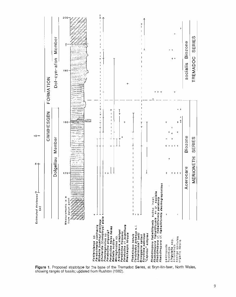
In Britain there are few sections that expose a sedimentary succession across the base of the Tremadoc Series (Stubble- field, 1956), and of these the most satisfactory in which to define a base to the series is on the forestry road at Bryn-llin- fawr, about 25 km east-southeast of Tremadog. This section was described in detail by Rushton (1982), with further information in Allen et al. (1981) and Allen and Jackson (1985). Figure 1 summarizes the rock types and the distribu- tion of fossils, and indicates the litho-, bio-, and chronostra- tigraphy of the sequence.
The section is easily accessible and even though it is an artificial exposure, of which parts will require cleaning from time to time, the boundary itself is exposed permanently. The rock type is fairly uniform and although there is a regional cleavage, this is slight in the area of Bryn-llin-fawr. Shelly fossils, especially trilobites, occur at regular intervals through the section, and range from the Acerocare Biozone (>20 m thickness exposed) to the R. flabelliformis Biozone, socialis Subzone (estimated to be >40 m thick). Graptolites are found at and above the proposed base of the Tremadoc. Conodonts are rare and lack variety at Bryn-llin-fawr. There is a perma- nent confirmatory section in the stream at Dol-cyn-afon, 2 km south of Bryn-llin-fawr, but this has not been studied thor- oughly. In North Wales we cannot readily recognize the equivalents of the base of the Cordylodus proavus conodont Biozone, which would lie in the Upper Cambrian sequence, and there is no justification for moving the base of the Tremadoc from the horizon at the appearance of Rhabdin- opora.
Biostratigraphy and correlation
As well as the widely distributed graptoloid Rhabdinopora and the trilobite Boeckaspis hirsuta, many of the trilobites from Bryn-llin-fawr are of considerable use in correlation outside Wales. Since the description of the section in 1982 it has been possible to refer several trilobite taxa to species described from China. Parabolinella? sp. of the Acerocare Biozone can be referred to P. contracta Lu and Zhou (Lu et al., 1981). This species has been described under various names from several sections in China, as discussed by Rush- ton (1988); everywhere it occurs at a horizon near the base of the Tremadoc. Some of the Niobella from the Acerocare Biozone appear to be referable to the finely drawn species N. preciosa Lu and Zhou (treated as a subspecies of N , homfrayi in Allen and Jackson, 1985). This form occurs with
P. contracta in Nei Monggol, China (Lu et al., 1981). Despite search, no further conodonts have been found apart from a cluster of Phulekodus ["Prooneotodus"] tetzuis (Hig- gins and Austin, 1985, P1. 2.1, figs. l ,7) .
Oslo region
The section at Naersnes, Oslo, described by Bruton et al. (1982) has some trilobite species in common with Bryn-llin- fawr. Their lowest records of Parabolina acanthura (Bruton et al., 1982, P1. 1, figs. 1-3, 17, 19; 1988), all from concretion N1, are referable to P. heres heres (Nikolaisen and Hennings- moen, 1985, p. 4), which thus appears below Rhabdinopora and Boeckaspis hirsuta, as at Bryn-llin-fawr. Our criteria would place the base of the Tremadoc 0.5 m above the base of the Ordovician proposed by Bruton et al. (1982).
Western Newfoundland
The base of the Tremadoc at Bryn-llin-fawr is thought to correspond to the base recognized by Fortey et al. (1982), although there are no conodont or trilobite taxa to support the graptolite evidence. However, Fortey et al. (1982) showed that the Missisquoia typicalis Biozone underlies the base of the Tremadoc, and similarly Rushton (1982) showed that associates of M. typicalis at its type locality, namely Plica- tolina kindlei and Neoagnostus bilobus, underlie the base of the Tremadoc in North Wales.
Platform carbonate sequences
Correlation of the base of the Tremadoc into platform carbon- ate sequences is indirect, and relies on sections such as those at Broom Point, Newfoundland, and Dayangcha, China, where there are "mixed" faunas. The appearance of the conodont Cordylodus lindstromi equates closely with, but apparently slightly precedes, the appearance of nematopho- rous graptolites (Landing et al., 1986). Nonetheless, this provides a workable approximation in at least the more mar- ginal North American sequences to the base of the Tremadoc Series in its type area. Other propositions for the base of the Ordovician - for example, the base of the Hirsutodontus sinzplex Subzone of the C. iiztermedius Biozone (Miller, 1984, 1987), or the base of the C. proavus Biozone (Kazakhstan: Chugaeva and Apollonov, 1982; China: Zhou et al., 1984) are substantially older, and would not provide a ready correlation into North Wales.
ARENIG (R.A.F., S.G.M., R.M.O., A.W.A.R.)
The type area for the Arenig Series is at the mountain called Arennig Fawr in North Wales, where the succession has been redescribed recently by Zalasiewicz (1984; see also Beckly, 1987). Fortey and Owens (1987) recently reviewed the bios- tratigraphy of the Arenig Series in Britain and showed that its development is commensurate with that in other parts of the world, and that it is a major division of the Ordovician System. Three stages for the Arenig were proposed: in as- cending order, Moridunian, Whitlandian, and Fennian. It was
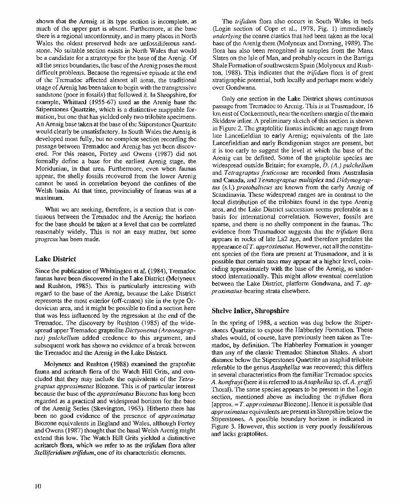
shown that the Arenig at its type section is incomplete, as much of the upper part is absent. Furthermore, at t!ie base there is a regional unconformity, and in many places in North Wales the oldest preserved beds are unfossiliferous sand- stone. No suitable section exists in North Wales that would be a candidate for a stratotype for the base of the Arenig. Of all the series boundaries, the base of the Arenig poses the most difficult problems. Because the regressive episode at the end of the Tremadoc affected almost all areas, the traditional usage of Arenig has been taken to begin with the transgressive sandstone in fossils) that follohed it. In ~hro~shi re , for example, Whittard (1955-67) used as the Arenig base the Stiperstones Quartzite, which is a distinctive mappable for- mation, but one that has yielded only two trilobite specimens. An Arenig base taken at the base of the Stiperstones Quartzite would clearly be unsatisfactory. In South Wales the Arenig is developed most fully, but no complete section recording the passage between Tremadoc and Arenig has yet been discov- ered. For this reason, Fortey and Owens (1987) did not formally define a base for the earliest Arenig stage, the Moridunian, in that area. Furthermore, even when faunas appear, the shelly fossils recovered from the lower Arenig cannot be used in correlation beyond the confines of the Welsh basin. At that time, provinciality of faunas was at a maximum.
What we are seeking, therefore, is a section that is con- tinuous between the Tremadoc and the Arenig; the horizon for the base should be taken at a level that can be correlated reasonably widely. This is not an easy matter, but some progress has been made.
Lake District
Since the publication of Whittington et al. (1984), Tremadoc faunas have been discovered in the Lake District (Molyneux and Rushton, 1985). This is particularly interesting with regard to the base of the Arenig, because the Lake District represents the most exterior (off-craton) site in the type Or- dovician area, and it might be possible to find a section here that was less influenced by the regression at the end of the Tremadoc. The discovery by .Rushton (1985) of the wide- spread upper Tremadoc graptolite Dictyonema (Araneograp- tus) pulchellum added credence to this argument, and subsequent work has shown no evidence of a break between the Tremadoc and the Arenig in the Lake District.
Molyneux and Rushton (1988) examined the graptolite fauna and acritarch flora of the Watch Hill Grits, and con- cluded that they may include the equivalents of the Tetra- graptus approximatus Biozone. This is of particular interest because the base of the approximatus Biozone has long been regarded as a practical and widespread horizon for the base of the Arenig Series (Skevington, 1963). Hitherto there has been no good evidence of the presence of approximatus Biozone equivalents in England and Wales, although Fortey and Owens (1987) thought that the basal Welsh Arenig might extend this low. The Watch Hill Grits yielded a distinctive acritarch flora, which we refer to as the trifidum flora after Stelliferidium trijidum, one of its characteristic elements.
The trifdum flora also occurs in South Wales in beds (Login section of Cope et a]., 1978, Fig. 1) immediately underlying the coarse clastics that had been taken as the local base of the Arenig there (Molyneux and Doming, 1989). The flora has also been recognized in samples from the Manx Slates on the Isle of Man, and probably occurs in the Barriga ShaleFomation of southwestern Spain (Molyneux and Rush- ton, 1988). This indicates that the trifidum flora is of great stratigraphic potential, both locally and perhaps more widely over Gondwana
Only one section in the Lake District shows continuous passage from Tremadoc to Arenig. This is at Trusmadoor, 16 km east of Cockermouth, near the northern margin of the main Skiddaw inlier. A preliminary sketch of this section is shown in Figure 2. The graptolitic faunas indicate an age range from late Lancefieldian to early Arenig; equivalents of the late Lancefieldian and early Bendigonian stages are present, but it is too early to suggest the level at which the base of the Arenig can be defined. Some of the graptolite species are widespread outside Britain; for example, D. (A.) pulchellum and Tetragraptus fruticosus are recorded from Australasia and Canada, and Temnograptus multiplex and Didymograp- tus (s.1.) protobalticus are known from the early Arenig of Scandinavia. These widespread ranges are in contrast to the local distribution of the trilobites found in the type Arenig area, and the Lake District succession seems preferable as a basis for international correlation. However, fossils are sparse, and there is no shelly component in the faunas. The evidence from Trusmadoor suggests that the tr-ifidum flora appears in rocks of late La2 age, and therefore predates the appearance of T. approximatus. However, not all the constitu- ent species of the flora are present at Tmsmadoor, and it is possible that certain taxa may appear at a higher level, coin- ciding approximately with the base of the Arenig, as under- stood internationally. This might allow eventual correlation between the Lake District, platform Gondwana, and T. ap- proximatus-bearing strata elsewhere.
Shelve Inlier, Shropshire
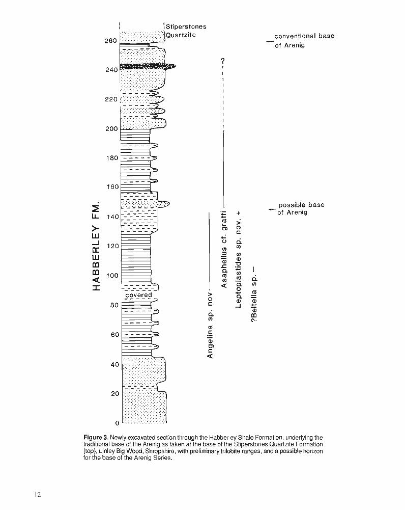
In the spring of 1988, a section was dug below the Stiper- stones Quartzite to expose the Habberley Formation. These shales would, of course, have previously been taken as Tre- madoc, by definition. The Habberley Formation. is younger than any of the classic Tremadoc Shineton Shales. A short distance below the Stiperstones Quartzite an asaphid trilobite referable to the genus Asaphellus was recovered; this differs in several characteristics from the familiar Tremadoc species A. homfrayi (here it is referred to as Asaphellus sp. cf. A. grafi Thoral). The same species appears to be present in the Login section, mentioned above as including the trifidum flora [approx. = T. approximatus Biozone]. Hence it is possible that approximatus equivalents are present in Shropshire below the Stiperstones. A possible boundary horizon is indicated in Figure 3. However, this section is very poorly fossiliferous and lacks graptolites.
In summary, two sections have been discovered that are relevant to the definition of the base of the Arenig Series. Neither is particularly fossiliferous. But there is now good reason to suppose that there is no major gap, at least in the Lake District succession of the type Anglo-Welsh area (e.g., Erdtmann, 1965), and that a horizon corresponding approxi- mately to the base of the T. approximatus graptolite biozone should be recognizable in Britain, and would be useful else- where. The base of the Moridunian Stage will be coincident with the best of the available choices in the Anglo-Welsh area.
LLANVIRN (R.A.F. AND R.M.O.) The base of the Llanvirn Series has been taken generally at the base of the Didymograptus artus Biozone [D. "bifdus" zone of earlier authors, and renamed by Fortey and Owens (1987, p. 90)]. The type section at the farmstead of Llanvirn on the coast of southwest Wales is not satisfactory; in particu- lar, the contact with the Arenig below is not well exposed, nor is it in a continuous fossiliferous sequence. Good sections spanning the Arenig-Llanvirn boundary are not easy to find
TREMADOC boundary to be drawn ARENIG
estimated thickness (m.) VI
2 A 2 2 N N 2
N P 0) Co 0 F3 P 0) a, 0 N 0 0 0 0 0 0 0 0 0 0 0 0
"Dictyonema" +
pulchellum "Dictyonema:
rnurrayl +
Didymograptus (s.l.1 cf.demissus +
Tetragraptus quadribrachiatus - 0-
Temnograptus multiplex 0-c - - - Tetragraptus amii -~ - - +
Didymograptus (s.1.) cf. holmi o e - Didymograptus (s.1.) cf. vicinus o
Didymograptus (s.l.1 cf. protobalticus ,4
Didymograptus (s.l.1 sp. nov. o
Tetragraptus (Pendeograptus) cf. fruticosus , , Stelliferidium trifidium
,- - - , Caldariola glabra
+ Acanthodiacrodium? dilatum
Acanthodiacrodium aff. angustum +
Coryphidium sp. nov. + Veryhachium lairdii (group) -
Figure 2. Newly discovered section with continuous passage between Tremadoc and Arenig series, and a possible stratotype for the base of the Arenig Series, Trusmadoor, Lake District. Foss~l ranges show graptolites on left, acritarchs on right.
conventional base C
of Arenig
+ possible base of Arenig
Figure 3. Newly excavated section through the Habberley Shale Formation, underlying the traditional base of the Arenig as taken at the base of the Stiperstones Quartzite Formation (top), Linley Big Wood, Shropshire, with preliminary trilobite ranges, and a possible horizon for the base of the Arenig Series.
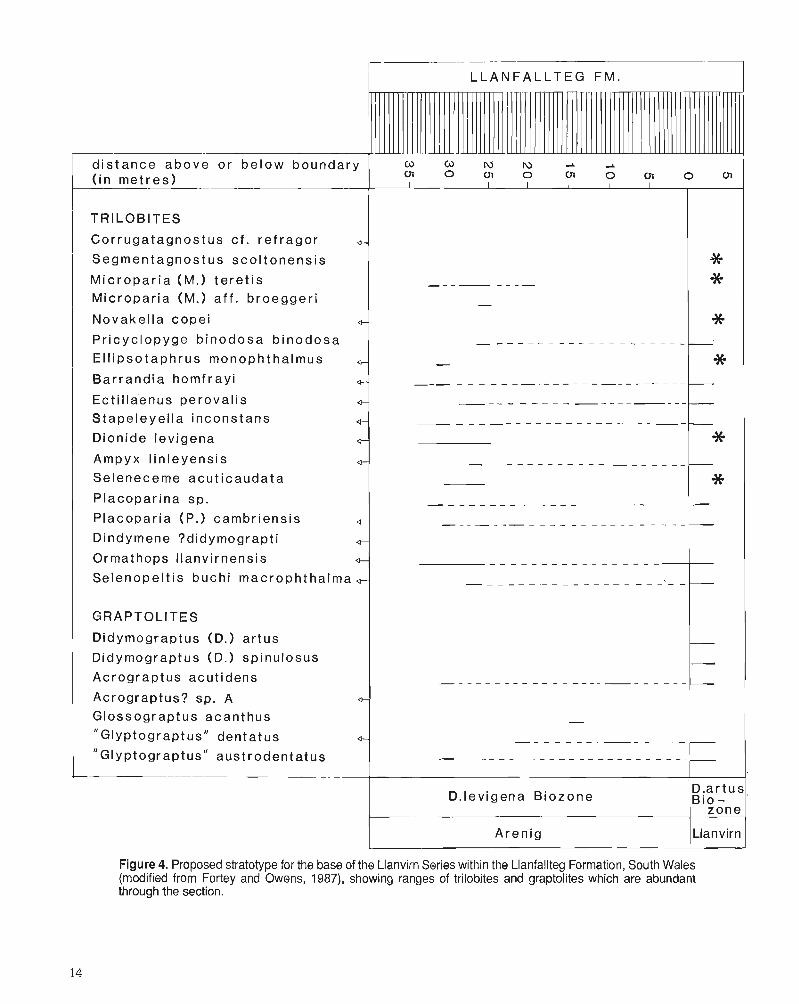
(Fortey et al., 1990). Two have been investigated: on the river Seiont, Gwynedd (Caernarvonshire), North Wales, men- tioned by Elles (1904); and along a disused railway cut at Llanfallteg, South Wales (Foi-tey and Owens, 1987, Textfig. 8). Only the latter is fossiliferous enough to deserve serious consideration as a stratotype (Fig. 2). This section is also not far distant from the type area on the Dyfed coast.
The Llanfallteg Formation lies at the top of a thick Arenig succession in South Wales, and consists of at least one hun- dred metres of soft, grey shale, which are widely exposed in an area east of Haverfordwest. Graptolites and trilobites are common, and are generally well preserved. There are no sudden changes in rock type across the Arenig-Llanvim boundary, which is therefore placed within the Llanfallteg Formation. The definition of the boundary at the first appear- ance of pendent didymograptid graptolites is accordingly arbitrary. Many species have unbroken ranges extending across the boundary (Fig. 4).
Correlation
The appearance of pendent didymograptids of the artus group affords a convenient criterion for recognizing the base of the Llanvim Series over a wide area. It is now well known that there is also a group of Arenig pendent didymograptid spe- cies. This was a source of much confusion in the past and resulted in the miscorrelation of North American and Euro- pean so-called bifidus zones. True D. bifidus is a North American and "Pacific Province" taxon of Arenig age (Coo- per and Fortey, 1982; Williams and Stevens, 1988), and is assigned to the subgenus Didymograptus (Didymograptel- lus). The Llanvim pendents in the subgenus Didymograptus (Didymograptus), including D, artus, make their appearance shortly after biserial graptoloids of the "Glyptograptus" (now Undulograptus) au;trodentatus group, in South Wales and elsewhere. These biserial graptoloids are also used widely in correlation. As well as throughout the Anglo-Welsh area, the Arenig-Llanvim boundary can be recognized in major areas of Ordovician Gondwana on the basis of the appearance of pendents of the artus group: for example, in the Armorican Massif, Iberia, Scandinavia, Saudi Arabia, and South China (Mu et al., 1979). Certain of the trilobites appearing in the Llanfallteg Formation are also widespread in the westem segment of Ordovician Gondwana, and provide confirmation of the correlation: Pricyclopyge binodosa binodosa, Priono- cheilus pulcher, Placoparia cambriensis, and Selenopeltis buchii subspecies are among them. This section thus affords a satisfactory standard for the base of the Llanvim for the Gondwana paleocontinent, over much of which it is difficult to recover conodonts from the dominantly clastic facies.
Correlation outside Ordovician Gondwana is more indi- rect. A comparable sequence of graptolites occurs in Baltos- candia. In this region, conodont information can be added, which permits correlation of the Arenig-Llanvim boundary almost worldwide. Bergstrom (1986, Fig. 2) has summarized the ties between conodont and graptolite biozones, and sug- gested that the Arenig-Llanvirn boundary corresponds ap- proximately with that between the two "assemblage subzones" into which Lofgren (1978) divided the Eoplacog-
nathus variahilis Zone. This is close to, but slightly above, the base of the Kundan Stage in Baltic usage. However, a properly detailed analysis of the succession of graptolites and conodonts across the Arenig-Llanvim boundary in Scandina- via remains to be made. The position of this boundary within the North Atlantic conodont faunal succession will influence the detail of the correlation with the Midcontinent conodont sequence.
Certain graptoloids in the upper Arenig of the type area are very widespread species, and can be used in correlations with areas as distant as Australia and Texas. These include the relatively offshelf assemblage of taxa termed the isograp- tid biofacies by Fortey and Cocks (1986). Isograptids evolved particularly rapidly in the later Arenig, and are capable of fine stratigraphic resolution (Cooper, 1973; Cooper and Ni, 1986). The genus Pseudisograptus is reported from upper Arenig, Fennian, strata in North and South Wales (Beckly, 1987). These occurrences are probably from the equivalents of the youngest Fennian biozone recognized in South Wales by Fortey and Owens (1987) (Dionide levigena Biozone).
The occurrence in Wales of species of the Pseudisograp- tus rnanubriatus complex is diagnostic of the presence there of the latest of the Arenig graptolite stages recognized in Australasia, the Yapeenian. This is consistent with the Arenig-Llanvim boundary corresponding closely with the Yapeenian-Darriwilian boundary in Australia. The same boundary equates with the Isograptus (s.1.)-P. tentaculatus zonal boundary as used in North America. There are some differences in the ranges of graptolite species between the "Pacific" sequence and Gondwana. The most important difference is that the biserial graptoloids of the austrodentatus group apparently appear earlier in Wales (and South China) than in Australia, New Zealand, Texas, etc. In the Anglo- Welsh area the first biserials appear quite far down in the Fennian, whereas the "Pacific" appearances are at the base of the Darriwilian. However, the origin of the biserial grap- toloids is entirely cryptic (there is no generally accepted candidate for a direct ancestor) and it is not surprising to find regional differences in their time of first appearance. For correlation purposes, the well studied and phylogenetically analyzed isograptids are considered more important (Fortey et al., 1990).
The relationship between the base of the North American Whiterock and the base of the Llanvim requires some discus- sion. The Whiterock has been associated with a particular assemblage of North American trilobites and brachiopods with a "middle Ordovician" flavour. This fauna is partly a facies fauna and so its time of appearance will vary from place to place, according to local conditions (Ross and Ingham, 1970; Fortey, 1980). Now that the Whiterock is to be em- ployed in a strictly chronostratigraphic sense, it is important to be clear about the biostratigraphy and facies components. The early Whiterock Orthidiella Biozone is relevant to the Arenig-Llanvim boundary. In places where graptolites and trilobite/brachiopod faunas co-occur, there is the possibility of cross correlation with the type Arenig and Llanvim. In the Outram Formation of Westem Canada, typical Whiterock faunas coexist with P. tentaculatus Biozone graptolites (McKee et al., 1972). The Glenogle Shales belonging to the
I- .- --
I L L A N F A L L T E G FM.
TRILOBITES
Cor ruga tagnos tus c f . r e f r ago r 0-
Segmentagnos tus sco l tonens is
M i c r o p a r i a (M.) t e re t i s M ic ropar ia (M.) af f . b roegger i
Novake l la cope i + Pr icyc lopyge b inodosa b inodosa
E l l i pso taph rus monophthalmus G
Bar rand ia homf r a y i 0-
Ect i l laenus perova l i s 4-
S tape leye l la inconstans Q-
Dionide lev igena 4-
Ampyx l in leyens is 0-
Seleneceme acu t i caudata
Placopar ina sp.
P lacopar ia (P.1 cambr iens is Q-
Dindymene ?didymograpt i 0-
Ormathops l lanvirnensis 0-
Selenope l t i s buch i macroph tha lma ,
distance above o r be low boundary ( i n met res )
GRAPTOLITES
Didymograptus (D.) ar tus
Didymograptus (D.) spinulosus
Acrograptus acut idens
Acrograptus? sp. A Glossograptus acanthus
" G l y ~ t o g r a p t u s " dentatus "Glyptograptus" aust rodentatus
~ , c 3 r \ j l y -. -. ( n o 0 1 0 ~ O U I O U l
I I I I I I I I _
D .ar tus, D. levigena B iozone B i o -
zone
1 Aren ig l~lanvirn I Figure 4. Proposed stratotype for the base of the Llanvirn Series within the Llanfallteg Formation, South Wales (modified from Fortey and Owens, 1987), showing ranges of trilobites and graptolites which are abundant through the section.
Isograptus Biozone beneath also include a "Whiterock fau- na" in terms of generic composition, containing trilobite genera such as Peraspis and Globampyx (Norford and Ross, 1978). But none of the species from the Glenogle Shales is identical to those from the Orthidiella Biozone of Nevada. The conclusion might be drawn that the Glenogle fauna is Whiterock in facies terms - but not necessarily in chronos- tratigraphic terms. In Spitsbergen (Fortey, 1980, chart; Coo- per and Fortey, 1982), a Whiterock fauna that does have some species in common with Nevada Orthidiella Biozone faunas occurs well above an occurrence of Isograptus maximus, and with Paracardiograptus?, suggesting that it is equivalent to Yapeenian to Dal there. In Spitsbergen, an assemblage of "Whiterock type" genera (but with distinctly different spe- cies) occurs below this Orthidiella Biozone fauna - an Arenig "Whiterock fauna" in biofacies terms, which Fortey (1980) assigned to a pre-Whiterock Valhallan interval. In the Cow Head Group of western Newfoundland, boulder beds with shelf faunas are interbedded with graptolitic shales. Ross and James (1987) reported a Whiterock assemblage of brachi- opods from as early as Bed 12, again basing most of their correlation arguments on genera, and conclude: "the Orthidi- efla Zone spans the range of the Australian Castlemainian, Yapeenian and Darriwilian Dal graptolite zones". This is, to put it discreetly, a remarkably long shelly biozone; its longev- ity may be a function of the duration of the biofacies rather than an incapacity to refine it further. In our experience, it is possible to refine shelly zones in this part of the column to a degree not unlike the graptolite biozones in the same interval, in which case one is justified in questioning the meaning of a shelly biozone equivalent to six graptolite zones. This long Orthidiella Biozone spans the Arenig-Llanvirn boundary, and, indeed, includes a sizeable portion of the Arenig within it (see also Ross et al., 1982). It should be possible to refine the base of a new biozone within the current Orthidiella Biozone that comes close to the Arenig-Llanvirn boundary in Wales. This would increase both precision and international usefulness (Fortey, 1988).
LLANDEILO (R.A.F., M.G.B., R.A.H., P.R.S.) Richly fossiliferous calcareous flags around the town of Llan- deilo and in adjacent areas of the Tywi River valley of South Wales gave Murchison (1835, 1839) the basis to define there what is now the Llandeilo Series; his "Llandeilo flags" replaced his "Builth and Llandeilo flags" and part of his "Black Trilobite Flagstone" of earlier usage (1 833, 1834). Details of the history and nomenclature of the series are given by Whittard (1960) and Whittington et al. (1984).
Modem interpretation of the Llandeilo Series in its type area stems from the work of Williams (1953), who recognized three "subformations" (lower, middle, and upper), with a succession of trinucleid trilobite biozones/subzones as a basis for correlation; the "subformations" have generally come to be regarded as divisions of chronostratigraphic stage rank (e.g., Williams et al., 1972, p. 33). Important additional faunal data for definition and correlation are available for various fossil groups, particularly brachiopods (Williams, 1949; Lockley and Williams, 1981), conodonts (Rhodes, 1954; Bergstrijm et al., 1987), and ostracodes (Jones, 1986, 1987).
The ecological relationships of faunal changes both laterally and vertically through the succession are described in detail by Wilcox and Lockley (1981).
Three sections in Wales are of immediate relevance to the definition of the base of the Llandeilo Series: the type Llan- deilo area, Pant-y-Hendre quany, and Bach-y-graig, Builth Inlier.
Type Llandeilo area
In the type Llandeilo area itself few sections expose the base of the "Lower Llandeilo Flags" in contact with beds consid- ered to belong to the underlying Llanvirn Series. Following accustomed usage, and Williams (1953, p. 188) and Wilcox and Lockley (1981, p. 287), the "type section" is acomposite running south from Dynevor Park at Llandeilo itself, through the well known Ffairfich Railway cutting into the Cennen Valley.
Following Williams (1953), the base of the Llandeilo is marked by the appearance of the trinucleid trilobite Lloy- dolithus lloydi and by the subzone based on this taxon. In the Ffairfkh cutting, the contact with the underlying Ffairfiich Group (see Williams et al., 1981) is now unexposed, and the contact interval is poorly fossiliferous, although basal Llan- deilo sands sitting on Ffairfiich rhyolite conglomerates give a hint that a break might be present at the critical level. The Lloydolithus lloydii level is recognized fairly well westward through Carmarthenshire into the Mydrim and Narberth ar- eas, and also northeastward to the Shelve Inlier of the Welsh Borderland where it is present at the base of the Meadowtown Formation (e.g., Whittard, 1979, p. 43).
From information in western Carmarthenshire and in the Builth area (see Williams et al., 1972, p. 5, 33), the base of the Llandeilo Series has generally been taken to approximate closely to the base of the G. teretiusculus graptolite Biozone, although Bergstrom (1986) and Bergstrom et al. (1987, p. 301) interpret this base as being no older than the upper part of teretiusculus. Direct graptolite control is limited to the recent discovery of G. teretiusculus itself (identified by R.B. Rickards) in the basal Llandeilo Limestone in the old quarry at the west end of the Ffairfich cutting above the FfairfGch Group, but the full range of the teretiusculus Biozone in the Llandeilo area remains unknown. A recent assessment of the conodont data from the Ffairfsch cutting (Bergstrom et al., 1987) shows that the base of the Llandeilo is close to, but somewhat above, the base of the Amorphognathus inaequalis Subzone within the widely recognized Pygodus anserinus Biozone. The fact that the base of the type Llandeilo does not correspond to any recognizable level in either the graptolite or conodont zonal scale is clearly not satisfactory from a biostratigraphic point of view, especially for international use. Wilcox and Lockley (1981) have shown that brachiopod occurrences are under environmental control in the type Llan- deilo, and the same presumably also applies to the trilobites. Nonetheless, a succession of trinucleid species have proved their worth for local subdivision and correlation within the Anglo-Welsh area (Williams, 1953). However, although the trinucleids of the Llandeilo have been well studied, there is no comparably detailed knowledge of the trinucleids of the
underlying part of the upper Llanvirn. What is required is a detailed study of the Llanvim-Llandeilo sequence of benthic faunas (following the brachiopod studies of Lockley and Williams, 1981) to identify the sequence of appearance of taxa. The horizon at which a base may be chosen would depend on correlative usefulness, but is likely to be somewhat below the base of the Llandeilo Flags at Llandeilo. If such could be found, for example, a horizon equating as closely as possible with the base of the Pygodus anserinus conodont Biozone would be suitable.
Pant-y-Hendre quarry
This quarry, near Meidrim, shows the more distal facies development of the Llandeilo Series (map in Toghill, 1970). Although overgrown by vegetation, the quarry still affords a good section from the Murchisoni Shales, through the Asa- phus Ash and the local thin development of the Llandeilo Flags, into the basal part of the Hendre Shales. Trilobites, brachiopods, and graptolites in the Hendre Shales provide a good "mixed" aspect to the fauna for correlation purposes. The sequence of these faunas requires detailed study.
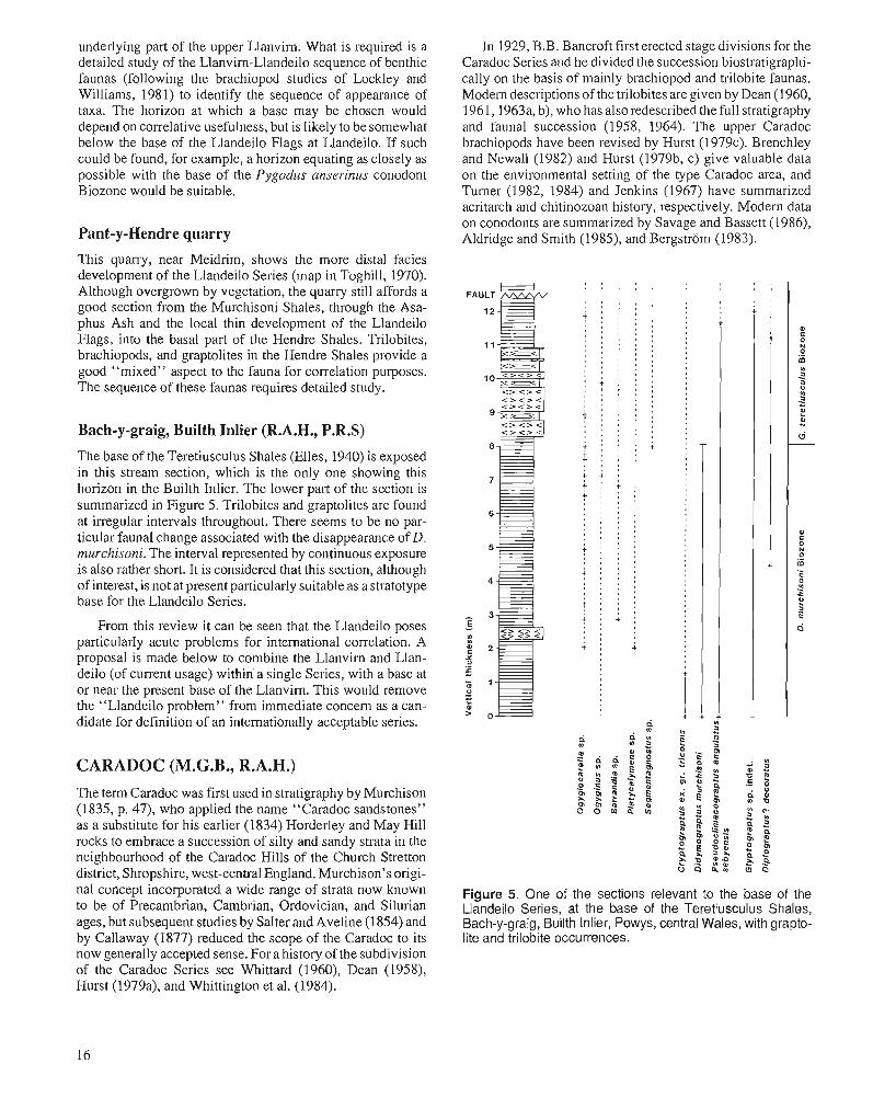
Bach-y-graig, Builth Inlier (R.A.H., P.R.S)
The base of the Teretiusculus Shales (Elles, 1940) is exposed in this stream section, which is the only one showing this horizon in the Builth Inlier. The lower part of the section is summarized in Figure 5. Trilobites and graptolites are found at irregular intervals throughout. There seems to be no par- ticular faunal change associated with the disappearance of D. murchisoni. The interval represented by continuous exposure is also rather short. It is considered that this section, although of interest, is not at present particularly suitable as a stratotype base for the Llandeilo Series.
From this review it can be seen that the Llandeilo poses particularly acute problems for international conelation. A proposal is made below to combine the Llanvirn and Llan- deilo (of current usage) within'a single Series, with a base at or near the present base of the Llanvirn. This would remove the "Llandeilo problem" from immediate concern as a can- didate for definition of an internationally acceptable series.
CARADOC (M.G.B., R.A.H.) The term Caradoc was first used in stratigraphy by Murchison (1835, p. 47), who applied the name "Caradoc sandstones" as a substitute for his earlier (1834) Horderley and May Hill rocks to embrace a succession of silty and sandy strata in the neighbourhood of the Caradoc Hills of the Church Stretton district, Shropshire, west-central England. Murchison's origi- nal concept incorporated a wide range of strata now known to be of Precambrian, Cambrian, Ordovician, and Silurian ages, but subsequent studies by SaIter and Aveline (1 854) and by Callaway (1877) reduced the scope of the Caradoc to its now generally accepted sense. For a history of the subdivision of the Caradoc Series see Whittard (1960), Dean (1958), Hurst (1979a), and Whittington et al. (1984).
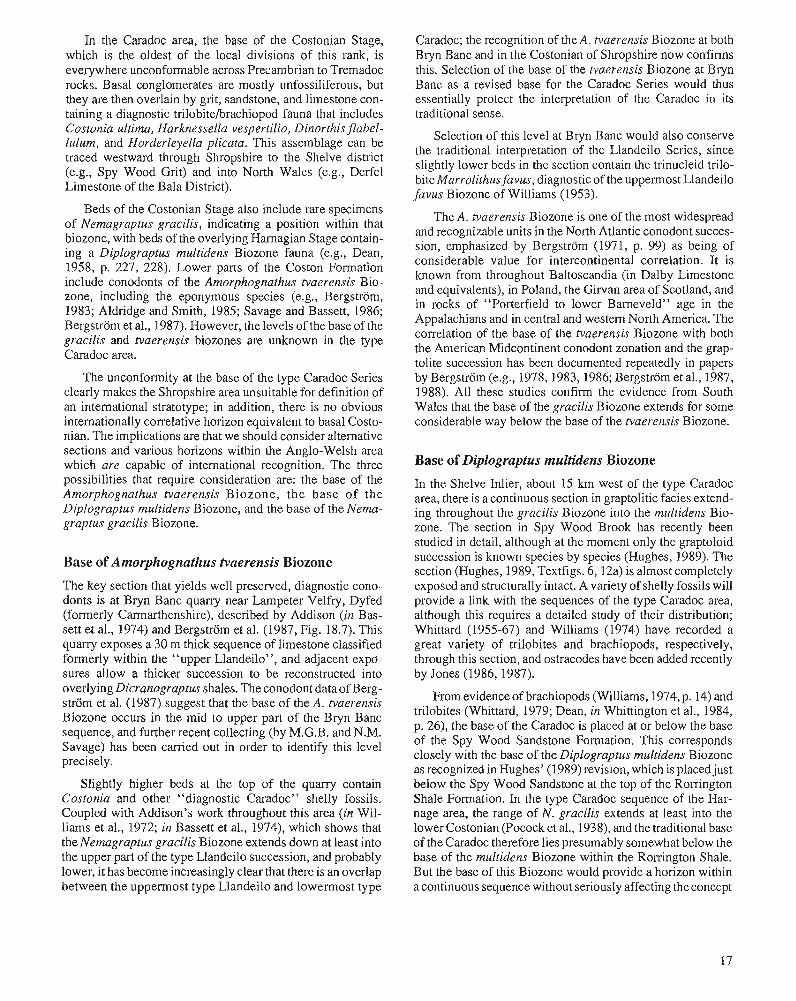
In 1929, B.B. Bancroft first erected stage divisions for the Caradoc Series and he divided the succession biostratigraphi- cally on the basis of mainly brachiopod and trilobite faunas. Modem descriptions of the trilobites are given by Dean (1 960, 1961, 1963a, b), who has also redescribed the full stratigraphy and faunal succession (1958, 1964). The upper Caradoc brachiopods have been revised by Hurst (1979~). Brenchley and Newall (1982) and Hurst (1979b, c) give valuable data on the environmental setting of the type Caradoc area, and Turner (1982, 1984) and Jenkins (1967) have summarized acritarch and chitinozoan history, respectively. Modern data on conodonts are summarized by Savage and Bassett (1986), Aldridge and Smith (1985), and Bergstrom (1983).
FAULT 12E , , . , , . , . , . > , , 8 " I
' , I + ; : : : ' I ,
' . . . , 0 .
I , ' I , ' I ,
' , I , I I
" I " , , , ' I . ,
I . . , !
' I . . . : + . . , , ~ . ~ , , . a s , , I , , ,
, I , ,
8 8 8 , 4 : : : : I . , .
I . . - , . . ' I . . . I ,
+ : : : +
t : : : # 8 m 8 , . , , t : : : + . t + + : , , , , , ' , , , ' , , , ' , , , I
, I . .
I . ,
, I . a I , ,
# . .
t : : : , . , I
I , '
I , , ,
t : : : , , . I
I , . a
, # . I
I , , i : : : , , , a
t : + : I ,
' I
i : i
d
a 4 g 0 n 2 & $ Z 0
e m s rP o 3 ~ - , ~ n m z g
3, 5 $ 6 6 s m o o m z d
Figure 5. One of the sections relevant to the base of the Llandeilo Series, at the base of the Teretiusculus Shales, Bach-y-graig, Builth Inlier, Powys, central Wales, with grapto- lite and trilobite occurrences.
In the Caradoc area, the base of the Costonian Stage, which is the oldest of the local divisions of this rank, is everywhere unconformable across Precambrian to Tremadoc rocks. Basal conglomerates are mostly unfossiliferous, but they are then overlain by grit, sandstone, and limestone con- taining a diagnostic trilobite/brachiopod fauna that includes Costonia ultima, Harknessella vespertilio, Dinorthis Jlabel- lulum, and Horderleyella plicata. This assemblage can be traced westward through Shropshire to the Shelve district (e.g., Spy Wood Grit) and into North Wales (e.g., Derfel Limestone of the Bala District).
Beds of the Costonian Stage also include rare specimens of Nemagraptus gracilis, indicating a position within that biozone, with beds of the overlying Hamagian Stage contain- ing a Diplograptus multidens Biozone fauna (e.g., Dean, 1958, p. 227, 228). Lower parts of the Coston Formation include conodonts of the Amorphognathus tvaerensis Bio- zone, including the eponymous species (e.g., Bergstrom, 1983; Aldridge and Smith, 1985; Savage and Bassett, 1986; Bergstrom et al., 1987). However, the levels of the base of the gracilis and tvaerensis biozones are unknown in the type Caradoc area.
The unconformity at the base of the type Caradoc Series clearly makes the Shropshire area unsuitable for definition of an international stratotype; in addition, there is no obvious internationally correlative horizon equivalent to basal Costo- nian. The implications are that we should consider alternative sections and various horizons within the Anglo-Welsh area which are capable of international recognition. The three possibilities that require consideration are: the base of the Amorphognathus tvaerensis Biozone, the base of the Diplograptus multidens Biozone, and the base of the Nema- graptus gracilis Biozone.
Base of Amorphognathus tvaerensis Biozone
The key section that yields well preserved, diagnostic cono- donts is at Bryn Banc quarry near Lampeter Velfry, Dyfed (formerly Carmarthenshire), described by Addison (in Bas- sett et al., 1974) and Bergstrom et al. (1987, Fig. 18.7). This quany exposes a 30 m thick sequence of limestone classified formerly within the "upper Llandeilo", and adjacent expo- sures allow a thicker succession to be reconstructed into overlying Dicranograptus shales. The conodont data of Berg- strom et al. (1987) suggest that the base of the A. tvaerensis Biozone occurs in the mid to upper part of the Bryn Banc sequence, and further recent collecting (by M.G.B. and N.M. Savage) has been carried out in order to identify this level precisely.
Slightly higher beds at the top of the quarry contain Costonia and other "diagnostic Caradoc" shelly fossils. Coupled with Addison's work throughout this area (in Wil- liams et al., 1972; in Bassett et al., 1974), which shows that the Nemagraptus gracilis Biozone extends down at least into the upper part of the type Llandeilo succession, and probably lower, it has become increasingly clear that there is an overlap between the uppermost type Llandeilo and lowermost type
Caradoc; the recognition of the A. tvaerensis Biozone at both Bryn Banc and in the Costonian of Shropshire now confirms this. Selection of the base of the tvaerensis Biozone at Bryn Banc as a revised base for the Caradoc Series would thus essentially protect the interpretation of the Caradoc in its traditional sense.
Selection of this level at Bryn Banc would also conserve the traditional interpretation of the Llandeilo Series, since slightly lower beds in the section contain the trinucleid trilo- bite Marrolithus favus, diagnostic of the uppermost Llandeilo favus Biozone of Williams (1953).
The A. tvaerensis Biozone is one of the most widespread and recognizable units in the North Atlantic conodont succes- sion, emphasized by Bergstrom (1971, p. 99) as being of considerable value for intercontinental correlation. It is known from throughout Baltoscandia (in Dalby Limestone and equivalents), in Poland, the Girvan area of Scotland, and in rocks of "Porterfield to lower Bameveld" age in the Appalachians and in central and western North America. The correlation of the base of the tvaerensis Biozone with both the American Midcontinent conodont zonation and the grap- tolite succession has been documented repeatedly in papers by Bergstrom (e.g., 1978,1983,1986; Bergstrom et al., 1987, 1988). All these studies confirm the evidence from South Wales that the base of the gracilis Biozone extends for some considerable way below the base of the tvaerensis Biozone.
Base of Diplograptus multidens Biozone
In the Shelve Inlier, about 15 km west of the type Caradoc area, there is a continuous section in graptolitic facies extend- ing throughout the gracilis Biozone into the multide~zs Bio- zone. The section in Spy Wood Brook has recently been studied in detail, although at the moment only the graptoloid succession is known species by species (Hughes, 1989). The section (Hughes, 1989, Textfigs. 6,12a) is almost completely exposed and structurally intact. A variety of shelly fossils will provide a link with the sequences of the type Caradoc area, although this requires a detailed study of their distribution; Whittard (1955-67) and Williams (1974) have recorded a great variety of trilobites and brachiopods, respectively, through this section, and ostracodes have been added recently by Jones (1986,1987).
From evidence of brachiopods (Williams, 1974, p. 14) and trilobites (Whittard, 1979; Dean, in Whittington et al., 1984, p. 26), the base of the Caradoc is placed at or below the base of the Spy Wood Sandstone Formation. This corresponds closely with the base of the Diplograptus multidens Biozone as recognized in Hughes' (1989) revision, which is placed just below the Spy Wood Sandstone at the top of the Rorrington Shale Formation. In the type Caradoc sequence of the Har- nage area, the range of N. gracilis extends at least into the lower Costonian (Pocock et al., 1938), and the traditional base of the Caradoc therefore lies presumably somewhat below the base of the multidens Biozone within the Rorrington Shale. But the base of this Biozone would provide a horizon within a continuous sequence without seriously affecting the concept
of Caradoc based on the type section. The disadvantage is that, at the moment at least, it is unclear how widely the horizon may be correlated internationally. Possibly the cur- rent active restudy of biserial graptoloids will enable its recognition quite widely.
Base of Nemagraptus gracilis Biozone
The base of the N. gracilis Biozone has been described within the Rorrington Shale Formation by Hughes (1989), as taken at the first appearance of the eponymous species. There is no doubt that the gracilis Biozone is one of the most widely recognized Ordovician intervals, corresponding as it does to a major eustatic transgression. As such it can be recognized on most continents outside platform limestone facies. The base of the biozone would correspond to the base of the Gisbornian of the Australian graptolitic standard.
The main problem with the selection of this horizon for a Caradoc base would be that the Caradoc would then consume a large part of the classical Llandeilo, which as shown above is now known to include some part, and possibly a large part, of the gracilis Biozone. This would not necessarily be a major objection if the "old" Llandeilo were to be replaced by a local stage, as we suggest below. But it does represent a radical departure from current usage. It would, in practice, represent a return to an older view (e.g., that of O.T. Jones, 1936) on the horizon of the basal Caradoc, which had been based on misconceptions about the ages of type sections.
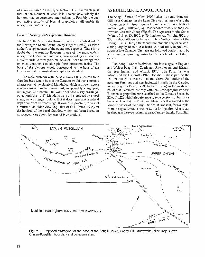
ASHGILL (J.K.I., A.W.04, D.A.T.H.) The Ashgill Series of Marr (1905) takes its name from Ash Gill, near Coniston in the Lake District in an area where the succession is far from complete, and where basal beds of mid-Ashgill (Cautleyan) age rest unconfonnably on the Bor- rowdale Volcanic Group (Fig. 6). The type area for the Series (Marr, 19 13, p. 13, 19 16, p. 89; Ingham and Wright, 1970, p. 233) is about 40 km to the east in the Cautley district of the Howgill Fells. Here, a thick and monotonous sequence, con- sisting largely of neritic calcareous mudstone, begins with strata of late Caradoc (Onnian) age followed conformably by a succession spanning virtually the whole of the Ashgill Series.
The Ashgill Series is divided into four stages in England and Wales: Pusgillian, Cautleyan, Rawtheyan, and Hirnan- tian (see Ingham and Wright, 1970). The Pusgillian was introduced by Bancroft (1945) for the highest part of the Dufton Shales at Pus Gill in the Cross Fell Inlier of the northern Pennines and was included initially in the Caradoc Series (e.g., by Dean, 1959; Ingham, 1966) in the mistaken belief that it equated entirely with the Pleurograptus linearis Biozone, a graptolite zone ascribed to the Caradoc Series by Elles (1922) with little reference to type sections. It has since become clear that the Pusgillian Stage is best regarded as the lowest division of the Ashgill Series. It is absent, for example, from the type Caradoc area in South Shropshire. Also it can be shown in the type Ashgill area at Cautley that the Pusgillian
LOWER PUSGlLLlAN
rises
0 \
kxalities from lngham 1966, 1970, with additions
Figure 6. Proposed stratotype for the base of the Ashgill Series, Foggy Gill, Murthwaite Inlier: map shows Onnian-Pusgillian boundary and collection sites.
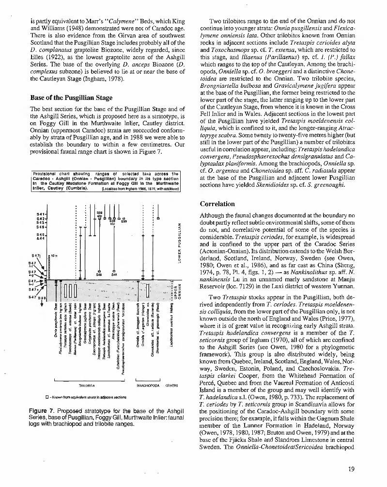
is partly equivalent to Marr's "Calymene" Beds, which King and Williams (1948) demonstrated were not of Caradoc age. There is also evidence from the Giwan area of southwest Scotland that the Pusgillian Stage includes probably all of the D. complanatus graptolite Biozone, widely regarded, since Elles (1922), as the lowest graptolite zone of the Ashgill Series. The base of the overlying D. anceps Biozone (D. complexus subzone) is believed to lie at or near the base of the Cautleyan Stage (Ingharn, 1978).
Base of the Pusgillian Stage
The best section for the base of the Pusgillian Stage and of the Ashgill Series, which is proposed here as a stratotype, is on Foggy Gill in the Murthwaite Inlier, Cautley district. Onnian (uppermost Caradoc) strata are succeeded conform- ably by strata of Pusgillian age, and in 1988 we were able to establish the boundary to within a few centimetres. Our provisional faunal range chart is shown in Figure 7.
Provisional chart showing ranges of selected taxa across the Caradoc - Ashgill (Onnian - Pusgillian) boundary In its type section In the Cautley Mudstone Formation at Foggy Gill in the Murthwaite Inlier, Cautley (Cumbria). {Localiies from lnaham 1966.1970. with addillonsl
-Known rmm equivalent strata In adjacent seclions
Figure 7. Proposed stratotype for the base of the Ashgill Series, base of Pusgillian, Foggy Gill, Murthwaite Inlier: faunal logs with brachiopod and trilobite ranges.
Two trilobites range to the end of the Onnian and do not continue into younger strata: Onnia pusgillensis and Flexica- lymerze onniensis lata. Other trilobites known from Onnian rocks in adjacent sections include Tretaspis cerioides alyta and Toxochasmops sp. cf. T. extensa, which are restricted to this stage, and Illaenus (Parillaenus) sp. cf. I . (P.) fallax which ranges to the top of the Cautleyan. Among the brachi- opods, Onniella sp. cf. 0. broeggeri and a distinctive Chone- toidea are restricted to the Onnian. Two trilobite species, Brongniartella bulbosa and Gravicalymene jugifera appear at the base of the Pusgillian, the former being restricted to the lower part of the stage, the latter ranging up to the lower part of the Cautleyan Stage, from whence it is known in the Cross Fell Inlier and in Wales. Adjacent sections in the lowest part of the Pusgillian have yielded Tretaspis moeldenensis col- liquia, which is confined to it, and the longer-ranging Atrac- topyge scabra. Some twenty to twenty-five metres higher (but still in the lower part of the Pusgillian) a number of trilobites useful in correlation appear, including: Tretaspis hadelandica convergens, Pseudosphaerexochus densigranulatus and Ca- Iyptaula. planiformis. Among the brachiopods, Onniella sp. cf. 0 . argentea and Chonetoidea sp. aff. C, radiatula appear at the base of the Pusgillian and adjacent lower Pusgillian sections have yielded Skenidioides sp. cf. S. greenoughi.
Correlation
Although the faunal changes documented at the boundary no doubt partly reflect subtle environmental shifts, some of them do not, and correlative potential of some of the species is considerable. Tretaspis ceriodes, for example, is widespread and is confined to the upper part of the Caradoc Series (Actonian-Onnian). Its distribution extends to the Welsh Bor- derland, Scotland, Ireland, Norway, Sweden (see Owen, 1980; Owen et al., 1986), and as far east as China (Sheng, 1974, p. 78, P1. 4, figs. 1,2) - as Nankinolithus sp. aff. N. nunkinensis Lu in an unnamed marly sandstone at Manju Reservoir (loc. 7129) in the Luxi district of western Yunnan.
Two Tretaspis stocks appear in the Pusgillian, both de- rived independently from T. ceriodes. Tretaspis moeldenen- sis colliquia, from the lower part of the Pusgillian only, is not known outside the north of England and Wales (Price, 1977), where it is of great value in recognizing early Ashgill strata. Tretaspis hadelandica convergens is a member of the T. seticornis group of Ingham (1970), all of which are confined to the Ashgill Series (see Owen, 1980 for a phylogenetic framework). This group is also distributed widely, being known from Quebec, Ireland, Scotland, England, Wales, Nor- way, Sweden, Estonia, Poland, and Czechoslovakia. Tre- taspis clarkei Cooper, from the Whitehead Formation of PercC, Quebec and from the Vaureal Formation of Anticosti Island is a member of the group and may well identify with T. hadelandica s.1. (Owen, 1980, p. 733). The replacement of T. ceriodes by T. seticornis group in Scandinavia allows for the positioning of the Caradoc-Ashgill boundary with some precision there; for example, it falls within the Gagnum Shale member of the Lunner Formation in Hadeland, Norway (Owen, 1978,1980,1987; Bruton and owen, 1979) and at the base of the Fjacka Shale and Slandrom Limestone in central Sweden. The Onniella-ChonetoideaISericoidea brachiopod
association found in the Cautley district (including the Foggy Gill section) is widespread in the deeper water clastic facies in the Upper Ordovician, pa11icularly around the CaradocAshgill boundary in the Baltic, Mediterranean, and North American provinces, thus providing potential for near global correlation.
Correlation with graptolite and conodont schemes
No graptolites are known from the proposed type section for the base of the Ashgill Series, but it is known that the boundary falls within the P. linearis Biozone (Ingham and Wright, 1970; Wright, in Whittington et al., 1984, p. 27, 28; cf. Williams and Bruton, 1983, p. 161, 162). The upper part of this biozone is recognized in the Fjacka Shale Formation in central Sweden (Skoglund, 1963), which also yields lower Ashgill trilobites. At Girvan, the P. linearis fauna known from the upper part of the Lower Whitehouse Group occurs below a horizon in the Upper Whitehouse Group yielding late Caradoc Tretaspis ceriodes s.I. The top of the linearis Biozone almost certainly lies within the Pusgillian as Dicellograptus complanatus faunas are known from the upper part of the Upper Whitehouse Group and the lower beds of the overlying Shalloch Formation (Williams, 1987) where they are associated with lowest Ashgill trilobites - including Tretaspis sp. cf. T. hadelandica convergens. The base of the linearis Biozone is believed to fall within the Onnian Stage. Much has been made of the occurrence of Onnia gracilis in the Nod Glas Formation of the Welshpool area of mid-Wales associated with graptolites, which on balance probably indicate a level high in the D. cling ani Biozone (Cave, 1965; Cave and Price, 1978). Onnia gracilis has been regarded previously as indicative of mid-Onnian but its range has been extended down to the late Actonian (Owen and Ingham, 1988, p. 850).
In Sweden, the base of the Hmju Series (J aanusson, 1963) is taken notionally at the base of the linearis Biozone, which was believed originally to lie at the base of the Fjacka Shale, or, in the Siljan District, the Slandrom Limestone. For reasons already stated this is not now believed to be the case, for both these units contain lower Ashgill trilobites. In lithostratigraphic terms, for all practical purposes, the base of the Harju Series corresponds very closely with the base of the Ashgill Series (see Jaanusson, 1982, Fig. 4) and Jaanusson's Vasagaardian Stage is probably the equivalent of some lower part of the Pusgillian.
A distinctive Dicellograptus from the basal D. complanatus Biozone in the Upper Whitehouse Group at Girvan, described by Williams (1987) as D. alector? may be extremely valuable for intercontinental graptolite facies correlation. Dicellograptus alector is known otherwise from the Phi Kappa Formation of Idaho and from Nevado where its range is evidently restricted to an interval equivalent to the D. cling ani and P.linearis biozones. A probable senior synonym is D. gravis from the latest Eastonian (Ea4) Stage of Victoria, Australia, which Williams correlates with the lower part of the British complanatus Biozone. It seems therefore that the Eastonian-Bolinidian boundary lies within the complanatus Biozone and may be closer to the top of the Pusgillian than the bottom.
20
With regard to conodonts, Sweet and Bergstrom (1971, p. 622) have demonstrated that advanced Amorphognathus superbus occur in the lower part of the type Maysvillian Stage of the Cincinnatian Series, which suggests that the base of the A. ordovicicus Biozone probably lies within that stage. Similarly, Savage and Bassett (1986, p. 683) have indicated on the basis of Welsh data that the base of the A. ordovicicus Biozone may also lie within the Pusgillian Stage, in spite of statements to the contrary (Orchard, 1980; Bergstrom and Orchard, 1985). It may be that the bases of the Pusgillian and Maysvillian stages are approximately coeval.
In summary, the base of the Pusgillian Stage is an appropriate level at which to define the base of the Ashgill Series. There are a sufficient number of species of trilobites and brachiopods to effect international correlation. If the base were to be redefined at the base of the P. linear is Biozone, its position within the Onnian Stage would be difficult to identify. Equally, if the boundary were to be transferred to the base of the complanatus Biozone, its position is unlikely to be recognizable within the Pusgillian Stage. Neither of these altematives commends itself to the writers. The base of the Ashgill Series as currently understood has the best potential for precise definition, wide correlation, and nomenclatural stability.
A CASE FOR COMBINING LLANVIRN AND LLANDEILO WITHIN A SINGLE SERIES
In the light of our review of all available sections and their potential for definition of units of series rank, we consider that it may now be preferable to combine the Llanvirn and L!andeilo in order to form a division commensurate in scope with those others in the Ordovician System. The present series in the British type area have been criticized as being too short to be usable at this level in the chronostratigraphic hierarchy (Chlupa~ et al., 1981), and this objection has most substance with regard to the Llanvim and Llandeilo. The Llanvirn (with two graptolite zones) and Llandeilo (with three trinucleid zones equivalent approximately to one graptolite zone) appear to be brief on a biostratigraphic measure, approximate though this is, and this impression is consistent with assessments of absolute age. For example, on the McKerrow et al. (1985, p. 75) timescale, the Llanvirn and Llandeilo (9 and 7 m.y. long, respectively) do appear to be short compared with the Tremadoc, Arenig, and Caradoc (21, 22 and 16 m.y.long, respectively). Combining the Llanvirn and Llandeilo would provide a series commensurate with those above and below. Neither name need be lost. We propose that the Llandeilo be retained for the whole series, and that the Llanvirnian be applied as a division of stage rank for the lower part of the Llandeilo. This would then require only the introduction of one new name for the upper stage division, approximately equivalent in scope to the present Llandeilo; for this, the Dyneforian Stage would be appropriate, named after Dynefor Park at Llandeilo itself, where rocks of this age are so well exposed (Williams, 1953).
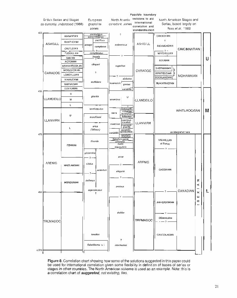
British Series and Stages as currently understood (1988)
)I I CAUTLEYAN I
Figure 8. Correlation chart showing how some of the solutions suggested in this paper could be used for international correlation given some flexibility in definition of bases of series or stages in other countries. The North American scheme is used as an example. Note: this is a correlation chart of suggested, not existing, ties.
The proposal would, of course, remove the problem of definition of the base of the Llandeilo Series (present usage) from the immediate concern of this working group. The base of the Llanvim is, at least potentially, capable of wide corre- lation. According to the possible definitions of the base of the Caradoc, as discussed above, the revised Llandeilo would either include the Nemagraptus gracilis Biozone, which is recognized almost worldwide, or that Biozone would be adjoined with the Caradoc. Given that the proposal would also result in a more equable distribution of time through the series of the Ordovician, without interfering with current terminol- ogy, it should find favour with those concerned with making the various primary chronostratigraphic subdivisions of the system robust and durable concepts capable of employment internationally. More generally, Figure 8 is an attempt to show how, with some common sense employed in the defini- tion of bases of chronostratigraphic divisions of the Ordovi- cian System intemationally, a practical correlation between different continents - and between different traditional us- ages - could be achieved.
REFERENCES Aldridge, R.J. and Smith, M.P. 1985: Lower Palaeozoic Succession of the Welsh Borderland. Fourth
European Conodont Symposium (ECOS N), Field Excursion B Guidebook, 39 p.
Allen, P.M. and Jackson, A.A. 1985: Geology of the country around Harlech. Geological Survey of Great
Britain, Memoir (for Sheet 135). xii + 111 p., 14 pls. Allen, P.M., Jackson, A.A., and Rushton, A.W.A. 1981: The stratigraphy of the Mawddach Group in the ~ambrian succes-
sion of Noah Wales. Proceedings of the Yorkshire Geological Society, v. 43, p. 295-329.
Bancroft, B.B. 1929: Some new species of Cryplolilhus (s.1.) from the Upper Ordovician.
Manchester Literary and Philosophical Society, Memoirs and Pro- ceedings, v. 123, p. 67-98.
1945: The brachiopod zonal indices of the stages Costonian-Onnian in Britain. Journal of Paleontology, v. 19, p. 181-252.
Bassett, D.A., Ingham, J.K., and Wright, A.D. 1974: Field Excursion Guide to Type and Classical Sections in Britain.
The Palaeontological Association, Ordovician System Symposium, Birmingham, 1974,66 p.
Beckly, A.J. 1987: Basin development in North Wales during the Arenig. Geological
Journal; v. 22, p. 19-30. Bergstrom, S.M. 1971: Conodont biostratigraphy of the Middle and Upper Ordovician of
Europe and eastern North America. Geological Society of America, Memoir 127 (for 1970), p. 83-157, pls. 1.2.
1978: Middle and Upper Ordovician conodont and graptolite biostratigra- phy of the Marathon, Texas graptolite zone reference standard. Palaeontology, v. 21, p. 723-758, pls. 79, 80.
1983: Biogeography, evolutionary relationships, and biostratigraphic sig- nificance of Ordovician ~latform conodonts. Fossils and Strata. no. 15, p. 35-58.
1986: Biostratigraphic integration of Ordovician graptolite and conodont zones -a regional review. Geological Society of London, Special Publication, no. 20, p. 61-78.
Bergstrom, S.M., Carnes, J.B., Hall, J.C., Kurapkat, W., and O'Neil, B.E. 1988: Conodont biostratigraphy of some Middle Ordovician stratotypes in
the southern and central Appalachians. New York State Museum, Bulletin, no. 462, p. 20-32.
Bergstrom, S.M. and Orchard, M.J. 1985: Conodonts of the Cambrian and Ordovician systems from the British
Isles. In A Stratigraphical Index of Conodonts, A.C. Higgins and R.L. Austin (eds.); British Micropalaeontological Society and Ellis Horwood Ltd., Chichester, p. 32-67.
Bergstrom, S.M., Rhodes, F.H.T., and Lindstrom, M. 1987: Conodont biostratigraphy of the Llanvirn-Llandeilo and Llandeilo-
Caradoc series boundaries in the Ordovician System of Wales and the Welsh Borderland. In Conodonts: Investigative Techniques and Applications, R.L. Austin (ed.); British Micropalaeontological So- ciety and Ellis Honvood Ltd., Chichester, p. 295-3 15, pl. 18.1.
Brenchley, P.J. and Newall, G. 1982: Ston-influenced inner shelf sand lobes in the Caradoc (Ordovician)
of Sluopshire, England. Journal of Sedimentary Petrology, v. 52, p. 1257-1 269.
Bruton. D.L.. Erdtmann. B.-D., and Koch. L. 1982: 'The ~aersnes section, 0slo ~ e ~ i o n , Norway: a candidate for the
Cambrian-Ordovician boundary stratotype at the base of the Trema- doc Series. In The Cambrian-Ordovician Boundary: Sections, Fossil Distributions, and Correlations, M.G. Bassett and W.T. Dean (eds.); National Museum of Wales, Geological Series, no. 3, Cardiff, p. 61-69.
Bruton, D.L., Koch, L., and Repetski, J.E. 1988: The Naersnes Section, Oslo Region, Noway: trilobite, graptolite
and conodont fossils reviewed. Geological Magazine, v. 125, p. 451-455.
Bruton, D.L. and Owen, A.W. 1979: Late Caradoc-early Ashgill trilobite distribution in the central Oslo
Region, Norway. Norsk Geologisk Tidsskrift, v. 59, p. 213-222. Callaway, C. 1877: On a new area of Upper Cambrian rocks in South Shropshire, with
a description of a new fauna. Geological Society of London, Quar- terly Journal, v. 33, p. 652-671, pl. I.
Cave, R. 1965: The Nod Glas sediments of Caradoc age in North Wales. Geological
Journal, v. 4, p. 279-298. Cave, R. and Price, D. 1978: The Ashgill Series near Welshpool, North Wales. Geological Maga-
zine, v. 115, p. 183-194. Chlupat, I., Fliigel, H., and Jaeger, H. 1981: Series or stages within Palaeozoic systems? Newsletters in Stratig-
raphy, v. 10, p. 78-91. Chugaeva, M.N. and Apollonov, M.K. 1982: The Cambrian-Ordovician boundary in the Batyrbaisai section,
Malyi Karatau Range, Kazakhstan, U.S.S.R. In The Cambrian-Or- dovician Boundary: Sections, Fossil Distributions, and Correlations, M.G. Bassett and W.T. Dean (eds.); National Museum of Wales, Geological Series, no. 3, Cardiff, p. 77-85.
Cooper, R.A. 1973: Taxonomy and evolution of lsograplus Moberg in Australasia.
Palaeontology, v. 16, p. 45-1 15. Cooper, R.A. and Fortey, R.A. 1982: The Ordovician graptolites of Spitsbergen. British Museum (Natural
History), Geology, Bulletin, v. 36, p. 157-302. Cooper, R.A. and Ni, Yunan 1986: Taxonomy, phylogeny and variability of Pseudisograptus Beavis.
Palaeontology, v. 29, p. 313-363. Cope, J.C.W., Fortey, R.A., and Owens, R.M. 1978: Newly discovered Tremadoc rocks in the Camarthen district, South
Wales. Geological Magazine, v. 115, p. 195-198. Cowie, J.W., Ziegler, W., Boucot, A.J., Bassett, M.G., and Remane, J. 1986: Guidelines and statutes of the International Commission on Stratig-
raphy (ICS). Courier Forschungsinstitut Senckenberg, v. 83, p. 1-14. Dean, W.T. 1958: The faunal succession in the Caradoc Series of south Shropshire.
British Museum (Natural History), Geology, Bulletin, v. 3, p. 191- 23 1, PIS. 24-26.
1959: The stratigraphy of the Caradoc Series in the Cross Fell Inlier. Proceedings of the Yorkshire Geological Society, v. 32, p. 185-228.
1960: The Ordovician trilobite faunas of south Shropshire I. British Mu- seum (Natural History), Geology, Bulletin, v. 4, p. 71-143, PIS. 11-19.
1961: The Ordovician trilobite faunas of south Shropshire, TI. British Museum (Natural History), Geology, Bulletin, v. 5, p. 31 1-358, pls. 49-55.
1963a: The Ordovician trilobite faunas of south Shropshire, 111. British Museum (Natural History), Geology, Bulletin, v. 7, p. 215-254, PIS. 37-46.
1963b: The Ordovician trilobite faunas of south Shropshire, IV. British Museum (Natural History), Geology, Bulletin, v. 9, p. 1-18, pls. 1,2.
1964: The geology of the Ordovician and adjacent strata in the southern Caradoc district of Shropshire. British Museum (Natural History), Geology, Bulletin, v. 9, p. 257-296.
Elles, G.L. 1904: Some graptolite zones in the Arenig rocks of Wales. Geological
Magazine, Decade 5, v. 1, p. 199-21 1. 1922: The graptolite faunas of the British Isles. Proceedings of the Geolo-
gists' Association, v. 33, p. 168-200. 1940: The stratigraphy and faunal succession in the Ordovician rocks of
the Builth-Llandrindod Inlier, Radnorshire. Geological Society of London, Quarterly Joumal, v. 95, p. 383-445.
Erdtrnann, B.-D. 1965: Outline stratigraphy of graptolite-bearing 3b (Lower Ordovician) in
Oslo Region, Norway. Norsk Geologisk Tidsskrift, v. 45, p. 481- 547.
Fortey, R.A. 1980: The Ordovician trilobites of Spitsbergen, 111, remaining trilobites of
the Valhallfonna Formation. Skrifter Norsk Polarinstitutt, v. 171, 163 p.
1988: The international correlation of the lower part of the Ordovician and how it should influence Laurentian chronostratigraphy. New York State Museum, Bulletin, v. 462, p. 43-47.
Fortey, R.A., Beckly, A.J., and Rushton, A.W.A. 1990: International correlation of the base of the Llanvim Series, Ordovi-
cian System. Newsletters in Stratigraphy, v. 22, p. 119-142. Fortey, R.A. and Cocks, L.R.M. 1986: Marginal faunal belts and their structural implications, with exarn-
ples from the Lower Palaeozoic. Geological Society of London, Journal, v. 143, p. 151-160.
Fortey, R.A., Landing, E., and Skevington, D. 1982: Cambrian-Ordovician boundary sections in the Cow Head Group,
western Newfoundlaid. It1 The Cambrian-Ordovician Boundary: Sections, Fossil Distributions, and Correlations, M.G. Bassett and W.T. Dean (eds.); National Museum of Wales, Geological Series, no. 3, Cardiff, p. 95-1 29.
Fortey, R.A. and Owens, R.M. 1987: The Arenig Series in South Wales. British Museum (Natural His-
tory), Geology, Bulletin, v. 41, p. 69-307. Fortey, R.A., Owens, R.M., and Rushton, A.W.A. 1989: The palaeogeographic position of the Lake District in the Early
Ordovician. Geological Magazine, v. 125, p. 9-17. Henningsmoen, G. 1973: The Carnbro-Ordovician boundary. Lethaia, v. 6, p. 423-439. Higgins, A.C. and Austin, R.L. 1985: A Stratigraphical Index of Conodonts. British Micropalaeontologi-
cal Society and Ellis Horwood Ltd., Chichester, 263 p. Hughes, R.A. 1989: Llandeilo and Caradoc graptolites of the Builth and Shelve inliers.
Palaeontographical Society London, Monograph, (Publication no. 577, part of v. 141 for 1987), p. 1-89, pls. 1-5.
Hurst, J.M. 1979a: The stratigraphy and brachiopods of the upper part of the type
Caradoc of south Salop. British Museum (Natural History), Geol- ogy, Bulletin, v. 32, p. 183-304.
1979b: Evolution, succession and replacement in the type Upper Caradoc (Ordovician) benthic faunas of England. Palaeogeography, Palaeo- climatology, Palaeoecology, v. 27, p. 189-246.
1979c: The environment of deposition of the Caradoc Alternata Limestone and contiguous deposits of Salop. Geological Journal, v. 14, p. 15-40.
Ingham, J.K. 1966: The Ordovician rocks in the Cautley and Dent districts of Westmor-
land and Yorkshire. Proceedings of the Yorkshire Geological Society, V. 35, p. 455-505.
1970: A monograph of the upper Ordovician trilobites from the Cautley and Dent districts of Westmorland and Yorkshire, Part 1. Palaeon- tographical Society London, Monograph, (Publication no. 526, part of v. 124 for 1970). 58 p.
1978: Geology of a continental margin 2: Middle and Late Ordovician transgression, Giwan. In Crustal Evolution in Northwestem Britain and Adjacent Regions, D.R. Bowes and B.E. Leake (eds.); Geologi- cal Journal, Special Issue, v. 10, p. 163-176.
Ingham, J.K. and Wright, A.D. 1970: A revised classification of the Ashgill Series. Lethaia, v. 3, p.
233-242.
Jaanusson, V. 1963: Classification of the Harjuan (Upper Ordovician) rocks of the main-
land of Sweden. Geologiska Foreningens i Stockholm Forhandlin- gar, v. 85, p. 1 10-144.
1982: Introduction to the Ordovician of Sweden. 111 Field Excursion Guide. IV International Symposium on the Ordovician System, D.L. Bruton and S.H. Williams (eds.); University of Oslo, Paleontological Con- tributions, no. 279, p. 1-1 0.
Jenkins, W.A.M. 1967: Ordovician Chitinozoa from Shropshire. Palaeontology, v. 10, p.
436-488. - ~
Jones, C.R. 1986-87: Ordovician (Llandeilo and Caradoc) bevrichiocooe Ostracoda from
England and Wales. ~alaeonto~raphi&l ~ o c i e 6 London, Mono- graph, Part 1 (Publication no. 569, part of v. 138 for 1984), p. 1-76, pls. 1-22; Part 2 (Publication no. 571, part of v. 139 for 1985). p. 77-1 14, PIS. 23-30.
Jones, O.T. 1936: The Lower Palaeozoic rocks of Britain. International Geological
Congress, Washington, 1933, p. 463-484. King, W.B.R. and Williams, A. 1948: On the lower part of the Ashgillian Series in the north of England.
Geological Magazine, v. 85, p. 205-212. Landing, E., Barnes, C.R., and Stevens, R.K. 1986: Tempo of earliest Ordovician graptolite faunal succession: cono-
dont-based correlations from the Tremadocian of Quebec. Canadian Journal of Earth Sciences, v. 23, p. 1928-1 949.
Lockley, M.G. and Williams, A. 1981: Lower Ordovician Brachiopoda from mid and southwest Wales.
British Museum (Natural History), Geology, Bulletin, v. 35, p. 1-78. Lofgren, A. 1978: Arenigian and Llanvimian conodonts from J2rntland, northern Sweden.
Fossils and Strata, no. 13, 129 p. Lu Yanhao, Zhou Zhiyi, and Zhou Zhiqiang 1981: Cambrian-Ordovician boundary and their related trilobites in the
Hangula region, W. Nei Monggol. Xi'an Institute of Geology and Mineral Resources, Chinese Academy of Geological Sciences, Bul- letin, v. 2, p. 1-22.
Marr, J.E. 1905: Anniversary address (The classification of the sedimentary rocks).
Geological Society of London, Quarterly Journal, v. 61, p. Ixi-lxxxvi.
1913: The lower Palaeozoic rocks of the Cautley district. Geological society of London, Quanerly Journal, v. 69, p. 1-17.
1916: The Ashgillian succession m the west of Coniston Lake. Geological Society of London, Quarterly Journal, v. 71, p. 189-204.
McKee, E.H., Norford, B.S., and Ross, R.J. 1972: Correlation of Ordovician shelly facies Orlhidiella Zone with zones
of the graptolitic facies, Toquima Range, Nevada, and North White River region, British Columbia. United States Geological Survey, Professional Paper 880-C, p. 145-156.
McKerrow, W.S., Lambert, R. St J., and Cocks, L.R.M. 1985: The Ordovician, Silurian and Devonian periods. In Thc Chronology
of the Geological Record, N.J. Snelling (ed.); Geological Society of London, Memoir, no. 10, p. 73-80.
McKerrow, W.S. and Soper, N.J. 1989: The Iapetus suture in the British Isles. Geological Magazine, v. 126,
p. 1-8. Miller, J.F. 1984: Cambrian and earliest Ordovician conodont evolution, biofacies,
and provincialism. Geological Society of America, Special Paper, no. 196, p. 43-68.
1987: h Geological Society of America, 21st Annual Meeting, South- Central section, Waco, Texas, March 28-29, Guidebook for Field Excursion l ,22 p.
Molyneux, S.G. 1987: Acritarchs and Chitinozoa from the Arenig Series of South Wales.
British Museum (Natural History), Geology, Bulletin, v. 41, p. 309-364.
Molyneux, S.G. and Dorning, K.J. 1989: Acritarch dating of latest Tremadoc+arliest Arenig (Early Ordovi-
cian) sediments in the Carmarthen district, South Wales. Geological Magazine, v. 126, p. 707-7 14.
Molyneux, S.G. and Rushton, A.W.A. 1985: Discovery of Trcmadoc rocks in the Lake District. Yorkshire Geo-
logical Society, Proceedings, v. 45, p. 123-127. 1988: The age of the Watch Hill Grits (Ordovician), English Lake District:
structural and palaeogeographical implications. Royal Society of Edinburgh, Earth Sciences, Transactions, v. 79 p. 43-69.
Mu, E.-Z., Ge, M.-Y. Chen, X., Ni, Y.-N., and Lin, Y.-K. 1979: Lower Ordovician graptolites of southwest China. Palaeontologia
Sinica, New Series B, no. 156, 192 p. Murchison, R.L 1833: On the sedimentary deposits which occupy the western parts of
Shropshire and Herefordshire, and are prolonged fro1nN.E. to S.W., through Radnor, Brecknock and Caermarthenshire, with descrip- tions of the accompanying rocks of intrusive or igneous characters. London and Edinburgh Philosophical Magazine, v. 3, p. 224-231.
1834: On the structure and classification of the transition rocks of Shrop- shire, Herefordshire and part of Wales, and on the lines of distur- bance which have affected that series of deposits, including the valley of elevation of Woolhope. London and Edinburgh Philo- sophical Magazine, v. 4, p. 370-375,450,451.
1835: On the Silurian System of rocks. London and Edinburgh Philosophi- cal Magazine, v. 7, p. 46-52.
1839: The Silurian System founded on geological researches in the coun- ties of Salop, Hereford, Radnor, Montgomery, Caermarthen, Bre- con, Pembroke, Monmouth, Gloucester, Worcester, and Stafford; with descriptions of the coal-fields and overlying formations. Mul~ay, London, v. 1, p. i-xxxii + 1-576; v. 2, p. 577-768, pls. 1-37.
Nikolaisen, F. and Henningsmoen, G. 1985: Upper Cambrian and Lower Tremadoc olenid trilobites from the
Digermul Peninsula, Finnmark, northern Norway. Norges Geolo- giske Unders@kelse, Bulletin 400, p. 1-49.
Norford, B.S. and Ross, R.J. 1978: New species of brachiopods and trilobites from the Middle Ordovi-
cian (Whiterock) of southeastern British Columbia. Geolorrical Sur- vey of ~ a n a d a , Bulletin 267, p. 1-1 1.
- Orchard, M.J. 1980: Upper Ordovician conodonts from England and Wales. Geologica
et Palaeontologica, v. 14, p. 9-44. Owen, A.W. 1978: The Ordovician and Silurian stratigraphy of central Hadeland. South
Norway. Norges Geologiske Undersgkelse, no. 338,23 p. 1980: Thc trilobite Tretaspis from the upper Ordovician of the Oslo
Region, Norway. Palaeontology, v. 23, p. 715-747. 1987: The trilobite Trefaspis at the Middle-Upper Ordovician boundary in
Vastergotland. Geologiska Foreningens i Stockholm FBrhandlingar, V. 109, p. 259-266.
Owen, A.W. and Ingharn, J.K. 1988: The stratigraphical distribution and taxonomy of the trilobite Otzriia
in the type Onnian Stage of the uppermost Caradoc. Palaeontology, V. 31, p. 839-855.
Owen, A.W., Tripp, R.P., and Morris, S.F. 1986: The trilobite fauna of the Raheen Formation (upper Caradoc), Co.
Waterford, Ireland. British Museum (Natural History), Geology, Bulletin, v. 40, p. 91-122.
Pocock, R.W., Whitehead, T.H., Wedd, C.B., and Robertson, T. 1938: Shrewsbury District, including the Hanwood Coalfield (Sheet 152).
Geological Survey of Great Britain, Memoir, xii + 297 p. Price, D. 1977: Species of Tretaspis (Trilobita) from the Ashgill Series in Wales.
Palaeontology, v. 20, p. 763-792. Rhodes, F.H.T. 1954: Some British Lower Palaeozoic conodont faunas. Philosophical
Transactions of the Royal Society, B, v. 237, p. 261-334, pls. 20-23. Ross, R.J. and Ingham, J.K. 1970: ~istribution of the Toquima-Table Head (Middle Ordovician Whit-
erock) faunal realm in the northern hemis~here. Geoloeical Societv of America, Bulletin, v. 81, p. 393-408. '
- Ross, R.J. and James, N.P. 1987: Brachiopod biostratigraphy of the middle Ordovician Cow Head and
Table Head groups, western Newfoundland. Canadian Journal of Earth Sciences, v. 24, p. 70-95.
Ross, R.J. and 27 others 1982: The Ordovician System in the United States: correlation chart and
explanatory notes. International Union of Geological Sciences, Publication no. 12,73 p.
Rushton, A.W.A. 1982: The biostratigraphy and correlation of the Merioneth-Tremadoc
Series boundary in North Wales. In The Cambrian-Ordovician Boundary: Sections, Fossil Distributions, and Correlations, M.G. Bassett and W.T. Dean (eds.); National Museum of Wales, Geologi- cal Series no. 3, Cardiff, p. 41-59.
1985: A Lancefieldian graptolite from the Lake District. Geological Maga- zine, v. 122, p. 329-333.
1988: Tremadoc trilobites from the Skiddaw Group in the English Lake District. Palaeontology, v. 31, p. 677-698.
Salter, J.W. and Aveline, W.T. 1854: On the "Caradoc Sandstone" of Shropshire. Geological Society of
London, Quarterly Journal, v. 10, p. 62-75. Savage, N.M. and Bassett, M.G. 1986: Caradoc-Ashgill conodonr faunas from Wales and the Welsh Bor-
derland. Palaeontology, v. 28 (for 1985), p. 679-713, pls. 80-86. Sheng, Huo-Fung 1974: Classification and correlation of the Ordovician System in China.
Geological Press, Beijing, 153 p. (in Chinese) Skevington, D. 1963: A correlation of Ordovician graptolite bearing sequences. Geolo-
giska Fareningens i Stockholm Forhandlingar, v. 85, p. 298-319. Skoglund, R. 1963: Upper Viruan and Lower Harjuan (Ordovician) stratigraphy of
VastergBtland and Lower Harjuan graptolite faunas of central Sweden. Geological Institution of the University of Uppsala, Bulle- tin, v. 42, p. 1-55.
Stubblefield, C.J. 1956: Cambrian palaeogeography in Britain. I n El sistema cambrico, su
paleogeographica y el problema da su base, v. 1, J. Rodgers (ed.); XX International Geological Congress, Mexico, 1956, p. 1-56.
Sweet, W.C. and Bergstrom, S.M. 197 1: The American Upper Ordovician Standard XUI: A revised time-
stratigraphic classification of North American upper Middle and Upper Ordovician rocks. Geological Society of America, Bulletin, v. 82, p. 613-628.
Toghill, P. 1970: A fauna from the Hendre Shales (Llandeilo) of the Mydrim area,
Carmarthenshire. Geological Society of London, Proceedings, no. 1663, p. 121-129.
Turner, R.E. 1982: Reworked acritarchs from the type section of the Ordovician Caradoc
Series, Shropshire. Palaeontology, v. 25, p. 119.143, pls. 15-17. 1984: Acritarchs from the type area of the Ordovician Caradoc Series,
Shropshire, England. Palaeontographica, Abt. B, v. 190, p. 87-157. 1985: Acritarchs from the type area of the Ordovician Llandeilo Series,
South Wales. Palynology, v. 9, p. 21 1-234. Whittard, W.F. 1955-67: The Ordovician trilobites of the Shelve Inlier, West Shropshire.
Palaeontographical Society London, Monographs, nos. 470, 473, 478,487,491,494,501,508,516; 350 p., 50 pls.
1960: Lexique Stratigraphique International,, Volume I , Europe, Part 3a, 1V - Angleterre, Pays de GaJles, Ecosse: Ordovicien. Congres GCologique International Commission de Stratigraphic, 1956, Mexico, Centre National de la RechErche Scientifique, 296 p.
1979: An account of the Ordovician rocks of the Shelve Inlier in West Salop and part of North Powys. British Museum (Natural History), Geology, Bulletin, v. 33, p. 1-69.
Wllittington, H.B, Dean, W.T, Fortey, RA, Rickards, RB., Rushton, A.W.A., and Wright, A.D. 1984: Definition of the Tremadoc Series and the series of the Ordovician
System in Britain. Geological Magazine, v. 121, p. 17-33. Wilcox, C.J. and Lockley, M.G. 1981: A reassessment of facies and faunas in the tvDe Llandeilo (Ordovi-
cian), Wales. Palaeogeography, ~ a ~ a e o c ~ i m i t b l o ~ ~ , ~ a l a e o k c o ~ o ~ ~ , V. 34, p. 285-314.
Williams, A. 1949: New Lower Ordovician brachiopods from the Llandeilo-Llanga-
dock district. Geological Magazine, v. 86, p. 161-174, 226-238. 1953: The geology of the Llandeilo District, Carmarthenshire. Geological
Society of London, Quarterly Journal, v. 108, p. 177-207. 1974: Ordovician Brachiopoda from the Shelve District, Shropshire.
British Museum (Natural History), Geology, Supplement 11, 163 p., 28 pls.
Williams, A,, Lockley, M.G., and Hurst, J.M. 198 1: Benthic palacoco~nrnunities represented in the Ffairfach Group and
coeval Ordovician successions of Wales. Palaeontology, v. 24. p. 661 -694.
W- A.,Sh;lchan,I., Basett, D.A., Dean, W.T., Ingham, J.K, Wright, A.D., and Whittington, H.B. 1972: A correlation of Ordovician rocks in [he British Isles. Geological
Society of London, Special Report, no. 3, p. 1-74. Williams, S.H. 1987: Upper Ordovician graptolites from the D. compla~~atus Zone of the
Moffat and Girvan districts and their significance for correlation. Scottish Journal of Geology, v. 23, p. 65-92.
Williams, S.H. and Bruton, D.L. 1983: The Caradoc-Ashgill boundwy in the central Oslo Region and
associated graptolite faunas. Norsk Geologisk Tidsskrift, v. 63, p. 147-191.
Williams, S.H. and Stevens, R.K. 1988: Early Ordovician (Arenig) graptolites of the Cow Head Group,
western Newfoundland, Canada. Paleontoflaphica Canadiana, v. 5, p. 1-167.
Zalasiewicz, J.A. 1984: A re-examination of the type Arenig Series. Geological Journal,
V. 19, p. 105-124. Zhou Zhiyi, et al. 1984: Cambrian-Ordovicia~i boundary sections aid the proposed candi-
dates for stratotypes in nonh and northeast China. In Stratigl-aphy and Palaeontology of Systemic Boundaries in China. Cambrian-Or- dovician Boundary, v. 2. Anhui Science andTechnology Publishing House, p. 1-57, pls. 1-3.
R.A. Fortey, Department of Palaeontology, The Natural History Museum, Cromwell Road, London SW7 5BD, U.K. M.G. Bassett, Department of Geology, National Museum of Wales, Cardiff CFI 3NP, U.K. D.A.T. Harper, Department of Geology, University College, Galway, Ireland R.A. Hughes,* British Geological Survey, Windsor Court, Windsor Terrace, Newcastle upon Tyne NE2 4HB, U.K. J.K. Ingham, Department of Geology, Hunterian Museum, The University, Glasgow G I 2 8QQ, U.K. S.G. Molyneux*, British Geological Survey, Keyworth, Nottingham NG12 5GG, U.K. A.W. Owen, Department of Geology and Applied Geology, The University, Glasgow G I 2 8QQ, U.K. R.M. Owens, Department of Geology, National Museum of Wales, Cardiff CFI 3NP, U.K. A.W.A. Rushton*, British Geological Survey, Keyworth, Nottingham NG12 SGG, U.K. P.R. Sheldon, Department of Geology, University of Wales College of Cardiff, Cardiff CFI 3YE, U.K.
*Contributions published by permission of the Director, British Geological Survey.

The international working group on the Cambrian-Ordovician boundary: report of progress
B.S. or ford' Norford, B.S., The international working group on the Cambrian-Ordovician boundary: report ofprogress; irz Advances in Ordovician Geology, C.R. Barnes and S.H. Williams (ed.), Geological Survey of Canada, Paper 90-9, p. 27-32,1991.
Abstract
The Working Group has the responsibility of recommeizdirzg a speciJic level within a suitable stratig- raphic section to serve as the global stratotype for the Cambrian-Ordovician boundary. Commencing in 1974, comprehensive studies culminated in a plenary session held in Calgary in 1985 and resulted in decisions on the "golden-spike" principle of selecting the boundary at a horizon just below the first influx ofplanktic (nematophorous) graptolites. Conodonts are to be used as the primary guide for the selection of the specijic horizon and the global stratotype section must have potential for studies using paleomag- netism, geochemistry, and other nonbiological correlation tools. The spec$ic horizon will correspond approximately to the base of the Tremadoc Series of Wales and will be slightly higher than the base of the Canadian Series as used in western North America.
At the Calgary meeting, important sections from various parts of the world were reviewed. The Xiaoyangqiao sections at Dayangcha, Jilin Province, China and the Green Point and Broom Point sections in Newfoundland, Canada were identiJied asprime candidates to serve as the global stratotype. A delegation from the Working Group inspected the Dayangcha sections in 1986; the Newfoundland sections similarly were inspected in 1981. A 1988 issue of the Geological Magazine presents details of these and other globally important sections and of the biostratigraphy provided by data on conodonts, graptolites, and trilobites. In mostparts of the world, the first influx ofplanktic graptolites has been documented as occurring within the lower part of the conodont zone of Cordylodus lindstromi Druce and Jones.
Le groupe de travail se charge de recommander un niveauparticulier dans une coupe stratigraphique convenable qui servira de stratotype mondial pour la linzite cambro-ordovicienne. Des e'tudes de'tailltes commenckes en 1974 se sont ternzintes par une assemble'e ple'niire tenue d Calgary en 1985; on y a pris des dkcisions quant au principe de choisir la limite d un horizon qui est imrntdiatement au-dessous de la premiire apparition de graptolites planctoniques (nkmatophores). Des coizodontes serviront de repkre primaire pour le choix de l'horizon particulier; en outre, il faudra pouvoir e'tudier le stratotype mondial d l'aide de rne'thodes pale'omagnktiques et gtochimiques et d'autres outils de corrtlation non biologiques. L'horizon particulier correspondra ci peu pr2s d la base de la sbie du Trkmadocien du pays de Galles et sera le'girement plus haut que la base de la se'rie du Canada selon le sens qu'on lui donne dans l'ouest de I'Ame'rique du Nord.
A la rencontre de Calgary, on a examine des coupes importantes provenant de dcjcse'rentes parties du monde. Les coupes de Xiaoyangqiao, d Dayangcha, dans la province de Jilin, en Chine, et les coupes de la pointe Green et de la pointe Broom, d Terre-Neuve, au Canada, sont reconnues comme ttant les principales possibilitts pour le stratotype mondial. Une dklkgation du groupe de travail a inspect6 les coupes de Dayangcha en 1986; les coupes d Terre-Neuve avaient t t t inspecte'es en 1981. Un nunze'ro de la revue Geolo_~ical Ma~azine paru en 1988 prksente des dttails sur ces coupes et d'autres coupes d'importance mondiale et sur la biostratigraphie ttablie ci partir de donne'es sur les conodontes, les graptolites et les trilobites. Presque partout au monde, les graptolites planctoniques apparaissent pour la premi2re fois dans la partie infe'rieure de la zone ci conodontes d Cordylodus lindstromi Druce et Jones.
1 Geological Survey of Canada, 3303 33rd Street N.W., Calgary Alberta, T2L 2A7, Canada
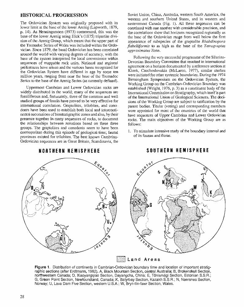
HISTORICAL PROGRESSION The Ordovician System was originally proposed with its lower limit at the base of the lower Arenig (Lapworth, 1879, p. 14). As Henningsmoen (1973) commented, this was the base of the lower Arenig using Hick's (1875) tripartite divi- sion of the Arenig Group, which meant that the upper part of the Tremadoc Series of Wales was included within the Ordo- vician. Since 1879, the basal Ordovician has been correlated around the world with varying degrees of accuracy, with the base of the system interpreted for local convenience within sequences of mappable rock units. National and regional preferences have arisen and the various bases recognized for the Ordovician System have differed in age by some ten million years, ranging from near the base of the Tremadoc Series to the base of the Arenig Series (as currently defined).
Uppermost Cambrian and Lower Ordovician rocks are widely distributed in the world; many of the sequences are fossiliferous and, fortunately, three of the common and well studied groups of fossils have proved to be very effective for intemational correlation. Graptolites, trilobites, and cono- donts have been used to establish both local and interconti- nental successions of biostratigraphic zones and also, by their presence together in many sequences of rocks, to document the relationships between zonations based on these three groups. The graptolites and conodonts seem to have been cosmopolitan during this episode of geological time; faunal provinces existed for trilobites. The best known Cambrian- Ordovician sequences are in Great Britain, Scandinavia, the
N O R T H E R N H E M I S P H E R E
Soviet Union, China, Australia, western South America, the western and southern United States, and in western and easternmost Canada (Fig. 1). All these sequences can be correlated with one another with considerable precision, and the correlations show that horizons recognized regionally as the base of the Ordovician range from well below the first appearance of subspecies of the graptolite Rhabdinopora jlabelliformis to as high as the base of the Tetragraptus approximatus Zone.
Following the very successful programme of the Silurian- Devonian Boundary Committee that resulted in intemational agreement on a horizon documented by a reference section at Klonk, Czechoslovakia (McLaren, 1977), similar studies were initiated for other systemic boundaries. During the 1974 Birmingham Symposium on the Ordovician System, the Working Group on the Cambrian-Ordovician Boundary was established (Wright, 1976, p. 3) as a constituent body of the International Commission on Stratigraphy, which itself is part of the International Union of Geological Sciences. The deci- sions of the Working Group are subject to ratification by the parent bodies. Titular (voting) and corresponding members were appointed for most of the countries of the world that have sequences of Upper Cambrian and Lower Ordovician rocks. The main objectives of the Working Group are as follows:
1. To stimulate intensive study of the boundary interval and of its faunas and floras.
S O U T H E R N H E M I S P H E R E
Figure 1. Distribution of continents in Cambrian-Ordovician boundary time and location of important stratig- raphic sections (after Erdtmann, 1982). A, Black Mountain Section, central Australia; B, Brokenskull Section, northwestern Canada; D, Xiaoyangqiao Section, Dayangcha, China; E, TBnismagi Section, Estonian S.S.R.; G, Green Point Section, Newfoundland, Canada; K, Batyrbay Section, Kazakh S.S.R.; N, Naersnes Section, Norway; U, Lava Dam Five Section, western U.S.A.; W, Bryn-llin-fawr Section, Wales.
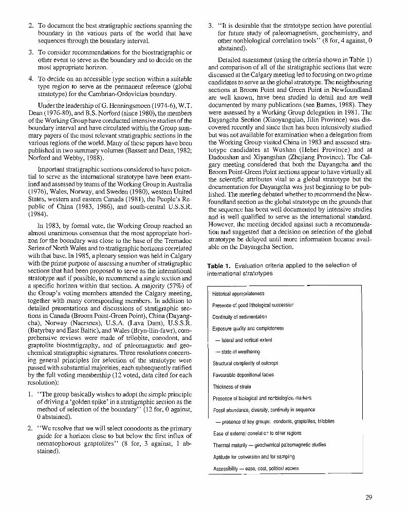
2. To document the best stratigraphic sections spanning the boundary in the various parts of the world that have sequences through the boundaly interval.
3. To consider recommendations for the biostratigraphic or other event to serve as the boundary and to decide on the most appropriate horizon.
4. To decide on an accessible type section within a suitable type region to serve as the permanent reference (global stratotype) for the Cambrian-Ordovician boundary.
Under the leadership of G. Henningsmoen (1974-6), W.T. Dean (1976-80), and B.S. Norford (since 1980), the members of the Working Group have conducted intensive studies of the boundary interval and have circulated within the Group sum- mary papers of the most relevant stratigraphic sections in the various regions of the world. Many of these papers have been published in two summary volumes (Bassett and Dean, 1982; Norford and Webby, 1988).
Important stratigraphic sections considered to have poten- tial to serve as the international stratotype have been exam- ined and assessed by teams of the Working Group in Australia (1976), Wales, Norway, and Sweden (1980), western United States, western and eastern Canada (1981), the People's Re- public of China (1983, 1986), and south-central U.S.S.R. (1984).
In 1983, by formal vote, the Working Group reached an almost unanimous consensus that the most appropriate hori- zon for the boundary was close to the base of the Tremadoc Series of North Wales and to stratigraphic horizons correlated with that base. In 1985, a plenary session was held in Calgary with the prime purpose of assessing a number of stratigraphic sections that had been proposed to serve as the international stratotype and if possible, to recommend a single section and a specific horizon within that section. A majority (57%) of the Group's voting members attended the Calgary meeting, together with many corresponding members. In addition to detailed presentations and discussions of stratigraphic sec- tions in Canada (Broom Point-Green Point), China (Dayang- cha), Norway (Naersnes), U.S.A. (Lava Dam), U.S.S.R. (Batyrbay and East Baltic), and Wales (Bryn-llin-fawr), com- prehensive reviews were' made of trilobite, conodont, and graptolite biostratigraphy, and of paleomagnetic and geo- chemical stratigraphic signatures. Three resolutions concern- ing general principles for selection of the stratotype were passed with substantial majorities, each subsequently ratified by the full voting membership (12 voted, data cited for each resolution):
1. "The group basically wishes to adopt the simple principle of driving a 'golden spike' in a stratigraphic section as the method of selection of the boundary" (12 for, 0 against, 0 abstained).
2. "We resolve that we will select conodonts as the primary guide for a horizon close to but below the first influx of nematophorous graptolites" (8 for, 3 against, 1 ab- stained).
3. "It is desirable that the stratotype section have potential for future study of paleomagnetism, geochemistry, and other nonbiological correlation tools" (8 for, 4 against, 0 abstained).
Detailed assessment (using the criteria shown in Table 1) and comparison of all of the stratigraphic sections that were discussed at the Calgary meeting led to focusing on two prime candidates to serve as the global stratotype. The neighbouring sections at Broom Point and Green Point in Newfoundland are well known, have been studied in detail and are well documented by many publications (see Barnes, 1988). They were assessed by a Working Group delegation in 198 1. The Dayangcha Section (Xiaoyangqiao, Jilin Province) was dis- covered recently and since then has been intensively studied but was not available for examination when a delegation from the Working Group visited China in 1983 and assessed stra- totype candidates at Wushan (Hebei Province) and at Dadoushan and Xiyangshan (Zhejiang Province). The Cal- gary meeting considered that both the Dayangcha and the Broom Point-Green Point sections appear to have virtually all the scientific attributes vital to a global stratotype but the documentation for Dayangcha was just beginning to be pub- lished. The meeting debated whether to recommend the New- foundland section as the global stratotype on the grounds that the sequence has been well documented by intensive studies and is well qualified to serve as the international standard. However, the meeting decided against such a recommenda- tion and suggested that a decision on selection of the global stratotype be delayed until more information became avail- able on the Dayangcha Section.
Table 1. Evaluation criteria applied to the selection of international stratotypes
Historical appropriateness
Presence of good lithological succession
Continuity of sedimentation
Exposure quality and completeness
- lateral and vertical extent
-state of weathering
Structural complexity of outcrops
Favourable depositional facies
Thickness of strata
Presence of biological and nonbiological markers
Fossil abundance, diversity, continuity in sequence
- presence of key groups: condonts, graptolites, trilobites
Ease of external correlation to other regions
Thermal maturity - geochemical paleomagnetic studies
Aptitude for conversion and for sampling
Accessibility - ease, cost, political access
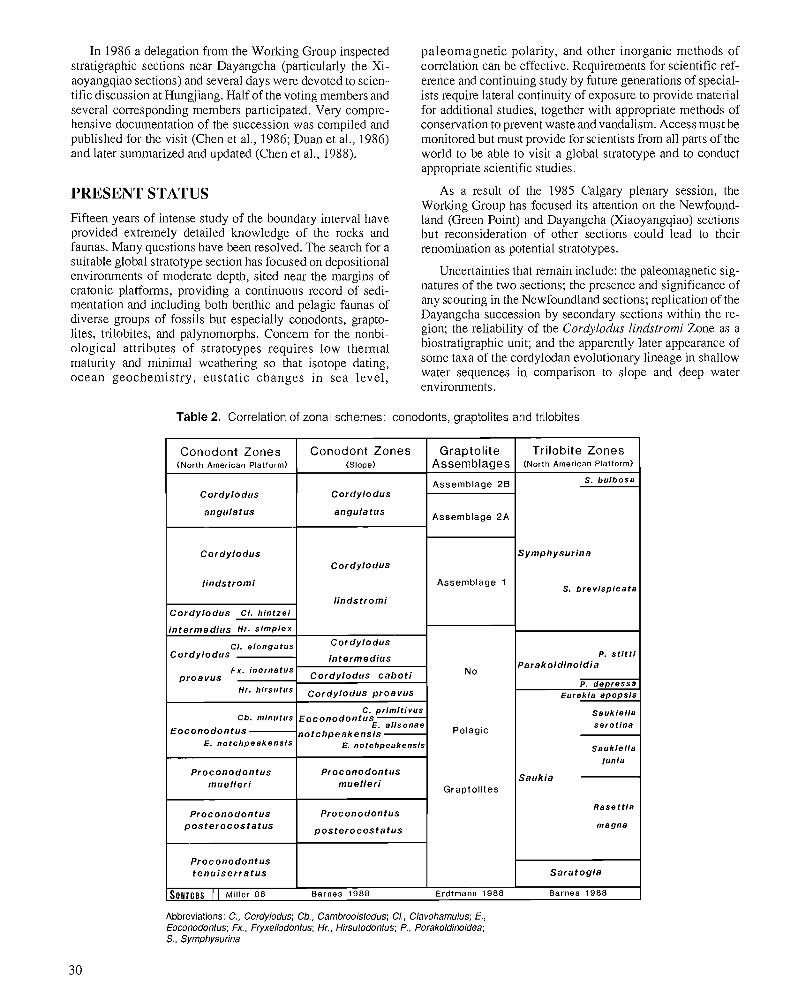
In 1986 a delegation from the Working Group inspected stratigraphic sections near Dayangcha (particularly the Xi- aoyangqiao sections) and several days were devoted to scien- tific discussion at Hungjiang. Half of the voting members and several corresponding members participated. Very compre- hensive documentation of the succession was compiled and published for the visit (Chen et al., 1986; Duan et al., 1986) and later summarized and updated (Chen et a]., 1988).
PRESENT STATUS
Fifteen years of intense study of the boundary interval have provided extremely detailed knowledge of the rocks and faunas. Many questions have been resolved. The search for a suitable global stratotype section has focused on depositional environments of moderate depth, sited near the margins of cratonic platforms, providing a continuous record of sedi- mentation and including both benthic and pelagic faunas of diverse groups of fossils but especially conodonts, grapto- lites, trilobites, and palynomorphs. Concern for the nonbi- ological attributes of stratotypes requires low thermal maturity and minimal weathering so that isotope dating, ocean geochemistry, eustatic changes in sea level,
Table 2. Correlation of zonal schemes:
paleornagnetic polarity, and other inorganic methods of correlation can be effective. Requirements for scientific ref- erence and continuing study by future generations of special- ists require lateral continuity of exposure to provide material for additional studies, together with appropriate methods of conservation to prevent waste and vandalism. Access must be monitored but must provide for scientists from all parts of the world to be able to visit a global stratotype and to conduct appropriate scientific studies.
As a result of the 1985 Calgary plenary session, the Working Group has focused its attention on the Newfound- land (Green Point) and Dayangcha (Xiaoyangqiao) sections but reconsideration of other sections could lead to their renomination as potential stratotypes.
Uncertainties that remain include: the paleomagnetic sig- natures of the two sections; the presence and significance of any scouring in the Newfoundland sections; replication of the Dayangcha succession by secondary sections within the re- gion; the reliability of the Cordylodus lindstromi Zone as a biostratigraphic unit; and the apparently later appearance of some taxa of the cordylodan evolutionary lineage in shallow water sequences in comparison to slope and deep water environments.
conodonts, graptolites and trilobites
Abbreviations: C., Cordylodus; Cb.. Cambrooistodus; CI., Clavohamulus; E., Eoconodontus; Fx., Fryxellodontus; Hr., Hirsutodontus; P., Porakoldinoidea; S., Symphysurina
Trilobite Zones (North American Platform)
S . b u l b o s a
Symphysurina
S . b r e v i s p i c a t a
P. s t l t t i Parakoldinoidia
P. d e p r e s s a Eurek le a p o p s i s
S a u k l e l l a s e r o t l n a
S a u k l e l l a
lun ia
Saukia
R a s e t t l a
m a g n e
Sara tog ia
Barnes 1988
Graptolite Assemblages
Assemblage 2 8
Assemblage 2 A
Assemblage 1
N o
Conodont Zones (North American Platform)
Cordylodus
angirlatus
Conodont Zones (Slope)
Cordylodus
angulatus
H r . h i rsutus
C b . minutus
Eoconodontus E . n o t c h p e a k e n s i s
Proconodontus muel ler i
Proconodontus p o s t e r o c o s t a t ~ s
Proconodontus t e n u i s e r r a t u s
Cordylodus
lindstromi
Cordylodus Cl . h l n t z e i
intermedius Hr. s i m p l e x
C I . e l o n g a t u s Cordylodus
Fx . inornatus proavus -
Cordylodus
l indstromi
Cordylodus
intermedius
Cordylodus cabot i
Sources 1 1 Miller 88 Barnes 1988 Erdtmann 1988
Cordylodus proavus
C. pr lmi t ivus Eoconodontus
E. a l isonae notchpeakensis
E. notchpeakensls
Proconodontus muel ler i
Proconodontus
posterocosta tus
Pelagic
Graptolites
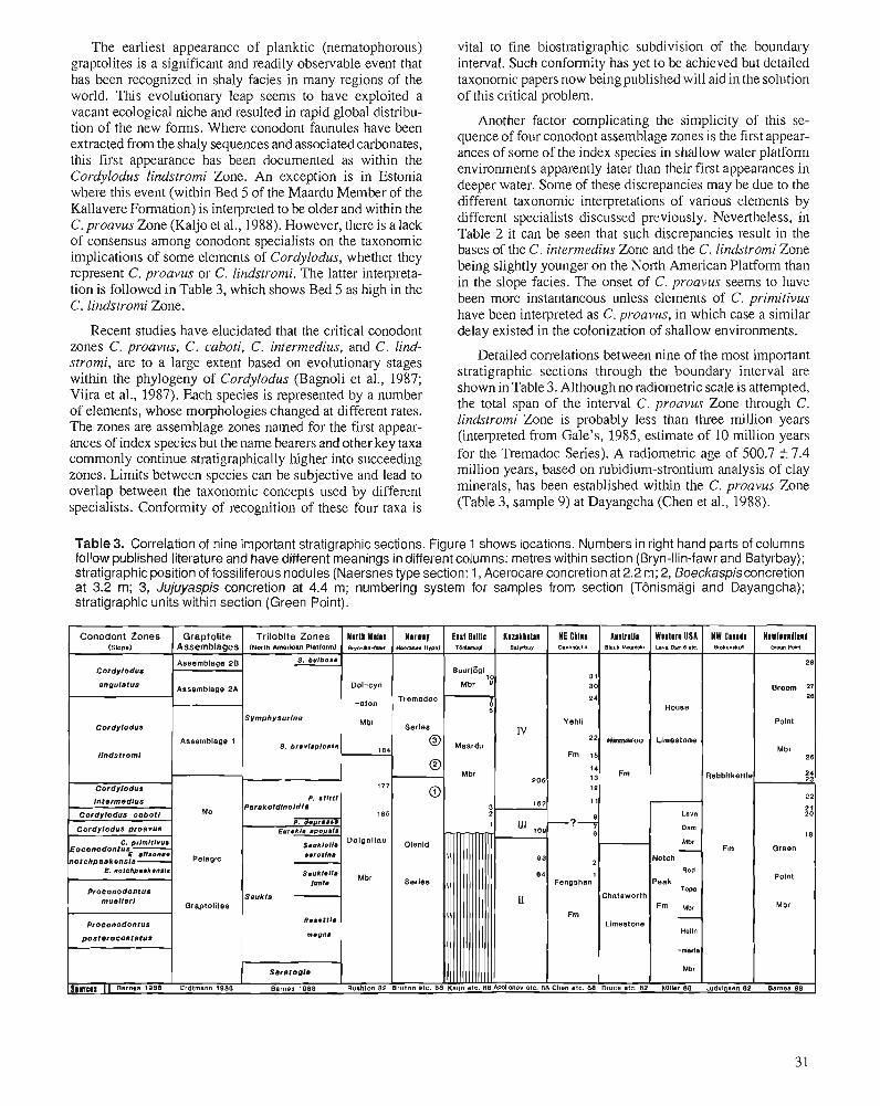
The earliest appearance of planktic (nematophorous) vital to fine biostratigraphic subdivision of the boundary graptolites is a significant and readily observable event that interval. Such conformity has yet to be achieved but detailed has been recognized in shaly facies in many regions of the taxonomic papers now being published will aid in the solution world. This evolutionary leap seems to have exploited a of this critical problem. vacant ecological niche and resulted in rapid globaldistribu- tion of the new forms. Where conodont faunules have been extracted from the shaly sequences and associated carbonates, this first appearance has been documented as within the Cordylodus lindstromi Zone. An exception is in Estonia where this event (within Bed 5 of the Maardu Member of the Kallavere Formation) is interpreted to be older and within the C. proavus Zone (Kaljo et al., 1988). However, there is a lack of consensus among conodont specialists on the taxonomic implications of some elements of Cordylodus, whether they represent C , proavus or C. lindstromi. The latter interpreta- tion is followed in Table 3, which shows Bed 5 as high in the C, lindstromi Zone.
Another factor complicating the simplicity of this se- quence of four conodont assemblage zones is the first appear- ances of some of the index species in shallow water platform environments apparently later than their first appearances in deeper water. Some of these discrepancies may be due to the different taxonomic interpretations of various elements by different specialists discussed previously. Nevertheless, in Table 2 it can be seen that such discrepancies result in the bases of the C. intermedius Zone and the C. lindstromi Zone being slightly younger on the North American Platform than in the slope facies. The onset of C. proavus seems to have been more instantaneous unless elements of C. primitivus have been interureted as C. uroavus, in which case a similar
Recent studies have elucidated that the critical conodont delay existed i; the colonization of shallow environments. zones C. proavus, C. caboti, C. intermedius, and C. lind- Detailed correlations between nine of the most important stromi, are to a large extent based on evolutionary stages within the phylogeny of Cordylodus (Bagnoli et al., 1987; stratigraphic sections through the boundary interval are
shown in Table 3. Although no radiometric scale is attempted, Viira et 1987). Each 'pecies is a number the total span of the interval C, proavus Zone C. of elements, whose morphologies changed at different rates. The zones are assemblage zones named for the first appear- lindstromi Zone is probably less than three million years
ances of index species but the name bearers and other key taxa (interpreted from Gale's, 1985, estimate of 10 million years
commonly continue stratigraphically higher into succeeding for the Tremadoc Series). A radiometric age of 500.7 +7-4
zones. Limits between species can be subjective and lead to million years, based on rubidium-strontium analysis of clay
overlap between the taxonomic concepts used by different minerals, has been established within the C, proavus Zone
specialists. Conformity of recognition of these four taxa is 37 9, at Dayangcha et lgg8).
Table 3. Correlation of nine important stratigraphic sections. Figure 1 shows locations. Numbers in right hand parts of columns follow published literature and have different meanings in different columns: metres within section (Bryn-llin-fawr and Batyrbay); stratigraphic position of foss~liferous nodules (Naersnes type section: 1, Acerocare concretion at 2.2 rn; 2, Boeckaspisconcretion at 3.2 m; 3, Jujuyaspis concretion at 4.4 m; numbering system for samples from section (TBnisrnagi and Dayangcha); stratigraphic units within section (Green Point).
Conodont Zones Graptolite Trilobite Zones N l r l l Wills N l r w l y €181 Bllllc K ~ z ~ k h s l ~ n HE Chllll l ~ s l r ~ l l l Wllllrn USA NW C l n l l l Nlwll11111n1 (Slope) Assemblages (North Amerlcan platform) ~ r ~ - l l l ~ - l ~ ~ ~ (tym) TW~..I eatvbml ~ava4chm slack -ah L . V ~ c-6 ate. ~ l o ~ e r u m m m POM
Aaaemblage 28 S. bu lbom 28
Cordylodus 8uurI801 10 31
sngulstua Assemblage 2A Dol-cyn Mbr 0 30 Broom 27 - Tremadoc I 24 28 House
Symphysurlne Cordylodus
Mbr Series Yehll Point
IV
Proconodontus
Paleomagnetic studies of the boundarv interval are at a preliminary stage. Data have been gatherei from Newfound- land (Broom Point), Texas (Lange Ranch Section), Kazakhstan (Batyrbay), and China (Dadoushan and Dayangcha) by J.L. Kirschvlnk and his co-workers. Reversed polarity seems to be characteristic of most of Late Cambrian and Early Ordo- vician times, but preliminary results from Batyrbay and Dadoushan indicate that a short episode of normal polarity may occur near the boundary interval (Ripperdan and Kirsch- vink, pers. comm., 1987). If these results are substantiated by the other sampled sections, the polarity signature of stratig- raphic sections will provide a powerful tool for correlation of the boundary.
Substantial progress has been achieved by the Worlung Group during its history. Minor uncertainties remain in the details of the conodont biostratigraphic zonation but resolu- tion of these problems is close to being achieved. This will allow decisions on the designation of a global stratotype and selection of a precise horizon within it to serve as the base of the Ordovician System.
ACKNOWLEDGMENTS This paper builds on the contributions from all members of the Working Group. In particular, M.K. Apollonov, C.R. Barnes, D.L. Bruton, Chen Jun-yuan, B.-D. Erdtmann, D.L. Kaljo, J.F. Miller, A.W.A. Rushton, and J.H. Shergold have contributed data that the author has interpreted to provide the present analysis.
REFERENCES Apollonov, M.K., Chugaeva, M.N., Dubinina, S.V., and Zhemchuzhnikov, V.G. 1988: Batyrbay Section, South Kazakhstan, U.S.S.R. - potential strato-
type for the Cambrian-Ordovician boundary. Geological Magazine, V. 125, p. 445-449.
Bagnoli, G., Barnes, C.R., and Stevens, R.K. 1987: Lower Ordovician (Tremadocian) conodonts from Broom Point and
Green Point, western Newfoundland. Bollettino Societa Paleon- tologica Italians, v. 25, p. 145-158.
Barnes, C.R. 1988: The proposed Cambrian-Ordovician global boundary stratotype and
point (GSSP) in western Newfoundland, Canada. Geological Maga- zine, v. 125, p. 381-414.
Bassett, M.G. and Dean, W.T. (eds.) 1982: The Cambrian-Ordovician Boundary: Sections, Fossil Distribu-
tions, and Correlations. National Museum of Wales, Geological Series, no. 3, Cardiff, 227 p.
Bruton, D.L., Koch, L., and Repetski, J.E. 1988: The Naersnes section, Oslo Region, Norway: trilobite, graptolite
and conodont fossils reviewed. Geological Magazine, v. 125, p. 451-455.
Chen Jun-yuan, Erdtmann, B.-D., Gong We-li, Li Hui-ming, Lin Yao-kun, Qian Yi-yuan, Tao Xian-chong, Wang Ying-xi, Wang Zong-zhe, Yang Jie-dong, Yin Lei-ming, and Zhang Jun-ming 1986: Aspects of Cambrian-Ordovician boundary in Dayangcha, China.
China Prospect Publishing House, Beijing, p. 1-410,98 pls.
Chen Jun-yuan, Qian Yi-yuan, Zhang Jun-ming, Lin Yao-kun, Yin Lei-ming, Wang Zhi-hao, Wang Zong-zhe, Yang Jie-dong, and Wang Ying-xi 1988: The recommended Cambrian-Ordovician global boundary strato-
type of the Xiaoyangqiao section (Dayangcha, Jilin Province) China. Geological Magazine, v. 125, p. 415-444.
Cooper, R.A. 1979: Sequence and correlation of Tremadoc graptolite assemblages.
Alcheringa 3, p. 7-19. Druce, E.C., Shergold, J.H., and Radke, B.M. 1982: A reassessment of the Cambrian-Ordovician boundary section at
Black Mountain, western Queensland, Australia. National Museum of Wales, Geological Series, no. 3, p. 193-209.
Duan Ji-ye, An Su-Ian, and Zhao Da 1986: Cambrian-Ordovician boundary and its interval biotas, southern
Jilin, northeast China. Journal of Changchun College of Geology, Special lssue of Stratigraphy and Palaeontology, p. 1-138, 33 pls.
Erdtmann, B.-D. 1982: Palaeobiogeography and environments of planktic diclyonemid
graptolites during the earliest Ordovician. National Museum of Wales, Geological Series, no. 3, p. 9-27.
1988: The earliest Ordovician nematophorid graptolites: taxonomy and correlation. Geological Magazine, v. 125, p. 327-348.
Gale, N.H. 1985: Numerical calibration of the Paleozoic time scale; Ordovician,
Silurian and Devonian periods. In The Chronology of the Geological Record, N.J. Snelling (ed.); Geological Society of London, Memoir 10, p. 81-88.
Henningsmoen, G. 1973: The Cambro-Ordovician boundary. Lethaia, v. 6, p. 423-439. Hicks, H. 1875: On the succession of the ancient rocks in the vicinity of St. David's,
Pembrokeshire, with special reference to those of the Arenig and Llandeilo groups, and their fossil content. Quarterly Journal of the Geological Society of London, v. 31, p. 167-195, pls. 8-1 1.
Kaljo, D., Heinsalu, H., Mens, K., Puura, I., and Viira, V. 1988: Cambrian-Ordovician boundary beds at TBnismBgi, Tallinn, North
Estonia. Geological Magazine, v. 125, p. 457-463. Lapworth, C. 1879: On the tripartite classification of the lower Paleozoic rocks.
Geological Magazine, New Series, Decade 2, v. 6, p. 1-15. Ludvigsen, R. 1982: The Cambrian-Ordovician boundary in the western District of
Mackenzie, Canada. National Museum of Wales, Geological Series, no. 3, p. 141-153.
McLaren, D.J. 1977: The Silurian-Devonian Boundary Committee. A final report. In The
Silurian-Devonian Boundary. Final Report of the Committee on the Silurian-Devonian Boundary Within IUGS Commission on Stratig- raphy and a State of the Art Report for Project Ecostratigraphy, A. Martinsson (ed.); IUGS Series A, no. 5, E. Schweizerbart'sche Verlagsbuch-handlung, Stuttgart, p. 1-34.
Miller, J.F. 1988: Conodonts as biostratigraphic tools for redefinition and correlation
of the Cambrian-Ordovician boundary. Geological Magazine, v. 125, p. 349-362.
Norford, B.S. and Webby, B.D. (eds.) 1988: Cambrian-Ordovician boundary issue. Geological Magazine,
V. 125, p. 323-463. Rushton, A.W.A. 1982: The biostratigraphy and correlation of the Merioneth-Trernadoc
Series boundary in North Wales. National Museum of Wales, Geological Series, no. 3, p. 41-59.
Viira, V., Sergeyeva, S., and Popov, L. 1987: Earliest representatives of the genus Cordylodus (Conodonta) from
Cambro-Ordovician boundary beds of North Estonia and Leningrad Region. Academy of Sciences, Estonian S.S.R., Geology Series, v. 36, no. 4, p. 145-153.
Wright, A.D. 1976: Preface. In The Ordovician System: Proceedings of a Palaeontologi-
cal Association Symposium, Birmingham, September, 1974, M.G. Bassett (ed.); University of Wales Press and National Museum of Wales, Cardiff, p. 3.4.
Cambrian-Ordovician boundary beds in the U.S.S.R.
Misha ~pollonovl
Apollonov, M., Cambrian-Ordovician boundary beds in the U.S.S.R.; Advances in Ordovician Geology, C.R. Barnes and S.H. Williams (ed.), Geological Survey of Canada, Paper 90-9, p. 33-45,1991.
Abstract
Cambrian-Ordovician boundary beds are widely distributed in many regions of the U.S.S.R. and are represented by sediments of various facies types. Correlations between facies belts are the subject of discussions in some cases. In the East European Platform, Urals, Pay-Khoy, Vaigach, South Novaya Zemlya, and in northeastern U.S.S.R., the base of the Ordovician coincides with the base of a transgressive complex. In Kazakhstan and the Siberian Platform, the change in facies is recorded close to the systemic boundary. Detailed conodont biostratigraphy of the boundary interval is established only in Kazakhstan, Estonia, and the Leningrad area. Graptolites are rare at the boundary interval; the exact level of the first appearance of nematophorous graptolites is open to dispute. The main group used for subdivision and correlation of the boundary interval is trilobites. The best horizon for the Cambrian-Ordovician boundary in the U.S.S.R. is the base of the conodont Cordylodus proavus Zone. The widespread transgression and drastic changes in faunal composition are connected with this horizon. Geochemical anomalies and reversal of the paleomagnetic polarity are known at this horizon in Kazakhstan. The main reasons for global changes at the Cambrian-Ordovician boundary are probably the strong activation of continental plate movements and related changes in the global system of oceanic circulation.
Rburne' Les couches limites cambriennes-ordoviciennes sont largement rkpandues dans de nombreuses rkgions
de 1' URSS et sont reprksentkes par des skdiments de diQkrents facibs. Les corrklations entre les zones de facibs font, dans certains cas, l'objet de discussions. A la plate-forme est-europkenne, dans I'Oural, les collines Pay-Khoy, I'ile Vaigach, la Nouvelle-Zemble du Sud et le Nord-Est de l'URSS, la base de I'Ordovicien coiizcide avec la base d'un complexe transgressif. Dans le Kazakhstan et la plate-forme sibkrienne, le changement de type de facibs s'observe prks de la limite systkmique. Des kchelles dktaillkes de conodontes ci I'intervalle limite n'ont ktk klaborkes que pour le Kazakhstan, I'Estonie et la rkgion de Leningrad. Les graptolites sont rares a I'intervalle lirnite et le niveau exact de la premibre apparition de graptolites nkmatophores est discutable. Le principal groupe utile pour une subdivision et une corrklation de I'intervalle limite est celui des trilobites. En URSS, les niveaux correspondant le mieux ci la limite cambrienne-ordovicienne est la base de la zone h conodontes Cordylodus proavus. La vaste transgression et les changements abrupts de composition faunique sont lie's d: ce niveau. Les anomalies gkochimiques et I'inversion de la polaritk pale'omagnktique ont e'te' dktermine'es d: ce niveau dans le Kazakhstan. La principale cause des changements globaux d: la limite cambrienne-ordovicienne est probablement la forte activation des mouvements de plaques continentales et les changements associks du systbme global de la circulation ockanique.
1 Institute of Geological Sciences, Academy of Sciences of Kazakh SSR, Kalinina 69a, Alma-Ata, 480100, U.S.S.R.
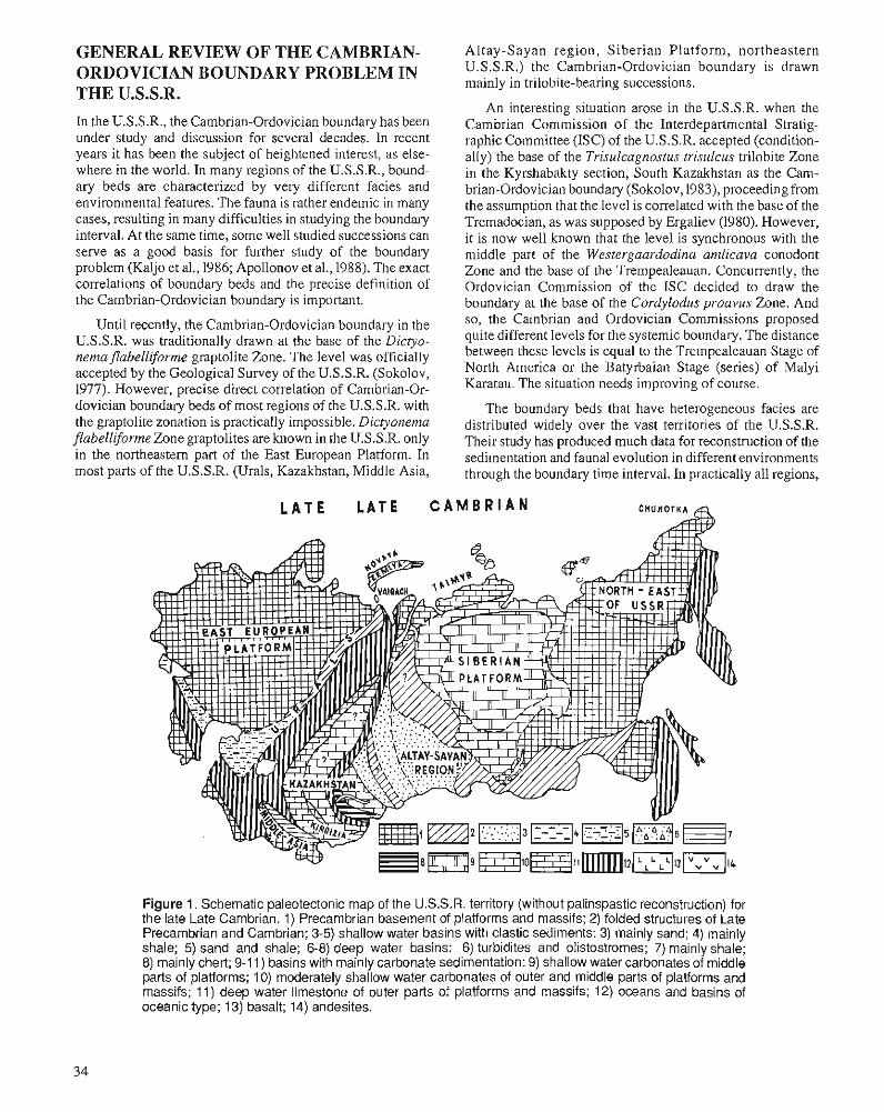
GENERAL REVIEW OF THE CAMBRIAN- Altay-Sayan region, Siberian Platform, northeastern
ORDOVICIAN BOUNDARY PROBLEM IN THE U.S.S.R. In the U.S.S.R., the Cambrian-Ordovician boundary has been under study and discussion for several decades. In recent years it has been the subject of heightened interest, as else- where in the world. In many regions of the U.S.S.R., bound- ary beds are characterized by very different facies and environmental features. The fauna is rather endemic in many cases, resulting in many difficulties in studying the boundary interval. At the same time, some well studied successions can serve as a good basis for further study of the boundary problem (Kaljo et al., 1986; Apollonov et al., 1988). The exact correlations of boundary beds and the precise definition of the Cambrian-Ordovician boundary is important.
Until recently, the Cambrian-Ordovician boundary in the U.S.S.R. was traditionally drawn at the base of the Dictyo- nemaflabelliforme graptolite Zone. The level was officially accepted by the Geological Survey of the U.S.S.R. (Sokolov, 1977). However, precise direct correlation of Cambrian-Or- dovician boundary beds of most regions of the U.S.S.R. with the graptolite zonation is practically impossible. Dictyonemu flubelliforme Zone graptolites are known in the U.S.S.R. only in the northeastern part of the East European Platform. In most parts of the U.S.S.R. (Urals, Kazakhstan, Middle Asia,
U.S.S.R.) the Cambrian-Ordovician boundary is drawn mainly in trilobite-bearing successions.
An interesting situation arose in the U.S.S.R. when the Cambrian Commission of the Interdepartmental Stratig- raphic Committee (ISC) of the U.S.S.R. accepted (condition- ally) the base of the Trisulcagnostus trisulcus trilobite Zone in the Kyrshabakty section, South Kazakhstan as the Cam- brian-Ordovician boundary (Sokolov, 1983), proceeding from the assumption that the level is correlated with the base of the Tremadocian, as was supposed by Ergaliev (1980). However, it is now well known that the level is synchronous with the middle part of the Westergaardodina amlicava conodont Zone and the base of the Trempealeauan. Concurrently, the Ordovician Commission of the ISC decided to draw the boundary at the base of the Cordylodus proavus Zone. And so, the Cambrian and Ordovician Commissions proposed quite different levels for the systemic boundary. The distance between these levels is equal to the Trempealeauan Stage of North America or the Batyrbaian Stage (series) of Malyi Karatau. The situation needs improving of course.
The boundary beds that have heterogeneous facies are distributed widely over the vast territories of the U.S.S.R. Their study has produced much data for reconstruction of the sedimentation and faunal evolution in different environments through the boundary time interval. In practically all regions,
Figure 1. Schematic paleotectonic map of the U.S.S.R. territory (without palinspastic reconstruction) for the late Late Cambrian. 1) Precambrian basement of platforms and massifs; 2) folded structures of Late Precambrian and Cambrian; 3-5) shallow water basins with clastic sediments: 3) mainly sand; 4) mainly shale; 5) sand and shale; 6-8) deep water basins: 6) turbidites and olistostromes; 7) mainly shale; 8) mainly chert; 9-1 1) basins with mainly carbonate sedimentation: 9) shallow water carbonates of middle parts of platforms; 10) moderately shallow water carbonates of outer and middle parts of platforms and massifs; 11) deep water limestone of outer parts of platforms and massifs; 12) oceans and basins of oceanic type; 13) basalt; 14) andesites.
a major transgression is evident at the boundary interval. The provide proper interprovincial correlation. The first appear- transgression probably began in the latest Late Cambrian - in ance of such widespread, well known, and easily identified Lotagnostus hedini Zone time. trilobites such as Hysterolenus, Macropyge (Macropyge),
Extensive land areas existed in the late Late Cambrian in the centre of major continental plates (East European plat- form and northeastern U.S.S.R.) (Fig. 1). In the Early Ordo- vician, these were transgressed by a shallow sea (Fig. 2). In the basins of Siberia and some regions of Kazakhstan, shal- low water deposits were replaced by deeper water sediments. Carbonates or alternating carbonate-shale deposits were re- placed by dark shale in the basins at the edges of plates (Taymyr, North Novaya Zemlya, Bolshoy Karatau, Ulutau) and elsewhere by dark chert (Sarykum in Kazakhstan). In the oceanic basins, jasper appeared in the latest Late Cambrian (Erementau-Chu-Ili Zone in Kazakhstan). Basalts were formed locally.
Three faunal groups - graptolites, trilobites, and cono- donts - are used mainly for the correlation and definition of the Cambrian-Ordovician boundary level in the U.S.S.R. The use of graptolites is limited for several reasons: boundary beds with graptolites are recorded from few areas; no zona- tion exists below the base of the Dictyonemaflabelliforme Zone; the horizon of the influx (or of the first appearance) of nematophorous graptolites is not fixed exactly; other fauna are rarely found together with graptolites.
Trilobites are the most common fossil in the Cambrian- Ordovician boundary beds in many regions of the U.S.S.R. They are often endemic in shallow water environments, and correlation between facies realms and provinces is commonly difficult. Within provinces, the correlation is exact and usually adequate. Some relatively deep water trilobites
Glaphurus, Shumardia, Apatocephalus, Nyaya, and others marks an important biostratigraphic level, which is corre- lated with the base of the conodont Cordylodus proavus Zone. The horizon of the first appearance of these trilobites can be used as one of the criteria for the definition of the Cambrian-Ordovician boundary.
Conodonts are the most eurytopic group and the cono- dont zonal scale is considered internationally to be the basis for the definition of the Cambrian-Ordovician bound- ary (Derby, 1986). According to the U.S.S.R. data, mainly from the Batyrbai section, South Kazakhstan, and sections in the Baltic region, the base of the Cordylodus proavus Zone is the best horizon for the systemic boundary (Apol- lonov and Chugaeva, 1982; Spizharskyi, 1986; Apollonov et al., 1988).
The base of the C. proavus Zone is the the only "natu- ral" boundary at the boundary interval from the base of the C. proavus Zone to the base of C. lindstromi Zone. Eustatic events, geochemical anomalies and changes in paleomag- netic polarity are recorded at this level (Apollonov et al., 1988). Ecosystems were changed virtually completely and new biomeres were formed at that level throughout the U.S.S.R. The main reason for such catastrophic global events may be increased activation of the continental plate movements, accompanied by great transgression and changes in oceanic circulation. These paleogeographic changes at the Cambrian-Ordovician boundary time are shown in Figures 1 and 2.
Figure 2. Schematic paleotectonic map of the U.S.S.R. territory (without palinspastic reconstruction) for the early Tremadocian. Legend as for Figure 1.
Two successions are particularly interesting for studies of the Cambrian-Ordovician transition beds: in Estonia (Kaljo et al., 1986) and in the Malyi Karatau Range, South Kazakh- stan. The Batyrbay section in Malyi Karatau is proposed as a potential Cambrian-Ordovician boundary stratotype (Apol- lonov et al., 1988).
The analysis of various data on the numerous boundary sections in many regions of the U.S.S.R. may be useful for resolving the international Cambrian-Ordovician boundary problem.
THE EAST EUROPEAN PLATFORM In the Soviet part of the East European (Russian) Platform, the Pakerort Horizon was erected for the lowermost part of the Ordovician (Alikhova, 1960; Mannil, 1966; Grigelis, 1978). The horizon correlates with the lower Tremadoc of Wales. Rocks of the horizon were usually deposited on an eroded surface of Lower and Middle Cambrian rocks. In the Leningradregion and Estonia, an Upper Cambrian succession with conodonts of the "Westergaardodina" Zone was dis- covered recently (Borovko et al., 1980, 1984; Kaljo et al., 1986).
The Cambrian-Ordovician boundary in the East European Platform is traditionally drawn at the base of the Pakerort Horizon (Alikhova, 1960; Mannil, 1966; Sokolov, 1977), al- though other views also exist. The history of the problem was discussed by Balashova and Balashov (1971).
After discovery of conodonts at the boundary interval in the Leningrad region (Borovko et a]., 1980), the suggestion was made to draw the Cambrian-Ordovician boundary there, at the base of the Cordylodus proavus Zone (Borovko et al., 1984). This level was accepted as the systemic boundary for the East European (Russian) Platform in the official "Deci- sion of the Interdepartmental Regional Stratigraphic Confer- ence on the Cambrian of the Russian Platform (Vilnius, 1983)" (Spizharskyi, 1986).
Recently, new data on the most complete Cambrian-Or- dovician boundary successions in the Baltic-Ladoga clint area (North Estonia and the Leningrad region) were analyzed (Kaljo et al., 1986). The numerous good outcrops enable detailed studies of the conodont and graptolite successions in the boundary interval (Table 1). At the level of the Cordy- lodus andresi Zone, graptolites were not found. However, the authors did not exclude the possibility that the Dictyonema sociale Subzone may be correlated, at least partly, with the Cordylodus proavus Zone. It is clear that the graptolite Dic- tyonemflabelliforme (s.1.) appears not later than the Cordy- lodus intermedius Zone. The bases of the Cordylodus andresi and C. intermedius zones were discussed as the probable Cambrian-Ordovician boundary for the East European Plat- form (Kaljo et a]., 1986). At present, stratigraphers in Estonia and Leningrad prefer the base of the C. proavus Zone as the boundary level (V. Viira, pers. comm., 1988).
The sections in the East European Platform area provide very important data for interpreting the relationship of the first nematophorous graptolites with the conodont zonation
at the Cambrian-Ordovician boundary interval. Shortcom- ings of those sections are the presence of several hiatuses, and the lack of trilobites and other fauna, except graptolites, conodonts, and inarticulate brachiopods.
THE URALS The problem of the exact position of the Cambrian-Ordovi- cian boundary in the Urals is not yet solved, in spite of many years of studying potential boundary sections. The problem was discussed at the conference on the Urals stratigraphy in 1977 (Breivel et al., 1980).
In the Urals, Lower Ordovician (and supposed Upper Cambrian) deposits are divided into tectonic zones - Belsk- Yeletsk, Sakmara-Lemva, Magnitogorsk-Schuchinsk, East Uralian, and Trans Uralian zones. The zones stretch from north to south over some thousands of kilometres. The bound- ary beds are best represented on the west slope of the Urals, in the Belsk-Yeletzk and Sakmara-Lemva zones. On the east slope in the Magnitogorsk-Schuchinsk Zone, the boundary beds are unrecorded, and in the East Uralian and Trans Uralian zones, they are only tentatively identified.
Everywhere on the west slope of the Urals, a thick com- plex of unrnetamorphosed or slightly metamorphosed shal- low water terrigenous deposits (quartz-feldspar sandstone, siltstone, mudstone, etc.) with an excellent Tremadocian fauna is known (e.g., Balashova, 1961). In the Sakmara-Lemva Zone, volcanics are recorded (Breivel et al., 1980). This transgressive complex rests on metamorphic rocks of Pre- cambrian, and Lower and Middle Cambrian age. The pres- ence of the Upper Cambrian is a particular problem. Ancygin et al. (1970) described the Khmelyov Horizon in the South Urals (Kidryas, Kosistek, Kayqla, Abitah areas), and consid- ered it to be of Upper Cambrian age. The horizon consists of clastic terrigenous deposits, more typical of the Ordovician. Abundant articulate brachiopods, Billingsella akbulakensis Andreeva, inarticulate brachiopods, Obolus sp., Lingulella sp. and others, and rare trilobites Kujandaspis kujandensis Ivshin, Olentella sp., identified by N.Ya. Acygin, are known in the horizon. But Korinevsky (1978) considered that faunal identifications need revision and that the deposits are of Ordovician age. Recently, he discovered the Tremadocian trilobites Ceratopyge, Shumardia, and Acerocarina in the deposits of the Khmelyov Horizon with Billingsella akbulak- ensis in the Kayala River area (Korinevsky, pers. comm., 1988).
Stratigraphic divisions of the Ordovician and Upper Cam- brian, proposed by Ancygin et al. (1970) and Varganov et al. (1973) were adopted by the Geological Survey for all regions in the Urals (Breivel et al., 1980). The Upper Cambrian can be distinguished in the lower part of the transgressive Ordo- vician complex in the Middle and Polar Urals, but is without fauna and only weakly correlated with the South Urals.
In the Belsk-Yeletsk Zone, the lowest part of the Ordovi- cian, bearing the brachiopod Angarella (supposedly Trema- docian-Arenigian), is known only in the Polar Urals. The deposits rest unconfomably on pre-Ordovician rocks.
The most complete succession close to the boundary occurs in the Sakmara-Lemva Zone. In the Polar Urals, in the Paga, Pogureisk-Lemva and Sangur areas, Lower Ordovician deposits are divided into supposedly lower Tremadocian (Pagata and Pogurey formations) and upper Tremadocian- Arenigian with Apatokephalus and other taxa (Kibata and Grubeya formations). In the Paga area near the Pokoinitza Shor stream, the oldest Ordovician conodonts in the Urals are found (Acodus, Acontiodus, Cordylodus, Drepanodus, Ois- todus, Oneotodus, and Scandodus) (Nasedkina, 1985). In the middle part of the Sakmara-Lemva Zone, undivided Trema- docian and Arenigian formations (Kolpakov, Telposs and others) that yield brachiopods (Tritoechia and others) are known.
Well documented, highly fossiliferous Tremadocian sandstone and mudstone containing the brachiopods Tri-
Tersella, Asaphellw, Ceratopyge, Pliomeroides, Nyaya; 4) Apatokephalus serratus beds with A. serratus (Boeck), Nileus limbatus Brogger, Pliomeroides primigenus (Angelin), Ger- agnostus, Geragnostella; and 5) Megalaspides beds with species of Megalaspides, Apatokephalus, Nileus, Niobella, Cybelurus.
Bondarev et al. (1970) correlated the basal beds with the Pakerort Horizon of the East European Platform. Beds 2-4 inclusive are correlated with the Ceratopyge Horizon of the East European Platform. Medalaspides beds are compared with the lower Arenigian. Hence, the transgressive complex with a typical Tremadocian fauna rests on an erosional sur- face of the folded pre-Ordovician, both here, and in the East European Platform and the Urals. It is evident that the main tectonic and sedimentological processes were generally simi- lar over the entire East European Platform.
toechia, Alirnbella, Altorthis, ~edes s i a , ~ inke lnbi r~ ia , Im- bricatia, Obolus, and the trilobites Dolgeulorna, A different situation exists in northern Novaya Zemlya.
Pseudokainella, Macropyge (Macropyge), Leimitzia, and According to R.F. Sobolevskaya (pers. comm., 1988), at the
others, as well as mudstone members with concretions bear- very north of the island, 70 krn southeast of the Zhelaniya Cape, the monotonous deep water Olen Formation occurs. It ing typical upper Tremadocian trilobites, such as Ceratopyge
forficula Sars, Shumardia oelandica Moberg, and Apa- consists of dark shale with carbonate concretions, with thin
tokephalus serratus (Boeck) are known to the south of the limestone strata in the lower part of the succession. The
Sakmara-Lemva Zone (Balashova, 1961; Varganov et al., thickness of the formation is 450 m. In the lower 70 m, the trilobites Lotagnostus trisectus (Salter), L. hedini (Troed.) 1973)' S t ra to t~~es of regi0na1 Uralian Kidwas (lower Trema- and others of the uppermost Cambrian (Lotagnosrus hedini docian) and Kolnabuk (upper Tremadocian) horizons were
established here (Varganov et al., 1973). Zone of Kazakhstan and China) were found. About 120 m above, the graptolites Dictyonema angelini Bulman,
Graptolites in the boundary interval are not known. Cono- donts are very rare (Nasedkina, 1985) and cannot be used for the division and correlation of the boundary interval. Hence, the base of the thick transgressive Ordovician complex in the Urals is approximately near the Cambrian-Ordovician bound- ary. More exact definition of the level is currently impossible. The question of whether the base of the complex is sychro- nous over all the Urals is not resolved. If the transgression over all the temtory of the East European Platform and the Urals had the same cause, it may be possible to correlate the base of the transgressive Ordovician complex of the Urals with the base of the Pakerort Horizon, or roughly with the base of the C. proavus Zone.
PAY-KHOY, VAIGACH, NOVAYA .
ZEMLYA
The Lower Ordovician successions of Pay-Khoy, Vaigach, and South Novaya Zemlya are well documented and have been studied in detail (Bondarev et al., 1970). A clastic-car- bonate, rather shallow water, complex (80-100 m thick) rests trangressively and unconformably on pre-Ordovician rocks. The regional Sokolii Horizon corresponds to the complex. The succession is divided into five beds (Bondarev et al., 1970): 1) basal beds; 2) Syntrophopsis magna and Dikelokephalina beds with Imbricatia sp. cf. I. lesnikovae Andreeva, Syntrophopsis magna Ulrich and Cooper, Al- torthis sp., Nyaya paichoica Bursky, Hystricurus sp., Nyaya sp., Tersella? sp., Dikelokephalina sp., Pliomeroides sp.; 3) Nyaya and Tersella beds with Imbricatia sp. cf. I. russanovi Bondarev, Syntrophopsis magna Ulrich and Cooper, Altor- this sp., Apatokephalus pecten Wiman, Apatokephalus,
~lonogra~tus-tenellus m inn arson and others of the middle Tremadocian are known. In the uppermost part of the succes- sion, Arenigian graptolites are present.
Thus, the Cambrian-Ordovician boundary in the section can be drawn roughly in the lower part of the barren interval.
KAZAKHSTAN In Kazakhstan, the Cambrian-Ordovician boundary beds probably were deposited over vast territories. However, tec- tonic deformation and sparse faunas in some facies have resulted in few good fossiliferous and unintemupted bound- ary successions (Nikitin, 1972; Apollonov et al., 1981; Apol- lonov and Chugaeva, 1983; Ergaliev, 1983; Apollonov et al., 1988).
Some tectonic facies zones are distinguished according to facies types of Upper Cambrian and Lower Ordovician sedi- ments and tectonic environments (Nikitin, 1972,1973; Apol- lonov and Patalakha, 1981; Nikitin et al., 1986). The author considers that the overall framework of the Upper Cambrian and Lower Ordovician structure of Kazakhstan comprised two large ancient sialic plates (terrains): the Kokchetav-Chu and Balkhash massives. The plates were divided by the Ere- mentau-Chu-Ili linear Zone (eugeocline) and bounded by the Ishim-Karatau Zone (miogeocline) on the west and by the Chingiz-Tarbagatai Zone (eugeocline) on the east.
In the Ishim-Karatau Zone, deep water limestone, shale, and chert were deposited during the Cambrian-Ordovician boundary interval (Nikitin, 1972,1973). In the sections of the Ulutau and Bolshoy Karatau ranges (Table I), the Upper
Table 1. Correlation chart for the Cambrian-Ordovician boundary beds of the U.S.S.R. Asterisks mark the levels proposed a s the Cambrian-Ordovician boundary by the various authors
BOlSHOl KARATAU,
1970
Tetragraptus Tetragraptus approximatus,
T. acclinans
Cambrian is represented by a dark, thin-bedded limestone member, bearing trilobites of the Lotagnostus punctatus- Hedinaspis and Lotagnostus hedini zones (Ergaliev, 1983). This member is replaced above by an interbedded limestone and shale member. In Bolshoy Karatau, in the lower part of the member, the trilobite Hysterolenus is recorded (Nikitin et al., 1978; Ergaliev, 1983). The Cambrian-Ordovician bound- ary is drawn at the level of the first appearance of Hysterole- nus.
One of the best Cambrian-Ordovician boundary succes- sions is in the Malyi Karatau Range, south Kazakhstan (Apol- lonov and Chugaeva, 1982,1983; Chugaeva and Apollonov, 1982; Apollonov et al., 1988). The boundary beds are part of
the carbonate Shabakty Folmation, formed on the north slope of the Aisha-Bibi Seamount, reconstructed by V.G. Zhern- chuzhnikov and H. Cook and studied in 1987 by a Soviet- U.S.A. scientific team. The conodont and trilobite zonal successions have been established for the section (Table 1).
Trilobites are abundant and diverse and represented by taxa of Asiatic or cosmopolitian aspect (Apollonov et al., 1988). Conodonts are known at many levels (Dubin- ina, 1982; this volume). The Eoconodontus (E.) notch- peakensis Z o n e , E. (E.) alisonae Z o n e a n d E. (Camhroistodus) minutus Zone can be correlated well with the same zones in North America, China, and some other regions. The base of the C. proavus Zone is marked by the appearances of C, proavus and C. oklahomensis at
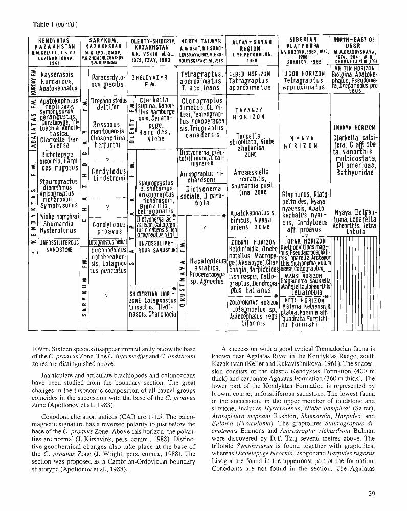
Table 1 (cont'd.)
I N A N Y A HORIZON
----
109 m. Sixteen species disappear immediately below the base A succession with a good typical Tremadocian fauna is of the C, proavus Zone. The C. intermedius and C, lindstromi known near Agalatas River in the Kondyktas Range, south zones are distinguished above. Kazakhstan (Keller and Rukavishnikova, 1961). The succes-
Inarticulate and articulate brachiopods and chitinozoans have been studied from the boundasy section. The great changes in the taxonomic composition of all faunal groups coincides in the succession with the base of the C. proavus Zone (Apollonov et al., 1988).
Conodont alteration indices (CAI) are 1-1.5. The paleo- magnetic signature has a reversed polarity to just below the base of the C. proavus Zone. Above this horizon, the polari- ties are normal (J. Kirshvink, pers. comm., 1988). Distinc- tive geochemical changes also take place at the base of the C. proavus Zone ( J . Wright, pers. comm., 1988). The section was proposed as a Cambrian-Ordovician boundary stratotype (Apollonov et al., 1988).
sion consists of the clastic Kendyktas Formation (400 m thick) and carbonate Agalatas Formation (360 m thick). The lower part of the Kendyktas Formation is represented by brown, coarse, unfossiliferous sandstone. The lowest fauna in the succession, in the upper member of mudstone and siltstone, includes Hysterolenus, Niobe homphrui (Salter), Araiopleura stephaizi Rushton, Shumardia, Harpides, and Euloma (Proteuloma). The graptolites Staurograptus di- chotomus Emmons and Anisograptus richardsoni Bulman were discovered by D.T. Tzaj several metres above. The trilobite Symphysurus is found together with graptolites, whereas Dichelepyge hicornis Lisogor and Harpides rugosus Lisogor are found in the uppermost part of the formation. Conodonts are not found in the section. The Agalatas
Formation, containing the trilobites Apatokephalus replicare Lisogor, Symphysurus perangustus Lisogor, Ceratopyge sp. and the brachiopod Tritoechia kendyktasika Rukavishnikova, rests conformably on the Kendyktas Formation. The Cam- brian fauna is not known in the section. The assemblage with Hysterolenus, Niobe homphrai (Salter), Araiopleura stephani Rushton and others is very similar to trilobites from the Acerocare Zone of North Wales (Rushton, 1982). The Cam- brian-Ordovician boundary in Kendyktas is drawn at the base of the beds with Hysterolenus.
In the Erementau-Chu-Ili Zone, uppermost Cambrian cono- donts are recorded from the lower part of the widespread deep water siliceous beds (jaspers), the clastic Akdym Formation (Dvoichenko and Abaimova, 1987). Older Cambrian depos- its are not known in most of the zone, except in the northern part of the zone (Selety River) where shallow water lime- stone, tuff, and clastic rocks of Late Cambrian age occur.
In the western part of the Balkhash Massive, in the north- western Balkhash region, the Cambrian-Ordovician bound- ary was studied in the lower part of the Chazhagay Formation, in dark, deep water chert with thin limestone layers in the lower part. The best section was studied by M.K. Apollonov and V.G. Zhemchuzhnikov near the Sarykum railway station. The Chazhagay Formation gradationally replaces the upper carbonatemember of the Sarykum Formation which bears the trilobite Lotagnostus punctatus. In the lowermost part of the Chazhagay Formation, Lotagnostus hedini and L. punctatus of the uppermost Cambrian were found in the limestone layers. Conodonts of the Eoconodontus (E.) notchpeakensis Zone were discovered together with trilobites. Conodonts of the Cordylodus proavus and C. lindstromi zones were ex- tracted from the thin layers of limestone from above. The C. intermedius Zone has not yet been discovered.
One of the best known Cambrian-Ordovician boundary sections in northeastern Kazakhstan is located in the Olenty- Shiderty rivers area in the northeast of the Erementau-Chu-Ili Zone (Ivshin et al., 1972; Nikitin, 1972). For many years, the section was considered as the stratotype for the regional Lermontov and Shidel-ty horizons (Cambrian) and Satpak and Olenty horizons (Ordovician). The Shidertian Stage of the international scale of the Upper Cambrian was proposed after studying the section (Ivshin and Pokrovskaya, 1968). Later it became evident that the section was too strongly disturbed tectonically and could not be used as a stratotype. Dictyonema flabelliforme mentioned from the section was later shown to be a different species of Dictyonema (Tzaj, 1983).
The Shidertian Horizon was established for the upper part of the carbonate tenigenous Tortkuduk Formation (Ivshin et al., 1972). It is characterized by a diverse complex of typical Upper Cambrian trilobites with Lotagnostus trisectus (Sal- ter), Hedinaspis, Charchaqia, and others. The conodonts Westergaardodina, Furnishina and others are also known. The Satpak Formation occurs above. Above a 5 m thick unfossiliferous interval, D.T. Tzaj (1983) erected two succes- sive graptolite complexes: a lower one with Callograptus olentensis Tzaj, Dendrograptus yini Mu, and Dictyonema asiaticum Hsu; and an upper one with Staurograptus di- chotomus Emmons and Anisograptus richardsoni Bulman.
The lower complex also includes the trilobites Bienvillia tetragonalis (Harrington) and Geragnostus sp. (Ivshin and Pokravskaya, 1968). The base of the Ordovician is drawn by D.T. Tzaj in the base of the Dendrograptus yini beds.
The Olenty Formation containing Clarkella supina Nikitii, Nanorthis hamburgensis (Walcott), Ceratopyge, Harpides, and Niobe, which is supposedly of late Temadocian age, rests on the Satpak Formation (Nkitin, 1956). The rocks are strongly folded.
In the t en i t q of the Chingiz-Tarbagatay Zone, complete successions of the Cambrian-Ordovician boundary intelval are unknown. In the western part of the zone, silicic (jasper) volcano- genic deposits of Arenig age rest unconformably on folded Lower and Middle Cambrian rocks. In the eastem part of the zone, tuffaceous limestone of the Mamat Formation containing Clarkella, Ceratopyge and others (supposedly upperTemadocian) rest tmnsgressively on folded Cambrian strata (Nlkitin, 1972).
To the east, in the Zaisan Zone, with its siliceous-volcano- genic lower Paleozoic deposits, the Upper Cambrian and Lower Ordovician are not known with certainty.
In Kirgizia, uninterrupted fossiliferous Cambrian-Ordo- vician successions are known. In some places, limestone containing Upper Cambrian Lotagnostus asiaticus Troeds- son, Acrocephalina armata Troedsson, Charchaqia norini Troedsson, Hedinaspis regalis Troedsson, Norinia convexa Troedsson and others are recorded (Goncharova, 1972).
MIDDLE ASIA
In Middle Asia, Cambrian-Ordovician boundary beds are known from two areas (Nikitin et al., 1986). In the central part of the Turkestan Range, the boundary is drawn at the base of Apchapkan Formation of dark shale, mudstone, and sand- stone with the upper Tremadocian(?) graptolites Callograp- tus sp. cf. C. sinicus Mu, Dictyonerna uniformis Mu, Clonograptus, Anisograptus?, and Bryograptus?. The forma- tion rests conformably on supposed Upper Cambrian rocks.
In the Central Pamir, the systemic boundary is located somewhere near the boundary between the Zorabat and Kozyndy formations, which consist of limestone, dolomite, and shale (Balashova, 1966). No fauna occurs in the upper part of the Zorabat Formation. In the lower part of the Kozyndy Formation, the upper Tremadocian trilobites Apa- tokephalus serratus pamiricus Balashova, Dikelokephalina, Shumardia and others are recorded (Balashova, 1966).
ALTAY-SAYAN REGION The Altay-Sayan region is an interesting and important region for studying the Cambrian-Ordovician boundary. It is consid- ered to be the miogeoclinal system along the edge of the Siberian Platform. The evolution of structures, environments, and sedimentation in the Late Cambrian and Earlv Ordovi- cian have not been studied sufficiently. Upper Cambrian and Lower Ordovician stratigraphy and trilobites were studied by Petrunina (e.g., 1968, 1973). This review is based mainly on her data.
Upper Cambrian and Lower Ordovician deposits are widespread in the territories of Salair, Kuznetsk Alatau, Gor- naya Shoria and in the eastern part of the Gomyi Altay-in Biya-Katun and Uiem-Lebed zones. Boundary beds consist mainly of sandstone and mudstone with rare lenses and beds of limestone. Volcanics are widespread only in the Lower Ordovician. Abundant and diverse trilobites are known at many levels (Petrunina, 1968, 1973; Krasnov et al., 1983). Other fauna are rare. The unfossiliferous, thick (several kilo- metres), deep water Gornoaltay Series consists of graded- bedded sandstone and mudstone (Goosyev, 1986) and is distributed over the western part of the Gomyi Altay Zone. The upper part of the series is correlated tentatively with Upper Cambrian and Lower Ordovician (Krasnov et al., 1983).
At the boundary interval, the Zolotokitat, Dobryi, Tay- anza (earlier known as Algain) and Lebed horizons are dis- tinguished (Krasnov et al., 1983). Petrunina drew the Cambrian-Ordovician boundary at the base of the Dobryi Horizon, and correlated the Tayanza Horizon with the upper Tremadocian (e.g., Petrunina, 1968; Bessonenko and Petrun- ina, 1972; Yermikov et al., 1979). This point of view became almost universally recognized by Siberian stratigraphers (Krasnov et al., 1983), but now requires radical revision.
The Zolotokitat Horizon was established based on the succession along the Dobryi stream in Kuznetsk Alatau. Typical Upper Cambrian trilobites with Pseudagnostus sim- plexLermontova, Lotagnostus sp., Asiocephalus regaliformis Ivshin, Proceratopyge sp, cf. P. grabaui Troedsson, Plica- tolina sp. and others (Krasnov et al., 1983) are recorded from the horizon.
The type succession of the Dobryi Horizon was also described among the Dobryi stream. It is characterized by abundant and diverse trilobites (Petrunina, 1968; Krasnov et al., 1983). The Archaeodictyota Zone is erected on the basis of rare graptolites Archaeodictyota sp. aff. A. dragunovi Obut and Sobolevskaya, Dendrograptus sp., and Callograptus sp. (Krasnov et al., 1983). According to Petrunina (1968, 1973) more than 60 trilobite species representing over 30 genera are known from the Dobryi Horizon. She believes that the hori- zon correlates with the lower Tremadocian. Well known trilobites Leiagnostus, Psedagnostus, Euloma (Proteuloma), Hospes, Koldinioidia, Parabolinella, Onchonotellus, Acro- cephalina, Macropyge (Promacropyge) , Niobella, Tropi- dopyge, Charchaqia, Harpidoides (=Sibiriopleura), Eocheirurus, and Diceratopyge are very important for corre- lation from her point of view. New genera Bilacunaspis, Ivshinaspis, and Skljarella were published from the horizon (Petrunina, 1973). Some paleontological data from the Hori- zon have not yet been published (Petrunina, pers. comm., 1988). Two zones - Skljarella lidiae-Tropidopyge tevipis and Euloma limata-Harpides (=Harpidoides) ulumandensis - are distinguished in the Dobryi Horizon by Petrunina (1968).
The deposition of the Tayanza Horizon is widespread over the tenitory of the Altay-Sayan region. Petrunina (1968) corre- lated the horizon with the upper Tremadocian. The type succes- sion was studied near the Tayanza River in Gomaya Shoriya. The trilobite assemblage according to Petrunina (1968) consists
of more than 100 species representing about 50 genera. Euloma (Euloma), Shumardia, Hysterolenus, Nyaya, Tersella, Apatokephalus, Platypeltoides, Niobe, Promegalaspides, Dikelokephalina, Ceratopyge, Harpides, Orometopw, Rhadin- opleura (Sibiriopleura) , Cyrthometopus, Pliomeroides, Amzasskiella, Kaltykelina, and Ottenbyaspis are most charac- teristic. Three zones - Apatokephalus sibiricus-Nayaya oriens, Amazasskiella mirabilis-Shurnardia pusillina and Tersella stro- bilata-Niobe zhulanica - are distinguished in the horizon (Petmnina, 1968). Two zones, hyperboreus and osloensis, are erected on the basis of rare graptolites. The brachiopods Apherothis, Nanorthis, Notorthis, Punctolira, the alga Nuia sibirica, and a single conodont species Oneotodus datsonen- sis Druce and Jones are known. The presence of Chitinozoa is recorded (Yermikov et al., 1979). The Lebed Horizon with Arenigian graptolites including Tetragraptus approximatus is noted above.
The presence of conodonts and graptolites in the Cam- brian-Ordovician boundary interval is very rare in the Altay- Sayan region, and the boundary can be drawn only on the basis of trilobites.
Analyzing the composition of the trilobite associations of the Dobryi and Tayanza horizons, Petrunina (1968) gave special significance to the typical Ordovician (according to her) genera Hospes, Tropidopyge, and Harpides and to the "Ordovician appearance" of the new genera Bilacunaspis, Ivshinaspis, and Skljarella. However, Hospes and Tropi- dopyge are well known in the Aksay Horizon, deep water Upper Cambrian strata, in Malyi Karatau (Ergaliev, 1980) and in Cambrian strata in many regions of China. "Har- pides" from Altay-Sayan region proved to be the new genus Harpidoides, which is common in the Batyrbay Horizon of the Upper Cambrian (Eoconodontus notchpeakensis Zone) in Malyi Karatau (Apollonov and Chugaeva, 1983; Apollonov et al., 1988). Ivshinaspis is characteristic only for the lower part of the Batyrbay Horizon.
The co-occurrence of such genera as Pseudagnostus, Koldinioidia, Onchonotellus, Macropyge (Promacropyge), Charchaqia, Harpidoides, and Ivshinaspis permits the corre- lation of the Dobry Horizon with the Batyrbay Horizon of Malyi Karatau, which is one of the typical units of the upper Upper Cambrian (Apollonov et al., 1988).
The Ordovician starts from the base of the Tayanza Hori- zon with well known typical Tremadocian trilobites Hys- terolenus, Euloma (Euloma), Shumardia, Nyaya, Tersella, Apatokephalus, Dikelokephalina, Ceratopyge, Harpides (s.s.), and others. The exact level of the Cambrian-Ordovician boundary in any particular section cannot be defined more precisely from the published data. The Tayanza Horizon correlates well with the Nyaya Horizon of the Siberian Platform with the presence of trilobites Apatokephalus sp. cf. A. nyai- cus Rozova and Dolgeuloma turumakitica Rozova in Gornyi Altay (Krasnov et al., 1983). The Tayanza Horizon can be correlated with the entire Tremadocian. The precise correla- tion of the Dobryi-Tayanza Horizon boundary with the cono- dont zonation needs further study.
SIBERIAN PLATFORM The Siberian Platform basin in the Cambrian and Ordovician extended over the territory between the modem Yenisey and Lena rivers. The upper Upper Cambrian and Lower Ordovi- cian consist mainly of shallow water carbonates - limestone and dolomite with beds and units of sandstone and mudstone. The facies variation is very characteristic. Only in North Taymyr are the Cambrian-Ordovician boundary beds repre- sented by comparatively deep water limestone and graptolitic shale (Krasnov et al., 1983).
The regional Kety, Mansi, Lopar, Nyaya, and Ugor hori- zons are established for the boundary interval mainly on the basis of the study of trilobites (e.g., Rozova, 1968; Krasnov et al., 1983). The problem of drawing the Cambrian-Ordovi- cian boundary in the Siberian Platform is difficult. Quite different levels have been proposed as the systemic boundary by different stratigraphers and each author believed the level proposed can be correlated with the base of the Tremadocian. Some authors (Yadryonkina, 1974; Ogienko, 1977; Krasnov et al., 1983) drew the boundary at the base of the Mansi Horizon. Rozova (1968, 1986) placed the boundary at the base of the Nyaya Horizon. Endernism of trilobites and brachiopods, and the limited study of conodonts, graptolites and other groups does not permit Siberian stratigraphers to agree on a common, precise level.
Trilobites in every horizon are strongly endemic. Naturally, those genera and species known beyond the Siberian Platform attract the greatest attention. For the Kety Horizon, Ketyna ketiensis Rozova, K. glabra Rozova, Kaninia sp. aff. K. quad- rata Lazarenko are of interest as they are also known in the Aksay Horizon in Malyi Karatau (Lisogor, 1977; Ergaliev, 1980; Apollonov and Chugaeva, 1982,1983; Rozova, 1986).
A sharp change in faunal composition is recorded between the Kety and Mansi horizons (Rozova, 1970,1986). Endemic Dolgeuloma, Pseudokoldiizia, Marzsiella, and Pseudacro- cephalites are characteristic for the Mansi Horizon. Saukiella is well known in North America, Kazakhstan, and China and occut-s in the south of the platform in the Lena Zone. Apa- tokephalus (possibly the oldest occurrence) is recorded here also (Ogienko, 1977). The brachiopods Tetralobula, Eoor- this, Apheorthis, Finkelnburgia, and Syntrophopsis are char- acteristic of the horizon (Rozova, 1968, 1970; Krasnov et al., 1983). The Mansi Horizon is present for certain only in the Igarka-Norilsk and Lena zones. In the other areas it is recog- nized only tentatively.
The fauna of the Lopar Horizon is similar to that of the Mansi Horizon. Pseudacrocephalites became abundant, and the species diversity increases appreciably. Tetralobula, Finkelnburgia, and Archaeoorthis are most common among the brachiopods. In the middle part of the Lopar Horizon the conodont Oneotodus nakamurai Nogami occurs, and the graptolite Dictyonemna kulumbense Obut and Sobolevskaya is recorded from the upper part of the horizon (ILozova, 1986). The resemblance of fauna of the Mansi and the Lopar hori- zons permitted Rosova (1970,1986) to combine the horizons into the Khantaika Superhorizon.
The fauna of the Nyaya Horizon is distinguished from that of the Lopar Horizon (Rozova, 1968, 1970). Among the trilobites, Nyaya, Apatokephalus, Glaphurus, and Platypeltoides (=Ursibia) are to be noted as they are well known in the Ordovician in many regions. Rare Cordy- lodus proavus Miiller is recorded from lower part of the horizon (Sokolov, 1982; Rozova, 1986). Conodonts of the Cordylodus angulatus-C. rotundatus Zone occur in the upper part of the horizon (Krasnov et al., 1983). Gastropods and monoplacophorans are common.
The Ugor Horizon is characterized by the appearance of the inarticulate brachiopod Angarella as the background of a generally poor fauna. Thicknesses of every horizon are from tens to 150-1 80 m. Greatest thicknesses are recorded from the successions along the ICulyumbe River and in the south of the platform in Lena Zone (Krasnov et al., 1983).
The Cambrian-Ordovician boundary succession of North Taymyr is distinctly different (Obut and Sobolevskaya, 1962; Sobolevskaya et al., 1978; Krasnov et al., 1983). The Grust- naya Formation consists of deep water limestone (250 m thick) with trilobites Hapalopleura asiatica Lazarenko, Pro- ceratopyge sp., and Agnostus sp. of Late Cambrian age, conformably overlain by a formation of dark shale and lime- stone, which is divided into three members. The graptolites Dictyonema sociale (Salter) and D. parabola Bulman occur in the lowest member (25 m thick); Aizisograptus richardsoni is recorded from the lower part of this member and D. graptolithinum Kiaer and D. taimyrense Obut and Sobolevskaya are present in the upper part of the middle member (60 m thick); Clonograptus limatus Obut and Sobolevskaya is known from the upper member (130 m thick). Tetragraptus approximatus is distinguished above.
It is practically impossible to correlate precisely the shal- low water boundary beds of the Siberian Platform with the deep water boundary interval of Tayrnyr.
Up to now, two main points of view on the Cambrian-Or- dovician boundary in Siberia have been advanced (Krasnov et al., 1983). Rosova (1968,1970) located the boundary at the base of the Nyaya Horizon with Apatokephalus nyaicus and Nyaya nyayensis, until recently correlating this level with the base of the upper Tremadocian. More recently she has de- cided to correlate the base of the Nyaya Horizon with the base of the Tremadocian (Rozova, 1986).
Yadryonkina (1974) and Ogienko (1977) drew the Cam- brian-Ordovician boundary at the base of the Mansi Horizon on the basis of the sharp change in faunal composition. The Mansi Horizon fauna is endemic and correlation of the hori- zon with the lower Tremadocian is only tentative. The grap- tolite Dictyonema kulumbense Obut and Sobolevskaya recorded from the Mansi Horizon probably belongs to the ancient, rooted Dictyonema, which was common in the Cam- brian (Rozova, 1986).
Yadryonkina et al. (1984) reported Dictyonemaflabelli- fornze Zone graptolites with Bryograptuspatens Matthew and Staurograptus(?) sp., and probably belonging to the D. pa- rabola Zone and D. nowegicum Zone, from the Oldondin Formation in the Aikhal area, Vilyui Zone. Graptolites are
discovered in subsurface borings; no other fauna is found. Selennyakh Range, and the Luksk Formation on the Omolon The member with graptolites is tentatively attributed to the Massive. The fauna in the Inanya Horizon includes the Mansi Horizon. brachiopods Clarkella calcifera (Billings), C. sp. aff. C.
Currently, the Cambrian-Ordovician boundary problem on the Siberian Platform cannot be resolved from conodont studies. The data on the group are fragmentary and controversial. Yadry- onkina and Abaimova (1980) recorded the discovery of the conodont Cordylodusproavus Miiller in the Mansi and Lopar horizons. Later, in the special paper on the Cambrian-Ordo- vician boundary on the Siberian Platform, Abaimova (1984) summarized all data on conodonts in Siberia. She stated that in the south of the Siberian Platform more than 20 localites of conodonts from Proconodontus tenuiserratus, Procono- dontus, and Cordylodusproavus zones are known. The Mansi Horizon is correlated with the Proconodontus Zone, the Lo- par Horizon with the Cordylodus proavus Zone, and the Nyaya Horizon with the Cordylodus angulatus-C. rotundatus Zone. Stratotypes for the horizons are not documented by conodonts. The known data on conodonts, graptolites, and trilobites do not compare perfectly. The position of the C. intermedius and C. lindstromi zones was not taken into con- sideration.
The potential Cambrian-Ordovician boundary interval (Cordylodusproavus-C. lindstromi Zone) is located probably somewhere near the base of the Nyaya Horizon or in the upper part of the Lopar Horizon. Hence, Rozova's (1986) position for the Cambrian-Ordovician boundary in the Siberian Plat- form is preferable.
NORTH AND NORTHEASTERN U.S.S.R.
In northeastern U.S.S.R., Lower Ordovician deposits cover vast territories from the Omulyovian Mountains to the Chu- kotka Peninsula. The transgressive cycle of sedimentation including the lower and middle Paleozoic began in the earliest Ordovician (Oradovskaya, 1974, 1984).
Cambrian deposits are known from small isolated areas. They are represented by multicoloured dolomite and marl (500 m thick). Uninterrupted Cambrian-Ordovician bound- ary successions are unknown (Oradovskaya, 1974, 1984). Cambrian fossils are practically absent. Only in the Nelchan Formation near Rassokha River do the inarticulate brachi- opods Linnarsoniidae (Neoteta?) and Acrotretinae occur. Upper Cambrian trilobites in Lower Ordovician conglomer- ate boulders near the Rossokha River are recorded (Ora- dovskaya, 1974,1984).
The interrelationships of the Lower Ordovician with pre- Ordovician deposits (Riphean-Middle or lower Upper Cam- brian) were studied recently in some remote areas (Rassokha, Omuljovka, Karkodon, Kedon rivers) (Oradovskaya, 1984). The Ordovician is represented mainly by shallow water car- bonate or fine grained clastic-carbonate deposits. Basal con- glomerates are present in most localities.
The Inanja Horizon is distinguished in the lowest Or- dovician in the northeastern U.S.S.R. (Chugaeva et al., 1964). The horizon unites the Inanya Formation in the Elgenchak Mountains, the Sekudun Formation in the
lobata Ulrich and Cooper, Nanorthis multicostata Ulrich and Cooper, Apheorthis, and Tetralobula. Trilobites are rare and represented in some places by Pliomeridae and Bathyuridae. In the Luksk Formation, Dolgeuloma, hparella, and Nyaya, characteristic for the Nyaya Horizon in the Siberian Platform, are known (Oradovskaya, 1974).
The Cambrian and Ordovician at the Chukotka Peninsula are distinguished only tenatively along the shore of the Chuk- chi Sea (Oradovskaya and Obut, 1977). Gently sloping (0-30 m thick) series of phyllitic shale rest unconformably on Proterozoic gneiss. The series is subdivided into Seman (375 m thick) and Ikoluvroon (250 m thick) formations, distin- guished mainly by their colour. Fauna are absent from both formations. They are considered to be undivided Cambrian- Ordovician. It is possible the whole series belongs to the Ordovician. Hence, the Cambrian-Ordovician boundary in the northeastern U.S.S.R. is probably located everywhere near the base of the transgressive Ordovician complex.
REFERENCES Abaimova, G.P. 1984: The position of the Cambrian-Ordovician boundary in the sections of
the Ust-Kut Formation and synchronous deposits at the Siberian Plat- form. In The Problems of Stage Divisions of Phanerozoic Systems in Siberia, V.I. Kmsnov (ed.); Novosibirsk, p. 28-31. (in Russian)
Alikhova, T.N. 1960: The Ordovician Stratigraphy at the Russian Platform. Moscow, 76
p. (in Russian) Ancygin, N.Ya., Vanganov, V.G., and Nasedkina, V.A. 1970: On the Upper Cambrian at Orsk Urals. Doklady AN SSSR, v. 193,
no. 1, p. 155-158. (in Russian) Apollonov, M.K. and Chugaeva, M.N. 1982: Batyrbaisai Section in Malyi Karatau (South Kazakhstan). Izves-
tiya Akademy Nauk SSR, SeriyaGeologicheskaya, no. 4, p. 34-45. (in Russian)
1983: The problem of the Cambrian-Ordovician boundary. In The Lower ~aleozoic Stratigraphy and Palaeontology of ~ b a k h s t a n , M.K. Apollonov, S.M. Bandaletov, and N.K. Ishvin (eds); Alma-Ata, Nauka, p. 16-25. (in Russian)
Apollonov, M.K., Chugaeva, M.N., and Dubinina, S.V. 1981: The Cambrian-Ordovician boundary in the Malyi Karatau Range,
South Kazakhstan. In Short Papers for the Second International Symposium on the Cambrian System, United States Geological Survey, Open File Report 8 1-743, p. 15-17.
Apollonov, M.K., Chugaeva, M.N., Dubinina, S.V., and Zhemchuzh- nikov, V.G. 1988: Batyrbay Section, South Kazakhstan, U.S.S.R. - potential strato-
type for the Cambrian-Ordovician Boundary. Geological Magazine, v. 125, no. 4, p. 445-449.
Apollonov, M.K. and Patalakha, Ye.1. 198 1 : Geological evolution of Kazakhstanian Paleozoides. In Problems of
Tectonics of Kazakhstan, A.A. Abdulin (ed.); Alma-Ata, p. 27-42. (in Russian)
Balashova, Ye.A. 1961: Some Tremadocian trilobites in the Aktyubinsk region. In The
Ordovician of Kazakhstan, IV, B.M. Keller (ed.); Moscow, p. 102-145. (in Russian)
1966: Trilobites from Ordovician and Silurian of Pamir. In Palaeontology and Stratigraphy, Transactions of the Department of Geology of the Council of Ministers of Tajik SSR, Moscow, p. 191-263. (in Russian)
Balashova, Ye.A. and Balashov, Z.G. 1971: On the Cambrian-Ordovician boundary in the North-West part of
the Russian Platform. Vestnik of the Leningrad University, no. 24, p. 16-27. (in Russian)
Bessonenko, V.V. and Petrunina, Z.Ye. 1972: New data on the Cambrian and Ordovician stratigraphy at North-
East Salair. Izvestigya of Geographical Society of U.S.S.R., Kuznetsk Branch, no. 1, p. 58-61. (in Russian)
Bondarev, V.I., Bursky, A.Z., Nekhorosheva, L.V., Krasiltov, A.M., Ravich, G.M., Zhizhina, M.S., and Sobolevskaya, R.F. 1970: General characteristics of Pay-khoy, Vaygach and South Novaya
2Rmlya Ordovician reference section. In Pay-zhoy, Vaigach and South Novaya Zemlya Ordovician Reference Section, V.I. Bon- darev (ed.); Leningrad, p. 5-49.
Borovko, N.G., Popov, L.Ye., Sergeyeva, S.P., and Khazanovich, K.K. 1980: New fossil assemblage from the lower part of theobolus sandstone
at Izhora River. Doklady AN SSSR, v. 254, no. 5, p. 1192-1 194. (in Russian)
Borovko, N.G., Sergeyeva, S.P., Volkova, N.A., Golub, I.N., Goryan- sky, V.Yu., Popov, L.Ye., and Khazanovich, K.K. 1984: The Cambrian-Ordovician boundary reference section at North-
West Russian plate (Izhora River). Izvestiya AN SSR, Seriya ge- ologicheskaya, no. 7, p. 54-62. (in Russian)
Breivel, M.G. e t al. (eds.) 1980: Unified and Correlation Schemes of Urals. Sverdlovsk, part I, 152
p. (in Russian) Chugaeva, M.N. and Apollonov, M.K. 1982: The Cambrian-Ordovician boundary in the Bathyrbaisai Section,
Malyi Karatau Range, Kazakhstan, U.S.S.R. In The Cambrian-Or- dovician Boundary Sections, Fossil Distributions, and Correlations, M.G. Bassett and W.T. Dean (eds.); National Museum of Wales, Geological series, no. 3, Cardiff, p. 77-85.
Chugaeva, M.N., Rozman, Kh.S., and Ivanova, V.A. 1964: Comparative Biostratigraphy of Ordovician Deposits in the North-
East of the U.S.S.R. Moscow, 237 p. (in Russian) Derby, J.R. 1986: Great progress but no decision by the Cambrian-Ordovician Bound-
ary Committee. Palaios, v. I , no. 1, p. 98-103. Dubinina, S.V. 1982: Conodont associations of Cambrian-Ordovician Boundary beds in
Maly Karatau (South Kazakhstan). Izvestiya AN U.S.S.R., Seriya Geologicheskaya, no. 4, p. 47-54. (in Russian)
Dvoichenko, N.K. and Abaimova, G.P. 1987: Conodonts and biostratigraphy of Lower Paleozoic volcanogenous-
siliceous units in Central Kazakhstan. In Phanerozoic Microfauna and Biostratigraphy in Siberia and Adjacent Regions, Novosibirsk, p. 160-178. (in Russian)
Ergaliev, G.Kh. 1980: Trilobites of the Middlc and Upper Cambrian of Malyi Karatau.
Alma-Ata, Nauka, 212 p. (in Russian) 1983: Cambrian-Ordovician boundary in South Kazakhstan and Ulutau. In
The Lower Paleozoic Stratigraphy and Palaeontology of Kazakhstan, M.K. Apollonov et al. (eds.); Alma-Ata, p. 16-25. (in Russian)
Goncharova, V.I. 1972: Cambrian system. In Geology of the U.S.S.R., v. XXV. Kirgiz SSR,
Part 1, A.V. Sidorenko (ed.); Moscow, p. 74-84. (in Russian) Goosyev, N.I. 1986: Paleotectonic features of the Gornyi Altay Series at the west slope
of Baratal. In New Data on the Precambrian and Paleozoic Stratig- raphy of the Altay-Sayan Folded Region, Yu.S. Nadler et al. (eds.); Novokuznetsk, p. 34-36. (in Russian)
Grigelis, A.A. (ed.) 1978: Decisions of the Interdepartmental Regional Stratigraphical Con-
ference on Stratigraphical Schemes of the Baltic Region (1976). Leningrad, 85 p. (in Russian)
Ivshin, N.K., Grechushkin, P.M., Zaravnyaeva, V.K., and Kopyat- kevich, R.A. 1972: Cambrian System, Boschchekul anticlinorium. In Geology of the
U.S.S.R., v. XX, Central Kazakhstan, Part I, A.V. Sidorenko (ed.); Moscow, p. 106-1 16. (in Russian)
Ivshin, N.K. and Pokrovskaya, N.V. 1968: Stage and zonal subdivision of the Upper Cambrian. I n The Lower
Paleozoic Stratigraphy of Central Europe, B.S. Sokolow (ed.); Moscow, p. 51-62. (in Russian)
Kaljo, D., Borovko, N., Heinsalu, H., Khazanovich, K., Mens, K., Popov, L., Sergeyeva, S., Sobolevskaya, R., and Viira, V. 1986: The Cambrian-Ordovician boundary in the Baltic-Ladoga Clint
Area (North Estonia and Leningrad region, U.S.S.R.). Proceedings of the Academy of Sciences of the Estonian SSR, Geology, v. 35, no. 3, p. 97-108.
Keller, B.M. and Rukavishnikova, T.B. 1961: Tremadocian and related strata in the Kendyktas Range. In The
Ordovician of Kazakhstan, IV, B.M. Keller (ed.); p. 22-28. (in Russian)
Korinevsky, V.G. 1978: Geological results of excavations at Lower Ordovician reference
sections at South Urals. Yezhegodnik hstihlta Geologii Geokhe- mecUNC AN U.S.S.R. for 1977, Sverdlovsk, p. 39-43. (inRussian)
Krasnov, V.I. et al. (eds.) 1983: Decisions of All-Union Stratigraphic Conference on Precambrian,
Paleozoic and Quaternary Systems of Middle Siberia. Novosibirsk, 1979, part 1,215 p. (in Russian)
Lisogor, K.A. 1977: The Upper Cambrian and Tremadocian biostratigraphy and trilo-
bites of Malyi Karatau (South Kazakhstan). In Biostratigraphy and Fauna of the Upper Cambrian and Related Beds, I.T. Zhuravlyova and A.V. Rozova (eds.); Novosibirsk, Trudy Instituta geologii geofiziki, So An SSR, v. 313, p. 197-265. (in Russian)
Mannil, R. 1966: Evolution of the Baltic Basin During the Ordovician. Tallinn, 200
p. (in Russian) Nasedkina, V.A. 1985: Features of the conodont distribution in the Ordovician of West
Urals. In Phanerozoic Microfauna in Siberia and Adjacent Regions, V.I. Goodina and A.V. Kanygin (eds.); Novosibirsk, p. 87-98. (in Russian)
Nikitin, I.F. 1956: Cambrian and Lower Ordovician Brachiopods at North East
Kazakhstan. Alma-Ata, 175 p. (in Russian) 1972: The Ordovician of Kazakhstan, Part 1, Stratigraphy. Alma-Ata,
Nauka, Kazakhstan SSR, 242 p. (in Russian) 1973: The Ordovician of Kazakhstan, Part 2, Paleogeography, Paleotec-
tonics. Alma-Ata, 175 p. (in Russian) Nikitin,I.F., Apollonov, M.K., Tzaj, D.T., Koroljov,V.G. Kim, A.I., Erina, M.V., Larin, N.M., and Golikov, A.N. 1986: The Ordovician System in Kazakhstan and Middle Asia. Intema-
tional Union of Geological Sciences Publication 21,34 p. Nikitin, I.F., Tzaj, D.T., and Nikitina, 0.1. 1978: New data on the lower Paleozoic stratigraphy of Bolshoy Karatau.
Izvestiya AN Kazakh SSR, Seriya geologicheskaya, no. 4, p. 47-51. (in Russian)
Obut, A.M. and Sobolevskaya, R.F. 1962: Early Ordovician graptolites at Taymyr. In Palaeontology and Bios-
tratigraphy, no. 3. Trudy NLIGA, v. 127, p. 65-85. (in Russian) Ogienko, L.V. 1977: The Lower Ordovician biostratigraphy at South Siberian Platform.
In Problems of the Ordovician and Silurian Stratigraphy in Siberia, B.S. Sokolov and A.V. Kanygin (eds.); Novosibirsk, p. 43-59. (in Russian)
Oradovskaya, M.M. 1974: The Ordovician stratigraphy and paleogeography of the Omolon
massif. In Paleozoic Reference Sections at North-East U.S.S.R., Magadan, p. 137-160. (in Russian)
1984: The lower boundary of the Ordovician and underlying deposits at North-East U.S.S.R. In Paleozoic and Mesozoic Stratigraphy and Paleontology at North-East U.S.S.R., Moscow, p. 3- 14. (in Russian)
Oradovskaya, M.M. and Obut, A.M. 1977: Ordovician and Silurian stratigraphy, correlations, and paleogeog-
raphy at Chukotka Peninsula. In Ordovician and Silurian Stratigra- phy and Fauna at the Chukotka Peninsula, A.M. Obut (ed.); Novosibirsk, p. 4-42.
Petrunina, Z.Ye. 1968: On the Tremadocian biostratigraphy at the west part of the Sayan-
Altay Mountain region. In New Data on Geology and Ore Deposits of West Siberia, Tomsk, no. 3, Tomskogo University, p. 87-89. (in Russian)
1973: New genera and species of Tremadocian trilobites from West Sibe- ria. In New data on Geology and Orc Deposits of West Siberia, Tomsk, no. 8, Tomskogo University, p. 59-72. (in Russian)
Rozova, A.V. 1968: The Upper Cambrian and Lower Paleozoic Biostratigraphy and
Trilobites of the West Siberian Platform, Moscow, 196 p. (in Russian)
1970: On Upper Cambrian and Lower Ordovician biostratigraphic schemes of North-East Siberian Platfonn. Geology and Geophysics, no. 5, p. 26-3 1 . (in Russian)
Rozova, A.V. (cont'd.) 1986: The correlation of Upper Cambrian successions of South Kazakh-
stan and Siberian Platfonn. In Cambrian Biostratigraphy and Pale- ontology of the North Asia, I.T. Zhuravlyova (ed.); Moscow, p. 25-39. (in Russian)
Rushton, A.W.A. 1982: The biostratigraphy and correlation of the Merioneth-Tremadoc
Series Boundary in North Wales. In The Cambrian-Ordovician Boundary: Sections, Fossil Distributions, and Correlations, M.G. Bassenand W.T. Dean (eds.); National Museum of Wales, Geologi- cal Series, no. 3, Cardiff, p. 41-59.
Sobolevskaya, R.F., Lazarenko, N.P., Kabankov, V.Ya., and Krasikov, A.M. 1978: On Cambrian-Ordovician transition beds at Taymyr (Grustnaya
Formation). In The Precambrian and Cambrian of the Taymyr Peninsula, V.Ya. Kabankov (ed.); Leningrad, p. 22-32. (in Russian)
Sokolov, B.S. (ed.) 1977: Resolutions of the Interdepartmental Stratigraphic committee and
its constant commissions. No. 17, Leningrad, 87 p. (in Russian) 1982: The Ordovician of the Siberian Platform (Reference Section at
Kuljurnbe River), Moscow, 224 p. (in Russian) 1983: Resolutions of the Interdepartmental Stratigraphic Committee and
its constant commissions. No. 21, Leningrad, 74 p. (in Russian Spizharskyi, T.N. (ed.) 1986: Decisions of the Interdepartmental Regional Stratigraphical Con-
ference on the Cambrian of the Russian platform (Vilnius, 1983). 49 p. (in Russian)
Tzaj, D.T. 1983: Tremadocian graptolites of North-East Kazakhstan. 111 The Lower
Paleozoic Stratigraphy and Palaeontology of Kazakhstan, M.K. Apollonov et al. (eds.); Alma-Ata, p. 90-96. (in Russian)
Varganov, V.G., Ancygin, N.Ya., Nasedkina, V.A., Militzyna, V.S., and Shurygina, M.V. 1973: Ordovician Stratigraphy and Fauna at Middle Urals. Moscow, 228
p.,(in Russian) Yadryonk~na, A.G. 1974: Upper Cambrian and Ordovician Brachiopods from North-West
Siberian Platform. Novosibirsk, 163 p. (in Russian) Yadryonkina, A.G. and Abaimova, G.P. 1980: Problems of Ordovician stratigraphy of the Siberian Platform. 112
Problems of Stratigraphy in Siberia in the Light of the Modern Data. V.Ye. Savitskyi (ed.); Novosibirsk, p. 34-46 (in Russian)
Yadryonkina, A.G., Sychyov, O.V., and Abaimova, G.P. et al. 1984: Ordovician and Silurian stratigraphy of Aikhal area, Siberian Plat-
form on the materials of boring. In Paleozoic Paleontology and Biostratigraphy of Siberia, O.A. Betekhtina (ed.); Novosibirsk, p. 17-25. (in Russian)
Yermikov, V.D., Zeifert, L.L., and Petrunina, Z.Ye. et al. 1979: Tremadocian of North Gomyi Altay. Geology and Geophysics, no.
11, p. 21 -34. (in Russian)

Subdivisions of the Ordovician System in Australia
B.D. Webbyl, A.H.M. VandenBerg, R.A. Cooper, I. Stewart, J.H. Shergold, R.S. Nicoll, C.F. Burrett, B. Stait,
B.J. Cooper, J. Laurie, and L. Sherwin
Webby, B.D., VandenBerg, A.H.M., Cooper, R.A., Stewart, I., Shergold, J.H., Nicoll, R.S., Burrett, C.F., Stait, B.. Cooper, B.J., Laurie, J., and Sherwin, L., Subdivisions of the Ordovician System in Australia; Advances in Ordovician Geology, C.R. Barnes and S.H. Williams (ed.), Geological Survey of Canada, Paper 90-9, p. 47-57,1991.
Abstract
The Victorian Ordovician stage and graptolitic zonal scheme is the main basis for correlation in the Tasman Fold Belt successions of eastern Australia and in New Zealand, and it is now recognized as one of the most useful global Ordovician biostratigraphic schemes available. The main disadvantages are that key Victorian sections have not been adequately described, and have a relatively sparse record of associated shelly faunas, though recent discoveries by I. Stewart of conodonts of North Atlantic aspect provide some useful tie points. An independent stage and zonal scheme based mainly on conodonts has been applied to the lowermost part of the Lower Ordovician continental platform sequences of northern Australia, but other shelly faunal schemes used in Australia are only informally designated. A number of major faunal events in the graptolite record are recognized as useful for international correlation, and this is also true of the Lower Ordovician shelly faunal and conodont record of the platform sequences in northern Australia. The British series can be correlated with vaiying levels of ambiguity with the Victorian graptolite succession. Other overseas subdivisions are less easily applied although the North American series and stage subdivision is the most useful in correlating shallow water Tasmanian sequences. Nevertheless, it is recommended that the Australasian Ordovician be divided broadly into two subsystems at the appearance of the worldwide zonal indicator Nemagraptus gracilis (i.e., at the base of the Gisbornian Stage).
La corre'lation des successions dans la zone de plissement de Tasman, duns l'est de 1'Australie et en Nouvelle-Zklande, se fonde principalement sur I'e'tage ordovicien du Victorien et ses zones de graptolites. Ce plan est maintenant reconnu comme ktant I'un des plus pratiques pour la biostratigraphie mondiale de I'Ordovicien. Toutefois, il pre'sente certains dksavantages, notamment /'absence d'une description adkquate de certaines coupes clks du Victorien et la rarete' relative de la faune coquillire associtfe; or, I. Stewart a ddcouvert rkcemment des conodontes qui rappellent ceux de 1'Atlantique Nord et qui sont des points de rattachement utiles. On a applique' un plan indkpendant d'e'tage et de zones, qui se fonde principalement sur des conodontes, d la partie basale des skquences continentales de plate-forme de I'Ordovicien infkrieur dans le nord de 1'Australie; toutefois, d'autres plans qui ont trait aux faunes coquill2res et qui sont utilisks en Australie n'ont qu'une dksignation informelle. Un certain nombre d'kvdnements fauniques majeurs dont attestent les donnkes sur les graptolites sont utiles aux fins de la corre'lation mondiale; cela est vrai aussi pour la faune coquill2re et les conodontes de lJOrdovicien inf6rieur dans les skquences de plate-forme dans le nord de I'Australie. On peut ktablir une corrklation plus ou moins ambigue entre la se'rie britannique et la succession de graptolites du Victorien. D'autres subdivisions d'outre-mer s'appliquent moins facilement, bien que celle de I'e'tage et de la se'rie nord-ame'ri- caine soit la plus utile pour la corrklation des skquences tasmaniennes d'eau peu profonde. Nkanmoins, on recommande de suhdiviser llOrdovicien australasien en deux grands sous-systemes a /'apparition du rnarqueur zonal mondial Nemagraptus gracilis (c.4-d. d la base du Gisbornien).
1 See end of report for Authors' addresses
INTRODUCTION At the business meeting of the Subcommission on Ordovician Stratigraphy held at the Fourth International Symposium on the Ordovician System in Sundvollen, Norway, in August, 1982, it was agreed to establish several regional working groups to tackle issues such as clarification of the nature of chronostratigraphic subdivisions used in the particular re- gions, as a basis for developing an internationally accepted chronostratigraphy for the Ordovician System. An Australa- sian Ordovician Chronostratigraphy Working Group (AOCWG) was established in September, 1983 under the chairmanship of R.A. Cooper and A.H.M. VandenBerg, and proceeded to focus on a number of chronostratigraphic and biostratigraphic problems in the region. A questionnaire was circulated by the co-chairmen toa large number of stratigraphers with an interest in the Ordovician geology of Australia and New Zealand, and the authors listed above all contributed responses to this questionnaire. Issues canvassed included 1) the nature of biostratigraphic zonal schemes, 2) the stage classifications used for both internal and external correla- tions, 3) the nature of successions with diverse faunas and major events, and 4) the desirability of adopting a single local or international stage and series classification for Australasia. Cooper and VandenBerg collated the initial responses on the graptolite facies, and B.D. Webby, the shelly faunal data. A preliminary presentation of results was given at a symposium entitled "Progress Towards an Australian Geological Time Scale" at the Ninth Australian Geological Convention in Brisbane in January-February, 1988 (Webby et al., 1988). The final report (herein) was compiled by Webby from a draft circulated to members in June, 1988.
As a part of a separate Bureau of Mineral Resources project, Webby and Nicoll (1989) have also assembled an Ordovician biostratigraphic chart and explanatory notes for Australia.
BIOSTRATIGRAPHIC ZONAL SCHEMES CURRENTLY IN USE In the graptolite facies only one zonal scheme is in general use through the Ordovician, that is, the one formulated by T.S. Hall, Keble, and Harris and Thomas between 1899 and 1938, and summarized by Harris and Thomas (1938), Thomas (1960). VandenBerg (in Webby et al., 1981), and Cas and VandenBerg (1988). In Victoria it is the only subdivision used (Fig. 1, Table 1); it is also applicable at the stage level, less so at the zonal level, in graptolite facies of New South Wales and Queensland. In New Zealand a slightly less sub- divided but closely similar zonal scheme is employed (Coo- per, 1979). Only at a comparatively few localities in southeastern Australia have conodonts of North Atlantic pro- vincial affinity been found in graptolite-bearing associations (Nicoll, 1980; Stewart, in Cas and VandenBerg, 1988) pro- viding essential tie points between graptolite and North At- lantic-type conodont schemes (Table 1). Commonly in both eastern Australia and New Zealand, it is necessary to correlate
between basinal sequences with graptolite zones, and plat- form-type successions with shelly faunas, through the mixed graptolite-shelly sequences of Britain, and/or North America.
In platformal areas of northern Australia (Fig. l), biostra- tigraphic zonal schemes are based mainly on conodonts (Druce and Jones, 1971; Jones et al., 1971; Druce et al., 1982). They are currently used for correlating the lower part of the Lower Ordovician successions in the Georgina, Amadeus, and Bonaparte Gulf basins, but nowhere is a complete zona- tion yet described (Table 2). There is a preliminary mixed conodont, graptolite and trilobite scheme applied to the Can- ning Basin (McTavish and Legg, 1976). Microfloral and nautiloid biostratigraphic schemes have also been used in the Canning Basin.
No formally designated biostratigraphic zonal schemes exist for use in the shelly facies of eastern Australia. Four informal schemes, however, have been introduced, as fol- lows:
1. The coral-stromatoporoid-based subdivisions of Webby (1969, 1975, in Webby et al., 1981, and in Strusz et al., 1988). The scheme includes four main Upper Ordovician subdivisions (Faunas I-IV) differentiated chiefly on the basis of incomings of new groups at a generic or higher taxonomic rank. The subdivisions have proved useful for correlating the limestones of central and northeastern New South Wales and more generalized relationships with Tasmanian "coralline" successions.
2. The trilobite-based faunule subdivision of the Upper Or- dovician (Webby, 1974,1975) is more like a conventional zonal scheme with constituent name-bearing species, but has proved to be less widely applicable than the coral-stro- matoporoid scheme. The four stratigraphically distinct faunules are of little use beyond central New South Wales.
3. The brachiopod-based scheme of Percival(1980) with its Faunas A, AB, B, C and D applies to the same interval in central New South Wales covered by the trilobite faunules, but has limited use elsewhere.
4. The "OT" assemblages of Tasmania span almost the entire Ordovician (Table 2), and are based on many dif- ferent taxa including trilobites, brachiopods, conodonts, nautiloids, corals, and stromatoporoids (see Banks and Burrett, 1980). Graptolites are only useful at a few hori- zons. Work is in progress to produce a more formal zonation.
STAGE CLASSIFICATION
Internal subdivision and correlation
In Victoria, local stage names (Tables 1,2) based on group- ings of graptolite zones have been used for correlating the graptolite facies since 1899, first introduced as series divi- sions by T.S. Hall (1 899), and later modified to stages in the 1930s by Thomas and Keble (1933), Thomas (1935), and Harris and Thomas (1 938). Their nomenclature and definition
have been well summarized by VandenBerg (in Webby et al., 1981) and Cas and VandenBerg (1988). They are easy to apply locally and can generally be correlated with most other graptolitic sequences on a global scale. Although lacking formally designated stratotypes and thus not being defined in terms of rock sequences (they are, strictly speaking, "super- zones"), the stages are based on a graptolite zonal sequence that has survived more than 50 years of testing, and must be regarded as the standard for correlation in the Pacific grapto- lite province, indeed the most detailed and firmly established Ordovician graptolite zonal scheme in the world. Of signifi- cance is the use of the Victorian stages in the Lower Ordovi- cian (Bendigonian-Yapeenian) of Spitzbergen (Cooper and Fortey, 1982) and the establishment by Williams and Stevens (1987) of a zonal scheme in the Lower Ordovician Cow Head
Group of antipodean Newfoundland, in part based on this Australian standard. Lenz (1988) also adopted the Victorian stages for correlating the Ordovician graptolite sequences in northern Yukon, Canada. It gives the Victorian stages a high degree of reliability and enhances their status in comparison with stage schemes of other regions (it should be noted that the British series boundaries are not all yet based on clearly defined boundary stratotypes, either). A particular disadvan- tage is the comparative lack of other faunas - few conodonts and only sparse shelly fossils are associated with the graptolites.
Victorian stage divisions and nomenclature are also rec- ognized in the New Zealand sequence (Cooper, 1979). In New South Wales, the Victorian stage names are applied, where shelly faunal correlations can be established in relation
Figure 1. Map showing the distribution of Ordovician rocks in Australasia.
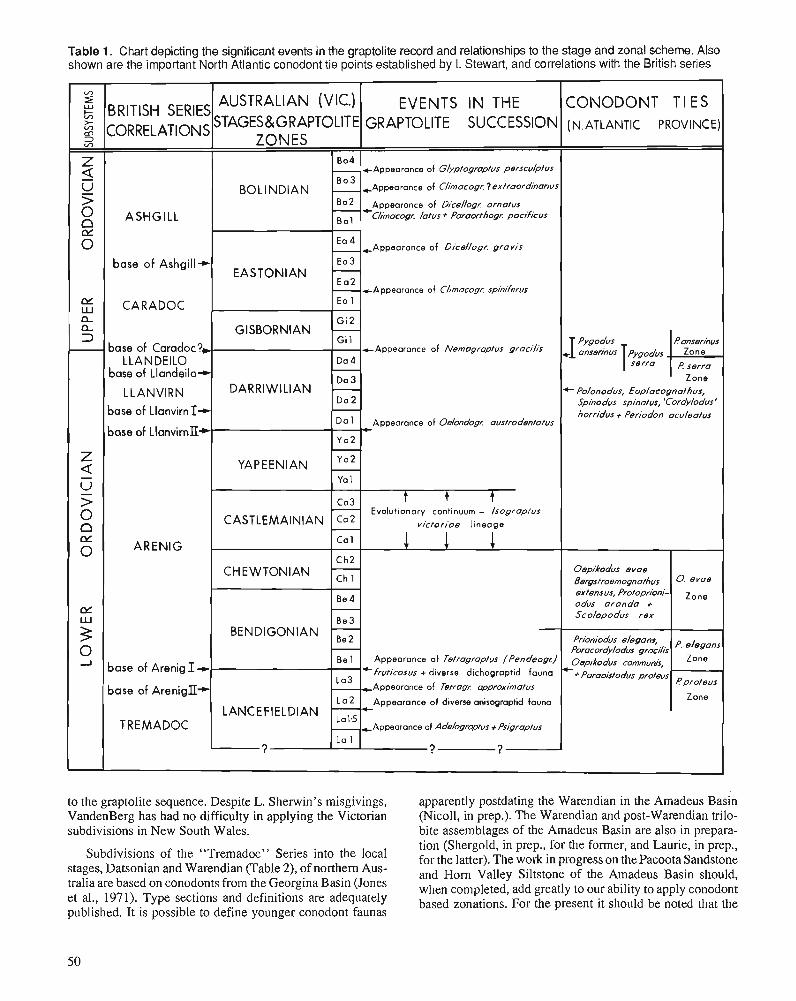
Table 1. Chart depicting the significant events in the graptolite record and relationships to the stage and zonal scheme. Also shown are the important North Atlantic conodont tie points established by I. Stewart, and correlations with the British series
to the graptolite sequence. Despite L. Sherwin's misgivings, apparently postdating the Warendian in the Amadeus Basin VandenBerg has had no difficulty in applying the Victorian (Nicoll, in prep.). The Warendian and post-Warendian trilo- subdivisions in New South Wales. bite assemblages of the Amadeus Basin are also in prepara-
Subdivisions of the "Tremadoc" Series into the local stages, Datsonian and Warendian (Table 2), of northern Aus- tralia are based on conodonts from the Georgina Basin (Jones et al., 1971). Type sections and definitions are adequately published. It is possible to define younger conodont faunas
tion ( ~ h e r ~ o l d , in prep., for the former, and Laurie, in prep., for the latter). The work in progress on the Pacoota Sandstone and Horn Valley Siltstone of the Amadeus Basin should, when completed, add greatly to our ability to apply conodont based zonations. For the present it should be noted that the
EVENTS IN THE GRAPTOLITE SUCCESSION
+ A p p e a r a n c e of Glyptograptus perscubtus
Appearance of Climacogr. ?ewtraordnorius
Appearance of Dice//ogr. ornutus 4-
Chocogr. /atus + Poroor/hogz pacificus
COWODONT TI E S ( N. ATLANTIC PROVINCE)
Ln ZE
m
5 3 v,
z 5 U 5 O s
anserinus pygodus +Ipygodus T serra
BRITISH SERIES CORRELATIONS
ASHGILL
0
a a 3
z a - u - > 0 n LY 0
CY Lu
3 0 J
AUSTRALIAN (VIC.) STAGES&GRAPTOLITE
ZONES
d anserinus Zo n e
E serro
BOLlNDlAN
604
B 0
Bo2
-
base of Ashgill+
CARADOC
base of Caradoc?, LLANDEILO
base of Llandeilo+
L L ANVIRN base of Llanvirn I-t base of LlanvirnlI*
ARENIG
base of Arenig I +.
base of AreniglI-
TREMADOC
Zone + Polonodus, Eoplocognafhus,
Spinodus spinotus, 'Cordylodus' horridus + Periodon aculeafus
Oepikodus evae Bergstroemognothus extensus, Protoprioni- odus oranda + Scolopodus rex
Prioniodus e/egans, Paracordy/odus gracilis oep;k0dus
C+Poraoisfo~us profeus
EASTONIAN
GlSBORNlAN
DARRlWlLlAN
YAPEENIAN
CASTLEMAINIAN
CHEWTONIAN
BENDIGONIAN
LANCEFIELDIAN
?
0 . eVO@
z
eelegans
Zone
Pprofeus
Zone
Ea 4
Ea 3 - E a 2
Ea 1
Gi 2 - Gi 1
Da 4 - D a 3 - Da 2 - D a 1
Y a 2 -
Ya 1
Ca3 - Ca2 - C a 1
C h 2
Be 4 - Be 3
- Be 1
lo3
L 0 2
Lal,5
La 1
, Appearance of Dicellogr. grovis
-+Appearance of Cl/macogr. spiniferus
+Appearonce of Nemagroptus gracilis
Appearance of Oehndagr. oustrodenfatus 4-
t t t Evolutionary continuum - /sograpfus
victoriae lineage
1 1 1
Appearance of Tetragraptus f Pendeogc)
*fruticosus + diverse dichograptid fauna
Appearance of Tetrag~ opproximofus
Appearance of diverse anisograptid fauna
Appearonce of Adelograpfus + Psigraptus
? ?
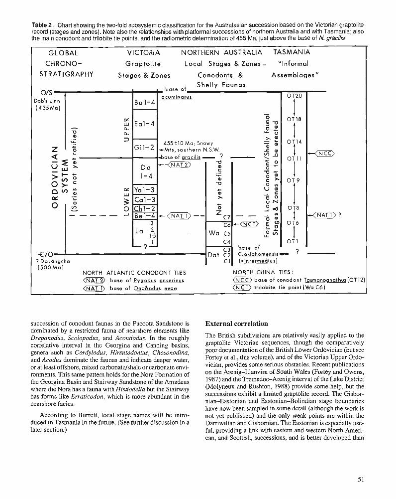
Table 2 . Chart showing the two-fold subsystemic classification for the Australasian succession based on the Victorian graptolite record (stages and zones). Note also the relationships with platformal successions of northern Australia and with Tasmania; also the main conodont and trilobite tie points, and the radiometric determination of 455 Ma, just above the base of N. gracilis
succession of conodont faunas in the Pacoota Sandstone is dominated by a restricted fauna of nearshore elements like Drepanodus, Scolopodus, and Acontiodus. In the roughly correlative interval in the Georgina and Canning basins, genera such as Cordylodus, Hirsutodontus, Chosonodina, and Acodus dominate the faunas and indicate deeper water, or at least offshore, mixed carbonatelshale or carbonate envi- ronments. This same pattern holds for the Nora Formation of the Georgina Basin and Stairway Sandstone of the Amadeus where the Nora has a fauna with Histiodella but the Stairway has forms like Erraticodon, which is more abundant in the nearshore facies.
GLOBAL VICTORIA NORTHERN AUSTRALIA TASMANIA
CHRONO- Grap to l i t e Local S t ages & Zones - "Informal
STRATIGRAPHY S t a g e s & Zones Conodonts & Assemblages"
According to Burrett, local stage names will be intro- duced in Tasmania in the future. (See further discussion in a later section.)
External correlation
The British subdivisions are relatively easily applied to the graptolite Victorian sequences, though the comparatively poor documentation of the British Lower Ordovician (but see Fortey et al., this volume), and of the Victorian Upper Ordo- vician, provides some serious obstacles. Recent publications on the Arenig-Llanvim of South Wales (Fortey and Owens, 1987) and the TremadooArenig interval of the Lake District (Molyneux and Rushton, 1988) provide some help, but the successions exhibit a limited graptolite record. The Gisbor- nian-Eastonian and Eastonian-Bolindian stage boundaries have now been sampled in some detail (although the work is not yet published) and the only weak points are within the Darriwilian and Gisbornian. The Eastonian is especially use- ful, providing a link with eastern and western North Ameri- can, and Scottish, successions, and is better developed than
BO 1-4
Eal-4
- Gi1-2
- - b a s e
Da 1-4
Yal-3
Ca l -3 Chl-2 Bel-4
3
L a 125 1
- ? -
01s A base of
Shelly Faunas
acuminatus
- 0 OT 18
4 5 5 t 1 0 M a ; Snowy +Mts, southern N.S.W. JZ a
of g& - ? -
Dob's Linn ( 4 35 M a )
<m> -
+<m>--
€10 ' rn
? Dayangcha
fx - 2 u n a . - Y . - 1)
2 5 4 -q : "J
> z : 0 >- a m ~ w
'i: 3 0 ," - 0 ---a- -'
( 5 0 0 M a ) NORTH ATLANTIC CONODONT TIES NORTH CHINA TIES: < w V base of Pygodus anserinus (N base of conodont Tasmano~nathus(OT12)
<-> base of Oepikodus evae <NCT) trilobite tie point ( W a C6)
w a c .- --,- a 73
Q) C
x + o
z C 7
Wa c 5
C 4 C3'
Da+ ~2 ~1
C 0 0 u
O T ~ - - -
0 : 1 -$mi>? C6'-
2 3j O T 1
base o f C,oklahornensis- ? (zintermedius)
the comparable interval in China and Russia. The Bolindian is also useful, filling what appears to be a gap in the Scottish sequence. The revisions of the British Upper Ordovician now allow correlation at almost zone level with confidence. This is much less so, however, in the Lower Ordovician where British graptolite faunas are less diverse and include endemic elements.
The coralline and shelly faunas of central New South Wales show provincial features which make it difficult to establish direct external correlation with British, North American or other regions. There is a strong link between "Caradoc" trilobite and brachiopod faunas of Kazakhstan and central New South Wales at the generic level, and in the brachiopods with the Scotc-Appalachian province, but all 49 brachiopod species described in Percival's (1980) Ph.D. the- sis are new, and more than one-third of the genera are en- demic. This means that correlation can be established in broad terms with North American stages (Blackriveran, Trentonian, Edenian, and Maysvillian) and with the Kazakhstan stages (Erkebidaik, Anderken, and Dulankara horizons).
All the trilobite species are new and a few genera are endemic. The closest faunal links are with Kazakhstan and southeast Asia. A less close connection exists with North America and northern Europe, making correlations with stages of these regions difficult. Similar problems exist with the corals and stromatoporoids.
The Tasmanian successions are mainly correlated with the North American cratonic sequences. The terms Ibexian and Whiterockian (including Chazyan) are relatively easily ap- plied. Cincinnatian (Series) can also be used but there are problems in the Blackriveran-Trentonian part of the sequence where macrofauna and microfauna tend to be endemic Aus- tralian/North Chinese, or even endemic Tasmanian (Burrett et al., 1983). With further documentation it may be possible to apply Chinese stages. Of particular interest, the Tasmanian conodont Tasmanognathus (Table 2) occurs also in northern China, and several Chinese conodont genera and species erected by An et al. (1983) are also found in the Amadeus, Canning, and Tasmanian sequences. However, the Tasma- nian species of Tasmanognathus, T. careyi, which occurs with Chirognathus monodactylus and Phragmodus sp. nov. in the "Lower Limestone Member" of the Benjamin Lime- stone, and occupies a position above Histiodella sinuosa and Phragmodusflexuosus, and below P. undatus, has not been confirmed outside Tasmania. Only different species of Tas- manognathus, possibly with somewhat different ranges, have so far been reported from North China.
The external correlation of the central and northern Australian platform sequences has depended on which fossil group is used. For example, for conodont-dominated assemblages, the Baltoscandian stages are employed; for graptolite-dominated horizons, the Victorian stages; for nautiloid occurrences, the North American subdivisions; and for the trilobite sequences, the informal subdivisions of the British Arenig and Llanvirn Series. However, it should be pointed out that trilobites in the lowermost
Ordovician(Tremadoc through lower Arenig) of these plat- form sequences are essentially similar, even to the species level in some instances, to faunas of eastern Asia, particularly the Sino-Korean Platform. Conodonts represent a mixture of North American Midcontinent and similar East Asian affini- ties at this time.
MAJOR FAUNAL EVENTS OF USE FOR EXTERNAL CORRELATION In the Australasian (mainly Victorian) graptolite facies, the following faunal events may be regarded as having signifi- cance for international correlation (Table 1); the first six events are recorded in Victoria and New Zealand successions, the remaining five events in Victoria only:
1. Appearance of Adelograptus and a diverse dendroid fauna in the La2 Zone of the Lancefieldian. Distinctive elements of this fauna useful for correlation include Dictyonema (Araneograptus) pulchellum, D. (A.) macgillivrayi, Ade- lograptus (Kiaerograptus) anriquus, A. (K.) pritchardi, Temnograptus, large clonograptids including the species rnagnificus, rigidus, tenellus, and flexilis, and Tetragrap- tus decipiens. The precise order of appearance of these forms has not been documented but they all make their first appearance over a relatively narrow stratigraphic interval. Similar faunas are recognized in western and eastern Canada, Norway, and Sweden.
2. Appearance of Tetragraptus (Paratetragraptus) approxi- matus. This distinctive species has a worldwide distribu- tion and is generally taken (e.g., Skevington, 1963) to mark the base of the Arenig Series. Often associated with T. (P.) approximatus is T. (P.) acclinans (or a related form).
3. Appearance af Tetragraptus (Pendeograptus) fruticosus and a diverse dichograptid fauna at the base of the Bendi- gonian (Be1 Zone). This is possibly the most easily rec- ognized horizon in the entire Australasian Ordovician, as it marks the appearance of the following genera: Go- niograptus, Loganograptus. Sigmagraptus, Trichograp- tus, Schizograptus, Trochograptus, Dichograptus, and Pendeograptus. In addition, several distinctive species of Didymograptus (s.l.), Tetragraptus (s.l.), Phyllograptus (s.~.), and Clonograptus make their appearance. The in- flux marks a major event in the development and evolu- tion of Ordovician graptolites, although the precise horizon of entry of T. (P.) fruticosus, with respect to that of other genera, is not yet documented.
4. Appearance of lsograptus victoriae or other datum within the I. victoriae lineage. The appearance of isograptids is a prominent feature of Lower Ordovician graptolite suc- cessions around the world. The succession of subspecies of I. victoriae, (lunatus-victoriae-maximus-maximodi- vergens) is one of the few evolutionary bioseries that has been statistically analyzed, making it exceptionally valu- able for precise correlation.
5. The appearance of Oelandograptus austrodentatus and other biserial forms at the base of the Darriwilian is a prominent event in Australasia and takes place in an interval during which there is a major change from a dichograptid-dominated fauna (Bendigonian to Yap- eenian) to a diplograptid (s.1.) dominated fauna (upper Darriwilian to Bolindian). However, the appearance of "biserial" scandent forms is not a sudden event. Some, such as glossograptids (Apiograptus, Paraglossograptus, and Pseudisograptus) appeared earlier, in the Yapeenian. Glossograptus itself does not appear quite at the base of Dal, and it is only in Da3 (a poorly documented interval probably divisible into several zones) that there is a real profusion of new diplograptaceans ("D". decoratus, "A". confertus, "A". differtus, "A". modicellus, and probably others). Nevertheless, the base of the Damwil- ian can be correlated on the basis of the appearance of the austrodentatus group (including the overseas subspecies 0. austrodentatus americanus, 0. a. oelandicus, 0 . a. sinodentatus, etc.).
6. The appearance of Nemagraptus gracilis at the base of the Gisbornian. Species of Dicellograptus and Dicranograp- tus appear at the top of the preceeding Darriwilian Zone Da4. In both Australia and New Zealand the appearance of dicellograptids is stratigraphically a well marked event, although relatively few species are involved. The appear- ance of Dicellograptus together with Dicranograptus has traditionally been taken as defining the base of the Gis- bornian Stage. In both Victoria (VandenBerg, in Webby et al., 1981) and New Zealand (Cooper, 1979), however, the worldwide zone fossil Nernagraptus gracilis appears at a later horizon, (contrary to the opinions of most earlier workers in the two regions), and Cas and VandenBerg (1988) have redefined the base of the Gisbornian Stage to coincide with the base of theN. gracilis Zone. The appear- ance of Dicellograptus and Dicranograptus is the most readily recognized event in the Australasian sequence but the appearance of N. gracilis is more reliable for precise international correlation. This has been discussed at length by Finney and Bergstrom (1986).
7. The appearance of Climacograptus spiniferus within the Eastonian (useful for correlation with northeastern North America and Scotland).
8. Appearance of Dicellograptus gravis (=D. alector) in the Ea4 Zone of the Eastonian (useful for correlation with western North America and Scotland).
9. Appearance of Paraorthograptus pacificus in a diverse fauna with Dicellograptus ornatus and Climacograptus latus (Bo2 Zone of the Bolindian).
10. The appearance of Glyptograptus extraordinarius in an impoverished fauna (Bo3 Zone of the Bolindian).
11. Appearance of Glyptograptus persculptus (now defining the topmost Bo4 Zone of the Bolindian).
There are a number of important conodont tie points that further enhance the usefulness of the Victorian graptolite scheme for external correlation (Table 1). Firstly, Stewart (in Cas and VandenBerg, 1988) has reported a mixed association of Bendigonian (Be1 Zone) graptolites at Dargo in Victoria with North Atlantic-type conodonts - occurrences of Para- cordylodus gracilis, Oepikodus communis, Prioniodus ele- guns, and Paroistodus proteus - allowing the Be1 Zone to be equated with the P. elegans Zone of the North Atlantic conodont province (Bergstrom, 1986). Secondly, there are Victorian graptolitic sequences ranging in age from Bendigo- nian (Be3 Zone) to Chewtonian (Ch2 Zone) with conodonts of the North Atlantic Oepikodus evae Zone - the fauna includes 0 . evae, Bergstroemognathus extensus, Protopri- oniodus aranda, and Scolopodus rex. Thirdly, Pygodus an- serinus, which partially overlaps the range of P. serra in the Victorian sequences, defines the North Atlantic-type cono- dont P. anserinus Zone, and extends from the upper part of the Hustedograptus (= Glyptograptus) teretiusculus Zone (Darriwilian, Da4 Zone) to the middle of the Nemagraptus gracilis Zone (Gisbornian, Gil Zone). It is associated with short-ranging graptolites including Dicellograptus divarica- tus and Reteograptus geinitzianus, as well as N. gracilis (Stewart, in Cas and VandenBerg, 1988).
The major faunal incomings recognized in the Upper Ordovician successions of central New South Wales - for example, first appearances of particular coral and stro- matoporoid groups - seem, in contrast, to have limited use- fulness in external correlation. There is evidence to suggest that some faunal elements, like the clathrodictyid stro- matoporoids, appeared first in shallow waters of the offshore, volcanic island arc complex of central New South Wales, and then dispersed slowly globally to other shallow water habi- tats, including the continental platforms (Webby, 1980, 1985).
There do not appear to be any major faunal events in the Tasmanian succession that prove to be useful for external correlation. However, there are some conodonts like Tasma- nognathus, as mentioned previously, which may prove to be of particular use for precise correlation (Table 2).
In the platform sequences of northern Australia there are also a series of faunal events which appear to be of particular value, as follows:
1. The incoming of the conodont Cordylodusproavus fauna, which initiates the Datsonian, can be widely correlated. However, it is now likely that the Cambrian-Ordovician boundary will be ratified internationally at a higher level, close to the base of, or within the upper Datsonian (C3) Zone of Cordylodus oklahomensis-C. lindstromi; i.e., as- sociated with a slightly later event, either the appearance of Cordylodus intermedius (within the C. oklahomensis Subzone of Miller, 1984) or of C. lindstromi (C.lindstromi Subzone of Miller, 1984).
2. The appearances of the scolopodids and chosonodinids, marking the beginning of the Warendian.
3. Although not adequately documented, but possibly of importance, are the first appearances of Histiodella, am- bonychiid bivalves, and the trilobite Carolinites. This latter is known to occur in central and western Queensland (Henderson, 1983; Fortey and Shergold, 1984), Tasmania (Jell and Stait, 1985), central Australia (Laurie, work in progress), northwestern Australia (Legg, 1976), and west- ern New South Wales (Wanis, 1969). Although more work needs to be done, it appears that most of the species of this genus are pandemic and will be useful for detailed intra- and intercontinental correlation.
4. The trend to gigantism in the faunas apparently occurs close to the "Arenig-Llanvirn" boundary. This is most noticeable in the bivalves, nautiloids, and trilobites of the middle Stairway Sandstone of the Amadeus Basin, and the Mithaka Formation of the Georgina Basin (Shergold, 1986). However, possible ecological factors need to be further assessed, as well as occurrences in other regions.
Unfortunately, the conodont faunas of central and north- em Australia are most closely related to North American Midcontinent faunas, not to North Atlantic provincial types. Consequently, the conodont zonation scheme developed in the graptolite facies of Victoria will not be that easily appli- cable to the Amadeus, Canning or Georgina basin succes- sions.
APPLICABILITY OF OVERSEAS SERIES NAMES IN AUSTRALASIA The British series are the most widely used of the overseas series schemes for correlation, particularly in the graptolite facies. For instance, they can be used with varying levels of ambiguity in the Victorian and New Zealand successions (Table 1):
1. The base of the Tremadoc cannot be located becauseit lies below the lowest planktic graptolites (Assemblage La2) of the region.
2. Correlation of the base of the Arenig depends on defini- tion of the Arenig in Britain. It is either at the base of the Tetragraptus approximatus Zone La3, where it is gener- ally taken (e.g., Skevington, 1963; Strachan, 1972; Moly- neux and Rushton, 1988), or approximating the base of the Bendigonian (Fortey, 1984; Fortey and Owens, 1987).
3. The base of the Llanvim has been defined recently at Llanfallteg, near Whitland in South Wales (Fortey and Owens, 1987), at the incoming of pendent didymograp- tids. They are preceded in the uppermost Arenig by the first biserial scandenf forms, including Undulograptus austrodentatus, which defines the base of the Darriwilian, so the best correlation is probably with the base of the Da2 Zone (see also Skevington, 1963), although the base of the Dal Zone has also been suggested (Cooper and Fortey, 1982, Figs. 2,3).
4. The base of the Llandeilo is customarily taken at the base of the Hustedograptus (= Glyptograptus) teretiusculus Zone, that is, at the base of the Darriwilian Da4 Zone.
5. The base of the Caradoc may correlate with the base of the Gisbornian as redefined by Cas and VandenBerg (1988) - however, the base of the Caradoc does not coincide, apparently, with the appearance of N. gracilis in British successions.
6. The improved correlation between the shelly and grapto- lite facies in Britain now allows much more accurate correlation of the Caradoc-Ashgill boundary with Victo- ria. Whittington et al. (1984) place this within the Pleuro- graptus linearis Zone. In Victoria the lowest occurrence of P, linearis is in the Ea3 Zone of Dicranograptus hians kirki. The Ea4 index fossil Dicellograptus gravis occurs at Ginan (Scotland) in limestones with a mixture of Pusgillian (lowermost Ashgill) shelly fossils and D. com- planatus Zone graptolites. Clearly, the base of the Ashgill correlates with a level within the Ea3 Zone of Victoria.
7. Traditionally the top of the Bolindian has been drawn below the level of the Glyptograptus persculptus Zone. However, now that the base of the Silurian (and base of the Llandovery) is established internationally at the base of the Akidograptus acuminatus Zone (Cocks, 1985), the G. persculptus Zone may be included as the topmost (Bo4) Zone of the Bolindian (VandenBerg and Webby, 1988).
The North American graptolite subdivisions established by Berry (1960) and Riva (1974) can also be applied in Victoria but unfortunately they cannot be correlated easily with the standard North American series, which are based on shelly faunas. Correlations with China and Scandinavia are only of limited use because of endemism in the respective graptolite faunas of these regions.
The British series are preferred in New South Wales, but can only be applied easily where associated graptolites occur. For instance, it is possible to establish the approximate posi- tion of the Caradoc-Ashgill boundary in the graptolitic Malongulli Formation of the Cliefden Caves area of central New South Wales (Webby and Packham, 1982; Rigby and Webby, 1988).
The North American series (and their subdivisions) are the most useful means of establishing external correlation of Tasmanian successions. Little direct correlation can be made with British series subdivisions. The Tremadoc, and less confidently, the Arenig and Ashgill can be used, but the Llanvirn through Caradoc interval cannot be applied as yet. This is mainly because none of the more useful trilobites and brachiopods, and few graptolites and conodonts, are in com- mon. The deeper slope Surprise Bay sequence in southern Tasmania can be correlated, but it cannot be closely related to other Tasmanian successions, which are of mainly shallow water aspect.
The British series are also not applied so easily to platform successions of northern Australia except where graptolites provide a datum. The Canning Basin has the most continuous graptolite record, through the Arenig to Llanvirn interval, but the sequences are of limited accessibility, since they are preserved mainly in the subsurface.
SUBSYSTEMIC DIVISIONS IN AUSTRALASIA A tripartite subdivision of the Ordovician has been widely used, following Harris and Thomas (1938). It has restricted the Middle Ordovician to the Darriwilian stage only, and consequently has meant that the terms Lower, Middle and Upper do not coincide with any of the several other subsys- temic schemes in use around the world. The disparity in use between these tripartite schemes has commonly led to confu- sion and is most undesirable. VandenBerg (in Webby et al., 1981, and in Cas and VandenBerg, 1988) noted that prior to Harris and Thomas' (1938) subdivision, Middle Ordovician was not used in Victoria, and he has recommended a reversion to the former two-fold subdivision of Lower and Upper, the boundary being placed at the base of the Gisbornian, that is, at the base of the N. gracilis Zone (Tables 1,2). This subdi- vision is also recommended for New South Wales, Queens- land, and New Zealand successions. It is important that the subsystemic division of the Ordovician be standardized around the world, and we recommend that this horizon and subdivision be adopted globally.
Although it has been traditional to use a tripartite subdi- vision in the platform sequences of northern Australia, the usage has depended on what fossil groups were being em- ployed as controls. It is now suggested that a two-fold subdi- vision should also apply. At present the faunal record suggests that only Lower Ordovician (formerly Lower and Middle Ordovician) deposits are represented, although there are, in some sections (e.g., in the Amadeus Basin, Shergold, 1986), substantial thicknesses of unfossiliferous beds above the last age-diagnostic fossil assemblage, which may imply that the sedimentary record continues partly into the Upper Ordovician.
. In Tasmania, Lower, Middle, and Upper have been used approximately as in North America, that is, the Lower = Canadian (now Ibexian), the Middle = Champlainian (Whit- erockian and Mohawkian), and the Upper = Cincinnatian. This subdivision is therefore quite different from that em- ployed in Victoria, and elsewhere in Australia and New Zealand. It seems essential therefore that if an acceptable, unified, bipartite subsystemic subdivision of the Ordovician of Australasia is to be achieved, with its boundary at the base of N. gracilis, then this level must be recognized also in Tasmania. Perhaps this can be done 1) by establishing closer zonal ties through the boundary interval, with other sequences exhibiting mixed graptolite, shelly and coralline facies, like those in central New South Wales, or 2) by recognizing links between the Tasmanian conodont succession, especially through the interval containing Tasmanognathus, and equiva- lent mixed conodont and graptolite facies of North China.
LOCAL STAGES OR A SINGLE STAGE CLASSIFICATION FOR AUSTRALASIA A single stage classification is thought by most respondents to be desirable but probably impractical because the cratonic sequences have so little in common with the mainly graptolitic successions of the Tasman Fold Belt, and New Zealand. One
contributor, however, argues that a single stage classification is not desirable since it is likely to obscure geological events. At this present stage of development of the Ordovician bios- tratigraphy of Australasia, it is probably useful to establish a number of local stage schemes in order to correlate the various platfomal, as well as basinal, successions. Local conodont-based stages (the Datsonian and Warendian) have been introduced in northem Australian platform areas, and this scheme will probably be extended upward to cover almost the entire Lower Ordovician (Tremadoc-Llanvim) interval. There is also a proposal by Burrett to introduce an independent set of local stages, based on the Florentine Val- ley sequence, for correlation of the "middle Tremadoc-Llan- dovery" interval in Tasmania. It is to be hoped that the definitions of these new local stages will be accompanied by the fullest possible documentation of the contained biotas, and that they will have more than local application.
If, alternatively, we choose only to maintain a single stage classification, it would undoubtedly be based on the Victorian graptolite scheme. However, this could not be seriously con- templated unless we were able to establish many more faunal ties to the shelly faunal and conodont-based platform schemes, even if the Victorian scheme became adopted as the international standard for the areas of the world exhibiting graptolitic successions of Pacific provincial type.
SINGLE INTERNATIONAL OR LOCAL SERIES CLASSIFICATION FOR AUSTRALASIA If the British series are more adequately defined than at present, they may provide a workable subdivision for use in Australasia. However, they must be designated within bound- ary stratotypes in continuous sections, so that they can be clearly and unambiguously applied, through the graptolite facies, to successions in Australasia. It seems highly desirable that a single series classification be adopted in Australasia, and the British subdivisions are on balance probably the best available. The only viable alternative could be to establish new Australasian series.
PHYSICAL CRITERIA FOR USE AS TIME MARKERS There is little stratigraphically controlled geochronological data presently available for the Australasian region. The K/Ar age of 455 k 10 Ma on the Doubtful River Gabbro in the Snowy Mountains area of southern New South Wales (Owen and Wyborn, 1979) is one of the few useful determinations (Table 2). This sill-like structure intruded the upper Darriwil- ian-lower Gisbornian Temperance Formation prior to its complete lithification. It is related to the overlying Nine Mile Volcanics, which in its upper part has an upper Gisbornian graptolite assemblage and a solitary rugose coral, establishing its upper limits, and thus suggesting that the intrusive event occurred about the middle of the Gisbornian. This is about one graptolite zone younger than the level of the proposed
Lower-Upper Ordovician subsystemic boundary. There is currently no available magnetostratigraphic or chemostratig- raphic data for the Australasian region.
GENERAL RECOIVIMENDATIONS 1. That .we need to formally designate the various stage
boundaq stratotypes for the Victorian graptolite succes- sion.
2. That we should focus immediate attention on the grapto- lites and the conodonts, particularly their ranges in Aus- tralasian successions.
3. That we should aim to establish precise ties between zonal indices - between North Atlantic-type conodonts and Pacific-type graptolites, and between North Atlantic and North American Midcontinent province conodonts in Australia and New Zealand, and secondarily to achieve the closest possible conodont and graptolite ties with China and other regions of central and southeastern Asia.
4. That we recommend establishing a two-fold subsystemic division of the Ordovician, with the base of Nenzagraptus gracilis defining the base of the upper division.
5. That following definition of stratotypes and establishment of closest possible ties with conodont zonal indices, we propose the Victorian succession as the international standard for use in regions of the world exhibiting Pacific provincial-type graptolites.
6. That in establishing additional local stage schemes, for the post-Warendian interval of. platform areas of northern Australia, and possibly through the Ordovician of Tasma- nia, we should aim at providing fullest possible docurnen- tation of biotas, and of correlation with existing local stage schemes.
REFERENCES An Taixiang, Zhang Fang, Xiang Weida, Zhang Youqui, Xu Wenhao, Zhang Huijuan, Jiang Debiao, Yang Changsheng, Lin Liandi, Cui Zhangtang, and Yang Xinchau. 1983: The conodonts of North China and the adjacent regions. Science
Press, Beijing, 223 p. (in Chinese with English abstract) Banks, M.R. and Burrett, C.F. 1980: A preliminary Ordovician bioshatigraphy of Tasmania. Journal of
the Geological Society of Australia, v. 26, p. 363-376. Bergstrom, S.M. 1986: Biostratigraphic integration of Ordovician graptolite and conodont
zones - a regional review. In Palaeobiology and Biostratigraphy of Graptolites, R.B. Rickards and C.P. Hughes (eds.); Blackwell Sci- entific, Oxford, p. 61-78. (Geological Society of London, Special Publication, 20.)
Berry, W.B.N. 1960: Graptolite Faunas of the Marathon Region, West Texas. Bureau of
Economic Geology, University of Texas, Publication 6005, 179 p. Burrett, C.F., Stait, B., and Laurie, J. 1983: Trilobites and microfossils from the Middle Ordovician of Surprise
Bay, southern Tasmania, Australia. Memoir of the Association of Australasian Palaeontologists, v. I, p. 177-1 93.
Cas, R.A.F. and VandenBerg, A.H.M. 1988: Ordovician. In Geology of Victoria, Revised Edition, J.G. Douglas
and J.A. Ferguson (eds.); Victorian Division of the Geological Society of Australia, p. 63-102.
Cocks, L.R.M. 1985: The Ordovician-Silurian boundary. Episodes, v. 8, p. 98-100. Cooper, R.A. 1979: Lower Palaeozoic rocks of New Zealand. Journal of the Royal
Society of New Zealand, v. 9, p. 29-84. Cooper, R.A. and Fortey, R.A. 1982: The Ordovician graptolites of Spitsbergen. Bulletin of the British
Museum (Natural History), Geology, v. 36, p. 157-302. Druce, E.C. and Jones, P.J. 1971: Cambro-Ordovician conodonts from the Burke River Structural
Belt, Queensland. Bulletin of the Bureau of Mineral Resources, Geology and Geophysics, Australia, v. 1 10, p. 1-158.
Druce, E.C., Shergold, J.H., and Radke, B.M. 1982: A reassessment of the Cambro-Ordovician boundary section at
Black Mountain, western Queensland, Australia. In The Cambrian Ordovician Boundary, M.G. Bassett and W.T. Dean (eds.); National Museum of Wales, Geological Series, v. 3, p. 193-209.
Finney, S.C. and Bergstrom, S.M. 1986: Biostratigraphy of the Ordovician Nemajirapius gracili.~ Zone. In
Palaeoecology and Biostratigraphy of Graptolites, C.P. Hughes and R.B. Rickards (eds.); Geological Society, Special Publication no. 20, p. 47-59.
Fortey, R.A. 1984: Global earlier Ordovician transgressions and regression and their
biological implications. In Aspects of the Ordovician, D.L. Bruton (ed.); Universitetsforlaget, Oslo, p. 37-50.
Fortey, R.A. and Owens, R.M. 1987: The Arenig Series in South Wales. Bulletin of the British Museum
(Natural History), Geology, v. 41, p. 69-307. Fortey, R.A. and Shergold, J.H. 1984: Early Ordovician trilobites, Nora Formation, cenhal Australia. Pa-
laeontology, v. 27, p. 315-366. Hall, T.S. 1899: The graptolite-bearing rocks of Victoria, Australia. Geological
Magazine, v. 46, p. 438-451. Harris, W.J. and Thomas, D.E. 1938: A revised classification and correlation of the Ordovician graptolite
beds of Victoria. Victorian Mining and Geological Joumal, v. I, no. 3, p. 62-72.
Henderson, R.A. 1983: Early Ordovician faunas from the Mount Windsor Subprovince,
northeastern Queensland. Memoirs of the Association of Australa- sian Palaeontologists, v. I, p. 145-175.
Jell, P.A. and Stait, B. 1985: Tremadoc trilobites from the Florentine Valley Formation, Tini
Shea area, Tasmania. Memoirs of the Museum Victoria, v. 46, p. 1-34.
Jones, P.J., Shergold, J.H., and Druce, E.C. 1971 : Late Cambrian and Early Ordovician stages in western Queensland.
Journal of the Geological Society of Australia, v. 18, p. 1-32. Legg, D.P. 1976: Ordovician hilobites and graptolites from the Canning Basin, West-
em Australia. Geologica et Palaeontologica, v. 10, p. 1-37. Lenz, A.C. 1988: Ordovician Series/Stages, graptolitic basinal facies, northern Yu-
kon. Bulletin of the New York State Museum, v. 462, p. 59-64. McTavish, R.A. and Legg, D.P. 1976: The Ordovician of the Canning Basin, western Australia. In The
Ordovician System, M.G.Bassea (ed.); University of Wales Press and the National Museum of Wales, Cardiff, p. 447-478.
Miller, J.F. 1984: Cambrian and earliest Ordovician conodont evolution, biofacies,
and provincialism. Geological Society of America, Special Paper 196, p. 43-68.
Molyneux, S.G. and Rushton, A.W.A. 1988: The age of the Watch Hill Grits (Ordovician), English Lake District:
struckral and palaeogeographical implications. ~ransactions of the Royal Society of Edinburgh, Earth Sciences, v. 79, p. 43-69.
Nicoll, R.S: -
1980: Middle Ordovician conodonts from the Pittma~i Formation. Can- berra, A.C.T. Bureau of Mineral Resources Journal, v. 5, p. 150-153.
Owen, M. and Wyborn, D. 1979: Geology and geochemistry of the Tantangara and Brindabella area.
Bulletinofthe Bureau of MineralResources, Geology andGeophys- ics, Australia, v. 204, p. 1-52.
Percival, I.G. 1980: Ordovician brachiopods of Ncw South Wales. Unpublished Ph.D.
thesis, University of Sydney, 354 p. Rigby, J.K. and Webby, B.D. 1988: Late Ordovician sponges from the Malongulli Formation of central
New South Wales, Australia. Palaeontographica Americana, v. 56, p. 1-147.
Riva, J.A. 1974: A revision of some Ordovician graptolites of eastem North Amer-
ica. Palaeontology, v. 17, p. 1-40. Shergold, J.H. 1986: Review of the Cambrian and Ordovician palaeontology of the
Amadeus Basin, central Australia. Report of the Bureau of Mineral Resources, Geology and Geophysics, Australia, v. 276, p. 1-21.
Skevington, D. 1963: A correlation of Ordovician graptolite-bearing sequences. Geolo-
giska Foreningens i Stockholln Forhandlingar, v. 85, p. 298-319. Strachan, I. 1972: Correlation of British and Australian graptolite zones. Geological
Society of London, Special Report no. 3, p. 10-14. Strusz, D.L., Webby, B.D., Pickett, J.W., and Wright, A.J. 1988: Ordovician, Silurian and Devonian Corals and Spongiomorphs of
Central New South Wales. Fifth International Symposium on Fossil Cnidaria including Spongiomorphs, Excursion A3, Guidebook.
Thomas, D.E. 1935: Ordovician. In Outline of the Physiography and Geology of Victo-
ria, E.W. Skeats (ed.); Australian and New Zealand Association for the Advancement of Science Handbook for Victoria, Melbourne University Press, p. 96-105.
1960: The zonal distribution of Australian graptolites. Journal and Pro- ceedings of the Royal Society of New South Wales, v. 94, p. 1-58.
Thomas, D.E. and Keble, R.A. 1933: The Ordovician and Silurian rocks of the Bulla-Sunbury area, and
discussion of the sequence of the Melbourne area. Royal Society of Victoria, Proceedings, v. 45, p. 33-84.
VandenBerg, A.H.M. and Webby, B.D. 1988: Ordovician-Silurian boundary in Victoria and New South Wales,
Australia. Bulletin of the British Museum (National History), (Ge- ology), V. 43, p. 183-190.
Warris, B.J. 1969: The Mt. Arrowsmith area. In The Geology of New South Wales,
G.H. Packham (ed.); Journal of the Geological Society of Australia, v. 16, p. 69,70.
Webby, B.D. 1969: Ordovician stromatoporoids from New South Wales. Palaeontol-
ogy, v. 12, p. 637-662. 1974: Upper Ordovician hilobites from central New South Wales. Palae-
ontology, v. 17, p. 203-252. 1975: Succession of Ordovician coral and stro~natoporoid faunas from
central-western New South Wales, Australia. In Drevniye Cnidaria, (ed.); Vol. II, Nauka, Novosibirsk, p. 57-68.
1980: Biogeography of Ordovician strolnatoporoids. Palaeogcography, Palacoclimatology, Palaeoecology, v. 32, p. 1-19.
1985: Influence of a &manide island-arc on the evolutionary develop- ment of Ordovician faunas. Records of the Geological Survey of New Zealand, v. 9, p. 99-101.
Webby, B.D. and Nicoll, R.S. 1989: Australian Phanerozoic Timescales 2 -Ordovician biostratigraphic
chart and explanatory notes. Bureau of Mineral Resources, Ausha- lia, Record 1989132, p. 1-42.
Webby, B.D. and Packham, G.H. 1982: Stratigraphy and regional setting of the Cliefden Caves Limestone
Group (Late Ordovician), central-western New South Wales. Jour- nal of the Geological Society of Australia, v. 29, p. 297-317.
Webby, B.D., Cooper, R.A., VandenBerg, A.H.M., Nicoll, R.S., Stewart, I., Shergold, J.H., Burrett, C.F., Stait, B., and Cooper, B.J. 1988: Towards an Ordovician biostratigraphy of Australia: a progress
report. Abstract, Ninth Australian Geological Convention, Geologi- cal Society of Australia, v. 21, p. 414-415.
Webby, B.D., VandenBerg, A.H.M., Cooper, R.A., Banks, M.R., Burrett, C.F., Henderson, R.A., Clarkson, P.D., Hughes, C.P., Laurie, J., Stait, B., Thomson, M.R.A., and Webers, G.F. 198 1: The Ordovician System in Australia, New Zealand and Antarctica:
correlation chart and explanatory notes. International Union of Geological Sciences Publication, v. 6, p. 1-64.
Whittington, H.B., Dean, W.T., Fortey, R.A., Rickards, R.B., Rush- ton, A.W.A., and Wright, A.D. 1984: Definition of the Tremadoc Series and the series of the Ordovician
System in Britain. Geological Magazine, v. 121, p. 17-33. Williams, S.H. and Stevens, R.K. 1987: Summary account of the Lower Ordovician (Arenig) graptolite
biostratigraphy of the Cow Head Group, western Newfoundland. Bulletin of the Geological Society of Denmark, v. 35, p. 259-270.
' B.D. Webby, Department of Geology and Geophysics, University of Sydney, New South Wales, 2006 A.H.M. VandenBerg, Department of Industry, Technology and Resources, P.O. Box 173, East Melbourne, - . -.
Victoria, 3002 R.A. Cooper, New Zealand Geological Survey, P.O. Box 30368, Lower Hutt, New Zealand I. Stewart, Department of Zoology, Monash University, Clayton, Victoria, 3168 J.H. Shergold, Bureau of Mineral Resources, Geology and Geophysics, P.O. Box 378, Canberra, A.C.T., 2601 R.S. Nicoll, Bureau of Mineral Resources, Geology and Geophysics, P.O. Box 378, Canberra, A.C.T., 2601 C.F. Burrett, Department of Geology, University of Tasmania, G.P.O. Box 252C, Hobart, Tasmania, 7001 B. Stait, Parliamentary Library, Parliament House, Hobart, Tasmania, 7000 B.J. Cooper, Department of Industry, Trade and Technology, G.P.O. Box 1019, Adelaide, South Australia, 5001 J. Laurie, Bureau of Mineral Resources, Geology and Geophysics, P.O. Box 378, Canberra, A.C.T., 2601 L. Sherwin, Department of Mineral Resources, P.O. Box 53, Orange, New South Wales, 2800

New graptolite and lithostratigraphic evidence from the Cincinnati region, U.S.A., for the definition and correlation of the base of the Cincinnatian Series (Upper Ordovician)
Charles E. Mitchell1 and Stig M. Bergstrod
Mitchell, C.E. and Bergstrom, S.M., New graptolite and lithostratigraphic evidence fiom the Cincinnati region, U.S.A., for the definition and correlation of the base of the Cincinnatian Series (Upper Ordovician); in Advances in Ordovician Geology, C.R. Barnes and S.H. Williams (ed.), Geological Survey of Canada, Paper 90-9, p. 59-77,1991.
Abstract
Recent study of several drill cores and surface sections has produced significant new biostratigraphic and lithostratigraphic data from the uppermost Middle Ordovician (Mohawkian Series) and lowermost Upper Ordovician (Cincinnatian Series) in the Cincinnati region, the type area of the Cincinnatian Series. A succession of diverse graptolite faunas recently discovered within the Sebree Trough permits correlation with the New York-Quebec Utica Shale graptolite zonation. The base of the Cincinnatian lies within the Climacograptus (Diplacanthograptus) spinifems Zone, 23 to 26 m below the base of the superjacent Geniculograptus pygmaeus Zone in sections along a I50 km traverse from easterrt Indiana to southern Ohio and northern Kentucky. The conodont biostratigraphy is in general agreement with that based on graptolites.
Examination of temporal morphological trends exhibited by Geniculograptus typicalis and G. pygmaeus through two sections provides supporting evidence for the proposed correlations. Detailed study of geophysical logs suggests that it is possible to recognize, and trace across the Cincinnati region, stratigraphic intervals as little as 5 to 10 m thick. These lithological correlations produce units that parallel a series of K-bentonite beds and correlations based on graptolites and conodonts. Thus, the sequence studied along much of our traverses has a "layer-cake" stratigraphy of considerable lateral uniformity, particularly in the Kope Formation and the Lexington Limestone.
De nouvelles donne'es biostratigraphiques et lithostratigraphiques importances sont tirtes de l'e'tude rtcente de plusieurs carottes de forage et coupes de surface provenant de la partie sommitale de l'ordovicien moyen (se'rie du Mohawkien) et de la partie basale de l'ordovicien supkrieur (se'rie du Cincinnatien) pr2s de Cincinnati, re'gion type de la skrie du Cincinnatien. Grdce d la dtcouverte re'cente d'une succession de faunes h graptolites varie'es dans la cuvette de Sebree, il est pqssible d'e'tablir une corrtlation avec la zonation des graptolites des schistes argileux d'Utica dans I'Etat de New York et la province de Qutbec. La base du Cincinnatien se situe dans la zone ci Climacograptus (Diplacanthograptus) spiniferus, soit 23 b 26 m sous la base de la zone susjacente. h Ge?iculograptus pygmaeus, dans des coupes le long d'une traverse de 150 km allant de la partie est de I'Etat d'lndiana jusque dans le sud de /'Ohio et le nord du Kentucky. La biostratigraphie des conodontes s'accorde ge'ne'ralement avec celle des graptolites.
L'examen des tendances morphologiques temporelles que prksentent Geniculograptus typicalis et G. pygmaeus dans deux coupes, fournit des indices b l'appui des corre'lations propose'es. L'e'tude de'taillte de diagraphies ge'ophysiques porte h croire qu'il est possible de reconnaitre des intervalles stratigraphiques
1 Department of Geology, State University of New York at Buffalo, Buffalo, New, York 14260, U.S.A. Department of Geological Sciences, The Ohlo State Unlverslty, Columbus, Ohlo 43210, U.S.A.
qui n'ont que 5 b 10 rn d'tpaisseur, et de les retracer b travers la rtgion de Cincinnati. Ces corrklations lithologiques produisent des unitts qui sont parall2les b une skrie de lits de bentonite potassique et d'unitts fondtes sur des graptolites et des conodontes. La stquence ttudie'e sur une grande partie de nos traverses prbente donc une stratigraphie ccttage'eu qui a une grande uniformite' lattrale, notamment duns la formation de Kope et le calcaire de Lexington.
INTRODUCTION In recent years, considerable effort has been devoted to the establishment of a set of global series for the Ordovician System. Although some progress has been achieved, the many problems associated with building a standard set of divisions from a disparate group of regional series remain to be solved. Providing precise definitions for bases of the existing Ordovician series in terms of zonations useful for intercontinental correlation is one of the fundamental steps that must be taken. This step is particularly difficult in the case of those series, such as the Cincinnatian Series, that are defined in shallow water epicratonic sequences dominated by largely endemic shelly fossil assemblages. This paper pre- sents new data obtained in our efforts to integrate the Cincin- natian Series, which is the North American standard for the Upper Ordovician, with regionally recognizable graptolite and conodont zonal units.
Although no formal stratotype has been designated for the Cincinnatian Series, its base coincides with that of the Ede- nian Stage. Traditionally, the base of the Edenian is placed at the base of the Kope Formation (formerly known as the Eden Shale) in the vicinity of the city of Cincinnati, Ohio. How- ever, this lithostratigraphic boundary is not readily definable in terms of shelly fossil zones useful for interregional corre- lation. Furthermore, this level is no longer exposed in or near Cincinnati. Nevertheless, work on conodonts and other fos- sils is improving the situation. Sweet and Bergstrom (1971, 1976) and Sweet (1979, 1984, 1988) suggested, on the basis of conodont studies, that the base of the Edenian Stage is correlative with the base of the Cobourg Limestone, as devel- oped in the Mohawk Valley of New York, the region of the reference standard for the upper Middle Ordovician Trenton Group and the Mohawkian Series. Riva (1969a, 1974) and Rickard (1973) suggested that the base of the Climcograptus (Diplacanthograptus) spiniferus Zone in the Utica Shale of New York and Quebec also is probably coeval with the base of the Cobourg Limestone in the Mohawk Valley. This con- clusion is further supported by Cisne and Chandlee (1982), based on tracing of bentonite beds between Trenton Falls and the Mohawk Valley. In a recent regional subsurface study, Bergstrom and Mitchell (1989) concluded that the base of the Cincinnatian is coeval with a level in the basal 6.5 to 10 m of the Cobourg Limestone of New York. Thus, the position of the base of the Cincinnatian Series is still not precisely known within the eastern North American graptolite succession. In order to facilitate intercontinental correlation, we would pre- fer to have a more direct biostratigraphic definition of the base
Figure 1. Sketch-map showing location of drilling sites and surface sections examined in the present study. Stippled pattern denotes outcrop area of Ordovician rocks in the Cin- cinnati region. Straight dotted lines between localities are traverses illustrated in Figures 10 and 11. Localities are a s follows: NP, New Point well (Indiana Geological Survey Drill Hole 124), Decatur Co., lndiana (Gray, 1972, Fig. 9; Sweet, 1979, p. G24); CF, Cook Farm well (Indiana Geological Survey Drill Hole 57), Wayne Co., lndiana (Gray, 1972, Fig. 7); B, Beiser well, Butler Co., Ohio (Stith, 1986, PI. 2 [Permit No. 21); M, Middletown well, Butler Co, Ohio (Bergstrom and Sweet, 1966; Sweet, 1979, p. G23; Stith, 1986, PI. 2 [Permit No. 41); Crosby well, Hamilton Co., Ohio (Ohio Geological Survey, unpublished); BS, Brent section, Campbell Co., Ken- tucky (Hoge, 1985); CO, Cominco American well, Mason Co., Kentucky (Sweet et al., 1974; Sweet, 1979, p. G24; Stith, 1986, PI. 3); MA, Maysville section, Mason Co., Kentucky (Carpenter and Ory, 1961; Evans, 1981; Bergstrom and Mitchell, 1986); D, Dravo well, Alpha Portland Cement Com- pany, Mason Co., Kentucky (Ohio Geological Survey, unpub- lished); RS, section along Hwy 68 just northeast of Ripley, Brown Co., Ohio (Rytel, 1982); P, Penn well, Highland Co., Ohio (Stith, 1986, PI. 2, section D [Permit No. 41); W, Wash- ington well, Warren Co., Ohio (Stith, 1986, PI. 2 [Permit No. 81); CC, Clear Creek well, Warren Co., Ohio (Stith 1986, PI. 2 [Permit No. 71). The lndiana cores are kept at the lndiana Geological Survey, Bloomington, Indiana, and the Ohio cores at the Ohio Division of the Geological Survey, Columbus, Ohio. The Cominco core and one half of the New Point core are stored at the Department of Geological Sciences, The Ohio State University, Columbus, Ohio.
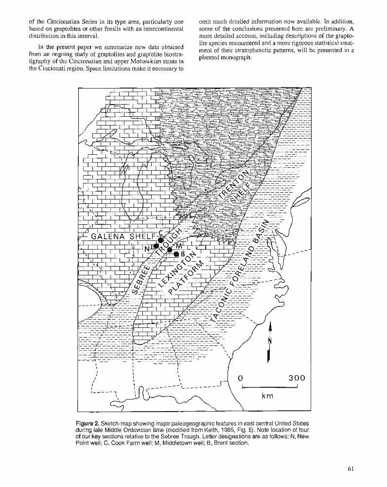
of the Cincinnatian Series in its type area, particularly one omit much detailed information now available. In addition, based on graptolites or other fossils with an intercontinental some of the conclusions presented here are preliminary. A distribution in this interval. more detailed account, including descriptions of the grapto-
lite species encountered and a more rigorous statistical treat- In the present paper we summarize new data obtained ment of their stratophenetic patterns, will be presented in a
from an ongoing study of graptolites and graptolite biostra- planned monograph. tigraphy of the Cincinnatian and upper Mohawkian strata in the dlincinnati region. Space limitations make it necessary to
Figure 2. Sketch-map showing major paleogeographic features in east central United States during late Middle Ordovician time (modified from Keith, 1985, Fig. 5). Note location of four of our key sections relative to the Sebree Trough. Letter designations are a s follows: N, New Point well; C, Cook Farm well; M , Middletown well; B, Brent section.
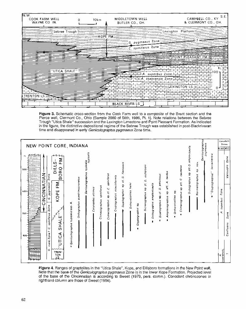
Figure 3. Schematic cross-section from the Cook Farm well to a composite of the Brent section and the Pierce well, Clermont Co., Ohio (Sample 2080 of Stith, 1986, PI. 1). Note relations between the Sebree Trough "Utica Shale" succession and the Lexington Limestone and Point Pleasant Formation. As indicated in the figure, the distinctive depositional regime of the Sebree Trough was established in post-Blackriveran time and disappeared in early Geniculograptus pygmaeus Zone time.
Figure 4. Ranges of graptolites in the "Utica Shale", Kope, and Dillsboro formations in the New Point well. Note that the base of the Geniculograptus pygmaeus Zone is in the lower Kope Formation. Projected level of the base of the Cincinnatian is according to Sweet (1979, pers. comm.). Conodont chronozones in righthand column are those of Sweet (1984).
Ln
NEW POINT CORE, INDIANA K * 3 ? 2 5 9 0 0 2 5 .O .$ : ,?
4 P .s ? : - V) - Q
$ - 2 P N I
Conodont
N.Atl
0
!j
YI 3
9 P YI
T
.--- 2 c
m ,.
zones
M.C.
e 0 N
.?! 2 3 2
----
0
0 N
VI
0 s 0 U
+.
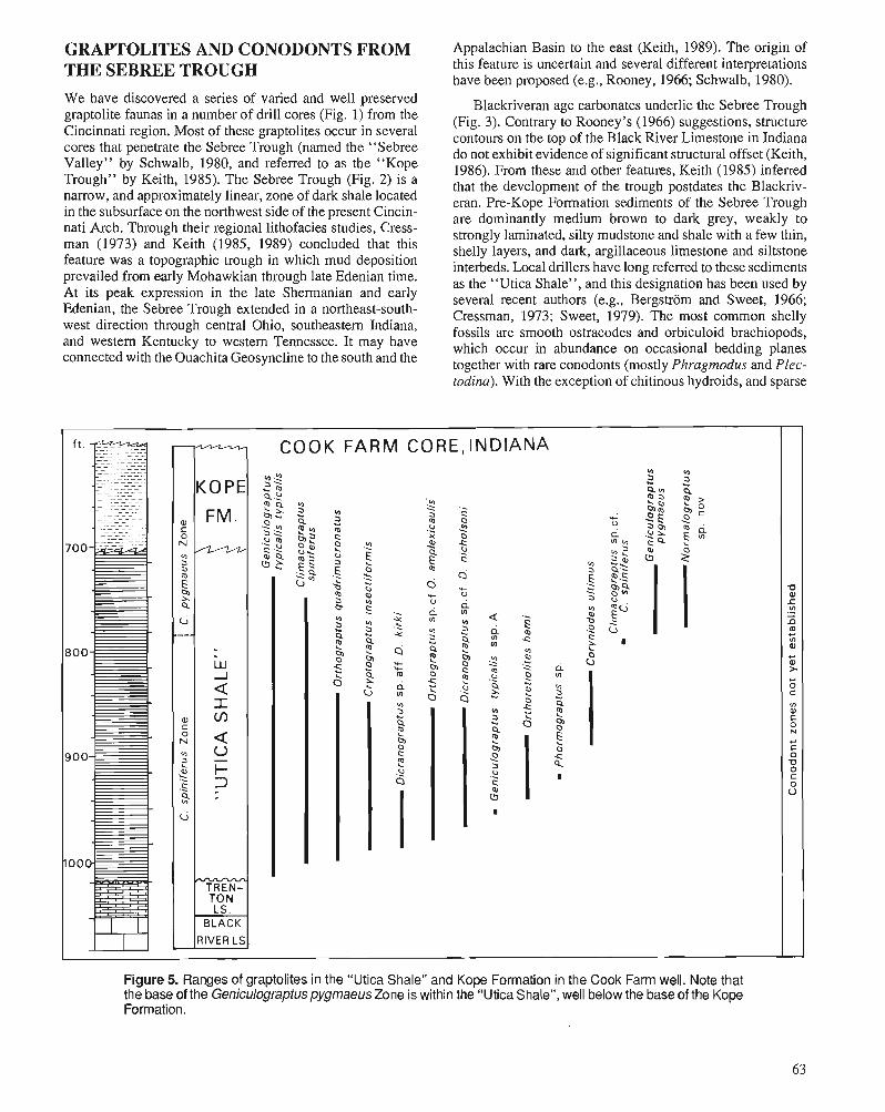
GRAPTOLITES AND CONODONTS FROM Appalachian Basin to the east (Keith, 1989). The origin of
THE SEBREE TROUGH We have discovered a series of varied and well preserved graptolite faunas in a number of drill cores (Fig. 1) from the Cincinnati region. Most of these graptolites occur in several cores that penetrate the Sebree Trough (named the "Sebree Valley" by Schwalb, 1980, and referred to as the "Kope Trough" by Keith, 1985). The Sebree Trough (Fig. 2) is a narrow, and approximately linear, zone of dark shale located in the subsurface on the northwest side of the present Cincin- nati Arch. Through their regional lithofacies studies, Cress- man (1973) and Keith (1985, 1989) concluded that this feature was a topographic trough in which mud deposition prevailed from early Mohawkian through late Edenian time. At its peak expression in the late Shermanian and early Edenian, the Sebree Trough extended in a northeast-south- west direction through central Ohio, southeastern Indiana, and western Kentucky to western Tennessee. It may have connected with the Ouachita Geosyncline to the south and the
this feature is uncertain and several different interpretations have been proposed (e.g., Rooney, 1966; Schwalb, 1980).
Blackriveran age carbonates underlie the Sebree Trough (Fig. 3). Contrary to Rooney's (1966) suggestions, structure contours on the top of the Black River Limestone in Indiana do not exhibit evidence of significant structural offset (Keith, 1986). From these and other features, Keith (1985) inferred that the development of the trough postdates the Blackriv- eran. Pre-Kope Formation sediments of the Sebree Trough are dominantly medium brown to dark grey, weakly to strongly laminated, silty mudstone and shale with a few thin, shelly layers, and dark, argillaceous limestone and siltstone interbeds. Local drillers have long referred to these sediments as the "Utica Shale", and this designation has been used by several recent authors (e.g., Bergstrom and Sweet, 1966; Cressman, 1973; Sweet, 1979). The most common shelly fossils are smooth ostracodes and orbiculoid brachiopods, which occur in abundance on occasional bedding planes together with rare conodonts (mostly Phragmodus and Plec- todina). With the exception of chitinous hydroids, and sparse
Figure 5. Ranges of graptolites in the "Utica Shale" and Kope Formation in the Cook Farm well. Note that the base of the GeniculograptuspygmaeusZone is within the "Utica Shale", well below the base of the Kope Formation.
'0 a r V) .- - 9 m ,- V) w + w > C 0
V) w C 0 N
C C 0 Kl
C 0 U
C 0 N
VI
0 9 E 2 4
ti .---
w
NO " ? s .s 9 ci
KOPE
FM,
W d a I w a 0 - !- 2 - -
- TREN-
COOK FARM CORE, INDIANA
" .?? 2'.
3 3 * 4.2 Q" Cp . " 4 " :s s; I 2 $2 2 " 3 Z
Q 2 " 0 2 p , o m .O 2
0 -
a * 2 2 * 0 " c i u s h '-
c u 0,; ." 5' -c " W .;Q 5 ,A
0 4 c, E 2 s m a Q
0 2 a L 2 : m s 0
5, s > " a a Q> .. .F_ FlS 0 9 .i 2 $ 2
3 2 - * * ri 2 $6 -5 . 6 m " " " ' I % .s 2 2 s .., * ; 2 d .? G -c ? l d K ? : 5 0
r z z r , $ 6 2 S p m o C I .$ .? "gciu.a~ 0 6 -
0 z 3 .. 4 2 2 I $
S 2 6 5 4
I
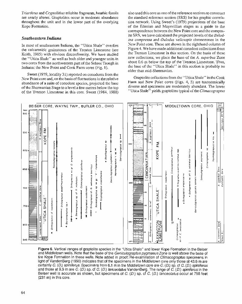
Triarthrus and Cryptolithus trilobite fragments, benthic fossils are nearly absent. Graptolites occur in moderate abundance throughout the unit and in the lower part of the overlying Kope Formation.
Southeastern Indiana
In most of southeastern Indiana, the "Utica Shale" overlies the calcarenitic grainstones of the Trenton Limestone (see Keith, 1985) with obvious disconformity. We have studied the "Utica Shale" as well as both older and younger units in two cores from the northwestern part of the Sebree Trough in Indiana: the New Point and Cook Farm cores (Fig. 1).
Sweet (1979, locality 31) reported on conodonts from the New Point core and, on the basis of fluctuations in the relative abundance of a suite of conodont species, projected the base of the Shermanian Stage to a level a few metres below the top of the Trenton Limestone in this core. Sweet (1984, 1988)
I BEISER CORE, WAYNE TWP., BUTLER CO., OHIO I
also used this core as one of the reference sections to construct the standard reference section (SRS) for his graphic correla- tion network. Using Sweet's (1979) projections of the base of the Edenian and Maysvillian stages as a guide to the correspondence between the New Point core and the compos- ite SRS, we have calculated the projected levels of the Belod- ina compressa and Oulodus velicuspis chronozones in the New Point core. These are shown in the righthand column of Figure 4. We have made additional conodont collections from the Trenton Limestone in this section. On the basis of these new collections, we place the base of the A. superbus Zone about 0.6 m below the top of the Trenton Limestone. Thus, the base of the "Utica Shale" in this section is probably no older than mid-Shermanian.
Graptolite collections from the "Utica Shale" in the Cook Farm and New Point cores (Figs. 4, 5 ) are taxonomically diverse and specimens are moderately abundant. The lower "Utica Shale" yields graptolites typical of the Clirnacograptus
Figure 6. Vertical ranges of graptolite species in the "Utica Shale" and lower Kope Formation in the Beiser and Middletown wells. Note that the base of the Geniculograptus pygmaeus Zone is well above the base of the Kope Formation in these wells. Note added in proof: Re-examination of Climacograptus specimens in light of VandenBerg (1 990) indicates that of the specimens in the Middletown core only those at 43.6 m are certainly C. (D.) spiniferus. Specimens from 6.1 m in the Middletown core are C. (D.) sp. cf C. (D.) spiniferus and those at 9.9 m are C. (D.) sp. cf C. (D.) lanceolatus VandenBerg. The range of C. (D.) spiniferus in the Beiser well is accurate as shown, but specimens of C. (D.) sp. cf C. (D.) lanceolatus occur at 758 feet (231 m) in this core.
(Diplacanthograptus) spiniferus Zone (Fig. 6) in New York and Quebec, including C. (D.) spiniferus, Geniculograptus typicalis, and Orthograptus quadrimucronatus. These spe- cies continue upward into the upper "Utica Shale" and are quickly joined by other typical C. (D.) spiniferus Zone ele- ments, such as Orthoretiolites hami, Dicellograptus jlexuo- sus, and Dicranograptus nicholsoni.
In addition to the usual C. (D.) spiniferus Zone species, this fauna also includes a few specimens of G. typicalis that bear a prominent mesial spine on the first theca (Plate 1, figs. 36, 37). Specimens of the spine-bearing G. typicalis ssp. A are restricted to the lower 19 m of shale. This interval also yields specimens of Corynoides ultimus Ruedemann, which ranges upward into the upper "Utica Shale" (Plate 1, figs. 18, 34). In the Mohawk Valley this species has been found only in the Geniculograptus pygmaeus Zone (Ruedemann, 1925; Riva, 1974), but the Sebree Trough and other occur- rences indicate that C. ultimus first appears in older rocks outside New York (Mitchell, 1989).
In both the Cook Farm and New Point cores (Figs. 4,5), Geniculograptus pygmueus makes its first appearance in the upper part of the "Utica" interval. Geniculograptus pyg- maeus makes its debut at 65 m above the top of the Trenton Limestone in the New Point core, which equates to 24 m above the base of the Cincinnatian Series as projected by Sweet (1979, Fig. 2), or 1087 m above the base of Sweet's (1988) composite SRS. Geniculograptus pygmaeus and G. typicalis range upward through an interval of gradational rock types into the soft, fissile, grey-green shale and argillaceous limestone of the Kope Formation. Although initially rare, G. pygmaeus becomes abundant upward in the lower Kope Formation. In the Sebree Trough sequence, as in the Utica Shale of New York and ~ u e b e c ( ~ i v a , 1969a, p. 520), a minute species with variably glyptograptid to climacograptid thecae (Normulograptus sp. nov., P1.l, figs. 9-12; see discus- sion of Normulograptus in Melchin and Mitchell, this vol- ume) is present in an interval spanning the boundary between the C. (D.) spiniferus and G. pygmaeus zones. Evans (1981) discovered three-dimensional specimens of this species (identified by him and listed by Bergstrom and Mitchell, 1986, as Orthograptus sp.) together with G. pygmaeus in the upper Kope Formation at Maysville, Kentucky. Other note- worthy elements of the G. pygmaeus fauna are Corynoides ultirnus, "Glyptograptus" lorrainensis (Pl. 1, figs. 7, 8), and specimens of an Orthoretiolites species similar to those fig- ured by Riva (1969a, Figs. 4k,l) from this zone in Quebec.
South western Ohio
In southeastern Indiana, the Trenton Limestone thins rapidly to the southeast, and in the centre of the trough shale may rest directly on Blackriveran strata (Fig. 3). On the east side of the trough, in extreme southeastern Indiana and southwestern Ohio, the "Utica Shale" interfingers with dark argillaceous wackestone of the Lexington Limestone (Fig. 10). This rela- tionship is displayed well in two cores that we have studied: the Beiser and Middletown cores (Fig. 6). Conodonts from the Middletown core were described by Bergstrom and Sweet (1966). On the basis of projections of the Cincinnatian stages
into this section supplied to us by Sweet, we have calculated the position of the base of the Belodina confluens and Ou- lodus velicuspis chronozones in the Middletown core, and indicated these in Figure 6.
Graptolites occur less frequently in the Middletown and Beiser cores than in the Indiana cores and represent fewer species. Stratigraphically useful faunas are present, however. The middle and upper Kope Formation contains a Genicu- lograptus pygmueus Zone fauna dominated by the same species as in the more westerly cores discussed above. The first appearance of G. pygmaeus in the Middletown core is 62 m above the top of the Lexington Limestone, and 23 m above the projected base of the Cincinnatian Series, or 1086 m above the base of the composite SRS. Thus, the difference in level of first appearance of G. pygmaeus in the New Point and Middletown cores (1 m) is substantially less than the present resolution (W = 6 m) of Sweet's graphic correlation network (Sweet, 1984, 1988), and these two occuqences, therefore, are effectively isochronous.
The lower Kope Formation and "Utica Shale" yield a sparse fauna indicative of the Climucograptus (Diplacanthograptus) spiniferus Zone (Fig. 6). Near the base of the brown shale interval, and well below Cincinnatian rocks, we find Genicu- lograptus typicalis typicalis and C. (D.) spiniferus in the Beiser core, and Climacograptus (Diplacanthograptus) sp. cf. C. (D.) spiniferus in the Middletown core together with numerous speci- mens of Orthograptus ruedemanni (Pl. 1, figs. 29,30,39). We have also discovered specimens in this interval of the Middle- town and Beiser cores that resemble Climacograptus (Diplacan- thograptus) lanceolatus VandenBerg, a member of the C. (D.) spiniferus lineage recently recognized in Australia (Vanden- Berg, 1990, see P1 1, fig. 43).
The graptolite zonal correlation of these lowest "Utica Shale" beds is problematic. The Orthograptus ruedemanni and Climucograptus (Diplacanthograptus) spiniferus zones, as defined by Riva (1969a, 1974), are assemblage zones. At numerous localities in the New York-Quebec region, ranges of characteristic elements of the 0. ruedemanni Zone, such as 0. ruedemanni and Normalograptus mohawkensis, signifi- cantly overlap those of several elements of the lower C. (D.) spiniferus Zone (e.g., C. (D.) spiniferus, Dicranograptus nicholsoni, and Amplexograptus praetypicalis) (Ruedemann, 1912, 1925; Riva, 1969a,b, 1972). Riva (1969a,b) placed the base of the C. (D.) spiniferus Zone within this zone of overlap, essentially at the base of the ranges of D. nicholsoni and Dicranograptus ramosus. The sequence developed in the Beiser c o r e q ~ i ~ . 6) is similar to that seen in the ~ t i c a Shale, so we have tentatively identified the presence of the 0 . ruedemanni Zone in this and the nearby Middletown core. However, Geniculograptus typicalis typicalis, which in New York and Quebec is reported only from the middle and upper portions of the C. (D.) spiniferus Zone, first appears in the Beiser core within the possible 0. ruedemanni Zone.
Limestone interbedded with the lower "Utica Shale" of the Middletown core yields amorphognathid conodonts. These indicate that the base of the range of C. (D.) spiniferus (and possibly also that of Geniculograptus typicalis typicalis) lies within the upper part of the A . tvaerensis Zone.
1-275 CUT - I I "0" ur!h bench + 3 5 m
170cm - 33m FAIRVIEW FM.
SECTIONS 38cm
NEAR 3 0 39cm t Poorly exposed
2 5 I WEST SlDE OF
FOUR-LANE HWY
Poorly expoeed Second bench (* 17m
KY . RT. 445
m 4 0
3 5
3 0
KOPE FM.
F ~ r r l bench I: I Road d m h B
N.end of cut
WEST SlDE OF HWY.
Figure 7 . Vertical ranges of graptolite species in the Kope Formation at the Brent section. The correlation between the two partial sections is based on leveling and comparison of the lithological succession. Cm-figures refer to thickness of the 5cm thick limestone beds, and the letters "t" and "p" indicate occurrences of Geniculograptus typicalis and G. pyg- maeus, respectively.
Orthograptus ruedemanni continues upward to 16 m above the base of the A. superbus Zone in this core. Thus, C. (D.) spiniferus and G. typicalis typicalis, which are characteristic of the C. (D.) spiniferus Zone, make their debut in the Sebree Trough succession in rocks that appear to be substantially older than the portion of the Utica Shale in which they first appear in the New York-Quebec region. Finney (1986) has described a similar situation in the Lexington Limestone from Kentucky and the lower Viola Springs Formation in Okla- homa, although Riva and Malo (1988) dispute his interpreta- tions. We examine these problems further in our discussion of the correlation of the Sebree Trough succession with that of the Mohawk Valley.
GRAPTOLITES FROM THE KOPE FORMATION NEAR BRENT, KENTUCKY
Bergstrom and Mitchell (1986) reviewed the data available at that time on the graptolite succession in the Upper Ordovi- cian outcrop belt of the Cincinnati region. In order to try to
establish the temporal equivalents of the Sebree Trough suc- cession in the shelly facies of the Cincinnati Arch, we have collected additional data in southwestern Ohio and northern Kentucky from both outcrop sections and drill cores.
Well exposed sections through the entire Kope Formation are rare. The early Edenian Fulton Shale, undoubtedly a tongue of the Sebree Trough "Utica Shale", is no longer exposed (see Bergstrom and Mitchell, 1986, p. 248,249). One of the best Kope Formation outcrops near Cincinnati occurs in two adjacent and overlapping road cuts near Brent, Ken- tucky, approximately 13 km southeast of the centre of the city (Fig. 1). Some 60 m of Kope Formation are exposed although, as usual, the lower 8 to 12 m of the unit are covered (Fig. 7). Exact correlation between the base of the upper section and a level in the lower section is difficult to establish, but the 0 m level in the upper section corresponds approximately to the 33 m level in the lower section. Hoge (1985) studied the distribution of conodonts and brachiopods in this section, provided a detailed description of the lithological succession, and discussed its graphic correlation with Sweet's (1984) composite SRS.
So far, we have found only two graptolite spccies in the Kope shale and limestone at the Brent sections. Genicu- lograptus typicalis typicalis occurs at 0.9 m above the base
BRENT, KY.
Gen~culograptus pygmaeus
I 1100 I I
L n=9
I I I / I /
1090 I I
15 I
--t n.47 1 n=22 I I
10 I I I
1080 I I I
1074 -, ~ m a m w u 1 1 1 1 1
0.42 0 . 5 6 1.08 1161.24 1.321.40 1 4 8 mm. mm. T ~ I ' Sicula
Ventral he~ght Length
Figure 8. Stratophenetic variation of morphologic features in Geniculograptus typicalis and G. pygmaeus in the Kope For- mation of the Brent section. For variables measured, see inset figure, in which "1 " denotes ventral height of Th l l and "2" the length of the sicula.
and at several widely spaced horizons up to 35 m. Genicu- lograptus pygmaeus appears at 33 m above the base of the section, which corresponds to a level 43 m above the base of the Cincinnatian, or 1106 m in the composite SRS. The species occurs profusely in several collections from just above this level in both sections. Much of the interval be- tween 20 and 31.5 m in the lower section is exposed only in a steep, not easily accessible slope and we have not yet carried out bed by bed collecting from these strata. Given the infre- quent occurrence of graptolites in much of the Brent section, it is likely that further work will extend the range of G. pygmaeus downward at this locale.
CORRELATION AMONG CINCINNATI REGION SECTIONS In the sections and cores that we have studied between the Middletown well in Butler County, Ohio and the sections at Maysville, Kentucky (see Fig. I), the Kope Formation main- tains a consistent thickness of about 76 m. Likewise, the first appearance of Geniculograptus pygmaeus occurs consis- tently at a horizon about 50 m below the top of the Kope Formation along a traverse from the Beiser well on the east flank of the Sebree Trough to the Cominco well near Minerva, Kentucky and sections near Ripley, Ohio and Maysville, Kentucky - a distance of some 125 km.
In the Brent sections, however, Geniculograptus pyg- maeus appears 30 m below the top of the Kope Formation, which is about 20 m higher than expected. This occurrence is also about 20 m higher than expected based on its projected level in the composite SRS (1 106 m versus 1086 m from the New Point and Middletown cores). This deviation may represent no more than incomplete collecting, or, alterna- tively, it might indicate either a delayed immigration of G. pygmaeus to this locality or a time-transgressive pattern of deposition for the Kope and Fairview formations. On the basis of the relative abundance patterns of several conodont species, Sweet (1979, Fig. 3) suggested that these units are indeed diachronous within the Cincinnati region. However, the uniformity in thickness of the Kope Formation and in the location of the first appearance of G. pygmaeus relative to the top of the formation indicate that this diachroneity may be less than some authors have suggested. For instance, Tobin and Pryor (198 I), in an attempt to explain the occurrence of cyclical sedimentation patterns within the Cincinnatian Se- ries, consider the Kope and Fairview formations and the Bellevue Limestone to be a set of contemporaneously depos- ited facies. To further examine this question, we have taken two different and independent approaches: 1) study of the stratophenetic pattern exhibited by the Geniculograptus spe- cies, and 2) study of the relationship between K-bentonite lithochronostratigraphy and lithostratigraphic patterns re- vealed by correlation of geophysical logs.
Stratophenetic correlation
We have gathered data on the length of the sicula and the first theca of some 410 graptolite specimens from the New Point core and the Brent sections. Because early growth stages are
Figure 9. Comparison of stratophenetic variation patterns of measured morphological characters of Geniculograptus pyg- maeus and G. typicalis in the New Point well (dots and squares) and the Brent section (stars). Note that based on estimated best fit, the first appearance of G. pygmaeus in the Brent section corresponds to a level well above the base of the G. pygmaeus zone in the New Point well.
NEW POINT CORE, IN.
* m Gen~culogreptus pygrneeus
* G. typicelis
I
0 ' \ \ \
\ \
much more common than large rhabdosomes in our core samples, we have used these in our morphometric study. Previous studies (Mitchell, 1986) indicate that the early growth stages of Geniculograptus typicalis and G. pygmaeus differ significantly in several features. Of these features, we chose to use only length because it is affected less by flatten- ing than width is; cylinders and cones become wider rather than longer when flattened. The sketch inset in Figure 8 shows the location of the variables measured. Figures 8 and 9 present sample means and standard deviations for the two variables plotted against their position in the stratigraphic section at the Brent locality and in the New Point core. To provide a common scale, we projected the sampled levels into
800-
850 - 865
2 V)
4 F =
-
\ \ I \ \ \ \ \ \ \ \ \
\ \ I \ .\. . \ \ \ --t n=12 n=6
Th' ventral height Sicula length
NEW POINT WELL DECATUR CO., IN.
COOK FARM WELL WAYNE CO., IN.
BEISER WELL BUTLER CO., OH.
Figure 10. Correlation based on geophysical logs, shale percentage logs, and biostratigraphic evidence along a traverse from the New Point well to the Brent section. Logs lacking shale percent scale are geophysical logs (only the upper 275 feet p3.8 m] of the Middletown well is represented by a shale percentage log). For traverse location, see Figure 1. As in Figure 11, the gamma ray-neutron logs of the Middletown well are projected from the Permit No. 4 well (cf. Stith, 1986, PI. 2). The latterwas drilled at Middletown very close to the site of the Permit No. 1 well (the Middletown well of Bergstrom and Sweet, 1966) and has a virtually identical rock succession. Left footages on the Middletown well column refer to Permit No. 1, right to Permit No. 4. Left footages of the Beiser well refer to the Ohio Geological Survey Core No. 2537 (company hole No. 09-2082) examined by us, right footages and geophysical logs are from Permit No. 2 well, which was drilled 0.85 miles (1.37 km) from the No. 2537 well (cf. Stith, 1986, PI. 2) and has a closely similar rock succession. Note facies relations between the Sebree Trough "Utica Shale", Kope Formation, Lexington Limestone, and Point Pleasant Formation. Part of the diagram is after Stith (1 986, PI. 2).
Sweet's (1984, 1988) composite SRS based on information provided in Sweet (1979) and Hoge (1985). Both G. typicalis and G, pygmaeus exhibit changes in the length of the sicula and first theca. In G. typicalis, there was an initial decrease in size, most of which was later reversed. During the latter, reversal phase, G. pygmaeus appeared. It too underwent an increase in these lengths, but was markedly smaller in size (among other differences - see Riva, 1974; Mitchell, 1986) than G. typicalis throughout its range.
Figure 9 also depicts our estimated best fit between the stratophenetic patterns exhibited by the two species in the Brent and New Point successions. We must emphasize that this is only fit by eye; we plan additional quantitative work on this problem. Although a number of alternative alignments
are possible, these do not differ greatly. The pattern illustrated here suggests that the first appearance of Geniculograptus pygmaeus at Brent is stratigraphically above (by about 15 m) and hence temporally later than, its appearance in the New Point core. This figure is in close agreement with the relative position of the base of the range of G. pygmaeus vis-a-vis the base of the Fairview Formation and its projected level in the composite SRS. Accordingly, we interpret the general uni- formity of level of first occurrence of G. pygmaeus across the Sebree Trough and at least into the western edge of the Lexington Shelf in the Cincinnati region as an indication of a similar uniformity in age for this horizon, i.e., for the base of the G. pygmaeus Zone. On the basis of the stratophenetic pattern, we project the base of this zone to a level about 18 m
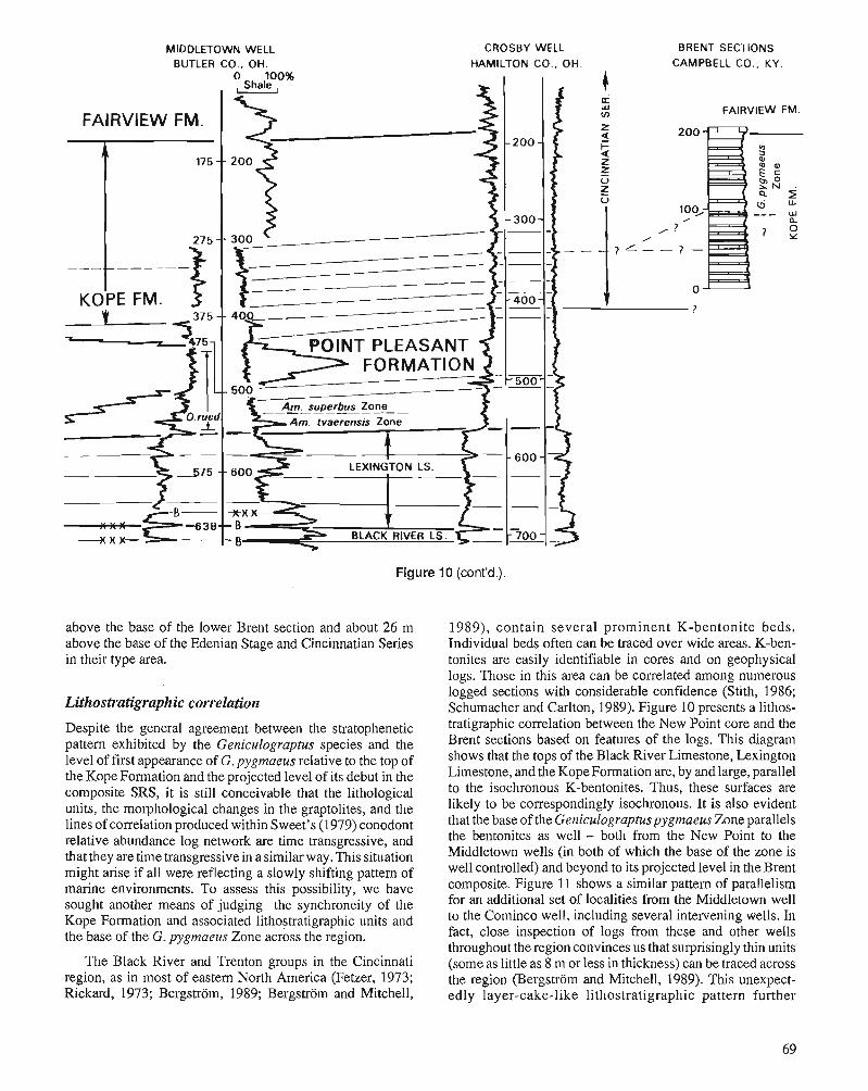
MIDDLETOWN WELL BUTLER CO., OH.
CROSBY WELL BRENT SECTIONS HAMILTON CO., OH. CAMPBELL CO., KY
Figure 10 (cont'd.).
above the base of the lower Breot section and about 26 m above the base of the Edenian Stage and Cincinnatian Series in their type area.
Lithostratigraphic correlation
Despite the general agreement between the stratophenetic pattern exhibited by the Geniculograptus species and the level of first appearance of G, pygmaeus relative to the top of the Kope Formation and the projected. level of its debut in the composite SRS, it is still conceivable that the lithological units, the morphological changes in the graptolites, and the lines of correlation produced within Sweet's (1979) conodont relative abundance log network are time transgressive, and that they are time transgressive in a similar way. This situation might arise if all were reflecting a slowly shifting pattem of marine environments. To assess this possibility, we have sought another means of judging the synchroneity of the Kope Formation and associated lithostratigraphic units and the base of the G. pygmaeus Zone across the region.
The Black River and Trenton groups in the Cincinnati region, as in most of eastern North America (Fetzer, 1973; Rickard, 1973; Bergstrom, 1989; Bergstrom and Mitchell,
1989), contain several prominent K-bentonite beds. Individual beds often can be traced over wide areas. K-ben- tonites are easily identifiable in cores and on geophysical logs. Those in this area can be correlated among numerous logged sections with considerable confidence (Stith, 1986; Schumacher and Carlton, 1989). Figure 10 presents a lithos- tratigraphic correlation between the New Point core and the Brent sections based on features of the logs. This diagram shows that the tops of the Black River Limestone, Lexington Limestone, and the KopeFormation are, by and large, parallel to the isochronous K-bentonites. Thus, these surfaces are likely to be correspondingly isochronous. It is also evident that the base of the Geniculograptuspygmaeus Zone parallels the bentonites as well - both from the New Point to the Middletown wells (in both of which the base of the zone is well controlled) and beyond to its projected level in the Brent composite. Figure 11 shows a similar pattem of parallelism for an additional set of localities from the Middletown well to the Cominco well, including several intervening wells. In fact, close inspection of logs from these and other wells throughout the region convinces us that surprisingly thin units (some as little as 8 m or less in thickness) can be traced across the region (Bergstrom and Mitchell, 1989). This unexpect- edly layer-cake-like lithostratigraphic pattern further
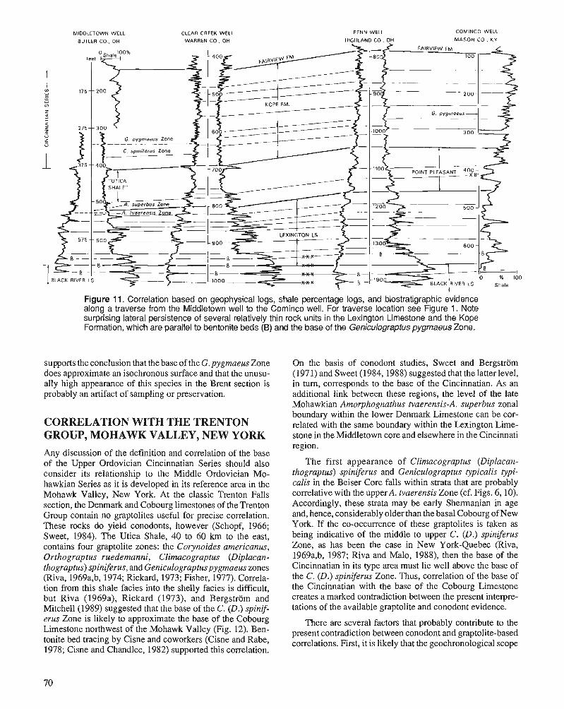
MIDDLETOWN WELL CLEAR CREEK WELL
BUTLER CO . OH WARREN CO , OH
PENN WELL
HIGHLAND CO . OH
COMINCO WELL
MASON CO . KY
Figure 11. Correlation based on geophysical logs, shale percentage logs, and biostratigraphic evidence along a traverse from the Middletown well to the Cominco well. For traverse location see Figure 1. Note surprising lateral persistence of several relatively thin rock units in the Lexington Limestone and the Kope Formation, which are parallel to bentonite beds (B) and the base of the Geniculograptuspygmaeus Zone.
supports the conclusion that the base of the G. pygmaeus Zone On the basis of conodont studies, Sweet and Bergstrom does approximate an isochronous surface and that the unusu- (197 1) and Sweet (1984,1988) suggested that the latter level, ally high appearance of this species in the Brent section is in turn, corresponds to the base of the Cincinnatian. As an probably an artifact of sampling or preservation. additional link between these regions, the level of the late
Mohawkian Amorphognathus tvaerensis-A, superbus zonal
CORRELATION WITH THE TRENTON GROUP, MOHAWK VALLEY, NEW YORK Any discussion of the definition and correlation of the base of the Upper Ordovician Cincinnatian Series should also consider its relationship to the Middle Ordovician Mo- hawkian Series as it is developed in its reference area in the Mohawk Valley, New York. At the classic Trenton Falls section, the Denmark and Cobourg limestones of the Trenton Group contain no graptolites useful for precise correlation. These rocks do yield conodonts, however (Schopf, 1966; Sweet, 1984). The Utica Shale, 40 to 60 km to the east, contains four graptolite zones: the Corynoides americanus, Orthograptus ruedemanni, Climacograptus (Diplacan- thograptus) spiniferus, and Geniculograptuspygmaeus zones (Riva, 1969a,b, 1974; Rickard, 1973; Fisher, 1977). Correla- tion from this shale facies into the shelly facies is difficult, but Riva (1969a), Rickard (1973), and Bergstrom and Mitchell (1989) suggested that the base of the C. (D.) spinif- erus Zone is likely to approximate the base of the Cobourg Limestone northwest of the Mohawk Valley (Fig. 12). Ben- tonite bed tracing by Cisne and coworkers (Cisne and Rabe, 1978; Cisne and Chandlee, 1982) supported this correlation.
boundary within the lower Denmark ~imestone can be cor- related with the same boundary within the Lexington Lime- stone in the Middletown core and elsewhere in the Cincinnati region.
The first appearance of Climacograptus (Diplacan- thograptus) spiniferus and Geniculograptus typicalis typi- calis in the Beiser Core falls within strata that are probably correlative with the upper A. tvaerensis Zone (cf. Figs. 6,10). Accordingly, these strata may be early Shermanian in age and, hence, considerably olderthan the basal Cobourg of New York. If the co-occurrence of these graptolites is taken as being indicative of the middle to upper C. (D.) spiniferus Zone, as has been the case in New York-Quebec (Riva, 1969a,b, 1987; Riva and Malo, 1988), then the base of the Cincinnatian in its type area must lie well above the base of the C. (D.) spiniferus Zone. Thus, correlation of the base of the Cincinnatian with the base of the Cobourg Limestone creates a marked contradiction between the present interpre- tations of the available graptolite and conodont evidence.
There are several factors that probably contribute to the present contradiction between conodont and graptolite-based correlations. First, it is likely that the geochronological scope
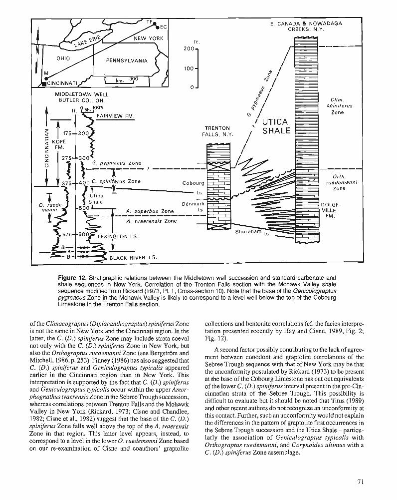
E. CANADA & NOWADAGA CREEKS, N.Y.
------ PENNSYLVANIA
MIDDLETOWN WELL BUTLER CO., OH. Clim.
spiniferus Zone
FALLS, N.Y.
G. pygmaeus Zone ------ Orth.
ruedemanni Zone
DOLGE- A. superbus Zone VlLLE
F M . A. tvaerensis Zone
Figure 12. Stratigraphic relations between the Middletown well succession and standard carbonate and shale sequences in New York. Correlation of the Trenton Falls section with the Mohawk Valley shale sequence modified from Rickard (1 973, PI. 1, Cross-section 10). Note that the base of the Geniculograptus pygmaeus Zone in the Mohawk Valley is likely to correspond to a level well below the top of the Cobourg Limestone in the Trenton Falls section.
of the Climacograptus (Diplacanthograptus) spiniferus Zone collections and bentonite correlations (cf. the facies interpre- is not the same in New York and the Cincinnati region. In the tation presented recently by Hay and Cisne, 1989, Fig. 2; latter, the C. (D.) spiniferus Zone may include strata coeval Fin. 12). not only with-thk C. (D.) spiniferus h n e in New York, but also the Orthograptus ruedemanni Zone (see Bergstrom and Mitchell, 1986, p. 253). Finney (1986) has also suggested that C. (D.) spiniferus and Geniculograptus typicalis appeared earlier in the Cincinnati region than in New York. This interpretation is supported by the fact that C. (D.) spiniferus and Geniculograptus typicalis occur within the upper Amor- phognathus tvaerensis Zone in the Sebree Trough succession, whereas correlations between Trenton Falls and the Mohawk Valley in New York (Rickard, 1973; Cisne and Chandlee, 1982; Cisne et al., 1982) suggest that the base of the C. (D.) spiniferus Zone falls well above the top of the A. tvaerensis Zone in that region. This latter level appears, instead, to correspond to a level in the lower 0. ruedemanni Zone based on our re-examination of Cisne and coauthors' graptolite
A second factor possibly contributing to the lack of agree- ment between conodont and graptolite correlations of the Sebree Trough sequence with that of New York may be that the unconformity postulated by Rickard (1973) to be present at the base of the Cobourg Limestone has cut out equivalents of the lower C. (D.) spiniferus interval present in the pre-Cin- cinnatian strata of the Sebree Trough. This possibility is difficult to evaluate but it should be noted that Titus (1989) and other recent authors do not recognize an unconformity at this contact. Further, such an unconformity would not explain the differences in the pattern of graptolite first occurrences in the Sebree Trough succession and the Utica Shale - particu- larly the association of Geniculograptus typicalis with Orthograptus ruedemanni, and Corynoides ultimus with a C. (D.) spiniferus Zone assemblage.
It is also possible that the base of the Cincinnatian Series is not precisely coeval with the base of the Cobourg Lime- stone, but rather corresponds to a somewhat higher level within this formation. On the basis of tracing markers in geophysical logs, Bergstrom and Mitchell (1989) suggested that the base of the Cincinnatian correlates with a level some 6.5 to 10 m above the base of the Cobourg Limestone. The magnitude of this revision of the accepted correlation be- tween these units.is not substantially more than the stated precision in Sweet's (1984) conodont-based graphic correla- tion. This interpretation accounts for the presence of a C. (D.) spiniferus Zone fauna below the base of the Cincinnatian in the Sebree Trough, but again does not directly address the problem posed by the occurrence of C. (D.) spiniferus Zone graptolites in the A. tvaerensis Zone.
All three of these alternatives are possible and others are conceivable as well. Nevertheless, we consider a combination of the first and third of the above-mentioned interpretations to provide the most likely explanation for the observations discussed here. If this is correct, it implies that the charac- teristic elements of the C. (D.) spiniferus Zone immigrated into the Appalachian Foreland Basin in New York and Que- bec later than they appeared elsewhere. Several additional lines of evidence that support this inference include:
1. Phylogenetic studies of the species of Climacograptus indicate that C. (Diplacanthograptus) spiniferus is closely allied to C. (Climacograptus) bicornis (Riva, 1976; Mitchell, 1987). Indeed, VandenBerg (1990) has discov- ered a succession of species that link C. (C.) bicornis and C. (D.) spiniferus within the Pacific Province grapto-
lite facies of Australia, including a new species Cli- macograptus (Diplacanthograptus) lanceolatus VandenBerg. Yet in New York-Quebec, C. (C.) bicornis and C. (D.) spiniferus are separated by an interval corre- sponding to the Corynoides americanus and Orthograp- tus ruedemanni zones (Riva, 1976; Bergstrom and Mitchell, 1986). Clirnacograptus (Diplacanthograptus) lanceolatus is not yet known from the Utica Shale but specimens of this species do occur in the Exploits Group, central Newfoundland (see Erdtmann, 1976, P1. 7, figs. B/3a, B/6a, B/6b, and B/6c) within the Corynoides ameri- canus Zone. We have also recovered a single specimen that may be referable to C. (D.) lanceolatus from the Amorphognathus tvaerensis Zone, at 9.9 m in the Middle- town core (P1 I., fig. 43; Fig. 6), which is above the first occurrence of C. (D.) spiniferus. VandenBerg (1990) reports only a short interval of overlap between these two graptolites, and this occurs in the lowermost C. (C.?) baragwanathi Zone. VandenBerg and Stewart (1983, Ta- ble 1) equate the base of this Victorian zone with the base of the 0. ruedernanni Zone in New York-Quebec.
2. The Orthograptus ruedemanni Zone of the Utica Shale in the Mohawk Valley yields a depauperate fauna of low species diversity. Orthograptus ruedemanni and Nor- malograptus mohawkensis are the only species that occur commonly throughout the interval and these two occur in great profusion on many bedding planes. The other five or six species known to occur in this zone occur sporadi- cally in small numbers, and nearly all are more common
in the underlying strata. Several of the species that are common in the Corynoides americanus Zone reappear toward the top of the 0, ruedemanni Zone or in the succeeding C. (D.) spiniferus Zone (e.g., Dicranograptus nicholsoni, Climacograptus (Climacograptus) caudatus, and Orthograptus quadrimucronatus ssp.; see Riva, 1969b). Corynoides americanus also disappears in the lower 0, ruedemanni Zone and a representative of the genus (C. ultirnus) only reappears within the Genicu- lograptus pygrnaeus Zone in the upper Utica Shale (Ruedemann, 1925; Riva, 1974; Mitchell, 1989). In con- trast, C. ultirnus appears within the lower portion of the range of C. (D.) spiniferus in the Sebree Trough.
The pattern of occurrence of graptolites within the Utica Shale in the Mohawk Valley suggests that the 0. ruedemanni Zone may reflect the establishment of unusual ecological conditions in this region, producing a taxonomically impov- erished and geographically restricted assemblage. These ob- servations, taken together with the biogeographic and phylogenetic data outlined above, suggest that the evolution- ary origin of Climacograptus (Diplacanthograptus) spinif- erus, Geniculograptus typicalis, and Corynoides ultirnus may have taken place during this interval and that the subsequent gradual appearance of the C. (D.) spiniferus zonal assemblage in the Mohawk Valley represents immigration controlled by the progressive return to conditions more favourable to a broad array of graptolite species.
One further issue regarding graptolite correlation between the Cincinnatian Series and the strata of the Mohawk Valley deserves comment here. Tlie appearance of Geniculograptus pygmaeus in shales above the top of the Cobourg Limestone in New York (Rickard, 1973) is unlikely to becoeval with the base of this zone in the Cincinnati region. According to conodont data, the base of the G, pygmaeus Zone is likely to correspond to a level in the middle part of the Cobourg Limestone. Hence, as suggested by Hay and Cisne (1989, Fig. 2) and Bergstrom and Mitchell (1989), the non-graptolite- bearing, upper portion of the Cobourg Limestone may be an equivalent to the G. pygmaeus Zone rather than to the C. (D.) spiniferus Zone as indicated by Riva (1972) and Rickard (1973). However, at the present time we have no decisive biostratigraphic data with which to evaluate the isochroneity of this boundary between the two regions. In any event, the resolution of this issue only indirectly affects the correlation of the base the Cincinnatian Series with the New York succession.
CONCLUSIONS The "Utica Shale" and Kope Formation of the Sebree Trough yield a diverse assemblage of graptolites that can be directly correlated with the classic facies of the Cincinnatian Series. The base of the series lies within the Climacograptus (Diplacanthograptus) spiniferus Zone as developed in this region, about 23 m below the base of the Geniculograptus pygmaeus Zone. We are uncertain whether the base of the C. (D.) spiniferus Zone in the Sebree Trough sections is actually isochronous with the base of the C. (D.) spiniferus Zone in the Utica Shale of the Mohawk Valley. However, on the basis
of the data available, we suspect that it is not; that outside the region of the Appalachian Basin, C. (D.) spiniferus and at least some of the other species of this zonal assemblage (such as Geniculograptus typicalis) range downward into rocks synchro- nous with the older Orthograptus ruedemanni Zone in New York. This observation, if it is confirmed, will have important implications for the biostratigraphy, biogeography, and phylog- eny of graptolites in this interval. Discussion of these implica- tions, however, is beyond the scope of the present paper.
As the base of the Cincinnatian Series in its reference area does not coincide with a graptolite or conodont zonal bound- ary, or with any other known biostratigraphic zonal boundary, the base of the series cannot be defined precisely on the basis of these traditional and regionally useful zonations. In view of this, the Cincinnatian Series in its present scope is unlikely to be a suitable global chronostratigraphic unit. Nevertheless, the designation of a boundary stratotype is needed to provide a stable and definable horizon as a basis for correlation with other regions and series. There are several alternatives, which are as follows:
1. Define the base of the series in terms of Sweet's (1984) graphic correlation network as the horizon within the SRS that corresponds to the traditional base of the series at the base of the Kope Formation in the city of Cincinnati. This level could then be projected to a specific section where the boundary could be permanently fixed and accessible to earth scientists. Recently, Sweet (1988) did this and suggested that the Cominco Core is a suitable reference section. However, the small diameter of this core and its poor condition (it has already been sampled for several different studies) make it less useful as a reference stand- ard than a well exposed surface section. More generally, this choice might also limit the range of correlation tech- niques that subsequently could be used for precise corre- lation of the Cincinnatian boundary stratotype with other sections. There is no guarantee that any future biostratig- raphic, magnetostratigraphic, or other time-significant boundary will prove to be coincident with the age of the base of the Kope Formation in Cincinnati.
2. Move the boundary slightly to coincide with the base of a more traditional biozone such as at the base of the Geniculograptuspygmaeus Zone or the Amorphognathus superbus Zone. Both of these options also have disadvan- tages in addition to their obvious advantages. The most serious of these is that at the present time no surface section within the region is known to expose either zonal boundary within a continuously fossiliferous succession, and again, we do not favour use of a core as a boundary stratotype. Thus, we believe that selection of a boundary stratotype for the base of the Cincinnatian Series must await further research on the fossils and strata of its classical reference area.
ACKNOWLEDGMENTS
This study would not have been possible without access to the drill cores generously made available to us by members of the Indiana Geological Survey, Bloomington, Indiana and the Ohio Division of Geological Survey, Columbus, Ohio. We are indebted to Tom Berg, Gerald Carpenter, Horace Collins, Jack Gray, Brian Keith, Carl Rexroad, John Rupp, Gregory Schumacher, Douglas Shrake, David Stith, Mac Swinford, and Lawrence Wickstrom for assistance and valu- able discussions. Thanks are also due to Karen Tyler of the technical staff, Department of Geology and Mineralogy, The Ohio State University, for the drafting. John Riva provided valuable information on graptolite occurrence in the New York-Quebec region and Newfoundland. Finally, we would like to thank Walter C. Sweet for useful information and discussion regarding Cincinnatian biostratigraphy. The manuscript benefitted from the comments of Stanley C. Fin- ney and two anonymous reviewers.
NOTE ADDED IN PROOF
Since the completion of this paper in 1988, additional infor- mation has become available concerning the graptolite corre- lation of the base of the Cincinnatian Series in its type area. In a recently drilled core (Ohio Geological Survey core No. 3020) from a site at Galbraith Road about 15 km north of the centre of Cincinnati, Geniculograptus pygmaeus appears about 20 m above the base of the Kope Formation (= the base of the Cincinnatian Series). This supports our conclusion that the known first appearance of this species in the Brent section is well above the base of the G. pygmaeus Zone in this region. Additional data on the graptolite correlation of the base of the Cincinnatian Series, including the position of this level in terms of the Australian standard graptolite succession, have been presented by us in a recently published paper (Journal of Paleontology, v. 64, p. 992-997).
REFERENCES Bergstrom, S.M. 1989: Use of graphic correlation for assessing event-stratigraphic signifi-
cance and trans-Atlantic relationships of Ordovician K-bentonites. Eesti Teaduste Akadeemia Toimetised, Geoloogia, 38(2), p. 55-59.
Bergstrom, S.M. and Mitchell, C.E. 1986: The graptolite correlation of the North American Upper Ordovician
Standard. Lethaia, v. 19, p. 247-266. 1989: Relations between the Ordovician Trenton Group and associated
strata in the Northern Appalachian Foreland Basin-Shelf region and their lateral equivalents in the eastern Midcontinent. Appalachian Basin Industrial Associates, v. 15, p. 7-41.
Bergstrom, S.M. and Sweet, W.C. 1966: Conodonts from the Lexington Limestone (Middle Ordovician) of
Kentucky and its lateral equivalents in Ohio and Indiana. Bulletins of American Paleontology, v. 50(229), p. 271-441.
Carpenter, J.W. and Ory, T.R. 1961: The American Upper Ordovician Standard. VI. The Covington
sequence at Maysville, Kentucky. The Ohio Journal of Science, v. 61, p. 372-378.
Cisne, J.L. and Chandlee, G.O. 1982: Taconic foreland basin graptolites: age zonation, depth zonation,
and use in ecostratigraphic correlation. Lethaia, v.15, p. 343-363. Cisne, J.L., Chandlee, G.O., Rabe, B.D., and Cohen, J.A. 1982: Clinal variation, episodic evolution, and possible parapatric specia-
tion: the trilobite Fiexicalymenesenuria along an Ordovician depth gradient. Lethaia, v. 15, p. 325-341.
Cisne, J.L. and Rabe, B.D. 1978: Coenowmlation: gradient analysis of fossil communities and its
application in stratigraphy. Lethaia, v. 11, p. 341-364. Cressman, E.R. 1973: Lithostratigraphy and depositional environments of the Lexington
Limestone (Ordovician) of central Kentucky. United States Geo- logical Survey, Professional Paper 768.61 p.
Erdtmann, B.-D. 1976: Die Graptolithenfauna der Exploits Gruppe (Oberes Ordovizium, Cara-
doc) von Zenhal-Neufundland Mitteilun~n aus dem Geologisch- Paltiontologischen Instirut der Universiat Hamburg, v. 45, p. 65-140.
Evans, R.D. 1981: Climacograprus pygmeaw and associated graptolites and enig-
matica of the Ripley Ohio, Maysville Kentucky, and Sherburne Kentucky areas. Unpublished senior thesis, Department of Geology and Mineralogy, The Ohio State University, 40 p.
Fetzer, J.A. 1973: Biostratigraphic evaluation of some Middle Ordovician bentonite
complexes in eastern North .America. Unpublished M.Sc. thesis, Department of Geology and Mineralogy,The Ohio State University, 165 p.
Finney, S.C. 1986: Graptolite biofacies and correlation of eustatic, subsidence, and
tectonic events in the Middle and Upper Ordovician of North America. Palaios, v. 1, p. 435461.
Fisher, D.W. 1977: Correlation of the Hadrynian, Cambrian, and Ordovician rocks in
New York State. New York State Museum and Science Service, Geological Survey Map and Chart Series no. 33,44 p.
Gray, H.H. 1972: Lithostratigraphy of the Maquoketa Group (Ordovician) in Indiana.
State of Indiana, Department of Natural Resources, Geological Survey Special Report 7,31 p.
Hay, B.J. and Cisne, J.L. 1989: Deposition in the oxygen-deficient Taconic Foreland Basin, Late
Ordovician. American Association of Petroleum Geologists, Stud- ies in Geology, v. 29, p. 113-134.
Hoge, R.J. 1985: Conodont and brachiopod biostratigraphy in the Upper Ordovician
rocks near Brent, Kentucky. Unpublished M.Sc. thesis, Department of Geology and Mineralogy, The Ohio State University, 148 p.
Keith, B.D. 1985: Facies, diagenesis, and the upper contact of the Trenton Limestone
of northern Indiana. Michigan Basin Geological Society, Special Paper no. 4, p. 15-32.
1986: Map of Indiana showing structure on top of an oil productive area of the Black River Group (Ordovician). Indiana Geological Survey Miscellaneous Map 46.
1989: Regional facies of Upper Ordovician Series of Eastern North Amer- ica. American Association of Petroleum Geologists, Studies in Geology, v. 29, p. 1-16.
Melchin, M.J. and Mitchell, C.E. (this volume) Late Ordovician extinction in the Graptoloidea. In Advances in Ordovician Geology, C.R. Barnes and H.S. Williams (eds.); Geo- logical Survey of Canaaa, Paper 90-9, p. 143-156.
Mitchell, C.E. 1986: Morphometric Studies of Clirnacograplus Hall and the phylogenetic
significance of astogeny. In Palaeoecology and Biostratigraphy of Graptolites, C.P. Hughes and R.B. Rickards (eds.); Geological Society Special Publication no. 20, p. 119-129.
1987: Evolution and phylogenetic classification of the Diplograptacea. Palaeontology, v. 30, p. 353-405.
1989: Revision of Corynoides uliimus Ruedemann (Graptolithina) and its relationship to Corynires Kozowski. Journal of Paleontology, v. 63, p. 382,383.
Rickard, L.V. 1973: Stratigraphy and structure of the subsurface Cambrian and Ordovi-
cian carbonates of New York. New York State Museum and Science Service, Geological Survey Map and Chart Series no. 18.26 p.
Riva, J. 1969a: Middle and Upper Ordoviciangraptolite faunas of the St. Lawrence
Lowlands of Quebec, andof Anticosti Island. American Associatior. of Petroleum Geologists, Memoir 12, p. 513-556.
1969b: Utica and Canajoharie Shales in the Mohawk Valley. New England Intercollegiate Geological Conference, 61st Annual Meet- ing, Albany New York, 1969, Guidebook for Field Trips in New York, Massachusetts and Vermont, J.M. Bird (ed.); p. 13-1 to 13-7.
1972: Jacques Cartier River below Pont-Rouge, riverbank exposures along left bank, Deschambault and Neuville limestones, Lot- binikre shale. In Stratigraphy and Structurc of the St. Law- rence Lowland of Quebec, T.H. Clark (ed . ) ; XXIV International Geological Congress, Montreal, 1972, Guide- book for Excursion C52, p. 50-54.
1974: A revision of some Ordovician graptolites of eastern North Amer- ica. Palaeontology, v. 17, p. 1-40.
1976: Climacograpius bicornis bicornis (Hall), its ancestor and likely descendants. In The Ordovician System: Proceedings of a Palae- ontological Association Symposium, Birmingham, September 1974, M.G. Bassen (ed.); University of Wales Press and National Museum of Wales, p. 589-619.
1987: The graptolite Amplexograpiusprae~picalis n. sp. and the origin of the iypicalis group. Canadian Journal of Earth Sciences, v. 24, p. 924-933.
Riva, J. and Malo, M. 1988: Age and correlation of the Honorat Group, southern Gas* Penin-
sula. Canadian Journal of Earth Sciences, v. 25, p. 1618-1628. Rooney, L.F. 1966: Evidence of unconformity at the top of Trenton Limestone in
Indiana and adjacent states. American Association of Petroleum Geologists, Bulletin, v. 50, p. 533-545.
Ruedemann, R. 1912: The Lower Siluric Shales of the Mohawk Valley. New York State
Museum, Bulletin 162, 151 p. 1925: The Utica and Lorraine fonnations of New York. Part I. Stratigra-
phy. New York State Museum, Bulletin 258, p. 5-175. Rytel, J.L. 1982: Conodont and brachiopod bioshatigraphy of Upper Ordovician
rocks near Ripley, Ohio. Unpublished M.Sc. thesis, Department of Geology and Mineralogy, Ohio State University, 105 p.
Schopf, T.J.M. 1966: Conodonts from the Trenton Group (Ordovician) in New York,
southern Ontario, and Quebec. New York State Museum and Sci- ence Service, Bulletin 405, 105 p.
Schumacher, G.A. and Carlton, R.W. 1989: Bentonilic shales from the Lexington Limestone and the Point
Pleasant Formation (Ordovician) of Ohio. Geological Society of America, Abstracts with Programs, v. 21, p. 46.
Schwalb, H. 1980: Hydrocarbonentrapment along a Middle Ordovician disconformity. Ken-
tucky Geological Survey, Series XI, Special Publication 2, p. 3541. Stith, D.A. 1986: Supplemental core investigations for high-calcium limestones in
western Ohio and discussion of natural gas and stratigraphic rela- tionships in the Middle to Upper Ordovician rocks of southwestern Ohio. Ohio Division of Geological Survey, Report of Investigations no. 132, 17 p.
Sweet, W.C. 1979: Conodonts and conodont biostratigraphy of post-Tymne Ordovician
rocks of the Cincinnati region. United States Geological Survey, Professional Paper 1066-G, 26 p.
1984: Graphic correlation of upper Middle and Upper Ordovician rocks, North American Midcontinent Province, U.S.A. In Aspects of the Ordovician System, D.L. Bruton (ed.); Palaeontolgical Conhibu- tions from the University of Oslo no. 295, p. 23-35.
1988: Mohawkian and Cincinnatian chronosh'atigraphy. In The Canadian Paleontology and Biostratigraphy Seminar. New York State Mu- seum, Bulletin 462, p. 84-90.
Sweet, W.C. and Bergstrom, S.M. 1971: The American Upper Ordovician Standard. XIU. A revised time-sha-
tigraphic classification of North American Middle and Upper Ordovi- cian rocks. Geological Society of America, Bulletin, v. 82, p. 613-628.
1976: Conodont biostratigraphy of the Middle and Upper Ordovician of the Unites States Midcontinent. In The Ordovician System: Pro- ceedings of a Palaeontological Association Symposium, Birming- ham, September 1974, M.G. Bassett (ed.); University of Wales Press and National Museum of Wales, p. 121-151.
Sweet, W.C., Harper, H., Jr., and Zlatkin, D. Tobin, R.C. and Pryor, W.A. 1974: The American Upper Ordovician Standard. XIX. A Middle and 198 1: Sedimentological interpretation of an Upper Ordovician carbonate-
Upper Ordovician reference standard for the eastern Cincinnati shale vertical sequence in northern Kentucky. In Meyer et al., region. The Ohio Journal of Science, v. 74, p. 47-54. Stratigraphy, Sedimentology, and Paleoecology of the Cincinnatian
Titus, R. Series (Upper Ordovician) in the Vicinity of Cincinnati, Ohio, T.G. 1989: Facies of the Trenton Group of New York. American Association Roberts (ed.); Field Trip Guidebooks, Geological Society of Amer-
of Petroleum Geologists, Studies in Geology, v. 29, p. 77-86. ica, Cincinnati 1981, v. 1, American Geological Institute, p. 49-57. VandenBerg, A.H.M. 1990: The ancestry of Climacograp!us spiniferus Ruedemann. Alcher-
inga, v. 14, p. 39-5 1. VandenBerg, A.H.M. and Stewart, I.R. 1983: Excursion to Devilrend Quany and Enoch's Point. Australian Pa-
laeontological Meeting, Museum of Victoria, Melbourne, 5-6 De- cember 1983. Nornen Nudum, v. 12, p. 35-52.
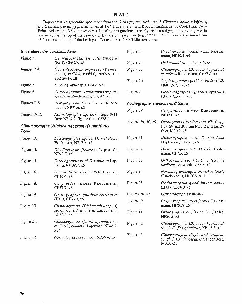
PLATE 1
Representative graptolite specimens from the Orthograptus ruedemanni, Climacograptus spiniferus, and Geniculograptus pygmaeus zones of the "Utica Shale" and Kope Formation in the Cook Farm, New Point, Beiser, and Middletown cores. Locality designations as in Figure 1; stratigraphic horizon given in metres above the top of the Trenton or Lexington limestones (e.g., "M43.5" indicates a specimen from 43.5 m above the top of the Lexington Limestone in the Middletown core).
Geniculograptus pygmaeus Zone Figure 23. Cryptograptus insectiformis Ruede-
Figure 1. Geniculograptus typicalis typicalis mann, NP49.4, x5 . . . -
(Hall), ~ ~ 6 8 . 8 , x8 Figure 24. Orthoretiolites sp., NP43.6, x8
Figures 2-4. Ceniculograptus pygmaeus (Ruede- Figure 25. Clirnacograptus (Diplacanthograptus) mann), NP70.0, NP64.0, NP69.9, re- spiniferus Ruedemann, CF37.8, x5 spectively, x8
Figure 26. Amplexograptus sp. aff. A. tardus (T.S. Figure 5. Dicellograptus sp. CF84.8, x8 Hall), NP38.7, x5
Figure 6. Climacograptw (Diplacanthograptus) Figure 27. Geniculograptus typicalis typicalis spiniferus Ruedemann, CF79.4, x8 (Hall), CF64.4, x5.
Figures 7,8. "Glyptograptus" lorrainensis (Ruede- Orthograptus ruedemanni? Zone mann), NP7 1.6, x8
Figure 28. Corvnoides ultimus Ruedemann, Figures 9-12.
u
Normalograptus sp. nov., figs. 9- 1 1 ~ ~ 1 3 . 0 , x8 from NP67.9, fig. 12 from CF88.5.
Figures 29,30,39. Orthograptus ruedemanni (Gurley), Clirnacograptus (Diplacanthograptus) spiniferus figs. 29 and 30 from M31.2 and fig. 39 Zone from M30.2, x5
Figure 13. Dicranograptus sp. cf. D. nicholsoni Figure 3 1. Dicranograptus sp. cf. D. nicholsoni Hopkinson, NP47.5, x5 Hopkinson, CF26.7, x5
Figure 14. Dicellograptus flexuosus Lapworth, Figure 32. Dicranograptus sp. cf. D. kirki Ruede- NP48.7, x5 mann, CF7.3, x5
Figure 15. Dicellograptus sp. cf. D. patulosus Lap- Figure 33. Orthograptus sp. aff. 0 . calcaratus worth, NP 38.7, x5 basilicus Lapworth, M33.3, x5
Figure 16. Orthoretiolites hami Whittington, Figure 34. Normalograptus sp. cf. N. mohawkensis CF39.4, x8 (Ruedemann), NP26.9, x14
Figure 18. Corynoides ultimus Ruedemann, Figure 35. Orthograptus quadrimucronatus CF57.7, x8 (Hall), CF34.0, x5
Figure 19. Orthograptus quadrimucronatus Figures 3637. Geniculograptus typicalis (Hall), CF33.3, x5 Figure 40. Cryptograptus insectiformis Rued e-
Figure 20. Climacograptw (Diplacanthograptus) mann, NP26.8, x5 sp. cf. C. (D.) spiniferus Ruedemann, Figure 41. Orthograptus amplexicaulis (Hall), NP56.4, x8 NP36.5, x5
Figure 21.
Figure 22.
Climacograptus (Climacograptus) sp. Figure 42. cf. C. (C.) caudatus Lapworth, NP46.7, x14
Normalograptus sp. nov., NP56.4, x5 Figure 43.
Climacograptus (Diplacanthograptus) sp. cf. C. (D.) spiniferus, NP 13.2, x8
Climacograptus (Diplacanthograptus) sp. cf. C. (D.1 lanceolatus VandenBerg,

Contributions of 19th century Canadian geologists to the adoption of the Ordovician System
Ellis L. ~ochelson'
Yochelson, E.L., Contributions of 19th century Canadian geologists to the adoption of the Ordovician System; &Advances in Ordovician Geology, C.R. Barnes and S.H. Williams (ed.), Geological Survey of Canada, Paper 90-9, p. 79-84,1991.
Abstract
Ever since Billings established the correct stratigraphic position of the Quebec Group, Ordovician rocks have been important to Canadian geologists. Thefirst usage of the term Ordovician in the New World was by Hunt in 1883. In several of his papers, he publicized this new division of the geological column. Although there was no international consensus on the usage, the Geological Survey of Canada recognized the time interval in about 1888; it was designated as Cambro-Silurian. In 1891, Sir William Dawson was the first to use the term Ordovician in an American textbook. These actions by Canadian geologists collectively influenced general acceptance of that new system.
Depuis I'ktablissement, par Billings, de la position stratigraphique correcte du groupe de Qdbec, les roches ordoviciennes revttent une importances pour les gkologues canadiens. Hunt est le premier ci utiliser le mot ccordovicien* dans le Nouveau Monde en 1883.11 mentionne cette rwuvelle division de l'e'chelle stratigraphique dans plusieurs de ses rapports. Malgre' l'absence de consensus international sur l'usage, la Commission g.4ologique du Canada reconnait cet intervalle de temps, appele' aCambro-Silurienw, vers 1888. En 1891, sir William Dawson est le premier d se servir du mot Ordovicien dans un rnanuel amkricain. Ces mesures prises collectivement par les gkologues canadiens incitent b I'acceptation gknkrale de ce nouveau systime.
INTRODUCTION The important contributions made by Canadian geologists to acceptance of the Ordovician System, proposed by Charles Lapworth in 1879, have not been summarized. By almost any measure one can apply, these workers were quicker to recog- nize the merits of this new system and to use it than were their far more numerous colleagues south of the border. It is not evident why this should be. One may speculate that during the last half of the 19th century, Canadian geologists were more preoccupied with the eastern pan of their country than were their counterparts in the United States. Thus, they were more influenced by the rocks which eventually came to be designated as Ordovician in age, but it seems almost too facile an explanation.
THE SIGNIFICANCE OF BILLINGS (1820-1878) Elkanah Billings has never received proper recognition for his insight in stratigraphic paleontology. He was the equal of James Hall in this regard, and in one important event was right when Hall was wrong. In the history of American geology, the age of the Quebec Group forms an important episode (Menill, 1924, p. 412). Although these Quebec rocks were "Silurian" in the 1860s, the sequence was intimately in- volved in the arguments over the validity of the Taconic System. Sir William Logan, originally Provincial Geologist and subsequently the first Director of the Geological Survey of Canada, had established a sequence of rocks along the St. Lawrence River. However, after carefully studying the fossils
1 Department of Paleobiology, National Museum of Natural History, Washington DC 20560 U.S.A.
which had been collected, Billings, paleontologist of the Survey, concluded that the sequence, as given by Logan, was in error. Billings worked with a small number of fossils, a paucity of literature, and the still limited knowledge of tlie European succession; his conclusion was brilliant.
Logan was swayed by the paleontological evidence that Billings had marshalled. As a result, he produced a structural solution to explain an inverted sequence (Eagan, 1987). This episode was one of the first in the New World whereby paleontological data was critical in identifying a major tec- tonic feature. Logan's Line stems directly from biostratig- raphic investigation of Ordovician fossils. The problem of the age of the Quebec Group indicated the importance of corre- lation of relatively small divisions of geological time. A generation earlier, this structure would have passed unnoticed within the thick mass of enigmatic "transition" rocks.
Although Billings died a year before the term Ordovician was introduced, his investigations had laid a strong founda- tion for that systemic division. In spite of the complexities of the Quebec Group problem, it soon became evident that rocks of Murchison's "Lower Silurian" were widespread andcom- monly quite fossiliferous in Canada. Both in quantity and what might be called quality, they outshadowed the outcrop areas of Great Britain and the Continent.
THE ROLE OF HUNT (1826-1892)
T. Sterry Hunt, geochemist and synthesizer, wrote exten- sively, both in his particu!ar specialty and in many other aspects of geology; by the same token, reams could be written about him. Hunt began his professional life in 1847 as a chemist and mineralogist with the Geological Survey of Canada, remaining with the organization for a quarter of a century (Boyle, 197 1). He had an illustrious career as the first geochemist in Canada, though a bit of the lustre he cast has faded. Hunt was a leading light in the new Royal Society of Canada when it was formed, and presented a long paper on May 23, 1883, which was printed the same year. A small part is quoted below.
"The name of Ordovician (sometimes contracted to Or- dovian) which we have introduced in this table was proposed by Lapworth in 1879 to designate the group of paleozoic rocks found in Wales between the base of the Lower Llan- dovery and the base of the Lower Arenig .... This new division is convenient in American geology from the fact that it includes the group of strata between the base of the Silurian (Oneida) sandstone and the base of the Chazy limestone; the latter together with the Trenton, Utica and Loraine divisions being equivalent to the Ordovician" (Hunt, 1883, p. 223). In the table mentioned in the quotation, Ordovician is listed with (Upper Cambrian) in smaller letters below it, presumably indicating use as a synonym. Cambrian is below Ordovician and Taconian is below that (see Table 1).
For some years, the annual reports of the Smithsonian Institution included accounts of the latest developments in various fields of science. Hunt was asked to prepare the summary on geology for both 1882 and 1883. In his first summary for the Smithsonian, Hunt also used the term
Ordovician. After discussing Lapworth's work briefly and the application of his new term in Europe, Hunt (1884, p. 334) noted, "The base of the Ordovician, as thus defined, is marked by a great stratigraphical break, attendant on conti- nental movements, in eastern North America .... Similar strata of Ordovician age, as long since pointed out, are found in eastern Canada, apparently dipping beneath the older Cam- brian (Quebec group), in which they were by Logan included .... Researchers in Canada and in Vermont have long since shown that in this greatly disturbed and involved belt are included fossiliferous strata, holding all three of tlie great lower Paleozoic faunas, Cambrian, Ordovician, and Silu- rian."
In the second Smithsonian report, Hunt (1885, p. 451) wrote: "While in the Adirondack area there is a break, both paleontological and stratigraphical, between the Cambrian and the Ordovician, which begins in some places with the Chazy and in other with the Trenton, we have, according to the late studies of Walcott in Nevada, a gradual passage from the Cambrian to the Ordovician (Lower Silurian or second fauna of Barrande)." He then went on to quote one of Walcott's statements, preliminary to Walcott's Eureka [Ne- vada] Monograph of 1884. This part of Hunt's survey is followed by a text centre heading of "Silurian, Cambrian, and Taconian," and within that section of the paper, the term Ordovician is used in the same table published in 1883.
Four years after his first use of the term Ordovician, Hunt (1887) referred to his original table and stated: "In the tabular view above noticed the writer attempted to introduce for the first time into American geology the term Ordovician pro- posed by Lapworth in 1879 for the group of strata between the proper Silurian of Murchison and the undisputed Cam- brian of Sedgwick, which, though by the latter named Upper Cambrian, has been alternately called by others Lower Silu- rian, Siluro-Cambrian, and Carnbro-Silurian, and includes the Chazy, Trenton, Utica, and Loraine subdivisions of the New York system. The name of Ordovician has since been adopted by many British and European geologists, and is now used by Mr. Charles D. Walcott, of the United States Geo- logical Survey."
Had it not been for the traditional delay of the United States Government Printing Office, the Smithsonian Annual Report might have come out before the Transactions of the Royal Society of Canada. However, whether it was in 1883 or 1884, or whether it was published in Canada or the United States that Ordovician was first used in America, are small matters; the credit for first usage of the term Ordovician in the New World without question goes to T. S t e w Hunt.
Employment of the general term Ordovician in the litera- ture and the boundaries that were associated with this new unit are necessarily interrelated, but are two distinct issues. For Hunt, the upper boundary of the system was not generally different from that recognized today. However, the Calcifer- ous, loosely the Early Ordovician of current usage, was considered part of the Cambrian. Hunt suggested adoption of the term Ordovician at first on the notion of a major stratig- raphic discontinuity in the eastern United States; almost immediately more continuous sections were noted in the
Table 1. Table showing the stratigraphical relations of the taconic rocks
Eaton's Nomenclature (1832.)
.......................... Corniferous Lime-rock
.......................... Geodiferous Lime-rock
Later Names.
............... I Upper Helderberg Devonian.
Utica - Loraine ...............
Metalliferous Lime-rock ...................
Sparry Lime-rock. Calcifer. Sand-rock.
1. Argillite ....................................
3. Granular Lime-rock ...........................
.............. Chazy - Trenton I Ordovician. (Upper Cambrian)
!i 0 .- - . .- - - tn ti I-
~i~~stone-gr i t ... First Upper Taconic. Cambrian. 2.{ (Middle and Lower Cambrian)
(Quebec Group)
L- Modified from Hunt (1883)
TI c
. 8 - = $
western United States, but the new data did not cause him to abandon the concept of this system. He continued to use the term Ordovician as appropriate in his writings, and his advo- cacy must have had a strong effect on the geological commu- nity. The boundaries that Hunt originalIy indicated seem to have been those that prevailed when the term Ordovician came into general use; only later was the lower boundary moved downward, and that mainly was because the Upper Cambrian faunas became better known.
2. Granular Quartz-rock ......................
......... 1. Gneiss and other Crystalline Rocks
THE INACTION OF THE CONGRES GEOLOGIQUE INTERNATIONAL
The first international assembly of geologists stemmed di- rectly from a meeting at the American Association for the Advancement of Science in 1876; Hunt formally introduced the motion for an international congress. As a member of the American Committee, he served as a "sparkplug," in pro- moting the 1878 Congress in Paris. The success of this original international gathering of scientists served as an
Lower Taconic. Taconian.
(Itacolumilic Group)
Huronian. Montal ban. Laurentian, Norian. Arvonian.
inspiration for international meetings in other disciplines and provided a model for their organization. Ordovician rocks were not of particular interest to Hunt, and it might have been his exposure to European and British geologists at the ses- sions of the Congress and his aim to be known as an interna- tionalist which led to his use of the term in his 1883 monograph.
From its inception, the Congress was concerned with divisions of the geological column and their appropriate nomenclature (Hughes, 1891). As is so common with many bodies, the Congress appointed a Commission to consider and report later. At the second Congress, in Bologna in 188 1, it was decided that a geological map of Europe should be compiled and there was general agreement on the stand- ardization of map colors to use for certain rocks. At the Berlin Congress of 1885, considerable discussion ensued concern- ing the units to be recognized on the European map. The term Ordovician was discussed, but it was finally agreed that for this map, Silurian in a broad sense was the most appropriate
telm. If various other views that were presented in 1884 had prevailed, the oldest pans of the Paleozoic geological column might have been named Taconic, Cambrian, and Bohemian.
At the 1888 London Congress, one of the three principal topics of discussion was the issue of classification of the Lower Paleozoic. The deaths of both Sedgwick and Mur- chison had not clarified the situation as much as one might have expected. There was extended discussion, but ultimately President J. Preswick (1 891, p. 53) summed it up by indicat- ing that the status quo of Cambrian, Lower Silurian and Upper Silurian would be maintained. The Congress also continued its international commission on nomenclature; it was early recognized by the Congress that the principle should be one vote per country. Robert Bell was the representative for Canada, but seemingly took no part in the discussions con- cerning the lower Paleozoic.
The fifth session of the Congress was in 1891 in Wash- ington. The word Ordovician does not appear in the Compte Rendu. Perhaps even more interesting than this official ac- count is a local guide for the Congress visitors - later republished in the proceedings - which included a section on geology of the region (McGee, 1891); in that, Lower Silurian is used. In fact, it was not until the Copenhagen meeting of 1960 that the International Geological Congress finally adopted the term Ordovician as it is used today. The various working groups and subcommissions of the present- day Commission on Stratigraphy move slowly, but one hopes not that slowly!
THE ACTION OF THE GEOLOGICAL SURVEY OF CANADA One important development may have stemmed from the 1888 Congress. Although Alfred R.C. Selwyn, who since 1869 had been the second Director of the Geological Survey of Canada, was not present, he might have been indirectly influenced by its action, or rather its lack of resolution, in the stratigraphic deliberations. So far as one can determine, there was tacit recognition among many of the geologists present in London, though not necessarily the most outspoken ones, that division of Murchison's Silurian into the Upper and Lower was not the most appropriate or convenient terminol- ogy. One serious problem was the lack of consensus at the Congress that adoption of Lapworth's terminology was in- deed the most satisfactory solution to the nomenclature issue.
Some time shortly after the London Congress, the Geo- logical Survey of Canada used the term Cambro-Silurian in its publications. This was not a term lumping the Lower Paleozoic, but was the formal designation for a middle divi- sion between Cambrian and Silurian. The term was not unique to Canada and had been used earlier. Nevertheless, organizational usage may carry more weight than mention in a paper. Now, it is a truism that an organization does what the head of it desires, or at least it does not do what the head is opposed to. Any way the problem is approached, Selwyn deserves credit for allowing publication of the term. The term Cambro-Silurian was in use in official Canadian publications
at least until after the death of George Mercer Dawson who succeeded Selwyn; Zazlow (1975, p. 200 C) provides an interesting example in Quebec of its usage on a map.
At precisely what date the term Cambro-Silurian came into the official glossary is difficult to determine, for the Geological Survey of Canada had no special committee to render and formalize stratigraphic decisions. This term was certainly used and well known a decade or less after Lap- worth's proposal. James Dwight Dana was aware of the need for greater precision in the geological column, but he was much tom on the issue of "justice" to Sedgwick and to Murchison and seemingly approved of Selwyn's approach. "With regard to the Lower Silurian, the term Cambro-Silu- rian, which is used already by the Canadian Survey, might serve, supposing another name needed, if its signification accorded with geological usage. It means, as employed in Canada, a formation that is neither Cambrian nor Silurian, but which lies between the Cambrian and Silurian formations" (Dana, 1890, p. 235). However, for some reason, Dana judged the term to be out of harmony with other compound period words then in usage. That he added this note to a paper already published shows that it was no later than 1890 when Selwyn authorized use of the term.
A particularly important Geological Survey publication during this interval was that of Ells (1888). It included a reconsideration of the Quebec Group and further focused attention on a classic American area of Ordovician rocks and fossils. This probably was the first Canadian work to use the term Cambro-Silurian and it may have been the one which caused the Director to make a decision on nomenclature. In a review of this report, Walcott, (1890, p. 102) equated the Cambro-Silurian with the Ordovician. [When Walcott touched on this term in his own writings during the 1880s and early 1890s, he rendered it as "Lower Silurian (Ordovi- cian). "1
One may contrast the approach of the Geological Survey of Canada under Alfred Selwyn with that of the United States Geological Survey under John Wesley Powell. On several occasions, there were efforts in Washington to standardize the use of stratigraphic nomenclature. In the spring of 1888, among other dicta issued on stratigraphy, was the note that Cambrian was to be followed by Silurian. The Ordovician System was not accepted by the U.S. Geological Survey until 1903, a year after it was adopted by the Geological Survey of Great Britain.
THE INFLUENCE OF DAWSON (1820-1899) If Dana is one of the patriarchs of geology in the United States, especially in the academic field, John William Daw- son has to be accorded the same role in Canada. Like Dana, Sir William wrote a major text which also went through four editions. Technically, Dawson's book really went through two editions; the third included new data in an appendix of about 100 pages and the fourth, with a minor change in title, added another shorter appendix to the first. In the second
edition this work could be said to be comparable to Dana's in the main, the term was ignored. It is nearly as fruitless to Manual of Geology, but it was rather more of a compendium look for its use in a stratigraphic paper. The first decade of than a classroom book. the Bulletin of the Geolo~ical Society ofAmerica indexes this
term only thrke times. he ~ournal of deology records it little The large size of Canada and the few geologists in the more during the same interval. None of these usages are for
country might lead One to expect that investigations rocks in Canada. The American Geolo@t was even later than have lagged behind those of Great Britain. This is not correct, these two to publish an article using the term Ordo- for by the time of his second edition in 1868, Dawson already vician in the text, had a fossiliferous base to his geological column, consisting of the rocks in Newfoundland and their presumed unfossilif- During the 1880s, geologists in North America devoted a erous equivalents in New Brunswick. In the next edition, in great deal of discussion to the issue of acceptance or rejection 1878, Dawson used the heading "Cambrian" in an even more of the Taconic System. It seems to have worn out the subject modem sense, whereas Dana (1879) placed the Cambrian as of stratigraphic nomenclature for some time. That might a subdivision of the Lower Silurian. explain why, during the 1890s, there was a dearth of argument
Dawson also made interesting comments under the head- ing of "Lower Silurian." "In the second edition of Acadian Geology, following, though under protest, the Murchisonian nomenclature, then current in both England and America, and adopted by the Canadian Geological Survey, I included under this head all the fossiliferous rock older than the Upper Silurian. If, however, we restrict the term Lower Silurian to that geologic group of which the great Trenton formation in America and the Bala in England are the main and typical members, and which contain what Barrande has called the 'second fauna,' then we have as yet no certainly determined fossiliferous group of this age in Acadia; and there seems little doubt that the great Lower Silurian fossiliferous lime- stones are absent, as they appear also to be in Newfoundland" (Dawson, 1878, p. 78 appendix). At least, this gives both a clear idea of the correlations of the time in Canada and an indication that the second fauna of Barrande marked a distinct interval.
Dawson, like Dana, could keep up with the times, though his viewpoint was different. In his supplement, Dawson (1 891, p. 24) follows a summary of "The Silurian" by two pages on "The Carnbro-Silurian, or Ordovician" and this in turn is followed by "The Cambrian." Lapworth is not men- tioned, and what reason there is for the change in nomencla- ture is given in two sentences. "With the incoming of this age, a more marked distinction occurs in America between the marginal and plateau-deposits. This had previously ap- peared in the Cambrian, and became more distinct in the Erian [Devonian] and Carboniferous, but it is somewhat peculiar as between the marginal and submarginal area and those inland in the period on which we now enter." In a table of Acadian rocks and correlations to England, Dawson (1891, p. 36) uses Ordovician as a centre heading, with Silurian above and Cambrian below. For this, he should receive credit as the first in the New World to introduce Lapworth's term into a geo- logical textbook. In the final edition of his textbook, publish- ed the year after his death, Dana (1895) still did not use the term Ordovician in the stratigraphic column.
DISCUSSION One searches in vain through the journal literature of the 1890s in North America for any extended discussions either championing or rejecting the concept of Ordovician. A few United States geologists indicated they saw no need for it, but
as to the merits or disadvantages of utilizing the term Ordo- vician. The absence of any public discussion or strong pro- ponent during this time casts a veil over the process of acceptance of this telm. In North America, acceptance of the term Ordovician "just happened." This lack of even a basis for speculation regarding the process of acceptance is exceed- ingly frustrating, for all later proposals to significantly mod- ify the geological column have been unsuccessful. It would be interesting to know if there was any logical process as to why it was accepted and why Erian, Ozarkian, and a host of other proposed systems have been generally rejected by the profession.
The term Ordovician was not so much a new scientific idea, in the same way that plate tectonics might be judged a new idea, as it was a change in general terminology. Lower Silurian rocks were distinct and were well known in North America long before the term Ordovician appeared. In a sense, with that geological basis, it required only a bit of extra attention to raise these rocks to the prominence they deserved as a separate system. If there were any persons who should be singled out to deserve our appreciation for leading this effort, they are Hunt and Dawson.
REFERENCES Boyle, R.W. 1971: Thomas Steny Hunt (1826-1892) - Canada's first geochemist.
Proceedings of the Geological Association of Canada, v. 23, p. 15-1 8. Dana, J.D. 1879: Manual of Geology; Treating of the Principals of the Science with
Special Reference to American Geological History. Ivison, Blaka- man, Taylor and Company, New York, 91 1 p.
1890: Sedgwick and Murchison: Cambrian and Silurian. American Journal of Science, 3rd series, v. 39, p. 167-180,235.
1895: Manual of Geology. American Book Company, New York, Cincinnati, Chicago. 4th edn., 1087 p.
Dawson, J.W. 1878: Acadian Geology. McMillan and Company, London. 3rd edn., 642 p.,
plus appendix of 102 p. 1891 : The Geology of Nova Scotia, New Brunswick, and Prince Edward
Island, or Acadian Geology. McMillan and Company, London. 4th edn., 642 p., plus appendix of 102 p., and supplementary note of 37 p.
Eagan, W.E. 1987: "I would have sworn my life on your interpretation": James Hall,
Sir William Logan, and the "Quebec Group." Earth Sciences History, v. 6, p. 47-60.
Ells, R.W. 1888: Second report on the geology of a portion of the Province of Quebec.
Annual Report of the Geological Survey of Canada, v. 3, p. 1-1 14. [This report is occasionally cited as 1889, suggesting that it may not have been widely distributed until that date.]
Hughes, T.M. 1891: Preface. Congr2s Gdologique International, Compte Rendu de la
4me session, Londres, 1888, Appendix B, Reports of the British Subcommim on Classification andNomenclatu~,2ndedn., p. B3-B 15.
Hunt, T.S. 1883: A historical account of the Taconic question in geology, with a
discussion of the relations of the Taconian Series to the Older Crystalline and to the Cambrian; First Part. Proceedings and Trans- actions of theRoyal Society of Canada for the years 1882 and 1883, V. 1, p. 217-270.
1884: mecords of scientific progress in] Geology. Annual Report of the Board of Regents of the Smithsonian Institution showing the opera- tions, expenditures, and condition of the Institution for the year 1882, p. 325-345.
1885: [Records of scientific progress in] Geology. Annual Report of the Board of Regents of the Smithsonian Institution showing the opera- tions, expenditures, and condition of the Institution for the year 1883, p. 443-465.
1887: The Taconic questionrestated. American Naturalist, v. 21, p. 114-125, 238-250,312-320.
Lapworth, C. 1879: On the tripartite classification of the Lower Palaeozoic rocks. Geo-
logical Magazine, Decade 2, v. 6, p. 1-15. McGee, W.J. 1891: The geology of Washington and vicinity. In Guide to Washington
and its Scientific Institutions. International Congress of Geologists, fifth session, 1891, p. 38-64.
Merrill, G.P. 1924: The First 100 years of American Geology. Yale University Press,
New Haven, Connecticut, 773 p. Prestwick, J. 1891: SCance de Cloture. Congr5s GCologique International, Comptes
Rendu de la 4me session, Londres, 1888. Walcott, C.D. 1890: A review of Dr. R.W. Ells's second report on the geology of a
portion of the Province of Quebec, with additional notes on the "Quebec Group." American Journal of Science, 3rd series, v. 39, p. 101-115.
Zazlow, M. 1975: Reading the Rocks: the Story of the Geological Survey of Canada,
1842-1972. McMillan Company, Toronto, 599 p.
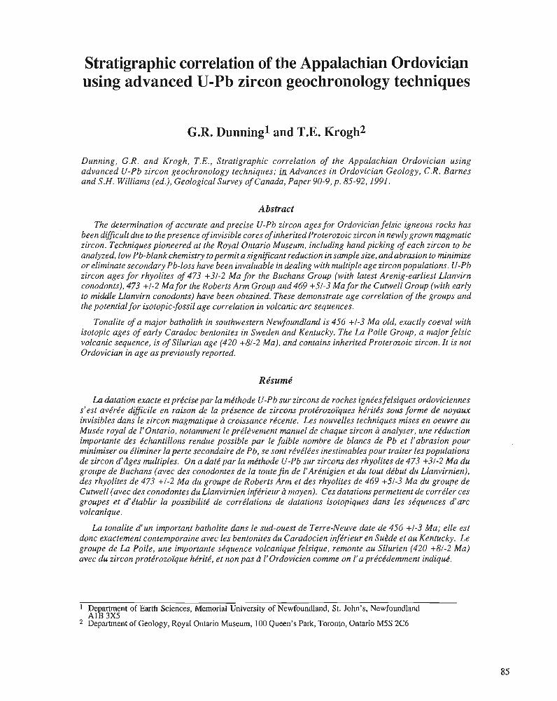
Stratigraphic correlation of the Appalachian Ordovician using advanced U-Pb zircon geochronology techniques
G.R. Dunning1 and T.E. Krogh2
Dunning, G.R. and Krogh, T.E., Stratigraphic correlation of the Appalachian Ordovician using advanced U-Pb zircon geochronology techniques; Advances in Ordovician Geology, C.R. Barnes and S.H. Williams (ed.), Geological Survey of Canada, Paper 90-9, p. 85-92,1991.
Abstract
The determination of accurate and precise U-Pb zircon ages for Ordovician felsic igneous rocks has been difficult due to the presence of invisible cores of inherited Proterozoic zircon in newly grown magmatic zircon. Techniques pioneered at the Royal Ontario Museum, including hand picking of each zircon to be analyzed, low Pb-blank chemistry to permit a significant reduction in sample size, and abrasion to minimize or eliminate secondary Pb-loss have been invaluable in dealing with multiple age zircon populations. U-Pb zircon ages for rhyolites of 473 +3/-2 Ma for the Buchans Group (with latest Arenig-earliest Llanvirn conodonts), 473 +I-2 Ma for the Roberts Arm Group and 469 +5/-3 Ma for the Cutwell Group (with early to middle Llanvirn conodonts) have been obtained. These demonstrate age correlation of the groups and the potential for isotopic-fossil age correlation in volcanic arc sequences.
Tonalite of a major batholith in southwestern Newfoundland is 456 +/-3 Ma old, exactly coeval with isotopic ages of early Caradoc bentonites in Sweden and Kentucky. The La Poile Group, a major felsic volcanic sequence, is of Silurian age (420 +%I-2 Ma), and contains inherited Proterozoic zircon. It is not Ordovician in age as previously reported.
La datation exacte et prkcise par la mkthode U-Pb sur zircons de roches ignkes felsiques ordoviciennes s'est avkrke difficile en raison de la prksence de zircons protkrozoiijues hkritks sous forme de noyaux invisibles dans'le zircon magmatique a croissance rkcente. Les nouvelles techniques mises en oeuvre au Muske royal de I'Ontario, notarnrnent le prkl2vernent manuel de chaque zircon d analyser, une rkduction importante des kchantillons rendue possible par le faible nombre de blancs de Pb et l'abrasion pour minimiser ou kliminer la perte secondaire de Pb, se sont rkvklkes inestimables pour traiter les populations de zircon d'dges multiples. On a datk par la mkthode U-Pb sur zircons des rhyolites de 473 +31-2 Ma du groupe de Buchans (avec des conodontes de la toute fin de 1'Arknigien et du tout dkbut du Llanvirnien), des rhyolites de 473 +/-2 Ma du groupe de Roberts Arm et des rhyolites de 469 +5/-3 Ma du groupe de Cutwell (avec des conodontes du Llanvirnien infkrieur ci moyen). Ces datations permettent de corrdler ces groupes et d'ktablir la possibilitk de corrklations de datations isotopiques dans les s.6quences d'arc volcanique.
La tonalite d u n important batholite dans le sud-ouest de Terre-Neuve date de 456 +/-3 Ma; elle est donc exactement contemporaine avec les bentonites du Caradocien infkrieur en Subde et au Kentucky. Le groupe de La Poile, une importante skquence volcanique felsique, remonte au Silurien (420 +8/-2 Ma) avec du zircon protkrozoi'que hkitk, et non pas b l'ordovicien comme on l'a prkckdemment indiqud.
1 De artment of Earth Sciences, Memorial University of Newfoundland, St. John's, Newfoundland A& 3x5
2 Department of Geology, Royal Ontario Museum, 100 Queen's Park, Toronto, Ontario M5S 2C6
INTRODUCTION Calibration of the geological time scale by isotopic dating of igneous units interstratified with fossiliferous sedimentary rocks is of fundamental importance to the earth sciences. In the assessment of orogenic processes operative in the history of the Appalachian-Caledonian Mountain Belt, it is critical that the age of igneous and metamorphic rock units can be compared directly to the stratigraphic age of sedimentary rocks.
Rb-Sr age determinations have in general been unreliable, likely due to the migration of Sr and Rb in late magmatic or alteration fluids. The resulting "mixichrons" can be as much as 50 or 100 m.y. older or younger than the true age of crystallization, based on a comparison of results from rocks in Newfoundland, Nova Scotia, Scotland, and Norway (e.g., Dunning et al., 1987, 1990). Ar-Ar ages record the age at which the analyzed mineral cooled through its blocking tem- perature and thus may be significantly younger than the age of crystallization in plutonic rocks. These provide valuable data on the cooling history of an intrusion or metamorphic assemblage, but not the primary age. Recently reported Ar-Ar (sanidine, biotite) results from bentonite beds in Kentucky and Sweden are in agreement with concordant zircon ages from the same beds (Kunk et al., 1988) and it is clear that Ar-Ar data provide reliable ages where suitable fresh miner- als are preserved in eruptive units.
U-Pb ZIRCON GEOCHRONOLOGY The U-Pb zircon geochronological technique has several advantages over other methods used to date crystallization of igneous rocks, and has become the standard against which results from other dating techniques are judged. These advan- tages include the resistance of the mineral zircon to alteration and metamorphism and the fact that, during crystallization, U is accepted into the crystal lattice but Pb is not. This means that the zircon is an "empty box" at the time of setting of the isotopic clock, and the Pb content measured in high quality zircon is virtually entirely radiogenic; the ideal case for geochronology. A further advantage is the existence of two independent chronometers; 2 3 5 ~ - 2 0 7 ~ b and 238U - 206~b , The resulting ages can be compared and, if they differ (are discordant), a determination of the degree of Pb-loss or dis- turbance of the system can be made.
The accuracy and precision of a U-Pb age determination are dependent upon:
1. The accuracy and precision of the measurement of the isotopic ratios. Accuracy is assessed by repeated measure- ment of standards; precision is a function of the amount of the element present, the stability of the ion beam, and other physical factors. It is assessed by calculations of means, standard deviations, and reproducibility through- out a determination.
2. The ratio of radiogenic Pb to common Pb. A high ratio minimizes the uncertainty in the correction for contami- nant common Pb in the analysis. This common Pb occurs in altered domains, inclusions and on the surfaces of the
zircon grains, and as common Pb contributed through the laboratory procedures, especially in reagents. Measure- ment and laboratory procedures will not be covered in this paper except as the latter directly relate to the determina- tion of reliable ages for the Ordovician rocks discussed below.
3. The distribution of data points on the concordia diagram. The distribution is a function of several properties of the zircons analyzed, and the interpretation of many data sets is not straightforward.
Interpretation of U-Pb data arrays
In the simplest case of high quality zircon that has not undergone Pb-loss since crystallization, data points will fall on the concordia curve (Fig. 1; example A), the locus of all concordant ages on the common concordia diagram (Faure, 1986). This simple result is rarely attained from the analysis of large fractions. Improved techniques for the selection of the highest quality grains using a magnetic pin under the microscope (Krogh, 1982a), and abrasion of these grains, which might have undergone Pb-loss, to remove outer sur- faces and altered domains (Krogh, 1982b), have resulted in a larger proportion of concordant analyses.
To obtain an analysis of the smaller amount (about 0.20 to 0.05 mg at Ordovician age) of high quality zircon obtained with these procedures, improvements have been made in chemistry and measurement techniques. Laboratory Pb blanks have been reduced to the 2-5 picogram (pg = 1 0 - l ~ ~ ) range so that high ratios of radiogenic Pb:common Pb are maintained despite the analysis of smaller amounts of sample
Figure 1. Generalized concordia diagram showing three types of data arrays that yield valid ages. A. duplicated concordant points; B. simple discordia or "Pb-loss" line; C. mixing line. See text for discussion.
Pb. At the same time, the development of commercial mass spectrometers with extended geometry has led to a four- or five-fold increase in ion transmission. This has, to a certain degree, counterbalanced the decrease in the amount of sample Pb measured so that an acceptable measurement precision is maintained.
Analyses from a single age igneous zircon population in some cases yield a linear array defining a Pb-loss trajectory (Fig. 1, example B). The upper intercept of this discordia line with the concordia curve indicates the age of crystallization. In these cases, the uncertainty regarding the age is related to the measurement uncertainty of each analysis, because these propagate through to uncertainty on the slope of the line. A discordia line without a point near concordia will yield a larger uncertainty on the upper intercept age. A fraction of highest quality abraded zircon is always analyzed to provide a data point as close to concordia as possible in order to reduce the uncertainty that results from projection to the concordia curve. This has been carried out in all the examples presented below.
Because of the refractory nature of zircon, many magmas produced by partial melting of continental crust or sediment contain an inherited zircon component. In many Ordovician rocks of the Appalachian-Caledonian Mountain Belt, a com- ponent of inherited Proterozoic zircon is present as discrete rounded cores enclosed in newly grown euhedral magmatic zircon. These must be recognized and properly dealt with if a valid crystallization age is to be obtained. It is now clear that, because of the failure to recognize inherited zircon, many published U-Pb zircon ages of Paleozoic rocks are invalid. If core material is present, it is critical that all frac- tions analyzed be of highest quality zircon, with no cracks or inclusions, that has been strongly abraded to minimize or eliminate secondary Pb-loss. The data points will define a mixing line (Fig. 1, example C) between the average age of inherited zircon at the upper intercept with concordia, and the age of magmatic overgrowths at the lower intercept. If un- abraded zircon or poor quality grains are included in the analysis, they may cause the data point to fall below the correct line as a result of secondary Pb-loss. If included in the linear regression, an invalid lower intercept age would result. Where inheritance is present in a sample, it may be possible to select needle-like zircon free of inherited cores for separate analysis. As an alternative, magmatic monazite or titanite can be analyzed, and these should plot on concordia at the lower intercept of the mixing line. However, it must be considered that under certain geological conditions these minerals could yield ages truly younger than the correct zircon age. Whatever the complexity of the zircon population in an igneous rock, it should be possible to determine an accurate and precise age of crystallization by paying attention to the details of mor- phology and selecting for analysis only the highest quality zircon.
U-Pb zircon ages of Ordovician rocks: Newfoundland Appalachians
Determination of the ages of stage boundaries in the Ordovi- cian is hampered by the fact that the most complete fossilif- erous sections in sedimentary basins have few interstratified volcanic horizons, while the volcanic arc sequences only rarely preserve strata containing diagnostic fossil assem- blages. As part of a program of U-Pb zircon age determina- tions of volcanic and plutonic rocks from allochthonous remnants of the Iapetus Ocean, ophiolites and volcanic rocks that are interbedded or associated with fossiliferous strata were dated. These data provide some information to constrain the Ordovician time scale.
Analytical procedures
The results presented below are all relevant to a discussion of the Ordovician System. Some have been presented pre- viously, along with details of procedures. Our analytical techniques have improved significantly since 1982 and this section presents only a generalized discussion that applies to all results. Further details of our present procedures can be found in Corfu and Ayres (1 984) and Dunning and Pedersen (1988). Zircons were separated under clean conditions using standard techniques of crushing and mineral separation with a Wilfley table, Frantz isodynamic separator, and heavy liquids. They were then processed into magnetic and size fractions for which the nomenclature is explained in Table 1. Zircons were dissolved and the Pb and U separated b the J method of Krogh (1973), with modifications. A mixed 5 ~ b - 2 3 5 ~ isotopic tracer (Krogh and Davis, 1975) was introduced into the Teflon capsules with the zircon and 0.5-1.0 ml HF and 5 drops 6N HN03 for dissolution, which was accom- plished in an oven at 220°C in five days. U and Pb were separated on standard (1982-1984) or miniaturized ion ex- change columns (one-tenth of previous resin and reagent volumes) using standard procedures, and loaded on Re fila- ments using H3PO4 and silica gel. Analyses were performed on a MM 30 or VG 354 mass spectrometer with ratios measured in the temperature range 1400 to 1600°C. A single Faraday cup was used for larger samples, except for the 207~b-204~b ratio. However, for several small samples, a Daly detector was used for all measurements.
For the Cutwell and La Poile group analyses, uncertainties in the isotopic ratios were calculated using the error propaga- tion procedure of Ludwig (1980). The other analyses were performed in 1982-1984 and were assigned uncertainties based on estimated overall reproducibility. The discordia lines, intercept ages and uncertainties (95% confidence inter- val) were calculated using the program of Davis (1982).
Betts Cove Complex-Snooks Arm Group
Zircons separated from gabbro of the Betts Cove ophiolite complex (Fig. 2) were clear, coarse, dark to light brown anhedral fragments. Four fractions analyzed defined a short colinear array, with the best abraded fraction only 1 % discor- dant (Fig 3A; Table 1) and yielded an age of 489 +3/-2 Ma (Dunning and Krogh, 1985). Immediately overlying the com- plex are tuffs, lavas, and sedimentary rocks of the Snooks Arm Group, from which a limited graptolite fauna was ob- tained that indicates a middle Arenig age (Snelgrove, 1931). This age was challenged as being based on "slight" paleon- tological evidence (Ross et al., 1978) in a paper that reviewed evidence that could constrain the Ordovician time scale. A
new collection of material from this sample locality (Wil- liams, 1989) has yielded a graptolite fauna characteristic of the lower part of the D. bifidus Zone of Williams and Stevens (1988). Although these lower middle Arenig strata must be slightly younger than the dated underlying gabbro of the ophiolite, it is considered that they are close in age.
Buchans-Roberts Arm-Cutwell groups
These three stratigraphic packages of volcanic rocks with interbedded sedimentary rocks occur from central to north- central Newfoundland and are allochthonous and structurally imbricated remnants of an island arc of the Iapetus Ocean. The Buchans, Roberts Arm, and Cutwell groups were considered
Figure 2. Map of Newfoundland showing distribution of the units discussed in the text and sample locations. Inset map shows area of Newfoundland covered in main map.
Figure 3A. Concordia diagram for the Betts Cove gabbro. B. Concordia diagram for the Buchans Group rhyolite. C. Concordia diagram for the Roberts Arm Group felsic tuff. D. Concordia diagram for the Cutwell Group rhyolite. E. Concordia diagram for the Southwest Brook batholith to- nalite showing mixing line with concordant titanite. Error ellip- ses are smaller than the symbols shown. F. Concordia diagram for the La Poile Group felsic tuff. Analyses 14 1 m and 14 mm were reported by Chorlton and Dallmeyer (1 986) for the same outcrop.
to be of Late Ordovician or Silurian age (Strong, 1977; Kean et al., 1981) based on regional correlation and the require- ments of tectonic models. The Cutwell Group was cited as the best example of a post-Caradoc arc sequence because rocks of the group were interpreted as unconformably over- lying a dated Caradoc black shale (Dean, 1978). Nowlan and Thurlow (1984) obtained a late Arenig-early Llanvirn age from conodonts in limestone blocks in a breccia within the Buchans Group and suggested that it, and the correlative Roberts Arm Group, were therefore of that age.
Zircons from a rhyolite of the Buchans Group are sparse euhdral to subhedral fine grains. Three fractions analyzed (Fig. 3B; Table 1) show a limited range of discordance from about 1.8 to 4% discordant and yield an upper intercept age of 473 +3/-2 Ma (Dunning et al., 1987). Zircons from a rhyolitic tuff from the upper section of the Roberts Arm
Group are abundant, coarse, euhedral grains and the three high quality abraded fractions plot 1.1 to 1.2% discordant. These, together with an unabraded fraction of fine grains, 9.4% discordant, define a line with an upper intercept age of 473 +/-2 Ma (Fig. 3C). These U-Pb zircon ages of rhyolites from the Buchans and Roberts Arm groups confirm their correlation and age. As well, the proximity of the zircon and conodont samples within the sequence at Buchans means that they can be considered coeval (Dunning et al., 1987), so that 473 +3/-2 Ma is a latest Arenig or earliest Llanvirn age.
Resampling of the sedimentary sequence that is overlain by rhyolite of the Cutwell Group was undertaken to check the paleontological age (Dean, 1978), and a U-Pb zircon age was determined for the rhyolite from the same outcrop on the Oil Islands (Fig. 2; locality D). A sparse conodont fauna indicates an early to middle Llanvirn age of deposition (Meyer et al., 1988), refuting the Caradoc age reported earlier.
Zircons separated from the Cutwell Group rhyolite are abundant, coarse euhedral grains. Two abraded and one un- abraded fraction analyzed define a line with a 31% prob- ability of fit and yield an upper intercept age of 469 +5/-3 Ma (Fig. 3D; Table 1). This line is anchored on concordia with a concordant point (analysis 12). Graptolites collected from shales of the Cutwell Group at other localities and further collections of conodont samples from limestone lenses in the volcanic rocks have yielded latest Arenig or earliest Llanvirn ages (Williams, 1988, 1989; O'Brien and Szybinski, 1988). These clearly demonstrate that this group is of early Ordovi- cian age everywhere.
The general lithological correlation, overlapping U-Pb zircon ages of rhyolites, and close similarities of the conodont faunas (O'Brien and Szybinski, 1988) strongly support the correlation of the Buchans, Roberts Arm, and Cutwell groups. All three are late Arenig and/or early Llanvirn sequences, based on the available faunal and U-Pb age data; there is no evidence for the presence of a post-Caradocian submarine volcanic arc sequence in the Newfoundland Appalachians. Indeed, it is only because of an artifact of the scale of mapping (1:50,000) and previous invalid radiometric and fossil age determinations that these rocks were assigned to different groups.
Southwest Brook Complex, Newfoundland
A major element of the geology of southwestern Newfound- land is an early Paleozoic batholith with plutons that vary in composition from hornblende gabbro and diorite to tonalite, monzonite, and granodiorite. Components of this batholith include the Cape Ray Granite, the Southwest Brook Com- plex, Hungry Mountain Complex, Burlington Granodiorite, and other smaller units correlated with them (Dunning and Chorlton, 1985; Dunning et al., 1989). Hornblende and biotite-bearing tonalite plutons make up the largest propor- tion of the batholith. These rocks int~ude and locally engulf mafic ophiolitic rocks throughout southwestern Newfound- land. Coarse clastic sedimentary rocks, correlated with the Eocambrian-Cambrian continental margin sequence of the Fleur de Lys Supergroup, also occur as xenoliths and large rafts in the batholith. A biotite and hornblende-bearing
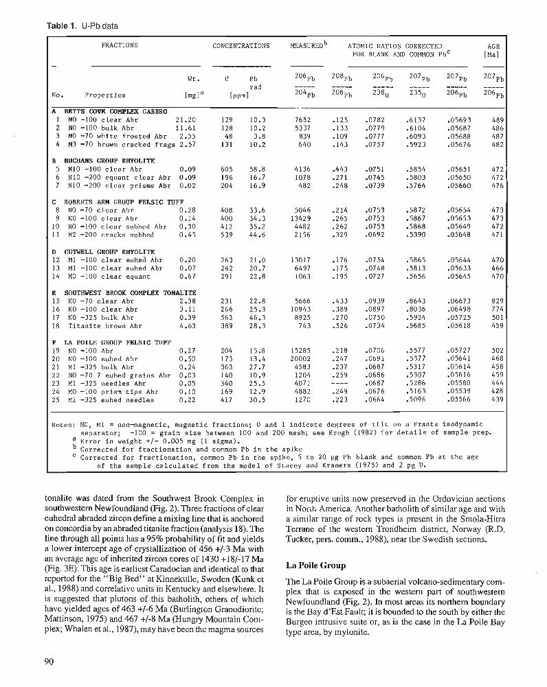
Table 1. U-Pb data
F R A C T ~ O N S CONCENTRATIONS MEASURED^ ATOMIC RATIOS CORRECTED AGE FOR BLANK AND COMMON PbC [Ma]
- W t . U Pb 2O6pb 208pb 2O6pb 2O7pb 2O7pb 2O7pb
rad ----- ----- - - - - - - - - - - - - - - - - - - - - No. P r o p e r t i e s [mgla [ P P ~ ] 204pb 206pb 238" 235" 206pb 206Pb
A BETTS COVE COMPLEX GABBRO 1 NO -100 c l e a r Abr 21.20 129 10.3 7652 .125 -0782 .6137 .05693 489 2 NO -100 bulk Abr 11.61 128 10.2 5337 -133 .0779 .6104 .05687 486 3 NO -70 wh i t e f r o s t e d Abr 2.55 48 3.8 839 . l o9 .0777 -6093 .05688 487 4 M 3 -70 brown cracked f r a g s 2.57 131 10.2 640 .143 -0757 .5923 -05676 482
B BUCHANS GROUP RHYOLITE 5 N10 -100 c l e a r Abr 0.09 605 58.8 4136 .443 -0751 .5854 .05651 472 6 N10 -200 equant c l e a r Abr 0.09 196 16.7 1078 .271 -0745 -5803 -05650 472 7 N10 -200 c l e a r prisms Abr 0.02 204 16.9 482 -248 .0739 .5764 .05660 476
C ROBERTS ARM GROUP FELSIC TUFF 8 NO -70 c l e a r Abr 0.28 408 33.6 5046 -214 .0753 .5872 .05654 473 9 NO -100 c l e a r Abr 0.14 400 34.3 13429 -265 .0753 -5867 -05653 473
10 NO -100 c l e a r subhed Abr 0.30 412 35.2 4482 -262 .0753 .5868 -05649 472 11 M2 -200 c racks subhed 0.45 539 44.6 2156 -329 .0692 .5390 .05648 471
D CUTWELL GROUP RHYOLITE 12 M1 -100 c l e a r euhed Abr 0.20 263 21.0 13017 .I76 -0754 -5865 -05644 470 13 M1 -100 c l e a r euhed Abr 0.07 262 20.7 6497 .175 .0748 .5813 .05633 466 14 MO -100 c l e a r equant 0.67 291 22.8 1063 .195 -0727 .5656 -05645 470
E SOUTHWEST BROOK COMPLBX TONALITE 15 NO -70 c l e a r Abr 2.38 231 22.8 5666 .433 .0939 .8643 .06673 829 16 N O -100 c l e a r Abr 3.11 266 25.3 10943 .389 .0897 .8036 .06498 774 17 NO -325 bulk Abr 0.39 563 46.3 8925 .270 .0750 .5924 .05725 50 1 18 T i t a n i t e brown Abr 4.63 389 28.3 743 ,526 .0734 .5685 .05618 459
F LA POILE GROUP FELSIC TUFF 19 NO -100 Abr 0.27 204 15.8 15285 .218 .0706 .5577 ,05727 502 20 NO -100 euhed Abr 0.50 173 13.4 20002 .247 .0691 .5377 .05641 468 21 M1 -325 bulk Abr 0.24 363 27.7 4583 .237 .0687 .5317 .05614 458 22 NO -70 7 euhed g r a i n s Abr 0.03 140 10.9 1204 .259 .0686 .5307 .05616 459 23 M1 -325 need le s Abr 0.05 340 25.5 407 1 ---- .0687 .5286 .05580 444 24 MO -100 prism t i p s Abr 0.10 169 12.9 4882 .249 .0676 .5163 .05539 428 25 M1 -325 euhed needles 0.22 417 30.5 1270 .223 .0664 .5096 .05566 439
Notes: NO, M1 = nonmagne t i c , magnetic f r a c t i o n s ; 0 and 1 i n d i c a t e deg rees of t i l t on a F ran tz isodynamic s e p a r a t o r ; -100 = g r a i n s i z e between 100 and 200 mesh; s e e Krogh (1982) f o r d e t a i l s of sample prep.
a E r r o r i n weight +/- 0.005 mg (1 sigma). Cor rec t ed f o r f r a c t i o n a t i o n and common Pb i n t h e s p i k e Cor rec t ed f o r f r a c t i o n a t i o n , common Pb i n t h e sp ike , 5 t o 20 pg P b b lank and common Pb a t t h e age
of t h e sample c a l c u l a t e d from t h e model o f Stacey and Kramers (1975) and 2 pg U .
tonalite was dated from the Southwest Brook Complex in southwestern Newfoundland (Fig. 2). Three fractions of clear euhedral abraded zircon define a mixing line that is anchored on concordia by an abraded titanite fraction (analysis 18). The line through all points has a 95% probability of fit and yields a lower intercept age of crystallization of 456 +/-3 Ma with an average age of inherited zircon cores of 1430 +18/-17 Ma (Fig. 3E). This age is earliest Caradocian and identical to that reported for the "Big Bed" at Kinnekulle, Sweden (Kunk et al., 1988) and correlative units in Kentucky and elsewhere. It is suggested that plutons of this batholith, others of which have yielded ages of 463 +/-6 Ma (Burlington Granodiorite; Mattinson, 1975) and 467 +/-8 Ma (Hungry Mountain Com- plex; Whalen et al., 1987), may have been the magma sources
for eruptive units now preserved in the Ordovician sections in Nor~h America. Another batholith of similar age and with a similar range of rock types is present in the Smola-Hitra Terrane of the western Trondheim district, Norway (R.D. Tucker, pers. comm., 1988), near the Swedish sections.
La Poile Group
The La Poile Group is a subaerial volcano-sedimentary com- plex that is exposed in the western part of southwestern Newfoundland (Fig. 2). In most areas its northern boundary is the Bay d'Est Fault; it is bounded to the south by either the Burgeo intrusive suite or, as is the case in the La Poile Bay type area, by mylonite.
Cooper (1954) established a tripartite division in the La Poile Bay area that included a basal conglomerate, an inter- mediate, mainly sedimentary unit, and an upper widespread unit of subaerial ash-flow tuff, rhyolite, lahar, and associated finer grained epiclastic rocks (Chorlton, 1980; S. O'Brien, 1983; B. O'Brien, 1987). Cooper (1954) originally assigned these rocks to the Devonian, based on a lithological correla- tion with fossiliferous Devonian strata to the west, whereas Chorlton (1980) subsequently assigned an Ordovician age to the La Poile Group. Chorlton and Dallmeyer (1986) reported a U-Pb age of 452 +5 11-1 3 Ma for the La Poile Group, based on analysis of bulk zircon fractions from two different tuff horizons.
A quartz and feldspar-phyric tuff collected from the east side of La Poile Bay at locality 14 of Chorlton and Dallmeyer (1986)(Fig. 2; locality F) yielded abundant clear, euhedral grains. Eight fractions with differing grain size and magnetic properties were anaIyzed (Table I), including six abraded fractions that define a linear trend (Fig. 3F) from analysis 24, closest to concordia, to analysis 19. The lower intercept of 420 +8/-2 Ma (probability of fit 12%) is taken as the age of eruption of this rhyolite (= Silurian). The abraded tips of euhedral prismatic zircons (24) contain the least amount of inherited core material because cores typically occur cen- trally in the grain. The upper intercept of 1376 +/-I20 Ma is the average age of the cores, but these could have actual ages of 1 and 1.6 Ga for example. Analyses 5 and 6, comprising cracked or very fine grains, have undergone significant sec- ondary Pb-loss and approximately duplicate bulk analyses (14-mm, 14- lm) reported for the same outcrop by Chorlton and Dallmeyer (1986). These authors grouped their two data points with two from another sample of the La Poile Group collected 7 km away (loc. 18; Chorlton and Dallmeyer, 1986) and fitted a discordia line to all four points to determine an age of 452 +51/-13 Ma, noting that three of four fractions give similar 207~b/206~b ages of 448 to 455 Ma (each +/-7 m.y.) as additional justification for their age. However, they failed to recognize that this sample contained a mixed-age zircon population.
This is a clear-cut example emphasizing the need for careful selection of the highest quality zircons, followed by abrasion to eliminate altered portions of grains, prior to analysis. In a sample with inherited zircon, it is only such fractions that define a valid mixing line projecting to the true age of crystallization. Analyses of large fractions or poor quality zircon yield no valid age information.
DISCUSSION The U-Pb zircon ages presented here demonstrate different types of data sets in rocks of Ordovician or, in the case of the La Poile Group, previously interpreted Ordovician age. The importance of selection of the highest quality grains for analysis is empha- sized in all cases, as these yield less discordant, or truly concor- dant, data points, which provide more accurate and precise ages. The potential for matching isotopic and fossil ages is demon- strated with the Buchans and Cutwell group examples and further U-Pb work is currently underway on other fossiliferous Ordovician strata. The previously reported U-Pb zircon age for
the La Poile volcanics is typical of many in the literature, where large zircon fractions were analyzed without attention being paid to the complexity or quality of the zircon popula- tion. The data points can appear consistent (and colinear) because the large sample weights of zircon analyzed lead to an averaging of themixed magmatic and inherited component in each fraction. In such a case it would not be possible to get a concordant fraction, but because concordant points are not commonly obtained without careful sample selection and abrasion, this might not arouse the suspicions of the analyst. The result is then published and believed because of the high degree of confidence placed in zircon ages in general. Al- though both of the present authors are enthusiastic U-Pb geochronologists, they hope to have made the point here that all zircon ages are not created equal. Many published ages are invalid as a result of the analysts' failure to recognize the complexity of some zircon populations and deal with them effectively (see examples in Rogers et al., 1989; Rogers and Dunning, in press). It is important that geologists become aware of possible pitfalls as well as the inherent advantages of the U-Pb geochronological technique. They can then criti- cally assess U-Pb data sets and judge the quality and validity of the ages reported. Most credence should be attached to U-Pb ages based on concordant data points and on analyses with a high ratio of radiogenic Pb to common Pb. Discordia or mixing lines involving three or more analyses of carefully selected, high quality fractions, including abraded fractions, are the most reliable. In the final analysis, consistency, repro- ducibility and compatibility with clear field relationships are important tests of any isotopic age determination.
ACKNOWLEDGMENTS This work was carried out while G.R.D. was an NSERC post-doctoral fellow at the Royal Ontario Museum and during the first year of a University Research Fellowship at Memo- rial University of Newfoundland. Field expenses were sup- ported by the Geological Survey of Canada and the Newfoundland Department of Mines, and additional funding for analytical work was provided by an NSERC grant to T.E. Krogh. Technical assistance was provided by Y.Y. Kwok and B. Podstwaskyj at the Royal Ontario Museum.
REFERENCES Chorlton, L.B. 1980: Geology of the La Poile River area (1 10/16), Newfoundland. New-
foundland Department of Mines and Energy, Report 80-3,86 p. Chorlton, L.B. and Dallmeyer, R.D. 1986: Geochronology of early to middle Paleozoic tectonic development
in the southwest Newfoundland Gander Zone. Journal of Geology, V. 94, D. 67-89. . .
Cooper, J.R. 1954: The La Poile-Cina Cerf mao area. Newfoundland. Geological Sur-
vey of Canada, ~ e r n o i r 254,62 p. -
Corfu, F. and Ayres, L.D. 1984: U-Pb ages and genetic significance of heterogeneous zircon popu-
lations in rocks from the Favourable Lake area, northwestern On- tario. Contributions to Mineralogy and Petrology, v. 88, p. 86-101.
Davis, D.W. 1982: Optimum linear regression and error estimation applied to U-Pb
data. Canadian Journal of Earth Sciences, v. 19, p. 2141-2149.
Dean, P.L. 1978: The volcanic stratigraphy and metallogeny of Nohe Dame Bay,
Newfoundland. Memorial University of Newfoundland, Geology Report 7,205 p.
Dunning, G.R., Barr, S.M., Raeside, R.P., and Jamieson, R.A. 1990: U/Pb zircon, titanite and monazite ages in the Bras d'Or and Aspy
terranes of Cape Breton Island, Nova Scotia: implications for igne- ous and metamorphic history. Geologcal Society of America Bul- letin, v. 102, p. 322-330.
Dunning, G.R., Kean, B.F., Thurlow, J.G., and Swinden, H.S. 1987: Geochronology of the Buchans, Roberts Ann, and Victoria Lake
groups and Mansfield Cove Complex, Newfoundland. Canadian Joumal of Earth Sciences, v. 24, p. 1 175- 1 184.
Dunning, G.R. and Chorlton, L.B. 1985: The Annieopsquotch ophiolite belt of southwcst Newfoundland:
geology and tectonic significance. Geological Society of America Bulletin, v. 96, p. 1466-1476.
Dunning, G.R. and Krogh, T.E. 1985: Geochronology of ophiolites of the Newfoundland Appalachians.
Canadian Journal of Earth Sciences, v. 22, p. 1659-1670. Dunning, G.R. and Pedersen, R.B. 1988: U/Pb ages of ophiolites and arc-related plutons of the Norwegian
Caledonides: implications for the development of Iapetus. Contri- butions to Mineralogy and Petrology, v. 98, p. 13-23.
Dunning, G.R., Wilton, D.H.C., and Herd, R.K. 1989: Geology, geochemishy and geochmnology of a taconic batholith,
southwestern Newfoundland. Transactions of the Royal Society of Edinburgh, Earth Sciences, v. 80, p. 159-168.
Faure, G. 1986: Principles of Isotope Geology. 2nd edn., Wiley, N.Y., 589 p. Kean, B.F., Dean, P.L., and Strong, D.F. 1981: Regional geology of the Cenhal Volcanic Belt of Newfoundland.
In The Buchans Orebodies: Fifty Years of Geology and Mining, E.A. Swanson, D.F. Strong, and J.G. Thurlow (eds.); Geological Association of Canada, Special Paper 22, p. 65-78.
Krogh, T.E. 1973: A low contamination method for hydrothermal decomposition of
zircon and extraction of U and Pb for isotopic age determinations. Geochimica et Cosmochimica Acta, v. 37, p. 485-494.
1982a: hnproved accuracy of U-Pb dating by selection of more concordant fractions using a high gradient magnetic separation technique. Geo- chimica et Cosmochimica Acta, v. 46, p. 631-636.
l982b: Improved accuracy of U-Pb zircon ages by creation of more con- cordant systems using an air abrasion technique. Geochimica et Cosmochimica Acta, v. 46, p. 637-649.
Krogh, T.E. and Davis, G.L. 1975: The production and preparation of 205Pb for use as a tracer for
isotope dilution analyses. Carnegie Institution of Washington Year- book, v. 74, p. 416,417.
Kunk, M.J., Samson, S.D., and Roddick, J.C. 1988: 40Ar/39Ar age spectrum dating of biotite and sanidine and U/Pb
dating of zircon of mid-Ordovician bentonites from Swcden: a comparison with results from eastern North America. In Fifth International Symposium on the Ordovician System, Program and Abshacts, S.H. Williams and C.R. Barnes (eds.); p. 49.
Ludwig, K.R. 1980: Calculation of uncertainties of U-Pb isotope data. Earth and Plane-
tary Science Letters, v. 46, p. 212-220. Mattinson, J.M. 1975: Early Paleozoic ophiolite complexes of Newfoundland: isotopic
ages of zircons. Geology, v. 3, p. 181-183.
Meyer, J.R., Dean, P.L., and Barnes, C.R. 1988: Conodont ages for three carbonate samples from Middle Ordovician
cherts and shales in central Newfoundland. Newfoundland Depart- ment of Mines, Report 88-1, p. 189-1 92.
Nowlan, G.S. and Thurlow, J.G. 1984: Middle Ordovician conodonts from the Buchans Group, central
Newfoundland, and their significance for regional shatigraphy of the Central Volcanic Belt. Canadian Journal of Earth Sci- ences, v. 21, p. 284-296.
O'Brien, B.H. 1987: The lithostratigraphy and structure of the Grand Bruit-Cinq Cerf
areas (parts of NTS areas 11019 and 110/16), southwestern New- foundland. Newfoundland Department of Mines, Report 87-1, p. 31 1-334.
O'Brien, F.H.C. and Szybinski, Z.A. 1988: Lower-Middle Ordovician fauna from the Cutwell Group (cenhal
Newfoundland): its implications on stratigraphy and structure. In Fifth International Symposium on the Ordovician Systcm, S.H. Williams and C.R. Barnes (eds.); Program and Abstracts, p. 68.
O'Brien, S.J. 1983: Geology of the eastern half of the Peter Snout map m a (1 1P/13E),
Newfoundland. Newfoundland Department of Mincs, Report 83-1, p. 57-67.
Rogers, G., Dempster, T.J., Bluck, B.J., and Tanner, P.W.G. 1989: A high precision U-Pb age for the Ben Vuirich granite: implications
for the evolution of the Scottish Dalradian Supergroup. Joumal of the Geological Society of London, v. 146, p. 789-798.
Rogers, G. and Dunning, G.R. in press: Geochronology of appinitic and related granitic magmatism in the
W Highlands of Scotland: constraints on the timing of transcurrent fault movement. Joumal of the Geological Society of London.
Ross, R.J., Jr., Naesser, C.W., and Lambert, R. St.J. 1978: Ordovician geochronology. ln Contributions to the Geological Time
Scale. American Association of Petroleum Geologists, Studies in Geology, no. 6, p. 347-354.
Snelgrove, A.K. 1931: Geology and ore deposits of the Betts Cove-Tilt Cove area, Nohe
Dame Bay area, Newfoundland. Canadian Mining and Metallurgi- cal Bulletin, v. 24, p. 477-519.
Stacey, J.S. and Kramers, J.D. 1975: Approximation of terrestrial lead isotope evolution by a two-stage
model. Earth and Planetary Science Letters, v. 26, p. 207-221. Strong, D.F. 1977: Volcanic regimes of the Newfoundland Appalachians. In Volcanic
Regimes in Canada, W.R.A. Baragar, L.C. Coleman, and J.M. Hall (eds.); Geological Association of Canada, Special Paper 16, p. 6 1-90.
Whalen, J.B., Currie, K.L., and van Breeman, 0. 1987: Episodic Ordovician-Silurian plutonism in the Topsails Igneous
Terrane, western Newfoundland. Transactions of the Royal Society of Edinburgh, Earth Sciences, v. 78, p. 17-28.
Williams, S.H. 1988: Middle Ordovician graptolites from central Newfoundland. New-
foundland Department of Mines, Report 88-1, p. 183-188. 1989: New graptolite discoveries from the Ordovician of cenhal New-
foundland. Newfoundland Department of Mines, Report 89-1, p. 149-157.
Williams, S.H. and Stevens, R.K. 1988: Early Ordovician (Arenig) graptolites of the Cow Head Group,
western Newfoundland. Paleontographica Canadiana, v. 5, 167 p.
Ordovician vertebrates
D.K. Elliottl, A.R.M. Blieck2, and P.-Y. Gagnier3
Elliott, D.K., Blieck, A.R.M., and Gagnier, P.-Y., Ordovician vertebrates; b Advances in Ordovician Geology, C.R. Barnes and S.H. Williams (ed.), Geological Survey of Canada, Paper 90-9, p. 93-106,1991.
Abstract
The fossil record for the early evolution of vertebrates consists of the remains of Agnatha (jawless vertebrates) from the Ordovician of Australia, North America, and Bolivia. Although vertebrate fragments have been reported from the Upper Cambrian and Lower Ordovician, none can be conclusively identified as vertebrate and their status remains uncertain at present. The oldest agreed vertebrates occur in the Stairway Sandstone of central Australia (Arandaspis, Porophoraspis) of early Llanvirn age, whereas slightly younger remains occur in the Harding Sandstone and equivalents of the U.S.A. and Canada (Astraspis, Eriptychius) and the Anzaldo Formation of Bolivia (Sacabambaspis) of early Caradoc age. All occur in very nearshore, intertidal to subtidal, marine environments. Present knowledge of the anatomy of these animals shows that the Australian and Bolivian forms are more closely related to each other than to the North American genera. Although the Ordovician vertebrates had previously been classified with the Heterostraci because of their external armour of bony plates formed of aspidin, it has now been shown that they possess primitive features such as numerous branchial openings and superjicial sensory grooves that would exclude them from that group. Understanding of relationships with later vertebrates is hampered by a gap in the fossil record between the Caradoc and the upper Llandovery that correlates with Late Ordovician glaciation.
Les premiires traces fossiles de l'kvolution des vertthr-e's sont des poissons fossiles sans mdchoires ( ' 'Agnathes") re'coltks duns les roches ordoviciennes d' Australie, d1Ame'rique du Nord, et de Bolivie. Bien que des microfragments de tissue phosphate' du Cambrierz supe'rieur ou de l'ordovicien infkrieur aient ktk signalks, il n'existe aucune certitude permettant de dksigner ces restes comme appartenant d des vertkbrks. Les plus vieux vertkbrks reconnus sont donc ceux des grEs de Stairway du centre de 1'Australie (Arandaspis et Porophoraspis, du Llanvirn infe'rieur), des grbs de Harding et de leurs kquivalents amkricains et canadiens (Astraspis et Eriptychius) ainsi que de la formation Anzaldo de Bolivie (Sacabambaspis du Caradoc infe'rieur). Tous les gisements appartiennent B un milieu marin de type intertidal a infratidal. L'ktude des relations de parent6 des divers taxons permet de rapprocher le genre bolivien Sacabambaspis du genre australien Arandaspis, les genres nord-ambicains ktant phylogknktiquement plus kloignks. Par ailleurs, les vertkbrks ordoviciens ktaient, jusqu'b prbent, classks parmi les Hktkrostracks du fait de leur armure osseuse externe forme'e d'os acellulaires (apidine) cependant des caractbres primitifs dkcouverts sur les sptcimens boliviens, telle que la prtsence de plusieurs ouvertures branchiales et de sillons sensoriels superficiels, les excluent de ce groupe B moins d e n modifier la de'finition. La comprkhension des relations phylogknktiques entre les premiers vertkbrks et les formes plus tardives est rendue difficile par l'absence de fossiles entre le Caradoc et le Llandovery sup6rieur, un intervalle de temps qui est en corrklation avec la glaciation qui eut lieu au cours de l'ordovicien supbieur.
De~artment of Geology, P.O. Box 6030, Northern Arizona University, Flagstaff, AZ 8601 1-6030, U.S.A. UniversitC des Sciences et Techniques de Lille Flandres Artois, Sciences de la Terre, URA 1365 du CNRS, F-59655, Villeneuve d'Asc Cedex, France
3 Museum Natlonal d'Hstolre ~arura le , lnstttut de Pal6onrologie. 8 rue Buffon, 75005 Paris, France
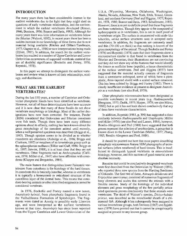
INTRODUCTION For many years there has been considerable interest in the earliest vertebrates due to the light that they might shed on questions of early vertebrate relationships, and the environ- ment in which the earliest vertebrates developed (Romer, 1946; Denison, 1956; Boucot and Janis, 1983). Although for many years there was little information on vertebrates below the Silurian (Walcott, 1892), in recent years there has been a sudden increase in our knowledge of these forms due to new material being available (Ritchie and Gilbert-Tomlinson, 1977; Gagnier et al., 1986) or new interpretations being made (Elliott, 1987). In addition, the search for the earliest verte- brates has resulted in a number of Upper Cambrian and Lower Ordovician occurrences of supposed vertebrate material that are of doubtful significance (Bockelie and Fortey, 1976; Repetski, 1978).
In this paper we attempt to distinguish the earliest verte- brates and review what is known of their relationships, ecol- ogy, and distribution.
WHAT ARE THE EARLIEST VERTEBRATES? During the last 130 years, a number of Cambrian and Ordo- vician phosphatic fossils have been identified as vertebrate. However, not all of these determinations have been accurate and it is now clear that many of these fossils do not show vertebrate morphology or histology. Most of the earlier des- ignations have now been corrected. For instance, Pander (1856) considered that Ordovician and Silurian conodonts were fish teeth. Though there have been many different opinions about its affinity, nothing has been known about the gross morphology of the conodont animal until recently, when a well preserved specimen was described (Briggs et al., 1983). Though opinion seems to be divided as to whether conodonts are chordates (Aldridge et al., 1986; Briggs and Clarkson, 1987) or members of an invertebrate group such as the aplacophoran molluscs (Tillier and Cuif, 1986; Briggs et al., 1987; Janvier, 1988), it is at least clear that they are not vertebrates. Other fragments such as Archeognathus (Culli- son, 1938; Miller et al., 1947) also have affinities with cono- donts (Klapper and Bergstrom, 1984).
The main feature that distinguishes lower Paleozoic ver- tebrates from conodonts is the histology of the hard tissues. In conodonts this is basically lamellar, whereas in vertebrates it is typically a honeycomb or reticulated structure of the cancellous layer of the dermal bone. This means that cono- dont-bearing animals or other described enigmatica cannot be considered vertebrate.
In 1976, Bockelie and Fortey named a new taxon, Anatolepis heintzi, from phosphatic fragments found in the Valhallfonna Formation of Spitsbergen. The frag- ments were dated as Arenig or possibly early Llanvirn age, and were interpreted as the earliest vertebrates known at that time. Anatolepis has since been reported from the Upper Cambrian and Lower Ordovician of the
U.S.A. (Wyoming, Montana, Oklahoma, Washington, Alaska, Nevada, Arkansas, New York, Utah, Texas), Green- land, and northern Germany (Peel and Higgins, 1977; Repet- ski, 1978, 1980; Boucot and Janis, 1983; Schallreuter, 1983). However, there is as yet no definite proof that these fragments are from vertebrates. Though they appear to be composed of hydroxyapatite as in vertebrates, this is not in itself proof of a vertebrate origin. The surface is ornamented with scale-like tubercles, unlike surface structures seen in accepted early vertebrates. In addition, the fragments are extremely small and thin (70-100 pm thick) so that nothing is known of the gross morphology of the animal. Though Bockelie and Fortey (1976) and Repetski (1978) state that their fragments show a microstructure similar to that found in vertebrates from the Silurian and Devonian, their illustrations are not convincing and they did not show any of the features that would identify the tissues as acellular bone (aspidin), a tissue characteristic of the earliest vertebrates. Peel and Higgins (1977) have suggested that the material actually consists of fragments from a merostome arthropod, some of which have a phos- phatic, three-layered shield with a scaled surface ornament. This has been refuted by Briggs and Fortey (1982). There is clearly insufficient evidence at present to designate Anatole- pis as a vertebrate (see also Peel, 1979).
Other phosphatic microremains have been designated as possible vertebrates in recent years (e.g. Hadimopanella [Bengtson, 1977; Gedik, 1977; Harper, 1979; see also Marss, 19881) but as yet it has not been shown conclusively that any of them have vertebrate characteristics.
In addition, Repetski (198 1, p. 399) has suggested a close similarity between Hadimopanella and Utaphospha Miiller and Miller (1976) (see also Peel and Larsen, 1984), however, Bendix-Almgreen and Peel (1988) have suggested that both genera represent the sclerites of urochordates, a group that is known down to the Lower Cambrian (Miiller, 1977; Zhang, 1985; Bendix-Almgreen and Peel, 1988).
It should be pointed out here that most papers describing phosphatic microremains feature SEM photographs of exter- nal surfaces (often weathered) of hard tissues. This is insuf- ficient to distinguish typical vertebrate or nonvertebrate histology, however, and thin sections of good material are an absolute necessity.
Remains that could be conclusively designated vertebrate were first described from the Ordovician by Walcott (1892), who reported three new species from the Harding Sandstone of Colorado. The first two of these, Astraspis desiderata and Eriptychius americanus, consisted of numerous fragments of bony elements and scales that covered the animals with a flexible amour. Study of the histology of the individual elements and gross morphology of the few partially articu- lated specimens proves conclusively that these animals were vertebrates. The third of Walcott's species, Dictyorhabdus priscus, was described as the notochordal sheath of a chi- maeroid fish. Although it has subsequently been assigned to various invertebrate groups, both Denison (1967) and Spjeld- naes (1979) have pointed out that it cannot be unequivocally assigned at present to any known group.
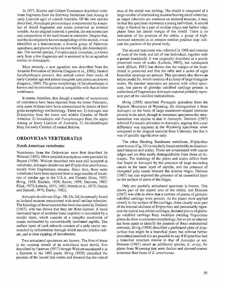
In 1977, Ritchie and Gilbert-Tomlinson described verte- brate fragments from the Stairway Sandstone (late Arenig or early Llanvirn age) of central Australia. Of the two species described, Arandaspisprionotolepis is represented by a num- ber of shield fragments and scales preserved as external moulds. As no original material is present, the microstructure and composition of the hard tissues is unknown. Despite that, and the incompletely known morphology of the animal, it was identified as a heterostracan, a diverse group of Paleozoic agnathans, and placed within its own family, the Arandaspidi- dae. The second species, Porophoraspis crenulata, is known only from a few fragments and is assumed to be an agnathan similar to Arandaspis.
Most recently, a new agnathan was described from the Anzaldo Formation of Bolivia (Gagnier et al., 1986). Named Sacabambaspis janvieri, this animal comes from rocks of early Caradoc age and almost complete specimens are known (Gagnier, 1989). The gross morphology of Sacabambaspis is known and its microstmcture is compatible with that of other vertebrates.
It seems, therefore, that though a number of occurrences of vertebrates have been reported from the lower Paleozoic, only some of them have been substantiated by details of their gross morphology and histology. These are: 1) Astraspis and Eriptychius from the lower and middle Caradoc of North America; 2) Arandaspis and Porophoraspis from the upper Arenig or lower Llanvim of Australia; 3) Sacabambaspis from the early Caradoc of central Bolivia.
ORDOVICIAN VERTEBRATES
North American vertebrates
Vertebrates from the Ordovician were first described by Walcott (1 892). More detailed descriptions were provided by Bryant (1936). Walcott described two taxa still accepted as vertebrate, Astraspis desiderata and Eriptychius americanus, mostly from fragmentary remains. Since then, these same vertebrates have been reported from a large number of locali- ties of similar age in the U.S.A. and Canada (Ross, 1957; 0rvig, 1958; Sinclair, 1958; Sawin, 1959; Denison, 1967; Eliuk, 1973; Lehtola, 1973, 1983; Nitecki et al., 1975; Ossian and Halseth, 1976; Darby, 1982).
Astraspisdesiderata (Figs. 1B; 2A; 3A) is normally found as isolated tesserae ornamented with small stellate tubercles. The histology of these tesserae has been discussed by Denison (1967), who has shown that they are three-layered. A basal laminated layer of acellular bone (aspidin) is succeeded by a middle layer, which consists of a complex meshwork of canals surrounded by concentrically laminated aspidin. The surface layer of each tubercle consists of a pulp cavity sur- rounded by orthodentine through which minute tubules radi- ate, and a clear capping of durodentine.
Two articulated specimens are known. The first of these is the external mould of an articulated head shield, first described by Eastman (1917) though Walcott mentioned it in a footnote to his 1892 paper. @wig (1958) identified the position of the lateral line canals and showed that the rostral
area of the shield was lacking. The shield is composed of a large number of interlocking tesserae bearing small tubercles; as larger tubercles are common on isolated tesserae, it may be that this specimen represents a young individual. A central ridge is flanked by a pair of median ridges and further ridge plates form the lateral margin of the shield. There is no indication of the position of the orbits; a group of high- crowned tubercles in an anterior median position may indi- cate the position of the pineal body.
The second specimen was collected in 1968 and consists of most of the body and tail of one individual, together with a partial headshield. It was originally described as a poorly preserved mass of scales (Lehtola, 1983), but subsequent work (Elliott, 1987) has shown that the margin of the head- shield is preserved and that the orbit and a series of eight branchial openings are present. This specimen also shows an entire caudal fin, which consists of a clump of large triangular scales. No internal structures are present with either speci- men, but pieces of globular calcified cartilage present in collections of fragmentary Astraspis material probably repre- sent part of the calcified endoskeleton.
0rvig (1958) described Pycnaspis splendens from the Bighorn Mountains of Wyoming. He distinguished it from Astraspis on the basis of large mushroom-shaped tubercles present in the adult, though in immature specimens the oma- mentation was similar to that in Astraspis. Denison (1967) referred Pycnaspis splendens to Astraspis, arguing that a size difference was apparent in the Wyoming specimens when compared to the original material from Colorado, but that it was of specific significance only.
The other Harding Sandstone vertebrate, Eriptychius americanus (Fig. 3B) is similarly found normally as disarticu- lated tesserae and scales. These are ornamented with coarse ridges and are thus easily distinguishable from those of As- traspis. The histology of the plates and scales differs from that found in Astraspis by the presence of large ascending canals in the basal layer of aspidin, and the presence of elongated pulp canals beneath the dentine ridges. Denison (1967) has also reported the presence of an enarneloid layer on the surface of some of the ridges.
Only one partially articulated specimen is known. This shows part of the rostral area of the shield, and Denison (1967) was able to show that a number of pieces of globular calcified cartilage were present. As the plates were applied closely to the surface of the cartilage, these clearly were part of the internal skeleton of Eriptychius and presumably repre- sent the rostral and orbital cartilages. Isolated pieces of globu- lar calcified cartilage from localities yielding Eriptychius plates do show aconsistent morphology, but as yet no attempt has been made to identify the position of these endoskeletal elements. @wig (1958) described a perforated plate of Erip- tychius that might be a branchial plate; but without further articulated material it is not possible to say if Eriptychius had a branchial structure similar to that of Astraspis or not. Denison (1967) raised an additional species, E. orvigi, for plates from Wyoming that were thicker and showed coarser ornament than those of E, americanus.
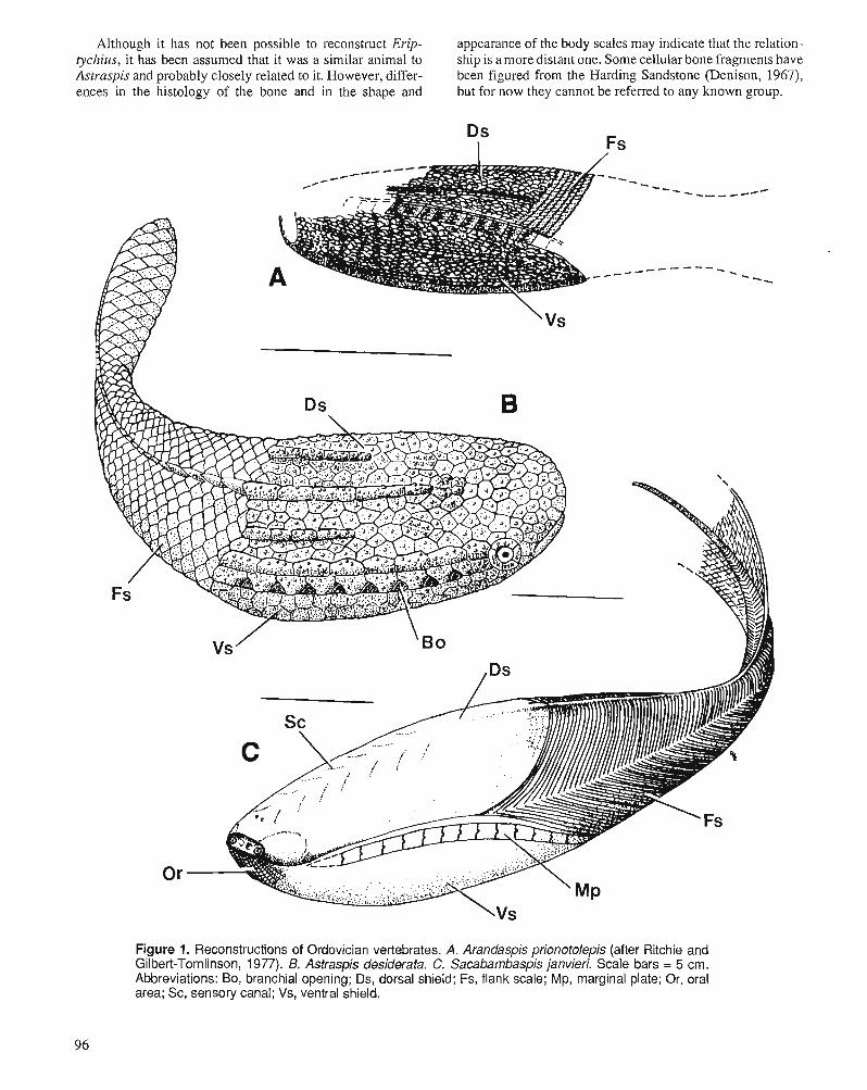
Although it has not been possible to reconstruct Erip- appearance of the body scales may indicate that the relation- tychius, it has been assumed that it was a similar animal to ship is a more distant one. Some cellular bone fragments have Astraspis and probably closely related to it. However, differ- been figured from the Harding Sandstone (Denison, 1967), ences in the histology of the bone and in the shape and but for now they cannot be referred to any known group.
Figure 1. Reconstructions of Ordovician vertebrates. A. Arandaspis prionotolepis (after Ritchie and Gilbert-Tomlinson, 1977). B. Astraspis desiderata. C. Sacabambaspis janvieri. Scale bars = 5 cm. Abbreviations: Bo, branchial opening; Ds, dorsal shield; Fs, flank scale; Mp, marginal plate; Or, oral area; Sc, sensory canal; Vs, ventral shield.
Figure 2. Shields of Ordovician vertebrates. A. Astraspis desiderata, dorsal shield, USNM8121. B. Aran- daspis prionotolepis, shield fragment with isolated scale, CPC15469a. C. Sacabambaspis janvieri, dorsal shield, YPFB PAL 6221. Scale bars = 1 cm.
Figure 3. SEM photographs of tesserae of Astraspis (A) and Eriptychius (B). Scale bars = 0.5 mm.
97
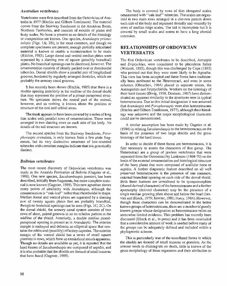
Australian vertebrates
Vertebrates were first described from the Ordovician of Aus- tralia in 1977 (Ritchie and Gilbert-Tomlinson). The material comes from the Stairway Sandstone in the Amadeus Basin, Northern Territories, and consists of moulds of plates and body scales. No bone is present so no details of the histology or composition are known. One species, Arandaspis priono- tolepis (Figs. 1A; 2B), is the most common, and though no complete specimens are present, enough partially articulated material is known to enable a reconstruction to be made (Ritchie, 1985). Large dorsal and ventral median plates were separated by a slanting row of square (possibly branchial) plates. No branchial openings can be discerned, however. The ornamentation consists of closely packed oval or rhomboidal tubercles. Dorsal shields show a parallel pair of longitudinal grooves, bordered by regularly arranged denticles, which are probably the sensory canal grooves.
It has recently been shown (Ritchie, 1985) that there is a double opening anteriorly in the midline of the dorsal shield that may represent the position of a pineal-parapineal struc- ture. No specimen shows the rostra1 part of the animal, however, and so nothing is known about the position or structure of the oral and orbital areas.
The trunk appears to have been covered by a series of long thin scales with parallel rows of ornamentation. These were arranged in two slanting rows on each side of the body. No details of the tail structure are known.
The second species from the Stairway Sandstone, Poro- phoraspis crenulata, is only known from a few plate frag- ments, but its very distinctive ornament of low-rounded tubercles with crenulate margins indicate that it is generically distinct.
Bolivian vertebrates
The most recent discovery of Ordovician vertebrates was made in the Anzaldo Formation of Bolivia (Gagnier et al., 1986). One new species, Sacabambaspis janvieri, has been described, initially from fragments, but more complete mate- rial is now known (Gagnier, 1989). This new agnathan shows many points of similarity with Arandaspis, although the ornamentation is "oak-leaf'' rather than rhomboidal in shape. Median dorsal and ventral plates are separated by a slanting row of twenty square plates that are probably branchial, though no branchial openings can be seen (Figs. 1C; 2C). On the dorsal shield, the sensory canal system consists of two rows of short, paired grooves in an en echelon pattem in the midline of the shield. Anteriorly, a double median pineal- parapineal opening is present as in Arandaspis. The anterior margin is embayed and delimits an elliptical space that con- tains the orbits and (possibly) olfactory capsules. The anterior margin of the ventral shield has a series of small square platelets in rows, which form an exoskeletal mouth apparatus. Though no details are available as yet, it is reported that the hard tissues of Sacabambaspis are composed of aspidin, and it is also probable that the shields are formed of small tesserae that have fused (Gagnier, 1989).
The body is covered by rows of thin elongated scales ornamented with "oak-leaf" tubercles. The scales are organ- ized in two main rows arranged in a chevron pattem down each side of the body and separated dorsally and ventrally by rows of median ridge scales. The tail is incomplete but it is covered by small scales and seems to have a long chordal extension.
RELATIONSHIPS OF ORDOVICIAN VERTEBRATES The first Ordovician vertebrates to be described, Astraspis and Eriptychius, were considered to be placoderm fishes (Walcott, 1892), though this was challenged by Cope (1893) who pointed out that they were more likely to be Agnatha. This view has been accepted and these forms have tradition- ally been attributed to the Heterostraci, and even in some schemes (Obruchev, 1964) placed in separate orders, the Astraspidida and Eriptychidida. Workers on the histology of their hard tissues (Drvig, 1958; Denison, 1967) have demon- strated an apparent similarity to the structures seen in typical heterostracans. Due to this initial designation it was assumed that Arandaspis and Porophoraspis were also heterostracans (Ritchie and Gilbert-Tomlinson, 1977), although their histol- ogy was unknown and the major morphological characters could not be demonstrated.
A similar assumption has been made by Gagnier et al. (1986) in relating Sacabambaspis to the heterostracans on the basis of the presence of two large shields and the gross histology of the hard tissue.
In order to decide if these forms are heterostracans, it is first necessary to assess the characters of that group. The Heterostraci are a group of jawless vertebrates that were separated from the Osteostraci by Lankester (1 868-70) on the basis of the external ornamentation and histological structure of the bony plates that were composed of acellular bone or aspidin. A further diagnostic feature described on all well preserved heterostracans is the presence of one common, external branchial opening on each side of the dorsal shield. Both these features are considered to be synapomorphies (shared derived characters) of the heterostracans and a further apomorphy (derived character) may be the presence of a single median growing plate above and below the head (Jan- vier and Blieck, 1979; Janvier, 1981; Forey, 1984). However, though these characters can be demonstrated in the better known groups of heterostracans, there are a number of poorly known groups whose designation as heterostracans relies on somewhat limited evidence. This problem has recently been discussed (Blieck et al., in press) and it has been concluded that a considerable amount of work is needed before many of the groups can be adequately defined and included within a phylogenetic scheme.
This is particularly true of the tessellated forms in which the shields are formed of small tesserae or platelets. As the amour tends to disintegrate on death, little is known of the gross morphology of these organisms and their attribution to
the Heterostraci has rested almost entirely on the histology of However, this raises other problems of relationship with the plates (see Elliott and Loeffler, 1990, for a discussion of osteostracans, and it is probable that these similarities are not this problem). significant.
Recent work on Astraspis (Elliott, 1987) has demon- strated that this animal possessed a series of eight external branchial openings, despite having a histology apparently similar to that found in heterostracans. Clearly Astraspis and probably also Eriptychius cannot be considered heterostra- cans sensu strict0 as they now only possess the synapomorphy of hard tissues composed of aspidin. It also seems that Aran- daspis and Sacahambaspis cannot be considered heterostra- cans as, although they apparently possessed aspidin, they also appear to have a series of external branchial ducts.
What characters are available to assess the phylogenetic position of the Ordovician forms if they are not heterostra- cans? Clearly both Arandaspis and Sacabambaspis are very similar organisms that form a distinct group. They share a suite of distinctive characters including the presence of a slanting row of branchial plates, shields formed of small fused tesserae, sensory canals in open grooves on the surface, double anterior dorsal openings in the shield, and elongated scales arranged in a chevron pattern.
The North American forms are quite distinct, however. Astraspis and Eriptychius are forms in which the shields are formed of tesserae that fuse in some areas only; the branchial ducts are open, eight in number and form a horizontal row (known only for Astraspis). No pineal opening is visible, scales are thick and polygonal in Astraspis, and more elon- gated in Eriptychius.
These two groups are clearly distinct. The only characters that relate them to each other are the presence of numerous branchial ducts, sensory canals borne in open surface grooves, and hard tissues composed of aspidin. The first two characters are almost certainly primitive for vertebrates and differ in detail in the two groups. Branchial ducts are slanting, closed, and twenty in number in the Arandaspis-Sacabam- baspis group; open, horizontal and eight in number in the Astraspis-Eriptychius group (in so far as this is known). Sensory canals are borne in continuous grooves in the Aran- daspis-Sacabambaspis group, and in occasional short grooves between tubercles in the Astraspis-Eriptychius group.
As the hard tissue of Sacahambaspis is aspidin, it appears that it shares this character with Astraspis. Eriptychius, and the heterostracans. However, acellular bone is also present in anaspids, another agnathan group. This may indicate that acellular bone is primitive among agnathans and among vertebrates; however, the acellular bone of anaspids is lamel- lar and without a cancellous layer (Gross, 1958), which might suggest that acellular bone has developed more than 'once. The acellular bone present in some osteostracans, acanthodi- ans, and teleost actinopterygians is certainly considered to be secondary (Drvig, 1967). If this is the case, then its presence cannot be used as a character linking these early groups. It has been suggested (Blieck et al., in press) that the presence of long thin flank scales arranged in a chevron, and a slanting row of branchial ducts might be characters that could indicate a relationship between Sacahambaspis and anaspids.
At present, therefore, though at least two distinct groups of Ordovician vertebrates can be distinguished, it is difficult to determine their relationship to each other or to the later agnathan groups. This difficulty is mostly due to the lack of agnathan specimens through the Upper Ordovician and Lower Silurian, which means that there are no known inter- mediates between the early forms and the more numerous and diverse later groups.
ENVIRONMENT AND ECOLOGY The environment in which the early vertebrates lived has been the subject of some dispute over the years due to its bearing on the environment in which the vertebrates originated. Romer (1946) used the then freshwater interpretation of the Harding Sandstone in combination with ideas on the way in which the glomerular kidney had developed (Smith, 1932; Romer and Grove, 1935) to support the view that vertebrates had developed in fresh water. These ideas were questioned later, however (Denison, 1956; Robertson, 1957, 1963; Darby, 1982) in the light of new paleontological and sedimen- tological evidence and new approaches to physiology. It is now generally accepted that the earliest vertebrates originated in the marine realm and invaded freshwater later (Thomson, 1971; Halstead, 1973; Blieck, 1985).
Of course, direct evidence from the Ordovician verte- brates attests only to the environment that they were living in at that time and not to the environment that their ancestors inhabited. It is interesting to note, however, that the Ordovi- cian localities represent very similar environments. The west- em North American Harding Sandstone, though originally considered to be a freshwater deposit, is now thought to represent sediment laid down in shallow, nearshore condi- tions (Denison, 1956; Fischer, 1978; Darby, 1982). Spjeld- naes (1 967,1979) concluded that restricted marine conditions may have been present, with salinity as the restricting factor, and that changes occurred from brackish to normal marine in a lagoon-like or estuarine-deltaic habitat. Certainly the pres- ence of Cruziana and other trace fossils indicates a shallow, nearshore environment and the presence of conodonts and other marine organisms points toward a marine habitat.
Boucot and Janis (1983) concluded that the North Ameri- can Ordovician vertebrate localities correspond to their ma- rine benthic assemblages BAl (marine intertidal), BA2 or BA3 (shallow subtidal).
The environment in which the Australian vertebrates Arandaspis and Porophoraspis lived seems to have been very similar to that postulated for the Harding Sandstone. The Stairway Sandstone was deposited as part of a transgressive event, not far from shore (Ritchie and Gilbert-Tomlinson, 1977), and there may have been specialized local conditions as shown by an unusual invertebrate fauna in some areas. The relationship with Cruziana once again points to a nearshore, shallow marine habitat (benthic assemblage BA2 of Boucot and Janis, 1983). A similar habitat is inferred for the Bolivian
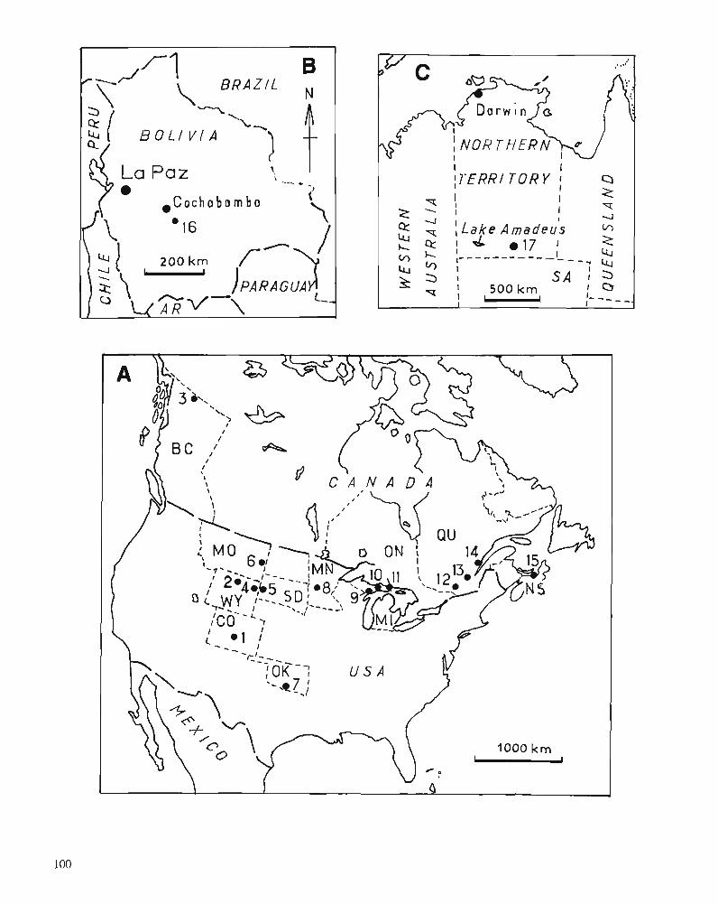
I I ITERR/ T O R Y I
I a
I 2 I I I
T
z 4 I I 4 z - , L a k e Amadeus m
1 4 a17 2 2 ;-- - - - - - - - - - I _ '4
4 - 1 --.
f a ' I 500 km SA I ; a 0 - ; - I I - - - - - .
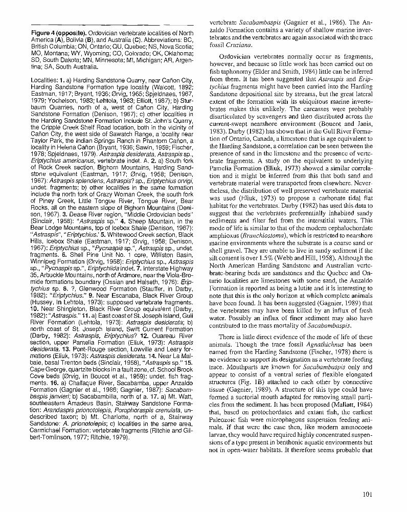
Figure 4 (opposite). Ordovician vertebrate localities of North America (A), Bolivia (B), and Australia (C). Abbreviations: BC, British Columbia; ON, Ontario; QU, Quebec; NS, Nova Scotia; MO, Montana; WY, Wyoming; CO, Colorado; OK, Oklahoma; SD, South Dakota; M N , Minnesota; MI, Michigan; AR, Argen- tina; SA, South Australia.
Localities: 1. a) Harding Sandstone Quarry, near Caiion City, Harding Sandstone Formation type locality (Walcott, 1892; Eastman, 191 7; Bryant, 1936; Drvig, 1965; Spjeldnaes, 1967, 1979; Yochelson, 1983; Lehtola, 1983; Elliott, 1987); b) Stur- baum Quarries, north of a, west of CaRon City, Harding Sandstone Formation (Denison, 1967); c) other localities in the Harding Sandstone Formation include St. John's Quarry, the Cripple Creek Shelf Road location, both in the vicinity of Caiion City, the west side of Sawatch Range, a locality near Taylor Park, the Indian Springs Ranch in Phantom Cation, a locality in Helena CaRon (Bryant, 1936; Sawin, 1959; Fischer, 1978; Spjeldnaes, 1979). Astraspis desiderata, Astraspis sp., Eriptychius americanus, vertebrate indet. A. 2. a) South fork of Rock Creek section, Bighorn Mountains, Harding Sand- stone equivalent (Eastman, 191 7; Drvig, 1958; Denison, 1 967): Astraspis splendens, Astraspis? sp., Eriptychius onligi, undet. fragments; b) other localities in the same formation include the north fork of Crazy Woman Creek, the south fork of Piney Creek, Little Tongue River, Tongue River, Bear Rocks, all on the eastern slope of Bighorn Mountains (Deni- son, 1967). 3. Dease River region, "Middle Ordovician beds" (Sinclair, 1958): "Astraspis sp." 4. Sheep Mountain, in the Bear Lodge Mountains, top of Icebox Shale (Denison, 1967): "Astraspis", " Eriptychius.' 5. Whitewood Creek section, Black Hills, Icebox Shale (Eastman, 1917; Drvig, 1958; Denison, 1967): Eriptychius sp., " Pycnaspis sp.", Astraspis sp., undet. fragments. 6. Shell Pine Unit No. 1 core, Williston Basin, Winnipeg Formation (Drvig, 1958): Eriptychius sp., Astraspis sp., " Pycnaspis sp.", Eriptychiida indet. 7. Interstate Highway 35, Arbuckle Mountains, north of Ardmore, near the Viola-Bro- mide formations boundary (Ossian and Halseth, 1976): Erip- tychius sp. 8. ?, Glenwood Formation (Stauffer, in Darby, 1982): "Eriptychius." 9. Near Escanaba, Black River Group (Hussey, in Lehtola, 1973): supposed vertebrate fragments. 10. Near Shingleton, Black River Group equivalent (Darby, 1982): "Astraspis." 11. a) East coast of St. Joseph Island, Gull River Formation (Lehtola, 1973): Astraspis desiderata; b) north coast of St. Joseph Island, Swift Current Formation (Darby, 1 982) : Astraspis, Eriptychius? 12. Ouareau River section, upper Pamelia Formation (Eliuk, 1973): Astraspis desiderata. 13. Pont-Rouge section, Lowville and Leary for- mations (Eliuk, 1973): Astraspis desiderata. 14. Near La Mal- baie, basal Trenton beds (Sinclair, 1958), "Astraspis sp." 15. Cape George, quartzite blocks in afault zone, cf. School Brook Cove beds (Brvig, in Boucot et al., 1959): undet. fish frag- ments. 16. a) Challaque River, Sacabamba, upper Anzaldo Formation (Gagnier et al., 1986; Gagnier, 1987): Sacabam- baspis janvieri; b) Sacabambilla, north of a. 17. a) Mt. Watt, southeastern Amadeus Basin, Stairway Sandstone Forma- tion : Arandaspis prionotolepis, Porophoraspis crenula fa, un- described taxon; b) Mt. Charlotte, north of a, Stairway Sandstone: A. prionotolepis; c) localities in the same area, Carmichael Formation: vertebrate fragments (Ritchie and Gil- bert-Tomlinson, 1977; Ritchie, 1979).
vertebrate Sacabambaspis (Gagnier et al., 1986). The An- zaldo Formation contains a variety of shallow marine inver- tebrates and the vertebrates are again associated with the trace fossil Cruziana.
Ordovician vertebrates normally occur as fragments, however, and because so little work has been carried out on fish taphonomy (Elder and Smith, 1984) little can be inferred from them. It has been suggested that Astraspis and Erip- tychius fragments might have been carried into the Harding Sandstone depositional site by streams, but the great lateral extent of the formation with its ubiquitous marine inverte- brates makes this unlikely. The carcasses were probably disarticulated by scavengers and then distributed across the current-swept nearshore environment (Boucot and Janis, 1983). Darby (1982) has shown that in the Gull RiverForma- tion of Ontario, Canada, a limestone that is age equivalent to the Harding Sandstone, a correlation can be seen between the presence of sand in the limestone and the presence of verte- brate fragments. A study on the equivalent to underlying Pamelia Formation Eliuk, 1973) showed a similar correla- tion and it might be inferred from this that both sand and vertebrate material were transported from elsewhere. Never- theless, the distribution of well preserved vertebrate material was used (Eliuk, 1973) to propose a carbonate tidal flat habitat for the vertebrates. Darby (1982) has used this data to suggest that the vertebrates preferentially inhabited sandy sediments and filter fed from the interstitial waters. This mode of life is similar to that of the modem cephalochordate amphioxus (Branchiostoma), which is restricted to nearshore marine environments where the substrate is a coarse sand or shell gravel. They are unable to live in sandy sediment if the silt content is over 1.5% (Webb and Hill, 1958). Although the North American Harding Sandstone and Australian verte- brate-bearing beds are sandstones and the Quebec and On- tario localities are limestones with some sand, the Anzaldo Formation is reported as being a lutite and it is interesting to note that this is the only horizon at which complete animals have been found. It has been suggested (Gagnier, 1989) that the vertebrates may have been killed by an influx of fresh water. Possibly an influx of finer sediment may also have contributed to the mass mortality of Sacabambaspis.
There is little direct evidence of the mode of life of these animals. Though the trace fossil Agnathichnus has been named from the Harding Sandstone (Fischer, 1978) there is no evidence to support its designation as a vertebrate feeding trace. Mouthparts are known for Sacabambaspis only and appear to consist of a ventral series of flexible elongated structures (Fig. 1B) attached to each other by connective tissue (Gagnier, 1989). A structure of this type could have formed a suctorial mouth adapted for removing small parti- cles from the sediment. It has been proposed (Mallatt, 1984) that, based on protochordates and extant fish, the earliest Paleozoic fish were microphagous suspension feeding ani- mals. If that were the case then, like modern ammocoete larvae, they would have required highly concentrated suspen- sions of a type present in benthonic aquatic environments but not in open-water habitats. It therefore seems probable that
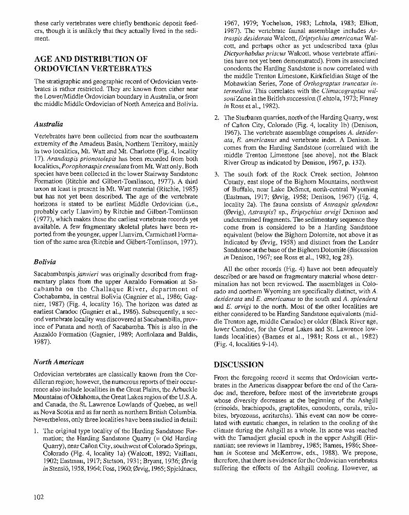
these early vertebrates were chiefly benthonic deposit feed- ers, though it is unlikely that they actually lived in the sedi- ment.
AGE AND DISTRIBUTION OF ORDOVICIAN VERTEBRATES The stratigraphic and geographic record of Ordovician verte- brates is rather restricted. They are known from either near the Lowermiddle Ordovician boundary in Australia, or from the middle Middle Ordovician of North America and Bolivia.
Australia
Vertebrates have been collected from near the southeastern extremity of the Amadeus Basin, Northern Territory, mainly in two localities, Mt. Watt and Mt. Charlotte (Fig. 4, locality 17). Arandaspis prionotolepis has been recorded from both localities, Porophoraspis crenulata from Mt. Watt only. Both species have been collected in the lower Stairway Sandstone Formation (Ritchie and Gilbert-Tomlinson, 1977). A third taxon at least is present in Mt. Watt material (Ritchie, 1985) but has not yet been described. The age of the vertebrate horizons is stated to be earliest Middle Ordovician (i.e., probably early Llanvim) by Ritchie and Gilbert-Tomlinson (1977), which makes these the earliest vertebrate records yet available. A few fragmentary skeletal plates have been re- ported from the younger, upper Llanvirn, Carmichael Forma- tion of the same area (Ritchie and Gilbert-Tomlinson, 1977).
Bolivia
Sacabambaspis janvieri was originally described from frag- mentary plates from the upper Anzaldo Formation at Sa- cabamba on the Challaque River, department of Cochabamba, in central Bolivia (Gagnier et al., 1986; Gag- nier, 1987) (Fig. 4, locality 16). The horizon was dated as earliest Caradoc (Gagnier et al., 1986). Subsequently, a sec- ond vertebrate locality was discovered at Sacabambilla, prov- ince of Punata and north of Sacabamba. This is also in the Anzaldo Formation (Gagnier, 1989; Acefiolaza and Baldis, 1987).
1967, 1979; Yochelson, 1983; Lehtola, 1983; Elliott, 1987). The vertebrate faunal assemblage includes As- traspis desiderata Walcott, Eriptychius arnericanus Wal- cott, and perhaps other as yet undescribed taxa (plus Dictyorhabdus priscus Walcott, whose vertebrate aKini- ties have not yet been demonstrated). From its associated conodonts the Harding Sandstone is now correlated with the middle Trenton Limestone, Kirkfieldian Stage of the Mohawkian Series, Zone of Orthograptus truncatus in- terrnedius. This correlates with the Climacograptus wil- soniZone in the British succession (Lehtola, 1973; Finney in Ross et al., 1982).
2. The Sturbaum quarries, north of the Harding Quany, west of Caiion City, Colorado (Fig. 4, locality lb) (Denison, 1967). The vertebrate assemblage comprises A. desider- ata, E. americanus and vertebrate indet. A Denison. It comes from the Harding Sandstone (correlated with the middle Trenton Limestone [see above], not the Black River Group as indicated by Denison, 1967, p. 132).
3. The south fork of the Rock Creek section, Johnson County, east slope of the Bighorn Mountains, northwest of Buffalo, near Lake DeSmet, north-central Wyoming (Eastman, 1917; @wig, 1958; Denison, 1967) (Fig. 4, locality 2a). The fauna consists of Astraspis splendens (@wig), Astraspis? sp., Eriptychius orvigi Denison and undetermined fragments. The sedimentary sequence they come from is considered to be a Harding Sandstone equivalent (below the Bighorn Dolomite, not above it as indicated by @~-vig, 1958) and distinct from the Lander Sandstone at the base of the Bighorn Dolomite (discussion in Denison, 1967; see Ross et al., 1982, log 28).
All the other records (Fig. 4) have not been adequately described or are based on fragmentary material whose deter- mination has not been reviewed. The assemblages in Colo- rado and northern Wyoming are specifically distinct, with A. desiderata and E. arnericanus to the south and A. splendens and E. orvigi to the north. Most of the other localities are either considered to be Harding Sandstone equivalents (mid- dle Trenton age, middle Caradoc) or older (Black River age, lower Caradoc, for the Great Lakes and St. Lawrence low- lands localities) (Barnes et al., 1981; Ross et al., 1982) (Fig. 4, localities 9-14).
North American DISCUSSION Ordovician vertebrates are classically known from the Cor- From the foregoing record it seems that Ordovician verte- dilleran region; however, the numerous reports of their occur- brates in the Americas disappear before the end of the Cars- rence also include localities in the Great Plains, the Arbuckle doc and, therefore, before most of the invertebrate groups Mountains of Oklahoma, h e a s region of the U.S.A. whose diversity decreases at the beginning of the Ashgill and the St* Lawrence of as (crinoids, brachiopods, graptolites, conodonts, corals, trilo- as Nova Scotia and as far north as northern British Columbia. bites, bryozoans, acritarchs). This event can now be Nevertheless, only three localities have been studied in detail: lated with eustatic changes, in relation to the cooling of the 1. The original type locality of the Harding Sandstone For- climate during the ~ s h ~ i l l as a whole. Its acme was reached
mation; the Harding Sandstone Quarry (= Old Harding with the Tamadjert glacial epoch in the upper Ashgill (Hir- Quarry), near Cafion City, southwest of Colorado Springs, nantian; see reviews in Hambrey, 1985; Barnes, 1986; Shee- Colorado (Fig. 4, locality la) (Walcott, 1892; Vaillant, han in Scotese and McKerrow, eds., 1988). We propose, 1902; Eastman, 1917; Stetson, 1931; Bryant, 1936; @wig therefore, that there is evidence for the Ordovician vertebrates in Stensio, 1958,1964; Foss, 1960; @wig, 1965; Spjeldnaes, suffering the effects of the Ashgill cooling. However, as
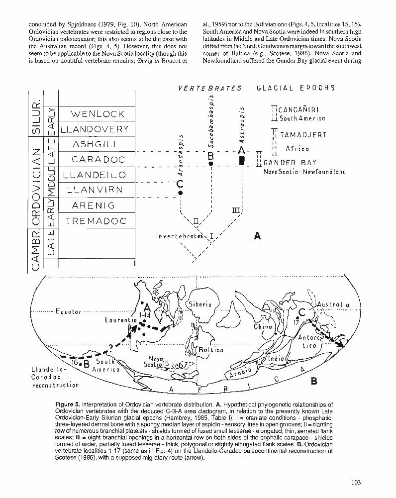
concluded by Spjeldnaes (1979, Fig. lo), North American al., 1959) nor to the Bolivian one (Figs. 4,5, localities 15,16). Ordovician vertebrates were restricted to regions close to the South America and Nova Scotia were indeed in southern high Ordovician paleoequator; this also seems to be the case with latitudes in Middle and Late Ordovician times. Nova Scotia the Australian record (Figs. 4, 5). However, this does not drifted from the North Gondwanan margin toward the southwest seem to be applicable to the Nova Scotia locality (though this corner of Baltica (e.g., Scotese, 1986). Nova Scotia and i s based on doubtful vertebrate remains; Orvig in Boucot et Newfoundland suffered the Gander Bay glacial event during
V E R T E B R A T E S
E
A - cn
z
G L A C I A L E P O C H S
7 T A M A D J E R T I I
K
w " k
LGANDER BAY N o v o S c o t i o - ~ e w f o u n d l o n d
W E N L O C K
LLANDOVERY
A S H G I L L
Figure 5. Interpretation of Ordovician vertebrate distribution. A. Hypothetical phylogenetic relationships of Ordovician vertebrates with the deduced C-B-A area cladogram, in relation to the presently known Late Ordovician-Early Silurian glacial epochs (Hambrey, 1985, Table I). I = craniate conditions - phosphatic, three-layered dermal bone with aspongy median layer of aspidin -sensory lines In open grooves; II =slanting row of numerous branchial platelets - shields formed of fused small tesserae -elongated, thin, serrated flank scales; Ill = eight branchial openings in a horizontal row on both sides of the cephalic carapace - shields formed of wider, partially fused tesserae - thick, polygonal or slightly elongated flank scales. B. Ordovician vertebrate localities 1-1 7 (same as in Fig. 4) on the Llandeilo-Caradoc paleocontinental reconstruction of Scotese (1 986), with a supposed migratory route (arrow).
C A R A D O C
L L A N D E I L O
L L A N V I R N
A R E N I G
T R E M A D O C
- O 3
Di * k 2 Q
2 5 w
_I
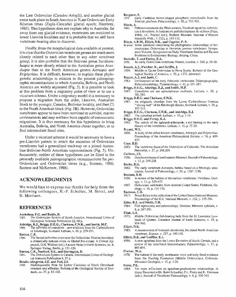
the Late Ordovician (Caradoc-Ashgill), and another glacial event took place in South America in ?Late Ordovician-Early Silurian times (Zapla-Cancaiiiri glacial epoch; Hambrey, 1985). This hypothesis does not explain why in Australia, far away from any glacial evidence, vertebrates are restricted to lower Llanvirn localities and it is probable that we still have vertebrate-bearing sites to discover.
Finally, from the morphological data available at present, it is clear that the Ordovician vertebrate genera are much more closely related to each other than to any other vertebrate group; it is also probable that the Bolivian genus Sacabam- baspis is more closely related to the Australian genus Aran- daspis than to the North American genera Astraspis and Eriptychius. It is difficult, however, to explain these phylo- genetic relationships in relation to the present paleogeog- raphic reconstructions in which Australia, Bolivia, and North America are widely separated (Fig. 5). It is possible to look at this problem from a migratory point of view or to use a vicariant scheme. Under a migratory model it is necessary to propose a migration from the older, Llanvim, Australian block to the younger, Caradoc, Bolivian locality, and then (?) to the North American block (Fig. 5B). However, Ordovician vertebrates appear to have been restricted to subtidal, marine environments and may not have been capable of transoceanic migrations. It is thus necessary for this hypothesis to bring Australia, Bolivia, and North America closer together, or to find intermediate fossil sites.
Under a vicariant scheme it would be necessary to have a pre-Llanvim pattern in which the ancestors of Ordovician vertebrates had a generalized trackway on a joined Austra- lian-Bolivian-North American supercontinent (Fig. 5). Un- fortunately, neither of these hypotheses can be fitted to the presently available paleogeographic reconstructions for pre- Ordovician and Ordovician times (e.g., Scotese, 1986; Scotese and McKerrow, 1988).
ACKNOWLEDGMENTS We would like to express our thanks for help from the following colleagues, H.-P. Schultze, M. Streel, and B. Mistiaen.
REFERENCES Acenolaza, F.G. and Baldis, B. 1987: The Ordovician System of South America. International Union of
Geological Sciences Publication 22.68 p. Aldridge, R.J., Briggs, D.E.G., Clarkson, E.N.K., and Smith, M.P. 1986: The affinities of conodonts - new evidence from the Carboniferous
of Edinburgh. Scotland. Lethaia. v. 19. D. 279-291. - . . . . Barnes, C.R. 1986: The faunal extinction event near the Ordovician-Silurian boundary:
a climatically induced crisis. In Global Bio-events: A Critical ~ p - proach, O.H. Walliser (ed.); Lecture Notes in Earth Sciences, no. 8, Springer-Verlag, Berlin, p. 121-1 26.
Barnes, C.R., Norford, B.S., and Skevington, D. 1981: The Ordovician System in Canada. International Union of Geologi-
cal Sciences Publication 8,27 p. Bendix-Almgreen, S.E. and Peel, J.S. 1988: Hadimpanella from the Lower Cambrian of North Greenland:
structure and affinities. Bulletin of the Geological Society of Den- mark, no. 37, p. 83-103.
Bengtson, S. 1977: Early Cambrian bunon-shaped phosphatic microfossils from the
Siberian platform. Palaeontology, v. 20, p. 751-762. Blieck, A. 198s: Paltoenvironments des Htttrostraces, Vertbbrks agnathes ordovici-
ens B dkvoniens. In Indicateurs paltobiologiques de milieux (Paris, 1984). J.C. Fischer (ed.); Bulletin Museum National d'Histoire Naturelle 4edr., 7, C(2). p. 143-155.
Blieck, A.R.M., Elliott, D.K., and Gagnier, P.-Y. In press: Some questions concerning the phylogenetic relationships of het-
erostracans, Ordovician to Devonian jawless vertebrates. Sympo- sium Volume, Symposium on Early Vertebrate Studies and Related Problems in Evolutionary Biology, Beijing, China.
Bockelie, T. and Fortey, R.A. 1976: An early Ordovician vertebrate; Nature, London, v. 260, p. 36-38.
Boucot, A.J., Fletcher, R., and Griffin, J. 1959: Middle or Upper Ordovician in Nova Scotia. Bulletin of the Geo-
logical Society of America, v. 70, p. 1572. (abstract) Boucot, A.J. and Janis, C. 1983: Environment of the early Paleozoic vertebrates. Palaeogeography,
Palaeoclimatology, Palaeoecology, v. 41, p. 251-287. Briggs, D.E.G., Aldridge, R.J., and Smith, M.P. 1987: Conodonts are not aplacophoran molluscs. Lethaia, v. 20, p.
381,382. Briggs, D.E.G. and Clarkson, E.N.K. 1987: An enigmatic chordate from the Lower Carboniferous Granton
"shrimp bed" of the Edinburgh district, Scotland. Lethaia, v. 20, p. 107-1 15.
Briggs, D.E.G., Clarkson, E.N.K., and Aldridge, R.J. 1983: The conodont animal. Lethaia, v. 16, p. 1-14. Briggs, D.E.G. and Fortey, R.A. 1982: The cuticle of the aglaspid arthropods, a red-herring in the early
history of the vertebrates. Lethaia, v. 15, p. 25-29. Bryant, W.L. 1936: A study of the oldest known vertebrates, Aslraspis and Eriptychius.
Proceedings of the American Philosophical Society, v. 76, p. 409- 427.
Cope, E.D. 1893: The vertebrate fauna of the Ordovician of Colorado. The American
Naturalist, v. 27, p. 268,269. Cullison, J.S. 1938: Dutchtown fauna of southeastern Missouri. Journal of Paleontology,
V. 12, p. 219-228. Darby, D.G. 1982: The early vertebrate Astraspis, habitat based on a lithologic asso-
ciation. Journal of Paleontology, v. 56, p. 1187-1 196. Denison, R.H. 1956: A review of the habitat of the earliest vertebrates. Fieldiana, Geol-
ogy, v. 11, p. 359-457. 1967: Ordovician vertebrates from western United States. Fieldiana, Ge-
ology, v. 16, p. 131-192. Eastman, C.R. 1917: Fossil fishes in thecollectionof the United StatesNational Museum.
Proceedings of the U.S. National Museum, v. 152, p. 235-304. Elder, R.L. and Smith, G.R. 1984: Fish taphonomy and paleoecology. Geobios, MCmoire sptciale, v.
8, p. 287-291. Eliuk, L.S. 1973: Middle Ordovician fish-bearing beds from the St. Lawrence Low-
lands of Quebec. Canadian Joumal of Earth Sciences, v. 10, p. 954-960.
Elliott, D.K. 1987: A reassessment of Asrraspis desiderata, the oldest North American
vertebrate. Science, v. 237, p. 190-192. Elliott, D.K. and Loeftler, E.J. 1990: A new agnathan from the Lower Devonian of Arctic Canada, and a
review of the tessellated heterostracans. Palaeontology, v. 32, p. 883-891.
Fischer, W.A. 1978: The habitat of the early vertebrates: trace and body fossil evidence
from the Harding Formation (Middle Ordovician), Colorado. Mountain Geologist, v. 15, p. 1-26.
Forey, P.L. 1984: Yet more reflections on agnathan-gnathostome relationships. In
Essay Presented to Dr. Bobb Schaeffer, P.L. Forey and K. Thomson (eds.); Joumal of Vertebrate Paleontology, v. 4, p. 330-343.
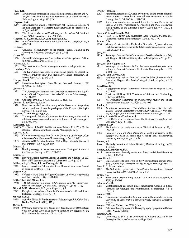
Foss, T.H. 1960: Structure and composition of associated neurodontiformes and As-
lraspis scales from the Harding Formation of Colorado. Journal of Paleontology, v. 34, p. 372,373.
Gagnier, P.-Y. 1987: Sacabambaspis janvieri, heterostraceo del Ordovicico Superior de
Bolivia. Acta del N Congreso Latinoamericano de Paleontologia, V. 2, p. 665-677.
1989: The oldest vertebrate: a 470 million years old jawless fish. National Geographic Research, v. 5, p. 250-253.
Gagnier, P.-Y., Blieck, A.R.M., and Rodrigo, S.G. 1986: First Ordovician vertebrate from South America. Geobios, v. 19, p.
629-634. Gedik, I. 1977: Conodont biostratigraphy of the middle T ~ U N S . Bulletin of the
Geological Society of Turkey, v. 20, p. 35-48. Gross, W. 1958: Anaspiden-Schuppen aus dem Ludlow des Ostseegebiets. Palaon-
tologische Zeitschrift, v. 32, p. 24-37. Halstead, L.B. 1973: The heterostracan fishes. Biological Review, v. 48, p. 279-332. Hambrey, M.J. 1985: The Late Ordovician-Early Silurian glacial period. In Glacial Re-
cord, M. Deynoux (ed.); Paleogeography, Palaeoclimatology, Pa- laeoecology, v. 51, p. 273-283.
Harper, D.A.T. 1979: Ordovician fish spines from Girvan, Scotland. Nature, v. 278
(5705), p. 634-635. Janvier, P. 1981: The phylogeny of craniata with particular reference to the signifi-
cance of fossil "agnathans". Journal of Vertebrate Paleontology, v. 1.p. 121-159.
1988: Conodont affinities: a reply. Lethaia, v. 21, p. 27. Janvier, P. and Blieck, A.R.M. 1979: New data on the internal qatomy of the Heterostraci (Agnatha),
with general remarks on the phylogeny of the Craniota. Zoologica Scripta, v. 8, p. 287-296.
Klapper, G. and Bergstrom, S.M. 1984: The enigmatic Middle Ordovician fossil Archaeognathus and its
relations to conodonts and vertebrates. Journal of Paleontology, v. 58, p. 949-976.
Lankester, E.R. 1868-70: The Fishes of the Old Red Sandstone of Britain. Part I-The Cepha-
laspidae. Palaeontographical Society Monograph, 62 p. Lehtola, K.A. 1973: Ordovician vertebrates from Ontario. University of Michigan, Con-
hibutions of the Museum of Paleontology, v. 24, p. 23-30. 1983: Articulated Ordovician fish from Cafion City, Colorado: Journal of
Paleontology, v. 57, p. 605-607. Mallatt, J. 1984: Feeding ecology of the earliest vertebrates. Zoological Journal of
the Linnean Society, v. 82, p. 261-272. Marss, T. 1988: Early Palaeozoic hadimopanellids of Estonia and Kirgizia (USSR).
Eesti NSV Teaduste Akadeemia Toimetised, v. 37, p. 10-17. Miller, A.K., Callison, J.S., and Younguist, W. 1947: Lower Ordovician fish remains from Missouri. American Journal
of Science, v. 245, p. 31-34. Miiller, K.J. 1977: Palaeoborryllus from the Upper Cambrian of Nevada - a probable
ascidian. Lethaia, v. 10, p. 107-1 18. Miiller, K.J. and Miller, J.F. 1976: The problematic microfossil Ulahphospha from the Upper Cam-
brian of the western United States. Lethaia, v. 9, p. 391-395. Nitecki, M.H., Gutschick, R.C., and Repetski, J.E. 1975: Phosphatic microfossils from the Ordovician of the United States.
Fieldiana, Geology, v. 35, p. 1-9. Obruchev, D.V. 1964: Agnatha, Pisces. In Fundamentals of Paleontology, J.A. Orlov (ed.);
Nauka, Moskva, I, A(l I), 522 p. @wig, T. 1958: Pycnaspis splendens, new genus, new species, a new Ostracodenn
from the Upper Ordovician of North America. Proceedings of the U. S. National Museum, v. 108, p. 1-23.
Orvig, T. (cont'd.) 1965: Paleohistological notes 2. Certain comments on the phyletic signifi-
cance of acellular bone tissue in early lower vertebrates. Arkiv for Zoologi, Ser. 2, Bd. 16(29), p. 551-556.
1967: Some new acanthodian material from the Lower Devonian of Europe. In Fossil Vertebrates, C. Patterson and P.H. Greenwood (eds.); Journal of the Linnaean Society (Zoology), v. 47(31 I), p. 131-153.
Ossian, C.R. and Halseth, M.A. 1976: Discovery of Ordovician vertebrates in the Arbuckle Mountains of
Oklahoma Journal of Paleontology, v. 50, p. 773-777. Pander, C.H. 1856: Monografie der fossilen Fische des Silurischen Systems des ms-
sisch-baltischen Gouvernements. Jahrbuch der geologischen Reich- sanstalt, X, p. 1-91.
Peel, J.S. 1979: Anatolepis from the Early Ordovician of East Greenland - not a fishy
tail. Rapport Gronlands Geologiske Undersoegelse, v. 91, p. 1 1 1- I IS.
Peel, J.S. and Higgins, A.K. 1977: Analolepis - a problematic Ordovician vertebrate reinterpreted as an
arthropod. Rapport Grplnlands Geologiske Undersoegelse, v. 121, p. 108,109.
Peel, J.S. and Larsen, N.H. 1984: Hadirnopanellaapicata from the Lower Cambrian of western North
Greenland. Rapport Gronlands Geologiske Undersoegelse, v. 121, p. 89-96.
Repetski, J.E. 1978: A fish from the Upper Cambrian of North America. Science, v. 200,
p. 529-532. 1980: Fossil. In McGraw Hill Yearbook of Science and Technology
(1979), p. 202-204. 1981: An Ordovician occurrence of Utahphosphu Miiller and Miller.
Journal of Paleontology, v. 55(2), p. 395-400. Ritchie, A. 1985: Arandaspis prionotolepis. The southern four-eyed fish. In Kadi-
makara - Extinct Vertebrates of Australia, P.V. Rich, G.F. Van Tets, and F. Knight (eds.); Pioneer Design Studio, Victoria, p. 95-101.
Ritchie, A. and Gilbert-Tomlinson, J. 1977: First Ordovician vertebrates from the Southern Hemisphere. Al-
cheringa, v. l , p. 351-368. Robertson, J.D. 1957: The habitat of the early vertebrates. Biological Review, v. 32, p.
156-187. 1963: Osmoregulation and ionic regulation of cells and tissues. In The
Biology of Myxine, A. Brodel and R. Fange (eds.); Scandinavian University Books, Oslo, p. 513-515.
Romer, A.S. 1946: The early evolution of fishes. Quarterly Review of Biology, v. 21,
p. 33-69. Romer, A.S. and Grove, B.H. 1935: Environment of the early vertebrates. American Midland Naturalist,
v. 16, p. 805-856. Ross, R.J., Jr. 1957: Ordovician fossils from wells in the Williston Basin, eastern Mon-
tana. United States Geological Survey Bulletin 1021-M, p. 439-5 10. Ross, R.J., Jr. and others 1982: The Ordovician System in the United States; International Union of
Geological Sciences Publication 12, p. 1-73. Sawin, H.J. 1959: Notes on the origin of bony armor. The Rice Institute Pamphlet, v.
46(1), p. 90-108. Schallreuter, R. 1983: Vertebratenreste aus einem unterordovizischen Geschiebe. Neues
Jahrbuch fur Geologie und Paliiontologie, Monatshefte, H2, p. 101-112.
Scotese, C.R. 1986: Phanerozoic reconstructions: a new look at the assembly of Asia.
University of Texas Institute for Geophysics, Technical Report 66, p. 1-54.
Scotese, C.R. and McKercow, W.S. (eds.) 1988: Paleozoic Biogeography and Paleogeography Symposium (Oxford
1988). Abstracts, 85 p. Sinclair, G.W. 1958: Occurrence of fish in the Ordovician of Canada. Bulletin of the
Geological Society of America, v. 69, p. 1644.
Smith, H.W. 1932: Water regulation and its evolution in fishes. Quarterly Review of
Biology, v. 7, p. 1-26. Spjeldnaes, N. 1967: The palaeoecology of the Ordovician vertebrates of the Harding
Formation. In Colloques Internationaux 163, Problbmes Actuels de PalContologie; Evolution des VenCbds, Paris, p. 11-20.
1979: The paleoecology of the Ordovician Harding Sandstone (Colorado, USA). Palaeogeography, Palaeoclimatology, Palaeoecology, v. 26, p. 317-347.
Stensio, E.A. 1958: Les Cyclostomes fossiles ou Ostracodermes. In Trait6 de Zoologic,
P.P. Grass6 (ed.); 13(1), Masson, Paris, p. 173-425. 1964: Les Cyclostomes fossiles ou Ostracodennes. In Trait6 de PalCon-
tologie, J. Piveteau (ed.); 4(1), Masson, Paris, p. 96-382. Stetson, H.C. 1931: Studies on the morphology of the Heterostraci. Journal of Geology,
v. 39, p. 141-154. Thomson, K.S. 1971: The adaptation and evolution of early fishes. Quarterly Review of
Biology, v. 46, p. 136-166.
Tillier, S. and Cuif, J.P. 1986: L'anirnal conodonte est-il un mollusc Aplacophore? Compte rendus
des Sdances de I'Acadkmie des Sciences, sene II,7, p. 627-632. Vaillant, L. 1902: Sur la prCsence du tissu osseux chez certains poissons des terrains
pal6ozoiques de Canyon City (Colorado). Centre de la Recherche Scientifique, Paris, 134(22), p. 1321,1322.
Walcott, C.D. 1892: Notes on the discovery of a vertebrate fauna in Silurian (Ordovician)
strata. Geological Society of America Bulletin, v. 3, p. 153-172. Webb, J.E. and Hill, M.B. 1958: The ecology of Lagos Lagoon IV. On the reactions of Branchios-
roma nigeriense Webb to its environment. Philosophical Transac- tions of the Royal Society of London (B), v. 241, p. 355-391.
Yochelson, E.L. 1983: Walcon's discovery of Middle Ordovician vertebrates. History of
Geology, v. 2, p. 66-75. Zbang, Aiyun 1985: Discovery of fossil tunicates at the initial stage of the Cambrian.
Kexue Tongbao, v. 30(12), p. 1643-1647.
Upper Cambrian and Lower Ordovician conodont associations from open ocean paleoenvironrnents, illustrated
by Batyrbay and Sarykum sections in Kazakhstan
Svetlana V. ~ u b i n i n a l
Dubinina, S.V., Upper Cambrian and Lower Ordovician conodont associations from open ocean paleoen- vironments, illustrated by Batyrbay and Sarykum sections in Kazakhstan; Irt Advances in Ordovician Geology, C.R. Barnes and S.H. Williams (ed.), Geological Survey of Canada, Paper 90-9,p. 107-124,1991.
Abstract
Upper Cambrian and Lower Ordovician conodont associations are reported from the carbonate facies of the Batyrbay section, Malyi Karatau, south Kazakhstan and siliceous-carbonate facies of the complete Sarykum section, central Kazakhstan. Different paleoenvironments at Batyrbay and Sarykum affected the composition of conodont associations. They are compared with associationsfl-om other regions of the world for specific time intervals (as chronological equivalents of conodont zones) using the Cambrian-Ordovician zonal scale at Batyrbay as the example.
These data distinguish flrom the total warm and cold faunal realms of J.F. Miller) a so-called transitional (T) faunal realm. The extent and faunal characteristics of the T realm are considered. The significance of contemporaneously redeposited warm water euconodont elements is noted to co-mpare different warm and T faunal realms.
The evolutionary zonal subdivisions at Batyrbay are recognized by: the earliest evolutionary stage of the Hirsutodontus lineage of the Upper Cambrian; the lineagesfrom Eoconodontus (E.) notchpeakensis to E.(E.) alisoneae and from E.(E.) notchpeakensis to Cordylodus primitivus in the uppermost Cambrian; and fr-om Prioniodus (P.) deltatus longibasis to P.(P.) elegans in the lower Arenig.
The beginning of J.F. Miller's Lange Ranch Eustatic Event at the Cambrian-Ordovician boundary has been given a more precise definition, i.e., from the second phase of the Cordylodus primitivus time of the latest Cambrian.
Rksurnk Les associations de conodontes du Cambrien supbieur et de 1'Ordovicien infe'rieur ont kte' localise'es dans
le faci2s carbonate' au profil Batyrbay (Malyi Karatau, Kazakhstan du Sud) et dans le faci.2~ siliceux-carbonate' de tout le profil Sarykum (Kazakhstan central). Diffe'rents pale'o-environnements d Batyrbay et Sarykum ont affect6 la composition des associations de conodontes. Elles sont compare'es a des associations d'autres rkgions dans le monde pour des intervalles de temps spe'c$ques (cornme kquivalents chronologiques des zones d conodontes) en appliquant, ci titre d'exemple, I'e'chelle zonale canzbrienne-ordovicienne d Batyrbay.
Ces donne'es font ressortir (base' sur les domaines fauniques chauds et froids totaux de J.F. Miller) un domaine faunique de transition (T). L'ktendue et les caractkristiques fauniques du domaine T sont analyskes. L'importance des e'lkments d'euconodontes d'eau chaude rede'posks contemporainement est retenue pour la comparaison des diffkrents domaines fauniques chauds et T.
Les sous-divisions zonales kvolutives d Batyrbay se disringuent par : le stade e'volutifprtcoce de la ligne'e de Hirsutodontus du Cambrien supe'rieur; les lignkes de Eoconodontus (E.) notchpeakensis d E.(E.) alisonae etde E.(E.) notchpeakensis d Cordylodus primitivus dans 1e sommet du Camhrien; et de Prioniodus (P.) deltatus longibasis d P.(P.) elegans dans I'Are'nigien infe'rieur.
1 Geological Institute, U.S.S.R. Academy of Sciences, Pyzhevski per. 7, Moscow, 109017, U.S.S.R.
Le dkbut de l'kvknement eustatique du chainon Lunge de J.F. Miller 12 la limite du sysdme cambrien- ordovicien a kt6 dkfini avec plus de prkcision, c'est-d-dire h partir de la deuxi2me phase de l'kpoque de Cordylodus primitivus du Cambrien terminal.
INTRODUCTION The Upper Cambrian and Lower Ordovician conodont asso- ciations are known from carbonate and siliceous-carbonate facies in Kazakhstan (Fig. 1). The Batyrbay section of the Malyi Karatau in south Kazakhstan%elongs to the carbonate facies (Fig. 2). The section has been described in numerous papers (Apollonov, Chugaeva, and Dubinina, 198 1, 1984; Apollonov and Chugaeva, 1982,1983; Chugaeva and Apol- lonov, 1982; Dubinina, 1982; Apollonov et al., 1985, 1988; Zhemchuzhnikov, 1986, 1987; Apollonov and Zhemchuzh- nikov, 1988; Chugaeva et al., 1989) and embraces a continu- ous carbonate succession from the Upper Cambrian up to the lower Arenig, inclusive. The accumulation of these sediments took place in an open basin, in environments varying from the Upper Cambrian lower slope and basin to the carbonate shelf in the Arenig (Fig. 2). The recent detailed sedimen- tological study carried out by V. Zhemchuzhnikov (pers. comm., 1988) and completed by H. Cook (pers. comm., 1988) suggests that the Malyi Karatau in the early Paleozoic repre- sented a carbonate seamount not connected to a continental massif. Thus, the basin had permanent and free access to the open ocean. It was also influenced by a certain system of oceanic currents. Such a paleoenvironment affected the com- position of conodont associations at Batyrbay (located, as the adjacent Kyrshabakty section, on the northeastern margin of the seamount).
The Sarykum section in central Kazakhstan represents the second (siliceous-carbonate) type of deposit (Zhemchuzh- nikov, 1987). The complete section consists of three parts (Fig. 3). The continuous succession of siliceous-carbonate sediments was deposited in an environment that increased in depth from Late Cambrian to early Arenig time. Thus, the
Figure 1. The Batyrbay and Sarykurn sections in Kazakhstan.
deposits of the upper part of the Sarykum Formation (upper- most Cambrian; Fig. 4, beds 3-3, where the carbonates of submarine fans prevailed over cherts, probably accumulated near the lower slope of the carbonate platform. The lower member of the Chazhagay Formation (from the uppermost Cambrian to the Tremadoc; Fig. 4, beds 7-13; Fig. 3), with a lower carbonate content and prevailing chert, was formed in a hemipelagic environment. The upper member of this for- mation (lower Arenig; Fig. 4, bed 14; Fig. 3), represented by black chert with no carbonate component, was formed in a pelagic environment.
The Batyrbay and complete Sarykum sections fortunately supplement each other, as the continuous succession of boundary deposits is traced herein in different facies appear- ing at various bathymetric levels. Thirteen conodont zonal subdivisions were established at Batyrbay, whereas at Sarykum there are six (Fig. 5). The succession of conodont assemblages distinguished in both sections does not differ in principle. The main purpose of this paper is to determine the specific features of conodont associations of Kazakhstan for certain time periods from the Late Cambrian to the Early Ordovician. This task is accomplished by comparing data from different regions of the world. This approach leads to a generalized, but far from perfect, pattern of the distribution of conodont associations from various paleoenvironments. The pattern includes the results of the previous studies by Sweet and Bergstrom (1974), Lindstrijm (1976), Landing (1983), Ethington and Repetski (1984), and Miller (1984), concerning paleogeographic distribution of conodonts of these time intervals.
Distinct from the warm and cold faunal realms of Miller (1984), a so-called transitional faunal realm is proposed (Figs. 6, 6a). Herein, the cold (C) faunal realm includes various paleoenvironments of ancient seas and oceans in relatively high paleolatitudes (northwestern Europe) as well as the deepest paleoenvironments in middle paleolatitudes (central Kazakhstan). The warm (W) faunal realm includes ancient shallow water seas (excluding the outermost open shelves) in low to middle paleolatitudes, i.e., ancient epicontinental seas of North America, north China, and Australia, with restricted access to the open ocean. This W realm is confined to stable cratons and continental massifs in low to middle paleolati- tudes. Finally, the transitional (T) faunal realm includes an- cient open seas and oceans in low to middle paleolatitudes. It embraces outermost continental shelf with unrestricted ac- cess to the open ocean, continental slope, basinal (hemipelagic), i.e., any carbonate continental or seamount margins and can be illustrated by sections in south Kazakh- stan (this paper), western Mackenzie Mountains, Canada (Landing et al., 1980), central Nevada (Taylor and Cook, 1976; Taylor, 1977; Cook et al., 1989), northwestern Ver- mont (Landing, 1983), western Newfoundland (Barnes, 1988; Pohler et al., 1987), and in the future it might be
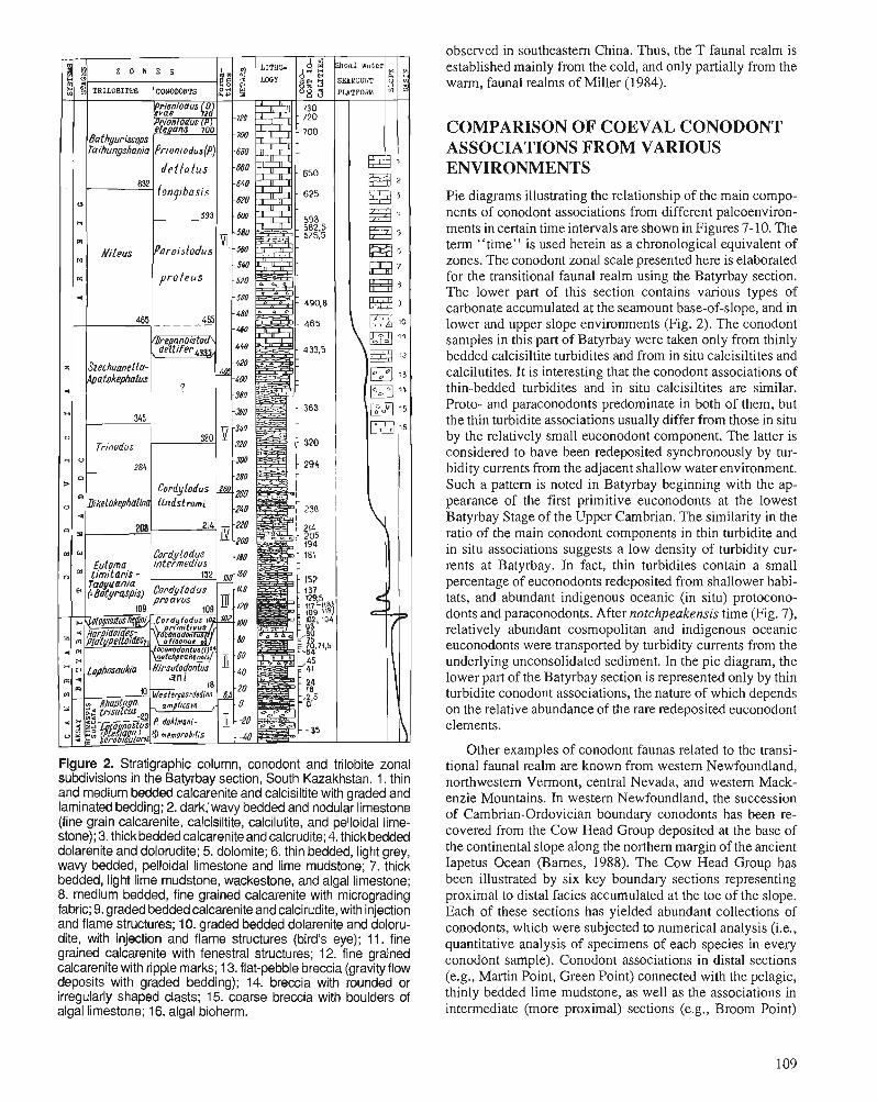
observed in southeastern China. Thus, the T faunal realm is established mainly from the cold, and only partially from the warm, faunal realms of Miller (1984).
Figure 2. Stratigraphic column, conodont and trilobite zonal subdivisions in the Batyrbay section, South Kazakhstan. 1. thin and medium bedded calcarenite and calcisiltite with graded and laminated bedding; 2. dark,'wavy bedded and nodular limestone (fine grain calcarenite, calcisiltite, calcilutite, and pelloidal lime- stone); 3. thick bedded calcarenite and calcrudite; 4. thick bedded dolarenite and dolorudite; 5. dolomite; 6. thin bedded, light grey, wavy bedded, pelloidal limestone and lime mudstone; 7. thick bedded, light lime mudstone, wackestone, and algal limestone; 8. medium bedded, fine grained calcarenite with micrograding fabric; 9. graded bedded calcarenite and calcirudite, with injection and flame structures; 10. graded bedded dolarenite and doloru- dite, with injection and flame structures (bird's eye); 11. fine grained calcarenite with fenestral structures; 12. fine grained calcarenite with ripple marks; 13. flat-pebble breccia (gravity flow deposits with graded bedding); 14. breccia with rounded or irregularly shaped clasts; 15. coarse breccia with boulders of algal limestone; 16. algal bioherm.
COMPARISON OF COEVAL CONODONT ASSOCIATIONS FROM VARIOUS ENVIRONMENTS
Pie diagrams illustrating the relationship of the main compo- nents of conodont associations from different paleoenviron- ments in certain time intervals are shown in Figures 7-10. The term "time" is used herein as a chronological equivalent of zones. The conodont zonal scale presented here is elaborated for the transitional faunal realm using the Batyrbay section. The lower part of this section contains various types of carbonate accumulated at the seamount base-of-slope, and in lower and upper slope environments (Fig. 2). The conodont samples in this part of Batyrbay were taken only from thinly bedded calcisiltite turbidites and from in situ calcisiltites and calcilutites. It is interesting that the conodont associations of thin-bedded turbidites and in situ calcisiltites are similar. Proto- and paraconodonts predominate in both of them, but the thin turbidite associations usually differ from those in situ by the relatively small euconodont component. The latter is considered to have been redeposited synchronously by tur- bidity currents from the adjacent shallow water environment. Such a pattern is noted in Batyrbay beginning with the ap- pearance of the first primitive euconodonts at the lowest Batyrbay Stage of the Upper Cambrian. The similarity in the ratio of the main conodont components in thin turbidite and in situ associations suggests a low density of turbidity cur- rents at Batyrbay. In fact, thin turbidites contain a small percentage of euconodonts redeposited from shallower habi- tats, and abundant indigenous oceanic (in situ) protocono- donts and paraconodonts. After notchpeakensis time (Fig. 7) , relatively abundant cosmopolitan and indigenous oceanic euconodonts were transported by turbidity currents from the underlying unconsolidated sediment. In the pie diagram, the lower part of the Batyrbay section is represented only by thin turbidite conodont associations, the nature of which depends on the relative abundance of the rare redeposited euconodont elements.
Other exam~les of conodont faunas related to the transi- tional faunal realm are known from western Newfoundland, northwestern Vermont, central Nevada, and western Mack- enzie Mountains. In western Newfoundland, the succession of Cambrian-Ordovician boundary conodonts has been re- covered from the Cow Head Group deposited at the base of the continental slope along the northern margin of the ancient Iapetus Ocean (Barnes, 1988). The Cow Head Group has been illustrated by six key boundary sections representing proximal to distal facies accumulated at the toe of the slope. Each of these sections has yielded abundant collections of conodonts, which were subjected to numerical analysis (i.e., quantitative analysis of specimens of each species in every conodont sample). Conodont associations in distal sections (e.g., Martin Point, Green Point) connected with the pelagic, thinly bedded lime mudstone, as well as the associations in intermediate (more proximal) sections (e.g., Broom Point)
Figure 3. Three sections (A, B, C) representing the complete Sarykum section, central Kazakhstan. 1. fine grained, muddy and marly limestone; 2. breccia with limestone clasts; 3. chert interbedded with limy, cherty shale and limestone (calcarenite); 4. alevrolite chert, spongolite, radiolarite; 5. chert, cherty shale, and black carbon-rich chert; 6. conodont localities.
derived from the pelagic sediments and thin turbidites, were in open ocean in situ associations. These elements (W' in Fig. taken into account while comparing them with thin turbidite 6), having a restricted access to the open ocean, could have and in situ conodont associations at Batyrbay. In the pie been carried oceanward (by surface, wind driven currents or diagrams, the ratios of the main components in conodont due to the influence of upwelling) and later fallen to the associations recovered from these facies are approximate, bottom. In such cases, the in situ and thin turbidite associa- giving only a general relationship of the biofacies compo- tions are similar to each other.
Section C Prioniodus ( 0 . ) evae LindatrGm, , periodon flabellurn (~ inds trom) Drepanodus arcuatue Pander, bepanodus proteua Lindstrom, p s ~ ~ ~ r d y l o d u a g r u c i l i s Lindstram-
Rossodus manitoueneis Repet- s k i and Ethington
paracordy lodua g r a c i l i a Lindstrom-
"Paltodus" bass l er i Furnish, "Acodus" oneotensis Furnish, Acanthodus l inea tus Purniah, - - - - - - -
Cordylodu Chosonodina herfu &epanorstoduS d e l t i f e r (~ indsrom)
(m)
40
80
120
w 2 e A V)
Z
H
nents. The conodont components-of associations of western Newfoundland are separated from each other by dotted lines. The elements redeposited from the epicontinental shallow water habitats are marked by a special symbol (Figs. 7-10).
The illustrations (Figs. 7-10) show that the thinnest slope facies in western Newfoundland and in Batyrbay usually contain abundant in situ (indigenous) oceanic specimens and relatively rare elements redeposited from a shallow water environment. The oceanic (indigenous) specimens could have been incorporated by low density turbidity currents from underlying nonlithified carbonate sediment and transported downslope. Thus, the redeposition not only of platform ele- ments, but also of oceanic (in situ) ones, is a natural process for an open ocean (slope) environment. Thin turbidites belong to the numerous slope facies that could have contained faunas derived from different habitats (i.e., mixed faunas). The oce- anic elements (in thin turbidites) are abundant, but platform specimens are relatively rare. The ratio of elements (or main components) in an open ocean conodont association can help to understand the origin of elements (i.e., in situ or alloch- thonous origin) on one hand, and to define more exactly the peculiarities of the lithofacies containing these associations on the other. However, rare platform elements can be found
.C,
b
H
w w tx d
The probability of occurrence of platform elements in the oceanic in situ sediments seems appropriate for both the continental slope (western Newfoundland) and the seamount slope (lower part of Batyrbay) environments. Upper Cam- brian and Lower Ordovician deposits in the Hot Creek Range of central Nevada are thought to represent a submarine fan toward the uppermost slope complex formed at the margin of the proto-Pacific Ocean (Taylor and Cook, 1976; Cook et al., 1989). The detailed analysis of conodont associations from various lithofacies in the Hot Creek Range is now in progress by J.F. Miller (in Cook et al., 1989). Redeposition of platform specimens together with in situ ones (as discrete elements or in small clasts), leading to a mixing of faunas of different habitats (and ages), is noted by Miller for continental slope facies, in particular, in central Nevada. These data of Miller, and previous studies of conodonts by Landing (1983) in continental slope facies of northwestern Vermont and in low angle slope or outermost shelf facies of western Mackenzie Mountains (Landing et al., 1980), are considered to be in agreement with the above-mentioned data from western Newfoundland and Kazakhstan. Currently, this is the only information available about the T faunal realm; not complete but sufficient to provide a general view.
-
" r- S
' m : $ g
0.4 v 1 h c 1
* d
H
"
d
0
A Z a 0 Z P
a
@ 1
o ' a x O d N
O x 4 k1
B
* e d 4 @ x ~ " 2 " * % m e $ Z 4
x O O : U I r l
Figure 4. Section A of the complete Sarykum section. Continuous Cambrian-Ordovician boundary succession of siliceous-carbonate rocks. The conodont localities are derived from the calcarenite beds only. 1. grey and light grey fine grained calcarenite; 2. medium grained calcarenite and cherty lime sandstone with graded bedding; 3. muddy calcisiltite and calcilu- tite; 4. limy, cherty shale; 5. alevrolite chert, spongolite, radiolarite; 6. black carbon-rich chert; 7. limy quartz-feldspar sandstone; 8. conodont (and trilobite) localities; 9. unexposed intervals of the section.
Cono.lont (and t r i l o b i t e ) l o c a l i t i e s
d y l o d u s l i n d s t r o m i Druce a n d J o n e s
C o r d y l o d u s l i n d s t r o m i Druce a n d J o n e s o rdy lodus p rosvus M i l l e r , S- 1'. ordy lodus p r i o n Linds t rom, S= f. , oconodontus (Z . ) n o t c h p e a k e n s i s ( M i l l e r )
d o n t u s nakamurai ( ~ o g a m i ) o s a g i t t o d o n t u s a f f . e u r e k a [ ~ i i l l e r ) .
e l o d u s t c n u i s ( N d l l e r ) , nodon t u s (3. ) n o t c h p e a k e n s i s ( M i l l e r ) , y lo . ius Droavus I N l l e r .
onotiontus (E. ) n o t c h p e a k e n s i s ( M i l l e r ) , han nod us sp..
a:;nostus h c d i n i (Troedsson) .
g n o s t u s h e d i n i (T roeds son ) nodontus (3. ) n o t c h p e a k e n s i s (Miller), neo t odus r o t u n d a t u s (Druce a n d J o n e s ) ,
a g n o s t u s h e d i n i (Troedsson) , a s i a t i c u s Lu,
a r c h a q i a sp. 1
5
9
Lithe-. l ogy - - - _._. _ - - ._._.
-=.= .= - - .- . -. -_ - - _. _. - .=.=. -=.=.I . = a = .
V) Q, fi
2 2 QJ d
E
33
31
IJI
14
b @
% s e w L,?
2 - W
4
<
0 f i z z -
S o u t h K a z a k h s t a n
M a l y i Kyrshabakty
s e c t i o n
(T. B. Bay to r ina G. Kh. E r g a l i e v , pers . comm, )
C e n t r a l Kazakhstan
Sarykum s e c t i o n
Assemblages
ion iodus (Q) e v h
2
4
H
U
H
* - 4
o
Q
P:
0
Ej
K a r a t a u
'Batyrbay S e c t i o n
I I
I Parac ordylodus
I g r a c i l i s
i I
'
C. p r i m i t i v u s Eoconodontus (E,) L. hed in i Zoc ono-
4 a l i s o n a e
k e n s i s
? Hirsu todontue 5
k4 P; 4 ani t~
IZ - Vleatergaardodina -4 Assemblage wit
proto- and amplicava cn
dahlmanl - I -% .rnemorabilis
Figure 5. Correlation of Upper Cambrian and Lower Ordovician strata in south and central Kazakhstan (Batyrbay, Kyrshabakty, Sarykum sections) based on the conodont zone succession.
ti
z
p:
4
v
0
Q
Ei
W
p:
H
-- z o m s - - Pr ioniodus (O-)evae
~ r i o n i o d u h % l e ~ a n s
P r ion iodus (P. ) d e l t a t u s longiba-
si s
Yarois todus p r o t e u s
Jb repano i s todua 7 d e l t i f e r
?
Corciylodus l i n d e t romi
B,
-4
i-io8aodus mani t oue
e i e - h n o d i n a he r
\ f u r t h i .
Cordylodue in te rmediu8
C ordylodus
proavus
d e l t i f e r I hoe:-
i 1
/
X
C . l inds t ro in i 4 l
CJ
4
W
U
C ordylodus
proavus
U 3 W TO MIDDLE PALEOLATITUDES RELATIVELY HIGH PAL;PX)LATIwDES
Warm faunal realm I~ransi t ionat cold faunal realm (W 1 f d u n a l realm
I (TI (C>
spioontinental man of 1 western N e ~ h u n d l ~ ~ d . 1 Baltic region North north western Vermont (northwestern Ehrope)
A
Figure 6. Inferred paleoenvironmental relationship of the warm, transitional, and cold conodontfaunal realms in the Late Cambrian and Early Ordovician. Not to scale. General models by Taylor (1 977, Textfig. 14) and Taylor and Cook (1976, Fig. 49) were used to determine extension of conodont realm. W, realm inhabited by warm water conodont species (populations, associations), i.e., epicontinental seas in low to middle paleolatitudes; W', warm water species starved in an open ocean environment; RC, relatively cold, (relatively deep water species [associations] living above the permanent thermocline); RC', RC species (associations) starved in an open ocean beyond a certain distance from shoreline; C' and C", variants of cold, deep water conodont associations living below the permanent thermocline; T, realm inhabited by W', RC, RC', and C" conodont associations (populations). Above-mentioned designations related to low and middle paleolati- iudes. C, cold water associations in relatively high paleolatitude environments of shallow seas and ocean (- . - . - . indicates level of the permanent thermocline).
Eoconodontus (E.) ~i rsu todon tz westergaardodlna notchpeakensis time primitivus t lrne amplicava t ime
i
4 cd
t E
I r L u
+- s a p n ~ ~ ~ o i o a l z d y8!4 f i l a n l l ~ l a ~
11
75- r: d
d
awl? srsuayeadyalou 0) s nluopouoso3
a w q s n n ~ l r w ~ ~ d sn luopo~ns~r H
awyl an3?lduv e u r p o p ~ t t 8 ~ a l s a ~
The contrast between T (transitional) and W (warm) fau- nal realms is obvious. The T realm has the allochthonous faunal component redeposited from the W realm. The re-es- tablishing of the main faunal components in conodont asso- ciations of the W faunal realm (and the relationship of their components) in specific Cambrian-Ordovician time intervals is not difficult now with the data from North America (Miller et al., 1982; Ethington and Repetski, 1984; Miller, 1984), north and northeastern China (An, 1982; An et al., 1983; Chen and Gong, 1986), and Australia (Druce et al., 1982). The reverse relationship of coeval faunal components is typical for the W and T realm associations and can be explained by the differences of T and W conodont ecology. The absence of several T taxa is true for the W realm as well. The data concerning the W faunal realm associations are conditionally reflected in the pie diagrams, where faunal components are separated from each other by dotted lines (Figs. 7-10). The general information about C (cold) faunal realm associations was obtained from earlier studies by Miiller (1959), Bednarc- zyk (1979), from the recent data of Kaljo et al. (1986), and from this paper (central Kazakhstan). The line between the T and C realms (Fig. 6) is tentative at this stage.
The pattern of realms develops in the Late Cambrian, at the end of the Aksay Epoch, the Westergaardodina ampli- cava time. This is the time of abundant proto- and paracono- donts (Fig. 7). Maximum taxonomic diversity of these conodont groups occurs in the W and T associations of central Asia (sections of northern China, as well as Batyrbay and Kyrshabakty in Kazakhstan). Medium and minimum taxo- nomic diversity is found in the cold water associations in northwestern Europe (Kaljo et al., 1986) and warm water associations of North America (Miller et al., 1981), respec- tively. The central Asia, Kazakhstan-China, region may have been the centre of origination and migration of the proto- and paraconodont fauna.
The first euconodonts occur in the beginning of the Batyr- bay Epoch. Coeval associations are characterized by different relations between euconodont and proto-, paraconodont ele- ments. Faunal contrast becomes sharper from the alisonae time of the latest Cambrian. Within this final epoch of the Late Cambrian the following associations are found for the various time intervals:
Hirsutodontus ani time
In the Hirsutodontus ani time, the dominant component of the W associations is represented by euconodonts of Procono- dontus in North America (Miller et al., 1982); of Procono- dontus, Teridontus, and Hirsutodontus in North China (An, 1982; An et al., 1983); of Proconodontus and Teridontus in Australia (Druce et al., 1982), whereas a relatively small component is composed of proto- and paraconodonts (Fig. 7). In the T associations recovered, for example, from the base- of-slope deposits of the Batyrbay section, we observe the reverse relationship of elements: proto- and paraconodonts prevail, but the stratigraphically important euconodonts make up (in thin-bedded turbidites) a minor percentage component
(2-5%), which is allochthonous by nature (i.e., synchronously transported from the nearby shallow environment by turbidity currents). Euconodonts, abundant in shallow, warm water associations, arriving in the T realm, make up therein a minor component. Thus, the analysis of euconodonts from the W and T realms can help to define their origin and compare different facies. Euconodonts of this time interval belong to exclusively warm water varieties. They are absent in C as- semblages, making the correlation with northwestern Europe difficult.
Eoconodontus (E.) notchpeakensis time
The Eoconodontus (E.) notchpeakensis time is connected with the appearance of E.(E.) notchpeakensis, the first cos- mopolitan euconodont dominating the W realm. The average euconodont content in the T realm (up to 30% in calcisiltite turbidites in the Batyrbay section) is caused, apparently, by both in situ occurrence and transport from shallower environ- ments. Rare elements of Proconodontus (1-2% from the total assemblage) most probably are transported, though no attri- tion or damage is observed. Evidently, this kind of preserva- tion of elements is characteristic of this type of transport, as already reported by Ethington and Repetski (1984). In the C realm, the eIements of E. (E.) notchpeakensis are extremely rare, for example, in the Estonia and Leningrad areas (Kaljo et al., 1986), and in Sweden (Miiller, 1959) and Poland (Bednarczyk, 1979) they are either absent or as yet unknown. Disproportionate abundances between proto- and paracono- donts on one hand, and euconodonts on the other, are typical for the associations discussed for this time interval (Fig. 7).
Eoconodontus (E.) alisonae time
The Eoconodontus (E.) alisonae time is characterized by the strict confinement of some euconodont species to certain environments. Species of the E. (Cambrooistodus) subgenus are typical for the W ancient epicontinental seas, whereas E. (Eoconodontus) alisonae Landing characterizes only the T open ocean paleoenvironments (Fig. 8). This fact was first noted by Landing (1983). In the T associations (for example, in Batyrbay) rare elements of E. (Cambrooistodus) and Pro- conodontus are redeposited. The C fauna is devoid of warm water E. (Cambrooistodus), and the transitional E. (E.) aliso- nae remains unchanged. Therefore, conodont zonal subdivi- sions of the same name cannot be established in northwestern Europe.
Cordylodus primitivus time
The most interesting, disputed, and short time interval is the Cordylodus primitivus time. In this brief interval, the first primitive species of Cordylodus occur, such as C, andresi Viira and Sergeeva (Viira et al., 1987) and C. primitivus (Bagnoli et al., 1987). However, during this period these species inhabited the C and T realms only, and did not penetrate into the warm water cratonic seas of North America,
Fig
ure
8.
Com
paris
on o
f co
eval
con
odon
t ass
ocia
tions
in
var
ious
pal
eoen
viro
nmen
ts fr
om a
lison
ae to
C
ordy
lodu
sprim
itivu
s tim
e of
the
late
st C
ambr
ian.
Ref
eren
ces
and
sym
bols
as
for
Fig
ure
7.
- - m
iddi
e -lo
w p
aleo
iatit
ude s
t
r L
0
sea level
0
'5
2.
IC
w
N-W
Eur
ope
rc.
+ '
- V
)
'<
- lo
w- m
idd
le
pai
eola
titu
des
Q) E
.+
4
(I, = -4 4 -4 f -4
A -
~o
rth
Am
eric
a sea
leve
l
w Ut
ah O
klah
oma,
C. Te
xas
\ [
*/
\
\
/
-
- L
w ~
ewfo
undl
and
cu
S. K
azak
hsta
n z
u
Q
W. U
tah,
Oki
ahom
a,
W. N
ewfo
undl
and
3
S. K
azak
hsta
n C
ord
aio
du
s p
rim
itiv
us
N. C
hi tl a
m
cn
ct
t'
3
(Cam
- no
tch-
4
p
ara:
" ,i(;;\
broo
is- I
peak
e 3-1
con
o-k
.aii
son
ae
do
nts
':a
~.(C
arnb
ro- t
od
us)
/t- .si
s /
\pro
tP-
oist
odu
s)*
\par
a-
t---
CO
-
T n
aka
mu
ra
do
nts
T
nak
amur
a~
-4
P
roco
nodo
ntus
s
rd
4
Q) L
N-W
Eur
ope
S.K
azak
hsta
n d
on
ts
(D ,
N. C
hina
-
xas
W N
ewfo
und l
and
Y
north China, or Australia. Invasion of the primitive cordylo- dan species onto the cratons occurred somewhat later, at the beginning of proavus time.
The faunal data of the Batyrbay section show that Cordy- lodus primitivus time should be divided into two phases (Fig. 8). During the first, in the T associations (Batyrbay), primitive species of Cordylodus coexist with proto- and paraconodonts, E. (E.) notchpeakensis and with the less common E. (E.) alisonae. By the end of the first phase of primitivus time, E. (E.) alisonae becomes extinct and the rare transported ele- ments of E. (Cambrooistodus) and Proconodontus disappear from the T associations as well, which is explained by the extinction of these species in the adjacent cratonic paleoen- vironments.
Associations of the second phase of primitivus time can be observed in the C and T realms or only in the latter (e.g., Batyrbay section). These associations are represented by primitive elements of Cordylodus, still existing E. (E.) notch- peakensis, and proto- and paraconodonts. In shallow water cratonic environments, the second phase of primitivus time is probably reflected by a hiatus in sedimentation that lasts until the beginning of proavus time.
Thus, the beginning of the Lange Ranch Eustatic Event, marked by a sharp and episodic drop in sea level (Miller, 1984), is fixed apparently at the second phase of the Cordy- lodus primitivus time. In this case, the first hiatus in the sedimentation of the shallow water platform carbonates em- braces the time interval from the end of primitivus time until the very beginning of proavus time. During this period, the conodont associations of the Batyrbay section have no ana- logues in shallow cratonic seas (Fig. 8) as well as in proximal and distal parts of ocean basins, for example, in western Newfoundland (Barnes, 1988). because some of the latter are characterized by intensive erosion processes resulting in a loss of coeval deposits.
Cordylodus proavus time
Cordylodus proavus time refers to early Tremadoc time. Faunal changes at the base of the proavus Zone, considered herein as the systemic boundary, are not equivalent in differ- ent paleoenvironments. In the C realm, these changes are manifested only by the extinction of some species of para- conodonts and in the appearance of numerous specimens of C. proavus. The T associations also do not have sharp changes. Near the systemic boundary, E. (E.) alisonae and some paraconodont species disappear and, soon after, C. proavus is common. Only warm water associations show significant changes. Their composition undergoes alterations due to the extinction of E. (Cambrooistodus) and Procono- dontus species and to the appearance of C. proavus, species of Hirsutodontus, and, slightly later, species of Fryxellodon- tus and Clavohamulus. At this time in the carbonate shallow water environments of North America (Miller, 1984), the steady spread of Teridontus nakamurai and Cordylodus primitivus takes place.
Hirsutodontus, F~yxellodontus, Clavohamulus (H., Fr., CI.) were unable to tolerate the open sea and oceanic environ- ments, and together with the more eurytopic E. (E.) notch- peakensis and Cordylodus, provide the differences in the ratio of the faunal components in the W and T associations as well as the absence of the H., Fr., Cl. component in the C realm (Fig. 9). The H., Fr., Cl. genera are dominant to relatively abundant in the shallow, warm water seas (Miller, 1984). In the slope environments (thin turbidites and in situ deposits of western Newfoundland), they rank second (Barnes, 1988), which can be explained by transportation by turbidity and surface currents. In environments such as the open outermost shelf or upper slope of Malyi Karatau seamount (Batyrbay) and the low angle continental slope or outer shelf of western Mackenzie Mountains (Landing et al., 1980) H., Fr., Cl. elements may be missing. In the T associations, proto- and paraconodonts still prevail; Cordylodus proavus, C. primiti- vus, E. (E.) notchpeakensis, and T. nakamurai are present in smaller but consistent numbers, and the component with H., Fr., C1. elements is minute or missing. The C fauna is char- acterized by numerous Cordylodus proavus, C. andresi, E. (E.) notchpeakensis and rare proto- and paraconodonts (Kaljo et al., 1986). Thus, the time interval connected with the appearance of new species of H., Fr., Cl. genera at the systemic boundary may be traced in the deposits of carbonate platform and adjacent slope facies. In the first case, these in situ species are numerous, whereas in the second, they are transported and relatively rare.
The same principle is valid for the ratio of the conodont faunal components of the Cordylodus intermedius time (Fig. 9). In this time interval, the transported elements are the new representatives of the Teridontus lineage (i.e., elements of the Monocostodus, Utahconus, and Semiacontiodus genera) and the Hirsutodontus lineage. A certain number of such redepos- ited specimens in slope associations is common, as in western Newfoundland (Barnes, 1988) and central Nevada (Cook et al., 1989). But in the transition zone, from the outermost shelf to slope environment, the probability of their meeting is small, e.g., rare, as H. simplex at Batyrbay or even absent, as in western Mackenzie Mountains (Landing et al., 1980). It is known that species such as H. simplex were adapted exclu- sively to the restricted marine environments of ancient epi- continental seas (Landing et al., 1980; Miller, 1984). The bypass zone from the open outermost shelf to the slope is a most unsuitable environment not only for the habitat of H. simplex, but also for the capture of the H. simplex elements for redeposition. Most probably, the few specimens of H. simplex at Batyrbay are indigenous (in situ) and survived in the seamount outermost shelf to upper slope environment.
Generally, the associations of the T realm include, apart from the allochthonous (transported) or starved W compo- nent, a considerable cosmopolitan component (i.e., cordylo- dan species, E. (E.) notchpeakensis, T. nakamurai), proto- and paraconodonts (or moderate numbers of cosmopolitans and abundant proto- and paraconodonts, as in the Batyrbay section). The content of cosmopolitan species of Cordylodus and E. (E.) notchpeakensis increases in both the C and tax- onomically homogeneous assemblages.
tow
- mid
dle
pal
eola
t~tu
des
A
- m
lddl
e -lo
w p
aleo
iatlt
udes
p
00
lort
h A
mer
ica
- A
C
00
se
a le
vel
sea
1&
E-
Jape
togn
athu
s
C. ~
evad
a 7s 3
W N
ewfo
undl
and
N-W
Eur
ope
S. K
azak
hsta
n N
.Chi
na
C.O
cd
4
C.Ne
vada
,W. N
ewfo
undl
and
5
do
nts
* N-
W E
urop
e L
S. K
azak
hsta
n N
.Chi
na
3 =
(0'"
? ?
7
Figu
re 9
. C
ompa
rison
of
coev
al c
onod
ont
asso
ciat
ions
in
vario
us p
aleo
envi
ronm
ents
from
pro
avus
to
iinds
trom
i-ang
ulat
us tim
e of
the
Ear
ly O
rdov
icia
n. R
efer
ence
s an
d sy
mbo
ls a
s fo
r F
igur
e 7,
exc
ept e
aste
rn
Nev
ada
(Eth
ingt
on a
nd R
epet
ski,
1984
); ce
ntra
l Nev
ada
(Coo
k et
al.,
198
9). F
auna
l com
pone
nts
ende
mic
to
cen
tral
Asi
a sy
mbo
lized
by
cros
s-ha
tchi
ng.
Cordylodus lindstromi-C. angulatus time
Cordylodus lindstromi-C. angulatus time is characterized by the last remaining cosmopolitan E. (E.) notchpeakensis and species of Cordylodus. In the W realm, as shown by Miller (1984) and Ethington and Repetski (1984), a small percentage of new Midcontinent species is added to the numerous dista- codontiform and less abundant cordylodan species (Fig. 9). The C and T realms undergo some innovations due to the appearance of Iapetognathus. The same regularity in the ratio of faunal components in the adjacent W and T realms is evident. The C realm becomes progressively more different from the others. However, the contrast between the coeval faunal realms is still smoothed by cosmopolitan elements. The actual difficulties in comparing these realms increase from the end of the Black Mountain Eustatic Event (Miller, 1984), when numerous coniform taxa appear in the W and C realms but there are practically no taxa in common (Miller, 1984).
Drepanoistodus deltifer-Rossodus manitouensis time
The proof that the upper Tremadoc cold water Drepanois- todus deltifer fauna is coeval with the warm water Rossodus manitouensis fauna (or Fauna C of North America) is based on the fact that both of them replace previous associations with the last remaining cosmopolitans. To compare these sharply contrasting faunas, attention should be paid to the T realm's associations (Fig. lo), containing, together with the deltifer faunal elements, 'some shallower water transported forms, shown in the data of Landing (1983) from the conti- nental slope deposits of the Highgate Formation in northwest- ern Vermont. There are also some examples of changes in the ratio of different components of the Rossodus rnanitouensis fauna discovered from the shallow to relatively deep environ- ments of North America, described by Ethington and Repet- ski (1984).
Such observations are of special value for the interpreta- tion of the upper Tremadoc associations derived from the different lithofacies of the Sarykum section. The upper part of the lower member of the Chazhagay Formation is consid- ered herein (Fig. 3). The first conodont association at Sarykum is a typical warm water one with R. manitouensis, Chosonodina herfurthi and other species (Fig. 3, section B, sample [51] 81.5). This association, derived from the cal- carenite turbidites of the Chazhagay Formation's lower mem- ber, has been transported from the neighbouring shallow water carbonate environment into the hemipelagic environ- ment without any changes in the ratio of faunal components. This can be proved by having the same ratio of components in both the Sarykum and in the shallow water Fauna C of North America (Fig. 10). Furthermore, the invariability in the ratio of faunal components of the R. manitouensis association during redeposition from the shallow to hemipelagic environ- ment at Sarykum can be evidence of the high density of turbidity currents in the Sarykum Basin. The second conodont association, a typical cold water association found in the cherts of the same member (Fig. 3, section C, samples 148-3, 148-2) was formed in situ in a relatively deep hemipelagic environment of the Sarykum Basin.
With reference to the above, the events happening at this time in south Kazakhstan are of acute interest (Fig. 10). The Batyrbay section serves as an example of the coexistence of deltifer fauna with proto- and paraconodonts in the shoal environment of the seamount, subjected to ocean currents and the constant influence of free access to the open ocean. Consequently, for the seamount, it is not mandatory to have a relatively deep environment (similar to the continental slope in North America) in order to have a deltifer component in the population. However, coeval proto- and paraconodonts are absent in the basinal Sarykum hemipelagic environment, which contains only the deltifer fauna, similar to that of Europe but less taxonomically diverse. Such is the difference in the upper Tremadoc biofacies in Kazakhstan.
The lower Arenig fauna, when compared with its prede- cessors, is more differentiated, depending on the specific environments. The complete diversity of environments and associations might be presented as a pattern, wherein various ratios of faunal components take part: at first, two, i.e., North Atlantic or (in the narrower sense of this term) Acado-Baltic (A-B) and Midcontinent (M); and later, three, i.e., A-B, M, and Juanognathus (Ju).
Paroistodus proteus-Prioniodus (P.) deltatus longibasis time
The distribution of these two types of faunal components from the Paroistodus proteus to the Prioniodus (P.) deltatus longibasis time is shown in Figure 10. The data reveal the similarity of the Batyrbay shallow water association of the seamount to the North American populations from the conti- nental slope and basin environments. Likewise, the close similarity of the deep water basinal association from the black chert of the Sarykum section (i.e., from the upper member of the Chazhagay Formation; Fig. 3, section C, samples 148-1, 148-A, 148) and the cold water fauna of northwestern Europe is shown. The Sarykum association, when compared to that of Europe, is taxonomically less diverse; probably only a limited number of A-B species were adapted to the relatively deep, cold environment of the central Kazakhstan Basin.
Prioniodus (P.) elegans-P. (Oepikodus) evae time
The last time interval to be considered herein is the Pri- oniodus (P.) elegans-P. (Oepikodus) evae time, which is connected with the appearance of the Juanognathus compo- nent (Lindstrom, 1976) in the conodont fauna. This compo- nent is typical only for the T faunal realm. It is worth mentioning that if the A-B and M components under certain paleoenvironments make up the basis for the contrasting associations of the same names, the Ju component is not known as an independent unit or Ju population. Its occurrence either with M, A-B or with both components provides a solution to the problem of comparing provincially differenti- ated lower Arenig A-B and M faunas. In North America, Ethington and Repetski (1984) identified four coeval popu- lations traced from inner shallow shelf to ocean basin envi- ronments (Fig. 10). The open outer shelf and continental slope environments containing, respectively, the second and the
~repanolstodus deltifer time
Prloniodu s eleg a ns - I? (Oeplkodus) evae t ime
Prlonlodus(~de1tatus Paroistdus poteus- longibasis time
A
U
B z d u 3 A P d TI E! E
1~ u 4
4 s a p n ~ ~ l e ~ o a l e d y;Sr~ f i ~ a n ~ ~ t ~ a ~ cd
B cd 3' (d =-'. 2% a-4 dZ d 0
rl) 3
Q) z -4
cd
0 Q) d (d ncd
L,
3 2 - 2 2 E = 3 5 ,O L 0 Z
3 eune j a ei lnej : 3 e u n v j aeAa ( S ~ P O Y T ~ ~ O ) ~
-'su$8~la SnPoTuoTJd a r l .s~s~q!i5uo~
snlp&p . ) snporuqjd dd -snalo~ snpols~o~ed a t u u JajqTap snpo 'g5~0~tda~a
third populations, are the most suitable for the Ju component. Faunas A and B of Argentina (Serpagli, 1974) and the Batyr- bay shallow water association including both A-B and Ju components are most similar to the above-mentioned popu- lations. The probability of the Ju and M components meeting in northwestern Europe and in the basinal pelagic environ- ment of central Kazakhstan does not exist. These are the environments inhabited by A-B species exclusively. Thus, the T realm's associations with a Ju component in situ, or in transported form, could not be overestimated for the correla- tion of different types of lower Arenig deposits.
In conclusion, it is worth enumerating the main faunal features typical of the T (transitional) faunal realm, thus giving the reason for distinguishing it. The T realm is char- acterized by the following:
1. The Upper Cambrian Eoconodontus (E.) alisonae. This species is known in the T realm not only in situ, but also in transported form. It means that the habitat of E. (E.) alisonae could embrace an open ocean environment of outermost shelf and upper slope (i.e., above the permanent thermocline), but the lower continental slope and hemipelagic environment might be represented, appar- ently, by transported specimens of E. (E.) alisonae.
2. The abundance and diversity of long-lived proto- and paraconodonts continues until the late Tremadoc or early Arenig.
3. In the early Arenig, a Juanognathus component develops. It is known in the T realm not only in situ, but also in transported form.
4. The presence of rare (starved), warm water species.
The contemporaneously redeposited warm water eucono- dont elements are especially important for comparing differ- ent cratonic and oceanic biofacies (i.e., to compare the W and T faunal realms).
Depending on the bathymetric parameters, the T realm may be considered as a continuous series of paleoenviron- ments and their associations of lower rank. In such a series, three or more paleoenvironments of low rank can be condi- tionally recognized, with a continuous transition from so- called moderate warm, to moderate cold, to cold water paleoenvironments. However, all four of the above-men- tioned characteristics of the T realm cannot be applied to the deepest cold water paleoenvironments (and associations). The latter, such as a pelagic basinal environment (and asso- ciation) in central Kazakhstan in early Arenig time, is similar to that of the C faunal realm nearby, in the relatively high paleolatitudes.
A comparison of different types of paleoenvironments and their associations provides several advantages. Firstly, it makes the correlation more precise. Secondly, it allows a generalization of the stages in early conodont evolution. The stages might be based on the changes in the euconodont evolutionary lineages of McTavish (1973), Miller (1980, 1984, 1988), Dzik (1983), Repetski and Ethington (1983), Bagnoli and Stouge (1985), and Bagnoli et al. (1987) on the rate of their evolution and on the analysis of the proto- and
paraconodonts. This must be accompanied by a generaliza- tion of the changes in the evolutionary lineages in the W, T, and C realms and on the evaluation of the heirarchy of these changes. Hence, the most significant changes in the conodont fauna at the base of the Cordylodus proavus Zone correspond to the change in the evolutionary stages of the first rank, i.e., between Late Cambrian and Early Ordovician time. This is regarded herein as the systemic boundary. The evolutionary stages of second rank might correspond to changes at the boundaries of series (or stage) subdivisions, and influence ideas on the duration of the Tremadoc Series. Finally, the stages of the third rank provide a basis for zonal subdivisions.
The conodont zonal scale at Batyrbay is one of the few scales elaborated for the T realm.
The following euconodont lineages have a particular sig- nificance for establishing zonal conodont subdivisions at Batyrbay:
I . Hirsutodontus lineage
The most primitive representatives of the Hirsutodontus line- age, such as H. ani (Wang), succeeded by H. transmutatus (Xu and Xiang), are known in the Upper Cambrian of north China (An, 1982; An et al., 1983) and of the Malyi Karatau (Batyrbay and Kyrshabakty sections). These species inhab- ited the Chinese epicontinental seas and were found in situ, whereas in the Malyi Karatau slope facies, they were contem- poraneously transported by currents from the adjacent shal- lower environment. The primitive species of the Hirsutodontus lineage appeared practically simultaneously with the first primitive species of the Proconodontus lineage (i.e., P. tenuiserratus Miller) at the base of the Fengshan Stage of north China and, respectively, at the base of the Batyrbay Stage in Kazakhstan (Kyrshabakty section). These data indicate that the Hirsutodontus lineage can be traced from the Late Cambrian, i.e., from the beginning of Batyr- baian (Kazakhstan) and Fengshanian (north China) time, equivalent to latest Franconian (North America) time, rather than from the Early Ordovician proavus time as suggested by Miller (1980,1984). Furthermore, the Hirsutodontus lineage apparently developed independently from the Teridontus lineage.
Miller (1988), having summarized the latest data from the Dayangcha section of northeastern China (Chen and Gong, 1986), came to similar conclusions. In south Kazakhstan, the earliest evolutionary stage of the Hirsutodontus lineage has been used for establishing the Hirsutodontus ani Zone in the lowest Batyrbay Stage of the Upper Cambrian.
2. Lineages from Eoconodontus (E.) notchpeakensis to E. (E.) alisonae or to Cordylodus primitivus
The lineages from Eoconodontus (E.) notchpeakensis to E. (E.) alisonae and, respectively, from E. (E.) notchpeakensis to Cordylodus prirnitivus, characteristic of the T realm, were taken into account while establishing the Eoconodontus (E.) alisonae and Cordylodus primitivus zones in the uppermost
Cambrian in south Kazakhstan (Apollonov et al., 1988; Chu- gaeva et al., 1989) and subzones of the same name in western Newfoundland (Barnes, 1988).
3. Lineage from Prioniodus (P.) deltatus longibasis to P. (P.) elegans
The reconstruction of the Prioniodus (P.) elegans lineage remains one of the interesting evolutionary problems (Mc- Tavish, 1973; Bagnoli and Stouge, 1985). New data of Pohler et al. (1987) show that the new species of Prioniodus, re- corded in the upper slope facies of western Newfoundland, is probably the ancestor of Prioniodus elegans. Pohler et al. (1987) noted the similarity in the elemental composition of the P. n. sp. and P. elegans apparatuses, but noted also the more primitive (minute) denticles of the P. n. sp. elements compared with those of P. elegans.
P. (P.) deltatus longibasis (McTavish), recovered from the shallow water Malyi Karatau seamount facies (Batyrbay), has the same type of apparatus and probably the same primi- tive denticulation of elements as the P. n. sp. of Pohler et al. (1987). However, the denticulation of the P. (P.) deltatus longibasis (McTavish) elements is so minute, that it is often difficult to recognize. If the P. n. sp. in western Newfound- land and P. (P.) deltatus longibasis (McTavish) in Batyrbay are synonymous, the lineage, named at present as a transition from P. (P.) deltatus longibasis to P. (P.) elegans (this paper) or from P. n. sp. to P. elegans (Pohler et al., 1987), will be very important for the detailed zonation of the lower Arenig in the T faunal realm.
The lineage from Prioniodus (P.) deltatus longibasis to Prioniodus (P.) elegans was used to establish conodont zones of the same name in the continuous lower Arenig deposits in south Kazakhstan.
CONCLUSIONS The continuous succession of Upper Cambrian and Lower Ordovician conodont associations recognized in the carbon- ate facies of the Batyrbay section, Malyi Karatau, south Kazakhstan, is more detailed than the conodont succession established in the siliceous-carbonate facies of the complete Sarykum section, central Kazakhstan, but they do not differ in principle.
Generally, the composition of the Batyrbay conodont associations depended on their location on the margin of the ancient carbonate seamount, where there was permanent and free access to the open ocean, and the influence of a system of ocean currents. Basinal and slope environments in the Upper Cambrian were succeeded by the Lower Ordovician upper slope and, later, the lower Arenig shallow water envi- ronments of the seamount. In contrast, the sufficiently deep oceanic environments at Sarykum changed from the base-of- slope of the carbonate platform in the latest Cambrian to Tremadoc hemipelagic and early Arenig pelagic environ- ments. Such paleoenvironments determined the composition of conodont associations at Batyrbay and Sarykum. They were compared to associations from other regions of the
world for specific time intervals, considered as chronological equivalents of conodont zones. The Cambrian-Ordovician zonal scale of Batyrbay was taken as the standard for particu- lar time intervals.
The comparison of coeval conodont associations from different paleoenvironments permits the recognition (sepa- rate from Miller's warm and cold faunal realm) of the transi- tional (T) faunal realm. This included ancient open seas and oceans in low to middle paleolatitudes. The realm embraced outermost continental shelves with unrestricted access to the open ocean, continental slopes, basinal (hemipelagic) and any carbonate seamount paleoenvironments. The realm is traced along the ancient continental margins and can be illustrated by sections in south Kazakhstan, western Mackenzie Moun- tains (Landing et a]., 1980), central Nevada (Cook et al., 1989), northwestern Vermont (Landing, 1983), western Newfoundland (Barnes, 1988), and probably occurs in south- eastern China.
The latest Cambrian Eoconodontus (E.) alisonae, the abundance and diversity of long-lived proto- and paracono- donts, the early Arenig Juanognathus faunal component in conodont associations and, finally, the rare (starved) warm water species are all typical characteristics of the T faunal realm. The significance of contemporaneously redeposited warm water euconodont elements is noted to compare cra- tonic and oceanic biofacies (i.e., to compare markedly differ- ent warm and T faunal realms).
The zonal scale of Batyrbay is one of the few scales elaborated for the T realm, with the scale of Sarykum likewise a model for the C realm.
Four euconodont lineages had particular significance for establishing zonal subdivisions at Batyrbay. The earliest evo- lutionary stage of the Hirsutodontus lineage has been used for recognition of the Hirsutodontus ani Zone in the lowest Batyrbay Stage of the Upper Cambrian. The lineages from Eoconodontus (E.) notchpeakensis to E. (E.) alisonae and from E. (E.) notchpeakensis to Cordylodusprimitivus, typical for the T faunal realm, helped to establish the Eoconodontus (E.) alisonae and Cordylodus primitivus zones in the upper- most Cambrian. The lineage from Prioniodus (P.) deltatus longibasis to P. (P.) elegans was used to define these zones in the lower Arenig. If this latter lineage is equivalent to the P. n. sp.-P. elegans lineage of Pohler et al. (1987), it will be important for detailing the lower Arenig zonal scales of the T faunal realm.
The faunal data of the Batyrbay section showed that the very short Cordylodus prirnitivus time interval of the latest Cambrian should be divided into two parts. The conodont association of the second part could be observed in the C and T faunal realms or in the T realm only. In shallow cratonic environments (warm realm) the second part of the Cordy- lodus primitivus time was apparently reflected by a hiatus. Earlier, the hiatus was recognized within Cordylodusproavus time by Miller (1984). Thus, the beginning of Miller's Lange Ranch Eustatic Event at the systemic boundary (as defined herein) has obtained a more precise definition, i.e., from the second phase of the Cordylodus primitivus time of the latest Cambrian.
ACKNOWLEDGMENTS I gratefully acknowledge the following persons for contrib- uting stimulating ideas, discussions, and criticism: Michael Taylor, James Miller, Harry Cook, Christopher Barnes, Mi- chael Apollonov, Vyacheslav Zhemchuzhnikov, and Tatjana Kheraskova. Christopher Barnes kindly read a preliminary draft of the manuscript, and his comments helped to improve the final draft. Helena Gomaya aided significantly in trans- lating this paper.
REFERENCES An, T. 1982: Study on the Cambrian conodonts from north and northeast China.
University of Tsukuba, Science Reports of the Institute of Geos- cience, Section B, v. 3, p. 113-159.
An, T., Zhang, F., Xiang, W., Zhang, Y., Xu, W., Zhang, H., Jiang, D., Yang, C., Lin, L., Cui, Z., and Yang, X. 1983: The Conodonts of North China and Adjacent Regions. Science
Press, Beijing, 223 p. Apollonov, M.K. and Chugaeva, M.N. 1982: Batyrbaisai Section of Cambrian and Ordovician in Malyi Karatau
(South Kazakhstan). Izvestiya Akademy nauk SSSR, Seriya ge- ologicheskaya, v. 4, p. 36-45. (in Russian)
1983: The problem of the Cambrian-Ordovician boundary. In The Lower Palaeozoic Snatigraphy and Palaeontology of Kazakhstan, M.K. Apollonov, S.M. Bandaletov, and N.K. Ishvin (eds.); Alma-Ata, Nauka, p. 16-25. (in Russian)
Apollonov, M.K. and Zahemchuzhnikov, V.G. 1988: Lithostratigraphy of the Cambrian-Ordovician boundary deposits in
the Batyrbay section of the Malyi Karatau. Izvestiya Akademy nauk KazSSR, Seriya geologicheskaya, v. 1, p. 22-36. (in Russian)
Apollonov, M.K., Chugaeva, M.N., and Dubinina, S.V. 1981: The Cambrian-Ordovician boundary in the Malyi Karatau Range,
South Kazakhstan. In Short Papers for the Second International Symposium on the Cambrian System, M.E. Taylor (ed.); United States Department of the Interior, Geological Su~vey, Open File Report 81-743, p. 15-17.
1984: Trilobites and Conodonts from the Batyrbay Section (Uppermost Cambrian-Lower Ordovician) in the Malyi Karatau Range, Atlas of Paleontological Plates. Alma-Ata, Nauka, 48 p. (in Russian)
Apollonov, M.K., Dubinina, S.V., Ergaliev, G.Kh., and Chugaeva, M.N. 1985: Potential Cambrian-Ordovician boundary stratotype in Malyi
Karatau. Izvestiya Akademy nauk KazSSR, Seriya ge- ologicheskaya, v. l , p. 32-38. (in Russian)
Apollonov, M.K., Chugaeva, M.N., Dubinina, S.V., and Zhemchuzhnikov, V.G. 1988: Batyrbay Section, South Kazakhstan, USSR - potential stratotype
for the Cambrian-Ordovician boundary. Geological Magazine, v. 125, p. 445-449.
Bagnoli, G. and Stouge, S. 1985: Species of Prioniodus Pander, 1856 from Bed 9 (Lower Ordovi-
cian), Cow Head Group, western Newfoundland. In Fourth Euro- pean Conodont Symposium (ECOS N), Abstracts, R.J. Aldridge, R.L. Austin, and M.P. Smith (eds.); Private Publication, University of Southampton, p. 3.4.
Bagnoli, G., Barnes, C.R., and Stevens, R.K. 1987: Lower Ordovician (Tremadocian) conodonts from Broom Point,
western Newfoundland. Bollettino della Societa Paleontologica Italians, v. 25, p. 145-158.
Barnes, C.R. 1988: The proposed Cambrian-Ordovician global boundary stratotype and
~ o i n t (GSSP) in western Newfoundland. Canada. Geological M a ~ a - h e , v. 125, '~. 381-414.
- Bednarczy k, W. 1979: Upper Cambrian to Lower Ordovician conodonts of Leba Elevation,
NW Poland, and their stratigraphic significance. Acta Geologica Polonica, v. 29, p. 409-448.
Chen, J. and Gong, W. 1986: Conodonts. In Aspects of Cambrian-Ordovician Boundary in Day-
angcha, China. Contribution to Dayangcha International Confer- ence on Cambrian-Ordovician Boundary, J. Chen (ed.); Beijing, China Prospect Publishing House, p. 93-223.
Chugaeva, M.N. and Apollonov, M.K. 1982: The Cambrian-Ordovician boundary in the Batyrbasisai Section,
Malyi Karatau Range, Kazakhstan, USSR. In The Cambrian-Ordo- vician Boundary: Sections, Fossil Distributions and Correlations, M.G. Bassett and W.T. Dean (eds.); National Museum of Wales, Geological Series, no. 3, p. 77-85.
Chugaeva, M.N., Dubinina, S.V., Apollonov, U.K., and Zhemchuzhnikov, V.G. 1989: Batyrbay Section, South Kazakhstan - possible StratOtype for the
Cambrian-Ordovician boundary. In The Problems of the Upper Proterozoic and Phanerozoic Stratigraphy, V. Krasheninnikov (ed.); Proceedings of the Geological Institute of the Academy of Sciences of the USSR, Moscow, Nauka, v. 431, p. 84-106. (in Russian)
Cook, H.E., Taylor, M.E., and Miller, J.F. 1989: Cambrian and Early Ordovician Stratigraphy and Paleontology of
the Basin and Range Province, Western United States, M.E. Taylor (ed.); Guidebook for Field Trip T125,28th International Geological Congress, 86 p.
Druce, E.C., Shergold, J.H., and Radke, B.M. 1982: A reassessment of the Cambrian-Ordovician boundary section at
Black Mountain, western Queensland, Australia. In The Cambrian- Ordovician Boundary: Sections, Fossil Distributions and Correla- tions, M.G. Bassett and W.T. Dean (eds.); National Museum of Wales, Geological Series, no. 3, p. 193-209.
Dubinina, S.V. 1982: Conodont associations of Cambrian-Ordovician boundary beds in
Malyi Karatau (South Kazakhstan). Isvestiya Akademy naukSSSR, Seriya geologicheskaya, v. 4, p. 47-54. (in Russian)
Dzik, J . 1983: Early Ordovician conodonts from the Barrandian and Bohemian -
Baltic faunal relationships. Acta Palaeontologica Polonica, v. 28, p. 327-368.
Ethington, R.L. and Clark, D.L. 1981: Lower and Middle Ordovician conodonts from the Ibex area, west-
em Milland County, Utah. Brigham Young University Geological Studies, v. 28, 155 p.
Ethington, R.L. and Repetski, J.E. 1984: Paleobiogeographic distribution of Early Ordovician conodonts in
cenhal and western United States. Geological Society of America, Special Paper, v. 196, p. 89-101.
Fahraeus, L.E. and Nowlan, G.S. 1978: Franconian (Late Cambrian) to early Champlainian (Middle Ordo-
vician) conodonts from the Cow Head Group, western Newfound- land. Journal of Paleontology, v. 52, p. 444-47 1.
Kaljo, D., Borovko, N., Heinsalu, H., Khazanovich, K., Mens, K., Popov, L., Sergeyeva, S., Sobolevskaya, R., and Viira, V. 1986: The Cambrian-Ordovician boundary in the Baltic-Ladogaglint area
(North Estonia and Leningrad region, USSR). Proceedings of the Academy of Sciences of the Estonian SSR. Geology, v. 35, p. 97-108.
Landing, E. 1976: Early Ordovician (Arenigian) conodont and graptolite biostratigra-
phy of the Taconic allochthon, eastern New York. Journal of Pale- ontology, v. 50, p. 614-646.
1983: Highgate Gorge: Upper Cambrian and Lower Ordovician continen- tal slope deposition and biostratigraphy, northwestern Vermont. Journal of Paleontology, v. 57, p. 1149-1 187.
Landing, E. and Ludvigsen, R. 1984: Classification and conodont-based age of the Ordovician trilobite
Ellsaspis (middle Arenigian, Ville Guay, Quebec). Canadian Jour- nal of Earth Sciences, v. 21, p. 1483-1490.
Landing. E., Ludvigsen, R., and von Bitter, P.H. 1980: -upper ~ambrian to Lower ~rdovician conodont biostratigraphy and
biofacies, Rabbitkettle Formation. District of Mackenzie. Royal Ontario Museum, Life Sciences Contributions, no. 126,42 p.
Lindstrom, M. 1976: Conodont palaeogeography of the Ordovician. In The Ordovician
System, Proceedings of a Palaeontological Association Sympo- sium, Birmingham, September 1974, M.G. Bassett (ed.): University of wales press, cardiff, and National ~useumof wales, p. 502-522.
McTavish, R.A. 1973: Prioniodontacean conodonts from the Emanuel Formation (Lower
Ordovician) of Western Australia. Geologica et Palaeontologica, v. 7, p. 27-58.
Miller, J.F. 1980: Taxonomic revisions of some Upper Cambrian and Lower Ordovi-
cian conodonts with comments on their evolution. The University of Kansas Paleontological Contributions, Paper 99.39 p.
1984: Cambrian and earliest Ordovician conodontevolution, biofacies and provincialism. Geological Society of Arncrica, Special Paper, no. 196, p. 43-68.
1988: Conodonts as biostratigraphic tools for redefinition and correlation of the Cambrian-Ordovician boundary. Geologjcal Magazine, v. 125, p. 349-362.
Miller, J.F., Taylor, M.E., Stitt, J.H., Ethington, R.L., Hintze, L.F., and Taylor, J.F. 1982: Potential Cambrian-Ordovician boundary stratotype sections in the
western United States. In The Cambrian-Ordovician Boundary: Sections, Fossil Distributions, and Correlations, M.G. Bassett and W.T. Dean (eds.); National Museum of Wales Geological Series, no. 3, p. 155-1 80.
Miller, R.H., Sundberg, F.A., Harma, R.H., and Wright, J. 1981: Late Cambrian stratigraphy and conodonts of southern Nevada.
Alcheringa, v. 5, p. 183-196. Miiller, K.J. 1959: Kambrische Conodonten. ~eutsche' Geologische Gesellschaft,
Zeitschrift, v. 11 I , p. 434-485. Ni, S., Wang, X., Xu, G., Zhou, T., Zeng, Q., Li, Z., Xiang, L., and Lai, C. 1983: Cambrian-Ordovician boundary section at Huanghuachang,
Yichang, Hubei, China. Bulletin Yichang Institute of Geology and Mineral Resources, Chinese Academy of Geological Sciences, no. 6, p. 79-94.
Pohler, S.L., Barnes, C.R., and James, N.P. 1987: Reconstructing a lost faunal realm: conodonts from megaconglom-
erates of the Ordovician Cow Head Group, western Newfoundland. 111 Conodonts: Investigative Techniques and Applications, R.L. Austin (ed.); Ellis Honvood Ltd., British Micropalaeontological Society Series, p. 34 1-362.
Repetski, J.E. and Ethington, R.L. 1983: Rossodus manilouensis (Conodonta), a new Early Ordovician index
fossil. Journal of Paleontology, v. 57, p. 289-301. Serpagli, E. 1974: Lower Ordovician conodonts from Precordilleran Argentina (Prov-
ince of San Juan). Bolletino della Societa Paleontologica Italians, v. 13, p. 17-98.
Sweet, W.C. and Bergstriim, S.M. 1974: Provincialism exhibited by Ordovician conodont faunas. In Paleo-
geographic Provinces and Provinciality, C.R. Ross (ed.); Society of Economic Paleontologists and Mineralogists, Special Publication, no. 21, p. 189-202.
Taylor, M.E. 1977: Late Cambrian of western North America: hilobite biofacies, envi-
ronmental significance, and biostratigraphic implications. In Con- ceDts and Methods of Biostratigra~hv, E.G. Kauffman and J.E. - . . Hazel (eds.); Dowden, Hutchinson, and Ross, p. 397-426.
Taylor, M.E. and Cook, H.E. 1976: Shelf to slope facies transition in the early Paleozoic of Nevada. In
Cambrian of Western North America, R.A. Robinson and A.J. Rowell (eds.); Brigham Young University, Geology Studies, v. 2, p. 181-214.
Viira, V., Sergeyeva, S., and Popov, L. 1987: Earliest representatives of the genus Cordylodus (Conodonta) from
Cambro-Ordovician boundary beds of North Estonia and Leningrad region. Proceedings of the Academy of Sciences and Estonian SSR, Geology, v. 36, p. 145-154.
Zeng, Q., Ni, S., Xu, G., Zhou, T., Wang, X., Li, Z., Lai, C., and Xiang, L. 1983: Subdivision and correlation on the Ordovician in the Eastern Yangtze
Gorges, China. Bulletin Yichang Institute of Geology and Mineral Resources, Chinese Academy of Geological Sciences, no. 6, p. 21-68.
Zhemchuzhnikov, V.G. 1986: Carbonate breccia in the Upper Cambrian-Lower Ordovician beds
in the Batyrbay dry creek, Malyi Karatau. Lithologiya and poleznie iskopaemie, v. 6, p. 76-87. (in Russian)
1987: Eustatic events on the Cambrian-Ordovician boundary in Kazakh- stan. Vestnik Akademy nauk KazSSR, v. 6, p. 78-82. (in Russian)
Conodont biostratigraphy of the upper St. George Group (Canadian to Whiterockian),
western Newfoundland
K.A. staitl and C.R. ~ a r n e s ~
Stait, K.A. and Barnes, C.R., Conodont biostratigraphy of the upper St. George Group (Canadian to Whiterockian), western Newfoundland; Advances in Ordovician Geology, C.R. Barnes and S.H. Williams (ed.), Geological Survey of Canada, Paper 90-9, p. 125-134,1991.
Abstract
The St. George Group of western Newfoundland consists of two megacycles of autochthonous carbonate deposition. The sequence, from high in the lower part of the Catoche Formation to the uppermost part of the Aguathuna Formation, i.e., most of the upper megacycle, may be subdivided into seven informal assemblages on the basis of conodont faunas. The lower three assemblages are dependent upon faunal lineage changes. Assemblages may intergrade, as is the case between Assemblages III and IV. Assemblages V to VII occupy the middle to upper part of the Aguathuna Formation. Although defined by changes in conodont associations, the upper Aguathuna Formation assemblages are strongly environmentally con- trolled and much of the fauna is dominated by an extremely shallow water association, which is unusual in its abundance of particularly enigmatic taxa. This interval is also marked by the occurrence of reworked conodonts.
The biostratigraphy was defined at Table Point and from cores from the nearby Daniel's Harbour zinc mine. When applied to Iithostratigraphically similar rocks at other locations throughout western Newfound- land, stratigraphic hiatuses and faunal data indicate varied time intervals for the deposition of Aguathuna facies.
Le groupe de St. George dans l'ouest de Terre-Neuve est compose' de deux mkgacycles de skdimentation carbonate'e autochtone. La se'quence allant du sommet de la partie infkrieure de la formation de Catoche au sommet de la partie supe'rieure de la formation d'Aguathuna, c'est-8-dire presque tout le me'gacycle supe'rieur, peut &re subdivise'e en sept assemblages non officialise's basks sur les faunes de conodontes. Les trois assemblages de la base se fondent sur les changements de ligne'es. Les assemblages peuvent sJentrem&ler, comme c'est le cas pour les assemblages I11 et IV. Les assemblages V a VII sont contenus entre les parties interme'diaire et supkrieure de la formation d'Aguathuna. MEme s'ils ont kte' de'finis par des changements d'associations des conodontes, les assemblages supkrieurs de la formation d'Aguathuna se distinguent fortement par des caracte'ristiques environnementales et la grande partie de la faune est constitute dune association d'eau t r b peu profonde 02 l'on trouve en abondance inhabituelle des taxons particulitrement e'nigmatiques. Cet intervalle est e'galement marque' par la pre'sence de conodontes remaniks.
Cette biostratigraphie a e'te' de'finie a la pointe Table et h partir de carottes pre'levkes dans la mine de zinc voisine Li Daniel's Harbour. Lorsqu'on les applique Li des roches lithostratigraphiquement semblables situe'es d d'autres endroits re'partis dans tout l'ouest de Terre-Neuve, les lacunes stratigraphiques et les donne'es sur la faune re'vilent divers intewalles de temps en ce qui concerne la se'dimentation du faciis d' Aguathuna.
' Department of Earth Sciences, Memorial University of Newfoundland, St. John's, Newfoundland AlB 3x5 Centre for Earth and Ocean Research, University of Victoria, P.O. Box 3055, Victoria, B.C. V8W 3P6
INTRODUCTION The St. George Group is that sequence of Lower to Middle Ordovician autochthonous rocks deposited on the stable North American platform margin of the Iapetus Ocean. It outcrops along a discontinuous sinuous belt in westem New- foundland from the Port au Port Peninsula in the south, to Cape Norman and Hare Bay in the north (Fig. 1). It is composed, in ascending order, of the Watts Bight, Boat Harbour, Catoche, and Aguathuna formations, and consists of two shallowing-upward megacycles of deposition (Knight and James, 1987).
These rocks are important as the autochthonous equiva- lent of the upper Cow Head Group. Within that group, the study of intercalated shallow water shelly faunas with grap- tolite sequences, and conodonts derived from the slope mar- gin, has enabled direct comparison of previously unrelated biostratigraphic schemes, and facilitated international corre- lation (Williams and Stevens, 1988). Shallow water cono- donts of the St. George Group show affinity with conodonts of the Midcontinent Conodont Province, but may be corre- lated with the Cow Head Group at various levels. Thus, the North American Midcontinent conodont zonation may be directly compared with graptolite and European shelly fossil biostratigraphy via the St. George and Cow Head groups.
Stable platform sedimentation in the Ordovician of west- em Newfoundland is last represented in the St. George Group. The overlying Table Head Group represents deposition onto a subsiding, and eventually foundered, platform (James et al., 1989). The initial effects of the Taconic Orogeny in platfor- ma1 sequences are recorded in the upper St. George Group (Knight and James, 1987; James et al., 1988, 1989).
In addition, the St. George Group hosts stratabound Mis- sissippi-Valley-type mineralization at various levels (Lane, 1984). A precise and detailed conodont biostratigraphy has enabled clarification of lithostratigraphic relationships within mine and prospective target areas.
Previous studies
This paper forms part of a sedimentological and paleontologi- cal study of the Cow Head and Ordovician platformal rocks of western Newfoundland. The St. George (Knight and James, 1987), Table Head (Klappa et al., 1980), and Cow Head (James and Stevens, 1986; James et al., 1987) groups have recently been redescribed and defined. St. George Group cephalopods (Flower, 1978), trilobites (Fortey, 1979; Stouge and Boyce, 1983), conodonts (Barnes and Tuke, 1970; Stouge, 1982; Stouge and Boyce, 1983), and Table Head Group conodonts (Stouge, 1984), and Cow Head Group graptolites (Williams et al., 1987; Williams and Stevens, 1987, 1988) and conodonts (FAhraeus, 1970; FAhraeus and Nowlan, 1978; Pohler et al., 1987) have been described. Comparative studies between these include Bergstrom et al. (1974), Ross and James (1987), and Williams et al. (1987). Syntheses of Ordovician sedimentation in western New- foundland are also currently available (James et al., 1988, 1989).
On the basis of shelly fossils, the studied sequence corre- lates with Zones H to L or M of the Ibex area (Boyce, 1985). Trilobite occurrences suggest a Zone I or J age for the base of the Aguathuna Formation (Fortey, 1979; Boyce, 1985), which corresponds with Bendigonian 3 or 4 of the Australian graptolite zonation (Williams et al., 1987).
Studies of brachiopods (Ross and James, 1987) and grap- tolites (Williams et al., 1987) indicate that the Cow Head Group is entirely older than the Table Head Group, whereas Williams et al. (1987) concluded that correlation with the preliminary conodont zonation of the St. George Group was not possible. A more complete and precise conodont biostra- tigraphy for the Catoche and Aguathuna formations is devel- oped herein.
The conodont succession was initially determined from the shore section from Freshwater Cove to Table Point. This locality was chosen because it is the type section for the Aguathuna Formation. Lithostratigraphy of the section has been well documented (Knight and James, 1987). Nearby, subsurface samples enabled extension of the conodont bios- tratigraphy into the lower Catoche Formation. Much of the upper megacycle of the St. George Group was sampled in a 180 m thick section. Constituent rock types ranged from subtidal limestones (lower Catoche Formation) through vari- ously dolomitized and mineralized limestones (upper Cato- che Formation) to peritidal dolostones of the Aguathuna Formation.
Within these lithotypes, faunas are of mixed affinity. The Catoche Formation contains conodonts characteristic of both North Atlantic and Midcontinent provinces in varying ratios. A primarily Midcontinent fauna is evident, with incursions of North Atlantic province faunas at various levels. A greater proportion of North Atlantic taxa occurs in the primarily subtidal Catoche Formation than in the peritidal Aguathuna Formation. The pattern of relative abundances, best seen in Assemblage III, is a response to changes in environmental parameters. Assemblage boundaries can be seen to be inde- pendent of these changes (Fig. 2).
CONODONT SUCCESSION The conodont zonation of the Ibex area (Ethington and Clark, 1981) was not found to be applicable to faunas of the upper St. George Group, due to environmental differences at their respective sites of deposition. Different, informal assem- blages are therefore proposed for the St. George Group, based upon the succession of species of Diaphorodus Kennedy (Fig. 3 ) and Parapanderodus Stouge (Fig. 4), consideration of concurrent ranges of a large number of species within these strata, and upon acme of abundances of certain species (Fig. 5, Table 1). These assemblages are recognizable within auto- chthonous platfomal sequences throughout western New- foundland, but not internationally, nor between the different environmental settings preserved in autochthonous and al- lochthonous sequences of western Newfoundland.
Peritidal sediments of the Aguathuna Formation contain many levels at which hardgrounds or disconformity surfaces are preserved. This is particularly common in the middle and
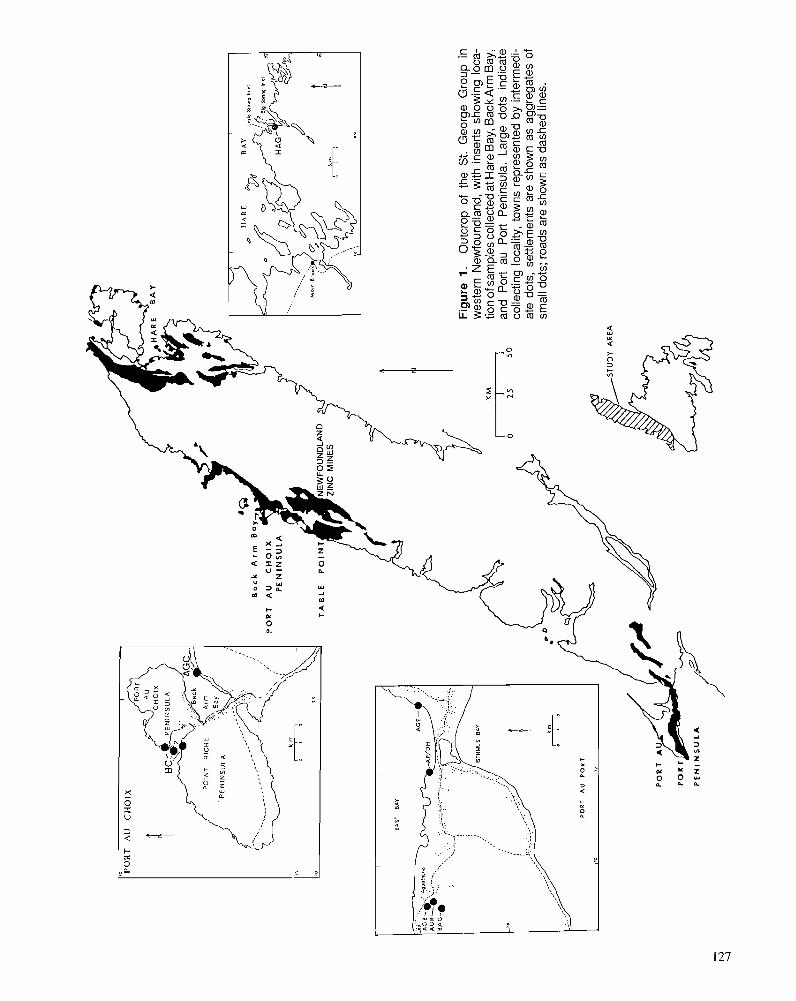
I
krn
0-:
PO
RT
A
U PORT
172
Ba
ck
A
rm
B
a
PO
RT
A
U
CH
OlX
P
EN
INS
UL
A
TA
BL
E
PO
lN
Fig
ure
1.
Out
crop
of
the
St.
Geo
rge
Gro
up i
n
wes
tern
New
foun
dlan
d, w
ith i
nser
ts s
how
ing
loca
- tio
n of
sam
ples
col
lect
ed a
t Har
e B
ay, B
ack
Arm
Bay
,
no
and
Por
t au
P
ort
Pen
insu
la.
Larg
e do
ts
indi
cate
co
llect
ing
loca
lity,
tow
ns r
epre
sent
ed b
y in
term
edi-
ate
dots
, se
ttlem
ents
are
sho
wn
as a
ggre
gate
s of
sm
all d
ots;
roa
ds a
re s
how
n as
das
hed
lines
.
PO
RT
PO
RT
PE
N1
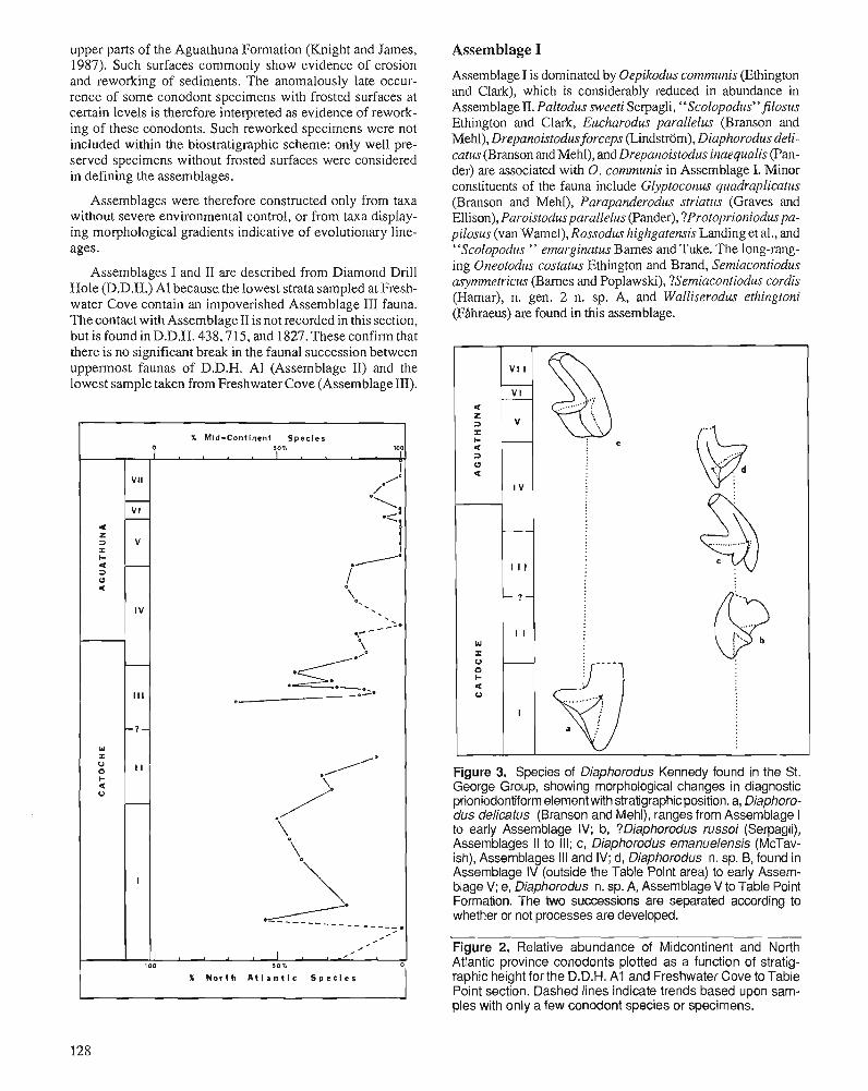
upper parts of the Aguathuna Formation (Knight and James, 1987). Such surfaces commoniy show evidence of erosion and reworking of sediments. The anomalously late occurrence of some conodont specimens with frosted surfaces at certain levels is therefore interpreted as evidence of reworking of these conodonts. Such reworked specimens were not included within the biostratigraphic scheme: only well preserved specimens without frosted surfaces were considered in defining the assemblages.
Assemblages were therefore constructed only from taxa without severe environmental control, or from taxa displaying morphological gradients indicative of evolutionary lineages.
Assemblages I and II are described from Diamond Drill Hole (D.D.H.) AI because. the lowest strata sampled at Freshwater Cove contain an impoverished Assemblage III fauna. The contact with Assemblage Il is not recorded in this section, but is found in D.D.H. 438,715, and 1827. These confirm that there is no significant break in the fauna! succession between uppermost faunas of D.D.H. AI (Assemblage II) and the lowest sample taken from Freshwater Cove (Assemblage Ill).
X Mid-Continent Species
r sio1. 101
I VII
/. /0
r-- ·-............. VI _I
r-- ·--t c z ::> V i :z: ... ---· < - 0 ::> I ~ c \
o,
' IV ' '
,--- -~0
\ - ·-----·/0
Ill -~·-.~. 0 t-1-
"' :z: 0.-----· (J 11 0 ... \ <
(J ./· -\ \
I ~ ----· ·------~---------~· -----I I - I -100 )0"1. 0
X North AtlantIc Species
128
Assemblage I
Assemblage I is dominated by Oepikodus communis (Ethington and Clark), which is considerably reduced in abundance in Assemblage II. Paltodus sweeti Serpagli, '' Scolopodus' 'filosus Ethington and Clark, Eucharodus parallelus (Branson and Mehl), Drepanoistodusforceps (Lindstrom), Diaphorodus delicatus (Branson and Mehl), and Drepanoistodus inaequalis (Pander) are associated with 0. communis in Assemblage I. Minor constituents of the fauna include Glyptoconus quadraplicatus (Branson and Mehl), Parapanderodus striatus (Graves and Ellison), Paroistodus parallel us (Pander), ?Protoprioniodus papilosus (van Wamel), Rossodus highgatensis Landing et al., and "Scolopodus " emarginatus Bames and Tuke. The long-ranging Oneotodus costatus Ethington and Brand, Semiacontiodus asymmetricus (Bames and Poplawski), ?Semiacontiodus cordis (Hamar), n. gen. 2 n. sp. A, and Walliserodus ethingtoni (Hhraeus) are found in this assemblage.
Figure 3. Species of Diaphorodus Kennedy found in the St. George Group, showing morphological changes in diagnostic prioniodontiform element with stratigraphic position. a, Diaphorodus delicatus (Branson and Mehl), ranges from Assemblage I to early Assemblage IV; b, ?Diaphorodus russoi (Serpagli), Assemblages 11 to Ill; c, Diaphorodus emanuelensis (McTavish), Assemblages Ill and IV; d, Diaphorodus n. sp. B, found in Assemblage IV (outside the Table Point area) to early Assemblage V; e, Diaphorodus n. sp. A, Assemblage V to Table Point Formation. The two successions are separated according to whether or not processes are developed.
Figure 2. Relative abundance of Midcontinent and North Atlantic province conodonts plotted as a function of stratigraphic height for the D.D.H. A 1 and Freshwater Cove to Table Point section. Dashed lines indicate trends based upon samples with only a few conodont species or specimens.
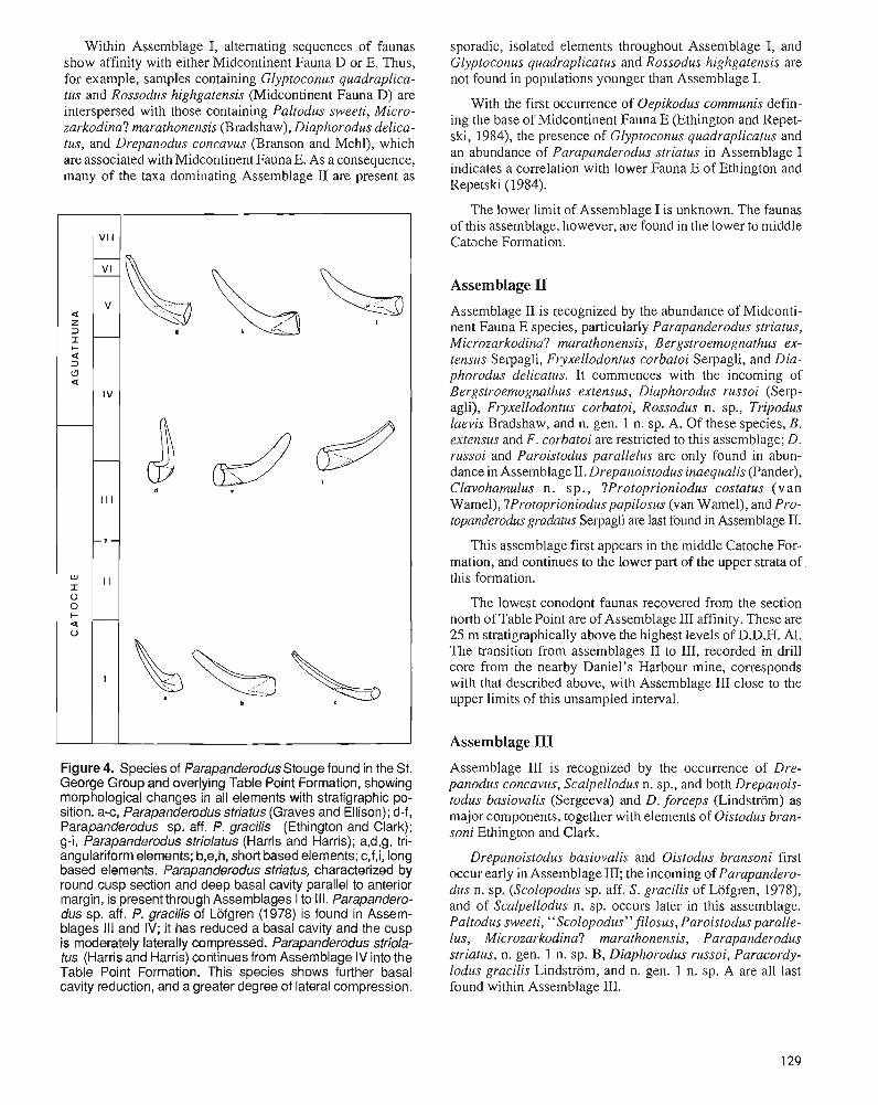
Within Assemblage I, alternating sequences of faunas show affinity with either Midcontinent Fauna D or E. Thus, for example, samples containing Glyptoconus quadraplica- tus and Rossodus highgatensis (Midcontinent Fauna D) are interspersed with those containing Paltodus sweeti, Micro- zarkodina? marathonensis (Bradshaw), Diaphorodus delica- tus, and Drepanodus concavus (Branson and Mehl), which are associated with Midcontinent Fauna E. As a consequence, many of the taxa dominating Assemblage I1 are present as
Figure4. Species of ParapanderodusStouge found in the St. George Group and overlying Table Point Formation, showing morphological changes in all elements with stratigraphic po- sition. a-c, Parapanderodus striatus (Graves and Ellison); d-f, Parapanderodus sp, aff. P. gracilis (Ethington and Clark); g-i, Parapanderodus striolatus (Harris and Harris); a,d,g, tri- angulariform elements; b,e,h, short based elements; c,f,i, long based elements. Parapanderodus striatus, characterized by round cusp section and deep basal cavity parallel to anterior margin, is present through Assemblages I to Ill. Parapandero- dus sp. aff. P. gracilis of Lofgren (1 978) is found in Assem- blages Ill and IV; it has reduced a basal cavity and the cusp is moderately laterally compressed. Parapanderodus striola- tus (Harris and Harris) continues from Assemblage IV into the Table Point Formation. This species shows further basal cavity reduction, and a greater degree of lateral compression.
sporadic, isolated elements throughout Assemblage I, and Glyptoconus quadraplicatus and Rossodus highgatensis are not found in populations younger than Assemblage I.
With the first occurrence of Oepikodus communis defin- ing the base of Midcontinent Fauna E (Ethington and Repet- ski, 1984), the presence of Glyptoconus quadraplicatiis and an abundance of Parapanderodus striatus in Assemblage I indicates a correlation with lower Fauna E of Ethington and Repetski (1984).
The lower limit of Assemblage I is unknown. The faunas of this assemblage, however, are found in the lower to middle Catache Formation.
Assemblage II Assemblage I1 is recognized by the abundance of Midconti- nent Fauna E species, particularly Parapanderodus striatus, Microzarkodina? marathonensis, Bergsnoemognathus ex- tensus Serpagli, Fryxellodontus corbatoi Serpagli, and Dia- phorodus delicatus. It commences with the incoming of Bergstroemognatlzus extensus, Diaphorodus russoi (Serp- agli), Fryxellodontus corbatoi, Rossodus n. sp., Tripodus laevis Bradshaw, and n. gen. 1 n. sp. A. Of these species, B. extensus and F. corbatoi are restricted to this assemblage; D. russoi and Paroistodus parallelus are only found in abun- dance in Assemblage II. Drepanoistodus inaequalis (Pander), Clavohamulus n. sp., ?Protoprioniodus costatus (van Wamel), ?Protoprionioduspapilosus (van Wamel), and Pro- topanderodus gradatus Serpagli are last found in Assemblage 11.
This assemblage first appears in the middle Catoche For- mation, and continues to the lower part of the upper strata of this formation.
The lowest conodont faunas recovered from the section north of Table Point are of Assemblage I11 affinity. These are 25 m stratigraphically above the highest levels of D.D.H. Al. The transition from assemblages I1 to 111, recorded in drill core from the nearby Daniel's Harbour mine, corresponds with that described above, with Assemblage I11 close to the upper limits of this unsampled interval.
Assemblage III
Assemblage I11 is recognized by the occurrence of Dre- panodus concavus, Scalpellodus n. sp., and both Drepanois- todus basiovalis (Sergeeva) and D. forceps (Lindstrom) as major components, together with elements of Oistodus bran- soni Ethington and Clark.
Drepanoistodus basiovalis and Oistodus bransoni first occur early in Assemblage 111; the incoming of Parapandero- dus n. sp. (Scolopodus sp. aff. S. gracilis of Lofgren, 1978), and of Scalpellodus n. sp. occurs later in this assemblage. Paltodus sweeti, "Scolopodus" filosus, Paroistodus paralle- lus, Microzarkodina? marathonensis, Parapanderodus striatus, n. gen. 1 n. sp. B, Diaphorodus russoi, Paracordy- lodus gracilis Lindstrom, and n. gen. 1 n. sp. A are all last found within Assemblage 111.
CA
TO
CH
E
I A
GU
ATH
UN
A
I TA
BLE
Par
oisf
odus
pm
teus
D
repa
nois
lodu
s ina
equa
lis
Pal
todu
s sw
eefi
"Sco
lopo
dus"
filo
sus
Oep
ikod
us c
ornr
nuni
s -
-
Dre
pano
isto
dus
forc
eps
Van
abili
wnu
s n.
sp.
A
-
- Clav
oham
ulus
n.
sp.
- Glyp
toco
nus q
uadr
apliw
tus
- Ros
sodu
s hi
ghga
tens
is
- ?P
rofo
prio
niod
us co
sfat
us
?Pro
ropr
ioni
odus
papi
losu
s P
aroi
srod
us p
aral
lelu
s "S
colo
podu
s" e
mar
grna
rus
- -.
Par
apan
dero
dus
slria
tus
Mic
mza
rkod
rna?
mar
atho
nens
is
New
gen
us 1
n.
sp.
B
- Dia
phor
odus
del
imlu
s D
repa
nodu
s co
nwvu
s P
roto
pand
emdu
s gr
adat
us
- "Scol
opod
us" c
arla
e - Fryxe
llodo
ntus
cor
bafo
i -
Ber
gsK
oem
ogna
rhus
exl
ensu
s N
ew g
enus
1 n
. sp
. A
Dia
phom
dus
russ
oi
~o
ss
od
us
n. s
p. ~ri
po
du
s laev
is
- Drepa
nodu
s ar
cuat
us
- - Par
acor
dylo
dus
grac
ilis
-
Ois
rodu
s br
anso
ni D
repa
nois
fodu
s bas
iova
lis
Jum
udon
tus
gana
nda
., S
calp
ello
dus n
. sp
. P
arap
ande
mdu
s sp
. aft
. P g
raci
lis -
Dia
phor
odus
em
anue
lens
is -
Par
apan
dem
dus
n. s
p. B
- P
arap
ande
rodu
s sr
riola
fus
- O
~st
odus
mul
ficor
ruga
tus -
Oep
ikod
us s
p.
Dia
phor
odus
n. s
p. A
-
Pre
raco
nrio
dus
wyp
tode
ns
Dia
phor
odus
n.
sp.
B -
Reu
nerc
dus s
p. -
Dre
pano
dus
sp. d. D
. gra
cilis
-
Ber
gstro
erno
gnat
hus
n. s
p. -
Glv
~ro
conu
s recf
us -
- ~
roto
pand
erod
us strig
atus
- -
Dre
pano
isfo
dus
angu
lens
is -
Lepl
ochi
rogn
arhu
s n.
sp.
-
Lept
ochi
mgn
afhu
s qu
adra
tus -
- E
rism
odus
sp. - -
"?M
ul~
tod
us
au
rifus
" -
Mul
fiois
fodu
s sub
denf
atus
-
Eris
mod
us a
sym
met
ricus
P
arap
rioni
odus
cos
tatu
s S
cand
odus
sin
uosu
s
Assemblage I11 is known from the upper Catoche Forma- tion, and does not extend into the Aguathuna Formation.
Table 1. Fauna, stratigraphic level and correlation of upper Transition to Assemblage IV faunas is gradual, commonly St. George Group assemblages occurring within several metres of the base of the Aguathuna
Formation.
Strat. Assemblage level Fauna Correlatives
I Lower to 'Oepikodus communis Early MIC Middle Paltodus sweeli Fauna E; Caloche "Scolopodu9' filosus SF Zone H Formation Drepanoistodus haequalis
Diaphorodus delicatus Glyptoconus quadraplicalus 'Parapanderodus slriatus Roxodus highgatensis "SmlopoduS' emarginalus
I1 middle to Bergslroemog, exlensus MIC Fauna E; low in Diaphorodus russoi SF Zone H; upper Paroislodus parallelus Faunas A and Catoche Fryxellodonlus corbaloi B of San Formation ?Clavohamulus n. sp. Juan Fm. of
'Drepanoistodus forceps Argentina Microz.? marathonensis 'Diaphorodus delicalus
Ill upper Parapanderodus aff, gracilis MIC Fauna E; Catoche Oistodus bransoni SF zone I; Formation Drepanoislodus basiovalis u. Jellerson
Scalpellodus n. sp. City Variabilimnus n. sp. A Dolomite
IV uppermost Diaphorodus emanuelensis MIC Fauna Catoche 'Parapand. n, sp. B El1 and lower UEucharodus parallelus Aguathuna #Oneotodus costatus formations #Drepanodus concaws
Diaphorodus n, sp. B Parapanderodus striolatus
V middle Pterawntiodus cryplodens MIC Fauna Agualhuna Oislodus mullicorrugatus in Formation Oepikodus sp.
Diaphorodus n. sp. A Diaphorodus n, sp. B
VI low in Drepanodus sp. cf. D. gracilis WC Fauna upper Reutterodus sp. (R) 112 Aguathuna #Oneotodus costatus Formation
VII Upper Paraprioniodus costatus MIC Fauna Agualhuna , Scandodus sinuosus 4; Kanosh and lower Leptochirogn, quadrata and Lehman Table Point Multioistodus subdenlalus fms. of Utah formations Drepanoistodus angulensis
Conodont species are listed in order of abundance for each assemblage. Species marked with an asterisk are also important in the succeeding assemblage. MIC, Midconlinent conodont zonation; SIF, shelly fossil zones of the Ibex section; #, acme 01 long-ranging species; (R), listed species was possibly reworked in assemblage.
Assemblage IV Assemblage IV is characterized by lower conodont diversity and abundance than previous assemblages. Long ranging taxa dominate, particularly later in the assemblage. These include unusually high abundances of ~ u c h a r i d u s parallelus, Oneotodus costatus Ethington and Brand, Drepanodus con- cavus, ?Semiacontiodus cordis (Hamar), n. gen. 2 n. sp. A, and Semiacontiodus asymmetricus (Barnes and Poplawski).
Few species are first found in Assemblage IV. Diaphoro- dus emanuelensis (McTavish) is only known from early to middle Assemblage IV; Parapanderodus n. sp. B first occurs in mid-assemblage. Earliest specimens of Parapanderodus striolatus (Harris and Harris) immediately precede Assem- blage V.
Many of the species continuing from Assemblage I11 disappear by mid-assemblage. These include Drepanoistodus forceps, Oepikodus communis, Variabiliconus n. sp. A, Dia- phorodus delicatus, Drepanodus arcuatus Pander, Oistodus bransoni, Parapanderodus n. sp. (aff. gracilis), and Scalpel- lodus n. sp. Drepanoistodus basiovalis also disappears from the Table Point section before the emergence of Assemblage V.
Assemblage IV is recorded from the uppermost Catoche Formation and the lower Aguathuna Formation of the shore section north of Table Point. It immediately underlies a prominent solution surface; strata above this surface contain Assemblage V faunas.
Assemblage V
The first occurrence of Diaphorodus n. sp. A, together with the presence of Pteracontiodus cryptodens (Mound), Ois- todus multicorrugatus Harris, and Oepikodus sp. are indica- tive of Assemblage V. These are joined by Diaphorodus n. sp. B at the Table Point section. Conodont faunas are of low diversity and abundance.
With the exception of Rossodus n. sp., long ranging forms of Assemblage IV continue through the Assemblage V into Assemblage VI, although many of these are not represented within Assemblage V.
An early Whiterockian age (Midcontinent Fauna 1 of Sweet et al. [I9711 as discussed by Ethington and Repetski [1984, p. 971) is indicated by the first appearance of species of Diaphorodus with Pteracontiodus cryptodens (Ethington and Repetski, 1984).
This assemblage is known from the middle of the Aguathuna Formation.
Figure 6. Biostratigraphic correlations between Port au Port, Table Point, Port au Choix, and Hare Bay sections. Coeval strata are joined by solid lines, with important assemblages marked. Dotted line is used to show correlation with a stratigraphic level lower than those shown in the diagram. Assemblage VI+ represents the faunal succession omitted from the Table Point sequence between Assemblage VI and Assemblage V11. Table Point-Aguathuna formation boundary shown by dashed line. Stylized sections of Port au Port and Table Point sections modified from Knight and James (1 987).
Assemblage VI
This asemblage is distinguished from previous assemblages by the first appearance of Drepanodus sp. cf. D. gracilis and Reutterodus sp., and last occurrence of Drepanodus concavus and Tripodus laevis. This indicates an age equivalenat at least to that of Midcontinent Fauna 2. The base of this assemblage records the last appearance of conodonts of Canadian (Ibex- ian) aspect. Conodonts remain low in abundance and diver- sity, with faunas dominated by Oneotodus costatus.
Reworking of the conodonts is suggested by the occur- rence of Reutterodus sp. and Oneotodus costatus with latest Tripodus laevis. It is, however, possible that the range of 0. costatus is extended in very shallow environments.
"?Multioistodus auritus" (Hanis and Harris) sensu Ething- ton and Clark, M. subdentatus Cullison, Paraprioniodus costatus Ethington and Clark, Protopanderodus strigatus Barnes and Poplawski, Scandodus sinuosus Mound, and en- demic species are all found in the lowest sample of this assemblage, and continue through to the uppetmost part of the Aguathuna Formation or into the Table Point Formation.
Jumudontus gananda Cooper, Oepikodus sp., Oneotodus costatus, Parapanderodus n. sp., Pteracontiodus cryptodens (Mound), Reutterodus sp., and n. gen. 2 n. sp. A do not continue into the Table Point Formation (Stouge, 1984). Anomalously high ranges of J. gananda, 0 , costatus, P. cryptodens, and Reutterodus sp. indicate reworking of cono- donts into the upper Aguathuna Formation from lower strata.
Assemblage VI is found within a brief interval, low in the This assemblage is found in the uppermost 15 m of the upper part of the Aguathuna Formation. Aguathuna Formation and basal Table Point Formation. It
frequently overlies an omission surface, and the lowest level
Assemblage VII of this assemblage marks a distinct change in conodont fauna.
The incoming of a highly abundant, diverse fauna marks the beginning of Assemblage VII. Drepanoistodus angulensis (Harris), Erismodus asymmetricus (Branson and Mehl), Leptochirognathus quadratus (Branson and Mehl) ,
Conodont species known from the Ibex section are indica- tive of a Midcontinent Fauna 4 age, with the exception of Erismodus asymmetricus, which is known from Midcontinent Fauna 5 and younger strata. The presence of Multioistodus subdentatus is suggestive also of Midcontinent Fauna 5, but
this is known from older rocks. It is likely that the range of E. asymmetricus is extended downward in western New- foundland.
REGIONAL ASPECTS In order to test the validity of this conodont biostratigraphy, samples of primarily Aguathuna Formation rock types were collected from Big Spring Inlet of Hare Bay, the mainland shore of Back Arm Bay, at the Gravels section at the southernmost point of East Bay on Port au Port Peninsula, and road and quarry sections at Aguathuna (Fig. 1). Port au Port and Hare Bay sections were deposited in settings out- board of the setting recorded at Table Point (Knight and James, 1987).
Big Spring Inlet samples contained Assemblage IV to VII faunas, although the incoming of Assemblage VII species is not abrupt as north of Table Point. The sequence of first appearance of Assemblage VII conodonts indicates that some of the strata missing from the section north of Table Point are preserved at Big Spring Inlet.
At Back Arm Bay, Assemblage VII overlies Assemblage 111: most of the Aguathuna Formation is missing at Back Arm Bay, with only that part deposited above the uppermost erosion level at Table Point preserved.
Strata from a section west of The Gravels at Port au Port Peninsula commenced within Assemblage IV, in the lower part of the Aguathuna Formation. Uppermost strata of this formation contain Assemblage VI. Assemblage VII is not found until three metres into the conformably overlying Table Point Formation. A similar succession is found in the Aguathuna Quarries, although the Aguathuna-Table Point boundary is demonstrably erosional (Knight and James, 1987).
Correlation throughout western Newfoundland
Biostratigraphic relationships between the Port au Port, Table Point, Port au Choix, and Hare Bay sections are illustrated in Figure 6. It can be seen that the Aguathuna Formation on Port au Port Peninsula terminates earlier than similar sediments of the Table Point-Daniel's Harbour region. All but the upper- most Aguathuna Formation at Back Arm Bay near Port au Choix is missing from the section; uppermost Aguathuna strata rest disconformably upon uppermost Catoche Forma- tion strata in this area. At Hare Bay (Big Spring Inlet), a solution horizon approximately 13 m beneath the base of the Table Point Formation represents a stratigraphic break of two local assemblages. Deposition, however, resumed earlier at Hare Bay than near Table Point.
Assemblages within the Catoche Formation are generally recognizable, where sampled, throughout the Great Northern and Port au Port peninsulas. On the basis of lithological evidence (Knight and James, 1987), the succession of faunas in the Aguathuna Formation is probably disrupted within Assemblage IV ( the "Breccia Bed" of Stouge, 1982), between Assemblages IV and V, and between As- semblages VI and VII. However, no significant break in the
faunal succession is recorded at the level of the Breccia Bed. Stratigraphic level and conodont faunas of the transition from Assemblage IV to V are everywhere consistent, and the erosion surface separating these two faunas is not likely to represent a major hiatus. It is apparent that a regional regres- sion affected all areas simultaneously (Barnes, 1984) prior to the deposition of Whiterockian sediments of Assemblage V. The Assemblage VI to VII transition is diachronous, and more long-lasting at Table Point than Port au Port or Big Spring Inlet.
CONCLUSIONS
In summary, the faunas of the upper lower Catoche and Aguathuna formations may be subdivided into seven assem- blages. Their diagnostic species, stratigraphic level within the St. George Group, and probable correlations are summarized in Table 1.
The proposed biostratigraphic zonation, based upon the Table Point-Daniel's Harbour region, is recognized in other sections of the upper St. George Group throughout western Newfoundland. Comparison of the conodont succession throughout western Newfoundland indicates an omission sur- face in the middle part of the Aguathuna Formation, which is contemporaneous in inboard (Table Point) and outboard (Port au Port) settings. Subsequent strata contain faunas that do not correlate exactly across the region; an upper omission surface in the Aguathuna Formation is diachronous both beneath and above the omitted strata (Fig. 6); the base of the Table Point Formation is also diachronous. This interval also contains evidence of reworking of sediments.
The detailed conodont biostratigraphic framework for the upper St. George Group developed herein should enable further insight into tectonic development of the carbonate platform immediately prior to its foundering.
ACKNOWLEDGMENTS
This study was supported by funding provided from a Natural Sciences and Engineering Research Council of Canada grant and Department of Energy, Mines and Resources Research Agreement support to CRB. T. Lane and Teck Exploration Ltd. enabled access to the Daniel's Harbour Mine.
Access to facilities in Australia was provided by Prof. B.N. Runnegar and personnel at the Electron Microscope Unit of the University of New England; and by Drs. R.S. Nicoll and E. Trusswell of the Bureau of Mineral Resources in Canberra. Discussions with staff (N.P. James, L.E. FAhraeus, R.K. Stevens, S.H. Williams) and students (D. Johnston, S. Pohler, T. Lane) of Memorial University of Newfoundland were beneficial in the clarification of some of the ideas presented herein.
The technical assistance of F. O'Brien is gratefully ac- knowledged. B.A. Stait provided drafting assistance, and critical evaluation of earlier manuscripts.
REFERENCES Barnes, C.R. 1984: Early Ordovician eustatic events in Canada. In Aspects of the
Ordovician System, D.L. Bruton (ed.); Universitetsforlaget, Oslo, p. 5 1-63.
Barnes, C.R. and Tuke, M.F. 1970: Conodonts from the St. George Formation (Ordovician), northern
Newfoundland. Geological Survey of Canada, Bulletin 187, p. 79-97.
Bergstrom, S.M., Riva, J., and Kay, M. 1974: Significance of conodonts, graptolites, and shelly faunas from the
Ordovician of western and north-central Newfoundland. Canadian Joumal of Earth Sciences, v. 11, p. 1625-1660.
Boyce, W.D. 1985: Cambrian-Ordovician biostratigraphic investigations, Great North-
em Peninsula, western Newfoundland. In Current Research, R.V. Gibbons (ed.); Newfoundland Department of Mines and Energy, Mineral Development Division, Report 85-1, p. 60-70.
Ethington, R.L. and Clark, D.L. 1981: Lower and Middle Ordovician conodonts from the Ibex area, west-
em Millard County, Utah. Brigham Young University Geology Studies, v. 28, Part 2, 155 p.
Ethington, R.L. and Repetski, J.E. 1984: Paleobiogeographic distribution of Early Ordovician conodonts in
central and western United States. Geological Society of America, Special Paper 196, p. 89-101.
Fhhraeus, L.E. 1970: Conodont-based correlations of Lower and Middle Ordovician
strata in western Newfoundland. Geological Society of America Bulletin, v. 81, p. 2061-2076.
Rhraeus, L.E. and Nowlan, G.S. 1978: Franconian (Late Cambrian) to early Champlainian (Middle Ordo-
vician) conodonts from the Cow Head Group, western Newfound- land. Journal of Paleontology, v. 52, p. 444-471.
Flower, R.H. 1978: St. George and Table Head cephalopod zonation in western New-
foundland. In Current Research, Part A, Geological Survey of Canada, Paper 78-l A, p. 217-224.
Fortey, R.A. 1979:- Early Ordovician trilobites from the Catoche Formation (St. George
Group), western Newfoundland. Geolodcal Survev of Canada. ~ulleiin 321, p. 61-1 14.
- James, N.P., Botsford, J.W., and Williams, S.H. 1987: Allochthonous slope sequence at Lobster Cove Head: evidence for
a complex Middle Ordovician platform margin in western New- foundland. Canadian Journal of Earth Sciences, v. 24, p. 1 199-121 1.
James, N.P., Knight, I., Stevens, R.K., and Barnes, C.R. 1988: Sedirnentology and paleontology of an Early Paleozoic Continental
Margin, Western Newfoundland. Geological Association of Can- ada, Mineralogical Association of Canada, Canadian Society of Petroleum Geologists, Field Trip Guidebook, Trip B1. Geological Association of Canada, Newfoundland Section, St. John's, 121 p.
James, N.P. and Stevens, R.K. 1986: Stratigraphy and correlation of the Cambro-Ordovician Cow Head
Group, western Newfoundland. Geological Survey of Canada, Bul- letin 366, 142 p.
James, N.P., Stevens, R.K., Barnes, C.R., and Knight, I. 1989: Evolution of a lower Paleozoic continental margin carbonate plat-
form, northern Canadian Appalachians. In Controls on Carbonate Platform and Basin Development, P. Crevalla et al. (eds.); Society of Economic Paleontologists and Mineralogists, Special Publication 44, p. 123-146.
Klappa, C.F., Opalinski, P.R., and James, N.P. 1980: Middle Ordovician Table Head Group of western Newfoundland: a
revised stratigraphy. Canadian ~ournal of Earth Sciences, v. 17, p. 1007-1019.
Knight, I. and James, N.P. 1987: The stratigraphy of the Lower Ordovician St. George Group, west-
em Newfoundland: the interaction between eustasy and tectonics. Canadian Journal of Earth Sciences, v. 24, p. 1927-1951.
Lane, T.E. 1984: Preliminary classification of carbonate breccia, Newfoundland and
Zinc Mines, Daniel's Harbour, Newfoundland. In Current Research, R.V. Gibbons (ed.); Newfoundland Department of Mines and En- ergy, Mineral Development Division, Report 84-1, p. 505-512.
Lofgren, A. 1978: Arenigian and Llanvirnianconodonts from Jamtland, northern Swe-
den. Fossils and Strata, no. 13, p. 1-129. Pohler, S.L., Barnes, C.R., and James, N.P. 1987: Reconstructing a lost faunal realm: conodonts from mega-conglom-
erates of the Ordovician Cow Head Group, western Newfoundland. In Conodonts: Investigative Techniques and Applications, R.L. Austin (4.); Ellis Horwood Ltd., Chichester, p. 341-362.
Ross, R.J., Jr. and James, N.P. 1987: Brachiopod biostratigraphy of the middle Ordovician Cow Head
and Table Head groups, western Newfoundland. Canadian Journal of Earth Sciences, v. 24, p. 70-95.
Stouge, S.S. 1982: Preliminary conodont biostratigraphy and correlation of Lower to
Middle Ordovician carbonates of the St. George Group, Great Northern Peninsula, Newfoundland. Newfoundland Department of Mines and Energy, Mineral Development Division, Report 82-3, 59 P.
1984: Conodonts of the Middle Ordovician Table Head Formation, west- em Newfoundland. Fossils and Strata, no. 16, p. 1-145.
Stouge, S.S. and Boyce, W.D. 1983: Fossils of northwestern Newfoundland and southeastern Labrador:
conodonts and trilobites. Newfoundland Department of Mines and Energy, Mineral Development Division, Report 83-3,55 p.
Sweet, W.C., Ethington, R.L., and Barnes, C.R. 1971: North American Middle and Upper Ordovician conodont faunas.
Geological Society of America, Memoir 127, p. 163-193. Williams, S.H., Boyce, W.D., and James, N.P. 1987: Graptolites from the Lower-Middle Ordovician St. George and
Table Head groups, western Newfoundland, and their correlation with trilobite, brachiopod and conodont zones. Canadian Journal of Earth Sciences, v. 24, p. 456-470.
Williams, S.H. and Stevens, R.K. 1987: Summary account of the Lower Ordovician (Arenig) graptolite
biostratigraphy of the Cow Head Group, western Newfoundland. Bulletin of the Geological Society of Denmark, v. 35, p. 259-270.
1988: Arenig graptolites of the Cow Head Group, western Newfoundland. Palaeontographica Canadiana, no. 5, 167 p.
Biogeography of Ordovician Chitinozoa
Aicha Achabl
Achab, A., Biogeography of Ordovician Chitinozoa; &Advances in Ordovician Geology, C.R. Barnes and S.H. Williams led.), Geological Survey of Canada, Paper 90-9, p. 135-142,1991.
Abstract
Biogeographic differentiation of chitinozoans may help explain some of the problems associated with correlating the microfaunas of Quebec with those of southwest Europe, North Africa, and the Baltic region of Scandinavia. This differentiation becomes evident when comparisons are made with the respective regional zonation, vertical stratigraphic distribution charts, and microfaunal assemblages.
An assessment of the number of species in common between chitinozoan assemblages of different regions, and the similarity coefficient thus obtained, indicates affinities among the microfaunas of North Africa, southwest Europe, Great Britain, and Bohemia; these regions were situated in high latitudes during the Ordovician. Similarly, microfaunas from eastern Canada, Australia, Spitsbergen, and the United States, which occupied subequatorial latitudes, have many feature in common. Faunas from the Baltic region of Scandinavia appear to have occupied an intermediate position.
Les difficultks rencontrtes Iors des essais de corre'lation entre les microfaunes de chitinozoaires ordoviciennes du Qukbec et celles de I'Europe du sud-ouest, d'Afrique du Nord et de la Baltoscandinavie s'expliquent par une diffkrenciation biogkographique des chitinozoaires. Cette diffkrenciation est mise en kvidence en comparant les zonations rkgionales, les tableaux stratigraphiques et l'ensemble de la micro- faune de ces rkgions.
La dktermination du nombre d'espZces communes entre fes assemblages de chitinozoaires de diverses rtgions et l'analyse des coefficients de similitude s'y rapportant rtvdent des affinitks entre les microfaunes d'Afrique du Nord, d'Europe du Sud-Ouest, de Grande-Bretagne et de Boh2me qui ttaient localise'es sous les hautes latitudes. L'Est du Canada, llAustralie, le Spitsberg et les ~ t a t s - ~ n i s , qui occupaient une position subkquatoriale, prksentent kgalement des liens entre leurs microfaunes. La Baltoscandinavie semble occuper une situation intermkdiaire entre ces deu . ensembles.
INTRODUCTION The study of Ordovician strata of Quebec led to the recogni- tion of 22 chitinozoan assemblages (Achab, 1989). The strata containing the microfossils on which the zonation is based may be correlated with the standard North American grapto- lite zones. This work shows that Quebec microfaunas were significantly different from those of similar age in Europe and the Baltic region of Scandinavia, hereafter referred to as Baltoscandia. These differences, which appear to be related to the geographic distribution, have been investigated to determine if, in fact, there is provincialism. Little previous work has been done on the provincialism of chitinozoans.
Rauscher (1973) compared the assemblages he had studied in France with the data then available for Ordo- vician chitinozoans. In the Arenig, he recognized a south- ern assemblage group, including assemblages from the Sahara, France, and Belgium, and a northern assemblage group, occurring in Great Britain, Baltoscandia, and the Rus- sian platform. The analysis of microfaunas from the Llanvim indicated a third intermediate group between the Sahara and southern Europe. Laufeld (1979), describing the geographical distribution of Ordovician chitinozoans, came to conclusions similar to those of Jenkins (1967). These authors favoured a fairly free communication, especially during the Caradoc, between the chitinozoans of Shropshire, and those of Baltos- candia. The relationship between the chitinozoans of northern
Centre gkoscientifique de QuCbec, 2700 rue Einstein, C.P. 7500, Sainte-Foy, QuCbec G l V 4C7
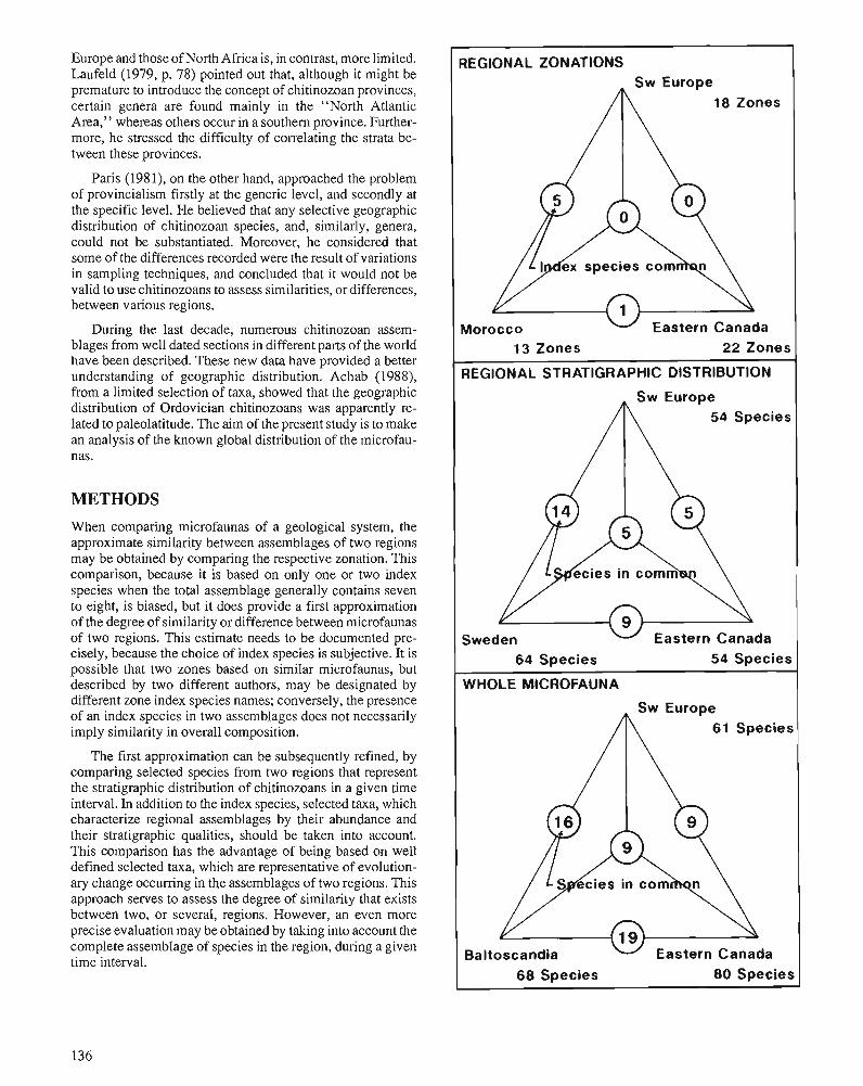
Europe and those of North Africa is, in contrast, more limited. Laufeld (1979, p. 78) pointed out that, although it might be premature to introduce the concept of chitinozoan provinces, certain genera are found mainly in the "North Atlantic Area," whereas others occur in a southern province. Further- more, he stressed the difficulty of correlating the strata be- tween these provinces.
Paris (1981), on the other hand, approached the problem of provincialism firstly at the generic level, and secondly at the specific level. He believed that any selective geographic distribution of chitinozoan species, and, similarly, genera, could not be substantiated. Moreover, he considered that some of the differences recorded were the result of variations in sampling techniques, and concluded that it would not be valid to use chitinozoans to assess similarities, or differences, between various regions.
During the last decade, numerous chitinozoan assem- blages from well dated sections in different parts of the world have been described. These new data have provided a better understanding of geographic distribution. Achab (1988), from a limited selection of taxa, showed that the geographic distribution of Ordovician chitinozoans was apparently re- lated to paleolatitude. The aim of the present study is to make an analysis of the known global distribution of the microfau- nas.
METHODS When comparing microfaunas of a geological system, the approximate similarity between assemblages of two regions may be obtained by comparing the respective zonation. This comparison, because it is based on only one or two index species when the total assemblage generally contains seven to eight, is biased, but it does provide a first approximation of the degree of similarity or difference between microfaunas of two regions. This estimate needs to be documented pre- cisely, because the choice of index species is subjective. It is possible that two zones based on similar microfaunas, but described by two different authors, may be designated by different zone index species names; conversely, the presence of an index species in two assemblages does not necessarily imply similarity in overall composition.
The first approximation can be subsequently refined, by comparing selected species from two regions that represent the stratigraphic distribution of chitinozoans in a given time interval. In addition to the index species, selected taxa, which characterize regional assemblages by their abundance and their stratigraphic qualities, should be taken into account. This comparison has the advantage of being based on well defined selected taxa, which are representative of evolution- ary change occumng in the assemblages of two regions. This approach serves to assess the degree of similarity that exists between two, or several, regions. However, an even more precise evaluation may be obtained by taking into account the complete assemblage of species in the region, during a given time interval.
REGIONAL ZONATIONS
18 Zones
Morocco Eastern Canada 13 Zones 22 Zones
REGIONAL STRATIGRAPHIC DlSTRlBUTlON
54 Species
Sweden Eastern Canada 64 Species 54 Species
WHOLE MICROFAUNA
61 Species
Baltoscandia Eastern Canada 68 Species 80 Species
It is also possible to consider, in a more global sense, the assemblage of chitinozoan species known from different regions. All of thesedata can then be treated in orderto determine the degree of similarity existing between regions, and to make conclusions concerning the geographic distribution of microfaunas.
Comparison of regional zonation
There are few publications proposing a regional chitinozoan zonation for the Ordovician System. The first was that of Paris (1981) for the Ordovician of southwest Europe. More re- cently, Achab (1989) established a regional zonation for the Ordovician of Quebec and western Newfoundland. The zo- nation of Elaouad-Debbaj (1987), although less complete, provides interesting data on the Ordovician of Morocco.
These zonations not only deal with the whole Ordovician, but have the advantage of being based on well dated se- quences closely correlated with graptolite zones; this allows comparison of more or less synchronous zones.
From a comparison of these chitinozoan zones, it appears (Fig. 1) that of the 18 defined by Paris (1981), and the 13 recognized by Elaouad-Debbaj (1987), 5 are designated by the same index species. Five of the zones, which have differ- ent names, have been defined in Morocco from stratigraphic intervals that in Europe have either not been studied or recognized, or which lack chitinozoans. The three remaining zones are from intervals whose stratigraphic position is not certain; two of the zones are designated by species known to occur in southwest Europe.
If a comparison is made between the zonation of Paris (1981), and that proposed by Achab (1989) for Quebec, it becomes clear that none of the taxa designated as charac- terizing southwest European zones is the same as the Quebec index species. Also, it appears that the index species used in Europe, and in Morocco, are little known, or unknown, in eastern Canada.
At first sight, it thus appears that there is a marked differ- ence between the Quebec assemblages and those of Morocco and Europe.
Comparison of the regional distn'bution of chitinozoans
Paris (1981), Grahn (1982). and Achab (1989) provide syn- theses of the vertical stratigraphic distribution of the main chitinozoans for southwest Europe, Sweden, and Quebec, respectively. Comparison of the vertical stratigraphic distri- bution is facilitated by the fact that in each of the regions, an almost identical number of taxa (50 to 60) were selected to illustrate chitinozoan distribution during the Ordovician.
Figure 1 (opposite). Number of species common to different regions when taking into consideration- 1 : regional zonation; 2: selected species from vertical stratigraphic distribution charts; 3: the whole microfauna.
Also, as mentioned above, there is good stratigraphic control for the chitinozoan-bearing strata, thus enabling comparison of synchronous time units.
Comparison of stratigraphically important species indi- cates that five species are common to all three regions (Fig. 1). When the regions are compared two at a time, it is evident that no additional species are common to southern Europe and Quebec, but nine are common to southern Europe and Swe- den; this brings the total number of species common to these two regions to 14. There are a total of nine species common to Sweden and eastern Canada. The results suggest a clear distinction between the microfaunas of the three regions. To make the results meaningful, one can also take into account the greater contrast between Canada and southwest Europe, and the fact that faunally, Baltoscandia occupies an interme- diate position. The difference between the European and Canadian microfaunas corresponds with that noted above, when only the zonal index fossils were considered.
Comparison of the total regional microfauna
The data summarized above can be supplemented by that obtained from the remaining palynological literature, and includes well dated, but more restricted, stratigraphic inter- vals in Europe (Rauscher, 1968; Rauscher and Doubinger, 1967a, b), Baltoscandia (Eisenack, 1931; Laufeld, 1967; Mannil, 1971), and eastern Canada (Jansonius, 1964; Martin, 1975,1983; Neville, 1974). These data, integrated with those previously discussed, include 209 records of 166 species that have been described from the three regions. Four additional species occur in Baltoscandia, southwest Europe, and eastern Canada, making a total of nine species in common among the three regions. When the regions are compared two at a time, the number of species in common (Fig. 1) are 16 in Baltos- candia and southwest Europe, and 19 in Baltoscandia and eastern Canada, while the nine species common to Canada and Europe also exist in Baltoscandia. These results compare well with those described in the previous section. It appears that southwest Europe and eastern Canada have distinct mi- crofaunas, and that Baltoscandia has as many affinities with Europe as it does with North America.
At whatever level the comparisons are made, the results are consistent; namely, chitinozoans, like other fossils, show important biogeographic differentiation during the Ordovi- cian. Paleogeographic reconstructions for continents during the Ordovician indicate that the eastern part of North America occupied a subequatorial position, whereas southern Europe was situated in low latitudes and Baltoscandia was located in an intermediate position. Biogeographic distribution of chit- inozoans therefore seems to have been related to paleolati- tude.
SIMILARITY BETWEEN ORDOVICIAN MICROFAUNAS
Although the approach outlined above might be used for Ordovician chitinozoan assemblages, problems may arise when the relative importance of stratigraphic levels, and thus
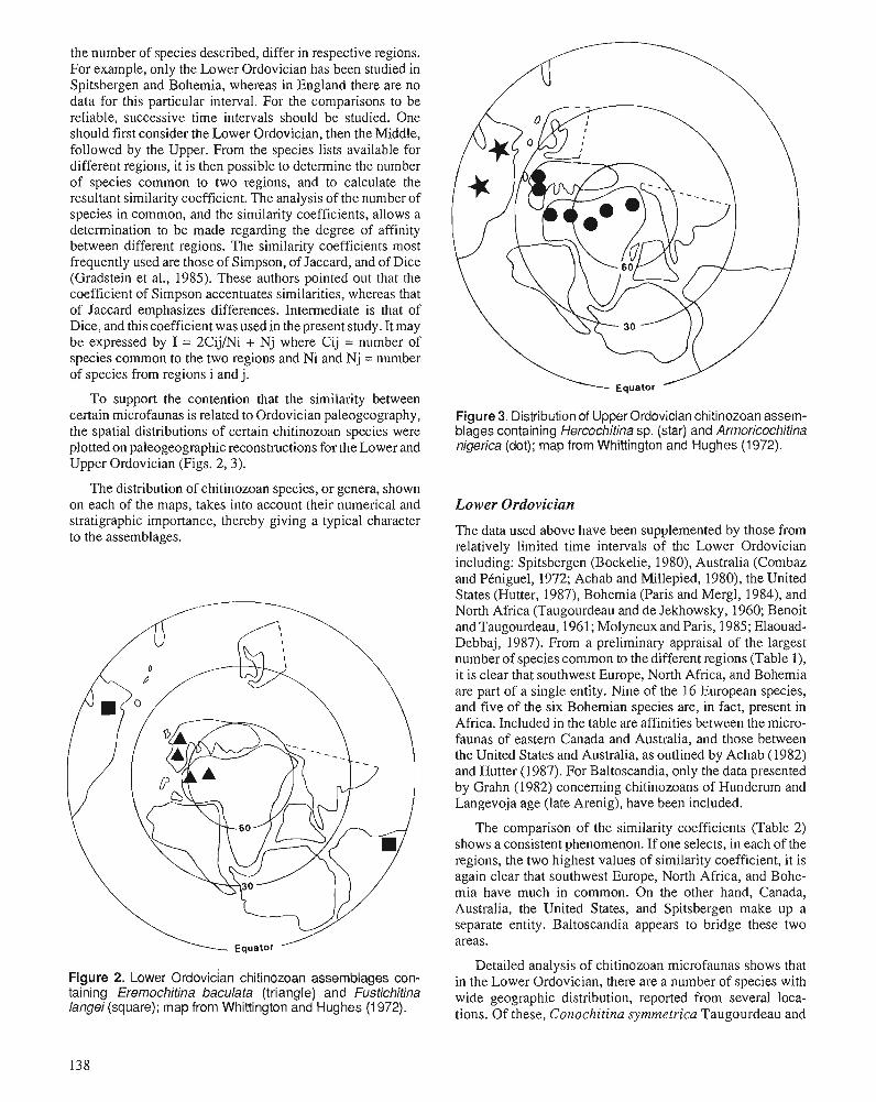
the number of species described, differ in respective regions. For example, only the Lower Ordovician has been studied in Spitsbergen and Bohemia, whereas in England there are no data for this particular interval. For the comparisons to be reliable, successive time intervals should be studied. One should first consider the Lower Ordovician, then the Middle, followed by the Upper. From the species lists available for different regions, it is then possible to determine the number of species common to two regions, and to calculate the resultant similarity coefficient. The analysis of the number of species in common, and the similarity coefficients, allows a determination to be made regarding the degree of affinity between different regions. The similarity coefficients most frequently used are those of Simpson, of Jaccard, and of Dice (Gradstein et al., 1985). These authors pointed out that the coefficient of Simpson accentuates similarities, whereas that of Jaccard emphasizes differences. Intermediate is that of Dice, and this coefficient was used in the present study. It may be expressed by I = 2CijiNi + Nj where Cij = number of species common to the two regions and Ni and Nj = number of species from regions i and j.
To support the contention that the similarity between certain microfaunas is related to Ordovician paleogeography, the spatial distributions of certain chitinozoan species were plotted on paleogeographic reconstructions for the Lower and Upper Ordovician (Figs. 2,3).
The distribution of chitinozoan species, or genera, shown on each of the maps, takes into account their numerical and stratigraphic importance, thereby giving a typical character to the assemblages.
Figure 3. Distribution of Upper Ordovician chitinozoan assem- blages containing Hercochitina sp. (star) and Armoricochitina nigerica (dot); map from Whittington and Hughes (1972).
The comparison of the similarity coefficients (Table 2) shows a consistent phenomenon. If one selects, in each of the regions, the two highest values of similarity coefficient, it is again clear that southwest Europe, North Africa, and Bohe- mia have much in common. On the other hand, Canada, Australia, the United States, and Spitsbergen make up a separate entity. Baltoscandia appears to bridge these two areas.
Figure 2. Lower ~rdovician chitinozoan assemblages con- taining Eremochitina baculata (triangle) and Fustichitina langei (square); map from Whittington and Hughes (1 972).
Lower Ordovician
The data used above have been supplemented by those from relatively limited time intervals of the Lower Ordovician including: Spitsbergen (Bockelie, 1980), Australia (Combaz and PCniguel, 1972; Achab and Millepied, 1980), the United States (Hutter, 1987), Bohemia (Paris and Mergl, 1984), and North Africa (Taugourdeau and de Jekhowsky, 1960; Benoit and Taugourdeau, 1961; Molyneux and Paris, 1985; Elaouad- Debbaj, 1987). From a preliminary appraisal of the largest number of species common to the different regions (Table l), it is clear that southwest Europe, North Africa, and Bohemia are part of a single entity. Nine of the 16 European species, and five of the six Bohemian species are, in fact, present in Africa. Included in the table are affinities between the micro- faunas of eastern Canada and Australia, and those between the United States and Australia, as outlined by Achab (1982) and Hutter (1987). For Baltoscandia, only the data presented by Grahn (1982) concerning chitinozoans of Hunderum and Langevoja age (late Arenig), have been included.
Detailed analysis of chitinozoan microfaunas shows that in the Lower Ordovician, there are a number of species with wide geographic distribution, reported from several loca- tions. Of these, Conochitina symmetrica Taugourdeau and
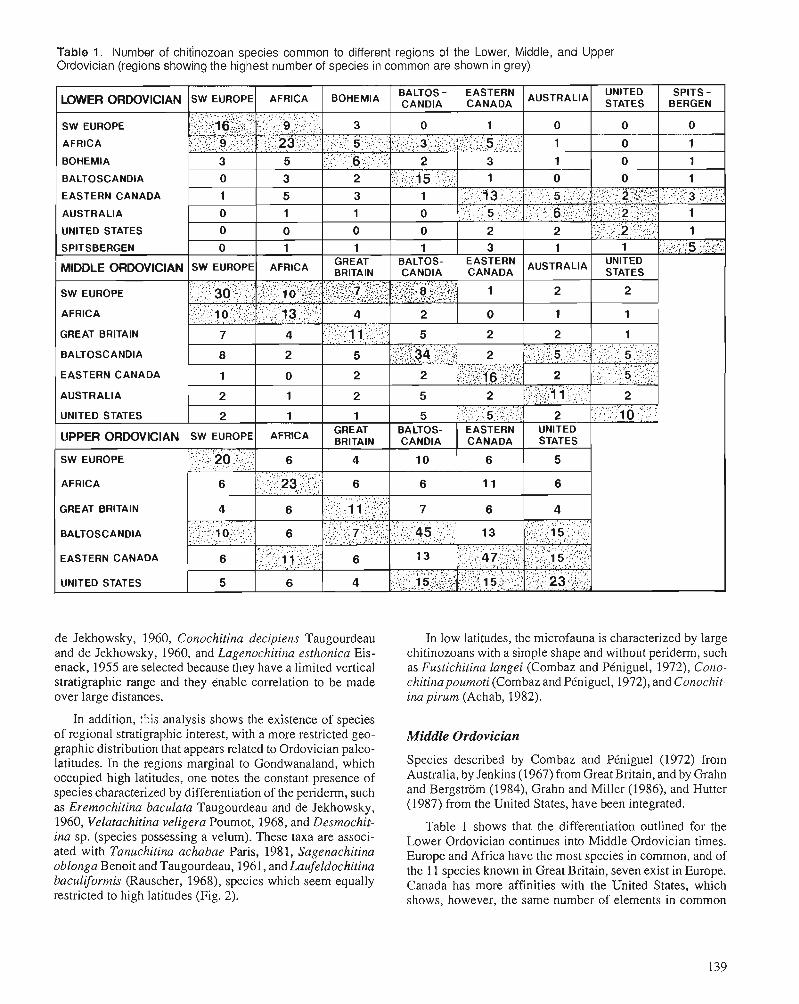
Table 1. IVumber of chitinozoan species common to different regions of the Lower, Middle, and Upper Ordovician (regions showing the highest number of species in common are shown in grey)
BALTOSCANDIA
EASTERN CANADA
GREAT BRITAIN
BALTOSCANDIA
EASTERN CANADA
GREAT BRITAIN
BALTOSCANDIA
EASTERN CANADA
de Jekhowsky, 1960, Conochitina decipiens Taugourdeau and de Jekhowsky, 1960, and Lagenochitina esthonica Eis- enack, 1955 are selected because they have a limited vertical stratigraphic range and they enable co~relation to be made over large distances.
In addition, :his analysis shows the existence of species of regional stratigraphic interest, with a more restricted geo- graphic distribution that appears related to Ordovician paleo- latitudes. In the regions marginal to Gondwanaland, which occupied high latitudes, one notes the constant presence of species characterized by differentiation of the peridem, such as Eremochitina baculata Taugourdeau and de Jekhowsky, 1960, Velatachitina veligera Poumot, 1968, and Desmochit- ina sp. (species possessing a velum). These taxa are associ- ated with Tanuchitina achabae Paris, 198 1, Sagenachitina oblonga Benoit and Taugourdeau, 1961, and Laufeldochitina baculiformis (Rauscher, 1968), species which seem equally restricted to high latitudes (Fig. 2).
In low latitudes, the microfauna is characterized by large chitinozoans with a simple shape and without periderm, such as Fustichitina langei (Combaz and PCniguel, 1972), Cono- chitinapournoti (Combaz and PCniguel, 1972), and Conochit- ina pirum (Achab, 1982).
Middle 01-dovician
Species described by Combaz and PCniguel (1972) from Australia, by Jenkins (1967) from Great Britain, and by Grahn and Bergstrom (1984), Grahn and Miller (1986), and Hutter (1987) from the United States, have been integrated.
Table 1 shows that the differentiation outlined for the Lower Ordovician continues into Middle Ordovician times. Europe and Africa have the most species in common, and of the 1 1 species known in Great Britain, seven exist in Europe. Canada has more affinities with the United States, which shows, however, the same number of elements in common
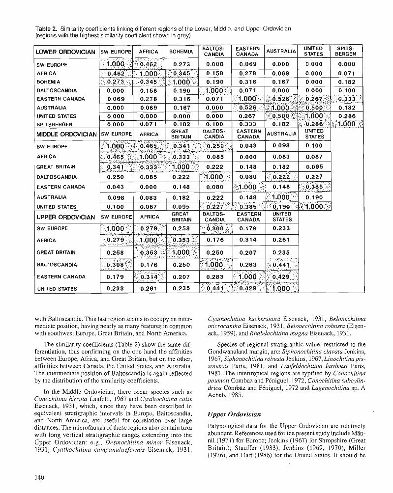
Table 2. Similarity coefficients linking different regions of the Lower, Middle, and Upper Ordovician (regions with the highest similarity coefficient shown in grey)
BALTOSCANDIA
EASTERN CANADA
UNITED STATES
GREAT BRITAIN
BALTOSCANDIA
EASTERN CANADA
GREAT BRITAIN
BALTOSCANDIA
EASTERN CANADA
with Baltoscandia. This last region seems to occupy an inter- mediate position, having nearly as many features in common with southwest Europe, Great Britain, and North America.
The similarity coefficients (Table 2) show the same dif- ferentiation, thus confirming on the one hand the affinities between Europe, Africa, and Great Britain, but on the other, affinities between Canada, the United States, and Australia. The intermediate position of Baltoscandia is again reflected by the distribution of the similarity coefficients.
In the Middle Ordovician, there occur species such as Conochitina hirsuta Laufeld, 1967 and Cyathochitina calix Eisenack, 1931, which, since they have been described in equivalent stratigraphic intervals in Europe, Baltoscandia, and North America, are useful for correlation over large distances. The microfaunas of these regions also contain taxa with long vertical stratigraphic ranges extending into the Upper Ordovician: e.g., Desmochitina minor Eisenack, 193 1 , Cyathochitina campanulaeformis Eisenack, 193 1,
Cyathochitina kuckersiana Eisenack, 193 1, Belonechitina micracantha Eisenack, 193 1, Belonechitina robusta (Eisen- ack, 1959), and Rhabdochitina magna Eisenack, 193 1.
Species of regional stratigraphic value, restricted to the Gondwanaland margin, are: Siphonochitina clavata Jenkins, 1967, Siphonochitina rohusta Jenkins, 1967, Linochitina pis- sotensis Paris, 1981, and Laufeldochitina lardeuxi Paris, 1981. The intertropical regions are typified by Conochitina poumoti Combaz and PCniguel, 1972, Conochitina subcylin- drica Combaz and PCniguel, 1972 and Lagenochitina sp. A Achab, 1985.
Upper Ordovician
Palynological data for the Upper Ordovician are relatively abundant. References used for the present study include Man- nil (1971) for Europe; Jenkins (1967) for Shropshire (Great Britain); Stauffer (1933), Jenkins (1969, 1970), Miller (1976), and Hart (1986) for the United States. It should be
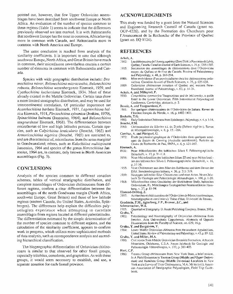
pointed out, however, that few Upper Ordovician assem- blages have been described from southwest Europe or North Africa. An evaluation of the number of species common to these regions (Table 1) seems to indicate that the differences previously observed are less marked. It is with Baltoscandia that southwest Europe has the most in common, Africa having more in common with Canada, and Baltoscandia more in common with North America and Europe.
The same conclusion is reached from analysis of the similarity coefficients. It'is important to note that although southwest Europe, North Africa, and Great Britain have much in common, their microfaunas nevertheless contain a certain number of elements in common with Baltoscandia and Can- ada.
Species with wide geographic distribution include: Des- mochitina minor, Belonechitina micracantha, Belonechitina robusta, Belonechitina wesenbergensis Eisenack, 1959, and Cyathochitina kuckersiana Eisenack, 1934. Most of these already existed in the Middle Ordovician. Certain taxa show a more limited stratigraphic distribution, and may be used for intercontinental correlation. Of particular importance are Acanthochitina barbata Eisenack, 193 1, Lagenochitina hal- tica Eisenack, 193 l , Plectochitina sylvanica (Jenkins, 1970), Spinachitina bulmani (Jansonius, 1964), and Belonechitina taugourdeaui Eisenack, 1968). The differentiation between microfaunas of low and high latitudes persists. Certain spe- cies, such as Calpichitina lenticularis (BouchC, 1965) and Armoricochitina nigerica (Bouch6, 1965) are restricted to, and are characteristic of, microfaunas from the areas marginal to Gondwanaland; others, such as Kalochitina rnultispinata Jansonius, 1964 and species of the genus Hercochitina Jan- sonius, 1964 are, in contrast, only known in North American assemblages (Fig. 3).
CONCLUSIONS Analysis of the species common to different zonation schemes, tables of vertical stratigraphic distribution, and complete assemblages of Ordovician chitinozoans from dif- ferent regions, confirm a clear differentiation between the assemblages of the north Gondwana margin (North Africa, southwest Europe, Great Britain) and those of low latitude regions (eastern Canada, the United States, Australia, Spits- bergen). The differences help explain the difficulties paly- nologists experience when attempting to correlate assemblages from regions located at different paleolatitudes. The differentiation estimated by the simple determination of the number of species common to different regions, and the calculation of the similarity coefficient, appears to confirm work in progress, which utilizes more sophisticated methods of data analysis, such as correspondence analysis and ascend- ing hierarchical classification.
The biogeographic differentiation of Ordovician chitino- zoans is similar to that observed for other fossil groups, especially trilobites, conodonts, andgraptolites. As with these groups, it would seem necessary to establish, and use, a separate zonation for each faunal province.
ACKNOWLEDGMENTS This study was funded by a grant from the Natural Sciences and Engineering Research Council of Canada (grant no. OGP-4226), and by the Formation des Chercheurs pour 1'Avancement de la Recherche of the Province of Quebec (grant no. EQ 1124).
REFERENCES Achab, A. 1982: Leschitinozoai~.esde I'Arenigsu~rieur(ZoneD)delaFomationdeUvis,
Qu6hc, Canada. Canadian Journal of h l h Sciences, v. 19, p. 135-1 307. 1985: Succession des assemblages de chitinozoaires dans I'Ordovicien
moyen du Quebec et de I'est du Canada. Review of Palaeobotany and Palynology, v. 48, p. 269-294.
1988: Mise en evidence d'un provincialisme chez les chitinozoaires ordo- viciens. Canadian Journal of Earth Sciences, v. 25, p. 635-638.
1989: Ordovician chitinozoan zonation of Quebec and westelm New- foundland. Journal of Paleontology, v. 63, p. 14-24.
Achab, A. and Millepied, P. 1980: Corlochiiitlu synirnerrica Taugourdeau and de Jekhowsky, a guide
fossil to the Lower Ordovician. Fifth International Palynological Conference, Cambridge, abstracts, p. 3.
Benoit, A. and Taugourdeau, P. 1961: Sur qi~elqiies chitinozoaires de I'Ordovicien du Sahara. Revue de
I'Institut francais du Petrole, v. 16, p. 1403- 142 1. Bockelie, T.G. 1980: Early Ordovician Chitinozoa from Spitskrgen. Palynology, v. 4, p. 1-14. BouchC, P.M. 1965: Chitinozonires du Silurien s.1. du Djado (Sahara nigCrien). Revue
de Micropal6ontologie, v. 8, p. 151-164. Combaz, A, and Phniguel, G. 1972: ~ t u d e palynostratigraphique de I'Ordovicien dans quelques sond-
ages du Bassin de Canning (Ausrralie occidentale). Bulletin du Centre de Recherche de Pau, SNPA, v. 6, p. 121-167.
Eisenack, A. 1931: Neue Mikrofossilien des baltischen Silurs I. Palaontographische
Zeitschrift, v. 13, p. 74-1 18. 1934: Neue Mikrofossilien des baltischen Silurs 111 und neuc Mikrofossil-
ien des bohmischen Silurs I. Palaontographische Zeitschrift, v. 16, - . p. 52-76.
1955: Neue Chitinozoen aus dem Silur des Baltikums und dem Devon der Eifel. Senckenbcrgiana lethaea, v. 36, p. 31 1-319.
1959: Neotypen baltischer ~ilur-~hitinozoen-t~nd neue Arten. Neues Jahr- buch fur Geologie und Palaontologie Abhandlugen, v. 108, p. 1-20.
1968: Mikrofossilien eines Geschiebes der Borkholmer Stufe, baltisches Ordovizium, F2. Mitteilungen Geologisches Staatsinstitut in Ham- burg, v. 37, p. 81-94.
Elaouad-Debbaj, 2. 1987: Acritarcheset chitinozoairesde I'Ordovicien du Maroc (systimatique,
biosrratigraphie et corr6lations). Thkse d'Ctat, UniversitC de Rennes. Gradstein, F.M., Agterberg, F.P., Brower, J.C., and Schwarzacher, W.S. 1985: Quantitative Stratigraphy. D. Reidel Publishing Company, Boston, 598 p. Grahn, Y. 1982: Paleobiology and biostratigraphy of Ordovician chitinozoa from
Sweden. Acta Universitatis Uppsaliensis. Abstracts of Uppsala Dissertations from the Faculty of Science, no. 629, 16 p.
Grahn, Y. and Bergstrom, Y. 1984: Lower Middle Ordovician chitinozoa fmm the southern Appalachians,
United States. Review of Palaeobotany and Palynology, v. 43, p. 89-122. Crahn, Y. and Miller, M.A. 1986: Chitinozoa from Middle Ordovician Bromide Folmation, Arbuckle
Mountains, Oklahoma, U.S.A. Neues Jahrbuch fur Geologie und Palaontologie Abhandlungen, v. 172, p. 381-403.
Hart, C.P. 1986: Trenton Group chitinozoans from New York State, a brief review.
111 A Field Excursion to Trenton Group (Middle and Upper Ordovi- cian) and Hamilton Group (Middle Devonian) Localities in New York andaSurvey ofTheir Chitinozoans, M.A. Miller (ed.); Ameri- can Association of Stratigraphic Palynologists, Field Trip Guide- book.
Hutter, T.J. 1987: Ordovician chitinozoan zones of Great Basin. American Associa-
tion of Peholeum Geologists, Rocky Mountain Section Meeting, Boise, Idaho, U.S.A.
Jansonius, J. 1964: Morphology and classification of some Chitinozoa. Bulletin of
Canadian Petroleum Geology, v. 12, p. 901-918. Jenkins, W.A.M. 1967: Ordovician Chitinozoa from Shpshire. Palaeontology, v. 10, p. 436-488. 1969: Chitinozoa from the Ordovician Viola and Fernvale limestones of
the Arbuckle Mountains, Oklahoma. Special Papers in Palaeontol- ogy, v. 5.44 p.
1970: Chitinozoa from the Ordovician Sylvan Shale of the Arbuckle Mountains, Oklahoma. Palaeontology, v. 13, p. 261-288.
Laufeld, S . 1967: Caradocian Chitinozoa from Dalarna, Sweden. Geologiska Foren-
ingens i Stockholm Forhandlingar, v. 89, p. 275-349. 1979: Biogeography of Ordovician. Silurian and Devonian Chitinozoans.
In Historical Biogeography, Plate Tectonics and the Changing Environment, J. Gray and A.J. Boucot (eds.); Oregon State Univer- sity Press, p. 75-90.
Mannil, R. 1971: Distribution of selected Ordovician chitinozoan assemblages and
species in northem Europe and their stratigraphical evaluation. MCmoire du Bureau de Recherches GCologique et Minibre, v. 73, Colloque Ordovicien-Silurien, Brest, September 1971, p. 309-3 1 1.
Martin, F. 1975: Sur quelques chitinozoaires ordoviciens du Qutbec et de I'Ontario,
Canada. Canadian Journal of Earth Sciences, v. 12, p. 1006-1018. 1983: Chitinozoaires et acritarches ordoviciens de la plate-forme du Saint-
Laurent (Qubbec et sud-est .de I'Ontario). Geological Survey of Canada, Bulletin 310, p. 1-59,
Miller, M.A. 1976: Maysvillian (Upper Ordovician) chitinozoans from the Cincinnati
Region of Ohio, Indiana and Kentucky. Unpublished M.Sc. thesis, Ohio State University, 25 1 p.
Molyneux, S. and Paris, F. 1985: Late Ordovician palynomorphs. Journal of Micropaleontol-
O ~ Y , V. 4, p. 11-26. Neville, R.S.W. 1974: Ordovician Chitinozoa from western Newfoundland. Review of
Palaeobotany and Palynology, v. 18, p. 187-221.
Paris, F. 1981: Les chitinozoaires dans le PalCozoFque du sud-ouest de
I'Europe. Cadre gCologique, 6tude systCrnatique, biostratigra- phie. M6moire de la SociCtb gtologique et mintralogique de Bretagne, no. 26, 412 p.
Paris, F. and Mergl, M. 1984: Arenigian chitinozoans from the Klabava Formation, Bohemia.
Review of Palaeobotany and Palynology, v. 43, p. 33-65. Poumot, C. 1968: Amphorachilina. Ollachitina, Velatachitina; hois nouveaux genres
de chitinozoaires de 1'Erg oriental (AlgCrie-Tunisie). Bulletin du Centre de Recherche de Pau, v. 2, p. 45-55.
Rauscher, R. 1968: Chitinozoaires de I'Arenig de la Montagne Noire (France). Revue
de MicropalContologie, v. 11, p. 51-60. 1973: Recherches micropalContologiques et stratigraphiques dans I'Ordo-
vicien et le Silurien en France. ktude des acritarches, des chitino- zoaires et des spores. Sciences gbologiques (Universitt Louis-Pasteur de Strasbourg, Institut de Gbologie), v. 38, 224 p., thbse d'btat, 365 p.
Rauscher, R. and Doubinger, J. 1967a: Les Chitinozoaires des schistes Calymkne (Llanvirnien) de Nor-
mandie. 92bme Congrks national des sociCt6s savantes, Strasbourg et Colmar, v. 2, p. 471-484.
3967b: Associations de Chitinozoaires de Normandie et comparisons avec les faunes dCjA dCcrites. Bulletin du Service de carte GCologique de I'Alsace Lorraine, v. 20, p. 307-328.
Stauffer, C.R. 1933: Middle Ordovician Polychaeta from Minnesota. Bulletin of the
Geological Society of America, v. 44, p. 1173- 121 8. Taugourdeau, P. and de Jekhowsky, B. 1960: Rtpartition et description des chitinozoaires siluro-dCvoniens de
quelques sondages de la C.R.E.P.S., de la C.F.P.A. et de la S.N. Repal au Sahara. Revue de I'Institut Fran~ais du PCtrole, v. 15, p. 1 199- 1260.
Whittington, H.B. and Hughes, C.P. 1972: Ordovician geography and faunal provinces deduced from trilobite
distribution. Philosophical Transactions of the Royal Society of London, ser. B, v. 263, p. 235-278.
Late Ordovician extinction in the Graptoloidea
Michael J. Melchinl and Charles E. Mitchell2
Melchin, M.J. and Mitchell, C.E., Late Ordovician extinction in the Graptoloidea; h Advances in Ordovician Geology, C.R. Barnes and S.H. Williams (ed.), Geological Survey of Canada, Paper 90-9, p. 143-156,1991.
Abstract
During the Late Ordovician and Early Silurian, the composition ofplanktic graptolite faunas underwent a great change. Late Ordovician graptolites experienced nearly total extinction, with the exception of a few species with Pattern H astogeny (e.g., N. normalis, N. angustus, and N. extraordinarius). None of the other middle Ashgill diplograptaceans survived into the persculptus Zone and on into the early Llandovery. Post-extinction morphological radiation developed entirely from these few species and was already well underway in the persculptus Zone.
The Late Ordovician graptolite faunas do not consist only of holdovers from earlier, more vigorous lines; rather, they are dominated by rapidly evolving clades that experienced substantial increases in diversity during the Ashgill. These lineages are represented by the groups Climacograptus longispinus-C. venustus, Paraorthograptus pacificus-Amplexograptus latus, and "Glyptograptus" tenuissimus-"G." occidentalis, as well as several dicranograptid and lasiograptid groups. However, all of these lineages (some 23 of 24 genera and three of the four extant families) became extinct within the middle Ashgill, prior to or during the interval occupied by the Himantia Fauna.
The Ashgill graptolite extinctions coincide approximately with those among many other benthic to holoplanktic organisms. These extinctions are associated with increased oxygenation and possibly with cooling of basinal water masses, as well as regression and habitat restriction brought about by peak glaciation during Hirnantian time. It is suggested that the oxygenation of the basinal water masses resulted in disruption of the plankton communities and was a prime factor in causing graptolite extinction.
Revisions are made to the genera Normalograptus and Glyptograptus on the basis of their astogenetic patterns.
L' Ordovicien supkrieur et le Silurien infkrieur ont ktk marquks par un changement important de la composition des faunes de graptolites planctoniques. Les graptolites de l'ordovicien suptrieur ont connu une extinction quasi torale ci l'exception de quelques espkces de l'astogen6se de la conjguration H (par ex. N . normalis, N. angustus et N. extraordinarius). Aucun des autres diplograptactens de l'Ashgillien moyen n'a survkcu dans la zone ci persculptus et jusque dans le Llandovkrien infie'rieur. Le rayonnement morphologique postkrieur d l'extirzction s'est amorct enti6rernent a partir de ces quelques espkces et ktait dkjB bien en cours d m la zone a persculptus.
Les faunes de graptolites de l'ordovicien supkrieur ne comprennent pas seulement des survivants de lignkes anciennes plus vigoureuses; elles sont plutBt composkes en grande partie de clades ci &volution rapide qui se sont diversifiie'es substantiellement au cours de 1'Ashgillien. Ces lignkes sont reprksentkes par les taxons Climacograptus longispinus - C. venustus, Paraorthograptus pacificus - Amplexograptus latus et "Glyptograptus" tenuissimus - "G." occidentalis ainsi que par plusieurs groupes de dicranograp- tidks et de lasiograptidks. Cependant, toutes ces Iignkes (quelque 23 des 24 genres et trois des quatre familles consewb) ont disparu au sein de lJAshgillien moyen, avant ou pendant I'intervalle occupe' par la faune Hirnantia.
1 Department of Earth Sciences, University of Waterloo, Waterloo, Ontario N2L 3G1 2 Department of Geology, State University of New York at Buffalo, New York, U.S.A. 14260
L'extinction des graptolites ashgilliens a coiizcide'd peu p r b avec celle de nombreux autres organismes benthiques d holoplanctoniques. Ces extinctions sont associkes Li une augmentation de I'oxyge'nation et peut-&re d un refroidissement des masses d'eau de bassin ainsi qu'a une re'gression et une limitation de leur habitat cause'es par une glaciation maximale au cours de I' Hirnantien. I1 est propose' que l'oxyge'na- tion des masses d'eau de bassin a provoque' une perturbation des comrnunautt!~ planctoniques et que ce phtnomdne a e'te' le principal facteur de I'extinction des graptolites.
Des re'visions sont apporte'es aux genres Normalograptus et Glyptograptus en fonction de leur configu- ration astogtne'tique.
INTRODUCTION It has long been known that the graptolites were affected by a major extinction event near the end of the Ordovician. Lack of stratigraphic precision from key Ordovician-Silurian boundary sections combined with a lack of understanding of graptolite lineages across this boundary has, however, pre- vented a full assessment of the nature and magnitude of this bioevent. The first problem was recently addressed with a concerted effort to assign a boundary stratotype and regional parastratotypes. Much information concerning graptolite dis- tribution is now available from excellent sections around the world (Cocks and Rickards, 1988).
The second problem, the understanding of graptolite line- ages, was also addressed recently through the proposal of a new, phylogenetic classification by Fortey and Cooper (1986) and Mitchell (1987) (see also Kearsley, 1985). This new scheme is based on early rhabdosomal astogeny (proxi- mal development patterns) as a major criterion for supraspe- cific classification and has produced a refined understanding of graptolite phylogeny. The purpose of this paper is to examine upper Ashgill graptolite faunas and, in particular, the Ashgill extinction event, in light of this new view of graptolite phylogeny.
ASTOGENETIC PATTERNS IN ASHGILL GRAPTOLITES It has long been observed that Ashgill faunas are dominated by dicranograptids, lasiograptines, and biserial diplograpta- ceans with spinose proximal ends, whereas the lowest Llan- dovery faunas are composed mostly of diplograptaceans with proximal ends bearing only a virgella. The significance of these observations has been masked bv a classification that relied on thecal form rather than proximal end structure as its principal distinguishing criterion. The work of Mitchell (1987) on the astogeny of Middle and Upper Ordovician diplograptaceans has now been built up& by studies of exquisitely preserved Upper Ordovician (Stewart, 1987; Stewart and Mitchell, 1988) and Llandovery diplograptid faunas (Melchin, 1987a). These studies have led to the rec- ognition of two new diplograptacean astogenies, Patterns J and K.
The proximal development types found in later Ashgill and early Llandovery faunas are schematically illustrated in Figures 1 and 2, together with typical species illustrating these patterns. Mitchell (1987) has provided some sugges- tions for recognition of these patterns in compressed specimens.
The most obvious feature is that Patterns D-G and K (those forms that dominatepre-Hirnantian faunas) tend to have blunt proximal ends with a generally obscured sicula in reverse view, and proximal spines other than the virgella (i.e., paired antivirgellar spines, a mesial spine on thl and rarely on th12). The Ashgill fauna, dominated by species with these primor- dial astogenies, will be referred to as the DDO (Dicranograp- tidae-Diplograptidae-Orthograptidae) fauna. Patterns H-J and M, which completely dominate post-Himantian faunas, possess a somewhat more acicular proximal end with a par- tially exposed sicula below th12 and usually no spines other than the virgella, which may be very elaborate. These are designated as the M (Monograptidae) Fauna.
These observations provide a framework for critical re- examination of the abundance of recently published literature with the aim of assessing the distribution and diversity of these newly assigned genera within the upper Ashgill.
CORRELATION OF MIDDLE AND LATE ASHGILL GRAPTOLITE ZONES
Any attempt to examine worldwide coincidence of the Late Ordovician extinction event relies heavily on the quality of the correlation of the various zonation schemes for Upper Ordovician rocks. Figure 3 shows a proposed correlation of the Ordovician-Silurian boundary zones from several key areas around the world. Examination of this and other pub- lished correlation charts shows that the end of the pacificus Zone in northwestern and arctic Canada, the pacificus Subzone of Scotland and northeastern Siberia, the ornatus- latus Zone of central Victoria, and the anceps Zone of south- eastern Alaska are closely coincident. The termination of these zones corresponds to the nearly simultaneous disap- pearance of several key Ashgill genera including Dicel- lograptus, Paraorthograptus, species of the "C." latus group, Climacograptus (Diplacanthograptus) (the C, long- ispinus group), Orthograptus s . ~ . (i.e., 0. amplexicaulis, 0. truncatus), and the Lasiograptinae (sensu Mitchell, 1987) (see Fig. 4 for generic ranges at selected boundary sections). The succeeding extraordinarius Zone yields a very low di- versity fauna usually consisting of two to five species, all of which can almost certainly be assigned to Normalograptus as defined here (see Appendix). As pointed out by Williams (1982) and VandenBerg et al. (1984), the first occurrence of "C"? extraordinarius shows some overlap with the preced- ing fauna. In these areas, the base of the extraordinarius Zone is not recognized by the first occurrence of the nominate species but by the disappearance of the preceding fauna. Outside China, very few species are known for certain to have
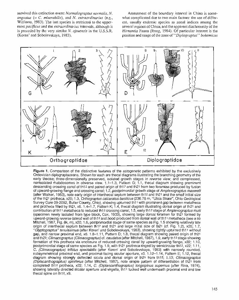
survived this extinction event: Normalograptus normalis, N. Assessment of the boundary interval in China is some- angustus (= C. miserabilis), and N. extraordinarius (e.g., what complicated due to two main factors: the use of differ- Williams, 1983). The last species is restricted to the upper- ent, usually endemic species as zonal indices among the most pacificus and the extraordinarius intervals, although i t several regions of China; and the apparent diachroneity of the is preceded by the very similar N. ojsuensis i n the U.S.S.R. Hirnantia Fauna (Rong, 1984). Of particular interest i s the (Koren' and Sobolevskaya, 1983). position and range of the zone of "Diplograptus" bohemicus
Figure 1. Comparison of the distinctive features of the astogenetic patterns exhibited by the exclusively Ordovician diplograptaceans. Shown for each are thecal diagrams illustrating the branching geometry of the early thecae; three-dimensionally preserved, isolated growth stages in reverse view; and compressed, nonisolated rhabdosomes in obverse view. 1 .I-1.3, Pattern G; 1 .I, thecal diagram showing prominent descending crossing canal of thl2 and paired origin of thl2 and th21 from two foramina produced by fusion of upward-growing flange and crossing canal; 1.2, postprimordial growth stage of Amplexograptus maxwelli (after Walker, 1953), note early origin of interthecal septum between thl2 and th21 and the small initial size of the th21 protheca, x20; 1.3, Orthograptus calcaratus basilicus (236.75 m, "Utica Shale", Ohio Geological Survey Core 09-2082, Butler County, Ohio), showing upturned th l l with prominent gap between metatheca and protheca filled by th21, x6. 1.4-1.7, Pattern K; 1.4, thecal diagram illustrating dorsal origin of th21 and contribution of thl 1 metatheca to reduced thl2 crossing canal; 1.5, early thl2 stage of Amplexograptus inuiti (specimen newly isolated from type block, Cox, 1933), showing large dorsal foramen for th21 formed by upward-growing reverse lateral wall of th12 and hood produced from dorsal wall of th11 metatheca (see also Mitchell, 1987, Fig. 8k, m), x20; 1.6, postprimordial stage of same species as Fig. 1.5 showing relatively late origin of interthecal septum between thl2 and th21 and large initial size of th21 (cf. Fig. 1.2), x20; 1.7, "Glyptograptus" tenuissimus (after Koren' and Sobolevskaya, 1983), showing tightly upturned th l l without gap, and narrow proximal end, x6. 1.8-1 .I 1, Pattern D; 1.8, thecal diagram showing paired origin of th21 and th22; Climacograptus (Climacograptus) cf. caudatus (after Mitchell, 1987), 1.9, early th12 stage showing formation of this protheca via enclosure of reduced crossing canal by upward-growing flange, x22; 1 .I 0, postprimordial stage of same species as Fig. 1.9, with th21 protheca ringed by semicircular thl2, x22; 1 .I 1, C. (Climacograptus) trifidus specfabilis (after Koren' and Sobolevskaya, 1983) with narrowly rounded, sl~b~ymmetrical proximal end, and proximal-facing sicular aperture, x5. 1 .I 2-1.14, Pattern E; 1 .I 2, thecal diagram showing strongly deflected sicula and dorsal origin of th21 from thl2; 1.13; Climacograptus (Diplacanthograptus) spiniferus (after Mitchell, 1 987), note simple pattern of differentiation of th21 from completed thl2 protheca, x22; 1 .I 4, C. (Diplaneanthograptus) longispinus supernus (after Riva, 1974), showing laterally directed sicular aperture and virgella, th l l tucked well underneath proximal end and low thecal spine on thl2, x9.
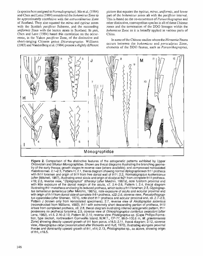
(a species here assigned to Normalograptus). Mu et al. (I 984) and Chen and Lenz (1984) considered the bohemicus Zone to be approximately correlative with the extraordinarius Zone of Scotland. They also equated the mirus and typicus zones with the Scottish pacificus Subzone, and the succeeding uniformis Zone with the barren strata in Scotland. I n part, Chen and Lenz (1984) based this correlation on the occur- rence, in the Yukon pacificus Zone, of the distinctive and short-ranging Chinese genus Diceratograptus. Williams (1983) and VandenBerg et al. (1984) present a slightly different
picture that equates the typicus, mirus, uniformis, and lower part of the bohemicus zones all with the pacificus interval. This i s based on the co-occurrence of Paraorthograptus and other distinctive, cosmopolitan species in all of these Chinese zones and the termination of the DDO lineages within the bohemicus Zone as i t i s broadly applied in various parts of China.
In some of the Chinese studies where the Hirnantia Fauna occurs between the bohemicus and persculptus Zone, elements of the DDO faunas, such as Paraorthograptus,
Monograptidae
Figure 2. Comparison of the distinctive features of the astogenetic patterns exhibited by Upper Ordovician and Silurian Monograptidae. Shown are thecal diagrams illustrating the branching geome- try of the early thecae; growth stages in reverse view (where available); and compressed nonisolated rhabdosomes. 2.1 -2.3, Pattern H; 2.1, thecal diagram showing normal diplograptacean th l l protheca with thl2 foramen and origin of thl2 from free dorsal wall of thl l ; 2.2, Normalograptus kuckersianus (after (Mitchell, 1987), illustrating erect sicula and origin of dicalycal th21 from complete thl2 protheca. x18; 2.3, reverse view, " Diplograptus" tcherskyi (after Melchin, 1 987a), note fusiform proximal end with little exposure of the dorsal margin of the sicula, x7. 2.4-2.6, Pattern 1; 2.4, thecal diagram illustrating thl1 metatheca enclosing its reduced protheca, which lacks a thl2forarnen; 2.5, Glyptograp- tus tamariscus tamariscus (after Melchin, 1987a), note exposure of sicula and acicular proximal end with origin of th12 from dorsal side of complete thl 1 protheca, x22; 2.6, obverse view, Pseudorfhograp- tus cyperoides (after Sherwin, 1974), note short thI1 protheca and acicular proximal end, x9.2.7-2.9, Pattern J (known only from nonisolated specimens); 2.7, reverse view of Akidograptus ascensus (reconstructed from Williams, 1983), thl 1 with extremely short descending portion of protheca, thl2 arises from completed protheca, x9; 2.8, thecal diagram illustrating inferred astogenetic pattern, thl 1 possesses no prothecal foramina; 2.9, obverse view of Dimorphograptus confertus swanstoni (after Lenz, 1982), x4.5. 2.10-2.1 3, Pattern M; 2.1 0, reverse view Pristiograptus sp. (Cape Phillips Forma- tion, type section, northeastern Cornwallis Island, N.W.T., CP-77, 99.0-100.6 m, M. griestoniensis Zone) showing directly upward growth of thl from porus, x18.5; 2.1 1, thecal diagram; 2.1 2, obverse view, Atavograptus ceryx (reconstructed after Rickards and Hutt, 1970), illustrating elongate proximal thecae and dominantly upward growth of thl, xl4; 2.13, Pristiograptus sp., as above, showing origin of thl , xl8.5.
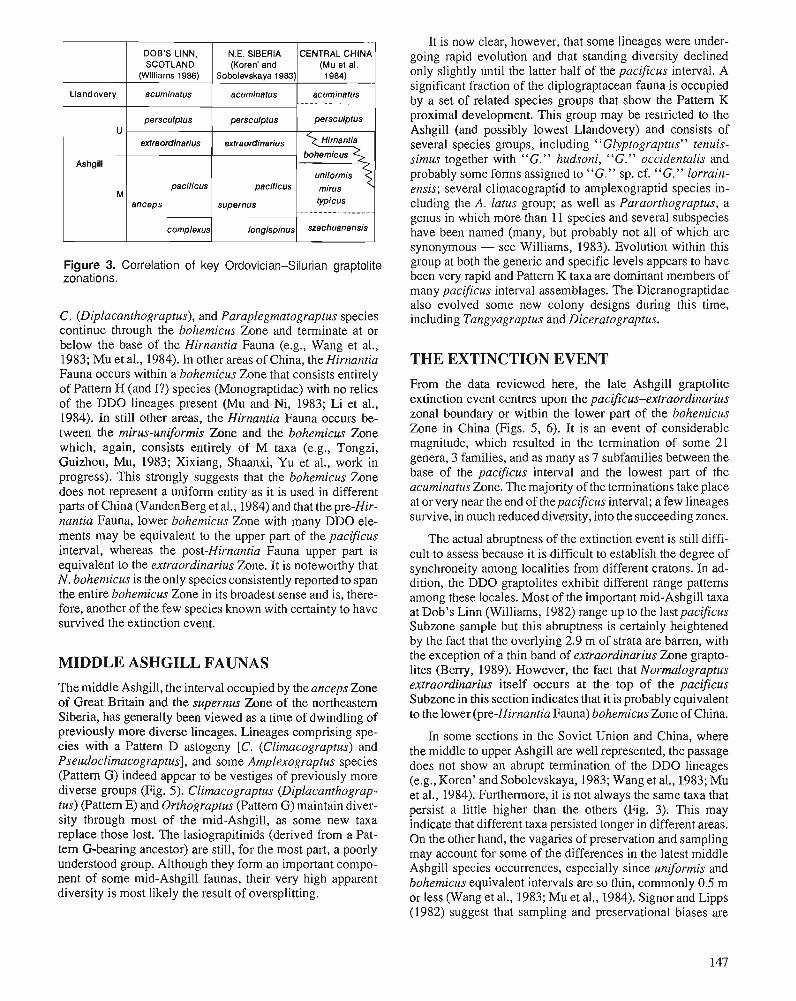
Figure 3. Correlation of key Ordovician-Silurian graptolite zonations.
Llandovery
U
Ashgill
M
C. (Diplacanthograptus), and Paraplegmatograptus species continue through the bohemicus Zone and terminate at or below the base of the Hirnantia Fauna (e.g., Wang et al., 1983; Mu et al., 1984). In other areas of China, the Hirnantia Fauna occurs within a bohemicus Zone that consists entirely of Pattern H (and I?) species (Monograptidae) with no relics of the DDO lineages present (Mu and Ni, 1983; Li et al., 1984). In still other areas, the Hirnantia Fauna occurs be- tween the mirus-uniformis Zone and the bohemicus Zone which, again, consists entirely of M taxa (e.g., Tongzi, Guizhou, Mu, 1983; Xixiang, Shaanxi, Yu et a]., work in progress). This strongly suggests that the bohemicus Zone does not represent a uniform entity as it is used in different parts of China (VandenBerg et al., 1984) and that the pre-Hir- nantia Fauna, lower bohemicus Zone with many DDO ele- ments may be equivalent to the upper part of the pacificus interval, whereas the post-Hirnantia Fauna upper part is equivalent to the extraordinarius Zone. It is noteworthy that N, bohemicus is the only species consistently reported to span the entire bohemicus Zone in its broadest sense and is, there- fore, another of the few species known with certainty to have survived the extinction event.
MIDDLE ASHGILL FAUNAS
DOE'S L I N N , SCOTLAND
(Williams 1986)
acumlnatus
persculptus
extraordinarhs
pacificus
anceps
complexus
The middle Ashgill, the interval occupied by the anceps Zone of Great Britain and the supernus Zone of the northeastern Siberia, has generally been viewed as a time of dwindling of previously more diverse lineages. Lineages comprising spe- cies with a Pattern D astogeny [C. (Climacograptus) and Pseudoclimacograptus], and some Amplexograptus species (Pattern G) indeed appear to be vestiges of previously more diverse groups (Fig. 5). Climacograptus (Diplacanthograp- tus) (Pattern E) and Orthograptus (Pattern G) maintain diver- sity through most of the mid-Ashgill, as some new taxa replace those lost. The lasiograpitinids (derived from a Pat- tern G-bearing ancestor) are still, for the most part, a poorly understood group. Although they form an important compo- nent of some mid-Ashgill faunas, their very high apparent diversity is most likely the result of oversplitting.
It is now clear, however, that some lineages were under- going rapid evolution and that standing diversity declined only slightly until the latter half of the pacificus interval. A significant fraction of the diplograptacean fauna is occupied by a set of related species groups that show the Pattern K proximal development. This group may be restricted to the Ashgill (and possibly lowest Llandovery) and consists of several species groups, including "Glyptograptus" tenuis- simus together with "G. " hudsoni, "G. " occidentalis and probably some forms assigned to "G." sp. cf. "G." lorrain- ensis; several climacograptid to amplexograptid species in- cluding the A . latus group; as well as Paraorthograptus, a genus in which more than 11 species and several subspecies have been named (many, but probably not all of which are synonymous - see Williams, 1983). Evolution within this group at both the generic and specific levels appears to have been very rapid and Pattern K taxa are dominant members of many pacificus interval assemblages. The Dicranograptidae also evolved some new colony designs during this time, including Tangyagraptus and Diceratograptus.
N.E. SIBERIA (Koren' and
Sobolevskaya 1983)
acumlnatus
persculptus
extraordlnarius -
paclflcus supernus
longispinus
THE EXTINCTION EVENT
CENTRAL CHINA (Mu el el. 1984)
acuminatus . - - - - .. - - . - - - - - - -
persculptus
HirnanNa bohemlcus
unlformls
fypicus -------
szechuanensis
From the data reviewed here, the late Ashgill graptolite extinction event centres upon the pacifcus-extraordinarius zonal boundary or within the lower part of the bohemicus Zone in China (Figs. 5, 6). It is an event of considerable magnitude, which resulted in the termination of some 21 genera, 3 families, and as many as 7 subfamilies between the base of the pacificus interval and the lowest part of the acuminatus Zone. The majority of the terminations take place at or very near the end of the pacificus interval; a few lineages survive, in much reduced diversity, into the succeeding zones.
The actual abruptness of the extinction event is still diffi- cult to assess because it is difficult to establish the degree of synchroneity among localities from different cratons. In ad- dition, the DDO graptolites exhibit different range patterns among these locales. Most of the important mid-Ashgill taxa at Dob's Linn (Williams, 1982) range up to the lastpacificus Subzone sample but this abruptness is certainly heightened by the fact that the overlying 2.9 m of strata are barren, with the exception of a thin band of extraordinarius Zone grapto- lites (Beny, 1989). However, the fact that Normalograptus extraordinarius itself occurs at the top of the pacificus Subzone in this section indicates that it is probably equivalent to the lower (pre-Hirnantia Fauna) bohemicus Zone of China.
In some sections in the Soviet Union and China, where the middle to upper Ashgill are well represented, the passage does not show an abrupt termination of the DDO lineages (e.g., Koren' and Sobolevskaya, 1983; Wang et al., 1983; Mu et al., 1984). Furthermore, it is not always the same taxa that persist a little higher than the others (Fig. 3). This may indicate that different taxa persisted longer in different areas. On the other hand, the vagaries of preservation and sampling may account for some of the differences in the latest middle Ashgill species occurrences, especially since uniformis and bohemicus equivalent intervals are so thin, commonly 0.5 m or less (Wang et al., 1983; Mu et al., 1984). Signor and Lipps (1982) suggest that sampling and preservational biases are
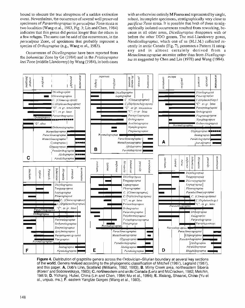
", B 3
.9
'"
Bg
c
2 S a-
0
.= gg
<G
I..
Q)
O0
3
,ac
c e,
CZ
~~
G
22
-e
~
=irnSa
0
I.. 0 4
.9 S,
>%
A &
* 0 c,
0-
-c;;c
,*
&
0
g : g
.5
~
c u c C4.2
" '"
0
Wr
r
2 b
Y
C
O.
0
91
%m
a
p2
"Z
2
:g'z
m
Yg
s3
1
3 G-5 2
%
o%
Fm
m
2 3 2 5s
.g 52.2 %
0 >
m.z
G
0 C-
"z":g
fsg
"e
E
oa
B ii 2
2.2
rn -
a -+
K iT
.c .G
a,
Oc
0 a
,c 3
'-=m
oo
>
Pa,-
h~
'Kg
H
m a
md
m
y brn
rn*
m
a, 2 --.< k
J-c c
K
>-
ra
m
cub
O
X m
0
03
c o
r
-m
my
6?
*
xz
gg
ti) 5
5 a
> 5
-25
50
-x
3"
g g
j7
02
0
-0
Ei
K 0 h
a, .-
.- 2 ~.
EA
T
I%>
.- .u
, m
g Y
Sm
g:,
Kr
nx
m cam
.- z
33
L-0
3
.- > oa
.0 c
um
0 o--E
g> P
%cu m .-m
0 r
am
*+
cum
K
c0
a, $
m-
mm
m
--_o rn
>v
iE-.g
r
nr
E a, =
0 n
m5
25
t a,_ a,*
v,
:25
2u
r r &
E&
ze
mo
a,.&
m ..Go
rn
~%
O&
$
g g&
j$g
g
0 0
-03
.- z
m
~8
32
2~
C
S)V
)
- .s " ~
2 d
K
0 g
&?
s ,$j
02
nz
.-
9
mi
%
EQ
OC
.ca,
.n
m.-
L 0
12
5u
g*.o E
b
-u ,o
x
-ta
r .&
d 0 m
-a
P 3
3.- ,=
--Q
a c
a,S
gb
Jf z
Sg
r L
Lo
mv
-m
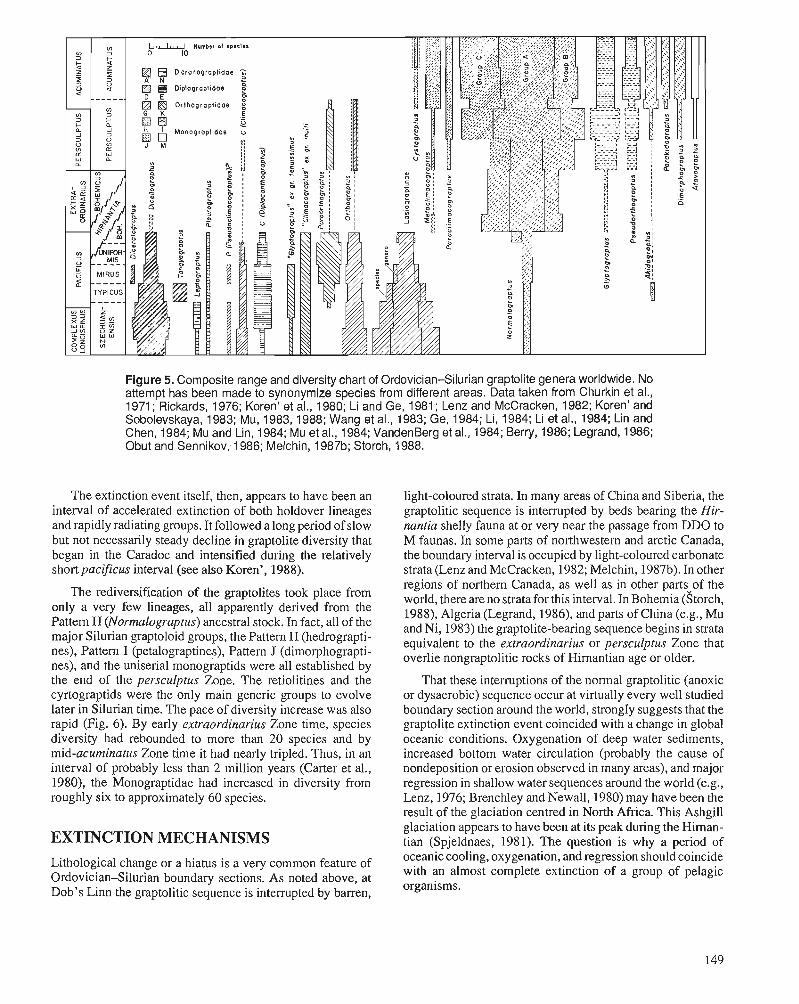
Figure 5. Composite range and diversity chart of Ordovician-Silurian graptolite genera worldwide. No attempt has been made to synonymize species from different areas. Data taken from Churkin et al., 1971 ; Rickards, 1976; Koren' et al., 1980; Li and Ge, 1981 ; Lenz and McCracken, 1982; Koren' and Sobolevskaya, 1983; Mu, 1983, 1988; Wang et al., 1983; Ge, 1984; Li, 1984; Li et al., 1984; Lin and Chen, 1984; M u and Lin, 1984; M u et al., 1984; VandenBerg et al., 1984; Berry, 1986; Legrand, 1986; Obut and Sennikov; 1986; Melchin, 1987b; Storch, 1988.
The extinction event itself, then, appears to have been an interval of accelerated extinction of both holdover lineages and rapidly radiating groups. It followed a long period of slow but not necessarily steady decline in graptolite diversity that began in the Caradoc and intensified during the relatively short pacificus interval (see also Koren', 1988).
The rediversification of the graptolites took place from only a very few lineages, all apparently derived from the Pattern H (Normalograptus) ancestral stock. In fact, all of the major Silurian graptoloid groups, the Pattern H (hedrograpti- nes), Pattern I (petalograptines), Pattern J (dimorphograpti- nes), and the uniserial monograptids were all established by the end of the persculptus Zone. The retiolitines and the cyrtograptids were the only main generic groups to evolve later in Silurian time. The pace of diversity increase was also rapid (Fig. 6). By early extraordinarius Zone time, species diversity had rebounded to more than 20 species and by mid-acurninatus Zone time it had nearly tripled. Thus, in an interval of probably less than 2 million years (Carter et al., 1980), the Monograptidae had increased in diversity from roughly six to approximately 60 species.
EXTINCTION MECHANISMS Lithological change or a hiatus is a very common feature of Ordovician-Silurian boundary sections. As noted above, at Dob's Linn the graptolitic sequence is interrupted by barren,
light-coloured strata. In many areas of China and Siberia, the graptolitic sequence is interrupted by beds bearing the Hir- nantia shelly fauna at or very near the passage from DDO to M faunas. In some Darts of northwestern and arctic Canada. the boundary interval is occupied by light-coloured carbonate strata (Lenz and McCracken, 1982; Melchin, 1987b). In other regions of northern Canada, as well as in other parts-of the world, there areno strata for this interval. In ~ohemia (Storch, 1988), Algeria (Legrand, 1986), and parts of China (e.g., Mu and Ni, 1983) the graptolite-bearing sequence begins in strata equivalent to the extraordinarius or persculptus Zone that overlie nongraptolitic rocks of Hirnantian age or older.
That these interruptions of the normal graptolitic (anoxic or dysaerobic) sequence occur at virtually every well studied boundary section around the world, s t r 0 n ~ 1 ~ suggests that the graptolite extinction event coincided with a change in global oceanic conditions. Oxygenation of deep water sediments, increased bottom water circulation (probably the cause of nondeposition or erosion observed in many areas), and major regression in shallow water sequences around the world (e.g., Lenz, 1976; Brenchley and Newall, 1980) may have been the result of the glaciation centred in North Africa. This Ashgill glaciation appears to have been at its peak during the Himan- tian (Spjeldnaes, 1981). The question is why a period of oceanic cooling, oxygenation, and regression should coincide with an almost complete extinction of a group of pelagic organisms.
Wilde and Beny (1984) have developed a model that attributes extinction events to oceanic turnover and the rise of inhospitable waters into the surface regions of maximum productivity, resulting from the onset of glaciation. Their model depicts warm, nonglacial periods as times of weak but stable water mass stratification. In tropical seas, there may have been two layers of anoxic (or at least strongly dysaero- bic) water within the water column because of sluggish circulation and different salinity sources for water at different depths. During periods of transitional climate, the flood of cool, low salinity water from the polar regions would mix with the warmer, more saline water of the same density below the pycnocline (in the deep and intermediate layers of the oceans) causing a rise and merging of the anoxic layers. With the appropriate rates of climatic change, this could result in a temporary condition of density instability in the water col- umn. Overturn could result, bringing toxic, oxygen-depleted, sulphide rich water to the surface. Periods of glacial maxima would be characterized by a high stability of oceanic stratifi- cation based on strong temperature gradients from very cold bottom waters of polar origin, and elimination of the anoxic layers as a consequence of movement of oxygenated waters into deep and intermediate depths.
Overtum and potential extinction in this model generally should coincide with the onset or decline of glacial activity, as this is the time when density instability would occur.
Figure 7. Neodicellograptus sp. cf. N, siluricus ( M u et al.) from small creek 10 km east of Cape Manning, Cornwallis Island, N.W.T., 75'27-N, 94T1-W. A. GSC 94728; B. GSC 94729; C. GSC 94730. All figures x12.
However, the Late Ordovician graptolite extinction appears to coincide with the peak of glacial activity; ice caps had apparently been present over the south polar areas at least since Caradoc time.
Brenchley (1984) reviewed the faunal extinctions of the Late Ordovician and found that the deep shelf faunas suffered a significant extinction coincident with the graptolite extinc- tion at or near the Rawtheyan-Himantian boundary, whereas the shallower shelf faunas suffered fewer extinctions throughout Himantian time. Brenchley (1984) attributed the extinctions of the shelf faunas to regression and the associated reduction of shallow shelf area. The extinction of the pelagic faunas (especially graptolites) was attributed to contraction of the tropical plankton belts. Jablonski (1980, 1985), Wise and Schopf (1981), and Stanley (1984) argued that reduction in habitable area by itself is not sufficient to cause large-scale extinction. Stanley argued that overall oceanic cooling is a more likely cause of the extinction of faunas adapted to tropical conditions.
Other planktic or nektic organisms that appear to have suffered from significant extinction are the acritarchs (Duf- field and Legault, 1981; Colbath, 1986; Martin, 1988) and cephalopods (McKinney, 1985). Neither seem to have de- clined as profoundly as the graptolites, but this may be attributed to the fact that both had a significant representation in neritic waters where extinctions were less pervasive than in the pelagic realm. Asaphinid trilobites had planktic larvae and appear to have been more severely affected by the extinc- tion event than other Ashgill trilobite groups with benthic larvae (Fortey and Chatterton, 1988). Likewise, the Chiti- nozoa, which may have been a planktic dispersal stage of some metazoan, also suffered a significant faunal turnover (Grahn, 1988).
Figure 6. Numerical abundances of DDO and M Fauna grap- tolites across the Ordovician-Silurian boundary. See Figure 5 for data sources.
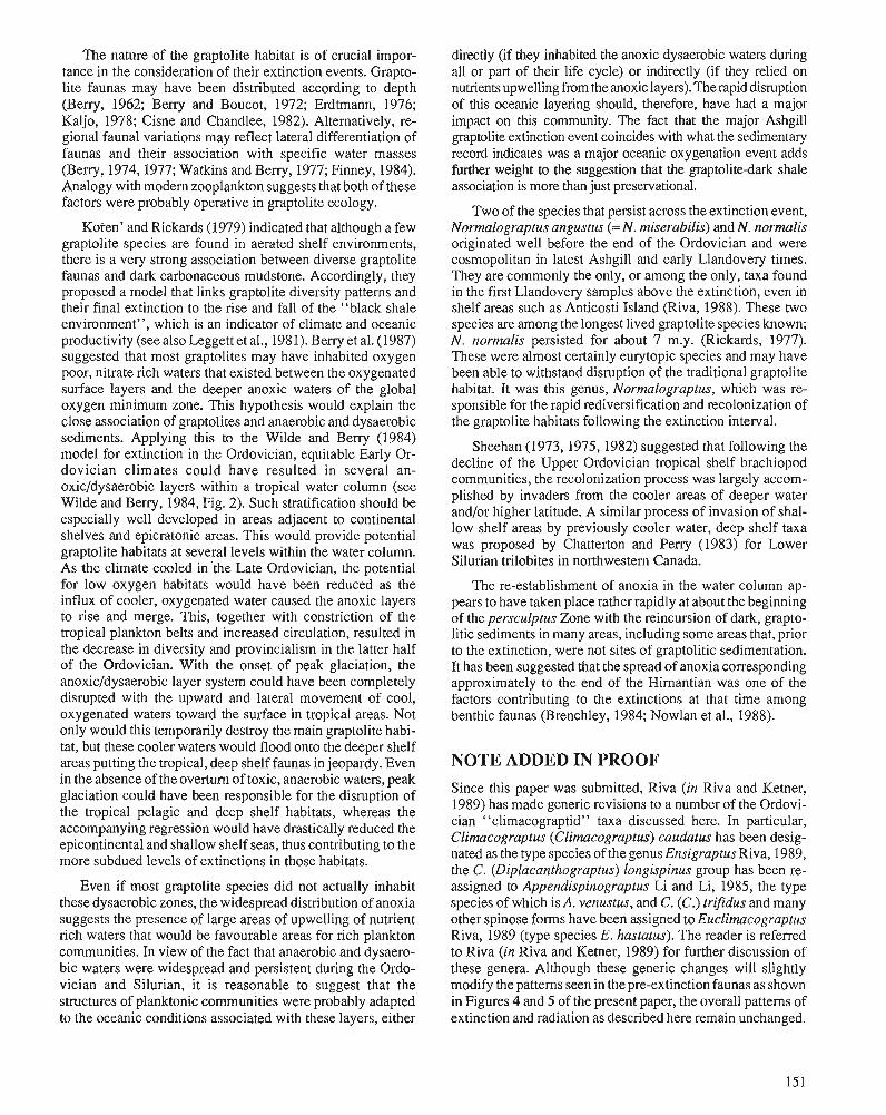
The nature of the graptolite habitat is of crucial impor- tance in the consideration of their extinction events. Grapto- lite faunas may have been distributed according to depth (Berry, 1962; Berry and Boucot, 1972; Erdtmann, 1976; Kaljo, 1978; Cisne and Chandlee, 1982). Alternatively, re- gional faunal variations may reflect lateral differentiation of faunas and their association with specific water masses (Berry, 1974,1977; Watkins and Beny, 1977; Finney, 1984). Analogy with modern zooplankton suggests that both of these factors were probably operative in graptolite ecology.
Koren' and Rickards (1979) indicated that although a few graptolite species are found in aerated shelf environments, there is a very strong association between diverse graptolite faunas and dark carbonaceous mudstone. Accordingly, they proposed a model that links graptolite diversity patterns and their final extinction to the rise and fall of the "black shale environment", which is an indicator of climate and oceanic productivity (see also Leggett et al., 1981). Beny et al. (1987) suggested that most graptolites may have inhabited oxygen poor, nitrate rich waters that existed between the oxygenated surface layers and the deeper anoxic waters of the global oxygen minimum zone. This hypothesis would explain the close association of graptolites and anaerobic and dysaerobic sediments. Applying this to the Wilde and Berry (1984) model for extinction in the Ordovician, equitable Early Or- dovician climates could have resulted in several an- oxic/dysaerobic layers within a tropical water column (see Wilde and Berry, 1984, Fig. 2). Such stratification should be especially well developed in areas adjacent to continental shelves and epicratonic areas. This would provide potential graptolite habitats at several levels within the water column. As the climate cooled in .the Late Ordovician, the potential for low oxygen habitats would have been reduced as the influx of cooler, oxygenated water caused the anoxic layers to rise and merge. This, together with constriction of the tropical plankton belts and increased circulation, resulted in the decrease in diversity and provincialism in the latter half of the Ordovician. With the onset of peak glaciation, the anoxic/dysaerobic layer system could have been completely disrupted with the upward and lateral movement of cool, oxygenated waters toward the surface in tropical areas. Not only would this temporarily destroy the main graptolite habi- tat, but these cooler waters would flood onto the deeper shelf areas putting the tropical, deep shelf faunas in jeopardy. Even in the absence of the overturn of toxic, anaerobic waters, peak glaciation could have been responsible for the disruption of the tropical pelagic and deep shelf habitats, whereas the accompanying regression would have drastically reduced the epicontinental and shallow shelf seas, thus contributing to the more subdued levels of extinctions in those habitats.
Even if most graptolite species did not actually inhabit these dysaerobic zones, the widespread distribution of anoxia suggests the presence of large areas of upwelling of nutrient rich waters that would be favourable areas for rich plankton communities. In view of the fact that anaerobic and dysaero- bic waters were widespread and persistent during the Ordo- vician and Silurian, it is reasonable to suggest that the structures of planktonic communities were probably adapted to the oceanic conditions associated with these layers, either
directly (if they inhabited the anoxic dysaerobic waters during all or part of their life cycle) or indirectly (if they relied on nutrients upwelling from the anoxic layers). The rapid disruption of this oceanic layering should, therefore, have had a major impact on this community. The fact that the major Ashgill graptolite extinction event coincides with what the sedimentary record indicates was a major oceanic oxygenation event adds further weight to the suggestion that the graptolite-dark shale association is more than just preservational.
Two of the species that persist across the extinction event, Normalograptus angustus (= N. miserabilis) and N. norrnalis originated well before the end of the Ordovician and were cosmopolitan in latest Ashgill and early Llandovery times. They are commonly the only, or among the only, taxa found in the first Llandovery samples above the extinction, even in shelf areas such as Anticosti Island (Riva, 1988). These two species are among the longest lived graptolite species known; N. normalis persisted for about 7 m.y. (Rickards, 1977). These were almost certainly eurytopic species and may have been able to withstand disruption of the traditional graptolite habitat. It was this genus, Normalograptus, which was re- sponsible for the rapid rediversification and recolonization of the graptolite habitats following the extinction interval.
Sheehan (1973,1975,1982) suggested that following the decline of the Upper Ordovician tropical shelf brachiopod communities, the recolonization process was largely accom- plished by invaders from the cooler areas of deeper water and/or higher latitude. A similar process of invasion of shal- low shelf areas by previously cooler water, deep shelf taxa was proposed by Chatterton and Peny (1983) for Lower Silurian trilobites in northwestern Canada.
The re-establishment of anoxia in the water column ap- pears to have taken placerather rapidly at about the beginning of the persculptus Zone with the reincursion of dark, grapto- litic sediments in many areas, including some areas that, prior to the extinction, were not sites of graptolitic sedimentation. It has been suggested that the spread of anoxia corresponding approximately to the end of the Hirnantian was one of the factors contributing to the extinctions at that time among benthic faunas (Brenchley, 1984; Nowlan et al., 1988).
NOTE ADDED IN PROOF Since this paper was submitted, Riva (in Riva and Ketner, 1989) has made generic revisions to a number of the Ordovi- cian "climacograptid" taxa discussed here. In particular, Climacograptus (Climacograptus) caudatus has been desig- nated as the type species of the genus Ensigraptus Riva, 1989, the C. (Diplacanthograptus) longispinus group has been re- assigned to Appendispinograptus Li and Li, 1985, the type species of which is A. venustus, and C. (C.) trifdus and many other spinose forms have been assigned to Euclirnacograptus Riva, 1989 (type species E. hastatus). The reader is referred to Riva (in Riva and Ketner, 1989) for further discussion of these genera. Although these generic changes will slightly modify the patterns seen in the pre-extinction faunas as shown in Figures 4 and 5 of the present paper, the overall patterns of extinction and radiation as described here remain unchanged.
ACKNOWLEDGMENTS The authors are grateful to the following sources of financial support: Natural Sciences and Engineering Research Council Operating Grant to A.C. Lenz (University of Western On- tario) and G. Norris (University of Toronto); Energy Mines and Resources Research Agreement Grant to G. Norris and M.J.M.; Northern Scientific Training Grant to M.J.M.; and the Polar Continental Shelf Project for logistical support in the Canadian Arctic to M.J.M. We also thank S. Stewart for allowing us to use unpublished thesis information and T. Koren' and P. Legrand for helpful discussions concerning some of the ideas presented. A.C. Lenz read an earlier draft of this manuscript and provided many useful comments as well as guidance and support to M.J.M. during the course of his Ph.D. research, on which much of this paper is based. M. Coniglio ably and cheerfully provided field assistance to M.J.M. in the Arctic during July of 1988, and provided suggestions for the improvement of this manuscript.
REFERENCES Berrv. W.B.N. ", 1962: Graptolite occurrence and ecology. Joumal of Paleontology, v. 36,
p. 285-293. 1974: Types of early Paleozoic faunal replacements in North America:
their relationship to environmental change. Journal of Geology, V. 82, p. 371-382.
1977: Ecology and age of graptolites from graywackes in eastern New York. Joumal of Paleontology, v. 51, p. 1102-1 107.
1986: Stratigraphic significance of Glyptograptuspersculp~us group grap- tolites in central Nevada, U.S.A. In Palaeoecology and Biostratig- raphy of Graptolites, R.B. Rickards and C.P. Hughes (eds.); Geological Society Special Publication, v. 20, p. 135-143.
1989: Taphonomic influence on perception of Late Ordovician graptolite mass mortality. 28th International Geological Congress, Washing- ton, D.C., U.S.A., July 9-19, 1989,Abstracts, v. 1, p. 138.
Berry, W.B.N. and Boucot, A.J. 1972: Silurian graptolite depth zonation. 24th International Geological
Congress, Proceedings, Section 7, p. 59-65. Berry, W.B.N., Wilde, P., and Quint-Hunt, M.S. 1987: The oceanic non-sulfidic oxygen-minimum zone: a habitat for grap-
tolites? Bulletin of the Geological Society of Denmark, v. 35, p. 103-113.
Brenchley, P.J. 1984: Late Ordovician extinctions and their relationship to the Gondwana
glaciation. In Fossils and Climate, P.J. Brenchley (ed.); Wiley, New York, p. 291-315.
Brenchley, P.J. and Newall, G. 1980: A facies analysis of Upper Ordovician regressive sequences in the
Oslo Region, Noway - a record of glacio-eustatic changes. Palae- ogeography, Palaeoclimatology and Palaeoecology, v. 31, p. 1-38.
Bulman, O.M.B. 1970: Graptolithina, with sections on Enteropneusta and Pterobranchia. In
Treatise on Invertebrate Paleontology, 2nd edn., pt. V., C. Teichert (ed.); Lawrence, Geological Society of America and University of Kansas Press, 163 p.
Carter, C., Trexler, J.H., Jr., and Churkin, M., Jr. 1980: Dating of graptolite zones by sedimentation rates: implications for
rates of evolution. Lethaia, v. 13, p. 279-287. Chatterton, B.D.E. and Perry, D.G. 1983: Silicified Silurian odontopleurid trilobites from the Mackenzie
Mountains. Palaeontographica Canadiana, v. 1, 127 p. Chen X. and Lenz, A.C. 1984: Correlation of Ashgill graptolite faunas of central China and arctic
Canada, with a description of Diceratograptus cf. mirus Mu from arctic Canada. In Stratigraphy and Paleontology of Systemic Boundaries in China, Ordovician-Silurian Boundary I, Nanjing Institute of Geology and Palaeontology (ed.); Anhui Science and Technology Publishing House, p. 247-258.
Chen X. and Lin Y.-K. 1978: Lower Silurian graptolites From Tongzi, northern Guizhou. Memoir
of the Nanjing Institute of Geology and Paleontology, Academica Sinica, v. 12, p. 1-76. (in Chinese with English abstract p. 7576)
Churkin, M., Jr., Carter, C., and Eberlein, G.D. 197 1: Graptolite succession across the Ordovician-Silurian boundary in
southeastem Alaska. Quarterly Joumal of the Geological Society of London, v. 126, p. 319-330.
Cisne, J.L. and Chandlee, G.O. 1982: Taconic Foreland Basin graptolites: age zonation, depth zonation,
and use in ecostratigraphic correlation. Lethaia, v. 15, p. 343-363. Cocks, L.R.M. and Rickards, R.B. (eds.) 1988: A global analysis of the OrdovicianSilurian boundary. Bulletin of
the British Museum, Natural History (Geology), v. 43,394 p. Colbath, G.K. 1986: Abrupt terminal Ordovician extinction in phytoplankton associa-
tions, southern Appalachians. Geology, v. 14, p. 943-946. Cox, I. 1933: On Climacograptus inuiti sp. nov. and its development. Geological
Magazine, v. 70, p. 1-18. Dunield, S.L. and Legault, J.A. 1981: Acritarch biostratiara~hv of Upper Ordovician-Lower Silurian
rocks, Anticosti 1sland;~;ebec: preliminary results. In Subcommis- sion on Silurian Straticrraohv. OrdovicianSilurian Boundary Work- - . .. ing Group, Field Meeting, Anticosti-GaspC, Quebec, 1981,'~ol. II: Stratigraphy and Paleontology, P.J. Lesptrance (ed.); p. 91-99.
Erdtmann, B.-D. 1976: Ecostratigraphy of Ordovician graptoloids. In The Ordovician Sys-
tem: Proceedings of a Palaeontological Association Symposium, Birmingham, November, 1975, M.G. Bassen (ed.); University of Wales Press and National Museum of Wales, Cardiff, p. 621643.
Finney, S.C. 1984: Biogeography of Ordovician graptolites in the southern Appalachi-
ans. In Aspects of the Ordovician System, D.L. Bruton (ed.); Palae- ontological Contributions from the University of Oslo, no. 295, Universitetsforlaget, p. 167-176.
1986: Heterochrony, punctuatcd equilibrium, and graptolite zonal boundaries. In Palaeoecology and Bioshatigraphy of Graptolites, C.P. Hughes and R.B. Rickards (eds.); Geological Society Special Publication 20, p. 103-1 13.
Fortey, R.A and Chatterton, B.D.E. 1988: Classification of the trilobite suborder Asaphina. Palaeontology,
v. 3 1, p. 165-222. Fortey, R.A. and Cooper, R.A. 1986: A phylogenetic classification of the graptoloids. Palaeontology,
v. 29, p. 63 1-654. Ge M.-Y. 1984: The graptolite fauna of the OrdovicianSilurian boundary section
in Yuqian, Zhejiang. In Stratigraphy and Palaeontology of Systemic Boundaries in China, Ordovician-Silurian Boundary 1, Nanjing Institute of Geology and Palaeontology (ed.); Academica Sinica, Anhui Science and Technology Publishing House, p. 389454.
Grahn, Y. 1988: Chitinozoan stratigraphy in the Ashgill and L1andovery.h A Global
Analysis of the OrdovicianSilurian Boundary, L.R.M. Cocks and R.B. Rickards (eds.); Bulletin of the British Museum, Natural History (Geology), v. 43, p. 317-323.
Jablonski, D. 1980: Apparent versus real biotic effects of transgression and regression.
Paleobiology, v. 6, p. 398407. 1985: Marine regressions and mass extinctions: a test using the modem
biota. In Phanerozoic Diversity Patterns: Profiles in Macroevolu- tion, J.W. Valentine (ed.); Princeton University Press, p. 335-353.
Kaljo, D.L. 1978: On the bathymetric distribution of graptolites. Acta Palaeontologica
Polonica, v. 23, p. 523-531. Kearsley, A. 1985: A new phylogeny of diplograptine graptoloids, and their classifica-
tion based on proximal and thecal construction. Newsletter of the Graptolite Working Group, International Palaeontological Associa- tion, v. 6, p. 8-22.
Koren', T.N. 1988: Evolutionary crisis of Ashgill graptolites. In Vth International Sym-
posium on the Ordovician System, August 9-12, 1988, St. John's, Newfoundland, Program and Abstracts, p. 48.
Koren', T.N., Mikhailova, N.F., and Tsai, D.T. 1980: Klass Graptolithina. In Granitsa Ordovika i Silura v Kazakhstane
[The OrdovicianSilurian boundary in Kazakhstan], M.K. Apol- lonov, S.M. Bandelatov, and I.F. Nikitin (eds.); Alma-Ata, p. 121-170. (in Russian)
Koren', T.N. and Rickards, R.B. 1979: Extinction of the graptolites. In The Caledonides of the British Isles
- Reviewed, A.L. Harris, C.H. Holland, and B.E. Leake (eds.); Geological Society of London, p. 457-466.
Koren', T.N. and Sobolevsltaya, R.F. 1983: Graptolity. In Granitsa Ordovika i Silura na Severo-Vostoke SSSR
[The Ordovician-Silurian boundary in the Northeast of the U.S.S.R.], B.S. Sokolov, T.N. Koren', and LF. Nikitin (eds.); Nauka, Lengingrad, p. 97-106. (in Russian)
Leggett, J.K., McKerrow, W.S., Cocks, L.R.M., and Rickards, R.B. 1981: Periodicity in the early Paleozoic marine realm. Journal of the
Geological Society of London, v. 138, p. 167-176. Legrand, P. 1986: The lower Silurian graptolites of Oued In Djerane: a study of
populations at the Ordovician-Silurian boundary. In Palaeoecology and Bioshatigraphy of Graptolites, C.P. Hughes andR.B. Rickards (eds.); Geolonical Society Special Publication 20. p. 143-153.
1987: Modo de des&ollo del Suborden Diplograptina (~ra~toli thina) en el Ordovicio Suwrior v en Sil6rico. Im~licaciones taxon6micas [Mode of development of the Suborder ~ i ~ l o ~ r a ~ t i n a in the Upper Ordovician and Silurian. Taxonomic implications]. Revista -Espaiiola de Palcontologia, v. 2, p. 59-64.
Lenz, A.C. 1976: Late Ordovician-Early Silurian glaciation and the OrdovicianSi-
lurian boundary in the-northern Canadian Cordillera. Geology, v. 3, p. 313-317.
1982: Llandoverian graptolites of the northern Canadian Cordillera: Peta- lograptus. Cephalograplus, Rhaphidograptus, Dimorphograptur. Retiolitidae, and Monograptidae. Royal Ontario Museum, Life Sci- ences Contribution no. 130, 154 p.
Lenz, A.C. and McCracken, A.D. 1982: The Ordovician-Silurian boundary, northern Canadian Cordillera:
graptolite and conodont correlation. Canadian Journal of Earth Sciences, v. 19, p. 1308-1322.
Li J.-J. 1984: Graptolites across the Ordovician-Silurian boundary from Jingxian,
Anhui. 111 Stratigraphy and Palaeontology of Systemic Boundaries in China, OrdovicianSilurian Boundary 1, Nanjing Institute of Geology and Palaeontology (ed.); Academica Sinica, Anhui Sci- ence and Technology Publishing House, p. 309-370.
Li J.-J. and Ge M.-Y. 198 1: Development and systematic position of akidograptids. Acta Palae-
ontologia Sinica, v. 20, p. 225-234. (in Chinese with English summary)
Li J.-J., Qian Y.-Y., and Zhang J.-M. 1984: OrdovicianSilurian boundary section from Jingxian, South Anhui.
In Stratigraphy andPalaeontology of Systemic Boundaries in China, OrdovicianSilurian Boundary I, Nanjing Lnstitute of Geology and Palaeontology (ed.); Academica Sinica, Anhui Science and Tech- nology Publishing House, p. 287-308.
Li, Z.-M. and Li, D.-Q. 1985: Appendispinograptus, a new subgenus of Climacograptuc. Journal
of the Wuhan College of Geology, v. 10, p. 3542. (in Chinese with English summary)
Lin Y.-K. and Chen X. 1984: Glyptograptus persculptus Zone - the earliest Silurian graptolite
zone from Yangzi Gorges, China. In Stratigraphy and Palaeontology of Systemic Boundaries in China, Ordovician-Silurian Boundary 1, Nanjing Institute of Geology and Palaeontology (ed.); Academica Sinica, Anhui Science and Technology Publishing House, p. 203- 232.
Martin, F. 1988: Late Ordovician and Early Silurian acritarchs. In A Global Analysis
of the OrdovicianSilurian Boundary, L.R.M. Cocks and R.B. Rickards (eds.); Bulletin of the British Museum, Natural History (Geology), v. 43, p. 299-309.
McKinney, M.L. 1985: Mass extinction patterns of marine invertebrate groups and some
implications for a causal phenomenon. Paleobiology, v. 11, p. 227-233.
Melchin, M.J. 1987a: Late Ordovician and Early Silurian graptolites, Cape Phillips For-
mation, Canadian Arctic Archipelago. Unpublished Ph.D. thesis, University of Western Ontario, London, Ontario, 760 p.
1987b: Upper Ordovician graptolites from the Cape Phillips Formation, Canadian Arctic Islands. Bulletin of the Geological Society of Denmark, v. 35, p. 191-202.
Mitchell, C.E. 1987: The evolution and classification of the Diplograptacea. Palaeontol-
ogy, v. 30, p. 353405. Mu E.-Z. 1983: On the boundary between the Ordovician and Silurian in China.
Palaeontologia Cathayana, v. 1, p. 107-122. 1988: The OrdovicianSilurian boundary in China. In A Global Analysis
of the Ordovician-Silurian Boundary, L.R.M. Cocks and R.B. Rickards (eds.), Bulletin of the British Museum, Natural History (Geology), v. 43, p. 1 17-131.
Mu E.-2. and Lin Y.-K. 1984: Graptolites from the Ordovician-Silurian boundary sections
Yichang area, W. Hubei. In Stratigraphy and Palaeontology of Systemic Boundaries in China, OrdovicianSilurian Boundary 1, Nanjing Institute of Geology and Palaeontology (ed.); Anhui Sci- ence and Technology Publishing House, p. 45-82.
Mu E.-2. and Ni Y.-N. 1983: Uppermost Ordovician and lowermost Silurian graptolites from the
Xainza area of Xizang (Tibet) with discussion on the Ordovician- Silurian boundary. Palaeontologica Cathayana, v. 1, p. 155-179.
Mu E.-Z., Zhu Z.-L., Lin Y.-K., and Wu H.-J. 1984: The Ordovician-Silurian boundary in Yichang, Hubei. In Stratigra-
phy and Palaeontology of Systemic Boundaries in China, Ordovi- cian-Silurian Boundary I, Nanjing Institute of Geology and Palaeontology (ed.); Academica Sinica, Anhui Science and Tech- nology Publishing House, p. 15-44.
Nowlan, G.S, Goodfellow, W.D., McCracken, A.D., and Lenz, A.C. 1988: Geochemical evidence for sudden biomass reduction and anoxic
basins near the Ordovician-Silurian boundary in northwestern Can- ada. In Vth International Symposium on the Ordovician System, August 9-12, 1988, St. John's, Newfoundland, Program and Ab- stracts, p. 66.
Obut, A.M. and Sennikov, N.V. 1986: Graptolite zones of the Gorny Altai. In Palaeoecology and Biosha-
tigraphy of Graptolites, C.P. Hughes and R.B. Rickards (eds.); Geological Society Special Publication 20, p. 155-164.
Packham, G.H. 1962: Some diplograptids from the British Lower Silurian. Palaeontology,
v. 5, p. 498-526. Rickards. R.B. 1976: The sequence of Silurian graptolite zones in the British Isles.
Geological Journal, v. 11, p. 153-188. 1977: Patterns of evolution in the graptolites. In Patterns of Evolution as
Illustrated by the Fossil Record, A. Hallam (ed.); Elsevier, Amster- dam, p. 333-358.
Rickards, R.B. and Hutt, J.E. 1970: The earliest monogmptid. Proceedings of the Geological Society of
London, v. 1663, p. 115-1 19. Riva, J. 1974: Graptolites with multiple genicular spines from the Upper Ordovi-
cian of western North America. Canadian Journal of Earth Sciences, v. I 1, p. 1455-1460.
1988: Graptolites at and below the OrdovicianSilurian boundary on Anticosti Island, Canada. In A Global Analysis of the Ordovician- Silurian Boundary, L.R.M. Cocks and R.B. Rickards (eds.); Bulletin of the British Museum, Natural History (Geology), v. 43, p. 221- 237.
Riva, J.F. and Ketner, K.B. 1989: Ordovician graptolites from the northern Sierra de Cobachi, Sonora,
Mexico. Transactions of the Royal Society of Edinburgh: Earth Sciences, v. 80, p. 71-90.
Rong J.-Y. 1984: Dishibution of the Hirnanria Fauna and its meaning. In Aspects of the
Ordovician System, D.L. Bruton (ed.); Palaeontological Contributions from the University of Oslo, no. 295, Universitetsforlaget, p. 101-1 12.
Sheehan, P.M. 1973: The relation of the Late Ordovician glaciation to the Ordovician-
Early Silurian changeover in North American brachiopod faunas. Lethaia, v. 6, p. 147-154.
Sheehan, P.M. (cont'd.) 1975: Brachiopod synecology in a time of crisis (Late Ordovician-Early
Silurian). Paleobiology, v. 1, p. 205-212. 1982: Brachiopod macroevolution at the Ordovician-Silurian boundary.
In Third North American Paleontoiogical Conference Proceedings, V. 2, p. 477-48 1.
Sherwin, L. 1974: Llandovery graptolites from the Forbes District, New South Wales.
In Graptolite Studies in Honour of O.M.B. Bulman, R.B. Rickards, D.E. Jackson, and C.P. Hughes (eds.); Special Papers in Palaeontol- ogy 13, p. 149-175.
Signor, P.W., 111 and Lipps, J.H. 1982: Sampling bias, gradual extinction patterns and catastrophes in the
fossil record. Geological Society of America, Special Paper 190, p. 291-296.
Spjeldnaes, N. 1981: Lower Palaeozoic palaeoclimatology. In Lower Palaeozoic of the
Middle East, Eastern and Southern Africa and Antarctica, C.H. Holland (ed.); Wiley, New York. p. 199-256.
Stanley, S.M. 1984: Marine mass extinctions: a dominant role for temperature. In Ex-
tinctions, M.H. Nitecki (ed.); University of Chicago Press, p. 69-1 17.
Stewart, S. 1987: Morphology and systematics of three-diminsionally preserved Late
Ordovician graptolites from Anticosti Island, Quebec. Unpublished M.Sc. thesis, Department of Geology, State University of New York at Buffalo, Buffalo, N.Y.
Stewart, S. and Mitchell, C.E. 1988: Morphology and systematics of several Late Ordovician graptolites
of the family Orthograptidae. In Vth International Symposium on the Ordovician System, August 9-12, 1988, St. John's, Newfound- land, Program and Abstracts, p. 100.
Storch, P. 1988: The OrdovicianSilurian boundary in the Prague Basin, Bohemia.
In A Global Analysis of the OrdovicianSilurian Boundary, L.R.M. Cocks and R.B. Rickards (eds.); Bulletin of the British Museum (Natural History), v. 43, p. 95-100.
VandenBerg, A.H.M., Rickards, R.B., and Holloway, D.J. 1984: The Ordovician-Silurian boundary at Darraweit Guim, central Vic-
toria. Alcheringa, v. 8, p. 1-22. Walker, M.O. 1953: The development of a diplograptid from the Platteville Limestone.
Geological Magazine, v. 90, p. 1-16. Wang X.-F. 1984: The occurrence of Dicellograptus in Silurian strata. 27th Interna-
tional Geological Conference Proceedings, p. 69-73. (in Chinese with English summary)
Wang X.-F., Zeng Q.-L, Zhou T.-M., Ni S.-Z., Xu G.-H., Sun Q.-Y., Li 2.-H., Xiang L.-W., and Lai C.-G. 1983: Latest Ordovician and earliest Silurian faunas from the eastem
Yangtze Gorges, China with comments on the Ordovician-Silurian boundary. Bulletin of the Yichang Institute of Geology and Mineral Resources, Chinese Academy of Geological Sciences, v. 6, p. 57-163. (in Chinese with English summary p. 129-155)
Watkins, R. and Berry, W.B.N. 1977: Ecology of a Late Silurian fauna of graptolites and associated
organisms. Lethaia, v. 10, p. 267-286. Wilde, P. and Berry, W.B.N. 1984: Destabilization of the oceanic density structure and its significance
to marine "extinction" events. Palaeogeography, Palaeoclimatol- ogy and Palaeoecology, v. 48, p. 143-162.
Williams, S.H. 1982: The late Ordovician graptolite fauna of the Anceps Bands at Dob's
Linn, southern Scotland. Geologica et Palaeontologica, v. 16, p. 29-56.
1983: The Ordovician-Silurian boundary graptolite fauna of Dob's Linn, southern Scotland. Palaeontology, v. 26, p. 605439.
1986: Top Ordovician and lowest Silurian of Dob's Linn. In Palaeoecol- ogy and Biostratigraphy of Graptolites, C.P. Hughes and R.B. ~jckards (eds.); ~ e o l o ~ i c a l society Special publication 20, p. 165-171.
Wise, K. and Schopf, T.J.M. 1981: Was marine faunal diversity in the Pleistocene affected by changes
in sea level? Paleobiology, v. 7, p. 394-400. Yu J.-H., Fang Y.-T., Liu H.-B., and Zhang D.-L. 1985: The OrdovicianSilurian boundary in Xixiang, southern Shaanxi,
7 p. (unpub. ms.)
APPENDIX
Systematic Notes
Order GRAPTOLOIDEA Lapworth, 1875
Suborder VIRGELLINA Fortey and Cooper 1986
Superfamily DIPLOGRAPTACEA Lapworth 1873, emend.
Family MONOGRAPTIDAE Lapworth 1873, emend.
Genus Normalograptus Legrand, 1987 emend.
Type species. Climacograptus scalaris normalis Lapworth, 1877.
Diagnosis (emended herein). Pattern H species with (usually) unomamented glyptograptid to clima- cograptid thecae. Proximal end relatively narrow, rounded, and asymmetrical with strongly alternating thecae. Median septum straight and usually complete, with th2l or some later theca dicalycal.
Remarks. Legrand (1987) has recognized the distinctness of the proximal development patterns exhibited by Llandovery and some Ordovician diplograptaceans; an astogenetic pattern that he called the "keroblastic" mode of development (equivalent to the patterns H and I employed here). He established a new genus, Normalograptus, to encompass the keroblastic species with climacograptid thecae.
Riva (1988) proposed the genus Scalarigraptus, also based on the type species "C." normalis, which encompasses the same group of species as Normalograptus and is based on essentially the same criteria. Scalarigraptus, therefore, is a junior synonym of Normalograptus.
As Packham (1962), Bulman (1970), and others have observed, there exists a morphological continuum between species with climacograptid thecae and those with glyptograptid and biform thecae (climacograp- tid to glyptograptid) within many diplograptacean lineages. This feature of rhabdosomal evolution is particularly pervasive among those Monograptidae (sensu Mitchell, 1987) that possess a Pattern H astogeny as in the "Glyptograptus" persculptus-' 'Climacograptus" extraordinarius group from the OrdovicianISi- lurian boundary interval and the "G." euglyphus-"C." brevis lineage of Caradoc age (Finney, 1986). Until much more information is available on the phylogeny of species with a Pattern H astogeny and glyptograptid thecae, it is advisable to include both, as well as some of the biform "Diplograptus" species (e.g., "D." modestus), within an expanded Normalograptus. Legrand's genus Neodiplograptus is based on the type species Diplograptus magnus (H. Lapworth). Uncompressed material from arctic Canada of the very similar species D. tcherskyi, indicate that members of the magnus-tcherskyi-thuringiacus group may differ at the generic level from members of the D. modestus group, which appear to resemble other Normalograptus species more closely.
In the composite generic range chart (Fig. 5) Normalograptus species are grouped into three informal species groups that may or may not have any phylogenetic significance: Group A, species with climacog- raptid thecae throughout; Group B, species with glyptograptid thecae throughout; Group C, those with biform to polyform thecae.
Glyptograptus Lapworth, 1873, emend.
Type species. Diplograpsus tamariscus Nicholson, 1868.
Diagnosis (emended herein). Pattem I species with glyptograptid to, less commonly, climacograptid thecae. Proximal end rather slender, unomamented, and usually tapering. Rhabdosome circular to ovate in cross-section, usually aseptate although a partial median septum may be present.
Remarks. Mitchell (1987) felt that all of the Llandovery species with glyptograptid and climacograptid thecae have the same proximal development pattern (Pattern H) and he decided to include both within an expanded Glyptograptus until further information was available to distinguish more phylogenetically consistent subgroups. One of us (M.J.M.) has now obtained uncompressed specimens of G. tamariscus (Fig. 2.5) and several other glyptograptids from arctic Canada, and these clearly show that the primordial astogeny of some of the Llandovery "glyptograptids" are of the Pattem I type, including G. tamariscus, the type species, whereas some (e.g., G. nikolayevi) posses the Pattem H proximal growth form and are here grouped with the Pattern H "climacograptids" in the genus Normalograptus
Evolutionary crisis of the Ashgill graptolites
Tatjana N. or en' Koren, T.N., Evolutionary crisisof the Ashgill grapto1ites;d Advances in Ordovician Geology, C.R. Barnes and S.H. Williams (ed.), Geological Survey of Canada, Paper 90-9, p. 157-1 64,1991.
Abstract
Ashgill graptolites are widespread in many regions, where four to six zonal associations are differen- tiated in continuous sections. Of importance among successive bioevents are: I ) late Caradoc-early Ashgill extinction; 2) moderate radiation and appearance of an impoverished complanatus Biozone assemblage; 3 ) short-term radiation and minor extinctions at the complexuslpacificus boundary; 4) terminal mass extinction (pacificus event), affecting several graptolite families and coinciding with maximum glaciation in the late Ashgill; 5) slight radiation of morphologically simple diplograptids, followed by afinal episode of Ashgill extinction (the extraordinarius Biozone); 6 ) radiation with moderate numbers of a few significant taxa (the persculptus Biozone); 7) radiation in the acuminatus Biozone comparable in importance with the persculptus event, but more expressive with regard to morphological variety.
Radiation events in the persculptus and acuminatus biozones did not restore the taxonomic diversity lost due to the crisis at the lower Hirnantian boundary. A new radiation peak was attained in subsequent evolutionary phases of the early Llandovery graptolites as a response to deglaciation and onset of black shale sedimentation.
Les graptolites ashgilliens sont re'pandus dam de nombreuses rtgions oli quatre des six associations zonales sont diffkrencie'es dans des profils continus. Les bioe've'nements successifs importants sont les suivants : 1) une extinction au Caradocien suptrieur-Ashgillien infkrieur; 2) wz rayonnement modkrt et /'apparition d'un assemblage appauvri de la biozone ci complanatus; 3) un rayonnement d court terme et des extinctions accessoires d la limite complexus/pacificus; 4) une extinction massive terminale (e've'nement pacificus) affectant plusieurs familles de graptolites et coiizcidant avec la glaciation maximale a l'dshgillien supe'rieur; 5 ) un faible rayonnement des diplograptidks morphologiquement simples, suivi d'un kpisode terminal de l'extinction ashgillienne (la biozone a extraordinarius); 6 ) le rayonnement d'un nombre modkre' de quelques taxons importants (la biozone d persculptus); 7 ) le rayonnement dans la biozone d acuminatus comparable en importance d l'kvtnement d persculptus, mais plus expressif en ce qui concerne la varikte' morphologique.
Les kvtnements de rayonnement dans les biozones d persculptus et d acuminatus ne redonnent pas la diversite' taxonomique perdue par suite de la crise obsewte ci la limite de I'Hirnantien infkrieur. Un rwuveau sommet de rayonnement est atteint au cours des phases tvolutives subse'quentes des graptolites du Llandovkrien prkcoce par rkaction d. la dkglaciation et le dkbut d'une stdimentation de schistes noirs.
A.P. Karpinsky All-Union Geological Research Institute, Sredny 74, Leningrad, U.S.S.R.
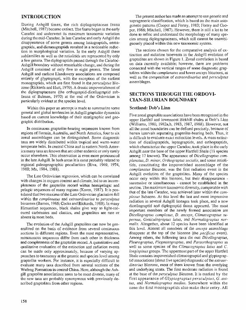
INTRODUCTION
During Ashgill times, the rich diplograptacean fauna (Mitchell, 1987) became extinct. The fauna began in the early Caradoc and underwent its maximum taxonomic variation during the mid-Caradoc. In late Caradoc and early Ashgill the disappearance of some genera among lasiograptids, nema- graptids, and dicranograptids resultedin a noticeable reduc- tion in morphological variation. In the early Ashgill these subfamilies as well as the retiolitids are represented by only a few genera. The diplograptids passed through the Caradoc- Ashgill boundary without remarkable change, and during the Ashgill consisted of only five to eight genera. The latest Ashgill and earliest ~landovery asskiations are composed entirely of glyptograpti, with the exception of the earliest monograptids, which are first found in the persculptus Bio- zone (Rickards and Hutt, 1970). A drastic impoverishment of the diplograptaceans (the orthograptid-dicellograptid sub- fauna of Bulman, 1970) at the end of the Ordovician is particularly evident at the, species level.
Within this paper an attempt is made to summarize some general and global tendencies in Ashgill graptolite dynamics based on current knowledge of their stratigraphic and geo- graphic distribution.
In continuous graptolite-bearing sequences known from regions of Eurasia, Australia, and North America, four to six zonal assemblages can be distinguished. Some diagnostic taxa are widely distributed within tropical and warm-water temperate belts. In central China and in eastern North Amer- ica many taxa are known that are either endemic or only rarely occur elsewhere. This observation is even more pronounced in the late Ashgill. In both areas it is most probably related to regional paleogeographic peculiarities (Riva, 1969, 1974, 1988; Mu, 1984, 1988).
The Late Ordovician regression, which can be correlated with changes in oxygen content and climate, led to an incom- pleteness of the graptolite record within hemipelagic and pelagic sequences of many regions (Koren, 1987). It is pos- tulated that two maxima of the Late Ordovician glaciation fell within the complanatus and extraordinarius to persculptus biozones (Barnes, 1986; Cocks and Rickards, 1988). In many Himantian sequences, black shales give way to light-col- oured carbonates and clastics, and graptolites are rare or absent in most beds.
The evolution of the Ashgill graptolites can now be gen- eralized on the basis of evidence from several continuous sections in different regions. Even the most representative, monotonous sequences differ from each other in thickness and completeness of the graptolite record. A quantitative and qualitative evaluation of the extinction and radiation events can be made only approximately, because of varying ap- proaches to taxonomy at the generic and species level among graptolite workers. For instance, it is especially difficult to evaluate many taxa described from several sections of the Wufeng Formation in central China. Here, although the Ash- gill graptolite associations seem to be most diverse, many of the new taxa are probably synonymous with previously de- scribed graptolites from other regions.
The present author has made an attempt to use generic and suprageneric classification, which is based on the main asto- genetic patterns (Cooper and Fortey, 1983; Fortey and Coo- per, 1986; Mitchell, 1987). However, there is still a lot to be done to refine and understand the morphology of many spe- cies among diplograptaceans, which still cannot be unambi- guously placed within this new taxonomic system.
The sections chosen for the comparative analysis of ex- tinction and radiation bioevents in the Ashgill evolution of graptolites are shown in Figure 1. Zonal correlation is based on data currently available; however, there are problems connected with the vertical ranges of some diagnostic grap- tolites within the complanatus and lower anceps biozones, as well as the composition of extraordinarius and persculptus assemblages.
SECTIONS THROUGH THE ORDOVI- CIAN-SILURIAN BOUNDARY
Scotland: Dob's Linn
Five zonal graptolite associations have been recognized in the upper Hartfell and lowermost Birkhill shales at Dob's Linn (Williams, 1980, 1982a,b, 1983, 1987, 1988). However, not all the zonal boundaries can be defined precisely, because of barren intervals separating graptolite-bearing beds. Thus, it is difficult to evaluate exact extinction levels. A mass extinc- tion of dicellograptids, leptograptids, and orthograptids, which characterize the upper Caradoc, took place in the early Ashgill near the base of the upper Hartfell Shale (1 1 species among 17 known). The appearance of Dicellograptus com- planatus, D. minor, Orthograptus socialis, and some retioli- tids, constituting the impoverished assemblage of the cornplanatus Biozone, was the first radiation event in the Ashgill evolution of the graptolites. Many of the species occur only within this biozone, but their disappearance - successive or simultaneous - cannot be established in the section. The maximum taxonomic diversity, comparable with that of the late Caradoc, was achieved later within the corn- plexus Subzone. At this level the last and most impressive radiation in several Ashgill lineages took place, and a new dicellograptid and diplograptid fauna appeared. The most important members of the newly formed association are Dicellograptus complexus, D. anceps, Clirnacograptus su- pernus, Geniculograptus latus, and Normalograptus nor- malis. Altogether, about 12 species have been identified at this level. Almost all members of the anceps assemblage disappear at the top of the biozone (the pacificus event). Among others, the following taxa die out: Dicellograptus, Pleurograptus, Plegrnatograptus, and Paraorthograptus as well as some species of the Climacograptus latus and C. longispinus groups. The uppermost of the upper Hartfell Shale contains impoverished climacograptid and glyptograp- tid associations (about five species) diagnostic of the extraor- dinarius Biozone, most of them known from the overlying and underlying strata. The first moderate radiation is found at the base of the persculptus Biozone. It is marked by the first appearance of Glyptograptus persculptus, G. avi- tus, and Normalograptus medius. Somewhere within the zone the first monograptids also make their entry. All
taxa cross the persculptus/acuminatus zonal boundary. A new radiative event started at the base of the acuminatus ~iozone. It gave rise to many new morphotypes, notably Akidograptus ascensus, Parakidograptus acuminatus, Nor- malograptus trifilis, and other forms.
Northeast U.S.S.R.: the Kolyma Basin, Mirny Creek
The supernus Biozone (the lower Tirekhtiakh Formation) at the Mimy Creek section is characterized by diverse facies development, composed mainly of organo-detrital carbonates with a benthic fauna (Koren et al., 1983, 1988). Shale and siltstone layers yielding numerous graptolites occur within this sequence. Strata of the extraordinarius and persculptus biozones consist of light-coloured dolomite, marl, and silt- stone, representing the terminal phase of Late Ordovician regression. The black shale sedimentation beginning at the base of the acuminatus Biozone is the first evidence of the Llandovery transgression (the Maut Formation). Graptolites do not occur continuously within the succession of the Tirek- htiakh Formation, which makes it difficult to define precisely the stratigraphic ranges of some species. Nevertheless, within the formation four zonal graptolite assemblages have been recognized above the quadrimucronatus Biozone. They all become impoverished toward the top of the unit. The first extinction coincides with the basal part of member N, with the last occurrences of Climacograptus tubuliferus, C. trifi- dus, and Arnheimograptus lorrainensis, characteristic of the early Ashgill. At the longispinus level, graptolite diversity increases as the result of the last Ashgill radiation. Numerous species of the Climacograptus longispinus, C. hastatus, and Geniculograptus latus groups appear in association with Dicellograptus complanatus and D, complexus. Ten new taxa first occur at this level. The mass extinction of almost all Ashgill graptolites coincides with the top of member P. At this level C. longispinus, C. pogrebovi, Paraorthograptus pacificus, Arachniograptus sp., and other diagnostic diplograptids disappear (the pacificus event). Species belong- ing to Dicellograptus are rare in the section and do not reach the top of the pacificus Subzone. The upper Tirekhtiakh Formation (member Q) is characterized by numerous clima- cograptids (dominant), glyptograptids (comparatively rare), and diplograptids (rare). Species diversity is very low: it is about five to six in the extraordinarius Biozone and four to five in the persculptus Biozone. All graptolites have a very simple morphology. Both zonal assemblages include such long-ranging species as Normalograptus angustus, N. mirny- ensis, and N. normalis. The beds between the last occurrences of G. persculptus contain numerous small climacograptid rhabdosomes, a feature which has also been noted at the Dob's Linn section. The disappearance of the abundant G.? extraordinarius (the middle part of member Q) marks the last extinction at the end of the Ashgill. The onset of black shale sedimentation at the base of the acuminatus Biozone is the first evidence of Llandovery transgression in the region. The first significant radiation is indicated by the appearance of new genera and species at the base of the Maut Formation.
Central China: Yangtze Gorges
The condensed sequence of graptolite-bearing shales of the Wufeng Formation north of Yichang, Western Hubei has been subdivided into six biozones (Mu and Ni, 1983; Mu, 1984, 1988; Mu and Lin, 1984; Mu et al., 1984; Wang et al., 1984). The zonal assemblages are very diverse, containing both cosmopolitan and endemic species. The lowermost part of the Wufeng Formation (WI, yangtzeensis Biozone) con- tains no more than seven species, which also extend into the succeeding biozone. The radiation among the dicellograptids and climacograptids marks the lower boundary of the szechu- anensis Biozone. The diverse assemblage contains about 20 species, most of which have a wide geographic distribution. The first extinction event in the Ashgill took place at the beginning of the typicus Biozone. At this level the last dicel- lograptids, Climacograptus tubuliferus, Geniculograptus la- tus, "Orthograptus" denticulatus, and Pararetiograptus sinensis became extinct. In the middle part of the Wufeng Formation (W3-W5), taxonomic diversity increased again as a result of a final radiation event in the dicellograptid stock, when some specialized graptolites like Tangyagraptus and Diceratograptus appeared (typicus and mirus biozones, Mu et al., 1984; Wang et al., 1984). At the same time, the genera Paraorthograptus and "Yinograptus" made their first ap- pearance, and in great abundance. The graptolite dynamics of this time are unstable, because of the extinction and appear- ance of several short-lived species, though both composition and diversity of successive assemblages are comparable (about 16 to 20 species). The most complete known graptolite sequence of the topmost Ashgill is represented by the upper part of Wufeng Formation (W6, bohemicus Biozone). The final extinction of the last typical Ashgill taxa takes place in two successive events within a very short time span. Or- thograptus amplexicaulis, Geniculograptus inuiti, the last Dicellograptus, Leptograptus, and "Yinograptus" die out at the uniformis/bohemicus zonal boundary. The final mass extinction of almost all Ashgill lineages takes place in the lower bohemicus Biozone. Only the long-ranging N, normalis and N. angustus range into the overlying beds.
Graptolites of the Ordovician-Silurian boundary beds (bo- hemicus, persculptus, and acuminatus biozones) near Yichang, in the South Anhui and Tibet are represented by variable but dense populations (Mu and Ni, 1983; Li, 1984; Li et al., 1984; Lin and Chen, 1984; Mu et al., 1984). The bohemicus and persculptus zonal assemblages include grap- tolites that are morphologically simple compared with the preceeding fauna. They include some species of Clyptograp- tus (dominant), "Diplograptus" (numerous), and Normalo- graptus and "Amplexograptus" (rare). Successive radiation events within these form genera coincide with the beginning of the bohemicus Biozone, the persculptus Biozone, and the acuminatus Biozone, respectively. In this area the last event is not as impressive as in the other regions. It is marked by the appearance of only the index species in association with long-ranging diplograptids and glyptograptids.
Figure 1. Ashgill-early Llandovery bioevents in graptolite evolution against interpreted changes in eustasy and oxygenation. Curves for Anticosti and Dob's Linn, and the curve showing global climatic changes are based on Barnes (1986, Fig. 1). Data on the transgressive-regressive cycles in Hubei and the Canadian Cordillera are taken from Geng Liang-Yu (in Mu [ed.], 1984) and from Lenz and McCracken (1982, 1988), respectively. Abbreviations: R, regression; T, transgression; Fm, Formation; H and L, high and low 0, content in the bottom environment; L.H., Lower Hartfell; Mc, Macasly; E.B., Ellis Bay. Black and white circles show extinction and radiation, respectively. Arabic numerals give numbers of new and extinct species based on regional data, cited in the text. Roman numerals show successive extinction and radiation events.
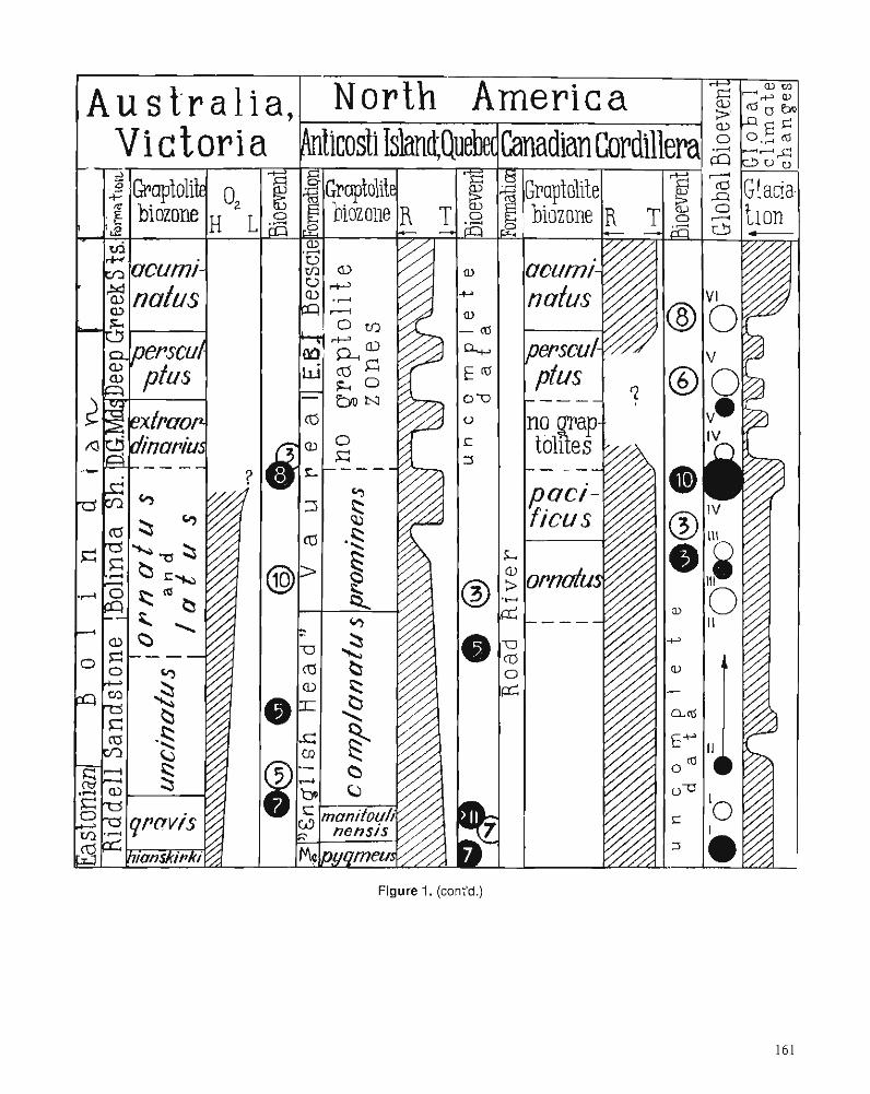
Figure 1. (cont'd.)
Australia: central Victoria
A continuous sequence of graptolite-bearing shales, indica- tive of the gravis and uncinatus biozones, is recognized in Eastonian and Bolindian boundary beds in the Mountain Creek and Wellington River (VandenBerg, 1981; Vanden- Berg et al., 1984; VandenBerg and Webby, 1988). Assem- blages are represented mostly by cosmopolitan species with ranges similar to those known from other regions. Two ex- tinction events are well expressed. The first coincides ap- proximately with the gravisluncinatus zonal boundary. It is characterized by the extinction of previous dicellograptids and orthoretiolitids. The radiation within the climacograptid stock follows this event, and the C. longispinus, C. hastatus, and "C." uncinatus groups appear for the first time. Within the lower uncinatus Biozone, "C." uncinatus, Pleurograptus linearis simplex, Dicellograptus sp. cf. D. morrisi, Parare- tiograptus pulcherrimus, and others occur for the last time. The upper Bolindian graptolite sequence is known from the terrigenous rocks of Darraweit Guim. The ornatus and latus zonal associations have about the same diversity as that of the upper gravis Biozone (12 species). These biozones are char- acterized by cosmopolitan species that elsewhere are known from the pacificus Biozone. Almost all members of the latus zonal assemblage disappear at the top of the Bolinda Shale, that is, at a level coinciding with the main extinction event at the end of the Ashgill (the pacificus event). An impoverished diplograptid fauna characteristic of the extraordinarius and persculptus biozones (one to three species) is known from the Darraweit Guim Mudstone and Deep Creek Siltstone. In the same area the acuminatus Biozone is recognized by the occurrence of the zonal species. However, graptolite data from the Ordovician/Silurian boundary beds in central Victoria are insufficient to allow an evaluation of graptolite dynamics.
North America: Canadian Cordillera
Graptolite biozones of the Ashgill and the basal Llandovery have been studied in the 30 to 60 m thick shale sequence of the Road River Formation in the Richardson Mountains, northern Yukon (Lenz and McCracken, 1982, 1988). The assemblages of the ornatus and pacificus biozones are formed by cosmopolitan species. The Ashgill graptolite shales of the Descon and Maravillas formations of Alaska and Texas have similar zonal compositions (Churkin et al., 1970; Bergstrom, 1978). At the base of the pacificus Biozone the diversity of graptolites increased slightly. A mass extinction took place at the top of this biozone (the pacificus event). This sequence of latest Ashgill graptolites is not complete, most probably because of facies changes. Short breaks in sedimentation also cannot be excluded. The base of the persculptus Biozone is marked by a distinct radiation within the glyptograptid and climacograptid stocks. Among diagnostic taxa, the Glyp- tograptus tamariscus and Normalograptus normalis-N. mis- erabilis groups dominate. The base of the acurninatus Biozone is characterized by the appearance of a more diverse assemblage including the first Akidograptus, Parakidograp- tus, and Cystograptus as well as some new species of Nor- malograptus, Paraclimacograptus, and " Diplograptus".
North America: Anticosti Island and St. Lawrence Lowlands
The Ashgill graptolite sequence of eastern North America is known from the Utica Shale, and the English Head and Vaureal formations (Riva, 1969, 1974, 1988; Petryk, 1981). The peculiarities of their composition are especially well expressed at the Caradoc-Ashgill boundary (the pygmeus and manitoulinensis biozones) and close to the base of the Llan- dovery (prominens Biozone). However, the dynamics of graptolite associations during Ashgill times is not dissimilar to that revealed in other regions. The first extinction event is related to the end of black shale sedimentation at the top of the Utica or Macasty shales and the disappearance of the last typical graptolites of the pygmaeus Biozone. Here many dicranograptids, geniculograptids, and climacograptids dis- appear (about seven species). Radiation events within the Climacograptus, Pseudoclimacograptus, and Diplograptus? stocks are characterized by a discernible increase in taxo- nomic diversity in the manitoulinensis Biozone (to 18 spe- cies). The second extinction event of the older Ashgill fauna takes place at the top of this biozone. Here, "Climacograp- tus" sp. cf. "C." styloideus, Amplexograptus manitoulinen- sis, Pseudoclirnacograptus sp. cf. P. clevensis, and other taxa become extinct. The overlying complanatus Biozone, corre- sponding to most of the English Head Formation, is charac- terized by an impoverished assemblage of cosmopolitan dicellograptids and orthograptids (seven species). The third extinction event is documented at the base of the Vaureal Formation, where almost all typical Ashgill taxa become extinct. In the lower part of the formation only rare graptolites occur. They belong to Arnheimograptus, Amplexograptus, Geniculograptus, Orthograptus, and Paraclimacograptus?, constituting a peculiar assemblage of the prominens Biozone. The upper Vaureal Formation and Ellis Bay Formation con- sist of nine regressive series of shallow-water deposits and have no diagnostic graptolites. The occurrence of Normalo- graptus normalis and other long-ranging diplograptids allow a tentative correlation with thepersculptus and, also possibly, with the acuminatus biozones.
CONCLUSIONS In the evolution of Ashgill graptolites, several bioevents can be traced globally. Among them certain extinction and radia- tion events are recognized, even in those regions with differ- ent facies development. Thus, they reflect general tendencies in the evolution of graptolites and can, therefore, be used as good time-markers for global correlations. The events occur over relatively short, sometimes abrupt, intervals when one takes into consideration the average duration of the Ashgill graptolite biozone (Harland et al., 1982).
In addition, some bioevents may be more geographically restricted. For instance, in eastern North America there is an extinction event at the end of the manitoulinensis Biozone, while in central China there are two extinction episodes in the bohemicus and persculptus biozones, respectively. In addi- tion, there seems to be a radiation at the base of the typicus Biozone in central China but this could well be an artifact of taxonomic oversplitting.
The succession of global bioevents in graptolite evolution can be summarized as follows.
1. The Caradoc-Ashgill boundary extinction event is char- acterized by the disappearance of many genera and spe- cies (Fig. 1, I). However, the taxonomic structure of the assemblages was not significantly affected.
2. The first radiation (I) is in the cornplanatus Biozone, although this is only moderate with respect to both mor- phological variety and the appearance of new species. The extinction pattern of these new taxa is not yet fully docu- mented in continuous sections (11).
3. The most significant radiation event occurred within the early complexus Biozone, followed by a distinct accelera- tion of evolution during the complexus and pacificus phases (11,111). The taxonomic structure of the graptolite assemblages of this time reached a maximum diversity.
4. Insignificant extinction between radiations I1 and 111, close to the complexuslpacificus boundary (111), can only be recognized in the most complete sections with continu- ous graptolite records (central China, Canadian Cordil- lera).
5. The major evolutionary crisis, which is expressed by the terminal mass extinction of Ashgill families, genera, and many species, takes place at the end of the pacificus Biozone (the pacificus event, IV). All morphologically specialized graptolites are eliminated; only generalists with simple morphology persist. The pacificus event can most probably be related to the maximum of the late Ashgill glaciation.
6. New morphological types appear together with the last representatives of the pacificus Biozone. These are the simple climacograptids and glyptograptids. They also become extinct but give rise to an extraordinarius assem- blage (IV). This assemblage disappears at the end of that biozone (V).
7. Appearances of new species both at the lower boundary and within the persculptus Biozone are only moderate in number of taxa, but of great significance for the further evolution of graptoloids, as the Suborder Monograptina appears. Another evolutionary phenomenon, which oc- curs within both the persculptus and underlying extraor- dinarius Biozone, is a population burst in certain simple diplograptids.
8. The radiation at the beginning of the acuminatus Biozone is more or less comparable to that of the persculptus Biozone in the number of new taxa. However, it is more significant because of an appearance of several new diplograptid lineages (families, genera, and species).
The persculptus and acuminatus radiation events do not, however, restore the morphological diversity of graptolites lost at the RawtheyanIHimantian boundary (the pacificus event).
ACKNOWLEDGNZENTS I am most grateful to Otto Walliser who inspired this study and gave me most valuable help. John Riva kindly read and commented on the manuscript and corrected the English.
REFERENCES Barnes, C.R. 1986: The faunal extinction event near the Ordovician-Silurian boundary:
a climatically induced crisis. In Lecture Notes in Earth Sciences, O.H. Walliser (ed.); Global Bio-Events, v. 8, Springer-Verlag, Berlin, Heidelberg, p. 121-126.
Bergstrom, S.M. 1978: Mddle and Upper Ordovician conodont and graptolite biostratigra-
phy of the Marathon, Texas graptolite zone reference standard. Palaeontology, v. 51, p. 723-758.
Bulman, O.M.B. 1970: Graptolithina with section on Enteropneusta and Pterobranchia. In
Treatise on Invertebrate Paleontology, C. Teichert (ed.); Geological Society of America and University of Kansas Press, part V (2nd edn.), Boulder, Colorado and Lawrence, Kansas, 163 p.
Churkin, M., Jr., Carter, C., and Eberlein, G.D. 1970: Graptolite succession across the Ordovician-Silurian boundary in
south-eastem Alaska. Quarterly Journal of the GeoIogical Society of London, v. 126, p. 319-330.
Cocks, L.R.M. and Rickards, R.B. (eds.) 1988: A global analysis of the Ordovician-Silurian boundary. Bulletin of
the British Museum (Natural History), Geology, v. 43, 394 p. Cooper, R.A. and Fortey, R.A. 1983: Development of the graptolite rhabdosome. Alcheringa, v. 7,
p. 201221. Fortey, R.A. and Cooper, R.A. 1986: A phylogenetic classification of the graptoloids. Palaeontology,
v. 29, p. 631-654. Harland, W.B. et al. 1982: A Geologic Time Scale. Cambridge University Press, 138 p. Koren, T.N. 1987: Graptolite dynamics in Silurian and Devonian time. Bulletin of
Geological Society of Denmark, v. 35, p. 149-159. Koren, T.N., Oradovskaya, M.M., Pylma, LJ., Sobolevskaya, R.F., and Chugaeva, M.A. 1983: The Ordovician and Silurian boundary in the Northeast of the
USSR. Interdepartmental Stratigraphic Committee of the USSR, vol. 11, "Nauka" Publishers, Leningrad Branch, 205 p.
Koren, T.N., Oradovskaya, M.M., and Sobolevskaya, R.F. 1988: The Ordovician-Silurian boundary beds of the Northeast USSR.
Bulletin of the British Museum (Natural History), Geology, v. 43, p. 133-138.
Lenz, A.C. and McCracken, A.D. 1982:- The Ordovician-Silurian boundary in northern Canadian Cordillera,
nra~tolite and conodont correlation. Canadian Journal of Earth iciknces, v. 19, p. 1308- 1322.
1988: Ordovician and Silurian boundary, northern Yukon, Canada. Bulletin of the British Museum (Natural History), Geology, v. 43, p. 265-271.
Li Ji-Jin 1984: Graptolites across the Ordovician-Silurian boundary from Jingxian,
south Anhui. I n Stratigraphy and Palaeontology of Systemic Boundaries in China. Ordovician-Silurian Boundary (I), En-Zhi Mu (ed.); Anhui Science and Technology Publishing ~ o u s e , p. 309-388.
Li Ji-Jin, Qian Yi-Yuan, and Zhang Jun-Ming 1984: Ordovician-Silurian boundary section from Jingxian, South Anhui.
In Stratigraphy and Palaeontology of Systemic Boundaries in China. Ordovician-Silurian Boundary (I), En-Zhi Mu (ed.); Anhui Science and Technology Publishing House, p. 287-308.
Lin Yao-Kun and Chen Xu 1984: Glyptograptus persculptus Zone - the earliest Silurian graptolite
Zone from Yangtze Gorges, China In Stratigraphy and Palaeontology of Systemic Boundaries in China Ordovician and Silurian Boundary (I), En-Zhi Mu (ed.); Anhui Science and Technology Publishing House, p. 203-232.
Mitchell, C.S. 1987: Evolution and phylogenetic classification of the Diplograptacea.
Palaeontology, v. 30, p. 353-405. Mu En-Zhi (ed.) 1984: Stratigraphy and aleo onto log^ of Systemic Boundaries in China.
Ordovician-Silurian Boundary. ( I ) Anhui Science and Technology Publishing House, 526 p.
Mu En-Zhi 1988: The Ordovician-Silurian boundary in China. Bulletin of the British
Museum (Natural History), Geology, v. 43, p. 117-1 3 1. Mu En-Zhi and Lin Yao-kun 1984: Graptolites from the Ordovician-Silurian boundary section of
Yichang area, W. Hubei. In Stratigraphy and Palaeontology of Systemic Boundaries in China. Ordovician-Silurian Boundary (I), En-Zhi Mu (ed.); Anhui Science andTechnology Publishing House, p. 45-82.
Mu En-Zhi and Ni Yu-Nan 1983: Uppermost Ordovician and lowermost Silurian graptolites from the
Xainza area of Xizang (Tibet) with the discussion of the Ordovi- cian-Silurian boundary. Palaeontologia Cathayana, v. I, p. 155.179.
Mu En-Zhi, Zhu Zhao-Ling, Lin Yao-Kun, and Wu Hong-Yi 1984: The Ordovician-Silurian boundary in Yichang, Hubei. In Stratigraphy
and Palaeontology of Systemic Boundaries in China. Ordovician- Silurian Boundary (I), En-Zhi Mu (ed.); Anhui Science and Technology Publishing House, p. 15-41.
Petryk, A.A. 1981: Stratigraphy, sedimentology, and paleogeography of the Upper
Ordovician-Lower Silurian of Anticosti Island, Quebec. In Field Meeting, Anticosti-GaspC, Quebec, 1981.2 (Stratigraphy and Pale- ontology), P.J. LespCrance (ed.); International Union of Geological Sciences Subcommission on Silurian Stratigraphy, Ordovician-Si- lurian Boundary Working Group, Montreal, p. 11-39.
Rickards, R.B. and Hutt, J.E. 1970: The earliest monograptid. Proceedings of the Geological Society of
London, v. 1663, p. 115-1 19. Riva, J. 1969: Middle and Upper Ordovician graptolite faunas of St. Lawrence
Lowlands of Quebec, and of Anticosti Island. American Association of Petroleum Geologists, Memoir 12, p. 513-556.
Riva, J. (cont'd) 1974: A revision of some Ordovician graptolites of eastern North Amer-
ica. Paleontology, v. 17, p. 1-40. 1988: Graptolites at and below the Ordovician-Silurian boundary on An-
ticosti Island, Canada. Bulletin of the British Museum (Natural History), Geology, v. 43, p. 221-237.
VandenBerg, A.H.M. 198 1 : Victorian stages and graptolite zones. International Union of Geo-
logical Sciences Publication, v. 6, p. 2-7. VandenBerg, A.H.M., Richards, R.B., and Hollowvay, D.Y. 1984: The Ordovician-Silurian boundary at Darraweit Guim, cenhal Vic-
toria. Alcheringa, v. 8, p. 1-22. VandenBerg, A.H.M. and Webby, B.D. 1988: Ordovician and Silurian boundary in Victoria and New South
Wales, Australia. Bulletin of the British Museum (Natural History), Geology, v. 43, p. 183-190.
Wang Xiaofeng, Seng Qingluan, Zhou Tianmei, et al. 1984: Ordovician-Silurian boundary biostratigraphy of eastern Yangtze
Gorges, China. Scientia Sinica (Series B), v. XXVII, p. 101-1 11. Williams, S.H. 1980: An excursion guide to Dob's Linn. Proceedings of the Geological
Society of Glasgow, v. 1211122, p. 13-18. 1982a: The late Ordovician graptolite fauna of the Anceps Bands at Dob's
Linn, southern Scotland. Geologica et Palaeontologica, Marburg, V. 16, p. 29-56.
1982b: Upper Ordovician graptolites from the top Lower Hartfell Shale Formation (D. clingani and P. linearis zones) near Moffat, southem Scotland. Transactions of the Royal Society of Edinburgh, Earth Sciences, v. 72, p. 229-255.
1983: The Ordovician-Silurian boundary graptolite fauna of Dob's Linn, southern Scotland. Palaeontology, v. 26, p. 605-639.
1987: Upper Ordovician graptolites from the D. cornplanatus Zone of the Moffat and Girvan districts and their significance for correlation. Scottish Journal of Geology, v. 23, p. 65-92.
1988: Dob's Linn - the Ordovician-Silurian boundary shatotype. Bulle- tin of the British Museum (Natural History), Geology, v. 43, p. 17- 30.
A chronology of North American Ordovician trilobite genera
Robert E. Sloanl
Sloan, R.E., A chronology of North American Ordovician trilobite genera; Advances in Ordovician Geology, C.R. Barnes and S.H. Williams (ed.), Geological Survey of Canada, Paper 90-9,p. 165-1 77,1991.
Abstract
Absolute duration of trilobite genera in North America is calculated for the Late Cambrian Ptero- cephalid and Ptychaspid biomeres and for the Ordovician. Generic duration for the two biomeres and each part of the Ordovician is distributed in a Poisson distribution. An absolute chronology for the Ordovician is calculated from Sweet's (1984) Composite Standard Section (CSS) and three high precision dates. The primary trilobite stratigraphic data are transposed into the CSS, which has been extrapolated to the beginning of the Atdabanian.
There are 266 Ordovician non-agnostid trilobite genera that have an average duration of 12.2 rn.y.; the minimum duration is about 0.1 m.y. and the maximum duration (Shumardia) 56.4 m.y. There are 64 genera with ranges longer than 20 m.y. The 95 Ibexian genera average 7.7 my. , 164 Whiterockian genera average 16.4 my., 114 Mohawkian genera average 20.8 my., and 74 Cincinnatian genera average 22.1 m.y. For comparison, 32 Cedaria-Crepicephalus Zone trilobite genera f fom Texas average 3.0 my., with a minimum of 0.2 m.y. and a maximum of 7.7 m.y. The average duration of 48 Pterocephalid biomere genera from the Great Basin is 0.9 m.y., with a minimum of 0.05 m.y. and a maximum of 3.7 m.y. The average duration of 41 Ptychaspid biomere genera from Minnesota is 1.6 my., with a minimum of 0.05 my., and a maximum of 5.3 m.y. The average duration of the Cambrian species is half that of the generic durations, and a similar or slightly smaller ratio appears to hold for the Ordovician.
On a dktermink la durke d'existence absolue de genres de trilobites de 1'Amkrique du Nord pour les biombres de Ptkrockphalidks et de Ptychaspidks du Cambrien supkrieur et pour l'ordovicien. La loi de Poisson illustre la durke d'existence des genres dans les deux biomtres et chaque partie de 1'Ordovicien. L'ktablissement d'une chronologie absolue de I'Ordovicien se fonde sur la coupe composke standard de Sweet (1984) et sur trois dates t r b prkcises. Les principales donntes stratigraphiques de trilobites sont transposkes dans la coupe composke standard, qui est extrapolke jusqu'au dtbut de I'Atdabanien.
Zl existe 266 genres de trilobites ordoviciens non-Agnostidks qui ont une durte d'existence moyenne de 12,2 ma; la durke d'existence minimale est d'environ 0,l ma et la durke d'existence maximale (Shumardia), de 56,4 ma. Soixante-quatre genres ont exist& pendant plus de 20 ma. Les 95 genres de l'lbexien ont une durke d'existence moyenne de 7,7 ma, les 164 genres du Whiterockien, de 16,4 ma, les 114 genres du Mohawkien, de 20,8 ma, et les 74 genres du Cincinnatien, de 22,l ma. Auxfins de comparaison, 32 genres de trilobites de la zone b Cedaria-Crepicephalus, au Texas, ont une durte d'existence moyenne de 3.0 ma, avec un minimum de 0,2 ma et un maximum de 7,7 ma. Quarante-huit genres du biorn2re de Pttroctphalidks, dans le bassin Great, ont une durte d'existence moyenne de 0,9 ma, avec un minimum de 0,05 ma et un maximum de 3,7rna. La durke d'existence moyenne de41 genresdu biombre de Ptychaspidks, au Minnesota, est de 1,6 ma, le minimum ktant de 0.05 ma et le maximum, de 5,3 ma. La durte d'existence moyenne des espkces drl Cambrien est la moitik moins de celle des genres; le rapport pour I'Ordovicien serait semblable ou lkg2rement moins tlevk.
1 Department of Geology and Geophysics, University of Minnesota, Minneapolis, MN 55455 U.S.A.
INTRODUCTION This study was done for several reasons. There are few data on the durations of genera and species over long spans of time. There are theoretical reasons for suspecting a progressive increase in duration as adaptive radiation progresses. It is currently not possible to make a precise census of duration of taxa on a worldwide basis. The problems include those of correlation and time scale, as well as those of density of information. However, as a result of recent work on conodont biostratigraphy, it is possible to review the data for the Ordo- vician of North America. This study covers all the available literature on trilobite biostratigraphy of North America dur- ing the Ordovician, as well as Greenland, Spitzbergen, north- western Scotland (especially the Girvan district), western Newfoundland, and northwestern Ireland. This study is pri- marily concerned with taxa at the generic level. A similar study at the species level is possible, but will require several more years. For comparison, the more detailed data for North America during the Cambrian is also described.
CAMBRIAN-ORDOVICIAN TIME SCALE The major problem with the early Phanerozoic time scale is evaluation of data with varying precision, and interpolation between good dates. Snelling (1984) suggested that all early Paleozoic chronometric boundaries of periods, epochs, and ages should be rounded to the nearest 5 million years. I strongly disagree, as this discards all of the very large quantity of information that we have on the relative duration of these units. The time scale is too important to be left solely to those who measure ages.
The best time scales are the result of a synthesis by linear interpolation of time with a continuous independent variable such as the Cretaceous and Cenozoic magnetostratigraphic record derived from seafloor spreading data. Traditionally, developers of time scales have consulted the relative thick- ness of stratigraphic units as a way of interpolating between dates.
Shaw's (1964) method of graphic interpolation by the development of Composite Standard Sections is the most precise way known of partitioning the available time based on stratigraphic thickness. Sweet (1984) developed such a Composite Standard Section (CSS) for the Whiterockian to the end of the Ordovician by pooling data on conodont distribution from 81 measured and sampled sections spread throughout the United States.
Three good radioactive dates have been determined with high precision (two sigma errors of 2 m.y.) in or close to the Ordovician Period. There are also precise biostratigraphic data available. Two of these dates, Churkin's earliest Silurian date of 436 m.y. and Kunk and Sutter's (1984) date on the Deicke K-bentonite are included within or are very close to Sweet's CSS. Churkin's date provides a date of 438 m.y. for the end of the Ordovician. The Deicke date provides an age of 454 m.y. for the Black River-Trenton boundary.
Sloan (1987b) converted Sweet's (1984) CSS to a time scale for purposes of analysis of rates of evolution and sedi- mentation in the upper Mississippi Valley region. The equa- tion for conversion of a CSS number to an absolute age is:
Age = 0.0544 (1277 - CSS) + 438.
The chronology of the North American Ordovician from the base of the Whiterockian to the end of the Ordovician now rests on a very sound foundation. Unfortunately, the chronol- ogy of the type British series is less certain. It is based mainly on less precise methods, and is unlikely to improve except by correlation with North America.
The chronology can be extended to the IbexianICanadian with some ease. Sloan calculated the age of the end of the Ibexian to be 483.7 m.y. based on the value of CSS 387 that Sweet (1984) calculated for top of the series. An assumption of 504 m.y. for the Cambrian-Ordovician boundary (Ross et al., 1982) produces a duration for the Ibexian of 20.3 m.y. In turn, this determines the base of the Ordovician and the Ibexian as CSS 64. The temporal partitioning of the Ibexian in this study is based on the thickness of the Ross-Hintze trilobite zones at Ibex (Hintze, 1953, 1979, 1982). Unfortu- nately, the distribution of trilobites has only been reported to the zonal rather than the absolute stratigraphic level. None- theless, because of its rich fossil content, this is the best possible reference section for the entire IbexianICanadian.
The Cambrian time scale poses unique problems. There are few biostratigraphically controlled dates, and those that exist are of low precision. It is, however, possible to extrapo- late the Ordovician time scale backward, by using the meas- ured thickness of strata in the Great Basin. This seems reasonable because there are no major changes in tectonic style of sedimentation between the end of the Waucoban and the Whiterockian in the Great Basin. The thickness of the Ptychaspid biomere at the Ibex section (Miller et al., 1982) is 375 m compared to 805 m for the Ibexian (Hintze, 1982) at the same place. This suggests that the duration of the Ptychas- pid biomere is 46.6 per cent of the Ibexian, or 9.5 million years.
Palmer (1971) presents data on the relative thicknesses of the biomeres and trilobite zones of the Eureka-House Range region (which includes the Ibex section) for the Middle and Late Cambrian, and the Inyo Mountains for the Early Cam- brian. By simple ratios of thickness, the duration of the Ibexian and the Ptychaspid biomere can be extended (Table 1) to produce durations of the other Albertan-Croixan zones and biomeres. Naeser's (in Ross and Naeser, 1984) fission track date of 535 * 12 m.y. for a tuff in the Bolaspidella Zone (estimated duration 527 to 540 m.y.) agrees closely with this extrapolation.
Unfortunately, Naeser's other fission track date of 563 + 12 m.y. from the Glossopleura Zone is not quite as close to the extrapolated range of the Glossopleura Zone from 543.5 to 55 1 m.y., but the agreement is still satisfactory.
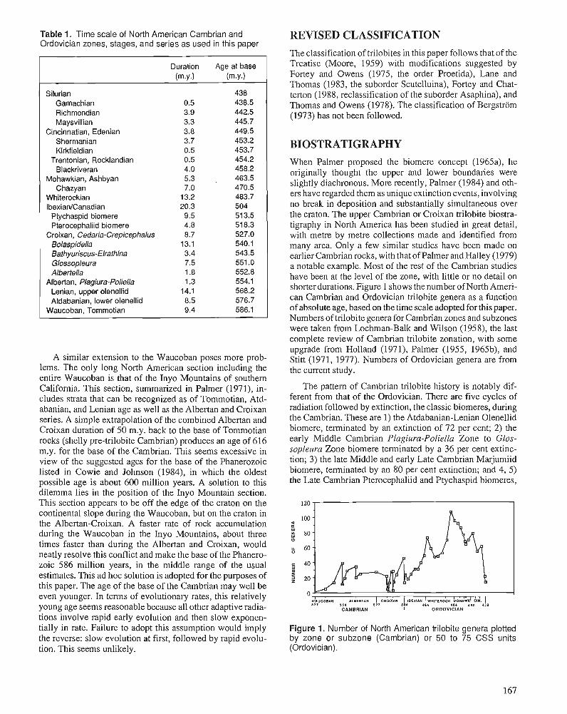
Table 1. Time scale of North American Cambrian and Ordovician zones, stages, and series as used in this paper
Duration Age at base (rn.y.1 (rn.y.1
Silurian 438 Gamachian 0.5 438.5 Richmondian 3.9 442.5 Maysvillian 3.3 445.7
Cincinnatian, Edenian 3.8 449.5 Sherrnanian 3.7 453.2 Kirkfieldian 0.5 453.7
Trentonian, Rocklandian 0.5 454.2 Blackriveran 4.0 458.2
Mohawkian, Ashbyan 5.3 . 463.5 Chazyan 7.0 470.5
Whiterockian 13.2 483.7 IbexianICanadian 20.3 504 Ptychaspid biornere 9.5 51 3.5 Pterocephaliid biornere 4.8 51 8.3
Croixan, Cedaria-Crepicephalus 8.7 527.0 Bolaspidella 13.1 540.1 Bathyuriscus-Elrathina 3.4 543.5 Glossopleura 7.5 551 .O Albertella 1.8 552.8
Albertan, Plagiura-Poliella 1.3 554.1 Lenian, upper olenellid 14.1 568.2 Atdabanian, lower olenellid 8.5 576.7
Waucoban, Tornrnotian 9.4 586.1
A similar extension to the Waucoban poses more prob- lems. The only long North American section including the entire Waucoban is that of the Inyo Mountains of southern California. This section, summarized in Palmer (1971), in- cludes strata that can be recognized as of Tommotian, Atd- abanian, and Lenian age as well as the Albertan and Croixan series. A simple extrapolation of the combined Albertan and Croixan duration of 50 m.y, back to the base of Tommotian rocks (shelly pre-trilobite Cambrian) produces an age of 616 m.y. for the base of the Cambrian. This seems excessive in view of the suggested ages for the base of the Phanerozoic listed in Cowie and Johnson (1984), in which the oldest possible age is about 600 million years. A solution to this dilemma lies in the position of the Inyo Mountain section. This section appears to be off the edge of the craton on the continental slope during the Waucoban, but on the craton in the Albertan-Croixan. A faster rate of rock accumulation during the Waucoban in the Inyo Mountains, about three times faster than during the Albertan and Croixan, would neatly resolve this conflict and make the base of the Phanero- zoic 586 million years, in the middle range of the usual estimates. This ad hoc solution is adopted for the purposes of this paper. The age of the base of the Cambrian may well be even younger. In terms of evolutionary rates, this relatively young age seems reasonable because all other adaptive radia- tions involve rapid early evolution and then slow exponen- tially in rate. Failure to adopt this assumption would imply the reverse: slow evolution at first, followed by rapid evolu- tion. This seems unlikely.
REVISED CLASSIFICATION
The classification of trilobites in this paper follows that of the Treatise (Moore, 1959) with modifications suggested by Fortey and Owens (1975, the order Proetida), Lane and Thomas (1983, the suborder Scutelluina), Fortey and Chat- terton (1988, reclassification of the suborder Asaphina), and Thomas and Owens (1978). The classification of Bergstrom (1973) has not been followed.
BIOSTRATIGRAPHY When Palmer proposed the biomere concept (1965a), he originally thought the upper and lower boundaries were slightly diachronous. More recently, Palmer (1984) and oth- ers have regarded them as unique extinction events, involving no break in deposition and substantially simultaneous over the craton. The upper Cambrian or Croixan trilobite biostra- tigraphy in North America has been studied in great detail, with metre by metre collections made and identified from many area. Only a few similar studies have been made on earlier Cambrian rocks, with that of Palmer and Halley (1979) a notable example. Most of the rest of the Cambrian studies have been at the level of the zone, with little or no detail on shorter durations. Figure 1 shows the number of North Ameri- can Cambrian and Ordovician trilobite genera as a function of absolute age, based on the time scale adoptedfor this paper. Numbers of trilobite genera for Cambrian zones and subzones were taken from Lochman-Balk and Wilson (1958), the last complete review of Cambrian trilobite zonation, with some upgrade from Holland (1971), Palmer (1955, 1965b), and Stitt (1971, 1977). Numbers of Ordovician genera are from the current study.
The pattern of Cambrian trilobite history is notably dif- ferent from that of the Ordovician. There are five cycles of radiation followed by extinction, the classic biomeres, during the Cambrian. These are 1) the Atdabanian-Lenian Olenellid biomere, terminated by an extinction of 72 per cent; 2) the early Middle Cambrian Plagiura-Poliella Zone to Glos- sopleura Zone biomere terminated by a 36 per cent extinc- tion; 3) the late Middle and early Late Cambrian Marjumiid biomere, terminated by an 80 per cent extinction; and 4, 5) the Late Cambrian Pterocephaliid and Ptychaspid biomeres,
Figure 1. IVumber of North American trilobite genera plotted by zone or subzone (Cambrian) or 50 to 75 CSS units (Ordovician).
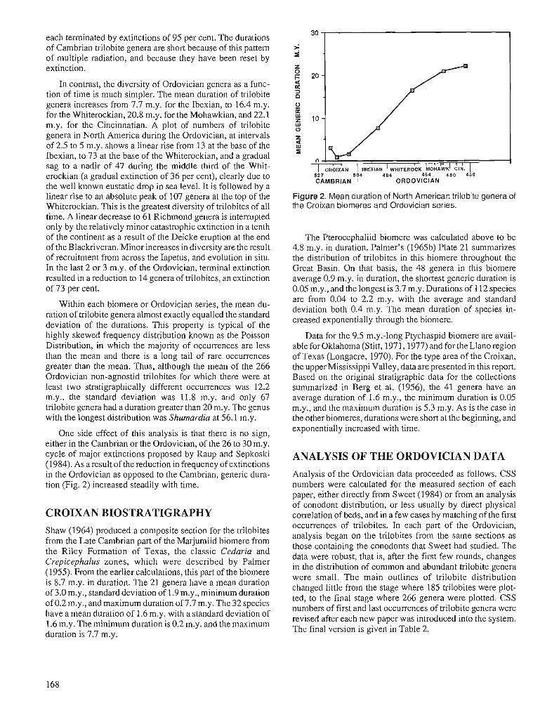
each terminated by extinctions of 95 per cent. The durations of Cambrian trilobite genera are short because of this pattern of multiple radiation, and because they have been reset by extinction.
In contrast, the diversity of Ordovician genera as a func- tion of time is much simpler. The mean duration of trilobite genera increases from 7.7 m.y. for the Ibexian, to 16.4 m.y. for the Whiterockian, 20.8 m.y. for the Mohawkian, and 22.1 m.y. for the Cincinnatian. A plot of numbers of trilobite genera in North America during the Ordovician, at intervals of 2.5 to 5 m.y. shows a linear rise from 13 at the base of the Ibexian, to 73 at the base of the Whiterockian, and a gradual sag to a nadir of 47 during the middle third of the Whit- erockian (a gradual extinction of 36 per cent), clearly due to the well known eustatic drop in sea level. It is followed by a linear rise to an absolute peak of 107 genera at the top of the Whiterockian. This is the greatest diversity of trilobites of all time. A linear decrease to 61 Richmond genera is interrupted only by the relatively minor catastrophic extinction in a tenth of the continent as a result of the Deicke eruption at the end of the Blackriveran. Minor increases in diversity are the result of recruitment from across the Iapetus, and evolution in situ. In the last 2 or 3 m.y. of the Ordovician, terminal extinction resulted in a reduction to 14 genera of trilobites, an extinction of 73 per cent.
Within each biomere or Ordovician series, the mean du- ration of trilobite genera almost exactly equalled the standard deviation of the durations. This property is typical of the highly skewed frequency distribution known as the Poisson Distribution, in which the majority of occurrences are less than the mean and there is a long tail of rare occurrences greater than the mean. Thus, although the mean of the 266 Ordovician non-agnostid trilobites for which there were at least two stratigraphically different occurrences was 12.2 m.y., the standard deviation was 11.8 m.y. and only 67 trilobite genera had a duration greater than 20 m.y. The genus with the longest distribution was Shumardia at 56.1 m.y.
One side effect of this analysis is that there is no sign, either in the Cambrian or the Ordovician, of the 26 to 30 m.y. cycle of major extinctions proposed by Raup and Sepkoski (1984). As a result of the reduction in frequency of extinctions in the Ordovician as opposed to the Cambrian, generic dura- tion (Fig. 2) increased steadily with time.
CROIXAN BIOSTRATIGRAPHY Shaw (1964) produced a composite section for the trilobites from the Late Cambrian part of the Marjumiid biomere from the Riley Formation of Texas, the classic Cedaria and Crepicephalus zones, which were described by Palmer (1955). From the earlier calculations, this part of the biomere is 8.7 m.y. in duration. The 21 genera have a mean duration of 3.0 m.y., standard deviation of 1.9 m.y., minimum duration of 0.2 m.y., and maximum duration of 7.7 m.y. The 32 species have a mean duration of 1.6 m.y. with a standard deviation of 1.6 m.y. The minimum duration is 0.2 m.y. and the maximum duration is 7.7 m.y.
20 -
10 -
n CROIXAN I ~ E X I A N 1 WHITEROCK LO HAWK^ CIN.
IU1 1 I
5 2 7 504 4 8 4 4 6 4 4 5 0 4 3 8 CAMBRIAN I ORDOVICIAN
Figure 2. Mean duration of North American trilobite genera of the Croixan biomeres and Ordovician series.
The Pterocephaliid biomere was calculated above to be 4.8 m.y. in duration. Palmer's (1965b) Plate 21 summarizes the distribution of trilobites in this biomere throughout the Great Basin. On that basis, the 48 genera in this biomere average 0.9 m.y. in duration, the shortest generic duration is 0.05 m.y., and the longest is 3.7 m.y. Durations of 112 species are from 0.04 to 2.2 m.y. with the average and standard deviation both 0.4 m.y. The mean duration of species in- creased exponentially through the biomere.
Data for the 9.5 m.y.-long Ptychaspid biomere are avail- able for Oklahoma (Stitt, 1971,1977) and for theLlano region of Texas (Longacre, 1970). For the type area of the Croixan, the upper Mississippi Valley, data are presented in this report. Based on the original stratigraphic data for the collections summarized in Berg et al. (1956), the 41 genera have an average duration of 1.6 m.y., the minimum duration is 0.05 m.y., and the maximum duration is 5.3 m.y. As is the case in the other biomeres, durations were short at the beginning, and exponentially increased with time.
ANALYSIS OF THE ORDOVICIAN DATA Analysis of the Ordovician data proceeded as follows. CSS numbers were calculated for the measured section of each paper, either directly from Sweet (1984) or from an analysis of conodont distribution, or less usually by direct physical correlation of beds, and in a few cases by matching of the first occurrences of trilobites. In each part of the Ordovician, analysis began on the trilobites from the same sections as those containing the conodonts that Sweet had studied. The data were robust, that is, after the first few rounds, changes in the distribution of common and abundant trilobite genera were small. The main outlines of trilobite distribution changed little from the stage where 185 trilobites were plot- ted, to the final stage where 266 genera were plotted. CSS numbers of first and last occurrences of trilobite genera were revised after each new paper was introduced into the system. The final version is given in Table 2.
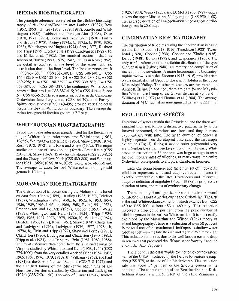
IBEXIAN BIOSTRATIGRAPHY
The principle references consulted on the trilobite biostratig- raphy of the IbexianJCanadian are: Poulsen (1937), Ross (1952, 1953), Hintze (1953, 1979, 1982), Kindle and Whit- tington (1958), Robison and Pantojas-Alor (1968), Dean (1970, 1971, 1973), Fortey and Skevington (1970), Fortey and Bruton (1973). Fortey (1974a, b, 1975a, b, 1979,1980, 1983), Whittington and Hughes (1974), Stitt (1977), Rushton and Tripp (1979), Fortey et al. (1982), Ludvigsen (1982a, b), and Miller et al. (1982). The standard section is the Ibex section of Hintze (1953, 1979, 1982), but as in Ross (1952), the detail is confined to the level of the zones, with no distribution data at the finer level. The Ibexian zones are: B = CSS 76-138; C = CSS 138-140; D = CSS 140-148; E = CSS 164-188; F = CSS 188-200; G1 = CSS 200-230; G2 = CSS 230-298; H = CSS 198-339; I = CSS 339-362; J = CSS 362-384; K = CSS 384-387. The continuing Whiterockian zones at Ibex are L = CSS 387-415; M = CSS 415-463; and N = CSS 463-515. There is much finer detail in the Cambrian- Ordovician boundary zones (CSS 64-79), and Fortey's Spitzbergen studies (CSS 140-495) provide very fine detail across the Ibexian-Whiterockian boundary. The average du- ration for agnostid Ibexian genera is 7.7 m.y.
WHITEROCKIAN BIOSTRATIGRAPHY In addition to the references already listed for the Ibexian, the major Whiterockian references are: Whittington (1961, 1965b), Whittington and Kindle (1963), Shaw (1968, 1974), Ross (1970, 1972), and Ross and Shaw (1972). The major studies are those of Ross (op. cit.) for the Great Basin (CSS 350-750), Shaw (1968, 1974) for Oklahoma (CSS 350-825) and the Chazyan of New York (CSS 680-800), and Whitting- ton (1961,1965b) (CSS 387-680) for western Newfoundland. The average duration for 164 Whiterockian non-agnostid genera is 16.4 m.y.
MOHAWKIAN BIOSTRATIGRAPHY The distribution of trilobites during the Mohawkian is based on data from Clarke (1894), Bradley (1925, 1930), Teichert (1937), Whittington (1941, 1950a, b, 1952a, b, 1953, 1954, 1956,1959,1963, 1965a, b, 1966, 1968), Evitt (1951, 1953), Frederickson and Pollack (1952), Cooper (1953), Weiss (1953), Whittington and Evitt (1953, 1954), Tripp (1954, 1962, 1965, 1967, 1976, 1979, 1980a, b), Williams (1962), DeMott (1963,1987), Ross (1967), Shaw (1974), Chatterton and Ludvigsen (1976), Ludvigsen (1976, 1977, 1978a, b, 1979a, b), Evitt and Tripp (1977), Shaw and Fortey (1977), Chatterton (1980), Ludvigsen and Chatterton (1980, 1982), Tripp et al. (1981), and Tripp and Evitt (1981, 1983, 1986). The most extensive data come from the silicified faunas of Virginia studied by Whittington and Evitt (1953,1954) (CSS 775-1000), from the very detailed work of Tripp (1954,1962, l965,1967,1976,1979,1980a, b), Williams (1962), andPaul (1981) on the Girvan faunas of Scotland (CSS 718-1277), and the silicified faunas of the Mackenzie Mountains of the Northwest Territories studied by Chatterton and Ludvigsen (1976) (CSS 750-1 150). The work of Clarke (1894), Bradley
(1925,1930), Weiss (1953), and DeMott (1963,1987) amply covers the upper Mississippi Valley region (CSS 950-1 100). The average duration of 114 Mohawkian non-agnostid trilo- bite genera is 20.8 m.y.
CINCINNATIAN BIOSTRATIGRAPHY The distribution of trilobites during the Cincinnatian is based on data from Slocum (1913, 191 6), Troedsson (1928), Twen- hofel (1928), Cooper (1930), Cooper and Kindle (1936), Dalve (1948), Bolton (1972), and Lesptrance (1968). The only useful reference on the trilobite distribution of the type Cincinnatian is Dalve (1948), a summary and compilation of many minor observations. A major taxonomic and biostratig- raphic review is in order. Slocum (1913, 1916) provides data on the distribution of Upper Ordovician trilobites in the upper Mississippi Valley. The other references are for Per& and Anticosti Island. In addition, there are data for the Maysvil- lian Whitehouse Group of the Girvan district of Scotland in Williams et al. (1972) and Thomas et al. (1984). The average duration of 74 Cincinnatian non-agnostid genera is 22.1 m.y.
EVOLUTIONARY ASPECTS Durations of genera within the Ordovician and the three well sampled biomeres follow a distinctive pattern. Early in the interval concerned, durations are short, and they increase exponentially with time. The mean duration of genera is highly dependent on the elapsed time since the last major extinction (Fig. 3), fitting a second-order polynomial very well. Neither the small Deicke extinction nor the early Whit- erockian extinction at 36 per cent was large enough to reset the evolutionary rates of trilobites. In many ways, the entire Ordovician corresponds to a typical Cambrian biomere.
Each Cambrian biomere and the entire set of Ordovician trilobites represents a normal adaptive radiation; each is exactly comparable to the latest Cretaceous and Paleocene adaptive radiation of ungulates (Sloan, 1987a) in progressive duration of taxa, and rates of evolutionary change.
There are only three significant extinctions in the record of trilobites in North America during the Ordovician. The first is the mid-Whiterockian extinction, which extends from CSS 450 to CSS 700, or from 483 to 469 m.y. This extinction involved a drop of 36 per cent from the peak number of trilobite genera in the earliest Whiterockian. It is most easily explained by the MacArthur and Wilson (1967) theory of island biogeography. There is a reduction of over 50 per cent in the total area of the continental shelf open to shallow water trilobites between the late Ibexian and the mid-Whiterockian. This reduction in area is due to the well known eustatic drop in sea level that produced the "Knox unconformity" and the end of the Sauk Sequence.
The second is the catastrophic extinction over the eastern half of the U.S.A. produced by the Deicke K-bentonite erup- tion (CSS 979) at the end of the Blackriveran. The extinction rate was about 17 per cent of the trilobite genera in the continent. The short duration of the Rocklandian and Kirk- fieldian stages is a direct result of the rapid community
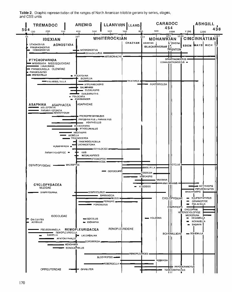
Table 2. Graphic representation of the ranges of North American trilobite genera by series, stages, and CSS units
I TREMADOC I ARENIG 1 LLANVIRN ILL AND.^ CARADOC ASHGILL , 200 300 400 500 600 700 800 900 1000 1100
4 5 4 1200
438
64 387 1 ' I IBEXIAN
LITAGNOSTUS AGNOSTlDA PSEUDAGNOSTUS I HOMAGNOSTUS I
PTYCHOPARIIDA MISSlSQUOlA MlSSlSQUOllDAE
LUNACRANIA - PARABOLINELLA OLENIDAE PARABOLINITES
WHITEROCKIAN
I MICRAGNOSTUS GERAGNOSTUS
ARTHRORHACHIS
I HIGHGATELLA I PLlCATOLlNA
BlENVlLLlA
HYPERMECASPIS
CLOACASPIS
SVALBARDITES m PSILOCARA r ANAXIMANDER
- BELLEFONTIA - PARABELLEFONTIA XENOSTEGIUM
PROTOPRESBYNILEUS
PRESBYNILEUS = PARANlLEUS ASAPHELLUS
AULACOPARIA PTYOCEPHALUS - MEGlTASPlS - NIOBELLA - TRIGONOCERCA
TRIGONOCERCELLA LACHNOSTOMA
HUNNEBERGIA m ISOTELOIDES
PARAPWCHOPYGE - MEGALASPIDES
STEGNOPSIS k NlOBE
I l l
CHAZYAN ASHBYAN 1 BLACKRIVERAN
CERATOPYG~DAE - tmCROPYGE
CYCLOPYGACEA NlLElDAE - SYMPHYSURINA
ISOCOLIDAE CALCULITES
m ACHEILUS
- PSEUDOKAINELLA
ECTENASPIS PSEUDOGYGITES
1 I
CINCINNATIAN
MAYS
TRIATHRUS m
-
k ' ~SHERM
1 EDEN TRENTON
1 1 1 B
1 1 1 I I I I I
SPHAERAGNOSTUS CORRUGATAGNOSTUS -
OGYGIOCARIS
SYMPHYSURUS - BARRANDEIA
NlLEUS PERASPIS I - PORONILEUS
= ISOCOLUS I IDIORAPHA
REMOPLEURlDACEA REMOPLEURIDIDAE REMOPLEURIDELLA
KAINELLA 1- LACORSALINA - APATOKEPHALUS E O R O B E R G I A
MENOPARiA - SCINOCEPHALUS
1 BLOSYROPSIS - ROBERGIELLA
OPIPEUTERIDAE OPIPEUTER
RICH
mBASILIELLA
VOGDESIA
HYBOASPIS
G
I I - NlLEOlDES
REMOPLEURIDES
I I HYPO?lCRANOTUS
TERATORHYNCHUS
I HOLDENIA
CYCLOPYGIDAE - EL;LIPSOTAPHRUS GIRVANOPI/GE 1 1 1 I - PYLACELP
SYMPHYSOPS
IISOTELUS
NAHANNIA
PORTERFIELDIA
1 CYCLOP+GE HETEROCYCLOPYGE '
MICROPARIA
ANATAPHRUS
¤
-
1 1 1
I FIOBERGIA
' BRACHYASPIS
BOHEMILLIDAE
I DEGAMELY
I NOVAKELLA
- B0HEMlLI-A
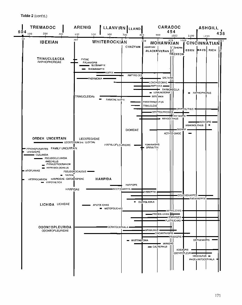
Table 2 (cont'd.)
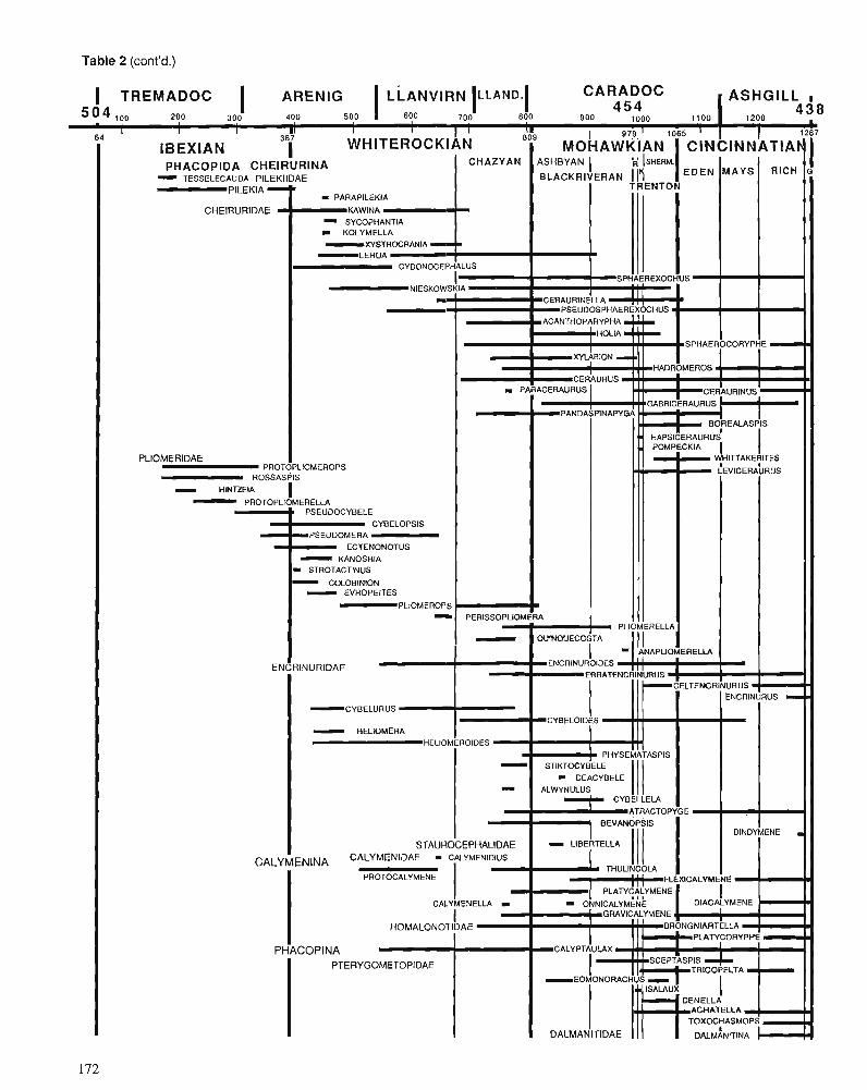
Table 2 (cont'd.)
. PHACOPIDA CHElRURlNA CHAZYAN ASHBYAN 1 ISHERM. I I
TESSELECAUDA PlLEKllDAE BLACKRIVERAN 117 EDEN ' ICH
PlLEKlA - TRENTON - PARAPlLEKlA
CHEIRURIDAE KAWlNA - SYCOPHANTIA I KOLYMELLA
-XYSTROCRANIA -- L E H U A
CYDONOCEPHALUS
I SPHAEREXOCHUS NIESKOWSKIA _ . I I
I CERAURINELIA (II 9 - PSEUDOSPHAEREX0CHUS.r I - -ACANTHOPARYPHA - I HOLlA
SPHAEROCORYPHE
GABRICERAURUS
BOREALASPIS
HAPSICERAURU~
( TREMADOC I ARENIG LLANVIRN LLAND. CARADOC ASHGILL I I 5 ? 4 l o o 200 300 400 500 , I YO 700 800 900 1000 1100 1200
PLIOMERIDAE I PROTOPLIOMEROPS
ROSSASPIS I HlNTZElA I - PROTOPLIOMERELIA
PSEUDOCYBELE CYBELOPSIS
ECTENONOTUS
9 STROTACTINUS
4 5 4
I 1 I II I 64 387 I '
- COLOBlNlON I - EVROPEITES
4 3 8 n
I ENC
WHITEROCKIAN 809
I IBEXIAN I M O C A ~ & A N ' O ~ C ; N C I N N ~ T I A ~ ~
(HITTAKE$ITES
LEVICERAURUS
I 1-1 E E V A N ~ P ~ S I I DINDYMENE STAUROCEPHALIDAE - LlBERTELLA I
P L I O M E R O P S
PLIOMERELLA - OUINOUECOSTA I I 1 ANAPLIOMERELLA
RlNURlDAE ENCRINUROIDES ' ' ERRATENCRINURUS !
CALYiENINA CALYMENIDAE - CALYMENIDIUS
I PROTOCALYMENE I I . ! FLEXICALYMENE
C Y B E L U R U S - HELIOMERA
I CALYMENELLA I ONNICALYMENE
I DIACALYMENE
I ' GRAVICALYMENE r I I
HOMALONOTIDAE BRONGNIARTELLA PLAWCORYPHE
PHACOPlNA CALYPTAULAX I
I
PTERYGOMETOPIDAE I SCEPTASPIS
I I
DALMANITIDAE r
HELIOMEROIDES - -
CYBELOIDES
STIKTOCYBELE - DEACYBELE 111 ALWYNULUS
' CYBELLELA
ATRACTOPYGE
C E L T E N C R I N U R U S
PHYSEMATASPIS
ENCRINURUS m
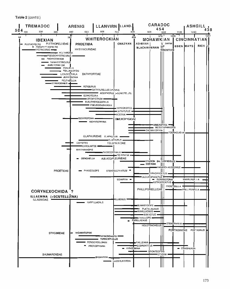
Table 2 (cont'd.)
- 'OMA -
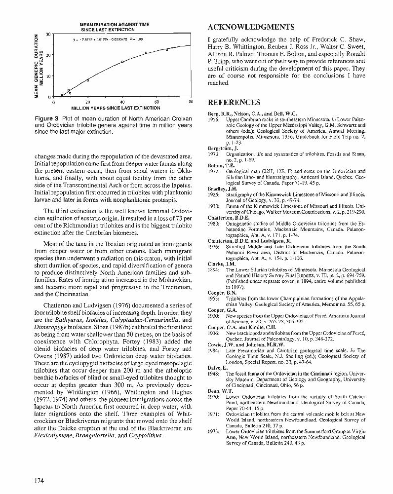
MEAN DURATION AGAINST TIME SINCE LAST EXTINCTION
0 y = - 2.6752 + 0.6122~ - 0.0035x"2 R = 1 .DO
0 20 40 60 80 MILLION YEARS SINCE LAST EXTINCTION
Figure 3. Plot of mean duration of North American Croixan and Ordovician trilobite genera against time in million years since the last major extinction.
changes made during the repopulation of the devastated area. Initial repopulation came first from deeper water faunas along the present eastern coast, then from shoal waters in Okla- homa, and finally, with about equal facility from the other side of the Transcontinental Arch or from across the Iapetus. Initial repopulation first occurred in trilobites with planktonic larvae and later in forms with nonplanktonic protaspis.
The third extinction is the well known terminal Ordovi- cian extinction of eustatic origin. It resulted in a loss of 73 per cent of the Richmondian trilobites and is the biggest trilobite extinction after the Cambrian biomeres.
Most of the taxa in the Ibexian originated as immigrants from deeper water or from other cratons. Each immigrant species then underwent a radiation on this craton, with initial short duration of species, and rapid diversification of genera to produce distinctively North American families and sub- families. Rates of immigration increased in the Mohawkian, and became more rapid and progressive in the Trentonian, and the Cincinnatian.
Chatterton and Ludvigsen (1976) documented a series of four trilobite shelf biofacies of increasing depth. In order, they are the Bathyurus, Isotelus, Calyptaulax-Ceraurinella, and Dimeropyge biofacies. Sloan (1987b) calibrated the first three as being from water shallower than 50 metres, on the basis of coexistence with Chlorophyta. Fortey (1983) added the olenid biofacies of deep water trilobites, and Fortey and Owens (1987) added two Ordovician deep water biofacies. These are the cyclopygid biofacies of large-eyed mesopelagic trilobites that occur deeper than 200 m and the atheloptic benthic biofacies of blind or small-eyed trilobites thought to occur at depths greater than 300 m. As previously docu- mented by Whittington (1966), Whittington and Hughes (1972,1974) and others, the pioneer immigrations across the Iapetus to North America first occurred in deep water, with later migrations onto the shelf. Three examples of Whit- erockian or Blackriveran migrants that moved onto the shelf after the Deicke eruption at the end of the Blackriveran are Flexicalymene, Brongniartella, and Cryptolithus.
ACKNOWLEDGMENTS
I gratefully acknowledge the help of Frederick C. Shaw, Harry B. Whittington, Reuben J. Ross Jr., Walter C. Sweet, Allison R. Palmer, Thomas E. Bolton, and especially Ronald P. Tripp, who went out of their way to provide references and useful criticism during the development of this paper. They are of course not responsible for the conclusions I have reached.
REFERENCES Berg, R.R., Nelson, C.A., and Bell, W.C. 1956: Upper Cambrian rocks in southeastern Minnesota. 61 Lower Paleo-
zoic Geology of the Upper Mississippi Valley, G.M. Schwartz and others (eds.); Geological Society of America, Annual Meeting, Minneapolis, Minnesota, 1956, Guidebook for Field Trip no. 2, p. 1-23.
Bergstrom, J. 1973: Organization, life and systematics of trilobites. Fossils and Strata,
no. 2, p. 1-69. Bolton, T.E. 1972: Geological map (22H, 12E, F) and notes on the Ordovician and
Silurian litho- and biostratigraphy, Anticosti Island, Quebec. Geo- logical Survey of Canada, Paper 71 -19,45 p.
Bradley, J.H. 1925: Stratigraphy of the Kimmswick Limestone of Missouri and Illinois.
Journal of Geology, v. 33, p. 49-74. 1930: Fauna of the Kimmswick Limestone of Missouri and Illinois. Uni-
versity of Chicago, Walker Museum Conhibutions, v. 2, p. 219-290. Chatterton, B.D.E. 1980: Ontogenetic studies of Middle Ordovician trilobites from the Es-
bataotine Formation, Mackenzie Mountains, Canada. Palaeon- tographica, Abt. A, v. 171, p. 1-74.
Chatterton, B.D.E. and Ludvigsen, R. 1976: Silicified Middle and Late Ordovician trilobites from the South
Nahanni River area, District of Mackenzie, Canada. Palaeon- tographica, Abt. A., v. 154, p. 1-106.
Clarke, J.M. 1894: The Lower Silurian trilobites of Minnesota. Minnesota Geological
and Natural History Survey Final Reports, v. 111, pt. 2, p. 694-759. (Published under separate cover in 1894, entire volume published in 1897).
Cooper, B.N. 1953: Trilobites from the lower Champlainian formations of the Appala-
chian Valley. Geological Society of America, Memoir no. 55,65 p. Cooper, G.A. 1930: New species from the Upper Ordovician of PercC. American Journal
of Science, v. 20, p. 265-28.365-392. Cooper, G.A. and Kindle, C.H. 1936: New brachiopods and trilobites from the Upper Ordovician of PcrcC,
Quebec. Journal of Paleontology, v. 10, p. 348-372. Cowie, J.W. and Johnson, M.R.W. 1984: Late Precambrian and Cambrian geological time scale. In The
Geologic Time Scale, N.J. Snelling (ed.); Geological Society of London, Special Report, no. 33, p. 47-64.
Dalve, E. 1948: The fossil fauna of the Ordovician in the Cincinnati region. Univer-
sity Museum, Depamnent of Geology and Geography, University of Cincinnati, Cincinnati, Ohio, 56 p.
Dean, W.T. 1970: Lower Ordovician trilobites from the vicinity of South Catcher
Pond, northeastern Newfoundland. Geological Survey of Canada, Paper 70-44, 15 p.
1971: Ordovician trilobites from the central volcanic mobile belt at New World Island, northeastern Newfoundland. Geological Survey of Canada. Bulletin 210.37 D.
1973: ~ o w e r Ordovician trilobites from the Summerford Group at Virgin Arm. New World Island. northeastern Newfoundland. Geoloeical survey of Canada, ~ u ~ l e h n 240.43 p.
-
DeMott, L.L. 1963: Middle Ordovician trilobites of the Upper Mississippi Valley. Un-
published Ph.D. thesis, Harvard University, 236 p. 1987: Platteville and Decorah trilobites from Illinois and Wisconsin. In
Middle and Late Ordovician Lithostratigraphy and Biostratigraphy of the Upper Mississippi Valley, R.E. Sloan (ed.); Minnesota Geo- logical Survey, Report of Investigations, no. 35, p. 63-98.
Evitt, W.R. 1951: Some Middle Ordovician trilobites of the families Cheimridae,
Harpidae and Lichidae. Journal of Paleontology, v. 25, p. 587-616. 1953: Observations on the trilobite Ceraurus. Journal of Paleontology,
V. 27, p. 33-48. Evitt, W.R. and Tripp, R.P. 1977: Silicified Middle Ordovician trilobites from the families Encrinuri-
dae and Staurocephalidae. Palaeontographica, Abt. A, Bd. 157, p. 109-174.
Fortey, R.A. 1974a: A new pelagic hilobite from the Ordovician of Spitsbergen, Ireland
and Utah. Palaeontology, v. 17, p. 11 1-124. 1974b: The Ordovician trilobites of Spitsbergen, I, Olenidae. Norsk Po-
larinstitutt Skrifter, no. 160, 120 p. 1975a: Early Ordovician trilobite communities. Fossils and Strata, no. 4,
p. 339-360. 1975b: The Ordovician trilobites of Spitsbergen, TI, Asaphidae, Nileidae,
Raphiophoridae and Telephinidae of the Valahlfonna Formation. Norsk Polarinstitutt Skrifter, no. 162,207 p.
1979: Early Ordovician trilobites from the Catoche Formation (St. George Group), western Newfoundland. Geological Survey of Canada, Bulletin 321, p. 61-1 14.
1980: The Ordovician trilobites of Spitsbergen, 111, remaining trilobites of the Valhalfonna Formation. Norsk Polarinstitutt Skrifter, no. 171, 163 p.
1983: Cambrian-Ordovician trilobites from the boundary beds in western Newfoundland and their phylogenetic significance. Special Papers in Palaeontology, no. 30, p. 179-21 1.
Fortey, R.A. and Bruton, D.L. 1973: Cambrian-Ordovician rocks adjacent to Hinlopenshetet, North Ny
Friesland, Spitsbergen. Geological Society of America Bulletin, v. 84, p. 2227-2242.
Fortey, R.A. and Chatterton, B.D.E. 1988: Classification of the trilobite suborder Asaphina. Palaeontology,
v. 3 1, p. 165-222. Fortey, R.A. and Owens, R.M. 1975: Proetida- a new order of trilobites. Fossils and Strata, no. 4,
p. 227-239. 1987: The Arenig Series in South Wales. Bulletin of the British Museum
O\latural Histo~y), v. 41, no. 3, p. 69-307. Fortey, R.A. and Skevington D. 1980: Correlation of Cambrian-Ordovician boundary between Europe and
North America: new data from western Newfoundland. Canadian Journal of Earth Sciences, v. 17, p. 382-388.
Fortey, R.A., Landing, E., and Skevington, D. 1982: Cambrian-Ordovician boundary sections in the Cow Head Group,
western Newfoundland. In The Cambrian-Ordovician Boundary: Sections, Fossil Distributions, and Correlations, M.G. Bassett and W.T. Dean (eds.); National Museum of Wales, Geological Series, no. 3, p. 95-130.
Frederickson, E.A. and Pollack, J.M. 1952: Two Ordovician genera from the Harding Formation (Ordovician)
of Colorado. Journal of Paleontology, v. 26, p. 641-644. Hintze, L.F. 1953: Lower Ordovician trilobites from western Utah and eastern Nevada.
Utah Geological and Mineralogical Survey, Bulletin 48,249 p. 1979: Preliminary zonations of Lower Ordovician of western Utah by
various taxa. Brigham Young University, Geology Studies, v. 26, p. 13-19.
1982: Ibexian Series (Lower Ordovician) type section, western Utah, U.S.A. In The Ordovician System in the United States, R.J. Ross, Jr. and 27 other (eds.); International Union of Geological Sciences, Publication 12, p. 7-10.
Holland, C.H. 1971: Cambrian of the New World. Wiley-Interscience, New York,
456 p. Kindle, C.H. and Whittington, H.B. 1958: Stratigraphy of the Cow Head region, western Newfoundland. Geo-
logical Society of America Bulletin, v. 69, p. 315-342.
Kunk, M.J. and Sutter, J.F. 1984: 40Ar139Ar age spectrum dating of biotite from Middle Ordovician
bentonites, eastern North America. In Aspects of the Ordovician System, D.L. Bmton (ed.): Palaeontological Contributions from the University of Oslo, no. 295, Universitetsforlaget, p. 11-22.
Lane, P.D. and Thomas, A.T. 1983: A review of the trilobite suborder Scutelluina. Special Papers in
Palaeontology, no. 30, p. 141-160. Lesperance, P. 1968: Ordovician and Silurian trilobite faunas of the White Head Forma-
tion, Perc6 region, Quebec. Journal of Paleontology, v. 42, p. 811-826.
Lochman-Balk, C. and Wilson, J.L. 1958: Cambrian biostratigraphy in North America. Journal of Paleontol-
ogy, v. 32, p. 312-350. Longacre, S.A. 1970: Trilobites of the Upper Cambrian Ptychaspid biomere Wilberns
Formation, central Texas. Journal of Paleontology, v. 44, no. 1, pt. 11, p. 1-70.
Ludvigsen, R. 1976: New cheimrinid trilobites from the lower Whittaker Formation
(Ordovician),.southern Mackenzie Mountains. Canadian Journal of Earth Sciences, v. 23, p. 947-959.
1977: The Ordovician trilobite Ceruurinus Barton in North America. Journal of Paleontology, v. 51, p. 959-972.
1978a: Middle Ordovician trilobite biofacies, southern Mackenzie Moun- tains. In Western and Arctic Canadian Biostratigraphy, C.R. Stelck and B.D.E. Chatterton (eds.); Geological Association of Canada, Special Paper no. 18, p. 1-37.
1978b: The trilobites Bathyurus and Eornonorachus from the Middle Ordo- vician of Oklahoma and their biofacies significance. Royal Ontario Museum, Life Sciences Contributions no. 114, p. 3-18.
1979a: A trilobite zonation of Middle Ordovician rocks, southwestern District of Mackenzie. Geological Survey of Canada, Bulletin 312, 99 p.
1979b: Fossils of Ontario, part 1: the trilobites. Royal Ontario Museum, Life Sciences Division, Miscellaneous Publication, 96 p.
1982a: The Cambrian-Ordovician boundary in the western district of Mack- enzie, Canada. In The Cambrian-Ordovician Boundary: Sections, Fossil Distributions, and Correlations, M.G. Bassett and W.T. Dean (eds.); National Museum of Wales, Geological Series, no. 3, p. 131-140.
1982b: Upper Cambrian and Lower Ordovician trilobite biostratigraphy of the Rabbitkettle Formation, western District of Mackenzie. Royal Ontario Museum, Life Sciences, Contribution no. 134, 188 p.
Ludvigsen, R. and Chatterton, B.D.E. 1980: The Ontogeny of Failleana and the origin of the Bumastinae (Tri-
lobita). Geological Magazine, v. 117, p. 471-478. 1982: Ordovician Pterygometopidae (Trilobita) of North America. Cana-
dian Journal of Earth Sciences, v. 19, p. 2179-2206. MacArthur, R.H. and Wilson, E.O. 1967: The Theory of Island Biogeography. Princeton University Press,
Princeton, N.J., 203 p. Miller, J.F., Taylor, M.E., Stitt, J.H., Ethington, R.F., Hintze, L.F., and Taylor, J.F. 1982: Potential Cambrian-Ordovician boundary stratotype sections in the
western United States. In The Cambrian-Ordovician Boundary: Sections, Fossil Distributions and Correlations, M.G. Bassett and W.T. Dean (eds.); National Museum of Wales, Geological Series, no. 3, p. 141-154.
Moore, R.C. (ed.) 1959: Treatise on Invertebrate Paleontology, Part 0 , Arthropoda 1. Geo-
logical Society of America, 560 p. Palmer, A.R. 1955: The faunas of the Riley Formation in central Texas. Journal of
Paleontology, v. 28, p. 709-786. 1965a: Biomere - a new kind of stratigraphic unit. Journal of Paleontol-
ogy, v. 39, p. 149-153. 1965b: Trilobites of the Late Cambrian Pterocephaliid biomere in the Great
Basin, United States. United States Geological Survey, Professional Paper 493, 105 p.
197 1: The Cambrian of the Great Basin and adjacent areas, western United States. In Cambrian of the New World, C.H. Holland (ed.); Wiley- Interscience, New York, p. 1-78.
1984: The biomere problem: evolution of an idea. Journal of Paleontology, V. 58, p. 599-61 1.
Palmer, A.R. and Halley, R.B. 1979: Physical stratigraphy and trilobite biostratigraphy of the Carrara
Formation (Lower and Middle Cambrian) in the southern Great Basin. United States Geological Survey, Professional Paper 1047, 131 p.
Poulsen, C. 1937: On the Lower Ordovician faunas of East Greenland. Meddelelser
om GrOnland, Bd. 1 19, no. 3, 11 1 p. Raup, D.M. and Sepkoski, J.J., Jr. 1984: Periodicities of extinctions in the geologic past. Proceedings of the
National Academy of Science, v. 81, p. 801-805. Robison, R.A. and Pantojas-Alor, J. 1968: Tremadocian hilobites from the Nochixtlan region, Oaxaca, Mex-
ico. Journal of Paleontology, v. 42, p. 767-800. Ross, R.J., Jr. 1952: Stratigraphy of the Garden City Formation in northeastern Utah. and
its trilobite faunas. Peabody Museum of Natural History, Yale University Bulletin 6, 161 p.
1953: Additional Garden City (early Ordovician) trilobites. Journal of Paleontology, v. 27, p. 633-646.
1967: Calymenid and other Ordovician trilobites from Kentucky and Ohio. United States Geological Survey, Professional Paper 583-B, p. B1-B19.
1970: Ordovician brachiopods, trilobites and stratigraphy in east and central Nevada. United States Geological Survey, Professional Pa- per 639,103 p.
1972: Fossils from the Ordovician bioherm at Meiklejohn Peak, Nevada. United States Geological Survey, Professional Paper 685.47 p.
Ross, R.J., Jr. et al. 1982: The Ordovician System and the United States. International Union
of Geological Sciences, Publication 12,73 p. Ross R.J., Jr. and Naeser, C.W. 1984: The Ordovician time scale - new refinements. It1 Aspects of the
Ordovician System, D.L. Bruton (ed.); Palaeontological Contribu- tions from the University of Oslo, no. 295, Universitetsforlaget, p. 5- 10.
Ross, R.J., Jr. and Shaw, F.C. 1972: Distribution of the Middle Ordovician Copenhagen Formation and
its trilobites in Nevada. United States Geological Survey, Profes- sional Paper 749. p. 1-33.
Rushton, A.W.A. and Tripp, R.P. 1979: A fossiliferous lower Canadian (Tremadoc) boulder from the Benan
Conglomerate of the Girvan District. Scottish Journal of Geology, V. 15, p. 321-327.
Shaw, A.B. 1964: Time in Stratigraphy. McGraw-Hill Book Co., Ncw York, 363 p. Shaw F.C. 1968: Early Middle Ordoviciin Chazy trilobites of New York. New York
State Museum, Memoir 17, 163 p. 1974: Simpson Group (Middle Ordovician) hilobites of Oklahoma. Jour-
nal of Paleontology, v. 48, no. 5, pt. 2,54 p. Shaw, F.C. and Fortey, R.A. 1977: Middle Ordovician facies and trilobite faunas in North America.
Geological Magazine, v. 114, p. 409-496. Sloan, R.E. 1987a: Paleocene and latest Cretaceous mammal ages, biozones, magneto-
zones, rates of sedimentation, and evolution. h The Cretaceousner- tiary boundary in the San Juan and Raton Basins, J. Fassett and J.K. Rigby, Jr. (eds.); Geological Society of America, Special Paper no. 209, p. 165-200.
1987b: Tectonics, biostratigraphy and lithostratigraphy of the Middle and Late Ordovician of the upper Mississippi Valley. In Middle and Late Ordovician Lithostratigraphy and Biostratigraphy of the Upper Mississippi Valley, R.E. Sloan (ed.); Minnesota Geological Survey, Report of Investigations 35, p. 7-20.
Slocum, A.W. 1913: New trilobites from the Maquoketa beds of Fayette County, Iowa.
Chicago, Field Museum of Natural History Publication, Geological Series, v. 4, p. 43-83.
1916: Trilobites from the Maquoketa beds of Fayette County, Iowa. Iowa Geological Survey Bulletin, v. 27, p. 187-237 (reprint, with revi- sions, of Slocum, 191 3).
Snelling, N.J. 1984: An interim time scale. In The Geologic Time Scale, N.J. Snelling
(ed.); Geological Society of London, Special Report no. 33, p. 261-265.
Stitt, J.H. 1971: Late Cambrian and earliest Ordovician trilobites, Timbered Hills
and Lower Arbuckle groups, western Arbuckle Mountains, Murray County, Oklahorna. Oklahoma Geological Survey, Bulletin 110, p. 1-83.
1977: Late Cambrian and earliest Ordovician trilobites, Wichita Moun- tains area, Oklahoma. Oklahoma Geological Survey, Bulletin 124, p. 1-79.
Sweet, W.C. 1984: Graphic correlation of upper Middle and Upper Ordovician rocks,
North American Midconhnent Province, U.S.A. In Aspects of the Ordovician System, D.L. Bruton (ed.); Palaeontological Contribu- tions from the University of Oslo, no. 295, Universitetsforlaget, p. 23-35.
Teichert, C. 1937: A new Ordovician fauna from Washington Land, North Greenland.
Meddelelser om Grpinland, Bd. 119, p. 1-65. Thomas, A.T. and Owens, R.M. 1978: A review of the trilobite family Aulacopleuridae. Palaeontology,
v. 21, p. 65-81. Thomas, A.T., Owens, R.M., and Rushton, A.W.A. 1984: Trilobites in British stratigraphy. Geological Society of London,
Special Report 16,78 p. Tripp, R.P. 1954: Caradocian trilobites from mudstones in Craighead Quarry, near
Girvan, Ayrshire. Transactions of the Royal Society of Edinburgh, v. 62, part 3, p. 655-693.
1962: Trilobites from the conjinis flags (Ordovician) of the Girvan Dis- trict, Ayrshire. Transactions of the Royal Society of Edinburgh, V. 65, p. 1-40.
1965: Trilobites from the Albany division (Ordovician) of the Girvan District, Ayrshire. Paleontology, v. 8, p. 577-603.
1967: Trilobites from the upper Stinchar Limestone (Ordovician) of the Girvan District, Ayrshire. Transactions of the Royal Society of Edinburgh, v. 67, p. 43-93.
1976: Trilobites from the basal supersfes mudstones (Ordovician) at Al- dons Quany, near Girvan, Scotland. Transactions of the Royal Society of Edinburgh, v. 69, p. 369-423.
1979: Trilobites from the Ordovician Auchensoul and Stinchar limestones of the Girvan District, Strathclyde. Palaeontology, v. 22, p. 339-361.
1980a: Trilobites from the Ordovician Ardwell Group of the Craighead Inlier, Girvan District, Scotland. Transactions of the Royal Society of Edinburgh, Earth Sciences, v. 71, p. 147-157.
1980b: Trilobites from the Ordovician Balclatchie and lower Ardwell groups of the Girvan District, Scotland. Transactions of the Royal Society of Edinburgh, Earth Sciences, v. 71, p. 123-145.
Tripp, R.P. and Evitt, W.R. 1981: Silicified Lichidae (Trilobita) from the Middle Ordovician of Vir-
ginia. Geological Magazine, v. 118, p. 665-677. 1983: Silicified trilobites of the genus Dimeropyge from the Middle
Ordovician of Virginia. Special Papers in Palaeontology, no. 30, p. 229-240.
1986: Silicified trilobites of the family Asaphidae from the Middle Ordo- vician of Virginia. Palaeontology, v. 29, p. 705-724.
Tripp, R.P., Williams, A., and Paul, C.R.C. 1981: On an exposure of the Ordovician supersfes mudstones at Colmo-
nell, Girvan District, Swathclyde. Scottish Journal of Geology, v. 17, p. 21-25.
Troedsson, G.T. 1928: On the Middle and Upper Ordovician faunas of Northern Greenland
Part 11. Meddelelser om Grpinland, v. 72, 198 p. Twenhofel, W.H. 1928: Geology of Anticosti Island. Geological Survey of Canada, Memoir
154,351 p. Weiss, M.P. 1953: The stratigraphy and stratigraphic paleontology of the upper Middle
Ordovician rocks of Fillmore County, Minnesota. Unpublished Ph.D. thesis, University of Minnesota, 615 p.
Whittington, H.B. 1941: The Trinucleidae - with special reference to North American
genera and species. Journal of Paleontology, v. 15, p. 21-41. 1950a: Dolichoharpes and the origin of the harpid fringe. American Journal
of Science, v. 247, p. 276-285. 1950b: Sixteen Ordovician genotype trilobites. Journal of Paleontology,
V. 24, p. 551-565. 19521: A unique remopleurid trilobite. Breviora, v. 17,6 p.
Whittington, H.B. (cont'd.) 1952b: The trilobite family Dionidae. Journal of Paleontology, v. 26,
p. 1-1 1. 1953: North American Bathyuridae and Leiostegidae (Trilobita). Jou~nal
of Paleontology, v. 27, p. 647-678. 1954: Ordovician trilobites from Silliman's Fossil Mount. 111 Ordovician
Cephalopod Fauna of Baffin Island, A.K. Miller et al.; Geological Society of America, Memoir 62, p. 119-141.
1956: Silicified Middle Ordovician trilobites; the Odontopleuridae. Har- vard University, Museum of Comparative Zoology, Bulletin no. 114, p. 15-288.
1959: Silicified Middle Ordovician trilobites: Remopleuridae, Trinuclei- dae, Raphiophoridae, Endymionidae. Harvard University, Museum of Comparative Zoology, Bulletin no. 121, p. 369-496.
1961: Middle Ordovician Pliomeridae (Trilobita) from Nevada, New York, Quebec, Newfoundland. Journal of Paleontology, v. 35, p. 91 1-922.
1963: Middle Ordovician trilobites from Lower Head, western Newfound- land. Harvard University, Museum of Comparative Zoology, Bul- letin no. 129, p. 1-129.
1965a: Platycoryphe, an Ordovician homalonotid trilobite. Joumal of Pa- leontology, v. 39, p. 487-4911
1965b: Trilobites of the Ordovician Table Head Formation, western New- foundland. Harvard University, Museum of Comparative Zoology, Bulletin no. 132, p. 275-442.
1966: Phylogeny and distribution of Ordovician trilobites. Journal of Paleontology, v. 40, p. 263-308.
Whittington, H.B. (cont'd.) 1968: Cryplolirhus (Trilobita): specific characters and occurrence in 0r -
dovician of eastern North America. Journal of Paleontology, v. 42, p. 702-7 14.
Whittington, H.B. and Evitt, W.R. 1953: The exoskeleton of Flexicalymene (Trilobita). Joumal of Paleontol-
ogy, v. 27, p. 49-55. 1954: Silicified Middle Ordovician trilobites. Geological Society of
America, Memoir 59, 137 p. Whittington, H.B. and Hughes, C.P. 1972: Ordovician geography and faunal provinces deduced from trilobite
distribution. Philosophical Transactions, Royal Society of London, v. 263, p. 236-278.
1974: Geography and faunal provinces in the Tremadoc Epoch. Society of Economic Paleontology and Mineralogy, Special Publication no. 21, p. 203-218.
Whittington, H.B. and Kindle, C.H. 1963: Middle Ordovician Table Head Formation, western Newfoundland.
Geological Society of America Bulletin, v. 74, p. 745-758. Williams, A. 1962: The Barr and lower Ardmill Series (Caradoc) of the Girvan District,
south-west Ayrshire, with descriptions of the Brachiopoda. Geo- logical Society of London, Memoir 3, 267 p.
Williams, A., Strachan, S., Bassett, D.A., Dean, W.T., Ingham, J.K., Wright, A.D., and Whittington, H.B. 1972: Ordovician. Geological Society of London, Special Report no. 3,
74 p.

Hirnantian trilobites and brachiopods in space and time
Alan W. 0wen1, David A.T. ~ a r ~ e r ~ , and Rong, Jia-yu 3
Owen, A.W., Harper, DA.T., and Rong, J., Hirnantian trilobites and brachiopods in space and time; & Ordovician Geology, C.R. Barnes and S.H. Williams (ed.), Geological Survey of Canada, Paper 90-9, p. 179-190; 1991.
Abstract
A global review of the range and distribution of Hirnantian shelly faunas reveals some marked contrasts. The brachiopods show a distinct latitudinal zonation, with the various associations of the typical Hirnantia Fauna widespread in subtropical and temperate latitudes, and the very different, diverse, Edgewood Fauna typifying equatorial regions. The Hirnantia Fauna includes some highly diverse assemblages and represents a mixture of some of the more eurytopic taxa from several earlier biotas as well as some genera whose provincial origins are not clear. The Hirnantia Fauna became extinct prior to the end of the Hirnantian. The trilobites suffered major extinction at the Rawtheyan-Hirnantian boundary and few Hirnantian assemblages contain more than I0 genera (most considerably less). Most genera are known from only a few sites and are simply relicts of earlier faunas in the area. The only commonly occurring association is that of a dalmanitine (DalmanitinalMucronaspis) and a homalonotid (Brongniar- tellalPlatycotyphe) in some cases with the odontopleurid Leonaspis. This association had a greater depth and latitudinal range than that of the typical Hirnantia Fauna and persisted to the end of the Hirnantian. Analysis of the fate of Rawtheyan trilobite genera across a wide ecological spectrum shows that extinctions were disproportionately concentrated in deeper water environments. The same may-apply to the brachi- opods, with the extinction of most elements of the deep water Foliomena Fauna at the end of the Rawtheyan.
Une ktude de la rkpartition stratigraphique et gkographique mondiale des faunes coquillkres hirnan- tiennes fait ressortir certaines diffe'rences marque'es. Les brachiopodes prksentent une nette zonation latitudinale, les diverses associations de la faune a Hirnantia typique ktant rkpandues d des latitudes subtropicales et tempkrkes tandis que la faune &Edgewood, varike et trbs diffkrente, caractkrise les rkgions kquatoriales. La faune a Hirnantia comprend quelques assemblages t r b variks et repre'sente un me'lange de certains des taxons plus eurytopiques de biotes plus anciennes et de certains genres dont l'origine provinciale n'est pas kvidente. La faune a Hirnantia disparait avant l a j n de llHirnantien. Les trilobites conmissent une pe'riode d'ankantissement majeure h la limite du Rawtheyen et de I'Hirnantien, et tr2speu d'assemblages hirnantiens comptent plus de 10 genres (la plupart en contiennent beaucoup moins). La plupart des genres ne sont connus qu'd quelques sites; ce sont tout simplement des vestiges de faunes plus ancienms duns la rkgion. La seule association que l'on rencontre fre'quemment est celle d u n dalmanitidk (DalmanitinalMucronaspis) et d u n hornalonotidk (BrongniartellalPlatycoryphe), dans certains cas avec un odontopleuridk (Leonaspis). Cette association a une plus grande rkpartition en profondeur et en latitude que la Faune d Hirnantia typique, et elle persiste jusqu'd la fin de I'Hirnantien. L'ttude des genres de trilobites du Rawtheyen sur un vaste spectre kcologique re'vdle que les extinctions sont concentrtes de facon disproportionnte duns les eaux plus profondes. Le mEme rbultat pourrait s'appliquer aux brachiopodes, car laplupart des klkments de la faune benthique d Foliomena avaient disparu a la fin du Rawtheyen.
' Department of Geology and Applied Geology, The University, Glasgow G12 8QQ, Scotland Department of Geology, University College, Galway, Ireland Nanjing Institute of Geology and Palaeontology, Academia Sinica, Chi-Ming-Ssu, Nanjing, Peoples Republic of China
INTRODUCTION Throughout the world, the uppermost Ordovician trilobite and brachiopod faunas are distinctive and differ markedly from those of the underlying middle Ashgill in composition and (commonly) diversity. The latest Ordovician stage, the Himantian, is typified by these faunas but the base of the stage has yet to be formally defined. Its correlation with the grap- tolite zonal scheme is not firmly established and the marked provincialism of Upper Ordovician conodonts still presents major problems for international correlation (e.g., Bames and Bergstrijm, 1988). Both trilobites and brachiopods have been the focus of considerable attention in the context of the Late Ordovician extinction events (e.g., Sheehan, 1982; Brenchley and Newall, 1984; Briggs et al., 1988) and the brachiopods in particular have been influential in the positioning of the Ordovician-Silurian boundary in shelf facies (Cocks and Rickards, 1988). The timing and extent of the Upper Ordovi- cian faunal changes differed from phylum to phylum and even province to province (cf. Eckert, 1988 and Donovan, 1988 on crinoids). In general though, the major extinctions occurred at the end of the Rawtheyan and during the early to mid-Hir- nantian. By the end of the Hirnantian, many groups were beginning to diversify again (e.g., Bames, 1986).
Global reviews of the detailed composition of Hirnantian brachiopod and trilobite faunas have recently been produced by Rong and Harper (1988) and Owen (1986) respectively. They need not be repeated here, but for the present paper form a substantial database, from which we can assess the diversity, spatial and temporal distribution, and the origins and fates of these faunas. Some marked contrasts between the two groups are highlighted. In particular, it is clear that in contrast to the trilobites, there is a more substantial group of brachiopods that had a wide distribution, and new brachiopod taxa, com- munity structures, and provinces developed during the Hir- nantian.
SPATIAL DISTRIBUTION
Diversity and geographic range
Figure 1 summarizes the available data on Himantian brachi- opod and trilobite faunas at the generic level. In general, both groups show a marked decline in diversity and geographic distribution when compared to the underlying Rawtheyan Stage but there are some exceptions. This decline is most strongly marked in the trilobites.
Brachiopods
The majority of Himantian brachiopod faunas are of low diversity, commonly containing less than ten genera (Fig. 1A). Most genera are restricted to six or fewer sites but some are very widespread (Fig. 1B) and include the genera that Rong and Harper (1988) have shown to be the core of the Hirnantia Fauna. This fauna, formally named by Temple (1965), is critical for correlation of the Hirnantian Stage
(Ingham and Wright, 1970) but problems exist in defining its precise temporal range. Moreover, although widespread, it is not cosmopolitan, and Elles, who first recognized the fauna (1922), emphasized the difficulties in using what may be a "facies fauna" for chronostratigraphic correlation (Elles, 1923).
The core of the Hirnantia Fauna comprises Hirnantia itself (known from 28 sites), Dalmanella, Eostropheodonta (and the closely related Aphanomena), Hindella, Cliftonia, Kinnella, Plectothyrella, and Paromalomena. The last three of these are restricted to the Himantian. In contrast to the very widespread elements of the core, the majority of genera known from the Hirnantia Fauna as a whole have a much narrower spatial range; most occur at fewer than five sites with many restricted to a single site. Virtually all of these elements are leftovers from the diverse middle Ashgill faunas.
Of the diverse Himantian brachiopod faunas (Fig. lA), those of southwest Sichuan, west Hubei, and Bohemia are typical Hirnantia faunas. That at Garth, mid-Wales, contains a number of typical Hirnantia Fauna genera but these are numerically dominated by a large number of apparent relicts: genera unknown from other Himantian successions. The American Mid-continent Edgewood Fauna is very different from the Hirnantia Fauna (see below), and similar assem- blages from the Oslo Region are also fairly diverse.
Trilobites
Almost all Himantian trilobite faunas are of very low diver- sity (Fig. 1A). Even in the two areas where the greatest number of taxa are found, the Oslo Region (see Owen, 1981, Table 1, 1986; Brenchley and Cocks, 1982) and Anticosti Island (see Owen, 1986; LespCrance, 1988b; R. Ludvigsen, pers. comm., 1988), different trilobites occur in low diversity assemblages at different levels. The detailed distribution of trilobites at the other sites of relatively high diversity is not known.
Most trilobite genera known from the Himantian are known from very few sites and these highly endemic taxa are commonly relicts of earlier faunas in the area (Owen, 1986). The notable exceptions are the odontopleurid, Leonaspis, the homalonotids Brongniartella and Platycoryphe and, espe- cially, the dalmanitids variously ascribed to Dalmanitina and Mucronaspis (or Songxites now widely considered a subge- nus of Dalnuznitina). The diverse taxonomy affecting the dalmanitids was discussed by LespCrance (1988b, p. 363- 365), whose synonymy of the Mucronaspidinae Holloway, 1981 in the Dalmanitininae Destombes, 1972 has provided some simplification. LespCrance also discussed the distinc- tion between Dalmanitina and Mucronaspis but noted that many of the records of these taxa from the Himantian are based on insufficiently complete material or have not been adequately illustrated for generic differentiation. Conse- quently, they are treated together here pending further de- tailed taxonomic work. The same applies to the Hirnantian homalonotids. No trilobite genus is known to have appeared in the Himantian.
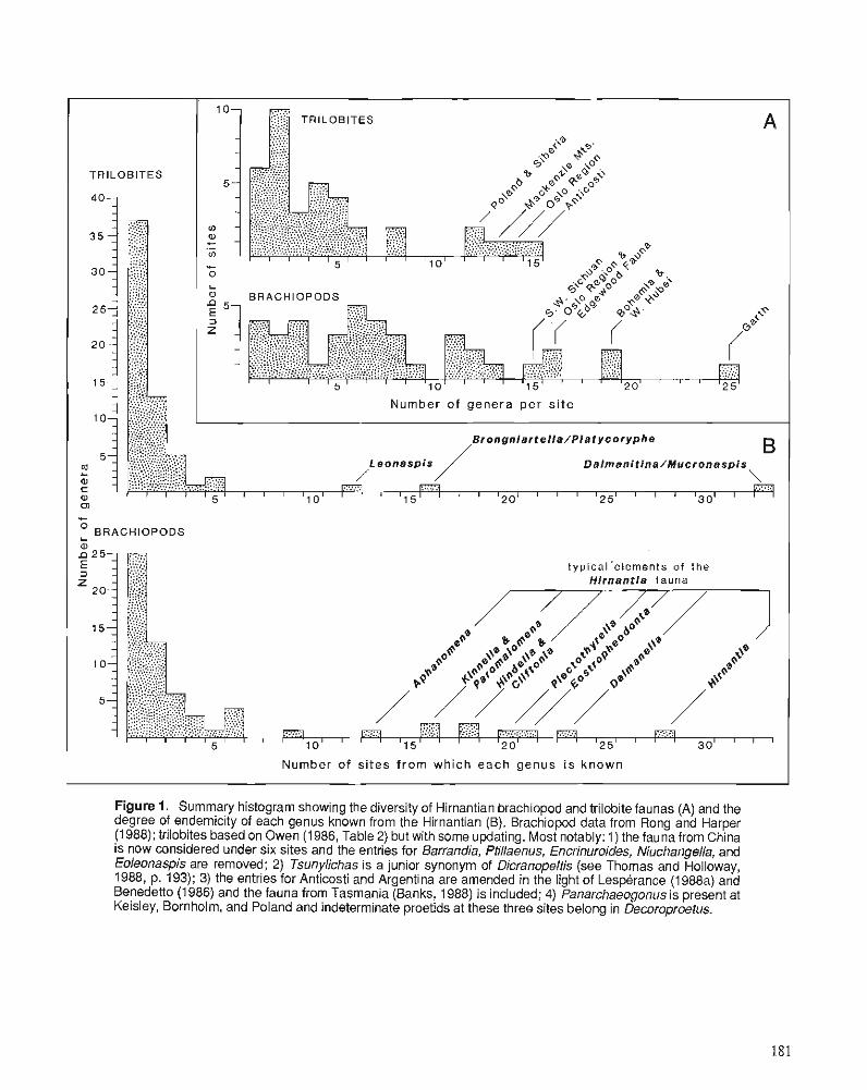
A
TRILOBITES
Number of genera per si te
Brongn ia r te l l a /P la tycoryphe
Dalmanitina/Mucronaspis B
.... \ :. 5 1 I I 1 l l 0 1 1 I 1 I l5 l I 1 1 1 2 0 1 1 I 1 1 I I I3y 1 1 7
'C
O BRACHIOPODS L
0 2 5 ..... ....... ..... ._.... ..... typical'elernents of the ........ Hirnantia fauna
5 1 0 ' '
I Number of sites from which each genus i s known I
Figure 1. Summary histogram showing the diversity of Hirnantian brachiopod and trilobite faunas (A) and the degree of endemicity of each genus known from the Hirnantian (6). Brachiopod data from Rong and Harper (1988); trilobites based on Owen (1986, Table 2) but with some updating. Most notably: I ) the fauna from China is now considered under six sites and the entries for Barrandia, Ptillaenus, Encrinuroides, Niuchangella, and Eoleonaspis are removed; 2) Tsunylichas is a junior synonym of Dicranopeltis (see Thomas and Holloway, 1988, p. 193); 3) the entries for Anticosti and Argentina are amended in the light of Lesperance (1988a) and Benedetto (1 986.) and the fauna from Tasmania (Banks, 1988) is included; 4) Panarchaeogonus is present at Keisley, Bornholm, and Poland and indeterminate proetids at these three sites belong in Decoroproetus.
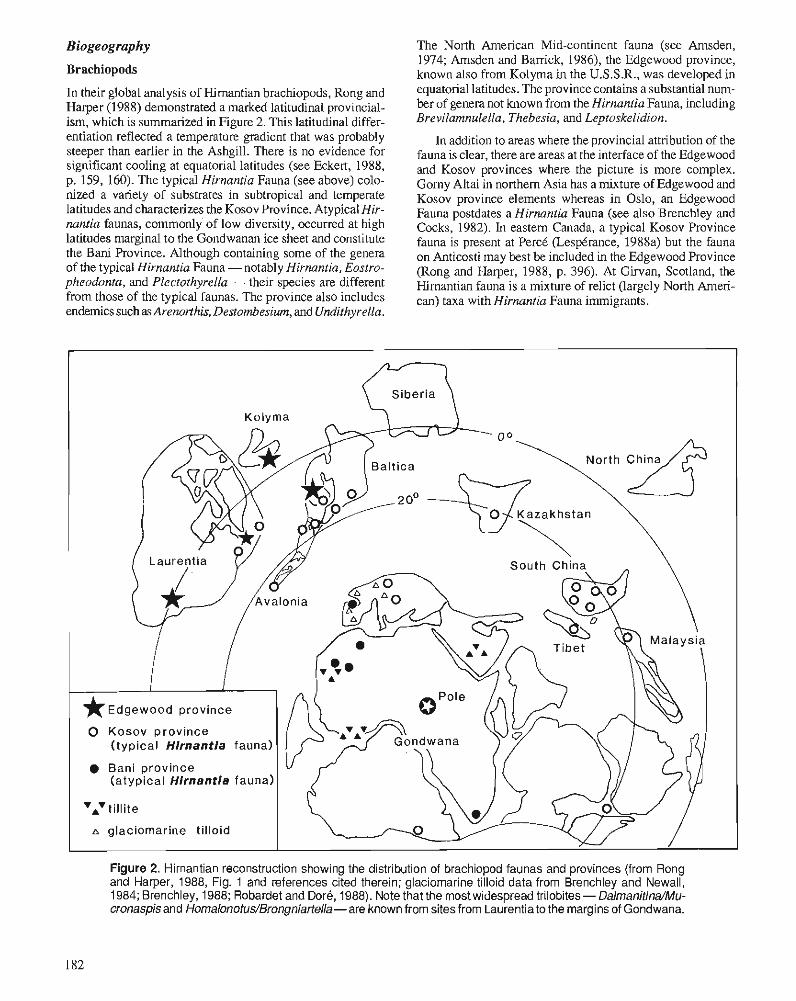
Biogeography
Brachiopods
In their global analysis of Himantian brachiopods, Rong and Harper (1988) demonstrated a marked latitudinal provincial- ism, which is summarized in Figure 2. This latitudinal differ- entiation reflected a temperature gradient that was probably steeper than earlier in the Ashgill. There is no evidence for significant cooling at equatorial latitudes (see Eckert, 1988, p. 159, 160). The typical Hirnantia Fauna (see above) colo- nized a variety of substrates in subtropical and temperate latitudes and characterizes the Kosov Province. Atypical Hir- nantia faunas, commonly of low diversity, occurred at high latitudes marginal to the Gondwanan ice sheet and constitute the Bani Province. Although containing some of the genera of the typical Hirnantia Fauna - notably Hirnantia, Eostro- pheodonta, and Plectothyrella - their species are different from those of the typical faunas. The province also includes endemics such as Arenorthis, Destombesium, and Una'ithyrella.
The North American Mid-continent fauna (see Amsden, 1974; Amsden and Barrick, 1986), the Edgewood province, known also from Kolyma in the U.S.S.R., was developed in equatorial latitudes. The province contains a substantial num- ber of genera not known from the Hirnantia Fauna, including Brevilamnulella, Thebesia, and Leptoskelidion.
In addition to areas where the provincial attribution of the fauna is clear, there are areas at the interface of the Edgewood and Kosov provinces where the picture is more complex. Gomy Altai in northern Asia has a mixture of Edgewood and Kosov province elements whereas in Oslo, an Edgewood Fauna postdates a Hirnantia Fauna (see also Brenchley and Cocks, 1982). In eastern Canada, a typical Kosov Province fauna is present at PercC (LespCrance, 1988a) but the fauna on Anticosti may best be included in the Edgewood Province (Rong and Harper, 1988, p. 396). At Girvan, Scotland, the Hirnantian fauna is a mixture of relict (largely North Arneri- can) taxa with Hirnantia Fauna immigrants.
South China
* ~ d g e w o o d province
0 Kosov province (typical Hirnantia fauna)
Bani province (atypical Hirnantia fauna)
vAvtillite
A glaciomarine tilloid
Figure 2. Hirnantian reconstruction showing the distribution of brachiopod faunas and provinces (from Rong and Harper, 1988, Fig. 1 and references cited therein; glaciomarine tilloid data from Brenchley and Newall, 1984; Brenchley, 1988; Robardet and Dore, 1988). Note that the most widespread trilobites - Dalmanitina/Mu- cronaspisand Homalonotus/Brongniartella-are known from sites from Laurentia to the margins of Gondwana.
Trilobites and Hamer (1988) have also recorded Dalmanitina in shallow
Most Himantian trilobite genera were highly endemic local remnants of earlier faunas. The few widely distributed genera - DalmanitinalMucronaspis, BrongniartellalHomalonotus and, to a lesser extent, Leonaspis - were highly eurytopic and not latitudinally constrained. They are known from the high latitude Bani Province (e.g.. Morocco), the midlatitude Kosov Province (e.g., Bohemia, Poland, China) and Mucro- naspis is known from the Edgewood Province (see LespCrance, 1988b, p. 366-369). As with the brachiopods, the Oslo Region provides an interesting mixture of faunas at the interface between the Kosov and Edgewood provinces, which is also seen in the contrast between the Anticosti and PercC faunas in eastem Canada (see LespCrance, 1988b, p. 361,362). The Girvan Fauna is restricted to North American relicts (Owen, 1986).
Bathymetry
Brachiopods
A number of authors have recognized associations or com- munities within the Hirnantia Fauna (e.g., Rong, 1979; Harper, 1981; Brenchley and Cocks, 1982; Brenchley and Cullen, 1984). Rong and Harper (1988) have shown that the fauna is best developed in Benthic Assemblage Zone 3 and especially in the deeper part of the zone. In deeper water facies (BA4-5), lower diversity faunas contain Dalmanella, Kin- nella, Parornalomena, FardenialCoolinia, and Hindella but are commonly dominated by Skenidioides and Philhe- dralPhilhedrella - forms otherwise rare in the typical Hir- nantia faunas. Shallow water variants (BA2) are commonly of low diversity and are dominated by rhynchonellids and spire bearers (see Rong and Harper, 1988, Figs. 4, 5). The Hirnantia Fauna colonized a variety of substrates and is found in mudstone (e.g., Temple, 1965; Wright, 1968), siltstone (Temple, 1965; Bergstrom, 1968), sandstone (Harper, 198 I), marl (Schonlaub, 1971), and limestone (Rong, 1979, 1984). The type Edgewood Province faunas thrived in a carbonate- forming environment in shallow, warm water with little or no siliciclastic input (Arnsden and Barrick, 1986).
Trilobites
DalmanitinalMucronaspis with a homalonotid and, in some instances, Leonaspis have been described from deeper water settings than coeval Hirnantia faunas in North Wales (Brenchley and Cullen, 1984) and at PercB, Canada (LespCrance and Sheehan, 1976, p. 720). In the latter area, the so called Mucronaspis Community has been interpreted as occupying a BA6 position (LespCrance et al., 1987, p. 123). In Bohemia, -torch (1986) recorded a low diversity "Mucro- naspis Community" of trilobites and brachiopods from the base of the Kosov Formation (interpreted as the base of the Himantian) and a rich Hirnantia Fauna from near the top of the formation (G, bohemicus Zone). However, Mucronaspis and Brongniartella are also common in the Hirnantia Fauna (*torch, 1984, p. 84). This co-occurrence is also seen else- where, most notably in parts of China where, in addition,Rong
water sLdiients of the Nancheng Shale of southern Shaanxi. Similarly, Brenchley and Cullen (1984, Table 3) also re- corded Mucronaspis in what have been interpreted as shallow water assemblages in the Himantian of the Oslo Region. Thus, as with the biogeographic distribution, the limited number of widespread Himantian trilobite genera were also bathymetrically more eurytopic than the typical Hirnantia faunas.
TEMPORAL DISTRIBUTION
Brachiopods
here are few sections available where the development of the Hirnantia Fauna may be monitored relative to graptolite biozones. Sections on the South China Plate display the relationships of the developing Hirnantia Fauna to the grap- tolite zonal scheme established within the Wufeng Shale (see Rong and Harper, 1988, for details). The first appearance of some elements of the fauna corres~ond to the D. mirus (W4) . , and P. uniformis (W5) zones. ~airnanella, Paromalomena, Leptaenu, Aphanomena, Fardenia, and Hindella are absent; the fauna, which characterizes deeper water settings appears transitional. In Tongzi County, the typical Hirnantia Fauna first appears within the P. uniformis Zone. The fauna reaches its acme in the D. bohemicus Zone (W6) (= C. extraordina- rius Zone). The Hirnantia Fauna disappeared suddenly, prior to the G. persculptus Zone of the Chinese zonal scheme, probably as a result of a severe reduction of the ventilation of the seabed. Excluding the Chinese sections, the Hirnantia Fauna of Kazakhstan and a variation on the Hirnantia Fauna documented from the English Lake District (Cocks, 1988) are recorded with persculptus Zone graptolites in terms of the British scheme. Both faunas thus represent occurrences at the younger end of the age range of the fauna. Significantly, both are from deeper water settings and the Kazakhstan fauna contains a number of mid-Ashgill relicts together with genera, but few species, of the typical Hirnantia Fauna (Koren et al., 1988). The correlation of horizons containing the Edgewood Province fauna with the graptolite zones is not known (see Arnsden and Barrick, 1986, p. 47).
Trilobites
As noted by Owen (1986, p. 232,233) Mucronuspis makes its first appearance in strata interpreted as uppermost Raw- theyan in Norway, Sweden, England, and Wales, although it had a longer previous history in peri-Gondwanan faunas. The low diversity Himantian tilobite associations centred on MucronaspislDalmanilina are known from strata equated with the D. mirus to the D. bohemicus graptolite zones in China (Rong, 1984; Rong and Harper, 1988) and from the G. persculptus Zone in Kazakhstan (Apollonov et al., 1980) and Siberia (Chugaeva, 1983). An as yet unnamed dalmanitine presently ascribed to Dalmanitina (Songxites) (see LespCrance, 1988b, p. 365) is known from just below the C. extraordinarius Band at Dob's Linn. A broadly similar speci- men originally ascribed to Mucronaspis (s.1.) by Siveter and
- - - - - -
1 % Rawtheyan 1 genera
surviving 1; into Silurian
S H A L L O W S H E L F UPPER SLOPE
I l l aen id - Encr in u ro ldes - Opsimasaphus- Novaspls- ' O n n l e l l a " Tretaspis Cheirur ld Ceraur ine l la Nenkinol i thus cyclopygid
Associat ion Association Associat ion Associat ion Associat ion Association
HORIZONTAL SCALE EXAGGERATED
Figure 3. The survival of trilobite genera from a spectrum of Rawtheyan environments. The Foliomena brachiopod fauna is at the "deep end" of this spectrum and shows low survival rates into the Hirnantian and Silurian.
Ingham (in Siveter et al., 1980; see onajdr, 1987, p. 274; also LespCrance, 1988b, p. 365) is known from a level between the D. anceps and G. persculptus zones in Ireland. Interest- ingly, despite their very widespread occurrence throughout the Hirnantian, Dalmanitina and Mucronaspis did not survive into the Silurian (see Lespkrance, 1988b, for discussion of putative Silurian species).
ORIGINS AND FATE OF THE HIRNANTIAN FAUNAS The latest Ordovician extinction events shaped the composi- tion and sealed the fate of the Himantian trilobite and brachi- opod faunas. The extinctions were not concentrated in a single mass event at the end of the Ordovician Period (Brenchley and Newall, 1984) and their causes are still unclear, although the Late Ordovician glaciation and its several consequences are likely candidates (Brenchley, 1984, 1988; Brenchley and Newall, 1984; Barnes, 1986; Sheehan, 1988).
As a result of modem taxonomic studies, the composition of many Ashgill trilobite faunas, especially in Europe and China, is well known. It is possible therefore to assess the fate of Rawtheyan assemblages in a semiquantitative way and to do so in relation to a broadly bathymetric scheme. In contrast, unlike some of the earlier parts of the Ordovician, there are relatively few detailed monographic, or paleoecological works on Ashgill brachiopod faunas, and several important faunas remain to be documented, at least in modern terms. However, a few general points emerge even for the brachiopods.
Brachiopods
The end of the Rawtheyan marked the demise of the deep water Foliomena Fauna, which had flourished since the late Caradoc (see Cocks and Rong, 1988 for review) and the Proboscisambon "Community" of Havliek (1982; see also Cocks and Rong, 1988), which also inhabited deep waters during the Rawtheyan. Only about 35 per cent of the genera known from the Foliomena Fauna survived into the f i n a n - tian and at least half of these also occurred in much shallower environments. The Hirnantia faunas comprised eurytopic taxa derived from several earlier provinces, together with newly evolved taxa and local relicts of earlier faunas. Further extinction toward the end of the Himantian marked the end of many of the widespread genera of the Hirnantia Fauna. As a result, the lowest Llandovery faunas are dominated by older relicts (including "Lazarus" taxa not known from the Hir- nantian) together with some taxa from the Edgewood Prov- ince. Only later did the typical Silurian fauna become established (see Baarli and Harper, 1986; Cocks, 1988; Harper, 1988).
A relatively high proportion of the typical genera of the Edgewood Fauna, for example Leptoskelidion, Biparetis, Thebesia, and Brevilamnulella, appear initially at the base of the Himantian and were probably derived from ancestors within the North American province. Nevertheless, a number of genera arrived in the Edgewood Province at the beginning of the Himantian from pre-Himantian sites on the margins of the North American province - Dolerorthis, Mendacella?, Dalmanella, Dicoelosia, and Leptaena. All these genera are represented in the diverse faunas of the Drummuck Group of the Girvan district, southwest Scotland (Harper, 1982).
Table 1. The fate of the trilobite genera from a spectrum of ~awthe~an' environments
Sources of Rawtheyan data are as follows:
Kildare - Dean, 1978, p. 111, 112 (note: Otarion sp., Platylichas glenos, Trinodus sp, cf. T. tardus and proetid gen. et sp. inlet. of Dean reassigned to Panarchaeogonus, Anhrorhachis, and Cyphaspides, respectively).
Keisley - Thomas et al., 1984, Fig. 20 (see text).
Oslo and Asker units -Owen, 1981, Table 1; Brenchley and Cocks, 1982.
Local i ty
Ki ldare , I re land
< e i s l e y , I r e l and
Asker, Norway
Ringerike, Norway
Hadeland, Norway
Oslo, Norway
Girvan, Scotland
Bala, Wales
Vastergatland, Sweden
Holy Cross Mts., Poland
Bwlch Siglen , Wales
Abercwmeiddaw, Wales
A l l
Ringerike and Hadeland units- Owen, 1981, Table 1 (note: species of Plarylichas and Paraharpes? wegelini reassigned to Autoloxolichas and Wegelinia).
Bala - Whittington, 1968, Table 4 (note: Astroproerw, Platylichas, and Trinodus species reassigned to Decoroproetw, Autoloxolichas, and Arrhrorhachis respectively; Nankinolithus present amongst the Tretaspis material).
Unit
Chair of Kildare Limes tone
Keisley Limes tone
Langzra Fm.
Bdnsnes Fm.
Kjdrrven Fm.
Husbergdya Fm.
Upper Drummuck Group
Rhiwlas Limestone
Ulunda Mudstone
Staurocephalus c l a v i f r o n s Beds
Abercwmeiddaw Group
genera i n t hese 12
Rawtheyan
Skultorp - Bergstrom, 1973, Table 1 (note: species of Trinodus, Platylichas, Illaenus, and Zeliskella reassigned to Arthrorhachis, Autoloxolichas, Ectillaenus? and Calyptaulax, respectively).
genera i n t o
No
36
19
24
16
1 3
11
25
17
12
14
10
3
60
Rawtheyan
Poland - Kielan, 1960 (note: species of Trinodus, Ogmocnemis, and Stubblefieldia reassigned to Arthrorhachis, Decoroproetus, and Pseudo-spaerexochus, respectively).
Faunal Type
I l l a e n i d - che i ru r id Association
"Onniella" Association
In termedia te Mid-she1 f faunas
T re t a sp i s Association
Mixed s h e l f faunas
Encrinuroides- Ce rau r ine l l a Association
In termedia te deep s h e l f faunas
Opsirnasaphus- Nankinoli thus Association
Novaspis- cyclopygid Association
faunas
su rv iv ing Hirnant ian
%
63
66
77
67
72
69
69
59
60
38
40
21
55
genera i n t o No
22
12
13
6
5
3
12
7
6
6
3
1
33
Bwlch Siglen and Abercwmeiddaw - Price and Magor, 1984, Fig. 2 b, e. (note that Opsimasaphrts may be a junior synonym of Birmanites- see Tripp et al., 1989, p. 36 and references therein).
Number of Rawtheyan
Genera
57
29
31
24
1 8
16
36
29
20
37
25
14
109
su rv iv ing S i l u r i a n
%
39
4 1
4 2
25
28
19
33
24
30
1 6
12
7
30
Girvan - Thomas et a]., 1984, Fig. 16 [note: this list only contains named species, the fauna is even more diverse but in need of revision (Owen, in prep.). Nankinolithus is included in the present analysis and the species of Platylichas reassigned to Autoloxolichas].
Note that Lazarus taxa have been accounted for in calculating the survival of Rawtheyan genera into the Hirnantian.
Trilobites
Brenchley and Newall (1984) estimated that only about 15 per cent of Rawtheyan trilobite genera survived into the hrnantian. More recent reviews of Hirnantian faunas (Owen, 1986, and herein; LespCrance, 1988b) including the recogni- tion of "Lazarus" taxa show that the figure is of the order of 50 to 60 per cent with only about 30 per cent of Rawtheyan genera surviving into the Silurian (Fig. 3). Most Rawtheyan families survived into the Hirnantian (Briggs et al., 1988, Fig. 9.5) but with very reduced generic diversity. By the end of the Himantian, half of the 29 Rawtheyan families were ex- tinct. Thus, as Brenchley and Newall (1984) recognized, the Late Ordovician extinction of trilobites had two phases. Although the first, at the end of the Rawtheyan, was demon- strably rapid, the resulting low diversity and high endemicity (Fig. 1) make the speed of the latter phase of extinction impossible to assess accurately.
The low diversity of most Himantian trilobite faunas testifies to the marked disintegration of the Rawtheyan fau- nas, which represented well established biofacies. As is shown below, the extinction of taxa at the end of the Raw- theyan was not uniformly spread across the Rawtheyan eco- logical spectrum. Table 1 and Figure 3 show the fate of taxa from well documented faunas across this spectrum, from pure carbonate environments, through generalized shelf environ- ments with a variety of lithofacies, to an integradational shelf to upper slope transect. Some comments on the faunas in- volved in this new synthesis are necessary before the synthe- sis results are analyzed.
Pure carbonate environments
Pure limestones of Ordoviciao to Devonian age commonly have a trilobite fauna dominated by illaenids, cheirurids, scutelluids, harpids, and lichids (Lane, 1972; Mikulic, 198 1). Fortey (1975) named this association in the Llanvirn of Spits- bergen, the "illaenid-cheirurid community." All three authors cited above included the Ashgill Chair of Kildare Limestone in Ireland and the Keisley Limestone of Northern England in their analyses. The precise age of the former is not certain but a Rawtheyan age for at least part of it is likely (Dean, 1978, p. 110). If it is older, then the high generic survival rate is even more remarkable. The stratigraphy of the broadly coeval Keisley Limestone was summarized by Wright (1985), who demonstrated that the bedded limestone above the typical unbedded facies is Himantian in age (cf. Temple, 1968, 1969). The fauna of the higher strata, which includes Mucronuspis is not included in Table 1. Other Ash- gill pure limestone faunas in need of modem documentation and thus not included here include those of the Pusgillian to early Himantian Boda Limestone of Sweden (Jaanusson, 1982a, Fig. 4) and a carbonate mound in Kazakhstan noted by Apollonov (1975, p. 379).
General shelf environments
The distribution of Caradoc to middle Ashgill shelly faunas was strongly substrate controlled (e.g., Lockley, 1983; Mc- Narnara and Fordham, 1981). Apart from the outer shelf-upper
slope transect discussed below, the only detailed pa- leoecological study involving Rawtheyan trilobites is that of Brenchley and Cocks (1982) on the uppermost part of the stage in the Oslo-Asker district of the Oslo Region, Norway. They recognized two faunal associations, the Tretaspis Asso- ciation in the mudstone of the east (Oslo) and the "Onniella" Association in nodular limestone and mudstone in the west (Asker). The naming of the latter is unfortunate, as the epony- mous brachiopod is probably Cryptothyris not Onniella. The association is not the same as the offshore associations domi- nated by Onniella and small plectambonitaceans Sericoidea and/or Chonetoidea in the Middle and Upper Ordovician elsewhere (e.g., see Harper and Owen, 1986, p. 274,275). The trilobite fauna of the "Onniella" Association of Asker is dominated by proetids and the encrinurine Erratencrinurus (Celtencrinurus); the Tretaspis Association, by the epony- mous trinucleid and, to a lesser extent, Toxochasmops, and Lonchodomas. Brenchley and Cocks argued that the Tre- taspis Association inhabited the deeper water, which was still probably less than 100 m deep.
Two other faunas from the Oslo Region are included in this analysis, those of the limestone and shale of the Bansnes Formation in Ringerike and the limestone, siltstone, and shale of the Kjprrrven Formation in Hadeland. The Bprnsnes Forma- tion probably represents a shallow water, low energy environ- ment (Hanken and Harper, 1985, p. 252, 253); the trilobite fauna is dominated by the scutelluid Eobronteus, illaenids, and Remopleurides. The Kjarrven Formation contains abun- dant Tretaspis, Erratencrinurus, Toxochasmops, and Priono- cheilus in a fauna whose overall generic composition is close to that of the Cautleyan Stage in northern England (Owen, 1978, 1981, p. 8, 9). All but three of the genera in the formation are known from one or other of the three trilobite associations defined by McNarnara and Fordham (1981) in the mid-Cautleyan of the English Lake District. The rarity of proetids and absence of Gravicalymene, important compo- nents of the English proetid and calymenid associations, indicates that the faunal list of the Kjarrven Formation does not simply represent a homogenization of the English asso- ciations.
Outer shelf-upper slope transect
Price (1 980, 198 1) and Price and Magor (1 984) recognized a series of intergradational trilobite associations in the Ashgill of Wales and related them to a depth gradient. The shallowest of those, the Encrinuroides-Ceraurinella Association (Price and Magor, 1984, p. 195 = "intermediate faunas" of Price 1980, 1981) was considered to have occupied water depths greater than those of the "illaenid-cheirurid-lichid associa- tion" and the "shelf faunas" such as those of northern England (see above). The Encrinuroides-Ceraurinella Asso- ciation occurs in the Rawtheyan Rhiwlas Limestone, inter- preted as a small elevated site in the northern Welsh Basin. This limestone also includes the ten characteristic elements of the "Phillipsinella parabola-Staurocephalus clavifrons fauna" (Whittington, 1968, p. 116,117). Price (1973) showed that this is an ecologically controlled assemblage, which appears at various levels in the Ashgill of Britain, Sweden, and Poland.
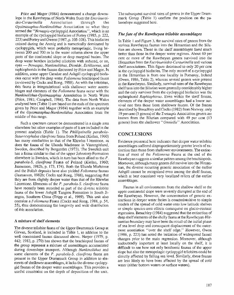
Price and Magor (1984) demonstrated a change downs- lope in the Rawtheyan of North Wales from the Encrinuroi- des-Ceraurinella Association through the Opsimasaphus-Nankinolithus Association to what they termed the "Novaspis-cyclopygid Association", which is an example of the cyclopygid biofacies of Fortey (1985, p. 222, 223) and Fortey and Owens (1987, p. 105-108). This biofacies existed during the Arenig and is numerically dominated by cyclopygids, which were probably mesopelagic, living be- tween 200 and 700 m in the water column above the upper parts of the continental slope or deep marginal basins. The deep water benthos included trilobites with reduced, or no, eyes - Novaspis, Nankinolithus, Dionide. Ectillaenus, and raphiophorids in the faunas discussed by Price and Magor. In addition, some upper Caradoc and Ashgill cyclopygid biofa- cies occur with the deep water Foliomena brachiopod fauna (reviewed by Cocks and Rong, 1988). As with the trilobites, this fauna is integradational with shallower water assem- blages and elements of the Foliomena fauna occur with the Nankinolithus-Opsimasaphus Association in North Wales (Price, 1981; Campbell, 1984). The data from North Wales analyzed here (Table 1) are based on the ends of the spectrum given by Price and Magor (1984) together with an example of the Opsimasaphus-Nankinolithus Association from the middle of this range.
Such a spectrum cannot be demonstrated in a single area elsewhere but other examples of parts of it are included in the present analysis (Table 1). The Phillipsinella parabola- Staurocephalus clavifrons fauna from Poland (Kielan, 1960) has many similarities to that of the Rhiwlas Limestone, as does the fauna of the Ulunda Mudstone in Vbtergotland, Sweden, described by Bergstrom (1973). The Swedish unit has a fauna similar to that of the upper Johnstorp Formation elsewhere in Sweden, which in turn has been allied to the P. parabola-S. clavifrons Fauna of Poland (Kielan, 1960; Jaanusson, 1982b, p. 173, 174). Both the Ulunda Mudstone and the Polish deposits have also yielded Foliomena faunas (Jaanusson, 1982b; Cocks and Rong, 1988), suggesting that they are from slightly deeper water than that of the Rhiwlas Limestone. Elements of the P, parabola-S. clavifrons fauna have recently been recorded as part of the diverse trilobite fauna of the lower Ashgill Tangtou Formation in South Ji- angsu, Southern China (Tripp et al., 1989). This unit also contains a Foliomena Fauna (Cocks and Rong, 1988, p. 54, 5 3 , thus demonstrating the longevity and wide distribution of this association.
A mixture of shelf elements
The diverse trilobite fauna of the Upper Drummuck Group at Girvan, Scotland, is included in Table 1, in addition to the well constrained faunas discussed above. Harper (1979, p. 442; 1982, p. 270) has shown that the brachiopod faunas of the group represent a mixture of assemblages accumulated during downslope transport. Although Nankinolithus and some elements of the P, parabola-S, clavijrons fauna are present in the Upper Drurnrnuck Group in addition to ele- ments of shallower assemblages, it lacks the diverse cyclopy- gid faunas of the deeper water assemblages. This provides a useful constraint on the depth of deposition of the unit.
The subsequent survival rates of genera in the Upper Drum- muck Group (Table 1) confirm the position on the pa- laeoslope suggested here.
The fate of the Rawtheyan trilobite assemblages
In Table 1 and Figure 3, the survival rates of genera from the various Rawtheyan faunas into the Himantian and the Silu- rian are shown. Those in the shelf assemblages fared much better than those in the deeper water regimes. About 60 per cent or more of the Rawtheyan genera survived into the Hirnantian from the Encrinuroides-Ceraurinella and various shelf associations. This figure decreased to only 20 per cent in the cyclopygid biofacies. The only record of a cyclopygid in the Himantian is from one locality in Pomeroy, Ireland (Owen, 1986, Table 2), whereas several genera were present in the Rawtheyan. Similarly, survival rates of the Rawtheyan shelf taxa into the Silurian were generally considerably higher and the only survivor from the cyclopygid biofacies was the raphiophorid Raphiophorus. Even within the shelf faunas, elements of the deeper water assemblages had a lower sur- vival rate than those from shallower faunas. Of the faunas described by Brenchley and Cocks (1982) from Norway, only 19 per cent (3 genera) of the Tretaspis Association genera are known from the Silurian compared with 49 per cent (13 genera) from the shallower "Onniella" Association.
CONCLUSIONS Evidence presented here indicates that deeper water trilobite assemblages suffered disproportionately greater levels of ex- tinction than those from shallower environments. The extinc- tion of most of the Foliomena Fauna at the end of the Rawtheyan suggests a similar pattern among the brachiopods. Moreover, although many genera did survive into the Hirnan- tian, the diverse recurring generic association of the earlier Ashgill cannot be recognized even among the shelf faunas, which at best contained very localized relicts of the earlier assemblages.
Faunas in all environments from the shallow shelf to the upper continental slope were severely disrupted at the end of the Rawtheyan. However, the concentration of generic ex- tinctions in deeper water facies is counterintuitive to simple models of the spread of cold water onto low latitude shelves or simple species-area effects consequent on glacio-eustatic regression. Brenchley (1984) suggested that the extinction of deep shelf elements of the shelly fauna at the Rawtheyan-Hir- nantian boundary may have been the result of the initial phase of sea level drop and consequent displacement of the outer- most association "over the shelf edge." However, Owen (1986, p. 223) has noted the initiation of widespread faunal changes prior to the main regression. Moreover, although undoubtedly important at least locally on the shelf, it is difficult to see how not only benthonic faunas of the upper slope but also the mesopelagic cyclopygid trilobites could be directly affected by falling sea level. Similarly, these faunas are less likely to have been affected by the spread of cold water (either bottom waters or surface waters).
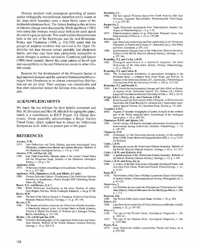
Oceanic overtuln with consequent upwelling of anoxic and/or biologically unconditional (therefore toxic) waters at the slope-shelf boundary seem a more likely cause of the profound extinctions here. The factors leading to this at times of climatic change were discussed by Wilde and Beny (1984) who noted that overturn would occur both at the onset and at the end of a glacial episode. This could explain the extinctions both at the end of the Rawtheyan and the mid-Himantian. Fortey and Chatterton (1988, p. 216-218) noted that the groups of asaphine trilobites that survived to the Upper Or- dovician but then became extinct probably had planktonic habits, and thus may have been particularly susceptible to major changes in oceanic circulation. Chatterton and Speyer (1989) have recently shown this same pattern of larval type and susceptibility to the end-Ordovician events in other trilo- bite stocks.
Reasons for the development of the Hirnantia faunas in high and mid-latitudes and the spread of DalmanitinalMucro- naspis from Gondwana to an almost cosmopolitan distribu- tion are not yet clear. Their eurytopy was considerable and thus their extinction before the Silurian even more remark- able.
ACKNOWLEDGNIENTS We thank the two referees for their helpful comments and Mrs. M. Davidson and Miss M. Mitchell for typing this paper, which is a contribution to IGCP Project 216 Global Bio- events. Owen gratefully acknowledges a Royal Society Travel Grant, which enabled him to attend the Ordovician Symposium in St. John's to present part of this paper.
REFERENCES Amsden, T.W. 1974: Late Ordovician and Early Silurian articulate brachiopods from
Oklahoma, southwestern Illinois and eastem Missouri. Bulletin of the Oklahoma Geological Survey, v. 119, p. 1-154.
Amsden, T.W. and Barrick, J.E. 1986: Late Ordovician-Early Silurian strata in the central United States
and the Himantian Stage. Bulletin of the Oklahoma Geological Survey, v. 139, p. 1-95.
Apollonov, M.K. 1975: Ordovician trilobite assemblages of Kazakhstan. Fossils and Strata,
no. 4, p. 375-380. Apollonov, M.K., Bandaletov, S.M., and Nikitin, I.F. (eds.) 1980: Grantsa Ordovika i Silura v Kazakhstane [The Ordovician-Silurian
boundary in Kazakhstan], Nauka Kazakh SSR Publishing House, Alma Ata, 300 p.
Baarli, B.G. and Harper, D.A.T. 1986: Relict Ordovician brachiopods in the lower Silurian of Asker,
Oslo-Region, Norway. Norsk Geologisk Tidsskrift, v. 66, p. 87-98. Banks, M.R. 1988: The base of the Silurian System in Tasmania. Bulletin of the British
Museum (Natural History), Geology, v. 43, p. 191-194. Barnes, C.R. 1986: The faunal extinction event near the Ordovician-Silurian boundary:
a climatically induced crisis. In Lecture Notes in Earth Sciences, Volume 8. Global Bio-Events, 0. Walliser (ed.); Springer-Verlag, Berlin, Heidelberg, p. 121 -126.
Barnes, C.R. and Bergstrom, S.M. 1988: Conodont biostratigraphy of the uppennost Ordovician and lower-
most Silurian. Bulletin of the British Museum (Natural History), Geology, v. 43, p. 325-343.
Benedetto, J.L. 1986: The first typical Hirnantia fauna from South America (San Jaun
Province, Argentine Precordillera). Bioestratigrafia Paleozoique, v. 4, p. 439-447.
Bergstrijm, J. 1968: Upper Ordovician brachiopods from Vastergtitland, Sweden. Ge-
ologica et Palaeontologica, v. 2, p. 1-35. 1973: Palaeoecological aspects of an Ordovician Tretaspis fauna. Acta
Palaeontologica Polonica, v. 23, p. 179-206. Brenchley, P.J. 1984: Late Ordovician extinctions and their relationship to the Gondwana
Glaciation. In Fossils and Climate, P.J. Brenchley (ed.); John Wiley and Sons, Chichester, p. 291-315.
1988: Environmental changes close to the Ordovician-Silurian boundary. Bulletin of the British Museum (Natural History), Geology, v. 43, p. 377-385.
Brenchley, P.J. and Cocks, L.R.M. 1982: Ecological associations in a regressive sequence: the latest
Ordovician of the Oslo-Asker district, Norway. Palaeontology, v. 25, p. 783-815.
Brenchley, P.J. and Cullen, B. 1984: The environmental distribution of associations belonging to the
Hirnantia fauna - evidence from North Wales and Norway. In Aspects of the Ordovician System, D.L. Bruton (ed.); Paleontological Contributions from the University of Oslo, v. 295, p. 113-125.
Brenchley, P.J. and Newall, G. 1984: Late Ordovician environmental changes and their effect on faunas.
In Aspects of the Ordovician System, D.L. Bruton (ed.); Paleon- tological Contributions from the University of Oslo, v. 295, p. 65-79.
Briggs, D.E.G., Fortey, R.A., and Clarkson, E.N.K. 1988: Extinction and the fossil record of the arthropods. In Extinction and
Survival in the Fossil Record, G. Larwood (ed.); Systematics Asso- ciation Special Volume 34, Clarendon Press, Oxford, p. 171-209.
Campbell, S.D.G. 1984: Aspects of dynamic stratigraphy (Caradoc-Ashgill) in the northern
part of the Welsh marginal basin. Proceedings of the Geologists Association, v. 95, p. 309-391.
Chatterton, B.D.E. and Speyer, S.E. 1989: Larval ecology, life history strategies and patterns of extinction and
survivorship among Ordovician trilobites. Paleobiology, v. 15, p. 118-132.
Chugaeva, M.N. 1983: [Trilobites]. In The Ordovician-Silurian boundary in the northeast
of the USSR, Trudy Mezhved Stratigrafia Kom SSR, v. 1 I, p. 73-97. (in Russian)
Cocks, L.R.M. 1988: Brachiopods across the Ordovician-Silurian boundary. Bulletin of
the British Museum (Natural History), Geology, v. 43, p. 31 1-315. Cocks, L.R.M. and Rickards, R.B. 1988: A global analysis of the Ordovician-Silurian boundary. Bulletin of
the British Museum (Natural History), Geology, v. 43, p. 1-394. Cocks, L.R.M. and Rong, Jia-yu 1988: A review of the late Ordovician Foliomena brachiopod fauna with
new data from China, Wales and Poland. Palaeontology, v. 31, p. 53-67.
Dean, W.T. 1978: The trilobites of the Chair of Kildare Limestone (Upper Ordovician)
of eastern Ireland. Palaeontographical Society, Monographs no. 3, p. 99- 129.
Destombes, J. 1972: Les Trilobites du sous-ordre des Phacopina de I'Ordovicien de I'Anti-
Atlas (Maroc). Notes et Mkmoires Service Gkologique Maroc, v. 240, p. 1-113.
Donovan, S.K. 1988: The British Ordovician crinoid fauna. Lethaia, v. 21, p. 424. Eckert, J.F. 1988: Late Ordovician extinction of North American and British crinoids.
Lethaia, v. 21, p. 147-167. Elles, G.L. 1922: The age of the Hirnant Beds. Geological Magazine, v. 59,
p. 409-414. 1923: The age of the Hirnant Beds. Geological Magazine, v. 60,
p. 559-560. Fortey, R.A. 1975: Early Ordovician trilobite communities. Fossils and Strata, no. 4,
p. 339-360.
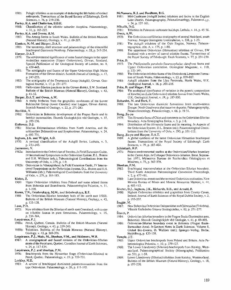
1985: Pelagic trilobites as an example of deducing the life habits of extinct arthropods. Transactions of the Royal Society of Edinburgh, Earth Sciences, v. 76, p. 219-230.
Fortey, R.A. and Chatterton, B.D.E. 1988: Classification of the trilobite suborder Asaphina. Palaeontology,
V. 3 1, p. 165-222. Fortey, R.A. and Owens, R.M. 1987: The Arenig Series in South Wales. Bulletin of the British Museum
(Natural History), Geology, v. 41, p. 69-307. Hanken, N.-M. and Harper, D.A.T. 1985: The taxonomy, shell structure and palaeoecology of the trimerellid
brachiopod Gasconsia Northrop. Palaeontology, v. 28, p. 243-254. Harper, D.A.T. 1979: The environmental significance of some faunal changes in the upper
Ardmillan succession (Upper Ordovician), Girvan, Scotland. Special Publication of the Geological Society of London, no. 8, p. 439-445.
1981: The stratigraphy and faunas of the Upper Ordovician High Mains Formation of the Girvan district. Scottish Journal of Geology, v. 17, p. 247-255.
1982: The stratigraphy of the Drummuck Group (Ashgill), G i ~ a n . Geo- logical Journal, v. 17, p. 251-277.
1988: Ordovician-Silurian junctions in the Ginan district, S.W. Scotland. Bulletin of the British Museum (Natural History), Geology, v. 43, p. 45-52.
Harper, D.A.T. and Owen, A.W. 1986: A shelly biofacies from the graptolitic mudstones of the Lower
Balclatchie Group (lower Caradoc) near Laggan, Girvan district. Scottish Journal of Geology, v. 22, p. 271-283.
HavliEek, V. 1982: Ordovician in Bohemia: development of the Prague Basin and its
benthic communities. Sbornik ~eologickfch v ~ d ~ e o l o g i e , v. 37, p. 103-136.
~olloway, D.J. 1981: Silurian Dalmanitacean trilobites from North America, and the
subfamilies Dalmanitinae and Synphoriinae. Palaeontology, v. 24, p. 695-731.
Ingham, J.K. and Wright, A.D. 1970: A revised classification of the Ashgill Series. Lethaia, v. 3,
p. 233-243. Jaanusson, V. 1982a: Introduction to the Ordovician of Sweden. In Field Excursion Guide,
IV International Symposium on the Ordovician System, D.L. Bruton and S.H. Williams (eds.); Paleontological Contributions from the University of Oslo, v. 279, p. 1-9.
1982b: Ordovician in Vlstergtitland. In Field Excursion Guide, IV Intema- tional Symposium on the Ordovician System, D.L. Bruton and S.H. Williams (eds.); Paleontological Contributions from the University of Oslo, V. 279, p. 164-183.
Kielan, Z. 1960: Upper Ordovician trilobites from Poland and some related forms
from Bohemia and Scandinavia. Palaeontologica Polonica, v. 11, p. 1-198.
Koren, T.N., Oradovskaya, M.M., and Sobolevskaya, R.F. 1988: The Ordovician-Silurian boundary beds of the north-east USSR.
Bulletin of the British Museum (Natural History), Geology, v. 43, p. 133-138.
Lane, P.D. 1972: New trilobites from the Silurian of north-east Greenland, with a note
on trilobite faunas in pure limestones. Palaeontology, v. 15, p. 336-364.
Lespkrance, P.J. 1988a: PercB, Quebec, Canada. Bulletin of the British Museum (Natural
History), Geology, v. 43, p. 239-245. 1988b: Trilobites. Bulletin of the British Museum (Natural History),
Geology, v. 43, p. 369-376. Lespkrance, P.J., Malo, M., Sheehan, P.M., and Skidmore, W.B. 1987: A stratigraphical and faunal revision of the Ordovician-Silurian
strata of the Per& area, Quebec. Canadian Journal of Earth Sciences, V. 24, p. 117-134.
LespCrance, P.J. and Sheehan, P.M. 1976: Brachiopods from the Hirnantian Stage (Ordovician-Silurian) at
PercC, Quebec. Palaeontology, v. 19. p. 719-731. Lockley, M.E. 1983: A review of brachiopod dominated palaeocommunities from the
type Ordovician. Palaeontology, v. 26, p. 11 1-145.
McNamara, K.J. and Fordham, B.G. 1981: Mid-Cautleyan (Ashgill Series) trilobites and facies in the English
Lake District. Palaeogeography, Palaeoclimatology, Palaeoecol,,~y, V. 34, p. 137-161.
Mikulik, D.G. 198 1: Trilobites in Paleozoic carbonate buildups. Lethaia, v. 14, p. 45-56. Owen, A.W. 1978: The Ordovician and Silurian stratigraphy of central Hadeland, south
Norway. Norges Geologiske Unders@kelse, v. 338, p. 1-23. 1981: The Ashgill trilobites of the Oslo Region, Norway. Palaeon-
tographica, Abt. A, v. 175, p. 1-88. 1986: The uppermost Ordovician (Hirnantian) trilobites of Girvan, SW
Scotland with a review of coeval trilobite faunas. Transactions of the Royal Society of Edinburgh: Eanh Sciences, v. 77, p. 23 1-239.
Price, D. 1973: The Phillipsinella parabola-Staurocephalus ciavifrons fauna and
Upper Ordovician correlation. Geological Magazine, v. 110, p. 535-541.
1980: The Ordovician trilobite fauna of the Sholeshook Limestone Forma- tion of South Wales. Palaeontology, v. 23, p. 839-887.
1981: Ashgill trilobites from the Llyn Peninsula, North Wales, U.K. Geological Journal, v. 16, p. 201-216.
Price. D. and Maeor. P.M. - ,
1984: The ecological significance of variation in the generic composition of Rawthevan (Late Ordovician) trilobite faunas from North Wales. U.K. ~ e o l b ~ i c a l Journal, v. 19,'~. 187-200.
Robardet, M. and Dork, F. 1988: The late Ordovician diamictic formations from southwestern
Europe: North Gondwana glaciomarine deposits. Palaeogeography, Palaeoclimatology, Palaeoecology, v. 66, p. 19-31.
Rong, Jia-yu 1979: The Hirnantia fauna of China and comments on the Ordovician-Silurian
boundaly. Acta Stratigraphia Sinica, v. 3, p. 1-8. 1984: Distribution of the Hirnantia fauna and its meaning. In Aspects of
the Ordovician System, D.L. Bruton (ed.); Palaeontological Contri- butions from the University of Oslo, v. 295, p. 101-1 12.
Rong, Jia-yu and Harper, D.A.T. 1988: A global synthesis of the latest Ordovician Himantian brachiopod
faunas. Transactions of the Royal Society of Edinburgh: Earth Sciences, v. 79, p. 383-402.
Schonlaub, H.P. 1971: Palaeo-environmental studies at the Ordovician/Silurian boundary
in the Carnic Alps. In Colloque Ordovicien-Silurien, Brest, Septem- bre 1971, MCmoires Bureau de Recherches GCologiques et Minieres, v. 73, p. 367-378.
Sheehan, P.M. 1982: Brachiopod macroevolution at the Ordovician-Silurian boundary.
Third North American Paleontological Convention Proceedings, V. 2, p. 477-481.
1988: Late Ordovician events and the terminal Ordovician extinction. New Mexico Bureau of Mines and Mineral Resources Memoir, v. 44, p. 405-415.
Siveter, D.J., Ingham, J.K., Rickards, R.B., and Arnold, B. 1980: Highest Ordovician trilobites and graptolites from County Cavan,
Lreland. Journal of Earth Sciences of the Royal Dublin Society, v. 2, p. 193-207.
Snajdr, M. 1987: New Bohemian Ordovician Dalmanilidae and Calmonidae (Trilobita).
Vzstnik dst:ednlho ~ s t a v u GeologickCho, v. 62, p. 271-277. Storch, P. 1984: Ordovician-Silurian boundary in the Prague Basin (Barrandian area,
Bohemia). Sbornik Geologickjkh vEd Geologic, v. 41, p. 69-103. 1986: Ordovician-Silurian boundary event in Bohemia (Prague Basin-
Barrandian Area). In Lecture Notes in Earth Sciences. Volume 8, Global Bio-Events, 0. Walliser (ed.); Springer-Verlag. Berlin, Heidelberg, p. 133-138.
Temple, J.T. 1965: Upper Ordovician brachiopods from Poland and Britain. Acta Pa-
laeontologica Polonica, v. 10, p. 379-427. 1968: The Lower Llandovery (Silurian) brachiopods from Keisley, West-
morland. Palaeontographical Society (Monographs), Publication no. 521, p. 1-58.
1969: Lower Llandovery (Silurian) trilobites from Keisley, Westmorland. Bulletin of the British Museum (Natural History), Geology, v. 18, p. 197-230.
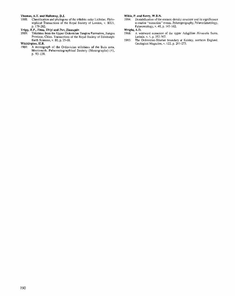
Thomas, A.T. and Holloway, D.J. 1988: Classification and phylogeny of the trilobite order Lichidae. Philo-
sophical Transactions of the Royal Society of London, v. B321, p. 179-262.
Tripp, R.P., Zhou, Zhiyi and Pan, Zhanquin 1989: Trilobites from the Upper Ordovician Tangtou Formation, Jiangsu
Province, China. Transactions of the Royal Society of Edinburgh: Earth Sciences, v. 80, p. 25-68.
Whittington, H.B. 1968: A monograph of the Ordovician trilobites of the Bala area,
Merioneth. Palaeontographical Society (Monographs) (4), p. 93-138.
Wilde, P. and Berry, W.B.N. 1984: Destabilization of the oceanic density structure and its significance
to marine "extinction" events. Palaeogeography, Palaeoclimatology, Palaeoecology, v. 48, p. 143-162.
Wright, A.D. 1968: A westward extension of the upper Ashgillian Hirnanfia fauna.
Lethaia, v. 1, p. 352-367. 1985: The Ordovician-Silurian boundary at Keisley, northern England.
Geological Magazine, v. 122. p. 261-273.
Lower to Middle Ordovician trace fossils from the Central Iberian Zone of Portugal and Spain
Romano. M., Lower to Middle Ordovician trace fossils from the Central Iberian Zone of Portugal and Spain; in Advances in Ordovician Geology, C.R. Barnes and S.H. Williams fed.), Geological Survey of Canada, Paper 90-9, p. 191 -204,1991.
Abstract
The Lower to Middle Ordovician strata of the Central Iberian Zone (C.I.Z.) in Portugal and Spain accumulated in a cold water, shallow shelfsea on the margin of Gondwanaland. The sequences are almost entirely siliciclastic and are dominated by thick (up to 1000 m) quartzose sandstone and mudrock (up to 350 m thick), the latter punctuated by widespread sheet sandstones of storm origin. Subordinate conglom- erate and rare oolitic ironstone also occur.
Thirty-one ichnogenera and over 45 ichnospecies are now known from the Arenig to lower Caradoc of the C.I.Z. Range charts and diversity graphs illustrate the presence of trace fossils throughout the Lower to Middle Ordovician and their preponderance in the more heterolithic facies.
Five, possibly six, ichnofacies associations (A, B, C, C1, D, E) that are generally restricted to discrete sedimentological facies have been recognized. Heterolithic, shallow marine sequences contain examples of the Cruziana (Association B) and Skolithos (Association A) ichnofacies, whereas shelfmudstones yield low-diversity assemblages with Tomaculum (Association D). Two associations (C, C I ) that can be referred to the Cruziana ichnofacies are provisionally recordedfrom the storm interbeds; both are of low to moderate diversity and typically contain Arthraria, Bifungites, Taenidium, and Phycodes. Association E is dominated by U-shaped tubes with uncommon Bergaueria. It marks the recurrence of the Skolithos ichnofacies in a thin, but distinctive, oolitic ironstone sequence that is present throughout much of central Portugal and Spain.
The composition of the assemblages and the general absence of typical deep water traces support the earlier suggestions of the existence of a relatively shallow shelfsea over much of central Iberia during Early to Middle Ordovician times.
Les strates de l'ordovicien infkrieur et moyen de la zone Ibkrique centrale, au Portugal et en Espagne, se sont accumulkes dans une mer marginale froide et peu profonde, en bordure du Gondwana. Les skquences sont presque enti2rement silicoclastiques et contiennent en prkdominance des gris quartzeux kpais (jusqu'd 1 000 m) et des pklites (jusqu'd 350 m d'kpaisseur), ces derniers renfermant des nappes ktendues de grds accumulkes par suite de tempbes. Elles contiennent aussi du conglomkrat moins abondant et du fer oolitique rare.
On reconnaft actuellement 31 genres et plus de 45 esp2ces d'ichnofossiles dans l'intervalle de I' Arknigien-Caradocien infkrieur de la zone Ibkrique centrale. Les tableaux de rkpartition et les graphiques de diversitk illustrent la prksence d'ichnofossiles tout au long de l'ordovicien infkrieur et moyen, et leur prkponde'rance dam les faci2s hdtkrolithiques.
On y reconnait 5 , et possiblement 6, associations d'ichnofaciis (A, B , C, C1, D, E) qui, en gknkral, se limitent d des faci2s skdimentologiques isolks. Des skquences hktkrolithiques, de mer peu profonde, contiennent des exemples des ichnofaciis d Cruziana (association B) et d Skolithos (association A), tandis
1 Earth Sciences, University of Sheffield, Beaumont Building, Brook Hill, Sheffield S3 7HF. U.K.
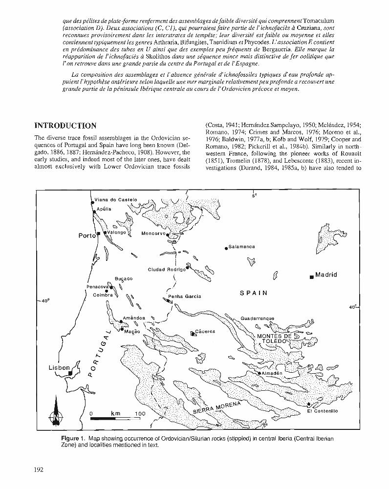
que des pklites de plate-forme renferment des assemblages de faible diversite qui comprennent Tomaculum (association D). Deux associations (C, CI) , qui pourraient faire partie de I'ichnofacit?~ a Cruziana, sont reconnues provisoirement dans les interstrates de temp2te; leur diversite' est faible ou moyenne et elles contiennent typiquement les genres Arthraria, Bifungites, Taenidium et Phycodes. L'association E contient en prkdominance des tubes en U ainsi que des exemples peu fre'quents de Bergaueria. Elle marque la rkapparition de l'ichnofacib a Skolithos dans une se'quence mince mais distinctive defer oolitique que I'on retrouve dans une grande partie du centre du Portugal et de I'Espagne.
La composition des assemblages et l'absence ge'ne'rale d'ichnofossiles typiques d'eau profonde ap- puient I'hypothtse ante'rieure selon laquelle une mer marginale relativement peu profonde a recouvert une grande partie de la pkninsule Ibe'rique centrale au cours de 1'Ordovicien prtcoce et moyen.
INTRODUCTION (Costa, 1941; Hernandez Sampelayo, 1950; MelCndez, 1954; Romano, 1974; Crimes and Marcos, 1976; Moreno et al.,
The diverse trace fossil assemblages in the Ordovician se- 1976; Baldwin, 1977a, b; Kolb and Wolf, 1979; Cooper and quences of Portugal and Spain have 10% been kllown (Del- Romano, 1982; Pickerill et al., 1984b). Similarly in north- gad% 1886,1887; Hernindez-Pacheco, 1908). However, the western France, following the pioneer works of Rouault early studies, and indeed most of the later ones, have dealt (1851), Tromelin (1878), and Lebesconte (1883), recent in- almost exclusively with Lower Ordovician trace fossils vestigations (Durand, 1984, 1985a, b) have also tended to
I 5 O
S P A I N
40%
El Centenillo
Figure 1. Map showing occurrence of Ordovician/Silurian rocks (stippled) in central Iberia (Central Iberian Zone) and localities mentioned in text.
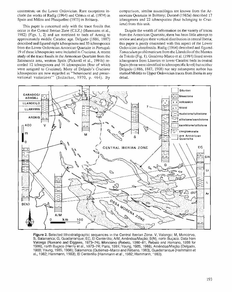
concentrate on the Lower Ordovician. Rare exceptions in- clude the works of Radig (1964) and Crimes et al. (1974) in Spain and Mtlou and Plusquellec (1975) in Brittany.
This paper is concerned only with the trace fossils that occur in the Central Iberian Zone (C.I.Z.) (Hammann et al., 1982) (Figs. 1, 2) and are restricted to beds of Arenig to approximately middle Caradoc age. Delgado (1 886, 1887) described and figured eight ichnogenera and 35 ichnospecies from the Lower Ordovician Amorican Quartzite in Portugal: 19 of these ichnospecies were included in Cruziana. A recent study of the trace fossils in the Amorican Quartzite from the Salamanca area, western Spain (Pickerill et al., 1984b) re- corded 12 ichnogenera and 16 ichnospecies (four of which were assigned to Cruziana). Many of Delgado's Cruziana ichnospecies are now regarded as "behavioural and preser- vational variations" (Seilacher, 1970, p. 464). By
comparison, similar assemblages are known from the Ar- morican Quartzite in Brittany; Durand (1985a) described 17 ichnogenera and 22 ichnospecies (four belonging to Cruz- iana) from this unit.
Despite the wealth of information on the variety of traces from the Almorican Quartzite, there has been little attempt to review and analyze their vertical distribution in central Iberia; this paper is partly concerned with this aspect of the Lower Ordovician ichnofossils. Radig (1964) described and figured Tomaculump~oblematicum from the Llandeilo of the Montes de Toledo (Fig. 1). GutiCrrez-Marco et al. (1984) listed seven ichnogenera from Llanvirn to lower Caradoc beds in central Spain (three were identified to ichnospecific level) but neither Delgado (1886, 1887, 1908) nor any subsequent author has studied Middle to Upper Ordovician traces from Iberia in any detail.
<' CENTRAL IBERIAN ZONE
Figure 2. Selected lithostratigraphic sequences in the Central Iberian Zone. V, Valongo; M, Moncorvo, S, Salamanca; G, Guadarranque; EC, El Centenillo; AIM, Am&ndoa/Ma@o; B(N), north Bu~aco. Data from Valongo (Romano and Diggens, 1973-74), Moncorvo (Rebelo, 1980-81 ; Rebelo and Romano, 1988 for 1986), north Bu~aco (Henry et al., 1973-74; Paris, 1981; Young, 1985,1988), Ami?ndoa/Ma~%o (Delgado, 1908; Young, 1985,1988); Salamanca (Gutikrrez-Marco and Rabano, 1983), Guadarranque (Hammann et al., 1982; Hammann, 1983); El Centenillo (Hammann et al., 1982; Hammann, 1983).
The importance of trace fossils in sequences where body fossils are either rare or absent has been amply shown by Seilacher (1967, 1970), Crimes (l970), Baldwin (1977a) and others, and ichnofossils may provide the basis for age deter- minations and/or environmental interpretations. These as- pects are briefly investigated below.
The data used to construct the range charts in Figure 3 were collected mainly by the author over a number of years during field work into other aspects of Ordovician biostratig- raphy. Information in Spain is limited to a number of sections in the Montes de Toledo and Sierra Morena (Fig. 1). The following works were also used: Delgado (1886,1887), Costa (1941), Bouyx (1966), Perdiggo (196445), Seilacher (1970), Romano (1974, 1982), Romano and Diggens (1973-74), Cooper (1980), Cooper and Romano (1982), Pickerill et al. (1984b), GutiCrrez-Marco (1984), GutiCrrez-Marco et al. (1984), Rebelo and Romano (1988 for 1986). Further speci- mens were kindly made available by Drs. T.P. Young and A.H. Cooper.
STRATIGRAPHY Seven simplified stratigraphic columns for selected regions in the C.I.Z. are shown in Figure 2. For each of the sequences the series boundaries for the Ordovician are indicated. The base of the Arenig is not shown due to the general absence of diagnostic faunas (body and trace fossils) although in the Montes de Toledo, Moreno et al. (1976) recognized the possible presence of beds of Tremadoc age below the Arenig Armorican Quartzite, on the basis of the range of Cruziana ichnospecies. The ArenigILlanvim boundary is drawn ap- proximately at the top of the Armorican Quartzite and grap- tolitic faunas of early Llanvirn age occur immediately above the last quartzite bed in central Portugal (Romano et al., 1986). The LlanvirnLlandeilo boundary normally lies within the mudrock sequence overlying the Armorican Quartzite; the exception is in the El Centenillo sequence (Fig. 1) where Hammann (1983) placed the boundary near the base of the El Cafio Alternation. The evidence for this is inconclusive, however, as (presumably) Hammann used the presence of "Neseuretus (N.) tristani ssp. inc." (Hammann, 1983, p. 14) to indicate a post-Llanvim age; this species ranges down into the upper Llanvim. In central Portugal the base of the Caradoc was considered by Paris (1981) and Young (1985, 1988) to lie near the base of a mudstone unit (Carregueira Formation of Young); in north Portugal the Llandeilo/Caradoc junction probably lies toward the top of the Valongo Formation (Young and Romano, work in progress). Around Salamanca (Fig. 1) graptolitic shales of early Llandovery age overlie sparsely fossiliferous Llandeilo strata (Gutikrrez-Marco and RBbano, 1983), whereas in the Montes de Toledo (Guadar- ranque) and Sierra Morena (El Centenillo), Hammann (1983) located the base of the Caradoc near the base of a mudrock sequence, and toward the top of a quartzite sequence, respec- tively. The upper parts of the Caradoc and Ashgill are not considered in this paper.
The sequences illustrated in Figure 2 show a general similarity between the Arenig and Llanvirn, but there are differences in detail. McDougall et al. (1987) recently de- scribed the base of the Lower Ordovician Armorican Quartz- ite in the C.I.Z. and pointed out that, although it generally lies unconformably on the Complexo Xisto-GrauvBquico (CXG) (a thick, upper Precambrian to Cambrian turbidite sequence), a conformable junction is seen in some places. The oldest proven, or assumed, Ordovocian rocks in the C.I.Z. are either the Armorican Quartzite or the "red beds" (Henry et al., 1973-74; Hammann, 1983) that locally occur below the quartzites. The latter (including the Sarnelha Formation at Bugaco) show a variety of fan-delta sediments (McDougall et al., 1987). The mudrocks overlying the Armorican Quartz- ite occur throughout the zone and generally form a thick monotonous sequence. They are locally interbedded with sandstone of Llanvirn and Llandeilo age that exhibit hum- mocky cross-stratification of storm origin (Brenchley et al., 1986). Neither of these sandstone incursions are known from the Valongo area (Romano and Diggens, 1973-74), nor have they definitely been recorded from Moncorvo (Fig. 1) or Salamanca, although in the former region the mudrocks of Llanvim and possibly Llandeilo age pass laterally into a coarser facies (Rebelo and Romano, 1988 for 1986). In the Salamanca sequence, GutiCrrez-Marco and RBbano (1983) showed a more sandy facies at the top of the Middle Ordovi- cian sequence. The Llandeilo sandstone strata are probably related to a regressive event (Fortey, 1984); they thicken to the south, toward the probable source areatshoreline. After the regressive phase, mud and silt deposition resumed in most regions until another short-lived, storm-generated event gave rise to hummocky sand at the top of the Llandeilo sequence (Young, 1988); this was then followed by mud of the early Caradoc transgression. In the southern regions, sedimentation was dominated during the Caradoc by thick sand accumula- tions interbedded with fossiliferous mud of considerable lat- eral extent. The sandstone frequently shows evidence of storm origin.
DIVERSITY AND VERTICAL RANGE OF TRACE FOSSILS IN THE CENTRAL IBERIAN ZONE Figure 3 is a generalized lithostratigraphic log of the southern sections shown in Figure 2 (i.e., north Bu~ao , AmCn- doa/Ma@io, Guadarranque, El Centenillo). For convenience only the lithostratigraphic terms of central Portugal are used (Hen~y et al., 1973-74; Cooper, 1980; Young, 1985, 1988). The graphs record the regional vertical ranges of trace fossils within these sections. In some cases the exact horizon is unknown (see explanation and key to Fig. 3), and in an attempt to represent all the ranges from different sections on a single log, some over-simplifications have inevitably been introduced. For instance, not all the ichnospecies shown in Figure 3 necessarily occur at any horizon or body of rock in one section.
Do the range charts give a true and accurate indication of the diversity and ranges of the taxa?
Of the ichnospecies listed in Figure 3, ten have not been recorded previously from the C.I.Z. Perhaps more impor- tantly, of these ten ichnospecies, eight occur in units above the Armorican Quartzite, and two (Zoophycos? ichnosp. and Lockeia? ichnosp.) are so far only recorded from the Armori- can Quartzite. The presence of these ichnospecies, previously unrecorded in post-Armorican Quartzite strata, indicates the general lack of ichnological work from this part of the se- quence, and only three studies (Radig, 1964; Seilacher, 1970; Guti6rrez-Marco, 1984) have described post-Armorican Quartzite trace fossils.
The diversity and ranges of the taxa given in Figures 3 and 4 must then be open to question. Are the graphs faithful representations, or are they considerably biased by the very selective research done on these sequences? Although further work will undoubtedly add to the diversity of the vertical ranges, as well as expanding some of them, the general composition of the assemblages is considered to be essen- tially representative. For example, the only records of Cruz- iana occurring in beds overlying the Armorican Quartzite in the southern part of the C.I.Z. are of Cruziana almadenensis (Seilacher, 1970) from the Canteras (Botella) Quartzite, in the Sierra Morena (Almela et a]., 1962) of Llandeilo to Caradoc age (Hammann, 1974,1983) and of an unidentified specimen of Cruziana (possibly Didymaulichnus) from the Canaveral syncline, northeast of CBceres (Carballeira et al., 1985), de- spite work on similar horizons and in similar facies elsewhere in the zone (Brenchley et al., 1986).
Diversity
Figure 4A depicts the diversity of the Ordovician trace fossils in the C.I.Z. Several notable features emerge from the graph. Diversities are highest in the coarser facies and, in particular, in the heterolithic parts of the sequence, such as at the top of the Armorican Quartzite and Monte da Sombadeira Forma- tion. This latter feature may be due in part to the nature of the traces, which are more readily observable in heterolithic sequences (cf. Durand, 1985b). Diagenetic processes may enhance the preservation of trace fossils (Narbonne, 1984; Pickerill et al., 1984a), but these processes are clearly less effective in clean quartzose sandstone (Baldwin, 1977a), such as the Armorican Quartzite.
The diversity graph tends to mirror the nature of lithologi- cal boundaries. Thus, where formational boundaries are rela- tively sharp from sandstone/siltstone to mudstone (e.g., Monte da Sombadeira to Fonte da Horta Formation), there is a sudden drop in diversity (note that in Figure 4A this change does not quite coincide with the top of the Monte da Som- badeira Formation; this "effect" is due to combining the Portuguese lithological log with trace fossil information from the Los Rasos sandstone in Montes de Toledo, Spain). The greatest decline in diversity occurs where the Armorican Quartzite Formation grades into the overlying mudrocks.
Diversity is highest in the upper part of the Armorican Quartzite Formation. The lower diversity in the Monte de Sombadeira sandstone may be the result of environmental differences (see below). The difference in graph width be- tween ichnogenera and ichnospecies is only really apparent in the Lower Ordovician. This is mainly due to the number of ichnospecies of Cruziana, and to a lesser extent, of Dae- dalus, Didymaulichnus, Planolites, and Rusophycus. The proportion of vertical to horizontal traces (Figure 4B) and its significance is considered later.
Trace fossils as age indicators in the Central Iberian Zone
Trace fossils generally have little use in age determination, although notable exceptions include ichnospecies of Cruz- iana. Cruzianids range from the Cambrian to Lower Triassic, but several authors (Seilacher, 1960, 1970; Crimes, 1968, 1969, 1970, 1975; Moreno et al., 1976; Baldwin, 1977a; Pickerill and Fillion, 1983; Rebelo and Romano, 1988 for 1986) have used some of the ichnospecies as age indicators in "unfossiliferous" or "poorly fossiliferous" strata. Of the cruzianid ichnospecies listed from the C.I.Z., C. furcifera, C. rugosa, and C. goldfussi are most frequently cited as indicat- ing an Early Ordovician age; although, until the stratigraphic ranges of these ichnospecies are known in greater detail, age determination to series level should be regarded as tentative; particularly when only one or two of these ichnospecies are present. When all three ichnospecies co-occur, however, an Arenig age is more confidently indicated.
Rusophycus and Phycodes also have potential use as age indicators but, like cruzianids, it is doubtful whether they will ever achieve the age refinements of body fossils. Neverthe- less, the presence of these trace fossils in "unfossiliferous" sequences is of considerable value in general age determina- tions. The value is lessened, however, in the early Ordovician of the C.I.Z. where a marked facies change occurs approxi- mately at the Arenigblanvirn boundary and the full age range of these ichnospecies cannot be determined.
Vertical ranges and ichnofacies
Trace fossils occur throughout the Lower to Middle Ordovi- cian sequences in the C.I.Z. (Fig. 3). Some, such as Planolites ichnosp., occur virtually continuously; others are restricted to part of the sequence (Arthrophycus ichnosp.); a number are only known from very restricted horizons (Bergaueria hemi- spherica).
Delgado (1908) noticed that the trace fossils in the Ar- morican Quartzite commonly showed a change from Sk- olithos-dominated assemblages in the lower part to Cruziana-dominated assemblages in the upper ("Quartzites 2 Scolithus" and "Quartzites h Bilobites"). Although this observation is probably true for many of the Armorican Quartzite (sensu lato) sequences in the C.I.Z., cruzianids do occur quite commonly low in the formation (Romano and Diggens, 1973-74) and Skolithos often ranges throughout.
CA
RA
DO
C
Are
nic
olit
es
ich
no
sp.
. A
rth
rari
a i
chn
osp
.
Art
hra
ria
an
tiq
ua
ta
Art
hro
ph
yc
us
ic
hn
osp
. in
de
t.
Art
hro
ph
yc
us
a
lleg
ha
nie
nsi
s
Be
rga
ue
ria
he
mis
ph
eri
ca
-- -
Bif
un
git
es?
ich
no
sp.
ind
et.
- cf
. C
ate
nic
hn
us
ich
no
sp.
Cil
ind
roto
ma
~u
lum
me
len
de
zi
Cru
zia
na
alm
ad
en
en
sis
---
Cru
zia
na
ba
gn
ole
nsi
s --
----
-
Cru
zia
na
fu
rcif
era
--
C
ruzi
an
a g
old
fus
si
---
Cru
zia
na
? i
mb
ric
ata
-.-
Cru
zia
na
ru
go
sa
---
Da
ed
alu
s ic
hn
osp
. D
ae
da
lus
de
sg
lan
di
---
Da
ed
alu
s h
alli
Did
yma
ulic
hn
us
ich
no
sp.
---
Did
yma
ulic
hn
us
alt
ern
atu
s
---
- D
idym
au
lich
nu
s ly
elli
Dim
orp
hic
hn
us?
ich
no
sp.
ind
et.
---
Dip
lich
nit
es
ich
no
sp.
---
- - -
D
iplo
cra
teri
on
ich
no
sp.
Figure 3 (cont'd.)
Figure 4. Diversity graph (A) of ichnogenera and ichnospecies from the Lower to Middle Ordovician sequence in the Central Iberian Zone. Also shown is distribution of vertical (Bl), horizontal (B2), and other (B3) traces. See text for explanation. "CXG", Complexo Xisto- Grauvaquico.
FORMAI'IONIMember Diversity Vertical Horizontal Others traces traces
0 5 10 0 5 1 0 1 5 0 5 10 1 2 0 1 m - m
I-101 r 5 i
3
3
I
1
ARMORICAN QUARTZITE
-
CARREGUEIRA
MONTE DA SOMBADEIRA
3 1
C
-
-
-
I
SARNELHA
A B 1 8 2 B 3
lchnogenvs 0 bhnospecies
r
I
3
1
-
I
-
-
This "reversed" distribution was described from Apdlia, north Portugal (Romano, 1974) where cruzianids are most common some 40 m above the base and Skolithos is particu- larly abundant (up to 15,000 a square metre) between 85 and 110 m above the base. Unfortunately, the top of the Armori- can Quartzite is not exposed at Apdlia and it cannot be determined whether there was a return to the Cruziana-domi- nated assemblage. Farther north still, at Viana do Castelo where the Armorican Quartzite is much attenuated, Cruziana and Arthrophycus also occur near the base of the sequence.
Of greater importance than the vertical ranges of individ- ual ichnogenera (which may be modified following more detailed work on the sequences) is the presence of particular associations of trace fossils. These may be analyzed within the framework of ichnofacies developed by Seilacher (1964,
1967) and expanded by others (Bromley et al., 1984; Pember- ton and Frey, 1984,1985). At the present state of knowledge of Ordovician trace fossils from the C.I.Z., five or six asso- ciations have been recognized (Fig. 5). The generally ubiqui- tous ichnogenera Planolites and Palaeophycus are not considered in the definition of these associations. Association A (belonging to the Skolithos ichnofacies) and Association B (Cruziana ichnofacies) have previously been identified in other lower Paleozoic sequences. For example, Seilacher (1963) recognized the Skolithos (Pirispiki Red Beds) and Cruziana (Khabour Quartzite) ichnofacies from Iraq, and Crimes (1970) described virtually identical assemblages from the lower Paleozoic rocks of Wales. The trace fossils making up Association B in the C.I.Z. include Rusophycus, Daedalus, Diplocraterion, Dimorphichnus, Phycodes, and the ubiquitous
Formation
Didymaullchnus? Dirnorphichnus Helmlnthopsis
Teichichnus
Tomaculum 'Shales with
Figure 5. Dominant ichnogenera in identified associations, characteristic ichnofossils, diversity (number of ichnospecies), generalized lithotype, and examples of lithostratigraphic units from Portugal and Spain.
Cruziana. In contrast, Association A is consistently of very (Crimes, 1970; Baldwin, 1977a; Frey and Seilacher, 1980). low diversity (Frey and Seilacher, 1980) with Skolithos the The Skolithos and Cruziana ichnofacies are perhaps among dominant ichnogenus. One unusual aspect of the Cruziana the best documented and, although many of the published ichnofacies (Association B) in the present study is the rare examples are from the lower Paleozoic, the two ichnofacies presence of Zoophycos? (also similar to Spirophyton) from are also recorded from the Pliocene (Mayoral, 1986). The the upper part of the Armorican Quartzite in central Portugal ichnological and lithological data from the Armorican (see below). Quartzite Formation (Figs. 3, 5) support previous environ-
The other four associations (C, C1, D, E) are less well defined, and are characterized in part by the absence of ichnogenera usually found in the Skolithos and/or Cruziana ichnofacies (Fig. 6). Associations C and C1 have a number of ichnogenera in common, namely, Taenidium, Arthraria, and/or Bifungites (the identification of these two latter ichno- genera is not without problems, see Fillion and Pickerill, 1984). The two associations are both of relatively low diver- sity; the former occurs in well bedded siltstone/mudstone sequences, the latter in more massively bedded, bioturbated, imvure sandstone. The ichnoeenera from Association C1 that " are placed in parentheses in Figure 5 were recorded from the lower part of the Kermeur Formation in the Veryhac'h sec- tion, Crozon Peninsula, Brittany, which is equivalent to the lower part of the Louredo Formation of Buqaco, central Portugal. Associations C and C1 probably represent more distal expressions of the Cruziana ichnofacies (cf. Pemberton and Frey, 1984). They may not differ enough to be considered distinct, but the larger diversity in Association C, together with the presence of more common horizontal traces (Didy- rnaulichnus?, Dimorphichnus, Helminthopsis) and complex feeding burrows (Phycodes, Teichichnus), suggest that the distinction is reasonable. Only further work will support or invalidate this suggestion.
Association D is of very low diversity. Apart from the description of Cilindrotomaculum melendezi (GutiCrrez- Marco, 1984) only Tomaculum has been definitely recorded from the generally homogeneous mud- to silt-grade sedi- ments (Gutierrez-Marco et al, 1984). Irregular strings of pellets reach up to 20 cm in length in the Llanvim sequences and may be better referred to Syncoprulus (see Pickerill et al., 1987).
A distinctive lithofacies within the Ordovician sequences of the C.I.Z. comprises beds of oolitic ironstone, generally less than 1 m thick. The thickest and best documented of these are the Favaqal bed at the base of the Louredo Formation and LRira Ma Member at the base of the Porto de Santa Anna Formation (Paris, 1979, 1981; Young, 1988). The Leira Ma Member is not considered here. The Favaqal bed contains Bergaueria hemispherica (not recorded elsewhere in the Cen- tral Iberian Zone) as well as abundant U-shaped tubes referred to Diplocraterion ichnosp. This unique assemblage is recog- nized as a discrete association (Association E) referable to the Skolithos ichnofacies.
Zchnofacies and environments
Since the important early work by Seilacher (1967) on the relationship between trace fossil assemblages and bathymet~y, various authors have noted the persistent recur- rence of distinctive ichnofacies within particular lithofacies
mental interpretations. Associations A and B, which repre- sent typical expressions of these ichnofacies, are not further discussed here. Relevant works relating to these ichnofacies in the C.I.Z. can be found in Romano (1974), Moreno et al. (1976), Pickerill et al. (1984b) and McDougall et al. (1987), and in Durand (1984,1985a, b) for Brittany. The presence of Zoophycos? in this ichnofacies is unusual and is perhaps more typically found in lithofacies that indicate a lower energy, offshore environment, although as noted by Eagar et al. (1985) and others, this trace fossil is now known to have a considerable bathymetric range.
The remaining associations (C, C1, D, E; Figs. 5,6) occur in lithofacies that have not received much attention in the C.I.Z.; namely, shelf, storm sandstone (C) and bioturbated muddy sandstone (Cl), shelf mudstone (D), and oolitic iron- stone (E). Trace fossils representing Association C are pre- sent in the upper part of the Monte da Sombadeira Formation in central Portugal and Los Rasos sandstone in Montes de Toledo, central Spain, where they occur in laminated siltstone with interbeds showing low-angle crossbedding that resem- bles hummocky cross-stratification (Facies F3 of Brenchley et al., 1986, p. 244). The laminated siltstone strata are inter- preted as having been formed during storms when silt was carried seaward and deposited from suspension. The facies is interbedded with thicker-bedded sandstone, which exhibits hummocky cross-stratification and rarely shows extensive bioturbation. The part more proximal to the Monte da Som- badeirabos Rasos unit is represented by the El Caiio Alter- nation of the Sierra Morena, central Spain. Recognizable trace fossils are generally rare in the latter, more nearshore sequences. The storm sands were laid down on a gently dipping shelf, above storm wave base, in probably no more than 80 m of water.
Association C1 occurs in generally massive, bioturbated and sparsely fossiliferous, muddy sandstone with thin inter- beds of mudstone. The lower part of the Louredo Formation in central Portugal typifies the lithofacies, as does the lower part of the equivalent Kermeur Formation, Crozon Peninsula, Brittany. Most of the trace fossils recorded from this associa- tion were recovered from the French sequence. The poorly sorted sandstones have been heavily reworked by organisms, destroying the original mixed mud/sand sequence (Young, 1985) and may possibly represent a modified lithofacies such as that associated with Association C. The situation is similar to that of Suite 3 of Pemberton and Frey (1984).
Association D occurs in grey, weakly fissile mudstone, which represents the background sedimentation of the shelf (Facies F1 of Brenchley et al., 1986). Below the storm sand- stone of the Monte da Sombadeira Formation, the mudstone commonly contains disarticulated and dispersed shelly fau- nas with infrequent bedding-plane assemblages; above this unit coquinas are most common, suggesting a slightly
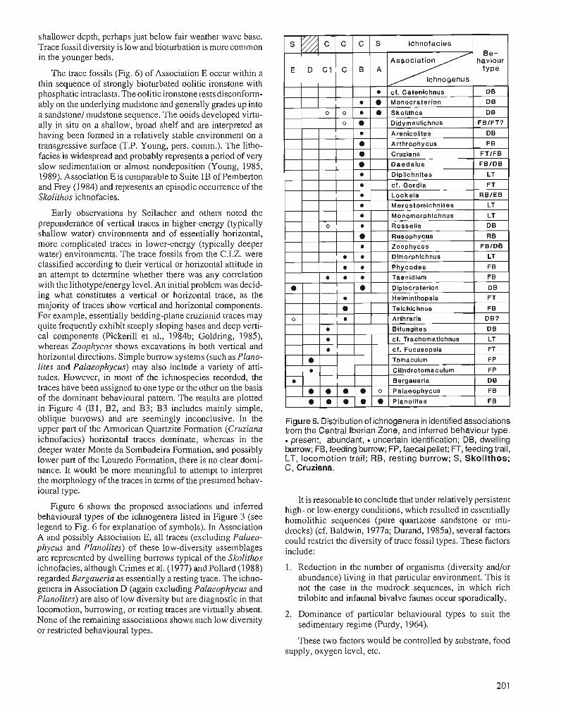
shallower depth, perhaps just below fair weather wave base. Trace fossil diversity is low and bioturbation is more common in the younger beds.
The trace fossils (Fig. 6) of Association E occur within a thin sequence of strongly bioturbated oolitic ironstone with phosphatic intraclasts. The oolitic ironstone rests disconform- ably on the underlying mudstone and generally grades up into a sandstonel mudstone sequence. The ooids developed virtu- ally in situ on a shallow, broad shelf and are interpreted as having been formed in a relatively stable environment on a transgressive surface (T.P. Young, pers. comm.). The litho- facies is widespread and probably represents a period of very slow sedimentation or almost nondeposition (Young, 1985, 1989). Association E is comparable to Suite 1B of Pemberton and Frey (1984) and represents an episodic occurrence of the Skolithos ichnofacies.
Early observations by Seilacher and others noted the preponderance of vertical traces in higher-energy (typically shallow water) environments and of essentially horizontal, more complicated traces in lower-energy (typically deeper water) environments. The trace fossils from the C.I.Z. were classified according to their vertical or horizontal attitude in an attempt to determine whether there was any correlation with the 1ithotypeJenergy level. An initial problem was decid- ing what constitutes a vertical or horizontal trace, as the majority of traces show vertical and horizontal components. For example, essentially bedding-plane cruzianid traces may quite frequently exhibit steeply sloping bases and deep verti- cal components (Pickerill et al., 1984b; Goldring, 1985), whereas Zoophycos shows excavations in both vertical and horizontal directions. Simple burrow systems (such as Plano- lites and Palaeophycus) may also include a variety of atti- tudes. However, in most of the ichnospecies recorded, the traces have been assigned to one type or the other on the basis of the dominant behavioural pattern. The results are plotted in Figure 4 (Bl, B2, and B3; B3 includes mainly simple, oblique burrows) and are seemingly inconclusive. In the upper part of the Armorican Quartzite Formation (Cruziana ichnofacies) horizontal traces dominate, whereas in the deeper water Monte da Sombadeira Formation, and possibly lower part of the Louredo Formation, there is no clear domi- nance. It would be more meaningful to attempt to interpret the morphology of the traces in terms of the presumed behav- ioural type.
Figure 6 shows the proposed associations and inferred behavioural types of the ichnogenera listed in Figure 3 (see legend to Fig. 6 for explanation of symbols). In ~ssociation A and possibly Association E, all traces (excluding Palaeo- phycus and Planolites) of these low-diversity assemblages are represented by dwelling burrows typical of the Skolithos ichnofacies, although Crimes et al. (1977) and Pollard (1988) regarded Bergaueria as essentially a resting trace. The ichno- genera in Association D (again excluding Palaeophycus and Planolites) are also of low diversity but are diagnostic in that locomotion, burrowing, or resting traces are virtually absent. None of the remaining associations shows such low diversity or restricted behavioural types.
Figure 6. Distribution of ichnogenera in identified associations from the Central Iberian Zone, and inferred behaviour type. . present, abundant, uncertain identification; DB, dwelling burrow; FB, feeding burrow; FP, faecal pellet; FT, feeding trail, LT, locomotion trail; RB, resting burrow; S, Skolithos; G, Cruziana.
It is reasonable to conclude that under relatively persistent high- or low-energy conditions, which resulted in essentially homolithic sequences (pure quartzose sandstone or mu- drocks) (cf. Baldwin, 1977a; Durand, 1985a), several factors could restrict the diversity of trace fossil types. These factors include:
1. Reduction in the number of organisms (diversity and/or abundance) living in that particular environment. This is not the case in the mudrock sequences, in which rich trilobite and infaunal bivalve faunas occur sporadically.
2. Dominance of particular behavioural types to suit the sedimentary regime (Purdy, 1964).
These two factors would be controlled by substrate, food supply, oxygen level, etc.
3. Low fossilization potential of traces in a well sorted sediment (Pickerill, 1975).
4. Reworking of sediment, which destroys a high proportion of traces, particularly the surface or shallow-burrowing types (Fiirsich, 1975).
5. Intense bioturbation, which may destroy otherwise dis- crete traces and homogenize the sediment (Fiirsich, 1975).
Conversely, the heterolithic sequences, with their fre- quently abundant and varied ichnofaunas, undoubtedly sup- ported a rich benthic fauna, or diverse life styles; the destruction of traces was countered by the original abundance of traces, and higher fossilization potential (Baldwin, 1977a). The upper part of the Armorican Quartzite typifies this type of sequence, yet body fossils are generally rare. Macrofossils recorded are limited to rare trilobites, inarticulate brachi- opods, and three species of bivalves. An abundant soft-bodied fauna was probably responsible for many of the diverse ichnofossils present.
CONCLUSIONS Shelf mudstones (Brejo Fundeiro and Fonte da Horta forma- tions) with locally rich bivalve, trilobite, ostracode, and brachiopod faunas contain low-diversity trace fossil assem- blages, and little direct evidence of the environmental condi- tions may be deduced from the ichnofauna. The lower Llandeilo (Monte da Sombadeira Formation and Los Rasos sandstone)' and lower Caradoc (Louredo Formation) storm siltstones and sandstones interbedded within the shelf mud- stones yield relatively abundant and diverse traces, but this diversity decreases in the'more sandy, proximal, and higher energy parts of the units (El Cafio Alternation (cf. Pemberton and Frey, 1984). Shallow marine, storm dominated het- erolithic sequences (upper part of the Armorican Quartzite Formation) contain abundant and varied trace fossil assem- blages, but are virtually devoid of body fossils. The lack of complex horizontal traces, which are typical of the Nereites ichnofacies (Seilacher, 1967; Frey and Seilacher, 1980), in- dicates that none of the sequences under study was deposited in deep water. Thus, the composition of the trace fossil assemblages currently known from this region tends to sup- port the paleoenvironmental interpretation of these sequences inferred from sedimentological and body fossil studies (Ham- mann and Henry, 1978; Romano, 1982; GutiCnrez-Marco et al., 1984; RQbano, 1984; Brenchley et al., 1986).
ACKNOWLEDGMENTS Thanks are extended to R.K. Pickerill, G.M. Narbonne and, in particular, D. Fillion for suggesting improvements to the manuscript and for help with taxonomic problems, T.P. Young for making material available and helping in the field, A.H. Cooper for allowing use of his collections, N.D. Mc- Dougall for information on Catenichus, Serviqos Geol6gicos de Portugal for access to the extensive Delgado collection, Miss S. Forster, Miss P. Mellor and Miss C. Pyatt for typing the manuscript, and M. Cooper who redrew the diagrams. Work was support by NERC Grant GR313786.
REFERENCES Almela, A., Alvarado, M., Coma, J., Felbueroso, I., and Quentero, I. 1962: Estudio geoldgico de la regi6n de Almandkn. Boletln del Instituto
Geologico y Minero de Espaiia, v. 73, p. 193-328. Baldwin, C.T. 1977a: The stratigraphy and facies associations of trace fossils in some
Cambrian and Ordovician rocks of north western Spain. In Trace Fossils 2, T.P. Crimes and J.C. Harper (eds.); Geological Journal, Special Issue, no. 9. Seel House Press, Liverpool, p. 9 4 0 .
1977b: Rusophycus morgari: an asaphid produced &ace fossil from the Cambro-Ordovician of Brittany and northwest Spain. Journal of Paleontology, v. 51, p. 411413.
Bouyx, E. 1966: Repartition verticale des pistes bilobCes dans I'Ordovicien inftrieur
de la province de Ciudad Real (Espagne mtridionale). Comptes rendus Sommaire des Seances de la Socittt gtologique de France, fasc. 2, p. 88,89.
Brenchley, P.J., Romano, M., and Gutierrez-Marco, J.C. 1986: Proximal and distal hummocky cross-stratified facies on a wide
Ordovician shelf in Iberia. Canadian Society of Petroleum Geolo- gists, Memoir 1 I, p. 241-255.
Bromley, R.G., Pemberton, S.G., and Rahmani, R.A. 1984: A Cretaceous woodground: the Teredolires ichnofacies. Journal of
Paleontology, v. 58, p. 488498. Carballeira, J., Pol, C., and Duque, J. 1985: Tempestitas del Ordovicico Superior en el sinclinal de CaRaveral
(Ciceres). Trabajos de Geologfa, v. 15, p. 87-97. Cooper, A.H. 1980: The stratigraphy and palaeontology of the Ordovician to Devonian
rocks of the area north of Domes (near Figueird dos Vinhos), central Portugal. Unpublished Ph.D. thesis, University of Sheffield, Eng- land, 429 p.
Cooper, A.H. and Romano, M. 1982: The lower Ordovician stratigraphy of the Domes-Figueir6 dos
Vinhos area, central Portugal, with descriptions of Meros- tornichnites ichnosp. and ~osie l ia socialis; two previously unre- corded trace fossils. Comunica@5es dos Servi~os Geoldgicos de Portugal, v. 68, p. 73-82.
Costa, J.S. Carrington da 1941: Cmzianas do Alto de Santa Justa. Anais de Faculdade de Ciencias
do Porto, v. 26, p. 186-192. Crimes, T.P. 1968: Cruziana: a stratigraphically useful trace fossil. Geological Maga-
zine, v. 105, p. 360-364. 1969: Trace fossils from the Cambro-Ordovician rocks of North Wales
and their stratigraphic significance. Geological Journal, v. 6, p. 333-338.
1970: The significance of trace fossils in sedimentology, stratigraphy and palaeoecology with examples from lower Palaeozoic strata. In Trace Fossils, T.P. Crimcs and J.C. Harper (eds.); Geological Journal, Special Issue no. 3, Seel House Press, Liverpool, p. 101-126.
1975: The stratigraphical significance of trace fossils. In The Study of Trace Fossils - A Synthesis of Principles, Problems and Proce- dures in Ichnology, R.W. Frey (ed.); Springer-Verlag. New York, p. 109-130.
Crimes, T.P., Legg, I., Marcos, A., and Arboleya, M. 1977: ?Late Precambrian-low Lower Cambrian trace fossils from Spain.
In Trace Fossils 2, T.P. Crimes and J.C. Harper (eds.); Geological Journal, Special Issue no. 9, Seel House Press, Liverpool, p. 9 1-138.
Crimes, T.P. and Marcos. A. 1976: Trilobite traces and the age of the lowest part of the Ordovician
reference section for NW Spain. Geological Magazine, v. I 13, p. 349-356.
Crimes, T.P., Marcos, A., and Perez-Estaun, A. 1974: Upper Ordovician turbidites in western Asturias: a facies analysis
with particular reference to vertical and lateral variations. Palaeo- geography, Palaeoclimatology, Palaeoecology, v. 15, p. 169-184.
Delgado, J.F.N. 1886: etude sur les Bilobites et d'autres fossiles des quartzites de la base
du systtme silurique du Portugal. Memoire Section des Travaux Gtologiques de Portugal, 113 p.
1887: etude sur les Bilobites et d'autres fossiles des quartzites de la base du systtme silurien du Portugal (supplkment). Mk~noire Section des Travaux Gtologiques de Portugal, 76 p.
Delgado, J.F.N. (cont'd.) 1908: Syseme silurique du Portugal. ~ t u d e de stratigraphic palContolo-
gique. MCmoire Commission du Service GCologique du Portugal, 245 p.
Durand, J. 1984: Ichnocenoses du Grbs armoricain (Ordovicien infCrieur du Massif
Armoricain) dans leur contexte sbdimentologique. Gbobios: Paltontologie, Stratigraphic, PalCoCcologie, MCmoire special no. 8, p. 189-197.
1985a: Le G&s Armoricain. SCdimentologie - traces fossiles. Milieux de dCp6t. MCmoires et Documents du Centre Armoricain d '~ tode Structurale des Socles, no. 3, 150 p.
1985b: Les traces fossiles indicateurs palbobiologiques de milieux: un exemple dans I'Ordovician armoricain. Bullet~n du Musee National d'Histoire Naturelle, Paris, v. 7, p. 215-227.
Eagar, R.M.C., Baines, J.G., Collinson, J.D., Hardy, P.G., Okolo, S.A., and Pollard, J.E. 1985: Trace fossil assemblages and their occurrence in Silesian (mid-Car-
boniferous) deltaic sediments of the central Pennine Basin, England. In Biogenic Structures: Their Use in Interpreting Depositional En- vironments, H.A. Curran (ed.); Society of Economic Paleontolo- gists and Mineralogists, Special Publication 35, p. 99-149.
Fillion, D. and Pickerill, R.K. 1984: On Arlhraria aniiquaia Billings, 1872 and its relationship to Dip-
locraterion Torell, 1870 and B~fungiles Desio, 1940. Journal of Paleontology, v. 58, p. 683496.
Fortey, R.A. 1984: Global earlier Ordovician transgression and regressions and their
biological implication. In Aspects of the Ordovician System, D.L. Bruton (ed.); Palaeontological Contributions from the University of Oslo, no. 295, Universitetsforlaget, p. 37-50.
Frey, R.W. and Seilacher, A. 1980: Uniformity in marine invertebrate ichnology. Lethaia, v. 13,
p. 183-207. Fiirsich, F.T. 1975: Trace fossils as environmental indicators in the Corallion of Eng-
land and Normandy. Lethaia, v. 8, p. 151-172. Goldring, R. 1985: The formation of the trace fossil Cruziana. Geological Magazine,
V. 122, p. 65-72. GutiCrresMarco, J.C. 1984: Una interesante seiial de actividad biol6gica en el Ordovicico de 10s
Montes de Toledo. COLPA, no. 39, p. 17-25. Gutibrrez-Marco, J.C. and RBbano, I. 1983: Bioestratigrafia de las pizarras ordovicicas en la Sierra de Tamames
(Sinclinal de Sequeros - Ahigal de 10s Aceiteros, prov. Sala- manca). COL-PA, no. 38, p. 13-25.
Gutikrrez-Marco, J.C., RBbano, I., Preito, M., and Martin, J. 1984: Estudio bioestratigriificodel ~lanviin y.~landeilo (~bbrotiviense)
en la parte meridional de laZona Centroibtrica (Esoaiia). Cuadernos . . . de ~eologia IbCrica, v. 9, p. 289-322.
Hammann, W. 1974: Phacopina und Cheirurina (Trilobita) aus dem Ordovizium von
Spanien. Senckenbergiana lethaea, v. 55, p. 1-151. 1983: Calymenacea (Trilobita) aus dem Ordovicium von Spanien; ihre
biostratigraphie, bkologie und systematik. Abhandlungen der Senckenbergischen Naturforschenden Gesellschaft, v. 542, p. 1-177.
Hammann, W. and Henry, J.-L. 1978: Quelques es@ces de Calymenella, Eohomalonolu et Keflort~ella
(Trilobita, Ptychopariida) de I'Ordovician du Massif Armoricain et de la PCninsule IMrique. Senckenbergiana lethaea, v. 59, p. 401-429.
Hammann, W., Robardet, M., and Romano, M. 1982: The Ordovician System in southwestern Europe (France, Spain, and
Portugal). Correlation chart and explanatory notes. International Union of Geological Sciences, Publication no. 11, p. 147.
Henry, 5.-L? Nion, J., Paris, F., and Thadeu, D. 1973-74: Chltlnozoaires, ostracodes et trilobites de I'Ordovicien du Poltugal
(serra de Bu~aco) et du massif Armoricain: essai de comparaison et signification palCogCographique. Comunica$des dos Servi~os GeoMgicos de Portugal, v. 57, p. 303-345.
HernBnde~Pacheco, E. 1908: Consideraciones respecto 6 la organizaci611, gtnero de vida y man-
era de fosilizarse algunos organismos dudosos de la Cpoca sildrica y estudio de las especies de alga y huellas de gusanos arenicolas del sildrico inferior de AlcuCscar (Cgceres). Boletln de la Real Sociedad Espaiiola de Historia Natural, v. 8, p. 75-91.
Hernandez Sampelayo, P. 1950: Nuevas especies silurianas en la Sierra de la Demanda. Libro Jubilar
(1849-1949), Institute Geologico y Minero de Espaih, v. 1, p. 145-171. Kolb, S. and Wolf, R. 1979: Distribution of Cruziana in the Lower Ordovician sequence of
Celtiberia (NE Spain) with a revision oftheCruzianarugosa-group. Neues Jahrbuch fur Geologie und Pallontologie Monatshefte, v. 8, p. 457474.
Lebesconte, P. 1883: Oeuvres posthumes de Marie Rouault, publites par les soins de P.
Lebesconte, suivies de: les Cruziana et Rysophycu, connus sous Le norn g6nCral Bilobites, sont-ils des vCg6taux ou des traces d'ani- maux? F. Savy (Rennes-Paris), 73 p.
Mayoral, E. 1986: Icnofacies de Skolithos y Cruziana en el Ne6geno superior (Plio-
ceno Marino) del sector Huelva-Bonares (Valle del Rio Guadalquivir, Espaiia). Revista Espaiiola de Paleontologia, v. 1, p. 13-28.
McDougall, N.D., Brenchley, P.J., Rebelo, J.A., and Romano, M. 1987: Fans and fan deltas - precursors to the Armorican Quartzite
(Ordovician) in western Iberia. Geological Magazine, v. 124, p. 347-359.
Melbndez, B. 1954: Bilobites del Sil6rico inferior. In Notas Paleontologicas. Boletin de
la Real Sociedad Espaiiola de Historia Natural, v. 5 1, p. 133-135. Melou, M. and Plusquellec, Y. 1975: SurBifungiles? (Problematica) du "Grbs de Kenneur", Ordovicien
de la Presqu'ile de Crozon (Finistbre, France). Neues Jahrbuch fiir Geologie und Palaontologie Monatschefte, v. 8, p. 465-479.
Moreno, F., Vegas, R., and Marcos, A. 1976: Sobre la edad de las series Ordovicicas y CQmbricas relacionadas
con la discordancia "sardica" en el anticlinal de Valdelacasa (Mon- tes de Toledo, Espaiia). Breviora Geologia Astiirica, Aiio xx, no. I, Oviedo, p. 8-16.
Narbonne, G.M. 1984: Trace fossils in Upper Silurian tidal flat to basin slope carbonates
of Arctic Canada. Journal of Paleontology, v. 58, p. 398415. Paris, F. 1979: Les Chitinozoaires de la Formation de Louredo, Ordovicien
Sup61ieur de synclinal de Busaco (Portugal). Palaeontographica A, V. 164, p. 24-5 1.
1981: Les chitinozoaires dans le PalCozoi'que du sud-ouest de I'Europe. (Cadre gCologique - ktude systernatique - Biostratigraphie). MCmoire de la SociCtC geologique et minCralogique de Bretagne, v. 26,412 p.
Pemberton, S.G. and Frey, R.W. 1984: Ichnology of storm-influenced shallow marine sequence: Cardium
Formation (Upper Cretaceous) at Seebe, Alberta. In The Mesozoic of Middle North America, D.F. Stott and D.J. Glass (eds.); Canadian Society of Petroleum Geologists, Memoir 9, D. 281-304.
1985: The ~ioss&ngites ichnofac&: modern exarnblcs from the Georgia coast. U.S.A. In Bioaenic Shuctures: Their Use in Intemreting Deoo- sitiond ~nvironmenk, H.A. Curran (ed.); Society of &ono$c pale- ontologists and Mineralogists, Special Publication 35, p. 237-259.
PerdigPo, J.C. 196445: Sobre a descoberta de Cruziana et Vexillurn (= Daedalus) na Colina
de Cuncos (MourBo). CornunicaqGes dos Servigos geol6gicos de Portugal, v. 65, p. 193-199.
Pickerill, R.K. 1975: Application of ichnology to the study of ancient marine benthic
community paleoecology. Maritime Sediments, v. 1 I, no. 2, p. 49-52. Pickerill, R.K. and Fillion D. 1983: On the Tremadoc-Arenig and lower-upper Tremadoc boundaries
in the Bell Island Group, Conception Bay, eastern Newfoundland. Maritime Sediments and Atlantic Geology, v. 19, p. 21-30.
Pickerill, R.K., Fillion, D., and Harland, T.L. 1984a: Middle Ordovician trace fossils in carbonates of the Trenton Group
between Montreal and Quebec City, St. Lawrence Lowland, eastern Canada. Journal of Paleontology, v. 58, p. 416439.
Pickerill, R.K., Fyffe, L.R., and Forbes, W.H. 1987: Late Ordovician-Early Silurian trace fossils from the Matapedia
Group, Tobique River, western New Brunswick, Canada. Maritime Sediments and Atlantic Geology, v. 23, p. 77-88.
Pickerill, R.K., Romano, M., and Melbndez, B. 1984b: Arenig trace fossils from the Salamanca area, western Spain. Geo-
logical Journal, v. 19, p. 249-269.
Pollard, J. 1988: Trace fossils in coal-bearing sequences. Journal of the Geological
Society, London, v. 145, p. 339-350. Purdy, E.G. 1964: Sediments as substrates. In Approaches to Paleoecology, J. Imbrie
and N. Newell (eds.); J. Wiley and Sons, New York, p. 238-271. RBbano, I. 1984: Trilobites ordovlcicos del Macizo HespCrico espaiiol: una visidn
bioeshatigrzlfica. Cuadernos de Geologia Iberia, v. 9, p. 267-287. Radig, F. 1964: Die Lebensspur Tomaculum problematicum Groom 1902 im Llan-
deilo der lberischen Halbinsel. Neues Jahrbuch fiir Geologie und Pallontologie, Abhandlungen, v. 119, p. 12-18.
Rebelo, J.A. 1980-81: Sobre o prolongamento para este do jazigo de ferro de Jvioncorvo.
Boletim da Sociedade Geoldgica de Portugal, v. 22, p. 267-271. Rebelo, J. and Romano, M. 1988: A contribution to the lithostratigraphy and palaeontology of the lower
Palaeozoic rocks of the MO~CONO region, northeast Portugal. Comu- nicaq- dos Sewiqos Geoldgicos de Portugal, v. 72, p. 45-57.
Romano, M. 1974: The palaeoenvironment and ichnology of the Lower Ordovician
rocks at Aphlia, north Portugal. Boletim do Museu e Laborat6rio Mineral6gico e Geoldgico da Faculdade de CiCncias, v. 14, p. 63-76.
1982: The Ordovician biostratigraphy of Portugal -a review with new data and re-appraisal. Geological Journal, v. 17, p. 89-1 10.
Romano, M., Brenchley, P.J., and McDougall, N.D. 1986: New information concerning the age of the beds immediately over-
lying the Armorican Quartzite in central Portugal. Gtobios: PalCon- tologie, Stratigraphic, PalCokcologie, no. 19, p. 421-433.
Romano, M. and Diggens, J.N. 1973-74: The stratigraphy and structure of Ordovician and associated rocks
around Valongo, north Portugal. Comunica$Ges dos Servi~os Geol6gicos de Portugal, v. 57, p. 22-50.
Rouault, M. 185 1: Note prbliminaire (1) sur une nouvelle formation dkcouverte dans
le terrain silurien infbrieur de la Bretagne. Bulletin de la Socibtk GCologique de France, SCrie 2, v. 7, p. 724-744.
Seilacher, A. 1960: Lebenspuren als Leitfossilien. Geologische Rundschau, v. 49,
p. 41-50. 1963: Kaledonischer unterbau der Irakiden. Neues Jahrbuch fur Geologie
und Pallontologie Monatshefte, p. 527-542. 1964: Biogenic sedimentary structures. In Approaches to Paleoecology, J.
Imbrie and N. Newell (eds.); J. Wiley and Sons, New York, p. 296-316.
1967: Bathymetry of trace fossils. Marine Geology, v. 5, p. 413428. 1970: Cruziana stratigraphy of "non-fossiliferous" Palaeozoic sand-
stones. In Trace Fossils, T.P. Crimes and J.C. Harper (eds.); Geo- logical Journal, Special Issue no. 3, See1 House Press, Liverpool, p. 447476.
Tromelin, G. de 1878: Etude de terrains palkozdiques de la Basse-Normandie, particu-
likrement dans les dbpartements de I'Orne et du Calvados. Associa- tion Fran~aise pour I'Avancement des Sciences, Compte Rendu, v. 6, p. 493-501.
Young, T.P. 1985: The stratigraphy of the upper Ordovician of central Portugal. Un-
published Ph.D. thesis, University of Sheffield, England, 441 p. 1988: The lithostratigraphy of the upper Ordovician of central Portugal.
Journal of the Geological Society, London, v. 145, p. 377-392. 1989: Eustatically controlled ooidal ironstone deposition: facies relation-
ships of the Ordovician open-shelf ironstones of Western Europe. In Phanerozoic Ironstones, T.P. Young and W.E.G. Taylor (eds.); Geological Society Special Publication no. 46, Geological Society of London, p. 51-63.
Environmental cycles and bioevents in the Upper Ordovician Red River-Stony Mountain solitary
rugose coral province of North America
Robert J. ~ l i a s l
Elias, R.J., Environmental cycles and bioevents in the Upper Ordovician Red River-Stony Mountain solitary rugose coral province of North America; & Advances in Ordovician Geology, C.R. Barnes and S.H. Wil- liams (ed.), Geological Survey of Canada, Paper 90-9, p. 205-211,1991,
Abstract
Stratigraphic sequences within the Red River-Stony Mountain Province record two major environmental cycles in a vast area of epicontinental seas. The Red River Cycle began with a transgressive phase in the middle Edenian that reached its maximum in the early Maysvillian, and was followed by a regressive phase during the later Maysvillian and early Richmondian. The transgressive phase of the Stony Mountain Cycle reached its peak in the middle Richmondian, and was followed by a regressive phase during the later "Ichmondian and Gamachian. In general, the greatest water depth and most open marine conditions were attained during the first cycle, and seas were shallowest and most restricted toward the end of the second cycle. Recognition of the transgressive maxima, when deposition was most widespread, permits chronos- tratigraphic correlation throughout the province (and likely beyond).
Bioevents involving evolution and dispersion of solitary rugose corals in the Red River-Stony Mountain Province, as well asfluctuations in the relative abundance of taxa, were closely related to changes in water depth and degree of environmental restriction during the two cycles. The first major evolutionary event took place during the transgressive maximum of the Red River Cycle, when water depth in some areas exceeded the limit for corals and they were confined to basin margins and structural highs. The second occurred at the end of the Red River regressive phase, when most areas became inhospitable and corals were restricted to the centres of cratonic interior basins and to cratonic margin areas of the province. Corals became widely dispersed during the subsequent transgressive phase of the Stony Mountain Cycle. Late in the regressive phase of that cycle, taxa were introducedfr-om outside the Red River-Stony Mountain Province, and the endemic corals became extinct.
Les stquences stratigraphiques au sein de la province de Red River-Stony Mountain rkvklent deux importants cycles environnementaux dans,une vaste rtgion de mers tpicontinentales. Le cycle de Red River a dkbutkavec une phase transgressive a I' Edenien moyen qui a atteint son maximum au Maysvillien infkrieur et il a kt6 suivi par une phase rkgressive au cours du Maysvillien suptrieur et du Richmondien infkrieur. La phase transgressive du cycle Stony Mountain a atteint son maximum au Richmondien moyen et a kt6 suivie par une phase rtgressive durant le Richmoizdien suptrieur et le Gamachien. En gknkral, c'est au cours du premier cycle que les profondeurs d'eau les plus grandes et les conditions marines les plus grandes ont ktk atteintes; de plus, les mers ont atteint leur niveau le moins profond et leurs conditions les plus rtduites vers la fin du second cycle. La dkterminafion des maxima de transgression, lorsque la stdimentation a atteint sa plus grande superficie permet d'ttablir une corrtlation chronostratigraphique a l'kchelle de toute la province (et probablement au-dela).
Les biotvtnements liks a l'kvolution et a la dispersion des rugosa solitaires dans la province de Red River-Stony Mountain ainsi que les fluctuations de l'abondance relative de taxons ont kt6 ktroitement corrklks a m changements de profondeur d'eau et au degre' de restriction environnementale au cours des
' Department of Geblogical Sciences, 'The University of Manitoba, Winnipeg, Manitoba R3T 2N2
deux cycles. Le premier e'vtnement important lit a l'e'volution a eu lieu au cours du maximum de transgression du cycle de Red River lorsque la profondeur de l'eau duns certaines zones a dkpasst la limite des coraux et que ces derniers ont btt confints aux marges de bassin et aux hauteurs structurales. Le second kvtnement a eu lieu d la fin de la phase rtgressive de Red River lorsque la plupart des zones sont devenues inhospitali2res et que la prtsence des coraux s'est limitte au centre des bassins inte'rieurs cratoniques et aux zones de marge cratonique de la province. Les coraux se sont disperse's conside'rahlement au cours de la phase de transgression substquente du cycle de Stony Mountain. A la fin de la phase de rtgression de ce cycle, des taxons provenant de zones exte'rieures de la province de Red River-Stony Mountain ont tte' introduits et les coraux indigtnes ont disparu.
INTRODUCTION The Late Ordovician Red River-Stony Mountain Solitary Rugose Coral Province of North America occupied a vast area of shallow epicontinental seas, in which carbonate sedi- mentation was predominant (Fig. 1). Characteristic taxa are species of Grewingkia including triangulate to trilobate corals (the normal cross-sectional shape is circular), and the genera Lobocorallium (derived from Grewingkia), Deiracorallium, Salvadorea, and Bighornia. ~aleoecolo~ical and taphonomic studies indicate a close ecological relationship between GrewingkialLobocorallium and Deiracorallium, and be- tween Salvadorea and Bighornia. The former group evidently preferred relatively deep water (but above s tom wave base), high energy, open marine environments, whereas the latter favoured comparatively shallow water, low energy environ- ments and tolerated somewhat restricted conditions (Elias, 1982b, p. 1586, 1587; Elias, 1985, p. 13-16; Buttler et al., 1988, p. 56; Elias, Zeilstra, and Bayer, 1988, p. 33; Elias, Nowlan, and Bolton, 1988, p. 347). Therefore, temporal and geographic patterns in the distribution and relative abundance of these genera should prove useful for paleoenvironmental reconstruction.
The purpose of this paper is to document and characterize major environmental cycles in the Red River-Stony Moun- tain Province, to evaIuate their chronostratigraphic signifi- cance, and to determine the relationship of bioevents involving solitary rugosan evolution and dispersion to these cycles.
WILLISTON BASIN, SOUTHERN MANITOBA The middle Edenian through Gamachian sequence of south- em Manitoba and elsewhere within the Williston Cratonic Interior Basin represents, virtually continuous, mainly car- bonate deposition, and records two major environmental cycles (Figs. 1, 2; Cowan, 197 1, p. 239, 240; Kendall, 1976, p. 46-58). The lower Red River Formation (Dog Head, Cat Head, and Selkirk members) was deposited in open marine conditions. The Dog Head and Selkirk members are litho- and biofacies equivalents. The Cat Head Member between them, which contains chert nodules, sponges (Rigby, 1971), com- paratively small cephalopods (Flower, 1971), and remarkably well preserved megascopic algae (Fry, 1983), is here consid- ered to record the first transgressive maximum. The lower Stony Mountain Formation (Gunn and Penitentiary members)
is also an open marine deposit. The argillaceous, highly fossiliferous Gunn Member marks the second transgressive phase. The Penitentiary Member represents a transition to more restricted conditions (Elias, 1982b, p. 1585). The upper Red River Formation (Fort Garry Member) and the upper Stony Mountain Formation (Gunton and Williams members) plus Stonewall Formation consist of sedimentary cycles, some of which include evaporites. These units were deposited in restricted conditions during later stages of the first and second regressive phases.
Figure 1. Late Ordovician Red River-Stony Mountain Soli- tary Rugose Coral Province in western and central North America (Elias, 1981, 1982a, 1983, 1985, new data; Buttler et al., 1988); thick solid and dashed lines show established, and uncertain boundaries, respectively. Medium dashed lines show outline of cratonic interior basins. Locations 1-4 are southern Manitoba, northern Manitoba, southern New Mexico and westernmost Texas, and AkutlakCreek in British Columbia, respectively.
Solitary rugose corals are diverse and common in the Selkirk Member of the Red River Formation, but Whiteaves (1897, p. 154) reported only a few comparatively small specimens from the Dog Head Member. The two small indi- viduals documented by Caramanica (1973, p. 314, 351) are identified as Salvadorea? sp. and Grewingkia sp. herein. Caramanica (1973, p. 62) and Elias (1981, p. 10) observed single unidentifiable specimens in the Cat Head Member. It seems likely that the majority of species in the Selkirk Mem- ber were not present earlier. Grewingkia robusta, which is known from older strata elsewhere in the Red River-Stony Mountain Province, is considered to be the ancestor of G.
G. : GAMACHIAN t : 1 MARKER BED W : WILLIAMS MBR. G : GUNTON MBR. P : PENITENTIARY MBR.
Figure 2. Composite section showing Upper Ordovician units and solitary rugose corals in southern Manitoba (see Fig. 1, loc. 1); T, transgressive phase; R , regressive phase; o, open marine stage; r, restricted marine stage; , , first cycle (Red River Cycle); second cycle (Stony Mountain Cycle) (see text). Section based on McCabe and Barchyn (1 982, Fig. 10) and McCabe (pers. comm., 1987). Ages extrapo- lated from Sweet (1979, p. 54, Fig. 4). Ordovician-Silurian boundary (top of Gamachian) has been placed at top of Stonewall Formation (Stearn, 1956, p. 14-1 6) and at t marker bed within Stonewall (Brindle, 1960, p. 18, 19). Distribution of corals based on Caramanica (1 973) for Dog Head and Cat Head members of Red River Formation, Elias (1 981 , 1982b, 1983, new data) and Elias, Nowlan, and Bolton (1 988) for Cat Head to Fort Garry members of Red River Formation and Stony Mountain Formation, and Stearn (1 956) for Stone- wall Formation, with taxonomy updated; wide line indicates interval of occurrence, narrow dashed line indicates that exact position within an interval is uncertain, diagonal line indicates start or termination of rarise at base or top of
crassa crassa, G. lamellosa, G. dilata, and G. haysii selkirkensis (a trilobate species) (see Elias, 1985, p. 17). The last three are endemic, suggesting evolution within the Williston Basin. The Selkirk assemblage is Grewingkia-dominated. Salva- dorea randi is the only species known to range into the Fort Garry Member. This reflects the change from relatively deep and open environments to comparatively shallow and re- stricted conditions during the regressive phase of the first cycle.
New taxa appear in the Gunn Member of the Stony Mountain Formation. Salvadorea selecta arose from S. randi, probably in the Williston Basin. Bighorniapatella descended from B. wilsonae, possibly in this basin. Lobocorallium tri- lobatum evolved from G. haysii. Deiracorallium angulatum arose from a Maysvillian species such as D. delicatum. All four species range into the Penitentiary Member. The Gunn assemblage is Salvadorea-dominated, suggesting that the sea was shallower and less open during the second transgressive phase than during Selkirk Member deposition. The Bighor- nia-dominated assemblage at the base of the Penitentiary Member reflects somewhat more restricted conditions. Big- hornia sp. cf. B. integriseptata occurs at the base of the Gunton Member, where moulds of evaporite minerals mark the change to restricted environments during the regressive phase of the second cycle. This large form of Bighornia, which evolved from B. patella, is also present in the Stone- wall Formation. Lobocorallium and Deiracorallium are not known from the restricted stage of the regressive phase. Streptelasma? hindi, introduced during Stonewall deposition, is not a Red River-Stony Mountain taxon.
HUDSON BAY BASIN, NORTHERN MANITOBA
The Upper Ordovician sequence of northern Manitoba and elsewhere within the Hudson Bay Cratonic Interior Basin represents predominantly carbonate deposition and records two major environmental cycles (Figs. 1, 3; Le Fevre et al., 1976, p. 75-77,79-81). It seems probable that sedimentation was virtually continuous from the Edenian through Gama- chian, as in the Williston Basin. The Portage Chute Formation (lower Bad Cache Rapids Group) and Caution Creek Forma- tion (lower Churchill River Group) were deposited in open marine conditions. Peaks in conodont frequency logs in the middle of the Portage Chute and lower part of the Caution Creek (Le Fkvre et al., 1976, Fig. 2) may mark the first and second transgressive maxima. Member 1 of the Caution Creek is the most fossiliferous unit in the entire sequence (Nelson, 1963, p. 14). The Surprise Creek Formation (upper Bad Cache Rapids Group) and the Chasm Creek Formation (upper Churchill River Group) plus the Red Head Rapids Formation accumulated in somewhat restricted to evaporitic environments during later stages of the first and second regressive phases.
measured section. Pie diagrams show relative abundance The solitary rugosan assemblage in the Portage Chute and of genera in the intervals indicated, based on corals identified lower Surprise Creek formations is Grewingkia-dominated, to 'pecies level E l i a s 981) for Red River Formation at indicating relatively deep, open marine conditions, Its disap- Garson, and corals identified to genus level by Elias (1 982b, Table 2; identified to species level by Elias, 1983) for Stony pearance higher in the Creek the change ~ ~ ~ ~ t ~ i ~ ti^^ at stony Mountain; N, number of speci- restricted environments during the regressive phase of the mens. first cycle. New taxa appear in the Caution Creek Formation.
Salvadorea distincta distincta and Bighornia patella were introduced to the Hudson Bay Basin from elsewhere. The trilobate coral Grewingkia haysii haysii evolved from G. robusta, possibly in this basin. The representative of Deira- corallium arose from a Maysvillian species such as D. harveyi. The Caution Creek assemblage is SalvadorealBig- hornia-dominated, suggesting that the sea was not as deep and open during the second transgressive phase as during deposition of the Portage Chute and lower Surprise Creek formations. The Caution Creek taxa range into or through the Chasm Creek Formation.
G.(?) : GAMACHIAN(7) A : ABUNDANT M : MORE COMMON C : COMMON F : FAIRLY COMMON R : RATHER RARE + : NO. OF CORALS ......
RAPIDS
Figure 3. Composite section showing Upper Ordovician units and solitary rugose corals in northern Manitoba (see Fig. 1, loc. 2); T, transgressive phase; R, regressive phase; o, open marine stage; r, restricted marine stage; , , first cycle (Red River Cycle); ,, second cycle (Stony Mountain Cycle) (see text). Section based on IVelson (1981, Fig. 2). Ages based on extrapolation from Williston Basin to Hudson Bay Basin using Sweet (1 979, p. 54, Fig. 4) and Cumming (1 975, Table 1). Distribution of corals based on Nelson (1963, 1981), with taxonomy updated; solid line indicates interval of occurrence, dashed line indicates that exact position within an interval is uncertain. Pie diagram shows relative abundance of genera in the interval indicated, based on corals identified to species level by Nelson (1 981, Table 3); N, number of specimens. For Churchill River Group, relative abundance is indicated using number of corals identified to species level by Nelson (1 981, Table 3) and statements by Nelson (1963) for the marked intervals; explanations of abbreviations are given above stratigraphic column.
Bighomia Oottei (possibly a synonym of B. integrisep- tata), a large species that evolved from B. patella, appears at the base o f the Chasm Creek. This coincides with the change from open to relatively restricted conditions during the sec- ond regressive phase. Salvadorea sp. 2 (of Nelson, 198 1) and Deiracoral l i~~m prolongatum were later introduced to the Hudson Bay Basin. Paliphyllum? stummi, which appears in the upper Chasm Creek, is not a Red River-Stony Mountain taxon. Assemblages in the Chasm Creek are SalvadoreaJBig- hornia-dominated. The disappearance o f Deiracorallium fol- lowed by other solitary corals at the top o f the Chasm Creek mark changes to more restricted conditions near the end of the regressive phase.
SOUTHERN NEW MEXICO AND WESTERNMOST TEXAS
The middle Edenian to late Richmondian Montoya Group represents virtually continuous, predominantly carbonate deposition in a cratonic margin setting, several hundred kilo- metres from the Ouachita Geocline (Figs. 1, 4; Brimberry, 1984; Elias, 1985, p. 3-7 and references cited therein; Meas- ures, 1985a, b). The Second Value Dolomite was deposited
C : CABLE CANYON SANDSTONE MBR.
Figure 4. Composite section showing Upper Ordovician units and solitary rugose corals in southern New Mexico and westernmost Texas (see Fig. 1, loc. 3); T, transgressive phase; R, regressive phase; ,, first cycle (Red River Cycle); ,, second cycle (Stony Mountain Cycle) (see text). Ages and thickness of units based on Sweet (1 979, Fig. 4). Distribution of corals based on Elias (1 985, 1986), with taxonomy up- dated; wide line indicates interval of occurrence, narrow dashed line indicates that exact position within an interval is uncertain. Pie diagrams show relative abundance of genera in the intervals indicated, based on corals identified to spe- cies level (positively and probably) by Elias (1 985, Table 1); N, number of specimens.
in open marine conditions during a transgressive phase. The basal portion of the Aleman Formation marks the first trans- gressive maximum. Relict anhydrite nodules scattered through the formation in one area suggest somewhat re- stricted conditions, at least locally, during the regressive phase. The Sierra Diablo area of westemmost Texas became emergent at the end of Aleman deposition, recording the regressive maximum. Argillaceous basal beds of the Cutter Dolomite mark the beginning of the second transgressive phase. From the composite conodont relative abundance log of Sweet (1979, Fig. 4), it is inferred that a transgressive maximum in the middle Cutter was followed by a regressive phase. Cyclic bedding has been reported in the Cutter.
The Grewingkia-dominated assemblage of the Second Value Dolomite reflects relatively deep, open marine condi- tions during the first transgression. These corals disappeared as water depth neared its maximum. Grewingkia franklinen- sis and possibly Salvadorea distincta distincta appear in the Aleman Formation above the transgressive peak. The first is an endemic, trilobate species that arose from G. robusta, likely in the vicinity of Montoya sedimentation. The second possibly evolved from a coral such as Salvadorea? sp. A or B (of Elias, 1985), which occurs in the Second Value. 'The endemic subspecies G. crassa alemanensis, which likely arose from G. crassa crassa of the Williston Basin and northern North America, appeared later during the regressive phase. The upper Aleman assemblage is Salvadorea-domi- nated, indicating that environments were shallower and more restricted during the regressive phase than during Second Value deposition. Salvadorea distincta cutterensis, an en- demic subspecies, appears at the base of the Cutter Dolomite. It arose from S. distincta distincta, likely in the area of Montoya deposition. Bighornia patella was introduced dur- ing the second transgressive phase. Grewingkia sp. cf. G. franklinensis is the only representative of that genus in the Cutter. Ths high relative abundance of Salvadorea in the upper Montoya suggests that the sea was relatively shallow, and more restricted during the second environmental cycle than during the first. Solitary rugose corals disappeared from this region during the second regressive phase.
AKUTLAK CREEK, BRITISH COLUMBIA The Beaverfoot Formation in the southern Rocky Mountains of British Columbia and Alberta represents dominantly car- bonate deposition that began during the Late Ordovician and continued into the Early Silurian in a cratonic margin setting an unknown distance from the edge of the continent (Fig. 1; Buttler et al., 1988, p. 49,50,58-60). The Bighornia-Thaero- donta Zone of the lower Beaverfoot has been traced to 128 m above the base of the formation at Akutlak Creek (Fig. 5). All solitary rugosan taxa that are present (as well as Salvadorea sp. 2 [of Nelson, 1981.1 and Bighornia sp. cf. B. bottei, which have been found in this zone at other localities) also occur in the Churchill River Group of northern Manitoba. The entire Bighornia-Thaerodonta Zone is probably Richmondian in age, and strata of the lower Beaverfoot are here considered to have been deposited during the second major Late Ordovician environmental cycle.
Solitary rugose corals were introduced to this region during a transgressive phase, in which the dominantly clastic Whiskey Trail Member of the Beaverfoot Formation was deposited. Deiracorallium prolongaturn may have evolved from D. harveyi of theHudson Bay Basin. Norford (1969, p. 32) stated that "the horizon of widespread Beaverfoot transgres- sion seems to be the top of the Whiskey Trail." The assem- blage in the Whiskey Trail is Salvadorea-dominated, but Grewingkia is dominant in overlying carbonate beds of the Beaverfoot. This is considered to reflect deeper water and more open conditions at the peak of the transgression. Higher in the Bighornia-Thaerodonta Zone, the increasing relative abundance of Salvadorea and Bighornia, decreasing abun- dance of Grewingkia, and disappearance of Deiracorallium suggest a regressive phase and increasingly restricted conditions.
DISCUSSION.AND CONCLUSIONS Stratigraphic sequences within the Red River-Stony Moun- tain Province that represent virtually continuous deposition from the Edenian to Richmondian or Gamachian record two
Figure 5. Section showing Beaverfoot Formation and distri- bution of solitary rugose corals at Akutlak Creek, British Columbia (see Fig. 1, loc. 4), based on Buttler et al. (1988); T, transgressive phase; R, regressive phase; ,, second cycle (Stony Mountain Cycle) (see text). Top of section marks highest level to which Bighornia-Thaerodonta Zone has been traced in the Beaverfoot of the southern Rocky Moun- tains, British Columbia and Alberta; entire zone is probably Richmondian. Pie diagrams show relative abundance of genera in the intervals indicated, based on corals identified to species level (positively and probably) by Buttler et al. (1988, Table 3.1, Fig. 3.4); N, number of specimens.
major environmental cycles in a vast area of epicontinental seas (Figs. 2-4). The first, here termed the Red River Cycle, began with a transgressive phase in the middle Edenian that reached its maximum in the early Maysvillian, and was followed by a regressive phase during the later Maysvillian and early Richrnondian. The transgressive phase of the sec- ond cycle, here termed the Stony Mountain Cycle, reached its peak in the middle Richmondian, and was followed by a regressive phase during the later Richrnondian and Gama- chian. Le Fhvre et al. (1976, p. 76) noted that the latter regression corresponds to the latest Ordovician glacial maximum, and the first may reflect an earlier climax.
Greater thicknesses of sediment accumulated during re- gressive phases than during transgressive phases of the Red River and Stony Mountain cycles in cratonic interior basins and cratonic margin areas. Differences from place to place in the thickness of cycles and phases within them reflect variable rates of subsidence and sedimentation (e.g., Elias, Nowlan, and Bolton, 1988, p. 346). For both cycles in the Williston and Hudson Bay basins, relatively open marine conditions prevailed during the transgressive phase and early stage of the regressive phase, whereas environments were somewhat re- stricted to evaporitic during the later stage of the regressive phase. Cyclic sedimentation during the restricted phases in the Williston Basin (and probably elsewhere) was related to fluctuations in sea level (likely eustatic; Sweet, 1979, p. 54) and/or basin salinity (Kendall, 1976, p. 53-55, 57; Elias, Nowlan, and Bolton, 1988, p. 346).
In general, the greatest water depths and most open marine conditions were attained during the Red River Cycle, and seas were shallowest and most restricted toward the end of the Stony Mountain Cycle. In the western Midcontinent of the United States south of the Williston Basin, deposition was widespread during the early Maysvillian (maximum submer- gence) and middle Richmondian, and unconformities span the late Maysvillian-early Richrnondian and the late Rich- mondian-Gamachian (maximum emergence) (see Sweet, 1979, Fig. 4). These unconfonnities suggest that seas in cratonic interior basins became isolated from ocean waters along the continental margin during regressive phases of the two cycles.
It seems probable that recognition of the transgressive maxima in the Red River and Stony Mountain cycles (when deposition was most widespread) would permit chronostra- tigraphic correlation among sections within the Red River- Stony Mountain Province (and likely beyond). Thus, the Cat Head Member of the Red River Formation, strata in the middle of the Portage Chute Formation, and basal beds of the Aleman Formation are correlable. Strata near the base of the Stony Mountain and Caution Creek formations, near the middle of the Cutter Dolomite, and in the Bighornia-Thaero- donta Zone of the Beaverfoot Formation a short distance above the Whiskey Trail Member, are considered correlative (Figs. 2-5). The above correlations between New Mexico- Texas and the Williston Basin in southern Manitoba agree precisely with those of Sweet (1979, Fig. 4) based on cono- dont biostratigraphy extrapolated to a subsurface section within the Williston Basin in Montana. Sweet equated the
lower Cutter Dolomite in New Mexico-Texas with the Herald Formation (= Fort Garry Member of the Red River Forma- tion) in the Williston Basin. If the boundary between the Red River and Stony Mountain cycles is considered synchronous, the lower Cutter correlates with basal beds of the Stony Mountain Formation. A problematic sequence containing Richmondian conodonts at Churchill in northern Manitoba (see Johnson et a]., 1988, p. 96, 112) probably records the transgressive phase of the Stony Mountain Cycle, and likely represents the Churchill River Group (a possibility noted by Norford, 197 1, p. 206).
Bioevents involving evolution and dispersion of solitary rugose corals in the Red River-Stony Mountain Province, as well as fluctuations in the relative abundance of taxa, were closely related to changes in water depth and degree of restriction during the Red River and Stony Mountain cycles. The first major evolutionary event evidently occurred at the time of the first transgressive maximum, in the early Mays- villian. It is suggested that as water depth in some places such as the Williston Basin and area of Montoya deposition ex- ceeded the limit for most or all corals, their geographic ranges were reduced to basin margins and structural highs. Evolution apparently occurred rapidly in these populations, which were probably small, and the descendants and survivors dispersed as favourable conditions returned very early in the regressive phase. Trilobate species of Grewingkia and corals definitely representing Salvadorea appeared at that time. As conditions changed from relatively deep and open to shallower and more restricted during the first regressive phase, the Grewingkia- dominated assemblage disappeared from the Hudson Bay Basin, and Grewingkia was followed by Salvadorea as the dominant taxon in the Williston Basin and area of Montoya deposition.
The second major evolutionary event occurred at the end of the first regressive phase, in the early Richmondian. It is suggested that as most areas became inhospitable, geographic ranges of corals were reduced to the centres of cratonic interior basins and to cratonic margin areas in the Red hver- Stony Mountain Province. Evolution apparently occurred rapidly, and the descendants and survivors dispersed widely within the province as favourable conditions spread during the second transgressive phase. Bighorniapatella, and Lobo- corallium or trilobate species of Grewingkia (but not normal to triangulate forms of Grewingkia), typically occur in these assemblages, which are generally Salvadorea-dominated. In the Williston and Hudson Bay basins, the appearance of a large species of Bighornia coincided with a change to more restricted conditions during the second regressive phase. Late in the regressive phase (late Richmondian-Gamachian), taxa were introduced from outside the Red River-Stony Mountain Province. and the endemic corals became extinct.
ACKNOWLEDGMENTS This research was supported by grants from the Natural Sciences and Engineering Research Council of Canada. I thank the reviewers and editors for helpful suggestions.
REFERENCES Biimberry, D.L. 1984: Depositional environments, conodont biostratigraphy, and porosity
diagenesis of Montoya Group (Upper Ordovician), Sacramento Mountains, south-central [New] Mexico. American Association of Peh0kum Geologists, Bulletin, v. 68, p. 457,458.
Brindle, J.E. 1960: The faunas of the lower Palaeozoic carbonate rocks in the subsur-
face of Saskatchewan. Saskatchewan Department of Mineral Re- sources, Report 52,45 p.
Buttler, C.J., Elias, R.J., and Norford, B.S. 1988: Upper Ordovician to lowermost Silurian solitary rugose corals from
the Beaverfoot Formation, southern Rocky Mountains, British Co- lumbia and Alberta. bz Contributions to Canadian Paleontology, Geological Survey of Canada, Bulletin 379, p. 47-91.
Caramanica, F.P. 1973: Ordovician corals of the Williston Basin periphery. Unpublished
Ph.D. thesis, University of North Dakota, 570 p. Cowan, J. 1971: Ordovician and Silurian stratigraphy of the Intcrlake area, Mani-
toba. In Geoscience Studies in Manitoba, A.C. Turnock (ed.); Geological Association of Canada, Special Paper 9, p. 235-241.
Cumming, L.M. 1975: Ordovician strata of the Hudson Bay Lowlands. Geological Survey
of Canada, Paper 74-28,93 p. Elias, R.J. 1981: Solitary rugose corals of the Selkirk Member, Red River Formation
(late Middle or Upper Ordovician), southern Manitoba. Geological Survey of Canada, Bulletin 344,53 p.
1982a: Latest Ordovician solitary rugose corals of eastern North America. Bulletins of American Paleontology, v. 81, no. 314, 116 p.
1982b: Paleoecology and biostratinomy of solitary rugose corals in the Stony Mountain Formation (Upper Ordovician), Stony Mountain, Manitoba. Canadian Journal of Earth Sciences, v. 19, p. 1582-1598.
1983: Late Ordovician solitary rugose corals of the Stony Mountain Formation, southern Manitoba, and its equivalents. Journal of Pale- ontology, v. 57, p. 924-956.
1985: Solitary rugose corals of the Upper Ordovician Montoya Group, southern New Mexico and westernmost Texas. Paleontological Society, Memoir 16,58 p.
1986: New Late Ordovician solitary rugose coral with perforate septa. Journal of Paleontology, v. 60, p. 14-25.
Elias, R.J., Nowlan, G.S., and Bolton, T.E. 1988: Paleontology of the type section, Fort Gany Member, Red River
Formation (Upper Ordovician), southern Manitoba. In Contribu- tions to Paleozoic Paleontology and Stratigraphy in Honor of Rous- seau H. Flower, D.L. Wolberg (comp.); New Mexico Bureau of Mines and Mineral Resources, Memoir 44, p. 341 -359.
Elias, R.J., Zeilstra, R.G., and Bayer, T.N. 1988: Paleoenvironmental reconstruction based on horn corals, with an
example from the Late Ordovician of North America. Palaios, v. 3, p. 22-34.
Flower. R.H. 1971: ' Cephalopods of the Ordovician Cat Head Member, Lake Winnipeg,
Manitoba. In Contributions to Canadian Paleontology, Geological -.
Survey of Canada, Bulletin 202, p. 13-33.
Fry, W.L. 1983: An algal flora from the Upper Ordovician of the Lake Winnipeg
region, Manitoba, Canada. Review of Palaeobotany and Palynology, V. 39, p. 313-341.
Johnson, M.E., Skinner, D.F., and Macleod, K.G. 1988: Ecological zonation during the carbonate transgression of a Late
Ordovician rocky shore (northeastern Manitoba, Hudson Bay, Canada). Palaeogeography, Palaeoclimatology, Palaeoecology, V. 65, p. 93-1 14.
Kendall, A.C. 1976: The Ordovician carbonate succession (Bighorn Group) of south-
eastern Saskatchewan. Saskatchewan Department of Mineral Re- sources, Report 180, 185 p.
Le F&vre, J., Barnes, C.R., and Tixier, M. 1976: Paleoecology of Late Ordovician and Ejrly Silurian conodonto-
phorids. Hudson Bay Basin. In Conodont Paleoecology, C.R. Bar- nes (ed.); Geological Association of Canada, Special Paper 15, p. 69-89.
McCabe, H.R. and Barchyn, D. 1982: Paleozoic stratigraphy of southwestern Manitoba. Geological As-
sociation ofCanada and Mineralogical Association of Canada, Joint Annual Meeting, Winnipeg, Manitoba, 1982, Field Trip 10, 48 p,
Measures, E.A. 1985a: Carbonate facies of the Montoya Group - description of a shoal-
ing-upward ramp, Part I. West Texas Geological Society, Bulletin, v. 25, no. 2, p. 4-8.
1985b: Carbonate facies of the Montoya Group - description of a shoaling- upward ramp, Part Il. West Texas Geological Society, Bulletin, v. 25, no. 3, p. 4-8.
Nelson, S.J. 1963: Ordovician paleontology of the northern Hudson Bay Lowland.
Geological Society of America, Memoir 90, 152 p. 198 1 : Solitary sheptelasmatid corals, Ordovician of northern Hudson Bay
Lowland, Manitoba, Canada. Palaeontographica, Abt. A, v. 172, no. 1-3,p. 1-71.
Norford, B.S. 1969: Ordovician and Silurian stratigraphy of the southern Rocky Moun-
tains. Geological Survey of Canada, Bulletin 176,90 p. 197 1: Silurian stratigraphy of northern Manitoba. In Geoscience Studies
in Manitoba, A.C. Turnock (ed.); Geological Association of Can- ada, Special Paper 9, p. 199-207.
Rigby, J.K. 1971: Sponges of the Ordovician Cat Head Member, Lake Winnipeg,
Manitoba. In Contributions to Canadian Paleontology, Geological Survey of Canada, Bulletin 202, p. 35-79.
Stearn, C.W. 1956: Stratigraphy and palaeontology of the Interlake Group and Stone-
wall Formation of southern Manitoba. Geological Survey of Canada, Memoir 28 1,162 p.
Sweet, W.C. 1979: Late Ordovician conodonts and biostratigraphy of the western Mid-
continent Province. In Conodont Biostratigraphy of the Great Basin and Rocky Mountains, C.A. Sandberg and D.L. Clark (eds.); Brigham Young University, Geology Studies, v. 26, no. 3, p. 45-85.
Whiteaves, J.F. 1897: The fossils of the Galena-Trenton and Black River formations of
Lake Winnipeg and its vicinity. Geological Survey of Canada, Palaeozoic Fossils, v. 3, no. 3, p. 129-242.

Flexural interpretation of relationships between Ordovician tectonism and stratigraphic sequences,
central and so~lthern Appalacians, U.S.A.
Frank R. ~ttensohnl
Ettensohn, F.R., Flexural interpretation of relationships between Ordovician tectonisnz and stratigraphic sequences, central and southern Appalacians, U.S.A.; &J Advances iiz Ordovician Geology, C.R. Barnes and S.H. Williams (ed.), Geological Survey of Canada, Paper 90-9, p. 213-224,1991.
Abstract
Much of Ordovician deposition in the Appalachian Basin occurred in foreland basins developed in response to Taconian tectonism. The recent development of lithosphericflexure models suggests a scenario of foreland basin formation and "maturation" that can be followed in the stratigraphic record, thereby elucidating more clearly relationships between tectonism and sedimentation. The resulting scenario consists of a four-part, consecutive, process-response sequence: 1) process- collisional braking; response - development of an extensive unconformity; 2) process - active deformational loading; response - deposition of transgressive carbonates and overlying dark shale in a rapidly subsiding, underfilled foreland basin; 3 ) proceess - cessation of active tectonism and advent of "loading-type" relaxation accompanied by major erosion; response - infilling of foreland basin with flysch-like clastic sediment; and 4) process - rebound in orogen and advent of "unloading-type' ' relaxation; response - cratonward progradation of a marginal marine redbed sequence.
This dark shale through redbed sequence is repeated twice in the Ordovician of the central and southern Appalachians, indicating two distinct Taconian tectophases. Moreover, these sequences show evidence of migration in space and time both parallel and perpendicular to the strike of the orogen, suggesting that the sediments reflect the progress of orogeny along the orogen.
Although the general nature and timing of the Taconian Orogeny and resulting sedimentation are largely known, the parallelism between Ordovician stratigraphic sequences and predictions from litho- spheric flexure models suggest that the above scenario may permit more exact interpretations of causal, temporal, and spatial relationships between tectonism and sedimentation. Clearly, the more fully preserved Ordovician sequences of the central and southern Appalachians m y well serve as patterns for the application of this scenario elsewhere.
Un grand nombre de de'pbts ordoviciens dans le bassin appalachien se sont produits dans des avant-bassins qui se sont forme's sous l'effet du tectonisme du Taconique. Le de'veloppement re'cent des modkles deflexure lithosphe'rique suggkre un scknario deformation de l'avant-bassin et de "maturation" que l'on peut suivre dans les te'moignages stratigraphiques, et qui kclaircissent les rapports entre le tectonisme et la sedimentation. Le scknario qui s'ensuit consiste en une skquence de quatre e'tapes conse'cutives de processus et effet: I ) processus - freinage aprks collision; a- dkveloppement d'une discordance e'tendue; 2) processus - chargement de'formationnel actif; - de'pbt de carbonates transgressifs et de schistes argileux fonce's ssujacents dans un avant-bassin partiell ement rempli s'affais- sant rapidement; 3) procesw - cessation du tectonisme actif et apparition d'une relaxation du type "compression"; &.- remplissage de l'avant-bassin avec des sidiments clastiques du genre flysch; 4) p m w - rebondissement de l'orogkne et apparition d'une relaxation du type dkchargement; & - progradation vers le craton d'une se'quence de couches rouges marines marginales.
' Department of Geological Sciences, University of Kentucky, Lexington, Kentucky 40506, U.S.A.
Cette skquence, qui va du schiste argileux fonce' aux couches rouges, s'est rkpktke deux fois au cours de I'Ordovicien duns de bassin appalachien, indiquant deux phases taconiques distinctes. De plus, ces skquences portent l'kvidence d'une migration spaciale et temporelle d la fois parallble et perpendiculaire & la direction de l'orogdne, ce qui suggPre que les skdiments suivent I'evolution de I'orogkn6se le long de l'oroglne.
Bien que la nature et la chronologie gknkrales de l'orogknlse du Taconique et de la skdimentation qui en rksulte soient en grande partie connues, le paralltlisme entre les skquences stratigraphiques orodovi- ciennes et les prkdictions des modbles de flexure lithosphkrique suggbrent que le scknario dkcrit ci-dessus puisse permettre d'interprkter de facon plus exacte les rapports causals, temporels et spatiaux entre le tectonisme et la se'dimentation. I1 est clair que les skquences ordoviciennes plus complbtement dkveloppkes duns les Appalaches centrales et mkridionales pourraient bien servir de modlle pour l'application de ce sce'nario ailleurs.
INTRODUCTION The Lower Ordovician rocks of eastern and central United States are a remarkably uniform sequence of dolomitic car- bonates representing relatively shallow water deposition on the passive, southeastern platform margin of Laurentia. Abruptly, however, at about the Early-Middle Ordovician transition, the well defined pattems of Early Ordovician sedimentation were disrupted by uplift and erosion and suc- ceeded by a complex of interbedded calcareous and detrital facies, which reflect the mobilization of the southeastern margin of Laurentia by the Taconian Orogeny. The term "Taconian" is used in the sense of Kay (1969) to include all Ordovician deformation along the Atlantic coast, although a growing trend exists to elevate what are herein called Taco- nian "tectophases" to the rank of orogenies (e.g., Drake et al., 1989).
In response to this Taconian mobilization of the Lauren- tian margin, simple pattems of platform-margin sedimenta- tion were replaced by complex facies patterns largely restricted to resulting Appalachian foreland basins (Fig. 1). Although it was soon realized that Taconian tectonism was involved in the origin of these complex facies patterns, the exact mechanisms were uncertain. For example, Shanmugam and Walker (1978) and Benedict and Walker (1978), dealing largely with deep basinal facies, suggested that the necessary subsidence resulted from flexural bending or down-to-basin normal faulting. However, in the apparent absence of a major load, Shanmugam and Walker (1980) later argued that base- ment downwarping was a more likely explanation. Shanmu- gam and Lash (1982), Quinlan and Beaumont (1984), and Lash (1987a) were among the earliest to apply a more modem understanding of flexural mechanisms in explaining the Mid- dle and Upper Ordovician sequence from foreland basins within the larger Appalachian Basin. These studies were also successful in relating some parts of the stratigraphic sequence in the Sevier and Martinsburg foreland basins to specific tectonic causes, but aside from the somewhat similar se- quences in the two basins, the specific tectonic mechanisms and the relationships between the two sequences remained unclear. With the latest developments in the understanding of Taconian tectonism (e.g., Vick et al., 1987; Drake et al., 1989) and refinements in lithospheric flexure models (e.g., Beau- mont et al., 1988; Jamieson and Beaumont, 1988), it may now be possible to integrate apparent stratigraphic complexities
into coherent, regional patterns that will elucidate more clearly the relationships between tectonism and Ordovician sedimentation in central and southern parts of the Appala- chian Basin and on adjacent pans of the craton; such is the goal of this paper. In addition, the vertical and areal distribu- tion of lithologies in such a setting may hold supplementary information about the nature and timing of the orogeny itself. Hence, the use of lithospheric flexure models to interpret Ordovician stratigraphy may not only help to confirm and augment interpretations gained by other means, but may also serve as a model for use in other orogens and accompanying foreland basins.
St. Lawrence Promontory
BI, Blountia Blountian Tectophase
(3 Highlands
V. Vermontia Sevier Foreland Basin ..... Political Boundaries and equivalents
Craton Margin Martinsburg Foreland Basin
C2 ,~ecton ic Highlands
Figure 1. Study area in the central and southern Appalachi- ans showing the positions of tectonic highlands and black shale foreland basins relative to continental promontories during the Middle and Late Ordovician. lVote the northwest- ward and northeastward shift of the Martinsburg Basin relative to the Sevier Basin and equivalents (basin distribution from Dennison, 1986). Letters refer to mid- and end-points of sections illustrated in Figures 4, 5, and 6.
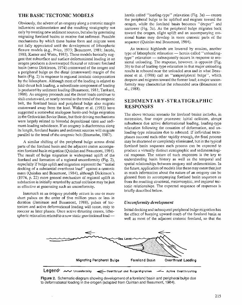
THE BASIC TECTONIC MODELS
Obviously, the advent of an orogeny along a cratonic margin influences sedimentation and the resulting stratigraphy not only by creating new sediment sources, but also by generating migrating foreland basins to receive that sediment. Possible mechanisms by which these basins form and migrate were not fully appreciated until the development of lithospheric flexure models (e.g., Price, 1973; Beaumont, 1981; Jacobi, 1981; Karner and Watts, 1983). These models basically sug- gest that subsurface and surface deformational loading in an orogen produces a downwarped flexural or retroarc foreland basin (sensu Dickinson, 1974) cratonward of the orogen and a peripheral bulge on the distal (cratonward) margin of the basin (Fig. 2) in response to regional isostatic compensation by the lithosphere. Although most of the loading is related to fold-thrust belt loading, a subordinate component of loading is produced by sediment loading (Beaumont, 1981; Tankard, 1986). As orogeny proceeds and the thrust loads continue to shift cratonward, or nearly normal to the trend of the orogenic belt, the foreland basin and peripheral bulge also migrate cratonward away from the load. Walker et al. (1983) have suggested a somewhat analogous basin-and-bulge migration in the Ordovician Sevier Basin, but their driving mechanisms were largely related to bimodal depositional rates and sedi- ment-loading subsidence. If an orogeny is diachronous along its length, foreland basins and sediment sources will migrate parallel to the trend of the orogenic belt (Ettensohn, 1987).
A similar shifting of the peripheral bulge across distal parts of the foreland basin and the adjacent craton accompa- nies foreland basin migration (Quinlan and Beaumont, 1984). The result of bulge migration is widespread uplift of the foreland and formation of a regional unconformity (Fig. 2), especially if bulge uplift and migration represent the "initial docking of a substantial overthrust load" against a cratonic mass (Quinlan and Beaumont, 1984), although Dickinson's (1974, p. 22) more general mechanism of regional uplift as subduction is initially retarded by actual collision may be just as effective at generating such an unconformity.
Inasmuch as an orogeny probably occurs in one or more short pulses on the order of five million years or less in duration (Jamieson and Beaumont, 1988), pulses of tec- tonism and active deformational loading will cease, only to reoccur as later phases. Once active thrusting ceases, litho- spheric relaxation related to a now static gravitational load -
herein called "loading-type" relaxation (Fig. 3a) - causes the peripheral bulge to be uplifted and migrate toward the orogen, while the foreland basin becomes "deeper" and narrower (Fig. 3a). As the peripheral bulge migrates back toward the orogen, slight uplift and an accompanying ero- sional hiatus may develop in more cratonic parts of the sequence (Quinlan and Beaumont, 1984).
As tectonic highlands are lowered by erosion, another type of lithospheric relaxation - herein called "unloading- type" relaxation - subsequently occurs in response to ero- sional unloading. The response, however, is opposite (Fig. 3b) to that of loading-type relaxation in that major unloading results in rebound near the unloaded area and in what Beau- mont et al. (1988) call an "antiperipheral bulge", which deepens and migrates toward the former load; a major uncon- fonnity may characterize the rebounded area (Beaumont et al., 1988).
SEDIMENTARY-STRATIGRAPHIC RESPONSES
The above tectonic scenario for foreland basins includes, in succession, four major processes: initial collision, abrupt subsidence due active deformational loading, loading-type relaxation following the cessation of deformation, and un- loading-type relaxation due to rebound. If individual tecto- phases succeed each other rapidly enough, the final process may be shortened or completely eliminated, b - ~ t in the typical foreland basin sequence each process can be expected to produce a virtually distinct stratigraphic and sedimentologi- cal response. The nature of such responses is the key to understanding basin history as well as the temporal and spatial relationships between orogeny and sedimentation. In the future, application of models like these may mean thatjust as much information about the nature of an orogeny can be gleaned from its accompanying foreland basin sequence as from the resulting stluctural, metamorphic, and regional tec- tonic relationships. The expected sequence of responses is briefly described below.
Unconformity development
Initial docking and subsequent peripheral bulge migration has the effect of buoying upward much of the foreland basin as well as most of the adjacent cratonic foreland, so that the
Migrating Peripheral Bulge Foreland Basin Overthrust Loading
Legend: - Uncontormity + Overthrust and Bulge Migration - Active Overthrusting
Figure 2. Schematic diagram showing development of a foreland basin and peripheral bulge due to deformational loading in the orogen (adapted from Quinlan and Beaumont, 1984).
A*) Paleoslopes '. 0 Load
-'z<-.. . \ .
Peripheral Bulge '. " ~ n t i - peripheral ~u l~e"" . - . .~ . . ....... 3
Figure 3. Two types of flexural response to lithospheric stress relaxation (redrawn from Beaumont et al., 1988). a, "loading-type" relaxation: response to a static gravitational load results in a deepening foreland basin and migration of peripheral bulge toward the load; b, "unloading-type" relaxation: response to erosional unloading results in rebound near the unloaded area and an "antiperipheral bulge" that deepens and migrates toward the former load.
response sequence begins with a major regional uncon- formity (Jacobi, 1981; Quinlan and Beaumont, 1984). How- ever, in parts of the foreland basin just cratonward of the loci of most intense collision, unconformities should not be ex- pected because subsidence due to residual deformational loading in these areas will generally be great enough to offset the effects of bulge uplift (Quinlan and Beaumont, 1984). For the Appalachian foreland basin during the Taconian (Hiscott et al., 1986; Lash, 1987a) and subsequent orogenies (Etten- sohn, 1985a; Ettensohn and Chesnut, in press), these loci were generally the continental promontories (Thomas, 1977), which because of their protuberant nature apparently experi- enced a greater intensity of compression and deformation (Dewey and Burke, 1974; Dewey and Kidd, 1974). Because some loading would always have been present at these loci during an orogeny, continuous foreland basin subsidence would be expected to have occurred just cratonward of them. This is borne out by the fact that during the development of major North American cratonic unconfonities (Early-Mid- dle Ordovician, Early Devonian, and Early Pennsylvanian; see Sloss, 1963), parts of the Appalachian Basin just craton- ward of the promontories exhibit gradational sequences (Ross et al., 1982; Patchen et al., 1985a. b) across intervals that are normally unconformable elsewhere in the basin.
Foreland basin subsidence
As active tectonism and deformational loading ensue, the foreland basin experiences rapid subsidence. Inasmuch as subsurface loading (buried, obducted blocks and flakes) is probably responsible for the initiation of foreland basin de- velopment and much of the early subsidence (Kamer and Watts, 1983), during early phases of an orogeny no major source of externally derived sediment is available, and the basin becomes sediment starved. In fact, most major sediment redistribution occurs during subsequent periods of tectonic quiescence (Karner, 1987), and even then paleogeographic, paleoclimatic, eustatic, or structural mechanisms may act to enhance this sediment starvation (Ettensohn, 1985b, p. 71,72). In the absence of major clastic influx, organic matter and suspended clay and silt compose most of the
sediment in these early basins, although on the cratonward margin of these basins away from the locus of major subsi- dence, a generally transgressive carbonate sequence may persist (Walker et al., 1983; Quinlan and Beaumont, 1984). Moreover, because of the rapid subsidence and slow sediment accu'mulation, the water columns in the basins quickly be- come stratified, especially if the basins are situated in tropical to subtropical regions where surface waters become so warm that the overturning of bottom waters becomes difficult (Et- tensohn andBarron, 198 1 ; Ettensohn, 1985b). As aresult, this stage in the response sequence is characterized by dark, organic-rich shales, which accumulate in anaerobic to dysaerobic conditions. The faunas comprise largely planktic and nektic forms such as graptolites and cephalopods, al- though layers of broken and abraded, shallow water, benthic forms may also accumulate due to storm activity or mass- movement processes acting on adjacent shelf areas (Walker et al., 1983). Some of the classic, fissile, Paleozoic black shales such as those in parts of the Ordovician Athens, Block- house, Paperville, and Martinsburg shales, and in parts of the Devonian Ohio and Chattanooga shales, represent early depo- sition in rapidly subsiding foreland basins.
If the black shale stratigraphy of a foreland basin is well enough known to map the distribution of individual basinal units, these black shale units will typically track the progress of the orogeny. If an orogeny is largely contemporaneous along the length of the orogen, successive black shale basins will incrementally shift cratonward (Ettensohn, 1985a) in response to the cratonward migration of deformation. If the orogeny is diachronous along its length, successive basins will also shift parallel to the strike of the orogen in the direction of latest convergence (Ettensohn, 1987).
Though dark shale predominates during early foreland basin subsidence, on the distal or cratonward margin of the basin, carbonate deposition may persist for some time be- cause of reduced rates of subsidence away from loading. Nonetheless, as deformation moves cratonward, even the distal margin will eventually subside and undergo inundation so that the overall sequence is transgressive.
Loading-type lithospheric relaxation
As active deformation and thrust migration cease, the litho- sphere responds to the now static load by relaxing stress so that the basin deepens, while the peripheral bulge is uplifted and migrates toward the load (Fig. 3a). By this time, however, folding and thrusting have created an extensive surface load, which is eroded and transported into the foreland basin in the form of turbidites and debris flows, and this sediment load itself may be another important factor in basin subsidence (Walker et al., 1983) during this response. Despite continued basin subsidence, the influx of flysch-like sediment eventu- ally exceeds subsidence to the point that sediments aggrade upward into dysaerobic and aerobic waters capable of sup- porting benthic faunas able to withstand clastic influx. Over- all, coarser marine clastics predominate in the basin during this relaxation response, and two paleoslope directions arise (Fig. 3a).
Though marine clastic sediments dominate the centre and proximal r.:argins of the foreland basin, carbonate deposition may continue on the distal margin (Walker et al., 1983). In contrast to the transgressive carbonate sequence that charac- terized the distal margin during the previous process-re- sponse, uplift and migration of the bulge during relaxation will give rise to a succeeding regressive carbonate sequence. If the amount of bulge uplift is large, the regressive sequence will be truncated by an unconformity.
Unloading-type lithospheric relaxation
As the foreland basin fills with clastic sediments and the orogenic highlands undergo substantial lowering by erosion, a brief period of elevational equilibrium ensues between the filled basin and eroded highlands. This is short-lived, how- ever, for as isostatic adjustment continues, the orogen begins to rebound upward in response to the lost load, and a com- pensating "antiperipheral bulge" forms near the former dis- tal margin, deepens and migrates toward the rebounding area (Fig. 3b) (Beaumont et al., 1988). Because the rebounding load now consists of formerly leveled highland and pre- viously deposited foreland basin sediments, sediments eroded from the rebounded area will be mainly fine grained, consisting dominantly of siltstone, silty shale, shale, mud- stone, or shaly carbonate, except in the most proximal areas where conglomerate may occur. Moreover, because the proc- ess begins from a state of approximate elevational equilib- rium at or near sea level, a single, cratonward-dipping paleoslope will be established and the sediments will be deposited in mainly marginal marine or terrestrial environ- ments. Hence, redbeds of molasse aspect will be common, and some of the classic red clastic wedges like the "Queen- ston Delta" probably record deposition as a result of unload- ing-type relaxation.
In the area of the former distal margin, on the other hand, enough deepening may occur due to "antiperipheral bulge" development so that a short-lived transgressive sequence of shallow open marine carbonate or shale may develop. Even- tually, however, regression resumes as the wedge of marginal
marine clastics progrades cratonward. Again, if uplift due to rebound is large, the resulting sequence may be truncated by an unconformity.
ORDOVICIAN STRATIGRAPHIC RESPONSES TO THE TACONIAN OROGENY
Tectonic framework
The Taconian Orogeny is now widely regarded as having resulted from a continental margin-island arc collison asso- ciated with an east-dipping subduction zone during the Mid- dle and Late Ordovician (e.g., Malpas and Stevens, 1977; Hiscott, 1978; Rowley and Kidd, 1981; Rodgers, 1987). Although actual docking in the central and southern Appala- chians probably did not occur until the Middle and Late Ordovician, evidence for Cambrian and Early Ordovician tectonic activity is recognized around the St. Lawrence prom- ontory in New England and in some of the Canadian Atlantic provinces (Bird and Dewey, 1970; Rodgers, 1971; Hiscott et al., 1983; Hiscott, 1984; Boone and Boudette, 1989). Farther south, however, the subduction that would bring about later collision may have begun far east of the continental shelf as early as the Cambrian and continued throughout the Early Ordovician (e.g., Pavlides, 1981, 1989). These Cambrian and Early Ordovician phases of tectonism are sometimes called the Penobscottian Orogeny or the Penobscot phase of the Taconian Orogeny (e.g., see Neuman, 1967; Rodgers, 1967; Hatcher, 1987; Skehan, 1988; Rast, 1989).
The main part of the orogeny, however, is generally considered to have occurred from the Middle Ordovician to the early Late Ordovician (Llandeilian to Caradocian; Rast, 1989) beginning with the subduction of the Laurentian con- tinental margin below island-arc complexes. These island-arc complexes may be represented by a series of terranes in the south - the Carolina terrane is probably one (Vick et al., 1987) -and by the Dunnage and Gander terranes in the north and central parts of the Appalachians (Williams and Hatcher, 1983). The occurrence of altered tuffs in upper Whiterockian and Mohawkian basinal and cratonic rocks from Tennessee and Kentucky (McFarlan, 1943; Conkin and Conkin, 1983; Shanmugam and Walker, 1983; Dennison, 1986) strongly supports the presence of these island arcs in the south. Con- tinued eastward subduction below these arc complexes even- tually resulted in the obduction of continental slopefrise sediments, continental and oceanic basement, as well as accretionary prism materials onto the Laurentian continental shelf; it was the accumulation of these materials on the former shelf in the form of folds, nappes, and thrusts that provided the deformational load necessary to initiate cratonward fore- land basin formation.
Moreover, the temporal and spatial distribution of Ordo- vician foreland basin sequences in the central and southern Appalachians (Figs. 1,4) suggests that the Taconian Orogeny occurred here mainly in two diachronous Middle and Late Ordovician tectophases related to enhanced convergence near the Virginia and New York promontories, respectively. Although major orogeny may have been concentrated at these
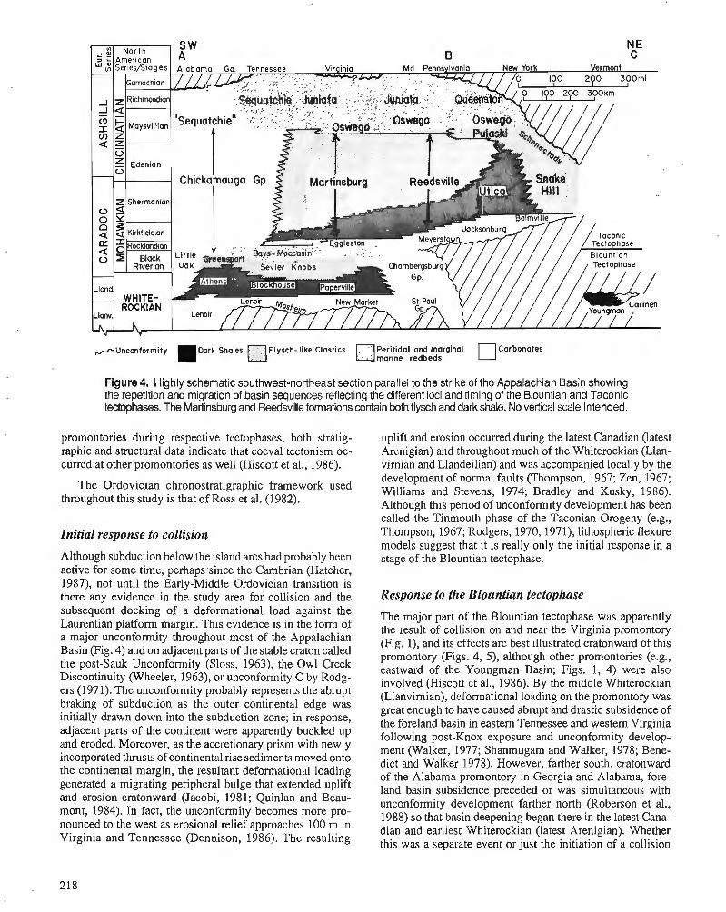
/ Unconformity l ~ a r k Shales O ~ l ~ s c h - l l k e Clastics Per~t ida l and marglnal Carbonates marine redbeds
Figure 4. Highly schematic southwest-northeast section parallel to the strike of the Appalachian Basin showing the repetition and migration of basin sequences reflecting the different loci and timing of the Blountian and Taconic tectophases. The Martinsburg and Reedsville formations contain both flysch and dark shale. No vertical scale intended.
promontories during respective tectophases, both stratig- uplift and erosion occurred during the latest Canadian (latest raphic and structural data indicate that coeval tectonism oc- Arenigian) and throughout much of the Whiterockian (Llan- curred at other promontories as well (Hiscott et al., 1986). virnian and Llandeilian) and was accompanied locally by the
development of normal faults (Thompson, 1967; Zen, 1967; The Ordovician chronostratigraphic framework used Williams and Stevens, 1974; Bradley and Kusky, 1986),
throughout this study is that of Ross et al. (1982). Although this period of unconfonnity development has been called the ~ i n k o u t h phase of the ~aconian-Orogeny (e.g.,
Initial response to collision Thompson, 1967; Rodgers, 1970,1971), lithospheric flexure models suggest that it is really only the initial response in a
Although subduction below the island arcs had probably been stage of the Blountian tectophase. active for some time, perhaps since the Cambrian (Hatcher, 1987), not until the Early-Middle Ordovician transition is there any evidence in the study area for collision and the Response to the Blountian tecto~hase subsequent docking of a deformational load against the Laurentian platform margin. This evidence is in the form of a major unconformity throughout most of the Appalachian Basin (Fig. 4) and on adjacent parts of the stable craton called the post-Sauk Unconformity (Sloss, 1963), the Owl Creek Discontinuity (Wheeler, 1963), or unconformity C by Rodg- ers (1971). The unconfonnity probably represents the abrupt braking of subduction as the outer continental edge was initially drawn down into the subduction zone; in response, adjacent parts of the continent were apparently buckled up and eroded. Moreover, as the accretionary prism with newly incorporated thrusts of continental rise sediments moved onto the continental margin, the resultant defonnational loading generated a migrating peripheral bulge that extended uplift and erosion cratonward (Jacobi, 1981; Quinlan and Beau- mont, 1984). In fact, the unconformity becomes more pro- nounced to the west as erosional relief approaches 100 m in Virginia and Tennessee (Dennison, 1986). The resulting
The major part of the Blountian tectophase was apparently the result of collision on and near the Virginia promontory (Fig. I), and its effects are best illustrated cratonward of this promontory (Figs. 4, 5), although other promontories (e.g., eastward of the Youngman Basin; Figs. 1, 4) were also involved (Hiscott et al., 1986). By the middle Whiterockian (Llanvirnian), deformational loading on the promontory was great enough to have caused abrupt and drastic subsidence of the foreland basin in eastern Tennessee and western Virginia following post-Knox exposure and unconformity develop- ment (Walker, 1977; Shanmugam and Walker, 1978; Bene- dict and Walker 1978). However, farther south, cratonward of the Alabama promontory in Georgia and Alabama, fore- land basin subsidence preceded or was simultaneous with unconfolmity development farther north (Roberson et al., 1988) so that basin deepening began there in the latest Cana- dian and earliest Whiterockian (latest Arenigian). Whether this was a separate event or just the initiation of a collision
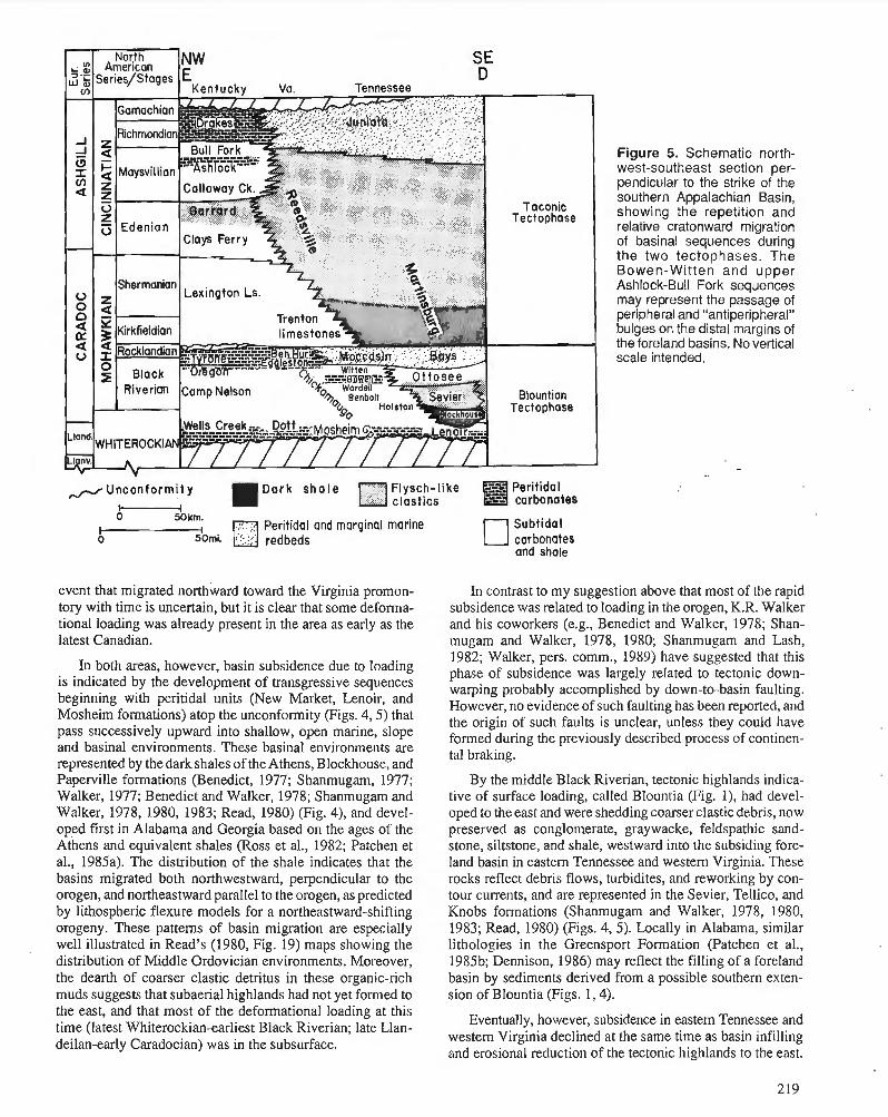
Figure 5. Schematic north- west-southeast section per- pendicular to the strike of the southern Appalachian Basin, showing the repetition and relative cratonward migration of basinal sequences during the two tectophases. The Bowen-Witten and upper Ashlock-Bull Fork sequences may represent the passage of peripheral and "antiperipheral" bulges on the distal margins of the foreland basins. No vertical scale intended.
4 Unconformit y Flysch-like a --- Peritidal --- carbonates - IDark ctastics 0 50km.
I Peritidal and marginal marine Subtidal o redbeds carbonates
and shale
event that migrated northward toward the Virginia promon- In contrast to my suggestion above that most of the rapid tory with time is uncertain, but it is clear that some deforma- subsidence was related to loading in the orogen, K.R. Walker tional loading was already present in the area as early as the and his coworkers (e.g., Benedict and Walker, 1978; Shan- latest Canadian. mugam and Walker, 1978, 1980; Shanmugam and Lash,
1982; Walker, pers. comm., 1989) have suggested that this In both areas, however, basin subsidence due to loading phase of subsidence was largely related to tectonic down-
's indicated the of uansgressive sequences warping probably accomplished by down-to-basin faulting. beginning with peritidal units (New Market. LenOirj and However, no evidence of such faulting has been reporfed, and ~ o s h e i m formations) atop the uncOnformity (Figs. 47 5, lhat the origin of such faults is unclear, unless they could have pass Open 'lope formed during the previously described process of continen- and basinal environments. These basinal environments are
tal braking. represented by the dark shales of the Athens, Blockhouse, and Paperville formations (Benedict, 1977; Shanmugam, 1977; Walker, 1977; Benedict and Walker, 1978; Shanmugam and Walker, 1978, 1980, 1983; Read, 1980) (Fig. 4), and devel- oped first in Alabama and Georgia based on the ages of the ~ t h e n s and equivalent shales (Ross et al., 1982; Patchen et al., 1985a). The distribution of the shale indicates that the basins migrated both northwestward, perpendicular to the orogen, and northeastward parallel to the orogen, as predicted by lithospheric flexure models for a northeastward-shifting orogeny. These patterns of basin migration are especially well illustrated in Read's (1980, Fig. 19) maps showing the distribution of Middle Ordovician environments. Moreover, the dearth of coarser clastic detritus in these organic-rich muds suggests that subaerial highlands had not yet formed to the east, and that most of the deformational loading at this time (latest Whiterockian-earliest Black Riverian; late Llan- deilan-early Caradocian) was in the subsurface.
By the middle Black Riverian, tectonic highlands indica- tive of surface loading, called Blountia (Fig. I), had devel- oped to the east and were shedding coarser clastic debris, now preserved as conglomerate, graywacke, feldspathic sand- stone, siltstone, and shale, westward into the subsiding fore- land basin in eastern Tennessee and western Virginia. These rocks reflect debris flows, turbidites, and reworking by con- tour currents, and are represented in the Sevier, Tellico, and Knobs formations (Shanmugam and Walker, 1978, 1980, 1983; Read, 1980) (Figs. 4,5). Locally in Alabama, similar lithologies in the Greensport Formation (Patchen et al., 1985b; Dennison, 1986) may reflect the filling of a foreland basin by sediments derived from a possible southern exten- sion of Blountia (Figs. 1,4).
Eventually, however, subsidence in eastern Tennessee and western Virginia declined at the same time as basin infilling and erosional reduction of the tectonic highlands to the east.
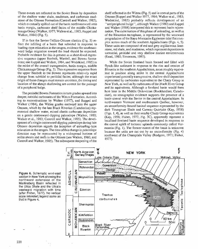
These events are reflected in the Sevier Basin by deposition of the shallow water shale, mudstone, and carbonate mud- stone of the Ottosee Formation (Cantrell and Walker, 1985), which eventually spilled out of the basin northwestward onto basin margin, carbonate shelf facies of the middle Chicka- mauga Group (Walker, 1977; Walker et al., 1983; Ruppel and Walker, 1984) (Fig. 5).
If in fact the Sevier-Tellico-Ottosee clastics (Fig. 5) re- flect the infilling of a basin that subsided in response to loading-type relaxation in the orogen, evidence for southeast- ward bulge migration toward the load should be expected. Probable evidence for this is present as a short-lived regres- sive sequence (upper Benbolt, Wardell, and Bowen forma- tions; see Ruppel and Walker, 1984, and Wedekind, 1985) in the midst of the overall transgressive, basin margin, middle Chickamauga Group (Fig. 5). This regressive sequence from the upper Benbolt to the Bowen represents relatively rapid change from subtidal to peritidal facies; although the exact origin of these changes must remain uncertain, the timing and location of the abrupt shallowing are correct for the passage of a peripheral bulge.
The peritidal Bowen Formation in turn grades upward into deeper, subtidal carbonates of the Witten Formation. Accord- ing to reconstructions by Walker (1977), and Ruppel and Walker (1984), the Witten grades eastward into the upper Ottosee, which by the late Black Riverian (Caradocian) rep- resented shallow water, mixed clastic-carbonate deposition on a gentle cratonward-dipping paleoslope (Walker, 1980; Walker et al., 1983; Cantrell and Walker, 1985). The devel- opment of a single cratonward-dipping paleoslope during late Ottosee deposition signals the inception of unloading-type relaxation in theorogen. The time of this change in paleoslope direction may be represented by a widespread horizon of oolite shoals and reefs in the Ottosee (see Walker, 1980, and Cantrell and Walker, 1985). The subsequent deepening of the
shelf reflected in the Witten (Fig. 5) and in coeval parts of the Ottosee (Ruppel and Walker 1977,1984; Walker et al., 1983; Wedekind, 1985) probably reflects development of an "antiperipheral bulge", although Walker (1980) and Ruppel and Walker (1984) interpreted this to represent basin rejuve- nation. The culmination of this phase of unloading, as well as of the Blountian tectophase, is represented by the westward progradation of the Bays-Moccasin-Eggleston tidal flat com- plex across much of the southern Appalachians (Figs. 4, 5). These units are composed of red and grey argillaceous lime- stone, red shale, and mudstone, which represent deposition in terrestrial, peritidal and very shallow marine environments (Read, 1980; Simonson, 1985).
While the Sevier foreland basin folmed and filled with flysch-like sediment in response to the rise and erosion of Blountia in the southern Appalachians, areas roughly equiva- lent in position along strike in the central Appalachians experienced generally transgressive, shallow shelf deposition represented by carbonates equivalent to the Chazy Group in New York, as well as by carbonates of the Black River Group and its equivalents. Although a foreland basin would form here later in the Middle Ordovician (Rocklandian; Carado- cian), no stratigraphic evidence supports the presence of a basin coeval with the Sevier in the central Appalachians. In northwestern Vermont and southeastern Quebec, however, an unconformity-bound basinal sequence represented by the dark Youngman Shale and Carman Quartzite (Kay, 1958) (Figs. 1,4), as well as their nearby Chazy Group equivalents (Kay, 1958; Fisher, 1977, Fig. 3C), apparently represent a localized foreland basin sequence developed in response to the coeval uplift of tectonic uplands commonly called Ver- montia (Fig. 1). The former extent of the basin is unknown because the units are cut out by an unconformity (Fig. 4) southwest of the Champlain Valley (Rodgers, 1971; Fisher, 1977).
Figure 6. Schematic west-east section in New Yorkshowing the northward extension of the Martinsburg Basin reflected in the Utica Shale and the Utica's westward migration with time (after Fisher, 1977). No vertical scale intended; legend same a s that in Figure 4.
E NEW YORK F
c a r b o n a t e s
While the Blountian tectophase proceeded in the south, and shallow water, carbonate platform deposition continued in the central Appalachians, eastward subduction of oceanic and continental crust seaward of the New York promontory progressed to the point that the accretionary wedge at the advancing margin of the island arc began to shed sediments into a peripheral basin (sensu Dickinson, 1974) that impinged on the central Appalachian platform margin (e.g., Rowley and Kidd, 1981). The dark shale, siltstone, graywacke, and chert deposited in the basin are included in the allochthonous Normanskill Group (Fisher, 1977) and its equivalents, but are not part of the foreland-basin sequence.
Response to the Taconic tectophase
?he Taconic tectophase (Kay, 1937) began in the late Middle Ordovician (Rocklandian; Caradocian) and apparently re- flects the obduction of the aforementioned peripheral basin sediments and accretionary wedge material onto the platform margin, forming a tectonic highland called Taconica (Fig. 1). The obduction of these materials onto the platform generated the load necessary to form the Martinsburg (Utica) foreland basin (Figs. 4-6). Although what is called the Taconic tecto- phase here may be subdivided elsewhere into shorter named phases (e.g., Rodgers, 1971), the stratigraphic record in the central Appalachian foreland basin suggests that it is a single event.
The locus of the Taconic tectophase was largely centred near the New York promontory in the central Appalachians (e.g., Rodgers, 1971), but foreland basin subsidence, and hence deformational loading, apparently began earliest in northeastern Tennessee cratonward of the Virginia promon- tory, suggesting a substantial overlap in the areal extent of the tectophases (Fig. 4). In northeastern Tennessee, peritidal Bays-Moccasin mudstone from the last stage of the Blountian tectophase is sharply overlain by a thin sequence of transgres- sive carbonate, followed by the deep water black shale of the Martinsburg Formation (Walker and Diehl, 1985) (Figs. 4, 5), indicating abrupt Rocklandian (late Caradocian) subsi- dence. No unconformity, however, is apparent between the Bays-Moccasin and Martinsburg, suggesting that sufficient residual loading from the Blountian tectophase remained in the area of the Virginia promontory to offset the effects of any new bulge migration.
The New York promontory, in contrast, seems to have been very little affected by the Blountian tectophase, and residual loading was absent. Hence, while subsidence oc- curred to the south, uplift and erosion accompanying Taconic tectophase, peripheral bulge migration resulted in an uncon- formity in parts of the foreland basin just cratonward of the New York promontory in New Jersey, eastern Pennsylvania, and southern New York. In these areas, transgressive Rock- landian and Kirkfieldian (middle Caradocian) carbonate of the Jacksonburg, Myerstown, and Balmville formations un- conformably overlie Canadian to Black Riverian (upper Arenigian to lower Caradocian) shallow water, platform car- bonates of the Beekmantown Group and Chambersburg Limestone (Fig. 4) and grade upward into dark shale of the Martinsburg or its equivalents (Fisher, 1977; Patchin et al.,
1985a; Lash, 1987a). A series of unconformities below the dark Utica Shale in central New York (Fig. 6) becomes progressively younger to the west (Fisher, 1977, P1.2,4) and apparently represents the same bulge migration phenomenon. This stratigraphic response - unconformity, transgressive carbonate, and black shale - is analogous to that observed in the Sevier Basin during the inception of early Middle Ordovician Blountian tectophase (Shanmugam and Lash, 1982). Hence, the Martinsburg Basin (Martinsburg, Reeds- ville, and Utica shale) (Figs. 1, 4) reflects new basin subsi- dence accompanying the inception of the late Middle Ordovician Taconic tectophase. The much larger areal extent of the Martinsburg Basin (Fig. 1) may reflect the greater intensity of the Taconic tectophase combined with a possible middle Mohawkian to early Cincinnatian (middle Caradocian- early Ashgillian) rise in sea level ( ~ e g ~ e k , 1978; McKerrow; 1979).
Inasmuch as deformational loading will migrate craton- ward in time (e.g., Beaumont, 1981), the more westward position of the Martinsburg Basin relative to the Sevier Basin (Figs. 1, 5) reflects the extent of this shift between tecto- phases. The same pattern is also apparent within the Martins- burg Shale and its equivalents, for although the oldest parts of the Martinsburg in the eastern parts of its basin may be as old as Rocklandian, Kirkfieldian or Shelmanian (middle to late Caradocian), at its maximum westward extent in eastern Kentucky, eastern Ohio, and West Virginia (Figs. 1, 5), it is Maysvillian (Ashgillian) in age (Patchen et al., 1985a,b). Similarly, the partially equivalent Utica Shale is Shermanian in the east, 'but in westem New York, the unit is wholly Maysvillian in age (Fisher, 1977) (Fig. 6).
In an analogous fashion, the lower Martinsburg and its equivalents become younger northward along strike in the foreland basin (Fig. 4). In northeastern Tennessee, Martins- burg basinal black shale deposition began in the Rocklandian, but similar basinal environments only reached New York during deposition of the Utica ("Canajoharie") Shale in the Shermanian (e.g., Ross et al., 1982). This kind of shift in the inception of basinal deposition along strike probably reflects diachroneity in the collision of separate terranes along the orogen.
The cessation of active orogeny and the advent of load- ing-type relaxation is represented by shallowing during depo- sition of middle parts of the Martinsburg to the south (Walker and Diehl, 1985), by the influx of sandstone and siltstone turbidites and carbonate tempestites in middle parts of the Martinsburg of the central Appalachians (Shanmugam and Lash, 1982; Lash, 1987a,b), and by the sandstone, siltstone, graywacke, and shale of the Frankfort, Schenectady, Whet- stone Gulf, and Pulaski formations in New York (Fisher, 1977; Zerrahn, 1978) from the Shennanian to theMaysvillian (latest Caradocian to Ashgillian). The concomitant uplift and eastward migration of the peripheral bulge on the western margin of the Martinsburg foreland basin (Fig. 3a) is difficult to document, because most of the rocks likely to reveal this event are poorly known in the subsurface of western West Virginia, eastern Ohio, and eastern Kentucky where they are commonly included in undifferentiated shale and limestone sequences (e.g., Patchen et al., 19851). Nonetheless, in
eastcentral Kentucky and south-central Ohio (Patchen et al., 1985b), abrupt shallowing from subtidal to peritidal condi- tions reflected in lower and middle parts of the Ashlock Formation (Weir et al., 1984) (Fig. 5) occurred at the correct time and place to represent the passage of a peripheral bulge.
Upper parts of the Ashlock and the Bull Fork Formation in the same area (Weir et al., 1984) reflect an equally sudden return to subtidal conditions and may indicate the subsequent development of an "antiperipheral bulge" accompanying the advent of unloading-type relaxation. The timing (latest Mays- villian; Ashgillian) is correct for such a shift, and these subtidal units are overlain by the Richmondian (Ashgillian) Drakes Formation, which is correlative with the Queenston, Juniata, Bald Eagle, Spitzbergen, and Sequatchie formations farther east in the foreland basin. The above foreland basin units are largely red in colour and consist of finer grained clastic sediments and argillaceous carbonates representing the cratonward progradation of fluviodeltaic, peritidal and very shallow marine facies on a unidirectional paleoslope developed in response to rebound accompanying unloading- type relaxation in the orogen. The Bald Eagle and Spitzber- gen, however, are largely conglomerates (Thompson, 1970; Lash, 1987a), probably reflecting proximal source areas and the reactivation of basement structures during rebound (see Dennison, 1986, Fig. 26). In areas proximal to the New York promontory, moreover, a major unconformity overlies these redbed units. Although some workers have related this un- conformity to thermal doming (Chapple, 1973; Coleman- Sadd, 1982), nothing more than unloading-type rebound compounded by the effects of a glacioeustatic drop in sea level near the Ordovician-Silurian boundary (Dennison, 1976; Hambrey, 1985) is probably necessary to explain it.
CONCLUSIONS
The Middle and Late Ordovician Taconian Orogeny resulted in a complete reorganization of stratigraphic patterns on the former eastern margin of Laurentia. Despite the complex nature of the resulting facies and of the nomenclature super- imposed upon them, generalized lithostratigraphic patterns have emerged that confirm the predicted results of recently developed lithospheric flexure models. Consequently, these models have a high predictive value in interpreting the stra- tigraphic and sedimentological responses to orogenic events like the Taconian Orogeny. The generalized process-re- sponse sequence includes four stages: 1) collisional braking -development of a regional unconformity; 2) active defor- mational loading - thin transgressive carbonate followed by black shale in a rapidly subsiding foreland basin; 3) loading- type relaxation - flysch-like clastics infilling the foreland basin; and 4) unloading-type relaxation - cratonward pro- gradation of a marginal marine redbed sequence. The stratig- raphic response in each stage will generally track the progress of orogeny, but the black shale stage, because of its distinct lithology and ease of mapping, is most easily traced. The two Ordovician black shale sequences encountered in this study clearly reflect the initiation, migration, and foci of two Taconian tectophases in the southern and central Appalachians.
The process-response models discussed herein are mostly restricted to the interpretation of foreland basins, but the overall transgressive-regressive scenario inherent in thestratigraphic responses should be equally apparent in platform and ramp carbonates on adjacent parts of the stable craton. The migra- tion of the peripheral bulge across these stable areas may also be apparent in the form of local unconformities or abrupt environmental changes. Although the stratigraphic and envi- ronmental fluctuations reflected in the process-response models for the Ordovician have been largely attributed to eustatic variations, their proximity to and contemporaneity with the Taconian Orogeny suggest that a large component of such variations must be related to concurrent tectonism.
ACKNOWLEDGMENTS
I gratefully acknowledge the assistance of J.M. Dennison, P. Goodmann, N. Rast, and K.R. Walker, who reviewed earlier stages of the manuscript, and offered helpful comments for its improvement. I also wish to thank B.M. Ettensohn, who did the drafting andM.A. Palmer who did the word processing.
REFERENCES Beaumont, C. 1981: Foreland basins. Geophysical Journal of the Royal Astronomical
Society, v. 65, p. 291-329. Beaumont, C., Quinlan, G., and Hamilton, J. 1988: Orogeny and stratigraphy: numerical models of the Paleozoic in the
eastern interior of North America. Tectonics, v. 7, p. 389-416. Benedict, G.L. 1977: Outer shelf margin-upper slope transition zone in the Lenoir and
Whitesburg formations. 111 The Ecostratigraphy of the Middle Or- dovician of the Southern Appalachians (Kentucky, Tennessee, and Virginia), U.S.A., a Field Excursion, S.C. Ruppel and K.R. Walker (eds.); University of Tennessee Department of Geological Sciences, Studies in Geology no. 77-1, p. 96-102.
Benedict, G.L. and Walker, K.R. 1978: Paleobathymetric analysis in Paleozoic sequences and its geodynarnic
significance. American Joumal of Science, v. 278, p. 579-607. Bird, J.M. and Dewey, J.F. 1970: Lithospheric plate-continental margin tectonics and the evolution
of the Appalachian orogen. Geological Society of America, Bulle- tin, v. 8 1, p. 103 1-1 059.
Boone, G.M. and Boudette, E.L. 1989: Accretion of the Boundary Mountains Tetrane within the northern
Appalachian orthotectic zone. In Melanges and Olistostromes in the U.S. Appalachians, J.W. Horton, Jr. and N. Rast (eds.); Geological Society of America, Special Paper 228, p. 17-42.
Bradley, D.C. and Kusky, T.M. 1986: Geologic evidence for rate of plate convergence during the Taconic
arc-continent collision. Journal of Geology, v. 94, p. 667-681. Cantrell, D.L. and Walker, K.R. 1985: Depositional and diagenehc patterns, ancient oolite, Middle Ordo-
vician, eastern Tennessee. Journal of Sedimentary Petrology, v. 55, p. 518-531.
Chapple, W.M. 1973: Taconic orogeny: abortive subduction of the North American con-
tinental plate? Geological Society of America, Abstracts with Programs, v. 5, p. 573.
Colman-Sadd, S.P. 1982: Two stage continental collision and plate driving forces. Tectono-
physics, v. 90, p. 263-282. Conkin, J.E. and Conltin, B.M. 1983: Paleozoic metabentonites of North America: Part 2 - metabentonites
in the Middle Ordovician Tyrone Formation at Boonesborough, Clark County, Kentucky. University of Louisville Studies in Pale- ontology and Stratigraphy, no. 17,46 p.
Dennison, J.M. 1976: Appalachian Queenston delta related to eustatic sea-level drop
accompanying Late Ordovician glaciation centered in Africa. In The Ordovician System: Proceedings of a Palaeontological Association Symposium. M.G. Basset (ed.); University of Wales Press and National Museum of Wales, Cardiff, p. 107-120.
1986: Sedimentary tectonics of the Appalachian Basin, short course notes. Society of Economic Paleontologists and Mineralogists Mid-Year Meeting, Raleigh, 148 p.
Dewey, J.F. and Burke, K.C.A. 1974: Hot spots and continental breakup: implications for collisional
'
orogeny. Geology, v. 2, p. 57-60. Dewey, J.F. and Kidd, W.S.F. 1974: Continental collisions in the Appalachian-Caledonian belt: vari-
ations related to complete and incomplete suturing. Geology, v. 2, p. 543-546.
Dickinson, W.R. 1974: Plate tectonics and sedimentation. In Tectonics and Sedimentation,
W.R. Dickinson (ed.); Society of Economic Paleontologists and Mineralogsts Special Publication no. 22, p. 1-27.
Drake, A.A., Jr., Sinha, A.K., Laird, J., and Guy, R.E. 1989: The Taconic orogen. In The Appalachian-Ouachita Orogen in the
United States, R.D. Hatcher, Jr., W.A. Thomas, and G.W. Viele (eds.); Geological Society of America, The Geology of Nonh Amer- ica, v. F-2, p. 101-177.
Ettensohn, F.R. 1985a: The Catskill Delta complex and the Acadian Orogeny: a model. 0 1
The Catskill Delta, D.W. Woodrow and W.D. Sevon (eds.); Geo- logical Society of America, Special Paper 201, p. 39-49.
1985b: Controls on development of Catskill Delta complex basin facies. In The Catskill Delta, D.W. Woodrow and W.D. Sevon (eds.); Geo- logical Society of America, Special Paper 201, p. 65-77.
1987: Rates of relative plate motion during the Acadian Orogeny based on the spatial distribution of black shales. Journal of Geologv, v. 95, -. p. 572-582.
Ettensohn. F.R. and Barron. L.S. 1981 : ~k~osi t ional model fbr the Devonian-Mississippian black shales of
North America: apaleoclimatic-paleogeographic approach. In Geo- logical Society of America Cincinnati '8 1 Field Trip Guidebooks, v. 11, T.G. Roberts (ed.); American Geological Institute, Falls Church, p. 344-361.
Ettensohn. F.R. and Chesnut. D.R.. Jr. in press: ~ a t u r e and probable'origin of the Mississippian-Pennsylvanian
unconformity in the eastern United States. Compte Rendu, Eleventh ~n temahon~~ongres s of Carboniferous stratigraphy and Geology, 19 p.
Fisher, D.W. 1977: Correlation of the Hadrynian, Cambrian, and Ordovician rocks in
New York State. New York State Museum Map and Chart Series, no. 25.
Hambrey, M.J. 1985: The Late Ordovician-Early Silurian glacial period. Paleogeography,
Paleoclimatology, Paleoecology, v. 5 1, p. 273-289. Hatcher, R.D., Jr. 1987: Tectonics of the southern and central Appalachian internides.
Annual Review of Earth and Planetary Sciences, v. 15, p. 337-362. Hiscott, R.N. 1978: Provenance of Ordovician deep-water sandstones, Tourelle Fona -
tion, Quebec, and implications for initiation of the Taconic Orog- eny. Canadian Journal of Earth Sciences, v. 15, p. 1579-1597.
1984: Ophiolitic source rocks for Taconic-age flysch: ham-element evi- dence. Geological Society of America, Bulletin, v. 95, p. 1261- 1267.
Hiscott, R.N., Pickering, K.T., and Beeden, D.R. 1986: Progressive filling of a confined Middle Ordovician foreland basin
associated with the Taconic Orogeny, Quebec, Canada. Special Publications of the International Association of Sedimentologists, v. 8, p. 309-325.
Hiscott, R.N., Quinlan, G.M., and Stevens, R.K. 1983: Comh~ent on "Analogous tectonic evolution of the Ordovician
foredeeps, southern and central Appalachians." Geology, v. 11, p. 732.
Jacobi, R.D. 1981: Peripheral bulge - a causal mechanism for the LowernvIiddle
Ordovician disconformity along the western margin of the northern Appalachians. Earth and Planetary Science Letters, v. 56, p. 245-251.
Jamieson, R.A. and Beaumont, C. 1988: Orogeny and metamorphism: a model for deformation and pressure-
temperature-time paths with applications to the central and southem Appalachians. Tectonics, v. 7, p. 417-445.
Karner, G.D. 1987: The inte~play between erosion and basin development. Yearbook,
Lamont-Doherty Geological Observatory of Columbia University, p. 46-51.
Karner, G.D. and Watts, A.B. 1983: Gravity anomalies and flexure of the lithosphere at mountain ranges.
Journal of Geophysical Research, v. 88, no. B12, p. I0 449-10 477. Kay, M. 1937: Stratigraphy of the Trenton Group. Geological Society of America
Bulletin, v. 48, p. 233-302. 1958: Ordovician Highgate Springs sequence of Vermont and Quebec and
Ordovician classification. American Journal of Science, v. 256, p. 65-96.
1969: Introduction. In North Atlantic Geology and Continental Drift, a Symposium, M. Kay (ed.); American Association of Petroleum Geologists Bulletin, Memoir 12, p. 3,4.
Lash, G.G. 1987a: Geodynamic evolution of the lower Paleozoic central Appalachian
foreland basin. In Sedimentary Basins and Basin-Forming Mecha- nisms, C. Beaumont and A.J. Tankard (eds.); Canadian Society of Petroleum Geologists, Memoir 12, p. 413-423.
1987b: Sedimentology and possible paleoceanographic significance of mudstone turbidites and associated deposits of the Pen Argyl Member, Martinsburg Formation (Upper Ordovician), eastern Pennsylvania. Sedimentary Geology, v. 54, p. 113-135.
Leggett, J.K. 1978: Eustacy and pelagic regimes in the Iapetus Ocean during the Ordo-
vician and Silurian. Earth and Planetary Science Letters, v. 41, p. 163-1 69.
Malpas, J. and Stevens, R.K. 1977: The origin and emplacement of the ophiolite suite with examples
from western Newfoundland. Geotectonics, v. 1 I, p. 453-466. McFarlan, A.C. 1943: Geology of Kentucky. University of Kentucky, Lexington, 531 p. McKerrow, W.S. 1979: Ordovician and Silurian changes in sea level. Journal of the Geo-
logical Society of London, v. 136, p. 137-145. Neuman, R.B. 1967: Bedrock geology of the Skin Pond and Stacyville quadrangles,
Penobscot County, Maine. United States Geological Survey, Professional Paper 524-I,37 p.
Patchin, D.G., Avary, K.L., and Erwin, R.B. 1985a: Northern Appalachian Region, Correlation of Stratigraphic Units of
North America (COSUNA) Project. American Association of Pe- troleum Geologists, Tulsa.
1985b: Southern Appalachian Region, Correlation of Stratigraphic Units of North America (COSUNA) Project. American Association of Petroleum Geologists, Tulsa.
Pavlides, L. 1981: The central Virginia volcanic-plutonic belt; an island arc of
Cambrian age. United States Geological Survey, Professional Paper 123 1 -A, 34 p.
1989: Early Paleozoic composite melange terrane and its origin, central Appalachian Piedmont Belt, Virginia and Maryland. In Melanges and Olistostromes of the U.S. Appalachians, J.W. Horton, Jr. and N. Rast (eds.); Geological Society of America, Special Paper 228, p. 137-193.
Price, R.A. 1973: Large-scale gravitational flow of supracrustal rocks, southern Ca-
nadian Rockies. In Gravity and Tectonics, K.A. deJong and R. Scholten (eds.); John Wiley, New York, p. 491-502.
Quinlan, G.M. and Beaumont, C. 1984: Appalachian thrusting, lithospheric flexure, and the Paleozoic stra-
tigraphy of the eastern interior of North America. Canadian Journal of Earth Sciences, v. 21, p. 973-996.
Rast, N. 1989: The evolution of the Appalachian chain. In The Geology of Nonh
America, an Overview, A.W. Bally and A.R. Palmer (eds.); Geo- logical Society of America, The Geology of North America, v. A, p. 323-348.
Read, J.F. 1980: Carbonate ramp-to-basin transitions and foreland basin evolution,
Middle Ordovician, Virginia Appalachians. American Association of Petroleum Geologists Bulletin, v. 64, p. 1575-1612.
Roberson, K.E., Benson, D.J., and Walker, K.R. 1988: Stratigraphic evidence for late Early Ordovician shelf deformation
in the Alabama Appalachians. Geological Society of America, Abstracts with Programs, v. 20, p. 31 1.
Rodgers, J. 1967: Chronology of tectonic movements in the Appalachian region of
eastern North America. American Journal of Science, v. 265, p. 408-427.
1970: TheTectonics of the Appalachians. Wiley-Interscience, New York, 271 p.
1971: The'~aconic Orogeny. Geological Society of America, Bulletin, V. 82, p. 1141-1 178.
1987: The Appalachian-Ouachita orogenic belt. Episodes, v. 10, p. 259-266.
Ross, R.J., Jr., and others 1982: The Ordovician System in the United States, Correlation Chart and
Explanatory Notes. International Union of Geological Sciences, Publication no. 12.73 p.
Rowley, D.B. and Kidd, W.S.F. 1981: Stratigraphic relationships and detrital composition of the medial
Ordovician flysch of western New England: implications for the tectonic evolution of the Taconic Orogeny. Journal of Geology, v. 89, p. 199-218.
Ruppel, S.C. and Walker, K.R. (eds.) 1977: The Ecostrahgraphy of the Middle Ordovician of the Southern
Appalachians (Kentucky, Tennessee, and Virginia), U.S.A.: a Field Excursion. University of Tennessee, Department of Geological Sciences, Studies in Geology no. 77-1, 171 p.
1984: Petrology and depositional history of a Middle Ordovician carbonate platform, Chickamauga Group, northeastern Tennessee. Geological Society of America, Bulletin, v. 95, p. 568-583.
Shanmugam, G. 1977: Shelf to basinal sequences at Boyds Creek, Tennessee. 111 The
Ecostratigraphy of the Middle Ordovician of the Southern Appalachians (Kentucky, Tennessee, and Virginia), U.S.A.: a Field Excursion, S.C. Ruppel and K.R. Walker (eds.); University of Tennessee, ~ e ~ a r t m i t of Geological Sciences, Studies in ~ e o l o ~ ~ no. 77-1, p. 106-1 17.
~hanrnugam, G. and Lash, G.G. 1982: Analogous tectonic evolution of the Ordovician foredeeps, southern
and central Appalachians. Geology, v. 10, p. 562-566. Shanmugam, G. and Walker, K.R. 1978: Tectonic significance of distal turbidites in the Middle Ordovician
Blockhouse and lower Sevier formations in east Tennessee. American Journal of Science, v. 280, p. 479-496.
1980: Sedimentation, subsidence, and evolution of a foredeep basin in the Middle Ordovician, southern Appalachians. American Journal of Science, v. 280, p. 479-496.
1983: Anatomy of the Middle Ordovician Sevier Shale basin, eastem Tennessee. Sedimentology, v. 34, p. 3 15-337.
Simonson, J.C.B. 1985: Mixed carbonate-siliciclastic tidal flat deposits of the Moccasin
Formation. In The Geologic History of the Thorn Hill Paleozoic Section (Cambrian-Mississippian), Eastern Tennessee, K.R. Walker (ed.); University of Tennessee, Department of Geological Sciences, Studies in Geology no. 10, p. 16-85.
Sltehan, J.W. 1988: Evolution of the Iapetus Ocean and its borders in pre-Arenig times:
a synthesis. In The Caledonian-Appalachian Orogen, A.L. Harris and D.J. Fettes (eds.); Geological Society of London, SpeciaE Pub- lication no. 38, p. 185-229.
Sloss, L.L. 1963: Sequences in the cratonic interior of North America. Geological
Society of America, Bulletin, v. 74, p. 93-1 14.
Tankard, A.J. 1986: On the depositional response to thrusting and lithospheric flexure:
examples from the Appalachian and Rocky Mountain Basins. In Foreland Basins, P.A. Allen and P. Homewood (eds.); International Association of Sedimentologists, Special Publication no. 8, p. 369-392.
Thomas, W.A. 1977: Evolution ofAppalachian-Ouachitasalients and recesses from reen-
trants and promontories in the continental margin. American Jour- nal of Science, v. 277, p. 1233-1278.
Thompson, A.M. 1970: Lithofacies and formation nomenclature in Upper Ordovician stra-
tigl-aphy, central Appalachians. Geological Society of America, Bulletin, v. 81, p. 1255-1260.
Thompson, J.B., Jr. 1967: Bedrock geology of the Pawlet quadrangle, Vermont, part 11, eastern
portions. Vermont Geological Survey, Bulletin 30, p. 61-98. Vick, H.K., Channell, J.E.T., and Opdyke, N.D. 1987: Ordovician docking of the Carolina Slate Belt: paleomagnetic data.
Tectonics, v. 6, p. 573-583. Walker, K.R. 1977: A brief introduction to the ecostratigraphy of the Middle Ordovician
of Tennessee (southern Appalachians, U.S.A.). 111 The Ecostratig- raphy of the Middle Ordovician of the Southern Appalachians (Kentucky, Tennessee, and Virginia), U.S.A.: a Field Excursion, S.C. Ruppel and K.R. Walker (eds.); University ofTennessee, Depart- ment of Geological Sciences, Studies in Geology no. 77- I, p. 12-17.
1980: Stop 7: Mid-Ottosee Formation oolite body representing rejuvena- tion of the southeastern basin. In Middle Ordovician Carbonate Shelf to Deep-Water Basin Deposition in the South Appalachians, K.R. Walker, T.W. Broadhead, and F.B. Keller (eds.); University of Tennessee, Department of Geological Sciences, Studies in Geol- ogy no. 4, p. 74-80.
Walker, K.R. and Diehl, W.W. 1985: Upper Ordovician "Martinsburg" Formation, a deep-water to shal-
low-water sequence. 111 The Geologic History of the Thorn Hill Paleozoic Section (Cambrian-Mississippian), Eastern Tennessee, K.R. Walker (ed.); University of Tennessee, Department of Geo- logical Sciences, Studies in Geology, no. 10, p. 86-92.
Walker, K.R., Shanmugam, G., and Ruppe1,S.C. 1983: A model for carbonate to tcrrigenous clastic sequences. Geological
Society of America, Bulletin, v. 94, p. 700-7 12. Wedekind, J.E. 1985: Shelf facies of the middle Chickamauga Group. 111 the Geologic
History of the Thorn Hill Paleozoic Section (Cambrian-Mississip- pian), Eastern Tennessee, K.R. Walker (ed.); University of Tennes- see, Department of Geological Sciences, Studies in Geology, no. 10, p. 70-75.
Weir, G.W., Peterson, W.L., and Swadly, W.C. 1984: Lithoshatigraphy of Upper Ordovician strata exposed in Kentucky.
United States Geological Survey, Professional Paper 115 1-E, 121 p. Wheeler, H.E. 1963: Post-Sauk and pre-Absaroka stratigraphic patterns in North America.
American Association of Petroleum Geologists, Bulletin, v. 47, p. 1497- 1526.
Williams, H. and Hatcher, R.D., Jr. 1983: Appalachian suspect terranes. In Contributions to the Tectonics and
Geophysics of Mountain Chains, R.D. Hatcher, Jr., H. Williams, and I. Zietz (eds.); Geological Society of America, Memoir 158, p. 33-53.
Williams, H. and Stevens, R.K. 1974: The ancient continental margin of eastern North America. In The
Geology of Continental Margins, C.A. Burk and C.L. Drake (eds.); Springer-Verlag, New York, p. 781-796.
Zen, E. 1967: Time and space relationships of theTaconic allochthon and autoch-
thon. Geological Society of America, Special Paper 87, 107 p. Zerrahn, G.J. 1978: Ordovician (Trenton to Richmond) depositional patterns of New
York State, and their rcla~ion to the Taconic Orogeny. Geological Society of America, Bulletin, v. 89, p. 1751-1760.
Taconian sedimentary basins of the Appalachians
Richard J. ~iecchio'
Diecchio, RJ., Taconian sedimentary basins of the Appalachians; Advances in Ordovician Geology, C.R. Barnes and S.H. Williams (ed.), Geological Survey of Canada, Paper 90-9, p. 225-234,1991.
Abstract
Two categories of Taconian sedimentary basins can be recognized in northern Virginia and eastern West Virginia. Deep basins were topographic lows during deposition, and are recognizedprimarily on the basis of deep siliciclastic lithofacies. Shallow basins had little, ifany, topographic expression during deposition, and are recognized primarily on the basis of isopach trends in strata that do not display very significant lithofacies changes. By comparison, similar Ordovician basins are recognized elsewhere in the Appalachians.
Deep basins were predominant during the Middle Ordovician and today are situated along the eastern margin of the Valley and Ridge Province of the Central and Southern Appalachians, and along the western margin of the Northern and Maritime Appalachians. The oldest deep basins, of early Middle Ordovician age, are found in Newfoundland. Deep basins of medial Middle Ordovician age are restricted to the Southern Appalachians. Late Middle Ordovician deep basins occur from the Central Appalachians to Vermont. Apparently, these deep basins were formed by thrust-loading of the eastern margin ofNorth America.
Middle Ordovician shallow basins occurred in eastern Tennessee and southwestern Virginia. During Late Ordovician time, shallow basins occurred from southwestern Virginia to southern Pennsylvania. The origin of shallow basins is thought to be more directly related to subsidence due to sediment loading.
Subsequent to their initial development, many of the basins were structurally modified to become major synclinoria.
On reconnuit deux catkgorries ak bassins skdimentaires taconiques dam le nord de la Virginie et duns rest de la Virginie occidentale. Les bassins profonds ktaient des dkpressions au cours de la skdimentation, et ils se reconnaissent principalement d leurs lithofacids silicoclastiques profonds. Les bassins peu profonds avaient peu ou point d'expression topographique durant la skdimentation, et ils se reconnaissent principalement aux tendunces des isopaques dans les strates 02 il n'y a aucun changement important de lithofaci2s. Des bassins ordoviciens semblables se rencontrent ailleurs duns les Appalaches.
Les bassins profonds ont prkdomink d I'Ordovicien moyen; de nos jours, on en trouve le long de la marge est de la province de Valley and Ridge dans les Appalaches du centre et du Sud, et le long de la marge ouest dans les Appalaches du Nord et des maritimes. Les bassins profonds les plus anciens, qui remntent au &but de I' Ordovicien moyen, se rencontrent d Terre-Neuve. Des bassins profonds du milieu de 1' Ordovicien moyen se trouvent uniquement dans les Appalaches du Sud. Des bassins profonds de la fin de I'Ordovicien moyen se rencontrent d partir des Appalaches centrales jusqu'au Vermont. Ils se sont vraisemblablement formks par suite de la pousske June charge sur la marge est de 1'Amkrique du Nord.
Des bassins peu profonds se trouvaient dam I'est du Tennessee et le sud-ouest de la Virginie d I'Ordovicien moyen, et d partir du sud-ouest de la Virginie jusque dans fe sud de la Pennsylvanie d I'Ordovicien supe'rieur. Leur origine semble s'associer plus directement d la subsidence qu'd la charge skdimentaire.
Plusieurs des bassins ont kte' transformts structuralement en synclinoriums importants.
Institute of Geographical and Geological Sciences, George Mason University, Fairfax, Virginia 22030 U.S.A.
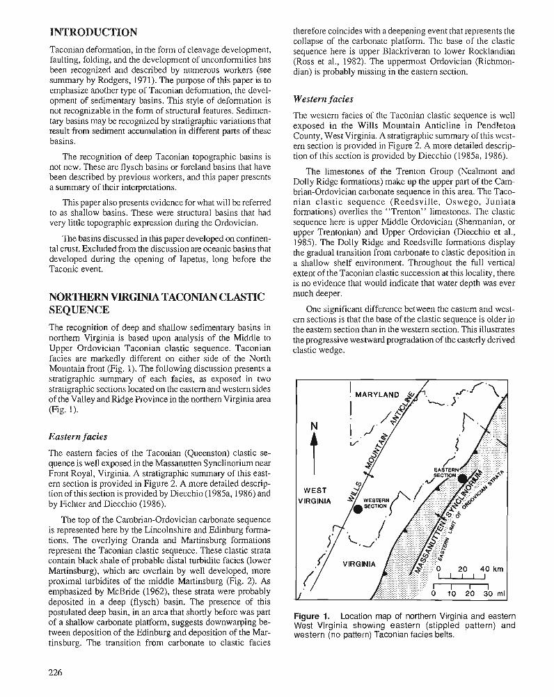
INTRODUCTION Taconian deformation, in the form of cleavage development, faulting, folding, and the development of unconformities has been recognized and described by numerous workers (see summary by Rodgers, 1971). The purpose of this paper is to emphasize another type of Taconian deformation, the devel- opment of sedimentary basins. This style of deformation is not recognizable in the form of structural features. Sedimen- tary basins may be recognized by stratigraphic variations that result from sediment accumulation in different parts of these basins.
The recognition of deep Taconian topographic basins is not new. These are flysch basins or foreland basins that have been described by previous workers, and this paper presents a summary of their interpretations.
This paper also presents evidence for what will be referred to as shallow basins. These were structural basins that had very little topographic expression during the Ordovician.
The basins discussed in this paper developed on continen- tal crust. Excluded from the discussion are oceanic basins that developed during the opening of Iapetus, long before the Taconic event.
NORTHERN VIRGINLA TACONTAN CLASTIC SEQUENCE
The recognition of deep and shallow sedimentary basins in northern Virginia is based upon analysis of the Middle to Upper Ordovician Taconian clastic sequence. Taconian facies are markedly different on either side of the North Mountain front (Fig. 1). The following discussion presents a stratigraphic summary of each facies, as exposed in two stratigraphic sections located on the eastern and western sides of the Valley and Ridge Province in the northern Virginia area (Fig. 1).
Eastern facies
The eastern facies of the Taconian (Queenston) clastic se- quence is well exposed in the Massanutten Synclinorium near Front Royal, Virginia. A stratigraphic summary of this east- ern section is provided in Figure 2. A more detailed descrip- tion of this section is provided by Diecchio (1985a, 1986) and by Fichter and Diecchio (1986).
The top of the Cambrian-Ordovician carbonate sequence is represented here by the Lincolnshire and Edinburg forma- tions. The overlying Oranda and Martinsburg formations represent the Taconian clastic sequence. These clastic strata contain black shale of probable distal turbidite facies (lower Martinsburg), which are overlain by well developed, more proximal turbidites of the middle Martinsburg (Fig. 2). As emphasized by McBride (1962), these strata were probably deposited in a deep (flysch) basin. The presence of this postulated deep basin, in an area that shortly before was part of a shallow carbonate platform, suggests downwarping be- tween deposition of the Edinburg and deposition of the Mar- tinsburg. The transition from carbonate to clastic facies
therefore coincides with a deepening event that represents the collapse of the carbonate platform. The base of the clastic sequence here is upper Blackriveran to lower Rocklandian (Ross et al., 1982). The uppermost Ordovician (Richmon- dim) is probably missing in the eastern section.
Western facies
The western facies of the Taconian clastic sequence is well exposed in the Wills Mountain Anticline in Pendleton County, West Virginia. A stratigraphic summary of this west- ern section is provided in Figure 2. A more detailed descrip- tion of this section is provided by Diecchio (1985a, 1986).
The limestones of the Trenton Group (Nealmont and Dolly Ridge formations) make up the upper part of the Cam- brian-Ordovician carbonate sequence in this area. The Taco- nian clastic sequence (Reedsville, Oswego, Juniata formations) overlies the "Trenton" limestones. The clastic sequence here is upper Middle Ordovician (Sherrnanian, or upper Trentonian) and Upper Ordovician (Diecchio et al., 1985). The Dolly Ridge and Reedsville formations display the gradual transition from carbonate to clastic deposition in a shallow shelf environment. Throughout the full vertical extent of the Taconian clastic succession at this locality, there is no evidence that would indicate that water depth was ever much deeper.
One significant difference between the eastern and west- ern sections is that the base of the clastic sequence is older in the eastern section than in the western section. This illustrates the progressive westward progradation of the easterly derived clastic wedge.
Figure 1. Location map of northern Virginia and eastern West Virginia showing eastern (stippled pattern) and western (no pattern) Taconian facies belts.
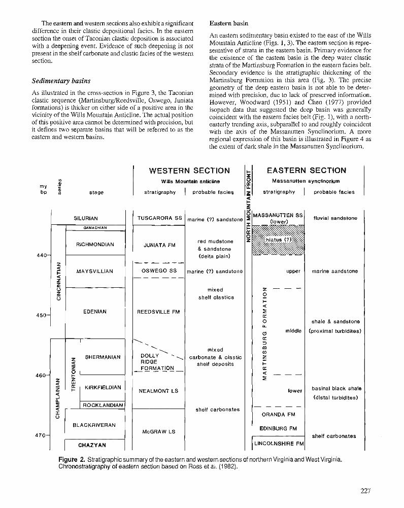
The eastern and western sections also exhibit a significant Eastern basin difference in their clastic depositional facies. In the eastern section the onset of Taconian clastic deposition is associated with a deepening event. Evidence of such deepening is not present in the shelf carbonate and clastic facies of the western section.
An eastern sedimentary basin existed to the east of the Wills Mountain Anticline (Figs. 1,3). The eastern section is repre- sentative of strata in the eastern basin. Primary evidence for the existence of the eastern basin is the deep water clastic strata of the Martinsburg Formation in the eastern facies belt. Secondary evidence is the stratigraphic thickening of the Martinsburg Formation in this area (Fig. 3). The precise geometry of the deep eastern basin is not able to be deter- mined with precision, due to lack of preserved information. However, Woodward (1951) and Chen (1977) provided isopach data that suggested the deep basin was generally coincident with the eastern facies belt (Fig. I), with a north- easterly trending axis, subparallel to and roughly coincident with the axis of the Massanutten Synclinorium. A more regional expression of this basin is illustrated in Figure 4 as the extent of dark shale in the Massanutten Synclinorium.
Sedimentaly basins
As illustrated in the cross-section in Figure 3, the Taconian clastic sequence (Martinsburg/Reedsville, Oswego, Juniata formations) is thicker on either side of a positive area in the vicinity of the Wills Mountain Anticline. The actual position of this positive area cannot be determined with precision, but it defines two separate basins that will be referred to as the eastern and western basins.
SECTION sy nclinorlum
probable facies
WESTERN SECTION Wills Mountah antictlne
stratigraphy ( probable facies
m 0
my e bp stage
TUSCARORA SS
JUNIATA FM
a
+ 2
X U.
g
1 SILURIAN I
EASTERN Massanutten
stratigraphy I
fluvial sandstone marine (7) sandstone
8. sandstone (delta plain)
marine sandstone
shale & sandstone
(proximal turbidltes)
--- --- I OSWEGO SS 1 MAYSVILLIAN marine (7) sandstone I I upper (
mixed shelf clastics
mixed carbonate & clastic
shelf deposits SHERMANIAN
1 NEALMONT LS 1 I I lower ( basinal black shale
(distal turbidites)
shelf carbonates
EDINBURG FM
LINCOLNSHIRE FM
ROCKLANDIAN F shelf carbonates
BLACKRIVERAN
CHAZYAN t-i Figure 2. Stratigraphic summary of the eastern and western sections of northern Virginia and West Virginia. Chronostratigraphy of eastern section based on Ross et al. (1 982).
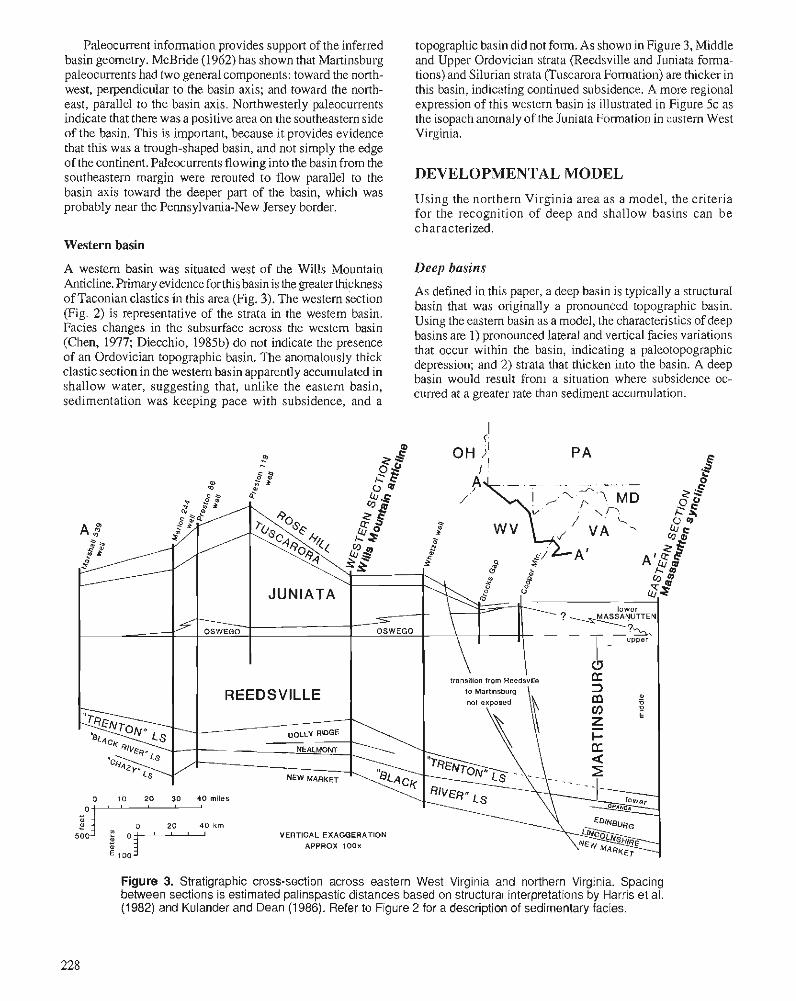
Paleocurrent information provides support of the inferred basin geometry. McBride (1962) has shown that Martinsburg paleocurrents had two general components: toward the north- west, perpendicular to the basin axis; and toward the north- east, parallel to the basin axis. Northwesterly paleocurrents indicate that there was a positive area on the southeastern side of the basin. This is important, because it provides evidence that this was a trough-shaped basin, and not simply the edge of the continent. Paleocurrents flowing into the basin from the southeastern margin were rerouted to flow parallel to the basin axis toward the deeper part of the basin, which was probably near the Pennsylvania-New Jersey border.
topographic basin did not form. As shown inFigure 3, Middle and Upper Ordovician strata (Reedsville and Juniata forma- tions) and Silurian strata (Tuscarora Formation) are thicker in this basin, indicating continued subsidence. A more regional expression of this western basin is illustrated in Figure 5c as the isopach anomaly of the Juniata Formation in castern West Virginia.
DEVELOPMENTAL MODEL
Using the northern Virginia area as a model, the criteria for the recognition of deep and shallow basins can be characterized.
Western basin
A western basin was situated west of the Wills Mountain Deep basins ~nticline. primary evidence forthis basin is As defined in this paper, a deep basin is typically a structural of Taconian clastics in this area (Fig. 3). The western section basin that was onginally a pronounced topographic basin, (Fig. 2, is the strata in the basin' Using the eastern basin as a model, the of deep Facies changes in the subsurface across the western basin
basins are I ) pronounced lateral and vertical facies variations (Chen, 1977; Diecchio, 198%) do not indicate the presence that occur within basin, indicating a paleotopographic
of an Ordovician basin. The thick depression; and 2) strata mat thicken into the basin. A deep clastic section in the western basin apparently accumulated in basin would result from a situation where subsidence oc- shallow water, suggesting that, unlike the eastern basin, curred at a greater rate sediment accumulation. sedimentation was keeping pace with subsidence, and a
Figure 3. Stratigraphic cross-section across eastern West Virginia and northern Virginia. Spacing between sections is estimated palinspastic distances based on structural interpretations by Harris et al. (1 982) and Kulander and Dean (1 986). Refer to Figure 2 for a description of sedimentary facies.
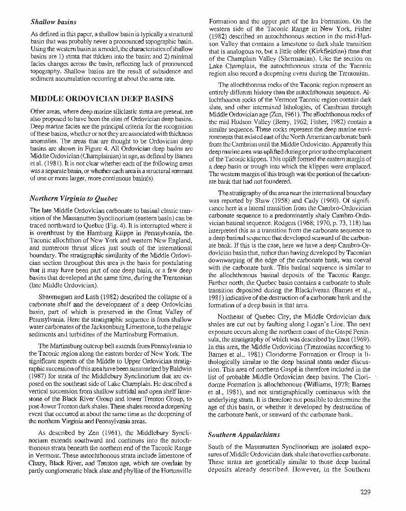
Shallow basins
As defined in this paper, a shallow basin is typically a structural basin that was probably never a pronounced topographic basin. Using the western basin as amodel, thecharacteristics of shallow basins are 1) strata that thicken into the basin; and 2) minimal facies changes across the basin, reflecting lack of pronounced topography. Shallow basins are the result of subsidence and sediment accumulation occurring at about the same rate.
MIDDLE ORDOVICIAN DEEP BASINS Other areas, where deep marine siliclastic strata are present, are also proposed to have been the sites of Ordovician deep basins. Deep marine facies are the principal criteria for the recognition of these basins, whether or not they are associated with thickness anomalies. The areas that,are thought to be Ordovician deep basins are shown in Figure 4. All Ordovician deep basins are Middle Ordovician (Champlainian) in age, as defined by Barnes et al. (1981). It is not clear whether each of the following areas was a separate basin, or whether each area is a structural remnant of one or more larger, more continuous basin(s).
Northern Virginia to Quebec
The late Middle Ordovician carbonate to basinal clastic tran- sition of the Massanutten Synclinorium (eastern basin) can be traced northward to Quebec (Fig. 4). It is interrupted where it is overthrust by the Hamburg Klippe in Pennsylvania, the Taconic allochthon of New York and western New England, and numerous thrust slices just south of the international boundary. The stratigraphic similarity of the Middle Ordovi- cian section throughout this area is the basis for postulating that it may have been part of one deep basin, or a few deep basins that developed at the same time, during the Trentonian (late Middle Ordovician).
Shanrnugarn and Lash (1982) described the collapse of a carbonate shelf and the development of a deep Ordovician basin, part of whlch is preserved in the Great Valley of Pennsylvania. Here the stratigraphic sequence is from shallow water carbonates of the Jacksonburg Limestone, to the pelagic sediments and turbidites of the Martinsburg Formation.
The Martinsburg outcrop belt extends from Pennsylvania to the Taconic region along the eastern border of New York. The significant aspects of the Middle to Upper Ordovician stratig- raphic succession of tlus area have been summarized by Baldwin (1987) for strata of the Middlebury Synclinorium that are ex- posed on the southeast side of Lake Champlain. He described a vertical succession from shallow subtidal and open shelf lime- stone of the Black River Group and lower Trenton Group, to post-lower Trenton dark shales. These shales record a deepening event that occurred at about the same time as the deepening of the northern Virginia and Pennsylvania areas.
As described by Zen (1961), the Wddlebury Syncli- norium extends southward and continues into the autoch- thonous strata beneath the northern end of the Taconic Range in Vermont. These autochthonous strata include limestone of Chazy, Black River, and Trenton age, which are overlain by partly conglomeratic black slate and phyllite of the Hortonville
Formation and the upper part of the Ira Formation. On the western side of the Taconic Range in New York, Fisher (1982) described an autochthonous section in the mid-Hud- son Valley that contains a limestone to dark shale transition that is analogous to, but a little older (Kirkfieldian) than that of the Champlain Valley (Shermanian). Like the section on Lake Champlain, the autochthonous strata of the Taconic region also record a deepening event during the Trentonian.
The allochthonous rocks of the Taconic region represent an entirely different history than the autochthonous sequence. Al- lochthonous rocks of the Vermont T~CONC region contain dark slate, and other intermixed lithologies, of Cambrian through Middle Ordovician age (Zen, 1961). The allochthonous rocks of the mid-Hudson Valley (Beny, 1962; Fisher, 1982) contain a similar sequence. These rocks represent the deep marine envi- ronments that existed east oftheNorth Americancarbonatebank from the Cambrian until the Middle Ordovician. Apparently this deep marine area was uplifted during or prior to the emplacement of the Taconic klippen. This uplift formed the eastem margin of a deep basin or trough into which the klippen were emplaced. The western margin of this trough was the portion of the carbon- ate bank that had not foundered.
The stratigraphy of the area near the international boundary was reported by Shaw (1958) and Cady (1960). Of signifi- cance here is a lateral transition from the Cambro-Ordovician carbonate sequence to a predominantly shaly Cambro-Ordo- vician basinal sequence. Rodgers (1968; 1970, p. 73, 118) has interpreted this as a transition from the carbonate sequence to a deep basinal sequence that developed seaward of the carbon- ate bank. If this is the case, here we have a deep Cambro-Or- dovician basin that, rather than having developed by Taconian downwarping of the edge of the carbonate bank, was coeval with the carbonate bank. This basinal sequence is similar to the aIlochthonous basinal deposits of the Taconic Range. Farther north, the Quebec basin contains a carbonate to shale transition deposited during the Blackriveran (Barnes et al., 1981) indicative of the destruction of a carbonate bank and the formation of a deep basin in that area.
Northeast of Quebec City, the Middle Ordovician dark shales are cut out by faulting along Logan's Line. The next exposure occurs along the northern coast of the GaspC Penin- sula, the stratigraphy of which was describedby Enos (1969). In this area, the Middle Ordovician (Trentonian according to Barnes et al., 1981) Cloridorme Formation or Group is li- thologically similar to the deep basinal strata under discus- sion. This area of northern GaspC is therefore included in the list of probable Middle Ordovician deep basins. The Clori- dome Formation is allochthonous (Williams, 1978; Barnes et al., 1981), and not stratigraphically continuous with the underlying strata. It is therefore not possible to determine the age of this basin, or whether it developed by destruction of the carbonate bank, or seaward of the carbonate bank.
Southern Appalachians
South of the Massanutten Synclinorium are isolated expo- sures of Middle Ordovician dark shale that overlies carbonate. These strata are genetically similar to those deep basinal deposits already described. However, in the Southern
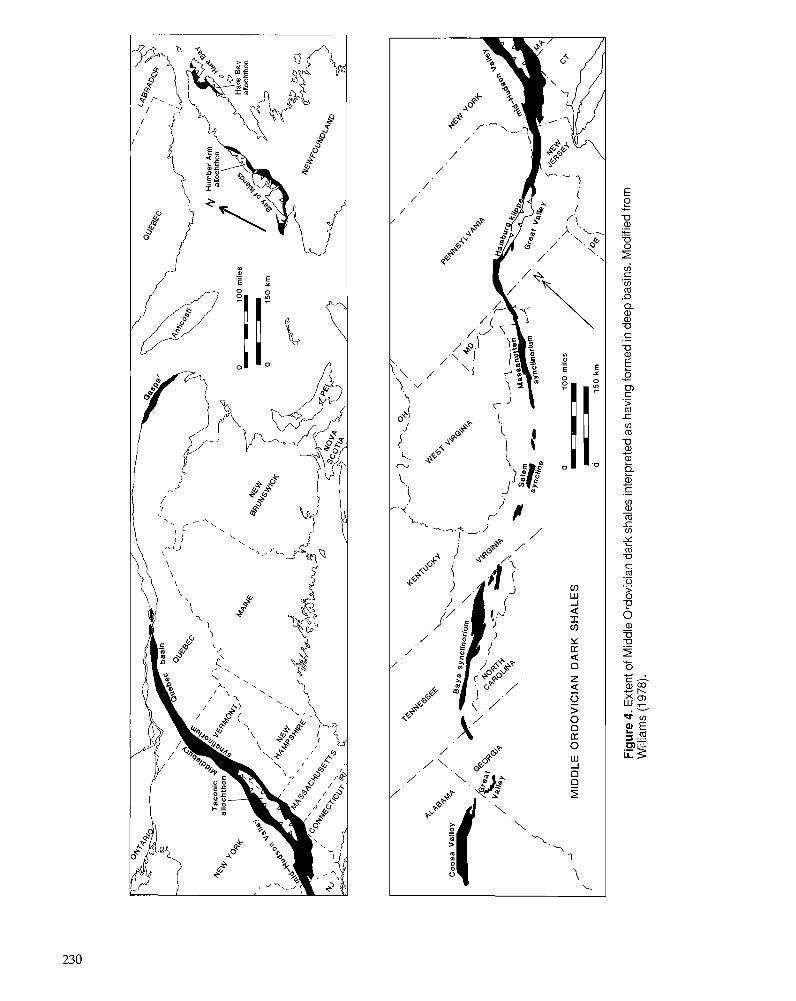
vj C .- (I) m -0
(I) m
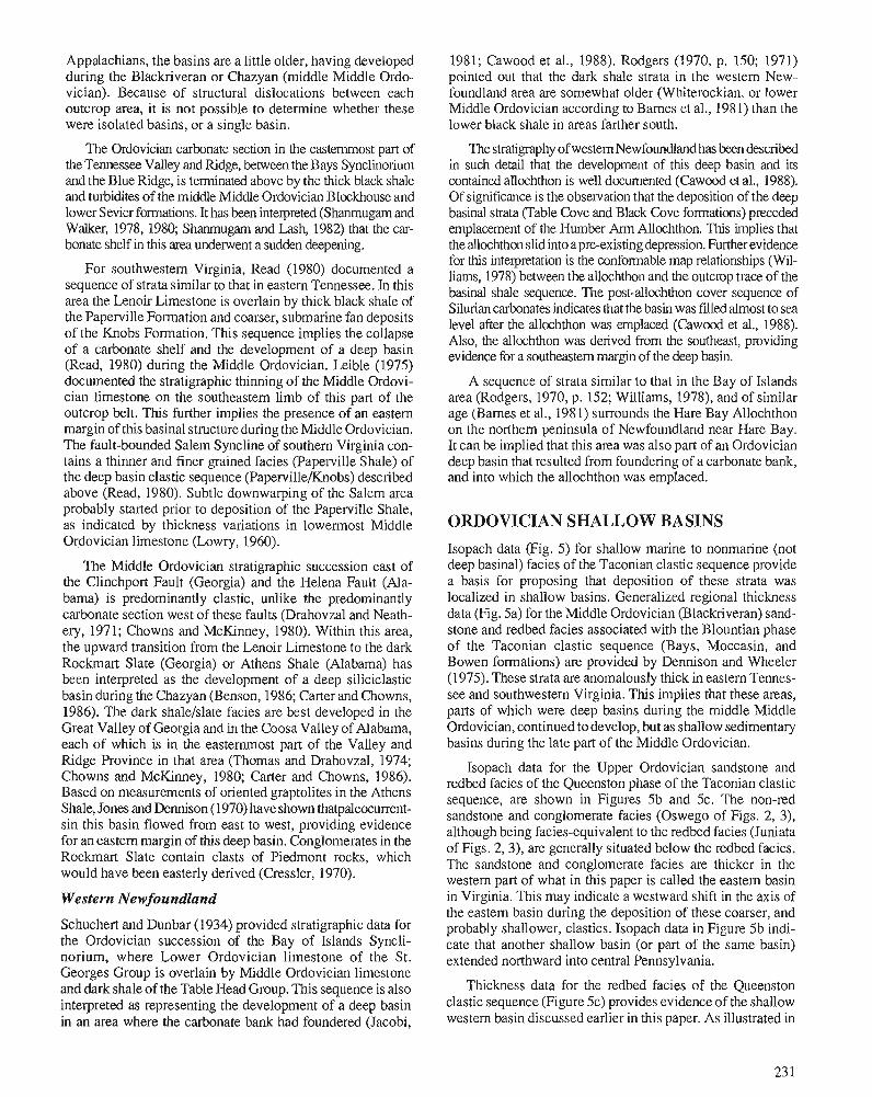
Appalachians, the basins are a little older, having developed during the Blackriveran or Chazyan (middle Middle Ordo- vician). Because of structural dislocations between each outcrop area, it is not possible to determine whether these were isolated basins, or a single basin.
The Ordovician carbonate section in the easternmost part of the Tennessee Valley and Ridge, between the Bays Synclinolium and the Blue Ridge, is terminated above by the thick black shale and turbidites of the middle Middle Ordovician Blockhouse and lower Sevier formations. It has been interpreted (Shanmugam and Walker, 1978,1980; Shanmugarn and Lash, 1982) that the car- bonate shelf in this area underwent a sudden deepening.
For southwestern Virginia, Read (1980) documented a sequence of strata similar to that in eastern Tennessee. In this area the Lenoir Limestone is overlain by thick black shale of the Paperville Formation and coarser, submarine fan deposits of the Knobs Formation. This sequence implies the collapse of a carbonate shelf and the development of a deep basin (Read, 1980) during the Middle Ordovician. Leible (1975) documented the stratigraphic thinning of the Mddle Ordovi- cian limestone on the southeastern limb of this part of the outcrop belt. This further implies the presence of an eastern margin of this basinal structure during the Middle Ordovician. The fault-bounded Salem Syncline of southern Virginia con- tains a thinner and finer grained facies (Paperville Shale) of the deep basin clastic sequence (Paperville/Knobs) described above (Read, 1980). Subtle downwarping of the Salem area probably started prior to deposition of the Paperville Shale, as indicated by thickness variations in lowermost Middle Ordovician limestone (Lowry, 1960).
The Middle Ordovician stratigraphic succession east of the Clinchport Fault (Georgia) and the Helena Fault (Ala- bama) is predominantly clastic, unlike the predominantly carbonate section west of these faults (Drahovzal and Neath- ery, 1971; Chowns and McKinney, 1980). Within this area, the upward transition from the Lenoir Limestone to the dark Rockmart Slate (Georgia) or Athens Shale (Alabama) has been interpreted as the development of a deep siliciclastic basin during the Chazyan (Benson, 1986; Carter and Chowns, 1986). The dark shalelslate facies are best developed in the Great Valley of Georgia and in the Coosa Valley of Alabama, each of which is in the easternmost part of the Valley and Ridge Province in that area (Thomas and Drahovzal, 1974; Chowns and McKinney, 1980; Carter and Chowns, 1986). Based on measurements of oriented graptolites in the Athens Shale, Jones and Dennison (1970) have shown thatpaleocurrent- sin this basin flowed from east to west, providing evidence for an eastern margin of this deep basin. Conglomerates in the Rockmart Slate contain clasts of Piedmont rocks, which would have been easterly derived (Cressler, 1970).
Western Newfoundland
Schuchert and Dunbar (1934) provided stratigraphic data for the Ordovician succession of the Bay of Islands Syncli- norium, where Lower Ordovician limestone of the St. Georges Group is overlain by Middle Ordovician limestone and dark shale of the Table Head Group. This sequence is also interpreted as representing the development of a deep basin in an area where the carbonate bank had foundered (Jacobi,
1981; Cawood et al., 1988). Rodgers (1970, p. 150; 1971) pointed out that the dark shale strata in the westem New- foundland area are somewhat older (Whiterockian, or lower Middle Ordovician according to Barnes et al., 1981) than the lower black shale in areas farther south.
The stratigraphy of western Newfoundland has been described in such detail that the development of this deep basin and its contained allochthon is well documented (Cawood et al., 1988). Of significance is the observation that the deposition of the deep basinal strata (Table Cove and Black Cove formations) preceded emplacement of the Hurnber Arm Allochthon. This implies that the allochthon slid into a preexisting depression. Further evidence for this interpretation is the conformable map relationships (Wil- liams, 1978) between the allochthon and the outcrop t~-ace of the basinal shale sequence. The post-allochthon cover sequence of Silurian carbonates indicates that the basin was filled almost to sea level after the allochthon was emplaced (Cawood et al., 1988). Also, the allochthon was derived from the southeast, providing evidence for a southeastern margin of the deep basin.
A sequence of strata similar to that in the Bay of Islands area (Rodgers, 1970, p. 152; Williams, 1978), and of similar age (Barnes et al., 1981) surrounds the Hare Bay Allochthon on the northern peninsula of Newfoundland near Hare Bay. It can be implied that this area was also part of an Ordovician deep basin that resulted from foundering of a carbonate bank, and into which the allochthon was emplaced.
ORDOVICIAN SHALLOW BASINS
Isopach data (Fig. 5) for shallow marine to nonmarine (not deep basinal) facies of the Taconian clastic sequence provide a basis for proposing that deposition of these strata was localized in shallow basins. Generalized regional thickness data (Fig. 5a) for the Middle Ordovician (Blackriveran) sand- stone and redbed facies associated with the Blountian phase of the Taconian clastic sequence (Bays, Moccasin, and Bowen formations) are provided by Dennison and Wheeler (1975). These strata are anomalously thick in eastern Tennes- see and southwestern Virginia. This implies that these areas, parts of which were deep basins during the middle Middle Ordovician, continued to develop, but as shallow sedimentary basins during the late part of the Middle Ordovician.
Isopach data for the Upper Ordovician sandstone and redbed facies of the Queenston phase of the Taconian clastic sequence, are shown in Figures 5b and 5c. The non-red sandstone and conglomerate facies (Oswego of Figs. 2, 3), although being facies-equivalent to the redbed facies (Juniata of Figs. 2,3), are generally situated below the redbed facies. The sandstone and conglomerate facies are thicker in the western part of what in this paper is called the eastern basin in Virginia. This may indicate a westward shift in the axis of the eastern basin during the deposition of these coarser, and probably shallower, clastics. Isopach data in Figure 5b indi- cate that another shallow basin (or part of the same basin) extended northward into central Pennsylvania.
Thickness data for the redbed facies of the Queenston clastic sequence (Figure 5c) provides evidence of the shallow western basin discussed earlier in this paper. As illustrated in
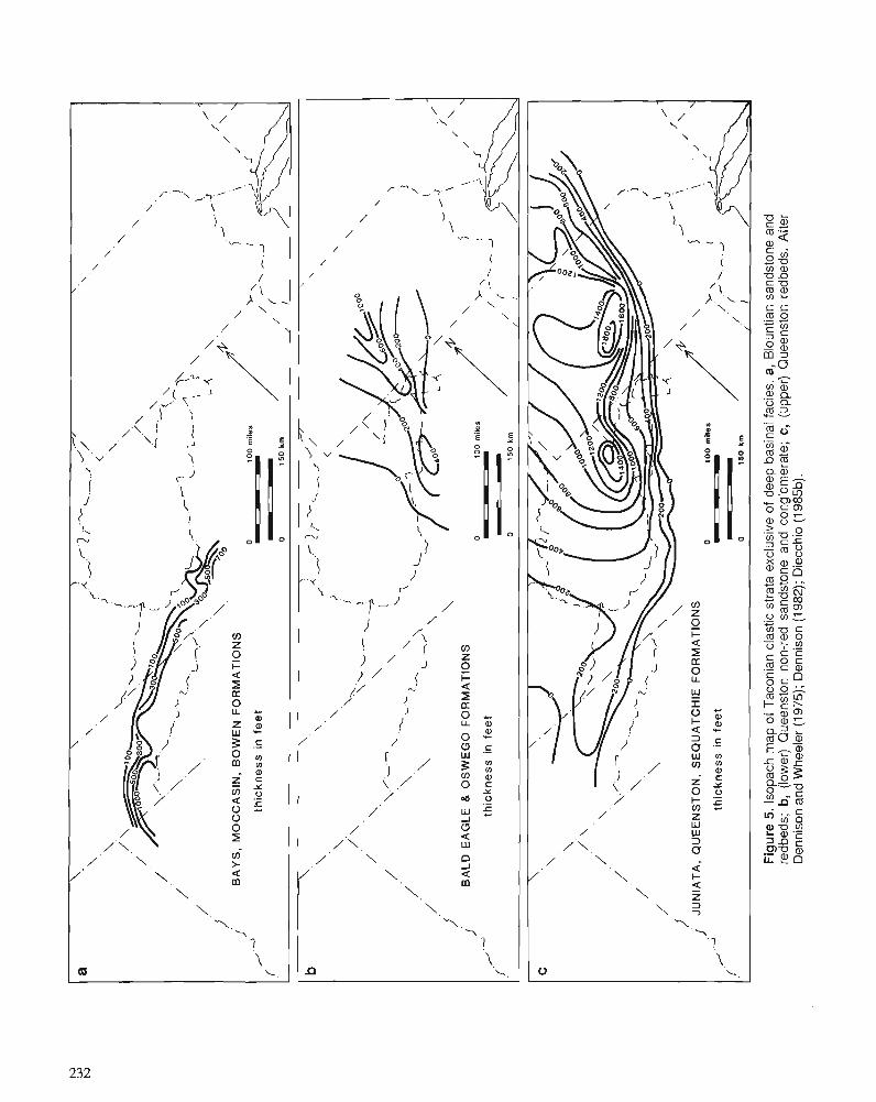
a
\
\
\ A
,
./, \
\
\
.i.-./.2
.r--L
. .-,,
\.
r' \
> <
\.
\
1.
'.
\ .
\
/ .'\
'.
/.
- -.-\.
\
<. \
'l
/ '
\
- 7
2- -I\
I L
.J
L-
.d
/
/
I s'
\ L
-4
\
j.
.; B
AY
S,
MO
CC
AS
IN.
BO
WE
N F
OR
MA
TIO
NS
0
1
00
mile
s P
th
ick
ne
ss
in
fe
et
f'
-
0
15
0 k
rn
b
\
\
A,
\
\
\
\
!' <
\
\
\
> \
/.\
\.
I \
\L
L*
) -3
\
\
I /
\
\./-
-
\
'.
\
\
\-
/ '
L L
\
7 1
\
I,
'I
/.
/
L -/ \
Y
,
,? /
/r'
\
2
\ i
I ;
BA
LD
EA
GL
E 8
OS
WE
GO
FO
RM
AT
ION
S
0
10
0 m
des
thic
knes
s in
fe
et
('
0
15
0 k
m
,/ JU
NIA
TA
, Q
UE
EN
ST
ON
, S
EQ
UA
TC
HIE
FO
RM
AT
ION
S
I \
0
10
0 m
lle
s
P
/.a
thic
kn
es
s i
n f
ee
t 1 ,+
..-.a
f'
- / ,':,
0
15
0 k
rn
/'
1
Fig
ure
5.
lsop
ach
map
of
Tac
onia
n cl
astic
str
ata
excl
usiv
e of
dee
p ba
sina
l fac
ies.
a,
Blo
untia
n sa
ndst
one
and
redb
eds;
b,
(low
er)
Que
enst
on n
on-r
ed s
ands
tone
and
con
glom
erat
e; c
, (u
pper
) Q
ueen
ston
red
beds
. A
fter
Den
niso
n an
d W
heel
er (1
975
); D
enni
son
(1 9
82);
Die
cchi
o (1
98513).
Figure 3, the shelf deposits of the Reedsville Formation are thicker in the western basin, indicating that there was slow subsidence here, while the deep basin existed farther east. In addition, both the red and non-red Queenston clastics (Figs. 5b, 5c) delineate a shallow basin in central Pennsylvania. This is probably a continuation of subsidence of the same basin delineated by the Oswego isopachs (Fig. 5b).
CONTROL OF BASIN DEVELOPMENT
Deep basins
Most of the Middle Ordovician deep basins mentioned above had developed in association with the foundering of the pre-existing carbonate bank. The development of a deep b. :n requires that subsidence occur at a greater rate than sediment accumulation. These deep basins have been described as foreland basins associated with thrust-loading during subduc- tion of the eastern margin of North America (Jacobi, 1981; Shanmugam and Lash, 1982; Quinlan and Beaumont, 1984; Lash, 1987). The isostatic effect of sediment loading, as well as other factors, is most likely of secondary importance in the development of deep basins.
Shallow basins
For shallow basins, there is not such a great disparity between the rate of downwarping and the rate of sedimentation, in fact the two rates should be about equal. There are two possible explanations for the development of a shallow basin. One reason might be coincidence, that the availability of sediment was sufficient to allow accumulation at the same rate as downwarping. An alternate, and more plausible explanation, is that sediment accumulation was the cause of the subsidence due to isostatic adjustment.
The question of why the downwarping and the sedimen- tation are localized to such specific areas as the basins them- selves is another matter. Some structural control is probably responsible for this localization, but for the most part, these structures have not yet been recognized. One possible exam- ple has been described by Jacobeen and Kanes (1974, 1975) for the Broadtop Synclinorium that extends from northern
Virginia into central Pennsylvania, the axis of which coin- cides with the axis of thickening of the Bald Eagle and Oswego formations (Fig. 5b). They have documented the presence of high angle normal faults that offset basement below the Broadtop Synclinorium. Differential rates of sub- sidence may have occurred on either side of these faults, either before or during accumulation of the Bald Eagle and Oswego formations, thus localizing the accumulation of these strata.
In at least two areas, Tennessee/southwestern Virginia and the eastern basin of northern Virginia, the development of a deep basin is followed by the existence of a shallow basin. In these areas, after the initial subsidence in response to the thrust load, it could be that sedimentation continued so as to fill these basins to shallower depths. Unequal rates of sedi- mentation, or localization of sediment accumulation within this area or part of this area, would have resulted in the development of one or more shallow basins.
Subsequent structural modifications
The sedimentary basins described above are features probably due to syndepositional conditions. Later compressional defor- mation (Acadian or Alleghenian) modified the original geome- try of these basins by steepening their limbs or by redeforming these basins into more complex stl-uctural features. Also, many of these basins are allochthonous. However, for many of the basins, the original basinal structure is still recognizable in the form of a synclinorium. For example, the structural feature known today as the Massanutten Synclinorium had developed in the area that was an Ordovician deep basin (eastern basin of northern Virginia). Subsequent deformation (Acadian or Al- leghenian) of the original basinal structure was responsible for the the present structural configuration (dips, fold axes, second- order folds) of this synclinorium. Also, the Massanutten Syncli- norium is allochthonous, having been displaced westward along the North Mountain Fault (Fig. 1).
ACKNOWLEDGMENTS Acknowledgment is made to the Donors of The Petroleum Research Fund, administered by the American Chemical Society (ACS-PRF grant number 19220-B2), for the support of this research.
REFERENCES Baldwin, B. 1987: The mid-Ordovician section at Crown Point, New York. In Geologi-
cal Society of America, Northeastern Section, Centennial Field Guide, v. 5, Decade of North American Geology, D.C. Roy (ed.); p. 147-150.
Barnes, C.R., Norford, B.S., and Skevington, D. 1981: The Ordovician System in Canada. International Union of Geological
Sciences, Publication no. 8, 27 p. Benson, D.J. 1986: Depositional setting and history of the Middle Ordovician of the
Alabama Appalachians. In Depositional History of the Middle Ordovician of the Alabama Appalachians, D.J. Benson and C.W. Stock (eds.); Guidebook for 23rd Annual Field Trip, Alabama Geological Society, p. 15-31.
Berry, W.B.N. 1962: Stratigraphy, zonation, and age of Schaghticoke, Deepkill, and
Normanskill shales, eastern New York. Geological Society of America, Bulletin, v. 73, p. 695-718.
Cady, W.M. 1960: Stratigraphy and geotectonic relationships in northern Vermont and
southern Quebec. Geological Society of America, Bulletin, v. 71, p. 53 1-576.
Carter, B.D. and Chowns, T.M. 1986: Stratigraphic and environmental relationships of Middle and Upper
Ordovician rocks in northwestern Georgla and northeastern Alabama. In Depositional Bstory of the Middle Ordovician of the Alabama Appalachians, D.J. Benson and C.W. Stock (eds.); Guidebook for 23rd Annual Field Trip, Alabama Geological Society, p. 33-50.
Cawood, P.A., Barnes, C.R., Botsford, J.W., James, N.P., Knight, I., O'Brien, S.J., O'Neill, P.P., Parsons, M.G., Stenzel, S.R., Stevens, R.K., Williams, H., and Williams, S.H. 1988: A cross-section of the Iapetus Ocean and its continental margins. In
Field Excursion Guidebook, S.H. Williams (ed.); Vth International Symposium on the Ordovician System, St. John's, Newfoundland, Canada, August, 1988.
Chen, Ping-fan 1977: Lower Paleozoic stratigraphy, tectonics, paleogeography, and oil-
gas possibilities in the central Appalachians (West Virginia and adjacent states): part 1, stratigraphic maps. West Virginia Geologic and Economic Survey, Report of Investigations RI-26- 1,14 1 p.
Chowns, T.M. and McKinney, F.K. 1980: Depositional facies in Middle-Upper Ordovician and Silurian rocks
of Alabama and Georgia. In Excursions in Southeastern Geology, v. 2, R.W. Frey (ed.); Geological Society of America, Annual Meeting, Field Trip Guidebook, p. 323-348.
Cressler, C.W. 1970: Geology and ground-water resources of Floyd and Polk counties,
Georgia. Geological Survey of Georgia, Information Circular 39.95 p. Dennison, J.M. 1982: Uranium favorability of nonmarine and marginal-marine strata of
late Precambrian and Paleozoic age in Ohio, Pennsylvania, New Jersey, and New York. Report GJBX-50(82) prepared for United States Department of Energy, 254 p.
Dennison, J.M. and Wheeler, W.H. 1975: St~atigraphy of Precambrian through Cletaceous strata of probable
fluvial origin in southeastern United States and their potential as uranium host rocks. Southeastern Geology, Special Publication5,210p.
Diecchio, R.J. 1985a: The Taconian clastic sequence.in nonhem Virginia and West Virginia.
Society of Economic Paleontologists and Mineralogists, Eastem Section, Field Trip Guidebook, October, 1985, Hanisonburg, Virginia, 62 p.
1985b: Post-Martinsburg Ordovician suatigraphy of Virginia and West Vir- ginia. Virginia Division of Mineral Resources, Publication 57,77 p.
1986: Upper Ordovician and Silurian stratigraphy of the Virginia and West Virginia Valley and Ridge - sedimenta~y and structural effects of the Taconic Orogeny. In Society of Economic Paleontologists and Mineralogists Field Trip Guidebooks, D.A. Textoris (ed.); South- eastern United States, Third Annual Midyear Meeting, Raleigh, North Carolina, p. 217-252.
Diecchio, R.J., Iverson, B.M., and Hall, J.C. 1985: Conodont age determination of the lower portion of the Taconian
clastic sequence at the Allegheny front, Pendleton County, West Virginia (abstract). Geological Society of America, Southeastern Section, Abstracts with Programs, v. 17, p. 88.
Drahovzal, J.A. and Neathery, T.N. 1971: Middle and Upper Ordovician stratigraphy of the Alabama Appala-
chians. I n The Middle and Upper Ordovician of the Alabama Appalachians, J.A. Drahovzal and T.N. Neathery (eds.); Guidebook for Ninth Annual Field Trip, Alabama Geological Society, p. 1-62.
Enos, P. 1969: Cloridorme Formation, Middle Ordovician flysch, northern Gaspi
Peninsula, Quebec. Geological Society of America, Special Paper 117.66 p.
Fichter, L.S. and Diecchio, R.J. 1986: The Taconic sequence in the northern Shenandoah Valley, Virginia.
In Geological Society of America, Southeastern Section, Centennial Field Guide, v. 6, Decade of North American Geology, T.N. Neathery (ed.); p. 73-78.
Fisher, D.W. 1982: Synopsis of Ordovician correlations in New York State. In The
Ordovician System in the United States, R.J. Ross, Jr. et a].; Inter- national Union of Geological Sciences, Publication no. 12, p. 44-51.
Harris, L.D., deWitt. W., and Bayer, K.C. 1982: Interpretive seismic profiles along Interstate 1-64 from the Valley
and Ridge to the Coastal Plain in central Virginia. United States Geological Survey, Oil and Gas Investigations Chart OC-123.
Jacobeen, F., Jr. and Kanes, W.H. 1974: Structure of Broadtop Synclinorium and its implications for Appa-
lachian structural style. American Association of Petroleum Geolo- gists, Bulletin, v. 58, p. 362-375.
1975: Structure of Broadtop Synclinorium, Wills Mountain Anticli- norium, and Allegheny frontal zone. American Association of Pe- troleum Geologists, Bulletin, v. 59, p. 1136-1 150.
Jacobi, R.D. 1981: Peripheral bulge - a causal mechanism for the LowerIMiddle Ordo-
vician unconformity along the western margin of the Northern Appalachians. Earth and Planetary Science Leners, v. 56, p. 245-25 1.
Jones, M.L. and Dennison, J.M. 1970: Oriented fossils as paleocurrent indicators in Paleozoic lutites of
Southern Appalachians. Journal of Sedimentary Petrology, v. 40, p. 642-649.
Kulander, B.R. and Dean, S.L. 1986: Struclure and tectonics of Central and Southern Appalachian Valley
and Ridge and Plateau provinces, West Virginia and Virginia. American Association of Petroleum Geologists, Bulletin, v. 70, p. 1674-1684.
Lash, G.G. 1987: Geodynamic evolution of the Lower Paleozoic Central Appalachian
foreland basin. I n Sedimentary Basins and Basin-Forming Mecha- nisms, C. Beaumont and A.J. Tankard (eds.); Canadian Society of Petroleum Geologists, Memoir 12, p. 413-423.
Leible, K.A. 1975: The paleotectonic significance of two Middle Ordovician polymic-
tic conglomerates near South Holston Dam, Tennessee, and Avens ~ r i d ~ e r Virginia. Unpublished M.Sc. thesis, Virginia Polytechnic Institute and State University, Blacksburg. 89 D. - &
Lowry, W.D. 1960: relations hi^ between tectonism and sedimentation in Earlv Silurian
time in virginia. Virginia Polytechnic Institute, Mineral industries Journal, v. 7, no. 3, p. 1-7.
McBride, E.F. 1962: Flysch and associated beds of the Martinsburg Formation (Ordovi-
cian), central Appalachians. Journal of Sedimentary Petrology, V. 32, p. 39-91.
Quinlan, G.M. and Beaumont, C. 1984: Appalachian thrusting, lithospheric flexure, and the Paleozoic stra-
tigraphy of the eastern interior of North America. Canadian Journal of Earth Sciences, v. 21, p. 973-996.
Read, J.F. 1980: Carbonate ramp-to-basin transition and foreland basin evolution,
Middle Ordovician, Virginia Appalachians. American Association of Petroleum Geologists, Bulletin, v. 64, p. 1575-1612.
Rodgers, J. 1968: The eastern edge of the North American continent during the
Cambrian and Early Ordovician. In Studies of Appalachian Geology -Northern and Maritime, E-An Zen, W.S. White, J.B. Hadley, and J.B. Thompson, Jr.; Wiley-Interscience, p. 141-149.
1970: The Tectonics of the Appalachians. Wiley-Interscience, 271 p. 1971: The Taconic Orogeny. Geological Society of America, Bulletin,
v. 82, p. 1141-1178. Ross, R.J., Jr., Adler, F.J., Amsden, T.W., Bergstrom, D., Bergstrom, S.M., Carter, C., Churkin, M., Cressman, E.A., Derby, J.R., Dutro, J.T., Jr., Ethington, R.L., Finney, S.C., Fisher, D.W., Fisher, J.H., Harris, A.G., Hintze, L.F., Ketner, K.B., Kolata, D.L., Landing, E., Neuman, R.B., Sweet, W.C., Pojeta, J., Jr., Potter, A.W., Rader, E.K., Repetski, J.E., Shaver, R.H., Thompson, T.L., and Webers, G.F. 1982: The Ordovician System in the United States. International Union of
Geological Sciences, Publication no. 12, 73 p. Schuchert, C. and Dunbar, C.O. 1934: Stratigraphy of western Newfoundland. Geological Society of
America, Memoir no. 1, 123 p. Shanmugan~, G. and Lash, G.G. 1982: Analogous tectonic evolution of the Ordovician foredeeps, southern
and central Appalachians. Geology, v. 10, p. 562-566. Shanmugam, G. and Walker, K.R. 1978: Tectonic significance of distal turbidites in the Middle Ordovician
Blockhouse and lower Sevier formations in east Tennessee. Ameri- can Journal of Science, v. 278, p. 55 1-578.
1980: Sedimentation, subsidence, and evolution of a foredeep basin in the Middle Ordovician, southern Appalachians. American Journal of Science, v. 280, p. 479-496.
Shaw, A.B. 1958: Stratigraphy and structure of the St. Albans area, northwestern
Vermont. Geological Society of America, Bulletin, v. 69, p. 519-568. Thomas, W.A. and Drahovzal, J.A. 1974: Geology of the Coosa deformed belt. hz The Coosa Deformed Belt
in the Alabama Appalachians, W.A. Thomas and J.A. Drahovzal (eds.); Guidebook for the Twelfth Annual Field Trip, Alabama Geological Society, p. 45-75.
Williams, H. 1978: Tectonic lithofacies map of the Appalachian orogen. Memorial
University of Newfoundland, Map no. 1, scale 1:1,000,000. Woodward, H.P. 1951: Ordovician System of West Virginia. West Virginia Geological
Survey, v. 21,627 p. Zen, E-an 1961: Stratigraphy and structure at the north end of the Taconic Range in
west-central Vermont. Geological Society of America, Bulletin, V. 72, p. 293-338.
Stratigraphy of the Middle Ordovician Long Point Group, western Newfoundland
Bryan A. staitl and Christopher R. ~ a r n e s ~
Stait, B A . and Barnes, C.R., Stratigraphy of the Middle Ordovician Long Point Group, western Newfound- land; & Advances in Ordovician Geology, C.R. Barnes and S.H. Williams (ed.), Geological Survey of Canada, Paper 90-9, p. 235-244,1991.
Abstract
The Long Point Group is the only fossiliferous Ordovician sequence in Newfoundland that postdates the deposition' of synorogenic ji'ysch and possibly also the emplacement of the allochthons. Thus, understanding the biostratigraphy and depositional history of this sequence is a critical element in any tectonic model for the Appalachian Orogen.
The Long Point Group consists of the lower, 75 m thick Lourdes Formation and the upper, 300 m thick Winterhouse Formation. Although the Lourdes Formation deepens up-sequence, it consists of three shallowing-upward sequences, each formally established as new members. The boundaries between the lower two members are unusual "planed-off ' surfaces, whereas the top of the formation is transitional to the deeper Winterhouse Formation.
The lowest Shore Point Member begins with a green sandstone: probably reworkedflysch or Humber Arm rocks. The remainder of the member is massive sandstone and interbedded sandstone and intertidal carbonate. The Black Duck Member is characterized by the presence of in situ coral heads. At the base, these are isolated heads, but in the upper six metres they form wall-like "reefs". These upper six metres contain a very diverse fauna, including trilobites, nautiloids, ostracodes, stromatoporoids, bryozoans, and gastropods. The uppermost Beach Point Member represents a deeper water environment and contains rolled and worn corals and other fossils in the upper subunit. The Winterhouse Formation is interpreted as a deeper water, possibly slope, deposit.
As the Long Point Group has been considered traditionally to immediately overlie the allochthonous Humber Arm Group, it provides a minimum age for the emplacement of the Taconic allochthons in western Newfoundland. Recent reinterpretations suggest that the present location of the allochthons was a result of the Acadian Orogeny. Resampling for conodonts has confirmed a predominantly Prioniodus gerdae Subzone age (Blackriveran to mid-Kirkfiieldian) for most of the Lourdes Formation.
Le groupe de Long Point est la seule skquence ordovicienne fossilqere h Terre-Neuve qui estpostkrieure h l'accumulation de flysch synorogknique et possiblement aussi a la mise en place des dkp6ts allochtones. I1 est done essentiel de connaitre la biostratigraphie et thistoire skdimentaire de cette skquence afin de pouvoir Ctablir un modble tectonique de I'orogPne des Appalaches.
Le groupe de Long Point comprend une formation infkrieure de 75 m d'Cpaisseur, la formation de Lourdes, et une formation supkrieure de 300 m d'kpaisseur, la formation de Winterhouse. Bien que la formation de Lourdes tkmoigne d u n accroissement de la profondeur marine vers le h u t , elle se compose
Parliamentary Library, Parliament House, Hobart, Tasmania, Australia Centre for Earth and Ocean Research, University of Victoria, Victoria, B.C. V8W 3P6
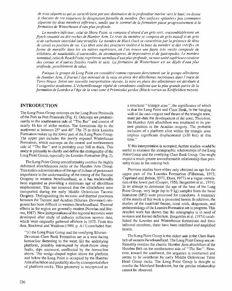
de trois sequences qui se caracterisent par une diminution de la profondeur marine vers le haut; on donne a chacune de ces sequences la designation forme !le de membre. Des suifaces <<planees» peu communes se parent les deux membres injerieurs, tandis que le sommet de la formation passe progressivement a la formation de Winterhouse d' eau plus profonde.
Le membre injerieur, celui de Shore Point, se composed' abord d' un gn!s vert, vraisemblablement un flysch remanie ou des roches de Humber Arm. Le reste du membre se compose de gres massif et de gres et de carbonate intertidal interstratifies. Le membre de Black Duck se caracterise par la presence de tetes de corail en position de vie. Ces tetes sont des structures isolees a la base du membre et des «recifs» en forme de muraille dans les si.x metres superieurs, m't I' on trouve une faune tres variee composee de trilobites, de nautiloides, d' ostracodes, de stromatopores, de bryozoaires et de gastropodes. Le membre sommital, celui de Beach Point, represente un milieu d' eau plus profonde; sa sous-unite superieure contient des corau.x et d' autres fossiles routes et uses. La formation de Winterhouse est un depot d' eau plus profonde, possiblement de talus.
Puisque le groupe de Long Point est considere comme reposant directement sur le groupe allochtone de Humber Arm, il fournit l' age minimal de la mise en place des allochtones taconiques dans l' ouest de Terre-Neuve. Se/on une nouvelle interpretation recente, la mise en place des allochtones est attribuee a I' orogenese acadienne. L' echantillonnage repete de conodontes confirme que la plus grande partie de la formation de Lourdes a I' age de la sous-zone a Prioniodus gerdae (Blackriverien au Kirkfieldien moyen).
INTRODUCTION
The Long Point Group outcrops on the Long Point Peninsula of the Port au Port Peninsula (Fig. 1 ). Outcrops are predominantly to the southeastern side of "The Bar" and consist of nearly 16 km of strike section. The formations dip to the northwest at between 25° and 40°. The 75 m thick Lourdes Formation makes up the lower part of the Long Point Group. The upper part includes the poorly exposed Winterhouse Formation, which outcrops on the central and northwestern side of "The Bar" and is probably over 500 m thick. This study is primarily to clarify and define the stratigraphy of the Long Point Group, especially the Lourdes Formation (Fig. 2).
The Long Point Group unconformably overlies the highly deformed allochthonous rocks of the Humber Arm Group. This makes a determination of the age of its base of paramount importance in the understanding of the timing of the Taconic Orogeny in westem Newfoundland, as it has traditionally been regarded as providing a minimum age of allochthon emplacement. This has assumed that the allochthons were transported during the early Middle Ordovician Taconic Orogeny. Distinguishing the tectonic and thermal processes between the Taconic and Acadian (Silurian- Devonian) oregenies has been difficult in westem Newfoundland. Thermal effects in the region are generally modest (Nowlan and Barnes, 1987). New inte1pretations of the regional tectonics were developed after study of industry reflection seismic data, which were originally gathered offshore in 1973. From this data, Stockmal and Waldron (1989, p. All) concluded that:
"(i) the Long Point Group and the overlying SilUlianDevonian Clam Bank Formation are in a west-facing homocline flattening to the west; (ii) the underlying platform, possibly interrupted by short-throw steep faults, dips eastward, unaffected by the homocline above. The wedge-shaped region above the platform and below the Long Point is occupied by the Humber Arm allochthon and probably also by a transported slice of platform rocks . This geometry is interpreted as
236
a structural "triangle zone", the significance of which is that the Long Point and Clam Bank, in the hanging wall of the east-vergent roof thrust of the triangle zone, must pre-date the development of the zone. Therefore, the Humber Arm allochthon was emplaced in its present position in the Acadian orogeny. The probable inclusion of a platform slice within the triangle zone implies significant displacement (>30 km) at this time."
If this interpretation is accepted, further studies would be useful to examine the stratigraphic relationships of the Long Point Group and the overlying Clam Bank Group. One might expect a much greater unconformable relationship than presently exists in the outcrop belt.
Previous studies have either only obtained an age for the upper part of the Lourdes Formation (Filhraeus, 1973; Copeland and Bolton, 1977; Dean, 1977) or a vague con-elation of the lower part (Cooper, 1956; Bergstrom et al. , 1974). In an attempt to determine the age of the base of the Long Point Group, very large (up to 9 kg) samples from the basal limestone (SP2) were processed for conodonts. A summary of the results of this work is presented herein. In addition, the studies of the nautiloid faunas, coral reefs, diagenesis, and sedimentology of the Lourdes Formation are in progress. This detailed work has shown that the stratigraphy is in need of revision and formal definition. Bergstrom et al. (1974) established the Lourdes and Winterhouse formations and three informal members; these have been redefined and amplified herein.
The Long Point Group is the oldest unit in the Clam Bank belt of western Newfoundland. The Long Point Group unconformably overlies the chaotic Humber Arm allochthon of the Humber Belt on the southeastem side of "The Bar" . However, toward the southwest, the sequence is overturned and seems to be overthrust by early Middle Ordovician Table Head Group rocks. The Long Point Group is thought to overlie the Mainland Sandstone, but the precise relationship cannot be observed.
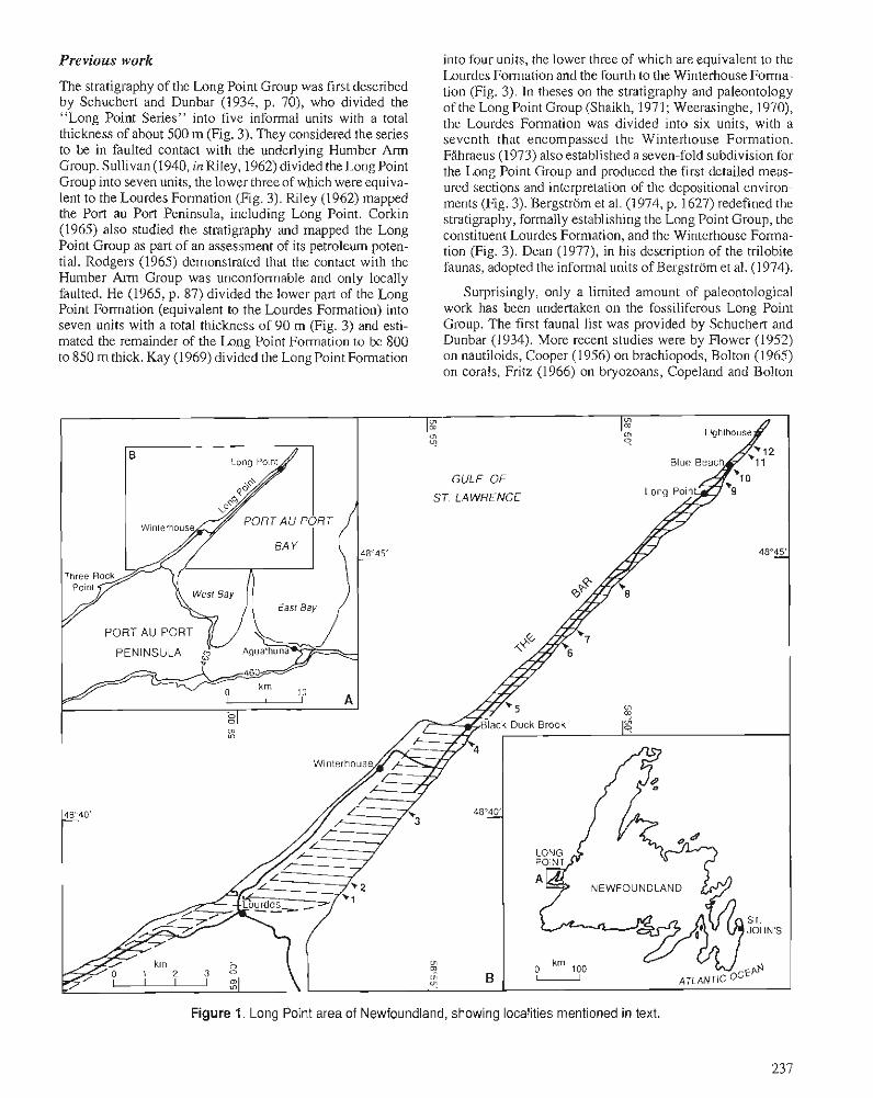
Previous work
The stratigraphy of the Long Point Group was first described by Schuchert and Dunbar (1934, p. 70). who divided the "Long Point Series" into five informal units with a total thickness of about 500 m (Fig. 3). They considered the series to be in faulted contact with the underlying Humber Arm Group. Sullivan (1940, in Riley, 1962) divided the Long Point Group into seven units, the lower three of which were equiva- lent to the Lourdes Formation (Fig. 3). Riley (1962) mapped the Port au Port Peninsula, including Long Point. Corkin (1965) also studled the stratigraphy and mapped the Long Point Group as part of an assessment of its petroleum poten- tial. Rodgers (1965) demonstrated that the contact with the Humber Arm Group was unconformable and only locally faulted. He (1965, p. 87) divided the lower part of the Long Point Formation (equivalent to the Lourdes Formation) into seven units with a total thickness of 90 m (Fig. 3) and esti- mated the remainder of the Long Point Formation to be 800 to 850 m thick. Kay (1969) divided the Long Point Formation
into four units, the lower three of which are equivalent to the Lourdes Fomlation and the fourth to the Winterhouse Forma- tion (Fig. 3). In theses on the stratigraphy and paleontology of the Long Point Group (Shaikh, 1971; Weerasinghe, 1970), the Lourdes Formation was divided into six units, with a seventh that encompassed the Winterhouse Formation. Filhraeus (1973) also established a seven-fold subdivision for the Long Point Group and produced the first detailed meas- ured sections and interpretation of the depositional environ- ments (Fig. 3). Bergstrom et al. (1974, p. 1627) redefined the stratigraphy, formally establishing the Long Point Group, the constituent Lourdes Formation, and the Winterhouse Forma- tion (Fig. 3). Dean (1977), in his description of the trilobite faunas, adopted the informal units of Bergstrom et al. (1974).
Surprisingly, only a limited amount of paleontological work has been undertaken on the fossiliferous Long Point Group. The first faunal list was provided by Schuchert and Dunbar (1934). More recent studies were by Flower (1952) on nautiloids, Cooper (1956) on brachiopods, Bolton (1965) on corals, Fritz (1966) on bryozoans, Copeland and Bolton
Figure 1. Long Point area of Newfoundland, showing localities mentioned in text.
(1977) on ostracodes and corals, Dean (1977) on trilobites, and Stait (1988) on nautiloids. Conodont data were provided by FAhraeus (1973) and Bergstrom et al. (1974).
Depositional environmment
Although the Long Point Group was examined in some detail for this study, no attempt was made at the bed-by-bed analysis required to^ unravel the sequence of depositional environ- ments represented. However, our preliminary observations allow generalizations to be made about the changes and pattern of sedimentation. This reconnaissance study has shown that an important story is to be obtained from these rocks. Preliminary studies of specific aspects of the sedimen- tology by R. Cuffy and N.P. James and by M. Coniglio have pointed to the importance of unraveling the entire complex of facies.
The following brief discussion is intended to place the stratigraphy developed herein into a sedimentological frame- work.
The Lourdes Formation consists of three members; each is a shallowing-upward sequence, with the lower two termi- nating in a "planed-off" bed or hardground, which is fol- lowed by deeper water sediments of the basal units of the overlying member. Each succeeding member, although a shallowing-upward sequence, represents a deeper water fa- cies than the preceding member (Fig. 3).
The basal Shore Point Member has at its base green sandstone (unit SPl), which probably represents eroded and reworked Humber Arm facies in a subtidal setting. Unit SP2 represents the establishment of carbonate deposition over the area. The succeeding facies are very shallow water sequences, with unit SP4 probably representing a high intertidal setting.
The Black Duck Member has deeper water, silty carbonate and carbonate strata (BDI) that contain rare, in situ, isolated coral heads. The remainder of the member is from a shallower setting, showing considerable evidence of tidal and current activity. However, the uppermost unit (unit BD4) is still clearly subtidal.
The basal unit of the Beach Point Member was deposited in relatively deep water, with some beds having turbidite characteristics. The overlying unit (unit BP2) is also deep water, with rolled and worn fossils as well as evidence of currents.
In summary, the sequence of sediments probably reflects the subsidence that followed the emplacement of the alloch- thonous rocks of the Humber Arm Group. Carbonate deposi- tion proceeded in a series of asymmetrical, shallowing-upward cycles, each deposited in deeper water until the water depth became too great for primary carbonate formation. Following this, sedimentation was dominated by the transported carbonates, elastics, and slumps typical of the lower Winterhouse Formation (Fig. 3).
Biostratigraphy
A major outstanding biostratigraphic problem in western Newfoundland has been the precise age of the base of the Long Point Group. Most of the fauna previously described was from the highly fossiliferous Black Duck Member, which is 40 to 50 m above the base of the Long Point Group. One of the aims of this study was to obtain biostratigraphic control on the basal rocks. This was achieved using conodonts, which were extracted from the two lowest units. Unfortunately, non-conodont faunas were found to be virtually nonexistent in the Shore Point Member and, when present, were of limited biostratigraphic use. The significance of the conodonts will be discussed further below.
Information for most fossil groups is restricted to the informal units BD4 and BPI, and no zonation is possible for any group (possibly with the exception of conodonts). The nautiloids are the only macrofossil group that has been col- lected systematically from the entire Lourdes Formation
r/+K?? WATER DEPTH
Figure 2. Stratigraphic column indicating the subdi- visions and the relative water depths of the Long Point Group.
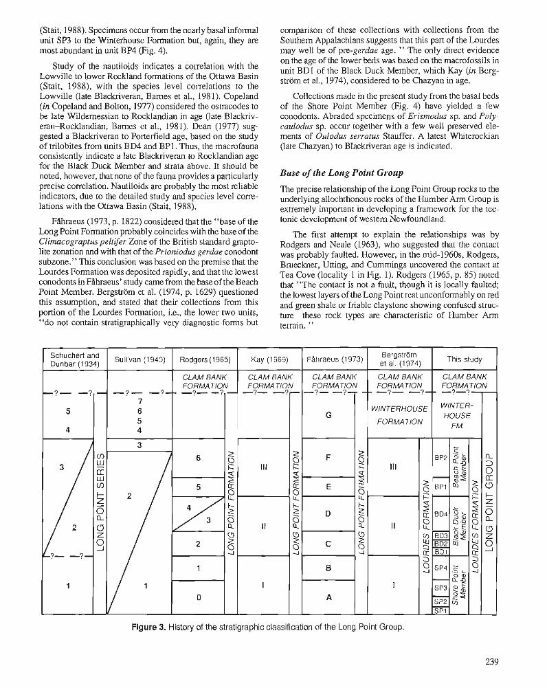
(Stait, 1988). Specimens occur from the nearly basal informal unit SP3 to the Winterhouse Formation but, again, they are most abundant in unit BP4 (Fig. 4).
Study of the nautiloids indicates a correlation with the Lowville to lower Rockland formations of the Ottawa Basin (Stait, 1988), with the species level correlations to the Lowville (late Blackriveran, Bames et al., 1981). Copeland (in Copeland and Bolton, 1977) considered the ostracodes to be late Wildemessian to Rocklandian in age (late Blackriv- eran-Rocklandan, Bames et al., 1981). Dean (1977) sug- gested a Blackriveran to Porterfield age, based on the study of trilobites from units BD4 and BPI. Thus, the macrofauna consistently indicate a late Blackriveran to Rocklandian age for the Black Duck Member and strata above. It should be noted, however, that none of the fauna provides a particularly precise correlation. Nautiloids are probably the most reliable indicators, due to the detailed study and species level corre- lations with the Ottawa Basin (Stait, 1988).
FAhraeus (1973, p. 1822) considered that the "base of the Long Point Formation probably coincides with the base of the Climacograptus peltifer Zone of the British standard grapto- lite zonation and with that of the Prioniodus gerdae conodont subzone." This conclusion was based on the premise that the Lourdes Formation was deposited rapidly, and that the lowest conodonts in FAhraeus' study came from the base of the Beach Point Member. Bergstrom et al. (1974, p. 1629) questioned this assumption, and stated that their collections from this portion of the Lourdes Formation, i.e., the lower two units, "do not contain stratigraphically very diagnostic forms but
comparison of these collections with collections from the Southern Appalachians suggests that this part of the Lourdes may well be of pre-gerdae age. " The only direct evidence on the age of the lower beds was based on the macrofossils in unit BD1 of the Black Duck Member, which Kay (in Berg- strijm et al., 1974), considered to be Chazyan in age.
Collections made in the present study from the basal beds of the Shore Point Member (Fig. 4) have yielded a few conodonts. Abraded specimens of Erismodus sp. and Poly- caulodus sp. occur together with a few well preserved ele- ments of Oulodus serratus Stauffer. A latest Whiterockian (late Chazyan) to Blackriveran age is indicated.
Base of the Long Point Group
The precise relationship of the Long Point Group rocks to the underlying allochthonous rocks of the Humber Arm Group is extremely important in developing a framework for the tec- tonic development of western Newfoundland.
The first attempt to explain the relationships was by Rodgers and Neale (1963), who suggested that the contact was probably faulted. However, in the mid-1960s, Rodgers, Brueckner, Utting, and Cumrnings uncovered the contact at Tea Cove (locality 1 in Fig. 1). Rodgers (1965, p. 85) noted that "The contact is not a fault, though it is locally faulted; the lowest layers of the Long Point rest unconformably on red and green shale or friable claystone showing confused struc- ture these rock types are characteristic of Humber Arm terrain. "
Figure 3. History of the stratigraphic classification of the Long Point Group.
Bergstrom et a,, (, 974)
CLAM BANK FORMA TlON -?- -?--
WINTERHOUSE
FORMA TlON
This study
CLAM BANK FORMA TlON -7-?
HOUSE FM.
FAhraeus (1 973)
CLAM BANK
Rodgers (1 965)
CLAM BANK FORMA TIqN -?- - , -
SChUChen and Dunbar (1 934)
-?- -? - 5
4
I I
I
Kay (1 969)
CLAM BANK FORMATION
-?- -?-
G
F
I , -
D
Sullivan (1 940)
-? - -?-- 7 6 5 4
FORMATION -?- -?-
111
--
2 0 i=
2 . I-
111
I I
I
2 0 c
8 I- z
8 2
8 2
-
c
B
A
2 s p 4
-82 SP3
SP2S - SPI
Z L
p 5 ='T
2
The above description has been accepted by subsequent localities, but this is a later event that occurred preferentially authors but has not since been confirmed. However, in 1984, along the contact, especially where the Long Point Group B.A. Stait and N.P. James once again exposed the contact at swings southwest across the peninsula, with the sequence the southeastern end of Long Point (locality 2 in Fig. 1). A overturned at Three Rock Point (Fig. 1,A). . - detailed description of the contact is included below,but.it is clear from our study that the contact is an unconformity and A previously undescribed feature uncovered in our sec-
not a fault. The contact may now be locally faulted at some tions was the poorly consolidated green sandstone at the base of the Long Point Group. This green sandstone may have a
LONG POINT GROUP ?:
each Point Mbr.
meres
OSTRACODES Telndella? newfoundlandensis "Aparchiles" /lmbrlalus Cryplophyllus spp. Eurychilina llnepuncfafa Eurychilina sp, cl. E. venlrosa Punclaparchiles rugosus Sacceialia arrecla Schmidlela umbonala Winchellalla sp. all. W. minnesolensis
TRILOBITES Scoloharpes fiiiarum Dolichoharpes sp. Ceraurus cefus Ceraurus sp. cf. C. denlafus Ceraurus sp. I"eraurinella? sp. Sphaerexochus sp. Sphaerocoryphe sp. Fncrinurus gibber Cybeloides (Cybeloides) sp. Calyplaulax fe~lhi Remopleurides sp. lsotelus sp Analaphrus giomeralus lllaenus kayi Thaleops sp. A Thaleops sp. B
CEPHALOPODS Acfinoceras gradalum - Gonioceras minor Rhynchoflhoceras blackduckensis Gorbyoceras sp, cl. G, lelreauense Cenlroonoceras josephianum Pseudorlhoceridaesp. Vaginoceras sp. Endoceras? sp. Chldleyenoceras sp. Zilleloceras ternnovacum
CORALS Labyrinlhiles (Labyrinfhiles) chidlensis Bilfinosaria ~arv i fuba - BRYOZOANS Diplofrypa schucherli Sliclopora sp. all. S. feneslrala - Ceramorpha sp. - BRACHIOPODS Pfychopleurella sp. - STROMATOPOROIDS Labechia sp. -
Figure 4. Ranges of fossils from the Long Point Group. Some are only general positions, a s the precise stratigraphic position of some collections is not known.
localized distribution, filling lows in the erodedsurfaceon the side of Long Point (Stephenville 1 :50 000) map sheet, grid Humber Arm rocks, which would explain why it was not ref. 563910; locality 2 in Fig. 1). The top of the formation is recorded by Rodgers and others. the base of the overlying Winterhouse Formation (see below).
The green sandstone is very similar to parts of the Main- land Sandstone but it is difficult to determine whether the green sandstone was formed as a late phase of flysch deposi- tion, by reworking of the flysch during the erosional phase following emplacement of the thrust sheets, or by erosion of the underlying Humber Arm rocks. The last alternative is the most probable, as the upper Mainland Sandstone is carbon- ate-rich (Cow Rocks Member) rather than the typical green sandstone of the lower part. As the Cow Rocks Member appears to be older than the Long Point Group, deposition of the flysch would have ceased prior to the deposition of the lowest unit of the Long Point Group in this area.
STRATIGRAPHY The general stratigraphy of the Long Point Group was de- scribed by FAhraeus (1973) and Bergstrom et al. (1974). Recent work by the present authors enables the nature of the contact with the Humber Arm Group to be described and the members of the Lourdes Formation to be formally defined.
LONG POINT GROUP The Long Point Group was originally defined by Bergstrom et al. (1974, p. 1627) as "a group consisting of two forma- tions, the Lourdes Limestone and the Winterhouse Forma- tion." They noted that the "Long Point rests unconformably on the Humber Arm Group." The Long Point Group is equivalent to the Long Point Series (Schuchert and Dunbar, 1934) and the Long Point Formation (Rodgers, 1965; FAhraeus, 1973). The Long Point Group consists of the lower, dominantly calcareous Lourdes Formation and the poorly known, dominantly clastic Winterhouse Formation, which together underlie most of the Long Point Peninsula (Fig. 1).
The base of the Long Point Group is exposed at the southeastern end of "The Bar". It is most clearly exposed at Tea Cove (locality 2, Fig. 1). At this locality it consists of one metre of green, poorly consolidated sandstone (SPl), which grades up into the overlying carbonate unit (SP2). It overlies the highly deformed red and green shales of the Humber Arm Group with a relatively flat and erosional contact. Although the contact is not exposed elsewhere, the lowest unit of the Long Point Group overlies, with only a narrow gap, various rock types of the Humber Arm Group, including black grap- tolitic shale, greywacke, and igneous rocks.
Lourdes Formation
Bergstrom et al. (1974, p. 1628) defined the Lourdes Forma- tion as consisting " of about 280 ft. (90 m) of dominantly limestone. It is fully exposed in an escarpment along the shore of the northwestern side of Port au Port Bay." This is a rather vague definition and, therefore, we herein define the base of the Lourdes Formation as the base of the green sandstone in the cliff two kilometres south of Portage on the southeastern
The Lourdes Formation is equivalent to units 1-3 of Schuchert and Dunbar (1934), units 0-6 of Rodgers (1965), and units A-F of Whraeus (1973) (Fig. 3). The Lourdes Formation is 75 m thick.
The subdivision of the Lourdes Formation has been a major point of difference between various studies (Fig. 3). Of the two latest studies (FAhraeus, 1973; Bergstrom et al., 1974), we favour the subdivision of Bergstrom et al. (1974), as the three units are clearly separated by disconformable surfaces and have distinct lithological characteristics. This three-fold subdivision is sufficiently understood to allow formal definition of three new members of the Lourdes For- mation. In ascending stratigraphic order, they are the Shore Point, Black Duck, and Beach Point members.
Shore Point Member
The Shore Point Member consists of 16 m of silty limestone, sandstone with calcareous cement, and minor argillaceous beds. The base of the member is defined at the base of the green sandstone in the cliff two kilometres south of Portage on the southeastern side of Long Point (locality 2 in Fig. 1; Stephenville 150 000 map sheet, grid ref. 563910), which disconformably overlies the highly deformed red and green shale of the Humber Arm Group. The member outcrops as cliffs along the southeast shore of Long Point Peninsula from Tea Cove to just north of Portage (between localities 1 and 4, Fig. 1). It is equivalent to units A and B of Filhraeus (1973) and member I of Bergstrom et al. (1974), and consists of four informal units that we designate units SPI, SP2, SP3, and SP4, in ascending stratigraphic order.
Unit SPI
This basal unit of the Shore Point Member consists of green silty sandstone (1.0 m thick). It disconfonnably overlies the red and green shale of the Humber Arm Group. It outcrops rather poorly between localities 1 and 2 (Fig. 1).
Unit SP2
This 3.5 m thick unit is composed of silty limestone with minor interbeds of recessively weathering calcareous shale. It has a transitional boundary with the underlying green sandstone, with the transition occurring over a 30 cm thick interval. It outcrops sporadically between localities 1 and 2 (Fig. 1).
This 5 m thick unit consists of massively bedded quartz sandstone with calcareous cement. The contact with the un- derlying unit SP2 is sharp but not erosional. Crossbedding is present within some beds, but most are planar laminated. Fossil fragments are concentrated in layers. The unit outcrops
from Tea Cove (locality 1, Fig. 1) to just south of Portage (locality 3, Fig. 1). This unit contains a sparse, fragmented molluscan fauna.
Unit SP4
This 6.5 m thick unit includes quartz sandstone with calcare- ous cement and interbedded silty limestone, and minor shale beds. The quartz sandstone is commonly crossbedded and has disrupted and contorted bedding. The limestone has abundant bird's-eye structures, and typically a basal silty sandstone layer, which grades upward into fenestral limestone. The shale layers commonly contain mudcracks. The contact with unit SP3 is transitional over about one metre, with sandstone beds decreasing in thickness and silty limestone developing. This unit outcrops over a wide area from near Tea Cove (locality 1, Fig. 1) to north of Portage (locality 4, Fig. 1). The macrofauna is restricted to rare gastropods, which are trans- ported and fragmentary.
Black Duck Member
The 21 m thick Black Duck Member consists of shale and nodular calcarenite near the base, and calcarenite and calcilu- tite in the upper two thirds. It is characterized by the presence of coral heads of Labyrinthites, which form isolated patch reefs in the upper six metres. The base is marked by a sharp, probably erosional, contact with the underlying Shore Point Member at locality 3 (Fig. 1). The Black Duck Member is the most widely outcropping member of the Lourdes Formation. It occurs along the southeast shore of Long Point Peninsula from just north of Tea Cove (locality 1, Fig. 1) to north of Beach Point (locality 10, Fig. 1).
The wide area of outcrop and the diverse fauna of this member have made it the most studied part of the Lourdes Formation. The upper part of the member opposite the Black Duck Brook turnoff has been studied in great detail, particu- larly the morphology of the coral reefs (James and Cuffey, 1989).
The Black Duck Member is divided into four informal units. In ascending order, they are units BD1, BD2, BD3, and BD4.
Unit BDI.
This unit consists of argillaceous beds (10 cm thick) with thin interbeds of nodular calcarenite (commonly surrounding iso- lated coral heads). The thickness varies along strike, with a maximum thickness of 2.7 m. The base is the same as that for the Black Duck Member. The outcrop extends from Tea Cove (locality 1, Fig. 1) to north of Portage (locality 5, Fig. 1).
Unit BD2
This unit is discontinuous along strike, but when present is a series of calcarenite beds with minor shale interbeds. It reaches a maximum thickness of 2.1 m at locality 4 (Fig. 1).
Unit BD3
This 3 m thick unit is lithologically similar to unit BD1, with thin beds of shale interbedded with nodular calcarenite. The lower boundary, where unit BD2 is present, is relatively sharp, but not erosional. Where unit BD2 is absent, unit BD3 merges with unit BDl.
Unit BD4
This unit consists of thin to moderately thick bedded cal- carenite and calcilutite beds, with rare, thin argillaceous beds. Its thickness varies along strike, being 12 m at locality 2 and 15 m at locality 10 (Fig. 1). This unit forms most of the shoreline outcrop on the southeast side of the Long Point Peninsula from Shore Point (locality 2) to the north of Beach Point (locality 10). It contains abundant coral heads, espe- cially in the upper six metres, where they form reefs up to six metres in height. The base is transitional with the underlying unit BD3; however, it is conveniently drawn at the point where calcarenite is dominant over shale. This unit is highly fossiliferous, and biocalcarenite and biocalcirudite flank the coral heads and reefs. The sedimentology and paleoecology of the coral heads and buildups at locality 5 were considered in detail by James and Cuffey (1989). They further subdivided unit BD4, although the subunits are only of local significance.
Important macrofauna are corals, nautiloids, trilobites, bryozoans, brachiopods, gastropods, echinoderms, sponges, ostracodes, and stromatoporoids. Conodonts are absent in, and close to, the reefal strata.
Beach Point Member
This is the uppermost member of the Lourdes Formation. It consists of a lower part of thin bedded shale with thin inter- beds of nodular calcarenite, and an upper part of oncolitic biocalcarenite and calcilutite, with minor thin argillaceous beds. The member is variable in thickness; north of Beach Point it is 32 m thick. The base is marked by a conspicuous erosional surface on the top of the underlying Black Duck Member. This surface has been "planed" flat, dissecting corals and other fossils. The lowest bed in the Beach Point Member is often a thin sandstone, and the base of the member is defined as the base of this sandstone at the cliff on the southeastern shore of Long Point, opposite the turn off to Black Duck (Stephenville 150 000 map sheet, grid ref. 602953; locality 4, Fig. 1). This member is equivalent to units E and F of FAhraeus (1973) and member III of Bergstrom et al. (1974). The Beach Point Member is divided into two informal units, BPI and BP2, in ascending stratigraphic order. Fossils are abundant in this member, especially echinoderms, brachiopods, trilobites, conodonts, algae, nautiloids, sponges, and ostracodes, with minor corals.
This unit is composed of interbedded shale and thin bedded nodular calcarenite and calcilutite, and thin, graded beds of silty limestone. The upper surfaces of the graded limestone beds are highly irregular, whereas their lower surfaces tend
to be planar. The thickness of this unit at locality 5 is 10 m. The base is the same as for the Beach Point Member and is best exposed at locality 4, but is also exposed in the cliff section from south of this locality to north of Beach Point (locality 10).
Unit BP2
This 22 m thick unit is composed of thin to thick bedded biocalcarenite, calcilutite, and minor argillaceous beds. On- colites are common throughout, but especially near the base, where they may constitute over 60% of the rock. The base is transitional, but is drawn at the first thick (40 cm) biocal- carenite; above thls point, argillaceous beds become thin and rare. This unit is best exposed north of Beach Point out to the lighthouse on the southeast side of the Long Point Peninsula (localities 10 to 12, Fig. 1). However, it is well exposed all along the peninsula, south to locality 4. Crossbedding and trace fossils are particularly abundant in the unit. Rare, dis- placed, and eroded coral heads are also present.
Winterhouse Formation
This was defined by Bergstrom et al. (1974, p. 1628) as " a succession of thin-bedded silty shales, sandstones, redbeds, and occasional limestones with an estimated total thickness of 1000 ft (300 m)." Bergstrom et al. (1974) had a problem defining the base of the formation, commenting (p. 1628) that although "the lithological difference between the Lourdes and Winterhouse is striking, the contact between these forma- tions appears to be gradational. " They defined it as occurring " beyond the light at the extreme northeast end of the penin- sula.'' We agree with the location of the boundary and con- sider it to occur above the strike ridge of biocalcarenite that forms the projection of rock on the northeast side of the peninsula. Above this point, the sequence is dominated by shale and silty limestone.
The thickness of the Winterhouse Formation is uncertain due to the extremely poor outcrop. Earlier estimates were based on the dip and the outcrop width, e.g., 400 m by Schuchert and Dunbar (1934), 800 m by Rodgers (1965), 500 m by Fiihraeus (1973), and 300 m by Bergstrom et al. (1974). We are unable to refine these estimates and suggest that a stratigraphic drill hole would be of considerable benefit. The Winterhouse Formation is equivalent to units 4 and 5 of Schuchert and Dunbar (1934), units 4 to 7 of Sullivan (1940), and unit G of FAhraeus (1973) (Fig. 3).
The Winterhouse Formation is fossiliferous, with several horizons containing receptaculitids, brachiopods, nautiloids, rugose corals, gastropods, conodonts, graptolites, and trilo- bites.
CLAM BANK FORMATION-LONG POINT GROUP BOUNDARY We have not examined the boundary problem in this study and, therefore, agree with FAhraeus (1973, p. 1824), who placed the discontinuity at the top of the crossbedded, pebbly gravel conglomerate.
ACKNOWLEDGMENTS
C.R. Barnes acknowledges the continuing financial support for lower Paleozoic conodont studies from the Natural Sci- ences and Engineering Research Council of Canada. Post- doctoral fellowship support was provided to B.A. Stait by Memorial University of Newfoundland.
REFERENCES Barnes, C.R., Norford, B.S., and Skevington, D. 1981: The Ordovician System in Canada. International Union of Geologi-
cal Sciences, Publication 8,27 p. Bergstrom, S.M., Riva, J., and Kay, M. 1974: Significance of conodonts, graptolites, and shelly faunas from the
Ordovician of western and north-central Newfoundland. Canadian Journal of Earth Sciences, v. 11, p. 1625-1660.
Bolton, T.E. 1965: Ordovician and Silurian tabulate corals Labyrinfhites, Arcturia,
Troedssonites, Multisolenia, and Boreaster. Geological Survey of Canada, Bulletin 134, p. 17-33.
Cooper, G.A. 1956: Chazyan and related brachipods. Smithsonian Miscellaneous Col-
lections, no. 127, 1245 p. Copeland, M.J. and Bolton, T.E. 1977: Additional paleontological observations bearing on the age of the
Lourdes Formation (Ordovician) Port au Port Peninsula, western Newfoundland. In Report of Activities, Part B, Geological Survey of Canada, Paper 77-IB, p. 1-13.
Corkin, H. 1965: The petroleum geology of the Port au Port Peninsula, southwestern
Newfoundland. Geological Survey of Canada, Bulletin 290, p. 1-23. Dean, W.T. 1977: Trilobites From the Long Point Group (Ordovician) Port au Port
Peninsula, southwestern Newfoundland. Geological Survey of Canada, Bulletin 290, p. 1-23.
Ffihraeus, L.E. 1973: Depositional environments and conodont-based correlations of the
Long Point Formation (Middle Ordovician), western Newfound- land. Canadian Journal of Earth Sciences, v. 10, p. 1822-1833.
Flower, R.H. 1952: New Ordovician cephalopods from eastern North America. Journal
of Paleontology, v. 26, p. 24-59. Fritz, M.A. 1966: Diplofrypa schucherli, a new bryozoan species from the Long Point
Formation (Ordovician), western Newfoundland. Journal of Paleontology, v. 40, p. 1335-1337.
James, N.P and Cuffey, R.J. 1989: Middle Ordovician coral reefs, western Newfoundland. In Reefs,
H.H.J. Geldsetzer, N.P. James, and G.E Tebbutt (eds.); Canadian Society of Petroleum Geologists, Memoir 13, p. 192-195.
Kay, M. 1969: Long Point Formation and Taconic Orogeny in western Newfound-
land. Geological Society of America, Abstracts with Programs, part 7, p. 120.
Nowlan, G.S. and Barnes, C.R. 1987: Thermal maturation of Paleozoic strata in eastern Canada from
conodont colour alteration index (CAI) data with implications for burial history, tectonic evolution, hotspot tracks and mineral and hydrocarbon exploration. Geological Survey of Canada, Bulletin 367.47 p.
Riley, G.C. 1962: Stephenville map area, Newfoundland. Geological Survey of
Canada, Memoir 323, p. 1-72. Rodgers, J. 1965: Long Point and Clam Bank formations, western Newfoundland.
Geological Association of Canada, Proceedings, v. 16, p. 83-94. Rodgers, J.U. and Neale, E.R.W. 1963: Possible "Taconic" klippen in western Newfoundland. American
Journal of Science, v. 261, p. 713-730. Shaikh, Z.M. 1971: Geology and some aspects of the paleontology of the Ordovician
Long Point Formation, Port au Port Peninsula, Newfoundland. Unpublished M.Sc. thesis, Memorial University of Newfoundland, St. John's, Newfoundland.
Schuchert, C. and Dunbar, C.O. 1934: Stratigraphy of western Newfoundland. Geological Survey of
America, Memoir 1, 123 p. Stait, B.A. 1988: Nautiloids of the Lourdes Formation (Middle Ordovician), Port au
Port Peninsula, western Newfoundland. New Mexico Bureau Mines and Mineral Resources, Memoir 44, p. 61-77.
Stockmal, G.S. and Waldron, J.W.F. 1989: The Long Point Group and the Humber Arm allochthon, western
Newfoundland: implications of a new tectonic-stratigraphic interpretation for the timing and magnitude of the overthrusting. Geological Association of Canada-Mineral Association of Canada, 1989 Annual Meeting. Program with Abstracts, v. 14, p. A1 1.
Sullivan, J.W. 1940: The Geology and Mineral Resources of the Port-au-Port Area,
Newfoundland. Unpublished Ph.D. thesis, Yale University, 101 p. Weerasinghe, A. 1970: Stratigraphy and paleontology of the Ordovician Long Point
Formation, Port au Port Peninsula, Newfoundland. Unpublished M.Sc. thesis, Memorial University, St. John's, Newfoundland.
Late Ordovician stratigraphy, paleoecology, and sea 1evel:changes in the Argentine Precordillera
Teresa M. Sanchezl, Juan L. Benedettol, and Edsel Brussal
Sanchez, T.M., Benedetto, J.L., and Brussa, E., Late Ordovician stratigraphy, paleoecology, and sea level changes in the Argentine Precordillera; Advances in Ordovician Geology, C.R. Barnes and S.H. Williams (ed.), Geological Survey of Canada, Paper 90-9, p. 245-258,1991.
Abstract
In the Precordillera basin, Upper Ordovician rocks are exposed in the Sierra de Villicum, Cerro del Fuerte, and Talacasto areas. In the Sierra de Villicum, the facies sequence is interpreted in terms of a main lowering of the sea level during the Ashgill followed by a rise in the Hirnantian (persculptus Zone). Lowstand deposits are represented by debris flow and channel fill conglomerates, whereas those of highstand include fine grained bioturbated facies. The base of the transgressive sequence contains a conglomeratic lag horizon, succeeded upward by mudstone containing a low diversity Hirnantia Fauna. A shallow water community characterized by the brachiopods Hirnantia sagittifera and Dalmanella testudi- naria and by the bivalve Modiolopsis cuyana is recognized. The rise in sea level is documented in the Cerro del Fuerte section by deep shelf muddy deposits bearing Anisopleurella sp. cf. A. gracilis and in the Talacasto region by a transgressive sequence containing G. persculptus near the base.
The fluctuations in sea level recorded in the Precordillera basin are synchronous with glacioeustatic sea level changes recognized worldwide.
The Ashgill debrisflow deposits exposed in Subandean Ranges of northwestern Argentina are probably related to the same glacioeustatic event.
Duns le bassin de la Prkcordill&re, des roches de I'Ordovicien supkrieur afleurent d proximitk de la Sierra de Villicum, de Cerro del Fuerte et de Talacasto. Dans la Sierra de Villicum, la skquence de faci&s est interprktke en fonction June chute importante du niveau marin d lJAshgillien, suivie d'une montte a I'Hirnantien (zone d persculptus). Les dkpdts de bas niveau se composent de coulkes de dkbris et de conglome'rats de chenaux, tandis que les dtp6ts de haut niveau comprennent des faciPs bioturbb h grain fin. La base de la skquence transgressive contieizt un horizon compose' d'un rtsidu conglomtratique de d@ation, suivi vers le h u t dune pe'lite qui renferme une faune ct Hirnantia peu varike. On y trouve une communautk d'eau peu profonde, caracttriske par la prksence des brachiopodes Hirnantia sagittifera et Dalmanella testudinaria et par le bivalve Modiolopsis cuyana. La prksence, dans Ia coupe de Cerro del Fuerte, de dkp6ts boueux de plate-forme profonde dans lesquels se trouve Anisopleurella sp. cf. A. gracilis et, pr2s de Talasco, dune skquence transgressive qui contient G. persculptus prds de sa base, tkmoigne de la montte du niveau marin.
LesJZuctuations du niveau marin qui sont enregistrtes dans le bassin de la Pre'cordilldre sont synchrones avec les fluctuations glacio-eustatiques qui se rencontrent partout au monde.
Les coulkes de dkbris de 1'Ashgillien qui afleurent dans les chainons subandins, dans le nord-ouest de I'Argentine, sont vraisemblablement associkes au m2me kvknement glacio-eustatique.
1 Consejo Nacional de hvestigaciones Cientificas Tkcnicas (CONICET), Dcpartamento de Geologia BBsica, Universidad Nacional de Cdrdoba, Av. &lez Shnfield 299,5000 Cdrdoba, Argentina.
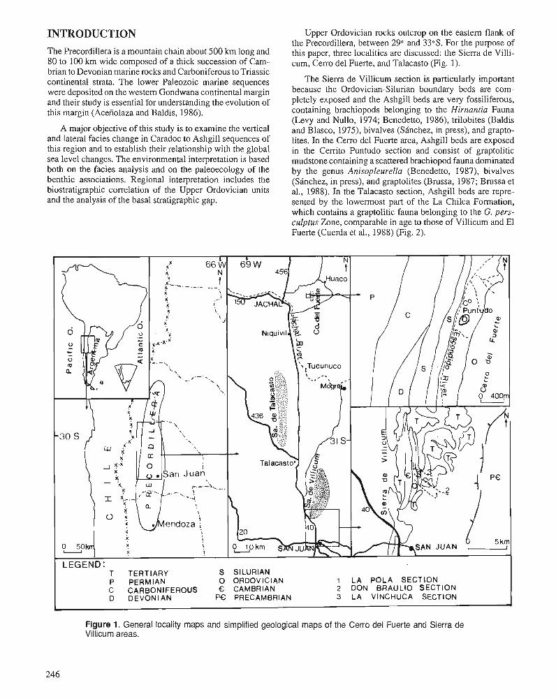
INTRODUCTION The Precordillera is a mountain chain about 500 km long and 80 to 100 km wide composed of a thick succession of Cam- brian to Devonian marine rocks and Carboniferous to Triassic continental strata. The lower Paleozoic marine sequences were deposited on the western Gondwana continental margin and their study is essential for understanding the evolution of this margin (Acefiolaza and Baldis, 1986).
A major objective of this study is to examine the vertical and lateral facies change in Caradoc to Ashgill sequences of this region and to establish their relationship with the global sea level changes. The environmental interpretation is based both on the facies analysis and on the paleoecology of the benthic associations. Regional interpretation includes the biostratigraphic correlation of the Upper Ordovician units and the analysis of the basal stratigraphic gap.
Upper Ordovician rocks outcrop on the eastern flank of the Precordillera, between 29" and 330s. For the purpose of this paper, three localities are discussed: the Sierra de Villi- cum, Cerro del Fuerte, and Talacasto (Fig. 1).
The Sierra de Villicum section is particularly important because the Ordovician-Silurian boundary beds are com- pletely exposed and the Ashgill beds are very fossiliferous, containing brachiopods belonging to the Hirnantia Fauna (Levy and Nullo, 1974; Benedetto, 1986), trilobites (Baldis and Blasco, 1975), bivalves (SBnchez, in press), and grapto- lites. In the Cerro del Fuerte area, Ashgill beds are exposed in the Cerrito Puntudo section and consist of graptolitic mudstone containing a scattered brachiopod fauna dominated by the genus Anisopleurella (Benedetto, 1987), bivalves (SBnchez, in press), and graptolites (Brussa, 1987; Brussa et al., 1988). In the Talacasto section, Ashgill beds are repre- sented by the lowermost part of the La Chilca Formation, which contains a graptolitic fauna belonging to the G. pers- culptus Zone, comparable in age to those of Villicum and El Fuerte (Cuerda et al., 1988) (Fig. 2).
S SILURIAN 0 ORDOVICIAN 1 LA POLA SECTION € CAMBRIAN 2 DON BRAULIO SECTION
Figure 1. General locality maps and simplified geological maps of the Cerro del Fuerte and Sierra de Villicum areas.
246
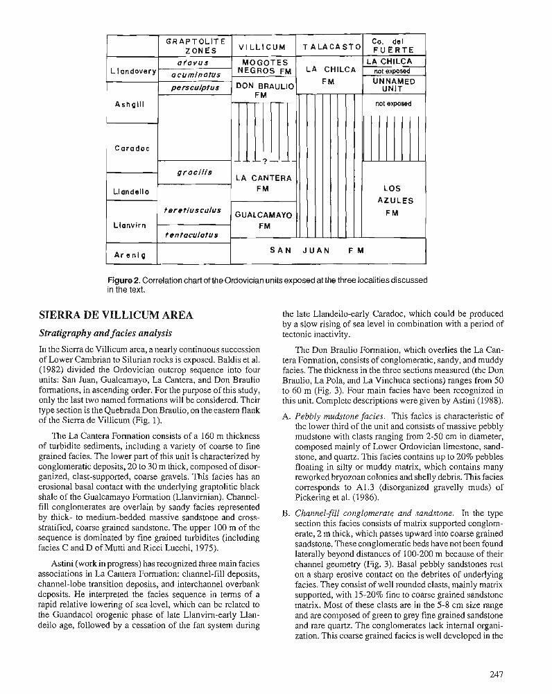
LA CANTERA
Ar e n l g S A N J U A N F M
Figure 2. Correlation chart of the Ordovician units exposed at the three localities discussed in the text.
SIERRA DE VILLICUM AREA
Stratigraphy and facies analysis
In the Sierra de Villicum area, a nearly continuous succession of Lower Cambrian to Silurian rocks is exposed. Baldis et al. (1982) divided the Ordovician outcrop sequence into four units: San Juan, Gualcamayo, La Cantera, and Don Braulio formations, in ascending order. For the purpose of this study, only the last two named formations will be considered. Their type section is the Quebrada Don Braulio, on the eastern flank of the Sierra de Villicum (Fig. 1).
The La Cantera Formation consists of a 160 m thickness of turbidite sediments, including a variety of coarse to fine grained facies. The lower part of this unit is characterized by conglomeratic deposits, 20 to 30 m thick, composed of disor- ganized, clast-supported, coarse gravels. This facies has an erosional basal contact with the underlying graptolitic black shale of the Gualcamayo Formation (Llanvirnian). Channel- fill conglomerates are overlain by sandy facies represented by thick- to medium-bedded massive sandstone and cross- stratified, coarse grained sandstone. The upper 100 m of the sequence is dominated by fine grained turbidites (including facies C and D of Mutti and Ricci Lucchi, 1975).
the late Llandeilo-early Caradoc, which could be produced by a slow rising of sea level in combination with a period of tectonic inactivity.
The Don Braulio Formation, which overlies the La Can- tera Formation, consists of conglomeratic, sandy, and muddy facies. The thickness in the three sections measured (the Don Braulio, La Pola, and La Vinchuca sections) ranges from 50 to 60 m (Fig. 3). Four main facies have been recognized in this unit. Complete descriptions were given by Astini (1988).
A. Pebbly mudstone facies. This facies is characteristic of the lower third of the unit and consists of massive pebbly mudstone with clasts ranging from 2-50 cm in diameter, composed mainly of Lower Ordovician limestone, sand- stone, and quartz. This facies contains up to 20% pebbles floating in silty or muddy matrix, which contains many reworked bryozoan colonies and shelly debris. This facies corresponds to A1.3 (disorganized gravelly muds) of Pickering et al. (1986).
B. Channel-fill conglomerate and sandstone. In the type section this facies consists of matrix supported conglom- erate, 2 m thick, which passes upward into coarse grained sandstone. These conglomeratic beds have not been found laterally beyond distances of 100-200 m because of their
Astini (work in progress) has recognized three main facies channel geometry (Fig. 3). Basal pebbly sandstones rest associations in La Cantera Formation: channel-fill deposits, on a sharp erosive contact on the debrites of underlying channel-lobe transition deposits, and interchannel overbank facies. They consist of well rounded clasts, mainly matrix deposits. He interpreted the facies sequence in terms of a supported, with 1520% fine to coarse grained sandstone rapid relative lowering of sea level, which can be related to matrix. Most of these clasts are in the 5-8 cm size range the Guandacol orogenic phase of late Llanvirn-early Llan- and are composed of green to grey fine grained sandstone deilo age, followed by a cessation of the fan system during and rare quartz. The conglomerates lack internal organi-
zation. This coarse grained facies is well developed in the
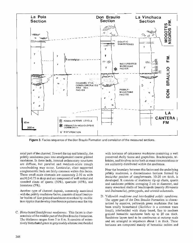
La Pola Don Braulio La Vinchuca Section Sect ion
G.persculptus - - - - - - - --
- - - - - - - - -
- - _ _
FOSSILIFEROUS L E V E L S
U BIOTURBATION
Figure 3. Facies sequence of the Don Braulio Formation and correlation of the measured sections.
axial part of the channel. Toward the top and laterally, the with horizons of calcareous mudstone containing a well pebbly sandstones pass into amalgamated coarse grained preserved shelly fauna and graptolites. Brachiopods, tri- sandstone. In these beds, internal sedimentary structures lobites, and bivalves occur both as mass concentrations or are diffuse, but parallel and medium-scale trough are uniformly distributed within the mudstone. crossbedding may occur. Lenticular, clast supported conglomeratic beds are fairly common within this facies. Near the boundary between this facies and the underlying
These small-scale channels are commonly 2-10 m wide pebbly mudstone, a discontinuous horizon formed by
and 0.2-0.75 m deep and are composed of well sorted and lenticular patches of conglomerate, 10-20 cm thick, is
rounded clasts of quartz (SO%), quartzite (45%), and developed. It consists of mudstone rip-up clasts, quartz
limestone (5%). and sandstone pebbles averaging 2 cm in diameter, and many reworked shells of brachiopods (mainly Hirnantia
Another type of channel deposit, commonly associated and balmanella), pelecypods, and crinoid coiumnals. with the pebbly mudstone facies, consists of small lenticu- lar bodies of fine grained sandstone reworked by oscilla- D. Yellowish mudstone and interbedded oolitic sandstone.
tion ripples that develop interference patterns near the top. The upper part of the Don Braulio Formation is charac- terized by massive, yellowish green mudstone that has been totally bioturbated (~koliihos is a common trace fossil), interbedded with sharp based, fine to medium
C . Bioturbated fossiliferous mudstones. This facies is char- grained hematitic sandstone beds up to 20 cm thick. acteristic of the middle part of the Don Braulio Formation. Sandstone layers tend to be continuous at outcrop scale The thickness ranges from 5 to 8 m. It consists of exten- and are arranged in sequences about 1 m thick. These sively bioturbated green to grey muddy siltstone interbedded horizons are composed mainly of hematitic oolites and
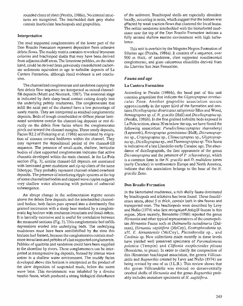
rounded clasts of chert (Peralta, 1986a). No internal struc- tures are recognized. The interbedded dark grey shales contain inarticulate brachiopods and graptolites.
Interpretation
The mud supported conglomerates of the lower part of the Don Braulio Formation represent deposition from cohesive debris flows. The muddy matrix contains reworked bryozoan colonies and brachiopod shells that may have been derived from adjacent shelf areas. The limestone pebbles, on the other hand, could be derived from previously consolidated carbon- ate sediments equivalent.in age to turbidite deposits of La Cantera Formation, although fossil evidence is not conclu- sive.
The channelized conglomerate and sandstone capping the first debris flow sequence are interpreted as mixed channel- fill deposits (Mutti and Normark, 1987). The erosional stage is indicated by their sharp basal contact cutting deeply into the underlying pebbly mudstones. The conglomerates that infill the axial part of the channel have a low percentage of sandy matrix. They are interpreted as residual conglomeratic deposits. Beds of trough crossbedded or diffuse planar-lami- nated sandstone overlie the channel-lag deposits or rest di- rectly on the debris flow facies where the conglomerates pinch out toward the channel margins. These sandy deposits, Facies B2.2 of Pickering et al. (1986) accumulated by migra- tion of sinuous crested bedforms within the channel. They may represent the depositional period of the channel-fill sequence. The presence of small-scale, shallow, lenticular bodies of clast supported conglomerate indicates that active channels developed within the main channel. In the La Pola section (Fig. 3), similar channel-fill deposits are associated with laminated green mudstone and rip-up clasts of the same lithotype. They probably represent channel related overbank deposits. The presence of interfering ripple systems at the top of some channelized bodies and capped wave ripples suggests very shallow water alternating with periods of subaerial submergence.
An abrupt change in the sedimentation regime occurs above the debris flow deposits and the interbedded channel- ized bodies: both facies pass upward into a dominantly fine grained succession with a sharp base marked by a conglom- eratic lag horizon with mudstone intraclasts and fossil debris. It is laterally extensive and is useful for correlation between the measured sections (Fig. 3). This conglomeratic bed infills depressions eroded into underlying beds. The underlying mudstones must have been semilithified by the time this horizon had formed, because the conglomerates contain mud- stone intraclasts and pebbles of clast supported conglomerate. Pebbles of quartzite and sandstone could have been supplied to the shoreline by rivers. These conglomerates can be inter- preted as transgressive lag deposits, formed by intense wave action in a shallow water environment. The muddy facies developed above this horizon is interpreted as the product of the slow deposition of suspended muds, below the storm wave base. This environment was inhabited by a diverse benthic fauna, which produced a strong biological disturbance
of the sediment. Brachiopod shells are especially abundant locally, occurring in nests, which suggest that the bottom was affected by weak traction flows that clustered the local fauna. The oolitic sandstone interbedded with the bioturbated mud- stone near the top of the Don Braulio Formation indicate a fully aerated shallow marine environment with high turbu- lence.
This unit is overlain by the Mogotes Negros Formation of Silurian age (Peralta, 1986a). It consists of a sequence, over 900 m thick, of sandstone, clast supported resedimented conglomerate, and giant calcareous olistoliths derived from the Llanvim San Juan Formation.
Fauna and age
La Cantera Formation
According to Peralta (1986b), the basal part of this unit contains graptolites that indicate the Glyptograptus teretius- culus Zone. Another graptoli te association occurs approximately in the upper third of the formation and con- tains Dicellograptus divaricatus salopiensis Elles and Wood, Nemagraptus sp. cf. N. gracilis (Hall) and Dicellograptus sp. (Peralta, 1986b). In the fine grained turbidite beds exposed in La Pola section, about 30 m below the top, we have found the following association: Pseudoclimacograptus sharenbergi (Lapworth), Reteograptus geinitzianus (Hall), Dicranograp- tus sp., Cryptograptus sp., Clirnacograptus sp., Glyptograp- tus sp., Dicellograptus sp., and Thamnograptus sp. This fauna is indicative of a late Llandeilo-early Caradoc age. The abun- dance of dicellograptids, the first appearance of the genus Dicranograptus and the presence of P. scharenbergi, which is a common form in the N. gracilis and D. multidens zones (early Caradoc) in northwestem Europe and North America, indicate that this association belongs to the base of the N. gracilis Zone.
Don Braulio Formation
In the bioturbated mudstones, a rich shelly fauna dominated by brachiopods and trilobites has been found. These fossilif- erous strata, about 5 m thick, contain both in situ faunas and transported ones. The brachiopods were described by Levy and Nullo (1974) who first recognized Ashgill faunas in this region. More recently, ~enede t to (1986) reported the genus Hirnantia and other typical representatives of the cosmopoli- tan Hirnantia Fauna such as Dalmanella testudinaria (Dal- man), Hirnantia sagittifera (McCoy), Eostropheodonta sp. af f . E. hirnantensis (McCoy ), Plectothyrella s p . , and Coolinia sp. New collections made recently in these levels have yielded well preserved specimens of Paromalomena polonica (Temple) and Cliftonia oxoplecioides plicata (Benedetto, in press). In order to clarify the composition of this Himantian brachiopod association, the genera Villicun- della and Bagnorthis created by Levy and Nullo (1974) are being revised by one of us (J.L.B.). This review shows that the genus Villicundella was erected on dorsoventrally crushed shells of Hirnantia and the genus Bagnorthis prob- ably includes immature specimens of H. sagittifera.
These beds also contain a trilobite fauna dominated by Dalmanitina sudamericana Baldis and Blasco and Eo- homalonotus villicunensis Baldis and Blasco (1975). Of the bivalves, Sdnchez (in press) described the species Modiolop- sis cuyana Sdnchez and Palaeoneilo sp.
The upper levels of the mudstone facies (Fig. 3) contain a low diversity graptolite fauna dominated by Glyptograptus persculptus and indeterminate dendroids.
The uppermost levels of the Don Braulio Formation have yielded only graptolites and microfossils. A diversified chit- inozoan association was recognized by Volkheimer et al. (1980) from the dark grey shale interbedded with the oolitic sandstone. This association, of Llandovery age, includes: Ancyrochitina sp. cf. A. ancyrea (Eisenack), Conochitina sp. cf. C. chydaea Jenkins, Cyathochitina sp, cf. C. campanulae- formis (Eisenack), Euconochitina sp. cf. E, filifera (Eisen- ack), Rhabdochitina sp., Spathachitina sp. cf. S. clarindoi da Costa, and Sphaerochitina sp. From the same levels, Peralta (1986a) identified the following graptolites: Climacograptus sp. aff. C. hughesi (Nicholson), Climacograptus sp., Mono- graptus sp., and Rastrites sp. This association confirms an Early Silurian age.
On the basis of the fauna, the Don Braulio Formation can be regarded as partly Hirnantian and partly Llandovery. The available evidence indicates ' that the Ordovician-Silurian boundary falls within the upper part of this unit (yellowish mudstones). On the other hand, a stratigraphic break is evi- dent between the La Cantera and Don Braulio formations, which encompasses almost the entire Caradoc and the lower middle Ashgill (Fig. 2).
brachiopods (over 60%). The modiomorphoid pelecypod Modiolopsis cuyana is a common element and is accompa- nied by the trilobite Dalmanitina. The specimens of Hirnan- cia are mainly articulated and well preserved. The high percentage of articulated shells of this species is significant, because the deltidiodont type of hinge facilitates the dissocia- tion of the valves (Sheehan, 1978; Sbnchez, 1986). The abundance of articulated shells indicates that they are un- transported shells. The specimens of Modiolopsis are fre- quently found as articulated valves, some of which are in life position. Shells of various size are associated in the samples, which suggests the coexistence of adult and juvenile indi- viduals of a normal population. Several articulated specimens of Dalmanitina provide additional evidence for an untrans- ported and rapidly buried assemblage. We, therefore, regard this association as a fossil community. The term community refers to "the biological association of taxa usually related to particular environmental conditions" (Brenchley and Cocks, 1982, p. 786). The Hirnantia-Modiolopsis Community is characterized by the epifaunal suspension feeder brachiopods Hirnantia sagittifera and Da6manella testudinaria and by the semi-infaunal, byssate, suspension feeder pelecypod Modi- olopsis cuyana. This is a low diversity Hirnantia Association (Rong, 1985) with seven genera, three of which are dominant (Table 1; Fig. 4).
T h e Trematis-Bivalve Assemblage, described by Brenchley and Cocks (1982), and this community are similar in the abundance of modiolopsid pelecypods, but differ in the occurrence of the inarticulate brachiopod Trernatis norvegica and the relative reduction of Hirnantia in the former. Brenchley and Cocks (1982) suggest a lower shoreface envi- ronment for the Trematis-Bivalve Association.
Paleoecology According to the environmental distribution of pelecy- pods (especially modiomorphoids) during the Ordovician
The calcareous lenses found in the lower part of the muddy (Jablonski et al., 1983), the relatively high percentage of siltstone at the Don Braulio section (Fig. 3) contain a well Modiolopsis in the community suggests a shallow water preserved Hirnantia Fauna, which is dominated by articulate environment. The associated brachiopods Hirnantia and
Table 1. Composition of the Hirnantia-Modiolopsis Community (Don Braulio Formation; Sierra de Villicum)
Articulated Isolated Life valves valves Total habits'
Brachiopods Hirnantia sagittifera 32 29 7 1 ep.s. Dalmanella testudinaria 51 45 96 ep.s. Paromalomena polonica 23 23 ep.s. Lingulacea indet. 5 5 in.s.
Pelecypods Modiolopsis cuyana 45 36 81 se.s.
Trilobites Dalmanitina sudamericana 8 1 g2 27 eP-
Encrusting trepostome bryozoa scarce
'ep: epifaunal; in.: infaunal; se.: semi-endobyssate; s.: suspension feeder. "ncludes isolated cephala and pygidia.
Hirnantia- Modlolopsis Corn muni ty
. . 2 3
Dalmanella are not indicative because they probably were In the same section, immediately above the Hirnantia- eurytopic genera (Brenchley and Cullen, 1984). In the Oslo Modiolopsis Community, an assemblage of dispersed, locally region, for example, the Dalmanella Association described clustered specimens of Eostropheodonta sp. cf. E. hirnanten- by Brenchley and Cocks (1982) was developed in a deep sis, Plectothyrella sp., Eohomalonotus villicunensis, Palae- water environment. This genus, however, flourished in the oneilo sp., and conulariids are found (Benedetto, 1986). Middle Ordovician shallow waters (Cocks and McKerrow, 1978). In the La Vinchuca section, 500 m north, a 5 m thick
sequence of fine grained sandstone and siltstone contains a The low diversity of this community could be the result Hirnantia Fauna represented by several assemblages. We
of a fluctuating resource supply. According to thepaleogeog- have found five levels that appear to be distinguishable by raphic reconstruction proposed by Ziegler et al. (1977) and to relative proportions of genera (Table 2). Level 1 contains very the extension of the floating ice suggested by Brenchley and transported specimens of Dalrnanella and Hirnantia, which Newall (1984), this region has experienced a cold circumpolar are the commonest genera, and rare Paromalomena, Clifto- climate. Under these climatic conditions there is a rich re- nia, and Modiolopsis. At level 2, we have collected a few source supply in summer, followed by a rapid decay of specimens of Dalmanella and Palaeoneilo and sclerites of resources in winter. Consequently, only some eurytopic and Dalmanitina and Eohomalonotus. Level 3 contains abundant opportunistic species can survive (Valentine, 197 1). sclerites of Dalmanitina and Eohomalonotus and a few valves
of Paromalomena. At level 4, the assemblage includes iso- lated valves of Paromalomena, Dalmanella, and Hirnantia. At this horizon Paromalomena is the commonest genus, whereas Dalrnanella and Hirnantia are rare. At the uppermost level (level 5 ) , Eostropheodonta is the most abundant genus, whereas Hirnantia and Paromalomena are relatively scarce. We have not found at this locality the Hirnantia-Modiolopsis Community, which is apparently restricted to one horizon of the Don Braulio section.
There is undoubtedly considerable fluctuation within both a small area and a thin section in the relative proportions of the genera. This could be the result of normal fluctuations in the fauna belonging to the same association. However, it is important to note the replacement of Hirnantia by Eostro- pheodonta at the top in both sections and the progressive decrease both in number and diversity of the fauna (see Table
Figure 4. Reconstruction of the Hifnantia-Modio/opsis 2), followed by the disappearance of the brachiopods at the Community. a , Hirnantia sagittifera; b, Modiolopsis cuyana; g,aptolitic horizon. hi^ fact is consistent with the decline and c, Dalmanella testudinaria; d, Dalmanitina sudamericana. extinction of the fauna at the end of Himantian, recognized
by Brenchley (1984), Brenchley and Newall (1984), and Sheehan (1988).
Table 2. variation' of genera at the sections of Sierra de Villicum
La Vinchuca Section Don Braulio Section
Levels H.-M. Levels
1 2 3 4 5 Comm.' above
Hirnantia A S S A Dalmanella A C S A A Paromalomena S S A S S Eostropheodonta - A A Plectothyrella C Coolinia S Cliftonia S Modiolopsis S A Palaeoneilo S S Dalrnanitina S C C S Eohomalonotus S C C
'A, abundant; C, common; S, scarce. 2 ~ . - ~ . Comm. = Hirnantia-Modiolopsis Community.
This upper association resembles the Hindella-Cliftonia Association of Brenchley and Cocks (1982) in lacking Hir- nantia and having Eostropheodonta and Coolinia, but differs in its lower diversity (lacking gastropods, bryozoans, corals, some brachiopods, and trilobites).
We can conclude that the lower horizons in both sections containing pelecypods (Hirnantia-Modiolopsis Community and Level 1) represent the shallowest part of the sequence, whereas the horizons dominated by brachiopod assemblages, found above, indicate a shelf environment below wave base.
CERRO DEL FUERTE AREA
Lithological description and environmental interpretation
The Cerro del Fuerte and Cerro Viejo form a north-south trending range of mountains located to the northeast of Jachal City (Fig. 1). On their western flank an unnamed Upper Ordovician stratigraphic unit is exposed in an isolated out- crop (Cerrito Puntudo) within the Rio Escondido valley (Benedetto et al., 1986; Brussa, 1987). Its basal and upper contacts are covered by recent alluvial sediments. This se- quence is 119 m thick. The exposed basal beds consist of 3.5 m of grey, medium grained sandstone interbedded with len- ticular, clast supported, polymictic conglomerate up to 20 cm thick, containing well rounded clasts of quartz and quartzite. They grade into a homogeneous succession of bioturbated, light green, silty mudstone, which locally contains brachiopods, molluscs, and graptolites. Sedimentary features include extensive bioturbation, with abundant oblique to subhorizon- tal cylindrical burrows and ferruginous concretions. The mid- dle-upper part of the unnamed unit consists of bluish grey shale and sandy shale. These beds are poorly fossiliferous, containing only scattered remains of graptolites. They are overlain in apparent conformity by the La Chilca Formation, although the transition between the units is not exposed. The
basal strata of the La Chilca Formation are composed of light blue, thin bedded, fine grained sandstone, which have yielded a well preserved graptolite fauna of early Llandovery age (Brussa, 1987; Blussa et al., 1988).
We interpret the fine grained facies of the unnamed unit as the deposits of a muddy shelf below the storm wave base. The lowermost sandstone-conglomerate facies can be inter- preted as transgressive lag deposits, which originated in a high energy, shallow water environment.
Unfortunately, the stratigraphic relations at the base of the unnamed unit are unknown. However, black shale and marl containing a rich graptolite fauna of Llanvim to early Caradoc age (Cuerda and Furque, 1975; Ortega, 1987), named the Los Azules Formation, outcrop about 4 km north of the Cerrito Puntudo section. Since no other Ordovician units are known in this region, the simplest interpretation of this boundary is that the Upper Ordovician sequence rests unconformably on the Los Azules Formation. Thus, the hiatus between these units would be the same as that in the Sierra de Villicum between the La Cantera and Don Braulio formations.
Fauna and age
The siltstone and mudstone that outcrop in the Cerrito Pun- tudo contain Glyptograptus persculptus (Salter). This grap- tolite zone is developed throughout the exposed sequence. The lower part of the unnamed unit contains a very sparse shelly fauna, containing Anisopleurella sp. cf. A. gracilis (Jones) and Reuschella sp. (Benedetto et al., 1986; Benedetto, 1987) and the bivalves Costaledopsis fuertensis SBnchez, Whiteavesia sp., and Colpomya? sp. (SBnchez, in press).
The Atavograptus atavus Zone is developed within the lowest 3.90 m of La Chilca Formation. Atavograptus ata- vus (Jones) appearance is placed at the first 0.50 rn and Climacograptus normalis (Lapworth), Paraclimacograp- tus innotatus brasiliensis (Ruedemann), Climacograptus
Table 3. The composition of the assemblage at the unnamed unit (Cerro del Fuerte)
Life habits"
ep.s. ep.s. i n s .
in.d. ends. in.s.
'Measurements in rnrn; in brachiopods, wide; in pelecypods, high. 'ep., epifaunal; in., infaunal; end., endobyssate; s., suspension-feeder; d., deposit-feeder.
Total
27 15 3
3 2 1
Measures' Isolated valves
25 14 3
2
Brachiopodsl Anisopleurella sp. cf. A. gracilis Reuschella sp. Lingulacea indet.
~elecypods' Costaledopsis
fuerfensis Whiteavesia sp. Colpomya ? sp.
Nautiloids (rare fragments) Conulariids: one specimen
max.
12 17 3.5
5 10 3.5
Articulated valves
2 1
1 2 1
min.
4 4 2
1.5
sp. cf. C. rectangularis (McCoy), Pseudoclimacograptus (Clinoclimacograptus) n. sp., and Diplograptus sp. are found above (Brussa et al., 1988). It is supposed that the covered 200 m represent an interval between the unnamed unit and the base of the La Chilca Formation, and fall within the acuminatus Zone.
Paleoecology
The fossil assemblage described here occurs in the silty mudstone sequence. Fossils are disseminated throughout bio- turbated rocks, and they occur individually rather than in clusters. The scarce fauna includes articulate and inarticulate brachiopods, pelecypods, graptolites, rare orthocone nauti- loids, and one specimen of a conulariid. The orthocones occur as fragments, but brachiopods and pelecypods are represented by complete and often articulated shells. Disturbance of the shells prior to fossilization could have been the result of the activity of burrowing organisms, as is suggested by the abun- dant horizontal burrows. We regard this assemblage as essen- tially untransported, but because the fauna is very sparse we have considered it as an "assemblage" and not as a commu- nity. This fauna is presented in Table 3, which shows the commonest species, their relative size, and their life habit.
The assemblage is dominated by the epifaunal, suspension feeders Anisopleurella and Reuschella. In contrast, pelecypods are much less abundant. Both infaunal suspension feeders (Whiteavesia and Colpomya?) and infaunal deposit feeders (Costaledopsis) occur, but they are a minor component of the assemblage. Therefore, the suspension feeder type dominates. This suggests a firm substrate, clear water environment.
The pe1ecypod.s have a tendency toward small individuals and a low population density that might have been the result of d e creased nutrient supply in deep waters. It is important to note the absence of the common Ordovician genus Modiolopsis. This can be the result of an inadequate environment (such as deep water).
The specimens of Reuschella are relatively smaller than the typical representatives of the genus (Benedetto, 1987), whereas those of Anisopleurella are large-sized individuals (cf. A. gracilis (Jones) in Cocks, 1970). Reuschella was reported as a common component in the Dolhir Formation of North Wales, which was deposited in a shallow shelf environment beyond the influence of wave action (Hiller, 1981). The smaller size of individuals of the Argentine species might indicate abnormal conditions for them, such as a deeper environment. Ani- sopleurella is a common genus of an Upper Ordovician associa- tion equivalent to Llandovery deep water Clorinda Community of Ziegler et al. (1968) (Cocks, 1970). This could be an expla- nation for their size not being affected or diminished. The
L,
evidence suggests a resource poor, deep shelf environment.
TALACASTO AREA
Lithological descriphn and environmental interpretation
A fossiliferous sequence, 25 m thick, of Late Ordovician- Early Silurian age is exposed along the southern margin of the Talacasto River, approximately 10 km west of the
Talacasto locality (Fig. 1). It corresponds to the lower part of the La Chilca Formation, a stratigraphic unit that usually reaches 80 to 100 m in thickness. The sequence rests unconformably on the Llanvim limestones of the San Juan Formation (Fig. 2 and Fig. 5, column 1). The basal part consists of a monomictic, clast supported conglomerate up to 50 cm thick, composed of well rounded clasts of chert. It is overlain by 5 m of bioturbated, light green, graptolitic shale, which pass upward into fine grained, sharp based quartzitic sandstone, 10 to 20 cm thick, separated by shale partings. Traces on the top of sandstone beds are dominated by Chon- drites. The upper 15 m exposed are composed predominantly of shale. Near the top there is a 90 cm thick, prominent bed of hematitic sandstone.
A model of deposition of the La Chilca Formation, based on facies analysis of a section outcropping 30 km north of Talacasto, has been proposed recently by Astini and Piovano (in press), who suggest an inner shelf to offshore transition, wave dominated and offshore environment. The facies suc- cession exposed in theTalacasto area could have been formed in a muddy shelf below the mean wave base. The sandstone interbeds, however, indicate a periodic influence of low re- gime traction flows. The ferruginous beds were interpreted by Astini and Piovano (in press) as having been formed of resedimented oolites.
Fauna and age
The graptolites of this section were described by Cuerda et al. (1988). The fauna occurs in the lower 3.65 m of the La Chilca Formation. Glyptograptus persculptus (Salter) was only found in the lowelmost 55 cm, associated with Clima- cograptus angustus Pemer, C. normalis Lapworth, C. sp. cf. C. medius Tomquist, Glyptograptus sp., and Pseudoclima- cograptus (?Metaclimacograptus) robustus Cuerda, Rickards, and Cingolani. The upper beds (from 0.6 to 1.75 m) are dominated by Pseudoclimacograptus (?Metaclimacog- raptus) robustus and also yield C. acceptus (Koren and Mik- hailova), C. angustus, C. sp. cf. C. medius, C. normalis, and Rhaphidograptus sp., which would belong to a probable acuminatus Zone (Cuerda et al., 1988).
SEA LEVEL CHANGES IN THE PRECORDILLERA BASIN The facies sequence present in the Upper Ordovician rocks of the Sierra de Villicum can be interpreted in terms of a relative lowering of sea level to account for the hiatus and facies change between the La Cantera and Don Braulio for- mations. The timing of this episode of low sea level cannot be accurately established because of the lack of fossils in the sediments immediately below the debris flow. On the basis of the graptolites recovered in the upper third of the La Cantera Formation, the hiatus spans at least the late Caradoc and the early Ashgill.
It seems likely that the eastem margin of the Precordillera basin was deeply notched and partially eroded at this time. The upper Ashgill strata were characterized by an influx of
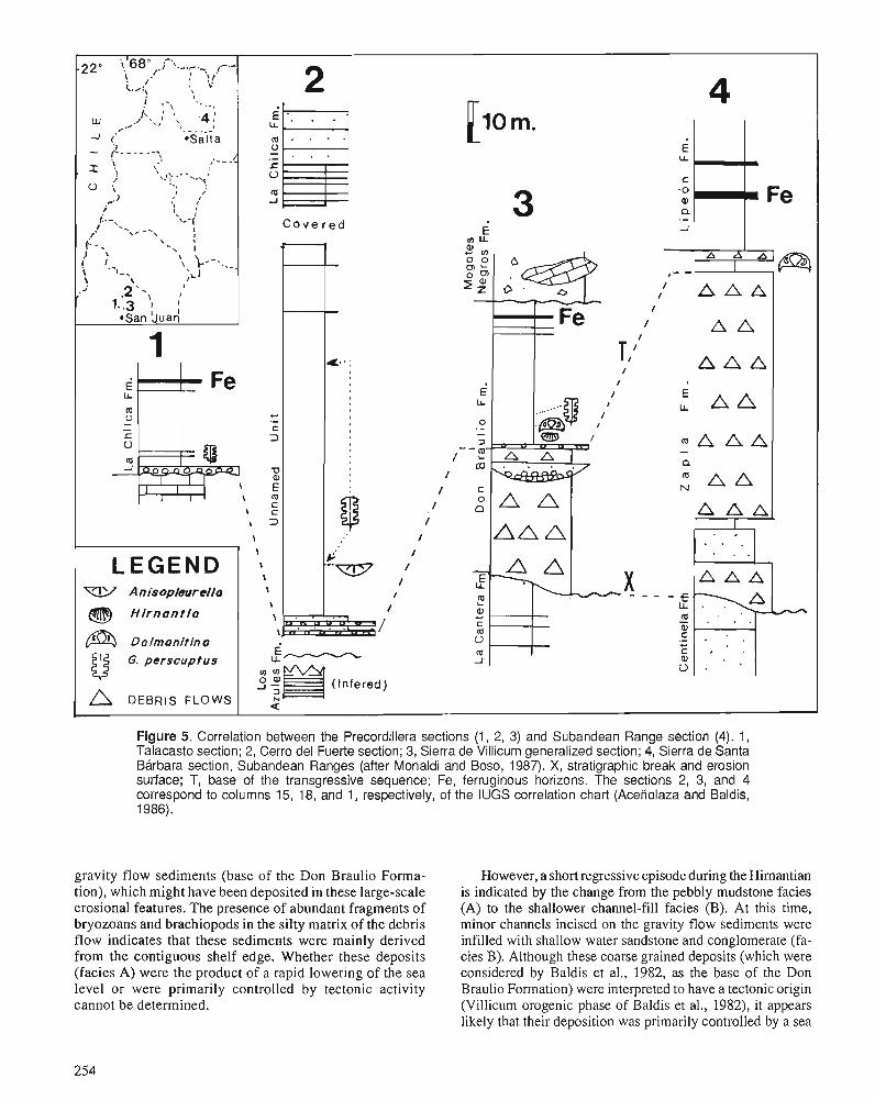
Figure 5. Correlation between the Precordillera sections (1, 2, 3) and Subandean Range section (4). 1 , Talacasto section; 2, Cerro del Fuerte section; 3, Sierra de Villicum generalized section; 4, Sierra de Santa Barbara section, Subandean Ranges (after Monaldi and Boso, 1987). X, stratigraphic break and erosion surface; T, base of the transgressive sequence; Fe, ferruginous horizons. The sections 2, 3, and 4 correspond to columns 15, 18, and 1, respectively, of the IUGS correlation chart (Acefiolaza and Baldis, 1986).
-220 'i,'68°,.j-'\.-,7.-. ,-.- . ,' ! !,! L,:, 2 4
gravity flow sediments (base of the Don Braulio Forma- tion), which might have been deposited in these large-scale erosional features. The presence of abundant fragments of bryozoans and brachiopods in the silty matrix of the debris flow indicates that these sediments were mainly derived from the contiguous shelf edge. Whether these deposits (facies A) were the product of a rapid lowering of the sea level or were primarily controlled by tectonic activity cannot be determined.
E LI
C
3 .o Q i a . -
C o v e r e d i 1 m U.
# - - ,I
m U
f - .- c
- P
f
/ N
/
/
I
I
LEGEN-D W Anisopleurella - f,
Hirnant io m - . a, .- " 9)
i)
However, a short regressive episode during the Himantian is indicated by the change from the pebbly mudstone facies (A) to the shallower channel-fill facies (B). At this time, minor channels incised on the gravity flow sediments were infilled with shallow water sandstone and conglomerate (fa- cies B). Although these coarse grained deposits (which were considered by Baldis et al., 1982, as the base of the Don Braulio Formation) were interpreted to have a tectonic origin (Villicum orogenic phase of Baldis et al., 1982), it appears likely that their deposition was primarily controlled by a sea
Fe
A A I " ' rn
A A A
A A
A A A
A A
m A A A
A A A A A
I . , . . . - . . - A A A
L . . \ . ' . . *
C .
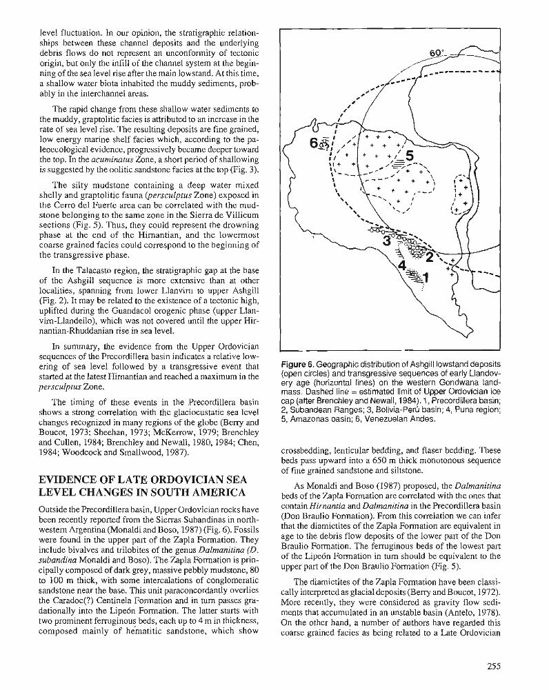
level fluctuation. In our opinion, the stratigraphic relation- ships between these channel deposits and the underlying debris flows do not represent an unconformity of tectonic origin, but only the infill of the channel system at the begin- ning of the sea level rise after the main lowstand. At this time, a shallow water biota inhabited the muddy sediments, prob- ably in the interchannel areas.
The rapid change from these shallow water sediments to the muddy, graptolitic facies is attributed to an increase in the rate of sea level rise. The resulting deposits are fine grained, low energy marine shelf facies which, according to the pa- leoecological evidence, progressively became deeper toward the top. In the acuminatus Zone, a short period of shallowing is suggested by the oolitic sandstone facies at the top (Fig. 3).
The silty mudstone containing a deep water mixed shelly and graptolitic fauna (persculptus Zone) exposed in the Cerro del Fuerte area can be correlated with the mud- stone belonging to the same zone in the Sierra de Villicum sections (Fig. 5). Thus, they could represent the drowning phase at the end of the Himantian, and the lowermost coarse grained facies could correspond to the beginning of the transgressive phase.
In the Talacasto region, the stratigraphic gap at the base of the Ashgill sequence is more extensive than at other localities, spanning from lower Llanvim to upper Ashgill (Fig. 2). It may be related to the existence of a tectonic high, uplifted during the Guandacol orogenic phase (upper Llan- vim-Llandeilo), which was not covered until the upper Hir- nantian-Rhuddanian rise in sea level.
In summary, the evidence from the Upper Ordovician sequences of the Precordillera basin indicates a relative low- ering of sea level followed by a transgressive event that started at the latest Himantian and reached a maximum in the persculplus Zone.
The timing of these events in the Precordillera basin shows a strong correlation with the glacioeustatic sea level changes recognized in many regions of the globe (Beny and Boucot, 1973; Sheehan, 1973; McKerrow, 1979; Brenchley and Cullen, 1984; Brenchley and Newall, 1980, 1984; Chen, 1984; Woodcock and Smallwood, 1987).
EVIDENCE OF LATE ORDOVICIAN SEA LEVEL CHANGES IN SOUTH AMERICA Outside the Precordillera basin, Upper Ordovician rocks have been recently reported from the Sierras Subandinas in north- western Argentina (Monaldi and Boso, 1987) (Fig. 6). Fossils were found in the upper part of the Zapla Formation. They include bivalves and trilobites of the genus Dalmanitina (D. subandina Monaldi and Boso). The Zapla Formation is prin- cipally composed of dark grey, massive pebbly mudstone, 80 to 100 m thick, with some intercalations of conglomeratic sandstone near the base. This unit paraconcordantly overlies the Caradoc(?) Centinela Formation and in turn passes gra- dationally into the Lipe6n Formation. The latter starts with two prominent ferruginous beds, each up to 4 m in thickness, composed mainly of hha t i t i c sandstone, which show
Figure 6. Geographic distribution of Ashgill lowstand deposits (open circles) and transgressive sequences of early Llandov- ery age (horizontal lines) on the western Gondwana land- mass. Dashed line = estimated limit of Upper Ordovician ice cap (after Brenchley and Newall, 1984). 1, Precordillera basin; 2, Subandean Ranges; 3, Bolivia-Pert3 basin; 4, Puna region; 5, Amazonas basin; 6, Venezuelan Andes.
crossbedding, lenticular bedding, and flaser bedding. These beds pass upward into a 650 m thick monotonous sequence of fine grained sandstone and siltstone.
As Monaldi and Boso (1987) proposed, the Dalmanitina beds of the Zapla Formation are correlated with the ones that contain Hirnantia and Dalmanitina in the Precordillera basin (Don Braulio Formation). From this correlation we can infer that the diamictites of the Zapla Formation are equivalent in age to the debris flow deposits of the lower part of the Don Braulio Formation. The ferruginous beds of the lowest part of the Lipe6n Formation in turn should be equivalent to the upper part of the Don Braulio Formation (Fig. 5).
The diamictites of the Zapla Formation have been classi- cally interpreted as glacial deposits (Beny and Boucot, 1972). More recently, they were considered as gravity flow sedi- ments that accumulated in an unstable basin (Antelo, 1978). On the other hand, a number of authors have regarded this coarse grained facies as being related to a Late Ordovician
tectonic event named the Ocloyica Phase (Turner and Men- beds was related to the more temperate regime initiated at the dez, 1975; Moyaand Salfity, 1982; Monaldi and Boso, 1987). end of theHirnantian when the ice cap melted (Brenchley and According to the evidence presented in this paper relating to Cullen, 1984). sea level fluctuations in the Precordillera basin, and the correlation between the northwestern and Precordilleran Up- per Ordovician units, we infer that the Ashgill diamictites of ACKNOWLEDGMENTS - the Zapla Formation may also be of glacioeustatic origin. This work was by grants from the Consejo Na- Similarly, the transgressive nature of the Silurian sequence cional de Investigaciones Cientificas y T6cnicas (CONICETI (Lipe6n Formation) in the northwestern basin could reflect PIA no. 194. The authors would like to thank R, Astini for the sea level rise recognized in the Precordillera basin. useful discussions on the environmental succession in the
Deposits equivalent in facies and almost synchronous to those of the Zapla Formation have been recorded in Bolivia (Cancaiiiri and Sacta formations) and southern Peni, covering a 1500 km long and 200 km wide area along the western margin of Gondwana. Likewise, a stratigraphic lacuna just prior to the debris flow deposits is developed throughout this belt. Similar relationships are present in the Andes of Vene- zuela (Benedetto and Ramirez Puig, 1982). Here, the se- quence consists of muddy limestone containing brachiopods, trilobites, and graptolites of Caradoc age (Hughes, 1980) capped by debris flow deposits. Lower Llandovery rocks outcrop in the same area (Boucot et al., 1972), but their stratigraphic relationships with the Ordovician unit are not clear.
As a basis for understanding the patterns of distribution of the Ashgill-lower Llandovery rocks, we have plotted on a paleogeographical map the data discussed in this paper. It shows that the effects of the global sea level fall would be recognized along the entire Paleo-Pacific margin of South America (Fig. 6).
The stratigraphic evidence of the subsequent rise in sea level related to the melting of the ice cap is particularly evident on the Brazilian Shield. In the Amazonas basin the first Phanerozoic transgression on the Precambrian basement is represented by the Trombetas Formation. The lowermost members of this formation (AutBs-Mirim and Nharnundri members) consist of sandstone and shale, which pass upward to the graptolitiferous black shale of the Pitinga member containing Climacograptus innotatus brasiliensis and early Llandovery chitinozoa. According to Popp (1983), the low- ermost horizons of this unit must be referred to the Upper Ordovician.
In the Andean orogenic belt this transgressive episode is well documented in the Subandean ranges of northwestern Argentina and Bolivia (Lipe6n Formation and equivalents) and Cordillera Oriental of Bolivia (Uncia and Huanuni for- mations). Particularly significant is the presence of lower Llandovery strata near the border between Argentina and Chile (Isaacson et a]., 1976), because this is the first record of marine Paleozoic strata covering the underlying Lower Ordovician folded rocks in the Puna region.
Sedimentary ferruginous deposits were unusually wide- spread during the lower Llandovery (Fig. 5). Based on the environmental parameters controlling the origin of these de- posits, Beresi (1978) has suggested a tropical-humid climate for this region. This evidence appears to be contradictory to palmgeographic reconstructions based mainly on palmmagnetic data. We consider, however, that the origin of ferruginous
Sierra de Villicum area.
REFERENCES Aceriolaza, F.G. and Baldis, B. 1986: The Ordovician System of South America. International Union of
Geological Sciences, Publication no. 22. Antelo, B. 1978: Las formaciones de edad sildrica en el Noroeste argendno (Provin-
cias de Jujuy y Salta). Asociaci6n Geol6gica Argentina, Revista 33, no. 1, p. 1-16.
Astini, R. 1988: Anilisis litofacial y estratighfico de las unidades clhticas ordovlci-
cas de la Precordillera septentional y heas vecinas. Inform. CONI- CET, unpublished.
Astini, R. and Piovano, E. in press: Facies de platafonna en el Sildrico de Precordillera, San Juan,
Argentina. Asociaci6n Geol6gica Argentina, Revista. Baldis, B.A., Beresi, M., Bordonaro, O., and Vaca, A. 1982: Sintesis evolutiva de la Precordillera argentina. Quinto Con-
greso Latinoamericano de Geologla, Buenos Aires, Actas 4, p. 399-445.
Baldis, B.A. and Blasco, G. 1975: Primeros trilobites Ashgilianos del Ordovfcico Sudamericano.
Primer Congreso Argentino de Paleontologfa y Bioestratigrafia, TucurnBn, Argentina, Actas 1, p. 33-48.
1986: The first typical Hirnanria Fauna from South America (San Juan Province, Argentine Precordillera). In Les Brachiopodes fossiles et actuels, P.R. Racheboeuf and C.C. Emig (eds.); Biostratigraphie du PalCozoYque, v. 4, p. 439-447.
Benedetto, J.L. 1987: Braqui6podos neo-ordovicicos del flanco occidental del Cerro del
Fuerte, Provincia de San Juan. Ameghiniana, v. 24, no. 3-4, p. 169- 174. Benedetto, J.L. in press: Los gkneros Clifionia y Paromalomena (Brachiopoda) en el Ash-
giliano tardio de la Sierra de Villicum, Precordillera de San Juan. Ameghiniana.
Benedetto, J.L., Ortega, G., Brussa, E., and Toro, B. 1986: Estratigrafia y fauna de la secuencia Neo-Ordovicica y Llandoveri-
ana del Rio Escondido (Flanco Occidental del Cerro del Fuerte) Provincia de San Juan. Primeras Jomadas sobre Geologia de la Precordillera, Actas 1, p. 128-133.
Benedetto, J.L. and Ramirez Puip, E. 1982: ~a secuencia sedimentaria Precimbrico-Paleozoico inferior
oericrat6nica del exmrno Norte de SudarnMca v sus relaciones con ias cuencas del Norte de Africa. Quinto congreso ~atinoamericano de Geologia, Actas 11, p. 41 1-425, Argentina.
Beresi, M.S. 1978: Presencia de dep6sitos de hierro sedimentario en el Paleozoico
inferior de la Precordillera de San Juan. Suplemento de Acta Geol6gica Lilloana, Tucumin, t. 14, p. 61-64.
Berry, W.B.N. and Boucot, A.J. 1972: Correlation of the South America Silurian rocks. Geological Society
of America, Special Paper 133, p. 1-60. 1973: Glacio-eustatic control of Late Ordovician-Early Silurian platform
sedimentation and faunal changes. Geological Society of America, Bulletin, v. 84, p. 275-284.
Boucot, A.J., Johnson, J.G., and Shagam, R. 1972: Braqui6podos silfiricos de Los Andes de MCrida, Venezuela. IV
Congreso Geol6gico Venezolano, Caracas, Venezuela, Memorias, t. 11, p. 585-728.
Brenchley, P.J. 1984: Late Ordovician extinctions and their relationship to the Gondwana
glaciation. In Fossils and Climate, P. Brenchley (ed.); J. Wiley and Sons Ltd., Chichester, p. 291-315.
Brenchley, P.J. and Cocks, L.R.M. 1982: Ecological associations in a regressive sequence: the latest Ordovi-
cian of the Oslo-Asker District, Norway. Palaeontology, v. 25, pt. 4, p. 783-815.
Brenchley, P.J. and Cullen, B. 1984: The environmental dish-ibution of associations belonging to the
Hirnantia Fauna - evidence from North Wales and Norway. In Aspects of the Ordovician System, D.L. Bruton (ed.); Palaeon- tolonical Contributions from the Universitv of Oslo. no. 295, p. 1113-125.
Brenchley. P.J. and Newall. G. 1980: i.facies analysis of upper Ordovician regressive sequences in the
Oslo Region, Norway - a record of glacio-eustatic changes. Palae- ogeography, Palaeoclimatology, Palaeoecology, v. 31, p. 1-38.
1984: Late Ordovician environmental changes and their effect on faunas. In Aspects of the Ordovician System, D.L. Bruton (ed.); Palaeon- tological Contributions from the University of Oslo, no. 295, p. 65-79.
Brussa, E. 1987: Estratigrafia y paleontologia de la secuencia Neo-Ordovlcica-
Sildrica del flanco Occidental del Cerro del Fuerte, Precordillera de San Juan. Unpublished graduate thesis, Universidad Nacional de CQdoba.
Brussa, E., Rickards, R., Toro, B., and Ortega, G. 1988: Upper Ordovician-Silurian graptolites from the western flank of
Cerro del Fuerte, Precordillera de San Juan, Argentina. Unpub- lished.
Chen Xu 1984: Influence of the Late Ordovician glaciation on basin configuration
of the Yangtze Platform in China. Lethaia, v. 17, p. 5 1-59. Cocks, L.R.M. 1970: Silurian brachiopods of the Superfamily Plectambonitacea. Bulletin
of the British Museum (Natural History), Geology, v. 19, no. 4, p. 142-203.
Cocks, L.R.M. and McKerrow, W.S. 1978: Ordovician. In The Ecology of Fossils, W.S. McKerrow (ed.);
Duckworth and Company, London, p. 62-92. Cuerda, A. and Furque, G. 1975: Nuevos datos sobre la paleobiogwgrafia de la Fomaci6n Gual-
carnayo, Ordovicico de la Precordillera. I Congreso Argentino de Paleontologfa y Bioestratigrafia, Tucumb, Argentina, Actas I, p. 49-58.
Cuerda, A., Rickards, R.B., and Cingolani, C. 1988: A new Ordovician-Silurian boundary section in San Juan Province,
Argentina, and its definitive graptolite fauna. Journal of the Geo- logical Society, London, v. 145, p. 749-757.
Hiller, N. 1981: The Ashgill rocks of the Glyn Ceiriog district, North Wales. Geo-
logical Journal, v. 16, p. 181-200. Hughes, C.P. 1980: A brief review of the Ordovician faunas of northern South America.
I1 Congreso Argentino de Paleontologla y Bioestratigrafia, Buenos Aires, Argentina, Actas I, p. 11-22.
Isaacson, P., Antelo, B., and Boucot, A.J. 1976: Implication of a Llandovery (Early Silurian) Brachiopod fauna from
Salta province, Argentina. Journal of Paleontology, v. 50, no. 6, p. 1103-1112.
Jablonski, D., Sepkoski, J.J., Jr., Bottjer, D.J., and Sheehan, P.M. 1983: Onshore-offshore patterns in the evolution of Phanerozoic shelf
communities. Science, v. 222, p. 1123-1 125. Levy, R. and Nullo, F. 1974: La fauna del Ordovicico (Ashgiliano) de Villicum, San Juan, Ar-
gentina. Ameghiniana, v. 9, no. 2, p. 173-194.
McKerrow, W.S. 1979: Ordovician and Silurian changes in sea level. Journal of the Geo-
logical Society, London, v. 136, p. 137-145. Monaldi, R. and Boso, M.A. 1987: Dalmanilina (Dalmanitina) subandinn n. sp. (Trilobita) en la For-
maci6n Zapla del Norte argentino. IV Congreso Latinoamericano de Paleontologia, Memorias, t. I, p. 149-158, Bolivia.
Moya, M.C. and Salfity, J.A. 1982: Los ciclos magm4ticos en el Noroeste argentino. V Congreso Lati-
noamericano de Geologia, Argentina, t. 111, p. 523-536. Mutti, E. and Normark, W.R. 1987: Comparing examples of modem and ancient turbidite systems:
problems ru~d concepts. In Marine Clastic Sedimentology, J.K. Leggett and G.G. Zuffa (eds.); Graham and Trotman, London, p. 1-38.
Mutti, E. and Ricci Lucchi, F. 1975: Turbidite facies and facies associations. 111 Examples of Turbidite
Facies and Associations from Selected Formations of the Northern Apennines, E. Mutti et al. (eds.); Field Trip Guidebook A-1 1, 9th International Association of Sedi~nentologists Congress, Nice.
Ortega, G. 1987: Las graptofaunas y 10s conodontes de la Formaci6n Los Azules,
Cerro Viejo, Zona de Huaco, Depto.JBchal, San Juan. Unpublished thesis, Facultad de Ciencias Exactas, Fisicas y Naturales, Universi- dad Nacional de Cbrdoba.
Peralta, S. 1986a: Graptolitos del Llandoveriano inferior en el Paleozoico inferior
clBstico del pie oriental de la Sierra de Villicum, Precordillera Oriental de San Juan. Primeras Jomadas sobre Geologia de Precor- dillera, San Juan, Argentina, Actas I, p. 134-138.
1986b: La graptofauna ordovicica de la Fomaci6n La Cantera, Precordil- lera Oriental de San Juan. IV Congreso Argentino de Paleontologia y Bioestratigrafia, Actas I, p. 67-7 1.
Pickering, R., Stow, D., Watson, M., and Hiscott, R. 1986: Deep-water facies, processes and models: a review and classifica-
tion scheme for modem and ancient sediments. Earth Science Reviews, v. 23, p. 75-174.
POPP, Me 1983: Estado actual del conocimiento del Sillirico y Dev6nico en Brasil.
RevistaTkcnica de Yacimientos Petroliferos Fiscales Bolivianos, v. 9, no. 1-4, p. 7 1-92.
Rong, Jia-yu 1985: Brachiopods of latest Ordovician in the Yichang district, western
Hubei, central China. In Stratigraphy and Palaeontology of Sys- temic Boundaries in China. Ordovician-Silurian Boundary, p. 1 11- 176.
Shnchez, T. 1986: Quelques observations sur la prkservation de certains Brachiopodes
siluriens de la Province Malvinocafre dans la Precordillere argen- tine. In Les Brachiopodes fossiles et actuels, P. Racheboeuf and C.C. Emig (eds.); Biostratigraphie du PalCozoi'que, v. 4, p. 375-381.
in press: Bivalvos del Ordovicico medio-tardio de la Precordillera de San Juan (Argentina). Ameghiniana, v. 27.
Sheehan, P.M. 1973: The relation of Late Ordovician glaciation to the Ordovician-Silu-
rim changeover in North American brachiopod faunas. Lethaia, v. 6, p. 147-154.
1978: The hinging mechanisms of brachiopods. Taphonomic considera- tions. Journal of Paleontology, v. 52, no. 3, p. 748.
1988: Late Ordovician events and the terminal Ordovician extinction. New Mexico Bureau of Mines and Mineral Resources, Memoir 44, p. 405-4 15.
Turner, J.C. and Mendez, V. 1975: Geologia del sector oriental de 10s departamentos Santa Victoria e
Iruya, Salta. Boletfn de la Academia Nacional de Ciencias, v. 51, p. 11-24.
Valentine. J.W. . - 1971: Resource supply and species diversity patterns. Lethaia, v. 4, p.
5 1-62.
Volkheimer, W., Pothe de Baldis, D.E., and Baldis, B. Ziegler, A.M., Cocks, L.R.M., and Bambach, R.K. 1980: Quitinozoos de la base del Sillirico de la Sierra de Villicum (Pro- 1968: The composition and structure of Lower Silurian marine communi-
vincia de San Juan, Repirblica Argentina). Revista del Museo Ar- ties. Lethaia, v. 1, p. 1-27. gentino de Ciencias Naturales "Bernardino Rivadavia" Ziegler, A.M., Hansen, K.S., Johnson, M.E., Kelly, M.A., Scotese, (Paleontologfa), v. 2, no. 6, p. 125-135. C.R., and van der Voo, R.
Woodcock, N.H. and Smallwood, S.D. 1977: Silurian continental distributions, palaeogeography, climatology 1987: Late Ordovician shallow marine environments due to glacio-eus- and biogeography. Tectonophysics, v. 40, p. 31-51.
tatic regression: Scrach Formation, Mid-Wales. Journal of the Geo- logical Society, London, v. 144, p. 393-400.
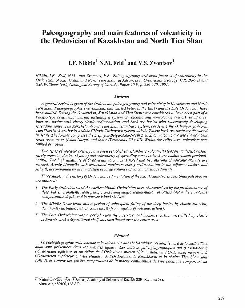
Paleogeography and main features of volcanicity in the Ordovician of Kazakhstan and North Tien Shan
I.F. ~ i k i t i n l N.M. rid' and V.S. 2vontsov1
Nikitin, I.F., Frid, N.M., and Zvontsov, V.S., Paleogeography and main features of volcanicity in the Ordovician of Kazakhstan and North Tien Shan; ttz Advances in Ordovician Geology, C.R. Barnes and S.H. Williams (ed.), Geological Survey of Canada, Paper 90-9, p. 259-270,1991.
Abstract
A general review is given of the Ordovician paleogeography and volcanicity in Kazakhstan and North Tien Shun. Paleogeographic environments that existed between the Early and the Late Ordovician have been studied. During the Ordovician, Kazakhstan and Tien Shun were considered to have been part of a Pacific-type continental margin including a system of volcanic and nonvolcanic (relict) island arcs, inter-arc basins with cherty-clastic sedimentation, and back-arc basins with successively developing spreading zones. The Kokchetav-North Tien Shun island-arc system, bordering the Dzhungariya-North Tien Shan back-arc basin, and the Chingiz-Tarbagatai system with the Zaisan back-arc basin are discussed in detail. The former comprises the Stepnyak-Betpakdala-North Tien Shan volcanic arc and the adjacent relict arcs: outer (Ishim-Naryn) and inner (Yermentau-Chu Ili). Within the relict arcs, volcanism was limited or absent.
Two types of volcanic activity have been established: island-arc volcanicity (basalt, andesitic basalt, rarely andesite, dacite, rhyolite) and volcanicity of spreading zones in back-arc basins (basalt predomi- nating). The high alkalinity of Ordovician volcanics is noted and two maxima of volcanic activity are marked: Arenig-Llandeilo with associated maximum cherty sedimentation in the adjacent basins, and Ashgill, accompanied by accumulation of large volumes of volcaniclastic sediments.
Three stages in the history of Ordovician sedimentation of the Kazakhstan-North Tien Shanpaleobasins are outlined:
I . The Early Ordovician and the earliest Middle Ordovician were characterized by the predominance of deep sea environments, with pelagic and hemipelagic sedimentation in basins below the carbonate compensation depth, and in narrow island shelves.
2. The Middle Ordovician was a period of subsequent filling of the deep basins by clastic material, dominantly turbidites, which came mostly from regions of volcanic activity.
3. The Lute Ordovician was a period when the inter-arc and back-arc basins were filled by clastic sediments, and a depositional shelf was distributed over the entire area.
La pale'ogkographie ordovicienne et la volcanicite' dam le Kazakhstan et duns le nordde la chaine Tien Shun sont prksentkes dam les grandes lignes. Les milieux palkog6ographiques qui y existaient b I'Ordovicien infe'rieur et au de'but de lJOrdovicien moyen (Llanvirnien), cl. I'Ordovicien moyen et ct 1'Ordovicien supkrieur ont ktk ktudiks. A I'Ordovicien, le Kazakhstan et la chaine Tien Shan sont conside'rks comme des parties composantes de la marge continentale de type pacifique comportant un
Institute of Geological Sciences, Academy of Sciences of Kazakh SSR, Kalinina 69a, Alma-Ata, 480100, U.S.S.R.
tion cherteuse-clastique et de bassins d'arri2re-arc incluant des zones d'expansion successives. Le systhme d'arc insulaire de Kokchetav-Tien Shan du Nord, bordant le bassin d'arri2re-arc de Dzhungariya-Tien Shan du Nord, et le systime de Chingiz-Tarbagatai avec le bassin d'arridre-arc de Zaisan servent d'exemples et sont traitks de facon dktaillke. Le premier comprend 1'arc volcanique de Stepnyak-Betpak- dala-Tien Shan du Nord et les arcs residuels adjacents : l'arc externe Ishim Naryn et l'arc interne Yermentau-Chu Ili. Au sein des arcs residuels, le volcanisnze e'tait limitk ou absent.
Deux types d'activite's volcaniques ont eu cours : une volcanicite' d'arc insulaire (basaltes, basaltes ande'sitiques, rarement ande'sites, dacites, rhyolites) et une volcanicite' de zone en expansion dans les bassins d'arridre-arc (basaltes prkdominants). La forte alcalinitk des roches volcaniques ordoviciennes est une caractkristique dont il est fait mention et deux maxima d'activitks volcaniques sont relevks : I'Arknigien-Llandeilien associk d une skdimentation cherteuse maximale dam k s bassins adjacents et I'Ashgillien, accompagne' dune accumulation de grades quantitks de skdiments volcanoclastiques.
Trois e'tapes de skdimentation ordovicienne dans les pale'obassins de Kazakhstan-Tien Shan du Nord ont e'te' circonscrites :
I . L'Ordovicien infkrieur et le tout dkbut de I'Ordovicien moyen sont caractkrisks par la prkdominance de milieux ockaniques profonds, d skdimentation pklagique et hkmipklagique dans des bassins situks au-dessous de la profondeur de compensation des carbonates et dans les plates-formes insulaires ktroites.
2 . L'Ordovicien moyen a e'te' une pkriode de remblayage de bassins profonds par des roches clastiques, surtout des turbidites, qui provenaient en grande partie des re'gions volcaniques.
3. L'Ordovicien supkrieur a kte' une pkriode de remblayage des bassins d'inter-arc et d'arriire-arc avec des skdiments clastiques et une plate-forme de skdimentation s'est ktalke dans toute la rkgion.
INTRODUCTION
In recent decades, because of a better understanding of mod- em marine geology, the search for ancient oceanic sediments and structures has developed within continental areas such as the Paleozoic deformed belts of Kazakhstan and Tien Shan. Here, the Paleozoic deposits contain ophiolite belts, and argillaceous, calcareous, and siliceous rocks that can be ten- tatively referred to pelagic and hemipelagic sediments are widely distributed. There is alsb a wide distribution of thick, green, clastic, rhythmically bedded sediments, which have all the features of turbidite sedimentation (Lisitsyn, 1985; Ni- kitin, 1973, p. 50, 51). Thus the early Paleozoic strata of Kazakhstan comprise relatively deep sea deposits, which belong both to oceanic structures with oceanic crust, and to continental margins with transitional-type crust - island arcs and back-arc basin systems (Lyapichev, 1977; Peive and Mossakovsky, 1982).
There is some controversy about the nature of these Pa- leozoic deformed belts in Kazakhstan during the early stages of development. Several possible interpretations have been proposed:
1. Kazakhstan is a mosaic of microcontinents formerly sepa- rated by micro-oceans that have completely disappeared (Avdeev, 1984; Seitov, 1988).
2. The Paleozoic strata are closely analogous to modem continental margins.
3. Relict parts of ancient oceanic structures similar to mod- em ones have been included (Sonenshain, 1976).
4. The lower Paleozoic structures are significantly different from structures of modem oceans (Abdulin and Shlygin, 1982).
An obvious approach to settling the debate is to compare the Ordovician stratigraphy and paleogeography of Kazakh- stan and North Tien Shan with modem examples. There is much information about Ordovician deposits in Kazakhstan, including new data about the age and structure of cherty and volcanic formations (Nikitin, 1984; Zaicev, 1985; Nikitin et al., 1987).
Ordovician deposits are widely distributed in Kazakhstan and North Tien Shan (Fig. 1) as constituents of compound fold structures that are complicated by numerous faults. Most of these structures are asymmetric, with relatively simple, gently inclined western and southwestern flanks of synclino- ria, and more steep, sometimes overturned, dislocated north- eastem slopes. Such structures indicate a general vergence of Paleozoic belts of Kazakhstan and North Tien Shan, and assume tectonic transport from northeast to southwest.
The following tectonofacies zones are distinguished by sediment type, completeness of section, and volcanicity (Fig. 1) (Nikitin et al., 1986): 1) Ishim-Naryn (Ulutau- Karatau-Naryn); 2) Stepnyak-Betpakdala-North Tien Shan; 3) Yermentau-Chu Ili; 4) Chingiz-Tarbagatay; 5) Dzhungariya- Balkhash; 6) Zaisan; 7) Gomy Altai.
MAIN PALEOGEOGRAPHIC ENVIRONMENTS
Most of the area being discussed was covered by the sea during the Ordovician and was freely connected to the ocean covering the rest of the world (Vinogradov, 1968). In this sea was an island-arc system - the Kazakhstan Islands. Some of these islands probably existed in the Cambrian, but others appeared in the Ordovician and grew so that by the end of the Ordovician, they had formed a large region and had sur- rounded the inner part of Central Kazakhstan.
During the Tremadoc, Arenig, and Llanvirn, the Ishim- are found together with graptolites. Benthic faunas include Naryn Zone (Figs. 1, 2) was a system of relatively deep thin shelled inarticulate brachiopods and rare gastropods. marine basins with thin peIagic and hemipelagic argillaceous Graptolites frequently show parallel orientation, giving evi- and cherty sediments up to 380 m thick (Nikitin, 1973; dence of ocean currents that were probably cold and moved Azerbaev, 1978, 1988). Conodonts from near surface waters along the basin from south to north.
Figure 1. Ordovician structural zonation in Kazakhstan and North Tien Shan (according to I.F. Nikitin, V.G. Koroljov, M.K. Apollonov, and others). Shaded areas = outcrops of Ordovician deposits. I-VI: tectono-facies zones: I. Ishim-Naryn (la. Maryevka; Ib. Ishirn- Sardzhas; Ic. Maly Karatau-Talas subzones); II. Stepnyak-Betpakdala-North Tien Shan (Ila. Susamyr-Dolon; Ilb. Makbal-Burkhan; Ilc. Keptash-Dzhumgal; Ild. Stepnyak-Zailiyski Alatau subzones); Ill. Ermentau-Chu Ili (Illa. Selety-Sugaty; Illb. Errnentau-Burultas; Il lc. Shiderty; Illd. Mynaral-Southern Dzhungaria; Ille. Mointy-Tekeli subzones); IV. Chingiz-Tarbagai (IVa. Boshchekul-Maikain; IVb. Alkarnergen-Tarbagatai subzones); V. Dzhungaria-Balkhash; VI. Zaisan.
In the inner part of the zone, to the southwest (Maly There is a suggestion of a landmass within the Ishim- Karatau-Talas Subzone), limestone was deposited. This re- Naryn Zone only in the extreme northwest, near the Kok- gion was probably an elevated submarine platform that had chetav Massif. Lower to Middle Ordovician strata along the originated in the Cambrian. To the southwest and northeast periphery of this massif include cherty as well as clastic sandy of this seamount are calcareous rocks with features charac- strata. teristic of slope facies. (Zhemchuzhnikov, 1986). Volcanic activity was very weak in some areas of the Ishim-Naryn In the Stepnyak-Betpakdala-North Tien Shan Zone during
Zone. It resulted in the appearance of minor coarse basic tuff the same time (Tremadoc-Arenig-Llanvirn), there are rhyth-
and lava in some sections. mic, sandy, arkosic strata up to 2000 m thick. When clastic material was very limited, carbonaceous siliceous strata, and less commonly limestone, was deposited. Siliceous strata were most common in the late Arenig and early Llanvirn.
Figure 2. Paleogeographic reconstruction of Kazakhstan and North Tien Shan in the Early Ordovician and Llanvirn. 1. islands; 2. outer deep water basins (continental slope?); 3-4. island-arc basins (3. deep water basins; 4. shallow sea with submarine uplifts and island shelves); 5. back-arc basins; 6. limestone; 7. dark carbonate and siliceous sediment; 8. red siliceous sediment; 9. sandy sediment; 10. conglomeratic sediment; 11, deep water basaltic volcanism; 12. island-arc volcanism: basalt, andesite-basalt, rhyolite, and pyroclastic sediment; 13. spreading zones; 14. currents; 15. plankton (1 5a. graptalites; 15b. conodonts); 16. bottom communities (1 6a. deep-water inarticulate brachiopods; 16b. shallow-water bottom communities: brachiopods, trilobites, and others).
In the north they are replaced in the upper part by red siliceous shallow, nearshore arkosic, and calcareous strata up to 500 m strata, from which jasper formed. Local volcanism is known thick. There are many places where these strata appeared from the presence of basalt, rhyolite, and tuff. during the Arenig or Llanvim, and they transgressively over-
In the dark siliceous strata, graptolites and conodonts are common and inarticulate brachiopods are rare. In the red siliceous strata, mainly radiolarians and conodonts occur. A typical benthic brachiopod community (Clarkella, Nanor- this; late Tremadoc) with trilobites (Bathyuriscops granula- tus; Llanvim) characterizes the shallow water limestone.
Along the western and southwestern margins of the Yer- mentau-Chu Ili Zone (Selety-Sugaty Subzone) there is an isolated part of the basin with an accumu!ation of apparently
lap ~ k b r i a n strata or Precambrian metamorphic rocks. The upper part of the clastic deposits is rhythmic and commonly contains lenses and bands of conglomerate. There are usually graptolites in the thin shale beds; in limestone, various trilo- bites, brachiopods, echinoderms, coelenterates, and other or- ganisms produce typical Llanvirn benthic communities (Aportophyla, Martellia, Yangtzella, Bathyuriscops granula- tus, and others). The composition, structural peculiarities and fauna of these Ordovician strata leaves no doubt that there was a system of islands, each surrounded by a narrow
1 1 2 1 3 4 1 5
m 6 m 7 I 8 1",'9 m10
mi ~ I I v l i 3
4 1 1 5
0 50 100 200 3 0 0 ~ ~
Figure 3. Paleogeographic reconstruction of Kazakhstan and North Tien Shan in the Middle Ordovi- cian. 1. islands; 2, outer deep water basins (turbidite); 3-4, island-arc basins: 3. turbidite deep water basins and volcanic basins with volcanic islands; 4. shallow sea with submarine uplifts and island shelves; 5. back-arc basins; 6. limestone; 7. sandy sediment; 8. conglomeratic sediment; 9, red siliceous sediment; 10. deep water basaltic volcanism; 11. island-arc volcanism (basalt, andesite-ba- salt, andesite, and pyroclastic sediment); 12. spreading zones; 13. currents; 14. plankton (14a. graptolites; 14b. conodonts); 15, bottom communities: trilobites, brachiopods, and others.
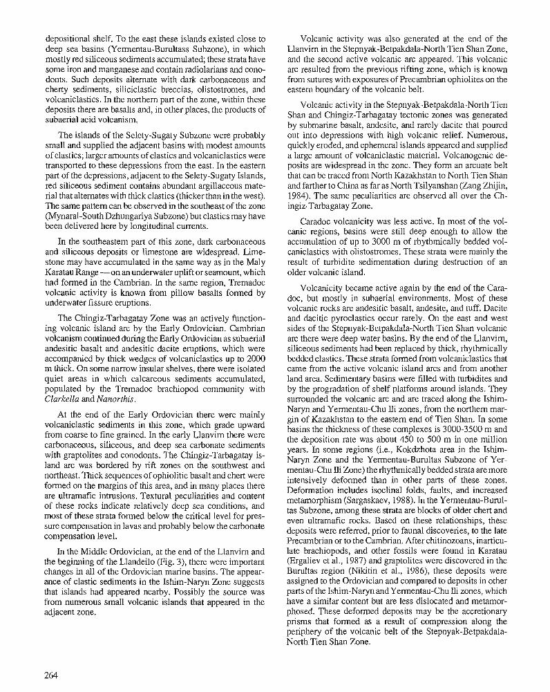
depositional shelf. To the east these islands existed close to deep sea basins (Yermentau-Burultass Subzone), in which mostly red siliceous sediments accumulated; these strata have some iron and manganese and contain radiolarians and cono- donts. Such deposits alternate with dark carbonaceous and cherty sediments, siliciclastic breccias, olistostromes, and volcaniclastics. In the northern part of the zone, within these deposits there are basalts and, in other places, the products of subaerial acid volcanism.
The islands of the Selety-Sugaty Subzone were probably small and supplied the adjacent basins with modest amounts of clastics; larger amounts of clastics and volcaniclastics were transported to these depressions from the east. In the eastern part of the depressions, adjacent to the Selety-Sugaty Islands, red siliceous sediment contains abundant argillaceous mate- rial that alternates with thick clastics (thicker than in the west). The same pattern can be observed in the southeast of the zone (Mynaral-SouthDzhungariya Subzone) but clastics may have been delivered here by longitudinal currents.
In the southeastern part of this zone, dark carbonaceous and siliceous deposits or limestone are widespread. Lime- stone may have accumulated in the same way as in the Maly Karatau Range -on an underwater uplift or seamount, which had formed in the Cambrian. In the same region, Tremadoc volcanic activity is known from pillow basalts formed by underwater fissure eruptions.
The Chingiz-Tarbagatay Zone was an actively function- ing volcanic island arc by the Early Ordovician. Cambrian volcanism continued during the Early Ordovician as subaerial andesitic basalt and andesitic dacite eruptions, which were accompanied by thick wedges of volcaniclastics up to 2000 m thick. On some narrow insular shelves, there were isolated quiet areas in which calcareous sediments accumulated, populated by the Tremadoc brachiopod community with Clarkella and Nanorthis.
At the end of the Early Ordovician there were mainly volcaniclastic sediments in this zone, which grade upward from coarse to fine grained. In the early Llanvirn there were carbonaceous, siliceous, and deep sea carbonate sediments with graptolites and conodonts. The Chingiz-Tarbagatay is- land arc was bordered by rift zones on the southwest and northeast. Thick sequences of ophiolitic basalt and chert were formed on the margins of this area, and in many places there are ultramafic intrusions. Textural peculiarities and content of these rocks indicate relatively deep sea conditions, and most of these strata formed below the critical level for pres- sure compensation in lavas and probably below the carbonate compensation level.
In the Middle Ordovician, at the end of the Llanvim and the beginning of the Llandeilo (Fig. 3), there were important changes in all of the Ordovician marine basins. The appear- ance of clastic sediments in the Ishim-Naryn Zone suggests that islands had appeared nearby. Possibly the source was from numerous small volcanic islands that appeared in the adjacent zone.
Volcanic activity was also generated at the end of the Llanvirn in the Stepnyak-Betpakdala-North Tien Shan Zone, and the second active volcanic arc appeared. This volcanic arc resulted from the previous rifting zone, which is known from sutures with exposures of Precambrian ophiolites on the eastern boundary of the volcanic belt.
Volcanic activity in the Stepnyak-Betpakdala-North Tien Shan and Chingiz-Tarbagatay tectonic zones was generated by submarine basalt, andesite, and rarely dacite that poured out into depressions with high volcanic relief. Numerous, quickly eroded, and ephemeral islands appeared and supplied a large amount of volcaniclastic material. Volcanogenic de- posits are widespread in the zone. They form an arcuate belt that can be traced from North Kazakhstan to North Tien Shan and farther to China as far as North Tsilyanshan (Zang Zhijin, 1984). The same peculiarities are observed all over the Ch- ingiz-Tarbagatay Zone.
Caradoc volcanicity was less active. In most of the vol- canic regions, basins were still deep enough to allow the accumulation of up to 3000 m of rhythmically bedded vol- caniclastics with olistostromes. These strata were mainly the result of turbidite sedimentation during destruction of an older volcanic island.
Volcanicity became active again by the end of the Cara- doc, but mostly in subaerial environments. Most of these volcanic rocks are andesitic basalt, andesite, and tuff. Dacite and dacitic pyroclastics occur rarely. On the east and west sides of the Stepnyak-Betpakdala-North Tien Shan volcanic arc there were deep water basins. By the end of the Llanvirn, siliceous sediments had been replaced by thick, rhythmically bedded clastics. These strata formed from volcaniclastics that came from the active volcanic island arcs and from another land area. Sedimentary basins were filled with turbidites and by the progradation of shelf platforms around islands. They surrounded the volcanic arc and are traced along the Ishim- Naryn and Yermentau-Chu Ili zones, from the northern mar- gin of Kazakhstan to the eastern end of Tien Shan. In some basins the thickness of these complexes is 3000-3500 m and the deposition rate was .about 450 to 500 m in one million years. In some regions (i.e., Kokdzhota area in the Ishim- Naryn Zone and the Yermentau-Burultas Subzone of Yer- mentau-Chu Ili Zone) the rhythmically bedded strata are more intensively deformed than in other parts of these zones. Deformation includes isoclinal folds, faults, and increased metamorphism (Sargaskaev, 1988). In the Yermentau-Burul- tas Subzone, among these strata are blocks of older chert and even ultramafic rocks. Based on these relationships, these deposits were referred, prior to faunal discoveries, to the late Precambrian or to the Cambrian. After chitinozoans, inarticu- late brachiopods, and other fossils were found in Karatau (Ergaliev et al., 1987) and graptolites were discovered in the Burultas region (Nikitin et al., 1986), these deposits were assigned to the Ordovician and compared to deposits in other parts of the Ishim-Naryn and Yermentau-Chu Ili zones, which have a similar content but are less dislocated and metamor- phosed. These deformed deposits may be the accretionary prisms that formed as a result of compression along the periphery of the volcanic belt of the Stepnyak-Betpakdala- North Tien Shan Zone.
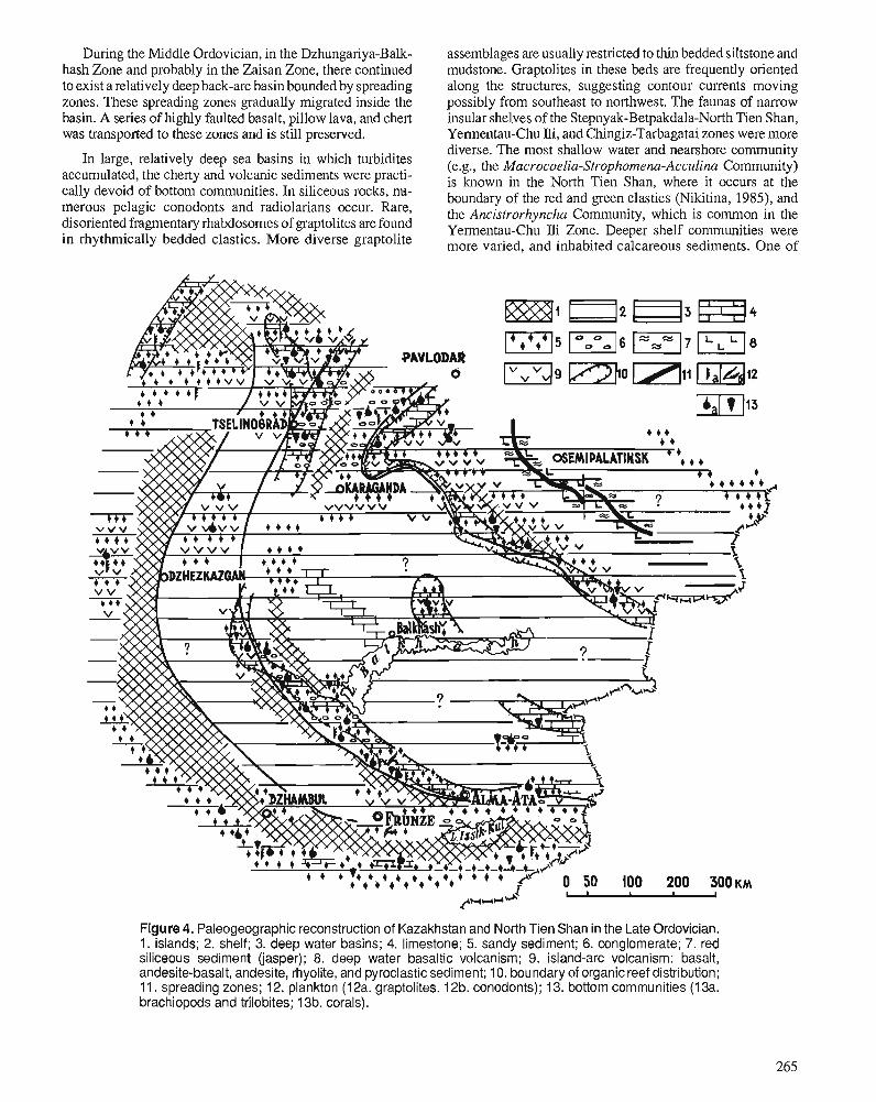
During the Middle Ordovician, in the Dzhungariya-Balk- assemblages are usually restricted to thin bedded siltstone and hash Zone and probably in the Zaisan Zone, there continued mudstone. Graptolites in these beds are frequently oriented to exist a relatively deep back-arc basin bounded by spreading along the structures, suggesting contour currents moving zones. These spreading zones gradually migrated inside the possibly from southeast to northwest. The faunas of narrow basin. A series of highly faulted basalt, pillow lava, and chert insular shelves of the Stepnyak-Betpakdala-North Tien Shan, was transported to these zones and is still preserved. Yermentau-Chu Ili, and Chingiz-Tarbagatai zones were more
In large, relatively deep sea basins in which turbidites accumulated, the cherty and volcanic sediments were practi- cally devoid of bottom communities. In siliceous rocks, nu- merous pelagic conodonts and radiolarians occur. Rare, disoriented fragmentary rhabdosomes of graptolites are found in rhythmically bedded clastics. More diverse graptolite
diverse. The most shallow water and nearshore community (e.g., the Macrocoelia-Strophomena-Acculina Community) is known in the North Tien Shan, where it occurs at the boundary of the red and green clastics (Nikitina, 1985), and the Ancistrorhyncha Community, which is common in the Yementau-Chu Ili Zone. Deeper shelf communities were more varied, and inhabited calcareous sediments. One of
Figure 4. Paleogeographic reconstruction of Kazakhstan and North Tien Shan in the Late Ordovician. 1. islands; 2. shelf; 3. deep water basins; 4. limestone; 5. sandy sediment; 6. conglomerate; 7. red siliceous sediment (jasper); 8. deep water basaltic volcanism; 9. island-arc volcanism: basalt, andesite-basalt, andesite, rhyolite, and pyroclastic sediment; 10. boundary of organic reef distribution; 11. spreading zones; 12, plankton (12a. graptolites. 12b. conodonts); 13. bottom communities (1 3a. brachiopods and trilobites; 13b. corals).
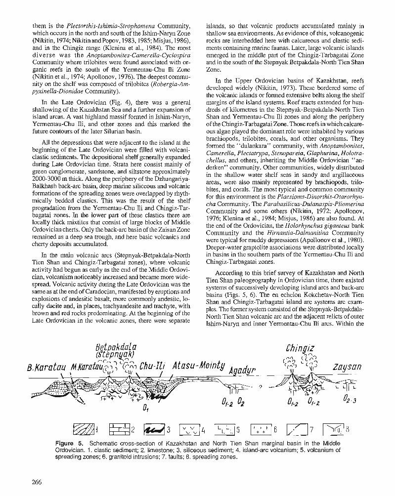
them is the Plectorthis-Ishimia-Strophomena Community, which occurs in the north and south of the Ishim-Naryn Zone (Nikitin, 1974; NiitinandPopov, 1983,1985; Misjus, 1986), and in the Chingiz range (Klenina et al., 1984). The most diverse was the Anoptambonites-Camerella-Cyclospira Community where trilobites were found associated with or- ganic reefs in the south of the Yermentau-Chu Ili Zone (Nikitin et al., 1974; Apollonov, 1976). The deepest commu- nity on the shelf was composed of trilobites (Robergia-Am- pyxinella-Dionidae Community).
In the Late Ordovician (Fig. 4), there was a general shallowing of the Kazakhstan Sea and a further expansion of island areas. A vast highland massif formed in Ishim-Na~yn, Yementau-Chu Jli, and other zones and this marked the future contours of the later Silurian basin.
All the depressions that were adjacent to the island at the beginning of the Late Ordovician were filled with volcani- clastic sediments. The depositional shelf generally expanded during Late Ordovician time. Strata here consist mainly of green conglomerate, sandstone, and siltstone approximately 2000-3000 m thick. Along the periphery of the Dzhungariya- Balkhash back-arc basin, deep marine siliceous and volcanic formations of the spreading zones were overlapped by rhyth- mically bedded clastics. This was the result of the shelf progradation from the Yementau-Chu lli and Chingiz-Tar- bagatai zones. In the lower part of these clastics there are locally thick rnixtites that consist of large blocks of Middle Ordovician cherts. Only the back-arc basin of the Zaisan Zone remained as a deep sea trough, and here basic volcanics and cherty deposits accumulated.
islands, so that volcanic products accumulated mainly in shallow sea environments. As evidence of this, volcanogenic rocks are interbedded here with calcareous and clastic sedi- ments containing marine faunas. Later, large volcanic islands emerged in the middle part of the Chingiz-Tarbagatai Zone and in the south of the Stepnyak Betpakdala-North Tien Shan Zone.
In the Upper Ordovician basins of Kazakhstan, reefs developed widely (Nikitin, 1973). These bordered some of the volcanic islands or formed extensive belts along the shelf margins of the island systems. Reef tracts extended for hun- dreds of kilometres in the Stepnyak-Betpakdala-North Tien Shan and Yermentau-Chu lli zones and along the periphery of the Chingiz-Tarbagatai Zone. Those reefs in which calcare- ous algae played the dominant role were inhabited by various brachiopdds,- trilobites, corals, and other organisms. They formed the "dulankara" community, with Anoptambonites, Camerella, Plectatrypa, Stenopareia, Glaphurina, Holotra- chellus, and others, inheriting the Middle Ordovician "an- derken" community. Other communities, widely distributed in the shallow water shelf seas in sandy and argillaceous areas, were also mainly represented by brachiopods, trilo- bites, and corals. The most typical and common community for this environment is the Plaesioms-Dinorthis-Otarorhyn- cha Community. The Parabasilicus-Dulanaspis-Pliomerina Community and some others (Nikitin, 1972; Apollonov, 1976; Klenina et al., 1984; Misjus, 1986) are also found. At the end of the Ordovician, the Holorhynchus giganteus bank Community and the Hirnantia-Dalmanitina Community were typical for muddy depressions (Apollonov et al., 1980). Deeper-water graptolite associations were distributed locally
In the main volcanic arcs (Stepnyak-Betpakdala-North in basins in the southern parts of the Yementau-Chu Ili and Tien Shan and Chingiz-Tarbagatai zones), where volcanic Chingiz-Tarbagatai zones. activity had begun as early as the end of the Middle Ordovi- cian, volcanism noticeably increased and became more wide- spread. Volcanic activity during the Late Ordovician was the same as at the end of Caradocian, manifested by eruptions and explosions of andesitic basalt, more commonly andesite, lo- cally dacite and, in places, trachyandesite and trachyte, with brown and red rocks predominating. At the beginning of the Late Ordovician in the volcanic zones, there were separate
According to this brief survey of Kazakhstan and North Tien Shan paleogeography in Ordovician time, there existed systems of successively developing island arcs and back-arc basins (Figs. 5, 6). The en echelon Kokchetav-North Tien Shan and Chingiz-Tarbagatai island-arc systems are exam- ples. The former system consisted of the Stepnyak-Betpakdala- North Tien Shan volcanic arc and the adjacent relicts of outer Ishim-Naryn and inner Yementau-Chu Ili arcs. Within the
Figure 5. Schematic cross-section of Kazakhstan and North Tien Shan marginal basin in the Middle Ordovician. 1. clastic sediment; 2. limestone; 3. siliceous sediment; 4. island-arc volcanism; 5. volcanism of spreading zones; 6. granitoid intrusions; 7. faults; 8. spreading zones.
relict arcs, volcanism was weak or almost missing. The Ch- This diverse Ordovician volcanism may be subdivided into ingiz-Tarbagatai island-arc system was likely to be traced to two types based on the character of the volcanic eruptions, by the West Siberia Lowland. Some island-arc systems bordered the content of the accompanying sediments. the back-arc basins: Kokchetav-North Tien ~ h a n system sur- rounded Dzhungaria-Balkhash basin; the Chingiz-Tarbagatai system surrounded the Zaysan basin.
THE PECULIARITIES OF ORDOVICIAN VOLCANISM Ordovician volcanicity in Kazakhstan was of long duration, it was significant and widespread, and was mostly in marine areas, with only rare nonmarine volcanism. The volcanic deposits are extremely thick, and diverse in composition.
The first type of volcanism unites volcanic eruptions of the main type, which were controlled by transregional magma sources. These volcanoes were connected at their bases, and they formed ranges of submarine and subaerial mountains, archipelagos, and volcanic island chains, which formed is- land-arc systems in Stepnyak-Betpakdala-North Tien Shan and Chingiz-Tarbagatai zones (Fig. 5).
The Ordovician volcanic deposits that took part in the building of ~ i ~ e s e island systems have the same features as volcanics of these island arcs, such as: porphyritic and megaporphyritic structures, arnygdaloidal structures of lavas,
Figure 6. Paleotectonic reconstruction of Kazakhstan and North Tien Shan in the Ordovician. 1-4. Kokchetav-North Tien Shan island-arc system: 1 . Stepnyak-Betpakdala-North Tien Shan volcanic arc; 2. outer relict island arc uplifts and basins; 3. continental slopeduring the Early Ordovician and Llanvirn; 4, inner relict island arc uplifts and basins; 5. Chingiz-Tarbagatai island-arc system; 6. Altai-Sayan shelf; 7. back-arc basins (A. Dzhungaria-Balkhash Basin; B. Zaisan Basin); 8. accretionary zones; 9. Ordovician granitoid intrusions; 10-13. spreading zones: 10. Early Ordovician and I-lanvirn; 11 . Early Ordovician-Llandeilo; 12. Early Ordovician-Caradoc; 13. Middle-Upper Ordovician.
forming zonally arranged flows with brown chilled crust; abundance of pyroclastic material with a wide granulometric spectrum from ash to coarse boulder, attaining 70-80 per cent of the total thickness of the volcanogenics; thick trains of volcanoclastics along the periphery of the volcanoes.
Island-arc volcanicity was durable and was characterized by the formation of both undifferentiated (basaltic) and well differentiated volcanics. In some cases basic volcanics domi- nated, in others, more rarely, acid volcanics prevailed. The specific peculiarity of Ordovician effusions is their increased alkalinity of both sodium and potassium types. Among basic rocks trachybasalts predominate, less common are basalts with normal alkalinity. Among the latter, calc-alkali and tholeiitic basalts are identified, which are likely to be petro- chemically comparable to their equivalents from modern island arcs (Table 1). Ordovician island-arc basalts are char- acterized by low titanium and magnesium, moderate iron content, increased alumina content, and high alkalinity.
Ordovician island-arc volcanism developed in a compli- cated geodynamic environment under the conditions of alter- nating tensional and compressional faults. There were two main periods of volcanic activity separated by a nonvolcanic interval, the Arenig-Llandeilo and the late Caradoc-Ashgill.
The peculiar feature of the Arenig to Llandeilo period of volcanism is the predominance of basalt and andesitic basalt, with the local subordinate development of andesite and rhy- olite. The volcanics form both undifferentiated and well dif- ferentiated complexes. In the Chingiz-Tarbagatai island-arc system, andesitic basalt and trachyandesite-trachybasalt com- plexes formed at this time. In the Stepnyak-Betpakdala-North Tien Shan island-arc system, basaltic, trachyrhyolitic, and trachybasaltic complexes predominate and andesitic com- plexes rarely prevail.
Late Caradoc to Ashgill volcanism is characterized by large amounts of acid eruptions, which were especially abun- dant in the Ashgill. Differentiated volcanic complexes are distributed here. In the Chingiz-Tarbagatai island arc at this time there were trachybasalt-andesite and basalt-rhyolite complexes. In the Kokchetav-North Tien Shan, basalt-an- desite-rhyolite and basalt rhyolite complexes formed.
The amounts of Ordovician island-arc volcanogenic de- posits are significant: the thickness of some volcanic com- plexes is 1 to 5 km, with a total thickness range of 5 to 8 km. Within the island-arc systems a displacement is observed, with volcanogenic rocks completely wedged out, both along the arcs and across them. Ordovician volcanic arcs of Kazakh- stan are mature and have inherited to a considerable degree the tectonic setting of the previous Vendian-Cambrian vol- canism.
The development of the Kokchetav-North Tien Shan is- land-arc system undoubtedly took place on continental crust, which is evident from outcrops of metamorphosed Precam- brian rocks. The significant proportion of dacites and rhy- ol i te~ in the Chingiz-Tarbagatai island arc likewise indicates a basement of continental crust.
The second type of Ordovician volcanism in Kazakhstan was represented by fissure eruptions along a complex system of narrow, variably oriented spreading zones, mainly at back- arc marine basins; these formed during the Arenig-Caradoc in the Dzhungariya-Balkhash and Zaisan zones, and at the early stages of the development of Kokchetav-North Tien Shan and Chingiz-Tarbagatai island-arc systems (Fig. 5). A peculiarity of volcanic formations of the spreading zones is the predominance of undifferentiated basalts (spilites), with insignificant amounts of derived rhyolite. Most of these vol- canic~ are aphyric, have pillow structures and small amounts of pyroclastics, and may rarely have amygdaloidal structures. The thickness of the complexes is more than 2.5 krn. The petrochemical composition of basalts of the spreading zones is quite uniform. They are rich in iron and titanium and low in alumina. Besides tholeiites, high sodium oxide and potas- sium oxide subalkaline basalts (spilite and trachybasalt) are developed widely, both of them with low silica content. The spreading zone basalts are similar to the low alumina and highly fermginous alkali-olivine basalt and tholeiite of the
Table 1. Comparable analytical data on Kazakhstan Ordovician basalts with basalts from other modern geological structures
Arabian-Indian Ridge, as well as to the ferrobasalt of the Philippine Sea. Neither calc-alkali nor high alumina rocks of island-arc type occur among the Kazakhstan back-arc basin basalt.
The wide combination of volcanic rocks with jasper, commonly with highly fermginous sediments and ultrabasic rocks, is a particular feature of spreading zone volcanism. The peculiarities of volcanic rocks of the spreading zones and their combination with pelagic siliceous sediments are evidence of relatively deep water conditions.
There are some reasons to suggest that the migration of the spreading zones into the inner part of the basin during Arenig to Caradoc time resulted in the opening of volcanic fissures. Related to the Vendian-Cambrian volcanism, the Ordovician spreading zones of Kazakhstan are mainly neoge- netic structures that are not in accordance with the disposition of the previous volcanic zones.
CONCLUSIONS 1. Kazakhstan and North Tien Shan were part of a vast
Pacific-type continental margin during the Ordovician. There was a system of volcanic and nonvolcanic basins with cherty-clastic and clastic sediments. There were also back-arc basins with back-arc spreading zones (Kokelaar and Howells, 1984; Boillot, 1985) (Fig. 6).
2. The real oceanic structures, or paleo-oceans, must have occurred in the Ordovician, not only between the Urals and the Paleozoic belts of Kazakhstan in the Turgai and Priaral regions, but also in South Tien Shan.
3. Due to the composition of the Kazakhstan-North Tien Shan island-arc system, this realm must have belonged to the Siberian continental margin, and the Siberian Platform was at the core of it. This conclusion is not consistent with the Earth palinspastic reconstructions based on paleomag- netic data (Chrarnov, 198 1; Ronov et al., 1984), which indicates a need for further studies to eliminate the exist- ing discordances.
4. Two types of volcanic activity are singled out: volcanicity of the island-arc type and volcanicity from spreading zones in back-arc basins. There were two main periods of volcanic activity: Arenig-Llandeilo and late Caradoc- Ashgill. The predominant volcanics of Ordovician island arcs were basalt and andesitic basalt, with subordinate dacite and rhyolite and possibly some andesite. Basalt predominated in the spreading zones. The peculiarity of Ordovician volcanics is the predominance of high-alka- linity rocks.
5. The island-arc volcanism was more intensive and for a long time acted in the Chingiz-Tarbagatai volcanic arc. The volcanic activity in the Kokchetav-North Tien Shan island-arc systems was concentrated mainly in the inner part of the Stepnyak-Betpakdala-North Tien Shan arc (the active volcanic arc). The volcanic activity in the Ishim- Naryn and Yermentau-Chu Ili zones (the relict arcs) at the beginning of the Ordovician was practically absent and acted only locally. Granitoid intrusions are associated
only with the Kokchetav-North Tien Shan island-arc sys- tem and mainly with its inner volcanic arc, with ages of 470-430 million years (Fig. 6).
6. The history of Ordovician sedimentation in the Kazakh- stan-North Tien Shan paleobasin may be divided into three stages: 1) The Early and the earliest Middle Ordovi- cian was characterized by the predominance of deep sea environments with pelagic and hemipelagic sedimenta- tion in compensated basins, and the existence of narrow depositional shelf areas around islands; 2) the Middle Ordovician was a period of subsequent infilling of the deep basins by turbidites and clastics derived mainly from regions of volcanic activity; 3) the Late Ordovician was a period when the inter-arc and back-arc basins were filled by clastic sediments, and a depositional shelf was distrib- uted over the entire area.
ACKNOWLEDGMENTS The authors wish to express their sincere thanks to Professor James J. Miller (Southwest Missouri State University) for his help in the translation of the paper into English and for his valuable comments on the manuscript. Our thanks are also due to Dr. T.N. Koren of VSEGEI (Leningrad) who kindly read the paper at the VISOS Symposium.
REFERENCES Abdulin, A.A. and Shlygin, A.E. 1982: The most important features of tectonics of the Kazakhstan and
Middle Asia segments of the Ural-Mongolian folded belt. Geotec- tonics, v. 6, p. 66-79. (in Russian)
Apollonov, M.K. 1976: About the paleoecological characteristics of the shelf sediments in
the Ordovician Kazakhstan. Informatsionnii sbornik nauchno-issle- dovatelskich rabot, Nauka, Kazakhstan SSR, p. 22-25. (in Russian)
Apollonov, M.K., Bandaletov, S.M., and Niltitin, I.F. (eds.) 1980: The Ordovician-Silurian Boundary in Kazakhstan. Nauka, Kazakh-
stan SSR, Alma-Ata, 300 p. (in Russian) Avdeev, A.V. 1984: Ophiolite belts and history of the geological evolution of the
Kazakhstan territory from a mobility point of view. Sovetskaja Geologija, v. 4, p. 63-72. (in Russian)
Azerbaev, N.A. 1978: Ordovician Geosynclinal Deposits in BaikonurSynclinorium: Com-
position and Formation Conditions. Nauka, Kazakhstan SSR, Alma- Ata, 136 p. (in Russian)
1988: Facies of the continental rise in lower Paleozoic geosynclinal depos- its of the Bolshoi Karatau. Theses of the repolls of the 8th All Union School of Marine Geology, v. 4, Moscow, p. 6 ,7 . (in Russian)
Boillot, G. 1985: GCologie des Marges Continentales. Mir, Moscow, 155 p. Chramov, A.N. 1981: Early and middle Paleozoic global palaeogeography as a result of
the paleomagnetic investigations. In Paleornagnetism and Problems of Paleogeography. Leningrad, p. 113-127. (in Russian)
Ergaliev, G.Kh., Sargaskaev, Zh.S., and Koneva, S.P. 1987: On the problem of the age of Kokdzhota group in the Malyi Karatau
Range. Vestnik Akademii Nauk SSR, v. 1, p. 43-45. Frolova, T.I., Burikova, LA., and Gushin, A.V.,et al. 1985: The Origin of the Island-Arc Volcanic Series. Moscow, Nedra, 275 p.
(in Russian) Govorov, N.I. 1983: The oceanic basalts origin due to petrochemical data. In Magmatic
and Metamorphic Rocks of the Ocean Bonoms and Their Genesis, O.A. Bogathikov et al. (eds.); Nauka, Moscow, p. 24-38. (in Russian)
Klenina, L.N., Nikitin, I.F., and Popov, L.E. 1984: Middle and Upper Ordovician Brachiopods and Biostratigraphy of
the Chingiz Range. Nauka, Kazakhstan SSR, Alma-Ata, 196 p. (in Russian)
Kokelaar, B.P. and Howells, M.F. (eds.) 1984: Marginal Basin Geology, Volcanic and Associated Sedimentary and
Tectonic Processes in Modern and Ancient Marginal Basins. Black- well Scientific Publications, Oxford, 322 p.
Lisitsyn, A.P. 1985: Avalanche sedimentation in seas and in oceans. Communication 4.
Sedimentation stages of second global level (preparation, transpor- tion, accumulation) models of deep-sea fans. Lithology and Mineral Resources, v. 6. p. 13-19. (in Russian)
Lyapichev, G.F. 1977: The evolution of the Earth's crust and tectonic zonation. I n Types
of the Structural and Formational Complexes and Tectonic Zona- tion, A.A. Abdulin et al. (eds.); Nauka, Kazakhstan SSR, Alma-Ata, p. 164-182. (in Russian)
Misjus, P.P. 1986: The Ordovician Brachiopods from Northern Kirghizia. Ilim, Frunza,
254 p. (in Russian) Nikitin, I.F. 1972: The Ordovician System in Kazakhstan, Part I - Stratigraphy. Nauka,
Kazakhstan SSR, Alma-Ata, 242 p. (in Russian) 1973: The Ordovician System in Kazakhstan,Part 11- Paleogeography and
Paleotectonics. ~ a u k a , Kazakhstan SSR, ~ l m a - ~ t a , 9fp. (in Russian) 1974: New Middle Ordovician Plectambonitacea (Brachio~oda) from . .
Kazakhstan. Paleontological Journal, v. 4, p. 55-67. 1984: Ordovician system. I n Stratigraphy and Paleontology of the Ancient
Phanerozoic, A.B. Ivanovsky and I.B. Ivanov (eds.); Nauka, Moscow, p. 72-93. (in Russian)
Nikitin, I.F., Apollonov, M.K., Tzaj, D.T., Koroljov, V.G., Kim, A.I., Erina, M.V., Larin, N.M., and Golicov, A.N. 1986: The Ordovician System in Kazakhstan and Middle Asia. Interna-
tional Union of Geological Sciences, Publication no. 21,34 p. Nikitin, I.F., Apollonov, M.K., Zima, M.B., Koroljov, V.G., Misjus, P.P., and Tzaj, D.T. 1987: Ordovician System in Kazakhstan and Kirghisia. Isvestia Akademii
Nauk Kazakhstan SSR, serija geologicheskaja, v. 4, p. 52-60. (in Russian)
Nikitin, I.F., Gnilovskaya, M.B., Zhuravleva, I.T., Luchinina, V.A., and Myagkova, E.I. 1974: Anderken bioherm range and the history of its origin. In Environ-
ment and Life in the Geological Past (Paleoecological Problems). O.A. Betechtina and I.T. Zhuravleva (eds.); Nauka. Siberian Branch, Novosibisk, p. 123-159. (in Russian)
Nikitin, I.F. and Popov, L.E. 1983: Middle Ordovician Orthacea and Plectambonitacea from Northern
Priishimic and Akzhar river basin, Central Kazakhstan. Ezhegodnik Vsesojuznogo Paleontologicheskogo Obschestva, v. 26, p. 228-247. (in Russian)
1985: Ordovician Strophomenida (Brachiopoda) from Northern Pri- ishimic (Central Kazakhstan). Ezhegodnik Vsesojuznogo Paleon- tologicheskogo Obschestva, v. 28, p. 34-39. (in Russian)
Nikitina, 0.1. 1985: New brachiopod assemblage from the Middle Ordovician of South
Kazakhstan. Paleontological Journal, v. 4, p. 21-29. Peive, A.V. and Mossakovsky, A.A. (eds.) 1982: The Tectonics of the Kazakhstan. Nauka, Moscow, 137 p. (in
Russian) Ronov, A.B., Khain, V.E., and Seslavinsky, N.V. 1984: Atlas of lithological-paleogeographical maps of the world. Leningrad,
70 p. Sargaskaev, Zh.S. 1988: The conditions of the Kokzhot series formation in Karatau
(Kazakhstan). Lithology and Mineral Resources, v. 1, p. 70-81. Seitov, N.S. 1988: Plate tectonics and the ophiolitic belts in Kazakhstan. Nauka,
Kazakhstan SSR, Alma-Ata, 109 p. (in Russian) Sharkov, E.V. (ed.) 1985: Magmatic Rocks. Nauka, Moscow, 485 p. (in Russian) Sonenshain, L.P. 1976: Reconstruction of the Paleozoic oceans. I n Drift of the Continents,
G.N. Petrov (ed.); Nauka, Moscow, p. 28-71. (in Russian) Vinoeradov. A.P. (ed.) 1968; ~ t l a s of the ~ i t h o l o ~ i c a l and Paleogeographical Maps of the
U.S.S.R.. v. I - Precambrian, Cambrian, Ordovician and Silurian, Moscow, 32 maps. (in Russian)
Zaicev, Yu.A. (ed.) 1985: Geology of Early Geosynclinal Complexes of Central Kazakhstan.
Moscow Publishing University, 195 p. (in Russian) Zhang Zhijin 1984: Lower Paleozoic volcanism of northern Qilianshan N.W. China. In
Marginal Basin Geology, B.P. Kokelaar and M.F. Howells (eds.); Published for the Geological Society of London, Blackwell Scientific Publications, Oxford, p. 285-289.
Zhemchuzhnikov, V.G. 1986: Carbonate breccias in the section of Upper Cambrian and Lower
Ordovician deposits in the Batyrbay balka of the Lesser Karatau area. Lithology and Mineral Resources, v. 6, p. 76-87.
Ordovician plate tectonic reconstructions
Christopher R. scotesel and W.S. ~ c ~ e r r o w ~
Scotese, C.R. and McKerrow, W.S., Ordovician plate tectonic reconstructions; &Advances in Ordovician Geology, C.R. Barnes andS.H. Williams (ed.), Geological Survey of Canada, Paper 90-9, p. 271-282,1991.
Abstract
Plate tectonic reconstructions are presented for the Trernadoc, Arenig, Uandeilo-Caradoc, and Ashgill. During the Ordovician, the major continents were Laurentia (North America), Baltica (Northern Europe), SiberidKazakhstan, and Gondwana, which included China and Southeast Asia. These continents were separated by three large oceans: Iapetus, Paleotethys, and Panthalassa. Lower Paleozoic plutonisrn, island arc activity, metamorphism, and in some cases ophiolites, in eastern Australia, East Antarctica, western South America and North America, Arctic Canada, Mongolia, Kazakhstan, and north-central China, suggest that during the Ordovician, continents were encircled by a Panthalassic subduction zone. During the Late Cambrian or Early Ordovician, Avalonia rified away from the northern margin of Gondwana, widening the Paleotethys and narrowing the Iapetus. The collision of the Bronson Hill-Tetagouche-Lush's Bight island arc along the eastern margin of Laurentia during the Middle Ordovician resulted in the Taconic Orogeny and the initiation of northwesterly directed subduction beneath Laurentia, which ultimately lead to the closure of the Iapetus Ocean in the middle Paleozoic. In most respects, the number, size, and rate at which the plates moved during the Ordovician were comparable to present-day plate geometry and motion.
Les auteurs prksentent des reconstitutions de la tectonique de plaques au cours du Trkrnadocien, de I'Arknigien, du Llandeilien-Caradocien et de I'Ashgillien. Au cours de I'Ordovicien, les principaux continents ktaient la Laurentia (Amtrique du Nord), la Baltica (Europe du Nord), la SiberiaIKazakhstan et le Gondwana, qui comprenait la Chine et le sud-est de 1'Asie. Trois grands oc6ans - Japet, Pale'otkthys et Panthalassa - skparaient ces continents. Le plutonisme, le volcanisme &arc insulaire, le mktamorphisme et, dans certains cas, les ophiolites du Pale'ozoipue infkrieur, qui se reconnaissent dans l'est de I'Australie, I'est de I'Antarctique, I'ouest de I'Amkrique du Sud et de I'Amkrique du Nord, I'Arctique canadien, la Mongolie, le Kazakhstan et le centre nord de la Chine, portent h croire qu'une zone de subduction panthalassique: encerclait les continents d l'ordovicien. Au cours du Cambrien supkrieur ou de l'Ordo- vicien infkrieur, I'Avalonia s'est dktachke de la marge du Gondwana, ce qui a klargi I'ockan Palkotkthys et refermt l'octan Japet. La collision de I'arc insulaire de Bronson Hill-Tetagouche-Lush's Bight le long de la marge est de la Laurentia, h I'Ordovicien moyen, a produit I'orogenEse du Taconique et engendrk une subduction vers le nord-ouest, sow la Laurentia, qui a entrain6 la ferrneture de I'ockan Japet au Paltozoi'que moyen. Le nombre de plaques, leur grandeur et ieur vitesse de dkplacement au cours de l'ordovicien se cornparent, hpresque tous les kgards, d la gkomktrie et au mouvement actuels desplaques.
INTRODUCTION of a globalbiostratigraphic standard, the paucity of reliable paleoagnetic results (Van der Voo et al., 1984) and the uncer-
The Ordovician is the oldest time period for which accurate tainty concerning the absolute age of the Cambrian/ plate tectonic reconstructions can be made. Plate tectonic Precambrian boundary (Cowie and Brasier, 1989; Moczyd- reconstructions for the Cambrian and late Precambrian lowska and Vidal, 1988). In this paper we present plate (Bond et al., 1984; Piper, 1983, 1987; Parrish et al., 1986; tectonic reconstructions for the Tremadoc, Arenig, Llandeilo- Kirschvink, 1990) remain speculative due to the absence Caradoc, and Ashgill epochs.
1 Shell Development Company, P.O. Box 481, Houston, Texas 77001, U.S.A. 2 Department of Earth Sciences, Oxford University, Oxford, OX1 3PR, U.K.
The poles of rotation used to reassemble the superconti- nents of Gondwana and Laurentia are given in Table 1. The total finite rotation poles used to orient the major continental blocks relative to the geographic pole are listed in Table 2.
Ordovician paleomagnetic results from North America Table 1. Rota t ion p o l e s u s e d t o a s s e m b l e G o n d w a n a
In addition to illustrating the positions of the ocean basins and continents (Fig. I), we have attempted to plot the location of Ordovician subduction zones and regions of inferred plate divergence (arrows, Figs. 2-5). During the Ordovician there were four major convergent boundaries. Two subduction zones lay on either side of the Iapetus Ocean. One of these subduction zones ran along the northwest coast of Avalonia and a slightly younger, westward-dipping subduction zone was located along the eastern margin of Laurentia. A third major subduction zone stretched across the northern margin of Gondwana, and a fourth, the Panthalassic subduction zone, encircled Gondwana, Siberia, and the northern and western coasts of Laurentia (Fig. 1).
(Van der Voo, 1988; Kent and Van der Voo, 1990), Europe (Torsvik et al., 1990). Siberia (Khramov and Rodionov, 1980; Khramov et al., 1981), South China (Lin et al., 1985a, b) and Gondwana (Bachtadse and Briden, 1990) provide the frame- work for the reconstructions. These paleomagnetic con- straints have been supplemented with information from paleoclimatology (Scotese and Barrett, 1990), biogeography (McKerrow and Scotese, 1990), and plate kinematics. We estimate that there is a +15" uncertainty in the latitudinal positions of the major continents, and a +30° uncertainty in their relative longitudinal positions.
The areas of the plate divergence shown in Figures 2-5 are speculative. Except for ophiolitic remnants, no direct evidence exists concerning the location or orientation of ancient spreading centres, or the rates of sea floor spreading. The spreading directions shown in these figures have been drawn to account for the relative motion of the continents and to provide oceanic crust for the Ordovician trenches.
and L a u r e n t i a
It should be noted that there have been several previous attempts to reconstruct Ordovician plate boundaries (Keppie, 1977; Zonenshain and Gorodnitsky, 1977; Kanasewich et al., 1978; Seslavinsky, 1984; Zonenshain et al., 1985,1987). The maps presented here, although similar to these earlier at- tempts, are more detailed and are based on a new synthesis of paleomagnetic, paleoclimatic, and biogeographic data.
ORDOVICIAN OCEANS AND CONTINENTS The Ordovician world, like the present-day, was made up of groups of continents separated by large ocean basins. The Iapetus Ocean separated LaurentiaJSiberia from Baltica (Fig. 1). Baltica, in turn, was separated from Gondwana by the Paleotethys, which extended eastward along the northern margin of Gondwana (Fig. 1). The Panthalassic Ocean, like the modem Pacific, was bounded by subduction zones and encircled the entire ensemble of continents (Fig. 1).
A GONDWANA (ROTATIONS WITH RESPECT TO FIXED AFRICA)
Part 1. Cenlral Gondwana
Continental Block
South America Madagascar Arabia India Sri Lank Australia Easl Antarctica
Latitude
45.5 -1.7 -26.50 -28.1 0 -1 8.00 -24.63 -9.68
Parl2. Northwest Margin
Longitude
-32.30 -87.80
-1 58.50 -1 36.70 -1 28.60 -62.64 -31 .El
Angle
58.20 22.20 7.60 66.50 90.50 55.92 58.54
Continental Block
Florida~Piedmont Yucatan Iberia South-Central Europe ApulialAdria W. Avalonia E. Avalonia Turkey
Longitude
15.90 97.02 165.60 36.60 47.30 -4.03 16.60 174.0
Latitude
62.2 48.36 -39.44 41.85 43.78 61.68 25.60 -46.50
Angle
78.80 66.00 25.40 13.67 14.62 71.23 39.42 7.70
Part 3. Northeast Margin
Continenlal Block
South China QiangtanglUlasa Indochina Burma-Malaya North China
Longitude
89.93 -145.90 93.92 102.57 131.53
Latitude
6.39 -32.44 -1 2.1 8 1.95 15.06
Angle
93.34 49.66 62.85 86.79
1 1 2.1
Part 4. Southeast and Southwest Margin
N. New Zealand S. New Zealand Marie Byrdland W. Antarctic Pen.
4.83 29.93 3.19
36.90
B. LAURENTIA (ROTATIONS WITH RESPECT TO NORTH AMERICA FIXED)
-54.80 -58.89 33.40 19.92
Continental Block
Greenland Alaska N. Slope Mexico Baja California Arctic Islands Chortisfionduras N. Scotland Barentsia (Svalbard)
84.68 103.9 61 A7 81.40
Latitude
-50.07 -70.1 1 -48.60 -51 .I 2 -50.07 -42.66 -82.30 -81.45
Longitude
26.29 51.84 94.10 80.89 26.29 88.53 -25.90 1 1 0.7
Angle
7.74 78.00 13.00 5.63 7.74 43.96 33.50 50.10
Table 2. Rotation poles used to reconstruct major plates relative to geographic pole
Zapetus Ocean
Continent stage Latitude Longitude ~ngle'
A. Laurentia
The Iapetus Ocean probably originated when the southern margin of Baltica rifted away from the eastern margin of Laurentia during the latest Precambrian (600-550 Ma, Wil- liams and Hiscott, 1987; Bond et al., 1984). It widened throughout the Cambrian, and was widest during Late Cam- brian/Early Ordovician time. In the Early Ordovician, a trans- form boundary in the Iapetus Ocean converted to a southeast-dipping subduction zone bounding a northwest- facing arc (McKerrow et al., 1990), and the Iapetus Ocean began to narrow. Apart from pandemic pelagic faunas and deep water benthos, the marine faunas of the continents bordering Iapetus were distinct during the Early and Middle Ordovician, suggesting that Laurentia, Baltica and the north- em margin of Gondwana were separated by oceans at least 1000 km wide (Cocks and Fortey, 1982) (Fig. 2).
In Figures 2 and 3, an island arc is shown adjacent to the southern margin of Laurentia. The Lower Ordovician benthic faunas of these island arcs (Bronson Hill, Tetagouche, and Lush's Bight) have been considered sufficiently distinct from
Tremadoc Arenig Lland.-Car. Ashgill
those of Laurentia, Baltica, and Gondwana to justify a sepa- rate "Celtic Province" (Neuman, 1984). However, recent descriptions of similar fossils from both Laurentia and Avalo- nia (McKerrow and Cocks, 1986) would suggest that envi- ronmental factors, rather than geographic isolation, were responsible for these peculiar faunas. We believe that parts of this arc had already collided with the Grampian Highlands of Scotland prior to the Arenig, and that parts of the island arc could not have been far removed from northern New- foundland, as collision took place there in Llanvirn time. Geographic isolation of these arc faunas from Laurentia would thus have been unlikely. The collision of these island arcs with the eastern margin of Laurentia resulted in the Taconic Orogeny.
43.10 41 -64 39.70 41.20
-1 5.70 3.02
26.40 21.00
During the Early Ordovician, the ocean floor was sub- ducted to the southeast, beneath the Avalonian margin of Iapetus (northern Gondwana). In Figures 3 and 4, the Avalonian island arc, comprising England, Wales, south- eastern Ireland, the Avalon Peninsula of eastern New- foundland, parts of coastal New Brunswick, Nova Scotia, and coastal New England, is shown rifting from northwest- ern Gondwana. Calc-alkaline arc rocks appear in England, Wales, and Ireland in the Tremadoc (Kokelaar et al., 1984). This subduction zone appears to have become inactive after the Llandeilo-Caradoc (Figs. 4,5), and a new subduc- tion zone was initiated along the northwestern margin of Iapetus following the collision of the Bronson Hill- Tetagouche-Lush's Bight (BTL) arc with the eastern mar- gin of Laurentia (McKerrow et al., 1990).
86.70 75.51 71 -40 71.60
B. Baltica
By the Middle Ordovician, the benthic faunas of east- ern Avalonia started to lose their affinities with Gondwana and began to show more similarities to faunas from Bal- tica. The faunas of Avalonia and Baltica became identical in the late Caradoc (Fortey and Cocks, 1986) indicating that the Tornquist Sea between Avalonia and Baltica (Fig. 1) was narrow enough for cratonic benthos to cross easily. This connection occurred significantly earlier than the late Ashgill connection of benthic faunas across Iapetus be- tween Baltica and Laurentia (McKerrow and Cocks, 1986; Cocks and Fortey, 1982).
Although we consider Avalonia to be composed of ter- ranes from both sides of the Atlantic, the location of the western portions of Avalonia (Nova Scotia, and the eastern
128.0 113.4 98.40 88.50
Tremadoc Arenig Lland.-Car. Ashgill
regions of Newfoundland, New Brunswick, and New Eng- land) is more uncertain. In southern Nova Scotia, the very thick clastic sequence of the Meguma Group extends upward to include Lower Ordovician sediments. No comparable se- quence is known elsewhere in Avalonia, and it may be that the Meguma Terrane was originally separated from the rest of western Avalonia. Tillites have been described from the Roxbury Conglomerate of the Boston Bay Group, but their
-1 9.00 -1 5.31 -1 0.70 :.9.20
C. Siberia
age is unknown. Tillites have also been describedfrom Nova Scotia (Schenk, 1972). If Ashgill tillites were present in western Avalonia, western Avalonia would have been at a higher latitude than the eastern part of Avalonia. The location
77.00 77.68 78.50 72.30
ofthe Avalon-Acadia terranes shown in Figures 2-4 is con- sistent with paleomagnetic results that place these terranes at temperate paleolatitudes during the early Paleozoic (Johnson et al., 1988).
130.1 124.60 119.30 115.70
Tremadoc Arenig Lland.-Car. Ashgill
8.10 13.59 19.66 24.40
D. Gondwana
56.20 57.63 59.30 60.70
152.50 138.90 124.90 110.60
' All rotations follow right-hand rule, i.e., positive wunter- clockwise
86.70 84.32 81.60 85.50
Tremadoc Arenig Lland.-Car. Ashgill
-6.10 -2.66 1.30
-3.40
Subduction beneath eastern Laurentia throughout the re- mainder of the Ordovician resulted in the narrowing of Iape- tus, and lead to the eventual collision of Baltica with Laurentia during the mid-Silurian (McKerrow et al., 1990). The last remnants of Iapetus oceanic crust were consumed when Avalonia, which rifted away from Gondwana during the Early Ordovician, collided with Laurentia during the Late Silurian and Early Devonian (CaledonianIAcadian orogenies).
Paleotethys Ocean
Sengor (1984, 1987) recognized that the Tethys Ocean of Seuss (1893) was not a single ocean basin, but rather repre- sented several generations of rifting, subduction, and conti- nental collision. We use the term "Paleotethys" (Proto-Tethys of Ziegler, 1988) to describe the Paleozoic ocean basin separating the northern margin of Gondwana from the southern margin of Baltica and the southwestern margin of SibenatKazakhstan (Fig. 1).
Southern margin of Paleotethys
Like the modem western Pacific, the southern margin of Paleotethys was a major convergent plate boundary and the site of widespread back-arc basin formation (see Fig. 1, Cimmerian-Cathaysian subduction zone, cc). During the Pa- leozoic, numerous continental fragments rifted away from the
northern margin of Gondwana and were eventually welded together to form much of south-central Europe (Ziegler, 19881, China, and Southeast Asia (Sengor, 1989; Nie et al., 1990).
Although the original position of these continental frag- ments is not well known, a variety of biogeographic, paleo- climatic, and paleomagnetic constraints can be used to infer their relative positions. Proceeding from southwest to north- east along the northern margin of Gondwana (Fig. I), the major continental fragments are: south-central Europe, Tur- key, Iran, Afghanistan, South China (Yangtze block) and Tarim, Indochina, Qiangtang, Lhasa, Greater India, Burma- Malaya, and North China (Sino-Korean platform).
South-Central Europe, Turkey, Iran and Afghanistan
South-Central Europe includes Iberia, France (Armorica), parts of West Germany, and the Bohemian massif. Paleomag- netic data from western France (Perroud and Van der Voo, 1985) and Spain (Perroud, 1983; Perroud et al., 1984), indi- cate that these areas were at high southern latitudes during the Ordovician (Torsvik et al., 1990), which is consistent with a position adjacent to the North African margin of Gondwana. Faunal evidence (Cocks and Fortey, 1982) supports the con- clusion that these parts of Gondwana, together with Avalonia, bordered the southern margin of the Paleotethys Ocean. Deeper water facies, marginal to Gondwana, are present in the Ardennes of northern France, and in Bohemia, indicating
Figure 1. Key to geographic locations mentioned in text. Continental blocks: BR = Barentsia (Svalbard), ENG = England and Wales, NE = New England and Maritime Canada, YU = Yucatan, PD = Florida and Piedmont of southeastern U.S.A., SC = South-Central Europe, TR = Turkey, SC = South China, IR = Central Iran and Afghanistan (Helmand), IN = Indochina, QT = Qiangtang and Lhasa, GI = Greater India, BM = Burma-Malaya, NC = North China, NNZ = North New Zealand, SNZ = South New Zealand; Island arcs and subduction zones: cka = Chiapas-Klamath-Alexander arc, ne = North Slope Alaska arc, mk = Mongolian-Kazakhstan subduction complex, av = Avalonian arc, btl = Bronson Hill-Tetagouche-Lush's Bight arc (shown sutured to Laurentia), cc = Cimmerian-Cathaysian subduction complex, qq = Qinling-Qilian Shan Subduction zone, tt = Tasman-Trans- Antarctic subduction zone, pap = Puna-Arequipa-Perija subduction zone. The South Pole is indicated by the diamond symbol near Spain. (Middle-Late Ordovician reconstruction, Oblique Mollweide projection.)
that these parts of Europe also lay along the margin of Gondwana (Cocks and Fortey, 1982). The lower Paleozoic sequences of Morocco, Spain, France, and Bohemia are dominated by clastic sediments; there are no deposits of warm-water limestones from the Middle Cambrian through to the mid- Devonian, suggesting that these regions of Gondwana were located at high latitudes near the South Pole.
Both Turkey and Iran are composites of several continen- tal fragments. Turkey, north of a suture that runs parallel to the Anatolian fault (intra-Pontide suture), is considered to be a rifted fragment of south-central Europe (Sengor and Yil- maz, 198 l), whereas the regions south of the fault have faunas with mixed Gondwanan and Asian affinites. The location of southern Turkey during the Ordovician is not well con- strained; we follow Dewey et al. (1973) and Geley (1988), who suggested that Turkey rifted from the northern coast of Egypt in the Late Triassic/Jurassic.
The major terranes that constitute Iran are the Alborz block, Lut block, and the Sanandaj-Sirjan zone. the Helmand (Sistan) block of Afghanistan appears to be closely associated with the Lut block of Iran. The Early Cambrian (or latest Precambrian) salt deposits of central Iran were probably once adjacent to similar salt deposits now found in the Persian Gulf, Oman, and Pakistan. In the reconstruction presented here, we place the Lut block of Iran and the Helmand block of Afghanistan in the gap between India and Arabia (Fig. 1). This position is consistent with Lower Devonian paleomag- netic data that suggests a location adjacent to India (Wensink, 1983). Mid-Devonian through Permian volcanic rocks in the Sanandaj-Sirjan zone (Berberian and King, 198 1) indicate that this linear zone was either an island arc or Andean-stvle margin along the northern edge of Gondwana.
South China and Tarim
The position of South China and Tarim differs from the recently published reconstructions of Scotese and McKerrow (1990), and is similar to the reconstruction proposed by Burrett et al. (1990). South China is rotated 180°, so that its present-day eastern margin faces northwest. Biogeographic affinities suggest that South China was located near north- western India and Pakistan during the Early Cambrian (Chang, 1981), although connections with North China and Australia are also maintained throughout the early Paleozoic (Burrett et al., 1990).
The occurrence of the Lower Ordovician trilobite, Ne- seuretus (Fortey and Morris, 1982), in South China indicates that there were biogeographic connections between South China, Arabia and south-central Europe. Neseuretus has been interpreted as a cold, shallow water fauna and its appearance in South China mav reflect its southward movement into temperate latitudes during the Early Ordovician (Fig. 2). The orientation of South China shown in Figures 2-5 is consistent with Cambrian (Lin et al., 1985a, b), Silurian (Opdyke et al., 1987), and Devonian (Fang et al., 1990) paleomagnetic data.
The paleoposition of Tarim is still unknown. Late Pre- cambrian and lower Paleozoic lithofacies, including lower Sinian tillites (Wang et al., 1985), archaeocyathids (Zhuravlev, 1986), andLower Cambrian phosphorites (Notholt and Sheldon, 1986) indicate a closer association with South China than with North China. For these reasons we believe that Tarim was adjacent to South China and Indochina, but outboard of the Qiangtang and Burma-Malaya continental blocks (Fig. 1).
Earliest Ordovician (Tremadoc) Figure 2. Earliest Ordovician (Tremadoc) plate tectonic reconstruction. Bold lin'es = subduction zones, arrows indicate areas of probable plate divergence (seafloor spreading).
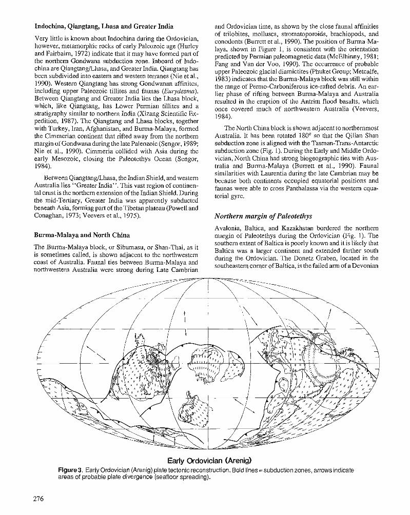
Indochina, Qiangtang, Lhasa and Greater India and Ordovician time, as shown by the close faunal affinities
Very little is known about Indochina during the Ordovician, however, metamorphic rocks of early Paleozoic age (Hurley and Fairbairn, 1972) indicate that it may have formed part of the northern Gondwana subduction zone. Inboard of Indo- china are QiangtangJLhasa, and Greater India. Qiangtang has been subdivided into eastern and western terranes (Nie et al., 1990). Western Qiangtang has strong Gondwanan affinites, including upper Paleozoic tillites and faunas (Eurydesma). Between Qiangtang and Greater India lies the Lhasa block, which, like Qiangtang, has Lower Permian tillites and a stratigraphy similar to northern India (Xizang Scientific Ex- pedition, 1987). The Qiangtang and Lhasa blocks, together with Turkey, Iran, Afghanistan, and Burma-Malaya, formed the Cimmerian continent that rifted away from the northern margin of Gondwana during the late Paleozoic (Sengor, 1989; Nie et al., 1990). Cimmeria collided with Asia during the early Mesozoic, closing the Paleotethys Ocean (Sengor, 1984).
of trilobites, molluscs, stromatoporoids, brachiopods, and conodonts (Burrett et al., 1990). The position of Burma-Ma- laya, shown in Figure 1, is consistent with the orientation predicted by Permian paleomagnetic data (McElhinny, 1981; Fang and Van der Voo, 1990). The occurrence of probable upper Paleozoic glacial diamictites (Phuket Group; Metcalfe, 1983) indicates that the Burma-Malaya block was still within the range of Permo-Carboniferous ice-rafted debris. An ear- lier phase of rifting between Burma-Malaya and Australia resulted in the eruption of the Antrim flood basalts, which once covered much of northwestern Australia (Veevers, 1984).
The North China block is shown adjacent to northernmost Australia. It has been rotated 180' so that the Qilian Shan subduction zone is aligned with the Tasman-Trans-Antarctic subduction zone (Fig. 1). During the Early and Middle Ordo- vician, North China had strong biogeographic ties with Aus- tralia and Burma-Malaya (Burrett et al., 1990). Faunal similarities with Laurentia during the late Cambrian may be
Between Qimgtanahasa* the Indian because both continents occupied equatorial positions and Australia lies "Greater India". This vast region of continen- faunas were able to cross Panthalassa via the equa- tal crust is the northern extension of the Indian Shield. During torial gyre. the mid-Tertiary, Greater India was apparently subducted beneath Asia, forming part of the Tibetan plateau (Powell and Conaghan, 1973; Veevers et al., 1975). Northern margin of Paleotethys
Burma-Malaya and North China Avalonia, Baltica, and Kazakhstan bordered the northern margin of Paleotethys during the Ordovician (Fig. 1). The southern extent of Baltica is poorly known and it is likely that
The Buma-Mala~a Or Sibumasu, Or Shm-Thai, as it Baltica was a larger continent and extended fanher south is sometimes called, is shown adjacent to the northwestern during Ordovician. The Donetz Graben, located in the coast of Australia. Faunal ties between Burma-Malaya and corner of Baltica, is the failed arm of a Devonian northwestern Australia were strong during Late Cambrian
Early Ordovician (Arenig) Figure 3. Early Ordovician (Arenig) plate tectonic reconstruction. Bold lines =subduction zones, arrows indicate areas of probable plate divergence (seafloor spreading).
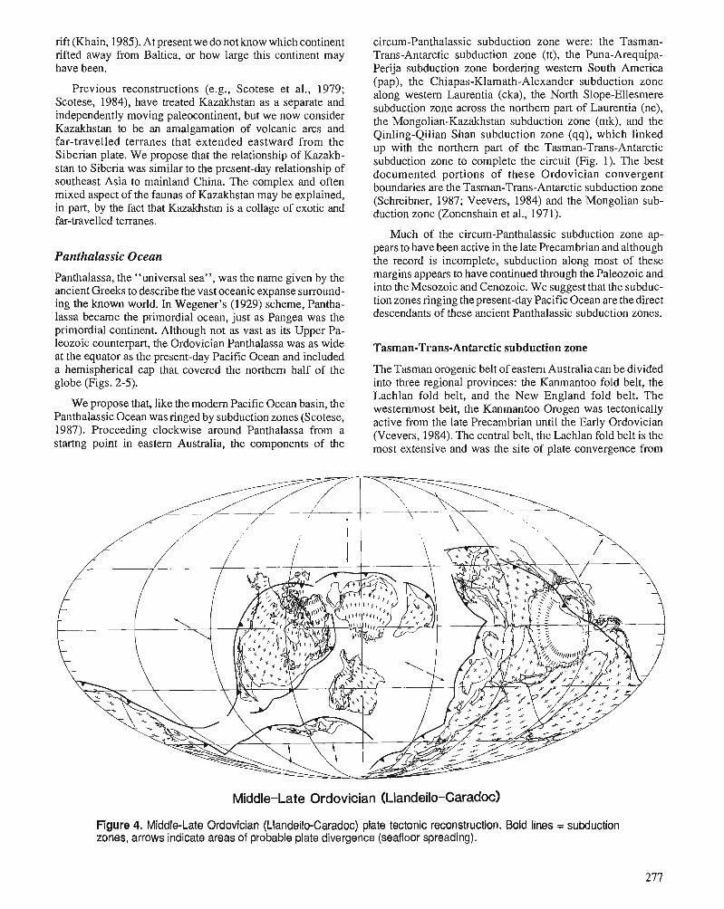
rift (Khain, 1985). At present we do not know which continent circum-Panthalassic subduction zone were: the Tasman- rifted away from Baltica, or how large this continent may Trans-Antarctic subduction zone (tt), the Puna-Arequipa- have been. Peri-ja subduction zone bordering westem South America
Previous reconstructions (e.g., Scotese et al., 1979; Scotese, 1984), have treated Kazakhstan as a separate and independently moving paleocontinent, but we now consider Kazakhstan to be an amalgamation of volcanic arcs and far-travelled terranes that extended eastward from the Siberian plate. We propose that the relationship of Kazakh- stan to Siberia was similar to the present-day relationship of southeast Asia to mainland China. The complex and often mixed aspect of the faunas of Kazakhstan may be explained, in part, by the fact that Kazakhstan is a collage of exotic and far-travelled terranes.
Panthalassic Ocean
Panthalassa, the "universal sea", was the name given by the ancient Greeks to describe the vast oceanic expanse surround- ing the known world. In Wegener's (1929) scheme, Pantha- lassa became the primordial ocean, just as Pangea was the primordial continent. Although not as vast as its Upper Pa- leozoic counterpart, the Ordovician Panthalassa was as wide at the equator as the present-day Pacific Ocean and included a hemispherical cap that. covered the northern half of the globe (Figs. 2-5).
We propose that, like the modem Pacific Ocean basin, the Panthalassic Ocean was ringed by subduction zones (Scotese, 1987). Proceeding clockwise around Panthalassa from a startng point in eastern Australia, the components of the
(pap), the chiapas- la math-~lexander subduction zone along western Laurentia (cka), the North Slope-Ellesmere subduction zone across the northern part of Laurentia (ne), the Mongolian-Kazakhstan subduction zone (mk), and the Qinling-Qilian Shan subduction zone (qq), which linked up with the northern part of the Tasman-Trans-Antarctic subduction zone to complete the circuit (Fig. 1). The best documented portions of these Ordovician convergent boundaries are the Tasman-Trans-Antarctic subduction zone (Schreibner, 1987; Veevers, 1984) and the Mongolian sub- duction zone (Zonenshain et al., 197 1).
Much of the circum-Panthalassic subduction zone ap- pears to have been active in the late Precambrian and although the record is incomplete, subduction along most of these margins appears to have continued through the Paleozoic and into the Mesozoic and Cenozoic. We suggest that the subduc- tion zones ringing the present-day Pacific Ocean are the direct descendants of these ancient Panthalassic subduction zones.
Tasman-Trans-Antarctic subduction zone
The Tasman orogenic belt of eastern Australia can be divided into three regional provinces: the Kanmantoo fold belt, the Lachlan fold belt, and the New England fold belt. The westernmost belt, the Kanmantoo Orogen was tectonically active from the late Precambrian until the Early Ordovician (Veevers, 1984). The central belt, the Lachlan fold belt is the most extensive and was the site of plate convergence from
Middle-Late Ordovician (~landeilo-~aradoc)
Figure 4. Middle-Late Ordovician (Llandeilo-Caradoc) plate tectonic reconstruction. Bold lines = subduction zones, arrows indicate areas of probable plate divergence (seafloor spreading).
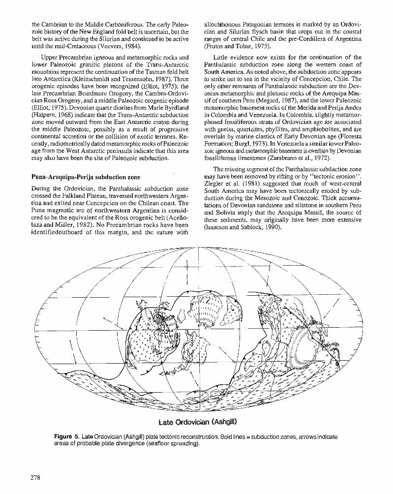
the Cambrian to the Middle Carboniferous. The early Paleo- allochthonous Patagonian terranes is marked by an Ordovi- zoic history of the New England fold belt is uncertain, but the cian and Silurian flysch basin that crops out in the coastal belt was active during the Silurian and continued to be active ranges of central Chile and the pre-Cordillera of Argentina until the mid-Cretaceous (Veevers, 1984). (Frutos and Tobar, 1975).
Upper Precambrian igneous and metamorphic rocks and lower Paleozoic granitic plutons of the Trans-Antarctic mountains represent the continuation of the Tasman fold belt into Antarctica (Kleinschmidt and Tessensohn, 1987). Three orogenic episodes have been recognized (Elliot, 1975): the late Precambrian Beardmore Orogeny, the Cambro-Ordovi- cian Ross Orogeny, and a middle Paleozoic orogenic episode (Elliot, 1975). Devonian quartz diorites from Marie Byrdland (Halpern, 1968) indicate that the Trans-Antarctic subduction zone moved outward from the East Antarctic craton during the middle Paleozoic, possibly as a result of progressive continental accretion or the collision of exotic terranes. Re- cently, radiometrically dated metamorphic rocks of Paleozoic age from the West Antarctic peninsula indicate that this area may also have been the site of Paleozoic subduction.
Puna-Arequipa-Perija subduction zone
During the Ordovician, the Panthalassic subduction zone crossed the Falkland Plateau, traversed northwestern Argen- tina and exited near Concepcion on the Chilean coast. The Puna magmatic arc of northwestern Argentina is consid- ered to be the equivalent of the Ross orogenic belt (Acefio- laza and Miller, 1982). No Precambrian rocks have been identifiedoutboard of this margin, and the suture with
Little evidence now exists for the continuation of the Panthalassic subduction zone along the western coast of South America. As noted above, the subduction zone appears to strike out to sea in the vicinity of Concepcion, Chile. The only other remnants of Panthalassic subduction are the Dev- onian metamorphic and plutonic rocks of the Arequipa Mas- sif of southern Peru (Megard, 1987), and the lower Paleozoic metamorphic basement rocks of the Merida and Perija Andes in Colombia and Venezuela. In Colombia, slightly metamor- phosed fossiliferous strata of Ordovician age are associated with gneiss, quartzites, phyllites, and amphiobolites, and are overlain by marine clastics of Early Devonian age (Floresta Formation; Burgl, 1973). In Venezuela a similar lower Paleo- zoic igneous and metamorphic basement is overlain by Devonian fossiliferous limestones (Zambrano et al., 1972).
The missing segment of the Panthalassic subduction zone may have been removed by rifting or by "tectonic erosion". Ziegler et al. (1981) suggested that much of west-central South America may have been tectonically eroded by sub- duction during the Mesozoic and Cenozoic. Thick accumu- lations of Devonian sandstone and siltstone in southern Peru and Bolivia imply that the Arequipa Massif, the source of these sediments, may originally have been more extensive (Isaacson and Sablock, 1990).
Late Ordovician (Ashgill)
Figure 5. Late Ordovician (Ashgill) plate tectonic reconstruction. Bold lines = subduction zones, arrows indicate areas of probable plate divergence (seafloor spreading).
Chiapas-Klamath-Alexander subduction zone
The continuation of the Panthalassic subduction zone along the western margin of Laurentia is recorded in the lower Paleozoic metamorphic terranes of northwestern Honduras, southwestern Mexico, as well as in the lower Paleozoic metamorphic, volcanic, and plutonic complexes of the Kla- math mountains and Alexander Terrane of southwestern Alaska. Upper Precambrian and lower Paleozoic metamor- phics and metavolcanics, including a high pressure, low temperature phase that has been dated as Early Ordovician (de Cserna, 1989), have been reported from Chiapas and the Acatlan Terrane (Sierra Madre del Sur) of southwestern Mexico (Ortega-Gutierrez, 1982). Subduction in this area con- tinued through the middle and late Paleozoic (de Cserna, 1989).
The lower Paleozoic volcanic arc of the Klamath moun- tains in northern California represents the northward continu- ation of the Panthalassic subduction zone. Ordovician tonalitic and pegmatitic trondjemites from the Trinity ophiolite (Wallin et al., 1988), and associated Upper Ordovi- cian calc-alkaline basalts with strong island arc affinites (Lovers Leap Butte volcanics, Brouxel et al., 1988) indicate that subduction along the western margin of Laurentia ex- tended back into the early Paleozoic. This interpretation assumes that the Klamath volcanic arc is not a far-travelled terrane (Schweikert and Snyder, 1981), but rather originated in a back-arc setting (Burchfiel and Davis, 1972,1975; Gray, 1986). Although arguments have been made for both inter- pretations, paleomagnetic data (Fagin and Gose, 1983) and mixed Tethyan and North American biogeographic affinities (Miller and Wright, 1987) suggest proximity to Laurentia. Although adjacent to North America, the Klamath volcanic arc was far offshore and did not influence foreland-platform sedimentation.
The volcanic arc that fringed Laurentia during the Ordo- vician continued northward in the Alexander terrane of Brit- ish Columbia and southeastern Alaska. In these areas, Cambrian and Middle Ordovician metamorphic rocks, together with Ordovician and Silurian turbidites, calc-alka- line intrusives, and minor volcanics (Descon Formation) form the basis of the arc (Gehrels and Saleeby, 1987a). As in the case of the Klamath volcanic arc, it has been proposed that the Alexander Terrane is allochthonous and possibly far- travelled (Gehrels and Saleeby, 1987b). We find no compelling evidence for an exotic origin of the arc and agree with earlier authors (Churkin, 1974) who place the Alexander arc near the Laurentian margin.
North Slope-Ellesmere subduction zone
In the reconstruction of Laurentia presented here, the North Slope block of Alaska has been refitted against the Canadian Arctic Islands by a rotation about a pivot-point near the Mackenzie Delta (for a review see Lawver and Scotese, 1990). As illustrated in Figure 1, the Panthalassic subduction zone swung eastward across the North Slope, the eastern portion of the Canadian Arctic Islands (Ellesmere Island), and northern Greenland. The Precambrian(?) and lower Pa- leozoic metasedimentary and metavolcanic rocks of the
Skajit allochthon of the Central Brooks Range (North Slope block) represent an island arc that fringed this subduction zone. Further evidence of island arc activity is seen in north- western Ellesmere Island and Axel Heiberg Island where upper Precambrian through Silurian volcanics and flysch comprisethecomplexly deformedPearyaisland arc (Trettin, 1989). Included in this sequence are a Lower Ordovician ophiolite(Thoressuite)andamphibolite-grademetamorphic, which give Middle-Late Ordovician ages (452 Ma; Trettin, 1989). The deep water, lower Paleozoic sedimentary basin in northern Greenland represents a foredeep behind this vol- canic arc.
Mongolian-Kazakhstan subduction zone
Numerous lower and middle Paleozoic calc-alkaline volcan- ics, metamorphics, and obducted ophiolites make the Mon- golian-Kazakhstan subduction zone one of the best documented Paleozoic convergent plate boundaries (Zonen- shain et al., 1971; Zonenshain, 1973). Built on pre-Riphean metamorphic basement (>I 100 Ma), the Mongolian-Kazakh- stan island arc was active from the late Precambrian (Mos- sakovsky and Dergunov, 1985) to the Permian, when subduction was terminated by the collision of the Tarim and North China blocks (Nie et al., 1990).
The original geometry of the arcs and subduction zones was certainly more complex than shown in Figures 2-5. Multiple ophiolite sequences (Zonenshain, 1973) indicate a succession of back-arc basin formation and collapse. Also, as proposed by several authors (Zonenshain et al., 1985; Rowley et al., 1985; Nie et al., 1990), an eastern extension of the Mongolian arc (Amuria, Zonenshain et al., 1985) was sepa- rated from mainland Siberia by a small ocean basin that did not close until the Late Jurassic.
As discussed earlier, Kazakhstan is an agglomeration of island arcs and exotic terranes. Although part of a separate subduction system, we believe that the island arcs of Kazakhstan were closely linked to the Mongolian subduction zone. As in Siberia, subduction continued throughout the Paleozoic, terminating in the Permian with the closure of the lrtysch Seaway between Kazakhstan and Siberia, and the sutur- ing of Tarim (Tian Shan suture) and Baltica (Uralian suture).
Qinling-Qilian Shan subduction zone
Our tour of the Panthalassic subduction zone is complete as we return to Gondwana and connect the Mongolian subduc- tion zone with the Qinling-Qilian Shan subduction zone of North China. The Qinling suture is the boundary between North China and South China (Nie et al., 1990). It is presumed to have been the site of subduction during the Paleozoic and the locus of continental collision during the Late Triassic Indosinian Orogeny (Sengor, 1984). The Qilian Mountains, located between the Ordos Basin and the Tarim block, are the westward continuation of the Qinling mobile belt. This inte- rior mountain range consists of a series of upper Precambrian- lower Paleozoic island arcs, which collided against an Andean-style margin (Yang et al., 1986). The lower Paleo- zoic section includes over 10,000 metres of deep water
clastics, siliceous and carbonaceous rocks, and volcanics. The peak of magmatic activity occurred during the Ordovi- cian, with abundant intermediate and intermediate-basic vol- canic~ (Yang et al., 1986), which were metamorphosed to greenschist facies during the middle and late Paleozoic.
In its present-day location the Qinling-Qilian Shan sub- duction zone appears anomalous; however, in the reconstruc- tion presented here (Fig. I), it forms a plausible continuation of the Tasman subduction zone. In this reconstruction (after Burrett et al., 1990), North China is shown rotated 180" and placed against the northern margin of Australia. This aligns the Qilian Shan subduction zone with the New England fold belt of eastern Australia.
CONCLUSIONS From the plate boundaries described in Figures 2-4, it can be inferred that there were six to eight major plates during the Ordovician that were roughly comparable in size to modern plates. The rates of plate motion, based on the trajectory of the continents, were also similar to modem rates of plate motion. Based on the scenario presented here, Laurentia was the fastest moving continent, travelling eastward at rates of 15 cm/y during the Early and Middle Ordovician. Rates in excess of 10 cm/y are indicative of plates that are connected to a large subducting slab, like the modem Pacific Plate (Forsyth and Uyeda, 1975) or the Indian Plate during the Late Cretaceous and Early Tertiary (Scotese et al., 1988). In the case of Laurentia, the southern and eastern portions of the plate were subducted beneath the Avalonian arc and the Bronson Hill-Tetagouche-Lush's Bight arc (Figs. 2,3). After collision with the Bronson Hill-Tetagouche-Lush's Bight arc and the ensuing reversal of subduction polarity (Figs. 4, 5). Laurentia's rate of motion abruptly slowed. Throughout the Ordovician, Baltica and Siberia moved northward at the moderate rate of 6 to 8 cm/y, while Gondwana moved south- ward over the South Pole at a similar pace.
Although preliminary, the Ordovician plate tectonic re- constructions presented here can be used as a framework for a better understanding of the paleobiogeography, paleoclima- tology, and paleoceanography of the Ordovician. Only through an interactive process of revision and refinement in the light of new geological, tectonic, paleontological, and paleomagnetic data will we be able to unveil the secrets of the early Paleozoic world. Although the clues are sparse and often subject to alternative interpretations, it should be re- membered that the same plate tectonic driving forces that produced the Mesozoic and Cenozoic ocean basins were also in operation during the Paleozoic. In this regard, the pattern of Paleozoic plate evolution, once it is understood, should be characterized by the same simplicity and elegance that charac- terizes Mesozoic and Cenozoic plate evolution.
ACKNOWLEDGMENTS The authors thank Shell Oil Co. for permission to publish this paper. The authors also benefited from discussions with J. Kirschvink and Nie Shang-you concerning the location of the Asian terranes in Gondwana. Large format copies of the
Ordovician reconstructions, both with and without plate boundaries, are available from C.R. Scotese upon request. The Ordovician reconstructions presented here are the pre- liminary results of the PALEOMAP Phanerozoic Atlas Pro- ject, Task Group 9, International Lithosphere Program, which is sponsored jointly by the IUGGDUGS.
REFERENCES Aceiiolaza, F.G. and Miller, H. 1982: Early Paleozoic orogeny in southern South America. Precambrian
Research, v. 17, p. 133-146. Bachtadse, V. and Briden, J.C. 1990: Palaeomagnetic constraints on the position of Gondwana during the
Ordovician to Devonian times. In Palaeozoic Biogeography and Paleogeography, W.S. McKerrow and C.R. Scotese (eds.); Geologi- cal Society of London Memoir, no. 12, p. 43-48.
Berberian, M. and King, G.C.P. 1981: Towards a paleogeography and tectonic evolution of Iran. Canadian
Journal of Earth Sciences, v. 18, p. 210-265. Bond, G.C., Nickeson, P.A., and Kominz, M.A. 1984: Breakup of a supercontinent between 625 and 555 Ma: new evi-
dence and implications for continental histories. Earth and Planetary Science Letters, v. 70, p. 325-345.
Brouxel, M., Lapierre, H., Michard, A,, and Albarede, F. 1988: Geochemical study of an early Paleozoic island-arc-back-arc basin
system. Part 2: Eastern Klamath, early to middle Paleozoic island- arc volcanic rocks (northern California). Geological Society of America, Bulletin, no. 100, p. 1120-1 130.
Burchfiel, B.C. and Davis, G.A. 1972: Structural framework for the evolution of the southern part of the
Cordilleran orogen in the United States. American Journal of Sci- ence, v. 272, p. 97-1 18.
1975: Nature and controls of Cordilleran orogenesis, western United States - extensions of an earlier synthesis. American Journal of Science, v. 275A. p. 363-396.
Burgl, H. 1973: Precambrian to Middle Cretaceous Stratigraphy of Colombia. Char-
les G. Allen, Bogota, 215 p. Burrett, C., Long, J., and Stait, B. 1990: Early-Middle Paleozoic biogeography of Asia terranes derived from
Gondwana. In Palaeozoic Biogeography and Paleogeography, W.S. McKerrow and C.R. Scotese (eds.); Geological Society of London, Memoir, no. 12, p. 163-174.
Chang, W.T. 1981: On the northward drift of the Afro-Arabian and Indian plates.
Proceedings of the Royal Society of Victoria, v. 92, p. 181-185. Churkin, M.C., Jr. 1974: Paleozoic marginal ocean basin volcanic arc systems in the Cordil-
leran foldbelt. In Modem and Ancient Geosynclinal Sedimentation, R.H. Dott, Jr. and R.H. Shaver (eds.); Society of Economic Paleon- tologists and Mineralogists, Special Publication no. 19, p. 174-192.
Cocks, L.R.M. and Fortey, R.A. 1982: Faunal evidence for oceanic separations in the Palaeozoic of Britain.
Journal of the Geological Society of London, v. 139, p. 465-478. Cowie, J.W. and Brasier, M.D. (eds.) 1989: The Precambrian-Cambrian Boundary. Clarendon Press. Oxford,
213 p. de Cserna, Z. 1989: An outline of the geology of Mexico. In The Geology of North
America: An Overview, Decade of North American Geology, The Geology of North America, volume A, A.W. Bally and A.R. Palmer (eds.); p. 233-264.
Dewey, J.F., Pitman 111, W.C., Ryan, W.B.F., and Bonnin, J. 1973: Plate tectonics and the evolution of the Alpine system. Geological
Society of America Bulletin, no. 84, p. 3 137-3 180. Elliot, D.H. 1975: Tectonics of Antarctica: a review. American Journal of Science,
v. 275A, p. 45- 106. Fagin, S.W. and Gose, W.A. 1983: Paleomagnetic data from the Redding section of the eastern Kla-
math belt, northern California. Geology, v. 11, p. 505-508.
Fang, W. and Van der Voo, R. 1990: Devonian paleomagnetism of Yunnan province across the Shan
Thai-South China suture. Tectonics (in press). Forsyth, D. and Uyeda, S. 1975: On the relative importance of the driving forces of plate motion.
Geophysical Journal of the Royal Astronomical Society, v. 43, p. 163-189.
Fortey, R.A. and Cocks, L.R.M. 1986: Marginal faunal belts and their structural implications, with exam-
ples from the Lower Paleozoic. Journal of the Geological Society of London, v. 143, p. 151-160.
Fortey, R.A. and Morris, S.F. 1982: The Ordovician trilobite Neseurelus from Saudi Arabia, and the
palaeogeography of the Neseuretus fauna related to Gondwanaland in the earlier Ordovician. Bulletin of the British Museum (Natural History), Geology, v. 36, p. 63-75.
Frutos, J. and Tobar, A. 1975: Evolution of the southwestern margin of South America. In Gond-
wana Geology: Papers Presented at the Third Gondwana Sympo- sium, Canberra, Australia, 1973, K.S.W. Campbell (ed.); Australian National University Press, Canberra, p. 565-578.
Cealey, W.K. 1988: Plate tectonic evolution of the Mediterranean-Middle East region.
Tectonophysics, v. 155, p. 285-306. Gehrels, G.E. and Saleeby, J.B. 1987a: Geologic framework, tectonic evolution, and displacement history
of the Alexander terrane. Tectonics, v. 6, p. 151-173. 1987b: Geology of South Prince of Wales Island, southeastern Alaska.
Geological Society of America Bulletin, no. 98, p. 123-137. Gray, C. 1986: Native terranes of the central Klamath mountains. Tectonics, v. 5,
p. 1043-1054. P -
Halpern, M. 1968: Ages of Antarctic and Argentine rocks bearing on continental drift.
Earth and Planetary Science Letters, v. 5, p. 159-167. Hurley, P.M. and Fairbairn, H.W. 1972: Rb-Sr ages in Vietnam: 530 m.y. event. Geological Society of
America Bulletin, no. 83, p. 3525-3528. Isaacson, P.E. and Sablock, P.E. 1990: Devonian palaeogeography and palaeobiogeography of the central
Andes. In Palaeozoic Biogeography and Paleogeography, W.S. McKerrow and C.R. Scotese (eds.); Geological Society of London Memoir, no. 12, p. 429-433.
Johnson, RJ-E., van der Pluijm, B.A., and Van der Voo, R. 1988: Paleoreconstruction of the Early Ordovician terranes in the Central
Mobile Belt of the Newfoundland Appalachians (abstract). Geo- logical Society of America Abstracts with Programs, v. 20, p. A63.
Kanasewich, E.R., Havskov, J., and Evans, M.E. 1978: Plate tectonics in the Phanerozoic. Canadian Journal of Earth Sci-
ences, v. 15, p. 919-955. Kent, D.V. and Van der Voo, R. 1990: Palaeozoic palaeogeography from palaeomagnetism of the Atlan-
tic-bordering continents. In Palaeozoic Biogeography and Paleo- geography, W.S. McKerrow and C.R. scotise<eds.j; Geological Society of London Memoir, no. 12, p. 49-56.
Keppie, J.D. 1977: Plate tectonic interpretation of Palaeozoic world maps (withempha-
sis on circum-Atlantic orogens and southern Nova Scotia). Nova Scotia Department of Mines, Paper 77-3,45 p.
Khain, V.E. 1985: Geology of the U.S.S.R. Gebruder-Borntraeger, Berlin, 272 p. Khramov, A.N., Petrova, C.N., and Pechersky, D.M. 1981: Paleomagnetism of the Soviet Union. In Paleoreconstruction of the
Continents, M.W. McElhinny and D.A. Valencio (eds.); American Geophysical Union, Geodynamics series, v. 2, p. 177-194.
Khramov, A.N. and Rodionov, V.P. 1980: Paleomagnetism and reconstruction of paleogeographic positions of
the Siberian and Russian plates during the Late Proterozoic and Palaeozoic. Journal of Geomagnetics and Geoelectricity, v. 32, Supplement In, p. SIII 23-37.
Kirschvink. .l.L. 1990: chapter XIII: A paleogeographic model for Vendian and Cambrian
time. In The Proterozoic Biosphere: A Multidisciplinary Study, J.W. Schopf, C. Klein, and D. ~ e s Maris (eds.); (in press):
Kleinschmidt, G. and Tessensohn, F. 1987: Early Paleozoic westward directed subduction at the Pacific margin
of Antarctica. In Gondwana Six: Structure, Tectonics, and Geophys- ics, G. McKenzie (ed.); Geophysical Monograph 40, p. 89-105, American Geophysical Union, Washington, D.C.
Kokelaar, B.P., Howells, M.F., Bevins, R.E., Roach, R.A., and Dunkey, P.R. 1984: The Ordovician marginal basin of Wales. In Marginal Basin Geol-
ogy, B.P. Kokelaar and M.F. Howells (eds.); Geological Society of London, Special Publication no. 16, p. 245-269.
Lawer , L.A. and Scotese, C.R. 1990: Review of tectonic models for the evolution of the Canada Basin.
In The Arctic Region, Decade of North American Geology, volume M, A. Grantz, J.F. Sweeney, and G.L. Johnson (eds.); (in press).
Lin, J.L., Fuller, M., and Zhang, W.Y. 1985a: Paleogeography of the North and South China blocks during the
Cambrian. Journal of Geodynamics, v. 2, p. 91-1 14. 1985b: Preliminary Phanerozoic polar wander paths for the Nonh and
South China blocks. Nature, v. 313, p. 444-449. McElhinny, M.W., Ma, X., and Zhang, Z.K. 198 1: Fragmentationof Asiaduring the Permian. Nature, v. 293, p. 212-216. McKerrow, W.S. and Cocks, L.R.M. 1986: Oceans, island arcs and olistostromes: the use of fossils in distin-
guishing sutures, terranes and environments around the Iapetus Ocean. Journal of the Geological Society of London, v. 143, p. 185-191.
McKerrow, W.S., Dewey, J.P., and Scotese, C.R. 1990: The Ordovician and Silurian development of the Iapetus Ocean. In
The Murchison Symposium, M.G. Bassett, P.D. Lane, and D. Edwards (eds.); Special Papers in Palaeontology, v. 42 (in press).
McKerrow, W.S. and Scotese, C.R. 1990: Palaeozoic Biogeography and Paleogeography, Geological Society
of London Memoir, no. 12,433 p. Megard, F. 1987: Structure and evolution of the Peruvian Andes. In The Anatomy of
Mountain Ranges, J.-P. Schafer and J. Rodgers (eds.); Princeton University Press, Princeton, New Jersey, p. 182-192.
Metcalfe, I. 1983: South East Asia. In The Carboniferous of the World, C. Martinez
Diaz (ed.); IUGS Publication no. 16, Institute Geologico y Minero de Espana, p. 213-238.
Miller, M.M. and Wright, J.E. 1987: Paleogeopphic implications of Permian Tethyan corals from the
Klamath Mountains, California. Geology, v. 15, p. 266-269. Moczydlowska, M. and Vidal, C. 1988: How old is the Tommotian? Geology, v. 16, p. 166-168. Mossakovsky, A.A. and Degunov, A.B. 1985: The Caledonides of Kazakhstan, Siberia and Mongolia: a review of
structure, development history and paleotectonic environments. In The Caledonide Orogen - Scandinavia and Related Areas, D.G. Gee and B.A. Sturt (eds.); Wiley, Chichester, p. 1201-1205.
Neuman, R.B. 1984: Geology and paleobiology of islands in the Ordovician Iapetus
Ocean: review and implications. Geological Society of America, Bulletin, v. 95, p. 1188-1201.
Nie, S., Rowley, D.B., and Ziegler, A.M. 1990: Constraints on the location of the Asian microcontinents in the
Palaeo-Tethys during the Late Paleozoic. 111 Palaeozoic Biogeogra- phy and Paleogeography, W.S. McKerrow and C.R. Scotese (eds.); Geological Society of London Memoir, no. 12, p. 397-408.
Notholt, A.J.G. and Sheldon, R.P. 1986: Proterozoic and Cambrian phosphorites - regional view: world
resources. In Phosphate Deposits of the World, volume 1, P.J. Cook and J.H. Shergold (4s.); Cambridge University Press, Cambridge, p. 9- 19.
Opdyke, N.D., Huang, K., Xu, C., Zhang, W.Y., and Kent, D.V. 1987: Paleomagnetic results from the Silurian of the Yangtze paraplat-
form. Tectonophysics, v. 139, p. 123-132. Ortega-Gutierrez, F. 1981: Metamorphic belts of southern Mexico and their significance.
Geofisica International (Mexico), v. 20, p. 177-202. Parrish, J.T., Ziegler, A.M., Scotese, C.R., Humphreville, R.G., and Kirschvink, J.L. 1986: Proterozoic and Cambrian phosphorites - specialist studies: Early
Cambrian palaeogeography, palaeoceanography, and phosphorites. In Phosphate Deposits of the World, volume 1, P.J. Cook and J.H. Shergold (eds.); Cambridge University Press, Cambridge, p. 280-294.
Perroud, H. 1983: Palaeomagnetism of Palaeozoic rocks fiom the Cabo de Penas,
Asturia, Spain. Geophysical Journal of the Royal Astronomical Society, v. 75, p. 201-215.
Perroud, H. and Van der Voo, R. 1985: Paleomagnetism of the late Ordovician Thouars massif, Vendee
province, France. Journal of Geophysical Research, v. 90, p. 461 1- 4625.
Perroud, H., Van der Voo, R.,'and Bonhommet, N. 1984: Paleozoic evolution of the Armorica plate on the basis of paleomag-
netic data. Geology, v. 12, p. 579-582. Piper, J.D.A. 1683:' Proterozoic paleomagnetism and single continent plate tectonics.
Geo~hvsical Journal of the Royal Astronomical Societv. v. 74, . . no. i, p. 163-197.
1987: Paleomagnetism and the Continental Crust. J. Wiley and Sons, New York, 434 p.
Powell, C.McA. and Conaghan, P.J. 1973: Plate tectonics and the Himalayas. Earth and Planetary Science
Letters, v. 20, p. 1-12. Rowley, D.B., Raymond, A., Parrish, J.T., Lottes, A.L., Scotese, C.R., and Ziegler, A.M. 1985: Carboniferous paleogeographic, phytogeographic, and paleocli-
matic reconstructions. International Journal of Coal Geology, v. 51, p. 123-134.
Scheibner, E. 1987: Paleozoic tectonic development of eastern Australia in relation to
the Pacific region. In Circum-Pacific Orogenic Belts and Evolution of the Pacific Ocean Basin, J. Monger and J. Francheteau (eds.); America Geophysical Union, Geodynamics series, v. 18, p. 133-165.
Schenk, P.E. 1972: Possible Late Ordovician glaciation in Nova Scotia. Canadian Jour-
nal of Earth Sciences, v. 9, p. 95-107. Schwieckert, R.A. and Snyder, W.S. 1981: Paleozoic plate tectonics of the Sierra Nevada and adjacent regions.
In Geotectonic Development of California, W.G. Ernst (ed.); Pren- tice-Hall, New Jersey, p. 182-202.
Scotese, C.R. 1984: An introduction to this volume: Paleozoic paleomagnetisrn and the
assembly of Pangea. In Plate Reconstruction from Paleozoic Paleo- magnetism, R. Van der Voo, C.R. Scotese, and N. Bonhommet (eds.); American Geophysical Union, Geodynamics series, v. 12, p. 1-10.
1987: Development of the circum-Pacific Panthallassic Ocean during the Early Paleozoic. In Circum-Pacific Orogenic Belts and Evolution of the Pacific Ocean Basin, J. Monger and J. Francheteau (eds.); American Geophysical Union, Geodynamics series, v. 18, p. 49-57.
Scotese, C.R., Bambach, R.K., Barton, C., Van der Voo, R., and Ziegler, A.M. 1979: Paleozoic base maps. Journal of Geology, v. 87, p. 217-277. Scotese, C.R. and Barrett, S.F. 1990: Gondwana's movement over the South Pole during the Paleozoic:
evidence from lithologic indicators of climate. In Palaeozoic Bio- geography and Paleogeography, W.S. McKerrow and C.R. Scotese (eds.); Geological Society of London Memoir, no. 12, p. 75-85.
Scotese, C.R., Gahagan, L.M., and Larson, R.L. 1988: Plate tectonic reconstructions of the Cretaceous and Cenozoic ocean
basins. Tectonophysics, v. 155, p. 27-48. Scotese, C.R. and McKerrow, W.S. 1990: Palaeozoic palaeogeography and biogeography: an introduction to
this volume. In Palaeozoic Biogeography and Paleogwgraphy, W.S. McKerrow and C.R. Scotese (eds.); Geological Society of London Memoir, no. 12, p. 1-24.
Sengor, A.M.C. 1984: The Cimmeride orogenic system and the tectonics of Eurasia.
Geological Society of America, Special Paper, no. 195, 82 p. 1987: Tectonics of the Tethysides: orogenic collage development in a
collisional setting. Annual Review of Earth and Planetary Science, V. 15, p. 213-244.
1989: The Tethyside orogenic system: an introduction. In Tectonic Evo- lution of the Tethyan Region, A.M.C. Sengor (ed.); Kluwer Aca- demic Publishers, p. 1-22.
Sengor, A.M.C. and Yilmaz, Y. 1981: Tethyan evolution of Turkey: a plate tectonic approach. Tectono-
physics, v. 75, p. 181-241.
Seslavinsky, K.B. 1984: Paleotectonic analysis of global Paleozoic maps. Geotectonics,
v. 18, p. 294-309. Seuss, E. 1893: Are the great ocean depths permanent? Natural Sciences, v, 2,
p. 180-187. Torsvik, T.H., Smethurst, M.A., and Briden, J.C. 1989: A review of Palaeozoic palaeomagnetic data from Europe and their
palaeogeographical implications. In Palaeozoic Biogeography and Paleogeography. W.S. McKerrow andC.R. Scotese (eds.); Geologi- cal Society of London Memoir, no. 12, p. 25-41.
Trettin, H.P. 1989: The Arctic Islands. In The Geology of North America: An Over-
view, Decade of North American Geology, The Geology of North America, volume A, A.W. Bally and A.R. Palmer (eds.); p. 349-379.
Van der Voo, R. 1988: Paleozoic paleogeography of North America, Gondwana, and the
intervening displaced tenanes: comparisons of paleomagnetisrn with paleoclimatology and biogeographical patterns. Geological Society of America, Bulletin, no. 100, p. 31 1-324.
Van der Voo, R., McCabe, C., and Scotese, C.R. 1984: Was Laurentia part of an Eocambrian supercontinent? In Plate
Reconshuction from Paleozoic Paleomagnetism, R. Van der Voo, C.R. Scotese, and N. Bonhommet (eds.); American Geophysical Union, Geodynamics series, v. 12, p. 131-136.
Veevers, J.J. 1984: Phanerozoic Earth History of Aush;llia Clarendon Press, Oxford, 41 8 p. Veevers, J.J., Powell, C.McA., and Johnson, B.D. 1975: Greater India's place in Gondwanaland and in Asia. Earth and
Planetary Science Letters, v. 27, p. 383-387. Wallin, E.T., Mattinson, J.M., and Potter, A.W. 1988: Early Paleozoic magmaticevents in theeastem Klamath Mountains,
northern California. Geology, v. 16, p. 144-148. Wang, Hongzhen (ed.) 1985: Atlas of the Paleogeography of China. Beijing, 143 p. Wegener, A. 1929: The Origin of the Continents and Oceans. John Biram (trans.),
Dover, New York (1966 reprint). Wensink, H. 1983: Paleomagnetism of red beds of Early Devonian age from Central
Iran. Earth and Planetary Science Letters, v. 63, p. 325-334. Williams, H. and Hiscott, R.N. 1987: Definition of the Iapetus rift-drift transition in western Newfound-
land. Geology, v. 15, p. 1044-1047. Xizang (Tibet) Scientific Expedition, Chinese Academy of Sciences. 1987: Stratigraphy of the Qomolangma Region. Science Press, Beijing,
225 p. Yang, Z., Cheng, Y., and Wang, H. 1986: The Geology of China. Oxford Monographs on Geology and Geo-
physics, no. 3, Clarendon Press, Oxford, 303 p. Zambrano, E., Vasquez, E., Duval, B., Latreille, M., and Cofinieres,B 1972: Paleogeographic and Petroleum Synthesis of Western Venezuela.
Technip, Paris, 62 p. Zhuravlev, A.Y. 1986: Evolution of archaeocyaths and palaeobiogeography of the Early
Cambrian. Geological Magazine, v. 123, p. 377-385. Ziegler, A.M., Barrett, S.F., and Scotese, C.R. 1981: Paleoclimate, sedimentation and continental accretion. Philosophi-
cal Transactions of theRoyal Society of London, A 301, p. 253-264. Ziegler, P.A. 1988: Evolution of the Arctic-North Atlantic and Western Tethys. Ameri-
can Association of Petroleum Geologists Memoir, no. 43, 198 p. Zonenshain, L.P. 1973: The evolution of central Asiatic geosynclines through sea-floor
spreading. Tectonophysics, v. 19. p. 213-232. Zonenshain, L.P. and Gorodnitsky, A.M. 1977: Paleozoic and Mesozoic reconstructions of the continents and
oceans. Geotektonika, v. 2, p. 3-22. Zonenshain, L.P., Kuzmin, M.I., and Kononov, M.V. 1985: Absolute reconstructions of the Paleozoic oceans. Earth and Plane-
tary Science Letters, v. 74, p. 103-1 16. 1987: Absolute reconstructions of the position of the continents during the
Paleozoic and early Mesozoic time. Geotectonics, v. 21, p. 199-212. Zonenshain, L.P., Markova, N.G., and Nagibina, M.S. 1971: Relationship between the Paleozoic and Mesozoic structures of
Mongolia. Geotectonics, v. 4, p. 229-233.
Oceanography in the Ordovician
Wilde, P., Oceanography in the Ordovician; &I Advances in Ordovician Geology, C.R. Barnes and S.H. Williams (ed.), Geological Survey of Canada, Paper 90-9, p. 283-298,1991.
Abstract
The geographic position of major continental blocks in the Ordovician, determined primarily from lithofacies analysis and paleomagnetic studies, was the cause of a vastly different oceanic circulation pattern than that of today. The Ordovician was characterized by 1) a northern hemispheric ocean covering about one half of the Earth's surface; 2 ) a band of land and shallow shelfseas that occupied the tropics; and3) a major landmass and associated shallow shelfseas in the southern hemisphere.
The trends during the Ordovician were a) the reduction of land and shallow shelves in the equatorial region and b) the movement of the southern landmass toward the south pole, culminating in a south polar ice cap during the Late Ordovician. The lack of meridional barriers in the northern hemisphere produced only zonal (east-west) su$ace currents: an easterly flowing current in the north polar zone; a westerly flowing current in the north temperate zone; and an easterly jlowing current in the northern tropical regions.
The separation of the northern, or Boreal Ocean from the southern oceans (Iapetus and Proto-Tethys) by an equatorial barrier implies that the deep circulation of each ocean was independent. Only in the southern oceans with meridional barriers would the surface flow be similar in pattern to that of modern oceans. Trends toward an austral polar landmass, break-up of equatorial lands, and shallow shelf seas and generation of a polar ice cap during the Lute Ordovician permitted establishment of connections between the oceans in the two hemispheres as well as significant deep ventilation from the edges of the polar ice cap during the Late Ordovician glaciation.
Monsoonal reversals of the equatorial currents would have occurred in the southern hemisphere due to the presence of the Gondwanan landmass. Such reversals would shift water mass boundaries on a seasonal basis and might explain apparent mixtures of marine faunal provinces ("Pacific" = tropical; "Atlantic" = temperate-subpolar), especially on the Gondwanan shore or the northeastern side of the Proto-Tethys Ocean.
La position gkographique des principaux blocs continentaw de 170rdovicien, fonde'e principalement sur I'analyse des lithofacids et des e'tudes pale'omagne'tiques, s'est traduite par une configuration de la circulation oce'anique considkrablement diffe'rente de celle d'aujourd'hui. L'Ordovicien e'tait caractkrise' par : I ) un oce'an d'he'misphire nord couvrant a peu prks la moitie' de la surface de la Terre; 2 ) une bande de terre et des mers de plate-forme peu profondes situe'es sous les tropiques; 3 ) une importance masse continentale et des mers de plate-forme peu profondes dans l'hkmisphke sud. L'Ordovicien ktait caracte'rise'par les tendances suivantes : a) la re'duction des terres et des plates-formes peu profondes dans la rkgion tquatoriale; b) le dkplacement de la masse continentale mkridionale vers le p61e sud culminant en une culotte glaciaire polaire me'ridionale durant I'Ordovicien suptrieur. L'absence de barriires mkridionales dans l'he'misphire nord n'a produit que des courants de surface zonaux est-ouest : un courant d direction est dans la zone polaire nord; un courant de direction ouest dans la zone tempkrke nord; un courant de direction est dans les rkgions tropicales septentrionales. La skparation de l'ockan nordique ou bore'al des ockans mkridionaux (Iapetus et Proto-Tethys) par une harriire kquatoriale rkvdle une
' Marine Sciences Group, University of California, Berkeley, California 94720, U.S.A.
circulation profonde indkpendante dans chaque ockan. Ce n'est que duns les ockans mkridionaux comportant des barrikres mkridionales que l'kcoulement de surface ktait semblable h celui des ockans modernes. Les tendances h la formation dune masse continentale polaire australe, a la fragmentation des terres kquatoriales et des mers de plate-forme peuprofondes eta la formation dune culotte glaciaire polaire au cours de I'Ordovicien supkrieur ont permis d'e'tablir des liens entre les ockans des deux hkrnisphires ainsi qu'une ventilation profonde importante h partir desa bordures de la culotte glaciaire polaire au cours de la glaciation de llOrdovicien supe'rieur. Des inversions dues aux moussons dans les courants tquato- riaux de l'hkmisphire sud auraient kt6 cause'es par la pre'sence du continent Gondwana.
De telles inversions auraient eu pour effet de dkplacer les limites des masses d'eau selon les saisons et pourraient expliquer les mklanges apparents de provinces fauniques marines ("Pacifique" = tropical; "Atlantique" = temptrk-subpolaire), en particulier sur la rive du Gondwana ou le cBtt nord-est de la Proto-Tkthys.
INTRODUCTION This paper uses fundamental oceanographic circulation p~in- ciples to speculate on the major current patterns and water masses and their implications for the biogeography of the Ordovician Period as a function of paleogeographic recon- struction of the major continental blocks. This approach elaborates on the procedures used by Stehli (1965), Ross (1975), Berggren and Hollister, 1977, and Parrish (1982) and is an extension of our work on the development of paleo- oceanographic interpretative methods (Wilde and Berry, 1986).
The primary astrophysical assumptions are 1) the Earth was the same size and shape as it is today, 2) the Earth was rotating in the same direction (west to east), 3) the Earth was rotating at about the same angular velocity (one rotation = 24 hours), 4) the path of rotation was in the plane of the ecliptic (the sun on the equator), and 5) there was some seasonality (the pole of rotation at some angle to the plane of the ecliptic). In the atmosphere of a rotating, spherical Earth, incoming solar heating would be transferred polarward in three major atmospheric cells symmetrical about the incoming solar maximum near the geographic equator. This would produce climatic zones with rising air at the meteorological equator and at 60°, and sinking air at the poles and at 30". The major climate zones would have been bounded by these vertical air flows and would have been similar to those of today with a tropical zone extending from about 30" N to 30" S centred on the geographic equator; two temperate zones from 30' to 60"; and two polar zones from 60' to the pole. The degree desig- nations for the boundaries are long-term mean values and would vary seasonally. The meteorological equator or ther- mal equator is the line that divides the polarward heat transfer in half. It will differ from the geographic equator (90" from each pole of rotation) 1) seasonally, moving with the sun north of the geographic equator in~the boreal summer and south of the geographic equator in the austral summer and 2) as a function of the land-sea ratio in each hemisphere shifting into the hemisphere with the most land.
The modem open ocean is density stratified and has two layers: 1) an upper wind-mixed isothermal layer (0 to 100 m), the temperature and salinity characteristics of which are
determined by local surface conditions with a general latitu- dinal temperature decrease from the equator to the pole and 2) a deep isothermal layer (1000 m to the bottom) of relatively uniformly cold water with gradually increasing temperature a function of distance from the area of formation at high latitudes with little or no relationship to surface latitudinal temperature gradients. These two layers are separated by a boundary layer: the main pycnocline (100 to 1000 m), where the temperature and density are transitional with depth be- tween the upper and deep layers. For this discussion of the Ordovician ocean, only circulation in the upper mixed layer is treated in detail. Although this would cover sites of depo- sition of most shelf deposits, deep sea fan or continental margin deposits would intersect the transitional pycnocline, as would outer shelf sediments during high stands of sea level. In any case, most of the pelagic and benthic faunas that were likely to be fossilized would live in the upper mixed layer, although they may have become fossilized in sediments in the pycnocline.
CURRENTS
Planetary conditions
In the oceans, the movement of water is primarily the result of the interaction of frictional influence of the atmospheric winds on the ocean, and thermo-haline (density) stability. In most of the ocean, in the pycnocline and the deep layer, the effects of friction by surface winds or the bottom are negli- gible, so the circulation is dominated by density differences. Only in the surface mixed layer is wind friction the predomi- nant driving force. However, the wind-driven circulation can be modified or even dominated by thenno-haline circulation in areas where density differences are sufficient to cause sinking or rising water before wind mixing and "homogena- tion" can occur. At the sea surface, air flow connecting the rising or sinking air at the cell boundaries would produce easterly surface winds in the polar and tropical zones and westerly surface winds in the temperate zones. The frictional couple between the air flow and the sea surface generates water flow in the surface ocean to the depth of the influence of friction essentially defining the surface mixed layer. Ek- man (1905) mathematically described this flow, which is
called the Ekrnan transport, and noted the net flow was 90" cum sol (to the right in the northern hemisphere and to the left in the southern hemisphere) to the wind. Low oceanic pres- sure is formed when two planetary Ekman transport vectors diverge (0' and 60") and high oceanic pressure is formed when planetary Ekman transport vectors converge (30"). For oceanic pressure systems, like atmospheric pressure systems, the surface circulation is assumed to be geostrophic with cyclonic flow about low pressure systems and anticyclonic flow about high pressure systems. If there were no bamers in the oceans (i.e., no continents), the water circulation about such systems would be purely zonal or east-west. With me- ridional barriers, the north-south flow is permitted and the circulation can transfer heat to different latitudes. The Sver- drup-Ekrnan circulation model (Stommel, 1957) describes how Ekrnan transport due to planetary winds with appropriate meridional (north-south) boundaries creates quasi-circular pressure systems in the ocean.
The major currents generated by this system can also be identified with climatic zones, although the flows are con- nected at zonal boundaries.
In the tropics, there are two westward flowing equatorial currents astride the meteorological equator, which are the northerly and southerly limbs of the equatorial divergence (oceanic low pressure). The equatorial currents flow in the same direction due to the shift of the Coriolis deflection and the sense of geostrophic flow across the geographic equator. The equatorial currents transfer water to the west creating an accumulation of water at the western barrier. As the centre of the atmospheric low pressure at the meteorological equator is characterized by rising air, surface wind flow is diminished, as signified by the calms of the doldrums. Thus, part of the water accumulation is relieved by oceanic easterly flow em- bedded in the centre of the equatorial low pressure. One such current is the easterly flowing equatorial counter-current, seen best developed on the eastern side of the ocean. As this type of counter-current develops as a response to the accumu- lation of water on the west, the amount of transport and the extent of the counter-current would vary directly with the width of the particular equatorial ocean and the fetch of the tropical trade winds. The transport of surface counter-current is small and restricted to the narrow zone of the doldrums, so that the westward zonal flow in the tropics is dominant.
In the temperate zone, the open ocean circulation is domi- nated by the oceanic high pressure centred in middle latitudes at about 30°. Such systems, with meridional barriers, will produce polanvard warm currents derived from the warm water piled up on the western side of the system in the tropics and equatorward cool currents on the eastern side. In general, the polarward flow is strongest as a result of western intensi- fication (Stommel, 1948; Munk and Carrier, 1950).
In the polar regions, the circulation is cyclonic about oceanic low pressure centred at about 60". With meridional barriers, the circulation will be cyclonic with equatorward cold currents flowing along the western barrier and polarward warm to cool currents along the eastern barrier.
The temperaure of polarward flow is a function of the strength of the western intensification polarward warm current about the neighboring oceanic high pressure at midlatitudes. As the area of the polar regions is much smaller than either the temperate zone or the tropical zone, the volume of surface water formed in the polar regions is relatively small. The coherence and transport of the north- south components of circulation depends on the configura- tion and the meridional continuity of the barriers. Thus, a definite continental bamer such as the Americas will produce a strong western intensification as seen in the Gulf Stream. Seasonal conditions
The planetary oceanic circulation can be modified on a sea- sonal basis, if the winds produced by atmospheric pressure systems oppose and override the planetary winds or are able to generate water currents counter to those produced by first-order geostrophic processes.
Equatorial-subtropical monsoons
Monsoons are produced when there is sufficient land at middle latitudes to modify the circulation derived from global oceanic conditions. The landmass or continental effect (Von Arx, 1962, p. 164; Barron, 1981) is due to the difference in heat capacity and albedo between land and water, because water has a greater heat capacity and lower albedo than land. Thus, the air temperature over land is highly variable as a function of insolation compared to water, with seasonal at- mospheric high pressure created over land in the winter (sinking cold air) and atmospheric low pressure created over land in the summer (rising hot air). These continental atmos- pheric pressure systems reverse with season, air flows from the ocean to the land in the hemispheric summer and from the land to the ocean in the hemispheric winter. Where the con- figuration of the landmass results in winds flowing counter to the direction of the usual planetary winds, current reversals will occur in the ocean. In the opposite season, the monsoonal winds and the planetary winds will be in the same direction, with an increase in current speed and transport in the ocean. In the tropics, reversals of the trade winds in the hemispheric summer would occur if the continental pressure system were centred to the east of the oceanic area. Such a situation is present today in the tropical northern Indian Ocean.
Midlatitude west coast gradient currents
During the winter, off western coasts in the temperate zone, the presence of atmospheric low pressure systems offshore creates localized polarward surface winds along the coasts, and Ekman transport against them. This pile-up of water creates polanvard current flow along the coast, counter to the equatorward flow on the eastern side of the oceanic high pressure system. The Davidson Current (Sverdrup et al., 1942), off the west coast of the United States, is an example of such winter seasonal currents.
WATER MASS FORMATION
Water masses are packets of water with relatively uniform or systematically varying temperature and salinity. Their distri- bution and coherence, therefore, would be density related. However, the distribution of surface water masses, due to the primary influence of the wind-driven circulation in the upper mixed layer, is the result of a combination of both thermo- haline (density) and wind-driven factors. Surface water masses are formed and identified by the temperature-salinity conditions generally as the result of latitudinal changes in temperature (polarward cooling) and salinity (evaporation versus precipitation). Surface circulation will transport water from areas of primary formation, with gradual changes due to mixing or dilution with smaller water masses, or latitudinal temperature change, until the individual water mass encoun- ters another water mass with differing properties. If the den- sity difference is sufficient, the denser water mass will sink under the lighter mass at a density convergence, forming a boundary zone between the two water masses. This density convergence is different from the wind-driven convergence produced by the opposition of two Ekman transport vectors. Thus the boundaries of water masses are only subparallel with the climatic boundaries where the flow is zonal, and diverge significantly where the flow is meridional at continental barriers. Water mass nomenclature used here follows that in Sverdrup et al. (1942) and Tchernia (1980).
Equatorial water masses are of relatively low density, because they are warmer and generally less saline than other oceanic water, due to high precipitation in the tropics. More dense but basically tropical masses, or central water, show a wider range of warm temperatures, as a result of meridional flow and mixing and generally higher salinity at its polarward edge, as the evaporation maximum occurs at the latitude of the centre of the oceanic high pressure system. Surface waters in temperate to subpolar latitudes are cool with relatively low salinity due to higher precipitation at the boundary between the temperate and polar zones. The paired equatorial conver- gences define the region of the doldrums and highest rainfall. This least dense water floats on top of more dense tropical waters and is carried in the equatorial countercurrent. As the salinity difference caused by precipitation is slight, due to the enormous volume of the oceans, the paired equatorial conver- gences are weak. The equatorial convergences lie embedded within the major wind-driven planetary divergence associated with the oceanic low pressure near the equator (Sverdrup, 1947). Accordingly, at the global scale of the maps figured here, the equatorial water masses are merged with the central water masses. At the subtropical convergence, the warmer but more saline central water sinks with the colder but less saline subpolar waters. This boundary generally is polarward of the centre-line between the oceanic middle latitude high with warm central water flowing westward on the equatorward part of the anticyclonic oceanic high, and cooler subpolar water flowing east on the other side of the convergence. At the subtropical convergence, central water sinks, forming the upper part of the pycnocline and subpolar water sinks, form- ing intermediate water at the base of the pycnocline. During present glacial climates, there is a major convergence in the polar regions, where dense, cold polar water sinks, forming
deep and bottom water below the pycnocline. The high lati- tude wind-driven planetary divergence occurs between the subtropical convergence and the polar convergence at the centre of the oceanic low-pressure system.
Water masses, because of both the uniformity and the continuity of variation in temperature and salinity within each water mass, commonly define major biogeographic regions (e.g., La Fond and La Fond, 1971; McGowan, 1972). In this paper, the figures depict the equatorial and central water masses as warm water, subpolar water masses as cool water, and polar water masses as cold water.
PALEOGEOGRAPHIC RECONSTRUCTIONS The representations of significant continental blocks given in the figures presented here are based on the reconstructions of Scotese (1986). As most of the fossil record is in marine rocks, the outline of the continental blocks presented by Scotese (1986) must include the continental shelf and even parts of the slope and rise, with sea level somewhere inside the given outline. For the Sverdrup-Ekman model, the meridional bar- riers are not coincident with sea level, but with the edge of the continental block on the slope and rise. Thus, lack of detailed knowledge of the location of sea level on a given block at any given time is not a critical problem in reconstruction of the major global currents. Such imprecision is a problem for coastal currents, particularly for seasonal monsoonal and gradient currents. We have chosen to illustrate currents flow- ing over continental blocks seaward of the position of the major shield and platform areas, assuming these areas would have been shallow enough to be considered a barrier in the Sverdrup-Ekman model. However, the depicted currents would not flow necessarily over shallow platforms and re- gions of continental shelf shallower than 100 m. Areas within a continental block boundary known to be deep water conti- nental margin, such as the Upper Ordovician section at Dobs' Linn, Scotland, are indicated as oceanic.
Kirshvink (1988, pers. comm.) has developed paleogeog- raphic reconstructions that show differences in block orien- tation, particularly for Kazakhstan and North China, compared with Scotese (1986). Such differences would not affect the major currents, so are not included here.
RELEVANCE TO THE ORDOVICIAN
Imparting climatic zones and seasonality to the Ordovician is a risky business, particularly using analogues of the modem interglacial climate with a relatively high temperature con- trast between the polar and the tropical latitudes. Although the Upper Ordovician is considered to have had a glacial climate, most of the Ordovician is considered to have had a milder climate than today (Frakes, 1979; Brenchley, 1984; Barnes, 1986). Also, the position of the continents and other landmasses, which might affect physical oceanography, is different from today (Scotese, 1986; Cocks and Fortey, 1982). Thus, the position of the climatic belts is conjectural. The approach used here is to assume that the oceans, at least since ., the late Precambrian, covered a greater surface area than the land. Accordingly, the primary driving force for surface
circulation is that of wind blowing over water. A first-order South America (Acefiolaza and Baldis, 1987); southwestern circulation model would be that of a limitless ocean, similar Europe (Hamman et al., 1982); and the United States (Ross to the Hough-Goldsborough models described by Stommel et al., 1982). The major lithofacies patterns for intervals (1957). Thus, the influence of the varying positions of the within the Ordovician may be constructed on the paleogeog- continental blocks would be to impose modifications to the raphic maps from data from these charts. Thick carbonate primary pattern, chiefly in pelmitting meridional flow, as sections are found in blocks within the tropical regions as described by the Sverdrup-Ekman equations. plotted by Scotese (1986). Throughout the Ordovician, North
For times when the climate was nonglacial, it is difficult to postulate the extent of the variability of the seasons. How- ever, with a rotating spherical Earth, there always will be latitudinal differences in insolation and heat flux away from the zone of maximum insolation at the meteorological equa- tor. Seasons occur as a result of the angle of the pole of rotation to the plane of the ecliptic, causing a variation in the length of the diurnal light-dark cycles both annually and latitudinally. Only if the pole of rotation was perpendicular to the plane of the ecliptic, so that light-dark cycles would be the same latitudinally, would there not be any seasons. However, there still would be climatic belts and a latitudinal difference in insolation with the heat flux from the equator to the poles. Vanyo and Awramik (1985), using data derived from stroma- tolites, indicated that the obliquity of the Earth's rotation to the ecliptic at 850 Ma was similar to the modem. Thus, seasonality in the Ordovician similar to modern conditions is not unreasonable.
The Ordovician was prior to the development of vascular land plants that reduce the land albedo. The terrestrial albedo in the Ordovician was probably high, similar to that of deserts. Therefore, even with a relatively mild global climate, if the landmasses were in the appropriate locations, regional modi- fications of the wind pattems, such as monsoons, could occur. The extent of modification would be a function of the season- ality and the areal extent of the land and its latitudinal posi- tion. Because large contiguous landmasses occurred on the Gondwanan continent in the Ordovician, it may be assumed that monsoons also would have occurred then. In this paper, due to lack of land in the northern hemisphere, figures desig- nated northem hemispheric summer typify mean annual non- seasonal conditions. Due to the presence of land in the southern hemisphere, figures designated northern hemi- spheric winter or austral summer show the maximum reversal effects of the austral monsoons.
Both the Ekrnan transport and the velocity of geostrophic currents vary with the angular rotation of the Earth or plane- tary vorticity (Defant, 1961, p. 383). If the number of days in a year was significantly more in the Paleozoic (410 days in a year in the Silurian [Mazzullo, 1971]), then the geostrophic current velocities would be about 15 per cent more for the same pressure gradient seen today and net transport of water and circulation would be more vigorous. No current velocities or transport volumes are expressly quantified here, so any change in the angular rotation of the Earth would have a relative effect.
America, Australia, North China, Siberia (Taimyr) and parts of Kazakhstan were sites of carbonate sequences presumably deposited in shallow shelf seas. Starting in the Caradoc, the Balto-Scandia-Russian Platform also showed shallow shelf carbonate deposition. Thick shallow shelf sea accumulations of calcium carbonate only form in tropical and subtropical latitudes as a function of maximum light availability, because year-around light refraction drops markedly at about 35 de- grees from the equator, which is the present poleward limit of Bahamian environments.
As Berry and Boucot (1973) discussed, based on Latest Ordovician-Early Silurian worldwide correlations, glacial and glaciomarine strata developed across North Africa, east- em South America, the modern Middle East, and some sites in Spain during the Late Ordovician. Simultaneously, gla- cioeustatic sea level lowering worldwide led to exposure of wide areas of fonner continental shelf. The effects of major continental glaciation about a pole in central Africa are seen in the stratigraphic record both in the form of glacial and glaciation-related deposits, and in the form of a major depo- sitional hiatus. The geographic location of the glacial beds is consistent with the plate reconstructions from remanent mag- netism indicated by Scotese (1986).
Ordovician graptolite faunal provincialism has been re- lated to oceanic surface water temperatures by Skevington (1974,1976). He pointed out that the most species-rich faunas are those that occur about the craton-platform areas that were sites of thick accumulations of shallow shelf carbonates. The species-rich faunas, those of the "Pacific" Faunal Region, were most likely tropical. The other graptolite faunas of the Ordovician (e.g., Erdtmann, 1984) have been grouped in the "Atlantic" Faunal Region. Such appellations using modern geographic names can be misleading, particularly if the the faunal region was based on climatic conditions. According to the present reconstructions, the "Pacific" region actually encompassed the tropical and subtropical areas, whereas the "Atlantic" region was in middle to high southern latitudes.
Based on considerations of prominent lithofacies pattems and on a consistent biogeography for graptolites, the rock and fossil data regarding the latitudinal (climatic zonal) positions for major cratons and shelf seas are consistent with paleomag- netic data. Accordingly, the maps showing major marine surface currents and water masses for the various depicted time intervals from the Late Cambrian to Early Silurian reflect consideration of three lines of evidence bearing on paleogeog- raphy: paleomagnetism, lithofacies pattems, and biogeography.
The Intsmational Union of Geological Sciences (IUGS) Figures 1 to 6 depict the principal features of the surface has published correlations charts for Australia, New Zealand, oceanography from the Late Cambrian through the Early and Antarctica (Webby et al., 1981); Canada (Barnes et al., Silurian. The following text concerning each of the maps is, 1981); China (Shen-Fu, 1980); Kazakhstan and Middle Asia in effect, an expanded figure caption showing how the basic (Nikitin et al., 1986); the Near and Middle East (Dean, 1980); oceanographic principles are used to reconstruct the
oceanoaphic features. Specific references to sections or columns Seasonal patterns from the IUGS compilation charts or other compilations are given in the text todemonstrate the interaction arnongpaleogeog- raphy and lithofacies to ~lxomtruct the paleo-cceanography.
LATE CAMBRIAN
Figures lA, B represent the surface oceanic current patterns in the Late Cambrian, and set the scene for the Ordovician. The major feature in the north polar region is open ocean, with continental blocks all south of 35"N.
Primary circulation
A zonal Boreal Ocean covered the north polar and north temperate zones. This ocean had two embayments extending to the equator between northern Gondwana (New Guinea and Australia) and Laurentia, each with a longitudinal extent of almost 180". Depending bn the level of these blocks in the northern hemisphere, the actual Boreal Ocean may have extended to the equator and covered the whole northern hemisphere. Temperate to cool water dominated in the Boreal Ocean due to the lack of significant meridional bamers to advect warm water from the tropical areas. Clockwise circu- lation in the two weak high pressure systems in the two boreal embayments advected cool water equatorward along the west coast of North America and New Guinea, and warm water polarward in the Arctic Islands and south Australia.
Emergent land on the equator included the Laurentian, Siberian, and Australian-Antarctic shields. Thus, the global oceanic low pressure systems probably were fragmented, with the major systems south of the high pressure centres of the Boreal Ocean embayments. The water current flow was east to west, parallel to the equator.
Figure 1A shows the effects of monsoons produced by the concentration of continental blocks in the southern hemi- sphere. During the southern hemisphere summer, anti-trade monsoon winds would be generated along the coastal and platform areas of Gondwana. In contrast to the equatorial currents shown in Figure lB, these monsoonal currents would drive warm water eastward and polarward through North China, Borneo, Sumatra, New Guinea, and South China, countering the cool flow from the midlatitude oceanic high pressure systems. In the northern hemisphere, cool water would be advected southward along New Zealand and the east coast of Australia.
Divergences (upwelling)
Tropical divergences would occur along the equator with the most persistent in the Arctic Islands and southern Siberia. Due to monsoonal current reversals, upwelling occurred along the equator during the northern hemisphere summer in North China, New Zealand-Australia, and southern Laurentia. Near 60°S, planetary divergences occurred in North Africa, Iberia- Amorica, Balto-Scandia, and Turkey and the Near East. Sea- sonal divergences near 30"s in the austral summer produced upwelling off westem coasts in South China. Upwelling would persist in the austral winter as a result of offshore advection due to the meeting of monsoonal warm and equa- torward cool currents.
EARLIEST ORDOVICIAN: TREMADOC
The major paleogeographic changes from the Upper Cam- brian were 1) the shift of both Laurentia and Gondwana to the south, increasing the latitudinal extent of the zonal Boreal
The African, South American, and Antarctic shield areas Ocean; 2) the northward drift of a) Balto-Scandia, closing the
were in the southern hemisphere as part of Gondwana. Iapetus gap and increasing the width of the Tornquist Sea
A relatively small Austral Ocean was divided by separate between Balto-Scandia and the parts of Western Europe
blocks consisting of Siberia, Kazakhstan, and Balto-Scandia attached to North Africa and the main Gondwanan continent
and the Russian Platform. These barriers produced two coun- and of b) Siberia, maintaining the open ocean connection
terclockwise oceanic high pressure systems, which moved between Iapetus and Proto-Tethys in the Austral Ocean
warm water south along eastern North America and Siberia (Figs. 2A, B).
and Kazakhstan, and cool water north along western Siberia and through Turkey, Iran, and South China. The Austral Ocean was connected to the Boreal Ocean on the west through a seaway between Laurentia and Gondwana (South America). This would produce a third counterclockwise oceanic high pressure circulation gyre in the southern hemisphere. The Gondwanan shields form the only continuous meridional barrier on the eastern side of the Austral Ocean. Thus, the easternmost oceanic high pressure gyre would be the most coherent. The two western high pressure gyres have limited eastern barriers, so would have relatively weak northern meridional flow on the eastern side. The two western-most gyres are commonly combined into the Iapetus Ocean, whereas the easternmost gyre is included in the Proto-Tethyian Ocean.
The Austral Ocean was open to the south pole with the Balto-Scandian barrier at about 60's. Circulation was clockwise, governed by the oceanic low pressure.
Primary circulation
The zonal portion of the Boreal Ocean expanded to about 30°N, limiting meridional flow in the northern hemisphere to the tropic zone with a weak development of oceanic high pressure in subtropical to southern north temperate regions. With the shift of the major landmasses to the south, the westward flowing north equatorial current expanded meridi- onally in the tropical regions. The preponderance of zonal flow in the northern hemisphere would produce a temperature distribution in the surface ocean, with isotherms parallel to lines of latitude with minor deflections of cold water to the south on the eastern side (Western Canada and New Guinea), and of warm water to the north on the western side (Arctic Islands and New Zealand) of the boreal embayments.
In the southern hemisphere, the westward flowing south midlatitude Proto-Tethys oceanic high would be strong on equatorial current was segmented by the the Laurentian, the western side and weak on the southerly limb at the Siberian, and Gondwanan shields. The northern movement juncture with Iapetus. of Balto-Scandia and the southerly shift of South America combined to merge the oceanic high pressure gyres of the At high southern latitudes, the Tornquist Sea and its
Proto-Tethys counterpart were astride the planetary oceanic Upper Cambrian into One gyre in the Iapetus Ocean with low pressure system producing strong clockwise circulation weak northerly flow on the eastern side. Circulation in the
centred at about 60's.
LATE CAMBRIAN
90°S
LATE CAM BRIAN
Figure 1. Surface current circulation and surface water masses in the Late Cambrian. Paleo- geography from Scotese (1986). A, Northern hemispheric winter and southern hemispheric summer. B, Northern hemispheric summer and southern hemispheric winter.
Seasonal patterns (actually, by modern analogy: the equatorial countercurrent) to flow east; there would be little thermal change in the
~ u r i n g the austral summer in the Tremadoc (Fig. 2A) current northem hemisphere due to the already weak rneridional flow. reversals would develop in the subtropical regions along the ~h~ major changes in temperature would be in the southern shores of the Gondwanan continent similar to those in the hemisphere in south china where cool water advecting from Upper Cambrian. Allthough the direction of the equatorial the south would be replaced by tropical water driven current during the austral monsoon would be reversed by the monsoon.
EARLIEST ORDOVICIAN (Tremadoc)
Northern Hemisphere QOON
Winter
(i 0
EARLIEST ORDOVICIAN (Trernadoc)
NP = NSP = NT = NE = M = SE = ST = SSP = SP =
Figure 2. Surface current circulation and surface water masses in the Earliest Ordovician (Tremadoc). Paleogeography from Scotese (1 988). A, northern hemispheric winter and south- ern hemispheric summer. B, northern hemispheric summer and southern hemispheric winter.
290
Divergences (upwelling) Seasonal patterns
Major tropical divergences would occur along the equator in western North America (Mayflower Schist, Ross et al. [1982], no. 14) and Arctic Islands in Laurentia, Siberia, North China (Hsienerhtai Fm, Erdtmann [1982], no. 19), Weddel Sea (Antarctica), and southernmost South America. In the south- em hemisphere, the planetary divergence at 60"s would affect North Africa, Maguma (Barnes et al. [1981], no. 68), Avalo- nia (Barnes et al. [1981], no. 87), South Ireland and Britain, the Baltic area (Barnes et al. [1981], no. 66). the southern Ukraine, Asia Minor (Karadere Formation, Dean [1980], no. 4), the Levant, and northwestern Arabia.
Less intensive seasonal upwellings would occur in the summer in southwestern China (Pingtou Formation, Shen-Fu [1980], no. I) to Iran south of 30°S, augmented by offshore flow caused by the Gondwanan monsoonal currents merging with the cool eastern gyre of the oceanic Proto-Tethyan high. Depending on the latitude of Laurentia, potential upwelling would occur on the east side of the Iapetus high pressure gyre from eastern Canada (Levis Formation, Barnes et al. [I98 11, no. 66), Scotland, and northern Newfoundland (Cow Head, Barnes et al. [1981], no. 74). In the northern hemisphere, upwelling might occur in New Zealand (Webb Formation, Webby et al. [1981], no. 59) as a result of offshore flow where the northern branch of the Gondwanan monsoonal current flowing south meets the easterly deflection of the north equatorial current.
EARLY ORDOVICIAN (ARENIG) The major change in the Arenig (Figs. 3A, B) from the Tremadoc was the continued northerly drift of Balto-Scandia and Siberia, and the southerly drift of Gondwana. Southern Ireland and Great Britain, and Iberia-Amorica began to drift northward, away from North Africa and Gondwana.
Primary circulation
Zonal flow continued to dominate the circulation in the north polar and temperate belts. The movement of the Siberian Shield astride the equator deflected the west-flowing north equatorial current slightly. In the southern hemisphere, the twin bamers of Balto-Scandia and Siberia emphasized the independent oceanic midlatitude high pressure systems in the Iapetus and Proto-Tethyian oceans. However, some transport probably occurred, of cool water from Iapetus eastward across the north side of Balto-Scandia, and of warm water from tropical Proto-Tethys westward across Siberia and Kazakhstan. At high latitudes, clockwise circulation about the oceanic low pressure system centred at 60"s and the Torn- quist Sea persisted, connecting Iapetus and Proto-Tethys on the south. The increase in land in the south polar zone prob- ably reduced the transport volume in the southern part of the gyre, which would cause increased northerly advection along the west coast of Balto-Scandia, or more likely, against the Gondwanan bamer to the east of Balto-Scandia.
The effect of the Gondwanan monsoon probably vanished in the northern hemisphere due to the continued southerly drift of the main Gondwanan continent and concentration of land- masses in the southern hemisphere. However, as a conse- quence of this, monsoonal conditions intensified in the subtropical regions of the southern hemisphere. During the austral summer, monsoonal warm water would flow south through South China and into Central Asia, whereas during the austral winter the monsoon would intensify the planetary oceanic high pressure flow of cool water northward into the subtropics even as far as North China.
Divergences (upwellings)
With landmasses on the equator, the planetary equatorial divergence was segmented into three parts. The longest ex- tends from the west coast of Laurentia (Phi-Kappa Formation, Ross et al. [1982], no. 9 and Kanosh Formation, Ross et al. [I9821 no. 25) to the east coast of Gondwana (Victoria, Australia, Webby et al. [I9811 no. 23; Lancefield, Erdtmann [1982], no. 17). Smaller segments of the equatorial oceanic low pressure zone were between Laurentia and Siberia and between Siberia and Gondwana, over what is now Kazakh- stan, North China, Sumatra, and Borneo. Upwelling in the Gondwanan sector would be reduced by the monsoon, espe- cially south of the equator.
High latitude divergence at about 60"s in the southern hemisphere would be seen in Venezuela (Cerrojon Foma- tion, Acefiolaza and Baldis [1987], no. 59); southern Appala- chia (Suwanee Basin, Ross et al. [1982], no. loo), northwest to west Africa, Nova Scotia (Halifax, Barnes et al.[1981], no. 67); Avalonia (Wabana Formation, Barnes et a1.[1981], no. 83); Wales, Denmark to the Ukraine on Balto-Scandia (Lind- strorn and Vortische [1953]); northwestern Arabia-Asia Mi- nor (Bosporus, Dean [1980], no. 4; Sedisehir Formation, Dean [1980], nos. 5,6,7,8-12).
Summer seasonal upwelling in the southern hemisphere would occur at midlatitudes off the western coasts of Central America-southern Mexico, and northern Nonvay-Spitzber- gen (Valhalfonna, Archer and Fortey [1974]; Fortey [1984]), with the best developed system in western South China (Ningkou Shale, Shen-Fu [1980], nos. XV,XVI; Chungyi Formation, Shen-Fu [1980], no. XVII, and Indo-China).
MIDDLE ORDOVICIAN (LLANDEILO-CARADOC) In the Middle Ordovician (Figs. 4A, B), Gondwana continued its southern drift. The major change from the Arenig was the formation of an eastern meridional barrier in the Iapetus Ocean, because of the merging of Laurentia and Siberia in the tropics and the near attachment of Balto-Scandia to Siberia. In high southern latitudes, the Rheic Ocean opened to separate
the Meguma, Avalonia, South Ireland-Great Britain, Belgium Primary circulation sliver from Iberia-Amorica and North Africa. Accordingly, the I~~~~~~ and p ro to -~e~yan oceans were more sharply In the northern hemisphere, zonal circulation continued in the delineated, although a seaway connection probably existed Ocean no*h 300N7 potentially extending to theequator between them. with only weak meridional flow west of Laurentia and east of
New Zealand-Australia. Due to the shife of Gondwana toward the south, the north equatorial current flowed westward, relatively
EARLY ORDOVICIAN (Arenig)
EARLY ORDOVICIAN (Arenig)
Northern Hemisphere 9 0 0 ~ Summer
B
90°S LEGEND NP = Norlh Polar Current NSP = North Subpolar Current NT = North Tropical Current NE = North Equatorial Current M = Monsoonal Counter-Current SE = South Equator~al Current ST = South Trop~cal Current SSP = South Subpolar Current SP = South Polar Current
WATER MASSES
0 Cold
0 Cool
0 Warm
W a r m Currents
+"" Cool Currents - Subtropical Convergence -- Polar Convergence
Center of Oceanic High Pressure
Figure 3. Surface current circulation and surface water masses in the Early Ordovician (Arenig). Paleogeography from Scotese (1988). A, northern hemispheric winter and southern hemispheric summer. B, northern hemispheric summer and southern hemispheric winter.
unimpeded from the west coast of Laurentia to Siberia with At midsouthem latitudes, three oceanic high pressure only the Laurentian and Siberian shields under shallow water gyres were maintained. With South America drifting south of or emergent. The south equatorial current was blocked on the 30°S, a distinct high pressure system could develop in the west by the Australian-Antarctic shields, but re-formed in Proto-Pacific. This system was linked with the Iapetus anti- Southeast Asia through North China and Kazakhstan until the cyclonic gyre in the gap between Mexico and South America current was blocked by the Siberian Shield. south of 30"s. At this time, both Iapetus andproto-Tethys had
MIDDLE ORDOVICIAN (Llandeilo-Caradoc)
MIDDLE ORDOVICIAN (Llandeilo-Caradoc)
SOON
90°S LEGEND
NP = North Polar Current NSP = North Subpolar Current NT = North Troplcal Current
WATER MASSES - Warm Currents
NE = North Equator~al Current 4 e m , . Cool Currents M = Monsoonal Counter-Current SE = South Equatonal Current - Subtrop~cal Convergence
ST = South Trop~cal Current a 0 E l -- Polar Convergence SSP = South Subpolar Current SP = South Polar Current Cold Cool Warm Center of Oceanlc Hlgh Pressure
Figure 4. Surface current circulation and surface water masses in the Middle Ordovician (Llandeilo-Caradoc). Paleogeography from Scotese (1 988). A, northern hemispheric winter and southern hemispheric summer. B, northern hemispheric summer and southern hemispheric winter.
well developed meridional barriers, although eastward flow from Iapetus probably leaked into Proto-Tethys via the Torn- quist Sea. The circulation in the Rhaeic Ocean and the south- ernmost part of Proto-Tethys were governed by cyclonic flow about the 60°S oceanic low pressure system.
Seasonal patterns
Monsoonal current reversals during the austral summer would occur along the northwest shores of Gondwana (Fig. 4A) due the continuing presence of the large landmass to the south.
Divergences (upwelling)
The planetary divergence at the equator was divided into two major oceanic low pressure systems with the most persistent open ocean system located between the west coast of Lauren- tia (Phi Kappa, Ross et al. [1982], no. 9; VirninWalmay, Ross et al. [1982], nos. 12,13,14,17,18; in Canada: Skoki Forma- tion, Barnes et al. [1981], nos. 4,5,7,8,9 and Road River Formation, Bameset al. [1981], nos. 10,12,13) and the north coast of Gondwana (Victoria, Webby et al. [1981], nos. 23,26,27). The system between Gondwana and Siberia would be modified in the southern hemisphere by the austral winter monsoons with modified upwelling in eastern Kazakhstan and central North China.
In the vicinity of 60°S, upwelling along the planetary divergence would occur in southern Appalachia (Suwanee, US, no. 100); west Africa, Iberia (Hamman et al. [1982], nos. 27,28); west Armoricia (Urville, Le Pissot, Hamman et al. [1982], nos. 3,4,5; Schistes d'Angers, Hamman et al. 119821, nos. 7,8); Belgium, and northwest Arabia (Jordan, Dean [1980], no. 20; Arabia Hanadir Shale, Dean [1980], no. 21).
Seasonal upwellings in the summer along westem coasts of middle latitude oceanic high pressure systems would occur in the southern hemisphere of Central America, westem Nor- way, and westem South China and Indo-China (Shen-Fu [1980], nos. WI,I). The seasonal upwellings in China at middle latitudes would be augmented by the divergence of the currents caused by the Gondwanan summer monsoon.
LATE ORDOVICIAN (ASHGILL)
Gondwana continued to move south with the South Arneri- can, African and parts of the Antarctic shields in high south- em latitudes astride the south pole (Figs. 5A, B). The Tomquist Sea closed, linking the Meguma through Belgium blocks with Balto-Scandia. Iapetus narrowed with a seaway at the equator separating Laurentia-Siberia from Balto- Scandia. The Rhaeic Ocean widened, which acted as the major water communication between the widening South Pacific and Proto-Tethys.
Primary circulation
Zonal flow in the Boreal Ocean continued above 30°N. The alignment of the Laurentia, Siberia, and Balto-Scandia blocks, which reduced Iapetus essentially to an embayment, created a meridional barrier in the tropical regions with sig- nificant meridional flow on both sides of that block. The most persistent equatorial currents flowed to the west between Laurentia and northern Gondwana. The major oceanic high was in the South Pacific, with smaller highs in Proto-Tethys and Iapetus. With ice in the south polar regions and limited tropical circulation in the northern lapetus and Proto-Tethys, the surface waters in the southern hemisphere, except in the western South Pacific, were noticeably cooler than in the Middle Ordovician. Circulation about the 60"s oceanic low was limited by the extensive landmasses and the possibility of ice shelves covering significant parts of the gyre. With glaciation in the southem hemisphere and the lowering of sea level, the areal extent of the shelf seas was limited so that the meridional barriers would be more uniform. These conditions would lead to more intense circulation in the open ocean.
Deep circulation
Glaciation in the Ashgill produced conditions favoring the formation of cold deep water during the austral winter, which could affect the depositional environment on the continental rise as seen in deposits on deep sea fans. Prior to the glacia- tion, deep sea fan deposits such as at Dob's Linn, Scotland were anoxic black shale. For pre-Ashgill times, in tropical areas, the waters in the lower part of the mixed layer and the pycnocline were derived from the sinking of relatively warm central water at the subtropical convergence. However, the upper Ordovician deposits are more oxic mudstone, indicat- ing ventilation of middle depths. The narrowing of Iapetus and the position of the Gondwanan shore near the pole sug- gests that Iapetus was ventilated by cold deep water sinlung during the formation of sea ice in the austral winter. Also, during glaciation, subpolar water must have been colder and more oxygen-rich. This water, also sinking at the subtropical convergence, may have chilled the overlying central water and ventilated it by vertical advection. Thus, although Dob's Linn was associated with tropical Laurentia, at this time, with warm surface waters, the water in the pycnocline overlying the offshore fans was cold and relatively oxygen-rich. On the other hand, deep sea fan deposits on the continental slope and rise from the late Ordovician of China continue to be anoxic black shale. Accordingly, cold water sinking from the Gondwanan ice shelf at the south polar convergence might have been blocked from entering the Proto-Tethyan Ocean due to the bathymetric ridge-rise associated with the opening of the Rhaeic Ocean. The ridge apparently was high enough to, at least partially, block subpolar water sinking at the subtropical convergence, permitting dilution by the larger volume of central water formed in the larger Proto-Tethys. Alternately, this deep water may not have contained sufficient oxygen to vertically ventilate the pycnocline or to compensate for the organic productivity in Proto-Tethys.
Seasonal patterns Divergences (upwellings)
Monsoonal circulation in the Indo-Australian-Antarctic re- Equatorial upwelling along the planetary divergence would gions of Gondwana likely intensified during glaciation, par- persist from the west coast of Laurentia (Antelope Valley, titularly along the northeastern subtropical coast. Ross et al. [1982], no. 17; Road River Formation, Barnes et
LATE ORDOVICIAN (Ashgill)
Northern Hemisphere go0 N
o0
90°S
LATE ORDOVICIAN (Ashgill)
Northern Hemisphere 9 0 0 ~
B
0 O
CURRENTS
90°S LEGEND NP = Noah Polar Current NSP = North Subpolar Current NT = North Troplcal Current WATER MASSES - Warm Currents NE = North Equator~al Current M = Monsoonal Counter-Current ++--. Cool Currents SE = South Equalorla1 Current
I - Subtrop~cal Convergence
ST = South Troplcal Current a 0 -- SSP = South Subpolar Current Polar Convergence SP = South Polar Current Cold Cool Warm Center of Oceantc Hlgh Pressure
Figure 5. Surface current circulation and surface water masses in the Late Ordovician (Ashgill). Paleogeography from Scotese (1988). A, northern hemispheric winter and southern hemi- spheric summer. B, northern hemispheric summer and southern hemispheric winter.
al.[1981], no. 12) to the east coast ofGondwana (Australia, nos. 23,24,26); western France (glaciomarine pelites and Melbourne, Webby et al. [1981], nos. 25,26,27; Victoria fragments, Hamman et al. [1982], nos. 1,2,3); and northwest [Webby et al. [1981.], nos. 29,30,31). The austral polar Arabia (Syria, Dean [1980], no. 19). latitude divergence was limited by ice and land with upwellings seen in Iberia (Orea Shale, Hamman et al. [1982],
EARLY SILURIAN (Llandovery)
Northern Hemisphere QOON
A
0 O
90°S
EARLY SILURIAN (Llandovery)
NP = NSP = NT = NE = M = SE = ST = SSP = SP =
South Equatorial Current South Tropical Current South Subpolar Current South Polar Current
-- Subtropical Convergence
C I I O I I -- polar convergence
Cold Cool Warm Center of Oceanic High Pressure
Figure 6. Surface current circulation and surface water masses in the Early Silurian (Llandov- ery). Paleogeography from Scotese (1988). A, northern hemispheric winter and southern hemispheric summer. 6, northern hemispheric summer and southern hemispheric winter.
LOWER SILURIAN (LLANDOVERY)
Deglaciation occurred with the shift of Gondwana away from the south pole (Figs. 6A, B) Siberia moved above 30°N, reducing the zonal Boreal Ocean. Laurentia moved south as South America moved north, constricting the connection between the Proto-South Pacific with the austral Iapetus and Rhaeic oceans. This constriction would force more cool water along the coast of Central America and Mexico in a manner similar to the modem Peru-Chile (Humboldt) Current, which is enhanced by the constriction of the Drake Passage. The limited supply of cool water moving into the southern Iapetus and Rhaeic oceans permitted more warm water from the tropics to flow into these areas, particularly on the western sides of the oceans.
SUMMARY Given the basic assumptions discussed above, oceanographic conditions in the Ordovician have been reconstructed. The characteristic features of oceanic conditions in the Ordovician include:
1. Zonal circulation in the polar and most of the temperate regions of the northern hemisphere due to a globe girdling Boreal Ocean.
2. Meridional barriers in the tropical northern hemisphere, which permitted weak north-south flow in the sub-tropics.
3. Westward-flowing equatorial currents were discontinu- ous until the Late Ordovician as the result of numerous equatorial landmasses and shallow seas. Although land- masses would impede equatorial zonal flow, a mixture of tropical and subtropical waters would produce vast areas of central water with relatively uniform temperature con- ducive to carbonate deposition in shallow areas. Planetary divergence and upwelling near the equator would be lim- ited by the reduced wind fetch caused by the discontinuity of m e oceanic depths there.
4. Three small to modest-sized oceans existed at middle latitudes in the southern hemisphere, with at least partial meridional barriers. The eastemmost, the Proto-Tethys, had the most persistent barrier on its eastern shore. As a consequence of the north-south barriers, warm water flowed polarward on the western side of the oceans and cool water flowed equatorward along the eastern side. Seasonal upwellings would enhance productivity at mid- dle latitudes along the eastern coast of these oceans.
5. Monsoonal conditions produced by the concentration of landmasses in Gondwana produced seasonal current re- versals on the subtropical Gondwanan shore of Proto- Tethys. This permitted mingling of tropical (old Pacific) and subpolar/temperate (old Atlantic) faunas.
6 . Austral polar and subpolar areas were land during most of the Ordovician. Increased productivity at the planetary divergence at the polartemperate boundary would have occurred in embayments of the three southern oceans.
7. Pycnoclinal and deep circulation was governed chiefly by sinking of warm central water until the Late Ordovician. During glaciation, colder and denser intermediate and deep waters ventilated the pycnocline, particularly in the narrow Iapetus Ocean. However, tectonic ridge-rise sys- tems, such as those that produced the Rhaeic Ocean could block pycnoclinal ventilation in tropical regions of Proto- Tethys.
Consequences of the evolving Ordovician oceanic circu- lation patterns would be: 1) enhanced upwelling (and in- creased organism diversity) on the southeastern side of a bounded southern ocean (Iapetus in the early Ordovician); 2) inhibited upwelling at the equatorial planetary divergence during the presence of the equatorial barrier; 3) significant deep ventilation in the global ocean during glaciation; and 4) low new nutrient availability in an isolated Boreal Ocean.
ACKNOWLEDGMENTS I thank C.R. Barnes, E.G. Kauffman, R.J. Ross, and O.H. Walliser for their encouragement of our interdiscipli- nary activities. W.B.N. Berry, M.S. Quinby-Hunt, and an anonymous reviewer contributed greatly to the clarity of the manuscript. M. Krup did her usual heroic job in compiling the various drafts into clear and concise illustrations. This is contribution number MSG 88-005 of the Marine Sciences Group of the University of California, Berkeley.
REFERENCES Acefiolaza, F.G. and Baldis, B. 1987: The Ordovician System of South America. International Union of
Geological Sciences, Publication no. 22,64 p. Archer, J.B. and Fortey, R.A. 1974: Ordovician graptolites from the Valhallfonna Formation, northern
Spitsbergen. In Graptolite Studies in Honour of O.M.B. Bulrnan, R.B. Rickards, D.E. Jackson and C.P. Hughes (eds.); The Palaeon- tological Association, London, p. 87-97.
Barnes, C.R. 1986: The faunal extinction event near the Ordovician-Silurian boundary:
a climatically induced crisis. In Global Bio-Events, 0. Walliser (ed.); Springer-Verlag, Berlin, p. 121-126.
Barnes, C.R., Norford, B.S., and Skevington, D. 1981: The Ordovician System in Canada. International Union of Geologi-
cal Sciences, Publication no. 8,27 p. Barron, E. J. 1981: Paleogeography as a climatic forcing factor. Geologishes Rund-
schau, v. 70, p. 737-747. Berggren, W.A. and Hollister, C.D. 1977: Plate tectonics and paleocirculation-commotion in the ocean. Tec-
tonophysics, v. 38, p. 11-48. Berry, W.B.N. and Boucot, A.J. 1973: Glacio-eustatic control of Late Ordovician-Early Silurian platform
sedimentation and faunal changes. Geological Society of America, Bulletin, v. 84, p. 275-284.
Brenchley, P.J. 1984: Late Ordovician extinctions and their relationship to the Gondwana
glaciation. In Fossils and Climate, P.J. Brenchley (ed.); John Wiley, New York, p. 291-316.
Cocks, L.R.M. and Fortey, R.A. 1982: Faunal evidence for oceanic separations in the Palaeozoic of Britain.
Journal of the Geological Society of London. v. 139, p. 465-478. Dean, W.T. 1980: The Ordovician System in the Near and Middle East. International
Union of Geological Sciences, Publication no. 2,22 p.
Defant, A. 1961: Physical Oceanography. Pergamon, Oxford, v. 1,729 p., v. 2,598 p. Ekman, V.W. 1905: On the influence of the Earth's rotation on ocean currents. Arkiv f6r
matematik, astronomi, och fysik, v. 2, no. 11, p. 1-52. Erdtmann, B.-D. 1982: Palaeobiogeography and environments of planktic dictyonemid
graptolites during the earliest Ordovician. In The Cambrian-Ordo- vician Boundary: Sections, Fossil Distributions, and Correlations, M.G. Bassett and W.T. Dean (eds.); National Museum of Wales, Geological Series no. 3, p. 9-27.
1984: Outline ecostratigraphic analysis of the Ordovician graptolite zones in Scandinavia in relation to the paleogeographic disposition of the Iapetus Ocean. Geologica et Palaeontologica, v. 18, p. 9-15.
Fortey, R.A. 1984: Global earlier Ordovician transgressions and regressions and their
biological implications. In Aspects of the Ordovician System, D.L. Bruton (ed.); Palaeontological Contributions from the University of Oslo, p. 37-50.
Frakes, L.A. 1979: Climates Throughout Geologic Time. Elsevier, Amsterdam, 310 p. Hamman, W., Robardet, M., and Romano, M. 1982: The Ordovician System in Southwestern Europe. International Un-
ion of Geological Sciences, Publication no. 11.47 p. La Fond, E.C. and La Fond, K.G. 1971: Oceanography and its relation to marine production. In Fertility of
the Sea, J.D. Costlow (ed.); Gordon and Beach, New York, p. 241-265. Lindstrom, M. and Vortisch, W. 1953: Indications of upwelling in the Lower Ordovician of Scandinavia,
Part B. In Coastal Upwelling, J. Thiede and E. Suess (eds.); Plenum, New York, p. 535-551.
Mazzullo, S.J. 1971: Length of the year during the Silurian and Devonian periods. Geo-
logical Society of America, Bulletin, v. 82, p. 1085,1086. McGowan, J.A. 1972: The nature of oceanic ecosystems. In The Biology of the Oceanic
Pacific, C.B. Miller (ed.); Oregon University Press, Cowallis, Ore- gon, p. 9-28.
Munk, W.H. and Carrier, G.F. 1950: The wind-driven circulation in ocean basins of various shapes.
Tellus, v. 2, p. 158-167. Nikitin, I.F., Apollonov, M.K.,Tzaj, D.T., Koroljov, V.C., Kim, A.I., Erina, N.V., Larin, N.M., and Golikov, A.N. 1986: The Ordovician System in Kazakhstan and Middle Asia. Interna-
tional Union of Geological Sciences, Publication no. 21,34 p. Parrish, J.T. 1982: Upwelling and petroleum source beds, with reference to Paleozoic.
American Association of Petroleum Geologists, Bulletin, v. 66, p. 750-774.
Ross, R J. 1975: Early Paleozoic trilobites, sedimentary facies, lithospheric plates
and ocean currents. Fossils and Strata, no. 4, p. 307-329.
Ross, R.J., Adler, F.J., Amsden, T.W., Bergstrom, D., Bergstrom, S.M., Carter, C., Churkin, M., Cressman, E.A., Derby, J.R., Dutro, J.T., Ethington, R.L., Finney, S.C., Fisher, D.W., Fisher, J.H., Harris, A.G., Hintze, L.F., Ketner, K.B., Kolata, D.L., Landing, E., Neuman, R.B., Sweet, W.C., Potjeta, J., Jr., Potter, A.W., Rader, E.K., Repetski, J.E., Shaver, R.H., Thompson, T.L., and Webers, G.F. 1982: The Ordovician System in the United States. International Union of
Geological Sciences, Publication no. 12,73 p. Scotese, C.R. 1986: Phanerozoic reconstructions: a new look at the assembly of Asia.
University of Texas Institute for Geophysics, Technical Report no. 66., 54 p.
Shen-Fu, S. 1980: The Ordovician System in China. International Union of Geological
Sciences, Publication no. 1.7 p. Skevington, D. 1974: Controls influencing the composition and distribution of Ordovician
graptolite faunal provinces In Graptolite Studies in Honour of O.M.B. Bulman, R.B. Rickards, D.E. Jackson and C.P. Hughes (eds.); The Palaeontological Association, London, p. 59-73.
1976: A discussion of the factors responsible for the provincialism dis- played by graptolite faunas during the Early Ordovician. In Grapto- lites and Stratigraphy, D. Kaljo and T. Koren (eds.); Academy of Sciences of Estonian SSR Institutof Geology, TaUinn, p. 180-201.
Stehli, F.C. 1965: Paleontologic technique for defining ancient ocean currents. Sci-
ence, v. 148, p. 943-946. Stommel, H. 1948: The westward intensification of wind-driven ocean currents. Trans-
actions of the American Geophysical Union, v. 29, p. 202-206. 1957: A survey of ocean current theory. Deepsea Research, v. 4, p. 149-184. Sverdrup, H.V. 1947: Wind-driven currents in a baroclinic ocean; with application to the
equatorial currents of the eastern Pacific. Proceedings of the Na- tional Academy of Sciences, v. 33, p. 318-326.
Sverdrup, H.V., Johnson, M.W., and Flemming, R.H. 1942: The Oceans. Prentice-Hall, Englewood Cliffs, N.J., 1042 p. Tchernia, P. 1980: Descriptive Regional Oceanography. (translated by D. Densmore).
Pergamon Press, Oxford, 253 p. Vanyo, J.P. and Awramik, S.M. 1985: Stromatolites and Earth-Sun-Moon dynamics. Precambrian Re-
search, v. 29, p. 121-142. Von Arx, W.S. 1962: Introduction to Physical Oceanography. Addison-Wesley, Reading,
Massachusetts, 422 p. Webby, B.D. et al. (eds.) 1981: The Ordovician System in Australia, New Zealand and Antarctica.
International Union of Geological Sciences, Publication no. 6., 64 p. Wilde, P. and Berry, W.B.N. 1986: Role of oceanographic factors in the generation of global bio-events.
In Global Bio-Events, 0. Walliser (ed.); Springer-Verlag, Berlin, p. 75-91.
Bathymetric biosignals and Ordovician chronology of eustatic variations
Chen Junyuan 1
Chen, Junyuan, Bathyrnetric biosignals and Ordoviciarz chronology of eustatic variations; ia Advances in Ordovician Geology, C.R. Barnes and S.H. Williams (ed.), Geological Survey of Canada, Paper 90-9, p. 299-311,1991.
Abstract
The Ordovician Period has long been regarded as a time when the number of plates and the length of the ridge systems were maximal, and thus sea level was high, with a prolonged 350 m rise from middle Arenigian to Caradocian. Although the high latitude disposition of Condwanaland was favourable for ice and snow, triggering the formation of large ice sheets at the end of the Ordovician, large lowland ice sheets were generally absent due to the existence of a greenhouse state. The ice sheets may have been actively enlarged due to increased precipitation during episodes of anomalously enhanced volcanic activity. Rapid formation and subsequent melting of the large ice sheets may have led to rapid changes in sea level on the order of between 50 rn and 300 m.
Emphasis is placed on the interpretation of the bathymetric biosignal of the chambered cephalopod animals, and its use in establishing the history of quantitative bathymetric variations in broadly separated areas. Thus, a chronology of eustatic variations has been established quantitatively from the evidence of the bathymetricfluctuations in certain areas, assuming thesefluctuations to he a mirror of eustatic variation.
L' Ordovicien est depuis longtemps considkre' comme une pe'riode pendant laquelle le nombre de plaques et la longueur des syst2rnes de dorsales ont atteint des niveacuc jamais dkpassks; c'estpourquoi cette ptriode a ktt marqute par des niveaux de rner e'leve's avec une augmentation prolongte de 350 m de llAr&nigien moyen au Caradocien. M&me si la latitude klevte du Condwana e'tait favorable a la formation de glace et de neige, done de vastes calottes glaciaires ci la fin de I'Ordovicien, l'effet de serre a ge'nkralement emptchk la formation de grandes calottes glaciaires dans les basses terres. Les calottes glaciaires ontpu s'accroftre par suite d'une augmentation des prkcipitations durant des kpisodes d'activitk volcanique anormalernent intense. La rapide formation et la fusion subse'quente des grandes calottes glaciaires ont eu des re'percus- sions sur les niveaux de la mer qui ont subi des changements rapides de l'ordre de 50 rn a 300 m.
L'accent porte sur l'interpre'tation du biosignal hathyme'trique des ce'phalopodes cloisonn~s et de son utilisation pour ktablir l'histoire des variations bathymttriques quantitatives dans des zones trPs e'loigne'es l'une de l'autre. Par consiquent, une chronologie des variations eustatiques a ktt e'tablie ci partir de donntes quantitatives desfluctuations bathyrne'triques dans certaines zones, en supposant que cesfluctua- tions sont le reflet de variations eustatiques.
INTRODUCTION variations of sea level no longer seems enigmatic, and the variations are recognized as the combined changes in the
Sea level is the most important reference level on the earth's volume of water and the volume of the oceanic basins (Hays surface. Evidence for its synchronous changes are remarkable and Pittman, 1973). The Ordovician Period has long been in the Ordovician Period. The synchroneity of significant regarded as thalassocratic (Jaanusson, 1984), when the
1 Nanjing Institute of Geology and Palaeontology, Nanjing, P.R.C. 210008
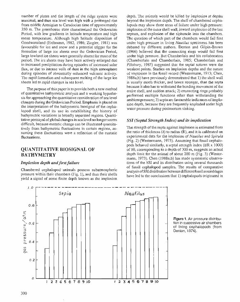
number of plates and the length of the ridge system were maximal, and thus sea level was high with a prolonged rise from middle Arenigian to Caradocian time of approximately 350 m. The greenhouse state characterized the Ordovician Period, with low gradients in latitude temperature and high mean temperature. Although high latitude disposition of Gondwanaland (Erdtmann, 1982, 1986; Ziegler, 1981) was favourable for ice and snow and a potential trigger for the formation of large ice sheets over the Ordovician Period, large lowland ice sheets were generally absent for most of the period. The ice sheets may have been actively enlarged due to increased precipitation during episodes of increased solar flux, or due to intense veils of dust in the high atmosphere during episodes of abnormally enhanced volcanic activity. The rapid formation and subsequent melting of the large ice sheets led to rapid changes in sea level.
The purpose of this paper is to provide both a new method of quantitative bathymetric analysis and a working hypothe- sis for approaching the quantitative consideration of sea level changes during the Ordovician Period. Emphasis is placed on the interpretation of the bathymetric biosignal of the cepha- lopod shell, and its use in establishing the history of bathymetric variations in broadly separated regions. Quanti- tative portrayal of global changes in sea level no longer seems difficult, because eustatic change can be illustrated quantita- tively from bathymetric fluctuations in certain regions, as- suming these fluctuations were a reflection of the eustatic fluctuations.
QUANTITATIVE BIOSIGNAL OF BATHYMETRY
Implosion depth and first failure
Chambered cephalopod 'animals possess subatmospheric pressure within their chambers (Fig. I), and thus their shells yield a signal of some finite depth known as the implosion
depth. The animals would be killed by implosion at depths beyond the implosion depth. The shell of chambered cepha- lopods may show three areas of failure under high pressure: implosion of the outer shell wall, inward implosio~i of the last septum, and explosion of the siphuncle into the chambers. The question of which part of the chambers would fail first under high pressure in living Nautilus specimens has been debated by different authors. Denton and Gilpin-Brown (1966) believed that the connecting rings would fail first under high pressure. But Chamberlain and his collaborators (Chamberlain and Chamberlain, 1985; Chamberlain and Pillsbury, 1985) suggested that the septal sutures were the weakest points. Studies on implosion depths and the nature of implosion in the fossil record (Westermann, 1973; Chen, 1988a,b) have previously demonstrated that I ) the shell wall is usually much thicker, and hence stronger, than the septa because it also has to withstand the bending movement of the entire shell, and sudden attack; 2) connecting rings probably performed multiple functions other than withstanding the ambient pressure; 3) septa are favourable indicators of implo- sion depth, because they are frequently imploded under high water pressure during postmortem sinking.
SSI (Septa1 Strength Index) and its implication
The strength of the septa against implosion is estimated from the ratio of thickness (6) to radius (R), and it is calibrated on experimental data for the implosion of Nautilus and Spirula (Fig. 2) (Westermann, 1973). Assuming that fossil cephalo- pods behaved similarly, a septal strength index (6/R x 1000) of 10, corresponding to a depth of 300 m, suggests an actual depth limit for the animal of about 200 m (Fig. 3) (Wester- mann, 1973). Chen (1988a,b) has made systematic observa- tions of the SSI and its distribution using several thousands of fossil cephalopod samples. The results of comparative analysis of SSIdistribution between different fossil assemblages have led to the conclusions that I) cephalopods originated in
Figure 1. Air pressure distribu- tion in successive air chambers of living cephalopods (from Denton, 1974).
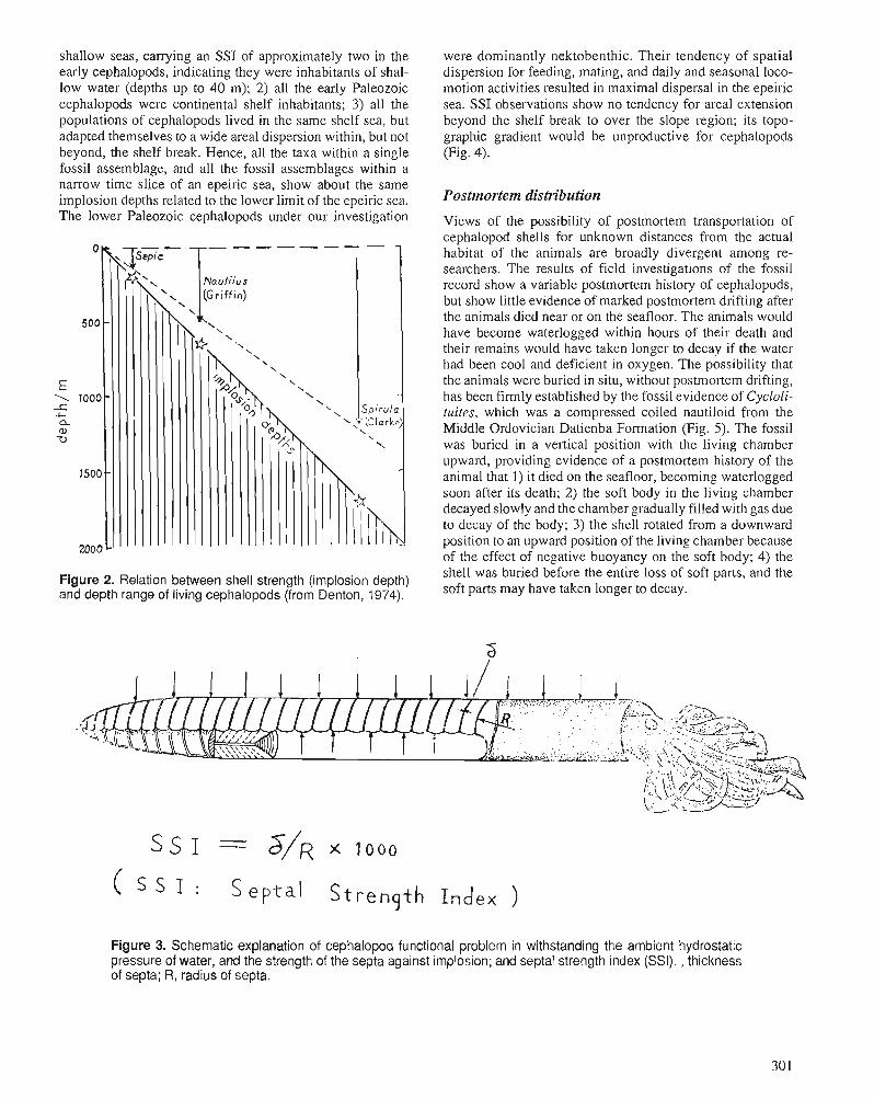
shallow seas, carrying an SSI of approximately two in the early cephalopods, indicating they were inhabitants of shal- low water (depths up to 40 m); 2) all the early Paleozoic cephalopods were continental shelf inhabitants; 3) all the populations of cephalopods lived in the same shelf sea, but adapted themselves to a wide areal dispersion within, but not beyond, the shelf break. Hence, all the taxa within a single fossil assemblage, and all the fossil assemblages within a narrow time slice of an epeiric sea, show about the same implosion depths related to the lower limit of the epeiric sea. The lower Paleozoic cephalopods under our investigation
Figure 2. Relation between shell strength (implosion depth) and depth range of living cephalopods (from Denton, 1974).
were dominantly nektobenthic. Their tendency of spatial dispersion for feeding, mating, and daily and seasonal loco- motion activities resulted in maximal dispersal in the epeiric sea. SSI observations show no tendency for areal extension beyond the shelf break to over the slope region; its topo- grapl~ic gradient would be unproductive for cephalopods (Fig. 4).
Postmortem distribution
Views of the possibility of postmortem transportation of cephalopod shells for unknown distances from the actual habitat of the animals are broadly divergent among re- searchers. The results of field investigations of the fossil record show a variable postmortem history of cephalopods, but show little evidence of marked postmortem drifting after the animals died near or on the seafloor. The animals would have become waterlogged within hours of their death and their remains would have taken longer to decay if the water had been cool and deficient in oxygen. The possibility that the animals were buried in situ, without postmortem drifting, has been firmly established by the fossil evidence of Cycloli- mites, which was a compressed coiled nautiloid from the Middle Ordovician Datienba Formation (Fig. 5) . The fossil was buried in a vertical position with the living chamber upward, providing evidence of a postmortem history of the animal that 1) it died on the seafloor, becoming waterlogged soon after its death; 2) the soft body in the living chamber decayed slowly and the chamber gradually filled with gas due to decay of the body; 3) the shell rotated from a downward position to an upward position of the living chamber because of the effect of negative buoyancy on the soft body; 4) the shell was buried before the entire loss of soft parts, and the soft parts may have taken longer to decay.
( S I : S e p t a 1 S t r e n g t h I n d e x )
Figure 3. Schematic explanation of cephalopod functional problem in withstanding the ambient hydrostatic pressure of water, and the strength of the septa against implosion; and septa1 strength index (SSI). , thickness of septa; R, radius of septa.
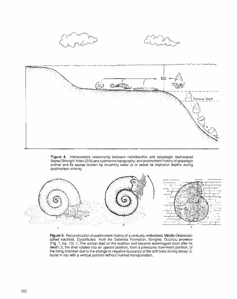
Figure 4. Interpretative relationship between nektobenthic and epipelagic cephalopod Septal Strength Index (SSI) and submarine topography; and postmortem history of epipelagic animal and its septae broken by inrushing water at or below its implosion depths during postmortem sinking.
. .
. . . . . . . .
.
. . . . . . . . . . . . . . . . . . . . . . . . . . . . . . . . : . . . . . . . . . . : . . . . . . . . . . . . - . .... : : .. : . . . . . . . . . . , . . . . . . , , . . , , . . , . - - . . . . . .
1 3
Figure 5. Reconstruction of postmortem history of a vertically embedded, Middle Ordovician coiled nautiloid, Cyclolituites from the Datienba Formation, Songtao, Guizhou province (Fig. 7, loc. 13). 1, The animal died on the seafloor and became waterlogged soon after its death; 2, the shell rotated into an upward position, from a previously downward position, of the living chamber due to the change to negative buoyancy of the soft body during decay; 3, burial in situ with a vertical position without marked transportation.
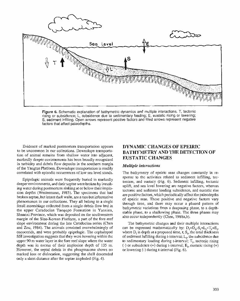
Figure 6. Schematic explanation of bathymetric dynamics and multiple interactions. T, tectonic rising or subsidence; L, subsidence due to sedimentary loading; E, eustatic rising or lowering; S, sediment infilling. Open arrows represent positive factors and filled arrows represent negative factors that affect paleodepths.
Evidence of marked postmortem transportation appears to be uncommon in our collections. Downslope transporta- tion of animal remains from shallow water into adjacent, markedly deeper environments has been broadly recognized in turbidity and debris flow deposits in the southern margin of the Yangtze Platform. Downslope transportation is readily correlated with episodic occurrences of low sea level stands.
Epipelagic animals were frequently buried in markedly deeper environments, and their septae were broken by inrush- ing water during postmortem sinking at or below their implo- sion depths (Westermann, 1985). The specimens that had broken septae, but intact shell walls, are a rare but informative phenomenon in our collections. They all belong to a single fossil assemblage collected from a single debris flow bed in the upper Caradocian Taoqupo Formation in Yaoxien, Shaanxi Province, which was deposited on the southwestern margin of the Sino-Korean Platform, a part of the fore reef slope environment during the late Caradocian series (Chen and Zou, 1984). The animals consisted overwhelmingly of oncocerids, and were probably epipelagic. The cephalopod SSI investigation suggests that they were hovering within the upper 90 m water layer in the fore reef slope where the water depth was in excess of their implosion depth of 135 m. However, the septa1 debris in the phragmacone shows no marked loss or dislocation, suggesting the shell descended only a short distance after the septae imploded (Fig. 4).
DYNAMIC CHANGES OF EPEIRIC BATHYMETRY AND THE DETECTION OF EUSTATIC CHANGES
Multiple interactions
The bathymetry of epeiric seas changes constantly in re- sponse to the activities related to sediment infilling, tec- tonism, and eustacy (Fig. 6). Sediment infilling, tectonic uplift, and sea level lowering are negative factors, whereas tectonic and sediment loading subsidence, and eustatic rise are positive factors, which periodically affect the paleodepths of epeiric seas. These positive and negative factors vary through time, and there may occur a phased pattern of bathymetric variations from a deepening phase, to a depth- stable phase, to a shallowing phase. The three phases may also occur independently (Chen, 1988a,b).
The bathymetric changes and their multiple interactions can be expressed mathematically by: D,=D,-S,+L,+T,+E,, where D, is depth at a proposed time, t; St, the total thickness of sediment infilling during t-interval; L,, the subsidence due to sedimentary loading during t-interval; T,, tectonic rising (-) or subsidence (+) during t-interval; E,, eustatic rising (+) or lowering (-) during t-interval (Fig. 6).
Influence of tectonism
The epeiric seas under our investigation were under constant slow subsidence apparently due to the combined effects of thermal cooling and sediment loading. The combined value of T, + L, is determinable, and estimates of the order of 1.5-2 cm/1000 y. can be determined during much of the Ordovician for the Sino-Korean Platform, and for the Tremadocian and early Arenigian of the Yangtze Platform. The value seems larger along the western margin of the Sino-Korean Platform where it was on the order of 7.5 cm/1000 y. from the middle Arenigian to the late Cardocian (Figs. 7, 9).
Bathymetric dynamics of the neritic realm
The rate of sedimentation varies greatly through time and in different regions in the neritic (shallow water) realm. It might be extremely high, as much as 30 m/1000 y. (Wilson, 1975) and thus sediment infilling (S,) would be the most active factor to affect negatively the epeiric bathymetry. Nondepo- sition and erosion would be commonly expected as sediment infilling built the seafloor up to, and above, the sea level. The occurrence of fluctuations on the order of a few metres near sea level seems rather common in neritic regions, with shal- lowing-upward sequences, tidal sequences, or supratidal se- quences developing under the following conditions: 1) slow eustatic rise; 2) minimal fluctuations of eustacy; 3) slow and constant tectonic subsidence. The marked deepening trend, which seems a rare phenomenon in shallow water sequences, is unnecessary in relation to eustatic highs or eustatic rise, but it may be attributed to an active phase of eustatic rise with a high rate of sedimentation that cannot keep pace. As the
deepening trend slowed with time, the depth stable phase would occur, accompanying the appearance of an open cir- culation environment and a sharp increase in normal marine faunas. As the rate of eustatic rise slowed, the shallowing phase would resume, and sediment infilling would build the seafloor up to, and above, sea level within a few thousand years; the effect of tectonic subsidence would be incompara- bly small -only a few to ten centimetres during the period. Thus, the thickness of the shallowing sequences provides useful evidence for estimating the paleodepth in the local area.
Eustatic changes
In areas where the activities of tectonic subsidence and sedi- ment infilling were minimal, the bathymetric variations would be dependent on eustatic variations. Thus, the detailed investigation of the quantitative variations of bathymetry provide a quantitative interpretation of the eustatic variations through time.
BATHYMETRIC FLUCTUATIONS OF EPEIRIC SEAS
Yangtze area
Metamorphic and intrusive events caused this area (Fig. 7) to become cratonic about 840 Ma, and thermal cooling mechan- ics have governed a constant subsidence of the Yangtze area since 740 Ma. The thermal cooling mechanics may have declined during the Ordovician Period and become negligible
Figure 7. Index m a p showing t h e following locali t ies ment ioned i n t h e text: 1 , Huanghuachang, Yichang, Hubei province; 2, Fengxiang town, Yichang, Hubei province; 3, Yanhe, Guizhou province; 4, Wuwei, Anhui province; 5, Shiqian, Guizhou province; 6, Magezhuang, Laishui, Hebei province; 7, Tangshan, Hebei province; 8, Badou and Xinwen areas of Shandong province; 9, Haibowan area, Inner Mongolia Autonomous Region; 10, Yaoxien, Shaanxi province; 11, Nylam, Tibet Autonomous Region; 12, Xainza, Tibet Autono- mous Region; 13, Songtao Guizhou province.
with time since the middle Arenigian (Fig. 8). This area (Fig. 7) was covered broadly with epeiric seas and the bathymetric fluctuations were basically of a eustatic nature since the middle Arenigian. Because it was a suitable envi- ronment for cephalopods, the quantitative reconstruction of the Ordovician history of bathymet~y and eustacy is possible.
Tremadocian-early Arenigian
This interval is represented by a thick sequence of shallow water carbonates. The rate of subsidence was slow, on the order of 15 cm/1000 y. and there was always sufficient carbonate accumulation to equal or exceed sea level rise, with numerous nonsedimentation or erosion periods. Cephalopods appeared repeatedly in response to transgression periods. SSI study on the cephalopod assemblages provides evidence of epeiric sea levels that may have fluctuated within a narrow spectrum of 60 m throughout the period of the Tremadocian and early Arenigian (Fig. 9).
Mid-Arenigian to mid-Caradocian
In much of the Yangtze area, this period was represented by a prolonged trend of deepening, interrupted by two brief regression events in the upper Didymograptus hirundo Zone, equivalent to the late Arenigian, and in an equivalent of the lower part of the Glyptograptus teretiusculus Zone of the terminal Llanvimian (Fig. 9). The net sedimentation rate was extremely slow, with an estimate of 0.25 to 0.1 cm per 1000 years. The extensive occurrence of hardground surfaces indi- cates the repeated removal of material, yielding cemented resistant surfaces, accompanied by subsequent solution, which removed skeletal and consolidated material. Upper portions of cephalopod shells often show evidence of heavy loss of skeletal material. The bathymetric changes in the epeiric sea were documented to include three major deepen- ing events with magnitudes of approximately 100 m, 200 m,
so0 l ( Ma) 5 1 0 15 2; cm,40oo yr
Figure 8. Declining trend in the rate of tectonic subsidence of the Yangtze area during the Ordovician Period.
and 300 m, with two intervening shallowing events with magnitudes of 40 m and 100 m (Figs. 9,lO). The bathymetric changes of this period are considered to be a reflection of eustatic changes due to minimal tectonic subsidence and extremely slow rates of sedimentation.
Late Caradocian
This period was characterized by a great shallowing trend with a magnitude of 350 m, estimated from evidence of facies and cephalopod SSI changes in the upper Pagoda and Linh- siang formations.
A brief transgressive event in the lower Wufeng Forma- tion (W1-W3) was proposed by Chen (1988a,b) with the interpretation of an abrupt facies change of shelly calcareous mudstone into black graptolitic siliceous shale in response to a sudden eustatic rise in sea level during the deglaciation episode.
In the period of the upper Wufeng Formation (W4-W5), a shallowing trend has been recognized by evidence such as 1) occurrence of the benthonic shelly Hirnantia Fauna; 2) re- duced diversity of taxonomic composition of graptolites (Mu, 1974); 3) size of the habitat area of the Hirnantia Fauna increasing upward from the Diceratograptus rnirus Zone and reaching a climax near the top of the Wufeng Formation; 4) evidence of subaerial emergence; 5) introduction of mass flow deposits on the continental slope and the adjacent oceanic basin.
Lower reach of the Yellow River: bathymetric dynamics
Ordovician rocks in this area (Fig. 7) are represented by shallow water carbonate sequences that accumulated inter- mittently at rates higher than those of subsidence to form vertical sequences of three different types: 1) cyclic se- quences; 2) shallowing-upward seqltcnces; and 3) supratidal sequences. The cyclic sequence consists of (from the base): 1) deepening unit; 2) depth-stable unit; 3) shallowing unit. The deepening unit seems to have formed during episodes of rapid rise in sea level when the rate of eustatic rise plus the rate of subsidence was greater than the rate of sedimentation. The depth-stable unit is marked by the occurrence of normal marine faunas such as cephalopods, trilobites, stro- matoporoids, and brachiopods; it seems to be a period of open circulation and maximal water depth. The shallowing unit corresponds to a period when the sedimentation rate was greater than the subsidence rate plus the rate of sea level rise; its thickness is a good indicator of paleodepth at the trans- gressive climax of the cyclic sequence. These cyclic sequences have been broadly recognized in the Beianzhuang Formation of the midle to upper Arenigian, and in the lower Machiakou Formation (Llandeilian and lower Caradocian). They are interpreted as being related to the peak of the eustatic rise event.
Carbonate accumulation under minor bathymetric fluctuation conditions are represented by shallowing-upward sequences, as observed in the upper Yehli Formation of IateTremadocian age.
c-+- % 2- -a x = +j 2 5 2 5 z' m o E =* 5" - C 2 m a.5 Q,
.5 ; 'Z ~2 - 2 @J- a ;- $ .m -c m 3 ~ z a 0
$ 0 5 P- - 272 = I S L m . 0 0 5 2 %
'5 2 _m .V, 2 y$j 5 Q,c K c 0 A.0 a, "JZS S'5 .r S 2 v, .F. a s m a , o .r a .m m . .- > m.2 0 = - .r .0 a 5 m: E 2.2 Xu c 5 a, Q rnzm
2 .G - g-5 -6az -2 = r n o .P 0 L.
+-A .- c F S 0 m;s$ $2 3 gz-? .= a) Q, >z 6 %g J z 0 s x Eg d m ,
3.0 a, 2' Zj 6 L L n m
~ U O O Q ~
OOE -
d DOZ-
aJ L d 001 -
w . N - In + VI mz 0. ._ 2 % . - - M M - - 2 5 y+ P M I I
lo m" ' N - N (V & c '-s d F
G" hw/w6.0 e?d
5 w b u a j n ~ - J I
A W / w l . l AW/UIS'Z ~ y / u 1 9 ' 9
Qpobvd
A ~ ~ / L U S ' V I
D q U D ! ~ P u.+n!unn U Q M V ~ 2 r
N L 1 2 z
5 u D n ~ ~ u 1 5 t ~ o ~ I - 6 ~ ~ ~ ~
M N -
z z z h ~ " * m ~ - 523-3333
I
10 cu - x x X
U V I ~ U D ~ J U ! ~
uo!oapowa,l
d c m 0 '-
6 2 V)
f ‘0
CO 0 d IA
a3 CO a, 10 t- Q b-z
P Tf 9 d Tt - 2 d-,
2 2 I T
K ) r
l l ~ ! 6 u s j n ~
LID^^!^^^^ 1 uo!?opodoJ P ! ~ ! a r l u I J ! U J ! A U D ~ ~ I u ~ 1 6 1 u a i g I ,-""Ill
. . I
$6 5: uw!UVolnH U Q ! U D O ~ ~ U ! ~
- -
g 5 1 1 , , j L , ;h ':I A , :! i , 5 / ,, 51,,Li/,,, 5 lo 15 SSI 5 10 5 10 rc 80 20 10' 20 10 20 10 20 10 m
1 I
2 3 4 5 6 7 8 I I I I I I I
Figure 10. Histograms 1-32 showing frequency (number of specimens) versus Septal Strength Index (SSI) of the cephalopod assemblages. 1-9, all from Locality 1 (Fig. 7), arranged stratigraphically in ascending order : 1. Collection Number (Coll. No.) ACC 332, the Protocycloceras deprati Zone of the Dawan Formation, an equivalent of the Oncograptus Zone of the Australia graptolite sequence; 2. Coll. No. ACC 334, the upper Protocycloceras depratizone, an equivalent of the CardiograptusZone of the Australian graptolite sequence; 3. Coll. No. ACC 335, covering an interval including the Glyptograptus sinodentatus Zone below and G. austrodentatus Zone above in the uppermost Dawan Formation; 4. Coll. No. ACC 337, the lower Kuniutan Formation; 5. ACC 338, the upper Kuniutan Formation; 6. ACC 339, the Miopo Formation. 10-15, arranged stratigraphically in ascending order: 10. the fossil assemblage is from the southwestern margin of the Yangtze Platform in the Bathmoceras Zone, which lies between the Azygograptus suecicus Zone below and the Protocycloceras deprati Zone above; 1 1 . ACC 31 1 from Locality 2 (Fig. 7) of the Protocycloceras deprati Zone of the Dawan Formation; 12. ACC 315, from Locality 2 (Fig. 7) in the upper Protocycloceras depratizone; 13. ACC 314, Locality 2 (Fig. 7), in the basal Kuniutan Formation; 14. ACC 31 1, Locality 2 (Fig. 7), the uppermost Kuniutan Formation; 15. ACC 320, Locality 2 (Fig. 7), the Pagoda Formation. 16-1 9, arranged stratigraphically in ascending order: 16. ACC 88, Locality 3 (Fig. 7), the upper Kuniutan Formation; 17. Locality 4 (Fig. 7), the uppermost Kuniutan Formation; 18. Locality 4 (Fig. 7), the Datianba Formation; 19. Locality 5 (Fig. 7), the Linhsiang Formation equivalent. 20-25, all from the Lower Reach of the Yellow River, and arranged stratigraphi- cally in ascending order: 20. Locality 6 (Fig. 7), in the basal Yehli Formation; 21. Locality 7 (Fig. 7) in the basal Liangchiashan Formation, 22. Locality 8 (Fig. 7) in the Beianzhuang Formation; 23. Locality 8 (Fig. 7) in the Machiakou Formation; 24. Locality 7 (Fig. 7) in the Machiakou Formation; 25. Locality 8 (Fig. 7) in the Badou Formation. 26-32, all from Locality 9 (Fig. 7), and arranged stratigraphically in ascending order: 26. the Pseudowutinoceras Zone in the lower Sandaokan Formation; 27. the Parakogenoceras Zone of the upper Sandaokan Formation; 28. the Polydesmia zuezshanensis Zone of the lower Zotzeshan Formation; 29. the OrdosocerasZone of the lower Zotzeshan Formation; 30. the lower part of the PomphocerasZone in the upper Zotzeshan Formation; 31. the upper Pomphoceras Zone in the uppermost Zotzeshan Formation; 32. the Sheshan Formation.
Sedimentary accumulation of the supratidal sequences took place persistently, within a narrow zone from sea level up to storm tidal level, with durations of up to several million years. These have been observed in the top of the Liangchi- ashan Formation, in the top of the Beianzhuang Formation, and in the Gezhuang Formation; they seem to indicate a time of extreme stability in sea level (Figs. 8,9).
Haibown area (Inner Mongolia)
Along the western margin of the Sino-Korean Platform (Fig. 7), Ordovician rocks of middle Arenigian to late Cara- docian age rest unconformably on upper Cambrian strata. They comprise a depositional cycle deepening-upward from shallow shelf carbonate to hemipelagic, thinly bedded car- bonate, to an alternation with graptolitic shale, to basinal graptolitic shale deposits, and then shallowing-upward through clastic turbidites to shoal deposits. The subdivisions of the Ordovician strata include (from the base): I ) San- daokan Formation: Pseudowutinoceras Zone; Parako- genoceras Zone; 2) Zotzeshan (Zuozishan) Formation: Polydesmia zuezshanensis Zone; .Ordosoceras Zone; Pomphoceras Zone; 3) Klimoli Formation: Amplexograptus confertus Zone; Pterograptus elegans Zone; 4) Wulalike Formation: Glyptograptus teretiusculus Zone; 5 ) Lashenchong Formation: Nemagraptus gracilis Zone with Syndyograptus Subzone above and Climacograptus bicornis Subzone below; 6 ) Gongwusu Formation: Amplexograptus gansuensis Zone; 7) Sheshan Formation: Eurasiaticoceras- Sheshanoceras Zone (Chen et al., 1984).
Investigation of cephalopod SSI (Fig. 10) shows evidence of a deepening trend in the mid-Arenigian equivalent (San- daokan Formation) (Figs. 9, 10). The Zotzezhan Formation, upper Arenigian, shows a slow deepening trend of the epeiric sea from 60 m to 120 m in much of the formation. A sharp change in bathymetry was documented in the top of the Zotzeshan Formation (uppermost Arenigian), with depths in the epeiric sea of approximately 250 m as indicated by cephalopod SSI (Fig. 10, histogram 31). The evidence of a continuous deepening seems remarkable in the Klimoli For- mation, which is interpreted as representing a hemipelagic slope environment in its major part, with a constant trend of deepening upward to depths near or below the upper limit of the CCD (Carbonate Compensation Depth) at its top.
A brief shallowing event in the latest Llanvimian has been registered by an introduction of gravity flow deposits at the base of the Wulalike Formation. The main part of this forma- tion contains black graptolitic shale. Its sedimentary accumu- lation is thought to have occurred in a marginal basinal environment at a depth below the CCD.
The Laschenchong Formation is represented by black pelagic graptolitic shale in its lower part, a Syndyograptus Subzone equivalent, which was succeeded by an alternating sequence of siltstone, shale, and pebbly limestone repre- sented in the upper part of the Climacograptus bicornis Subzone and in the overlying Gongwusu Formation. The Sheshan Formation is the highest unit, consisting of a
sequence of skeletal and oolitic limestone, and arenaceous shale representing a very shallow, turbulent deposi- tional environment. The SSI of the cephalopod assemblage suggests the lower limit of the epeiric sea was about 100 m during the late Caradocian (Fig. 10, histogram 32).
Mt. Jolmo Lungma region (Tibet)
The shallow water carbonates have been broadly recorded in this region (Fig. 7), suggesting an extensive epeiric sea during the Ordovician Period. The Chiatsun Group in Nylam area (Figs. 9-1 1) contains a thick sequence of carbonates up to 833 m thick, of late Arenigian to late Caradocian age, and lies unconformably on the metamorphic rocks of the Juchiatsun Group (Mu et al., 1973). The lower 726 m of the Chiatsun Group consist of massive limestone with interbeds of silt- stone and sandstone; they are thought to have been laid down at a considerably higher rate under shallow water conditions as a response to a profound transgressive event in the late Arenigian. The SSI of the cephalopod assemblages provides evidence of maximal depths of the epeiric sea of approxi- mately 100 m during the late Arenigian, deepening progres- sively to 300 m in the Llanvimian. The upper 97 m of the Chiatsun Group is composed of reddish limestone with rich cephalopod faunas (Chen, 1975). The SSI of these cephalo- pod assemblages indicates a major transgressive and sub- sequent regressive event during the Caradocian (Fig. 8). The changes of biofacies and bathymetry are comparable with those of the Yangtze area (Chen, 1988a,b). The bathymetry indicated by SSI changes from 340 m to 400 m, and then a shallowing phase followed by the occurrence of the Richard- sonoceras Fauna in the top beds of the upper Caradocian when the water depth was about 180 m.
The Hongshantou Formation consists of a 70 m thickness of brown shale, with extremely rare fossils, which is consid- ered to represent the regressive event in the Late Ordovician.
Xainza area (Tibet)
This area (Fig. 7, loc. 12) is tectonically separated from the Mt. Jolmo Langma region by the Indus-Yaluzangbu Suture. The Ordovician rocks include three units, in ascending order.: the Kordo, Gangmusang, and Xainza formations. The Kordo Formation is about 400 m thick, and consists mainly of carbonates yielding a rich cephalopod fauna of Yangtze area affinity with an age probably ranging from Llandeilian to Caradocian. The Gangmusang Formation consists of shallow water carbonates probably of late Ashgillian age, regarded as representing the regressive phase during the period equiva- lent to the Diceratograptus mirus Zone and the Paraor- thograptus uniformis Zone of the upper Wufeng Fonnation. The Xainza Formation contains the top 14.09 m of the Ordovician sequence (Ni et al., 1981). Its lower 5.27 m consists of greyish graptolitic shale containing a rich Diplograptus bohemicus Fauna (Mu and Ni, 1983), whereas the upper 8.82 m is represented by a shallow water, grey argillaceous limestone with the associated shelly Hirnantia Fauna.
EUSTACY AND ITS CAUSES Eustatic changes in sea level are dependent on a number of interrelated controls and they can be brought about by changes in volume either of ocean water, or of ocean basins (e.g., Pitmann, 1978; Schopf, 1980). A large, high latitude Gondwana landmass existing near the south pole during Ordovician time (Ziegler, 1981; Erdtmann, 1982, 1986) could have been a place for permanent ice and snow. The growth and decay of ice sheets may have appreciably altered the water volume in the oceans within narrow time intervals.
Stable period with episodic fluctuations
Sea level remained stable from the latest Cambrian to the early Arenigian, apart from episodic fluctuations (Fig. 11). The fluctuations are considered to have been glaciation- driven, were rapid, and had characteristic sequences of a regressive and a succeeding transgressive event (Fig. 11). These events were known as 1) LangeRanch Eustatic (regres- sive) Event (Miller, 1984), succeeded by the basal Tremadoc (transgressive) event (Chen, 1988a,b); 2) Black Mountain Eustatic (regressive) Event (Miller, 1984). followed by a transgressive event at end of the early Tremadocian (Chen, 1988a,b); 3) late Tremadoc eustatic (transgressive) episode (Barnes, 1984; Fortey, 1984), which was marked in China by a flood of Adelograptus-Clonograptus-Kiaerograptus Fauna into the cratonic succession, and was preceded by a regressive event in the middle Tremadocian (Chen, 1988a,b).
The evidence of the characteristic sequence of regressive and succeeding transgressive events together with their short duration suggests that the cause of the eustatic fluctuations in this period may have been related to changes in solar
radiation. Assuming an increase in solar radiation, the ice sheet may have advanced; an increase in solar radiation would have resulted in increased wind strength circulation and evaporation, and a sudden increase in the amount of snow on the landmasses in high latitudes. With a further increase in solar radiation, wet snow would melt and a post-glacial eustatic rise would follow (Lamb, 1977).
Eustatic rise with sudden lowering episodes
For a duration of roughly 40 m.y. (middle Arenigian to Caradocian), there were three transgressive cycles with re- lated rises in sea level amounting to approximately 80 m in the middle Arenigian, to 200 m in the latest Arenigian and Llanvimian, and to 200 m in the Llandeilian and Caradocian. The rate of sea level rise is estimated to be on the order of 20 m per m.y. (Chen, 1988a,b). The two sharp reversal episodes in sea level occurred in the late Arenigian and in the latest Llanvimian-early Llandeilian, respectively. An estimated few tens, to 100 m, in the lowering of sea level may have taken place in roughly one million years during each of the reversal episodes (Figs. 10, 11).
The cause of the prolonged process of eustatic rise was previously interpreted to have been driven by rather rapid seafloor spreading (Chen, 1988a,b) and in this paper the author emphasizes the idea of an increase of the length of spreading ridges that could have changed sufficiently to raise sea level by some hundreds of metres during the Ordovician Period. It is known that the number of lithospheric plates varies over geological time, and the total length of the ridges changes from maximal during continental dispersal to mini- mal during aggregation periods (Fischer, 1984). Thus, sea level may be expected to be high during continental
400 '
200 - Re la t i ve p o s i t i o n of sea l e v e l
505 500 490 480 4 70 460 450 440 (Ma)
Figure 11. Schematic explanation of the changes in sea level during the Ordovician Period. S H , Shikounian;. HA, Hanjiangian.
dispelsion periods and low during pangeal episodes. The great rise in sea level from the middle Arenigian to Carado- cian did indeed occur in a time of continental dispersion. Jaanusson (1984) interpreted the Ordovician Period as pro- nouncedly thalassocratic, which was in great contrast to widespread "epeirocratic" emergence known in the late Precambrian pangeal period.
Continental dispersion and maximal activity may have been accompanied by maximal volcanism during the Ordo- vician Period (Stillman, 1984). The appearance of intense veils of dust in the high atmosphere would probable have accompanied the abnormally enhanced volcanic activity; it is possible that it caused the accumulation of ice sheets and sharp reversal trends of sea level in the late Arenigian and in the latest Llanvirian and early Llandeilian.
Late Ordovician eustacy and glaciation
The author (1988a,b) has argued that the sea level during the Late Ordovician might have fluctuated successively in a sequence of 1) a latest Caradocian lowering event; 2) an early Wufengian rising event; 3) a Himantian lowering event; 4) a bohemicus rising event; 5 ) a terminal Wufengian lowering event (Fig. 11). The latest Caradocian seems to have had a major glaciation episode, during which the ice cap grew at a rapid rate, with a related 350 m lowering of sea level as documented in the Yangtze Epeiric Sea. The evidence of the early Wufengian deglaciation and eustatic rising event are strong, bringing a flood of graptolitic faunas almost every- where within the Yangtze Epeiric Sea. The Himantian low- ering event is indicated by a change of biofacies in the shelf succession, with the shelly facies and associated brachiopods of the Hirnantia Fauna increasing in areal extension. The bohemicus rising event was proposed by Chen (1988a,b) to represent a sea level change at the top of the Wufengian Stage. The brief transgressive event, which brought graptolite fau- nas onto the shelf sequence in the Yangtze area and in the Xainza area (Tibet), can be correlated precisely with the lower part of the Diplograptus bohemicus Zone of the upper- most Wufengian. Evidence of the terminal Wufengian low- ering event was documented broadly in many sections of separated regions in the Tibet and Yangtze River areas, China (Chen, 1988a,b) as well as in Europe (Brenchley and Newall, 1984). This terminal Wufengian lowering event can be cor- related closely with the upper Diplograptus bohemicus Zone.
CAUSES OF GLACIATION UNDER THE GREENHOUSE EFFECT The general aspects of the paleoenvironments seem to indi- cate a greenhouse effect during the Ordovician Period, in which an essentially nonglacial world was briefly plunged into glacial conditions. Because of the existence of a green- house effect during that period, the glaciations seem to have been rapidly developed due to an abundance of atmospheric moisture, but were difficult to sustain with the onset of a warm climate. The deglaciations appear to proceed rapidly and an anoxic marine envit'onment was generally widespread.
Cause of glaciation
The glaciations appear to have resulted from increased solar influx from the latest Cambrian to the early Arenigian, as mentioned above. Plate activity and accompanying volcan- ism apparently climaxed in the middle Arenigian to Carado- cian. An intense veil of dust in the high atmosphere would be expected to raise the earth's albedo to a level at which much solar energy was reflected, and the glaciation may thus have resumed in the following separate periods: 1) within the late Arenigian; 2) latest Llanvimian-early Llandeilian; 3) late Caradocian.
ACKNOWLEDGMENTS This research was supported by Wang Kuancheng Education Foundation Ltd. and NSF (China) Grant 48701 19. A part of financial aid from Canadian sources to attend the Ordovician conference at St. John's, Newfoundland is greatly appreci- ated. I thank Drs. C.R. Barnes (Victoria, British Columbia), B.-D. Erdtmann (Berlin), Lu Yanhao (Nanjing, China), A.T. Nielsen (Copenhagen), R.J. Ross (Golden, Colorado), S.E. Speyer (Tulsa), C. Teichert (Rochester, New York), P. Wilde (Berkeley, California), and A.M. Ziegler (Chicago) for read- ing the manuscript and for valuable discussions. Thanks also to Li Gejun, Xu Baorui, and Ma Yujin for drafting and typing assistance.
REFERENCES Barnes, C.R. 1984: Early Ordovician eustatic events in Canada. In Aspects of the
Ordovician System, D.L. Bruton (ed.); Palaeontological Contribu- tions hom the University of Oslo, no. 295, Universitetsforlaget, p. 51-63.
Brenchley, P.J. and Newall, G. 1984: Late Ordovician environmental changes of their effect on faunas. It1
Aspects of the Ordovician System, D.L. Bruton (ed.); Palaeon- tological Contributions from the University of Oslo, no. 295, Uni- versitetsforlaget, p. 65-79.
Chamberlain, J.A., Jr. and Chamberlain, R. 1985: Septa1 fracture in Naufilus: implications for cephalopod paleo-
bathymetry. Lethaia, v. 18, p. 261-272. Chamberlain, J.A. and Pillsbury, S.W. 1985: Flow properties of Naurilw siphuncular tube: within-camera distri-
bution of flow rate. Palaeontology, v. 28, p. 121-131. Chen Junyuan 1975: Fossil nautiloids of Mt. Jolmo Lungma region. Memoir of Mt. Jolmo
Lungma Exploration (1966-1968), Palaeontology (Part One), p. 267-294, with 9 pls. Science Press, Beijing. (in Chinese)
1988a: Ordovician changes of level. New Mexico Institute for Mining and Technology, State Bureau of Mines and Mineral Resources, Memoir 44, p. 387-404.
1988b: Ordovician cephalopod bathymemc signals and chronology of sea level change. Acta Palaeontologica Sinica, v. 27, p. 344-365.
Chen Junyuan, Zhou Zhi-yi, Lin Yao-Kun, Yang Xue-chang, Zou Xi- ping, Wang Zhi-hao, Luo Kun-quan, Yao Baoqi, and Shen Hou 1984: Ordovician biostratigraphy of western Ordos. Memoirs of the
Nanjing Institute of Geology and Palaeontology, v. 20, p. 1-31. (in Chinese with English abstract)
Chen Jun-yuan and Zou Xi-ping 1984: Ordovician cephalopods from the Ordos area, China. Memoirs of
the Nanjing Institute of Geology and Palaeontology, v. 20, p. 33-84, 20 pls. (in Chinese with English absaact)
Denton, E.J. 1974: On buoyancy and the lives of modem and fossil cephalopods.
Proceedings of the Royal Society of London, Series B, v. 185, p. 273-299.
Denton, E.J. and Gilpin-Brown, J.B. 1966: On the buoyancy of the pearly Nautilus. Journal of Maine Biology
Association, U.K., v. 46, p. 723-759. Erdtmann. B.-D. 1982: ~ a l a e o b i o ~ e o g r a ~ h ~ and environments of planktic dictyonemid
mautolites during the earliest Ordovician. In The Cambrian-Ordo- &;an ~oundary~ections, Fossil Distributions and Correlations, M.G. Bassett and W.T. Dean (eds.); National Museum of Wales, Geolonical Series, no. 3, D. 9-27.
1986: ~ e v i e w of lithofacies and*graptolite-based biofacies of three critical Cambrian-Ordovician boundarv sections. In A s D ~ c ~ ~ of Cambrian- Ordovician Boundary in ~ a ~ h ~ c h a , China, hen Junyuan (ed.); China Prospect Publishing House, Beijing, p. 374-391.
Fischer, A.G. 1984: The two Phanerozoic supercycles. In Catastrophes and Earth His- '
tory - The New Uniformitarianism, W.A. Berggren and J.A. VanCouvering (eds.); Princeton, New Jersey, p. 127-150.
Fortey, R.A. 1984: Global earlier Ordovician transgressions and regressions and their
biological implications. In ~ s ~ e c t s of the ~rdovician System, D.L. Bruton (ed.); Palaeontologid Contributions from the University of Oslo, no. 295, ~niversiteisforla~et, p. 37-50.
Hays, J.D., and Pitman 111, W.C. 1973: Lithospheric plate motion, sea level changes and climatic and
ecological consequences. Nature, v. 246, no. 5427, p. 18-22. Jaanusson, V. 1984: What is so special about the Ordovician? In Aspects of the Ordovi-
cian System, D.L. Bruton (ed.); Palaeontological Contributions from the University of Oslo, no. 295, Universitetsforlaget, p. 1-3.
Lamb, H.H. 1977: Climate Present, Past and Future, Volume 2, Climatic History and
the Future. Methuen and Co. Ltd., London; Barnes and Noble Books, New York, 835 p.
Miller, J.F. 1984: Cambrian and earliest Ordovician conodont evolution, biofacies
and provincialism. In Conodont Biofacies and Provincialism, D.L. Clark (ed.); Geological Society of America, Special Paper 196, p. 43-68.
Mu En-zhi 1974: Evolution, classification and distribution of graptoloidea and grap-
todendroids. Scientia Sinica, v. 17, p. 227-238. Mu En-zhi and Ni Yu-nan 1983: Uppermost Ordovician and lowermost Silurian graptolites from the
Xainza area of Xizang (Tibet) with discussion on the Ordovician- Silurian boundary. Palaeontologica Cathayana, v. I , p. 155-179.
Mu En-zhi, Yin Ji-xiang, Wen Shi-xuan, Wang Yi-gang, and Zhang Bing-gao 1973: Stratigraphy of the Mount Jolmo Lungma region in southern Tibet,
China. Scientia Geologica Sinica, 1973, v. I, p. 13-25. Ni Yu-nan, Xu Han-kui, and Chen Ting-en 1981: Boundary of Ordovician and Silurian in the Xainza area, Xizang.
Joumal of Stratigraphy, v. 5, p. 146,147. (in Chinese with English title)
Pitman 111, W.C. 1978: Relationship between eustacy and stratigraphic sequences of pas-
sive margins. Geological Society of America, Bulletin, v. 89, p. 1389-1403.
Schopf, T.J.M. 1980: Palaeoceanography. Harvard University Press, 341 p. Stillman, T.J.M. 1984: Ordovician volcanicity. In Aspects of the Ordovician System, D.L.
Bruton (ed.); Palaeontological Contributions from the University of Oslo, no. 295, Universitetsforlaget, p. 183-1 84.
Westermann, G.E.G. 1973: Strength of concave septa and depth limits of fossil cephalopods.
Lethaia, v. 6, p. 383-403. 1985: Post-mortem descent with septa1 implosion in Silurian nautiloids.
Palaontologische Zeischrift, v. 59, p. 79-97. Wilson, J.L. 1975: Carbonate Facies in Geological History. Springer-Verlag, New
York, 471 p., 30 pls. Ziegler, A.M. 1981: Paleozoic paleogeography. In Paleoreconstruction of the Conti-
nents, M.M. McElhinny and D.A. Valencio (eds.); Geodynamics Series, v. 2, American Geophysical Union, Washington, D.C., Geological Society of America, Boulder, Colorado, p. 3 1-37.

Evidence for isotopic change associated with Late Ordovician glaciation, from brachiopods and
marine cements of central Sweden
Paul D. Middletonl, James D. Marshalla, and Patrick J. Brenchleya
Middleton, P.D., Marshall, J.D., and Brenchley, P.J., Evidence for isotopic change associated with Late Ordovician glaciation, from hrachiopods and marine cements of central Sweden; & Advances in Ordovician Geology, C.R. Barnes and S.H. Williams (ed.), Geological Survey of Canada, Paper 90-9, p. 313-323,1991.
Abstract
The carbon and oxygen stable isotopic composition of brachiopods and marine cements from the Boda Limestone carbonate mud mounds (Ashgillian) of central Sweden has provided evidence for the effect of the Late Ordovician-Early Silurian glaciation on the isotopic composition of contemporane- ous sea water.
Brachiopods and marine cements were analyzed from different stratigraphic levels within the mounds. Isotopic and trace element results show that primary marine compositions are preserved. The 6 1 8 0 and 8I3c values are approximately constant throughout the pre-Hirnantian mound limestone (mean 6 1 8 0 = -4.5 0/ , , , ti13c= +1.8 0 /00 ) , but braclziopods and cements from coquinas of Hirnantian age at the top of the mounds show significant enrichment in 6 1 8 0 and 6 13c (mean 6 180= -2.5 O/O., 6 I3c= +6.3 o/,,) when compared to the mound components.
A drop in water temperature of approximately 10°C could explain the 2°/,, positive 6 1 8 0 shift. Paleoecological considerations, however, render this unlikely. It is therefore proposed that the shift marks an increase in sea water 6 1 8 0 , perhaps caused by a glacial "ice volume" effect.
The careful sampling of brachiopods and cements rules or.~t biological vital effects and diagenetic alteration as potential mechanisms of 13c enrichment. The shift is interpreted as representing a significant change in the 13c/12c ratio of the dissolved bicarbonate in Hirnantian sea water.
La composition en isotopes stables de carbone et d oqg2ne des brachiopodes et des ciments marins des monticules de boue carbonatke du calcaire Boda (Ashgillien) dans le centre de la SuPde a fourni des indices sur les gets de la glaciation & I'Ordovicien supkrieur au Silurien injkrieur sur la composition isotopique de Peau de mer contemporaine.
On a analyse' des hrachiopodes et des ciments rnarins provenant de diflkrerzts niveaux stratigraphiques au sein des monticules. L'analyse des isotopes et des e'le'ments traces montre que les principales compositions marines ont kte' consewkes. Les valeurs 180 et 13c sont approximativement constantes dans tout le calcaire des monticules antkrieur h llHirnantien (180 moyen = -45 0 / 0 0 , 13C = +1,8 0 / 0 0 ) mais les brachiopodes et les ciments de lumachelles d' Bge hirnantien au sommet des monticules indiquent un enrichissement important en 180 et 13c (180. moyen = -2 5 0/00, 13c = +6,3 0 / 0 0 ) lorsqu'on les compare aux composantes des monticules.
Une chute de la tempkrature de l'eau d'enviroiz 10 C pourrait expliquer le changementpositifde 2°/,, de 180. Des conside'rations pale'o-kcologiques, torrtefois, rendent cette explication improbable. I1 est donc propost! que ce changement indique une augmentation de 180 darzs l'eau de mer, cause'e peut-2tre par un effet glaciaire dit ccvolume de glace)).
1 BP Exploration, 301 St. Vincent Street, Glas ow, Scotland G25 DD Department of Earth Sciences, University of&iverpool, Liverpool, U.K.
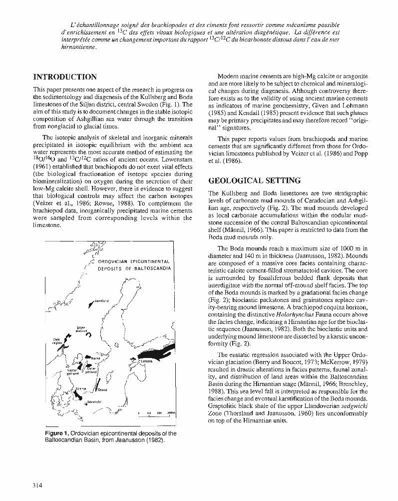
L'tchantillonnage soigne' des brachiopodes et des ciments font ressortir comme me'canisme possible d'enrichissement en 13c des effets vitaux biologiques et une alte'ration diagtne'tique. La difftrence est interprtte'e comme un changement important du rapport l3c1I2c du bicarbonate dissous dans l'eau de mer hirnantienne.
INTRODUCTION
This paper presents one aspect of the research in progress on the sedimentology and diagenesis of the Kullsberg and Boda limestones of the Siljan district, central Sweden (Fig. 1). The aim of this study is to document changes in the stable isotopic composition of Ashgillian sea water through the transition from nonglacial to glacial times.
The isotopic analysis of skeletal and inorganic minerals precipitated in isotopic equilibrium with the ambient sea water represents the most accurate method of estimating the 1s0/160 and 13c/12c ratios of ancient oceans. Lowenstam (1961) established that brachiopods do not exert vital effects (the biological fractionation of isotope species during biomineralization) on oxygen during the secretion of their low-Mg calcite shell. However, there is evidence to suggest that biological controls may affect the carbon isotopes (Veizer et al., 1986; Rowse, 1988). To complement the brachiopod data, inorganically precipitated marine cements were sampled from corresponding levels within the limestone.
ORDOVICIAN EPICONTINENTAL
DEPOSITS OF BALTOSCANDIA I
Modern marine cements are high-Mg calcite or aragonite and are more likely to be subject to chemical and mineralogi- cal changes during diagenesis. Although controversy there- fore exists as to the validity of using ancient marine cements as indicators of marine geochemistry, Given and Lohmann (1985) and Kendail(1985) present evidence that such phases may be primary precipitates and may therefore record "origi- nal" signatures.
This paper reports values from brachiopods and marine cements that are significantly different from those for Ordo- vician limestones published by Veizer et al. (1986) and Popp et al. (1986).
GEOLOGICAL SETTING The Kullsberg and Boda limestones are two stratigraphic levels of carbonate mud mounds of Caradocian and Ashgil- lian age, respectively (Fig. 2). The mud mounds developed as local carbonate accumulations within the nodular mud- stone succession of the central Baltoscandian epicontinental shelf (Mannil, 1966). This paper is restricted to data from the Boda mud mounds only.
The Boda mounds reach a maximum size of 1000 m in diameter and 140 m in thickness (Jaanusson, 1982). Mounds are composed of a massive core facies containing charac- teristic calcite cement-filled stromatactoid cavities. The core is surrounded by fossiliferous bedded flank deposits that interdigitate with the normal off-mound shelf facies. The top of the Boda mounds is marked by a gradational facies change (Fig. 2); bioclastic packstones and grainstones replace cav- ity-bearing mound limestone. A brachiopod coquina horizon, containing the distinctive Holorhynchus Fauna occurs above the facies change, indicating a Hirnantian age for the bioclas- tic sequence (Jaanusson, 1982). Both the bioclastic units and underlying mound limestone are dissected by a karstic uncon- formity (Fig. 2).
The eustatic regression associated with the Upper Ordo- vician glaciation (Beny and Boucot, 1973; McKerrow, 1979) resulted in drastic alterations in facies patterns, faunal zonal- ity, and distribution of land areas within the Baltoscandian Basin during the Hirnantian stage (Mannil, 1966; Brenchley, 1988). This sea level fall is interpreted as responsible for the facies change and eventual karstification of theBodamounds. Graptolitic black shale of the upper Llandoverian sedgwicki Zone (Thorsland and Jaanusson, 1960) lies unconformably on top of the Hirnantian units.
Figure 1. Ordovician epicontinental deposits of the Baltoscandian Basin, from Jaanusson (1 982).
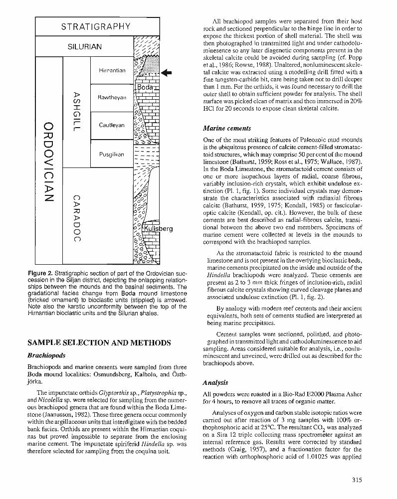
STRATIGRAPHY
SILURIAN
- - - - - Pusgillian - - -- - - - -__ - - - - -
0 >
Figure 2. Stratigraphic section of part of the Ordovician suc- cession in the Siljan district, depicting the onlapping relation- ships between the mounds and the basinal sediments. The gradational facies change from Boda mound limestone (bricked ornament) to bioclastic units (stippled) is arrowed. Note also the karstic unconformity between the top of the Hirnantian bioclastic units and the Silurian shales.
SAMPLE SELECTION AND METHODS
Brachiopods
Brachiopods and marine cements were sampled from three Boda mound localities: Osmundsberg, Kalholn, and 0stb- jorka.
The impunctate orthids Glyptorthis sp., Platystrophia sp., and Nicolella sp. were selected for sampling from the numer- ous brachiopod genera that are found within the Boda Lime- stone (Jaanusson, 1982). These three genera occur commonly within the argillaceous units that interdigitate with the bedded bank facies. Orthids are present within the Himantian coqui- nas but proved impossible to separate from the enclosing marine cement. The impunctate spiriferid Hindella sp. was therefore selected for sampling from the coquina unit.
All brachiopod samples were separated from their host rock and sectioned perpendicular to the hinge line in order to expose the thickest portion of shell material. The shell was then photographed in transmitted light and under cathodolu- minesence so any later diagenetic components present in the skeletal calcite could be avoided during sampling (cf. Popp et al., 1986; Rowse, 1988). Unaltered, nonluminescent skele- tal calcite was extracted using a modelling drill fitted with a fine tungsten-carbide bit, care being taken not to drill deeper than 1 mm. For the 01-thids, it was found necessary to drill the outer shell to obtain sufficient powder for analysis. The shell surface was picked clean of matrix and then immersed in 20% HCl for 20 seconds to expose clean skeletal calcite.
Marine cements
One of the most striking features of Paleozoic mud mounds is the ubiquitous presence of calcite cement-filled stromatac- toid structures, which may comprise 50 per cent of the mound limestone (Bathurst, 1959; Ross et al., 1975; Wallace, 1987). In the Boda Limestone, the stromatactoid cement consists of one or more isopachous layers of radial, coarse fibrous, variably inclusion-rich crystals, which exhibit undulose ex- tinction (Pl. 1, fig. 1). Some individual crystals may demon- strate the characteristics associated with radiaxial fibrous calcite (Bathurst, 1959, 1975; Kendall, 1985) or fascicular- optic calcite (Kendall, op. cit.). However, the bulk of these cements are best described as radial-fibrous calcite, transi- tional between the above two end members. Specimens of marine cement were collected at levels in the mounds to correspond with the brachiopod samples.
As the stromatactoid fabric is restricted to the mound limestone and is not present in the overlying bioclastic beds, marine cements precipitated on the inside and outside of the Hindella brachiopods were analyzed. These cements are present as 2 to 3 mm thick fringes of inclusion-rich, radial fibrous calcite crystals showing curved cleavage planes and associated undulose extinction (Pl. 1, fig. 2).
By analogy with modem reef cements and their ancient equivalents, both sets of cements studied are interpreted as being marine precipitates.
Cement samples were sectioned, polished, and photo- graphed in transmitted light and cathodoluminescence to aid
sampling. Areas considered suitable for analysis, i.e., nonlu- minescent and unveined, were drilled out as described for the brachiopods above.
Analysis
All powders were roasted in a Bio-Rad E2000 Plasma Asher for 4 hours, to remove all traces of organic matter.
Analyses of oxygen and carbon stable isotopic ratios were carried out after reaction of 3 mg samples with 100% or- thophosphoric acid at 25°C. The resultant C02 was analyzed on a Sira 12 triple collecting mass spectrometer against an internal reference gas. Results were corrected by standard methods (Craig, 1957), and a fractionation factor for the reaction with orthophosphoric acid of 1.01025 was applied
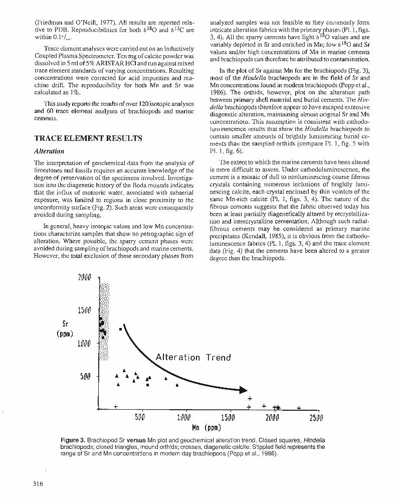
(Friedman and O'Neill, 1977). All results are reported rela- tive to PDB. Reproducibilities for both 6 1 8 0 and 6 13C are within O.lO/.. .
Trace element analyses were carried out on an Inductively Coupled Plasma Spectrometer. Ten mg of calcite powder was dissolved in 5 ml of 5% ARISTAR HCl and run against mixed trace element standards of varying concentrations. Resulting concentrations were corrected for acid impurities and ma- chine drift. The reproducibility for both Mn and Sr was calculated as 1 %.
This study reports the results of over 120 isotopic analyses and 60 trace element analyses of brachiopods and marine cements.
TRACE ELEMENT RESULTS
Alteration
The interpretation of geochemical. data from the analysis of limestones and fossils requires an accurate knowledge of the degree of preservation of the specimens involved. Investiga- tion into the diagenetic history of the Boda mounds indicates that the influx of meteoric water, associated with subaerial exposure, was limited to regions in close proximity to the unconfonnity surface (Fig. 2). Such areas were consequently avoided during sampling.
In general, heavy isotopic values and low Mn concentra- tions characterize samples that show no petrographic sign of alteration. Where possible, the sparry cement phases were avoided during sampling of brachiopods and marine cements. However, the total exclusion of these secondary phases from
analyzed samples was not feasible as they coinmonly form intricate alteration fabrics with the primary hases (PI. I , figs. h' 3,4). All the sparry cements have light 6' 0 values and are variably depleted in Sr and enriched in Mn; low 6180 and Sr values and/or high concentrations of Mn in marine cements and brachiopods can therefore be attributed to contamination.
In the plot of Sr against Mn for the brachiopods (Fig. 3), most of the Hindella brachiopods are in the field of Sr and Mn concentrations found in modem brachiopods (Popp et al., 1986). The orthids, however, plot on the alteration path between primary shell material and burial cements. The Hin- della brachiopods therefore appear to have escaped extensive diagenetic alteration, maintaining almost original Sr and Mn concentrations. This assumption is consistent with cathodo- luminescence results that show the Hindella brachiopods to contain smaller amounts of brightly luminescing burial ce- ments than the sampled orthids (compare P1. 1, fig. 5 with PI. 1, fig. 6).
The extent to which the marine cements have been altered is more difficult to assess. Under cathodoluminescence, the cement is a mosaic of dull to nonluminescing coarse fibrous crystals containing numerous inclusions of brightly lumi- nescing calcite, each crystal enclosed by thin veinlets of the same Mn-rich calcite (PI. 1, figs. 3, 4). The nature of the fibrous cements suggests that the fabric observed today has been at least partially diagenetically altered by recrystalliza- tion and intercrystalline cementation. Although such radial- fibrous cements may be considered as primary marine precipitates (Kendall, 1985), it is obvious from the cathodo- luminescence fabrics (Pl. 1, figs. 3 ,4) and the trace element data (Fig. 4) that the cements have been altered to a greater degree than the brachiopods.
Figure 3. Brachiopod Sr versus Mn plot and geochemical alteration trend. Closed squares, Hindella brachiopods; closed triangles, mound orthids; crosses, diagenetic calcite. Stippled field represents the range of Sr and Mn concentrations in modern day brachiopods (Popp et al., 1986).
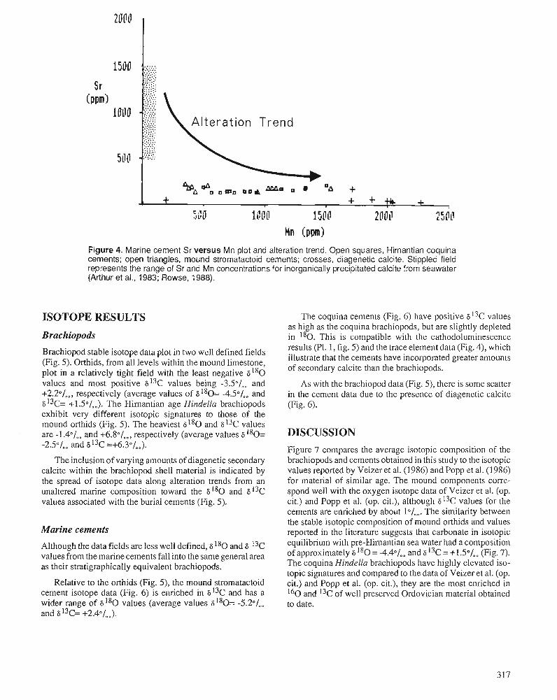
Figure 4. Marine cement Sr versus Mn plot and alteration trend. Open squares, Hirnantian coquina cements; open triangles, mound stromatactoid cements; crosses, diagenetic calcite. Stippled field represents the range of Sr and Mn concentrations for inorganically precipitated calcite from seawater (Arthur et al., 1983; Rowse, 1988).
ISOTOPE RESULTS
Brachiopods
Brachiopod stable isotope data plot in two well defined fields (Fig. 5). Orthids, from all levels within the mound limestone, plot in a relatively tight field with the least negative 6 1 8 0 values and most positive 613c values being -3.50/,, and +2.20/,,, respectively (average values of 6 180= -4.50/,, and 6 13c= +1.5°/00). The Himantian age Hindella brachiopods exhibit very different isotopic signatures to those of the mound orthids (Fig. 5). The heaviest 6 1 8 0 and 6 13c values are -1.4"/,. and +6.80/,,, respectively (average values 6180= -2.501.. and 6 13c =+6.3°/.,).
The inclusion of varying amounts of diagenetic secondary calcite within the brachiopod shell material is indicated by the spread of isotope data along alteration trends from an unaltered marine composition toward the 6 1 8 0 and 613c values associated with the burial cements (Fig. 5).
Marine cements
Although the data fields are less well defined, 6 180 and 6 13c values from the marine cements fall into the same general area as their stratigraphically equivalent brachiopods.
Relative to the orthids (Fig. 5), the mound stromatactoid cement isotope data (Fig. 6) is enriched in 613c and has a wider range of 6180 values (average values 6180= -5.2°/.. and 6I3c= +2.4°/,,).
The coquina cements (Fig. 6) have positive 6I3c values as high as the coquina brachiopods, but are slightly depleted in 180. This is compatible with the cathodoluminescence results (PI. I , fig. 5) and the trace element data (Fig. 4), which illustrate that the cements have incorporated greater amounts of secondary calcite than the brachiopods.
As with the brachiopod data (Fig. 5), there is some scatter in the cement data due to the presence of diagenetic calcite (Fig. 6).
DISCUSSION Figure 7 compares the average isotopic composition of the brachiopods and cements obtained in this study to the isotopic values reported by Veizer et al. (1986) and Popp et al. (1 986) for material of similar age. The mound components corre- spond well with the oxygen isotope data of Veizer et al. (op. cit.) and Popp et al. (op. cit.), although 6 13c values for the cements are enriched by about The similarity between the stable isotopic composition of mound orthids and values reported in the literature suggests that carbonate in isotopic equilibrium with pre-Himantian sea water had a composition of approximately 6 180 = -4.40/,, and 6 13c = +1.50/,, (Fig. 7). The coquina Hindella brachiopods have highly elevated iso- topic signatures and compared to the data of Veizer et al. (op. cit.) and Popp et al. (op. cit.), they are the most enriched in 160 and 13c of well preserved Ordovician material obtained to date.
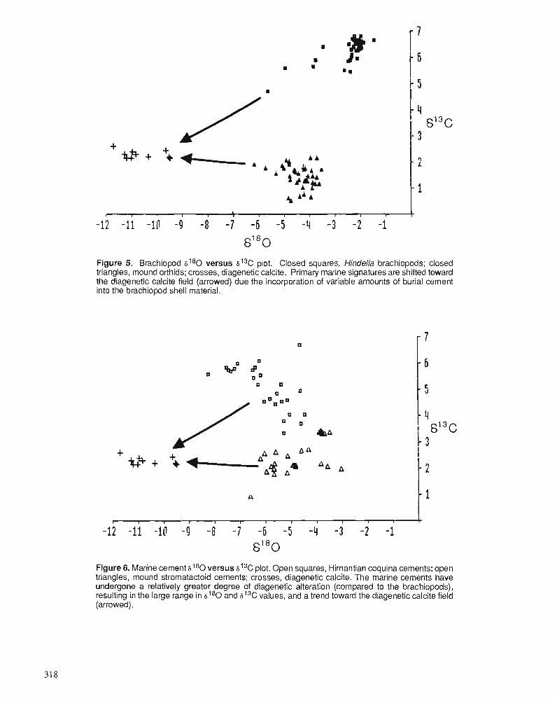
Figure 5. Brachiopod sI80 versus st3C plot. Closed squares, Hindella brachiopods; closed triangles, mound orthids; crosses, diagenetic calcite. Primary marine signatures are shifted toward the diagenetic calcite field (arrowed) due the incorporation of variable amounts of burial cement into the brachiopod shell material.
Figure 6. Marine cement si80 versus si3C plot. Open squares, Hirnantian coquina cements; open triangles, mound stromatactoid cements; crosses, diagenetic calcite. The marine cements have undergone a relatively greater degree of diagenetic alteration (compared to the brachiopods), resulting in the large range in s t 8 0 and st3C values, and a trend toward the diagenetic calcite field (arrowed).
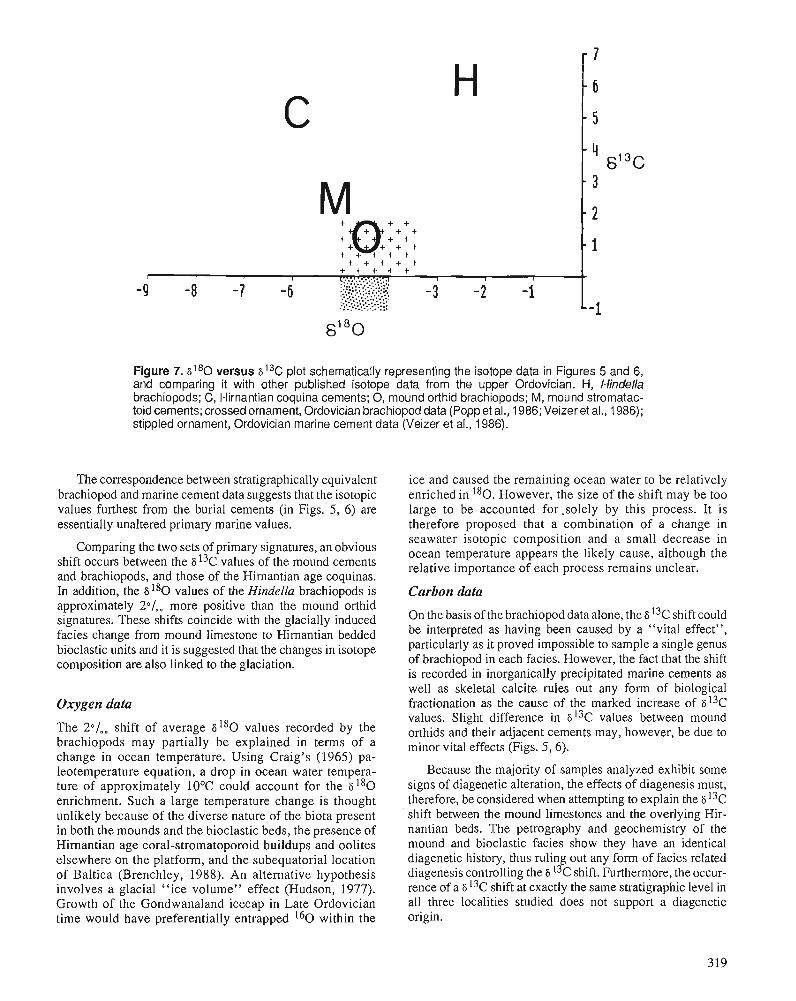
Figure 7. s i 8 0 versus si3C plot schematically representing the isotope data in Figures 5 and 6, and comparing it with other published isotope data from the upper Ordovician. H, Hindella brachiopods; C, Hirnantian coquina cements; 0, mound orthid brachiopods; M , mound stromatac- toid cements; crossed ornament, Ordovician brachiopod data (Poppet al., 1986; Veizeret al., 1986); stippled ornament, Ordovician marine cement data (Veizer et al., 1986).
The correspondence between stratigraphically equivalent ice and caused the remaining ocean water to be relatively brachiopod and marine cement data suggests that the isotopic enriched in 180. However, the size of the shift may be too values furthest from the burial cements (in Figs. 5 , 6) are large to be accounted for .solely by this process. It is essentially unaltered primary marine values. therefore proposed that a combination of a change in
seawater isotopic composition and a small decrease in the two sets of primary signatures, an obvious ocean temperature appears the likely cause, although the
shift occurs between the 8l3c values of the mound cements relative importance of each pmcess remains unclear. and brachiopods, and those of the Himantian age coquinas. In addition, the 8180 values of the Hindella brachiopods is Carbon data approximately 2/,, more positive than the mouni orthid
~h~~~ shifts with the glacially induced On the basis of the brachiopod data alone, the a "C shift could
facies change from mound limestone to ~ i ~ ~ ~ ~ t i ~ ~ bedded be interpreted as having been caused by a ''vital effect",
bioclastic units and it is suggested that the changes in isotope particularly as it proved impossible to sample a single genus composition are also linked to the glaciation. of brachiopod in each facies. However, the fact that the shift
is recorded in inorganically precipitated marine cements as
Oxygen data
The 2°/ , , shift of average 6 1 8 0 values recorded by the brachiopods may partially be explained in terms of a change in ocean temperature. Using Craig's (1965) pa- leotemperature equation, a drop in ocean water tempera- ture of approximately 10°C could account for the 6 1 8 0 enrichment. Such a large temperature change is thought unlikely because of the diverse nature of the biota present in both the mounds and the bioclastic beds, the presence of Hirnantian age coral-stromatoporoid buildups and oolites elsewhere on the platform, and the subequatorial location of Baltica (Brenchley, 1988). An alternative hypothesis involves a glacial "ice volume" effect (Hudson, 1977). Growth of the Gondwanaland icecap in Late Ordovician time would have preferentially entrapped 160 within the
well as skeletal calcite rules out any form of biological fractionation as the cause of the marked increase of s13c values. Slight difference in s13c values between mound orthids and their adjacent cements may, however, be due to minor vital effects (Figs. 5,6).
Because the majority of samples analyzed exhibit some signs of diagenetic alteration, the effects of diagenesis must, therefore, be considered when attempting to explain the 6 13c shift between the mound limestones and the overlying Hir- nantian beds. The petrography and geochemistry of the mound and bioclastic facies show they have an identical diagenetic history, thus ruling out any form of facies related diagenesis controlling the S 13c shift. Furthermore, the occur- rence of a s 13C shift at exactly the same stratigraphic level in all three localities studied does not support a diagenetic origin.
Positive shifts in 6 13c, similar to the one described in this paper, have been reported from elsewhere in the stratigraphic column (e.g., Weissert et al., 1979; Scholle and Arthur, 1980; Tucker, 1986; Carson, 1988). Such excursions are generally associated with periods of enhanced sedimentation of organic matter: the removal of isotopically light organic carbon leaves the remaining dissolved marine carbon relatively en- riched in 13C. There is, however, no evidence from the Baltoscandian Basin for the synchronous deposition of black shale or organic-rich sediment (Jaanusson, pers. comm.). An additional problem comes from faunal evidence that suggests generally low levels of planktonic productivity (Brenchley, 1984).
Despite these problems, the removal of 12c-rich organic matter is favoured as the cause of the carbon shift. One potential solution is the generation of a 13c enriched water mass outside the Baltoscandian Basin. Wilde and Berry (1984) conclude that the onset of glacial climatic conditions could induce oceanic destabilization, the subsequent overturn of dysaerobic or anaerobic water masses onto continental margins aiding in the preservation of organic-rich sediments. Such a scenario may be associated with the Late Ordovician glaciation, the Hirnantian brachiopods and marine cements recording the passage of a 1 3 c enriched water mass into the Baltoscandian Basin.
This paper represents the first documentation of a Hirnan- tian age positive carbon shift. The presence of a shift of this magnitude has important implications in the interpretation of the paleoceanography and paleoecology of Hirnantian times. The isotopic analysis of equivalent age sediments is required to ascertain whether the shift is merely a local effect, re- stricted to the seas around Baltica, or a widespread (possibly global) event.
A further discussion of oxygen and carbon isotope data for the Kullsberg and Boda limestones can be found in Marshall and Middleton (1990).
CONCLUSIONS 1. Brachiopods from coquinas capping the Boda mounds
have the least negative 6 1 8 0 values and the most positive 613C values reported to date for unaltered Ordovician marine cements and brachiopods.
2. The similarity between the stable isotopic composition of the brachiopods and cements from within the mounds and published data for Ordovician carbonates suggests the stable isotopic signature of carbonate in equilibrium with nonglacial Ashgillian sea water was approximately 6 ' 8 0 = -4.4°/,, and s13C = +1.5°/,,.
3. Hirnantian brachiopods and associated marine cements record a positive carbon shift of approximately 4/,, and a positive oxygen shift of approximately 20/,,. These shifts coincide with the facies change from mound lime- stone to bedded bioclastic units.
4. The shift in 6 l 8 0 is attributed to a combination of tem- perature decrease and a glacially induced change in the isotopic composition of the sea water.
5. Sedimentological and geochemical reasons preclude bio- logical fractionation and diagenetic alteration as possible causes of 13C enrichment. The most suitable explanation for the observed shift is a major change in the distribution of carbon between organic and inorganic carbon reser- voirs.
ACKNOWLEDGMENTS We would like to thank Jon Rowse, Steve Crowley, Jim Hendry, William Holser, and the anonymous referee for their comments and suggestions, which have greatly improved this manuscript. Also thanked are Hilary Attenborough for his help in the Stable IsotopeLaboratory and the staff of the I.C.P. laboratory at Royal Holloway and Bedford New College. This work was supported by a Research Studentship grant (to Paul Middleton) from the Natural Environment Research Council (N.E.R.C.) of Great Britain. The Stable Isotope Laboratory at Liverpool University is funded by the Univer- sity and by the N.E.R.C. (grants GR316815 and GR315339 to Jim Marshall).
REFERENCES Bathurst, R.G.C. 1959: The cavernous structure of some Mississippian reefs in Lancashire,
England. Journal of Geology, v. 67, p. 506-521. 1975: Carbonate Sediments and 7heu Diagenesis. Elsevier, knsterdam, 658 p. Berry, W.B.N. and Boucot, A.J. 1973: Glacio-eustatic control of Late Ordovician-Early Silurian platform
sedimentation and faunal changes. Geological Society of America, Bulletin, v. 84, p. 275-284.
Brenchley, P.J. 1984: Late Ordovician extinctions and their relationship to the Gondwana
glaciation. In Fossils and Climate, P.J. Brenchley (ed.); John Wiley and Sons, New York, p. 291-315.
1988: Environmental changes close to the Ordovician-Silurian boundary. Bulletin of the British Museum (Natural History), Geology, v. 43, p. 377-385.
Carson, G.A. 1988: A diagenetic and palecmanographic study of the mid-Cretaceous of South
England. Unpublished PhD. thesis, University of Liverpool, 293 p. Craig, H. 1957: Isotope standards for carbon and oxygen and correction factors for
mass-spectrometer analysis of carbon dioxide. Geochimica et Cos- mochimica Acta, v. 12, p. 133-149.
1965: The measurement of oxygen isotope paleotemperatures: Proceed- ings of the Conference on Stable Isotopes in Ocean Studies and Paleotemperatures, Spoleto, p. 3-24.
Friedman, I. and O'Neill, J.R. 1977: Compilation of stable isotope fractionation factors of geochemical
interest. In Data of Geochemistry, M. Fleicher ed.; United States Geological Survey, Professional Paper 440-KK.
Given, R.K. and Lohmann, K.C. 1985: Derivation of the original isotopic composition of Permian marine
cements. Journal of Sedimentary Petrology, v. 55, p. 430-439. Hudson, J.D. 1977: Oxygen isotope studies on Cenozoic temperatures, oceans and ice
accumulation. Scottish Journal of Geology, v. 13, p. 313-325. Jaanusson, V. 1982: The Siljan district. In Field Excursion Guide, D.L. Bruton and S.H.
Williams (eds.); IV International Symposium on the Ordovician System, Paleontological Contributions from the University of Oslo, no. 279, p. 15-42.
Kendall, A.C. 1985: Radiaxial fibrous calcite: a reappraisal. In Carbonate Cements, N.
Schneidennann and P.M. Hanis (eds.); Society of Economic Pale- ontologists and Mineralogists, Special Publication no. 36, p. 59-77.
Lowenstam, H.A. 1961: Mineralogy, '80/160 ratios, and Sr and Mg contents of recent and
fossil brachiopods and their bearing on the history of the oceans. Journal of Geology, v. 69, p. 241-260.
Mannil, R.M. 1966: Istoriya razvitiya Baltiyskogo basseyna v ordovike. Eesti NSV
Teaduste Akadeemia geoloogia Instituudi Tallin, p. 1-201. Marshall, J.D. and Middleton, P.D. 1990: Changes in marine isotopic composition and the Late Ordovician
glaciation. Journal of the Geological Society, London, v. 147, p. 1-4. McKerrow, W.S. 1979: Ordovician and Silurian changes in sea level. Journal of the Geo-
logical Society of London, v. 136, p. 137-145. Popp, B.N., Anderson, T.F., and Sandberg, P.A. 1986: Brachiopods as indicators of original isotopic composition in some
Paleozoic limestones. Geological Society of America, Bulletin, V. 97, p. 1262-1269.
Ross, R.J., Jaanusson, V., and Friedman, I. 1975: Lithology and origin of Middle Ordovician calcareous mudmound
at Meiklejohn Peak, Southern Nevada. United States Geological Survey, Professional Paper 871,48 p.
Rowse, M.J. 1988: The diagenesis and geochemistry of Silurian limestones Welsh Bor-
derlands. Unpublished Ph.D. thesis, University of Liverpool, 332 p.
Scholle, P.A. and Arthur, M.A. 1980: Carbon isotope fluctuations in Cretaceous pelagic limestones: poten-
tial stratigrapllic and petroleum exploration tool. The American Asso- ciation of Petroleum Geologists, Bulletin, v. 64, p. 67-87.
Thorsland, P. and Jaanusson, V. 1960: The Cambrian, Ordovician and Silurian in Vastergotland, Narke,
Dalarna, and Jamtland, Central Sweden. Guide Excursion, nos. A23 and C18, International Geological Congress M Session, Norden, p. 27-35.
Tucker, M.E. 1986: Carbon isotope excursions in Precambrian/Cambrian boundary
beds, Morocco. Nature, v. 319, p. 48-50. Veizer, J., Fritz, P., and Jones, B. 1986: Geochemishy of brachiopods: oxygen and carbon isotopic records of
Paleozoicoceans. GeochimicaetCosmochimica Acta, v. 50, p. 1679-1696. Wallace, M.W. 1987: The role of internal erosion and sedimentation in the formation of
stromatactis mudstones and associated lithologies. Journal of Sedi- mentary Petrology, v. 57, p. 695-700.
Weissert, H., McKenzie, J., and Hochuli, P. 1979: Cyclic anoxic events in the Early Cretaceous Tethys Ocean. Geol-
ogy, v. 7, p. 147-151. Wilde, P. and Berry, W.B.N. 1984: Progressive ventilation of the oceans -potential for return to anoxic
conditions in the post-Paleozoic. In Nature and Origin of Cretaceous CarbonRich Facies, S.O. Schlanger and M.B. Cita (eds.); Academic Press, p. 209-224.
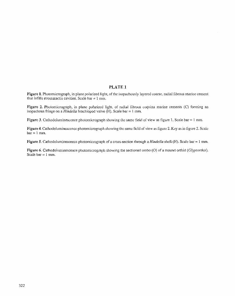
PLATE 1
Figure 1. Photomicrograph, in plane polarized light, of the isopachously layered coarse, radial fibrous marine cement that infills stromatactis cavities. Scale bar = 1 mm.
Figure 2. Photomicrograph, in plane polarized light, of radial fibrous coquina marine cements (C) forming an isopachous fringe on a Hindella brachiopod valve (H). Scale bar = 1 mm.
Figure 3. Cathodoluminescence photomicrograph showing the same field of view as figure 1. Scale bar = 1 mm.
Figure 4. Cathodoluminescence photomicrograph showing the same field of view as figure 2. Key as in figure 2. Scale bar = 1 mm.
Figure 5. Cathodoluminescence photomicrograph of a cross-section through a Hindella shell (H). Scale bar = 1 mm.
Figure 6. Cathodoluminescence photomicrograph showing the sectioned umbo (0) of a mound orthid (Gfyptorthis). Scale bar = 1 mm.

Hirnantian glaciomarine cliamictites - evidence for the spread of glaciation and its effect on Upper
Ordovician faunas
1 P.J. Brenehley , M. ~ o r n a n o ~ , T.P. young3, and P. storch4
Brenchley, P.,J., Romano, M., Young, T.P., and Storch, P., Hirnantian glaciomarine diamictites- evidence for the spread of glaciation and its effect on Upper Ordovician faunas; k Advances in Ordovician Geology, C.R. Barnes and S.H. Williams (ed.), Geological Survey of Canada, Paper 90-9, p. 325-336,1991.
Abstract
Upper Ordovician sequences in Portugal and in the Prague Basin, Czechoslovakia, have glaciomarine diamictites that are Hirnantian in age. Upper Ordovician diarnictites in Morocco are likewise ofHirnantian age, as probably are those elsewhere in Europe. Thus, although the continental glaciation of Saharan Africa cannot be accurately dated, the extension of the ice into peripheral areas appears to have been confined to the Hirnuntian. This is consistent with Hirnantian eustatic sea level changes.
The sequence in the Prague Basin suggests that cold climates with floating marine ice developed early in the Hirnantian, before the main glacio-eustatic regression, whereas in Portugal, deposition from marine ice was somewhat later and postdated the regression.
The diamictites in the Prague Basin were probably deposited from an ice shelf or possibly from sea ice, whereas the diamictites in Iberia may have been deposited nzainly from floating glacier ice.
The expansion of cold climates at the start of the Hirnantian coincides with the first and major phase of Late Ordovician extinction, and precedes the nzavimum low stand of sea level during the Hirnantian regression. It is concluded that lowered temperatures at the start of the Hirnantian may have played a major role in the extinction, particularly among high latitude faunas andfloras.
Au Portugal et dans le bassin de Prague, en Tche'coslovaquie, des se'quences de 1'Ordovicien supkieur contiennent des diamictites glaciomarines qui remontent ci I' Hirnantien. Des diamictites de 1'Ordovicien supe'rieur qui se trouvent au Maroc et vraisemblablement ailleurs en Europe datent eux aussi de 1'Hirnantien. Par conse'quent, bien qu'il soit impossible de dater avec pre'cision la glaciation continentale de 1'Afrique saharienne, la glace n'a vraisemblablement envahi les zones pe'riphkriques que durant llHirnantien, ce qui est compatible avec lesfluctuations eustatiques du niveau rnarin a 1'Hirnantien.
La se'quence qui se rencontre dans le bassin de Prague porte 2 croire que des climatsfroids, caracte'risks par la prksence de glace marineflottante, se sont dkveloppis au dkbut de l'Hirnuntien, avant la principale rkgression glacio-eustatique. Par opposition, au Portugal, I'accumulation de se'diments en provenance de la glace marine a eu lieu un peu plus tard, aprks la rkgression.
' Department of Earth Sciences, University of Liverpool, Liverpool, L69 3BX, U.K. Earth Sciences Unit, University of Sheffield, Sheffield, S3 7HF, U.K. Department of Geology, University College of Wales, Cardiff CFI IXL, U.K. Ustedni Ustav Geologicky, 118 21 Praha 1, MalostranskC nhm. 19, Czechoslovakia.

Les diamictites du bassin de Prague provienizent vraisemblablement dune plate-forme de glace ou encore de la glace de mer, tandis que celles de la ptninsule Ibtrique pourraient s'2rr.e accumultes principalernent d partir de glaciers flottants.
L'expansion des climats froids au dkbut de I'Hirnantien coi'ncide avec la premikre et principale phase d'extinction de I'Ordovicien supkrieur; elle prkckde la phase principale de bas niveau de la rkgression hirnantienne. Les basses tempkratures au dtbut de I'Hirnantien auraient vraisemblablenzent kt6 une des causes principales de I'extinction, notamment des faunes et desflores des hautes latitudes.
INTRODUCTION
The existence of a Late Ordovician continental glaciation centred on the African part of Gondwanaland is now well established through the work of Beuf et al. (1971) and others. The glaciation was probably of "antarctic type, based on a large peneplaned continent, under the pole" (Spjeldnaes, 198 1). Land-based ice occurred in parts of Saharan Africa and South Africa, and floating ice in peripheral regions (Fig. 1). The age and nature of the glaciation has been the subject of reviews by Spjeldnaes (1981). Hambrey (1985), and Ro- bardet and Dore (1988). Spjeldnaes noted that it was difficult to determine the age of the continental glaciation because fossils are generally lacking, and even where they are present they are possibly derived from the underlying sequence. The peripheral glaciomarine deposits have yielded an Upper Or- dovician (Himantian) fauna in Morocco (Destombes, 1968b) and elsewhere have been shown to be of broadly Late Ordo- vician age, suggesting that they may be roughly contempora- neous (Havlicek, 1974,1976; Spjeldnaes, 198 1; Robardet and Dor6, 1988).
In this paper we use evidence from sequences with dia- rnictites in western Iberia and the Prague Basin (Czechoslo- vakia) (Fig. 3) to constrain more closely the age of the peripheral glacial deposits. We then briefly review the likely nature of the depositional processes and finally comment on the likely influence of a rapid climatic cooling on Upper Ordovician faunas.
STRATIGRAPHY The age of continental glacialdeposits in Africa is not well constrained. In Saharan Africa, glacial deposits of the Felar- Felar Formation lie on an erosional surface above various units of different ages. Fossils of Caradoc or possibly Ashgill age are found in nodules in the green silts above the erosional surface in the Hoggar region, but as Spjeldnaes (1981) and Legrand (1985) pointed out, they are likely to be derived from the underlying sequence. Only in Morocco are there glacial deposits with intercalated marine horizons yielding a fauna of Himantian age (Destombes, 1968a, b, 1981; Destombes et al., 1985).
The upper limit of the continental glacial deposits is broadly indicated by the overlying black graptolitic shales. In Algeria, Legrand (1986) has recognized the presence of grap- tolites, probably equivalent to the persculptus Zone, and possibly the top of the underlying extraordinarius Zone, above the glacial deposits. In Morocco, the persculptus Zone is known only from one locality; more usually acuminatus is the lowest zone recorded above the diamictites (Destombes and Willefert, 1988). Farther south in the Hodh area of Mauritania, Willefert (1988) documented the persculptus Zone occurring in a sequence of microconglomerate, clay, and sandstone in the upper part of the glacial sequence.
Figure 1. Distribution of Upper Ordovician glacigenic depos- its. Dots indicate recorded localities. Stippled area has gla- ciomarine deposits dominant, hachured area has evidence for land-based ice. Some localities interpreted here as being of Late Ordovician age have been previously referred to the Early Silurian. (Base map from Ashgill reconstruction of Scotese and McKerrow, 1990)
Although there may have been a small polar ice cap throughout much of the Ordovician, if part of Gondwana lay in polar latitudes, the stratigraphic evidence from continental deposits of Saharan Africa only demonstrates that the glacial deposits were laid down sometime during the Caradoc or Ashgill.
In the peripheral areas, dating of the glaciomarine diamic- tites depends upon two different strands of evidence, one biostratigraphic, the other event-stratigraphic. Biostratig- raphic evidence for correlation at this stratigraphic level is relatively good because the uppermost Ashgill stage (the Hirnantian) (Fig. 2) is characterized by the distinctive Hir- nantia fauna. This has now been recognized widely through- out Europe and China, in North America, Asia and the U.S.S.R. (Rong, 1984) and more recently in South America (Benedetto, 1986). The fauna provides good evidence for identifying the presence of rocks of Himantian age. However, in sections where there is not a complete sequence of faunas or the underlying faunas are endemic, it may not be possible to determine the precise position of stage boundaries. Where faunal evidence is inadequate, event stratigraphy, using the evidence of sea level changes, can be more effective.
It has been shown that at many places around the world (Berry and Boucot, 1973; Brenchley, 1988), where upper- most Ordovician rocks are present, there is a regressive phase near the base of the Himantian followed by a transgressive phase at approximately the base of the Glyptograptus pers- culptus Zone (Fig. 2). Sea level changes that can be shown to be of approximately the same age on several separate plates are a good indication that the sea level changes are eustatic rather than tectonic. The effects of eustatic movements will be synchronous, and can be used for correlation except where they have been modified by particularly strong local tectonic effects. The first signs of the late Ashgill eustatic regression occur at, or close to, the base of the Himantian (Brenchley and Newall, 1980; Brenchley and Cullen, 1984; Brenchley, 1988), whereas evidence for the subsequent transgression is found below or within the Glyptograptus persculptus Zone, i.e., in the upper part of the Hirnantian (Fig. 2). Consequently. we have used the first evidence of regression to identify the base of the Hirnantian, and the transgression to identify the upper part of the stage, where suitable fossils are not present.
AGE AND ORIGIN OF THE DIAMICTITES
Outside Morocco, the age of the glaciomarine diamictites has not been precisely determined, though it has been suggested that they are late Ashgill in age (Havlicek, 1974). In Celtiberia (Spain, Fig. 3), for example, diarnictites (the Orea Shales) occur above a karst surface on the Urbana Limestone (= Cystoid Limestone), which Hafenrichter (1980) suggested is of Rawtheyan age. In Normandy, Upper Ordovician diamic- tites overlie beds of Caradoc age and at Caen contain re- worked fragments of Ashgill limestone (Robardet and Dor6, 1988).
New evidence from Portugal and the Prague Basin sug- gests a Himantian age for the diamictites in these two regions.
Diamictites in Portugal
Diamictites are known from several areas of northem and central Portugal. Although diamictites have been recognized in Iberia for some considerable time, a recent review of the Upper Ordovician stratigraphy of central Portugal (Young, 1985) has allowed their reappraisal within this sector of the peninsula.
The upper member of the Sobredo Formation (Fig. 4) of the Valongo/Arouca area of northern Portugal (Romano and Diggens, 1976) consists of 1.5 m of laminated mudstone, which lies abruptly, possibly unconformably, over the sand- stone of the lower member, and is overlain by more than 100 m of mainly massive "pebbly greywacke" grading upward into less pebbly lithotypes (Fig. 5, column V). At a few horizons there is a faint lamination with laminae up to a few rnillimetres thick. The diamictites are muddy, fine grained sandstone, bearing clasts of sandstone, quartz, and granite of 1-50 rnrn diameter, usually 2-10 rnm (Romano and Diggens, 1976). The clasts are generally thinly dispersed through the sandstone and are seen on exposed surfaces as one in a square metre or less.
The biostratigraphic control on the diarnictite is poor. The first fossils below the diarnictite, from the Valongo Formation, are of Llandeilo, or possibly early Caradoc age (Romano, 1982,
G. persculptus
System Series Graptolite Stages zones Eustatic sealevel curve
Figure 2. Upper Ordovician stratigraphy and diagrammatic illustration of the timing of glacio-eustatic sea level change in the Late Ordovician.
Z P 5 2
.- 5 c
CC 0 Pacuminatus
high low --
Figure 3. Areas in Europe with Upper Ordovician diamictites (solid black areas).
ela l ive sea level
Figure 4. Lithostratigraphy of Upper Ordovician deposits in north and central Portugal, showing correlation of units with chronostratigraphicscaleand eustaticand glacial events.
and work in progress) and the earliest Silurian graptolites sandstone, with clasts up to 20 cm in diameter. The diamic- above the diamictites are of middle to late Llandovery age tites at most localities are less than 30 m thick and consist of (Romariz, 1963). massive, poorly sorted, muddy sandstone, bearing isolated
In central Portugal, a more complete sequence of Late Ordovician age is exposed (Figs. 4-6). Diamictites generally overlie a regressive sequence, the Rio Ceira Group (Fig. 4) (Young, 1988). This sequence (Fig. 5, between lines 1 and 3) includes mudstone and siltstone toward the base (the lower part of the Ribeira da Laje Formation of south-central Portu- gal and the Ribeira do Brasal Formation of the Buqaco Syncline), but the frequency and thickness of intercalated sandstone beds increase upward through these formations, culminating in the Serra do Arnial Member of south-central Portugal (e.g., Domes). In the Buqaco area, there was a lower to middle Ashgill volcanic centre (Porto de Santa Anna Formation), with associated bioclastic carbonates (Ferradosa Formation). Where these deposits are thin, in the south of the Bu~aco area, they are overlain by a regressive sequence (Ribeira do Bra@ Formation), but around the margins of the thicker developments the volcanics are unconformably over- lain by the conglomeratic sandstone of the Ribeira Cimeira Formation (Figs. 4,5). This conglomeratic sandstone also lies unconformably on the Ribeira do BraqaI Formation in the southern part of the syncline. Some comminuted conglom- eratic debris has also been recorded in the Serra do Amial Member of south-central Portugal. The clasts in the conglom- erate are almost exclusively derived from the Porto de Santa Anna Formation.
large sand grains (PI. 1, fig. 4) and clasts of up to 5 cm in diameter, although rare clasts of up to 15 cm in diameter have been recorded. The lithotypes represented in the clasts include sandstone, limestone, and ooidal ironstone. In the Bu~aco Syncline, the dominant clast lithotype is a decalcified impure limestone bearing charnosite ooids. In many areas, there are well sorted, laminated sandstones, probably of storm origin, intercalated within the lower part of the diamictites. These show evidence of significant soft sediment deformation, par- ticularly load casts.
The diarnictites grade upward into dark mudstone with sandy laminae, which form the upper part of the Casal Car- valhal Formation. In the uppermost part of the formation, these laminae become thicker, and distinct load-casted sand- stone beds are intercalated in the few metres immediately below the base of the Vale da Ursa Formation. This formation consists of black, pyritic sandstone, often showing consider- able load casting. The upper part of the Vale da Ursa Forma- tion contains finely laminated sandstone, the Serra dos Aguilhks Member, and is overlain by rnicaceous muddy sandstone with mudstone rip-up clasts, the Junqueira Mem- ber, at the base of the Foz da Serta Formation. The Junqueira Member is generally less than 4 m thick and is sharply overlain by black graptolitic mudstone, which forms the bulk of the Foz da Sertii Formation.
The diarnictites overlie the Ribeira Cimeira Formation The Upper Ordovician sequence in the Rio Ceira Group and the Serra do Amial Member and are interbedded near of central Portugal is interpreted as recording glacio-eustatic the contact in some areas (Fig. 5). They lie within the lower regression (Fig. 5, between lines 1 and 3), followed by the part of the Casal C a ~ a l h a l Formation. In the Dornes area, deposition of glaciomarine diamictites. The diamictites are the base of the diamictites consists of a massive, hard, pebbly interpreted as being of glaciomarine origin because of the
Dornes D
Valongo Navatrasierra
/ 1 Tielines 1 Base
2 Base
3 Base
4 Base
Mudstone
Diamictite
lnterbedded sandstone /mudstone
Volcaniclastics Sandstone
Conglomerate
of regressive sequence
of conglomeratic sandstone
of diarnictite
of transgressive sequence
Figure 5. Selected diamictite- bearing sequences of Late Ordovician age in the Iberian Peninsula. The localities in Portugal are 20 to 50 km apart. Navatrasierra is about 250 km from Bu~aco.
5 Base of graptolitic mudstone
combination of their texture, as well as their very wide extent, forming a blanket deposit over a very large area, and the absence of any demonstrable lateral facies change (see dis- cussion below). Most of the pebbles recovered from the diamictites of central Portugal are subangular to subrounded. Striated pebbles have not been found, although a faceted morphology is not uncommon among the larger clasts. The clast lithotypes are compatible with relatively local deriva- tion. The similarity between the impure limestone with chamositic ooids seen as clasts in the Buqaco area, and the lithotype of the lower part of the Porto de Santa Anna Forma- tion in the southern part of the syncline is striking. Young (1985,1988,1990) has described a belt of reduced subsidence during the Ordovician across central Portugal, the Dor- nes/Amendoa "rise", lying between the southern part of the Buqaco Syncline and the Domes area. This belt could have acted as a source for all the pebble lithotypes seen, and might have been a slightly positive topographic feature at the time. The presence of striated pebbles (Pl. 1, fig. 1) in central Iberia (Navatrasierra in the Montes de Toledo), demonstrates some input of glacially eroded debris, but the subrounded nature of the clasts, together with their inferred local derivation, sug- gest that sea ice might have played a role, as well as glacier ice, during the deposition of the diarnictites.
The upper part of the Casal Carvalhal Formation is inter- preted as being deposited during the glacio-eustatic transgres- sion. The gradual passage of the diamictites upward into better-sorted sediments suggests a slowing of the sedimenta- tion rate and increased reworking. The Vale da Ursa Forma- tion and the base of the Foz da Sertii Formation are the products of reworking on the sediment-starved shelf after sea level rise. It is only in the upper Llandovery that sedimenta- tion resumes, albeit with organic-rich black graptolitic mud- stone.
The central Portugal area provides some useful biostratig- raphic data on the diarnictites (Young, 1990). In the southern part of the Buqaco Syncline, the Porto de Santa Anna Forma- tion is reduced to just a few metres in thickness. Its base contains a fauna (Fig. 6, assemblage 1) that is of Pusgillian age, but the top yields a fauna of small brachiopods (Fig. 6, assemblage 2) showing some affinity to the Proboscisambon Community (Havlicek, 1982; Havlicek and Mergl, 1982; Cocks and Rong, 1988) from the uppermost Kr6luv Dvur Formation (Rawtheyan) of the Prague Basin. These Raw- theyan sediments are abruptly overlain by siltstone at the base of the Ribeira do Bra~al Formation, bearing a low diversity shelly fauna (Fig. 6, assemblage 3) with elements related to those of Hirnantia faunas in other regions. These sediments, which also bear large isolated quartz sand grains, mark the earliest sediments deposited in the area during the glacio-eus- tatic regression and are interpreted as being of Himantian age.
In the south-central Portugal region (e.g., Domes) the Serra dos AguilhBes Member contains, near its base, a poorly preserved fauna of graptolites (Fig. 6, assemblage 4), indicat- ing a Rhuddanian age. The overlying Junqueira Member is a condensed deposit, yielding middle to late Llandovery age graptolites (Fig. 6, assemblage 5). The base of the graptolitic mudstone above the Junqueira Member yields a graptolite fauna of late Llandovery (griestoniensis Biozone) age.
Diamictites in the Prague Basin
The Ashgill of the Prague Basin consists of a monotonous sequence of grey mudstone, the Krhluv Dvur Formation, overlain by sandstone and shale of the Kosov Formation. The Krhluv Dvur has a trilobite and sparse brachiopod fauna belonging to benthic assemblage 5 or 6, suggesting a deep shelf or slope environment (Havlicek, 1982), whereas the sandstone of the Kosov Formation has wave ripples and hummocky cross-stratification, implying a shallow shelf en- vironment (Brenchley and Storch, 1989).
The Kosov Formation has a fauna of Hirnantian age in its upper part, but is mainly unfossiliferous in its lower and middle portions, which prevents the identification of the lower Hirnantian boundary on purely biostratigraphic evi- dence. There are, however, sedimentological and faunal changes in the top few metres of the KrAluv Dvur that suggest the initiation of the late Ashgill regression. Within 3 m of the top of the Kri5luv Dvur is the Pemk Bed (Fig. 7, Unit A), a thin (<lOcm) calcareous mudstone/siltstone, with a diverse fauna of more than 70 genera including many trilobites and brachiopods. In the succeeding few centimetres (Fig. 7, Unit B) the rich fauna disappears, to be replaced by a low diversity Mucronaspis association, containing mainly Mucronaspis, ostracodes, and bivalves (Storch and Mergl, 1989). At the same level there is a change in the colour and texture of the mudstone, from the calcareous Pernik Bed (Fig. 7, Unit A), through brown-grey silty mudstone, to silty, grey shale with sparse nodules, to silty grey shale without nodules (Fig. 7, Unit B).
The Mucronaspis association, though probably not diag- nostic of the Himantian, is a common deep shelf association in the Himantian (cf. LespCrance and Sheehan, 1981) and its presence, taken together with the lithological change, is be- lieved to identify the base of the Himantian at a few centime- tres above the Pemik Bed.
The lower diamictites (Fig. 7, Unit C), which have tradi- tionally been taken to mark the base of the Kosov Formation, occur 3 to 4 m above the Pernik Bed and about 3 m below the sandstone of the Kosov Formation, which reflects the peak of the first phase of the Himantian regression. The lower dia- mictite horizon is 10 to 20 cm thick and consists of four or more thin, structureless, ungraded beds. The sediments have well rounded to subrounded quartz grains (<2 mm in diame- ter) in a fine sand/silt/mud matrix. Sparsely dispersed through the rock are larger clasts, usually less than 2 cm in diameter.
The upper diamictite (2 to 3 m thick, Fig. 7, Unit E) is separated from the lower one by about 2 m of mudstone. The diamictite consists of several beds, 10 to 30 cm thick, passing up into very thinly bedded diamictite (1.0 to 10 mm thick), separated by thin partings of mudstone and siltstone (Pl. 1, fig. 2). Clasts, usually 1 to 2 cm in diameter but more rarely up to 5 cm in diameter, are thinly dispersed through the diamictite, especially in the thicker beds (Pl. 1, fig. 3). The clasts are mainly siltstone, sandstone, or oolitic ironstone derived from the underlying formations, though granitoids and clasts of chert and mildly metamorphosed shale were probably derived from the surrounding Proterozoic basement, suggesting the possibility of glacial erosion (Havliek, 1974).
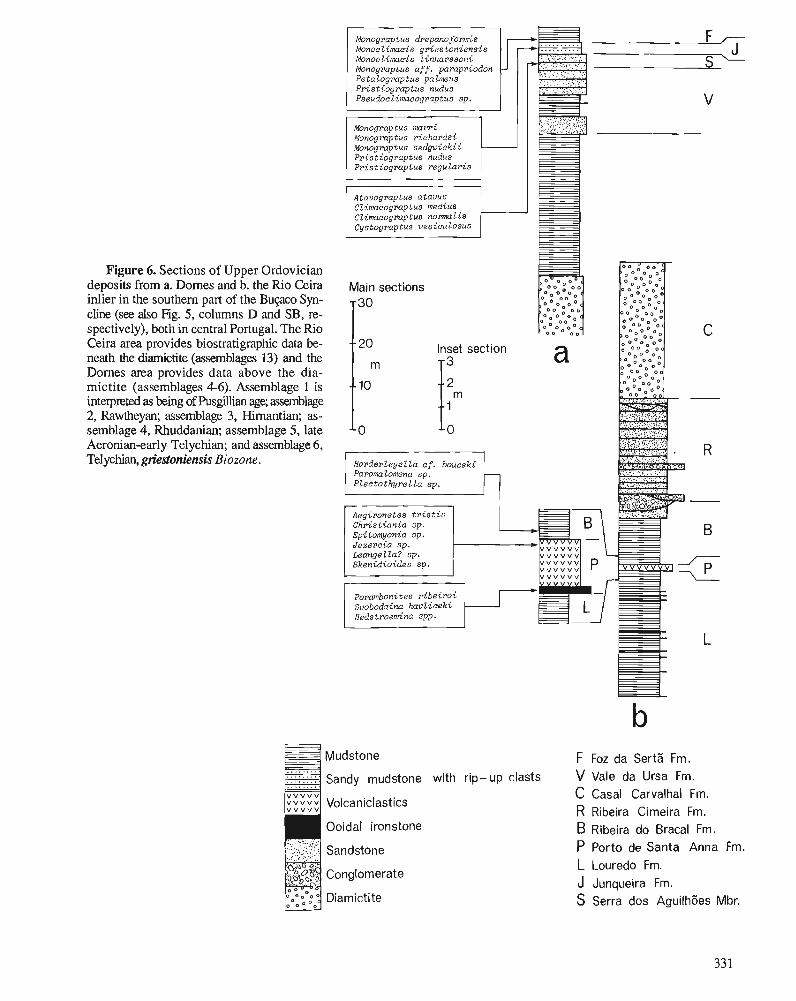
Figure 6. Sections of Upper Ordovician deposits from a. Domes and b. the Rio Ceira inlier in the southern part of the Bupco Syn- cline (see also Fig. 5, columns D and SB, re- spectively), both in central Portugal. The k o Ceira area provides biostratigraphic data be- neath the diamictite (assemblages 13) and the Domes area provides data above the dia- mictite (assemblages 4-6). Assemblage 1 is interpreted as being of Pusgdian age; &1age 2, Rawtheyan; assemblage 3, Hirnantian; as- semblage 4, Rhuddanian; assemblage 5, late Aeronian-early Telychian; and assemblage 6, Telychian, griestoniensis Biozone.
Mudstone F Foz da SertZ Fm. Sandy mudstone with rip-up clasts V Vale da Ursa Fm.
C Casal Carvalhal Fm. Volcaniclastics R Ribeira Cimeira Fm. Ooidal ironstone B Ribeira do Bracal Fm.
Sandstone P Porto de Santa Anna Fm. L Louredo Fm.
Conglomerate J Junqueira Fm.
Diamicti te S Serra dos AguilhBes Mbr.
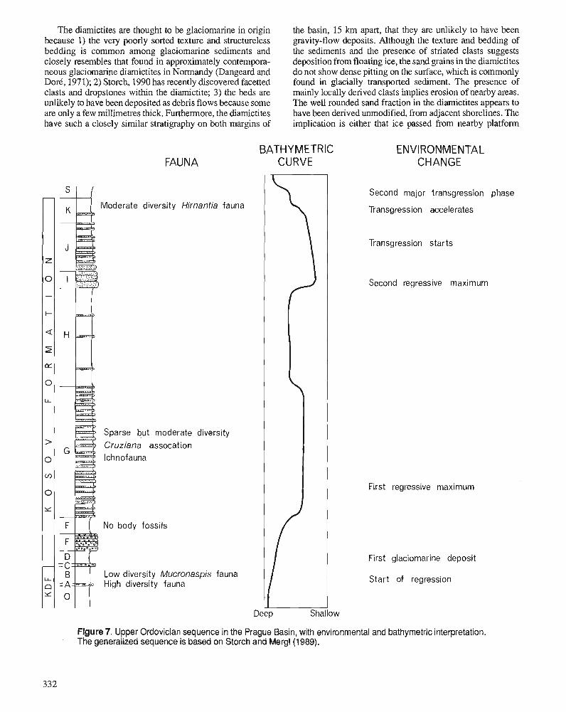
The diamictites are thought to be glaciomarine in origin because 1) the very poorly sorted texture and structureless bedding is common among glaciomarine sediments and closely resembles that found in approximately contempora- neous glaciomarine diamictites in Normandy (Dangeard and Dore, 197 1); 2) Storch, 1990 has recently discovered facetted clasts and dropstones within the diamictite; 3) the beds are unlikely to have been deposited as debris flows because some are only a few rnillirnetres thick. Furthermore, the diamictites have such a closely similar stratigraphy on both margins of
the basin, 15 km apart, that they are unlikely to have been gravity-flow deposits. Although the texture and bedding of the sediments and the presence of striated clasts suggests deposition from floating ice, the sand grains in the diamictites do not show dense pitting on the surface, which is commonly found in glacially transported sediment. The presence of mainly locally derived clasts implies erosion of nearby areas. The well rounded sand fraction in the diamictites appears to have been derived unmodified, from adjacent shorelines. The implication is either that ice passed from nearby platform
FAUNA BATHYMETRIC
CURVE ENVIRONMENTAL
CHANGE
% Moderate diversity Hirnantia fauna
Sparse but moderate diversity - Cruziana assocat ion ' lchnofauna
F I ( No body fossils
Low diversity Mucronaspis fauna High diversity fauna
Second major transgression phase
Transgression accelerates
Transgression starts
Second regressive maximum
First regressive maximum
First glaciomarine deposit
Start of regression
Figure 7. Upper Ordovician sequence in the Prague Basin, with environmental and bathymetric interpretation. The generalized sequence is based on Storch and Mergl(1989).
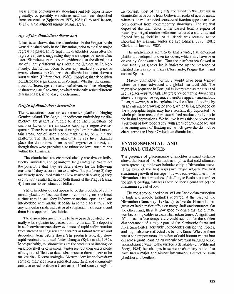
areas across contemporary shorelines and left deposits sub- glacially, or possibly sometimes sediment was deposited from seasonal ice (Spjeldnaes, 1973,198 1; Clark and Hanson, 1983), in the adjacent marine basinal areas.
Age of the diamictites: discussion
It has been shown that the diamictites in the Prague Basin were deposited early in the Hirnantian, prior to the first major regressive phase. In Portugal, the diamictites occur after the regressive phase, suggesting they were deposited somewhat later. Elsewhere, there is some evidence that the diamictites are of slightly different ages within the Himantian. In Nor- mandy, diamictites occur before any markedly regressive event, whereas in Celtiberia the diamictites occur above a karst surface (Hafenrichter, 1980), implying that deposition postdated the regression, as in Portugal. Whether the diamic- tites of different age represent local advances of ice belonging to the same glacial advance, or whether deposits reflect different glacial phases, is not easy to determine.
Origin of diamictites: discussion
The diamictites occur on an extensive platform fringing Gondwanaland. The Ashgillian sediments underlying the dia- mictites are generally middle to deep shelf mudstone of uniform facies or are sandstone capping a regressive se- quence. There is no evidence of marginal or intrashelf moun- tain areas, nor of steep slopes marginal to, or within the platform. The Hirnantian glaciomarine sea level changes place the diarnictites in an overall regressive context, al- though there were probably also minor sea level fluctuations within the Himantian.
The diarnictites are characteristically massive or indis- tinctly laminated, and of uniform facies laterally. We reject the possibility that they are debris flows for the following reasons: I) they occur on an extensive, flat platform; 2) they are closely associated with shallow marine deposits; 3) they occur, with similar facies, on both flanks of the Prague Basin; 4) there are no associated turbidites.
The diamictites do not appear to be the products of conti- nental glaciation because there is commonly no erosional surface at their base; they lie between marine deposits and are interbedded with marine deposits in some places; they lack any lenticular sands indicative of subglacial melt waters; and there is no apparent clast fabric.
The diamictites are unlikely to have been deposited proxi- mally where glacier ice passes out into the sea. The deposits in such environments show evidence of rapid sedimentation from streams or subglacial melt waters or fallout from ice and deposition from debris flows. The products typically show rapid vertical and lateral facies changes (Eyles et al., 1985). More probably, the diamictites are the products of floating ice on an ice shelf or of seasonal winter ice, but their exact mode of origin is difficult to determine because there appear to be no described Recent analogies. Most modem ice shelves draw some of their ice from a glaciated hinterland and commonly contain erratics drawn from an uplifted source region.
In contrast, most of the clasts contained in the Himantian diamictites have come from Ordovician rocks of nearby areas, whereas the well rounded coarse sand fraction appears to have been derived from contemporary shorelines. The ice that deposited the diamictites either passed from a region of recently emerged marine sediments, crossed a shoreline and floated free as shelf ice, or the debris was accreted at the shoreline by seasonal winter ice (Spjeldnaes, 1973, 1981; Clark and Hanson, 1983).
The implications seem to be that a wide, flat, emergent platform developed its own ice cover, which may have been driven by Gondwanan ice. That the platform ice flowed at least locally as glacier ice is indicated by the presence of striated clasts in some places (Normandy, Prague Basin, and central Spain).
Marine diamictites normally would have been formed when ice sheets advanced and global sea level fell. The regressive sequence in Portugal is interpreted as the result of such a glacio-eustatic fall. The presence of marine diamictites above the regressive sequence therefore appears anomalous. It can, however, best be explained by the effect of loading by an advancing or growing ice sheet, which being grounded on the topographic highs may have isostatically depressed the whole platform area and re-established marine conditions in the basinal depressions. We believe it was this ice cover over a platform of low topography, with areas of grounded ice and intervening areas of floating ice, which gave the distinctive character to the Upper Ordovician diamictites.
ENVIRONMENTAL AND FAUNAL CHANGES . The presence of glaciomarine diarnictites a small distance above the base of the Hirnantian implies that cold climates were spreading into lower latitudes early in Himantian times. If the peak of the first regressive phase reflects the first maximum growth of ice caps, this was somewhat later in the Hirnantian. The diamictites of the Prague Basin could reflect the initial cooling, whereas those of Iberia could reflect the maximum spread of ice.
The most pronounced phase of Late Ordovician extinction in high and middle latitudes occurred at the base of the Hirnantian (Brenchley, 1984a, b), before the Himantian re- gression had a major effect on many shelf environments. On the other hand, there is now good evidence that the climate was becoming colder in early Himantian times. A significant fall in sea surface temperature could account for the sudden disappearance of a major part of the planktonic fauna and flora (graptolites, acritarchs, conodonts) outside the tropics, and might also have affected the benthic fauna. Whether there was a contemporaneous intrusion of cold bottom waters into oceanic regions, causing an oceanic overturn bringing toxic, unconditioned water to the surface is debatable (cf. Wilde and Beny, 1984) but changes in seawater chemistry could also have had a major and almost instantaneous effect on both plankton and benthos.
There is no evidence that the lowered temperatures had an immediate effect on tropical environments, where carbonate deposition apparently continued without interruption into the Hirnantian. It is possible that the very extensive shallow marine platforms of tropical regions were affected by falling seawater temperatures at a slightly later stage, or the Himan- tian regression had a major effect in these areas (Sheehan, 1973, 1975). A relatively small fall in sea level could have diminished the marine area considerably, and might have seriously affected the "perched faunas" by a reduction in habitable area (Johnson, 1974).
In conclusion, we identify the importance of lowered temperatures in the early Hirnantian extinction, and thus support the contention of Stanley (1988) that global cooling was a major factor in Paleozoic mass extinctions. However, our hypothesis differs from that of Stanley in that it seems premature to identify one single cause for the terminal Ordo- vician extinction. It seems more likely that there were a number of related factors such as change in temperature, seawater geochemistry and habitable area, each linked to the growth and decay of the Upper Ordovician ice caps, but each having its own effect on the faunas.
REFERENCES Benedetto, J.L. 1986: The fust typical Hirnantia fauna from South America (San Juan
Province, Argentine Precordillera). In Les Brachiopodes Fossiles et Actuels, P.R. Racheboeuf and C.C. Emig (eds.); Biostratigraphie du PalCozoique, v. 4, p. 439-447.
Berry, W.B.N. and Boucot, A.J. 1973: Glacio-eustatic control of Late Ordovician-Early Silurian platform
sedimentation and faunal changes. Geological Society of America Bulletin, v. 84, p. 275-284.
Beuf, S., Biju-Duval, B., De Charpal, O., Rognon, P., Gariel, O., and Bennacef, A. 1971: Les gr8s du PalCozoique infCrieur au Sahara. Sedimentation et
discontinuites, evolution structurale d'un craton. Publications de I'Institut franqais du pCtrole.
Brenchley, P.J. 1984a: Late Ordovician extinctions and their relationship to the Gondwana
glaciation. In Fossils and Climate, P.J. Brenchley (ed.); Geological Journal, Special Issue 11, p. 291-315.
1984b: Late Ordovician environmental changes and their effect on faunas. In Aspects of the Ordovician System; D.L. Bruton (ed.); Univer- sitetsforlaget, Oslo, p. 65-79.
1988: Environmental changes close to the Ordovician-Silurian boundary. In A Global Analysis of the Ordovician-Silurian Boundary, L.R.H. Cocks and R.B. Rickards (eds.); Bulletin of the British Museum (Natural History), v. 43, p. 377-385.
Brenchley, P.J. and Cullen, B. 1984: The environmental distribution of associations belonging to the
Hirnantia fauna - evidence from Wales and Noway. In Aspects of the Ordovician System, D.L. Bruton (ed.); Universitetsforlaget, Oslo, p. 113-125.
Brenchley, PJ. and Newall, G. 1980: A facies analysis of upper Ordovician regressive sequences in the
Oslo Region, Norway: a record of glacio-eustatic changes. Palaeo- geography. Palaeoclimatology, Palaeoecology, v. 31, p. 1-38.
Brenchley, PJ. and Storch, P. 1989: Environmental changes in the Hirnantian (upper Ordovician) of the
Prague Basin, Czechoslovakia. Geological Journal, v. 24, p. 165-181.
Clark, D.L. and Hanson, A. 1983: Central Arctic Ocean sediment texture: a key to ice transport mecha-
nisms. In Glacial-Marine Sedimentation, B.F. Molnia (ed.); Plenum Press, New York, p. 301-303.
Cocks, L.R.M. and Rong, Jia-Yu. 1988: A review of the late Ordovician Foliomena brachiopod fauna with
new data from China, Wales and Poland. Palaeontology, v. 31, p. 53-67.
Dangeard, L. and Dore, F. 197 1: Facits glaciaires de I'Ordovicien superieur en Normandie. MCmoire
du Bureau des Recherches gkologique et minitres, Colloque Ordovicien-Silurien, Brest, v. 73, p. 119-127.
Destombes, J. 1968a: Sur la presence d'une discordance g6nCrale de ravinement d'lge
Ashgill superieur dans I'Ordovicien terminal de I'Anti-Atlas (Ma- roc). Comptes rendus des stances de I'AcadCmie des Sciences, v. 267, p. 565-567.
1968b: Sur la nature glaciaire des sediments du groupe du 2C Bani, Ashgill supCrieur de I'Anti-Atlas, Maroc. Comptes rendus des seances de 1'AcadCmie des Sciences, v. 267, p. 684-686.
1981: Himantian, (Upper Ordovician) tillites on the north flank of the Tindouf basin, Anti-Atlas, Morocco. In Earth's Pre-Pleistocene Glacial Record, J. Hambrey and W.B. Harland (eds.); Cambridge University Press, Cambridge, p. 84-88.
Destombes, J., Holland, H., and Willefert, S. 1985: Lower Palaeozoic rocks of Morocco. In Lower Palaeozoic of North-
western and West Central Africa, C.H. Holland (ed.); J. Wiley and Sons, Chichester, p. 91-336.
Destombes, J. and Willefert, S. 1988: The Ordovician-Silurian boundary in Morocco. In A Global Analy-
sis of the Ordovician-Silurian Boundary, L.R.M. Cocks and R.B. Rickards (eds.); Bulletin of the British Museum (Natural History), v. 43, p. 165-170.
Eyles, C.H., Eyles, N., and Miall, A.D. 1985: Models of glacio-marine sedimentation and their application to the
interpretation of ancient glacial sequences. Palaeogeography, Palaeo- climatology, Palaeoecology, v. 51, p. 15-84.
Hafenrichter, M. 1980: The lower and upper boundary of the Ordovician system of some
selected regions (Celtiberia, Eastern Sierra Morena) in Spain, Part 11. The Ordovician/Silurian boundary in Spain. Neues Jahrbuch fur Geologie und Pallontologie Abhandlungen, v. 160, p. 138-148.
Hambrey, J. 1985: The late Ordovician-early Silurian glacial period. Palaeogeography,
Palaeoclimatology, Palaeoecology, v. 5 1, p. 273-289. Havlicek, V. 1974: Some problems of the Ordovician in the Mediterranean area. Vest-
nik ~stredniho Ustavu geologickeho, v. 49, p. 343-348. 1976: Evolution of Ordovician brachiopod communities in the Mediterra-
nean province. III The Ordovician System: Proceedings of a Palae- ontological Association Symposium, Birmingham, September 1974, M.G. Bassett (ed.); University of Wales Press and National Museum of Wales, Cardiff, p. 349-358.
1982: Ordovician in Bohemia: development of the Prague Basin and its benthic communities. Sbornik geologickych ved., Geologie, v. 37, p. 103-136.
Havlicek, V. and Mergl, M. 1982: Deep water shelly fauna in the latest kralodvorian (upper Ordovi-
cian, Bohemia). Vestnik ostredniho ostavu geologickCho, v. 57, p. 37-46.
Johnson, J.G. 1974: Extinction of perched faunas. Geology, v. 2, p. 279-282. Legrand, P. 1985: Lower Palaeozoic rocks of Algeria. In Lower Palaeozoic Rocks of
the World, Volume 4, Lower Palaeozoic of North-western and West-central Africa, C.H. Holland (ed.); J. Wiley and Sons, Chichester, p. 5-89.
1986: The lower Silurian graptolites of Oued In Djerane: a study of populations at the Ordovician-Silurian boundary. In Palaeoecology and Biostratigraphy of Graptolites, C.P. Hughes and R.B. Rickards (eds.); Geological Society, Special Publication no. 20, p. 145.153.
Lesperance, P.J. and Sheehan, P.M. 1981: Hirnantian fauna in and around Perce, QuCbec. In Field Meeting,
Anticosti-GaspC, Quebec, 1981.2 (Stratigraphy and Paleontology), P.J. LespCrance (ed.); MontrCal (I.U.G.S. Subcommission on Silu- rian Stratigraphy, Ordovician-Silurian Boundary Working Group), p. 231-245.
Robardet, M. and Dorb, F. 1988: The late Ordovician diamictic formations from southwestern
Europe: North-Gondwana glacio-marine deposits. Palaeogeogra- phy, Palaeoclimatology, Palaeoecology, v. 66, p. 19-31.
Romano, M. 1982: The Ordovician biostratigraphy of Portugal - a review with new
data and re-appraisal. Geological Journal, v. 17, p. 89-1 10. Romano, M. and Diggens, J.N. 1976: The stratigraphy and structure of Ordovician and associated rocks
around Valongo, north Portugal. ComunicacBes dos Servi~os geol6gicas de Portugal, v. 57 (for 1973-1974), p. 23-50.
Romariz, C. 1963: Graptolitos do Silurico PortugQes. Revista da Faculdade de CiCcias
de Lisboa, v. 10, p. 1-195. Rong Jia-Yu. 1984: Distribution of the Hirnanlia fauna and its meaning. In Aspects of
the Ordovician System, D.L. Bruton (ed.); Universitetsforlaget, Oslo, p. 101-112.
Scotese, C.R. and McKerrow, W.S. 1990: Revised world maps and introduction. In Palaeozoic Palaeogeogra-
phy and Biogeography.,Geological Society of London, Memoir 12, p. 1-21.
Sheehan, P.M. 1973: The relation of Late Ordovician glaciation to the Ordovician-Silu-
rian changeover in North American brachiopod faunas. Lethaia, V. 6, p. 147-154.
1975: Brachiopod synecology in a time of crisis (Late Ordovician-Early Silurian). Paleobiology, v. 1(2), p. 205-212.
Spjeldnaes, N. 1973: Moraine stratigraphy, with examples from the basal Cambrian,
("Eocambrian") and Ordovician glaciations. Bulletin of the Geo- logical Institute of the University of Uppsala, v. 5, p. 165-171.
1981: Lower Palaeozoic palaeoclimatology. In Lower Palaeozoic Rocks of the World, Volume 3; Lower Palaeozoic of the Middle East, Eastern and Southern Africa and Antarctica, C.H. Holland (ed.); J. Wiley and Sons, Chichester, New York, Brisbane, Toronto. p. 199-256.
Stanley, S.M. 1988: Paleozoic mass extinctions: shared patterns suggest global cooling
as a common cause. American Journal of Science, v. 288, p. 334-352.
Storch, P. 1990: Upper Ordovician-Lower Silurian sequences of the Bohemian
Massif, central Europe, Geological Magazine, v. 127, p. 225-239. Storch, P. and Mergl, M. 1989: Kralodvor-Kosov boundary and the late Ordovician environmental
changes in the Prague Basin (Barrandian area, Bohemia). Sbjornik Geologickych ved Geologic, v. 44, p. 117-153.
Wilde, P. and Berry, W.B.N. 1984: Destabilisation of the oceanic density structure and its significance
to marine "extinction" events. Palaeogeography, Palaeoclimatol- ogy, Palaeoecology, v. 48, p. 143-162.
Willefert, S. 1988: The Ordovician-Silurian boundary in Mauritania. In A Global
Analysis of the Ordovician-Silurian Boundary, L.R.M. Cocks and R.B. Rickards (eds.); Bulletin of the British Museum (Natural History), v. 43, p. 177-182.
Young, T.P. 1985: The stratigraphy of the upper Ordovician of central Portugal. Un-
published Ph.D. thesis, University of Sheffield, 441 p. 1988: The lithostratigraphy of the upper Ordovician of central Portugal.
Journal of the Geological Society, London, v. 145, p. 377-392. 1990: Ordovician sedimentary facies and faunas of southwest Europe:
palaeogeographic and tectonic implications. In Palaeozoic Palaeo- geography and Biogeography, W.S. McKerrow and C.R. Scotese (eds.); Geological Society of London, Memoir 12, p. 421-430.
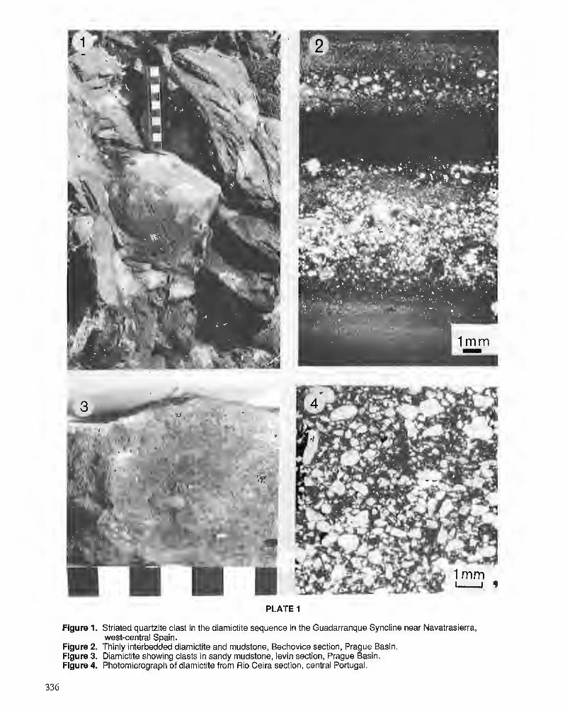
Figure 1. Striated quartzite clast in the diamictite sequence in the Guadarranque Syncline near Navatrasierra, west-central Spain.
Figure 2. Thinly interbedded diamictite and mudstone, Bechovice section, Prague Basin. Figure 3. Diamictite showing clasts in sandy mudstone, levin section, Prague Basin. Figure 4. Photomicrograph of diamictite from Rio Ceira section, central Portugal.