Embed Size (px)
Citation preview

551
BIBLIOGRAPHY
Note: The items of the published literature cited in this volume are listed in the following pages. In addition, other material is
presented as well, on the assumption that it will help the reader gain a deeper understanding of vegetation mapping. The material listed here includes therefore publications which are not necessarily the most recent ones, but the value of which remains unquestioned.
The number of vegetation maps cited here may seem small and, of course, vast numbers of such maps could have been listed. This seemed inappropriate. Readers interested in information on vegatation maps are therefore invited to consult the International Bibliography of Vegetation Maps (lBVM). In the bibliography of this volume, reference to the IBVM is made in the item of Kuchler, ed., 1965ff. More recent information is available from the author who continues to collect material for future volumes of the IBVM.
In addition, large numbers of vegetation maps prepared for application are never printed for distribution. They exist in limited numbers as appendices of project reports. However they still may contain important information.
Abbate, G., G.C. Avena, C. Blasi and L. Veri. 1981. Studio delle tipologie fitosociologische del Monte Soratte (Lazio) e loro contributo nella definizione fitogeografico dei complessi vegetazionali centro - appenninici. (With colour map 1: 10.000). Consiglio Nazionale delle Ricerche. AQ/l/125 Roma.
Abramova, T.e. 1962. The importance of a medium scale geobotanical map for the geobotanical subdivision for agricultural purposes.
Addor, E. E. 1963. Vegetation description for military purposes. Vicksburg, MS. United States Army Engineer Waterways Experiment Station. Miscellaneous Paper No. 3-610, pp. 98-128.
Adriani, M.J. and E van der Maarel. 1968. 'Voorne in de branding'. (Met kaart 1: 25.000-kleur) Stickting Wetenschappelijk Duinonderzoek Oostvoorne.
Agency for Cultural Affairs, Ministry of Education 1969-1976: The vegetation map and the map of natural monuments. 1: 200,000 with color. 129 leafs. Tokyo.
Aichinger, E. 1954. Statische und dynamische Betrachtung in der pfianzensoziologischen Forschung. ZUrich. Geobotanisches Forschungsinstitut Rubel. Veroifentlichungen, vol. 29.
Albertson, F. W., G. W. Tomanek and A. Riegel. 1957. Ecology of drought cycles and grazing intensity on grasslands of the central Great Plains. Ecological Monographs, 27:27-44.
A.W. Kuchler & I.S. Zonneveld (eds.), Vegetation mapping. © 1988, Kluwer Academic Publishers, Dordrecht.
Aldrich, R. e. 1979. Remote Sensing of Wildland Resources: A State-of the-Art Review, General Technical Report RM-71, Fort Collins, CO: U.S. Forest Service Rocky Mountain Forest and Range Experiment Station.
Andere, D.K. 1981. The Kenya Rangeland ecological Monitoring Unit (KREMU) Low-level aerial techniques Rep. Int. Workship 6-11 Nov. 1979, Nairobi. pp. 59-69. I.L.C.A. Addis-Abeba.
Anderson, A. 19xx.Vegetationskartor Siljan (4 maps in colour 1 : 50.000) Meddelande fran Naturgeografiska institutionen Stockholms universiteit Nr. 160.
Anderson, J.A.R. and J. Muller. 1975. Palynological study of a holocene peat and a miocene coal deposit from NW Borneo. Rev. Palaeobot. Palynol. 19:291-351.
Andersson, L. and T. Rafstedt. 19xx. Fjiillens Vegetation Kartpr Del: I Jiimtlands liin (6 maps in colour 1 : 100.000) Meddelande fran Naturgeografiska institutionen Stockholms universiteit Nr. 162.
Andrews, H.J. and R. W. Cowlin. 1936. Forest type maps of Oregon and Washington. Portland, OR. Pacific Northwest Forest & Range Experiment Station.
Anonymous. 1934. Areas characterized by major forest types: Alabama, Florida, Georgia, Louisiana, Mississippi. New Orleans, LA. Southern Forest Experiment Station.
Anonymous. 1940. Areas characterized by major forest types: North and South Carolina. Asheville, Ne. Appalachian Forest Experiment Station.

552
Anonymous. 1941a. Areas characterized by major forest types: Virgina. Asheville, NC. Appalachian Forest Experiment Station.
Anonymous. 1941 b. Areas characterized by major forest types: northern Michigan. St. Paul, MN. Lake States Forest Experiment Station.
Anonymous. I 948a. Lac Letondal. Ottawa. Department of Mines & Resources, canadian Forest Services.
Anonymous. 1948b. Wildlife and cover map of Arkansas. Little Rock, AR. Arkansas State Game and Fish Commission.
Anonymous. 1955. Field manual: grassland sampling. Berkeley, CA. California Forest & Range Experiment Station.
Anonymous. 1973. International classification and mapping of vegetation. Paris. United Nations Educational, Scientific and Cultural Organization. Ecology and Conservation. No.6.
Anonymous. 1976. Montana: climax vegetation. Helena, MT. United States Department of Agriculture, Soil Conservation Service.
Apinis, A.E. 1963. Der Wert der Vegetationskarte fUr die grundlegenden bodenmikrobiologischen Untersuchungen. In: Reinhold Tiixen, 1963a, pp. 185-194.
Arrigoni P. V. and Di Tommaso. 1981. Carta della vegetazione dell'lsola di Giannutri. (provincia di Grosseto) (With colour map 1: 5.000) Consiglio Nazionale delle Richerche AQ/1I130. Roma.
Aubert de la Riie, E., F. Bourliere and J-P. Harroy. 1957. The Tropics. Alfred A. Knopf, Inc. New York, NY.
Aubreville, A. 1961. De la necessite de fixer une nomenclature synthetique des formations vegetales tropicales avant d'entreprendre la cartographie de la vegetation tropicale. In: Henri Gaussen, 1961a, pp. 37-47.
Augarde, 1. 1957. Contribution Ii l'etude des problemes de l'homogeneite en phytosociologie. Montpellier. Service de la carte phytogeographique. Bulletin, Serie B, 2: 11-23.
Avena, G.c. and C. Blasi. 1980. Carta della vegetazione del Massiccio del Monte Velino. Appennino Abruzzese. (With colour map 1: 25000) Consiglio Nazionale delle Richerche. AQ/1I35 Roma.
Ayasse, L. and R. Molinier. 1955. Carte des groupements vegetaux des environs de la Motte-du-Caire au 1110,000. Revue Forestiere Fran~aise, 9-10: 697-707.
Baig, M. S. 1977. Inventory and evaluation of rangeland. An example for rangelands in arid zones worked out for Quetta Pishin areas, Baluchistan, Pakistan. M.Sc. thesis lTC, Enschede, The Netherlands, 132 pp + app.
Bailey, R.G. 1980. Description of the ecoregions of the United States. Washington, DC. U.S. Dept. of Agriculture, Forest Service. Miscellaneous Publication No. 1391.
Bailey, R.G. 1976. Ecoregions of the United States. Fort Collins, CO. U.S. Dept. of Agriculture, Forest Service. Rocky Mountains Forest & Range Experiment Station.
Bakker, T. W.M., J.A. Klijn and F.1. van Zadelhoff. 1979. 'Duinen en duinvalleien' (With colour maps 1: 100.000)
Een landschapsecologische studie van het Nederlandse duingebied. Centrum voor Landbouwpublicaties en landbouwdocumentatie Wageningen. pp. 201.
Baillieux, P., P. Andre and C. Lheureux. 1977. Prunus serotina Ehrh. interet, exigences et traitement. Bull. Soc. Roy. For de Belgique 84(4): 197-208.
Bannink, J.F., H. N. Leys and I.S. Zonneveld. 1973. Vegetation, habitat and site class in Dutch conifer forst. Bodemk. Stud. 9 Stichting v. Bodem Kartering, Wageningen. Versl. Landbouwk. Onderzoek 800, 188 pp.
Bannink, J., H.N. Leys and I.S. Zonneveld. 1974. Weeds as Environmental Indicators Especially for Soil Conditions. Versl. Landbouwk. Onderzoek 807, Bodemk. Studies 11, Stiboka, Wageningen, 88 pp.
Barbero, M. and P. Ozenda. 1979. carte de la vegetation potentielle des Alpes piemontaises. Grenoble. Documents de cartographie ecologique, 21: 139-162.
Barker, G.R. 1982. 'FRIS: St. Regis' Forest Management Approach," Chapter 40 in Remote Sensing for Resource Mangement, c.J. Johannson and J.L. Sanders, eds., Ankeny, IA: Soil Conservation of America, pp. 454-469.
Barnhart, Dr. 1930. cambridge. 5th International Botanical Congress. Proceedings, p. 559.
Baumgardner, M.F. 1974. Remote sensing information in the service of ecology. Proceeding first International Congress of Ecology. 274-278. Den Haag.
Beadle, N. C. W. and A. B. Costin. 1952. Ecological classification and nomenclature. Proceedings of the Linnean Society of New South Wales, 67: 61-82.
Beard, 1.S. 1944. Climax vegetation in tropical America. Ecology, 25; 127-158.
Beard, J.S. 1972. 'The Vegetation of the Newdegate and Bremer Bay areas, Western Australia.' Maps and explanatory Memoir 1 : 250.000 Series (With 2 monocolor maps.) Vegmap Publications, Sydney.
Beard, J.S. 1974-1981. The vegetation survey of Western Australia. Nedlands, W.A. University of Western Australia Press.
Beek, K.J. 1978. Land evaluation for agricultural development. Diss. Wageningen, ILRI Publ. 23, Wageningen.
Beek, K.J. and J. Bennema. 1972. Land evaluation for agricultural land use planning. An ecological methodology. Dept. Soil. Sci. & Geol., Agric. Univ. Wageningen, Netherlands, 70 p.
Bellan, M.F. 1979. cartographie de la vegetation Ii l'aide de l'image-satellite. Exemple en Inde: Carte de la vegetation des Palni Ii 11250 000. These de Doctorat de 3e cycle, Univ. Paul Sabatier, Toulouse; 84 p., 2 images satellites, 1 carte.
Belov, A. V. 1983. Some aspects and perspectives of geobotanical mapping and prognostication in Siberia. Leningrad. Academy of Sciences of the U.S.S.R., Komarov Institute of Botany. Geobotanical Cartography, pp. 18-24.
Bennet, C.F. 1963. Notes on the use oflight aircraft in mapping the vegetation in the American tropics. Professional Geographer, 15: 6: 21-24.

Benson, D.H. 1981. Vegetation of the Agnes Banks sand deposit, Richmond, N.S.W. Cunninghamia, 1: 35-57.
Berezin, A. M. 1962. On the choice of a scale of aerophotos and of kinds of aerorecords for the deciphering and mapping of forests. In: Victor B. Sochava, 1962a, pp. 223-231.
Berg, A. van den et al. 1984. MAP: a set of computer programs that provide for input, output and transformation of cartographic data. in: IALE, the International Association for Landscape Ecology. Proceedings of the first international seminar on Methodology in Landschape Ecological Research and Planning. Theme III Methodology of data analysis. Roskilde University Centre, Denmark.
Berg, J. van der. 1985. MONA 1984 Rapport over de vorderingen van het Mona-project, deelproject van het Moneragala District. Survey Project. ITC Enschede.
Bertrovic, S. 1973. Pflanzensoziologische Kartierungen in Kroatien und andern Teilen Jugoslawiens. In: Reinhold Tiixen, 1963a, pp. 231-243.
Bharucha, F.R. 1952. Vegetation cartography. Indian Forester,78:6.
Bharucha, F.R. 1955. Les problemes cartographiques du sud-est asiatique. In: Henri Gaussen, pp. 189-193.
Bhimaya. 1967. Studies on detailed survey methods for management of range lands in North Western arid zone of India. Int. Seminar on Integrated Survey of Natural Grazing areas.
Bickmore, D.P. 1982. Mapping the vegetation of Britain. Cartographica, 19:2: 100-107.
Bie, S. W. 1983. Project CriteriaiSoft- and hardware for Global Land/soil Monitoring System Consultats rep. UNEP. Nairobi, Kenya.
Bie, S. and J.J. Kessler. 1981. An aerial resource inventory of the National Park 'Boucle du Baoule' (Mali, WestAfrica). Nature Conservation Department, Agricultural University, Wageningen.
Billings, W. D. 1952. The environmental complex in relation to plant growth and distribution. Quarterly Review of Biology, 27: 251-265.
Blaeu, J. 1640-1654. Theatrum Orbis Terrarum. Amsterdam. Novus Atlas, vols. 1-6.
Blasco, F., F. Lavenu and G. Saint. 1983. Resultats des simulations de SPOT au Bangladesh. Colloque 'Geographie, Amenagement et Teledetection spatiale' CNESCNRS, Chantilly 18-19.
Blasco, F., Y. Laumonier and Purnajaya. 1983. Tropical vegetation mapping. Sumatera. Biotrop Bulletin No. 18. Bogor. Indonesia. 71 p.
Blasco, F. 1982. The transition from open forest to savanna in continental South East Asia. in: F. Bourliere - tropical savannas, Ecosystems of the world 13: 167-181, Elsevier. Amsterdam.
Blasco, F. 1971. Montagnes du Sud de l'Inde; forets, savanes, ecologie. These de Doct. Etat, Univ. Paul Sabatier, Toulouse et Inst. fran~ais de Pondicbery, Trav. Sect. scient. Techn., T. X, 436 p., 3 cartes.
Bleeker, P. 1975. Explanatory Notes to the Land Limitation
553
and Agricultural Land Use Potential Map of Papua New Guinea. (With colour maps, Scale 1: 1.000.000) Land Research Series N. 36, pp. 80. Commonwealth Scientific and Industrial Research Organization, Autralia.
Bleydenstein, J. 1969. Grassland and Vegetation Surveys for Economic Development. Physical Resource Investigations for Economic Development. O.A.S. Case Book OAS Washington.
Boer, T.A. de. 1954. Die Griinlandvegetationskartierung in den Niederlanden. Festschrift Aichinger, pp. 1232-1234. Springer Verlag. Wien.
Boer, T.A. de 1963. Die Griinlandvegetationskartierung als Grundlage fUr die landwirtschaftliche Verbesserung ganzer Gebiete in den Niederlanden. In: Reinhold Tiixen, 1963a, pp. 441-455.
Boer, Th. A. de. 1983. Vegetation as an Indicator of Environmental Changes. Environm. Monitoring and Assessm. 3.
Boerboom, J. H. A. 1960. De plantengemeenschappen van de Wassenaarse Duinen. Mededelingen van de Landbouwhogeschool te Wageningen. Nederland 60 (10) 1-135 pp. 135. (With colour maps, Scale 1: 5.000).
Boere, G.c. and W.K.R.E. van Wingerden. 1983. Integratie en Perspectiven van inventariseren en monitoring van Hora en Fauna in Nederland. Med. W.L.O. 9 (1982) N. 1. 5-10.
Bohn, U. 1981. Vegetationskarte der Bundesrepublik Deutschland 1: 200 000 - Potentielle natiirliche Vegetation - Blatt CC 5518 Fulda. Schr. Reihe Vegetationskunde 15.
Borza, A. 1963. Bibliographie der Vegetationskarten Rumiiniens. Excerpta Botanica, sectio B: Sociologica, 5: 103-107.
Boughey, A.S. 1957. The physionomic delimitation ofW-estAfrican vegetation types. Journal of the W.-African Sc. Association 3, 2, (pp. 148-165).
Box, E.O. 1981. Macroclimate and plant forms. Dr. W. Junk Publishers. The Hague, NL.
Brakebusch, L. 1983. Uber die Bodenverhiiltnisse des nordwestlichen Teiles der argentinischen Republik mit Bezugnahme auf die Vegetation. Petermanns Geographische Mitteilungen, vol. 39, No.7, Tafel 11.
Braun, E.L. 1950. Deciduous forests of eastern North America. Blakiston Co. Philidalphia, P A.
Braun-Blanquet, J. 1932. Pfianzensoziologie. Jul. Springer, Berlin. Plant Sociology (transl.) by Fuller and Conard, 1932. McGraw-Hill-Book Co., New York-London, (see also 1966).
Braun-Blanquet, J. 1944. Sur l'importance pratique d'une carte detaillee des associations vegetales de la France. Station internationale de geobotanique mediterraneenne et alpine. Montpellier. Communication 86.
Braun-Blanquet, J., L. Emberger and R. Molinier. 1947. Instructions pour l'etablissement de la carte des groupements vegetaux. Centre National de la Recherche Scientifique. Paris.
Braun-Blanquet, J. and Y.T. Chou. 1947. Carte des groupe-
554
ments vegetaux de la France, region nordouest de Montpellier. Station internationale de geobotanique mCditerraneenne et alpine. Montpellier.
Braun-Blanquet, J. 1964. Pflanzensoziologie, 3rd ed. Springer Verlag. Wien.
Brinkman, J.W.E. 1972. Studiekartering van het landgoed Schovenhorst te Putten. Scriptie voor de afdelingen Bodemkunde, Houtteelt en Natuurbeheer in het kader van de ingenieursstudie aan de Landbouwhogeschool te Wageningen.
Brinkman, R. and A.J. Smyth. 1973. Land evaluation for rural purposes. ILRI Publ. 17, Wageningen, Netherlands, 115 p.
Brockmann-Jerosch, H. 1935. Vegetation der Erde. In: Hermann Haack, Physikalischer Wand-Atlas. Perthes Verlag. Gotha.
Broek van den, J.M.M. en W.H. Diemont. 1966. Het Savelsbos. Bosgezelschappen en Bodem. (With colour maps Scale I: 5.000). Verslagen van Landbouwkundige Onderzoekingen 682 RIVON Verhandeling Nr. 3. deel XXIII pp. 120.
Bromme, T. 1851. Atlas zu Alexander von Humboldts Kosmos. Krais & Hoffmann Verlag. Stuttgart.
Brown, D. 1954. Methods of Surveying and Measuring Vegetation. Bulletin 6. C.A.B. Books, England.
Brown, D.E. and C.H. Lowe. 1977. Biotic communities of the South-west. Fort Collins, CO. U.S. Dept, of Agriculture, Forest Service. General Technical Report RM-41.
Brullo, S., F. Fagotto and G. Cicero Lo. 1980. Esempi di cartografia della vegetazione di alcune aree della Sicilia. (With colour maps Scales: 1: 10.000; 1: 12.500; 1 : 25.000). Consiglio Nazionale delle Ricerche AQ/1/37-40. pp. 66. Roma.
Briinig, E. F. 1970. Stand structure, physiognomy and environmental factors in some lowland forests in Sarawak. Trop. Ecol. 11: 26-43.
Briinig, E.F. 1973. Bioecology of tropical forests. In: E.F. Briinig, Silvics and silviculture management in humid tropical forests. 68 p.
Brush, G.S., C. Lenk and 1. Smith. 1976. Vegetation map of Maryland. Baltimore, MD. Johns Hopkins University, Dept. of Geography.
Bruyn, c.A. de. 1984. USEMAP. Operations Manual Volume I, general description. ITC Department of Urban Survey. ITC/US/CAB/840119.
Buchwald, K. 1951. Vegetationskarten als Grundlage fUr die Landschaftsplanung. Pflanze und Garten, I: 11-13.
Buchwald, K. 1953. Generalwasserpanung auf Grund natiirlicher Standortkartierung am Beispiel des Argengebietes. In: Wirksame Landschaftspflege durch wissenschaftliche Forschung. Pp. 57-62. Dorn Verlag. Bremen-Horn.
Buchwald, K. 1954. Griinlandkartierung im Rahmen des ERP GriinlandfOrderungsprogramms. r:andwirtschaft, angewandte Wissenschaft, No. 21.
Buell, P. F. and P. Dansereau. 1966. Studies on the vegetation of Puerto Rico. Mayaguez. University of Puerto Rico, Institute of Caribbean Science.
Buks, I. I. 1975. The principles for compiling a correlational ecologo-phytocoenological map of Siberia and the Far East. XII. International Botanical Congress. Institute of Geography of Siberia and the Far East. (Irkutsk, U.S.S.R.) Leningrad, pp. 5.
Bunnik, N.J.J. 1978. 'The multispectral reflectance of shortwave radiation by agricultural crops in relation with their morphological and optical properties'. H. Veenman & zonen b.v. Wageningen.
Burke, T. F. and H. Shelton. 1953. The United States of America. Denver, CO. Jeppeson & CO.
Burrough, P. A. 1984a. Geografische Informatie Verwerking. Diktaat bij het kollege F302: Geografische informatie systemen, cursus 1984/85. Vakgroep Fysische Geografie. R.U. Utrecht. (english text).
Burrough, P. A. 1984b. The use of geographical information systems for cartographic modelling in Landscape Ecology. in: IALE, the International Association for Landscape Ecology. Proceedings of the first international seminar on Methodology in Landscape Ecological Research and Planning. Theme III Methodology of data analysis. Roskilde University Centre, Denmark.
Burtt-Davy, J. 1938. The classification of tropical woody vegetation types. Oxford. Imperial Forestry Institute Paper No. 13.
Butorina, T. N. 1962. Principles of compilation offorest type maps. In: Victor B. Sochava, 1962a, pp. 103-109.
Cain, S.A. and G.M. de Oliveira Castro. 1959. Manual of vegetation analysis. Harper & Brothers. New York, NY.
Camarasa, J. M., R. Folch i Guillen, R. M. Masalles and E. Velasco. 1976. Paisatge vegetal del delta de l'Ebre. Instituci6 Catalana d'Historia Natural. Barcelona.
Caneva, G., G. De Marco and L. Mossa. 1981. Analisi fitosociologica e cartografia della vegetazione (1: 25.000) dell'isola di S. Atioco. (Sardegna sud-occidentale) (With colour map 1 : 25.000) Consiglio Nazionale delle Ricerche. AQ/1/124. Roma.
Caniglia, G., F. Chiesure, L. Curti, G. G. Lorenzoni, S. Marchiori, S. Razzara and N. T. Marchiori. 1978. Carta della vegetazione di Torre Colimena Salento. Puglio Meridionale. (With colour map I: 25.000). Consiglio Nazionale delle Ricerche. AQ/1/8. Roma.
Cano, E. and R. G6mez Cadret. 1968. La vegetaci6n de la Republica Argentina (Bibliography of vegetation maps). Buenos Aires. Instituto Nacional de Technologia Agropecuaria. Centro Nacional de Investigaciones Agropecuarias, Instituto de Botanica Agricola.
CARAP. 1980. Countrywide Animal and Range Assessment Project, Botswana. DHV/ITC, Amersfoort/Enschede, Vol. III.
Carnahan, J.A. 1975. Problems of vegetation mapping in Australia. 12th International Botanical Congress, Leningrad. Section 8: Ecological Botany.
Carnahan, J. A. 1976. 'Natural Vegetation' (With colour map 1 : 6.000.000). Atlas of Australian Resources. 2a. Series Geographic Section Division of National Mapping.

Department of National Resources. Camberra, Australia. pp.26.
Carnegie, D.M., S.D. de Gloria and R.N. Colwell. 1975. Usefulness of Landsat data for monitoring plant development and range conditions in California's annual grassland. Houston, TX. NASA Johnson Space Center. Proceedings of the NASA Earth Resources Survey Symposium, lA: 19-41.
Cate, R.B., J.A. Artley and D.E. Phinney. 1980. Quantitative Estimation of Plant Characteristics Using Spectra Measurement: A Survey of the Literature, Tecnical Report N. JSC-16298; SR-LO-0048, Houston, TX: NASAl AgRlST ARSlLockheed Engineering and Management Services, Inc.
CCAS. 1956. CSA specialist meeting on phytogeography. Yangambi 28 July - 8 August 1956. CCTA Publ 22, pp. 1-40.
Centre National de la Recherche Scientifique. 1961. Methodes de la Cartographie de la Vegetation. Toulouse 16-21 Mai 1960. pp. 322.
Chabrol, P. 1961. Methodes cartographiques et plans forestiers dans l'ceuvre de la reformation de la Grande Maitrise des Eaux et Forets de Toulouse au 17" siecle. In: Henri Gaussen, 1961a, pp. 219-226.
Chamberlin, T. C. 1983. Vegetation map of Wisconsin. Madison, WI. Atlas of the Geological Survey, plate 3.
Champion, H.G. 1936. A preliminary survey of the forest types of India and Burma. Indian Forest Records, N.S.
Christian, e.S. and G.A Stewart. 1953. General report on the survey 9f the Katherine-Darwin region, 1946. Melbourne. Commonwealth Scientific and Industrial Research Organization. Land Research Series No. 1.
Cibula, W.G. 1981. Computer implemented land classification using Landsat MSS digital data, II: Vegetation and other land cover analysis of the Olympic National Park. NSTL Station, NS. NASA Earth Resources Laboratory, Report No. 193.
Clausman, J. Zorg voor het Milieu. ' Vegetatiekartering' pp.7.
Clausman, P.H.M.A. and AJ. den Held. 1982. Vergelijking in de tijd in het kader van het vegetatie-onderzoek van de provincie Zuid Holland. Med. W.L.O. 9 n. I: 11-18.
Cleef, AM. 1981. The vegetation of the paramos of the Colombian Cordillera Oriental. Diss. Utrecht. Statement 1.
Clements, F. E. 1916. Plant succession: an analysis of the development of vegetation. Carnegie Institution of Washington, Publ. No. 242, 512 p.
Clements, F. E. 1928. Plant succession and indicators. A definitive edition of plant succession and plant indicators. Hafner Pub. Co Ltd. 453 p.
Clements, F.E. 1936. Nature and structure of the climax. Journ. Ecol. 24: 252-284. .
Cobb, S. 1976. The distribution and abundance of the large herbivore community of Tsavo National Park. Ph. D. thesis, Oxford University.
Cochrane, G.R. 1963. A Physiognomic Vegetation Map of
555
Australia. University of Australia. J. Ecol. 51, Nov.l63 Blackwell Scientific Publications Oxford. pp. 639-655.
Cochrane, G.R. 1967. 'A Vegetation Map of Australia'. Some explanatory notes. F. W. Cheshire Melbourne, Canberra, Sydney. pp. 34.
Cochrane, G.R. 1967. The Description and Mapping ofVegetation in Australia: a Contribution to the International Biological Programme. pp. 299-316.
Colwell, J. 1974. Vegetation canopy reflectance. Remote Sensing of Environment, 3: 175-183.
Colwell, R.N. 'Manual of remote sensing'. American society of photogrammetry, Sheridan Press, 1983, applications (2111-2384).
Cook, G.H. and J.e. Smock. 1978. Vegetation map of New Jersey. Trenton, NJ. Geological Survey of New Jersey.
Corbetta, F. and G. Pirone. 1981. Carta della vegetazione di Monte Alpi e zone contermini. (Tavoletta 'Latronico' delIa carta d'ItaIia Consiglio Nazionale delle Ricerche. AQ/l/122. Roma. (With colour map Scale 1: 25.000).
Costin, A. B. 1954. Study of the ecosystems of the Monaro region of New South Wales. Government Printer. Sydney, N.S.W.
Cottam, G. and J. T. Curtis. 1956. The use of distance measures in phytosociological sampling. Ecology, 37: 451-460.
Council of Europe 1979. Vegetation map of the Council of Europe member states (ed. P. Ozenda). Nature and Environment Series no. 16.
Coupland, R. T. 1959. Effects of changes in weather conditions upon grasslands in the northern Great Plains. In: Grasslands. American Association for the Advancement of Science.
Couteaux, M. 1974. Essai de cartographie ecologique du bas Vivarais. Grenoble. Documents de cartographie ecol<>gique, 13: 49-68.
Cowles, H.e. 1899. The ecological relations of the vegetation on the sand dunes of Lake Michigan. Bot. Gaz. 27: 95-391.
Cowles, H. e. 1911. The causes of vegetation cycle. Bot. Gaz. 51: 161-183.
Cox, J.A., R. Higler and B. van den Hoff. 1983. Land Ecological Survey of South-Monaragala, Sri Lanka. Unpubl MSc thesis, lTC, Enschede.
Credaro, V., e. Ferrari, A Pirola, M. Speranza and D. Ubaldi. 1980. Carta della Vegatazione del Crinale Appenninico da1 Monte Giovo al Como alle Scale. (Appennino ToscoEmiliano). (With colour map 1: 25.000). Consiglio nazionale delle Richerche. AQ/l/81. Roma.
Croze, H. and M.S. Gwynne. 1978. Rangeland monitoring: function, form and results. Discussion paper prepared for the West Mrican Rangeland. Coordination Meeting, Regional Centre for Remote Sensing, Ouagadougou.
Croze, H., M. Norton-Griffiths and M. D. Gwynne. 1978. Ecological monitoring in East Africa. New Scientist, Vol. 77 (1088), 283-285.
Cunningham, R. N. and H. e. Moser. 1939. The distribution of forests in the upper peninsula of Michigan. St. Paul,

556
MN. Lake States Forest Experiment Station. Cunningham, R.N. and H.e. Moser. 1940. The distribution
of forests in northern Minnesota. St. Paul, MN. Lake States Forest Experiment Station.
Curran, P. 1980. Multispectral remote sensing of vegetation amount. In: B. W. Adkinson, ed., Progress in physical geography. pp. 315-341. Edward Arnold. London.
Curtis, J.T. and R. P. Mcintosh. 1951. An upland forest continuum in the prairie-forest border region of Wisconsin. Ecology, 32: 476-496.
Curtis, J. T. 1959. The vegetation of Wisconsin. Madison, WI. University of Wisconsin Press.
Curtis, J. T. 1959. The vegetation of Wisconsin. An ordination of plant communities. The University of Wisconsin Press. Madison.
Curtis, M.A. 1860. Vegetation map of North Carolina. Raleigh, Ne. Geological and Natural History Survey of North Carolina, part 3.
Cushman, M. and M. Luck. 1949. Vegetation-soil and timber stands and vegetation elements, Mendocino Country. Berkeley, CA. University of California. California Forest & Range Experiment Station.
Dangermond, J. 1982. Software Components commouly used in Geographic Information Systems. Environmental Systems Research Institute, California.
Dansereau, P. 1957. Biogeography. Ronald Press. New York, NY.
Dansereau, P. 1958. An universal system for recording vegetation. Contribution de l'Institut de Botanique de l'Universite de Montreat N° 72, 52 p., 1 carte.
Danserau, P. 1961. Essai de representation cartographique des elements structuraux de la vegetation. In: Henri Gaussen, 1961a, pp. 233-255.
Davis, J.H. 1943. Southern Florida. Florida Geological Survey. Bulletin No. 25.
Davis, J.H. 1967. The natural vegetation of Florida. Gainesville, FL. University of Florida, Agricultural Experiment Station.
Deering, D. W. and R.H. Hass. 1980. Using Landsat Digital Data for Estimating Green Biomass, Nasa Technical Memorandum 80727, Greenbelt, MD: NASA Goddard Space Flight Centre.
De Marco, G. and L. Mossa. 1980. Analisi fitosociologica e cartografia della vegetazione (l: 25.000) dell'Isola di S. Pietro (Sardegna sud-occidentale) (colour map.) Consiglio Nazionale delle Ricerche. AQ/l/80. Roma.
Demchenko, L.A. 1962. An essay on the compilation of a medium scale map for a district atlas. In: Victor B. Sochava, 1962a, pp. 211-214.
Deshayes, M. 1981. Traitement numerique des donnees LANDSAT. Applications Ii la cartographie automatique de la vegetation tropicale. These DocteUr-Ingenieur, Univ. Paul Sabatier, Toulouse, 121 p.
Devred, R. 1955. Kwango. Brussels, Institut National pour l'Etude Agronomique du Congo beIge. No. 10.
Devred, R. 1960. La cartographie de la vegetation au Congo
beIge. Bulletin agricol du Congo beIge et du RuandaUrundi, 51: 529-542.
DHV IILAO. 1976. Shinyanga regional integrated development plan - phase II.
Dierschke, H. 1974. Zur Abrenzung von Einheiten der heutigen potentiell natiirlichen Vegetation in Waldarmen Gebieten Nordwestdeutslands. In: Tatsachen und Probleme der Grenzen in der Vegetation. Ber. Intern. Symp. Rinteln 1968 305-325.
Dijkema, K.S. and W.J. Wolff. 1983. Flora and vegetation of the Wadden Sea Islands and coastal areas. Rotterdam. A.A. Balkema, Publishers. Final Report of the section 'Flora and vegetation of the islands.' Wadden Sea Working Group, Report No.9.
Dijkema, K.S. 1980. Toward a vegetation and landscape map of the Danish, German and Dutch Wadden Sea islands and ainland coastal areas. Acta Botanica Neerlandiea, 29:523-531.
Dobbar, H.F. 1982. Monitoring van Flora en Vegetatie. Med. W.L.O. n. 1: 5-10.
Dobremez, J.F. 1972. Mise au point d'une methode cartographique d'etude des montagnes tropicales. Le Nepal, ecologie et phytogeographie. These doct. Etat, Univ. Grenoble, 373 p., 3 cartes.
Dobremez, J.F., J. Girel, J.P. Guichard, M.e. Vartanian and F. Vigny. 1976. Bourg-en-Bresse. Documents de cartographie ecologique, 18: 11-42.
Dobremez, J.-F. 1971ff. Carte ecologique du Nepal. Documents pour la carte de la vegetation des Alpes, 9ff: 147-190.
Dombremez, J.-F. and F. Vigny. 1982. Materiaux pour une carte ecologique r{:gionale. Grenoble. Documents de cartographie ecologique, 25: 1-25.
Doing, H. 1961. Systematische Ordnung und floristische Zusammensetzung Niederliindischer Wald und Gebiischgesellschaften. Wentia 8, 1-85.
Doing-Kraft, H. 1963. Eine Landschaftskartiernng auf vegetationskundlicher Grundlage in den Diinen bei Haarlem. In: Reinhold Tiixen, 1963a, pp. 297-312.
Doing, H. 1964. Recreatie en Natuurbescherming in het Noordhollands Duinreservaat. Supplement 2: Vegetatie. Mededeling Nr. 69c/1964. pp. 52. (With colour maps Scale 1: 25.000).
Doing, H. 1974. Landschapsecologie van de duinstreek tussen Wassenaar en Umuiden. Meded. Landbouwhogeschool Wageningen 74-12.
Doing H. and S. van der Werf. 1962. Overzicht der Nederlandse Vegetatiekaarten. Laboratorium voor Plantensystematiek en -geografie, Landbouwhogeschool, Wageningen, Nederland. H. Veenman & Zonen N.V. Wageningen.
Doing, H. en S. van der Werf. 1962. Overzicht der Nederlandse Vegetatiekaarten. Medede. Landbouwhogeschool, Wageningen 62(6), 1-30 (62) pp. 30.
Donita, N., V. Leandru and E. Puscaru-Soroceanu. 1960. Harta geobotanica of Romania. Bucharest. Academia Republicii Populare Romini.
Donselaar, J. van. 1965. An ecological and phytogeographi-

cal study of Northern Surinam Savannas. Wentia 14: 1-169.
Drude, O. 1907. Die kartographische Darstellung mitteldeutscher Vegetaionsformationen. Dresden. Bericht des freien Vereins fUr systematische Botanik und Planzengeographie.
Drude, O. 1905. Die Methoden der speziellen pflanzengeographischen Kartographie. Wien. 2nd International Botanical Congress. Wissenschaftliche Eergebnisse.
Dunning, D. 1942. A site classification for the mixed conifer selection forests of the Sierra Nevada. Berkeley, CA. California Forest & Range Experiment Station, Research Note 28.
Dupias, G., H. Gaussen, M. Izard and P. Rey. 1965. Carte de la vegetation de la France Ii 1I200000e; feuilIe 80-81 : Corse.
Du Rietz, G. 1921. Methodologische Grundlage der modernen Ptlanzensoziologie. Akademische Abhandlung, Upsala.
Du Rietz, G.E. 1931. Life forms of terrestrial flowering plants. Acta phytogeographica suecica, vol. 3.
Du Rietz, G.E. 1932. Vegetationsforschung mit Soziationsanalytischer Grundlage. Abderhaldens Handbuch der Biologischen Arbeitsmethoden 11 (5), pp. 293-480.
Duvigneaud, P. 1960. Le Laboratoire de Botanique Systematique et de la Phytogeographie de l'Institut Botanique Leo Errera. Comm. Leo Errera Univ. Libre Bruxelles 1958: 135-184, Bruxelles.
Duvigneaud, P. 1961. Application de la methode des groupes ecologiques Ii la cartographie au 1/50,000 des forets de la Lorraine beige. In: Henri Gaussen, 1961a, pp. 83-86.
E. Afr. Agric. For. J. 1969. Special Issue. E. Afr. Agric. For. J.,34.
Edelman, C.H. 1950. Inleiding tot de Bodemkunde van Nederland (Introduction to the Soil science of the Netherlands). Noord-Hollandsche Uitgevers mij. Amsterdam.
Egler, F.E. 1951. A commentary on American plant ecology. Ecology, 32: 673-694.
Egler, F.E. 1954. Vegetation science concepts I. Vegetatio, 4:412-417.
Ehwald, E. 1950. Uber das Zusammenwirken von Standortskunde und Ptlanzensoziologie bei der forstlichen Standortskartierung. Allgemeine Forstzeitschrift, 5: 416-418.
Eiten, G. 1968. Vegetation forms. Sao Paulo, SP. Boletim do Instituto de Bomnica, No.4.
Eiten, G. 1968. Vegetation Forms. A classification ofvegetation based on structure, growth form of the components, and vegetative periodicity. Bol. Inst. Bot. 4, Sao Paulo, Bazil, 33 pp.
Eklundh, J.D. and A. Rosenfeld. 1981. 'Image smoothing based on neighbour linking'. IEEE vol. PAMI 3, No.6, (679-683).
Ellenberg. H. 1950. Unkrautgemeinschafien als Zeiger flir Klima und Boden. Stuttgart. Eugen Ulmer Verlag.
Ellenberg, H. 1952. Auswirkungen der Grundwassersenkung
557
auf die Wiesengesellschaften am Seitenkanal westlich Braunschweig. Stolzenau. Angewandte Ptlanzensoziologie No.6.
Ellenberg, H. 1953. Physiologisches und okologisches Verhalten derselben Ptlanzenarten. Berichte der Deutschen Botanischen Gesellschaft, vol. 65.
Ellenberg, H. 1955. Sudwestdeutschland: Wuchsklimakarte. Stuttgart. Reise- und Verkehrsverlag.
Ellenberg, H. 1956. Aufgaben und Methoden der Vegetationskunde. Stuttgart. Ulmer Verlag.
Ellenberg, H. 1974. Zeigerwerte der Gefaszpflanzen Mitteleuropas. Scripta Geobotanica 9, Gottingen, Verlag Erich Goltze. Z. Auflage 122 pp.
Ellenberg, H. 1978. Vegetation Mitteleuropas mit den Alpen in okologischer Sicht, Stuttgart, Ulmer Verlag, 981 pp.
Ellenberg, H. and O. Zeller. 1951. Die Ptlanzenstandortkarte. - am Beispiel des Kreises Leonberg - (With colour maps Scale 1: 50.000). Institut der Landwirtschaftlichen Hochschule Stuttgart-Hohenheim. pp. 11-49.
Ellenberg, H. and D. Mueller-Dombois. 1966. Tentative physiognomic-ecological classification of plantformations of the earth. Ber. geob. Inst. ETH. Stiftg. Rubel Zurich, 37, 1965/66.
Ellenberg, H. and F. Klotzli. 1966. Vegetation und Bewirtschaftung des Vogelreservates Neerachter Riet. (With colour map, scale 1: 2.500) Inst. ETH. Stiftung Rubel. Zurich. 37 (1965/66) pp. 88-103.
Emberger, L. 1939. Carte phytogeographique du Maroc. Zurich. Geobotanisches Forschungsinstitut Rubel. Veroffentlichungen, vol. 14.
Emberger, L. 1961. Evolution, principes actuels et probl<~mes de la technique cartographique pratiques au service de la carte des groupements vegetaux. In: Henri Gaussen, 1961a, pp. 211-217.
Emberger, L. Principes de la Methode de Travail du Service de la Carte des Groupements Vegetaux du C.N.R.S. Serie B. tome III, fascicule 2. pp. 91-99.
Emberger, L., H. Gaussen and P. Rey. 1955. Service de la carte phytogeographique. Paris. Centre National de la Recherche Scientifique.
Emberger, L. and G. Long. 1959. Orientation actuelle au service de la Carte des Groupements Vegetaux de la cartographie phytosociologique appliquee. Bulletin du Service de la carte phytogeographique, serie B, 4: 119-146.
Emberger, L. and R. Molinier. 1955. Les couleurs. Paris. Centre National de la Recherche Scientifique, Service de la carte phytogeographique.
Environmental Agency 1975. 1977. Report of preservation for natural environments (basic investigation), with maps of actual vegetation and natural grades after vegetation with colour 129 leafs and while & black natural grades maps after vegetation 129 leafs. Tokyo.
Environmental Agency 1981, 1982. Actual vegetation map 1 : 50,000. (from Hokkaido to Okinawa). The 2nd national survey on the natural environment (vegetation). With colour vegetation map. 1249 leafs. (Japanese). Tokyo.
Environmental Agency 1982. The natural environment of

558
Japan. With 8 colour vegetation maps, 248 pp. (JapaneselEnglish). Tokyo.
Esselink, P. and H.A.M.J. van Gils. 1985. Ground-based reflectance measurements for standing crop estimates. ITC Journal, 1985-1 :47-52.
Etter, H. 1947. Vegetationskarte des Sihlwaldes der Stadt Ziirich. Zeitschrift der Schweizer Forstverwaltung, Beiheft 24.
Falinski, J.B. 1971. Methodical basis for Map of Potential Natural Vegetation of Poland. Acta Soc. Bot. Poloniae. Vol. XL(I):209-222.
FAO, 1974. Approaches to land classification. Soils Bulletin 22, FAO, Rome 120 p.
FAO, 1976. A framework for land evaluation. Soils Bulletin 32, FAO, Rome. 72 pp.
FAO, 1976. A Framework for land evaluation. Soils bulletin no. 32, F.A.O., Rome 72 pp.
FAO, 1977. Land evaluation standards for rainfed agriculture. Report of an expert consultation. World Resources Reports 49, Rome.
FAO, 1979. Report ofan expert consultation on land evaluation criteria for irrigation: Feb.-March 1979. World Soil Resources Reports 50, Rome.
FAO, 1980. Land evaluation guidelines for rainfed agriculture. M-59. Report of an expert consultation held in Rome, December 1979.
FAO, 1982. Project on classification of tropical vegetation types in Asia. First draft. Methodology and applications. Project F.A.O. No. 30, 113 p.
Fenton, E. W. 1947. The transitory character of vegetation maps. Scottish Geographical Magazine, 63: 129-130.
Feoli, E., M. Langonegro and L. Orloci. 1984. Information analysis of vegetation data. Dr. W. Junk Publishers, The Hague.
Fernald, M.L. 1950. Gray's manual of botany, 8th ed. American Book Co. New York, NY.
Ferre, Y. de 1982. Eloge de Monsieur Ie Professeur Henri Gaussen. Mem. Acad. Sci. Insc. Belles-Lettres Toulouse, vol. 144:27-34.
Fiori, A. 1940. Formazioni vegetali d'Italia. In: Giotto Daninelli, Atlante fisico-economico d'Italia, p. 21. Milano.
Firbas, F. 1949/52. Spiit- und nacheiszeitliche Waldgeschichte Mitteleuropas nordlich der Alpen. 1. Bd.: Allgemeine Waldgeschichte. 2. Bd.: Waldgeschichte der einzelnen Landschaften. Fischer Verlag, Jena.
Fisher, J.R. and K.E. Bradshaw. 1957. Uses of soil-vegetation survey information in road construction. Soil Science Society of America. Proceedings, 21 : 115-117.
Flahault, e. 1894. Projet de carte botanique, forestiere et agricole de la France. Bulletin de la Societe Botanique de la France, vol. 41.
Flahault, e. and e. SchrOter. 1910. Referate aund Vorschliige betreffend die pflanzengeographische Nomenklatur. Bruxelles. 3rd International Botanical Congress.
Fleming, M.D. and R.M. Hoffer. 1979. 'Machine Processing of Landsat MSS Data and DMA Topographic Data for
Forest Cover Type Mapping,' Proceedings of Machine Processing of Remotely Sensed Data Symposium, West Lafayette, In: Purdue University, LARS, pp. 377-390.
Floret, M.e. 1967. Conception et Realisation Cartographiques, a Moyenne Echelle du Theme Phyto-Ecologique en Tunisie Septentrionale. (Expose prononce lors de la 2ge
reunion commune des Sections A et B, Ie 22 fevrier 1967). pp.3.
Floret, e. 1968. La carte Phyto-Ecologique a l'echelle de 1 : 200.000 de la Tunisie Septentrionale, son Utilisation pour Ie Developpment du Territoire. Extrait des Annales de l'Institut National de la Recherche Agronomique de Tunisie. Vol. 41. Fasc. 1 - 1968. pp. 41-48.
Floret, Ch. and D. Schwaar. 1966. Cartographie Phyto-Ecologique a petite echelle et photo-interpretation en Tunisie du Nord. lIe Symposium International de Photo-Interpretation Paris-1966 pp. 10.
Floret, C. and D. Schwaar. 1968. La carte d'utilisation du sol a l'echelle de 1: 50.000 de la Tunisie Septentrionale. Extrait des Annales de I'Institut National de la Recherche Agronomique de Tunisie. Vol. 41. Fsc. 1 - 1968; pp. 85-100.
Floret, Ch. and D. Schwaar. Cartografie Phyto-Ecologique a petite echelle et Photo-Interpretation en Tunisie du Nord. pp.17.
Foncin, M. 1961. Representation de la vegetation sur les cartes anciennes. In: Henri Gaussen, 1961a, pp. 147-155.
Fontes, J. 1984. Carte Internationale du Tapis Vegetal et des Conditions Ecologiques a 1/1000 OOOe. La Haute Volta en preparation a I'I.C.I.T.V.
Fosberg, F. R. 1958. Mapping of vegetation types. Paris. UNESCO. Study of tropical vegetation, pp. 219-220.
Fosberg, F.R. 1961a. What should we map? In: Henri Gaussen, 1961 a, pp. 23-35.
Fosberg, F.R. 1961b. The study of vegetation in Europe. American Institute of Biological Sciences. Bulletin, June, pp. 17-19.
Fosberg, F.R. 1961c. A classification of vegetation for general purposes. Tropical Ecology, 2: 1-28.
Fosberg, F.R. 1967. A pragmatic approach to pratical vegetation mapping. Leningrad. Komarov Institute of the Academy of Sciences of the U .S.S.R. Geobotanical Cartography, pp. 9-17.
Fosberg, F.R. 1967. A classification of vegetation for general purposes. IBP Handbook No.4. Blackwell Scientific Publications Oxford/Edinburgh.
Fosberg, F.R., B.J. Gamier and A.W. Kiichler. 1961. Delimitation of the humid tropics. Geographical Review, 51: 333-347.
Fox, L. and K.E. Mayer. 1981. 'Using Ecological Zones to Increase the Detail of Landsat Classifications,' Proceedings ASP Fall Technical Conference, Falls Church, VA: American Society of Photogrammetry, pp. 113-124.
Frank, T.D. 1984. The effect of change in vegetation cover and erosion patterns on albedo and texture of Landsat images in a semiarid environment. Annals of the Asso-

ciation of Americain Geographers, 74: 393-407. Friedel, H. 1934. Boden- und Vegetationsentwicklung am
Pasterzenufer. Carinthia, 2: 29-41. Klagenfurth. Friedel, H. 1956. Die alpine Vegetation des obersten M511-
tales, Hohe Tauern. Wagner Verlag. Innsbruck. Fukarek, P. 1963. Die Ausarbeitung einer detaillierten Wald
karte Bosniens und der Herzegowina aufpflanzensoziologischer Grundlage. In: Reinhold Tiixen, 1963a, pp. 363-386.
Gaillard, P.J. and G.P. Baerends. 1968. Voorne in de Branding. Stichting Wetenschappelijk Duinonderzoek, Oostvoorne.
Galiano, E. F. 1960. Mapa de vegetaci6n de la provincia de Jaen (mitad oriental). Instituto de Estudios Gienenses. Jaen.
Galiano, E. F. 1961. Etat actuel de la cartographie botanique en Espagne. In: Henri Gaussen, 1961 a, pp. 179-186.
Galkina, E. A. 1961. Special aspects in swamp vegetation mapping. In: Victor B. Sochava, 1961 a, pp. 121-130.
Galloway, R W., H. M. van de Graaf and R. Story. 1963. Land systems of the Hunter Valley area, New South Wales. Commonwealth Scientific and Industrial Research Organization, Division of Land Research and Regional Survey. Canberra.
Gams, H. 1918. Prinzipienfragen der Vegetationsforschung. Vierteljahresschrift der naturforschenden Gesellschaft in Ziirich, 63: 293-493.
Gams, H. 1927. Von den Follateres zur Dent des Morc1es. Bern. Beitrage zur geobotanischen Landesaufnahme der Schweiz, vol. 15.
Gams, H. 1936. Die Vegetation des Grossglocknergebietes. Abhandlungen der Zoologisch-Botanischen Gesellschaft in Wien, vol. 16, No.2. Inserted in back.
Gardner, RA. 1955. Interpretation of soil-vegetation survey data. California Forest & Range Experiment Station. Berkely, CA.
Gardner, R.A. and A.E. Wieslander .. 1957. The soil-vegetation survey in California. Soil Science Society of America. Proceedings, 21: 103-105.
Gates, D.M., H.F. Keegan, J.c. Schleter and V.R Weidner. 1965. Spectral properties of plants. Applied Optics 4: li-20.
Gauch, Jr., H. G. 1985. Multivariate analysis in community ecology. Cambridge Univ. Press. 298 pp.
Gaussen, H. 1936. Signes conventionels pour Ie travail sur Ie terrain. Centre National de la Recherche Scientifique. Service de la carte phytogeographique. Paris.
Gaussen, H. 1945. Tapis vegetal de la France. Editions geographiques de France. Paris. Atlas de France, pp. 30-33.
Gaussen, H. 1949. Carte de la vegetation de la France, feuille Perpignan. Service de la carte de la vegetation de la France. Toulouse.
Gaussen, H. 1949. Projets pour diverses cartes du monde a 1: 1,000,000: la carte ecologique du tapis vegetal. Annales Agronomiques, vol. 19.
Gaussen, H., G. Roberty and J. Trochain. 1950. Carte de la
559
vegetation de l'Afrique Occidentale Fran~ise, feuille Thies. Office de la Recherche Scientifique Outre-Mer. Paris.
Gaussen, H. (ed.). 1955. Les divisions ecoloques du monde. Centre National de la Recherche Scientifique. Paris. 59th International Colloquium, 1954.
Gaussen, H. 1955. Rapport general sur la cartographie ecologique. Ann. BioI. 31(5-6):221-231.
Gaussen, H. 1957. Les cartes de vegetation Inst. fran~ais de PondichCry. Trav. Sect. Sci. Techn. 1(2):51-87.
Gaussen, H. 1958. Integration of data by means of vegetation maps. Proceed. of the Ninth Pacific Congress, vol. 20: 67-74, Bangkok.
Gaussen, H. and A. Vernet. 1958. Carte internationale du tapis vegetal, feuille Tunis-Sfax. Service de la carte de la vegetation de la France. Toulouse.
Gaussen, H. 1959. The vegetation maps. Pondicherry. Institut Fran~ais de Pondichery. Travaux de la section scientifique et technique, I: 155-179.
Gaussen, H. 1960. Ombrothermic curves and xerothermic index. Bull. Intern. Soc. for Tropical Ecology, T. I (I): 25-26.
Gaussen, H. 1960. L'emploi des couleurs dans la cartographie de la vegetation. Colloques Internationaux du C.N .R.S .• Methodes de la cartographie de la vegetation', Toulouse: 137-145.
Gaussen, H. (ed.). 1961a. Methodes de la cartographie de la vegetation. Centre National de la Recherche Scientifique. Paris. 97th International Colloquium, Toulouse, 1960.
Gaussen, H., P. Legris, M. Viart and V.M. Meher Homji. 1961. Carte Internationale du Tapis Vegetal et des Conditions Ecologiques; feuille Cape Comorin ai/I OOOOODe. Notice in Inst. fran~ais PondichCry; Trav. Sect. scient. Technique, Hors Serie N° I, 108 p.
Gaussen, H. 1961b. L'emploi des coleurs dans la cartographie de la vegetation. In: Henri Gaussen, 1961a, pp. 137-145.
Geiger, R 1961. Das Klima der bodennahen Luftschicht. 4th ed. Braunschweig.
GEMS/PAC. 1979. An introduction to ecological monitoring. Information paper prepared for Meeting of UNDP Resident Representatives, Dakar. Hielkema, J.: ITC Journal.
GEMS/PAC. 1979. Ecological monitoring for desertification. Background paper prepared for the Expert Meeting on Methodology for Desertification Assessment and Mapping. Geneva.
Giacomini, V. 1960. La Cartografia della Vegetazione per la Conoscenza della Vegatazione Forestale. From: Accademia ltaliana di Scienze Forestali. Vol. IX.-1960. pp. 323-356.
Giacomini, V. 1961. Le probleme du choix des echelles en cartographie de la vegetation. In: Henri Gaussen, 1961 a, pp. 127-135.
Gillman, C. 1949. A vegetation types map of Tanganyika Territory. Geographical Review, vol. 39.
Gils, H.A.M.J. van. 1978. Standengesellschaft mit Geran-

560
ium sanguineum und Trifolium medium in den (sub)montanen Stufen des Walliser Rhonetals (Schweiz). Folia Geobot. Phytotax, Praha, pp. 351-369.
Gils, H.A.M.J. van. 1977. On types of tension zones between deciduous forest (Querco-Fageta) and grassland (Festuco-Brometed). Nat Canada 104, Quebec, pp. 173-176.
Gils, H.A.M.J. van (ed.), H.G.J. Huizing, W. van Wijngaarden and I. S. Zonneveld. 1982. Introduction to Land Ecology. Lecture note, lTC, Enschede, 46 pp.
Gils, H.A.M.J. van and I.S. Zonneveld. 1982. Vegetation and Rangeland Surveys (3rd ed.). Lecture note, lTC, Enschede, 49 pp.
Gils, H.A.M.J. van, A. Kannegieter and D.v.d. Zee. 198x. I.T.C. World landcover and landuse classification for image interpretation.
Ginzberger, A. and J. Stadlmann. 1939. Pflanzengeographisches Hilfsbuch. Springer Verlag. Wien.
Glavac, V. 1972. Zur Planung von geobotanischen Dauerbeobachtungsfliichen in Waldschutzgebieten. Natur und Landschaft 47(4): 139-143.
Godron, M. and J. Poissonet. 1973. Quatre themes complt~mentaires pour la cartographie de la vegetation et du milieu. Bull. Soc. Lang. de Geographie, Montpellier 6: 329-356.
Godron, M. 1964. Carte phyto-ecologique, Argent-sur Sauldre, Sologne. Centre National de la Recherche Scientifique. Centre d'Etudes Phytosociologiques et Ecologiques Louis Emberger. Montpellier.
Godron, M., G. Grandjouan, A. Heaulme, E. Le Floc'h, J. Poissonet and J.P. Wacquant. 1964. Carte phyto-ecologique et carte de l'occupation des terres de Sologne. Centre National de la Recherche Scientifique. Centre d'Etudes Phytosociologiques et Ecologiques Louis Emberger. Montpellier.
Goel, N.S. and D.E. Strebel. 1983. 'Inversion of vegetation canopy reflectance models for estimating agronomic variables, I: problem definition and initial results using the Suits model. ' Remote Sensing of the environment, 13:487-507.
Goetz, A.F.H., and B.N. Rock. 1983. 'Remote Sensing for Exploration: An Overview' Economic Geology and the Bulletin of the Society of Economic Geologists. Vol. 78, No.4. Jet Propulsion Laboratory, California Institute of Technology, Pasadena, California 91109 pp. 573-684.
Goetz, A.F.H., B.N. Rock and L.C. Rowan. 1983. Remote sensing for exploration. Economic Geology, July.
Golley, F. (ed.). 1977. Ecological succession. Benchmark papers in Ecology. Vol. 5, XI+375 p., Dowden Hutchinson & Ross, Inc. Stroudsburg, Pennsylvania.
Goodall, D. W. 1953. Objective methods for the classification of vegetation, II. Fidelity and indicator value. Austr. Journ. Bot. 5, pp. 434-56.
Goodall, D. W. 1954. Objective methods for the classification of vegetation, III. An essay in the use of factor analysis. Australian Journal of Botany, Volume 2, No.2. pp. 30-324.
Gooijer, H. H. 1982. 'DE HIL VER '. Een ecologische vegetatiekartering. Centrum voor Agrobiologisch Onderzoek Wageningen. Karteringsverslag Nr. 203. April 1983. pp. 31. (Met Bijlagen).
Gorbachev, B.N. and O.S. Gorozhankia. 1962. The compilation of maps of natural (reconstructed) vegetational cover using plant indicators. In: Victor B. Sochava, 1962a, pp. 77-86.
Gordon, M., J. Poissonet and P. Poissonet. 1967. Methodes d'Etudes des Formations Herbacees Denses. Essais d' Application a d'Etude du Dynamisme de la Vegetation. Document N. 35 pp. 28. Centre National de la Recherche Scientifique. Centre d'etudes Phytosociologiques et Ecologiques Montpellier.
Gossweiler, J. 1939. Carta fitogeognifica de Angola. Edi,.ao do Governo Geral de Angola. Lisboa.
Gounot, M. 1956. A propos de l'homogeneite et du choix des surfaces des releves. Service de la carte phytogeographique. Bulletin, serie B, 1: 7-17.
Gounot, M. 1961. Les methodes d'inventaire de la vegetation. Service de la carte phytogeographique. Bulletin, Serie B., 6:7-73.
Grabau, W.E. and W.N. Rushing. 1968. A computer comptable system for quantitatively assessment of the physiognomy of vegetation assemblages. Land evaluation page: 263-275. Papers on CSIRO-UNESCO symposium Canberra Australia.
Graetz, R. and M. Gentle. 1982. The relationship between reflectance in the Landsat wavebands and the composition of an Australian semi-arid shrub rangeland. Photogrammetric Engineering and Remote Sensing, 48: 1712-1730.
Graetz, R.D., M.R. Gentle, R.P. Pech and J.F. O'Callaghan. 1982. 'The Development of a Land Image-Based Resource Information System (LIBRIS) and its Application to the Assessment and Monitoring of Australian Arid Rangelands'. Proceedings of the International Symposium on Remote Sensing of Environment-first Thematic Conference on Remote Sensing of Arid and Semi-Arid Lands, Ann Arbor, MI: Environmental Research Institute of Michigan, pp. 257-275.
Grandjouan, G., C. Floret, M. Buisson, Charbert, L. Emberger and G. Long. Ecologie Vegetale et Developpement du territoire. Centre National de la Recherche Scientifique. Montpellier. pp. 20.
Greig-Smith, P. 1964. Quantitative Plant Ecology. 2nd ed. London.
Gremmen, N.J.M. 1981. Alien vascular plants on Marion Island (Subantarctic). Colloque sur les Ecosystemes Subantarctiques, C.N.F.R.A., no. 51: 315-323.
Grisebach, A. 1872. Die Vegetationsgebiete der Erde. In: Die Vegetation der Erde. Engelmann Verlag. Leipzig.
Grosser, K..H. 1964. Die WIDder am JagdschloB bei WeiBwasser (OL). Waldkundliche Studien in der Muskauer Heide. Abhandlungen und Berichte des Naturkundemuseums Gorlitz, Band 39, N. 2. Leipzig, 1964. pp. 101. (colour map I: 10.000).
Grosser, K..H. 1966. Brandenburgische Naturschutzgebiete.

With colour map Scale 1 : 5.000. Beitrage zur wissenschaftlichen ErschlieBung der Naturschutzgebiete in Berlin und in den Bezirken Potsdam, Frankfurt (Oder) und Cottbus. C-Ww3, pp. 40.
Grubb, P.J., J.R. Lloyd, D. T. Pennington and T.e. Whitmore. 1963. A comparison of montane and lowland rain forests in Ecuador. Journal of Ecology, 51: 567-599.
Grundsten, T., T. Rafstedt and U. von Sydow. 'FJiillens Vegetation Kartor' (5 maps in colur 1: 100000). Del 3a: Norr ottens lan, sodra delen. Meddelande fran Naturgeografisca institutionen Stockholms universitet Nr. 164. Stockholm.
Guinochet, M. 1955. Logique et dynamique du peuplement vegetale. Paris.
Guinet, P. 1953. Carte de la vegetation de I'Algerie, feuille Beni-Abbes. Service de la carte de la vegetation de la France. Toulouse.
Gupta, Raj K. and e. T. Abichandani. 19xx. Air photo Analysis of Plant Communities in Relation to Edaphic Factors in the Arid Zone of Western Rajasthan. Division of Basic Resource Studies, Central Arid Zone Research Institute, Jodhpur, India, pp. 57-66.
Guricheva, N. P., Z. V. Karamysheva and E. I. Rachkovskaia. 1967. On the compilation of a legend for a large scale vegetation map in the desert-steppe subzone of Kazakhstan. Academy of Sciences of the U.S.S.R., Komarov Institute. Leningrad. Geobotanical Cartography, pp. 57-67.
Gwynne, M.D. and H. Croze. 1975a. East African habitat monitoring practice: a review of methods and application. In the Proceedings of the International Livestock Centre for Africa (ILCA) Seminar on Evaluation and mapping of Tropical African Rangeland. Bamaco, March 1975, 95-142.
Gwynne, M.D. and H. Croze. 1975b. The concept and practice of ecological monitoring over large areas of land: the Systematic reconnaissance Flight (SRF). Paper presented at the lbadaniGaroua International Symposium on Wildlife Mangement in Savanna Woodland. Ibadan, September 1975.
Haffner, W. 1968. Vegetationskarte des mittleren Nahetals. Geographisches Institut der Universitiit. Bonn.
Hagihara, J. S. and J. Linn. 1982. A field evaluation report on the use of an ecological land classification for the United States for classifying potential and existing vegetation: Saval Ranch, Elko, Nevada. United States Department of the Interior, Bureau of Land Management. Washington, De.
Halle, F., R.A. Oldeman and P.B. Tomlinson. 1978. Tropical trees and forests; an architectural analysis. 441 p. Springer Verlag, Heidelberg, Berlin, New York.
Hardy, N.E. 1976. Examination and analysis of vegetation boundary zones using aerial and orbital data sources. University of Kansas, Department of Geography. Lawrence, KS. Ph. D. Dissertation.
Hare, F. K. 1959. A photo-reconnaissance survey of Labrador-Ungava. Geographical Branch, Mines and Technical
561
Surveys, Memoir No.6. Ottawa. Harlan, J.e., D.W. Deering, R.H. Haas and W.E. Boyd.
1979. Determination of Range Biomass Using Landsat. Proceedings of the Thirteenth International Symposium on Remote Sensing of Environment, Ann Arbor, MI: Environmental Research Institute of Michigan, pp. 659-673.
Harlan, L.e., W.E. Boyd, e. Clarke, S. Clarke, and O.e. Jenkins. 1979. Rangeland Resource Evaluation from Landsat, Report RSC 3715-2, Houston, TX: NASA and USDA Nationwide Forestry Application Program.
Harms, W.B. and M. Damen. 1978. Die Anwendung von Vegetationskomplexen in einem Landschaftsplanungsprojekt. Rijksinstituut voor onderzoek in de bos- en landschapsbouw 'De Dorschkamp' Wageningen, Overdruk Nr. 23 pp. 435-453.
Harper, L. 1857. Map of the prairie above Tibley creek. Jackson, MS. Preliminary Report on the Geology and Agriculture of the state of Mississippi, plate 5.
Harper, R.M. 1943. Forests of Alabama. Geological Survey of Alabama, Monograph No. 10.
Hashem, M. and P. Hermelink. 1981. Landscape Ecological Surveys of Kauf National Park, Libya. Unpubl. MSc. thesis'. ITe. Enschede. 50 pp.
Hayata, B. 1911. The vegetation of Mt. Fuji. 125 pp. with coloured vegetation map. Tokyo.
Hayden, E. V. 1878. Colorado and parts of adjacent territories. United States Geological and Geographical Survey, Washington, De. 10th Annual Report.
Heiselmayer, P. 1981. Die Vegetationskarte als Grundlage flir okologische Kartierungen. Angewandte Pflanzensoziologie, 26: 59-73.
Heiselmayer, P., W. Schneider and H. Plank. 1982. Vegetationskundliche Luftbildauswertung am Beispiel der Umgebung des Glocknerhauses. Carinthia, 225-240.
Hejny, S. 1960. Oekologische Charakteristik der Wasserund Sumpfpflanzen in den Siowakischen Tiefebenen. Verlag der Slowakischen Akadernie der Wissenschaften. Bratislava.
Hejny, S. 1963. Die Wege und Methoden der Vegetationskartierung in Bohmen und Mahren. In: Reinhold Tiixen, 1963a, pp. 261-263.
Heller, R.e., ed. 1975. Evaluation ofERTS-l Data for Forest and Rangeland Surveys, Research Paper PSW-112, Berkeley, CA: USDA Pacific Southwest Forest and Range Experiment Station.
Hempenius, S.A. 1974. How can ecology prepare itself for remote sensing. Proc. First Int. Congress Ecology, The Hague, 1974. Also I.T.e. Journal 1974 no. 4.
Hengeveld, R. and J. Haecj. 1982. The Distribution of Abundance, I. Measurements. J. Biogeography 9, pp. 303-316.
Heusden, W. van. 1983. Monitoring changes in heathland vegetation using sequential aerial photographs. ITC Journal 1983-2 p: 160-165.
Heyligers, P.e. 1963. Structure Formulae in Vegetation Analysis on Aerial Photographs and in the field. Re-

562
printed from: The Symposium on Ecological Research in Humid Tropic Vegetation. Kuching, Sarawak. pp. 249-255.
Heyligers, P.e. 1963. Vegetation and Soil of a white sand Savanna in Surinam. N.V. Noord-Hollandsche Uitgevers Mij. Amsterdam Verh. Kon. Ned. Akad v. Wet. afd. Nat. Tweede reeks LIV. No.3.
Heyligers, P. e. 1968. Quantification of Vegetation Structure on Vertical Aerial Photographs Land evaluation. Papers CSIRO-UNESCO.
Hildebrand, O. 1939. Pflanzensoziologische Reichskartierung. Mitteilungen des Reichsamts fUr Landesaufuahme, No.1.
Hills, G.A. 1952. The classification and evaluation of site for forestry. Ontario Department of Lands and Forests. Research Report No. 24.
Hoffer, R.M. 1980. 'Computer-Aided Analysis of Remote Sensor - Data Magic Mystery or Myth?' Proceedings of Remote Sensing for Natural Resources: A Symposium, Moscow, ID: University of Idaho College of Forestry, Wildlife and Range Sciences, pp. 156-179.
Hoffer, R.M. and e.J. Johannsen. 1969. Ecological Potentials in Spectral Signature Analysis. In: Remote Sensing in Ecology. University Georgia Press. Athens. pp. 1-16.
Holdgate, M. W. 1967. The influence of introduced species on the ecosystems of temperate oceanic islands. Proceeed. and Papers IUCN, 10th ,technical meeting, I.U.e.N. Publications, New Series 9: 151-176.
Holdridge, L. R. 1947. Determination of world plant formations from simple climatic data. Science, vol. 105, No. 2727: 367-368.
Holdrige, L.R. 1959. Ecological Indication of the Need for a New Approach to Tropical Land Use. Econ. Bot. 13, pp. 271-280.
Holdridge, L.R. 1959. Mapa ecol6gico de El Salvador and Mapa ecologico de Guatemala. Instituto Interamericano de Ciencias Agricolas. San Jose, e.R.
Holdridge, L.R., W.e. Grenke, W.H. Hatheway, T. Liang and Josef A. Tosi. 1971. The forest environments in tropical life zones. Pergamon Press. New York, NY. 747 pp.
Hommel, P.W.F.M. 1986. Landscape ecology of Udjung Kulon (West Java). Diss. Wageningen. 206 p. appendices, coloured map. Publ. privat. 1986.
Hopley, D. 19xx. Aerial photography and other remote sensing techniques. Dep. of Geography, James Cook University, Townsville, Queensland, Australia 4811, pp. 23-43.
Horvat, A.O. 1963. Phytozonologische Waldkartierung im Mecsek Gebirge bei Pecs (Fiinfkirchen) in Siidungarn. In: Reinhold Tiixen, 1963a, pp. 245-259.
Horvat, I. 1958. Carte des groupements vegetaux de la Croatie du sud-ouest. Forest Research Institute. Zagreb.
Horvat, I. 1963. Vegetationskarte Europas. In: Reinhold Tiixen, 1963a, pp. 334-346.
Horvat, I., V. Glavac and H. Ellenberg, 1974. Vegetation Siidosteuropas. Geobotanica Selecta Band IV. Fisher Verlag. Stuttgart.
Hou, H.-Y. 1979. The vegetation of China. Academia Sinica, Institute of Botany. Beijing.
Houten de Lange, ten S.M. 1977. Rapport van het Veluweonderzoek. Centrum voor Landbouwpublikaties en Landbouwdocumentatie, Wageningen. pp. 263. Met kaartbijlagen.
J.A. Howard. 1971. The Reflective Foliaceous Properties of Tree Species, Application of Remote Sensors on Forestry. International Union of Forest Research Organizations. Section 25. p: 127-146.
Howard, A.J. 1970. Aerial photo-ecology. Faber and Faber. London.
Hsu, SoY. 1978. Texture-tone analysis for automated landuse mapping. Photogrammetric Engineering and Remote Sensing, 44: 1393-1404.
Hubbard, J. e. E. and B. H. Grimes. 1972. The analysis of coastal vegetation through the medium of aerial photography. Reprinted from Medical and Biological Illustration, Vol. 22, No.3. July 1972. British Medical Association Tavistock Square. London, WCIH 9JR. pp. 182-190.
Hubbard, J.C.E. and B.H. Grimes. City University and the Nature Conservancy 'Coastal Vegetation Survey' pp. 11.
Hueck, K. 1939. Vegetationskarte des Riesengebirges (nordlicher Teil). In his: Botanische Wanderungen im Riesengebirge. Gustav Fischer Verlag. Jena.
Hueck, K. 1943. Vegetationskarte des Deutschen Reiches, Blatt Berlin. Neumann Verlag. Berlin-Neudamm.
Hueck, K. 1950. Natiiliche Pflanzendecke von Niedersachsen. Atlas von Niedersachsen, p. 19. Dorn Verlag. Bremen.
Hueck, K. 1955. Nouvelles cartes de la vegetation sud-americaine et leur signification pour l'agriculture et la sylviculture. In: Henri Gaussen, 1955, pp. 181-188.
Hueck, K. 1956. Mapa fitogeogrMico do estado de~Siio Paulo. Boletim Paulista de Geografia, 22: 19-25.
Hueck, K. 1957. Die Urspriinglichkeit der brasilianischen campos cerrados und neue Beobachtungen an ihrer Siidgrenze. Erdkunde. 9: 193-203.
Hueck, K. 1960. Mapa de vegetaci6n de la Republica de Venezuela. Merida. Instituto Forestal Latino-Americano de Investigacion y Capacitacion.
Huizing, H. 1984. Analysis of Landuse Changes in relation to land qualities by means of a geoinformation system. (A case study in the Lemele area, E. Netherlands) Poster N. 11,4 in: IALE (etc.) pp. 135-136.
Huizing, H.G.J. and I.S. Zonneveld. 1980. (with ass. M.e. Bronsveld). Monitoring primary production (survey of the fourth dimension). Environment monitoring for the Arab world. Proceedings of a Seminar on Methodology and Application of Remote Sensing from Space, Light Aircraft and the ground for Monitoring Natural Resources. Amman - Sudan 26 - 29 Oct. 1980. Pollution and Climate. Page 152-191.
Humbert, H. 1936. Flore de Madagascar et des Comores. Museum National d'Histoire Naturelle, Laboratoire de Phanerogamie, Paris.
Humbert, H. 1951. Les territoires phytogeographiques du

Nord de Madagascar. C.R.SOC. Biogeographie, Paris, N° 246: 176-184.
Humbert, H. 1955. Projet de la carte de la vegetation de Madagascar. In: Henri Gaussen, 1955. pp. 49-60.
Humbert, H. 1960. Projet de carte de vegetation de Madagascar au 111000 OODe. In Colloques Internationaux du C.N.RS. 'Methodes de la Cartographie de la Vegetation', Toulouse: 49-60.
Humbert, H. and G. Cours Dame. 1965. Carte Internationale du Tapis Vegetal et des Conditions Ecologiques Ii 111 000 OODe: Madagascar. Notice in Inst. fran~s de PondichCry; Trav. Sect. scient. Techn., Hors Serie N° 6, 162 p.
Humboldt, A. von. 1807. Ideen zu einer Physiognomik der Gewiichse. Tiibingen.
Humbolt, A. von and A. Bonpland. 1895. Geographie des plantes equinoxiales: tableau physique des Andes et pays voisins. In their: Essai sur la geographie des plantes. Levrault, Schoell et Co. Paris.
Hutchinson, C.F. 1982. 'Techniques for Combininb Landsat and Ancillary Data for Digital Classification Improvement,' Photogrammetry Engineering and Remote Sensing, 48: 123-130.
Ignatiev, E.I., and O.V. Shkurlatov. 1962. The importance of geobotanical maps in medico-geographical studies. In: Victor B. Sochava, 1962a, pp. 204-207.
Ihse, M., T. Rafstedt and L. Wastenson. 1981. Air photointerpretation for vegetation mapping. Handbook i flygbildsteknik och fjiirranalys, kap. 9. Stockholm Ed. Niimden fOr skoglig flygbildsteknik.
Ihse, M. 1978. Aerial photo interpretation of vegetation in south and central Sweden - a methodological study of medium scale mapping. Stockholms universitet. Naturgeografiska institutionen Stockholms, Sweden. SNV PM 1083. NR. A. 93, pp. 165.
Ihse, M. and L. Wastenson. 1975. Aerial photo-interpretation of Swedish mountain vegetation. Swedish Environmental Protection Board. Stockholm. PM 596.
Ihse, M., L. Wastenson. Aerial photo interpretation of Swedish Mountain vegetation - a methodological study of medium scale mapping. (With colour maps.) Stockholms universitet Naturgeografiska institutionen pp. 134 SNV PM 596.
ILCA. 1981. Low-Level Aerial survey techniques. ILCA Monograph 4, ILCA, Addis-Abeba.
Iljina, I. S. 1968. A dynamic principle of compiling a largescale geobotanical map. Academy of Sciences of the U.S.S.R, Komarov Botanical Institute. Leningrad. Geobotanical Cartography, pp. 21-37.
Ionescu, T. 1956. A propos de la cartographie des groupements vegetaux des terres cultivees en zon~ semi-aride. Service de la carte phytogeographique. Montpellier. Bulletin, Serie B, 1: 19-23.
Ionescu, T. 1958. Etude phytosociologique et ecologique de la plaine de Doukkala. Ministere d'Agriculture du Maroc, Division de la mise en valeur et du genie rural. Rabat.
563
Isachenko, A. G. 1962. Some connections of landscape mapping with geobotanical mapping. In: Victor B. Sochava, 1962a, pp. 169-177.
Isachenko, T.I. 1962. Principals and methods of generalization in geobotanical mapping in large, medium and small scale. In: Victor B. Sochava, 1962a, pp. 28-46.
Isachenko, T. I. 1969. The structure of the vegetation cover and mapping. Academy of Sciences of the U.S.S.R., Komarov Botanical Institute. Leningrad. Geobotanical Cartography, pp. 20-33.
I.T.C. 1963. Tree and Stand Height Measurements and Estimations on vertical Photographs. Vol. X, Chapter X.2.1. pp.35.
I.T.C.-Unesco. Aerial Forest Inventory and Land Use Survey Project. Conservator of Forest Peshawar. pp. 17.
I.T.C. 1977. Project de developpement rural integre de la Region Kaiirta. Rep. du Mali. Phase de reconnaissance du Volet VIII. Cartographie. I.T.C. Enschede (avec des cartes colores).
ITC. 1979. An Introduction to land evaluation. RUR S.7. Ivanova, E.N. and N.N. Rosov. 1962. Some works on gen
eral soil cartography of Siberia and their connection with geobotanical studies. In: Victor B. Sochava, 1962a, pp. 194-199.
Iversen, J. 1936. Biologische Ptlanzentypen als Hilfsmittel in der Vegetationsforschung. Levin & Munksgaard. K0benhavn. 224 pp.
Iversen, J. 1936. Biologische Ptlanzentypen als Hilfsmittel in der Vegetationsforschung. Diss. Kobenhavn, Meddeleser fra Skaling-Laboratoriet, 4, Kobenhavn.
Iversen, J. 1964. Retrogressive vegetational succession in the post-glacial. J. Ecol. 52 (Suppl.): 59-70.
Jackson, RD. 1984. Spectral indices in n-space. Remote Sensing of the environment, 13: 409-421.
Jacquinet, J.c. 1969. Etude Ecologique integree de l'Unite Regionale de Developpement de Soliman (Tunisie). Document N. 54. Centre Nationale de la Recherche Scientifique. Montpellier, pp. 250. (With diazo copy map scale 1: 50.000).
Jaeger, H. 1952. Standortserkundung und Standortskartierung als Grundlagen der Forsteinrichtung. Der Wald, 2:82-85.
Janssen, C. R 1960. On the Late-Glacial and Post-Glacial Vegetation of South Limburg (Netherlands). Diss. Utrecht: 112 p. Wentia IV.
Jenks, G.F. and D. Knos. 1961. The use of shading patterns in graded series. Annals of the Association of American Geographers, 51: 316-334.
Jensen, H.A. 1947. A system for classifying vegetation in California. California Fish and Game, 34: 199-266.
Johns, E. 1957. The surveying and mapping of vegetation on some Dartmoor pastures. Geographical Studies, 4: 1 : 129-137.
Johnson, G.R and W.G. Rohde. 1981. 'Landsat Digital Analysis Techniques Required for Wildland Resourses Classification,' Proceeding of the Arid Land Resource In-

564
ventories Symposium, General Technical Report WO-28, Washington, D.C.: USDA Forest Service, pp. 204-213.
Johnson, P.L. (ed.). 1969. Remote Sensing in Ecology. Various Chapters University Press. University of Georgia Athens.
Johnston, W.B. 1961. Locating the vegetation of early Canterbury: a map and its sources. Transactions of the Royal Society of New Zealand, 1: 2 : 5-15.
Jones, R.G.B. 1969. Specific Application of Air Photo-Interpretation in Agricultural Development Planning. The Journal and Proceedings of the Institution of Agricultural Engineers. Vol. 24. N. 2-1969 England. pp. 14.
Kalkhoven, J.T.R., A. H. P. Stumpel and S.E. StumpelRienks. Environmental Survey of The Netherlands. A landscape ecological Survey of the Natural Environment in the Netherlands for physical planning on National Level. pp. 141. (With serveral colour maps Scale 1 : 200.000).
Karamysheva, Z. V. and E.I. Rachkovskaia. 1968. On the compilation of a small scale map of a steppe territory in Kazakhstan. Academy of Science of the U.S.S.R. Leningrad. Geobotanical cartography, pp. 5-21.
Karamysheva, Z. V. and T. I. Isachenko. 1983. The advance of geobotanical mapping in the Komarov Botanical Institute of the Academy of Sciences of the U.S.S.R. Academy of Sciences of the U.S.S.R. Leningrad. Geobotanical cartography, pp. 3-18.
Kartawinata, K. 1980. The classification and utilization of forests in Indonesia Conference on forest land assessment for sustainable uses, East-West Center, Honolulu, Hawaii, June 19-28 1979. BioIndonesia No.7, 95-106.
Kaul, R.E. 1975. Vegetation of Nebraska. University ofNebraska, Institute of Agriculture and Natural Resources. Lincoln, NE.
Kauth, R.J. and G.S. Thomas. 1976. 'The Tasselled cap - A Graphic Description of the Spectra-Temporal Development of Agricultural Crops as Seen by Landsat, • Proceeding of the Machine Processing of Remotely Sensed Data Symposium, West Lafayette, In: Purdue University, LARS, pp. 4B-41-4B-51.
Keay, R. W.J. 1959. Vegetation map of Africa south of the tropic of Cancer. Oxford University Press. London.
Keizer, P. de, J. Steenhamer and D. van der Zee. 1984. MONA 1983. Rapport over de volderingen van het Mona-project, deelproject van het Moneragala District. Survey Project. ITC. Enschede.
Kelner, U. G. 1962. Utilization of complementary data when compiling geobotanical maps for comprehensive district atlases of the U .S.S.R. In: Victor B. Sochava, 1962a, pp. 259-264.
Kenya. Kindaruma area Kenya, Soil, Vegetation and Land Evaluation. (With colour and monocolour maps Scales: 1 :100.000; 1 :"250.000).
Kenya. 1974. A vegetation map of the Masai Mara Game Reserve (colour). Scale 1: 125.000 Sheets 14412,4; 145/3,4; 158/1,2,4 Draw by Survey of Kenya from Infor-
mation supplied by Research Division of the Game Department, 1974.
Kernervon Marilaun, A. 1863. Das pflanzenleben der Donaulander (Innsbruck). 2nd edition by F. Vierhapper, 1929.
Khan, M.A. 1954. Sliced maps. Indian Forester, 80: 103-116.
Kharin, N.G. 1962. New methods of vegetation deciphering on aerophotos. In: Victor B. Sochava, 1962a, pp. 232-236.
Kitchen, L. and A. Rozenfeld. 1984. Scene analyses using region based constraint filtering. Pattern Recognition Vol. 17, No.2, (189-203).
Kleopov, G.N. and E.M. Lavrenko. 1942. Geobotanical map of the Ukraine. Kiev. Ukrainian Research Institute for Agricultural Botany.
Klingebiel, A.A. and D.H. Montgomery. 1961. Land capability classification. Agricultural Handbook 210. Soil Conservation Service, U.S. Govt. Printing Office, Washington DC.
Klink, H.J. 1973. Die natiirliche Vegetation und ihre diumliche Ordnung im Puebla-Tlaxcala Gebiet, Mexico, Erdkunde, 27: 213.
Klinka, K. 1977. Biogeoclimatic units, Nootka-Nanaimo. Ministry of Forests, Information Services Branch. Victoria, B.C.
Knapp, R. 1951. Zur Bedeutung pflanzensoziologischer Karten fUr die Forst- und Landwirtschaft und die Vegetationskartierung in Hessen. Akademie fUr Raumforschung und Landesplanung. Bremen-Hom. Forschungs- und Sitzungsberichte, 2' 63-69.
Knapp. R. 1965. Die Vegetation von Nord- und Mittelamerika und der Hawaii Inseln. Gustav Fischer Verlag. Stuttgart. 373 pp.
Knapp. R. 1973. Die Vegetation von Afrika. Gustav Fischer Verlag. Stuttgart. 626 pp.
Knapp, R. (ed.). 1974. Vegetation Dynamics. Handbook of Vegetation Science, Part VIII. Junk, The Hague.
Knipling, E.B. 1967. Physical and Physiological basis for differences in reflectance of healthy and diseased plants. Proc. Workshop on Infrared Col. Photography in Plant sciences. Florida Dept. Agr. Div. Plant. Industry Winter Haven Florida 1967.
Knipling, E.B. 1969. Lead reflectance and Image Formation on Color Infrared Film. Remote Sensing in Ecology. University Georgia Press. Athens.
Konekamp, A.H. und F. Weise. 1952. Pflanzensoziologie und Griinlandkartierung im Dienste der Landwirtschaft. Braunschweig-Volkenrode. Schriftenreihe der Forschungsanstalt fUr Landwirtschaft, 5: 7-21.
Kop, L.G. 1959. Proefstation voor de akker- en weidebouw. Wageningen. Verslag van het Internationale Symposium over Vegetationkartering te Stolzenau (W.Dld) van 23 Vm 26 maart 1959. Intern Rapport Nr. 37, pp. 6.
Koppen, V. 1931. Grundriss der Klimakunde. Walter de Gruyter Verlag. Berlin.
Koriba, K. 1958. On the periodicity of tree growth in the

tropics, with reference to the mode of branching, the leaf fall and the formation of the resting bud. Singapore. The Gardens Bulletin, Series 3, 17: 11-81.
Kosmakova, o. P. 1960. Editorial work in the representation of vegetation on topographic maps. Geodesy and Cartography, 1-2:27-31.
Krajina, W.l. 1959. Classification of ecosystems of forests. University of British Columbia. Vancouver, B.c.
Krajina, V.l. 1973. Biogeoclimatic zones of British Columbia. British Columbia Ecological Reserves Committee. University of British Columbia. Vancouver, B.C.
Krause, W. 1950. Dber Vegetationskarten als Hilfsmittel kausalanalytischer Untersuchung der Pflanzendecke. Planta, 38: 296-323.
Krause, W. 1952. Das Mosaik der Pflanzengesellschaften und seine Bedeutung fUr die Vegetationskunde. Planta, 41:240-289.
Krause, W. 1954a. Griinlandkartierung im Rahmen des ERP-GriinlandfOrderungsprogramms 195111953. Landwirtschaft und Angewandte Wissenschaft, 21: 1-5.
Krause, W. 1954b. Zur okologischen und landwirtschaftlichen Auswertung von Vegetationskarten der Allmendweiden im Hochschwarzwald. Springer Verlag. Wien. Festschrift Aichinger, pp. 1076-1100.
Krause, W. 1955. Pflanzensoziologische Luftbildauswertung. StolzenaulWeser. Angewandte Pflanzensoziologie, vol. 10.
Krause, A. and L. Schroder. 1979. Vegetationskarte der Bundesrepublik Deutschland 1 ;200 000 - Potentielle natiirliche Vegetation - Blatt CC 3118 Hamburg-West. Schr. Reihe Vegetationskunde 14.
Krippelova, T. and R. Neuhaus!. 1963. Bibliographie der Vegetationskarten der Tschechoslovakei. Excerpta Botanica, Sectio B, 5: 203-213.
Krylov, G.V. 1962. Forest map and forest site map of western Siberia. In: Victor B. Sochava, 1962a, pp. 110-113.
Kuchler, A. W. 1947. Localizing vegetation terms. Annals of the Association of American Geographers, 37: 198-208.
Kuchler, A. W. 1950. Die physiognomische Kartierung der Vegetation. Petermanns Geographische Mitteilungen, 94: 1-6.
Kuchler, A. W. 1951. The relation between classifying and mapping vegetation. Ecology, 32: 275-283.
Kuchler, A. W. 1952. Toward a solution of the problems in mapping the vegetation of the United States at the scale of 1: 1,000,000. Washington, DC. International Geographical Union, 17th Congress. Proceedings, pp. 257-260.
Kuchler, A. W. 1953a. Natural vegetation of the United States and southern Canada. Chicago, IL. Rand McNally & Co. Goode's World Atlas, pp. 52-53.
Kuchler, A. W. 1953b. Vegetation mapping in Europe. Geographical Review, 43: 91-97.
Kuchler, A. W. 1954a. Some considerations concerning the mapping of herbaceous vegetation. Kansas Academy of Science, Proceedings, 57: 449-452.
Kuchler, A. W. 1954b. Vegetation maps at the scale from 1: 200,000 to 1: 1,000,000. Paris. 8th International Botan-
565
ical Congress. Rapports et communications, section 7, pp. 107-112.
Kuchler, A. W. 1955. Projet d'une carte physionomique de la vegetation du monde. In: Henri Gaussen, 1955, pp. 163-168.
Kuchler, A. W. 1955. A Comprehansive Method of Mapping Vegetation. Annals of the Association of the American Geographers, Vol. XLV. Nr. 4, pp. 404-415.
Kuchler, A. W. 1956a. Notes on the vegetation of southeastern Mount Desert Island, Maine. University of Kansas Science Bulletin, 38: 1 : 335-392.
Kuchler, A. W. 1956. Classification and Purpose in Vegetation Maps. (With three separate maps). The Geographical Review, Vol. XLVI, N. 2, 1956. pp. 155-167.
Kuchler, A. W. 1957. The New Soviet Vegetation Maps. Ecology, Vol. 38, Nr. 4, October, 1957. p. 671.
Kuchler, A. W. 1959. Vegetation Maps in Geographical Research. From: The Professional Geographer, Vol. XI, Nov.!59 Nr. 6, pp. 6-9.
Kuchler, A. W. 1960. Mapping the Dynamic Aspects of Vegetation. Centre National de la Recherche Scientifique. Methodes de la Cartographie de la Vegetation Toulouse, 16-21 Mai 1960. pp. 187-201.
Kuchler, A. W. 1960a. Vergleichende Vegetationskartierung. Vegetatio, 9: 208-216.
Kuchler, A. W. 1960b. Vegetation Mapping in Africa. Annals of the Association of American Geographers, 50: 74-84.
Kuchler, A. W. 1961. Mapping the dynamic aspects of vegetation. In: Henri Gaussen, 1961a, pp. 187-201.
Kuchler, A. W. 1963a. Die Zusammenstellung von Vegetationskarten kleinen Masstabs. In: Reinhold Tiixen, 1963a, pp.39-46.
Kuchler, A. W. 1963b. Vegetation maps as climatic records. Pau 3rd Biometerorological Congress. Biometeorology, 2:953-964.
Kuchler, A. W. 1964. The potential natural vegetation of the conterminous United States. New York, NY. American Geographical Society, Special Publication No. 36.
Kuchler, A. W. ed. 1965ff. International bibliography of vegetation maps. Lawrence, KS. University of Kansas Publications, Library Series, Nos. 21. 26, 29, 36 and 45: vol. 1: North America, 1965; vol. 2: Europe, 1966; vol. 3: U.S.S.R., Asia, Australia, 1968; vol. 4: Africa, South America, W orId, 1970; 2nd ed.: vol. 1: South America, 1980.
Kuchler, A W. 1966. Analyzing the physiognomy and structure of vegetation. Annals of the Association of American Geographers, 56: 112-127.
Kuchler, A. W. 1967a. Vegetation Mapping. New York, NY. Ronald Press. 472 pp.
Kuchler, A.W. and 1.0. Sawyer. 1967. A study of the vegetation near Chiengmai, Thailand. Kansas Academy of Science. Transactions, 70: 281-348.
Kuchler, A. W. 1967b. Potential natural vegetation of the United States. Washington, DC. United States Geological Survey. National Atlas, pp. 89-90.
Kuchler, A. W. 1969a. The vegetation of Kansas on maps.

566
Kansas Academy of Science, Transactions, 72: 141-166. KUchler, A. W. 1969b. Natural and cultural vegetation. Pro
fessional Geographer, 21: 383-385. KUchler, A. W. 1970. 'A Biogeographical Boundary: the
Tatschl Line'. Transactions of the Kansas Academy of Science, Vol. 73, N. 3, pp. 298-301.
KUchler, A. W. 1972. The oscillations of the Mixed Prairie in Kansas. Erdkunde, 26: 120-129.
KUchler, A. W. 1973. Problems in classifying and mapping vegetation for ecological regionalization. Ecology, 54:512-523.
KUchler, A.W. 1974. A new vegetation map of Kansas. Ecology, 55: 586-604.
KUchler, A.W. 1975a. Boundaries on vegetation maps. In: W.H. Sommer and Reinhold TUxen, eds., Tatsachen und Probleme der Grenzen in der Vegetation. Lehre. J. Cramer Verlag.
KUchler, A.W. 1975b. The substrate on vegetation maps. In: H. Dierschke, ed., Vegetation und Substrat. Vaduz. J. Cramer Verlag.
KUchler, A.W. 1977. The map of the natural vegetation of California. In: Michael S. Barbour and Jack Major, eds., The terrestrial vegetation of California. New York, NY. John Wiley & Sons.
KUchler, A. W. 1981a. The Argentinian vegetation on maps. Phytocoenologia, 9: 465-472.
KUchler, A.W. 1981b. The organization of the content of small scale vegetation maps. Documents de cartographie ecologique, 24: 35-38.
KUchler, A. W. 1982. Brazilian vegetation on maps. Vegetatio, 49: 29-34.
KUchler, A. W. 1984. Ecological vegetation maps. Vegetatio, 55:3-10.
KUchler, A.W. and J.M. Montoya Maquin. 1971. The UNESCO classification of vegetation: some tests in the tropics. Turrialba, 21: 98-109.
Kuhnholtz-Lordat, G. 1949. La cartographie parcellaire de la vegetation. Paris. Institut National de la Recherche Agronomique.
Kuminova, A. V. 1962. Geobotanical mapping during a comprehensive study of pastures and haylands on state and collective farms. In: Victor B. Sochava, 1962a, pp. 131-138.
Kurtz, F. 1905. Mapa Fitogeognifico de la Provincia de C6rdoba. In: Manuel E. Rio and L. Achaval. Geografia de la Provencia de C6rdoba. C6rdoba. Publicaci6n Oficial. Atlas.
Kunznetsov, N.1. 1928. Geobotanical map on the European part of the Soviet Union. Leningrad. Central Botanical Garden, Geobotanical Section.
Laban, P. (ed.). 1981. Proceedings of the workshop on land evaluation for forestry. IRLI Publ. 28, 355 p., Wageningen.
Laclavere, G. and J. Dejeumont. 1961. Sur l'impression des cartes de la vegetation. In: Henri Gaussen, 1961a, pp. 265-273.
Lamarck, J.B. and A.P. de Candolle. 1813. Flore franc;aise. 3" edition. Tome II, 600 p. Desray, rue Hautefeuille N° 4, Paris.
Langdale-Brown, I. 1959a. The vegetation of Buganda. Uganda Department of Agriculture. Memoirs of the Research Division, Series 2, No.2.
Langdale-Brown, I. 1959b. The vegetation of Eastern Province, Uganda. Uganda Department of Agriculture. Memoire of the Research Division, Series 2, No. 1.
Langdale-Brown, I. 1960a. The vegetation of the West Nile, Acholi and Lango Districts of the Northern Province of Uganda. Uganda Department of Agriculture. Memoirs of the Research Division, Series 2, No.2.
Landale-Brown, I. 1960b. The vegetation of Uganda (excluding Karamoja). Uganda Department of Agriculture. Memoirs of the Research Division, Series 2, No.6.
Langdale-Brown, I. 1964. The vegetation of Uganda and its bearing on land-use. London. Uganda High Commission. Also: Entebbe. The Government Printer.
Lanly, J.P. 1984. Les ressources forestieres de l'Amerique du Sud tropicale. These de doct. Etat Univ. Paul Sabatier. Toulouse. 365 p.
Lauer, W. and H.J. Klink. 1973. Vegetationsgebiete am Ostabfall der zentralmexikanischen Meseta. In: H.J. Klink 1973.
Laumonier, Y. 1980. Contribution a l'etude ecologique et structurale des forets de Sumatra. These de 3" cycle Univ. Paul Sabatier. Toulouse. 137 p.
Laumonier, Y. 1983. International map of the vegetation at 111 000 000 scale, 'Sumatra '. Biotrop. Bogor. Indonesia.
Lausi, D. and R. Gerdol. 1980. Mappe della vegetazione degli ambienti umidi subalpin delle Alpi Giulie occidentali. Friuli-Venezia Giulia (Provincia di Udine) (With colour maps 1: 500). Consiglio Nazionale delle Richerche. AQ/1178. Roma.
Lautenschlager, L.F. and C.R. Perry, Jr. 1981. An Empirical, Graphical and Analytical Study of the Relationships Between Vegetation Indices. Report n. EW-jl-04150; JSC-17424, Houston, TX: NASAIAgRISTARS EW/CCA, Johnson Space Centre.
Lavenu, F. 1984. Telooetection et vegetation tropicale; exemple du Nord-Est de la COte d'Ivoire et des mangroves du Bangladesh. These de 3" cycle, Univ. Paul Sabatier. Toulouse. 287 p.
Lavergne, D. 1963. Notes et Documents. 8. Les Causses d'Aquitaine (aper~u phytogeographique). Centre National de la Recherche Scientifique. Service de la Carte de la Vegetation. pp. 10.
Lavrenko, E.M., T.1. Isachenko, S.A. Gribova and R. Neuhausl. 1981. A new project of vegetation map of Europe. Documents de cartographie ecologique, 24: 7-9.
Lavrenko, E. M. and L. E. Rodin. 1956. Vegetation map of central Asia. Academy of Sciences of the U.S.S.R. Komarov Botanical Institute. Leningrad.
Lavrenko, E.M. and V.B. Sochava. 1956. Vegetation map of the U.S.S.R. Academy of Sciences of the U.S.S.R. Komarov Botanical Institute. Leningrad.

Lebrun, J. 1961. La cartographie de la vegetation: une methode de developpement des pays tropicaux. In: Henri Gaussen, 1961a, pp. 111-126.
Lebrun, J. and R. Devred. 1961. La cartographie de la vegetation au Congo beige. In: Recent advances in Botany. University of Toronto Press. Toronto.
Leemans, J. and B. Verspaandonk. 1980. Saftinghe. Vegetatiekaart 1: 10.000. 1972. Stichting Het Zeeuwse Landschap. Heikenszand. pp. 24 (coloured map).
Leeuwen, Chr. G. v. 1966. A relation theoretical approach to pattern and process in vegetation. Wentia XV, pp. 25-46.
Leeuwen, Chr. van 1981a. College Syllabus. Technical Univ. Delft, 79 pp (in Dutch).
Leeuwen, Chr. van 1981 b. From Ecosystem to Ecodevice. Proc. Int. Congr. Neth. Soc. Landscape Ecology Veldhoven. pp. 29-34.
Leeuwen, Chr. van 1981c. Nature Technics. - Ecology and Nature Technics (5) Tijdschrift Kon. Ned. Heidemij. 927/8, pp. 297-306 (in Dutch).
Legris, P. and M. Viart. 1959. Documentation and method proposed for vegetation mapping at 111,000,000 scale. Institut fran"ais de PondichCry. Pondicherry. Travaux de la section scientifique et technique.
Legris, P. 1961. Botanical and ecological cartography in India. Institut fran"ais de Pondichery. Pondicherry. Travaux de la section scientifique et technique.
Legris, P. & V.M. Meher Homji. 1968. Vegetation maps of India. Proceed. Symposium on recent advances in tropical ecology (Ed. R. Misra & G. Gopal) vol. 1: 32-41.
Legris, P. & F. Blasco. 1972. Carte internationale du Tapis vegetal a III 000000; feuille 'Cambridge'. Notice explicative in Inst. fran"ais PondichCry; Trav. Sect. scient. techn., Hors Serie N° II, 240 p.
Legris, P. & V.M. Meher Homji. 1973. The Deccan trap country and its vegetation patterns. Proceed. Symposium on 'Deccan Trap Country'. Bull. Indian Nat. Sci. Academy, No. 45: 108-128.
Le Houerou, H. N. 1955. Contribution a l'etude de la vegetation de la region de Gabes. Annales du Service Botanique et Agronomique de Tunisie, 28: 141-180.
Le Houerou, H. N., J. Claudin, M. Haywood et J. Donadieu. 1975. Etude phytoecologique du Honda. (Volume 1. Etudes des ressources naturelles et experimentation et demonstration agricoles dans la region du Honda). UNDP/FAO Rome. 154 pp. carte phyto-ecologique du Honda 2 feuilles colores.
Leiberg, lB. 1899. Vegetation map of Montana. Washington, De. U.S. Geological Survey, Report, part 5, facing p. 256.
Leneuf, B. et Ch. Rosetti. A propos d'un Programme de Stage sur L'application des Methodes Photographiques Aeriennes a l'etude de certains facteurs de la·mise en valeur agricole, pastorale et forestiere. pp. 7.
Leys, H. N. 1965. Een Vegetatiekartering van het Liesbosch. Overdruk uit De Levende Natuur, maart '65. pp. 63-72.
Leys, H. N. 1978. Handleiding ten Behoeve van Vegetatie-
567
karteringen. Wetenschappe1ijke mededelingen K.N.N.V. or. 130 December 1978. Koninklijke Nederlandse Natuurhistorische Vereniging. pp. 52.
Lindeman, J.e. 1953. The Vegetation of the coastal region of Surinam. Dissertation. Utrecht (col. maps).
Linkola, K. 1941. Die Kartierung der Flora und Vegetation Finlands. Helsinki. Sitzungsbericht der finischen Akademie der Wissenschaft, 1938.
Lipatova, V. V. 1962. A contribution towards the bibliography of the problem of vegetation mapping. In: Victor B. Sochava, 1962a, pp. 265-266.
Little, E.L. 1965. Clave Preliminar de las familia de los arboles en Costa Rica. Revista Interamericana de Ciencias Agricolas. 'Turriaalba' Vol. 15, N. 2 pp. 119-139.
Livingston, B. E. and F. Shreve. 1921. The distribution of vegetation in the United States as related to climatic conditions. Carnegie Institution of Washington. Washington, De. Publication No. 284.
Lohmayer, W. 1963. Erfahrungen bei der Verwendung von Luftbildern fiir die Vegetationskartierung. In: Reinhold Tiixen, 1963a, pp. 129-137.
Londo, G. 1975. Dutch list of hydro-, phreato- and aphreato-phytes. Report RIN, Leersum, 52 pp (in Dutch).
Long, G. 1959. Possibilites actuelles d'application pratique de la cartographique et ecologique au Service de la Carte des Groupements Vegetaux. Service de la Carte des Groupements Vegetaux. Montpellier.
Long, G. 1974. Diagnostic phyto-ecologique et amenagement du territoire, vol. 1 : principes generaux et methodes. Masson et Cie., Editeurs. Paris.
Long, G. 1959. Possibilites Actuelles d'Application Practique de la Cartographie Phytosociologique et Ecologique au Service de la Carte des Groupements Vegetaux de France. Symposium sur la Cartographie de la Vegetation, StolzenaulWeser, 23-26 mars 1969. pp. 6.
Long, G. 1968. Conception Generales sur la Cartographie Biogeographique Integree de la Vegetation et de son Ecologie. Document N. 46 Centre National de la Recherche Scientifique. Montpellier 1968. pp. 77.
Long, G. 1969. Perspectives Nouvelles de la Cartographie Biogeographique Vegetale Integree. Separatum Vol. XVIII, 16-V-1969., Vegetatio. Fasc. 1-6 pp. 44-63.
Long, G. 1974. Diagnostic phyto-ecologique et amenagement du territoire. 1. Principes generaux et methodes. Collection d'ecologie 4. Mason et cie., Ed., Paris.
Lorentz, P.G. 1876. Mapa fitogeografico de la parte noroeste de la Republica Argentina. In: Kurt Kueck: Urlandschaft, Raublandschaft und Kulturlandschaft in der Provinz Tucuman. Bonner Geographische Abhandlungen, 10: 1-102.
Lorenzoni, G.G., e. Caniglia, S. Marchiori and S. Razzara. 1980. Carta della vegetazione di Maruggio, S. Pietro e S. Isidoro. (Salento, Publia Meridionale) (colour map I : 25.000). Consiglio Nazionale delle Richerche. AQ/1I123. Instituto di Botanica, Universita di Padova. Roma.
Louis, H. 1939. Das natiirliche Pflanzenkleid Anatoliens.

568
Spemann Verlag. Stuttgart. Lubimova, E. L. 1961. The use of toponyms for the compi
lation of botanical maps. In: Victor B. Sochava, 1962a, pp.64-67.
Liidi, W. 1921. Genetisch-dynamische Vegetationskarte des Lauterbrunnentals (Sukzessionskarte). Bern. Beitrage zur geobotanischen Landesaufnahme der Schweiz, voL 9.
Lukicheva, A. N. 1962. Principles of the choice of color designation for small scale geobotanical maps. In: Victor B. Socha va, 1962a, pp. 244-253.
Lukicheva, A.N. and D.N. Saburov. 1969. Revealing the relations between vegetation and landscape in the source of large scale vegetation mapping. Academy of Sciences of the U.S.S.R. Komarov Botanical Institute. Leningrad. Geobotanical Cartography, pp. 33-42.
Lundegardh, H. 1957. Klima und Boden, 5th ed., Gustav Fischer Verlag. J ena.
Luti, R 1976. Vegetaci6n de la provincia de C6rdoba. Universidad Nacional, Catedras de Ecologia, Agricultura y Geobotanica. C6rdoba.
Maack, R 1950. Mapa fitogegraiico do estado do Parana. ServifYo de Geologia e Petrografia do Instituto de Biologia e Pesquisas technol6gicas. Curitiba.
Maarel, E.v.d. 1966. Over vegetatiestructuren, -relaties en -systemen in het bijzonder in de duingraslanden van Voorne. On vegetational structures, relations and systems, with special reference to the dune grasslands of Voorne (The Netherlands). Diss. Univ. of Groningen.
Maarel, van der, E. and V. Westhoff. 1964. The Vegetation of the Dunes near Oostvoorne (The Netherland) (With a coulour vegetation map) Wentia 12 (1964) 1-61. pp. 61.
MacConnell, W.P. and L.E. Gravin. 1956. Cover mapping a state from aerial photographs. Photogrammetric Engineering, 22: 702-707.
Mahler, P.l. (ed.). 1970. Manual of multi-purpose land classification. PubL 212, SOli Institute of Iran, Min. of Agric., Teheran, 81 p.
Maire, A., J.P. Bourassa and A. Aubin. 1976. Cartographie ecologique des milieux a larves de moustiques de la region de Trois-Rivieres, Quebec. Grenoble. Documents de cartographie ecologique, 17: 49-71.
Major, J. 1963. Vegetation mapping in California. In: Reinhold Tiixen, 1963a, pp. 195-218.
Malin, J. C. 1947. Grasslands, 'treeless' and 'subhumid.' Geographical Revue, 37: 241-250.
Manual of photointerpretation. 1960. American Society of Photogrammetry. Washington.
Mangenot, G. 1955. Ecologie et representation cartographique des forets equatoriales et tropicales humides de I' Afrique occidentale. In: Henri Gaussen, pp. 149-156.
Mangenot, G. 1956. Les recherches sur la vegetation dans les regions tropicales humides de l'Afrique-occidentale. United Nations EdlJcational, Scientific and Cultural Organization. Paris. Humid Tropics Research: Tropical Vegetation.
Marincek, L., I. Puncer and M. Zupancic. 1980. Die Vegeta-
tionskartierung in Siowenien. Documents de cartographie ecologique, 23: 15-16.
Marres, P. 1952. La cartographie parcellaire de la vegetation. Annales de Geographie, 41: 363-366.
Marschall, F. 1963. Vegetationskartierung und GiiterzusammenIegung an einem Beispiel aus dem oberen Engadin. In: Reinhold Tiixen, 1963a, pp. 473-480.
Marschner, F.J. 1974. The original vegetation of Minnesota. North Central Forest Experiment Station. St. Paul, MN.
Martius, c.F.P. 1858. Flora brasiliensis. Oldenburg Verlag. Leipzig.
Marvet, A. V. 1968. On the construction of a legend for detailed large scale maps reflecting vegetation dynamics. Academy of Sciences of the U.S.S.R., Komarov Botanical Institute. Leningrad. Geobotanical Cartography, pp. 38-44.
Mason, Herbert L. and J. H. Langenheim. 1957. Language analysis and the concept environment. Ecology, 38: 325-340.
Matuszkiewicz, W. The vegetation of the Forest of the environment of Lvov. Anab. Univ. Maria Curie-Sklodowska, Lublin-Polonia, VoL III. 5. pp. 119-198.
Matuszkiewicz, A. 1961. Bibliographie der Vegetationskarten Polens. Excerpta Botanica, Section B: Sociologica, 3:68-77.
Matuszkiewicz, A. 1963. La cartographie phytosociologique en Pologne. In: Reinhold Tiixen, 1963a, pp. 347-352.
Maxwell, E.L. 1976. A remote rangeland analysis system. Journal of Range Management, 29: 66-73.
Maxwell, E. L. 1981. 'Biomass Measurement from Landsat -Drought and Energy Application, , Proceedings of the Second Eastern Regional Remote Sensing Application Conference, NASA Conference Publication 2198, Greenbelt, MD: NASA Goddard Space Flight Centre, pp. 51-72.
Mazade, A.V. 1981. Ten-Ecosystem Study. Final Report. Houston, TX: NASA and USDA Nationwide Forestry Application Program.
Mazing, V. V. 1962. Some problems oflarge scale vegetation mapping. In: Victor B. Sochava, 1962a, pp. 47-53.
McArdle, R E. 1949. The yield of Douglas fir in the Pacific North-west. United States Department of Agriculture, Forest Service. Technical Bulletin No. 201.
McCoy, RM. 1982. Models in remote sensing: an approach to mapping vegetation in arid lands. American Society of Photogrammetry. Falls Church, VA. Pecora VII Symposium, Proceedings, pp. 427-441.
McDaniel, K. C. and R. H. Haas. 1981. Classifying and characterizing natural vegetation on a regional basis with Landsat MSS data. United States Department of Agriculture, Forest Service. Weshington, DC. Technical Report No. WO-28, pp. 197-203.
McDaniel, K. C. and R H. Haas. 1982. Assessing mesquitegrass vegetation condition from Landsat. Photogrammetric Engineering and Remote Sensing, 48: 441-450.
McGee, W.l. 1889. Primeval forests and swamps of northeastern Iowa. Washington, D.C. United States Geological Survey, II th Annual Report, plate 22.
McIntyre, G. A. 1952. A Method for unbiassed selective sampling using ranked sets. Austr. J. Agric. research 3: p. 385-390.
McNaughton, S.J. 1979. Grassland-Herbivore Dynamics. In: Sinclair, A.R.E. and M. Norton-Griffiths, Serengeti: dynamics of an ecosystem. University of Chicago Press, Chicago.
Meher Homji, V.M. 1973. Phytogeography of the Indian Subcontinent. In: Misra (R.) & al. (ed.) Progress of plant ecology in India vol. I: 10-88. Banaris Hindu Univ., Varanasi, India.
Meisel, K. 1954. Wasserstufenkarte des Emstales zu Dalum und Hespe. (Colour map Scale I: 5.000).
Meisel, K. 1960. Die Auswirkung der Grundwasserabsenkung auf die Pflanzengesellschaften im Gebiete urn Moers (Niederrhein) (With colour map Scale I: 25.000) StolzenaU/Weser, pp. 105.
Meisel, K. 1963. Die Vegetationskarte als Grundlage fUr die Beurteilung von Wasserschaden. In: Reinhold Tiixen, 1963a, pp. 423-430.
Melstser, L. 1. 1980. The representation of heterogeneous vegetation of west Siberian tundras on medium scale maps. Academy of Sciences of the U.S.S.R., Komarov Botanical Institute. Leningrad. Geobotanical Cartography, pp. 11-24.
Mennema, J. and E.J. Weeda. Flora and Vegetation of the Wadden Sea islands and coastal areas. Report 9 (With colour maps scale I: 100000) Vegetation Islands. pp. 382.
Mensching, H. 1950. Verbreitungskarten von Pflanzengesellschaften als Hilfsmittel fUr den Morphologen am Beispiel des Wesertales. Stolzenau/Weser. Mittelungen der floristisch-soziologischen Arbeitsgemeinschaft, Neue Folge, vol. 2.
Merchant, J.W. 1983. Utilizing Landsat MSS Data in forest and range management, a guide to selected literature. Lawrence, KS. University of Kansas, Space Technology Center.
Meulen, F. v.d. 1979. Plant sociology of the Western Transvaal Bushveld. South Africa. A syntaxonomic and synecological study. Dissertations Botanicase Band 49, Nijmegen.
Meusel, H. 1943. Vergleichende Arealkunde. Borntrager Verlag. Berlin-Zehlendorf.
Miles, J. 1979. Vegetation Dynamics. Outline Studies in Ecology. Chapman and Hall. London.
Miller, G. E. 1981. A look at the commonly used Landsat vegetation indices. NASN Agristars/Lockheed Mangement and Engineering Services. Houston, TX.
Miller, W.A. and M.M. Shasby. 1982. 'Refilling Landsat Classification Results Using Digital Terrain Data '. Journal of Applied Photographic Engineering 8: 35-40.
Ministerie van CRM. 1979. Natuurwaarden en Cultuurwaarden in het landelijk gebied. (Coloured maps) The Hague. Netherlands.
Miyawaki, A. 1966. Bibliographie der Vegetationskarten Japans. Excerpta Botanica B. 7: 54-59. Gustav Fischer
569
Verlag. Stuttgart. Miyawaki, A. (ed.) 1967. Vegetation of Japan. Encyclopedia
Sci. Technology 3: 535 pp. with vegetation map. (Japanese) Tokyo.
Miyawaki, A. 1968. Heutige potentielle naturliche Vegetation und ihre Ersatzgesellschaften im Kanto-Flachland (Mitteljapan). JIBP: 89-95. Sendai.
Miyawaki, A. 1968. Japan. in: KUchler, A.W. (ed.) International bibliography of vegetation maps 3: 204-229. Kansas.
Miyawaki, A. 1968. Abschatzung der potentiellen natiirlichen Vegetation und ihre Anwendungsmoglichkeiten fUr die Landnutzung. Berich. Forsch. Studien 22: 25-54. (japanisch) Tokyo.
Miyawaki, A. 1968. Typen von Vegetationskarten und ihre Anwendung fUr die Beurteilung des Standortes. Map 6 (2): 1-9. (japanisch mit deutscher Zusammenfassung) Yokohoma.
Miyawaki, A. 1969. Vegetationkundliche Studien im Neustadtbezirk Minamitama westlich Tokyo. Stud. Veget. Griinplanung Neustadtbezirk Minamitana westl. Tokyo. Teil: 1-94. mit 2.frb. Vegetationskarten. (japanisch mit deutscher Zusammenfassung) Tokyo.
Miyawaki, A. 1969. Naturschutz und Vegetationskarte. Berg und Museum: 2-3. (japanisch) Ohmachi.
Miyawaki, A. 1970. Anfertigung der japanischen Vegetationskartierung. Rep. JIBP (CT) 6: 64-66. (japanisch) Sendai.
Miyawaki, A. 1970. Vegetationskarte. Die Bedeutung des heutigen Tourismus und seine Zukunft: 95-105. (japanisch) Tokyo.
Miyawaki, A. 1970. Zustand der Vegetationskartierung und ihre Anwendung fUr die Industrie. 17 pp. (japanisch) Tokyo.
Miyawaki, A. 1971. Uber die Karte der realen Vegetation im Hakone-Gebiet. Rep. Map. 9(4): 16-17 (japanisch) Tokyo.
Miyawaki, A. 1971. Bibliographie der Vegetationskarten Japans II. Excerpta Botanica Sec. B, Sociologica Band 11 (3): 238-240. Gustav Fischer Verlag, Stuttgart.
Miyawaki, A. 1972. Voruntersuchung fUr die Beurteilung und Gestaltung der Umwelt aus okologischer Sicht. Forsch. Ber. iiber die rechte Flachennutzung in der Praf. Kanagawa 32 pp. (japanisch) Tokyo.
Miyawaki, A. 1973. Begriinung der Umgebung von Schu1en. Rep. of the Ministry of Education 1145: 21-29 (japanisch) Tokyo.
Miyawaki, A. 1974. Phytosociological studies on creation of environmental protection forests around schools-based on field surveys at 158 schools throughout Japan. Rep. Stud. Creation of Environ. Protec. For. around schools. 116 pp. with 2 colored vegetation maps. (with co-workers) (Japanese) Yokohama.
Miyawaki, A. 1974. Vegetation der Prafektur Nagano. Ptlanzensociologische Studie - Heft 2, 79 pp. mit 4 farb. Vegetationskarten. (Mitarbeiler) (japanisch) Nagano.
Miyawaki, A. 1975. Entwicklung der Umweltschulz-Pflan-

570
zungen und Aussaten in Japan. In: Tiixen, R. (Edit.) Sukzessionsforschung: 273-254. Vaduz.
Miyawaki, A. 1975. Outline of Japanese vegetation. JIBP Syntheses 8: 19-27 with 1 colored vegetation map. Tokyo.
Miyawaki, A. 1977. The potential vegetation maps of the Chubu and Kinki regions (central Japan). Environment and Human Survival 4:296-308. (Japanese) Tokyo.
Miyawaki, A. 1977. Vegetation of Japan. Compared with other regions of the world. 535 pp. (with co-workers) (Japanese) Verlag Gakken, Tokyo.
Miyawaki, A. 1977. Vegetation science and environmental protection. 577 pp. (co-edit. Miyawaki, A. & Tiixen, R.) Verlag Maruzen, Tokyo.
Miyawaki, A. 1977. Die Vegetation in der Stadt Sakura (Chiba Priifektur in der Niihe Tokyos). 132 pp. mit 2 farb. Vegetationskarten und Tabellenheft. (Mitarbeiter) (japanisch mit deutscher Zusammenfassung) Sakura.
Miyawaki, A. 1978. Handbook of Japanese Vegetation. 850 pp. (edit.) (with Okuda, S., Mochozuki, R.) (Japanese with scientific plant names) Shibundo Co. Lfd. Tokyo.
Miyawaki, A. 1978. Sigmassoziationen in Mittel und SiidJapan. In: Tiixen, R. (Edit.) Assoziationkomplexe: 241-265. Vaduz.
Miyawaki, A. 1984. A vegetation-ecological view of the Japanese archipelago. Bull. Inst. Envir. Sci. Tech. Yokohama Nat. Univ. 11: 85-101. Yokohama.
Miyawaki, A. 1980. Vegetation ofJapan; Vol. 1: Yakushima (edit.). 376 pp. with 4 color vegetation maps and supplement tables. (Japanese with German summary) Shibundo. Tokyo.
Miyawaki, A. 1981. Vegetation of Japan; Vol. 2: Kyushu (edit.). 483 pp. with 3 color vegetation maps and supplement tables. (Japanese with German summary) Shibundo. Tokyo.
Miyawaki, A. 1982. Vegetation of Japan; Vol. 3: Shikoku (edit.). 539 pp. with 3 color vegetation maps and supplement tables. (Japanese with German summary) Shibundo. Tokyo.
Miyawaki, A. 1983. Vegetation of Japan; Vol. 4: Chugoku (edit.). 540 pp. with 3 color vegetation maps and supplement tables. (Japanese with German summary) Shibundo. Tokyo.
Miyawaki, A. 1984. Vegetation of Japan; Vol. 5: Kinki (edit.). 596 pp. with 3 color vegetation maps and supplement tables. (Japanese with German summary) Shibundo. Tokyo.
Miyawaki, A. 1985. Vegetation of Japan; Vol. 6: Chubu (edit.). 604 pp. with 3 color vegetation maps and supplement tables. (Japanese with German summary) Shibundo. Tokyo.
Miyawaki, A. 1986. Vegetation of Japan; Vol. 7: Kanto (edit.). 643 pp. with 3 color vegetation maps and supplement tables. (Japanese with German and Englisch summary) Shibundo. Tokyo.
Miyawaki. A. and K. Fujiwara. 1968. Pfianzensoziologische Studien im westlichen Neubaugebiet der Stadt Fujisawa
bei Yokohama. 466 pp. mit 2 frb. Vegetationskarten. (japanisch mit deutscher Zus.) Fujisawa.
Miyawaki, A. and K. Fujiwara. 1969. Pflanzensoziologische Studien im Ise-Shima-Nationalpark. Forsch. Ber. Ise-Shirna Nat. Park: 101-143. mit 1 frb. Vegetationskarten. (japanisch mit deutscher Zus.) Tokyo.
Miyawaki, A. and K. Fujiwara. 1969. Vegetation und Vegetationskartierung iiber das Moor Ozegahara (Mitteljapan). Ann. Rep. JIBP-CT (P) Fisc. Year 1968: 6-11 (japanisch mit deutscher Zus.) Sendai.
Miyawaki, A. and K. Fujiwara. 1969. Ein Begriinungs- und Resaturierungsplan im westlichen Neubaugebiet der Stadt Fujisawa bei Yokohama. mit 1 frb. Vegetationskarte. 38 pp. (japanisch mit deutscher Zus.) Fujisawa.
Miyawaki, A. and K. Fujiwara. 1969. Vegetationskundliche Studien iiber den Quasi-Nationalpark Meiji no morl bei Mino (Osaka-Prafektur). 58 pp. mit 1 frb. Vegetationskarte. (japanisch mit deutscher Zus.) Tokyo.
Miyawaki, A. and K. Fujiwara. 1974. Vegetation der Stadt Itami (praf. Hyogo). Vegetationskundliche Studien zu einer Bestandesaufnahme der natiirlichen Umwelt und zur Wiederherstellung einer naturgemassen Umwelt. 136 pp. mit 2 farb. Vegetationskarten und Tabellenheft. (japanisch mit deutscher Zus.) Itami.
Miyawaki, A. and K. Fujiwara. 1975. Ein Versuch zur Kartierung des Natiirlichkeitsgrades der Vegetation und der Anwendungsmoglichkeit dieser Karte fur den Umweltund Natuschutz am Beispiel der Stadt Fujisawa. Phytocoenologia 2 (3/4): 429-436. Stuttgart-Lehre.
Miyawaki, A. and K. Fujiwara. 1976. Vegetation der Umgebung von Wakasa-Ohwi und Mihama, Fukui Prafektur. -Eine pflanzensoziologische Studie zum Umweltschutz und zur Erhaltung und zur Schaffung von Umweltschutzwaldemo - Bull. Yokohama Phytosoc. Soc. 3: 114 pp. mit 2 farb. Vegetationskarten und Tabellenheft. (japanisch mit deutscher Zus.) Yokohama.
Miyawaki, A. and K. Fujiwara. 1979. Vegetation and vegetation maps. In: Matsunaka, S. (Edit.) Pollution and biotic indicators: 30-35. (Japanese) Verlag Asakura. Tokyo.
Miyawaki, A., K. Fujiwara and H. Harada. 1976. Vegetation des Hama-dorl (Bezirk Futaba) in der Praf. Fhkushima. Bull. Yokohama Phytosoc. Soc. 2: 70 pp. mit 3 farb. Vegetationskarten und Tabellenheft. (japanisch mit deutscher Zus.) Yokohama.
Miyawaki, A., K. Fujiwara and H. Harada. 1976. Vegetation der Stadt Kashiwazaki und ihre Umgebung in der Praf. Niigata an der Kiiste des Japanischen Meeres von MittelHonshu. Pflanzensoziologische Studie im nordlichen Grenzgebiet der Castanopsis cuspidata var. sieboldiiWalder. Bull. Yokohama Phytosoc. Soc. 9: 120 pp. mit farb. 2 Vegetationskarten. (japanisch mit deuscher Zus.) Yokohama.
Miyawaki, A., K. Fujiwara, H. Harada, T. Kusunoki and S. Okuda. 1971. Vegetationskundliche Untersuchungen in der Stadt Zushi bei Yokohama. Besondere Betrachtung der Camellietea japonicae Walder Japans. Zushi Educat. Comm.: 151 pp. mit 2 farb. Vegetationskarten (japanisch

mit deutscher Zus.) Tokyo. Miyawaki, A., K. Fujiwara and R. Mochizuki. 1977. Vegeta
tion der Ubayashiki in N. Honshu (lwate Priif.). Bull. Yokohama Phytosoc. Soc. 7: 82 pp. mit 2 farb. Vegetationskarten und Tabellenheft. Gapanisch mit deutscher Zus.) Yokohama.
Miyawaki, A., K. Fujiwara and Y. Murakami. 1984. Vegetation der Stadt Fujisawa. 168 pp. mit farbigen Vegetationskarten. Gapanisch mit deutscher Zus.) Fujisawa.
Miyawaki, A., K. Fujiwara, S. Okuda, L. Minowa, K. Tsurumaki, T. Koshinaka, Y. Aizawa, Y. Senuma, K. Yamamoto and R. Mochitsuki. 1980. Die Vegetation von Kashiwazaki und Umgebung im Radius von 30 km. Bull. Yokohama Phytosoc. Soc. 24: 1-71. mit 2 farb. Vegetationskarten und Tabellenheft. Gapanisch mit deutscher Zus.) Yokohama.
Miyawaki, A., K. Fujiwara, S. Suzuki and H. Harada. 1971. Vegetation der Stadt Fujisawa (Kanagawa Prat:) Eine Pflanzensoziologische Studie flir den Umweltschutz der Stadt Fujisawa: II 7 pp. mit 2 frb. u. 1 Schwarz u. Weiss Vegetationskarten. Gapanisch mit deutscher Zus.) Fujisawa.
Miyawaki, A. and H. Harada. 1974. Pflanzensoziologische Studie zur Schaffung einer griinen Umwelt der Stadt Kamakura und ihre Erhaltung. 44 pp. mit 1 Vegetationskarte. Gapanisch mit deutscher Zus.) Kamakura.
Miyawaki, A., H. Harada and S. Suzuki. 1971. Pflanzensoziologische Studien fUr rationelle Nutzung und Erhaltung des Ohbashiroyama-Bezirks (Fujisawa bei Yokohama). Stadt Fujisawa: 43 pp. mit 1 farb. u. 1 Schwarz u. Weiss Vegetationskarten. Gapanisch mit deutscher Zus.) Fujisawa.
Miyawaki, A., H. Harada and H. Ude. 1979. Vegetationskundliche Untersuchung zur Schaffung von Umweltschutzwiildern urn Industrieanlagen, erliiutert am Beispiel der II Fabriken der Toray-Industrie-AG. Bull. Yokohama Phytosoc. Soc. 8: 50 pp. mit 11 farb. Vegetationskarten. Gapanisch mit deutscher Zus.) Yokohama.
Miyawaki, A., H. Ide and S. Okuda. 1968. Vegetation und Vegetationskundliche Untersuchungen im Kohoku-Bez. (Yokohama). Grundlagenforschung iiber Natur und Standortbedingungen im Kohoku-Neustadt-Gebiet: 47-86. mit 2 farb. Vegetationskarten. Gapanisch mit deutscher Zus.) Yokohama.
Miyawaki, A. and S. Itow. 1966. Phytosociological approach to the conservation of nature and natural resources in Japan. with color vegetation map. Pacific Sci. Congress: 1-5. Tokyo.
Miyawaki, A., S. Itow and S. Okuda. 1967. Pflanzensoziologische Studien iiber die Vegetation der Umgebung von Aizukomagatake u. Tashiroyama (priif. Fukushima). Rep. Nat. Conserv. Soc. Japan 29: 15-43. mit 1 farb. Vegetationskarte. Gapanisch mit deutscher Zus.) Tokyo.
Miyawaki, A. and J. W. Kim. 1985. Phytosociological study of the vegetation of Shonan seashore, Kanagawa Prefecture. with 1 color vegetation map. Bull. Inst. Sci. Technol. Yokohama Natn. Univ. 12: 105-124. Yokohama.
571
Miyawaki, A., Y. Nakamura and S. Okuda. 1978. Die Potentielle natiirliche Vegetation in der Gegend vom Jouetsu (Shibukawa Minakami). okologischer Forschungsbericht zum Bau des Jonetsu-Shinkansen: 176-226. mit 4 farb. Vegetationskarten. Gapanisch mit deutscher Zus.) Tokyo.
Miyawaki, A., Y. Nakamura, S. Okuda and S. Suzuki. 1982. Vegetation der Stadt Handa: 121 pp. mit 2 farb. Vegetationskarten.
Miyawaki, A., Y. Nakamura, K. Fujiwara and Y. Murakami. 1984. Die potentielle natiirliche Vegetation der Stadt Fuji. 254 pp. mit farbiger Vegetationskarte. Gapanisch mit deutscher ZuS/Englisch summary) Fuji.
Miyawaki, A., T. Ohba and S. Okuda. 1969. Pflanzensozio-10gische Studien iiber die alpine und subalpine Stufe des Norikura-dake in Mittel Japan. Rep. Nat. Conserv. Soc. Japan 36: 50-103. mit I farb. Vegetationskarte. Gapanisch mit deutscher Zus.) Tokyo.
Miyawaki, A., T. Ohba, S. Okuda, K. Nakayama and K. Fujiwara. 1969. Pflanzensoziologische Studien iiber die Vegetation der Umgebung von Echigo-Sanzan und Okutadami (Priif. Niigata und Fukushima). Sci. Rep. EchigoSanzan Okutadami and its Vicinity, Niigata and Fukushima Prefecture: 57-152. mit 1 farb. Vegetationskarte. Gapanisch mit deutscher Zus.) Tokyo.
Miyawaki, A., T. Ohba and N. Murase. 1969. Scientific studies on the Hakone and Peninsula Manauzu, Kanagawa Prefecture. Sci. Rep. Hakone-Manazuru-Peninsula. 59 pp. with 2 color vegetation maps (in Japanese with German summary). Yokohama.
Miyawaki, A. and K. Ohno. 1972. Pflanzensoziologische Studien fUr Vegetationsgutachten und Griinplanung auf dem Wakabadai in Yokohama. 44 p. mit 2 farb. Vegetationskarten. Gapanisch mit deutscher Zus.) Yokohama.
Miyawaki, A., K. Ohno and S. Okuda. 1974. Pflanzetmociologische Studie iiber den Berg Daisen in der Priif. Tottori (W-Honshu), Japan. Bulletin Inst. Sci. Technol. Yokohama Nat. Univ. 1 (1): 89-122. mit I farb. Vegetationskarte und Tabellenheft. Gapanisch mit deutscher Zus.) Yokohama.
Miyawaki, A. and S. Okuda. 1966. Die Vegetation der Umgebung des Katsuoji-Tempels. Osaka Priif.: 3-15. mit I farb. Vegetationskarte Gapanisch mit deutscher Zus.) Osaka.
Miyawaki, A and S. Okuda. 1966. Karte der realen Vegetation des Staatlichen Naturparks flir Naturstudien in Tokyo. Ecol. Studies Biotic Comm. Nat. Study I: 1-14. mit I farb. Vegetationskarte Gapanisch mit deutscher Zus.). Osaka.
Miyawaki, A. and S. Okuda. 1972. Pflanzensoziologische Untersuchungen iiber die Auenvegetation des Flusses Tama bei Tokyo, mit einer vergleichenden Betrachtung iiber die Vegetation des Flusses Tone. Vegetatio 24(4-6):229-311. Denn Haag.
Miyawaki, A. and S. Okuda. 1974. Karte der potentiellen natiirlichen Vegetation der Priif. urn Tokyo. mit I farb. Vegetationskarte Gapanisch mit deutscher Zus.). Yokohama.

572
Miyawaki, A. and S. Okuda. 1975. Vegetation der Umgebung der Wakasa-Bucht, Fukui Priif. Sci. Rep. Natur Conservo Soc. Japan 47. 25-111. mit 6 farb. Vegetationskarten (japanisch mit deutscher Zus.). Tokyo.
Miyawaki, A. and S. Okuda. 1976. Methode der Vegetationskartierung. In: Numata, M. (Edit.) Handbook of the Nature Conservation: 258-268. Tokyo.
Miyawaki, A. and S. Okuda. 1976. Die potentielle natiirliche Vegetation der Priif. um Tokyo. Bull. Inst. Environm. Sci. Yokohama Natn. Univ. 2(1):95-114. mit 1 farb. Vegetationskarte (japanisch mit deutscher Zus.). Yokohama.
Miyawaki, A. and S. Okuda. 1977. Diagnose und Vorschlage auf Grund der Vegetationkunde fUr kiinftige Massnahmen fdr den Umweltschutz fdr die Umgebungvon Tokyo. In: Miyawaki, A., Tiixen, R. (Edit.) Vegetation Science and Environmental Protection. Tokyo.
Miyawaki, A., S. Okuda and K. Fujiwara. 1970. Pflanzensoziologische Studien iiber die Vegetation der TsugaruHalbinsel, des Berges Iwaki und des Juniko Sees. Sci. Rep. Tsugaru Peninsula Mt. Iwaki National Park: 1-40. mit I farb. Vegetationskarte (japanisch mit deutscher Zus.). Tokyo.
Miyawaki, A., S. Okuda and K. Fujiwara. 1971. Pflanzensoziologische Studien iiber die Vegetation des NumapparaMoores und seiner Umgebung, Tochigi Praf., Mittel Japan. Rep. Nat. Conserv. Soc. Japan. 38: 135-182. mit 1 farb. Vegetationskarte (japanisch mit deutscher Zus.). Tokyo.
Miyawaki, A., S. Okuda, K. Fujiwara and K. Inoue. 1977. Vegetation der Sarobetsugenya NO-Hokkaido. 47 pp. The Tourist Resources Conservation Foundation. mit I farb. Vegetationskarte (japanisch mit deutscher Zus.). Tokyo.
Miyawaki, A., S. Okuda, H. Harada and Y. Nakamura. 1977. Potentielle natiirliche Vegetation des Chubuken des Tokai Gebietes in Mittel-Japan. Bull. Envir. Sci. Techn. Yokohama Nat. Univ. 3(1):77-109. mit I farb. Vegetationskarte (japanisch mit deutscher Zus.). Yokohama.
Miyawaki, A., S. Okuda and K. Inoue. 1975. Vegetation des SO-Teils der Priif. Saitama. 86 pp. mit 6 farb. Vegetationskarten (japanisch mit deutscher Zus.). Saitama.
Miyawaki, A., S. Okuda and K. Inoue. 1980. Pflanzensoziologishe Untersuchungen in den Waldem des Leiji-Schreins in Tokyo. Interdisziplinare Untersuchungsergebnisse iiber den Meiji-Schrein: 269-333. mit I farb. Vegetationskarte (japanisch mit deutscher Zus.). Tokyo.
Miyawaki, A., S. Okuda and K. Suzuki. 1975. Kiistenvegetation in der Bucht von Tokyo. 119 pp. mit 2 farb. Vegetationskarten (japanisch mit deutscher Zus.) Tokyo.
Miyawaki, A., S. Okuda and K. Suzuki. 1975. Pflanzensoziologische Studien iiber die Vegetation im SO-Teil von Chiba und Chiharadai (praf. Chiba). 93 pp. mit 2 farb. Vegetationskarten (japanisch mit deutscher Zus.) Tokyo.
Miyawaki, A. and Y. Sasaki. 1981. Planiing von Umweltschutzwaldem entlang der staatlichen japanischen Eisenbahn (Japanese National Railway) im Hashihara MisanaBezirk (Mittel-Japan) Heft III. Bull. Yokohama Phytosoc. Soc. 30: 1-41. mit 2 farb. Vegetationskarten. Yokohama.
Miyawaki, A. and Y. Sasaki. 1982. Die potentielle natiirliche Vegetation des Enrei-Hochlandes. Bull. Yokohama Phytosoc. Soc. 39: 1-63. mit 1 farb. Vegetationskarten. Y okohama.
Miyawaki, A., Y. Sasaki and K. Fujiwara. 1971. Bericht iiber eine Vegetationsaufuahme fUr den Griinplan und die Landschaftspflege des Waldparkes auf dem Musashi-Hugel nordlich von Tokyo. mit 2 farb. Vegetationskarten (japanisch mit deutscher Zus.) Tokyo.
Miyawaki, A., Y. Sasaki and K. Inoue. 1976. Pflanzensoziologische Untersuchung des Plateaus von Hiki, Priif. Saitamao Bull. Yokohama Phytosoc. Soc. 5: 47 pp. mit 2 farb. Vegetationskarten (japanisch mit deutscher Zus.) Yokohama.
Miyawaki, A., Y. Sasaki and M. Kimura. 1979. Planung von Umweltschutzwiildem entlang der japanischen Staatseisenbahn in Hashibara, Misawa-Bezirk (Mittel-Japan) Bull. Yokohama Phytosoc. Soc. 12: 19 pp. mit 2 farb. Vegetationskarten (japanisch mit deutscher Zus.) Yokohama.
Miyawaki, A., Y. Sasaki and R. Kobayashi. 1982. Vegetation der Stadt Atsugi in der Priif. Kanagawa: 153 pp. mit 2 farb. Vegetationskarten (japanisch mit deutscher Zus.) Atsugi.
Miyawaki, A. and K. Suzuki. 1974. Die potentielle natiirliche Vegetation an der Kiiste Anan (Praf. Tokushima) und ihre Standorte. Forsch. Ber. iiber die Vegetation der Kiisten-Erholungsgebiete. II 49 pp. mit 2 farb. Vegetationskarten (japanisch mit deutscher Zus.) Tolushima.
Miyawaki, A. and K. Suzuki. 1974. Die Vegetation der Stadt Chiba. Eine pflanzensoziologische Studie zur Erhaltung und zur Schaffung einer vegetationsreichen Stadt. 92 pp. mit 2 farb. Vegetationskarten und tabellenheft. (japanisch mit deutscher Zus.) Chiba.
Miyawaki, A. and K. Suzuki. 1975. Vegetation der Halbinsel Uragami, Kumanonada in der Praf. Wakayama. Bull. Yokohama Phytosoc. Soc. I: 102 pp. mit 2 farb. Vegetationskarten und Tabellenheft. (japanisch mit deutscher Zus.) Yokohama.
Miyawaki, A. and K. Suzuki. 1979. Karte der Sigmassoziationen des Flussgebietes Sagami (Priif. Kanagawa in Mittel-Japan). Bericht iiber Umweltforschung im Flussgebiet von Sagami in der Praf. Kanagawa. mit I farb. Vegetationskarte. Tokyo.
Miyawaki, A. and K. Suzuki. 1980. Process of phytosociological studies and vegetation mapping. Bull. Inst. Envir. Yokohama Nat. Univ. 6:65-76. Yokohama.
Miyawaki, A., K. Suzuki and K. Fujiwara. 1977. Human impact upon forest vegetation in Japan. Naturaliste Canadien 104:97-107. (with French summary) Quebec.
Miyawaki, A., K. Suzuki, Y. Ogawa and M. Kimura. 1979. Vegetation des Bezirks Tsuruga, Fukui Praf. Eine Pflanzensoziologische Studie zum Umweltschutz und zur Erhaltung und Schaffung von Umweltschutzwiildem. Bull. Yokohama Phytosoc. Soc. 15: 74 pp. mit 2 farb. Vegetationskarten und Tabellenheft. (japanisch mit deutscher Zus.) Yokohama.
Miyawaki, A., K. Suzuki, Y. Sasaki, K. Fujiwara and H.

Harada. 1972. Vegetation des Gebietes von Tanoura in Wakasatakahama, Praf. Fukui. Pflanzensoziologische Untersuchung zum Pflanzen von Umweltschutzwlildem. 74 pp. mit 2 farb. Vegetationskarten und 1 Standortkarte. (japanisch mit deutscher Zus.) Osaka.
Miyawaki, A, H. Sugawara and T. Hamada. 1967. Pflanzensoziologische Studien iiber die Vegetation am Siidhang des Fujiyama. Wiss. Ber. Siidhang des Fujiyama: 1-40. mit 1 farb. Vegetationskarte (japanisch mit deutscher Zus.) Shizuoka.
Miyawaki, A, H. Sugawara and T. Hamada. 1971. Vegetation ofMt. Fuji. Result of the Co-operative Scientific Survey of Mt. Fuji: 665-721. with 1 color vegetation map. (in Japanese with English summary) Tokyo.
Miyawaki, A, H. Sugawara, T. Hamada and M. Ishizuka. 1969. Pflanzensoziologische Studien iiber die Vegetation auf dem Nordhang des Berges Fuji (yamanashi Prlit:). Sci. Rep. Mt. Fuji: 1-48. mit 1 farb. Vegetationskarte (japanisch mit deutscher Zus.) Koufu.
Miyawaki, A and H. Tohma. 1975. Vegetation und Vegetationskarte im W.Teil der neuen Stadt Tama. Okologosche Studien fiir Umweltschutz im W-Teil der neuen Stadt Tama: 1-92. mit 2 farb. Vegetationskarten. Yokohama.
Miyawaki, A, H. Tohma and Y. Sasaki. 1973. Vegetationskundliche Untersuchung in der Umgebung von Higashitakane, Stadt Kawasaki. Forsch. Ber. iiber das Kulturgut in der Prat: Kanagawa 35: 1-17. mit 1 farb. Vegetationskarte (japanisch) Yokohama.
Miyawaki, A, H. Tohma and K. Suzuki. 1979. Pflanzensoziologische Untersuchung in der Hainen der ShintoSchreine und Buddistischen Temple in der Prlit: Kanagawa (Hauptstadt: Tokohama) II: 167 pp. (japanisch mit deutscher Zus.) Yokohama.
Miyawaki, A et al. 1971. Vegetationkarte und pflanzensoziologische Studien im lse-Shima-Nationalpark (MiePm.). National Park Society of Japan: 15 pp. mit 1 farb. Vegetationskarte (mit Mitarbeiter) (japanisch) Tokyo.
Miyawaki, A et al. 1971. Pflanzensoziologische Studien iiber die Vegetation der Izumi-Katsurage Bergkette in den Prat: Wakayama und Osaka. Sci. Rep. the Izumi-Katsuragi Range Natural Park: 37-70. mit 1 farb. Vegetationskarte. (mit Mitarbeiter) (japanisch mit deutscher Zus.) Tokyo.
Miyawaki, A et al. 1972. Vegetation der Stadt Yokohama. Eine pflanzensoziologische Studie fiir den Umweltschutz und die Schaffung einer vegetationsreichen Stadt. 141 pp. mit 2 farb. Vegetationskarten und Tabellenheft. (mit Mitarbeiter) (japanisch mit deutscher Zus.) Yokohama.
Miyawaki, A et al. 1972. Reale Vegetation der Prat: Kanagawa. 788 pp. mit 44 farb. Vegetationskarten und Tabellenheft. (Mitarbeiter) (japanisch mit deutscher Zus.). Yokohama.
Miyawaki, A. et al. 1972. Vegetation der Stadt Kamakura. Eine pflanzensoziologische Studie iiber die Erhaltung der historischen Landschaft der alten japanischen Hauptstadt Kamakura. 114 pp. mit 2 farb. Vegetationskarten und Tabellenheft. (mit Mitarbeiter) (japanisch mit deutscher Zus.) Yokohama.
573
Miyawaki, A. et al. 1973. Vegetation der Halbinsel Oga, Prat: Akita in Nord-Honshu, Japan. Rep. Nat. Conserv. Soc. Japan 44: 101-145. mit 2 farb. Vegetationskarten und Tabellenheft. (Mitarbeiter) (japanisch mit deutscher Zus.) Tokyo.
Miyawaki, A. et al. 1973. Vegetationskundliche Untersuchung der Kiiste Anan, Prlifektur Tokushima. Forsch. Ber iiber die Vegetation des Erholungsgebietes Kiiste von Anan. 28 pp. mit 2 farb. Vegetationskarten und Tabellenheft. (Mitarbeiter) (japanisch mit deutscher Zus.) Tolushimao
Miyawaki, A. et al. 1973. Vegetation des SO-Teils der Praf. Saitama. 77 p. (Mitarbeiter) Urawa.
Miyawaki, A. et al. 1973. Phytosociological studies on creation of environmental protection forests around schoolsBased on field surveys at 158 schools throughout Japan. Rep. Stud. Creation of Environ. Protec. For. around Schools. 116 pp. with 2 colored vegetation maps. (with co-workers) (in Japanese). Yokohama.
Miyawaki, A et al. 1974. Forschungsbericht iiber den natiirlichen Umweltschutz im geplanten Mutsu-Ogawara Kultivierungs-Gebiet. 92 pp. mit 6 farb. Vegetationskarten (Mitarbeiter) (japanisch) Sendai.
Miyawaki, A. et al. 1976. Bericht iiber die Vegetation im West-Teil der Praf. Kumamoto, Kyushu. Forsch. Ber. iiber die Anlage eines Griingiirtels um den Flughafen Kumamoto. 87 pp. mit 4 farb. Vegetationskarten (Mitarbeiter) (japanisch mit deutscher Zus.) Kumamoto.
Miyawaki, A et al. 1976. Die potentielle natiirliche Vegetation in der Praf. Kanagawa. 407 pp. mit 44 farb. Vegetationskarten (Mitarbeiter) (japanisch mit deutscher Zus.) The Board of Education of the Kanagawa Pret: Yokohama.
Miyawaki et al. 1977. Vegetation der Prat: Yamanashi. 237 pp. mit 10 farb. Vegetationskarten und Tabellenheft. (Mitarbeiter) (japanisch mit deutscher Zus.) Yamanashi.
Miyawaki et al. 1977. Vegetation der Insel Satsuma-low (Siidteil der Prat: Kagoshima). Bull. Yokohama Phytosoc. Soc. 6: 25 pp. mit 1 farb. Vegetationskarte. (Mitarbeiter) (japanisch mit deutscher Zus.) Yokohama.
Miyawaki et al. 1977. Vegetation der Prlit: Tohyama. 289 pp. mit 6 farb. Vegetationskarten und Tabellenheft. (Mitarbeiter) (japanisch mit deutscher Zus). Tohyama.
Miyawaki et al. 1977. Karte der potentiellen natiirlichen Vegetation in der Prat: Nagano. Heft 1: 134 pp. mit 4 farb. Vegetationskarten (Mitarbeiter) (japanisch mit deutscher Zus.) Nagano.
Miyawaki et al. 1977. Karte der potentiellen natiirlichen Vegetation in der Prat: Nagano. Heft 2: 122 pp. mit 4 farb. Vegetationskarten (Mitarbeiter) (japanisch mit deutscher Zus.) Nagano.
Miyawaki et al. 1977. Vegetation in the surroundings of the Hamaoka-atomic-power plant (Pref. Shizuoka) 60 pp. with 3 colored vegetation maps (with co-workers) (Japanese) Shizuoka.
Miyawaki et al. 1978. Vegetation der Umgebung des EnreiTunnels in Mittelhonshu. Forsch. Ber. iiber die Umwelt

574
zwischen Okaya und Shiojiri: 115-192. mit 2 farb. Vegetationskarten (Mitarbeiter) (japanisch) Yokohama.
Miyawaki et al. 1978. Potentielle natiirliche Vegetation des Kinkiken (Umgebung von Kyoto, Osaka, Kobe und Halbinsel Kii). Bull. Inst. Environm. Sci. Techn. Yokohama Nat. Univ. 4(1): 113-148. mit I farb. Vegetationskarte (Mitarbeiter) (japanisch mit deutscher Zus.) Yokohama.
Miyawaki et al. 1979. Vegetation der Stadt Kashima und ihrer Umgebung in den Priif. Ibaraki und Chiba. Bull. Yokohama Phytosoc. Soc. 129 pp. mit 2 farb. Vegetationskarten (Mitarbeiter) (japanisch) Yokohama.
Miyawaki et al. 1980. Vegetation am Mittel- und Oberlauf des Hijikawa-Flusses und seiner Umgebung in Shikoku. Bull. Yokohama Phytosoc. Soc. 24: 1-129. mit 2 farb. Vegetationskarten (Mitarbeiter) (japanisch mit deutscher Zus.) Yokohama.
Miyawaki et al. 1980. Vegetation des Genkais und seiner Umgebung in NW-Kyushu. Bull. Yokohama Phytosoc. Soc. 14: 1-189. mit 4 farb. Vegetationskarten (Mitarbeiter) (japanisch mit deutscher Zus.) Yokohama.
Miyawaki et al. 1980. Potentielle natiirliche Vegetation des Chugoku-Gebietes (West-Honshu). Bull. Inst. Envir. Yokohama Nat. Univ. 6:77-118. mit 1 farb. Vegetationskarte (Mitarbeiter) Yokohama.
Miyawaki et al. 1981. Vegetation von Futsu und seiner Umgebung an der Bucht von Tokyo in den Priif. Chiba und Kanagawa. Bull. Yokohama Phytosoc. Soc. 18: 1-135. mit 2 farb. Vegetationskarten (Mitarbeiter) (japanisch mit deutscher Zus.) Yokohama.
Miyawaki et al. 1981. Vegetation of Tsurugashima-cho in Saitaina Pref. Office for Compiling the History of Tsurugashima Town. 78 pp. with 2 colored vegetation maps. (with co-worker) Tsurugashima.
Miyawaki et al. 1981. Vegetationskundliche Forschungen iiber die Veriinderungen der Umwelt in der Hironogegend. 2. Heft. Bull. Yokohama Phytosoc. Soc. 176 pp. mit 4 farb. Vegetationskarten (Mitarbeiter) (japanisch) Yokohama.
Miyawaki et al. 1981. Vegetation der Stadt Kawasaki und ihrer Umgebung. Bull. Yokohama Phytosoc. Soc. 24: 1-211. mit 4 farb. Vegetationskarten (Mitarbeiter) (japanisch mit deutscher Zus.) Yokohama.
Miyawaki et al. 1983. Potentielle natiirliche Vegetation des Stadt Sakata, Priif. Yamagata an der Kiiste des Japanischen Meeres in Nord-Honshu: 132 pp. mit farb. Vegetationskarten (Mitarbeiter) (japanisch mit deutscher Zus.) Sakata.
Miyawaki et al. 1983. Vegetation der Umgebung der Stadt Takahata in der Priif. Yamagata, Japan: 116 pp. mit farb. Vegetationskarten (Mitarbeiter) (japanisch mit deutscher Zus.) Takahata.
Miyawaki et al. 1983. Okologische und vegetationskundliche Untersuchungen zur Schaffimg von Umweltschutzwiildern in den Industrie-Gebieten Japans. Heft II. Bull. Yokohama Phytosoc. Soc. 22: 1-151. mit farb. Vegetationskarten (Mitarbeiter) (japanisch mit deutscher Zus.) Yokohama.
Miyawaki, A. M. Yokoyama and H. Ide. 1967. Grundlagen-
forschung fUr die Erstellung der Karte der potentiellen natiirlichen Vegetation und einer pflanzensoziologischen Vegetation und eines pflanzensoziologischen Standortgutachtens. Housing Corporation. 20 pp. mit 1 farb. Vegetationskarte. (japanisch mit deutscher und englischer Zusammenfassung) Tokyo.
Molina, L.C.E. 1973. SLAR En la mapificacion de los bosques hfunedos tropicales de Colombia. Bogota. CIAF 1973.
Molinier, R. 1951. La cartographie phytosociologique au service de la prospection agronomique. Association FranlYllise pour l' A vancement des Sciences, 70th Congress, Proceedings, Fasc. 4.
Molinier, R., R. Molinier and H. Paliot. 1951. Cartes phytogeographiques a diverses echelles de la foret domaniale de la Sainte Baume (Var). Association Fran.;aise pour I'Avancement des Sciences. 70th Congress, Proceedings, No.4.
Molinier, R. 1952. Carte des groupements vegetaux de la France, feuille Aix S.O. Montpellier. Service de la carte des groupements vegetaux.
Molinier, R. 1954. Etude des biocenoses marines du Cap Corse. Vegetatio, 9: 121-192 and 217-312.
Molinier, R. 1957. L'interet Pedagogique de la Carte des Groupements Vegetaux. (1: 20.000). Centre National de la Recherche Scientifique. pp. 14.
Molinier, R. and J. Picard. 1959. Delimitation et cartographie des peuplements marins benthiques de la mer Mediterram!e. Service de la carte phytogeographique. Bulletin, serie B, 4: 73-84.
Molinier, R. 1961. Carte des associations vegetales terrestres et des biocenoses marines dans Ie sud-est de la France. In: Henri Gaussen, 1961a, pp. 157-170.
Moll, E.J. and L. Bossi. 1983. Vegetation of the Fynbos biome. Capetown. University of Capetown, Botany Department.
Montoya-Maquin. J.M. 1970. Situacion de la cartografia de la vegetacion en el contexto de estudios de recursos para el desarrollo. Merida. Universidad de los Andes. Centro de Estudios Forestales.
Moor, M. and U. Schwarz. 1957. Die kartographische Darstellung der Vegetation des Creux-du-Vent Gebietes. Bern. Beitriige zur geobotanischen Landesaufnahme der Schweiz, vol. 37.
Moore, C.W.E. 1953. Vegetation map of the southeastern Riverina, New South Wales. Australian Journal of Botany, vol. 1, No.3.
Mouat, D.A. and C.F. Hutchinson. 1980. Applied Remote Sensing Program. Office of Arid Lands Studies. University of Arizona, Tucson, Arizona. 'Techniques for Vegetation Mapping in Semiarid Regions Case' Cocoyoc, Morelos, Mexico. October 6, 7 and 8, 1980. pp. 22.
Movia, C.P. 1974. Cuenca del Rio de la Plate: alta cuenca del Rio Bermejo. Washington, DC. Organization of American States, General Secretariat.
Mraz, K. and V. Samek. 1963. Beitriige zum Problem der Vegetationskartierung mit besonderer Riicksicht auf ihre

forstliche Anwendung. In: Reinhold Tiixen, 1963a, pp. 385-393.
Mulder, N.J. 1982. 'Generalised operators for geometric correction resampling and deconvolution' Proc. Symposium ISP comm. III, Helsinki.
Mulder, N.J. 1982. 'Methodology of colour coding MSS and other data' Proc. Symposium ISP comm. III, Helsinki.
Mulder, N.J. 1983. 'Classification and decision making'; Proc. ISP comm. III spec. workshop pattern recognotion, Graz.
Mulder, N.J. 'Spectral correlation and natural colour ... ' I.T.C. Journal. Enschede 1981-3.
Mulder, N.J. 'Geodata processing' I.T.C. Journal. Enschede. 198312.
Mulder, N. J. 1985. 'Decision making and classification' Photogrammetria, 40 (1985) 95-116.
Mulder, N.J. and S.A Hempenius. 'Data compression and data reduction techniques for the visual interpretation of multispectral images' I.T.C. Journal. Enschede, 1974/3.
Miiller-Dombois, D. and H. Ellenberg. 1974. Aims and Methods of Vegetation Ecology. John Wiley & Sons, New York and London, 547 pp.
Munz, P.A. and D.D. Keck. 1973. A California flora. Berkeley, CA. University of California Press.
Musa, A, G. O. Odoh, N. Mengistu, M. Liberman, M. Fadl E and Y.A. Yath. 1983. Land Ecology and Land Evaluation Tajo-Tietar, Province of Caceres, Spain. Land inventory of an area around Serradilla and Torrejon el Rubio. Unpubl. MSc thesis, lTC, Enschede, 74 pp.
Nago, M. and T. Matsuyama. 1980. 'A structural analysis of complex photographs' Plenum Press. New York.
Nasonova, O. N. 1962. Pasture and hayland maps and principles of their compilation. In: Victor B. Sochava, 1962a, pp. 145-151.
Neuhausl, R. 1963a. Vegetationskarte von Bohmen und Miihren. ZUrich. Geobotanisches Institut Riibel. Bericht No. 34, pp. 107-121.
Neuhausl, R. 1963b. Kartierung der natiirlichen Vegetation Miihrens. In: Reinhold Tiixen, 1963a, pp. 265-278.
Neuhausl, R. 1982a. Die Vegetationskarte der Tschechoslowakei 1: 200,000 und ihre geographische Interpretation. Berlin. Archiv fUr Naturschutz und Landschaftsforschung, 22: 145-150.
Neuhausl, R. 1982b. Das 2. Internationale Kolloquium iiber die Vegetationskarte Europas. Czechoslovak Academy of Sciences. Pruhonice.
Nicklfeld, H. 1980. Vegetationskartierung im Gebirge. Grenoble. Documents de cartographie ecologique, 23: 1-23.
Nijland, G. 1974. 'Nieuw Overzicht van de Nederlandse Vegetatiekaarten' Mededelingen Landbouwhogeschool Wageningen Nederland. 74-20. H. Veenman & Zonen B.V. - Wageningen.
Noirfalise, A. 1963. Gbjectifs et probl<:mes de la cartographie des vegetations en Belgique. In: Reinhold Tiixen, 1963a, pp. 95-101.
Noirfalise, A. 1963. Le Centre de Cartographie Phytosocio-
575
logique. Institute Agronomique de Gembloux. Extrait de 'Le Mouvement Scientifique en Belgique'. N. X-1963 p.8.
Nomokonov, L.I. 1962. The vegetation map in the comprehensive atlas of the Irkutsk region. In: Victor B. Sochava, 1962a, pp. 208-210.
Norton-Griffiths, D.v.M. 1972. Serengeti ecological monitoring program. African Wildlife Leadership Foundation. Washington D.C.
Norton-Griffiths, M. 1978. Counting Animals. Handbook No.1, African Wildlife Leadership Foundation, Nairobi.
Norton-Griffiths, M., T. Hart and M. Parton. 1983. Sample surveys from light aircraft combining visual observation and very large scale colour photography. ITC Journal, 1983-1: 17-20.
Norwine, J.R. and D.H. Greegor. 1983. Vegetation classification based on advanced very high resolution radiometer satellite imagery. Remote Sensing and Environment, 13:69-87.
Oberdorfer, E. 1957. Eine Vegetationskarte von Freiburg im Breisgau. Freiburg. Berichte der Naturforschenden Gesellschaft, 47: 2.
Oefelein, H. 1960. Vegetationskartierung: Helvetia. Excerpta Botanica, Sectio B: Sociologica, 2:215-218.
Okuda, S. und A Miyawaki. 1966. Reale Vegetationskarte des Staatlichen Naturparks flir Naturstudien in Tokyo. (colour map 1: 1.000) from: Ecological Studies of Biotic Communities in the National Park for Nature StUdy. Nr. 1: 1-14 (1966). pp 14.
0ldeman, R.AA 1974. L'architecture de la foret guyanaise. Memoires ORSTROM N° 73, 204 p., Paris.
Oldeman, R. A. A 1983. Tropical rain forest, architecture, silvigenesis and diversity. Reprint from Tropical rain-Torest: ecology and management. Special publication, no. 2 of the British Ecological Society, pp. 139-150. Blackwell Scientific Publication. Oxford.
Olson, G. W. 1974. Land classifications. Search, Agriculture 4(7), 34 p. Cornell University, Ithaca, New York.
Oosterveld, P. 1983. Taraxacum Species as Environmental Indicators for Grassland Management. Environmental Monitoring and Assessment: 3.
Ozenda, P. 1961a. La publication de coupures provisoires: raison d'etre, techniques possibles. In: Henri Gaussen, pp. 257-264.
Ozenda, P. 1961b. Le representation cartographique de la vegetation a moyenne echelle a l'aide de trames. Comite fran"ais de techniques cartographiques. Bulletin, 11: 177-182.
Ozenda, P. 1963. Principes et objectifs d'une cartographie de la vegetation des Alpes a moyenne echelle. Documents pour la carte de la vegetation des Alpes, 1: 5-18.
Ozenda, P., ed. 1963-1972. Documents pour la carte de la vegetation des Alpes, vol. 1-10, and Documents de cartographie ecologique, 1973ff. Universite Scientifique et Medicale de Grenoble. Grenoble. Laboratoire de Biologie Vegetale.

576
Ozenda, P. 1964. Biogeographie vegetale. Editions Doin, Deren et Cie. Paris.
Ozenda, P et G. Pautou. 1980. Cartographie ecologique de i'environnement. Bulletin d'Ecoiogie, 11: 1.
Ozenda, P. 1981. Colloque international sur la cartographie de la vegetation a petite echelle. Grenoble. Documents de cartographie ecologique, 24: 1-134.
Paijmans, K.. 1965. Typing of Tropical Vegetation by Aerial Photographs and Field Sampling in Northern Papua. Division of Land Research, C.S.I.R.O., Camberra A.C.T. (Australia). Photogrammetria Vol. 21, N. 1, Febr. 1966. pp. 1-25.
Paijmans, K.. 1969. Land Evaluation by Air Photo Interpretation and Field Sampling in Australian New Guinea. Photogrammetria, 26 (1970) 77-100 pp. 8. Elsevier Publishing Company, Amsterdam.
Paijmans, K.. 1975. Explanatory Notes to the Vegetation Map of Papua New Guinea (With colour maps.). Land Research Series N. 35. Commonwealth Scientific and Industrial Research Organization, Australia.
Pannekoek, G. 1981. 'GOIRIE' Een ecologische vegetatiekartering. Centrum voor Agrobiologisch Onderzoek Wageningen. Karteringsverlag Nr. 195, Maart 1981. pp. 39.
Pallmann, H. 1948. Uber die Zusammenarbeit von Bodenkunde und Pflanzensoziologie. St. Gallen. Verhandlungen der schweizer naturforschenden Gesellschaft.
Pascal, J.P. 1982. Forest map of South India; scale 11250000. 'Shimoga' and' Mercara-Mysore '. Published by the Karnataka and the Kerala Forest Departments and the French Institute of Pondicherry.
Pautou, G., J. Girel and G. Ain. 1979. Recherches ecologiques dans la vallee du haut Rhone fran~ais. Documents de cartographie eoologique, 22: 5-63.
Pavillard, J. 1935. Elements de sociologie vegetale (phytosociologie) I. Paris 1935.
Pavlidis, T. 1977. 'Structural pattern recognition' Springer Verlag. Berlin.
Peden, D. 1985. Estimating maize yield in Kenya using airborn digital photometer. ITC Journal 1985. Praet van: Senegal.
Pedrotti, F. 1967. Carta fitosociologica della vegetazione dei piani de Montelago. Instituto di Botanica, Universita di Camerino. Camerino.
Pedrotti, Franco. 1975. Carta fitosociologica della vegetazione della palude di Colfiorito. Societa Geografica. Firenze.
Pedrotti, F. 1976. Esperienze di cartografia della vegetazione (1965-1975). Estratto da Studi Trentini di Scienze Naturali Rivista del 'Museo Tridentino di Scienze Naturali'. Vol. 53, N. 6 B, 1976. pp. 205-214.
Pedrotti, F. 1982. Uberblick tiber die Vegetationskartierung in den Alpen und Apenninen. Grenoble. Documents de cartographie eGologique, 25: 89-95.
Peer, T. 1981. Die aktuellen VegetationsverhiiItnisse Stidtirols. Wien. Angewandte Pflanzensoziologie, 26: 151-168.
Pereda, N.P. 1975. A physiognomic vegetation map of Sri
Lanka (Ceylon) Journal of Biogeography 2: 185-203. Peres, J.M. and J. Picard. 1955. Biotopes et biocenoses de la
Mediterranee occidentale compares a ceux de la Manche et de I'Atlantique nordoriental. Archives de zoologie experimentale, vol. 92, No.1.
Pettinger, L. R. 1982. Digital classification of Landsat data for vegetation and land cover mapping in the Blackfoot River watershed, southeastern Idaho. United States Geological Survey. Washington, DC. Professional Paper No. 1219.
Pickard, J. 1983. Vegetation of Lord Howe Island. Cunningshamia, I: 133-266.
Pignatti, E., P. Nimis and A. Avanzini. 1980. La vegetazione ad arbusti spinosi emisferici: Contributo alla interpretazione delle fasce di vegetazione delle alte montagne dell'Italia mediterranea. Consiglio Nazionale delle Richerche. AQ1l179. Roma.
Pignatti, S. 1980. Uber Vegetationskomplexe und ihre kartographische Darstellung. Documents de cartographie ecologique, 23: 17-18.
Pina Manique e Albuquerque, 1. de 1954. Carta ecologica de Portugal. Direc~o Geral dos servi~os agrlcolas; servi~o editorial da reparti~ao de estudos, informa~ao e propaganda. Lisboa.
Pirola, A., C. Montanari and V. Credaro. 1980. Valutazione speditiva del grado di protezione del mantello vegetale contro l'azione delle acque cadenti e dilavanti. Esempio condotto sui piccolo bacino del Rio Grande (Valle del Sillaro, Appennino Bolognese). (With colour map Scale 1: 10.000). Consiglio Nazionale delle Ricerche AQ/1175. Roma. pp. 20.
Pitschmann, H., H. Reisigl, H. M. Schiechtl and R. Stern. 1970ff. Karte der aktuellen Vegetation von Tirol. Documents pour la carte de la vegetation des Alpes, 8: 7-34.
Poissonet, P. 1967. Place de la Photo-Interpretation dans un Programme d'Etude detaillee de la flore, de la Vegetation et du Milieu. lIe Symposium International de Photo-Interpretation. Paris, 1966. pp. 52-55.
Poldini, L. 1980. Carta della vegetazione del Carso Triestino (zona dell'accordo di Osimo) (With colour, 1: 15.000) Consiglio Nazionale delle Ricerche AQ/1I82. Roma.
Poore, M.E.D. 1963. Problems in the classification oftropical rain forests. Journal of Tropical Ecology, 17: 12-19.
Poore, M.E.D. 1982. Vegetation Mapping by Computer. Cartographica, 19: 2: 71-107.
Portecop, J. 1979. Phytogeographie, cartographie ecologique et amenagement dans une ile tropicale: Ie cas de la Martinique. Grenoble. Documents de cartographie ecologique, 21: 1-78.
PRORADAM, 1979. La Amazonia Colombiana y sus Recursos. Proyecto Radargrammetrico del Amazonas, Bogota.
Puig, H. 1976. Vegetation de la Huasteca, Mexique. Mission Archeologique et Ethnographique Fran~aise au Mexique.
Puig, H. 1979. Carte Internationale du Tapis Vegetal et des conditions ecologiques. Feuille 'Guadalajara-Tampico (Mexique), Echelle: 111 000000. Notice explicative In

Inst. fro PondicMry; trav. Sect. scient. techn., Hors Serie N° 16, 142 p.
Puppi, G., M. Speranza and A. Pirola. 1980. Carta della vegetazione dei dintorni del lago Brasirnone - Emilia Romagna. (With colour map 1: 25000) Consiglio Nazionale delle Ricerche. AQ/1174. Roma.
Quintanilla, V.G. 1974. Les formations vegetales du Chili tempere. Grenoble. Documents de cartographie ecologique, 14: 33-80.
Radam. 1974. Ministerio das Minas e Energia. Departamento Nacional da Produ~o Mineral. Prieto Radam. Rio de Janeiro. Levantamento de Recursos Naturais Vol. n. 4.
Rafstedt, T. and L. Anderson. 1981. Air photo interpretation of mires. SNV (Swedish Environmental Protection Board), PM 1433.
Rafstedt, T. and L. Andersson . •. 'Flygbildstolkning av myrvegetation' En metodstudie for oversiktlig kartering. Rapport snv pm 1433. Meddelanden fran Naturgeografisca. Institutionen Vid Stockholms Universitet. Nr. A 117. Stockholm. Sweden. pp. 106.
Raimondo, F. M. 1980. Carta delle vegetazione di Piano della Battaglia e del territorio circostante. (Madonie, Sicilia) Consiglio Nazionale delle Ricerche. AQ/1I89. Roma, 1980. (With colour map Scale 1: 4.000).
Raman, K. G. 1962. Classification of geographical complexes in Latvia and the possible use of these principles in geobotanical mapping. In: Victor B. Sochava, 1962a, pp. 178-185.
Raunkiaer, C. 1934. The life forms of plants and statistical plant geography. Clarendon Press. Oxford.
Raunkiaer, C. 1937. Plant Life Forms. Clarendon Press. Oxford. 104 pp.
Reeves, R.G., A. Anson and D. Landen. 1975. Manual of Remote Sensing. 2 vol., 2144 p. American Soc. of Photogrammetry. Falls Church, Virginia, U.S.A.
Renaud, P. 1949. Cartographie parcellaire appliquee Ii l'apiculture. In: G. Kuhnholtz-Lordat, 1949.
Retzer, J.L. 1953. Soil-vegetation survey of wild-lands. Journal of Forestry, 51: 615-619.
Rey, P. and H. Gaussen. 1955. Service de la carte de la Vegetation de la France au 200000e. Centre National de la Recherche Scientifique, Service de la carte phytogeografique pp. 11-34. 29 rue Jeanne Marvig, 31400 Tououse.
Rey, P. 1955. Recensement cartographique des milieux et analyse ecologique des cartes de la vegetation. In: Henri Gaussen, 1955, pp. 169-180.
Rey, P. 1957. Initiation Ii l'utilisation scientifique et pedagogique des cartes de la vegetation. Service de la carte phytogeographique, Bulletin, Serie A, 2: 73-86.
Rey, P. 1958. La cartographie botanique en couJeurs. Service de la carte phytogeographique, Bulletin, Serie A, 3: 11-19.
Rey, P. 1961. De la clarte en toute chose, meme en cartographie de la vegetation. In: Henri Gaussen, 1961a, pp. 283-288.
577
Rey, P. 1962a. Ecologie et agronomie: la cartographie de la vegetation Ii l'epreuve de l'agronomie. Bulletin technique d'information des services agricoles, 172: 1-3.
Rey, P. 1962b. Les perspectives fondamentales de la cartographie de la vegetation. Comite fran~ais de techniques cartographiques, 14: 69-73.
Rey, P. 1962c. Generalisation cartographique de la vegetation. Toulouse. Service de la carte de la vegetation. Notes et Documents, No.5.
Rey, P. 1962d. Recherche biogeographique, carte de la vegetation et amenagement de l'espace rural. Toulouse. Service de la carte de la vegetation. Notes et documents, No.6.
Rey, P. 1966. La place de la photographie aerienne dans les Methodes d'Etude du Milieu Vivant. lIe Symposium International de Photo-Interpretation Paris. pp. 67-62.
Rey, P. 1967. La carte de la Vegetation, base d'un Recensement des Ressources Biologiques. Retlexions sur la Regionalisation de l'Amenagement des Ressources Naturelies. Congres d'Ottawa. pp. 5.
Richard, L. 1978. Carte ecologique des Alpes: feuille Chamonix - Thonon les Bains. Documents de cartographie ecologique, 20: 1-39.
Richard, L. 1981. Quelques propositions sur la cartographie des groupements vegetaux indicateurs. Grenoble. Documents de cartographie ecologique, 24: 112-116.
Richard, L. 1983. Nouvelles donnees pour la zonation ecologique des Alpes nord-occidentales et contribution Ii la notice de la carte ecologique Ii 1: 50,000 'Saint Gervais. ' Grenoble. Documents de cartographie ecologique, 26: 83-116.
Richards, J.A., O.A. Langrebe, Swain. 1981. 'Pixel labeling by supervised probabilistic relaxation' IEEE vol. PAMI-3, No.2 March 1981, (188-191).
Richards, P.W., A.G. Tansley and A.S. Watt. 1940. The recording of structure, life form and flora of tropical forest communities as a basis of their classification. Journal of Ecology, 28: 224-239.
Richards, P.W. 1952. The tropical rain forest; an ecological study. 450 p. University Press. Cambridge.
Richardson, A.1. and C. L. Wiegand. 1977. 'Distinguishing vegetation from soil background information'; Photogr. Eng. and Rem. Sens., vol. 42, no. 5, pp. 679-684.
Rivas-Martinez, S. 1982. Mapa de las Series de Vegetaci6n de Madrid. Escala 1; 200 000. Diputaci6n de Madrid.
Robbins, R. G. 1958. The montane vegetation of New Guinea. Tuatara 8(3): 121-133.
Robertson, 1. S. 1982. Vegetation surveying and mapping in Scotland. Cartographica, 19: 2: 74-82.
Roberty, G. 1961. La vegetation des regions depourvues de tradition agricole precisement definie et sa representation cartographique. In: Henri Gaussen, 1961 a, pp. 103-110.
Robus, M.A. 1983. Geobotanical mapping. In: WoodwardClyde Consultants, The Lisburne Development Area (Prudhoe Bay). Anchorage, AK. Environmental Studies Report prepared for ARCO Alaska, Inc. 3: 1-16 and 11: 1-2.

578
Romariz, Dora de A. 1981. Le projet Radambrasil. Grenoble. Documents de cartographie ecologique, 24: 117-120.
Rosenberg, V. A. 1962. Principles of the compilation of forest maps. In: Victor B. Sochava, 1962a, pp. 98-102.
Rosetti, C. 1962. Un dispositif de prises de vues aeriennes a basse altitude et ses applications pour l'etude de la physiognomie de vegetations ouvertes. Service de la carte phytogeographique, Bulletin, Serie B, 7: 211-238.
Rosetti, C. 1963. Etude de communautes vegetales ouvertes a l'aide de photographies aeriennes a grande echelle. Centre d'etudes phytosociologiques et ecologiques, Montpellier, France. pp. 495-499.
Rossetti, C. 1964. Reflexions sur l'utilisation des photographies aeriennes pour l'etude du couvert vegetal. pp. 6.
Rossetti, C. 1965. Realisation par Photo-Interpretation d'un Inventaire Expedie des Peuplents de Pin d'Alep de Tunisie et Exament Critique de ses Resultats. pp. 15.
Rossetti, C. 1966. Reflexions sur l'utilisation des Photographies Aeriennes pour l'Etude du Couvert Vegetal. pp. 6.
Rossetti, c., P. Kowaliski and N. Have. 1967. Relations entre les caracteristiques de reflexion spectrale de quelques especes vegetales et leurs images sur des photographies en couleur, terrestres et aeriennes. Acte lIe Symp. int. de photo-interpret. Paris, 1966.
Rouse, J. W., R. H. Haas, J.A. Schell and D. W. Deering. 1973. Monitoring vegetation systems in the Great Plains with ERTS. Third NASA ERTS Symposium, NASA SP-351, I: 309-317.
Roussine, N. and C. Sauvage. 1961. Afrique du Nord. Excerpta Botanica, Sectio B: Sociologica, 3: 48-50.
Rouvillois-Brigol, M., C. Nesson and J. Vallet. Oasis du Sahara algerien. Etudes de photo-interpretation N. 6. Institut Geographique National. pp. 4.
Rowe, J. S. 1959. Forest regions of Canada. Department of Northern Affairs and National Resources, Forestry Branch. Ottawa.
Rowe, J.S. 1961. The level-of-integration concept and ecology. Ecology, 42: 420-427.
Rubel, E. 1916. Vorschliige zur geobotanischen Kartographie. Bern. Beitriige zur geobotanischen Landesaufnahme der Schweiz, vol. 1.
Rubel, E. 1930. Die Pflanzengesellschaften der Erde. Huber Verlag. Bern.
Ruthsatz, B. and c.P. Movia. 1975. Relevamiento de las estepas andinas del noreste de la provincia de Jujuy. Fundacion para la Educacion, la Ciencia y la Cultura. Buenos Aires, (Republica Argentina) With colour maps, Scales I : 50.000 and I: 200.000. Catedra de Botanica, Dep. de Ecologia, Facult. de Agron. de la Universidad de Buenos Aires. Argentina.
Rutzler, K. Photogrammetry of reef environments by helium balloon. Dep. of Invertebrate Zoology, National Museum of Natural History, Smithsonian Institution, Washington, D.C. 20560, U.S.A. pp. 45-52.
Sappa, F. and G. Charrier. 1949. Carta della vegetazione della val Sangone. Firenze. Nuovo Giornale botanico ital-
iano, N.S., vol. 56. Sargent, C. S. 1884. Forets, prairie and treeless regions of
North America exclusive of Mexico. Washington, DC. 10th Census of the United States, vol. 9. Maps of individual states (with the pages they face given in parentheses): Alabama (524), Arkansas (544), F10rida (522), Georgia (519), Louisiana (536), Maine (496), Michigan (550), Minnesota (558), North Carolina (514), South Carolina (519), Texas (541), West Virgina (512), Wisconsin (544).
Satyanarayan, Y. and V. V. Dhruvanarayan. Use of Aerial Photographs in Surveying Ground-water And Vegetation Resources in the arid zone of India. pp. 505-507.
Saxton, W. T. 1924. Phases of vegetation under monsoon conditions. Journal of Ecology, 12: 1-38.
Sayago, M. 1957. La cartografia botanica en colores. Cordoba, Argentina. Revista de la facultad de ciencias exactas fisicas y naturales, 19: 1-16.
Scamoni, A. 1950. Kriterien bei der Standortskartierung im Bereich des Dilluviums von Mecklenburg, Brandenburg und Sachsen-Anhalt. Allgemeine Forstzeitschrift, 5: 435-438.
Scamoni, A. et al. 1958. Karte des naturlichen Vegetation der Deutschen Demokratischen Republik. - 1. Ergiinzungsband zum Klima-atlas der Deutschen Demokratischen Republik. Berlin.
Scamoni, A. 1958. Zur Karte der naturlichen Vegetation der Deutschen Demokratischen Republik. Remagen. Berichte zur deutschen Landeskunde, 21: 53-74.
Scamoni, A. 1963. Prinzipien der Karte der naturlichen Vegetation der Deutschen Demokratischen Republik. In: Reinhold Tuxen, 1963a, pp. 47-59.
Scharf etter, P. 1932. Die kartographische Darstellung der Pflanzengeseelschaften. In: Emil Abderhalden, Handbuch der biologischen Arbeitsmethoden, Abteilung XI, Teil 5, 1. Hiilfte, pp. 77-164. Urban und Schwarzenberg. Berlin.
Schimper, A. F. W. 1898. Pflanzengeographie auf physiologischer Grundlage. Gustav Fischer Verlag. Jena.
Schimper, A. F. W. and F. C. von Faber. 1935. Pflanzengeographie auf physiologischer Grundlage, 3rd ed. Gustav Fischer Verlag. Jena.
Schatterer, E. F. 1983. Proceedings of the workshop on southwestern habitat types. Rocky Mountains Forest & Range Experiment Station. Fort Collins, CO.
Schluter, H. 1976. Geobotany and vegetation mapping as a basis of the analysis of ecosystems and landscapes. Academy of Sciences of the U.S.S.R., KomarovBotanical Institute. Leningrad. Geobotanical Cartography, pp. 22-31.
Schmid, E. 1940. Die Vegetationskartierung der Schweiz im Masstab I: 200,000. ZUrich. Geobotanisches Forschungsinstitut Rubel. Bericht fUr das Jahr 1939, pp. 76-85.
Schmid, E. 1948. Vegetationskarte der Schweiz. Huber Verlag. Bern.
Schmid, E. 1949. Vegetation des Mediterrangebiets. OrellFussli. Zurich.
Schmid, E. 1955. Principes de cartographie mondiale aux echelles du 200,000e et du 1,000,000e bases sur les unites biocenologiques. In: Henri Gaussen, 1955. pp. 157-161.

Schmithiisen, 1. 1942. Vegetationsforschung; oko10gische Standortslehre in ihrer Bedeutung fiir die Geographie der Kulturlandschaft. Zeitschrift der Gesellschaft flir Erdkunde zu Berlin, pp. 113-157.
Schmithiisen, 1. 1957. Anfange und Ziele der Vegetationsgeographie. Mitteilungen der Aoristich-soziologischen Arbeitsgemeinschaft. N.F. Heft 617, pp. 52-78.
Schmithiisen,1. 1957. Probleme der Vegetationsgeographie. (With colour maps). Deutscher Geographentag. Wiirzburg. 29, Juli bis 5. August 1957. pp. 72-84.
Schmithiisen, J. 1959. Allgemeine Vegetationsgeographie. De Gruyter & Co. Berlin.
Schmithiisen, J. 1963. Der wissenschaftliche Inhalt von Vegetationskarten verschiedener MaBstiibe. International Society for Plant Geography and Ecology. Vegetationskartierung vom 23.-26.3.1959 in StolzenaulWeser. pp. 321-329.
Schmithiisen, J. 1968. Allgemeine Vegetationsgeographie. Lehrbuch der Allgemeinen Geographie IV. Gruyter. Berlin.
Schliiter, H. 1966. Archiv. fiir Naturschutz und Landschaftsforschung. (With colour map Scale 1 : 10.000) Band 6, Heft 112, 1966. Deutsche Demokratische Republik. Deutsche Akademie der Landwirtschaftswissenschaften zu Berlin, pp.44.
Schouw, J.F. 1823. Grundziige einer allgemeinen Pflanzengeographie (mit Atlas). Berlin.
Schouw, J.F. 1838. Pflanzengeographische Karte der Erde. Berghaus' physikalischer Atlas.
Schreiber, K. F. 1977. Landscape Planning and Protection of the Environment. Appl. Sci. Dev. 5, pp. 128-135.
Schroder, L. 1984. Karteniibersicht zur potentiellen natiirlichen Vegetation und realen Waldvegetation in der Bundesrepublik Deutschland. Natur und Landschaft 59 (7/8): 280-283.
Schroter, C. 1985. Die Thalschaft St. AntOnien im Priittigau in ihren wirtschaftlichen und pflanzengeographischen Verhiiltnissen. Landwirtschaftliches Jahrbuch der Schweiz, vol. 9.
Schroter, C. 1910. Uber pflanzengeographische Karten. Bruxelles. 3rd International Botanical Congress. Proceedings, 2:97-154.
Schulz, G.E. 1962. Phenological maps and their use in geobotany. In: Victor B. Sochava, 1962a, pp. 87-91.
Schweinfurth, U. 1957. Die horizontale und vertikale Verbreitung der Vegetation im Himalaya. Bonn. Ferdinand Diimmler Verlag. Bonner Geographische Abhandiungen, vol. 20.
Schweinfurth, U. 1966. Neuseeland. Ferdinand Diimmler Verlag. Bonn. Bonner Geographische Abhandlungen, vol. 36.
Schwickerath, M. 1954. Die Landschaft und ihre Wandlung. Georgi Verlag. Aachen.
Schwickerath, M. 1963. Assoziationsdiagramme und ihre Bedeutung flir die Vegetationskartierung. In: Reinhold Tiixen, 1963a, pp. 11-38.
Seibert, P. 1954. Vegetationskarte des Graf Gortzischen
579
Forstbezirks Schlitz. StolzenauIWeser. Angewandte Pflanzensoziologie, vol. 9.
Seibert, P. 1958. Die Pflanzengesellschaften im Naturschutzgebiet 'Pupplinger Au' (With Colour and monocolour maps Scales 1: 16.000 and 1: 8.000). Landschaftspflege und Vegetationskunde, Heft 1. Miinchen. pp. 79.
Seibert, P. 'Vegetation und Landschaft in Bayern' (With colour map Scale 1: 500.000). Erliiuterungen zur Ubersichtskarte der natiirlichen Vegetationsgebiete von Bayern. Band XXII, Lfg. 4, 1968, Bonn.
Seibert, P. 1968. Uebersichtskarte der natiirlichen Vegetationsgebiete von Bayern 1: 500 000 mit Erliiuterungen. Schr. Reihe Vegetationskunde 3.
Seibert, P. 1980. Okologische Bewertung von homogenen Landschaftsteilen, Okosystemen und Pflanzengesellschaften. Forstwissenschaftliche Fakultiit der Universitiit. Miinchen.
Sendtner, O. 1854. Die Vegetationsverhiiltnisse Siidbayerns nach den Grundsiitzen der Pflanzengeographie und mit Bezugnahme auf die Landescultur geschildert. Miinchen.
Shantz, H.L. 1911. Natural vegetation as an indicator of the capabilities of land for crop production in the Great Plains area. United States Department of Agriculture, Bureau of Plant Industry, Bulletin No. 201.
Shantz, H. L. 1923. The natural vegetation of the Great Plains region. Annals of the Association of American Geographers, 13: 81-107.
Shantz, H. L. and R. L. Piemeisel. 1924. Indicator significance of the natural vegetation of the southwestern desert region. Journal of Agricultural Research, vol. 28, No.8.
Shantz, H. L. and R. Zon. 1923. Natural vegetation of the United States. United States Department of Agriculture. Washington, DC. Atlas of American Agriculture.
Shasby, M.B., R.R. Burgan and G.R. Johnson. 1981. 'Broad Area Forest Fuels and Topography Mapping Using Digital Landsat and Terrain Data,' Machine Processing of Remotely Sensed Data Symposium, West Lafayette. In: Purdue University, LARS, pp. 529-538.
Shchelkunova, R. P. 1962. The use of aerophotography in the compilation of geobotanical pasture maps in the Far North. In: Victor B. Sochava, 1962a, pp. 164-168.
Shimwell, D. W. 1971. Description and classification of Vegetation. Sidgwick and Jackson. London.
Shreve, F. 1915. The vegetation of a desert mountain range as conditioned by climatic factors. Carnegie Institution of Washington. Publication No. 217.
Shreve, F. 1917. Vegetation areas of the United States. Geographical Review, 3: facing p. 124.
Shreve, F. 1942. The desert vegetation of North America. Botanical Review, 8: 199-246.
Shumilova, L. V. 1962. Vegetation mapping as a basis of phytogeographical subdivision (rayonization). In: Victor B. Sochava, 1962a, pp. 68-71.
Sicco Smit, G. 1979. SLAR Mosaic Interpretation for Forestry Purposes. A case study of the interpretation of a SLAR mosaic of Nigeria, without additional information. United Nations/FAO Regional Training Seminar on Re-

580
mote Sensing Applications. Ibadan, Nigeria, Nov. 1979. Sicco Smit, G. 1975. Will the road to the green hell be paved
with SLAR. lTC-Journal 1975-2. Siede, E. 1960. Untersuchungen iiber die Pflanzengesell
schaften im Ayschgebiet Oberbayerns. (With colour map I: 8.000) Landschaftspflege und Vegetationskunde, Heft 2. Munchen, 1960. pp. 59.
Sinclair, T. R., M. M. Schreiber and R. M. Hoffer. Pathway of solar radiation through leaves.
Sissingh, G. and P. Tideman. 1960. De planten Gemeenschappen uit de Omgeving van Didam en Zevenaar. Mededeling van de Landbouwhogeschool te Wageningen Nederland. 60 (13), 1960. pp. 30. (With colour map Scale 1:25.000).
Sobolev, L.N. 1962. Principles in the compilation ofa pasture and hayland map. In: Victor B. Sochava, 1962a, pp. 139-144.
Sotchava, V. 1967. Geobotanical Mapping 1967. pp. 96. Sochava, V. 1968. Geobotanical Mapping. pp. 87. Sochava, V. 1975. The Content of Vegetation Maps and how
to enrich it. XII International Botanical Congress. Section 8. Ecological Botany Leningrad, pp. 7. (U.S.S.R.).
Sochava, V. B. 1954. Les principes et les problemes de la cartographie geobotanique. Academy of Science of the U.S.S.R. Leningrad. In: Essais de Botanique, pp. 273-288.
Sochava, V.B. 1958. The most significant achievements in mapping the vegetation of the U.S.S.R. in the past 40 years. Izvestia of the All-Union Geographical Society, 90: 109-117.
Sochava, V. B. 1961. Quelques conclusions methodiques d'apres les travaux sur la cartographie de la vegetation de l'U.R.S.S. In: Henri Gaussen, 1961a, pp. 203-210.
Sochava, V. B. 1962a. Principles and methods of vegetation mapping. Academy of Sciences of the U.S.S.R. Leningrad.
Sochava, V.B. 1962b. Mapping problems in geobotany. In: Victor B. Sochava, 1962a, pp. 5-27.
Sochava, V.B. 1967. Achievements in thematic cartography and vegetation maps. Academy of Sciences of the U.S.S.R. Komarov Botanical Institute. Leningrad. Geobotanical Cartography, pp. 3-9.
Sochava, V. B. 1968. A complex study of the natural environment and the geobotanical map. Academy of Sciences of the U.S.S.R. Komarov Botanical Institute. Leningrad. Geobotanical Cartography, pp. 3-4.
Sochava, V.B. 1976. Logical principles of construction and improvement of the information content of vegetation maps. Academy of Sciences of the U.S.S.R., Geobotanical Cartography, pp. 12-18.
Sombroek, W.G. and I.S. Zonneveld. 1971. Ancient dune fields and fluvratile deposits in the Rima-Sokoto river basin (N.W. Nigeria) Soil Survey Papers no. 5. Soil Survey Institute Wageningen. The Netherlands. 109 pp. maps.
Solovei, I.N. 1962. Vegetation mapping during large scale soil mapping in Belo-Russia. In: Victor B. Sochava, 1962a, pp. 200-203.
Soo, R. von. 1954. Angewandte Pflanzensoziologie und Kartierung in Ungarn. Festschrift Aichinger. Springer Verlag. Wien. Pp. 337-345.
Soo, R. von. 1960. Bibliographia Phytosociologica: Hungaria. Vegetationskartierung. Excerpta Botanica, Sectio B: Sociologica, 2: 120-121.
Sougnez, N. and R. Tournay. 1963. Cartographie de la vegetation, Belgium. Excerpta Botanica, Sectio B: Sociologica, 5:250-257.
Specht, R.L. 1980. South Australia. Woods & Forest Department. Adelaide.
Speidel, B. 1963. Vegetationskartierung als Grundlage zur Melioration salzgeschadigter Wiesen an der Werra. In: Reinhold Tiixen, 1963a, pp. 457-468.
Speranza, M. and P. Testoni (ed.). 1982. La Comunita Vegetali come Indicatore Ambiental. Inst. ed Orto Botanico dell Universita di Bologna. Bologna.
Spiers, B. 1978. Vegetation survey of semi-natural grazing lands (Dehesas) near Merida, SW Spain as a basis for land use planning. ITC Journal 4, pp. 649-679. Map.
Steenis, e.G.G.J. van. 1958. Vegetation map of Malaysia. United Nations Educational, Scientific and Cultural Organization. Paris.
Stellingwerf, D.A. 1964. Textbook of Photo-Interpretation. Compilation of Forest and Vegetation Maps of Vertical Photographs. Vol. X, Chapter X.4, pp. 60.
Ste1lingwerf, D.A. 1966. Practical Application of Aerial Photographs in Forestry and Other Vegetation Studies. I.T.e. Publications B 37 Summer 1966, pp. 23. I.T.e. Publications B 38 Summer 1966. pp. 27.
Stellingwerf, D.A. 1966. Practical Applications of Aerial Photographs in Forestry and Other Vegetation Studies. I.T.C. Publications. Serie B. Number 36 pp. 60.
Stellingwerf, D.A. 1966/68. Applications of aerial photographs in forestry. ITC publications, 36, 37, 38, 46, 47, 48.
Ste1lingwerf, D.A. 1968. Vegetation Mapping From Aerial Photographs. 'Invited paper of the Conference on the Use of Light Aircraft in East-African Wildlife Management.Kenya-December 1968'. pp. 14.
Stellingwerf, D.A. 1969. Vegetation Mapping from Aerial Photographs. Reprinted from the East African Agricultural and Forestry Journal, Vol. XXXIV - Special Issue. pp. 80-86.
Stellingwerf, D.A. 1969. Kodak ektachrome infrared aero fIlm for forestry purposes. I.T.e. publication B. 54.
Stellingwerf, D.A., G. Sicco Smith and J.M. Remeyn. 1984. Applications of aerial photographs and other remote sensing imagery in Forestry (temperate regions). ITC publ. Number 3. Part. 1.
Steubing, L. 1963. Ergebnisse einer Vegetationskartierung in Windschutzgebieten. In: Reinhold Tiixen, 1963a, pp. 469-472.
Steubing, L. and H.J. Jager (eds.). 1982. Monitoring of Air Pollutants by Plants: Methods and Problems. Dr. W. Junk Publishers. The Hague. 172 pp.
Stewart, R.E. and J.W. Brainerd. 1945. Patuxen Research

Refuge. United States Fish and Wildlife Service. Washington, DC.
Stichting voor Bodemkartering. 1965. De Bodem van Nederland (Soils of the Netherlands) 292 text + 11 maps 1 : 200.000 + several seperate text books. Stichting voor Bodemkartering. Wageningen.
Stoddart D.R. 19xx. Mapping reefs and islands. Department of Geography, Cambridge University, Cambridge CB2 3EN, United Kingdom. pp. 17-21.
Stokkom van, H. T. C. 1980. Toelichting op de vegetatiekaart van het Verdronken Land van Saeftinge van 1979, Schaal 1 : 10.000. Rijkswaterstaat Meetkundige Dienst Afd. Fotointerpretatie. With a diazo copy map. Delf.
Story, R. 1963. The Hunter Valley area, New South Wales: Vegetation. C.S.I.R.O. Melbourne. Land Research Series No.8.
Story, R. 1967. Vegetation. In: Land of Isaac-Comet area, Queensland. Commonwealth Scientific and Industrial Research Organization, Series 19.
Strahler, A.H. 1981. 'Stratification of Natural Vegetation for Forest and Rangeland Inventory Using Landsat Digital Imagery and Collateral Data,'. International Journal of Remote Sensing 2: 15-41.
Strahler, A.H., T.L. Logan and N.A. Bryant. 1978. 'Improving Forest Cover Classification Accuracy from Landsat by Incorporating Topographic Information', Proceedings of the Twelfth International Symposium on Remote Sensing of Environment, Ann Arbor, MI Environmental Research Institute of Michigan, pp. 927-942.
Stumpel, A.H.P. and J. T.R. Kalkhoven. 1978. A Vegetation Map of the Netherlands, Based on the Relationship Between Ecotypes and Types of Potencial Natural Vegetation. Research Institute for Nature Management, Leersum, The Netherlands. Vegetatio, 37, 3: pp. 163-173.
Sukachev, V.N. 1947. The basis of forest biogeocenology. Jubilee Sbornik of the Academy of Sciences of the U.S.S.R. Moscow.
Sukachev, V.N. 1954. Quelques problemes tMoriques de la phytocenologie. In: Essais de botanique. Academy of Sciences of the U.S.S.R., Komarov Botanical Institute. Leningrad. Pp. 310-330.
Sukachev, V.N. 1960. The correlation of the concept 'forest ecosystem' and 'forest biogeocenose' and their importance for the classification of forests. Silva Fennica, 105:94-57.
Sweet, E. T. 1880. Geology of the western Lake Superior District. In: Geology of Wisconsin, Survey of 1873-1879. Madison, WI. Commissioners of Public Printing, vol. 3, facing p. 325.
Suits, G.H. 1972. 'The calculation of the directional reflectance of a vegetation canopy.' Remote Sensing of the environment, 2: 117-125.
Tansley, A. G. 1935. The use and abuse of vegetational concepts and terms. Ecology, 16: 284-307.
Tansley, A.G. and T.F. Chipp. 1926. Aims and methods in the study of vegetation. British Empire Vegetation Com-
581
mittee. London. Terechov, N.M. 1962. Coordination of geobotanical maps
with physiographic and other maps. In: Victor B. Sochava, 1962a, pp. 254-258.
Thalen, D. C. P. 1981. The integration of data collection techniques in small scale vegetation survey for land-use planning. Documents de cartographie ecologique, 24: 128.
Thalen, D.C.P. 1978. Complex mapping units, geosyntaxa and the evaluation of grazing areas. Internationale Vereinigung fUr Vegetationskunde. Berichte, 1977: 491-514.
Thalen, D.C.P. 1979. On photographic Techniques in Permanent Plot Studies. Vegetatio, Vol. 39, 3: pp. 185-190. I.T.C., Enschede, The Netherlands.
Thalen, D.C.P. 1977. Complex Mapping Units, Geosyntaxa and the Evaluation of Grazing Areas. (Rinteln 4.-7.4.1977). pp. 491-514. FL-9490 Vaduz.
Thalen, D.C.P. 1982. Ecologische monitoring systemen international gezien: in het bijzonder met toepassing van remote sensing technieken. Med. W.L.O. 9 n. 1.
Thalen, D.C.P. 1981. An approach to evaluating techniques for vegetation surveys on rangelands. Low-level aerial survey techniques. Report Int. Workshop 6-11 Nov. 1979 Nairobi ILCA, Kenya min. envorment as Nat. resources UNEP: 85-99 ILCA, Addis Abeba 1981.
Thalen, D. C. P. 1979. Ecology and utilization of desert shrub rangelands in Iraq, Dr. W. Junk b.v., The Hague, 448 pp.
Thalen, D.C.P. 1978. Complex mapping units, geosyntaxa and the evaluation of grazing areas, pp. 491-514 in: Assoziationskomplexe (Sigmeten) und ihre praktische Anwendung (int. Symp. Rinteln April '77) Reindhold Tiixen (ed.), J. Cramer Verlag, Vaduz.
Thill, A. 1961. La cartographie des vegetations et son application forestiere. Bulletin de la Societe Royale Forestiere de Belgique. Juillet.
Tideman, P. 1963. Vegetationskartierung als Grundlage fUr Verwaltungsplline in Naturschutzgebieten in den Niederlanden. In: Reinhold Tiixen, 1963a, pp. 481-490.
Tivy, J. 1954. Reconnaissance vegetation survey of certain hill grazings in the Southern Uplands. Scottish Geographical Magazine, 70:21-33.
Tom, C.H. and L.D. Miller. 1980. 'Forest Site Index Mapping and Modelling,' Photogrammetric Engineering and Remote Sensing, 46: 1585-1596.
Tomaselli, R. 1958. Plant communities of the western half of the University of Kansas Natural History Reservation. Casa Editrice Renzo Cortina. Pavia.
Tomaselli, R. 1970. Note illustrative della carta della vegetazione naturale potenziale d'ltalia (prima approssimazione). Collana verde 27. Minist. Agric. e Foreste. Roma.
Tomaselli, R. 1970. Vegetazione naturale potenziale d'ltalia. Pavia. Istituto Botanico dell'Universita.
Tosi, 1. jr. 1966. Economics and the natural environment. Seminar on Integrated Survey, 1966. Publications of the lTC-UNESCO Centre for Integrated Survey, S. 13.

582
Tosi, J.A. 1969. Republica de Costa Rica incl. Isla del Coco: mapa ecol6gico. Centro Cientifico Tropical. San Jose, C.R.
Tongeren, O. van. 1968. FLEXCLUS an interactive program for classification and tabulation of ecological data. Acta Neerlandia 35 (3) August 1986: 137-143.
Townshed, J. and C. Justice. 1981. 'Information Extraction from Remotely Sensed Data,' International Journal of Remote Sensing 2: 313-329.
Traets, J. 1961. Verklarende Tekst bij het Kaartblad. Lillo 14 E. Vegetatiekaart van Belgie. (With colour map 1: 20.000) pp. 79.
Traets, J. 1960. Verklarende Tekst bij het Kaartblad. Kalmthoutse Hoek 6 W. Vegetatiekaart van Belgie. (With colour map I: 20.000) pp. 61.
Traets, J. 1959. Verklarende Tekst bij het Kaartblad. Kalmthout 6 E. Vegetatiekaart van Belgie. pp. 76.
Trapnell, C. G. 1948. Vegetation-soil map of Northern Rhodesia. Department of Agriculture, Forestry Branch. Lusaka.
Trapnell, C.G. 1969. Vegetation: Kenya. Overseas Development Administration, Land Resources Development Center. Surbiton.
Trautmann, W. 1963. Methoden und Erfahrungen bei der Vegetationskartierung der Walder und Forsten. In: Reinhold Tiixen, 1963a, pp. 119-127.
Trautmann, W. 1972. 'Vegetation'. (potentielle natiirliche Vegetation). Deutscher Planungsatias Band I: NordrheinWestfalen. Lieferung 3. Gebriider Janecke Verlag. Hannover.
Trautniann, W. 1969. Zur Geschichte des Eichen-Hainbuchenwaldes im Miinster-land auf Grund pollenanlytischer Untersuchungen. Schr. Reihe Vegetationskunde 4: 109-129.
Trautmann, W. 1966. Erlauterungen zur Karte der potentiellen natiirlichen Vegetation der Bundesrepublik Deutschland 1: 200 000, Blatt 85 Minden. Schr. Reihe Vegetationskunde 1.
Trautmann, W. 1973. Vegetationskarte der Bundesrepublik Deutschland 1: 200 000 - Potentielle natiirliche Vegetation - Blatt CC 5502 KOin. Schr. Reihe Vegetationskunde 6.
Trautmann, W. 1976. Veriinderungen der Geholzflora und Waldvegetation in jiingerer Zeit. Changes in the flora of woods and in the woodland vegetation of the Federal Republic of Germany in recent decades. Schr. Reihe Vegationskunde 10: 91-108.
Trautmann, W. 1972. Vegetation (potentielle natiirliche Vegetation). Deutscher Planungsatias Bd. 1: NordrheinWestfalen, Lieferung 3. Veroff. Akad. Raumforsch. Landesplan., Hannover.
Trochain, J.L. 1961. Representation cartographique des types de vegetation intertropicaux africains. In: Henri Gaussen, 1961a, pp. 87-102.
Troll, C. 1936. Termiten-Savannen. Stuttgart. In: Liinderkundliche Forschung: Festschrift Norbert Krebs, pp. 275-312.
Troll. C. 1939. Vegetationskarte der Nanga Parbat Gruppe. Leipzig. Deutsches Museum fUr Liinderkunde. Wissenschaftliche Veroffentlichungen, N.S., No.7.
Troll, C. 1941. Studien zur vergieichenden Geographie der Hochgebirge. Bonn. Friedrich Wilhelm Universitiit, Bericht No. 23, pp. 49-96.
Troll. C. 1943. Die Frostwechseihaufigkeit in den Luft- und Bodenklimaten der Erde. Meteorologische Zeitschrift, 60: 161-171.
Troll, C. 1948. Der asymmetrische Aufbau der Vegetationszonen und Vegetationsstufen auf der Nord- und Siidhalbkugel. Geobotanisches Forschungsinstitut Riibel. Ziirich. Bericht fUr das Jahr 1947, pp. 46-83.
Troll, C. 1951. Das Pflanzenkleid der Tropen in seiner Abhiingigkeit von Klima, Boden und Mensch. Verlag des Amtes fiir Landeskunde. Remagen.
Troll, C. 1955. Der jahreszeitliche Ablauf des Naturgeschehens in den verschiedenen Klimagiirteln der Erde. Studium Generale, 8: 713-733.
Troll, C. 1956. Der Klima- und Vegetationsaufbau der Erde irn Lichte neuer Forschungen. Akademie der Wissenschaften und Literatur. Mainz. Abhandlungen, pp. 216-229.
Troll, C. 1971. Landscape ecology and biogeocenology. Geoforum, 8: 43-46.
Troy, J.P., H. Gaussen, P. Legris, V.M. Meher Homji and F. Blasco. 1968. Carte internationale du Tapis Vegetal et des conditions ecologiques Ii 11 1 000 000· feuille 'Kathiawar'. Notice explicative in Inst. franc;ais de Pondichery; trav. Sect. scient. techn., Hors Serie N° 9, 96 p.
Tucker, c.J. 1979. 'Red and Photographic Infrared Linear Combinations for Monitoring Vegetation,' Remote Sensing of Environment 8: 127-150.
Tucker, C. 1979. Red and photographic infrared linear combinations for monitoring vegetation. Photogrammetric Engineering and Remote Sensing, 5: 781-784.
Tueller, P. T. 1982. 'Remote Sensing for Range Management,' Chapter 12 in Remote Sensing for Resourse Management. c.J. Johannsen and J.L. Sanders, eds., Ankeny, IA: Soil Conservation Society of America, pp. 125-140.
Tiixen, R. and H. Diemont. 1937. Klimaxgruppe und Klimaxschwarm, ein Beitrag zur Klimaxtheorie. Jahresber. naturhist. Ges. Hannover 88-89: 73-87.
Tiixen, R. 1950. Neue Methoden der Wald- und Forstkartierung. StolzenaulWeser. Mitteilungen der Floristisch-soziologischen Arbeitsgemeinschaft, N.F., vol. 2.
Tiixen, R. and E. Preising. 1951. Erfahrungsgrundlagen fiir die pflanzensoziologische Kartierung des norddeutschen Griinlandes. StolzenauIWeser. Angewandte Pflanzensoziologie, vol. 4.
Tiixen, R. 1951. 'Angewandte Pflanzensoziologie '. Arbeiten aus der Zentralstelle, fUr Vegetationskartierung. (With colour map Scale 1: 10.000). StolzenaulWeser 1951. pp. 72.
Tiixen, R. 1951. Angewandte Pflanzensoziologie. N. 2. Bruchwaldgesellschaften im GroBen und Kleinen Moor Forstamt Danndorf (Dromling). Wit a colour map Scale

1: 10.000). StolzenauIWeser 1951. pp. 46. Tiixen, R. 1952. Ein einfacher Weg zur nachtraglichen Fest
stellung von Entwasserungsschaden. StolzenauIWeser. Mitteilungen der Floristisch-soziologischen Arbeitsgemeinschaft, N.F. vol. 3.
Tiixen, R. 1952. Angewandte Pflanzensoziologie. N. 5 (Colour map Scale 1: 10.000). StolzenauIWeser 1952, pp.77.
Tiixen, R. and G. Hentschel. 1954. Bibliographie der Vegetationskarten Deutschlands. StolzenauIWeser. Mitteilungen der floristisch-soziologischen Arbeitsgemeinschaft, N.F., vol. 5.
Tiixen, R. 1954a. Pflanzengesellschaften und Grundwasserganglinien. StolzenaulWeser. Angewandte Pflanzensoziologie, vol. 8.
Tiixen, R. 1954b. tiber die raumliche, durch Relief und Gestein bedingte Ordnung der natiirlichen Waldgesellschaften am nordlichen Rande des Harzes. Vegetatio, 5-6: 454-478.
Tiixen, R. 1954. Die Wald- und Forstgesellschaften im Graf Gortzischen Forstbezirk Schlitz (With colour maps 1: 15.000). StolzenauIWeser 1954. pp. 63.
Tiixen, R. 1956a. Baltrum. StolzenauIWeser. Bundesantalt flir Vegeationskartierung.
Tiixen, R. 1956b. Die heutige potentielle natiirliche Vegetation als Gegenstand der Vegetationskartierung. StolzenauIWeser. Angewandte Pflanzensoziologie, 13: 5-42.
Tiixen, R. 1956. Die heutige potentielle natiirliche Vegetation als Gegenstand der Vegetationskartierung. 8 mit 3 Abb. und 10 Tabellenlmit 1 ibg. Kartel: 25.000). pp. 55.
Tiixen, R. 1957. Die heutige natiirliche potentielle Vegetation als Gegenstand der Vegetationskartierung. Remagen. Berichte zur deutschen Landekunde, 19: 200-246.
Tiixen, R. 1958. Die Eichung von Pflanzengesellschaften auf Torfprofiltypen. StolzenaulWeser. Angewandte Pflanzensoziologie, 15: 131-141.
Tiixen, R. 1958. Die heutige potentielle natiirliche Vegetation als Gegenstand der Vegetationskartierung. Pflanzensoziologie 13: pp. 5-42. StolzenaulWeser 56. (See also Ber. Dtsch. Landsh. Remagen, 1958).
Tiixen, R. 1958. Die koinzidenzmethod-Eichung von pflanzengesellschaften auf edaphischen Faktoren. Angew. Pflanzensoziologie 15, pp. 1-10.
Tiixen, R. and H. Meissner. 1959. Vegetationskartierung. Excerpta Botanica, Sectio B: Sociologica, I: 50-51.
Tiixen, R. 1959. Bibliographie der Verbreitungs- und Arealkarten von Pflanzengesellschaften. Excerpta Botanica, Sectio B: Sociologica, I: 227-261.
Tiixen, R. 1959. Typen von Vegetationskarten und ihre Erarbeitung. Bericht iiber das Internationale Symposion fUr Vegetationskartierung, vom 23.-26.3.1959 in StolzenauIWeser. pp. 139-154. 500 pp.
Tiixen, R. 1961. Bemerkungen zu Einer Vegetationskarte Europas. In: Methodes de la Cartographie de la Vegetation Toulouse, 16-21 Mai, 1960. pp. 61-72.
Tiixen, R. Methodisches Handbuch flir Heimatforschung in
583
Niedersachen. Vegetationskartierung. pp. 153-168. Tiixen, R. 1963a. Bericht iiber das Internationale Sympo
sium fUr Vegetationskartierung vom 23. bis 26.3.1959 in Stolzenau an der Weser. Weinheim. Cramer Verlag.
Tiixen, R. 1963. Bericht iiber das Internationale Symposion flir • Vegetationskartierung' vom 23.-26.3.1959 in StolzenaulWeser. International Society for Plant Geography and Ecology. pp. 481-490.
Tiixen, J. 1963. Vegetationskarten als Hilfsmittel der Altlandschaftsforschung am Beispiel des Messtischblattes Stolzenau an der Weser. In: Reinhold Tiixen, 1963a, pp. 313-319.
Tiixen, R. 1974. Tatsachen und Probleme der Grenzen in der Vegetation. J. Cramer Verlag. Lehre.
Ubaldi, D. 1978. Carta della vegetazione di Vergato Bologna. Emilia-Romagna (With colour map I: 25.000). Consiglio Nazionale delle Ricerche. AQ1l/4. Roma.
UNESCO. 1973. Classification internationale et cartographie de la vegetation. Ecologie et Conservation N° 6, 96 p. Also in English + Spanish.
UNESCO. 1981. Carte de la Vegetation d'Amerique du Sud. 1 carte it I: 5 000 000 en 2 feuilles + notice explicative, 183 p. Recherches sur les Ressourses Naturelles N. 17.
U.S. Bureau of Reclamation. 1953. Bureau of Reclamation Manual Vol. V. Irrigated land use Part 2, land classification, 132 p. Dept. ofInterior, Washington De.
Van der Pijl, L. 1972. Principles of dispersal in higher plants. 2nd. Edition. Springer Verlag. Berlin. 162 p.
Van Dijk et al. 1984. • A VHRR training set' vol. 1 NDAAlNESDIS/AISC June 1984.
Van Steenis, e.G.G.J. 1935. Maleische Vegetatieschetsen. Tijdschr. Ned. Aardrijksk. Genoots 52 25-67; 171-203; 363-398.
Van Steenis, e.G.G.J. 1957. Outline of vegetation types in Indonesia and some adjacent regions. Proceed. of the 8th Pacific Science Congress, 4: 61-97.
Van Steenis, e.G.G.J. 1958. The vegetation map of Malesia. Scale 1: 1 000 000. UNESCO, Paris.
Vane, G., A.F.H Goetz and J.B. Wellman. Airborne Imaging Spectrometer: A New tool for Remote Sensing. Jet Propulsion Laboratory, California Institute of Technology Pasadena, California, U.S. pp. 5.
Van der Werf, S. and G. Londo (in Prep.) Natuurtechnisch Bosbeheer. Vol. 4. Rijksinstituut voor Natuurbeheer, Natuurbeheer in Nederland. PUDOC, Wageningen.
Veatch, J.O. 1953. Soils and Land of Michigan. Michigan State College Press. East Lansing, MI.
Veri, L. and F. Tammaro. 1980. Aspetti vegetazionali del Monte Sirente. (Appennino Abruzzese) (With colour map 1 : 25.000). Consiglio Nazionale delle Ricerche AQ/1/83. Roma.
Veri, L., V. La Valva and G. Caputo. 1980. Carta delle vegetazione delle isole Ponziane (Golfo di Gaeta) (With colour map. Scale 1: 14.000). Cinsiglio Nazionale delle Ricerche AQIl/41. Roma, 1980. pp. 25.

584
Verstappen, H. Th. 1973. A geomorphological reconnaissance of Sumatra and adjacent islands. Verhandelingen of Royal Dutch Geographical Society. 182 p.
Vervoorst, F.B. 1967. Las comunidades vegetales de la depresion del Salado (provincia de Buenos Aires). INTA. Buenos Aires. La vegetacion de la Republica Argentina, Serie Fitogeografia, No.7.
Victorov, S. V. 1962. Geobotanical indication maps and methods of their compilation. In: Victor B. Sochava, 1962a, pp. 72-76.
Victorov, S. V., A. Vostokova and D.D. Vishivkin. 1964. A short guide to geobotanical mapping. The Macmillan Co. New York, NY.
Victorov, S. V., Y.A. Vostokova and D.D. Vyshivkin. 1964. Short guide to Geo-Botanical Surveying. Int. Series of Monographs on Pure and Applied Biology, Volume 8. Botany Division. Pergamon Press.
Vinogradov, B. V. 1962. The major problems of desert vegetation mapping using aerophotos. In: Victor B. Sochava, 1962a, pp. 215-222.
Vinogradov, B. V. 1966. Aeromethods in studies of vegetation of arid zones (only Russian text). Academy of Sciences of the USSR. Laboratories of aeromethods of the Ministry of Geology of the USSR.
Vinogradov, B. V. 1978. Geobotanical Mapping. pp. 22-34 Leningrad. U.S.S.R.
Volkova, V.G. 1969. Detailed plans of vegetation and the method of complex ordination. Academy of Sciences of the U.S.S.R. Komarov Botanical Institute. Leningrad. Geobotanical Cartography, pp. 42-51.
Vororiov, A.G. and A.M. Cheltsov-Bebutov. 1962. On the methods of biogeographical mapping of open landscapes. In: Victor B. Sochava, 1962a, pp. 186-193.
Vries A.A. de. 197x. Paper on false colour and dutch-elm disease detection. Amsterdam.
Vries, D.M. de. 1949. Objective combination of Species. Acta bot. Neerlandica, I. 4.
Wagner, H. 1948. Die Bedeutung der Vegetationskartierung fiir Forschung und Praxis. Wien. Jahrbuch der Hochschule fUr Bodenkultur, 2: 23-26.
Wagner, H. 1961a. Die Fassung der Gesellschaftseinheiten auf Grund der grossmasstiibigen Vegetationskartierung. In: Henri Gaussen, 1961a, pp. 171-178.
Wagner, H. 1961b. Bibliographie der Vegetationskarten Osterreichs. Excerpta Botanica, Sectio B: Sociologica, 3: 305-315.
Wagner, H. 1980. Aufgaben der Vegetationskartierung in Forschung und Praxis. Documents de cartographie ecologique, 23: 21-22.
Wagner, H. 1981. Zur Farbenwahl in der Vegetationskartierung. Wien. Angewandte Pflanzensoziologie, 26: 277-281.
Wagner, P.L. 1957. A contribution to structural vegetation mapping. Annals of the Association of American Geographers, 47: 363-369.
Waibel, L. 1943. Place names as an aid in the reconstruction
of the original vegetation of Cuba. Geographical Review, 33: 376-396.
Walker, D.A., K.R. Everett, P.J. Webber and J. Brown. 1980. Geobotanical atlas of the Prudhoe Bay region. United States Army Corps of Engineers. Hanover, NH. Cold Regions Research and Engineering Laboratory. Report No. 80-14.
Walter, H. 1951. Grundlagen der Pflanzenverbreitung. Ulmer Verlag. Stuttgart.
Walter, H. 1958. Klimax und zonale Vegetation. Angew. Pflanzensoz. Festschr. E. Aichinger I: 144-150. Wien.
Walter, H. 1968-1973. Die Vegetation der Erde. Gustav Fischer Verlag. Stuttgart.
Walter, H. 1968. Die Vegetation der Erde in oko-physiologischer Betrachtung, Bd. II. De gemiissigten und arktischen Zonen. Fischer Verlag. Jena.
Walter, H. (trans!. by Joy Wieser). 1973. Vegetation of the Earth in relation to Climate and the Eco-Physiological Conditions. Heidelberg Science Library.
Walter, H. 1976. Die okologischen Systeme der Kontinente. Gustav Fischer Verlag. Stuttgart.
Walter, H. 1977. Vegetationszonen und Klima, 3rd ed. Eugen Ulmer Verlag. Stuttgart.
Walter, H. 1979. Vegetation of the earth and ecological systems of the geobiosphere. Springer Verlag. Heidelberg.
Walther, K. 1957. Vegationskarte der deutschen Flusstiiler: mittlere Elbe oberhalb Damnatz. Bundesstelle fiir Vegetationskartierung. StolzenaulWeser.
Walther, K. 1960. Pflanzensoziologie und Kulturtechnik. Zeitschrift fUr Kulturtechnik, 1: 65-76.
Walther, K. 1963. Die Vegetationskartierung in den einfUhrenden pfianzensoziologischen Lehrgiingen der Bundesstelle fiir Vegetationskartierung. In: Reinhold Tiixen, 1963a, pp. 155-165.
Wangerin, W. 1915. Vorliiufige Beitriige zur kartographischen Darstellung der Vegetationsformationen im norddeutschen Flachland unter besonderer Beriicksichtigung der Moore. Berichte der deutschen botanischen Gesellschaft, 33: 168-199.
Warren, P., K. Reichardt and D. Mouat. 1981. Remote Sensing Newsletter. University of Arizona. 81-2 October 1981. 'Vegetation Mapping of the Grand Canyon National Park.' pp. 11.
Watson, R.M. and J.J. Beckett. 1976. A pilot aerial inventory of the woody vegetation in the Loka region of E. Equatoria province, Sudan. Resource Mangement & Research, Nairobi.
Weaver, J.E. and F.E. Clements. 1929. Plant ecology. Second edition, 601 p., Mac Graw Hill Co. Ltd. Bombay.
Wells, P. 1962. Vegetation in relation to geological substratum and fire in the San Luis Obispo quadrangle, California. Ecological Monographs, 32: 79-103.
Wenzel, A. 1963. Technische Erfahrung in der Vegetationskartographie. In: Reinhold Tiixen, 1963a, pp. 167-172.
WerfS. van der. 1957. 'Vegetatiekartering'. 'Kruipnieuws' Orgaan van NJ.N. Sociologengroep. 1ge Jaargang - N. 2 pp.25-43.

Western, D. and J.J.R. Grimsdeel. 1979. Measuring the distribution of animals in relation to the environment. Handbook No.2, African Wildlife Leadership Foundation, Nairobi.
Westhoff, V. 1954. Die Vegetationskartierung in den Niederlanden. Sonderdruck aus 'Angewandte Pflanzensoziologie', Veroffentlichungen des Kiirntner Landesinstituts fiir angewandte Pflanzensoziologie in Klagenfurt. Festschrift Aichinger, II. Band. pp. 1.223.1.234.
Westhoff, V. 1955. Vegetatie-Kartering. Overdruk uit T.N.O. Nieuw Nr. 107. pp. 61-67.
Westhoff, V. 1957. Een Gedetailleerde Vegetatiekartering van een deel van het Bosgebied van Middachten. Laboratorium voor Plantensystematiek en geografie der Landbouwhogeschool). pp. 57. (With colour map, scale 1: 6493).
Westhoff, V. 1954. Die Vegetationskartierung in den Niederlanden. Wien. Festschrift Aichinger. Springer Verlag. Pp. 1223-1231.
Westhoff, V. 1958. Boden- und Vegetationskartierung von Wald- und Forstgesellschaften im Quercion robori-petraeae-Gebiet der Veluwe, StolzenaulWeser. Angewandte Pflanzensoziologie. Vol. 15.
Westhoff, V. 1961. Bibliographia phytosociologica. Neerlandia: Vegetationskartierung. Excerpta Botanica, Sectio B: Sociologica, 3: 140-141.
Westhoff, V. & AJ. den Held. 1975. Plantengemeenschappen van Nederland. Thieme, Zutphen. 324 pp.
Westveld, M. 1951. Vegetation mapping as a guide to better silviculture. Ecology, 32: 508-517.
Westveld, M. i 952. A method of evaluating forest site quality. Northeastern Forest Experiment Station, Upper Darby, PA Station Paper No. 48.
Westveld, M. 1954. Use of plant indicators as an index to site quality. Society of American Foresters, New England Section. Boston.
White, F. 1981. The vegetation of Africa. Paris. United Nations Educational, Scientific and Cultural Organization. Natural Resources Research, vol. 20.
Whitmore, T.C. 1975. The Tropical Rain Forest of the Far East. Oxford University Press. Oxford.
Whitmore, T. C. 1975. Tropical rain forest of the far East. 282 p. Clarendon Press. Oxford.
Whittaker, R. H. 1953. A consideration of climax theory: the climax as a population and pattern. Ecol. Mon. 23: 41-78.
Whittaker, R.H. 1974. Climax concepts and recognition. In: Knapp, R. (ed.) Vegetation dynamics. Handbook ofVegetation Science, part VIII. Junk, The Hague.
Whittaker, R. H. 1962. Classification of natural communities. Botanical Review, 28: 1-239.
Whittaker, R. H. 1970. Communities and ecosystems, 2nd ed. Macmillan. New York, NY.
Whittaker, R. H. 1978." Classification of plant communities. Dr. W. Junk Publishers. The Hague.
Whittaker, R.H. and G.M. Woodwell. 1972. Evolution of Natural Communities. In: Ecosystem Structure and Func-
585
tion (ed.) lA. Wiens. Proceed. 31th Annual Biology Colloquium. Oregon State University Press.
Wieslander, AE. 1934. Vegetation types of California, Ramona quadrangle. California Forest & Range Experiment Station. Berkely, CA.
Wieslander, A.E. 1937. Vegetation types of California, Tujunga quadrangle. California Forest & Range Experiment Station. Berkely, CA
Wieslander, A. E. 1944. Forest survey type maps. California Forest & Range Experiment Station. Berkely, CA.
Wieslander, AE. 1949. The timber stand and vegetation-soil maps of California. California Forest & Range Experiment Station. Berkely, CA
Wieslander, A E. and R. E. Storie. 1952. The vegetation-soil survey in California and its use in the management of wild lands for yield of timber, forage and water. Journal of Forestry, 50: 521-526.
Wieslander, AP. and R.E. Storie. 1953. Vegetational approach to soil surveys in wild land areas. Soil Science Society of America. Proceedings, 17: 143-147.
Wijngaarden W. van. 1984. Soils and vegetation of the Tsavo area. Reconnaissance Soil Survey Rep R-7. Kenya Soil Survey, Nairobi.
W. v. Wijngaarden. 1985. Elephants - Trees - grass - grazer. Relationships between climate, soil, vegetation and large herbivores in a semi-arid savanna ecosystem (Tsaro, Kenya). Diss. Agricultural University Wageninge.
Wikstrom, J.H. and R.G. Bailey. 1983. Land systems classification. Renewable Resources Journal, 1: 4.
Williams, D. L. and L. D. Miller. 1979. Monitoring Forest Canopy Alteration Around the World With Digital Analysis of Landsat Imagery, Greenbelt, MD: NASA Goddazrd Space Flight Centre.
Williams, Don L., C. King. N.E. Hardy and J. Cihlar. 1:974. Vegetation of the University of Kansas Natural History Reservation and the Nelson Environmental Study Area according to the UNESCO classification. University of Kansas. Lawrence, KS. Field Facilities Committee.
Williams, R.J. 1955. Vegetation regions (of Australia). Canberra. Department of National Development. Atlas of Australian Resources.
Wilson, J.G. 1962. The vegetation of the Karamoja District, Northern Province of Uganda. Uganda Department of Agriculture, Memoirs of the Research Division, Series 2, No.5. In pocket.
Wirdum, G. van. 1981. Design for a Land Ecological Survey of Nature Protection. Proc. Int. Congr. Neth. Soc. Landscape Ecology. Veldhoven, pp. 245-251.
Wittich, W. 1950. Die Auswertung der Standortskartierung durch die Forsteinrichtung. Allgemeine Forstzeitschrift, 5 :413-416.
Wolff, G. 1967. Aerial photography in the assessment of fertilizing results in forestry and in detecting diseases of trees. Agricultural Aviation Intern. Agr. A viat. Centr. The Haque 9 (4): 114-122.
Wooster, L.c. 1876. Vegetation map of the lower St. Croix district, WI. In: T. C. Chamberlin: Geology of Wisconsin.
586
1882. Madison, WI. P. 146. Wraber, Maks. 1963. Allgemeine Orientierungskarte der po
tentiellen natiirlichen Vegetation im slowenischen Kiistenland als Grundlage fUr die Wiederbewaldung der degradierten Karst- und Flyschgebiete. In: Reinhold Tiixen, 1963a, pp. 369-384.
Wyatt-Smith, J. 1962. Some vegetation types and a preliminary vegetation map of Malaya. Kuala Lumpur. Regional Conference of Southeast Asian Geographers.
Wyatt-Smith, J. 1964. A premilinary vegetation map of Malaya with description of the vegetation types. J. of tropical Geography, 18:200-213.
Yurkovskaya, T.K. 1968. Some principles of compilation of a bog vegetation map. Academy of Sciences of the U.S.S.R. Komarov Botanical Institute. Leningrad. Geobotanical Cartography, pp. 44-51.
Zackrisson, O. 1977. Influence of forest fires on the North Swedish boreal forest. Oikos 29: 22-32.
Zanotti, A. L., F. Corbetta and L. Aita. 1980. Carta della vegetazione della Tavoletta • Trivigno' (Basilicata). (With colour map I: 25.000). Consiglio Nazionale delle Ricerche. AQ/1I84. Roma.
Zee, D. van der. 1984. Monitoring Mneragala. A landscape under Pressure in: IALE, the International Association for Landscape Ecology. PrQCeedings of the first international seminar on methodology in Landscape Ecological Research and Planning. Theme II: Methodology and Techniques ofInventory And Survey, pp. 85-96 Roskilde University Centre, Denmark.
Zee, D. van der. 1985. Monitoring Moneragala. Een landschap in verandering. Public lecture given on the Sri Lanka Seminar of the KNAG. (Royal Netherlands Geographical Society) departm. of geography of developing countries. January 11 tho 1985 in Amsterdam.
Ziani, P. 1963. Die Vegetationskarte als Grundlage der Verbesserung der degradierten Bodenflachen im Ost-Mittelmeergebiet. In: Reinhold Tiixen, 1963a, pp. 395-407.
Zohary, M. 1947. A vegetation map of western Palestine. Journal of Ecology, 34: 1-18.
Zohary, M. 1981. Siidliche Levante: Vegetation. Ludwig Reicher Verlag. Wiesbaden. Tiibinger Atlas des Vorderen Orients.
Zohary, M. and G. Orshan. 1966. Vegetation of Crete. Israel Journal of Botany, vol. 14, Supplement.
Zonneveld, I.S. 1959. The Relation between Soil and Vegetation Research. Boor en Spade, pp. 35-58 (in Dutch).
Zonneveld, I. S. 1959. Rapport over het • Internationale Symposium voor Vegetatiekartering' gehouden van 23 tot 26 Maart 1959 te StolzenaulWeser West-Duitsland. pp. 16.
Zonneveld, I. S. 1960. A study of soil alld vegetation of a freshwater tidal delta. The Brabantse Biesbosch, Vol. I + II. pp. 209 + 396; 3 coloured maps appendices (DrThesis). Wageningen, Med. Landb. Onderz. No. 65,20.
Zonneveld, I. S. 1963. Vegetationskartierung eines Siisswas-
sergezeitendeltas (Biesbosch). In: Reinhold Tiixen, 1963a, pp. 279-296.
Zonneveld, I. S. 1966. Zusammenhiinge ForstgesellschaftBoden - Hydrologie und Baumwuchs in einigen Niederliindischen Pinus-Forsten auf Flugsand und auf Podsolen (with summary). Anthropogene Vegetation: 312-335. Junk. Den Haag, 1966.
Zonneveld, I. S. 1966. The role of plant ecology in Integrated surveys of the natural environment. Sem. on Integrated Surveys, P. 2. I.T.e. Delft. The Netherlands. 1966.
Zonneveld, I. S. 1970. The contribution of vegetation science in the exploration of natural resources. lTC-UNESCO publication P. 3. I.T.e. Delft. The Netherlands. 1970.
Zonneveld, I.S. 1973175. A photo report on 114 century vegetation succession in a fresh water tidal area (Biesbosch) Netherlands. Sukzessionforschung. Berichte Int. Symp. Int. Ver. Veg.
Zonneveld, I.S. 1974. Aerial photography, remote sensing and ecology. Proceed. First Int. Congress on Ecology, The Hague, 1974. Also ITC Journal 1974-4.
Zonneveld, I. S. 1974. 25 years of sequential photographic monitoring of a tidal environment. I.T.e. Journal 1974.
Zonneveld, I. S. 1977. Classificeren en evalueren van bos mede met behulp van de spontane vegetatie. Ned. Bosbouwtijdschrift. Jrg. 1977. pp 44-65.
Zonneveld, I.S. 1979. Landscape Science and Land Evaluation. lTC-textbook VII-4, 2nd ed., 134 pp.
Zonneveld, I. S. 1980. Some aspects of the mutual relation between climate and vegetation in the Sahel and Sudan (zones) and the consequences for research and development. Symposium Epharmony of Vegetation. Rinteln. 1979: 409-454. ITC Journal, 1980(2): 255-296.
Zonneveld, I.S. 1981. The role of single land attributes in forest evaluation. In: Laban, P. (ed.). Proceedings of the workshop on land evaluation for forestry. ILRI Pub!. 28, 76-94, Wageningen.
Zonneveld, I. S. 1982. Principles of Indication of Environment through Vegetation. L. Steubing and H.J. Jager (eds) Monitoring of Air Pollutants by Plants: Methods and Problems, Junk Publishers, The Hague.
Zonneveld, I. S. 1984. Conclutions and Outlook I.A.L.E. Congres Landscape Ecology. Roskilde. Oct. 1984. 18 pp.
Zonneveld, I.S. (1986) i.p. Scope and Concepts of Landscape Ecology, an Emerging Science. Inv. Pap. IVth International Congress of Ecology INTECOL. Syracuse U.S.A. aug. 1986. In Forman & Zonneveld (ed.). Trends in Landscape Ecology. Chapt. 1. Springer Verlag (i.p.).
Zonneveld, I.S. (1987) i.p. Landscape Survey and evaluation. Invited paper Binational Workshop on Desert Ecology. "What is special about desert ecology". Sede Boger. Proceedings i.p.
Zonneveld, I.S. and J.F. Bannink. 1960. Studies van Bodem en Vegetatie op het Nederlandse deel van de Kalmthoutse Heide. Stichting voor Bodemkartering Wageningen, pp. 115.
Zonneveld, I.S., H.A.M.J. van Gils and D.e.P. Thalen. 1979. Aspects of the ITC approach to vegetation survey.

Doc. Phytosoc. IV. Lille pp: 1029-1063. Zonneveld, I.S., P.N. de Leeuw, and W.G. Sombroek. 1970.
Ecological Interpretation of Aerial. Photos in a Savanna Region in N. Nigeria. ITC Publication B63.
Zonneveld, I.S. and D.C.P. Thalen. 1976. Methods in Vegetation survey for Development. - The Present State of the Art -. International Symposium to mark the Twentyfifth Anniversary of the I.T.C. (9-15 Dec. 1976). pp. 18.
587
Zonneveld, I.S. and D.C.P. Thalen. 1980. Interpretation and application of the vegetation and landscape map. In: K. S. Dijkema and W.J. Wolff. 1983. Flora and vegetation of the Wadden Sea Islands and coastal areas. A.A. Balkema Publishers. Rotterdam. Wadden Sea Working Group, Report No.9.
Zorn, H. C. 1965. An Instrument for Testing Stereoscopic Acuity. Photogrammetria I.T.C. pp. 230-238. Oct. 1965.

COLOUR SECTION
The following 32 pages renders the black and white photographs, where indicated through
out the book, in colour.
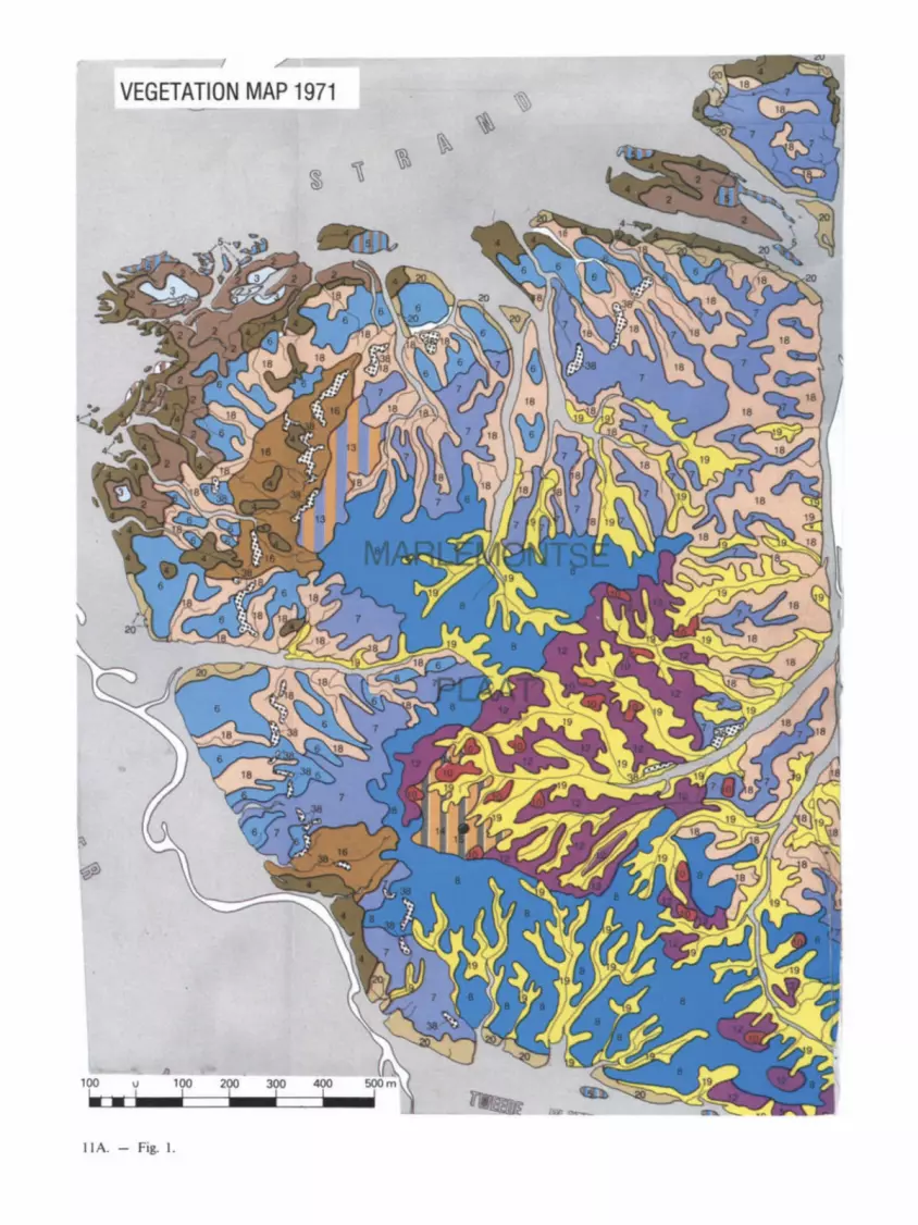
VEGETATION MAP 1971
IIA. - Fig. I.

---------_____ a.. ..... _---....... _--_ ..... -----------_ ........ __ ._.-. _100 __ ....... __ 0. __ ... 100 ___ _ --0. .......... peuorolondll ......... ....".,. OY -0. ___ ... _..-. __ _
.., .",..... ."..,.. 01.1 fOCt'IIuJ:
O' .. .....,. .... t....,...~ ... 1CIIII --o. .. ..--...~ N' ... ~ ........ -s... __ __
.. -------... _----II . - Fig. 3.
Ift_ ...... ..,....._~ ......... _ ... _ .. -
~"~_'E ___ OO' <IE "" ~"'~ __ ' __ 1CIAoI a.. :IS'<.
_"'~_E __ ' __ IOEOI·~"'~_ OED .,.. --'--- _ -_ ... ___ ,E __ IIIEl· lIE .,..
~ .. __ ,-_'C--lIE" 15"0
"""""CI!IOO. ~0It~"'· ~yt - ... -. ... _"~-_' __ ICIAoI' GAo ~
~-'--(QN) . ..-.. QH :IS"" C--_-_, __ _ 3D"O.
Gt_"_''-IBE)'_'" IIf ..... ~----'---
_ .33'
~"_'~CllEJ'_'" • -. _E __ __ .",_ 8£" .
III' Pwoc:etcIut~ I £~ ...... (PEl P£ • III
s.w_ ......... ~~Acaciwl-_,, ____ '--111_ A_ .....
U .",-.--,--~ -, -- .. --,--~."'- .. -. ..... ---,,--~ I'E 10'10 - .. ~--.- (QN) . .... --,,---_.--- A ... "" '_ff __ ' __ ~ -. :rs...
~ff __ -_'-_I11_ A ... 30'10 . - .. --.--~.- -. 30'10 " __ ._111' .... A, ... 30'10 s..-_ ....................... _ ...... WOll --,,_._-,_ .. - "'" _'E __ ~ P£ -- ... -0.,. __ "_
c.ur.~,~_Qlllu_"""""'" ........ ..,. .. _~~iIbda~.~ .. a.........1 ... 7 • £'taQtonI .... ' ~ _.,..,-•• ComIIr~ .... I()'o. _I&.QroMetgllt·~"'COI'MIIt~ .. tIIMt .. I()'o. - • ~ .... IOrttI ............. ~ ......... _ _ .. _..' ____ do_ ~ .. ---....... -"---'-- ...... .... ........ ~ - --"--'- ' .... ...,...,.. - .... - -Dooonoo ... __ .. _ .. -..,., - ..... ........,.....,....,_ ......... C)ClllftftlllAaMI .. PMI
""'" ~ :JS""
~ ... --... -,--. .... -___ BEM._._ IIEM ,'''' _
I ....
T ....... ~CIA¥6_eflC~,..".. ..........
_ I .... __ ..-.......... , . ., -
Fragment of the VEGETATION MAP
....... toO .... of the KAARTA- REGION in MALI
IlII00..,. - 111 7'00,..
"' ... --100_
IIOftI .... 100 _
_ ... 1IJO_ t ! DJ Fl __ ... >co_ t I U I vu_ ....... 100
fIIIOIN_700 • toO ..... i lJLJ~~ L.! ____________ _
::.1 = .. I::"
ITe 1977 ......,.~~A .. ~
CIn" A 1Il .. ___ 0' Ort.~ A_
I I

SLIK EN LAAG SCHOR MUD FLAT AND LOW SALT MARSH
gemeenschap van Zeekraal community of Sallcornra europaea (Sa/,com/erum eufcpaeae)
gemeenschap van Zeeaster, tage rozetten community of Asler tnpohum, vegetatIVe
gemeenschap van Zeeaster met Engels slljkgras communrty of Aster tnpohum With Sparttna anghca
gemeensd1ap van Zeeasler, hoog en bIoetend
community of Aster tnpolium, fIowenng
593
gemeenschappen van Heen en van Engels slljkgras communrttes of Sctrpus mallhmus (Sctrpelum man~m') and 01 Spa.1tna angltca (Spanme/um ang/lCile)
gemeenschappen van Engels slljkgras. van Heen en van Zeeaster communrtles 01 Spartlna anghca (Sparonerum angllCile). 01 Sctrpus mantlmus (Sctrperum man/lml) and 01 Aster tnpohum (SOCIa/JOfl of Aster tnpoi/um)
gemeenschappen van Engels stljkgras. van Heen en van SchOITezoutgras communrtteS of Spartma angllC8 (Sparonetum angllCae). of Sctrpus mallllmus (SCIrpelum man/1m,) and of T nglochln manllma (SOCIa~OIl of Tnglochm manIJrna)
gemeenschap van Atet communrty of Phragmlles australIS (socla/JOfl ot Phragm,tes austral,s)
gemeensdlappen van Zeeasler en van Engels s1ljkgras DROGE KOMMEN EN OEVERWALLEN communities of Asler Inpoltum and Of Sparttna angla DRY BACK SWAMPS AND NATURAL LEVEES (Spartm8rum angllCa8)
NATTOTDAQGEKOMMEN WET TO DRY BACK SWAMPS
40
gemeensd1ap van Engels slijkgras community of Spartlna angllC8 (Sparonerum angllCae)
gemeenschap van Engels sf 9ras mel veldjes Heen* community of Spartlna angllC8 (Sparonetum ang/lCile) with small dusters 01 Sctrpus manllmus
gemeenschap van Engels 51 jkgras, dichle veIden community 01 Sparllna angllC8 (Sparonetum ang/ae). dense dusters
gemeenschap van Heen, dtehl8 velden community of ScI/PUS martllmus (Sorperum manlJml), dense duslers
_ Zou!gehaIte 10 - 7l5.0-~ ... .... I ............... Sal.tn.ty
... .1. ... I ........ I I t I
....
II . - ig. I.
gemeenschappen van Gewoon kwelderg:"as: van Spiesmelde en van Zeeasler communt\lesoi Puoclnetllamantlma (PucClneJlle/ummant,mae). 01 Atnplexhastata (Afnp/ice/um hastatae). and 01 Aster II/pol um (SOCI8/JOf1 of Aster InpoilumJ
gemeenschap van Spiesmelde community of Atnplex hastata (Atnp/lCe/urn haslatae)
gemeenschap van SpiesmeIde en Strandkweek commUnity of Atnplex hastata and Elytng1<l pungens (Atnp/ICI·E/ylng/erum
pungenllS) gemeenschap van Gewoon kweldergras lnet Echt IepeIbIad B.a. community of PuOClnelha mantlma (PlJccmeJlterum manlJrnae) with Cochleana ofhonalts el at
CompIled by. Drs J LeemIIIS en DIs B Ve<spaanOOl\ under supeM$lOl'l 01 Or I. I. S Zonnev !d. IT C EnIctoede In eoopera\lOll With Or I. W G Bee Qena InsbMe. Yerseke PubIIIhed by the Founda\IOII .. Het ZHUWSCh lafldSChIp". HetnXenSHnd. supported by the Pms BemllaRlfonds Canography S de Sdva. Intennap B v .• Enschede 1979 .---------
7 - 5.S"-cr-

VEGETATIEKAART 1957 VEGETATION MAP
N
t VEGET ATIEKAART 1971
(Gegeneq_d/
VEGETATION MAP (GeneralISed)
SEQUENTIAL SEMIDETAILED VEGETATION
MAPPING OF (Verdronken Land van)
SAEFTINGHE T H E NETHER L ANDS
Leemans ,.75
& Verspaendonk See e l l o me " ( Flgl1 .5 )
II . - Fig. 2.

SUI( E I.AAG SCHOA ,",UOFtAT AND LOW SAlT MARSH
-____ .. ~_z- ... ~
"""" IhOf ., aotrebOn 1N'I~ot ~ lnPC*Iaend s-:.:-. ...-
'"-,_"2_,-_Z"0"0'_ .. 2 .. "'G"-"'-_ ..-.g--... &>goIo~ oca ....... ;u. ..... " __ SooMaonglQ
.... ......,&>goIo "Q Soort W'O'Q
GEBIEOE MET NAT TOT DROGE KOMMEN AREAS WITH WET TO DRY BACK SWAMPS
-
_ ... o.-..~ __ -.gono:o&>gololllfq.o
....... " ---- ~ongIQ 1ogo __ &>goIo~ ... ___ o.-..~ ... ~ ""'.... .. ~_l"" __ .... ,,,,, __ -__ o.-..~._.~ ... _"'" Ooworw-._~ III< .. __ ............ __ ~ __
..... oISco1>uo-..... ___ _
"-,--&>goIo~~ ........ -~ -~I"'_' "9'0''''''- '_" ~ __ ' ___ 01~
-- '-~£¥nuoo_' Wij'------&>goIo1llfq.o ~Sor __
hog _ '*" _w __ oISc1onw1oonglQ_
-. £¥nuoo~
-----~--OIItJo.I.ampe .. "'c::tuI*"Iof~~""""""" ·~"91_ '-----Hovo--oISco1>uo_ ""," __
'-----... -eno- III.Hovo--hogtIbItio .. ;cII ......... oI ___ oI~ongIQ ""'"
not.nl_ .. £ 90~
'---.....---.&>goIo...,....-.~ .. ___ Hovo--S_ "'11"""'" _- _oISot11uo ......... s..-angIa.""""""" ___ T"9'OC""'_ .... ""'"__ E'YVge_
GEBIEOEN MET DROGE KDMMEN. OEIIERWAU..EN AREAS WITH DRY BACK SWAMPS. NATURAL LEVEES
"
"-_ .. Iogo __ Z-... ~ __ -P'Iq'I Mlunllfttelw ""~It'd""''-
"-_"Iogo __ ~ o.-..~ _ .. ...."..- ","--EnoeII~ "'II" ,, __ ""' ___ ~ __ _ . _' ____ 01_-...... ,, __
s...-t .... ongIQ --.. ,---~ 11< ...... "'01 _"'11" _____ -_
GEBIEOEN MET BEWEIOING AREAS WITH GRAZING --
.... 1Iogo-----&>goIo...,....~c;o..-~.~ -"'G"-.... ___ _ _ " ___ 111 __
~_3"" __ .....,"""3 ... ,. ~_O'-"~.,do_ .. _za_ ....... ap do __ " .......... __ -..;._za......,..
.001 Pt..:::oneIII nw-um..,.,. ... ..,.lftdIWtrdOl"""rutIaI f _11""' __ ..... _'*'01~ ~ lW)IIOI'Ilteqsuo. ....,.
595
llA. - Fig. 2.

ra.c:.' 1 9'H-'~
596
)
, l
1 , •
S, TT\..DII: .. T
.... ~ . , ,,",, . ~ J
.. ~ • 1
IIt ICcrICL.DI
, .....
' ...... --"
14. - Fig. 12 .
--~
14. - Fig. I .

597
• , •• It .2
• 4 .. • • If •
14. - Fig. 14.

598
:r; co
~ ~ ~
IQ
:i! ~ G 11:1
~ I ... 0
14 .,;. ~ E 0
8 ... ~
~ ~ Q
~ ~ II)
Eo IC ...
0 ~ ~ 0 ~ Q
~ ~ ...
8 -D ~ 0
14 ~ III
oil ~ u::
0 ..,.

DIG
ITIS
ED
P
OL
YG
ON
S O
F LA
ND
U
NIT
M
AP
14.
-Fi
g.
16.
l e c o 0- >.
'0
0. 2 3
~
'0
VI
VI
.......
III
---..-..
C
v. 0
0 0
fJ '""
' '; -
VI
ClI
VI ... c Cl
I ... e o U
L
QJL
VI
ClIO
OO
ON
o-V
I
>,
It>
en
It
> en
._
'"
'"
U
~
._
U
o .-
t,I)
Q
,I o
~
VlClI~
U
'"
ClI
"''''
U
....
'"
I
.... ;:
, Cl
I I-
VI
c.;
:,
>'V
I f
I ClI ... '" ~
... .<:
;:,
......
• -C
L
X
o Cl
I Cl
I V
I ""C
O ..
.
""CO C
;:, o I- '"
'" .-
....
0
I-VI
;:,~
VI
;:,
III
ClI
I-I-
.., o N
ClI
t...
~----~~;,
>,
>,
>,
>, ----
-
-,-"
'" ...
_ C
. 0
..'-
or-
..,
...., ~
ClI
...
;:,.
<:
...
U
...
0-
....,
n::I
)(
.,...
",o
.ClI
.<:
>,o
.o
.u
ucce
-::::J,::3n;)ftlGJ~GJ
~VlVI:;-:;-8.Q.8.
ClII-I-U
UO
OO
Q
.ClI
ClI
S
-L
QJ';
Q.I
Cl
I Cl
I >
>
>
..
....
C
lIC
lIC
lI
E
!5 ...
UU~
....... -
c Cl
I 0
'"
II)
VI
",c~
I-Cl
I ;:
, o
""CO
VI
... ...
ClI
ClI
'"
'"
~ .... ~~~
'"
"'""
CI"
"CO
""C
O Cl
I Cl
I Cl
I C
C
V
I .,
..
v.
:::Ji
:::l ~ ~
ClI ~
ClI
0 0
I-C
lII..I-I-»
0
.1
-0
.0
-"'''''''
........
. 0
0
0
e f
e 1,1,4.~,2.6.1,4.5,8.8,8,8,5.5,5.5,
1.2
.4,2
,5,3
.8,1
,1,8
,8,1
,2,4
.3.2
.4.
4 1
,2,4
,3,5
,3,8
,1,1
,8.8
,1,2
,4,3
,2,2
, 5
1.2
.4,5
.5.3
,e,1
,1,8
,8,8
,8.4
.4.1
.4,
6 1
,2,4
,6.5
.3,8
,1.1
.8.8
.8,8
,4.4
.1,2
, 7
1,2
.4.7
.5,3
,8,1
,1,8
,8,8
.8.5
.4.1
.1.
9 1
.2.4
.8.5
.3,8
,1,1
,8,8
.8.8
.5.4
.1.1
. ~
1,2
.4,'
,5,3
,8.1
,1,8
,8,8
.8.5
,4.1
.1.
18
1
,2.5
,7,5
,3 •• ,1
.l,8
.B.8
•• ,5
.4.1
,l,
11
1
,3.4
,',4
,3 •• ,1
.1,8
.B.8
.8,4
.4.1
.1.
12
1
,3,5
,2.4
,3.8
,1.1
,8,B
.l.2
.4,3
,2.4
. 1
3 1
.3.5
.7.4
,3.8
,l,1
,8,B
.8.8
,5.4
,l.1
. 1
4
l,3
.5.8
.4,3
.8.1
.1.8
.B.8
.8,5
.4,l
,1.
15
2
,2.5
.3.6
.3,1
.1.2
,8,1
.1.2
.4,3
.2,2
, 1
6 2
,2,9
,2.7
.4.3
,1.5
.8.8
.1.2
,4,3
,5,5
, 1
7 3
,4,5
,7.4
.4,8
.1.1
.8.8
.8.8
.4.4
.1.1
, 1
8 3
,4.5
.8.4
.4,8
.1,1
.8,8
,8.8
.4.4
,1.1
; l'
a,4
,5.,
,4.4
,B,l
.1,8
••••• 8
.4.4
.1.1
. 2
8 3
.5,4
,8.5
.7.8
.2.2
,8.8
,8,8
.4.3
.2.2
. 2
1
3.5
,4,'
.5.7
•• ,2
,2.8
.8,8
.8.4
,3,2
.2,
22
3
,5,5
,6,5
,6,8
,2,2
,8,8
,8.8
.4.3
,2.2
. 2
3 3
.5.5
.7.5
.6.8
.2,2
,8.8
.8.8
,4.3
.2,2
, 2
4 3
.5.5
,8.5
,6,8
.2,2
,8,8
,8,8
,4,3
,2,2
, 2
5 3
,5,5
,',5
,6,8
,2,2
,8,8
,8 ••• 4
,3,2
,2,
26
3
.6,4
,8.5
,4,.
,1,1
,8.8
,8 ••• 4
,3.1
,1,
SE
CT
ION
O
F T
AB
J..E
W
ITH
PO
LY
GO
N
NI.J
M8.
&R
S O
F I.
AN
l)
UN
IT
MA
P A
NO
C
OD
ES
FOR
I.
AN
l)
AT
TR
IBU
TE
C
LA
SS
ES
Vl
\0
\0

I ~ = I 3
UA
ICO
I.&
or
LM
D Q
UA
L''I
'Y ... _
"'''"
CItI
LA
ND
A
'J"t
at.
IU'I
"U
~y o
r IIOJIIT~
F'lt
0tl
1
1_
'£1
1
( ..
he,
... 1
1 g
rlln
s)
NIL
-,.OIIITlUt:
-.uIL'-IW/~'Ct
a'_
1:
CA
I'A
(;JT
Y o
r M
/lllU
O ..
.. 1:
IIOlaT~
1M
lIOO
T
ZO
MI:
( ..
h.,
...
11
gr,
lns)
->n. 1M
5. -
1" ""
- 1M -z .. "
"
< s
. ""
- 1" -15.
""
-.uILT-U!'/IIfI
TE
II
14.
-Fi
g.
18.
i i ~ : ~ E l § ~
_lU
Ll: HOI"'~
(lII
h.,
_1
1 g
rlln
s)
HI l
it!
HE
IIIW
l LO
W
U£l
IYL
OW
-"'ILT-"
';~TE"
DE
I,le
af
.sn.
a I
1.
AV
AlL
A&
a .M
Ol"
"" II
H
IGII
W
MD
f 'I
"IIS
Q:
I'
M
AD
IQC
An
I_
,TI"'"
IU
l'PL
Y or
MO
lnu
u
,... c
;;aO
t.III
DW
An.
v
tTH
UI
TH
S IM
C
"U
OO
u.
WH
D,.
... .. J
I lie
) IU
PPL
Y
nell
G1a
JMD
WA
na
UI
"U
I "A
loo,
'ri
ll
8'fO
UG
& C
API
IoC
lTY
or
'ft
(I:
MX
)IT
... D
C't'
I:a
JtI ...
. 'f
tlI
OQ
AL
lft
-AV
AlL
Aa
l.&
NO
IIT
UU
*.
til
ftIl
l C
A$
&
AV
o\l.J
.AI.L
I:
tl)1
11
'UU
I'
,
-UG
iI
tIIK
III
TU
n
o ..
....
Cld
'AC
lTl
I'
)20
0 .
..
-tca
Dlt
llt
WIl
D '"
"
8"f'O
JUIG
I: C
AP
AC
In
18
1
00
-20
0 '"
-LO
ll _
....
. ftQ
UG
8 ~JIC1'I'Y
U
~.-1 •• M
-VU
1'
LOW
tI
I&D
I ".. aoro~
CU
'AC
tT'f
U
<
50
JI
M
0\ o o
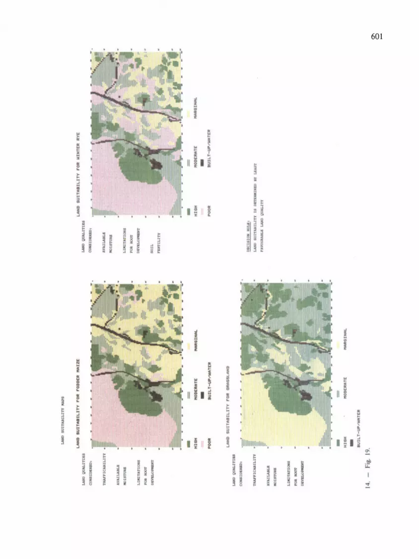
l.AN
D
QU
Al-
ITI"
caq
IDt.
oa ..
TIl
tAP
?IC
UIL
ITY
AV
All
..AaL
a
.,lm
IU
LU
UT
AT
ION
I
"'" .,
.,.
DII
VS
LO
....
...
l.U
rD Q
UA
LIT
1U
CO
IC,lo
.am
.
'J"
MIT
lCU
lLl1
'1'
AV
MI..
A.IL
&
11
01
_
LU
UT
ATI(
»IS
"'" .,
.,.
DIII
I1Il.
O ..
....
.
LiJ
ID
IUl'
fUIL
l'I'
Y I
IAJ'
S
LII
HD
.u
rTlI
.IL
rTY
,.
011
,.OD
DE
R
1II
I1zt
:
-HI ... -II
OD
DlI
ITit
-IUILT-~'NIIT£
1t
LII
HD
.u
1T
1I8
1L
rTY
,.0
11 _
SL
IIN
D
; J -HIOH -lUlL T-~"NIIT£1t
IIO
KIt
IIT
it
14.
-Fi
g.
19.
__
IHII
L
_O
IHA
l,
....
....
gw
.w'P
1U
ca&
aI:D
&I:
ItD
,
AV
AlL
A.l
La
11
01
_
LU
UT
AT
l ...
.
"'"
II
OO
r D
.va.
DJI
IQ:M
'I'
lOL
L
PlR
'flL
ITY
Ole
III ca
r II
ILa
I
LiO
IND
1
UIT
II8
1L
ITY
"0
11
IIJH
TE
II
11'1
'£
-HIOH P'0
0tt
IIO
D£I
tIIT
E
-lUlL T-IW""
"'T
ltIt
LAH
D
IUl"
....
U .. l
TY
1
. D
ITIM
IIf.
m I'
t.&
Aft
PA
VO
U'U
.III
..a
LA
IID
Q
UA
Ll,
"
_O
IIll
lL
00-
o

602
'" .., • ... IIV • .. • ~ ~... ~ .. '" ~ ~ . ! IIV ~ =. .. = ~ -· .............. . ·
7 · .............. . ~ :
.. · .............. . · · ~ ~::!..:
· ! .. !.. =: · .............. . ~ .. · ~ ~ : ~ ~ ! .. t · ~ ·
· .............. . >.. : ~ = : :: . ;; = !~
~ : ... fW :! ..
~ ! § .. · . ~
I ~ ! ~ !
t .. ! £
· .............. . fW = = = ~ ~: . .. ... ~
... : ~ ! Po ; c!
· .. , .... , ...... . ... "" " '" f'!I ..... ~ : ~ .
" ••• '101' e : ~
I .1 ~ .. i
II i •
i ~ ~ i i i I II ; I ;
i • v a : 1:1 ~
i t ; II i I ~ ti
e ~ ~ •
~ E ! I I 3 i ! ~ I \I i 0
I I I 0 W Iii '" "
.. 3 I I ., 5 cob
I I I • i u:
! ~ of

CIl
eI'I
tRll
<:l
f cr
~
LN
lO
t 19
0))
'1
'0
Cia
AU
LA
ilD
C 1
97
3)
UI
DL
AT
10
ti
'fO
aur
TUI.1
.lTY
or
l.\M
D
l.n
d l
ui U
bi l
tty
fo
r ar
.ble
lIn
d/9
rlS
slin
d
-11i'S1 R
i'S
Z
g,a
--
-R
i'S
1
Di'S
Z
_I-R
-IV
A
1111
1. ''
'''''''''T
UI
5u H
lb I 1
tty
c Il
Sse
s:
51 °
Hig
h 53
° "
,rg
l ..
l 52
° M
oder
lta
N °
Hot
su
i ted
~:
5215
1 °
52
for
Irlb
l. h
.'t/
51
gra
ssla
nd
....
...,
CO
VItI
l 0
1_
1
90
J -
19
71
tiD
...
.. 1
M
nG
UU
SI
14.
-F
ig.
21.
_ ~ _
It 1
0
_ U
_lln
,
Ne
D 1
._ "
'''l
UlU
"
(197
3 sH
ult
lon
)
... .. .,
:
--
-~'I_" ~R'--U _U~"
-_
n.--
U "
'II.'''
'''''''''U
5
ult
lbtl
tty
ch
sses:
51
•
Hig
h 53
• "
,rg
lnll
52
° M
oder
lte
54 °
Hot
su
Hed
~
A..
U.U
O
IED
P
OI:
AJt
UI.
.&
cao
PS
P
UV
lQU
1.L
Y
AN
D
ro. ~D
AT
.a
aaat
r ...
.. ,
FO
R
A ~
rAItT
, III
QIIA
LLY
1I
J1T
t!)
..,.
lO
'I'II
U
DI
(CM
IDI
CO
LO
UU
"
OK
LY
QtA
1.I
.I:.
'U
TI
or 'r
'KI
.u&
A W
HIQ
4 C
IIAH
CK
D
....
. A
J..\
aIA
J.
.AN
1)
TO
C
ItA88
I..A
HD
A
U
U1
"TD
S
UIT
ll)
.0.
Qt.
\IB
LA
!II)
(o
m o
:x.o
uu I.
-_
0
0'1 o Vol
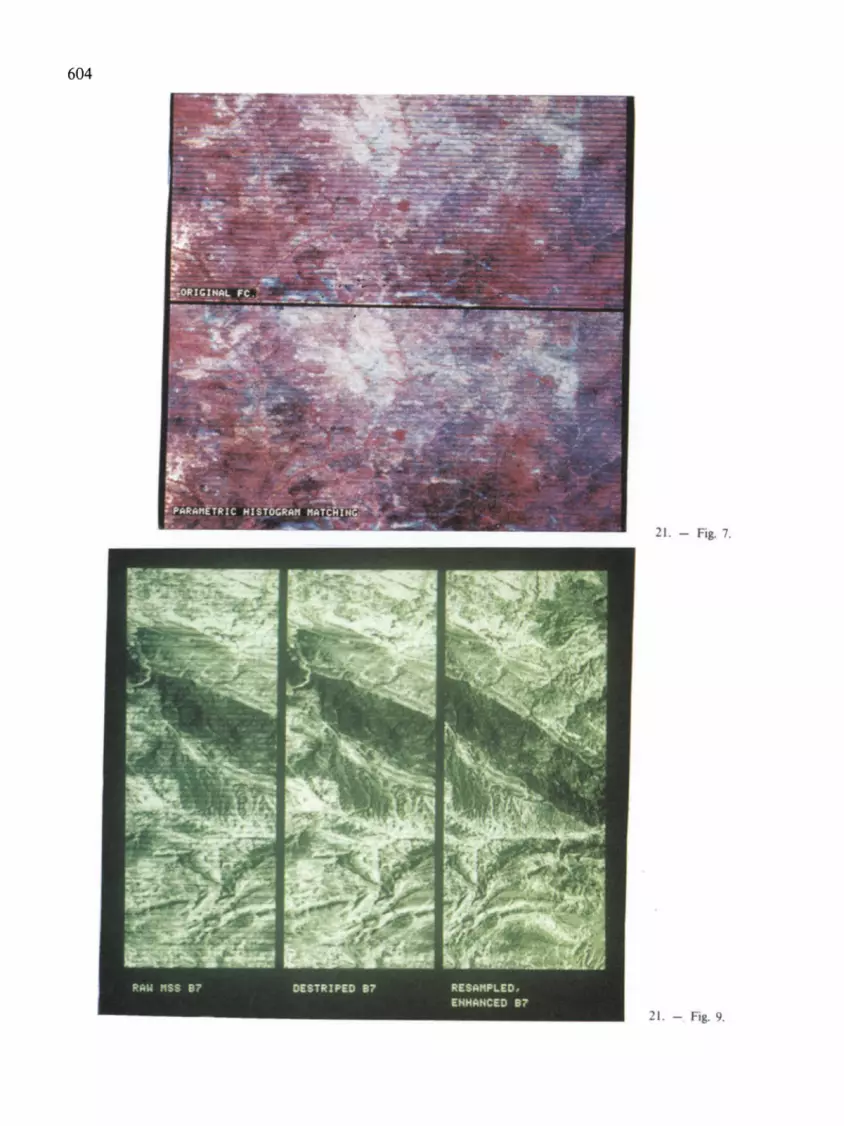
604
21. - Fig. 7.
21. - Fig. 9.

605
21. - Fig. 13.
21. - Fig. 14.

606
2 t. - is. 19.
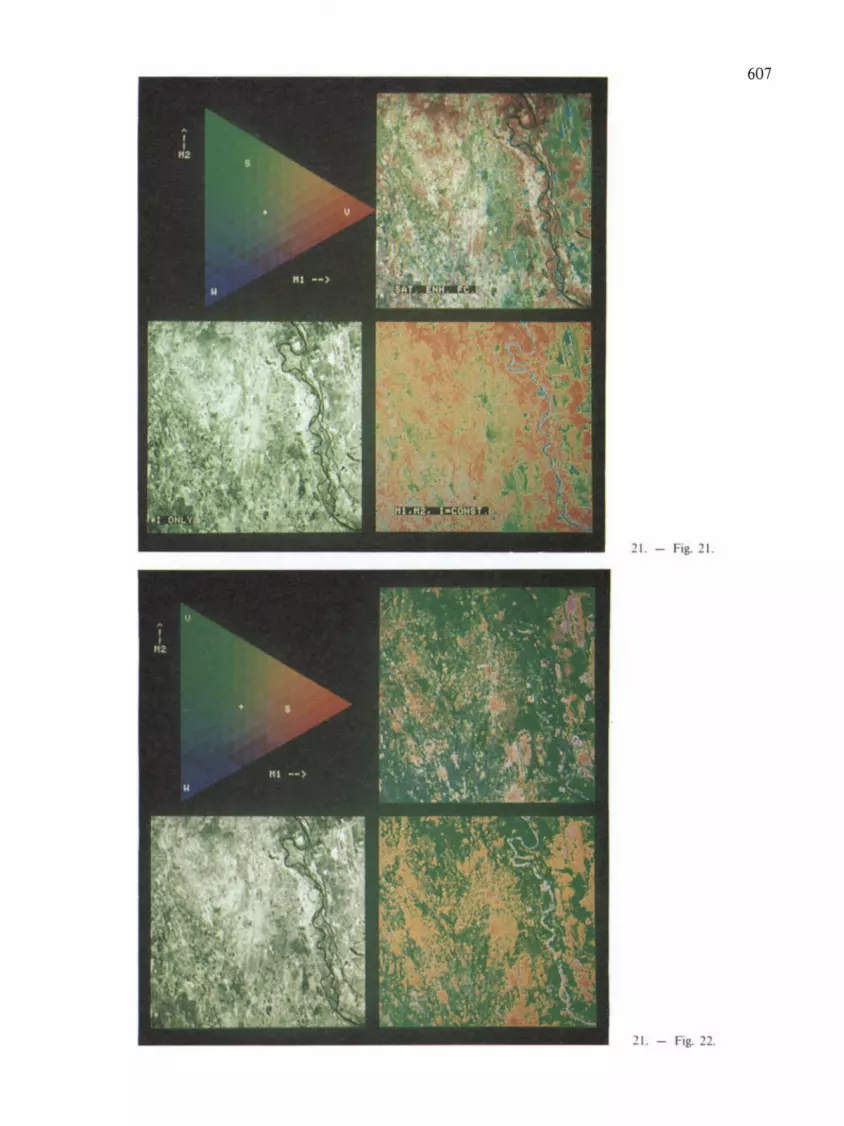
607
21. - Fig. 21.
21. - Fig. 22.

608
21. - Fig. 25 .
_I. - ig. 2 B.

609
21. - Fig. 28.

610
21. - Fig. 27.
21. - Fig. 29.

611
21. - Fig. 23.
21. - Fig. 31 .
21. - Fig. 31 B.

612
21. - Ig. 34.
21. - Fig. 35.

613
21. - ig. 6.
21. - Fig. 7.

6 14
26. - Fig. I.
VEGETATIONSKARTE DER BUNDESREPUBLIK
Potentielle
Blrkenbruchwald des Rachlandes. orUtch Heldemoor. Gagelgebusch. Eichen - Blrken -wald und Eichen - Buchenwald
Feuchler Eichen - Buchenwald des Rachlandes, selten Ubergange zum E,chenB"kenwald
Feuchter Eichen - Buchenwald des Berglandes
Trockener Eichen - Buchenwald des Flachlandes, selten Ubergiinge zum ElchenBlrkenwald
Erlenbruchwald des Flachlandes. selten waldfreles Nledermoor (N)
Erlenbruchwald und feuchter Eichen - Buchenwald 1m Wechsel
~ Weldenwald und Mandelwe,dengebusch
D ~ ~
Traubenklrschen - Erlen - Eschenwald. stellenwelse mit Erlenbruchwald und ElchenHalnbuchenwald Eichen - Ulmenwald (role Punkte: auf slark entwasserten Slandorten
1m Erf1tal)
Arlenrelcher Sternmleren - SlIelelchen - HalObuchenwald
II Stlelelchen - HalObuchen - Auenwald der Berglandtaler emschheBlich der bach~ und fluBbegleltenden Erlenwalder
D Malglockchen - Stlelelchen - HalObuchenwald der Nlederrhemischen Buchl
~~
~ ~
D ~ ~
Malgl6ckchen - Shelelchen - Halnbuchenwald und feuchter Eichen - Buchenwald 1m Wechsel
Trockener Flattergras - Traubenelchen - Buchenwald mit Ubergang zum ElchenBuchenwald
Flattergras - Traubenelchen - Buchenwald
Typischer HalOSlmsen - Buchenwald
HalOSlmsen - Buchenwald mil Rasenschmlele
Flattergras - HalOSlmsen - Buchenwald
TYP,scher und Flattergras - Hamslmsen - Buchenwald 1m Wechsel
Ma,glockchen - Perlgras - Buchenwald der Nlederrheinischen Bucht, meist auf k,esigen BOden Malglockchen - Perlgras - Buchenwald der Nledenhemischen Bucht, stel1enwelse Flattergras - Traubenelchen - Buchenwald, auf lehmlgen BOden
Malgl6ckchen - Buchenwalder des Villeosthanges
Malglockchen - Perlgras - Buchenwald und Malgl6ckchen - Stielelchen - Halll _ buchenwald 1m Wechsel
HalllSimsen - Perlgras - Buchenwald sowle Perlgras - Buchenwald und HalOSlmsen Buchenwald 1m Wechsel
HalnSlmsen - Perrgras - Buchenwald mit Rasenschmlele
Typischer Pengras - Buchenwald
Feldaufnahme: H. Wedeck. G. Wolf. K. Meisel u. a. (1965 -1969)
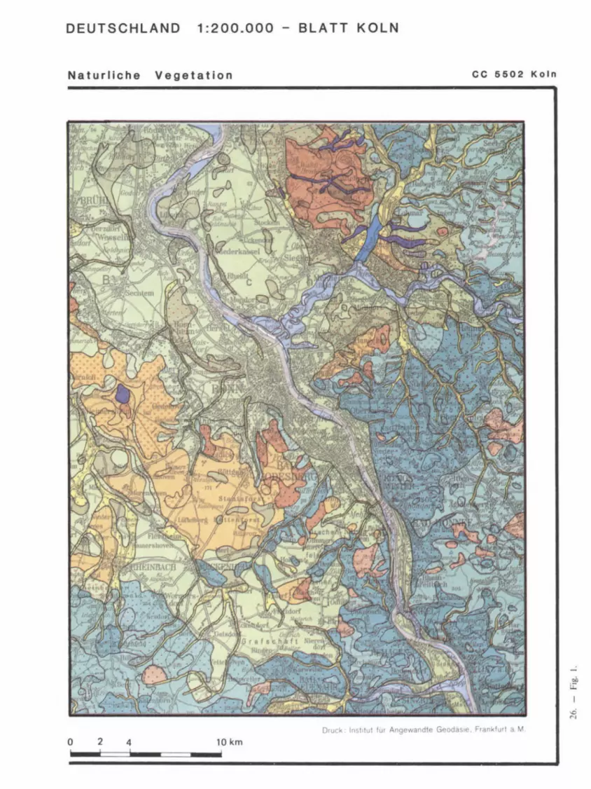
DEUTSCHLAND 1 :200.000 - BLATT KOLN
Naturllche Vegetation CC 5502 Koln
....:
DrUCK Ins! luI fur Angewandte GeOdasle Frankfur' a M
o 2 4 10 km

616
26. - Fig. 2.
LEGEND
Vegetatieuaapt van Nederland. Vegetation map of the Nether1ands Vegetation series. named after the natural forest types (according to Westhoff & den Held. 1969)
QJerco roboris-Betuletum
complex of Querco roboris-Betuletum and Fago-QJercetum
Fago-Ouercetum
Fago-Quercetum. type poor in species
_ Fraxino-Ulmetum
Anthrisco-Fraxinetum
Circaeo-A1nion
complex of Circaeo-Alnion and Alnion glutinosae
Alnion glutinosae
_ A1no-Padion
complex of Alno-Padion and Salicetum aloo-fragilis
bI complex of Fago-Ouercetum and A1no-Padion
.... complex of Fago-Quercetum and Circaeo-Alnion
Additions
complex of Fago-Ouercetum and Macrophorbio-Alnetum
complex of Querdo roboris-Betuletum. Fago-Quercetum. Circaeo-A1nion and A1nion glutinosae
complex of Fago-Quercetum. Circaeo-A1nion and Alnion glutinosae
predominantly dry vegetation types
predominantly moist and wet vegetation types
r:!'rr:;.7!~,7~-· ~
I}:.:::::::::'" ! development to peat bog within the Alder forest series
w open water
urban area
Code for the actual vegetation
The code counts five posnions for forest. shrub. semi-natural vegetallOn. cropland and marshiwater vegetation respectively. The presence of each category is expressed in % of the area of the map unitconcemed: 50: > 75%. 4 0: 50-75%, 3 0: 25-50%, 2 = < 25% or many line and point shaped elements. 1 = few line and point shaped elements ..
example: code 31142
3.... 25-50% forest .1... few hedgerows .. 1.. few small patches of semi-natural vegetation .. .4. 50-75% cuRivated land (grassland and arable land) .... 2 a mumber of patches and lines with water and marsh vegetation
It depends on the colour. that is the vegetation series. what types of shrub. semi-natural and marshiwater vegetation are present. In the original study this can be checked in a table 01 vegetation series.

VEGET ATIEKAART VAN NEDERLAND OORSPRONKELlJK SCHAAL 1 :200 .000
1975
617
26. - ig._.

-31. - Fig. 3.
16-11 """DIII$ G.u~S
fT 1fIOUSES
-.
Go., ....
[ 2t 3 -" h,..". '-'1
" lUGE SUloI.ltlN
I"~'OUIIIIII
r. • .... -
CVIMES

M oil
i..i:
....; a M

620
A fragment of the mop ·South Sumatra". _ °C::::::E==:3::=:l:i++l==:3:::=SOom51 The venerable concept of "series c1 veQetofion" has desoppeared A specimen of its Iegend (Loumonler 1983)
II • formatIOnS de bIIsse I .lmucle (300 t 1000 ml des petites 0CCIdentaIas 1M 'SI(IITI slopes III low tHrwllliDfl. bill-. 300 NId looom
_._------------_. __ .. --0.-",.", ............. ...... ......,. tI".,.". -_._--~ .. ~'_'--~1IrtIIt/tIr
~.----- .... _._-------------~-----
III . ZonatJOn lorestl4ire alllludinale sur Ie chaine des BartSln. alHlessus de looom FOfnl aItJIudinai _ on tht/ S •• SIJ/I
Range
J:ottI: ... t"I • .",. ......... a (ncacMII IU ........ 2100 1£----E."..,. ..... __ .,. ...... fJ/ IN ~ __
_:t1rIO ..
~ ......... r .............. ---.. --___ '_ICa-_ e--_. __ .. _.c:.w-. --0., __ -0..-_-31. - Fig.
Types de ~ion des ~ions --.d6es TyptlS found 1ft ~ IIrHS
- - - _ ......... ""*--=-1JoodooaOoi __ GUa~ ___
... _--" ... -._------............... -=--- .... --" ... _._/WWA~ ,.,.. ........... ~."--"""'" , .................. .-...,..,. 1 _____ ' ___ __ s ___ ...
-,------"'----.., ----~--_ ... __ ... --o.....,...,~", ..,.." ... /IftINI'f...., ,..,.--~.~ .......... ------~-......-~-~---HItt«Mut""".."""tC ~ -"""""'_Sw.. '.
----... ""'-...0.---,-----'-----------~-.. ,-------------------_.-._-Der _____ _
----.-.-..-. o.r-____ _
F'f°lf'J --_._-042 Ctarv .. ...., .... _._----

31.
-F
ig.
5.

622
SPOT simulations in the Sunder bans (Hat yo island -Ganges) and their interpretation
1 - Natural dense mangrove (mainly Sonneratia apetala)
2 - Plantations (about 5 years old) 3 - Plantations (2 to 4 years old)
4 - Orchards with villages 5 - Dry harvested fields 6 - Dry fields with some dry crops including pulses,
tomatoes, chillies
7 - Very wet fields
31. - Fig. 5.
8· Almost barren wet muds ( intertidot zone 1 9 -Recent deposits, scattered Ql"osses, new croPiOrld
A,A'
--8rackish water (SilO water) deep (A) , turbid and shollow (A') Embankments consorldoted by trees Footpath one! embankment WIder construction OroirlOQll net-..ork

623
INDEX
A Amazon Valley 545, 548 Amazonian igapo 532
Abies 536 Amazonian varzea 532 Abies balsa mea 200,396 Amboseli 210 Abney level 394,396 Ammophila 485 Absorption 223,228 ANDEL 506 Abundance 51, 52 ANDERE 332 Acacia 448 ANDERSON 352, 376 Acacia albida 491 Andropogon gayanus 491 Acacia asparagoides 39 Andropogon gerardi 150 Acacia senegal 546 Andropogon hallii 546 Acacia tortilis 546 Anemone 461 Acacia verticillata 39 Anisoptera 450 Acantholimon 541 Annotated maps 426 Acer glabrum 44 Antennaria 470 Aconitum 461 Aphyllous 40,46 Actual vegetation 18, 19, 20, 21, 22, 427, 434, 438 Application of vegetation maps 481.519 Adansonia grandidieri 38 Arbutus unedo 3 Addis Abeba 501, 506 Arealkunde 461 Adenostoma fasciculatum 39 Areca palms 41 Aerial photographs 402, 412, 414, 419, 423 Argentina 5, 9, 195, 546 Aerial photography 237, 267, 412 Arid zones 342 Aeronautical charts 390 Arizona 377 Aerovisual survey 207 Arkansas 149 Mrica 9, 117, 195, 546 ARNOLDS 56,63 Ager 464 Arocomia totai 545 Agrostis stolonifera 377 Artemisia 131 Agropyron 131 Asclepias 544 AICHINGER 22, 69, 73, 326 Aspen 233 Aix 125 Association rings 327 Alaska 548 Astragalus 541 ALBERTSON 93,322 Atmospheric effects 277 Albizzia amara 448 Atriplex 540 Alchemilla arvensis 21 Attalea princeps 545 ALDEWEGE 239 AUBERT DE LA RUE 42 Aleutian forb meadows 548 AUBREVILLE 150 Algeria 448, 520 AUGARDE 193 Alnus 537 Australia 540, 544 Alnus viridis 540 Austria 7 Alsophila camerunensis 41 Autecology 27 Amazon Basin 532 Azolla pinnata 549
A. W. Kuchler & I. S. Zonneveld (eds.), Vegetation mapping. © 1988. Kluwer Academic Publishers, Dordrecht.

624
B
BAIG BAILEY BAILLIEUX Baltrum Bamboos Bangladesh BANNING BANNINK Barely present Bar Harbor fire Barison Range BARKMAN BARNHART Barren Batis BEARD BECK BECKITT BEEK Belgium BELLAN Belt method Belt transect Bengal Bengkulu BENNEMA BERG Berthol/etia excelsa Betula papyri/era Betula pendula Betula tortuosa BIE Biesbosch BILLINGS
512, 514 475 377
125, 150, 472 42,46
460 52
85, 87, 484, 492, 495, 496 46
323 451
64 149 46
548 9, 10, 39, 70, 71, 194
484 210, 213 500,504
9,496 457 460
59,60 459,460
451 500 173 44
38,200,396 21
540 212
26, 68, 132, 191, 469, 481 91
15, 465, 466, 467 450
14 476
Biocenose Bioclimatic limits Biogeocenose Biogeociimatic zones Biological indication 492,494
210,298 15, 16, 18, 20, 473, 474, 475, 476, 478, 479
Biomass Biotope Biotrop BLASCO Blue Mountains BOER Bohemia BOHN Bolivia Bombax malabaricum Borneo Botswana Bouteloua gracilis BOWERS BOX BRACKEBUSCH
450, 454, 460 450, 454, 455, 456
532 496
3 384
248, 545, 547 38
376, 534 421 547 227
16, 71, 474 5
BRAINERD BRAUN-BLANQUET
74, 75, 102, 107, 125, 135,
Brazil Brazilian Amazon BREMAN BRINKMAN British Columbia Broadleaf deciduous Broadleaf evergreen BROCKMANN-JEROSCH BROMME Bromus secalinus BROWN BRliNE BRUNIG BRUSH Bryoids BUCHWALD Bulgaria
68 7, 51, 63, 64, 65, 69, 72,
150, 154, 390, 421, 427, 443, 461, 472
9, 10,248 251 514 500 476
39,46 39,46
387 4
326 52, 62, 63, 239
63 451, 455
9 41
8 7
Bulletin du Service de la Carte Phytogeographique Bundesstelle fUr Vegetationskartierung
6 7, 124
BUNNIK BUNNINK BURKE Burkina Faso Burma BURROUGH BURTT-DAVY
C
Caatinga CAIN Calamagrostidetum varia Calamagrostis varia Calathea
223, 361 296 115 448
70 163, 165, 166, 169, 170, 172, 175
194
94 43, 52, 59, 61, 72, 217
327 326 448
Calibration 275 California 23,69, 118, 119,201,473,535,536 California Coast Range 94 California Forest & Range Experiment Station 8, 60 Cal/una 152, 333, 541 Cal/una vulgaris 470 Calluneto-Genistetum 21 Cambodia 448, 450 Cameroun 448, 450 Campnosperma panamensis 256 Campo Cerrado 194, 544 Campos de varzea 545 Canada 10, 195, 472 CANDOLLE 445 Cap Comorin Cap Corse Capparis decidua CARAP
448 465 448 420

Carex Carex curvula CARLQUIST Carrying capacity
544 150 451
carte de la vegetation de la Belgique 514, 517
199 carte des groupements vegetaux de la France 199
435 43, 52, 59, 61, 65, 72, 217
Castano psis sieboldii CASTRO Casuarina CCAS Cedrus libani Ceiba Ceiba pentandra Celmisia Celtis Central America Central Asia Central Europe
40 421
39 533
38 547 150
9 119 379
Centre de cartographie Phytosociologique Ceratonia siliqua
7 38 45
439 16 4
473 70, 71, 194
94,539 461
91 534, 547, 548
9 62, 195,327
21 42
485,491
Cercidium Chamaecyparis obtusa Chamaephyta CHAMBERLAIN Chamonix-Thonon les Bains CHAMPION Chaparral CHARRIER Chenopodium polyspermum Chile China CHIPP Chrysanthemum segetum Chusquea quila Cirsium arvense Cistus heath Claenaceae Classification CLAUDIANUS CLEEF CLEMENTS Climatope Climax Climbers COBB CODESUR Coincidence method Colombia Colombian Amazon Colombian Llanos Colorado Color coding Color method Colors Comoro Islands Companion species Competition
539 449
67,269,304 3
72,74 8, 73, 93, 375, 443, 444
15 18, 20, 326, 328
41,46 209,210
248 87
248, 251, 531, 547 251 546
4,547 282,284
65 328,476
449 62 13
625
Compound leaves 43 Congo Basin 150 Conium maculatum 44 Contact community 21,384 Continua 105 COOK 4 Comus canadensis 200,422 Corrientes 546 Corsica 135 Corylus avellana 379 Corynephorus 485 Costa Rica 132, 531, 532 COSTIN 319 Council of Europe 385 COUPLAND 92 Cove forests 90 Cover, coverage 45, 46, 51, 53, 396 Coverage classes 46 COWLES 375,443 Crau 521 Creux du Van 462 CRIGINGER 3 Cross table 412,426 CROZE 332,334 Cryptomeria japonica 439 CUATRECASAS Cuba Cultural vegetation CUNNINGHAM Cyc/obalanopsis Cyperus papyrus Czechoslovakia
D
DAHL Daisetsu Damnatz DANGERMOND DANSEREAU Darien Data bank Data base Data output DAUBENMIRE DAVIS Deconvolution Dehesa DEJEUMONT Density DESHAYES
547 462,463
19, 21, 487 124 435 545
7,385
65 440 474
163, 165, 168, 171, 173, 175 16, 27, 29, 34, 44, 45, 49, 62, 128, 444
251 164
164, 165, 172 171 327
319, 478 280 424 461
45, 51, 52, 56 460
Determination of requirements DEVRED
507,510 104, 117, 524
449 375 384
Didieraceae DIEMONT DIERSCHKE

626
Digital analysis Digital image processing Digitizing Digitizing accuracy DUK DJITEYE Dipterocarp rain forest Dipterocarpus Dipterocarpus obtusifolius Dipterocarpus tuberculatus DOBREMEZ
457 269
170,171, 177 171 277 415 450 450
Documents de Cartographie Ecologique Dodaira District
39 39
122, 443 11, 122, 472
432 DOING DOKUCHAEV DOMIN Domaine de Fontcause Dominance Dominants DONSELAAR Dorycnium suffruticosum DRUDE DUNNING DUPIAS DU RIETZ DUVIGNEAUD Dynamics Dynamism
E
Eastern Europe East Germany Echinocactus grandis Ecological group Ecological vegetation maps Ecosystem Ecuador Edaphotope EDELMAN
64, 66, 98, 378, 485, 497 91
65,66 465
53 17, 61
74 465
6, 62, 113 472 446
16 74, 115
331 18, 321, 322, 327, 328, 329
344 385
41 86
473, 474, 477 14, 15, 481
248 15
483 Editing 157, 171 EGLER 90, 327 Eichhornia 549 EITEN 71, 421 Elbe Valley 97 ELLENBERG 14, 15, 16, 31, 34, 44, 45, 52, 53, 70, 74,
75, 85, 91, 100, 124, 191, 197, 342, 375, 376, 378, 390, 444, 471, 472, 475, 476, 495, 520, 523, 525
EMBERGER 6, 75, 114, 125, 378, 474 England 27 Environmental indication Epilobium Epilobium hirsutum Ephedra Epiphytes
491 152 495
40,42 42,46
Eriophorum Espeletia Espeletia hartwegiana ESSELINK Ethological ecology Eucalyptus Eucalyptus diversicolor Eucalyptus ovata Eucalyptus regnans Eupatorium cannabium Euphorbia Eurasia Evergreen Excoecaria agallocha Exploratory mapping
F
FABER Fagus Fagus silvatica FALINSKI Falkland Islands False color film Fashion FENTON FEOLI Festuca novae-zelandiae Festuca orthophylla Field surveys FIRBAS FLAHAULT Flint Hills Florida Floristic composition
548 547
41 210 217
38, 544 535 535 535 495
40,449 537, 547
38,39 460
193, 197
70 439
21, 71, 444 7,385
377 239 471 322
51, 85 546 547 203 379
6,97 201
9,478 16, 17, 18,22,397,445,449,
450, 451, 456 Food & Agriculture Organization (FAO) 10, 48, 444,
456, 499, 500, 501, 502, 503, 504, 510, 511, 515 FONCIN Forbs Forest of Sainte Baume Forestry Formulas
3 41, 46, 319
101 521 47
FOSBERG Frame France
7, 71, 151, 327 157
4,9, 10, 106, 114, 153, 198,326,445,463,
Fraxinus excelsior French Guyana Frequency FRIEDEL FRITZ FUnSAWA FUJIWARA
464, 474, 520, 521 495 455
52 90, 97, 191, 199, 327
230 439
385, 432, 434, 438

627
G HALLE 455 Halya Island 459
GALIANO 461 HANKS 227 GAMS 15,17,90,102 HANSON 62,63 GARDNER III HARADA 432 Gascogne 127 HARDY 352 GATES 223 HARE 117 GAUCH 51, 85 HARPER 4 GAUSSEN 6, 10, 73, 74, 104, 106, 113, 115, 116, 117, HAYATA 427
118, 119, 123, 124, 151, 154, 191, 197,198,321,324,326, HAYDEN 4 328, 378,443,444,460,471, 473, 474, 523 Heather moor 22
GEIGER 90 Hedera helix 536 GEMS 332 Height classes 44,46 Generalization 48,49 HEJNI 87 Geocenose 15 Helianthus 544 Geographic Information System (GIS) Heliconia 548
163,169,171, 172, 173, 174, 175, 176, 177, 178, 180 Hemicryptophyte 16 Geometric corrections 278 HENGEVELD 495 Geophyta 16 HENTSCHEL 5 Georgia 98 Herbaceous 40, 46, 317, 318 Germany 98, 117, 124, 135, 377, 379, 432 Heritiera 460 GIACOMINI 101, 102 Heritiera fomes 460 Gigantochloa maxima 42 HEUSDEN 333,334 GILLMAN 154 HEYLIGERS 74 GILS 29, 56, 82, 210, 217, 419, 421 Hibiscus tiliaeceus 539 GLAVAC 379 HIELKEMA 333 GODRON 124, 378 HILLS 472 GOETZ 10 Himalaya 387 GOLLEY 375,444 Hippophad 485 GOUNOT 193 Hippotragus equinus 491 Graminoids 40,46 HOFFER 223 Grand Ribaud 465 Hokkaido 432, 439, 440 Grasslands 520 Holcus mollis 491 Grazing capacity 514 HOLDGATE 377 Great Britain 9,322 HOLDRIDGE 9, 132, 444, 450, 497, 523 Great Smokey Mountains 90 HOMMEL 72,87 Greece 541 Honduras 535 Green leaf area 295 Honshu 432, 435, 439 Green vegetation index 298 Hopea 450 GREIG-SMITH 85 HORVAT 385 GREMMEN 377 HOU 9 Grenoble 443 HOWARD 223, 238, 241 Grid 157 HUECK 4,5,76,98,106,117, 125, 191, 195 Grid representation 166 HUIZING 332 GRIMSDELL 209,210 HULT 64 GRISEBACH 15,70 HUMBERT 449 Growthform 16,496 HUMBOLDT 4, 16, 70, 502 Growthform categories 46 Hunter Valley 523 Guadalajara 450 HYDROCOLYLE 485 Guinea 150 GWYNNE 332,334
I
H IDE 432 IHSE 125
HAECK 495 Usel Lake 372 HAFFNER 155 ILACO 484

628
flex aquifolium Image scale fmperata India Indicator species Indonesia Indrapura Infrared radiation
536 281
40 9, 70, 448, 450, 457
385 376, 450, 451
451,454 223
Institut de la carte internationale du tapis vegetal 460 Intensive mapping 193 Internal land evaluation 516 International Bibliography of Vegetation Maps 11 International Collection of Vegetation Maps 476 International Colloquium on Vegetation Mapping 151 International Map of the Vegetation 197, 390, 443, 448 Interpretation 265 Iowa 4 frianthera joruensis 256 Isaac-Comet region 379 ISHIWCHI 439 Italy 7, 10, 385 LT.C. mapping method 401 LT.C. World Land Cover and Land-use Classification
75, 413, 415 ITOW 435 IVERSON 33, 34, 87, 496
J
Jamaica JANSSEN Japan JENKS JOHANNES Juncus
532 379
9, 10, 427, 428, 430, 432, 434, 435, 438, 441 112, 159 223,226
544
K
Kaarta Kalimantan KALKHOVEN KANNEGIETER Kansas Kanto Plain KARMON KARTAWINATA KASTROWICKI KAUL KAWASAKI KEAY KEEGAN Kenya KESSLER KETELAARS KEULEN
191, 483 376, 451, 456
130, 375, 377, 378, 379, 384, 385 335
9, 23, 60, 69, 92, 122, 201, 520, 546 435
343, 344, 347, 350 454
344, 345 9
434 117 223
9, 211, 334, 420 212 514 514
Key method Kingia australis KLEOPOV KLINGEBIEL KLINK KLINKA KNAPP KNIPLING KNOS Kochia Koeleria
206 42
7, 317 499 130
11, 132, 153, 155, 476, 477, 479 51, 61, 375
223, 231, 238 112, 159
540 485
Komarov Botanical Institute 7 KOPPEN 37, 44 KORIBA 39 KOWALSKI 223 KRAJINA 476 KRAUSE 8, 95, 324, 384, 470, 471, 473, 524 KUCHLER 6, 9, 10, 11, 19, 23, 29, 30, 35, 37, 38, 39,
40,49,51,69,71,72,76,92,103,115,116,117,118,119, 122, 124, 115, 116, 117, 118, 119, 122, 124, 126, 127, 149, 191, 194,202,206,319,322,323,376,377,379,384,385,
390, 393, 443, 461, 473, 475, 523 KUHNHOLTZ-LORDAT 100, 115, 325, 463, 464, 465 KURTZ 5 KUROMATSUNAI 439 Kwango KYLIN Kyoto Kyushu
L
LABAN Labrador LACLAVERE Lake Iliamna Lake Victoria LAMARCK Landes Land evaluation Land qualities Landsat Landscape Landscape approach
103, 117 64
434 432, 435, 439
-SOl, 506 117 159 548 365 445 474
178,489,499,501,502,514,515 508
242, 369, 370, 371, 457, 460 481
Landscape guided vegetation mapping Land system maps
206, 412 402 482
Land suitability Land-use Land-use planning Land utilization LANGDALE-BROWN LANGENHEIM LANLY Large-leaved Laricetum deciduae Larix
510, 515 211, 335, 336, 337, 501, 504
489 504,506
9 89,470
456 43,46
327 537

629
Larix laricina 40 MALIN 317 Larix leptolepis 439 MANGENOT 149 Larrea divaricata 43 Mangrove 38, 451, 534 LAUER 130 Maple-hemlock forest 536 LAUMONIER 455 Mapping succession 327 Lauterbrunnental 328 Marine biocenoses 464,465 Lavandula stoechas 465 Marine communities 465 LAVRENKO 7, 116, 117, 118, 119, 319 Marion Island 377 Layout 157, 158 Mariscus jamaicensis 40 Leaf size 43 MARRES 115 LEBON 339,345 MARSCHNER 9 LEBRUN 425 MARTIUS 4 LEEMANS 334,481 Maryland 9 LEEUWEN 29,497 MASON 89,470 Legend 325,391 Mass 52,55 LEGRIS 443, 448, 450, 456 Matricaria chamomilla 21 LEffiERG 4 MATUSZKIEWICZ 98 Lemele 180 Mauritania 484 Lemna 549 Mauritia 41, 546 Leonberg 124,471 Mauritia vinifera 545 LEYS 66, 85, 87, 484 McARDLE 427 Lianas 41,46 McGEE 4 Libya 420 McINTOSH 107 Lichens 46 MciNTYRE 56 Life form 13, 16, 26, 496 McNAUGHTON 210,211 Life form systems 30 Mediterranean region 535 Life zones 450,497 MEISEL 381 LINDEMAN 72 MEHER-HOMJI 443,448 Line intercept 53 MERCHANT 10 Line transect 59,60 Mesological ecology 217 LINNE 5 Messicol vegetation 19, 21, 22, 328 Liriodendron tulipifera 38 MEULEN 74 LIVINGSTON 90 MEUSEL 461 Lolieto-Cynosuretum 21 Methodology 461 LONDO 379, 385, 495 Mexico 10, 448, 450, 535 LONG 125, 376, 378, 390 Michigan 8,9 Lophira 150 Microbiocenose 15 Lophiretalia 150 MILES 375 WRENTZ 5 Minimal area 201 WUIS 112 Minnesota 8,9,322 WVE 62 Miombo forest 94 LUDI 73, 115, 125, 328 Mixed (D+E) 40,46 Luminance 228 Mixed Mesophytic Forest 71 LUSK 124 MIYAWAKl 9, 385, 427, 432, 434, 435, 438 Lycopus europeus 26 MIYAZU 435
MOBIUS 465 MOCHIZUKI 427
M Mojave Desert 43 MOLINIER (Rent!) 101, 103, 114, 125, 324, 519, 521
MAACK 329 MOLINIER (Roger) 465, 466, 467 Macchia 94,539 Molinietalia 21 Macropattem 28 Moneragala 176, 177, 178 Madagascar 448,449 Monitoring 211, 231, 334, 367 Madrid 385 Montana 4 Magnolia 536 Monte 94 Malaysia 191 MONTGOMERY 499 Mali 191, 211, 333, 483, 484 Montpellier 125, 443, 463, 465

630
MOOR MOORE MOSER Mosses MRAZ MUELLER-DOMBOIS MULDER Mulga MULLER Multiband scanning
461 104, 319
322 46
3,522 16, 52, 53, 85, 375, 376, 378
269, 291, 303, 309 540 376 241
Multiquality ecological vegetation maps Multispectral photography
474 241
Multispectral scanning MURASE Musa Muscovy Mwanza
N
Nagoya Nanaimo Nanga Parbat Nardus Natural vegetation NAVEH Nebraska Nebraska Sand Hills Needieleaf deciduous Needleleaf evergreen NEEF Netherlands NEUHAUSL New England New Guinea New Jersey New South Wales New York New Zealand Nicaragua Nigeria Nile VaHey Nilgiri Hills Nootka Nootka-Nanaimo North America North Carolina Northern Italy Northern Rhodesia Northwestern Europe Northwestern Costa Rica Northwest Germany Nothofagus NORTON-GRIFFITHS Norway Novara
241, 368,419,420 432 424
3 365
432 476
90, 197, 471 541
18, 19, 20, 22, 441, 487 489
9 546
40,46 39,46
489 130, 132, 135, 180, 334, 496
379, 385 327,427
534 4
523 536
155, 534, 535, 546, 548 535
248, 251, 256, 483 545 456 476 476
377, 536, 540, 547 24
371 387
377, 378, 479 536 470 534
207, 209, 211 7
364
Nuphar Nymphaea
o
Oak-hickory series Occurrence OHBA OKUDA Okinawa OLDEMAN OLSEN Olympic Peninsula OOSTERVELD Ore Mountains Oregon Original vegetation Oruro Osaka Oxalis acetosella Ozegahara Moor OZENDA
P
PALLMANN Palmate Palm savannas Panama Panicum crus-galli Paramo Parana ParceHe mapping Parklike
549 549
326 51, 52
432 385, 427, 432
435 450,455
499 97, 547
496 6,62
8, 125, 472 18, 19
547 432,434 326,522
427 7, 10, 74, 126, 324, 443, 469, 474
475 43
545 251
21 547 329
463, 464, 465 45,46
Parthenociscus tricuspidata 44 PASCAL 457 Pasterze 91, 191, 199 Pasterze glacier 327 Patuxent 68 Paulinia cupana 41 PATOU 122,474 PAVILLARD 217,481 PEDEN 333 PEDROTTI 7 PENNING 514 PERELLE 3 PERES 465 Perpignan 6, 123, 324 Persea thunbergii 435 Peru 248, 548 Phenological observations 475 Phenology 55 Philippines 535 Photography 202,233 Photo-guided field survey 205

Photo-interpretation
Photo-interpretation keys Phragmites Phragmites australis Phrygana Physiognomy Phytocenological Record
Phytocenose Phytogeocenose Phytosociology PICKARD Piceetum Piceetum mugi Piceetum oxalidosum PICKARD Picture element PIEMEISEL PUL PINA Pine forests Pinnate Pinus Pinus cembra Pinus mugo Pinus palustris Pinus pinea Pinus ponderosa Pinus pumilia Pinus rigid a Pinus taeda Pinus uncinata Pioneer community Piptadenia Piptadenia-Celtidetalia Pistia Pixel Place name method Platforms Plesioclimax Poa annua Poa colensoi Poa pratensis PODAIRE Podocarpus
27, 56, 81, 239, 265, 362, 405, 411,412, 413, 422, 425, 426
362 3
378 541
17, 70, 444 29, 37, 49, 57, 58, 59, 71,
395, 396, 397 14, 16, 17, 18, 21, 22, 396
475 16
465, 466, 467 327 327 327 153 284
93 444,451
471 535 43
536,538 14
326 326
3 326,377
4 39
326 152
18,21, 328 150 150 549 284 462
Podocarpus dacrydioides Point-centered quarter method Point-contact sampling POISSONET
233,235 378 377 547 377 460 534 534
53,54 52
378 7,385
449,460 72 3
Poland Pondicherry POOR Populus alba Populus tremula Po River Portugal
233 364
9,471
Potential vegetation Potential natural vegetation
631
19, 20, 21, 22
324, 326, 328, 329, 375, 376, 377, 378, 379, 384, 385, 427, 430, 432, 434, 435, 438, 439, 441, 475
POUSSE Prairie PREISING Prenanthes Printing Problem file Profile Progressive vegetational evolution Proofreading Proradam Prosopis Prunus serotina Prunus spinosa Pseudotsuga Pseudotsuga menzies;; Pteridium aquilinum Pteridium aquillinum var. latiusculum PUIG Puna
Q
Qualitative changes Quality determination Queensland Quercetum cocciferae Quercetum ilicis Quercetum pubescentis Quercus Quercus coccifera Quereus dentata Quercus ilex Quercus mongolica var. grossese"ata Quercus petraea Quercus pubescentis Quercus robur Quercus rubra Quercus sessiliflora Quercus velutina Quick herbarium
R
460 60,94
318 461
159, 160 392
27 326
161, 391 248, 251, 253
45 377 379 536 44
548 200
153, 450 547
326 507
479,533 114 114 114 435
5 439
3 439
21 3
21 526 444 526 219
Radam 207, 251, 373 Radambrasil 10, 248 Radar 373, 411 Radar imagery 249 Radiation 223, 224, 225, 226, 228, 229, 233, 235 Radiometric corrections 274, 275 Rangeland evaluation 508 Ranunculus 461

632
Raster data base Raster data structure Raster representation RAUNKIAER Recognition Reconnaissance flight Reconnaissance mapping Records Red fir forests Reduction Reflectance characteristics Reflection Refraction Registration Regressive vegetational evolution Releve Remote sensing RENAUD Replacement communities Reproduction Resampling Resolution Retama retam Retrieval Retrogressive monitoring REY Rhododendron RICHARD RICHARDS Riesengebirge RIVAS-MARTINEZ Riverina Rizophora mangle ROACH ROBBINS Robinia pseudoacacia ROCK Rocky Mountains RODIN ROMARIZ
171 168, 169
166 16, 30, 34, 43, 496
265 207
193, 195 392 536 158 366
223, 226, 227, 228 231 282 326 218
265,356 465
21, 22, 376, 384, 395 159 278 176 540
173, 174 334
444,474, 519 461, 539
473 62, 72, 73, 194, 456
125 385 103 38
352 456
43 10
327, 541 7, 116, 119
10 379
223,238 3
Rosa canina ROSETTI Rosmarinus officinalis ROWAN ROWE RUBEL Rubus caeseus Ruderal vegetation Rumania Russia
10 15
7, 100, 113, 114, 115, 118, 192, 390 484
19,22 7 6
s
SAEFfINGHE Sagebrush Sahel
334 94
546
SAINT 460 Salicornia 542 Salix 537,540 Salix herbacea 547 Salsola 3 Saltus 464 Sample plots 216, 217 Sample plot size 56 Sample points 215 Sampling 215, 219 SAMUELSON 64 Sanseveria 94 Santa Cruz de la Sierra 545 SAPPA SARGENT Sarothamnus scoparius Sasa Satellite imagery SAXTON Scale (of maps) SCAMONI Scanning SCHARFETTER SCHIMPER SCHLATTERER SCHLETER Schlitz SCHMID SCHMITHUSEN SCHOUW SCHREIBER SCHRODER SCHROTER SCHWARZ SCHWEINFURTH SCHWICKERA TH Scirpus Scleranthus annuus Sclerophyll Scotland Seasat
461 4,325
32 439
408, 411, 420 323
97, 157, 325 385 241
75, 90, 107, 144, 191 5,70
20 223
106, 125, 471, 472 5, 7, 73, 74, 100, 115, 124, 461, 462
385,524 4
496 384
6,97 461,462 155, 387 324,327
3,29 91 46
7,22 248
Segetal vegetation 19, 22 SEIBERT 72, 106, 318, 384, 385, 471, 472, 477, 479 Seitenkanal 324 Selaginella 532 Semi-deciduous 40, 46 Semi-natural vegetation 19, 20 SENDTNER 4 Senecio Senecio keniodendron Senegal Sensor effects Sensor systems Sequoia Sequoiadendron giganteum Serengeti Series
547 141 334 274 274 536 49
210 444

SERNANDER 64 Service de la carte de la vegetation de la France 6 Service de la carte des groupements vegetaux 6 Sesia 364 SHANTZ 5, 8, 93, 124 SHELDON 115 Shikoku 432, 435, 439 SHIMWELL 85 Shorea 450 SHREVE 8, 90, 201 Siberian Larix forests 537 Side looking airborn radar (SLAR) 252, 253, 255, 256, 259 SIDERIUS 501, 506, 507, 509, 514 Sierra de Talamanca 532 Sierra Nevada 201 Silphium laciniatum 44 Silva 464, 465 Single quality ecological vegetation maps 8 Site 94 Site analysis 473 Site characteristics 471 Small-leaved 42, 46 Small scale mapping 319 Small scale maps 387, 392 S~IT 249 S~OCK 4 S~YTH 500 SOCHAVA 6,7,98, 116, 117, 118,388 Sociological group 86 Soft leaved 42, 46 Software 312, 316 Soil brightness index 298 Solanum nigrum 91 SO~BROEK 483 Sonneratia alba 460 Sonneratia apetala 459 Sonoran Desert 548 Sorghastrum nutans 40, 150 Source maps 387 South America 368, 369, 456, 457 Southeast Europe 385 Southwestern Australia 535 Southwest Germany 390 Soviet Union 9, 102, 117 Soviet World Atlas 388 Spain 424 Spergula arvensis 21 Sphagnum 41, 152, 540, 543 SPIERS 482 Sporadic 46 SPOT 242, 245, 369, 370, 459, 460 Sri Lanka 176, 3{~ 342, 448 Stability 18 STADL~NN 16 STA~P 342, 345 Stand 16 Standardization 125
633
St. Antoniertal 6 STAUFFER 10 STEENIS 191, 454 Stem succulents 41, 46 Steppes 94 Step-point method 60 STEUR 204 STEWART 68 Stipa 131 STOLBERG 324 STORY 479, 523 Strombosia 150 Strombosia-Parinatea 150 Structural categories 44, 46 Structure 16, 17, 18,22, 27, 29, 58, 59, 60, 419, 455, 469 STU~PEL 377, 378 Suaeda jruticosa 520 Substitute communities 21, 324, 329, 376, 384, 475, 519 Succession 18, 20, 73, 323, 329 Successive mapping 324 Succulent 42, 46 Sudan 210, 339 SUITS 296 SUKACHEV 14, 193 Sumatra 135,432,448,450, 451, 452 Sunderbans 459 Super paramo 547 SUZUKI 427, 432, 438 Sweden 7, 125 SWEET 4 Switzerland 7, 461 Synecology 27 Synusia 17, 27, 61
T
TabelIation table Taiwan Tall grass prairie Tamarix Tambourissa Tampico TANFILEV Tanganyika TANSLEY Tanzania Tanzawa ~ountains Taxodium distichum Taxon (taxa) TCHOU
85 533 546 40
449 450
6 154
14, 62, 65, 72, 90, 194, 195, 327, 375 365,484
432 40
16, 17 125, 154
39 Tectona grandis Teesdalio-Arnoseretum Terminology
21 149, 150
545 153
217, 514
Termite savannas Texts THALEN

634
Thermal scanner Therophyte Thies Thuja occidentalis Thymus vulgaris Tibley Creek Ticino TWa maximowicziana Tillandsia usneoides Timber inventory Timberline Tirol Title TOHMA Tokyo Tolerance TOMASELLI TOMLINSON TONGEREN TOSI Toulouse Toulouse Colloquium Transect method fransformation programs Transhumance Transition Translation Transmission of light TRAPNELL TRAUTMANN TREPP
372 16
103 39
465 4
364 439
94, 533, 536 210 105 327 157 432
385, 432, 434, 435 13
385 163 85
9 443,454
104, 117, 465 59
172, 173 343 105
388, 389 223,228
9,387 376, 377, 379, 384, 385
65 Trifolium 544 TROCHAIN 71,118 TROLL 90, 94, 118, 193, 197, 462, 471, 473 Tropical rain forest 249 Tropical Science Center 132 Tsavo 95, 209, 210 Tsurugi sa 439 TUCKER 112 Tuft plants 41, 46 Tunis 151, 197 Turkey 112 TUXEN 2, 5, 7, 10, 20, 21, 75, 87, 100, 105, 107, 110,
124, 125, 150, 151,318,324,375,376,377,378,379,384, 427, 434, 472, 495, 523
Typha 544, 546, 549
U
Uapaca bojeri 449 Uapacetalia 150 Uganda 9 Ulmus 239 UNESCO 9, 10, 69, 71, 421, 444, 456, 457, 497 UNESCO classification 544 United Kingdom 367
United States (USA) 4,5,7,8,9,93, 102, 103, 115, 196,201,202,367,385, 390,475
Upper Peninsula, Michigan Usnea Usnea barbata USSR Utricularia purpurea
v
Vaccinium Vaccinium angusti/olium Vancouver Island Vander MAAREL Van der WERF VANE Vatica VEATCH Vector data Vector representation Vegetation Vegetation belts Vegetation-site map Venezuela Venezuela Llanos VERNET VERSPAENDONK VERSTAPPEN Victoria Victoria regia VICTOROV Vitality Vitis vulpina VOSTOKOVA VRIES VYSHIVKIN
w
123 536 94
7, 195 549
461 200
11, 476 85
375, 379, 385 333 450
9 169, 171 166, 167
14, 15 461, 466 475,476
105, 191, 195, 248, 547 546
151, 197 334,482
451 535 549
205, 207, 209 53 41
205,207 52, 85, 239, 514
205,207
WAGNER WAIBEL WALTER WALTHER WANGERIN WARMING Washington WATSON WATT WATTSON WEAVER WEBER WEDA WEDECK WEIDNER
68, 75, 97, 100, 113 462,463
14, 70, 377, 385, 470, 471, 472, 474, 494, 495 94, 97, 115, 390, 474, 478, 523
113 72
8, 125, 472, 547 210
62, 72, 194 207, 210, 213
444 63
506 381 223

Weinmannia WELLS WESTERN Western Australia Western Ghats WESTVELD WHITE WHITFORD WHITMORE WHITTAKER WIESLANDER WUNGAARDEN WIKKRAMATILEKE WILLIAMS WILSON Wisconsin WIRDUM WOLF WOODWELL Woody categories WOOSTER
449 94
209,210 9, 153, 535
450 472,522
9 72
377,451 51, 70, 74, 75, 85, 109, 375, 379
8, 76, 111, 118, 124, 154 29, 74, 95, 419, 420, 507
340, 341, 342 71
9 4
492,497 381 375
38,46 4
World Land-use Classification 337, 338, 339 94
195,456 Wormwood formations WYATT-SMITH
Y
Yokohama YOKOYAMA Yugoslavia
Z
ZACKRISSON Zaire ZELLER ZOHARY ZON ZONNEVELD
635
432, 434, 435 432
7
377 524
124, 191, 197,471,472,475,476, 520, 523 159
5, 124
56, 66, 68, 72, 74, 75, 82, 85, 87, 107, 109, 121, 125, 132, 191,217,235,265, 331,332, 333,401,469,474,481,482, 483,487,489,491,496,497, 504, 506
Zoocenose Zuiderzee
15 372