Embed Size (px)
Citation preview
Eastern CBD Cable Project, Sydney
Heritage Impact Assessment
Prepared for Ausgrid
October 2018
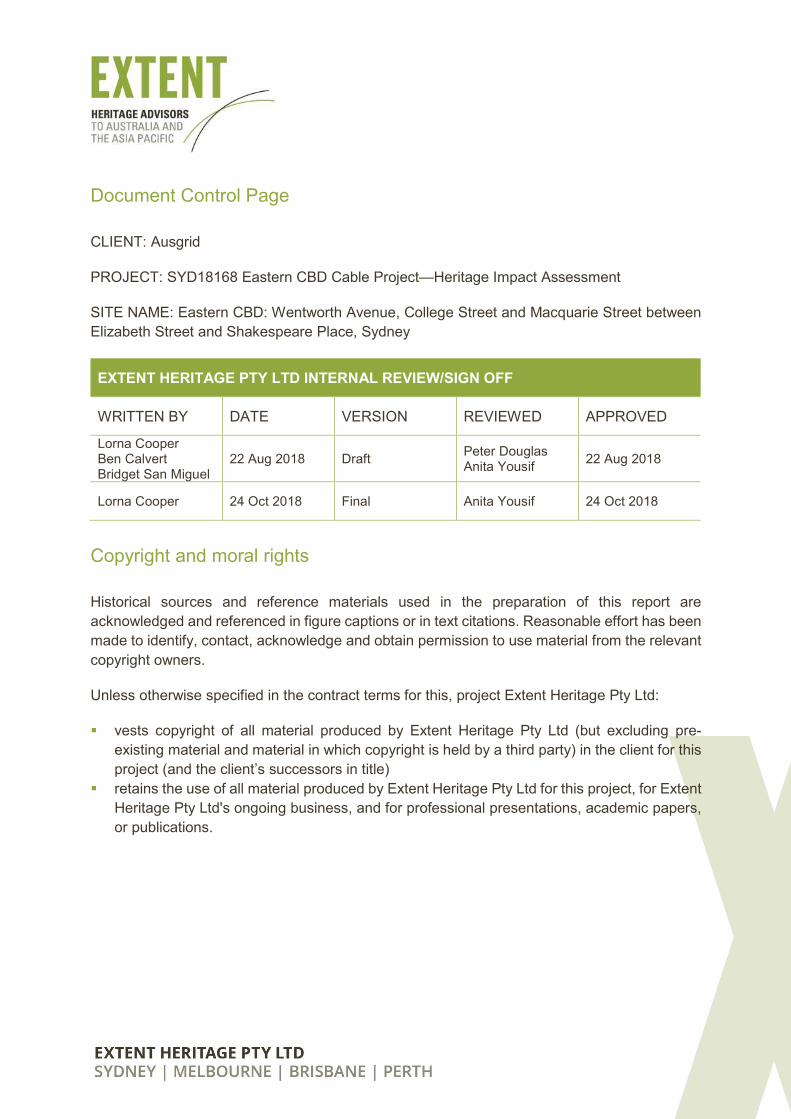
Document Control Page
CLIENT: Ausgrid
PROJECT: SYD18168 Eastern CBD Cable Project—Heritage Impact Assessment
SITE NAME: Eastern CBD: Wentworth Avenue, College Street and Macquarie Street between
Elizabeth Street and Shakespeare Place, Sydney
EXTENT HERITAGE PTY LTD INTERNAL REVIEW/SIGN OFF
WRITTEN BY DATE VERSION REVIEWED APPROVED
Lorna Cooper Ben Calvert Bridget San Miguel
22 Aug 2018 Draft Peter Douglas Anita Yousif
22 Aug 2018
Lorna Cooper 24 Oct 2018 Final Anita Yousif 24 Oct 2018
Copyright and moral rights
Historical sources and reference materials used in the preparation of this report are
acknowledged and referenced in figure captions or in text citations. Reasonable effort has been
made to identify, contact, acknowledge and obtain permission to use material from the relevant
copyright owners.
Unless otherwise specified in the contract terms for this, project Extent Heritage Pty Ltd:
� vests copyright of all material produced by Extent Heritage Pty Ltd (but excluding pre-
existing material and material in which copyright is held by a third party) in the client for this
project (and the client’s successors in title)
� retains the use of all material produced by Extent Heritage Pty Ltd for this project, for Extent
Heritage Pty Ltd's ongoing business, and for professional presentations, academic papers,
or publications.
Extent Heritage Pty Ltd | Eastern CBD Cable Project HIA i | Page
Contents
1. INTRODUCTION ......................................................................................................... 1
1.1 THE BRIEF ........................................................................................................ 1
1.2 SITE LOCATION AND IDENTIFICATION .......................................................... 1
1.3 STATUTORY CONTEXT AND PLANNING TOOLS ........................................... 1
1.4 METHODOLOGY ............................................................................................... 1
1.5 LIMITATIONS .................................................................................................... 2
1.6 AUTHOR IDENTIFICATION............................................................................... 2
2. STATUTORY AND NON-STATUTORY CONTROLS................................................... 5
2.1 ENVIRONMENTAL PROTECTION AND BIODIVERSITY CONSERVATION ACT
1999 5
2.2 NSW HERITAGE ACT 1977 .............................................................................. 5
2.3 ENVIRONMENTAL PLANNING AND ASSESSMENT ACT 1979 ....................... 6
2.4 STATE ENVIRONMENTAL PLANNING POLICY (INFRASTRUCTURE) 2007 .. 6
2.5 SYDNEY LOCAL ENVIRONMENTAL PLAN 2012 ............................................. 7
2.6 DEVELOPMENT CONTROL PLAN 2012........................................................... 7
2.7 HERITAGE ITEMS IN THE VICINITY .............................................................. 10
3. HISTORICAL CONTEXT ........................................................................................... 13
3.1 INTRODUCTION ............................................................................................. 13
3.2 PRE-EUROPEAN ABORIGINAL OCCUPATION ............................................. 13
3.3 EUROPEAN SETTLEMENT AND SYDNEY’S STREET GRID ......................... 13
3.4 MACQUARIE STREET: A CIVIC CENTRE ...................................................... 16
3.5 HYDE PARK AND COLLEGE STREET ........................................................... 18
3.6 WENTWORTH AVENUE ................................................................................. 22
3.7 LEAK’S POTTERY ........................................................................................... 26
3.8 WATER MANAGEMENT AND BUSBY’S BORE .............................................. 30
3.9 ST JAMES STATION AND THE CITY CIRCLE RAILWAY NETWORK ............ 35
3.10 ROAD SURFACING IN THE NINETEENTH AND TWENTIETH CENTURIES
37
3.11 MODERN USE ............................................................................................. 38
4. SITE DESCRIPTION ................................................................................................. 40
4.1 GENERAL ........................................................................................................ 40
4.2 SETTING AND VIEWS .................................................................................... 41
5. HISTORICAL ARCHAEOLOGICAL POTENTIAL ....................................................... 45
5.1 INTRODUCTION ............................................................................................. 45
Extent Heritage Pty Ltd | Eastern CBD Cable Project HIA ii | Page
5.2 PREVIOUS REPORTS .................................................................................... 45
5.3 SITE DEVELOPMENT ..................................................................................... 50
5.4 SUMMARY OF HISTORICAL ARCHAEOLOGICAL POTENTIAL .................... 51
6. ASSESSMENT OF HERITAGE SIGNIFICANCE ....................................................... 55
6.1 BUILT HERITAGE ........................................................................................... 55
6.2 EXISTING STATEMENT OF SIGNIFICANCE .................................................. 55
6.3 HISTORICAL ARCHAEOLOGY ....................................................................... 57
7. ASSESSMENT OF HERITAGE IMPACT ................................................................... 63
7.1 PROPOSED DEVELOPMENT ......................................................................... 63
7.2 POTENTIAL DEVELOPMENT IMPACTS......................................................... 63
8. CONCLUSIONS AND RECOMMENDATIONS .......................................................... 67
8.1 CONCLUSION ................................................................................................. 67
8.2 RECOMMENDATIONS .................................................................................... 68
9. REFERENCES .......................................................................................................... 70
Extent Heritage Pty Ltd | Eastern CBD Cable Project HIA 1 | Page
1. Introduction
1.1 The brief
Extent Heritage Pty Ltd (Extent) have been commissioned by Ausgrid to prepare a Heritage
Impact Assessment (HIA) for a proposed cabling works in the Eastern CBD of Sydney. The
purpose of the report is to analyse the proposed works and the potential impacts on the heritage
significance and archaeological potential of the study area.
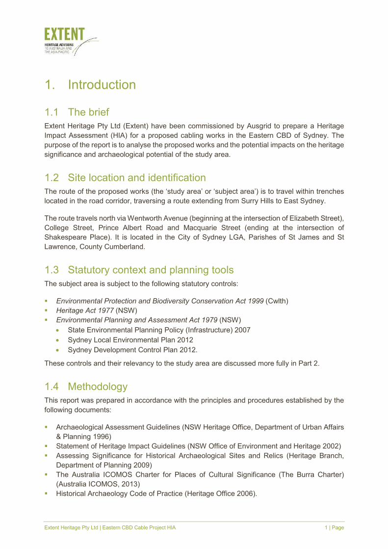
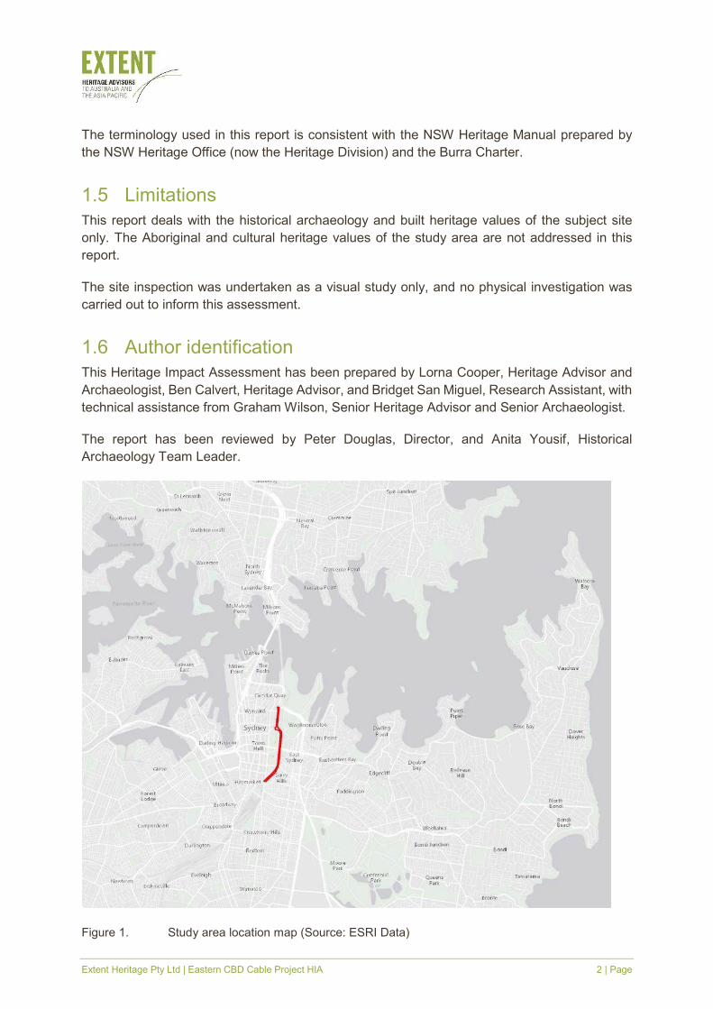
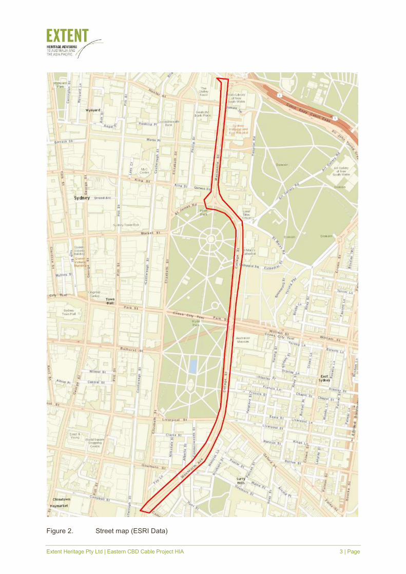
1.2 Site location and identification
The route of the proposed works (the ‘study area’ or ‘subject area’) is to travel within trenches
located in the road corridor, traversing a route extending from Surry Hills to East Sydney.
The route travels north via Wentworth Avenue (beginning at the intersection of Elizabeth Street),
College Street, Prince Albert Road and Macquarie Street (ending at the intersection of
Shakespeare Place). It is located in the City of Sydney LGA, Parishes of St James and St
Lawrence, County Cumberland.
1.3 Statutory context and planning tools
The subject area is subject to the following statutory controls:
� Environmental Protection and Biodiversity Conservation Act 1999 (Cwlth)
� Heritage Act 1977 (NSW)
� Environmental Planning and Assessment Act 1979 (NSW)
• State Environmental Planning Policy (Infrastructure) 2007
• Sydney Local Environmental Plan 2012
• Sydney Development Control Plan 2012.
These controls and their relevancy to the study area are discussed more fully in Part 2.
1.4 Methodology
This report was prepared in accordance with the principles and procedures established by the
following documents:
� Archaeological Assessment Guidelines (NSW Heritage Office, Department of Urban Affairs
& Planning 1996)
� Statement of Heritage Impact Guidelines (NSW Office of Environment and Heritage 2002)
� Assessing Significance for Historical Archaeological Sites and Relics (Heritage Branch,
Department of Planning 2009)
� The Australia ICOMOS Charter for Places of Cultural Significance (The Burra Charter)
(Australia ICOMOS, 2013)
� Historical Archaeology Code of Practice (Heritage Office 2006).
Extent Heritage Pty Ltd | Eastern CBD Cable Project HIA 2 | Page
The terminology used in this report is consistent with the NSW Heritage Manual prepared by
the NSW Heritage Office (now the Heritage Division) and the Burra Charter.
1.5 Limitations
This report deals with the historical archaeology and built heritage values of the subject site
only. The Aboriginal and cultural heritage values of the study area are not addressed in this
report.
The site inspection was undertaken as a visual study only, and no physical investigation was
carried out to inform this assessment.
1.6 Author identification
This Heritage Impact Assessment has been prepared by Lorna Cooper, Heritage Advisor and
Archaeologist, Ben Calvert, Heritage Advisor, and Bridget San Miguel, Research Assistant, with
technical assistance from Graham Wilson, Senior Heritage Advisor and Senior Archaeologist.
The report has been reviewed by Peter Douglas, Director, and Anita Yousif, Historical
Archaeology Team Leader.
Figure 1. Study area location map (Source: ESRI Data)
Extent Heritage Pty Ltd | Eastern CBD Cable Project HIA 3 | Page
Figure 2. Street map (ESRI Data)
Extent Heritage Pty Ltd | Eastern CBD Cable Project HIA 4 | Page
Figure 3. Aerial photograph of the study area (Source: ESRI Data)
Extent Heritage Pty Ltd | Eastern CBD Cable Project HIA 5 | Page
2. Statutory and non-statutory controls
2.1 Environmental Protection and Biodiversity Conservation
Act 1999
The Environmental Protection and Biodiversity Conservation Act 1999 (Cwlth) is a federal level
of legislation. It protects natural, historical, and Indigenous heritage places that are of
outstanding universal value, outstanding significance to the nation, or that are owned or
controlled by the Australian Government. Sites listed on the World Heritage List, the National
Heritage List, the Commonwealth Heritage List or the Register of the National Estate (which is
now expired and no longer a statutory list) are protected by this act.
No sites within the study area are protected under this act, however Hyde Park Barracks,
adjacent to the study area is listed on the World Heritage List as part of Eleven Australian
Convict Sites and the National Heritage List.
2.2 NSW Heritage Act 1977
The Heritage Act 1977 (NSW) (the Heritage Act) provides protection for items of state heritage
significance that are listed on the State Heritage Register (SHR), as well as for unlisted
archaeological relics.
Significant historical archaeological features are afforded automatic statutory protection by the
ʻrelicsʼ provisions of the Heritage Act. A ‘relic’ is defined as follows:
any deposit, artefact, object or material evidence that:
(a) relates to the settlement of the area that comprises New South Wales, not being
Aboriginal settlement, and
(b) is of State or local heritage significance.
In accordance with section 139(1), it is an offence to disturb or excavate land, where this may
affect a relic, without the approval/excavation permit of the Heritage Council of NSW, unless an
endorsed ‘exemption’ or ‘exception’ to disturb or expose and destroy a ‘relic’ applies. Sites which
may contain archaeological relics of local significance are dealt with under section 140 and 141
of the Heritage Act. Sites with known or potential archaeological resources, listed on the SHR,
are dealt with under sections 60 and 63 of the Heritage Act.
Works proposed for items protected by the Heritage Act are approved by the Heritage Council
of NSW or its delegates, as appropriate.
There are two SHR listed items within the study area: Busby’s Bore (SHR #00568) and St James
Railway Station group (SHR#01248); and seventeen SHR listed items adjacent to the study
area.
Extent Heritage Pty Ltd | Eastern CBD Cable Project HIA 6 | Page
2.3 Environmental Planning and Assessment Act 1979
The NSW Environmental Planning and Assessment Act 1979 (the EPA Act) requires that
environmental impacts, including impacts on cultural heritage, are considered by consent
authorities prior to granting development approvals. The relevant sections of the EPA Act are:
� Part 4 (Division 4.3): Development that needs consent under consideration of environmental
planning instruments.
� Part 4 (Division 4.7): An approval pathway for State Significant Development (SSD) projects.
� Part 5 (Division 5.1): Activities carried out by or on behalf of public authorities.
� Part 5 (Division 5.2): An approval pathway for State Significant Infrastructure (SSI).
The EPA Act controls the making of environmental planning instruments, including State
Environment Planning Policies (SEPPs), which deal with matters of state or regional
environmental planning significance; and Local Environmental Plans (LEPs), which guide
planning decisions for local government areas. The site falls within the City of Sydney Local
Government Area (LGA). The relevant environmental planning instrument is Sydney LEP 2012,
however Ausgrid is a determining authority under Part 5 of the EPA Act with respect to works
for which it is a proponent and is guided by the State Environmental Planning Policy
(Infrastructure) 2007.
Where development approval is to be determined under part 5 of the EPA Act, section 5.5(1)
requires that a determining authority: ‘examine and take into account the fullest extent possible
all matters affecting or likely to affect the environment’ with respect to the proposed works. As
an Authorised Network Operator, Ausgrid is a determining authority under Part 5 of the EPA Act
with respect to works for which it is a proponent. The specific requirements of what must be
contained in an environmental assessment are set out in Schedule 2 of the Environmental
Planning and Assessment Regulations 2000. Heritage matters fall within the definition of
‘environment’ in relation to this Act.
As the study area contains state heritage items, a statutory approval is required under Part 5 of
the NSW Environmental Planning and Assessment Act 1979 in order to assess the project’s
impact on heritage items.
Should it be required, this report and its recommendations should be included within the Part 5
environmental impact assessment. This report fulfils the requirements for assessment under
Part 5 of the EPA Act.
2.4 State Environmental Planning Policy (Infrastructure) 2007
The State Environmental Planning Policy (Infrastructure) 2007 (Infrastructure SEPP) deals with
a wide range of State infrastructure, such as telecommunications, sewage and electricity
transmission carried out by or on behalf of public authorities, and specifies when development
consent is (and is not) required for development to be carried out in certain zones.
With regards to the development and maintenance of electricity transmission, clause 41 (1)
states that, development may be carried out without consent on any land P 2(a) 2 whether or
Extent Heritage Pty Ltd | Eastern CBD Cable Project HIA 7 | Page
not in a heritage conservation area, including: 2 (ii)alteration, demolition or relocation of a local
heritage item.
However, in accordance with Clause 14 (1) a) [if it] is likely to affect the heritage significance of
a local heritage item, or of a heritage conservation area, that is not also a State heritage item,
in a way that is more than minor or inconsequential and (b) is development that this Policy
provides may be carried out without consent. To be exempt in accordance with Clause 20 (2)
e) if it is likely to affect a State or local heritage item or a heritage conservation area, must
involve no more than minimal impact on the heritage significance of the item or area. Then:
Clause 14 (2 A public authority, or a person acting on behalf of a public authority, must not carry
out development to which this clause applies unless the authority or the person has:
a. had an assessment of the impact prepared, and
b. given written notice of the intention to carry out the development, with a copy of the
assessment and a scope of works, to the council for the area in which the heritage item
or heritage conservation area (or the relevant part of such an area) is located, and
c. taken into consideration any response to the notice that is received from the council
within 21 days after the notice is given.
This report meets the requirements of Clause 14 (2) a) for an assessment of impact.
2.5 Sydney Local Environmental Plan 2012
The objectives of the Sydney LEP 2012 with respect to heritage conservation and
archaeological sites are provided in clause 5.10 which (amongst other objectives) aims to
conserve archaeological sites and requires consent to demolish, move or alter known or
potential archaeology. Additionally, it requires that the consent authority must notify the Heritage
Council of this development and take into consideration their response.
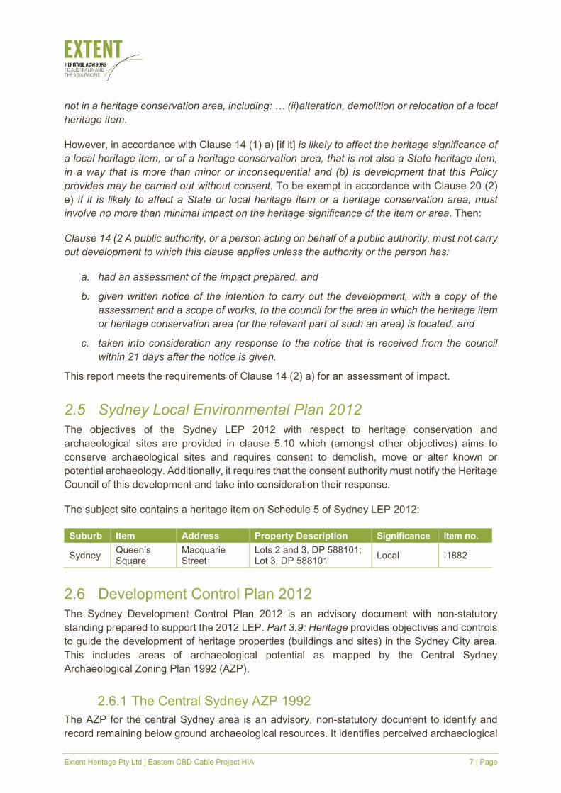
The subject site contains a heritage item on Schedule 5 of Sydney LEP 2012:
Suburb Item Address Property Description Significance Item no.
Sydney Queen’s Square
Macquarie Street
Lots 2 and 3, DP 588101; Lot 3, DP 588101
Local I1882
2.6 Development Control Plan 2012
The Sydney Development Control Plan 2012 is an advisory document with non-statutory
standing prepared to support the 2012 LEP. Part 3.9: Heritage provides objectives and controls
to guide the development of heritage properties (buildings and sites) in the Sydney City area.
This includes areas of archaeological potential as mapped by the Central Sydney
Archaeological Zoning Plan 1992 (AZP).
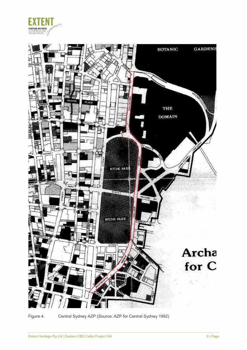
2.6.1 The Central Sydney AZP 1992
The AZP for the central Sydney area is an advisory, non-statutory document to identify and
record remaining below ground archaeological resources. It identifies perceived archaeological
Extent Heritage Pty Ltd | Eastern CBD Cable Project HIA 8 | Page
potential according to ground disturbance. Although it does not assess sites beneath roadways
in any detail, it makes recommendations about the archaeological potential of these areas.
The AZP identifies many areas of archaeological potential adjacent to the study area as having
(1) archaeological potential, (2) partially disturbed archaeological potential, and (3)
archaeological potential with deeper sub-surface features (Figure 4).
In the development of the AZP, the archaeological potential of roads, laneways, plazas etc, was
not surveyed or assessed in detail. In general, in the absence of evidence to the contrary, all
open spaces, including roadways, whether identified in this study or not, should be considered
as containing some archaeological potential until a further assessment is undertaken.
Extent Heritage Pty Ltd | Eastern CBD Cable Project HIA 9 | Page
Figure 4. Central Sydney AZP (Source: AZP for Central Sydney 1992)
Extent Heritage Pty Ltd | Eastern CBD Cable Project HIA 10 | Page
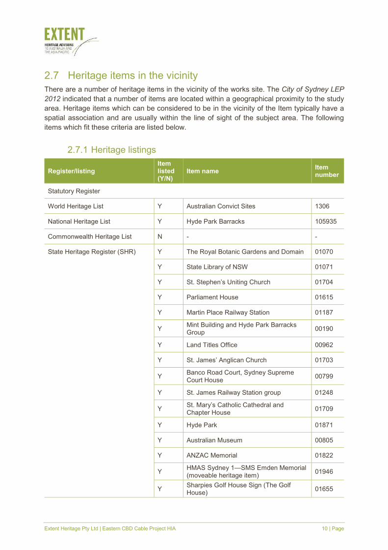
2.7 Heritage items in the vicinity
There are a number of heritage items in the vicinity of the works site. The City of Sydney LEP
2012 indicated that a number of items are located within a geographical proximity to the study
area. Heritage items which can be considered to be in the vicinity of the Item typically have a
spatial association and are usually within the line of sight of the subject area. The following
items which fit these criteria are listed below.
2.7.1 Heritage listings
Register/listing Item listed (Y/N)
Item name Item number
Statutory Register
World Heritage List Y Australian Convict Sites 1306
National Heritage List Y Hyde Park Barracks 105935
Commonwealth Heritage List N - -
State Heritage Register (SHR) Y The Royal Botanic Gardens and Domain 01070
Y State Library of NSW 01071
Y St. Stephen’s Uniting Church 01704
Y Parliament House 01615
Y Martin Place Railway Station 01187
Y Mint Building and Hyde Park Barracks Group
00190
Y Land Titles Office 00962
Y St. James’ Anglican Church 01703
Y Banco Road Court, Sydney Supreme Court House
00799
Y St. James Railway Station group 01248
Y St. Mary’s Catholic Cathedral and Chapter House
01709
Y Hyde Park 01871
Y Australian Museum 00805
Y ANZAC Memorial 01822
Y HMAS Sydney 1—SMS Emden Memorial (moveable heritage item)
01946
Y Sharpies Golf House Sign (The Golf House)
01655
Extent Heritage Pty Ltd | Eastern CBD Cable Project HIA 11 | Page
Register/listing Item listed (Y/N)
Item name Item number
Y Sydney Terminal and Central Railway Stations Group
01255
S170 Heritage and Conservation Register
State Government Agency Y Central Railway Station and Sydney Terminal Group
4801296
Sydney Local Environmental Plan (2012)
Y Royal Botanic Gardens I1652
Y Shakespeare Place, including Shakespeare monument and Bourke Statue
I1949
Y
Former City Mission Hall, including interior
I187
Y Commercial Chambers ‘Wyoming’, including interiors
I1878
Y State Library of NSW, including interiors I1950
Y Commercial Chambers ‘Hengrove Hall’, including interiors
I1879
Y St Stephen’s Uniting Church, including interior
I1180
Y Parliament House I1864
Y Sydney Hospital group, including interiors, courtyards, forecourts and fences
I1865
Y
Former Royal Mint Building, including interior, forecourt, courtyards, cart way, entrance gates, fence and archaeology, former Police Station building
I1866
Y
Former Hyde Park Barracks, including forecourt, wall and gatehouses, interiors, grounds, former District Courts and offices and archaeology
I1867
Y Martin Place I1889
Y Reserve Bank, including interior I1897
Y ‘Beanbah Chambers’, including interiors I1881
Y St James Church, including interior, courtyards, perimeter walls and fences
I1847
Y Supreme Court and old Registry Office building group, including interiors, fences and grounds
I1739
Y Former Registrar General’s Department building, including interior
I1946
Y
Hyde Park, including north and south park reserves, Archibald Memorial Fountain, Anzac Memorial, Pool of Remembrance, stone perimeter walls and
I1654
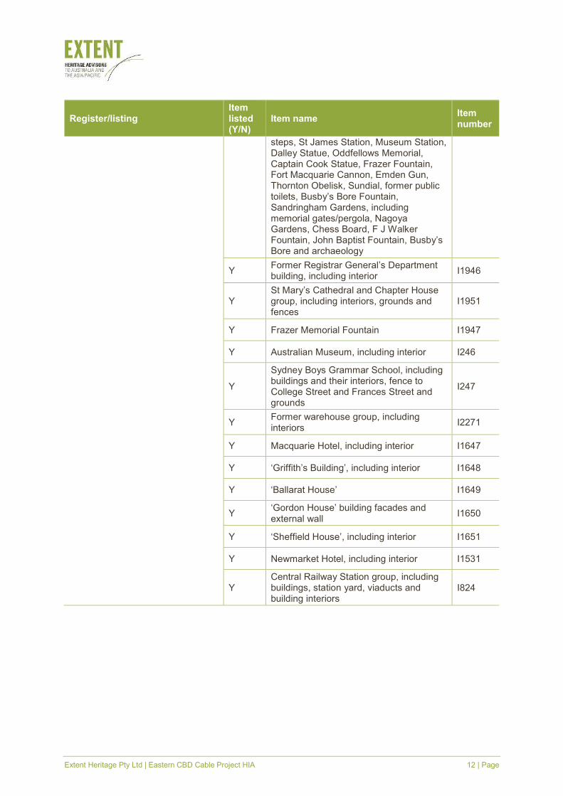
Extent Heritage Pty Ltd | Eastern CBD Cable Project HIA 12 | Page
Register/listing Item listed (Y/N)
Item name Item number
steps, St James Station, Museum Station, Dalley Statue, Oddfellows Memorial, Captain Cook Statue, Frazer Fountain, Fort Macquarie Cannon, Emden Gun, Thornton Obelisk, Sundial, former public toilets, Busby’s Bore Fountain, Sandringham Gardens, including memorial gates/pergola, Nagoya Gardens, Chess Board, F J Walker Fountain, John Baptist Fountain, Busby’s Bore and archaeology
Y Former Registrar General’s Department building, including interior
I1946
Y St Mary’s Cathedral and Chapter House group, including interiors, grounds and fences
I1951
Y Frazer Memorial Fountain I1947
Y Australian Museum, including interior I246
Y
Sydney Boys Grammar School, including buildings and their interiors, fence to College Street and Frances Street and grounds
I247
Y Former warehouse group, including interiors
I2271
Y Macquarie Hotel, including interior I1647
Y ‘Griffith’s Building’, including interior I1648
Y ‘Ballarat House’ I1649
Y ‘Gordon House’ building facades and external wall
I1650
Y ‘Sheffield House’, including interior I1651
Y Newmarket Hotel, including interior I1531
Y Central Railway Station group, including buildings, station yard, viaducts and building interiors
I824

Extent Heritage Pty Ltd | Eastern CBD Cable Project HIA 13 | Page
3. Historical context
3.1 Introduction
The study area is adjacent to and within a number of significant historical areas in central
Sydney. This historical context is not intended as an exhaustive history of the site and its
surrounding area, but to facilitate the assessment of historical archaeological potential of places
and sites that may be impacted by the proposed work. It is not intended to cover the pre-
European Aboriginal occupation of the study area, although a short summary is provided in Part
3.2. Note that on all maps and aerial imagery, north is shown as the top of the page unless
otherwise indicated.
3.2 Pre-European Aboriginal occupation
The Aboriginal population in the Sydney area was estimated by Governor Arthur Phillip to be
approximately 1,500 in 1788. This number is likely to have been higher before initial European
contact as diseases such as smallpox quickly ravaged Aboriginal communities (Attenbrow 2002,
17). Occupation in the Sydney region has been dated up to approximately 17,800 years ago,
however sites elsewhere in Australia are up to 55,000 years old (Attenbrow 2002, 20). What is
currently Sydney’s CBD is Gadigal (Cadigal) land, part of the coastal Darug (Dharug) language
group (Attenbrow 2002, 23). Aboriginal people lived sustainably in the Sydney environment
throughout significant climate and sea level changes over thousands of years, managing and
exploiting land and coastal resources long before European arrival (Attenbrow 2002, 37).
3.3 European settlement and Sydney’s street grid
Sydney became the first European settlement in Australia because of its accessible harbour
and the fresh water available from the Tank Stream, which ran through what is now the northern
part of Sydney’s CBD (Sydney Water, online). Governor Phillip planned for the future city to
have a main street 200' wide, leading from Sydney Cove to the Governor’s residence which at
the time was anticipated to be further west than its current location at the Domain (Figure 5)
(Johnson 1999). The main street was intended to promote airflow throughout the city and
provide easy access to the harbour. However, this plan was not carried out and the street layout
follows the water of the (now underground) Tank Stream, between Pitt Street and George Street
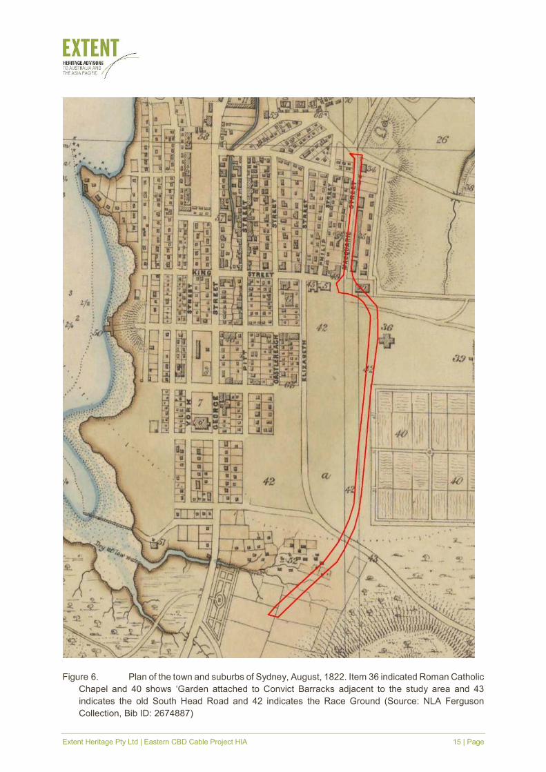
(Thalis & Cantrill 2008, online) (Figure 6). Other roads throughout Sydney follow the established
Aboriginal tracks Europeans encountered upon their arrival (Wotherspoon 2010, online).
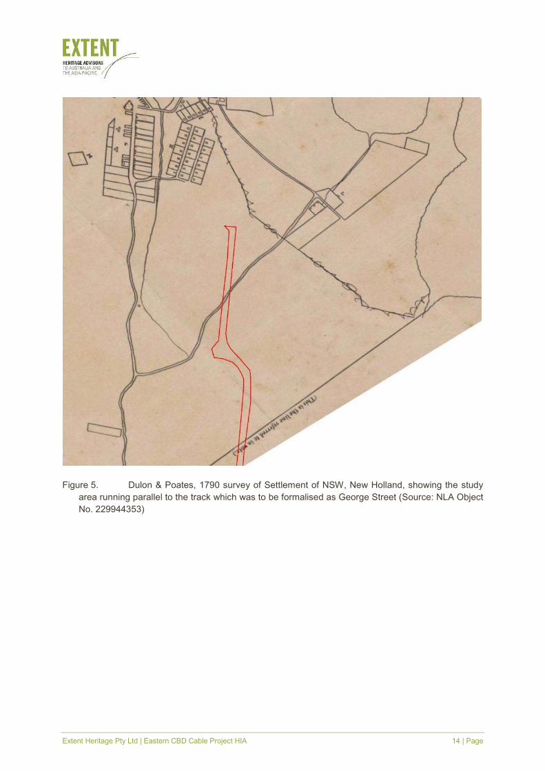
Extent Heritage Pty Ltd | Eastern CBD Cable Project HIA 14 | Page
Figure 5. Dulon & Poates, 1790 survey of Settlement of NSW, New Holland, showing the study
area running parallel to the track which was to be formalised as George Street (Source: NLA Object
No. 229944353)
Extent Heritage Pty Ltd | Eastern CBD Cable Project HIA 15 | Page
Figure 6. Plan of the town and suburbs of Sydney, August, 1822. Item 36 indicated Roman Catholic
Chapel and 40 shows ‘Garden attached to Convict Barracks adjacent to the study area and 43
indicates the old South Head Road and 42 indicates the Race Ground (Source: NLA Ferguson
Collection, Bib ID: 2674887)
Extent Heritage Pty Ltd | Eastern CBD Cable Project HIA 16 | Page
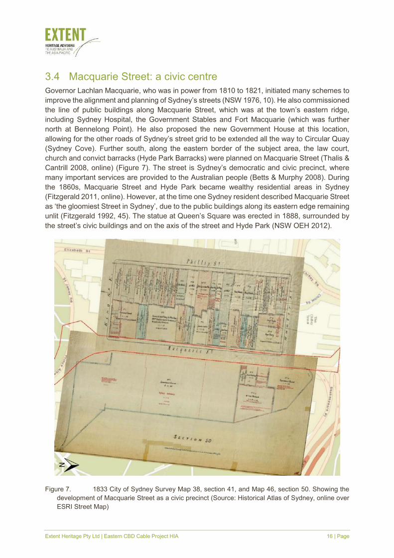
3.4 Macquarie Street: a civic centre
Governor Lachlan Macquarie, who was in power from 1810 to 1821, initiated many schemes to
improve the alignment and planning of Sydney’s streets (NSW 1976, 10). He also commissioned
the line of public buildings along Macquarie Street, which was at the town’s eastern ridge,
including Sydney Hospital, the Government Stables and Fort Macquarie (which was further
north at Bennelong Point). He also proposed the new Government House at this location,
allowing for the other roads of Sydney’s street grid to be extended all the way to Circular Quay
(Sydney Cove). Further south, along the eastern border of the subject area, the law court,
church and convict barracks (Hyde Park Barracks) were planned on Macquarie Street (Thalis &
Cantrill 2008, online) (Figure 7). The street is Sydney’s democratic and civic precinct, where
many important services are provided to the Australian people (Betts & Murphy 2008). During
the 1860s, Macquarie Street and Hyde Park became wealthy residential areas in Sydney
(Fitzgerald 2011, online). However, at the time one Sydney resident described Macquarie Street
as ‘the gloomiest Street in Sydney’, due to the public buildings along its eastern edge remaining
unlit (Fitzgerald 1992, 45). The statue at Queen’s Square was erected in 1888, surrounded by
the street’s civic buildings and on the axis of the street and Hyde Park (NSW OEH 2012).
Figure 7. 1833 City of Sydney Survey Map 38, section 41, and Map 46, section 50. Showing the
development of Macquarie Street as a civic precinct (Source: Historical Atlas of Sydney, online over
ESRI Street Map)
Extent Heritage Pty Ltd | Eastern CBD Cable Project HIA 17 | Page
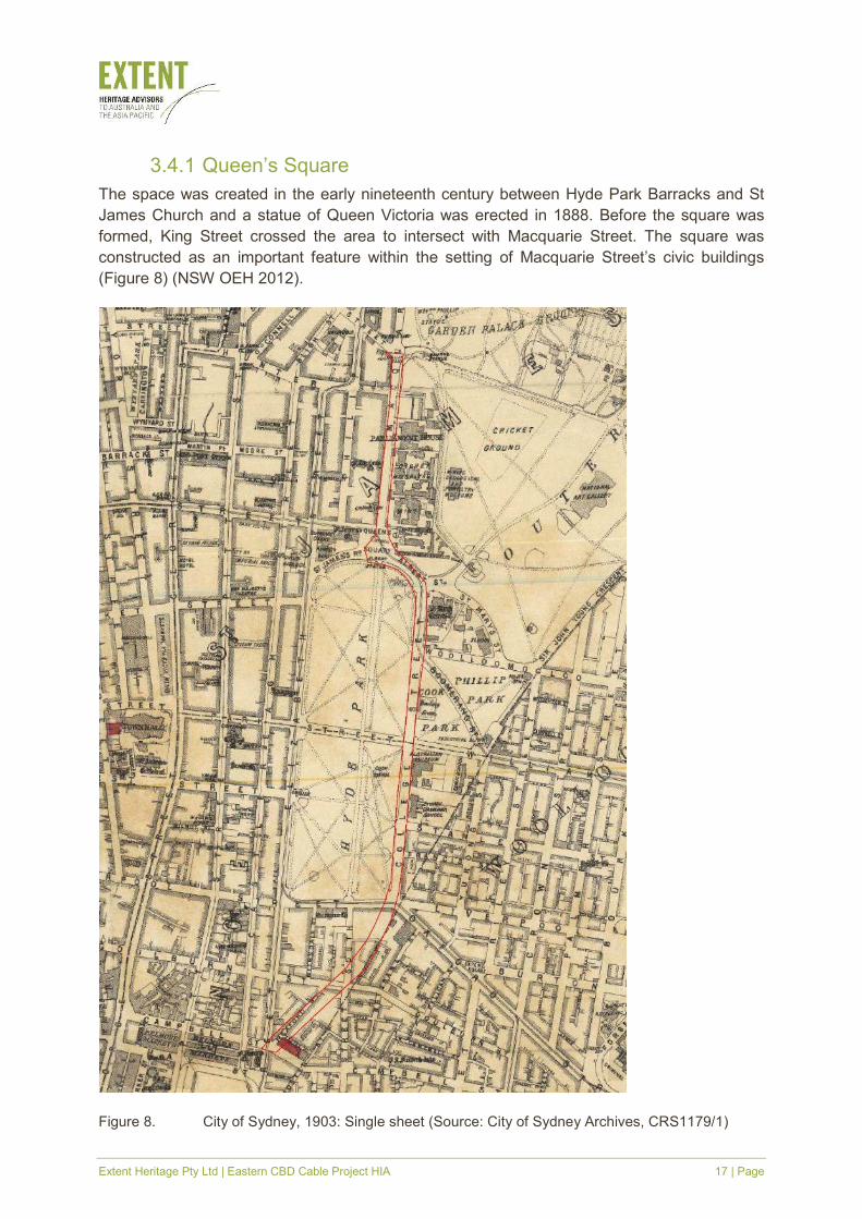
3.4.1 Queen’s Square
The space was created in the early nineteenth century between Hyde Park Barracks and St
James Church and a statue of Queen Victoria was erected in 1888. Before the square was
formed, King Street crossed the area to intersect with Macquarie Street. The square was
constructed as an important feature within the setting of Macquarie Street’s civic buildings
(Figure 8) (NSW OEH 2012).
Figure 8. City of Sydney, 1903: Single sheet (Source: City of Sydney Archives, CRS1179/1)
Extent Heritage Pty Ltd | Eastern CBD Cable Project HIA 18 | Page
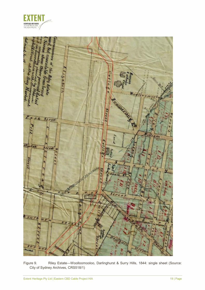
3.5 Hyde Park and College Street
Hyde Park, at the southern end of Macquarie Street, was already being used as a common
when it was proclaimed a park by Governor Macquarie in 1810. The proclaimed park was first
used as a horse racecourse, then as a cricket ground in the 1820s. It then became associated
with the water supply from Busby’s Bore in the 1830s, as discussed in Part 3.6. Sydney College
was established in 1832 and College Street, which runs through the centre of the study area,
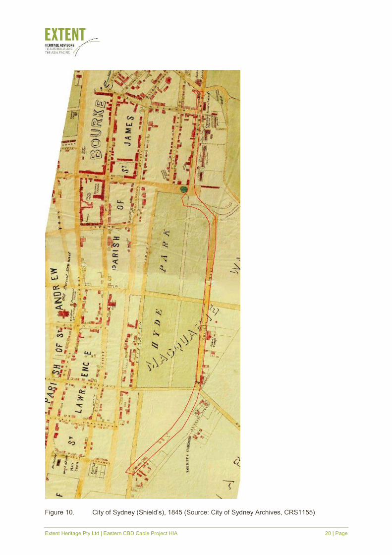
was constructed in the same year (Figure 9). In the 1850s the park was planted and the first of
its civic monuments, the obelisk, was installed (Figure 10). Others monuments were added in
the following years, up to the 1890s, before the Archibald Fountain was built in 1932 and the
Anzac Memorial in 1934 (Whitaker, A. 2008).
Extent Heritage Pty Ltd | Eastern CBD Cable Project HIA 19 | Page
Figure 9. Riley Estate—Woolloomooloo, Darlinghurst & Surry Hills, 1844: single sheet (Source:
City of Sydney Archives, CRS518/1)
Extent Heritage Pty Ltd | Eastern CBD Cable Project HIA 20 | Page
Figure 10. City of Sydney (Shield’s), 1845 (Source: City of Sydney Archives, CRS1155)

Extent Heritage Pty Ltd | Eastern CBD Cable Project HIA 21 | Page
Figure 11. William Wells’ 1850 Plan of the City of Sydney (Source: SLNSW, File No. FL3741047)
Extent Heritage Pty Ltd | Eastern CBD Cable Project HIA 22 | Page
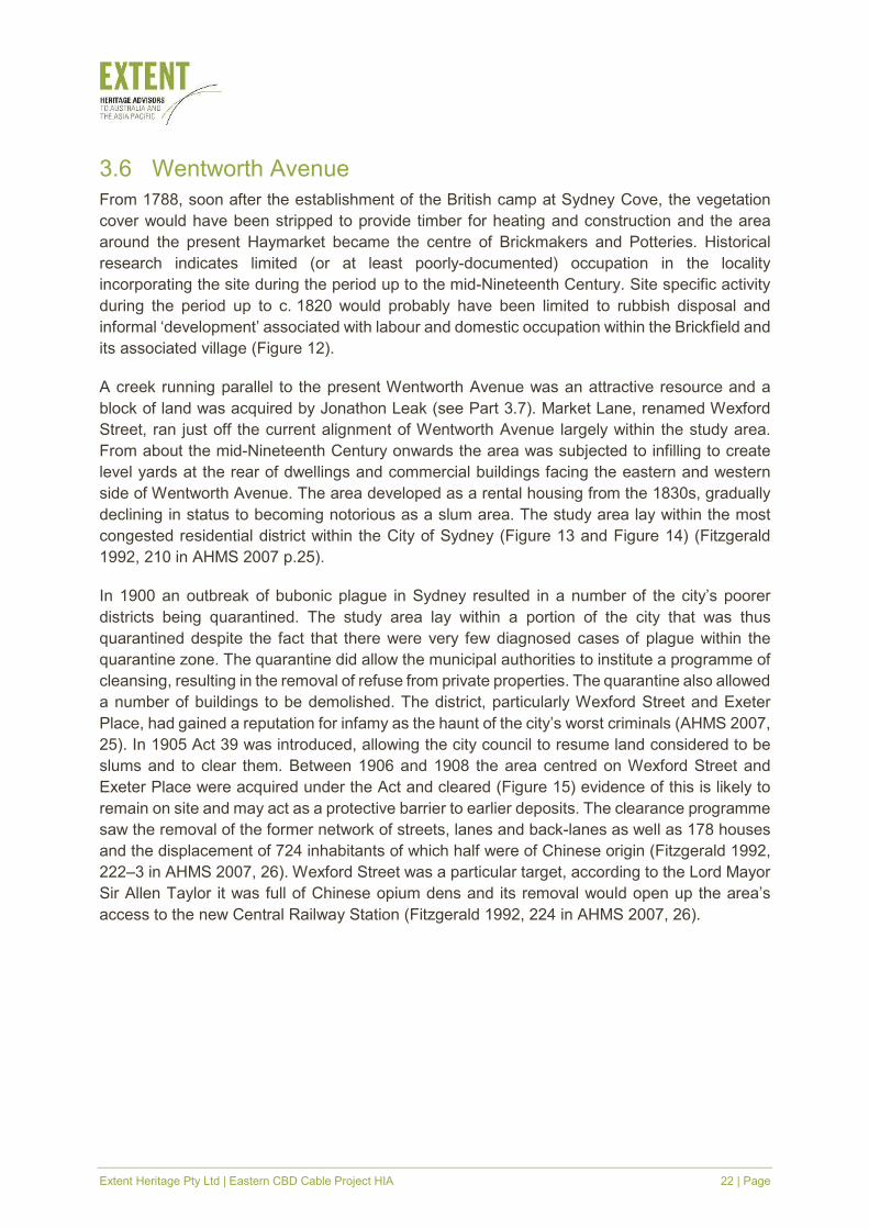
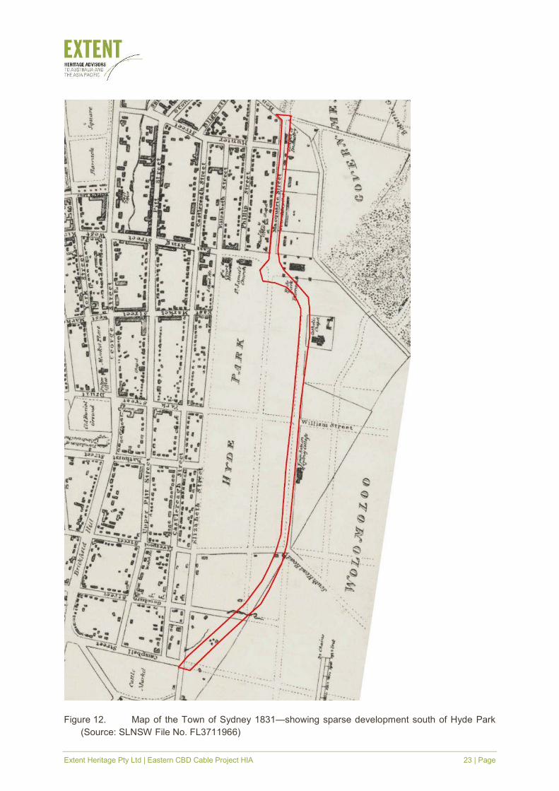
3.6 Wentworth Avenue
From 1788, soon after the establishment of the British camp at Sydney Cove, the vegetation
cover would have been stripped to provide timber for heating and construction and the area
around the present Haymarket became the centre of Brickmakers and Potteries. Historical
research indicates limited (or at least poorly-documented) occupation in the locality
incorporating the site during the period up to the mid-Nineteenth Century. Site specific activity
during the period up to c. 1820 would probably have been limited to rubbish disposal and
informal ‘development’ associated with labour and domestic occupation within the Brickfield and
its associated village (Figure 12).
A creek running parallel to the present Wentworth Avenue was an attractive resource and a
block of land was acquired by Jonathon Leak (see Part 3.7). Market Lane, renamed Wexford
Street, ran just off the current alignment of Wentworth Avenue largely within the study area.
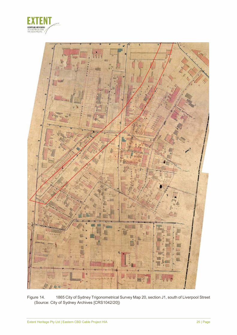
From about the mid-Nineteenth Century onwards the area was subjected to infilling to create
level yards at the rear of dwellings and commercial buildings facing the eastern and western
side of Wentworth Avenue. The area developed as a rental housing from the 1830s, gradually
declining in status to becoming notorious as a slum area. The study area lay within the most
congested residential district within the City of Sydney (Figure 13 and Figure 14) (Fitzgerald
1992, 210 in AHMS 2007 p.25).
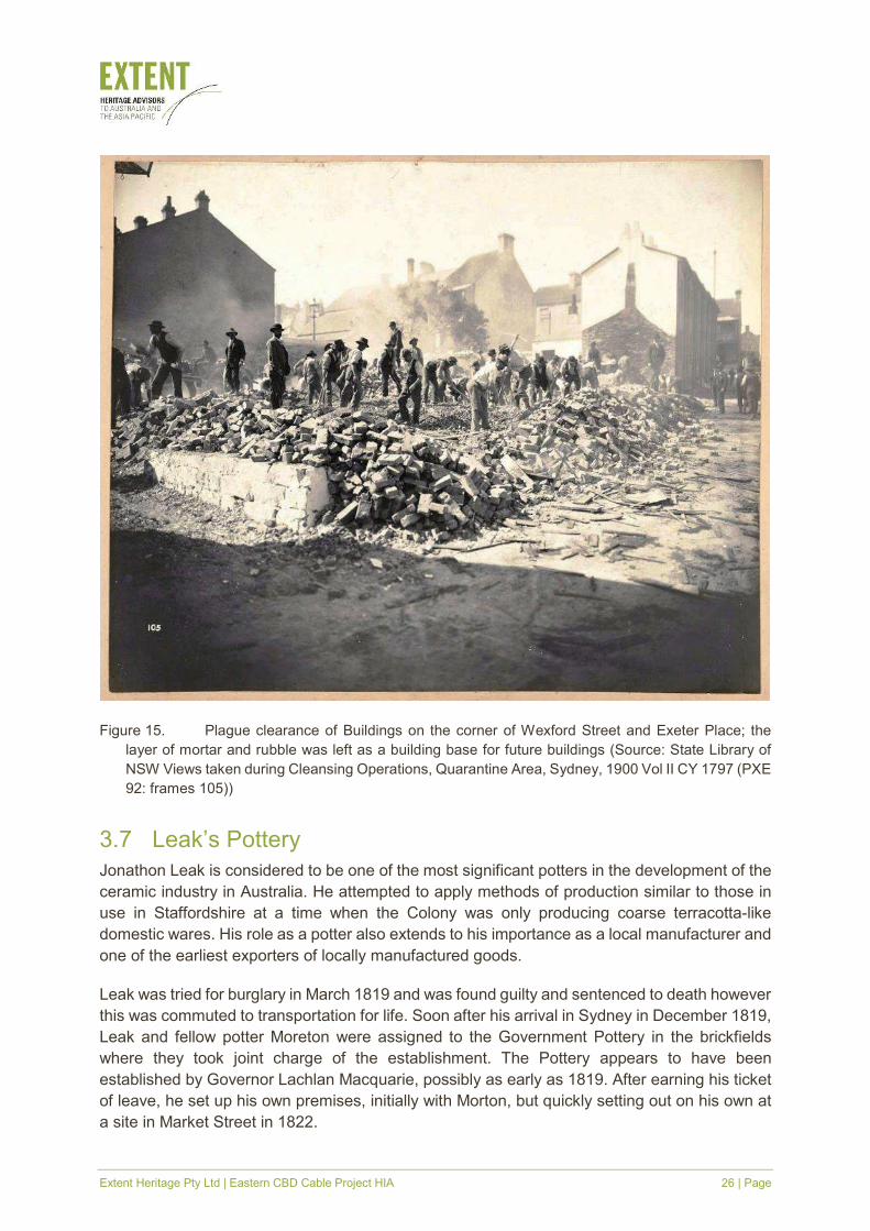
In 1900 an outbreak of bubonic plague in Sydney resulted in a number of the city’s poorer
districts being quarantined. The study area lay within a portion of the city that was thus
quarantined despite the fact that there were very few diagnosed cases of plague within the
quarantine zone. The quarantine did allow the municipal authorities to institute a programme of
cleansing, resulting in the removal of refuse from private properties. The quarantine also allowed
a number of buildings to be demolished. The district, particularly Wexford Street and Exeter
Place, had gained a reputation for infamy as the haunt of the city’s worst criminals (AHMS 2007,
25). In 1905 Act 39 was introduced, allowing the city council to resume land considered to be
slums and to clear them. Between 1906 and 1908 the area centred on Wexford Street and
Exeter Place were acquired under the Act and cleared (Figure 15) evidence of this is likely to
remain on site and may act as a protective barrier to earlier deposits. The clearance programme
saw the removal of the former network of streets, lanes and back-lanes as well as 178 houses
and the displacement of 724 inhabitants of which half were of Chinese origin (Fitzgerald 1992,
222–3 in AHMS 2007, 26). Wexford Street was a particular target, according to the Lord Mayor
Sir Allen Taylor it was full of Chinese opium dens and its removal would open up the area’s
access to the new Central Railway Station (Fitzgerald 1992, 224 in AHMS 2007, 26).
Extent Heritage Pty Ltd | Eastern CBD Cable Project HIA 23 | Page
Figure 12. Map of the Town of Sydney 1831—showing sparse development south of Hyde Park
(Source: SLNSW File No. FL3711966)

Extent Heritage Pty Ltd | Eastern CBD Cable Project HIA 24 | Page
Figure 13. Smith & Gardiner's map of Sydney and suburbs 1855—showing terrace housing
south of Hyde Park (Source: NLA Bib ID 2714669)
Extent Heritage Pty Ltd | Eastern CBD Cable Project HIA 25 | Page
Figure 14. 1865 City of Sydney Trigonometrical Survey Map 20, section J1, south of Liverpool Street
(Source: City of Sydney Archives [CRS1042/20])
Extent Heritage Pty Ltd | Eastern CBD Cable Project HIA 26 | Page
Figure 15. Plague clearance of Buildings on the corner of Wexford Street and Exeter Place; the
layer of mortar and rubble was left as a building base for future buildings (Source: State Library of
NSW Views taken during Cleansing Operations, Quarantine Area, Sydney, 1900 Vol II CY 1797 (PXE
92: frames 105))
3.7 Leak’s Pottery
Jonathon Leak is considered to be one of the most significant potters in the development of the
ceramic industry in Australia. He attempted to apply methods of production similar to those in
use in Staffordshire at a time when the Colony was only producing coarse terracotta-like
domestic wares. His role as a potter also extends to his importance as a local manufacturer and
one of the earliest exporters of locally manufactured goods.
Leak was tried for burglary in March 1819 and was found guilty and sentenced to death however
this was commuted to transportation for life. Soon after his arrival in Sydney in December 1819,
Leak and fellow potter Moreton were assigned to the Government Pottery in the brickfields
where they took joint charge of the establishment. The Pottery appears to have been
established by Governor Lachlan Macquarie, possibly as early as 1819. After earning his ticket
of leave, he set up his own premises, initially with Morton, but quickly setting out on his own at
a site in Market Street in 1822.
Extent Heritage Pty Ltd | Eastern CBD Cable Project HIA 27 | Page
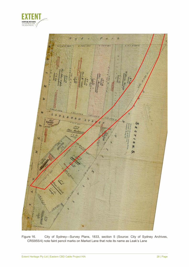
Leak initially occupied Lot 6 of section 5, located on the southern side of Market Lane (later
Wexford Street). In October 1831 he obtained a smaller allotment Lot 7 on the northern side of
Market Lane immediately opposite his existing property. The study area forms the westernmost
portion of Lot 7 (Figure 16).
Eight months after the purchase of the second Lot Leak put both Lot 6 and Lot 7 on the market.
The property was divided into eight allotments, four in each of the two Lots:
Lots 1 and 2 will comprise about 30 rods each, of a Garden of rich mould in a high state
of cultivation, having at this date scarce vegetables growing on it. These allotments are
bounded on the N.W. by 31 feet each, of a Government Street running from the
intersection of Campbell with Elizabeth Streets—depths exceeding 220 feet and 48
feet, at the back adjoining the estate of John Mackaness, Esq., which would be a
beautiful site for a retired dwelling.
Lots 3, 4, 5 and 6 are bounded on the South East by exceeding 44 feet each of the
Government Street described above, by a depth varying from 60 to 70 feet, and on the
North East (sic) by a stream of water. These allotments are very eligible for the erection
of Cottages for Mechanics, having a never-failing supply of water by nature. Lot 7 has
45 feet frontage to the Street before described, by a depth of 200 feet, on which stands
erected a comfortable Skilling and Stables. Lot 8 Contains 65 rods, having a frontage
to the Street of 80 feet, by a depth exceeding 200 feet, expanding at the back to 90
feet.
In this allotment stand erected 3 kilns, viz. a Pot, Stone and Pipe, with Workshop, a
Cottage containing 4 apartments and a Skilling with 2 rooms. This is one of the oldest
established Potteries in the Colony, formed by the Grantee of the Land. (Sydney Herald
1832)
From the sale description it is clear that the study area formed part of either Allotment 3, 4, 5 or
6 that had only been in Leak’s possession for eight months. The main production area and
dwelling were located on Allotment 8 on the southern side of Market Lane. The sale description
also suggests that Allotments 3, 4, 5, and 6 had not been improved by Leak during the period
of his ownership and that no buildings were present.
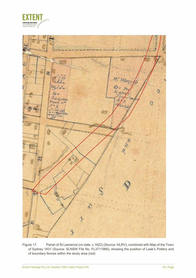
An approximation for this arrangement of buildings within Leak’s complex comes from
overlaying a plan of 1831 over an early historic parish map of St Lawrence (Figure 17). The
1831 map lacks the high-degree of accuracy but it does suggest the relative position of the main
works with the original lot boundaries. This overlay indicates that the main pottery buildings are
located beneath the current line of Wentworth Avenue.
Extent Heritage Pty Ltd | Eastern CBD Cable Project HIA 28 | Page
Figure 16. City of Sydney—Survey Plans, 1833, section 5 (Source: City of Sydney Archives,
CRS955/4) note faint pencil marks on Market Lane that note its name as Leak’s Lane
Extent Heritage Pty Ltd | Eastern CBD Cable Project HIA 29 | Page
Figure 17. Parish of St Lawrence (no date, c.1822) (Source: HLRV), combined with Map of the Town
of Sydney 1831 (Source: SLNSW File No. FL3711966), showing the position of Leak’s Pottery and
of boundary fences within the study area (red)
Extent Heritage Pty Ltd | Eastern CBD Cable Project HIA 30 | Page
3.8 Water management and Busby’s Bore
After European settlement, the Tank Stream became an increasingly contaminated and
unreliable water source until it was no longer usable by 1826. Pumps and wells were
constructed and water had to be carted across the city. A solution was desperately needed. In
1823, the mining engineer John Busby was commissioned to design and supervise the
construction of a tunnel from the Lachlan Swamps in present-day Centennial Park to an outlet
at the corner of Elizabeth and Park Streets. The tunnel was 4 km long, usually less than 1.5 m
high and took ten years to build. Convict labourers worked solely with hand tools, constructing
a series of thirty-six shafts to the required depth of the tunnel and digging horizontal tunnels
between them (Extent 2018a). At College Street, under the subject area, the floor of the tunnel
is likely to be 17–25' (approximately 5–8 m) deep, suggesting that the roof would like be 3 m
below the road surface (Extent 2018a, 8). The bore began to provide limited water as early as
1830 but the full extent of the tunnel was not completed until 1837 (Extent 2018b).
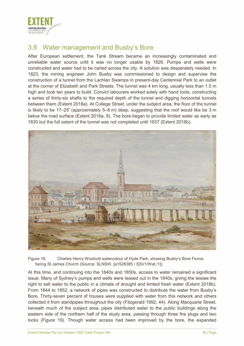
Figure 18. Charles Henry Woolcott watercolour of Hyde Park, showing Busby’s Bore Flume,
facing St James Church (Source: SLNSW, [a1528385 / SSV1/Wat /1])
At this time, and continuing into the 1840s and 1850s, access to water remained a significant
issue. Many of Sydney’s pumps and wells were leased out in the 1840s, giving the lessee the
right to sell water to the public in a climate of drought and limited fresh water (Extent 2018b).
From 1844 to 1852, a network of pipes was constructed to distribute the water from Busby’s
Bore. Thirty-seven percent of houses were supplied with water from this network and others
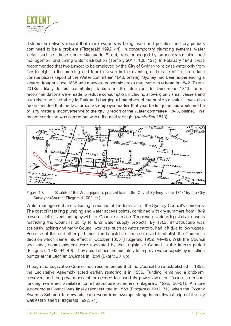
collected it from standpipes throughout the city (Fitzgerald 1992, 44). Along Macquarie Street,
beneath much of the subject area, pipes distributed water to the public buildings along the
eastern side of the northern half of the study area, passing through three fire plugs and two
locks (Figure 19). Though water access had been improved by the bore, the expanded
Extent Heritage Pty Ltd | Eastern CBD Cable Project HIA 31 | Page
distribution network meant that more water was being used and pollution and dry periods
continued to be a problem (Fitzgerald 1992, 44). In contemporary plumbing systems, water
locks, such as those under Macquarie Street, were managed by turncocks for pipe load
management and timing water distribution (Tomory 2017, 126–128). In February 1843 it was
recommended that two turncocks be employed by the City of Sydney to release water only from
five to eight in the morning and four to seven in the evening, or in case of fire, to reduce
consumption (Report of the Water committee’ 1843, online). Sydney had been experiencing a
severe drought since 1838 and a severe economic crash that came to a head in 1842 (Extent
2018c), likely to be contributing factors in this decision. In December 1843 further
recommendations were made to reduce consumption, including allowing only small vessels and
buckets to be filled at Hyde Park and charging all members of the public for water. It was also
recommended that the two turncocks employed earlier that year be let go as this would not be
of ‘any material inconvenience to the city’ (Report of the Water committee’ 1843, online). This
recommendation was carried out within the next fortnight (Australian 1843).
Figure 19. ʻSketch of the Waterpipes at present laid in the City of Sydney, June 1844ʼ by the City
Surveyor (Source: Fitzgerald 1992, 44)
Water management and rationing remained at the forefront of the Sydney Council’s concerns.
The cost of installing plumbing and water access points, combined with dry summers from 1849
onwards, left citizens unhappy with the Council’s service. There were various legislative reasons
restricting the Council’s ability to fund water supply projects. By 1852, infrastructure was
seriously lacking and many Council workers, such as water carters, had left due to low wages.
Because of this and other problems, the Legislative Council moved to abolish the Council, a
decision which came into effect in October 1853 (Fitzgerald 1992, 44–49). With the Council
abolished, commissioners were appointed by the Legislative Council in the interim period
(Fitzgerald 1992, 44–49). They acted almost immediately to improve water supply by installing
pumps at the Lachlan Swamps in 1854 (Extent 2018b).
Though the Legislative Council had recommended that the Council be re-established in 1858,
the Legislative Assembly acted earlier, restoring it in 1856. Funding remained a problem,
however, and the government often needed to assert its power over the Council to ensure
funding remained available for infrastructure schemes (Fitzgerald 1992, 50–51). A more
autonomous Council was finally reconstituted in 1858 (Fitzgerald 1992, 71), when the ‘Botany
Swamps Scheme’ to draw additional water from swamps along the southwest edge of the city
was established (Fitzgerald 1992, 71).
Extent Heritage Pty Ltd | Eastern CBD Cable Project HIA 32 | Page
Busby’s Bore was cleared of debris and extensively surveyed in 1872, which dramatically
increased its flow. It was, however, prone to contamination from surface runoff, so in 1902 the
water was instead diverted to the ‘Royal Botanic Gardens’ to flush the ponds. In 1934, much of
the bore was filled in with sand to limit the risk of subsidence and collapse. While Busby’s Bore
is still present beneath Centennial Park, Oxford Street and College Street, it is no longer used
nor accessible (Extent 2018b).
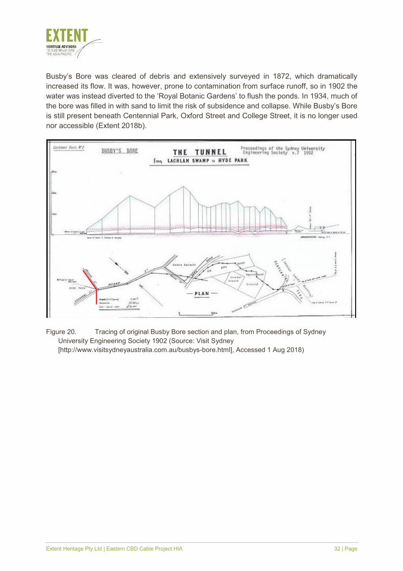
Figure 20. Tracing of original Busby Bore section and plan, from Proceedings of Sydney
University Engineering Society 1902 (Source: Visit Sydney
[http://www.visitsydneyaustralia.com.au/busbys-bore.html], Accessed 1 Aug 2018)
Extent Heritage Pty Ltd | Eastern CBD Cable Project HIA 33 | Page
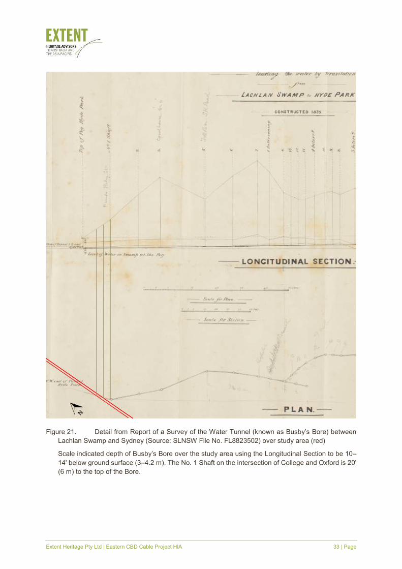
Figure 21. Detail from Report of a Survey of the Water Tunnel (known as Busby’s Bore) between
Lachlan Swamp and Sydney (Source: SLNSW File No. FL8823502) over study area (red)
Scale indicated depth of Busby’s Bore over the study area using the Longitudinal Section to be 10–
14' below ground surface (3–4.2 m). The No. 1 Shaft on the intersection of College and Oxford is 20'
(6 m) to the top of the Bore.
Extent Heritage Pty Ltd | Eastern CBD Cable Project HIA 34 | Page
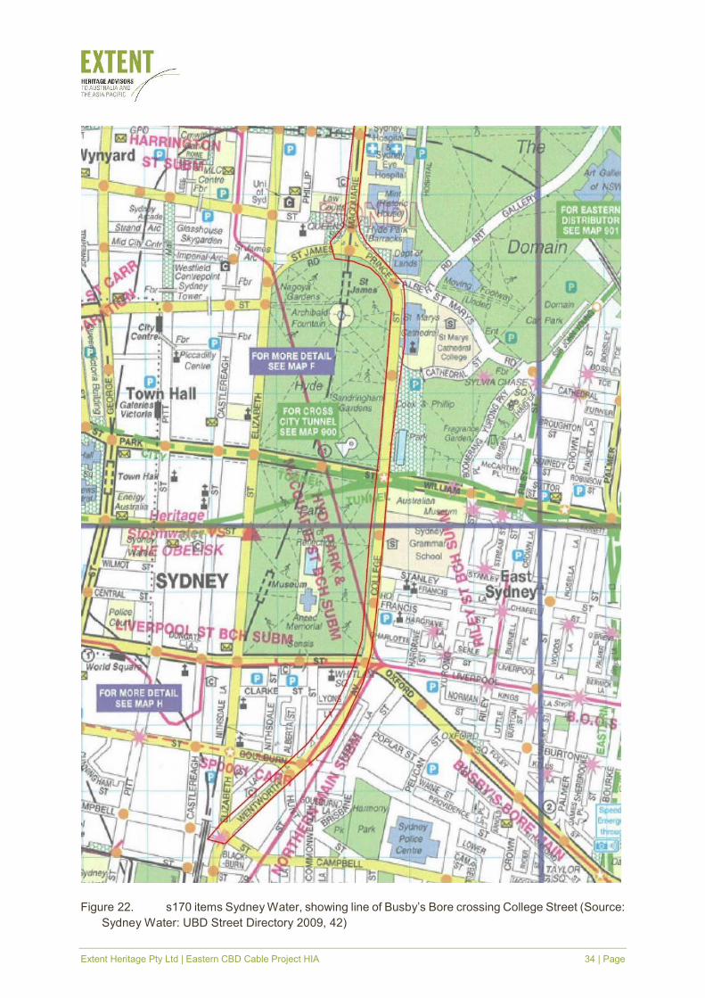
Figure 22. s170 items Sydney Water, showing line of Busby’s Bore crossing College Street (Source:
Sydney Water: UBD Street Directory 2009, 42)
Extent Heritage Pty Ltd | Eastern CBD Cable Project HIA 35 | Page
3.9 St James Station and the city circle railway network
3.9.1 Australia’s underground stations
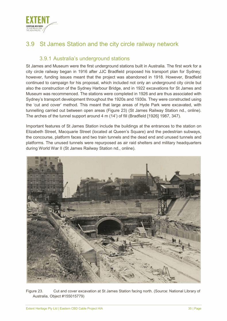
St James and Museum were the first underground stations built in Australia. The first work for a
city circle railway began in 1916 after JJC Bradfield proposed his transport plan for Sydney;
however, funding issues meant that the project was abandoned in 1918. However, Bradfield
continued to campaign for his proposal, which included not only an underground city circle but
also the construction of the Sydney Harbour Bridge, and in 1922 excavations for St James and
Museum was recommenced. The stations were completed in 1926 and are thus associated with
Sydney’s transport development throughout the 1920s and 1930s. They were constructed using
the ‘cut and cover’ method. This meant that large areas of Hyde Park were excavated, with
tunnelling carried out between open areas (Figure 23) (St James Railway Station nd., online).
The arches of the tunnel support around 4 m (14’) of fill (Bradfield [1926] 1987, 347).
Important features of St James Station include the buildings at the entrances to the station on
Elizabeth Street, Macquarie Street (located at Queen’s Square) and the pedestrian subways,
the concourse, platform faces and two train tunnels and the dead end and unused tunnels and
platforms. The unused tunnels were repurposed as air raid shelters and military headquarters
during World War II (St James Railway Station nd., online).
Figure 23. Cut and cover excavation at St James Station facing north. (Source: National Library of
Australia, Object #155015779)
Extent Heritage Pty Ltd | Eastern CBD Cable Project HIA 36 | Page
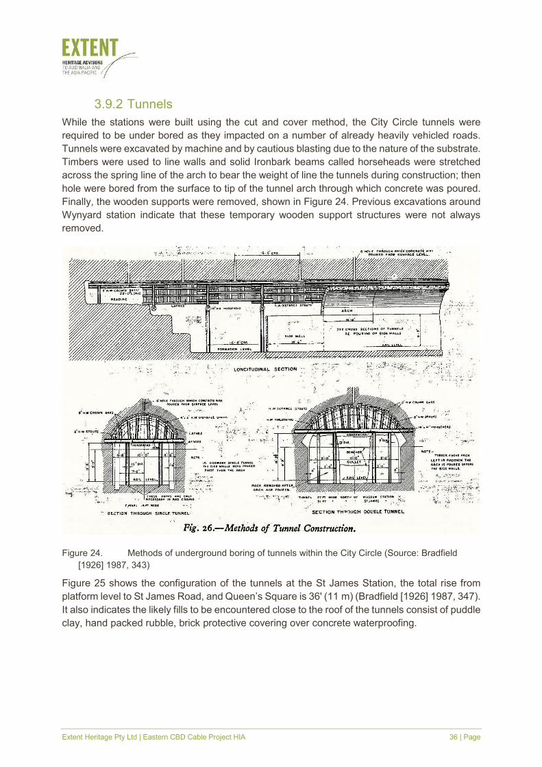
3.9.2 Tunnels
While the stations were built using the cut and cover method, the City Circle tunnels were
required to be under bored as they impacted on a number of already heavily vehicled roads.
Tunnels were excavated by machine and by cautious blasting due to the nature of the substrate.
Timbers were used to line walls and solid Ironbark beams called horseheads were stretched
across the spring line of the arch to bear the weight of line the tunnels during construction; then
hole were bored from the surface to tip of the tunnel arch through which concrete was poured.
Finally, the wooden supports were removed, shown in Figure 24. Previous excavations around
Wynyard station indicate that these temporary wooden support structures were not always
removed.
Figure 24. Methods of underground boring of tunnels within the City Circle (Source: Bradfield
[1926] 1987, 343)
Figure 25 shows the configuration of the tunnels at the St James Station, the total rise from
platform level to St James Road, and Queen’s Square is 36' (11 m) (Bradfield [1926] 1987, 347).
It also indicates the likely fills to be encountered close to the roof of the tunnels consist of puddle
clay, hand packed rubble, brick protective covering over concrete waterproofing.

Extent Heritage Pty Ltd | Eastern CBD Cable Project HIA 37 | Page
Figure 25. Cross section of St James Station platforms, showing the central line which is now filled
in (Source: Bradfield [1926] 1987, 346)
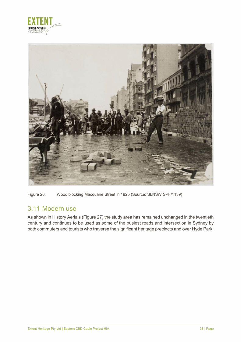
3.10 Road surfacing in the nineteenth and twentieth centuries
In the 1880s, experiments began with using woodblocks to form Sydney’s roads, particularly its
main thoroughfares. Hardwood blocks were laid into the road, with individual blocks sometimes
covered in tar or embedded into concrete (Labour Daily 1925, online). This method of road
building reduced dust throughout Sydney’s centre in the 1890s (NSW Main Roads, 43). From
1900 onwards, a top surface of tar was added for a durable and less slippery surface (Fitzgerald
1992, 57). Macquarie Street was wood blocked in 1925 (Figure 26) (Labour Daily 1925, online).
This wood blocking technique was used until the 1930s. Subsequently, ballast and aggregate
were used to form road beds, which were then covered with asphalt. Roads need to be
constantly modified and resurfaced under this system as part of routine maintenance (NSW
Main Roads 1976, 43).
Extent Heritage Pty Ltd | Eastern CBD Cable Project HIA 38 | Page
Figure 26. Wood blocking Macquarie Street in 1925 (Source: SLNSW SPF/1139)
3.11 Modern use
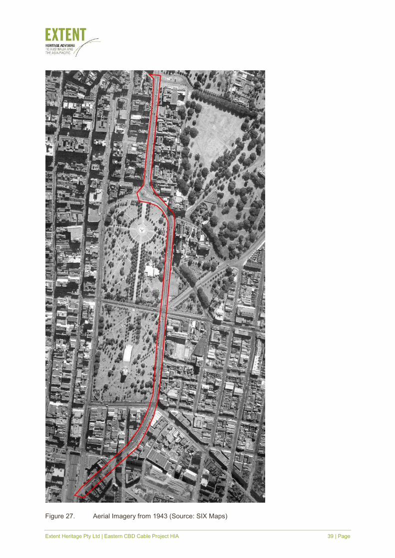
As shown in History Aerials (Figure 27) the study area has remained unchanged in the twentieth
century and continues to be used as some of the busiest roads and intersection in Sydney by
both commuters and tourists who traverse the significant heritage precincts and over Hyde Park.
Extent Heritage Pty Ltd | Eastern CBD Cable Project HIA 39 | Page
Figure 27. Aerial Imagery from 1943 (Source: SIX Maps)
Extent Heritage Pty Ltd | Eastern CBD Cable Project HIA 40 | Page
4. Site description
4.1 General
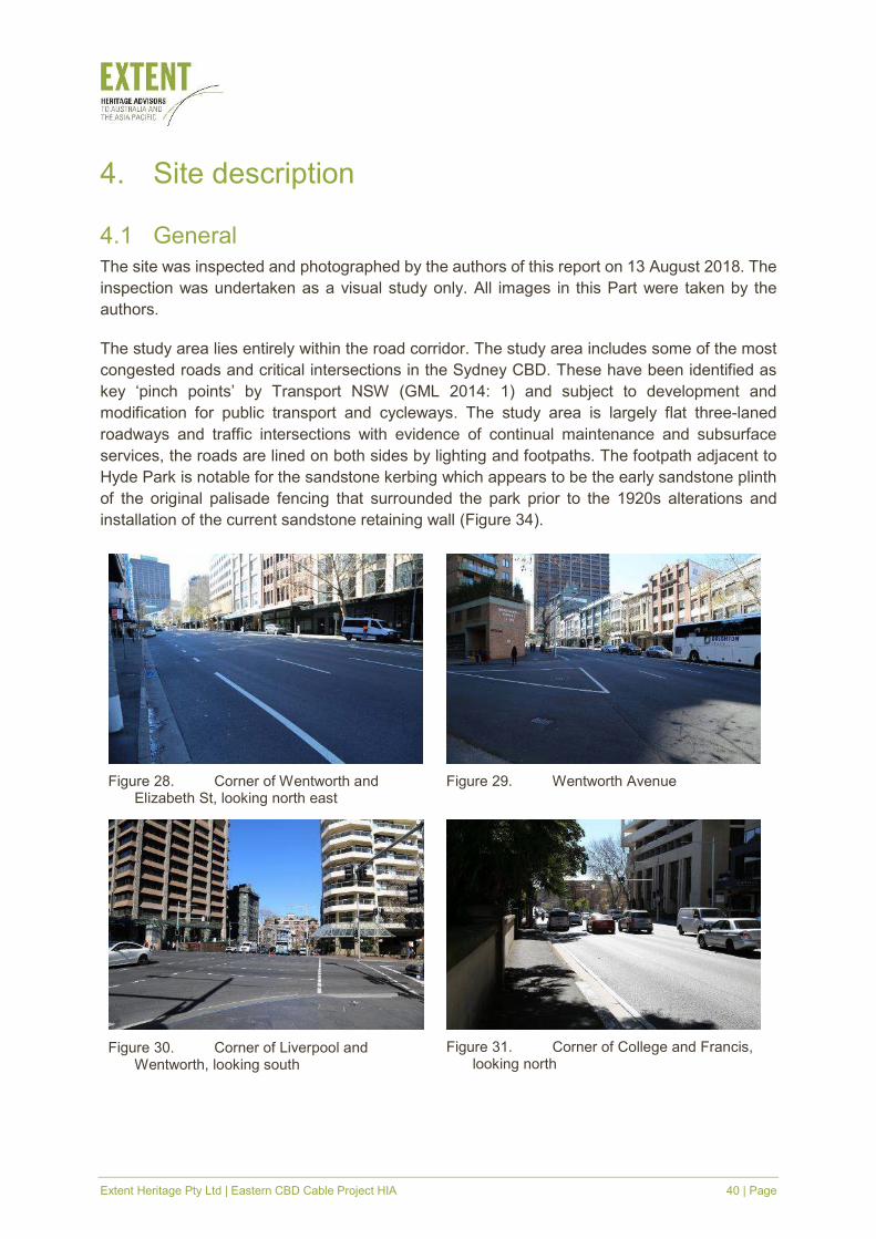
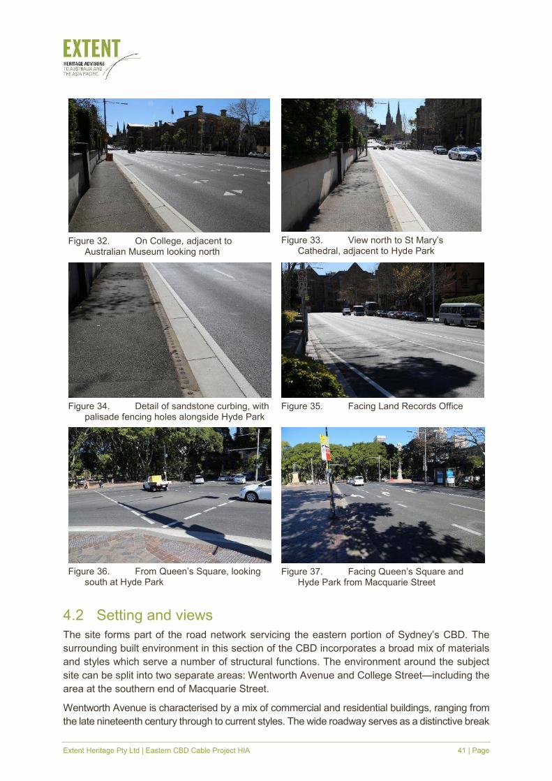
The site was inspected and photographed by the authors of this report on 13 August 2018. The
inspection was undertaken as a visual study only. All images in this Part were taken by the
authors.
The study area lies entirely within the road corridor. The study area includes some of the most
congested roads and critical intersections in the Sydney CBD. These have been identified as
key ‘pinch points’ by Transport NSW (GML 2014: 1) and subject to development and
modification for public transport and cycleways. The study area is largely flat three-laned
roadways and traffic intersections with evidence of continual maintenance and subsurface
services, the roads are lined on both sides by lighting and footpaths. The footpath adjacent to
Hyde Park is notable for the sandstone kerbing which appears to be the early sandstone plinth
of the original palisade fencing that surrounded the park prior to the 1920s alterations and
installation of the current sandstone retaining wall (Figure 34).
Figure 28. Corner of Wentworth and Elizabeth St, looking north east
Figure 29. Wentworth Avenue
Figure 30. Corner of Liverpool and Wentworth, looking south
Figure 31. Corner of College and Francis, looking north
Extent Heritage Pty Ltd | Eastern CBD Cable Project HIA 41 | Page
4.2 Setting and views
The site forms part of the road network servicing the eastern portion of Sydney’s CBD. The
surrounding built environment in this section of the CBD incorporates a broad mix of materials
and styles which serve a number of structural functions. The environment around the subject
site can be split into two separate areas: Wentworth Avenue and College Street—including the
area at the southern end of Macquarie Street.
Wentworth Avenue is characterised by a mix of commercial and residential buildings, ranging from
the late nineteenth century through to current styles. The wide roadway serves as a distinctive break
Figure 32. On College, adjacent to
Australian Museum looking north
Figure 33. View north to St Mary’s
Cathedral, adjacent to Hyde Park
Figure 34. Detail of sandstone curbing, with
palisade fencing holes alongside Hyde Park
Figure 35. Facing Land Records Office
Figure 36. From Queen’s Square, looking
south at Hyde Park
Figure 37. Facing Queen’s Square and
Hyde Park from Macquarie Street
Extent Heritage Pty Ltd | Eastern CBD Cable Project HIA 42 | Page
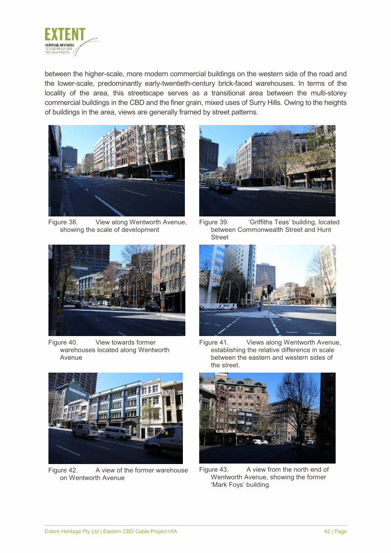
between the higher-scale, more modern commercial buildings on the western side of the road and
the lower-scale, predominantly early-twentieth-century brick-faced warehouses. In terms of the
locality of the area, this streetscape serves as a transitional area between the multi-storey
commercial buildings in the CBD and the finer grain, mixed uses of Surry Hills. Owing to the heights
of buildings in the area, views are generally framed by street patterns.
Figure 38. View along Wentworth Avenue,
showing the scale of development
Figure 39. ‘Griffiths Teas’ building, located
between Commonwealth Street and Hunt Street
Figure 40. View towards former
warehouses located along Wentworth Avenue
Figure 41. Views along Wentworth Avenue,
establishing the relative difference in scale between the eastern and western sides of the street.
Figure 42. A view of the former warehouse
on Wentworth Avenue
Figure 43. A view from the north end of
Wentworth Avenue, showing the former ‘Mark Foys’ building
Extent Heritage Pty Ltd | Eastern CBD Cable Project HIA 43 | Page
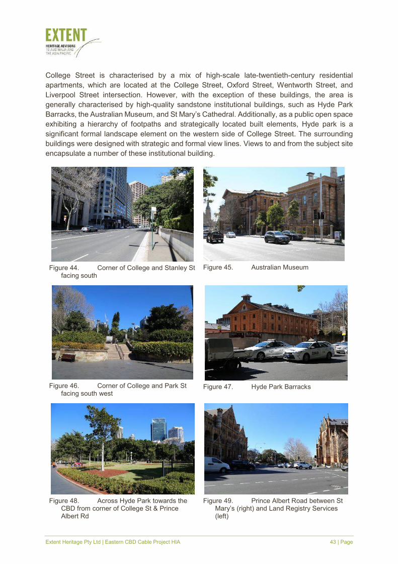
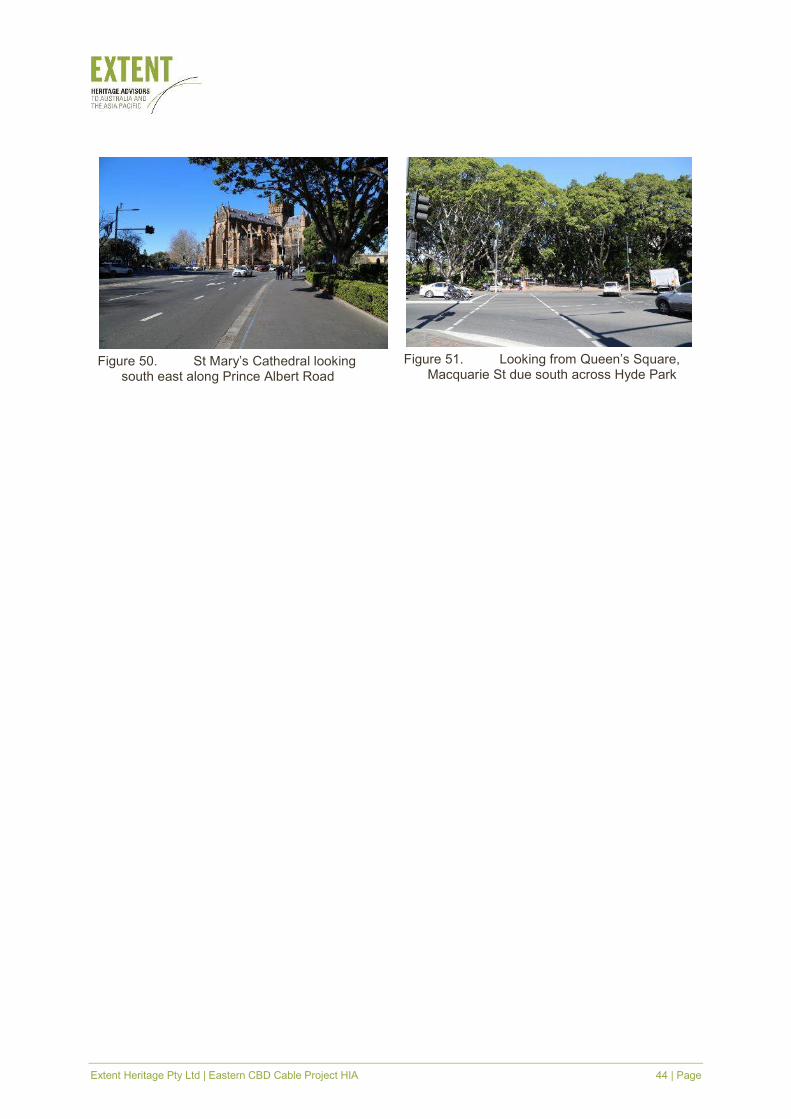
College Street is characterised by a mix of high-scale late-twentieth-century residential
apartments, which are located at the College Street, Oxford Street, Wentworth Street, and
Liverpool Street intersection. However, with the exception of these buildings, the area is
generally characterised by high-quality sandstone institutional buildings, such as Hyde Park
Barracks, the Australian Museum, and St Mary’s Cathedral. Additionally, as a public open space
exhibiting a hierarchy of footpaths and strategically located built elements, Hyde park is a
significant formal landscape element on the western side of College Street. The surrounding
buildings were designed with strategic and formal view lines. Views to and from the subject site
encapsulate a number of these institutional building.
Figure 44. Corner of College and Stanley St
facing south
Figure 45. Australian Museum
Figure 46. Corner of College and Park St
facing south west
Figure 47. Hyde Park Barracks
Figure 48. Across Hyde Park towards the
CBD from corner of College St & Prince Albert Rd
Figure 49. Prince Albert Road between St
Mary’s (right) and Land Registry Services (left)
Extent Heritage Pty Ltd | Eastern CBD Cable Project HIA 44 | Page
Figure 50. St Mary’s Cathedral looking
south east along Prince Albert Road
Figure 51. Looking from Queen’s Square,
Macquarie St due south across Hyde Park
Extent Heritage Pty Ltd | Eastern CBD Cable Project HIA 45 | Page
5. Historical archaeological potential
5.1 Introduction
This section provides an evaluation of the site’s potential to contain historical archaeological
remains and assesses the significance of such potential remains. Archaeological significance
refers to the heritage significance of known or potential archaeological remains. While they
remain an integral component of the overall significance of a place, it is necessary to assess
the archaeological resources of a site independently from aboveground and other heritage
elements. Assessment of archaeological significance is more challenging as the extent and
nature of the archaeological features is often unknown and judgment is usually formulated on
the basis of expected or potential attributes.
5.2 Previous reports
5.2.1 Macquarie, Prince Albert and College Streets
In 2014 GML prepared ‘Sydney City Centre Capacity Improvement Plan: Non-Aboriginal
Heritage Technical Report’ for Parsons Brinckerhoff on behalf of Roads and Maritime Services.
The report was prepared as a desktop assessment to provide heritage impact advice on traffic
capacity improvements around the city. The assessment investigated a wider area which
includes large portions of the current study area including the historically archaeologically
sensitive areas assessed for this report. The following extract is taken from section 3.4
Archaeological Impact Assessment (GML 2014, p47):
The scoping and evaluation of the known and potential historical archaeological resource
that may be impacted by the proposed works is based on consideration of the readily
available information obtained from historic maps, plans and aerials, the central Sydney
Archaeological Zoning Plan 1992, heritage registers and relevant historical archaeological
documentation (i.e. assessments and excavation reports).
This overview assessment does not provide a detailed review of all potential
archaeological resources across the areas of impact, but rather a summary of the known
and potential archaeological resource (inferred from the above sources) that may be
subjected to the development impacts of the proposal. As a guideline relevant for the table
below, grading of archaeological potential is commonly described as low, moderate or high
as follows:
� Low—it is unlikely that archaeological evidence associated with this historical
phase or feature survives.
� Moderate—it is possible that some archaeological evidence associated with this
historical phase or feature survive. If archaeological remains survive they may
have been subject to some disturbance.
� High—it is likely that archaeological evidence associated with this historical phase
or feature survives intact.
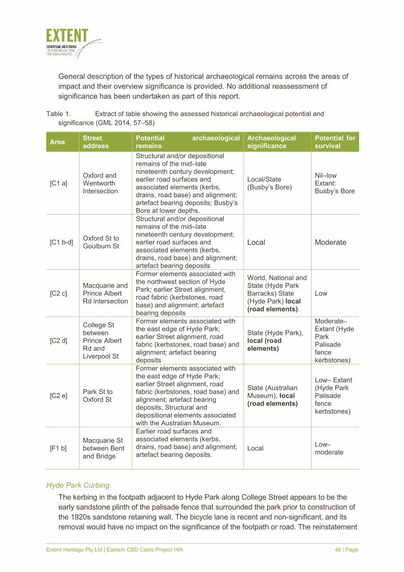
Extent Heritage Pty Ltd | Eastern CBD Cable Project HIA 46 | Page
General description of the types of historical archaeological remains across the areas of
impact and their overview significance is provided. No additional reassessment of
significance has been undertaken as part of this report.
Table 1. Extract of table showing the assessed historical archaeological potential and
significance (GML 2014, 57–58)
Area Street address
Potential archaeological remains
Archaeological significance
Potential for survival
[C1 a] Oxford and Wentworth Intersection
Structural and/or depositional remains of the mid–late nineteenth century development; earlier road surfaces and associated elements (kerbs, drains, road base) and alignment; artefact bearing deposits; Busby’s Bore at lower depths.
Local/State (Busby’s Bore)
Nil–low Extant: Busby’s Bore
[C1 b-d] Oxford St to Goulburn St
Structural and/or depositional remains of the mid–late nineteenth century development; earlier road surfaces and associated elements (kerbs, drains, road base) and alignment; artefact bearing deposits
Local Moderate
[C2 c] Macquarie and Prince Albert Rd intersection
Former elements associated with the northwest section of Hyde Park; earlier Street alignment, road fabric (kerbstones, road base) and alignment; artefact bearing deposits
World, National and State (Hyde Park Barracks) State (Hyde Park) local (road elements).
Low
[C2 d]
College St between Prince Albert Rd and Liverpool St
Former elements associated with the east edge of Hyde Park; earlier Street alignment, road fabric (kerbstones, road base) and alignment; artefact bearing deposits
State (Hyde Park), local (road elements)
Moderate– Extant (Hyde Park Palisade fence kerbstones)
[C2 e] Park St to Oxford St
Former elements associated with the east edge of Hyde Park; earlier Street alignment, road fabric (kerbstones, road base) and alignment; artefact bearing deposits; Structural and depositional elements associated with the Australian Museum.
State (Australian Museum), local (road elements)
Low– Extant (Hyde Park Palisade fence kerbstones)
[F1 b] Macquarie St between Bent and Bridge
Earlier road surfaces and associated elements (kerbs, drains, road base) and alignment; artefact bearing deposits.
Local Low–moderate
Hyde Park Curbing
The kerbing in the footpath adjacent to Hyde Park along College Street appears to be the
early sandstone plinth of the palisade fence that surrounded the park prior to construction of
the 1920s sandstone retaining wall. The bicycle lane is recent and non-significant, and its
removal would have no impact on the significance of the footpath or road. The reinstatement
Extent Heritage Pty Ltd | Eastern CBD Cable Project HIA 47 | Page
of the traffic lane adjacent to the sandstone plinth could potentially cause damage through
bringing traffic closer towards the footpath. Pending confirmation of whether the sandstone
plinth is within the SHR listed curtilage of Hyde Park, any alterations to the sandstone plinth
could have an adverse heritage impact on Hyde Park. Alterations would be subject to
approval under section 60 of the Heritage Act. (GML 2014, 41–42)
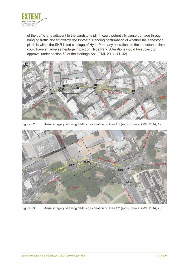
Figure 52. Aerial imagery showing GML’s designation of Area C1 (a-g) (Source: GML 2014, 19)
Figure 53. Aerial imagery showing GML’s designation of Area C2 (a-d) (Source: GML 2014, 20)
Extent Heritage Pty Ltd | Eastern CBD Cable Project HIA 48 | Page
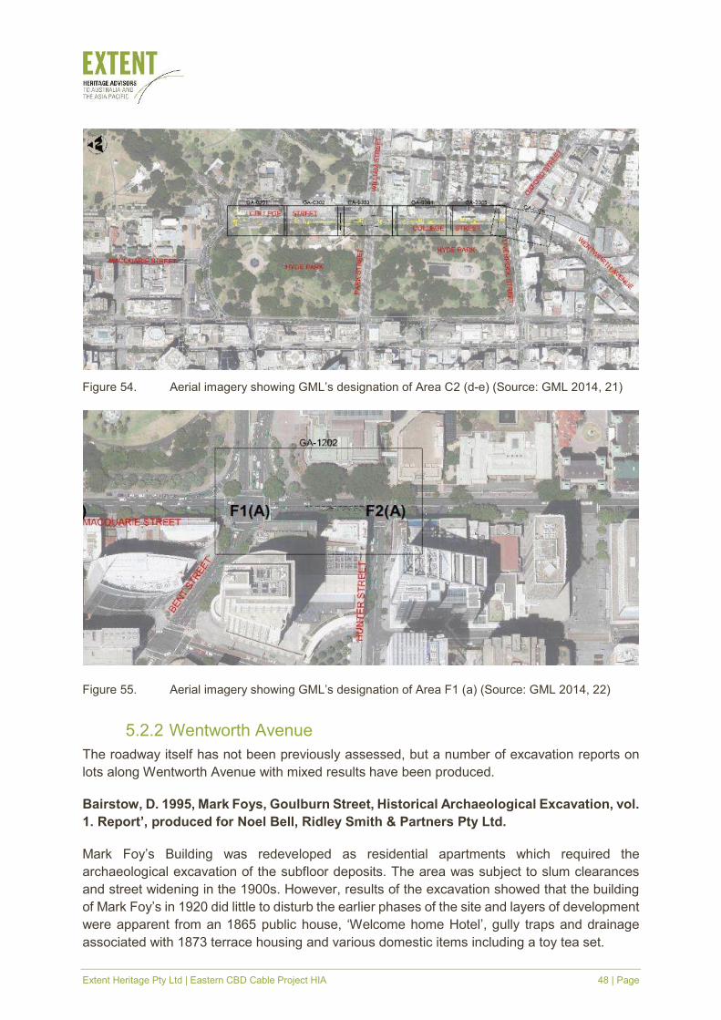
Figure 54. Aerial imagery showing GML’s designation of Area C2 (d-e) (Source: GML 2014, 21)
Figure 55. Aerial imagery showing GML’s designation of Area F1 (a) (Source: GML 2014, 22)
5.2.2 Wentworth Avenue
The roadway itself has not been previously assessed, but a number of excavation reports on
lots along Wentworth Avenue with mixed results have been produced.
Bairstow, D. 1995, Mark Foys, Goulburn Street, Historical Archaeological Excavation, vol.
1. Report’, produced for Noel Bell, Ridley Smith & Partners Pty Ltd.
Mark Foy’s Building was redeveloped as residential apartments which required the
archaeological excavation of the subfloor deposits. The area was subject to slum clearances
and street widening in the 1900s. However, results of the excavation showed that the building
of Mark Foy’s in 1920 did little to disturb the earlier phases of the site and layers of development
were apparent from an 1865 public house, ‘Welcome home Hotel’, gully traps and drainage
associated with 1873 terrace housing and various domestic items including a toy tea set.
Extent Heritage Pty Ltd | Eastern CBD Cable Project HIA 49 | Page
Higginbotham, E. 1995, ‘Historical and Archaeological Assessment of The Southern
Cross Tower, 35–45 Wentworth Avenue, Sydney’, Prepared for Straesser Poli Little and
Associates Pty Ltd.
The assessment found that the construction of the current office buildings may have had little
impact outside of footing trenches, lift wells and services. The results of geotechnical works
however indicated disturbance around the edges of the site of 3.1 m–3.7 m. The results of the
excavation demonstrated at a depth of 1.1 m–1.4 m was a humic soil including demolition
materials and artefacts associated with occupation consistent with the slum clearances. The
report suggests the excavations were inconclusive but may show evidence of Jonathon Leak’s
Pottery.
AHMS, 2007, ‘61–65 Wentworth Avenue, Surry Hills NSW, Archaeological Impact
Assessment and Research Design: Interim report on Preliminary Archaeological Test
Excavation’, Prepared for Eastview (Australia) Pty Ltd., 41–48.
The development area was situated over the site of Leak’s Pottery and its subsequent terrace
and slum development and was altered during the slum demolition and realignment. Test
excavation found surface building deposits, (concrete slabs etc.) were around 1–2 m, overlaying
a demolition deposit consisting of crushed brick and mortar which was cleared exposing the
footings of three terrace houses that fronted the former Wexford Street. All of the houses had
lost up to 50 per cent of their front rooms due to modern construction. The structures consisted
of two ground floor rooms (front and back), an attached kitchen separated from the house by a
passage and an attached privy. The occupation deposits from both the front and back rooms
were relatively thin with some material being concentrated along the edges of the walls. The
occupation deposit in the kitchen however was up to 150 mm thick. The remains of the terrace
houses were located approximately 1000 mm below the current level of the Wentworth Ave
pavement and were set on a clay bed. The material appears to represent occupation during the
final decades of the terraces occupation (that is c.1880–1908). Three 2 m by 1 m trenches were
then excavated within the footprint of this building in order to determine the extent and nature
of the deposits that pre-date the construction of the terraces (i.e. pre-c.1860).
A sequence of late 1850s or early 1860s dump deposits was encountered in all trenches.
These deposits consist primarily of ash and charcoal, demolition rubble and layers of
mixed clays interspersed with waterborne silts. No structural remains or evidence of
structures was encountered within this sequence. Very few domestic or industrial artefacts
were associated with these deposits. It is not clear if these deposits represent a
programme of deliberate levelling or providential dumping on a vacant site. P In the east,
immediately adjacent to Wentworth Avenue a series of overlapping deposits consisting of
mixed clays, charcoal and ash and crushed sandstock brick were encountered. This lower
dump sequence contained large quantities of clay tobacco pipe wasters. The brick rubble
contained no full bricks (and no mortar) but large quantities of vitrified or heat-decayed
brick fragments as well as baked clay used to fill cracks in the kilns. Some kiln furniture
was present as were biscuit-fired coarse earthenware wasters and a smaller number of
glazed earthenware wasters. This sequence of waste deposits was up to 400 mm thick.
The evidence derived from the style of artefact present and a number of marked pieces
Extent Heritage Pty Ltd | Eastern CBD Cable Project HIA 50 | Page
indicate that it was not part of the 1850s/1860s filling programme—the source of this
material was Leak’s Pottery during the 1830s.
Casey & Lowe, 2016, ‘Results of Non-Indigenous Archaeological Testing 46–52
Wentworth Avenue, Surry Hills’, Prepared for Cornerstone Property Group.
The study area, at the north end of Wentworth Avenue, was first developed in the 1850s with a
stone building that remained on site until the 1906 plague clearances. A terrace was constructed
adjacent to this in 1868, relacing earlier wooden cottages. Portions of the site, not subject to
underground parking were considered to have moderate potential for archaeological evidence
and were subject to testing, but no archaeological remains or intact soil profiles were identified.
5.3 Site development
5.3.1 Macquarie Street
From the earliest days of the Colony of New South Wales, the town began to expand from
Circular Quay, southwards. The line of Macquarie Street was set out by Governor Lachlan
Macquarie within the first few years. He initiated many schemes to improve the alignment and
planning of Sydney’s streets including the commission of the line of public buildings along
Macquarie Street, which was at the town’s eastern ridge.
The layout has not changed significantly since this time, there may be evidence of previous road
surfaces, however these are likely to have been impacted by the continual development, update
of services and resurfacing including early innovative methods such as wood blocking.
St James Station was built under Hyde Park in 1926 with the electrification of the Sydney
railways and development of the City Circle. The station was formed by complete excavation of
the north end of the park and then the tunnel was bored underneath Macquarie Street with a
track depth of about 10 m. The under boring is not likely to have created any near surface
evidence.
5.3.2 College Street
Similar to Macquarie Street, College Street developed with the creation of Hyde Park which was
laid out by the city planning ideals of Governor Macquarie. Sydney College was established in
1832 and the road was laid out in the same year and has remained largely unchanged.
Busby’s Bore, the second source of the colonies water, was constructed in 1837 allowing water
to be gravity fed from the outlining Lachlan Swamp into a flume in Hyde Park from which water
could be collected. At its northern end, the tunnel rises out of the bedrock and is edged with
dressed sandstone blocks. Across the study area in College Street, it lies at a depth of
approximately 3 m below the road surface. The full precise route is uncertain as the bore has
not been traversed in entirety since 1849 and only twenty-eight of the bore shafts have been
located. However, the tunnel has undergone modification since then and the portion of the
tunnel under Oxford Street from Hyde Park to Riley Street was filled with sand after the weight
of tram traffic caused stone slabs to collapse.
Extent Heritage Pty Ltd | Eastern CBD Cable Project HIA 51 | Page
5.3.3 Wentworth Avenue
The area was at some distance from the earliest settlement and was initially used both as grazing
land and by brickmakers and potteries. Johnathon Leak set up his early pottery workshop in the
area in 1822, with the buildings shown directly within the study area on early maps, however
cartographic error must be considered for a site so distant from significant reference points.
Through the 1850s to 1890s the area was developed and occupation intensified into slum
dwellings. Deaths from dysentery and an outbreak of plague in Sydney in 1900 caused a
number of areas of intensive occupation including Wexford Street to be quarantined. In 1906,
the buildings in the area were demolished, rubble was potentially left in situ as a base for future
works and the new significantly wider Wentworth Avenue was realigned roughly along the line
of Market Street up to the south eastern corner of Hyde Park.
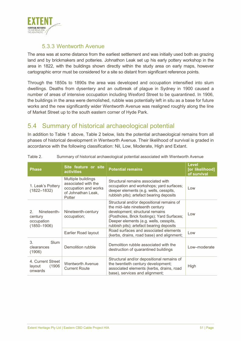
5.4 Summary of historical archaeological potential
In addition to Table 1 above, Table 2 below, lists the potential archaeological remains from all
phases of historical development in Wentworth Avenue. Their likelihood of survival is graded in
accordance with the following classification: Nil, Low, Moderate, High and Extant.
Table 2. Summary of historical archaeological potential associated with Wentworth Avenue
Phase Site feature or site activities
Potential remains Level [or likelihood] of survival
1. Leak’s Pottery (1822–1832)
Multiple buildings associated with the occupation and works of Johnathan Leak, Potter
Structural remains associated with occupation and workshops; yard surfaces; deeper elements (e.g. wells, cesspits, rubbish pits); artefact bearing deposits
Low
2. Nineteenth-century occupation (1850–1906)
Nineteenth-century occupation;
Structural and/or depositional remains of the mid–late nineteenth century development; structural remains (Postholes, Brick footings); Yard Surfaces; Deeper elements (e.g. wells, cesspits, rubbish pits); artefact bearing deposits
Low
Earlier Road layout Road surfaces and associated elements (kerbs, drains, road base) and alignment;
Low
3. Slum clearances (1906)
Demolition rubble Demolition rubble associated with the destruction of quarantined buildings
Low–moderate
4. Current Street layout (1906 onwards
Wentworth Avenue Current Route
Structural and/or depositional remains of the twentieth century development; associated elements (kerbs, drains, road base), services and alignment;
High
Extent Heritage Pty Ltd | Eastern CBD Cable Project HIA 52 | Page
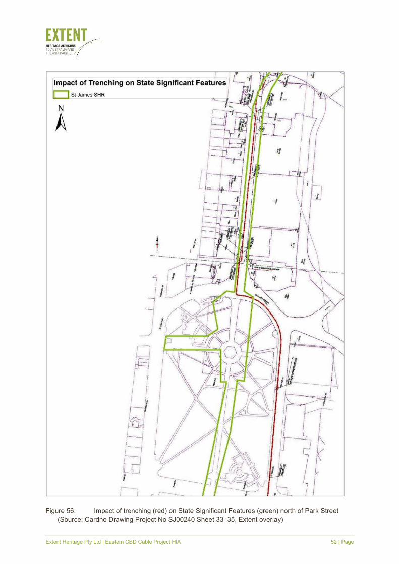
Figure 56. Impact of trenching (red) on State Significant Features (green) north of Park Street
(Source: Cardno Drawing Project No SJ00240 Sheet 33–35, Extent overlay)
Extent Heritage Pty Ltd | Eastern CBD Cable Project HIA 53 | Page
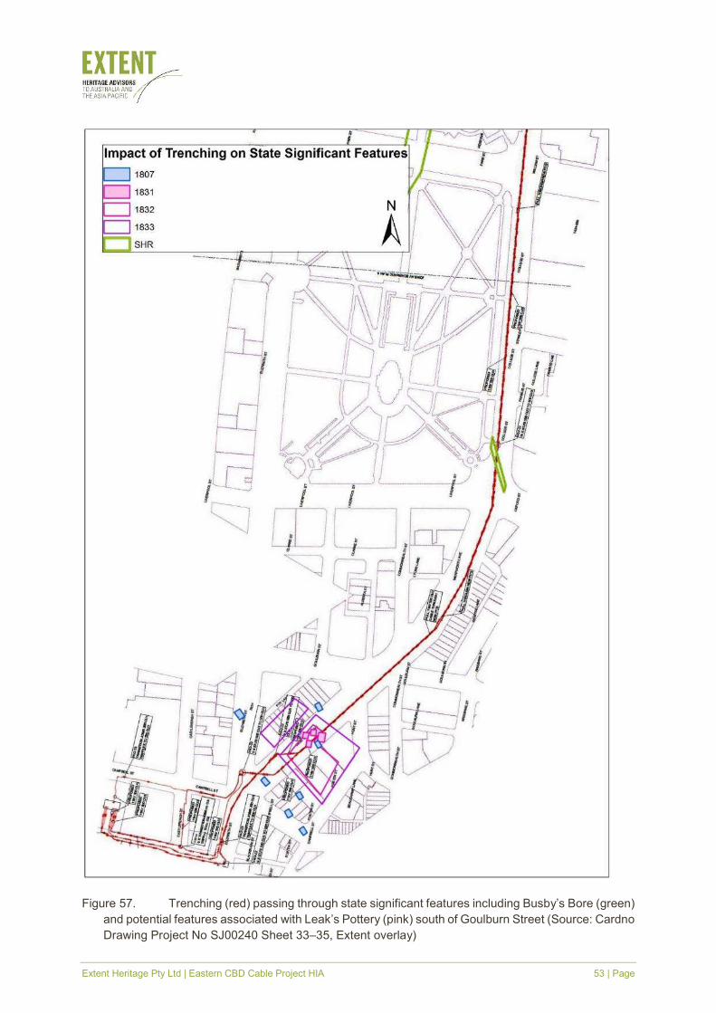
Figure 57. Trenching (red) passing through state significant features including Busby’s Bore (green)
and potential features associated with Leak’s Pottery (pink) south of Goulburn Street (Source: Cardno
Drawing Project No SJ00240 Sheet 33–35, Extent overlay)
Extent Heritage Pty Ltd | Eastern CBD Cable Project HIA 54 | Page
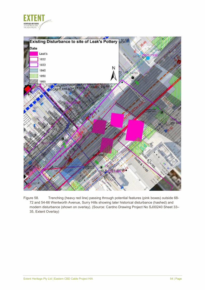
Figure 58. Trenching (heavy red line) passing through potential features (pink boxes) outside 68-
72 and 54-66 Wentworth Avenue, Surry Hills showing later historical disturbance (hashed) and
modern disturbance (shown on overlay). (Source: Cardno Drawing Project No SJ00240 Sheet 33–
35, Extent Overlay)
Extent Heritage Pty Ltd | Eastern CBD Cable Project HIA 55 | Page
6. Assessment of heritage significance
6.1 Built heritage
The NSW Heritage Manual was developed by the Heritage Office and former NSW Department
of Urban Affairs and Planning to provide the basis for an assessment of heritage significance of
an item or place. This is achieved by evaluating the place or items significance in reference to
specific criteria, which can be applied at a national, state or local level (NSW DUAP 1996).
6.2 Existing statement of significance
6.2.1 Busby’s Bore
Busby's Bore is a unique engineering achievement which played a crucial role in the
development of urban Sydney. As a product of convict labour and a major factor in the
establishment of local administration in NSW (in the form of the Sydney Corporation) the bore
is associated with the important steps that changed Sydney from penal colony to colonial trading
port.
The fabric of the bore and associated archaeological deposits possess research potential
relating to substantive historical and scientific questions relating to nineteenth-century work and
technology and to changes in the environment.
The intactness of the bore and the fact that it was still in use as late as 2001 (although now is
officially not in use as a water source) make it a rare survivor from the first half of the nineteenth
century within urban Sydney (Godden Mackay 2001, 25–26).
The site is considered to have state significance and is listed on the SHR as item 00568.
6.2.2 St James Railway Station
St James Station is of state significance (SHR # 001248) because, along with Museum, it was
the first underground station in Australia and demonstrates the adaptation of the London tube-
style station to the Australian situation. The station is well constructed, proportioned and
detailed.
The station complex is an important part of the larger Sydney Harbour Bridge and the electrified
City Underground Railway scheme and has associations with prominent persons such as JJC
Bradfield, chief engineer and designer of the Sydney Harbour Bridge and city underground and
organisations such as the Department of Railways and represents the culmination of many
years of political lobbying for a city railway system. The construction of the city underground
and position of St James Station encouraged the retail and commercial development of the
Sydney CBD in the late 1920s and 1930s, with large department stores constructed around the
stations.
Extent Heritage Pty Ltd | Eastern CBD Cable Project HIA 56 | Page
The St James Station entry building is a fine and largely intact example of a small-scale Inter-
War Stripped Classical style building which adds to the general character of the immediate area.
It has significance as one of two buildings of its type and style remaining in the city railway
system (the other being Museum Station entrance) and is a rare example of this type of station
building.
The underground platforms and concourse retain many original features and provide one of the
most ornate station interiors in the NSW railway system. Disused platforms demonstrate the
grand plans of the 1930s railway network of Bradfield, while the air raid shelter areas in the
southern tunnels are rare surviving elements of Sydney's World War II defences.
Individual elements, such as the tiling, ornate stairs, lights and clocks add to the ambience of
the station, while the Chateau Tanunda neon advertising sign at the Elizabeth Street entrance
is a rare surviving example of a 1930s neon sign in Sydney (St James Railway Station 2018).
6.2.3 Queen’s Square
The square is perhaps the earliest example of formal urban design in central Sydney. It is of
historic, aesthetic, and cultural significance. Queen’s Square is listed on the Heritage
Streetscape Map and as an item of local significance on Schedule 8 Part 3 of the Sydney LEP
2005 Item I1882. Queen’s Square is of historical significance as an open space terminating the
Macquarie Street boulevard with views of Hyde Park, St James Church, Hyde Park Barracks,
the Mint and the former Registrar Generals (Land Titles) Office (NSW OEH 2012).
6.2.4 Wentworth Avenue
Wentworth Avenue is associated with continuous European occupation from c1800. Deposits
and features dating to the period prior to c.1830 have a poor survival due to clay extracting
undertaken in the eastern portion of the site in the 1830s, and the installation of services in the
west in the period after c. 1857.
The most significant features observed on the site are those associated with Jonathan Leak’s
Pottery. These features consisting of waste deposits and a clay pit are associated with an
industrial complex that, if it survives, would be regarded as having state significance. By
association the extant Leak features observed on the site have a level of significance that is at
least locally significant and marginally state significant. As such these features are worthy of
investigation and careful treatment.
The surviving remains of structures associated with the post-1857 domestic occupation of the
site is considered to be locally significant. These have the potential to provide information
regarding the evolution of the district from the mid-Nineteenth Century to its complete removal
in c. 1908. (AHMS 2007, 57)
Extent Heritage Pty Ltd | Eastern CBD Cable Project HIA 57 | Page
6.3 Historical archaeology
6.3.1 Overview
Archaeological significance refers to the heritage significance of known or potential
archaeological remains. While they remain an integral component of the overall significance of
a place, it is necessary to assess the archaeological resources of a site independently from
aboveground and other heritage elements. Assessment of archaeological significance is more
complex as the extent and nature of the archaeological features is often unknown and
significance is usually formulated on the basis of expected or potential attributes.
To facilitate significance assessment of historical archaeological remains, the NSW Heritage
Division prepared a set of criteria in the publication ‘Assessing Significance for Historical
Archaeological Sites and ‘Relics’, prepared by the Heritage Branch, formerly Department of
Planning (NSW) (now the Heritage Division, Office of Heritage and Environment) in December
2009.
The following Assessments of Significance are drawn from the following sources:
� AHMS, 2007, ‘61–65 Wentworth Avenue, Surry Hills NSW, Historical Archaeological Impact
Assessment’, Prepared for Eastview (Australia) Pty Ltd.
� Extent. 2018a. Busby’s Bore Conservation Management Plan. Draft V1. Prepared for
Sydney Water.
� ‘St James Railway Station’. nd. SRA s170 Heritage Register Listing Sheet. Available from
NSW Office of Environment and Heritage (Online).
� GML, 2014 ‘Sydney City Centre Capacity Improvement Plan: Non-Aboriginal Heritage
Technical Report’, Prepared for Parsons Brinckerhoff on behalf of Roads and Maritime
Services.
6.3.2 Assessment of significance
� Archaeological research potential (current NSW Heritage Criterion E)
St James Railway Station
The disused tunnels at St James Railway Station have some research significance through their
uses during World War II as air raid shelters. The study area has a high level of intactness with
some modifications and upgrades, such as replacement tiling, new entrances via north Hyde
Park and the inclusion of a café in the former entrance building amenities effecting its overall
integrity and may be able to add significantly to the corpus of archaeological information on
construction and use of the underground railway system (St James Railway Station).
Busby Bore
The archaeological deposits surrounding the Bore may also provide evidence of its use and
construction. Archaeological deposits within the curtilage of the Bore may possess research
potential relating to; aboriginal occupation of the area, environmental changes since
colonisation including the introduction of new species, grazing, drainage of swamps and
Extent Heritage Pty Ltd | Eastern CBD Cable Project HIA 58 | Page
development and the development of the Royal Agricultural Society’s Showground. Busby’s
Bore meets this criterion at the state level (Extent 2018a, 49–50).
Wentworth Avenue and Leak’s Pottery
The potential archaeological deposits have potential to yield information regarding Nineteenth
Century occupation of the subject site and Sydney, as such, they are considered to be locally
significant in terms of criterion. (AHMS 2007, 55–56)
� Associations with individuals, events or groups of historical importance (NSW
Heritage Criteria A, B & D)
St James Railway Station
St James Station was, with Museum Station, one the first two underground railway stations to
operate in Australia. It has been in continuous operation since its opening and has retained
much of the original fabric intact. It was part of the development of transport services in the early
twentieth century, and provides evidence of the expansion and upgrading of public utilities in
the inner city during this period. St James Station is associated with early plans for the
development of a city rail network and demonstrates the adoption of the European-style tube
station.
The station is associated with prominent persons such as JJC Bradfield and organisations such
as the Department of Railways. JJC Bradfield was Chief Engineer for the Sydney Harbour
Bridge and City Transit and had a direct hand in the design and layout of St James Station. The
place has the potential to contribute to the local community's sense of place and can provide a
connection to the local community's history.
The construction of St James and Museum Stations on the eastern edge of the city encouraged
the development of commercial and retail property in this part of the city with large firms
including David Jones, Farmers (later Grace Bros and now Myers) and Mark Foy's all building
large stores near the stations to take advantage. The underground location of the station is a
result of citizens' concerns over losing parkland. The St James Railway disused tunnels are
also historically significant as part of Sydney's wartime experience, with both military
headquarters and civilian air raid shelters located within sections of them during World War II.
(St James Railway Station)
Busby Bore
Busby’s Bore, as an important public work constructed between 1827 and 1837 and Sydney’s
main water supply between 1837 and 1852, is a physical remnant of a fundamental process
which has shaped the evolution and development of Sydney. Busby’s Bore was an important
factor leading to the establishment of the Sydney Corporation in 1842. It highlights the Colonial
Government’s lack of interest in managing the problems caused by Sydney’s fast-growing urban
population. The Bore is associated with John Busby and Commissioner Bigge and symbolises
their aspirations for Sydney, and themselves. Busby’s Bore meets this criterion at the state level.
(Extent 2018a, 49–50)
Wentworth Avenue and Leak’s Pottery
Evidence of the operation of Jonathan Leak’s Pottery (c.1822–1838) as a significant early
manufacturer of ceramics whose marked works have been identified on many sites. Leak was
Extent Heritage Pty Ltd | Eastern CBD Cable Project HIA 59 | Page
one of many clay-based manufacturers in the general vicinity including brick and tile makers,
tobacco pipe makers and potters. As yet there has been no comprehensive investigation of his
range of products. Evidence associated with Leak’s works is considered to be of local
significance.
The study area also formed part of Sydney’s Chinatown in the period between c.1880 and
c.1908. Domestic occupation associated with this phase of the site’s history has relevance to
state historical themes of ethnic influences, migration, commerce, environment, cultural
landscape, utilities and persons; the potential relics are considered to be locally significant
(AHMS 2007, 55–56),
� Aesthetic or technical significance (NSW Heritage Criterion C)
St James Railway Station
St James Station provides evidence of developing railway technology in NSW and Australia in
the 1920s and reflects the underground systems of England and Europe of the same period.
The scale and methods of construction represent a major feat of engineering for its time. The
sandstone entry building in Elizabeth Street is a fine and largely intact example of the Inter-War
Stripped Classical style, and includes significant neon signs in its entrance way. The entry
building is a prominent feature in north Hyde Park and at the top of Market Street. The wall tiling
within the station and the pedestrian tunnels, including the green indicator banding, is a
distinctive and significant element of the interior of the station, which retains a number of original
features including light fittings, station clocks and timber work (St James Railway Station).
Busby Bore
The majority of Busby’s Bore is located underground. There are, however, a number of
wells/shafts tapped into the bore. The aesthetic significance of the Bore is also evident in the
important surroundings where these wells and shafts meet the surface.
The Bore is technically significant as a major engineering achievement of its time. The Bore’s
fabric possesses research potential regarding its construction techniques, the technology and
materials available in the colony at the time, convict working conditions, the history of its use
through changes made to it over time and the success of government regulation of the water
supply through evidence of illegal entries. Busby’s Bore meets this criterion at the state level
(Extent 2018a, 49–50).
Wentworth Avenue and Leak’s Pottery
Deposits associated with pottery production found on this site are considered to be state
significant in terms of criterion for their association with Jonathan Leak’s Pottery (AHMS 2007,
55–56).
� Ability to demonstrate the past through archaeological remains (NSW Heritage
Criteria A, C, F & G)
St James Railway Station
St James Station was one of the first two underground railway stations to operate in Australia.
The layout of St James, along with Museum, based on the London underground, is unique in
the NSW railways network, while the surviving World War II air raid shelter sections are rare
remaining examples of public air raid precautions in the Sydney area. The neon Chateau
Extent Heritage Pty Ltd | Eastern CBD Cable Project HIA 60 | Page
Tanunda (Brandy) sign within the Elizabeth Street entrance building is a rare surviving example
of a pre-World War II neon sign in Sydney and a local landmark.
The station entrance (Elizabeth Street) is representative of a low-scale public building
constructed in the inter-War Stripped Classical style. It is representative of a facility designed to
cater for the ongoing transport of Sydney's citizens. It was associated with early plans for the
development of a city rail network, and demonstrates the adoption of the European-style tube
station. (St James Railway Station)
Busby Bore
The Bore is representative of English rock mining techniques of the period and of rock mining
in other parts of Australia. It is also representative of public works carried out by convict labour
and nineteenth-century engineering techniques. Busby’s Bore is a unique engineering
achievement. The intactness of this early nineteenth century, convict-built water supply makes
it a rare survivor from this period within urban Sydney. As the main water supply to Sydney from
1837 to 1853 the bore is a unique item. Busby’s Bore meets this criterion at the state level.
(Extent 2018a, 49–50)
Wentworth Avenue and Leak’s Pottery
The clay cutting observed during testing was a feature that is typical of the region in that this
area formed part of the earliest concentration of clay-based industries in the Colony. Features
associated with clay extraction demonstrate this phase of the region’s development and are
considered to be locally significant in terms of assessment criterion.
Known and potential relics within the study area constitute a partially intact urban archaeological
site. The exposed relics are typical of inner city development in the late 1850s and early 1860s
through the construction of terrace housing. Therefore, it is likely that the relics within the study
area will demonstrate this phase of the City’s development, and are considered to be Locally
significant in terms of assessment criterion.
Without knowing how much of Leak’s Pottery survives beneath Wentworth Avenue and the
existing buildings on the eastern side of this street, extant evidence of this manufacturing at 61–
65 Wentworth Avenue is considered as rare and endangered. Deposits associated with pottery
production found on this site are considered to be state significant in terms of criterion for their
association with Jonathan Leak’s Pottery (AHMS 2007, 55–56).
6.3.3 Bickford and Sullivan questions
The above state heritage significance assessment criteria are routinely augmented during
significance assessment for sites in NSW by consideration of three questions formulated by
Bickford and Sullivan that place emphasis on the research contribution of the identified
archaeological resource to the field of Australian history and archaeology (Bickford & Sullivan
1984, 19–26). They include:
� Can the site contribute knowledge that no other resource can?
Extent Heritage Pty Ltd | Eastern CBD Cable Project HIA 61 | Page
St James Railway Station
The archaeological record provides evidence that has the potential to provide information
relating to construction methods that may not necessarily be found in the documentary record.
Busby Bore
The line of Busby’s Bore, its construction techniques, size and impact are broadly known from
the documentary record but precise details are uncertain. Details for any of these items would
be of importance to a broader understanding of the tunnel and its construction and use.
Wentworth Avenue and Leak’s Pottery
The archaeological record provides evidence that has the potential to provide information that
may not necessarily be found in the documentary record. Often this detail is associated with
aspects of life that may have been of importance to the inhabitants of a site but were not
necessarily important to contemporary commentators who provide the basis for the
documentary record.
Historical documentary sources provide little information regarding the material culture and the
environment in which working people lived. Similarly, the documentary record regarding
Chinese occupation is generally negative in character and does not examine the details of the
lives of ordinary Chinese families. The archaeological record has the ability to redress some of
this bias.
In regard to the wares produced by Jonathan Leak waste dumps from the Pottery have the
potential to provide a corpus of wares. No comprehensive catalogue of Leak’s wares is known
to exist and no reconstructed corpus from excavated material or collections has been produced.
(AHMS 2007, 55–56)
� Can the site contribute knowledge that no other site can?
St James Railway Station
As one of the first two underground railway stations in Sydney, the site may be able to
demonstrate the development of the electrification of Sydney’s railways and the use of
excavation techniques designed to under bore busy city streets.
Busby Bore
As a one-of-a-kind source of information about Sydney’s development of water and the labour
management system used to develop it, any archaeological information gleaned from it would
be able to add significantly to what is known about Sydney’s early water management and the
systems surrounding its development and use.
Wentworth Avenue and Leak’s Pottery
The site may provide an insight into aspects of Sydney’s socio-economic history that will not be
available at other sites. More specifically potential archaeological deposits at the site may
provide evidence regarding the development of a successful, early Colonial Pottery. (AHMS
2007, 55–56)
Extent Heritage Pty Ltd | Eastern CBD Cable Project HIA 62 | Page
� Is this knowledge relevant to general questions about human history or other
substantive questions relating to Australian history, or does it contribute to other
major research questions?
St James Railway Station
Whilst the tunnel was under bored below Macquarie street evidence of construction techniques
may reveal methods employed to meet the requirements of an already busy city centre and to
provide innovative transport solutions to carry innumerable commuters to their work and home.
Busby Bore
As the second source of Sydney’s drinking water the site is unique. It can contribute to an
understanding of the development of municipal dealings with the most basic of human needs in
the burgeoning colony.
Wentworth Avenue and Leak’s Pottery
Historical occupation of the site included the activities of Jonathan Leak, a noted potter and
early manufacturer. Evidence of his presence may reveal information that is relevant to the
following NSW historical research theme of Commerce and Industry. The site has the potential
to provide information that is relevant to the examination of the development of Australia’s
ceramic industry as a whole (AHMS 2007, 55–56).
6.3.4 Summary statement of historical archaeological significance
Heritage significance across the study area as a whole varies. However, the whole area can be
said to have some level of heritage significance. Three areas hold state heritage significance
and the remainder is considered significant on a local level.
St James’s Railway is significant as the site of Australia’s first underground railway and as part
of the larger Sydney harbour Bridge and City Circle scheme, which altered the face of Sydney’s
transport system. Busby’s Bore, as Sydney’s second source of drinking water is a unique
engineering achievement and archaeological deposits may be able to address substantive
questions ranging from nineteenth-century technology to economic and social policy. The site
of Johnathan Leak’s Pottery, a source of innovative ceramic techniques and of early
manufacturing for an export market in a burgeoning economy may be able to expand on
research themes addressing commerce and industry.
The system of roads, established in the first days of the colony and largely unchanged since
are significant for their continuity. Archaeological deposits relating to their development and
maintenance may be able to inform the existing knowledge of the system of continual update
and maintenance.
Extent Heritage Pty Ltd | Eastern CBD Cable Project HIA 63 | Page
7. Assessment of heritage impact
7.1 Proposed development
The trench for the electrical cabling conduit will involve open excavation by machine of a trench
of various widths. Generally, the trench will be up to 1500 mm wide and up to a maximum depth
of 2245 mm. The majority of the conduit will be laid at 2200 mm depth below the existing
surface. The shallowest cable will be laid in Prince Albert Road where the conduit will be laid
over existing conduit, 700 mm below the road surface and 40 mm above the existing service
roof in a trench 2500 mm wide.
The works will be staged, most likely be completed at night and will be required to comply with
road opening permits.
7.2 Potential development impacts
7.2.1 Built heritage
The built fabric of Queen’s Square pedestrian plaza is understood to consist primarily of statues
of Queen Victoria and Prince Albert and the brick and granite square, which is primarily formed
between Hyde Park Barracks and St James Church. The form and function of the square acts
as an aesthetic link between the several institutional buildings and landscapes located in the
vicinity. The form of the square also allows for the thoroughfare at the southern end of Macquarie
Street.
The proposed works intend to trench (1500 mm wide and 2200 mm deep) through the centre of
the curtilage of Queen’s Square pedestrian plaza, inside the active road curtilage of Macquarie
Street. These works have been designed so as to avoid any impact to Queen’s Square
pedestrian plaza, by only trenching through the operational roadway on Macquarie Street, and
only effecting the current road surfacing material. The current surface itself is modern asphalt
which has been laid within the last thirty years. This is non-significant heritage material which
does not contribute to the heritage significance of the of the Queen’s Square pedestrian plaza.
In this context, the cutting, excavating and resurfacing of this material will have no impact, as
resurfacing will make the good the roadway and only leave some minor patching on the surface.
This residual patching is the same as any other commonly found service installation present
throughout roadways in the CBD. Therefore, as this material is non-significant and will only
result in a physically superficial, it will have no impact on the built heritage fabric of Queen’s
Square pedestrian plaza.
7.2.2 Views and settings
The works to install the cable involve cutting a 1500 mm wide by 2200 mm deep trench through
the central portion of Queen’s Square pedestrian park. This work will be conducted at night and
will require establishing temporary compounds around active sections of cable trenching in
order to safely install cables.
Extent Heritage Pty Ltd | Eastern CBD Cable Project HIA 64 | Page
Physically, the Queen’s Square pedestrian plaza is constituted by open sections of granite
pavers and statues of Queen Victoria and Prince Albert. However, as part of the place’s
aesthetic and historic significance is constituted by the visual relationship between the Queen
Victoria Statue and the Prince Albert Statue. Any interruption between these elements would
have an impact on the site. However, as the compounds are temporary, and for the carrying out
of necessary works, this will only have a transitory impact on the significance of the heritage
site. Once the works have been completed and the existing fabric returned there will be no
visual impact in the Queen’s Square pedestrian plaza.
Additionally, as addressed above, the impact of the works of the asphalt road will be physically
superficial. This will translate into minor patching on the road surface. The final appearance of
this resurfacing would be the same as any other typical service installation which can be
commonly found on roadways in the CBD. Therefore, there will be no impact to the overall
setting and views around the plaza.
7.2.3 Curtilage and subdivision
The proposed works do not subdivide the land and do not affect the curtilage of Queen’s Square
pedestrian plaza.
7.2.4 Heritage items in the vicinity
The opening of cable trenches between Wentworth Avenue and Macquarie Street will require
works to take place in the setting and around the view lines of fifty-one heritage items in the
vicinity. These heritage items include local, state agency, state, nation and world heritage
listings (as Hyde Park Barracks is listed Australian Convict Sites listing). Many of these items,
for example St Mary’s Cathedral and St James Church, were designed to have formal
boundaries and view lines which enhanced the presentational quality of the building. Likewise,
many of these buildings themselves were designed so as to maintain or raise the civic and
public experience of the place.
As the road curtilage is an operational component necessary to the ongoing functioning of the
transport network in the City of Sydney, it has been maintained in accordance with modern
roadway standards. Accordingly, the asphalt surface between Wentworth Street and Macquarie
Street does not directly contribute to items in the vicinity. Though, it should be noted that the
sandstone curbing which bounds Hyde Park, does contribute to items in the vicinity. However,
the overall neatness and presentation of the immediate surrounds are of importance when
considering the current setting of these items. Particularly in relation to state, national, and world
heritage items, which as landmark buildings or landscapes are actively presented for a public
audience.
The impacts to heritage items in the vicinity will be the same as those which effected the
Queen’s Square pedestrian plaza. Compounds will be installed around active cabling zones,
however as these will be temporary, they will ultimately have no residual impact to the settings
and views of heritage items in vicinity. Furthermore, the works will only physically result in minor
patching on the surface of the roadway. The appearance of this trench will be the same as any
other commonly found service installation, present on most roadways in the CBD. Therefore,
the cabling works will have no permanent impact upon heritage items in the vicinity.
Extent Heritage Pty Ltd | Eastern CBD Cable Project HIA 65 | Page
7.2.5 Historical archaeology
St James Railway
The channel along Macquarie Street will be excavated within the curtilage of St James Railway
Station and tunnel. The depth of excavation will not impact on the tunnel the roof of which is
indicated to begin beneath a level of fill 4 m below the current ground surface. Consideration
should be given as to vibration impacts on the structure in order that excavation should not
impact on the integrity of the heritage item.
Busby’s Bore
Along College Street the channel will be excavated within the curtilage of Busby’s Bore. The
depth of excavation will likely not directly impact upon the tunnel itself which the assessment
and historical evidence suggests to be 3 m or more below the surface, however it will impact on
the 3 m wide curtilage around the tunnel in all directions coming within 50 mm of the tunnel.
Consideration should be given as to vibration impacts on the structure and weight of heavy
machinery on the surface in order that excavation should not impact on the integrity of the
heritage item.
Wentworth Avenue and Leak’s Pottery
Previous excavations in 61–65 Wentworth Avenue has revealed intact deposits associated with
all phases of development of the study area including, demolition of terrace houses, intact
terrace footings and rubbish dumps associated with Jonathon Leak. These deposits lie from
1 m to 2 m below the current footpath level. It is likely that excavations will impact directly on
the potential remains of buildings (now demolished) associated with Leak’s occupation of the
land within this locality which are considered to be state significant.
All other areas
Evidence associated with the eighteenth- and nineteenth-century road surfaces is considered
to be significant on a local level, however the proposed works are unlikely to significantly reduce
the integrity of the item beyond existing disturbance levels. In order to mitigate any impacts to
historical archaeological resources beyond the potential archaeology identified by this report,
an unexpected finds procedure is recommended, as outlined in Section 7.2.6 below.
7.2.6 Unexpected Finds Procedure
Purpose
This procedure details the actions to be taken when a previously unidentified and/or potential
Aboriginal and/or historical heritage item/object/site is found during construction activities.
Scope
This procedure is applicable to all activities conducted by project personnel that have the
potential to uncover an Aboriginal and/or historical heritage artefact/item/object/site.
Procedure
Extent Heritage Pty Ltd | Eastern CBD Cable Project HIA 66 | Page
In the event that a potential heritage artefact/item/object/site is encountered during construction
the following steps shall be taken.
STOP ALL WORK in the vicinity of the find and immediately notify the relevant Site Supervisor,
who will demark the area to protect the artefact/item/object/site.
The Site Supervisor is to record the details, take photos of the find and ensure that the area is
adequately protected from additional disturbance.
The Site Supervisor contacts a qualified Archaeologist to notify them of the location of the find.
If the Archaeologist advises that the find is not a potential Aboriginal object or significant
historical relic, work will recommence in consultation with the Site Manager.
If the Archaeologist advises that the find is a potential heritage item the Site Manager should
undertake the following procedure:
Liaise with the Archaeologist to determine the significance of the heritage item. Note this may
require liaison with Relevant Aboriginal Parties; and
Implement the appropriate heritage mitigations dependent on the significance of the site as per
the assessment provided by the Archaeologist.
Extent Heritage Pty Ltd | Eastern CBD Cable Project HIA 67 | Page
8. Conclusions and recommendations
8.1 Conclusion
The study area encompasses several major roads within the Eastern Sydney CBD: Macquarie
Street from Shakespeare Street south to Prince Albert Road, the full length of College Street
and south west along Wentworth Avenue to the intersection of Elizabeth Street.
The study area encompasses two sites listed on the SHR—St James Railway Station Group
(SHR #01248) and Busby’s Bore (SHR #00568) and one locally significant item listed on the
Sydney LEP 2012, Queen’s Square I1882.
The development involves excavating a trench generally 2200 mm deep and 1500 mm wide
through the study area to install new conduit for electrical cabling.
Built heritage
Overall, the impact to built heritage items is considered to be nil. The works have been designed
to avoid impacting on the fabrics and materials with identified heritage value, and to avoid
impacting the overall setting of heritage items in the vicinity, which, particularly towards the
northern end of the works, interact with each other to enhance the public experience.
Specifically, these works will have a no impact on the Queen’s Square pedestrian plaza, in
respect to both built fabric and views and settings. Further, because of the common and
superficial nature of modifications to the roadway, it will also have no impact to identified
heritage items located in the vicinity of the works.
Historical archaeology
In addition to the extant SHR listed St James Railway Station and Busby’s Bore, (which has
already been subject to modification and maintenance during the twentieth century) the study
area also crosses the area though to contain the original workshops associated with the convict
potter Johnathan Leak (c1822) in the south end of the study area (South of Goulburn Street).
The site is considered to have a low potential for survival due to the heavy disturbance of the
nineteenth century development and the realignment of Wentworth Avenue, as well as
installation of services. Any substantially intact deposits would be significant on a state level.
The original road surfaces, showing previous alignments, widths as well as construction and
maintenance methods along with associated features are considered to have a low to moderate
potential of survival and to be significant on a local level.
Extent Heritage Pty Ltd | Eastern CBD Cable Project HIA 68 | Page
8.2 Recommendations
8.2.1 Site specific recommendations
SHR curtilage of Busby’s Bore and St James Railway Station Group
� The proposed development within the curtilage of St James Railway Station Group will have
no significant impact on the heritage significance of the Station or tunnel.
� The impacts on the curtilage of Busby’s Bore have the potential to significantly damage the
integrity of the heritage item if the item is shallower than anticipated. Works in this area
should be monitored by a suitably qualified archaeologist to ensure the bore is not impacted.
Additionally, care should be taken in this area to minimise impacts to the integrity of the
heritage item through vibration and heavy machinery.
� Both areas are suitable for an Exemption Notification under section 57(2) of the Heritage
Act 1977 (NSW) to allow ground disturbance by the proposed works in the area within the
SHR curtilage of the site. The s57 Exemption Notification is usually supported by a work
method statement explaining the recommended archaeological method as part of the
mitigation measure.
� In the event that significant archaeological deposits are uncovered, it is possible that further
works would require development redesign, a further assessment and/or an application for
an Excavation Permit under section 60 to allow works to proceed
Wentworth Avenue
� The proposed excavation along Wentworth Avenue between Hunt and Campbell Street has
the potential to cause impact on the site of Jonathon Leak’s Pottery (c.1822–1832),
assessed as having state heritage significance.
� The site should be subject to archaeological monitoring and recording.
� It is recommended that an Excavation Permit under section 140 of the Heritage Act 1977
(NSW) for the study area be sought from the Heritage Division, OEH, as delegate of the
NSW Heritage Council to allow disturbance and/or removal of archaeological relics. The
Permit application is usually supported by an Archaeological Research Design, which will
provide a research framework and excavation methodology to guide the archaeological
works.
All Other Areas
� Evidence associated with the eighteenth- and nineteenth-century road surfaces is
considered to be significant on a local level however the proposed works are unlikely to
significantly reduce the integrity of the item beyond existing disturbance levels.
� In order to mitigate impacts to any, previously unidentified, archaeology an 'Unexpected
Finds' procedure, as outlined in Section 7.2.6 should be put in place.
Extent Heritage Pty Ltd | Eastern CBD Cable Project HIA 69 | Page
8.2.2 Whole site recommendations
� Ground disturbance at the site should not commence prior to the issue of the relevant
approvals under the Heritage Act: a S141 Excavation Permit and S57(2) Exception
Notifications.
� In addition to this document, heritage approvals should be supported by an overarching
Archaeological Research Design that needs to be developed for the entire study area. This
would ensure a wholistic approach to the mitigation of potential development impacts and
seamless guidance to all stages of the proposed works. Suitably qualified archaeologists
should undertake works in accordance with the methodology outlined in the archaeological
research design and any approval conditions. The project archaeologist should include an
excavation director approved for excavation of both state and locally significant
archaeological sites and items.
� A final excavation report presenting the results of all phases of archaeological works
undertaken at the site should be prepared at the completion of all onsite works.
� Care should be taken that no materials are to be stockpiled or stored against the platform
buildings or other heritage items in the area, including the sandstone curbing present on the
Hyde Park road boundary of College Street, and any accidental damage to a heritage item
is to be treated as an incident, with appropriate recording and notification.
� Any unexpected archaeological relics that are present in the study area remain protected by
the Heritage Act. If the exposed remains are assessed to be archaeological relics, the works
in the affected area should stop and the Heritage Division should be notified under section
146 of the Heritage Act. It is possible that further works would require a further assessment
and/or an application for an Approval under section 60 of the Heritage Act to allow works to
proceed, should the remains be assessed to be of local or state significance.
� In the event that evidence of the Aboriginal occupation of the site is identified during any
phase of onsite works, all works in the affected area should stop, the area adequately
protected and OEH informed about the discovery under section 89(A) of the National Parks
and Wildlife Act 1974 (NSW).
Extent Heritage Pty Ltd | Eastern CBD Cable Project HIA 70 | Page
9. References
Australian. 1843. ‘City Council’. Australian, 30 December 1843. Accessed 25 July 2018.
http://nla.gov.au/nla.news-article37120453.
AHMS. 2007a. ‘61–65 Wentworth Avenue, Surry Hills NSW, Historical Archaeological Impact
Assessment’. Report prepared for Eastview (Australia) Pty Ltd.
AHMS. 2007b. ‘61–65 Wentworth Avenue, Surry Hills NSW, Archaeological Impact Assessment
and Research Design: Interim report on Preliminary Archaeological Test Excavation’. Report
prepared for Eastview (Australia) Pty Ltd.
Attenbrow, V. 2002. Sydney’s Aboriginal Past. Second Edition. Sydney: UNSW Press.
Bairstow, D. 1995. ‛Mark Foys, Goulburn Street, Historical Archaeological Excavation, vol. 1.
Report’. Report prepared for Noel Bell, Ridley Smith & Partners Pty Ltd.
Betts, G, and J Murphy. 2008. ‘Reserve Bank of Australia Building, 65 Martin Place, Sydney.’
Dictionary of Sydney. Accessed 1 August 2018. http://dictionaryofsydney.org/entry/reserve
_bank_of_australia_building_65_martin_place_sydney.
Bickford, A, and S Sullivan. 1984. ‘Assessing the Research Significance of Historic Sites.’ In
Site Surveys and Significance Assessment in Australian Archaeology (Proceedings of the 1981
Springwood Conference on Australian Prehistory), edited by S Sullivan and S Bowdler, 19–26.
Canberra: Department of Prehistory, Research School of Pacific Studies, Australian National
University.
Bradfield, JJC. (1926) 1987. ‘The City Railway.’ In Electrification of Sydney and Suburban
Railways: The Genesis of the Sydney Electric Railway System, edited by Institution of Engineers
Australia, 347. Australian Railway Historical Society of NSW.
Casey, M, and T Lowe. 2016. ‘Results of Non-Indigenous Archaeological Testing 46–52
Wentworth Avenue, Surry Hills.’ Report prepared for Cornerstone Property Group.
Extent. 2018a. ‘Busby’s Bore Conservation Management Plan. Draft V1.’ Report prepared for
Sydney Water.
Extent. 2018b. ‘Bankstown Reservoir (WS0007) Conservation Management Plan. Draft V1.’
Report prepared for Sydney Water.
Extent. 2018c. ‘44 Barden Street, Tempe Conservation Management Plan.’ Report prepared for
Stuart and Sharin Jessop.
Fitzgerald, S. 1992. Sydney 1842–1992. Sydney: Hale & Iremonger.
Fitzgerald, S. 2011. ‘Sydney’. In Dictionary of Sydney. Accessed 1 August 2018.
http://dictionaryofsydney.org/entry/sydney.
Extent Heritage Pty Ltd | Eastern CBD Cable Project HIA 71 | Page
GML, 2001. ‘Busby’s Bore—Moore Park Showground Archaeological Excavation Report.’
Report prepared for Fox Studio Australia, Bovis Lend Lease, Centennial Park & Moore Park
Trust and the NSW Heritage Office.
GML, 2014. ‘Sydney City Centre Capacity Improvement Plan: Non-Aboriginal Heritage
Technical Report.’ Report prepared for Parson Brinkerhoff on behalf of Roads and Maritime
Services.
Higginbotham, E. 1995. ‘Historical and Archaeological Assessment of The Southern Cross
Tower, 35–45 Wentworth Avenue, Sydney.’ Report prepared for Straesser Poli Little and
Associates Pty Ltd.
Johnson, C. 1999. Shaping Sydney: Public Architecture and Civic Decorum. Sydney: Hale &
Iremonger.
Labour Daily. 1925. ‘Blocking Macquarie Street with woodblocks and tar, opposite Mitchell
Library’ (photograph). Labour Daily,10 October 1925. SLNSW SPF/1139. Accessed 25 July
2018. http://archival.sl.nsw.gov.au/Details/archive/110341627.
New South Wales Department of Main Roads. 1976. The Roadmakers: a history of main roads
in New South Wales. Sydney: New South Wales Department of Main Roads.
NSW DUAP (NSW Heritage Office and Department of Urban Affairs and Planning). 1996. NSW
Heritage Manual. Sydney: NSW Heritage Office and Department of Urban Affairs and Planning.
NSW OEH (NSW Office of Environment and Heritage). 2012. ‘Queen’s Square’. Sydney LEP
2012. Listing #I1882. Accessed 1 August 2018. https://www.environment.nsw.gov.au
/heritageapp/ViewHeritageItemDetails.aspx?ID=2424653.
‘Report from the Water Committee, read in Council, Friday, 15th December, 1843’. 1843. The
Sydney Morning Herald. 22 December. 4. Accessed 25 July 2018. http://nla.gov.au/nla.news-
article12409333.
Report of the Water Committee’. 1843. The Sydney Morning Herald. 6 February. 2. Accessed
25 July 2018. Available at [http://nla.gov.au/nla.news-article12416636].
Thalis, P. and P. J. Cantrill. 2008. ‘Built environment’. Dictionary of Sydney. Accessed 31 July
2018. http://dictionaryofsydney.org/entry/built_environment.
The Sydney Herald, 1832, For sale by Public Auction, 14 June, p.3
‘St James Railway Station’. Nd. SRA s170 Heritage Register Listing Sheet. Accessed 1 August
2018. https://www.environment.nsw.gov.au/heritageapp/ViewHeritageItemDetails
.aspx?ID=4801096.
Sydney Water. Nd. The history of Sydney Water. Accessed 31 July 2018.
https://www.sydneywater.com.au/web/groups/publicwebcontent/documents/document/zgrf/md
ux/~edisp/dd_051446.pdf.
Extent Heritage Pty Ltd | Eastern CBD Cable Project HIA 72 | Page
Tomory, L. 2017. The History of the London Water Industry 1580–1820. John Hopkins
University Press: Baltimore.
Whitaker, A. 2008. ‘Hyde Park’. Dictionary of Sydney. Accessed 1 August 2018.
https://dictionaryofsydney.org/entry/hyde_park.
Wotherspoon, G. 2010. ‘Roads’. Dictionary of Sydney. Accessed 24 July 2018.
https://dictionaryofsydney.org/entry/roads].