Embed Size (px)
Citation preview

LIBRAR'l
LIBRARY COPY
General Geology
of Guam
GEOLOGICAL SURVEY PROFESSIONAL PAPER 403-A
suRe A o onnw&18 LI8RAR~
SPUI\AN~. ~ASH.
JUN 31971
•.
GENERAL GEOLOGY OF GUAM
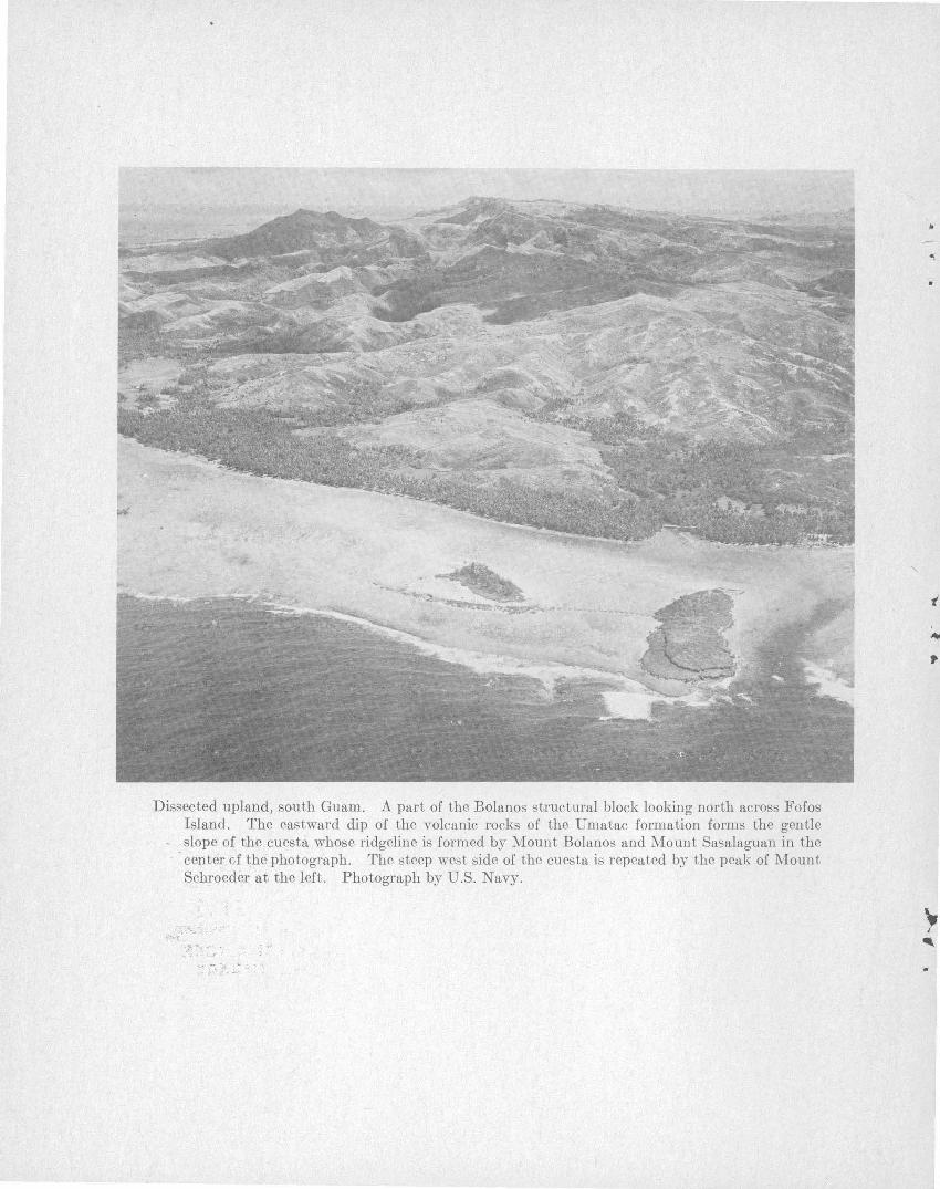
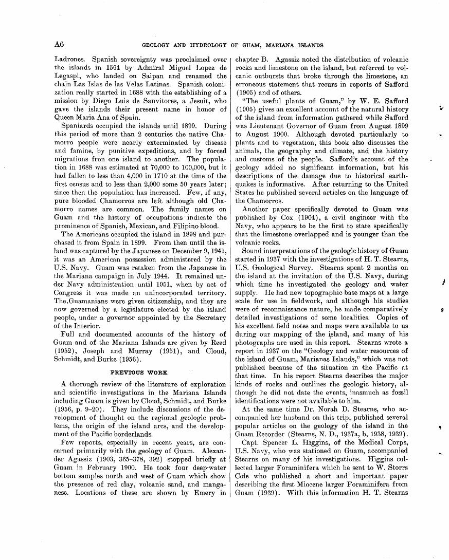
Dissected upland, south Guam. A part of the Bolanos structural block looking north across Fofos Island. The eastward dip of the volcanic rocks of the Umatac formation forms the gentle
- slope of the cuesta whose ridgeline is formed by Mount Bolanos and Mount Sasalaguan in the -c.enter of the photograph. The steep west side of the cuesta is repeated by the peak of Mount Schroeder at the left. Photograph by U.S . Navy.
:"' .. '
.o; .. -. ".> ... . :. -, - ;.."- .. .-· ...
•
,.
~ I
'
.,.
•• ..
General Geology
of Guam By JOSHUA I. TRACEY, JR., SEYMOUR 0. SCHLANGER,
JOHN T. STARK, DAVID B. DOAN, and HAROLD G. MAY
GEOLOGY AND HYDROLOGY OF GUAM, MARIANA ISLANDS
GEOLOGICAL SURVEY PROFESSIONAL PAPER 403-A
A study of the stratigraphy, structure, and\
Tertiary geologic history of the
southern most island of the
Mariana Arc
rtJBRARY
SURfAU Of 111111 &..ISRAR,
S P 0 k A N I. ~ AS fl.
JUN 31971 . .-.. .. ~·~
PtfASf lfTOifl tO liBRAII
UNITED STATES GOVERNMENT PRINTING OFFICE, WASHINGTON : 1964
UNITED STATES DEPARTMENT OF THE INTERIOR
STEWART L. UDALL, Secretary
GEOLOGICAL SURVEY
Thomas B. :!Solan, Director
The U.S. Geological Survey Library has cataloged this publication as follows :
Tracey, Joshua Irving, 1906-General geology of Guam, by Joshua I. Tracey, Jr. [and
others] Washington, U.S. Govt. Print. Off., 1964. iv, 104 p. illus., maps (3 fold. col. in pocket) diagrs., profile. 29
em. (U.S. Geological Survey. Professional paper 403-A) Geology and hydrology of Guam, Mariana Islands. Bibliography: p. 101-102.
1. Geology-Guam. I. Title. (Series)
For sale by the Superintendent of Documents, U.S. Government Printing Office Washington, D.C. 20402
f
'
CONTENTS
Abstract __________________________________________ _ Introduction ______________________________________ _
Scope ________________________________________ _
Acknowledgments _____________________________ _
IiistorY----------------------------------------Previous work _________________________________ _ Geographic setting _____________________________ _ Cl i Ina te ______________________________________ _
Temperature ______________________________ _ Rain f n,ll __________________________________ _ Winds and typhoons _______________________ _
Oceanographic setting _________________________ .. _ Earthquakes __________________________________ _
Tsunain~--------------------------------------llegional aspects _______________________________ _
Geologic succession ________________________________ _ Eocene and Oligocene series ________________ ~ ____ _
Alutom formation _________________________ _ Main body of Alutom formation _________ _ Mahlac member _______________________ _
Miocene series _________________ - _______________ _ Umatac formation _________________________ _
Facpi volcanic member _________________ _ Maemong limestone member ____________ _ Bolanos pyroclastic member ________ -:------Dandan flow member __________________ _
Bony a limestone ___________________________ _ Alifan limestone ___________________________ _
Talisay member _______________________ _ Typical exposures of the Alifan limestone __ Other Alif an limestone localities _________ _ Former extent of the Alifan limestone in
southern Guam ______________________ _ Fossils ______________ -------------------
Barrigada limestone ________________________ _ Janum formation __________________________ _
Pliocene and Pleistocene series ___________________ _ Mariana limestone _________________________ _
Reef facies ____________________________ _ Detrital facies _________________________ -Molluscan facies _______________________ _ Fore-reef facies ________________________ _ Distribution of facies ___________________ _ Agana argillaceous member _____________ _ Conditions of deposition of the Mariana
limestone ___________________________ _ Fossils and age ________________________ _
Recent series __________________________________ _ Merizo limestone __________________________ _ Alluvium _________________________________ _ Recent reefs _______________________________ -Boac h deposits _____________________ ---- _- _-
Structural geology _________________________________ _ Major aspects ________________________________ ~_
Bn.thymetric features _______________________ _ Structural provinces ________________________ _ Subsidiary structural features _______________ _
Page
A1 2 2 5 5 6 8 9 9 9
11 11 12 12 14 14 15 15 16 21 22. 22 22 25 27 28 29 31 31 32 34
35 37 37 41 44 44 44 45 46 46 47 47
49 50 50 50 52 53 53 53 53 53 53 55
Structural geology-Continued Structures within the principal stratigraphic units __ _
Alutom formation ______ --- ______ ----_-------U matac formation ___ ----- ___ -_-------------Miocene limestone formations ______________ --
Mariana limestone ___ -----------------------Uplift and subsidence ________ - ___ -_-------------
Physical geography __________ ----- __ --_-------------Limestone plateau _______ -----------------------Dissected volcanic uplands ______________ -_-_-_---
Tenjo block _______________________________ _
Bolanos block _________ - _- _____ -------------Interior basin _______ ---------------------------
'Valley floors and coastal lowlands ________________ _
Lateritic soil and bauxite _____ -----------------------Occurrence ____________________________________ _
Bauxitic material on volcanic rocks __ ---------Bauxitic material on limestone _____________ --Gibbsite and nordstrandite in limestone ____ ---Clay minerals __________ -- _____ -------------Possibility of economic deposits _____ ----------
Conditions of origin _______________ --------------Bauxitic rna terial on volcanic rocks ________ ---Bauxitic material on limestone _____ -_--------
Reefs of Guam ________________________ -------------Descriptions of reef sectors ______________________ _
Sector 1. Broad reefs from Tepungan to Tumon Bay ____________________________________ _
Sector 2. Reef fringing the cliffs from Gognga Beach to Ritidian Point_ __________ --------
Sector 3. Northeastern reefs fro_m Ritidian Point to Pati Point __________________ --_--
Sector 4. Eastern cliffed coast from Pati Point to Pago Bay ____________________________ _
Sector 5. Southeast coast from Pago Bay to Manell ChanneL ____________ -------------
Sector 6. Barrier reef and Cocos Lagoon from Manell Channel to Mamaon ChanneL ______ _
Sector 7. Reefs fringing basalt shore platforms from Mamaon Channel to Anae Island ____ -_
Sector 8. Irregular broad reefs from Anae Island to Orote Peninsula ______________________ --
Sector 9. Reefs of Apra Harbor and Orote Pe-ninsula _________________________________ _
Factors influencing reefs ____________ -------------Relation of reef margins to exposure _____ - __ --Relative effectiveness of growth and erosion __ --Relation of reefs to other geologic features ____ _
Geologic history ______________ - ________ -------------Pre-Eocene, Eocene, and Oligocene events _______ --Miocene events ____________________ ------ - ------
Umatac formation _____________ -- ____ - __ ----Bony a limestone __________________________ --Alifan limestone __________________ -- ___ --_--Events during the Miocene on north Guam_---
Pliocene, Pleistocene, and Recent events ___ -_------References cited _________________ -------------------Index ____________________________________________ _
III
Page
A57 57 59 60 60 60 61 62 66 67 68 69 70 71 71 72 73 73 74 74 74 74 75 76 76
76
79
79
81
81
88
90
92
92 92 92 93 93 94 94 95 95 96 96 97 97
101 103
IV CONTENTS
ILLUSTRATIONS
[Plates are in pocket]
PLATE 1. Geologic map and sections of Guam, Mariana Islands. 2. Sample locality map of Guam, Mariana Islands. 3. Geologic map and sections of Mount Santa Rosa area.
FIGURE 1. Index map of the western Pacific Ocean _______________ ..: ______________________________________________ _ 2. Sample locality grid for Guam, Mariana Islands _______________________________________________________ _ 3. Regional relations in the western north Pacific Ocean __________________________________________________ _ 4. Stratigraphic sections for Guam _____________________________________________________________________ _ 5. Weathered tuffaceous shale of the Alutom formation ___________________________________________________ _ 6. Partial stratigraphic section at Mount Santa Rosa _____________________________________________________ _ 7. Volcanic rocks from the Alutom formation ____________________________________________________________ _ 8. Lava flows and dikes at Facpi Point, Guam ___________________________________________________________ _ 9. Pillow lavas of the Umatac formation ________________________________________________________________ _
10. Weathered pillow lava ______________________________________________________________________________ _
11. Bedded tuffaceous sandstone of the Bolanos pyroclastic member of the U matac formation __________________ _ 12. Residual lava boulders from the Dandan flow member of the Umatac formation ___________________________ _ 13. Ali fan quarry, Mount Alifan, Guam ________ - ___________ --- __________________________________________ _ 14. Alifan limestone ______________________________________ --- __________________________________________ _ 15. Sketch of Bony a and Alifan limestones _______________________________________________________________ _ 16. Present distribution of the Alifan limestone and inferred former extent of the Alifan and Mariana limestones __ _ 17. Diagrammatic sketch of type section of Barrigada limestone ____________________________________________ _ 18. Histogram of lime sand from the Harmon quarry _________ --- __________________________________________ _ 19. Type section of the Janum formation ________________________________________________________________ _ 20. Relations of facies of the Mariana limestone __________________________________________________________ _ 21. Moll usc an facies of the Mariana limestone ____________________________________________________________ _ 22. Agana argillaceous member of the Mariana limestone __________________________________________________ _ 23. Merizo limestone near Facpi Point, Guam _______________ - ____________________________________________ _ 24. Sketch of Merizo limestone near Facpi Point, Guam ___________________________________________________ _ 25. Structural subdivisions of Guam and vicinity __________________________________________________________ _
26. Structure_sections A-A'-C-C' of Guam and vicinitY----------------------------------------------------27. Slump structures in tuffaceous shale ______________________________________________________________ .. __ _ 28. Structural development of middle Guam ______________________________________________________________ _ 29. Structural development of south Guam _______________________________________________________________ _ 30. Drainage pattern of Guam ___ ' _______________________________________________________________________ _ 31. Physiographic divisions of Guam ____________________________________________________________________ _ 32. Limestone cliffs at A mantes Point ___________________________________________________________________ _ 33. Limestone cliffs at Pati Point _______________________________________________________________________ _ 34. Limestone rampart, Lafac Point, north Guam _________________________________________________________ _ 35. Sketch of rampart and moat ________________________________________________________________________ _ 36. Sol uti on features of limestone _______________________________________________________________________ _ 37. Erosion surface on Mount Tenjo, Guam ______________________________________________________________ _ 38. Sketch of remnants of old erosion surface _____________________________________________________________ _ 39. Reef sectors around Guam _________________________________________________ ~ ________________________ _ 40. Bench at Saupon Point _____________________________________________________________________________ _
41. Aganareef-----------------------------------------------------------------------------------------42. Surge channels at Inapsan Beach ____________________________________________________________________ _
43. Pati Point, Guam-----------------------------------------------------------------------------------44. Algal spurs and rimmed terraces _____________________________ -.- ______________________________________ _ 45. Pago Point, Guam _________________________________________________________________________________ _ 46. Reef at f'\ga Point, Guam ___________________________________________________________________________ _
47. Reef fiat at Pago BaY-------------------------------------------------------------------------------48. Nips at Pago Point ________________________________________________________________________________ _ 49. Section across reef at Agfayan Bay __________________________________________________________________ _ 50. Cocos Lagoon, Guam ______________________________________________________________________________ _ 51. Reef flat near Manell ChanneL ______________________________________________________________________ _ 52. Profile of west reef of Cocos Lagoon ______________________________________________________________ ----53. Reef at Cetti Bay _________________________________________________________________________________ _
Page
A3 4
13 16 17 19 20 23 24 25 28 28 33 33 34 36 38 39 42 45 46 47 52 52 54 55 57 58 59 61 63 64 65 65 65 66 67 67 76 77 78 80 82 83 84 85 86 87 88 89 90 90 91
•
f
•.
\,·
,
GEOLOGY AND HYDROLOGY OF GUAM, MARIANA ISLANDS
GENERAL GEOLOGY OF GUAM
By JosnuA I. TnACl~Y, Jn., SEYMOUR 0. ScHLANGER, JoHN T. STARK, DAVID B. DoAN, and HAROLD G. MAY
ABSTRACT
Guam, the largest and southernmost of the Mariana Islnllds, is located nt Int. 13°28' N. and long. 144°45' E. It is 30 miles long, 4 to 11% miles wide, and is 212 square miles in area, excluding reefs. The north half of the island is a broad limestone plateau bounded by cliffs. The plateau slopes from an altitude of more than 600 feet at the north end to less than 200 feet near the middle of the island. The south half of the island is a dissected volcanic upland fringed with limestone along the east coast. No streams flow on the porous limestone of the north plateau, which is a groundwater province ; whereas the southern volcanic part of the Island contains numerous streams and is mostly a surfacewater province.
A chain of low mountains ranging from 1,000 to 1,334 feet high parallels the west coast in the southern part of the island. Fringing reefs surround most of the island, except for parts of the cliffecl coastline; Cocos Lagoon is formed by a. small barrier reef at the south end of the island. The fringing reefs range from narrow cut benches around limestone headlands to broad reef flats more than 3,000 feet wide.
Guam has a warm, humid climate. Daytime temperatures nre usually in the middle to hig·b eighties, and nighttime temperatures are in the middle to high seventies. Mean annual rainfall ranges from 85 to 115 inches ..
Typhoons are moderately common in the vicinity of Guam, and the chances are about 1 in 3 that in any year, one or more damaging typhoons will strike. The heaviest winds, storm waves, and the most intense rainfalls are associated with typhoons.
Earthqual{es are moderately common, and 19 shocl{S of moderate to severe intensity have been recorded since 1825.
The andesitic rocl{S of Guam are generally believed to show contin('ntal affinities; the exposed geologic column shows no evidence of deep burial or compressive tectonic forces ; the Island has been generally emergent since early Cenozoic time and contains mostly s·hallow-water deposits. No true deepsea deposits were found.
The column of rocl\S exposed on Guam ranges in age from lute F:oeene (Tertiary 1J of the Indonesian letter classification) to Hecent. The earliest roek unit is the Alutom formation of Tertiary b and o age, which forms the central part of the island. It consists of a sequence, 2,000 to 3,000 feet thicl\, of water-laid tuffaceous shale, sandstone, and conglomerate; lnva flows and blocky breccias; and reworked tuffbreccia and conglomerate containing fragments' of reef-assocint"Pd lim('st:one. 'l'he limestone-bp:uing brPccia and the Mahlac membt-r of the Alntom formation nre of Tertiary o age.
The southern part of the island is formed mostly of a volcanic sequence of Tertiary e age (early Miocene), the Umatac formation. This comprises the Facpi volcanic member-about 1,400 feet of pillow lavas, flow breccia, and tuffaceous shale; the Maemong limestone member that tongues into the upper part of the Facpi and contains an abundant Tertiary e fauna of larger Foraminifera; the Bolanos pyroclastic member-a thick-bedded reworked tuff breccia and volcanic conglomerate containing fragments of limestone of the Maemong member; and the capping Dandan flow member-a thin lava cap that is present only as scattered weathered remnants.
The Bonya limestone overlies older rocks unconformably and contains a fauna of larger Foraminifera of Tertiary f age. It is overlain by the Alifan limestone that now caps the highest peaks of Guam. The lower part of the Alifan, containing a basal clayey conglomerate that is called the Talisay member, is probably of Tertiary g age. In north Guam reef-associated limestone equivalent to the Alifan are present, although they are more difficult to recognize. A
· central part of ·the north plateau is formed of bank-type foraminiferal limestone called the Barrigada limestone, of Tertiary g age, that was probably contemporaneous with parts of the Alifan limestone. Along the east coast well-bedded globigerinicl limestone of the same age is called the Janum formation. Deposition of both the Alifan and Barrigacla forUlations possibly lasted well into Pliocene time ..
The Mariana limestone of Pliocene and Pleistocene age is the youngest major formation on the island. It forms most of the north plateau, the fringing limestone along the east coast of southern Guam, and the cliffed plateau of Orote Peninsula. It comprises a peripheral reef facies mostly along the presentday cliffs; a detrital facies that was deposited primarily in a lagoon in back of the reefs ; a molluscan facies of fine-grained lagoonal-type limestone rich in mollusk shells; and a peripheral fore-reef facies of sanely to rubbly limestone, containing Foraminifera considered diagnostic of Pleistocene and Recent age. Much of the Mariana limestone near its contact with underlying volcanic rocks contains clayey contaminates. The clayey limestone, which has a distinctive appearance and weathers in characteristic patterns, has been designated the Agana argillaceous member of the Mariana. It includes rocks of the facies recognized in the pure Mariana limestone.
At some time in the Pleistocene the island was elevated and sea levels shifted with recurrent glaciations. Terraces cut in the emerged limestone cliffs during these shifts were veneered with coral and algal growth younger than that on the plateau surface, but these are grouped with the Mariana limestone in this study. Only the lowest limestone deposited in Recent time during the 6-foot stillstand is called the Merizo
Al
A2 GEOLOGY AND HYDROLOGY OF GUAM, MARIANA ISLANDS
limestone. A radiocarbon date of 3,400±250 years was found for this limestone.
Guam is divided into three principal structural provinces. The north plateau tilts gently to the southwest and indicates that this block, and possibly the whole island, has been tilted in post-Mariana time (late Pleistocene). The central structural block is formed of early Tertiary volcanic rocks that are much deformed by small block faults, small tight folds, and, in some places, small thrusts. The Eocene rocks of the central block were derived from an early volcano, west of Guam, that has now collapsed. The structures within the block probably were caused by "free gliding" and superficial slumping and were incidental to the prolonged activity and subsequent collapse of the volcano, probably in Oligocene time. The southern structural block of Miocene volcanic rocks was derived from a second, later volcano southwest of the island. It is much less deformed by faults and shows only minor folds, but these structures are likewise related to the growth and collapse of the Miocene volcano.
The land surface of the island is divided into four principal categories: limestone plateau, dissected volcanic uplands, interior basin, and coastal lowland and valley floors.
The limestone plateau includes both the extensive nearly flat limestone surface of the north plateau and Orote Peninsula, formed on pure limestone, and the rather intricately dissected area formed on argillaceous limestone at the south end of the north plateau and along the southeast coast.
Dissected volcanic uplands have numerous remnants that indicate the configuration of a former rolling to hilly land surface. Small remnants of this surface capped with lateritic soil presumably were formerly capped by the Alifan limestone. Lateritic soil is not found higher than the inferred former extent of the Alifan limestone on volcanic rocks that stood as islands in the Alifan sea, nor lower than the shoreline of the later Mariana sea. Apparently the period of erosion of the emergent Alifan limestone and deposition of the Mariana limestone was a time of lateritic weathering.
No bauxite deposits are found on volcanic rocks, although gibbsite concretions are present in or on lateritic soil. Some of the red soil on pure limestone of the north plateau, however, contains 40 percent of alumina, 20 percent of iron, and 1 percent of silica. The soil is generally less than 1 foot thick, although small sinks and depressions contain more than 8 feet of the soil. No significant deposits of bauxite were found. The origin of the red soil on limestone is not yet clear.
The present studies show that by early Eocene time a thick sequence of volcanic rocks, from a volcano west of the present island, had built up near enough to sea level that reefs and reef-associated limestones could form. Explosive volcanic activity was possibly related to the collapse of a caldera, probably in early Oligocene time. In early Miocene time volcanic deposits were laid down by a volcano southwest of the island, and these deposits contain lenses of reefassociated limestone, indicating shoal to moderate water depths. Later deposits from this volcano show explosive activity and collapse.
The Bonya limestone was deposited at moderate depths during the Tertiary f age. In late Miocene time extensive shoalwater reefs and lagoons of the Alifan limestone were formed over most of the south half of the island, and thick bank limestones of the Barrigada limestone were deposited at moderate depths on the north plateau. A general period of emergence and weathering preceded resubmergence or" the island in Mariana (Pliocene and Pleistocene) time during which the north
plateau was an "almost-atoll" bounded by extensive wide peripheral reefs. Middle and late Pleistocene emergence and tilting are shown by several cut terraces veneered with coral and algal limestone. Recent stillstands are represented by well-defined nips at 5 and 9 feet above present mean sea level.
INTRODUCTION
SCOPE
Investigations of the geology, soils, an4 water resources of the island of Guam in the western Pacific Ocean (fig. 1), as well as other more specialized studies, were made as a part of a program of geologic mapping of some of the islands of the western Pacific conducted jointly by the Corps of Engineers, U.S. Army, and the U.S. Geological Survey. The results of these studies are published in parts 1 and 2 of the "l\1:ilitary Geology of Guam, Mariana Islands," by Tracey and others ( 1959). A field party of the Geological Survey was on Guam from 1951 to 1954. The water resources of the island have been investigated continuously since February 1951 under a cooperative agreement between the Government of Guam and the U.S. Geological Survey. The water studies were also sponsored in part, during the time of the field mapping, by the Corps of E'ngineers (U.S. Geol. Survey, 19()2; 'Varcl and Brookhart, 19()2).
Members of the Geological Survey field party and their period on the island are Joshua I. Tracey, Jr., 1951-54, David B. Doan, 1951-54; Harold G. May, 1951-54; John T. Stark, 1952-54; Seymour 0. Schlanger, 1951-53; Carl H. Stensland, 1952-54; James M. Paseur, 1953-54; and the late Joseph W. Brookhart, 1951-54. Brookhart was in charge of the waterresources program, which included the construction of 13 stream-gaging stations under the supervision of Raymond B. Chun. Continuing investigations of water resources have been carried on by Ernest Bishop, 1954-55; Porter H. Ward, 1955-58; and Santos Valenciano, 1955.
Special investigations in the field include studies of marine and coastal geology by Kenneth 0. Emery assisted by Stuart l(eesling during the smn1ner of 1952, studies of marine algae by .J. Harlan .Johnson in August 1951 and the fall of 1952, and a reconnaissance of the vegetation of the island by F. Raymond Fosberg in the winter of 1953-54. Allen H. Nicol supervised the collecting of sa1nples for engineering tests and reviewed the engineering geology units in the field during the spring of 1954. He was primarily responsible for the format of the engineering geology section of the military geology report. Edward H. Templin, of the U.S. Department of Agriculture, made a field inspection and review of the soils map units in June 1954.
..
'
'
'·.
'
GENEHAL GEOLOGY OF GUAM A3
LUZOtN P/1/L/PPINE Sf..l-1
SOl/Til C/1/NA
SEA PHILIPPINE ~' I ~ ~ • ~~ ISLANDS
JAPAN
BONIN IS;
VOLCANO I~ lwo Jima:
MARIANA IS':
Saipan •• ~
Guam/
Palawa~· ~&,~. Ml.ro;.~.~~ PALAU IS)
CAROLINE
Yap.
... ·.·. IS
BERING SEA
Attuo «:>
,Agrihan
~Pagan
,Aiamagan
'Guguan
• Zealandia bank 'Sarigan
Tinian/Saipan
·Aguijan
, Rota
-/c,uam
c \ f \ c
MARSHALL IS
Eniwetok' :Bikini
Wotje: Kwajalein·
.~onape Arno·
Onot~a·::
Funafuti
PHOENIX IS
Can~on .•••
·.
Johnston
's l..-<1
• !Vo 'cS> " . ~\?:
Pa!myra
FIGURE I.-Index map of the western Pacific Ocean showing the location of Guam and the Mariana Islands.
This chapter contains the discussion of the general geology of Guam. Subsequent chapters of the report are Chapter B, Marine geology, by IC 0. Emery; Chapter C, Petrology of the volcanic rocks, by J. T. Stark; Chapter D, Petrology of the limestones, by S. 0. Schlanger, with section on mineralogy of insoluble residues of the limestones by Dorothy Carroll and ,John lin,t.haway; Chapter E, Larger Foraminifera, by '~r. Storrs Cole; Chapter F, Mineralogy of selected soils of Guam, by Dorothy Carroll and John Hathaway, with section describing the soils profiles by' Carl
H. Stensland; and Chapter G, Fossil and Recent calcareous algae, by J. Harlan Johnson. Other chapters on hydrology and on Smaller Foraminifera are in preparation.
This chapter on the general 'geology is a product of t:he geologic mapping of the island by -the five geologists, although it owes much to close cooperation in the field with the soils scientist's and the ground-water geologist and to helpful identifications provided during the progress of the mapping by paleontologists, especially ,V'. Storrs Cole.
A4 GEOLOGY AND HYDROLOGY OF GUAM, MARIANA ISLANDS
First-draft descriptions of the lithology and stratigraphy of the rocks were prepared as follows: the Mariana, Barrigada, and Alifan limestones by H. G. May; the Alutom formation, and the Facpi volcanics, the Bolanos pyroclastic, and the Dan dan flow memhers of the Umatac formation by J. T. Stark; the Mahlac member of the .A:lutom, the Maemong limestone member of the U matac formation, the Bonya limestone and the Talisay member of the Alifan limestone by D. B. Doan; and the Janum formation by S. 0. Schlanger. The final draft of these sections was made by Tracey and Schlanger, and includes revised interpretations based on paJeontologic and petrographic information obtained af.ter the party had left the island. The section on structure was prepared by Schlanger; the sections on the physical geography and reefs of Guam by Tracey were based in part on a discussion of the landforms and major physiographic subdivisions of the island prepared by Doan (Tracey and others, 1959). Sections on lateritic soil and bauxite and on geologic history were prepared by Tracey.
Areal responsibilitN for the geologic map (pl. 1) is shown in an insert. The mapping was done on aerial photographs flown in 1948 by the U.S. Navy. These were at a scale of 1 : 28,000; older sets at other scales were also used. In January 1953 another set of vertical photographs at a scale of 1: 24,000 was flown by the Navy and was used during the later stages of mapping. The oblique photographs of the coast were flown by the U.S. •Navy in 1948.
The geologic map was compiled in the field on 1 : 20,-000-scale preliminary sheets of the 1 : 25,000-scale topographic map of Guam (AMS series W843, 11 sheets) published in 1955 in Tokyo. The geology was recompiled for publication on a 1-sheet map at a scale of 1 : 5o,ooo ( AMS series W7 43). The recompilation by Schlanger and Tracey in Washington made use of paleontologic and other data that became availa:ble after the completion of special studies. In the summer of 1955 Schlanger returned to Guam for 2 months to make collections in areas that paleontologic studies had shown to be critical an~ to check and remap several areas.
Fossil collections and rock specimens were numbered in the field according to a grid system based on minutes of latitude and longitude (fig. 2). Grid squares are lettered from A to Z west to east and from a to z south to north. vVithin each grid square, 1 minute in length and width, sample localities are labelled consecutively. At any locality successive samples and individual collections are numbered in order. Thus, sample Gn 3-2 is the second sample collected at locality 3 within grid square Gn. All localities men-
144'36' 40' 45' 50' 55' 144'58' 13'40'
zz
y
w
m
I
i
g
f
I 12 3 4 5 MiLES
/""""'
I \
N v '\.
r
~ ~~
I)
c\> I / 0 r l{
35'
,c v \~ _/ ~c
~ lr- .....-!_ ,-/./
b + _...-v 30'
ll--v r- --- / f=7/
~ ,/'
t' ~k } ®G n3 v ll \2 <'> ''-* ----v
1'\ ( ~~ ) ~ ~·'v-< c~
0
25'
c , I --.... "' .( t,__ .r= c'
...> ~~ 20'
I~ ( (
.~ ;sV \. l?
v_ ----!-"!-' 15'
ABCDEFGHI J KLMNOPQRSTUV 13'13'
FIGURE 2.--Sample locality grid for Guam, Mariana Islands.
tioned in the first seven chapters (A-G) of this report are shown on the sample locality map of Guam (pl. 2).
Localities of drill holes are shown only if they are specifically mentioned in the text. More complete well locations will be shown in a planned chapter on water resources.
Photographs of rock specimens are by Nelson Shupe. All other photographs not accredited are by the authors.
Some of the problems encountered in mapping a small volcanic and limestone island in a. structurally complex region have been described by Cloud, Schmidt, and Burke (1956). Most of the rocks of the island have been deposited on moderately steep slopes relatively close to sea level. In any rock unit marked changes in facies are to be expected within short distances up and down dip near the old shoreline. Changes also may be expected laterally, depending on the kind of shore and the nature of the offshore slopes at the time of deposition.
On a volcanic island, initial offshore slopes are generally moderate to steep, and therefore initial dips are large. Deposits tend to be built out peripherally rather than up to sea level, which leads to confusion in the meaning of thickness of deposits. Because of the rapidity of deposition of volcanic deposits and the instability of the region, the rock units are much
rl
j
•
GENERAL GEOLOGY OF GUAM A5
dist.urbed by submarine slumping and sliding on a large scnle.
Abrupt changes in facies, great alterations due to deep tropical weathering, especially of volcanic rocks, and the scattered occurrence of good outcrops in the thickly vegetated tropical island make it extremely difficult in places to correln.te from one outcrop to anot.her. In addition, the tilting of the island and displacement by faulting, and the up-and-down movement of t·hc shoreline through geologic time, make it very hard to make reasonable correlations from one part of t.lw isln.nd to another. Subaerial erosion is a continual process, and deposition of volcanic rocks either primary or reworked, or of fringing limestone, is nearly continuous. Thus, it is improbable that a marked erosional unconformity at one place on the island can be matched closely with that at a~wther place. For the same reasons one can never be certain that lithologically identical units of rock on different parts of the island are closely synchronous.
Our purpose in this chapter is to produce a general summary of the stratigraphy, structure, physical geography, and geologic history of the island that will provide a basis for the specialized studies to follow. We have therefore tended to condense the detailed data acquired during mapping, to group formations, and where possible, to extend correlations over the island in spite of the aforementioned difficulties.
ACKNOWLEDGMENTS
The field party was on Guam for more than 3 years and was aided and supported by representat~ves of the Army, the Navy, the Air Force, and the Government of Guam. Consequently, we are indebted to a great many people who helped in both official and personal ways; we can acknowledge here only those who were responsible for our support, or who contributed d i reetly to the investigations or to the reports.
We are indebted to Col. Julian D. Abel, commanding the Engineer Intelligence Division of the Far East Command, for a personal interest in the fieldwork that was most encouraging.
On Guam the party was supported logistically first by the Mariana-Bonin Command of the Army. Col. Paul M. Seiple, Assistant Chief of Staff for Supply, was most .helpful when the field party was first organized. Later when the Army left the island, support was transferred to the 19th Bombardment Wing,tTSAF, commanded by Brig. Gen. Robert Wimsatt, whose officers and staff were of constant help throughout the project. 'iVe are indebted also to Rear Adm. I~rnest W. Litch, Commander Naval Forces Marianas, and to members of his staff, particularly Capt. William
Sihler, Assistant Chief of Staff for Base Development, and the officers and engineers on his staff. Engineering tests of rock and soils samples were provided by the Base Development Testing Laboratory directed by Charles Shirley, who freely gave excellent advice and information on the engineering properties of rocks and soils in the tropics.
The first civilian Governor of Guam, the Honorable Carlton Skinner, took a personal interest in the work, and his aid was especially helpful at the start of the project. The dep~utments of the Government of Guam under Governor Skinner, and later under his successor the Honorable Ford Q. Elvidge, were most cooperative. Our particular thanks go to Mr. William Sinclair, Director of Public Works, and his successors, Mr. 'iVi1liam Hellier and Mr. Henry Meyer, and their staff for cooperation and helpful advice. They provided us with office space and many facilities.
We acknowledge the help given by Mr. Albert P. Bronson, of Agana, Guam, both because of his store of knowledge of marine life and the ecology of the reefs, and because of his generosity in sharing boats and other eql.1ipment.
Studies of the marine geology by K. 0. Emery, and of the reefs and offshore submarine terraces, were greatly aided by the generous loan of a 27-foot boat, the SES 800, from the Explorer Scouts, through Mr. Eugene l(rapf, Scout Executive for Guam.
Especial acknowledgment must be made to those of our Guamanian friends who acted as guides and who were most helpful because of their detailed knowledge of the life and geography of the island. These include Jose S. Quinata, of Umatac and Vicente Santos, of Piti, hydrologic field assistants; Vincente Santiago and Jose Santiago, of Umatac, Isidro Manalisay, of Merizo, and Frank Taitano, of Yigo.
Most of the geologic map units were reviewed in the field by Preston E. Cloud, Jr., in December 1953. The review was especially helpful because Cloud had spent several months in a reconnaissance of Guam in 1948 before his detailed mapping of Saipan. Harry S. Ladd collected mo11usks from Guam during the spring of 1958, making use of, and field-checking parts of, the revised geologic map and the stratigraphic descriptions of this report.
HISTORY
The Mariru.1a Islands were first discovered by western Europeans on March 6, 1521, when Ferdinand de Magellan made a 1 andfall on an island generally agreed to be Guam, a'lthough the original accounts are not clear and the first landfall may have b~en on the island of Tinian. He called the islands Islas de los
A6 GEOLOGY AND HYDROLOGY OF GUAM, MARIANA ISLANDS
Ladrones. Spanish sovereignty was proclaimed over the islands in 1564 by Admiral Miguel Lopez de Legaspi, who landed on Saipan and renamed the chain Las Islas de las V elas Latinas. Spanish colonization really started in 1688 with the establishing of a mission by Diego Luis de Sanvitores, a Jesuit, who gave the islands their present name in honor of Queen Maria Ana of Spain.
Spaniards occupied the islands until 1899. During this period of more than 2 centuries the native Chamorro people were nearly exterminated by disease and famine, by punitive expeditions, and by forced migrations fron one island to another. The population in 1688 was estimated at 70,000 to 100,000, but it had faJ]en to less than 4,000 in 1710 at the time of the first census and to less -than 2,000 some 50 years later; since then the population has increased. Few, if any, pure blooded Chamorros are left although old Chamorro names are common. The family names on Guam and the history of occupations indicate the prominence of Spanish, Mexican, and Filipino blood.
The Americans occupied the island in 1898 and purchased it from Spain in 1899. From then until the island was captured by the Japanese on December 9, 1941, it was an American possession administered by the U.S. Navy. Guam was retaken from the Japanese in the Mariana campaign in July 1944. It remained under Navy administration until 1951, when by act of Congress it was made an unincorporated territory. The.Gua:manians were given citizenship, and they are now governed by a legislature elected by the island people, under a governor appointed by the Secretary of the Interior.
Full and documented accounts of the history of Guam and of the Mariana Islands are given by Reed (1952), Joseph and Murray (1951), and Cloud, Schmidt, and Burke ( 1956).
PREVIOUS WORK
A thorough review of the literature of exploration and scientific investigations in the Mariana Islands including Guam is given by Cloud, Schmidt, and Burke ( 1956, p. 9-20). They include discussions of the development of thought on the regional geologic problems, the origin of the island arcs, and the· develop· ment of the Pacific borderlands.
Few reports, especially in recent years, are concerned primarily with the geology of Guam. Alexander Agassiz ( 1903, 365-378, 392) stopped briefly at Guam in February 1900. He took four deep-water bottmn samples north and west of Guam which show the presence of red clay, volcanic sand, and manganese. Locations of these are shown by Emery in
chapter B. Agassiz noted the distribution of volcanic rocks and limestone on the island, but referred to volcanic outbursts that broke through the limestone, an erroneous statement that recurs in reports of Safford ( 1905) and of others.
"The useful plants of Guam," by W. E. Safford (1905) gives an excellent account of the natural history of the island from information gathered while Safford was Lieutenant Governor of Guam from August 1899 to August 1900. Although devoted particularly to plants and to vegetation, this book also discusses the ·animals, the geography and climate, and the history and customs of the people. Safford's account of the geology added no significant information, but his descriptions of the damage due to historical earthquakes is informative. After returning to the United States he published several articles on the language of the Chamorros.
Another paper specific~lly devoted to Guam was published by Cox (1904), a civil engineer with the Navy, who appears to be the first to state specifically that the limestone overlapped and is younger than the volcanic rocks.
Sound interpretations of the geologic history of Guam started in 1937 with the investigations of H. T. Stearns, U.S. Geological Survey. Stearns spent 2 months on the island at the invitation of the U.S. Navy, during which time he investigated the geology and water supply. He had new topographic base maps at a large scale for use in fieldwork, and although his studies were of reconnaissance nature, he made comparatively detailed investigations of some localities. Copies of his excellent field notes and maps were available to us during our mapping of the ~sland, and many of his photographs are used in this report. Stearns wrote a report in 1937 on the "Geology and water resources of the island of Guam, Marianas Islands," which was not published because of the situation in the Pacific at that time. In his report Stearns describes the major kinds of rocks and outlines the geologic history, although he did not date the events, inasmuch as fossil identifications were not available to him.
At the same time Dr. Norah D. Stearns, who accompanied her husband on this trip, published several popular articles on the geology of the island in the Guam Recorder (Stearns, N.D., 1937a, b, 1938, 1939).
Capt. Spencer L. Higgins, of the Medical Corps, U.S. Navy, who was stationed on Guam, accompanied Stearns on many of his investigations. Higgins collected larger Foraminifera which he sent toW. Storrs Cole who published a short and important paper describing the first Miocene larger Foraminifera from Guam (1939). With this ~nformation H. T. Stearns
..
GENERAL GEOLOGY OF GUAM A7
(1940) was enabled to date the volcanism of Guam as of l\1iocene age. l-Ie stated that the capping limestone on l\1ount Lamlam was deposited after cessation of volcr~nism nnd intense deformation, and that this deposition was foHowed by emergence and subaerial erosion. Resubmergence to 700 feet led to deposition of the limestone of the north plateau which Stearns believed to be Pleistocene in age. The latest events were a complicated series of emergences and submergences to the present island level, at which the vnlley mouths are partly drowned.
Another paper by Stearns concerns the shore benches on nort·.h Pacific islands (1941) with especial reference to the cut benches of Amantes Point and other localities on Guam, and "Eustatic shorelines of the Pacific" (Stearns, 1945) makes passing reference to the terraces on the north end of Guam.
.Japanese investigations of the structure and stratigntphy of the .Japanese Mandated Pacific Islands resulted in numerous reports between 1931 and 1941. St..-atigraphic information for Saipan and the southern Mariana Islands was sun1marized by Asano (1939) who sho,\·ed that Tertiary rocks of Miocene age ("Oligocene" of Asano) were present on Farallon de Medini·lln, Tinian, Rota, and Saipan, and that Eocene rocks were present on Saipan. During the Japanese occupation of Guam the island was visited by Tayama who named and described many rock units and published a table showing correlations with other is]ands of the Marianas, Yap, and Palau (Tayama, 1952, table 4). IIe assigned the "Fen a beds" and "N agas beds" of Guam to the Eocene and placed them as equiva]ent to the "Densinyama Beds" and "Matansa Beds" belonging to the "Omnerina group" of beds at the top of the Eocene of Saipan. No account of fossils from Guam was published to corroborate this conclusion, however.
The rock units named by Tayama were not formally described and type localities were not designated. Also Tayama's studies on Guam were made during wartime and were much briefer and less detailed than his studies on Saipan. We have therefore used only a few of his names-redefining the units where necessary-and have not retained those about which we were in doubt. Tayama made significant observations on t.he geology and geomorphology and tried to make region a 1 correlations of rock units and of terrace levels over a very large area of the Pacific. In a detailed or exact sense he failed, but he recognized the predominance of early Tertiary volcanism in the southern l\1arianas; the presence during the early TerUary of shallow-water coral reefs that are now interbedded with the early volcanic rocks; and the presence of widespread coral reefs during the later
Tertiary now uplifted and dissected at many levels by cut terraces or benches.
Following 'Vorld War II several geologists of the U.S. Geological Survey made brief examinations of Guam for the U.S. Commercia;] Co. in an economic survey of :Micronesia, in 1946. Josiah Bridge examined the bauxite and manganese prospects and A. N. Piper, the water resources.
In planning and carrying out the reconstruction of Guam by the U.S.Navy, a series of geologic and engineering studies were made by the Pacific Islands Engineers, Architect-Engineers to the Navy under contract NOy13626. The literature on geology, meteorology, and oceanography for Guam and the surrounding region was reviewed, and mimeographed reports prepared. Surface-geology maps and mimeographed reports were prepared on the geology· of the middle part of Guam, excluding the north and. south ends of the island. Their large collections of fossils, chiefly mollusks from quarries and outcrops, form the major part of collections from Guam being studied by H. S. Ladd.
Geologists for the Pacific Islands Engineers also described in detail the lithologic logs of about 350 core-drill holes, drilled to depths of as much as 650 feet at various localities about the island, mostly in connection with engineering studies for construction sites or for water supply. A large reference selection of these cores is kept by the Base Development Laboratory of the U.S. Navy on Guam. A small representative selection was sent to Washington, D.C., for study by the U.S. Geological Survey.
In 1948, P. E. Cloud, Jr, and R G. Schmidt, both of the U.S. Geological Survey, spent several months in a reconnaissance of Guam before starting their detailed studies of Saipan (Cloud and others, 1956). They made collections and prepared several preliminary reports. A report by Cloud in 1951, given only limited distribution, pertained principa1ly to the water supply of the island.
The occurrence of an Eocene foraminiferal fauna from Guam, recorded by Oloud and Cole (1953), showed that volcanism was active in Eocene time on Guam as it was on Saipan. Cloud and Cole questioned the occurrence of primary post-Eocene volcanism in the southern Mariana Islands, but the present work confirms that H. T. Stearns ( 1940) was correct in stating that Miocene Foraminifera occur in shales and marls with andesitic tuff and agglomerate laid down during an intermittent explosive phase of volcanism.
An outline of the sequence of events in the geologic history of Guam determined by the writers was presented at the 8th Pacific Science Congress in 1953
A8 GEOLOGY AND HYDROLOGY OF GUAM, MARIANA ISLANDS
in Manila. Abstracts of the papers sketched the purpose of the geologic program (Tracey, 1956), the stratigraphic sequence (Stark and Schlanger, 1956), the younger limestones and ]ate geologic history (Doan and May, 1956), the water resources (Brookhart, 1956) and the soils (Stensland, 1956).
Correlations of stratigraphic sections on many islands of the western Pacific including Guam were compiled by Cloud and presented at that Congress ( 1956). Shore features of Guam are discussed by Cloud (1954) in a paper describing features of modern reefs.
Kesling ( 1958) describes a beautifully preserved fauna of crabs weathered from material dredged from Apra Harbor. The excellent material he describes is unfortunately not definitely placed in the geologic section; but J(esling has carefully evaluated the stratigraphic significance, and it is apparent that considerable detailed information on the late geologic history of the island will come with careful study of material cored or dug below sea level in aNuvial and harbor deposits.
Military geology reports by the writers (Tracey and others, 1959) include studies of geology, soils, vegetation, engineering geology, and engineering soils. Detailed discussion of the vegetation has been published by Fosberg ( 1960).
GEOGRAPHIC SETTING
Guam is the largest and the most southerly of the Mariana Islands. It lies in the western Pacific Ocean about 1,200 nautical miles east of the Philippine Islands, 1,500 miles south-southeast of Japan, and 1,000 miles north of New Guinea (fig. 1). The town of Agana, is near the middle of the island, at lat 13°28¥2' N.; long 144°45' E. The island is 30 miles long and tapers in width from 8 miles at the northeast to 4 miles at the central waist; it widens again to the south to a maximum width of 11% miles from Orote Point on the west to Ylig Bay on the east coast. The land area exclusive of the reefs is 212 square miles, based on planimetry of the Army Map Service maps. North of the narrow waistline, which extends from the town of Agana to Pago Bay, the axis of the island trends northeast; south of the waist, the trend is northsouth.
A network of paved roads covers the north and central parts of the island and follows the coast around the southern end. Secondary unpaved roads allow access to :r;nost parts of the island, except during parts of the rainy season. The island is served by several commercial airlines and shipping lines.
The 15 small islands of the Mariana group are the high points of a submarine ridge that is bowed to the east. The ~1ariana Trench lies 60 to 100 miles east of the ridge and passes south and west of Guam. Deepest points in the trench are the Nero deep ( 5,269 fathoms), 75 miles to the southeast of Guam, and the Challenger deep ( 5,960 fathoms), about 210 miles southwest of the island.
The northern half of Guam is a broad gently undulating limestone plateau bordered by steep cliffs. The plateau slopes southwestward from an elevation of more than 600 feet at the northeast to less than 200 feet near the central waist of the island. Three prominent hills rise above the level of the plateau. Mount Santa Rosa ( 858 ft; 262 meters) and Mataguac Hill ( 630 ft.; 192 meters) are inliers of volcanic rock, and Barrigada Hill ( 665 ft; 203 meters) is made of limestone. The limestone is so permeable that no permanent· streams exist on the plateau, although several small intermittent streams dissect the low limestone land near Agana. The plateau is bordered in places by a narrow and irregular coastal plain and fringed by reefs. The steep sea ward cliffs around the plateau are marked here and there by a series of wave-cut benches or terraces.
The southern half of Guam is primarily a dissected volcanic upland. A discontinuous ridge of mountains parallels the west coast 1:Y2 to 2 miles inland, and most of the peaks are more than 1,000 feet high. Mount Lamlam, the highest point on the island, is 1,334 feet ( 405 meters) in height and is capped by limestone. The west coast is bordered by a narrow coastal lowland in most places, and the east coast by limestone cliffs 100 to 300 feet high. Reefs surround the south half of the island, and they are cut by numerous bays at the mouths of the large permanent streams that drain the volcanic upland.
The twofold division of Guam into a northern limestone province and a southern volcanic province broadly defines the major soils provinces of Guamchiefly limestone soils on northern Guam and chiefly volcanic soils on southern Guam-and also separates the island into two water provinces. The northern limestone plateau of highly permeable rock is a groundwater province containing a modified basal freshwater lens that floats on salt water, according to the Ghyben-Herzberg principle; whereas the southern half of relatively impermeable weathered volcanic rocks is chiefly at surface-water province ('V"ard and Brookhart, 1962).
The two major provinces, in turn, may be subdivided. The north half of the island, which shall be referred to as north Guam, is separated from the south
•
•.
GENEIRAL GE:OLOGY OF GUAM A9
half by a major fault zone at the narrow waistline of t-.l1e island between Adelup Point and Pago Bay. Nort·h Guam includes the uplifted and relatively undissected plateau of pure limestone mostly north of Bnrrigada, overlain by thin red ·lateritic soil, and a smaller area of argiHaceous limestone south and west of Barrigada, covered by yellow to brown clayey soil. 'fhe argillaceous limestone also fringes the east coast of the southern part of the island as far south as lnarajan and Agfayan Bay. It forms a plateau much dissect"ed by n,n intricate drainage pattern as weH as by large sinks. 'iVater flows in the streambeds throughout most of the area only for short periods after very heavy rains.
The southern volcanic province includes two areas which shaH be called central Guam and south Guam. Central Guam is made up chiefly of much-folded and fauHed Eocene volcanic rocks. It is bounded on the northeast by the aforementioned Adelup-Pago fault and on t·he southwest by a major fault zone along the 'Talofofo River valley and the south side of Orote Peninsula. South Guam consists mostly of a thick sequence of Miocene flows, tuffaceous shale, and reworked tuff breccia that forms an east-dipping cuesta.
CLIMATE
Except for the years of Japanese occupation, systematic observations of the climate of Guam are available for the period 1906 to the present. In 1948 the Pacific Isla,nds Engineers compiled a "Historical Review of the Meteorology of Guam" for the U.S. Navy, which summarized records from 1906 to 1941. A more recent study of the climate of Guam was prepared by David Bhnnenstock, of the U.S. Weather Bureau (in Tracey and others, 1959).
The following discussion of the climate of Guam is drawn from the mimeographed reviews and reports of the Pacific Islands Engineers, from the "Local Area Forecasters Manual" (typewritten) compiled in 1 953 by a forecaster of the Fleet Weather Central on Guam, and from the detailed study of Mr. Blumenstock.
The climate of Guam is determined by the westwardmoving warm humid air of the tropic latitudes. This westward-moving air is produced between the subtropical anticyclones of the northern and southern hernispheres. Major variations in the weather are produced by disturbances of this westward-moving fiow in the form of eddies or whorls that form continuously, sweep westward, and dissipate. These are counterclockwise or cyclonic in the northern hemisphere. Some of these grow to large size to become tropical storms, and those having winds of 65 knots or
more are typhoons. The westward procession of these disturbances migrates north and south with the seasons and generally follows displacement of the subtropical anticyclones, which in turn is caused by, and lags behind, the march of the sun north and south of the equator. As Guam is at ]at 13°N., the disturbances pass near Guam most frequently after the summer solstice; accordingly, the months from July to November are the rainy season. The disturbances are generally well south of Guam during the months from January to May, and this period is the dry season. J nne and December are transitional months.
TEMPERATURE
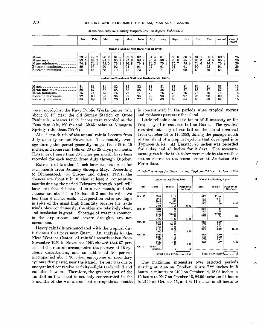
The average annual temperature at Sumay, near Apra flarbor, over a period of 26 years was 80.9°F. ~1ean temperature variations are slight from month to month. In the Apra Harbor area, for example, the ,coolest month averages 79.2°F and the warmest averages 82.5°F. At all locations except on the highest peaks, daytime temperatures are usually in the middle to high eighties, and nighttime temperatures in the middle to high seventies. The highest temperature reported at Sumay was 95°F, although in most places the temperature rarely exceeds 90°F. The lowest temperature reported was 64°F, although in most places a temperature below 70° F is rare. Seasonal variations are shown in the table on page A10.
The temperature is dependent on both location and elevation, for places exposed to the trade winds along the eastern coast are generally somewhat cooler than places on the west coast in the lee of the mountains. Average temperatures on mountain tops are 3° to 4 ° F cooler than at sea level.
RAINFALL
The mean annual rainfall on Guam ranges from less than 90 inches in the vicinity of Apra Harbor in the lee of the mountains to more than 110 inches in the higher mountain areas (Blumenstock, in Tracey and others, 1959, p. 24; Jordan, 1955). The average annual rainfall at 3 stations having reliable records for more than 10 years is 86.5 inches at Suma.y ( 41 yr; 1906-39; 1947-53) ; 89.3 inches at the Agana Navy Yard (19 yr; 1915-33); and 93.8 inches at the Agricultural Experiment Station at Barrigada (14 yr; 1918-31). At any one locality the rainfall varies greatly from year to year. A maximum of 119.35 inches was recorded at the Agana Navy Yard in 1916 and a minimum of 57.14 inches in 1926.
Rainfall records after 1952 were collected from numerous stations on Guam by the Navy, the Air Force, and the Geological Survey. A comparison of these records for the year 1953 shows that 94.38 inches
AlO GEOLOGY AND HYDROLOGY OF GUAM, MARIANA ISLANDS
Mean and extreme monthly temperatures, in degrees Fahrenheit
I Jan, I Feb. I M.,, I Ap,, I May I June I July I Aug. I Sept. I Oet I Nov. I Deo. I Annual I ';:'J'
Sumay station at Apra Harbor (at sea level)
~ean ____________________ 79. 2 79. 2 80. 2 81. 5 82. 3 82. 5 81. 4 81. 0 80. 8 80. 8 81. 1 80. 4 80. 9 2 6 ~ean maximum ___________ 83. 5 84. 2 85. 3 86. 9 87.8 88. 2 86. 4 86. 2 86. 0 85. 6 85. 6 84. 6 85. 8 2 ~ean minimum ___________ 74. 8 74. 1 75. 0 76. 1 76. 8 76. 8 76. 3 75. 9 75. 7 75. 9 76. 6 76. 1 75. 8 2
6 :,.; 6
Extreme maximum ________ 89 93 90 92 94 94 92 91 91 91 90 92 94 2 6 Extreme minimum _________ 68 64 68 70 71 72 70 71 70 69 69 70 64 2 6
Agriculture Experiment Station at Barrigada (alt., 250 Ct)
~ean ____________________ 81 81 81 82 82 ~ean maximum ___________ 86 87 87 88 88 ~ean minimum ___________ 75 74 75 76 77 Extreme maximum ________ 92 100 96 96 99 Extreme minim urn _________ 65 68 69 70 71
'vere recorded at the Navy Public Works Center ( alt, about 60 ft) near the old Sumay Station on Orote Peninsula, whereas 119.92 inches were recorded at the Fena dam ( alt, 120 ft) and 132.65 inches at Almagosa Springs ( alt, about 700 ft).
About two-thirds of the annual rainfall occurs from Ju]y to early or mid-November. The monthly average during this period generaHy ranges from 12 to 15 inches, and some rain frulls on 20 to 25 days per month. Extremes of more than 26 inches per month have been recorded for each month from July through October.
Extremes of less than 1 inch have been recorded for each month from January through May. According to Blumenstock (in Tracey and others, 1959), the chances are about 6 in 10 that at least 2 consecutive months during the period February through April will have less than 4 inches of rain per month, and the chances are about 4 in 10 that an 3 months will have less than 4 inches each. Evaporation rates are high in spite of the usual high humidity because the trade winds blow continuously, the skies are relatively clear, and insolation is great. Shortage of water is common in the dry season, and severe droughts are not uncommon.
Heavy rainfalls are associated with the tropical disturbances that pass near Guam. An analysis by the Fleet Weather Central of rainfa'll records taken from November 1952 to November 1953 showed that 67 percent of the rainfaH accompanied the passage of 16 cyclonic disturbances, and an additional 20 percent accompanied rubout 70 other embryonic or secondary cyclones that passed near the island; t.he rest was due to unorganized convective activity-light trade wind and cumulus showers. Therefore, the greatest part of the rainfall on the island is not only concentrated in the 5 months of the wet season, but during those months
82 81 81 81 81 82 81 81 15 88 87 86 87 87 88 87 87 15 77 76 76 76 76 76 76 76 15 93 98 93 93 97 95 98 100 15 72 68 69 69 64 69 68 64 15
is concentrated in the periods when tropical storms and typhoons pass near the island.
Little reliable data exist for rainfall intensity or for frequency of intense rainfall on Guam. The greatest recorded intensity of rainfall on the island occurred from October 14 to 17, 1953, during the passage north of the island of a tropical cyclone that developed into Typhoon Alice. At Umatac, 26 inches was recorded for 1 day and 48 inches for 2 days. The measurements given in the table below were made by the weather station elosest to the storm center at Andersen Air Force Base.
Rainfall readings for Guam during Typhoon "Alice," October 1953
Andersen Air Force Base Naval Air Station, Agana
Date Time Inches Daily total Time Inches Daily total (inches) (inches)
Oct. 13 0334 0.10 0400 Trace 0945 .00 1000 0.01 1548 .00 1600 . 01 2146 Trace 2200 .00 0. 02 2400 .47 0. 57
Oct. 14
OOMI "I J MOO I ·"I 0948 . 26 1000 .18 1546 Trace 1600 Trace 2146 .82 2200 .04 .39 2400 7.22
Oct. 15
~·I .~I ,.J ~I 2291 0947 10.15 8.61 1546 3.26 1600 2.38 2149 3. 59 2200 2. 52 15.80 2400 .62
Oct. 16 0345 1. 86 0400 1.60 0946 1.83 1000 1.30 1547 .72 1600 1. 42 2149 1.18 2200 .50 4. 82 2400 .12 5. 71
Oct. 17 24-hr period __ .82 .82 ------------------------ ---------------
Total 5-day period _____ 33.91 Total 4-day pcrjod ______ 21.03
The maximum intensities over selected periods starting at 2146 on October 14 are 7.22 inches in 2 hours 14 minutes to 2400 on October 14, 18.05 inches in 12 hours to 094 7 on October 15, 24.90 inches in 24 hours to 2149 on October 15, and 32.11 inches in 48 hours to
}
I
•
GENE,RAL GEOLOGY OF GUAM All
21.49 on October 1.6. Readings during the same storm, by the Fleet 'Veather Central at Naval Air Station a.bout ll miles southeast of the Andersen station, are given for comparison.
The only other comparable records were made during the typhoon of October 24, 1.924, and were reported in a 2-page typewritten report of the U.S. Department of Agrieulture, "Typhoon and Flood Strikes Guam"; these records were quoted by Pacific Islands Engil.leers in 1.948 (unpublished data). Rain gages showed that. the downfall amounted to 19 Inches in 1.5 hours, 2H.25 inehes in 80 hours, and 33.09 inches in 48 hours. Thus, rainfall amounting. to more than 20 inches in 24 hours and to more than 30 inches in 48 hours has oceu rred at least twice in the half century of recorded rai11:fa.ll. Rainfall of l inch in l hour occurs several t·.imes eae.h year on Guam. Rainfall of 2 inches or more per hour is rare, but· it usually occurs once or twice each ye~u'.
WINDS AND TYPHOONS
During the dry season easterly trade winds dominate, wind speeds commonly exceed 15 miles per hour, and ealms are rare. 'V"inds have a strong northerly component from November through March and a strong sont.herly component from April through June. From .Tnly through October, winds are highly variable and may eome :from any direction, wind speeds seldom exceed 1.5 miles per hour, and calms are frequent. Strong winds of 25 miles per hour or more are nearly a.l ways associated with cyclonic disturbances.
Typhoons are moderately common in the vicinity o:f Guam. They may occur in any month, but they arc about five times more likely to occur during the wet season than during the dry season. The chances al'e appt·oximately 2 in 3 that one or more typhoons will pass within 1.20 nautical miles of Guam in any parHeuln.r year. The chances are about l in 3 that in any year one or more typhoons will cause considerable damage. They b,·ing high seas, destructive winds, and flooding rainfall, and are one of the principal agents of erosion and redistribution of sediments.
l~"'rom 1805 when Americans first occupied the island, t.o August 1954, six extremely destructive typhoons are l'eeorded:
1900, November 13 ___ 34 persons killed. The sea rose at at least 12 ft and flooded the Plaza at Agana.
l91.R, .Tuly 6 _________ 2 persons killed. Winds of 125 mph recorded, with almost com7
plete destruction of houses. 1923, March 25 ______ Gusts recorded to 156 mph. Dam-
716-2910-64-2
age to roads and crops from the sea.
1924, October L _____ Extremely destructive, but most damage was by flooding due to excessive rainfall.
1940, November 3 __ _-_ Winds more than 75 mph for 12 hr; gusts of 170 mph.
194fl, November 17 ___ Typhoon Allyn, winds of 95 mph, gusts to 125 mph estimated. Sea rose 2 to 4 ft over Coast Guard Station on Cocos Island.
About 20 damaging typhoons (including the destruct.i ve ones) have been recorded in the period 1.898 to 1954.
OCEANOGRAPHIC SETTING
The ocean dominates the island of Guam and is largely responsible for its olimate. The ocean temperah.Jre is about 81 °F the year round. The North Equatorial Current, caused by the northeast trades, generally sets in a westerly direction near the island of Guam with a velocity of lh to 1 knot.
Tides at Guam are semidiurnal with a mean range of 1.6 feet and a diurnal range of 2.3 feet. Datum for -the island is mean lower low water, and other applicaJble data with relation to this datum are tabulated below:
Feet ~1ean higher high water ____________________ 2.3 Mean high water __________________________ 2. 2 Mean water leveL _________________________ 1. 4
Mean low water--------------------------- . 6 Mean lower low water_____________________ . 0
Extreme predicted tide range at Guam is about 3.5 feet; during June and December it is from +2.6 to -0.9 feet.
Wind waves (sea) are mostly from the northeast to southeast and are driven by the trade winds. Normal trade-wind waves are low (less than 2 ft) to medium (less than 9 ft), and range mostly from 3 to 5 feet in height. "Vincl '"aves higher than 9 feet are usually associated with storms. Occasional calms happen from April to September, but periods of more than 2 days of calm are rare.
Large waves 15 to 25 feet in height are sometimes associated with large typhoons that strike the island. :Most commonly, such waves strike Guam after the typhoon has moved north or west past the island. During Typhoon Allyn in November 1949, large stretches of beach from Merizo to Ylig Bay were destroyed, and water 2 to 5 feet deep passed over large parts of Cocos Island. Less commonly, large waves are caused by storms at a considerable distance from Guam. On December 17, 1953, large waves generated by a typhoon 350 miles north of Guam damaged Marine Drive (route 1) and many buildings near Asan, Piti, and Agana. On March 27 and 28, 1952 the Glass
A12 GEOLOGY AND HYDROLOGY OF GUAM, MARIANA ISLANDS
Breakwater at Apra Harbor suffered extensive damage by waves generated by a high pressure area off the coast of Japan 1,200 miles northwest of Guam.
The number, intensity, frequency, and nearness to Guam of these disturbances controls the greatest part of the annual rainfall, as well as the intensity with which it falls. The amount and intensity of rainfall determines the available water supply and controls the physiographic and weathering process, thereby affecting the geologic history of the island.
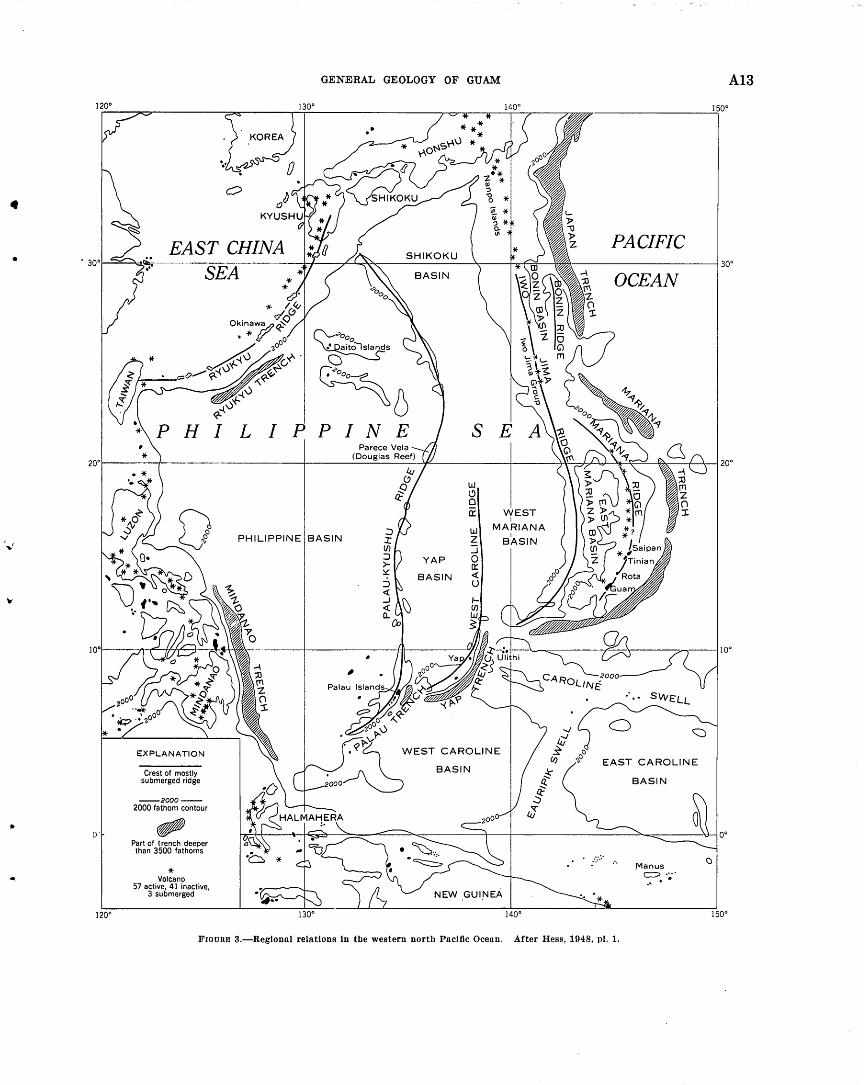
EARTHQUAKES
Guam lies about 70 miles northwest of the deep Mariana Trench, and is therefore in an active seismic zone (fig. 3). Repetti (1939) published a "Catalogue of earthquakes felt in Guam, 1825-1938," compiled from many sources, including records and observations of the Guam Seismograph Station that were destroyed during World War II.
The most destructive earthquakes listed in Repetti's catalogue are tabulated below; the table gives the estimated intensities on the Rossi-Forel and modified Mercalli scales.
Date
Equivalent intensity, Estimated intensity, modified Mercalli
Rossi-Forel scale scale
April1825__________________ VIII VII-VIII May 1834___________________ VIII VII-VIII Jan. 25, 1849________________ IX VIII-IX July 1, 1862_________________ VII VI Dec. 7, 1863 _ _ _ _ _ _ _ _ _ _ _ _ _ _ _ _ VI V-VI June 24, 1866_______________ VI V-VI May 13, 1870_______________ VI V-VI May 16, 1892_______________ VIII VII-VIII Sept. 22, 1902_______________ IX VIII-IX Dec. 24, 1902_______________ VI V-VI Feb. 10, 1903________________ VII VI Dec. 10, 1909_______________ VIII VII-VIII Oct. 26, 1912________________ VI V-VI May 10, 1917_______________ VI V-VI Nov. 24, 1917.--------------- VI V-VI June 12, 1932_______________ VI V-VI Oct. 30, 1936________________ VIII VII-VIII Nov. 12, 1936_______________ VI V-VI Dec. 14, 1936_______________ VII VI
Great damage by the severe earthquake of 1902 was described in some detail by Cox (1904) who mentioned, among other observations, that many landslides in the mountains were caused by the shocks. Many shallow, intermediate, and deep earthquakes in the Mariana area from 1904 to 1950 are tabulated by Gutenberg and Richter ( 1954). Of these, only four resulted in damaging earthquakes reported by Repetti and tabulated above. Data for these four taken from Gutenberg and Richter ( 1954, tables 17, p. 188; 18, p. 263) are shown below. Magnitude is measured on the Richter scale.
Time North East Depth Date (G.m.t.) latitude longitude (Km) Magnitude
(degrees) (degrees) -
Oct. 26, 1912 __ 09:00:6 14 146 130 7 June 11, 1932 __ 17:00:00 137f 1457~ 60 6 Oct. 29 (30),
1447~ 60 6% 1936 ________ 18:38:52 13~ Nov. 12, 1936 __ 02:15:58 177~ 147 170 67~
All four epicenters are fairly close to Guam, the closest being the October 29 ( 30), 1936 shock, only 15 miles northwest of the island, which did the most damage. The other destructive earthquakes between 1909 and 1936, inclusive, doubtless resulted from shocks that were not large enough on an absolute scale to be recorded by Gutenberg and Richter, but which occurred at epicenters very near or under the island.
Since the war no consistent records were kept of seismic activity until 1956, when the U.S. Navy set up a seismograph station. In 1960 the U.S. Coast and Geodetic Survey established the Guam Magnetic Observatory for both seismic and magnetic observations. During 1951 and 1952 the U.S. Navy Microseismic La:boratory on Nimitz Hill kept records of seismic shocks, using an adapted microseismograph. Records from the station during this period show an average of about two shocks a day strong enough to be recorded. Of these, about two per month were strong enough to be felt.
TSUNAMIS
Except for a sea wave associated with the earth quake of January 1849, no record of a damaging tsunami is known from Guam. The wave caused by the 1849 earthquake is reported by Repetti to have rolled into Talofofo Bay and carried out to sea a woman who was walking on the coastal road. The same earthquake caused a series of waves that washed over Satawal Island 450 miles southeast of Guam
A tsunami was recorded on Guam on November 5 1952. It originated from an earthquake, the epicenter of which was at lat 51° N.; long 158° E. according to a warning sent out by the Magnetic Observatory at Honolulu. This tsunami was recorded at Guam as a seiche of 40- to 50-minute period in Apra Harbor, with an initial amplitude of 1 foot or less. In Ylig Bay at the time of the tsunami a series of waves was observed which had a period of about 8 minutes, the largest wave having an amplitude of more than 5 feet. Ac cordin<Y to John l{nauss, oceanographer from the
b •
Office of Naval Research who made the observations, the computed natural periods of resonance for Ylig Bay is about 8 minutes (written communication, 1953). Approximate seiche periods for other bays are Talofofo 7%, minutes; U matac 5l)t minutes; and Inaraj an, 7% minutes.
\·
•
• •
',.r
• 0'
•.
120°
EAST CHINA SEA
GENiE:RAL GEOLOGY OF GUAM
a
~6 PINE S E
w (j 0 0:: WEST
I MARIANA
PHILIPPINE BASIN w z ::::i 0 0:: ~ u
I
BASIN
Crest of mostly submerged ridge
--2000--2000 fathom contour
Part of trench deeper than 3500 fathoms
* Volcano 57 active, 41 inactive,
3 submerged
YAP
WEST CAROLINE
BASIN
NEW .GUI.NEA
140°
PACIFIC
OCEAN
BASIN
.Manus
~.·~··
FIGURE 3.-Regtonnl relations In the western north Pnctfic Ocean. After Hess, 1948, pl. 1.
A13

A14 GEOLOGY AND HYDROLOGY OF GUAM, MARIANA ISILANDS
Tsunamis are reported to have periods of 10 minutes to 1 hour. It is therefore possible that large and destructive oscillations might be set up in any of the open bays of Guam, by tsunamis .that have a period close to the natural period of resonance of the bays.
The possibility of a large tsunami causing considerable damage, however, appears remote inasmuch as most of the lowland on the island is protected by a band of coral reefs that acts as a filter or baffle for long-period waves. Open bays unprotected by reefs, such as Pago, Talofofo, and Inarajan, are most likely to be flooded if a tsunami should strike Guam.
REGIONAL ASPECTS
The arcuate curve of the Mariana Islands and the associated deeps (fig. 3) have long stimulated the interest of geologists and geophysicists concerned with the structure of the earth. Seismic evidence indicates a zone of faulting along a plane through the arcs that dips about 45° W. Gravity profiles across the trenches show that the deeps are zones of negative gravity anmnalies and indicate an excess of sialic material. Distribution of petrographic rock types suggests that the Mariana Arc forms a boundary between andesitic and silicic volcanic rock of continental affinities on the west and oceanic basalt of the Pacific basin on the east. Current thought on these regional problems is summarized by Cloud, Schmidt, and Burke (1956, p. 15-20).
It is tempting, of course, to speculate on the larger earth problems of the region surrounding Guam, but little further contribution can be made until detailed results of studies of the whole arc are available. In this report we have tried to confine ourselves to interpretations at a scale of the order of magnitude of the mapping. Several conclusions that relate to broader interpretations of the geanticline may be summarized here, however.
The andesitic rocks show close affinities to the rocks of Saipan, described by Schmidt (1957), and to some of those of Japan, and are thought by Stark (1963) to show continental affinities. The field mapping and the stratigraphic studies described here, ·and the petrographic studies of the limestones by Schlanger (1964), indicate that relatively shoal water conditions of deposition prevailed from early Cenozoic time. Although some of the tuffaceous shales were deposited in moderately deep water-possibly several thousand feetno evidence was found to indicate that any part of the geologic column was deposited in true oceanic depths.
Stratigraphic and physiographic evidence indicates that the land has been emergent from time to time during the Cenozoic era, and that the general configu-
ration of the island probably dates from late Miocene time. The structural evidence indicates that considerable folding and minor thrusting has taken place in the older volcanic rocks, but all of it has been on a relatively superficial scale and can be accounted for by submarine slumping and gliding rather than by deep-seated compressive forces.
No evidence has been found. which would confirm the former presence of large landmasses nearby to the west, although the early volcanic islands during some of their periods of activity may well have been considerably larger and more nea,rly continuous than the present southern Mariana Islands.
GEOLOGIC SUCCESSION
The rocks of Guam were studied and samples collected by Tayama (1952, fig. 4) who published a chart sho~Ying the units he recognized and their relation to other rock units in islands of the western north Pacific. In the table below, part of Tayama's chart pertaining to Guam is reproduced, along with his age assignments. The units of formational and member rank recognized and mapped in the present study are also shown, as well as their ages as determined chiefly from studies of the larger Foraminifera by ,V. Storrs Cole ( 1963). The units are correlated with the Tertiary letter classification of the Indonesian Tertiary of Van der Vlerk and Dickerson (1927), and with the standard epochs of the Cenozoic era, as used throughout this report.
A comparison of the formational names shows that we have used the names Mariana limestone and Merizo limestone virhmlly as Tayama used them. '~T e have also used several other names of his where a good exposure of rocks exists at the locality he designated, although we have redefined the unit or changed its age designation : these are the U matac formation, the Bolanos pyroclastic member of the U matac, and the Barrigada limestone. We have not accepted other names used by Tayama either because the localities are not good examples of the whole formation as we _ understand it, or because of uncertainty as to what rock units were intended by Tayama at the locality designated. These include the Santa Rosa beds, N agas beds, Fena beds, Asan limestone, Talofofo peatbearing beds (probably equivalent to our Talisay member of the Ali fan limestone), and Sumay limestone (probably equivalent to the Alifan). The "diorite gravels" were not identified by us, and the "liparite gravel" was inferred by us to be interbedded within the Alutom formation.
Three simplified stratigraphic columns are shown for north, central, and south Guam (fig. 4) to illustrate broadly the relations that exist between units.
•
)
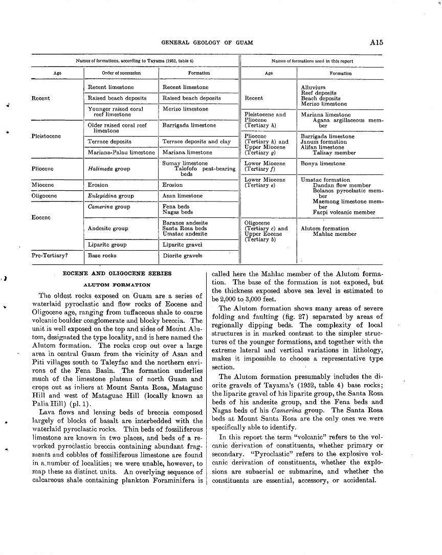
.J
GENERAL GEOLOGY OF GUAM A15
Names of formations, according to Tayama (1952, table 4) Names of formations used in this report
Ago Order of succession Formation Age Formation
Recent limestone Recent limestone Alluvium Reef deposits
Recent Raised beach deposits Raised beach deposits Recent Beach deposits Merizo limestone
Younger raised coral Merizo limestone reef limestone Pleistocene and Mariana limestone
Pliocene mem-Agana argillaceous Older raised coral reef Barrigada limestone (Tertiary h) ber
limestone Pleistocene Pliocene
Terrace deposits Terrace deposits and clay (Tertiary h) and Barrigada limestone Janum formation
Upper Miocene Alifan limestone Marimut-Palau limestone Mariana limestone (Tertiary g) Talisay member
Sumay limestone Lower Miocene Bonya limestone Pliocene Halimeda group Talofofo peat-bearing (Tertiary f)
beds
Miocene Erosion Erosion
Oligocene Eulepidina group Asan limestone
Camerina group
Eocene
Fena beds Nagas beds
Baranos andesite Andesite group Santa Rosa beds
U matac andesite
Liparite group Liparite gravel
Pre-Tertiary? Base rocks Diorite gravels
EOCENE AND OLIGOCENE SERIES
ALUTOM FORMATION
The oldest rocks exposed on Guam are a series of waterln.id pyroclastic and flow rocks of Eocene and Oligocene age, ranging from tuffaceous shale to coarse volcanic boulder conglomerate and blocky breccia. The unit is well exposed on the top and sides of Mount Alutom, designated the type locality, and is here named the Alutom formation. The rocks crop out over a large area :in central Guam from the vicinity of Asan and Piti villages south to Taleyfac and the northern environs of the Fena Basin. .The formation underlies much of the limestone plateau of north Guam and crops out a,s inliers at Mount Santa Rosa, Mataguac Fiill and west of Mataguac Hill (locally known as Palialiill) (pl.l).
Lava flows and lensing beds of breccia composed largely of blocks of basalt are interbedded with the waterlaid pyroclastic rocks. Thin beds of fossiliferous limestone are known in two places, and beds of a re"·orked pyroclastic breccia containing abundant fragments and cobbles of fossiliferous limestone are found in a.number of localities; we were unable, however, to map these as distinct units. An overlying sequence of calcareous shale containing plankton Foraminifera is
Lower Miocene U ma.tac formation (Tertiary e) Dandan flow member
Bolanos pyroclastic mem-ber
Maemong limestone mem-ber
Facpi volcanic member
Oligocene (Tertiary c) and Alutom formation Upper Eocene Mahlac member (Tertiary b)
called here the Mahlac member of the Alutom formation. The base of the formation is not exposed, but the thickness exposed above sea level is estimated to be 2,000 to. 3,000 feet.
The Alutom formation shows many areas of s~vere folding and faulting (fig. 27) separated by areas of regionally dipping beds. The complexity of local structures is in marked contrast to the simpler structures of the younger formations, and together with the extreme lateral and vertical variations in lithology, makes it impossible to choose a representative type section.
The Alutom formation presumably includes the diorite gravels of Tayama's (1952, table 4) base rocks; the liparite gravel of his liparite group, the Santa Rosa beds of his andesite group, and the Fena beds and Nagas beds of his Omnerina group. The Santa Rosa beds at Mount Santa ·Rosa are the only ones we were specifically able to identify.
In this report the term "volcanic" refers to the volcanic derivation of constituents, whether primary or secondary. "Pyroclastic" refers to the explosive volcanic derivation of constituents, whether the explosions are subaerial or submarine, and whether the constituents are essential, accessory, or accidental.
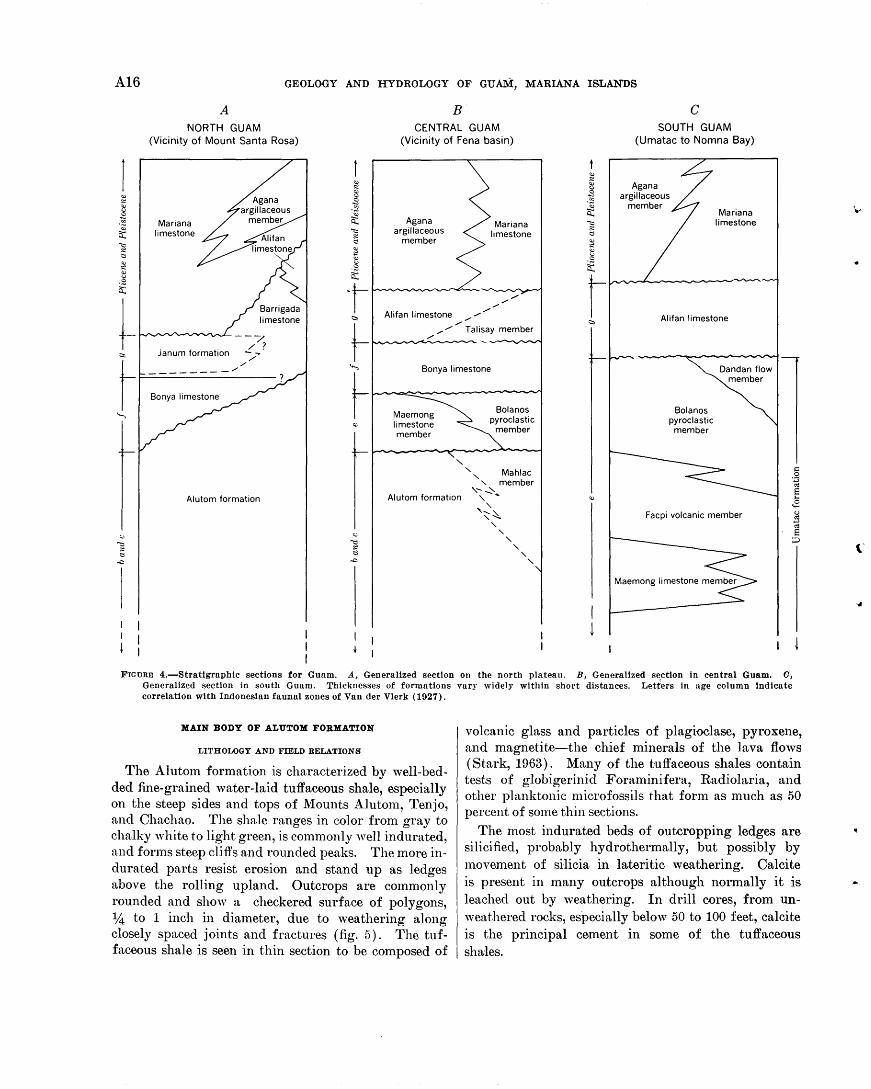
A16 GEOLOGY AND HYDROLOGY OF GUA1.\1:, MARIANA ISLANDS
A B c NORTH GUAM
(Vicinity of Mount Santa Rosa) CENTRAL GUAM
(Vicinity of Fena basin) SOUTH GUAM
(Umatac to Nomna Bay)
Mariana limestone
"" .:
~ -~
a: ~ .: t::l
"" ~ -~ 0:::
Agana argillaceous
member
Agana argillaceous
member Mariana
limestone
-t- / I ,/-<:::>, Ali fan limestone , ..-" Alifan limestone
--7 / ?
..-" Talisay member ~/ ~
/
janum formation ""/-. / ________ / ......
t Bonya limestone
Maemong limestone member
" ' '
Bolanos pyroclastic
member
Mahlac ' member
Bolanos pyroclastic
member
Alutom formation Alutom formation '" ~ ... "~~ '""' ' ' ' ' ' '
Facpi volcanic member
FIGURE 4.-Strattgraphtc sections for Guam. A, Generalized section on the north plateau. B, Generalized section in central Guam. 0, Generalized section in south Guam. Thicknesses of formations vary widely within short distances. Letters in nge column indicate correlation with Indonesian faunal zones of Vander Vlerk (1927).
MAIN BODY OF ALUTOM FORMATION
LITHOLOGY AND FIELD RELATIONS'
The Alutom formation is characterized by well-bedded fine-grained water-laid tuffaceous shale, especially on the steep sides and tops of Mounts Alutom, Tenjo, and Chachao. The shale ranges in color from gray to chalky white to light green, is commonly well indurated, and forms steep cliffs and rounded peaks. The more indurated parts resist erosion and stand up as ledges above the rolling upland. Outcrops are commonly rounded and show a checkered surface of polygons, 1,4 to 1 inch in diameter, due to weathering along closely spaced joints and fractures (fig. 5). The tuffaceous shale is seen in thin section to be composed of
volcanic glass and particles of plagioclase, pyroxene, and magnetite-the chief minerals of the lava flows (Stark, 1963). Many of the tuffaceous shales contain tests of globigerinid Foraminifera, Radiolaria, and other planktonic microfossils that form as much as 50 percent of some thin sections.
The most indurated beds of outcropping ledges are silicified, proba.bly hydrothermally, but possibly by movement of silicia in lateritic weathering. Calcite is present in many outcrops although normally it is leached out by weathering. In drill cores, from unweathered rocks, especially below 50 to 100 feet, calcite is the principal cement in some of the tuffaceous shales.
' "''
('
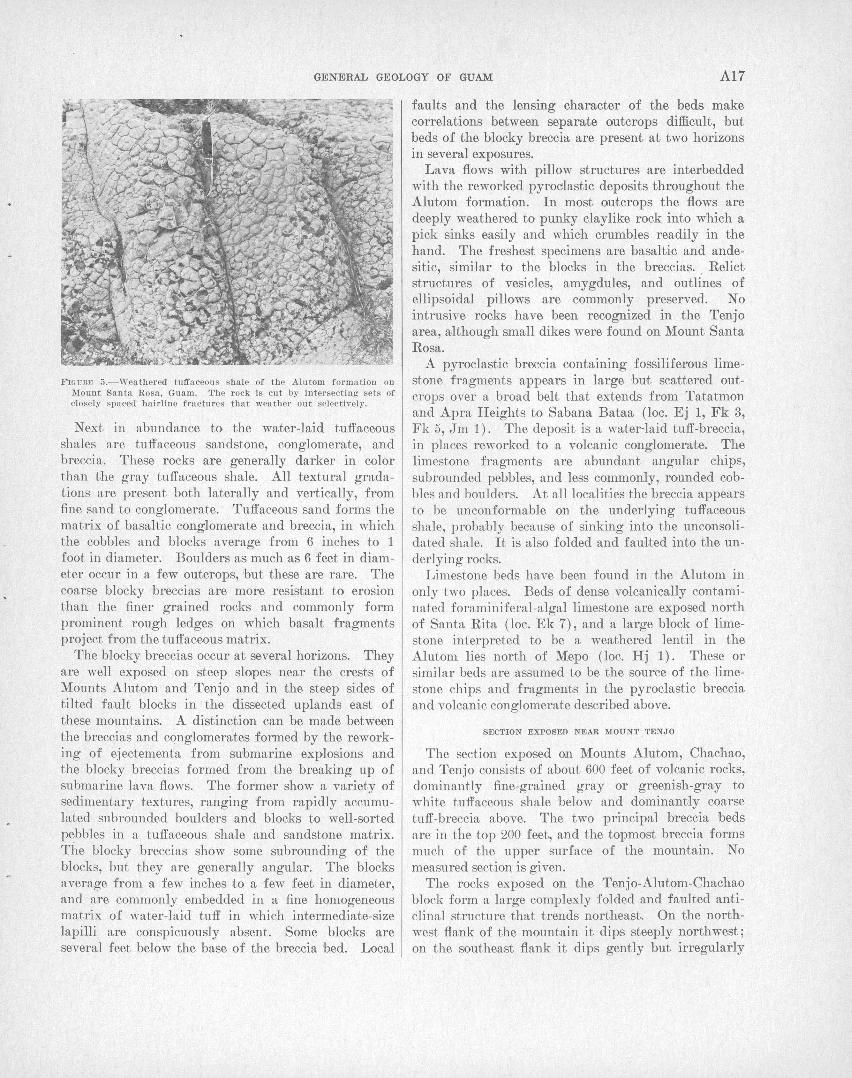
GENERAL GE:OLOGY OF GUAM A17
FIGURF1 5.- Weathered tufl'aceous shale of the Alutom formation on l\fount Santa Rosa, Guam. The rock is cu t by intersecting sets of closely spaced hairline fractures that weather out selectively .
Next in abundance to the water-laid tuffaceous shales are tuffaceous sandstone, conglomerate, and breccia. These rocks are generally darker in color than the gray tuffaceous shale. All textural gradations are present both laterally and vertically, from fine sand to conglomerate. Tuffaceous sand forms the matrix of basaltic conglomerate and breccia, in which the cobbles and blocks average from 6 inches to 1 foot in diameter. Boulders as much as 6 feet in diameter occur in a few outcrops, but these are rare. The coarse blocky breccias are more resistant to erosion than the finer grained rocks and commonly form prominent rough ledges on which basalt fragments project from the tuffaceous matrix.
The blocky breccias occur at several horizons. They are well exposed on steep slopes near the crests of Mounts Alutom and Tenjo and in the steep sides of tilted fault blocks in the dissected uplands east of these mountains. A distinction can be made between the breccias and conglomerates formed by the reworking of ejectementa from submarine explosions and the blocky breccias formed from the breaking up of submarine lava flows. The former show a variety of sedimentary textures, ranging from rapidly accumulated subrounded bou'lders and blocks to well-sorted pebbles in a tuffaceous shale and sandstone matrix. The blocky breccias show some subrounding of the blocks, but they are generally angular. The blocks average from a few inches to a few feet in diameter, and are commonly embedded in a fine homogeneous matrix of water-laid tuff in which intermediate-size lapilli are conspicuously absent. Some blocks are several feet below the base of the breccia bed. Local
faults and the lensing character of the beds make correlations between separate outcrops difficult, but beds of the blocky breccia are present at two horizons in several exposures.
Lava flows with pillow structures are interbedded with the reworked pyrodastic deposits throughout the Alutom formation. In most outcrops the flows are deeply weathered to punky claylike rock into which a pick sinks easily and which crumbles readily in the hand. The freshest specimens are basaltic and andesitic, similar to the blocks in the breccias . . Relict structures of vesicles, amygdules, and outlines of ellipsoidal pillows are commonly preserved. No intrusive rocks have been recognized in the Tenjo area, although small dikes were found on Mount Santa Rosa.
A pyroclastic breccia containing fossiliferous limestone fragments appears in large but scattered outcrops over a broad belt that extends from Tatatmon and Apra Heights to Sabana Bataa (loc. Ej 1, Fk 3, Fk 5, Jm 1). The deposit is a water-laid tuff-breccia, in places reworked to a volcanic conglomerate. The limestone fragments are abundant angular chips, subrounded pebbles, and less commonly, rounded cobbles and boulders. At all localities the breccia appears to be unconformable on the underlying tuffaceous shale, probably because of sinking into the unconsolidated shale. It is also folded and fauLted into the underlying rocks.
Limestone beds have been found in the Alutom in only two places. Beds of dense volcanically contaminated foraminiferal-algal limestone are exposed north of Santa Rita (loc. Ek 7), and a large block of limestone interpreted to be a weathered lentil in the Alutom lies north of Mepo (loc. Hj 1). These or similar beds are assumed to be t:he source of the limestone chips and fragments in the pyroclastic breccia and volcanic conglomerate described above.
SECTION EXPOSED NEAR MOUNT TENJO
The section exposed on Mounts Alutom, Chachao, and Tenjo consists of about 600 feet of volcanic rocks, dominantly fine-grained gray or greenish-gray to white tuffaceous shale below and dominantly coarse tuff-breccia above. The two principal breccia beds are in the top 200 feet, and the topmost breccia forms much of the upper surface of the mountain. No measured section is given.
The rocks exposed on the Tenjo-Alutom-Chachao block form a large complexly folded and faulted anticlinal structure that trends northeast. On the northwest flank of the mountain it dips steeply northwest; on the southeast flank it dips gently but irregularly
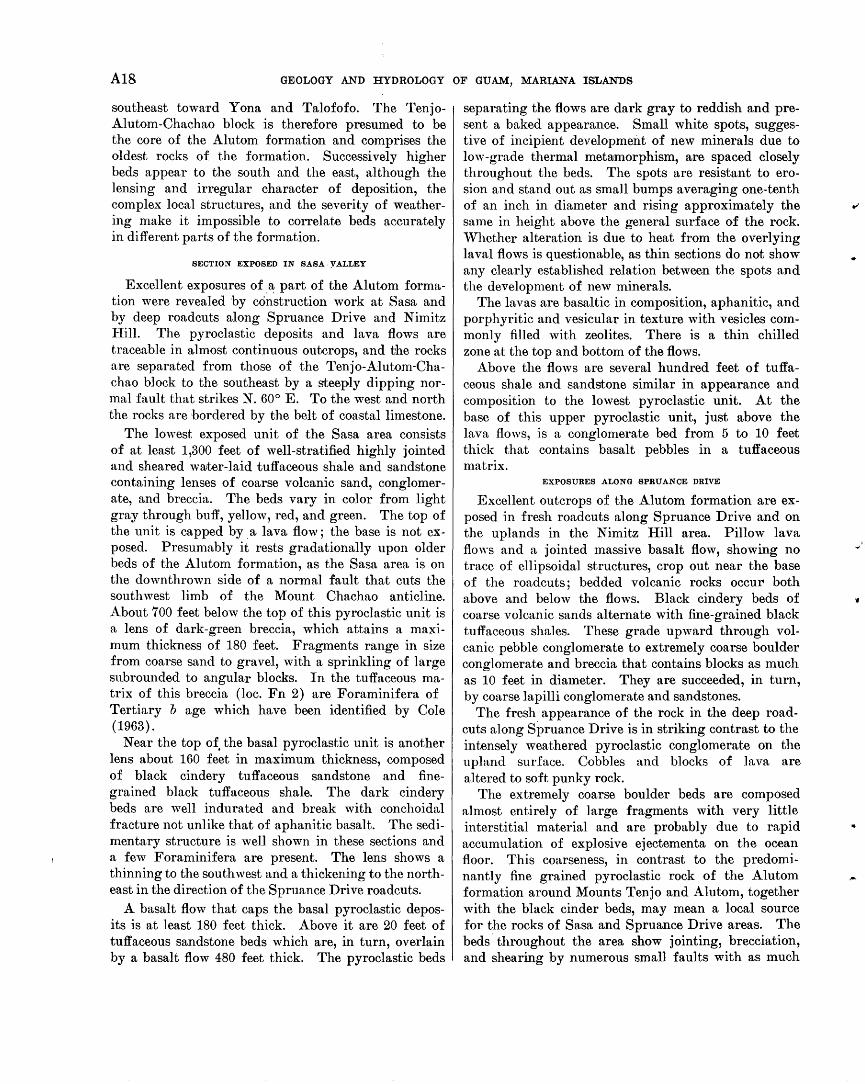
A18 GEOLOGY AND HYDROLOGY OF GUAM, MARIANA ISLANDS
southeast toward Y ona and Talofofo. The TenjoAlutom-Chachao block is therefore presumed to be the core of the Alutom formation and comprises the oldest rocks of the formation. Successively higher beds appear to the south and the east, although the lensing and irregular character of deposition, the complex local structures, and the severity of weathering make it impossible to correlate beds accurately in different parts of the formation.
SECTION EXPOSED IN SABA . YALLEY
Excellent exposures of .3: part of the Alutom formation were revealed by construction work at Sasa and by deep roadcuts along Spruance Drive and Nimitz J-Iill. The pyroclastic deposits and lava flows are traceable in almost continuous outcrops, and the rocks are separated from those of the Tenjo-Alutom-Chachao block to the southeast by a steeply dipping normal fault that strikes N. 60° E. To the west and north the rocks are bordered by the belt of coastal limestone.
The lowest exposed unit of the Sasa area consists of at least 1,300 feet of well-stratified highly jointed and sheared water-laid tuffaceous shale and sandstone containing lenses of coarse volcanic sand, conglomerate, and breccia. The beds vary in color from light gray through buff, yellow, red, and green. The top of the unit is capped by a lava flow; the base is not exposed. Presumably it rests gradationally upon older beds of the Alutom formation, as the Sasa area is on the downthrown side of a normal fault that cuts the southwest limb of the Mount Chachao anticline. About 700 feet below the top of this pyroclastic unit is a lens of dark-green breccia, which attains a maximum thickness of 180 feet. Fragments range in size from coarse sand to gravel, with a sprinkling of large subrounded to angular blocks. In the tuffaceous matrix of this breccia (loc. Fn 2) are Foraminifera of Tertiary b age which have been identified by Cole (1963).
Near the top of, the basal pyroclastic unit is another lens about 160 feet in maximum thickness, composed of black cindery tuffaceous sandstone and finegrained black tuffaceous shale. The dark cindery beds are well indurated and break with conchoidal fracture not unlike that of aphanitic basalt. The sedimentary structure is well shown in these sections and a few Foraminifera are present. The lens shows a thinning to the southwest and a thickening to the northeast in the direction of the Spruance Drive roadcuts.
A basalt flow that caps the basal pyroclastic deposits is at least 180 feet thick. Above it are 20 feet of tuffaceous sandstone beds which are, in turn, overlain by a basalt flow 480 feet thick. The pyroclastic beds
separating the flows are dark gray to reddish and present a baked appearance. Small white spots, suggestive of incipient development of new minerals due to ]ow-grade thermal metamorphism, are spaced closely throughout the beds. The spots are resistant to erosion and stand out as small bumps averaging one-tenth of an inch in diameter and rising approximately the same in height above the general surface of the rock. 'iVhether alteration is due to heat from the overlying laval flows is questionable, as thin sections do not show any clearly established relation between the spots and the development of new minerals.
The lavas are basaltic in composition, aphanitic, and porphyritic and vesicular in texture with vesicles cornmonly filled with zeolites. There is a thin chilled zone at the top and bottom of the flows.
Above the flows are several hundred feet of tuffaceous shale and sandstone similar in appearance and composition to the lowest pyroclastic unit. At the base of this upper pyroclastic unit, just above the lava flows, is a conglomerate bed from 5 to 10 feet thick that contains basalt pebbles in a tuffaceous matrix.
EXPOSURES ALONG SPRUANCE DRIVE
Excellent outcrops of the Alutom formation are exposed in fresh roadcuts along Spruance Drive and on the uplands in the Nimitz Hill area. Pillow lava flO\YS and a jointed massive basalt flow, showing no trace of ellipsoidal structures, crop out near the base of the road cuts; bedded volcanic rocks occur both above and below the flows. Black cindery beds of coarse volcanic sands alternate with fine-grained black tuffaceous shales. These grade upward through volcanic pebble conglomerate to extremely coarse boulder conglomerate and breccia that contains blocks as much as 10 feet in diameter. They are succeeded, in turn, by coarse lapilli conglomerate and sandstones.
The fresh appearance of the rock in the deep roadcuts along Spruance Drive is in striking contrast to the intensely weathered pyroclastic conglomerate on the upland surface. Cobbles and blocks of lava are altered to soft punky rock.
The extremely coarse boulder beds are composed almost entirely of large fragments with very little interstitial material and are probably due to rapid accumulation of explosive ejectementa on the ocean floor. This coarseness, in contrast to the predominantly fine grained pyroclastic rock of the Alutom formation around Mounts Tenjo and Alutom, together with the black cinder beds, may mean a local source for the rocks of Sasa and Spruance Drive areas. The beds throughout the area show jointing, brecciation, and shearing by numerous small faults with as much
.. /
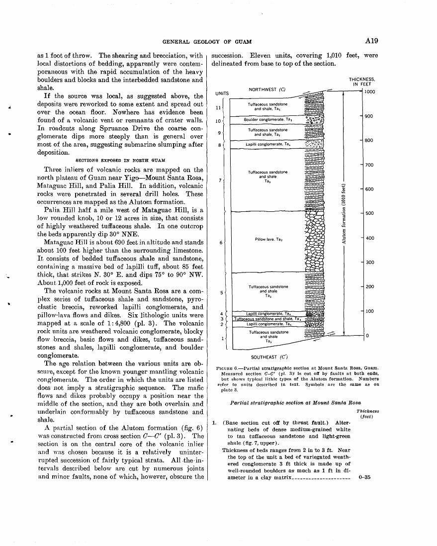
•
GENEIRAL GEOLOGY OF GUAM A19
as 1 foot of throw. The shearing and brecciation, with local distortions of bedding, apparently were contemporaneous with the rapid accumulation of the heavy boulders and blocks and the interbedded sandstone and shale.
If the source was local, as suggested above, the deposits were reworked to some extent and spread out over the ocean floor. Now here has evidence been found of a volcanic vent or remnants of crater walls. In roadcuts along Spruance Drive the coarse conglomerate dips more steeply than is general over most of the area, suggesting submarine slumping after deposition.
SECTIONS EXPOSED IN NORTH GUAM
Three inliers of volcanic rocks are mapped on the north plateau of Guam near Yigo--Mount Santa Rosa, l\1at.aguac I-Iill, and Palia Hill. In addition, volcanic rocks were penetrated in several drill holes. These occurrences are mapped as the Alutom formation.
Palia If.ill ha'lf a mile west of Mataguac Hill, is a low rounded knob, 10 or 12 acres in size, that consists of highly weathered tuffaceous shale. In one outcrop the beds apparently dip 30° NNE.
Mataguac Ifill is about 690 feet in altitude and stands n:bout 100 feet higher than the surrounding limestone. It consists of bedded tuffaceous shale and sandstone, containing a massive bed of lapilli tuff, about 85 feet thick, that strikes N. 30° E. and dips 75 o to 90° NW. About 1,000 feet of rock is exposed.
The volcanic rocks at Mount Santa Rosa are a complex series of tuffaceous shale and sandstone, pyroclastic breccia, reworked lapilli conglomerate, and pillow-lava flows and dikes. Six lithologic units were mapped at a scale of 1:4,800 (pl. 3). The volcanic rock units are weathered volcanic conglomerate, blocky flow breccia, basic flows and dikes, tuffaceous sandstones and shales, lapilli conglomerate, and boulder conglomerate.
The age relation between the various units are obscure, except for the known younger mantling volcanic conglomerate. The order in which the units are listed does not imply a stratigraphic sequence. The mafic flows and dikes probably occupy a position near the middle of the section, and they are both overlain and underlain conformably by tuffaceous sandstone and shale.
A partial section of the Alutom formation (fig. 6) was eonst.ructed from cross section 0-0' (pl. 3). The section is on the central core of the volcanic inlier and "·as chosen because it is a relatively uninterrupted succession of fairly typical strata. All-the-intervals described below are cut by numerous joints and minor faults, none of which, however, obscure the
succession. Eleven units, covering 1,010 feet, were delineated from base to top of the section.
THICKNESS,
Tuffaceous sandstone and shale, Tal
Boulder conglomerate, Tas
Tuffaceous sandstone and shale, Ta 3
Lapilli conglomerate, Ta 4
Tuffaceous sandstone and shale
7 Ta3
6
5
4 3 2
Pillow lava, Ta2
Tuffaceous sandstone and shale
Tal
La illi conglomerate, Ta. Tu ceo sandstone and shale,
Lapilli conglomerate, Ta.
Tuffaceous sandstone and shale
Tal
SOUTHEAST (C')
IN FEET
1000
FIGURE 6.-Partial stratigraphic section at Mount Santa Rosa, Guam. Measured section C-0' (pl. 3)r Is cut off by faults at both ends, but shows typical lithic types of the Alutom formation. Numbers
refer to units described in text. Symbols are the same as on plate 3.
Partial st1·atigraphic section at Mount Santa Rosa
Thickness (feet)
1. (Base section cut off by thrust fault.) Alternating beds of dense medium-grained white to tan tuffaceous sandstone and light-green shale (fig. 7, upper).
Thickness of beds ranges from 2 in 'to 3ft. Near the top of the unit a bed of variegated weathered conglomerate 3 ft thick is made up of well-rounded boulders as much as 1 ft in di-ameter in a clay matrix_____________________ 0-35
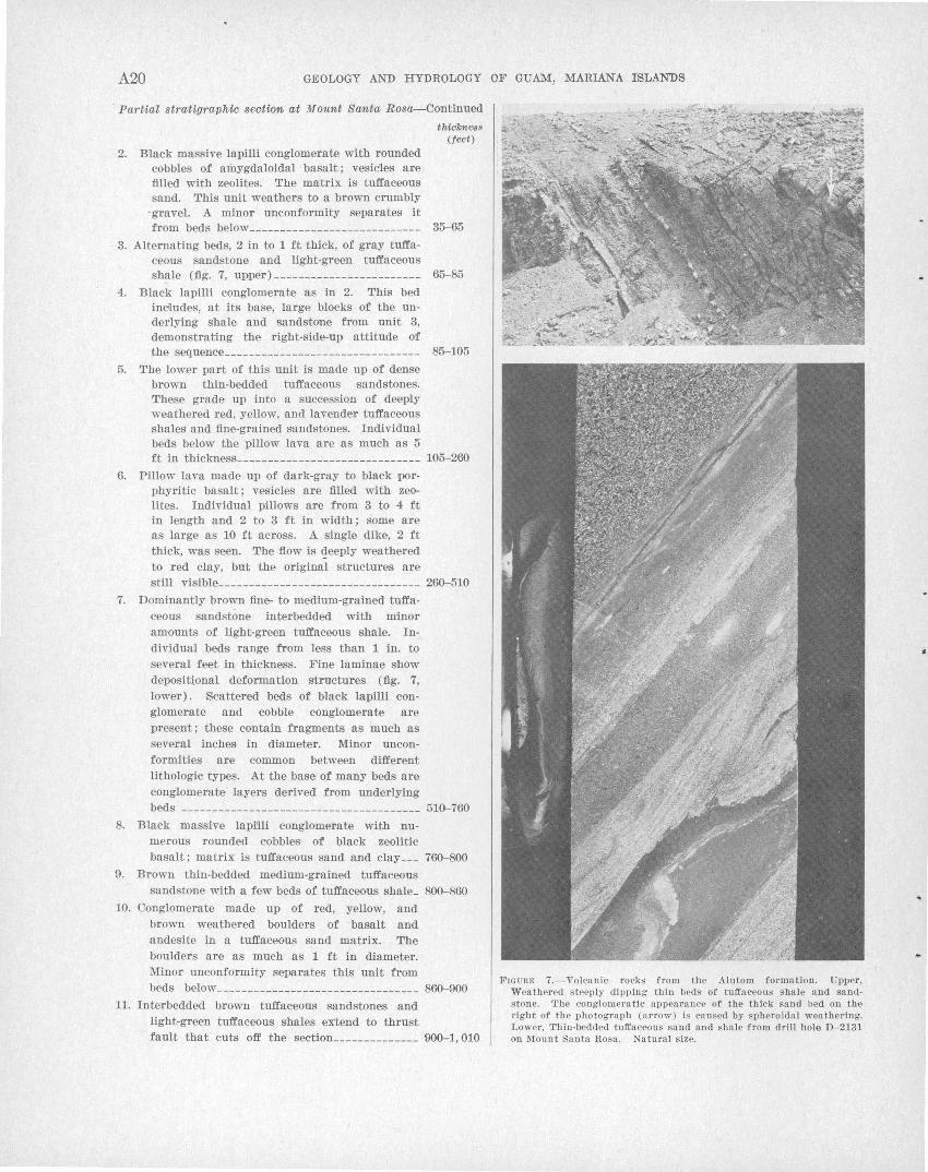
A20 GEOLOGY AND HYDROLOGY OF GUAM, MARIANA ISLANDS
· Partial stratigraphic section at Mount Santa Rosa--Continued
thickneBB (feet)
2. B-lack massive lapilli conglomerate with rounded cobbles of amygdaloidal basalt; vesicles are filled with zeolites. The ma'trix is tuffaceous sand. This unit weathers to a brown crumbly
·gravel. A. minor unconformity separates it from beds below_____ _______________________ 35-65
3. Alternating beds, 2 in to 1 ft thick, of gray tuffa-ceous sandstone ·and light-green tuffaceous shale (fig .. 7, upper) ________________________ 65-85
4. Black lapilli conglomerate as in 2. This bed includes, at its base, large blocks of the underlying shale and sandstone from unit 3, demonstrating the right-side-up attitude of the sequence________________________________ 85-105
5. The lower part of this unit is made up of dense brown thin-bedded tuffaceous sandstones. These grade up into a succession of deeply weathered red, yellow, and lavender tuffaceous shales and fine-grained sandstones. Individual beds below the pillow lava are as much as 5 ft in thickness ______________________________ 105-260
6. Pillow lava made up of dark-gray to black porphyritic basalt; vesicles are filled with zeolites. Individual pillows are from 3 to 4 ft in length and 2 to 3 ft in width ; some are as large as 10 ft across. A. single dike, 2 ft
thick, was seen. The flow is «;!eeply weathered to red clay, but the original structures are still visible __________ ___________________ ____ 260-510
7. Dominantly brown fine- to medium-grained tuffaceous sandstone interbedded with minor amounts of light-green tuffaceous shale. Individual beds range from less than 1 in. to several feet in thickness. Fine laminae show deposiUonal deformation structures (fig. 7, lower). Scattered beds of black lapilli conglomerate and cobble conglomerate are present; these contain fragments as much as several inches formities are lithologic types.
in diameter. Minor unconcommon between different At the base of many beds are
conglomerate layers derived from underlying
beds --------------------------------------- 510-760 8. Black massive lapi'lli conglomerate with nu-
merous rounded cobbles of black zeolitic basalt; matrix is tuffaceous sand and clay ___ 760-800
9. Brown thin-bedded medium-grained tuffaceous sandstone with a few beds of tuffaceous shale_ 800-860
10. Conglomerate made up of red, yellow, and brown weathered boulders of basalt and andesite in a tuffaceous sand matrix. The boulders are as much as 1 ft in diameter. Minor unconformity separates this unit from beds below _________________________________ 860-900
11. Interbedded brown tuffaceous sandstones and light-green tuffaceous shales extend to thrust fault that cuts off the section ______________ 900-1, 010
FIGURE 7.-Volcanic rocks from the Alutom formation . Upper, Weathered steeply dipping thin beds of tuffaceous shale and sandstone. The conglomeratic appearance of the thick sand bed on the right of the photograph (arrow) is caused by spheroidal weathering. Lower, Thin-bedded tuffaceous sand and sha.le from drill hole D- 2131 on Mount Santa Rosa. Natural size.
..
GEN;E,RAL GEOLOGY OF GUAM A21
A bed of conglomerate on the southeast slope of Mount Santa Rosa contains pebbles and cobbles of a dark-gray porphyry with abundant megascopic quartz crystals. The quartz-bearing cobbles are easily recognized and are apparently unique to this conglomerate. They resemble rhyolite in hand specimen, the quartz grains n.ppearing as phenocrysts with plagioclase and pyroxene crystals. The quartz grains range in size from a fraction of a millimeter to 3 mm in diameter and are fairly abundant in some specimens . Thin sections of the quartz-bearing blocks show that the quartz grains and many feldspar crystals are xenocrysts rather than phenocrysts (Stark, 1963). Bedrock outcrops, similar to rock of the quartz-bearing bloeks, have not been found on Guam. Tayama (1952} found what he called "liparite gravels" along the Fena H.iver in southe111 Guam. l-Ie believed that they represented the oldest rocks on the island. The area along the Fena River where Tayama found the gravels is now under water by flooding caused by installation of the Fena dam in 1951.
CONDITIONS OF DEPOSITION
The volcanic explosions and extrusions responsible for the building up of Guam appear to have been all submarine, at least in the area now occupied by the island. Volcanic ejectamenta from explosions and blocky breccias formed from rubbly lava flows spread out on the sloping sea floor, and were reworked into soft tuffaceous muds. Lim.estone beds and reefs formed in shoa.ler waters were broken up by explosive volen.nic activity and were incorporated into pyrocln.stic deposits. Submarine slides, mudflows, and turbidity currents were common mechanisms of reworking and deposition. Many of the complex structures within the formation are attributable to such ehaotic deposition and redeposition, which are diseussed more fully in the section on structure (p. A57-A58).
AGE AND CORRELATION
Cole (1963) has studied the larger Foraminifera :from the Alutom, mostly from the reworked tuff-breccia and volcanic conglomerate. The limestone beds and the limestone chips and pebbles in the breccia contain the following Foraminifera:
Asterooyolina rnatanzens.is penuria praeoipua
Biplanispira tuloeria rnilrabiUs
Fabiania saA.panensis Pr.Ua.tisJJira orbitoidea
provaZeae Spiroclypeus ve·rmioular"is
Cole states that these are diagnostic of the Tertiary b. (upper Eocene). In two localities, Fk 3 and Ej 1, he reports that the matrix of the breccia contains Oa1ne·rina fichteli, which is one of the characteristic forms found in Tertiary c (lower Oligocene) beds of the East Indies. Because of the lithologic similarity and the position in a broad band of the spotty outcrops of this breccia, we believe that all the limestone-bearing breccia and conglomerate beds are equivalent, and therefore are of Tertiary c age, although only two localities contain larger Foraminifera definitely of Tertiary cage.
MAHLAC ME'MBER
A sequence of well-bedded calcareous fossiliferous shale containing tests of planktonic Foraminifera is called the Mahlac member of the Alutom formation, here named for the Mahlac River in the Mapao area of south Guam. The shale is poorly exposed in several places from Santa Rita on the west nearly to Talofofo on the east.
LITHOLOGY AND DISTRmUTION
The Mahlac member is a buff to tan or yellowishtan shale, friable, generally weathered i:" outcrop, and in places contains. extremely abundant planktonic Foraminifera. In places the matrix is calcareous. North of the village of Santa Rita a bedded calcareous shale dips northeast and is unconformably overlain by weathered flow rocks of probable Tertiary e age. In the Fena valley 3,000 feet north of the reservoir, a a large and accessible exposure 2,000 feet in longest dimension displays folded bedded shale of the Mahlac member that dips about 45° S. Collections Gj 11, Gj 13, Gj 14, and Gj 15 are from this exposure, which is designated the type locality. The rock is fractured to the point of appearing crushed, and shows many s:r:nall slickensided surfaces throughout.
The largest exposures are north of the Mahlac River (loc. Hi 6) where the shale is friable, well bedded, and nearly vertical. At several places a thick section is exposed, but we do not know whether beds are duplicated by faulting. Neither top nor base of the sequence has been determined.
FOSSILS AND AGE
Diagnostic planktonic Foraminifera that have been identified by Ruth Todd from several collections made in the Mahlac member are tabulated on page A22.
The sequence of rocks appears to be of Tertiary c (Oligocene) age, and is interpreted by Miss Todd as being a relatively deep water deposit, possibly about 100 fathoms. A few larger Foraminifera from locality Hi 6 were identified by W. Storrs Cole. These he be-
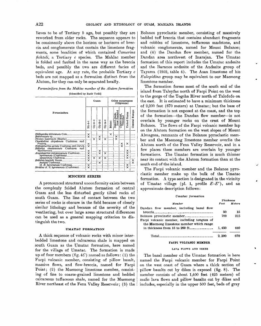
A22 GEOLOGY AND HYDROLOGY OF GUAM, MARIANA ISLANDS
lieves to be of Tertiary b age, but possibly they are reworked from older rocks. The sequence appears to be consistently above the horizon or horizons of breccia and conglomerate that contain the limestone fragments, some localities of which contained Oamerina fiohteli, a Tertiary o species. The Mahlac member is folded and faulted in the same way as the breccia beds, and possibly the two are different facies of equivalent age. At any rate, the probable Tertiary o beds are not mapped as a formation distinct from the Alutom, for they can only be separated locally.
Foraminifera from the Mahlac member of the Alutom formation
[Identified by Ruth Todd]
Guam Other occurrences (Oligocene)
"0 Q)
Foraminifera .!ai§ "' c.
~ 0
";'; ~"0 l3 ,&:IQ) s~ r:-l c.>~ U1
± .!. 'i' :t :s 'E~ e:S "0 ~ e.:> Q)
1 I. ~ ~ -az .e.~ ~ = Q)
~ 0 0 ~ 0 0 0
- - - - - - - -Halkyardia bikiniensis Cole________________ X ____ ____ ____ X ---- ---- ---- ----Bolivinopsis sp____________________________ X ____ X ____ ____ X ---- ---- ----Nonion maoricum (Stache) ____________________ X X X ____ X ---- ---- ----Cassidulina chipolensis Cushman and
Ponton--------------------------------- X ____________________ X X ----Siphogenerina seriata Cushman and Jarvis_ X ____ ____ ____ ____ ____ X ---- ___ _ Bolivina choctawansis Cushman and McGlamery ____________________________ X ____ X ____ --~- ________ X ___ _ Angulogerina vicksburgensis Cushman _____ X ____ X X ____ ---- ---- X ----
byramensis (Cushman) ________________ X ________________________ X ___ _ cooperensis Cushman _________________ X X X X ____ ---- ---- X ----
Bolivina beyrichi Reuss____________________ X ________________ ---- ---- ---- X jastigia Cushman _____________________________ X ____________ ---- ---- X cr. B. byramensis Cushman ___________ X ________________ ---- ---- X
Streblus cr. S. byramensis (Cushman) _____ X ---- ---- ---- ---- ---- ---- X ----
MIOCENE SERIES
A pronounced structural unconformity exists between the complexly folded Alutom formation of central Guam and the less disturbed gently tilted rocks of south Guam. The line of contact between the two series of rocks is obscure in the field because of closely similar lithology and because of the severity of the weathering, but over large areas structural differences can be used as a general mapping criterion to distinguish the two.
UMATAC FORMATION
A thick sequence of volcanic rocks with minor interbedded limestone and calcareous shale is mapped on south Guam as the U matac formation, here named for· the village of U matac. The formation is made up of four members (fig. 40) named as follows: (1) the Facpi volcanic member, consisting of pillow basalt, massive flows, and flow-breccia, named for Facpi Point; (2) the Maemong limestone member, consisting of fine to coarse-grained limestone and bedded calcareous tuffaceous shale, named for the Maemong River northeast of the Fena Valley Reservoir; (3) the
Bolanos pyroclastic member, consisting of massively bedded tuff breccia that contains abundant fragments and cobbles of limestone, tuffaceous sandstone, and volcanic conglomerate, named for Mount Bolanos; and ( 4) the Dandan flow member, named for the Dandan area northwest of Inarajan. The Umatac formation of this report includes the Um~tac andesite and the Baranos andesite of the Andesite group of Tayama (1952, table 4). The Asan limestone of his Eulepidina group may be equivalent to our Maemong limestone member.
The formation forms most of the south end of the island from Taleyfac north of Facpi Point on the west to the gorge of the Togcha River north of Talofofo on the east. It is estimated to have a minimum thickness of 2,200 feet ( 670 meters) at U matac; but the base of the formation is not exposed at the coast, and the top of the formation-the Dandan flow member-is not overlain by younger rocks on the crest of Mount Bolanos. The flows of the Facpi volcanic member lap on the Alutom formation on the west slopes of Mount Almagosa, remnants of the Bolanos pyroclastic member and the Maemong limestone member overlie the Alutom north of the Fena Valley Reservoir, and in a few places these members are overlain by younger formations. The U matac formation is much thinner near its contact with the Alutom formation than at the south end of the island.
The Facpi volcanic member and the Bolanos pyroclastic member make up the bulk of the Umatac formation. A type section is designated in the vicinity of U matac village (pl. 1, profile E -E'), and an approximate description follows:
Umatac formation
Member
Dandan flow member, including basal flow breccia __________________________________ _
Bolanos pyroclastic member ________________ _ Facpi volcanic member, including tongues of
the Maemong limestone member which range in thickness from 15 to 260 ft_ ____________ _
Total _______________________________ _
F ACPI VOLCANIC MEMBER
LAVA FLOWS AND DIKES
Thickness Feet Meters
50 15 700 215
1,450 440
2,200 670
The basal member of the U matac formation is here named the Facpi volcanic member for Facpi Point on the west coast of Guam where a thick section of pillow basalts cut by dikes is exposed (fig. 8). The member consists of about 1,400 feet ( 425 meters) of mafic lava flows and pillow basalts cut by dikes and includes, especially in the upper 500 feet, beds of gray
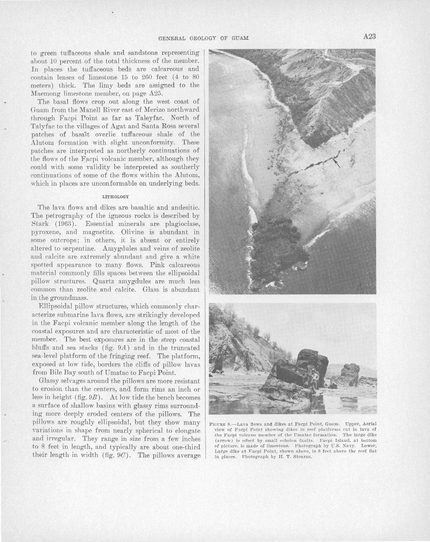
GENE<RAL GEOLOGY OF GUAM A23
to green tuffaceous shale and sandstone representing about 10 percent of the total thickness of the member. In places the tuffaceous beds are calcareous and contain lenses of limestone 15 to 260 feet ( 4 to 80 meters) thick. The limy beds are assigned to the Maemong limestone member, on page A25.
The basal flows crop out along the west coast of Guam from the Manell River east of Merizo northward through Facpi Point as far as Taleyfac. North of Talyfac to the villages of Agat and Santa Rosa several patches of basalt overlie tuffaceous shale of the Alutom formation with slight unconformity. These patches are interpreted as northerly continuations of the flows of the F).cpi volcanic member, although they could with some validity be interpreted as southerly continuations of some of the flows within the Alutom, which in places are unconformable on underlying beds.
LITHOLOGY
The lava flows and dikes are basaltic and andesitic. The petrography of the igneous rocks is described by Stark ( 1963) . Essential minerals are plagioclase, pyroxene, and magnetite. Olivine is abundant in some outcrops; in others, it is absent or entirely altered to serpentine. Amygdules and veins of zeolite and calcite are extremely abundant and give a white spotted appearance to many flows. Pink calcareous material commonly fills spaces between the ellipsoidal pillow structures. Quartz amygdules are much less common than zeolite and calcite. Glass is abundant in the groundmass.
Ellipsoidal pillow structures, which commonly characterize submarine lava flows, are strikingly developed in the Facpi volcanic member along the length of the coastal exposures . and are characteristic of most of the member. The best exposures are in the steep coastal bluffs and sea stacks (fig. 9A) and in the truncated sea-level platform of the fringing reef. The platform, exposed at low tide, borders the cliffs of pillow lavas from Bile Bay south of Umatac to Facpi Point.
Glassy selvages around the pillows are more resistant to erosion than the centers, and form rims an inch or less in height (fig. 9B). At low tide the bench becomes a surface of shallow basins with glassy rims surrounding more deeply eroded centers of the pillows. The pillows are roughly ellipsoidal, but they show many variations in shape from nearly spherical to elongate and irregular. They range in size from a few inches to 8 feet in length, and typically are about one-third their length in width (fig. 90). The pillows average
F IOU RI!l 8.- Lava fl ows and dikes at Facpi P oint, Guam. Upper, Aerial view of F acpi P oint showing dikes in reef platforms cu t in lava of the Facpi volcano member of the Umatac forma tion. The la rge dike (arrow ) is ofiset by s ma ll echelon fa ult . Facpi I sland, a t bottom of picture, is ma de of limes tone. Photograph by U.S. Navy. Lower, La rge dike a t F acpi Poin t , shown above, is 8 f eet above the reef fia t in places. Photograph by H. T. Stearns.
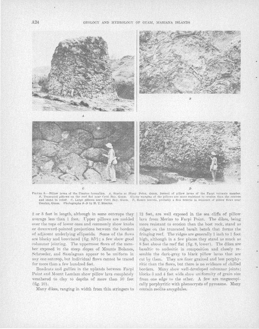
A24 GEOLOGY AND HYDROLOGY OF GUAM, MARIANA ISLANDS
a D
FIGURE 9.-Pillow lavas of the Umatac formation. A, Stacks at Pinay Point, Guam, formed of pillow lavas of the Facpi volcanic member. B, Truncated pillows on the reef flat near Cetti Bay, Guam. Glassy margins of the pillows are more resistant to erosion than the centers and stand in relief. C, Large pillows near Cetti Bay, Guam. D, Basalt breccia, probably a flow breccia in sequence of pillow flows near Umatac, Guam. Photographs B-D by H. T. Stearns.
2 or 3 feet in length, although in some outcrops they average less than 1 foot. Upper pillows are molded over the tops of lower ones and commonly show knobs or do,vnward-pointed projections between the borders of adjacent underlying ellipsoids. Some of the flows are blocky and brecciated (fig. 9D) ; a few show good columnar jointing. The uppermost flows of the member exposed in t.he steep slopes of Mounts Bolanos, Schroeder, and Sasalaguan appear to be uniform in any one outcrop, but individual flows cannot be traced for more than a few hundred feet.
Roadcuts and gullies in the uplands between Facpi Point and Mount Lamlam show pillow lava completely weathered to clay to depths of more than 50 feet (fig. 10).
Many dikes, ranging in width from thin stringers to
12 feet, are well exposed in the sea cliffs of pillow lava from Merizo to Facpi Point. The dikes, being more resistant to erosion than the host rock, stand as ridges on the truncated basalt bench that forms the fringing reef. The ridges are generally 1 inch to 1 foot high, although in a few places they stand as much as 8 feet above the reef flat (fig. 8, lower). The dikes are basaltic to andesitic in composition and closely resemble the dark-gray to black pillow lavas that are cut by them. They are finer grained and less porphyritic than the flows, but there is no evidence of chilled borders. Many show well-developed columnar joints; blocks 3 and 4 feet wide sho''" uniformity of grain size from one edge to the other. A few are megascopically porphyritic with phenocrysts of pyroxene. Many contain zeolite amygdules.
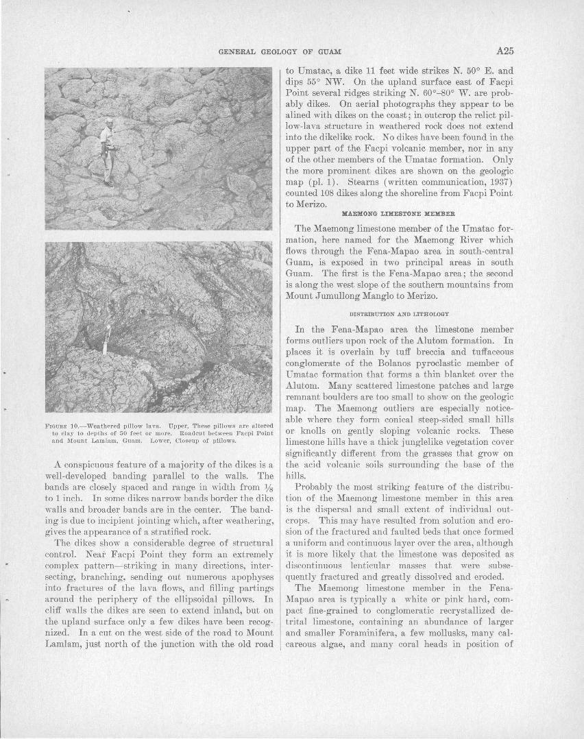
;.
GENIDRAL GEOLOGY OF GUAM A25
FrGURE 10.-Weathered pillow lava. Upper, These pillows are altered to clay to depths of 50 f ee t or more. Roadcut between Facpi Point and Mount Lamlam, Guam. Lower, Closeup of pillows.
A conspicuous feature of a majority of the dikes is a well-developed banding parallel to the walls. The bands are closely spaced and range in width from Ys to 1 inch. In some dikes narrow bands border the dike walls and broader bands are in the center. The banding is due to incipient jointing which, after weathering, gives the appearance of a stratified rock.
The dikes show a considerable degree of structural control. Near Facpi Point they form an extremely complex pattern-striking in many directions, intersecting, branching, sending out numerous apophyses into fractures of the lava flows, and filling partings around the periphery of the ellipsoidal pillows. In cliff walls the dikes are seen to extend inland, but on the upland surface only a few dikes have been recognized. In a cut on the west side of the road to Mount Lamlam, just north of the junction with the old road
to Umatac, a dike 11 feet wide strikes N. 50° E. and dips 55° NW. On the upland surface east of Facpi Point severall'idges striking N. 60°-80° W. are probably dikes. On aerial photographs they appear to be alined with dikes on the coast; in outcrop the relict pillow-lava structure in weathered rock does not extend into the dikelike rock. No dikes have been found in the upper part of the Facpi volcanic member, nor in any of the other members of the Umatac formation. Only the more prominent dikes are shown on the geologic map (pl. 1). Stearns (written communication, 1937) counted 108 dikes along the shoreline from Facpi Point to Merizo.
MAEliONG LIMESTONE MEMBER
The Maemong limestone member of the Umatac formation, here named for the Maemong River which flows through the Fena-Mapao area in south-central Guam, is exposed in two principal areas in south Guam. The first is the Fena-Mapao area; the second is along the west slope of the southern mountains from Mount J umullong Manglo to Merizo.
DISTRmUTION AND LITHOLOGY
In the Fena-Mapao area the limestone member forms outliers upon rock of the Alutom formation. In places it is overlain by tuff breccia and tuffaceous conglomerate of the Bolanos pyroclastic member of Umatac formation that forms a thin blanket over the Alu.tom. Many scattered limestone patches and large remnant boulders are too small to show on the geologic map. The Maemong outliers are especially noticeable where they form conical steep-sided small hills or knolls on gently sloping volcanic rocks. These limestone hills have a thick junglelike vegetation cover significantly different from the grasses that grow on the acid volcanic soils surrounding the base of the hills.
Probably the most striking feature of the distribution of the Maemong limestone member in this area is the dispersal and small extent of individual outcrops. This may have resulted from solution and erosion of the fractured and faulted beds that once formed a uniform and continuous layer over the area, although it is more likely that the limestone was deposited as discontinuous lenticular masses that were subsequently fractured and greatly dissolved and eroded.
The Maemong limestone member in the FenaMapao area is typically a white or pink hard, compact fine-grained to conglomeratic recrystallized detrital limestone, containing an abundance of larger and smaller Foraminifera, a few mollusks, many calcareous algae, and many coral heads in position of
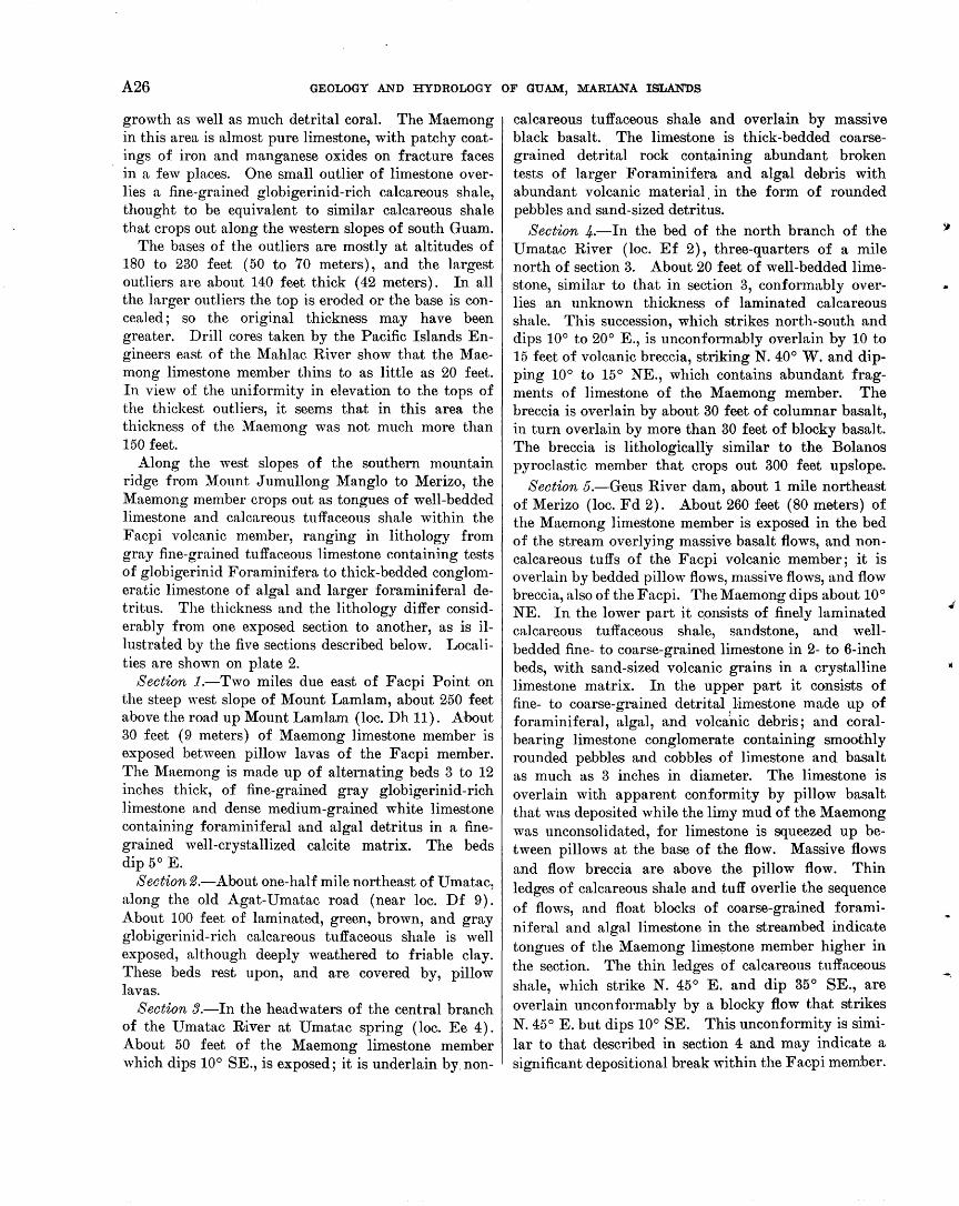
A26 GEOLOGY AND HYDROLOGY OF GUAM, MARIANA ISLANDS
growth as well as much detrital coral. The Maemong in this area is almost pure limestone, with patchy coatings of iron and manganese oxides on fracture faces in a few places. One small outlier of limestone overlies a fine-grained globigerinid-rich calcareous shale, thought to be equivalent to similar calcareous shale that crops out along the western slopes of south Guam.
The bases of the outliers are mostly at altitudes of 180 to 230 feet (50 to 70 meters), and the largest outliers are about 140 feet thick ( 42 meters). In all the larger outliers the top is eroded or the base is concealed; so the original thickness may have been greater. Drill cores taken by the Pacific Islands Engineers east of the Mahlac River show that the Maemong limestone member thins to as little as 20 feet. In view of the uniformity in elevation to the tops of the thickest outliers, it seems that in this area the thickness of the Maemong was not much more than 150 feet.
Along the west slopes of the southern mountain ridge from Mount J umullong Manglo to Merizo, the Maemong member crops out as tongues of well-bedded limestone and calcareous tuffaceous shale within the Facpi volcanic member, ranging in lithology from gray fine-grained tuffaceous limestone containing tests of globigerinid Foraminifera to thick-bedded conglomeratic limestone of algal and larger foraminiferal detritus. The thickness and the lithology differ considerably from one exposed section to another, as is illustrated by the five sections described below. Localities are shown on plate 2.
Section 1.-Two miles due east of Facpi Point on the steep west slope of Mount Lamlam, about 250 feet above the road up Mount Lamlam (loc. Dh 11). About 30 feet ( 9 meters) of Maemong limestone member is exposed between pillow lavas of the Facpi member. The Maemong is made up of alternating beds 3 to 12 inches thick, of fine-grained gray globigerinid-rich limestone and dense medium-grained white limestone containing foraminiferal and algal detritus in a finegrained well-crystallized calcite matrix. The beds dip 5° E.
Section 2.-About one-half mile northeast of Umatac, along the old Agat-U matac road (near loc. Df 9). About 100 feet of laminated, green, brown, and gray globigerinid-rich calcareous tuffaceous shale is well exposed, although deeply weathered to friable clay. These beds rest upon, and are covered by, pillow lavas.
Section 3.-In the headwaters of the central branch of the Umatac River at Umatac spring (loc. Ee 4). About 50 feet of the Maemong limestone member which dips 10° SE., is exposed; it is underlain by non-
calcareous tuffaceous shale and overlain by massive black basalt. The limestone is thick-bedded coarsegrained detrital rock containing abundant broken tests of larger Foraminifera and algal debris with abundant volcanic material, in the form of rounded pebbles and sand-sized detritus.
Section 4.-In the bed of the north branch of the U matac River (loc. Ef 2), three-quarters of a mile north of section 3. About 20 feet of well-bedded limestone, similar to that in section 3, conformably overlies an unknown thickness of laminated calcareous shale. This succession, which strikes north-south and dips 10° to 20° E., is unconformably overlain by 10 to 15 feet of volcanic breccia, striking N. 40° W. and dipping 10° to 15° NE., which contains abundant fragments of limestone of the Maemong member. The breccia is overlain by about 30 feet of columnar basalt, in turn overlain by more than 30 feet of blocky basalt. The breccia is lithologically similar to the Bolanos pyroclastic member that crops out 300 feet upslope.
Section 5.-Geus River dam, about 1 mile northeast of Merizo (loc. Fd 2). About 260 feet (80 meters) of the Maemong limestone member is exposed in the bed of the stream overlying massive basalt flows, and noncalcareous tuffs of the Facpi volcanic member; it is overlain by bedded pillow flows, massive flows, and flow breccia, also of the Facpi. The Maemong dips about 10° NE. In the lower part it c.onsists of finely laminated calcareous tuffaceous shale, sandstone, and wellbedded fine- to coarse-grained limestone in 2- to 6-inch beds, with sand-sized volcanic grains in a crystalline limestone matrix. In the upper part it consists of fine- to coarse-grained detrital , limestone made up of foraminiferal, algal, and volcanic debris; and coralbearing limestone conglomerate containing smoothly rounded pebbles and cobbles of limestone and basalt as much as 3 inches in diameter. The limestone is overlain with apparent conformity by pillow basalt that was deposited while the limy mud of the Maemong was unconsolidated, for limestone is squeezed up between pillows at the base of the flow. Massive flows and flow breccia are above the pillow flow. Thin ledges of calcareous shale and tuff overlie the sequence of flows, and float blocks of coarse-grained foraminiferal and algal limestone in the streambed indicate tongues of the Maemong limestone member higher in the section. The thin ledges of calcareous tuffaceous shale, which strike N. 45° E. and dip 35° SE., are overlain unconformably by a blocky flow that strikes N. 45° E. but dips 10° SE. This unconformity is similar to that described in section 4 and may indicate a significant depositional break within the Facpi member.
-.
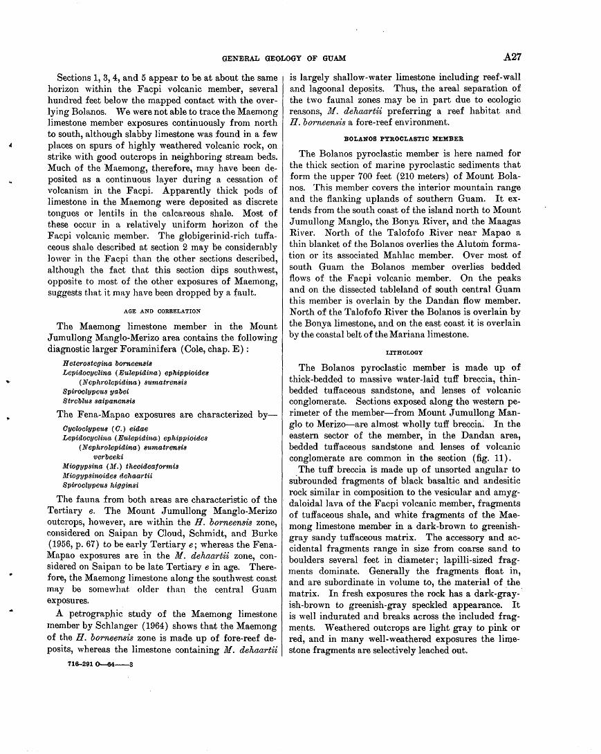
•
GENE,RAL GEOLOGY OF GUAM A27
Sections 1, 3, 4, and 5 appear to be at about the same horizon within the Facpi volcanic member, several hundred feet below the mapped contact with the overlying Bolanos. We were not able to trace the Maemong limestone member exposures continuously from north to south, although slabby limestone was found in a few places on spurs of highly weathered volcanic rock, on strike with good outcrops in neighboring stream beds. Much of the ~{aemong, therefore, may have been deposited as a continuous layer during a cessation of volcanism in the Facpi. Apparently thick pods of limestone in the Maemong were deposited as discrete tongues or lentils in the calcareous shale. Most of these occur in a relatively uniform horizon of the Facpi volcanic member. The globigerinid-rich tuffaceous shale described at section 2 may be considerably lower in the Facpi than the other sections described, although the fact that this section dips southwest, opposite to most of the other exposures of Maemong, suggests that it may have been dropped by a fault.
AGE AND CORRELATION
The Maemong limestone member in the Mount Jumullong Manglo-Merizo area contains the following diagnostic larger Foraminifera (Cole, chap. E) :
H eterostegina borneensis Lcpidocyclina ( 11Julepidina) ephipp·ioides
( N ephrolepidina) sutnatrens·is Spiroclypeus yabei Stt·obltts saipanensis
The Fena-Mapao exposures are characterized byOycloctypetts ( 0.) eidae Lepidooyclina ( 11Julepidina) ephippioides
(Nephrolepidina) 8ttmatrensis verbeeki
M iogypsina ( .M.) theoideatormis Mi001JP8inoides dehaartii Spiroclypeus higginsi
The fauna from both areas are characteristic of the Tertiary e. The Mount Jumullong Manglo-Merizo outcrops, however, are within the H. borneensis zone, considered on Saipan by Cloud, Schmidt, and Burke (1956, p. 67) to be early Tertiary e; whereas the FenaMapao exposures are in the 111. dehaartii zone, con-sidered on Saipan to be late Tertiary e in age. Therefore, the Maemong limestone along the southwest coast ma.y be somewhat. older than the central Guam exposures.
A petrographic study of the Maemong limestone member by Schlanger (1964) shows th3Jt the Maemong of the H. borneensis zone is made up of fore-reef deposits, whereas the limestone containing M. dehaartii
716-291~----3
is largely shallow-water limestone including reef-wall and lagoonal deposits. Thus, the areal separation. of the two faunal zones may be in part due to ecologic reasons, 111. dehaartii preferring a reef habitat and H. borneensis a fore-reef environment.
BOLANOS PYROCLASTIC MEMBER
The Bolanos pyroclastic member is here named for the thick section of marine pyroclastic sediments that form the upper 700 feet (210 meters) of Mount Bolanos. This member covers the interior mountain range and the flanking uplands of southern Guam. It extends from the south coast of the island north to Mount Jumullong Manglo, the Bonya River, and the Maagas River. North of the Talofofo River near Mapao a thin blanket of the Bolanos overlies the Alutoin formation or its associated Mahlac member. Over most of south Guam the Bolanos member overlies bedded flows of the Facpi volcanic member. On the peaks and on the dissected tableland of south central Guam this member is overlain by the Dandan flow member. North of the Talofofo River the Bolanos is overlain by the Bonya limestone, and on the east coast it is overlain by the coastal belt of the Mariana limestone.
LITHOLOGY
The Bolanos pyroclastic member is made up of thick-bedded to massive water-laid tuff breccia, thinbedded tuffaceous sandstone, and lenses of volcanic conglomerate. Sections exposed along the western perimeter of the member-from Mount Jumullong Manglo to Merizo-are almost wholly tuff breccia; In the eastern sector of the member, in the Dandan area, bedded tuffaceous sandstone and lenses of volcanic conglomerate are common in the section (fig. 11).
. The tuff breccia is made up of unsorted angular to subrounded fragments of black basaltic and andesitic rock similar in composition to the vesicular and amygdaloidallava of the Facpi volcanic member, fragments of tuffaceous shale, and white fragments of the Maemong limestone member in a dark-brown to greenishgray sandy tuffaceous matrix. The accessory and accidental fragments range in size from coarse sand to boulders several feet in diameter; lapilli-sized fragments dominate. Generally the fragments float in, and are subordinate in volume to, the material of the matrix. In fresh exposures the rock has a dark-g~ay- · ish-brown to greenish-gray speckled appearance. It is well indurated and breaks across the included fragme!lts. Weathered outcrops are light gray to pink or red, and in many well-weathered exposures the limestone fragments are selectively leached out.
A28 GEOLOGY AND HYDROLOGY OF GUAM, MARIANA ISLANDS
FIGURE 11.- Bedded tuiiacPo us sandstone of the Bolanos pyroclastic member of the matac formation. Friable sandstone overlies the tuff breccia in the Danclan area. Boulders in the foreground are derived from the overlying Dandan flow member of the Umatac formation. Severe erosion (middle ground) is widespread in the volcanic uplands.
The dissected upland from the Ugum River to the Inarajan River is covered by a well-bedded tuffaceous sandstone of the Bolanos pyroclastic member. Near Inarajan the sandstone can be seen to overlie the tuff breccia, and near Dandan the tuff breccia is exposed in a small anticline. The tuffaceous sandstone is exposed at Assupian in dissected badlands (fig. 11).
In places the water-laid character of .the Bolanos pyroclastic member is well shown by stratification, sorting, and rounding of the fragments. The bulk of the tuff breccia, however, was evidently deposited rapidly with little reworking by water. Lenses of finer grained beds with large blocks of .tuffaceous shale and basalt are interbedded with lapilli tuff. On the south coast in an outcrop near the road opposite the west tip of Agrigan Island, blocks of stratified tuffaceous shale and angular blocks of basalt as much as 10 feet in longest dimension are seen.
The limestone fragments appear to increase in abundance and in size from the top of Mount J umullong Manglo to the Fena Valley Reservoir. The fragments in thin section can be matched lithologically (Schlanger, 1964) and faunally (Cole, 1963), with all the facies of the Maemong limestone member exposed in both the Fena-Mapao area and the Mount Jumullong Manglo-Merizo area.
RELATION TO THE FACPI VOLCANIC MEMBER
The contact between the Bolanos pyroclastic member and the underlying Facpi volcanic member in places is a clean-cut break between lava flow and overlying
tuff breccia. In other places, however, it is transitional. Mount Bolanos consists of a minimum thickness of 700 feet (210 meters) of tuff breccia, above the highest well-defined flow of the Facpi. On the west face of Mount Sasalaguan, however, on the spur leading to Mount Finasantos, a total thickness of at least 50 feet of flows is within 300 feet (less than 100 meters) of the top of the mountain. The appearance of flows high in the Bolanos member and the finding of thick sections of Bolanos lithology low in the Facpi member make it impossible to map with certainty either the thickness of the units or the displacement along faults, inasmuch as no recognizable key beds were found to keep their identity over any distance.
DANDAN FLOW MEMBER
Basaltic lava flows cap small areas of the Bolanos pyroclastic member on the top of Mount Bolanos, and are exposed in isolated outcrops on ridges east of Mount Jumullong Manglo and on high points of the dissected upland east of the Mount Jumullong MangloMount Sasalaguan ridge. The flows are especial1y prominent in the Dandan area, for which the unit is here named. Prominent boulder fields that cover parts of the Dandan area are believed by us to be residuals of the weathered flows (fig. 12). The relict boulders range in diameter from less than 1 foot to more than 20 feet and show that the flows, or tongues of flows, covered most of the area from the crest of the mountains to the limestone that fringes the coast. vVeathered remnants of the flows are much eroded, but they reach a maximum thickness of 40 feet (12 meters).
FIGURE 12.-Residual lava boulders from the Dandan fiow member of the Umatac formation. Photograph by H. T. Stearns.
LITHOLOGY
Many of the boulders of the Danclan flow member consist of fresh basaltic rock that ranges in texture from coarsely crystalline to extremely fine grained.
GEN:E,RAL GEOLOGY OF GUAM A29
Minerals are essentially plagioclase, pyroxene, magnetite, and olivine. Olivine commonly is completely n.ltered to secondary serpentine. Phenocrysts are n.l w~tys· present. Vesicles and amygdules are relatively rare in contrast to the pillow lavas of the Facpi volcanic member. Extremely fine grained aphanites with scattered phenocrysts less than 2 mm long are :found in the easternmost exposures which suggests that the flows from the west became thinner and chilled more rapidly to the east. Exposures in place only rarely contain large masses of relatively fresh rock. For the most part the outcrops are completely or almost completely weathered to clay, and contain only scattered remnants of fresh or rotten rock.
Exposed fresh basalt is characterized by rectangular jointing. Blocks ranging in maximum length from a few inches to a few feet are covered by a weathered limonitic rind that forms yellow bands on the outcrop. Contacts between rind and basalt in some places are of knife~edge sharpness; in others they are gradational. In the more weathered outcrops, the limonitic bands are large in relation to the size of the spheroidally rounded blocks. In places where weathering is severe, spheroidal masses of fresh basalt are scattered in a yellow to brown earthy matrix. All exposures of relatively fresh Dttndan overlie 5 to 15 feet of highly weathered basalt breccia.
In many eroded exposures mapped as the Dandan member, the highly weathered: breccia is the only indication of the former presence of a flow. In a few out·.crops near Dandan (near loc. If 6), gravel lenses 1 to 4 feet thick contain rounded basalt cobbles and boulders (fig. 12). The lenses are alined and suggest stream-channel origin. vVe were unable to prove, however, whether these channel deposits were within the basal breccia of the Dandan member, or the uppermost beds of the Bolanos member; or whether they represent reworking of Dandan material at a later time-possibly before deposition of the Mariana limestone.
'\Vest of Fena Valley Reservoir, on the east slopes of l\{ount Almagosa, basaltic flows overlie the Bolanos pyroclastic member, which is exposed in valleys. The extent and t.he thickness of these flows are difficult to determine because of the weathering and the poor exposures. No exposed flow was more than 40 feet thick, but the steep slopes and irregular topography require either that the flows are very irregular in thickness, or that they consist of a series of flows on an irregular surface. These flows ar~ correlated with the nandan flow member becn.use they overlie the Bolanos pyroclastic member.
OVERLYING REDS
No younger beds are present over most of the area of exposure of the U matac formation. A- small patch of Bonya limestone overlies the Dandan flow member near the headwaters of the Bonya River (loc. Fi 5). Alifan limestone overlies lava of the Dandan flow member near Almagosa Springs on the east slope of Mount Almagosa (loc. Eh 1). Along the east coast the Bolanos is overlain by the Alifan or the Mariana limestone. ·
No flows or definite volcanic activity resulting in significant deposits are known to have occurred after deposition of the Dandan flow member. Intermittent offshore explosions from late l\{iocene possibly into Recent time probably resulted in the minor amount of volcanic ash incorporated in the post-Miocene limestone of Guam reported by Carroll and Hathaway in chapter F.
BONYA LIMESTONE
Part of the large basin, which includes the Fena Valley Reservoir, between central and south Guam, is karst country underlain by a much-eroded bedded limestone. The limestone forms the steep sides of sinks and the valley walls of the Bonya River, for which it is here named. Fresh surfaces are exposed in a small quarry 800 feet northeast of the north end of the Fena River dam (loc. Gi 6), here designated the type locality, and in another small quarry 1,600 feet east of the dam (loc. Gi 2). Bonya limestone also forms the steep-sided gorge of the Togcha River north of the village of Talofofo and parts of the north and south banks of the Talofofo River near the mouth of the U gum River. In no~h Guam it crops out on the northeast coast between Lujuna Point and Anao Point.
LITHOLOGY
The Bonya limestone is generally well bedded and jointed in central Guam. Beds are from 2 inches to 2 feet thick. A part of the rock is buff-white to pink compact detrital limestone made up of poorly to moderately well sorted foraminiferal and algal debris set in a fine-grained well-lithified matrix of calcareous "mud." The rest of the rock is yellow, tan, or brown porous calcarenite made up of sandy debris with less matrix. LocaJly it is friable. The limestone is contamina.ted by volcanic material in the form of fine clay by medium to coarse rounded grains of ' . weathered volcanic rock and angular mineral grains, and, especially near the base of the unit, by scattered pebbles of volcanic rock or of limestone of the Maemong limestone member from the underlying formation. Streaks and stringers of volcanic debris in the
A30 GEOLOGY AND HYDROLOGY OF GUAM, MARIANA ISLANDS
rock accentuate the characteristic bedding. The color of the rock depends mostly on the a·mount of volcanic contamination.
LenSes of conglomeratic or rubbly limestone are locally present, especially near the base of the formation. The rubble contains unsorted fragmental debris of coral, calcareous algae, and mollusks. Corals and calcareous algae in place, possibly representing an old reef surface, are confined to the upper parts of a few outcrops and may represent deposits younger than the Bonya.
Manganese oxide commonly stains the rock or fills small cavities. A layer of black earthy manganese oxide several inches thick is in a basal conglomerate bed in the Bony a overlying the contact with the Bolanos pyroclastic member of the U matac formation, in a roadside cut 1,000 feet east of Fena dam. Manganese oxide replaces both foraminiferal-algal debris and matrix in buff-white compact rock near the Talofofo and U g~m Rivers. The rock is mottled dark gray to black on a fresh surface and is noticeably heavier than unreplaced rock.
Massive and compact pure white foraminiferal limestone of north Guam is assigned to the Bopya formation because of a ·similar faunal content': of larger Foraminifera. Algal and -coral debris is lacking. Schlanger ( 1964) observed scattered dolomite crystals in thin section. A black rounded cobble of Bonya limestone partly replaced by manganese oxide was found in the base of the overlying J anum formation at Anao Point, indicating that the time of manganese replacement was before the deposition of the J anum. Possibly some of the manganese is penecontemporaneous with deposition of the Bonya, although the earthy manganese material in limestone conglomerate near Fena dam, at the contact with the Bolanos pyroclastic member, appears to be related to ground-water circulation.
FIELD RELATIONS
In the karst area northeast of the Fena dam, the Bonya limestone in most places overlies the Bolanos pyroclastic member of the U matac formation, and basal beds of the Bonya contain pebbles from the underlying Bolanos. The northern edge of the Bonya overlies the Alutom formation, and the westernmost outcrop of the formation, 3,000 feet northwest of the Fena Valley Reservoir, laps onto lava flows assigned to the Dandan flow member of the U matac formation. In the small quarry northeast of Fena dam (loc. Gi 6) the Bonya overlies Bolanos and abuts a large knoll of Maemong that protrudes through the Bolanos.
Many near-vertical walls of the Bonya limestone are exposed in sinks and along streams, but the base of
the formation is rarely exposed and the top is generally obscured by heavy jungle growth. No rocks are known to overlie Bonya limestone in the Fena basin, except along the northeast edge of the formation where it is overlain by Alifan limestone. In a few places, such as locality Gj 8 north of the Fena dam a few feet of greenish-gray clayey gravel represents
·the basal Talisay member of the Alifan limestone, and separates the rest of the Alifan from the Bonya.
In the gorge of the Togcha River, 1 mile north of Talofofo village, a thick section of bedded yellowishbrown sandy to conglomeratic limestone overlies conglomerate of the Bolanos pyroclastic member of the U matac formation. Scattered small pebbles of volcanic rock and of the Maemong limestone member are most abundant dose to the contact, which is covered. vV est of the gorge the Bolanos and the Bony a are overlapped by the Agana argillaceous member of the Mariana limestone; but east of the gorge the Bonya is overlain by limestone assigned to the Alifan, which is, in turn, unconformably overlain by the Agana. A similar relation holds for exposure of Bonya limestone in valley walls north of the Talofofo River, and east of the Ugum River. In both places the Bonya dips eastward, overlying conglomeratic rock of the Bolano-s pyroclastic member of the U matac formation, and in both places a thin wedge of Alifan limestone overlies the Bonya and is overlapped by the Agana argillaceous member of the Mariana limestone. The contact of Alifan with Bonya appears to be conformable.
Along the northeast coast of Guam the Bonya limestone is exposed in places from Lujuna Point to Anao Point. It is faulted against volcanic rooks of the Alutom formation near J anum Point and is assumed to overlie the Alutom beneath sea level at all the other outcrops. The Bonya li·mestone is overlain by thin-bedded argillaceous limestone of the J anum formation or unconformably by the Mariana limestone. A maximum exposed thickness of 50 feet of Bonya forms the base of high sea cliffs near Lujuna Point.
The maximum thickness of the Bonya is about 120 feet in the Togcha gorge and over much of the karst area of the Fena basin. It thins to the north and east and breaks up into small outliers and remnants. The Bonya limestone in southeastern Guam dips gently eastward. Beds near the Fena dam are nearly flat lying, but beds in the Togcha River gorge dip 5° to 7o E. Over the extent of the Togcha exposure the base of the Bonya dips about 3° E.
Within the basin of the Ta1ofofo River the base of the Bonya limestone generally ranges in altitude from 120 to 150 feet ( 30 to 40 meters) , although the
..
GENEiRAL GEOLOGY OF GUAM A31
westernmost exposures near Almagosa Springs (east of Tatatmon) are at nearly 320 feet (100 meters) altitude. Scattered large hlocks of the Bonya limestone are found west and nor-th of the mapped outcrop, indicating that the formation was originally somewhat more extensive, but no outliers have been found at higher altitudes. Thus, the present area of outcrop of the Bonya represents the approximate original basin of deposition. In the Togcha gorge the altitude of the base of the Bonya ranges from about 16 feet ( 5 meters) near the mouth of the Togcha to about 250 :feet (75 meters) about 1 mile to the west. Outcrops near the mouth of the Talofofo and the Ugum Rivers show about the same range. The Bonya therefore probnbly continues eastward under the Mariana limestone below sea level.
FOSSILS AND CORRELATION
The following larger Foraminifera have been identi.fied from samples of the Bonya limestone by W. Storrs Cole (chap. E) :
Oycloclypeus ( Oycloclypeu.<t) indopacificus ( 0.) posteidae (KatacycZocZype1t8) annulatus
martini Flosettlinella botitangensis Lepidocyclina ( N ephrolepidina) japonica
(N.) rutteni martini sumatrensis
M arginopora vertebralis M iogypsinoides cupulaetormis Operoulina ammonoides
bartschi venosa
Rotalia atjehen.sis
This assemblage indicates a Tertiary f age for the Bonya limestone.
CONDITIONS OF DEPOSITION
The areal distribution and the present elevation of the Bonya limestone in southern Guam relative to the volcanic rocks suggest that the deposition of this formation took place in an embayment bordered on the north by the Alutom formation and on the south and west by the Bolanos pyroclastic member of the U matac formation. Small fringing reefs probUJbly grew in shallow peripheral waters of the embayments and contributed detritus eastward. The presence of Oycloclypeus suggests that parts of the formation were deposited in open water probably deeper than 25 fathoms. The gentle eastward dip of th~ Bonya limestone implies that the embayment deepened to the east; this interpretation is strengthened by the finding of numerous tests of globigerinid Foraminifera in
samples from easternmost outcrops in the gorge of the Togcha River.
On the other hand, the abundance of volcanic material weathered to clay and the numerous rounded pebbles from underlying formations suggest subaerial erosion nearby; the lenses of rubbly coral conglomerate and the prevalence of Rotalia suggest coastal erosion and shoal-water conditions close at hand; and the general appearance of stratification, unusual in limestone from Guam, strongly implies that the detritus was deposited in waters shallow enough that waves and currents were effective.
ALIFAN LIMESTONE
Thick fossiliferous limestone caps the mountain ridge of central Guam from Mount Alifan to Mount Lamlam, the highest point on Guam. The limestone is well exposed at the .type locality in the Alifan quarry (fig. 13) of the Naval Ammunition Depot above Santa Rita on the north slope of Mount Alifan, and it is here named the Alifan limestone. Remnant patches of the limestone are found on the gentle lower slopes east of Mounts Alifan and Almagosa in the drainage areas .. of the Talisay and the Bonya Rivers. Extensive thin basal clayey conglomerate covers large areas presumably once overlain by the Alifan limestone. The clayey conglomerate is here designated the Talisay m'ember of the Alifan limestone for the Talisay River, in the drainage basin of which the unit is well exposed in roadcuts and foundation sites.
TALISAY ~KEMBER
The basal unit of the Ali fan limestone in the central karst area and on the lower slopes of Mounts Alifan and Almagosa consists of yellowish-brown or mottled red and green clayey conglomerate in a plastic clayey matrix; gray clayey marl containing abundant coral and molluscan skeleton or molds; and dark-gray clayey volcanic detritus or sand with· carbonaceous inclusions and thin interbedded peat or lignite. The member is generally thin and nowhere more than 30 feet thick.
TYPICAL EXPOSURES
A good exposure of the member is in an excavation behind a loading ramp of the Naval Ammunition Depot, one-half mile southeast of the entrance to the Depot (loc. Fj 5) and is here designated the type locality. The clayey Talisay member is faulted against the Alutom formation by a small fault within the outcrop, and the Alutom probably underlies Talisay a few feet beneath the cut. At the base of the cut, weathered gravel of limestone and volcanic pebbles is overlain by about 5 feet of clayball conglomerate,
A32 GEOLOGY AND HYDROLOGY OF GUAM, MARIANA ISLANDS
in turn overlain by 10 feet of dark-gray marly clay containing abundant finger-sized fragments of coral, mostly Porites and Aaropora, and moll~sk shells. Most of the shells are broken, and the coral is leached and rotten. Above the marly clay of the Talisay member are 12 feet of thin-bedded argillaceous molluscan limestone and about 10 feet of reddish-brown finegrained hard limestone typical of the lower part of the Alifan limestone in this area.
Wmlithered clayey conglomerate of the Talisay member is well exposed at the site of a large slump 1 mile northwest of the north end of the Fena dam, in a roadcut on the main road to the dam (loc. Fj 4) one-half mile southeast of locality Fj 5. The base of the me.mber consists of 1.5 feet of greenish-gray plastic silty clay, containing pieces of black soft woody lignite, overlying tuffaceous shale of the Alutom formation. A sample of the lignite was examined by Dr. Elso Barghoorn, who stated (written communic31tion, 1954):
The material consists of lignitized wood, some specimens vitrainized, others relatively uncompressed but infiltrated with an unidentified mineral loosely held in the wood. The vitrainized wood is at the low-rank lignite stage in coalification. The mineral is neither quartz nor calcite and reacts strongly with nitric acid.
The wood is all assignable to broadleaf trees ( Angiosperms) and none is coniferous. The preservation is such that generic or family identification is not possible. Judging by the degree of coalification it would seem reasonab'le to ~sign the wood to a late Tertiary age.
The Talisay member is evidently the same as the "Talofofo peat-bearing beds" of Tayama ( 1952, table 4.). A roadside cut at locality Fj 7, midway between localities Fj 4 and Fj 5, contains abundant mollusk molds and sman lignitic fragments. No identifial)le . Foraminifera were found. The material when wet is dark-green fine-grained slick plastic clayey sand. When dry, it is a light-grayish-green fine-grained silty sand. Under magnification, rounded grains of volcanic derivation are seen to be completely weathereq to clay. Black hard angular grains are uncommon, but broken unetched crystals of clear quartz are rather common and average about 1 mm in largest dimension.
DISTRffiUTION
The Talisay member of the Alifan limestone is exposed in many places beneath most of the high cap of Alifan limestone, especially on the east and north sides of the cap. A large area of the lower slopes of mounts Alifan and Almagosa, north of the Fena Valley Reservoir, is covered by pads and fill of clayey cqnglomerate, mostly in small depressions on the trun-
cated surface of the Alutom formation. The clayey nature of the member and its occurrence in thin sheetlike l~yers over an old surface of erosion makes recognition of the Talisay member very difficult except in fresh cuts, for a deeply weathered natural outcrop can scarcely be differentiated from a well-weathered surface of volcanic rocks.
The Talisay member of the Alifan limestone thinly covers the northeastern part of the Bonya 'limestone, and apparently wedges out east of locality Gj 8 where it forms a clayey conglomerate several feet .thick, ovevlying Bonya and underlying hard crystalline molluscan Alifan limestone. East of the Fena dam the Talisay thins and disappears, and limestone assigned to the Alifan directly overlies Bonya limestone without any intervening clayey conglomeratic member. North of Mount Alifan, from Agat and Santa Rita to the Gautali River, thin green plastic clayey conglomerate in fresh cuts is overlain by sandy limestone that we assign .to the Alifan. These outcrops are at levels for the most part accordant with the trend of the base of the Alifan limestone, and the remnant patches of clayey conglomerate probably represent the Talisay member.
TYPICAL EXPOSURES OF THE ALIF AN LIMESTONE
About 130 feet ( 40 meters) of Ali fan limestone is exposed in the Ali fan quarry (fig. 13). The rock is well bedded and contains medium to thick beds, which can be seen in the photograph; on close inspection the beds are gradational and many are obscure.
The lower 30 feet of the quarry section is light-pink to red fine-grained limestone that contains abundant borings and vertical filled tubes 1 to 3 feet long and about 1 inch in diameter. The rock is hard and well lithified, and in places is completely recrystallized, to a medium-grained crystalline limestone. It grades into pinkish-buff to white fossiliferous limestone (fig. 14) that forms the upper 100 feet of the quarry section. Corals are abundant and locally form beds of massed twigs or sticks of Porites or Acropora, which remind one of living Acropora thickets so common on parts of Tumon reef and Cocos Lagoon. Mollusk molds are common to abundant throughout most of the section. No diagnostic Foraminifera were found in samples from the quarry. Mollusks and corals are scattered through a fine-grained detrital matrix that is well indurated, but irregularly, so that even in a hand specimen part of the rock shows a clean conchoidal fracture, and part is dusty or chalky. The rock is brecciated throughout, and minor faults displace bedding planes in places.
•
GENE,RAL GEOLOGY OF GUAM A33
FIGURE 13.-Alifan Quarry, Mount Alifan, Guam. The type section expose 150 fee.t of the Alifan limestone. It is red to pink fine detrital limestone at the base, overlain gradationally by white coral-rich limestone of a lagoonal facies. A fresh cut like this shows well-defined bedding at some distance, which is not apparent close up. ·
FIGURE 14.-Allfan limestone. This sample (Ej 4-3) from the Allfan Quarry shows the fragile fingerlike Porites and Acropora so common in the formation.
The lithology of the Alifan limestone over all the Alifan-Lamlam cap is similar to that in the quarry. Basal limestone at Almagosa Springs (Eh 1), east of the locality of Taleyfac (Di 1), on Mount Almagosa (Di 2), and in many other places shows hard recrystallized pink to red fine-grained limestone containing traces of thin twiglike coral casts and mollusk molds. The larger Foraminifera Rotalia atjehensis found throughout the Bonya limestone is common and in places is abundant at the base of the Alifan. In
most of these localities the basal reddish molluscan limestone grades upward into pinkish-buff to white limestone containing more abundant matted corals. Foraminifera are rare or absent.
Limestone similar in lithology to the type Alifan is found over much of the Fena Valley north of the reservoir. Large outliers are found a short distance east of the large capping mass on the Alifan-Lamlam mountain ridge, downslope from the Alifan quarry on the north end, and from Mount Almagosa on the south end.
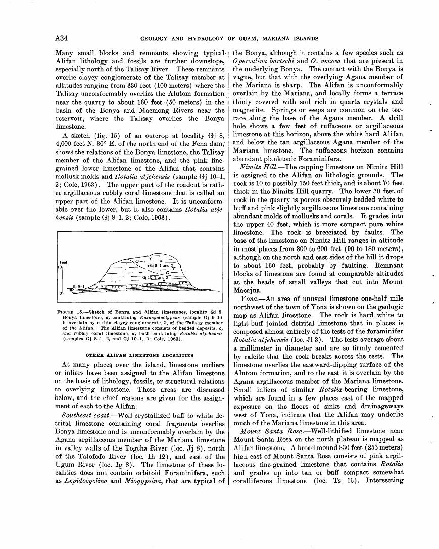
A34 GEOLOGY AND HYDROLOGY OF GUAM, MARIANA ISLANDS
Many small blocks and remnants showing typical. Alifan lithology and fossils are further down~lope, especially north of the Talisay River. These remnants overlie clayey conglomerate of the Talisay member at altitudes ranging from 330 feet ( 100 meters) ~here the Talisay unconformably overlies the Alutom formation . near the quarry to about 160 feet · (50 meters) in the basin of the Bonya and Maemong Rivers near the reservoir, where the Talisay overlies the Bonya limestone.
A sketch (fig. 15) of an outcrop at locality Gj 8, 4,000 feet N. 30° E. of the north end of the Fena dam; shows the relations of the Bonya limestone, the Talisay member of the Alifan limestone, and the pink finegrained lower limestone of the Alifan that contains mollusk molds and Rotalia atjehensis (sample Gj 10-1, 2; Cole, 1963). The upper part of the roadcut is rather argillaceous rubbly coral 1imestone that is called an upper part of the Alifan limestone. It is unconformable over the lower, but it also contains Rotalia atjehensis (sample Gj 8-1, 2; Cole, 1963).
FIGURE 15.-Sketch of Bonya and Alifan limestones, locality Gj 8. Bonya limestone, a, containing Katacycloclypeus (sample Gj 9-1) is overlain by a thin clayey conglomerate, b, of the Talisay member of the Alifan. The Alifan limestone consists of bedded deposits, c, and rubbly coral limestone, d, both containing Rotalia atjehensis (samples Gj 8--1, 2, and Gj 10-1, 2; Cole, 1963).
OTHER ALIF AN LIMESTONE LOCALITIES
At many place~ over the island, limestone outliers or inliers have been assigned to the Ali fan limestone on the basis of lithology, fossils, or structural relations to overlying limestone. These areas are discussed below, and the chief reasons are given for the assignment of each to the Alifan.
Southeast ooa.st.-Well-crystallized buff to white de., trital limestone containing coral fragments overlies Bonya limestone and is unconformably overlain by the Agana argillaceous member of the Mariana limestone in valley walls of the Togcha River (loc. Jj 8), north of the Talofofo River (loc. Ih 12), and east of the Ugum River (loc. Ig 8). The limestone of these localities does not contain orbitoid Foraminifera, such as Lepidooyolina and M iogypsina, that are typical of
the Bonya, although it contains a few species such as Operoulina bartsohi and 0. venosa that are present in the underlying Bonya. The contact with the Bonya is vague, but that with the overlying Agana member of the Mariana is sharp. The Alifan is unconformably overlain by the Mariana, and locally forms a terrace thiniy covered with soil rich in quartz crystals and magnetite. Springs or seeps are common on .the terrace along the base of the Agana member. A drill hole shows a few feet of tuffaceous or argillaceous limestone at this horizon, above .the white hard Alifan and below the tan argillaceous Agana member of the Mariana limestone. The tuffaceous .horizon contains abundant planktonic Foraminifera.
Nimitz Hill.-The capping limestone on Nimitz HiH is assigned to the Alifan on lithologic grounds. The rock is 10 to possibly 150 feet thick, and is about 70 feet thick in the Nimitz Hill quarry. The lower 30 feet of rock in the quarry is porous obscurely bedded white to bvff and pink slightly argillaceous limestone containing abundant molds of mollusks and corals. It grades into the upper 40 feet, which is more compact pure white limestone. The rock is brecciated by faults. The base of the limestone on Nimitz Hill ranges in altitude in most· places from 300 to 600 feet ( 90 to 180 meters) , although on the north and east sides of the hill it drops to about 160 feet, probably by faulting. Remnant blocks of limestone are found at comparable altitudes at the heads of small valleys that cut into Mount Macajna.
Y ona.-An area of unusual limestone one-half mile northwest of the town of Y ona is shown on the geologic map as Alifan limestone. The rock is hard white to light-buff jointed detrital limestone that in places is composed almost entirely of the tests of the foraminifer Rotalia atjehewis (loc. Jl3). The tests .average about a millimeter in diameter and are so firmly cemented by calcite that the rock breaks across the tests. The limestone overlies the eastward-dipping surface of the Alutom formation, and to the east it is overlain by the Agana argillaceous member of the Mariana limestone. Small inliers of similar Rotalia-bearing limestone, which are found in a few places east of the mapped exposure on the floors of sinks and drainageways west of Y ona, indicate that the Alifan may underlie much of the Mariana limestone in this area.
11/ ount Santa Rosa.-Well-lithified limestone near Mount Santa Rosa on the north plateau is mapped as Ali fan limestone. A broad mound 830 feet ( 253 meters) high east of Mount Santa Rosa consists of pink argillaceous fine-grained limestone that contains Rotalia and grades up into tan or buff compact somewhat coralliferous limestone (loc. Ts 16). Intersecting
·•
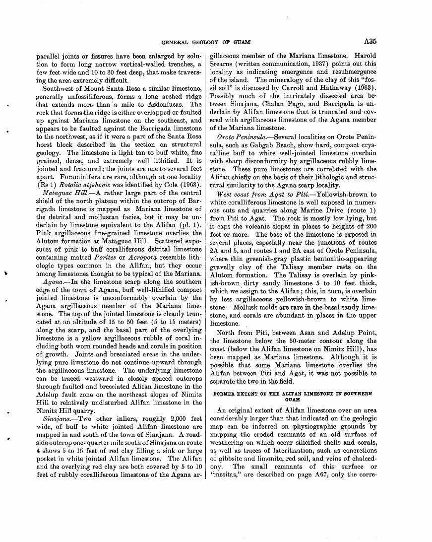
GENEIRAL GEOLOGY OF GUAM A35
parallel joints or fissures have been enlarged by solution to form long narrow vertical-walled trenches, a few feet wide and 10 to 30 feet deep, that make traversing the area extremely difficult.
Southwest of Mount Santa Rosa a similar limestone, generally unfossiliferous, forms a long arched ridge that extends more than a mi~le to Asdonlucas. The rock that forms .the ridge is either overlapped or faulted up against Mariana limestone on the southeast, and appears to be faulted against the Barrigada limestone to the northwest, as if it were a part of the Santa Rosa horst block described in the section on structural geology. The limestone is light tan to buff white, fine grained, dense, and extremely well lithified. It is jointed and fractured; the joints are one to several feet apart. Foraminifera are rare, although at one locality (Rs 1) RotAalia atjehenis was identified by Cole (1963).
. ~! ataguac Hill.-A rather large part of the central shield of the north plateau within the outcrop of Barrigada limestone is mapped as Mariana limestone of the detrital and molluscan facies, but it may be underlain by limestone equivalent to the Ali fan (pl. 1). Pink argillaceous fine-grained limestone overlies the Alutom formation at Mataguac Hill. Scattered exposures of pink to buff coralliferous detrital limestone containing matted Porites or Acropora resemble lithologic types common in the Alifan, but they occur among limestones thought to be typica1 of the Mariana.
Agana.-In the limestone scarp along the southern edge of the town of Agana, buff well-lithified compact jointed limestone is unconformrubly overlain by the Agana argillaceous member of the Mariana limestone. The top of .the jointed limestone is cleanly truncated at an altitude of 15 to 50 feet ( 5 to 15 meters) along the scarp, and the basal part of the overlying limestone is a yellow argillaceous rubble of coral including both worn rounded heads and corals in position of growth. Joints and brecciated areas in the underlying pure limestone do not continue upward through the argillaceous limestone. The underlying limestone can be traced westward in closely spaced outcrops through faulted and brecciated Alifan limestone in the Adelup fault zone on the northeast slopes of Nimitz I:Iill to relatively undisturbed Alifan limestone in the Nimitz I-IiU quarry.
Sinajana.-Two other inliers, roughly 2,000 feet wide, of buff· to white jointed Alifan limestone are 1napped in and south of the town of Sinajana. A roadside outcrop one- quarter mile south of Sinajana on route 4 shows 5 to 15 feet of red clay filling a sink or large pocket in white jointed Alifan limestone. The Alifan and the overlying red clay are both covered by 5 to 10 feet of rubbly coralliferous limestone of the Agana ar-
gillaceous member of the Mariana limestone. Harold Stearns (written communication, 1937) points out .this locaJity as indicating emergence and resubmergence of the island. The mineralogy of the clay of this "fossil soil" is discussed by Carroll and Hathaway ( 1963). Possibly much of the intricately dissected area between Sinajana, Chalan Pago, and Barrigada is underlain by Alifan limestone that is truncated and· covered with argillaceous limestone of the Agana member of the Mariana limestone.
Orote Peninsula.-Severallocalities on Orote Peninsula, such as Gabgab Beach, show hard, compact crystalline buff to white well-jointed limestone overlain with sharp disconformity by argillaceous ruhbly limestone. These pure limestones are correlated with the Alifan chiefly on the basis of thei~ lithologic and structural similarity to the Agana scarp locwlity .
West coast from A gat to Piti.-Yellowish-brown to white coralliferous limestone is well exposed in numerous cuts and quarries along Marine Drive (route 1) from Piti to Agat. The rock is mostly low lying, but it caps the volcanic slopes in places to heights of 200 feet or more. The base of the limestone is exposed in several places, especially near the junctions of routes 2A and 5, and routes 1 and 2A east of Orote Peninsula, where thin greenish-gray plastic bentonitic-appearing gravelly clay of the Talisay member rests on the Alutom formation. The Talisay is overlain by pinkish-brown dirty sandy limestone 5 to 10 feet thick, which we assign to the Alifan; this, in turn, is overlain by less argillaceous yellowish-brown to white limestone. Mollusk molds are rare in the basal sandy limestone, and corals are abundant in places in the upper limestone.
North from Piti, between Asan and A del up Point, the limestone below the 50-meter contour along the coast (below the Ali fan limestone on Nimitz Hill), has been mapped as Mariana limestone. Although it is possible that some Mariana limestone overlies the Alifan between Piti and Agat, it was not possible to separate the two in the field.
FORMER EXTENT OF THE ALIF AN LIMESTONE IN SOUTHERN GUAM
An original extent of Alifan limestone over an area considera:bly larger than that indicated on the geologic map can be inferred on physiographic gr,ounds by mapping the eroded remnants of an old surface of weathering on which occur silicified shells and corals, as well as traces of lateritization, such as concretions of gibbsite and limonite, red soil, and veins of chalcedony. The small remnants of this surface or "mesitas," are described on page A67, only the corre-
A36 GEOLOGY AND HYDROLOGY OF GUAM, MARIANA ISLANDS
lation of this surface with the base of the Alifan limestone is discussed here. The few coral fragments found are mainly sticklike Porites or Acropora, which are common in the Alifan.
The remnants of the surface range in altitude from about 390 to 650 feet ( 120 to 200 meters), and are predominantly from 490 to 520 feet (150 to 160 meters). They are conformal with the present surface of the base of the Alifan near present outcrops. On many
~:.···~······.·.····:···:·.:·.::·· .. ··.·.· .. ··. ,:: .. ·:;·. ·.;:
. ' . . . . .
.. GQCOS ISL.,A.I'JD).
remnants the rock beneath the surface is deeply weathered clay conglomerate, composed of volcanic boulders that are completely weathered to clay. These possibly represent weathered deposits of the Talisay member of the Alifan limeston~.
The mapped area of outcrop .of the Alifan limestone and the probable extent of the A.lifan before erosion are shown in figure 16. The hills of the Tenjo structural block now above 650 feet (200 meters) apparently were
0
EXPLANATION
Present area of outcrop of Alifan limestone --,--,-
Inferred Alifan shoreline
D Former extent of Alifan limestone
Inferred Mariana shoreline
-Former extent of Mariana limestone
4 MILES
FIGURE 16.-Present distribution of the Alifan limestone and inferred former extent of the Ali!an and Mariana limestones in southern Guani.
GENEiRAL GEOLOGY OF GUAM A37
islands during Ali fan time, for numerous blocks of limestone are found around the slopes of the mountains at altitudes of 520 to 650 feet ( 160 to 200 meters), but none are found higher. A break in slope is also apparent at about this range in altitude. The boundary of the southern Bolanos "island" is much more tentative and is based on the break in slope at the foot of the mountain ridge below which well-defined mesita remnants are found. Remnants that we believe are definitely of Alifa.n age are found as far south as Inarajan, although it is possible that the Alifan did not extend completely around the southern end of the island as shown.
The presence of Alifan limestone on the western slopes of the island indicates that a west-dipping surface had been formed on the eastward-dipping volcanic rocks before Alifan time. Therefore the present configurat-ion of the island, at least of the central part of the island, was largely formed before the deposition of the Alifan limestone.
FOSSILS
According to Cole ( cha.p. E) ,Rota1ia atjehoosis is the only diagnostic larger foraminifer to be found over the area of typical Alifan limestone, on Mounts Alifan and Almagosa and in the valleys of the Bonya and Talisay Rivers. This rotalid is common in most of the Bonya limestone of Tertiary f age. In the Alifan it is comm~n with mollusks in the lower part of many outcrops-near the underlying volcanic rocks-but not higher in the section with corals.
Limestone at two areas along the east coast, Y ona n.nd Mount Santa. Rosa, contains rare broken fragments of ll!logyJ')Sinoides ouzntlaefm'1nis with Rotalia atjehensis. According to Cole (1963), M. cupulaeformis is a Tertiary f species that is found in some of the Bonya samples. Possibly the limestone at .these localities represents a shoal or nearshore facies equivalent to the uppermost Bonya limestone.
Limestone at Gabgaib Beach (loc. Cn 1) on Orote Point contains Oycloclypeus carpenteri and other Foraminifera which live in recent seas, but which ext·end back into Tertiary g. The same is true of the Alifn.n limestone of the southeast coast, which contains OJJe'rmtlina venosa, 0. bartschi, and others that are living in recent seas, but which are found in the underlying Bonya limestone associated with typical Tertiary f Foraminifera.
The lowermo?t Alifan limestone may be of Tertiary f age, especially in areas closely associated with the Bonya limestone. It is probable that most of the Alifan is Tertiary g (upper Miocene) and possibly
uppermost beds are Pliocene. Definite placing of the Ali fan limestone will have to a wait study of collections of mollusks and other fossils.
BARRIGADA LIMESTONE
White comparatively homogeneous even-grained detrital limestone, generally carrying a characteristic assemblage of large Foraminifera, crops out over a ring-shaped area of the north plateau. It is called the Barrigada limestone, and the type locality is exposed on the lower north slope of Barrigada Hill and on the north-facing scarp 2,000 feet north of Barrigad~l, Hi1l. The base of the formation is not exposed, and the top grades both upward and outward into the detrital fossiliferous Mariana limestone. Tayama ( 1952, p. 57; table 4) used the naine Barrigada limestone without designating a type section and without defining the limestone, except to state that it was the stratigraphic equivalent of the "Older raised coral reef limestone" of the Mariana Islands, and that it resembled the Mariana limestone both in lithology and in fossil content (1952, p. 212). Harold T. Stearns (1940) also used the name Barrigada limestone in an abstract, without designating a type section, to refer to limestone of the northern plateau. In the present report the nU!me Barrigada limestone is restricted to limestones that crop out along the base of Barrigada Hill and the scarp to the north, and to their mappable equivalents.
LITHOLOGY
The rock is intensely white pure medium- to coarsegrained detrital limestone. It is massive, brecciated in many places, and ranges from compact and well lit:hified to extremely friable. On fresh fracture it is dusty or chalky in appearance. Most fossils, such as mollusks and corals, are present only as scattered poorly preserved molds or as shadowy relicts; but such larger Foraminifera as Oycloclypeus, Operculina, and Gypsina are generally so abundant as to be characteristic of the formation.
The rock at Barrigada Hill is not continuously exposed, and no detailed descriptive section was made (fig. 17). A generalized description follows.
General'ized description of a section of the Barrigada li.rneston_e from north to south starting at road at ~95 feet (90-'lneter contour) at base of scarp 3,600 feet (1,100 mete'rs) due north of Barrigada ~ triangulation Bill at top of Barrigada Hill.-Most of the rock is uniform white medium- to coarse-grained detrital limestone from the road up to the 510-foot (155-meter) contour, a horizontal distance of 2,300 feet (700 meters) and a vertical rise of 215 feet ( 65 meters). The limestone is brecciated and friable on the face ·of
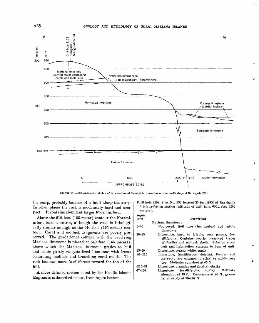
A38 GEOLOGY AND HYDROLOGY OF GUAM, MARIANA ISLANDS
(f) 0:: LLJ 1-LLJ ~
200
s
1-LLJ LLJ I.L..
Mariana limestone (detrital facies containing
corals and mollusks) _
N
Foraminifera --500~--~~~~------.~--------------~~~~~----------------------------------------------------------
400------------------------------~========~~~-------------------------------Barrigada limestone
100
Barrigada limestone
100--------------------------------------------------------------~r-------------------------
Sealevel ---------------.--____ ----::==-?---------~==----~~~------=::~~1~.----------~~.==~------~r-------------------------
Alutom formation
0 1000 2000 METERS Alutom formation
APPROXIMATE SCALE \ FIGURE 17.-Diagrammatlc sketch of type section of Barrlgada limestone on the north slope of Barrigada Hill.
the scarp, probably because of a fault along the scarp. In other places the rock is moderately hard and compact. It contains abundant larger Foraminifera.
Above the 510-:foot (155-meter) contour the Foraminifera become scarce, although the rock is lithologically similar as high as the 540-foot (165-meter) contour. Coral and mollusk fragments are poorly pre-, served. The gradational contact with the overlying Mariana limestone is placed at 540 feet ( 165 meters), above which the Mariana limestone grades to buff and white partly recrystallized limestone with lenses containing mollusk and branching coral molds. The rock becomes more fossiliferous toward the top of the hill.
A more detailed section cored by the Pacific Islands Engineers is described below, from top to bottom.
Drill hole 2109, (loc. No. 15) located 50 feet SSE of Barrigada 2 triangulation station; altitude of drill hole, 660.1 feet (202 meters).
Depth (feet)
0-10
10-25
25-30 30-63.5
63.5-67 67-104
Description
Mariana limestone : Not cored. Soil zone (few inches) and rubbly
limestone. Limestone, hard to friable, very porous, fos
siliferous. Contains po'Orly preserved traces of Porites and mollusk shells·. Solution channels and light-yellow staining to base of unit.
Limestone, coarse, white, sandy. Limestone, fossiliferous, detrital. P01·ifes and
Acropora. are common in sticklike molds near top. Mollusks abundant at 45 ft.
Limestone, granular and detrital, chalky. Limestone, fossiliferous, chalky. Mollusks
abundant at 75 ft. Cavernous at 90 ft; granular or sandy alt 98-104 ft.
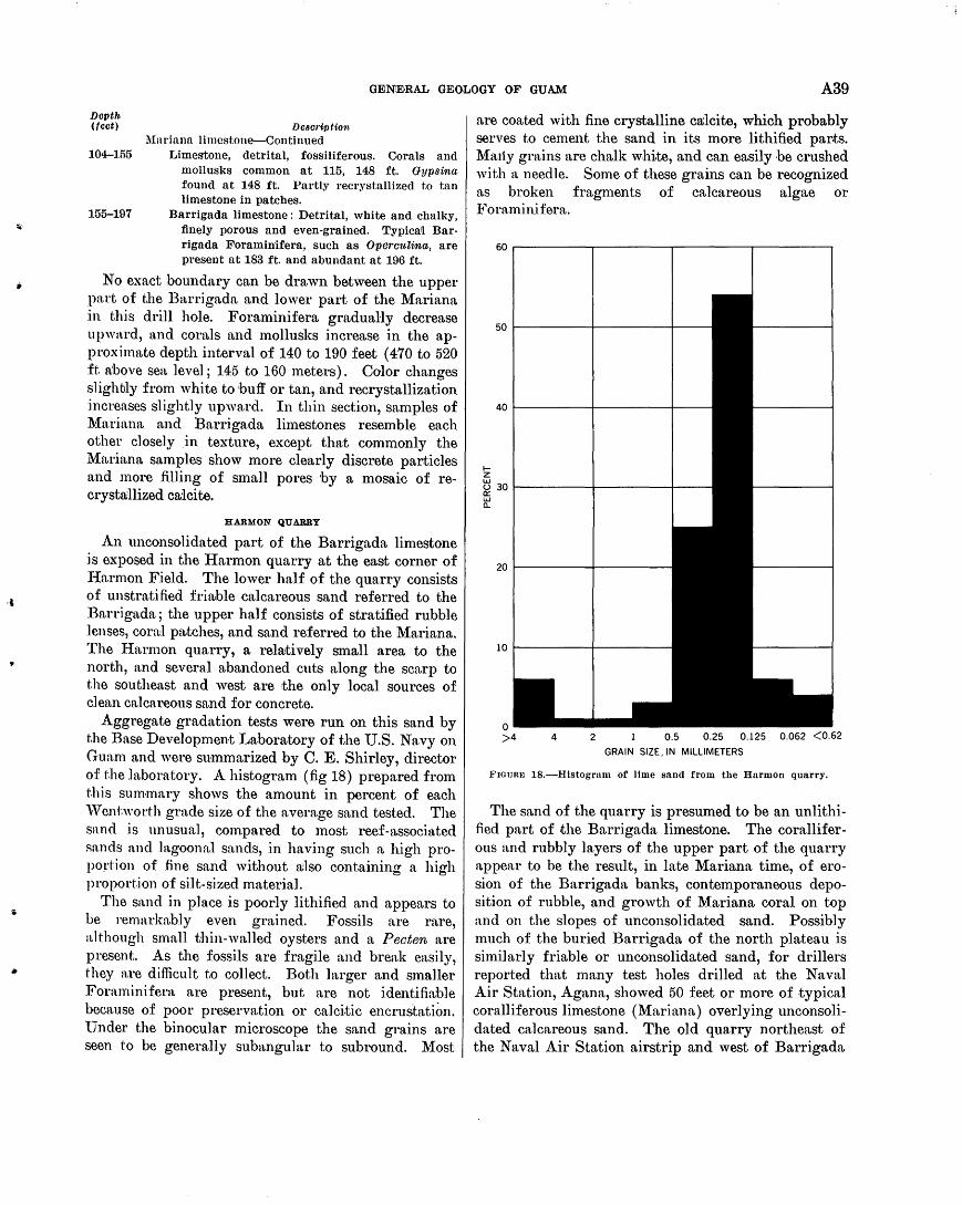
,,
,.
GENE·RAL GEOLOGY OF GUAM A39
Depth (feet) DoBoription
Mariana limestone-Continued 104-155 T .. imestone, detrital, fossiliferous. Corals and
mollusl\:S common at 115, 148 ft. Gypsina found at 148 ft. Partly recrystallized to tan limestone in patches.
155-197 Bnrrigada limestone: Detrital, white and chall\:y, finely porous and even-grained. Typica[ Barrigada Foraminifera, such as Operettlina, are present at 183 ft. and abundant at 196 ft.
No exact boundary can be drawn between the upper part of the Barrigada and lower part of the Mariana :in this drill hole. Foraminifera gradually decrease upward, and coraJs and mollusks increase in the approximate depth interval of 140 to 190 feet ( 4 70 to 520 ft. n:bove sea level; 145 to 160 meters). Color changes slighbly from white to buff or tan, and recrystallization increases slightly upward. In thin section, samples of Mariana and Barrigada limestones resemble each other closely .in texture, except that commonly the ~{ariana samples show more clearly discrete particles and more filling of small pores by a mosaic of recrysta;llized ca;lcite.
HARMON QUARRY
An unconsolidated part of the Barrigada limestone is exposed in the Harmon quarry at the east corner of !-Iarmon Field. The lower half of the quarry consists of unstratified friable calcareous sand referred to the Barrigada; the upper half consists of stratified rubble lenses, coral patches, and sand referred to the Mariana. The !-Iarmon quarry, a relrutively small area to the north, and several abandoned cuts along the scarp to the southeast and west are the only local sources of clean calcareous sand for concrete.
Aggregate gradation tests were run on this sand by t.he Base Development Laboratory of the U.S. Navy on Gun.m and were summarized by C. E. Shirley, director of the laboratory. A histogram (fig 18) prepared from t.his summary shows the amount in percent of each ''Tentworth grade size of the average sand tested. The snnd is unusual, compared to most reef-associated sands and htgoonal sands, in having such a high proportion of fine sand without a;lso containing a high proportion of silt-sized material.
The sand in place is poorly lithified and appears to be remarkably even grained. Fossils are rare, although small thin-walled oysters and a Pecten are present. As the fossils are fragile and break easily, they are difficult to collect. Both larger and smaller Foraminifera are present, but are not identifiable because of poor preservation or calcitic encrustation. ·under the binocular microscope the sand grains are seen to be generally subangular to subround. Most
are coated with fine crystalline ca;lcite, which probably serves to cement the sand in its more lithified par.ts. Ma1iy grains are chalk white, and can easily be crushed with a needle. Some of these grains can be recognized as broken fragments of calcareous algae or Foraminifera.
1-z ~ 30~------~---------+---ct: w c..
4 2 0.5 0.25 0.125 0.062 <0.62
GRAIN SIZE, IN MILLIMETERS
FIGUR~J 18.-Histogrnm of lime sand from the Harmon quarry.
The sand of the quarry is presumed to be an unlithified part of .the Barrigada limestone. The coralliferous and rubbly layers of the upper part of the quarry appear to be the result, in late Mariana time, of erosion of the Barrigada banks, contemporaneous deposition of rubble, and growth of Mariana coral on top and on the slopes of unconsolidated sand. Possibly much of the buried Barrigada of the north plateau is similarly friable or unconsolidated sand, for drillers reported that many test holes drilled at the Naval Air Station, Agana, showed 50 feet or more of typical coralliferous limestone (Mariana) overlying unconsolidated calcareous sand. The old quarry northeast of the Naval Air Station airstrip and west of Barrigada
A40 GEOLOGY AND HYDROLOGY OF GUAM, MARIANA ISLAN'DS
Hill contains friable fine-grained Barrigada limestone in the bottom 20 feet, grading upwards to lithified Mariana limestone.
DISTRffiUTION
The Barrigada limestone has a ring-shaped area of outcrop on the north plateau about 5 miles in diameter from northwest to southeast, about 9 miles long from northeast to southwest; the breadth of outcrop ranges from 1 to 2 miles (pl. 1). The "loop highway" on the plateau, formed by routes 1, 3, and 9, follows the ring-shaped area of outcrop of the formation. The surface of the formation is, in a general way, a low area or moat bounding a central broad low mound which is capped by the Mariana (possibly Alifan) limestone and bounded by the so mew hat higher rugged
.margin of the plateau, likewise formed of overlapping Mariana limestone. A small inlier of Barrigada limestone at some distance from the principle outcrop is exposed on a low terrace at the base of the cliffs at Tarague near the north end of the island.
The base of the Barrigada has not been identified. A drill hole 543 feet deep near Haputo (Ov 7) started in Barrigada limestone at the surface and bottomed about 100 feet below sea level in white detrital limestone which contains Foramini_fera characteristic of the Barrigada limestone. The formation therefore is greater than 543 feet in maximum thickness.
A bed at the base of the J anum formation at Catalina Point is a medium-grained detrital limestone (sample Ts 5-10). ·It contains not only a rich fauna of planktonic and benthonic Foraminifera typical of the J anum formation, but also the same species of Operculina and Oycloclypeus identified from the Barrigada formation. This basal layer, resting unconformably on the Bonya limestone, is equivalent to some part of the Barrigada formation.
On the geologic map (pl. 1) the Barrigada limestone is shown lapping onto volcanic rocks of the Alutom formation west of Mount Santa Rosa and in contact with Alifan limestone southwest of Mount Santa Rosa. In both places the overlapping rock at the contact is probably the upper part of the Barrigada limestone. The contact with the Alifan may be a fault contact.
The relation of the Barrigada limestone to the overlying Mariana limestone is well exposed in contrast, although the contact between the two is generally gradational and difficult to map. In most places, and especially on the eastern and central parts of the aren, of outcrop of the Barrigada, the rocks grade upward from typical "chalky" intensely white limestone with the cha.racteristic assemblage of larger Foraminifera, through 30 feet or more of limestone of similar lithol-
ogy with few Foraminifera, to more recrystallized and less chalky limestone that contains molds of corals and mollusks and is shown on the map as Mariana limestone.· In some places Foraminifera, such as Gypsina, are found with abundant molds of branching corals and mollusks at the top of the formation, as, for instance, in sample Sv 5-1 from the quarry one-half mile northeast of Salisbury, and also in the drill cores from Barrigada HiU.
In a few places on the west side of the north plateau, coralliferous detrital limestone of the Mariana limestone overlies a truncated surface of Barrigada with sharp unconformity. The best example of such a relationship is seen northwest of the Taguac intersection (1,300 ft WSW of loc. Ov 7). Barrigada limestone, strongly jointed in a rectilinear pattern by closely spaced vertical joints that trend N. 35° E. and S. 54° E., is truncated and overlain by the wedging-out margin of nonjointed coralliferous detrital Mariana limestone.
FOSSILS
Larger Foraminifera of the Barrigada limestone are discussed by Cole (1963) who repor.ts that three species are diagnostic of the formation. These are Oycloclypeu.s ( Oycloclypeus) postindopacificus, Operculina lucidisutura, and 0. rectilata. In addition a large Gypsina is characteristic and in places albundant, and a large encrusting foraminifer similar to Gypsina is very abundant. Sman fragments of calcareous red algae are also common in places. They are generally rounded and are probably nodular, rather than broken and worn fragments.
Scattered coral molds, especially of small branching Porites, Acropora, and Seriatopora, are present but are not common. Poorly preserved molds of mollusk shells likewise are present in places, but they do not seem to be characteristic of .the formation. Moderately well preserved thin calcitic shells of a small Pecten and an Ostrea are found in places but are not common. The apparent .Jack of corals, aragonetic mollusks, and other organisms is due, at least in part, to the effacing of traces of .these organisms by alteration of aragonite to calcite and by disintegration of the aragonitic fossil structure. Calcitic organ~sms, especially heavy-bodied Foraminifera-such as Opermdina and Gypsina-the nodular algae, and the Pecten and Ostrea persist without alteration, although these fossils too show evidence of disintegration. They are pure white and are somewhat chalky or friable instead of being hard and crystalline as are the fossil Foraminifera and algae in the Maemong, Bonya, and lower part of the Alifan limestones.
•
f
..
•
•
•·
GENE•RAL GEOLOGY OF GUAM A41
AGE AND CORRELATION
Cole ( 1963) has placed the Barrigada limestone in Tertiary g (upper Miocene), correlating it with the Tertiary g of the Bikini drill hole. Field evidence indicates that the Barrigada is younger than the Bonya limestone and younger than the Rot.alia atjehensis zone of the .lower part of the Alifan limestone. It may be a. :facies equivalent of the coral and 1nolluscan-rich Alifan limestone exposed in the upper part of the Ali:fan quarry, although at present the equivalency cannot be demonstrated .
The Barrigada is possibly older than the recrystallized and jointed limestones, mapped as the uppermost part of the Alifan limestone, which underlie the Agana member of the l\{ariana limestone on Orote Peninsuln, at Agann., and on the east coast north and south of Talofofo. These localities are discussed by Cole (1963), who believes that the operculinid and Oyclocly7Jeus fauna, found in them is generally younger in aspect than that of the Barrigada.
CONDITIONS OF DEPOSITION
Cole considers that the Foraminifera of the Barrigada formation developed in deeper w31ters of the seaward slopes. The configuration of the Barrigada outcrop indicates that the sediments were probably depos.i ted on banks of considerable areal extent around the l\{ount Santa Rosa-Mataguac volcanic mass. The OzJermtlina-Oycloclypeus fauna suggests open-water conditi.ons at depths perhaps to 100 fathoms, although t,he increase in corals near the top of the formation indicates depths probably not greater than 30 fathoms. Gradual shoaling led to increasing coral growth, the development of reefs and lagoons, and to the dying out of the open-water benthonic fauna as shoaling banks of the Barrigada passed over to a Mariana reef environment.
JANUM FORMATION
A sequence of well-bedded globigerinid limestones ranging in .thickness from 4 to 70 feet, crops out at 7 localities rulong the northeast coast of Guam from Lujuna to Anao Points. It is here named the Janum formn.tion after J anmn Point, near the type section at Ca,talina Point. Three sections of the formation, described by S. 0. Schlanger, are given below.
Tmw section of the J an1tm formation on the seacoast at Oatal·ina Point, 1% miles southeast of Mount Santa Rosa (loc. Ts 5; fig. 19)
Mariana limestone: Conglomerate of cemented rounded coral boulders 10 ft thick ; forms a cap on the low coastal terrace.
S·harp contact. Janum formation:
Thickness (feet)
Limestone, pink to red and yellow, medium-grained, friable, argillaceous ; formed mostly of packed tests of planktonic Foraminifera ; thin laminar beds (sample Ts 5-5 near bottom of unit)-------- 10
Limestone, dark-brown, foraminiferal, fairly well indurated, medium-grained, argillaceous; grades down into alternating bands of brown friable argillaceous limestone 6 ins to 1 ft thick (sample Ts 5-6 10 ft above bottom of unit) and hard white relatively pure limestone 1 to 2 ft thick________ 30
Limestone, lemon-yellow banded, medium-grained, friable, slightly argillaceous____________________ 1
Limestone, foraminiferal, white to buff, friable, thick-bedded, grading down to sea level into dense well-lithified jointed white limestone containing benthonic larger Foraminifera as well as abundant planktonic types, sample Ts 5-7, 10 ft below top; sample Ts 5-10, near bottom)--------------- 30
The base of the formation is not exposed, but the Bonya limestone is thought to lie at a very short distance below the lowest port of the J anum limestone exposed here because in other places where the J anum is thinner, the Bonya immediately underlies the J"anum. Section ot the Janu·m limestone exposed on the coastal ter
race 7,000 teet 801ttll:1rest of Lu,jmw Point and 3,500 feet north-northeast ot Pagat Point ( loc. Rr 13)
Mariana limestone: Rubbly near the contact grading upward into coralliferous limestone in the cliff face.
Thickness Sharp contact. (feet)
Janum formation: Limestone, pink to red, grading down into yellow ; well-bedded ; friable; argillaceous; composed dominantly of globigerinid Foraminifera (sam-ple Rr 14-1, near bottom; Rr 15-1, near top ________ 10-12
Sharp contact. Bonya limestone : Limestone, massively bedded, white,
hard and compact, recrystallized, jointed; contains larger Foraminifera (sample Rr 13-1). Strike N. 55° E., 20° SE.
Section at Anao Pmnt in cliff face about 75 teet above sea level ( locality U 1t 1 )
Mariana limestone: Rubbly, grading upward in 10 ft into massive white coralliferous limestone. The basal 4 to 6 ft of the unit is pink to orange argillaceous limestone containing subrounded fragments of recrystallized white limestone; it is assumed to be reworked from the unit below.
Jamun formation: Limestone, pink to orange, argillaceous ; composed dominantly of globigerinid Foraminifera. It is thin bedded ( 1 to 4 in.) and closely
jointed (sample Uu 1-3) ---------------------------- 4 Sharp contact. Bonya limestone : Limestone,
compact and hard, jointed. white, recrystallized,
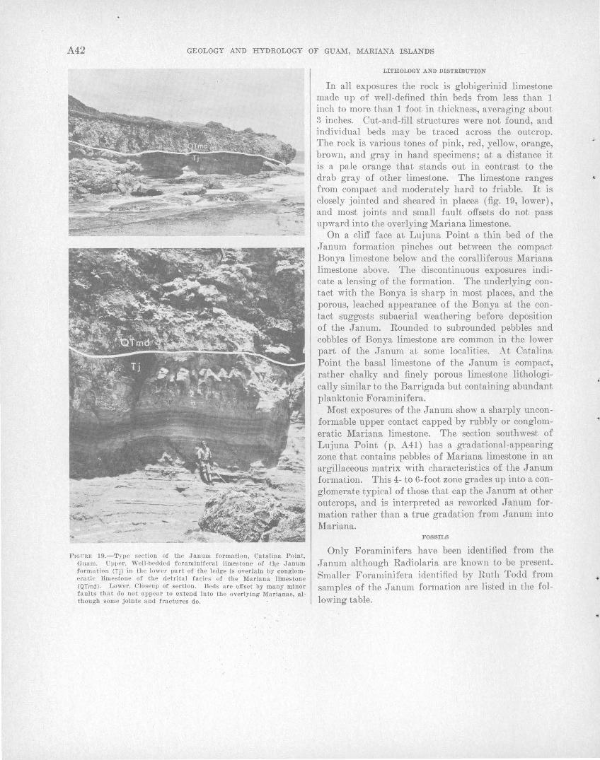
A42 GEOLOGY AND HYDROLOGY OF GUAM, MARIANA I SLANDS
FIGURE 19.-Type section of the Janum formation, Catalipa Point, Guam . Uvper, Wcll-bE>dued foraminiferal limestone of tlje Janum formation (Tjl in the lower part of the ledge is overlain by conglomeratic limestone of the detrital facies of the Mariana limestone (QTmd) . Lower, Closeup of section. Beds are offset by many minor faults that do not appear to extend into the overlying Marianas, although some joints and fractures do .
LITHOLOGY AND DISTRmUTION
In all exposures the rock is globigerinid limestone made up of well-defined thin beds from less than 1 inch to more than 1 foot in .thickness, averaging about 3 inches. Cut-and-fill structures were not found, and individual beds may be traced across the outcrop. The rock is various tones of pink, red, yellow, orange, brown, and gray in hand specimens; at a distance it is a pale orange that stands out in contrast to the drab gray of other limestone. The limestone ranges from compact and moderately hard to friable. It is closely jointed and sheared in places (fig. 19, lower), and most joints and small fault offsets do not pass upward into the overlying Mariana limestone.
On a cliff face at Lujuna Point a thin bed of the Janum formation pinches out between the compact Bonya limestone below and the coralliferous Mariana limestone above. The discontinuous exposures indicate a lensing of the formation. The underlying contact with the Bonya is sharp in most places, and the porous, leached appearance of the Bonya at the contact suggests subaerial weathering before deposition of the J anum. Rounded to subrounded pebbles and cobbles of Bonya limestone are common in 'the lower part of the Janum at some localities. At Catalina Point the basal limestone of the J anum is compact, rather chalky and finely porous limestone lithologically similar to the Barrigada but containing abundant planktonic Foraminifera.
Most exposures of the Janum show a sharply unconformable upper contact capped by rubbly or conglomeratic Mariana limestone. The section southwest of Lujuna Point (p. A41) has a gradational-appearing zone that contains pebbles of Mariana limestone in an argillaceous matrix with characteristics of the J anum formation. This 4- to 6-foot zone grades up into a conglomerate typical of those that cap the J anum at other outcrops, and is interpreted as reworked J anum formation rather than a true gradation from Janum into Mariana.
FOS"SILS
Only Foraminifera have been identified from the Janum although Radiolaria are known to be present. Smaller Foraminifera identified by Ruth Todd from samples of the Janum formation are listed in the following table.
•
GENE·RAL GEOLOGY OF GUAM A43.
Sample
Planktonic species 1
------------1--------------Globiocrina in{lata d'Orblgny _________ R ------ R ------ ------ ------ C
oenezw:lana Hedberg _____________ ------ ------ R ------ R ------ C t!eprmthes ~l'odd __________________ ------ R ------ ------ ------ R C
Globlgerinoirles conglobata (Brady)____ C C R ----·- R C A aaccnlifera (Brady)_______________ R H. ------ ------ C ------ A
Globloerinella aeqttilateralis (Brady) __ ------ ------ ------ ------ ------ ------ R Orbulina bilobata (d'Orblgny) ________ ------ ------ ------ ------ ------ ------ R nniocrsa d'Orblgny _______________ C H. R C C R A Sphaeroidinella dehiscens (Parker and
Jones>----------------------·----·- C C R A R C C kochi (Caudrl) ____________________ ------ C A ------ C A A seminttlina (Schwager)___________ A A C C A C C
Candeina nltida d'Orblgny ___________ ------ ------ ------ ------ ------ ------ R Globoqnadrina altispira (Cushman
1\nd .Torvls)_______________________ R R Globorotalia canariensis (d'Orblgny) __
111Cndardii (d'Orblgny) var jiji-cnsis Cushman .•••••• ____________ A A tttmid,a (Brady)__________________ 0 A
R R
R A
R
A R ------ R
c A
0 A
1 Numerous specimens or unidentified globlgerlnlds present In all the samples. R, rare; 0, common; A, abundant.
Benthonic species (composite fauna from 7 samples) wer·e also identified by Ruth Todd. Because these, "·ith the starred exceptions, form only a negligible proportion of the total fauna, they are merely listed below in aJphabeticaJ order.
Arnphisteg·ina? sp. Angu.loger·ina sp. AnornaUna 'l sp. A.nornalinella rostrata (Brady)? Bolivina pusilla Schwager
spp. Oassi<lttlina <lelicata Cushman
pacifica Cushman? •subglobosa Brady spp.
OibicMos cicat·ricostt8 (Schwager) cf. 0. pscu.<lottngeriamts (Cushman) spp.
Dentalina. pcrproce-ra (Schwager) ? tau;ricornis (Schwager) juv.? spp.
Fl{lffC?'cZla b1·a(lyi (Cushman) •Eh1'C1tbm·gi1ia albatrossi Cushman Ellipsoplmtrostornella sp. ]J)lphillittrn sp. E1wn·illcs um.bona.ttts (Reuss) .E110nirles 'l spp. Flssurina ci'I'Cttl1tm. Seguenza
formosa (Schwager) globosa Bornemann spp.
Gu.ttu.Una 'l sp. Gy1·ohUu a spp. I\.arrr1·iella. bnt.dy·i (Cushman) La-rJcna. gntciUs Williamson La.gcna. 'l sp. La.tioarin,in.a sp. Lomost01nmn lintbatttm. (Brady) var. costulatu.m ( Cush
man) No(losar·ia cqu,isetiformis Schwager
insecta Schwager? sp.
}o/odosariw? spp.
716-2910---64-4
Nonion? sp. N onionella sp. Orthomorphina spp. Orthomorphina? spp. Osangttlaria bengalensis (Schwager) juv. PlanuUna sp.
• Plettrostom.ella alternans (Schwager) brevis Schwager sp.
Pu.Uen'ia bnlloi<les ( d'Orbigny) sp.
Pyrgo sp. Pyrulina labiata (Schwager) Robultts '! sp. Siphogeneria striata (Schwager) Siphono<losa?"ia fijiensis Cushman
sp. Siphono<losaria 'l sp. Sphaeroi<lina bulloi<les d'Orbigny T1·itarina bra<lyi Cushman Triloculina sp. Uvigerina p1·oboscidea Schwager
proboscidea Schwager var. vadescens Cushman VttlmtUna sp.
A series of samples from the type section at Catalina Point show that globigerinids form the bulk of the rock throughout most of the J anum formation, but that those samples near the top and bottom contain such benthonic Foraminifera as Amphistegina and rotalids, as well as globigerinids and other planktonic forms.
W. Storrs Cole (1963, pls. 4, 7) has identified Operculina rectilata and Oycloclypeus ( 0.) postindopacificus from sample Ts 5-10 near the bottom of the Catalina Point section. These larger Foraminifera are characteristic Barrigada types, and occur in a limestone of lithology similar to that of the Barrigada. Therefore the J anum formation is probably equivalent to some or all of the Barrigada formation of Tertiary g age.
CONDITIONS OF DEPOSITION
From a review of the smaller foraminiferal constituents of the J anum formation, Ruth Todd (written communication, 1952) states th31t the globigerinid limestone making up the· bulk of the formation was deposited at depths probably below 100 fathoms, but not below 1,500 fathoms. The benthonic species in the samples from the lowermost and uppermost beds within the formation indicate deposition possibly as shallow as 40 or 50 fathoms, but not so shallow as 10 fathoms, and certainly not within any barrier to the circulation of oceanic currents, as indicated by the abundance of planktonic forms.
The indication that the J anum formation was probably deposited contemporaneously with the Barrigada limestone suggests th31t the J:anum was deposited on
A44 GEOLOGY AND HYDROLOGY OF GUAM, MARIANA ISLANDS
the seaward slope of the broad banks on which the Barrigada was deposited. If the Barrigada were deposited mostly at depths of 50 to 100 fathoms in open water, then the ~Janum formation (which is 400 to 500 ft below the principal Barrigada outcrops) was deposited at depths of 100 to 200 fathoms.
The argillaceous or tuffaceous contamination of the .J anum ranges from less than 1 percent .to 30 percent in 6 samples ana'lyzed by Carroll and Hathaway (1963). The samples are probably representative of the formation, which therefore averages about 10 percent insoluble material. The amount of contamination is difficult to explain when contrasted with the relative purity (probably less than 1 percent) of the Barrigada limestone. If the two formations are conte:mporanoous, either the Barrigada contains contaminated beds not exposed on the plateau . (or not discovered), or the contaminating material that probably originated from the 'erosion of Mount Santa Rosa was deposited on the eastern slopes rather than on the top of the banks.
PLIOCENE AND PLEISTOCENE SERIES
MARIANA LIMESTONE
The Mariana limestone includes about 80 percent of the exposed reef-associated limestones of Guam. It forms most of the north plateau of the island, the Orote Peninsula, and the limestone thak fringes the southeast coast from Pago Bay to Agfayan Bay south of Inarajan.
The Mariana limestone was named. by Tayama (1936) for exposures on Tinian Island. He later extended the name to exposures on Saipan Island (Tayama, 1938) and to the other southern Mariana Islands (Tayama, 1952), although he designated no type section or type locality. According to Tayama (1952, p. 211), the Mariana limestone covers the southern half of Saipan, the northern half of Guam, and most of Rota, Tinian, and Aguijan. He did not recognize it on Farallon de Medinilla. Cole and Bridge (1953) used the name on Saipan; and Cloud, Schmidt, and Burke (1956, p. 78) redefined and mapped the formation on Saipan and described reference localities for each of four facies into which they divided the formation: the rUJbbrly, :the Acropora-rich, the llalhneda-rich, and the massive facies. They purposely did not designate a 'type section for ~the formation as a whole, al,though for reference the exposures in ~the Dandan area of southeastern Saipan were designated as the standard for the Mariana limestone on Saipan.
Tayama (1952, p. 211) stated that the Mariana limestone forms the north plateau of Guam. He also
considered that the limestone cap on Mount Lamlam is an elevated atoll of Mariana age (1952, p. 257), although we have assigned this limestone to the Ali fan.
The 1f ariana limestone on Guam consists of two members: the main body of the Mariana limestone, uncontaminated by clay or volcanic detritus, and not given a separate member name; and the Agana argillaceous member near the older volcanic uplands. The main body of the l\1ariana is made up of four mapped reef-associated facies over most of the north plateau: the reef facies, the detrital facies, the molluscan facies, and the fore-reef facies. Both the detrital and the molluscan facies represent a lagoonal environment in most pla_ces. The fore-reef facies is mapped in relatively few places because characteristically dipping beds of offshore deposi·ts are not common. The Agana argillaceous member is not subdivided into facies.
The relations of the main body of ,the Mariana limestone and the Agana argillaceous member to the volcanic rocks and the relations of the facies are shown on the geologic map (pl. 1) and diagrammatically in figure 20. The configuration of the former peripheral reef of the north plateau and the related lagoon and offshore deposits formed an atoll-like structure in which the present l\1ount Santa Rosa and Mataguac I-IiH stood out as small volcanic islands w~thin an encircling reef in much the same manner as the present-day Truk Islands, although on a smaller scale.
Each facies of the Mariana lin1estone comprises several suhfacies or biofacies characterized by a dominant faunal assemblage. The subfacies were mapped in .the field, but they are not shown on the published geologic map (pl. 1). Each facies and its component subfacies will be discussed separately.
REEF FACIES
Reef limestone formed of well-cemented coral and algal rock, similar to that formed on a living reef margin or on patch reefs within a lagoon, makes up the reef facies. Several varieties of reef rock grade one into another, but all are characterized essentifVlly by a cemented skeletal framework. The framework is formed of branching and massive coral colonies that grew olosely together and were cemented ·by thick layers of crustose coraJline algae similar to Porolithon and Lithophyllum on present-day reefs. The reef facies is almost everywhere well consolidated. It is generally porous on top of the plateau, and contains large unfi.Jled pockets and cavities between coral colonies; near cliffs, however, the rock is generally recrystaHized, and pores are filled by calcite to form a
..
•.
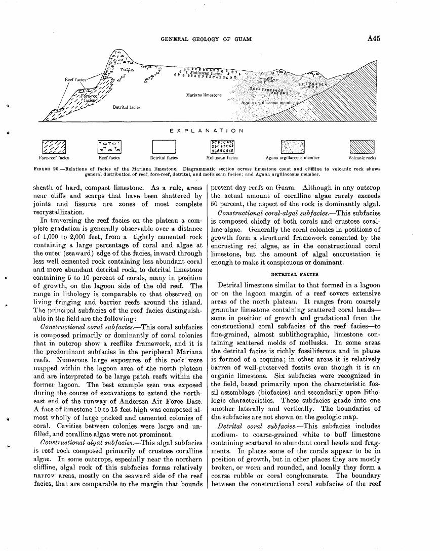
GE-NE·RAL GEOLOGY OF GUAM A45
Mariana limestone
Detrital facies
EXPLANATION
Fore-r·eef facies Reef facies Detrital facies Molluscan facies Agana argillaceous member Volcanic rocks
FrouaFJ 20.-Relatlons of facies of the Mariana limestone. Diagrammatic section across limestone coast and clitHine to volcanic rock shows general distribution of reef, fore-reef, detrital, and molluscan facies; and Agana argillaceous member.
sheath of hard, compaot limestone. As a rule, areas nea.r cliffs and scarps that have been shattered by :joint.s and fissures are zones of most complete recrystallization.
In traversing the reef faoies on the plateau a complet·e gradation is generally observable over a distance of 1,000 t·o 2,000 feet, from a tightly cemented rock eonhtining a large percentage of coral and algae at t.he outer (seaward) edge of the f·acies, inward through less well cemented rock containing less abundant coral and more abundant detrital rock, to detrital limestooe containing 5 to 10 percent of corals, many in position of growtJ1, on tJhe lagoon side of the old reef. The range in lithology is comparable to that observed on 1 i.ving fringing and barrier reefs around the island. The principal sutbfacies of the reef facies distinguishable in the field are the following:
Oonst'J··1.wtional coral S'ltbfacies.-This coral subfacies .is composed primarily or dominantly of coral colonies that in outcrop show a reefiike framework, and it is t·he predominant subfacies in the peripheral Mariana reefs. Numerous large exposures of this rock were mapped within the lagoon area of .the north plateau and are interpreted to be large patch reefs within the former lagoon. The best example seen was exposed dnring the course of excavations to extend the northeast end of the runway of Andersen Air Force Base. A face of limestone 10 to 1.5 feet high was composed almost wholly of large packed and cemented colonies of coral. Cavities between colonies were large and unfilled, and coralline algae were not prominent.
Oon8l'ruotional algal S'l.tbfacies.-This algal subfacies is reef rock composed primarily of crustose coralline algae. In some outcrops, especially near the northern cliflline, algal rock of this subfacies forms relatively narrow areas, mostly on the sea ward side of the reef facies, that are comparable to the margin that bounds
present-day reefs on Gua·m. Although in any outcrop the actual amount of coralline algae rarely exceeds 50 percent, the aspect of the rock is dominantly algal.
0 onstructional coral-algal sub facies.-This sub facies is composed chiefly of both corals and crustose coralline algae. Generally the coral colonies in positions of growth form a structural framework cemented by the encrusting red algae, as in the constructional coral limestone, but the amount of algal encrustation is enough to make it conspicuous or dominant.
DETRITAL FACIES
Detrital limestone similar to that formed in a lagoon or on the lagoon margin of a reef covers extensive areas of the north plateau. It ranges from coarsely granular limestone containing scattered coral headssome in position of growth and gradational from the constructional coral subfacies of the reef faoies-to fine-grained, almost sublithographic, limestone contabling scattered molds of mollusks. In some areas the detrital facies is richly fossi·liferous and in places is formed of a coquina; in other areas it is relatively barren of well-preserved fossils even though it is an organic limestone. Six subfacies were recognized in the field, based primarily upon the characteristic fossil assemblage (biofacies) and secondarily upon lithologic characteristics. These subfacies grade into one another ]aterwlly and vertically. The boundaries of the subfacies are not shown on the geologic map.
Detrital coral subfacies.-This subfacies includes medium- to coarse-grained white to buff limestone containing scattered .to abundant coral heads and fragments. In places some of ·the corals appear to be in position of growth, but in other places they are mostly broken, or worn and rounded, and local,ly they form a coarse rubble or coral conglomerate. The boundary between the constructional coral subfacies of the reef
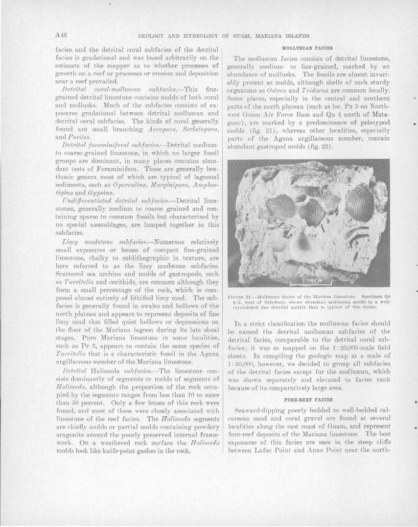
A46 GEOLOGY AND HYDROLOGY OF GUAM, MARIANA ISLANDS
facies and the detrital coral subfacies of the detrital facies is gradational and was based arbitrarily on the estimate of the mapper as to whether processes of growth on a reef or processes or erosion and deposition near a reef prevailed.
Detrital coral-molluscan subfacies.-This finegrained detrital limestone contains molds of both coral and mollusks. Much of the subfacies consists of exposures gradational between detrital molluscan and .detrital coral subfacies. The kinds of coral generally found are small branching Acropora, Seriatopora, and Porites.
Detrital foraminiferal sv,bfacies.-Detrital mediumto coarse-grained limestone, in which no larger fossil groups are dominant, in many places contains abundant tests of Foraminifera. These are generally benthonic genera most of whioh are ,typical of lagoonal sediments, such as Operculina, M arginipora, Amphestigina and Gypsina.
Undifferentiated detrital subfacies.-Detrital limestones, generally medium to coarse grained and containing sparse to common fossils hut characterized by no special assemblages, are lumped together in this sub facies.
Limy mudstone subfacies.-Numerous relatively smali exposures or lenses of compact fine-grained limestone, chalky to sublithographic in 'texture, are here referred to as the limy mudstone subfacies. Scattered sea urchins and molds of ·gastropods, such as Turritella and cerithids, are common al:though they form a small percentage of the rock, whioh is composed almost entirely of lithified limy mud. The subfacies is generally found in swales and hollows of the noPth plateau and appears to represent deposits of fine limy mud that filled quiet hollows or depressions on the floor of the Mariana lagoon during its late shoal stages. Pure Mariana limestone in some localities, such as Pr 3, appe.:'trs to contain the same species of Tur1·itella that is a characteristic fossil in the Agana argillaceous member of the Mariana limestone.
Detrital Halimeda subfacies.-The limestone consists dominantly of segments or molds of segments of Halimeda, although the proportion of the rock occupied by the segments ranges from less than 10 to more than 50 percent. Only a few lenses of this rock were found, and most of these were closely associated with limestone of the reef facies. The Halimeda segments are chiefly molds or partial molds containing powdery aragonite around the poorly preserved internal framework. On a weathered rock surface the Halimeda molds look like knife-point gashes in the rock.
MOLLUBCA:N FACIES
The mollusc.m facies consists of detrital ilimestone, generally medium- to fine-grained, marked by an abundance of mollusks. The fossils are almost invariably present as molds, although shells of such sturdy organisms as Ost1·ea and Tridacna are common locally. Some places, especially in the central and northern parts of the north plateau (such as loc. Px 5 on Northwest Guam Air Force Base and Qu 4 north of Mataguac) , are marked by a predominance of pelecypod molds (fig. 21), whereas other localities, especially parts of the Agana argillaceous member, contain a.bundant gastropod molds (fig. 22).
FIGURfl 21.- ;\folluscan facies of the Mariana limestone. Specimen Qu 4-2, west of Salisbury, shows abundant molluscan molds in a wellcrystallized fine detrital matrix that is typical of this facies.
In a strict classification the molluscan facies should be named the detrital molluscan subfacies of the detrital facies, comparable to the detrital coral subfacies; it was so mapped on the 1: 20,000-scale field sheets. In compiling the geologic map at a scale of 1: 50,000, however, we decided to group all subfacies of the detrital facies except for the molluscan, which was sho"·n separately and elevated to facies rank because of its comparatively large area.
FORE-REEF FACIES
Seaward-dipping poorly bedded to well-bedded calcareous sand and coral gravel are found at several localities along the east coast of Guam, and represent fore-reef deposits of the Mariana limestone. The best exposures of this facies are seen in the steep cliffs between Lafac Point and Anao Point near the north-
•
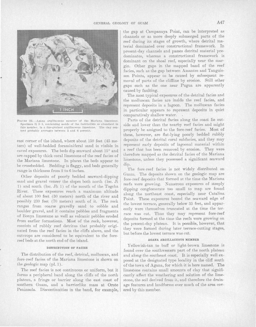
GENERAL GEOLOGY OF GUAM A47
FIG URE 22.- Agan a a rgillaceous member of the Mariana limestone. Specimen Ij 2- 1, containing molds of the turrltelllds so abundant in this member , in a fine-grained a rgillaceous limestone. The clay content proba bly averages between 2, and 6 percent.
east corner of the island, wher~ about 150 feet ( 45 meters) of well-bedded foraminiferal sand ri.s visible in caved exposures. The beds dip seaward about 15° and are capped by thick coral limestone of the reef facies of the Mariana limestone. In places the beds appear to be crossbedded. Bedding is flaggy, and beds generally range in thickness from 2 to 6 inches.
Other deposits of poorly bedded seaward-dipping sand and gravel veneer the slopes both north (loc. Ji 1) and south (loc. Jh 1) of the mouth of the Togcha River. These exposures reach a maximum altitude of about 100 feet (30 meters) north of the river and possibly 230 feet (70 meters) south of it. The rock ranges from coarse gravelly sand to cobble and boulder gravel, and it conta,ins pebbles and fragments of Bonya limestone as well as volcanic pebbles eroded from ea,rlier formations. Most of the rock, however, consists of rubbly reef detritus that probably originated from the reef facies in the cliffs above, and the outcrops are considered to be equivalent to the forereef beds at the north end of the island.
DISTRIBUTION OF . FACIES
The distribution of the reef, detrital, molluscan, and fore-reef facies of the Mariana limestone is shown on the geologic map (pl. 1).
11he reef facies is not continuous or uniform, but it forms a peripheral band along the cliffs of the north plateau, a fringe or barrier along the east coast of southern Guam, and a barrierlike mass at Orote Peninsula. Discontinuities in the band, for example,
the gap at Campanaya Point, can be interpreted as channels or as more deeply submerged parts of the reef during its stages of growth, where detrital material dominated over constructional framework. In present-day channels and passes detl'ital material predominates, whereas a constructional framework is dominant on the shoa,l reef, especially near the margin. Other gaps in the mapped band of the reef facies, such as the gap between Amantes and Tanguisson Points, appear to be caused by subsequent removal of parts of the clifRine by erosion. Still other gaps such as the one near Pugua are apparently caused by fau1ting.
The most typical exposures of the detrital facies and the molluscan facies are inside the reef facies, and represent deposits in a 'lagoon. The molluscan facies in particular appears to represent deposits in quiet comparatively shallow water.
Parts of the detrita)l facies along the coast lie outside and lower than the nearby reef facies and might properly be assigned to the fore- reef facies. Most of these, however, are flat-lying poorly bedded rubbly deposits of the detrital coral subfacies, and they may represent early deposits of lagoonal material within a reef that has been removed by erosion. They were t.herefore mapped as t.he detrital facies of the Mariana limestone, unless ·they possessed a significant seaward dip.
The fore-reef facies is not widely distributed on Guam. The deposits shown on the geologic map are fore-reef deposits that formed at the time the Mariana reefs were growing. Numerous exposures of steeply dipping conglomerate too smaH to map are found along the nol'theast coast, especial'ly near Catalina Point. These exposures bound the seaward edge of the lowest terrace, generally below 35 feet, and apparently were themselves trunc3!ted at the time the terrace was cut. Thus they may represent fore-reef deposits formed at 'the time the reefs were growing on the present-day plateau. It is possible, however, that they were formed during l3!ter terrace-cutting stages, but before the lowest ·terrace was cu't.
AGANA ARGILLACEOUS MEMBER
Yellowish-tan to buff or light-brown limestone is found over the southwestern part of the north pla,teau and along the southeast coast. It is especial'ly well exposed a,t 'the designated type locality in the cliff south of the town of Agana, for which ~tis here named. The limestone contains small amounts of clay that significantly affect the weathering and solution of the limestone, the soil derived from it, and therefore the drainage features and landforms over much of the a,rea covered by this member.
A48 GEOLOGY AND HYDROLOGY OF GUAM, MARIANA ISLANDS
LITHOLOGY
Limestone of the Agana argillaceous member, except for clay content, is similar in Ethology to pure limestone of the Mariana, although the facies subdivisions were not mapped. Medium- and fine-grained limestone of the molluscan facies and the limy mudstone subfacies of the detrital facies are the predominant constituents of the member. Corals and coral rubble are abundant. The cora.ls, when broken, show a characteristically yellow color throughout, indicating that the finely disseminated clay has penetrated the porous skeletons. In contrast, most corals in other argillaceous limestone formations of Guam generally show pure recrystallized calcite in the coral centers, which are surrounded by a clayey limestone matrix.
The l\1ariana coral reefs of the reef facies that bound the Agana argillaceous member are relatively free of clayey contamination and are mapped separately. The reef limestone was deposited contemporaneously with the clayey limestone of the Agana member, but the reefs were comparatively free of the contaminating silt and mud that a.re characteristic of deposits of the Agana behind the reefs. Similarly, in present-day deposits on the Agana reef, or on the reefs of Pago Bay, the reef margins are formed of relatively clean coral and algae, but the reef flats are muddy from streams that drain the uplands.
The scarp behind the town of Agana is a typical exposure of the Agana member. A generalized section in the vicinity of the U.S. Naval Hospital can be described from a study of the exposures along the base of the scarp and from the outcrops, cavities, and excavations examined during construction of the hospital. The Agana member rests upon a truncated jointed and fractured hard white recrystallized limestone mapped as Alifan limestone. Small faults and fractures in the Alifan do not continue into the overlying Agana.
A lenticular rubbly coral conglomerate as much as 10 feet thick forms the base of the Agana member. Corals are from several inches to a foot in diameter and are worn and rounded, but some colonies are in positions of growth. Overlying the coral conglomerate is a thick section of medium- to fine-grained yellow detrital limestone that contains mollusks, extends nearly to the surface of the plateau, and generally exceeds 100 feet in thickness. Abundantly fossiliferous lenses or patches are found throughout the limestone, although most of the fossils are present as molds.
The plateau is capped by a thin bed of coral largely in positions of growth, containing colonies of branching forms such as Aaropora and more massive heads
similar to Porites and Favia. The cap is generally present in the .triangular area hounded by Agana, Chalan Pago, and Barrigada, where it occurs on top of the dissected plateau at altitudes from 130 to 200 feet ( 40 to 60 meters) . It ranges from less than 1 foot to more than 15 feet in thickness.
The threefold sequence of rubbly or conglomeratic beds containing abundant coral at the base, overlain by fine-grained silty or muddy molluscan limestone and capped by thin but extensive beds of coral in posi1tion of growth is exposed at a number of places over the area of outcrop and appears to be typical of the Agan·a member.
The amouTIJt of clay in the Agana argillaceous member is small. A representative sample Ij 2-1, contained 3.5 percent insoluble residue (Schlanger, 1964, table 14), and the clay content over most of the area of outcrop probably ranges from 2 to 6 percent. The greatest clay contamination is in limestone that is closest to the volcanic rocks. Although on the whole the amount of clay incorporated in the limestone is relatively low, the amount of clay filling cavities in weathered limestone may be large.
The Agana n1ember was deposited upon an irregular erosion surf,ace cut on the AlHan limestone. Inliers of A lifan are exposed near the town of Sinajana. Several exposures of red clay at the contact are thought to be remnants of red soil on the surface of the Alifan limestone, which were buried by later deposits of the Agana argillaceous member. A roadcut on the east side of route 4, B,OOO feet south of Sinajana, contains red clay 2 to 6 feet in thickness in a pocketlike depression in fracJtured chalky white Alifan limestone (soils loc. S-24). At the top of the cut the clay is overlain by 1 to 2 feet of rubbly coral limestone at an altitude of about 160 feet (50 meters), which is concordant with the coral cap of the Agana member on other parts of the plateau.
DISTRmUTION
The Agana member forms a large triangular area of the north plruteau, from the Adelup-Pago faultline nearly to Barrigada Hill. Limestone of the Agana member extends south from Pago Bay to Inarajan, and discontinuous patches of the limestone extend from Inarajan south nearly to Aga Point.
Small areas of argillaceous limestone are found along the scarp east of the village of Tamuning, in the limestone slopes on the east end of Tum on Bay, and in other isolated places. These were not mapped separately because they are small and discontinuous. A former greater extent of :the Agana member of the l\1ariana limestone is shown by the presence of a:bun-
•
GENERAL GEOLOGY OF GUAM A49
dant argillaceous Hmestone float on volcanic rocks at some distance from ~the present edge of the Mariana. One such place is shown on the slopes of the Lonfit River :tbout 3,000 feet upstream from its oonfluence with .the Signa, River to form the Pago River. Anot·her probably more significant locality is Ig 10, on uplands 2,000 feet north\vest of the Ugum River at analtitude eompara'ble to the top of the fringing limestone of ·the Agana nearer the coast .to the west.
UELATION TO OTI:IEU PAUTS OF THE MARIANA
Except for its sm:tll content of clay, the Agana argillaceous member appears to be equivalent to the rest of t.he :Mariana limestone. It is difficult to draw a boundary between the two. In exposures where the Aga.na rests uncoi1f01~mahly upon a pure recrystallized 1 i rnestone, the underlying limestone has been interpret·ed as Alifn,n, although in a few places it might wihh some justification have been called an older tnmc:11ted pat~t of the Mariana. An abundant small gastropod (fig. 22) was identified by Miss Julia Gardner (oral communication, 1953) as Turritella filiol.a Yokayama and was considered by her to be prob~1Jbly Pl1iocene. This fossil was found in abundance over 1nuch of t:he area covered by the member, and ne::l.r the village of Talofufu it is common throughout a section of limestone of the Agana that is more than 100 feet thick. The same fossil is found in nu.merous places in the main body of the Mariana limestone of H1e nort"Jh plateau (loc. Pr 3, Qx 5), mostly in the limy mudstone SU'b:facies.
The A-gana argi 11 aceous member is generally lagoonal in nature and is equivalent to the detrital and molluscan facies of the pure M·aria.na limestone, except tJhn:t it was deposited in parts of the Mariana lagoon near enough to tl1e volcanic highlands of Mariana time that the fine mud and silt eroded from the highla,nds and spread over the lagoon was incorporated in the li1ny sedilnent.
On the north plateau, the top of the Agana member ranges in altitude from about 300 feet (90 meters) near Ba.rrigada I-Iill to 180 feet (55 meters) near Agana, and 165 feet (50 meters) near Chalan Pago. Along the east coast from Yona to Talofofo the limestone is at altitudes of nearly 300 feet (88 meters); south of the Talofofo River it ranges in al:titude from 330 feet (100 meters) between Matala and Malolos to a few feet above sen. level near Aga Point, south of Inarajan.
Limestone that forms bluffs and ledges on lower volcanic slopes along the west coast from Piti to Agat, and shown on the geologic map (pl. 1) as Alifan limestone, may be overlain to elevations as much as 100 feet by a cap of the Agana argillaceous member o·f
the Mariana limestone. We were unable to separate the two in the field; ·and until the faunas are better known, these limestones .are mapped as Alifan.
A relatively small area of limestone of the Agana member has been mapped near Sumay on the east end of the Orote Peninsula. It would perhaps be possible to extend the boundaries of the member westward along the peninsula, for most of the rubbly conglomeratic limestone at the base of the Mariana on the peninsula contains clayey contaminants .
Small patches of limestone that form islets on the reef and isolated exposures more than 6 feet high along the west coast from Agat south to Facpi Point are mapped as the reef facies of the Mariana limestone if they contain much coral limestone and as the Agana member if they are significantly contaminated by clay. The limestone of the islets is hard, recrystallized, and jointed, and no good criteria exist for determining whether it should be correlated with the Mariana or with the Alifan limestone.
CONDITIONS OF DEPOSITION OF THE :MARIANA LIMESTONE
Reef and lagoonal conditions prevailed throughout the period of de·position of the Mariana limestone, and a map of the formation (pl. 1) shows the atoll-like conditions that must have prevailed over most of the north plateau. The reefs of the Mariana were nearly continuous and were apparently very close to the surface of the water at the time of formation, as shown by the aJbundant gt~wth of coral and calcareous algae in the reef facies. Although reef and lagoonal facies intergrade, the two are distinctly different, and they indicate that true lagoonal conditions existed under the protection of the massive coral reefs. In this respect the Mariana limestone of Guam is considerably different from the Barrigada and the Alifan limestones, although in places the older rocks appear to grade into the younger without any mappable break. The Barrigada limestone consists mostly of bank-type deposits, although corals and mollusks are especially common near the top of the formation where Barrigada grades into Mariana. Corals and shallow-water mollusks become dominant concurrently with the development of the protecting reefs of the Mariana.
The Alifan limestone contains abundant thicketlike deposits of branching Po'rites and Acropora, such as are common in pt~sent-day lagoons. Par.t of the Alifan limestone is fine grained and contains abundant mollusks. Possibly a considera;hle part of the Alifan was protected by surrounding reefs that no longer exist. In the Mariana, on the other hand, the reef and lagoonal facies are intimately associated over large areas.
A 50 GEOLOGY AND HYDROLOGY OF GUAM, MARIANA ISLANDS
FOSSILS AND AGE
The Mariana limestone is the most extensive and the most fossiliferous formation on Guam. The commonest fossils are corals, mollusks, and Halimeda and ot.her algae. Corals and mollusks are preserved generally as molds or as heavily recrystallized casts, and as yet they have not been studied. The smaller Foraminifera are never conspicuous in the pure limestone, and are almost impossible to separate from the rock matrix when they are found. Larger Foraminifera, such as Gypsina, A1nphistegina, and Operculina, are present t.hough not abundant; Foraminifera of diagnostic significance have not yet been found in exposures definitely assigned to the Mariana, except for those in the fore-reef facies. A sample (Uu 3) from La fac Point near sea level consists of sugary foraminiferal sand containing Oalcarina spengleri, Baculogy]JBina sphaerulata, and other reef-growing foraminifers considered by Cole (chap. E) to be diagnostic of the Pleistocene and Recent. Some outcrops of compact recrystallized limestone in cliffs contain rare Oycloclype'tt8. They possibly represent early deposits of the Mariana limestone but other similar outcrops are overlain unconformably by Mariana limestone and thus are thought to be equivalent to the Alifan limestone.
Based on field relrut.ions, ~the Mariana limestone is later than the Barrigada, the Alifan, and the Janum formations, all of which are probably Tertiary g in age-at least in their lower parts. The upper parts of t.he Barrigada and the Alifan could be Pliocene age. The ~{ariana limestone over lies an erosional unconformity in the Alifan and also in a few places in Barrigada limestone, but it is gradational to the Barrigada in many places .. The Mariana represents a phase of reef-and-lagoon deposits more extensive and better defined than either the Alifan, which represents early reef and lagoonal deposition, or the Barrigada, which represents early bank deposition. The age of the Marjana is Pliocene and Pleistocene, although just how much of the formation is Pliocene we are unable to state.
The foraminiferal sand of the fore-reef facies is Pleistocene, according to Cole (1963). The facies at Lafac Point is conformably overlain at an altitude of about 150 feet ( 45 meters) by reef coral limestone that forms a thick peripheral reef facies at the top of the plateau. ~{ost of the reefl.ike deposits on top of the plateau were probably formed at the same time as these peripheral reef deposits, which suggests that a considerable part of the uppermost and outermost layers of the Mariana limestone are Pleistocene. These layers appear to correspond closely to the older
reef -complex limestones of the Mariana limestone of Saipan, assigned to the early Pleistocene by Cloud, Schmidt, and Burke (1956, p. 104).
Many terraces were cut into the cliffs after emergence of the plateau and therefore after formation of the uppermost deposits on the plateau. The most striking terraces on the island are a steplike sequence of five broad benches in the northwest-facing reentrant at Ritidian Point on the north end of Guam. These benches are at altitudes of about 490 feet ( 150 meters), 330 feet (100 meters), 215 feet (65 meters), 100 feet (30 meters), and 35 feet (10 meters).
The terraces are veneered in many places with coral and algal limestone that probably was deposited for the most part contemporaneously with the cutting. On upper terraces, especially above 100 feet, the veneer cannot be differentiated from the reef facies of the Mariana limestone on the plateau, and it has therefore been mapped with the Mariana. It probably corresponds closely to the limestone on Saipan that veneers· terraces between 100 and 500 feet, which is thought by Cloud, Schmidt, and Burke ( 1956, p. 105) to be of middle ( ~) Pleistocene age.
On low0r terraces on Guam, especially below 50 feet, the veneer is patchy and in some places is unconsolidated sand and rubble. These limestone patches have a distinctive appearance because of the good preservation of mollusk shells and the lack of recrystaHization; they undoubtedly are comparable to the similarly preserved Tanapag limestone which is found at the sam·e alt1itude on Saipan (Cloud 'and othern, 1956, p. 86) and is referred to the late Pleistocene. A radiocarbon determination by Kulp indicates that the youngest Tanapag deposits on Saipan at the 12- to 15-foot level were deposited (or possibly altered) 20,000 years ago.
RECENT SERIES
MERIZO LIMESTONE
Scattered patches of low-lying coral limestone, mostly not more than 2 feet thick, are found on the basalt reef platform of southwest Guam from the Sagua River north of Facpi Point to Ajayan Bay east of Merizo. These patches were called the Merizo limestone by Tayama ( 1952, p. 212; figs. 53-55; table 4) and were considered by him to be a part of the "Younger Raised Coral Reef Limestone," the lowest reef terrace in the western Carolines and Mariana area, and to be equivalent to the Tanapag limestone of Saipan, the Dankuro limestone of Tinian, and the Mirikatten limestone of Rota.
Tayama stated that this limestone maintains an approximately uniform elevation of 2 meters ( 61h ft)
•
GENERAL GEOLOGY OF GUAM A51
n:bove the surface of the reef flat, and he shows three photographs (1952, app. 1, figs. 124-126) of the "Younger Haised Coral Reef," which show limestone less t.han 2 meters rubove the reef. In other places, however, Tayamn. referred to limestone as muoh as 5 meters (16112 ~t) above the reef flat as Merizo limestone (1952, fig. 54a). Many truncated limestone ledges and mushroom rocks are more than 3 meters (11 f.t) above the reef; therefore, in this report we restrict the Merizo limestone to exposures equivalent to the ones at and near t.he town of Merizo, all of which are less than 2 meters ( 6112 ft) above the reef flat.
LITHOLOGY AND DISTRmUTION
Exposures described here show closely packed heads of cora,l, many in positions of growth. The colonies range in size from a few inches to more than a foot and in<ilude common branching and globular types. They are solidly cemented in a hard calcareous matrix that wewt:.hers a way so that ~the colonies stand out in relief. l\{any good exposures are seen at the mouths of minor streams where they flow onto the reef rulong the Merizo coast and in small bays north of Umatac. These patches are only a foot or two thick and are about at high-w~tter level.
Patches of limestone cover the inner part of the basalt reef platform. In more exposed places they are as much as 3112 feet thick and grow on a cut platform about n.t present mean sea level (fig. 8, upper). Well-rounded p~bbles of basalt are scattered through the limy matrix between the corals, just above the basalt platform. Most of the preserved patches of l\{erizo limestone cover parts of the present reef flat and extend close to the present beach line (fig. 23).
Truncated reef rock 1 to 2 .feet above mean sea level, exposed along the sea ward coast of Cocos Island, and similar remnants on the Cocos reef flat (Balbe Island), were pt'Obably formed at the same time as the Merizo limestone of the coast, and represent a seaward reef facies of the Merizo limestone.
The alluvial flats near the mouth of the Aguada River at Apra J-Iarbor are formed of a thin layer of mud deposited on a 2-foot layer of coral limestone that is just above present high-water level. The coral layer is undoubtedly equivalent to the Merizo limestone.
AGE
In 1955 a complete Tridaona shell was collected by Schlanger from a patch of Merizo limestone about 100 feet long and 20 feet wide, 4,000 feet northeast of Facpi Point (loc. Ch 8). The limestone patch is about 2 feet thick, n.nd consists of closely packed solidly cemented coral colonies that rest on a truncated basalt
platform only an inch or two higher than the present reef flat (fig. 24). The top of the limestone pa·tch is n.n irregularly pitted surface on which the corals are well exposed, but do not appear to be truncated. The shell, probably T. elongata, was collected from the top of the outcrop, in position of growth as if on a living coral reef; it was exposed at the very top of the patch, but was so enclosed by the coral colonies that it had to be excavated with a geologic pick.
A sample of the shell was submitted to Meyer Rubin, of the U.S. Geological Survey, for radiocarbon analysis. He states (written communicartion, Feb. 10, 1956) that the radiocarbon age of the shell (W -370) is 3,400 ±250 years. Thin sections of the Tridaona shell were comp.:'tred with those from -a Tridaona collected alive, and no alteration of the shell could be seen. Samples of both shells were analyzed by X-ray diffractometer by Paul Blackmon, of ~the U.S. Geological Survey, who stated (written communication, 1958) that both fossil and living shell were aragonite. Calcite was detected only at the outer edge of the fossil shell, which contained less than 2 percent calcite.
The significance of the radiocarbon date for the Merizo limestone is that the shape of this particular outcrop appears to be closely determined iby the socalled 2-meter or 6-foot stand of the sea. The top of the limestone patch is 2 feet above the truncated basalt surface, which at this point is approximately at present mean sea level (fig. 24). Thus the top of the limestone is about 1 foot above present high tides and 4112 feet above extreme low tides. At the time the limestone was a living reef, the. flatness of its top indicates that the growth of corals on its surface was probably controlled by low-water level. On the other hand, individual colonies forming the surface of the limestone are not flattened in growth form or truncated, as are present-day corals on Guam reef flats that are exposed during moderately 1low tides. We infer, ·therefore, that the top of the limestone patch represents a surface that, as a living reef, was exposed only at lowest tides, if at all. If tides at that time were comparable in pattern and range with present-day tides, former extreme low water was at least 41/2 feet, and most likely not more than 6 feet above present-day extreme low water.
The low limestone benches and truncated reef rock less than 6 feet above present mean sea lev~l along the rest of t:he coast of Guam prdb31bly were truncated by the 6-foot sea. Many of these exposures consist of truncated Mariana limestone, rather than of limestone formed during the 6-foot stand. Inasmuch as the two limestones are difficult to differentiate on a
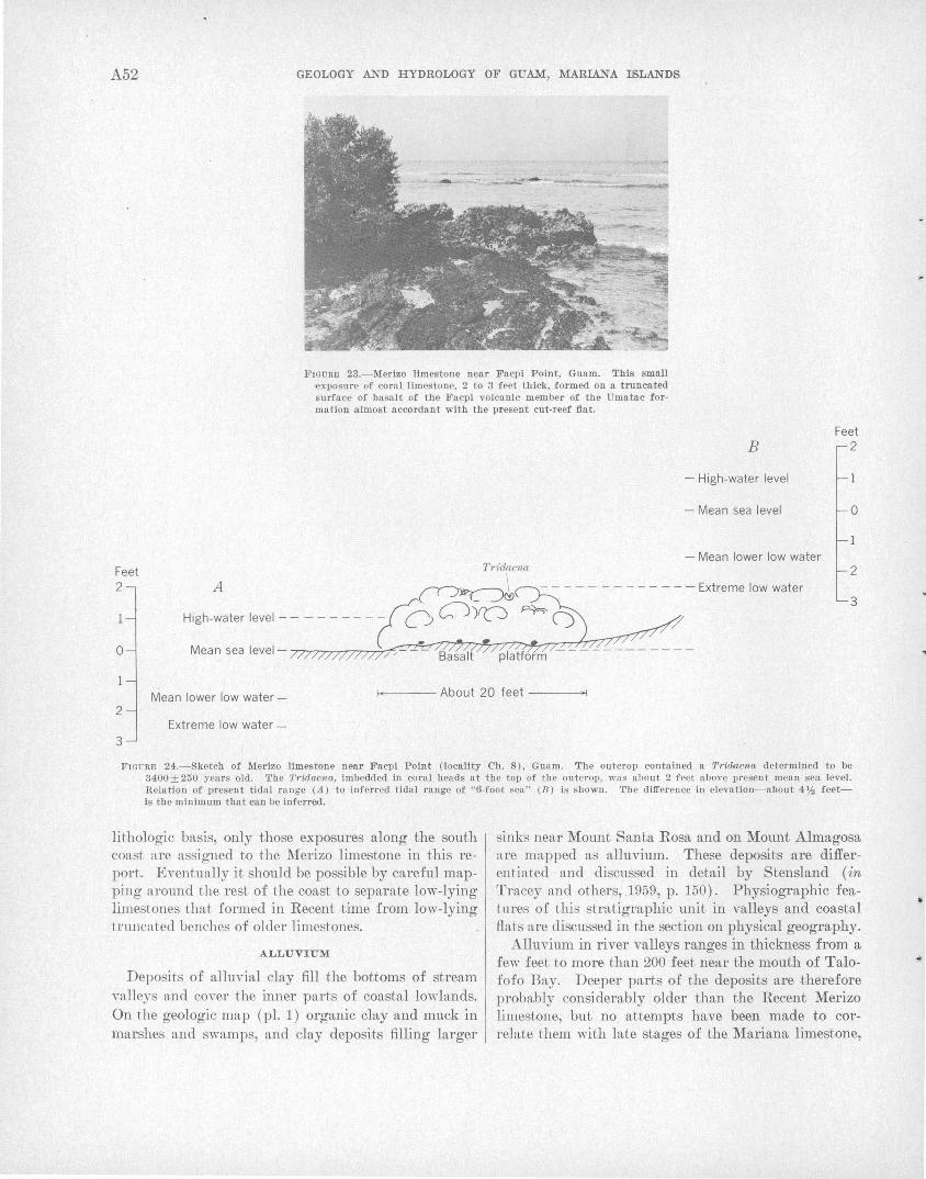
A 52 GEOLOGY AND HYDROLOGY OF GUAM, MARIAN:A ISLANDS
FIGURFJ 23.-1\ferlzo limestone near Facpi Point, Guam. This small exposure of coral limestone, 2 to 3 feet thick, formed on a truncated surface of basalt of the Facpi volcanic member of the Umatac formation almost accordant with the present cut-reef fiat.
Feet 2
0
B
-High-water level
-Mean sea level
Feet 2
0
2
3
Mean lower low water- f-<---- About 20 feet ---~
2 Extreme low water-
3
FIGURFJ 24.-Sketch of 1\ferizo limestone near Facpi Point (locality Ch. 8), Guam. The outcrop contained a Tria.acna determined to be 3400±250 years old. '.rhe Triaacna, imbedded in coral heads at the top of the outcrop, was about 2 feet above present mean sea level. Relation of present tidal range (A) to inferred tidal range of "6-foot sea" (B) is shown. The difference in elevation-about 4'h feetis the minimum that can be inferred.
lithologic basis, only those exposures along the south coast are assigned to the Merizo limestone in this report.. Eventually it should be possible by careful mapping around the rest of the coast to separate low-lying limestones t-hat formed in Recent time from low-lying trw1cated benches of older limestones.
ALLUVIUM
Deposits of alluvial clay fill the bottoms of stream va.lleys and cover the inner parts of coastal lo"\Vhtnds. On the geologic map (pl. 1) organic day and muck in marshes and swamps, and clay deposits filling larger
sinks near Mount Santa Rosa and on Mount Almagosa are ma,pped as a,lluvium. These deposits are differentiated and discussed in detail by Stensland (in Tracey and others, .1959, p. 150). Physiographic feat-ures of this stratigraphic unit in valleys and coastal flats are discussed in the section on physical geography.
Alluvium in river valleys ranges in thickness from a few feet to more than 200 feet near the mouth of Talofofo Bay. Deeper parts of the deposits are therefore probably considera,bly older than the Recent Merizo limestone, but no attempts have been made to correlate them with late stages of the Mariana limestone,
... 1
..
.•
GENERAL GEOLOGY OF GUAM A 53
or wi t.h stages of sea level. A few small gastropod shells, not yet identified, were co1lected at a depth of 50 feet from a soils boring in the Pago River valley.
RECENT REEFS
The Guam coastline is almost completely encircled by reef and reef-associated deposits. Those re~fs that are awash at low tide are shown on .the geologic map (pl. 1). Varieties of reefs, growth forms, and sealevel benches and terraces cut in limestone headlands are discussed on pages A 76-A93.
BEACH DEPOSITS
Present-day beaches and outer parts of coastal lowln nels of Gnam are covered by Recent beach deposits. These are mostly only a few feet thick, although in a few places they may exceed 30 feet. Volcanic sand beaehes are found most:ly at the mouths of streams t·.hnJ. drn,in volcn,nic areas; otherwise the deposits are pr·edominnnt.ly to entirely composed of calcium carbonn.f'e derived from the fringing reefs. Features of the heaehes and the coastal lowlands are discussed in other se,et.ions o:f the report by Emery (1963).
STRUCTURAL GEOLOGY
Structural elements significant to the evolution of the island of Guam may be divided into three orders of magn-itude. The largest are the island arcs and trenches and other major features of the western Paeific ocean, which were not studied directly in this project and which will not be discussed in detaiL Appmisa ls o:f these elements have been made by Gutenberg and Richter (1954), based on seismic data; by Vening Meinesz (1948), based on gravity surveys; and by I-:Iess (1948), Van Bemmelen (1949), and others, based on syntheses of geophysical, petrographic, and ot.her data.
Elements of the second order of magnitude are compn.rn.ble in size to the island but small compared to the western Pacific. These include major bathymetric features in the neighborhood of the island and major structuraJ features on the island. Third-order and snutller features include subsidiary faults and folds, joint.s, and other structural elements. Our purpose in this section is to deduce the structural evolution of the island from an analysis of the second- and thirdorder elements that were studied directly.
MAJOR ASPECTS
BATHYMETRIC FEATURES
A contour chart of the ocean bottom near Guam (fig. 25) shows major structural features. Emery ( 1963) discusses some of these features, especially the slopes,
in detail. The bathymetry and structures around Guam should be compared with tJhose around the island of Saipan, 100 miles to the nor.theast (Cloud, 1959, pl. 121).
Extensive flat submarine banks, such as Santa Rosa Reef and Galvez Bank southwest of Guam, and a large umutmecl bank northeast of Guam, are similar in form and probably in origin .to banks around Saipan, Tinian, and Aguijan shown by Cloud. They proba:bly consist of truncated volcanic rock or submerged limestone plateaus .
The features west and northwest of the 'island, named and outlined in figure 25, are of most interest to our structural interpretation. They include two depressions or troughs which are interpreted as collapse or grabenlike features, and are designated the northwest collapse area and the southwest collapse area. They are bounded by inferred major normal faults. Two submarine cones inferred to be volcanic-a northwest cone and a southwest cone-are closely rela.Jted to the collapse areas. In contrast to the "cone and graben" topography west of tJhe island, .the slopes between Guam and the Mariana trench to the southeast are smooth and regular. Three cross sections (fig. 26) show the differences. between the eastern and western slopes around the island, and should be compared with the flat slopes to the west and smooth steeper slopes to the east of Saipan (Cloud, 1959, pl. 120). Faulting and volcanic collapse probably were more severe west of Guam than west of Saipan.
Normal faulting and volcanic collapse appear to be common features on the concave side of Pacific island arcs. Cloud, Schmid!t, and Burke (1956, p. 102) describe the foundering of the western parts of a volcano or volcanic mass of Eocene age during the formation of Saipan. Gates and Gibson (1956, p. 39) describe large-scale normal faults and calderas on the north insular slope (concave side) of the Aleutian Island arc. In a schematic block diagram of a Mariana-type arc, Umbgrove (1947, fig. 114) suggests that arching and stretching of the crust related to underthrusting would produce graben structures on the crest of the arc.
STRUCTURAL PROVINCES
The Timestone plateau of north Guam, the folded Eocene volcanic rocks of central Guam, and the eastdipping Miocen~ volcanic rocks of south Guam form the three major structural provinces of the island. Each of these structural provinces consists of several blocks separated by fault zones (fig. 25).
North Guam comprises the Machanao and Barrigada blocks, separated by the Tamuning-Yigo fault zone;
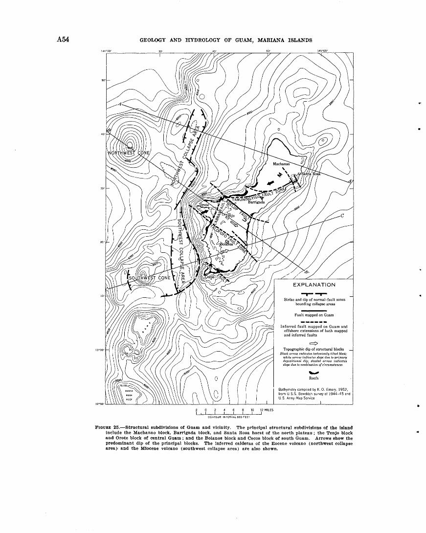
A 54
13"00'
GEOLOGY AND HYDROLOGY OF GUAM, MARIANA ISLANDS
10 12 MILES
CONTOUR INTERVAL 600 FEET
--r-...,... Strike and dip of normal-fault zones
bounding collapse areas
Fault mapped on Guam
Inferred fault mapped on Guam and offshore extensions of both mapped and inferred faults
c:::> Topographic dip of structural blocks
Black arrow indicates tectonically tilted block; white arrow indica.tes slope due to primary depositional dip; shaded a.rrow indicates slope due to combination of circumstances
~
Reefs
Bathymetry compiled by K. 0. Emery, 1952, from U.S.S. Bowditch survey of 1944-45 and U.S. Army Map Service
FIGURE 25.-Structural subdivisions of Guam and vicinity. The principal structural subdivisions of the island Include the Machanao block, Barrtgada block, and Santa Rosa horst of the north plateau; the Tenjo block and Orote block of central Guam ; and the Bolanos block and Cocos block of south Guam. Arrows show the predominant dip of the principal blocks. The inferred calderas of the Eocene volcano (northwest collapse area), and the Miocene volcano (southwest collapse area) are also shown.
•
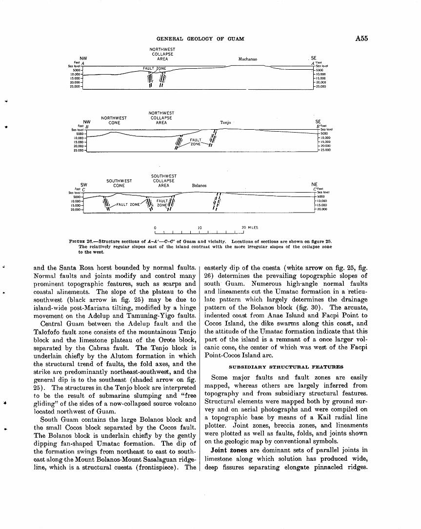
,.
GENERAL GEOLOGY OF GUAM A 55
NW
NORTHWEST COLLAPSE
AREA Machanao . SE Foot A
s~;:§Tit------------------~--FJFAW~UL\~z~~lmy:-================
~~:g:~ II II
A'Feet -..::::::::::~------:;...~sea level --------4. 5000
10,000 15.000 20.000 25,000
-------------~
NORTHWEST NORTHWEST COLLAPSE
NW CONE AREA Tenjo · SE ~B B~
Son~~~~:.__--==~· ====--=--=--=--=--=--=--=--=-~~-=--~--=:::::::;:;----::/Tj/,------"----=====:=====±
1_ ~~~~evel
10,000 M!f/; II~ 10.000
~ FAULT r,· 15,000 '111.--- ....____, 15,000 20.000 tr ZONE rl 20.000 25.000 25.000
SOUTHWEST SOUTHWEST COLLAPSE
sw CONE AREA Bolanos NE Foot C C'Feet
Sen lovol -- ff
I I. Sea level 5000-1--- 5000
10.000- ~\~FAULT ZONE~\\ ~~~L; I# ~' 'f 10.000 15.000- 1/ 15.000 20.000":" \\ ,, ....,., 20.000
0 10 20 MILES
FIOURID 26.-Structure sections of A-A'-0-0' of Guam and vicinity. Locations of sections are shown on figure 25. The relatively regular slopes east of the Island contrast with the more irregular slopes of the collapse zone to the west.
and the Santa Rosa horst bounded by normal faults. Normal faults and joints modify and control many prom.inent topographic features, such as scarps and eoastn:l aJinements. The slope of the plateau to the southwest (black arrow in fig. 25) may be due to island-wide post-l\1ariana tilting, modified by a hinge movement on the Adelup and Tamuning-Yigo faults.
Centrn,l Guam between the Adelup fault and the Talofofo fault zone consists of the mountainous Tenjo block and the limestone pl3iteau of the Orote block, separated by the Cabras fault. The Tenjo block is underlain chiefly by the Alutom formation in which the structural trend of faults, the fold axes, and the strike are predominantly northeast-southwest, and the general dip is to the southeast (shaded arrow on fig. 25). The structures in the Tenjo block are interpreted to be the result of submarine slumping and "free gliding" of the sides of a now-collapsed source volcano located northwest of Guam.
South Guam contains the large Bolanos block and the small Cocos block separated by the Cocos fault. The Bolanos block is underlain chiefly by the gently dipping fan-shaped Umatac formation. The dip of the formation swings from northeast to east to southeast n.long the Mount Bolanos-Mount Sasalaguan ridgeline, which is a structural cuesta (frontispiece) . The
easterly dip of the cuesta (white arrow on fig. 25, fig. 26) determines the prevailing topographic slopes of south· Guam. Numerous high-angle normal faults and lineaments cut the Umatac formation in a ·reticulate pattern which largely determines the drainage pattern of the Bolanos block (fig. 30). The arcuate, indented coast f1·om Anae Island and Facpi Point to Cocos Island, the dike swarms along this coast, and the attitude of the U mrutac form3Jtion indicate that this pal'lt of the island is a remnant of a once larger volcanic cone, .the center of whioh was west of .the Facpi Point-Cocos Island arc.
SUBSIDIARY STRUCTURAL FEATURES
Some major faults and fault zones are easily mapped, whereas others are largely inferred from topography and from subsidiary structural features. Structural elements were mapped both by ground survey and on aerial photographs and were compiled on a topographic base by means of a Kail radial line plotter. Joint zones, breccia zones, and lineaments were plotted as well as faults, folds, and joints shown on the geologic map by conventional symbols.
Joint zones are dominant sets of parallel joints in limestone along which solution has produced wide, deep fissures separating elongate pinnacled ridges.
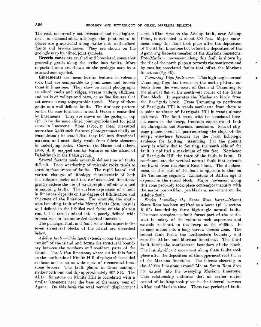
A 56 GEOLOGY AND HYDROLOGY OF GUAM, MARIANA ISLANDS
The rock is normally not brecciated and no displacement is demonstrable, although the joint zones in places are gradational along strike into well-defined faults and breccia zones. They are shown on the geologic map by alined joint symbols.
Breccia zones are crushed and brecciated zones that generally grade along the strike into faults. More important ones are shown on the geologic map by a crushed-zone symbol.
Lineaments are linear terrain features in volcanic rock that are comparable to joint zones and breccia zones in limestone. They show on aerial photographs as al ined knobs and ridges, stream valleys, clifflines, and wa1ls of valleys and bays, or as fine fissures that cut across strong topographic trends. Many of them grade into well-defined faults. The drainage pattern on the lT ma,tac formation in south Guam is controlled by lineaments. They are shown on the geologic map (pl. 1) by the same alined joint symbols used for joint zones in limestone. Blom (1955, p. 1644) measured more than 3,400 such features photogrammetrically on Guadalcanal; he stated that they fell into directional maxima, and most likely result from fabric elements in underlying rocks. Corwin (in MU)son and others, 1956, pl. 8) mapped similar features on the island of Babelthuap in the Patlau group._
Severa'! factors made accurate delineation of faults difficult. Deep weathering of volcanic rocks tends to erase surface traces of faults. The rapid lateral and vertical changes of Ji,thology character.istic of both the volcanic rocks and the reef -associated limestones great:ly reduce the use of stratigraphic offsets as a tool in mapping ~aults'. The surface expression of a fault in limestone depends on the degree of lithification and thickness of the limestone. For example, the southwest bounding fault of the Mount Santa Rosa horst is well defined in the lithified reef facies on the plateau rim, but it trends inland into a poorly defined wide breccia zone in less indurated detrital limestone.
The principal fault and fault zones that separate the seven structural blocks of the island are described below.
Adelup fault.-This faullt extends across the narrow "waist" of the island and forms the structural boundary behveen the northern and southern parts of the island. The Alifan limestone, where cut by this fault on the north side of Nimiltz Hi.Jl, displays slickensided surfaces and contains wide zones of recemented limestone breccia. The fault planes in these outcrops strike northwest and dip approximately 40° NE. The Alifan limestone on Nimitz Hill is correlated with a similar lJimestone near the base of the scarp west of Agana. On thi'S basis the total vertica'l displacement
since Alifan time on the Adelup fault, near Adelup Point, is estimated at about 300 feet. MLtjor movement a~long this fault took place after the· deposition of the Alifa~1 limestone but before the depoSition of the Agana argiUaceous member of the Mariana l~imestone. Post-Mariana movement a'long this fault is shown by the t,ilt of ·tJhe north plateau towards the southwest and by smruller associated faults that offset the Mariana limestone (fig. 45). ·
Tam'ltning-Yigo fault zone.-This high-angle normal Tamuning-Yigo fault zone on .the north plateau extends from the west coast of Guam at Tamuning to the alluvial flat at the southwest corner of the Santa Rosa block. It separates the Machanao block from the Barrigada block. From Tamuning to northwest of Barrigada Hill it trends northeast; from there to a point northeast of Barrigada Hill it trends almost east-west. The fault trace, with its associated breccia zones in the scarp, transects exposures of both the Barrigada and Mariana limestones. Sets of slippage planes occur in quarries a-long the slope of the scarp ; elsewhere breccias are -the main lithologic evidence for faulting. Assuming that the present scarp is wholly due to faulting, the south side of the fault is uplifted a maximum of 200 feet. Northeast of Barrigada Hill the trace of the fault is faint. It cont,inues into the vertioatl normal fault that extends southwest from the Santa Rosa block. The displacement on this part of the fault is opposite to that on the Tamuning segment. Limestone of Alifan age is exposed in the raised block. Major movement along this zone probably took place contemporaneously with the major post-Alifan, pre-Mariana movement on the Adelup fault.
Faults bounding the Santa Rosa hor8.t.-Mount Santa Rosa has heen uplift~d as a horst (pl. 1, section B-B') bounded lby three high-angle normal faults. The most conspicuous fault forms part of the southwest boundary of the volcanic rock exposures and extends southeast to the scarp at the clifH.ine. It extends inland into a long narrow breccia zone. The second fault forms the northeastern boundary and cuts the Alifan and Mariana limestones. The third fault forms the southeastern boundary of the block. The last significant movement along these faults took place after the deposition of the uppermost reef facies of the Mariana limestone. The intense shearing in the Alifan limestone around Mount Santa Rosa does not extend into the over.lying Mariana limestone. This relationship indicates that an earlier major period of faulting took place in the interval between Alifan and Mariana time. These two periods of fault-
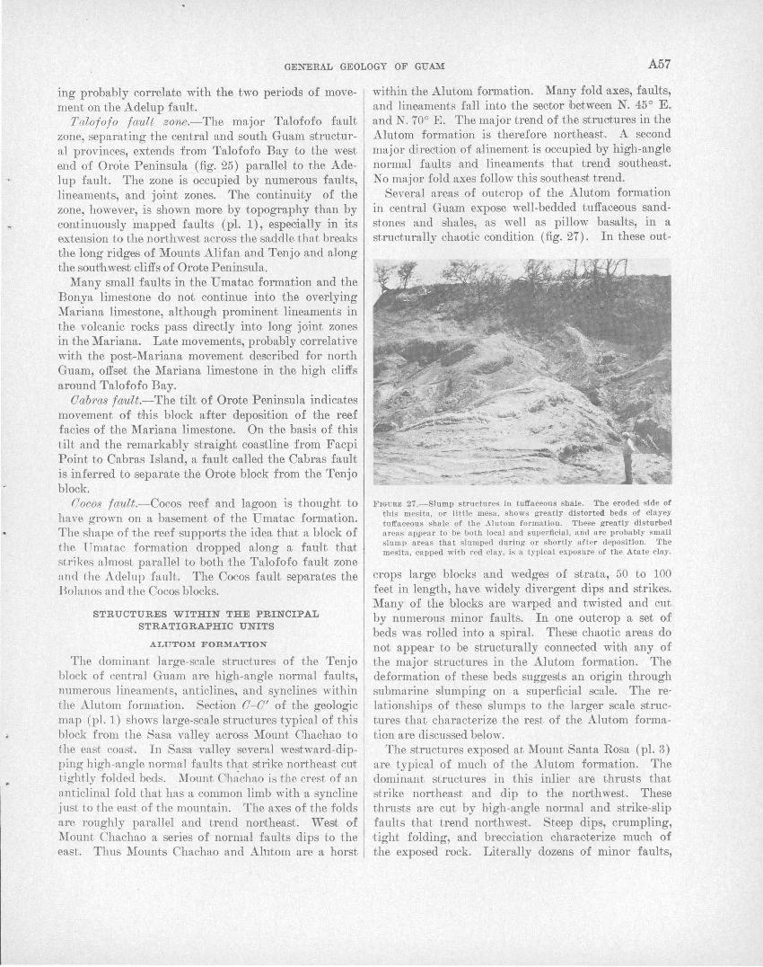
GENERAL GEOLOGY OF GUAM A57
ing probably correlate with the two periods of movement on the Adelup fault.
Talofofo fault zone.-The major Talofofo fault zone, separating the central and south Guam structural provinces, extends from Talofofo Bay to the west end of Orote Peninsula (fig. 25) parallel to the A del up fault. The zone is occupied by numerous faults, linea;ments, and joint zones. The continuity of the zone, however, is shown more by topography than by continuously 'mapped faults (pl. 1), especially in its extension to the northwest acr06S the saddle that breaks the long ridges of 'Mounts Alifan and Tenjo and along the soutJhwest cliffs of Orote Peninsula.
Many small faults in the Umatac formation and the Bonya limestone do not continue into the overlying Mariana limestone, although prominent lineaments in the volcanic rocks pass directly into long joint zones in the Mariana. Late movements, probably correlative with the post-Mariana movement described for north Guam, offset the Mariana limestone in the high cliffs around Talofofo Bay.
Oabras fault.-The tilt of Orote Peninsula indicates movement of tJhis block after deposition of the reef facies of the Mariana limestone. On the basis of this tilt and the remarkably straight coastline from Facpi Point to Cabras Island, a fault called the Cabras fault is inferred to separate the Orote block from the Tenjo block.
Cocos fault.-Cocos reef and lagoon is t hought to have grown on a basement of the Umatac formation. The shape of the reef supports the ridea that a block of the 1 matll!c formation dropped along a fault that strikes almost parallel to both the Talofofo fau.J~t zone and the Adelup fault. The Cocos fault separates the Bolanos and t he Cocos blocks.
STRUCTURES WITHIN THE PRINCIPAL STRATIGRAPHIC UNITS
ALUTOM FORMATION
The dominant large-scale structures of the Tenjo block of central Guam are high-angle normal faults, numerous lineaments, anticlines, and synclines within tJhe Alutom formation. Section 0-0' of the geologic map (pl. 1) shows large-scale structures typical of this block from the Sasa valley across Mount Chachao rto the east coast. In Sasa valley several westward-dipping high-angle normal faults that strike northeast cult tightly folded beds. Mount Oh~{chao is the crest of an anticlinal fold that has a common limb with a syncline just to the east of the mountain. The axes of the folds are roughly parallel and trend nontheast. West of Mount Chachao a series of normal faults dips to the east. Thus Mounts Chachao and Alutom are a horst
wibhin the Alutom formation. Many fold ·axes, faults, and lineaments fall into the sector ibetween N. 45° E. and N. 70° E. The major trend of the struotures in the Alutom formation is therefore northeast. A second major direction of alinement is occupied by high-angle normal faults and lineaments that trend southeast. No major fold axes follow this southeast trend.
Several areas of outcrop of the Alutom formation in central Guam expose well-bedded tuffaceous sandstones and shales, as well as pillow basalts, in a structurally chaotic condition (fig. 27). In these out-
FIGURE 27.-Slump structures in tull'aceous shale. The eroded side of this mesita, or little mesa , shows greatly distorted beds of clayey tuffaceous shale of thP Alutom formation. These greatly disturbed areas a ppea r to be both loca l and superficial, and are probably small Hlump a reas that slumped during or shortly after deposition. The mesita, capped with red clay, is a typical exposure of the AttLte clay.
crops large blocks and wedges of strata, 50 to 100 feet in length, have widely divergent dips and strikes. Many of the blocks are warped and twisted and cut by numerous minor faults. In one outcrop a set of beds was rolled into a spiral. These chaotic areas do not appear to be structurally connected with any of the major structures in the Alutom formation. The deformation of these beds suggests an origin through submarine slumping on a superficial scale. The relationships of these slumps to the larger scale structures that characterize ;the rest of the Alutom formation are discussed below.
The structures exposed at Mount Santa Rosa (pl. 3) are typical of much of the Alutom formation. The dominant structures in this inlier are thrusts that strike northeast and dip to the northwest. These thrusts are cut by high-angle normal and strike-slip faults that trend northwest. Steep dips, crumpling, t ight folding, and brecciation characterize much of the exposed rock. Literally dozens of minor faults,
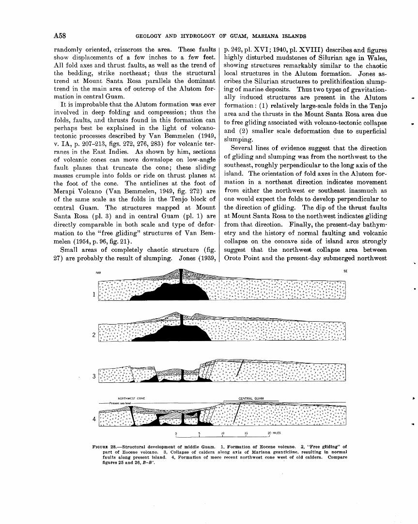
A 58 GEOLOGY AND HYDROLOGY OF GUAM, MARIANA ISLANDS
randomly oriented, crisscross the area. These faults show displacements of a few inches to a few feet. All fold axes and thrust faults, as well as the trend of the bedding, strike northeast; thus the structural trend at Mount Santa Rosa parallels the dominant trend in the main area of outcrop of the Alutom formation in central Guam.
It is improbable that the Alutom formation was ever involved in deep folding and compression; thus the folds, faults, and thrusts found in this formation can perhaps best be explained in the light of volcanotectonic processes described by Van Bemmelen (1949, v. IA, p. 207-213, figs. 272, 276, 283) for volcanic terranes in the East Indies. As shown by him, sections of volcanic cones can move downslope on low-angle fault planes that truncate the cone; these sliding masses crumple into folds or ride on thrust planes at the foot of the cone. The anticlines at the foot of Merapi Volcano (Van Bemmelen, 1949, fig. 272) are of the same scale as the folds in ·the Tenjo block of central Guam. The structures mapped at Mount Santa Rosa (pl. 3) and in central Guam (pl. 1) are directly comparable in both scale and type of deformation to the "free gliding" structures of Van Bemmelen ( 1954, p. 96, fig. 21).
Small areas of completely chaotic structure (fig. 27) are probably the result of slumping. Jones (1939,
2
3
4
p. 242, pl. XVI; 1940, pl. XVIII) describes and figures highly disturbed mudstones of Silurian age in Wales, showing structures remarkably similar to the chaotic local structures in the Alutom formation. Jones ascribes the Silurian structures to prelithification slumping of marine deposits. Thus two types of gravitationally induced structures are present in the Alutom formation: ( 1) relatively large-scale folds in. tJhe Tenjo area and the thrusts in the Mount Santa Rosa area due to free gliding associated with volcano-tectonic collapse and (2) smaller scale deformation due to superficial slumping.
Several lines of evidence suggest that the direction of gliding and slumping was from the northwest to the southeast, roughly perpendicular to the long axis of the island. The orientation of fold axes in the Alu:tom formation in a northeast direotion indicates movement from either the northwest or southeast inasmuch as one would expect the folds to develop perpendicular to the direction of gliding. The dip of the thrust faults at Mount Santa Rosa to the northwest indicates gliding from that direotJion. Final·ly, the present-day bathymetry and the history of normal faulting and volcanic collapse on the concave side of island arcs strongly suggest that the north west collapse area between Orote Point and the present-day submerged northwest
10 15 20 MILES
FIGURE 28.-Structural development of middle Guam. 1, Formation of Eocene volcano. 2, "Free gliding" of part of Eocene volcano. 3, Collapse of caldera along axis of Mariana geanticline, resulting in normal faults along present island. 4, Formation of more recent northwest cone west of old caldera. Compare figures 25 and 26, B-B '.
.•
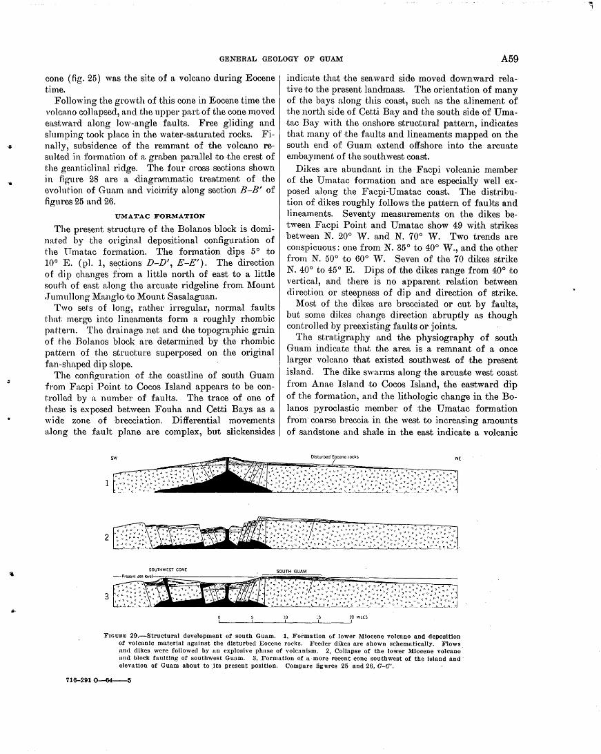
.,.
...
GENERAL GEOLOGY OF GUAM A 59
cone (.fig. 2.5) was the site of a volcano during Eocene time.
Following the growth of this cone in Eocene time the volcano collapsed, and the upper part of the cone moved ea,stwn.rd along low-angle faults. Free gliding and slumping took place in the water-saturated rocks. Fin:11ly, subsidence of the remnant of the volcano resu }ted :in formatJ.ion of a graben parallel to .the crest of the gen.nticlinal ridge. The four cross sections shown :in figure 28 n.re a diagrrummat.ic tre9Jtment of the evolut'ion of Guam a.nd vicinity along section B-B' of fi.gures 25 and 26.
UMATAC FORMATION
The present structure of the Bolanos block is domina·ted by the original depositional configuration of the Umatac formation. The formation dips 5° to 10° E. (pl. 1, sections D-D', E-E'). The direction of dip changes ft~om a little north of east to a little sout'!l1 of east along the arcuate ridgeline from ~{ount • Tumnllong ~{anglo ~to Mount Sasalaguan.
Two sets of long, rather irregular, normal faults t.hat merge :into linean1ents form a roughly rhombic pat".tern. The drainage net and the topographic grain o'f t.he Bolanos block are determined by the rhombic pattet.·n of the structure superposed on the original fan-shaped dip slope.
The configuration of .the coastline of south Guam from Fa,cpi Point to Cocos Island appears to be conh·olled by a number of faults. The trace of one of these is exposed between Fouha and Cetti Bays as a wide zone of brecciation. Differential movements along the fault plane ttre complex, but slickensides
2
3
indicate that the seaward side moved downward relative to the present landmass. The orientation of many of the bays a1ong this coast, such as the alinement of the north side of Cetti Bay and the south side of Umatac Bay with the onshore structural pattern, indicates that many of the faults and lineaments mapped on the south end of Guam extend offshore into the arcuate embayment of the southwest coast.
Dikes are abundant in the Facpi volcanic member of the Umatac formation and are especiaNy well exposed along the Facpi-Umatac coast. The distribution of dikes roughly follows the pattern of faults and lineaments. Seventy measurements on the dikes between Facpi Point and Umatac show 49 with strikes between N. 20° vV. and N. 70° W. Two trends are conspicuous: one from N. 35° to 40° W., and the other from N. 50° ·to 60° ,V. Seven of the 70 dikes strike N. 40° to 45° E. Dips of tJhe dikes range from 40° ~to vertical, and there is no apparent relation between direction or steepness of dip and direction of strike .
Most of the dikes are brecciated or cut by faults, but some dikes change direction abruptly as though controlled by preexisting faul.ts or joints.
The stratigraphy and the physiography of south Guam indicate that the area is a remnant of a once larger volcano tJhat existed southwest of the present island. The dike swarms along the arcuate west coast from Anae Island to Cocos Island, the eastward dip of the forma,tion, and the lithologic change in the Bolanos pyroclastic member of the Umatac formation from· coarse breccia in the west to increasing amounts of sandstone and sha1e in the east indicate a volcanic
10 15 20 MILES
Frounm 29.-Structural development of south Guam: 1, Formation 0f lower Miocene volcano and deposition of volcanic material against the disturbed Eocene rocks. Feeder dikes are shown schematically. Flows and dikes were followed by an explosive phase of volcanism. 2, Collapse of the lower Miocene volcano· and block faulting of southwest Guam. 3, Formation of n·more recent cone southwest of the Island and· elevation of Guam about to .Its present position. Compare figures 25 and 26. C-0'.
716-2910-64--5
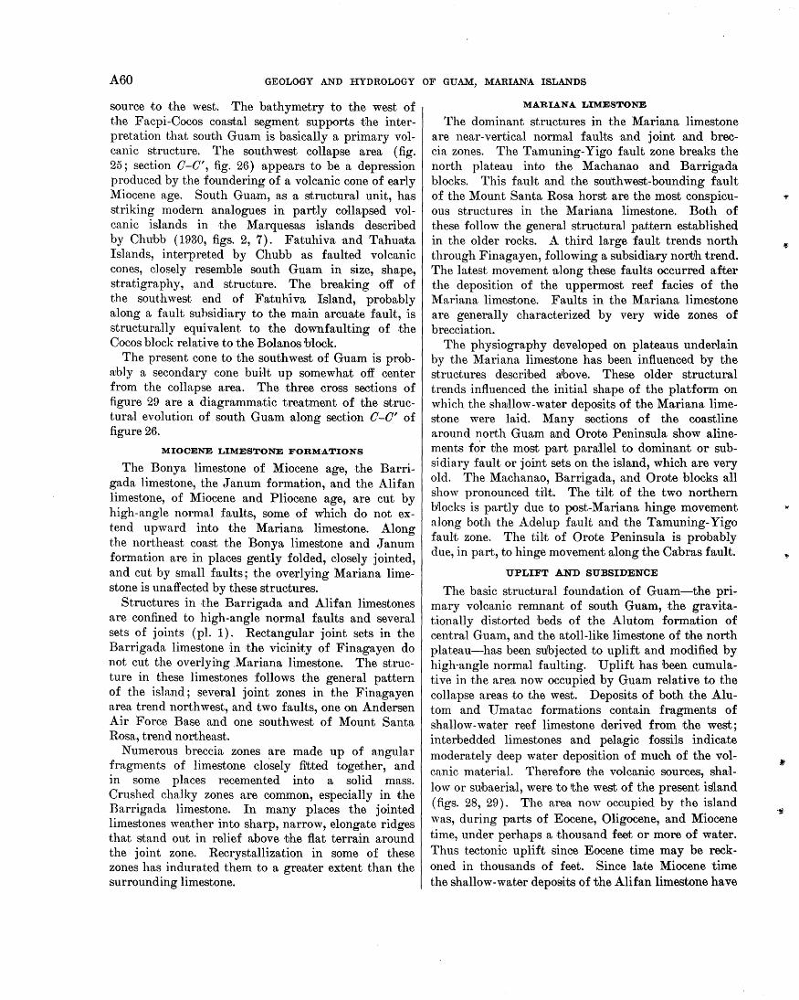
A60 GEOLOGY AND HYDROLOGY OF GUAM, MARIAN:A ISLAN·DS
source to .the west. The bathymetry to the west of the Facpi-Cocos coastal segment supports the interpretation that south Guam is basically a primary volcanic structure. The southwest collapse area (fig. 25; section 0-0', fig. 26) appears to be a depression produced by the foundering of a volcanic cone of early Miocene age. South Guam, as a structural unit, has striking modern analogues in partly collapsed volcanic islands in the Marquesas islands described by Chubb (1930, figs. 2, 7). Fatuhiva and Tahua.ta Islands, interpreted by Chubb as faulted volcanic cones, closely resemble south Guam in size, shape, stratigraphy, and structure. The breaking off of the southwest end of F.atuhiva Island, probably along a fault suhsidiary to the main arcuate f·ault, is structurally equivalent to the downfaulting of the Cocos block relative to the Bolanos block.
The present cone to the southwest of Guam is probably a secondary cone built up somewhat off center from th~ collapse area. The .three cross sections of figure 29 are a diagrammatic treatment of the structural evolution of south Guam along section 0-0' of figure 26.
MIOCENE LIMESTONE FORM-ATIONS
The Bonya limestone of Miocene age, the Barrigada limestone, the J anum formation, and the Alifan limestone, of Miocene and Pliocene age, are cut by high-angle normal faults, some of which do not extend upward into the Mariana limestone. Along the northeast coast the Bonya limestone and J anum formation are in places gently folded, closely jointed, and cut by small faults; the overlying Mariana limestone is unaffected by these structures.
Structures in the Barrigada and Alifan limestones are confined to high-angle normal faults and several sets of joints (pl. 1). Rectangular joint sets in the Barrigada limestone in the vicinity of Finagayen do not cut the overlying .Mariana limestone. The structure in these limestones follows the general pattern of the island; several joint zones in the Finagayen area trend northwest, and two faul.ts, one on Andersen Air Force Base and one southwest of Mount Santa Rosa, trend northeast.
Numerous breccia zones are made up of angular fragments of limestone closely fitted together, and in some places recemented into a solid mass. Crushed chalky zones are oom·mon, especially in the Barrigada limestone. In many places the jointed limestones weather into sharp, narrow, elongate ridges that stand out in relief above ·tJhe flat terrain around the joint zone. Recrystallization in some of these zones has indurated them to a greater extent than the surrounding limestone.
MARIANA LIMESTONE
The dominant structures in the Mariana limestone are near-vertical normal faults and joint and breccia zones. The Tamuning-Yigo fault zone breaks the north plateau into the Machanao and Barrigada blocks. This fau}t and the southwest-bounding fault of the Mount Santa Rosa horst are the most conspicuous structures in the Mariana limestone. Both of these follow the general structural pattern established in the older rocks. A third large fault trends north through Finagayen, following a subsidiary north trend. The latest movement ·along these faults occurred after the deposition of the uppermost reef facies of the Mariana limestone. Faults in the Mariana limestone are generally characterized by very wide zones of brecciation.
The physiography developed on plateaus undel'lain by the Mariana limestone has been influenced by the structures described rubove. These older structural trends influenced the initial shape of the platform on which the shrullow-water deposits of the Mariana limestone were laid. Many sections of the coastline around north Guam and Orote Peninsula show alinements for the most part parallel to dominant or subsidiary fault or joint sets on the island, which are very old. The Machanao, Barrigada, and Orote blocks all show pronounced tilt. The til·t of the two northern Mocks is partly due to post-Mariana hinge movement along both the Adelup fault and the Tamuning-Yigo faulot zone. The tilt of Orote Peninsula is probably due, in part, to hinge movement along the Ca;bras fault.
UPLIFT AND SUBSIDENCE
The basic structural foundation of Guam-the primary volcanic remnant of south Guam, the gra vitationally distorted beds of the Alutom formation of central Guam, and the atoll-like limestone of the north plateau-has been subjected to uplift and modified by high-angle normal faulting. Uplift has been cumulative in the area now occupied by Guam relative to the collapse areas to the west. Deposits of both the Alutom and U matac formations contain fragments of shallow-water reef limestone derived from the west; interbedded limestones and pelagic fossils indicate moderately deep water deposition of much of the volcanic material. Therefore the volcanic sources, shallow or subaerial, were to 'the west of the present island (figs. 28, 29). The area now occupied by the island was, during parts of Eocene, Oligocene, and Miocene time, under perhaps a thousand feet or more of water. Thus tectonic uplift since Eocene time may be reckoned in thousands of feet. Since late Miocene time the shallow-water deposits of the Alifan limestone have
·1!1
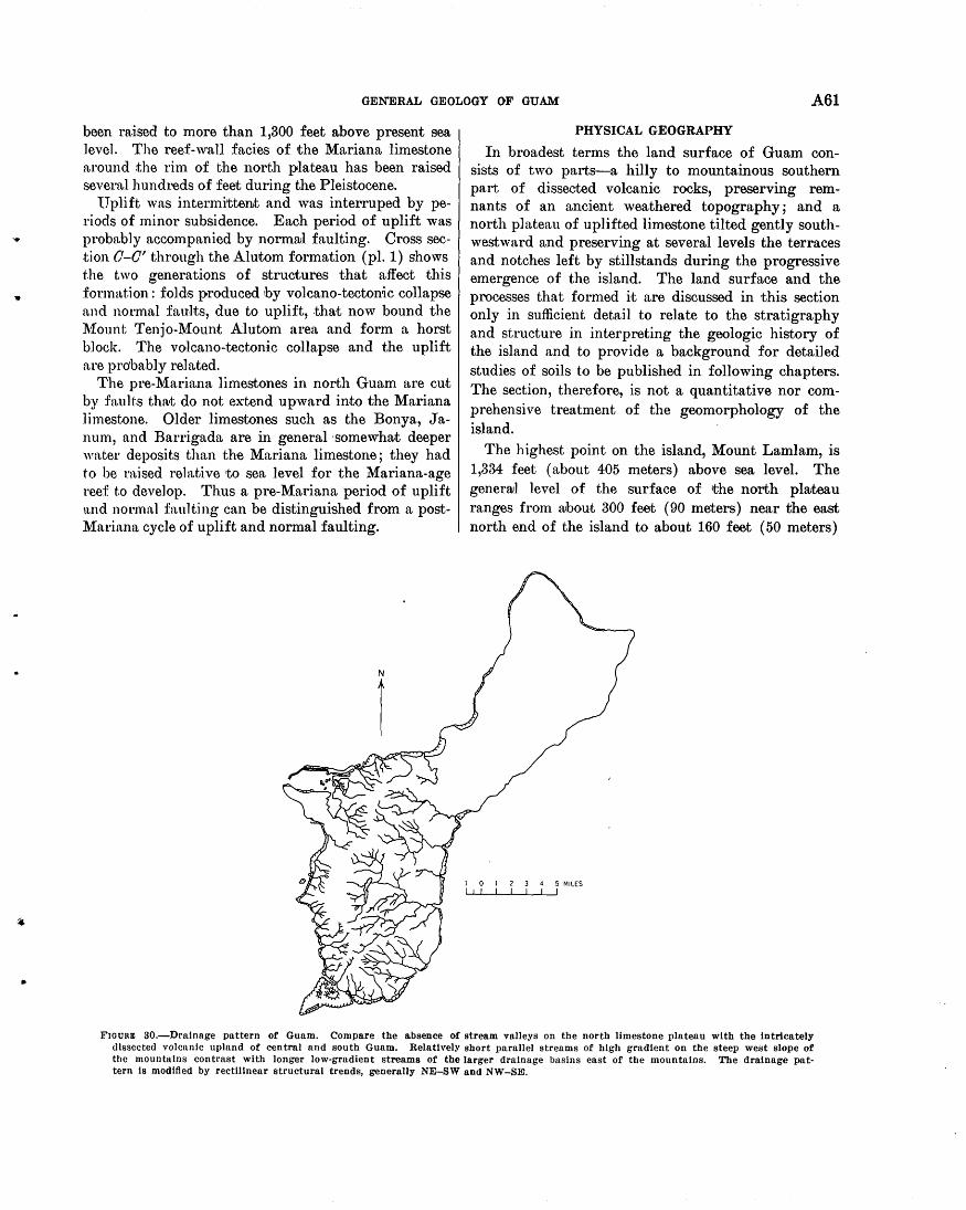
..
..
GENERAL GEOLOGY OF GUAM A61
been raised to more than 1,300 feet above present sea level. The reef-wall facies of the Mariana limestone around :the rim of the north plateau has been raised severn,! hundreds of feet during the Pleistocene.
1Tplift was intermittent and was interruped by periods of minor subsidence. Each period of uplift was probably accompanied by normrul faulting. Cross section 0-0' through the Alutom formation (pl. 1) shows the two generations of structures that affect this :formation: folds produced by volcano-tectonic collapse ftnd normal fau.lts, due to uplift, that now bound the l\f.ount Tenjo-Mount Alutom area and form a horst block. The volcano-tectonic collapse and the uplift ftre probably related.
The pre-Mariana limestones in north Guam are cut by fault.s tha·t do not extend upward into the Mariana ] i mestone. Older limestones such as the Bony a, J anum, and Barrigada are in general ·somewhat deeper water deposits than the Mariana limestone; they had to be raised relative to sea level for the Mariana-age reef to develop. Thus a pre-Mariana period of uplift ttnd normnJ faul·ting can be distinguished from a postMariana cycle of uplift and normal faulting .
PHYSICAL GEOGRAPHY
In broadest terms the land surface of Guam consists of two parts-a hilly to mountainous southern part of dissected volcanic rocks, preserving remnants of an ancient weathered topography; and a north plateau of uplifted limestone tilted gently southwestward and preserving at several levels the terraces and notches left by stillstands during the progressive emergence of the island. The land surface and the processes that formed it are discussed in this section only in sufficient detail to relate to the stratigraphy and structure in interpreting the geologic history of the island and to provide a background for detailed studies of soils to be published in following chapters. The section, therefore, is not a quantitative nor comprehensive treatment of the geomorphology of the island.
The highest point on the island, Mount Lamlam, is 1,334 feet (about 405 meters) above sea level. The generwl level of the surface of the north plwteau ranges from rubout 300 feet ( 90 meters) near the east north end of the island to about 160 feet (50 meters)
FIOURm 30.-Dralnnge pattern of Guam. Compare the absence of stream valleys on the north limestone plateau with the intricately ()lsscctcd volcanic upland of central and south Guam. Relatively short parallel streams of high gradient on the steep west slope of the mountnlns contrast with longer low-gradient streams of the larger drainage basins east of the mountains. The drainage pat· tern Is modified by rectilinear structural trends, generally NE-SW and NW-SE.
A62 GEOLOGY AND HYDROLOGY OF GUAM, MARIANA ISLANDS
between Agana and Pago Bay near the middle of the island. The general level of the dissected surface of the volcanic uplands in the southern part of the island ranges from about 300 feet ( 90 meters) near the east coast to more than 1,000 feet ( 300 meters) along the higher parts of the ridge from Mount Alutom in the north to Mount Sasalaguan at the south end of the island.
The drainage pattern of the island is shown in figure 30. No streams drain the major part of the north plateau. Rainfa'll sinks directly into the porous limestone and passes through to the water table, which is about at sea level in areas not underlain by volcanic rocks. The low southwestern part of the north plateau includes an intricate drainage system developed probably when the sea was somewhat higher than at present, and now occupied by streams only un~er conditions of intense rainfall. Two permanent streams flow in the area-the lower part of the Agana River and the Fonte River.
The southern volcanic part· of the island contains an intricate network of permanent streams. The dendritic pattern of the larger streams on the east side of the island has been strongly modified to a rectangular pattern by northeasterly and southeasterly trends that are probably structural in origin.
The land surface of Guam may be divided into four principal categories, each of which contains several subdivisions (fig. 31). These are the limestone plateau, the dissected volcanic uplands, the interior basin, and the coastal lowlands and valley floors.
LIMESTONE PLATEAU
The limestone plateau division includes the north plateau, Orote Peninsula, and the :firinging limestone of the southeast coast. The north plateau is a nearly flat constructional platform of reef-associated limestone that has been lifted above sea level and tilted gently southwestward. Local relief on the plateau ranges from a few feet in small depressions and low mounds to 150 feet ( 45 meters) for the principal scarps a.nd steeper slopes of hills on the plateau, and to 300 feet ( 90 meters) for the larger hills, such as Barrigada Hill and l\1ount Santa Rosa. Sinkholes range from a few feet to about 75 feet deep over most of the plateau. This local relief is superposed on a gentle overall slope of about 25 feet per mile ( 5 meters per kilometer). The overall slope of 25 feet per mile is a rough average, for the topographic map shows that the Machanao and Barrigada structural blocks (fig. 25) of the north plateau are formed of several smaller blocks, some of which dip as much as 150 feet per mile (30 meters
per kilometer) and some of which are nearly horizontrul.
Coastal cliffs bound most of the plateau. They are as much as 625 feet ( 190 meters) above sea level at their highest point, and few steep cliffs show uninterrupted faces more than 330 feet (100 meters) in height (figs. 32, 33) .
The periphery of the limestone plateau at the top of the cliff is in many places a well-defined rampart 20 to ~0 feet high and U~bout 50 feet wide at its base (fig. ~4). The top is approximately at the level of the. plateau, and behind the rampart is a moat or trench several hundred feet wide (fig. 35). The formation of the ramparts of Okinawa has been attributed by Flint (1949) and Flint and others (1953, p. 1260) to what they call "surface-controlled secondary cementation and differential erosion." The downward passage of rainwater on the top of a horizontal limestone surface causes solution of the surface. Near cliffs and steeply inclined surfaces a part of the water within the rocks evaporates, leading to precipitation of calcium carbonate. Secondary cementation occurs· selectively on steep surfaces, which are in consequence less affected by solution than are the comparatively uncemented horizontal surfaces. The hypothesis is accepted by Cloud, Schmidt, and Burke ( 1956, p. 25) as a likely explanation for the ramparts of Saipan, and it seems to be applicable to Guam as well. An alternative explanation-that the ramparts are of reef limestone that is less soluble than adjacent porous limestone-is not reasonable on Guam, for the ramparts and moats are both formed of the same limestone, which in most places is of the reef facies although in some places ramparts and moats are formed of porous detrital limestone.
In cuts or quarry faces the rampart shows a dense recrystallized limestone that appears to be massively cemented. The surface of the ·moat, however, is much dissected by solution pits, enlarged cracks, pinnacles and pipes (fig. 36, upper).
Other solution features on the plateau are sinks or enclosed depressions that may be as much as half a mile in diameter and 40 to 50 feet in depth. Alined sinks in some places suggest solution along faults or structural lines. In other places lines of depressions or sinks appear to follow the contact of the Mariana limestone upon the Barrigada limestone.
Several broad continuous valleylike trenches on the north plateau can be seen on the topographic map. The most conspicuous of these trends southwest from Mount Santa Rosa past the west side of Barrigada Hill to Tamuning, and is pounded on its southeast side by a prominent scarp that is probably structural. De-
•
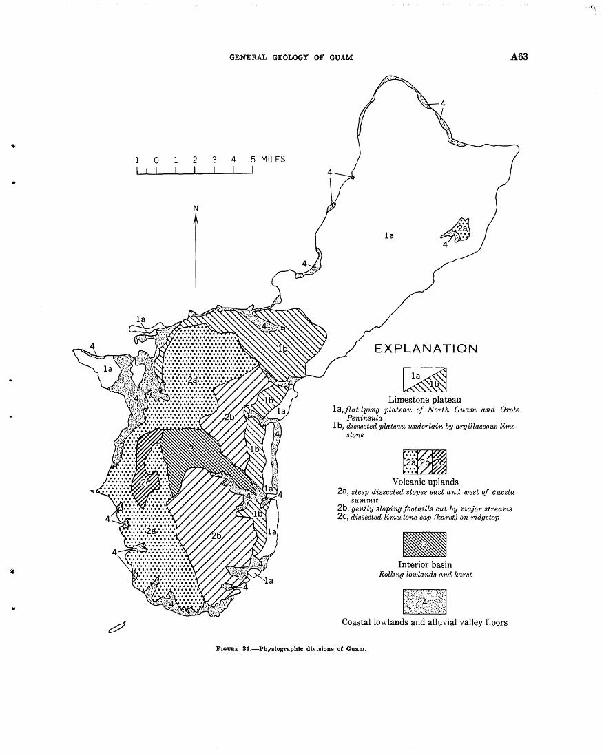
.. 1 I
0 I
1 I
2 I
N
3 I
GENERAL GEOLOGY OF GUAM A63
4 I
5 MILES I
EXPLANATION
Limestone plateau la,jlat-lying plateau of North Guam and Orote
Peninsula 1 b, dissected plateau underlain by argillaceous lime
stone
Volcanic uplands 2a, steep dissected slopes east and west of Cuesta
summit 2b, gently sloping foothills cut by major streams 2c, dissected limestone cap (karst) on ridgetop
Interior basin Rolling lowlands and karst
Coastal lowlands and alluvial valley floors
FIGURE 31.-Physlographlc divisions of Guam.
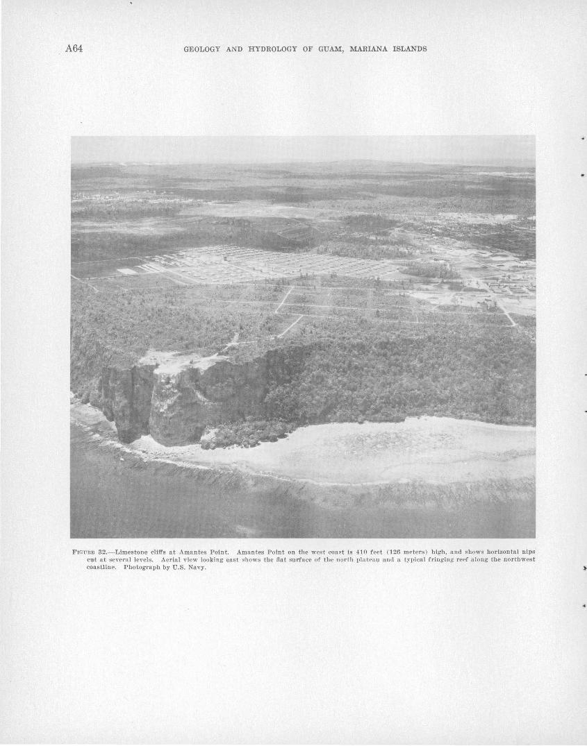
A64 GEOLOGY AND HYDROLOGY OF GUAM, MARIANA ISLANDS
FIGURE 32.-Limestone cllfl's at Amantes Point. Amantes Point on the west coast Is 410 feet (126 meters) high, and shows horizontal nips' cut at several levels. Aerial view looking east shcHvs the flat surface of the north plateau and a typical fringing reef a long the northwest coastline. Photograph by U.S. Navy. )
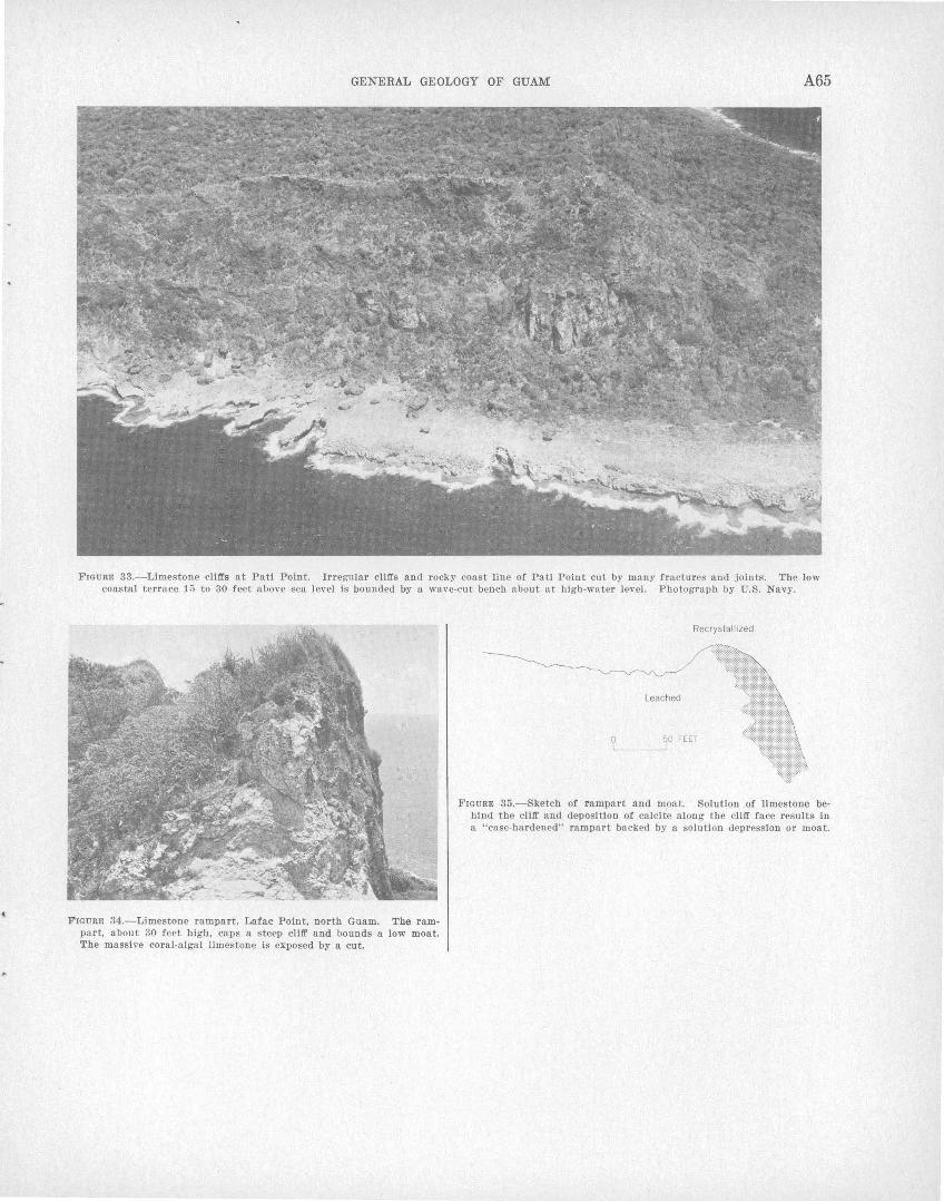
GENERAL GEOLOGY OF GUAM A65
FIGURE 33.-Limestone cliffs at Pat! Point. Irregular cliffs and rocky coast line of Pat! Point cut by many fractures and joints. The low coastal terrace 15 to 30 feet above sea level is bounded by a wave-cut bench about nt high-water level. Photograph by U.S. Navy.
FIGURE 34.-Limestone rampart, Lafac Point, north Guam. The rampart, about 30 feet high, caps a steep cliff and bounds a low moat. The massive coral-algal limestone Is exposed by a cut.
Recrystallized
Leached
0 50 FEET
FIGURE 35.-Sketch of rampart and moat. Solution .of limestone behind the cliff and deposition of calcite a long the cliff face results in a "case-hardened" rampart backed by a solution depression or moat.
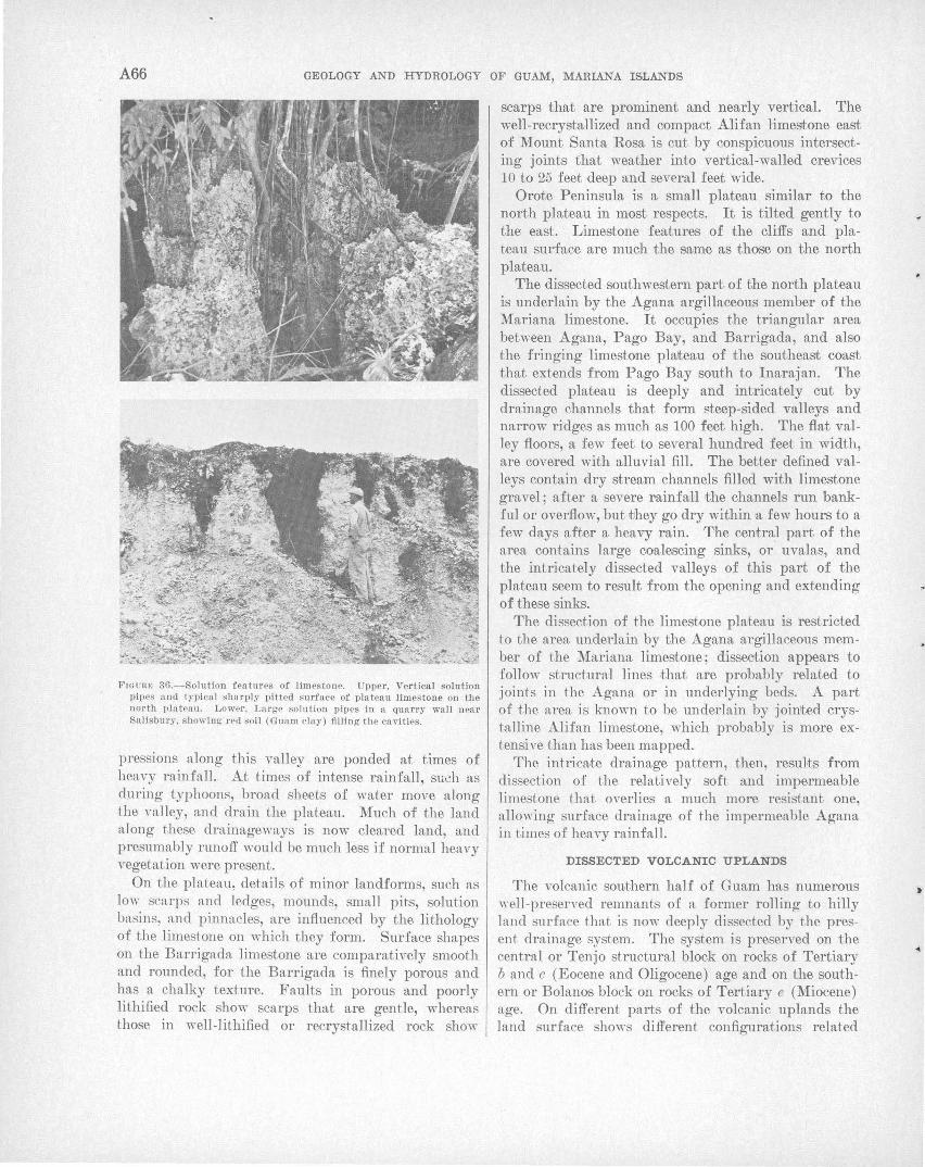
A66 GEOLOGY AND HYDROLOGY OF GUAM, MARIANA ISLANDS
FIGU R E 36.-Solution featur~s of limes tone. Upper, Vertical solution pipes and ty pi ca l sharply pitted Rurface of plateau limes tone on the north plateau. Lower , Large solution pipes In a quarry wall near Sa lis bury, showing red soil (Gua m clay ) filling the caviti es.
pressions along this valley are ponded at times of heavy rainfall. At times of intense rainfall, suGh as during typhoons, broad sheets of water move along the valley, and drain the plateau. Much of the land along these drainageways is now cleared land, and presumably runoff >Yould be much less if normal heavy vegetation were present.
On the plateau, details of minor landforms, such as low scarps and ledges, mounds, small pits, solution basins, and pinnacles, are influenced by the lithology of the limestone on which they form. Surface shapes on the Barrigada limestone are comparatively smooth and rounded, for the Barrigada is finely porous and has a chalky texture. Faults in porous and poorly lithified rock show scarps that are gentle, whereas those in well-lithified or recrystallized rock show
scarps that are prominent and nearly vertical. The well-recrystallized and compact Alifan limestone east of Mount Santa Rosa is cut by conspicuous intersecting joints that weather into vertical-walled crevices 10 to 25 feet deep and several feet wide.
Orote Peninsula is a small plateau similar to the north plateau in most respects. It is tilted gently to the east. Limestone features of the cliffs and plateau surface are much the same as those on the north plateau.
The dissected southwestern part of the north plateau is underlain by the Agana argillaceous member of the Mariana limestone. It occupies the triangular area between Agana, Pago Bay, and Barrigada, and also the fringing limestone plateau of the southeast coast that extends from Pago Bay south to Inarajan. The dissected plateau is deeply and intricately cut by drainage channels that form steep-sided valleys and narrow ridges as much as 100 feet high. The flat valley floors, a few feet to several hundred feet in width, are covered with alluvial fill. The better defined valleys contain dry stream channels filled with limestone gravel ; after a severe rainfall the channels run bankful or overflow, but they go dry within a few hours to a few days after a heavy rain. The central part of the area contains large coalescing sinks, or uvalas, and the intricately dissected valleys of this part of the plateau seem to result from the opening and extending of these sinks.
The dissection of the limestone plateau is restricted to the area underlain by the Agana argillaceous member of the Mariana limestone; dissection appears to follow structural lines that are probably related to joints in the Agana or in underlying beds. A part of the area is kno\m to be underlain by jointed crystalline Alifan limestone, which probably is more extensive than has been mapped.
The intricate drainage pattern, then, resul·ts from dissection of the relatively soft and impermeable limestone t.hat overlies a much more resistant one, allowing surface drainage of the impermeable Agana in times of heavy rainfall.
DrSSECTED VOLCANIC UPLANDS
The volcanic southern half of Guam has numerous well-preserved remnants of a former rolling to hilly land surface that is now deeply dissected by the present drainage system. The system is preserved on the central or Tenjo structural block on rocks of Tertiary b and c (Eocene and Oligocene) age and on the southern or Bolanos block on rocks of Tertiary e (Miocene) age. On different parts of the volcanic uplands the land surface sho\I'S different configurations related
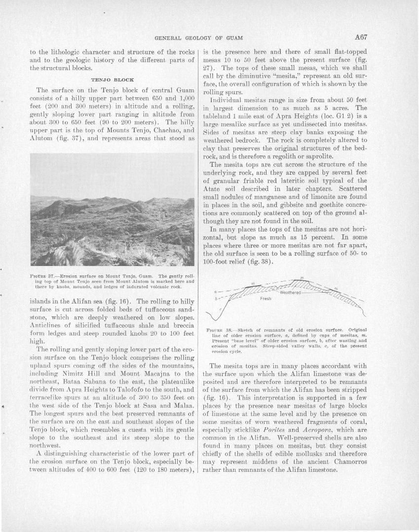
GENERAL GEOLOGY OF GUAM .A67
to the lithologic character and structure of the rocks and to the geologic history of the different parts of the ·structural blocks.
TENJO BLOCK
The surface on the Tenjo block of central Guam consists of a hilly upper part between 650 and 1,000 feet (200 and 300 meters) in altitude and a rolling, gently sloping lower part ranging in altitude from about 300 to 650 feet ( 90 to 200 meters). The hilly upper ,part is the top of Mounts Tenjo, Chachao, and Alutom (fig. 37), and represents areas that stood as
FIGURE 37.-Erosion surface on Mount Tenjo, Guam. The gently rolling top of Mount Tenjo seen from Mount .Alutom l.s marked here and there by knobs, mounds, and ledges of indurated volcanic rock.
islands in the Ali fan sea (fig. 16). The rolling to hilly surface is cut across folded beds of tuffaceous sandstone, which are deeply weathered on low slopes. Anticlines of silicified tuffaceous shale and breccia form ledges and steep rounded knobs 20 to 100 feet high.
The rolling and gently sloping lower part of the erosion surface on the Tenjo block comprises the rolling upland spurs coming off the sides of the mountains, including Nimitz Hill and Mount Macajna to the northeast, Bataa Sabana to the east, the plaJt.eaulike divide from Apra Heights to Talofofo to the south, and terracelike spurs at an altitude of 300 to 350 feet on the west side of the Tenjo block at Sasa and Malaa. The longest spurs and tlhe best preserved remnants of the surface are on the east and southeast slopes of the Tenjo block, which resembles a cuesta wi·th its gentle slope to the southeast and its steep slope to the northwest.
A distinguishing characteristic of the lower part of the erosion surface on the Tenjo block, especially between altitudes of 400 to 600 feet ( 120 to 180 meters),
is the presence here and there of small flat-topped mesas 10 to 50 feet above the present surface (fig. 27). The tops of these small mesas, which we shall call by the diminutive "mesita," represent an old surface, the overall configuration of which is shown by the rolling spurs.
Individual mesitas range in size from about 50 feet in largest dimension to as much as 5 acres. The tableland 1 mile east of Apra Heights (loc. G1 2) is a large mesalike surface as yet undissected into mesitas. Sides of mesitas are steep clay banks exposing the weathered bedrock. The rock is completely altered to clay that preserves the original structures of the bedrock, and is therefore a regolith or saprolite.
The mesita tops are cut across the structure of the underlying rock, and they are capped by several feet of granular friable red lateritic soil typical of the Atate soil described in later chapters. Scattered small nodules of manganese and of limonite are found in places in the soil, and gibbsite and goethite concretions are commonly scattered on top of vhe ground although they are not found in the soil.
In many places the tops of the mesitas are not horizontal, hut slope as much as 15 percent. In some places where three or more mesitas are not far apart, the old surface is . seen to be a rolling surface of 50- to 100-foot relief (fig. 38) .
m
FIGURE 38.-Sketch of remnants of old erosion surface. Orlg!nal line of older erosion surface, a, defined !Jy caps of mes!tas, m. Present "!Jase level" of older erosion surface, b, after wasting and erosion of mesltas. Steep-sided valley walls, o, of the present erosion cycle.
The mesita tops are in many places accordant with the surface upon which the Alifan limestone was deposited and are therefore interpreted to be remnants of the surface from which the Alifan has been stripped (fig. 16). This interpretation is supported in a few places by the presence near mesitas of large blocks of limestone at the same level and by the presence on some mesitas of worn weathered fragments of coral, especially sticklike Porites and .Acropora, which are common in the Alifan. Well-preserved shells are also found in many places on mesitas, but they consist chiefly of the shells of edible mollusks and therefore may represent middens of the ancient Chamorros rather than remnants of the Alifan limestone.
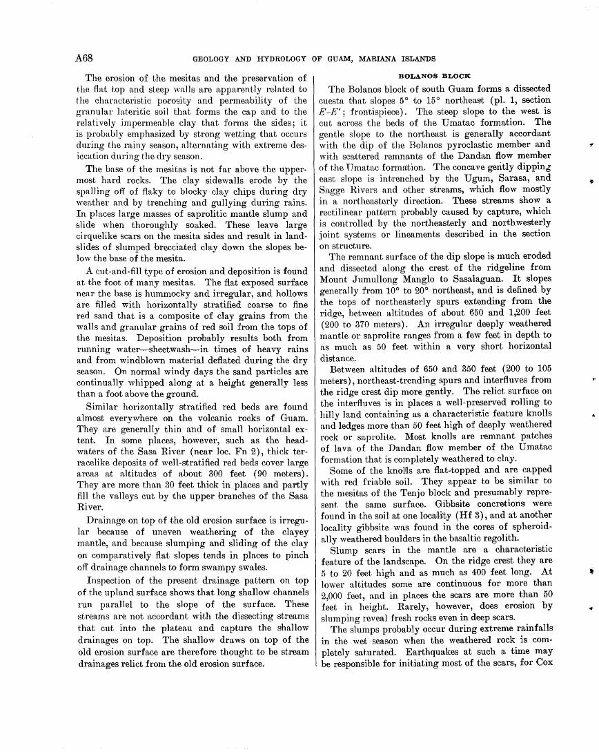
A68 GEOLOGY AND HYDROLOGY OF GUAM, MARIANA ISLANDS
The erosion of the mesitas and the preservation of the flat top and steep walls are apparently related to the characteristic porosity and permeability of the granular lateritic soil that forms the cap and to the relatively impermeable clay that forms the sides; it is probably emphasized by strong wetting that occurs during the rainy season, alternating with extreme desiccation during the dry season.
The base of the mesitas is not far above the uppermost hard rocks. The clay sidewalls erode by the spalling off of flaky to blocky clay chips during dry weather and by trenching and gullying during rains. In places large masses of saprolitic mantle slump and slide when thoroughly soaked. These leave large cirquelike scars on the mesita sides and result in landslides of slumped brecciated clay down the slopes below the base of the mesita.
A cut-and-fill type of erosion and deposition is found at the foot of many mesitas. The flat exposed surface near the base is hummocky and irregular, and hollows are fi1led with horizontally stratified coarse to fine red sand that is a composite of clay grains from the walls and granular grains of red soil from the tops of the mesitas. Deposition probably results both from running water-sheetwash-in times of heavy rains and from windblown material deflated during the dry season. On normal windy days the sand particles are continually whipped along at a height generally less than a foot above the ground.
Similar horizontally stratified red beds are found almost everywhere on the volcanic rocks of Guam. They are generally thin and of small horizontal extent. In some places, however, such as the headwaters of the Sasa River (near loc. Fn 2), thick terracelike deposits of well-stratified red beds cover large areas at altitudes of a-bout 300 feet (90 meters). They are more than 30 feet thick in places and partly fill the valleys cut by the upper branches of the Sasa River.
Drainage on top of the old erosion surface is irregular because of uneven weathering of the clayey mantle, and because slumping and sliding of the clay on comparatively flat slopes tends in places to pinch off drainage channels to form swampy swales.
Inspection of the present drainage pattern on top of the upland surface shows that long shallow channels run parallel to the slope of the surface. These streams are not accordant with the dissecting streams that cut into the plateau and capture the shallow drainages on top. The shallow draws on top of the old erosion surface are therefore thought to be stream drainages relict from the old erosion surface.
BOLANOS BLOCK
The Bolanos block of south Guam forms a dissected cuesta that slopes 5° to 15° northeast (pl. 1, section E -E' ; frontispiece) . The steep slope to the west is cut across the beds of the U matac formation. The gentle slope to the northeast is generally accordant with the dip of the Bolanos pyroclastic member and with sca·ttered remnants of the Dandan flow member of the TJ matac forma'tron. The concave gently dippinJ east slope is intrenched by the Ugum, Sarasa, and Sagge Rivers and other streams, which flow mostly in a northeasterly direction. These streams show a rectilinear pattern probably caused by capture, which is controlled by the nor:theaste~ly and northwesterly joint systems or lineaments described in the section on structure.
The remnant surface of the dip slope is much eroded and dissected along the crest of the ridgeline from Mount J umullong Manglo to Sasalaguan. It slopes generally from 10° to 20° northeast, and is defined by the tops of northeasterly spurs extending from the ridge, between altitudes of about 650 and 1,200 feet ( 200 to 370 meters). An irregular deeply weathered mantle or saprolite ranges from a few feet in depth to as much as 50 feet within a very short horizontal distance.
Between altitudes of 650 and 350 feet (200 to 105 meters), northeast-trending spurs and interfluves from the ridge crest dip more gently. The relict surface on the interfluves is in places a well-preserved rolling to hilly land containing as a characteristic feature knolls and ledges more than 50 feet high of deeply weathered rock or saprolite. Most knolls are remnant patches of lava of the Dan dan flow member of the U matac formation that is completely weathered to clay.
Some of the knoJils are flat-·topped and are capped with red friable soil. They appear to be similar to the mesitas of the Tenjo block and presumably represent the same surface. Gibbsite concretions were found in the soil at one locrulity (Hf 3), and at another locality gibbsite was found in the cores of spheroidally weathered boulders in the basaltic regolith.
Slump scars in the mantle are a characteristic feature of the landscape. On the ridge crest they are 5 to 20 feet high and as much as 400 feet long. At lower altitudes some are continuous for more than 2,000 feet, and in places the scars are more than 50 feet in height. Rarely, however, does erosion by slumping reveal fresh rocks even in deep scars.
The slumps probably occur during extreme rainfalls in the wet season when the weathered rock is completely saturated. Earthquakes at such a time may be responsible for initiating most of the scars, for Cox
~·
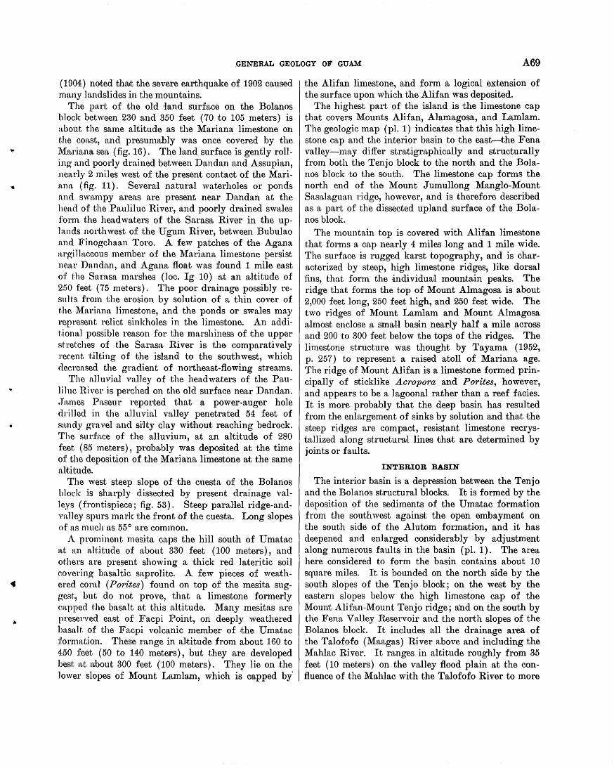
.GENERAL GE'OLOGY OF GUAM A69
( 1904) noted thrut the severe earthquake of 1902 caused many landslides in the mountains.
The part of the old 'land surface on the Bolanos block between 230 and 350 feet (70 to 105 meters) is about the same altitude as the Mariana limestone on the coast, and presumably was once covered by the l\1ariana sea (fig. 16). The land surface is gently rolling and poorly drained between Dandan and Assupian, nearly 2 miles west of the present contact of the Mariana (fig. 11). Several natural waterholes or ponds and swampy a.reas are present near Dandan at the head of the Pauliluc River, and poorly drained swales form the headwaters of the Sarasa River in the upln.nds northwest of the Ugum River, between Bubulao and Finogchaan Toro. A few patches of the Agana argillaceous men'lber of the l\1ariana limestone persist near Dandan, and Agana float was found 1 mile east of f'.he Sarnsa marshes (loc. Ig 10) a:t an altitude of 2f>O feet (75 meters). The poor drainage possibly resn Hs from the erosion by solution of a thin cover of f'.he l\1ariana limestone, and the ponds or swales may represent relict sinkholes in the limestone. An additional possible reason for the marshiness of the upper RtTetches of the Sarasa River is the comparatively recent tilting of the island to the southwest, whioh deereased the gradient of northeast-flowing streams.
The alluvia.l valley of the headwaters of the Pauliluc River is perched on the old surface near Dandan. . Ta.mes Paseur reported that a power-auger hole drilled in the alluvial valley penetrated 54 feet of sn.ndy gravel and si'lty clay witihout reaching bedrock. The surfn,ce of the alluvium, at an altitude of 280 i:eet ( 85 meters), probably was deposited at the time of the deposition of the Mariana limestone at the same al1titude.
The west steep slope of the cuesta of the Bolanos bloek is sharply dissected by present drainage valleys (frontispiece; fig. 53). Steep parallel ridge-andvalley spurs mark the front of the cuesta. Long slopes of as much as 55° are common.
A prominent mes1ta caps the hill south of Umatac at an altitude of n.bout 330 feet (100 meters), and others n.re present showing a thick red lateritic soil eovering basaltic snprolite. A few pieces of weathered cornJ (Pmites) found on top of the mesita suggest, but; do not prove, that a limestone formerly capped the basnlt at this altitude. Many mesitas are preserved east of Facpi Point, on deeply weathered basalt·. of the Facpi volcanic member of the Umatac formation. These range in altitude from about 160 to 450 feet (50 to 140 meters) , but they are developed best at rubout 300 feet (100 meters). They lie on the lower slopes of Mount Lamlam, which is capped by'
the Alifan limestone, and form a logical extension of the surface upon which the Alifan was deposited.
The highest part of the island is the limestone cap that covers Mounts Alifan, Al,amagosa, and Lamlam. The geologic map (pl. 1) indicates that this high limestone cap and the interior basin to the east---the Fena valley-may differ stratigraphically and structurally from both the Tenj o block to the north and the Bolanos block to the south. The limestone cap forms the north end of the Mount Jumullong Manglo-Mount Sasalaguan ridge, however, and is therefore described as a part of .the dissected upland surface of the Bolanos block.
The mountain top is covered with Alifan limestone that forms a cap nearly 4 miles long and 1 mile wide. The surface is rugged karst topography, and is characterized by steep, high limestone ridges, like dorsal fins, that fonn the individurul mountain peaks. The ridge that forms the top of Mount Almagosa is about 2,000 feet long, 250 feet high, and 250 feet wide. The two ridges of Mount Lamlam and Mount Almagosa almost enclose a small basin nea~ly half a mile across and 200 to 300 feet below the tops of the ridges. The limestone structure was thought by Tayama ( 1952, p. 257) to represent a raised atoll of Mariana age. The ridge of Mount Alifan is a limestone formed principally of sticklike Acropora and Porites, however, and appears to be a lagoonal rather than a reef facies . It is more probably that the deep basin has resulted from the enlargement of sinks by solution and that the steep ridges are compact, resistant limestone recrystallized along struetura1 lines that are determined by joints or faults.
INTERIOR BASIN
The interior basin is a depression between the Tenjo and the Bolanos structural blocks. It is formed by the deposition of the sediments of the Umatac formation from the southwest against the open embayment on the south side of the Alutom formation, and it has deepened and enlarged considera!bly by adjustment along numerous faults in the basin (pl. 1). The area here considered to form the basin contains about 10 square miles. It is bounded on the north side by the south slopes of the Tenjo block; on the west by the eastern slopes below the high limestone cap of the Moun't Alifan-Mount Tenjo ridge; a'nd on the south by the Fena Valley Reservoir and the north slopes of the Bolanos block. It includes all the drainage area of the Talofofo (Maagas) River above and including the Mahlac River. It ranges in altitude roughly from 35 feet (10 meters) on the valley flood plain at the confluence of the Mahlac with the Talofofo River to more
A70 GEOLOGY AND HYDROLOGY OF GUAM, MARIANA ISLANDS
than 650 feet (200 meters) on the east slopes of Mount Almagosa.
The interior basin is characterized on the west side by steep slopes, deeply dissected by numerous streams including those fed by springs that issue from the base of the Alifan limestone. It is characterized on the north by gentle to moderate slopes, thinly covered by the clayey conglomeratic strata of the basal Talisay member of the Alifan limestone, on which a few small remnant knobs or hums of Alifan limestone persist here and there. The eastern part of the basin contains comparatively large areas of Bonya and Alifan limestones that are much dissected by solution into karst topography.
The remnant knobs of the Alifan 'limestone on the north side of the basin and the thin residuum of the TaJisay member over the slopes indicate that the Alifan limestone formerly covered .the area between the high limestone cap on the Mount A'lifan-Mount Lamlam ridge and the low limestone karst area in the bottom of the basin. The slopes covered by the Talisay are of especial interest to the engineer who must plan road or site foundations, for the strata generally parallel the slopes and are formed of beds of volcanic gravel weathered to montmorillonitic clay. The beds are unstable under a load when they become saturated, which is most of the time during the wet season.
Solution topography in the eastern part of the basin achieves its most spectacular forms where the Bonya limestone overlies the Alutom or the Umatac formation wbout at the level of the main streams. Some small sinks or dolines are nearly 100 feet deep and are only 100 feet wide at the base. Others are 1,000 to 2,000 feet in 'longest dimension. The course of the Tolaeyuus River is completely within a series of connected sinks frorri the confluence of the l\1:aemong and the Bonya Rivers, to the cave or "tolaeyuus"-a Chamorro word meaning "God's bridge"--where the stream flows underground for several hundred feet, to join the Maagas River below the Fena dam.
The genesis of the landforms will not be discussed here, but the significance o;f the form of the basin and the distribution of the geologic formations should be noted. The present extent of the Bonya limestone over an area more than 2 miles long and 1 mile wide indicates that the basin had formed by Tertiary f ( ~1:iocene) time. The surface covered by the Alifan limestone and its basal Talisay member is part of the same surface marked by the remnant surfaces of the Tenjo and Bolanos blocks. Within the interior basin, however, much of this surface has not been stripped of the Talisay member, although much of the Alifan limestone has disappeared. No evidence has been
found that any part of the surface within the basin was altered to a laterite.
No Mariana limestone has been recognized within the basin, and it is possible that the Mariana sea never entered the embayment long enough for recognizruble deposits to accumulate. If this is so, the basin has sunk relwti ve to the east coast since the Mariana was deposited, for considerable areas east and south of the basin, now at altitudes about 200 feet, are covered with limestone of :the Agana member. It is possible, of course, that the Mariana limestone caps parts of the Alifan or the Bonya within the basin, but it has not been recognized either because of similar lithology or because it is present only on top of the limestone in the nearly inaccessible karst area.
VALLEY FLOORS AND COASTAL LOWLANDS
Alluvial fiat valley floors and coastal lowla.nds are discussed together because they are, in general, accordant in altitude, and both are probably influenced by relatively small changes in sea level. They both H~lso represent surfaces formed upon comparatively recent materials.
l\1:ost valley floors on Guam are narrow inland and partly fill steep-walled valleys. They widen near the coast and many spread for long distances along the coastline. Emery (1963) shows that the major bays of Guam are cut at the reef edge to depths of 60 to 100 feet. Borings by the Pacific Islands Engineers in the Talofofo valley floor show an alluvial thickness at Talofofo Bay of 219 feet; near the confluence of the Mahlac River 2 miles upstream from the Bay, an alluvial thickness of 118 feet; and at the site of the Fena dam 4 miles inland, an alluvial thickness of 40 to 90 feet. A soils boring in the Pago River va:lley 1 mile upstream from the mouth was stopped in black plastic clay at a depth of 55 feet.
Most alluvial fiats range in altitude from a;bout 5 feet (llh meters) near the river mouth to more than 50 feet (16 meters) at their upper ends. Numerous streams have perched alluvial fiats at higher altitudes. The floor of the Fonte River east of Agana has several steplike terraces, the highest of which is about 80 feet above sea 'level.
The Maagas-Talofofo River system has the largest and the widest alluvial valley floor on the island. It ranges in altitude from 5 feet at Talofofo Bay, to 19 to 21 feet near the confluence of the Mahlac River, and to 40 to 45 feet near the Fena dam. The valley floor is 15 to 20 feet above the norma;l stream level a little below Fena dam and about 12 feet above stream level near the Mahlac River.
•
...
•
GENERAL GEOLOGY OF GUAM A71
Alluvial floors in valleys perched on the volcanic uplands and alluvium that covers the bottom of sinks in limestone country have been mentioned in other parts of this section and will not he discussed here.
Coastal lowlands include sand flats behind beaches in numerous embayments of the coast, and marshes, swamps, and alluvial clay flats where streams debouch at the coast. In some places the sand flats grow at the expense of the alluvial mudflats; in others the mudflats encroach on the beach sand or the reef roelc The coastal lowland along Apra Harbor from Orot"e Peninsula to Cabras Island is a complex of alluvial fill, mudflats and mangrove swamp, sand flats and sand beaches.
'~Tide sand flats are found at Tumon Bay and at Tarague and Inapsan Beaches, where a thick pad of calcareous sn.nd derived from the reef forms a flat 8 to 15 :feet n.bove the reef flat and more than 1,000 feet wide in places. Comparable sand flats forming the coastal plain on the southwest side of Saipan were thought by Cloud, Schmidt, and Burke (1956, p. 90) to date back to a 12- to 15-foot stand of the sea 10,000 t-o 20,000 years ago. The sand flats of Tarague, Tumon, n.nd many other embayments of Guam are comparable in altitude and may have originated at an equivn.lent time. I:Iowever, large areas of these flats nmy hn.ve been built within the last few centuries by n.ccretion at the beach crest of sand derived from the reef. Stensland has observed that the soil z'ones on t-.he sand flats at Tumon Bay and Tarague Beach are t·.hickest on tJhe inner side, and .tlutt they thin progressively toward the beach line. Large waves associated with the common typhoons distribute sand landward for considerable distances. For example, during Typhoon !-lester in December 1953, waves topped a 17-foot beach crest at Tarague and carried sand and ~on.rse gravel as fn.r as 100 feet landward through heavy underbrush.
Successive increments of beach material, redistributed by occasional mn.jor storms, could therefore in H1e course of time amount to major additions to t·.he sand flats at heights of 10 to 15 feet above datum. At present we have no way of knowing how much of t".1w sand flats may date from a former stand of the sea, and how much may be due to accretions under t.he present conditions.
LATERITIC SOIL AND BAUXITE OCCURRENCE
Lateritic soil and bauxitic material are found in two characteristic modes of occurrence on Guam· first as
' ' patchy remnants of red friable soil on weathered vol-
canic rocks chiefly in the southern half of the island, and second, as thin red soil or scattered pockets of red soil in depressions on limestone, chiefly on the north plateau. Soil of the first type is included in the Atate clay and that of the second in the Guam clay mapped and described by C. H. Stensland (in Tracey and others, 1959) during the course of the fieldwork. Studies of the soils are in progress, and a report is planned which will discuss the field relations, morphology, and genesis of the soils of Guam. Samples from 14 profiles collected by Stensland were studied by Dorothy Carroll and John Hathaway, who present chemical and mineralogical analyses and discuss the mineralogy and the genesis and paragenesis of the minerals of selected soils of Guam in chapter F. A summary of present knowledge of the occurrence of bauxitic material is given here to determine the probn.ble relationship to the stratigraphy and to the physiographic development of the island.
The principal soil units mapped by Stensland are the following:
,Guam clay consists of reddish granular friable clay which thinly mantles the larger purer part of the Mariana limestone and the Barrigada limestone. It is the most extensive soil unit on Guam.
Chacha clay consists of yellowish-brown firm plastic clay, moderately deep to deep, on the Agana argillaceous member of the Mariana limestone.
Atate clay is a red granular acid clay latosol associated with the small mesitas and benchlike remnants of the old erosion surface described in the section on physical geography. Thickness of the red granular clay over the thick saprolite of the underlying volcanic rock ranges from 2 to 8 feet.
Asan clay is a dark grayish-brown clay regosol on pale-yellowish-gray to pale-olive clay soil formed on areas of fresh volcanic rock or on areas of weathered volcanic saprolite from which the older Atate clay has been stripped by erosion.
No accounts of bauxite on Guam were published before 'iV orld War II. Its presence on Saipan was reported in 1938 by Tayama, but was not verified by Cloud, Schmidt, and Burke ( 1956, p. 212). In 1922, the U.S. Bureau of Soils analyzed soils on the limestone of Guam for Glenn Brjggs, agronomist for the Gua1n Agricultural Experiment Station at Barrigada, Guam. The analyses are given below. Locations of the profiles are not known precisely, but the low-silica samples are from the Dededo area near ·the center of the north plateau; the other samples are averages from the brown soil of the Experimental Farm near Barrigada.
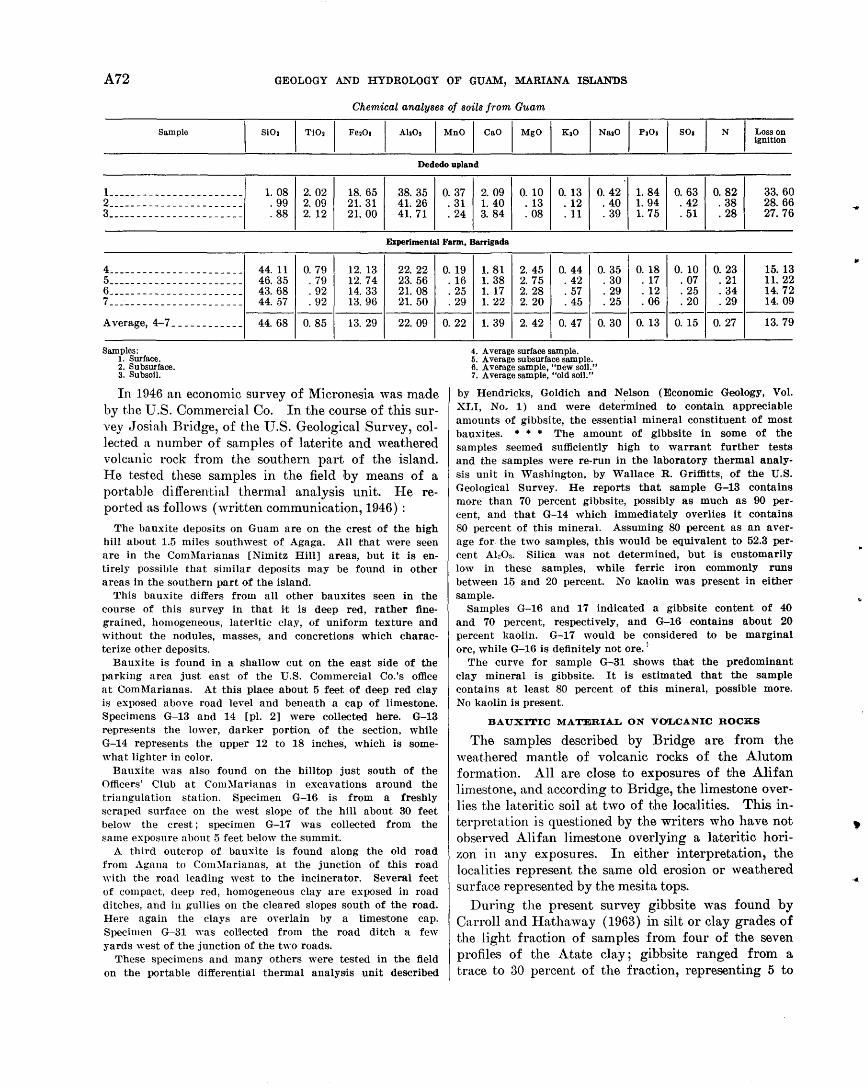
A72 GEOLOGY AND HYDROLOGY OF GUAM, MARIANA ISLANDS
Chemical analyses of soils from Guam
Sample AhOs I MnO I CaO I MgO I KoO I NaoO I M I SOo I N Loss on ignition
Dededo upland
! _______________________ 1. 08 2. 02 18. 65 38. 35 0. 37 2. 09 0. 10 0. 13 0. 42 1. 84 0. 63 0. 82 33. 60 2 _______________________ . 99 2. 09 21. 31 41. 26 . 31 1. 40 . 13 . 12 . 40 1. 94 . 42 . 38 28. 66 3 _______________________ . 88 2. 12 21. 00 41. 71 . 24 3. 84 . 08 .11 . 39 1. 75 . 51 . 28 27. 76
Experimental Farm, Barrigada
4 _______________________ 44. 11 0. 79 12. 13 22. 22 5 _______________________ 46. 35 . 79 12. 74 23. 56 6 _______________________ 43. 68 . 92 14. 33 21. 08 7 _______________________ 44. 57 . 92 13. 96 21. 50
Average, 4-7 ____________ 44. 68 0. 85 13. 29 22.09
Samples: 1. Surface. 2. Subsurface. 3. Subsoil.
In 1946 an economic survey of Micronesia was made by the U.S. Commercial Co. In the course of this survey tTosiah Bridge, of the U.S. Geological Survey, collected a number of samples of laterite and weathered volcanic rock from the southern part of the island. He tested these samples in the field by means of a portable differential thermal analysis unit. He reported as follows (written communication, 1946) :
The bauxite deposits on Guam are on the crest of the high hill about 1.5 miles southwest of Agaga. All that were seen are in the ComMarianas [Nimitz Hill] areas, but it is entirely possible that similar deposits may be found in other areas In the southern part of the island.
This bauxite differs from all other bauxites seen in the course of this survey in that it is deep red, rather finegrained, homogeneous, lateritic clay, of uniform texture and without the nodules, masses, and concretions which characterize other deposits.
Bauxite is found in a shallow cut on the east side of the parking area just east of the U.S. Commercial Co.'s office at Coml\farianas. At this place about 5 feet of deep red clay is exposed above road level and beneath a cap of limestone. Specimens G-13 and 14 [pl. 2] were collected here. G-13 represents the lower, darker portion of the section, while G-14 represents the upper 12 to 18 inches, which is somewhat lighter in color.
Bauxite was also found on the hilltop just south of the Officers' Club at Coml\larianas in excavations around the triangulation station. Specimen G-16 is from a freshly scraped surface on the west slope of the hill about 30 feet below the crest; specimen G-17 was collected from the same exposure about 5 feet below the summit.
A third outcrop of bauxite is found along the old road from .Agana to Com1Iarianas, at the junction of this road with the road leading west to the incinerator. Several feet of compact, deep red, homogeneous clay are exposed in road ditches, and in gullies on the cleared slopes south of the road. Here again the clays are OYerlain by a limestone cap. Specimen G-31 was co~lected from the road ditch a few yards west of the junction of the two roads.
These specimens and many others were tested in the field on the portable differential thermal analysis unit described
0. 19 1. 81 2. 45 0. 44 0. 35 0. 18 0. 10 0. 23 15. 13 . 16 1. 38 2. 75 . 42 . 30 . 17 . 07 . 21 11.22 . 25 1. 17 2. 28 . 57 . 29 . 12 . 25 . 34 14. 72 . 29 1. 22 2. 20 . 45 . 25 . 06 . 20 . 29 14. 09
------------------0. 22 1. 39 2. 42 0. 47 0. 30 0. 13 0. 15 0. 27 13.79
4. Average surface sample. 5. Average subsurface sample. 6. Average sample, "new soil." 7. Average sample, "old soil."
by Hendricks, Goldich and Nelson (Economic Geology, Vol. XLI, No.. 1) and were determined to contain appreciable amounts of gibbsite, the essential mineral constituent of most bauxites. * * * The amount of gibbsite in some of the samples seemed sufficiently high to warrant further tests and the samples were re-run in the laboratory thermal analysis unit in ·washington, by Wallace R. Griffitts, of the U.S. Geological Survey. He reports that sample G-13 contains more than 70 percent gibbsite, possibly as much as 90 percent, and that G-14 which immediately overlies it contains 80 percent of this mineral. Assuming 80 percent as an average for the two samples, this would be equivalent to 52.3 percent Al20a. Silica was not Qetermined, but is customarily low in these samples, while ferric iron commonly runs between 15 and 20 percent. No kaolin was present in either sample.
Samples G-16 and 17 indicated a gibbsite content of 40 and 70 percent, respectively, and G-16 contains about 20 percent kaolin. G-17 would be considered to be marginal ore, while G-16 is definitely not ore.'
The curve for sample G-31 shows that the predominant clay mineral is gibbsite. It is estimated that the sample contains at least 80 percent of this mineral, possible more. No kaolin is present.
BAUXITIC MATERIAL ON VOLCANIC ROCKS
The samples described by Bridge are from the weathered mantle of volcanic rocks of the Alutom formation. All are close to exposures of the Alifan limestone, and according to Bridge, the limestone overlies the lateritic soil at two of the loca:lities. This interpretation is questioned by the writers who have not observed Ali fan limestone overlying a lateritic horizon in any exposures. In either interpretation, the localities represent the same old erosion or weathered surface represented by the mesita tops.
During the present survey gibbsite was found by Carroll and Hathaway (1963) in silt or clay grades of the light fraction of samples from four of the seven profiles of the Atate clay ; gibbsite ranged from a trace to 30 percent of the fraction, representing 5 to
GENERAL GEOLOGY OF GUAM A73
10 percent of t.he novmative 1ninerals of the upper parts of so.me profiles. The proportion of gibbsite in t·.his soil is therefore small, but significant in that all profiles containing gibbsite are from mesita remnants thn,t presumably were once covered by Alifan limestone.
Gibbsite concretions were found on numerous mesita tops along with scattered fragments of shells or coral, ferruginous concretions, and in places silicified limest.one fragments and chalcedony. The concretions nre generally scattered on the surface of the ground and are only rarely found within the soil. The gibbsite in several concretions was determined by X-ray diffractometer by ,J. W. I-Iathaway, of the U.S. Geologicn,l Survey, and results are included in the table below.
In some places the weathered lava of the Dandan How member of the Umatac formation is a purple Sltprolite preserving well the origina:l structures of the flow rock. In general these appear to be altered to <·,lay, bnt. ~tt one locality (I-If 3) small parts of the flows showed ocherous porous material between intersecting veins of olay. An analysis (2) of the ocherous material, given in the table below, shows that parts of the lava flow were altered to gibbsite.
Minerals in concretions and weathered samples frorn Guarn [Analyzed by J. W. Hathaway)
Sam7Jle Minerals
Estimated amount (parts
in ten)
L _ -------- Gibbsite ______________________ _ Hematite ________ -- ______ ------
2 _ _ _ _ _ _ _ _ _ _ Gibbsite ______________________ _ (?)cristobalite _________________ _ Halloysite _______________ -- ----Goethite _____________________ _
3- _ _ _ _ _ _ _ _ _ Gibbsite _________________ - ____ _ Hematite __________________ - - - -
4 __ -------- Gibbsite ______________________ _ Hematite ____ -- ____ ------------Halloysite __________ --- _ -------
5 _ _ _ _ _ _ _ _ _ _ Gibbsite ______________________ _ Hematite ________________ -_----
6- _ _ _ _ _ _ _ _ _ Goethite _____________________ _
7 1
1 8 4 1
1 1
6 1
8 1
9 I. nr 3-1, concretion from meslta cap ncar Dan dan, alt about 440ft (132 meters). 2. Rmnple n r 3-2, weathered rock from center or basalt flow (Dandan flow mem
ber) from some locality as sample I. 3. Jm 1-6, concretions on surface ncar old radio station, Bataa Sabana, about
half a mile cast-northeast or soil locality Sii4-5. 4. .Ek 6-1, concretions on top of mcsita south or Apra Heights. li. 01 1-Ia, concretion from plateau I mile east or Apra Heights. 0. 011-lb, brown hollow twiglike concretion from same locality.
"r e~tthered rinds on basalt or andesite boulders are generally comparatively soft and clayey. Some, however, are firm and porous and preserve traces of the original igneous texture. A yellowish-brown rind
1 em thick on an andesite boulder (Go 12-1) was analyzed by Mr. H. Mcl{]osky, chemist for the U.S. Navy Base Development Testing Lruboratory on Guam. He reported (written conununication, 1953) the following results (in percent) : SiOz 23.8, FezOa 15.3, Al:!Oa 38.1, insoluble 1.8, and loss on ignition 20.4. This analysis corresponds roughly to a mineralogic content of 30 percent gibbsite, 50 percent kaolintype clay, and 20 percent limonite and other minerals. Sample Go 12-1 is from a weathered volcanic conglomerate that forms a mesita north of Spruance Drive, at an altitude of 400 feet (120 meters).
BAUXITIC MATERIAL ON LIMESTONE
Samples from four soil profiles of the Guam clay were analyzed by P. L. D. Elmore, K. E. White, and F. ,V. Scott; in them silica ranges from 0.74· to 2.3 percent, alumina from 35.3 to 42.6 percent, .total iron from 17 to 22.6 percent, and water (loss on ignition) from 21.3 to 25.4 percent. Complete analyses are published in chapter F. These samples are all from the north plateau (loc. S-16, 17, 18, 19) from soils overlying Barrigada limestone and from both reef and lagoonal facies of the Mariana limestone. Mineralogic analyses by Carroll and Hathaway show that the soils consist principally of gibbsite and goethite and indicate that the Guam clay as mapped by Stensland is primarily a high-iron bauxite or aluminous laterite.
The yellowish-brown Chacha soil ~that overlies the Agana argillaceous member of the Mariana limestone consists chiefly of halloysite. Gibbsite was not detected by the X-ray diffractometer, but a small amount is present by normative computations of the chemical analyses, and a minor amount is interpreted from the differential thermal curves by Faust (in Carroll and Hathaway, 1963).
A "fossil soil" locality south of Sinajana (S-24) consists of red clayey material overlying white massive limestone interpreted as Ali fan; the soil, in turn, is overlain by rubbly coralliferous limestone of the Agana argillaceous member of the Mariana limestone. This locality was noted by H. T. Stearns in his field notes (written communication, 1937) as indicating a late emergence and resubmergence of the island. The red clay from this locality contains a moderate amount of gibbsite, as indicated by Carroll and Hathaway in chapter F.
GIBBSITE AND NORD'SrrRANDITlD IN LIMESTONE
Traces of gibbsite have been identified by Hathaway (in Schlanger, 1964) in insoluble residues from samples of the Agana member of the Mariana lime-· stone. Hathaway also identified a mineral found in
A74 GEOLOGY AND HYDROLOGY OF GUAM, MARIANA ISLANDS
several samples of the Ali fan, J anum, and Mariana formations as naturally occurring nordstrandite. Neither gibbsite nor nordstrandite has been found in older limestones. In thin sections examined by Schlanger of both the Ali.fan and the J anum, the mineral nordstrandite fills fractures and small cavities, and is therefore postdepositional. It probably formed after uplift and during solution of the Alifan. The nordstrandite identified in the Mariana sample (Kr 3-1) by Hathaway (written com·munication, 1956) is from a limestone core at a depth of 35 feet, from drill hole 9 on the Guam Memorial Hospital site. This area is shown on the geologic map (pl. 1) as Mariana limestone, although it is of course possible that it is of Alifan age. · Not enough information is yet available to determine
whether the aluminous minerals in the limestone are forming under present conditions of weathering and solution, or whether they are relict from a period of lateritic weathering in the past.
CLAY MINERALS
Halloysite, montmorillonite, and mixed-layer montmorillonite-halloysite are the principal clay minerals in the soils profiles studied by Carroll and Hathaway (1963). Hrulloysite is the chief or only olay mineral in all the soils on limestone and in most of those on volcanic rocks. In profiles S-5 on Bataa Sabana (loc. Im 1) montmorillonite is the principal clay mineral at a depth of 28 feet, although higher samples contain mostly halloysite. Montmoril'lonite is also the chief clay mineral in a surface sample (loc. S-23, south of Libugon) of the Asan clay, believed by Stensland to represent a young soil forming under present condit.ions in areas where the older Atate clay has been eroded.
A series of samples of weathered waterlaid tuff from the Alutom formation near Mount Tenjo was examined by F. A. Hildebratnd, of the U.S. Geological Survey, who reported as follows :
Minerals in clayey tuffaceous rocks from Guam
Sample 1 Description
Om 33-L-------- Red and white clay altered from water-laid tuff.
Om 5-la_________ Relatively unaltered waterlaid tuff.
Om 5-lb __ .______ Green clay altered from Gm 5-la.
Om 5-lC--------- Pink clay apparently altered from Om 5-lb.
Minerals present
Halloysite, moderate amount of quartz, and traces of a mica-type mineral and cristobalitc (?).
Montmorillonitc,2 halloysite, opal, and small amounts of quartz and feldspar.
Opal,B halloyslte, and small amounts of mica-type mineral and quartz.
Halloysite, montmorillonitc,2 and traces of cristobalite (?) and quartz.
I All samples are from Tenia road near Mount Tenjo. 2 Glycol treatment and examination on the high-angle spectrometer by Paul
Blackmon confirms the presence of montmorillonite and halloysite. 3 This opal seems to have better crystallinity than most natural opals, placing
it somewhere between opal and cristobalite.
HaHoysite is the principal clay mineral of the Agana member of the Mariana limestone, which forms the largest area of argillaceous limestone on Guam. Montmorillonite appears to be a major clay mineral in the clay conglomerate of the Talisay member at the base of the Alifan limestone in the central part of the island.
POSSIB:ILITY OF ECONOMIC DEPOSITS
The chief source of bauxite or high-alumina laterite on Guam is the Guam day. The red earthy finegrained soil is, in most places, only a few ·inches deep and averages ,Jess ·than a foot in thickness. N umerous excavations in swales and depressions to obtain material for fill show that .the thiclmess in moderately large sinks 100 yards in diameter is irregular and does not normally exceed 5 to 8 feet, although in one soils boring it was more than 30 feet. Logs of many foundation borings record "red clay" to depths of 30 to 50 feet, but no analyses are available to determine whether material of this thickness might be latedtic. Cores and cuttings examined by members of the party from drill holes in very large sinks, such as those near Yigo, consisted entirely of plastic silty yellow clay (mapped as a1luvial fill on pl. 1) rather than the porous red Guam clay. Indications, therefore, are that although the Guam o1ay covers a large area, it probably contains no deposits large enough to have economic significance.
The most likely places for future prospecting are the series of smaH shallow depressions around the area of outcrop of the Barrigada limestone on the north plateau.
On volcanic rocks the presence of bauxite is confined to traces of gibbsite in the red soil that caps mesita remnants of the old erosion surface or scattered concretions of gibbsite on this surface and to minor bauxitization of volcanic rocks on this old surface. 'Veathered volcanic rocks consist chiefly of ha1loysite, montmorillonite, or mixed-layer clays. Apparently no gibbsite forms from volcanic rocks under present-day conditions. No significant deposits of bauxite were found on volcanic rocks, and it is unlikely that any wi1l be.
CONDITIONS OF ORIGIN
BAUXITIC MATERIAL ON VOLCANIC ROCKS
Gibbsitic material on the volcanic southern part of the island is found on remnants of the old erosion surface that were formerly covered by the Alifan limestone, or that are at altitudes that may have been covered by the Ali fan. No gibbsite has been found on
I high parts of the Tenjo or Bolanos blocks that ap-
...
GENERAL GEOLOGY OF GUAM A75
pn.rently stood as islands in the Alifan sea (fig. 16), although .these areas contain remnant patches of halloysitic saprolite that may have formed at the same time as the gibbsite.
No gibbsite has been found in volcanic areas over~ lapped by the Agana argillaceous member of the Mariana limestone, or in places frmn which the Agana is known to be eroded. The gibbsitic material, therefore, apparently :formed after uplift of the Alifan limestone on the southern part of the island and before or during deposition of the Agana member of the Mariana limestone.
Conditions were not favor~tble for the formation of thick residual deposits of bauxite from the volcanic rocks. The impervious tuffaceous shale of the Alutom forrnation altered chiefly to haJloysite and montmorillonite, n.nd the pillow basaJt and breccia of the Umatae formaJ.ion altered chiefly to halloysite. Gibbsite formed only in places and under conditions that were part.icula.rly favorable. The following conditions are believed to be necessary.
P'resence of lim,estone.-The relatively thin soil of the At.ate clay, conta.ining a proportion of fine-grained gibbsite and covered with scattered gibbsite concretions, appn.rently formed at the time of solution of the Alifan limestone and resulted from the 3Jlteration of volcanic and clay materials in and at the base of the Alifn.n. T'he presence of overlying limestone and the resu ltn.nt alkalinity of the percolating ground water may have been a necessary condition for the alterat-ion of undedying volcanic rock to gibbsite.
Fa'iJ01Ytble 80'I.trce rock.-The few samples of unrloubted volcanic rock that have altered to gibbsite eonsist of well-crystn.llized basalt or andesite. The t·.hiek residual saprolites of halloysite and montmorillonite were derived from the tuffaceous shale of the Alutom, or from the pyroclastic breccia of the Bolanos mmnber, or from flow rocks thn.t contained prmninent pillow structures. Possibly the glass in these rocks n.H.ers most readily to clay minerals. Thus moderately to con.rsely crystalline texture and the absence of volen.nie glass may be necessary conditions for alteration to gibbsite.
Oood intm"na.l drainage.-Gibbsitic material is found only in places that at the time of formation apparently were well-drained knolls or uplands. It is not found in poorly drained places containing large remnants of the Alifn.n limestone, or the Talisay member of the Alifan, such as the basin containing the Bonya an0. M:!Lemong R.ivers. The areas that were well drained at the time of formation of the gibbsite, however, are areas that have been most subject to erosion since that time.
716-291 0-64-6
BAUXITIC MATERIAL ON LIMESTONE
The origin of the gibbsitic deposits of Guam clay of the north plateau is not well understood. The soil lies on an irregula:r:ly eroded surface of limestone (fig. 36, lower), and is a considerruble distance from the nearest volcanic rocks.
According to Carroll and Hathaway ( 1963), the volcanic minerals within the limestone are a likely source for the gibbsite. In most places the Barrigada and l\1ariana .limestones under the soi1l pockets are relatively pure, however, and contain on an average less than 1 percent of impurities. Typical samplel3 of the Mariana and Barrigada limestones were found to contain only 0.1 percent of insohtble residue. A great thickness of limestone of this degree of purity would have to be dissolved to provide the necessary 1naterial to form such a soil. If the limestone contained on an average 1 percent of volcanic minerals, less than 20 percent of the residue would consist of alumina. Thus, to yield a soil 1 foot thick that contains more than 40 percent alumina, considerably more than 200 feet of limestone would have to be dissolved, assuming that no aluminous material were lost by erosion. The present surface of the north plateau does not contain evidence that this much limestone has disappeared by solution, at least fron1 the surface underl3Jin by Marim1a limestone.
An rulternate possibility is that the Guam clay was derived originally from the solution of a thick section of Barrigada limestone and argillaceous or volcanically contaminated Alifan limestone in the central pa:r:t of the north plateau, and that, after peripheral deposition of the l\1ariana limestone, the red clay in the central part was redistributed over the surface.
This interpretation is favored by the fact ·th3Jt the thickest pockets of red gibbsitic soil are found in sinks and hollows along the contact of the Mariana limestone on the Barrigada limestone. The red soil has not been found, however, in a vertic3Jl section of l\1ariana limestone overlying Barrigada limestone or Alifan limestone, except for the "fossil soil" locality south of Sinajana. This locality seems to be a pocket of lateritic clay in the downfaulted Alifan limestone north of the Adelup fault. The clay apparently represents an Atate-type soil that was eroded from the nea1~by volcanic highland to the west and was redeposited onto a weathered surface of Alifan limestone; the soil was then overlapped by the rubbly cora,lliferous cap of the uppermost part of the Agana argillaceous member of the Mariana limestone.
The gibbsitic deposits of the north plateau, therefore, possibly may be of the same age as those of southen1 Guam, tJhat is, post-Alifan or post-Barrigada. Their
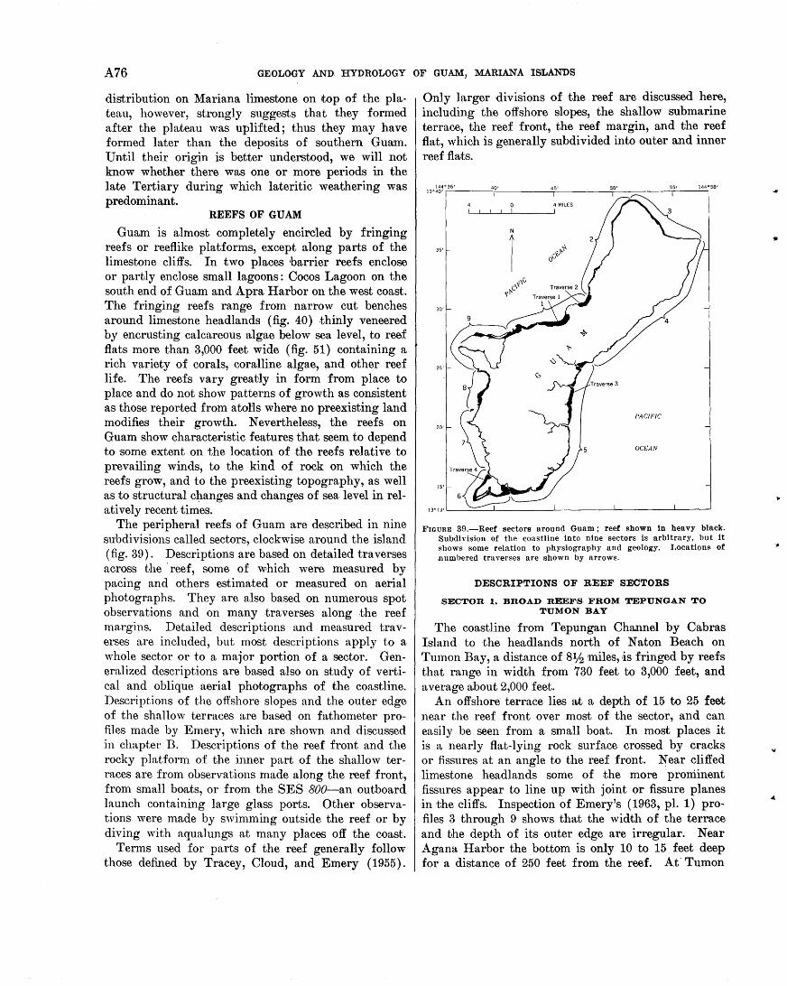
A76 GEOLOGY AND. HYDROLOGY OF GUAM, MARIANA ISLANDS
distribution on Mariana limestone on top of the plateau, however, strongly suggests that they formed after the plU~teau was uplifted; thus they may have formed later than the deposits of southern Guam. Until their origin is better understood, we will not know whether there was one or more periods in the late Tertiary during which lUJteritic weathering was predominant.
REEFS OF GUAM
Guam is almost completely encircled by fringing reefs or reeflike platforms, except along parts of the limestone cliffs. In two places barrier reefs enclose or partly enclose small lagoons : Cocos Lagoon on the south end of Guam and Apra Harbor on the west coast. The fringing reefs range from narrow cut benches around limestone headlands (fig. 40) thinly veneered by encrusting calcareous algae below sea level, to reef flats more than 3,000 feet wide (fig. 51) containing a rich variety of corals, coralline algae, and other reef life. The reefs vary greatly in form from place to place and do not show patterns of growth as consistent as those reported from atons where no preexisting land modifies their growth. Nevertheless, the reefs on Guam show characteristic features that seem to depend to some extent on the location of the reefs relative to prevailing winds, to the kind of rock on which the reefs grow, and to the preexisting topography, as well as to structural changes and changes of sea level in relatively recent times.
The peripheral reefs of Guam are described in nine subdivisions called sectors, clockwise around the island. (fig. 39) . Descriptions are based on detailed traverses across the ·reef, some of which were measured by pacing and others estimated or measured on aerial photographs. They are also based on numerous spot observations and on many traverses along the reef margins. Detailed descriptions and measured traverses are included, but most descriptions apply to a whole sector or to a major portion of a sector. Generalized descriptions are based also on study of vertical and oblique aerial photographs of the coastline. Descriptions of the offshore slopes and the outer edge of the shallow terraces are based on fathometer profiles made by Emery, which are shown and discussed in chapter B. Descriptions of the reef front and the rocky platform of the inner part of the shallow terraces are from observations made along the reef front, from small boats, or from the SES 800-an outboard launch containing large glass ports. Other observations were made by swimming outside the reef or by diving with aqualungs at many places off the coast.
Terms used for parts of the reef generally follow those defined by Tracey, Cloud, and Emery ( 1955).
Only larger divisions of the reef are discussed here, including the offshore slopes, the shallow submarine terrace, the reef front, the reef margin, and the reef flat, which is generally subdivided into outer and inner reef flats.
FIGURE 39.-Reef sectors around Guam; reef shown in heavy black. Subdivision of the coastline into nine sectors is arbitrary, but it shows some relation to physiography and geology. Locations of numbered traverses are shown by arrows.
DESCRIPTIONS OF REEF SECTORS
SECTOR 1. BROAD REEFS FROM TEPUNGAN TO TUMON BAY
The coastline from Tepungan Channel by Cabras Island to the headlands north of Naton Beach on Tumon Bay, a distance of 81h miles, ·is fringed by reefs that range in width from 730 feet to 3,000 feet, and average about 2,000 feet.
An offshore terrace lies B!t a depth of 15 to 25 feet near the reef front over most of the sector, and can easily be seen from a small boat. In most places it is a nearly flat-lying rock surface crossed by cracks or fissures at an angle to the reef front. Near cliffed limestone headlands some of the more prominent fissures appear to line up with joint or fissure planes in the cliffs. Inspection of Emery's ( 1963, pl. 1) profiles 3 through 9 shows that the wid·th of the terrace and the depth of its outer edge are irregular. Near Agana Harbor the bottom is only 10 to 15 feet deep for a distance of 250 feet from the reef. At' Tumon
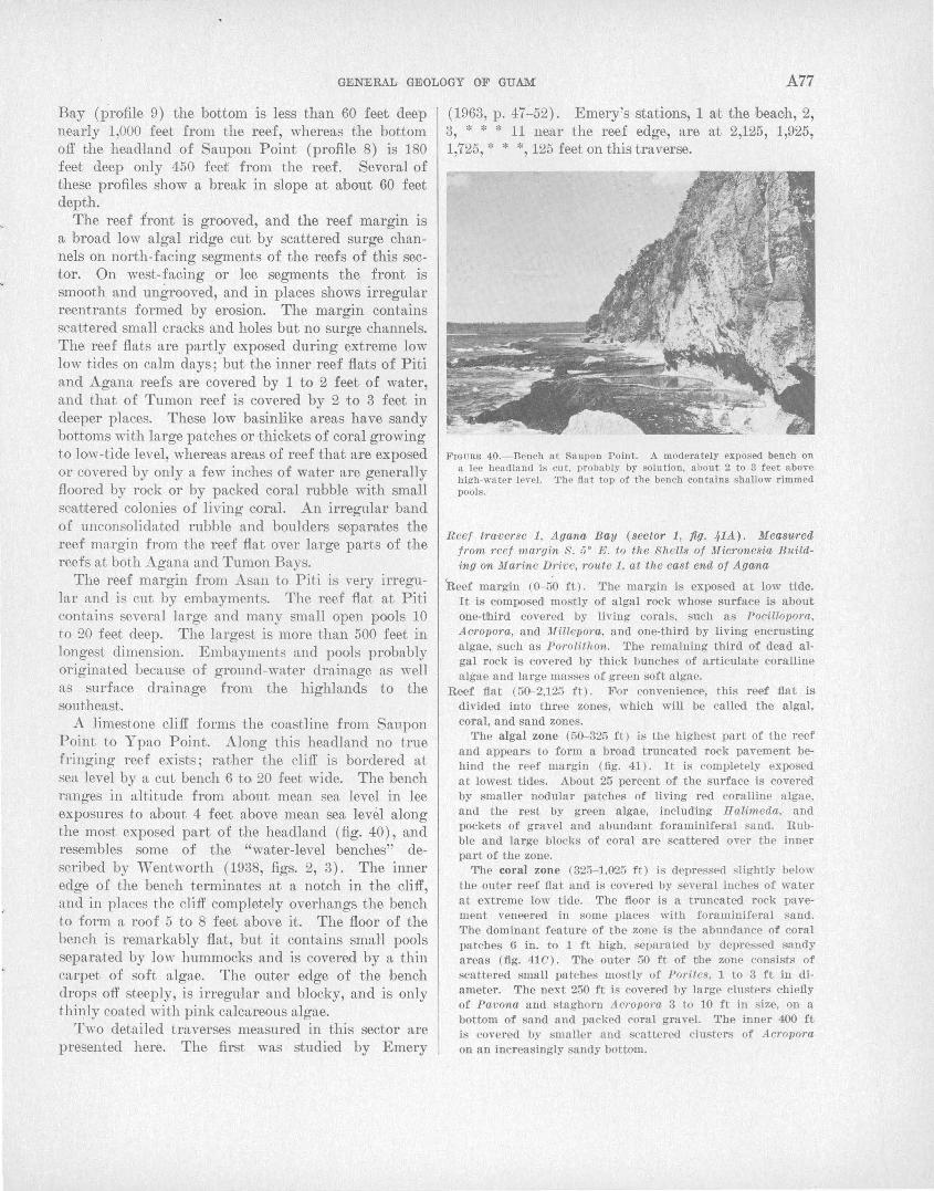
GENERAL GEOLOGY OF GUAM A77
Bay (profile 9) the bottom is less than 60 feet deep nearly 1,000 feet from the reef, whereas the bottom off the headland of Saupon Point (profile 8) is 180 feet deep only 450 feet from the reef. Several of these profiles show a break in slope at about 60 feet depth.
The reef front is grooved, and the reef margin is a broad low algal ridge cut by scattered surge channels on north-facing segments of the reefs of this sector. On west-facing or lee segments the front is smooth and ungrooved, and in places shows irregular reentrants formed by erosion. The margin contains scattered small cracks and holes but no surge channels. The reef flats are partly exposed during extreme low low tides on calm days; but the inner reef flats of Piti and Agana reefs are covered by 1 to 2 feet of water, and that of Tumon reef is covered by 2 to 3 feet in deeper places. These low basinlike areas have sandy bottoms with large patches or thickets of cora;} growing to low-tide level, whereas areas of reef that are exposed or covered by only a few inches of water are generally floored by rock or by packed coral rubble with small scatJtered colonies of living coral. An irregular band of unconsolidated rubble and boulders separates the reef margin from the reef flat over large parts of the reefs at both Agana and Tumon Bays.
The reef margin from Asan to Piti is very irregular and is cut by embayments. The reef flat at Piti contains several large and many small open pools 10 to 20 feet deep. The largest is more than 500 feet in longest dimension. Embayments and pools probably originated because of grotmd-water drainage as well as surface drainage from the highlands to the southeast.
A limestone cliff forms the coastline from Saupon Point to Ypao Point. Along this headland no true fringing reef exists; rather the cliff is bordered at se1t level by a cut bench 6 to 20 feet wide. The bench ranges in altitude from about mean sea level in lee exposures to a:bout 4 feet a:bove mean sea level along the most exposed part of the headland (fig. 40), and resembles some of the "water-level benches" described by Wentworth ( 1938, figs. 2, 3). The inner edge of the bench terminates at a notch in the cliff, and in pl!tces the cJ.iff completely overhangs the bench to form a roof 5 to 8 feet above it. The floor of the bench is remarka:bly flat, but it contains small pools separated by low hummocks and is covered by a thin carpet of soft algae. The outer edge of the bench drops off steeply, is irregular and blocky, and is only thinly coated with pink calcareous algae.
T"·o detailed traverses measured in this sector are presented here. The first was studied by Emery
(1963, p. 47-52). Emery's stations, 1 wt the beach, 2, 3, * * * 11 near the reef edge, are at 2,125, 1,925, 1,725, * * *, 125 feet on this traverse.
FIGURE 40.-Bench at Saupon Point. A moderately exposed bench on a l ee hea dland is cut, probably by solution, about 2 to 3 feet above high-water level. The flat top of the bench contains shallow rimmed pools.
R eef traverse 1, Agana Bay (sector 1, fig. 41A). Measured f'rom reef margin S. 5° E. to the Shells of Micronesia Building on Marine D1'ive, route 1, at the east ena of Agana
'Reef margin (0-50 ft). The margin is exposed at low tide. It is composed mostly of algal rock whose surface is about one-tibird covered by living corals, such as Pocillopora, Acropora, and Millepora, and one-third by living encrusting algae, such as Porolithon. The remaining third of dead algal rock is covered by thick bunches of articulate coralline algae and large masses o.f green soft algae.
Reef flat (50-2,12.5 ft). F1or convenience, this reef flat is divided into three zones, which will be called the algal, coral, and sand zones.
'l'he algal zone (50-325 ft) is the highest part of the reef and appears to form a broad truncated rock pavement behind the reef margin (fig. 41). It is completely exposed at lowest tides. About 25 percent of the surface is covered by smaller nodular patches of living red coralline algae, and the rest by green algae, including H alimeaa, and pockets of gravel and abundant foraminiferal sand. Rubble and large blocks of coral are scattered over the inner part of the zone.
The coral zone (325-1,025 ft) is depressed slightly below the outer reef flat and is covered by several inches of water at extreme low tide. The floor is a truncated rock pavement veneered in some places with foraminiferal sand. The dominant feature of the zone is the abundance of coral patches 6 in. to 1 ft high, separated by depressed sandy areas (fig. 410). The outer 50 ft of the zone consists of scattered small patches mostly of Po·riles, 1 to 3 ft in diameter. The next 250 ft is covered by large clusters chiefly of Pavona and staghorn Acropo1·a 3 to 10 ft in size, on a bottom of sand and packed coral gravel. The inner 400 ft is covered by smaller and scattered clusters of Acropora on an increasingly sandy bottom.
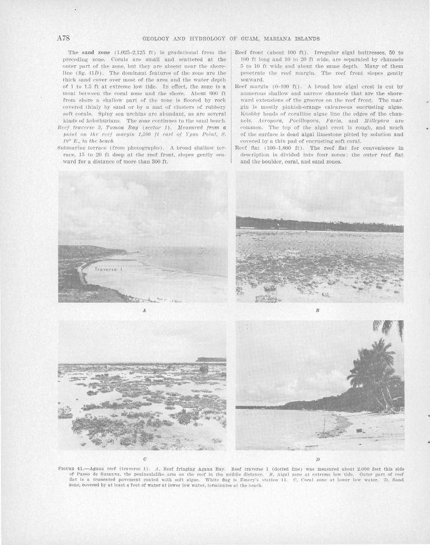
A78 GEOLOGY AND HYDROLOGY OF GUAM, MARIANA ISLANDS
The sand zone (1,025-2.125 ft) is gradational from the preceding zone. Corals are small and scattered at the outer part of the zone, but they are absent near the shoreline (fig. 41D). The dominant features of the zone are the thick sand cover over most of the area and the water depth of 1 to 1.5 ft at extreme low tide. In effect, the zone is a moat bet"·een the coral zone and the shore. About 600 ft from shore a shallow part of the zone is floored by roc]; co ,·erPd thinly by sand or by a mat of clusters of rubbery soft coral!>. Spiny sea urchins are abundant, as are several kind!> of holothurians. The zone continues to the sand beaeh.
Reef . t1·averse 2, Tumon Bay (sector· 1). lJf easur·ed from a poiut on the 1·ccf 11W1'{Jill 1,500 ft eas t of Ypao Point, 8. to• E., to the beach
Hubmarine terrace (from photographs). A broad shallow terrace, 15 to 20 ft deep at the reef front, slopes gently seaward for a distance of more than 300 ft.
a
Reef front (about 100 ft). Irregular algal buttresses, 50 to 100 ft long and 10 to 20 ft wide, a re separated by channels 5 to 10 ft wide and about the same depth. Many of them penetrate the reef margin. The reef front slopes gently seaward.
Reef mar~in (0-100 ft). A uroad low algal crest is cut by numerous shallow and narrow channels that are the shoreward extE>nsions of the grooves on the reef front. The margin is mostly pinkish-orange calcareous encrusting algae. Knobby llE>ads of coralline algae line the edges of the channels. Acro•pom, PociUopora, Favia, and llf'illepo1·a are common. The top of the algal crest is rough, and much of the surface is dead algal limestone pitted by solution and co,·ered by a thin pad of encrusting soft coral.
Reef flat (100-1,800 ft). The reef flat for convenience in dE>scription is divided into four zones: the outer reef flat and the boulder, coral, and sand zones.
B
-D
FIGURE 41.-.Agana reef (traverse 1). A, Reef fringing .Agana Bay. Reef traverse 1 (dotted of Paseo de Susanna, the penlnsulalike a rm on the reef in the middle distance. B, Algal flat is a truncated pavement coated with soft algae. White flag is Emery's •tation 11. zone, covered by at least a foot of water at lower low water, terminates at the beach.
line) was measured about 2,000 feet this side zone at extreme low tide. Outer part of reef C, Coral zone at lower low water. ID, Sand
..
GENERAL GEOLOGY OF GUAM A79
r:rhe outer reef flat (100-280 ft) is covered with green ::lTJiny soft nlgae for the first 100 ft. Corals are common. 'rhe last 80 ft of the zone is a barren ~rregular rocl' pavement.
':L'he boulder· zone (280-400 ft) has loose boulders and rubble piled about l foot high over the truncated pavement of t:he reef. especin.lly in the outer 50 ft. The inner 170 ft of t·he zonP contnins scattered boulders.
Thp coral zone ( 400-800 ft) llns a shallow itTegular floor, 6 ins. to l ft deep, formed of pacl~ed broken coral rubble. It is C'OVPI'Pd by scntt:Pred cornl colonies, such as Porites in the outer pat·t of the zone and Acropora, Pavona, and .Ponillopora in the inner part.
'l~he ~nnd zone ( 800-1,800 ft) has a floor covered by 1.5 t·o 3 ft: of water nt extreme low tide. The zone is covered with medium to coarse sand on which scattered large thiel\etr-; of A.cro1>0'ra grow. The thiclH~ts are 5 to 50 ft in long€'st dimension nnd grow to a common level about 6 ins. n bove the lowest tides. The patches occupy as much as half the bottom area near the outer edge of this zone, but lpss t:hnH fi percent of t11e area in the shoreward half. The imwr 100 ft of the zone contains no coral colonies, but it i::; occupied by very abundnnt holothurians that number as much ns one per S<]uare foot.
SECTOR 2. REEF FIRINGING THE CLIFFS FROM GOGNGA BEACH TO RITIDIAN POINT
The 10 miles of coastline from the north end of Tumon Bay to the north tip of the island is an undula.Hng cliflline 200 feet to ne:u]y 600 feet high fringed by irregu]ar and relative]y narrow, but in pla.ces richly, growing coral-a.lgal reefs. They range in width from about 20 to 750 feet .
The outer slopes are shown by Emery (1963, pl. 1) in :fnJhomet"er profiles 10 through 14. The profiles do not. show a well -defined break in slope at a depth of GO feel', n.Hhough a shallow terrace can be seen near t· he reef :from a small boat. The reef front shows a VfLriet.y o:f :forms ranging fr01n smoothly lobate or i l'reguln.rly eroded alga] margins on western coasts t·o poorly or moderately grooved margins on northern eoasts. Good examples of smooth and eroded reef fronts en.n be· seen south of Amantes Point, near Ta.nguisson Point, and a]ong the I-Iilaan-Pugua coast. Hood examples of grooved reef margins can be seen j nst·. north of Am antes Point, at Hilaan, and along t·he eoast from tTruno Point to Ritidian Point.
The low, flat algal reef margin is barely exposed at lo\\' t·.ide. CornJs are abundant. The reef flats commonly are ·wide and are covered by a few inches to severa.l feet" of water at low tide. Coral growth is everywhere abundant along this coast; and typical reef flats are floored with irregular packed rubble on which l:trge coral colonies or clusters are scattered, so t".hat walking is difficult. The reef flat immediately sout·h of Anutnt·es Point (fig. 32) is moatlike ~tnd is covered by about 3 feet of water. Packed thiokets of fragile staghorn Acropo1Yt, grow so thickly to low-tide
level thrut i.t is possible to walk along on top of th~ coral. Another luxuriant reef can be seen at Hilaan Point. The reef flat contains a large pool lined with varieties of coral.
In some places, such as the narrow reef north of Pugua, the reef flat is covered with pink calcareous algae and constitutes an extension of the reef n1argin.
Severa] stretches along the coast particularly arofmd headlands-such as those north of Haputo and south of Falcona Beaoh_:..ha ve poorly developed reefs or none at all. Where no reef is present, the coast· .line contains a cut bench similar to that described around Saupon Point. Some of the benches along this sector on protected or lee shores are bar~ly exposed at low tide, but others on exposed headlands are at mean- or high-water level.
SECTOR 3. NORTHEASTERN REEFS FROM RITIDIAN POINT TO PATI POINT
A well-developed windward reef 200 to 700 feet wide extends about 6 miles from Ritidian Point to Tagua Point, and a ncuTow reef-cut bench is present from 'Tagua Point to Pati Point, a distance of 1.5 miles.
An offshore terrace along .this coast slopes gently sea ward from the reef front at a depth of 15 to 25 feet to a depth of 50 to 90 feet at some distance from the reef. The outer edge of the terrace in most places breaks gradually rather than sharply toward the steep outer slope, as can be seen in fathometer profiles 14 through 17 of Emery(1963, pl. 1). Near the reef front the surface of the ten~ace is rough and broken, but beyond a distance of 50 to 100 feet it is comparatively smooth. It is pitted wi~th irregular holes or hollows ranging in diameter and depth from a few inches to a few feet and is partly covered by pink encrusting calcareous algae. The surface of the terrace is cut by .long sinuous channels ranging from 2 to 8 feet deep and from a few feet to as much as 20 feet wide. Some are continuous \\'ith the grooves and surge channels that cut the reef front and margin. Deeper channels are partly fiHed with coarse gravel and boulders, and in some places the surface of the pavement is littered with accumulations of coarse sand and gravel although generaJly it is clean and bare. Large blocks as long as 7 feet, and 2 to 3 feet wide and thick, have broken from the reef front and are scattered here and there.
The reef front along most of Tarague and Inapsan Beaches is formerl of rough knobby algal pillars and buttresses rather irregularly a.lined perpendicular to the reef edge. The reef margin is a massive algal ridge cut by surge channels. Some channels of Ina psan Beach in particular are more than 200 feet long and are broken by numerous pools 6 to 20 feet wide and 5 to 10 feet deep (fig. 42). The channels and
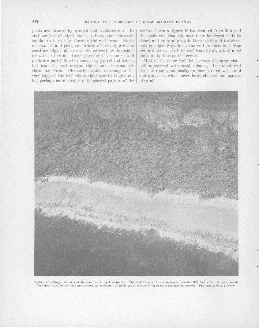
A80 GEOLOGY AND HYDROLOGY OF GUAM, MARIANA ISLANDS
pools are formed by growth and coalescence at the reef surface o:f algal knobs, pillars, and buttresses similar to those now forming the reef front. Edges of channels and pools are formed of actively growing coralline algae, and sides are covered by luxuriant growths of coral. Inner parts of the chmmels and pools a:re partly filled or choked by gravel and debris, but near ·the roof margin the channel bottoms are clean and " ·orn. Obviously erosion is strong at the Yery edge of the reef where algal growth is greatest,
. but perhaps more obviously the general pattern of the
reef as shown in figure 42 has resulted from filling of the pools and channels near their landward ends by debris and by coral growth, from healing of the channels by algal growth on the reef surface, and from seaward extension of the reef front by growth of algal knobs and pillars on the terrace.
Most of the outer reef flat between the surge channels is covered with coral colonies. The inner reef flat is a rough, hummocky surface covered with sand and gravel on which grow large clusters and patches of coral.
FIGURE 42.-Surge channels at Inapsan Beach (reef sector 3}. The reef, from surf zone to beach, is about 600 feet wide. Surge channels on outer third of reef flat are formed by coalescing of algal spurs that grow seaward on the shallow terrace. Photograph by U.S. Navy.
..
..
GENERAL GEOLOGY OF GUAM A81
A shal'low channel about 100 feet wide cuts the reef near Tarague. East of the channel the reef margin is tt massive algal ridge cut by surge channels. Numerous limestone remnants 3 to 4 feet high lie behind t.he algal margin, and large rentnants 6 to 8 feet above the reef flat are found near shore. These remnants possibly represent a reef that grew during t.he "6-foot" sea, in which case they would be patches of ~1erizo limestone; more probably they represent ledges of Mariana limestone truncated to their present level when the sea stood 6 feet or more higher than ~tt. present, and later eroded to form separate remnant blocks.
The reef fiat east of the channel is ·more hummocky a.nd irreguln,r than that .to the nor.thwest, and contains fewer corn .. l patches. This section of the long reef line has more indication of erosion and much less of growth than the section along Inapsan Beach.
Currents along the Ritidian-Tagua reef are especially strong and varied, depending on the strength of the wind and size of the swells. In .times of high trade winds and high surf, they may become dangerous to swimmers near shore. The currents on the reef are driven by the head of water piled onto the reef margin by the waves. ~1ueh of this water returns seaward f·.lnongh the surge channels, but during a series of high wn.ves the W<tt"er ren1ains several feet higher on the reef than it is on the ocean. ~1ost of this water tends t.o esen.pe f·hrough the central channel, causing strong longshore currents toward the channel that may reach speeds of 4 t:o 6 knots. At any one place -the nearshore <'.UJTent:.s are exceedingly irregular, for the water on f·he reef flat is piled high by series of -large waves on t.he reef margin .first .to one side, then to the other of f·he point of observation, resulting in a longshore current of several knots, first in one direction, then in the other.
The water level on this reef at any stage of the tide is parf·.icmla,rly dependent upon the height of the waves sf'.riking f'.he reef. During especiaJ:ly strong swells the water on f·he reef may be as much as 4 feet higher than it is af·, f·.he same stage of the tide in calmer weather.
The c:oastJine from Tagua Point to Pati Point (fig. 40) is rugged. Along most of this stretch the co.:'tst consists of a cut bench several feet above 1nean sea level, fringed by rimmed terraces. Along par.ts of I he eoast t·he bench has been cut approximately to low-tide level to form a typical reef flat, in places as m neh as 200 feet wide. Calcareous red algae form the reef front below sea level. In some places they appea I' merely f'o encrust the rocky front of the headlands, but. in most places they appear to form a healthy and growing front cut by grooves.
SECTOR 4. EASTERN CLIFFED COAST FROM PATI POINT TO PAGO BAY
This 16-mile sector contains several small discontinuous reef flats, but it consists mostly of rocky out benches. The entire length of coastline is backed by the cliffs that bound the north plateau, ranging in altitude from 250 feet at Pago Bay to 550 feet near Pati Point. At many places along the coast .the cliffs form headlands, hut in ·most places they lie several hundred feet heh~nd the coastline. In the embayment at Campanaya Point the cliffs are as much as 4,000 feet from the coastline. The area between cliffs and shore consists of one or more upraised terraeelike benches, the most prominent of which is the lowest, generally at 30 to 100 feet above sea level. Most of the shoreline is 'hacked by a ledge of limestone genera.Uy 10 to 30 feet high, at the base of which is a prominent cut notch.
Offshore slopes are shown in profiles 18 through 23 of Emery (1963, pl. 1). Only two of the profiles (19 and 21) show what appears to be a shallow terrace at a depth of about 60 feet at some distance from .the coastline; both of these profiles are irregular and indicate no sharp break to the outer slope beyond. The outer slope in several profiles is as steep as 35° and averages more than 20° along the length of the sector. J:'he terrace and the reef front have not been examined directJly, although the front can be seen in many of the oblique aerial photographs.
Many stretches of this coast are bounded by a well-developed algal margin and a grooved reef front. In some places the ·lobed algal margin forms the whole reef (fig. 44A). In other places the reef flat consists of a truncated bench of limestone at mean to high-tide level, bounded by an algal margin of rimmed terraces (fig. 440, D). An emerged high bench is much dissected by solution (fig. 44B).
The bench is very narrow in most places, especially around headlands from Pati Point to Catalina Point, J anum Point to Campanaya Point, and Fadian Point to Pago Bay. It is bounded by a steep rocky face and is generally at high-tide level, although around exposed headlands it may be higher (fig. 45).
SECTOR 5. SOUTHEAST COAST FROM PAGO BAY TO MANELL CHANNEL
The southeastern coast of Guam, 16 miles in length, is bordered by wide windward reefs. Broad reef flaJts and prominent algal margins are found at Pago Bay, from Tagachan Point to Asanite Point and from Agfayan Point to Manell Channel. Narrow reefs, rimmed terraces on the reef margins, and cut ben~hes along cliffed headlands that average 6 feet above lowtide level predominate from Pago Point (fig. 45) to
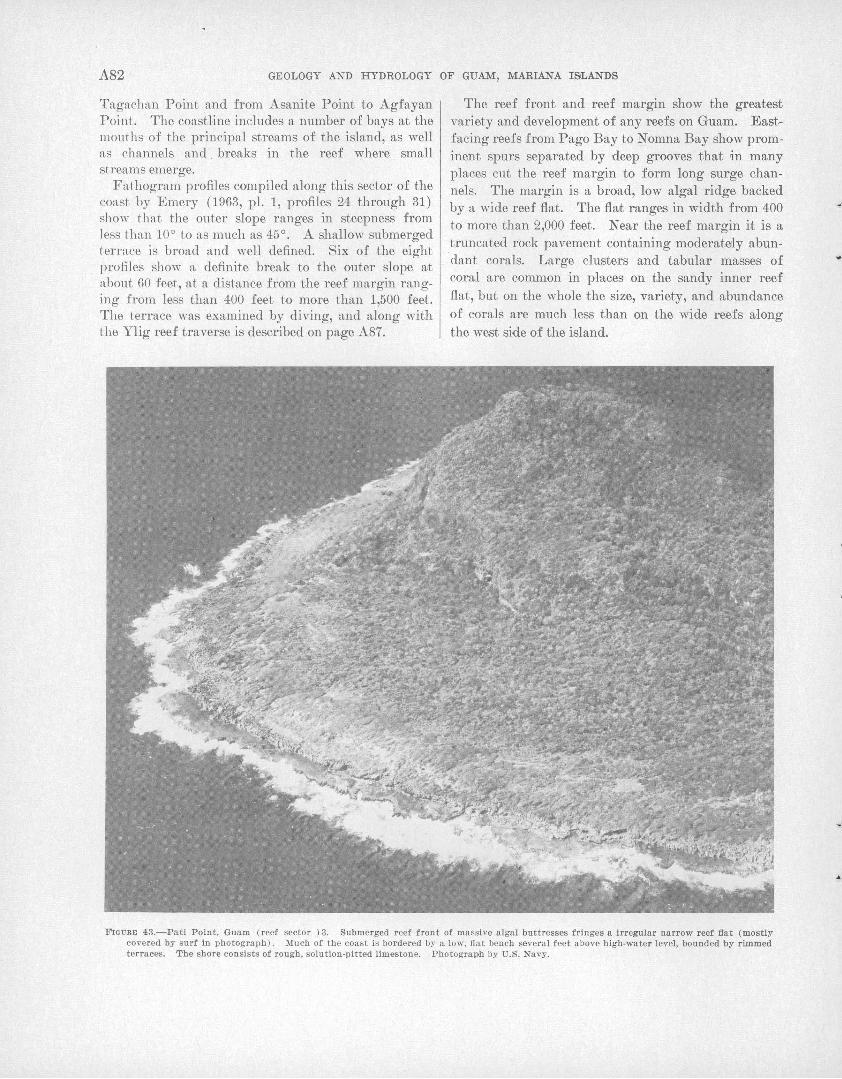
A82 GEOLOGY AND HYDROLOGY OF GUAM, MARIANA ISLANDS
Tagachan Point and from Asanite Point to Agfayan Point. The coastline includes a number of bays at the mouths of the principal streams of the island, as well as channels and . breaks in the reef where small streams emerge.
Fathogram profiles compiled along this sector of the coast by Emery (1963, pl. 1, profiles 24 through 31) show tlutt the outer slope ranges in steepness from Jess than 10° to as much as 45°. A shallow submerged terrace is broad and well defined. Six of the eight profiles show a definite break to the outer slope a;t about 60 feet, at a distance from the reef margin ranging from less than 400 feet to more than 1,500 feet. The terrace was examined by diving, and along with the Ylig reef traverse is described on page A87.
The reef front and reef margin show the greatest variety and development of any reefs on Guam. Eastfacing reefs from Pago Bay to Nomna Bay show prominent spurs separated by deep grooves that in many places cut the reef margin to form long surge channels. The margin is a broad, low algal ridge backed by a wide reef fiat. The fia;t ranges in width from 400 to more than 2,000 feet. Near the reef margin it is a truncated rock pavement containing moderately abun. dant corals. Large clusters and tabular masses of coral are common in places on the sandy inner reef fiat, but on the whole the size, variety, and abundance of corals are much less than on the wide reefs along the west side of the island.
FIGURE 43.-Pati Point, Guam (reef sector ) 3. Submerged r eef front of massive algal buttresses fringes a irregular narrow reef flat (mostly covered by surf in photograph). Much of the coast is bordered by a low, fl a t bench several feet above high-water level, bonnded by rimmed terraces. The shore consists of rough, solution-pitted limestone. Photograph by U.S. Navy.
..
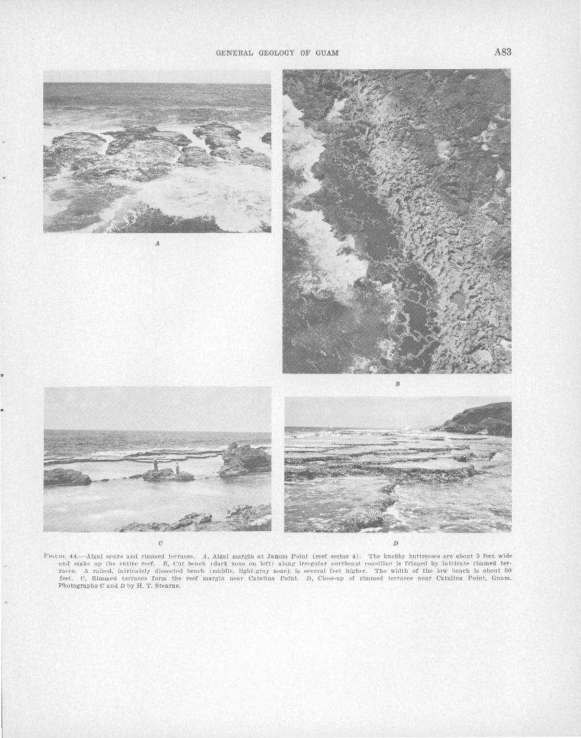
..
GENERAL GEOLOGY OF GUAM A83
A.
B
a D
FIGUR>: 44.- Aigal spu rs >Uld rimmed tPrraces. A, Algal margin at Janum Point (reef sector 4}. The knobby buttresses are about 5 feet wide and make up the entire reef. B, Cut bench (dark zone on left} along irregular northeast coastline is fringed by intricate rimmed terraces. A raised, in tricately dissected uench (middle, light-gray zone}1 is severa l feet higher. The width of the low bench is about 50 feet. a, Rimmed terraces form the reef margin near Catalina Point. D, Close-up of rimmed terraces near Catalina Point, Guam. Photographs a and D by H. T. Stearns.
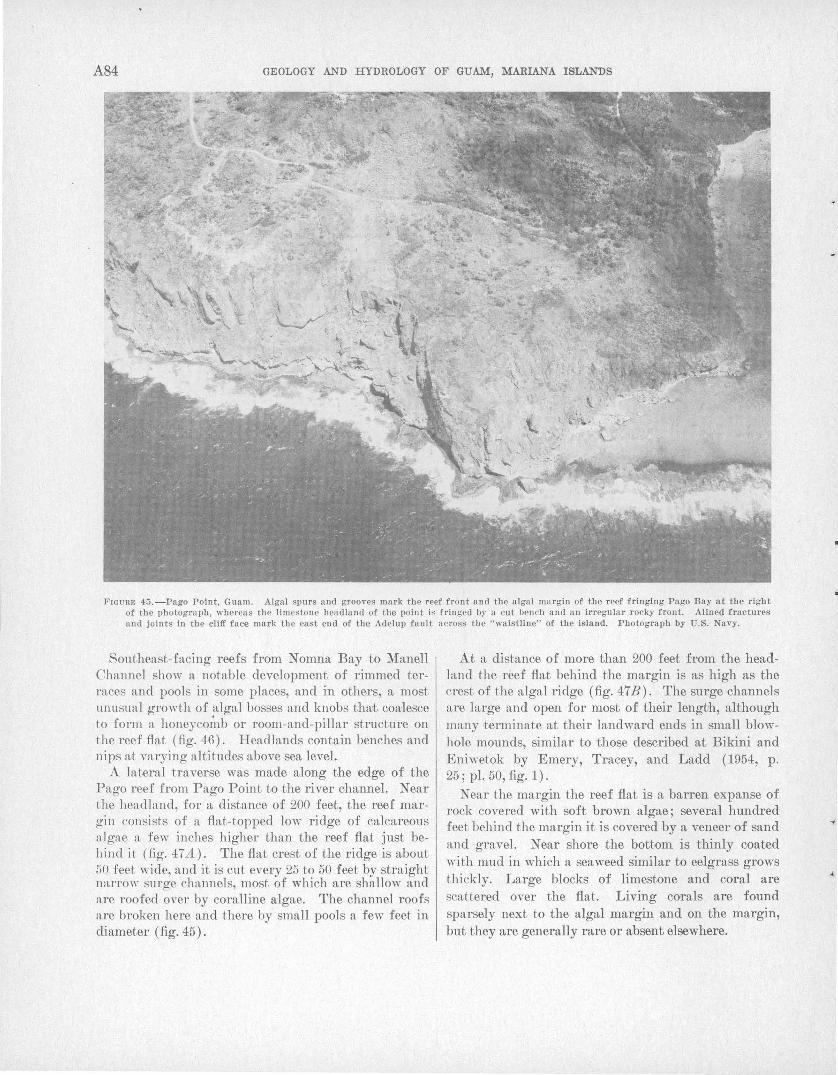
A84 GEOLOGY AND HYDROLOGY OF GUAM, MARIANA ISILANDS
FIGURE 45.-Pago Point, Guam. Algal spurs and grooves mark the reef front and the algal margin of the reef fringing Pago Bay at the right of the photograph, whereas the limestone headland of the point is fringed by a cut bench and an irregular rocky front. Alined fractures and joints in the cliff face mark the east end of the Aclelup fault across the "waistline" of the !&land. Photograph by U.S. Navy.
Southeast-facing reefs from Nomna Bay to Manell Channel show a notable development of rimmed t.erraces and pools in some places, and in others, a most unusual growth of algal bosses and knobs that coalesce to form a honeycomb or room-and-pillar structure on the reef fiat (fig. 46). Headlands contain benches and nips at varying altitudes above sea level.
A lateral traverse was made along the edge of the Pago reef from Pago Point to the river channel. Near t.he headland, for a distance of 200 feet, the reef margin consists of a fiat-topped low ridge of calcareous algae a few inches higher than the reef fiat just behind it (fig. 47A). The fiat crest of the ridge is about 50 feet wide, and it is cut every 25 to 50 feet by straight narrow surge channels, most of which are shallow and are roofed over by coralline algae. The channel roofs are broken here and there by small pools a few feet in diameter (fig. 45).
At a distance of more than 200 feet from the headland the reef fiat behind the margin is as high as the crest of the algal ridge (fig. 47B). The surge channels are large and open for most of their length, although many ,terminate at their landward ends in small blowhole mounds, similar to those described at Bikini and Eniwetok by Emery, Tracey, and Ladd (1954, p. 25; pl. 50, fig. 1).
Near the margin the reef fiat is a barren expanse of rock covered with soft brown algae; several hundred feet behind the margin it is covered by a veneer of sand and gravel. Near shore the bottom is thinly coated >Yith mud in which a seaweed similar to eelgrass grows thickly. Larg~ blocks of limestone and coral are sca,ttered over the fiat. Living corals are found sparsely next to the algal margin and on the margin, but they are generally rare or absent elsewhere.
•
•
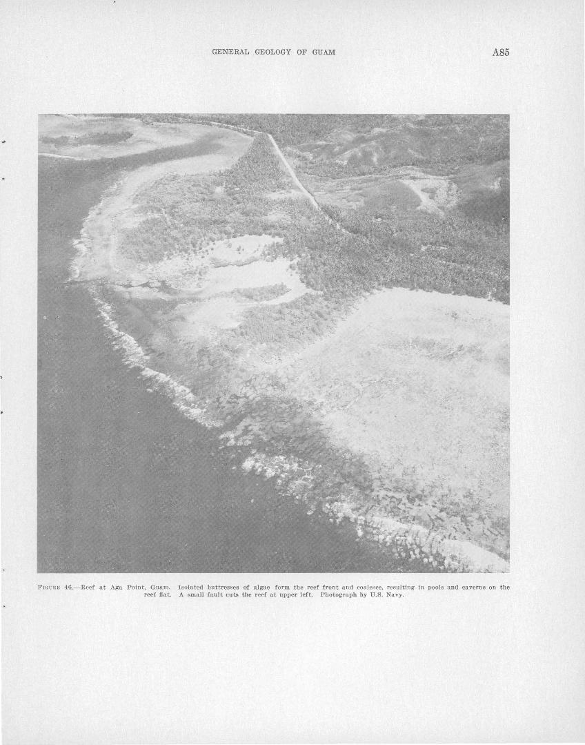
'FIG URE 46.- Reef at Aga Point, Guam . reef flat.
GENERAL GEOLOGY OF GUAM A85
I solated buttresses of algae form the reef front and coalesce, resulting in pools and caverns on the A small fault cuts the reef at upper left. Photograph by U.S. Navy.
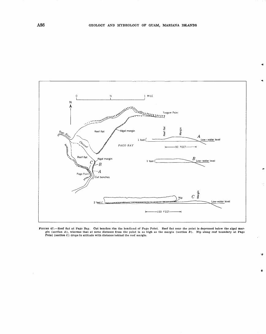
A86
0
N
r
GEOLOGY AND HYDROLOGY OF GUAM, MARIANA ISLANDS
PAGO BAY
2 feet ( \ =
1 MILE
Qj Cll
0::
1 foot{ ------ A ~ Low- water level
"""" f.;----50 FEET ------;..j
B ~ Low-water level
~ 1 foot {
----=:......, Low-water level
~ f.;---1 00 FEET ------""i
FIGURE 47.-Reef flat at Pago Bay. Cut benches rim the headland of Pago Point. Reef flat near the point is depressed below the algal margin (section A), whereas that at some distance from the point is as high as the margin (section B). Nip along reef boundary at Pago Point (section 0) drops in altitude with distance behind the reef margin.

...
•
•
GENERAL GEOLOGY OF GUAM A87
The southern part of the reef in Pago Bay, near the limestone headland of Pago Point, abuts a low limestone ledge at the 'base of which is a nip or notch at reef level. The reef flat slopes shoreward at this place, and .the altitude of the nip decreases nearly 2 feet in a horizontal distance of less than 200 feet, a way from the reef margin (fig. 470). During a rising tide, and under the influence of moderate surf, a sheet of water pours onto the reef flat and rushes along the sloping nip with a velocity of 2 or 3 knots. This locality is an example of the variation in altitude of sea-level nips.
The headland at Pago Point shows several benches cut at various altitudes, from the level of the reef flat to 13 feet above it (figs. 45, 48). Each bench is backed
WEST
i;i ~~ l:
12'-
10'-
6.5'-
EAST
3'-
1'-0'-----------------=::::::-.-.:::::--{Approximate mean
low-water level
25 50 FEET
Scale tS appro;\tmate
FIOURID 48.-Nips at Pago Point, Guam. Height above the reef flat was mcn.surcd by hand level. l\:lcan low-water level is estimated.
by a nip in the cliff, and each is held up by poorly developed rims that form pools similar to those of Tagachan Point discussed by E·mery ( 1963). The highest bench on the headland, 13 feet above the reef flat and about 15 feet above ex·treme low water level, contains ponded water freshened by nearly every wave even in times of low surf, because of the salient configuration of the headland. The flat, undissected be11ches and the regular conformation of the concave "visor" of the nips indicate that the benches are enlarging even though the highest one is about 13 feet above present mean sea level.
Possibly each bench and nip was initiated at a time when the sea stood at or near that particular elevation, but it seems just as likely that the nips were initiated by minor irregularities or cavities in the limestone cliff above sea level, and .therefore have no strict relationship to former sea levels. The benches a:t Pago Point resemble in many respects the several levels of "water-1evel benches" at Koko 'blowhole described by Wentworth (1938, p. 22, figs. 8, 9), which he thinks were largely formed in rel8Jtion to a former
sea level but which cannot be used to determine accurately the amount of emergence.
A measured traverse of the long reef south of Ylig Bay is described below.
Reef traver.'le 3, Ylig reef about half a mile south of the Ylig River, 500 teet south ot Ylig Point
Outer slope (not examined). Fathometer profiles 25 and 26 of Emery (1963, fig. 7) are north and south, respectively, of the traverse. These indicate that the edge of the terrace is at a depth of 60 ft nearly 300 yd beyond the reef edge.
Reef front and terrace (roughly 800 ft). Inner part examined in 1953 by S. 0. Schlanger using an aqualung. The terrace slopes very gently from the base of the reef front at a depth of 20 to 30 ft, to the outer edge at a depth of 60 ft. The outer part of the terrace is a nearly fiat rock pavement cut here and there by straight narrow nearly vertical fissures at angles to the reef edge. The rock pavement is coated with calcareous algae and contains scattered small colonies of coral. Between the base of the reef front and the outer fiat terrace is a rough zone, about 150 ft wide, cut by large irregular cracks and eroded hollows, 2 to 8 ft deep, that are filled with reef rubble. Large blocks as much as 8 ft in diameter lie on th~. pavement or fill the holes. The reef front is cut by surge channels that do not appear to be related to the cracks and fissures on the terrace.
Reef margin. The margin, about 100 ft wide, has as its chief feature a low algal ridge, about 30 ft wide, of porous coralline algae and coral. Surge channels cut through the margin for 20 to 50 ft, although a few are more than 100 ft long. They are 6 to 8 ft deep and 5 to 10 ft wide. Small open pools, partly roofed over, are found near the landward end of the channels, similar to those near Tartuguan Point. Between pools the inner part of the reef margin is formed mostly of packed fragments of dead coral thickly covered with soft brown and green algae and less than 10 percent calcareous red algae.
Outer reef fiat. The flat is about 200 ft wide and is just exposed at lowest tides. This is a fiat, comparatively smooth area with sea ttered small corals ( Pocillopora, Acropora) at the outer edge, which is cut by narrow channels 1 or 2 ft deep. The bottoms of the channels are co~vered with sand, and living corals grow on the sides. The size of the channels and shallow pools increases shoreward.
Inner reef flat. The inner flat is about 1,000 ft wide and is covered with water at low tide. The sandy floor of the pool areas increases shoreward to form the dominant area of the reef. Corals form colonies or fiat-topped clusters 1 or 2 ft wide near the outer edge of the zone, increasing shoreward in size to 10 ft or more, but decreasing in number. They stand 6 in to 1 ft above the sandy irregular :floor of the reef.
The reef north of Agfayan Bay, 2,000 feet south of Inarajan, is cut in limestone deposited upon volcanic conglomerate (Bolanos pyroclastic member of the U matac formation) and preserves both nips and eroded surfaces probably relating to former stands of the sea. A remnant of the l\1ariana limestone 15 feet or more in height stands near the sea ward margin of
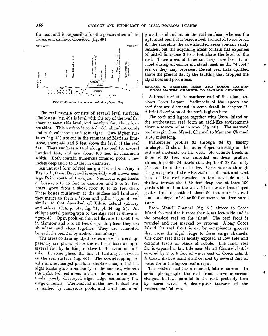
A88 GEOLOGY AND HYDROLOGY OF GUAM, MARIANA ISLANDS
the reef, and is responsible for the preservation of the forms and surfaces described (fig. 49).
NORTHWEST SOUTHEAST
FIGURE 49.-Sectlon across reef at Agfayan Bay.
The reef margin consists of several level surfaces. The lowest (fig. 49) is level with the top of the reef flat about at mean tide level, and nearly 2 feet above lowest tides. This surface is coated with abundant corals and with calcareous and soft algae. Two higher surfaces (fig. 49) are cut in the remnant of Mariana limestone, about 41h and 5 feet above the level of the reef flat. These surfaces extend along the reef for several hundred feet, and are about 100 feet in maximum width. Both contain numerous rimmed pools a few inches deep and 5 to 10 feet in diameter.
An unusual form of reef margin occurs from Ajayan Bay to Agfayan Bay, and is especially well shown near Aga Point south of Inarajan. Numerous algal knobs or bosses, 5 to 15 feet in diameter and 5 to 20 feet apart, grow from a shoal floor 10 to 15 feet deep. These bosses mushroom at the surface and landward they merge to form a "room and pillar" type of reef similar to that described off Bikini Island (Emery and others, 1954, p. 145; fig. 71; pl. 14, fig. 2). An oblique aerial photograph of the Aga reef is shown in figure 46. Open pools on the reef flat are 10 to 20 feet in diameter and 5 to 10 feet deep. In places they are abundant and close together. They are connected beneath the reef flat by arched channelways.
The areas containing algal bosses along the coast apparently are places where the reef has been dropped several feet by faulting relative to the areas on each · side. In some places the line of faulting is obvious on the reef surface (fig. 46). The downdropping results in a submerged platform shallow enough that the algal knobs grow abundantly to the surface, whereas the upfaulted reef areas to each side have a comparatively poorly developed algal ridge containing few surge channels. The reef flat in the downfaulted area is marked by numerous pools, and coral and algal
growth is abundant on the reef surface; whereas the upfaulted reef fla;t is barren rock truncated to sea level. At the shoreline the downfaulted areas contain sandy beaches, but the adjoining areas contain flat expanses of pitted limestone 3 to 5 feet above the level of the reef. These areas of limestone may have been truncated during an earlier sea stand, such as the "6-foot" sea, or they may represent Recent reef flats uplifted above the present flat by the £,aulting that dropped the a;lgal boss and pool areas.
SECTOR 6. BARRIER REEF AND COCOS LAGOON FROM MANELL CHANNEL TO MAMAON CHANNEL
A broad reef at the southern end of the island encloses Cocos Lagoon. Sediments of the lagoon and reef flats are discussed in some detail in chapter B. A brief description of the reefs is given here.
The reefs and lagoon together with Cocos Island on the southeastern reef form an atoll-like environment about 4 square miles in area (fig. 50). The sea ward reef margin from Manell Channel to Mamaon Channel is 6% miles long.
Fathometer profiles 32 through 34 by Emery in chapter B show that outer slopes are steep on the east and moderate on the west. No definite break in slope a;t 60 feet was recorded on these profiles, although profile 34 starts at a depth of 60 feet only 550 feet from the reef edge. Observations through the glass ports of the SES 800 on both east and west sides of the reef revealed on the east side a flat shallow terrace about 50 feet deep and at least 100 yards wide and on the west side a terrace that sloped gently from a depth of about 50 feet near the reef front to a depth of 80 or 90 feet several hundred yards away.
From Manell Channel (fig. 51) almost to Cocos Island the reef flat is more than 3,000 feet wide and is the broadest reef on the island. The reef front is rounded and not marked by grooves. Along Cocos Island the reef front is cut by conspicuous grooves that cross the algal ridge to form surge channels. The outer reef flat is mostly exposed at low tide and contains tracts or bands of rubble. The inner reef flat is exposed at low tide near Manell Channel, but is covered by 2 to 5 feet of water east of Cocos Island. A broad shallow sand shelf covered by several feet of water forms the lagoon reef margin.
The western reef has a rounded, lobate margin. In aerial photographs the reef front shows numerous elongate hollows parallel to the reef, probably torn by storm waves. A descriptive traverse of the western reef follows.
•
.4J
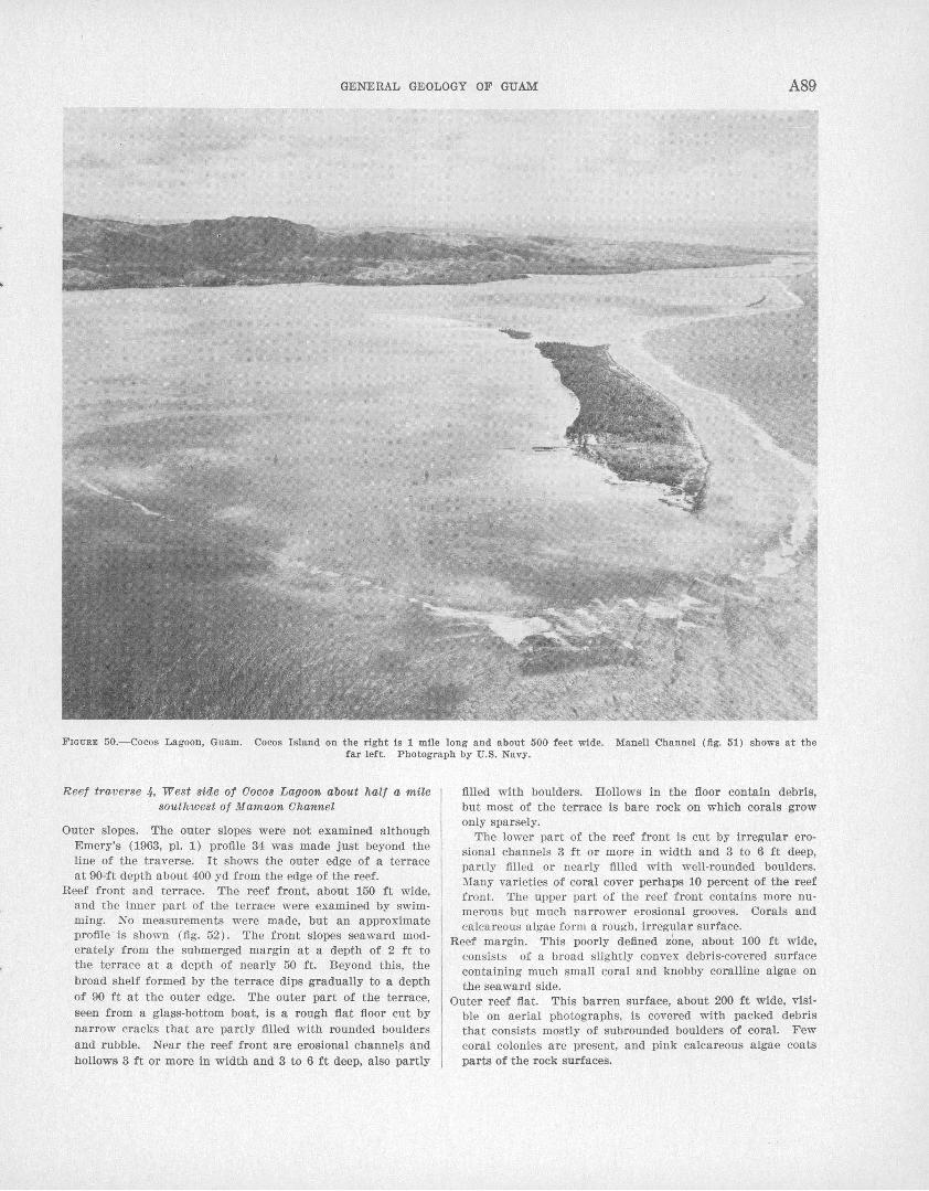
GENERAL GEOLOGY OF GUAM A89
FIGURE 50.-Cocos Lagoon, Guam. Cocos Island on the right is 1 mile long and about 500 feet wide. Mane!! Channel (fig. 51) shows at the far left. Photograph by U.S. Navy.
Reef traverse 4, West side of Cocos Lagoon about halt a mile southwest of M amaon Channel
Outer slopes. The outer slopes were not examined although Emery's (1963, pl. 1) profile 34 was made just beyond the line of the traverse. It shows the outer edge of a terrace at 90-ft depth about 400 yd from the edge of the reef.
Reef front and terrace. The reef front, about 150 ft wide, and the inner part of the terrace were examined by swimming. No measurements were made, but an approximate profile is shown (fig. 52). The front slopes seaward moderately from the submerged margin 'at a depth of 2 ft to the terrace at a depth of nearly 50 ft. Beyond this, the broad shelf formed by the terrace dips gradually to a depth of 90 ft at the outer edge. The outer part of the terrace, seen from a gla.ss-bottom boat, is a rough fiat floor cut by narrow cracks that are partly filled with rounded boulders and rubble. Near the reef front are erosional channel,s and hollows 3 ft or more in width and 3 to 6 ft deep, also partly
filled with boulders. Hollows in the floor contain debris, but most of the terrace is bare rock on which corals grow only sparsely.
The lower part of the reef front is cut by irregular erosional channels 3 ft or more in width and 3 to 6 ft deep, partly filled or nearly filled with well-rounded boulders. Many varieties of coral cover perhaps 10 percent of the reef front. The upper part of the reef front contains more numerous but much narrower erosional grooves. Corals and calcareous algae form a rough, irregular surface.
Reef margin. This poorly defined zone, about 100 ft wide, consists of a broad slightly convex debris-covered surface containing much small coral and knobby coralline algae on the seaward side.
Outer reef fiat. This barren surface, about 200 ft wide, visible on aerial photographs, is covered with packed debris that consists mostly of subrounded boulders of coral. Few coral colonies are present, and pink calcareous algae coats parts of the rock surfaces.
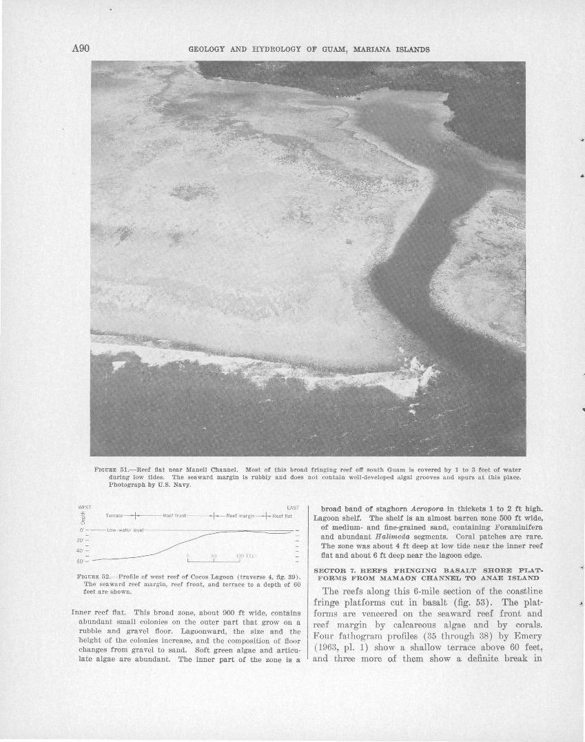
A90 GEOLOGY AND HYDROLOGY OF GUAM, MARIANA ISLANDS
Frouam 51.-Reef fiat near Manell Channel. Most of this broad fringing reef o1l' south Guam is covered by 1 to 3 feet of water during l<>w tides. The seaward margin Is rubbly and does not contain well-developed algal gro<>ves and spurs at this place. Photograph by U.S. Navy.
WEST .c a. c?l
EAST
Terrace~+---Reef front--- t---Reef margin-+ Reef flat
100 FEET
FIGU RE 52.- Prollle of west reef of Cocos Lagoon (traverse 4, fig. 39)·. The sea ward reef margin, r eef front, and terrace to a depth of 60 feet are shown.
Inner reef flat. This broad zone, about 900 ft wide, contains abundant small colonies on the outer part that grow on a rubble and gravel floor. Lagoonward, the size and the height of the colonies increase, and the composition of floor changes from gravel to sand. Soft green algae and articulate algae are abundant. The inner part of the zone is a
broad band of staghorn Acropora in thlckets 1 to 2 ft high. Lagoon shelf. The shelf is an almost barren zone 500 ft wide,
of medium- and fine-grained sand, containing Foraminifera and abundant Halimeda segments. Coral patches are rare. The zone was about 4 ft deep at low tide near the inner reef fiat and about 6 ft deep near the lagoon edge.
SECTOR 7. REEFS FRINGING BASALT SHORE P LAT· FORMS FROM MAMAON CHANNEL TO ANAE ISLAND
The reefs along this 6-mile section of the coastline fringe platforms cut in basalt (fig. 53). The platforms are veneered on the sea ward reef front and reef margin by calcareous algae and by corals. Four fathogram profiles (35 through 38) by Emery (1963, pl. 1) show a shallow terrace above 60 feet, and three more of them show a definite break in
•
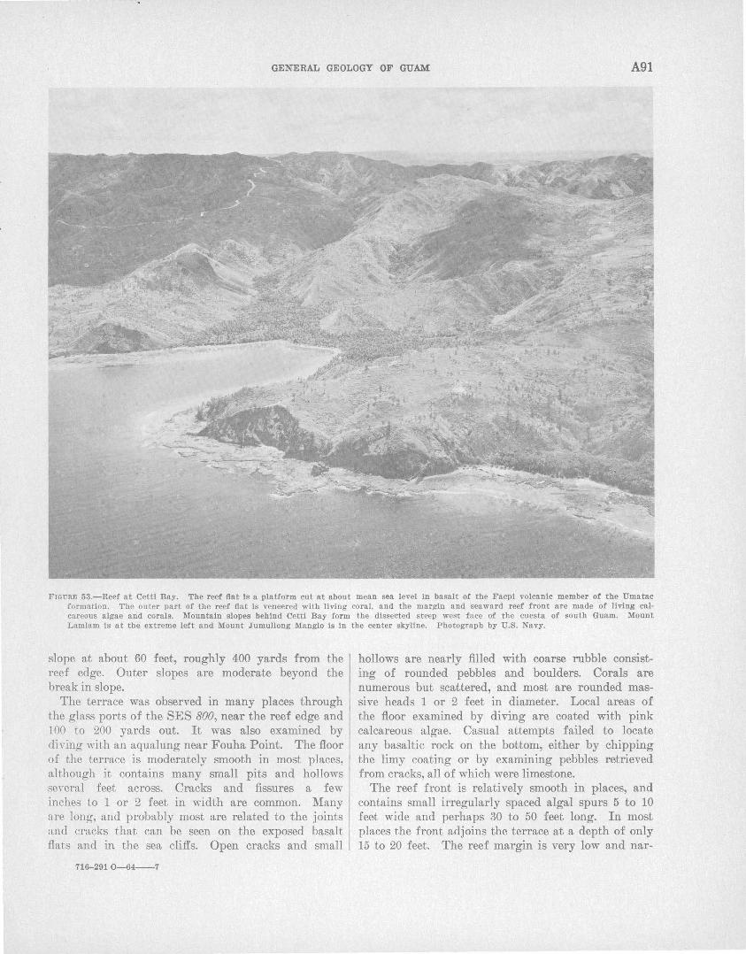
GENERAL GEOLOGY OF GUAM A91
FIGURE 53.-Reef at Cettl Bay. The reef fiat Is a platform cut at about mean sea level In basalt of the Facpl volcanic member of the Umatac formation . The outer part of the reef fiat Is veneered with living coral, and the margin and seaward reef front are made of living calcareous algae and corals·. Mountain slopes behind Cettl Bay form the dissected steep west face of the cuesta of south Guam. Mount Lamlam is at the extreme left and Mount Jumullong Manglo is In the center skyline. Photograph by U.S. Navy.
slope at about 60 feet, roughly 400 yards from the reef edge. Outer slopes are moderate beyond the break in slope.
The terrace was observed in many places through the glass ports of theSES 800, near the reef edge and 100 to 200 yards out. It was also examined by diving with an aqualung near Fouha Point. The floor of the terrace is modera;tely smooth in most places, although it contains many small pits and hollows several feet across. Cracks and fissures a few inches to 1 or 2 feet in width are common. Many are long, and probably most are related to the joints and cracks that can be seen on the exposed basalt flats and in the sea cliffs. Open cracks and small
716-291 0-64--7
hollows are nearly filled with coarse rubble consisting of rounded pebbles and boulders. Corals are numerous but scattered, and most are rounded massive heads 1 or 2 feet in diameter. Local areas of the floor examined by diving are coated with pink calcareous algae. Casual attempts failed to locate any basaltic rock on the bottom, either by chipping the limy coating or by examining pebbles retrieved from cracks, all of which were limestone.
The reef front is relatively smooth in places, and contains small irregularly spaced algal spurs 5 to 10 feet wide and perhaps 30 to 50 feet long. In most places the front adjoins the terrace at a depth of only 15 to 20 feet. The reef margin is very low and nar-
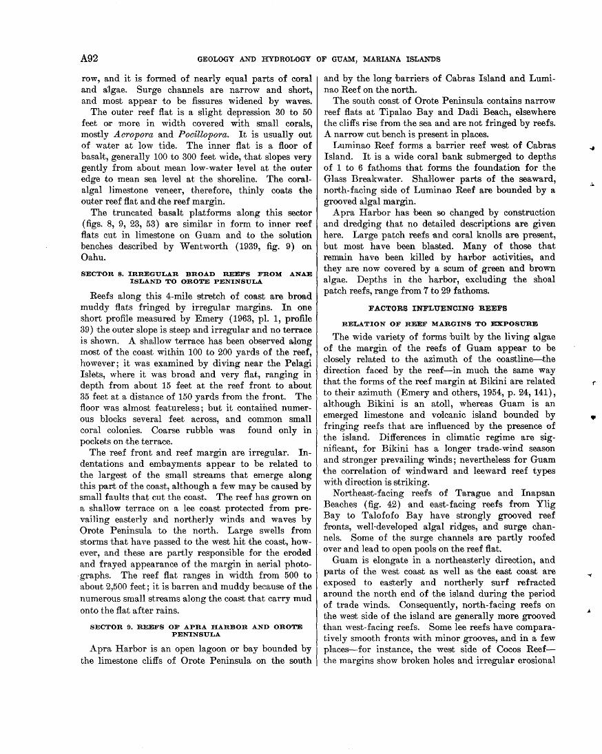
A92 GEOLOGY AND HYDROLOGY OF GUAM, MARIANA ISLANDS
row, and it is formed of nearly equal parts of coral and algae. Surge channels are narrow and short, and most appear to be fissures widened by waves.
The outer reef flat is a slight depression 30 to 50 feet or more in width covered with small corals, mostly Acropora and Pocillopora. It is usually out of water at low tide. The inner flat is a floor of basalt, generally 100 to 300 feet wide, that slopes very gently from about mean low-water level at the outer edge to mean sea leYel at the shoreline. The coralalgal limestone veneer, therefore, thinly coats the outer reef flat and ,tJhe reef margin.
The truncated basal,t platforms ·along this sector (figs. 8, 9, 23, 53) are simHar in form to inner reef flats cut in limestone on Guam and to the solution benches described by Wentworth (1939, fig. 9) on Oahu.
SECTOR 8. IRREGULAR BROAD REEFS FROM ANAE ISLAND TO OROTE PENINSULA
Reefs along this 4-mile stretch of coast are broad muddy flats fringed by irregular margins. In one short profile measured by Emery (1963, pl. 1, profile 39) the outer slope is steep and irregular and no terrace is shown. A shallow terrace has been observed along most of the coast within 100 to 200 yards of the reef, however; it was examined by diving near the Pelagi Islets, where it ·was broad and very flat, ranging in depth from about 15 feet at the reef front to about 35 feet at a distance of 150 yards from the front. The floor was almost featureless; but it contained numerous blocks several feet across, and common small coral colonies. Coarse rubble was found only in pockets on the terrace.
The reef front and reef margin are irregular. Indentations and embayments appear to be related to the largest of the sm~ll streams that emerge along this part of the coast, although a few may be caused by small faults that cut the coast. The reef has grown on a shallow terrace on a lee coast protected from prevailing easterly and northerly winds and waves by Orote Peninsula to the north. Large swells from storms that have passed to the west hit the coast, however, and these are partly responsible for the eroded and frayed appearance of the margin in aerial photo-graphs. The reef flat ranges in width from 500 to about 2,500 feet; it is barren and muddy because of the numerous small strea1ns along the coast that carry mud onto the flat after rains.
SECTOR 9. REEFS OF APRA HARBOR AND OROTE PENINSULA
Apra Harbor is an open lagoon or hay bounded by the limestone cliffs of Orote Peninsula on the south
and by the long barriers of Cabras Island and Luminao Reef on the north.
The south coast of Orote Peninsula contains narrow reef flats at Tipalao Bay and Dadi Beach,. elsewhere the cliffs rise from the sea and are not fringed by reefs. A narrow cut bench is present in places.
Luminao Reef forms a barrier reef west of Cabras Island. It is a wide coral bank submerged to depths of 1 to 6 fathoms that forms the foundation for the Glass Breakwater. ShaHower parts of the seaward, north-facing side of Luminao Reef are bounded by a grooved algal margin.
A pra Harbor has been so changed by construction and dredging that no detailed descriptions are given here. Large patch reefs and coral knolls are present, but most have been blasted. Many of those that remain have been killed by harbor activities, and they are now covered by a scum of green and brown algae. Depths in the harbor, excluding the shoal patch reefs, range from 7 to 29 fathoms.
FACTORS INFLUENCING REEFS
RELATION OF REEF MARGINS TO EXPOSURE
The wide variety of forms built by the living ·algae of the mG~rgin of the reefs of Guam appear to be closely related to the azimuth of the coastline---,the direction faoed by the reef-in muoh the same way that the forms of the reef margin a;t Bikini are related to their azimuth (Emery and others, 1954, p. 24, 141), although Bikini is an atoll, whereas Guam is an emerged limestone and volcanic island bounded by fringing reefs that are influenced by the presence of the island. Differences in climatic regime are significant, for Bikini has a longer trade-wind season and stronger prevailing winds; nevertheless for Guam the correlation of w_indward and leeward reef types with direction is striking.
Northeast-facing reefs of Tarague and Inapsan Beaches (fig. 42) ·and east-facing reefs from Ylig Bay to Talofofo Bay have strongly grooved reef :fronts, well-developed algal ridges, and surge channels. Some of the surge channels are partly roofed over and lead to open pools on the reef fla,t.
Guam is elongate in a northeasterly direotion, and parts of the west coast as well as the east roast are exposed to easterly and northerly surf refracted around the north end of the island during the period of trade winds. Consequently, north-facing reefs on the west side of the island are generally more grooved than west-facing reefs. Some lee reefs have comparatively smooth fronts with minor grooves, and in a few places-for instance, the west side of Cocos Reefthe margins show broken holes and irregular erosional
•
..
GE~RAL GEOLOGY OF GUAM A93
reentrants as do the southwestern reefs 31t Bikini,, presumably because the lee reefs are adjusted to moderate or calm surf and are unable to withstand the occasional great swells that come from westerly or soutJnvesterly directions during typhoons. More commonly the lee reefs have smaH irregular spurs and narrow shallow grooves ·that in aerial photographs give the reef margin a frayed aspect (fig. 32).
Southeast-facing reefs between Acho Point and Manell Channel contain large areas in which the reef front and margin are characterized by clusters of algal knobs or bosses that grow .together at water level to form a reef surface containing numerous open pools, foPming a room-and-pillar structure below the surface of the reef flat (fig. 46). These reefs bear a remarkable resemblance to similar ones .a;t Bikini, which also are on easterly and southeasterly stretches of the atoll (Emery and others, 1954, p. 25, 145). The room-andpillar structure on Guam appears to have developed on a shoal created by relatively recent faulting as described on page A88. Numerous algal knobs are forming a new reef on the flat platform submerged by down-faulting.
OtJ1er coastal feartures restricted to windward coasts are the rim1ned terraces that consist of steplike shallow pools, surrounded by low rims built by serpulid n1ollusks or by encrusting coralline algae (fig. 44B, 0, D).. Similar features have been called "algal terraces," "algal terrace rims" (Wentworth, 1939, p. 14), and rimmed pools. Rimmed terraces near Tagachan Point are described by Emery (1963), who shows that they are primarily solution forms cut in older limestone but controlled by growth on the rims. Although the living organisms of the rims do not effectively build up the limestone, they .tend to restrict the rate o:f downcutting by solution (l(uenen, 1950, p. 432).
Occurrence of these forms along .the reef margin of t.he windward coast is restricted to are·as that contain remnant patches of limestone higher than mean sea level. 'Ventwot,th (1939, fig. 8) showed thrut such terraces on Oahu are associated with active splashing at reentrants or salients on the coast. On Guam, wellpreserved rimmed terraces are found only where surf splashes over them regularly even on relatively calm days.
llELATIV.E EFFECTIVENES1S OF GROWTH AND EROSION
The effectiveness of organic growth and erosion in t"he development of reef margins is well shown by the nt.riety of forms at Guam, which range fron the algal bosses and room-and-pillar structures near Aga Point that are almost wholly constructional to the truncated
benches of the limestone headlands ·that are almost wholly erosional.
The role played by organic growth has been emphasized for the toothed algal ~argins of Funafuti (David and Sweet, 1904, pis. 17, 19; Kuenen, 1950, p. 423) and for the algal margins of the northern Marshall Islands (Emery and others, 1954, p. 26, 145). Gareau (1959, p. 86, fig. 4) shows that corals form m-assive grooveand-spur growth structures in the submerged reefs of Jamaica; these are coral analogues, in the Atlantic Ocean, of the algal structures in the open Pacific.
Newell (1956, p. 346) stresses the erosional aspects of the grooves of Raroia. Cloud (1954; 1959, p. 410), while convinced that many of the irregular forms of Guam and Sai pan are predominantly growth features, states th31t generally such forms are initiated by erosion from return currents off the reef, probably caused by island barriers on the reef.
On most reefs growth predominates in some places, erosion in others, and it is ordinarily not difficult .to assess the relative effectiveness of each. The significance of organic growth ·as a process, however, is that even those features that ·are predominantly erosional, such as rimmed terraces, are shaped and the erosion is controlled by growth. Such features are found only in reef-associated environments where coral~ algae, vermetid gastropods, and other limestonebuilding organisms thrive:
RELATION OF REEFS T.O OTHER GEO(l.OGIC FEATURES
Flourishing reefs on Guam are fronted by a shallow terrace, but ·most limestone headlands and coasts rimmed by cut benches are not. A preexisting shoal pla;tform appears to be necessary to the formation of a reef on Guam. The shaHow ~terrace, which ranges in depth from 15 to 25 feet at ·the reef front to 50 or 60 feet in depth at a distance of 50 yards or more from the reef, looks much the S31me off windward or lee coasts, whether formed of limestone or of volcanic rock. The bare hummocky rock floor of the terrace seem~ to be a cut surface. Sand, gravel, and coarse rubble are found only in small p31tches in hollows and pockets, or in cracks and fissures. Erosion close to the reef front is indica;ted by the presence of rugged irregular holes and large blocks of rock. Scruttered living corals are common off lee coasts, but otherwise are scarce. - Fractures and j oint:s in the terrace generally are alined with fractures or joints in nearby limestone or basalt cliffs.
'Vidth of reefs ·appears to depend on the depth, width and slope of the platform on which they grow. "Tide reefs that fringe .the north plateau are restricted to major embayments, such as Tumon, Agana, and
A94 GEOLOGY AND HYDROLOGY OF GUAM, MARIANA ISLANDS
Tarague Bays, although other 'large bays, such as Campanaya, contain no fringing reefs. These major embayments seem to be large-scrule slump features, although no positive evidence was revealed by the mapping. Reefs apparently fringe those bays in which a suitable platform is provided by a shallow cut terrace, or by a shallow slumped block.
Reefs fringing the Tenjo structura1 block are generally wider .than those fringing .the younger Bolanos block, except for the Cocos Reef at the southwest end of the island. Possibly, wider shelves carved around the older block provide broader foundations for the Recent reefs. The broad Cocos Reef may grow from a shallow platform of submerged Mariana Hmestone in about the same plane as the elevated Mariana limestone that rises to the northeast, rulong the east coast of Guam.
The kind of rock that forms .the coastline influences the fringing reef to some extent. Because of the small streams thrut drain the volcanic upland, compared to the lack of surface drainage along limestone coasts, reef flats along volcanic coasts are generally more muddy and barren.
Erosional features, such _.a;s benches and nips, are best developed along limestone coasts. The solution features described for Hawaii by WentwortJh (1938, 1939) are very similar to ferutures on Guam. The chief difference between water-level benches and solution benches appears to be relative height above sea level (W entwooth, 1939, p. 21), although at Hawaii the water-level bench is ·apparently restricted to volcanic rock and the solution bench to limestone. On Guam, however, features resembling the waterlevel bench, at or above high-tide level, are largely restricted to limestone coasts, whereas fea.tures comparable to the more common solution bench, a.t mean sea level to high -tide level, are found along the southwest basalt coast as well as on limestone.
The several benches and nips at Pago Point (fig. 48), all ·appear to be in process of formation and indicate that much caution is necessary in interpreting past stands of the sea by means of such features. Wentworth ( 1938, p. 22) pointed .this out in discussing several benches at different levels at Koko blowhole, Oahu. H. T. Stearns (1941, p. ·778) mapped and discussed a 5-foot variation in elevation of the lowest bench at Amantes Point, Guam, from the leeward to the windward side of the headland.
Active nips or benches at several levels, and lateral variation in the elevation of a single nip or bench, are always found on the windward side of headlands. Nips or benches cut in protected places or on lee
shores ·are thus more reliable evidence for interpreting former stands of the sea.
GEOLOGIC HISTORY
PRE-EOCENE, EOCENE, AND OLIGOCENE EVENTS
The earliest geologic event of which we have direct know ledge in .this part of the Mariana Islands is the deposition of the volcanic rocks of the Alubom formation in late Eocene time (Tertiary b). Diagnostic larger Foraminifera of this age are found well down in the sequence of volcanic rocks exposed on the island. The sequence is entirely of submarine origin, although the presence of well-rounded cobbles and pebbles in some places in the volcanic breccia suggests that wave erosion at the shoreline, or rounding by subaerial running water, took place not f~r away. Some Qf the tuffaceous ·shales of the formation contain abundant globigerinid Foraminifera and were proba.bly deposited at moderate depths that possibly reached 1,000 fathoms in places. All the unweathered tuffaceous sand and shale of the Alutom formation, however ,
1
is thoroughly permeated by calcite that in thin section appears to be a primary cement, indicS~ting deposition in water shallow enough for the formation of carbonate. No sediments were found that are comparable to the ooze and red clay of the present-day sea bottom at depths of 2,000 to 3,000 ::fathoms.
The volcanic pile that erupted during the Eocene epoch was dominantly of basaltic and andesitio composition, at least in the later stages now exposed. Dacite cobbles are found in pyroclastic conglomerates within .the Alutom formation, ·a;~though on Guam no flows of daoite were found. The Sankakuyama formation of Saipan consists of dacitic flows and pyroclastic rocks probably of Tertiary b age, according to Cloud, Schmidt, and Burke ( 1956, p. 39). This formation contains fragments of augite andesite, which they infer to be from older Eocene andesitic flows that preceded the dacitic flows. It is probable that on Guam dacitic flows preceded the andesitic flows now exposed.
The volcanism that resulted in deposition of .the Alutom form·ation was a part of the process of formation of the chain of islands and the arcuate deeps of the Mar.iana geanticline (fig. 3). The nature of the sea floor of the region before the deposition of the Alutom formation is not known. The available evidence from 8aipan (Cloud and others 1956, p. 101) and Rota ( Asano, 1939) indica;tes that ·the sequence of events in the southern Mariana;s happened probably at much the same time, and that the Mariana geanticline was well formed by late Eocene time.
•
.GENERAL GEOLOGY OF GUAM A95
Dredgings from the central part of the Pacific basin by the mid-Pacific expedition of the Scripps Institution of Oceanography and the U.S. Navy Electronics Laboratory in 1950 revealed a middle Cretaceous (Apthm-Cenomaniap) fauna of reef cora:ls, rudistids, st.romatoporoids, gastropods, p~lecypods, and an echinoid across the breaks in slopes at the tops of two flattopped guyots west of the Hawaiian Islands (Hamilton, 1956, p. 1). :Hamilton states that the guyots were '\vn. ve eroded and sank in Cretaceous time to below the zone of reef coral growth. Evidence from the Marshall Islands (Emery ai1d others, 1954; Ladd and others, 1953) indicates th31t long-continued subsidence of Bikini and Eniwetok started at the time of deposition at Eniwetok of reef-type coral limestones of late Eoeene age. It seems likely that a general subsidence of the central Pacific basin starting in middle or Late Cretaceous time nray be related ·to the early stages of formation of the arcs around the brusin, and that the 1\f.a.r.in.n:t geanticline therefore may have started forming in late 1\f.esozoic rather than eal'ly Cenozoic time.
No limestone was found in the lower part of the Alutom formation, and only a few ·thin beds were found in place in the upper part of the unit. The abundance of limestone fragments in the breccia in the upper part of the form:ation, however, indicates thrut extensive beds of limestone must have been present not far a way. The broad band of breccia and conglomerate containing abundant chips and fragments of limestone is thought by Cole (1963) to be of Ter.tiary c (Oligoeene) age, for he has found Oamerina fichteli, a Tert·iary c form, in the matrix of 1t;he breccia, whereas the limestone fragments collltain abundant Tertiary b (late Eocene) forms. The limestone fragments, as shown by t·he studies of Schlanger in chapter D, were derived from reef-associated limestone :facies similar to those t'hat form the 1\f.iocene, Pliocene, and Pleistocene limestones of Guam.
The common ft~agments of coral and abundant pieces of ealcareous algae indicate that the Eocene ocean provided. reef-forming conditions similar to the conditions prevailing today. The reefs were undoubtedly fringing types and were probably discontinuous along t.he shores as well as intermittent in time, depending upon t.he extent of volcanic activity and the stability of the shoreline.
Thiek beds of 1\f.at:ansa limestone of 131te Eocene age on Sn.i pa.n (Cloud and others, 1956, p. 56) are thought to have originated in shallow water that was probably 10 t,o 50 :fat,homs deep. Such deposits may have been present. on Guam -also, west of the present island.
The size of the volcano or group of volcanoes that produced the rocks of the Alutom formation can be
estimated from a study of figure 25 on page A54. The Tenjo structural block consi,sts mostly of rocks of the Alutom formwtion that appear to form a slumped sector of a large volcano. The center of volcanisn1 was probably 5 to 15 miles from the west edge of ~the Tenjo block. The area of the Eocene volcano exposed above sea level may have been larger than the present island, but no evidence indicates ~that a landmass of very large dimensions existed at that time.
The presence of reefs inferred from the limestone fragments suggests that the lrute Eocene epoch terminated in a relatively stable period during which conditions permitted the formation of limestone reefs. The reef building was followed early in Oligocene (Tertiary b) time by an explosive phase of volcanism that resulted in the deposits of breccia and conglomerate-bearing limestone fragments, and these were followed by deeper water quiet deposition of globigerinid tuffaceous sands and sha;les of the 1\f.ahlac member of the Alutom formation. The explosive volcanism and the last depQSits of the Alutom formation were possibly related to initial phases of the collapse of the caldera of the Eocene volcano discussed under structural geology. Movement along major faults and uplift of tihe island also may have been relruted to the collapse o:f the caldera. Folding produced by submarine gravitartionrul gliding probably both preceded and followed deposition of the early Oligocene deposits.
1\f.ost of the deformation of this period ended before the lower ~f.iocene rocks of the U matac form31tion were laid down. The lava flows of ~the U matac formation are found both east and west of the spur of volcanic rocks of .the Alutom formation that forms t:he core of the 1\f.ount Alifan-Mount Lamlam ridge. Therefore rtilie breaking up of the Eocene volcano and the principal shaping of the Tenjo structural block was accomplished before tJhe end of Oligocene time. The formation of the volcanic backbone of the north plateau had most likely taken place by this :time also, although specific evidence is l1acking.
No deposits have been found on Guam containing fossils of Tertiary d age. It is possible that during this time the gently rolling top of the mountain containing the separate peaks of Mounts Tenjo, Alutom, and Chacho may have been elevaJted and eroded.
MIOCENE EVENTS
UMATAC FORMATION
Formation of the Miocene volcano southwest of the island (fig. 25), w:hich produced the flows and pyroclastic breccias and conglomerates of the Umatac for-
A96 GEOLOGY AND HYDROLOGY OF GUAM, MARIANA ISLANDS
mation, followed the collapse of the caldera of the Eocene volcano. The lowermost fossils found in the Umali:;ac formUJtion are larger Foraminifera of Tertiary e age according to Cole ( 1963), ·and :these are found in calcareous lenses of the Maemong limestone member of the formation, some of which are apparently rakher low in the exposed sequence. Nevertheless, several hundred feeJt of pillow lava flows underlie the lowest dated rocks of the form3!tion; below sea level these flows are underlain by volcanic material probably many .thousands of feet in thickness. Consequently it is entirely possible that the foundations of the Miocene volcano were laid down in Oligocene time, although only rocks of early Miocene age are exposed above sea level.
Deposition of the flows of the Facpi volcanic member of the Umatac formation was complicated by minor faulting •31nd interrupted by one or more periods quiet enough .:to allow the deposition of lenticular beds of the Maemong limestone member. At about the same time or a little la;ter, limestone reefs grew on the shoal banks of the southeastern part of the Tenjo structura;l block and formed the isolated patches of the Maemong member north of the Talofofo Riyer.
The distribution of the isolated lower Miocene reef prutches in central Guam and the inference that they were deposited in shoal waters imply lthat higher parts of the Tenjo block were exposed to erosion at that time.
Following the deposition of the Maemong member, several hundred feet of flows, tuffaceous limy shale, and breccia of the Facpi member were laid down. Explosive volcanism started before deposition of the Maemong Emestone member and increased during deposition of the upper part of the Facpi member. It culmina;ted in the deposition of the Bolanos pyroclastic member of the Umatac formation. This nearly continuous sequence of tuff-breccia and volcanic conglomerate includes intermittent flows.
The final episode in the development of the U matac formation was the eruption of a series of sheetlike flows called the Dandan flow member, now exposed only as isolated weathered remnants. In the Miocene rocks, as in the Eocene rocks, the sequence of flows and tuffaceous shales was interrupted to allow the deposition of beds of limestone, and the succeeding volcanism was increasingly explosive. Deposition of the flows of the Dandan member ended the known major volcanism on Guam.
BONYA LIMESTONE
The flows of the Dandan member are overlain by the Bonya limestone of Tertiary f age. The Bonya limestone is restricted to parts of the east coast and
the embayment of the Talisay River and its tributaries. The bedded detritJal nature of the Bony.a and .the presence of rounded, apparently stream-worn, gravel in the uppermost part of the Bolanos near Dandan indicate that a considerable area of west and south Guam was exposed to subaerial weathering at this ti•me. The presence of K atacycloclypeu8,, suggesting moderately deep w3!ter in the lower part of the Bonya, and the increasing rubundance of the shoal-water or possibly brackish-water form, Rotalia atjehensis, toward the top of the formation indicate that parts of the island were emerging during the deposition of the Bonya. The extensive benchlike areas of south Guam on which the Ali:fan limestone was deposited may have been largely cut 3!t this ·time.
The volcanic rocks that were exposed to subaerial weathering during deposition of the Bonya limestone were weathered to clay and dissected by erosion. Evidence of the weathering is seen in the clayballs and argillaceous detritus in .the Bonya limestone. At the end of Bonya time, erosion and deposition of the weathered volcanic material increased sharply to form the clayey conglomeratic deposits of the Talisay member of the Alifan limestone.
Collapse of the caldera of the large Miocene volcano tha.t formed the south end of the island is discussed under structural geology. Probably the principal part of the collapse was for the most par.t concurrent with the flows of the D·andan member of the U matac forma;tion, following the explosive volcanism that resulted in the deposition of the Bolanos pyroclastic member. After effects may have continued through the period of deposition of Bonya limestone. Presumably the major effects of the collapse were accomplished by the time of deposition of the Alifan limestone. Remnants of Alifan limestone and traces of the Talisay member are found on the west slope of the Tenjo block, and indications are strong, although not conclusive, that the Alifan limestone was deposited on the west side of the Bolanos block. The Alifan was deposited on a weathered surface of older rocks; therefore ~the present form of the southern half of the island was determined by the end of Tertiary f and before the deposition of the Alifan limestone. The distribution of the Alifan limestone, the J anum formation, and the Barrigada limestone (probably of Tertiary g age) indicates that the north half of the island, too, had achieved its gross shape by l3!te Miocene time.
ALIFAN LIMESTONE
Deposition of the Alifan limestone started when the island was most emergent 3!t ·the close of deposition of the Bonya limestone. The rotalid limestones near Y ona were laid down in shallow water offshore;
•
.GEN"Jl}RAL GEOLOGY OF GUAM A97
fossiliferous marly beds and clayey conglomera·tic beds of the Talisay member were ·laid down in the embayment of the Fena valley. At much the same time, montmori.Uonitic clay beds and carbonaceous clay containing lignite fragments were deposited in higher places near ttJhe marshy shoreline. Higher stfll at the base of weathered slopes, thick taluslike deposits of mixed boulders of volcanic origin accumulated in a weruthered clayey matrix.
As the island gradually submerged, argillaceous limestone containing Rotalia atjehensis, mollusks, and fragile porit.id corals were deposited at ·the base of the Alifan limestone. As less and less of the highlands were exposed to subaerial weathering, the deposited limestone became less argillaceous and more coralliferous. Extensive reefs formed. The thick cora-lliferous limestone that caps the Mount Ali:fan-1\{ount Lam]am ridge was thought by Tayama (1952, p. 257) to represent an upraised atoll. The abundant thicketlike deposits of Acropora and Pm·ite8 so common in the limestone are lagoonal types, however, and Schlanger (1964) points out thn:t a study of :thin sections from the high limestone c~ap indicates the predominance of lagoonal facies. No reef facies were found, and the protecting reefs that must have surrounded-the Mount Alifan-Mount Lamlam lagoon have since disappeared.
It .is doubtful that ·all Guam was submerged at the time the high. ridge li,mestone was deposited, for evidence has been discussed (fig. 16) to show that tJ1e upper 300 feet or so of the Mount Tenjo-Mount Alutom mass stood above the sea as an island .throughout Alifan time. Apparently ·the upper several hundred feet of the Bolanos ridge from Mount J umullong Manglo to Mount Sasal·aguan also was not submerged. Both these "islands" are now lower than the present limestone-capped summit of Mount Lamlam, indicating that warping or faulting of several hundreds of feet has taken place since deposition of 1the Alif.an limestone.
EVENTS DURING THE MIOCENE ON NORTH GUAM
The sequence of events during the Miocene on the northern par't of the island generally paralleled that on t.he south, and most of the mapped formations in north Guam are virtually contemporaneous with those of the swme name in south Guam. Tilting, or deformation of one part of the island wi,th respect Ito ot·her parts, would result in erosion in some places during periods of deposition in others. It is not safe to assume, therefore, that similar deposits are synchronous although they may be closely similar in age. For the same reason unconformities cannot
safely be correlated from one part of the island to another.
On no nth Guam no rocks of Tertiary e age (early Miocene)" are known. Small patches of fossiliferous Bonya limestone of Tertiary I age overlie voloanic rocks of probable Eocene age on a low terrace east of Mount Santa Rosa. The Bonya is overlain with ·apparent unconformi·ty by moderaJtely deep water globigerinid argillaceous limestone of the J anum formation, from which we may infer th31t a period of emergence ·and weathering of :the volcanic hills of Mount Santa Rosa terminated the deposition of the Bonya limestone. Resubmergence of the northern part of the island in laite Tertiary I, or early Tertiary g, time to about the level of ~the present summit of Mount Santa Rosa was accompanied by deposition of the Rotalia-bearing Ali:fan Emestone near Mount Santa Rosa, in shallow water, at about the same time that the J anum formation was deposited in deeper water on the ter.race, and tJhe Barrigada Jimestone was deposited on banks rut intermediate depths.
Probably by eady Pliocene ti1me :the Barrigada banks had built up sufficiently, augmented by a. little emergence of the island that exposed lbhe older and higher Alifan rocks around Mount Santa Rosa, so tha;t cor31lliferous and molluscan limestone was deposited over most of tJhe central part of the north plateau. This we have interpreted as a lagoonal depositl rel·ated to the peripheral reefs of Mariana limestone on the north pl31teau. The correlation is not based on fossils, for no diagnostic larger Foraminifera ·are found in these rocks; but it may prove possible to correlate them more accurately after studies of corals and mollusks are completed.
PLIOCENE, PLEISTOCENE, AND RECENT EVENTS
The broad transition from deposition of the Alifan and Barrigada limesbones to deposition of the Mariana limestone was interrupted by a period of emergence caused by, or accompanied by, structural deformation and faulting. In some places the transition appears to be gradational, and no break that is oontinuous enough to map can be recognized. The northeastern part of the north plateau in the neighborhood of Salisbury is a good example of this seeming transition, for definite Barrigada limestone can be traced northeastward through the detrital and molluscan facies into coralliferous reef facies of the Mariana limestone with no mappable disconformity. The gradation from typical Barrigada limestone upward into Mariana limestone can also be seen on the slopes of Barrigada Hill. An apparent gradation from one detrital limestone to
A98 GEOLOGY AND HYDROLOGY OF GUAM, MARIANA ISLANDS
another, of course, is no proof of tlhe absence of a hiatus.
In other places the break between definite Alifan or Barrigada limestone and overlying Mariana limestone is very great. The Alifan limestone on Nimitz Hill, for example, at an altitude of as much as 600 feet, stands high above the argillaceous Agana member of the Mariana limestone exposed nearby at Agana. The two are separated by a fault of several hundred feet displacement. Significant erosion and weathering separated the periods of deposition, ·as shown by the marked disconformity in :the scarp southeast of the town of Agana, where crystalline Alifan limestone is ovedain by rubbly argillaceous limestone of the Agana member; this separation is ·also shown by the "fossil soil" locality on route 4 south ·of Sinajana, where a thick deposit of red lateritic clay overlies white Alifan limestone, and, in turn, is overlain by rubbly coralliferous limestone of the Agana member.
The m·agnitude of the structural deformation and the amount of emergence caused by it varied from place to place on the island. The major structural blocks of the island were to some extent affected separately; therefore the quantitative effects of erosion and the duration and extent of weathering differed in different places. The distribution and thickness of deposits of eroded ·material or of limestone varied greatly from place to place and from time to time, so that reef-associated facies of limestone were being laid down in one place or another almost continuously from early Alifan through late Mariana time, although the section in any one place might show one or more erosiona;l breaks or unconformities. The time of occurrence of the erosional breaks varied from place to place, and we do not imply tJhrut the transition from Alifan to Mariana was synchronous over the island.
With these limitations, we may generrulize that on the southern part of the island the deposi1tion of 'the Alifan limestone was followed by emergence and weathering. Parts of the Alifan limestone were eroded by solution, and lateritic weathering of the volcanic rocks was aided by solution of the overlying or adjacent limestone. The weathering processes resulted in the formation of partly gibbsitic soil in welldrained places and of halloysitic soil in poorly drained places. Montmorillonitic clay is generally deep in the weathered volcanic profile.
The southern part of the island emerged, probably to at least its present level, for ·a period long enough to aHow erosion and dissection of lower lying Alifan limestone. After this, it was resubmerged to about the present 300 foot ( 100 meter) level along the east coast, at which time the fringing reefs and lagoonal
facies of the Mariana limestone were laid down. Dissection of the weathered uplands continued, and streams cutting into the we31thered volcanic rocks carried silts and clays to .the shoreline of the Mariana sea where they where incorporated inJto the lagoonal limestone to form the Agana argillaceous member of the Mariana.
On ·the north plateau the Barrigada banks and the volcanic hills lapped by the Alifan limestone emerged and were eroded, perhaps at about the same time as the post-Alifan emergence of the southern part of the island. Resubmergence possibly related to displacement on the Adelup fault allowed ·the growth of coral reefs and .the formation of lagoonal deposi1ts on and around the central banks of Barrigada limestone.
Near the end of Mariana deposition the reefs and reef -associated sediments of the north plateau formed an atoll-like structure. A peripheral belt of broad reefs of profuse coral growth enclosed shallow lagoon deposits, containing shelly p31tches and coral thickets, that must have been very like the shallow present-day Cocos Lagoon.
The margins of the reefs were massive wave-resisting structures of coral solidly cemented by calcareous
· algae, and some places on the margin were formed .. dominantly of a]gae perhaps comparable ·to the present-day "Lithothamnium ridge." Mount Santa Rosa and Mataguac Hill stood out as smrull volcanic islands within the encircling reefs. We ·assume that the central part of the plateau, including the Barrigada bank from Dededo nearly to Agafo Gumas, was submerged and formed a lagoon during much of Mariana time.
At least some of the displacement on the numerous fault zones on the plateau occurred within the Mariana; therefore parts of the plateau consist of earlier Mariana limestone that was exposed to wave action and erosion by later Mariana seas. Barrigada Hill in the southern part of the north plateau, and possibly other pal'lts of the plateau, were emergent after early Mariana time.
The argiHaceous Agana member of the Mariana limestone was formed on the north pl31teau in much the same manner as along the east coast----by .the incorporrution into the limy lagoonal sediments of mud eroded from the weathered volcanic hills to the south. The muds consisted mostly of halloysite, and they were carried into the lagoon of the Agana-Barrigada-Pago area as far north as Barrigada Hill. Periods of excessive erosion of the volcanic rocks resulted in lenticular deposits of clay within the Agana member in the Chahn Pago area. Most of the deposition of the Agana member took place after the structural adjustments of early Mariana time, and it is probable that Barrigada
•
GENERAL GEOLOGY OF GUAM A99
Hill and other structural features of the north plateau were already emergent during rthe deposition of the Agana.
The l\1ariana reefs continued to grow well into Pleistocene time, as indicated by the thick pevipheral reef facies overlying the seaward-dipping fore-reef sand facies at Lafac and Anao Points. The fore-reef facies contains both Oalca'rina spengleri and Baculogypsina, according to Cole ( 1963), which are living on Pacific reefs today and which he believes are not older than Pleistocene. The peripheral reef facies, and probably tJ1e latest deposits on top of the plateau thus appear to correspond closely ·to the Mariana reef-complex limestones of Saipan, which are probably early Pleistocene according to Cloud, Schmidt, and Burke ( 1956, p. 104).
"Tidespread deposition of the Mariana limestone on Gnnm ended at some time in the Pleistocene with emerg-ence of the island followed by cutting of terraces at several levels and by continued deposition of reefassociated limestones on the terraces at lower and lower levels. Emergence continued through the Pleistocene. Because of tilting of .the north plateau, it is probable that limestone was deposited on top of one ptu't of the plateau at the same time that peripheral terrace deposirts were formed on another part. We have not attempted to separate the .terrace deposits from the plateau deposits.
Accurate interpretation of l•ater Mariana history n.:fter the main en1ergence of the north plateau is difficult because the events in this history are affected by several geologic circumstances. Pulsations connected with ;the evolution of the Mariana arc during the Cenozoic era have been dominantly emergent along the axis of the arc. Movements, both up and down, during the Pleistocene epoch happened probably in episodes, but resulted ultima·tely in emergence of p::wts of .the island to 500 feet or more. In the course of these movements, tilting of the island has imposed n. slope that averages about 25 feet per mile to .the southwest for the north plateau, and probably for the island as a whole. Structural readjustments during major episodes of the arc building led to displacements of large parts of the island relative t·o ot.her par'ts along lines such as the Adelup fault between the north plateau and the Tenjo structural block. Numerous minor faults at smaller soales probably have been almost continuously recur.rent during Pleistocene time.
On Guam, the later terraces and nips below 50 :feet are traceable around the island and can reasonably be correlated with some of the latest Pleistocene events. Older terraces proba;bly due to earlier eu-
static shifts, however, are superposed on an irregularly emerging island. They are complicated by tilting, warping, and recurrent faulting and are not at present accurately decipherable. It is, in faot, extremely difficult 'to recognize the same terrace at different places on the island; and because faulting between eustU~tic sea stands has ~affeoted different parts of the island in different ways and at different ~times, the same sequence of nips or terraces will be spaced differently, or even be in different order, at widely separates places on the same island.
On the north end of the island the terraces and associated deposits above about 100 feet in altitude were probably formed during the middle Pleistocene, and we believe them to be in most respects comparable to •the terraces and terrace deposits between 100 and 500 feet in altitude on Saipan, which are of middle( n Pleistocene age, according to Cloud, Schmidt, and Burke ( 1956, p. 105). The sequence of formation of the Guam terraces is not known, although for the north end of the island it is reasonable to assume that they were forn1ed in order from the top down, inasmuch as a resubmergence might ·modify or destroy a previously formed terrace.
We are uncertain how terraces between about 50 and 100 feet in altitude fit into the pioture. Along the northeast coast a prominent ·terrace U~t rubout 100 feet in altitude near Ylig and Pago headlands can be seen to rise to the northeast to more than 200 feet near Pagat and to nearly 300 feet near Anao and Lafac Points. Perhaps these do not ·all represent the same terrace; but seen from a vantage point on the reef flaJt near Ylig Bay, they -appear to form a continuous sloping plane. Other well-marked terraces are found locally at about 100 feet in altitude on the northeast and northwest coasts, but they cannot be correlated wrth certainty; therefore we cannot say at this time whether any terraces and nips between 50 ~and 100 feet a.re unaffected by tilting.
The highest terrace not definitely affected by tilting is that at 30 to 40 feet in altitude. This is probably synchronous with a well-defined nip at 40 to 50 feet, generally about 43 feet above present reef level (approximate mean sea level). Both !terrace and nip appear to correspond ·to the nip and bench at Saipan thwt is attributed to a 40-foot stand of the sea (Cloud and others, 1956, p. 105).
Evidence on Guam that this 40-foot stand is late Pleistocene consists in the occurrence at numerous places of alluvial terraces along streams at about 40 feet. A built bench of rounded coral rubble, the top of which is 53 feet above mean lower low water or about 51 feet above the reef level, is found one-quarter of a
AlOO GEOLOGY AND HYDROLOGY OF GUAM, MARIANA ISLANDS
mile inland from Adelup Point, at the junction of routes 6 and 7. Foundation drilling for a bridge abutment next .to this gravel bench found no bedrock for more than 35 feet below sea level, indic·ating that the bench was built upon a surface excavated at least that much below the present sea. Therefore the "40-foot stand" of the sea may postdaJte the submarine terraces.
Four possible submarine terraces are described by Emery in chapter B. Two of these are poorly defined, but two at -55 and -195 foot are well defined in ·most places around the island. Both, show ·a considerable range in depbh from place to place, but no consistent grada·tion in depth that would indicate a tilting of the plane of the terraces. Hence the two submerged .terraces postdate the major tilting of the north pl1ateau, which in turn ·affected rull the elev·ated terraces above about 100 feet in a1titude.
A former 1stand of the sea very close to the present level is shown along the sou1thwest coast by the relation of remnant patches of Merizo limestone to the basalt platform on which they lie. The limestone rests on ·a cut surface of basalt only slightly higher than the exposed basrult platform, at or slightly higher than present mean sea level (figs. 23, 24). The remnants of Merizo limestone ·are on the inner edge of the basalt bench, the outer edge of which is ·the ~algal reef margin, which is slightly b~low mean sea level, and 100 to 300 feet or more away. Most of the platform between is truncated basalt hardly a foot lower than the base of the limestone remnants.
The present basa.J·t platform, therefore, has been cut down only a few inches below a platform that was cut before the Merizo limestone was formed. As the former surface had ~io be ·at least as horizontrul as the present one, it .must have formed by processes related to sea level-presumably by abrasion and possibly solution at intertidal levels controlled rby a reef margin, rather than by wave erosion below sea level.
A former stand of the sea is therefore postulated slightly higher than the present one, prior to the 6-foot sea stand. Just how long before is impossible to say; if the pla;tform were cut before the -55- or -195-foot stands, some evidence of weathering of the basalt on the reef during those emergent periods should be seen. We will assume, tentatively, that the former +0 stand postda;tes ·the lower levels. In any event i:t lasted long enough to cut the wide platform on pillow basalt that forms the present inner reef flat from Bile Bay to Anae Island. E-rosion during the present sea stand has had relatively little effect.
From these inferences we postulate the foHowing late-Pleistocene sequence of events. First, a moder-
ately rapid drop in sea level from •aborut + 100 feet, at the close of cutting of the lS~test and lowest of the middle ( ~) Pleistocene terraces, to -195 feet, f<Yllowed by a rise again to + 40 feet. During the drop in sea level, both the -55-foot and the -195-foot submarine terraces were cut. The drop from + 100 to -195 feet may have been either eustJatic or due to local uplift. If due to looal uplift, then the -55-foot submarine terrace was probably cut last, for an 8- to 10-fatthom terrace is widely reported over the Pacific and appears to be a eustatic feature (Emery, 1963).
The width of the submarine terl'aces UJt -55 feet and -195 feet indicates that the duration of the stillstand at each level was long. The terraces •and nips at about 40 feet, although well defined, are not as wide as some of those at higher levels, but are better defined than any remnants of a sea stand between 40 and 100 feet. We can only infer th3!t after the sea rose from its low stand it returned at least tto the 40-foot level. It m·ay have risen •as high as 100 feet, ttnd, during pauses in the rise ·3Jnd fall, cut the nips th3it remain here and there between 100 and 40 feet. After the pause at 40 feet the sea dropped to its present level, with possible minor pauses ·at about 25 feet, and att 15 feet. Nips and poorly cut surfaces are found loeal·ly at these levels. The present basalt pl3itform at reef level wa;s probrubly cut during a moderately long pause ·3Jt the +0 level at this time.
The latest sea stands to ·affect the coastline of the island were at about 10, 6, and 2 feet above the present reef level. The 10-foot pause is weH marked in severwl places around the island, general,ly just above a deeply incised 6-foot nip. Possibly it corresponds to the tracr.s of a 15-foot stand reported on Saipan (Cloud and others, 1956, p. 106). Stands at 10-, 5-, and 2-foot levels are reported from Western Australia (Teichert, 1946, p. 78 ; Fairbridge, 194 7, 1948, p. 63), and are assumed to date from the "mid-Recent climatic optimum," sever3!l ,thousand years ago. The nips on Guam are 5 and 9 feet above the present mean sea level, and are about 61;2 and 101;2 feet or more above mean lower low wUJter, which is the datum for the island. In 6 places where the 10- and 6-foot nips occur together, the distance between :them is almost exactly 4 feet.
The 6-foot stand on Guam appej:trs to be well dated by a radiocarbon date made by Meyer Rubin, of the U.S. Geological Survey, on a Tridacna shell from th~ Merizo limestone. Details of the occu:r:rence of the shell ·31re discussed under strrutigraphy of the Merizo limestone. The date, 3400 +250 years (Meyer Rubin, written communication, 1956) represents the time that the sea began its retreat from the 6-foot stand.
•
•
GENERAL GEOLOGY OF GUAM AlOl
The 2-foot stand of the sea appears to be represented on Guam, as on Saipan (Cloud ·and others, 1056, p. 106), by numerous truncated hummocks of reef rock slightly elevruted above the general reef surface. The reef flat appears in places to be out of equilibrium with the present range of tides, as if irt were raised ·a foot or so above the range in which it was formed. The eustatic 2-foot stand or pause in sea level was apparently not of long duration and occurred in very recent times. It has been referred to as the 1!2-to-1-meter stand by I<:uenen (1933).
Late stands of the sea at Guam seem to be eustatic, for .they can be correlated with stands rut similar heights elsewhere in the western Pacific. Levels that can be called eustatic wi·th a high degree of probability are at + 40, + 10, + 6, + 2, ±0 (former), and -55 feet. Stands at ·about + 100 and -195 feet are possibly eusta,tic, as are other higher ·and lower stands; but they cannot be correlaked w!th similar stands in other parts of the Pacific, and indeed most cannot be traced around .the island.
In some places on jointed headlands the 6-foot nip is slightly displaced, and in ·a few places minor faults wilth displacements of 5 to 10 feet cut the reef margin. IIowever, no significant movements of the island of Guam appear to have taken place since the late Pleistocene.
REFERENCES CITED
Agassiz, Alexander, 1903, The coral reefs of the tropical Pacific: Harvard Coll. Mus. Comp. Zoology Mem., v. 28, 410 1)., 238 pls. (in 3 v.).
Asano, Kiyoshi, 1939, Limestones of the South Sea Islands under the Japanese mandate: Jubilee Pub. Commemorating Prof. H. Yabe, v. 1, p. 537-550 [Japanese, English summary, p. 548-549.], 2 figs., pls. 27-28.
Bemmell:'n, R. W.' van, 1949, The geology of Indonesia: v. 1A, General geology of Indonesia and adjacent archipelagoes, 732 p., 378 figs. ; v. 1B, Portfolio, 60 p., 46 pls., The Hague, Martinus Nijhoff.
-- 1954, Mountain building: The Hague, Martinus Nijhoff, 177 p.
Blom, C. J., 1955, Statistical consideration of linear geomorphological features of Guadalcanal [abs.] : Geol. Soc. America Bull., v. 66, no. '12, pt. 2, p. 1644.
Brool\:hart, J. \V., 1956, Water resources on Guam [abs.] : Pacific Sci. Cong., 8th, Manila 1953, Proc., v. 2, p. 272.
Carroll. Dorothy, and Hathaway, J. C., 1963, Mineralogy of selected soils from Guam : U.S. Geol. Survey Prof. Paper 403-1!"', p. F1-F53, 9 figs ..
Chubb, L . .T., 1930, Geology of the Marquesas Islands: B. P. Bishop Mus. Bull. 68, 71 p., 17 figs., 3 pls.
Cloud, P. E., .Jr., 19G4, Superficial aspects of modern organic reefs: Sci. Monthly, v. 79, no. 4, p. 195-208, figs. 1-7.
-- 1956, Provisional correlation of selected Cenozoic sequences in the western and central Pacific: Pacific Sci. Cong., 8th, Mall'ila 1953, Proc., v. 2, p. 555-574, 1 pl.
Cloud, P. E., Jr., 1959, Submarine topography and shoal- water ecology, Part 4 of Geology of Saipan, Mariana Islands: U.S. Geol. Survey Prof. Paper 280-K, p. 361-445, figs. 36-43, pls. 120-139.
Cloud, P. E., Jr., and Cole, ,V. S., 1953, Eocene Foraminifera from Guam, and their implications : Science, v. 117, no. 3039, p. 323-324, 1 fig.
Cloud, P. E., Jr., Schmidt, R. G., and Burke, H. W., 1956, General geology, Part 1 of Geology of Saipan, Mariana Islands: U.S. Geol. Survey Prof. Paper 280-A, p. 1-126, figs. 1-10, pls. 1-25.
Cole, ,V, S., 1939, Large Foraminifera from Guam: Jour. Paleontology, v. 13, no. 2, p. 183-189, 1 fig., pls. 23-24.
-.-- 1963, Tertiary larger 1!..,oraminifera from Guam: U.S. Geol. Survey Prof. Paper 403-E, p. E1-E28, 11 pls., 1 fig.
Cole, ,V. S., and Bridge, Josiah, 1953, Geology and larger Foraminifera of Saipan Island: U.S. Geol. Survey Prof. Paper 253, 45 p., 15 pls.
Cox, L. M., 1904, The island of Guam : Am. Geog. Soc. New York Bull., v. 36, no. 7, p. 385-395, 5 photographs, map.
David, T. W. E., and Sweet, G., 1904, The geology of Funafuti : Royal Soc. London, Rept. of Coral Reef Comm. of the Royal Soc., p. 61-124.
Doan, D. B., and May, H. G., 1956, Younger limestones and late geomorphic features of Guam [nbs.] : Pacific Sci. Oong., 8th, Manila 1953, Proc., v. 2, p. 262 ..
Emery, K. 0., 1963, Marine geology of Guam: U.S. Geol. Survey Prof. Paper 403-B, p. B1-B76, 1 pl., 65 figs.
Emery, K. 0., Tracey, J. I., Jr., and Ladd, H. S., 1954, Geology of Bikini and nearby atolls, Part 1, of Geology, in Bikini and nearby atolls, Marshall Islands: U.S. Geol. Survey Prof. Paper 260-A, p. 1-265, figs. 1-84, pls. 1-73, 11 charts.
Fairbridge, R. W., 1947, A contemporary eustatic rise in sea-level?: Geog. Jour., v. 109, July, p. 157.
-- 1948, The geology and geomorphology of Point Peron, Western Australia: Royal Soc. \Vestern Australia Jour., v. 34, 1947-48, (April 1950), p. 35-72, 11 figs., 1 pl. [1950].
I!.,lint, D. E., 1949, Natural limestone walls of Okinawa [abs.] : Geol. Soc. America Bull., v. 60, no. 12, p. 1968.
Flint, D. E., Corwin, G., Dings, M. G., Fuller, W .. D., MacNeil, F. S., and Saplis, R. A., 1953, Limestone walls of Okinawa: Geol. Soc. America Bull., v. 64, no. 11, p .. 1247-1260, 4 figs., 2 pls.
Fosberg, 1!.,. R., 1960, The vegetation of Micronesia. 1, General descriptions, the vegetation of the Mariana Islands, and a detailed consideration of the vegetation of Guam : Am. Mus. Nat. History Bull., v. 119, art. 1, p. 1-76, 2 figs·., 40 pls ..
Gates, Olcott, and Gibson, William, 1956, Interpretation of the configura'tion of the Aleutian Ridge : Geol. Soc. America Bull., v. 67, no. 2, p. 127-146, 13 figs., 2 pls.
Goreau, T. F., 1959, The ecology of Jamaican coral reefs. I, Species composition and zonation: Ecology, v. 40, no. 1, p. 67-90, 21 figs.
Gutenberg, Beno, and Richter, C. F., 1954, Seismicity of the earth and associated phenomena: 2d ed., Princeton, N.J., Princeton Univ. Press. 310 u.
Hamilton, E. L., 1956, Sunken islands of the Mid-Pacific Mow1tarns: Geol. Soc. America Mem. 64, 97 p., 12 figs., 13 pls.
A102 GEOLOGY AND HYDROLOGY OF GUAM, MARIANA ISLANDS
Hess, H. H., 1948, Major structural features of the western North Pacific, an interpretation of H.O. 5485, Bathymetric chart, Korea to New Guinea: Gedl. Soc. America Bull., v. 59, no. 5, p. 417-446, 8 figs., 2 pls.
Johnson, J. H. 1964, Fossil and Recent calcareous algae from Guam: U.S. Geol. Survey Prof. Paper 403-G, p. G1-G40, 15 pis., 1 fig.
Jones, 0. T., 1939, On the sliding or slumping of submarine sediments in Denbighshire, North Wales, during the Ludlow period: Geol. Soc. London Quart .. Jour., v. 93, pt. 3, p. 241-283.
--- 1940, The geology of the Colwyn Bay District: A study in submarine slumping during the Salopian period : Geol. Soc. London Quart. Jour., v. 95, pt. 4, p. 335-382.
Jordan, C. L., 1955, Some features of the rainfall at Guam: Am. Meteorol. Soc. Bull., v. 36, no. 9, p. 446-455.
.Joseph, Alice, and Murray, V. F., 1951, Chamorros and Carolinians of Saipan: Cambridge, Mass., Harvard Univ. Press, 381 p.
Kesling, R. V., 1958, Fossil crabs. from Guam: Michigan Univ. Mus. Paleontology Contr., v. 14, no. 14, p. 207-263, 2 figs., 12 pls.
Kuenen, Ph. H., 1933, Geology of coral reefs: The Snellius Expedition (Eastern Netherlands East Indies 1929-1930), v. 5 ( Geol. results), pt. 2, 125 p., 106 figs., 11 pls.
--- 1950, Marine geology: New York, John Wiley & Sons, 568 p.
J-1add, H. S., Ingerson, Earl, Townsend, R. C., Russell, Martin, and Stephenson, H. K., 1953, Drilling on Eniwetok Atoll, Marshall Islands : Am. Assoc. Petroleum Geologists BulL, v. 37, no. 10, p. 2257-2280.
Mason, A. C., and others, 1956, Military geology of Palau Islands, Caroline Islands: U.S. Army, Chief Engineer, Intelligence Div., Headquarters, U.S. Army Forces Far East (Tokyo), 285 p., 32 pis., 12 figs., 30 tables.
Newe'll, N. D., 1956, Geological reconnaissance of Raroia (Kon Tiki) Atoll, Tuamotu Archipelago: Am. Mus. Nat. History Bull., v. 109, art. 3, p. 311-372, 15 figs., pl. 22-49, 12 tables. ·
Reed, E. K., 1952, General report on archaeology and history of Guam: U.S. Natl. Park Service, 133 p., 22 figs., 3 maps.
Repetti, W. C., 1939, Catalogue of earthquakes felt in Guam, 1825-1938: Weather Bur. Manila, Seismol. Bull. (Jan.June 1939), p. 27-43.
Safford, W. E., 1905, The useful plants Olf Guam : Smithsonian Inst., U.S. Natl. Herbarium Contr., v. 9, 416 p., 70 pls.
Schlanger, S. 0., 1964, Petrology of the limestones of Guam, with a section on Petrography of the insoluble residues, by J. C. Hathaway and Dorothy Carroll: U.S. Geol. Survey Prof. Paper 403-D, p. Dl-D52, 21 pls., 5 figs.
Schmidt, R. G., 1957, Petrology of the volcanic rocks in Part 2, Petrology and soils of Geology of Saipan, Mariana Islands: U.S. Geol. Survey Prof. Paper 280-B, p. 127-175, figs. 11-24, 7 pls.
Stark, J. T., 1963, Petrology of the volcanic rocks of Guam, with a section on Trace elements in the volcanic rocks of Guam, by J. I. Tracey, Jr., and J. T. Stark: U.S. Geol. Survey Prof. Paper 403-C, p. C1-C32, 18 figs.
Stark, J. T., and Schlanger, S. 0., 1956, Stratigraphic succession on Guam [abs.] : Pacific Sci. Cong., 8th, Manila 1953, Proc., v. 2, p. 262.
Stearns, H. T., 1940, Geologic history of Guam [abs.] : Geol. Soc. America Bull., v. 52, no. 12, pt. 2, p. 194:8.
---1941, Shore benches on north Pacific islands: Geol. Soc. America Bull., v. 52, no. 6, p. 773-780.
--- 1945, Eustatic shorelines of the Pacific : Geol. Soc. America Bull., v. 56, no. 11, p. 1071-1078, 2 pls.
Stearns, N. D., 1937a, Significance of limestone in Guam: Guam Recorder, v. 14, no. 3, p. 28-43.
--- 1937b, Explosive volcanic rocks of Guam : Guam Recorder, v. 14, no. 4, p. 36-37.
--- 1938, Pillow lavas of Guam: Guam Recorder, v. 14, no. 11, p. 7-8.
--- 1939, Dike rocks of Guam: Guam Recorder, v. 15, no. 10, p. 8.
Stensland, C. S., 1956, The soils of Guam [abs.]: Pacific Sci. Cong., 8th, Manila 1953, Proc., v. 2, p. 271.
Tayama, Risaburo, 1936, Geomorphology, geology, and coral reefs of Tinian Island together with Aguijon and Naftan Islands: Tohoku Univ. Inst. Geology and Paleontology, Cont.r. 21, p .. 26-27, 31. [Japanese. English translation in U.S. Geol. Survey Library, p. 25-27, 31-32.]
--- 1938, Topography, geology, and coral reefs of Saipan Island : Palau Tropical Industry Inst. Bull. 1, 62 p., 21 figs., 15 pis. [Japanese. English translation in U.S. Geol. Survey Library (pages not correlated with original).]
--- 1952, Coral reefs of the South Seas: Japan Hydrographic Office Bull., v. 11, 292 p. [Japanese and English.]
Teichert, Curt, 1946, Late Qua ternary changes of sealevel at Rottnest Island, Western Australia: Royal Soc. Victoria Proc., v. 59, pt. 2, new ser., p. 63-79, 4 figs., pls. 5, 6 [1950].
Tracey, J. I., Jr., 1956, Geological investigations on Guam [abs.] : Pacific Sci. Cong., 8th, Manila 1953, Proc., v. 2, p. 271.
Tracey, J.. I., Jr., Cloud, P. E., Jr., and Emery, K. 0., 1955, Conspicuous features of organic reefs: Atoll Research Bull. 45, p. 1-3, 2 figs.
Tracey, J. I., Jr., and others, 1959, Military geology of Guam, Mariana Islands. Part I, Description of terrain and environment. Part II, Engineering aspects of geology and soils: U.S. Army, Chief of Engineers, Intelligence Div., Headquarters U.S. Army Pacific (Tokyo), 282 p., 19 figs., 49 pls. (including maps), 21 tables, (1960).
Umbgrove, J. H. F., 1947, The pulse of the earth: 2d ed., The Hague, Martinus Nijhoff, 358 p.
U.S. Geological Survey, 1962, Surface water supply of the Mariana, Caroline, and Samoa Islands through June 1960: U.S. Geol. Survey Water-Supply Paper 1751, 107 p.
Vening Meinesz, F. A., 1948, Complete results with isostatic reduction, interpretation of the results, v. 4 ot Gravity expeditions at sea 1923-1938: Netherlands Geod. Comm. Delft, 123, p., 6 pis., 5 maps.
Vlerck, I. M. van der, and Dickerson, R. E., 1927, Distinctions among certain genera of Foraminifera, for the field geologists of the East Indies: Jour. Paleontology, v. 1, no.' 3, p. 185-192, 3 figs.
'Vard, P. E., Brookhart, J. 'V., 1962, Military geology of Guam, Water Resources Supplement: U.S. Army, Chief of Engineers, Intelligence and Mapping Div., Headquarters U.S. Army Pacific, 182 p., 5 figs., 1 pl., 2 tables.
Wentworth, C. K., 1938, Marine bench-forming processeswater-level weathering: Jour. Geomorphology, v. 1, no. 1, p. 6-32, 13 figs.
--- 1939, Marine bench-forming processes-solution benching: Jour. Geomorphology, v. 2, no. 1, p. 3-25, 12 figs.
•
A Page
Agnnn nrglllnceons member-------- A34, 44, 47, 73,98 Agnna n~or. ••••• --------------- ••••• ---------- 77 Agnsslz, Alexander--------------------------- 6 Algao •.•• ---------------------------- 44, 77, 90, 93,95 Al~nl knolls or bosses------------------- 80, 84, 88,99
Al~t\l torrncrs •••••••• ---------------------- 81, 84,93 Allfan, Mount ••••••• ------------------------- 31,37 Allftm llmrstono _______________ 91, 49, 56, 67, 69, 75,96
Altrnn qunrry ••••• ---------------------------- 32 Alluvium, Recent •• ----------------------- 62, 70,99 Almngosn, Mount_ ________________________ 22, 29,69
Alutom, Motmt •.••• ------------------------- 16,95 Alutom formntlon ______________________ 16, 30, 57,94
Amnntrs Point·------------------------------ 47,94 Aml'ricnn occupntion of Guam ••• ------------ 6 Anno Point •••• ------------------------------_ 41 Antirllnc, Mount Chachao................... 18 Apra llnrbor •••••••• ------------------------- 8, 92
B
Dnrr.hoorn, Dr. Elso, quoted •• --------------- 32 llnrrlrtt\dn hlock ••••• ---------------------- 53, 56,62 llnrrignda HilL .••••••••••••••• 8, 97, 40, 49, 56, 62,97 Btwrigndn II mrs tone.---------- 97, 43, 49, 60, 74, 75,97 Bmmlt flows __________________________________ 18,28
nnst\lt or Fncpi volcanic member------------- 22,90 Hnsnlt platform ..•••• ------------------------ 90,100 Dtluxite. __ • ---------------------------------- 71 Hench deposits •.• ---------------------------- 69,71 Dt1mmelrn, van, U. W., cited._-------------- 58 11l'nch nt, Amnntcs Point._---------------- 7, 47,94
Pngo Point.·----------------------------- 87 Patl Point------------------------------- 70,81 Snu110n Point---------------------------- 77,99 'l.'tlgun Point .•••••••••••••••••••••••••••.. 79,81
Bonchl'S .. ------------------------------ 93, 94, 96,100 nlkini A tolL •••••••••••••••••••••••••••••••• 92,95
Bolanos, Mount •.•••• ------------------------ 22,27 Dolnnos block •• ------------------------ 55, 69, 68, 94 Bolanos pyroclastic member------ 22, 27, 30, 59, 68,96 nonya lhnC'stone. ---------------------- 29, 60, 70,96 Brocda zones·-------------------------------- 66,60 Driuge, Josiah, quoted._______________________ 72
0 (lllmpnnnya Point •.•• ------------------------ 47 Catalina Point ••••••• --------------------- 40, 41,47 Ohnllongor deep. See 'l'renches.
Glmmorros ••• -------------------------------- 6 Ohnnncl, ManciL............................ 88 Clmnnt'IS, sm·gc ______________________________ 81,92
snrgo, InaJ1Snn Beach_____________________ 70 Ohomicnlnnnlyscs or soils from Guam________ 72 Cloy, montmorlllonitic ____________________ 70, 74,08
Clhnato •• ---------------- •••• ---------------- 9 Cloud, 1'. K, Jr., cited _______________ 7, 53, 71, 93,94 Constnllowlnnds ••••••••••••••.•••••.••• _____ 70 Oocos block __________________________________ 55,60
Cocos Island. ___ .-------------------------___ 88 Cocos Lagoon·------------------------------- 88 Oooos Hccr. •• -------------------------------- 92, 94 Colo, W. S., cited •••• ---------------------- 7, 41,50
fossils Identified by-------------- 21, 27, 31, 40,43
INDEX
[Italic numbers indicate major references]
Page
Corals •... ---------------- A25, 32, 45, 49, 77, 90, 96,97 Cmrent, North EquatoriaL__________________ 11 Currents along Ritidian-Tagua reef........... 81
D Dandan flow member------------ 22, 28, 30, 68, 79,96
Dike swarms.----------------------------·---- 55,59 Dikes, Facpi volcanic member---------------- 22,69 Drainage.------------------------ 56, 62, 66, 68, 70,75
E Eru:thquakos ..• ------------------------------ 12, 68 Eniwetok AtolL .••••• ----------------------- 95 Eocene fossils ... ------------------------ 16, 18, 21,95 Eocene rocks •. __ ------------------------ •• 16, 57, 94 Eocene volcano. ______________________________ 59,96
Experimental Farm near Barrigada........... 71
F Facpi volcanic member----------- 22, 28, 59, 90, 92,96 Fatuhiva Island .• _--------------------------- 60 Faults _________ 18, 34, 38, 53, 55, 66, 67, 66, 88, 95, 98,101 Fena Valley Reservoir------------------ 22, 29, 32,69 Fieldwork •. ---------------------------------- 2, 4 Folds _____________ -------------------------___ 57 Foraminifera, larger-------- 21, 27, 31, 34, 37, 40, 43,50
smaller_--- ______ -------------- __ --------- 22, 43 Fossils, Alifan limestone _____________ 32, 34, 37, 49,67
Alutom formation __________________ 16, 18, 21,95
Barrigada limestone.------------------ 37, 38,40 Bonya limestone._.------------------- 30, 31,06 Harmon quarry__________________________ 39 Janum formation_________________________ 42 Maemong limestone member------- 25, 26, 27,96 Mariana limestone .• _----------------- 45, 50,99 Merizo limestone .•• ---------------------- 51 on mesitas.·------------------------------ 67 Talisay member •. ------------------------ 31 Umatac formation________________________ 96 See also member names.
G Gabgab Beach________________________________ 37
Galvez Bank.-------------------------------- 53 Geologic history------------------------------ 7, 94 Globigerinids ________________________ 16, 26, 31, 41,43
H Harmon quarry______________________________ 39 Hathaway, J. W., analyst____________________ 73 Horst, Mount Santa Rosa ____________________ 55,60
Islnnd arcs.---------------------------------- 53,99 Islas de los Ladrones __________ ._______________ 6
J Janum formation __________________________ 40, 41,96 Janum Point.________________________________ 41 Japanese investigations, of Japanese Mandated
Pacific Islands____________________ 7 Japanese occupation of Guam________________ 6
Joint zones._--------------------------------- 66, 60 Joints Alifan limestone_______________________ 66
columnar---- •••• --------------------_____ 24
K Page
Karst area .. -------------------------------- A30, 70 Kesling, R. V., cited .... --------------------- 8 Knolls ____ ------------------------------------ 68, 75
L Lafac Point_ ••• __________ . ___ ••••• ____ ._ •.•• _ 46, 50 Lagoons. See Cocos Lagoon. Lamlam, Mount_ _________ 7,8,24,26,31,44,61,69,97 Las Islas de las Velas latinas_________________ 6 Lava flows, Alutom formation________________ 17
Dandan area •.• -------------------------- 28 submarine _______________ ----------------- 17
Legaspi, Admiral Miguel Lapez de___________ 6 Lignite ________________ ----------------------- 31, 32 Limestone plateau .••.••• ------------------- 8, 62,99
dissected •• ------------------------------- 66 minor landforms .•••. --------------------- 66
Lineaments._ •• _____ ------------------------- 56 Lithology, Agana argillaceous member-------- 48
Alifan limestone .•..• --------------------- 33 Alutom formation ..• --------------------- 16 Barrigada limestone.--------------------- 37 Bolanos pyroclastic member______________ 27
Bonya limestone •• _---------------------- 29 Dandan flow member-------------------- 28 Facpi volcanic member___________________ 23 Janum formation_________________________ 42 Maemong limestone member_____________ 25 Mahlac member-------------------------- 21 Mariana limestone. __ -------------------- 44 Merizo limestone_________________________ 51
Talisay member •.•• ---------------------- 32 Lujuna Point_·------------------------------- 30,42
M Machanao block ________________________ 53, 56, 60,62
McKlosky, H., cited. __ ---------------------- 73 Maemong limestone member----------- 22, 26, 30,96 Magellan, Ferdinand de .• -------------------- 5 Mahlac member------------------------------ 15,21 Mapping of Guam·--------------------------- 4 Mariana Arc.-------------------------------- 14 Mariana geanticline •• ------------------------ 94 Mariana limestone ____ ----- 44, 49, 60, 70, 75, 87, 94,99 Mariana Trench. See trenches. Mataguae HilL---------------------- 8, 19, 86, 44,98 Matansa limestone of late Eocene age, Saipan. 95 Merizo limestone ____________________________ 60,100 Mesitas _____________________________ 96, 67, 69, 73,74 Minerals, clay, halloysite _______________ 73, 74, 75,98
clay, montmorillonite ... __________________ 74,75
gibbsite •• -------------------------- 72, 73, 74,75 goethite.---------------_----------------- 73 in clayey tuffaceous rocks________________ 74 in concretions and weathered samples.... 73 manganese oxide_________________________ 30
Miocene fossils.------------------ 27, 31, 37, 40, 43,97 Miocene rocks __________________________ 22, 59, 95,97
Miocene volcano.---------------------------- 60,95 Mollusks ________________ 25, 31, 32, 38, 45, 46, 49, 50, 51
N Nimitz HilL •...•.•...•• -------- 18, 34, 35, 56, 67,98 Nimitz Hill quarry ___________________________ 34,35
Nips._--------------------------------- •••• 100, 101
A103
A104
Page Nips at Pago Point _________________________ A87, 94
Nordstrandite, in limestone__________________ 74
0 Oahu _____________ --- ________ -----____________ 93 Oligocene fossils ___________________________ 15, 21,95
Oligocene rocks ____ --- __ ----- ___ -------- ______ 15,95 Orote block. ___________________ ------- _______ 57, 60 Orote Peninsula ________________________ 35, 44, 66,92
p Pacific basin ___ ------- ______ ----------------- 14, 95 Pago Bay _______ ---------- ___ ------__________ 48
Palia HilL------------ _______ --------------- 19 Physiographic divisions______________________ 62 Pillow structures in lava flows _____________ 17, 23,75
Pleistocene fossils.------------------------ 45, 50,51 Pleistocene rocks-------------------------- 44, 60,99 Pliocene fossils._------ ___ -------------------- 45, 50 Pliocene rocks.---------------------------- 44, 60,97 Pre-Eocene rocks _______ ---------------------- 94 Purpose of report. ______ ----------------------
R Radio carbon dating.----------------------- 51,100 Radiolaria _________ --------------------------- 16, 42 RainfalL.------------------------------- 9, 12, 66,68
intensity_-------------------------_______ 10 Ramparts of limestone. _____________ ------ 62
Raroia_ ---------------------------------- ____ 93 Recent rocks •• ------------------------------ 50,100 Reef, Cocos. See Cocos Reef.
Luminao. -------------------------------- 92 Reef banks, Barrigada ________________________ 41,98
Reef flats _____________________ 77, 81, 84, 87, 92,93,101 Reef traverse, 1, Agana Bay__________________ 77
2, Tumon Bay_-------------------------- 78 3, Ylig reeL------------------------------ 87 4, west side of Cocos Lagoon______________ 89
Reefs, factors influencing_____________________ 92 Recent. __________________________________ 53,76
RelieL _ -------------------------------------- 62 Repetti, W. C., cited_________________________ 12
Ritidian PoinL------------------------------ 50 Room-and-pillar structures ___________________ 88,93
s Safford, W. E., cited_________________________ 6 Saipan Island_----------------- 7, 44, 50, 53,71, 93,99
INDEX
Page Sand flats____________________________________ A71 Sankakuyama formation of Saipan___________ 94 Santa Rosa, Mount. 8, 19, 34, 37, 44, 52, 56, 57, 62, 97,98
Santa Rosa beds.----------------------------- 15 Santa Rosa block_____________________________ 56
Santa Rosa ReeL---------------------------- 53 Sanvitores, Diego Luis de._------------------Saprolite. _____ --------_------------- _________ 71, 75 Sasa Valley, exposures of Alutom formation__ 17 Sea stands __________________________ 51, 87, 88, 94, 100 Sinkholes __________________________ 9, 52, 62, 69, 70,7 4 Slump scars. __ ------------------------_______ 68 Soil, fossil _________________________________ 73, 75,98
Soils, Asan clay_----------------------------- 71, 74 Atate claY----------------------------- 71, 72,75 Chacha claY------------------------------ 71,73 chemical analyses_________________________ 72
Guam claY------------------------- 71, 73, 74,75 lateritic ___________ --______________________ 71
Spanish occupation of Mariana Islands_______ 6 Spruance Drive, exposures of Alutom forma-
tion ___ --------------------------- 18 Steams, H. T., cited __________________ 6, 25, 37, 73,94
Stratigraphic section, Alutom formation______ 19 Barrigada formation______________________ 37 Janum formation_________________________ 41 Maemong limestone______________________ 26
Stratigraphy_-------------------------------- 14 Structural blocks----------------------------- 53,98 Structural features, in Alifan limestone_______ 60
in Alutom formation_-------------------- 15, 57 in Barrigada limestone------------------- 60 Mariana limestone_---------------------- 260 Umatac formation________________________ 59
Structural provinces.------------------------- 53 Structures, room-and-pillar------------------- 93 Submarine banks_____________________________ 53
Submarine cones. __ -------------------------- 53 Submarine lava flows_________________________ 17 Submarine ridge______________________________ 8
T
Tahuata Island.------------------------------ 60
Talisay member------------------------ 31, 70, 96,97 Tanapag deposits on Saipan, radiocarbon de-
termination of age _______________ _ 50
Tanguisson Point._----------------------- __ _ 47
0
Page Tarague Beach_______________________________ A71 Tayama, Risaburo, cited ____ 7, 11,14, 15, 22, 37, 44, 50
Tectonic uplift. __ ---------------------------- 60 Temperature. ______ --------- ____ -----------__ 9 Tenjo, Mount, exposures of Alutom forma-
tion ________ --------------------__ 16 Tenjo block __ ----------- 36, 55, 57, 66, 67, 94, 95, 9(i, 99 Terraces, alluviaL---------------------------- 70,99
rimmed._--------------------- ________ 81, 84, 93 submarine ________________ 76, 79. 81, 90, 92,99,100
Tertiary letter classification of the Indonesian Tertiary of Van der Vlerk and Dickerson. ___________ ---------___ 14
Tides ___________ • _____ ._______________________ 11
Tinian Island ____________ ------- ___ ------____ 44
Todd, Ruth, fossi)s identified bY------------- 21,43 Topographic division of Guam_-------------- 8 Topography, solution_________________________ 70 Trade winds ________________________________ 9,11, 92
Trenches, Challenger deep____________________ 8 Mariana__________________________________ 8,12
Nero deeP-------------------------------- 8 Truk Islands·-------------------------------- 44 Tsunamis._------------------------------____ 12 Tuffaceous shales, Alutom formation ______ 16, 75,94
Tumon Bay reeL---------------------------- 78 Typhoons _________________________________ 10, 11,71
u Umatac formation _________________________ 22, 55,95
Uplift and subsidence __ ------------- 59, 60, 95, 97,98
v Valley floors__________________________________ 70 Volcanic cones _________________________ ------- 59
Volcanic rocks, inliers __ ---------------------- 19 of the Alutom formation__________________ 94
Volcanic uplands, dissected___________________ 8, 66 Volcanism __________________________________ 7, 59,94
Volcano, Eocene ______________________________ 59,95
Miocene·--------------------------------- 60,96 Volcano-tectonic collapse._------------------- 58, 60
w Water shortage ______________________________ _
Winds----------------------------------------
10
11